Floristic diversity of valonia oak silvopastoral woodlands in Greece
Upload
khangminh22Category
view
2download
0
Form 1220-5
BLM LIBRARY
T/N 310Filing Code 66lO
Date Issued December, 1977
TECHNICAL NOTE
U.S. DEPARTMENT OF THE INTERIOR - BUREAU OF LAND MANAGEMENT
ECOLOGICAL CHARACTERISTICS OF PINYON-JUNIPERWOODLANDS ON THE COLORADO PLATEAU
A LITERATURE SURVEY
by Mark Zarn
DSC Ubrr
FEB 16
Bureau or Land Ki
Cover Illustration by Doug Hulmes
QL
. L35
no., 510
c. 3
Prepared under contract with Bureau of Land ManagementDenver Service Center, Denver, CO
Additional copies of Technical Notes are available from DSC, Federal Center Building 50, Denver, Colo., 80225

Bureau of Lr
Denver, CO 8Q225

#-if(I'M? to -^%^i ^l-^ ^L
TABLE OF CONTENTS ,13**"
PART I.
THE COLORADO PLATEAU 1
FORMATION OF THE COLORADO PLATEAU 1
STRUCTURAL AND TOPOGRAPHIC UNITS OF THE COLORADO PLATEAU 2
Grand Canyon Section 2
Datil Section 3
Navajo Section 3
Canyon Lands Section 3
Uinta Basin Section 4
High Plateaus Section 4
CLIMATE 5
VEGETATION 6
HYDROLOGY 7
SURFACE DEPOSITS AND SOILS 9
Glacial and Peri glacial Deposits 9
Sand , Soil , Loess 10
Alluvial Deposits and Arroyo Cutting 11
Desert Varnish 12
DESERT LANDFORMS 13
Pediments and Badlands 13
Mesas , Cuestas , and Hogbacks 13
Alcoves , Arches , Bridges and Tanks 14
Pedestal Rocks , Monuments 15
MINERAL DEPOSITS 15
PART II.
PINYONS AND JUNIPERS OF THE COLORADO PLATEAU 18
VlnuM dduLU , Colorado Pinyon 18
V<Lntxi> monopkylZa, Singleleaf Pinyon 19
Ju,yiip2AuA obte.obpe.hma, Utah Juniper 20
JunipeAuA monobpeAma, One-Seed Juniper 21
3u.ni.pex.uA bc.opuJLon.um, Rocky Mountain Juniper 22
3unA.pnh.mi> d2.ppe.a.na , Alligator Juniper 23
LIFE HISTORY OF COLORADO PLATEAU PINYON PINES 24Growth and Devel opment 24
Reproducti on 24Diseases and Parasites 25
LIFE HISTORY OF COLORADO PLATEAU JUNIPERS 27
Growth and Development 27
Reproduction 27
Diseases and Parasites 29
Inhibitory Effects f)OP- 1 •?* 29
1 FEB 16
Bureau

PART III
PINYON JUNIPER WOODLANDS OF THE COLORADO PLATEAU 30Description. 30Human History of Plateau Woodlands. 33
Prehistoric Changes in Plateau Woodlands. 34
Historic Changes in Plateau Woodlands. 35
SUCCESSION IN PINYON JUNIPER WOODLAND 38
FACTORS INFLUENCING SUCCESSION IN PINYON JUNIPER WOODLAND 38
Successional Superiority of Trees. 38
Seed Production and Dispersal . 39
Seed Viability 39
Climate 39
Grazing 39
Fire 43
Wildlife Responses to Fire in Woodlands. 45
Mechanical Control of Vegetation . 45
Wildlife Responses to Woodland Conversion 47
PINYON JUNIPER HABITAT RELATIONSHIPS 49
Climatic Relationships 49
Edaphic relationships 50
WOODLAND VEGETATION RELATIONSHIPS ON THE COLORADO PLATEAU 53
Ecological Provinces of the Colorado Plateau 53
Vegetation of the LaSal Ecological Province 53
Vegetation of the Coronado Ecological Province 54
Canopy-Understory Relationships 55
Herbage Production 57
FAUNAL RELATIONSHIPS IN COLORADO PLATEAU WOODLANDS 57
Big Game 59
Wild Horses and Burrows 51
Predators 51
Small Mammals 52
Birds 54
Reptiles 55
Invertebrates 56
CRYPTOGAMMIC SOIL COMMUNITIES 57
VEGETATIONAL DIFFERENCES BETWEEN WOODLANDS ON AND ADJACENT TO THE COLORADO PLATEAU
68RTPARIAN HABITATS 69Hanging Gardens 69Small Streams, Pools, and Potholes 70Ponds and Swamps 71
Rivers 72
n

BIG GAME POPULATIONS 73
Deer 73
Elk 74
Desert Bighorn 74
Bison 75
Pronghorn 75
REFERENCES 77
TABLES1. Average annual discharges (acre-ft.) of streams on the
Colorado Plateau 8
FIGURES1. Mineral deposits on the Colorado Plateau 16
2. Responses of plant-form classes to protection from grazing in
Arizona 40
3. Relation of understory woody perennials, half-shrubs andherbaceous plants to canopy intercept of juniper and pinyontrees in Arizona 56
4. Relation of air-dry herbages yield to percent canopy interceptof overstory juniper and pinyon in Arizona 58
MAP1. Potential occurrence of pinyon-juniper woodlands on the
Colorado plateau Map Pocket
APPENDICESI. Trees occurring in pinyon-juniper woodland on the Colorado Plateau.II. Shrubs occurring in pinyon-juniper woodland on the Colorado Plateau.III. Forbs occurring in pinyon-juniper woodland on the Colorado Plateau.IV. Grasses occurring in pinyon juniper woodland on the Colorado Plateau.V. Riparian plants of the Colorado Plateau.VI. Other plants from pinyon-juniper woodland of the Colorado Plateau.VII. Key for Appendices VIII - XI.
VIII. Mammals occurring in pinyon-juniper woodlands of the Colorado Plateau.IX. Birds occurring in pinyon-juniper woodlands of the Colorado Plateau.X. Reptiles occurring in pinyon-juniper woodlands of the Colorado Plateau.XI. Amphibians occurring in pinyon-juniper woodlands of the Colorado Plateau.XII. Birds from riparian habitats on the Colorado Plateau.XIII. Major perennial plant species on and adjacent to the Colorado Plateau.
m


PART I
THE COLORADO PLATEAU
A magic land of wild canyons, high windswept plateaus, rugged volcanicmountains, arid sand deserts, and bizarre shale badlands, the ColoradoPlateau encompasses some 130,000 square miles between the Rocky Mountainand Basin and Range physiographic provinces (see Map). There, even thecasual observer can understand many of the well -exposed and dramatic geolog-ical features, and aridity and inaccessibility have preserved an abundanceof archeological sites dating to prehistoric times.
The varied structural geology of the Colorado Plateau, which has beenuplifted as much as three miles since the Cretaceous Period (Table 1),consists of extensive areas of nearly horizontal sedimentary formations,structural upwarps which have formed striking topographic features, andigneous structures which include large central-type volcanoes, cinder conesand volcanic necks, high lava-capped mesas and plateaus, and dome mountainsformed by intrusive forces. The surface of the Plateau lies at an averageelevation of slightly over 5000 feet, but some plateaus and peaks exceed11,000 feet. Narrow, steep-sided canyons formed by deeply incised drainagesystems display brilliantly colored walls. Even though water has been thechief formative agent of many of its features, the Plateau today is anarid land where periods of drought alternate with violent seasonal flash-floods made more severe by the expansive areas of naked rock characteristicof much of this region. Human populations remain sparse and widely dispersed,averaging only about four persons per square mile (Hunt 1974).
While Cretaceous and older continental structures form the major structuralelements which define the Colorado Plateau, the physiography of the provinceresults from later Cenozoic crustal movements and igneous activity. ThePlateau and the Southern Rocky Mountains lie on the high point of a tre-mendous Cenozoic arch, a geantecline reaching westward from the centralUnited States almost to the Pacific Coast. The large block-faulted areaof the Great Basin makes up the collapsed western flank of this arch. TheColorado Plateau, a mildly faulted segment of this flank, remains structurallyattached to the Rocky Mountain geantecline (Hunt 1974). Hunt (1974:440-445)discusses the Cenozoic history which led to the formation of the ColoradoPlateau.
FORMATION OF THE COLORADO PLATEAU
The earliest stages in the formation of the Colorado Plateau began about490 million years ago, during the Paleozoic and Mesozoic Eras. At thattime, the land mass which was to become the Colorado Plateau occupied a
flat area near the edge of a sea upon which sediments were deposited.As deposition occurred, these areas appear to have subsided completely

beneath the water.
At the close of the Mesozoic Era, near the end of the Cretaceous Period--about 60 million years ago--compressive forces uplifted these sedimentbeds in a huge block. The Plateau underwent little structural changeduring this period other than some folding and warping of some of the sed-iment layers. A long cycle of erosion followed which wasted away theuplifted block to a level plain at or near sea level. Later, during theTertiary Period of the Cenozoic Era, other yery thick sediment beds werelaid down over the area. The drainage system which developed over thesebeds would become the present-day Colorado River Basin.
Another period of uplift followed during which the Colorado Plateau reachedits present-day elevation; some faulting took place during the process.Stream gradients on the Plateau increased due to the uplift and began to cutvigorously down through the rock strata. Over a period of about 20 millionyears this stream erosion produced the intricately dissected landscape oftoday. This erosional process has been so profound that folds and warpingdating back to the Cretaceous Period have been exposed; these include theSan Rafael Swell, Comb Ridge, and the Waterpocket Fold (Crampton 1964).
During the last erosional cycle, huge masses of molten rock pushed up throughthe sedimentary strata, bulging them but not breaking through. As erosionproceeded these structures were left behind as laccolithic mountains, whichpersist today as the LaSal , Henry and Abajo Mountains, all in Utah (Crampton1964).
STRUCTURAL AND TOPOGRAPHIC UNITS OF THE COLORADO PLATEAU
Grand Canyon Section
The Grand Canyon Section comprises the high southwest part of the plateauand consists of complexly deformed Precambrian rocks overlain by about4000 feet of Paleozoic formations, which are exposed in Grand Canyon and
along the southwestern edge of the Plateau.
In the western portion of this section, a series of northerly trendingfaults have formed large blocks which delineate the transition betweenthe Colorado Plateau and the much more extensively faulted Basin and RangeProvince.
About one-third of the Grand Canyon Section has been covered by Tertiaryand Quaternary lavas from the San Francisco Mountain Volcanic field, and
from some isolated volcanoes north of Grand Canyon. By the time the earliestof these lavas had erupted, the ancestral river had already cut deeply into
Grand Canyon; some of the later flows poured down its walls and into the
bottom of Grand Canyon. Radiometric dating of these lavas indicate thatGrand Canyon was within 50 feet of its present depth 1.5 million years ago.

When Sunset Crater erupted in about the mid-eleventh century A.D., it
buried a Pueblo Indian village with cinders and debris (Hunt 1974).
Datil Section
The Datil Section encompasses the south rim of the Colorado Plateau in NewMexico and eastern Arizona, where it forms a large area covered by thicklavas dating from middle Tertiary to Holocene times.
Principal structural features in this section include the upwarp at the Zuni
Mountains, the large central -type volcano at Mount Taylor, the numeroussmaller volcanic necks and craters around it, and the extensive lava-coveredmesas and valleys to the south. These lavas extend southward into the Basinand Range Province; hence that boundary of the Colorado Plateau is arbitrary.Along the eastern edge of the Datil Section, the Basin and Range Provinceextends northward along the Rio Grande depression to the Southern RockyMountains; the boundary between this depression and the uplifted ColoradoPlateau is sharply defined by the westernmost faults of the depression(Hunt 1974).
Navajo Section
The structural depression to the north of the Grand Canyon and Datil Sectionsis the Navajo Section. About one-half of it lies on the Navajo IndianReservation. Broad flats on shaley formations, separated by low cuestaswhere more resistant sandstones crop out, characterize the Navajo Section.Colorful Triassic formations produce the Painted Desert, which extendsfar northwest of the national monument. In the San Juan Basin, the lowestpart of the structural depression of the Navajo Section, Tertiary andCretaceous formations resemble a series of stacked saucers which becomeprogressively smaller near the top, forming outward-facing cuestas. Erosionof volcanic formations in this section has produced numerous volcanic necks,notably those of Shiprock, New Mexico and Agathla Peak in Monument Valley.
Canyon Lands Section
Canyons are the dominant feature of the Canyon Lands Section, which liesnorth of the Navajo Section. Four large upwarps occur there; the Uncom-pahgre Upwarp, the Monument Upwarp, the Circle Cliffs Upwarp and the SanRafael Swell. Between these upwarps lie structural basins, a large onebeneath the Henry Mountains and another between the Kaibab and CircleCliffs Upwarps. The northwest-running basin south of and parallel to the
Uncompahgre Upwarp differs from other basins in the Section in that it containsthick deposits of salts.
The canyons of this section occur mostly in upper Paleozoic and lower Meso-zoic sandstones. Jurassic and Cretaceous formations embrace thick shaleswhich form badlands, arranged in belts between cuestas and benches arising

from resistant sandstone layers.
In some localities, the resistant canyon-forming sandstones have been turnedup sharply along the flanks of asymmetric anticlinal upwarps to form theimmense hogbacks locally known as "reefs" which, like the canyons, formnearly impossible barriers to travel. The thick sandstones found here erodeinto characteristic dome-like forms, as exemplified at Capitol Reef NationalPark, named for its domes which suggest the dome of the nation's capitolbuilding in Washington, D.C. The nearly horizontal sandstone formationsbehind the canyon rims form bare, knobby rock surfaces deeply dissected by
narrow, rock-walled gulches and small canyons. The dunes and sandy desertsof this section arise from the extensive areas of friable and earthysandstones.
The laccolithic Henry Mountains, LaSal Mountains, and others are structuraldomes produced by the forceful upward injection of molten igneous rockwhich formed stocks. The injection of these plug-like masses domed theoverlying rocks and those adjacent to them. As the stocks rose higher,they widened; the wider the stock, the deeper and higher the dome. Wherethe stocks encountered weak shales, the magma was squeezed sideways in themto form laccoliths.
The rounded summits of the higher peaks result from their exposure to
intensive frost action during the glacial stages; the lower parts of themountains still faithfully reflect the underlying geologic structure.The contrast between summits and lower slopes reflects differences in erosionprocesses (Hunt 1974).
Uinta Basin Section
The Uinta Basin Section to the north of the Canyon Lands Section forms an
embayment between the Middle and Southern Rocky Mountains. This Sectionis the deepest portion of the Colorado Plateau structural bowl; structurallyit lies four miles lower than the southwest rim of the Grand Canyon Section.About two miles of Mesozoic formations and another two miles of Tertiaryformations overly the Paleozoic layers beneath the basin. These layersrise gently southward to the Canyon Lands Section and steeply northwardonto the south flank of the Uinta Mountains. The Tertiary formations ofthe Uinta Basin Section form northerly-sloping, broad hilly benches, as
well as the south-facing escarpments known as the Roan Cliffs. Where
Cretaceous members rise southward from beneath the Tertiary formations, they
form the south-facing Book Cliffs, a 2000 foot escarpment which extendsabout 100 miles across the southern edge of the Basin and overlooks the
Canyon Lands Section (Hunt 1974).
High Plateaus Section
The western edge of the Colorado Plateau consists of northerly- trending
fault blocks, many of which are lava-capped and form plateaus. None of

these plateaus are lower than 9000 feet in elevation; a few reach 11,000feet. Beneath the lavas lie Mesozoic and Tertiary formations. Wide,flat-bottomed structural valleys, or grabens, which run north and south,separate the plateaus. Erosion has reduced the colorful Tertiary sedimen-tary deposits at Bryce Canyon National Park and Cedar Breaks National Monumentto badlands. At the southern end of the High Plateaus, Zion Canyon re-sembles many of the canyons in the Canyon Lands Section.
Three great southward-facing escarpments that overlook the Grand CanyonSection delineate the southern boundary of the High Plateaus. Tertiaryformations comprise the Pink Cliffs, the northernmost of these escarpments.Upper Mesozoic sandstones form the middle escarpment, known as the WhiteCliffs. Lower Mesozoic layers comprise the Vermillion Cliffs, the southern-most escarpment. Collectively, these escarpments are known as the GrandStaircase of Utah.
While a structurally high rim of the Colorado Plateau, the High PlateausSection differs from the southern and southwestern rims in having been raisedby faulting. Deformation, which began in late Cretaceous time, continuedintermittently throughout Tertiary and Quaternary time. Since some of thefaulting is recent, and the western edge of the High Plateaus Section liesalong an active seismic belt, these fault blocks may still be moving (Hunt1974).
CLIMATE
Climatic maps show the saucer-like form of the Colorado Plateau; precipitationis greater and evaporation less along its rims and on the high peaks thanin the interior regions. The average annual precipitation is less than 10
inches in much of the interior, but it exceeds 20 inches on the high south-west rim. The rain shadow created by the High Plateaus is partly respon-sible for the aridity of the interior.
The high evaporation rate on the Colorado Plateau also accounts for its
aridity. Effective moisture is even less than indicated by the average annual
precipitation rate, especially during the growing season. Up to 95 percentof the precipitation is lost to evaporation, transpiration, and seepageinto the ground.
Summers are hot and winters are cold. The frost-free period, about 200days along the Colorado River, diminishes to 160 days in most interioruplands, and to 100 days or fewer on the rims and mountains.
Climatic changes which took place in the late Quaternary altered the
processes presently at work on the now-arid Colorado Plateau. Erosion,prominent during dry periods, gave way to alluvium deposition on floodplainsand colluvium accumulation on hillsides during wetter times. Some mountain-tops were glaciated during the Pleistocene; other periglacial peaks underwentchanges attributable to severe freezing and thawing.

At the end of the thirteenth century A.D., a dry period documented by tree-ring studies caused early Pueblo Indians to abandon many of their settle-ments. They moved south and east to more favorable climates, includingthe Rio Grande Valley (Hunt 1974).
Four important factors which influence local climate include latitude,altitude, orientation of mountain ranges, and sources of moisture. Overthe Colorado Plateau, seasonal weather changes result mostly from theseasonal migration of two large high pressure centers: the "Pacific High"and the "Bermuda High". In winter, the Pacific High lies in its mostsoutherly position and is relatively weak. Storms pass around its northernedge, crossing the West Coast sometimes as far south as Baja, California.The Bernuda High, far out at sea and also quite weak at this time, exertslittle influence on cold-season climate. So winter storms track acrossNevada, Utah and Colorado more frequently than over Arizona and New Mexicofrom October through March. After the storms pass over the western mountainranges and the high peaks of Utah, they diminish in intensity; the relativelyfew storms that track across Arizona and New Mexico do not have to cross thehighest ranges of the Sierra Nevada, and so are relatively heavy.
As the Pacific High strengthens and moves northward in spring, storms becomeless frequent and move across the country at ever-increasing latitudes.By late spring to early summer, the Bermuda High has developed its westernextension into the Gulf of Mexico, and warm, moist air from that sourcebegins to track across the Southwest from a southeasterly direction. Again,this flow gradually decreases; western Arizona and southwest Utah receivemuch smaller amounts of spring and summer rainfall than their eastern regionsor the more easterly states of Colorado and Utah. In September, both thePacific High and Bermuda High begin to weaken, and the Pacific Ocean becomesthe major storm source by October (Landsberg 1961).
VEGETATION
Desert shrub and grassland grow in interior regions of the Colorado Plateau;its rims and isolated peaks are forested. Most of the Colorado Plateau lieswithin the Upper Sonoran Zone, which encompasses elevations between 2500and 7500 feet. Only at the bottom of Grand Canyon, below about 2500 feet,do the creosote bush, mesquite, and other life forms characteristic of theLower Sonoran Zone invade the Plateau.
In the Upper Sonoran Zone, differences in moisture availability largelydictate the occurrence of several different plant communities. Differencesin soil type resulting from variations in both altitude and geology in turncontrol the effective moisture for a given rainfall. Gravel -covered terracesat upper elevations usually support sagebrush and grama grass, but at loweraltitudes the same soil might grow shadscale and curly grasses. Severalshrubs and even scrub oak grow on \/ery sandy soil at upper levels, but
blackbrush takes over with increasing frequency as one moves lower. Im-
permeable soil over shale formations support mat saltbush; grassy vegetationpredominates on loamy soil. Cracks and crevices in rocky benches and ledges

support a variety of xerophytes, including bitterbrush, scrub oak, mountainash and juniper.
The Dinyon-j.unijDer woodland thrives near the upper reaches of the UpperSonoran Zone; the lower boundary of this woodland forms the so-called aridtimberline. Below lies a treeless land of desert shrubs; above the woodlandlie the more heavily forested zones and the alpine tundra.
Phreatophytes occur in the Upper Sonoran Zone where groundwater is available;water quality helps determine the species present. Along many alluvialfloodplains water may be alkaline and fairly deep beneath the soil surface.In these places greasewood is the predominant plant. Saltgrass occurscommonly where groundwater is alkaline but shallow. Good quality ground-water supports cottonwood, rabbitbrush and sacaton grass.
Above the pinyon-juniper woodland lie forests of the higher zones. TheTransition Zone occurs between 7500 and 9500 feet; it has yellow pine andDouglas fir as its characteristic tree species. The Canadian andHudsonian Zones consist mostly of spruce and fir forests from 9500 toabout 11,500 feet; above these zones lies the Alpine Zone with its smallherbs and grasses. In physiognomy, these zones resemble their counterpartsof the Southern Rocky Mountains.
Vegetation maps of portions of the Colorado Plateau may be misleading.Fnr ovamnlo novhanc r\no_nna v-f-ov rcf tho Pam/i-m I an/He Section iS bare
as well as flats
974).
vcycLatiun uid^b ui pur Liuiib ui uie ouiurauu rtatcau ma
For example, perhaps one-quarter of the Canyon Landsrock, including surfaces along canyon walls and rims a
and badland topography in the shale formations (Hunt 1
HYDROLOGY
Other than narrow strips along its southern and western edges which drainelsewhere, over 90 percent of the Colorado Plateau drains to the ColoradoRiver at Grand Canyon. Table 1 presents average annual discharge rates forprincipal streams on the Plateau. These measurements cannot be closelycompared owing to different years of record and wide fluctuations in annualdischarge rates, but they do illustrate that the combined discharges ofrivers above Grand Canyon equal, or slightly exceed, the discharge rateof the Colorado River at Grand Canyon. This indicates that runoff from thecentral Colorado Plateau is less than is lost through evaporation and seepage.
Most streams which arise on the Colorado Plateau are intermittent. Somemountain streams are perennial for short distances, but even the largestof these discharge only a few thousand acre-feet per year, and even in
flood rarely extend yery far from the foot of the mountains; their wateris lost in the desert to seepage and evaporation.
Springs, important water sources on the Plateau, differ widely in size,
quality and mode of occurrence. In mountains, springs may be quite numerous;many flow year-round and may yield up to several gallons per minute. Waterquality in mountain springs is uniformly good. Many of these springs flow

Table 1. Average annual discharges (in acre-feet) of streams on theColorado Plateau (Hunt 1974).
Colorado River, above mouth of Dolores River 6,000,000Dolores River, near its mouth 870,000Green River, at mouth 5,100,000San Juan River, near mouth 2,100,000Colorado River, above confluence with
Little Colorado River 14,400,000Little Colorado River, near mouth 240,000Colorado River at Grand Canyon 13,000,000
I

from the toes of boulder fields, where snow collecting between boulders meltsslowly and feeds subsurface streams which lose little or no water to evaporation.Foot-hill springs, fewer and smaller than those from mountains, have generallygood water, although it might be considerably higher in dissolved solids.Many of these springs may be found at the edge of gravel benches; subsurfacestreams draining the mountains recharge them. Discharge from much smallerand less frequent desert springs seldom amounts to more than seepage; upto a third of these may have concentrations of alkalines, salts or heavymetals too great for human use.
In some areas on the Colorado Plateau, natural depressions in the rockscalled "tanks" provide important—and sometimes the only—sources of water.The Powell Survey named the Waterpocket Fold in southern Utah for its
abundance of such tanks.
Wells provide other local sources of water over the Plateau. In some ofthe structural basins, aquifers occur within a few hundred feet of thesurface, but groundwater occurring there is of uncertain quality andlimited quantity. Much is too alkaline for use.
Municipal water supplies, depending on their source, also vary widely in
quality. Water originating in mountains is of the highest quality, havinglittle more than 100 ppm total dissolved solids (tds). Stream or wellwater used by some desert towns may contain 800 to 100 ppm tds, with hardnessof 250 to 300 (Hunt 1974).
SURFACE DEPOSITS AND SOILS
Glacial and Periglacial Deposits
On the Colorado Plateau, glacial deposits exist only on parts of the HighPlateaus, the LaSal Mountains, San Francisco Mountain, and at the WhiteMountains on the south rim of the Plateau in east-central Arizona. Theseare the only areas on the Plateau known to have been glaciated. Morainesand other deposits attributable to the Wisconsin stage of glaciation arewell-developed here; other deposits present represent earlier glaciations.While few glaciers existed on the Colorado Plateau, the climatic changesassociated with glaciation found several forms of expression. Unglaciatedmountaintops underwent intensive frost action that developed extensiveboulder fields, which are prominent on the upper slopes of the HenryMountains. The tops of the Henrys are so rounded as to obscure the structuralgeology there; igneous rocks have been as broken down as sedimentary rocks.
In parts of the Plateau along northern exposures, especially along someescarpments west of the Abajo Mountains, so much snow buildup took placeduring some parts of the Pleistocene that debris avalanches developedduring periods of thaw. Some of these are scores of feet high and nearlya mile long. They are related to colluvial deposits which are wide-spread

on shale slopes at the sides of canyons and mesas. In some places, colluvialdeposits of two or more ages may be distinguished because of alternatingperiods of colluvium deposition and erosion resulting from climatic changes.
Pleistocene glaciers in the Rocky Mountains sent large amounts of meltwaterdown the Colorado River, leaving thick deposits of gravel. Later, thegravel fill was partly excavated and the gravel left in terraces highabove the river. Pleistocene terraces occur commonly up to about 500 feetabove the river; a few higher terraces might be Tertiary (Hunt 1974).
Sand, Soil , Loess
Sand dunes occur both in crescentic forms and linear ridges over largeupland areas of the Colorado Plateau. Active sand dunes usually overlieolder, stabilized dune sand; active sand is loose, while older sand shows
iron-staining and slight consolidation. The stabilized sand dates to earlyHolocene and perhaps late Pleistocene, and forms the source of sand for activedunes. Where poorly consolidated sandy formations become exposed, dunesform. When dunes migrate from those formations onto shaley layers, theydiminish in size and eventually disappear.
Because of the slight agricultural use to which Colorado Plateau soils areput, they have received only slight study. Most soils are lithosols--derived from only slightly weathered parent material. Even so, threewery different soil types, representing as many separate geologic ages,can be identified.
Development of the oldest and most weathered of these soils took place in
pre-Wisconsin time. Pebbles in the upper layer of these soils, even thoseof granite, have weathered to clay. The upper clayey layer, where fullypreserved, reaches thicknesses of a few feet. Below this, the rocks haveretained their shape, but have been changed to clay. In this layer, and in
some lower layers, thick caticht accumulations occur. Fresh parent materialunderlies the catiche.. A pre-Wisconsin Chestnut soil of agriculturalvalue is found along the Utah-Colorado border; it developed on an ancientloess deposit.
In other parts of the United States, Pleistocene glacial meltwaters depositedloess soils; on the Colorado Plateau, deserts to the west and southwestformed the origin of loess soils on the Plateau.
Alkaline soils predominate over most of the Plateau except on the mountains,where more rainfall and organic material serve to make the soil acidic.Where frost action on mountaintops churns the ground, soils resemble thoseof the arctic; they exhibit no layering but have both organic and mineralfractions mixed throughout the weathering profile.
Soils of Wisconsinan age, such as those developed upon early Wisconsinanglacial deposits and their gravel outwash, show a leached layer at the top
a foot or two in depth. Pebbles in this section, while fresh, are likely
10

to be deeply stained with iron oxide, as are the sand and silt. Holocenesoils usually do not show evidence of oxidation, and the leached layer is onlya few inches thick. Both Wisconsinan and Holocene soils are fanned alongsome floodplains (Hunt 1974).
Alluvial Deposits and Arroyo-Cutting
Two kinds of alluvial deposits may be found on the Colorado Plateau. Onetype, forming as the floodplains along some valleys have been built up as
the main stream overflows its banks and deposits a layer of silt on thevalley floor. These deposits are relatively homogeneous along the valley,regardless of formations crossed; floodplain surfaces are nearly level.
Where the main stream has flows insufficient to carry away all of the sedimentbrought to it by its tributaries, alluvial deposits form as coalescing fansbuilt into the main valley by the tributaries. The surface of such a
floodplain is not flat, but consists of broad low fans apexing at eachtributary.
Many streams are now incised into arroyos cut into the alluvium. From fiveto over 50 feet deep and a few to several hundred feet wide, arroyos aredeep, steep-walled, flat-bottomed channels characteristic of ephemeralstreams; they maintain a vertical headwall as they extend themselves upstream.The alluvium consists mainly of fine-grained sediments, but lenses of sandor gravel also occur. Vertical fissures break the silty face; the nearlyvertical banks collapse along these cracks. Arroyos are difficult to cross,although their steep walls may round off with age. Surface water gettinginto vertical fissures back from a bank discharges underground into the arroyobed by a process known as piping. Pipes may extend several yards back froman arroyo bank, where the roofs, subject to collapse, form a hazard forlivestock.
Three ages of alluvium occur in most valleys. The oldest dates to latePleistocene and contains bones of such Pleistocene animals as the elephant,the camel, the horse, and the long-horned bison. During the middle Holocene,a relatively wet period in southwestern deserts, another layer was deposited.It contains bones of modern fauna, excluding the horse, which became extinctin North America at the end of the Pleistocene and was later reintroducedby the Spaniards. With these bones occur hearths and some stone artifactsof prehistoric Indians— basketmakers--who had not yet developed either thebow and arrow or pottery. They used the atlatl (throwing stick) and spearas weapons. The basketmakers were succeeded in about A.D. 500 by the Anasazi
,
whose town and camp sites can be observed on top of the middle Holocenealluvium and are obviously younger. The youngest of the three alluvialdeposits accumulated during the period of Spanish accoupation and containshistorical artifacts.
11

Periods of arroyo-cutting alternated with periods of alluvial deposition,and most of the arroyos were wider and deeper than present ones. Alter-nating episodes of alluviation and arroyo-cutting reflect, at least in part,the alternation of wet and dry periods. But the present cycle of arroyo-cutting and other erosion may also be attributable to land use practices.In almost eyery settled valley, arroyo-cutting commenced 10 to 15 yearsafter the valley was first settled. Erosion during the past 50 years has beensevere; present channels may be much wider, and not only destroy towns, homes,fields and road, but also lower water tables beneath the alluvium. Thisloss of water supply in the desert is one of the most damaging effects ofarroyo-cutting (Hunt 1974).
Prehistoric Indians may have been responsible, through agricultural andother land uses which distrubed the land, for arroyo-cutting that predateshistorical alluvium deposition. But the evidence remains uncertain, sincethe climate changed also. For example, tree-ring studies have identifieda decade-long drought which occurred at the end of the thirteenth century.Centers of Indian occupation along at least two streams, Cune Wash in MonumentValley and Bull Creek at the north end of the Henry Mountains, shiftedgradually upstream then, probably in response to drying of the streams. But
some evidence suggests that land use practices of the Indians caused someerosion (Hunt 1974).
Desert Varnish
Stains of iron and manganese oxides, known as desert varnish, decorate thecanyon walls of the Colorado Plateau with colorful patterns, some, parti-cularly in Glen Canyon, having the effect of tapestry. Desert varnish occurson all manner of rock surfaces including gravel, boulder field, and stonesor boulders on hillsides, from canyon bottoms to mountain tops.
The way in which the stain was deposited remains a puzzle; most likely the
iron and manganese were dissolved in water. Some may have been leachedfrom within rock formations and deposited at the surface. At otherlocalities, the minerals must have been brought from farther away by surfacewater or by groundwater.
Iron and manganese deposition still occurs today along seeps in the canyoncountry, but on a yery much smaller scale when compared to the dry areasof desert varnish. Today, fresh rock surfaces are being exposed wheredesert varnish is being removed from these dry surfaces. This desertvarnish predates cliff dwellings and other prehistoric remains dating back to
at least A.D. 500, since these dwellings were built against stained cliffs.
Most desert varnish deposits probably date back to a wetter period (Hunt 1974).
12

DESERT LANDFORMS
Pediments and Badlands
Extensive benches, planed by erosion of the bedrock and usually covered bygravel, lie around the foot of mountains and along the base of escarpmentson the Colorado Plateau. These surfaces show their greatest developmenton shale formations; their origin is clearly revealed along the foot of theBook Cliffs and at the base of the Henry Mountains. Water is lost by seepageand by evaporation when streams originating in mountains discharge into anarea of lower rainfall. This loss in stream volume reduces the ability ofthe stream to carry its bedload; gravel transported from the mountainsis deposited, and the lower stream course becomes aggraded.
Desert streams carry water infrequently, when heavy rains cause local floods.These streams can erode their beds at such times, especially in softer forma-tions unprotected by gravel, to levels below those of gravel-laden streamsdraining from the mountains. Eventually the streams draining the mountainsbecome perched, then captured and turned into the lower stream valley. Thisnew channel and its associated pediment, formerly free of gravel, become thedumping ground for sediment being carried by the captured stream. Gravel
,
deposited at the point of capture, forms a fan which gradually spreadsdown-stream from the point of capture to cover the pediment. As erosionprogresses and as more streams cut downward, the gravel -covered pedimentsremain as gravel -capped benches high above the drainage lines.
Since gravel resists erosion, the gravel-capped pediments form remnants ofbenches reduced by erosion which attacks the sides of the benches, under-mining the gravel cap. Erosion on the pediment surface takes place veryslowly. But in the badland hills at the head of such pediments, severeerosion occurs during each rainstorm when precipitation moves large amountsof sediment across the pediment sloping from the foot of the badlands. Theenergy of the water on the pediment apparently is fully consumed in trans-porting its load of mud from the badlands; it is incapable of cutting intothe shale underlying the pediment.
Shale formations on the Colorado Plateau supply most of the sediment to its
streams; almost all of that sediment comes from erosion of steep slopes in
the badlands. The much larger area of pediment contributes little sedimentuntil it eventually becomes gullied by arroyos which initiate a new cycleof badlands (Hunt 1974).
Mesas, Cuestas, and Hogbacks
Cretaceous formations on the Colorado Plateau consist of massive shale unitsfrom 500 to more than a thousand feet thick, alternating with more resistantsandstones from 50 to over 100 feet thick. Where formations lie flat or nearlyso, sandstones cap flat-topped mesas, whose slopes retreat as erosion of theshale undercuts the sandstone cap and collects as talus on the slopes.
13

Broken sandstone fragments collecting on the slope weather and disintegratefaster than the slope retreats and do not collect there as an armor plate.Badlands form at the foot of the shale slope, and pediments slope from thebadlands. When the formations dip gently, cuestas form; hogbacks occur wheredips are steeper.
Jurassic and Triassic formations, also of shale and sandstone, form mesas,cuestas and hogbacks. In contrast to the gray color of Cretaceous shales,those units in Jurassic and Triassic formations display bright colors,mostly red but also variegated with greens, browns, yellows and purples.The Glen Canyon Group, a thick sequence of sandstone in the Upper Triassicand Lower Jurassic, form the hogbacks and cuestas which outline such broadfolds as the San Rafael Swell, Circle Cliffs Upwarp, and Monument Upwarp.These are symmetrical folds with steep flanks and hogbacks on the east,and flanks and cuestas on the west.
Hogbacks are the protruding, eroding edges of steeply dipping, resistantformations, and form some spectacular scenery on the Colorado Plateau.One hogback, the Waterpocket Fold, rises 1000 to 1500 feet and extends for
nearly 75 miles. Its steep, rugged cliffs can be crossed in only a fewplaces, even on foot.
Where formations dip less steeply than in a hogback, the resistant forma-tions produce cuestas, ridges with escarpments facing updip and long, gentleslopes facing downdip.
Such asymmetrical divides as hogbacks and cuestas erode most steeply on theupdip side as removal of soft strata causes undercutting of resistant ones.As a result, the divide retreats down the dip in a process known as monoclinalshifting. With continued erosion, position of both ridges and valleysretreat in a downdip direction (Hunt 1974).
Alcoves, Arches, Bridges and Tanks
Overhanging cliffs in sandstone formations occur commonly and almostcharacteristically on the Colorado Plateau. They range in size fromdiminutive to gigantic; some afforded protection to ancient Pueblo cliffdwellings. They form by lateral cutting of streams dependent on therelative progress of vertical and horizontal cutting by the stream, by
the splash behind the plunge pool under waterfalls, and by groundwaterseepage softening the cement in the sandstone, which permits loosenedsand grains to be blown away.
An alcove arch developing along the outside of a meander may ultimatelybecome a natural bridge, especially where meanders in a canyon are closely
spaced enough to enable the stream to cut through an alcove and thereafterflow through it and under the arch which remains. Arches also develop away
from streams, by weathering on uplands.
14

Locally referred to as "tanks", the depressions in sandstone surfacesresulting from erosion play an important role in the water economy ofthe Plateau when they fill with water after rainstorms. Desert travelersdepend on these natural cisterns for water on some parts of the Plateau.Tanks were formed in three ways: as plunge pools below waterfalls, as pot-holes in the sandstone beds of now-dry rivers, or as upland areas whichcollected standing water which in turn dissolved the cement in the sandstoneand enabled the wind to blow away loosened sand grains after the water evaporated.
Although many attribute formation of the unusual landforms to the action ofwind erosion, in most cases the wind merely removed grains of sand whichbecame loosened by water as it dissolved the cement holding them together.These erosion forms, much older than the cliff dwellings on the Plateau,probably date to the Pleistocene. Then the climate was less arid and theprocesses which brought about these formations took place at a greaterrate than they do today (Hunt 1974).
Pedestal Rocks, Monuments
Where resistant sandstone crops out from between thicker beds of massive,earthy, less resistant sandstone to form caps, pedestal rocks are abundant.Rain falling on the cap runs off the top, adheres to the bottom side of thecap for a short distance, then falls to the ground, forming a drop curtain.Much less water moves slowly down the pedestal as a film; it is this waterwhich does most of the work of erosion by dissolving the cement in thesandstone so the loosened grains can be blown away. Though pedestal rocksare shaped in part by the wind, little or no sandblasting occurs.
Monuments develop where fissures, or joints, break formations of thicksandstone deposits. The monuments develop in resistant rock that formcliffs which retreat as the sandstone breaks at the joints and falls away.The huge blocks, often only a few feet wide but up to several hundred feetlong, break into smaller pieces when they fall away and strike ground at thebase of the cliff, where disintegration by weather is accelerated. Oddly,the slopes at the base of monuments almost lack large talus blocks of sandstone.
MINERAL DEPOSITS
Sedimentary formations give rise to most of the mineral resources on theColorado Plateau (see Figure 1); most of the production consists of uraniumand fossil fuels.
Cretaceous formations in the Navajo Section, the High Plateaus, and the
Uinta Basin contain extensive coal deposits. Less extensive coal beds occupysome parts of the Canyon Lands Section. Production of these fields has
waned since railroads stopped using steam locomotives, but recently cokingcoal production has been expanded to supply steel plants in the western
15

V
100 200Mi
ScaleT
P Phosphate
cl Coal
os Oil shale, including
bitumen and asphalt
I<J>-
Oil and gas; C02- ' T noar Priro Utah
gas
near Price, Utah
K Potash
S Other salts
Mn Manganese
Sb Antimony
U Uranium
T Pumice, perlite
4
FIGURE 1. Principal mineral deposits on the Colorado Plateau I from Hunt 19741
16

United States, and strip mining to supply steam plants that generateelectricity has increased greatly.
In the San Juan Basin of the Navajo Section and in the Uinta Basin, oil
and gas deposits have been developed; recent oil and gas discoveries havebeen made in the central part of the Canyon Lands Section. Carbon dioxidegas has been produced for the manufacture of dry ice near Price, Utah.
Huge oil shale deposits underlie the Uinta Basin and future development willno doubt occur. These deposits may contain as much oil as the combined totalof oil already produced and oil in reserve. But the cost of developingthese deposits is still prohibitive, and demand for the little availablewater is too great.
In the 1950's, the Colorado Plateau saw a true uranium rush; roads blazedinto the wilderness by prospectors still remain important routes of back-country travel in some areas. Several major deposits were discovered andbrought into production.
While production of other deposits has been minor, important deposits ofpotash and other salts underlie the salt anticlines southwest of theUncompahgre Upwarp (Hunt 1974).
17

PART II
PINYONS AND JUNIPERS OF THE COLORADO PLATEAU
I. Pinus edulis Engelm. , Colorado Pinyon
Species Description
Size: Trees to 15m tall (Cronquist et al . 1972), 10.5m(Kearney and Peebles 1964), 40-45 ft. (Phillips 1909).Trunk crooked and twisted, diameter to one meter(Tueller and Clark 1975).
Bark: Irregularly furrowed, broken into small scales. Oldbark yellowish-brown to reddish brown (Tueller and
Clark 1975).
Leaves: Mostly two per fascicle, length 2-4 or 2-6 cm, sharp-pointed margins entire, fascicle sheaths deciduous, 8
or fewer resin ducts in leaves.
Stamina te cones: About 6mm long, bright yellow soon fading(Cronquist et al . 1972).
Ovulate cones: Subterminal or lateral, 2-5cm long and nearlyas wide, ovoid, short-stalked (206 mm long), usuallybrown at maturity, 14-sided scales thickened and knobbedat the apex, inconspicuous dorsal umbro (Conquist et al
.
1972).
Seeds: Large, 10-16mm long, brown, wingless (Cronquist et al . 1972),narrowly winged (Tides trom 1925), 6-10 thick-shelledcotyledons.
Distribution: Colorado Plateau region of southwest Wyoming,western Colorado and northern Arizona. Extends east of
the Continental Divide in Colorado, extreme western tipof Oklahoma, west Texas, New Mexico, adjacent Chihuahua,Mexico and eastern Arizona (Cronquist et al . 1972).
Pinus edulis, the most well-known of the pinyon pines, grows from 4000feet in Oak Creek Canyon, Arizona, to 9000 feet on the east side ofMonarch Pass, Colorado. It forms woodland with alligator, one-seed and
Utah junipers; at the upper edge of the woodland it also associates withRocky Mountain juniper (Lanner 1975).
18

II. Pinus monophylla Torr. and Frem., Singleleaf Pinyon
Species Description
Size: Low tree, 5-15m tall, trunk short and usually divided withtwo to three main branches, rounded or flat- topped andopen with age. Young trees have rising branches whichform a compact pyramidal crown (Tueller and Clark 1975).
Bark: On older trees, narrow flat ridges with thin, close, darkbrown, sometimes reddish-brown scales. On young trees, smoothdull gray (Tueller and Clark 1975).
Branches: Glandular, puberlent at first (Tueller and Clark 1975).
Leaves: Mostly single, small proportion of two-needled fascicles.Single leaf characteristic is due to early abortion of oneof the original two-needle primordia (Cronquist et al . 1972).Leaves 3-5cm long with entire margins, pale green with darkgreen lines, stiff and prickly, curved toward the branch,fascicle sheaths deciduous. One season's growth of leavesusually remains on the tree for about five years butmay persist for 10 to 12 years (Brush 1947).
Staminate flower: Dark red spikes, catkins 6mm long, short-stalked pistillate flowers in purplish clusters (Tuellerand Clark 1975).
Ovulate cones: Subterminal or lateral, 3. 5-5. 5cm long, equallywide, broadly ovoid, brown short-stalked, thick-scaled,scales four-sided, knobbed at tips, inconspicuous dorsalumbro (Tueller and Clark 1975).
Seeds: Large, 13-17mm long, brown and wingless (Cronquist et al . 1972),narrowly winged (Tidestrom 1975), thin-shelled, 6-9 cotyledons.Seed well-rounded at base, tapering with prominent ridgesto an acute point (Tueller and Clark 1975).
Distribution: Throughout the Great Basin, southern Idaho (CassiaCounty), northern and western Utah, northwest corner ofArizona and across Nevada to eastern and southern Californiaand Baja California (Cronquist et al . 1972).
The principal range of Pinus monophylla lies to the north and west ofP. edulis. It occurs as low as 2000 feet near Palm Springs, California,and as high as 10,000 feet in the White Mountains of California (St. Andreet al . 1965). On Frisco Peak in southwest Utah, the species reaches 9700feet where it grows with Great Basin bristlecone pine (Lanner and Warnick1971). Along the southwestern portions of the range of P. edulis 3 single-leaf pinyon grows mainly in mountains south of the Mogollon Rim, formingan arc from northwest Arizona to southwest New Mexico (Lanner 1975).
19

III. JontpeAoA o&tzo&p&vma. Torr. , Utah Juniper
Species Description
Size: Small monoecious (sometimes dioecious) tree or arborescentshrub, 3-6m tall (Tueller and Clark 1975), 2-5m tall
(Shreve and Wiggins 1964). Trunk l-3cm thick, with baseto 8cm in diameter, sometimes several upright branchesnearly equal in size to main stem, arising from aboutground level to form rounded crowns. Branchlets stiff,twigs relatively stout, near 2mm in diameter, scaleyor shreddy (Tueller and Clark 1975).
Bark: Reddish-brown or gray brown, weathering to ashy white,thin and fibrous, shreds in long strips or flakes offin rhomboidal scales (Tueller and Clark 1975).
Leaves: Scalelike, mostly opposite, in twos or very rarely in
threes, occasionally in whorls of three on vigorousshoots, 2-3mm long, old leaves on large twigs sometimesto 5mm, acute to acuminate; leaves without glands orinconspicuously glandular, light yellowish green, closely-appressed, margins denticulate, resin gland deeply imbeddedin the mesophyll and visible on some old leaves as a
thin linear depression. Juvenile leaves arol-like andsharply pointed, to 5mm in length, decurrent at base(Tueller and Clark 1975).
Staminate Cones: Four to five mm long at anthesis of anthers(Tueller and Clark 1975).
Ovulate Cones: Mature in second year, globose to oblong-globose,6-lOmrn long, covered with a dense bloom, bluish-glaucousat first, reddish-brown beneath the bloom when mature.Flesh thin, dry and fibrous or mealy (Tueller and Clark 1975).
Seeds: One to two seeds (Shreve and Wiggins 1964), one seed(Cronquist et al . 1972), ovoid, acute at apex, stronglyone-to-four angled, light brown at the base and darkerabove, cotyledons 4-6 or 3-6 (Tueller and Clark 1975).
Distribution: From Providence and Panamint Mountains, California,
to southern Wyoming, Colorado and northern Arizona, barelytouching the fringe of the Sonoran Desert at Mojave,Arizona (Tueller and Clark 1975).
The Utah juniper is the most important member of its genus occurring in
the pinyon-juniper woodland. Virtually always it associates with Ruioi
monopkyZXa in the Great Basin; at lower elevations under conditions too
arid for any pine, the Utah juniper forms open pure stands and even occasionallyextends to the edge of salt flats. On the Colorado Plateau, the Utan
20

juniper is the constant associate of Poioa zduLU, and again forms purestands where the pinyon cannot survive. The species covers expansive areas
of Nevada, Utah and northern Arizona (Lanner 1975).
IV. JurUpeAuA monoApeAma. (Englem.) Sarg. , One-Seed Juniper
Species Description
Size: Erect shrubs or small trees, usually with multiple stems
at or below ground level, as high as 6m (Cronquist et al
.
1972), 15m (Shreve and Wiggins 1964). Plants spreadingto form low, open brush-like crown. Trunk may be low andbuttressed, to one meter in diameter. Twigs stout, 2mm
in diameter, clustered at end of stout branches, scalyor shreddy, gray or brown (Tueller and Clark 1975).
Bark: Thin, furrowed, ashy-gray, stringy or shreddy, red-browninner bark (Tueller and Clark 1975).
Leaves: Scalelike, mostly opposite but sometimes in whorls ofthree on the thicker twigs, paired, 2-3. 5mm long, ovateto ovate acuminate, closely appressed, yellowish-green,tips often spreading. Usually glandular with flat ordepressed elliptical resin gland located on the abaxialside. Leaves may be vigorous shoots up to 8mm long and like
juvenile leaves, sharp-pointed, up to 5mm long, decurrentat base, foliage inclined to branch at ends of branches(Tueller and Clark 1975).
Staminate Cones: Terminal, 3-4mm long, glaucous-brown, globular,3-10 microsporophylls (Tueller and Clark 1975).
Ovulate Cones: Subglobose, 4-6mm long, mature cones dark blue,succulent (Tueller and Clark 1975).
Seeds: One or rarely two, with 4 sharp edges, may be less than4mm long, rarely 5mm long. Broadly ovoid, slightly groovedbetween ridges, chestnut brown with paler hi 1 urn, bilobed,2 cotyledons, matures in a single season.
Distribution: To the upper margins of the Sonoran Desert in
Arizona; southern Nevada to Colorado, Kansas, and Texas,then southward into Chihuahua and Nueva Leon, Mexico(Shreve et al . 1964). Cronquist et al . (1972) do not
mention this species' presence in Colorado, Kansas or southernNevada, but do list its occurrence as far east as north-
west Oklahoma.
21

One-seed juniper commonly forms woodland with alligator juniper and alsoassociates with Colorado pinyon, Mexican pinyon (var. blcolon.] , and
singleleaf pinyon in sub-Mogollon Arizona. At low elevations and on sitestoo xeric for pinyon establishment, it frequently occurs in pure openstands (Lanner 1975).
V. JayUpeMLi AcopuZoium (Sarg.), Rocky Mountain Juniper
Species Description
Size: Erect shrubs or small trees, monoecious but rarely dioecious.Often over 10m tall (Cronquist et al . 1972), 6m (Kearneyand Peebles 1960). Crown often conical, trunk diameterto 45cm, sometimes with long pendulous secondary branches,heartwood reddish to purplisfi, xylem without vessels,tracheids without spiral thickenings. Twigs slender,about 1mm in diameter, smooth, flattened and reddish-brown (Tueller and Clark 1975).
Bark: Dark reddish to gray-brown, furrowed, thin, fibrous andshreddy (Tueller and Clark 1975).
Leaves: Scalelike, mostly opposite, paired, appressed, sometimesin whorls of three on vigorous shoots, l-4mm long,
green or blue-green, entire margins, rhombic-ovate,obtuse to subacute, usually with an oblong obscure glandon the back, imbedded in the mesophyll beneath the
vascular tissues near the leaf base. Juvenile leavesneedle-like, up to 7mm long, decurrent at the base (Tuellerand Clark 1975).
Staminate Cones: Terminal, small, 2-3mm long, brown, about 6
microsporophylls, catkins terminal on short branches(Tueller and Clark 1975).
Ovulate Cones: Subglobose, 4-8mm in diameter, mature cones bluishto purple glaucous, succulent when fresh. Germinatesfreely during the second spring (Tueller and Clark 1975).
Seeds: Two, 4-5mm long, yellowish to light brown (Tueller and Clark
1975).
Distribution: Southern British Columbia, southeast Alberta, Montana
and western North Dakota, southern to eastern Nevada, Arizona,
New Mexico and western Texas (Cronquist et al . 1972).
JunipeJuiA 6copuJLohum does not comprise a major component of pinyon-juniperwoodland, but is often found along the woodland's upper edge, commonly in the
southern Rocky Mountains and on the Colorado Plateau where is mingles with
VIywj> qAuJUa (Lanner 1975).
22

VI. JuyiipeAui de.ppejma Steud., Alligator Juniper
Species Description
Size: Tree reaching 20m (65 ft.) at maturity (Tueller and Clark 1975)
Bark: Thick, divided into scaly squares.
Leaves: Juvenile leaves awl-shaped in whorls of three; matureleaves scale-like, usually in pairs. Resin glands elongate;gland beside multiple epidermis often adjacent to surfaceepidermal cells between fiber bands; resin glands ruptureto give exudate on back of scale leaves (Tueller and Clark1975).
Cones: Dark red-brown, formed by coalescence of flower scales,globular mass covered with bloomy skin, about one-halfinch diameter, mealy, resinous but not succulent, reachmaturity at end of two growing seasons.
Distribution: West Texas to Arizona and Mexico.
The largest representative of its genus in the the Southwest, J. de.ppe.ana.
attains heights exceeding 60 feet and diameters in excess of three feet.
Alligator junipers occur with Colorado pinyons in Arizona, from west ofFlagstaff east to extreme west-central New Mexico, north of the MogollonRim. One-seed juniper and several evergreen oak species may occur in wood-land with alligator junipers on the Colorado Plateau, as well (Lanner 1975).
23

LIFE HISTORY OF COLORADO PLATEAU PINYON PINES
Growth and Development
The pinyon pines probably grow more slowly than any other group of speciesin the genus P-iniu. The Colorado pinyon reaches maturity between 75 and200 years, and may grow to an age of 400 years. The singleleaf pinyonnormally reaches ages of from 100 to 200 years. Specimens only 4 to 6 inchesin diameter growing in thin, dry soil may be 80 to 100 years old. Thosepinyons in deeper soils grow more rapidly, attaining diameters from 10 to12 inches in 150 to 160 years (Graves 1917, Tueller and Clark 1975). Onlyvery young plants, usually first-year seedlings, can tolerate shade (Graves
1917).
Bradshaw and Reveal (1943) described four age classes in P. monopkylla,including characteristics for age, height, basal diameter, conical shape,and bark. Blackburn (1967) described six age classes. Seedlings, up toone foot in height, had basal diameters of 3/8 inch and mean ages of sevenyears. Mature old trees varied in height from 11 to 20 feet, had basal
diameters of six to fourteen inches, and mean ages of 102 years. At thisstage of development the crowns are usually open, sparse, and expose thetrunk and larger branches. Lower branches tend to prune off and barkfissures deepen as trees approach the decadent age class.
Pinyon pines generally lack easily observed, periodic phenophases. Observedphenophases begin with the onset of leader elongation and proceed throughthe emergence of male and female cones, pollination, attainment of full
cone size, and opening of the cones. Timing of the phenophases is complicatedbecause male and female cones emerge in May of June from buds formed the
previous year. Growth of these conelets ceases in August and resumesagain the following May and continues to July when cones reach full size.
Cones mature by September of the second year and open the latter part ofSeptember or in October. Discharge of pollen takes place in only a fewdays. Often these relatively inconspicuous phenophases can be easily seenonly in the upper branches, making the dating of each event even moredifficult (Tueller and Clark 1975).
Reproduction
Male and female flowers, borne spearately on the same tree, appear during
late spring or early summer. Male flowers occur in groups of cylindricalcatkins around the base of young shoots. They vary in color from yellowish
to reddish. Female flowers appear as small green to purplish conelets at
or near the tops of new shoots. Pollen dispersal reaches its peak during
the last week of March (Tueller and Clark 1975).
Female cones develop slowly after pollination, reaching only one-sevenththe dimensions of ripe cones during the first summer (USDA 1948). The
cones mature in the autumn of their second year, opening in the latter part
24

of September or in October. Pinyons do not begin to bear cones until abouttheir twenty-fifth year when they are from three to four feet tall (Tuellerand Clark 1975). Roioi monopkytta bears abundant seeds every two or threeyears (Graves 1917). The reproductive rate of this species faces severelimitations as a result of the infrequency of abundant seed years,unfavorable climate, seed infertility, rapidly declining rates of germinationin the seed produced, and loss of seed through consumption by animals andpeople. Rtnoa advJLu* has a seed year only about every fifth year. Its
reproduction is limited by unfavorable climate, seed infertility, rapidlydeclining germination rates in the seed produced, and seed loss due toinsects. PlmiA zduLU produces 10 to 200 seeds per cone, which fall to theground under trees within a few weeks after the cones open (Tueller andClark 1975).
Optimum germination in P. <LduJLa> occurs at about 70° F; the largest andfastest growing seedlings sprout at this temperature (Kintigh 1949). Onestudy reported an 88 percent germination rate from seeds of this species(USDA 1965). Temperatures of 40 degrees F are very near the minimum for
germination of pinyon pine (Kintigh 1949).
Pinyon seeds germinate naturally during the first spring following dispersal,but under favorable conditions may germinate during the summer or earlyfall. Seeds of some species may germinate the second or even the thirdyear after dispersal (USDA 1948). For some species, including P. ndaLu,germination takes place best in the dark, under a cover of litter or finesoil (Tueller and Clark 1975). Fungi, insects, birds, rodents, and largeranimals including man, often reduce the natural seed supply considerablyboth before and after the seeds mature (USDA 1948).
Natural hybrids of P. eduJLU and P. monopkyJULa. occur in northern Utah(Lanner and Hutchinson 1972).
Diseases and Parasites
Pinyon pines resist disease more readily than most other conifers with whichthey associate (Phillips 1909). The false mistletoe (Razoumofskya) affectspinyons much less than it does junipers or ponderosa pine, and pinyons arenot affected by witch's broom as are Douglas-firs {P62.udotbu.ga mtnzZeAti)in the Southwest (Phillips 1909, Tueller and Clark 1975).
The following diseases are known for pinyon pines (Hepting 1971):
Root Diseases and Trunk Rots:
VaAtLCA-cZadlzlla wclqyizaIL causes a root disease.
VotieA puii causes red heart or red ring rot.
¥oh.oj> piyiicola causes brown crumbly rot.
PolyponuA &chiJ0<u.nAXz<U. causes a carbonizing, cubical root
and butt rot.
25

Stem Diseases:
Ctionajutlum occUde.ntate, blister rust.kUdQixZhobium campylopodum dlvoJUcaXxxm, pinyon dwarfmistletoe.
Foliage Diseases:
QL^uaqJULo. pi.vU causes tarspot needle cast.Cole.o6psU.um joneALL, leaf rust.
V-inyowia e.duticola causes spindle-shaped needle gall in Vlvuu e.duLu.Infested needles die and drop off prematurely. Spindle-shaped gall occursin landscape plantings of P. e.duLa> but has not yet been reported from nativetree stands (Tueller and Clark 1975). Another insect causing much moredamage in urban plantings than in active pinyon stands is the pinyon stuntneedle midge (JawutieZta. sp. ) which causes severe needle stunting in P. eduLU.Infested needles, about one-third normal length, show slightly swollen bases.Needle drop, which occurs after insect emergence, can result in seriousdefoliation (Brewer 1971).
The pinyon pine sawfly (Ne.odipsU.on e.duticaluA>) causes periodic seriousdefoliation of Poioi monopkylla. in the eastern Great Basin. Light infestationsshow most feeding by sawflies in the upper one-third of the crown, nearbranch tops. Heavy feeding can completely defoliate trees in one season;three successive years of complete defoliation is enough to kill some trees(McGregor and Sandrin 1968).
The pinyon needle scale affects VinuA monophy&ta throughout its range andP. e,duLU in Nevada, Utah and New Mexico, and by repeated infestation,weakens trees and subject them to attack by the bark beetle Ip-6 coyi^uaua .
As infestation by the beetle progresses, foliage thins and needle lengthis reduced drastically, severely weakening or killing small trees (McCambridgeand Pierce 1964).
Keen (1958) reports that a cone beetle (CoYioptkon.uA sp. ) and a cone moth(Vlon.ycXAAjx aZboviXleZta) cause the most damage to pinyon pines. Otherinsects which attack pinyons include a pitch nodule moth (Ve&iova. mono-phyULLayvx) , scale insects (McutiacoccuA sp. , VeAmococauA sp. , PJXycococ.cuu>
nju.QuZoi>uA) and the lodgepole sawfly (Ne.odip/Uon tiohweAA.) (Tueller andClark 1975).
No published literature concerns fungi which attack pinyon pines.
26

LIFE HISTORY OF COLORADO PLATEAU JUNIPERS
Growth and Development
Junipers characteristically grow quite slowly. Herman (1953) studiedJ. oAt&oipeAma in Utah for 10 years and reported a growth rate for thespecies of 0.6 percent per year. The Rocky Mountain juniper, a speciesof the upper edges of the woodland on the Colorado Plateau, takes 300 yearsto grow to 30 feet (Tueller and Clark 1975). The average age of standsof J. oAtzoApeAma in Wyoming has been reported as 150 years (Wight andFisser 1968).
In northern New Mexico and Arizona, J. 6c.opuZon.um seedlings took 8 years to
grow one foot. They remain small and grow uniformly during the first 40years, reaching average heights of 13 to 14 feet. Then the rate of growthdeclines; 80 year old trees average 18 feet tall. After the eightieth yearthey grow about .55 feet per decade, reaching 30 feet in 300 years (Howell 1941)Life span of the species averages 250 to 300 years (Tueller and Clark 1975).Dodge (1936) reported one specimen from Logan Canyon, Utah to be 3000years old.
Blackburn (1967) described maturity classes for J. oAt&o&p&wa. from easternNevada. Seedlings (trees up to one year old) averaged one foot in heightwith awl-shaped needles. Immature trees show basal diameters of 1/16 to
1/2 inch; they have a mean age of ten years. Mature vigorous plants vary from2 to 13 feet tall, average 92 years old and have pointed crowns and oftenseveral branches at ground level. Decadent plants, from 8 to 20 feet in
height, have basal diameters of 6 to 14 inches and a mean age of 240 years.Their crowns are round and flattened with many dead or dying branches; otherbranches are heavy and often twisted and gnarled.
The Utah juniper displays four phenophases: pollen shedding and flowersopen, onset of leader elongation, first conspicuous flower formation, andcessation of leader elongation (Tueller and Clark 1975). Tueller and Clarkrecommend that observers consider that pistillate flowers first becomeconspicuous during late summer and then open the following April whenstaminate flowers discharge their pollen, and that fruits ripen in Novemberand December of the second year following pollination and remain on the treeuntil March or April of the following year.
Reproduction
JunipeAuA 6c.oputoK.um is normally dioecious but occassional ly monoecious.
JuyU.peAuA o&taobpuhma. occurs normally as a monoecious plant but a few
specimens are dioecious. JuyUpeAuA mono&pvxma. appears as a dioecious plant
almost exclusively (Tueller and Clark 1975).
27

Juniper flowers are characteristically small and unisexual. The male flowers,yellow to yellowish-brown in color, form catkins. These staminate conesbear 3-6 pollen sacs; they are peltate and appear either solitary or in
clusters. Cone formation begins in summer or early fall and the flowersdischarge their pollen the following spring. In Ja^cpeAod icopulomim,pollen-shedding occurs in April (Tueller and Clark 1975).
Three to eight pointed scales bearing one or two ovules form the green femaleflowers. These scales gradually become fleshy, uniting into a berry-likeindehi scent conelet which matures in the first season in J. movio&pvima. andin the second season in J. osttoApeAma and J. Acopulotium. In the latter twospecies, the conelet attains essentially its full size during the firstsummer but requires a second summer to mature the seeds (USDA 1948, Tuellerand Clark 1975). Juniper berries are resinous, sweet, or nearly dry dependingon the species. Coloration ranges from blue and blue-black to reddish, oftenwith a conspicuous bloom. On the Colorado Platueau, J. icopulosium andJ. mono6p&ima have blue-colored berries, while berries of J. o6t<io&pQjwa.
are reddish in color (Tueller and Clark 1975).
Seeds number from one to six (USDA 1948). Cones of Utah junipers haveone seed (Vasek 1966), those of one-seed junipers have one but rarely twoseeds, and those of the Rocky Mountain juniper, two seeds. Based on datacollected from J. i>aopuJLoHxxm, seed-bearing in JuyiLpeAwi, species begins at10 years with optimum seed production between 50 and 200 years. While treesbear some seeds each year, they produce particularly heavy crops at two tofive year intervals (Tueller and Clark 1975).
Juniper seeds germinate naturally in early spring. In some species, suchas J. monoApoAma, germination takes place in the first spring after dispersal.In others, such as J. AcopuJioHum, germination occurs in the second year;seeds from some other species do not germinate until the third year. Seedswhich do not germinate in the first spring following dispersal must undergoa period of after-ripening which may be as long as 14 to 16 months (Tuellerand Clark 1975).
Germination rates for J. baopulonjum may vary from 32 to 58 percent and average45 percent (Tueller and Clark 1975). Vasek (1966) reported a 17 percentgermination rate for 45 year old seeds of J. oi>tzoi>p<wma. Fifty percentof J. mcmoipeAma. seeds germinated after 21 years; germination rates in the
study varied from four to 70 percent (Johnsen 1959). Impermeable seedcoats and embryo dormancy account for the need for an after-ripening period(Tueller and Clark 1975).
28

Diseases and Parasites
Diseases and parasites affecting junipers have been investigated muchless thoroughly than they have been in pinyon pines (Tueller and Clark 1975).The following diseases are known to affect junipers (Gill 1953, Vasek 1966,Tueller and Clark 1975):
Rot Diseases:
FomeA juyu.pQJia.yni6
Vom<u> tny.an.ua>
Blights:
Vkomop6l6 sp. , juniper blight
Stem Diseases:
Gymno6ponanQijum sp. , witch's broom (girdles and kills branches)
Foliage Diseases:
GLjmno6pofia.yiQi.uim sp. , leaf rust (on leaves and young stems)
Mistletoes [VkonjandQ.ndn.OYi junipeAA.num, p. boile.anum) parasitize junipersbut cause no serious damage (Vasek 1966, Gill 1953).
Insect pests on juniper include round head borers (CalJtlcUum caJU.kon.ni.cum
and C. junAjpoAl) which attack twigs and limbs, flat head borers {Ckny6obotYvvL6 sp.
)
which attack the wood and long-horned beetles {UetkixL junipeAi., StyloxiA blcolon.)
which girdle limbs and twigs (Tueller and Clark 1975).
Several insects feed on the flesh of junipers and eat the seeds. They includegrasshoppers {MeJLanoptuA sp.) which feed on berries and ants {Sole.nop6-d> sp.
)
which eat seeds, especially at lower elevations (Phillips 1909). Certaincaterpillars (Itkome. sp. ) feed on berry flesh and seeds, especially in
Juju.peA.ui6 catiion.Yii.ca (Keen 1958).
Inhibitory Effects
Junipers as well as pinyons exhibit inter- and intra-specific inhibition.Ju.YiipeA.uJ> 06te,06peAma inhibits plant growth beneath its crown throughcompounds present in litter, which included polymers and monomers of leu-
coanthocyanidin or catechin and another unidentified compound (Jameson 1970a).
In J. mono6peAma, litter accumulation was the major factor reducing growthof blue grama grass (Jameson 1966d); root competition also caused reductionin grasses (Jameson 1970b). Pinyon-juniper woodlands show many such competitive
relations which have important management implications (Tueller and Clark 1975).
29

PART III
PINYON-JUNIPER WOODLANDS OF THE COLORADO PLATEAU
Description
The pinyon-juniper woodland, or pigmy forest, consists of a vegetationalassociation of scrubby conifers belonging to the genera Roia6 and JunLpeAiu .
On the Colorado Plateau, principal components of the woodland includePajiua zduLu, the Colorado pinyon, as the most characteristic VlnuA of thePlateau; P. monopkytta, the singleleaf pinyon, a species characteristic ofthe Great Basin which intergrades with P. zduhu in a few places along thewestern edges of the Colorado Plateau; JuyUpeAuA oi>t2.oi>p<wm<x, the Utahjuniper, most important species of its genus found in pinyon-juniper wood-land; J. moYiobpoAma, the one-seed juniper; and J. i>copulohwm, the RockyMountain juniper, which occurs only in the upper limits of the woodland on theColorado Plateau (Woodbury 1947, Lanner 1975). Many other vegetational elementsoccur along with Plntii> and JuviipeALti> in the woodland, mostly in subordinatepositions. Map 1 shows the potential distribution of pinyon-juniperwoodlands on the Colorado Plateau. While most of the woodland lies between5000 and 7000 feet above sea level, it breaks these elevational boundariesin many places. Moreover, the forest within this elevational range displaysso many interruptions and discontinuities that large unbroken areas of forestseldom occur (Woodbury 1947).
Lower elevational limits normally occur around 5200 feet both in the Great
Basin and on the Colorado Plateau. In the Virgin River Basin just off theColorado Plateau in extreme southwestern Utah, the woodland extends down-ward to 3700 feet in the Beaver Dam Mountains, and to 3200 feet in the
Dixie Corridor where Arizona, Utah and Nevada meet (Woodbury 1947, Westet al. 1975).
Upper limits of the woodland community vary from about 6500 feet on north-facing slopes of the Kaibab Plateau, Arizona (Rasmussen 1941) to approx-imately 8400 feet on south-facing slopes of the Book Cliffs in CarbonCounty, Utah (Hardy 1945, Woodbury 1947, Isaacson 1967). On the southside of the LaSal Mountains, San Juan County, Utah, the upper limit is
reached near 7500 feet and in Cedar Canyon, Iron County, Utah, near 7800feet (Woodbury 1947).
Valleys, washes, canyons and mesas account for many discontinuities in the
woodland. There the pigmy conifers occupy coarser soil areas on upperslopes, while finer soils lower down support other types of vegetation.These discontinuities tend to interrupt the general zonation of the forestand sometimes to upset the normal canted arrangement of the zone of opposite
sides of a mountain (Woodbury 1947).
The scrubby forests made up by pinyons and junipers are especially characteris-
tic of the semi-arid regions of the West between the Sierra Nevada and
Rocky Mountains, and extending southward from southern Idaho and south-
western Wyoming into Mexico (Woodbury 1947). Pinyon-juniper woodland
30
occupies 160,931 square kilometers (41,286 square miles) or 32.9 percentof the land area of the Colorado Plateau (West et al. 1975), generallyoccurring on foothills which are intermediate in elevation between low valleys(4000 to 6000 ft.) and high mountains (8000 to 13,000 ft.) (Woodbury 1947).
In the northern portions of the Colorado Plateau, JunlpoAJuA o6te.o&peAmaforms the bulk of the woodland at lower elevations, but tends to beincreasingly replaced by J. mono&peAtna as one moves south. At higherelevations, P. zduJLa> occurs in varying proportions throughout the woodland(Woodbury 1947).
Graham (1937) found P. zduLU to be a component of secondary importance in
the Uinta Basin. He found it nearly missing north of Vernal but aboutequally abundant with juniper in the west end of the basin, on the TavaputsPlateau in and western Colorado. Hardy (1937) found pinyons to comprisefrom 17 to 48 percent of woodland near Price, Utah; they averaged 26.4percent. Woodbury (1947) found pinyons to comprise 64 percent of the wood-land on sample plots on Black Mesa, Arizona. At the mouth of Red Canyon,Garfield County, Utah, near the upper limit of the woodland, he found80 to 90 percent pinyon pines.
Pinyon-juniper woodland varies greatly in density. Generally, stands aremore open at lower elevational limits and become more dense as elevationsincrease until the ecotone at the upper limit is reached where the standthins rapidly and is replaced by other vegetation. Near its lower limits,the forest often thins more gradually, leaving a straggling line at thebottom. Even here a sharp line of demarcation often exists at the ecotone,especially in discontinuous areas (Woodbury 1947). Trees seem to growfastest, attain the largest size and reach maximum development just belowthe upper edge of the zone; here the density is also greatest. In a densestand of woodland, crown cover and crown: root ratios approach 40 percent.Crown:root ratios in sparser stands are sometimes as low as five percent(Woodbury 1947).
Pinyon-juniper woodland forms one of a series of altitudinal zones characteristicof mountainous regions. Daubenmire (1943) placed it below the ponderosapine zone and above the oak-mountain mahogany zone in his treatment ofvegetational zonation in the Rocky Mountains. From studies in the UintaBasin, Graham (1937) placed it between the submontane shrub which occurredabove it and the mixed desert shrub which occurred below it. Shelford (1963)placed the pigmy forest with ecotone woodland and bushland communitieswhich also include oak-juniper woodlands, oak woodlands and Rocky Mountainbushland. The ecotone between pinyon-juniper woodland and the vegetationalcommunity adjoining it from above is almost always narrow, from 200 to 300
linear feet (Woodbury 1947, Rasmussen 1941, Merkle 1952).
31

In northern areas of the Colorado Plateau, submontane shrub communities replacethe ponderosa pine forests more characteristic further south. Gambel oak
Viau gcunbcZLi) is the chief component of submontane shrub and associatesalso with bigtooth maple (AceA gnandLLdzvutcrfum) , mallow ninebark {PhyAoccmpuA
IvactuA) and serviceberry {ArndLayichioji sp.), squawbush (Rha6 sp.),antelope brush {PuAAkla. sp.), and snowberry [Symphoiica/ipuA sp.), as well
as some broadleaf evergreens that include the myrtle bosleaf {Pachy^timamifi6i>UteA) , mountain balm (CtanotkuA veJLutinuA) ,
manzanita (Ajicto6ta.phylo6
sp. ) and mountain mahogany (CeAcocoApoi sp. ) (Woodbury 1947).
In the Uinta Basin, Graham (1937) found that oak was largely missing fromthe submontane shrub community, having barely entered the basin on the westand south sides. KhX.2xaibi.a. had replaced QiieAcuA , modifying the aspectconsiderably. On the Kaibab Plateau in northern Arizona, submontane shrubappears as a narrow belt of oak brush climax lying between the woodland andmontane forest climaxes (Rasmussen 1941). In the Navajo country of north-eastern Arizona, Woodbury and Russell (1945) observed that pinyon-juniperwoodland was rapidly replaced either by oaks and other brush or by ponderosapine, or by both. The pine and oaks which appeared to occupy the samealtitudinal belt tended to diverge on an edaphic basis, the oaks takingbetter-developed soils and the pines occupying rockier sites.
On the southeast slopes of the Abajo Mountains, Utah, pigmy conifers attainelevations of 6500-6600 feet on east slopes and 6800-7000 feet on southslopes where they form ecotones with oaks and ponderosa pines in areas of200-300 feet in elevation. On these slopes, ponderosa pines begin at 6800feet and range upward along rocky slopes and gulches, whereas the oaksoccupy the smoother slopes with deeper soil (Woodbury 1947).
At its lower reaches, the pinyon-juniper woodland often contacts desertshrub communities. In the Great Basin and the northern part of the ColoradoPlateau, sagebrush (kntomUlcL VuA^ntata.) often dominates these brushcommunities, but further south, the lower elevational limit of sagebrushis often reached before that of the woodland; here, sagebrush is replacedby blackbrush {Colzogynn Kamo6AJ,i>Ajna.) which forms the ecotone with thepigmy conifers and extends downward below them (Woodbury 1947).
Daubenmire (1943) discusses an oak-mountain mahogany zone below the pigmyconifers in the Rocky Mountains. Nichol (1937) recognizes a zone ofchaparral containing much scrub live oak {Qulqjicua tu/thineZta. and Q.. fcndlwi)lying below the pigmy conifers and above the grass of the lowlands in
Arizona.
Sagebrush extends altitudinal ly from about 3000 to over 10,000 feet but the
great bulk of typical stands lies between 4500 and 7000 feet. Thus sage-
brush not only occurs at all altitudes where the pigmy conifers occur but
also at higher and usually at lower elevations beyond their limits. Occasional
patches of sagebrush occur in oak brush and in coniferous forests. Through-out the altitudinal range of the pinyon-juniper woodland, areas occur where
both types of vegetation appear, where one or the other is absent, or where
both are absent. Generally, sagebrush tends to occupy valleys, mesas or gentle
32

slopes with fine deep soil, while pigmy conifers utilize ridges, canyonsor rough slopes with coarse, rocky or shallow soil (Woodbury 1947).
Human History of Plateau Woodlands
Although evidence of human presence on the Colorado Plateau dates back nearly10,000 years, permanent cultures did not develop there until much later.Since the time of Christ, the Colorado Plateau has enjoyed a remarkablyrich and fascinating history. Its stories include those of the thirteen
-
century flowering and abrupt extinction of the Anasazi Culture; the periodof Spanish exploration; the arrival of white fur trappers; the developmentof railroads; the great Powell, Wheeler and Hayden Surveys; John WesleyPowell's epic journeys down the Colorado River; Butch Cassidy and his WildBunch; the heroic Mormon colonization and expansion effort; the Hualapai,Paiute, Ute, Navajo, Apache and Pueblo Indian peoples; prospecting; goldand silver rushes; Indian wars; grazing and range wars; mineral developmentand exploration; a uranium boom; and the establishment of over twentynational parks and monuments of natural or historic significance (McGregor1965, Crampton 1964, 1972).
Today, Pueblo peoples whose roots go back twenty centuries to the earliestPlateau cultures still live on or near the edge of the Colorado Plateau.More recent comers include the Paiute, Hualapai, Navajo and Apache Indianswho moved onto the Plateau after the Pueblo farmers abandoned it about700 years ago. On the Plateau's eastern margins reside Spanish-speakingpeople whose ancestors moved up the Rio Grande Valley well over 200 yearsago. On the Colorado Plateau itself, cowpokes, prospectors and Mormonfarmers carry on ways of life established in the 19th century. Theseolder communities have become increasingly affected by the overriding dominanceof the American industrial metropolitan culture. Like Alaska, the ColoradoPlateau has become a frontier for twentieth century America (Lipe 1976).
Humans have utilized the pinyon-juniper woodland for thousands of years.Prehistoric Indian cultures on the Colorado Plateau erected many of theirhabitations in or near pigmy confier forests due to pleasant climate,abundant wood supply for cooking, heating and building; medicinal andceremonial materials; berries and nuts for food; and suitable habitatfor the wildlife species used by these ancient peoples (Clary 1975).
The pinyon-juniper woodland was probably of much greater economic impor-tance to Indian cultures than it is to twentieth century man, simplybecause it was no doubt utilized much more fully by people who dependedfor their survival upon locally available resources. Anasazi peopleused shredded juniper bark to fringe their sandals during the earliercultural stages, and as they developed agricultural techniques, fashionedplanting and digging implements from juniper wood. Early inhabitantsof the woodland depended heavily on pinyon nuts as a staple food source
and sometimes traveled over 100 miles to secure enough food to maintainthemselves through winter and early spring (Fogg 1966, Gordon 1880).
33

Pinyon gum came into use among Indians as a waterproofing agent in themanufacture of baskets and pottery; it was also used to fashion jewelryand in the preparation of a black dye. Hopi Indains used pitch to preventwarping of their throwing sticks (Whiting 1939).
Four hundred years ago, Spanish explorers used pinyons and junipers forfuel and building material; they also used these trees for posts to fencetheir livestock (Clary 1975).
Humans utilize the pinyon-juntper woodland even today. Early settlers alsoused these trees for fuelwood, building materials and fences. Increasedpopulations on the Colorado Plateau led to increased demand for theseproducts among urban as well as rural people. Pinyon pines became thestandard Christmas tree among many southwestern families. But with increaseduse and availability of fossil fuels and steel posts, demand for pinyonand juniper products to meet these needs diminished (Clary 1975).
During the last two centuries, the distribution and derisity of the pinyon-juniper woodland has changed markedly (Cottam 1961b, Stoddart et al. 1964)as a result of grazing (Aro 1971) and fire control practices. Some areasof the woodland have been grazed since Coronado introduced livestock to the
Southwest in 1540, many year-round due to the favorable climate (Clary 1975,Springfield 1975).
Under Spanish methods of handling, livestock spread rapidly. Cattle andsheep, brought to New Mexico in the sixteenth and seventeenth centuries,had spread through California by the late 1700s. The horse probably firstescaped from Spanish missions and settlements in the seventeenth century,for Pueblo and Apache Indians had horses by 1680. The horse reachedMontana in the 1750s and it was in Canada by 1800 (Dasmann 1968).
Dittmer (1951) based his description of Southwest vegetation on documentsof early explorers dating to 1849. In these accounts, many areas nowgrown over with such woody plants as mesquite, creosotebush, pinyon and
juniper, were described as "grassy plains and open parklike areas withoccasional scattered evergreen trees". Heavy livestock grazing and fire
suppression in the late 1800s caused major changes in grassy vegetation to
woodland and bushland community types (Dwyer 1975).
Prehistoric Changes in Plateau Woodlands
The record of climatic changes of the past 10,000 years, preserved in
bristlecone pine growth rings (LaMarche 1974), indicates that considerable
vegetation changes have occurred in that time. Major depression of
vegetation zones in the past have been documented through fossil plant
parts or pollen deposits (Wright et al . 1973) and wood rat middens (Phillips
and Van Devender 1974, Spaulding 1974). West et al. (1975) mention one study
which showed a drop of 800m in elevation for the pinyon-juniper woodland
zone in southern Nevada during pluvial times. Later, when the climate
34

became warmer and drier (Cottam et al . 1959), woodland communities retreatedupward, where many of them were separated by greater expanses of desert thanthey are today (West et al. 1975).
Historic Changes in Plateau Woodlands
More recently, and even with high rates of cutting for firewood, charcoal,fence posts and mine props, tremendous increases have occurred in thedensity and extent of woodland communities (West et al. 1975).
Cottam and Stewart (1940) examined historical records for Mountain Meadows,a favorite recruiting place on the Old Spanish Trail, which lies on a broadlow divide separating the Great Basin from the Colorado Plateau in south-western Utah. They cite records of Capt. John C. Fremont, written in 1884,which show that the entire valley was grass-covered in earlier years. Atthat time, two distinct meadow types existed in the valley. One, a wetwiregrass meadow, surrounded the numerous small springs in the lower valleyareas. Important components of this meadow probably included JuncuAbaJUtlo.uA Willd., J. xX.phA.odeA E. Meyer, J. bu&oniuA L. , EqiuAeXum &ae.vlga£umA. Br. , Ele.och.aAAA paJLaAtxti L. , and Zaxex ne.bsiaAke.nA.ti> Dewey.
The other meadow type, a dry or grass meadow, covered the divide and lowfoothills which sloped gently upward from the spring-fed bottomlands. Thefollowing species probably grew there: dojiex pHjazgnacJJLti W. Boott,C. dougjjOAAA. W. Boott, C. itmophytla Wahl . , kgh.opyh.on 6mitkli Rydb.
,
A. bplcxjutum (Pursh) Scribn. and Smith, ElymuA tAsUticoldeA Buckl . , HXJLahXa.
jameAiA. (Torr. ) Benth. , BoLvteJtoua ghjacJJLti, (H.B.) Lag., Qnyzopi>iA hyme.noA.deA
(Roem. and Schult.) Ricker. , Poa 6e.cunda Presl., Poa annua L. , P. longiZigulaScribn. and Williams, P. ^zndleAlana (Steud. ) Vasey, S^Uanlon kybVvlx. (Nutt.)J.G. Smith, and SpoKobolnA cAyptandhuA (Torr.) A. Gray (Cottom and Stewart 1940).
Mormon pioneers settled Mountain Meadows in 1862; within a few years their sheepand cattle were grazing the entire valley heavily. A drought during the
1870s and early 1880s increased the forage deterioration which had been
initiated by severe grazing. Then in the spring of 1884, torrential rainscut huge gullies which drained the meadows. With the meadows drained and withgrazing herds on the increase, lush grassland soon gave way to desert shrub.
Today some bottomland areas formerly occupied by the wiregrass meadowsare grown up almost exclusively with sagebrush {khZemtila Vu.de.n£a£a) , otherslargely by viscid rabbitbrush {ChAy&otnamnuA va^cajU^Ioaua) , some by greyrabbi tbrush (C. ghjive.ole.nA ) , and still others by mixtures of rabbitbrushand sagebrush. Scattered junipers 10 to 30 years of age occupy the sage-
brush, but not the rabbitbrush associations. This appears to have resulted
because rabbitbrush, a very fire-resistant plant, has replaced sagebrush
and junipers killed in areas swept by fires, and suggests that sagebrush
became the first invader of the old wiregrass meadows after the wash
developed in 1884.
35

On the foothills formerly occupied by grass meadows grows a sagebrushassociation which differs from the sagebrush community in several ways.First, the shrub cover in the valley shows a density of 6.8 percent comparedwith 3.8 percent in the shallow, less productive foothill soil. Second,rabbi tbrush is absent from the foothills, probably because of the lessversatile nature of ChAyAothamnuA and as a result of the lower incidenceof fires due to the thinner vegetation. Third, thinner sagebrush coverin the foothill association allows a greater number of plant species,especially herbaceous forms. Fourth, foothill sagebrush display smallersize, fewer numbers, greater range of age classes, and a much longer lifecycle than the sagebrush in the valley bottoms. Fifth, the Utah juniper is
successfully replacing sagebrush in the foothills (Cottam and Stewart 1940).
Junipers have increased in the area until thousands of them now dot theentire landscape; hundreds presently grow in the former wiregrass meadow.In 1864, 1078 acres of juniper grew on the north valley drainage; by 1934,junipers had increased over 500 percent to occupy 6272 acres. On the originaljuniper areas, six times as many trees were found in 1934 as had been recordedin 1865; twenty times as many trees grow in the valley as a whole. Oldjuniper stumps or dead trees occurred only in the upper juniper belts (Cottamand Stewart 1940).
Junipers have invaded the valley bottoms only since about 1900; relativelyfew of them exist there now. But on the foothill slopes, juniper are vigorouslyreplacing sagebrush. In the valley bottoms, the deep-feeding root systemsof sagebrush and rabbitbrush probably prevented heavy invasion of juniper.In the foothills, where competition for space is less severe, junipers haveslowly encroached on the sagebrush. Once established, the shallow rootsystem of a juniper places it at a competitive advantage and allows it to
replace sagebrush (Cottam and Stewart 1940).
Competition from grasses probably prevented junipers from invading MountainMeadows prior to 1862. Since the disappearance of the grasses, juniperinvasion has been on the rapid increase, both upward and downward in eleva-tion, and on north and south-facing slopes. These facts seem to eliminateclimate, at least during the past century, as a major factor in plant succession
at Mountain Meadows (Cottom and Stewart 1940).
Christensen and Johnson (1964) used historical information, survey records
and relict vegetation as sources of data to determine the presettlementvegetation of Pavant, Round and Juab Valleys in central Utah. They found
that bunch grasses, mainly kQn.opyn.ovi bplaaZum and ?oa Accunda, coveredthe foothills; scattered sagebrush and Utah juniper also grew there. On
level areas within the foothills, western wheatgrass, Agn.opynx)n 6miXkU.,
grew commonly. Below the foothills on more gentle slopes and benchlands,
there occurred a broad belt also dominated by bunch grasses. This grassy
area intergraded into a zone dominated by northern desert shrubs, especially
sagebrush. Grasses also grew conspicuously in this shrub zone. Shrub
communities occurred in valley bottoms, wet meadows and salt deserts
(Christensen and Johnson 1964).
36

By 1900, significant changes in the presettlement vegetation of these valleyshad occurred. Sagebrush had largely replaced perennial grasses on the foot-hills and benches. In the shrub communities, grasses became less abundant.After 1870, juniper increased in density and invaded areas formerly dominatedby grasses. These changes accompanied the use of the valleys and foothillsas livestock grazing areas. Since 1900, several exotic plant species havebecome important components of the vegetation (Christensen and Johnson 1964).
Other references on historical changes in the vegetation of Utah include:Christensen 1950, 1962, 1963a, 1963b; Christensen and Welsh 1963; Cottam1926, 1929, 1945, 1947, 1961; Cottam and Hutchings 1940; Cottam and Evans1945; Bailey, Forsling and Becraft 1934; Mason 1963; Stewart 1941; Stoddart1941, 1945; Pickford 1932; Tanner 1940; Wakefield 1933, 1936. These studiesgenerally show that vegetational changes were particularly extensive in
foothill and valley areas previously dominated by grass, and in pinyon-juniper and mountain brush communities of foothills and lower mountainslopes.
Much of the present pinyon-juniper woodland type in the West is a relativelyrecent phenomenon (West et al . 1975, Arnold et al . 1964, Smith and Rechenthin1964, Ellis and Schuster 1968). Trees have invaded former savannah, grasslandand shrub steppes, boch upslope and down. Upslope invasion becomes morenoticeable where forest or tall shrub vegetation is lacking in the next higherzone. In addition to the invasion of new areas, stands in existence overa century ago have shown substantial increases in tree density, replacingthe formerly more abundant shrub and herbaceous understory (West et al . 1975).
Man has usually attributed these profound recent successional changes tounrestricted livestock grazing between the late 1800s and about 1935, sincerelict areas still show a savannah form (Blackburn and Tueller 1970, Arnoldet al. 1964). But some of this vegetation may already have been alteredby the Spanish, and later the American Indian reintroduction of the horse(West et al. 1975).
While livestock grazing surely played a major role in triggering changesin pinyon-juniper woodlands through reduction of herbaceous vegetationand dispersal of juniper seeds in animal feces, other effects probablyaccelerated succession. LaMarche (1974) showed the period from 1850 to
1940 to have been generally warmer and wetter than the periods directlybefore or since. These climatic trends probably favored tree seed pro-
duction and the competition of trees over understory species. Changesin vegetation initiated by livestock, coupled with predator control, mayhave increased rodent densities, which could have further aided the dis-
tribution of the increased tree seed production (West et al. 1975).
The advent of intensive fire prevention and suppression programs favored
the development of the climatic woodland climax (West et al . 1975); natural
fires favor the development of herbaceous cover (Erdman 1970, Barney and
Frischknecht 1973, Thatcher and Hart 1974).
37

Pinyon and juniper litter has increased along with the woodland itself.
Jameson (1970a) has shown that phenolic compounds present in juniper
scales can inhibit grass growth and may also alter decomposition and
mineralization processes essential for nutrient cycling (West et al. 1975)
SUCCESSION IN PINYON-JUNIPER WOODLAND
Succession in pigmy conifers is both interzonal and intrazonal in nature(Woodbury 1947); invasion takes place both within the zone and outwardlyfrom the zone, enabling complete pinyon-juniper dominance and zonal increasein space (Blackburn 1967).
Generally, juniper invades new areas first and is gradually replaced by
pinyon (Woodbury 1947, Blackburn 1967, Blackburn and Tueller 1970).Juniper grows more slowly than pinyon; because of the slower growth of jun-iper, pinyon should ultimately become the dominant member of the stand(Jameson 1965a). This successional pattern rarely follows to the lowerelevational limits of the woodland (Isaacson 1967).
The establishment of the individual juniper tree is the most importantstage in its ecesis; factors including drought, competition and fire greatlyaffect this stage. Once the tree becomes established, it begins to dominatethe surrounding area; both tree size and soil texture control the extent ofdominance (Johnsen 1962). Arnold (1964) studied vegetation compositionand production in four zones around a juniper tree. The first zone,immediately around the base of the tree, showed no herbaceous vegetation.The second zone contained several species: GutLeAH.e.zia AaAotknae. was themost abundant. No G. ba/iothAao. appeared in the third zone; insteadBoLvteZouA gKacitu was most abundant. In the fourth zone Agtiopyion bmithtlshowed an occurrence rate twice that of 8. qmlcaJLU, and G. &cuwthJuazwas more abundant than in the other three zones. Arnold explained thedifferences in species composition on the basis of competition for soil
moisture; tree roots absorbed and depleted soil moisture most rapidly in
the third zone, accounting for the smaller amounts of 'A. bmithll andG. Acuiotkncui there.
FACTORS INFLUENCING SUCCESSION IN PINYON-JUNIPER WOODLANDS
Successional Superiority of Trees
The size and longevity of junipers and pinyons place them at a decidedcompetitive advantage over understory grasses and forbs (Arnold et al . 1964)Leopold (1924) felt that grassland openings in pinyon-juniper woodlandsresulted from fire and were only temporary; reinvasion of open areasconstituted succession toward, rather than away from, the climax. Theinvasion of protected grassland by juniper and pinyon, coupled with the
more rapid growth of the established trees, indicates their ability to
38

dominate understory species. Therefore the invasion of such grasslandby woodland species seems to be a natural process of plant succession(Arnold et al. 1964).
Seed Production and Dispersal
Seed production forms the sole method of reproduction for Utah and one-seedjunipers and for pinyon pines; only alligator junipers exhibit sprouting.Junipers produce large numbers of seeds almost every year, but pinyonshave large mast crops only once every four to five years (Arnold et al . 1964).Animals disseminate seeds, an important factor in pinyon-juniper invasion ofgrassland (Parker 1945). Johnsen (1962) found that small mammals, birdsand coyotes eat juniper berries and dispense the seeds in their droppings.Young juniper trees growing along fences indicate avian dispersal. Livestock,particularly sheep, also disperse juniper seeds. So does moving water.Seeds passed by animals germinate faster than other seeds (Johnsen 1962).
Seed Viability
Johnsen (1959) found that 54 percent of one-seed juniper seeds germinatedafter 21 years, and that 17 percent of Utah juniper seed germinated after45 years; he concluded that a few years of drought would not seriously affectseed viability.
Climate
Good seed years followed by years of adequate moisture favor invasions byjuniper and pinyon. In years of above-normal rainfall, seedling trees maytake advantage of the extra moisture and become successfully establishedeven in the best stands of grass (Arnold et al . 1964).
Grazing
Arnold et al . (1964) studied the effects of grazing on overstory and under-story vegetation in the pinyon-juniper type of Arizona from 1940 to. 1953.
Because their study plots were located on open range and grazing intensityduring the study period was unknown and because site strongly influencesthe understory vegetation in the pinyon-juniper type, their comparisonsbetween grazed and protected sites (Figure 2) only indicate trends resultingfrom grazing. All tree species increased during the 1940 to 1953 period.Canopy intercepts by trees as a class increased about 150 percent underboth protection and grazing. These increases resulted mainly from growthof already established trees (Arnold et al . 1964).
39

10
9
8
z 7
c
2 69a.
"Z 5au• 4
»3aoc<o 2O
pry— Juniper &I... . -i pinyon
jtott. Shrubs, yuccas,
HraS agaves & cacti
Half -shrubs
1940 1953
Protected
1940 1953
Grazed
Prostrate grassesand forbs
~] Mid- and short- forbs
[frffjl] Short -grasses
I Mid -grasses
1940 1953 1940 1953
Protected Grazed1940 1953
Protected
1940 1953
Grazed
FIGURE 2. Response of plants to protection from grazing, grouped by plant- form classes
Arizona (from Arnold et al. 1964).
,m
40

Shrubs displayed greater increases in canopy intercept on protected plotsthan on grazed plots. Cliffrose (Couxinia AtanAburUana) , EsUogontm vonXghtLiand E. iimpionl, all palatable to cattle and sheep, benefited markedly fromprotection. Algerita {BeAbejvU famontll) increased slightly under protectionand decreased slightly under grazing. Fourwing saltbush (KtnJLplzx canzAcwiA) ,
not found on grazed plots, increased substantially on ungrazed plots. Shrublive oak {Quzacua tuJtbAjioIZa) and fringed sagebrush {AvtcmuijCL inXglda.) mayhave benefited by grazing. Rabbitbrush (CknyAothamnuA naa4eo4o6), anunpalatable species, decreased on both protected and grazed plots. Exceptfor rabbitbrush, a general relationship existed between palatability tolivestock and changes in intercept as influenced by grazing (Arnold et al . 1964)
Other woody perrennials, usually of little importance in pinyon-juniperwoodlands, sometimes become locally abundant. Generally these speciesmaintained their position in protected plant communities. Prickly pear(Opuwtia sp. ) intercept values remained constant in protected plots anddecreased slightly on grazed plots. Small numbers of pincushion cacti{MamrrUZtasUa. sp.) occurred on grazed plots in 1953, but had not existed onany plots in 1940. Yucca canopy intercept increased slightly on protectedsites (Arnold et al . 1964).
Mid-grasses as a class were not as abundant as short grasses, but they producedthe most palatable herbage for the space occupied, and thus formed an impor-tant component of the herbaceous understory. Side-oats grama {Bout&louaauAXlpznduta) , squirrel tail (SAX.ayu.on hyb&iXx) , western wheatgrass {KQn.opyn.on
6mi£kii) and mutton bluegrass {?oa {jUndlz/Uana) were the most abundantmid-grasses on sites studied.
On grazed plots, mid-grasses showed a general decrease. Only squirreltail
,
western wheatgrass, mutton bluegrass and spike muhly {MuklmbeAgla wnsigktLL)increased. Any increases were less than those on protected sites. Sixspecies decreased; side-oats grama decreased the most, more than 60 percent(Arnold et al . 1964).
Under protection, squirreltail, western wheatgrass and mutton bluegrass--all cool-season grasses— increased in basal intercept despite the increasedgrowth of overstory juniper and pinyon. Gall eta (HaJUuual j'amu-Li) , sanddropseed (Spon.oboini> cAyptandnuA) and the three-awn grasses [knJj>tida. sp.
)
decreased under protection. Galleta decreased about the same on both grazedand ungrazed plots (Arnold et al . 1964).
Short-grasses as a group declined, to be replaced by trees, shrubs and mid-grasses. Blue grama [BouteJLoua gnjOLcJJLUi) covered more area than any otherherbaceous species on the study plots.
On protected plots, blue grama, red three-awn (fovtl&tldoL longl^zta) , redmuhly {Mu.kle.nb2Ag<La n.e.pe.n&) and hairy tridens {[TnAd&nA p<ULoAiii>) decreasedmarkedly from 1940-1953. Blue grama, red three-awn and hairy tridens alsodecreased on grazed plots, although not as much as on protected sites. Redmuhly increased under grazing. Upon establishment of the study sites in
41

1940, the cover of short-grasses was greater on protected plots than ongrazed plots; by 1953, this relationship was reversed. Generally, the
short-grasses withstood grazing better than the taller mid-grasses (Arnoldet al. 1964).
Mid and short-forb vegetation, a mixed class of broad-leaved herbaceousplants, is relatively unimportant since it comprises only a minor part ofthe understory vegetation. But members of this group showed local abundance.Eriogonums, milkvetches {A&tAagaluA sp. ) and evolvulus increased to occupya somewhat larger area on protected plots than on grazed plots. Conversely,asters (A.6tzA sp.), globemallows {Spha2Aata2.a sp.) and penstemon {Pojutwonsp. ) decreased under protection and increased under grazing. As a whole,the group increased under grazing about three times as much as under pro-tection, but in 1953, the population was still slightly greater on protectedsites than grazed plots (Arnold et al . 1964).
Prostrate species—those whose main vegative height usually averaged lessthan two inches—included ring muhly {Mu.hZmbeAg.ia tonjtzy-i) , the most commonspecies found on the plots. It decreased about equally under both protectionand grazing from 1940 to 1953, but still occupied seven times more area on
grazed than on protected plots. Fendler three-awn {foilktl&a, fandleAiana)and fluffgrass {luLdim palckdULU) , nonexistent to sparse on the plots,became abundant on local overgrazed areas (Arnold et al. 1964).
Half-shrubs, low, short-lived plants with woody bases, are generally mostabundant on heavily grazed ranges, and may become established even in goodstands of perennial grass in years of above-normal precipitation. Broomsnakeweed {GixtivvtuzAM. 6a?wtfow.z.) , by far the most abundant species,decreased markedly between 1940 to 1953 on both protected and grazed plots.
Cooper actinea {Hijm<Lvioxyi> coopexi) , broom groundsel (Senecvco t>p<vitioid<zA)
and other minor species showed similar responses (Arnold et al . 1964).
Annual grasses and forbs, which reproduce solely by seed, occur mostcommonly on disturbed areas where perennials have been reduced. Arnoldet al. (1964) did not measure for annuals in 1940, but in 1953 twice as
many annuals occurred on grazed as on ungrazed plots. While grazingprobably favors annuals, even on grazed ranges, annuals formed only a veryminor part of the total plant cover (Arnold et al. 1964).
Arnold et al . (1964) found that trees and half-shrubs under both protectionand grazing changed in proportion to the amounts present on these plots in
1940. Shrubs, other woody perennials, and mid-grasses increased underprotection, while short-grasses, prostrate species and forbs decreased.
Shrubs and mid-grasses occupied more space on protected sites in 1953 than
on grazed plots. In contrast, short-grasses, prostrate species and annualsoccupied more space on grazed plots than on protected sites in 1953 eventhough they decreased under both protection and grazing. Thus grazing may
favor short grasses, prostrate species and annuals over palatable shrubsand mid-grasses. However, the amount of understory vegetation may be con-
trolled by the tree overstory and may not reflect grazing effects. Dis-
placement of understory plants by juniper resulted in a loss of 70 percent
42

of the perennial grasses, forbs and half-shrubs between 1940 and 1953 atone of the protected plots (Arnold et al. 1964).
Fire
Fire, as a natural ecological factor, repels invasions of juniper and pinyonand reverts old established woodland stands to grassland communities (Leopold1924, Parker 1945, Humphrey 1950).
Pinyon-juniper woodland often burns cleanly on flat to gently rollingterrain. In rougher topography, islands of unburned trees remain on hillsand ridges. Stands of trees on dry hillsides and ridges may be too open to
carry a fire (Arnold et al . 1964).
Erdman (1970) studied three postburn plant communities and two climax standsof pinyon-juniper woodland overlying residual soils at elevations of about7500 feet at Mesa Verda National Park, Colorado. There, a mountain brushcommunity typified by gambel oak {Quzacua gambeJLll) and serviceberry(AmeljmckteA ujtah&n&<U) dominates the uplands. This community probablyexists as a successional stage maintained by repeated natural fires in a
large part of the Mesa Verda landscape. Successional stands studied hadbeen burned through natural causes in 1873, 1934 and 1959, as determinedby cross-dating trees affected by the fire with the Mesa Verda masterchronology.
Plant succession following natural fire in Mesa Verda woodlands begins witha pioneer stage of shade and competition-intolerent weeds, HeJU.anth.LU> anniuu,
and Ckwopodium pnatvtLcolia, and proceeds to a meadow stage dominated by
the native grasses, Otiyzop&iA kymmoJAeA, SiXaviion hytt/Ux, and VoafandleAlana. Several species of perennial exotic grasses still occurredin the most recent burn; these had been introduced to check erosion (Erdman 1970)
After about 25 years, a crown-sprouting brush element, consisting mainly ofQulojicua QcimbdLii, AmeJLanckieA uutahzYiAAJ* , C2Ac.0c.an.puA montanuA and PuukiatnldwiZata, becomes the dominant vegetation. Seedlings of PlnuA zduLU andJunipeAuA oitto^pQAma also have become established at this time. About 100years after fire, this open shrub vegetation has become dense enough to forma thicket stage. Young trees grow up through the shrubs and eventuallyovertop them. The fire sere proceeds toward a climax condition as thematuring woodland gradually suppresses the brush species. After severalcenturies the climax consists of mature pinyon and juniper trees with anunderstory of a sparse shrub component, a grass [Voa. imdlojuxma.) , pricklypear {Opuntla polyacawtka) , and several forbs. Recurrent fires naveallowed a floristically rich, chaparral -like vegetation to persist as a
fire climax along the uplands of Mesa Verda National Park. Current fire-
suppression policies, though, are allowing a pinyon-juniper forest to slowlyreplace the former extensive shrub vegetation (Erdman 1970).
43

Barney and Frischknecht (1074) studied vegetation changes following fire in
pinyon-juniper woodlands of west-central Utah. Tree species present includedVimit monopkyZZa and JunipeAuA oi>to,oi>p<inma. The initial sere following fireconsisted of annuals which reached maximum development in the first threeto four years. A perennial-grass-forb stage generally replaced the annualstage by the fifth to sixth year if a fair remnant of native grasses existedprior to the burn. Under natural conditions in their study area, these wouldconsist primarily of bottlebrush, squirreltail , bearded bluebunch wheatgrass[Agsiopyion i>p<LcaXum) , Indian ricegrass {Qnyzopi>Aj> hymnYioidoj,
)
, and Sandbergbluegrass (Poa Azcunda). If shrubs dominate to the exclusion of perennialgrasses before the fire, a shrub stage may follow the annual stage. If theperennial grass stand develops first, it is usually followed by sagebrushand then by juniper.
Shrubs did not become dominant elements of the vegetation on most sites untilabout 35 years after fire. Snowberry {SympkosiiacuipuA vaccsinoixizA) dominateda few north-facing slopes, but sagebrush was the most abundant shrub in all
other areas 35 years after burning. Juniper occurred on 11 year old burnsbut did not become dominant for about 70 years. After 46 years, an upwardtrend in juniper numbers began. Junipers completely dominated 86 year oldburns; other plant species showed sharp reductions in vigor and density.Burns sampled did not give sufficient information to determine the place ofpinyon in the successional sequence (Barney and Frischknecht 1974).
Arnold et al . (1964) studied 16 accidental or natural fires in the pinyon-juniper type of Arizona to determine dates of burning and subsequent ecolog-ical changes. A 1953 fire on the Hualapai Indian Reservation burned a forestin which pinyon comprised 54 percent of the stand. In 1954, the burn wasstill a charred forest with no remaining understory vegetation and soil
surfaces clear of both vegetation and litter. Adjacent unburned areasshowed tree and shrub cover to be 37 to 46 percent and litter intercept to be
50 to 60 percent. Understory vegetation grew sparsely. Trees average 360per acre; 40 percent of these were pinyon pines.
Annual plants invaded the burn first and were abundant by the second growingseason; they became yery abundant by the end of the third growing seasonwhen Russian thistle {Sal&ola kati) grew prominently. Annuals decreasedduring the fourth and fifth growing seasons, replaced by perennial forbsand half-shrubs, including globemallow {SphaeAjalc.ua sp. ) and toadflaxpenstemon {VznAtmovi LLywjiIo&qa) . Perennial grasses had recovered consider-ably by the fifth growing season (Arnold et al . 1964).
An old burn dating to before 1875, lying west of Grand Canyon Village,illustrated the conversion of pinyon-juniper woodland to a big sagebrushcommunity. Intercept measurements of young pinyon and juniper on the burnedareas were less than one percent of measurements on' adjacent unburned areas.
But the intercept of sagebrush, the prevailing shrub, was more than seven
times greater on the burned area than on the unburned area. Combined basal
intercept for perennial grasses and forbs within the sagebrush-fire commun-ity was 82 percent of that observed in unburned woodland stands. Sagebrushhad nearly exluded pinyon and juniper and had restricted the grasses (Arnold
et al. 1964).
44

Arnold et al. (1964) concluded that the establishment of annuals on a burnedarea initiates successional recovery after fire. During the third year anannual -perennial forb stage develops; by the fourth year perennial speciesoutnumber annuals. Half-shrubs, important by the fourth year, continue to
increase into the sixth year. After this point, succession can proceed in
one of two directions. If shrubs such as sagebrush and rabbitbrush arepresent, a perennial shrub stage is likely to develop. In the absence ofshrubs, the perennial forb-grass stage may give way to a perennial grasscommunity. A shrub stage may be converted to grassland bv a second fire.
Both shrub and grassland stages under protection from fires will be invadedby trees and the pi nyon-juniper climax will recur (Arnold et al . 1964).
Wildlife Responses to Fire in Woodlands
McCulloch (1969) observed mule deer habitat conditions on a 50 square mileplateau of pinyon-juniper woodland, half of which had been previously burnedby crown fires; burned areas were devoid of living trees. Thirteen to fifteenyears after the fire, vegetative cover in the burned area consisted of numerousdead trees, sparsely scattered clumps of sagebrush and rabbitbrush, Gambel
oak and dense stands of seeded grasses. Deer intensively occupied bothburned and unburned areas during summers and the first of three fall -winterstudy periods. During a severe winter, pellets accumulated more on theburned area. Pellet accumulation rates were high in the burned zone up to
one-half mile from living woodland. Grasses formed important deer foodyear-round on both burned and unburned areas. CI iffrose, an important deerbrowse species, was almost nonexistent on the burned area. If woodlandswere managed only for deer, small burns in woodlands would be preferableto large burns because of the greater variety of cover and food than on large
burned or unburned areas.
Mechanical Control of Vegetation
Arnold et al . (1964) studied the effects of overstory tree removal on under-story plants by controlling pi nyon and juniper though cabling, bulldozingand hand chopping on 29 sites. Transect data were taken on those 29 sites
and on 23 sites in adjacent uncontrolled stands.
Pinyon and juniper recovered very slowly on thoroughly cleared sites. On
cabled sites, where young trees were not so completely removed, small trees
missed by clearing efforts responded rapidly to release upon the removal of
larger overstory trees (Arnold et al . 1964).
Shrubs exhibited no uniform response to tree removal. Shrubby eriogonumsat 5 years after clearing and yuccas, after 8 years, accounted for most of
the shrubs and other woody perennials. Half-shrubs, especially snakeweed,increased markedly after clearing. Canopy intercept of half-shrubs increased
during the second and third growing seasons after tree removal. Half-shrubsincreased much less on sites cleared more thoroughly of trees by hand
chopping; displacement by perennial grasses may also have taken place there
(Arnold et al . 1964).
45

Mid-grasses, especially three-awn and side-oats grama, showed generallygreater basal intercepts with an increase in the number of growing seasonsafter control, but less occurred on sites in their fifth and eighth growingseasons. Western wheatgrass responded rapidly to removal of pinyon andjuniper, especially on heavy swale soils (Arnold et al. 1964).
Blue grama, the most important of the short grasses, increased in basalintercept through at least the fifth year after control. By 8 to 13 yearsafter tree removal, blue grama was almost three times as dense as beforecontrol (Arnold et al . 1964).
Forbs did not respond markedly to control efforts; prostrate species did notrespond consistently. Great densities of prostrate plants occurred five to
eight growing seasons past control. Heavy grazing on the sites beforecontrol probably led to the abundance of prostrate species there (Arnold et al
.
1964).
Annuals increased on the controlled sites during the first two post-controlgrowing seasons and were still abundant during the fifth growing season.After this, however, they began to decline and were replaced by perennials(Arnold et al. 1964).
Clary et al. (1974) studied the effects of pinyon-juniper removal on watershedvalues in the volcanic-derived soils along the Mogollon Rim. Their resultsand conclusions probably also apply to other southwestern pinyon-juniper as
well. The researchers found overstory removal by herbicide (picloram) to be
the only vegetation treatment likely to increase water yield from Utah juniperwatersheds; conventional mechanical removal methods did not increase wateryield from this vegetative subtype. Only 1.3 percent of the picloram usedin control left the watershed in runoff water, and picloram ceased to bedetectable in the water within three years after application. No meaningfulchange in sediment yields resulted from tree removal. From the combinedstandpoints of water and forage production, deer response, and economics,herbicide and fire control techniques appeared to be the most effectivecontrol methods to use on pinyon-juniper woodland.
Arnold et al. (1964) calculated herbage yields from areas cleared by bull-dozing and hand chopping so that full release of understory species couldbe measured. They found that herbage production increased until about 10
years after control operations, from 198 pounds per acre before control to
about 690 pounds per acre 10 years later. They calculated a maximum expectedproduction at about 700 pounds per acre and stated that maximum herbageproduction probably takes place five to ten years after control.
Clary et al . (1974) gave the potential increase in livestock carrying capacityon many Utah juniper areas as nearly 0.5 AUM per acre after tree removal,but stated that increases of 0.21 to 0.32 AUM per acre are more realistic.Much lower increases are achieved when pinyon-juniper conversions are under-taken on low potential sites or when poor seeding techniques are used.
46

O'Rourke and Ogden (1969) studied herbage increases following pinyon-juniper control in north-central Arizona. They associated mean calciumcarbonate levels of 13 percent in the surface foot of soil, and low pinyon-juniper crown cover of 13 to 26 percent, with no increase in perennialgrass herbage production four to five years following tree removal.Furthermore, because of the mechanical distrubance of the soil profilefrom control operations, calcium carbonate and pH levels were slightlyhigher, and phosphorus levels slightly lower, in the surface soil of treatedareas compared with untreated sites. Such measurements seem to indicatethat clearing operations may reduce the herbage production potential ofcleared sites when they distrub the soil severely.
Percentage calcium carbonate in surface soil and percentage pinyon-junipercrown cover serve as expressions of the long-term moisture regime of anarea. As such, they may be good indices for predicting potential understoryresponse following pinyon-juniper control (O'Rourke and Ogden 1969).
Light slash cover can benefit grass growth on woodland areas subjected totree removal. In Arizona, side-oats and blue grama increased more underslash, and squirrel tail became established there. But Arizona three-awnincreased more without slash cover. Total increase in grass cover interceptincreased from 0.930 without slash to 1.990 with slash cover; herbageproduction on slash-covered areas increased 35 percent over slash-less plots,to 93 pounds of air-dry herbage per acre (Arnold et al. 1964). Glendening(1942) attributed this increase to protection from grazing and improved soilmoisture conditions beneath the slash.
Wildlife Responses to Pinyon-juniper Conversion
The impact of pinyon-juniper woodland conversion on wildlife remains verypoorly documented; published literature discusses implications only formule deer, rodents and rabbits. Virtually nothing is known of the impactsof woodland conversion on the hundreds of other vertebrate species associa-ted with this ecosystem (Terrel and Spillett 1975).
Many conversion projects attempted in the past have not influenced deer use
of the converted areas one way or another, but research has identified a fewmethods which may increase deer utilization of woodland conversions:1) small projects near escape cover, 2) restriction of treatments to areaswith prior histories of heavy deer use, 3) creation of a mid-successionalvegetation community having a high species diversity, and 4) location of the
treated plots on sites protected from the brunt of severe weather (Terrel
and Spillett 1975).
Limiting the size of the treated area is important since deer use of convertedpinyon-juniper areas declines with increasing distance from the conversion:woodland ecotone (Terrel and Spillett 1975, McCulloch 1969, Minnich 1969,Cole 1968, Terrel 1973). Measurements in Utah indicated that the sharpest
decline in deer use of chained areas had declined by 0.1 mile into them
(Terrel 1973, Terrel and Spillett 1975). McCulloch (1965) recommended that
47

treatment areas be confined to less than 120-acre blocks. Openings in
wooded cover have been demonstrated to be important to deer in other vegetationassociations such as ponderosa pine, mixed coniferous and spruce-fir forests,as well (Reynolds 1962, 1964c, 1966, Pearson 1968, Lyons n.d., Edgerton 1972).
Terrain remains the most important factor influencing deer movement patternsboth on converted and natural woodland. Terrel and Spillett (1975) reportedthat deer preferred small valleys and swale sites on converted woodland,avoiding large flat expanses. They utilized hillsides more on chainingsthan in woodland, but hilltops more in woodland than on chainings. In
southern New Mexico, Reynolds (1964a) found that slopes up to 40 percent had
as many deer and elk pellet groups as more level areas, and that northeasternexposures with greater amounts of trees and shrubs and lesser amounts of
herbaceous understory, showed the greatest concentration of pellet groups.Localized weather and climate variation, as well as vegetational differences,can also affect deer and elk use of converted woodland.
In Arizona, McCulloch (1968) concluded that broadly speaking, little differ-ence in deer use existed between cleared and uncleared pinyon-juniper ranges.The units which he did identify as having exceptionally high deer use sharedthe following attributes: no livestock use, small size, low tree kill, no
slash removal, no artificial seeding and year-long use. Tausch (1973)found that of all his eastern Nevada study sites, deer most extensivelyused those sites having the highest plant diversity, consisting of a mixtureof brush, smaller bunchgrass and the greatest forb density. Boeker andReynolds (1966) reported that pinyon-juniper removal has little effect ondeer or elk use if slopes steeper than 15 percent and northerly exposuresare left untreated in an amount of 15 percent of the area, if five percentof the juniper is retained for browse and if treatment areas do not exceed120 acres in size.
Good coordination of livestock range improvement with game habitatpreservation might be achieved by leaving existing cover on northeasternexposures, and by clearing only on slopes of less than 15 percent, sincelivestock use declines on slopes steeper than this. Deer use remainsunaffected by the degree of slope up to 40 percent. On areas reservedfor game habitat, conditions for elk and deer might be improved by removingor thinning trees which overtop shrubs where tree density exceeds 150 treesper acre, and by cutting back sprouting shrubs that are so tall as to be
inaccessible to elk and deer (Reynolds 1964a).
Small mammal population responses to woodland conversion have been measuredin western Utah (Baker and Frischknecht 1973) and on the Kaibab Plateau in
northern Arizona (Turkowski and Reynolds 1970). These studies observedinitial increases for most species, with a peak about the third year followingconversion. Populations then begin to decline, leveling out at near formerdensities after an indefinite time. Two species, the pinyon mouse (P&tomt/4ca6
&ull<lL) and the brush mouse (P. boylosi) , showed population declines followingtreatment. Three to eight years following woodland conversion, rodent popula-tions in pinyon-juniper woodland on the Kaibab Plateau were about 60 percentof those on cleared range (Turkowski and Reynolds 1970).
48

Cottontail (SljIvaMiquA auduboni) population densities in one study weresignificiantly lower on treated areas where slash was removed than onuntreated areas; more rabbits occurred on treated areas where slash hadbeen left in place than on natural woodland. Optimum observed cottontailhabitat contained approximately 85 shrubs and 270 pounds of herbaceousvegetation per acre (Kundaeli and Reynolds 1972).
PINYON AND JUNIPER HABITAT RELATIONSHIPS
Climatic Relationships
Published rainfall values for pinyon-juniper woodlands vary from 8 to 25
inches (20 to 63cm) (Merkel 1952, Richmond 1962, St. Andre et al . 1965,Woodbury 1947, Pearson 1920, Rasmussen 1941, Jensen 1972, Blackburn andTueller 1970), but the bulk of the woodland probably gets between 10 and15 (25 to 38cm) of precipitation each year (Tueller and Clark 1975).Fritts (1965) reported annual precipitation rates for pinyon-juniperwoodland of from 11.40 to 12.48 inches; high and low figures given by
Colton (1958) were 23.15 and 4.66 inches, respectively.
In northern portions of the Colorado Plateau, including the Uinta Basin,Canyon Lands and High Plateaus physiographic units, weather conditions showgreat uniformity from day to day because of the high mountains whichpractically surround the region, deflecting the course of low-pressuresystems (Sherrier 1933). Much of the precipitation there falls in winterand early spring, with the southern part of the region showing a higherpeak at this time than the northern part. Another important period ofprecipiation occurs during July and August, with precipitation taperingoff after October. Drought occurs commonly in late spring; June is oftenextremely dry. Clear skies predominate in this region throughout the year(Isaacson 1967).
In southern reaches of the Plateau, including the Navajo, Grand Canyon andDatil physiography units, precipitation occurs chiefly durinq two seasons.Severe summer convectional storms drop most of the moisture in July, Augustand September; most of the remaining moisture falls between December andMarch. The months of May and June are normally very dry. The extremewestern portion of this region is less affected by the summer flow of moisturefrom the Gulf of Mexico; there the summer precipitation peak is not so
pronounced. The percentage of days with sunshine remains high throughoutthe year (Isaacson 1967).
Mean July air temperatures vary from 67.5° F to 74.0° F across the woodland(Woodbury 1947, Pearson 1920, Merkel 1952, St. Andre et al. 1965). In Utahthis figure is 69° F (Woodbury 1947) and in Arizona, 69° to 74° F (Pearson1920, Merkel 1952). Pinyon-juniper woodland has a mean maximum temperatureof 67° F, a mean minimum of 37° F, and a mean annual of 52° F (Randies 1949).
Mean maximum and mean minimum July temperature in New Mexico and Arizona
49

are 84.5° F and 55.4° F, respectively. Evaporation rates lie between30 and 40 inches (Pearson 1931). The frost-free period is 120 days(Woodbury 1947).
JiuilpeAoi Acopuloium can tolerate temperature extremes from -35° F to 100° F,
but thrives best where average minimums do not exceed -5° to -10° F and whereprecipitation totals 12 to 26 inches per year (Herman 1958).
Pinyons and junipers vary in their susceptibility to drought, which occurscommonly on the Colorado Plateau. Woodin and Lindsey (1954) reported waterrequirement for four species of Vajwa and JuyvLpeAuA. In order of increasingwater requirements they are: P. czmbWAAeA , J. monoApeAma, V. e.duLu>, andJ. 6copulotium. Tap roots of both pinyons and junipers display rapid elonga-tion rates and can tolerate drought until precipitation alleviates it
(Emerson 1932).
Growth of pinyon and juniper trees depends primarily on soil moisture storedfrom winter precipitation, especially snow. Much of the summer precipitationis lost either through evaporation or runoff following heavy thunderstorms(Tueller and Clark 1975).
Individual trees strongly influence the microclimate in their immediatevicinity. Utah junipers, for example, intercept approximately 40 percentof the precipitation falling on the crown (Skau 1960), and up to 80 percentof the direct sunlight (Tueller and Clark 1975).
Edaphic Factors
Niether the character nor the geologic origin of soils limits the generaldistribution of pinyon-juniper woodlands (Emerson 1932). A wide varietyof parent materials and the soils derived from them underlie pinyon-juniperwoodlands. Parent materials include sandstone, limestone and basalt; soilsderived from them may be residual or transported (Aro 1971). Soil texturesrange from coarse, rocky and porous to fine compacted clays (Dixon 1935,Woodbury 1947).
Pearson (1931) described soil in pinyon-juniper woodlands as being grayishto pale brownish at the surface. Subsurface layers showed a slight concen-tration of clay and some cementation from salts. Beneath this was a
highly calcareous soil layer; bedrock comprised the lowest layer.
In the LaSal Mountains, Utah, climax forests of pinyon and juniper developedmostly on sierozen and Brown soils in arid regions, and up into Brown forestsoils (Richmond 1962). Tueller and Clark (1975) reported that woodlandsoils consist mostly of aridosols, although some lithosols, entisols,inceptisols, mollisols (particularly argixerolls and haplozerolls) occuras well
.
50

Isaacson (1967) reported that parent materials in the northern half of theColorado Plateau (Uinta Basin, Canyon Lands, and High Plateaus physiographicunits) consist mostly of residuum, colluvium, and alluvium derived fromsandstones and shales; some igneous rock occurs in the vicinity of the Henryand LaSal Mountians. Loess deposits cover older landscapes and provideyounger parent materials in southeastern Utah (Meiners 1965). While loessprofiles sometimes exceed 10 feet in depth, the usual soil profiles in thisregion do not exceed 3.5 feet; soil profiles are basic in nature (Isaacson 1967)
Most soils in the southern portion of the Plateau (Navajo, Grand Canyon andDatil physiographic units) develop on residuum, colluvium and alluvium derivedfrom sandstone, limestone and shale. But volcanic material caps these sedi-
mentary rocks in the extreme southeastern portion of the Colorado Plateaubeginning near Flagstaff, Arizona. Soils beneath pinyon-juniper woodlandsare basic in nature, only occasionally exceeding four feet in depth(Isaacson 1967).
Jameson (1967a) compiled the following soil characteristics for variousgeologic parent materials:
Infiltration Moisture-holdingParent Material Capacity Capacity Fertility
Jurassic sandstonesSupai sandstonesCoconino sandstonesKaibab limestoneRedwall limestoneTriassic shalesMesa Verda formationTertiary volcanics (basalt)Quaternary volcanics Med. to High Low to High Low to HighGraniteSand and Gravel
Soil type strongly influences the growth and development of individual trees(Tueller and Clark 1975). Phillips (1909) reported that the best stands ofP. ndwtu occurred on coarse gravel, gravelly loam or coarse sandy soilsusually over five feet deep. Soils beneath P. 2.duLU> are alkaline, mostlycalcareous, rocky, and \/ery low in productivity ( Howell 1941). Often theyhave poor soil-moisture-holding characteristics (Tueller and Clark 1975).Vajwa monopkyZJUi occurs commonly on coarse gravelly soils, shallow depositsoverlying granite, limestone or shale, and often in rock crevices (Graves 1917)
JuyilpeAuA bcoputotum prefers calcareous, somewhat alkaline soils. Bestgrowth takes place in deeper, moister soils, but the species occurs commonlyin soils which are shallow and stony, with limey, cemented subsoils andsubject to erosion (Herman 1958). 3uyiip2A.ua> 06t£0&peAma produces morefoliage and fruit per unit crown area on upland shallow hardpan soils thanon more mesic sites (Mason and Hutchings 1967).
High Low LowMedium Medium LowHigh Low LowHigh Low LowMedium Medium MediumLow High LowMedium Medium MediumMedium High HighMed. to High Low to High Low to
High Low LowHigh Low Low
51

Litter fall to the soil surface beneath trees strongly aids soil wettabilitywhich decreases outward from the base of a tree to openings in the woodland(Scholl 1971).
Both junipers and pinyons have generalized root systems which adapt the treesreadily to their surroundings. Lateral roots which lie 15 to 40cm beneaththe soil surface often compete directly with grasses for moisture. Taproots grow down to bedrock or to a restrictive soil layer and then becomelateral; they compete less with grasses for soil moisture than do lateral
roots (Emerson 1932). Soil structure often causes root systems to be
rather shallow (Tueller and Clark 1975).
Soil type also influences herbage production in pinyon-juniper woodlands.Mason et al. (1967) compared vegetation and soils of No Man's Land Mesa,a relict area in Kane County, Utah. Two soil types occurred under pinyon-juniper woodlands on the mesa. The Upland sand site consisted of Preston-like loamy fine sand. The deep soil of that site could hold 8.5 inches of
moisture in a six foot depth. The Upland shallow breaks site had Menefee-like very fine sandy loam; soil was shallow and could hold only two inchesof moisture in the profile not considering water in bedrock cracks.
Vegetation of the Upland sand site yielded an average of about 110 poundsper acre air-dry. Vegetation composition consisted of 10 percent grasses,5 percent forbs, and 85 percent trees and shrubs. Live understory plantdensity was 12 percent. Other cover included: litter and mulch, 29 percent;cryptogam, 7 percent; bare ground, 52 percent. Tree overstory densitymeasured 14 percent. Potential cedar post production was about 0.2 post/acre/year; juniper cordwood production potential averaged 0.02 cord/acre/year, while pinyon cordwood production potential averaged 0.07 cord/acre/year (Mason et al . 1967).
The Upland shallow breaks site yielded an average of almost 800 pounds per
acre of air-dry vegetation, consisting of 5 percent grasses, 5 percentforbs, and 90 percent trees and shrubs. Live plant density of the under-
story measured 6 percent; rock fragments covered 30 percent of the surface,litter and mulch, 29 percent, and bare ground 35 percent. Overstory density
reached 24 percent. Fencepost and cordwood production about equalledproduction on the Upland sand site (Mason and Hutchings 1967).
Thatcher and Hart (1974) found that in northwestern Arizona, soils with
vesicular, massive or platy surfaces did not produce significant quantitiesof grass in any stage of plant succession. Only juniper, pinyon and shrubs
grew on these soils to any degree. Soils with granular sandy loam surfacelayers, even when quite shallow, produced relatively large quantities of
grass under normal conditions.
52

WOODLAND VEGETATION RELATIONSHIPS ON THE COLORADO PLATEAU
Ecological Provinces of the Colorado Plateau
Isaacson (1967) studied pinyon-juniper woodlands in Arizona, Colorado, Nevada,New Mexico and Utah. Based on climatic, topographic and vegetation data,he proposed three tentative ecological provinces: the Escalante-Sevierprovince, the LaSal province and the Coronado province.
The Escalante-Sevier ecological province largely corresponds with theeastern portion of the Great Basin section of the Basin and Range physiographicprovince (Fenneman 1931, Thornbury 1965, Hunt 1974), but Isaacson changedits southeast boundary to include a portion of the High Plateaus physiographicunit of the Colorado Plateau. Vegetation of the Escalante-Sevier ecologicalprovince will be compared with vegetation of the Colorado Plateau laterin this report.
The LaSal ecological province encompasses the Uinta Basin, Canyon Lands, andmost of the High Plateaus physiographic units of the Colorado Plateau. It isdrained by the Colorado, Green and San Juan Rivers (Isaacson 1967).
The Coronado ecological province lies to the south of the LaSal province andincludes the Navajo, Datil and Grand Canyon units of the Colorado Plateau. TheLittle Colorado and Colorado Rivers drain it (Isaacson 1967).
Vegetation of the LaSal Ecological Province
R6ia6 e.duLU> and JuvU-peAuA oA£e,o&pe/ima dominate woodland stands of theLaSal province, although Plvna, monophylta also occurs in the area. JuvUpeAuAi>copuZoh.um is a minor species at upper elevations. Usually the pinyon-juniper woodland grades into a mountain brush community at upper elevationallimits within this province, but may also grade into ponderosa pine {Pinui>
pondeJioAa) or Douglas-fir {Pi>e.iidoti>ULga mmzieAli) communities (Isaacson 1967).
Characteristic understory species of the LaSal province include big sagebrush{hvtQMUAjx &u.de.vitata) , chicken sage (A. t. cuibuA aula
)
, little rabbitbrush{ChAy&othamnuA v^cMLillotiuA) , bitterbrush {PuAAhia tnlde-ntata) , snakeweek{Q>vjtiQAA.<LzXjx bcuiothmz) , white borage {Cnyptantha sp.), squirreltail {SytanlonhyA&Ux.) , Indian ricegrass {Oiyzop&Aj> hyme.notdeA) , muttongrass {Poa fie-ndleAiana) ,
blue grama grass {Bouteloua ghJxoJJLlb) , and dry land carex (Co/iex sp.). Frommiddle elevations to the upper reaches of thew)odland zone, birchleafmountain mahogany {CeAcocanpuA montanns) , serviceberry {AmoI.anc.kleA alni^otia) ,
Gambel oak {QueAcuA gambeJLLL) , jlunegrass [KoeJLeAla cJvUtata) and goldenrod{Sotldago sp.) become important species also (Isaacson 1967).
Many species are restricted latitudinally within the LaSal ecologicalprovince. For example, gall eta grass {WjJLojlLo. jamzAtl) occurs more commonlyin southern latitudes here, as well as in the Escalante-Sevier province.Three-awn grass {hvUtiAa sp. ) grows predominantly in the south and centralregions of the LaSal province at low elevations. Arizona fescue (Fe6taca
aAizoyiica) grows occasionally at mid and high woodland elevations. Several
species, notably western wheatgrass {kgnopynon 6muthil) , Sandberg bluegrass{Poa Ae.cu.Yida) , Pklox. sp. and Kt>teA sp. occurred more frequently in the central
and northern regions of the LaSal province; at higher elevations in these
53

regions grew also bluebunch wheatgrass {kgnx>pyn.on ApZcatam) , beardlesswheatgrass [kgn.opyn.oyi LntzAmz.) , and snowberry {SymphonZcaApo* sp.) (Isaacson1967).
Vegetation of the Coronado Ecological Province
Again, Roiui tduZZi and JunipzAuA 06tz.0ApzAma. comprise the principal dominants;P. monophylLa. occurs, usually as a minor species, with P. zduZU in northwesternArizona. JujitpzAuA monoApzAma occurs with P. zduZa> or grows in pure standsin the southeast portion of the Coronado province toward the Rio Grandedrainage of the eastern Lower Basin and Range physiographic province.JunipzAuA i>copuZonum grows in small quantities on favorable sites through-out the province (Isaacson 1967). JunipzAuA dz.ppz.ana also forms a minorcomponent of the woodland in the central and eastern regions of the province.
The lower woodland ecotone grades consistently into grassland communities;the upper ecotone into ponderosa pine. The largest pinyon and juniper treesgrow here, probably because most of the precipitation falls during thegrowing season. Junipers grow to 35 feet on the best sites. Coloradopinyon trees 40-45 feet tall grow on sites east of Farmington, New Mexicoand in Arizona. The tallest pinyons--47 feet--are recorded from thetimber:woodland ecotones on the south rim of Grand Canyon (Isaacson 1967)
Grass dominates the woodland understory in the Coronado province. Bluegrama occurs most abundantly, accounting for more than 40 percent of theunderstory composition on Isaacson's study areas. Other important grassesinclude: squirreltail {Syta.ni.on hyAtnZx) , three-awn grass {AnZitida sp.),gall eta grass {HiZanZa jamzAiZ) , black grama {BoutzZouux zAZopoda) , Indianricegrass {Qn.yzopt>Jj> hymo.noidzA) , side-oats grama {BoutzZoua. cuAtipmduZa) ,
and on somewhat moister sites, muttongrass {Poa {z.ndZzAZana) . Commonshrubs and forbs include big sagebrush {kn£zmu>ia tnZdz.ntata) , yucca sp.
,
snakeweed {GuJtizAKZ2.uk i>an.othAaz.) , globemallow {SphazAalcca sp.), and atupper elevational extremes, Gambel oak {Quzacua gambzZZi) (Isaacson 1967).
Unlike the LaSal province, changes in vegetation composition occur longi-tudinally instead of latitudinal ly. Differences in species compositionas one moves from east to west may be due to differences in the amounts ofsummer rainfall which decrease as storms track westward (Isaacson 1967).
Of the plants concentrated in the west and central parts of the Coronadoprovince, these seem to be the most important: cliffrose {Cowcutia. mex^cann)
,
Algerita {BzAbzAAA ^KemonJUJL) t live oak {Qu.zac.h6 tuAblnzIZa) , and Pklox sp.
Ring grass {Mu.hZz.yibzAguitonA.eyl), wolftail {LycuAuA pklz.oisLzJi) , bitterbrush{PuAAkia tnZdzntAjjOi) , and birchleaf mountain mahogany {CzAcocjm.puJ> montcmuA)grow mainly in the central and eastern regions of the province. Squawbush(R/ioi tAAJLobouta.) , rubber plant {Hymz.noxy6 nZckaAdLsoyiU.) , pine dropseed{Blz.phaAonz.uA.on tAickolz.p>u>) , Arizona fescue {TzMtaca. aAlzonZca) , Kentucky
bluegrass (Poa pntutz-nA-U) and manzanita {An.cXo*taphyluJ> poutuZa.) all occurat higher elevations (Isaacson 1967).
54

Isaacson (1967) emphasizes that plant species which he has relegated tospecific sub-provinces will probably occur elsewhere in the pinyon-juniperwoodlands. As species more common to specific geographical areas havingcommunities in the general condition found at the present time, they donot necessarily indicate what the climax understories for those areas might be.
Canopy-Understory Relationships
Pinyon-juniper woodland consists of stands ranging from open, scatteredstands of small trees to dense stands of large trees. Arnold et al. (1964)determined the relationship of understory vegetation to variations in over-story tree canopy by taking random 50 foot line transects in plots protectedfrom grazing from 1940 to 1953. Some transects were far enough from pinyonand juniper trees to be free of their influence; the rest of the transectswere grouped according to canopy intercepts of overstory trees by 10 percentintervals. Results of measurements of understory vegetation in Arizonaappear in Figure 3.
In Arizona, Arnold et al. (1964) found that shrubs showed the greatest canopyintercepts where no tree overstory occurred. Total intercept of shrubsgenerally decreased as overstory pinyon and juniper increased, exceptwhere crown cover fell between 41 and 60 percent. Algerita and cliffrosecaused the increase in shrub intercept where canopy cover was between 41
and 50 percent; cliffrose and other shrubs were responsible for the increasewhere canopy cover fell between 51 and 60 percent. These irregularities didnot represent trends since site conditions were not the same for all transects.Overstory trees tended to reduce amounts of browse of such palatable speciesas winterfat {Euxotia lanata) and shrubby eriogonums. Occurrence of woodyperennials, including cacti, agaves and yuccas, did not seem to relate definitelyto overstory tree density.
Perennial grasses showed greatest basal intercepts on areas not under theinfluence of trees. Increasing canopy cover of pinyon and juniper causedperennial forbs and perennial grasses to decrease. When perennial grassand forb cover becomes sparse beneath trees, annuals invade the barren soil
surfaces if and when excess moisture and favorable temperatures occur. Mid-
grasses averaged about one-third of the total perennial grass cover underboth dense and light tree stands. Half-shrubs, most abundant where tree
canopy intercept was 30 percent or less, showed less than one percent canopyintercept in protected grassland openings. Where tree canopy was greater,broom snakeweed decreased with increasing overstory canopy (Arnold et al . 1964).
55

3.5
3.0
Q.
w 2.5OIXUJI-
5 2.0
>a.
O\ 1.5
a
1.0
5
J Shrubs4.0r
j Yuccas, agaves'and cacti
Half - shrubs
Annualsj Grasses and forbs
Perennials
[Prostrate grasses and forbs
HMid- and short- forbs
|9 Short -grasses
I Mid -grasses
5 15 25 35 45 55 65 75 85 95 5 15 25 35 45 55 65 75 85 95
CANOPY INTERCEPT OF JUNIPERS AND PINYONS
5 15 25 35 45 55 65 75 85 95
( Percent 1
FIGURE 3. Relation of understory woody perennials, half-shrubs, and herbaceous plants to canopy
intercept of pinyon and juniper trees in Arizona (from Arnold et al. 1964).
56

Herbage Production
In Arizona, transects with no intercept of juniper and pinyon produced 620
pounds of air-dry herbage per acre, on the average. Production dropped to
40 percent less on transects with 10 percent canopy intercepts, and to 65
percent less on transects with 30 percent canopy intercepts. Where transects
had 50 percent canopy intercepts, herbage yield of forbs and grasses was 82
percent less than on sites with no tree influence (Figure 4) (Arnold et al. 1964)
An individual tree can influence species composition and growth of understoryplants far beyond its canopy (Springfield 1975). Tree roots provide morecompetition in openings between trees than beneath tree crowns (Arnold 1964).Surface soil in openings among dense tree stands may be nearly filled withtree roots (Plummer 1958).
Bunchgrasses seem to be less generally influenced by tree crowns thansodformers. Muttongrass and little ricegrass grows beneath trees, bluegrassgrows mainly in the openings, while species such as western wheatgrass,squirreltail , and snakeweed often grow around the outside edge of tree crowns(Springfield 1975). On the Coconino National Forest, Arizona, early springgrass production (muttongrass, squirreltail, prairie junegrass and westernwheatgrass) was four to five times greater beneath crowns of large alligatorjunipers than in areas of similar size away from the trees (Clary andMorrison 1973).
Dense tree overstories may prevent any great changes in understories. During10 to 14 years of protection from grazing on sites in New Mexico, Springfield(1959) found negligible changes in herbaceous cover where the tree canopyexceeded 30 percent, whereas density and production of desirable perennialgrasses improved substantially where tree cover was less than 20 percent.
Juniper trees commonly suppress understory vegetation, especially on heavyclay soils (Springfield 1975). Juniper trees can intercept up to 40 percentof the precipitation falling on the crown (Skau 1964). But tree litter andtree root competition seem to be the primary factors involved in the reduc-tion of blue grama stands by juniper (Jameson 1966b, 1966d, 1970).
FAUNAL RELATIONSHIPS IN COLORADO PLATEAU WOODLANDS
Pinyon-juniper woodlands vary from stunted, isolated trees on sheer cliffsto dense tree stands on flats and gentle slopes having over 1600 trees peracre, with canopy covers exceeding 60 percent on the best sites. The highlyvaried topography encompassed by Plateau woodlands provides diverse faunalhabitats. Within the altitudinal limits of pinyon-juniper communities, thetree cover is often broken by such understory vegetation as sagebrush,scrub oak, mountain-mahogany, cliffrose, serviceberry, bitterbrush, rabbit-brush, and many herbaceous plants that provide even more diversity of habitatfor faunal species (Frischknecht 1975). Appendices VIII to XI present listsof vertebrate species occurring in pinyon-juniper woodlands of the ColoradoPlateau; Appendix XII is a list of birds occurring in riparian habitats.
57

600
>-500
w(S
•400 — \ura
w _ \
«a•g300 — Vc3oa.
3 200 - \UJ
? ^^""^v
Ill
O<100 —
a.UJI
I I I I
I.I _ I
20 40 60 80 100
INTERCEPT OF TREE CANOPY (percent)
FIGURE 4. Relation of air- dry herbage yield
to percent canopy Intercept of overstory
pinyon and juniper in Arizona (from Arnold
et al.1964).
58

Big Game Animals
The mule deer (0dooui.ea6 hzmionuA) , a dominant species, is the most impor-tant big game animal occurring in pinyon-juniper woodlands. Mule deerdepend heavily on woodland for cover, shelter and emergency feed duringsevere winters. Julander (1962) reported that on winter stress areas in northernUtah where junipers were limited or lacking, losses within deer herds wereabout 50 percent during the severe winter of 1948-1949; on better pinyon-juniper ranges further south, losses averaged only 9 percent.
Kufeld et al. (1973) summarized 99 deer food-habits studies conducted in theUnited States and Canada. Of these, 28 showed that deer ate JunLp&iuAbcopuZonum and 16, J. oAtzoApeAma. Deer utilize junipers most in winter,then in spring, fall and summer, in that order (Frischknecht 1975).
Mule deer winter diet averages 74 percent shrubs and trees, 15 percent forbs,and 11 percent grasses, sedges and rushes. During the spring, the averageconsumption of forbs rises to 25 percent and grasses to 26 percent, whilewoody species drop to 49 percent of the diet. In summer, the proportion ofshrubs and trees in the diet remains at 49 percent, forbs increase to about48 percent, and grasses drop to 3 percent. Considerable regional variation canoccur in these diet figures, especially for grasses and grasslike plants,and forbs (Kufeld et al . 1973).
Differences in palatability apparently exist both among species of junipersand among individual trees of the same species. Some trees may show browselines while others nearby go untouched. This variability in palatabilityamong individual plants could account for differences in consumption ofjuniper, sagebrush and other vegetation in feeding trials (Smith 1959).Smith and Hubbard (1954) reported that among 15 shrub species, RockyMountain juniper ranked tenth in order of preference by captive mule deer;Utah juniper ranked last.
Mule deer use of juniper for food depends on the presence of other palatablespecies. Winter diet of deer in one study in Utah consisted mostly ofbrowse, especially bitterbrush, mountain-mahogany, curlleaf mountain mahogany(CeAcoccuipuA IccLtfiotLuA) , and cliffrose (Julander 1955). In one study in
southeast Utah, where the only browse species present consisted of sagebrush,juniper and pinyon, stomach analysis showed that sagebrush constituted up
to 80 percent of the diet of mule deer in October (Julander 1952).
Mule deer seek the shelter of trees during heavy winter storms. Gladfelter(1966), working with white-tailed deer {0doc.oU-2.uA komloviuA) in Idaho,found that deer activity increased before storms or high winds but decreasedduring storms. Deer travelled along paths of least resistance, avoiding the
snowdrifts which accumulated in open areas and on ridges. They bedded downmuch earlier in winter than in summer, often under a tree or other heavycover. Low temperatures and high humidity accompanied increased length of
bedding.
59

Elk {CeAvu& eJtaphuA canadzn6^&) use pi nyon-juniper woodland as winter rangein northwest Wyoming (Wight and Fisser 1968). Juniper is moderately palatableto elk in winter; they also feed on it in fall and spring. (Kufeld 1973).In southern Colorado, juniper comprised 8 percent of the elk spring diet,4 percent of autumn and winter diet, and less than 1 percent of the summerdiet (Hansen and Reid 1975).
Elk in Utah make extensive use of pinyon-juniper woodlands in winter,especially where mountain-mahogany {CeAcoavipuA l&di&oliuA) appears in theunderstory. A herd of 20 to 30 elk on the Indian Peaks area of southwestUtah spends much time in woodland throughout the year. On the Dutton Rangeeast of Panguitch, elk spend most of the summer in lower canyon bottoms havingsmall meadows. As the rut begins in September, elk move up the mountains,wintering on south-facing slopes to elevations of 9000 feet. Pinyon andjuniper trees on intermediate slopes have understories of mountain mahoganyand other shrubby species. Trees serve more as cover and shelter for elk thanas food (Frischknecht 1975).
On the Manti-LaSal National Forest east of Moab, winter elk use of woodlandaveraged 20 days per acre for six different pinyon-juniper areas from 1970to 1974. Highest average elk use occurred on Biddlecomb Ridge (43 elkdays per acre) and South Trail Mountain (42 elk days per acre). Heaviestuse of South Trail Mountain amounted to 117 elk days per acre in the
winter of 1970-71 (Frischknecht 1975).
Desert bighorn sheep {0vaj> canadznAiA neZbovU) inhabited most of the landsof the Southwest when the white man arrived in North America. Hunting,competition with domestic livestock, and decrease in available habitat con-tributed to drastic population declines of desert bighorns from the 1850sto the 1950s. Today the species utilizes pinyon-juniper range in roughareas otherwise suitable for bighorn habitat (Yoakum 1971, Frischknecht 1975).
Wilson (1968) studied bighorn sheep ecology and distribution in the WhiteCanyon area of southeast Utah. There, part of the bighorn sheep rangeoccupies pinyon-juniper woodland. Between 124 and 144 adult sheep in
scattered bunches ranged through the study areas. Adult rams utilizehigher, more remote rocky areas, whereas ewes, lambs and immature ramsone to three years old use steep talus slopes and lower mesas and canyons.High rims and buttes afford the most protection for these animals. On
Wingate Mesa, which rams utilize during summer, use increases proportionallyas tree density decreases toward the southwest end of the mesa. Lack ofavailable free water posed the greatest limitations to the sheep populationover the entire study area, but internal parasites and competition forforage and water with deer and livestock also limited population growth.
A herd of approximately 130 bison {KUon b<uon) range through the pinyon-juniper type in the Henry Mountains of southern Utah. The herd utilizeswoodland habitat primarily for shelter and cover, foraging primarily on
understory grasses (Frischknecht 1975).
60

Pronghorn {AyvLULocapsia. amVu.ca.Yui) occur on woodland ecotones where the pinyon-juniper community gives way to more open vegetation. Smith et al . (1965)tested fenced pronghorns for food preferences and found that these animalsconsumed big sagebrush, black sagebrush and juniper, in that order, and over13 other species. Single-leaf pinyon ranked fifth in order of preference,behind cliffrose.
Wild Horses and Burros
Wild horses make extensive use of pinyon-juniper woodland in various partsof the western United States. Most bands are small, from two to elevenanimals, each band having a dominant stallion. Some bands consist only ofstallions, which may have been driven from other bands by dominant stallions.Colts may be born from March through October, but most come in May. Horsesuse south-facing slopes in winter and consume cliffrose, bitterbrush, sage-brush, rabbi tbrush and oak leaves in autumn. Some rehabilitated areas seededto grasses show heavy year-round use by horses (Frischknecht 1975). Zarnet al . (1977a, 1977b) compiled literature reviews on wild, free-roaminghorses and burros.
Predators
Mountain lions {ToJLU concolon.) occur in rugged canyons, rims, and woodedareas throughout the Colorado Plateau. Substantial populations still remainin south-central and southeast Utah (Wilson 1968). At one time, mountainlions occurred numerously on the Kaibab Plateau in northern Arizona, buttheir numbers have been drastically reduced by hunting; in the period before931, 781 mountain lions were taken on the Kaibab Plateau. By the late1930s, the mountain lion population in this area stood at about 50animals (Rasmussen 1941).
Individual mountain lions can take up to two deer per week for food. Wheresufficient deer are available, lions seldom prey on appreciable numbers ofsmaller mammals or birds, but do take porcupines and young horses (Rasmussen1941).
Coyotes also range throughout pinyon-juniper woodlands and into adjacent
communities. Rasmussen (1941) reported that coyotes were a factor in deer
predation on the Kaibab Plateau, occurring there in densities two to three
times great in winter than in summer. Winter coyote droppings there showed
deer hair, rabbit fur, P2Aomy6cu6 remains and a small amount of grass. In
summer, droppings were composed mostly of vegetable matter, juniper berries,
service berries, prickly pear, grass, and rodent remains. Within the
woodland, the coyote's main year-round food consists of small rodents.
Bobcats {lynx tuLhuA) occur in woodland habitat having cliffs, canyons and
ledges. Their food consists of small rodents, some birds and an occasional
fawn (Rasmussen 1941). An antelope herd productivity study conducted on the
Desert Experimental Range in southwest Utah revealed that 61.5 percent of
all antelope fawn mortality, excluding abandoned fawns, was due to bobcat
predation. Most kills took place where juniper trees grew in dry washes,
forming stringers leading out into the valley (Beale ana smith iy/j).
61

Badgers {Jcixldna taxuA) and long- tailed weasels (MuAtzla faznata) occurin pinyon-juniper woodlands and prey largely on small mammals (Frischknecht1975).
Small Mammals
Porcupines (Ei&tkLzon doA&cutum) occur in woodlands as permanent residentswhere rocky cliffs and talus slopes in relatively inaccessible canyonsprovide adequate den sites and offer protection from predators.Dendrchronological studies of pinyon pine in Mesa Verde National Park
revealed that porcupines have experienced four population eruptions therein the last 120 years, centered in 1845, 1885, 1905 and 1935. The 1905eruption lasted about 12 years; the other three lasted about 20 years each(Spencer 1965).
Desert cottontail rabbits {SylvAJxiguii, auduboyiLL) range widely throughoutpinyon-juniper woodlands of the Rocky Mountains and the Colorado Plateau.In undistrubed woodland, highest use by cottontails occurred where vegeta-tion composition averaged 85 trees, 85 shrubs, and 270 pounds of grassper acre. But if adequate shrub cover exists, cottontails use an areawhether or not living trees are present. Cottontail use of an areagrows as shrubs increase from 53 to 85 per acre; use decreases as shrubsincrease from 85 to 125 per acre. In tree-removal areas, cottontail usedeclined unless a mixture of 70 to 90 felled trees and shrubs remainedper acre. Where shrubs alone occurred in that density, leaving downedtrees did little to improve habitat. Ranges of 150 to 320 pounds ofherbaceous vegetation per acre did not seem to affect cottontail use(Kundaeli and Reynolds 1972, Kundaeli 1969).
Black-tailed jackrabbits (Lepo6 zaLiioKyiioAxA ) and white-tailed jackrabbits(Lepci4 townAmdii) occur in scattered areas throughout pinyon-juniperwoodlands, concentrating there in severe winters (Frischknecht 1975).
Baker and Frischknecht (1973) studied small mammal populations in woodlandsof the eastern Great Basin in west-central Utah. Of 13 species taken, deermice {PeAomy&cuA mayiiuutatiu) comprised 83 percent of the catch. Otherspecies taken included : Great Basin pocket mice (PeAomyAcui pcuivuA) ,
long- tailed voles {MicAotuA longlcauduA) , western harvest mice (Ruitfoio-
don£omyt> mugaZotlA) , Great Basin kangaroo rats {Vipodomyb micAop*)
,
NuttalTs cottontails {SylviJLaguA nuJXaJUiil) , sagebrush voles {LaguAuAcuAtaXai ) , desert woodrats [Nzotoma lojpiAa.) , pinyon mice {VeAomy6c.uA tAmeA) ,
least chipmunks {EutamiaA miyiumu), rock squirrels (SpzAmopkliuA vaAie.gcutu6) ,
and northern grasshopper mice {Onychomy* IzucogaAteA) . In another small
mammal study in nearby sagebrush-grass communities, all but the two speciesof chipmunks, sagebrush vole and rock squirrel were taken (Black and
Frischknecht 1971).
62

In pinyon-juniper woodlands of the LaSal Mountains of southeast Utah occurthe pinyon mouse, Mexican woodrat {Utotoma. mexccana), white-throated woodrat(N. albigula), and the bushy- tailed woodrat (W. cxneAea). At the loweredge of the woodland occur the Colorado chipmunk {Eutamltu quacUiiviXtaXuA) ,
apache mouse {P2A0gncuth.ua> apackz), Ord's kangaroo rat {Vipodomy* ofidi) ,
canyon mouse {PeAomyicuu, cAlnltuA) , western harvest mcse, northern grass-hopper mouse, white- tailed antelope ground squirrel (AmmoApeAmopkllu6
£eucuAo6), rock squirrel, the Gunnison prairie dog {Cynomy* gunviUovu.) and
the desert cottontail. Least chipmunks and Nuttall's cottontails occurredfrom upper woodland ecotones into the spruce-fir communties. Deer miceoccurred in all the communities studied; so did the porcupine, except in
alnine tundra (Bradley 1971).
Shepherd (1972) conducted an eight-year study of small mammals on pinyon-juniper deer range in western Colorado, where deer mice and pinyon micewere the most abundant of seven species taken. Because these mice consumelarge quantities of insects, they are probably more beneficial than harmfulto the deer range. Pinyon mice may show population peaks over 25 times thesize of population lags; combined population densities for pinyon mice anddeer mice ranged from to 8.15 animals per acre. Other species inhabitingthe study area included the brush mouse {PejiomyAcuA boyltu.) , western harvestmouse, Mexican vole {HLcao£juu> rmxA.ca.nuA) , Colorado chipmunk, and the leastchipmunk.
The desert woodrat {Ncotoma. lz.pX.da) , along with the pinyon mouse, characterizespinyon-juniper woodland. Rasmussen (1941) studied desert woodrats on theKaibab Plateau. Woodrats build their nests around the stump of a pinyonor juniper tree. One nest observed by Rasmussen contained nearly 10 bushelsof materials, 85 percent of which consisted of sticks and twigs of juniper,pinyon and other available plant species. Empty pinyon cones made up 5
percent of the nest, 4 percent consisted of bones, 2 percent rocks, 1 percentopuntia cactus, 1 percent mushrooms, and 2 percent deer hide and hair. Thenest contained about one-half pound of pinyon nuts and a small amount ofjuniper berries. In some areas of woodland, nests may reach a density ofone per 1 .25 acres.
Stones (1960) observed 233 woodrat nests in west-central Utah. Ninetypercent were in direct association with live junipers, 6.4 percent occurredin dead trees or fallen limbs, 2.6 percent were built on open ground, and
1.3 percent were in sagebrush. While woodrats built almost all houses in
junipers at the bases of trees, a few occurred in the middle portions ofthe tree and one was in a treetop. Food caches consisted almost exclu-sively of juniper berries and fresh juniper foliage; pinyon did not occurin the study area. Woodrat populations varied from one to three, to 8.5
adults per acre in a mixed juniper-sagebrush community.
Abert's squirrels {SciuAuA abeAti) occasionally forage in pinyon trees.
Reynolds (1966) observed Abert's squirrels near Silver City, New Mexico,clipping terminal twigs on pinyon trees; occasionally the twigs formed
almost a complete mat beneath some trees. Squirrels stripped pinyon twigs
not having needles of bark; they did the same with twigs in nearby pon-derosa pines. Reynolds suggested that where pinyon trees surround smallclumps of ponderosa pines, a border of pinyon should be maintained aroundthe ponderosa pines to augment the squirrels' food supply.
63

Birds
In a two year study of nesting ecology of the ferruginous hawk in west-central Uah, Weston (1968) observed 27 occupied nests-- 11 in Utah junipers,1 in cliffrose, 14 on the ground and 1 on a cliff. Of 66 unoccupied nests,20 occurred in juniper trees, 1 in cliffrose, 42 on the ground, and 3 oncliffs. Ferruginous hawks nest from March through July and migrate southby September. Bald eagles {HaLia.e.etuA IcmcoccphjoituA) and rough-leggedhawks {Butco ZagopuA) moved into the area by November and wintered thereuntil February or early March. Other permanent residents of Weston'sstudy area included the goldeneagle {AquUZa cfoiyAaeXo*
)
, Swainson's hawk{Butto 4WMU.R6 oni) , American kestrel {fatco 6paA.veAA.uA) , red-tailed hawkButco jamai.cen6iA) and great horned owl {Bubo viAginianuA)
.
Smith (1971) also working in west-central Utah, observed nests of the prairiefalcon {Falco mtxicanuA) , marsh hawk {Oacua cya.ne.uA), Cooper's hawk {Kcci.piX.eA
coopeAi.) , short-eared owl {k6io fitammeju) , burrowing owl {Spcotyto cu.nicuZaAA.a
hypu.ga.ca.) , and raven {Cohvua cohxlx). Great horned owls, red-tailed hawks,Swainson's hawks, ferruginous hawks, Cooper's hawks and kestrels nestedin trees. Except for the nests of kestrels, which are built in small
crevices in tree trunks, tree nests occur mainly in treetops. Groundnesters include marsh hawks, burrowing owl, short-eared owl, and someferruginous hawks. Birds using cliff sites include golden eagles, greathorned owls, red-tailed hawks, prairie falcons and ravens. Ravens choosethe most remote and secluded areas for their nests.
Hardy (1945) studied the birds of the Book Cliff Mountains of eastern Utah and
identified eight permanent residents. Only three of these, all tree-nesters, are obligate to pinyon-juniper woodland: the pinyon jay {GymnoA-kinuA cyanoccpkatuA) , plain titmouse {Voajua inoAnatuA) and the commonbustit {?6altAi.paAuA minimuA).
Woodbury and Russel (1945) reported that characteristic birds of pinyon-juniper woodland in southeast Utah and adjacent areas include four permanentresidents: the pinyon jay, plain titmouse, common bushtit, and Bewick'swren {ThAyomaneA bo.taickAA.) . Birds breeding in the woodland include:
poor-will (P'kalae.noptltuA n. nuttaJLLli) , ash-throated flycatcher (MtaAckuA<U.neAjaAc.e.nA) , gray flycatcher {Emp<Ldona,x w/iigktii) , blue-gray gnatcatcher{Votioptila caeAule.a) and black-throated gray warbler {Ve.ndn.oi.ca. nigh.eAce.ni>).
Other birds are common to pinyon-juniper woodland but not necessarily limitedto the area; they include the following permanent residents: Americankestrel, great horned owl, common flicker (ColapteA a. auAatuA) , hairywoodpecker {Ve.ndAocopo6 vHIoaua) , mountain chickadee (Voajua gambeti) ,
white-breasted nuthatch {Sitta can.otine.nAiA) and house finch (CasipodacuA
me.xica.nuA). Breeding birds not limited to the woodland include:
64

mourning dove {lo.nai.da macAouAa ma/iginelZa) , black-chinned hummingbird{AA.chiZoc.kuA aZzxcmdhi,) , Cassin's kingbird {TysiannuA vociicAanA) ,
Say's phoebe {SayonniA 6aya) , western bluebird {SiaLLa maxlcana) ,
mountain bluebird (S. cuAAucoidej>) , solitary vireo {\JiAe.o 6oJU£oaama) andchipping sparrow {Sp-izntta. paAA&Una)
.
According to Rasmussen (1941), the most abundant birds residing in KaibabPlateau woodlands include: golden eagle, red-tailed hawk, common flicker,pinyon jay, plain titmouse, common bushtit and rockwren. Summer residentbirds are comprised of mourning dove, nighthawk, northern cliff swallow,Rocky Mountain grosbeak {Guisuica cae/iuZm) 9 black-throated gray warbler,western lark sparrow, western chipping sparrow and desert sparrow.
Balda (1969) observed 36 species of birds having a total nesting density of267 pairs per 100 acres in the oak-juniper woodlands of southeast Arizona.Balda and Bateman (1971) studied a flock of about 250 pinyon jays nearFlagstaff, Arizona for over two years. The flock fed as a unit fromOctober to December. Parrs separated from the flock to court in relativeisolation from the main flock during January and February. Most membersof the flock utilized a special dining call as a cue to reassemble. Adultjays began nesting in late February to mid-March; all built their nestsin a traditional 230-acre breeding ground used by the flock for at leastfour years. In any one year, nests were dispersed over about 120 acres.Males fed their mates during incubation and brooding. After hatching, onlyparent birds fed their young for the first six days; after that, helpers alsobrought food to the young. Communal units consisting of adults fromnearby nests assisted in feeding young until late summer when all thefeeding units gathered on the nut-laden pinyon slopes within the homerange. There they gathered seeds, most of which they cached in thetraditional breeding ground, since they appear to rely strongly on pinyonnuts for reproduction. Individuals from one flock did not mingle withbirds from other flocks and returned to their own flock even after a separa-tion of 21 miles. The flock maintained a well-defined home range of abouteight square miles for two years, but left it in the fall of 1970, probablydue to lack of pinyon nuts.
Principle avian nesting habitat in woodland occurs in trees, in shrubs, on
the ground, or in cavities in the ground, in trees or on cliffs. See
Appendices IX and XII for species lists and habitat information.
Reptiles
Diurinal reptiles represent the faunal group best adapted to withstand the
hostile environment of the pinyon-juniper ecosystem (Woodbury 1933). The
collared lizard {CiotaphytuA co&LojvU) , brown-shouldered lizard {Uta i>.
AtanAbuAlana.) , desert whiptail {CnejnidophoH.uA tUAdUaXm,) , and red racer
{MaAticopkU llageJUum) formed the most important species in Zion National
Park, Utah. The three lizards eat insects, but the collared lizard
preys on other lizards. It occurs on rocky slopes and hillsides, often
using rocks for lookout posts, and retreats beneath rocks for shelter.
65

±tdiiAbu/Uana occupies rocky, brushy areas or scrub forests. Its dwellson rocks, logs and in bushes, retreating to thick brush or into rock
crevices for shelter. Desert whiptail lizards, ground dwellers, do not
usually climb rocks or trees. They frequent brushy areas, retreatinginto burrows beneath brush for shelter. The red racer occurs on foothillsand in valleys and eats lizards, bird eggs, young birds and rodents(Woodbury 1933).
Rasmussen (1941) cataloged the following reptiles from Kaibab Plateauwoodlands: short-horned lizard (PhAynoAoma douglxLi>6l) , sagebrush lizard{Scztopoma giacioAuA) , blue- bellied lizard {SczZopoiuA utonqatsxd) , brown-shouldered lizard, collared lizard, Grand Canyon rattlesnake {CsiotaluA
viAidu aby66m&) and the Great Basin gopher snake (PX£uopkc6 meJUmolmcjuAdeAWtLcola.) . The horned lizard, the most common reptile in the upper limitsof the woodland community, average 6 to 8 animals per acre in some areas.The four other lizards occurred in the lower, more open, regions. The GreatBasin gopher snake occurred in lower woodlands where sagebrush formed muchof the understory.
Invertebrates
Rasmussen (1941) collected 83 invertebrate species in Kaibab Plateau wood-lands, but 37 of these he took only once. Spiders accounted for 25 percentof the total number taken, Chermidae 13 percent, Formicidae 12 percent,other Hymenopterans (mostly lchneumonidae) 8 percent, Diptera 10 percent,Cicindellidae 9 percent, Hemiptera 6 percent, Coleoptera 5 percent,Orthoptera 3 percent, and others, 9 percent.
Ants (Formicidae) predominated on the ground surface. The termite{RoXicxitLtdAmu tumlc<Lpi> Banks) formed galleries in dead pinyon and juniperlimbs lying on the ground. Ground strata contained slightly more inverte-brates per acre than any other strata; shrub and tree strata averaged moreanimals per acre than herb and grass strata. Two maximums in invertebratenumbers occurred in May; a lesser peak took place in September. The total
invertebrate population was considerably less than other researchers had
found in deciduous forests in Illinois (Rasmussen 1941).
Bacause of sparse, dry ground litter in Zion National Park, snails, millipedesand ground beetles occur uncommonly. Cicacas bcome periodically conspicuousas they sing noisily in trees, having completed their larval stages underground, feeding on live roots up to four feet deep. Adult tenebrionidbeetles forage at the soil surface; their larval stages burrow in the soil.
Predaceous insects such as robber flies (Asilidae) and bee flies (Bombyliidae)also complete larval stages underground. Scorpions and centipedes seekshelter under rocks during daytime, searching for prey at night. Tarantulasconstruct underground burrows for shelter (Woodbury 1933).
Insects often destroy 90 percent of the pinyon cone crop. Small, white-yellow larvae in maturing catkins destroy staminate cones; first year cones
66

are injured by gall midges (Itonidae). During the second year, cone mothsand cone beetles can cause extensive damage. Grasshoppers feed on thesurface of juniper berries, causing the berries to wither and crack open.
Certain plants which grow in woodland openings host more insect species thando the trees. Jorgensen and Tingey (1968) reported over 300 insect speciesfrom collections on big sagebrush, rubber rabbitbrush and bitterbrush andcrested wheatgrass in several shrub-grass communities among or near pinyon-juniper woodlands in west-central Utah. These four plant species hosted20 species of thrips (Thysanoptera) , some of which damaged plants (Tingeyet al. 1972)
Riffle (1972) reported on two species of nematodes, Xipk&n&ma ameAlcanuinand RotylmchuA pu.mLLu>, which parasitized seedlings of Junlp&iuA mono&pojvma.,
reducing root weights and root collar diameters. Four of seven nematodespecies studied parasitized ?Ivum> o.duLu> seedlings but did not significantlyreduce seedling growth.
Cryptogrammic Soil Communities
Cryptogammic soil communities remain virtually unknown in the publishedliterature, even though extensive communities of this unique associationoccur beneath pinyon-juniper woodlands on the Colorado Plateau.
Composed of blue-green algae (Cyanophyta) and fungi, cryptogams form a
crust in the upper layers of wind-deposited sands which have collected in
shallow slickrock pockets. They occur on deeper sandy soils as well. Theircrustlike nature allows cryptogams to exert a binding influence on surfacesoil layers, prevent erosion, aid in soil water retention (Loope and Gifford1972) and allow the eventual establishment of other plant species.
Kleiner and Harper (1972) studied environment and community organization in
the grasslands of Chesler and Virginia Parks, two relatively isolated areasin Canyonlands National Park, Utah. Chesler Park had received light wintergrazing until about 1962, while Virginia Park, due to difficulty of access,remained virgin. The authors analyzed 60 uniformly distributed stands, 40in Virginia Park and 20 in Chesler Park, recording both cryptogammic andvascular species as well as cover and frequency for each. Major environ-mental variables and soil samples from four depths at each site were alsoanalyzed.
Both Chesler and Virginia Parks exhibit similar gross environments and plantcover, but cryptogammic vegetation and community structure differ markedlybetween the two areas. Virginia Park is much richer floristically than is
Chesler; cryptogammic cover is about seven times greater in the ungrazedpark. Cryptogammic cover apparently acts as an important stabilizing agentagainst wind and water erosion for the highly erodable, sandy soils present.
Cryptogams also importantly influence the chemical characteristics of theupper 5cm of soil, and differences in surface soils between the parks maybe related to the presence of these species. Lower organic matter, less
67

available phosphate, and higher calcium content of surface soils in CheslerPark may be explained in terms of slow sheet erosion and loss of the weatheredand organically enriched few centimeters of surface soil. Cryptogams canapparently utilize moisture otherwise lost by physical evaporation that wouldnot become available to vascular plants. Because the algal associate ofthe lichen Cottema t<wax* the commonest component of the cryptogammic cover,
is a blue-green alga, the cryptogammic organisms may likely make some positivecontribution to the nitrogen economy of the community as well (Kleiner andHarper 1972). The contributions of cryptogams to total available soil
nitrogen is believed to be of special significance in arid soils becauseof their persistence in even extreme drought ( Shields 1957, Shields et al.
1957).
Looman (1964) observes that lichens and bryophytes indicate edaphic factors,and suggests that cryptophyte analysis can be useful in evaluating thequality of grassland management.
Because of their location and composition, cryptogams are quite fragile. Thesemi-arid conditions over the Colorado Plateau make them extremely slow-growing, as well. Footsteps in cryptogammic communities can remain forover a century, and open the way for wind and water erosion to remove thesoil so tenuously bound to the bedrock. In many areas, cryptogams havebeen heavily damaged by wildlife, grazing livestock, and humans. Moreresearch is needed to determine the role of cryptogammic soil communitiesin the pinyon-juniper woodland communities of the Colorado Plateau.
Appendix VI lists some algal components of cryptogammic communities.
VEGETATIONAL DIFFERENCES BETWEEN WOODLANDS ON AND ADJACENT TO THE COLORADO PLATEAU
Isaacson (1967) described pinyon-juniper woodland characteristics from the
eastern Great Basin (his "Escalante-Sevier ecological province") andcompared them with woodlands on the Colorado Plateau.
Pinyon-juniper woodlands of the Escalante-Sevier province show greateruniformity of composition than do those of the LaSal and Coronado provincesof the Colorado Plateau. Utah juniper was the only juniper at all mid-eleva-tions sampled. Singleleaf pinyon extends sporadically throughout the
province but in the southeastern regions (toward the Colorado Plateau),Colorado pinyon forms a minor component of woodland and even dominates stands
in some areas. Where these two pinyon species coexist, individual trees mayhave both single and double leaves (Isaacson 1967).
Common understory plants found throughout the province include: big sagebrush,black sagebrush, chicken sage, small rabbitbrush, bitterbrush, squirreltail
,
sandberg bluegrass, bluebunch wheatgrass, Indian ricegrass, Nevada blue-
grass {Poa vKLvadznAiA
)
, needle and thread grass [Stipa. lomcuta) , whiteborage {Csiyptawtha sp.), and Phtox sp. Big sagebrush, chicken sage, small
rabbitbrush, bitterbrush, squirreltail, Indian reicgrass and white borage
also occur in the LaSal ecological province (Isaacson 1967).
68

Some important understory vegetation varies with both elevation and latitude.Of species occurring in southern latitudes, galleta grass and buckbrush{C&anothuA qk.<lqqI) are probably the only species not found in northernlatitudes. Cliffrose appears to be important only in the southern portionof the Escalante-Sevier province (Isaacson 1967).
Several of the plants occurring in middle latitudes of the province join thegeneral woodland community listed above at higher elevations; specificelevation varies directly with latitude. They are: serviceberry, snowberry,mountain-mahogany and Idaho fescue {Ftetuca Idaho <LYU>i&) . All these speciesexcept mountain-mahogany probably enjoyed wider distributions before thelands became subject to heavy livestock and game concentrations. Mountain-mahogany generally occurs at elevations above pinyon-juniper woodlandsin southern portions of the province (Isaacson 1967).
Species more common to the northern latitudes of the province include balsamroot {BalAamosiktza iagjjtouta) , Vhtox long^otla, and larkspur {VzZpkinium sp.).The lower woodland ecotone usually grades into sagebrush-grass communities in
the Escalante-Sevier province. Isaacson did not observe upper woodlandecotones there (Isaacson 1967).
Appendix XIII presents distributional data for major perennial plant specieson and adjacent to the Colorado Plateau.
RIPARIAN HABITATS
The aridity of pinyon-juniper woodlands makes the riparian habitats whichinterfinger them especially important. In addition to their obvious role ofproviding water to wildlife and plant species, riparian zones amelioratethe harsh climatic regimes of adjacent woodland habitats, and offer a widevariety of niches for plant growth, foraging, shelter and reproduction.
Humans depend heavily on riparian habitats as well, and use them for personalwater supplies, irrigation, agriculture, grazine, and in the case of streamsand rivers, transportation both along waterways and terrestrial corridors.As a result, wildlife, grazing, and other values have deteriorated from past
abuses. A discussion of riparian habitat types follows.
Hanging Gardens
Hanging gardens form where water seeps from cliff faces to trickle down the
rock. The presence of water hastens the disintegration of the rock surfaceand allows its colonization by plants. Algae form in the first sere at theseseeps. Mosses become established next; ferns and angiosperms follow.
Hanging garden communities, more or less temporary features of the landscape,may pass into either a dry bare rock type upon loss of ground water supplies
or a small stream community with increased ground water supplies.
69

In areas overlain by limestone formations, travertine deposits may
form in hanging gardens. Rainwater, absorbing small amounts of atmospheric
carbon dioxide, dissolves small amounts of limestone in the form of calciumbicarbonate. This solution passes downward through the porous sandstone
aquifer and eventually emerges through the seep or spring. Water seeping
over the plants in the hanging garden restricts their supply of atmosphericcarbon dioxide, which the plants instead extract from the calcium bicarbonatesolution. Insoluble calcium carbonate remains, which is often depositeddirectly over the plants, eventually causing their death. New generationsgrow over older ones until several feet of travertine may be laid down.
Ferns and angiosperms become readily established on travertine Jeposits andsuccession advances as higher plant forms slowly crowd out lower ones
(Woodbury 1933).
Floral compositon of hanging garden communities strongly controls faunal
elements. Algae, dominant in the first sere, furnishes food for some insectsand snails, such as Pz&iopkyAa zlowii, in Zion Canyon, Utah. Flower-visitingand leaf-eating insects visit communities populated by ferns and angiosperms.Bumblebees and sphinx moths, especially, may visit the hanging gardens duringthe profuse early summer bloom of plants such as the small -flowered columbine(AqtuXegXa mlcAantha) . While these insects breed elsewhere, they visit the
hanging gardens to forage. Spiders, especially orb-weavers [ToAagnatha sp.),
spin their webs over the water to snare insect prey. Canyon wrens, song
sparrows and other birds visit hanging gardens in search of food. So do small
mammals when the gardens do not occur on inaccessible cliffs ( Woodbury 1933).Hanging garden communities are generally restricted to the canyon country ofthe Colorado Plateau; they shelter many rare endemic plant species.
Small Streams, Pools and Potholes
As the headward erosion of canyons opens new drainage channels in the rockstrata, it exposes underground reservoirs of water held in the porous sand-stone. Water drains from these aquifers and trickles down the rock walls,often in the thin sheets which produce hanging gardens. Gradually the watersconcentrate and develop into small channels, which are the antecedents ofsmall streams. They are usually lined with algae and populated by snailsand a few insect larvae.
Cliffs become undermined where groundwater emerges because the mineralcements holding sand grains together dissolve. As undermining proceeds,more water from underground reservoirs may drain into the enlarging channel;
this water may be drawn from seeps which formerly discharge elsewhere. Theseearly stages of stream development may support growths of algae, aquaticferns and some angiosperms, especially along the stream margins.
Surface drainage from storms increases as streams advance headward. As a
result, larger and larger periodic floods follow heavy precipitation. The
large quantities of silt and sand carried by these floods adversely affect
the aquatic biota by scouring them with sand, smothering them with mud, or
sweeping them downstream with the violent current. Much of this flood water
70

enters the mainstream from hanging canyons, which pour their water over highcliffs in spectacular water falls. In larger canyons, dozens of these maybe visible from a single vantage point during a violent thunderstorm. Thefalling water often gouges out holes in the sandstone at the base of the cliffwhich, between floods, may be kept filled with clear water from springsand seeps. Small pools often develop along other parts of drainage courses,known locally as tanks. These potholes may remain filled with water afterthe stream itself runs dry and furnish important sources of water to manyanimals (Woodbury 1933) as well as habitat for several invertebrate andamphibian species (Findley 1975).
Between floods, algae restock the scoured pools; so do other animals andplants if the interval between floods is long enough. Woodbury (1933)observed the early stages of succession in a pool following a flood in
Zion NationalPark. The flood, which occurred in August 1926, left a cleansandy floor in the pool. By September, algae had begun to grow in theclear, mineral-rich water. During the following summer, two visible typesof algae were present; one was loose-floating {SpiAogysia or Zygnema) and theother adhered to the pool bottom {Cka/ia). In the second summer followingthe flood, a single cattail (Typka sp. ) appeared in the pool and watercressgrew there by the third summer. Larvae of the canyon tree frog {HylaaAz.vilc.oloh.) appeared in the pool following reestablishment of the algae,but probably fed on other organisms. Water striders [GunxU, Ku&oAcutelJtatuA)and whirligig beetles {GuAinuA pticA,{ox) also migrated to the pool fromnearby areas.
Ponds and Swamps
As streams and rivers change courses within their valleys, primarily as a
result of periodic floods, they leave rock-strewn and sand-covered flood
plains of irregular contour. Seeps and springs may drain into depressedareas of these flood plains, notably where the depressions are deep enoughto reach the surface of subterranean water. The sluggish streams and pondswhich result may develop swampy conditions. Again, such features aretemporary in nature; they may be reclaimed by the stream when it later changesits course, or be filled with silt or talus and become a stage in a
terrestrial sere (Woodbury 1933).
Plants such as cattails, rushes and sedges inhabit these areas. Mosquitoes,dragonflies, amphibians, garter snakes and blackbirds constitute the
characteristic fauna appearing there. Areas where seepage occurs in in-
sufficient quantities to form a stream and evaporates from the surface to
leave heavy concentrations of soluble salts, are grown up in salt grass{ViAttchtu iplccuta). Back from the ponds on land, but still where their
roots can reach soil water, grow willows and cottonwoods. On drier ground
can occur almost any component of the particular deciduous forest character-istic of the area.
These waters host profuse growths of algae, bacteria and protozoa, but are
generally unsuited to fish life. They furnish good habitat for mosquitoes,
dragonfly larvae and amphibians, including leopard frogs {Rana plple.ru>)
71

and Sonoran toads {Bufio compacjtLLu) . Snails also occur among the algae,and tabinid fly larvae flourish in the bottom mud. Water striders colonizethe water surface, and lycosid spiders may often occur numerously over thewater along edges of the ponds. Dragonflies and damselflies use cattailsand rushes as perches, and forage for insects in the air over the watersurface. Redwing blackbirds nest among the cattails; they seek food not onlyin the swampy areas but in neighboring communities as well (Woodbury 1933).
Rivers
Many of the smaller rivers on the Colorado Plateau support little aquaticlife due to the work of tremendous periodic floods which keep them scouredclean. Lower forms such as algae and diatoms become established in eddiesand pools between floods, but never develop extensively in the main current.
Woodbury (1933) concluded from historical records that disturbance of thesoil cover since white settlement has produced an increased scouring actionby floods.
Fish, especially minnows and suckers, and aquatic insects constitute theprimary fauna of such rivers. Trout may descend from higher elevations to
frequent the less turbid streams, especially in early summer when the wateris cool and at its clearest, but usually disappear with the advent of summerfloods. Suckers are primarily vegetarian feeders while minnows and troutprey on insect forms.
Water striders occur on the surface of eddies and pools near shore. On bankskept wet by the irregular rise and fall of the water level, the beetleOnophAon obZJjtvtatum mta.ke.nAe. digs tunnels through the wet substrate in searchof food. The larvae of some tiger beetles ( including Ci.cJ,yideIZa tAanqut-bexlcji, C. vlbe.x, and C. on.e.gona) have burrows in damp sand just abovereach of ordinary river levels. They emerge as adults in summer to live in
the sandy areas along shore, utilizing surface and aerial strata in additionto their burrows. Lycosid spiders ( including VcuidoAa 6£eAYiatiA andP. Zja.pldicA.Yia) occupy spaces along flood plains and river margins. AdultSonoran toads occur commonly in the moister areas along the flood plains.The wandering garder snake {Tkamnopku eZe.gan6 vagsia.yu>) moves freely betweenriver pools and smaller streams in search of food. Dippers (Ctnciui me.xXca.yuu)
occur commonly, taking fish and insects directly from the stream. Spottedsandpipers [AatiZU macuZa/Ua.) forage along shorelines, but seldom go abovethe high water mark.
The valley floors and lower slopes of permanent stream drainages host a
varied deciduous flora. The ameliorating influence of the river acts bothto furnish moisture directly to the air in the form of evaporation and tomake available an abundant supply of soil water to plants, either directlyto roots submerged in the underground reservoir, or indirectly by capillarymovement up through the soil. Thus plants having rapid transpiration rates
can function normally here, and occur commonly.
72
Plants which require soil water at their roots grow along stream margins and
on flood plains; they seem not to be limited by soil texture. These plantsmay also occur up on talus slopes supplied with spring water. This groupof plants includes cottonwoods, willows, velvet ashes, boxelders and waterbirches. Cottonwoods and willows, appearing principally on the flood plains,act as pseudopioneers on areas left bare by floods where seedling roots can
rapidly penetrate the soil water. Willows grow fastest at first and producedense mats of vegetation which the cottonwoods evenually suppress as theygrow tall enough to overtop them. The movement of the river shifts thisvegetative cover periodically.
Other plants are limited by soil moisture but do not require water at theirroots, so their occurrence is notquite so narrowly restricted. They includethe Gambel oak, hackberry, New Mexico locust, squawbush, big-toothed mapleand singleleaf oak.
The deciduous forest associated with riparian situations occurs mainly on
canyon floors, long primary routes for movements of humans and animals. The
great quantities of vegetation distributed through many strata providenumerous ecological niches and make this habitat the most important communityof the canyons. It has also undergone some of the most severe damage by
humans through development of agricultural land, irrigation projects, andgrazing (Woodbury 1933).
BIG GAME POPULATIONS
Deer
Pioneers began to arrive on the Colorado Plateau in the 1850s and foundplentiful deer populations there. Many settlements were established duringthis time; most supported prospectors and miners. Because many trade and
store goods remained in very short supply, wild game formed a primary sourceof meat and hides for these people. Professional market hunters even-taully began to make great inroads on wild game populations; by the 1860s
they may have killed about 100,000 big game animals per year in the state of
Colorado alone. Colorado enacted its first qanc la\/s in 1GG7 and establishedthe branch of state government which would ultimately evolve into its
Division of Wildlife.
The early 1900s represented a low point in deer populations ( and big gamepopulations in general), but sound wildlife management practices put popula-tion levels into better balance with forage resources and available habitat,so that deer populations began to increase by the 1920s, and peaked in thelate 1940s or early 1950s. Deer population levels began a gradual declinein the 1960s which has continued to the present (Colorado Division ofWildlife 1975, Utah Division of Wildlife Resources 1975).
73

Total deer harvest for 1975 from State of Colorado game management unitson the Colorado Plateau totaled 9361 animals. In Utah, 33,798 deer wereharvested from the Colorado Plateau in 1974. These figures include deer takenfrom all habitats, not just from pinyon-juniper woodland ( Colorado Divisionof Wildlife 1976, Utah Division of Wildlife Resources 1975).
Elk
Elk herds occurred commonly throughout mountain and valley areas of northernand central Utah, Colorado, northern New Mexico and northern Arizona priorto white settlement. Unrestricted hunting followed settlement until the elkhad been largely eliminated from its natural ranges by the turn of the century.In Colorado, no elk hunting license was required from 1897 to 1902, but elkseasons were closed from 1903 to 1929. During the early years of thisclosure, the elk population in Colorado numbered between 500 and 1000. By
1929, populations had increased enough to reopen the hunting season, whichyielded a harvest of 895 bulls. By 1940, the population had increased to
the point that antlerless elk could be taken.
In Utah, elk were given protection with closed seasons from 1898 to 1925,when interstate transplant programs had reestablished populations enoughto allow hunting. Elk seasons took place on a limited basis until 1967,when the Utah Board of Game Control authorized the first "open bull" hunton five elk units. By 1970, this type of hunt took place statewide andwas continued until 1975 (Utah Division of Wildlife Resources 1975, ColoradoDivision of Wildlife 1976).
Hunters harvested a total of 2991 elk on portions of the Colorado Plateauwithin the state of Colorado in 1975. This total includes elk taken fromall habitat types, not just pinyon-juniper woodland (Colorado Division ofWildlife 1976).
Desert Bighorn Sheep
Earliest records from southeastern Utah reported a fair abundance of desertbighorn sheep when white men first ventured into that part of the state.Petroglyphs and pictographs of the Basket Maker and Pueblo peoples, the firstrecorded human inhabitants of the Colorado Plateau, show bighorn in prac-tically all the areas they inhabited over 1500 years ago. Father Escalante,John Wesley Powell, and the early Mormon pioneers who made the legendaryHole-in-the-Rock crossing of the Colorado River all mentioned bighornsheep in their journals. After permanent white settlements became established,the bighorn sheep herds were never considered large enough to form an
important food source. Sketchy records down to recent years indicate onlyoccasional sightings by cowboys and miners.
Increased interest in uranium mining in the 1940s and 1950s brought a large
influx of people into backcountry historically inhabited by bighorn. Thefew desert bighorn sheep occurring in the state today are believed to be
74
J

but a remnant of their former numbers (Utah Division of Wildlife Resources1975).
Increased interest by game managers in recent years, followed by intensivestudies, revealed a limited huntable bighorn population east of the ColoradoRiver in San Juan County. Utah held its first desert bighorn sheep hunt in
1967. Regulations specified that only mature trophy rams would be legal.Open seasons on desert bighorn rams in Utah were held from 1967 to 1972.During that time, hunters harvested a total of 24 animals. Utah closedhunting seasons on desert bighorn in 1973 and 1974 (Utah Division of WildlifeResources 1975); seasons were reopened in 1975 (2 rams harvested) and 1976
(4 rams harvested).
Bison
The state of Utah obtained a parent herd of bison from Yellowstone NationalPark, Wyoming, in 1941; three bulls and 15 cows comprised the herd. The herdwas released near Robber's Roost Ranch north of the Dirty Devil River onthe San Rafael Desert. The animals, particularly the bulls, dispersedimmediately; some moved several miles north and northeast of the transplantsite. Five more bulls were obtained from Yellowstone Park in 1942 to offsetthis loss, and were released with the remainder of the herd near Robber'sRoost Ranch. The major portion of this herd eventually moved south acrossthe Dirty Devil River and settled in an area adjacent to the Henry Moun-tains. The first sanctioned hunt was held in 1950 (Utah Division ofWildlife Resources 1975).
Ten either sex permits were issued for bison in 1974; nine permittees wentafield and harvested seven bison (Utah Division of Wildlife Resources 1975).
Pronghorn
Pronghorn occurred in foothills and lower valleys throughout the ColoradoPlateau before white settlement. As towns and agricultural developmentsincreased in size, pronghorn populations decreased as the animals wereforced from favorable habitat to less desirable desert ranges. Soonpopulations declined to isolated small bands. Even though the arid desertsformed less than desirable pronghorn habitat, they undoubtedly offeredthe protection necessary to keep the remaining antelope from beingcompletely eradicated.
Unregulated livestock grazing reached an all time high in the early 1900sand eventually extended even to desert regions. The resulting competitionfor forage and water caused a further decline in pronghorn populations.Utah granted total protection to the pronghorn in 1898; they were notagain legally hunted in the state until 1945.
75

In Colorado, sportsmen enjoyed their best hunting success in 1960 when 94
percent of hunters bagged a pronghorn. Success has generally declined since
1960, averaging 80 percent from 1967 to 1972. In 1972, fewer licenseswere issued in an attempt to increase pronghorn herd sizes. The state fur-
ther reduced the number of licenses in 1973 to compensate for winter losses,predation and reduced production in some areas (Colorado Division of Wildlife1976, Utah Division of Wildlife Resources 1975).
76

REFERENCES
Anonymous. 1930. First farmers of America lived in Mesa Verde.Amer. Indian 4(5):14.
Anonymous. 1966. Improving depleted pinyon-juniper range. RangeImprovement Notes 11:9-11.
Aandahl, A.R. 1965. The first comprehensive soil classification system.J. of Soil and Water Cons. 20:243-245.
Abbey, E. 1968. Desert solitaire. New York: McGraw-Hill.
Abbey, E. 1976. Come on in. Plateau 49(1 ) :3-5.
Adams, J.W. 1964. Cost of reclaiming pinyon-juniper woodland and itseffect on cattle ranch income. M.S. thesis, Utah St. Univ., Logan.
Adams, R.P. 1972. Chemosystematic and numerical studies of naturalpopulations of Juyu.p2AuA plnchotti S^fcldw. Taxon 21:407-427.
Adams, W.Y. 1960. Ninety years of Glen Canyon archeology 1869-1959:A brief historical sketch and bibliography of archeological investi-gations from J.W. Powell to the Glen Canyon Project. Mus. NorthernArizona Bull. 33, Glen Canyon Ser. No. 2. Flagstaff.
Adams, W.Y. and Nettie K. Adams. 1959. An inventory of prehistoric siteson the lower San Juan River, Utah. Bull. 31, Mus. of NorthernAriz., Flagstaff.
Afanasiev, M. and M. Cress. 1942. Changes within the seeds of Juyu.peAu6
AcopuZoium during the process of after-ripening and germination.J. For. 40:798-801.
Aldon, E.F. 1964. Ground-cover changes in relation to runoff and erosionin west-central New Mexico. USDA For. Serv., Res. Note RM-34.
Aldon, E.F. and H.G. Brown III. 1971. Geologic soil groupings for the
pinyon-juniper type on National Forests in New Mexico. USFS Res.
Note RM-197, Rocky Mtn. For. and Range Exp. Sta., Ft. Collins, CO. 4p
Aldon, E.F. and H.W. Springfield. 1973. The southwestern pinyon-juniperecosystem: a bibliography. USDA For. Serv. Gen. Tech. Rep. RM-4,Rocky Mtn. For. and Range Exp. Sta., Ft. Collins, CO. 20p.
Amsden, C.A. 1938. The ancient basketmakers. Masterkey 12(6): Novemberand following. Southwest Musewm, Los Angeles, CA.
77

Amsden, C.A. 1949. Prehistoric Southwesterners from basketmaker to
Pueblo. Southwest Museum, Los Angeles, CA,
Anderson, D.A. and E.L. Miner. 1940. Some soil-plant relationships in
the pinyon-juniper belt. Proc. Utah Acad. Sci., Arts and Letters17:13-14.
Anderson, S. 1961. Mammals of Mesa Verde National Park, Colorado.Univ. Kansas Publ . , Mus. Nat. Hist. 14:31-67.
Arizona Game and Fish Department. 1977. Arizona game survey and harvestdata summary 1976. Arizona Game and Fish Commission, Phoenix, AZ.
Fed. Aid Proj . W-53-R-26. 84p.
Arizona Interagency Range Technical Subcommittee. 1969. Guide to improve-ment of Arizona rangelands. Ariz. Agric. Exp. Sta. Bull. A-58. 93p.
Arnberger, Leslie P. and Jeanne R. Janish. 1968. Flowers of the southwestmountains. 4th ed. Southwest Parks and Monuments Assoc. (Box 1562,Globe, AZ 85501).
Arnold, J.F. 1955a. Plant life-form classification and its use in evaluatingrange conditions and trend. J. Range Mgmt. 8:176-181.
Arnold, J.F. 1955b. Juniper control. Ariz. Cattlelog 10:44-50.
Arnold, J.F. 1959. Effects of juniper invasion on forage production anderosion. Ariz. Cattlelog 12:42-44.
Arnold, J.F. 1964. Zonation of understory vegetation around a junipertree. J. Range Mgmt. 17:41-42.
Arnold, J.F. and W.L. Schroeder. 1955. Juniper control increases forageproduction on the Fort Apache Indian Reservation. USFS Sta. Pap. 18,Rocky Mtn. For. and Range Exp. Sta., Ft. Collins, CO. 35p.
Arnold, J.F., D.A. Jameson and E.H. Reid. 1964. The pinyon-juniper typeof Arizona: effects of grazing, fire and tree control. USDA For.
Serv. Production Res. Rep. 84. 28p.
Aro, R.S. 1971. Evaluation of pinyon-juniper conversion to grass.J. Range Mgmt. 24:188-197.
Aro, R.S. 1975. Pinyon-juniper woodland manipulation with mechanicalmethods, pp. 67-75. Ijn: The Pinyon Juniper Ecosystem: a Sympo-sium. Utah St. Univ., Utah Agr. Exp. Sta., Logan. 194p.
Auerbach, H.S. 1943. Father Escalante's journal with related documentsand maps. Utah Hist. Quarterly, XI.
78

Axelrod, D.I. 1940. Historical development of the woodland climax in westernNorth America. J. Bot. 27:21 (Abstr.j.
Axelrod, D.I. 1950. Evolution of desert vegetation in western NorthAmerica. Carnegie Inst. Publ . 590:215-306.
Bader, E.H. 1932. The vegetation of Mesa Verde National Park, Colorado--a preliminary study. M.A. Thesis, Univ. Colorado, Boulder.
Bailey, A.M. 1947. Desert river through Navajo land. Nat. Geogr. Mag.92(8):149-164.
Bailey, P. 1948. Jacob Hamblin, buckskin apostle. Los Angeles: WesternlorePress.
Bailey, R.W. 1935. Epicycles of erosion in the valleys of the ColoradoPlateau province. J. Geol . 63:337-355.
Bailey, R.W. , C.L. Forsling and R.J. Becraft. 1934. Floods and acceleratederosion in northern Utah. USDA Misc. Publ. 196. 21p.
Baker, A. A. 1933. Geology and oil possibilities of the Moab District,Grand and San Juan Counties, Utah. U.S. Geolog.Surv. Bull. 841.GPO, Washington, D.C.
Baker, A. A. 1936. Geology of the Monument Valley--Navajo Mountain Region,San Juan County, Utah. U.S. Geolog. Surv. Bull. 865. GPO, Washington,D.C.
Baker, A. A. 1946. Geology of the Green River Desert--Cataract CanyonRegion, Emery, Wayne, and Garfield Counties, Utah. U.S. Geolog. Surv.Bull. 951. GPO, Washington, D.C.
Baker, M.F. and N.C. Frischknecht. 1973. Small mammals increase on recentlycleared and seeded juniper rangeland. J. Range Mgmt. 26:101-103.
Baker, Pearl. 1963. The hard, good life at Robber's Roost. Desert Mag.
26(5):27-31.
Balda, R.P. 1969. Foliage use by birds of the oak-juniper woodland andponderosa pine forest in southeastern Arizona. Condor 71:399-412.
Balda, R.P. and G.C. Bateman. 1971. Flocking and annual cycle of thepinyon jay, Gymnofiklnui cyanoc^phaluA . Condor 73(3) :287-302.
Barger, R.L. and P.F. Ffolliott. 1972. Physical characteristics and
utilization of major woodland tree species in Arizona. USDA For.
Serv. Res. Pap. RM-83. Rocky Mtn. For. and Range Exp. Sta., Ft.
Collins, CO. 80p.
79

Barnes, F.A. 1973. Forestland chaining in Utah, a shameful practicethat continues, in: Notes from ISSUE. Utah Environment CenterNewsletter, Dec. 1973.
Barnes, F.A. 1977. Canyon country hiking and natural history. SaltLake City: Wasatch Publishers. 175p.
Barney, M.A. and N.C. Frischknecht. 1974. Vegetation changes followingfire in the pinyon-juniper type of west-central Utah. J. RangeMgmt. 27:91-96.
Bartlett, Katharine. 1934. Material culture of Pueblo II in the SanFrancisco Mountains, Arizona. Bull. 7, Mus. of Northern Ariz.,Flagstaff.
Bartlett, R.A. 1962. Great surveys of the American West. Norman: Univ.of Oklahoma Press.
Beal , M.D. 1967. Grand Canyon, the story behind the scenery. Flagstaff,AZ: KC Publications.
Beale, D.M. and A.D. Smith. 1973. Mortality of pronghorn antelope fawnsin western Utah. J. Wild!. Mgmt. 37:343-352.
Beals, R.L., G.W. Brainerd and W. Smith. 1945. Archeological studi'p^ in
northeast Arizona. Publ . in Amer. Arch, and Ethnol . 44(1).
Beeson, D.W. 1974. The distribution and synecology of Great Basinpinyon-juniper woodlands. M.S. Thesis, Univ. Nevada, Reno.
Beetle, A. A. 1970. Recommended plant names. Res. Journ. 31, Agr.Exp. Sta., Univ. of Wyoming, Laramie. 124p.
Behle, W.H. 1943. Birds of the Pine Valley Mountain region, southwestUtah. Univ. Utah Biol. Ser. 7(5).
Behle, W.H. 1955. The birds of the Deep Creek Mountains of central-western Utah. Univ. Utah Biol. Ser. ll(4):l-34.
Behle, W.H. 1960. The birds of southeastern Utah. Univ. Utah Biol. Ser.
12(1): 1-56.
Behle, W.H., J.B. Bushman and CM. Greenhalgh. 1958. Birds of the Kaibabarea and adjacent High Plateaus of southern Utah. Univ. Utah Biol.Ser. ll(7):l-92.
Behle, W.H. and H. Higgins. 1959. The birds of Glen Canyon. In:Ecological studies of the flora and fauna of Glen Canyon. Univ.
Utah Anthr. Pap. 40 (Glen Canyon Ser. No. 7):107-133.

Behle, W.H. and M.L. Perry. 1975. Utah birds: Check-list, seasonal andecological occurrence charts, and guides to bird finding. Univ.Utah, Utah Mus. Nat. Hist., Logan. 144p.
Beidleman, R.G. 1953. The islands of pines. Living Wilderness 18:7-10.
Benson, L. and R.A. Darrow. 1954. The trees and shrubs of the Southwesterndeserts. Univ. of Ariz. Press, Tucson, and Univ. of New Mexico Press,Albuquerque. 411p.
Benson, S.B. 1935. A biological reconnaissance of Navajo Mountain, Utah.Univ. of Cal. Pub. in Zoo! . 40:439-455.
Bethel, E. 1911. Notes on some species of GymnoApoianglum in Colorado.Mycologia 3:156-160.
Betton, H.B. 1972. Pinyon-juniper type species: ecology, biology andmanagement research evaluation, 1972. USDI Bureau of Land Mgmt.(mimeo)
.
Beveridge, W. and C. Ames. 1956. Does juniper control pay? Resultsobtained on the West Bear allotment, Prescott National Forest. Rept.to 1956 summer mtg. of Ariz. Sect. Amer. Soc. Range Mgmt., 5p.
Bieson, C. 1931. Evergreens of Mesa Verde. Mesa Verde Notes 2:12-16.
Billings, W.D. 1954. Temperature inversions in the pinyon-juniper zoneof a Nevada mountain range. Butler Univ. Botanical Studies 12.
Bingham, J.R. 1960. Reclamation and the Colorado. Utah Hist. Quarterly28:232-249.
Black, H.L. 1968. Population of small rodents in relation to grazingby cattle on foothill ranges. M.S. Thesis, Univ. Utah, Salt LakeCity. 56p.
Black, H.L. and N.C. Frischknecht. 1971. Relative abundance of mice onseeded sagebrush-grass range in relation to grazing. USDA For. Serv.Res. Note INT-147.
Blackburn, W.H. 1967. Plant succession on selected habitat types in
Nevada. M.S. Thesis, Univ. of Nevada, Reno.
Blackburn, W.H. and P.T. Tueller. 1970. Pinyon and juniper invasion in
black sagebrush communities in east-central Nevada. Ecology 51:841-848.
Boeker, E.L. and H.G. Reynolds. 1966. Deer and elk habitat improvementstudies in southern New Mexico. Arizona-New Mexico Section, The
Wildlife Society Proc. 5:29-35.
81

Bond, R.S. 1964. The influence of the microflora on the physicalproperties of soils. II. Field studies in water repellent sands.
Australian J. Soil Res. 2:123-131.
Booth, W.E. 1941. Algae as pioneers in plant succession and theirimportance in erosion control. Ecology 22:38-46.
Bostick, V.B. 1947. Principles for judging condition and trend forsouthwestern ranges. USDA For. Serv. Reg. 3, Albuquerque, NM. 50p.
Botlein, C.W. and L.B. Shires. 1948. The composition and value of pinyonnuts. N.M. Agric. Exp. Sta. Bull. 344, 14p.
Box, T.W. 1974. Increasing red meat from rangeland through improvedrange management practices. J. Range Mgmt. 27:333-336.
Box, T.W., G.M. Van Dyne and N.E. West. 1966. Syllabus on range resourcesof North America, Part IV, Pinyon-juniper ranges. Utah St. Univ.,
Logan. 8p. (mimeo)
Boyce, J.S. 1943. Host relationships and distribution of conifer rusts
in the United States and Canada. Conn. Acad. Arts and Sci . , Trans.35:366-383.
Bradley, S.R. 1971. The altitudinal distribution of mammals of the LaSal
Mountains, Utah. M.S. Thesis, Brigham Young Univ., Provo, Utah.
Bradshaw, K.E. and J.L. Reveal. 1943. Tree classification for VlnuAmonopkylta and JiuttpeAoA utahznAiA . J. For. 41:100-104.
Breed, W.J. 1976. Slicing through the layer cake: a geologist's lookat the Colorado Plateau. Plateau 49(1):6-15.
Brew, J.O. 1946. Archeology of Alkali Ridge, southeastern Utah. Pap.
of the Peabody Mus. of Amer. Arch, and Ethnol . vol. 21.
Brewer, J.W. 1971. Biology of the pinyon stunt needle midge. Ann.Entomol. Soc. Amer. 64:1099-1102.
"
Brewer, J.W. 1972. Control of pinyon stunt needle midge in Colorado.J. Econ. Entomol. 65:216-217.
Brewer, J.W. and M.W. Houseweart. 1972. Pinyon problem. Colo. Outdoors
21 (3): 28-31.
Brewer, J.W. and R.E. Stevens. 1972. Biology of the pinyon pitch nodulemoth in Colorado. J. Colo.-Wyo. Acad. Sci. 7:68-69 (Abstr.).
Brooks, Juanita. 1944. Indian relations on the Mormon frontier. UtahHist. Quarterly 12:1-68.
82

Brooks, S.T. 1936. Some molluscs from Utah. Naut. 50(1 ) : 1 3-14.
Brown, H.E. 1965. Preliminary results of cabling Utah juniper, Beaver CreekWatershed evaluation project. Ariz. Watershed Symp. Proc. 9:16-20.
Brush, W.D. 1945. Utah juniper {JwiipQJwA utakun^li, Engelm. Lemm. ). Amer.For. 51:602-603.
Brush, W.D. 1947. Single leaf pinyon pine (Rtno6 monopkylla). Amer. Forests53:170-171.
Buckhouse, J.C. 1975. Water quality impact of burning and grazing on a
chained pinyon-juniper site in southeastern Utah. PhD. Disseration,Utah St. Univ. , Logan.
Bureau of Land Management, n.d. "U-95", an interagency highway corridor studyof Utah highways U-95, U-261 , U-263, U-276, Notom Road. (Multilithed).
Bureau of Land Management, n.d. Wildlife habitat management considerationson pinyon-juniper sites, (mimeo).
Butler, B.S., G.F. Loughlin, V.C. Heikes and others. 1920. The ore depositsof Utah. U.S. Geolog. Surv. Prof. Pap. Ill, GP0, Washington, D.C.
Cain, D.R. 1971. The Ely chain. Bureau of Land Management, Ely, NV. 32p.
Calkins, H.G. 1940. Pinyon and juniper--a preliminary study of volume, growthand yield. USDA For. Serv., Reg. Bull. 71.
Call, M.W. 1966. A proposed desert bighorn sheep range development project.
Trans. Desert Bighorn Council 10:53-55.
Calvin, J.S., J. Dearinger and Mary Curtin. 1972. An attempt at assessingpreferences for natural landscapes. Environment and Behavior 4(4) :447-460.
Cameron, R.E. and G.B. Blank. 1966. Desert algae: soil crusts and diaphanous
substrata as algal habitats. Tech. Rept. No. 32-971. Jet Propulsion Lab.,
Pasadena, Calif. 5p.
Carothers, S.W. 1976. Canyons, commitments and experiences: a naturalistreflects. Plateau 49(l):16-25.
Castetter, E.F. 1956. The vegetation of New Mexico. New Mexico Quarterly
26:257-258.
Chamberlin, R.V. 1929. Notes on Chilopods and Diplopods from southeastern
Utah. Ent. News 39:307-311.
Chamberlin, R.V. and'D.T. Jones. 1929. A descriptive catalog of the mollusca
of Utah. Bull. Univ. Utah 19(4), Biol. Ser. l(l):l-203.
83

Chamberlin, R.V. and E. Berry. 1930. Mollusca from the Henry Mountainsand some neighboring points in Utah. Bull. Univ. Utah 21(2), Biol.Ser. l(3):l-7.
Chamberlin, R.V. and E.G. Berry. 1931. A new mollusc of the genus Vupoldufrom southern Utah. Proc. Biol. Soc. Wash. 44:7-8.
Chamberlin, R.V. and E.J. Roscoe. 1948. Check-list of recent Utah mollusca.Bull. Univ. Utah. Biol. Ser. 11(1):1-16.
Chansler, J.F. 1964. Overwintering habitsof lp6 Izcontzl Sw. and lpi>
con^uAuA (Lee.) in Arizona and New Mexico. USDA For. Serv. Res. NoteRM-27, Rocky Mtn. For. and Range Exp. Sta. , Ft. Collins, CO. 4p.
Chansler, J.F. 1966. Cold hardiness of two species of lpi> beetles. J.
Forest. 64:622-624.
Chapman, H.H. and C.E. Behre. 1918. Growth and management of pinyon in
New Mexico. J. Forest. 16:215-217.
Chilson, E.W. 1964. Increasing livestock production through juniper control.Proc. Eighth Ann. Ariz. Watershed Sump., State Lands Dept. , Phoenix.
Choate, G.A. 1965. Forests in Utah. U.S. For. Serv. Res. Bull. INT-4,Intermountain For. and Range Exp. Sta., Ogden, UT. 61 p.
Christensen, D.R., S.B. Monsen and A. P. Plummer. 1966. Response of seededand native plants six and seven years after eradication of Utah juniperby cabling and hula dozing followed by pipe harrowing as an aftertreatment on portions of the major treatments. Proc. Conf. West. Assoc.State Game and Fish Comm. 46:162-180.
Christensen, E.M. 1950. Distributional observations of oak brush {QuzacuaQambdUl Nutt. ) in Utah. Proc. Utah Acad. Sci . , Arts and Letters27:22-25.
Christensen, E.M. 1958. A comparative study of the climates of mountainbrush, pinyon-juniper and sagebrush communities in Utah. Proc. UtahAcad. Sci., Arts and Letters 36:174-175.
Christensen, E.M. 1962. The rate of naturalization of tamarix in Utah.
Amer. Midi. Nat. 68:51-57.
Christensen, E.M. 1963a. The foothill bunchgrass vegetation of central
Utah. Ecology 44:156-158.
Christensen, E.M. 1963b. Naturalization of russian olive {ElazgnuA
angu^U^oUa L.) in Utah. Amer. Midi. Nat. 70:133-137.
Christensen, E.M. and H.B. Johnson. 1963. Presettlement vegetation and
vegetational changes in three valleys in central Utah. Brigham Young
Univ. Sci. Bull. Biol. Ser. 4(4):1-16.
34

Christensen, E.M. and S.L. Welsh. 1963. Presettlement vegetation of thevalleys of western Summit and Wasatch Counties, Utah. Proc. UtahAcad. Sci., Arts and Letters 40:163-174.
Clapp, E.H. 1936. The western range: a great but neglected naturalresource. Senate Doc. 199:1-620.
Clary, W.P. 1971. Effects of Utah juniper removal on herbage yields fromSpringerville soils. J. Range Mgmt. 24:373-378.
Clary, W.P. 1975. Present and future multiple use demands on the pinyon-junipertype. pp. 19-26. J_n: The pinyon-juniper ecosystem: a symposium. UtahSt. Univ. Coll. Nat. Res., Utah Agr. Exp. Sta. , Logan. 194p.
Clary, W.P. and H.A. Pearson. 1969. Cattle preferences for forage speciesin northern Arizona. J. Range Mgmt. 22:114-116.
Clary, W.P. and D.C. Morrison. 1973. Large alligator juniper benefitsearly spring forage. J. Range Mgmt. 26:70-71.
Clary, W.P., M.B. Baker, Jr., P.F. O'Connell, T.N. Johnsen, Jr., and R.E.
Campbell. 1974. Effects of pinyon-juniper removal on naturalresource products and uses in Arizona. USDA For. Serv. Res. Pap.
RM-128, Rocky Mtn. For. and Range Exp. Sta., Ft. Collins, CO. 28p.
Cole, F.R. 1957. The pharmacognosy of Utah pinyon pines. PhD. Diss.,Univ Utah, Salt Lake City. 71p.
Cole, N.J. 1968. Mule deer utilization of rehabilitated Nevada rangelands.M.S. Thesis, Univ Nevada, Reno.
Collings, M.R. 1966. Throughfall for summer thunderstorms in a juniperand pinyon woodland, Cibecue Ridge, Arizona. U.S. Geolog. Surv.
Prof. Pap. 491-A. 12p.
Collings, M.R. and R.M. Myrick. 1966. Effects of juniper and pinyon
eradication on streamflow from Corduroy Creek Basin, Arizona. U.S.
Geolog. Surv. Prof. Pap. 491-B.
Colorado Division of Wildlife. 1976. 1975 Colorado big game harvest.
Colo. Div. Wildl., Denver. 198p.
Colton, H.S. 1946. The Sinagua. A summary of the archeology of the
region of Flagstaff, Arizona. Bull. 22, Mus. Northern Ariz.,
Flagstaff.
Colton, H.S. 1958. Precipitation about the San Francisco Peaks, Arizona.
Mus. N. Ariz., Tech. Ser. 2, Flagstaff, AZ.
85

Colton, H.S. 1967. The basaltic cinder cones and lava flows of the San
Francisco Mountain volcanic field. Rev. ed. Flagstaff, Ariz:Mus. Northern Ariz.
Colton, H.S. and L.L. Hargrave. 1933. Pueblo II in the San FranciscoMountains, Arizona, and Pueblo II houses in the San FranciscoMountains, Arizona. Bull. 4, Mus. Northern Ariz., Flagstaff.
Colton, H.S. and L.L. Hargrave. 1937. Handbook of northern Arizonapottery wares. Bull. 11, Mus. Northern Ariz., Flagstaff.
Cook, C.W. 1966. Development and use of foothill ranges in Utah. Utah St.
Univ., Utah Agr. Exp. Sta. Bull. 461, Logan.
Costello, D.F. and G.T. Turner. 1941. Vegetation changes following exclu-sion of livestock from grazed range. J. Forest. 39:310-315.
Cotner, M.L. 1958. Management of pinyon-juniper for more forage and water.Ariz. Watershed Symp. Proc. 2:41-45. Ariz. State Land Dept. , Phoenix.
Cotner, M.L. 1963. Controlling pinyon-juniper on southwestern range! ands.
Ariz. Agr. Exp. Sta. Rep. 210. 28p.
Cotner, M.L. and D.A. Jameson. 1959. Predicting costs of juniper controlby bulldozing and individual tree burning. USDA For. Serv. , RockyMtn. For. and Range Exp. Sta., Ft. Collins, CO. Sta. Pap. 43. 14p.
Cotner, M.L. and M.M. Kelso. 1963. Northern Arizona beef production is
affected by pinyon-juniper. Progr. Agr. in Ariz. 15(2).
Cottam, W.P. 1926. An ecological study of the flora of Utah Lake, Utah.
PhD. Diss., Univ. Chicago, Chicago, 111.
Cottam, W.P. 1929. Man as a biotic factor in ecology as illustrated by
recent floristic and physiographic changes at Mountain Meadows,Washington County, Utah. Proc. Utah Acad. Sci. 6:18-19.
Cottam, W.P. 1945. Resource problems of Utah. Proc. Utah Acad. Sci.,Arts and Letters 22:53-64.
Cottam, W.P. 1947. Is Utah Sahara bound? Bull. Univ. Utah 37(11 ):l-40.
Cottam, W.P. 1961a. Our renewable wild lands--a challenge. Salt Lake City:
Univ. of Utah Press. 182p.
Cottam, W.P. 1961b. The impact of man on the flora of the Bonneville Basin.
Lecture, Feb. 20, 1961, Univ. Utah.
Cottam, W.P. and G. Stewart. 1940. Plant succession as a result of grazing
and of meadow desiccation by erosion since settlement in 1862. J.
Forest. 38:613-626.
86

Cottam, W.P. and F.R. Evans. 1945. A comparative study of the vegetationof grazed and ungrazed canyons of the Wasatch Range, Utah. Ecology26:171-181.
Cottam, W.P., J.M. Tucker and R. Drabnik. 1959. Some clues to Great Basinpost pluvial climates provided by oak distributions. Ecology 40: 361-377,
Countryman, CM. 1967. Thermal characteristics of pinyon-pine and juniperfuels used in experimental fires. J_n: Proc. Tripartite TechnicalCooperation Program, Panel N-3 ( Thermal Radiation) Mass Fire Res.
Symp. , D.A.S.A.I.A.C. Spec. Rep. 59:309-319.
Crampton, C.G. 1959. Outline history of the Glen Canyon region, 1776-1922.Univ. Utah Anthr. Pap. No. 42, Glen Canyon Ser. No. 9.
Crampton, C.G. 1960. Historical sites in Glen Canyon: Mouth of the SanJuan River to Lee's Ferry. Univ. Utah Anthr. Pap. No. 46, Glen CanyonSer. No. 12.
Crampton, C.G. 1962. Historical sites in Glen Canyon: Mouth of HansenCreek to mouth of San Juan River. Univ. Utah Anthr. Pap. 61, Glen
Canyon Ser. 17.
Crampton, C.G. 1964. Standing up country, the canyonlands of Utah and
Arizona. Alfred A. Knopf, New York and Univ. of Utah Press, in assoc.
with Amon Carter Mus. of Western Art. 191 p.
Crampton, C.G. 1972. Land of living rock, the Grand Canyon and the High
Plateaus: Arizona, Utah and Nevada. Alfred A. Knopf, New York. 267p.
Critchfield, W.B. and E.L. Little, Jr. 1966. Geographic distribution of
the pines of the world. USDA Misc. Publ . 991.
Croft, A.R. 1932. Notes on the Yaki Point burn. Grand Canyon NatureNotes 7:71-73.
Croft, A.R. 1933. Notes on pinyon-juniper reforestation. Grand Canyon
Notes 8:151-154.
Cronquist, A., A.H. Holmgren, N.H. Holmgren and J.L. Reveal. 1972.
Intermountain flora: Vascular plants of the intermountain West.
New York: Hafner Publ. Co., Vol. I. 270p.
Cummins, G.P. 1938. A new microcyclic rust on timber and pinon pine.
Phytopathology 28:522-523.
Dallimore, W. and A.B. Jackson. 1969. A handbook of Coniferae including
Ginkgoaceae. London: Edward Arnold. 686p.
87

Daniel, T.W. , R.J. Rivers, H.E. Isaacson, E.J. Eberhard and A.D. LeBaron. 1966.
Management alternatives for pinyon-juniper woodlands. A. Ecologicalphase: The ecology of the pinyon-juniper type of the Colorado Plateauand the Basin and Range provinces. Utah Agric. Exp. Sta. (Multilithed).
Darling, M.L.S. 1966. Structure and productivity of a pinyon-juniperwoodland in northern Arizona. PhD. Diss., Duke Univ., Durham, N.C. 188p.
Darrah, W.C., ed. 1947. The exploration of the Colorado River in 1969.
(Includes the journals of G.Y. Bradley, J.C. Sumner and J.W. Powell,together with other original documents and newspaper reports, withbiographical sketches). Utah Hist. Quart. 15:1-153.
Dasmann, R.F. 1968. Environmental conservation. 2d ed. New York, John
Wiley and Sons, Inc. 375p.
Daubenmire, R.F. 1943. Vegetational zonation in the Rocky Mountains.Bot. Rev. 9:325-393.
Davis, W.A. 1969. Birds in western Colorado. Colo. Field Ornith. , Denver.
61p.
Dealy, J.E. 1971. Habitat characteristics of the Silver Lake mule deer range.
USDA For. Ser. , Pac. Northwest For. and Range Exp. Sta. Res. Pap.
PNW-15.
Deaver, C.F. and H.S. Haskell. 1955. Pinyon resources: Distribution ofpinyon (PXno6 e.dutu>) yield and resin potentialities, Navajo -Hopi
Reservations, Arizona-Utah. Tucson: Univ. of Arizona Press. 37p.
DeBloois, E.I., D.F. Green and H.G. Wylie. 1975. A test of the impact of
pinyon-juniper chaining on archeological sites, pp. 153-161. _In_:
The pinyon-juniper ecosystem: a symposium. Utah. St. Univ., UtahAgr. Exp. Sta., Logan. 194p.
Deming, M.H. 1957. Two-phase range condition surveys, supplemental instruc-tions for field use, Vol. IX, Range, Part 10, Studies, Chapter 10.3.
Condition Surveys of the Bureau of Land Mgmt. Manual and Amendments. 4p.
Dick-Peddie, W.A. and W.H. Moir. 1970. Vegetation of the Organ Mountaies,New Mexico. Range Sci. Dept. , Sci. Ser., No. 4, Colo. St. Univ., Ft.
Collins.
Dittmer, H.J. 1951. Vegetation of the Southwest--past and present. Texas
J. Sci. 3:350-355.
Dixon, H. 1935. Ecological studies on high plateaus of Utah. Bot. Gaz.
97:272-320.
88

Dodge, N.N. 1936. Trees of Grand Canyon National Park. Grand CanyonNat. Hist. Assoc. Nat. Hist. Bull. 3.
Dortignac, E.J. 1960. Water yield from pinyon-juniper woodland, pp. 16-27.In : Water yield in relation to environment in the southwestern UnitedStates. Amer. Assoc. Adv. Sci., Southwest and Rocky Mountain Div.
,
Desert and Arid Zones Res. Comm. Symp. , Alpine, Texas. 74p.
Durrant, S.D. 1952. The mammals of Utah, taxonomy and distribution Univ.Kansas Publ. Mus. Nat. Hist. 6:1-549.
Durrant, S.D. and H.W. Setzer. 1945. The distribution and taxonomy ofkangaroo rats (genus Vipodomy*) of Utah. Bull. Univ. Utah Biol. Ser.
9(3):l-39.
Dutton, C.E. 1880. Report on the geology of the High Plateaus of Utah,with atlas. U.S. Geograph. and Geolog. Surv. of the Rocky MountainRegion, GPO, Washington, D.C.
Dutton, C.E. 1882. Tertiary history of the Grand Canon District, with atlas.U.S. Geolog. Surv. Mono. II, GPO, Washington, D.C.
Douglas, C.L. and J. A. Erdmann. 1967. Development of terminal buds in pinyonpine and Douglas-fir trees. The Pearce-Sel lards Ser. No. 8, TexasMem. Mus. , Austin.
Dwyer, D.D. 1975. Response of livestock forage to manipulation of the pinyonjuniper ecosystem, pp. 97-103. In: The pinyon-juniper ecosystem: a
symposium. Utah St. Univ., Utah Agr. Exp. Sta. , Logan. 194p.
Dwyer, D.D. and R.D. Pieper. 1967. Fire effects on blue grama--pinyon-juniperrangeland in New Mexico. J. Range Mgmt. 20:359-362.
Edgerton, P.J. 1972. Big game use and habitat changes in a recently logged
mixed conifer forest in northeastern Oregon. Proc. West. Assoc. StateGame and Fish Comm. 52:239-246.
Ellis, D. and J.L. Schister. 1968. Juniper age and distribution on an
isolated butte in Garza County, Texas. S.W. Nat. 13:343-348.
Elmore, F.H. 1944. Ethobotany of the Navajo. Univ. of New Mexico Press
and School of Amer. Res., Albuquerque, NM.
Elmore, F.H. 1976. Shrubs and trees of the Southwest uplands. Southwest
Parks and Monuments Assoc. (Box 1562, Globe, AZ 85501). 214p.
Emerson, F.W. 1932. The tension zone between the grama grass and pinyon-
juniper associations in northeastern New Mexico. Ecology 13:347-358.
Erdman, J. A. 1962. Ecology of pinyon-juniper woodland of Wetherill Mesa,
Mesa Verde National Park. M.A. Thesis, Univ. Colorado, Boulder.

Erdman, J. A. 1970. Pi nyon-juniper succession after fire on residualsoils of Mesa Verde, Colorado. Birgham Young Univ. Sci. Bull.
Biol. Ser. ll(2):l-24.
Erdman, J. A., C.L. Douglas and J.W. Marr. 1969. The environment of MesaVerde, Colorado. USDI, Nat. Park Serv. Archeol . Res. Ser. No. 7-B.
Eslyn, W.E. 1960. New records of forest fungi in the Southwest.Mycologia 52:381-387.
Evans, R.A., R.E. Eckert, Jr., and J. A. Young. 1975. The role of herbicidesin management of pi nyon-juniper woodlands, pp. 83-90. In: The pinyon-juniper ecosystem: a symposium. Utah St. Univ., Utah Agr. Exp. Sta.,Logan. 1940p.
Evans, R.A. and J. A. Young. 1972. Competition within the grass community.J_n_:V.P. Younger and CM. McKell, eds. , Grass biology and utilization.New York: Academic Press.
Eyre, L. and D. Paul. 1973. Raptors of Uah. Utah Div. Wildl. Res., SaltLake City. 76p.
Fanning, F. 1964. Pinyon-juniper to grass. Ariz. Farmer-Rancher 43(2-3):6-7.
Fenneman, N.M. 1931. Physiography of western United States. New York:
McGraw-Hill. 534p.
Findley, R. 1971. Canyonlands, realm of rock and the far horizon. Nat.
Geogr. 140(1 ) :71-91
.
Findley, R. 1975. Miracle of the potholes. Nat. Geogr. 144(4) :570-578.
Fisher, D.J. , C.E. Erdmann, and J.B. Reeside, Jr. 1960. Cretaceous and
Tertiary formations of the Book Cliffs, Carbon, Emery and GrandCounties, Colorado. U.S. Geolog. Surv. Prof. Pap. 332, GP0,Washington, D.C.
Fletcher, J.E. and W.P. Martin. 1948. Some effects of algae and moldsin the raincrust of desert soils. Ecology 29:95-100.
Florin, R. 1964. The distribution of conifer and taxad genera in timeand space. Acta Hortic. Berg. 20(4) :122-312.
Flory, E.L. 1938. The relationship of vegetation and soil types in the
semi-arid desert grassland of the Southwest and the effect of differentgrazing intensities. Utah Juniper 9:5-12.
90

Flowers, S. 1969. Vegetation of Glen Canyon. Jj^: Ecological studies ofthe flora and fauna of Glen Canyon. Univ. Utah Anthr. Pap. No. 40(Glen Canyon Ser. No. 7):21-61.
Flowers, S. 1961. The Hepaticae of Utah. Utah Biol. Ser. 12(2) :l-89.
Floyd, J.W. and T.W. Daniel. 1959. Some management problems in the pinyon-juniper type. Soc. Amer. For. Proc. , Salt Lake City, Utah, 1958:77-79.
Fogg, G.G. 1966. The pinyon pines and man. Econ. Bot. 20:103-105.
Forest-Range Task Force. 1972. The nation's range resources—a forest-range environmental study. USDA Forest Serv. For. Resource Pap. 19.
147p.
Four Corners Geological Society. 1955. Geology of parts of Paradox, BlackMesa and San Juan Basins. Four Corners Field Conf .
, Durango, CO.
Fowler, D.D., R.C. Euler and Catherine S. Fowler. 1969. John Wesley Powelland the anthropology of the canyon country. U.S. Geolog. Surv. Prof.Pap. 670, GP0, Washington, D.C. 30p.
Fremont, J.C. 1845. Report of the exploring trip to the Rocky Mountainsin the year 1842 and to Oregon and north California in the years1843-1944. pp. 270-271.
Frischknecht, N.C. 1975. Native faunal relationships within the pinyonjuniper ecosystem, pp. 55-65. In: The pinyon-juniper ecosystem:a symposium. Utah St. Univ. Coll. Nat. Res., Utah Agr. Exp. Sta.
,
Logan. 194p.
Frischknecht, N.C. and M.F. Baker. 1972. Voles can improve sagebrushrangelands. J. Range Mgmt. 25:466-468.
Fritts, H.C. 1965. Tree ring evidence for climatic changes in westernNorth America. Mon. Weather Rev. 93:421-443.
Fritts, H.C, D.G. Smith, J.W. Cardis and C.A. Budelsky. 1965. Tree ringcharacteristics along a vegetation gradient in northern Arizona.Ecology 46:393-401.
Gagne, R.J. 1970. A new genus and new species of Cecidomyiidae on pinyon
pine (Diptera). Entomol . News (Philadelphia) 81:153-156.
Gardner, J.L. and D.S. Hubbell. 1943. Some vegetation responses aftereight years of protection from grazing. Ecology 24:409-410.
Gay, C.W., Jr. and D.C. Dwyer. 1965. New Mexico range plants. New Mex.
Ext. Serv. Circ. 374. 85p.
91

Getty, H.T. 1935. New dates from Mesa Verde. Tree-Ring Bull. 1:21-23.
Gifford, G.F. 1970. Some water movement patterns over and through pinyon-juniper litter. J. Range Mgmt. 23:365-366.
Gifford, G.F. 1973a. Influence of chaining pinyon-juniper on net radiation,solar radiation, and wind. J. Range Mgmt. 26:130-133.
Gifford, G.F. 1973b. Microclimate in pinyon-juniper. Range Research,Utah St. Univ. Ext., Logan.
Gifford, G.F. 1973c. Runoff and sediment yields from runoff plots on
chained pinyon-juniper sites in Utah. J. Range Mgmt. 26:440-443.
Gifford, G.F. 1975a. Approximate annual water budgets of two chainedpinyon-juniper sites. J. Range Mgmt. 28:73-74.
Gifford, G.F. 1975b. Impacts of pinyon-juniper manipulation on watershedvalues, pp. 127-141. In: The pinyon-juniper ecosystem: a symposium.Utah St. Univ., Utah Agr. Exp. Sta. , Logan. 194p.
Gifford, G.F. and R.K. Tew. 1969. Influence of pinyon-juniper conversionsand water quality on permeability of surface soils. Water ResourcesRes. 5:895-899.
Gifford, G.F., G. Williams and G.B. Coltharp. 1970. Infiltration and erosionon pinyon-juniper conversion sites in southern Utah. J. Range Mgmt.23:402-406.
Gifford, G.F. and C.B. Shaw. 1973. Soil moisture patterns on two chainedpinyon-juniper sites in Utah. J. Range Mgmt. 26:436-440.
Gilbert, G.K. 1877. Report on the geology of the Henry Mountains. U.S.
Geogr. and Geolog. Surv. of the Rocky Mtn. Region, Washington, D.C.
Gill, L.S. 1935. kn.c.2.u£kobhxm in the United States. Trans. Conn. Acad.
Arts and Sci. 35:111-245.
Gill, L.S. 1953. Plant diseases. USDA Yearbook of Agric. 1953, p. 73-77.
Gilluly, J. 1929. Geology and oil and gas prospects of part of the San
Rafael Swell, Utah. U.S. Geol . Surv. Bull. 806-C, Washington, D.C.
Gladfelter, H.L. 1966. Nocturnal behavior of white-tailed deer in the HatterCreek enclosure. Res. Compl . Rep., Idaho Fish and Game Dept. and Coop.
Wildl. Res. Unit, Forest, Wildl. and Range Exp. Sta., Univ. Idaho,
Moscow.
Glendening, G.E. 1942. Germination and emergence of native grasses in rela-
tion to litter cover and soil moisture. Amer. Soc. Agron. J. 34:797-804.
92

Glover, T. 1966. Estimating forage production following pinyon-junipercontrol: a probalistic approach. M.S. Thesis, Utah St. Univ., Logan.13p.
Goldman, E.A. 1937. The Colorado River as a barrier to mammalian distri-bution. J. Mamm. 18:427-435.
Gomm, F.B. and F. Lavin. 1968. Range seeding problems and research in thepinyon-juniper woodland type of the southwestern United States. Annalsof the Arid Zone (Jodhpur) 7:209-220.
Gooding, L. 1938. Notes on native and exotic plants in Region 8 with specialreference to their value in the soil conservation program. USDA SoilConserv. Serv. , Albuquerque, NM.
Gordon, G. 1880. The pinetum. London: Simpkin, Marshall and Co. 484p.
Graham, E.H. 1937. Botanical studies in the Uinta Basin of Utah and Colorado,Annals Carnegie Mus. 26:1-432.
Granfelt, C.F. 1965. Some observations on pinyon-juniper density within a
study plot in east central Arizona. Range Improvement Notes 10(4) :l-5.
Granger, B.H. 1960. Will C. Barnes Arizona place names, revised and enlarged,Tucson: Univ. Ariz. Press.
Graves, H.S. 1917. USDA Bull. No. 460, Forest Serv., Washington, D.C. 46p.
Gregg, W.0. 1940. Mollusca of Zion National Park, Utah. Naut. 54(1 ) :30-32.
Gregg, W.0. 1941. Mollusca of Cedar Breaks National Monument, Utah. Naut.
54(4):116-118.
Gregory, H.E. 1917. Geology of the Navajo Country: a reconnaissance of parts
of Arizona, New Mexico and Utah. U.S. Geolog. Surv. Prof. Pap. 93,
Washington, D.C.
Gregory, H.E. 1938. The San Juan country: a geographic and geologic
reconnaissance of southeastern Utah with contributions by Malcolm
R. Thorpe. U.S. Geolog. Surv. Prof. Pap. 188, Washington, D.C.
Gregory, H.E. 1945. Scientific explorations in southern Utah. Amer. J.
Sci., 243:527-549.
Gregory, H.E. 1947. Colorado drainage basin. Amer. J. Sci. 245:694-705.
Gregory, H.E. 1950. Geology and geography of the Zion Park region, Utah
and Arizona: a comprehensive report on a scenic and historic region
of the Southwest. U.S. Geolog. Surv. Prof. Pap. 220, Washington, D.C.

Gregory, H.E. 1951. The geology and geography of the Paunsaugunt region,Utah: a survey of parts of Garfield and Kane Counties. U.S. Geolog.Surv. Prof. Pap. 276, Washington, D.C.
Gregory, H.E. and R.C. Moore. 1931. The Kaiparowits region: a geographicand geologic reconnaissance of parts of Utah and Arizona. U.S. Geolog.Surv. Prof. Pap. 164, Washington, D.C.
Gregory, H.E. and J.C. Anderson. 1939. Geographic and geologic sketch ofthe Capitol Reef Region, Utah. Bull. Geolog. Soc. Amer. 50:1827-1850.
Guernsey, S.J. 1931. Explorations in northeastern Arizona. Pap. PeabodyMus. Amer. Arch, and Ethnol . 12(1).
Hall, J.M. 1966. Bighorn sheep management on the National Forests. Trans.Desert Bighorn Council 10:47-52.
Halvorson, W.L. 1972. Environmental influence on the pattern of plantcommunities along the North Rim of Grand Canyon. Amer. Midi. Nat.
87:222-235.
Hansen, G.H. and M.M. Bell. 1949. The oil and gas possibilities of Utah.
Salt Lake City: Utah Geolog. and Mineralog. Surv.
Hansen, R.M. and L.D. Ried. 1975. Diet overlap of deer, elk and cattlein southern Colorado. J. Range Mgmt. 28:43-47.
Hanson, H.C. 1924. A study of the vegetation of northeastern Arizona.Nebr. Univ. Stud. 24:85-178.
Hardy, R. 1937. Birds of pinyon and shadscale near Price, Utah. M.S.
Thesis, Univ. of Utah, Salt Lake City. 139p.
Hardy, R. 1945. Breeding birds of the pygmy confiers in the Book Cliffsregions of eastern Utah. Auk 62:523-542.
Harlow, W.M. and E.S. Harrar. 1969. Textbook of dendrology. 5th ed.
New York: McGraw-Hill.
Harrington, H.D. 1964. Manual of the plants of Colorado. 2d ed. SageBooks, The Swallow Press, Inc., Chicago, 111.
Harrington, H.D. and Y. Matsumura. 1971. Edible native plants of the RockyMountains. Albuquerque: Univ. of New Mexico Press.
Hawksworth, F.G. and D. Wiens. 1972. Biology and classification of dwarfmistletoes (A/tceudiobuun) . U.S. Dept. Agr. , Handbook 401. 234p.
Henderson, J. 1936. Mollusca of Colorado, Utah, Montana, Idaho and Wyoming--supplement. Univ. Colo. Stud. 23(2) :81-145.
94

Heptin, G.H. 1971. Diseases of forest and shade trees of the UnitedStates. USDA Handbook 386. 658p.
Herman, F.R. 1953. A growth record of Utah juniper in Arizona. J. Forestry51:200-201.
Herman, F.R. 1956. Growth and phenological observations of Arizona junipers.Ecology 37:193-195.
Hester, D.A. 1952. The pinyon-juniper fuel type can really burn. USDAForest Serv. Fire Control Notes 13:26-29.
Hewitt, G.B., E.W. Huddleston, R.J. Lavigne, D.N. Ueckert and J.G. Watts.1975. Rangeland entomology. Soc. for Range Mgmt. , Denver, CO.Range Science Ser. 2. 127p.
Hodge, H.L. 1931. Big game and livestock on New Mexico National Forests.Producer 13:6-7.
Hoffman, A.F. 1921. The pinyon-juniper land problem. II. Plan for handlingthe pinyon-juniper type. J. Forestry 19:537-541.
Holmes, W.H. 1877. Geological report on the San Juan District. Ninth Ann.Rep. of the U.S. Geol . and Geogr. Surv. of the Territories. . .1875,p. 237-76, Washington, D.C.
Holmes, W.H. 1878. Report on the geology of the Sierra Abajo and west SanMiguel Mountains. Tenth Ann. Rep. of the U.S. Geol. and Geogr. Surv.of the Territories. . .1876. , Washington, D.C.
Hottes, F.C. 1960. Notes on and a key to the species of Cinema (Aphidae)living on PivaxA zdutu. Biol. Soc. Wash. Proc. 73:221-233.
Houseweart, M.W. and J.W. Brewer. 1972. Biology of a pinyon spindle gallmidge (Diptera: Cecidomiidae). Entomol. Soc. Amer. Ann. 65:331-336.
Howell, J., Jr. 1940. Pinyon and juniper--a preliminary study of volume,growth and yield. USDA Soil Cons. Serv., Reg. Bull. 71, Reg. 8.
Howell, J., Jr. 1941. Pinyon and juniper woodlands of the Southwest.J. For. 39:542-545.
Hull, A.C., Jr. and C.W. Doran. 1950. Preliminary guide to reseedingpinyon-juniper lands of western Colorado. USDA For. Serv. RockyMountain Forest and Range Exp. Sta. Pap. 4.
Humphrey, R.R. 1950. Arizona range resources. II. Yavapai County.
Ariz. Agr. Exp. Sta. Bull. 229. 55p.
95

Humphrey, R.R. 1953. Forage production on Arizona ranges. Ill: MohaveCounty. Ariz. Agric. Exp. Sta. Bull. 244.
Humphrey, R.R. 1955. Forage production on Arizona ranges. IV. Coconino,Navajo, Apache Counties, a study in range conditions. Ariz. Agri . Exp.
Sta. Bull. 266.
Hungerford, C.R. 1965. Response of Kaibab mule deer to reseeded forest andmeadow. Trans N. Amer. Wildl. and Nat. Resour. Conf. 30:310-321.
Hunt, C.B. 1953. Geology and geography of the Henry Mountains region, Utah:a survey and restudy of one of the classic areas in geology. U.S.
Geol. Surv. Prof. Pap. 228, Washington, D.C.
Hunt, C.B. 1958. Structural and igneous geology of the LaSal Mountains,Utah. U.S. Geol. Surv. Prof. Pap. 294-1, Washington, D.C.
Hunt, C.B. 1974. Natural regions of the United States and Canada. SanFrancisco: Rreeman. 725p.
Hunt, J.D. and C.S. Bishop. 1966. Utah Christmas tree sales 1965.
Utah Sci. 27(l):36-38.
Hurst, W.D. 1975. Management strategies within the pinyon-juniper ecosystem,
pp. 187-194. In: The pinyon-juniper ecosystem: a symposium. UtahSt. Univ., Utah Agr. Exp. Sta., Logan. 194p.
Huser, V. and P. Rokich. 1975. Environmental concerns of pinyon-junipermanagement, pp. 179-185. J^n: The pinyon-juniper ecosystem: a
symposium. Utah St. Univ., Utah Agr. Exp. Sta., Logan. 194p.
Interagency Committee. 1950. Range for big game and livestock in Utah.
Utah St. Dept. of Fish and Game Publ . 2.
Intermountain Association of Petroleum Geologists. 1954. Geology of portionsof the High Plateaus and adjacent canyon lands, central and south-central Utah. Fifth Ann. Field Conf. Salt Lake City: Quality Press.
Isaacson, H.E. 1967. Ecological provinces within the pinyon-junipertype of the Great Basin and Colorado Plateau. M.S. Thesis, UtahSt. Univ. , Logan. 44p.
Jameson, D.A. 1961a. Growth inhibitors of native plants of northern Arizona.USDA For. Serv. Res. Note 61, Rocky Mtn. Forest and Range Exp. Sta.,
Ft. Collins, CO.
Jameson, D.A. 1961b. Heat and desiccation resistance of tissue of importanttrees and grasses of the pinyon-juniper type. Bot Gaz. 122:174-179.
96

Jameson, D.A. 1962. Effects of burning on a gal leta-black grama rangeinvaded by juniper. Ecology 43:760-763.
Jameson, D.A. 1965a. Arrangement and growth of pinyon and one-seed junipertrees. Plateau 37(4) : 1 21 -1 27.
Jameson, D.A. 1965b. Phenology of grasses of the northern Arizona pinyonjuniper type. USDA For. Serv. Res. Note RM-47, Rocky Mtn. For. andRange Exp. Sta. , Ft. Collins, CO. 8p.
James, D.A. 1965c. Reduction of understory grass growth by chemicals in
litter of Jmu-peAoa. Ecol . Soc. Amer. Bull. 46:109 (Abstr.
)
Jameson, D.A. 1966a. Diurnal and seasonal fluctuations in moisture contentof pinyon and juniper. USDA For. Serv. Res. Note RM-67, Rocky Mtn.
Forest and Range Exp. Sta., Ft. Collins, CO. 7p.
Jameson, D.A. 1966b. A growth function for the relationship of tree over-story and herbaceous understory. J. Range Mgmt. 20:247-249.
Jameson, D.A. 1966c. Juniper control by individual tree burning. USDAFor. Serv. Res. Note RM-71, Rocky Mtn. For. and Range Exp. Sta., Ft.
Collins.
Jameson, D.A. 1966d. Pinyon-juniper litter reduces growth of blue grama.
J. Range Mgmt. 19:214-217.
Jameson, D.A. 1967a. Productive potential of sites in the pinyon-junipertype. Establishment and progress report on file at Rocky Mtn. For.
and Range Exp. Sta., Flagstaff, AZ.
Jameson, D.A. 1967b. The relationship of tree overstory and herbaceous
understory vegetation. J. Range Mgmt. 20:247-249.
Jameson, D.A. 1968. Species interactions of growth inhibitors in native
plants of northern Arizona. USDA For Serv. Res. Note RM-113, RockyMtn. For. and Range Exp. Sta., Ft. Collins, CO. 2p.
Jameson, D.A. 1969. Rainfall patterns on vegetation zones in northern
Arizona. Plateau 41 :105-111.
Jameson, D.A. 1970a. Degradation and accumulation of inhibitory substance
from JaKu.peAa4 o&t&o&peJtma. (Torr.) Little. Plant and Soil 33:213-224.
Jameson, D.A. 1970b. Juniper root competition reduces basal area of blue
grama. J. Range Mgmt. 23:217-218.
Jameson, D.A. 1971. Optimum stand selection for juniper control on
southwestern woodland ranges. J. Range Mgmt. 24L94-98.
97

Jameson, D.A., J. A. Williams and E.W. Wilton. 1962. Vegetation and soilsof Fishtail Mesa, Arizona. Ecology 43;403-410.
Jameson, D.A. and E.H. Reid. 1965. The pinyon-juniper type of Arizona.J. Range Mgmt. 18:152-153.
Jameson, D.A. and J.D. Dodd. 1969. Herbage production differs with soil
in the pinyon-juniper type of Arizona. USDA For. Serv. Res. NoteRM-131, Rocky Mtn. For. and Range Exp. Sta. , Ft. Collins, CO. 4p.
Jantzen, R.A. 1958. The influence of pinyon-juniper eradication uponwildlife species. Wk. Plan 5, Job 3. Completion Rept. , Proj. W-78-R-2.Ariz. Game and Fish Dept. , Phoenix. 5p.
Jeffers, D.S. 1921. Should pinyon-juniper lands be included in the NationalForests? J. Forestry 19:534-537.
Jennings, J.D. 1960. The aboriginal peoples. Utah Hist. Quart. 28:211-221.
Jenny, H. 1941. Factors of soil formation. McGraw-Hill, New York.
Jensen, N.E. 1972. Pinyon-juniper woodland management for multiple usebenefits. J. Range Mgmt. 25:231-234.
Jett, S.C. 1967. Navajo wildlands: "As long as the rivers shall run".
San Francisco: Sierra Club.
Johnsen, T.N., Jr. 1959. Longevity of stored juniper seeds. Ecology 40:487-488.
Johnsen, T.N, Jr. 1959. Junipers, pp. W9-W10. In: Handbook: chemical control
of range weeds.
Johnsen, T.N., Jr. 1960. Factors affecting one-seed juniper invasion ofArizona grasslands. PhD. Diss., Duke Univ., Durham, NC. 156p.
Johnsen, T.N., Jr. 1962. One-seed juniper invasion of northern Arizonagrasslands. Ecol . Monogr. 32:187-207.
Johnsen, T.N, Jr. 1964. Merriam's pinyon zone. Plateau 37:65-66.
Johnson, CM. 1970. Common native trees of Utah. Utah St. Univ., Logan,
Spec. Rep. No. 22.
Johnson, CM. 1975. Pinyon-juniper forests: asset or liability, pp. 121-125.
In: The pinyon-juniper ecosystem: a symposium. Utah State Univ.,
Utah Agr. Exp. Sta., Logan. 194p.
Johnson, W.A. 1965. Annual report of research project: "Economic analyses
of charcoal production from the pinyon-juniper type (U221)". Agr. Exp.
Sta., Utah St. Univ., Logan.
98

Johnson, W.A. and D.R. Innis. 1966. A bibliography of the pinyon-juniperwoodland type in the southwestern United States. Utah Agr. Exp. Sta.
Mimeo. Ser. 501.
Johnson, W.A. and A.D. Lebaron. 1967. Preparing and marketing pinyonfireplace wood. Utah Agr. Exp. Sta. Mimeo Ser. 503.
Johnstone, G.E. 1940. Further studies on polyembryony and germinationof polyembryonic pine seeds. Amer. J. Bot. 27(4) :808-81 1
.
Jorgensen, CD. and W.M. Tingey. 1968. Insects of the sagebrush-grasscommunity of Utah. Progr. Rept. , 19p., in files of IntermountainFor. and Range Exp. Sta., Provo, Utah.
Judd, B.I. 1962. Principal forage plants of southwestern ranges. USDA For.
Serv. Sta. Pap. 69, Rocky Mtn. For. and Range Exp. Sta., Ft. Collins, CO.
93p.
Julander, 0. 1952. Forage habits of mule deer during the late fall as
measured by stomach content analyses. USDA For. Serv., IntermountainFor. and Range Exp. Sta., Res. Note 2.
Julander, 0. 1954. Ecology of deer-livestock foothill ranges in Utah.
Proc. Ann. Conf. West. Assoc. St. Game and Fish Comm. 34:186-194.
Julander, 0. 1955. Deer and cattle range relations in Utah. For. Sci . 1:
130-139.
Julander, 0. 1962. Range management in relation to mule deer habitat and
deer productivity in Utah. J. Range Mgmt. 15:278-281.
Julander, 0., W.L. Robinette and D.A. Jones. 1961. Relation of summer range
condition to mule deer herd productivity. J. Wildl. Mgmt. 25:54-60.
Kearney, T.H. and R.H. Peebles. 1964. Arizona flora. 2d ed. Univ. Calif.
Press, Berkeley. 1085p.
Keen, F.P. 1958. Cone and seed insects of western forest trees. USDA Tech. Bull
1169.
Keener, P.D. 1956. Two fungi associated with a microcyclic rust,
Cole.o6potiiu.m cAowzlZli Cummins, on needles of VimxA e.duta> Engelm.
in Arizona. Madrono 13:189-195.
Kelly, C. 1959. The outlaw trail: A history of Butch Cassidy and his
wild bunch. 2d ed. New York: Devon-Adair.
Kidder, A.V. and S.J. Guernsey. 1919. Archeological explorations in north-
eastern Arizona. Bull. 65, Bur. Amer. Ethnol . , Washington, D.C.
99

Kienast, C.R. 1975. A study of costs and benefits of pinyon-juniperchaining on Bureau of Land Management ranges. M.S. Thesis,Range Sciences Dept. , Utah St. Univ., Logan.
Kelson, K.R. 1951. Speciation in rodents of the Colorado River drainage.Univ. Utah Biol. Ser. 11(3):1-125.
Kintigh, R.G. 1949. Some effects of temperature on germination and developmentof pinyon pine. J. Forestry 47:622-626.
Kirk, D.R. 1970. Wild edible plants of the Western United States. Healdsburg,CA: Naturegraph Publ. 327p.
Kleiner, E.F. 1968. Comparative study of grasslands of Canyonlands NationalPark. PhD. Thesis, Univ. Utah, Salt Lake City.
Kleiner, E.F. and K.T. Harper. 1972. Environment and community organizationin grasslands of Canyonlands National Park. Ecology 53(2) :299-309.
Kline, D. 1970. Giant dwarf of the mesa lands. Ariz. Game and Fish,Wildl. Views 17(6):26-27.
Krauter, O.W. 1958. Management of PinuA monophytla. and JtwipeAuA uuta.h<inA<Lt>
woodlands. Tech. Note, Woodland Conservation, No. 5, Portland, OR. 13p.
Krenetsky, J.C. 1964. Phytosociological study of the Picuris grant andethnobotanical study of the Picuris Indians. M.S. Thesis, Univ. NewMexico, Albuquerque.
Kruth, J.W. 1962. Grand Canyon. New York: Doubleday and the AmericanMuseum of Natural History.
Kuchler, A.W. 1964. Potential natural vegetations of the conterminousUnited States. Am. Geophys. Soc. , N.Y., Spec. Publ. 36. 116p.
Revised in 1965 and 1966.
Kufeld, R.C. 1968. Range type conversion programs in Colorado and theirimpact on deer, elk and sage grouse. West. Assoc, of Game and Fish
Comm. Proc. 48:173-187.
Kufeld, R.C. 1973. Foods eaten/ by Rocky Mountain elk. J. Range Mgmt.
26:106-113.
Kufeld, R.C, O.C. Wallmo and C. Feddema. 1973. Foods of the Rocky Mountain
mule deer. USDA For. Serv. Res. Pap. RM-111, Rocky Mtn. For. and Range
Exp. Sta. , Ft. Collins, CO. 31p.
Kundaeli, J.N. 1969. Cottontail rabbit (SylvllaguA audubonii c&d&opkltuA
Nelson) response to pinyon-juniper removal. M.S. Thesis, Colo. St.
Univ. , Ft. Collins.
100

Kundaeli, J.H. and H.G. Reynolds. 1972. Desert cottontail use of naturaland modified pinyon-juniper woodland. J. Range Mgmt. 25(2 ): 11 6-1 18.
LaMarche, V.C. 1974. Paleo-cl imatic inferences from long tree-ring records.Science 183:1043-1948.
Lamb, S.H. 1964. Sagebrush and pinyon-juniper control as a game habitatimprovement practice. Wildl. Soc, N.^ Mex.-Ariz. Sect., Proc. 3:29-36.
Lamb, S.H. 1966. New Mexico's action program in game range revegetation.Proc. Nex Mexico-Ariz. Sect, the Wildlife Soc. 5:50-54.
Lamb, S. 1971. Woody plants of New Mexico. N.M. Game and Fish Dept. Bull.14. 80p.
Landsberg, H.E. 1961. Weather, a factor in plant location. U.S. Dept.Commerce, Weather Bureau. 23p.
Lanner, R.M. 1975. Pinyon pines and junipers of the southwestern woodlands,pp. 1-17. In: The pinyon-juniper ecosystem: a symposium. UtahSt. Univ. Coll. Nat. Res., Utah Agr. Exp. Sta. , Logan. 194p.
Lanner, R.M. and R. Warnick. 1971. Conifers of the San Francisco Mountains,San Rafael Swell, and Roan Plateau. Great Basin Nat. 31:177-180.
Lanner, R.M. and E.R. Hutchinson. 1972. Relict stands of pinyon hybridsin northern Utah. Great Basin Nat. 32:171-175.
Lavin, F. , F.B. Gomm and T.N. Johnsen, Jr. 1973. Cultural, seasonal and
site effects on pinyon-juniper rangeland plantings. J. Range Mgmt.26:279-285.
Leach, H.R. 1956. Food habits of the Great Basin deer herds of California.Calif. Fish and Game 42:244-362.
LeBaron, A.D. 1966. Management alternatives for pinyon-juniper woodlands.B. Economic phase--The economics of pinyon-juniper management. Utah
Agr. Exp. Sta., Logan, (multilithed)
LeBaron, A.D. 1968. Estimating profits from sales of pinyon-juniperproducts. Utah Agr. Exp. Sta. Res. Ser. 43.
LeBaron, A. and W.H. Johnson. 1965. Utah wood and California fireplaces.
Utah Sci. 26(1 ) :7.
Lee, M.R. 1960. Montane mammals of southeastern Utah with emphasis of past
climates upon occurrence and differentiation. M.S. Thesis, Univ. of
Utah, Salt Lake City.
101

Leigh, R.W. 1961. Five hundred Utah place names: Their origin and signi-ficance. Salt Lake City: Deseret New Press.
Leopold, A. 1924. Grass, brush, timber and fire in southern Arizona.J. For. 22:1-10.
Leopold, L.B. 1951. Vegetation of the southwestern watersheds in thenineteenth century. Geogr. Rev. 41:295-316.
Leopold, L.B. 1969. The rapids and the pools—Grand Canyon. U.S. Geol
.
Surv. Prof. Pap. 669, p. 131-145, Washington, D.C.
Leydet, F. 1964. Time and the river flowing, Grand Canyon. San Francisco:Sierra Club.
Ligon, J.D. 1974. Green cones of the pinyon pine stimulate late summerbreeding in the pinyon jay. Nature 250(5461 ) :80-82.
Lipe, W.D. 1976. Man and the plateau. Plateau 49(1 ):27-32.
Lister, R.H. 1963. Salvage archeology today and the Glen Canyon Project,P. 219-225. In: R.G. Ferris, ed. , The American West: an appraisal.Sante Fe: Museum of New Mexico Press.
Little, E.L. Jr. 1940a. Development of cones and seeds in pinon (P,ma6 zduLUEngelum.). Amer. J. Bot. 27(10) :6s. (Abstr.
)
Little, E.L., Jr. 1940b. Suggestions for selection cutting of pinyon trees.
U.S. For. Serv. Res. Note 90, SW For. and Range Exp. Sta. , Tucson. 3p.
Little, E.L., Jr. 1941. Managing woodlands for pinyon nuts. Chron. Bot.
6:348-349.
Little, E.L., Jr. 1943. Common insects on pinyon {Pajiua zduLU) . N.Y.
Entomol. Soc. J. 51:239-252.
Little, E.L., Jr. 1944. Destructive insects of pinyon {Pinu6 e.daLii>).
U.S. For. Serv. Res. Note 110, SW For. and Range Exp. Sta., Tucson. 46p.
Little, E.L., Jr. 1953. Check list of native and naturalized trees of the
United States (including Alaska). USDA Handbook No. 41.
Little, E.L., Jr. 1968a. Southwestern trees. Agr. Handbook No. 9, GP0,
Washington, D.C.
Little, E.L., Jr. 1968b. Two new pinyon varieties from Arizona. Phytologia
17(4):329-342.
Little, E.L., Jr. 1971. Atlas of United States trees. Vol. 1. Conifers
and important hardwoods. USDA Misc. Publ . 1146.
102

Lloyd, R.D. and C.W. Cook. 1960. Seeding Utah's ranges-- an economic
guide. Utah Agr. Exp. Sta. Bull. 423.
Long, A. 1974. Death of American ground sloths. Science 186:638-640.
Looman, J. 1964. Ecology of lichen and bryophyte communities in Saskatchewan,
Ecology 45:481-491.
Loope, W.L. and G.F. Gifford. 1972. Influence of soil microfloral crust
on select properties of soil under pinyon-juniper in southeastern
Utah. J. Soil and Water Conserv. 27:164-167.
Loveless, CM. 1967. Ecological characteristics of a mule deer winter range.
Colo. Dept. Game, Fish and Parks Tech. Publ. 20, Denver, CO.
Lowe, C.H. 1962. Biotic communities of the sub-Mogollon region of the
Southwest. J. Ariz. Acad. Sci. 2:40-49.
Lusby, G.C. 1970. Hydrologic and biotic effects of grazing vs. non-grazing
near Grand Junction, Colorado. J. Range Mgmt. 23(4) :256-260.
Lyon, L.J. n.d. Big game use of clearcuts in western Montana. Unpubl
.
report. 1 Op. (mimeo)
Major, J. 1951. A functional factorial approach to plant ecology. Ecology32:392-412.
Mansfield-Jones, G., Jr. 1968. Environmental sorting of sympatric pinyonspecies in southwestern Utah. PhD. Diss., Duke Univ., Durham, NC. 95p.
Marasco, R. and A. Lebaron. 1966. Selecting optimum conversion practicesin pinyon-juniper type. West. Farm. Econ. Assoc. Proc. 39:77-81.
Martin, A.C., H.S. Zim and A.L. Nelson. 1961. American wildlife and plants.New York: Dover Publications.
Martin, P.S. and Elizabeth S. Willis. 1940. Anasazi painted pottery in
Field Museum of Natural History. Anthropology Memoir 5, Field Mus.
Nat. Hist., Chicago, IL.
Martin, P.S., B.E. Sabels and D. Shulter, Jr. 1961. Rampart cave copro-lites and ecology of the Shasta ground sloth. Amer. J. Sci. 259:102-127.
Martin, P.S. and P.J. Mehringer, Jr. 1965. Pleistocene pollen analysis andbiogeography of the Southwest: pp. 433-451. In: Wright, H.W., Jr. and
D.B. Frey, eds. The quaternary of the United States. Princeton Univ.
Press, Princeton, NJ.
103

Martinez, M. 1963. Las pinaceas mexicanos, ed. 2, Ediciones Botas, Mexico.361p.
Mason, L.R. 1963. Value of historical data for determining potential orclimax vegetation in developing range site descriptions. Abstr. ofPapers, Ann. Mtg. Amer. Soc. Range Mgmt. 16:34.
Mason, L.R. and S.S. Hutchings. 1967. Estimating foliage yields on Utahjuniper from measurements of crown diameter. J. Range Mgmt. 20:161-166.
Mason, L.R., H.M. Andrews, J. A. Carley and E.D. Haacke. 1967. Vegetationand soils of No Man's Land Mesa relict area, Utah. J. Range Mgmt. 20:
45-49.
McCambridge, W.F. and D.A. Pierce. 1964. Observations on the life historyof the Pinyon Needle Scale, Mo£au.cocco6 acaZyptcU) (Homoptera, Coccoidea,Margarodidae). Annals Entomol . Soc. Amer. 57:197-200.
McCorkle, J. and M. Ray. 1965. Pinyon-juniper treatment problems. N. Mex.Stockman 30:26-28.
McCormick, J. and J.W. Andresen. 1963. A subdioecious population of Roioacejmbn.old.2Ji in southeast Arizona. Ohio J. Sci. 63(4) : 1 59-163
.
McCulloch, C.Y. 1964. The influence of pinyon-juniper eradication uponwildlife species. Work Plan 5, Job 3, Completion reports, Proj. W-78-R-4through R-8, Feb. 1, 1959 - Jan. 31, 1964. In: Wildl. Res. Ariz.1959-1963. Ariz. Game and Fish Dept., Phoenix.
McCulloch, C.Y. 1962. Watershed and game management. Ann. Ariz. WatershedSymp. 6:25-27.
McCulloch, C.Y. 1966a. Cliffrose browse yield on bulldozed pinyon-juniperareas in northern Arizona. J. Range Mgmt. 19:373-374.
McCulloch, C.Y. 1966b. Pinyon-juniper control and deer. Wildlife Views(Arizona) 13(2):10-13.
'
McCulloch, C.Y. 1969. Some effects of wildfire on deer habitat in pinyon-control juniper woodland. J. Wildl. Mgmt. 33(4):778-784.
McCulloch, C.Y. 1971. Cliffrose reproduction after pinyon-juniper control.J. Range Mgmt. 24:468.
McCulloch, C.Y. 1973. Control of pinyon-juniper as a deer managementmeasure in Arizona. Fed. Aid Proj. W-78-R, Final Rep. WP-4, J2 and
7. Ariz. Game and Fish Dept., Phoenix. 32p.
104

McDougall, W.B. 1947. Plants of Grand Canyon National Park. GrandCanyon Nat. Hist. Assoc, Nat. Hist. Bull. 10. 26p.
McGregor, J.C. 1965. Southwestern archeology. New York, John Wiley andSons. 403p.
McGregor, M.D. and L.O. Sandin. 1968. Observations on the pinyon sawfly,hltodipsiion ddLtlicoluA , in eastern Nevada (Hymenoptera : Diprionidae).Can. Entomol. 100:51-57.
McHenry, D.C. 1934. Indian uses of juniper in the Grand Canyon region.Grand Canyon Nature Notes 9:261-271.
McKean, W.T. 1971. Stocking rates for mule deer and livestock on certainpinon-juniper areas. Colo. Div. Game, Fish and Parks Game Inform. Leaf 1
.
87. 2p.
McKean, W.T. 1972. Influence of livestock and mule deer upon vigor of Indianricegrass and tufted phlox on a pinon-juniper range. Colo. Div. Game,Fish and Parks Game Inform. Leaf 1 . 89.
McKean, W.T. and R.W. Bateman. 1971. Deer-livestock relations on a pinyon-juniper range in northwestern Colorado. Colo. Dept. Game, Fish andParks, Final Rep., Fed. Aid in Wildl. Restoration Proj. W-101-R. 131p.
McKee, E.D. 1931. Ancient landscapes of the Grand Canyon region: the geologyof Grand Canyon, Zion, Bryce, Petrified Forest and Painted Desert.Atchison, Kansas: Edwin D. McKee.
McKee, E.D. 1936. The environment and history of the Toroweap and Kaibabformations of northern Arizona and southern Utah. Carnegie Inst, of
Washington Publ. 492.
McKee, E.D., R.F. Wilson, W.J. Breed and Carol S. Breed. 1967. Evolutionof the Colorado River in Arizona, a hypothesis developed at the symposiumon Cenozoic geology of the Colorado Plateau in Arizona, August, 1964.
Flagstaff, Arizona: Museum of Northern Arizona.
McKnight, E.T. 1940. Geology of an area between Green and Colorado Rivers,Grand and San Juan Counties, Utah. U.S. Geolog. Surv. Bull. 908,GP0, Washington, D.C.
Mead, P. 1930. An ecological description of the Kaibab Plateau. M.S.
Thesis, Univ. of Chicago.
Meagher, G.S. 1943. Reaction of pinyon and juniper seedlings to artificialshade and supplemental watering. J. For. 41 (7)L480-482.
Meiners, W.R. 1965. Some geologic and edaphic characteristics useful to
management programming within the pinyon-juniper type. M.S. Thesis,Utah St. Univ. , Logan.
105

Merkel, J. 1952. An analysis of a pinyon-juniper community at Grand Canyon,
Arizona. Ecology 33:375-384.
Merkle, J. 1962. Plant communities of the Grand Canyon area, Arizona.
Ecology 43:698-711.
Merriam, C.H. 1890. Results of a biological survey of the San FranciscoMountain region and the desert of the Little Colorado, Arizona. USDABiol. Surv. , No. Amer. Fauna 3:1-136.
Meriam, C.H. 1893. Notes on the distribution of trees and shrubs in thedesert ranges of southern California, southern Nevada, northwesternArizona, and southern Utah; also notes on the geographic and verticaldistribution of cactuses, yucca and agave. USDA Bur. Biol. Surv., No.
Amer. Fauna 7:285-343;345-359.
Mielke, J.L. 1948. LuptoQhjOipkijum root disease of pinyon pine, Mesa VerdeNational Park, Colorado. Unpubl. report, Div. of Forest Pathology,U.S. Forest Serv. 4p.
Miller, D.E. 1958. Discovery of Glen Canyon. Utah Hist. Quart. 28(3) :220-237,
Miller, F.H. 1921. Reclamation of grass lands by Utah juniper on the TusayanNational Forest, Arizona. J. For. 19:647-651.
Miller, P.H. and B.V. Coale. 1969. Colorado National Monument. Colorado-Black Canyon of the Gunnison Nature Association, National Park Service.
73p.
Minnich, D.W. 1969. Vegetative response and patterns of deer use followingchaining of pinyon-juniper forest. Colo. Game, Fish and Parks Dept.
(mimeo).
Morris, E.H. 1939. Archeological studies in the LaPlata district, south-western Colorado and northwestern New Mexico. Carnegie Inst. Publ
.
519, Washington, D.C.
Morris, E.H. and R.F. Burgh. 1941. Anasazi basketry, Basketmaker II throughPueblo III: a study based on specimens from the San Juan River country.Carnegie Inst. Publ. 533, Washington, D.C.
Muench, D. and D.G. Pike. 1974. Anasazi: Ancient people of the rock. PaloAlto, California: American West Publ. Co. 191p.
Munz, P. A. and D.D. Keck. 1970. A California flora and supplement. Univ.
Calif. Press, Berkeley. 1681 p.
Musser, R. Jean. 1962. Dragonfly nymphs of Utah. Univ. Utah Biol. Ser.
12(6):1-61.
106

Mutch, R.W. 1970. Wildland fires and ecosystems: a hypothesis. Ecology 51:
1046-1051.
Myers, C.A. 1962. Twenty year growth of Utah juniper in Arizona. USDAFor. Serv. Res. Note 71, Rocky Mtn. For. and Range Exp. Sta., Ft. Collins.2p.
Myers, G.T. 1973. The wild turkey on the Uncompahgre Plateau. Pt. 1. FinalRep. Fed. Aid Proj. W-37-R, Wk. Plan 2, Jobs 10 and 14. Colo. Div. Wildl.,Denver. 153p.
National Park Service. 1974. Final environmental impact statement, proposedMesa Verde National Park Wilderness, Colorado. USDA Nat. Park Serv.,Washington, D.C. 79p.
Nelson, Ruth A. 1969. Handbook of Rocky Mountain plants. Publ . by DaleStuart King, Tucson, AZ. 331 p.
Nelson, Ruth A. 1976. Plants of Zion National Park. Zion Nat. Hist. Assoc,Springdale, UT. 333p.
New Mexico Department of Game and Fish. 1974. Annual report July 1, 1973 -
June 30, 1974. New Mex. Dept. Game and Fish, Santa Fe. 54p.
New Mexico Department of Game and Fish. 1975. Annual report July 1, 1974 -
June 30, 1975. New Mex. Dept. Game and Fish, Santa Fe. 51p.
New Mexico Department of Game and Fish. 1976. Annual report July 1, 1975 -
June 30, 1976. New Mex. Dept. Game and Fish, Santa Fe. 63p.
New Mexico Interagency Range Committee. 1968. Improving pinyon-juniperrange in New Mexico. New Mex. Agr. Exp. Sta., Agr. Res. Serv. Rep. 2.
23p.
Nichol, A. A. 1937. The natural vegetation of Arizona. Ariz. Agr. Exp. Sta.Tech. Bull. 68:181-222.
Nichol, A. A. 1952. The natural vegetation of Arizona. Ariz. Agr. Exp. Sta.
Tech. Bull. 127:187-230.
Nielson, L.T. and D.M. Rees. 1961. The mosquitoes of Utah. Univ. UtahBiol. Ser. 12(3):l-58.
Olsen, R.W., Jr. 1965. Pipe Spring, Arizona, and thereabouts. J. Ariz.Hist. 6 (Spring):ll-20.
0'Rourke, J.T. 1967. Edaphic conditions influencing vegetative responsefollowing pinyon-juniper control in north-central Arizona. M.S. Thesis,
Univ. Arizona, Tucson.
107

O'Rourke, J.T. and P.R. Ogden. 1969. Vegetative response following pinyon-juniper control in Arizona. J. Range Mgmt. 22:416-418.
Pack, D.A. 1921. Chemistry of after-ripening, germination and seedling dev-elopment of juniper seeds. Bot. Gaz. 72:139-150.
Pantidou, M.E. and G.D. Darker. 1963. The species of VldymaAceJUa onJunip&wA. Mycologia 55:415-420.
Parker, K.W. 1945. Juniper comes to the grassland: suggestions on control.Amer. Cattle Prod. 27:12-14.
Parker, R.D. 1971. A study of the effects of two conversion treatments onpinyon-juniper vegetation in Utah. PhD. Diss., Brigham Young Univ.,Provo, Utah.
Paulsen, H.A., Jr. 1975. Range management in the central and southern RockyMountains. USDA For. Serv. Res. Pap. RM-154, Rocky Mtn. For. and RangeExp. Sta. , Ft. Collins, CO. 34p.
Pearson, G.A. 1920. Factors controlling the distribution of forest types.Parts I and II. Ecology 1:139-159, 289-308.
Pearson, G.A. 1931. Forest types in the southwest as determined by climateand soil. USDA Tech. Bull. 247.
Pearson, G.A. 1933. The conifers of northern Arizona. Mus. N. Ariz., Mus.
Notes 6(l):l-8.
Pearson, H.A. 1968. Thinning, clearcutting, and reseeding affect deer and
elk use of ponderosa pine forests in Arizona. USDA For. Serv. Res. NoteRM- 119, Rocky Mtn. For. and Range Exp. Sta., Ft. Collins, CO. 4p.
Peathe, D.C. 1953. A natural history of western trees. New York: BonanzaBooks.
Pederson, J.C. 1970. Productivity of mule deer in the LaSal and Henry Moun-tains of Utah. Utah St. Div. Fish and Game Publ. No. 70-2.
Peterson, G.W. and D.S. Wysong. 1968. Cercospora blight of junipers: damageand control. Plant Dis. Rep. 52:361-362.
Peterson, R.S. 1967. Studies of juniper rusts in the West. Madrono 19:79-91.
Phillips, A.N. Ill and T.R. VanDevender. 1974. Late pleistocene plant commun-ities in the lower Grand Canyon of Arizona. Bull. Ecol . Soc. Amer.51:27 (Abstr.).
Phillips, F.J. 1909. A study of pinyon pine. Bot. Gaz. 48:216-223.
108

Phillips, F.J. 1910. The dissemination of juniper by birds. Forest Quart.8:60-73.
Pickford, G.D. 1932. The influence of continued heavy grazing and ofpromiscuous burning on spring-fall ranges in Utah. Ecology 13:159-171.
Pieper, R.D. 1968. Vegetation on grazed and ungrazed pinyon-juniper grass-land in New Mexico. J. Range Mgmt. 21:51-52.
Pieper, R.D. 1970. Species utilization and botanical composition of cattlediets on pinyon-juniper grassland. N. Mex. Agr. Exp. Sta. Bull. 566.
Plummer, A. P. 1958. Restoration of pinyon-juniper woodland in Utah. Soc.
Amer. For. Proc. 1958:207-211.
Plummer, A. P., D.R. Christensen and S.B. Monsen. 1968. Restoring big gamerange in Utah. Utah Div. of Fish and Game, Publ . No. 68-3. 183p.
Porter, E. 1963. The place no one knew: Glen Canyon on the Colorado.San Francisco: Sierra Club.
Potter, L.D. and J.C. Krenetsky. 1967. Plant succession with released grazingon New Mexico range lands. J. Range Mgmt. 20:145-151.
Quinn, J.T. 1960. The study of external indicators of pocket rot of juniperin Utah. M.S. Thesis, Utah St. Univ., Logan.
Rabbit, Mary C, E.D. McKea, C.B. Hunt and L.B. Leopold. 1969. The ColoradoRiver and John Wesley Powell. A. John Wesley Powell: pioneer statemanof federal science. B. Stratified rocks of the Grand Canyon. C. Geologichistory of the Colorado River. D. The rapids and the pools—GrandCanyon. U.S. Geolog. Surv. Prof. Pap. 669, GP0, Washington, D.C.
Rand, P.J. 1960. The plant communities of Grand Canyon National Park,Arizona. Minn. Acad. Aci. Proc. 25/26:198-199.
Rand, P.J. 1965. Factors related to the distribution of ponderosa and
pinyon pines at Grand Canyon, Arizona. PhD. Diss., Duke Univ.,Durham, NC. 325p.
Rand, P.J. 1966. Factors related to the distribution of ponderosa and pinyonpines of Grand Canyon, Arizona. Diss. Abstr. 26(10) :5679-5680.
Randies, Q. 1949. Pinyon-juniper in the Southwest. Jji: TreeSj, yearbook of
agriculture. USDA, p. 342-347.
Rasmussen, D.I. 1933. Annual ecology of the Kaibab National Forest. PhD.
Diss., Univ. of Illinois, Urbana.
109

Rasmussen, D.I. 1941. Biotic communities of Kaibab Plateau. Ecol
.
Monogr. 11:229-275.
Read, A.D. 1915. The flora of the Williams Division of the Tusayan NationalForest, Arizona. Plant World 18:112.
Rees, D.M. 1943. The mosquitoes of Utah. Bull. Univ. Utah Biol. Ser.
7(4):l-99.
Reynolds, H.G. 1952a. Effect of logging on understory vegetation and deer use
in a ponderosa pine forest of Arizona. USDA For. Serv. Res. Note 80,Rocky Mtn. For. and Range. Exp. Sta., Ft. Collins, CO. 7p.
Reynolds, H.G. 1962b. Some characteristics and uses of Arizona's major plantcommunities. J. Ariz. Acad. Sci. 2:62-71.
Reynolds, H.G. 1963. A wildlife habitat research program for the Southwest.Arizona-New Mexico Section, The Wildl. Soc. Proc. 2:28-40.
Reynolds, H.G. 1964a. Elk and deer habitat use of a pi nyon-juniper woodlandin southern New Mexico. Proc. N. Amer. Wildl. Nat. Resour. Conf. 29:438-444.
Reynolds, H.G. 1964b. Fort Bayard habitat improvement. New Mex. Wildl. 9(3):10-11.
Reynolds, H.G. 1964c. Some livestock-wildlife habitat relations in Arizonaand New Mexico. Amer. Soc. Range Mgmt. , New Mexico Section Proc. 13p.(mimeo).
Reynolds, H.G. 1966. Abert's squirrels feeding on pi nyon pines. J. Mammal.47:550-551.
Reynolds, H.G. 1968. Healthy habitat: the key to wildlife protection in
the Southwest. New Mex. Wildl. 13(5):6-8.
Reynolds, H.G. 1966a. Use of a ponderosa pine forest in Arizona by deer,elk, and cattle. USDA For. Serv. Res. Note RM-63, Rocky Mtn. For. andRange Exp. Sta., Ft. Collins, CO. 7p.
Reynolds, H.G. 1966b. Use of openings in spruce-fir forests of Arizona byelk, deer and cattle. USDA For. Serv. Res. Note RM-66, Rocky Mtn. For.
and Range Exp. Sta., Ft. Collins, CO. 4p.
Reynolds, H.G. 1969. Improvement of deer habitat on southwestern forestlands. J. Forest. 67(11 ):803-805.
Richmond, G.M. 1962. Quaternary stratigraphy of the LaSal Mountains, Utah.U.S. Geolog. Surv. Prof. Pap. 324.
110

Riffle, J.W. 1968. VcdlcuZasuA ce.ntAayvtke.ca, a parasite of three southwesterntree species. Southwest. Nat. 13:99-100.
Riffle, J.W. 1972. Effects of certain nematodes on the growth of Vln.uA
e.duLU> and JuviipeAuA monoApeAma seedlings. J. Nematol . 4:91-94.
Rivers, R.J. 1968. A method of predicting tree kill on pinyon-junipereradication projects. Amer. Soc. Range Mgmt. , Abstr. Pap. 21:62.
Robinson, M.M. 1913. The San Franciscan volcanic field. U.S. Geolog. Surv.Prof. Pap. 76, GPO, Washington, D.C.
Russo, J. P. 1970. The Kaibab north deer herd, its history, problems, and
management. Ariz. Game and Fish Dept. , Wild!. Bull. 7, Phoenix. 195p.
Schantz, H.L. and R.L. Piemeisel. 1940. Types of vegetation in EscalanteValley, Utah, as indicators of soil conditions. USDA Tech. Bull. 713.
46p.'
Schmutz, E.M., C.C. Michaels, and B.I. Judd. 1967. Boysag Point: a relictarea on the North Rim of Grand Canyon in Arizona. J. Range Mgmt. 20:
363-369.
Scholl, D.G. 1971. Soil wettability in Utah juniper stands. Soil Sci. Soc.
Amer. Proc. 35:344-345.
Schreyer, R. and L.E. Royer. 1975. Impacts of pinyon-juniper manipulationon recreation and esthetics, p. 143-151. J_n: The pinyon-juniperecosystem: a symposium. Utah St. Univ., Utah Agr. Exp. Sta., Logan.
194p.
Schroeder, A.H. 1955. Archeology of Zion Park. Univ. Utah Anthr. Pap. 22.
Schroeder , W.L. 1962. Improving pinyon-juniper rangelands by controlledburning. Amer. Sco. Range Mgmt. Abstr. of Pap. 15:19-21.
Scott, V.E. and D.R. Patton. 1975. Cavity-nesting birds of Arizona and NewMexico forests. USDA For. Serv. Gen. Tech. Rep. RM-10, Rocky Mtn. For.
and Range Exp. Sta., Ft. Collins, CO. 52p.
Shelford, V.E. 1963. The ecology of North America. Univ. 111. Press,
Urbana. 61 Op.
Shepherd, H.R. 1972. Rodent effects on pinyon-juniper deer range. Colo.
Div. Wildl. Proj. W-101-R-14 Game Range Invest. Aug. 7, 1956 - March
31, 1964.
Sherrier, J.M. 1933. Western Colorado, climatic summary of the United Statesfrom establishment of stations to 1930. Sect. 22. USDA, Weather Bureau.
32p.
Ill

Shields, Lora M. 1957. Algal and lichen floras in relation to N contentof certain volcanic and arid range soils. Ecology 38:661-663.
Shields, Lora M., C. Mitchell and Francis Drouet. 1957. Alga- and lichen-stabilized surface cursts as soil N sources. Amer. J. Bot. 44:489-498.
Shreve, F. 1922. Conditions indirectly affecting vertical distribution ondesert mountains. Ecology 3:269-277.
Shreve, F. and I.L. Wiggens. 1964. Vegetation and flora of the Sonoran Desert.Vol. I. Stanford, California: Stanford Univ. Press. 840p.
Simmons, G.C. and D.L. Gaskill. 1969. River runner's guide to the canyonsof the Green and Colorado Rivers, with emphasis on geologic features.Flagstaff, Ariz.: Northland Press in cooperation with the Powell Soc.
Skau, CM. 1960. Some hydrologic characteristics in the Utah juniper typeof northern Arizona. PhD. Diss., Mich. St. Univ., East Lansing. 170p.
Skau, CM. 1961a. Some hydrologic influences of cabling juniper. USDA For.
Serv., Rocky Mtn. For and Range Exp. Sta. Res. Note 62. 2p.
Skau, CM. 1961b. Soil water storage under natural and cleared stands ofalligator and Utah juniper in northern Arizona. USDA For. Serv., RockyMtn. For. and Range Exp. Sta. Res. Note RM-24.
Skau, CM. 1964. Interception, throughfall, and stemflow in Utah and alligatorjuniper cover types of northern Arizona. For. Sci. 10: 283-287.
Smith, A.D. 1959. Adequacy of some important species in overwintering ofmule deer. J. Range Mgmt. 12:8-13.
Smith, A.D. and R.L. Hubbard. 1954. Preference ratings for winter deerforages from northern Utah rages based on browsing time and
forage consumed. J. Range Mgmt. 7(5) : 262-265.
Smith, A.D., D.M. Beale and D.D. Doell. 1965. Browse preferences of prong-horn antelope in southwestern Utah. Trans. 30th No. Amer. Wildl. Nat.
Res. Conf.
Smith, D.G. 1971. Population dynamics, habitat selection and partitioningof breeding raptors in the eastern Great Basin of Utah. PhD. Diss.,Brigham Young Univ., Provo, UT.
Smith, D.L. 1960. The engineer and the canyon. Utah Hist. Quart. 28(3):262-273.
Smith, H.N. and CA. Rechenthin. 1964. Grassland restoration. The Texasbrush problem. USDA Soil Conserv. Serv., Temple Texas.
112

Smith, J.F., Jr., L.C. Huff, E.N. Hinrichs and R.G. Luedke. 1963. Geologyof the Capitol Reef area, Wayne and Garfield Counties, Utah. U.S. Geolog.Surv. Prof. Pap. 363, GPO, Washington, D.C.
Smithsonian Institution. 1975. Report on endangered and threatened plantspecies of the United States. Ninety-fourth Congress, 1st Session.House Document No. 94-51, Serial No. 94-A, GPO, Washington, D.C.200p.
Sparks, E.A. 1974. Checklist of Utah wild mammals. Utah Div. Wildl. Res.Publ. 74-3, Salt Lake City, UT. 33p.
Spaulding, W.G. 1974. Dynamics of late Pleistocene vegetation change in
southern Nevada. Bull. Ecol . Soc. Amer. 51:27 (Abstr.).
Spencer, D.A. 1964. Porcupine population fluctuations in past centuriesrevealed by dendrochronology. J. Appl . Ecol. 1:127-150.
Spencer, R.F., J.D. Jennings, C.E. Dibble, E. Johnson, A.R. King, T.C. Stern,K.M. Steward, O.C. Steward and W.J. Wallace. 1965. The native Americans:prehistory and ethnology of the North American Indians. New York:Harper and Row. 539p.
Springfield, H.W. 1959. Exploratory studies relating to range conditions inthe pinyon-juniper zone of the Rio Grande Basin in New Mexico. Unpubl
.
rep. Rocky Mtn. For. and Range Exp. Sta., Albuquerque, NM. 21p.
Springfield, H.W. 1965. Adaptabiltiy of forage species for pinyon-junipersites in New Mexico. USDA For. Serv. Res. Note RM-57, Rocky Mtn. For.and Range Exp. Sta., Ft. Collins, CO. 4p.
Springfield, H.W. 1976. Characteristics and management of southwesternpinyon-juniper ranges: the status of our knowledge. USDA For. Serv.Res. Pap. RM-160, Rocky Mtn. For. and Range Exp. Sta., Ft. Collins,CO. 32p.
St. Andre, G., H.A. Mooney and R.D. Wright. 1965. The pinyon woodland zone in
the White Mountains of California. Amer. Midi. Nat. 73:225-239.
Stagner, M.L. 1962. Standing crop and primary productivity in the tree stratumof a pinyon-juniper community in northern Arizona. Bull. Ecol. Soc.Aerm. 43:90-91. (Abstr.)
Stanford, J.S. 1931. Records of birds in central and southeastern Utah.Univ. Utah Biol. Ser. 1(5):1-10.
Stanton, F. 1975. Fire impacts on wildlife and habitat. USDI Bur. LandMgmt. 48p.
113

Stanton, W.D. 1931. A preliminary study of the flora of the Henry Mountainsof Utah. M.A. Thesis, Brigham Young Univ., Provo, UT.
Sterns, F.W. and W.A. Creed. 1975. Wildlife habitat and the managedforest. Wise. Acad. Trans. 53(Part A) :123-129.
Stegner, W. 1936. Clarence Edward Dutton, a appraisal. Salt Lake City:Univ. of Utah Press.
Stegner, W. 1942. Mormon country. New York: Duell, Sloan and Pearce.
Stegner, W. 1954. Beyond the hundredth meridian: John Wesley Powell and thesecond opening of the West. Boston: Houghton Mifflin.
Stevens, R., A. P. Plummer, C.E. Jensen and B.C. Giunta. 1974. Siteproductivity classification for selected species on winter big game rangesof Utah. USDA For. Serv. Res. Pap. INT-158, Intermountain For. andRange Exp. Sta., Ogden, UT. 24p.
Stevens, R., B.C. Giunta and A. P. Plummer. 1975. Some aspects in the bio-logical control of juniper and pinyon, pp. 77-82. J_n: The pinyon-juniperecosystem: a symposium. Utah St. Univ., Utah Agr. Exp. Sta., Logan.
194p.
Stevenson, M.C. 1908. Ethnobotany of the Zuni Indians. Ann. Rep. Bur. Amer.Ethnol. 30:35-102.
Stewart, G. 1940. Historic records bearing on agriculture and grazing ecologyin Utah. J. For. 39:362-375.
Stewart, G., W.P. Cottam and S.S. Hutchings. 1940. Influence of unrestrictedgrazing on northern salt desert plant associations in western Utah. J.
Agr. Res. 60:289-316.
Stoddart, L.A. 1941. The palouse grassland association in northern Utah.Ecology 22:158-163.
Stoddart, L.A. 1945. Range lands of Utah County, Utah and their utilization.Utah Agr. Exp. Sta. Bull. 317. 32p.
Stoddart, L.A., A.D. Smith and T.W. Box. 1975. Range management. 3d ed.
New York: McGraw-Hill. 532p.
Stokes, W.L., ed. 1954. Guidebook to the geology of Utah: Number 9, Uraniumdeposits and general geology of southeastern Utah. Salt Lake City:Utah Geolog. Soc.
Stokes, W.L. and L.F. Hintze, comps. 1961-1963. Geologic map of Utah. SaltLake City: Coll. Mines and Mineral Indus., Univ. Utah and Utah St. Land
Bd., Salt Lake City.
114

Stones, R.C. 1960. Life history study of the desert woodrat. M.S. Thesis,Brigham Young Univ., Provo, UT.
Story, G.E. 1968. A mycological study of some soils of the Arizona pinyon-juniper type. N. Ariz. Univ., School of Forestry, For. Note 3, Flagstaff,Ariz. 7p.
Strahler, A.N. 1944. A guide to the east Kaibab monocline in the GrandCanyon region. Plateau 17 (July) : 1-13.
Strahler, A.N. 1945. Landscape features of the Kaibab and CoconinoPlateaus. Plateau 18(July) :l-6.
Sudworth, G.D. 1908. Forest trees of the Pacific slope. USDA Forest Serv. 441 p
.
Svihla, R.D. 1931. Mammals of the Uinta Mountain region. J. Mamm. 12:256-266.
Tanner, V.M. 1928. The coleoptera of Zion National Park, Utah. Ann. Ent. Soc.
Amer. 21:269-281.
Tanner, V.M. 1940. A chapter on the natural history of the Great Basin,1880-1855. Great Basin Nat. 1:33-61.
Tanner, V.M. 1941. A biotic study of the Kaiparowits region of Utah.
Great Basin Nat. 1(3 and 4):97-129.
Tanner, V.M. and C.L. Hayward. 1934. A biological study of the LaSal
Mountains, Utah. Rep. No. 1 (Ecology). Proc. Utah Acad. Sci., Artsand Letters 11:209-234.
Tausch, R.J. 1973. Plant succession and mule deer utilization on pinyon-juniper chainings in Nevada. M.S. Thesis, Univ. Nevada, Reno.
Terrell, J.V. 1969. The man who rediscovered America, a biography of JohnWesley Powell. New York: Weybright and Talley. 281 p.
Terrel , T.L. 1972. Mule deer use patterns as related to pinyon-juniper con-version in Utah, with management recommendations. PhD. Diss., Utah
St. Univ., Logan.
Terrel, T.L. and J.J. Spillett. 1971. Pinyon-juniper chainings--and deer?
Utah Sci. 32(l):29-32.
Terrel, T.L. and J.J. Spillett. 1975. Pinyon-juniper conversion: its impact
on mule deer and other wildlife, pp. 105-119. Jjk The pinyon-juniperecosystem: a symposium. Utah St. Univ., Utah Agr. Exp. Sta. , Logan. 194p.
Thatcher, A. P. and V.L. Hart. 1974. Spy Mesa yields better understanding of
pinyon-juniper range ecosystem. J. Range Mgmt. 27:354-357.
11

Thetford, F.O., R.D. Pieper, and A.B. Nelson. 1971. Botanical and chemicalcomposition of cattle and sheep diets on pinyon-juniper grasslandrange. J. Range Mgmt. 24:425-430.
Thornbury, W.D. 1965. Regional geomorphology of the United States. NewYork: John Wiley. 609p.
Tidestrom, I. 1925. Reprints of U.S. floras. Flora of Utah and Nevada.S-H Service Agency, Inc., New York. 665p.
Tidestrom, I. and T. Kittell. 1941. A flora of Arizona and New Mexico.Catholic Univ. Press, Washington, D.C.
Tingey, W.M. , CD. Jorgensen and N.C. Frischknecht. 1972. Thrips of the
sagebrush-grass community in west-central Utah. J. Range Mgmt. 25:304-308.
Trout, L.E. and J.L. Thiessen. 1973. Physical condition and range relationshipsof the Owyhee deer herd. Job Compl . Rep., Big Game Range Invest., Proj.
W-141-R-2, Study II, Job L. , Idaho Fish and Game Dept.
Tueller, P.T. and J.E. Clark. 1975. Autecology of pinyon-juniper speciesof the Great Basin and Colorado Plateau, pp. 27-40. In: The pinyon-juniper ecosystem: a symposium. Utah St. Univ. Coll. Nat. Res., UtahAgr. Exp. Sta., Logan. 194p.
Turkowski, F.J. and H.G. Reynolds. 1970. Response of some rodent populationsto pinyon-juniper reduction on the Kaibab Plateau, Arizona. SouthwesternNat. 15(l):23-27.
Twomey, A.C. 1942. The birds of the Uinta Basin, Utah. Ann. Carnegie Mus.28:341-490.
U.S. Bureau of Land Management. 1964. Pinon-juniper studies launched by BLM.
Our Public Lands 13:21-22.
U.S. Bureau of Land Management. 1967. Pinyon-juniper chaining: environmentalimpact statement. USDI Bureau of Land Management. (Mimeo)
U.S. Department of Agriculture. 1938. Soils and men. U.S. Dept. Agr. Yearbook1938. 1232p.
U.S. Department of Agriculture. 1948. Woody plant seed manual. U.S. For.
Serv. Misc. Publ . No. 654, GP0, Washington, D.C. 416p.
U.S. Department of Agriculture. 1965. Sylvics of forest trees of the UnitedStates. USDA Handbook 271. 762p.
U.S. Department of Agriculture. 1970. Nonstructural range improvements
handbook, amend. 1. U.S. For. Serv. Reg. 3, Albuquerque, NM 24p.
116

U.S. Department of Interior. 1972. Southwest energy study: alternative usesof Colorado River Basin coals. In-service report by the AlternativeUses of Colorado River Basin Coals Work Group. 95p.
U.S. Department of Interior. 1976. Final environmental statement: Kaiparowits,Volumes 1-9, Appendices. USDI, Washington, D.C.
U.S. Forest Service. 1972. Wildlife habitat and livestock range improvementopportunities on the Dixie, Fishlake and Manti-LaSal National Forests.Intermountain Region (mimeo).
U.S. Forest Service. 1973. Final environmental statement: pinyon-juniperchaining program on National Forest lands in the state of Utah. USFS,Intermountain Reg., Ogden, UT.
U.S. Geological Survey. 1970. Soils. I_n: National atlas. USDI, Washington,D.C.
Underhill, Ruth M. 1956. The Navajo. Norman: Univ. Oklahoma Press.
Utah Division of Wildlife Resources. 1975. Utah big game harvest 1974.
Fed. Aid Proj. W-65-R-D-23. Utah Div. Wildl. Res., Salt Lake City.
93p.
Utah Division of Wildlife Resources. 1975. Utah big game investigations andmanagement recommendations, 1974-1975. Compl . Rept. for Fed. Aid Proj.W-65-R-D-23, Publ. No. 75-3, Utah Div. Wildl. Res., Salt Lake City.
Utah Division of Wildlife Resources. 1975. Utah big game harvest 1974. UtahDiv. Wildl. Res. Publ. No. 75-2, Fed Aid Proj. W-65-R-D-23, Salt LakeCity.
Van Devender, T.R. 1974. The late Wisconsin biotic communities and climatesof the Sonoran Desert of Arizona: the fossil packrat midden record.Bull. Ecol. Soc. Amer. 51:27 (Abstr).
Vasek, F.C. 1966. The distribution and taxonomy of three western junipers.Brittonia 18:350-372.
Vines, R.A. 1960. Trees, shrubs and woody vines of the Southwest. Austin:Univ. of Texas Press.
Voigt, W., Jr. 1976. Public grazing lands: use and misuse by industry and
government. New Brunswick, NJ: Rutgers Univ. Press. 359p.
Wadsworth, C.E. 1972. Observations of the Colorado chipmunk in southeasternUtah. S.W. Nat. 16:451-454.
Waegner, W.W. and J.L. Mielke. 1961. A staining-fungus root disease of pon-
derosa, Jeffrey and pinyon pines. Plant Dis. Rep. 45:831-835.
117

Wakefield, H. 1933. A study of the plant ecology of Salt Lake and UtahValleys before the Mormon immigration. M.S. Thesis, Brigham YoungUniv., Provo, Utah. 54p.
Wakefield, H. 1936. A study of the native vegetation of Salt Lake andUtah Valleys as determined by historical evidence. Proc. Utah Acad.Sci., Arts and Letters 13:11-16.
Walker, D.D. 1964. The cattle industry of Utah, 1.850-1900, an historicalprofile. Utah Hist. Quart. 32:182-197.
Wanek, A. A. 1959. Geology and fuel resources of the Mesa Verde area,Montezuma and LaPlata Counties, Colorado. U.S. Geolog. Surv. Bull.
1072-M, p. 667-721.
Waters, F. 1963. Book of the Hopi . New York: Viking Press.
Weber, W.A. 1976. Rocky Mountain flora. Colo. Assoc. Univ. Press,Boulder. 479p.
Wells, P.V. 1960. Physiognomic intergradation of vegetation on the PineValley Mountains of southwestern Utah. Ecology 41:553-555.
Weel, P.V. 1966. Late Pleistocene vegetation and degree of pluvial climaticchange in the Chihuahuan Desert. Science 153:970-975.
Wells, P.V. and CD. Jorgenson. 1964. Pleistocene wood rat middens andclimatic change in Mojave Desert, a record of juniper woodlands.Science 14:1171-1174.
Wells, P.V. and R. Berger. 1967. Late Pleistocene history of coniferouswoodland in the Mohave Desert. Science 55:1640-1647.
Welsh, S.L. 1957. An ecological survey of the vegetation of DinosaurNational Monument, Utah. M.S. Thesis, Brigham Young Univ., Provo, UT.
Welsh, S.L. 1971. Flowers of the canyon country. Brigham Young Univ. Press,
Provo, UT.
Welsh, S.L. and J. A. Erdman. 1964. Annotated checklist of the plants of MesaVerde, Colorado. Brigham Young Univ. Sci. Bull. Biol. Ser. 4(2):32p.
Welsh, S.L. and G. Moore. 1968. Plants of Natural Bridges National Monument.Proc. Utah Acad. Sci., Arts and Letters 45:220-248.
West, N.E., D.R. Cain and G.F. Gifford. 1973. Biology, ecology and renewableresource management of the pigmy conifer woodlands of western North
America: a bibliography. Utah Agr. Exp. Sta., Utah St. Univ., Logan.
118

West, N.E., K.H. Rea and Robin J. Tausch. 1975. Basic synecological relationshipsin juniper-pinyon Woodlands, p. 41-53. Itk_ The pinyon-juniper ecosystem:a symposium. Utah St. Univ., Utah Agr. Exp. Sta., Logan. 194p.
Western Regional Soil Survey Work Group. 1967. Soil of the western UnitedStates. Washington St. Univ.
Weston, J.B. 1968. Nesting ecology of the ferruginous hawk {Butco tiegaZU)in west-central Utah. M.S. Thesis, Brigham Young Univ., Provo. UT.
Whiting, A.F. 1939. Ethnobotany of the Hopi. Bull. Mus. N. Ariz. No. 15.
Whiting, A.F. 1942. Junipers of the Flagstaff region. Plateau 15:23-31.
Wight, J.R. and H.G. Fisser. 1968. Jun-tpeAoi 06te.06peAma in northwesternWyoming: their distribution and ecology. Wyo. Agr. Exp. Sta. Monogr.No. 7.
Williams, G. 1969. Analysis of hydrologic, edaphic and vegetative factorsaffecting infiltration and erosion on certain treated and untreatedpinyon-juniper sites. PhD. Diss., Utah St. Univ., Logan.
Williams, G., G.F. Gifford and G.B. Coltharp. 1972. Factors influencing in-filtration and erosion on chained pinyon-juniper sites in Utah. J.
Range Mgmt. 25:201-205.
Williamson, R.M. and W.F. Currier. 1971. Applied landscape management in
plant control. J. Range. Mgmt. 24:2-6.
Wilson, L. 1968. Distribution and ecology of the desert bighorn sheep in
southeastern Utah. Utah Dept. Nat. Res., Div. of Fish and Game Publ
.
68-5, Salt Lake City. 220p.
Wink, R.L. and H.A. Wright. 1973. Effects of fire on an ash junipercommunity. J. Range Mgmt. 26:326-329.
Wood, J.E., T.S. Bickle, W. Evans, J.C. Germany and V.W. Howard. 1970.
The Fort Stanton mule deer herd. N. Mex. Agr. Exp. Sta., Bull. 567.
Woodbury, A.M. 1929. The snails of Zion National Park. Naut. 43(2):54-61.
Woodbury, A.M. 1931. A descriptive catalog of the reptiles of Utah.
Univ. Utah Biol. Ser. 1(4):1-129.
Woodbury, A.M. 1933. Biotic relationships in Zion Canyon, Utah with specialreference to succession. Ecol . Mono. 3:147-246.
Woodbury, A.M. 1950. A history of southern Utah and its National Parks.
2d ed. Salt Lake City: Utah St. Hist. Soc.
119

Woodbury, A.M., ed. 1959. Ecological studies of the flora and fauna in GlenCanyon. Univ. Utah Anthr. Pap. No. 40, Glen Canyon Ser. No. 7.
Woodbury, A.M. 1960. The Colorado River: the physical and biologicalsetting. Utah Hist. Quart. 28(3): 199-208.
Woodbury, A.M. and H.N. Russell, Jr. 1945. Birds of Navajo country. Univ.Utah Bull. 35, Biol. Ser. 9:1-160.
Woodbury, A.M., C. Cottam and J.W. Sugden. 1949. Annotated checklist of thebirds of Utah. Bull. Univ. Utah Biol. Ser. 11 (2): 1-40.
Woodbury, A.M. and C. Cottam. 1962. Ecological studies of birds in Utah.Univ. Utah Biol. Ser. 12(7).
Woodin, H.E. and A. A. Lindsey. 1954. Juniper-pinyon east of the ContinentalDivide, as analyzed by the line-strip method. Ecology 35:473-489.
Workman, J. P. and J.E. Keith. 1974. Economic aspects of erosion controlpractices in the upper Colorado River Basin. Proc. Utah Acad. Sci .
,
Arts and Letters 51 (1 ): 102-108.
Workman, J. P. and C.R. Kienast. 1975. Pinyon-juniper manipulation—somesocio-economic considerations, pp. 164-177. In: The pinyon-juniperecosystem: A symposium. Utah St. Univ., Utah Agr. Exp. Sta. , Logan.
Wormington, H.M. 1956. Prehistoric Indians of the Southwest. 3d ed.
Denver: Denver Mus. Nat. Hist.
Wright, H.E., Jr., A.M. Bent, B.S. Hansen and L.J. Maher, Jr. 1973. Presentand past vegetation of the Chuska Mountains, northwest New Mexico. Geol
.
Soc. Amer. Bull. 84:1155-1179.
Wylie, H.G. 1974. Archeological impacts of pinyon-juniper chaining: a test.Paper Presented at 39th Ann. Mtg. Soc. for Amer. Archeol., Washington,D.C. U.S. For. Serv., Intermountain Reg., Ogden, UT.
Yanovsky, E. 1936. Food plants of the North American Indians. USDA Misc.Publ. 237, GP0, Washington, D.C.
Yoakum, J. 1971. Habitat management for the desert bighorn. First Ann.
N. Amer. Bighorn Conf. Proc. 1:158-162.
Zarn, M., T. Heller and Kay Collins. 1977a. Wild, free-roaming horses-status of present knowledge. U.S. Bureau of Land Mgmt. and U.S. For.
Serv. Tech. Note T/N294, Denver. 72p.
Zarn, M. , T. Heller and Kay Collins. 1977b. Wild, free-roaming burros—statusof present knowledge. U.S. Bureau Land Management and U.S. For. Serv.
Tech. Note T/N 296, Denver. 65p.
120

APPENDIX I
TREES OCCURRING IN PINYON-JUNIPER WOODLAND
ON THE COLORADO PLATEAU
PINACEAE
V-inuA zdvJUu,
Colorado pinyonP. monophyttaSingleleaf pinyon
P. pondoAohaPonderosa pine
Pizudotkuga rmnzizA-UDouglas fir
Western edge of Colorado Plateau.
Upper woodland ecotones, especially in easternportions of the Colorado Plateau.Upper woodland ecotones, especially in easternportions of the Colorado Plateau.
CUPRESSACEAE
JuyvipeAui de.ppe.ana
Al ligator juniperJ. monoi>pe<ima
One-seed juniperJ. oiteoipenma
Utah juniperJ. icopuZohum
Rocky Mountain juniper
ncAZ to wcNM.
nw and cAZ to wNM along Mogollon escarpment;western edges of Colorado Plateau.
Upper woodland ecotones.
FAGACEAE
QueicuA gambeJLLi
Gambel oak
Q.. undulataWavyleaf oak
ULMACEAE
CeJLLU, KeXLcvJLataHackberry
Canyon floors, lower slopes in moist, shadedsituations.
ACERACEAE
kcex gfiandidentatum
Bigtooth mapleA. mgando
Boxelder
Canyon floors, lower slopes.
Canyon floors.
OLEACEAE
Vh.axi.nuA avwmalaSingleleaf ash
F. uapidataFragrant ash
F. vzla.tA.na
Velvet ash
Canyons, rocky slopes.
THREATENED; nAZ: Grand Canyon National Park,
5500-7000 ft.
Canyon floors.
ELEAGNACEAE
ElzagnuA anguAti&oZJM.
Russian olive
INTRODUCED.
121

APPENDIX II
SHRUBS OCCURRING IN PINYON-JUNIPER WOODLAND
ON THE COLORADO PLATEAU
EPHEDRACEAE
Ephedra tonx.zija.nja.
Torrey ephedraE. v-UvidUi
Mormon tea
Lower woodland ecotones.
LILIACEAE
Agave utahtnA-Lb kai.babcn&-u>
Kaibab agaveYucca anaah£u>i>i.ma
Narrowleaf yuccaV. baccata
Datil yuccaV. kanabe.ru> -Li
Kanab yuccaV. Lutakzm>-ii>
Utah yucca
THREATENED; nAZ, sUT: 3000-7500 ft.
Endemic to sc and swUT, ncAZ.
FAGACEAE
QueA.cuA tuhbinoJULaShrub live oak
POLYGONACEAE
Efuiogonum con.ymbo6um dav-Ld&eA.
E. daAAovi
E. denium
E. faaACstcuZatum
California buckwheatE. mich.otkzcwm
Slender eriogonumE. 06lundLi
E. fu.ple.ijl
E. bimpdonXA.
Simpson' s eriogonum
ENDANGERED; CO, nNM, UT: sagebrush andpinyon-juniper foothills.
THREATENED; AZ, wCO, NM, UT: shaded canyons,foothills, 4000-6500 ft.
THREATENED; UT: sagebrush, pinyon-juniperwoodland.THREATENED; nAZ: among pinyons near 6000 ft.
122
I

POLYGONACEAE (cont.)
EfUogonum wtvLghtiA.
Wright' s eriogonum
CHENOPODIACEAE
kVvlplzx camAc£n&Four-wing saltbush
A. con{te.svti{
ioLia
ShadscaleSaAcobatuA mayUculaXwi
Black greasewood
BERBERIDACEAE
Fremont barberry
SAXIFRAGACEAE
VnndleAa nup-Lcola,
FendlerbushJameA-la amVvLama.
CI iff jamesiaVhlla.dQl.phuA> rrU.cAophylluJ>
Littleleaf mockorangePJ.bu aumwm
Golden currantR. ce/ieu/n
Squaw currantR. vzZuJxnum
Desert gooseberry
Rock crevices, cliff bases, dry canyons.
123

ROSACEAE
Kmzlanc.hi.eA aZwi^oLiaSaskatoon serviceberry
A. moKmonica
A. paULidaPale serviceberry
A. ixtjxhzvu>-il>
Utah serviceberryCtficocaxpuM bztuZoZdeJ)
Birchleaf mountain-mahoganyC. IyvUu.ccU.uu>
Littleleaf mountain-mahoganyC. Icdi^oLLuu,
Curl-leaf mountain-mahoganyC. moYita.mii>
Alderleaf mountain-mahoganyCottogynt namoi>AJ>i>i.mum
BlackbrushCovoaviioL mtXA.ca.na.
CI iffroseTaULugia panada xa
Apache plumeHolodcicuA dumoAuA
Mountain sprayVo.napkLjli.um namoi>iA&i.mum
SquawappleVn.u.nuu> vJjig-lYilana
Western chokecherryPu/U>kia &u\de.YVtata
Antelope bitterbrushRota htnllata THREATENED; nAZ: dry, rocky areas, 6500 ft.
ANACARDIACEAE
RhuA glabra Moist canyon slopes.
Smooth sumac
R. na.dU.caYU> Uncommon; moist shaded banks.
Poison ivyR. txiLobata.
SquawbushR. fvitobaia i-anptlcAi^otla
Utah squawbush
ACERACEAE
AceA gla.bn.um
Rocky Mountain maple
RHAMNACEAE
Ctanothai {zndlunXBuckbrush
C. gniggiDesert ceanothus
C. veHmbinuASnowbrush ceanothus
124

VITACEAE
V-ULLii aAA.zonA.ccx.
Canyon wild grapeCanyon floors, lower slopes, often beneath oaks.
ELEAGNACEAE
ShzpeJidia fiotimdi^lofui
Roundleaf buffaloberry
GARRYACEAE
GaAAya j$£aue6ceit6
Silk-tassel bushG. WhlghtJUL
Wright's silk-tassel
ERICACEAE
kfictobtaphyloi, pcutuZa
Greenleaf manzanitaA. pungzm
Pointleaf manzanita
POLEMONIACEAE
L&ptodactylon pungzniPrickly phlox
Phlox koodU.Hood's phlox
RUBIACEAE
Gallium collomat ENDANGERED; cAZ: Mogollon escarpment, 6500 ft.
CAPRIFOLIACEAE
Sambucut, cae-tuXea
ElderberryS. ^zcemoia
European red elderSymphofvicaApoii longi&lonuA
Longflower snowberryDry slopes.
125

CAPRIFOLIACEAE (cont.
)
Sympho>ucaApo6 onzopkitaAMountain snowberry
S. on.toptuJ.iLi> uta.he.nA-L!>
Utah snowberry
Upper woodland elevations.
Upper woodland elevations.
COMPOS ITAE
knXemu>ia. axbaicataLow sagebrush
A. biadiovAA.
Bigelow sagebrushA. cana
Silver sagebrushA. ^-iti^otia
Sand sagebrushA. txidentata
Big sagebrushChAyAothamnuA nauAeoiuA
Rubber rabbitbrushC. v-u>cA.cU.{
ilon.LU>
RabbitbrushGutleAJiez-La AaAothmxe
Broom snakeweedLapkamla pcutmexi
Palmer laphamiaVeXfiadoHMi pwrnULa.
Rock-goldenrodTeXnadymia caneAce.vu>
Gray horsebrush
Sandstone crevices.
126

APPENDIX III
FORBS OCCURRING IN PINYON-JUNIPER WOODLAND
ON THE COLORADO PLATEAU
LILIACEAE
Atltum acuminatumHooker onion
A. ccxnuumNodding onion
A. ncvadcn&c csuAtatumNevada wild onion
En.odAM.za pulckelZaBluedicks
CalchoituA nuttaJUUJ.
Sego lilyViApofium tn.achycaA.pum
Fairybel Is
Smtlacina laccmo&aFalse solomonseal
S. btcllataStar-flowered solomon plume
Tiitclcta lemmonac
ZigadcnuA panA.cuJLatoi>
Foothill death-camas
Stony soil
.
Shaded canyons.
Shaded slopes.
THREATENED; nAZ: under pines, 5000-7000 ft.
IRIDACEAE
InJj, mAAiouAizni-U,
BlueflagMoist situations.
MORACEAE
HumuZuA ame.hA.canot>
American hop
LORANTHACEAE
An.ccuXhobium campylopodumPine dwarfmistletoe
A. vaginatum
Phon.adcndn.um juntpcn.um
Juniper mistletoe
Parasitic on pinyon pines.
Parasitic on ponderosa pines.
Parasitic on JunipcAuA oitzoApeAma.
127

SANTALACEAE
Comandia paJULLda Sandy soils.
ComandraC. umbellate.
Common bastard toadflax
POLYGONACEAE
ChotvLzawthz. thuxbeAx.
Thurber chorizantheEfvioqanwrn alatum
Winged wildbuckwheatE. hnnacllo-idej,
Wyeth silkbuckwheatE. -Ln&latwm
Desert trumpetE. jamn&tL nuplaola Sandstone crevices.
Slickrock sulfur flowerE. la.naX.um
E. ovatl^oLiumRound-leaved eriogonum
E. lacejmo&um
Redroot eriogonumE. £kompt>OYia.<L Rocky slopes.
Thompson eriogonumE. thomp&onaz. albl&loium
White-flowered Thompson eriogonumE. thompAonae. atwoo&U. ENDANGERED; nAZ, sUT: in pinyon-juniper
woodland.E. t. thompi>ona.t THREATENED; nAZ: sandy soil in sagebrush and
lower pinyon-juniper woodland, around 4500 ft.
E. zlona, cocclnzum ENDANGERED; nAZ, sUT: 7000=8000 ft.
Polygonum convulvuA Roadsides, cultivated areas.
CornbindP. tuxmoi>AJi(><<jnum
Bushy knotweedP. Aawatchzniz Sandy areas.
Sawatch knotweedRurrnx cAAj>pu& Sandy soils.
Curly dockR. hymmoie.pal.uA
CanaigreP. mex^canoi
Mexican dockR. u£a.hz.M>JJ>
Utah dock
128

CHENQPODIACEAE
Chenopodium albumLambsquarters
C. fafiemontAA.
Fremont goosefootC. incij>a
Ragleaf goosefootC. pn.ateAA.cola
Narrowleaf goosefootSatt>ola kati
Russian thistleINTRODUCED; disturbed soils.
AMARANTHACEAE
AmaAantnuA gfuxecA.zani
Pigweed
NYCTAGINACEAE
kbtonia fanjx.gKa.nii
Fragrant sand verbenaA. pumiZa
A. iatia
kltonia piZlo&aHairy allonia
tlLnjxbiLiA muttlfalonaWild four-o'clock
Sandy soils.
CARYOPHYLLACEAE
knenanxa. eaAtuioodiae ade.noph.ona
Eastwood sandwortA. macnadenia
Shrubby sandwortSilcne nectiAamca
Rock crevices.
ENDANGERED; nAZ: s. rim, Grand Canyon 6500-7000 ft.
RANUNCULACEAE
kquiZegia deJseAtonum
C-uru.cA.fau.ga aAA.zonA.ca
ClematiA columb-LanaVirgin's bower
Clematu> hinj>uLtAj>6ima aAi.zoni.ca
VetphA.ne.um netioniA.
Nelson larkspurV. paAAj>lvU.
Desert larkspur
THREATENED; nAZ: 7000-8000 ft.
THREATENED; cAZ: wooded canyons, 550-7000 ft.
Vine over trees, shrubs in canyons, alongroads; often in shade.
THREATENED; nAZ: s. rim, Grand Canyon to
Flagstaff, 7000-8000 ft.
129

RANUNCULACEAE (cont.)
RanmncuZuA inamoe.nuA -iuba^iniA
RanuncaluA junipeAinu6Sand buttercup
ENDANGERED; nAZ, sUT.
PAPAVERACEAE
Angemone con.ymboi>a
Prickly-poppyRoadsides, sand dunes, washes.
BERBERIDACEAE
BeAbeAiA H.epeni>
Creeping hollygrapeWooded canyons, often under oaks.
CRUCIFERAE
KnabiA gH.acifA.peA
A . pendvJLina
A. oxylobuJLa
A. peAe.nna.ni
Perennial rockcressA. ietbyi
RockcressVith.ijH.ea. wiAlizeniA.
Spectacle-podVhjxba a. aApnetta
V. oAptelZa kcu.babe.nAJj>
V. oApKella 6teltigeAa
V. mogoll.onA.ca.
EnyAimwm aApeHxxm
Western wallflowerLeAqueAelZa -LnteH.mi.dla
Bladderpodi. pH.LU.no6a
L. utahenAiAUtah bladderpod
PhyioHAJi newbeAAyiNewberry twinpod
SiAymbntum keaAnzyi
Stanteya pinnataPrincesplume
ThlaApi ^endleAA.
Fendler pennycress
THREATENED; AZ: hot sandy canyons, lower foothillsto 8000 ft.
ENDANGERED; wCO: around 6300 ft.
Sandy soils, dunes.
ENDANGERED; nAZ: Coconino, Yavapai Cos., 5000-8000 ft.
ENDANGERED; NAZ: Kaibab Plateau, n. rimGrand Canyon.THREATENED; nAZ: pine woods, 5000-8000 ft.
THREATENED; nwNM.
Dry sandy areas.
ENDANGERED; swCO: dry hills, 7000 ft.
Dry sandy areas.
ENDANGERED; nAZ: Grand Canyon, Mohave Co. only.
Alkali soils containing selenium.
130

CRASSULACEAE
Cleome luteaYellow beeplant
EcheveAia aoltomae
Sandy soils.
ENDANGERED; cAZ: among rocks, 2000-6000 ft.
SAXIFRAGACEAE
He.uc.hzAa veAAicotonAlumroot
Cliffs, rock crevices in moist shaded areas.
ROSACEAE
IveAia iabutoiaIvesia
PeXn.oph.ytum caeApitoiumRockmat
PoteniUIla {,iAt>a
Leafy cinquefoilP. mvJLti^otiata
Sandstone crevices.
Rock crevices.
Wooded areas.
THREATENED: nAZ : in washes, 6000-7000 ft.
LEGUMINOSAE
Ai&iagaluA axnpulJLoJvLb
Gumbo milkvetchA. ojbQ.lepiadoi.AeM
Milkweed milkvetchA. convaZlasiiuA fainitijmuA
Timber milkvetchA. cn.e,mnophylax
Sentry milkvetchA. deApeJuvtui conApectuA
Rimrock milkvetchA. enAifaonmiA
Pagumpa milkvetchA. frlavuA
Yel low milkvetchA. humiA tAatxxA
Prostrate locoweedA. leutoginoAuA ambiquui,
A. lutoiuADragon milkvetch
A. moLLiA-iijmuA
Thompson's wooly locoweedA. natu/vctenAiA
Naturita milkvetchA. nuttalZianuA
Nuttall milkvetchA. oophon.UA lonchocalyx
Spindle milkvetchA. piaelong-li
Stinking milkvetchA. ihmoZZae
Schmoll milkvetchA. Acopulonwn
Rocky Mountain milkvetch
THREATENED; nAZ, sUT.
Soils containing selenium.
THREATENED; UT: foothills, cliffs.
ENDANGERED; nAZ: s. rim Grand Canyon near El Tovar;
fissures in limestone pavement, 7000 ft.
THREATENED; nAZ: near Little Colorado River,
4000-5000 ft.
THREATENED; nAZ, sUT: 4000-5000 ft.
Clay soils.
THREATENED; AZ: sandy soil to 7000 ft.
ENDANGERED; wCO, eUT: dry slopes.
ENDANGERED; swCO: mesas, foothills, 6000-8000 ft.
Dry plains and slopes.
THREATENED; UT: Gravelly foothills in
sagebrush and pinyon-juniper.Clay soils containing selenium.
ENDANGERED; swCO: Mesa Verda, dry mesas in
pinyon-juniper, 6000-8000 ft.
131

LEGUMINOSAE (cont.
)
Aitnagalui ifuxti^loAia,
Escarpment milkvetchA. thomp&onaz
Thompson milkvetchA. frioglodytut>
CI iffdweller milkvetchA. mtkzAilli
Wetherill milkvetchA. xA.phoid.iLi,
Gladiator mi lkvetchA. ziOYUA
Zion milkvetchVaZza ^AzmontZi
Indigo bushHzdyianxxm boKzatz
Northern sweetvetchLotuJ> longibnactzuA
Longbract deercloverLupinui aduncXuA
L. ammophiluASand- loving lupine
L. caudcutuA
Tail cup lupineL. cuXlzxi
Cutler lupineL. kingii
King lupineL. puAiZZuA
Dwarf lupineL. izAA.ce.af>
Silky lupineOxytAopiA obvwJoi^onxMj)
VzJlzaajx thompAonae.
Thompson peteriaPaoaoZzcl caAtoiza.
ScurfpeaP. zpzpi>iZa
THREATENED; nAZ: 6500-7500 ft.
THREATENED; nAZ: 6500-7500 ft.
THREATENED; wcCO: 4500-6000 ft.
ENDANGERED; nAZ: Navajo Co., desert mesas,sandy soils, 5200 ft.
ENDANGERED; nAZ, sCO, sUT: rocky slopes,sandstone ledges to 7500 ft.
Rocky, sandy soils.
Sandy soils.
THREATENED; neAZ: about 7000 ft.
Gravel, sand, heavy clay soils.
ENDANGERED; nwCO, UT: dry sandy soils, 6000-
6500 ft.
THREATENED; sUT: rocky cliffs in sagebrushand pi nyon- juniper.Sandy areas at lower elevations.
THREATENED; nAZ, sUT.
GERIANACEAE
En.ocU.wm CAAc.vJbVbiu.rn
FilareeGzAanium mcuxginatz
INTRODUCED; disturbed soils.
THREATENED; CO, UT: foothills.
132

LINACEAE
Linum lew-is-oiLewis flax
EUPHORBIACEAE
Eu.phon.bia olbomaAginata
CarpetweedE. ^mdlznl
Fendler carpetweedE. fiobiuta
Stout spurge
MALVACEAE
SpkatnaZcm ambi.gua
Desert globemallowS. coc.cJ.nna.
Scarlet globemallowS. itndtzAl albican* ENDANGERED; nAZ, sCO: 3000-8000 ft.
Fendler globemallowS. gioi^alaJiiat^oLia
Gooseberryleaf globemallowS. paAvLhlona
Globemallow
VIOLACEAE
Viola canad^niAj, Cool, moist canyons.
Canada violetV. chaAleJ>tomvu>4J> swUT.
Charleston mountain violet
CACTACEAE
Eckinoczn.zui> zngzZmanniPurple torch
E. txlglockldlatiU)
Claret cupUamrrUZLafiia micAocaApa
Fishhook cactusOpuntta ba^iZaKiiii, au/ie.a
Utah beavertail0. chloiotica
Dollarjoint cactus0. zngHtmanwi
Engelmann prickly-pear0. eAinacza
Grizzlybear prickly-pear0. polycantha
Plains prickly-pear0. i>plnoi>-io>i
Spiny cholla
133

CACTACEAE (cont.
)
ScleAocactuA glaucuA
S. mua-vzAdat
S. uirvLpploJ.
Fishhook barrel cactus
ENDANGERED; AZ, swCO, UT: 4500-5500 ft.
THREATENED; swCO: dry slopes.
ONAGRACEAE
GauAa nQ.omnxA-C.ayia coloiade.ru>-<J> ENDANGERED; swCO: 6000-7000 ft.
Gayophytum nuttallxA.
GroundsmokeQmothwi atb-icauJUj,
Prairie evening-primrose0. bA.eiu.pe6
Desert day-primrose0. caupiXoba
White-tufted evening-primrose0. toitwoodLLaz
Eastwood evening-primrose0. frlava
Yellow- tufted evening-primrose0. lavandulxuL^otia
Lavender- leaved evening-primrose0. lonaiAbima
Tall yellow evening-primrose0. muttljuga Sandy, shaded soil.
Yellow day-primrose0. paJUUda
Pale evening-primrose0. t>tru.aoi>a Sandy soils.
Common evening-primroselauAckneAM QanAntti Rocky areas.
Firechalice
Cracks, fissures in sandstone rimrock.
UMBELLIFERAE
CymopteAuA boAoltlcuJi
C. bulboiuA
Onion springparsleyC. IzndleJU
ChimayaC. nwbeAAyA
THREATENED; UT: pinyon-juniper woodland.
THREATENED; nAZ, swCO, sUT.NM: foothills
sandy soils in sagebrush and pinyon-juniper.
134

UMBELLIFERAE
C. pah.puAe.uA
Wild parsleyLomatlum gnayi
Gray's biscuitrootOingonia li-neajvi^oLux
Indian potatoPizudocymopteAuA movvtanuA
Mountain false springparsley
Rocky outcrops in lime-rich soils.
PRIMULACEAE
VhJjnuLa. ipecuicola
APOCYNACEAE
THREATENED; nAZ, seUT: n. of Grand Canyon;
canyons beneath cliff overhangs.
AmoyUa pe.e.bleJ>-L THREATENED; nAZ: 4500-6000 ft.
ASCLEPIADACEAE
kbcJLe.pi.aA cu>peAuZa
Rough milkweedA. cuAZexJL THREATENED; neAZ, seUT: sand, 5000 ft.
A. ApZCA-OACL
Showy mi 1 kweedA. AubveAticola
Poison milkweedA. tubeJio&a. teAminatiA
Butterflyweed
CONVULVULACEAE
ConvulvuA oAven&iAField bindweed
CUSCUTACEAE
CuAcuJja. ce.phaZa.ntki
Dodder
P0LEM0NIACEAE
QoULokmjx giandi&lolaCream phlox
Gitixi aggKegaXa.
Skyrocket giliaG. mcvickeAae
G. muLtiilafia
G. 6coputon.um
THREATENED; UT: Gravelly foothills in
sagebrush and pinyon-juniper.
135

POLEMOIACEAE (cont.)
Pktox au&tAomontanaDesert phlox
P. cJUxtzana.
P. glade hoHmi&
P. hoodciHood's phlox
P. longi&oLLaLong-leaved phlox
P. 6tavu>bunyiStansbury phlox
THREATENED; neAZ, sUT: 6000-10000 ft.
THREATENED; csUT: pinyon-juniper woodland.
Sandy, gravelly soils.
HYDROPHYLLACEAE
Noma iztAofUum
Pkacztla cAznulataPurple scorpionweed
P. cuAv-LpeA
P. dzmi&ia hzteA.otsu.cha
P. {JUUL^onxhii,
P. hztznophyllaVarileaf phacelia
P. iiZfOvxta.
THREATENED; neAZ: sandy areas, 6000-7000 ft.
Dry, gravelly slopes.
THREATENED: nAZ, nwNM, sUT: foothills in
sagebrush or pinyon-juniper.ENDANGERED; nAZ: Grand Canyon, Kaibab Plateau,3000-7500 ft.
THREATENED; nAZ: 5000-7000 ft.
BORAGINACEAE
Cn.ypta.ntha bakeA*.
Baker cryptanthaC. donl<z.rubllloHa
Yellow forget-me-notC. ilava
Yel low cryptanthaC. hwnitc!>
Low cryptanthaHutiotAoplam convuZvutace.wm
Morning-glory heliotropeLappuJLa mdomkii
Common stickseedLLtko&peAmum incAAum
PuccoonL. muZti&lonwn
Manyflower puccoonL. >uidzhjJLlz
Wayside gromwell
136

VERBENACEAE
VeAbzna. bnacXnata. Distrubed soils.
Bigbract verbena
LABIATAE
Wtdzoma. nanwmMock pennyroyal
MaAAubtum vulgaAe.
Common hoarhoundMoldavlca paxvi^lona.
Dragonhead
SOLANACEAE
VatuAa mztdLoldn* Narcotic.
Sacred datruaPhyiaLU) izndloAt Dry, rocky banks.
Fendler groundcherrySolanum nignum
Black nightshadeS. tAi^tonixm
Cutleaf nightshade
SCROPHULARIACEAE
C<u£WtLe.ja chsiomoAa
Early paintbrushC. kcUbcLbnyiAiA THREATENED; nAZ, sUT.
C. LinQ.aJujx.z^olAJX
Wyoming paintbrushC . i> ca.bnA.da.
Eastwood paintbrushCon.dyta.nth.uA paAvt^lofim
Birdbeaktlcmuliu, caAdinaLii
Scarlet monkeyflowerM. zaAtwoodLLae.
Eastwood monkeyflowerM. filontbunduA
M. guttata*Yellow monkeyflower
M. Hubtllai
OntkocaApad tutuut,
Owlclover0. puApuAzo-aZbui,
Purplewhite owlcloverPzdtcal(WU> ce.ntAa.ntha
Wood betony
137

SCROPHULARACEAE (cont.
Pzn&tzmon amb<LguuA
Gilia penstemonP. b<uibcrfxi& toiAe.y-1
Scarlet buglerP. biA.dg&t>-U.
Bridges penstemonP. caeip.cto.6a6
Dwarf beardtongueP. caej>p-itoiui bUL^tujtLcoitAJi
P. clwtel
P. comaAh.hz.mjJ>
Dusty penstemonP. zatoviLi
Firecracker penstemonP. humilAA
Low penstemonP. jamoA<LL
James beardtongueP. Zaev.c6
Royal penstemonP. pcichyphyZZuA
Thickleaf penstemonP. po£m£/Lt
Palmer penstemonP. 6tAX.ctl6
Rocky Mountain penstemonP. uXahtvibJJi
Utah penstemonP. viJigatuA pi>e.udoputuJ>
Wandbloom penstemonP. woacUa.
Ward's penstemonP. WOt601^CC
Watson penstemonfeAba6 cum tkapAuA
Mullein
THREATENED; wCO, seUT: canyons, foothillsto 6500 ft.
ENDANGERED; nAZ: near Sunset Crater only,7000 ft.
THREATENED; AZ, NM: Woodlands, meadows,5000-11,000 ft.
THREATENED; swUT: dry canyons in pinyon-juniper and ponderosa pine.
MARTYNACEAE
Vn.oboiscJLd.zjx pahvifalona.
Devil's claw
PLANTAGINACEAE
Plawtago pu/u>kii
Pursh plantain
138

CUCURBITACEAE
CucuAbita {,oeJu.dL*>f>ima
Calabazil la
CAMPANULACEAE
Lobelia caAdinaUj> gnaxwinea.
Cardinal flower
COMPOS ITAE
Achittea millefolium lanuloba Disturbed soils.
YarrowAgoteAAA glauca Open woods.
Mountain-dandelionkgodtwu KzXnohAa.
Spearleaf agoserisKn.ni.ca. lajtlfaoLux
Arnicakh£emii>ia h-LUfaolla
Sand sagebrushA. ludovA.cA.ana
Louisiana sagewortA. wtilgktti.
Wright sagewortktitoji chilentiA
Pacific asterA. glaucoideJ> pulckeA
Glaucous asterAniennaAia paAvi&olia
Small -leaved pussytoesBa'/vLa diAAeda
Wild chrysanthemumBaileya muUUAadiaXa Dry, rocky slopes and ridges.
Desert-marigoldBaJUsomonhlza 6aggitaXa
Arrowleaf balsamrootBsvLckeZlia caLL^onnica
California bricklebush8. gKandi^lonjx
Tasselflower bricklbushChaenactiA douglaAii
Douglas false-yarrowChAyi>op&ij> villoma
GoldenasterCicb.on.um intybuA Distrubed soils, agricultural areas.
ChicoryCiAcium undulatum
ThistleC . utakenh e
Utah thistleC. vulgaAe.
Bull thistleCn.ep-U> inte.nme.dia
HawksbeardEnigeAon diveAgenA
Spreading fleabaneE. eatonAA.
Eaton daisyE. ^lagittaAiA Sandy soils.
Whiplash daisy
139

COMPOS ITAE (cont.)
Enx.geA.on pnlngleA.
E. pumitUFleabane daisy
E. xeLiglo&u&
E. 6A.OHC6
Zion daisyE. u.tahem,-U>
Utah daisyEu.patAoJ.um hoAba.cQ.um
ThoroughwortG&LlnAoga Aemicalva peAcaJLva
HaplopappuA gn.acJJLLi>
Iron plantH. macKonema
Desert goldenweedH. nuXX/xZLii
Nuttall goldenweedH. ialA.CA.nuA
H. AcopuLoKumThree- ribbed goldenweed
WeJLenhm anizonicum
WeLiantkuA annuuACommon sunflower
H. peJU-otaAAA
Prairie sunflowerHymenopappuA ^iil^otiuA
Fineleaf hymenopappusH. ^-ULi^otluA tomentoAuA
H. lugenA
HymenoxyA bigeJLov-Ll
Bigelow hymenoxysH. coopehXJL
Cooper hymenoxysH. HAchaAdAonAA.
Pingue actineaH. Aub-integKa
Kanab bitterweedLactuca AcaAAota
Wild lettuceMackaeAantheAa bLgeZoviA
M. tlneaAAATansy-aster
PlummeAa ombi.ge.ni
RafaneAquAa neomexi.ca.na.
Desert chicorySenecAO muJXLtobaX.uA
Lobeleaf groundselS. muAxLbiiJLA
S. ApahtA.oiA.eA
Broom groundselSotidago occi.dentaLiA
Western goldenrodS. ApanA-i^lona.
Few-flowered goldenrod
THREATENED; cAZ: Cliff ledges, crevices,5000-9000 ft.
ENDANGERED ;sUT: Zion National Park.
Rare; endemic to Zion National Park.
Dry, rocky hillsides.
Rocky crevices over 5000 ft.
ENDANGERED; neAZ: 5500-8500 ft.
ENDANGERED; nwAZ: Grand Canyon National Park,
Bright Angel Trail
.
THREATENED; nAZ, sUT.
THREATENED; cAZ; 7000-9000 ft.
THREATENED: UT: sagebrush, pinyon-juniperponderosa pine.
THREATENED; nAZ: 5500-8000 ft.
ENDANGERED; neAZ: Pinaleno Mountains,Graham Co. , 5000-7000 ft.
140

COMPOS ITAE (cont.)
Sttpanomejtia ex/tgua Sandy to clay soils.Wire-lettuce
TaAaxacum o khi-CAJioJLz.
Common dandelionIkoXyipunma 6u.bnu.dum Clay soils associated with shales.
GreenthreadTown&mdia. Incana Sandy soils.
Hoary town s end i
a
Tnjxgopon dub-LuA Disturbed soils.Salsify
T. pnaZtYittUi
Meadow salsify
141

APPENDIX IV
GRASSES OCCURRING IN PINYON-JUNIPER WOODLAND
ON THE COLORADO PLATEAU
GRAMINEAE
kqnopynon deAeAton.umCrested wheatgrass
A. ZnteAmedlumIntermediate wheatgrass
A. AmvthLL Cool season grass.Western wheatgrass
A. bp-lcaJjum
Bluebunch wheatgrassAnAAtZda adAc.enAi.ovuA
Sixweeks three-awnA. fae.ndleAA.ana.
Fendler three-awnA. longiAeta
Red three- awn
BouteZoua afuA&Ao-LdeANeedle grama
B. baAbataSixweeks grama
8. cuAtipendula Warm season grass.Side-oats grama
8. eAlopoda Warm season grass.Black grama
B. q/uxcaJUa Warm season grass.Blue grama
RtomuA caAinatuACalifornia brome
8. inteAmiASmooth brome
8. japonicuAJapanese brome
8. tecXonxmCheatgrass brome
ElymuA jiim.uA Loam, clay.
Russian wildryeVeAtsxca asu.zoyu.ca
Arizona fescueF. -Idaho enAiA
Idaho fescue\VLLatvLa beZangeAi.
CurlymesquiteH-ilanJjx jameA-LL Warm season grass.
GalletaKozJLeAAja cAAAtata Cool season grass.
Prairie junegrassK. gfiacJJLiA
Leucopoa ki.ng-LL
LycvJuxA pktzoi.de.ii
Wolftail
142

GRAMINEAE (cont.
)
Muklznb&igia montanaMountain muhly
M. tofOityi
Ring muhlyM. iMfUghtci Warm season grass.
Spike muhlyOiyzopt>jj> hyme.noid&>
Indian ricegrassVa.Yiic.uJUm obtuAum
Vine-mesquitePool fae.ndJL&vLana. Cool season grass.
Mutton bluegrassPoa AandbeJigii.
Scke.donnan.duJ, paniculatuATumblegrass
SJXa.vu.on hydtxix Cool season grass.Bottlebrush squirreltail
SpotioboluA cjiyptandnjuui,
Sand dropseedS. inteAAuptui Warm season grass.
Black dropseedStipa columbiana
Subalpine needlegrassS. comata
Needle-and- threadS. thuJibeAJjxna
Thurber needlegrasslHA.dzm> mmbLcti*
Slim tridensT. piJLo-buA
Hairy tridensT. pulchelZuA
FluffgrassTfisLLLcum aej>£lvam
Bread wheat
143

APPENDIX V
RIPARIAN PLANTS OF THE COLORADO PLATEAU
CYANOPHYTA (Blue-green Algae!
knabtana sp.
Lyngbya sp.
tA&vli>mope.dia sp.
OhcUXatonxa. sp.
Ph.oimi.dium sp.
RivuZa/via sp.
Scytomma sp.
Small streams, pools.
CHLOROPHYTA (Green Algae
]
CkaeXophona sp.
ChctAa sp.
Cladophona glomojuxta
Coccomma sp.
Ocdogovuum sp.
SczmdcAmuA sp.
Spjjiogyna sp.
Su/ixeZZa sp.
Ttiibomma bombycinaUlotlwLx ae.qu.aJUU,
U. zona-ta
VaucAe'zxa gzmmataI/. 62AAAJLUlygmma sp.
Small streams, pools.
Hanging gardens.Small streams, pools.
Hanging gardensSmall streams, pools.
BACILLARIACEAE (Diatoms!
Coccomma sp.
Cymbzlta sp.
VLatoma sp.
EpiA.h2.mla sp.
Gomphomma sp.
Small streams, pools.
EQUISETACEAE
Common horsetail
E. hyrmnatzCommon scouringrush
E. ta.zvA,gatum
Smooth scouringrush
POLYPODIACEAE
Adiantum cap-LLtuA--vzwaaaSouthern maidenhair
A. pzdantamBirdfoot maidenhair
K&plznAjm KOJiiLLank
Little ebony spleenwort
Poor soils, wet soils along streams.
Wet soil, stream edges.
Wet soil, stream edges.
Springs, seeps, hanging gardens, 5400-7800 ft.
Uncommon; springs, seeps, hanging gardens,moist, cool canyons.Uncommon; moist, shaded ledges.
144

POLYPODIACEAE (cont.
kiplzyUum adiantum- nigfium
Black spleenwortCy6topteA.uA bulbi&eJia
Berry bladderfernC. {Ka.gi£Jj>
Brittle bladderfern
TYPHACEAE
Typka anguAtt^otla.Narrow-leaved cattail
T. lati&otiaCommon cattail
GRAMINEAE
Kgfioitid veAtxceLtata
V-iAtLLckUs ip-icata
Seashore saltgrassPhfuxgmtttA auAtnaLiA
Common reedPuccinzLbia pcULiilvU.
Parish alkaligrass
CYPERACEAE
CaAzx aqucuLLLUi
Water sedgeC. au/iza
Golden sedgeC. ztzochaxli
Needleleaf sedgeC. fizAtivzlla
Oval head sedgeC. kyi>&vlcA.na
Bottlebrush sedgeC. kzlZogg-oi
Kellogg sedgeC. micAoptzna.
Small wing sedgeC. occidzntaLLt,
Western sedgeC. lOAtAOtCL
Beaked sedgeC. ipzcalcota
C. vaillcolaValley sedge
ElzochaxiA mcLcnoAtachya.
Common spikerushScAjipuA acutuA
Tule bulrushS. ameAJ.aa.naA
American bulrushS. mlcAocoApuA
Panicled bulrush5. paludobiA
Alkali bulrushS. vaLlduA
Softstem bulrush
Rare; seeps, hanging gardens.
Shaded seeps.
Shaded seeps.
In water of deeper ponds, streams.
In water of deeper ponds, streams.
In shallower water of ponds, slow streams.
In alkaline soil, where seepage leaves saltdeposits.Wet soil, shallow water.
THREATENED; nAZ: Marshy ground, 5000-6000 ft.
Shallow water, small stream margins.
Shallow water, small stream margins.
ENDANGERED; nAZ: Coconino Co. (Inscription House).
Shallow water, small stream margins.
Deeper ponds and swamps.
Deeper ponds and swamps.
145

LEMNACEAE
Lemuel minoKCommon duckweed
JUNCACEAE
JuncuA ba&ttcuAWiregrass
J. bKuneAce.ru>'
Button rushJ. bu&oniuA
Toad rushJ. mnxA.ca.nut>
Mexican rushJ. negeJUU.
Regel rushJ. s>axAjnorvta.nuA-bn.uneAcevu>
Rocky Mountain rushJ. tenuAA
Poverty rushJ. towizyi.
Torrey rushJ. XA.phi.o-ld.eA
Swordleaf rushLuzula paAvi.&loxa
Woodrush
LILIACEAE
Vagnexa. amplexi-caulAAFalse solomonseal
V. LiZia.ce.ae
False solomonseal
Ponds, stagnant water.
Shal low water, small stream margins.
Shallow water, stream margins.
Shallow water, small stream margins
Wet sand.
ORCHIDACEAE
EpA.pa.cAAA gi.garvte.a.
HelleborineHabenaJvia. i>poAAi-iloKa
Canyon bog orchid
SALICACEAE
VoputuA anguAti^otiaNarrowleaf cottonwood
P. faficmonAAA.
Fremont cottonwoodP. nlgna. iXaJLica
Lombardi poplarP. lAliAtizZriAA.
Rio Grande cottonwoodSaJbix la.zvi.gata
Red willowS. LaAiandAa caudata
Whiplash willowV. laAlolepiA
Arroyo willow
Shrub willows:S. dAummondiana
Drummond willowS. cxA,gua
Coyote willow
Streamsides, seeps, hanging gardens.
Moist, shaded canyons.
Flood plains.
146

SALICACEAE (cont.
)
SaLLx gcyzxlanaGeyer willow
S. lutcaYellow willow
S. rUgla.
Black wil low
S. AcoulejUanaScouler willow
BETULACEAE
BeXuta occXdzntaLuRiver birch
Flood plains.
Flood plains.
ULMACEAE
C&ttUi nzticulatubHackberry
Flood plains.
RANUNCULACEAE
AquiZcgia chsiy-bantha
Golden columbineA. miciantha
Small -flowered columbineA. mlcnantka ma.nco6a.na
A. txvteAnataCliff columbine
Ranunculus cymbalojuux
Shore buttercup
Seeps, moist banks.
Hanging gardens.
ENDANGERED; swCO: 5000-8000 ft.
Seeps, wet soil at cliff bases.
Small streams, swamp margins, shaded moistcanyons, seeps.
CRUCIFERAE
Uutuntium o i^lcA.nalz
WatercressPonds, slow clear streams.
SAXIFRAGACEAE
HzuchzAR fui.bzAce.nA
Red alumrootH. veAAicolon
Alumroot
Moist shaded cliffs
ROSACEAE
Roi>a woodA-ii
Woods roseMoist stream sites near seeps and springs.
LEGUMINOSAE
Lup-LnuA laJU-iotiuA columbianuAColumbine lupine
RobinAJi ne.ormxA.cana
New Mexico locust
Stream banks.
147

ANACARDIACEAE
RhuA iAxZobataSquawbush
Canyon floors, stream banks.
ACERACEAE
AceA gxandidentatumBigtooth maple
A. ne.Qu.ndo
Box elder
Moist canyon bottoms.
TAMARICACEAE
TamaJvix. gaLticaFrench tamarisk
7. pzntandnaTamarisk
Flood plains.
VIOLACEAE
\fZota. ne.pkn.oph.ylZa.
Kidney-leaved violetMoist banks.
ONAGRACEAE
EpiZoblum adenoaautonSticky willowherb
Stream banks.
OLEACEAE
FnaicinuA anomatuASingleleaf ash
F. v&lutinuAVelvet ash
SCROPHULARACEAE
MAjmuluA catdlnaLuScarlet monkeyflower
M. guuttcutuA
Yellow monkeyflower\)ex.oni.ca. ameSLtcana
American speedwell
Wet banks, streamsides, seeps.
Shaded canyons, seeps, stream banks.
CAMPANULACEAE
LobeLia caJicUnaLU,
Cardinal flowerHanging gardens, stream banks.
COMPOS ITAE
KiteA heApesuuA taetlvi/iemWhite- flowered Siskyou aster
BacchaAAA emonyi.
Waterwil lowPluchea. iexlcexi
Arrowweed
Seeps, stream banks.
Stream banks, flood plains.
Wet flood plains.
143

APPENDIX VI
OTHER PLANTS FROM PINYON-JUNIPER WOODLANDS
OF THE COLORADO PLATEAU
CYANOPHYTA (Algae)
Some algal components of desert crusts (cryptogams), in approximatedecreasing order of population size:
tAlcJioc.olQ.ut> vag-inatuJ,
M. chtkonoplaAtQASckizothsUx ciqauiqILU.SchizothtuLx sp.
CatothnA.x. sp.
Scytonoma sp.
Lyngbya sp.
Plzctonzma. gold.nkA.Yiianu.rn
Oi>ciZlatofU.a sp.
Noitoc sp.
Gloo.oca.pia sp.
SELAGINELLACEAE (Spikemossesi
SdlaginnULa de.ni>a
S. muutlca
S. undnnwoodUA.
Underwood spikemossS. u£ah<ini>iA
Utah spikemoss
Rocks, gravelly slopes, 5800-10,000 ft.
Rocks, dry cliffs, 4000-7600 ft.
On rocks, 5300-9800 ft.
EQUISETACEAE (Horsetails!
EquLieXum aAvzn&e.
Common horsetailPoor soils.
COMMELINACEAE (Spiderworts)
Tnad&Acantla ozcldzntaLii,
SpiderwortSandy areas.
POLYPODIACEAE (Ferns)
kiplznium i>i.KpzntftionaLz
Forked spleenwortA. tuickomanoj,
Maidenhair spleenwortkthyfhium cycloi>oK.um
LadyfernCheJJ.anthzi covWLoA,
Coville lipfernC. Qatoni.
Eaton lipfernC. faoA.
Slender lipfern
On rocks, 5000-8200 ft.
Rocks, cliff crevices, 5000-8700 ft.
Woods, fields, thickets, 5500-9500 ft.
Dry, shaded rocks, beneath dry ledges, 5500-
8500 ft.
Rocky areas, crevices.
Dry, shaded rocks, beneath dry ledges, 5500-
8500 ft.
149

POLYPODIACEAE (cont.
)
CheJJLcLnth&> IzndleAA,
Fendler lipfernCnyptoaiamma. acA06tA.cho-idu
American rockbrakePzUaexi glabella.
Purple cliffbrakeP. Viuncata
Spiny cliffbrakeP. 6uk-!>doi{
j<umcL
Suksdorfs cliffbrakePityxoghjamma &vLangula/uj>
GoldfernPolypocLLum kQjipe/u.um
Western polypodyPteJi-idiam aquAJtinwrn pub&6cejt6
BrackenWood&AA. icopuLina
Rocky Mountain woodsiaW. me.xA.ca.na
Shaded rocks and ledges, 5000-7500 ft.
Among rocks, especially rock slides, 7000-
12,000 ft.
Dry rock crevices
Dry rock crevices.
Cliffs, rock crevices.
RARE; dry crevices in pinyon-juniper andponderosa pine areas.
Dry rocks of shaded canyon sides.
Open woods, dry to moist slopes, canyons,5500-9100 ft.
Rocks, crevices, 5000-10,000 ft.
150

APPENDIX VII
KEY FOR APPENDICES VIII-XI
ar and op
br brushy ov
de dense sa
ed edges un
Ag Agricultural areas og
Bu Bushland, brushy areas Pj
Ca Canyons Po
Cf Coniferous forest Pp
CI Cliffs Ps
Cn Cavity-nester Re
Ct Cattails Ri
Cv Caves Ro
De Desert Sa
Dw Deciduous woodland Sc
Fh Foothill slopes Sh
Gb Underground burrow Ss
Gr Grassland Ta
Gs Gravelly soil Tp
Ht Hollow trees TrLo Logs (hollow logs), Ts
boards UrMa Marshes Wa
Ms Mesas, plateaus Wi
Mt Mountains
openoversemiaridunder
On groundPinyon-juniper woodlandPonderosa pinePermanent ponds, lakesPermanent streams, riversRock crevicesRiparian woodlandRocky areas (rocks)SagebrushScrublandShrub or bushSandy soil
Tanks in arid countryTemporary pondsTree, treesTemporary streamsUrban areasNear waterIn water
151

Q=C_lQOO3DiUJD.
>— '-D _J>—
1
I D-1—" ^> o o
>- QX Z e£1—
1
1—
1
ryO D- O^ _JUJ ^ OQ. >—
1
OD-eST CD UJ
DiDi
Oo00_l
01
rOQ.Xcu
CUCDC<CDi
>
-aa)s-cuCDcrC (LI
-o i-
uj s-
cus-fODi
</>
Di CDi a>ZD 0CQ
#i -021 CDLU COO rs
oDi
> >
CJDi
>CJ>
>
>
DiCDO
S- ,
—
CD <_)
rO OOO ro Di
#1 •O 3 •»
2 D. #* r— nQ Q. i-J CJ a.Q- O D. *> *
O «* #* 5 Di an S- O O n •-3 •<—> CO
«-J CD a. s_ ro a. D_ cuQl #» •> ro C_) -0
1
—
Q. •1
—
CU «» ro ^ ** *
Di O Di 2: "•-J i/l i. i- 3M *> r. #* D. * CD CQCD S- ro s- s- i_ cu a; CU<C ro OO
OCJ
CD ro
r—
CD
2: 2:
-O
2: O SI SI^ O ^ ^ CJ*» #* * r— •» ** ^~m r~>i M 1
—
r-vi M r— 1^1 h- tvl ^—=c cC < <t ct =£ => =C Z3 <C <
C\J
Q.< I—1—1 CU_l -o<: -r-
D. QZDOO •
Di E<C ro
o
•J,
3
CD
CU(OO
<c •r—
Di CJO •1—
> s-t—i
h- 00CJUJ .
00 EZ ro•—
'
U_
3 3d 2 *eft) cuciJ S- vo
.c 2 3'O t/l Q cu
1 ^« Oi-
— 00
^ E XJe ro ft) -i->
O *rm ^ S-
5 S- O cus- •<? to
X cu CUft) 2: -v a
>—1 u_ 00
o i-o

X)CD
"2
O "Ooc CDoc c—
1 oCO T3
^ C^ (CUJ -OQ »0
*N
enO
oares-
ooCJ
4-o
s-
a>oO O ,—
,
3 C£ a: ^—O £ c +-> reXI 3 3 ^ •r"
*v ** »* CS- s_ -C O ore 1— C/1 cc (
—
(!) c c c oC 3 3 3 u
n «\ #\ •—•*
JQ Xi X) JD x>CD CD CD CD CD
-C -Coo (/I
c c3 3
CO O?- Q.
"Ore CDCJ •o »»
»* D- #r"3••—> o Q_Q_ a; ft
-D * CD<L> re Q
«* oo #t
re *> reOO S- oo* cd »»
i- Q. s-
cd O CD
3•0 s-0. CT)
Q.4- si O 01 ••—>
O U- #> c O.n 3 CO a> •1
—
CO Q. CO
•>D GO oo Q Q. O0 O a:Q. * *• *» O •» re •» »
•t O >-3 1/1 _c r— 1-3 00 3 CO
s cc Q. CD LL. CO a. * co CDQ #> Q. * O . #* Q. •r-) ** O •»
#* 4- O 3 a: •r~) a. CO CL. -C3 CJ r? ** CO r> O- ft 0. 00 * u_CO '"-3 Q- a. to Q. re O. O 3 c u
»* Q- O CD O <_) O O. CO »• 3 00 cco r» A i_ •s #» O #» #» ** CO CO #* *
co -c ••-) a> CO (/) 0; 3 •r-J s- 00 CD CO re*> Ll_ O- Q. 2: 00 »» CO CL CD * •* 2:
re o Q. Q. re i/i Q. T3 re s- SZ re CDoo cc O 3 10 re cc O CD CO CD li_ 00
coLT)
1— O 1—eC CJ ct
ZD O«l CJO «O tvls =1M CD
ct C
oo1^1
o oCJ
oCJ
oCJ
i~^i t— r-~j 1— r--j 1— t-~j
<C =D <C ZD <C ^3 <C
001— h- roOl—O ZD ^ "*\ ^) «s #s •» rviN OINI-N r^i << WO< cC c
jj XI X)^ XJ x>« re re
3 i_ i-it ^•^re 1-^+-> •>->
-Q C N OO O O -a •V TD-O +J -a cd s cd
^ 4-> s: ^> *e 1-« O Ci) -r- O •!-
O|53 1
^0 re
^^ •^ +->
CT5 S- O CD a -^:
^ CD V +-> O^? CO • 1
—
re•y cd^ 3§ IS
<=N> a. S2.
^1 <i)
CO -4 -J
o

ocj
occCC
LUQ
<o3CT<c
O)o>-oOt—« O
.ii ccc e artJ (TJ 3-Q T3 o * >
O U cc s_ Cn o CJe -o q: a: * h- O 1 RfO c c o S- •* +-> c »* c o0) -I- 3 o; H- o in 3 o 3 _lS-. _C r. •N •* CC r\ n cc * 1+J <D o jQ -Q c S- J3 -Q c (J oOO -Q en O C3 3 i— C3 CD 3 Q£ en
CC
<L)
s: •"-}
A O-to CO Q. CL2 -=C OO ** •* A
i
—
s- ••"3 (O •"S4-
•<—> •r-J
CJ3 O- oo D-
<o a. o_ <o s 3 .C> *• * OO CO u_ O(O •r-5 i
—
.c •> «~s «* <o C£i
—
Q. CJ u_ 4- Q- x: to a: •»
•* «* o CJ «* Li_ * c C£ "-J•o (J +-> a: *• (O •* <j 3 •* Q_1
—
OO s: •» O (_) •"""5 ITS oo CO 2 •>
o •* <D tO o_ O Q- CJ <o CL u 4-.c O oo * CC «* *> to ct: •» C_>
»» Li_ •i
—
•^ *» •>-) »* 3 r— #* 4- #* a •"-
>
•»
.c O CC (O <u D_ to CO O S- <_> «~a Q_ Uu_ cc f CJ Q * 2: «* CD 1 00 0. * OOo Q. tO o Q- O O O (O dl »o O 4- IDcc O Cl. cc O cc CC o: Ct to Q 00 cc O 00
<3-
COt—
(
CC\—00
Qoo OO
l^vl \— Mct =) <C
O Oo oCJ
i^-j 1— i~~j 1— r-^i
oO CJOh- S
oCJ
oCJ
rD =cr-vi
cC to e£1^1
cCC1J l~^J
to cC

oo
QLUenLU
o
oenen
CD-QCD
-OCD
> *«
<_) O*l Q£
+-> CZC zs
oCD _1
#* *
O -Q -Q JD +Jct CD CD CD a:
oq:c3
#N o+-> en:e c O
•N 3 _1r— ^ Ccj o 3
«N _J •N
o c Oa: 3 a;t »* ft
> .a JZi juo CD CD CD
00
s s:Q «*
«% 4-(O r-3 CJ3 Q_ *
•* Q. ofO O Q-CJ *> ««
#» 4- U•o i
—
C_) OO COQ- •1-3 CJ . * * 3Q. a> O- •» CD •i-j •*
O o a Q. £ c_> a_ "r—•"-3 »> a: c O U_ c «» CC
LOD- 4- Vi CO •» o ** CO 3 —
"O CJ s- c. <o Q- r-3 S- CO >-»
QJ o CD CD 00 »* D- CD * o_ 1
« O 3 i
—
* •>-3 'I-
)•» r^ ra s Q.
<o O. CO O S- Q- Cl. s O 3 Q Ooo ** #N 4-> CD *» #* Q +-> ^ *» *
u S- CD <+- * s 4- *> o S- TO S^
<D CD =t CJ CD C/5 S- Q CJ 3 CD cc CD CJ o#* *> »* r> "O OO C3 ** «* 00 XJ *> * ^ »*
O) CD s- • r- •r— Q. Q. 3 +-> o •i
—
=3 CD -M ss: s: ZD C£ 3 o O CO s: a: SCO Q S Q
COI—
t
onh-oo
Q
OO2in
OCJ
«l
<Cc
CDCJ
oCJ
3O >rJ
X «^<3 o <^St- 5
>, -o +J -q •!— O CO
CJ £!.:*£ S2.O0 O CD
o

oo
COCDto
S-" CD. >
U1 O
s-
>> Oi- M-CCD -r^X Q-
Occa:
CO
oq
occ
3 +->
DO 2:*> n ••—) +->
•r-3 .c r-J fO Q. SIQ- Ll_ Q_ U~) T3 O
»> * M CD Q£s CO c a; * **
CD c_> •r- Q O) .co ^ ^ 2: Ll_
s. M- to +-> <_> Q. OC3 O s_ 2: OO O C£^ te 1 Ol 1
*» «* •*
f0 (_> CU +J s- S- rOo •N Q c t/i CD C3 O_z 4-> O • 1
—
QJ fO Q.Li- s: ai 3 Q to O a:
Lf>
001—
1
CtL\—00 O
r-J
-*3 cCJ 3 szeg _^
to tJ 1
—
3 -0 a;
1
—
*J£ <D fO c
to T3 • 1
—
•<3
•2 °;Z£1 ai
« CT)Li_
= n3 d 4->
4-> ^0 rOC 3 O=; *e -Q
a. o On: • -v 2: X CO
s; E '*v 2;
O (O SiO U- i^ —1
o

OO
OOQ<=£
_JQOO3QJ IDLU <:O- LU—
H
1—Z <:ZD _iX ra Q.
*—*i
z: oX o Qt—1 >- <=tQ z. QiZ »—
i
oLU Q. _iO. oQ- ^ (_>
<C t—
i
"D -OCU CU
+J c: C S-
c o CU CUnD C E +-> CDT3 o E n3 Ec E o QJ CU <T3
Z3 E u ^ s- -oJD o <z. tT3 -C C<udq:i-
<udq:i-
C3
ZDoooooQC£ -M
CCU-a +-> 4Jr— £Z tz00 CD CUCD T3 -oS_ •(— •1—
1/1 oo4J QJ QJ 4JC S_ S- cCU CUc 5- i- '(
—
fO qj QJ l/>
E E +J c<- E C 03
CU j •i— S-
LU_J O=C ^^ LUo a:oo oc
LlJ <_>oo oo
>
CDO CDO i— CDO O
+-> •1
—
cu2: oc Q
a. *>
•-J o CDQ. « <c* •i
-) *
2 Q. CUQ Q. s:* O *\
3 *> aCQ s CD oo^ Q O *o D. «* </i •1—5
oo O 5- 2: Q-»* » 1— * •<
f0 3 * _c ZJ ooo CO •-j u_ CO oo
#* «t Q. « «* **
s- CU O- s~ o <T3
CD s: O 1— oo 00*\ » * «N ^ r*
CU i- <o CU •|— n3 1
Q en s: s: DC oo o» **
CD (/i i
—
s- ••—> S_ CD in«=c <UC5 O- O «C
oo
o
C_) CO CQ CO

>
S- i—I— c_>
c *O -C* oo
4J c Z3zc rs co
•> * •*
i
—
Of) en CD(_) o O O
CD
•"""3
CL.
S-03
Q- Ll_ Z3 <o•» «* CO 1—
S- 2 </> «» **
C£> Q s: a CO« «* •> oo \—
CD ••-J -C ** *»
O Q. Ll_ re Q.•* ^ « oo 1—
CD O r^ * n
<: oo C_3 s- CO* »* » ZD o.
i
—
s- f0 « 2 4- *cj> CD CJ) D1Q <_> O-
* »* « <t - ** O-o co 3 Q. •> T-J o 1
—
*•
oo Q. GQ D_ "4- D- O- •-3 o s-* ** *> •» <_) •> * Q- r. o
CD +-> Q. CD +-> Q. CD "1-3 •% rs s-2: s: D- Q s: o s: Q. U co ra
*•i
•* Ai i
*> OO *» #\
s- fC CD •r— CD CD CD x: 2 03 "•"3 CD1— OO Q Q£ =a: Q Q U_ Q OO a_ Q
CX>LT>
o; a: o:
oo
cr:o
C£5
CD
S
CD03T3
C1 o
03>> S-
CD +->
-^ CD
) S- Hrs
E03
1
CD03
CD "OCO •!—
Z3 CO 03S_ -i-
CT) CO03
CD -CD1Q.03oo .
E03
o
O Z3
CD03
O0 "O|_U -r-
s: .aDC EO =3U_ r——* oco o
O 03O Li_
si
en
<3 CD
O T3
Oi
o o

s- c CD >1— o <c o
•H *» ft #v
n— 1
—
c c to uCJ> o o c_> cc en
w\ ** ft ft #» **
CD S- i- +J +-> CD en CD ,
—
o I— 1— X 3: O O o o
o O OO #»
a: •> 4-<C #* CD C_)c_> s- O •s
n t— ft CD+-> *> •>-3 s:2: CD a. ft
»» O s- rj4- 4- tf\ CO CQO c_> •r- CD ft ft
O) CD s- QC 5: 2 ••—> 3X5 -o i— 3 r* « Q Q- CQ
ft ft *> m ro 3 S- ft ft
• i— • 1—
—
• CO C_> CO <o <U (Oa: a: o co C_> ft ft ft OO ooCD CD ft oo ft 3 •o 3 ft ft
"O "O CO «* 4- co Q- CO i
—
1
—
1
—
ft « O 4- O <o Q. s- c_> c_> c_>o •>-3 ft O « 1/1 O CO ft ft «Q. Q. 4- ft o ft *» ft .c CD CDCD aj C_) •i— Gi- s- 3 s- u_ < «tT3 "O ft Cd ft CD Q "O C3 #»
ft *« •i— ft •<—> CO Q. CD s- <c +-> ••-J
2 s en •»~J Q. 1/1 O 4- fO C_) 2: CL.Q Q #> Q. «i ft ft <_> ft ** *% ft
a; cd •t-9 CD •r- CD s- Q. CD +-> .c .ca •a O- o a: Q C3 O Q s: u_ U-
enlo
(—oo
Z LlJo OHoo a:<: =>LlJ C_>
oo ooOO
o o o

C •> oO &. en* i— *.
-C +J • r— s- j= 1
—
OO n: CC 1— 00 oS- S- c c s- S- c >h- i— o c_> (— 1— O CJ
C_)
4->
cja:
c_>
c_>
OO=>I—<:i—oo
+J <*-
s: C_>n »l
j= ou_ a.
fl n4- 4- •<—>o C_) D-
#* •r™ *-~^ (C ** r*
o en i- •"3 OO O a)CL. * CD Q_ *> CL 5:« •1-3 2 » ••"3 * •
<+- r- ,f— Q_ O 2 C_ • r— 3 •"-5
<_> en. oc Q. i
—
Q S- Q£ 00 Q_•* *> * O ^—
^
* IT3 «* ** ^o •>-j •'—) #* •<—> J= «> •<—> rs (O UQ. Q- a_ 2 Q. u_ 2 Q. CO 00 OO» *« ** Q * r> Q *> #* #» #*n CD 2 Q. CD •r-} <U S- <T3 t-3 CD 3 •>-5
Q. <c Q O <c Q. Q 03 OO Q_ < CQ D-
O1
oCO
—I oZ. LUo enoo c£=£ =>uj ooo c_)o
oo
o s-
3CD
3^> CJ 2 <>
4-> <=: o s |"O ^ as s- s: i— cJ ~si-
S S- cj S-TD <? CJ -O CD -V i— o Q.
•f—
5 t^ -o -n S- S
,_ -OS-eOu o2 «iO
JO <) QJ O CU O S- Si *r" Cl) <J
3 g* « CD «0 (J cj OO -r- Irf JO (J 4_ -V CD 'V +-> CD « CO =v O<3 X5 J? CD -O Wr mm a
VO'r-1-s
«0 a> ~a cd -O Q)-Si U'V U"D-SO) ci
«3 E Waia <D
•O -^ --J j^ ci^ o s;
CD JO CD+-> ^<= >>•>- a^5 E ci ••- ^ -a D.-a oo rO +-> 3 CD -V <a ^oi— c
<T3 ^i O -R? U 'V ^ t0«^S >>"T3 -O
+u CD CD es o >,3 CD i
—
o o LU X3 s- ia O >^ <a
3 "^ is • M- -<7 O <? O s: •i—
z> c :> -^ CD"0 .^,1"°00 "O ti o 2 O 2 d; c S- <) Q. r— C Co -t-> >
<rf
*e co LU •i— C Q. Q. CD f0 s- c j= x; m- x: s_ 3 E S cO 3 2: cj Si O >, O >5 Lu t- -o ai -q -r- -o
d -m 3 co d+-> «Q CO CJ ti (1) S- S CO s- o _Q -O O
3 -S >>-=: o Qi •f— o s- o c ^—
I
>1 i -v - S >, s; +-> -r- >3r- OO o c_>
CJ^.m- o O, V E O t- O 2 d: 1— s; co s; oo -s; J=S>,On3OC0^ o s- ^ C-o 3 U- C o ^5-§c§ LU s: a> s: fa o l/l J^ (0 t3 S- "tt CU 2nv- t U O •!-
« en >—
(
• c! O oo •
^s^°i
< OW'^G'V3 • -s; > . OO S D.'~- CJ E =^ s s: 00 E ^ $2. Q. E O E -^ ECi) —
*
T3 o o Ci) <c ra 5n ^ -J? « S S <o ci <o a ^CO D-
Co
U_ C_) Ci » Cl.
o
u_ h- h- S 00 UJ LU U_ h- Li- < e>

o
CJccj
cCJ
o
a:
co
o
Q_ S- Q. CJ>* CD *» A2 o. 2 S- +j -CQ Q. Q CD 2: u_
•* 3 * n * **
cj CO •i-j *p- •1-} r-CO '•—> 00 Q_ OC Q. cc« Q_ * * * Q. **
<D CO +-> 2 M- O -CI/) "O s: Q O * u_
•* n n * #% 2 r>
S- o CO 3 •"-Jo O- s: 00 O- Q. Q_*» r< « «* * O #»
3 4- -G (C 1-3 * 2CO C_> Li_ CO D_ 3 en
#» #> * »» •» co #*
CD +-> CD O) 3 Q. fO<c s: Q <: CD O co
oQ-
3CO
•0 <n0. 3Ol »»
A3 T3 1
—
r—3 •» O CJ»» ro ** »*
-C co O «T3
Li_ «* C£ O* ** *
•r- 00 00 • 1
—
q: CO 2: CC* -0 «
•<-> * x: 2o_ 3 u_ O
•» CO * «3 CD •<~s •"-j
co -O Q- O-
2OOCD
s-CJ3*
CDSI
r»
(OCOA
4-CJ OO D_CD «
#* •f-J
•r-J Q_Q_ »»
O 3CD co
00
<00
CJI
_1 C_)
Z LUo ct
<LlJ CJCO o
co CO co co
CD•1- i- •<?
Q. <rf CDoiS^: -s:<a «
s:-Q S_ ^
"O £ CJ c -s;CO 3 +-> cd «e 2I— «^ 3 > ^ O1— c X to -s; S-<- <rf s- OX) 00
<3 1 c{ - e^ cO JXL 0}j*: CJ O ~Q•>? O tf i_
Q_ CO *? COE E
3 13 E1— ^Oi
—
O<3 cq --J cj 3 CJ ^ O
*J «e•V 3(X 2: CJ

_l c_>
^ LUo acoo an<C =>LU <_>
OO oo
C_)
3CO
10
1— <4-
<c O1— *1—
<
oCD Q_<c »
X r"JQ.
=3 "•"3
co Q_*v **
«3 3oo CO
VI rv
Ol <Q<C OO
o
<T3
OO(13
00
CD
c
CD
oa.
CQ
2
oo
o
2Q
CO
10
O
Oa.
O- ^C COO ** ais s:QQ. (CO oo
r. *
3 Olco <:
cd
s-
a>^—-QS-
(C2>>ro
3^ <rf 1Ci) s: s- s<j -o £ <D <3 CD CD <rf
9 CD 3 r— •v CD 03 O*e o CD O 03 "D •^*J
<T3 CD O i- CO '- C -i-
en o ro "Q s- a ^> 03 i—
<i) o•-^ s- -a •O o •r- o +J t— £ cs sz •i
—
*J Q. "ti •r— •(—
4-> i. C 1/1 z: 3 c en 3^« 1 <d £>.- 03 q s- cO -^ +-> +-> S_ CD •- O O)
•V u u •o +J -C « +-> s- (3 (/)
o re i—
i
4 o h- O] l/) u_ t3 3§ co
*? o s: a> o o. cj oo • tf 3 SXDCE 3 E
03 JE03 1
Ci U_ t—
1
u_ ex U. e>

enO
cct
CD4- s:C_> «*
#* (C -CO CO u_Q- n ft
* 2 2•<—> •
i
—
Q QO. cc Q. fO
*» ** O i/)
3 i+- ••—> •1-3 « *
00 O Q_ O- -l_3 •-5#> »» a * Q- O-
QJ o O) 3 M- Q. <os: Q. s: co <_> O CO
s- •l-> 3 re O 3 ots Q_ CO co Q_ CO CO
CD 13 o en •i-J i_ (O<E CO (/I <: D- CD CO
COCD
I—CO
«=£ zO OiCO en< =)LU C_>
CO (_3o

OO
OO
2 >i<a
i
—
co
<u+j c<D •1—+-> onoo 10
COo"O s-
<o CDs- >o •r—
1
—
CCoc_> oo>> <c-Q s-
o"O r—O) o+J (_)
o0) s-+J 0)o Q.s- Q.Q. ZD
ooQ
QOO
LU
*— <c
I
XX
Q-
o
o
caIDC_5OOOO
Q-LUDC
Ooo_joc_>
CQ
Q.
O
2Q
Q-
S-CD>*r—CC
Li- c •T>ft o> Q.
(O CD •*
C_> i. 2«» o QO #* r-
QC o 3S- o CQ<o (O *
•v i- <J•"-J o ooQ- ^— nQ. o oO o DC^ 00 **
S_ s- C COC5 CD r- Q£» Q. 00 **
CD CL <o 00Q =3 CQ co
CQ
DCI—OO
Q oc_>
ODhO 00 ID3 «>oo
r-j ^ i—
i
< J<c c c
oDC
3o
o<0
3CQ
O
<3"
ODOD WC_) 00 O 00 "
3 2 »Moo s: -s: <c
l^i 3 cc 3 i
=t C C C C
cCi TJ
•* Q.<z Oo 0£
n n
o 1— •> 2:LJ => O 1— ^3 CD u =3 3in IS] 3 CD crvl ^ M s: l^sl I—< ^ < z <c =;o> 3 3 3 a> ai
c c C c c 0^
S-o s-o

oo
=5
CDz:
o+->
-ocl>
4->
(->
•i
—
s-+JtoCDa:
re
a;
rO
o-oros-
o'oo
OCDCD-oa>
2CO
<uEcus-
ua>4->
os-Gi-
roencd
oc
LlJ
on
toC3
O
2Q
Q.OU00Q.OS-
CDQ
CL.
Q.O
CO
<->
oooCL.
3CQ
Oa:
toC_>
r-j
Q toCZ5
a; roo 00
oa:
oo
3O
to 00 oen
c#1 3
S- " oo ro O _iOJ 3 cc. *Q •> c o- to 3 cc:
.a s: ** «*
C3 * ra i-3" +J 00 Q.o s: •N •»
o; - O) 3** ro s: ao c_> •» «*
DC (O s- to^ 00 o t—
*> "r-
) "r-J toO CL. Q_ •
i
—
o__l •> *> oe «c 2 2 o ro3 Q Q cc 3
to
oCL.
00oo
2Qa.o
»» ro•-3 Oa. •«
o. toO oo
rooo
Oa:
CD
aj
2Q
OCL.
CUO
LT)
Oct:
oa.
CD
Q.a.o2QQ. fOO 3
CO
a;I—oot—
4
Q
OO-^ M ^ M oN 2 < 2<U< w c c c 2
cd a>c_> to
2 «'2: l-vl
•a: m
o I—O ZD2 QJ00 00
CD 2
o rDo 002 -s:
1^1 z -
oou2"I—
< -2 2:c z:
o

oc_>
oo
lj_ <c
a-f0
s:^ >>
c -t->
•i— o•i
—
Q s-UJ 4J^ 00LxJ
I— +>ct 00LlJ oDC E
CO
oc\-
t—
<
Q
-QCD
re **
3 O -O* _l C£S
+-> c »»
2: 3 Or> * a:
ro O *•
CD <_> a: CO
<t *> c: CO* to 3 *
•'-
)
s: * •"->
D_ *» 4- O-«* •"-j O Q.s Q- « OO CL •>-> **
^ o Q. 33 * * CQCQ 3 -c: Q.^ QQ Lc O
S- Q. O #»
CD O DC s_#* ** * C£>
CD S- 00 Q.Q C3 Q- O
O <DO I— "h- 2 => Oid •> "Ooo < z in
tos:
+js:
4-O2Q
CD
aia o«_j3 CCQ 3Q. »o o••en
C3 3
o oc_> ooo 2
xaj
« +->
M X<C CD
s-• f0 #*
re 2 .co jc: U_ o»* +J O _l
o c s- ac c_J _l o •» 3c c E •r- •»
3 3 en o o«* fl C Q.—I QL <oo o o o c r 3DC oc >> •• 3 3 •^
c c c 4- « « un
3 3 «o O O — O-*v ** <_) cldc Li_ *3 cd o c o OCO o a •< 3 DC CL
#* •» c •I-) «N •« •^
o o <o Q- oo <4- 3a: a. s- 0-00 o Q
#* r> o O - •^ •»
4- •r-) •> CD "•-J •«-JO Q. E s <: O- a.I
#* o Q ' 1 •>
CO 3 5- CL i- 2 •r-Q o U_ O C3
o
Q
1—
CC
t— o •» =D=D 00 CD aito h- C_) t/i
«* =3 • 2 •*
IV1 #* 1- » s: •»
<c M -t-> hvi 2: Nl2 M < X SL < s <c «=t C cu ^ c c CJ
COCO

o
i~
ooo
o>>c<oCJ> <D
TD <0c c_
s_ ...
CD 2:
oo
QUJ "Ozc 0)LU -t->
I— o<C (ULlJ -l->
cc ojc s-
I— Q-
o(U -o -o+-> ai a>o +-> +->
•r- o cji- <y <u
to o ocu i- s-
CC D. Q.
COCO CO
CO
00
COCL.
O
C3
OCCC
oa:
-t-> •!-
5: D£
occ
o
oocc
oel-
s'O
S-
C3
<D OQ CC
a:occ
oc
occ
COI/O
o
CJoa:
occ
oC£
occ:
occ
r— 1— O<_> CJ> C£ CO
4-O
n3O
(JCO
CJ
oco
CJ)
o00
2Q
CO
00»—
t
cc\—co
Q
O h- sC_> rj coco <l)
•>
•> CO l^vl
<C 21 3
o3
<H<C CO c <C co
1^1
ooo
oI—
co CO
cu 2 r-vi <c x<_) O)
<_> s;
a. <3 <o <n> 3
O Q. « -^ CJ
•3 *J a. -^
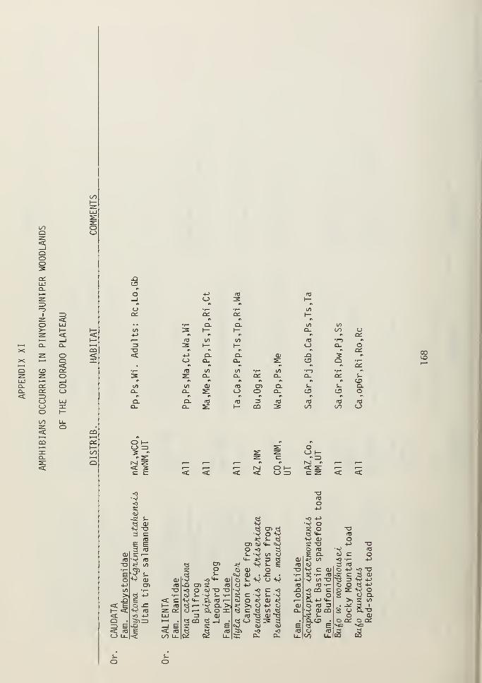
toI—
LU
coQ OC_)
QOOCCLU
I
O>-
i—
i
Q-XX >—i1—
I
Q C3
a. cca. cc< =>o
CJ>ooo
COi—
i
jza.
oQ<cCCO_lo
CQ«=Czc
JZ}
CD
acc
T3<c
10CL
Q.Q.
CQ
CCI—on»—tQ
+-> <c 03<_) 3 1—
» *» »*
1— •r- toCC Qi 1—n #« c
r" Q. Q. to to3 1— I— CL CO CJ«* •* * •» «* a:
03 to to f0 •-J •»
3 1— h- (_> Q. o#* r» #N w\ #* CC
-M Q. CL a; -Q 5 ^
(_> Q- CL s: C3 Q r—* * n ^ »* * Qi
03 to to •r— to •r-J •i— *«
S Q. Q- a: Q. Q- CCCD
to a> <a Cn Q. S- S- Q.D_ s: o o Q. o o OO- id 03 3 03 03 03 03Q_ s: I— CQ 3 OO 00 C_5
00to
O I— m *
O =3 s: O3 - s: ^ O I—-2: ^ c "=D
r^i ^<C 2 i
—
i
—
1— 1^1 O 1— <C SL i
—
i—
c c <t <C <c < O =) C ^ <C =c
3T303
iO
o-s; s- ^ •O -f->
<rf oj w •0 o3"g Q CD ^ si o T3
»o o *^\ 8 H- 03
o3 x^ ^ «3-s
O£ E CD S) 4- ^J +-> -o3 re O "0 3 O 03 •^ A3
OJ £ r— S- -v t/1 3 £ Q. c O03 •V 03
•c? to
<4- iJ Z3 ^ Ol J^ 00
3•1
—
+->
T3 ti CD *e -Q s^ E ra Cv 03•r—^ a o O OJ o o« cu o 4->
3"SE 3 S- «S> OJ . s: • •f— 03 -s: Co OJ ^^ cu o s- V u v 4-> •V to T3 -r: Z5 ^S4-> cn 03 -Q CD n3 O 4-> 03 03 •t— o oto •r— T3
3o Ci) XJ -a **^ <o c •o .a
Sca C s s
tS §.>! « -m r- C w s- •r- sew s. \ o O 3.a s <C C §
14- C 03 1
—
tt) o ^ CD J^ r— Q.+J 4- >1 S 00*=£ E O -C h- 10 i
—
•t> Q- >) 3&|+J o OJ O 03 3 • ^ 3 I
I— «5 K> (O z CC 3 i
—
Si. O ZC 00 ci CL 3 £CQ 2 o CLT3
< -5 +-> LU rs o> 03 "Q oj ~ci c OJC3 • tSM=> »—
<
• « cc «i _l • d O 3 3 3 . D.C3 o o: o ccID E -Q _l E st s E eg S S E ti E >o **G<C f0 E <C 13 a « IB 3i <) ^9 03 O T3 3 3O U_ -< oo U_ C<i cc u_ 3: Cl. a. Lu CO Ll_ n CQ
il•
o o

00
l-H OL Q-tH <X.X O-
i—
i
OX q: <=tt—
1
q:Q ^ oZ i—
i
_i OOUJ o r^Q_ C3 CJ t—Q- z: <.<C i—
i
UJ \—o: :e X OOq: I— t—
1
=5O z: Xo o r—o UJ—J o
oo CD <C 7ZQ Q. z: UJcc: Q. O QLi—
i
<c OO CCCO
fD
>>Q)1£
0)EfOto
QJto
a;t->
o
<=C =3UJ Ooo oo
S- i- S- S- s_ s- S- s- s- s-a; <U a> ai 0) <v C1J QJ O) a>+j -l-> -M +-> +-> +-) +-> +-> +-> +J<o f0 (B (O <a (O (O fO <o A32 2 2 2 2 2 2 2 2 2c c c c c c c c c c<D ai CD at 0) QJ OJ a; <u a>O- D. Q. Q. CL Q. Q. Q. Q. Q.O O O O O O O o o O
CT.IX)
Oen
co
oQ.

s- s- S- s- s- S- s- i. s- S_ S- i- S_ s- S-
CD CD O) CD ai O) <D CD CD O) CD CD CD CD CD+J +-> +-> +-) -M -l-> +J +-> +J +-> 4J +-> +-> +J +->
fO <a <a <a rtJ <a (O HJ r0 (O «J <o fO ca (O3 2 2 2 3 2 2 2 2 2 2 2 2 2 2c c c c c c c c c c C c C c: cCD CD a> a; 0) <u ai O) CD CD CD CD CD CD CDD. a. Q. Q. a. Q. Q. Q. Q. Q. Q. Q. Ql Q. Q.O o O o o O o O O O O O O O O
o
OO
_l c_>
=t ^z: luo a:oo a:<C =)LlJ OOO Oo

—I <_>
<C z=Z UJo ccU~t cc< IDLlJ OOO C_>o
0)siCOi~ro
E
l/l
CUorOs- c c c cs- Ocu • r- •r- •r™ •1™+-> +->
ro ro
(->
ro-Mro
n +-> 4-> +J -l->
c c C a c c c c c c CU CU CU CUo o o o CD CD CD CD•^ •r- •r™ •r— •1
—
T~ •r— •r— • r- •1
—
CU CU CU CU-t-> +-> +-> •4-) +J -t-> -M 4-> tO +-> 4-> > > > >ro rO (O <a rO rO rO (O CU (O ro+j +-> +-> +-> +-> 4-> 4-> +-> -^ -l-> +-> j*: ^L ^L jx:di o> cu ai CU CU CU CU rO CU CU c c c cCD DI CD a> CD cd CD CD 1
—
cd CD ro ro rO rocu o> ai OJ CU cu CU CU cu CU JD .Q -O JD> > > > > > > >
00> >
i- S- S- i--2«£ -V -i£ .^ *t _^ -*i .*: s_ j* ^ CU cu CU aic c c c c c c c CU c c > > > >rO (O rO rO (O (O 10 10 > rO ro •r- • r- •r- *rm
-Q -Q -Q -Q jQ jQ -O .aS-
jO -O s- s- s- s-
S- s_ s_ S- s_ S- S_ s- i- S- n «l •1 nCU O) cu cu CU CU CU a> s- cu CU CO CO CO CO 00> > > > > > > > CU > > s- s- s- s- s-•r" •1— •r- • r— •1
—
• 1
—
• r— tr- > •f— •r™ rO ro «o ro raCC q: a: d: cc cc CC ee a: CC co CO CO CO CO
*Cu
*
S ro O d)
•V co -0. O -y ro
Q.O CO Q.-C
OOO< < <

toCD
GO<
to c cs-fO •^ • r—
E (->
ri 4-> 4->
c a> (Uen cr>
«i
—
CD (UM > >(O4-> ^£ -*i
a» c: cai <o <aai .Q .q>
S- S-^. aj cuc > ><a •1
—
• 1
—
to to -Q S- s- to toa; <D
S- „ „O) aj
to to <1J to </> 1/5 to to to to to to to to to to tos- s- > s- s_ s- s- S- s- S- s- s- s- S- s_ i- s-fO <a •r— (O (U n3 <o <o ro (C <C (TJ fO ra fO ra (Os: 2: cc: CO co CO CO 2: CO co CO CO CO CO CO CO 2:
CM
I—00
Z UJo ct:
oo cc:< =5LlJ C_>
OO (_)o

on
uS-S-
+->
034->
OJCDOJ>
00 oo 00 00aj OJ J^ OJ OJo <_> c <_> o03 03 03 03 03S- S- JO i~ s.i- S- s- s_
OJ ai S- OJ OJ00 00 00 00 00 -t-> +-> OJ +-> 4-J
S- S- s- S- s- >03 03 03 03 03 * * • 1
—
r* *>
JO JO jo JO JO c c c c c c c c c S- C co o o o o o o o o o o
. #\ • «* . •% . r* > #* • «N •r— '1—
00 00 00 00 00 +-> +-> 4-> +J 4-> ••-» +-) +-> +-> 00 +-> l->
<u <D <u a; CD A3 03 n3 n3 03 03 03 03 03 OJ 03 03-i<£ jx: -x: .^ j*: -t-> +J -|J +-> 4-> -P +-> +-> +-> J* +-> +->
03 to 03 (O o3 OJ OJ OJ OJ OJ a> OJ OJ OJ 03 OJ OJCD en CD cd CD CD CD CD CD i
—
CD CDOJ OJ OJ OJ OJ ai OJ OJ OJ OJ aj> > > > > > > > > ^ > >
oo oo 00 00 oo 00S- S- s_ s_ S- J*i -^ j*: j* J*i .^ j*: JX! -^ S- -^ .*CD a> CD a> CD c c c c c c c c c OJ c c> > > > > 03 03 re "3 03 03 03 03 03 > 03 03
• r— •i
—
• r— • I— • r— JO JO JO JO -Q JO JO JO JO i
—
JO JOS- S- s- s- s- s-
S- S- s_ S- S- S- S- S- S- S- s-s- s- s- i. s- OJ OJ a> OJ O) a> aj Ol OJ S- OJ OJOJ a> 0J OJ 0J > > > > > > > > > OJ > >> > > > > > • I— •r-
CD o o o o oc OC oc o; c£ cc a: DC DC o DC oc
CO
OO
c£
O DCoo a:eC IOLU <_3
OO C_JO
oo ex. CL.
*Q-
*OO

CO
cu cu (Oo u +->
ra fO cus. s- cns- s- cucu cu >-M +-)
-^« •N c
c c c c £Z c c c c c c c c c: f0o o o o O o o o o o o o o o -Qr" •r—+-> +-> +J +-> +J +-> +-> +-> +-> +J M +-> +-> +-> S-ID (O <a rt3 <Q 03 (O "3 IT3 fU (O IC ra (O cu+J +-) +-> +-> +-> +-> +-> +J 4-> +-> +-> +-> +-> +J >CU cu cu CU cu CU cu cu cu cu cu cu cu cu • 1—
CD en en cn cn cn cn cn cn cn cn cn cn cn s-
cu CD cu CU cu cu cu cu cu cu cu cu cu cu> > > > > > > > > > > > > >
toi-.*: -^ .i*: -i<£ J^ ^ j*; J^. -V .*: .*; -^ -^ -^
c c c c c c c c c c: c c c c cu(O rt3 »a TO (O ra n3 (O to <T3 (O (O <c (O to >-O -Q -Q -Q -Q -Q JD X) -Q JD .a -Q .a J3 cu
u S-i. S- S- S- s- s_ S- s- s- s- i_ s- i- s- <Q
a; CD cu CU cu cu cu 0) cu cu cu <D (V O) s- s-> > > •r— > > > > > > > > > > s- cu
• r— •r— •r- > r- •r— • 1
—
•r— •r— r- •1— '1— • r— •r- cu >a: cn cc cc a: cc CC o; cc CC cc cc cc o; h- o
«*r^
ooIDh-<cI—oo
_i c_)
^ LUo ccoo cc< =3uj oOO Oo
OO
s-
O)
o3
.^ to Oo in Ti
, ^4- '3 CU x^•t— ^i
c) CUQ r- -s;•> i— vvo+j cu
<rf 4- "3 i>3o <a-C O 2 O
^> </> J o -vO i 1^ i— £Lu- -a a >— «li. cu p CU -1^
3 a; ^i>- 5nCO ^r *sfO Q. Q.c_> eo 00
cu -v-c £?u O s-+J -o cu(0 <V -Cu o <->
>,-s; +->
r— -^ fOM- O (_) --^ fO ^<3i
—
to o r— 2 >>-d
s; -* s: >, s;
O to O T3 OtS 3ti S-ti•>? q -^ <s> -yS2. Si. Q_S S H

CO
COo>o<oS-
S-CD4->
c c c co o o o•r— •r— •^ *p-
+-> -l-> +J +->
co CO re CO+j +-> 4-> -MCD CD CD CDCD CD CD CDCD CD CD CD> > > >-i^ -1^ -*L J>£c C c C03 IT3 CO COJD -Q -0 -Q
S- S- i- i-CD CD CD CD> > > >•r— •r— • t— • r—i. S_ S~ S- c c c c: c c c c c c
o o o o o o o o o o• " . «% > *t . rv •i
—
•1
—
CO CO CO co CO +-> +J +-> +-> +J +-> +-> -l-> +-> 4->
CD CD CD CD CD (O CO CO CO CO CO CO CO CO COJxZ -^ -^ ^L -^ -t-> -l-> 4J +-> 4J -M 4-> +-> •4-) +->
<a CO CO CO CO CD CD CD CD CD CD CD (D CD CDCD CD CD CD CD CD CD CD CD CDCD CD CD CD CO CD CD CD CD CD CD> > > > E > > > > > >
co co CO co CO COS- t- S- S- S_ .*: .*: -^ j*: CD -^ .*: -^ -^ J*£ JxL
O) CD CD CD CD !Z sz c c s- c c C C C 5Z> > > > > CO CO CO CO +-> CO CO CO CO CO CO•r— r™ • f— • r— • r— -Q -O .a -Q CO -O -Q J3 JD CO -O -QS- s- S- s- s- CD
S- s_ S- S- S- S- S- S~ S- -£= s- S-S- s_ S- s- s- CD CD QJ CD CO CD CD CD CD CO CD CDo> CD CD CD CD > > > > CD > > > > s- > >> > > > > •
i
—
•r™ •r" •i
—
i
—
•r— • f— •i
—
r— ca •r— •r-o o O O o OH C£ a: OH c_) OH oh OH a: s: en ccID
I—
^ UJO C£oo oh
LlJ C_)
U~> C_)O
C/}
*

00<U
Ora
I.
i-
4->
ITS
+->
CDCncu>
crrj
JD
s-(1)
>
cn
cucncu>
C(O
s-cu>
c:o4->
ro-MCUCnCU>
f0-Q
S-ai>
co-Mr0+->
cuencu>
ra.a
s_cu>a:
cucncu>
ra.a
s-
>
to +J
-^ -m03 cu
1— cncu>
toi- .*:
cu c> car- .a
S-s- cucu >> -r-O CU
to4->
CUCDCU>
o
cucn
>
4->
fC
cuCDcu>
-v j*£ .^c c: c13 03 ro-O JD -Q
i- S- S-cu cu cu> > >
co+->
+JcuCnCU>
cfO
i-cu>
o
<a+->
cucncu>
ra-O
cu>
(O4->
CUcnCU>
03
s-cu>
ra+JCUcnCU>
rO-a
s-cu>
co
ro 10ra+->
cu cu cucn cn cncu cu cu> > >
cra to to
S- t. S-
QJ <U CU> > >
ra+->
cucncu>
to—i-
>
+->
03+Jcucncu>
ra-Q
s_cu>
r—00
LU—I <_>
Z LUo ccoo a;<=c =5LU CJ00 Oo
00*
00

1/1
CD
s-ra
s-s-<L>
oco
cz
o o oco
CD
+J 4-> 4-> 4-> 4-) 4-> 4-> 4-> +J 4-> 4-> 4-> 4-> +-> 4J 4JTO TO (13 TO TO TO TO TO TO TO TO TO TO TO TO TO4-> 4-> -l-> +-> 4-> 4-> 4-> +-> +-> 4-> 4-> 4-> 4-> 4-> 4-> 4-J
CD CD CD CD CD CD CD CD CD CD CD CD CD CD CD CDen cn cn cn cn cn cn cn Cn cn cn cn cn cn cn cnCD CD CD CD CD CD CD CD CD CD CD CD CD CD CD CD> > > > > > > > > > > > > > > JD
J*C J*! J*: j*: J*£ Ji£ J*: -^ -^ J*£ j* -M -V j* J* J*£
c c c: c c C c c C c c c c c C cTO (0 TO TO re CO TO TO TO TO TO TO TO TO TO TO-O .a JD -Q jo jD JD JD JD JO -Q -O JD -Q JD JO
S- s- S_ S- S- S- S- S- i. S- S_ s- S- i- S- S-(D CD CD CD CD CD CD CD CD CD CD CD cu a> CD CD> > > > > > > > > > > > > > > >
Odr--
i—OO
o4-J
O LUoo a:<c a:LU ZDoo C_3oO
oo*a.
*oo
oo
*oo

(/> (/)
OJ a)O u<T3 <oS- i.s_ s-
oj OJ4-> +J
„ „
c c c c c c c c c E c c c c c c c co o o o o o o o o o o o o o o o o o+J -»-> +J 4J +-> +-> +-> +-> 4J -!-> +-> +-> +-> +J +-> 4-> -l-> +J
ITS <o (O (O <o (O fO (O (O re <TJ fO <T3 ra f0 «3 fO <o
-M +-> 4-> +-) +-) +-> +-> 4-> +J +-> +-> -M +-> +J -M +> -*-> +->
<L> cd OJ OJ CD CD Ol OJ OJ O) Ol a> 0J a) a) aj aj QJ
cd Ol CD CD CD CD CD CD CD CD CD CD CD CD CD CD CD CD<D CD QJ 0) CD 0) CD O) o> O) at a> a) a> a) QJ QJ QJ
> > > > > > > > > > > > > > > > > >
.*: ^ ^. je -^ -i£ ^ ^«: ^ ^L ^ .^ j*: .*: -^ ^ -2^ J*c c C c c c c c c c c c c c c c — C(O (C to (O fO (O re <o (O <o (T3 (O ID fO (C (O ID <o
JD .0 J3 -Q -Q -O -Q -Q -Q .a -O -O -O -Q -Q -Q _Q -Q
s_ s_ S- s- s- S- S- S_ S- s- s- s- S- S- S_ s- S- S-
OJ OJ <u QJ OJ <x> 0) O) QJ OJ 0) a) OJ Ol a; O) OJ 0J
> > > > > > > > > > > > > > > > > >
cc cc: cc cc cc cc c£ o; cc a: cc cc C£ cc cc a: cc o£CO
ct:
Nh O] : o•V s ssx o o00 r-j I^-J

CO
c c co o o•r—+J +J +J(O fC (O•4-> -t-> •l->
0) a; a>CD ai CT>OJ a) CD> > >-*: -*: ^ic E cfO to tc-Q -Q -Q
s- S- s-d) a; <D> > >
OO=>I—
I—oo
<c ^O C£.
oo ct<: idLlJ OOO oO
CT>

APPENDIX XIII
MAJOR PERRENNIAL PLANT SPECIES ON AND ADJACENT
TO THE COLORADO PLATEAU
(from West et al. 1975)
KEY
1. WYOMING BASIN
2. UPPER BASIN AND RANGE
3. WESTERN LOWER BASIN AND RANGE
4. WESTERN LOWER BASIN AND RANGE
5. WESTERN COLORADO PLATEAU
6. EASTERN COLORADO PLATEAU
7. EASTERN COLORADO PLATEAU
8. SOUTHEAST COLORADO PLATEAU
9. EASTERN LOWER BASIN AND RANGE
South slope Owl Creek Mtns., Fremont Co.,central WY; 1750m (5800 ft.).
Duckwater watershed, west slope DuckwaterMtns., Nye Co., east-central NV; 2040m (6650 ft.)
Pine Canyon, Lincoln Co., southeast NV;
2080m (6720 ft.).
Southeast slope, Pine Valley Mtns., WashintonCo., southwest UT; 1385m (4550 ft.).
Fishtail Mesa, Grand Canyon National Park,
northwest AZ; 1880m (6150 ft.).
Long Mesa, Mesa Verde National Park,
southwest CO; 2160m (7600 ft.).
Upland sand site, No Man's Mesa, Kane Co.,
southeast UT; 1820m (6000 ft.).
San Augustin Plain, Catron Co., west-central New Mexico; 2100m (7400 ft.).
Hills site, Ft. Stanton Coop. Range Res.
Sta., Lincoln Co., south-central New
Mexico; 1960m (6500 ft.).
180

APPENDIX XIII(cont.
)
1 2 3 4 5 6 7 8 9
TREES
Junip2AuA 06t20Ap2Ama
Junip2AuA mono6p2Ama
PinuA cdvJbiA
PinuA monopkyVba.
Qu2Acua gtuAza
SHRUBS
km2Jla.nc.hL2A paJULLda.
km2Jba.nc.hL2A utakznAiA
AfictoAtaphyloA patuibx
Kn.cXoiita.pkyto i, pung2nA
AnX2miAia biQ2lo\)<LL
knX.2miAia nova
kn£2mLi>ia tAidzntata.
C2.ano£h.UA QH.2QQ4A.
C2AcocoApuA montanuA
ChnyiotkamnuA viACA.di.kton.Lii>
Cotzogym namoAiAAima
CowanLa. mzxicana
EphzaAa viAidiA
VaJbtugia paAadoxa
TzndlzAa mxpicota.
Ga/tAya kla.v2Ac2.nA
xxxxxxxxx x
xxxxxx xx
x
181

SHRUBS (cont.)
PuaaIvul fiidzyvtata x x x x
Qlizacua gambzLU, x x
QaeAco6 tanb-inella x
QaeAcai undixlata x
Sh.zpcin.dia. tiotun&L&otia x x
SympkonA.caA.poi> on.e.opkilLLt> x
T&tAadymia can&>cnnA x
SUCCULENTS
Opuntla polycantka x x x x
Optmtia. i>plnoi>lofi x
/acca baccara. x x x
FORBS
Knab-U, pznduLlna x
Ai^7Lagai.a4 4pp. x x
Esiiogomun ca.Qj>pitoi>um x
EAsLogonum ovaZA.^onMm x
Hymo.nox.yi> bi.gel.ov4A. x
GRASSES
KgK.opqn.on. hmiXhiX. x
Kgn.opyn.on i>picaXxm x x
8oa£e£oua cuAtlpzndvita x
Boa£eXoua gnxLCJJLU> x
Bouutejtoua kOuula x x
182

GRASSES (cont.)
Efta.Qfioi>tUi &106OL
HULoJujx jameALL
KodLaruLa eAU>tata
LycuAtu pkldo-idu
MuklmbeAgJJi pcm.cA.^toha.
MuklmbeAgAjCi tohAtyi.
Qh.yzopt>ii> kymmo<Ldoj>
?oa fandleAAxma
Poa. Ioyiq-LquLo.
?oa 6and.b2A.g-l
SJJjxwion. hybtnlx
Stipa comata
Stipa ApZ.CA.OACL
StAjpa. thuJiboJujXYici
x
x x
x x
Bureau of Land Management
Library
Bidg. 50, Denver Federal Center
Denver, CO 8Q225
183


Bureau of Land Management
iry
,^ rh nonupr Fnrieral Center
TT7
Colorado

\| Colo
/ V.I : \
J-N
CANYON '
LANDS '
section|
\]
i
"'/
/
1
//
/
T -'
f,''
rr 1" - —
i
7- \ !
)/v
(
'
'7 GRAND
V CANYON
sv.—
SECTION
\All Eona v^
I
I
,-"N
NAVAJO| SECTION
i
i I
DATIL SECTION /I
New Mexico
J
Physiographic Units ol the Colorado Plateau from Hunt 19741.
PINYON- JUNIPER WOODLAND
KEY TO PHYSIOGRAPHIC FEATURES AND LANDMARKS
10 - Abajo Mountains11 - Henry Mountains12 - La Sal Mountains13 - Navajo Mountain14 - San Francisco Mountains15 - San Miguel Mountains16 - lite Mountain17 - White Mountains
20 - Buok Cliffs21 - Circle Cliffs Upwarp22 - Mogollon Rim23 - Monument Upwarp24 - Pink Cliffs25 - Roan Cliffs26 - San Rafael Swell27 - Vermilion Cliffs28 - Waterpocket Fold29 - White Cliffs
30 - Agathla Peak31 - Comb Ridge32 - Elk Ridge33 - Shiprock
40
41
42
434445
Black MesaCoconino PlateauKaibab PlateauKaipairowits PlateauMarkagunt PlateauPaunsagunt Plateau
50 - Monument Valley51 - San Juan Basin52 - Uinta Basin
60 - Arches Nat. Park61 - Bryce Canyon Nat. Park62 - Canyonlands Nat. Park63 - Capitol Reef Nat. Park64 - Colorado Nat. Mon.65 - Grand Canyon Nat. Park66 - Mesa Verde Nat. Park67 - Natural Bridges Nat. Mon.68 - Navajo Nat. Mon.69 - Zion Nat. Park
nd Management
Federal Center: . 1225
POTENTIAL OCCURRENCE OF PINYON -JUNIPER WOODLANDSON THE COLORADO PLATEAU
llrom Kuchler 19641
SCALE 1:3.168.000
50 100
STATUTE MILES

Copyright © 2022 FDOKUMEN