DiSttRiCT suRVEY REPoR丁 - Environmental Clearance
45
DiSTRiCr SURVEY REPORT{sAND M:N PAL: 眈 輌 mmat“ “ ・・ 塾 "changら 晩 W田 軋恥 tLLお n Date 2"″ ∝ 鋤 し ′ し し ヽ ヽ し し し し ヽ し し し し し し し し し し し ヽ し ヽ し し ヽ ヽ ヽ し し ヽ ヽ ヽ し 一 DiSttRiCT suRVEY REP {PALI DistHct Minera!survey R D!STR:CT PAL! PAL: DISTRlcT N ▲ JOdhpur I .r i .:r r Uo31pul ´ LEGEND _ "310nal Hぃ ,、 VeF,Rc。 ● 、 - Os:● a B04● η ‐ 6:]電 礼 ■ uaFy,ぃ n ● gher7∝ η ヽ ― Rル er 2011 (up 由 m121に |り 26イ F∫ YEAR 2018‐ 19 :n comp!iance of Ministry Of EnvirOnmel 論 呻 J■ , ―
-
Upload
khangminh22 -
Category
Documents
-
view
4 -
download
0
Transcript of DiSttRiCT suRVEY REPoR丁 - Environmental Clearance

DiSTRiCr SURVEY REPORT{sAND M:N:NG)′PAL:
眈 輌 mmat““・・ 塾 "changら
晩 W田軋 恥 tLLお n Date 2"″∝鋤
し ′
し
し
ヽ
ヽ
し
し
し
し
ヽ
し
し
し
し
し
し
し
し
し
し
し
ヽ
し
ヽ
し
し
ヽ
ヽ
ヽ
し
し
ヽ
ヽ
ヽ
し
一
DiSttRiCT suRVEY REPoR丁
{PALI DistHct Minera!survey RepOrt 2018〕
D!STR:CT PAL!PAL:
DISTRlcT N
▲
JOdhpur
I .r i .:r r
Uo31pul
´ LEGEND
_ "310nal Hぃ ,、
VeF,Rc。● 、- Os:● a B04● η
‐6:]電礼■ uaFy,ぃn
● gher7∝η
ヽ ― Rル er
2011(up颯由m121に|り 26イ F∫
YEAR 2018‐ 19
:n comp!iance of Ministry Of EnvirOnmel
論 呻 J■ ,
―

ヽ ヽ^
・́
ヽな・
,DtsrRlcr SURVEY REPORT (SAND MINING), PALI
(Under Ministry of Environment, Forest & climate chan3c, New Delhi, Notification Date 2g'7'2018')
PREFACE
Sustainable Development is built on three pillars - environmental,-social and
economic. sustainable development can not be achieved if the environment is
protected but poverty is prevalent in a significant part of the population. Similarly,
sustainable development cannot be achieved through inappropriate economic
growth, if it undermines the environment in which people and businesses exists. So
equilibrium is maintained between environment, society and economics. sand/gravel
has long been used as aggregate for construction of roads and building. Today, the
demand for these materials continues to rise. ln Rajasthan, the main sources of sand
are river flood plain, paleo channel sand, and sand from agricultural fields.
Ministry of Environment, Forest and Climate Change (MoEFCC) had time to
time made provisions for obtaining environmental clearance, such as, wide
Environmental lmpact Notification, SO 1533 (E), dated 14th September 2005, made
mandatory to obtain environmental clearance for different kinds of development
projects as listed in Schedule-1.
Further, Hon'ble Supreme Court wide order dated the 27th February, 2012 in
l.A. No.12- 13 of 2011 in Special Leave Petition (C) No.19628-19529 of 2009, in the
matter of Deepak Kumar etc. Vs. State of Haryana and Others etc., ordered that
" leoses of minor minerols including their renewol t'or on oreo of less thon fivehectores be gronted by the StoteslJnion Territories only ot'ter getting environmentol
clearonce from MoEF"; And Hon'ble National Green Tribunal. order dated the 13th
January,2015 in the matter regarding sand mining has directed for making a policy
on environmental clearance for mining leases in cluster for minor Minerals,
The MoEF&CC in compliance of above Hon'ble Supreme Court's and NGT'S
order has prepared "sustainable sand Mining Guidelines, 2016" in consultation withState governments, detailing the provisions on environmental clearance (EC) for
cluster, creation of District Environment lmpact Assessment Authority, preparation
of District survey report and proper monitoring of minor mineral. There by issued
Notification dated 15.01.2016 for making certain amendments in the EIA
Notification, 2006, and made mandatory to obtain EC for all minoi minerals.
Provisions have been made for the preparation of District survey report (DSR) ofRiver bed mining and other minor minerals.
Every effort has been made to cover all matter/issues mentioned in thenotification for district survey report for Jaipur district, The main objective of thepreparation of DSR (as per the Sustainable Sand Mining Guideline) is to ensure thefollowing -
(i) ldentification of areas of aggradations or deposition where mining can be
allowed;(ii) ldentification of areas of erosion and proximity to
and installations where mining should be prohibitedinfrastructural structures
ヽ民
Ц
IF
ミ
ーア
ヽ
へ ^

DiSTRiCI SURVEY REPORT{SAND MIN:NG)′ PALi〔under Mh`try of En」「Onment,Forest&dimate Change′ NewDJhL Notlflcatton Date2507‐ 20181
ヽ し
rate of reprenishment and aflowing time for reprenishment after mining in thata rea.
(iii) ldentification of mineral wealth in the district.The DE|M and DEAC wifl scrutinize and recommend for EC of mining of minor
minerals on the basis of DSR. This wifi a moder and guiding document *hi.h i*compendium of avairabre minerar resources, geographicar set up, environmentar andecological set up of the district and reprenishment of minerars and is based on dataof various departments, published reports, journals and websites.
The district has substantial resources of euartz feldspar, Asbestos. Lime Stone,Marble, Granite, Limestone, Marble, Rhyolite, Granite, Masonry stone, Bajari (riversand), China clay, Soap stone, Wollastonte, Gypsum, Magnesite, Calcite,Sandsone/Pattikatla.
District Survey Report (DSR) of pali District
Need of DSR:-
As per Gazette notification of 15th January 2016 of MoEF & cc a survey shabe carried out by the District Environment rmpact Assessment Authority (DETAA) withassistance of irrigation department, Forest department, Mining department, Groundwater Boards, Remote sensing Department and Revenue department in the districtat regular interval to for preparation of District survey Report as per the sustainabresand mining guiderines, 2016 to ensure identification of areas of aggradations ordeposition where mining can be allowed; and identification of areas oi erosion andproximity to infrastructurar structures and instalations where mining iirouta-ieprohibited and carcuration of annuar rate of reprenishment and aIowing time forreplenishment after mining in that area.
As per notification it is essentiar to prepqre a survey document mapping thestatus of sand sources and other minerars in a district. This survey shourd beconducted and report be prepared for each district. Though it is an acceptabre factthat rivers cut across districts and states and every river is an ecosystem in itserf. But,keeping in view the fact that the district is the most estabrished unit ofadministration at which this kind of survey, pranning and monitoring can be ensuredeffectively. so, every district wiI prepare this document taking the river stretch inthat district as an ecorogicar unit and inventorising other sources of sand in thedistrict.
The natural resources must be utirized in environment friendry manner inscientific and systematic way and with the objective of sustainabre deveropment thepolicy on the subject shourd have provisions for protection of environment &ecology. These factors can be accounted for in a most efficient manner at districtlevel. The sustainable mining plan needs to be dynamic.DSR of PALI
report of Pali was prepared based on direct and indirect
・―
曼
奎
屋
survey
3
District

ヽ ヽ
DiSTRICT SURVEY REPORT(SAND MiN:NG),PALl
〔under Min:sttt of Enuronment.ForeSt&Climate Change,New De:hら Notttcation Date 25・ 07‐2018.〕
benefits of mining and identification of the potential threats to the river / streambeds in the district. Besides, the production of aggregate in a particular district is afunction of availability of natural resources, the size of the population, the economyof the area and various developmental and infrastructural works being undertaken inthe d istrict.
Every effort have been made to cover sand mining locations, areas & overyiewof Mining actlvity in the Jaipur district with all its relevant features pertaining toGeology & Mineral wealth in Replenish-able Areas of Rivers, stream and gther sandSources. The mineral potential is calculated based on field investigation & geology ofthe catchment area of the river or streams. The area for removal of the mineral in ariver or stream is decided depending on geo-morphology & other factors, it can be50o/o to 60yo of the area of a particular river or stream. other constituents like clayand silt are excluded as waste while calculating the mineral potential of particularriver or stream.
This DSR shall form the basis for apprication for environment crearance,preparation of reports and appraisal of projects.
ヽ
ヘ
ヘ
ヘ
ヘ
● fミ ヽ 3 1ギ ヤ 子 」 PヤF,
口1.w■‐Fン嗣帥 ′
爺qヽ雨・)
翁.覇粋漏 RFa
」諷」RFklk」ヽ」ヽビヽ
,ヽヒヽ口ヽ日へ‥ヘーミ
Fへ‐ヽ ヽ
「 ヽ ヽ
( ヘ
― =

)
し
.
し
ヽ
し
ヽ
し
ヽ
し
ヽ
ヽ
し
し
ヽ
し
ヽ
し
し
ヽ
し
ヽ
し
AKNOWLEDGEMENT
The authOris indebted to DirectOtt Mines`L Geology Deptt AdditiOnal DirecLor
(MineS and ceology〕 ,Odhpur zOne for pro宙 ding guide lines for preparing
this District Survey Repo■ for Minor Minerals and Bajari Sand〔 Pali District〕
as perthe MOEF guidelines
we express our most sincere appreciation &deep sense of gratitude to Sh. G.S
Inda Suptdg.Mining Engineer,Jodhpur and Sh.Anil Kumar VermaSuptdg'GeologislJodhpur for suggestion and technicar guidance forfinalization of this report as per the MOEF guide lines.
we are also extend our thanks to supporting technicar staffs and Geologist
for preparing and collection data from the field and from literature and finallythey complied as per the MOEF guide lines .
qa+(Dr.Bhanwara Ram.)
Sr.Geologist
Jodhpur
Cンι轟
…
,
椰 ●■'=¬
針層′謙 tマ ■蘭.)
卜 ηR VishnOi〕
Mining Engineer
Sojat city
‐
ヽ
ヽ
ヽ
し
ヽ
ヽ
ヽ
し
‐
ヽ
‐
ヽ
‐

D:STRICT suRVEY REPORT{SAND M:N:NG)′PALI
(under Min`trv Of Env"onment,Forest 8t c‖ mate change,New DelhL Notincatlon Date 25‐07‐2018))
」 し
CIIAPTER II. INTRODUCTION
Pali is a city in Rajasthan state of western lndia. tt is
headquarters of pali District and comes in the Marwar region. ltbank of the river Bandi and is 70 km south east ofJodhpur. ltIndustrial City".
the administrative
is situated on the
is known as "The
Pa‖ District has an area Of 12387 km2 The district lies between 24°451 and
26° 291 north iatitudes and 72° 471 and 74° 181 east iOngitudes The Great Aravali hills
link Pali dも tHct wth Almer′ Raisamand′ udaipur and ttrohi DLtncts westem
Rajasthanゝ famous‖ ver Luni and ts t百 butanes JawaL MthadL sukadら Bandi andGuhiabala flows through Pali district The Largest dams Of this area Jawai Dam and
Sardar samand Dam are alsO Iocated in Pali district wh‖e plains Of this district are
180t0500 meters abOve sea level, Pali city the district headquarter′is situated at
212 meters above sea level While the highest pOint of Aravali hills in the district
measures lo99 meters,the famOus Ranakpur temples are situated in the f00tsteps
Of Arava:も Parashuram Mahadev temple,a place Of wOrship f。「milliOns tt devotees
of Lord Shiva′ is alsO 10cated in the Pali district On the hights Of aravali range
District is we‖ cOnnected by rail i e,Delhi Ahemdabad sectiOn Of North―
Western Railway and JOdhpur― Marwar sectiOn of North‐ Vvestern Railway /、 net‐wOrkOf roads is spread Over the district connecting many villages and important cities of
Raiasthan“ ke JOdhpur′ Jaipur Almer,SirohL udaipur etc
l.1.Location and Extent
Pali district is located in the central part Of Rajasthan lt is bOunded by eight
distncts,Nagaur DistncttO the nOrth,Almer DistncttO the northeast,Raisamand
District tO the east′ udaipur District tO the southeast,sirohi Distictto the
southwest′ Jalore District and Barmer DistricttO the west,and Jodhpur District tO the
northwest lt stretches between 24° 44.3560″ to 26° 2714454″ north latitude and
“茸」……
)
)
)
」
し
し
‐
ヽ
し
し
ヽ
し
ヽ
ヽ
し
ヽ
ヽ
ヽ
ヽ
‐
) 」
‐L‐ 一 = ―~ そヽ
し
し
し
'Fl ,
DtsTRtcT suRVEY REPORT (SAND MINING), pALt(under Ministry of Environment, torest & climate chante, Nen/ Delhi, Notlfication Date z5{t7-2018.)
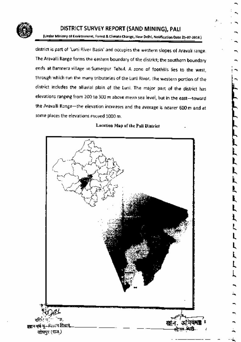
district is part of 'Luni River Basin' and occupies the western slopes of Aravali range.
The Aravalli Range forms the eastern boundary of the district; the southern boundary
ends at Bamnera village in Sumerpur Tehsil. A zone of foothills lies to the west,
through which run the many tributaries of the Luni River. The western portion of the
district includes the alluvial plain of the Luni. The major part of the district has
elevations ranging from 200 to 300 m above mean sea level, but in the east-toward
the Aravalli Range-the elevation increases and the average is nearer 600 m and at
some places the elevations exceed 1000 m.
Location Map of the Pali District
ヘ ヘ
一ヘ
ヽ ヘ
ヽ
ヽ
へ
ヽ
L
L
Ц
Ц
k
Ц
k
Ц
k
ミ
ミ
ム
ヽ
へ
ヽ
ヽ
duliv (ttu)

‐
DISTRICT SuRVEY REPOR丁 {SAND MiN:NG)′ PAL:{under Ministry Of Environment,Forest&C:imate Change,New Delhi,Notincation Date 25‐
07‐ 2018)
Fig.1.2 Pali District Administration Map
DiSTRICT:PAL:Administrative Map
皐田畠L=当と
=当皇
=争
二=二
曇』 .
ち´
i.Ja*f
) )
ヽ ・)
II. GENERAL PROFLE OF THE DISTRICT
2.l BRIEF HISToRY OF TⅡ E DISTRICTln 120 AD′ during the Kushana Age′ King Kanishka conquered the Rohat and
Jaitaran areas′ part5 0f tOday's Pali district Untilthe end Of seventh century AD this
area was ruled by the Chalukya King Harshavardhana along with Other parts Of the
present state of Ralasthan
During the periOd from the loth to the 15th century,the boundaries of Pali
extended to adiOining Mewar,Godwad and Mamar Nado!was the capkal ofthe Chauhan clan All Raiput rulers resisted the foreign invaders but individua‖
yfought for each Otherls land and leadership AFter the defeat Of Prithviraj Chauhan,
against MOhammed Gauri, the Rajput pOwer of the area was disintegrated
The Godwad area of Pali became subieCt tO the then ruler of Mewar,Maharana
Kumbha;hOwever Pali city― which was ruled by Brahminrulers with the patrOnage of
neighbOunng Ralput rulers― remained peace施 l and prOgress市 e
The L6th and 17th centuries saw a number of battles h判
1磐ヽ
し
こ
__ =:蒻
盪 ,
¨匡
―

ヽ ヽ ヘバ
DiSTR:CI SuRVEY REPORT(SAND MiN:NG)′ PAL:〔under Ministry of Environment,Forest a climate change,New De:hi,NotttcatiOn Date 25‐
07‐2018.)
ヽ
ヘ
ヘ
|ヘ
トLLLLLLLLLLLL
kミヽ民ЦЦミk
ヘ
ヽ
of Pari' shershah Suri was defeated by Rajput rurers in the battre of Giri nearJaitaran, Mughar emperor Akbar's army had constant battres with MaharanaPratap in the Godwad area. After the Mughals had conquered .trort ,ltof Rajputana, Veer Durga Das Rathore of Marwai made organised efforts to redeemthe Marwar area from Aurangzeb, the rast Mughar emperor. By then pari had becomesubservient to the Rathore cran of Marwar state. pari was rehabiritated ry vratrara;aVijaySinghandsoonitbecameanimportantcommercialcentre.
During the British era in rndia in 1857, various Thakurs of pari under thestewardship of the Thakur of Auwa fought against British rure. nuw, to.t *assurrounded by the British army and the conflict lasted many days.
Georogists trace the settrement at pari back to prehistory and maintain thatPali emerged from the ,.rt. *::t:ln sea, which was spread over a large part ofpresent day Rajasthan. rn the Vedic age, Maharshi Javari stayed in this area formeditation and interpretation of Vedas. rn the Mahabharata age, the pandavas arsomade this area (near Bari) thcir resting prace auring exire. ns a part of ancient ArbudaProvince, this area was known as Balla_Desh.
2.2 ADMINISTRATIVESETUP
The pali district in Nine subdivisions viz. pali, Bali, Sojat, Desuri,5umerpur,Rohat, M'Jn'Raipur and Jaitaran. Each Sub-Division is rooked after by the sub-divisional officer/Magistrate under the collector and District Magistrate, pali. oneAdditional District Magistrate is arso present to execute a[ the work. The Districtcomprises of 10 tehsils as follows:
Sub Divls10n
Pa:i
Rohat
Bali
Sumerpur
Saat
Man″ar Junction
Jaitaran
Raipur
Desuri
Desur!
Tehs‖ s
Pali
Rohat
Bali
Sumerpur
Sojat
MarwarJunctiOn
Jaitaran
Raipur
Desuri
Rani
Nagar/Township
1
0
2
2
1
1
1
0
1
1
No. Of
V‖ lages
88
80
113
70
125
157 .
118
141
81
77
( ヘ
「 ヽ
.fI!l`illlilSi!C°
ntains a number Of Pa
師

I驚llil旗灘1葛11捕「‖『雪i冊席1『 [層T』麗標1)as a BDO(BloCk Development Officer)to
serve as the representative of the district administration in the rurai areas
D:SttR:CT SuRVEY REPORT(SAND MiN:NG}′ PALI{under Min`trv Of Envレ Onment,Forest&C‖ mate change,New Dethら Notin(a“ 。n Date 25‐ 07‐ 2018)
Panchayat Samiti No. of No.Grampanchayat Villages
し )ヽ
)
)
し )
Pali
Rohat
Bali
Sumerpur
Desur
Jaitaran
Raipur
Solat
MarwarJunctiOn
Rani
23
23
39
29
24
33
35
38
47
29
82
81
109
69
78
114
141
125
148
77
PAL¨
D
一
=
ム
´ ‐ LIE
`""'ヤ十
1・ 6野…
ヽ
一〕ン
PHIC PROFILE
)
t
し
)
」
ヽ ヽ
ゴ 、́F」..
くL". t
=,煤`
「
A■ ...
“
い ■. 1
2.3

ヽ ヽ ヘべ
DISTR:(I SURVEY REPORT〔 SAND MiNING)′ PALitunder Min:strv of Environment,Forest&c"mate change,New De:hi,Notncation Date 25Ю
フ‐2013.)―
へ
pali District, with population of about 20.4 lakh is Rajasthan,s the L4thmost popurous district, rocated in the state Rajasthan in rndia. Totar geographicararea of Pari district is about L2 thousand km2 and it is the 7th biggest district by areain the state. popuration density of the district is 164 persons per km2. There are 9sub districts in the district, among them pari is the most popurous sub district withpopulation of about 3.7 rakh andRohatis the reast popurous sub district withpopulation of about 1.2 lakh.
*,^^-^ 'n"" are g cities in the district which comes under the district administratron,rnose are
Council; Sojat, Sumerpur, Sadri, Falna and Jaitaran Municipalities (,,r,;:;'iyI'l::lpopulous).
The district is home to about 20.4 lakh people, among them about 10.3 lakh(5070) are male and about 10.1 lakh (50%) are female. ?3% ;;; ;;;;;;;r;;;;are from generar caste, 20yo are frorn schedure caste and 7% are schedure tribes.child (aged under 6 years) population of pali district is 15%, among them 53% areboys and 47% arc girrs. There are about 4.2 rakh househords in the district and anaverage 5 persons live in every family.
The majority of the popuration, nearry 770/o rabout 15.8 rakh) rive in pariDistrict rural part and 23/o (about 4.6 lakh) population live in the pali District urbanpart. Rurar popuration density of pari district is 132 and urban popuration density is1049 persons per km2.
』k
』L
』ヽ
bL
ヽHヽ
‥L
ヽヽ
ヽ
¨¨¨̈¨̈¨̈¨̈¨。
聖
3^●αヽ00z
Caste wlse Male ttmale pOpulatわ n2011‐ Pa‖
市‐2 (
・へ
‐「

2.4 cLIMATE AND RAINFALL
l‖pttilliifilil:lill:1[]:il:|;lifi11‖‖:ler:::1lmlょ :lplil
(May‐June}months′ a large vLnaJon intemperature is fOund due tO ad,Oining green and hi‖
y areas Winters are mOderatelycool during December」 anuary when the mercury dips t0 4-5° C range MonsOOnbrings respite from long drawn summers′
11‖|li(:Tllll:IngthemOnth50fJuly―October resultintO average rainfa‖ Of 450
The rainfa‖ is very fairly goOd but erratic The general distributiOn Of rainfa‖
across can be visualized from isOhyets presented in the Plate―l‖ where mOst Ofthe
d st‖ dに∝市ed ttnfal h he mnge d r留
[肌 !nfЪl:T:1::[蓮写::rainfa‖ was 653.4 mm based On the data
nghest ttnfall o"mml wheぃ bw鵡1∬脱ツT‖ftt mml
Ⅲ帥6taverage annual rainfa‖ was received in 3a‖
DiSTRICr SURVEY REPORT{SAND M:N:NG)′PAL:
〔under Ministrv Of Environment,Forest&chmate change,NewDelt NotincationDate和フ‐2018.)
Table: Block wise annual rainfall statistics
Block Name
MinimumAnnual
Rainfall (mm)
MaximumAnnual
Rainfall (mm)
Average
Annual
Rainfall (mm)Ba
‐i
一7017 1,01370 8797
Desuri 645 1,0691o 7762,aitaran 4276 8061 5777Marwar Junction 5529 7472 6957
4659 6368 5382Raipur 358 9586 6892Rani 5828 7379 6484Rohat 4557 5416 4986Solat 3978 8097 5934〉umerpur 5516 7855 637
一
)・ )』ヽ
PAL| ptsTrycT 5 YEARS RA|NFA| L DAlYear JAN FEB MARCH APRIL MAY JUNE JULY AUG SEPT OCT NOV DEC2012 04 00 77 866 2710 12■ 4 03 002013 120 40 00 10 02 1484 1フ89 1126 199 00 002014
2015
00
11
00
00
00 43 77 1723 1992 1310 00 00 0040 924 3739 50 00 00 00
2016 00 02 ■9 00 00 431 2248 5589 224 309 00 00
輔・
いヽ珈
L
)
)
)
)
)
L
ヽ
)
」
)
)
)
)
)
)
)
)
)
」
)
)
)
」
)
)
」
し
ヽ
)
)
ヽ
)
)

DiSTRiCI SURVEY REPORT(SAND MiNING)′ PALi{under MiniЫttv Of EnvironmentJ Forest a climate change,New De:hL Notincation Date 250フ
‐2018.)
”r
,
ムニrA
ヽ
ヽ
ヽ
ヽ
ヘ
ヽ
ヘ
ヽ
ヽ
‐、
1‐ヽ
員議LkLkkk
ЦЦЩЦミЦミk
ミミヘ
ヘ
ヘ
ヽ
^
ヘ
―
D:STRICT:PAuRainhi:D:sい。n
(2010)
,°・・゙
i゙
てJミ1:'lζ t 〔::¬ 5,
椰ξ亀黒押:
14
……t― ‐
―
― ●_
… … …
肇
,―
Ⅲm,
■覇 "苺晴臨 切 ψ
菫簿 |・●…
=旨審ヨ 菫■■ん
軽き ヽ費
F響 “
鮨
■■■ 押 ,コ
1 ニミFi
Fig: 2.1 Rain Distribution map
t
一

③ .
DiSttRiCr SURVEY REPORT{SAND M:NING〕′PALi
(Under Ministry of Envヤ Onment,Forest&chmate Change,NewDeli,Notncation Date 25‐K17‐ 2018.)
」
ヽ
し
ヽ
」
ヽ
し
ヽ
し
ヽ
し
」
)
)
)
)
)
し
ヽ
し
)
)
ヽ
L
)
」
し
し
ヽ
し
」
し
ヽ
L
101D
lαЮ
14∞
1"0
1収Ю
800
m
`00
加
0
・ NORMAL RAINFALL ■ACTuAL RAINFALL
Tehsil wise statu5 0f Rainfa!:data Of Pali District〔2017)
S.No District Name of Station Normal
mml Pali Desuri 446 70
2 Pali Marwar JunctiOn 446 70
3 Pali sumerpur 446 70
4 Pali Bali 446 70
5 Paii Rani 446 70
6 Pali Pali 446 70
7 Pali Rohat 446 70
8 Pali Raipur 446 70
9 Pali sOiat 446 70
10 Pali Jaitaran 446 70
Pa‖ Average 446.70
Actual
mml17200
95800
9050084400
83700
77800
67200623.00
5410o
477_00
780.70
DeviatiOn
%16237%11446%10260%8894%8737%7417%5044%3947%2111%
678%
74.77%
2.5 TRANSPORT AND COMMuNICAT10NThe only two mOdes of travei available in the district are roadways and
railways
Alrnost a‖ ofthe vittages are cOnnected by rOads There are twO depots
of government_Owned state transport:Pali and Falna
:炒 曹
柄 m° n n the d StrlCt S Marw詞
i口 1i ll--G=nr Eqrq,

へ ヽ ヘ
ヽ
D!STRiCI SuRVEY REPORT(SAND M:NING)′ PALi{under Mhistry of Environment,Forest&Gimate Change,New De:hi,NOtncaJon Date 25・
07‐2018.)
ヘ
ヘ
ヽ
ヘ
ヽ
|ミ
は
[LЦLЦLLkLЦЦLЦЦL
ヽミk
connected with Jodhpur, Ajmer, Ahmedabad and Udaipur. pali railway stationis on the Jodhpur route whire the second highest earning rairway station in theAjmer division, Falna is on the Ahmedabad route. other important rairwaystations in the district are Rani, Jawai Bandh, Sojat Road and Falna.
The district got the rairway in the earry age of rndian Rairway in 1g81,when the Ahmedabad_Ajmer line opened at Rajputana State Railway. pali gotconnected to Marwar Junction on 24 June 18g2 and to Luni on tz June 1gi4.Jodhpur was connected to the district via Luni in 1gg5 by the Rajputana-Malwa Rairway network and the first train started on this route on g March1885. This line later becomes part of the Jodhpur-Bikaner Railway.
phulera-Marwar Junction line was converted from Meier. Gauge toBroad Gauge in 1995, whire the Ahmedabad-Ajmer rine was converted in1997. During 1997-99, the 72 km Jalore_Falna route was also surveyed bythe lndian Railway, however, the line has still not been laid.
PALI BYAIR
The nearest Domestic Airport is Jodhpur Airport, roughly oneand half hours, drive from pali. Jodhpur Airport is well connecied to aspectrum of cities rike Derhi, Mumbai, and udaipur through Air rndia and JetAirways.
PALI BY MITWAYSpali has its own Railway Station namcd as pali Railway Station
which is connected to the major cities of Rajasthan. rt is rinked with the citiesIike Guwahati, Jaipur, Ajmer, Bangalore, Ranakpur, yeshwantpur, Bikaner,Jodhpur and Mysore.
Pali by road-pali is 5G Km from Luni, 72 Km from Jodhpur, g7 Km from Samdari, j.11
Km from Beawar, 163 Km from Ajmer, 1g5 Km from Udaipur, 294 Km fromJaipur, 322 Km from Bikaner, 355 Km from Kota and is rinked throughRajasthan State Road Transport corporation (RSRTC) and some private trairservices.
From
UdaipurJodhpurAimer
BeawarJaipur
ヽ
ヽ
ヽ
へ
(
ヘ ヘ
‐857..9‐63「294
b PaliPali闘Pa‐‐画
Time
3 hours 6 minst hour 18 mins
2 hours 44 minst hour 57 mins4 hour 33 mins
胚
L PROFILE OF TⅡ E DISTRICT

:蜻 .
DiSTRiCI suRVEY REPORT(SAND MiNING〕′PALI
(Under MinistryOf Envlonment Forest&climate Change,NewDettLNotinca●。n Date 25-07‐2018)
し
ヽ
し
ヽ
ヽ
ヽ
ヽ
し
ヽ
し
し
し
し
し
ヽ
し
し
し
し
■
し
ヽ
し
ヽ
し
ヽ
し
ヽ
ヽ
し
し
」
ヽ
」
し‥
T_綺 .
S.No Particular Year Unit Statisticsじeographica1 11a tures
(A) pcggraphlcal Data
i)Latitude
螂転
24' 45'to 260 7 5;North
ほ)I On」 tudc720 48' to 7 40 20,
East123870) AdmiisL“ve U」ts 2011
i) Sub divisiOns9
一9
Tchsils
iii)Sub_Tehsil8
iVI Pa●Va circlc357
10V) Panchayat Simitis
¨1
vli)Nagar PJika7viii) Gram Panchayats
320
1052対) Reve{rue villagesX) ASSCmbly Area 6 MLAs&lMP
2. Population(A) Sex-wise 2011 Nos
D Malc1025895ii) Female1012638
〔B) Rural P望型lat10n1578682
3.抑 C
A Land utilizatiOn 2010_11 Hectarei)TOtal Arca
1233079il)Forcst cOvcr
86536
…
Cdttrc Land.58485
iv) cultivable Barren land43760
4. Forest(i) Forest 2010-ll Hectare 86536
5. Livestock&POultryA Cattlc 2007 NOs
1)CoWs354698ii) Buffaloes315125B Other livestock
i)Goats700183
真 6505
…
BitChes41372
…
yS
…
h Ofr」l lnc 2010-11 Kms 1232
→1■マ(Vヽ )
」〓一

DlsTRICI SuRVEY REPORT{sAND M:NING)′PALl
(Und"i Mini"try of Er "r,
D"lhi, Notification Date 25{7-2018.)
へ へ
ヘ ヘ
… 7
(a) National Highway 2010-11 Kms 25870(b)State Higttway 201o_11 Kms 60800(C)Main Distnct Highway 201o_11 Kms 30000(d)OtheF distnct&RuralRoads 201o_11 Kms 310202
蹴:結悧服毀輸
(o Kacha Road
2010_11
201o_11
Kms 40855Kms
ヘ
ヽ
FLAURA & FLATINA OF THE DISTRICT:The extent of naturar forests in Rajasthan is not onry one of the rowestin the country but also the lowest in terms of proJr.tirity of forest. On thecontrary the state is endowed with the rargest chunk of wasterand which isabout 2Oo/o of the total wastelands of tn" .ornif. iotal forests area ofRajasthan is 32639 km2 forests, which is g.S4 % of the total state,sgeographical area. Reserve Forests constitute 3g.16%, protected Forests53.36% and Unclassified Forests g.4g% of the forest area. AcLording to
!ht1n1o-n and seth (1968), a, the forests or this aisirict come under thetropicalforest.
S.No.
1
Name of
District
Pali
Reserved
Forest
81945
Protected
Forest
14162
Unc:assified TOta:
Forest
251 96358
The forests of Rajasthan can be divided into four broad forest types.1. Tropical Thorn Forests,2. Tropical Dry Deciduous Forests,3. Bamboo-Forests4. Central lndia Sub_tropical hill forests.5. Mixed Miscellaneous Forests
Tropical thorn forests are found in arid and semi-arid regions ofwestern Rajasthan in pari District. These extend fro, *"rt"rn rndo -park border andgradua'y merge with the dry deciduous mixed r**irlr the Aravari hirs and thesouth-eastern prateau' The moin species found in ii, xna or .orests ore Acocio
? llll,ii;,liiii "t
e u c o p h t oe o' P ro s o pi s c i n e ra ri o, co ii,, i, a pi i t t o, n, i; ;, - ;;;.,
‐ヽ ‘―ヘ
ヽ ヽ
( ヘ ヘ ′ヘ
胃
R
」
R
」
ヽ
』
』
卜
ヽ
卜
ヽ
し
ヽ
い
ヽ
日
ヽ
饉L
「
に
ヘ
礁瘍「
Ⅲ葛:黒ν′

●麒 DISTRiCT SURVEY REPORT(SAND MiN:NG}′ PAL:(under Ministry of Environment′ Forest&c‖ mate Change,New De:hi,Notincation Date 25‐ 07‐2018.)
〔、一‘ユーニヽ〓ばいr●
L
し
ヽ
ヽ
)
し
ヽ
」
)
)
)
)
し
)
)
)
)
)
)
)
)
し
し
ヽ
ヽ
」
)
し
)
)
)
)
」
ヽ
」
〓,
一ヽ,
7̈・
ヽr
■●
,03
,
●ン
チ´
こ,
こ
ẗ●
■■
こ7
●c´
一
.
・一
)
一.、●´一ヽ
一5
■」
0●■
●妥■●
い三
「彗
,
1
,¨
,
■
〓誕・要一一・一打・〓ギ一デ質≒一″肇≦輩ヽ詩≒紅́】彗一一一違事轟
^じ0,一OLじC・“∩´〓
しヽiお F● 61:id幣
"L● =“い■
'
睡 J ・・‐■'“ …ヽ
観鐸彎Ⅲ,Ⅲ山
、饉目:口.…:ギ裏ゝ響駆
´〓
コ一―
■〓
競ョ
ー■
一
′/
●〓
,,
´‘こ)〓F●
●●
」o
こ20
,
te
‘
「
‐‐
一一
露蓋計型」”
´1
一し■
ヽ■
´〓
,■● ■‘
ぉxし
,´ ?´「
一一一」」、ア一
´.
つョ
r
一́― 一
.
、
■、
´
一■
●Sキこ
S
t・
、4
社r
ア砲
生
f,1■tJ]
:::諄
テ
“
.`
|: 予 : :iヽ 1
二: il ::i;イ ,_ =ζ lL 「_=:′ _____三二

DiSTRICT SURVEY REPORT(SAND MINING)′ PALI(under Ministry of Environment, Forest & climate change, New Delhi, Notification Date 2547-2018.)
其
ヘ
ヘ
ヽ
ヘ
ヽ
ヽ
GROllNnヽVA■ ER■ 01・■ヾ IAL ZO恥
S■な 0 ● 〕0 1511 "a
LECCヽ0
1“_612●●o
lヽlAl`'rl
|
|
|
|
す― |
,
|
|
|
|
1
|
I
|
|
1
FII:[:]:Y薇“口"ハ
椰 脚
騨い・
‐・¨ヽ
日
Ⅲ…
H…k
醒 “ず・・ 姜・・
暉 ・ヽ・
‖Ⅲ …
EI≡ ]ヽ エ ルにヽ“
‐い ‐` ¬ヽ¨日ヽ ,
… ‐ …
… 、
ヽ
橘
PALI DiSTRiCT
…
(¬国 1.)
,」
ヽ
卜
(
日
ヽ
―
ヽ
じ
ヽ
」
ヽ
F
ヽ
ヘ
ヘ
ヽ
(
ヽ‐
へ
,ヘ

し
し
し
し DISTRICT suRVEY REPORT{SAND MINING)′PALi
伸 nder Mh、 tw OfEnuronment,Forest&Gimate Change,NewDettN∝面catbn Date 2H17‐20180
‐
ヽ
ヽ
ヽ
し
iJuiilrl\ o, IrU l\t .v.,t(r tn ltxli ilt\rflr r t!.iqnitr.;rllr irrtir,.rtccd h) Jamt-,nrl ,:lirur,, .rrJl'\11r,; i,la:.ic:rl ilr(rrr:r .tllr:l\. .tdi..ti.inJ Iiilvr,t(Jr(..llt' ttrirj4r i.r;lLrr= ,rlle.jro,, Iltr gr.rrrn,l ..r:,k,1qrrrlirv
. lIr )irlltit) gt !r\rurlrl untrr v,uic\ [rgm lr(,51t(o lrf,IlY uline t.muiol: lrotrl l-10 lts/,jnl (RilntljtD,t)cl rr t,locliJ t,r :l(Jl{I) ltstot (cltMod: .srurr.rlurtlorLl the lic\h rl,Jlct poclctt drc mrirrl! utr{nulttt Blli, Drsurr in(l R:t,ti trloctr oI rlrc iisrriit lnlhert blocks thc elcctrirtrl (r!r!iltrr:rivtr\'(llcj ol w:ttrrir le' rh:in lrxl0 pslcnl in fior(. ihno lori \r.(rll!vahr:!. h.Pnli rrfld Roh&l hlocks. thc groln(l \vitcrrs mors r,rlinc. -10,. e0rl 65.! ryell rv;rttr: httc ECrn(rc tht[ ti{)tfi ltsjcnr .\ntoog variour ;uluilirr, rhc\rclh EUok irr. <rlc'chisr :rrrJ colc.gnr.tr- gcncralll\r!'ld \r,ltLr ot lo\ \.tlinit\ \vherL:r\ tho{c ,n i,lh,rtu,i,ricld !ro\rnd u.,lrr.t mu,tl! \,f.alin( (l,rri,:lt.r Crrrrirernrl frrr;rr.rr. for'or ptrtr tl.ll . lurt'ct\ rh llt!,,ft(lrt(t :ll\l)kld n.rtqr,rt llr, qtiltc qlrrlit! (Arcrxtc E(..J57I
(irr.hrrrrq1ll1,,10l,; .:i,\,nd \lt(r rn tltr. rlr\rr,.tJr.. r,l .l,nrrl,. ryI. [,rll.,rr',rl hr i i,.; hrr .r,t,,rn.rrcl)tx nod 16.3:; rriri rype ot w.rt.r r\ x,oL rllcr.,r'r,l\. .,\!Jir,l,l rrl.irtr- .i\ tlt!. Dtii,tr ,f(,,:r, , ,ri ,15 l,:\r,,lCr \.fl,rph i l,ll.^\..\l hy .:l,l $ c.tl( it|I|l. rnlrN\iUrIl,lolilrn rrD'J :rrrrl l.,s., ,tr t;rlriurtt ,lrrrnirralliil. -lhclr\,rI[,,,nxrr t\pr.'it $.rlrrr :,ru,:lt,rr,,..rc,rr.,l i,r 1,,*.,rlrrrrt ,,(,,1 Lrs .."lrr.itt rrt r.trirurrr .,,h1 . ht,,,nl.\\:rr,,r'. t,\'. u r!. rr, r: t,r,,rlrijl 1L, r! :||r.l :rl,rtri: lL(rrr(.r.. i,r( rtr,.tl\ ol 1rr1.111,9,1x1. t\,\, l r,ll(,t)Ur.rl, t'.,r.r. tr, .r[, I lr.r \ r . .rt, rr,rrr ,,r ..rlt runi plrr.- rt r . r r, r t.
. .. r r r r r r
;rr ,rIlIIrrILIIII't' r:'rr,,rr,, lh,.r,. \\,ltar., .r,(. Il..1:rll\ lrr lt11 r 'lut,. li,rr nI. lxit,Ul\, 1".1.,$ t ,(ht lrs;., \t,\r\lr'(tr \r:rtr.t r. II.I|I\|tL'|::II t|r \hxt.rilL.r ill.t (r.fllt\rlr. .rrr -r lrrrr.r,. rr rlrr t,r..fl 1,,.0.rtc r)F. :rn,t ilrt,,rr,j,.l\l( i,l r\.rtir in tht,c rr..rtr,rr. .,tt.. ot tllr. :t l(,r! llrl,lr'rurn:rt lt: rlr.,r:r,.tlr. \lrl l\.1\ of s.x!er i.. t:cn!.rxllrr\!,.rrr\,t rn \i,rrlr :,r,,1 r.iq ,,t h.ttr htL\-1 , \\(it r)il)c\rrri l.l,,ck,,rJ t.r,r ut htrrtclrr hl,,jh lh,.rt,hrht,rrt\. ,,t
,N.'r. | . h.rr.. rrr,,.i,.r.,r.. ro hr;1h ..rlirrirr ;rrr,lir.'\( .oJr nr.r. tll(' doulrn.ult r.rrr,rrr. \fir.r,,f rIi..rrr,r
i:, rr,'r!lr\1(,t. \t...1 ..rlll ., lt.rll lr,rhlt r,, .,,,,rtl,rrt,t utlnc {r',tri..l h,,. gh1.r',,, t}lf rt \ rtnr
'lh, ,.orrrintrlrri,n ,rl tr,rta rh i:I,,r,trit \\.: ..r r:tcrrr'rrllr l,'r. r-rrl\ r..: n,, ..ur ".- ,,,,,.,, ,iu,*rnu.,r. ..'lrr- il r, I00 n,g I .lhc rr(., rrt rrr,l tr,r,,lin.lll. Krnr..r. I)hotr. .,\klr,irrr,urJ S:,r*1rrl,, rrr st.r,'l ltrrr t, l xrofi rl (,hll. r,: r1, ,r,.,rL,.r,r i.(ll,rr.n_lrn\',1 h\ .i[.,h $,lrir. .\p,,r ,.,tn,... ,,i 1,,,,,,nllr-rr! rr !rr'un,l \\.,r(t :r,j .rl\i,,_rl,.trr,tl .u \tarrrlirr,', |xir I'1,\1 .\rt,. i1) lr!/l ,. Llrlr\t.rr.r lr,,lxrrll::r')',J, lrri rn.;l r t'lr.,o.trrrr. ,r ,,1 \,11.rr |,r.,.r(\O,. l-.1 rrrl/Lt rIl.] PJlrr rtl -suntrtl,,lt t]li,il,,NO,il(t rrr!/1.r, Ilrl rrn.rrnrrrrrr nttt,rl(. i-\ ,)t,.,tr\srl rl!:rouIiJ $'{l.r xt \-lilnihirri i0 frli hlft.k an.l I,;r)r inSutrr.Jrpar bl'-rcL.
()csrrrrerrcr; ril'hrih lhtaridlr irr trr.ruurl *,lrer rri turroll, hc.ilrlr hlz,rrJ ir urtJ rt r-Jrirri:irrx .+rr,:r'c':r.... I lrr. tlirrri, r r,vrL, nrt,,.,D.-, tlt.j lrur,ri,l. 1,,,,1,1Jlc.rr In Ih'r 't.,r.- ll rr (irrl ttL,ut|J ..yxt,.r5 rI ltynl\trr(l liJ\f !lu\. d. L\rItctli .lt,u\L 1.,\ Iti/t.. llr It.rlr,l)t'1111 1>"1, .rn,t JlrmLrl.Lll I,I<L, rl:r, 1...r,.:rr:rJ,. ,,t.Ltrh \.,rcl.
'M^,,i .u,.t rli r,..,,,rrr,rv
?ri?<wglr-ii-6,
FIurr|t,ft rirl tvat.-t\ iu( r(cn in .tlltnr\t Jll th{_.Ilmution\ vit . :rll \ lnni. gr n ltr. gtlcl\\c\ clr. \!hrfht:o,itlttutr [lqoa p(Ienttil ilqllllerr- J|r (hc rhitriat.
'lLr. llurrritL.L.I\t1N1io1 lrxn \hr,q\ tno\t,,r lllq.(il.t(m.arl(l n{,ithtrt pxtt} ot thc (li\tfl hci,Uo(!'tlltcJ hv Frnlrnrl !\.: c. llivillU flurrrih conccnuflioihr$rc thiro l.l ntEl.. .\t G'(l:,lrr ofl(l \t lnn rd ltilllrl.'rl, Ictcr rur, .JajJr rvrts xnd Lntdi in .lcrrrran lrlock,Bithun Xh0i(1, ;Uxn\rr Jrr. in Khuchr blcr[, Bh:rL.ho.llIufitd:rtir, Khor\ril. Vlir<Ifl:1:st pxoirl" in pafi tfoci.ll:rripur. N,rI ia(l S;rh:llp (J It R;ripui( hlolrk.Bhlkarisqla 6aurr rrr Rohcr blmk. Lurirltwar,urt) ir(lJrlrnlan( I .in SoJit bl(rcli, tn.l Cogra irLl l(cnpurirul -\unlcrput lrlocl. thc ground ,r:ricl hg. flugritlc(or)lrnt rhqrc 5,0 rlr.ri/l-. l"hc highcrt Yaluc rit tluoridr1.1.0 nrEn. i\ obrrrrcd it O0El4 In SunFrlrut blo(li.. . Thc. grcunrl wxtcr in lhr rlisrricr ir chriricrcriscilbt, low to nlodcrilq llrntrrcrr.,lD_?.3l-0,(ll l9_? p;;arnl t\xL'I \.rinJ'lc\ ol tltc ih<triit nt( r h:rrr(tcrrr(.d h)h:rrdlci' lr rlrc rnrrlc 0.ltflr. _ttlr-6fy, iurd :rhorq 6l)iiItlt/l- .r. illsrurr (i,lx.r,arr- l'hc hxftlrci\ ot wilcr ri(,'rt'p:rr.rtirrl\ ,rti,r ' i n.ntl}(.ftr l!:rtt ,)t tlrc .h,tnr.l. r'rr'rrrrr. llulr.rr. l!:,tr.,rxl 5,1.rr I,l,(1,,. 15,,. irr.; .,|ld10'.: !roultJ s,rtqr" in rhc,rc Ll(\.1. lt.r\c l).rr{lnc\..rl),r\. h0(i lltp,l tc\ltL'!tt\r.lY R.rrrr hl\l It..1rqtlt. \rlllhc olhCr h:ulil. h.r. 11111s.1 r.rllic\ L,t ll.r(lncr\ tI|!tr(nntd lrrlJr. s-iir ucll 1!iltdri rn rhc bl(rc| irrrchlrl.t(fi\ril l.\ !ll|rtll1c,,. lrl,!\\. l{X, ||tI1l -lhrtrrrr,.inrrrr lllrrrlncr. rn ,:t!ltn(l \,rt(,r ,.. ,1hr..r.q,l niLhxr.:hrt:h,l iri Kh,rl.lrr h1,,.-! r.rti0 rrrqjl.r rrlrr.r.:;irll, l,\.,t r.tllrf r. \cc rt l.r r.rrI:1rh l S nl(Jntl,I'j.\ L lSi nrr. t
(lor'n,l qrit(r r\ th. ltiltr,! !.\rrr(i..,1 rrrrCntt,rr,r, rl . 't',rr..r r\. l\ r rln. .\rn{r\r,r.,r,,
".,,", ,ii,.,fi,.,,fi1(llrrrr lr.r'nrttn; llx. l|llt,ltt(, r,.,rcr,. l,' I p,:r .. rrr)'t,,u,'(l \r,rl(,r\ lt:rrr!ti ,:rl ||lr l\1,,\r adx,U llJ/r l .rrrrrtrt,rlllt. lt,r trrtfjlll. ,,rI rltr. \.rrxlr li,:lrr..{xl\ !,t tl\..l'\r"(t t,,,..rll tlt\ r,t (r lR. l,h,l rrr.rr s I lt.r ,.r,rrr\.Trr.r\ (il rh, !rlll r\ r.urltc (,ldt).St{.Ir
,rS,ri,irr t.,ul,Il1t' {lid li,r tml:;itrrtt q:ih,tolcrJ t (r()|ri rr$IldthErvI.:tt :1nd n)ll\tir(!t. Thc ta( l7.l Fc, tc I gf!:r\ kt\,.'ilrcr\ ll.l\nlc r.rh t!t xh.\vr- stxht tlslirn h,ircv(r.,rr,r,rl.rl'1. Ir,r itrir::rrl,rl| (.*,ltr.! t,, ht!:ll \xli0tt) lhC.C\r.rt(r..r(. l.)ill\ l.'rrnJ rrr Ntrh,u n rl tr.,lr lrii,Ll... ltr\,rtrrl\-r,,1.!crliLl thar rlrt s.rlru< .,\nlql-* ltilr( lligllp.','rcnt-rr:c .,i \r!htrD i)-?{),,j.r rtlri.rcr.; rltc ir,ih\1:'lL rr l:cr'Ur,,ll\ hir( r(,,hlUjtl (r{ltullr ,.rit\{, ,-/l{'i{ , Dr,r, llt.,lr : l) ,,,[il Il]. t,\r1 Lr..l,,tr.(lr.t\(l].( tli.t llri.x,'l 1.rrr1','rr,c:. I,r rcrh,r|'rr. ttr. f',.r,r,, rh,lrr;\\rx,r .,r(h N.Ior rr \.J tr,r IIlI.rtxtrr. ltrr:lr *,lirrtirtrrtcr' tunfrirllr \r(r rll t Jr.lxr I, hltxir.hr. l..,lr.l(.rtln'r. li,,lr.rt :rrr,,l Srrrrrcrprrr t,l,^t. rrIc,t.,], lrrrtill:i( (,irctr .rf. n\:1, l H;rli. l)r.rr,rr. l.rxrjrD .,ttr1lil'.rr,lrr l,lrr,.l .
,\rr rrr,j-sl1g,1 rrr.rp tirr rlrilI.rrr., rr.(i,,tuitrt\1,,r., ,l ut\,I rlt1. nt:r\tnlutll 1 r,rrrrr,.il,t,: ltrr,ti. t,irlirlr,lil). rIlrJtL: ,rrrrl fltrorrrlt ;,rDl{,rll \lx,\\\ ,r.., rarrtrr.rl ;tnd \VL!trnt p;rfl ol Illf dtr\t,irt It:ivi {ri.unili,.:rlcr .)l' I\ ttirl)h. ,gu.rlil1 rxrrni t,r ll \. ,,r nr.,r,\'
' r I ) \ I I I I r '
, I I I ltlXrrr. 111. u,.,t,,,,u,,, l,irr,,r,,t,t,, lir,,rt.\1. .t ,,t. tll\ .rrc.,rrl l{,rlr,rr, gr,r,1. I,Jlr. R.,rrr, Su r{rl,ul
^rrlrl. lrJlt bL(J.\ [.rtl rrr rhrr 7r'nc. lrr tltl. |,.r.!!trt pil|l(,1 t]rr (hltriit l),riirllcl ti, j\r.rvrllr It;rrr,r.., rlr.. r,r,rirrrri.,,ri(I. hL^LCytt- h.t\ .ltit.tlrl,r qri.r!tl\ rll !,,.,k,r !.Ill t.i\r
ヽ
し
し
し
し
し
し
し
し
し
し
‐
し
し
し
ヽ
ヽ
ヽ
ヽ
ヽ〓
ヽ
―
―
橘 い ,
口1■ 9■ fお前飾 ,
ヽ``き ':iヽ
1ド
ィギ魚

ヽ
し ,
こ◎ヽ
ヽ
ヽ
し
ヽ
し
し
ヽ
し
‐
し
し
し
し
し
‐
‐
し
‐
し
‐
し
ヽ
ヽ
ヽ
‐
‐
ヽ
ヽ
ヽ
し
ヽ
3 :LcI`]●■1■ ●
=| Y rr
DiSTR:CrSURVEY REPORT{SAND MiNING)′ PALl〔Under Ministry of Environment,Forest&climate Change,New De!hL NOtttcation Date 25 117‐
2018)
2.9 SEISMICITY: As per seismic zoning map of tndia lS 1893 (part_t): 2002,Figure 3.9, the major part of Rajasthan ries in Zone - [ and western parts ofthe districts of Barmer and sirohi as well as northern sections of Alwardistrict lie in Zone rV, where the maximum intensity courd reach vIr (MSK).The remaining areas of Barmer and Sirohi districts, as we[ as the districts ofBikaner, Jaiselmer and sirohi lie in Zone It. The north-eastern districts ofJhunjhunu, Sikar, Bharatpur and the rest of Arwar arso rie in Zone H. The restof the state, including the capital, Jaipur, lie in Zone ll, where the maximumintensity expected would be around MSK Vl, as is evident from the Seismiczone Map of Rajasthan (Figure 1.4) that some portion of district Barmer,Jalore, Alwar and Bharatpur lie under Zone - lV.
::.:!,r;i3:i:, jr: , rl::.;-
S. No- seirmir Zone tnrenii(y (M5K) tu.gniruCe
l Ⅳいい器…
‐ …
2 "I・/鷺
11:選maSe JⅢ
さ0-`つ
Di!rri.r
!1-i p,l':i rf B;r.r.r iai.hir:r ? ca\1. t:icre:;,'iair': -qli(i., : ir;: ii:rfj t',raiil.;rC
lfi-ei5!i'jr;ai i,i...r .r -.h;' 1
!r:r! r.ii! oi Ld;rour, tJ.t.]rlur. Srrc,.tr_
i I :! :rr,-:r. ie.!rt-r_ air;r.._ jhu.rh.r.lu. prrrj ori [;r 13 pur Cair:t,;:a8,,-rdiL]u,.
r,:: a: ii:i n_,... ..,r;a.r r_rir.. ._-:iu-r a.,r,.: ;j . ,.- ... t,.,., ij u
L-.. . t.!.. t,'.r,.-ii.i. (.rJ.].., :,huij..1:,:4j;:. :!fir. "ra.]:.; Siij,;"r UCr:)lji
irit.r,l,,r !.,:r. il,,j i !ri
(%.-=,"; -ifr, i..
rK;! +; 1i, Es; ,:it,ifq,-..*q5: (i,--;.
'
“
.― ‐・ _́― ― ‐ ‐ ●ヽ
27
DiSTRiCr SURVEY REPORT{SAND M:N:NG〕′PAL:
{under Mhistry of Enuronment,Forest&climate change,New De:hL NotttcatiOn Date2J島7‐2018.)
FIG: 1.4 MAp OF SEISMIC ZONES OF INDIA & RAJASTHAN
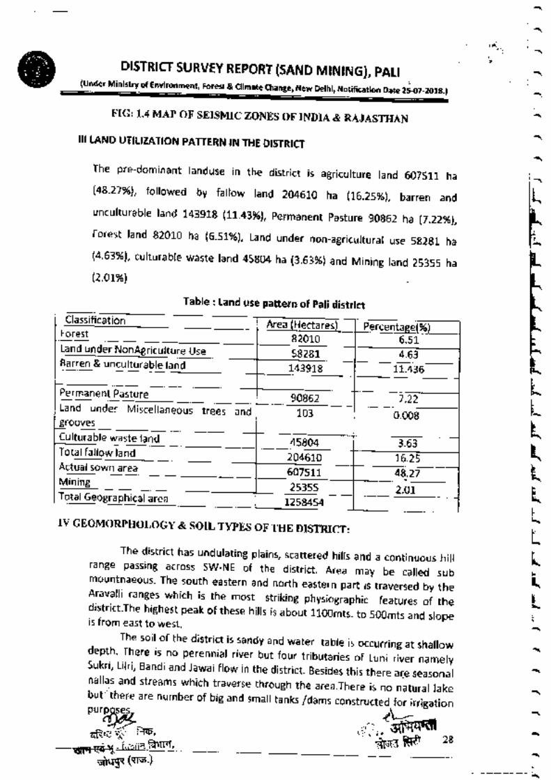
III LAND UTITIZATION PATTERN IN THE DISTRI T
The pre-dominant randuse in the district is agricurture rand 607511 ha
148.27%), followed by fallow land 204610 ha (t6.25%1, barren andunculturable land 14391g (lL.4lyo), permanent pasture 90g62 ha 17.22%1,
Forest land 82010 ha (6.51r%1, Land under non_agricultural use 582g1 ha(4.63%)' curturabre waste rand 45g04 ha (3.63%) and Mining rand 25355 ha(2.07%l
( ヽ (
へ ヽ ( ヘ
F
F
P
静
F
F
酔
卜
R
L
L
L
L
L
k
Ц
L
Ц
L
k
ヽ
L
k
ヽ
ヽ
ヽ
ヽ
ミ
(
よ〓
〓
IV GEOMoRPHoLOGY&soIL TYPES oF TIIE DISTRICr:
The district has undu!ating plains,scattered hills and a cOntinuOus hil:
range passing across sw― NE of the district. Area may be ca‖ ed submountnaeous.The sOuth eastern and nOrth eastern part is traversed by the
Arava‖ i ranges which is the most st「 iking physiographic features oF thedistrict The highest peak Of these h‖ !sis abOut lloomts t0 500mts and slopeis from easttO west.
The sOi1 0f the district is sandy and water tabie i5 0CCurring at sha‖ow
i:|!!:Ileii:illli計l:サ!|[lllよ
lよ‖:|1滉11::『:111‖も|[:羊:t』駕:よthrough the area.There is nO natural!ake
but theFe are number of big and s:
Table : land use pattern of pali districtClassification
Forest
Land under NonAgriculture Use
Area (Hectares) Percentage(%)82010 65158281 463
―
Land under Misce‖ aneous trees andgrooves
143918 11436
90862 7.22
103 0008
3.63tulturable waste land
TotJね‖∞′hnd ~Acti:alsOwn area
Mining
45804
204610 1625607511 48_27
25355 2.01
1258454

ヽ し
こりDiSTRICT SuRVEY REPOR丁 (SAND MiNING)′ PALl
lunder Ministry Of Enuronment,Forest&climate Change′ New Delhi,Notincation Date 2507‐ 2018)
‐
ヽ
ヽ
し
じ
し
し
ヽ
し
‐
し
‐
し
し
し
し
し
ヽ
ヽ
し
ヽ
し
ヽ
ヽ
ヽ
ヽ
‐
‐
ヽ
ヽ
ヽ
ヽ
10t
‐ ″ ●‐ ‐ ´.、 _ハ _●
rマゃぎ■.
ql● 甲 ■‐F:雨 諭 ′
爺■マ(ヽ:喘 )
29

) し
ヽ
DISTR:CrSURVEY REPORT{SAND MINING)′ PALi{under Ministry Of Environment Forest&c:imate Change,New Delhi,Notincation Date 25 07‐
2018)
‐
し
ヽ
し
‐
し
し
し
し
し
し
‐
‐
し
し
し
‐
し
し
し
ヽ
し
し
ヽ
‐
Old釣樹eロ
0「
Stt C■
“
●r“ntion
じ翼 さ
屋ヨSWE●ltH¨Y
國 ●●商 .a mpFf
田 。ctal,。 1
目鰍I「…ぬt
Eヨ`[。
、り
“
、
目 襲 ,。 こ,s
日 ヽ t。りЩ
IImL sa=
■ S‐ L〔 St"I[●C,R``螂 s
))))こヽき」
_ a. - _.4__.:,-t,,- i! sq:.: .:::
q5 ].'! 9.
- ;.i;; : ia'{rq,--:---.- ,--- -. \1I!tl! !: i.Y:'.i-r
31

ヽ
状
́・DISTRICT SURVEY REPORT (SAND MINtNG), pAtt
(und", Miniory of Er c", N"* Derhi, Notification Date 2s_{r7_2018.)
tAL WEALTH 5,lGEOLOGY‐
ヘ
ヘ
ヽ
ヘ
ヘ
‐F
F
F
F
F
F
F
い
F
D
ト
ト
L
L
L
Ц
L
ミ
Ц
L
Ц
L
L
ヽ「
ヽ
へヽ
ヽヽ
The geOb」酬brmttOn d the dtiま葛ξl慕[I籠[FI,~葛悪蔀再[R[£ξsedirnentary and met sedirnent rocks The Delhi Super Group rocks represented by
the AinhoArh rrハ“n ^´ .́.´ _^^―
^:―the Ajabgarh Group occur near the eastern border
";;ilil;:'::;:L:,::Ischists' phy,ite, marbre and- basic vorcanic. ,t "r' *" antruded by granites andrhyolites. The predominant of which is the Errnpu-ra g-.r-an ite whicn cover the southand southeastern parts of the district. The ,rr"r" rrpl or cranites is exposed south ofPali. town and is generally pink in colour. The n/ll.*rr super Group occurs in thenorthern part of the district and is represented by rimestone, doromite, sandstoneand share' Georogicar configuration of pari district i, qrit" .orpr"x. rt is comprised ofheterogeneous assembrage of different ritho units oi igneous, sedimentary andmetamorphic origin.
The oldest & prominent rock exposed along district belongscomprising southern, eastern and north ea-stern ,"rgin otferruginous and massive clastics.
爺■fttf■′u日Ⅲ■ね゙ 由n円口
to Delhi supergroupthe metamorphosed
"*l.mmt"'' 5"e s32
:.).,:,Y-
rr$ H er nrera enEtDt3rircr n€SaxricE rDp lr Dtstnlc , illastfillt
■≡二F― ―l=:■ _:lF :■:■ __ヽ ‐
::‐ ``

し
し
ヽ
しS. DiSttRICI suRVEY REPORT(sAND MiNING)′
PALI∫under MI雨詢 dttFOヽ me“,Forest&c‖ mate Change,New De生
しNot,■ca● On Date 25‐07‐20181
) し ヽ
)
)
し
)
)
)
し
)
)
)
)
し
) )
し
ヽ
し
し
ヽ
し ヽ
)
ヽ
し
ヽ
ヽ一
with subordinate chemogenic sediments and associated intrusive and extrusivephases' Rocks of this supergroup have been further classified in Kumbhalgarh,Siroh i & punagarh Groups.The Delhi's are succeeded by a sequence of unmetamorphosed sedimentary rockscomprised of sandstone, lim,estone, siltstone, gypsum beds, This Supergroup isfurther divided into Jodhpur Group, Bilara eroria Nrgrur. erorp.The Delhi's are Intruded by granites .na ,.f,yollt.. The predominant is theErinpura Granite.
5.2ECONOMIC IMPACT OF MININGThe mining wi' generate direct and indirect emproyment during mininSoperations and most of the unskired rabour wi, be used for mining purposes andthey will be paid more thanminimum *rg", pl"r*ii.d by State Govt. ln general,there wi'be no adverse effect on t'rrr'n t"rtti ., no brasting or handring oftoxic materiar is invorved. A, the safety measures wi, be strictry forowed toprevent occupationar risk during excavation, roading and transportation. This wi,b":-{frysource of revenue generation for the go-vernment as after getting theqRE,,F;:rilf, ., ," ffifu-=- ,,
eFr Ei ri -".rrm fu{FI' .=t
Alluvium & wind blown
Sandstone, shale, boulders and chert.Grante(J。 10r type)′ R「yOnte&pyrOdasucs wLh dykes Of
Baslc vd∞ 面c nh plllow b"′ mda mt qu誡ゴぃ hJQ¨ !‖ te′ bedded chert
Phyllite, mica schist, nio@migmatite& gneisses epidiorite, Hornablende
PhuladophiOI
ite Suite
Hornblends schist, amphibolite, pyroxene granulite,
創 c“h史′marЫ %ra雨腱 h■/amphbdに Ыo■eschist′ quartzite′ mica schist and migmatite
:

Environment clearance; the minor minerar concessioner wilr have to pay theRoyalty Price, DMFT and GST which will enhance the revenue of the state andCentral Government.
5.3 Mineral WealthPali district is one ofthe few districts of Rajasthan possessing wide variety of bothmetallic and non-metallic minerals. However ,commercial exploitation formetallic mineral has given encouraging results.
Among non-metallic minerals,limestone, magnesite, calcite, quartz, felsper,china clay , ball clay asbestos etc. are the minerar which being exproited for rast somany years. cement grade limestone of Ras belt has attracted manyentrepreneurs for setting up of major cement plants recent discoveries in thedistrict include blockable granite , wolastonite ,scheerite , worframite and
DISTRICr SURVEY REPORT{SAND MiNING}′ PALi(under Minにtry of Enuronment,Forest&c‖ mate Change,New De:hi,No面 catiOn Date 2507‐ 2018)
indication of gold mineralization. A brief description of each occunence Is givenbelow.
Major MineralsrBase metals:- occurrences of base metals haveNayakhera, Kalabar, Birantiya, Kantaliya, Jaitpura,Sandela etc.
でレ
been reported - in chitar,Bar, Sandarada, Punagarh,
Chittar:- Department of mines & geology has investigated copper deposit nearchittar 10 Km from sendra. A wefl deveroped gossan zone extends for about 2kms stricke length with average width of 1.5 to 2.0 mts .it shows variegatedshades of yellow brown ,maroon ,red and vermillion colours . Department hasproved 0.26 million tones of average 1% copper reserves in this areaNaya Khera :- A "L" shaped gossan body extends for about g00 mts . strike rengthwith variable width 1to 15 mts. rn derhi super group of rocks near naya kheraabout 18 kms from sendra - drifling was carried out by the department in the year1973-76 and proved .i.8 million tones reserves having 2g% sulpher ,0.5% copperand 1.76% zinc. The minerarization mainry consist of pyrite with subordinateamound of pyrrhotite , chalcopyrite, and sphalerite . the prppect may -be workedfor sulpher and base metals like copper, zinc can be recovered as by prtducts.Biranthiya khurd:- on the basis of geological investinggation taken up by G.S.l.massive sulphide minerarization hosted by fersic vorcanic unit (quartz mica schist )has been reported in this area .A 250 mts. Long rensoid ore zone has beenestablished in the north brock having smarr reserves of 44906 tonnes with anaverage grade of 4.6y" cu ,5.!5% pb and 10.6% zn. rn south brock ore bodies aresmall and impersistant both in stricke and dip. rndications of gord have arso beennoticed in north block. Samples have shown 150 to 1000 ppb of au.Kalabar:- massive and stringer surphide minerarization is found in karabar area.The rock type are assemblage of differentiated intermediate meta basic (amphiborites )chrorite scnist, carc granurite etc. ancient mining is evidenced bygold working slags and mine dumps occurring in echelon pattern over
ヘ
― ―― ― ―――‐、
ζえ宅「i■1てや ,
謙甲 (雨う
ミ沐
」
R
」ヽ
Lヽ
F
L
F
L
F
L
F
L
F
L
F
L
F
Iヽ
ヽ
ヽ
「
ヽ
ヽ
へ
ヽ
ヘ
ヘ
ヽ
へ
ヽ
一
・
t

①
し
ヽ
し
ヽ
し
DiSTRiCT suRVEY REPORT isAND MIN:NG〕′PALi
〔underMinistry21EWironment,Foreil&,‖mate change,New DelhL No●
■catbn Date 25‐ 07‐20181
譜:|::11°::llelu::11:|:i::S:alillCitta:):1::s穐:nl:″11」FI:‖』ょ1linlextends from kurklin the NE tO tunkra‐
mOriya in south_west it Occursin fOrm Ofnnral10r hOぃ● ́^__^´ ^J : _
) )
) 」) ・)
cumulative strike lengths of 335 mts. Test drilling done by G.S.l. Lelow theoxidized zone has proved the presence "f orrii"'l p]rrrhotite , sphelarite andchalcopyrite .besides.n rnd,:1 ,]c_1ifi.rnt r.tru oingii_a, oornt, se (1_50 ppm )Hg (2as-4000 ppm )and eu gttlt pp, tr,rr";ir;;;", obtained. 1.25 miiliontonnes reserves of massive sulphide zore having i.irri r^and 0.39% Cu and 0.19million tonnes of stringer surphide ,on. hrring'o-.;; cu and 28% Zn have beenestimated between 400_285 M.R_L G.S.t ,, *ra,.riry jrrestigation
in this area.sandarada punagarh etc :- sma, occurrences or teai mlneratization are observednear sandarda, punagarh ,bijaji ka guda areas . ,in"r"iiration is of disseminatedand vein type and shows erratic nature . air born" ,i^"r"f survey division of G.S.l.hasreported indications of base metar ,ir"rJ;;i;;; kantariya area near sojat
Tuntsten:-occu rrences of scheelite have been reported from Bar-Babra area andthese.areas have been explored by G.S.l. ,","rrOi.ri mineralization has beentraced for 10 kms strike rengths in bar area ."d ; k;;;; babra area ,width variesfrom 2 to 10 mts scheerite mrnerarization in the rt.rnr.no*, wide variation ingrade ' exproratorv dri'ing bv G.S.r. h.r pro;ul-;;;rl,"n." of minerarizationdown to 5 mtr. lt has average grade of O.2% Wo, .scheelite mineralization hasalso been reported by department near bar,runora ,-nrna,bera areas . the nanaareas have been explored by drilling .nd purrirt"n."'oi-sctreetite up to depth 132mtr. Have been observing.Occurrence of wolframite has been observed by G.S.l. near motiya_pipliya areanear kurki Minerarization occurs as dissemination in quartz veins at the contactof sewariya granites with mica schist of Delhi Srp", e ,Jrp.Beryl :- lt is an important source of beryllium metal and arso finds extensive usein atomic reactors. lt occurs in many pegmatite U"ai*
"f Raipur tehsil . Recentlydepartment has arso discovered beryt minerarizati"; ;;; Nador in Desuri tehsir .It occurs as large crystals (15_30 cmi I .nO .on1.in ,pto- 1.3% .rate elernent havealso been discovered during chemical analysis_
rhe major deposits., "".-#il,[:1H,5'"Hexproited in pari district arelimestone, Clay, quartz-feldspar, dimensional stone"s Gr"",* & marble), masonrystone & rhyolite. Details of these minerals are as follois:_
Limestone :- limestone is one of the important ,in"rrt, because of its use incement' chemicar, meturargicar, industries. pati drstrict has extensive rimestonebelonging to Delhi Super Group and Marwar Super Group of rocks. Cement gradeas werr as chemicar grade rimestone are found in the district. Major rime stonedeposits are described below :
)
」
し
し ヽ
) )
‐
ヽ
ヽ
し
ヽ
し
ヽ
し
ヽ
ヽ
ヽ
し ヽ 」L
,′′]!]:lindSexpOSed inanareaofabOui′:::高 |・ Iiよ
:'i:li!!lili丁
l:[[1
--r ,,trHF ,'l=):..,:: ir:; \
―一
|

ヘ
ヘ
ヽ
,DISTRiCT SURVEY REPORT{SAND M:NING〕′PALi
(under Ministry of Environment, Forest & oimate change, New Derhi, Notification Date 2907-201g.)
occurs as thin veins with an averageextensively prospected and 130 tonnes
associated with Marani igneous suite near Kharda, Kharda Ki Dhani,Dharamidhari, Jitra, Jawariya. The important potentiar areas have beeninvestigated by the department and granite prots have been delineated forleasing. Keeping in view the overwhelming response from the entrepreneurs,search and delineation of granites is in progress in different parts of pali district.Marble :- Search for marbre in pari district. Began during 1960 when first deposit
was explored at Bheru ka Bariya near Bar. The marble of this district has veriedcolours and is figurative at praces . regionar scanning for marbre was done indifferent parts of the district which herped in rocating deposits near Nandana,Ramgarh, Hemadai, Bhirda, Barwantgarh, Gurha rn Raipur and jaitaran tehsirs andnear jedri,sindru,Diyana,Banki,Khiwandi,Siriya ri,Anna, Kantaliya,Vin pura,Sarangwas etc. inBali, Desuri, and kharchi (Marwar Junction )
Most of the marble deposits of pali district are siliceous in nature . thevariegated corour is important due to presence of ferruginous contents, thinbanda of the district. Corours is attractive but the presence of irregurar croseryspaced fractures are creating probrem in extracting big brock and accordingrymarble industries in pari district has been severry affected .Except two,thrlelocalities i.e Hemardai, siriyari, Bhirda, in the most of the areas minirlg is beingdone for sending the materiars to cement industries. The crystafline rimestone issuitable for cement manufacture. Recentry carcsiricate rocks which are hard,compact & occur as shaets have attracted few entrepreneurs for its extraction asblocks as marble near viflage Asan and samer in the district . economic exproitionof such rocks is yet to begain.Rhyolite:- Rhyolite of pari district is mostry reddish brown,grayish brack in corourand is aphantic as well as porphyritic. lt is being worked near Medi Bhaker,Singhari ,Rohat and kharda ki Dhani , where g reases are in oprection. Besides,Rhyolite ,occurrences are reported from punagarh, Manihari, Bamborai, GuraPartap singh, Bhakariwala Gaon etc. in pali tehsil. These can only be utillised asroad ballast or for chip making-
The minor occurrences of non metallic minerals are as followsrAsbestos :- This mineral mainly finds application in making cement pipes, sheet,fireproof clothing etc. the asbestos deposits in pali diftrict .;; iffi; ;;;;sendra, mala ka guda, chhagri ki bhagal , patariya ,goriya , kanotiya, ramgarh,dhanbarli ,ballupura ,ranakpur ,shyampura ,alipura ,elc. rru_rst of the asbestos istermolite veriety but at place thin veins of chrysotile asbestos are also found .mining of asbestos is known for many years in pali district. these days newmining leases for asbestos are banded as per center government directivesbecause it has been considred hazardous minerar for mine & factory workers . theimportant occurrences are described below:-
Dhe: Maiali Ka Cuda:‐ asbestOsth夏
i:`´:!i:ill the area has been
「ト
ト
ト
ト
ト
ト
k
L
k
L
L
L
L
L
Ц
Ц
Ц
民
Ц
Ц
ヽ
民
(―、
ヽ ヽ ヽ 1・^
幸 `箭 “

DtsTRtcT SURVEY REPORT (SAND MtNtNG), pArl
ヽ 」
) )
(u^d", Mini*ry of E. h"ng", *"* Derhi, Notification Date 25.07_2018.)
reserves have been estimated upto depth of L mtr.
. chariya ki bhaga patriya :- asbestos of tremorite veriety occurs in srip fibersveins . the vein are short, irregular and discontinuous . the reserves have beenestimated to be 6550 tonnes upto a depth of 20 mtr.Goriya :- Tremolite asbestos occurring here is generally a cross fiber type 2G5
tonnes of reserves have been estimated upto 9 mtr. Depth.Dhan Barli :- asbestos occurs as thin cross fiber veins having 2-3 cmsthickness. The reserves are 1,15,440 tonnes a few thin criss_cross veins ofchrysolite have also been observed.
ln addition to these occurrences of asbestos have been reported from aripura,shyampura,patan,sendra,ballupura,patriya and phulad etc.Calcite i calcite occurrences are located at bara guda,Budha Lalwa, Kalab,Kapilki Bhagel , Khemal ,Alipura,kharol ,patan,Dayalpura ,ltimal ,Kurki ,Sardhana,Patariya,sumel etc.These areas mainry fafl in Raipur,iaitaran and Bari tehsir.Most of these occurrences are pocket type deposit.Garnet :- The minerar has been exproited in the past near devkhedi andkaranpura villages of Raipur tehsil .it is found in garnet -r,., ,.i,ri.ni ,. ,,r" i.skarns associated with wollastonite, epidote, quartz and calcite. lt is found atnumber of praces in Raipur and Kharachi tehsir . it is mainry of abrasive quarity.Graphite :- Small occurrences of graphite are rocated near Bar rairway station &desuri. Preliminary investigation by the department have shown that it has verylow carbon content (6-8%)Gypsum:- it has been worked in part near khutani villages. Gypsum occurs inabout 1 sq'km area with an average thickness of about r mtr. rt has been workedearlier by RSMM and few private mines owner.Magnesite :-the minerar is carbonate of magnesium occurring as hard whiteearthy lumps in urtrabasic rock. When free from sirica & iron it is highry varued forit's refractory properties. small g Magnesite occurrences are found near Koyalvav, Bhimana ,talao ,Charria ki bhagel ,bhilan ,phulad ,Siriyari . it occurs as thin veins& stringers in ultrabasic rocks like peridotites , pyroximate etc. A.few smalloccurrences have also been noticed in Desuri tehsil.Mica :- occurrences of muscovite mica are found in pegmatites along with quartz,felsper,and tourmarine in many parts of Raipur and Bari tehsirs. But no workabredeposits has been established.Barytes:- small occurrences of barites are found in punagarh hiI in the forrn ofsmall veins. lt has off white to cream colour and grade is also low. Barytes havealso been reported from Biranthia khurd by G.s.l. it overlies the lenses of massivesulphides along the contect of quartz-mica schist having intermittentry exposedoutcrops of about 280 mts. strike lengts and 1to 3 mL. Thickness it is of lowgrade.
Soap Stone:- small occurrences of soapstone are reported from kanuja,halwat,shyampu-ra ,khormar ,manpura ,kotri ,nandana ,kanoiiya ,asan etc, these are six,{Pt "6r__;;
⑨
) ) )
)
)
)
)
)
し
) L し
ヽ
」
)
L
)
ヽ
」
し
ヽ
し
」
・
輛 薔 」
i. -

ハ
・
ヽ
へ
ヽ
ヽ
へ
(
|~~ヽ
D:SttRICT SuRVEY REPORT〔SAND M:N:NG)′ PALi(rna"r r,n*t ot rnr
"rr", ""* Delhi, otificatlon Date 25.ro7_201g.)
mining leases of shop stone in the district.Red ocher/ Red oxide :- it is observed near botha ki dhani in Raipur tehsir whereit was being exploited by private parties . red oxide and clays.r. ilro being founJaround jaitpura and shyampura and have also been worked in past.Wollastonite: - this mineral is mainly used in ceramics. lt is also used in polymers,rubber, paints, plastics, mineral wood etc. it has become important substitute ofasbestos. Good quarities of wofiastonite are found in berka pahar ,kheravparraareas of sirohi and Udaipur districts. These arso extend in pari district. rt is beingworked by M/s wolkern lndia pw.ltd. it is associated with calcite. Both themineral are being mined out.
Recentry department has rocated row grade wo[astonite arong the border ofAjmer and Pali districts. woilastonite bearing skarns containing 20% woilastonitealong with epidote, garnet, quartz, calcite occur as detached bodies. Theseextend from pisangam-gola in ajmer district to alipura ,rawaniy;.,;.r;;;;,gopalpura, karanpura, sodpura, ramawas etc. for more than g0 kms strikelength beneficiation studies conducted by rBM raboratory,ajmer have indicatedencouraging resurts. Driling conducted in three area of pari district nameryRawaniyo , Rampura ,soupura and Gopalpura has proved 79596 metric tonnes ofWollastonite.
sand(8ajri)The district consists of a polycyclic sequence of large alluvial fans comprisingclastic materiar' Consequentry, considerabre raterar and verticar variations arewitnessed in size and shape of clastics and sand grains depending upon theprovenance and size and shape of clastics and sand grains depending upon theprovenance and size of the river. The newer alluvium is restricted io riverchannels. Texture is medium to coarse grain. Minerals mostly constituted ofquartz and ferdspar minerar with rit e micaceous minerarsand heavies, it containsvery little amount of clayey minerals. The sand (Bajri) was extensively qr"r.i"Jfrom Rover Masi, Dhund etc.
5.4 OVER VIEW Of MIIYING ACTIVITY IN THE DISTRICTPari district is one ofthe few districts of Rajasthanlossessing wide variety of bothmetallic and non-metaric minerars. However, commerciar exproitation formetallic mineral has given encouraging results.
Among non-metallic minerals, limestone, magnesite, calcite, quartz, felsper,china cray, ba, cray asbestos etc. are the mineraiwhich being exproited for rast somany years. Cement grade limestone of Ras belt has 'attracted
;;;;entrepreneurs for setting up of major cement plants recent discoveries in thedistrict include blockable granite, wollastoniie, scheelite, wolframite andindication of gold mineralization.
』k
i
F
ヽ
I
F
ヽ
卜ヽ」ヽ
」F
Щ
LF
ヽ へ ヽ ヽ ヘ ヘ ヘ ヽ

呻
L し
)
し
ヽ
し
ヽ
)
)
)
)
)
)
)
し
)
)
)
)
)
」
)
)
」
し
ヽ
し
し
ヽ
」
」
L
ヽ
」
L
ヽこ
DrsTRtcT suRVEy REPORT (SAND MtNtNG), pAtr -
(Under Mininry of En limate Chante, New Delhi, Notification Date 2S{r7_2O18.}
The mining activity in the district is administrated by twO mining engineer
offices viz Mining Engineer― SOlat under the cOntrO1 0f supenntending MiningEngineer― Jodhpur circle and AdditiOnai Director―
Mines′ Jodhpur zOne and MiningEngineer Beawar(Raipur tehsiり
under the contド Ol oF Superintending MiningEngineer―Almer Circ!e and AddtiOna!DirectOr― Mines,Jaipur zOne
The Geo!ogica! Survey and PrOspecting Activitv are COnducted by the
Geologists and seniOr Geologist Of the office of superintending Geologist JOdhpur
under the administrative cOntro1 0f AdditiOnai DirectOr―Geo:ogy′ JOdhpur ZOne.ln
dlstnct ll va面 eJes Of majOr minerals and 8 vanejes of minor minerals are 6eing
exp10ited As on 31 10 2018, 10 nos Of major mineral!eases,500 nos Of minor
mineral:eases and 84 QL were under Operation in the district,the statistics of
which are tabulated in fO‖ Owing tables.
Table‐ No of Malo「 Minera!Leases vvith Area,PrOductiOn,Sale Value′Revenue and
Table ―No. Of Minor Mineral Leases with Area, Production, Sale Value, Revenueand
Table‐ No.of
Employment in Pali district SOiat&Raipur office){Year 2016‐ 18S no Mineral Leases Area Production Sale
Value
Revenue Employment
(Hectare) (Tons) (Lac Rs.) (Lac Rs.) (Nos.)1 Limestone
(cement
Grade)
6 2576 81213501 Leases
holderown
Cementplant
974562 750
2 Megnesite 1 4 Nil N‖ N‖ N‖3 Wollestonite 3 3487 N‖ Nil 099 C
J
Total 10 261487 81213501 97457・ 19 765
in Pa!i distr:ct Office) (Year 20t6-18S no Mineral Leases Area Production Sale Value Revenue Employmen
t
(Hecta re ) (Tons) (tac Rs.) (Lac Rs.) (Nos)1 Limestone 46 3072 7670760 400-500 545692 750
Granite 21696 1365702 150■3000 20825 0CJ
nフ
3 Mesonarystone
201 L̈ツ
02
4031576 220-26022355 1550
4 Rahylite 28 3735 118128 200-250 805 200EJ Quartz
Feldspar13 112
79948250-300 458 220
6 Chaina
clay/Ballclay25 551
3092340350500 1838 500
7 Marbie 1 1 Nil Nil Nll NilTotal E
●■ι
4 419531 16358454 1173922 4170
Value,
,
Minor Mineral Leases with Area, production, Sale Revenue
¨

D:STR:Cr SURVEY REPORT{SAND M:NING),PAL:(under Minifiy of Environment, Forest & climate change, New oelhi, Notiflcatlon Date 25-07-2018.)
ヘ
ヽ
ヽ
ヘ
ヘ
ヽ
ヽ
ヘ
ヘ
へ ヘ̈ ヘ
L
卜
↑L
I
F
k
卜F
L
L
ヽレ¨,
へ
(
CHAPTER V:
6 RIVER OR STREAM AND OTH[R SAND SOURCES
・
111:11とイ争LT,d gravei are one Of the most important
4
2019100005061
Udesikuwa/
Sttat/
pali
KHUSHAVIR SiNGH 3997
5
2019100005279
Hirankhuri/
rani/
pali
SAIJAN SINGH 186
6
20191CXICD5421
Dhundali/
rohat/
pali
SHOBHARAM
7
2019100003940
Lototi/
jaitaran/
pa!i
Duda ram 24055
Details of Revenue and production from sand/ Bajari received in rast five
Production(in tonnes)
Revenue from bajri/sand(Rs in Lacs)
2013-20■ 4 1410441
2121145
19663116.46
(
^
(
へ
(
(爺叩 価研う
construction materia:s
赫 44
YEAR
2441999
2014-2015 2179920 1738972
2015‐2016 2511005
2016-2017 2418343 21637.8
2017‐ 18 2096160
2018-19 N‖ Nil

ぶt
・へ
r
、
へ
F
い
い
い
い
ト
ト
トL
L
L
L
L
L
L
L
L
L
Ц
k
L
L
L
L
L
(ヽ
ヘ
DiSTRiCr SuRVEY REPORT{SAND MIN:NG〕′PALl
〔under Minttry of Environment,Forest a climate alange,New DeihL NOtttatbn Date 2●720181
lnternal drainage in ocurring south eastern and north eastern part formed byseasonal nala coming out from rocar hifly region. The deposition of sand/Bajri in naraocuurs locally during rainy season.(6) Marwarln Marwar Panchayat samiti area is having Bandi, sukri Khari and Mithri rivertributries. lnternar drainage in ocurring south eastern and north eastern part formedby seasonal nala coming out from rocar hiily region. The deposition of sand/Bajri innala ocuurs locally during rainy season.(7) Rohat
ln Rohat Panchayat samiti area is having Bandi, Guriya, Rediya, sukri and phuphariariver tributries. rnternar drainage in ocurring south eastern and north eastern partformed by seasonal nara coming out from rocar hifly region. The deposition ofsand/Bajri in nala ocuurs locally during rainy season.(8) Sojatln sojat Panchayat samiti area is having Gurhiya, Rediya, sukri and phuawariya rivertributries. lnternal drainage rn ocurring south eastern and north eastern part formedby seasonal nala coming out from rocar hi[y region. The deposition of sand/Bajri innala ocuurs locally during rainy season.(9) Sumerpurln sumerpure Panchayat Samiti area is having sukri, Mithri and Jawal river tributries.lnternal drainage in ocurring south eastern and north eastern part formed byseasonal nara coming out from rocar hily region. The deposition of sand/Bijri in naraocuurs locally during rainy season.
Drainage system with description of main rivers
The district has a poor drainage system which too is internar. pari district fa[s inthe Luni & Barmer Basins. Major River of the district is Luni, which flows in ENE _wsw direction. rt enters pari district near viflage Ras in Raipur tehsir and reaves thedistrict Eari near vilage Amli. channer pattern of Luni is dendritic to sub-paraIer.However, in major part of the district, the drainage is essentially ephemeral andinternal' Tributaries to the Luni river are sukri, Lirri, Jawar, Bandi. other streams inthe district are Guhiya, Mithari, Kherwa and Khari which are all ephemeral.
( ,( ′ヽ ―
一一
S.No. Name of the River Area drained
lSq.Km)
%Area dralned in the
Distnct1 Raipur Luni 20.44 01652 Sukri Nadi‐ | 1725 0.1393 Lilari Nadi 450 00394 Gudiya 4.80 0038一b Bandi 21 0_1696 Sukri― ll 645 0_520
ノ

‐`
) ヽ D:STR:(I suRVEY REPORT{SAND MIN:NG}′
PALl〔Under Ministry of Env"onment,Forest&c‖ mate Change,NewDettι No■ ,ca● ●n Date 2507‐2018)
) ヽ
) )
) 」
) )
) し
) ヽ
) )
し ヽ
ヽ L
)
ヽ
ヽ
」
ヽ‥
DescriptiOn ofimpOrtant rivers is as under:_ ‐
い〕Lu面
Rang[:i:IC[|(1:ll。 lr暮 l]::itn:::11Fil」 Itl』51lSII:rll:el。 :;‖ll :`:Ii‖lwestern of Ralasthan,■ disappears in the marshy!and OfRann Of Kutch The totalcatchment area of the Luni River 8asin in Ralasthan is 37,363 km2,coverlng parts of
thiliStricFil富
∬ill:l‖:dhpur′
Nagaur,Barmer′ Ja10re and Gularat in Ralasthan
(b}Guhiva
m:n.rIIttFT訥鵠1器匙「‖誌願引l戦犠i窯
I思躍1距3,835 km2,which is situated in Pali district lts tributaries are Raipur Luni′
Radia Nadi′
lclKh」riHel露attL Suk‖
and Phunpha"a Baぬ
River Khari is fOrmed by the cOnfluence of sma‖ streams namei' sOnnesarけu面…計sOmew酬
…囃腱ISm耀訛榔l蹂!讐鷺II:::淋
all:i志
iミ:liil:‖:la‖ :i::lilir Reserved Forest Bhakar′ after flow OfabOut 30 km)After joining Of a‖ these smali streams,the nver is called Kha‖
AFterlowing fOr about 25 km′ lt,Oins Bandi River downstream of Hemawas reservOir ttscatchment area is l,232 km2
(d}Bandi(Hemawas}Near BOmbadra pickup weir Khan and Mthan Hvers ioin and fOrm the Bandi River
Later Bandi nveriOins the Luni near the Lakhar viliage′after 10wing for about 45 km
The catchment area is about l,685 km2 and Situated in Pali District
{e)M■hari
Mithari river originates by cOnfluence of:Ocal nalas in the sOuth_western siOpes of
聾漁詭塾輔曲上J膿11囃灘riS l,644 km2
「 ドuk‖
Sukri river is fOrmed by the conf!uence of several sma‖ nalas _ Ghanerav NadL
M‖翼]ド f甜′ポ請1‖札:ょ ど1:点
ng tt° m meAmv訓もh Ptt and udJpurl―west directiOns for abOut llo km and
feeds Bankli Dam on the wav NearSamdanin 3armer Dlstnct,it iOins Luni“ver
The Ja10re′ Pali and Barmer Districts are cOvered in this sub_3asin lts catchment area嶋Ψ給 ‐
:静芹ン _
壕 トー
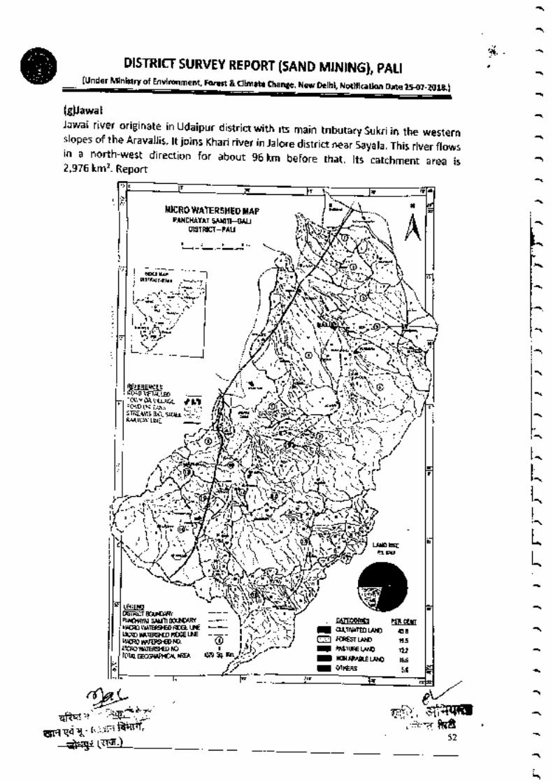
(g)Jawai
Jawai river originate in Udaipur district with its main tributary sukri in the westernslopes of the Aravalris. rt joins Khari river in Jarore district near say.r.. ii. ,ir"r'rr"*,in a north-west direction for about 96 km before that. rts catchment area is2,976 km'z. Report
DiSttR:CI SURVEY REPORT{SAND MINING)′ PAL:(Under Minlstry of En imate Chante, New Delhi, Noflflcatlon Date 25-07-2OtE.)
uNO uSEPS Ш
(」LこL」卜‐(
ヽ ( ヘ
いゞい)、
へ ́ヘ
k
L
L
L
L
L
l
●sTRrr ecl,NEVUWPmAYAr mlll∞いい
“や00い IEeCO Ш ェ 旺100n― ED mGE旺さい̈ MIEmED Юl¨ 鵬 ¨ 崚107AL GECRA― ―
)ヽヽ」一い〕一□日一一
CATE60meS PcR CEWCt■TⅣA¬m tAN0 450FOneST υ中。 196PASuCい o lυNON ARハ ヨにε鰤 1660TIERS s6
榊P雀1サr i
品鷺lil丼炉 鳴紫F,52 ヽ
へ
‥ヽ
・゙<
滞式
纂

DISTRICT SuRVEY REPORT{SAND MINING)′PAL:
{under Ministry of Environment Forest&aimate change,New De:hL Notncatton Date 25 07‐2018.)
J、 _
へ (
く●C‘
』く
」̈
・も
ヽ
‥「”1
・I=υl「■1
・■
一コくa 卜02卜∽一〇
一コく」・一卜一〓く∽卜‘>く一0〓く一
一く〓
O
u工∽∝Ш卜くを´0
∝0
一ミ
∽‘ロエ」0“一一ロ
025雪口臣く2o2口■
oこ
ヨ
」3
日
0そ言一〓2ロロ
0そ〓
口,
E3
1
目目ロヨロ
轟 膊 ′
口:・ ●■‐R師勧輛′
→雫 (")liヽ
56
へ
ヽ
ヘ
ヘ
ヘ
三
,S
¨
6
彙
ヨ壼
〓
8̈8
ご
ρ
い
箋
艶
縁
肇
礫
萎
―
――― リコH●こ0り●』“≦スχ】■
―‥‥―
リコ862nW2P≦6ス)g2
‥‥
‥‥ を費
28
,
E
‘
●な
り
〓
―‥―― ヽを
,●8
●こあ●
詢I
聖築雛
一一L一 ]9D一5r〇一■6ト
ーーーーー
0り■マL〕■0く0こ
菫:
讐言
【」E卜日ヽRFヨRr日」だ電」ヘ ヘ ( へ へ ヽ ヽ‐―ヽ

じ
し
t⑩DiSTR:CT SURVEY REPORT{SAND MiNING)′ PALi
(under Ministry of Environment, Forest & climate change, New Delhi, Notification Date 2s-o7-2018.)
い」¨二」0 一一一ロ
0〓”コ
山一にくL●〓0■ 一一一一
,‘̈叫i
,こ
一日日
c,
コ一いヽ
,c」
E
,一■
o”
ヽ
三
ボ̈
一ロ
ロ
ロツご̈CC〕』で0
雪:0贅
5=
く″κ
・.て,
工こイκり0”0コマ0̈】
2一り〕う●
■´
96ニ
0^avZL
R‘0こ0‘^
り
3^一p]“0}´∝L″メ
0“9
,
り一´=)●α
O〕ι”市」■■06
‘´
こヽ■】r′‘
二一′´ケ
,‘Λ〓r¨
ゝヒ6
z●0¨¨リピ』
,0
一ヨ
゛
0‐ ′
2
ミl
ド lヾ,■トミ
11‥I W4コ々ンコ臣
― ●■̈ ココくヽゆ0この2ヽ一“一∽
(¨´rυ γ〓イ【に00■Oα
r
●
●
”じ‘ず
6
一,9
11111, 0”コJ●”二0イ0こ
一‥
一一くこ
【0一α卜0一〇
¨ミr〓く〓一F〓´く0
卜くヽく〓02くヽ
L
く
〓
O
u
〓
∽
L
u
卜
く
ヽゝ
0
∝
0
一E
‥
こ
,
!
″・」.4一一一い・ ,‐〓ヽ、
ト
´∠
れ 、ど職rT,口H■■餞嗣斜呵′
爺喝マ(マ詞.)
■ :タ
ヽ
し
ヽ
」
し
)
)
)
)
)
)
)
)
)
)
)
)
)
)
)
)
し
ヽ
し
ヽ
ヽ
し
ヽ
)
)
Z・く
く
」・
」

DiSTRICT SURVEY REPORT{SAND MiNING)′ PAL:(Under MinisEy of Environment, Forest & Oimate Change, New Delhi, Notificatlm Date 25.(t7-2018,)
儡爺嘔マ(雨・)
58
へ
ヽ
へ
(
ヽ
ヽ
ヘ
い―へ妻
L
L
k
k
k
L
抵
k
L
L
L
L
k
L
L
L
k
ミ
ヽ
Ц
ヽ
ヽ
ヽ
ヽ
ヘミ
ヽ
´・^ ヽ ・
00 のにШ工FO■■●
9¨
Oζ
讐
霞
29
■■
0一一 〇2‘コurD一aく一 一口一一
■一 〇25一3ビ8
〔H日
■8 02≦00を‘L3
一■■
ユく〓
0ロエ∽“ロトく〓
OLO一〓
―「=日1一=ull「=ulJ
一ヨくユ・卜0一E卜0一〇
一Zくピユト一〓くの
卜く
,く工OZ‘ユ
ゴ“風 目』お要臨鋼
館聟
‐ぬν‐讐コШ%監暇だ畔要醍壁一
―
‥‥
―
”zコ
リ8
屁
n
ヌ
“
曜
〓
一9
0
3

し
ヽ
こ(暑2)D:STRICI suRVEY REPORTiSAND MiNING〕
′PALi(under Min、 try of Environment,Forest&c:imate change,New De:hi,Notncauon Date 25‐
07‐2013.)
∽聖
LO
C一卜く0
■ヽ一̈一,・
・ヽ一一一一す「r)ャ
し
ヽ
ヽ
)
)
)
)
)
し
)
」
)
)
」
)
)
)
)
)
」
ヽ
)
」
」
ヽ
」
)
」
)
)
」
しヽ
,藝幣式】
^〓
ヽ一』¢〕
」0
」
口
‐ ‐
U
こ2く一こ〕【くゝ一̈コ30 口一ロロ中
::=:=ミ
ヽ :… ・
I
ヨヨ
三 r
ヽ
ぼヽ′
歳 、 ビ
ト 舅 」 Fヽ市 ,
uH哺キで調 ` .
→琴 (ヽ「ヨう 膏
一コく一
・卜0一‘”め一〇
卜く「0∽ 一卜一Eく0
卜くヽく工02く」
LくE
OШ工の∝ロトく〓
0“0一〓
Zく
‐′―1
0日望
し
ヽ90こ
‥
―
―,―
じ7
κ由硼督
・9人
′
.ヽo
59

DiSTRiCT SURVEY REPORT(sAND MINING),PALl ,{undor Minlstw Of Envttonment,Forest 8t c‖ mate Change,New DethL Notrlca“
。n Date 25‐ t17-2018)
Ok
l
L
ムL
L
L
L
L
L
L
Ц
k
Ц
k
k
k
k
Ц
k
k
Ц
k
k
k
ム
ム
ヘ
¨ヽ
い
6 3 SALIENT FEATURES OFIMPoRTANT RIVERS AND STREAMS
Salient Features Ofimportant Riv nd S
6.4Availab‖ity Of sand Or grave:or aggregate resources in Pali:_
This has already been briefed in the preceeding paras The resOurces are on the
banks Of Luni river are sukri′Lilri′ JawaI′ Bandi other streams in the distri(■
areGuhiya′ MitharL Kherwa alld Khari etc
nt Rtvers a trearnsS.No. Name of the River
or StreamTotal Length
in the District
(in Km)
Place of origin Altitude at Origin
1 Bandi 12495 Bhupat Ka GurhaSingpura
4602 Cuiriya 1221
32283343
一4
Rediya Lonera 224Sukri 21938 Giri 339
5 Phtlnphariya 3419 Surayata
Sumel2366 107553957 a
L”
νヽ 3560 Perva 3028
9
Somesar
Khardi5707 Somesar 5002603
7457Khariya Swaniva
Motagura26910 Mlh●370■
■ Khot Ki Nadi 2544
…
42012 Magai 2996 Jaton ki Doran 37013 iawali 5156 Khaubban ka Gura 37614 Raipur Luni 5516 Lalvacha 37815
16
Tatawari
Jawai
1112
4972
Mahaveer ji templen ear Kundai
434
Dharcial 41117 7552 Oariyara 235


R.K.CONSULTANTS tCHEMiCALANALYSiS D:VIS:ON〕17げ″ ,C.H.町 J●dhpur i贅1.〕
Telefax.0291‐ 270 6098 ha‖ ―歯consu:tant珈劇hpurOMal.COm
R‐,●●lta02
NABLTC1 5788
RepOrt No.:RKC/2019・ 20/130 Date:20.05.2019
TEST REpORT
Day Tlme(600● m.to 10.00P.m.)`Nightttme〔 1000p.m to600a m)Th"reporttnottobereproducedwhOllyorinpartandcannotbcusedaseЙ dence:nthecomoFL喘SubleCttO'Odhpurrurlsdldon o■ ,
PaBe 1 of 1
■
2
■
¨N
NaDe & Address of CustomerShd3ogttnghSrOShHG●e Sltth
Ⅵ‖age-3● la,Khasra No.-197
Tehs‖ &Distnct― Pa‖ 〔Ral.)
ProleCt
Reference No.
Nolse Sample Code RKC′N/130
Type of Nolse Monltorlng Amb:ent Noぶ e
Date OfNoise Monitorlng 1505.2019
Monltorl● g Stan Date 15052019
Monltorltrg Ead Date 16.052019
EnvlmnmetrtalCondldons :
A Temperatsrre,oC :
& Rdaive Humtdltv,96 :
25■ 2●C4896
S.
N。
LOCAT10N UNr SPL LeqDay Time 山
血N
T
1 Mineま te dB(A〕 64.3 33.6