district survey report (dsr)
128
DISTRICT BALA ROAD METAL (FOR PLANNING ODISHA As per No Ministr CO SURVEY REPORT OF ANGIR DISTRICT, ODISHA FOR L/BUILDING STONE/BLAC G & EXPLOITATION OF MINO RESOURCES) A BA otification No. S.O. 3611(E) New Delhi dated 25 July 2018 of ry of Environment, Forest & Climate Change (MoEF & CC) OLLECTORATE BALANGIR Page | 1 T (DSR) A. CK STONE R MINERAL ALANGIR 5 th
-
Upload
khangminh22 -
Category
Documents
-
view
4 -
download
0
Transcript of district survey report (dsr)

DISTRICT SURVEY REPORT (DSR)
BALANGIR DISTRICT, ODISHA.
ROAD METAL/BUILDING STONE/BLACK STONE
(FOR PLANNING & EXPLOITATION OF MINOR MINERAL
ODISHA
As per Notification No. S.O. 3611(E) New Delhi dated 25
Ministry of Environment, Forest & Climate Change
COLLECTORATE BALANGIR
DISTRICT SURVEY REPORT (DSR)OF
BALANGIR DISTRICT, ODISHA.
FOR
ROAD METAL/BUILDING STONE/BLACK STONE
(FOR PLANNING & EXPLOITATION OF MINOR MINERAL RESOURCES)
ODISHA BALANGIR
As per Notification No. S.O. 3611(E) New Delhi dated 25
July 2018 of
Ministry of Environment, Forest & Climate Change
(MoEF & CC)
COLLECTORATE BALANGIR
P a g e | 1
DISTRICT SURVEY REPORT (DSR)
BALANGIR DISTRICT, ODISHA.
ROAD METAL/BUILDING STONE/BLACK STONE
(FOR PLANNING & EXPLOITATION OF MINOR MINERAL
BALANGIR
As per Notification No. S.O. 3611(E) New Delhi dated 25th
Ministry of Environment, Forest & Climate Change

P a g e | 2
CONTENT
CH. NO.
DESCRIPTION PAGE NO.
Preamble 4-5 1 Introduction
1.1 Location and Geographical Area 6-9 1.2 Administrative Units 9-10 1.3 Connectivity 10-13
2 Overview of Mining Activity in the District 13 3 General Profile of the District
3.1 Demography 14 4 Geology of the District
4.1 Physiography & Geomorphology 15-22 4.2 Soil 22-23 4.3 Mineral Resources. 23-24
5 Drainage of Irrigation Pattern
5.1 River System 25 6 Land Utilization Pattern in the District
6.1 Forest and non forest land. 26-27 6.2 Agricultural land. 27 6.3 Horticultural land. 27
7 Surface Water and Ground Water Scenario of the District
7.1 Hydrogeology. 28 7.2 Depth to water level. 28-30 7.3 Ground Water Quality. 30 7.4 Ground Water Development. 31 7.5 Ground water related issues & problems. 31 7.6 Mass Awareness Campaign on Water Management
Training Programme by CGWB 31
7.7 Area Notified By CGWB/SGWA 31 7.8 Recommendations 32
8 Rainfall of the District and Climate Condition
8.1 Month Wise rainfall. 32-33 8.2 Climate. 33-34
9 Details of Mining Lease in the District
9.1 List of Mines in operation in the District 34


P a g e | 4
PREAMBLE
Balangir is a city and municipality, the headquarters of Balangir district in the
state of Odisha, India. Balangir has a rich cultural heritage. It is also known as the
cultural hub of Western Odisha. Balangir municipality is divided into twenty one wards.
It is spread over an area of 12,200 acres (4,900 ha). Balangir is a unique District in
Odisha lies on the western most part of the State with rich and varied mineral resource.
In pursuance of MoEF & CC Notification S.O. 141(E) dated 15th Jan. 2016,
District Environment Impact Assessment Authority (DEIAA) & District level Expert
Appraisal Committee (DEAC) has been formed for Category –B2 Minor Minerals
having area less than or equal to 5 ha. Prior to the formation of Odisha Minor Mineral
Concession Rule 2004, (OMMCR -2004) the mining operation for minor mineral were
carried out in unscientific manner. Identifying this fact in exercise of power, Conferred
by Section 15 by Mines and Minerals (Development and Regulation) Act 1957 as
amended in 2015 and all other powers enabling it in that behalf, the industry Mines &
Geology Department, Govt. of Odisha framed the aforementioned rule, which has been
amended with period of times in the year 2014, 2015 and 2016.
Keeping in view of experience gained in period of decade, the MoEF & CC
came out with Environmental Impact Assessment Notification S.O.-1533(E) dated
14th Sept. 2006. It has been made mandatory to obtain environmental clearance for
different kinds of development projects as listed in Scheduled -I of notification. Further,
pursuance of the order of Hon’ ble Supreme Court Petition (C) No. 19628- 19629 of
2009, dated 27th Feb. 2012 In the matter of Deepak Kumar etc., Vs State of Haryana
and others etc., Prior Environmental Clearance has now become mandatory for mining
of Minor Minerals irrespective of the area of Mining Lease. And also in view of the
Hon’ ble National Green Tribunal, order dated the 13th Jan. 2015 the matter regarding
Sand, Brick Earth, & Burrowed Earth cutting for Road Construction has to take prior
E.C. for Mining Lease irrespective of the fact that whether the area involved is more
or less than 5 hectares. They also suggested to
make a policy on E.C for minor minerals lease in cluster.
MoEF & CC in consultation with State Government has prepared Guidelines on
Sustainable Sand Mining & Minor minerals other than sand mining in 2016, detailing

P a g e | 5
the provisions on Environmental Clearance for cluster. Creation of District
Environmental Impact Assessment Authority (DEIAA) & proper monitoring of Minor
Minerals. Mining, using Information Technology to track the mineral out material
from source to destination.
DEAC will scrutinize and recommend the prior environmental clearance of
mining of minor mineral to DEIAA on basis of District Survey Report. This will model
and guiding document which is a compendium of available mineral resources,
geographical setup, Environmental and Ecological set up of the District and
replenishment of minerals and is based on data of various departments, published
reports, Journal and websites. The District Survey Report will form the basis for
application for Environmental Clearance, preparation of reports and appraisal of
projects. District Survey Reports are to be reviewed once in every five years as per
statue, however this is an interim report, which will be updated at regular intervals. In
lieu of above guideline Chief Secretary of Government of Odisha issued a letter to
all DEIAA, to prepare a District Survey Report as per guideline of sustainable sand
mining & other than sand mining as minor mineral mining guidelines with the
assistance of Irrigation Department (Minor Irrigation), Forest Department, Mining &
Geology Departments, considering the recent amendment S.O. 3611 (E) dated 25th
July, 2018.
The Main objective of the preparation of District Survey Report is to ensure the
following:-
1. Identification of Mineral Resources in the District.
2. Identification of areas of minor minerals having the potentiality where mining can be
allowed.
3. Identification of area and proximity to infrastructure and installations where mining
should be prohibited.

P a g e | 6
INTRODUCTION
Balangir at a Glance:
1.1 Location and Geographical Area:
The Balangir District is surrounded by Subarnapur district in east, Nuapada District in
the west, Kalahandi District in the south and Bargarh District in the north. The District lies
between 20011’40 to 210 05’08 degree north latitude and 82041’15 to 83040’22 East longitude.
The District covers an area of 6575 sq.km.
The district of Balangir is flanked in the north-west by the Gandhamardan hills, a name
of the Ramayana Fame, and in the north-east by the rock-infested Mahanadi. It is traversed by
many hill streams and is interspersed with the evergreen woodlands, the shelter of Bison and
Sambar. The main forest area stretches along the western boundary bordering the Nuapada,
Kalahandi district and then turns to the east running parallel to the Gandhamardan range. This
forest track is broken by occasional clearings and small settlements, but it mostly consists of
thick vegetation in which bamboo of excellent quality grows and Sal, Sahaj, Piasal, Dhaura and
Ebony form the principal timber. The crest of the range of Gandhamardan hills is fine platue,
some ten miles long, with an average height of 3000 feet. For most part of this district lies on
the north-west bank of river Tel, which form the boundary between his district and the district
of Kalahandi, Sonepur, Boudh and Kandhamal.
The district has many rivers and perennial streams. Almost the entire Bolangir district is
drained by nine rivers namely Mahanadi,Tel, Undar, Lanth, Sungadh and Sukhtel (Tributaries
of the Tel),Ang, Jira, Saleshing.
Hill System Mathkhai, The Sacred Hill on the outskirt of Balangir City also a Landmark of the District.
Gandhamardan (3,296 ft)
Butel (2,670 ft)
Chahdli (2,630 ft)
Thuta (2,056 ft)
Bender (1,920 ft)
Patpani
Chhatardandi
Matkhai (2,591)

P a g e | 7
It is best known for Harisankar Temple. The Ordnance Factory is located 45 km South of
Balangir. It is the largest city of Western Odisha. The District is divided into 3 Sub-Divisions
namely 1) Balangir, 2) Patnagarh and , 3) Titalagarh. It has 1794 villages covering 14 Blocks,
14 Tahasils. Balangir is the main town of the District and is also its centre of economic growth.
The primary occupation of people in the District is cultivation. This District is mainly known
for cultivation of paddy. Because rice is the staple cereal of the local people. Hybrid varieties of
seeds are being developed and land reform programs are being planned for the maximum usage
of the wastelands, promising to enhance the District’s economic stability in the near future.
Industries, Agriculture and Tourism are the four major Revenue Sources of Balangir District.
The District Industries Centre, Balangir has been functioning since 1978, in order to provide
service to the people of Balangir District in all respects of industrial promotion i.e. preparation
of project reports, facilitating financial assistance from financing institutions, marketing
assistance, allotment of Govt. land and shed, Raw–material recommendation, imparting of
Entrepreneurship Development Training to prospective entrepreneurs and providing different
technical know–how etc under one roof. There are no of industries are present in the Bolangir
District.
1. No. of Small Scale Industries (Working) – 1066 2. No. of Large / Medium Industries – 6
Different Types Of Sophisticated Industries Existing In Balangir (Item Wise) Sl. No.
Type of Industries existing. No.of units.
1 Aluminium Utensils
08
2 Automatic Bakery Unit
9
3 Automatic Rice Mills 65 4 Auto – Offset Printing 4 5 Ayurvedic Medicine 1 6 Cold Storage 1 7 Coolers 15 8 Corn Flakes 2 9 Cotton Ginning Mill 10 10 Detergent Powder & Cake 2 11 Digital Colour Photo Lab 3 12 Engineering Workshop 20 13 Flax Printing 6 14 Flour Mill 3 15 Fly Ash Bricks 20

P a g e | 8
16 Gem stone cutting & Polishing
2
17 Granite Cutting & Polishing 11 18 Graphite Crucible 1 19 Graphite Beneficiation Plant 12 20 Gudakhu Factory 2 21 Handloom Weaving Factory 8 22 Hot Mix Plant 1 23 Hotel & Lodge 14 24 Leather Foot Wear 4 25 Modern Dal Mill 2 26 Oil Mill 4 27 Packaged Drinking Water 6 28 Pesticides & Insecticides 2 29 Pharmaceutical Tablet Units 1 30 Phenyle 2 31 Pressed Leaf Cup & Plate
Mfg./Paper Plate 12
32 Plastic Glass 2 33 Sophisticated Readymade
Garments 5
34 Sortex Rice 12 35 Steel Furniture With Hot
Chamber 3
36 Stone Crushers 15 37 Tufted Woolen Carpets 3 38 Therm Cool Sheet 2 39 Transformer assembling &
Repairing 2
40 Tyre Retreading 9 41 Vermicelli 2 Bolangir district is situated in the western side of the state of Odisha, extending from 82041’
to 83042’ East longitude and 200 9’ to 210 05’ north latitude. Generally the climate of the
district is hot & moist sub-humid. Broadly the district has Red & Yellow, Red & Black,
Black, Late–rite, Black Cotton Soil and Brown forest soil with alluvium soil and intersected
by the perennial rivers, which collectively provides conducive infrastructure for the growth of
agriculture in the region. Rice, Pulses, oil seeds like Groundnut, Mustard, Castor and linseed
are grown in the District of Balangir. The District has a rich mineral base of soft stones,
limestone, stone chips are available in the District, which are mainly used in industrial units
in the District. The huge deposits of granite stones at all the tahasil regions provides
tremendous scope for development of few more industries.
Bolangir district with its fascinating natural beauty, rich tribal cultural heritage has a
potential reserve of graphite, bauxite, Galena, & manganese.

1.2 Administrative
Balangir is the Administrative Headquarter
distance of 319 km from Bhubaneswar, State Capital of Odisha. In accordance to the area, the
District is the the 3rd largest weastern Odisha Districts of Odisha. It has 1794 villages covering
14 Blocks, 14 Tahasils and 3 Sub
namely 1) Balangir, 2) Patnagarh and , 3) Titalagarh.
The total population of the District is 13,79,647 according to the 2011 Census.
Sl No Unit
1 Population (Total)
2 ST Population
3 SC population
4 Literacy (Total)
Administrative Units:-
Balangir is the Administrative Headquarter of Balangir District. It is
distance of 319 km from Bhubaneswar, State Capital of Odisha. In accordance to the area, the
largest weastern Odisha Districts of Odisha. It has 1794 villages covering
14 Blocks, 14 Tahasils and 3 Sub-Divisions. The District is divided into 3 Sub
namely 1) Balangir, 2) Patnagarh and , 3) Titalagarh.
The total population of the District is 13,79,647 according to the 2011 Census.
Total Male
Population (Total) - 2011 1,648,997 830,097
3,47,164 1,72,489
294,777 148,356
Literacy (Total) 927,260 545,672
P a g e | 9
Balangir District. It is located at a
distance of 319 km from Bhubaneswar, State Capital of Odisha. In accordance to the area, the
largest weastern Odisha Districts of Odisha. It has 1794 villages covering
istrict is divided into 3 Sub-Divisions
The total population of the District is 13,79,647 according to the 2011 Census.
Female
818,900
1,74,675
146,421
381,588

P a g e | 10
1.3 Connectivity facilities:-
Road Network
The District is well served by a network of good roads. The chief road emanating from
Balangir town is NH-201 passes through the District. Balangir Town is about 79 Kms from
Bargarh, 119 Kms from Nuapada, 237 Kms from Kalahandi, 98 Kms from Boudh, and 49 Kms
from Subarnapur. It is also connected with other cities such as Nabarangpur, Koraput, Ganjam,
Khordha, Nayagarh, and Boudh via Odisha State Road Transport Corporation and some private
travel services.

P a g e | 11
Rail Network
Balangir District is well connected by Rail link to different places, Balangir railway
station is a railway station which serves Balangir district in Indian state of Odisha. The
Jharsuguda–Vizianagaram line is a railway line in western India. It connects Jharsuguda, on
the Howrah-Nagpur-Mumbai line, and Titlagarh, which in turn is connected with Vizianagaram,
on the Howrah-Chennai main line, and Raipur, There are several branch lines, like the one
connecting Rayagada with Koraput on the Kothavalasa-Kirandul line. The Khurda Road–
Bolangir line is a rail line between Khurda Road Junction and Balangir which is under
construction. The distance to Raipur is approximately 283 km, while the distance to
Bhubaneswar is about 317 km; the city of Balangir is well connected to many places in India
like Nayagarh, Phulbani, Baragarh, and Jharsuguda, Rourkela wiith Bhubaneswar sambalpur.

P a g e | 12
Air Network
The Jharsuguda Airport at Jharsuguda is the nearest airport to the city while
Swami Vivekananda Airport at Raipur, Chhattisgarh is 234 km away. Biju Patnaik
International Airport in the state capital, Bhubaneswar is 327 km away by road and
397 km by rail.

P a g e | 13
2. OVERVIEW OF MINING ACTIVITY IN THE DISTRICT:
A great variety of ores and minerals occur in this distriict. Of these, the important
ones are graphite, Galena(Lead ore), Manganese ore and Bauxite.Balangir District is a
transition land features of both coastal plain and hilly region. Most of the mineralized
area coming under Eco-Sensitive Zone, mining activity only confined out of safety zone
of Eco-Sensitive Zone. The mining activity in the District is only restricted to minor
minerals i.e. of sand, stone, granite and brick clays. Altogether there are leases of stone,
granite and sand which has been granted to the District is regulated as per minerals
concession rules of Odisha, there is no lease of major mineral in the District. At present
Leases of stone, sand and bricks making units are operational in the District. Stone
chips, granite stones, ordinary sand constitute the principal mining activity of all the
tahasil area of Balangir District. which have been provides tremendous scope for
development of few more Industries based on this resources.

3.0 .GENERAL PROFILE OF THE
3.1 Demography:
Geographical Area
Female Population
GENERAL PROFILE OF THE DISTRICT:
Census – 2011
Geographical Area 3806 Sq. Km.Total population 1,648,997Male Population 830,097
Female Population 818,900 Male Literacy 545,672
Female Literacy 381,588 SC Male 148,356
SC Female 146,421 ST Male 1,72,489
ST Female 1,74,675 Illiterate Male 2,84,425
Illiterate Female 437312
P a g e | 14
3806 Sq. Km. 1,648,997
2,84,425

P a g e | 15
4.0 GEOLOGY OF THE DISTRICT:
Balangir district constitutes a portion of the peninsular reunion. It has largely remained a
table-land, a mass of great rigidity and has not been affected by inner movements of the earth
through some portions of the peninsular India has been affected by structural disturbance of
vertical nature.
The Archean formations of the eastern Ghat region, rerpresented mainly by the rocks of the
Khondalite series, extend up to the western limit of the district. The next younger series of rocks,
in this area consisting of garnetiferous gneisses are thought to be the products of hybridism between the
cale silicate rocks and aplitic solutions. The concluding phases of the Archean in the Mahanadi
tracts have been marked by a large scale intrusion of very coarse grained, often porphyritic granite with
the accompanying pegmatite facies. Large scale felspathisation of the older rocks, particularly the
granulitic rocks and the leptynitic gneisses resulted in avariety of injection gneisses.
The next younger formatiions in this area consists of certain fresh water sediments perhaps of
lower Gondwana (Talchir stage) age and are exposed as isolated sandstone patches in the Tel Valley.
The youngest geological formations of the area are laterite an alluvium, the former occurring
extensively as surface capping on the plains as well as on the 3,000 foot high Gandhamardan
Plateau.
The areas represent parts of the Eastern Ghat Super Group comprising strongly
metamorphosed rocks viz. Khondalites (and their migmatitic derivatives), calc granulites
and garnetiferous quartzite associated with granite gneisses, pegmatites and quartz veins. The
stratigraphic sequence established by earlier workers and confirmed by the present
authors for these areas is as follows:-
alluvium & soil Laterite
Pegmatite & quartz veins
Granite gneisses
Migmatites
ARCHAEAN Eastern
Ghat Charnockite Pyroxene- granulite
Supergroup Formation
Khondalite
Khondalite, calc-
formation Granulate quartzite.

P a g e | 16

P a g e | 17
Khondalite formations:
Khondalites, sensu strict, are as vary scares in the areas as a result of extensive
migmatisation. Portions of these rocks, which are much less migmatised with leuco-somes
10% or less, form in general, high conical hills that support thick vegitation and stand out
prominently in an otherwise undulating rolling country.
Such hills are generally made up of gneissic khondalite. The Kalinili hill west of Sanbanki as
well as the hill further north and the hill east of Sapmund are made up of this type of rock. The
schistose variety, on the other hand, is exposed in the nalas and foothills close to those hills.
The rock is greyish to reddish brown in colour, medium grained, foliated and consists of quartz,
garnet, sillimanite, graphite and a little feldspars. The reddish brown colour is the result of
limonitisation of garnet. Under the microscope, it consists of xenomorphic and strained, quartz,
stumpy needles of
sillimanite with transverse cracks, limonitised garnet showing diablastic structure and biotite
altering from garnet mostly along cracks and peripheries. Graphite occurs as greyish black flakes.
Both perthite and K-feldspar are present.
The garnetiferous quartzite forms small hillocks east and NE of Bariali, east of Dholmandal and west
of mahulpati. The rock stands out prominently as hills and ranges because of its resistant nature.
The quartzite is a granular rock, greyish in colour and dotted with conspicuous reddish garnet. In
some cases, e.g. on the hill near Bariali, a little biotite is present in the rock. Sometimes
occasional sillimanite needles are noticed. It is generally devoid of graphite except for .a few
flakes as noted in the east of Dholmandel
The calc-granulite forms linear bands within the migmatised khondalite terrain and is intricately
folded. This rock is exposed in the west Bariali and extends discontinuously along the strike
further NE following the course of the Lant river (Plate-II.). The total strike length of the band
between Bariali and east of 1561 hill is about 10km. Another band is continuous for about 4km
between east of Debriamunda and east 1561 hill. The other bands are exposed near Kharli,
Debriamunda, and north of Harishankar Road (foot hills of 1561). The width of the bands are
varies from 3m to 10m. Bands of 1m or less width are exposed in Thongajhar nala east of Jamki
and Sanbanki. Differential weathering has given the rock a serrated appearance.
Megascopically, the rock is medium grained and pale in colour. Under the microscope, it shows granulitic texture and is found to contain diopside, quartz, calcite, scapolite and sphene. Garnet is rarely present.
P a g e | 18
Pyroxene granulite:
Pyroxene granulite occurs as isolated small outcrop on either side of the forest road connecting
Harishankar Road Rly. Station with Ghagruli, about 6km away. This is the only outcrop of
pyroxene granulite where it forms small humps standing out from the surrounding soil cover
area. Its contact with the other litho-units is concealed.
The rock is medium grained, dark in colour and very compact. It shows
granulitic texture under the microscope and consists of hypersthenes, diopside, plagioclase (andesine to
labradorite), garnet and quartz with some opaque. Incipient alteration of garnet to biotite at the margin
it noticed.
Migmatites:
Migmatite is hybrid rock containing an admixture of palaeosomes and leucosomes (neosomes) in various proportions. Strictly speaking, all the lithounits of the areas examined are migmatised to some extent or the other. But the khondalitic rocks being most prominent of the metasedimentaries, the migmatites formed after Khondalites are by far more conspicuous and prominently developed. The migmatite bodies are concordant to the regiona1 trend of the rock units and are confined to the low lying soil covered tracts where these are expose mainly in nala cuttings. Outcrops of migmatites are in Thongajhar nala east or Sanbanki and Jamki, Pandrapatranala, Palsakaninala and the nalas east of Gargarbahal, Lant river sections, south and north of Telenpali (Plate I). In all these outcrops the rocks considered to be migmatites have leucosomes varying from 10% and above. The ratio of palaeosomes, leucosome varies from more than 80:20 to as low as 20:80. The known graphite deposits fall within the migmatite zones. The various migmatitic structures noted are stromatic, schol1en and schollen types (Mehenerti, 1968). Of these, the stromatic in which veins of neosome alternate with palaeosomes is the most common. The schollen structure is noted in Pandrapatra and Palsakaninala where small sillimanite lumps are included within the leucosome. Development of biotite and garnet at the contact of leucosomes and palaeosomes is common. Megascopically, the migmatites have a general gneissic appearance as
a result of alternation of the paleosomes and neosomes. Under the microscope, the schistose structure is prominent. A mineral assemblage of K-feldspar, microperthite, quartz and garnet with minor amounts of biotite, sillimanite and opaques are seen. The feldspars are later developed and enclose sillimanite needle and biotite flakes partially or fully. Garnet alters to biotite at the margin. Graphite normally occupies the inter-granular space.

P a g e | 19 Granite gneisses:
Granite gneisses occupy a major part of the areas examined. Two distinct types of granite
gneisses are discernible non-porphyroblastic (garnetiferous) and porphyroblastic, of which the
latter is predominant.
The non-porphyroblastic granite gneiss is exposed on a smell ridge south-west of Dhusamunda
and has a few isolated outcrops further west. Small concordant tongues of this rock within the
migmatites are exposed in Pendrapatra, Thongajhor and Palsakaninalas. Relicts of the rock
within porphyroblastic granite gneiss are observed on the hill in Patpani R.F area indicating an
older age of the former.
The rock is leucocratic, medium grained and shows well developed gneissosity. It contains K-
feldspar, perthite, quartz garnet and biotite. The quartz grains in the rock are stretched
(flattened) at some places.
The porphyroblastic granite forms a continuous ridge in Patpani and Chandil R.F. areas apart
from the small ters, Whalebacks and ruwares in the planes between Bardakle on the south of
Jalpankel on the north (Plate I).It has intruded into all other units described above along their
foliation planes.
The rock is leucocratic and consists of large porphyroblasts of feldspar (long axis varying from
2cm to 15cm, showing a crude gneissosity), quartz, garnet and biotite. At the contact with the
older rocks, segregated zones of garnet and biotite are noticed. Sometimes growth of feldspar
is impeded by garnets suggesting a later origin of porphyroblasts. This may be due to alkali
metasomatism at a deeper tectonic level after the development of garnet.
Under the microscope, it shows porphyroblastic texture and consists of plagioclase (oligocase-
andesine), perthite, quartz, garnet, biotite with apatite as accessory. The rock is granodioritic in
composition.
Pegmatite and quartz veins:
Depending upon the mineral assemblages, three types of pegmatites are identified. These have the fo1lowing
compositions:
i) Quartz-feldspar-biotite-garnet with or without clots of graphite
ii) Quartz-feldspar-garnet -biotite -muscovite-tourmaline.
iii) Quartz-feldspar-with or without garnet and graphite

P a g e | 20
The pegmatite bodies are frequent within the migmatite zone and run parallel to the host rock foliation
with sharp contact as seen east, west and north of Jamki.
The third type has a gradational contact with the host rock and is exposed mainly in graphite quarries
near Chormunda and Sapmand and to the south of Sanbanki, The second type has mainly E-W to NW-SE
trends. This type of pegmatite is reported to be clandestinely excavated for precious stores (mainly
acquamarine and topaz). The width of pegmatite bodies vary from less than a meter to more than 3m.
One such excavation was noted in the nala NNW of Karuanajhor.
Two quartz veins are noted about 2.5km south-east of Lathor and 1.5km SW of Gargarbahal. These are
highly fractured and sheared. The quartz is milky white in colour.
Structure:
Foliation: The Khondalite and the associated rocks display well developed foliation as a result
of preferred orientation of sillimanite needles graphite flakes and other platy minerals.
Alternation of quartz-feldspathic bands with garnet rich bands is also quite prominent. The
regional trend of foliation varies from NNE-SSW to NE-SW with steep easterly dips 35° to 70°
(Plate I). In the Bakbahal R.F. area the strike is confined between N-S and NNE-SSW
directions with local variation to NW-SSE (Plate I). The dip is sometimes as low as 10° in this
part. The porphyroblastic granite displays a crude gneissosity with a linear arrangement of
feldspar porphyroblasts.

P a g e | 21 Folds:
The general parallelism of foliation indicates isoclinal to overturned nature of the regional fold
pattern. Such folds on minor scale are well preserved in calc-granulites. The tight folds
preserved in this rock have axial
plane parallel or sub-parallel to the foliation with fold axes plunging 15° to 30° towards NNE.
Later warping with plunge at 35° to 45° towards east, among along NW-SE and E-W axes is
observed in calc-granulites. This explains the swing in strike locally from NNW-SSE to NNE-
SSW in Bakbahal R.F. area.
Joints:
The following three prominent sets of joint sets are noted in the areas examined of which the
latter two sets are tension joints:
a) NE-SW to NNE-SSW, parallel to foliation
b) NW-SW vertical joint set
c) E - W vertical joint set
These joints are sometimes filled up by pegmatite veins and other quartzo-feldspathic material
as seen in Thongajhor, Palsakani and Pandrapatranalas.
Shear Zones:
Shearing parallel to the foliation is evident at many places. As a result of shearing,
close spaced joints had developed along with mylonitisation of the rocks. The quartz reef
emplaced along the shear zone SW of Gargarbahal and SE of Lathor is much crushed and has
close spaced joints parallel to the regional foliation trend. Shearing in migmatites is noted
along Thongajhor, Pandrapatranala, Karusnjhar, village, Lant river and WNW of Kandagadh
village.

P a g e | 22
4.1.Physiography &Geomorphology:
Physiography:
The areas examined in the course of the investigation fall south of the arcuate Gandhamardan
range forming a water divide. The different hill ranges in the area have NE-SW to ENE-WSW
trends in the northern part which swerves to the general N-S direction in the southern part. The
Gandhamardan range is a table land having the highest elevation of about 1000m above
the MSL. To the SW lies the Chandil range, known as Patpani range in its southern extension. In
between the two (Gandhamardan and Patpani ranges) lies a narrow valley. The Patpani range
marks the boundary between the two districts of Kalahandi and Bolangir many prominent peaks
of heights ranging from 560m to 715m above the MSL make the range quite conspicuous.
Another prominent hill, the Chattradandi (810m), lies in the south eastern part of the area. The
intervening valleys are extensively soil covered and have a few isolated hills. The area around
Sapmund, at the south-eastern foot hills of the Gandhamardan range, has two prominent hills
(816m and 518m). Elsewhere in the areas, there are many small hillocks and mounds which
range in altitude from 400m to 600m. The general elevation in the areas is about 300m above
the MSL.

The drainages of the areas are
(also known as Katanginala) flow
descending from the Gandhamardan
river forms the major drainage
the southernmost part, the Arjunnala
are ephemeral in nature.
Geomorphology: The district can be divided into two broad physiographic units (i) undulating plains (Pediments) dotted
with residual hills and (ii) scattered hills and areas with high relief. The undulating plains occupy the
central and eastern parts of the district the
with a general slope towards east. The areas with high relief and high hills are situated in the north
western, western and south eastern parts of the district (Plate
Ghats having a general trend of Northeast
983 m above mean sea level.
4.2. Soil:
The distribution of different soil types in the district depends much on its physiographic and lithologic
variations. Based on the physical and chemical characteristics, mode of origin and occurrence
includes red sandy soils and red loamy soils. The red loamy and sandy soils are occurring in major parts of the
district. The characteristic features of red soils are (1) light texture, porous and friable structure, (2) absence of
lime Kankar and free carbonates and (3) soluble salts in a small quantity usually not exceeding 0.05%. These are
usually deficient in nitrogen, phosphate, organic matter and
paddy and other crops.
are mostly controlled by joints. In the northern
flow north-easterly and joins the Suktel
Gandhamardan range feed this higher order stream.
drainage and flows to the NE to join ultimately the Tel river
Arjunnala flows SE and joins the Udanti river.
The district can be divided into two broad physiographic units (i) undulating plains (Pediments) dotted
with residual hills and (ii) scattered hills and areas with high relief. The undulating plains occupy the
central and eastern parts of the district the average elevation being 200m to 300m above mean sea level
with a general slope towards east. The areas with high relief and high hills are situated in the north
western, western and south eastern parts of the district (Plate-V). The hill ranges belong to t
Ghats having a general trend of Northeast – Southwest. The highest peak is Gandhamardan situated
The distribution of different soil types in the district depends much on its physiographic and lithologic
variations. Based on the physical and chemical characteristics, mode of origin and occurrence
includes red sandy soils and red loamy soils. The red loamy and sandy soils are occurring in major parts of the
s of red soils are (1) light texture, porous and friable structure, (2) absence of
lime Kankar and free carbonates and (3) soluble salts in a small quantity usually not exceeding 0.05%. These are
usually deficient in nitrogen, phosphate, organic matter and lime. These soils are suitable for cultivation of
P a g e | 23
northern part, the Sukhajhor
Suktel River. Perennial nalas
stream. In the south, the Lant
the Tel river further SE. In
Udanti river. The southern streams
The district can be divided into two broad physiographic units (i) undulating plains (Pediments) dotted
with residual hills and (ii) scattered hills and areas with high relief. The undulating plains occupy the
average elevation being 200m to 300m above mean sea level
with a general slope towards east. The areas with high relief and high hills are situated in the north
V). The hill ranges belong to the Eastern
Southwest. The highest peak is Gandhamardan situated
The distribution of different soil types in the district depends much on its physiographic and lithologic
variations. Based on the physical and chemical characteristics, mode of origin and occurrence Alfisols : It
includes red sandy soils and red loamy soils. The red loamy and sandy soils are occurring in major parts of the
s of red soils are (1) light texture, porous and friable structure, (2) absence of
lime Kankar and free carbonates and (3) soluble salts in a small quantity usually not exceeding 0.05%. These are
lime. These soils are suitable for cultivation of

P a g e | 24 Ultisols : These are lateritic soils occurring in northwestern part of the district in Khaprakhol block in
a limited area. These are characterized by compact to vesicular mass in the subsoil horizons
composed essentially of a mixture of the hydrated oxides of aluminum and iron. Due to peculiar
granular nature, these soils can be cultivated immediately after heavy rains.
Vertisols : These are medium black soils found in the blocks of Loisinga, Bolangir and Puintala
especially in the areas mostly underlain by anorthosite. The soils are highly argillaceous and contain
high amount of iron, calcium and magnesium. These are poor in organic matter, nitrogen and
phosphorous but rich in potash and lime. The pH varies from neutral to alkaline and texture varies from
loam to clayey loam. These are quite fertile soils and the crops grown are generally cotton, wheat,
tobacoo and chilly , soils of the district may be classified into three groups namely Alfisols, Ultisols
and Vertisols
4.3. Mineral Resources:
Minerals like soft stones, limestone, stone chips are available in the District, which are mainly used in
industrial units in the District. The huge deposits of granite stones at all the tahasil area provide
tremendous scope for development of few more Industries based on this resources. Except these, no
minerals in large quantity which can be explored for commercial purpose found in the District.

5.DRAINAGE OF IRRIGATION
The District has considerable flat land, which provide suitable site for agricultural use. The hilly areas
are mostly under forest with patches of cultivation on scarp areas. The district has many rivers and
perennial streams. Almost the entire Bolangir
Undar, Lanth, Sungadh and Sukhtel (Tributaries of the Tel),Ang, Jira,
the District are rice, Only. 12.21 percent area of
irrigations are well and tube wells.
5.1.River System:
The district has many rivers and perennial streams. Almost the entire Bolangir district is drained by
nine rivers namely Mahanadi,Tel, Undar, Lanth, Sungadh and Sukhtel (Tributaries of the
Tel),Ang, Jira, Saleshing.
Industrial Estate and flows from west to east. Amrutia N. flows from NNW to SSE and carries the
waste water load of East Coast Fertilizer at Gadadeulia and water laden solid wastes (particularly in
rainy season) from the dumping site of Krebs & CIE Ltd. at Kalma. These tributaries join Burhabalang
river downstream at Sahupada and Bhimda (outside present area) respectively. There is another local
stream, which flows from Southwest to Northeast, carrying the waste water of Birla
Chhanpur and the Industries located at Ganeshwarpur Industrial Estate. This stream too ultimately
joins the Burhabalang river near Nuabazar, Balangir
DRAINAGE OF IRRIGATION PATTERN:
The District has considerable flat land, which provide suitable site for agricultural use. The hilly areas
are mostly under forest with patches of cultivation on scarp areas. The district has many rivers and
perennial streams. Almost the entire Bolangir district is drained by nine rivers namely Mahanadi,Tel,
Undar, Lanth, Sungadh and Sukhtel (Tributaries of the Tel),Ang, Jira, Saleshing.Major
the District are rice, Only. 12.21 percent area of agricultural use are net irrigated
tube wells.
The district has many rivers and perennial streams. Almost the entire Bolangir district is drained by
nine rivers namely Mahanadi,Tel, Undar, Lanth, Sungadh and Sukhtel (Tributaries of the
Industrial Estate and flows from west to east. Amrutia N. flows from NNW to SSE and carries the
waste water load of East Coast Fertilizer at Gadadeulia and water laden solid wastes (particularly in
site of Krebs & CIE Ltd. at Kalma. These tributaries join Burhabalang
river downstream at Sahupada and Bhimda (outside present area) respectively. There is another local
stream, which flows from Southwest to Northeast, carrying the waste water of Birla
Chhanpur and the Industries located at Ganeshwarpur Industrial Estate. This stream too ultimately
joins the Burhabalang river near Nuabazar, Balangir town.
P a g e | 25
The District has considerable flat land, which provide suitable site for agricultural use. The hilly areas
are mostly under forest with patches of cultivation on scarp areas. The district has many rivers and
nine rivers namely Mahanadi,Tel,
Saleshing.Major crops grown in
irrigated and major source of
The district has many rivers and perennial streams. Almost the entire Bolangir district is drained by
nine rivers namely Mahanadi,Tel, Undar, Lanth, Sungadh and Sukhtel (Tributaries of the
Industrial Estate and flows from west to east. Amrutia N. flows from NNW to SSE and carries the
waste water load of East Coast Fertilizer at Gadadeulia and water laden solid wastes (particularly in
site of Krebs & CIE Ltd. at Kalma. These tributaries join Burhabalang
river downstream at Sahupada and Bhimda (outside present area) respectively. There is another local
stream, which flows from Southwest to Northeast, carrying the waste water of Birla Tyres Ltd. at
Chhanpur and the Industries located at Ganeshwarpur Industrial Estate. This stream too ultimately

P a g e | 26 6.LAND UTILIZATION PATTERN IN THE DISTRICT: 6.1.Forest and non forest land
The forest of Balangir District is full of variety of medicinal plants, Kendu leaves, Bamboo, Sal, Teak, other timber species and a wide range of carnivorous & herbivorous wild animals.
District-wise Forest Cover Area in Odisha (Area in Km2) 2017 Assessment
District Geograph ical Area Km2
Very Dense Forest
Moder- ate. Dense Forest
Open Forest
Total Percent of GA
Change Scrub
Angul 6375 371 1380 1004 2755 43.22 43 84
Bolangir 6575 70 224 837 1131 17.2 151 142
Balangir 3806 23 127 234 380 9.98 30 48
Bargarh 5837 176 371 484 1031 17.66 88 47
Bouda 3098 263 546 480 1289 41.61 27 57
Bhadrak 2505 0 9 66 75 2.99 2 0
Cuttack 3932 53 226 517 796 20.24 11 68
Deogarh 2940 191 667 614 1472 50.07 -3 14
Dhenkanal 4452 174 418 825 1417 31.83 9 82
Gajapati 4325 84 1490 946 2520 58.27 12 262
Ganjam 8206 164 1075 864 2103 25.63 15 655
Jagatsinghpur 1668 0 5 131 136 8.15 6 0
Jajpur 2899 6 72 225 303 10.45 3 50
Jharsugada 2114 3 140 179 322 15.23 9 36
Kalahandi 7920 362 729 1327 2418 30.53 36 362
Kandhamal 8021 661 2588 2143 5392 67.22 16 380
Kendrapada 2644 84 88 133 305 11.54 14 2
Keonjhar 8303 289 1404 1519 3212 38.68 4 55
Khorda 2813 21 186 250 457 16.25 0 92
Koraput 8807 94 740 1255 2089 23.72 120 944
Malkangiri 5791 158 709 1475 2342 40.44 20 45
Mayurbhanj 10418 1335 1718 1027 4080 39.16 42 34
Nabarangpur 5291 168 428 507 1103 20.85 8 47
Nayagarh 3890 189 965 556 1710 43.96 28 173
Nuapada 3852 86 482 705 1273 33.05 33 109
Puri 3479 0 54 160 214 6.15 8 11
Rayagada 7073 422 853 1851 3126 44.2 7 349
Sambalpur 6624 499 1675 1106 3280 49.52 13 40
Subarnapur 2337 2 187 161 350 14.98 26 29
Sundargarh 9712 1019 1814 1431 4264 43.9 107 89
Grand Total 155707 6967 21730 23008 51345 32.98 885 4306
(Source: India state of forest report 2017-Odisha)

P a g e | 27 The major portion of the District is covered by forest (9.98 % of TGA) and has scattered settlement
pattern. The forest is full of variety of medicinal plants, Kendu leaves, Bamboo, Sal, Teak and other
timber species. The District has considerable flat land, which provides suitable site for agricultural use.
The hilly areas are mostly under forest with patches of cultivation on scarp areas. Major crops grown
in the District are rice and pulses. Only 12.50 percent area of agricultural use are net irrigated and
major source of irrigations are well and tube wells.
6.2.Agriculture Land:
The primary objective of Agriculture Department is to increase of production as well as productivity
of major crops like Paddy, Groundnut, Mustard, Mung, Biri & vegetables which is widely covered in
this District in both Kharif & Rabi season. Another key objective is to make all round development of
the farming community of the District. The Deputy Director of Agriculture is the Head of office so far
as agriculture is concerned & he is the Principal Agriculture Officer of the District. There are 5 District
Agriculture Officers & the Block Level Officers are working under him. As it has already been
pointed out, that agriculture is the main livelihood of the people in Balangir District, it is therefore
designated as the food bowl of Odisha. Rice is the principal crop grown in this District, followed by
other cereals, pulses, oilseeds, vegetables, spices and sugarcane. The agricultural statistics for the
District is shown in subsequent tables below :
6.3.Horticulture Land:
The primary objective of Horticulture Department is increase of production as well as productivity of
major fruits like Mango, Guava, Citrus etc., which is widely covered in this District. Another key
objective is the all round development of the farming community of the District. The Deputy Director
of Horticulture is the head of office.

P a g e | 28
7.SURFACE WATER AND GROUND WATER SCENARIO OF THE DISTRICT
7.1.Hydrogeology
The hydrogeological framework of the district is mainly controlled by the geological set up, rainfall
distribution and the degree of secondary and primary porosities in the geological formations for storage
and movement of ground water. Since major parts of the district are underlain by hard rocks of diverse
lithological composition and structure, the water bearing properties of the formations also vary to a
great extent. The area has undergone several phases of intense tectonic deformations which has been
responsible for the development of deep seated intersecting fracture system. Hydrogeological surveys
in the district reveals the lithological characteristics and the role of tectonic deformation on the
occurrence and distribution of ground water reservoirs and their water bearing and water yielding
properties. Lineaments formed due to tensile deformation were picked up from remote sensing studies.
The structural elements mainly control the occurrence and movement of groundwater in the typical
fractured crystalline basement terrain. The major hydrogeologic units in the district can be subdivided
into three broad groups.(i)Areas underlain byfractured, fissured and consolidated basement rock
formations.(ii)Areas underlain by the semi consolidated (Gondwana) formation.(iii)Areas underlain by
recent unconsolidated alluvial formations.Water bearing properties of the Consolidated formations :
7.2.Depth to Water Level:
The crystalline rocks like Khondalites, granite gneisses, charnockites, quartzites and anorthosites,
which are devoid of primary porosity, occupy about 95% of the area of the district. The weathered
residuum and jointed & fractured portion of these consolidated rocks constitute principal water bearing
horizons. The thickness of the weathered zone is generally more in the topographic lows and
undulating plains than in the high land areas. Ground water occurs under phreatic condition in the
weathered zone and in semi-confined to confined condition in deeper fractured zones. The water
yielding capacity of fractured rocks largely depends on the extent of fracturing openness and size of
fracture and nature of their inter connections. Usually two to four water bearing fractures occur down
to a depth of 100m below ground level. Potential fracture zone is encountered even at depth of 178 m
at Kanut (Block-Belpara).Granites and Granite Gneisses Including Bonai granite :These are the most
predominant rock types occurring in the undulating plains and topographic lows. Depending upon the
topographic set up, the depth of weathering ranges from 5.5m to 17.50m and occasionally extends up
to 35.5m depth. The weathered residuum and fracture zones form principal aquifers.In deeper fracture
zones ground water occurs under confined to semi-confined conditions. In general the deep bore wells

P a g e | 29 in these rocks can sustain yield of 2 to 25 LPS depending upon topographic setting, proximity to the
major lineaments, thickness of weathered residuum and number of saturated and interconnected
fractures encountered. The granites and granite gneiss can be developed through open wells and
borewells. High yielding wells are recorded in the western parts of the district where the discharge
ranges from 10 to 25 LPS. Specific capacity of the dug wells tapping the weathered zone ranges from 6
to 286 LPM/M drawdown.Khondalites :These rocks generally form steep linear ridges hence don’t
form potential aquifers. Well foliated nature of these rocks allows deep weathering. In the pediment
areas, the thickness of weathering is varying from 5 to 32m. Ground water occurs under water table
condition in the weathered zone and circulates through deeper fractures. The yield of bore wells range
from 1 to 5 LPS. The specific capacity of the dug wells ranges from 2.3 to 13.3 LPM/m draw
down.Charnockite : These formations are of very much restricted occurrences in the district. Due to
paucity of joints and fractures the thickness of weathering in these formations is limited up to 10m.
Due to the compact nature and less weathering, ground water prospects in charnockites are not
good.Gabbro –anorthosites : The rheologic property of these rocks resembles with charnockite, Barring
few locations dismal weathering and lack of fracturing renders these formation as a bad water yielder.
The Sp. Capacity of dug wells in anorthosite vary from 16 to 102 LPM/M drawdown.Quartzites :This
unit also less fractured and weathered hence do not form good aquifers. However fractured quartzites
along lineaments yield good amount of water.Pegmatite and quartz vein : These are course grained
intrusives and form good aquifers when fractured.
Semiconsolidated Formation :These are represented by rocks of lower Gondwana formations. These
formations have faulted contact with the Precambrians. The friable and loosely connected sandstones
form the aquifers. Ground water occurs under water table condition in the weathered zone and under
semiconfined to confined condition in deeper fracturedand friable sand stone beds. The yield of tube
wells in these formation is meager (<1 LPS). Depth of the open wells in this formation ranges from 5 to
12 m bgl. Yield of the open wells in less then 3 LPS.Unconsolidated Formation : Laterites and
alluvium of sub-Recent to Recent age constitute the unconsolidated formations. Laterites occur as
capping over the older formations are tapped through dug wells. Recent alluvium occurs as thin
discontinuous patches along prominent drainage channels. The thickness of the alluvial deposit varies
from 6 to 12m and form potential shallow aquifers. The specific capacity of the dug wells in alluvium
vary from 336 to 466 LPM/M draw down.Aquifer Characteristics of Crystalline: In the hard crystalline
rock recharge of ground water from precipitation or seepage from surface water bodies percolate into
the weathered (saprolite) zone. In case the underlying basement rocks (both weathered and fresh) are
incised by open fractures, the downward movement of the water from the upperregolith zone

P a g e | 30 (comprising the top soil and saprolite horizon) is facilitated. In the saprolite/regolith horizon ground
water generally occurs under unconfined condition where as is the fractured bedrock aquifers it occurs
under semi-confined to confined conditions. At places confined conditions give rise to the formation of
auto flowing wells in the basement rocks as seen at Kantabanji (Block-Tureikela), Dokhra (Block-
Belpara), Bhoipara (Block-Muribahal). The ground water potentials of various zones i.e. saprolite
(tapped by dug wells), weathered basement rock and shallow fractured basement rock horizon (tapped
by the hand pumps) and deeper fractured basement rock (tapped by the deep boreholes by CGWB)
vary considerably depending upon their lithological andstructural characteristics. A total of 34
pumping tests were conducted in dug wells tapping the saprolite horizons of various rock formations.
The various aquifer parameters were derived following methods given by Slichter (1906) and Hvorslev
(1951). Perusal of all result indicates that granite gneiss forms the most potential aquifer both in
shallow and deeper horizons followed by Khondalite, Calc Silicate rocks and anorthosites.
Anorthosites and Gondwana sediments are poor water yielder in deeper horizonswhere as in the
weathered horizon some considerable amount of yield may be obtained from the anorthosites.In
unconsolidated alluvium the specific capacity of dug wells vary from 336-to 466-lpm/m drawdown.
Although of limited extant the alluvium forms potential shallow aquifers.Depth of water level.
7.3.Ground Water Quality:
Ground water in the phreatic aquifers in Balangir District slightly alkaline in nature, which is also colourless, odourless. The specific electrical conductance of ground water in phreatic zone at 25ºC. The suitability of ground water for drinking purpose has been evaluated on the basis of pH, Total hardness (T.H), Ca, Cl, F and NO3. The chemical concentration of these constituents is presented.

P a g e | 31 7.4.Ground Water Development: In the rural areas the entire water supply is dependent on ground water. Ground water development is
mainly carried out in the District through dug wells and Hand pumps. In general dug wells are of 2 m
diameter and the depth ranges between 8 to 15 m depending on the thickness of the weathered zone,
tapping the shallow aquifer in the weathered zone and uppermost slice of the basement. Large number
of dug wells used for drinking water is under private ownership for which there is no reliable data.
Over the years Mark II/ Mark III hand pumps are being drilled in large numbers for ground water
development. These hand pumps have the following two major advantages i) less susceptible to
contamination from surface sources and ii) tap fractures between 20-60m depth which have been
found to be less affected by seasonal water level fluctuation and thus have lesser chances of failure
even during extreme summer. In rural areas of Balangir District the number of hand pumps drilled by
PHED is 12311 of which 9342 are under working condition. There are 574 dug wells constructed by
government departments that are under regular use. In the urban areas ground water plays a
supplementary role in water supply, the major supply being made through dams, reservoirs or weirs
across rivers or streams. No authentic data is available on the number of ground water structures
catering the urban water supply.
As per the latest ground water resource estimation carried out adopting GEC 97 methodology, the
overall stage of ground water development in Balangir District has been found to be 41 % indicating
enough scope for future development. The ground water resources of Balangir District is given in the
table.
7.5. Ground Water Related Issue and Problems
Some of key ground water related issues are
I. Locating suitable sites for bore wells
II. Suitable design of dug wells and hand pumps
III. Taking up artificial recharge projects to augment the resource availability in Balangir District.
IV. Optimal development of irrigation potential by developing ground water available for future uses.
V. Creating public awareness for conserving ground water through awareness camps, NGO’s and mass media. 7.6.Mass Awareness Campaign (MAP) & Water Management Training Programme (WMTP)
by CGWB:
Nil
7.7. Area Notified by Cgwb/Sgwa
None

P a g e | 32 7.8. RECOMMENDATIONS As the District suffers from water scarcity, it is recommended to take artificial recharge at suitable
locales. On the basis of the hydrogeological criteria such as post monsoon water level below 7 m bgl
indicating availability of sufficient space in the unsaturated zone to retain additional water and
availability of surplus surface runoff, 250 Sq kms area in Balangir District has been demarcated as
suitable for artificial recharge. Through this 41.25 mcm water can be recharged.
In the hard rock areas, pin pointing suitable sites for bore wells is always a challenge. Considering
the anisotropy in distribution of fractures at deeper level, suitable sites may be selected using remote
sensing techniques in association with geophysical and hydro- geological investigations.
For deriving optimal benefit from aquifers in areas under fissured formation, the dug wells should
be designed to penetrate the weathered zone as well as top part (1-2 m) of the underlying bed rock,
so as to get the full benefit, from the total thickness of the shallow aquifer. For hand pumps and
shallow tube wells the casing provided against the weathered zone should be slotted at the bottom so
that the well can extract shallow ground water also. In urban areas use of shallow aquifers should be
encouraged.
The surface run off in urban areas and its peripheral parts should be harnessed to augment the
ground water resource through appropriate recharge techniques. For urban areas roof top rain water
harvesting and artificial recharge is most suitable. Location and design of the structures should be
guided by findings from hydrogeological and geophysical surveys. Sites for artificial recharge
should be taken up at places where sufficient thickness of weathered zone as well as fracture/fracture
zones is available. The depth of the recharge well should be governed by the depth of occurrence of
the fractures.
8.RAINFALL OF THE DISTRICT AND CLIMATE CONDITION
8.1. Month wise rainfall:
The south-west monsoon is the principal source of rainfall in the district. Average annual rainfall of
the district is 1229.47mm. About 80% of the total rainfall is received during the period from June-
September. Droughts are quite common in the district. The rainfall is scanty in the west and west-
central parts of the district i.e. in the Patnagarh subdivision, which increases in east and southern
directions. Block-wise average annual rainfall varies from 946.0 mm to 1492.10-mm.

P a g e | 33
Year 2016 2017 2018 Average Sl. No. Month (mm) (mm) (mm) (mm)
1 Jan 18.33 00 00 6.11 2 Feb 49.92 00 00 16.64 3 Mar 6.42 105.29 6.23 39.32 4 Apr 18.33 18.50 162.62 64.48 5 May 224.33 165.98 144.39 178.23 6 Jun 165.05 164.28 268.94 199.42 7 Jul 303.49 317.98 320.48 313.98 8 Aug 334.98 276.51 341.13 317.54 9 Sep 308.00 198.01 346.48 284.16 10 Oct 153.10 251.58 243.31 215.99 11 Nov 46.43 47.20 00 31.21 12 Dec 00 5.08 4.97 3.35
Total 1628.38 1550.41 1838.55 1672.44
The Indian Meteorological Department, Bhubaneswar, vide letter No. BBS/RMC/CS-312, dated 18th
January, 2016 has provided the period of Rainy Season viz. Normal dates of Onset and Withdrawal
of South West Monsoon over India as state-wise. The duration for the period is 10th June to 15th
October.
8.2.Climate: The climate of the district is tropical with hot and dry summer and pleasant winter. The summer season
extends from March to middle of June followed by the rainy season from June to September. The
winter season extends from November till the end of February. Humidity is high during middle of June
and it’s less in post-monsoon period. The relative humidity in the district varies from26% to 84%
through out the year. The mean monthly potential evapotranspiration value ranges from 45mm in
December to 470 mm in May. Wind is generally light to moderate. During summer and Southwest
monsoon months wind velocity increases. The mean annual wind speed is 3.3 Km/hr.
Temperature Graph- Balangir:
May is the warmest month of the year. The temperature in May averages 32.3 °C. January has the
lowest average temperature of the year. It is 16.5 °C.

P a g e | 34
9.0 DETAILS OF MINING LEASE OF ROAD METAL IN THE DISTRICT: 9.1 9.2 Attached as Annexure – I
10. DETAIL OF ROYALTY OR REVENUE RECEIVED IN LAST THREE YEARS:
Sl. No. Name of the Tahasil
2016-17 2017-18 2018-19 Total Amount (Lakh)
1 Agalpur Nil Nil Nil Nil 2 Balangir 1937359 4468383.89 5591118 1,19,96,810.89 3 Bangamunda 2664246 2491229 2170994 73,26,469 4 Belpara 1451774 1831415 2828697 61,11,886 5 Deogaon 743450 1063295 1093640 29,00,385 6 Kantabanji 1246155 1487508 1879550 46,13,213 7 Khaprakhol 504221 432048 462713 13,98,982 8 Loisinga 4667678 5347552 5823795 1,58,39,025 9 Moribahal 1397693 1397693 1397693 41,93,079
10 Patnagarh 1137954 1489339 673239 33,00,532 11 Puintala 89926 415033 429252 9,34,211 12 Saintala 546346 1097052 733537 23,76,935 13 Titilagarh 2986856 3823659 3020743 98,31,258
14 Tusura 115737.20 115737.20 115737.20 3,47,211.6
Grand Total 1,94,89,395.2 2,54,59,944.09 2,62,20,708.2
7,11,70,047.49

P a g e | 35
11. DETAIL OF PRODUCTION OF MINOR MINERALS IN LAST THREE YEARS:
Sl. No. Name of the Tahasil
2016-17 2017-18 2018-19 Total Quantity (Cubic meter)
1 Agalpur Nil Nil Nil Nil
2 Balangir 28374 29519 32814 90707
3 Bangamunda 18651 18398 18686 55735
4 Belpara 13415 16694 16492 46601
5 Deogaon 9708 9792 9864 29364
6 Kantabanji 14877 25022 25120 65019
7 Khaprakhol 2511 2537 8793 13841
8 Loisinga 38056 30955 29897 98908
9 Moribahal 3260 3380 3440 10080
10 Patnagarh 11036 11240 11361 33637
11 Puintala 12285 12346 12414 37045
12 Saintala 5758 6101 6161 18020
13 Titilagarh 14646 23685 26570 64901
14 Tusura 1044 1100 1159 3303
Grand Total 173621 190769 202771 567161
12. LIST OF LETTER OF INTENT (LOI) HOLDERS IN THE DISTRICT ALONG WITH ITS VALIDITY:
Sl. No.
Name of the
Mineral
Name of the
Lessee
Address Letter of Intent Grant
Order No. &
date
Area of Mining lease to
be allotted
Validity of LoI
Use
(Captive/ Non-
Captive)
Location of the Mining
lease (Latitude & Longitude)
1 2 3 4 5 6 7 8 9 Attached as Annexure-I

P a g e | 36
13.TOTAL MINERAL RESERVE AVAILABLE IN THE DISTRICT:
Total mineral reserve of road metal/Building stone is 3,61,47,374.16 cum which may increase after detail investigation as per details below.
(i) Blocks were identified based on geological studies through field observation.
(ii) Mineable resource was calculated by considering detail prospecting.
(iii) Area calculated as per GPS co-ordinates and information obtained from local people. Land detail
need to be verified from revenue record.
(iv) Since this is an interim report, as per the present requirement of minerals, more such blocks need
to be identified and the data should be updated periodically, after certain intervals to update the data
bank of DSR.
Summary of Identified Mineral Potential:
Sl. No.
Name of the mineral
Name of the lessee
Address and contact No. of the lessee
Letter of Intent Grant Order
No. and date
Area of mining lease to be allotted
Validity of LoI
Use
(Captive / Non- Captive
Location of the Mining lease (Latitude & Longitude)
1 2 3 4 5 6 7 8 9
Attached as Annexure-I 14.QUALITY/GRADE OF MINERAL AVAILABLE IN THE DISTRICT
Rocks and Minerals found in Balangir District.
Road metal/Building stone of the District are very much suitable for various construction purposes
after crushing and screening. The granite gneisses are well foliated, jointed and weathered easily.
Generally the depth of weathering extends down to a depth of 30 meters. This weathered zone forms
the main repository of ground water in hard rock areas and is tapped by dug wells. The yield of dug
wells range from 6 to 10 m³/ day. As the area has undergone several phases of tectonic deformations
deep-seated fractures are developed which form a conduit for downward percolation of ground water
and form aquifers in deeper conditions. These deeper fractures are generally encountered in bore
wells. Deeper fractures are tapped by bore wells in hilly blocks.

P a g e | 37 15. USE OF MINERAL:
Uses of granitic rocks:
Building Stone:- Granitic rocks have been extensively used as a dimension stone and as flooring
tiles in public and commercial buildings and monuments.
Sub base and base material in road and highway construction:- Crushed stone is the most
basic use of granite. Crushed granite is used as a sub base and base material in road and highway
construction. It is used as crushed stone media in sewage system drain fields and as a base material for
foundations and construction slabs. Crushed granite in attractive colors is used as a landscape stone and
in planters. It also makes great railroad ballast, and in larger sizes it makes good riprap.
Granite Paving Stone:- Granite paving stones or "pavers" can make a colorful and interesting
way of paving a driveway or patio. The beauty of natural stone combined with expert craftsmanship
and design can produce a unique and lasting result. In the past granite blocks were often used to pave
city streets.
Engineering:- Engineers have traditionally used polished granite surface plates to establish a
plane of reference, since they are relatively impervious and inflexible. Sandblasted concrete with a
heavy aggregate content has an appearance similar to rough granite, and is often used as a substitute
when use of real granite is impractical. Granite block is usually processed into slabs, which can be cut
and shaped by a cutting center. Granite tables are used extensively as bases for optical instruments
because of granite's rigidity, high dimensional stability, and excellent vibration characteristics.

P a g e | 38
16. DEMAND AND SUPPLY OF THE MINERAL IN THE LAST THREE YEARS:
As such there are huge infrastructural activities such as road, building, railways are coming up by
Govt. of India & PSUs under “Make In India” programme.
The Granitic rocks are the main raw minerals for the above activities and considering the last three
years’ actual production of Balangir with respect to the requirement of the state has a huge gap.
It is proposed to start the stone production from larger block/area to at least double the production of
the District which will enhance the revenue of the District and also support the livelihood of the local
people.
17. MAP OF EXISTING MINING LEASES IN THE DISTRICT:
Enclosed as Plate-I
18. DETAILS OF THE AREA OF WHERE THERE IS A CLUSTER OF MINING LEASE VIZ.
NUMBER OF MINING LEASES, LOCATION (LATITUDE AND LONGITUDE):
Currently there are 4 such clusters of mining leases in Uchhabpali, Titlagarh, Bangomunda area of the
District.
19. DETAILS OF ECO-SENSITIVE AREA, IF ANY, IN THE DISTRICT:
There is no eco- sensitive area within the district.
20. IMPACTS OF MINING ON ENVIRONMENT:
The most important environmental impact of mining projects are:-
Transportation sources:
Transportation sources of air pollutants include heavy vehicles used in excavation operations, cars that
transport personnel at the mining site, and trucks that transport mining materials. The level of polluting
emissions from these sources depends on the fuel and conditions of the equipment. Even though
individual emissions can be relatively small, collectively these emissions can be of real concern. In
addition, mobile sources are a major source of particulate matter, carbon monoxide, and volatile organic
compounds that contribute significantly to the formation of ground-level ozone.

P a g e | 39 Fugitive emissions: Common sources of fugitive emissions include: storage and handling of materials; mine
processing; fugitive dust, blasting, construction activities, and roadways associated with mining
activities; leach pads, and tailing piles and ponds; and waste rock piles. Sources and characteristics of
fugitive emissions dust in mining operations very in each case, as do their impacts. Impacts are
difficult to predict and calculate but should be considered since they could be a significant source of
hazardous air pollutants.
Noise and vibration:
Noise pollution associated with mining may include noise from vehicle engines, loading and
unloading of rock into steel dumpers, chutes, power generation, and other sources. Cumulative
impacts of shoveling, ripping, drilling, blasting, transport, crushing, grinding, and stock-piling can
significantly affect wildlife and nearby residents.
Vibrations are associated with many types of equipment used in mining operations, but blasting is
considered the major source. Vibration has affected the stability of infrastructures, buildings, and
homes of people living near large-scale open-pit mining operations. According to a study
commissioned by the European Union in 2000:“Shocks and vibrations as a result of blasting in
connection with mining can lead to noise, dust and collapse of structures in surrounding inhabited
areas. The animal life, on which the local population may depend, might also be disturbed.”
21. REMEDIAL MEASURES TO MITIGATE THE IMPACT OF MINING ON THE
ENVIRONMENT:
1. Following are the remedial measures to mitigate the in Water sprinkling on haul road, loading and unloading points. 2. Plantation along the safety zone and dump area.
3. Providing dust masks to workers.
4. Regular monitoring of ambient air quality.
5. Provision of air conditioned cabin of Excavators and Dumpers.
6. Regular and proper maintenance of working equipments.
7. Periodic medical examination of the workers and organize medical camp in the area.
8. Use Milli Second Delay Detonator in blasting operation.
9. Provisions of ear plug to the workers.

P a g e | 40
23.RECLAMATION OF MINED OUT AREA:
Necessity of Reclamation & Rehabilitation:
Exponential growth in mineral production since 1980.
Mining activities causes physical, chemical, biological and socio-economic changes in the
area.
Surface mining activities disturb the original land profile.
In India, mineral production comes mostly from opencast mines & hence Land
degradation problems is of serious concern.
An intricate, in-depth and site-specified techniques involving integrated approach is
necessary.
Reclamation has three vital roles:
i. Reclamation – Reclamation means return the mined-out land with useful life. It implies
restoring the land to a form and productivity that is useful and inconformity with a prior land
use. Reclamation always may not be a single- phase operation.
ii.Rehabilitation – Rehabilitation is to bring bach the degraded land to a normal stage by a special
treatment. It is a process of taking some mitigation measures for disturbed environmental condition
created through mining activities.
iii.Restoration – Restoration is the process of returning the mined out land being fit to an acceptable
environmental condition. However, the general acceptable meaning of the term is bringing the
disturbed land to its original form. Restoration is often used to indicate that biological properties of soil
are put back to what they were. This is a rate phenomenon.
iv.When active mining ceases, mine facilities and the site are reclaimed and closed. The goal of mine
site reclamation and closure should always be to return the site to a condition that most resembles the
pre-mining condition. Mines that are notorious for their immense impact on the environment often
made impacts only during the closure phase, when active mining operations ceased. These impacts can
persist for decades and even centuries.
Mine reclamation and closure plans must describe in sufficient detail how the mining company will
restore the site to a condition that most resembles pre-mining environmental quality; how it will
prevent – in perpetuity – the release of toxic contaminants from various mine facilities (such as
abandoned open pits and tailings impoundments); and how funds will be set aside to insure that the
costs of reclamation and closure will be paid for.

P a g e | 41
Proposed future land use after reclamation:
a. Forestry, b. Recreation, c. Water Reservoir, d. Crop Land, e. residential/Commercial, f. Fish &
wildlife Habitat, g. Undeveloped Land, h. Grazing/Pasture Land
Statutory requirement:
As per the Mineral Conservation Development Rule, 2017, the following rules must be bare in mind by
the mine owner/agent/manager, which is a part of reclamation activities –
Rule 22, Mine Closure Plan
Rule 23, Submission of Progressive Mine Closure Plan Rule 24, Submission of Final Mine Closure
Plan
Rule 26, Responsibility of holder of mining lease Rule 27, Financial Assurance Rule 35, Sustainable
Mining.
23.RISK ASSESSMENT AND DISASTER MANAGEMENT PLAN: Mining activity because of the very nature of the operation, complexity of the systems, procedures
and methods always involves some amount of hazards. Hazard identification and risk analysis is
carried for identification of undesirable events that can leads to a hazard, the analysis of hazard
mechanism by which this undesirable event could occur and usually the estimation of extent,
magnitude and likelihood of harmful effects. The activities which can cause high risk related to face
stability and the person blasting the shots. It was observed that on a working face of the mine, there
were large cracks and unsupported rocks were present, which can lead to a serious hazard and injure
workers engaged in loading operation and machineries because of rock falls or slides. This type of
condition turn out because improper dressing of the bench and improper supervision. To avoid the
hazards due to fall of rocks the face must be examined, made suitable for working and the remedial
measures must be taken to make it safe if there is any doubt that a collapse could take place. Working
of the face should be in the direction taking into account the geology of the area such that face and
quarry side remain stable. Another major risk identified in mines is due to the firing of explosive by an
unqualified person. In the mines there is problem of fly rocks and the village is located close to the
mine and so it is rated high as it can affect may people. Explosives by nature have the potential for
the most serious and catastrophic accident. Planning of round of shots, holes correctly drilled, direction
logged, weight of explosive suitable for good fragmentation are the few of the steps necessary to
ensure its safe use and if the shots are not properly designed can result in misfires, early ignition and

P a g e | 42 flying rocks. No person is allowed to use explosives without being properly trained in its handling. In
the mine a large numbers of heavy vehicles were in operation and the roads were not proper for
haulage purpose. The haulage roads were not even and were not wide enough for the crossing
purpose and hence the chances of hazards are very high. The main hazards arising from the use large
earth moving vehicles are incompetent drivers, brake failure, lack of all-around visibility from the
driver position, vehicle movements particularly reversing, roll over, and maintenance. Those most
at risk are the driver and pedestrians likely to be struck by the vehicle, and drivers of smaller
vehicles, which cannot be seen from the cabs of large vehicles. Edge protection is always necessary
to prevent inadvertent movement over the edge of roadway or a bench. Seatbelt will protect driver in
case of roll. Good maintenance and regular testing are necessary to reduce the possibility of brake
failure. Access to the vehicles should always be restricted to those people necessary for the work in
hand. The use of personal protective equipment and proper arrangements is essential to check if the
person is wearing protective equipment or not. The personal protective equipment includes helmet,
non-skid safety boots, safety glasses, earmuffs etc. The required personal protective equipment
should be provided and used in a manner that protects the individual from injury. Few minor injuries
which can be prevented are slip, trip, or fall hazards; hazards due to rock falls and collapse of
unstable rocks, atmosphere containing toxic or combustible gases; protects from chemical or
hazardous material etc. A disaster management plan should be prepared for taking care of for any
disaster. Other risk which are included in this category are noise, as it occurs and it can lead to
permanent disability. There are problems related to road traffic in and out issuers; inappropriate
exposure of moving machines; mechanical failure and because of large number of moving trucks and
dumpers there is large quantity of dust present in roadways which affects the operators and can lead
to accidents causing injury. They are in acceptable range because of precautions measures taken but no
step is taken it can cause hazard hence steps should be taken to reduce the hazards such as for dust
suppression system should be installed. Other problems like occurrence of lots of mosquitoes in the
area due to unhygienic conditions which affect the human health causing malaria, dengue etc. and
causing a person to be hospitalized.
Disaster in the mines like fires, explosions, entrapments, and inundations can occur any time, so emergency
preparedness is a must. The Disaster Management Plan and risk assessment in the mines will include all
sorts of above mentioned emergency and the extent that this plan will be implemented will depend on the
nature and scope of the emergency. The basic purpose of Disaster Management Plan and risk assessment
to ensure that mine rescue and recovery activities are conducted safely for rescuer and survivors.
According to MMR act 1961 a standard operating procedure should be drawn for involvement different
category of staff and officers. The SOP should be updated periodically to reduce the chaos and response

P a g e | 43 to the emergency should be quick and smooth. The responsible person should be familiar with his
responsibility during the mock drills. One or two standby should be there to replace the person in
Emergency situation. Rescue operations should not include the survivors for any assistance.
First Information of Disaster / Emergency should go to the attendance clerk on duty. Duties of
attendance Clerk (Emergency Siren) the attendance clerk or other designated person should on getting
information of major accident, sound a hooter or a siren immediately declaring a state of emergency
at the mine and then to contact the manager and on his advice to call key personnel using the
information listed in the Emergency Organization Chart. It is important that all telephone calls are
recorded in a telephone log book. Duties of Other Officials should be displayed and handed over to all
concerned. Copy the same should be kept at Manager’s Office for ready reference. Establishment of
Control Room at Unit Level, Area Level and Company Level is essential. Control Room should keep
the contact information about –
Company Manager
Company owner/ Administrative officer.
District Administration
Govt. Hospitals in Nearby Localities,
Private Nursing Homes of Localities
Attendance roaster and duty charge register should be properly maintained so the record of missing
people can be obtained.
24. DETAILS OF THE OCCUPATIONAL HELTH ISSUE IN THE DISTRICT:
The persons employed in the mines are exposed to a number of hazards at work which adversely affect
their health. Some of the important ones are dust, noise, heat, humidity, vibration etc. In recent times,
there has been increasing awareness among mining industry and the workers about occupational
diseases such as Coal Worker’s Pneumoconiosis, Silicosis, Manganese Poisoning, Hearing Impairment
etc. caused by exposure to health hazards at work. Almost all occupational diseases are known to
cause permanent disablement and there is no effective treatment. However, most of the occupational
diseases can be prevented by adopting proper occupational health measures and engineering control on
airborne dust at workplace.
Following diseases have been notified as the diseases connected with mining operations for the
purpose of sub-section (1) of Section 25 of the Mines Act, 1952: S.R.O. 1306 dated the 21st July, 1952

P a g e | 44 1. Silicosis
2. Tuberculosis
Total Number of TB cases in Balangir District of last 5 years.
S.R. O. 2521 dated the 26th June, 1986
Cancer of lung or the stomach or the pleura and peritoneum (i.e. mesothelioma)
25 S.O. 399(E) dated 21st February, 2011
1. Noise Induced Hearing Loss
2. Contact Dermatitis caused by direct contact with chemical.
3. Pathological manifestations due to radium or radioactive substances
System of Detection of Occupational Diseases in Mines In order to detect occupational
diseases the industry is required to conduct medical examinations and health surveillance of
workers as per the provisions of Mines Act. The present efforts of mines management are
concentrated on detection of silicosis, Pneumoconiosis and other notified diseases. Very little
attention is paid to other occupational diseases. The essential features of health surveillance
programme required to be carried out in mines are:
(a) Initial Medical Examination of persons to be employed in mines.
(b)Periodic Medical Examination once every five years. General physical examination, chest radiographs, lung function tests and audiometry.
(c)Classification of chest radiographs of workers as per ILO Classification.
(d)Medical examination within one year of superannuation. Evaluation of all cases of suspected pneumoconiosis by Pneumoconiosis Medical Board.
(e) Maintenance of medical records till the person is in service and 10 years thereafter. The cases of
silicosis detected during health surveillance programme are referred to Pneumoconiosis Medical Board
of the mining companies for evaluation and certification. If certified, the case is notified to the
enforcement authority and evaluated for disability and payment of compensation. Many cases of
silicosis and other pneumoconiosis go undetected and a large number of cases of silicosis are
misdiagnosed due to lack of training of medical professionals.

P a g e | 45 25. PLANTATION GREEN BELT DEVELOPMENT IN RESPECT OF LEASE ALREADY
GRANTED IN THE DISTRICT:
During mining operation green belt development through plantation is most important for environment
safe guard, which should be supervision by mining department. Different type of species should be
planted near lease periphery to keep environment clean at post mining period through reclamation.
Where specific usefulness of land could be decided, afforestation is normally planned through the site
could have been considered for better possibilities of land use.
26. CONCLUSION:
Since it is an interim report, to meet the requirement of minerals in the present scenario, it is proposed
to identify such potential areas at certain interval and get the data bank of DSR to be updated. The
mining activity in any area is on one hand bring revenue and employment (Direct and indirect) and
on other hand if not done properly potential pollution and ecological imbalance increases, the ability of
the ecosystem can also be reduced. Particulate matter transported by the wind as a result of
excavations, blasting, transportation of materials, heavy equipments used raise these particulate levels;
and Gas emissions from the combustion of fuels in stationary and mobile sources, explosions, and
mineral processing. All these activities indirectly affected the biodiversity of area. Larger potential
and smaller areas have been identified in Balangir District on the basis of geological study carried
out during field observation, which can be considered for mining concession after all the parameters
for statutory clearances are verified by consulting with concerned authorities.

P a g e | 46
The District Survey Report for Road Metal (Minor Mineral) in respect of Balangir District in accordance with
Appendix-X, Para-7 (iii) (a) of S.O. 3611(E) dt. 25.07.2018 of Ministry of Environment, Forest and Climate
Change, New Delhi is hereby approved for final publication in the District Website.

P a g e | 47
ROAD METAL/ BLACKSTONE/WHITESTONE/LATERITE/ MORRUM/EARTH FOR ROAD CONSTRUCTIO/EARTH FOR BRICK MAKING SAIRATS ALREADY LEASED OUT AND EXECUTED
(TO BE FILLED BY TAHASILDARS FOR RESPECTIVE TAHASILS [SEPARATE SHEET FOR DIFF MINERAL])
Sl. No.
Name of
Tahasil
Name of
Minor Miner
al
Name of
village/Date of
registration
of lease
Name of
lessee
Address & contact
No of lessee
Mining
lease
grant
order No &
date
Period of QL
Date of
commencemen
t of minig opera
tion
Status (worki
ng/ non-working/Te
mp working for depat
ch)
Captive or Non-
captive
Lt No &
date of grant of EC
Location of Resource (GPS co-ordinates
or Khata & Plot No) (Sketch
map to be attached)
Length of area leased for miner
al concession
(in km)
Average
width of
area leased for miner
al concession
(in km)
Area leased for miner
al concession (in sq
m)
Mineable
mineral potential
as per approved mining plan (in cum)
Production proposed
in the mining
plan (cum)
Y (R) Forms issued by
the Tahasildar
Royalty (in Rs lakh)
collected as Royalty
Any other remarks
From
To
1st Year
2n
d
Year
3r
d Year
4t
h
Year
16-17
17-18
18-19
19-20
16-17
17-18
18-19
19-20
A B C D E F G H I J K L M N O P Q R S T U V W X Y Z a b c d e
1 AGALPUR
Nil Nil Nil Nil Nil Nil
Nil
Nil Nil Nil Nil Nil Nil Nil Nil Nil Nil
Nil
Nil
Nil
Nil
Nil
Nil
Nil
Nil
Nil
Nil
Nil
Nil
2 BANGOMUNDA
Sindhbhali Road Metal 2.46 Hects
Sindhbhali, Bangomunda
Kisanlal Jain
At- Khariar, Dist- Nuapada
245 Dt- 11/03/2015
2015-16
2019-20
19/01/2016
Working
Captive
283Dt. 23/06/2016 DEIAA
N20º 17’ 16.7” to N20º 17’ 19.2” E82º 50’ 35.1” to E82º 50’ 29.2” Khata No- 86 Plot No- 561
0.28 0.18 24600 sqm
117173Cum
1400Cum
1400Cum
1400Cum
1400Cum
NA
NA
NA
NA
299056.00
299056.00
299056.00
299056.00
NA
3 BANGOMUNDA
Deheli Stone Quar
Deheli Stone
Jaswant Singh
At/Po- Kantabanji, Dist- Balangir, Mob:
301 Dt. 24/03/201
2015-
2019-
NA Working
Captive
301 Dt. 24/03/201
N20º 13’ 43.5” to N20º 13’ 47.6” E82º 57’ 39.5”
0.092 0.072 24280 sqm
189620 Cum
1952C
1920C
1952C
2048C
NA
NA
NA
NA
46412
46413
46413
NA
NA

P a g e | 48
ry 2.428 Hects
Saluja
9937526557
5 16
20
6DEIAA
to E82º 57’ 48.5” Khata No- 107 Plot No- 709(A)
um
um
um
um
.00
.00
.00
4 BANGOMUNDA
Bhirkapada Stone Quarry –II 0.19 Hects
Birkapada, Bangomunda
Lambodhar Kumshar
At/Po- Chuliphunka, Bangomunda, Mob: 6370488523
248Dt. 11/03/2015
2015-16
2019-20
28/10/2016
Working
Captive
253Dt. 23/06/2016 DEIAA
N20º 35’ 14.66” to N20º 35’ 2” E83º 59’ 55.35” to E83º 00’ 7.88” Khata No- 83 Plot No- 127
0.08 0.024 1900 sqm
17857 Cum
416Cum
374Cum
396Cum
319Cum
NA
NA
NA
NA
40000.00
NA
NA
NA
NA
5 BANGOMUNDA
Birkapada Stone Quarry –III 0.271 Hects
Birkapada, Bangomunda
Tuku Kumbhar
At/Po- Chuliphunka, Bangomunda, BalangirMob: 6370488532
244Dt. 11/03/2015
2015-16
2019-20
11/07/2017
Working
Captive
249Dt. 23/06/2016
N20º 17’ 36.00” to N20º 17’ 41.3” E82º 53’ 58.5” to E82º 54’ 5.6” Khata No- 83 Plot No- 621, 615, 629
0.097 0.028 2710 sqm
2024.45 Cum
396Cum
75Cum
100Cum
104Cum
NA
NA
NA
NA
133018.00
NA
NA
NA
NA
6 BANGOMUNDA
Sangamada Road Metal Quarry-I 2.023 Hects
Sangamada, Bangomunda
Bijaya Ku. Jha
At- Dharmagorh, Kalahandi, Mob: 9937300611
218 Dt. 04/03/2015
2015-16
2019-20
04/03/2016
Working
Captive
3661 Dt. 23/07/2016 SEIAA
N20º 22’ 59.0” to N20º 23’ 01.0” E82º 49’ 00.5” to E82º 49’ 01.1” Khata No-96 Plot No- 03
0.22 0.086 20230 sqm
118607.5 Cum
1450Cum
1450Cum
1450Cum
1650Cum
NA
NA
NA
NA
308612.00
308612.00
308612.00
308612.00
NA
7 BANGOMUN
Sangamada
Sangamada,
Bhumanyu
At- Sangamada,
1259 Dt.
201
201
25/08/2015
Working
Capt
283 Dt. 23/
N20º 22’ 59.0” to N20º 23’
0.267 0.091 20230 sqm
116505 Cum
127
126
119
105
NA
NA
NA
NA
NA
NA
NA
NA
NA

P a g e | 49
DA Stone Quarry –III 2.023 Hects
Bangomunda
Meher
Po/Ps- Bhalimunda, Bolangir, Mob: 9937300611
25/08/2015
5-16
9-20
ive
06/2016 DEIAA
01.0” E82º 49’ 00.5” to E82º 49’ 01.1” Khata No-96 Plot No- 03(C)
8Cum
0Cum
0Cum
0Cum
8 BANGOMUNDA
Sahajot Stone Quarry 1.537Hects
Sahajot, Bangomunda
Bhumanyu Meher
At/Po- Sahajot, Ps- Bangomunda, Bolangir
250 Dt. 21/02/2015
2015-16
2019-20
NA Working
Captive
3951 Dt. 14/08/2015 SEIAA
N20º 18’ 41.7” to N20º 18’ 53.7” E82º 54’ 07.6” to E82º 54’ 09.7” Khata No-61 Plot No- 447(A)
0.28 0.06 15370 sqm
76986 Cum
1525Cum
1764Cum
1856Cum
1950Cum
NA
NA
NA
NA
273945.00
273945.00
273945.00
NA
NA
9 BANGOMUNDA
Sindhbhadi Stone Quarry-II 2.444 Hects
Sindhbhadi, Bangomunda
Binod Ku. Arya
At/Po- Kantabanji, Bolangir
241Dt. 11/03/2015
2015-16
2019-20
31/12/2015
Working
Captive
283 Dt. 23/06/2016 DEIAA
N20º 17’ 21.2” to N20º 17’ 25.0” E82º 50’ 37.5” to E82º 50’ 37.7” Khata No-86 Plot No- 85
0.2 0.16 24440 sqm
199629Cum
1219Cum
1265Cum
1242Cum
1288Cum
NA
NA
NA
NA
278735.00
278735.00
278735.00
278735.00
NA
10 BANGOMUNDA
Salemudga Stone Quarry-II 1.618 Hects
Salemudga, Bangomunda
Nalinkumar Meher
At- Bhalumunda, Bangomunda, Bolangir
247 Dt. 11/03/2015
2015-16
2019-20
12/01/2016
Working
Captive
3912Dt. 14/14/08/2015 SEIAA
N20º 14’ 32.2” to N20º 14’ 35.7” E82º 56’ 43.8” to E82º 56’ 42.9” Khata No-40 Plot No- 398
0.18 0.098 16180 sqm
49851.25 Cum
2040Cum
1920Cum
2040Cum
1840Cum
NA
NA
NA
NA
231121.00
231121.00
231121.00
231121.00
NA
11 BANGOMUNDA
Barlabahali Ston
Barlabahali, Bang
Binod ku. Ara
At/Po/Ps- Kantabaji,
240 Dt. 11/03/
2015
2019
----------------
Non-Working
------
NA N20º 17’ 53.2” to N20º 17’ 55.2” E82º
0.132 0.11 12140 sqm
115496.25 Cum
1350
1395
1485
1485
NA
NA
NA
NA
NA
NA
NA
NA
NA

P a g e | 50
e Quarry 1.214 Hects
omunda
ya, Mob: 9658325250
Bolangir 2015
-16
-20
48’ 57.7” to E82º 48’ 58.1” Khata No-54 Plot No- 1/431
Cum
Cum
Cum
Cum
12 BANGOMUNDA
Salemudga Stone Quarry-I 1.618 Hects
Salemudga, Bangomunda
Jubaraj Bag
At/Po- Alanda, Ps- Sindukela, Bolangir
243Dt. 11/03/2015
2015-16
2019-20
23/02/2016
Working
Captive
NA N20º 14’ 32.9” to N20º 14’ 32.7” E82º 56’ 37.5” to E82º 56’ 40.4” Khata No-40 Plot No- 398(A)
0.176 0.11 16180 sqm
52475 Cum
1500Cum
1450Cum
1450Cum
1550Cum
NA
NA
NA
NA
320235.00
320235.00
NIL
NIL
NA
14 BANGOMUNDA
Bhirkapada Stone Quarry -1 0.16 Hects
Bhirkapada, Bangomunda
Turku Kumar
At- Chatuanka, Bangomunda, Bolangir, Mob: 9668206001
NA 2015-16
2019-20
24/02/2015
Working
Captive
283 Dt. 23/06/2016 DEIAA
N20º 31’ 8.6” to N20º 31’ 16.1” E83º 00’ 36.1” to E83º 00’ 29.6” Khata No- 83 Plot No- 129
0.075 0.022 1600 sqm
5760 Cum
NA
NA
NA
NA
NA
NA
NA
NA
NA
NA
NA
NA
NA
15 BANGOMUNDA
Sangamada Stone Quarry –II 2.02 Hects
Sangamada, Bangomunda
Shyamsundar Meher
At- Bhalumunda, Bolangir, Mob: 9937928464
242 Dt. 11/03/2015
2015-16
2019-20
26/11/2015
Working
Captive
283 Dt. 23/06/2016 DEIAA
N20º 22’ 54.7” to N20º 22’ 59.1” E82º 49’ 00.59” to E82º 49’ 09.6” Khata No-96 Plot No- 03
0.28 0.08 20200 sqm
121200Cum
4125 CUM
4125 CUM
4125 CUM
4125 CUM
NA
NA
NA
NA
733112.00
733112.00
733112.00
733112.00
NA

P a g e | 51
16 BELPADA
Black Stone Dakara Stone Quarry 1.08 Hects
Dakara
Jaswant Tank
At- Buromal,PS. Kantabanji,Dist- Balangir
269 dt.12/02/2015
2015-16
2019-20
19/10/2015
Working
Captive
4293 Dtd. 17/08/2015 SEIAA
N20° 31’ 08.1” to N20° 31’ 16.1” E83° 00’ 36.1” to E83° 00’ 29.6” Khata No-126/174 Plot No-183
0.28 0.064 10800 sqm
50768 Cum
1200 Cum
1200 Cum
1200 Cum
1200 Cum
6 Books
10 Books
10 Books
10 Books
120321
179622
215502
191619
NA
17 BELPADA
Black Stone Mandal(I)Stone Quarry 4.500Hects
Mandal
Sankar Prasad jain
At/Po- Belpara, DistBalangir
261 Dtd. 12/02/2015
2015-16
2019-20
19/10/2015
Working
Captive
3918 Dtd. 14/08/2015 SEIAA
N20° 35’ 14.66” to N20° 35’ 02.00” E82° 59’ 55.35” to E83° 00’ 07.88” Khata No- 229 Plot No- 34
0.600 0.120 45000 sqm
93150 Cum
2500 Cum
2500 Cum
2500Cum
2500Cum
10 Books
20Books
24Books
14Books
367612
430190
594873
506669
NA
18 BELPADA
Black Stone Mandal (II) Stone Quarry 1.736 Hects
Mandal
Pradyumna Thakur
At/Po.-Mandal,Dist-Balangir
262 Dtd. 12/2/2015
2015-16
2019-2020
28/10/2015
Working
Captive
4299 Dtd. 17/8/2015SEIAA
N20° 34’ 47.5” to N20° 34’ 40.8” E83° 00’ 44.4” to E83° 00’ 52.6” Khata No-229/228 Plot No- 219,348
0.180 0.160 17360 sqm
81106.25 Cum
1760Cum
1804Cum
1500Cum
1750Cum
7Books
9Books
12Books
N.A
183984
277602
278750
285390
NA

P a g e | 52
19 BELPADA
Black Stone Tara Stone Quarry 2.51 Hects
Tara Sankar Prasad Jain
At/Po- Belpara, DistBalangir
272 Dtd. 12/02/2015
2015-16
2019-20
19/10/2015
Working
Captive
4056Dtd. 17/8/2015SEIAA
N20° 40’ 07.49” to N20° 40’ 00.79” E83° 59’ 31.48” to E83° 59’ 17.57” Khata No- 119 Plot No- 979/p
0.420 0.160 25100 sqm
59400 Cum
1500Cum
1500Cum
1500Cum
1500Cum
6Books
12Books
12Books
12Books
185333
214447
311028
261853
NA
20 BELPADA
Black Stone –Admunda Stone Quarry 1.982 Hects.
Admunda
Haribandhu Meher
At/Po- Belpara, DistBalangir
287 Dtd. 20/02/2015
2015-16
2019-20
16/02/2016
Working
Captive
38 Dtd. 11/01/2016 SEIAA
N20° 42’ 22.2” to N20° 42’ 44.4” E83° 53’ 47.6” to E82° 53’ 49.3” Khata No-58,Plot No-66
0.480 0.140 19820 sqm
106765 Cum
2200Cum
2255Cum
2310Cum
2365Cum
3Books
18Books
18Books
14Books
117421
274590
407670
377583
21 BELPADA
Black Stone –Malijhar Stone Quarry 2.672 Hects
Malijhar
Sankar Prasad Jain
At/Po- Belpara, DistBalangir
259 Dtd. 12/02/2015
2015-16
2019-20
19/10/2015
Working
Captive
4046 Dtd. 17/08/2015 SEIAA
N20° 37’ 52.49” to N20° 37’ 46.52” E83° 01’ 10.66” to E83° 01’ 17.00” Khata No- 76 Plot No-633
0.400 0.120 26720 sqm
47250Cum
1500Cum
1500Cum
1500Cum
1500Cum
6Books
12Books
12Books
12Books
168919
259663
294070
241671
NA
22 BELPADA
Black Stone-Dunguripalli Stone Quarry-I
Dunguripalli
Jagabandhu Behera
At/Po-Kantabanji,Dist-Balangir
266 dtd. 12/02/2015
2015-16
2019-20
31/10/2015
Working
Captive
4285 Dtd.17/08/2015
N20° 30’ 14.4” to N20° 30’ 16."1” E82° 53’ 45.9” to E82° 53’ 48.6” Khata No-104/298
0.320 0.280 30230 sqm
164464Cum
1380Cum
1410Cum
1457Cum
1470Cum
6 Books
12Books
12 Books
12Books
171014
195301
293740
240343
N.A

P a g e | 53
3.023 Hects
Plot No- 318,384 etc
23 BELPADA
Black Stone-Bahabal Stone Quarry 1.08 Hects
Bahabal
Murarilal Agrawal
At/Po-Kantabanji,Dist-Balangir
287 dtd. 20/02/2015
2015-16
2019-20
N.A Non Working
N.A
3908 dtd. 14/08/2015 SEIAA
N20° 32’ 00.02” to N20° 32’ 06.9” E82° 58’ 54.6” to E82° 58’ 48.9” KhataNo-120/245, Plot No-784
0.280 0.064 10800 sqm
49851.25 Cum
1375Cum
1375Cum
1375Cum
1375Cum
3Books
NONWORKING
NONWORKING
NONWORKING
137170
NOT RECEIVED
NOT RECEIVED
NOT RECEIVED
N.A
24 BELPADA
Black Stone- Bhuliabandha Stone Quarry 2.023 Hects
Bhuliabandh
Haresh Patel
Gandhinagar Para, Balangir
1863 Dtd. 13/10/2016
2016-17
2020-21
4/12/2017
Working
Captive
432 Dtd. 22/09/2017 DEIAA
N20° 36’ 16.9” to N20° 36’ 25.8” E83° 04’ 22.5” to E83° 04’ 30.1” Khata No-53, PLOT No-07
0.400 0.120 20230 sqm
87750 Cum
- 3150Cum
3150Cum
3150Cum
- - 7Books
14Books
- - 433064
142541

P a g e | 54
25 BOLANGIR
Basupali-2 Stone Quarry 2.023 Hects
Basupali, Balangir
Mohit ku. Jain
At- Udayanagar, balangir, Mob: 9437033244
131, Dt.- 01.03.2017
2017-18
2021-22
12.10.2017
Working
Captive
557Dt.- 01.12.2017
N20º 37’ 30.00” to N20º 37’ 32.70” E83º 26’ 52.70” to E83º 26’ 51.80” Khata No- 14 Plot No- 79/B/1
0.360 0.060 20230
149580 2295
2340
2385
2430
NA
NA
NA
NA
NA
267499.87
701552.00
NA
NA
26 BOLANGIR
Basupali-3 Stone Quarry 1.82 Hects
Basupali, Balangir
Hemanta Ku. Mishra
Balangir Muncipality Ward No-8, Balangir, Mob: 7008057484
1642, Dt.- 20.04.2015
2015-16
2019-20
21.04.2017
Working
Captive
264Dt.- 14.01.2016
N20º 37’ 30” to N20º 38’ 30.00” E83º 26’ 00” to E83º 27’ 30” Khata No- 14 Plot No- 79/A, 101/A
0.310 0.060 18200
78525 3780
3780
3780
3780
NA
NA
NA
NA
453766.00
455571.00
606552.00
NA
NA
27 BOLANGIR
Basupali-4 Stone Quarry 2.023 Hects
Basupali, Balangir
Mohit ku. Jain
At- Udayanagar, balangir, Mob: 9437033244
1313, Dt.- 01.03.2017
2017-18
2021-22
24.07.2015
Working
Captive
556Dt.- 01.12.2017
NA 0.360 0.060 20230
86400 2300
2300
2400
2450
NA
NA
NA
NA
NA
287908.02
586080.00
NA
NA
28 BOLANGIR
Basupali-5 Stone Quarry 1.82 Hects
Basupali, Balangir
Hemanta Ku. Mishra
Balangir Muncipality Ward No-8, Balangir, Mob: 7008057484
1642, Dt.- 20.04.2015
2015-16
2019-20
21.04.2017
Working
Captive
264Dt.- 14.01.2016
N20º 37’ 30” to N20º 38’ 30.00” E83º 26’ 00” to E83º 27’ 30” Khata No- 14 Plot No- 79/A,
0.310 0.060 18200
78525 3780
3780
3780
3780
NA
NA
NA
NA
453766.00
455571.00
606552.00
NA
NA

P a g e | 55
101/A
29 BOLANGIR
Bhutiarbahal-A Stone Quarry 1.618 Hects
Bhutiarbahal, Balangir
Sanjaya Ku. Agrawal
Clubpara, Balangir, Mob: 9438002222
1213, Dt.- 01.03.2017
2015-16
2019-20
21.04.2017
Working
Captive
523Dt.- 10.11.2017
N20º 35’ 52.7” to N20º 35’ 57.80” E83º 20’ 39.60” to E83º 20’ 46.10” Khata No- 243 Plot No- 1727/A
0.140 0.130 16180
101664 3950
4000
4050
4000
NA
NA
NA
NA
NA
606453.48
590839.00
NA
NA
30 BOLANGIR
Bhutiarbahal-B Stone Quarry 1.214 Hects
Bhutiarbahal, Balangir
Niraj Ku. Agrawal
Clubpara, Balangir, Mob: 9438002222
1313, Dt.- 01.03.2017
2015-16
2019-20
21.04.2017
Working
Captive
427Dt.- 16.09.2017
N20º 35’ 55.20” to N20º 36’ 0.90” E83º 20’ 35.90” to E83º 20’ 39.60” Khata No- 243 Plot No- 1727/B
0.130 0.110 121400
62498 3950
4000
4050
4000
NA
NA
NA
NA
NA
584969.04
590694.00
NA
NA
31 BOLANGIR
Bhutiarbahal-C Stone Quarry 0.809 Hects
Bhutiarbahal, Balangir
Niraj Ku. Agrawal
Clubpara, Balangir, Mob: 9438002222
1313, Dt.- 01.03.2017
2015-16
2019-20
21.04.2017
Working
Captive
426Dt.- 16.09.2017
N20º 35’ 55.60” to N20º 35’ 57.30” E83º 20’ 24.70” to E83º 20’ 29.80” Khata No- 243 Plot No- 1727/C
0.135 0.070 8090 101664 3950
4000
4050
4000
NA
NA
NA
NA
NA
591600.24
590548.00
NA
NA

P a g e | 56
32 BOLANGIR
Dhulusar Stone quarry 1.89 Hects
Dhulusar
Khiimjibhai Patel
Gandhinagarpara,Balangirr, Mob-9437240698
5612 Dt.30.11.2015
2015-16
2019-20
13.07.2015
Working
Captive
Letter No-4930 Dt.17.08.2017
N20 º 37' 30” to N20 º 38' 30” E82 º 26' 00” to E82 º 27' 30” Khata No-125 Plot No-108,110 & 113
0.150 0.130 18900
59400 2205
2205
2205
2205
NA
NA
NA
NA
NA
295921.00
286889.00
354127.52
N.A
33 BOLANGIR
Hardatal Stone Quarry 3.075 Hects
Hardatal
Mangalal Patel
Gandhinagarpara,Balangirr, Mob-9437240698
3976 Dt.22.12.2014
2014-15
2018-19
12.03.2015
Working
Captive
Letter No-3452 Dt.01.06.2015
N20º 44' 20.5” to N20º 44' 14.0” E83º 20' 38.6” to E83º 20' 46.3” Khata No-94 Plot No-9
0.190 0.160 30750
89500 3000
3000
3000
3000
NA
NA
NA
NA
441183.00
420071.00
481988.00
NA
N.A
34 BOLANGIR
Barkhani Stone Quarry 4.85 Hects
Barkani
Pritumal Agrawal
At-Jharmunda, Po- Pardhiapali, Ps- Loisingha, Bolangir, Mob-9938386283
NA 2015-16
2019-20
NA Working
Captive
NA N20° 42' 30” to N°20 45' 00.0” E83° 17' 30” to E83° 17' 20” Khata No-30 Plot No-1
0.300 0.030 48500
108000 1350
1350
1350
1350
NA
NA
NA
NA
383731.00
289483.20
289483.00
NA

P a g e | 57
35 BOLANGIR
Bhanpur-2 Stone Quarry 0.287 Hects
Bhanpur
Pramod Kumar Panda
At-Bhanpur Po-Sikachhida Bolangir Mob-9438000905
13.03.2015
2015-16
2019-20
24.07.2015
Working
Captive
Letter No-274 Dt.14.01.2016
N20° 38' 18.2” to N20° 38' 07.6” E83° 25' 37.0” to E83° 26' 00.6” Khata No-59 Plot No-275
0.070 0.045 2870 6750 540 Cum
540Cum
540Cum
540Cum
64610.00
64524.00
43330.50
NA
36 BOLANGIR
Bhanpur-3 Stone Quarry 0.404 Hects
Bhanpur
Umakanta Naik
At-Bhanpur Po-Sikachhida Bolangir
13.03.2015
2015-16
2019-20
24.07.2015
Working
Captive
Letter No-92 Dt.14.01.2016
N20° 37' 30” to N20° 45' 00.0” E83° 17' 30” to E83° 17' 20” Khata No. 59 Plot No.444/P
0.080 0.060 4040 9180 1224
1224
1224
1224
140303.00
143319.00
196341.00
NA
37 DEOGAON
Sunarijora-A Stone Quarry 0.809 Hects
Sunarijora, Deogaon
Premananda Pradhan
At- Shantipara, Po- Deogaon, Dist- Balangir, Mob: 9439694311
2017 Dt- 30/07/2015
2015-16
2019-20
27/03/2017
Working
Non Captive
578 Dt. 23/11/2016 DEIAA
N20 41’ 23.18”, 20 41’ 21.81”N E83 17’ 28.78”, 83 17’ 28.28”E Khata No- 58 Plot No- 279
0.188 0.048 8090 sqm
32180Cum
560Cum
620Cum
680Cum
720Cum
NA
NA
NA
NA
2700.00
83700.00
91800.00
97200.00
NA

P a g e | 58
38 DEOGAON
Sunarijora-B Stone Quarry 3.237 Hects
Sunarijora, Deogaon
Md. Mazar Hussain Khan
At- Chatiapali, Po- Sadaipali, Dist- Balangir
505Dt- 27/03/2015
2015-16
2019-20
Working
Non Captive
430 Dt. 22/09/2017 DEIAA
N20 41’ 14.5” E83 17’ 40.0”E Khata No- 58 Plot No- 545/B
0.260 0.140 32370 sqm
381515Cum
1500Cum
1500Cum
1500Cum
1500Cum
NA
NA
NA
NA
NIL
181875.00
202500.00
202500.00
NA
39 DEOGAON
Sirabahal Stone Quarry 7.77 Hects
Sirabahal
Niraj Agrawal
At- Clubpada, Dist- Balangir
507 Dt. 27/03/2015
2015-16
2019-20
19/05/2016
Working
Non Captive
861 Dt. 25/07/2015 SEIAA
N22 33’ 32.30”, 22 33’ 41.80”N E83 26’ 20.00”, 83 26’ 32.80”E Khata No- 77 Plot No- 748
0.280 0.280 77700 sqm
821510Cum
7000Cum
7000Cum
7000Cum
7000Cum
NA
NA
NA
NA
707000.00
707000.00
707000.00
707000.00
NA
40 DEOGAON
Gudkhapala Stone Quarry 1.27 Hects
Gudkhapala
Rambhagat Agrawal
At/Po- Sargad, Loisingha, Dist- Balangir
509 Dt. 27/03/2015
2015-16
2019-20
Working
Non Captive
575 Dt. 23/11/2016 DEIAA
N20 32’ 48.97”, 20 32’ 57.24”N E83 32’ 27.35”, 83 32’ 39.92”E Khata No-181 Plot No- 586, 588, 619, 789
0.140 0.098 12700 sqm
9995 Cum
648Cum
672Cum
684Cum
770Cum
NA
NA
NA
NA
36450.00
90720.00
92340.00
103950.00
NA

P a g e | 59
41 KANTABANJI
Chatuanaka Stone Quarry No-1 2.63 Hects
Chatuanka
Jagabandhu Behera
At/Po- Salandi, Ps- Belpada
2138 Dt.15.09.2015
2015-16
2019-20
01.10.2016
Working
Non-Captive
4038 Dtd. 17/08/2016
N20° 28’ 31.5” to N20° 28’ 40.1”N E82° 50’ 04.5” to E82° 56’ 06.6”E Khata No- 153 Plot No-146/P
0.2 0.14 26300
148770 Cum
1395 Cum
11440Cum
11530 Cum
1575 Cum
NA
NA
NA
NA
324658.00
324658.00
324658.00
NA
NA
42 KANTABANJI
Dhamandanga Stone Quarry 2.023Hects
Dhamandanga
Purnananda Mohanty
At/Po/Ps- Kantabanji, DistBalangir
N/A 2017-18
2021-22
01.02.2018
Working
Non-Captive
260 Dtd. 05/02/2019
N20° 26’ 17.87” to N20 26’ 52.54” E82° 54’ 34.11” to E82° 54’ 42.55” Khata No- 145 Plot No-397
0.22 0.096 20230
57840 Cum
1260 Cum
1260 Cum
1350Cum
1305Cum
NA
NA
NA
NA
NIL
NIL
NIL
41458.00
NA
43 KANTABANJI
Simanabahal Stone Quarry-2 1.072 Hects
Simanabahal
Kailash Ch. Agrawal
At/Po/Ps- Kantabanji, DistBalangir
2140 Dtd. 15/09/2015
2015-16
2019-2020
01/10/2016
Working
Non-Captive
4036 Dtd. 17/8/2016
N20° 25’ 10.06” to N20° 25’ 11.02” E82° 58’ 53.01” to E82° 58’ 35.08” Khata No- 49 Plot No-770/P
0.18 0.06 10720
94590 Cum
1562 Cum
1562 Cum
1540 Cum
1562 Cum
NA
NA
NA
NA
209684.00
209684.00
209684.00
NA
NA

P a g e | 60
44 KANTABANJI
Dhumsu Stone Quarry –I 2.152 Hects
Dhumsur
Jasobant Singh Saluja
At/Po/Ps- Kantabanji, DistBalangir
2002 Dtd. 02/09/2015
2015-16
2019-20
01/10/2016
Working
Non-Captive
3910Dtd. 14/08/2016
N20° 27’ 33.3” to N20° 27’37.9” E82° 57’06.5” to E82° 57’08.8” Khata No- 43 Plot No-333/P
0.24 0.092 21520
215370 Cum
1640 Cum
1680 Cum
1560 Cum
1560 Cum
NA
NA
NA
NA
329008.00
329008.00
329008.00
NA
NA
45 KANTABANJI
Dhumsu Stone Quarry –II 2.145 Hects
Dhumsur
Parameswar Nag
At/Po- Titilagarh, Balangir
2142 Dtd. 15/09/2015
2015-16
2019-20
01/10/2016
Working
Non-Captive
4044 Dtd. 17.08.2016
N20° 27’ 36.0” to E20° 27’ 31.1” E82° 57’ 06.5” to E82° 57’ 10.8” Khata No-43, Plot No-333
0.24 0.09 21450
237640 Cum
1620 Cum
1620 Cum
1620 Cum
1620 Cum
NA
NA
NA
NA
332180.00
332180.00
332180.00
NA
NA
46 KANTABANJI
Dhumsu Stone Quarry –III 2.145Hects
Dhumsur
Rama Agrawal
At/Po/Ps- Kantabanji, DistBalangir
2991 Dtd. 18/12/2017
2017-18
2021-22
19/12/2017
Working
Non-Captive
555 Dtd. 01/12/2017
N20° 27’ 31.38” to N20° 27’ 40.08” E82° 57’ 08.11” to E82° 57’ 11.58” Khata No- 43 Plot No-333
0.160 0.136 21450
108644Cum
2250 Cum
2250 Cum
2250 Cum
2250 Cum
NA
NA
NA
NA
NIL
89478.00
357912.00
357912.00
NA
47 KANTABANJI
Shemela Stone Quarry 1.98 Hects
Shemla
Anup Kumar Agrawal
At/Po/Ps-Kantabanji,Dist-Balangir
380 Dtd. 14/12/2018
2018-19
2022-23
N/A Working
Non-Captive
4470 Dtd.17/-08/2019
N20° 29’ 25.43” to N20° 29’ 35.30” E82° 49’ 36.51” to E82° 49’ 41.36” Khata No-91 Plot No- 1320
0.22 0.9 19800
104225Cum
600 Cum
600 Cum
600 Cum
600 Cum
NA
NA
NA
NA
NIL
NIL
NIL
NIL
N.A

P a g e | 61
48 KANTABANJI
Sandhibahali Stone Quarry 2.42 Hects
Sandhibahali Stone
Sanjay Kumar Agrawal
At/Po-Bhuliasikuan, Dist-Balangir
2673 dtd. 01/11/2017
2017-18
2021-22
13.11.2017
Working
Non-Captive
482dtd. 13.12.2017
N20° 21’ 31.32” to N20° 41’ 40.02” E82° 46’ 21.01” to E82° 46’ 27.08” Khata No- 28, Plot No-341
0.16 0.16 24200
325680 Cum
1150 Cum
1150 Cum
1150 Cum
1150 Cum
NA
NA
NA
NA
NIL
NIL
50472.00
201888.00
N.A
49 KANTABANJI
Kukudahad Stone Quarry 0.83 Hects
Kukudahad
Rama Agarawal
At/Po/Ps-Kantabanji,Dist-Balangir
2992Dtd. 18/12/2017
2017-18
2021-22
19/12/201
Working
Non-Captive
554 Dtd. 01/12/2017
N20° 27’ 47.96” to N20° 27’ 51.56” E82° 56’ 52.12” to E82° 56’ 59.44” Khata No-224, PLOT No-2522 &2534
0.103 0.085 8300 34335Cum
820 cum
820 cum
820 cum
820 cum
NA
NA
NA
NA
NIL
NIL
31376.00
125504.00
NA
50 KANTABANJI
Dabri Stone Quarry 3.83 Hects
Dabri Md. Nadim
At/Po/Ps-Kantabanji,Dist-Balangir
2162 Dtd. 26.11.2018
2018-19
2022-23
01/11/2018
Working
Non-Captive
562 Dtd. 24/11/2018
N20° 29’ 23.15” to N20° 29’ 31.13” E82° 53’ 21.06” to E82° 53’ 27.15” Khata No-77, PLOT No-1653
0.3 0.129 38300
657324Cum
1140cum
1140cum
1140cum
1140cum
NA
NA
NA
NA
NIL
NIL
41760.00
167040.00
NA
51 KANTABANJI
Mahakhand Stone Quarry –I 1.95 Hects
Mahakhand
Ramesh Ch. Meher
At/Po- Bhulia Sikun, Ps-Khariar,Dist-Nuapada
432 Dtd. 03/03/2015
2015-16
2019-20
01/01/2016
Working
Non-Captive
478 Dtd. 30/01/2016
N20° 22’ 36.0” to N20° 22’ 39.9” E82° 47’ 41.3” to E82° 47’ 41.8” Khata No-111, PLOT No-1524
0.180 0.112 19500
143535Cum
1440cum
1500cum
1560cum
1620cum
NA
NA
NA
NA
50625.00
202500.00
202500.00
NA
NA

P a g e | 62
52 KHAPRAKHOL
Black Stone Chitkimal Stone Quarry
Chitkimal
Sananda Takur
At/Po- ChitkimalP.O- LuhasinghaDist- Balangir
342 dt. 21.03.2015 (0.267 Hects)
2015-16
2019-20
16/11/2015
Working
Captive
N.A N20° 47’ 15” to N20° 47’ 17” E83° 02’ 12” to E83° 02’ 16” Khata No-44 Plot No-112 Working
0.065 0.045 2670 sqm
49335 Cum
2511 Cum
2537 Cum
2718 Cum
2963 Cum
N.A
N.A
N.A
N.A
504221
432048
462713
504221
NA
53 KHAPRAKHOL
Black Stone-Bhaghamunda Stone Quarry
Baghamunda
Siyaram Sharma
At/Po-Padampur Dist- Bargarh
385 Dtd. 15/02/2018 (1.732 Hects)
2018-19
2022-23
NO E/C
N.A Captive
N.A N20° 48’ 50.26” to N20° 49’ 00.55” E83° 05’ 40.6” to E83° 05’ 45.24” ( Khata No-319 Plot No-319 and 321 NON WORKING
0.172 0.106 17320 sqm
87847 Cum
- - - 1020.6 Cum
- - - N.A
- - - NIL
NON WORKING
54 KHAPRAKHOL
Black Stone Karuanjhar Stone Quarry-II
Karuanjhar
Tahasildar, Khaprakhol
Khaprakhol, Dist-Balangir
1292 dtd. 09/08/2018 (2.02 Hects)
2018-19
2022-23
NO E/C
N.A N.A
N.A N20° 38’ 00.00” to N20° 38’ 06.43” E82° 44’ 58.22” To E82° 45’ 04.39” (Khata No- 126, Plot-No- 1461NON WORKING
0.28 0.075 20200 sqm
244863 cUM
- - - 14040 CUM
- - - - - - - - NON WOKING

P a g e | 63
55 KHAPRAKHOL
Black Stone (Karuanjhar Stone Quarry-I
Karuanjhar
Tahasildar, Khaprakhol
Khaprakhol, Dist-Balangir
1652 dtd. 20/07/2017 (2.1 Hects)
2017-18
2021-2021-22
NO E/C
N.A N.A
N.A N20° 38’ 24.08” to N20° 38’ 31.48” E82° 44’ 35.51” to E 82° 44’ 43.08” Khata No- 126, Plot-No-1484 NON WORKING
0.32 0.065 21000 sqm
117350 CUM
- - 6075CUM
6075Cum
- - - - - - - NON WOKING
56 KHAPRAKHOL
Chitkimal Stone –B Stone Quarry
Chitkimal
Siyaram Sharma
At/Po- Padampur Dist- Bargarh
385 dt. 15.02.2018 (1.732 Hects)
2018-19
2022-23
Not Started
Working
Non Captive
N.A NA 0.175 0.105 17320 sqm
57 LOISINGHA
Uchhabapali Stone Quarry No-1 4.653 Hects.
Uchhabapali
Anup Ku. Jain
At/Po- Near Railway Station Road, Balangir, Mob: 9437033244
2/2014-15 dt.25/07/2014
2014-15
2018-19
18/09/2014
Working
Captive
588 Dtd. 23/11/2016 DEIAA
N 20 50’ 54.8” , 20 51’ 03.1”N E 83 20’ 37.5”, 83 20’ 44.7”E Khata No- 34 Plot No- 597/P
260m 210m 46530
472500 Cum
2935Cum
3375Cum
3881 Cum
5133 Cum
NA
NA
NA
NA
303183.00
504890.00
667650.00
NA
NA

P a g e | 64
58 LOISINGHA
Uchhabapali Stone Quarry No-2 4.653 Hects
Uchhabapali
Dharuba Ku. Jain
At/Po- Near Railway Station Road, Balangir, Mob: 9437033244
3/2014-15 dt.25/07/2014
2014-15
2018-19
11/09/2014
Working
Captive
593 Dtd. 14/23/11/2016 DEIAA
N20 50’ 57.2”, 20 51’ 06.6”N E83 20’ 28.3”, 83 20’ 37.2”E Khata No- 34 Plot No- 597/P
230m 250m 46530
220500Cum
3312 Cum
3726 Cum
4278Cum
5658Cum
NA
NA
NA
NA
303183.00
504890.00
667650.00
NA
NA
59 LOISINGHA
Barkani Stone Quarry 4.856 Hects
Barkani
Pitrumal Agrawal
At- Jharmunda, Po-Pardhiapali, Balangir, Mob:7749818110
33/2014-15 Dt.
2014-15
2018-19
09/09/2014
NotWorking
Captive
4104 Dtd. 17/8/2015SEIAA
N 20 51’ 15.42”, 20 51’ 11.46”N E 83 19’ 37.0”, 83 19’ 26.65”E Khata No-30 Plot No- 1/P
820m 210m 48560
130000 Cum
1350Cum
1350Cum
1350Cum
1350Cum
NA
NA
NA
NA
222395.00
175860.00
175500.00
NA
NA
60 LOISINGHA
Babja Stone Quarry 3.35 Hects
Babja Ashish Ku. Agrawal
At/Sudpara DistBalangir, Mob:9437097890
34/2014-15 Dtd.
2014-15
2018-19
09/09/2014
NotWorking
Captive
260Dtd. 14/01/2016 SEIAA
N20 50’ 00”, 20 48’ 00”N E83 20’ 00”, 83 20’ 00”E Khata No- 89 Plot No- 632,802,805,806&810
170m 290m 33500
26460 Cum
1300Cum
1300Cum
1300Cum
1300Cum
NA
NA
NA
NA
193933.00
169360.00
169360.00
NA
NA
61 LOISINGHA
Banjipali Stone Qurry 0.744 Hects
Banjipali
Rahul Mishra
At/Po- Chhatamakhana DistBalangir
4/2015 Dt.
2015-16
2019-20
30/06/2016
Working
Captive
259 Dtd. 23/06/2016 DEIAA
N 20 52’ 41.04”, 20 52’ 54. 07”N E 83 29’ 41.12”, 83 30’ 59.24”E Khata No-
210m 150m 7440 14175Cum
2376Cum
2376Cum
2376Cum
2376Cum
NA
NA
NA
NA
211781.00
309240.00
309240.00
NA
NA

P a g e | 65
120, Plot No-91
62 LOISINGHA
Taliudar Stone quarry 1 Hects
Taliudar
Mohan Ku. Patel
At/Gandhinagarpara, DistBalangir, Mob:9437151287
5/2015Dt. 05/02/2016
2015-16
2019-20
5/02/2016
Working
Captive
106Dtd. 11/01/2016 SEIAA
N 20 52’ 58.9”, 20 52’ 51.5”N E 83 26’ 39.2”, 83 27’ 04.0”E Khata No- 309 Plot No-1879, 1786 & 1790
190m 120m 10000
920 Cum
1215Cum
1215Cum
1215Cum
1215Cum
NA
NA
NA
NA
149072.00
158310.00
158310.00
NA
NA
63 LOISINGHA
Dumdumi Stone Quarry No-1 2.428 Hects
Dumdumi
Bhagirath Agrawal
At/Po/Ps-Loisingha,Dist-Balangir, Mob:9937691787
10/2015 dt. 05/12/2015
2015-16
2019-20
06/12/2015
Working
Captive
4273 Dt.17/08/2015 SEIAA
N 20 52’ 58.1”, 20 52’ 50.1” N E 83 26’ 47.2”, 83 27’ 02.3”E Khata No- 163 Plot No- 851/A
160m 220m 24280
115920Cum
2250Cum
2250Cum
2250Cum
2250Cum
NA
NA
NA
NA
290945.00
292860.00
292860.00
NA
NA
64 LOISINGHA
Pandarani Stone Quarry No-1 4.046 Hects
Pandarani
Sunil Ku. Mishra
At/Po-Gandhinagarpara,Dist-Balangir, Mob: 9175410100
13/2015 dt. 15/01/2016
2015-16
2019-20
28/12/2015
Working
Captive
4520 dt. 17/08/2015 SEIAA
N 2052’ 58.9”, 20 52’ 51.5”N E83 26’ 39.2”, 83 27’ 04.0”E Khata No-285 Plot No-589
380m 350m 40460
136800 Cum
1728Cum
1728Cum
1728Cum
1728Cum
NA
NA
NA
NA
252492.00
225000.00
225000.00
NA
NA

P a g e | 66
65 LOISINGHA
Thakurpali Stone Quarry 2.189Hects
Thakurpali
Hasmukh Patel
At/Po-Gandhinagar Para, Balangir, Mob:9937828991
15/2015 Dt. 05/02/2016
2015-16
2019-20
04/02/2016
Working
Captive
328 Dt. 14/01/2016 SEIAA
N 20 49’ 53.01”, 20 50’ 05.29”N E 83 21’ 59.02”, 83 22’ 07.09”E Khata No-44, PLOT No-477&479
250m 200m 21890
45000 Cum
3026Cum
3026Cum
3026Cum
3026Cum
NA
NA
NA
NA
366629.00
393740.00
393740.00
NA
NA
66 LOISINGHA
Uchhabapali Stone Quarry No-3 3.156 Hects
Uchhabapali
Ram Bhagat Agrawal
At/Po-Sargad,Boalangir Mob-98961185411
16/2015 Dt.01/12/2016
2015-16
2019-20
02/02/2016
Working
Captive
4494Dt. 17/08/2015 SEIAA
20 50’42.0”N,20 51 05.4” & 83 20’ 43.5”E,83 2126.8”E Khata No-34 Plot No-640/P
210m 170m 31560
238140 Cum
2025Cum
2025Cum
2025Cum
2025Cum
NA
NA
NA
NA
410694.00
366885.00
366885.00
NA
NA
67 LOISINGHA
Uchhabapali Stone Quarry No-4 4.33 Hects
Uchhabapali
Ram Bhagat Agrawal
At/Po-Sargad,Boalangir Mob-98961185411
17/2015 Dt.01/12/2016
2015-16
2019-20
17/08/2015
Working
Captive
4540 Dt. 17/08/2015 SEIAA
20 50’42.0”N,20 51’05.4” & 83 20’ 43.5”E, 83 21’ 26.8” Khata No-34 Plot No-639 & 640/P
310m 230m 43300
272790 Cum
1890Cum
1890Cum
1890Cum
1890Cum
NA
NA
NA
NA
402689.00
342450.00
342450.00
NA
NA

P a g e | 67
68 LOISINGHA
Uchhabapali Stone Quarry No-5 3.095 Hects
Uchhabapali
Birendra Padhan
At/Po-Loisingha,Boalangir Mob-98961185411
18/2015 Dt.022/01/2016
2015-16
2019-20
20.01.2016
Working
Captive
4376 Dt. 17/08/2015 SEIAA
20 50’42.0”N,20 51’05.4”& 83 20’ 43.5”,83 21’ 26.8” Khata No-34 Plot No-597/P
210m 180m 30950
272790 Cum
1764Cum
1764Cum
1764Cum
1764Cum
NA
NA
NA
NA
413756.00
370800.00
370800.00
NA
NA
69 LOISINGHA
Uparudar Stone Quarry 2.832 Hects
Uparudar
Hasmukh Patel
At/Po-Gandhinagarpara,Boalangir Mob-9937828991
20/2015 Dt.08/12/2015
2015-16
2019-20
04.12.2015
Working
Captive
4378 Dt. 17.08.2015 SEIAA
20 49’53.01”N,20 50’05.29”N & 83 21’ 59.02”E,83 22’07.09”E Khata No-114 Plot No-32/P
270m 230m 28320
56700 Cum
2025Cum
2025Cum
2025Cum
2025Cum
NA
NA
NA
NA
266425.00
263610.00
263610.00
NA
NA
70 LOISINGHA
Uchhabapali Stone Quarry No-7 3.035 Hects
Uchhabapalir
Haresh Ku. Patel
At/Po-Gandhinagarpara,Boalangir Mob-9437074691
22/2015 Dt.06/02/2016
2015-16
2019-20
14.01.2016
Working
Captive
308 Dt. 14.01.2016 SEIAA
20 50’ 30.00”N,20 52’ 15.00”N & 83 20’ 11.00”E,83 22’ 10.00”E Khata No-34 Plot No-597/P & 640/P
180m 200m 30350
128250 Cum
5040Cum
5040Cum
5040Cum
5040Cum
NA
NA
NA
NA
638166.00
655560.00
655560.00
NA
NA
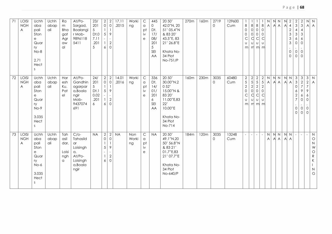
P a g e | 68
71 LOISINGHA
Uchhabapali Stone Quarry No-8 2.71 Hects
Uchhabapali
Ram Bhagat Agrawal
At/Po-Sargad,Boalangir Mob-98961185411
23/2015 Dt.07.11.2015
2015-16
2019-20
17.11.2015
Working
Captive
4450 Dt. 17/08/2015 SEIAA
20 50’ 42.0”N, 20 51’ 05.4”N & 83 20’ 43.5”E, 83 21’ 26.8”E Khata No-34 Plot No-751/P
270m 160m 27190
129600 Cum
1800Cum
1800Cum
1800Cum
1800Cum
NA
NA
NA
NA
242333.00
234360.00
234360.00
NA
NA
72 LOISINGHA
Uchhabapali Stone Quarry No-9 3.035 Hects
Uchhabapali
Haresh Ku. Patel
At/Po-Gandhinagarpara,Boalangir Mob-9437074691
24/2015 Dt.10.02.2016
2015-16
2019-20
14.01.2016
Working
Captive
336 Dt. 14/01/2016 SEIAA
20 50’ 30.00”N,20 52’ 15.00”N & 83 20’ 11.00”E,83 22’ 10.00”E Khata No-34 Plot No-714
160m 230m 30350
60480 Cum
2520Cum
2520Cum
2520Cum
2520Cum
NA
NA
NA
NA
NA
330627.00
327960.00
327960.00
NA
73 LOISINGHA
Uchhabapali Stone Quarry No-6 3.035 Hects
Uchhabapali
Tahasildar, Loisingha
C/o-Tahasildar Loisingha, At/Po-Loisingha,Boalangir
NA 2015-16
2019-20
NA Non Working
Captive
NA 20 50’ 49.1”N,20 50’ 56.8”N & 83 21’ 01.7”E,83 21’ 07.7”E Khata No-34 Plot No-640/P
184m 120m 30350
13248 Cum
- - - - NA
NA
NA
NA
NA
- - - NON WORKING

P a g e | 69
74 LOISINGHA
Kushmel Stone Quarry 5 Hects
Kushmel
Gouri Shankar Behera
At-Sialbahali Po-Icchapur,Subarnnapur,Mob-9937930951
25/2015 Dt.22/03/2017
2015-16
2019-20
23.01.2016
Working
Captive
586 Dt. 23.11.2016 SEIAA
20 48’ 08.2”N, 20 48’ 16.2”N & 83 24’ 51.9”E,83 24’ 51.9”E Khata No-330 Plot No-699
250m 330m 50000
133650 Cum
1500Cum
1500Cum
1500Cum
1500Cum
NA
NA
NA
NA
NA
49110.00
202860.00
0.00
NA
75 MURIBAHAL
Hadhada Stone Qyaarry 0.8 Hects
Hadhada
Lokesh Rosan Mishra
At/Po-Lakhaana, Kantabanjhi, Balangir, Mob: 8249598552
1596 dt.29/10/2015
2015-16
2019-20
27/01/09/2016
Working
Captive
1228 Dt. 26/04/2015 SEIAA
N20° 21’ 40.8” to N20° 21.06’ 43.8” E83° 00’ 1.05” to E83° 00’ 5.92” Khata No- 37 Plot No- 177
0.380 0.050 8000 sqm
82620 Cum
1200Cum
1320 Cum
1380Cum
1440Cum
NA
NA
NA
NA
461562.00
461562.00
461562.00
--
76 MURIBAHAL
Andaldarah Stone Quarry 0.809Hects
Andaldarah
Pruthiraj Patra
At/Po/ Kantabanji, Balangir, Mob: 9437204394
NA 2015-16
2019-20
21/11/2015
Working
Captive
4388 Dt. 17/08/2015
20˚ 29’ 20.12” N to 20˚ 29’25.36” N to 83˚ 01ˊ 40.16˝ E to 83˚ 01ˊ 46.43˝ E Khata No- 71 Plot No-932
0.390 0.030 8090 sqm
8090 1152.6
1152.6
1152.6
1152.6
NA
NA
NA
NA
612533.00- -
612533.00-
612533.00
--

P a g e | 70
77 MURIBAHAL
Sargul Stone Quarry 1.32Hects
Sargul
Anup Ku. Agrawal
At- Kantabanji Ward No 7, Balangir
1597 dt. 29/10/2015
2015-16
2019-20
31/08/2016
Temp Non Captive
256 Dt. 23/06/2016
N20° 30’ 02.07” to N20° 30’ 6.07” E83° 6’ 18.02” to E83° 6’ 22.08” Khata No- 71 Plot No-932
0.480 0.154 13200 sqm
7920 908
908
908
908
NA
NA
NA
NA
323598.0
323598.0
323598.00
NA
78 MURIBAHAL
Khapadarah Stone Quarry-I 1.32Hects
Nil Nil Nil Nil Nil
Nil
Nil Nil Nil Nil Nil Nil Nil Nil Nil Nil
Nil
Nil
Nil
Nil
Nil
Nil
Nil
Lost Physibility hence extinction proposal has been send from this office vide ltr. No 2247/16.09.2017
79 MURIBAHAL
Khapadarah Stone Quarry-II 1.32Hects
Nil Nil Nil Nil Nil
Nil
Nil Nil Nil Nil Nil Nil Nil Nil Nil Nil
Nil
Nil
Nil
Nil
Nil
Nil
Nil
Lost Physibility hence extinction proposal has been send from this office vide ltr. No 2247/16.09.2017
80 PATNAGARH
(BLACK STONE )Guhuriamunda Stone Quarry
Guhuriamunda
Suresh Agrawal
At/Po- Kadopara, Patnagarh, Balangir, Mob: 9938025024
332 dt.02.03.2015
2015-16
2019-20
29/10/2015
Working
Captive
4932 Dt. 17/08/2015 SEIAA
N 20 50’ 54.8” , 20 51’ 03.1”N E 83 20’ 37.5”, 83 20’ 44.7”E Khata No- 68 Plot No- 13 A/P
1.21 Hects
44688 Cum
1700Cum
1860Cum
1968 Cum
2050 Cum
NA
NA
NA
NA
651368.00
581627.00
267336.00
NA
NA

P a g e | 71
81 PATNAGARH
(BLACK STONE ) Jhulenber Stone Quarry
Jhulenber
Suresh Agrawal
At/Po- Kadopara, Patnagarh, Balangir, Mob: 9938025024
329 dt.02/03/2015
2015-16
2019-20
23/11/2015
Working
Captive
4393 Dt. 17/08/2015 SEIAA
N 20 44’ 35.6”, 20 44 36.2”N E 83 04’ 57.7”, 83 04’ 59.6”E Khata No- 141 Plot No- 490
2.12 Hects
85376.5 Cum
1476 Cum
1520 Cum
1533Cum
2075Cum
NA
NA
NA
NA
486586.00
437137.00
189558.00
NA
NA
82 PATNAGARH
(BLACK STONE ) Amdaraha Stone Quarry
Amdaraha
Haresh Patel
At- Gandhinagarhpada, Po/Dist- Balangir
2888 Dt. 12/08/2016
2016-17
2020-21
29/09/2018
Working
Captive
434 Dt. 22/09/2017 DEIAA
N 20 36’ 04.9”, 20 36’ 12.1”N E 83 07’ 48.3”, 83 07’ 54.0”E Khata No-81 Plot No- 451
2.023 Hects
95000 Cum
3960Cum
3960Cum
3960Cum
3960Cum
NA
NA
NA
NA
NA
470575.00
216345.00
---------
Case for money return ks
83 PATNAGARH
(BLACK STONE ) Guhuriamunda Stone Quarry
Guhuriamunda
Suresh Agrawal
At/Po- Kadopara, Patnagarh, Balangir, Mob: 9938025024
4176 dt.13/12/2017
2017-18
2021-22
NA Non Working
NA
NA N 20 40’ 31.44”, 20 40’ 41.02”N E 83 04’ 23.01”, 83 04’ 28.33”E Khata No- 68 Plot No- 13
2.02 Hects
233100 Cum
3900Cum
3900Cum
3900Cum
3900Cum
NA
NA
NA
NA
NA
NA
NA
NA
Non Working

P a g e | 72
84 PUINTALA
Kulerbahali Stone Quarry 0.433 Hects
Kulerbahali
Umesh Kumar Mahakur
At/Po- Ainlasari, Sauntpur, Balangir
458 dt.18/03/2015
2015-16
2019-20
01/03/2016
Working
Captive
385 Dt. 25/01/2016
N20° 38’ 2.84” to E20° 38’ 2.50” E83° 32’ 31.63” to E83° 32’ 33.56” Khata No- 84 Plot No- 292
0.115 0.043 4330 sqm
23254 Cum
800Cum
800Cum
800Cum
800Cum
NA
NA
NA
NA
NA
85 PUINTALA
Kuntenpali Stone Quarry 2.023 Hects
Kuntenpli
Anurag Agrawal
Staten Road, Balangir
456 dt.16/03/2015
2015-16
2019-20
29/03/2016
Working
Captive
444 Dt. 30/01/2016
N20° 37’ 49.36” to E20° 37’ 56.6” E83° 34’ 58.11” to E83° 35’ 1.23” Khata No- 126 Plot No- 574
0.210 0.110 20230 sqm
111600 Cum
4050Cum
4050Cum
4050Cum
4050Cum
NA
NA
NA
NA
NA
NA
NA
NA
NA
86 PUINTALA
Badburkabahal Stone Quarry 2.023 Hects
Badburkabahal
Lalmohan Panda
At/Po- Rugudipada, Balangir
4335 dt. 28/02/2015
2015-16
2019-20
26/02/2015
Working
Captive
566 Dt. 23/11/2016 DEIAA
N20° 38’ 2.84” to E20° 38’ 2.50” E83° 32’ 31.63” to E83° 32’ 33.56” Khata No- 77 Plot No- 628
0.190 0.110 20230 sqm
45126 Cum
2048Cum
2079Cum
2111Cum
2142Cum
NA
NA
NA
NA
71161.00
273348.00
154012.00
NA
NA

P a g e | 73
87 PUINTALA
Kureibahana Stone Quarry 2.66 Hects
Kureibahana
Bikram Behera
At- Gaintala, Po- Puintala,Balangir
452 Dt. 16/03/2015
2015-16
2019-20
04/01/2017
Working
Captive
679 Dt. 30/01/2016
N20° 42’ 5.0” to E20° 42’ 5.8” E83° 34’ 43.3” to E83° 34’ 43.7” Khata No- 66 Plot No- 603,622
0.240 0.124 26600 sqm
152462.4 Cum
1257Cum
1260Cum
1269Cum
1278Cum
NA
NA
NA
NA
NA
NA
NA
NA
NA
88 PUINTALA
Mahadevpali Stone Quarry 0.809 Hects
Madhabpally
Lalmohan Panda
At/Po- Rugudipada, Balangir
1021 Dt. 25./06/2015
2015-16
2019-20
30/03/2017
Working
Captive
567 Dt. 23/11/2016 DEIAA
N20° 45’ 15.5” E83° 32’ 59.2” Khata No- 60 Plot No- 135
0.098 0.085 8090 sqm
35012 Cum
540Cum
567Cum
594Cum
594Cum
NA
NA
NA
NA
18765.00
71680.00
44169.00
NA
NA
89 PUINTALA
Duhel Stone Quarry 2.023 Hects
Duhel Sitansu Sekhar Mishra
At- Palace line, Balangir
1680 Dt. 29/09/2015
2015-16
2019-20
15/03/2017
Working
Captive
572 Dt. 23/11/2016 DEIAA
N20° 38’ 10.1” to E20° 38’ 10.00” E83° 35’ 38.1” to E83° 35’ 38.3” Khata No- 105 Plot No-625
0.189 0.115 20230 sqm
16875 Cum
1590Cum
1590Cum
1590Cum
1590Cum
NA
NA
NA
NA
NA
31005.00
93871.00
NA
NA
90 PUINTALA
Patharla Stone Quarry 2.023 Hects
Patharla
Tahasildar Puintala, C/o- Sudhan
Balangir 1680 Dt. 22/09/2015
2015-16
2019-20
17/07/2017
Working
Captive
61 Dt. 31/01/2017
N20° 38’ 43.4” to E20° 38’ 50.4” E83° 36’ 41.8” to E83° 36’ 46.7” Khata No- 108
0.195 0.110 20230 sqm
56250 Cum
2000Cum
2000Cum
2000Cum
2000Cum
NA
NA
NA
NA
NA
39000.00
137200.00
NA
NA

P a g e | 74
sushekher Mishra
Plot No- 766/B
91 PUINTALA
Bandhanbahal Stone Quarry 2.02Hects
Bandhanbahal
Binod Biahri Rout
At- Thelomunda, Balangir
3330 Dt. 28/02/2015
2015-16
2019-20
NA Working
Captive
NA NA 0.210 0.102 20200 sqm
12852 NA
NA
NA
NA
NA
NA
NA
NA
NA
NA
NA
NA
NA
92 SAINTALA
Dangarpada ‘ka’ Stone Quarry 1.420 Hect
Dangarpada,Saintala,Balangir
Ajit Kumar Jain
At/Po- Tusura, Dist-Balangir
1069 dt.25/05/2015
2015-16
2019-20
26.04.2015
Working
Captive
2212/SEIAA-26.04.2016
N 20 29’ 58.72”, 20 30’ 03.27”N E83 25’ 25.82”, 83 25’ 20.73”E Khata No- 20 Plot No- 20 &25
0.320 0.120 14200
65450Cum
1527Cum
1527Cum
1527Cum
1527Cum
- 1 BOOK
4 BOOK
10 BOOKS
203587
263804
263804
NA
NA
93 SAINTALA
Dungripali Stone Quarry 1.602 Hects
Dangarpalli
Fakira Behera
Ghunsar,SaintalaBalangir
881 dtd. 01/05/2015
2015-16
2019-20
20/03/2018
Working
Captive
580 Dt. 23/11/2016
N 20 24’ 05.9”, 20 24’ 10.5”N E83 23’ 32.0”, 83 23’ 41.70”E Khata No- 70 Plot No- 513
0.375 0.140 16020
49725Cum
932Cum
932Cum
932Cum
932Cum
- - - 1Book
- 200000
182000
NA
NA

P a g e | 75
94 SAINTALA
Siletpada Stone Quarry 2.32 0 Hects
Siletpada
Gajanan Agrawal,
At/Po-Saintala Dist-Balangir
881 dtd. 01/05/2015
2015-16
2019-20
26/02/2015
Working
Captive
- N 20 25’ 24.0”, 20 25’ 25.5”N E83 19’ 57.3”, 83 20’ 05.7”E Khata No- 33 Plot No- 203,251,254,257
0.420 0.150 23200
30240Cum
1102 Cum
1160Cum
1078Cum
1241Cum
- 5 BOOKS
- 8 BOOKS
145000
249919
NA
NA
NA
95 SAINTALA
Turchaper Stone Quarry 1.61 Hects
Turchaper
Mahesh Kumar Agrawal
At- Saintala, Balangir
452 Dt. 16/03/2015
2018-19
2022-23
- Working
Captive
- N 20 25’ 15.25”, 20 25’ 19.33”N E83 23’ 13.11”, 83 23’ 19.05”E Khata No- 114 Plot No- 636
0.320 0.175 16100
129455 Cum
- - - 1512Cum
- - - - - - - - NA
96 SAINTALA
Manamunda Stone Quarry 3.770 Hects
Manamunda
Biswajit Patra
At- Saintala, Balangir
881 Dtd. 01/05/2015
2015-16
2019-20
26.11.2015
Working
Captive
2209/SEIAA. 26.11.2016
N 20 30’ 29.40”, 6 30’ 34.5”N E83 23’ 30.8”, 83 23’ 33.4”E Khata No- 24 Plot No- 128,136/257
0.350 0.120 37700
302904 Cum
1008Cum
1148Cu0m
1232Cum
1260Cum
- 1Books
- - - 117718
283733
NA
NA
97 SAINTALA
Kandhakalegaon Stone Quarry 1.690 Hects
Kandhakalegaon
Tulsiram Agrawal
At- Saintala, Balangir
881 Dtd. 01/05/2015
2015-16
2019-20
23/05/2016
Working
Captive
251 dtd. 23/05/2016
N 20 29’ 32.20”, 20 29’ 36”N E83 24’ 41”, 83 24’ 45”E Khata No- 159 Plot No- 714,776,795
0.350 0.180 16900
29190 Cum
1189Cum
1334Cum
1392Cum
1421Cum
- 2Books
- 8 Books
197759
265611
NA
NA
NA

P a g e | 76
98 TITLAGARH
Burdipada-A Stone Quarry 1.618Hects
Burdipada
Anup Das
At/Po/Ps- Titlagarh, Balangir
1303 dt.20/07/2015
2015-16
2019-20
27/01/2016
Working
Captive
316 Dt. 04/01/2016 SEIAA
N 20 17’ 38.7”, 20 17’ 46.5”N E83 11’ 14.7”, 83 11’ 13.8”E Khata No- 189 Plot No- 1226
0.120 0.080 16180 sqm
17507 Cum
- 1495 Cum
1560Cum
1625Cum
NA
NA
NA
NA
NA
100000
- - NA
99 TITLAGARH
Burdipada-B Stone Quarry 1.618Hects
Burdipada
Ajit Sahu
At/Po/ Burdipada, Ps- Titlagarh, Balangir
1448 dt.20/07/2015
2015-16
2019-20
02/07/2016
Working
Captive
247 Dt. 23/06/2016 SEIAA
N 20 17’ 45.9”, 20 17’ 46.9”N E 83 11’ 21.7”, 83 11’ 23.7”E Khata No- 189 Plot No- 1226
0.220 0.080 16180 sqm
18145 Cum
1750 Cum
1750 Cum
1820Cum
1820Cum
NA
NA
NA
NA
295881.00
306528.00
306528.00
NA
NA
100
TITLAGARH
Burdipada-C Stone Quarry 1.618Hects
Burdipada
Prakash Sahu
At/Po/ Ps- Titlagarh, Balangir
1308 dt.20/07/2015
2015-16
2019-20
27/01/2016
Working
Captive
342 Dt. 14/01/2016 SEIAA
N 20 17’ 35.9”, 20 17’ 43.4”N E 83 11’ 31.6”, 83 11’ 26.9”E Khata No-189 Plot No-1226
0.220 0.088 16180 sqm
24035 Cum
1600Cum
1750 Cum
1850Cum
2000Cum
NA
NA
NA
NA
289125.00
311091.00
NA
0.00
NA
101
TITLAGARH
Desil- A Stone Quarry 1.214Hects
Desil Amit Ku. Agrawal
At/Po/ Ps- Titlagarh, Balangir
1094 dt.30/06/2015
2015-16
2019-20
15/10/2015
Working
Captive
4486 Dt. 17/08/2015 SEIAA
N 20 16’ 5.9”, 20 16’ 9.2”N E83 10’38.8”, 83 10’ 44.8”E Khata No-178 Plot No-940 /P
0.176 0.080 12140 sqm
96216 Cum
1330 Cum
1295Cum
1365Cum
NA
NA
NA
NA
NA
125935.00
NA
NA
NA

P a g e | 77
102
TITLAGARH
Desil- B Stone Quarry 1.214Hects
Desil Sujit Ku. Bhuyan
Attorney Holder Rajlaxmi Construction Ltd., At/Po/ New Industrial Estate, Jagatpur, Dist- Cuttack
941 dt.19/06/2015
2015-16
2019-20
15/10/2015
Working
Captive
4518 Dt. 17/08/2015 SEIAA
N20 16’ 8.4”, 20 16’ 13.2”N E83 10’ 37.7”, 83 10’ 40.5”E Khata No- 178 Plot No- 940/P
0.208 0.080 12140 sqm
95000 Cum
972 Cum
966Cum
966Cum
NA
NA
NA
NA
170130.00
169218.00
169218.00
NA
NA
103
TITLAGARH
Desil- C Stone Quarry 1.214Hects
Desil Mnoj Ku. Goel
At- Ward No. 2, Po/Ps- Titilagarh, Balangir
945 dt.19/06/2015
2015-16
2019-20
15/10/2015
Working
Captive
3933 Dt. 10/07/2015 SEIAA
N20 16’ 10.1”, 20 16’ 12.7”N E83 10’ 40.5”, 83 10’ 41.8”E Khata No-178 Plot No-940/P
0.140 0.088 12140 sqm
51570 Cum
1242Cum
1288 Cum
1288Cum
1242Cum
NA
NA
NA
NA
218194.00
218194.00
211197.00
NA
NA
104
TITLAGARH
Desil- D Stone Quarry 1.214Hects
Desil Chhatrapal Jain
At/Po/Ps- Titilagarh, Balangir
925 dt.19/06/2015
2015-16
2019-20
15/10/2015
Working
Captive
4496 Dt. 17/08/2015 SEIAA
N20 16’ 8.4”, 20 16’ 11.2”N E83 10’ 42.3”, 83 10’ 43.4”E Khata No- 178 Plot No-940 /P
0.140 0.080 121400 sqm
37192 Cum
1064Cum
1200 Cum
1440Cum
1596Cum
NA
NA
NA
NA
204809.00
241313.00
NA
NA
NA
105
TITLAGARH
Dumdumi Stone Quarry 1.011Hects
Dumdumi
Subash Bisoi
At/Pipilibandh, Po-Siker, Ps-Titilagarh, Balangir
930 dt.19/06/2015
2015-16
2019-20
15/10/2015
Working
Captive
4552 Dt. 17/08/2015 SEIAA
N20 20’ 50.8”, 20 20’ 52.7”N E83 11’ 25.0”, 83 11’ 23.5”E Khata No- 40 Plot No-62, 172
0.125 0.070 10110 sqm
65778Cum
1300Cum
1300Cum
1300Cum
1300Cum
NA
NA
NA
NA
216292.00
216292.00
216292.00
NA
NA

P a g e | 78
106
TITLAGARH
Junapada Stone Quarry 0.809 Hects
Junapada
Bibhu Prasad Nag
At/Po-Naren, Ps-Titilagarh, Balangir
1558 dt.12/08/2015
2015-16
2019-20
23/06/2016
Working
Captive
248 Dt. 23/06/2016 DEIAA
N20 15’ 08.9”, 20 15’ 9.2”N E83 05’ 16.3”, 83 05’ 16.8”E Khata No- 24 Plot No-1
0.110 0.050 8090 sqm
79290Cum
1140Cum
1140Cum
1140Cum
1140Cum
NA
NA
NA
NA
197373.00
197373.00
197373.00
NA
NA
107
TITLAGARH
Kotmara Stone Quarry 0.607 Hects
Kotamara
Manpati Mungri
At- Kotmara, Po-Kursud, Ps-Sindhekela, Balangir
1818 dt.22/10/2016
2016-17
2020-21
25/09/2017
Working
Captive
425 Dt. 16/09/2017
N20 11’ 56.3”, 20 11’ 59.9”N E82 56’ 27.1”, 82 56’ 29..”E Khata No- 108 Plot No- 487
0.105 0.060 6070 sqm
16250 Cum
432Cum
960Cum
960Cum
NA
NA
NA
NA
NA
76723.00
157032.00
157032.00
NA
108
TITLAGARH
Kumuda Stone Quarry 1.214Hects
Kumuda
Anjani Prasad Dash
At- Sargiguda, Po/Ps-Titilagaarh, Balangir
1067 dt.29/06/2015
2015-16
2019-20
15/10/2015
Working
Captive
4544 Dt. 17/08/2015
N20 16’ 10”, 20 16’ 14”N E83 09’ 57”, 83 10’ 03” E Khata No-170 Plot No-884
0.140 0.080 12140 sqm
49851 Cum
1120Cum
1176Cum
960Cum
NA
NA
NA
NA
192641.00
201159.00
NA
NA
NA
109
TITLAGARH
Limpada Stone Quarry 1.63 Hects
Limpada
Dinesh Humar Jain
At/Po- Belgaon, Ps- Saintala, Balangir
1841 dt.22/10/2016
2016-17
2020-21
20/10/20107
Working
Captive
431 Dt. 22/09/2017 DEIAA
N20 18’ 58.7”, 20 18’ 08.8”N E83 17’ 19”, 83 17’ 23.9” E Khata No- 26 Plot No- 231,257,366
0.160 0.090 16300 sqm
92330 Cum
1125Cum
1225Cum
1375Cum
1375Cum
NA
NA
NA
NA
NA
124077.00
NA
NA
NA
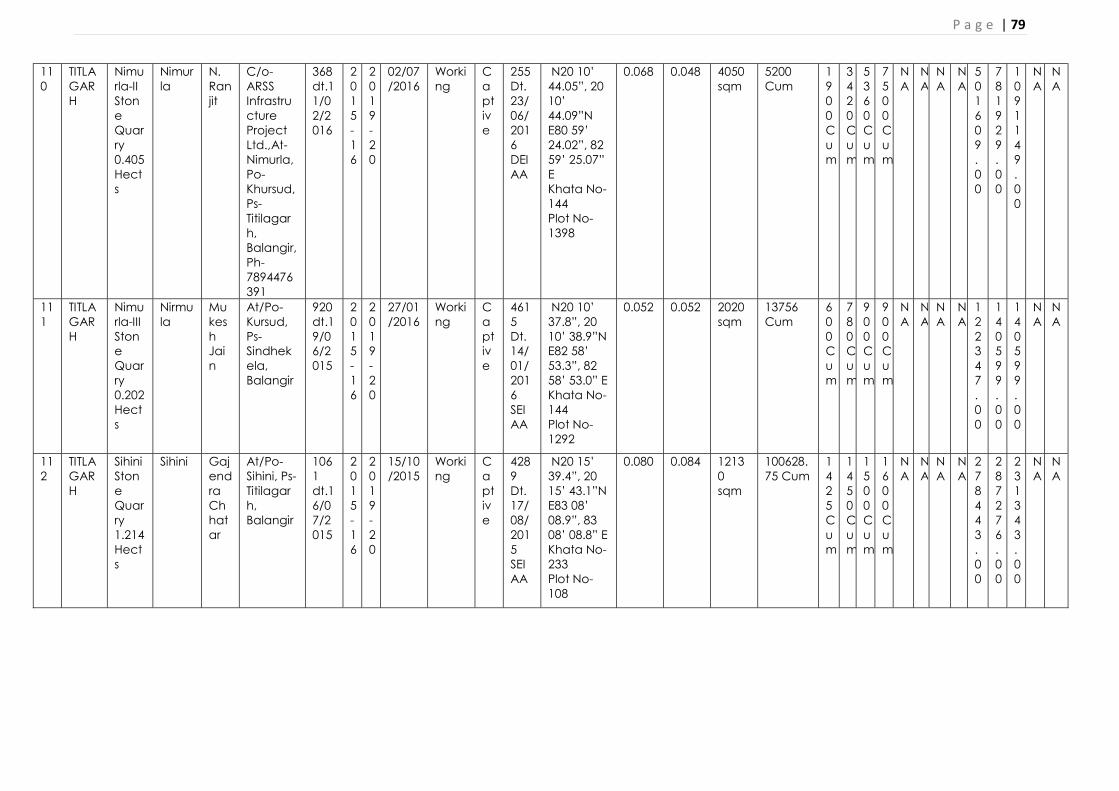
P a g e | 79
110
TITLAGARH
Nimurla-II Stone Quarry 0.405 Hects
Nimurla
N. Ranjit
C/o- ARSS Infrastructure Project Ltd.,At- Nimurla, Po- Khursud, Ps- Titilagarh, Balangir, Ph- 7894476391
368 dt.11/02/2016
2015-16
2019-20
02/07/2016
Working
Captive
255 Dt. 23/06/2016 DEIAA
N20 10’ 44.05”, 20 10’ 44.09”N E80 59’ 24.02”, 82 59’ 25.07” E Khata No- 144 Plot No- 1398
0.068 0.048 4050 sqm
5200 Cum
1900Cum
3420Cum
5360Cum
7500Cum
NA
NA
NA
NA
501609.00
781929.00
1091149.00
NA
NA
111
TITLAGARH
Nimurla-III Stone Quarry 0.202 Hects
Nirmula
Mukesh Jain
At/Po- Kursud, Ps- Sindhekela, Balangir
920 dt.19/06/2015
2015-16
2019-20
27/01/2016
Working
Captive
4615 Dt. 14/01/2016 SEIAA
N20 10’ 37.8”, 20 10’ 38.9”N E82 58’ 53.3”, 82 58’ 53.0” E Khata No- 144 Plot No- 1292
0.052 0.052 2020 sqm
13756 Cum
600Cum
780Cum
900Cum
900Cum
NA
NA
NA
NA
122347.00
140599.00
140599.00
NA
NA
112
TITLAGARH
Sihini Stone Quarry 1.214 Hects
Sihini Gajendra Chhatar
At/Po- Sihini, Ps- Titilagarh, Balangir
1061 dt.16/07/2015
2015-16
2019-20
15/10/2015
Working
Captive
4289 Dt. 17/08/2015 SEIAA
N20 15’ 39.4”, 20 15’ 43.1”N E83 08’ 08.9”, 83 08’ 08.8” E Khata No-233 Plot No- 108
0.080 0.084 12130 sqm
100628.75 Cum
1425Cum
1450Cum
1500Cum
1600Cum
NA
NA
NA
NA
278443.00
287276.00
231343.00
NA
NA

P a g e | 80
113
TITLAGARH
Sihin-2 Stone Quarry 0.809 Hects
Sihini Mohammad Jumma
At/Madbhatipada,Po/Ps-Titilagarh, Balangir
1861 dt.25/10/2016
2016-17
2020-21
10/02/2016
Working
Captive
62 Dt. 31/01/2017 DEIAA
N20 15’ 44.7”, 20 15’ 49.1”N E83 08’ 01.3”, 83 08’ 05.2” E Khata No-233 Plot No-108
0.070 0.063 8090 sqm
50209 Cum
NIL
960Cum
1040Cum
1120Cum
NA
NA
NA
NA
NA
146267.00
NA
NA
NA
114
TITLAGARH
Turla Stone Quarry 1.618 Hects
Turla Hemraj Kharsel
At/Turlaa, Po-Jagua, Ps-Titilagarh,, Balangir
1071 dt.29/06/2015
2015-16
2019-20
15/10/2015
Working
Captive
4287 Dt. 17/08/2015 SEIAA
N20 15’ 47.2”, 20 15’ 51.9”N E83 08’ 01.8”, 83 08’ 08.3” E Khata No- 196 Plot No- 1031/P
0.220 0.104 16180 sqm
290805.45 Cum
1500Cum
1530Cum
1530Cum
1530Cum
NA
NA
NA
NA
300012.00
179655.00
300012.00
NA
NA
115
TITLAGARH
Nirmula Stone Quarry-I 0.809 Hects.
Nirmula
Nil Nil Nil Nil
Nil
Nil Nil Nil Nil Nil Nil Nil Nil Nil Nil
Nil
Nil
Nil
Nil
Nil
Nil
Nil
Nil
Nil
Nil
Nil
NA
116
TITLAGARH
Siker Stone Quarry 1.618 Hects.
Siker Nil Nil Nil Nil
Nil
Nil Nil Nil Nil Nil Nil Nil Nil Nil Nil
Nil
Nil
Nil
Nil
Nil
Nil
Nil
Nil
Nil
Nil
Nil
NA

P a g e | 81
117
TUSRA
Kukedmal Stone Quarry 3.820 Hect
Kukedmal
Sri Tulsiram Agarwal
At/Po- Saintala, Bolangir Mob-9437036208
281dt.20.02.2015
2015-16
2019-20
25.06.2016
Working
Non-Captive
Lt. 257 Dtd. 23.06.2016
20 26’ 00.09”N,20 26 05.9 N & 83 26’ 36.7”E, 83 26’ 43.4”E Khata No- 84 Plot No- 132 & 133
0.270 0.124 38200
435527Cum
1044Cum
1100Cum
1159 Cum
1210 Cum
NA
NA
NA
NA
115737.20
115737.20
115737.20
115737.20
NA
ROAD METAL/ BLACKSTONE/WHITESTONE/LATERITE/ MORRUM/EARTH FOR ROAD CONSTRUCTIO/EARTH FOR BRICK MAKING SAIRATS PROPOSED TO BE LEASED OUT IN NEXT 5 YEARS (20-21 TO 24-25)
(TO BE FILLED BY TAHASILDARS FOR RESPECTIVE TAHASILS)
A. FOR EXECUTED SOURCES TO BE REAUCTIONED
Sl. No.
Name of Taha
sil
Name of village
Name of
Minor Miner
al and Area
of Sairat (Ha)
Location of the Source
(Total Hillock)
recommended for mineral
concession (GPS co-ordinates or Khata &
Plot No) (Sketch
map to be attached)
Area of the mineral potential
patch (in sq m)
Average height of
potential
patch (in m)
Mineable mineral potential (in cum)
MGQ (cum)
Aerial distance in km from different water related structures
Aerial Distance and name from
village and public places in km
Aerial Distance and
name from diff Roads
Aerial Distance
and name from diff
Forest related features Aces
s road exists or not (Yes
or No)
Approval of
Authority of Dir of
Geology declaring
the source
unsuitable for
decorative stone
(Only for Road metal
and Stone sources) & OSPCB
Bridge
Culvert
Dam/ Embankment
River/ Stream/canal/Pond/ Water Harvesting structure (with name)
Any other cross drainage structure
Village
School
Collge
Temple/ Place ofa Any worship
Any other public place (specify)
NH
State Highway
Village Road
RLY Line
Any other Road
Sanctuary/Wildlife habitat
RF/PF/PRF
Biosphere
A B C D E F G H I J K L M N O P Q R S T U V W Y Z a b c d

P a g e | 82
SOURCES TO BE REAUCTIONED AFTER COMPLETION OF PRESENT LEASE PERIOD 1 AGAL
PUR Nil Nil Nil Nil N
il Nil N
il Nil
Nil
Nil Nil
Nil Nil
Nil Nil Nil Nil Nil
Nil
Nil Nil Nil Nil Nil
Nil Nil Nil
2 BANGOMUNDA
Bhirkapada, Bangomunda
Bhirkapada Stone Quarry 0.19 Hects
20˚ 18’ 26.0” N to 20˚ 18’ 28.0” N To 82˚ 53ˊ 34.7˝ E to 82˚ 53ˊ 36.2˝ E Khata No- 83 Plot No- 127, Kisam - Dunguri
1900
1 3250
400
4 2 80 Pathara
8 Sundar Nadi
NA 2 Bhirkapada
2 Bhirkapada u.p school
5 BAngomunda
2 Village Temple
NA
10 NH-59
7 SH-42
500mtr Bhirkapada
27 East coast Railway line
NA
45 Sunabeda Wild Life
8 Bundia P.F
45 Yes
Approved for road metal
3 BANGOMUNDA
Barlabahali
Barlabahali Stone Quarry 1.214 Hects
20˚ 17’ 48.1” N to 20˚ 17’ 52.3” N To 82˚ 49ˊ 00.4˝ E to 82˚ 49ˊ 05.6˝ E Khata No-54 Plot No- 1/431, Kissam- Dunguri
12140
16
11250
2200
2.5
2 92 Pathara
5 Sundar Nadi
NA 1 Sandbahali
2 Sindhbahali school
8 BAngomunda
1.5 Village Temple
NA
14 NH-59
2 SH
500mtr Baldha
6 East coast Railway line
NA
52 Sunabeda Wild Life
2 Bundia P.F
52 Yes
Approved for road metal
4 BANGOMUNDA
Deheli Stone Quarry
Deheli Stone Quarry 0.607 Hects
20˚ 13’ 42.8” N to 20˚ 13’ 45.6” N To 82˚ 57ˊ 30.5˝
6070
11
11250
2200
3 2 64 Pathara
2 Sundar N
NA 1 Deheli
1 Deheli school
2 Sindheikela
2 Sindheikela Village
NA
1.5 NH 59
1 SH
500mtr
30 East coast Ra
NA
48 Sunabeda Wild Life
500 mtr
48 Yes
Approved for road metal

P a g e | 83
E to 82˚ 57ˊ 34.0˝ E Khata No- 107 Plot No- 709(A) Kissam-Parbat
adi
Temple
ilway line
Sindheikela RF
5 BANGOMUNDA
Salemudga
Salemudga Stone Quarry-A 1.618 Hects
20˚ 14’ 30.8” N to 20˚ 14’ 36.6” N To 82˚ 56ˊ 52.3˝ E to 82˚ 56ˊ 58.1˝ E Khata No-40 Plot No- 398(A) Kissam- Dunguri
16180
11
129490
1500
3 2 69 Pathara
3 Sundar Nadi
NA 1 Salemudga
1 Salemudga school
2 Sindheikela
2 Sindheikela Temple
NA
1 NH-59
500mtr
500mtr
35 East coast Railway line
NA
53 Sunabeda Wild Life
2 Mungal Paharh RF
53 Yes
Approved for road metal
6 BANGOMUNDA
Salemudga
Salemudga Stone Quarry-B 1.618 Hects
20˚ 14’ 31.1” N to 20˚ 14’ 36.1” N To 82˚ 56ˊ 45.5˝ E to 82˚ 56ˊ 50.9˝ E Khata No-40 Plot No- 398,(B) Kissam- Dunguri
16180
8 138103
1500
3 2 69 Pathara
3 Sundar Nadi
NA 1 Salemudga
1 Salemudga school
2 Sindheikela
2 Sindheikela Temple
NA
1 NH-59
500mtr
500mtr
35 East coast Railway line
NA
53 Sunabeda Wild Life
2 Mungal Paharh RF
53 Yes
Approved for road metal

P a g e | 84
7 BANGOMUNDA
Sangamada
Sangamada-A Road Metal Quarry 1.214 Hects
20˚ 23’ 03.2” N to 20˚ 22’ 56.9” N To 82˚ 49ˊ 10.4˝ E to 82˚ 49ˊ 01.4˝ E Khata No-96, Plot No- 03, Kissam-Dunguri
12140
4 58080
2000
3 1 74 Pathara
2 Arjun Nadi
NA 2 Jurabandh
2 Jurabandh
3 Mahakhand
3 Jurabandh
NA
21 NH-59
2 500mtr
15 East coast Railway line
NA
48 Sunabeda Wild Life
500 mtr Chhatradandi RF
48 Yes
Approved for road metal
8 BANGOMUNDA
Sangamada
Sangamada-B Road Metal Quarry 1.214 Hects
20˚ 22’ 54.7” N to 20˚ 22’ 59.1” N To 82˚ 49ˊ 00.6˝ E to 82˚ 49ˊ 09.6˝ E Khata No-96 Plot No- 03, Kissam-Dunguri
12140
4 80820
4000
3 1 74 Pathara
2 Arjun Nadi
NA 2 Jurabandh
2 Jurabandh
3 Mahakhand
3 Jurabandh
NA
21 NH-59
2 500mtr
15 East coast Railway line
NA
48 Sunabeda Wild Life
500 mtr Chhatradandi RF
48 Yes
Approved for road metal
9 BANGOMUNDA
Sangamada
Sangamada-C Road Metal Quarry 1.214
20˚ 22’ 53.7” N to 20˚ 23’ 00.1” N To 82˚
12140
4 65450
2000
3 1 74 Pathara
2 Arjun
NA 2 Jurab
2 Jurabandh
3 Mahakhand
3 Jurabandh
NA
21 NH-5
2 500mtr
15 East coast
NA
48 Sunabeda Wild Life
500 mtr
48 Yes
Approved for road metal

P a g e | 85
Hects 48ˊ 56.5˝ E to 82˚ 49ˊ 03.7˝ E Khata No-96 Plot No- 03(C), Kissam-Dunguri
Nadi
andh
9 Railway line
Chhatradandi RF
10 BANGOMUNDA
Sahajot
Sahajot Stone Quarry 1.537 Hects
20˚ 18’ 45.18” N to 20˚ 18’ 49.21” N To 82˚ 54ˊ 00.26˝ E to 82˚ 54ˊ 03.33˝ E Khata No-61 Plot No- 447(A)
15370
6 119400
1260
3 1 68 Pathara
7 Bagiharan Johr
NA 1 Sahjot
1 Sahjot
3 Bangomunda
3 Bangomunda
NA
5 NH-59
2 500mtr
24 East coast Railway line
NA
59 Sunabeda Wild Life
7 59 Yes
Approved for road metal
11 BANGOMUNDA
Sindhbhadi
Sindhbhadi Road Metal-II 2.46 Hects
20˚ 17’ 14.18” N to 20˚ 17’ 17.36” N To 82˚ 50ˊ 32.22˝ E to 82˚ 50ˊ 38.53˝ E Khata No- 86 Plot No- 561,
24600
6 125290
1350
1 2 73 Pathara
1 Bagiharan Johr
NA 1 Sindhbhadi
1 Sindhbhadi
3 Bangomunda
7 Bangomunda
NA
4 NH-59
3 2
28 East coast Railway line
NA
78 Sunabeda Wild Life
3 Bundia RF
78 Yes
Approved for road metal

P a g e | 86
Kissam- Dunguri
12 BANGOMUNDA
Sindhbhali
Sindhbhadi Road Metal-I 2.44 Hects
20˚ 17’ 18.21” N to 20˚ 17’ 23.46” N to 82˚ 50ˊ 34.17˝ E to 82˚ 50ˊ 38.22˝ E Khata No-86 Plot No- 85 Kissam-Pathara Chatan
24400
6 220500
1350
1 2 73 Pathara
500 mtr Bagiharan Johr
NA 1 Sindhbhadi
1 Sindhbhadi
3 Bangomunda
7 Bangomunda
NA
4 NH-59
3 2
28 East coast Railway line
NA
78 Sunabeda Wild Life
3 Bundia RF
78 Yes
Approved for road metal
13 BELPADA
Dakara,
Dakara Stone Quarry 1.08 Hects
N20° 31’ 08.1” to N20° 31’ 16.1” E83° 00’ 36.1” to E83° 00’ 29.6” Khata No-126/174 Plot No-183 , Kissam- Pathar Chatan
1277
2 34479
1350
3 2 50 Sutkel
5 Sutkel River
NA 1 Dakara
1 Dakara
10 Belpara
50 Harishankar
NA
40 NH-59
10 SH
1
25 East coast Railway line
NA
70 Sunabeda Santuary
3 BenderiR.F
70 Yes
Approved for road metal
14
BELPADA
Mandal,
Mandal Stone Quarry-I 4.5 Hects
N20° 35’ 14.66” to N20° 35’ 02.00” E82° 59’ 55.35” to E83° 00’ 07.88”
45000
2 187020
2800
1 4.5
32 Katradhari 4.
7 Kusumi R
NA 800mtr J
1.5 Haripur sa
2.3 Nachuni
6 Jagannath Tem
NA
1 NH-5
34 SH-1
500mtr Kaithapali
2 East coas
NA
6 Chilika Bird Santuary
4 Kuhudi
3 Yes
Approved for road metal

P a g e | 87
Khata No- 229 Plot No- 34 Kissam- Pathar Chatan
5 Balia
iver
ariput
san u.p school
ple t Railway line
R.F / 2 Kunjuri PRF
15 BELPADA
Mandal,
Mandal Stone Quarry-II 1.736 Hects
N20° 34’ 47.5” to N20° 34’ 40.8” E83° 00’ 44.4” to E83° 00’ 52.6” Khata No-229 Plot No- 228,219,348 Kissam- Pathar Chatan
17360
2 72468
2000
1 4.5
32 Katradhari 4.5 Balia
7
NA 800mtr Jariput
1.5 Haripur sasan u.p school
2.3 Nachuni
6 Jagannath Temple
NA
1 NH-5
34 SH-1
500mtr Kaithapali
2 East coast Railway line
NA
6 Chilika Bird Santuary
4 KuhudiR.F / 2 Kunjuri PRF
3 Yes
Approved for road metal
16 BELPADA
Tara,
Tara Stone Quarry 2.51 Hects
N20° 40’ 07.49” to N20° 40’ 00.79” E83° 59’
25100
2 182808
1800
1 4.5
32 Katradh
7
NA 800mt
1.5 Har
2.3 Nachuni
6 Jagannat
NA
1 NH-
34 SH
500mtr Kai
2 East
NA
6 Chilika Bird
4 Kuh
3 Yes
Approved for road metal

P a g e | 88
31.48” to E83° 59’ 17.57” Khata No- 119 Plot No- 979 Kissam- Pathar Chatan
ari 4.5 Balia
r Jariput
ipur sasan u.p school
h Temple
5 -1
thapali
coast Railway line
Santuary
udiR.F / 2 Kunjuri PRF
17 BELPADA
Admunda
Admunda Stone Quarry 1.982 Hects
N20° 42’ 22.2” to N20° 42’ 44.4” E83° 53’ 47.6” to E82° 53’ 49.3” Khata No-58,Plot No-66, Kissam- Dunguri
19820
2 98982
2600
4 2 50 Sutkel
1 Sutkel River
NA 1 Dakara
1 Dakara
10 Belpara
50 Harishankar
NA
40 NH-59
10 SH
1
25 East coast Railway line
NA
70 Sunabeda Santuary
3 BenderiR.F
70 Yes
Approved for road metal
18 BELPADA
Malijhar
Malijhar Stone Quarry 2.67Hects
N20° 37’ 52.49” to N20° 37’ 46.52” E83° 01’ 10.66” to E83° 01’ 17.00” Khata No- 76
26700
2 133920
1600
1 4.5
32 Katradhari 4.5
7
NA 800mtr Jar
1.5 Haripur sasan
2.3 Nachuni
6 Jagannath Temple
NA
1 NH-5
34 SH-1
500mtr Kaithapali
2 East coast R
NA
6 Chilika Bird Santuary
4 KuhudiR.
3 Yes
Approved for road metal

P a g e | 89
Plot No-633 Kissam- Pathar Chatan
Balia
iput
u.p school
ailway line
F / 2 Kunjuri PRF
19 BELPADA
Dunguripalli
Dunguripalli Stone Quarry-I 3.023 Hects
N20° 30’ 14.4” to N20° 30’ 16."1” E82° 53’ 45.9” to E82° 53’ 48.6” Khata No-104/298 Plot No- 256,143,144,298,318,378,384,385,256/1239, 256/1240,256/1281,256/1242,338,356,382,332,337 Kissam- Pathar Chatan
30230
5 100444
1650
2 1 64 Sutkel
10 Lanth River
NA 500mtr Dunguripali
1 Dunguripali
10 Kantabanjhi
62 Harishankar
NA
20 NH-59
1 SH
800
7 East coast Railway line
NA
76 Sunabeda Santuary
4 Lamphuta RF
76 Yes
Approved for road metal
20 BELPADA
Bhuliabandh
Black Stone- Bhuliabandha Stone
N20° 36’ 17.80” to N20° 36’ 12.64”
20230
2 204840
3870
6.3
1 63 Sutk
4 Bhuliabandh
0.9 R
11 7 35.5 Har
NA
29.3 N
5.4
0.5 22.7 E
NA
62.2 Sunab
2.8
70 Yes
Approved for road metal

P a g e | 90
Quarry 2.023 Hects
E83° 04’ 22.88” to E83° 04’ 29.68” Khata No-53, PLOT No-07 Kissam- Dunguri
el adbahal
ishankar temple
H-59
SH
ast coast Railway line
eda Santuary
Sana Buthikudari R F
21 BELPADA
Bahabal
Black Stone-Bahabal Stone Quarry 1.08 Hects
N20° 32’ 00.02” to N20° 32’ 06.9” E82° 58’ 54.6” to E82° 58’ 48.9” KhataNo-120, Plot No- 245,784 Kissam- Pathar Chatan
10800
3 54864
1500
2 3 60 5 NA 1 Bahabal
1.2
8 45 Harishankar temple
NA
20
3 500 20 East coast Railway line
NA
80 Sunabeda Santuary
7 60 Yes
Approved for road metal
22 BOLANGIR
Basupali-
Basupali-1 Stone Quarry 1.780 Hects
20˚ 37’ 16.6” N to 20˚ 37’ 24.9” N To 83˚ 26ˊ 40.1˝ E to 83˚ 26ˊ 47.0˝ E Khata
17800
3 75950
4400
23
21
42 Krupasindhu Dam
18 SutkelRiv
NA 2 Basupali
1.5 u.p school
10 Balangir
1 Village
NA
24 NH-26
25 SH-42
500mtr
5 E/cRailway line
NA
89Sunabedea
200 mtr
89 Yes
Approved for road metal

P a g e | 91
No- 14 Plot No- 101 Kissam- Kudar
er
23 BOLANGIR
Basupali
Basupali-2 Stone Quarry 2.023 Hects
N20º 37’ 30.00” to N20º 37’ 32.70” E83º 26’ 52.70” to E83º 26’ 51.80” Khata No- 14 Plot No- 79/B/1
20230
3 149580
5000
23
21
42 Krupasindhu Dam
18 SutkelRiver
NA 2 Basupali
1.5 u.p school
10 Balangir
1 Village
NA
24 NH-26
25 SH-42
500mtr
5 E/cRailway line
NA
89Sunabedea
200 mtr
89 Yes
Approved for road metal
24 BOLANGIR
Basupali
Basupali-3 Stone Quarry 2.023 Hects
20˚ 37’ 13.2” N to 20˚ 37’ 21.5” N To 83˚ 26ˊ 31.5˝ E to 83˚ 26ˊ 43.8˝ E Khata No- 14 Plot No- 79/A, 101/A Kissam- Kudar
20230
4 77455
4400
23
21
42 Krupasindhu Dam
18 SutkelRiver
NA 2 Basupali
1.5 u.p school
10 Balangir
1 Village
NA
24 NH-26
25 SH-42
500mtr
5 E/cRailway line
NA
89Sunabedea
200 mtr
89 Yes
Approved for road metal

P a g e | 92
25 BOLANGIR
Basupali
Basupali-4 Stone Quarry 2.023 Hects
20˚ 37’ 23.4” N to 20˚ 37’ 30.6” N To 85˚ 26ˊ 48.5˝ E to 85˚ 26ˊ 59.6˝ E Khata No- 14 Plot No-79 Kissam- Kudar
20230
4 86400
5000
23
21
42 Krupasindhu Dam
18 SutkelRiver
NA 2 Basupali
1.5 u.p school
10 Balangir
1 Village
NA
24 NH-26
25 SH-42
500mtr
5 E/cRailway line
NA
89Sunabedea
200 mtr
88 Yes
Approved for road metal
26 BOLANGIR
Basupali
Basupali-5 Stone Quarry 1.82 Hects
20˚ 37’ 17.6” N to 20˚ 37’ 25.0” N To 83˚ 26ˊ 37.3˝ E to 83˚ 26ˊ 47.5 ˝ E Khata No- 14 Plot No- 79/A, 101/A, Kissam- Kudar
18200
4 80576
4800
22
18
39 Krupasindhu Dam
17 SutkelRiver
NA 2 Basupali
1.5 u.p school
10 Balangir
1 Village
NA
24 NH-26
25 SH-42
500mtr
5 E/cRailway line
NA
88Sunabedea
200 mtr
88 Yes
Approved for road metal
27 BOLANGIR
Dhulusar
Dhulusar Stone quarry 1.906 Hects
20˚ 41’ 55.3” N to 20˚ 42’ 02.3” N To 83˚ 18ˊ 23.5˝ E to 83˚ 18ˊ 33.6˝ E Khata No-125
19060
3 82192
2800
4 2 49 Krupasindhu Dam
2 SutkelRiver
NA 1 Dhulusar
1 u.p school
12 Balangir
1 Village
NA
16 NH-26
1 SH-42
500mtr
15 E/cRailway line
NA
76Sunabedea
5 75 Yes
Approved for road metal

P a g e | 93
Plot No-108,110 & 117, Kissam- Pathara Chatan
28 BOLANGIR
Barkani
Barkhani Stone Quarry 0.744 Hects
20°42'29.8” N to 20°42'33.8” N To 83°17' 27.0˝ E to 83°17'30.7˝ E Khata No-112 Plot No-52, Kissam-Pathar Chatan
7440
2 51400
1350
8 7 53 Krupasindhu Dam
4 SutkelRiver
NA 2 Dhulusar
1 u.p school
16 Balangir
1 Village
NA
6 NH-26
10 SH-42
1
9 E/cRailway line
NA
78Sunabedea
5 76 Yes
Approved for road metal
29 BOLANGIR
Bhanpur
Bhanpur-3 Stone Quarry 0.404 Hects
20°37' 26.6”N to 20°37'31.4” N To 83°17' 29.9˝E to 83°17'32.6˝ E Khata No-59 Plot No-444, Kissam-Dunguri
4040
2 16200
1500
8 7 53 Krupasindhu Dam
4 SutkelRiver
NA 2 Dhulusar
1 u.p school
16 Balangir
1 Village
NA
6 NH-26
10 SH-42
1
9 E/cRailway line
NA
78Sunabedea
5 76 Yes
Approved for road metal
30 DEOGAON
Sunarijore
Sunarijore-A Stone Quarry
20˚ 41’ 07.39” N to 20˚
32370
11
292538
200
6 5 34 Kr
15
NA 2 S
1.5
13 11 Ra
NA
8 N
3 S
3 Su
24 E/
NA
85 Sun
4 84 Yes
Approved for road

P a g e | 94
3.237 Hects
41’ 39.27” N Longitude: 83˚ 17ˊ 33.97˝ E to 83˚ 17ˊ 56.31˝ E Khata No- 58 Plot No- 545 Kisssam- Dunguri
0 upasindhu Dam
unarijore
Sunarijore
m Mandir
H-26
H-42
narijor
C Railway line
abeda Santuary
metal
31 DEOGAON
Sunarijora
Sunarijora-B Stone Quarry 0.809 Hects
20˚ 41’ 19.93” N to 20˚ 41’ 23.18” N To 83˚ 17ˊ 28.28˝ E to 83˚ 17ˊ 34.36˝ E Khata No- 58 Plot No- 279 Kisssam- Dunguri
8090
2 15932
600
7 5 36 Krupasindhu Dam
14
NA 2 Sunarijore
1.5 Sunarijore
13 12 Ram Mandir
NA
8 NH-26
4 SH-42
2 Sunarijor
21 E/C Railway line
NA
81 Sunabeda Santuary
4 81 Yes
Approved for road metal
32 DEOGAON
Bahali
Bahali Stone Quarry 0.339 Hects
20˚ 31’ 07.39” N to 20˚ 31’ 09.27” N To 83˚ 23ˊ 33.97˝ E to 83˚ 23ˊ 36.31˝ E Khata
3390
4 5120.5
1000
5 4 38 Krupasindhu Dam
12 Suktel Rive
NA 1 Bahali
1.5 Bahali
11 18 Ram Mandir
NA
13 NH-26
2 SH-42
1 Deheli
14 E/C Railway line
NA
78 Sunabeda Santuary
3 78 Yes
Approved for road metal

P a g e | 95
No-107 Plot No- 1147 Kissam- patharchatan
r
33 DEOGAON
Gaddwar
Gaddwar Stone Quarry 0.526 Hects
20˚ 31’ 07.39” N to 20˚ 31’ 09.27” N To 83˚ 23ˊ 33.97˝ E to 83˚ 23ˊ 36.31˝ E Khata No-41 Plot No- 138/671 Kissam- Pathar Chatan
5260
3 13550
1500
7 6 44 Krupasindhu Dam
9 Suktel River
NA 1 Gaddwar
1 Gaddwar
8 1 Village Temple
NA
16 NH-26
3 SH-42
1
12 E/C Railway line
NA
84 Sunabeda Santuary
2 84 Yes
Approved for road metal
34 DEOGAON
Gudkhapala
Gudkhapala Stone Quarry 1.267Hects
20˚ 32’ 48.97” N to 20˚ 32’ 58.79” N To 83˚ 32ˊ 27.35˝ E to 83˚ 32ˊ 39.92˝ E Khata No-181 Plot No- 586, 588, 619, 789 Kissam- pathar Chatan
12670
1 27432
750
18
12
62 Krupasindhu Dam
18 Tel River
NA 1 Gudkhapala
1 Gudkhapala
8 1 Village Temple
NA
18 NH-26
4 SH-42
1
18 E/C Railway line
NA
86 Sunabeda Santuary
8 86 Yes
Approved for road metal
35 DEOGAON
Ghatuld
Ghatuldunguri
20˚ 34’ 11.57” N
16260
4 60345
16
2 2 53
5 S
NA 1
1
12 1 Vill
NA
38
8
2
24
NA
68
8
68 Yes
Approved for

P a g e | 96
unguri
Stone Quarry 1.626 Hects
to 20˚ 34’ 16.52” N To 83˚ 14ˊ 53.04˝ E to 83˚ 14ˊ 58.76˝ E Khata No- 46 Plot No- 132 Kissam- Dunguri
00
Krupasindhu Dam
ongad River
Ghatuldunguri
Ghatuldunguri
age Temple
NH-26
SH-42
E/C Railway line
Sunabeda Santuary
Ostali RF
road metal
36 DEOGAON
Sirabahal
Sirabahal Stone Quarry 5.000 Hects
20˚ 33’ 32.30” N to 20˚ 33’ 41.80” N To 83˚ 26ˊ 20.00˝ E to 83˚ 26ˊ 32.80˝ E Khata No- 77 Plot No- 748 Kissam- Dunguri
50000
10
137280
2300
3 2 48 Krupasindhu Dam
4 NA 1 Sirabahal
1 Sirabahal
9 1 Village Temple
NA
4 NH-26
2 SH-42
1
8 E/C Railway line
NA
84 Sunabeda Santuary
5 84 Yes
Approved for road metal
37 KANTABANJI
Simanabahal
Simanabahal Stone Quarry-2 1.072 Hects
20˚ 25’ 10.16” N to 20˚ 25’ 18.12” N To 82˚ 58ˊ 35.11˝ E to 82˚ 58ˊ 42.18˝ E Khata
10720
7 82215
1708
2.5
2 59 Pendrawan Dam
3 Telia Johr
NA 1 Simnabahal
1.5 Simnabahal sc
10 Kantabanji
1 Village temple
NA
15 NH-59
2 SH-42
500mtr
100mtr E/C Railway
NA
65 Sunabeda
3 KhujenRF
65 Yes
Approved for Stone

P a g e | 97
No- 49 Plot No-770
hool
line
38 KANTABANJI
Mahakhand
Mahakhand Stone Quarry –I 1.958 Hects
N20° 22’ 36.0” to N20° 22’ 39.9” E82° 47’ 41.3” to E82° 47’ 41.8” Khata No-111, PLOT No-1524
19500
6 131413
4018
1 1 63 Pendrawan Dam
1 Arjun
NA 1 Mahakhand
1.5 Mahakhand
12 Kantabanji
1 Village temple
NA
15 NH-59
12 SH
500mtr
15 E/C Railway line
NA
72 Sunabeda
1 Chhatradandi RF
72 Yes
Approved for Stone
39 KANTABANJI
Chatuanaka
Chatuanaka Stone Quarry No-1 2.638 Hects
N20° 28’ 46.88” to N20° 28’ 52.27”N E82° 55’ 53.08” to E82° 55’ 59.63”E Khata No- 153 Plot No-1046/P
26380
5 138960
1872
1 2 74 Pendrawan Dam
4 Arjun
NA 1 Chatuanka
1 Chatuanka
14 Kantabanji
18 “64” yogini andvisnu Temple
NA
12 NH-59
18 SH
800mtr
8 E/C Railway line
NA
78 Sunabeda
6 RF
78 Yes
Approved for Stone
40 KANTABANJI
Dhumsu
Dhumsu Stone Quarry –I 2.152 Hects
N20° 27’ 33.3” to N20° 27’37.9” E82° 57’06.5” to E82° 57’08.8” Khata No- 43 Plot No-333/P,
21520
6 213336
2088
2 4 71 Pendrawan Dam
9 Arjun
NA 2 Dhumsu
1.5 Dhumsu
9 Kantabanji
24 “64” yogini andvisnu Te
NA
14 NH-59
25 SH
1
18 E/c Railway line
NA
73 Sunabeda
7 RF
73 Yes
Approved for Stone

P a g e | 98
Kissam- Patharchatan.
mple
41 KANTABANJI
Dhumsu
Dhumsu Stone Quarry –II 2.145 Hects
N20° 27’ 36.0” to E20° 27’ 31.1” E82° 57’ 06.5” to E82° 57’ 10.8” Khata No-43, Plot No-333, Kissam- Patharchatan.
21450
6 180176
2133
2 4 71 Pendrawan Dam
9 Arjun
NA 2 Dhumsu
2 Dhumsu
9 Kantabanji
24 “64” yogini andvisnu Temple
NA
14 NH-59
25 SH
1
19 E/c Railway line
NA
75 Sunabeda
8 RF
75 Yes
Approved for Stone
42 KANTABANJI
Chatuanaka
Chatuanaka Stone Quarry No-II 2.509 Hects
20˚ 28’ 25.15” N to 20˚ 28’ 29.13” N To 82˚ 56’ 08.13” E to 82˚ 56’ 12.25’’E Khata No- 153 Plot No-1173
25090
5 279967
1575
1 2 74 Pendrawan Dam
4 Arjun
NA 1 Chatuanka
1 Chatuanka
14 Kantabanji
18 “64” yogini andvisnu Temple
NA
12 NH-59
18 SH
800mtr
8 E/C Railway line
NA
78 Sunabeda
6 RF
78 Yes
Approved for Stone
43 KHAPRAKHOL
Chitkimal
Black Stone Chitkimal Stone Quarry 0.267 Hects
N20° 47’ 15” to N20° 47’ 17” E83° 02’ 12” to E83° 02’ 16” Khata No-44 Plot No-112
2670
2 49335
2963
1 4.5
45 7
NA 800mtr
1 KM
5 KM
10 HARISHANKAR TEMPLE
NA
1 NH-
34 SH-1
800mtr Kaithapali
12 NA
45
4
3 Yes
Approved for road metal

P a g e | 99
44 LOISINGHA
Uchhabapali
Black Stone Uchhabapali Stone Quarry No-1 4.65 Hects.
20˚ 50’ 55.80” N to 20˚ 51’ 03.90” N Longitude: 83˚ 20’ 37.34˝ E to 83˚ 20ˊ 44.69˝ E Khata No- 34 Plot No- 597/P, Kissam- Pahada
46500
5 1489060
7000
2 5 6.5 Manhira Dam
7 Ong River
NA 1
1.5
6 Loisingha College
2 Sapneswar Temple, Sujia
NA
20 NH-57
5 SH-26
500mtr
12 East coast Railway line
NA
100 Debrigarh Santuary, Sambalpur
6
100
Yes
Approved for road metal
45 LOISINGHA
Uchhabapali
Black Stone Uchhabapali Stone Quarry No-2 4.653Hects
20˚ 50’ 57.21” N to 20˚ 51’ 05.60” N To 83˚ 20’ 27.78˝ E to 83˚ 20ˊ 36.77˝ E Khata No- 34 Plot No- 597/P, Kissam- Pahada
46500
5 514395
7000
2 5 6.5 Manhira Dam
7 Ong River
NA 1
1.5
6 Loisingha College
2 Sapneswar Temple, Sujia
NA
20 NH-57
5 SH-26
500mtr
12 East coast Railway line
NA
100 Debrigarh Santuary, Sambalpur
6
100
Yes
Approved for road metal
46 LOISINGHA
Uchhabapali
Black Stone Uchhabapali Stone Quarry No-3 3.15
20˚ 50’ 49.48” N to 20˚ 50’ 56.85” N To 83˚ 20’ 56.99˝ E to 83˚
31500
5 293112
7000
2 5 6.5 Manhira Dam
7 Ong River
NA 1
1.5
6 Loisingha College
2 Sapneswar Temple, Suji
NA
20 NH-57
5 SH-26
500mtr
12 East coast Railway
NA
100 Debrigarh Santuary, Sambal
6
100
Yes
Approved for road metal

P a g e | 100
Hects
21ˊ 02.42˝ E Khata No-34 Plot No-640/P Kissam- Pahada
a line
pur
47 LOISINGHA
Uchhabapali
Black Stone Uchhabapali Stone Quarry No-4 4.330 Hects
20˚ 50’ 46.42” N to 20˚ 50’ 56.88” N To 83˚ 21’ 04.19˝ E to 83˚ 21ˊ 13.20˝ E ” Khata No-34 Plot No-639 & 640/P, Kissam- Pahada
43300
4 391230
7000
2 5 6.5 Manhira Dam
6.5 Ong River
NA 1
1.5
6 Loisingha College
2 Sapneswar Temple, Sujia
NA
22 NH-57
5 SH-26
600mtr
12 East coast Railway line
NA
100 Debrigarh Santuary, Sambalpur
6
100
Yes
Approved for road metal
48 LOISINGHA
Uchhabapali
Black Stone Uchhabapali Stone Quarry No-5 3.09 Hects
20˚ 50’ 49.99” N to 20˚ 50’ 56.93” N To 83˚ 20’ 44.91˝ E to 83˚ 20ˊ 50.50˝ E Khata No-34 Plot No-597/P, Kissam-
30900
5 347976
7000
2.5
5 6.5 Manhira Dam
6.5 Ong River
NA 1
1.5
6 Loisingha College
2 Sapneswar Temple, Sujia
NA
22 NH-57
5 SH-26
750mtr
12 East coast Railway line
NA
100 Debrigarh Santuary, Sambalpur
6
100
Yes
Approved for road metal

P a g e | 101
Pahada
49 LOISINGHA
Uchhabapali
Black Stone Uchhabapali Stone Quarry No-6 3.035 Hects
20˚ 50’ 49.71” N to 20˚ 50’ 57.85” N To 83˚ 21’ 02.06˝ E to 83˚ 21ˊ 08.205˝ E Khata No-34, Plot No-640/P Kissam- Pahada
30350
5 60858
7000
2 5 6.5 Manhira Dam
6.5 Ong River
NA 1
1.5
6 Loisingha College
2 Sapneswar Temple, Sujia
NA
22 NH-57
5 SH-26
600mtr
12 East coast Railway line
NA
100 Debrigarh Santuary, Sambalpur
6
100
Yes
Approved for road metal
50 LOISINGHA
Uchhabapali
Black Stone Uchhabapali Stone Quarry No-7 3.035 Hects
20˚ 50’ 51.05” N to 20˚ 50’ 56.93” N To 83˚ 20’ 50.44˝ E to 83˚ 20ˊ 57.42˝ E Khata No-34 Plot No-597/P & 640/P Kissam-Pahada
30350
5 157626
7000
2 5 6.5 Manhira Dam
7 Ong River
NA 1
1.5
6 Loisingha College
2 Sapneswar Temple, Sujia
NA
20 NH-57
5 SH-26
500mtr
12 East coast Railway line
NA
100 Debrigarh Santuary, Sambalpur
6
100
Yes
Approved for road metal
51 LOISINGHA
Uchhabapal
Black Stone
20˚ 50’ 46.42” N to 20˚
27190
5 212553
700
2 5 6.5 M
7 On
NA 1
1.5
6 Loisin
2 Sapn
NA
20
5 S
500mtr
12 Ea
NA
100 Deb
6
100
Yes
Approved for road

P a g e | 102
i Uchhabapali Stone Quarry No-8 2.719 Hects
50’ 54.91” N Longitude: 83˚ 21’ 12.82˝ E to 83˚ 21ˊ 17.79˝ E Khata No-34 Plot No-751/P Kissam-Pahada
0 anhira Dam
g River
gha College
eswar Temple, Sujia
NH-57
H-26
st coast Railway line
rigarh Santuary, Sambalpur
metal
52 LOISINGHA
Uchhabapali
Black Stone Uchhabapali Stone Quarry No-9 2.266 Hects
20˚ 50’ 17.49” N to 20˚ 50’ 22.47” N To 83˚ 20’ 39.71˝ E to 83˚ 20ˊ 48.23˝ E Khata No-34 Plot No-714 Kissam- Pahada
22660
4 150822
4500
2 5 7 Manhira Dam
7 Ong River
NA 1
1.5
6 Loisingha College
2 Sapneswar Temple, Sujia
NA
20 NH-57
5 SH-26
500mtr
12 East coast Railway line
NA
100 Debrigarh Santuary, Sambalpur
6
100
Yes
Approved for road metal
53 LOISINGHA
Barkani
Black Stone Barkani Stone Quarry 4.856 Hects
20˚ 51’ 11. 06” N to 20˚ 51’ 16.98” N Longitude: 83˚ 19ˊ 30.15˝ E to 83˚ 19ˊ
48560
4 430809
2065
8 6 6.5 Manhira Dam
7 Ong River
NA 1
1.5
6 Loisingha College
2 Sapneswar Temple, Sujia
NA
20 NH-57
5 SH-26
500mtr
12 East coast Railway line
NA
100 Debrigarh Santuary, Sambalpur
6
100
Yes
Approved for road metal

P a g e | 103
44.43˝ E Khata No-30 Plot No- 1/P Kissam- Patharchatan
54 LOISINGHA
Babja
Black Stone Babja Stone Quarry 3.350 Hects
20˚ 50’ 47. 19” N to 20˚ 50’ 54.12” N To 83˚ 21ˊ 19.20˝ E to 83˚ 21ˊ 12.78˝ E Khata No- 89 Plot No- 632,802,805,806&810 Kissam- Patharchatan
33500
5 181044
2079
2 8 6.5 Manhira Dam
7 Ong River
NA 1
1.5
6 Loisingha College
2 Sapneswar Temple, Sujia
NA
20 NH-57
5 SH-26
500mtr
12 East coast Railway line
NA
100 Debrigarh Santuary, Sambalpur
6
100
Yes
Approved for road metal
55 LOISINGHA
Banjipali
Black Stone Banjipali Stone Qurry 0.745 Hects
20˚ 52’ 43.44” N to 20˚ 52’ 48.29” N Longitude: 83˚ 29ˊ 57.28˝ E to 83˚ 30ˊ 02.40˝ E Khata
7440
5 25998
3065
4 5 6.5 Manhira Dam
7 Ong River
NA 1
1.5
6 Loisingha College
2 Sapneswar Temple, Sujia
NA
20 NH-57
5 SH-26
500mtr
12 East coast Railway line
NA
100 Debrigarh Santuary, Sambalpur
6
100
Yes
Approved for road metal

P a g e | 104
No-120, Plot No-91 Kissam- Patharchatan
56 LOISINGHA
Taliudar
Black Stone Taliudar Stone quarry 1.000 Hects
20˚ 49’ 18.64” N to 20˚ 49’ 16.34” N To 83˚ 22ˊ 55.20˝ E to 83˚ 23ˊ 02.00˝ E Khata No- 309 Plot No-1879, 1786 & 1790 Kissam-Patharachatan
10000
5 29363
1950
2 10
6.5 Manhira Dam
7 Ong River
NA 1
1.5
6 Loisingha College
2 Sapneswar Temple, Sujia
NA
20 NH-57
5 SH-26
500mtr
12 East coast Railway line
NA
100 Debrigarh Santuary, Sambalpur
6
100
Yes
Approved for road metal
57 LOISINGHA
Dumdumi
Black Stone Dumdumi Stone Quarry No-1 2.428 Hects
20˚ 52’ 28.65” N to 20˚ 52’ 35.26” N To 83˚ 29ˊ 37.46˝ E to 83˚ 29ˊ 33.24˝ E Khata No- 163 Plot No- 851/A Kissam- Pathara
24280
5 235806
3029
5 5 6.5 Manhira Dam
7 Ong River
NA 1
1.5
6 Loisingha College
2 Sapneswar Temple, Sujia
NA
20 NH-57
5 SH-26
500mtr
15 East coast Railway line
NA
100 Debrigarh Santuary, Sambalpur
6
100
Yes
Approved for road metal

P a g e | 105
chatan
58 LOISINGHA
Pandarani
Black Stone Pandarani Stone Quarry No-1 4.046 Hects
20˚ 52’ 49.74” N to 20˚ 52’ 59.42” N Longitude: 83˚ 26ˊ 42.589˝ E to 83˚ 26ˊ 50.78˝ E Khata No-285 Plot No-589 Kissam- Patharachatan
40460
4 301664
2620
2 5 6.5 Manhira Dam
7 Ong River
NA 1
1.5
6 Loisingha College
2 Sapneswar Temple, Sujia
NA
20 NH-57
5 SH-26
500mtr
12 East coast Railway line
NA
100 Debrigarh Santuary, Sambalpur
6
100
Yes
Approved for road metal
59 LOISINGHA
Thakurpali
Black Stone Thakurpali Stone Quarry 2.205Hects
20˚ 49’ 51.44” N to 20˚ 49’ 59.15” N To 83˚ 22ˊ 01.59˝ E to 83˚ 22ˊ 02.45˝ E Khata No-44, PLOT No-477&479 Kissam-Patharchatan
22050
5 156019
3748
2 5 6.5 Manhira Dam
7 Ong River
NA 1
1.5
6 Loisingha College
2 Sapneswar Temple, Sujia
NA
20 NH-57
5 SH-26
500mtr
12 East coast Railway line
NA
100 Debrigarh Santuary, Sambalpur
6
100
Yes
Approved for road metal
60 LOISINGHA
Uparudar
Black Stone Uparudar Stone
20˚ 49’ 50. 61” N to 20˚ 52’ 48.29” N
28320
5 253300
2740
6 5 6.5 Manhira
9 Ong R
NA 1
1.5
6 Loisingha College
2 Sapneswar
NA
20 NH-
5 SH-2
500mtr
12 East coas
NA
100 Debrigarh Sant
10
100
Yes
Approved for road metal

P a g e | 106
Quarry 2.832 Hects
To 83˚ 22ˊ 1.59˝ E to 83˚ 22ˊ 6.71˝ E Khata No-114 Plot No-32/P Kissam- Patharachatan
Dam
iver
Temple, Sujia
57
6 t Railway line
uary, Sambalpur
61 LOISINGHA
Dumdumi
Black Stone Dumdumi Stone Quarry 0.829 Hects
20 52’01.1”N,20 52’60.30”N & 83 29’ 14.2”E,83 29’17.6”E Khata No-163, Plot No-1196
8290
5 24870
1500
5 5 6.5 Manhira Dam
7 Ong River
NA 1
1.5
6 Loisingha College
2 Sapneswar Temple, Sujia
NA
20 NH-57
5 SH-26
500mtr
15 East coast Railway line
NA
100 Debrigarh Santuary, Sambalpur
6
100
Yes
Approved for road metal
62 LOISINGHA
Dumdumi
Black Stone Dumdumi Stone Quarry-B 2.428 Hects
20 52’31.2”N,20 52’36.30”N & 83 29’ 31.7”E,83 29’39.8”E Khata No-163, Plot No-851/B
24280
5 14568
1500
5 5 6.5 Manhira Dam
7 Ong River
NA 1
1.5
6 Loisingha College
2 Sapneswar Temple, Sujia
NA
20 NH-57
5 SH-26
500mtr
15 East coast Railway line
NA
100 Debrigarh Santuary, Sambalpur
6
100
Yes
Approved for road metal

P a g e | 107
63 LOISINGHA
Jharmunda
Black Stone Jharmunda Stone Quarry 0.226 Hects
20 52’23.6”N,20 52’25.6”N & 83 24’ 07.3”E,83 24’09.9”E Khata No-308, Plot No-944
2260
5 6780
1000
7 5 6.5 Manhira Dam
5 Ong River
NA 1
5
6 Loisingha College
2 Sapneswar Temple, Sujia
NA
20 NH-57
5 SH-26
500mtr
15 East coast Railway line
NA
100 Debrigarh Santuary, Sambalpur
10
100
Yes
Approved for road metal
64 LOISINGHA
Kutenpali
Black Stone Kutenpali Stone Quarry 0.404 Hects
20 53’05.6”N,20 53’08.6”N & 83 28’ 12.8”E,83 28’17.2”E Khata No-102, Plot No-52
4040
5 12120
1000
7 5 12 Manhira Dam
5 Ong River
NA 1
5
6 Loisingha College
2 Sapneswar Temple, Sujia
NA
20 NH-57
5 SH-26
500mtr
15 East coast Railway line
NA
100 Debrigarh Santuary, Sambalpur
20
100
Yes
Approved for road metal
65 LOISINGHA
Luchkibahal
Black Stone Luchkibahal Stone Quarry 0.517 Hects
20 52’22.7”N,20 52’24.3”N & 83 24’ 03.7”E,83 24’07.8”E Khata
5170
5 15510
1000
5 5 6.5 Manhira Dam
5 Ong River
NA 1
5
6 Loisingha College
5 Sapneswar Temple, Sujia
NA
22 NH-57
5 SH-26
500mtr
15 East coast Railway line
NA
100 Debrigarh Santuary, Sambalpur
10
100
Yes
Approved for road metal

P a g e | 108
No-128, Plot No-291 & 293
66 MURIBAHAL
Hadhada
Hadhada Stone Qyaarry 0.809Hects
20˚ 21’ 42.37” N to 20˚ 21’48.23” N To 83˚ 59ˊ 54.11˝ E to 82˚ 59ˊ 59.15˝ E Khata No- 37 Plot No- 177 Kissam- Patharchatan
8090
4 4630
1782
1 5 60 5
NA 1
1.5
5
6 Temple
NA
30 NH
5 SH
1 5 East coast Railway line
NA
60
5
60 Yes
Approved for road metal
67 MURIBAHAL
Andaldarah
Andaldarah Stone Quarry 0.809Hects
20˚ 29’ 20.12” N to 20˚ 29’25.36” N to 83˚ 01ˊ 40.16˝ E to 83˚ 01ˊ 46.43˝ E Khata No- 71 Plot No-932 Kissam- Patharchatan
8090
3 52668
3600
2 5 65 4
NA 1
2
10
5 Temple
NA
35 NH
6 SH
2 15 East coast Railway line
NA
70
5
70 Yes
Approved for road metal
68 PATNAGARH
Gohiramund
(BLACK STONE ) Guhuriam
N 20 40’ 37.64” to 20 40’
12140
3 44489 Cu
220
1 K
2KM
40KM
NA
NA 2 2.5
2.0 2.3 NA
40
6 500mtr
40 1 Sunabed
5 8 NA
Approved for road

P a g e | 109
a unda Stone Quarry-A 1.214 Hects
42.22”N E 83 04’ 29.38” to 83 04’ 39.64”E Khata No-68,Plot No- 13 Kissam- Pathar Chatan
m 0Cum
M a wild life santuary
metal
69 PATNAGARH
Gohiramunda
(BLACK STONE ) Guhuriamunda Stone Quarry-B 2.023 Hects
N 20 40’ 29.68” to 20 40’ 33.54”N E 83 04’ 20.56” to 83 04’ 28.83”E Khata No-68,Plot No- 13 Kissam- Pathar Chatan
20230
5 115427 Cum
6399Cum
1 KM
2KM
40KM
NA
NA 2 1.9
1.6 2.0 NA
42
8 500mtr
41 1 Sunabeda wild life santuary
6 10 NA
Approved for road metal
70 PATNAGARH
Mundamahul
(BLACK STONE ) Munda Mahul Stone Quarry-A 2.023 Hects
N 20 40’ 37.64” to 20 40’ 42.22”N E 83 04’ 29.38” to 83 04’ 39.64”E Khata No-99,Plot No- 289/1 Kissam- Pathar Chatan
20230
4 163179 Cum
3330Cum
1 KM
2KM
40KM
NA
NA 2 2.3
2.8 2.3 NA
41
7 500mtr
42 1 Sunabeda wild life santuary
6 7 NA
Approved for road metal
71 PATNAGAR
Ghasian
(BLACK STONE )
20˚ 48’ 56.16” N
9670
3 23400
15
1
2K
40K
NA
NA 2 2 2.5 1.8 NA
40
6 500
40 1 Sunab
5.
7 NA
Approved for

P a g e | 110
H Ghasian Stone Quarry 0.967 Hects
to 20˚ 48’59.44” N to 83˚ 09ˊ 46.19˝ E to 83˚ 09ˊ 49.48˝ E Khata No-228,Plot No- 1276 & 1278 Kissam- Pathar Chatan
Cum
12Cum
KM
M M mtr
eda wild life santuary
5 road metal
72 PATNAGARH
Jhulenbar
(BLACK STONE ) Jhulenbar Stone Quarry 0.906 Hects
20˚ 44’ 35.6” N to 20˚ 44’37.4” N to 83˚ 04ˊ 57.7˝ E to 83˚ 04ˊ 59.6˝ E Khata No-228,Plot No- 1276 & 1278 Kissam- Pathar Chatan
9060
4 40590 Cum
2203Cum
1 KM
2KM
40KM
NA
NA 2 2.8
3 2.2 NA
41
7 500mtr
40 1 Sunabeda wild life santuary
6 9 NA
Approved for road metal
73 PUINTALA
Mahadevpali
Mahadevpali Stone Quarry . Area 0.809 Hects
20˚ 38’ 02.50” N to 20˚ 38’ 05.77” N To 83˚ 32ˊ
8090
4 29025
250
6 6 46 Krupasindhuda
2 Ong Rive
NA 1 Mahadev
1.5 up school
8 1.5 Dadhibaman Temple
NA
10 NH-57
2 SH-55
1 53 E/C Railway
NA
84 Debrigarh
2 84 Yes
Approved for Stone

P a g e | 111
31.63˝ E to 83˚ 32ˊ 34.59˝ E Khata No- 60 Plot No- 135 Kissam- Pathrchatan
m r pali
line
74 PUINTALA
Duhel
Duhel Stone Quarry Area 2.02 Hects
20˚ 35’ 04.5” N to 20˚ 35’ 10.1” N To 83˚ 35ˊ 32.1˝ E to 83˚ 35ˊ 38.9˝ E Khata No- 105 Plot No-625 Kissam- Patharbani
20200
1 41659
1400
14
10
10 Krupasindhudam
12 Tel River
NA 1 Duhel
1.5 up school
12 1 Mahesawari Temple
NA
10 NH-57
10 SH-55
1 12 E/C Railway line
NA
60 Debrigarh
2 60 Yes
Approved for Stone
75 PUINTALA
Badburkabahal
Badaburkabahal Stone Quarry Area 2.023 Hects
20˚ 37’ 34.40” N to 20˚ 37’ 41.43” N To 83˚ 36ˊ 52.11˝ E to 83˚ 36ˊ 55.33.0˝ E
20230
3 266480
1750
8 7 25 Krupasindhudam
16 Tel River
NA 1 Badaburkhaba
1.5 up school
9 1 Village Temple
NA
14 NH-57
8 SH-55
1 16 E/C Railway line
NA
64 Debrigarh
2 64 Yes
Approved for Stone

P a g e | 112
Khata No- 77 Plot No- 628, Kissam- parbat
hyal
76 PUINTALA
Patharla
Patharla Stone Quarry Area 2.02 Hects
20˚ 38’ 43.4” N to 20˚ 38’ 50.4” N To 83˚ 36ˊ 41.8˝ E to 83˚ 36ˊ 46.7˝ E Khata No- 108 Plot No- 766/B, Kissam- Dunguri
20200
3 124664
2200
8 12
38 Krupasindhudam
18
NA 1.5 Patharla
1.5 up school
11 1 Village Temple
NA
16 NH-57
4 SH-55
1 24 E/C Railway line
NA
64 Debrigarh
2 64 Yes
Approved for Stone
77 PUINTALA
Kulerbahali
Kulerbahali Stone Quarry Area 0.433 Hects
20˚ 43’ 40.8” N to 20˚ 43’ 44.5” N To 83˚ 32ˊ 49.1˝ E to 83˚ 32ˊ 51.5˝ E Khata No- 84 Plot No- 292 Kissam- Patharchatan
4330
5 15552
250
4 6 44 Krupasindhudam
12
NA 1.5 Kulerbahali
2 up school
9 1 Village Temple
NA
24 NH-57
8 SH-55
1 21 E/C Railway line
NA
71 Debrigarh
2 71 Yes
Approved for Stone
78 PUINTALA
Kuntenp
Kuntenpali Stone
20˚ 37’ 20710
5 88716
50
9 8 35
11
NA 1 K
2
7 1 Vill
NA
18
6
1 19
NA
63
2 63 Yes
Approved for
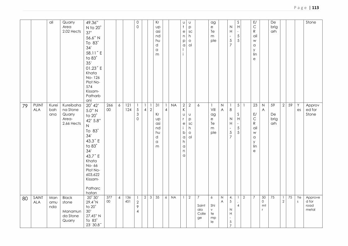
P a g e | 113
ali
Quarry Area 2.02 Hects
49.36” N to 20˚ 37’ 56.6” N To 83˚ 34ˊ 58.11˝ E to 83˚ 35ˊ 01.23˝ E Khata No- 126 Plot No- 574 Kissam- Patharbani
00
Krupasindhudam
utenpali
up school
age Temple
NH-57
SH-55
E/C Railway line
Debrigarh
Stone
79 PUINTALA
Kureibahana
Kureibahana Stone Quarry Area- 2.66 Hects
20˚ 42’ 5.0” N to 20˚ 42’ 5.8” N To 83˚ 34ˊ 43.3˝ E to 83˚ 34ˊ 43.7˝ E Khata No- 66 Plot No- 603,622 Kissam- Patharchatan
26600
6 121124
1530
14
12
31 Krupasindhudam
14
NA 2 Kureibahana
2 up school
6 1 Village Temple
NA
18 NH-57
5 SH-55
1 23 E/C Railway line
NA
59 Debrigarh
2 59 Yes
Approved for Stone
80 SAINTALA
Manamunda
Black stone Manamunda Stone Quarry
20˚ 30’ 29.4˝N to 20˚ 30’ 27.45” N To 83˚ 23ˊ 30.8˝
37700
4 136451
1294
2 3 35 6 NA 1 2
7 Saintala College
6 Shiv temple
NA
4.5 NH-57
1.4
2 7 500 mtr
75 12
75 Yes
Approved for road metal

P a g e | 114
3.770 Hects
E to 83˚ 23ˊ 26.34˝ E Khata No- 24 Plot No- 128,136/257, Kissam- Pathar Chatan
81 SAINTALA
Kandhakalegaon
Kandhakalegaon Stone Quarry 1.690 Hects
20˚ 29’ 32” N to 20˚ 29’ 36” N To 83˚ 24ˊ 41˝ E to 83˚ 24ˊ 45˝ E Khata No- 159 Plot No- 714,776,795, Kissam-Pathar Chatan
16900
4 79875
1500
3 3 40 6 NA 1 2
7 Saintala College
6 Shiv temple
NA
4.5 NH-57
1.4
2 7 800 mtr
70 12
70 Yes
Approved for road metal
82 SAINTALA
Dangarpada
Dangarpada Stone Quarry 1.420 Hect
N 20 29’ 58.72”to 20 30’ 03.27”N to E83 25’ 18.57” to 83 25’ 26.10”E Khata No- 20 Plot No- 20 &25, Kissam- Patharchatan
14200
4 58050
1680
4 2 35 5 NA 1 2
7 Saintala College
6 Shiv temple
NA
4 NH-57
1.4
2 7 800 mtr
70 10
70 Yes
Approved for road metal
83 SAINTALA
Dungrip
Dunguripali Stone
N 20 24’ 02.41”to
16020
5 61776
10
4 3 25 6 NA 1 2
7
6
NA
4.5
1.
2 7 800
60 12
60 Yes
Approved for

P a g e | 115
ali Quarry 1.602 Hects
20 24’ 10.77”N E83 23’ 32.13” to 83 23’ 41.76”E Khata No- 70 Plot No- 513, Kissam- Patharkhandi
25
Saintala College
Shiv temple
NH-57
4
mtr
road metal
84 TITLAGARH
Burdipada
Burdipada-A Stone Quarry 1.618Hects
20˚ 17’ 44.1” N to 20˚ 17’ 49.7” N To 83˚ 11ˊ 04.7˝ E to 83˚ 11ˊ 08.4˝ E Khata No- 189 Plot No- 1226, Kissam-Patharachatan
16180
5 151200
3000
2.5
2 45 15
NA 0.9
1 15 5 NA
10
10
1 6 NA
65 12
45 Yes
Approved for Road Metal
85 TITLAGARH
Burdipada
Burdipada-B Stone Quarry 1.618Hects
20˚ 17’ 45.3” N to 20˚ 17’ 47.8” N To 83˚ 11ˊ 07.9˝ E to 83˚ 11ˊ 16.5˝ E Khata No- 189 Plot No-
16180
5 172854
3000
2.5
2 45 15
NA 0.9
1 15 5 NA
10
10
1 6 NA
65 12
45 Yes
Approved for Road Metal

P a g e | 116
1226 Kissam- Patharchatan.
86 TITLAGARH
Burdipada
Burdipada-C Stone Quarry 1.618Hects
20˚ 17’ 48.2” N to 20˚ 17’ 55.2” N To 83˚ 11ˊ 04.4˝ E to 83˚ 11ˊ 11.0˝ E Khata No-189 Plot No-1226 , Kissam-Patharachatan
16180
5 271800
4000
2.5
2 45 15
NA 0.9
1 15 5 NA
10
10
1 6 NA
65 12
45 Yes
Approved for Road Metal
87 TITLAGARH
Desil Desil- A Stone Quarry 1.214Hects
20˚ 16’ 09.1” N to 20˚ 16’ 13.6” N To 83˚ 10ˊ 35.9˝ E to 83˚ 10ˊ 42.3˝ E Khata No-178 Plot No-940 /P Dunguri
12140
4 42223
2000
2 3 70 12
NA 1.5
1.2
15 10 NA
15
5 2 10 NA
60 10
50 Yes
Approved for Road Metal
88 TITLAGARH
Desil Desil- B Stone Quarry 1.214Hects
20˚ 16’ 07.5” N to 20˚ 16’ 12.8” N To 83˚ 10ˊ 36.7˝ E to 83˚ 10ˊ 42.0˝
12140
4 46990
2000
2 3 70 12
NA 1.5
1.2
15 10 NA
15
5 2 10 NA
60 10
50 Yes
Approved for Road Metal

P a g e | 117
E Khata No- 178 Plot No- 940/P Kissam-Dunguri
89 TITLAGARH
Desil Desil- C Stone Quarry 1.214Hects
20˚ 16’ 15.4” N to 20˚ 16’ 20.9” N To 83˚ 10ˊ 41.2˝ E to 83˚ 10ˊ 46.8˝ E Khata No-178 Plot No-940/P Kissam- Dunguri
12140
4 92070
1200
2 3 70 12
NA 1.5
1.2
15 10 NA
15
5 2 10 NA
60 10
50 Yes
Approved for Road Metal
90 TITLAGARH
Desil Desil- D Stone Quarry 1.214Hects
20˚ 16’ 11.2” N to 20˚ 16’ 17.4” N To 83˚ 10ˊ 44.1˝ E to 83˚ 10ˊ 49.2˝ E Khata No- 178 Plot No-940 /P Kissam-Dunguri
12140
4 52123
2000
2 3 70 12
NA 1.5
1.2
15 10 NA
15
5 2 10 NA
60 10
50 Yes
Approved for Road Metal
91 TITLAGARH
Nimurla
Nimurla-II Stone Quarry 0.404 Hects
20˚ 10’ 43.32” N to 20˚ 10’ 45.56” N To 82˚
36995
4 22800
2000
4 2 55 19
NA 2 1.5
10 10 NA
25
10
5 20 NA
55 15
30 Yes
Approved for Road Metal

P a g e | 118
59ˊ 23.85˝ E to 82˚ 59ˊ 25.72˝ E Khata No- 144 Plot No- 1398/A Kissam-Dunguri
92 TITLAGARH
Nimurla
Nimurla-III Stone Quarry 0.405 Hects
20˚ 10’ 33.2” N to 20˚ 10’ 35.6” N To 82˚ 58ˊ 45.6˝ E to 82˚ 58ˊ 49.2˝ E Khata No- 144 Plot No- 1292 Kissam -Dunguri
4050
6 20961
2000
2 3 50 20
NA 2 1.5
10 10 NA
25
10
5 20 NA
55 15
30 Yes
Approved for Road Metal
93 TITLAGARH
Sihini Sihini Stone Quarry 1.214 Hects
20˚ 15’ 45.1” N to 20˚ 15’ 49.4” N To 83˚ 08ˊ 09.2˝ E to 83˚ 08ˊ 13.7˝ E Khata No-233 Plot No- 108, Kissam- Pathar Chatan
12130
5 114048
2000
1.6
5 60 15
NA 3 2.5
10 10 NA
30
12
6 35 NA
62 18
35 Yes
Approved for Road Metal
94 TITLA Turla Turla 20˚ 15’ 161 5 103 2 3 6 65 2 NA 2 4 10 10 N 2 2 10 50 N 75 1 30 Ye Approve

P a g e | 119
GARH Stone Quarry 1.618 Hects
44.0” N to 20˚ 15’ 47.3” N To 83˚ 07ˊ 58.4˝ E to 83˚ 08ˊ 05.2˝ E Khata No- 196 Plot No- 1031/P Kissam-Dunguri
80 446 000
3 A 5 0 A 5 s d for Road Metal
95 TITLAGARH
Dumdumi
Dumdumi Stone Quarry 1.012Hects
N20 20’ 50.77”, 20 20’ 52.70”N E83 11’ 23.20”, 83 11’ 25.83”E Khata No- 40 Plot No-62A & 172A Kissam-Pahada
143640
4 82835
2000
3 6 65 33
NA 1 10 10 15 NA
25
20
10 50 NA
75 15
30 Yes
Approved for Road Metal
96 TITLAGARH
Junapada
Junapada Stone Quarry 0.809 Hects
N20 15’ 08.9”, 20 15’ 9.2”N E83 05’ 16.3”, 83 05’ 16.8”E Khata No- 24 Plot No-1 Kissam-
8090
4 19416
1500
4 5 65 25
NA 1 10 15 20 NA
20
20
10 50 NA
75 15
45 Yes
Approved for Road Metal
97 TITLAGARH
Kumuda
Kumuda Stone
20˚ 16’15.1”
14160
5 110808
50
1 5 50 35
NA 1 4 45 20 NA
20
20
10 45 NA
75 15
45 Yes
Approved for

P a g e | 120
Quarry 1.416Hects
N to 20˚ 16’10.49” N 83˚ 09ˊ 57.08˝ E to 83˚ 09ˊ 52.20˝ E Khata No-170 Plot No-884 Kissam-Dunguri
00
Road Metal
98 TITLAGARH
Kotmara
Kotmara Stone Quarry-II 0.607 Hects.
N20 11’ 56.3”, 20 11’ 59.9”N E82 56’ 27.1”, 82 56’ 29..”E Khata No- 108 Plot No- 487
6070
5 36420
1500
1 5 50 35
NA 1 4 45 20 NA
20
20
10 45 NA
75 15
45 Yes
Approved for Road Metal
99 TITLAGARH
Nirmula
Nirmula Stone Quarry-I 0.809 Hects
Khata- No Plot- No
8090
5 36420
1500
1 5 50 35
NA 1 4 45 20 NA
20
20
10 45 NA
75 15
45 Yes
Approved for Road Metal
100
TITLAGARH
Siker Siker Stone Quarry 1.618 Hects
Khata- No Plot- No
16180
5 36420
1500
1 5 50 35
NA 1 4 45 20 NA
20
20
10 45 NA
75 15
45 Yes
Approved for Road Metal
101
TUSRA Kukedmal
Black stone Kukedmal Stone Quarry
20˚ 26’ 0.09” N to 20˚ 26’ 5.9” N To 83˚ 26ˊ 36.7˝
38200
5 234236
1600
1 5 40 Suktel Dam
6
NA 900mtr
1.5
5 Tusura College
2
NA
20 NH
5 SH
500mtr
10 East coast Ra
NA
100 Sunabeda Santuary
4
100
Yes
Approved for road metal

P a g e | 121
ROAD METAL/ BLACKSTONE/WHITESTONE/LATERITE/ MORRUM/EARTH FOR ROAD CONSTRUCTIO/EARTH FOR BRICK MAKING SAIRATS TO BE DELARED AS NEW SOURCES
(TO BE FILLED BY TAHASILDARS FOR RESPECTIVE TAHASILS [SEPARATE SHEET FOR DIFF MINERAL])
3.820Hect E to 82˚ 26ˊ 43.4˝ E Khata No- 84 Plot No- 132 & 133 Kissam - Dunguri
ilway line
102
BELPARA
Bhuliabandh
Black Stone- Bhuliabandha Stone Quarry 2.023 Hects
N20° 36’ 16.9” to N20° 36’ 25.8” E83° 04’ 22.5” to E83° 04’ 30.1” Khata No-53, PLOT No-07 Kissam - Dunguri
20230
1 178830
3870
1 5 50 35
NA 1 4 8 km DAV College
20 NA
20
20
10 200 mtr
NA
80 Sunabeda Santuary
15
45 Yes
Approved for Road Metal
Sl. No.
Name of Tahasil Name of Minor Mineral
Portion of the Land, River or Stream
recommended for mineral concession
(GPS co-ordinates or Khata& Plot
No)(Sketch map to be attached)
Name of village Area recommended for
mineral concession (in
Hects)
Geological Reserve
Maximum Mineable sand (in cum) (60% of total potential)
Remarks
A B C D E F G H I

P a g e | 122
1 AGALPUR Nil Nil Nil Nil Nil Nil Nil 2 BANGOMUNDA (BLACK STONE )
Patalpara Stone Quarry
N20° 18’ 18.2” to N20° 18’ 21.6” E82° 53’ 38.9” to E82° 53’ 41.7” Khata No-48 Plot No- 140 Kisam – Pathar Chatan Khata No-105 Plot No- 1174 Kisam – Pathar Chatan
Patalpara 0.424 Hects
18940 Cum 14505 Cum Tahasil Letter No- 149 dt. 04/02/2020
3 BANGOMUNDA (BLACK STONE ) Borbahal Stone Quarry
20˚ 19’ 59.7” N to 20˚ 20’ 01.6” N 82˚ 54ˊ 42.0˝ E to 82˚ 54ˊ 45.1˝ E
Borbahal 0.242Hects 33210cum 8559cum Tahasil Letter No- 149 dt. 04/02/2020
4 BANGOMUNDA (ROAD METAL) Deheli Stone Quarry-B
1.618 Hects Khata No-107 Plot No-9 Kissam-Parbata
Deheli 1.618 Hects
129638 Cum 57240 Cum Tahasil Letter No- 395 dt. 04/03/2021
5 BANGOMUNDA (ROAD METAL) Salemudga Stone Quarry-C
1.618 Hects Khata No-40 Plot No-398 Kissam-Parbata
Salemudga 1.618 Hects
174192 Cum 73569 Cum Tahasil Letter No- 399 dt. 04/03/2021
6 BELPADA (BLACK STONE ) Bundamunda Stone Quarry
4.208 Hects Mouza- Budamunda KhataNo-63, Plot No-646/P Kissam- Gochar
Budamunda 4.208 Hects
210400 Cum 126240 Cum
Tahasil Letter No- 104 dt. 09/01/20
7 BELPADA (BLACK STONE ) Ghagurli Stone Quarry
20.214 Hects Mouza- Ghagurli KhataNo-214, Plot No-14,15 & 56 Kissam- Dunguri
Ghagurli 20.214 Hects
808560 Cum 485136 Cum
Tahasil Letter No- 104 dt. 09/01/20
8 BELPADA (BLACK STONE ) Bhalubahali Stone Quarry
5.422 Hects Mouza- Bhalubahali KhataNo-54,
Bhalubahali 5.422 Hects
216880 Cum 130128 Cum
Tahasil Letter No- 104 dt.

P a g e | 123
Plot No-144 Kissam- Gochar
09/01/20
9 BOLANGIR (BLACK STONE ) Fatkara Stone Quarry
3.277 Hects. 20˚ 36’ 22.4” N to 20˚ 36’ 31.1” N To 83˚ 20ˊ 15.1˝ E to 83˚ 20ˊ 21.0˝ E Khata No- 151, Plot No- 1236& 1276, Kisam- Pathara chatana
Fatkara 3.277 Hects
429132 Cum 180180 Cum MGQ-2600 Cum
Tahasil Letter No- 815dt. 12/02/2020
10 DEOGAON (BLACK STONE ) Mudapala Stone Quarry
0.404 Hects Latitude : 20˚ 33’ 23.29” N to 20˚ 33’25.76” N Longitude: 83˚ 34ˊ 35.47˝ E to 83˚ 34ˊ 37.68˝ E Khata No- 116, Plot No- 544 Kisam- Dunguri
Mudapala 0.404 Hects
62316 Cum 19561 Cum MGQ-1000 Cum
Tahasil Letter No- 1031 dt. 13/07/2020
11 KANTABANJI Nil Nil Nil Nil Nil Nil Nil 12 KHAPRAKHOL Nil Nil Nil Nil Nil Nil Nil 13 LOISINGHA Nil Nil Nil Nil Nil Nil Nil 14 MURIBAHAL Nil Nil Nil Nil Nil Nil Nil 15 PATNAGARH (BLACK STONE )
Nijibahal Stone Quarry
2.880 Acres Or 1.165 Hects. Mouza- Nijibahal Khata No-53, Plot No- 390, Kissam- Dunguri
Nijibahal 1.165 Hects
233000 139800 Cum
Tahasil Letter No- 874 dt. 20/02/20
16 PUINTALA (Black Stone) Badaburkabahal Stone Quarry-B
5.00 Acres Or 2.023 Hects. Mouza- Badaburkabahal Khata No-77, Plot No- 628/P, Kissam- Dunguri
Badaburkabahal
2.023 Hects
249061 Cum 116496 Cum
Tahasil Letter No- 1455 dt. 07/10/20
17 PUINTALA (Black Stone) 2.02 Acres Or 0.817 Janipali 0.817 Hects 117926 Cum 58374 Cum Tahasil

P a g e | 124
Janipali Stone Quarry
Hects. Mouza- Janipali Khata No-51, Plot No- 400, Kissam- Dunguri
Letter No- 1455 dt. 07/10/20
18 PUINTALA (Black Stone) Bileikani Stone Quarry
5.00 Acres Or 2.023 Hects. Mouza- Bileikani Khata No-130, Plot No-32, Kissam- Dunguri
Bileikani 2.023 Hects 268785 Cum 145390 Cum Tahasil Letter No- 1455 dt. 07/10/20
19 PUINTALA (Black Stone) Duhel-C Stone Quarry
2.52 Acres Or 1.019 Hects. Mauza- Duhel Khata No- 105, Plot No-1073, Kissam- Dunguri
Duhel 1.019 Hects 108297 Cum 1552239 Cum Tahasil Letter No- 1455 dt. 07/10/20
20 SAINTALA Nil Nil Nil Nil Nil Nil Nil 21 TITLAGARH (Black Stone)
Kotmara-II Stone Quarry
1.50 Acres Or 0.607 Hects. Mouza- Kotmara Khata No-108, Plot No- 487, Kissam- Pathar Chatana
Kotmara 0.607 Hects
111672 Cum 43780 Cum
Tahasil Letter No- 1896 dt. 20/08/20
22 TITLAGARH (Black Stone) Limpada Stone Quarry
4.03 Acres Or 1.631 Hects. Mouza- Limpada Khata No-26, Plot No- 257 & 366, Kissam- Dunguri
Limpada 1.631Hects
206928 Cum 83700 Cum
Tahasil Letter No- 1896 dt. 20/08/20
23 TITLAGARH (Black Stone) Sihini-2 Stone Quarry
2.00 Acres Or 0.809 Hects. Mouza- Sihini Khata No-233, Plot No- 108, Kissam- Pathar Chatana
Sihini 0.809 Hects
122976 Cum 49698 Cum
Tahasil Letter No- 1896 dt. 20/08/20
24 TUSRA Nil Nil Nil Nil Nil Nil Nil 25 BANGOMUNDA (BLACK STONE ) Khata No-96 Sangamada 1.942 Hects 142128 Cum 62586 Cum Tahasil

P a g e | 125
ROAD METAL/ BLACKSTONE/WHITESTONE/LATERITE/ MORRUM/EARTH FOR ROAD CONSTRUCTIO/EARTH FOR BRICK MAKING SAIRATS PROPOSED TO BE LEASED OUT FOR 5 YEARS
(TO BE FILLED BY TAHASILDARS FOR RESPECTIVE TAHASILS
A. FOR SOURCES ALREADY ISSUED LOI
Sangamada Stone Quarry-D
Plot No- 70 Kisam – Pathar Chatan
Letter No- 283 dt. 12/02/2021
Sl. No.
Name of Taha
sil
Name of village
Name of
Minor Miner
al and Area
of Sairat (Ha)
Location of the Source
(Total Hillock)
recommended for mineral
concession (GPS co-ordinates or Khata &
Plot No) (Sketch
map to be attached)
Area of the mineral potential
patch (in sq m)
Average height of
potential
patch (in m)
Mineable mineral potential (in cum)
MGQ (cum)
Aerial distance in km from different water related structures
Aerial Distance and name from
village and public places in km
Aerial Distance and
name from diff Roads
Aerial Distance
and name from diff
Forest related features
Acess road exists or
not (Yes or No)
Approval of Authority of
Dir of Geology declaring the source unsuitable
for decorative stone (Only
for Road metal and
Stone sources) &
OSPCB
Bridge
Culvert
Dam/ Embankment
River/ Stream/canal/Pond/ Water Harvesting structure (with name)
Any other cross drainage structure
Village
School
Collge
Temple/ Place ofa Any worship
Any other public place (specify)
NH
State Highway
Village Road
RLY Line
Any other Road
Sanctuary/Wildlife habitat
RF/PF/PRF
Biosphere
A B C D E F G H I J K L M N O P Q R S T U V W Y Z a b c FOR SOURCES ALREADY ISSUED LOI (BALANGIR) 1 AGA
LPUR Nil Nil Nil Nil Nil Nil Nil Nil Nil Nil Nil Nil Nil Nil Nil Nil Nil Nil Nil Nil Nil Nil Nil Nil Nil Nil Nil
2 BANGOMUNDA
Nil Nil Nil Nil Nil Nil Nil Nil Nil Nil Nil Nil Nil Nil Nil Nil Nil Nil Nil Nil Nil Nil Nil Nil Nil Nil Nil
3 BELP Nil Nil Nil Nil Nil Nil Nil Nil Nil Nil Nil Nil Nil Nil Nil Nil Nil Nil Nil Nil Nil Nil Nil Nil Nil Nil Nil

P a g e | 126
ADA 4 BOL
ANGIR
Salepali
Salepali Stone Quarry-1 0.412 Hects (2019- 20 to 2023-24) T.L- No-4069 dtd. 30/09/2019
20˚ 45’ 01.04” N to 20˚ 45’ 07.46” N To 83˚ 26ˊ 31.08˝ E to 83˚ 26ˊ 37.03 ˝ E Khata No- 136 Plot No- 768 Kissam- Dunguri Lessee- Sri Maheh Choudhury, At/Po-Chandanbhati, Dist-Balangir
4120
2 25480
600
22 18 39 Krupasindhu Dam
17 SutkelRiver
NA 2 Basupali
1.5 u.p school
10 Balangir
1 Village
NA
24 NH-26
25 SH-42
500mtr
5 E/cRailway line
NA
88Sunabedea
200 mtr
88 Yes Approved for road metal
5 BOLANGIR
Rajamunda
Rajamunda Stone Quarry 0.809 Hects (2019- 20 to 2023-24) T.L-No-3803 dtd. 17/09/2019
20˚ 36’ 38.43” N to 20˚ 36’ 44.56” N To 83˚ 20ˊ 05.22˝ E to 83˚ 20ˊ 10.52˝ E Khata No- 114 Plot No- 887 Kissam- Dunguri. Lessee- Bharat Kumar Agrawal, At/Po-Chudapali Dist- Balangir
8090
4 59520
1200
23 21 42 Krupasindhu Dam
18 SutkelRiver
NA 2 Basupali
1.5 u.p school
10 Balangir
1 Village
NA
24 NH-26
25 SH-42
500mtr
5 E/cRailway line
NA
89Sunabedea
200 mtr
89 Yes Approved for road metal

P a g e | 127
6 BOLANGIR
Mankadchuan
Mankadchuan Stone Quarry 1.416 Hects (2019- 20 to 2023-24) T.L-No-4905dtd. 07/11/2019
20˚ 37’ 34.13” N to 20˚ 37’ 41.70” N To 83˚ 30ˊ 34.74˝ E to 83˚ 30ˊ 37.59˝ E Khata No- 96 Plot No- 1149 Kissam- Dunguri Lessee- Sri Ankush Prasad Hota,At/Po- Puintala, Dist-Balangir
14160
3 54595
600
23 21 42 Krupasindhu Dam
18 SutkelRiver
NA 2 Basupali
1.5 u.p school
10 Balangir
1 Village
NA
24 NH-26
25 SH-42
500mtr
5 E/cRailway line
NA
89Sunabedea
200 mtr
89 Yes Approved for road metal
7 BOLANGIR
Hardatal
Hardatal Stone quarry 2.104 Hects (2019- 20 to 2023-24) T.L-No-4905dtd. 07/11/2019
20˚ 44’ 20.5” N to 20˚ 44’ 14.0” N To 83˚ 20ˊ 38.6˝ E to 83˚ 20ˊ 46.3˝ E Khata No-94 Plot No-9 Kissam- Pathara Chatan, Lessee- Khemji Bhai patel, Gandhinagarpada, Dist-Balangir
21040
3 80550
3000
4 2 49 Krupasindhu Dam
2 SutkelRiver
NA 1 Dhulusar
1 u.p school
12 Balangir
1 Village
NA
16 NH-26
1 SH-42
500mtr
15 E/cRailway line
NA
76Sunabedea
5 75 Yes Approved for road metal
8 DEOGAON
Nil Nil Nil Nil Nil Nil Nil Nil Nil Nil Nil Nil Nil Nil Nil Nil Nil Nil Nil Nil Nil Nil Nil Nil Nil Nil Nil

P a g e | 128
9 KANTABANJI
Tikrapada
Tikrapada Stone quarry 4.04 Hects (2019- 20 to 2023-24) 2379 Dtd. 14/12/2018
N20° 23’ 32.22” to N20° 23’ 32.08” E82° 45’ 00.08” to E82° 45’ 05.18” Khata No- 53, PLOT No- 683/1008, , Sri Goapl Agrawal At/Po/Ps-Kantabanji,Dist-Balangir
4120
2 40400
570
2 1 39
8
NA 2 Basupali
1.5 u.p school
10 Balangir
1 Village
NA
24 NH-26
25 SH-42
500mtr
5 E/cRailway line
NA
88Sunabedea
200 mtr
88 Yes Approved for road metal
10 KHAPRAKHOL
Nil Nil Nil Nil Nil Nil Nil Nil Nil Nil Nil Nil Nil Nil Nil Nil Nil Nil Nil Nil Nil Nil Nil Nil Nil Nil Nil
11 LOISINGHA
Nil Nil Nil Nil Nil Nil Nil Nil Nil Nil Nil Nil Nil Nil Nil Nil Nil Nil Nil Nil Nil Nil Nil Nil Nil Nil Nil
12 MURIBAHAL
Nil Nil Nil Nil Nil Nil Nil Nil Nil Nil Nil Nil Nil Nil Nil Nil Nil Nil Nil Nil Nil Nil Nil Nil Nil Nil Nil
13 PATNAGARH
Nil Nil Nil Nil Nil Nil Nil Nil Nil Nil Nil Nil Nil Nil Nil Nil Nil Nil Nil Nil Nil Nil Nil Nil Nil Nil Nil
14 PUINTALA
Nil Nil Nil Nil Nil Nil Nil Nil Nil Nil Nil Nil Nil Nil Nil Nil Nil Nil Nil Nil Nil Nil Nil Nil Nil Nil Nil
15 SAINTALA
Nil Nil Nil Nil Nil Nil Nil Nil Nil Nil Nil Nil Nil Nil Nil Nil Nil Nil Nil Nil Nil Nil Nil Nil Nil Nil Nil
16 TITLAGARH
Nil Nil Nil Nil Nil Nil Nil Nil Nil Nil Nil Nil Nil Nil Nil Nil Nil Nil Nil Nil Nil Nil Nil Nil Nil Nil Nil
17 TUSRA
Nil Nil Nil Nil Nil Nil Nil Nil Nil Nil Nil Nil Nil Nil Nil Nil Nil Nil Nil Nil Nil Nil Nil Nil Nil Nil Nil