DRAFT DISTRICT SURVEY REPORT (DSR)
89
ODISHA DRAFT DISTRICT SURVEY REPORT (DSR) OF KEONJHAR DISTRICT, ODISHA FOR ROAD METAL / BUILDING STONE / BLACK STONE (FOR PLANNING & EXPLOITING OF MINOR MINERAL RESOURCES) As per Notification No. S.O. 3611(E) New Delhi, 25 th July, 2018 MINISTRY OF ENVIRONMENT, FOREST AND CLIMATE CHANGE (MoEF & CC) COLLECTORATE, KEONJHAR KEONJHAR
-
Upload
khangminh22 -
Category
Documents
-
view
0 -
download
0
Transcript of DRAFT DISTRICT SURVEY REPORT (DSR)

ODISHA
DRAFT DISTRICT SURVEY REPORT (DSR) OF
KEONJHAR DISTRICT, ODISHAFOR
ROAD METAL / BUILDING STONE / BLACK STONE
(FOR PLANNING & EXPLOITING OF MINOR MINERAL RESOURCES)
As per Notification No. S.O. 3611(E) New Delhi, 25th July, 2018
MINISTRY OF ENVIRONMENT, FOREST AND CLIMATE CHANGE (MoEF & CC)
COLLECTORATE, KEONJHAR
KEONJHAR
1 | P a g e
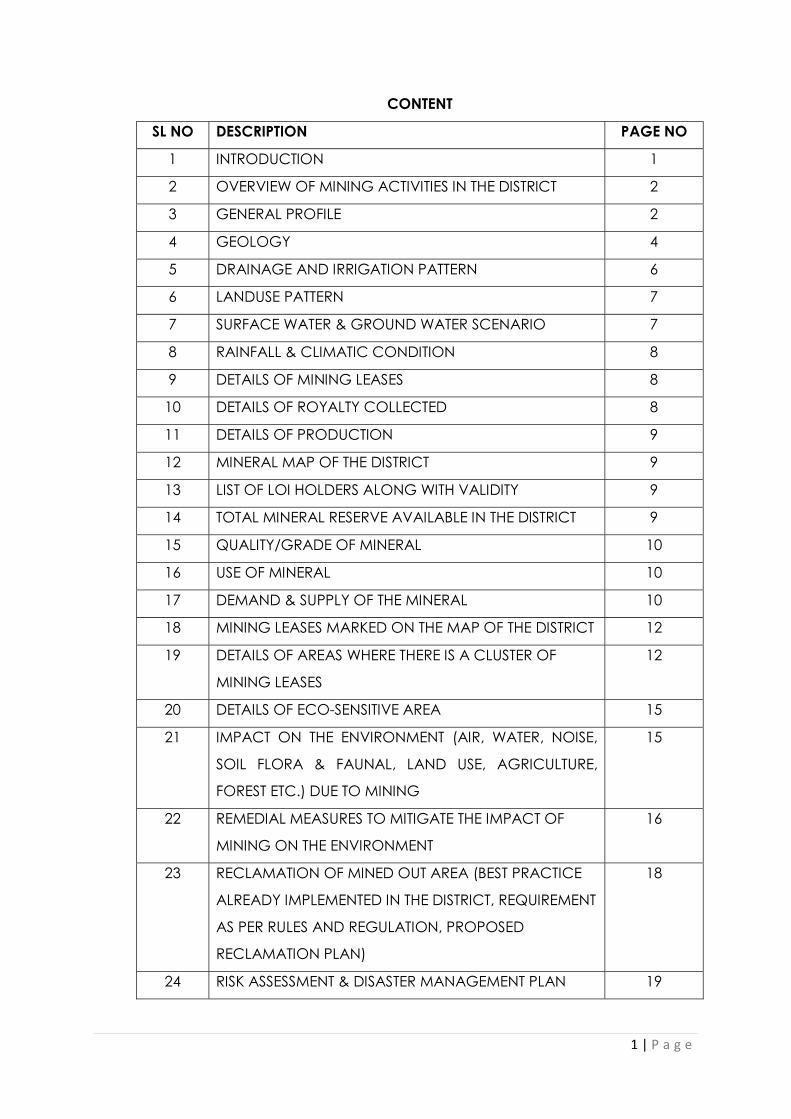
CONTENT
SL NO DESCRIPTION PAGE NO
1 INTRODUCTION 1
2 OVERVIEW OF MINING ACTIVITIES IN THE DISTRICT 2
3 GENERAL PROFILE 2
4 GEOLOGY 4
5 DRAINAGE AND IRRIGATION PATTERN 6
6 LANDUSE PATTERN 7
7 SURFACE WATER & GROUND WATER SCENARIO 7
8 RAINFALL & CLIMATIC CONDITION 8
9 DETAILS OF MINING LEASES 8
10 DETAILS OF ROYALTY COLLECTED 8
11 DETAILS OF PRODUCTION 9
12 MINERAL MAP OF THE DISTRICT 9
13 LIST OF LOI HOLDERS ALONG WITH VALIDITY 9
14 TOTAL MINERAL RESERVE AVAILABLE IN THE DISTRICT 9
15 QUALITY/GRADE OF MINERAL 10
16 USE OF MINERAL 10
17 DEMAND & SUPPLY OF THE MINERAL 10
18 MINING LEASES MARKED ON THE MAP OF THE DISTRICT 12
19 DETAILS OF AREAS WHERE THERE IS A CLUSTER OF
MINING LEASES
12
20 DETAILS OF ECO-SENSITIVE AREA 15
21 IMPACT ON THE ENVIRONMENT (AIR, WATER, NOISE,
SOIL FLORA & FAUNAL, LAND USE, AGRICULTURE,
FOREST ETC.) DUE TO MINING
15
22 REMEDIAL MEASURES TO MITIGATE THE IMPACT OF
MINING ON THE ENVIRONMENT
16
23 RECLAMATION OF MINED OUT AREA (BEST PRACTICE
ALREADY IMPLEMENTED IN THE DISTRICT, REQUIREMENT
AS PER RULES AND REGULATION, PROPOSED
RECLAMATION PLAN)
18
24 RISK ASSESSMENT & DISASTER MANAGEMENT PLAN 19

2 | P a g e
25 DETAILS OF THE OCCUPATION HEALTH ISSUES IN THE
DISTRICT. (LAST FIVE- YEAR DATA OF NUMBER OF
PATIENTS OF SILICOSIS & TUBERCULOSIS IS ALSO NEEDS
TO BE SUBMITTED)
20
26 PLANTATION OF GREEN BELT DEVELOPMENT IN
RESPECT OF LEASES ALREADY GRANTED IN THE
DISTRICT
21
27 ANY OTHER INFORMATION 21
LIST OF PLATES
DESCRIPTION PLATE NO
INDEX MAP OF THE DISTRICT 1
MAP SHOWING TAHASILS 2
ROAD MAP OF THE DISTRICT 3
MINERAL MAP OF THE DISTRICT 4
LEASE/POTENTIAL AREA MAP OF THE DISTRICT 5

INDEX MAPPLATE NO- 1
KEONJHAR
ODISHA

SundargarhMayurbhanj
KENDUJHARTEHSILMAPJharkhand,
/
.-.....•~"\.'\>. ~-- ....
.-.....'-- •.... ,.\
LSaha"apada ~.J \';'
IilI/./
Angul
:" " " "": Stat e Bou ndery.......
"\ ,./r~..~_.
<:[ajapurBhadrak
r------l Distr iet Bou ndaryL.__._'
Tehsil Bounder y
MAP SHOWING THE TAHASILS OF KEONJHAR DISTRICT
PLATE NO- 2

('Sin9pur~~.'---".~, ..,-'
..L.....r...,,, ",".~ ~ua,7r., GO.,n as,ika.~- )._____\-,_.~~"dP"r/; Jonghi".
ANGUL ~ .T~i.,....: II.'r.. I
-, '"8ir1il ,alia"\ \ Naog~on. .'.
•~~"'··."'-._ .•r."·~ ('.~ r-.... /-r."~~ -, •.••.l II·· oj." "· r' ,•.•--" •...•'\ •.....•- .• -;' /,/ .•••..•...•. ~,~-...... .. '. '··Rriaehand.r.~pur~...• /1 ~
,. ~i '. ~ (~oUF!.sca!e \~, .DHENKANAL 1 JAJPUR '._':
Copmal1!t@,2[l 13WWW.•~S(lfillldill!.,com ." ••••• _.•(Upd~edOl1l25thJanuary 'gQa) _. ,
N•••• JHARKHAND
..,JI,
L\I
.1,I,
'".iI'j'
KENDUJ HARGARHROAD MAP
LEGENDNatioo~ l-fighway
==== Major Road.---- ... District Bounetiny- - - • state l3omd'ary
@ District HQ• OIIler TOWn• MajorTown
,".,
'"
".,,.,.MAYURBHANJ
,,. .'ajnagal"
.,<,
.,/" .-.. .,
·Phuljhor//~-
Sana Ghag.cua. KENDUJHAR•,.
...'
Simil ia '.
,..-..,,
"...~ ./..: .•."' •..•.•.•...:~•......•.,,," ,.•.~... -~ ...··,»: ..I,,,
- , o:c· ,. ii','·,··
MAP SHOWING THE MAJOR ROADS OF KEONJHAR DISTRICT
PLATE NO- 3

1 | P a g e
PREFACE
In compliance to the notification issued by the Ministry of Environment and Forest
and Climate Change Notification no. S.O.3611 (E) NEW DELHI dated 25-07-2018 the
preparation of district survey report of road metal/building stone mining has been
prepared in accordance with Clause II of Appendix X of the notification. Every effort
has been made to cover road metal/building stone mining locations, future
potential areas and overview of road metal mining activities in the district with all its
relevant features pertaining to geology and mineral wealth. This report will act as a
compendium of available mineral resources, geological set up, environmental and
ecological set up of the district and based on data of various departments like
Revenue, Water Resources, Forest, Geology and Mining in the district as well as
statistical data uploaded by various state Government departments for preparation
for district survey report. The main purpose of preparation of District Survey Report is
to identify the mineral resources and developing the mining activities along with
other relevant data of the District.
1. INTRODUCTION
The Keonjhar district emerged as one of the districts of Odisha on 1st January,
1948. The district is bounded by Mayurbhanj district and Bhadrak district to the
east, Jajpur district to the south, dhenkanal district and Sundargarh district to
the west and West Singhbhum district of Jharkhand State to the north.
Covering a geographical area of 8303 sq km, the Keonjhar district lies
between 21º 1’ N to 22º 10’ N latitude and 85º 11’ E to 86º 22’ E longitude.
The whole District of Keonjhar was a princely state before its merger with
Odisha. From the history it reveals that a part of the old Khijjinga territory with
headquarters at Khijjinga Kota, identified with modern Khiching. It became a
separate state with Jyoti Bhanja as its ruling chief sometime during the first half
of the 12th century A.D.
The then State of Keonjhar comprised only the northern half of the modern
district for a long time prior to the incarnation of Jyoti Bhanja as King. During
the latter part of the 15th century the southern half of the district was
occupied by King Govinda Bhanja under whose rule Keonjhar was extended

2 | P a g e
from Singbhum in the north to Sukinda in the South and from Mayurbhanj in
the East to the borders of the States of Bonai, Pallahara and Anugul in the
West.
During the rule of Pratap Balabhadra Bhanja (1764–1792 A.D.) two small areas
of Tillo and Jujhpada were purchased from the Zamindar of Kantajhari and
were added to the district. These were recognised as parts of Keonjhar in the
Sanad granted by the East India Company to Raja Janardan Bhanja in 1804.
Since then there had been no territorial changes of the district till its merger
with the Province of Odisha. But after merger largely for the reasons of
administrative expediency the areas of Tillo (7.51 sq.km) and Jujhpada
(9.06sq.km.) were transferred to the districts of Balasore and Cuttack
respectively, while a number of villages called Ambo group (14.84 sq.km.) of
Balasore district were added to Keonjhar District.
Keonjhar is one of the major mineral producing districts of Odisha. Iron ore,
Manganese ore, Chromite, Quartzite, Bauxite, Gold and Pyrophyllite are the
major minerals found in this district.
2. OVERVIEW OF MINING ACTIVITIES IN THE DISTRICT.
Minerals:
IRON ORE:
The main iron ore deposits are found along the classic Bonai-Keonjhar Horse Shoe
shaped synclinorium which spared over an area of about 60KmX25Km.
Hematite is the chief mineral resource of this district. Important deposits were found
in Thakurani, Bolani, Joda east, Khandbhanda, Sidhmath, Belkundi, Kasia-Barapada,
Bolani, Kiribura, Gurudia, Jharibahal, Dubuna, Bamebari, Murga, Palsa, Jajang,
Malangtoli, Chamakpura, Gandhamardhan, Daitari, Tomka, Inganijaran, Horomoto
Guali and Uliburu. Iron ore bands occur in layered BIF bands along with volcano-
sedimentary rock piles known as Iron Ore Super Group. Usually four types of ore are
seen i.e. hard massive, laminated, lateritic and blue dust.

3 | P a g e
A total of 3142.70 million tonnes of iron ore resource of all categories have been
assessed with 64-68% Fe in massive, 62-65% Fe in laminated, 65-68% Fe in powdery
blue dust type of ore.
Besides, investigation of iron ore by the Directorate in Horomoto-Guali area has
established a possible reserve of 46.75 million tonnes of iron ore of grade varying
from 51.20% to 65.24% Fe.
MANGANESE: The Keonjhar manganese belt is a part and parcel of Singhbhum
Bonai belt and one of the most important manganese ore producing regions of
India. this is confined to shale formation of Pre-Cambrian Iron Ore Super Group as
stratiform, stratabound and lateritoid types.
Important deposits in the Keonjhar district are located in the areas of Roida-
Bhadrasahi, Silijhora-Kalimati, Guruda, Chormalda, Sarkunda, Dubna Kolarudkela,
Podadihi-Langini-Jharan, Lasarda, Pacheri, Balani, Baneikala, Kendudihi-Purulipada,
Horomoto-Jajang, Katasahi, Joribahal, Joda west and Belkundi etc.
The reserve of manganese ore is estimated as 127.27 million tonnes.
The grade of the ore is variable from deposit to deposit as also from body to body
within the same deposit. out of the total production, about 10% to 15% forms the
High Grade (more than 46% Mn), 25% to 30% Medium Grade (36-45% Mn) and the
rest Low (less than 30-35% Mn) and still lower ( less than 30% on Mn)
CHROMITE: The chromite deposits of the district are associated with the ultramafic
rocks of Nuasahi, Boula and Phuinjhorhuli area. The body extends for about 3Kms in
an N-S direction. It is a dyke like body dipping steeply to the east and is widest in the
centre and gradually tapering towards north and south. The ultrabasic occurs as
intrusive in Precambrian metamorphites as well as differentiated layered igneous
complex. It has a peridotite core with subordinate amount of chromite, peripheral
pyroxenite and enstatite. the ultramafites include enstatite, bonzite, pyroxenite,
serpentinised dunites, talc schist, silicified dunites and chromitites with chromite
loads. The chrome ore available are mostly of lumpy type.
The estimated reserve is 11.43 million tonnes with Cr2O3 content varies from 40% to
45%.
BAUXITE: Industrial and chemical grade Bauxite occurs on Dholkata pahar area of
the district. The area is represented by metavolcanites characterized by

4 | P a g e
metatholeiitic basalt. The different flows are separated by tuffaceous shale.
Outcrops of metagabbro have been noticed to the east and south east of Dholkata
pahar. Apart from these minor occurrences of bauxite in pockety or poddy nature
has been reported along Keonjhar-Banai belt. The occurrences has been located
around Kodalia, Khajurdi Pahar, east of Kasiara and Jaladihi area.
The Dholkata Bauxite is of high alumina, high iron, low silica and low titanium grade
having 60 to 70% tri-hydrated as gibbsite and rest bohemite. the predominant iron
minerals are goethite and hematite occurring as colloidal bands.
A total of 5.986 million tonnes of bauxite reserve has been estimated around
Dholkata pahar area of the district.
VANADIFEROUS MANGANESE: Deposits of vanadiferous magnetite occur in
association with gabbro-anorthosite suite of rocks in the Precambrian metamorphic.
A deposit of vanadiferous magnetite is seen near Phulinjhorhuli in Anandapur
subdivision. The mineral occurs in a band of ultabasic rocks about 4Km long.
GOLD: The occurrence of gold is reported in Telkoi and Banspal block of Keonjhar
district. Several old workings of the gold in the shape of elongated trenches, deep
circular pits, wells and tunnels have been recognised around Saleikena, Sirisbahal,
Dublapal, Bangadiha, Odal, Gopur, Gajipur and Kusuguda etc. The area covering
the gold deposits constitute the rock units belonging to Iron Ore Super Group
comprising of basic lava, tuffites, basic intrusive, metagabbro, metadiorite,
amphibolites, quartzite and chlorite schist. The granitic suites of rocks are intrusive
into the above rock types and are represented by micro granites, fracture, shear
zone and faults might have acted both as channel ways and receptacles for gold
deposition in the vein quartz bodies.
Few important fire assay result done by Hutti Gold Mines shows gold values ranging
from 1.8gm/tonne to 18.68gm/tonne in Gopur, traces to 5.3gm/tonne in Odal, traces
to 2gm/tonne in Gajipur.
PYROPHYLLITE: The occurrences of pyrophyllite are stretched over a 90Km long belt
extending from Rebna-Palasbahal in the south to Dhobakuchuda-Balabhadrapurr in
the north. These are associated with the border area of Singhbhum Granite and
quartzite hills such as Madrangajori, Macchakandana, Jodiaghat and south of
Uchakabeda, eastern slope of Chantrabhangapahar, Dalimpur and Sidhamath
area. The Pyrophyllite occurrences mentioned above are in the form of very fine

5 | P a g e
flakes, typically soapy feel and associated with pyrophyllite quartz schist, quartz
tourmaline pyrophyllite rocks and quartz tourmaline pyrophyllite schist as irregular
patches.
A total reserve of 12.28 million tonnes have been assessed in Keonjhar district. The
average percentage of Al2O3 is 20-23%, SiO2-65-75%, Fe2O3- 0.77% and LOI-3-4%.
QUARTZITE: High grade quartzite mining activities are continuing near Barapada,
Barang, Paharpur, Parsala area of the district. Besides, cherty and massive quartzite
with 99% SiO2 are marked intermittently in the iron ore series near Rebna-Palaspal,
Magarmuhan, Jaypur, Dalmaposi, Chauthia and Nawabeda area.
A total reserve of 45.68 million tonnes of quartzite has been estimated in the district.
the average SiO2 content varies from 95 to 99.66%.
CHINA CLAY: Pockets of china clay are encountered near Judiapahar, Tarreni
pokhari, Aupura, Fakirpur, Padmakesharpur, Jaypur, Kankadajodi, Adakata,
Govindpur area of the district. The clay is yellowish white, gritty and occurs as pocket
type.
The reserve of china clay has been estimated as 1.41 million tonnes in the area. The
Al2O3 content varies from 18.25% to 22.77%.
DIMENSION STONE: Singhbhum granite, dolerite dykes and ultrabasic rocks of the
district are suitable for dimension stone/ decorative stones. The 150Km long
Palaspanga dyke from Keonjhar to Chainbasa, the longest dyke in Asia is being used
for the above purpose in veiw of its colour, texture, composition and hardness. These
are quarried at number of places around Dhurpada and Keonjhar. A part of dyke to
the east of Kaliaprasad village has been estimated to contain 500Cu.m. of
dimension stone of block size 0.5mx0.5mx0.5m. Lower shale formations found near
village Lunagothani was found to be suitable for decorative purpose. However
1606900Cu.m. of black granite, 18044200Cu.m. of Grey granite and 8379000Cu.m. of
Green granite has been reported in the district.
TALC-SOAPSTONE: This is reported from the northern slope of hill ranges immediately
south and west of Kendujhargarh and Dalimpur. The talc-schist occurs as gently
undulating slabby layers underlying the Kolhan sandstone. The highly foliated talc-
schist are traversed by veins of quartz as impurities. Besides these, soapstone
occurrence is encountered near Dholkata, Dalangpur, NE of Sayedmulia,

6 | P a g e
Suramundi, Kuladhamkuni, Sapghosara, Pithagola, Alanga area. These are locally
utilized for preparation of stone ware and statues. The MgO content varies from
11.397 to 22%.
PYRITE: Pyrite crystals have been recorded in dark grey shaly formation underlying
the Kolhan sandstone west of Balibandha on the Keonjhar-Chainbasa road. The
occurrence is of no economic importance.
GLASS SAND: Some of the Kolhan sandstones in the northern portion of the
district(near Barangam) is suitable for glass industry.
BUILDING STONE & ROAD MATERIAL: Granite gneisses, aplites, dolerites and quartzite
are being used as road metal and in concrete mixtures. Lateritite blocks are
extensively used as a very common building material. All these materials are found
in plenty.
OTHER MINERALS: A few occurrences of asbestos are encountered near Gopalpur
and Ranki. Thin bands of slip fibres were marked in the peridotite body, but the
economic aspect of this occurrence appears not to be viable. A patch of travertine
limestone is also encountered near Asurkhol area.
The district is the major producer of iron and manganese ore of the state. Other than
the above mentioned minerals, minor minerals such as river sand, laterite slabs,
building stone/black stone/road metals, morrum, brick earth etc. are also available
in the district.
3. GENERAL PROFILE
a. Administrative set up:
Sl No Item Unit Magnitude
1 Location
Longitude Degree 85º 11’ E to 86º 22’ E
Latitude Degree 21º 1’ N to 22º 10’ N l
2 Geographical area Sq.Km. 8303
3 Sub-division Numbers 3
4 Tahasils Numbers 13
5 C D Blocks Numbers 13
6 Municipalities Numbers 4

7 | P a g e
7 NACs Numbers 1
8 Police Stations Numbers 25
9 Gram Panchayats Numbers 297
10 Villages Numbers 2123
Inhabited Numbers 2064
Uninhabited Numbers 59
11 Assembly
constituencies
Numbers 6
b. Area and Population:
The district has an area of 8303 sq. km and 18.02 lakh of population as per
2011 census. The district accounts for 4.09 percent of the states territory and
shares 3.03 percent of the states population. The density population of the
district is 217. per sq. kms. as against 270 person per sq. km. of the state.
c. Climate :
The climate condition of the district is generally hot and high humidity
during April to May and cold during November to December. The
monsoon generally breaks during the month of July, Average annual
rainfall of the district was 1228.4 mm during 2017, which is lower than the
normal rainfall 1487.7 mm.
d. Agriculture:
During the year 2017-18 the net area sown was 288 thousand hectares against
5356 thousand hectares of the state. The production of was as below:
Name Pad
dy
Whe
at
Maiz
e
Mun
g Biri
Kulth
i TilL
Grou
ndnu
t
Musta
rd
Potato
es Jute
Suga
rcan
e
Producti
on in
000 MT
598.
55
0.58 69.4
0
7.72 9.90 7.79 2.72 15.2
3
3.33 23.82 16.78 13.2
2

8 | P a g e
During 2017-18, the total fertilizers used in the district was about
Type of
fertiliser Nitrogenous Phosphatic Pottasic Total
Consumption
per Ha
Quantity in
MT
9185 3701 1725 14611 38.73
e. Power:
Consumption of electricity in Angul district during the year 2013-14 covers 136.03
million units and villages so far electrified as on 30.09.2019, 2067 revenue villages
which constitutes 97.4% to the total revenue villages of the district.
f. Transport & Communication:
Railway route length (14-15) km 158.06
No of Rly stations and PH(14-15) 16
Forest road (17-18) km 249.98
National Highway (16-17) km 341.30
State Highway (17-18) km 52.74
Major district road (17-18) km 34.29
Other dist road (17-18) km 885.98
Rural road(17-18) km 1945.90
Inter village road (16-17) km 3912.49
Intra village road (16-17) km 3143.74
g. Health:
The medical facilities are provided by different agencies like Govt., Private
individuals and voluntary organizations in the district.
Sub divisional hospitals including mobile
8 No
Beds facilities 593 No Homoeopathic dispensaries
48 No
Ayurvedic dispensaries 34 No
9 | P a g e
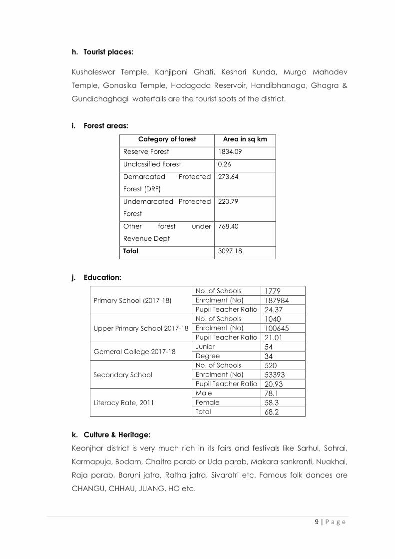
h. Tourist places:
Kushaleswar Temple, Kanjipani Ghati, Keshari Kunda, Murga Mahadev
Temple, Gonasika Temple, Hadagada Reservoir, Handibhanaga, Ghagra &
Gundichaghagi waterfalls are the tourist spots of the district.
i. Forest areas:
Category of forest Area in sq km
Reserve Forest 1834.09
Unclassified Forest 0.26
Demarcated Protected
Forest (DRF)
273.64
Undemarcated Protected
Forest
220.79
Other forest under
Revenue Dept
768.40
Total 3097.18
j. Education:
Primary School (2017-18) No. of Schools 1779 Enrolment (No) 187984 Pupil Teacher Ratio 24.37
Upper Primary School 2017-18 No. of Schools 1040 Enrolment (No) 100645 Pupil Teacher Ratio 21.01
Gerneral College 2017-18 Junior 54 Degree 34
Secondary School No. of Schools 520 Enrolment (No) 53393 Pupil Teacher Ratio 20.93
Literacy Rate, 2011 Male 78.1 Female 58.3 Total 68.2
k. Culture & Heritage:
Keonjhar district is very much rich in its fairs and festivals like Sarhul, Sohrai,
Karmapuja, Bodam, Chaitra parab or Uda parab, Makara sankranti, Nuakhai,
Raja parab, Baruni jatra, Ratha jatra, Sivaratri etc. Famous folk dances are
CHANGU, CHHAU, JUANG, HO etc.

10 | P a g e
4. GEOLOGY
The district can be broadly divided into seven geological units viz.: (i)
The patchy occurrences of metamorphites belonging to older
metamorphics of Archaean age (ii) Huge batholiths of Singhbhum
Granite with swarms of newer dolerites dykes in the eastern part of the
district, (iii) Metasedimentaries belonging to Gorumahisani Group of
rocks of Archean age in the southwestern part of the district (iv)
Volcano-sedimentary sequence intruded by Bonai granite belonging
to Lower Bonai group of age ranging between Archean and Paleo
Proterozoic in the southwest and on the north-west (v) Intrusives like
chromiferous ultramafics, gabbro-anorthosite, dolerite and quartz veins
of Archaean to Proterozoic age (vi) Sedimentaries and
metasedimentaries belonging to Kolhan Group ranging in age from
lower to middle Proterozoic (vii) Lateries of Cenozoic age and (viii)
Quaternaries represented by Kaimundi formation and un classified
alluvium.
The Singhbhum granite shows wide variation from highly foliated
biotite-epidote granodiorite to grayish white medium grained weakly
foliated to nearly massive muscovite-biotite granodiorite. It contains
enclaves of older metamorphics represented by hornblende schist,
chlorite schist and meta gabbros. Gorumahisani Group consists of
sheared pebbly quartzite, hornblende schist and BHQ. The Volcano-
sedimentary rocks of lower Bonai Group comprises Basic Volcanic,
BHQ, BHJ, ferruginous shale, quartzite, iron ore bodies and tuff with or
without manganese. The chromiferous ultra-basics of Nuasahi and the
mafic-ultramafic complex of Baula are rich in Cr-Fe-Ni and is probable
locale for PGE. This is followed by late magmatic gabbro-anorthosite
suite of rocks. The dolerite and gabbro occur as the younger intrusive.
The Kolhan Group of rocks comprises conglomerate, sandstone, shale
and quartzite. The insitu laterites are wide spread in the area. the
Quaternaries are represented by Kaimundi formation consisting of
sandy sticky clay impregnated with caliche and unclassified

11 | P a g e
Quaternaries represented by black to brown clay and coarse to fine
sand.
STRATIGRAPHY:
The geological succession in the district is as follows:
Age Formation/Group Lithology
Holocene Alluvium
Late Pleistocene to Early Holocene
Kaimundi Formation Clay with Calcareous concentration
Cainozoic Laterite and lateritic bauxite (Lbx)
Palaeo to Meso Proterozoic
Kolhan Group Conglomerate, sandstone and shale
Palaeo Proterozoic
Dangoaposi lava
Proterozoic (Undifferentiated)
Granophyre/ gabbro/anorthosite
Archaean to Proterozoic
Newer Ddolerite
Ultramafic rocks+Chromite
Archaean to Palaeo Proterozoic
Lower Bonai Group
Basalt, tuff, meta gabbro
Granite
Shale, tuff and manganese
BHQ, BHJ, ferruginous shale and quartzite
Gritty sandstone, orthoquartzite, conglomerate
Archaean Gorumahishani Group
Hornblende schist, chlorite schist, amphibolite and meta-gabbro
Quartzite, quartz sericite schist, cherty quartzite, fuchsite quartzite and black chert
Quartzite, chert
BHQ, BMQ, BCQ, BJQ
Ferrugineous shale, carbonaceous shale phyllite and mica schist

12 | P a g e
Pebbly quartzite, gritty quartzite and quartzite
Older Metamorphic Group
Singhbhum granite/ Hornblende Granite
Pellitic schist, quartzite and amphibolite
5. DRAINAGE AND IRRIGATION PATTERN.
The drainage of the district is mainly controlled by rivers like Baitarani, Kangira, Ardei,
Khairibandhan, Kanjhari, Sita, Kusei, Salandi etc. Detail of the river system is narrated
below.
SI. No.
Name of the River
Place of Origin Altitude at Origin
Total length in the district (in
Km) (Total length)
1 2 3 4 5
1 Baitarani Gonasika Longitude- 210-31’-00” N Longitude- 850-33’-00”E
240Km upto Anandapur
2 Kangira Haladi Pokhari 40Km
3 Ardei Sidha Matha Longitude- 220-009’-00”
N Longitude- 850-68’-00”E
72.40Km
4 Khairibandhan Smimlipal R.F. Longitude- 210-924’-00”
N Longitude- 850-794’-00”E
152Km
5 Deo Sidha Matha Longitude- 210-804’-00”
N Longitude- 850-826’-00”E
80Km
6 Kanjhari Kanjharibani Pira Longitude- 210-685’-00”
N Longitude- 850-851’-00”E
60Km
7 Sita Barabanki Hill Longitude- 210-497’-00”
N Longitude- 860-017’-00”E
26Km
8 Musal Rebana R.F. Longitude- 210-32’-00” N Longitude- 860-066’-00”E
60Km
9 Kusei R. Bera R.F. Longitude- 210-139’-00”
N Longitude- 860-178’-00”E
80Km
10 Salandi Banjhi Kusaghat
R.F. Longitude- 200-79’-00” N Longitude- 860-678’-00”E
144Km

13 | P a g e
11 Bhirol
Longitude- 210-606’-00” N
Longitude- 850-945’-00”E
12 Mermenda
Longitude- 210-958’-00” N
Longitude- 850-775’-00”E
6. LANDUSE PATTERN
Sl No Landuse Area in ‘000Ha
1 Forest Area 310
2 Misc. trees & Grooves 6
3 Permanent Pasture 20
4 Culturable Waste 26
5 Land put to Non Agril Use 70
6 Barren & Unculturable Land 93
7 Current Fallow 10
8 Other Fallow 0
9 Net Area Sown 288
10 Mining 7
Geographical Area
830
7. SURFACE WATER & GROUND WATER SCENARIO
The drainage systems i.e. rivers of the district gets filled with water during the
monsoon and the gradually it decreases from the month of January to June of
each year. In the summer season all rivers become almost dry excepting narrow
flow of water within the basin.
The variation of ground water table in the district is as follows:
Depth of water level (mbgl)/ Period April August November January
Minimum 4.0 0.60 1.48 0.3
Maximum 10.4 5.09 7.01 13.1
]

14 | P a g e
8. RAINFALL & CLIMATIC CONDITION
The district is generally hot with high humidity during April and May and cold during
December and January. The monsoon generally breaks during the month of July
and continues till end of October. The temperature goes as high as up to 450C in the
summer and up to 70-80 C during peak winter.
The rainfall statistics of the district for last four years is given below:
YEAR/MONTH
APRIL
MAY JUNE JULY AUG SEPT OCT NOV DEC JAN FEB MARCH
TOTAL
2015 64.40
52.92 197.56 319.21 167.32 114.26 27.14 0.16 22.71 20.72 14.58 8.52 1009.5
2016 2.34 137.14 145.02 270.37 348.52 166.20 58.26 4.03 0.00 1.69 53.95 23.71 1211.23
2017 15.13
117.45 162.00 320.52 230.52 161.25 160.06 24.98 0.09 0.92 0.0 35.42 1228.34
2018 133.26
95.75 185.79 360.55 375.08 351.53 113.38 0.25 49.55 0.0 0.0 0.83 1665.97
2019 59.64
116.61 143.27 232.23 327.32 353.60 161.64 - - - 55.20 40.18 1489.69
9. DETAILS OF MINING LEASES OF ROAD METAL
Attached as Annexure I
10. DETAILS OF ROYALTY COLLECTED
Year-wise Calculation of Royalty (Rs)
Sl.No Name Of Tahasil
2015-16 2016-17 2017-18 2018-19
1 Barbil 0 0 0 2281500 2 Patna 245007 838993 3008839 2573148 3 Saharapada 4 Anandpur 0 0 241010 245240 5 Banspal 0 4704695 8973341 10726299 6 Champua 529688 2796331 3122652 3203236 7 Ghasipura 0 13246702 26117462 12953570 8 Ghatagaon 0 241000 627000 3310000 9 Harichandanpur 87870 117000 1174335 1401270 10 Hatadihi 155105 155704 154794 168753 11 Jhumpura 0 1096000 1096000 1096000 12 Keonjhar 805000 3335000 3842000 3980000 13 Telkoi 0 23200 232000 232000 TOTAL 1822670 26554625 48589433 42171016

15 | P a g e
11. DETAILS OF PRODUCTION OF MINOR MINERAL
Yearwise Production of Road metal in cum
Sl.No Name of Tahasil 2015-16 2016-17 2017-18 2018-19 1 Barbil 17550 17550 17550 17550 2 Patna 7124.9 21494.9 23612.7 25019.2 3 Saharapada 0 0 0 0 4 Anandpur 0 0 923.4 939.6 5 Banspal 16214 183931 232947 233316 6 Champua 13099.5 20317 21165.2 21675 7 Ghasipura 0 130852 152195 43675 8 Ghatagaon 93377 93597 59913 41400 9 Harichandanpur 870 8716 9791 10779 10 Hatadihi 960 920 920 960 11 Jhumpura 3600 3600 3600 3600 12 Keonjhar 17970 22346 23347 25679 13 Telkoi 0 1542 1542 1542 TOTAL 170765.4 504865.9 547506.3 426134.8
12. MINERAL MAP OF THE DISTRICT
Attached as Plate No 4.
13. LIST OF LOI HOLDERS ALONG WITH VALIDITY
Attached as Annexure II
14. TOTAL MINERAL RESERVE AVAILABLE IN THE DISTRICT
Total mineral reserve of road metal/buildingstone/blackstone/white stone is
4,10,032 cum which may increase after detail investigation.
Details of the potential areas submitted as Annexure III.
15. QUALITY/GRADE OF MINERAL
Road metal/building metal of the district is very much suitable for various
construction purposes after its crushing and screening. The in-situ rocks are
fractured making these unsuitable for decorative purpose.
16. USE OF MINERAL
Road metal/building metal of the district is used mainly for various
construction purposes like road making, concrete making, dams etc.
17. DEMAND & SUPPLY OF THE MINERAL
The tentative annual demand is to the tune of 1,00,000 cum of road metal
and is mainly supplied from different tahasils of the district and adjoining
districts of Mayurbhanj and Dhenknal.
16 | P a g e
18. MINING LEASES MARKED ON THE MAP OF THE DISTRICT.
Attached as Plate No 5.
19. DETAILS OF AREAS WHERE THERE IS A CLUSTER OF MINING LEASES
Not applicable
20. DETAILS OF ECO-SENSITIVE AREA
Eco-sensitive Zone has been identified around Hadagarh Wildlife Sanctuary
and submitted to the Ministry of Environment & Forests and Climate Change,
Govt. of India, New Delhi through Govt. of Odisha, Forest & Environment
Department for final Notification which is being awaited. In absence of
Notification of Eco-sensitive Zone as per Hon’ble Supreme Court of India
direction the 10 km. radius from boundary of Hadagarh Wildlife Sanctuary is
being treated as Eco-sensitive Zone.
Further, as per direction of the Hon’ble Supreme Court of India, no mining and
quarry activities will be allowed within 1 km. radius of Hadagarh Wildlife
Sanctuary.
21.IMPACT ON THE ENVIRONMENT (AIR, WATER, NOISE, SOIL FLORA & FAUNAL , LAND
USE , AGRICULTURE, FOREST ETC.) DUE TO MINING
Activities attributed to Mining:-
Generally, the environment impact can be categorized as either primary or
secondary. Primary Impacts are those, which are attributed directly by the project.
Secondary impacts are those which are indirectly induced and typically include the
associated investment and changed pattern of social and economic activities by
the proposed action.
The impact has been ascertained for the project assuming that the pollution due to
mining activity has been completely spelled out under the base line environmental
status for the entire ROM which is proposed to be exploited from the mines.
Impact on Ambient Air
Mining operation are carried out by opencast manual, semi mechanized/
mechanized methods generating dust particles due to various activities likes,
excavation, loading, handling of mineral and transportation. The air quality in the

17 | P a g e
mining areas depends upon the nature and concentration of emissions and
meteorological conditions.
The major air pollutants due to mining activities include:-
Particulate matter (dust) of various sizes.
Gases, such as sulphur dioxide, oxides of nitrogen, carbon monoxide etc from
machine & vehicular exhaust.
Dust is the single air pollutant observed in the open cast mines. Diesel operating
drilling machines, blasting and movement of machineries/ vehicles produce NOx ,
SO2 and CO emissions, usually at low levels. Dust can be of significant nuance
surrounding land user and potential health risk in some circumstances.
Water Impact
Sometimes the mining operation leads to intersect the water table causing ground
water depletion. Due to the interference with surface water sources like river, nallah
etc drainage pattern of the area is altered.
Noise Impact
Noise pollution mainly due to operation of machineries and occasional plying of
machineries. These actives will create noise pollution in the surrounding area.
Impact on Land environment
The topography of the area will change certain changes due to mining
activity which may cause some alteration to the entire eco system.
Impact on Flora & Fauna
The impact on biodiversity is difficult to quantify because of it’s diverse and
dynamic characteristics.
Mining activities generally result in the deforestation, land degradation, water,
air and noise pollution which directly or indirectly affect the faunal and flora status
of the project area.
However, occurrence and magnitude of these impacts are entirely dependent
upon the project location, mode of operation and technology involved.

18 | P a g e
22. REMEDIAL MEASURES TO MITIGATE THE IMPACT OF MINING ON THE
ENVIRONMENT:-
Air
Mitigation measures suggested for air pollution controls are to be based on the
baseline ambient air quality of the project/cluster area and would include measures
such as:
Dust generation shall be reduced by using sharp teeth of shovels.
Wet drilling shall be carried out to contain the dust particles.
Controlled blasting techniques shall be adopted.
Water spraying on haul roads, service roads and overburden dumps will help
in reducing considerable dust pollution.
Proper and regular maintenance of mining equipment’s have to be
undertaken.
Transport of materials in trucks are to be covered with tarpaulin.
The mine pit water can be utilized for dust suppression in and around mine
area.
Information on wind diction and meteorology are to be considered during
planning, so that pollutants, which cannot be fully suppressed by
engineering techniques, will be prevented from reaching the nearby
agricultural land, if any.
Comprehensive greenbelt around overburden dumps and periphery of the
mining projects/clusters has to be carried out to reduce to fugitive dust
transmission from the project area in order to create clean & healthy
environment.
Water
Construction of garland drains and settling tanks to divert surface run –off of
the mining area to the natural drainage.
Construction of checks dams/ gully plugs at strategic places to arrest silt
wash off from broken up area.
Retaining walls with weep hole are to be constructed around the mine
boundaries to arrest silt wash off.

19 | P a g e
The mined out pits shall be converted in to the water reservoir at the end of
mine life. This will help in recharging ground water table by acting as a
water harvesting structure.
Periodic analysis of mine pit water and ground water quality in nearby
villages are to be undertaken.
Domestic sewage from site office & urinals/latrines provided within ML/QL
areas is to be discharged in septic tank followed by soak pits.
NOISE
Periodic maintenance of machineries, equipments shall be ensured to keep
the noise generated within acceptable limit.
Development of thick green belt around mining/cluster area, haul roads to
reduce the noise.
Provision of earplugs to workers exposed to high noise generating activities
like blasting, excavtion site etc. Worker and operators at work sites will be
provided with earmuffs.
Conducting periodical medical checkup of all workers for any noise related
health problems.
Proper training to personnel to create awareness about adverse noise related
effects.
Periodic noise monitoring at locations within the mining area and nearby
habitations to assess efficacy of adopted control measures.
During blasting optimum spacing, burden and charging of holes will be made
under the supervision of competent qualified mines foreman, mate etc.
Biological Environment
Development of green belt/gap filling saplings in the safety barrier left
around the quarry area/ cluster area.
Carrying out thick greenbelt with local flora species predominantly with long
canopy laves on the inactive mined out upper benches.
Development of dense poly culture plantation using local floral species in the
mining areas at conceptual stage if the mine is not continued much below
the general ground level.
Adoption of suitable air pollution control measures as suggested above.
Transport of materials in trucks covered with tarpaulin.

20 | P a g e
23. RECLAMATION OF MINED OUT AREA (BEST PRACTICE ALREADY IMPLEMENTED
IN THE DISTRICT, REQUIREMENT AS PER RULES AND REGULATION, PROPOSED
RECLAMATION PLAN) :-
As per statute all mines/quarries are to be properly reclaimed before final
closure of the mine. Reclamation of exhausted mines are planned to be
undertaken in below three possible means:
1. If, substantial amount of waste is there, the exhausted quarry can be fully or
partly backfilled using the stored waste. The backfilled areas are to be
brought under plantation of local species.
2. If the generation of waste is much less as in the case of minor mineral mining,
the exhausted quarries can be reclaimed by
a. Plantation on the broken up surface if the depth of quarry is not much
below the surrounding surface level.
b. Converted to water reservoir after stabilization of the slopes if the
exhausted quarry continues much below the surrounding surface level. It
is preferred to cordon the water reservoir either through wire fencing or
retaning wall with plantation from the safety point of view.
Most of the quarry/mining lease areas are yet to be exhausted from ore point of
view. Hence, reclamation would be taken up only after exhaustion of the
ore/mineral content from these areas. The exhausted minor mineral quarries of the
district have been converted to water reservoirs.
24. RISK ASSESSMENT & DISASTER MANAGEMENT PLAN
The only risk involved related to mining of minor mineral excepting natural
calamities is slope failure and probable accidents due to high and ill maintained
bench walls. This can only be addressed through making of regular benches
and undertaking mining in benching pattern.
The disaster management plan (DMP) is supposed be a dynamic, changing,
document focusing on continual improvement of emergency response planning
and arrangements.
The disaster management plan is to be aimed to ensure safety of life,
protection of environment, protection of installation, restoration of production

21 | P a g e
and savage operations in this same order of priorities. For effective
implementation of the disaster management plan, it should be widely circulated
through rehearsal/induction conducted by the respective department from
time to time .
General responsibilities of employees’ during an emergency:
During an emergency, it becomes more enhanced and pronounced when an
emergency warning is raised, the worker in charge, should adopt safe and
emergency shut down and attend to any prescribed duty. If no such
responsibility is assigned, the workers should adopt a safe course to assembly
point and wait instructions. He should not resort to spread panic. On the other
hand, he must assist emergency personnel towards objectives of DMP.
Co-ordination with local authorities:
The Mine Manger who is responsible for emergency will always keep a jeep ready at
site. In case of any eventuality, the victim will be taken to the nearby hospitals after
carrying out the first aid at the site. The Manger should collect and have adequate
information of the nearby hospitals, fire station, police station, village panchayat
heads, taxi stands, medical shops, district revenue authorities etc. and use them
efficiently during the case of emergency.
25. DETAILS OF THE OCCUPATION HEALTH ISSUES IN THE DISTRICT. (LAST FIVE- YEAR
DATA OF NUMBER OF PATIENTS OF SILICOSIS & TUBERCULOSIS IS ALSO NEEDS TO BE
SUBMITTED):-
As per the guidelines of the Mine Rules 1995, occupational health safety has been
stipulated by the ILO/WHO. The proponent’s will take necessary precautions to fulfill
the stipulations. Normal sanitary facilities have to be provided within the lease area.
The management will carry out periodic health checkup of workers.
Occupational hazards involved in mines are related to dust pollution, noise pollution,
blasting and injuries from moving machineries & equipment and fall from high
places. DGMS has given necessary guidelines for safety against these occupational
hazards. The management has to strictly follow these guidelines.

22 | P a g e
All necessary first aid and medical facilities are to be provided to the workers. The
mine shall be well equipped with personal protective equipment (PPE). Further, all
the necessary ported equipments such as helmet, safety goggles, earplugs, earmuffs
ets are to be provided to mine workers as per Mines Rules. All operators and
mechanics are to be trained to handle fire fighting equipments.
Details of occupational health issues in the district since last 5 years.
Incidence of Patients of Tuberculosis.
Year Total TB Cases
Notified 2015 2764 2016 3038 2017 2765 2018 2701 April 2019 to September,2019 1609
There is no case of Silicosis found in the district within the time frame mentioned
above.
26. PLANTATION OF GREEN BELT DEVELOPMENT IN RESPECT OF LEASES ALREADY
GRANTED IN THE DISTRICT
As most of the minor mineral mines/quarries of the district are yet to be exhausted of
their mineral content no sort of reclamation measures including plantation has been
undertaken excluding gap plantation of local species in the peripheral safety zones
of the quarries/ clusters and in some of the haul roads.
27. ANY OTHER INFORMATION
Nil

1
ANNEXURE I
ROAD METAL/ BLACKSTONE/WHITESTONE SAIRATS ALREADY LEASED OUT AND EXECUTED
Sl. No.
Name of Tahasil
Name of
Minor
Mineral
Name of village
Name of lessee
Address
& contact No of
lessee
Mining
lease
grant
order No &
date
Period of QL
Date of co
mmencement of
minig
operation
Status
(working/
non-
working/Temp
working
for depatch)
Captive or Non
-captive
Lt No &
date of
grant of EC
Location of
Resource
(GPS co-
ordinates or Khata & Plot No)
(Sketch map to be
attached)
Longitude
Lattitude
Method of
mining
Area leased
for mineral concession (in sq m)
Mineable mineral
potential as per
approved mining plan (in cum)
Production proposed
in the mining
plan (cum)
Actual production
(cum)
Royalty (in Rs lakh)
collected as Royalty
From
To
Degree
Minute
Second
Degree
Minute
Second
15-16
16-17
17-18
18-19
15-16
16-17
17-18
18-19
15-16
16-17
17-18
18-19
1 2 3 4 5 6 7 8 9 10 11 12 13 14 15
16
17
18
19
20
21 22 23 24
25
26
27
28
29
30
31
32
33
34
35

2
1 Barbil
Kandara-I
stone quarry
Kandara
Senior Manager (Civil), OCC Limited, Kanpur Spill Way Project, ,
Basudevpur
At/Po- Basudevpur
, Ps- Joda,
Dist-
Keonjhar
, Pin- 758041 Mob.
9337070654 .
5536/Dated
30.07.201
8
2015-16
2019-20
30.07.201
8
Working
Captiv
e
1803/Rev/02.04.201
8
N22°40’35.65” to N22° 02’
38.11” &
E85°29’
25.64” to
E85° 29’31.
64” K. No. 1/1, P.
No. 127 & 128
Area Ac.1.9
20 Kisam- Taila-II
22
40
35.6
22
02
38.11
OC 6400 13,500 2700
2700
2700
2700
Nil
Nil
Nil
2700
Nil
Nil
Nil
3.510

3
2 Barbil
Kandara-II
stone quarry
Kandara
Project Manager, M/S- Montecarlo Limited, Camp Office Bileipada
At/Po- Bileipada, Ps- Joda, Dist-Keonjhar, Pin- 7758038,
Mob.
6353213757..
4413/Dated
26.09.201
8
2015-16
2019-20
01.10.201
8
Working
(T.P)
Captiv
e
1805/Rev/02.04.201
8
N 22°02’ 42.74” to N 22° 02’
46.21” & E
85°29’ 32.34”
to E 85° 29’
37.19” Khata
No. 1/1, Plot No.
134 & 135
Area Ac. 3.38
,Kisam- Taila-
II Kisam- Taila-II
22
02
42.74
22
02
46.21
OC 7200 74,250 14,850
14,850
14,850
14,850
Nil
Nil
Nil
14,850
Nil
Nil
Nil
19.305
3 Patna
Stone
Vill:Tentulikhunti/3
Sankar Kumar(3
At/PO-Barbil Dist:Keonj
Order No:2230 dated:
2015-16
2019-20
30.07.2016
Working
Non-captiv
e
Yes Letter No:3379 dated:20.
Latitude:21°47'01.4"N to 21°47'14.9"N Longit
21
47
01.4
85
44
40.2
OC 40460 1,06,760 Cum
1451Cum
1690 Cu
1927 Cu
2174 Cu
nil
1690 Cu
1927 Cu
2174 Cu
nil
74485.0
334745.
334796.

4
0.07.2016
0.07.2016 to 11.03.2019) now it has transferred to Pramod Kumar Sahu(12.03.2019 onw
har Mob:7008080991now it has transferred to At/PO-Palaspanga Mob:9437035413
01/09/2015
05.2016
ude:85°44'40.2"E to 85°44'53.5"E Khata No: 44 Plot No:92 Kissam: Patharabani
m m m m m m 0 00
00

5
ards till end of lease period)
4 Patna
Stone
Vill:Jamunaposi/19.03.2016
Anup Kumar Sahu
At/PO-Madhapur PS-Town Dist:Keonjhar Mob:9437068205
Order No:221
1 dated:31/08/201
5
2015-16
2019-20
19.03.201
6
Working
Non-captiv
e
Yes Lette
r No:6
73 dated:30.01.20
16
Latitude:21°42'39.3"N to 21°42'46.3"N Longitude:85°45'56.7"E
to 85°46'01.5"E Khata
No: 211 Plot
No:2658
Kissam:
Patharaban
i
21
42
39.3
85
45
56.7
OC 10120 5,033.7 Cum
386.4 Cum
491.4 Cum
785.4 Cum
781.2Cum
386.4 Cum
491.4 Cum
785.4 Cum
781.2Cum
40572
68796.00
109956.00
109368.00
5 Patna
Stone
Vill:Padmap
Anup Kum
At/PO-Madhap
Order No:214
2
2015-16
2019-20
19.03.201
6
Working
Non-captiv
e
Yes Lette
r No:6
57
Latitude:21°43'2.8"N to
21°43'
21
43
2.8
85
46
44.1
OC 35450 1,69,568 Cum
1946.
2151.
2522.
2772.
1946.
2151.
2522.
2772.
20443
30125
35319
19404

6
ur/19.03.2016
ar Sahu
ur PS-Town Dist:Keonjhar Mob:9437068205
dated:22/08/201
5
dated:
30.01.2016
19.7"N Longitude:85°46'44.1"E
to 85°46'58.5"E Khata No: 40
Plot No:18
6 & 190
Kissam:Parbat-I
7Cum
80 Cum
80 Cum
00 Cum
7 Cum
80 Cum
80 Cum
00 Cum
5 2.00
2.00
0.00
6 Patna
Stone
Vill:Raikala(KHA)/24.03.2017
Satyendra Kumar Mishra
At/PO-Rajnagar Dist:Keonjhar Mob:9437038114
Order No: 190
4 dated:31/07/201
5
2015-16
2019-20
24.03.201
7
Working
Non-captiv
e
Yes Letter No: 2372 dated:30.12.20
16
Block-I Plot No:1222 Latitude:21°44'42.8"N to 21°44'51.5"N Block-II Plot No:140 Latitude:21°45'13.8"N to 21°45'29.2"N Block-III Plot No:142 Latitu
21
44
42.8
85
45
7.1
OC 60340 1,63,786.2 Cum
1872 Cum
2103.3 Cum
2438.1 Cum
2872.8 Cum
nil
2103.3 Cum
2438.1 Cum
2872.8 Cum
nil
290160.00
326120.00
378045.00

7
de:21°45'34"N to 21°45'45.3"N Block-I Plot No:122 Longitude:85°45'7.1"E to 85°45'12.1"E Block-II Plot No:140 Longitude:85°45'8.8"E to 85°45'15.4"E Block-III Plot No:142 Longitude:85°48'17.9"E to 85°48'25.8"E Khata No: 176 Plot No:140 &

8
1222 Khata No: 177 Plot No:142 Kissam:Patharabani
7 Patna
Stone
Village: Murusuan/14.08.2019
Ashok
Kumar Prusty
At/PO-Kalikaprasad Dist:Keonjhar Mob:9337180354
Order No:279
0 dated:16/09/201
6
2016-17
2020-21
Not working
Non-
working
Non-captiv
e
Yes Lette
r No:3717/SEIA
A date
d: 23.10.2017
Latitude:21°43'38.2"N to 21°43'59.2"N Longitude:85°48'8.5"E to 85°48'17.7"E Khata No:233 Plot No:1663 Kissam:Patharabani
21
43
38.2
85
48
8.5
OC 51710 1,67,481 Cum
nil
1620 Cum
1814.4 Cum
1944 Cum
nil
1620 Cum
1814.4 Cum
1944 Cum
0.00
0.00
123930.00
0.00
8 Patna
Stone
Village:Dumuria/24.05.20
Bibekananda Dash
At-Shibnarayanpur PO:Swampat
Order No: 197
4 dated:27/10/201
2016-17
2020-21
24.05.201
7
Working
Non-captiv
e
Yes Letter No: 3117/DEIAA
dated:
24.04.2017
Latitude:21°34'16.8"N to 21°34'34.2"N Longitude:85°58'5"E to
21
34
16.8
85
58
5 OC 42890 5,13,540 Cum
nil
9788 Cum
9788 Cum
9788 Cum
nil
nil
9788 Cum
9788 Cum
0.00
0.00
1370320.00
1370320.00

9
17 na Dist
: Keonjhar Mob:9437003732
6 85°58'12.2"E Khata No: 215 Plot No:471 Kissam: Patharabani
9 Patna
Stone
Village:Kumudabahali/03.07.2018
Sk. Md. Imran
At/PO-Dhenkikote
Dist:
Keonjhar Mob:7008912776
Order No:269
6 dated:03.09.201
6 Order No:354
6 dated:24.11.201
6
2016-17
2020-21
03.07.201
8
Working
Non-captiv
e
Yes Lette
r No:1797/DEIA
A dated:02.04.20
18
Latitude:21°33'21.8"N to 21°33'29.6"N Longitude:85°55'4.6"E to 85°55'6.5"E Khata No:123 Plot No:1279 Kissam: Patharabani
21
33
21.8
85
55
4.6
OC 8700 24,342.5 Cum
nil
2100 Cum
2100 Cum
2100 Cum
nil
nil
2100 Cum
2100 Cum
0.00
0.00
200057.00
100243.00
10 Patna
Stone
Village:Kantiapad
Sankar Kumar
At/PO-Barbil
Dist:Keonj
Order No:199
7 dated:
2017-18
2021-22
29.05.201
9
Working
Non-captiv
e
Yes Letter No: 862/DEIA
A date
Latitude:21°42'30.0"N to 21°42'37.6"N Longit
21
42
30.0
85
44
27.8
OC 3070 2086 Cum
nil
nil
413 Cum
420 Cum
nil
nil
nil
nil
0.00
0.00
0.00
0.00

10
a/29.05.2019
har Mob:7008080991
17.05.201
7
d:19.02.20
19
ude:85°44'27.8"E to 85°44'29.7"E Khata No:215 Plot No:01 Kissam:Patharabani
11 Patna
Stone
Village:Nuakhaman/23.08.2016
Pravat Kumar Sahu
At/PO- Turumunga Dist:Keonjhar Mob:9938686680
Order No:2039 dated:13.08.2015
2015-16
2019-20
23.08.2016
Working
Non-captiv
e
Yes Lette
r No:3377/DEIA
A dated:20.05.20
16
Latitude:21°44'54"N to 21°45'12"N Longitude:85°47'59"E to 85°48'8.3"E Khata No: 149 Plot No: 329 Kissam:Patharabani
21
44
54
85
47
59
OC 34000 1,46,911.2 Cum
1468.80 Cum
1550.4 Cum
1824 Cum
2167.2 Cum
nil
1550.4 Cum
1824 Cum
2167.2 Cum
0.00
104300.00
190519.00
86336.00
12 Sahara
Binida Stone quarr
Khata No
270, Plot No
2070
OC 0.760Hect
- - - - - - Nil
- - - - - -

11
pada
y
13 Anandapur
Stone
Baruan/ 26.04.2017
Pabitra Mohan Peda
S/O- Parsuram Peda, At/ PO- Bangore, PS- Soso Dist- Keonjhar, Mob- 933733185
26.04.2017
2016-17
2020-21
26.04.2017
Working
Non-captive
3125/ 20.04.2017
Latitude- 21.15'28.16"- 21.15'36.24"N Longitude- 86.10'46.59"- 86.10'53.18"E Khata No- 223 Plot No- 1/1 Area- Ac.12.00 out of 249.65 Kissam- Parbata
21
15
28.16
86
10
53.18
OC 48562.27
350941.5 0 0 923.4
939.6
0 0 923.4
939.6
0 0 241010.00
245240.00
14 Banspal
Amabadahara Stone Quarr
Ambadahara/06.02.20
Sri Manoj Kumar Mun
Govindpur, Dist- Keonjhar
1028/05.06.2015
2015-16
2019-20
12.05.2016
Working
Captive
284/14.01.2016
21` 37' 53.8"N to 21`38'3.8"N & 85`32' 5.9"E to 85`
21
37
53.8
85
32
5.9
OC Ha 4.4514
584280 m3
Nil
133952
121600
120096
Nil
15887
18732
24990
Nil
2224238
2622546
3498607

12
y 16 da, M.D. Fortune Associates Pvt. Ltd.
, Phone-8456842679
32' 13.0"E
15 Banspal
Ichinda Stone Quarry
Ichinda/11.03.2016
Sri M.K. Agarwal,M.D. Topsun Rim Iron & Mines
Salarapent, Sada, Keonjhar, Phone- 7536938451
1021/04.06.2015
2015-16
2019-20
06.06.2016
Working
Non-Captive
395/25.01.2018
21` 39`01.7"N to 21`39" 11.9" N & 85`31" 25.8" to 875` 31" 40.3"
21
39
01.7
85
31
25.8
OC Ha 4.8582
517760 m3
2160
2400
2520
2640
Nil
1442
3172
5340
148492
437792
736840
16 Bansp
Baitarani Bhuy
Baitarani Bhuy
Sri Soumya
Jail Road, Keonj
1029/5.6.2015
2015-16
2019-20
23.08.2016
Working
Non-Captive
411/25.01.2016
21`32'28.6" N to 21`32'38" N
21
32
28.6
85
27
58.4
OC Ha 5.0000
216968 m3
10064
10972
12139
13108
Nil
11650
26379
33263
12000
36930
46568

13
al
an Stone Quarry
an/11.02.2016
Ranjan Pani, M.D- P.K. Minerals
har, Phone-7894745991
& 85`27'58.4" E to 85`28'02.3" E
00
20
00
17 Banspal
Karangadihi Stone Quarry
Karangadihi/11.02.2016
Sri Soumya Ranjan Pani, M.D- P.K. Minerals
Jail Road, Keonjhar, Phone-7894745991
1030/05.06.2015
2015-16
2019-20
23.12.2016
Working
Non-Captive
411/25.01.2016
21`33'320" N to 21`33'39.4' N & 85`27'31.5" E to 85`27'40.3" E
21
33
39.4
85
27
40.3
OC Ha 0.3200
299645 m3
2534
2995
3456
4032
Nil
7378
8765
9988
745101
1209600
1378408
18 Banspal
Benidihi West Stone Quarry
Benidihi/20.09.2016
Sri P.K. Hota, M.D- Maa
Govindpur, Keonjhar, Phone-
1687/13.07.2015
2015-16
2019-20
23.12.2016
Working
Non-Captive
3355/20.05.2016
21`28'10.6"N to 21`28'19.6" N & 85`21'30.8"E to 85`21'36.1" E
21
28
10.6
85
21
30.8
OC Ha 0.4000
456336 m3
Nil
32000
91464
91464
Nil
2083
2711
2701
210372
279272
372644

14
Tarini Mining and Services
8456842679
19 Banspal
Benidihi East Stone Quarry
Benidihi/27.06.2016
Mr. Sudharanjan Mohapatra
At- Baniapat(Satasingha), P.O- D.D. Collage, Keonjhar
1677/13.07.2015
2015-16
2019-20
05.10.2016
Working
Non-Captive
421/ 25.01.2016
21`28'10.6"N to 21`28'19.6" N & 85`21'30.8"E to 85`21'36.1" E
21
28
10.6
85
21
30.8
OC Ha 0.4000
299645 m3
1456
1612
1768
1976
Nil
1748
5298
Nil
176492
731111
83000
20 Banspal
Kuanr Stone Quarry
Kuanr/Nil
Nil Nil Nil Nil Nil Nil Non-Working
Nil Nil Nil OC Ha 8.0000
--
-
-
-
-
-
-
-
-
-
-
-
-
21 Bansp
Danla Stone Qu
Kuanr/Nil
Nil Nil Nil Nil Nil Nil Non-Working
Nil Nil Nil OC Ha 4.0000
--
-
-
-
-
-
-
-
-
-
-
-
-

15
al
arry
22 Banspal
Benidihi Stone Quarry
Benidihi/Nil
Nil Nil Nil Nil Nil Nil Non-Working
Nil Nil Nil OC Ha 0.4000
--
-
-
-
-
-
-
-
-
-
-
-
-
23 Champua
Kalikaprasad
Stone Quarry
Kalikaprasad/
dt. 09.02.2016
Ananta Charan
Sahoo
At/PO- Kalikaprasad,PS- Champua,
Dist-
Keonjhar
, mob-
977739353
9
09.02.201
6
2015-16
2019-20
09.02.201
9
Working
Non
Captiv
e
238/dt.
14.01.2016
21°58’30”N
to 22°00’00”N and
85°36’00E”
to 85°37’
30” khata
no. 327 &,
plot no.
668 & 670
Area 5.57 & 5.00 Total Area Ac.
10.57
21
58
30
85
36
00
OC 22540.9903,
20234.2821
5500 1008
1008
1008
1008
1008
1008
1008
1008
Nil
237384.00
237384.00
237384.00
24 Champua
Bhalupahadi Stone
Kalikaprasad/ dt.
Ananta Chara
At/PO- Kalikaprasad,PS-
09.02.2016
2015-16
2019-20
09.02.2019
Working
Non Captive
240/dt. 14.01.2016
21°57’30”N to 21°58’30”N and 85°36’
21
57
30
85
36
00
OC 20234.2821
5220 944
944
944
944
944
944
944
944
Nil
222312.
222312.
222312.

16
quarry
09.02.2016
n Sahoo
Champua, Dist- Keonjhar, mob- 9777393539
00 ” E to 85°37’30”E khata no. 327 , plot no. 2048/3185 & Area Ac. 5.00
00
00
00
25 Champua
Kanchanpur Stone quarry-1
Kanchanpur/ dt. 10.06.2016
Swagatika Rout
At/PO- Baneikala,PS- Joda, Dist- Keonjhar mob-7978342499
10.06.2016
2015-16
2019-20
10.06.2016
Working
Non Captive
3367/dt.20.05.2016
21°01’15.44.1”N to 22°01’50.4”N and 85°38’32E” to 85°38’32.2”E khata no. 95 , plot no. 20 & Area Ac.2.080
21
01
15.44
85
38
32
OC 8417.46136
20464 nil
4104
4480
4452
nil
4104
4480
4452
nil
455544.00
582400.00
578760.00
26 Champu
Kanchanpur Sto
Kanchanpur/ dt.
Swagatika
At/PO- Baneikala,P
10.06.2016
2015-16
2019-20
10.06.2016
Working
Non Captive
3369/dt.20.05.2016
21°01’15.38”N to 22°01’44.5”N and
21
01
15.38
85
38
31
OC 8093.71284
10509 nil
1566
1620
1953
nil
1566
1620
1953
nil
189486
210600
253890

17
a ne quarry-2
10.06.2016
Rout
S- Joda, Dist- Keonjhar mob-7978342499
85°38’31E” to 85°38’34”E khata no. 95 , plot no. 20/1 & Area Ac.2.000
.00
.00
.00
27 Champua
Kanjiasula stone quarry
Kanjiasula/dt. 26.02.2016
Sankar Kumar
At/PO- Barbil,PS- Barbil, Dist- Keonjhar Mob- 9437004612
26.02.2016
2015-16
2019-20
26.02.2016
Working
Non Captive
500/dt.30.01.2016
21°56’24.8”N to 21°56’37.4”N and 85°40’50.3E” to 85°40’57.3”E khata no. 252 & plot no. 473 & Area Ac. 11.90
21
56
24.8
85
40
50.3
OC 48157.5914
12355 1813.5
2025
2203.2
2394
1813.5
2025
2203.2
2394
371768
415125.00
451656.00
490770.00
28 Champua
Rimuli stone quarry
Rimuli/dt. 10.02.2016
Brahmananda Se
At/PO- Rimuli,PS- Champu
10.02.2016
2015-16
2019-20
10.02.2016
Working
Non Captive
490/30.01.2016
21°57’56”N to 21°58’07”N and 85°37’04E”
21
57
56
85
37
4 OC 9429.17546
15270 1504
2840
3080
3094
1504
2840
3080
3094
157920
298200.0
400400.0
402220.0

18
thy
a, Dist- Keonjhar mob- 9337078837
to 85°37’07”E khata no. 534 , plot no. 2669 & Area Ac.2.33
0 0 0
28 Champua
Durukulia stone quarry
Durukulia/dt.20.09.2016
Anup Agarwal Director of M/s Flexi Infrastructure Project ltd.
At/PO- Basuvedpur,PS- Champua, Dist- Keonjhar mob- 7735383434
20.09.2016
2015-16
2019-20
20.09.2016
Working
Non Captive
3363/dt.20.05.2016
21°57’64”N to 21°58’04.24”N and 85°43’03.7E” to 85°43’18.16”E khata no. 50 , plot no. 276 ,Area Ac.11.41 Kissam-Patharbani
21
57
64
85
43
03
OC 46174.6318
39150 7830
7830
7830
7830
nil
7830
7830
7830
nil
978280.00
1017900.00
1017900.00

19
29 Ghasipura
Bholanuagaon Stone Quarry
Bholanuagaon
Sribas Jena
ST Mineral Pvt Ltd,403,Block A Gokul Plaza ,Ctc Road ,BBSR 9437021136
05.04.2017
2015-16
2019-20
05.04.2017
working
Noncaptive
2673/10.03.2017 SEIAA
BOLANUAGAON K-145 P-3
21
13
39.42N
86
4 22.22E
OC Ac. 14.00
------ --
--
42470
42744
--
--
42470
42744
--
- 12741000
12823200
30 Ghasipura
Narangapur Stone quarry
Narangapur
Chinmay Khuntia
At/P.O.-Keshadurapal Dist-Keonjhar 9437079855
27.06.2016
2015-16
2019-20
27.06.2016
working
Noncaptive
3375/20.05.2016 DEIAA
NARANGAPUR K-560 P-89,93,231,263
21
11
01.01N
85
59
57.9
OC Ac. 3.23
------ --
518
515
511
--
518
515
511
--
62980
69939
66950
31 Gh
Birag
Birag
Chi
At/P.O
27.06.
2015-
2019-
27.06.
workin
Nonc
3357/20.0
BIRAGOBIN
21
15
37
86
5 19
OC Ac.2.38 ------ --
39
41
42
--
39
41
42
--
60
61
63

20
asipura
obindapur stone quarry
obindapur
ntamani Jena
- Khaliamenta 9777295292
2016
16 20 2016
g aptive
5.2016DIAA
DAPUR K-209 P-724
N .9
9 0 0 9 0 0 249
910
420
32 Ghasipura
Ostapura stone quarry
Ostapura
Gayatri Projects Ltd
Gayatri Projects Ltd 7894441796
14.03.2016
2015-16
2019-20
14.03.2016
Non working
Noncaptive
733/30.01.2016 SEIAA
Ostapura k-169 P-905/1
21
13
34.0N
86
4 9.3E
OC Ac. 13.00
------- --
129935
108800
----
--
129935
108800
----
--
13123435
13244564
--------
33 Ghatagaon
Road Metal
Khajirijiani
Md. Iquabal Mahamad C/o. M/s. Gayatri Proj
C/o. M/s. Gayatri Project Ltd(P), Kanheipur, Jajpur Road, District-Jaj
Order No. 2098 23.06.2015
2015-16
2019-20
26.5.2016
Non-
working since 2018-19
Non-Captiv
e
YES L. No. 381, dtd. 25.1.2015
N21°30'03.6" - N21°31'10.5" E85°48'46.3" - E85°48'54.1" Khata-60, Plot-739
21
30 3
85
48
46
OC 57,500
245859.1 37050
36448
38525
19170
0 37.79
49.2
0

21
ect Ltd(P)
apur
34 Ghatagaon
Road Metal
Khajirijiani
Sk, Md. Imran
S/o. Sk. Abdul Mobin, Vill./P.O.-Dhenkikote, P.S.- Ghatagaon, District-Keonjhar
Order No. 1350, 27.04.2015
2015-16
2019-20
06.4.2017
Working
Non-Captiv
e
YES L.No. 8041, dtd. 12.12.2016
N21°31'18.70" - N21°31'30.30" E85°48'9.50" - E85°48'15.50" Khata-60, Plot-519
21
31
18
85
48
95
OC 16,800
48256 1520
1680
1840
2000
0 0 2.05
2.3
35 Ghatagaon
Road Metal
Mellan
Sri Binaya Kumar Choudhury
S/o. Rohita Choudhury, Vill.-Kamargo
Order No. 1346, 27.04.2015
2015-16
2019-20
31.5.2016
Working
Non-Captiv
e
YES L. No. 3371, dtd. 20.5.2016
N21°21'55.5" - N21°22'01.7" E85°59'11.4" - E85°59'15" Khata
21
21
55
85
59
11
OC 4,800
55890 1120
1220
1326
1411
0 1.15
1.64
1.81

22
da, P.S.-Town, District- Keonjhar
-142, Plot-2602
36 Ghatagaon
Road Metal
Rutisila
M/s. Sri Venkateswara Constructions
M. Madhusudan Reddy (Managing Partner), Champapet, Sagar Road, Hyderabad, Telenga
Order No. 2784, 12.09.2017
2017-18
2021-22
31.5.2018
Working
Non-Captiv
e
YES L.No. 2105, dtd. 15.11.2017
N21°30'11.10" - N21°31'19.50" E85°43'09.20" - E85°43'18.40" Khata-190, Plot-951
21
30
11
85
43 9
OC 63,000
913507 52632
52632
16164
16254
0 0 0 25.7

23
na-500079.
37 Ghatagaon
Road Metal
Basantpur
Sri Sourava Kumar Mohapatra
S/o. Jadabananda Mohapatra, Vill.- Dhrupada, P.S.- Town, District-Keonjhar
Order No. 1271, 22.04.2015
2015-16
2019-20
05.4.2016
Working
Non-Captiv
e
YES L. No. 4595, dtd. 17.8.2015
N21°32'15.04" - N21°32'18.02" E85°39'0.8" - E85°39'25.06" Khata-300, Plot-3439, 3441
21
32
15
85
39 8
OC 10,400
99560 1055
1617
2058
2565
0 1.26
2.58
3.29
38 Harichandanp
Stone
Hunda 19.01.16 and date 16.
Chaturbhuja Sahoo
At/PO Janghira Mob No 993788190
968/dt. 24.04.2015
2015-16
2019-20
23.01.2016
Working
NC SEIAA/4567 Dt 17.08.15
Khata No : 875 Plot No : 5857/1
OC 1.214 ha
58680 870
900
1395
1463
870
900
1395
1463
87870
117000
181135
190190

24
ur
01.2018
5
39 Harichandanpur
Stone
Salabeda dt 31.07.17
Manoranjan Giri
At/Po Sirispal Mob No.9437251669
3041/Dt. 21.12.15
2015-16
2019-20
14.11.17
Working
NC
3123/DEIAA Dt. 24.04.2017
Khata No : 145 Plot No : 263
OC
4.9879 ha 176616 0
3060
3240
3600 0 0
3240
3600 0 0
421200
468000
40 Harichandanpur
Stone
Sagadapata dt 19.09.2017
Susanta Kumar Mohanty
At Zero Point Tensa Mob-9438404040
3045/Dt.21.12.15
2015-16
2019-20
14.11.17
Working
NC
3121/DEIAA Dt. 24.04.2017
Khata No : 246 Plot No : 1275/1
OC
2.428 ha 25040 0
4000
4400
4960 0 0
4400
4960 0 0
572000
644800
41 Harichandanpur
Stone Ra
ghunathpur dt 30.08.2018
Sambit nandan Mohanty
At/Po harichandanpur Mob- 943700371
2233/Dt.08.09.16
2016-17
2020-21
Pending for Pollution Certificate
working
NC 1789/rev/02.04.2018 (EC Authority)
Khata No : 49 Plot No : 223
OC
0.2509ha 5258.4 0
756
756
756 0 0 0 0 0 0 0
98280

25
6
42 Hatadihi
Baniapanka
Stone Quarry
Baniapanka, L.D
. Date: 16.02.16
Ajit
Kumar Rout
At/Po- Padhiari
pally
469,
Dt. 8.2.16
2015-16
2019-20
16.02.16
W N.C
78/SEIAA, Dt.
11.01.2016
N-210
15'
43.03"
E-860
21'
38.29"
OC
2.00 4720 960
920
920
960
960
920
920
960
155105
155704
154794
168753
43 Jhumpura
Naradpur Stone Quarry-I
Naradpur
Anup Agrawal
At/PO- Basudevpur
, Dist
- Keonjhar 993724031
2 773538343
4
1174, dt. 4.6.2016
15-16
19-20
3.10.2016
Working
N.C.
3373, dt. 20.5.2016
Khata- 134 Plot-1084- 3.78 Plot- 1138- 3.91 Plot- 1157- 3.71 Total- 11.40
OC 46134.16
18000 3600
3600
3600
3600
0 3600
3600
3600
0 1096000
1096000
1096000
44 Keonjhar
Road Metal
Raghunathpur, 30th
Indumati khillar
W/O- Hiranya khillar, Kas
2885/29.04.2015
2015-16
2019-20
30th Jan-2016
Working
Non Captive
4525/SEIAA/17.08.2015
Khata No.75.Plot No.287/01, Area- Hc1.2145
21
33
37
85
42
32
OC
12145 Sq.Mtr
188955
1395.00
1485.00
1575.00
1665.00
815.00
1485.00
1575.00
1665.00
1.41
2.57
2.49
2.89
26
Jan-2016
hipur,Keonjhar Mob-9437157779
45 Keonjhar
Road Metal
Raghunathpur, 30th Jan-2016
Dillip Singh
S/O- Prithiviraj Singh, Jamunalia, Via-Naranpur, Keonjhar , Mob-9937004997
2304/08.04.2015
2015-16
2019-20
30th Jan-2016
Working
Non Captive
4194/SEIAA/17.08.2015
Khata No.75.Plot No.287/02, Area- Hc1.2145
21
36
3.5
85
42
30
OC
12145 Sq.Mtrs
160200
1620.00
1755.00
1890.00
2025.00
1172.00
1755.00
1890.00
2025.00
1.63
2.45
3.10
3.14
46 Keon
Road Metal
Nischintao
Soumya
S/O- Suren
2877/29.04.2
2015-16
2019-20
7th April-201
Working
Non Captiv
18/SEIAA/11.01.201
Khata No.36.Plot No.97
21
34
26
85
42
10.0
OC 8623 Sq.Mtrs
74250
979.
1069
1175
1265
192.
1069
1175
1265
0.30
2.61
1.93
1.58

27
jhar
ur Stone Quarry- 7th April-2016
Pattanaik
dranath Pattanaik, Kamargaqdia, P.O- D.D.College, Keonjhar Mob-9437008558
015 6 e 6 , Area- Hc 0.8623
1 00
.00
.00
.00
00
.00
.00
.00
47 Keonjhar
Road Metal
Gopalpur Stone Quarry-I 7th April-2017
Krishnapriya Barik
W/O- Dinamani Barik , Bhuinpur ,Via-Ukhunda, P.S-
9386/31.12.12015
2015-16
2019-20
7th April-2017
Working
Non Captive
8043/ DEIAA/ 12.12.2016
Khata No. 83 ,Plot No. 145 , Area- Hc 0.9716
21
33
52.3
85
42
43.3
OC
9716 Su.Mtrs
50840
0.00
2772.00
2739.00
2726.00
2772.00
2739.00
2726.00
0.0
0.83
4.22
4.22
28
Baria,Keonjhar Mob-8917330083
48 Keonjhar
Road Metal
Gopinahpur Nuagaon Stone Quarry-20th June-2016
Ajaya Kumar Mishra
S/O- Hrushikesha Mishra, Samantaraipur ,Keonjhar Mob-9437053639
4762/09.07.2015
2015-16
2019-20
20th June-2016
Working
Non Captive
3365/DEIAA/20.05.2016
Khata No. 99 ,Plot No. 229/02 , Area- Hc 2.0242
21
38
33.5
85
35
0.1
OC
20242 Sq.Mtrs
99000
4200.00
4200.00
4200.00
4200.00
0.00
4200.00
4200.00
4200.00
0.0
4.42
6.71
6.46
49 Keonjhar
Road Metal
Badaposi Stone Quarr
Jagadish Bada
S/O- Biswanath Bada
4532/31.07.16
2016-17
2020-21
11th September-2017
Working
Non Captive
1793/DEIAA/02.04.2017
Khata No. 68 ,Plot No. 624/1126 , Area- Hc
21
34
5.66
85
40
44.98
OC
7894 Sq.Mtrs
60840
0.00
504.00
518.00
546.00
0.00
0.00
518.00
546.00
0.0
0.00
1.46
1.49
29
u-III 11th September-2017
panda
panda , Badanai, Champua,Keonjhar Mob- 9938054824
0.7894
50 Keonjhar
Road Metal
Tikarapada Stone Quarry-I -31st May-2017
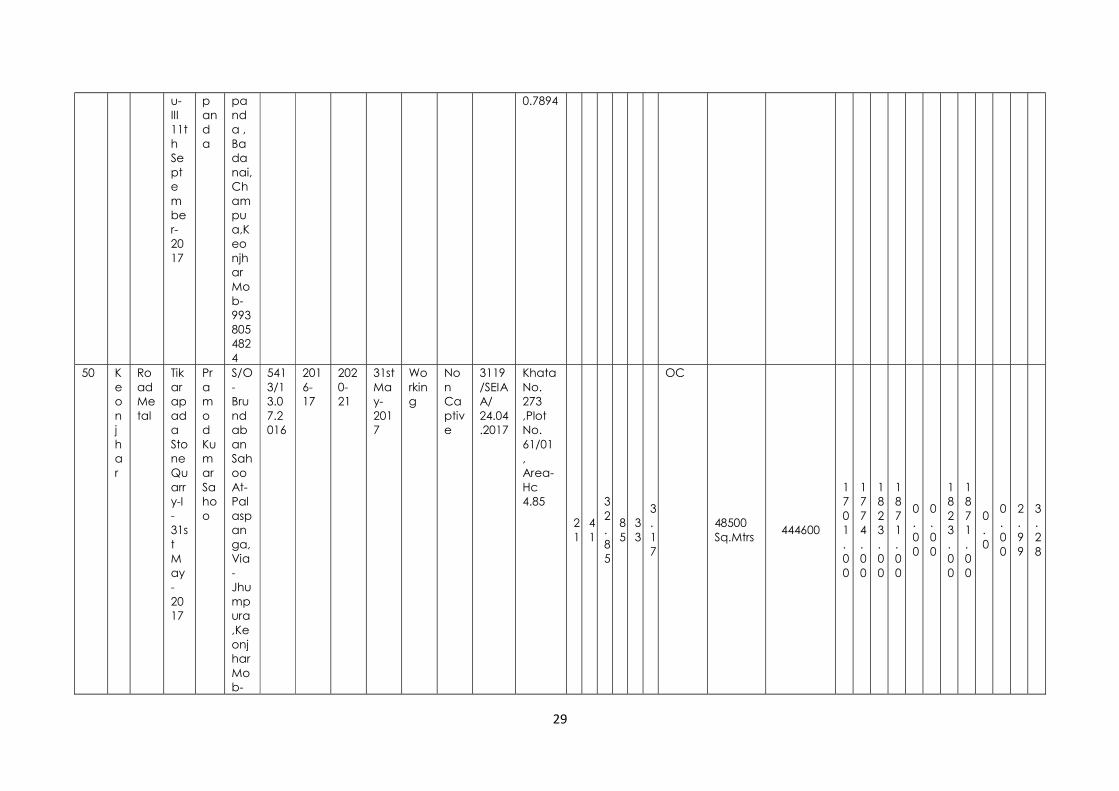
Pramod Kumar Sahoo
S/O-Brundaban Sahoo At-Palaspanga, Via-Jhumpura,Keonjhar Mob-
5413/13.07.2016
2016-17
2020-21
31st May-2017
Working
Non Captive
3119/SEIAA/ 24.04.2017
Khata No. 273 ,Plot No. 61/01 , Area- Hc 4.85
21
41
32.85
85
33
3.17
OC
48500 Sq.Mtrs
444600
1701.00
1774.00
1823.00
1871.00
0.00
0.00
1823.00
1871.00
0.0
0.00
2.99
3.28

30
9937607295
51 Keonjhar
Road Metal
Murusuan Stone Quarry-I 19th March-2016
Pramod Kumar Sahoo
S/O-Brundaban Sahoo At-Palaspanga, Via-Jhumpura,Keonjhar Mob- 9937607295
2301/08.04.2015
2015-16
2019-20
19th March-2016
Working
Non Captive
112/ SEIAA/11.01.2016
Khata No. 146 ,Plot No. 1229/ 1359 , Area- Hc 1.0562
21
46
38.6
85
33
40.06
OC
10562 Sq.Mtrs
113696
1295.00
1365.00
1435.00
1505.00
266.00
1365.00
1435.00
1505.00
0.39
3.14
2.12
2.67
52 Keonjhar
Road Metal
Murusuan Stone Quarry -II
Pramod Kumar Sahoo
S/O-Brundaban Sahoo At-Palasp
2302/08.04.2015
2015-16
2019-20
19th March-2016
Working
Non Captive
4442/SEIAA/17.08.2015
Khata No. 146 ,Plot No. 1226, 1235 , Area- Hc4.75
21
46
22.05
85
33
22.07
OC
47500 Sq.Mtrs
493140.3
750.00
780.00
810.00
840.00
466.00
780.00
810.00
840.00
1.58
2.30
2.71
2.79

31
9th December,2015
anga, Via-Jhumpura,Keonjhar Mob- 9937607295
53 Keonjhar
Road Metal
Kathabaunsuli -II 21 st April- 2016
Kumudini Rout
D/O-. Batakrishna Rout, New Colony, Mining Road,Keonjhar. Mob-943772718
2875/29.04.2018
2015-16
2019-20
21st April-2016
Working
Non Captive
120/SEIAA/ 11.01.2016
Khata No. 204 ,Plot No. 06, , Area- Hc 1.3765
21
48
45
85
38
55
OC
13765 Sq.Mtr
111600
4680.00
5292.00
5832.00
6336.00
481.00
5292.00
5832.00
6336.00
1.18
12.97
8.36
6.86

32
8
54 Keonjhar
Road Metal
Tangarani - 16th December,2015.
Pardip Dash,
S/O- Dillip Dash, At/PO- Barbil,Keonjhar , Mob-9437003246
2306/16.04.2015
2015-16
2019-20
16th Dec-2015
Working
Non Captive
4200/SEIAA/17.08.15
Khata No. 203 ,Plot No. 1499 , Area- Hc 1.7327
21
48
9.7
85
34
40.6
OC
17327 Sq.Mtrs
243000
1350.00
1350.00
1350.00
2700.00
1026.00
1350.00
1350.00
2700.00
1.560
2.06
2.33
4.42
55 Telkoi
Dabalapal stone quarry
Dabalapal 23.09.2016
Kuna Sahoo S/O. Dibakar
At/P.O. Dabalapal P.S. Telkoi Dist. Keonjhar 9556176099
1013 Dt. 7.4.2015
2016-17
2020-21
25.10.2016
Warking
Non-Captive
3361 Dt.20.5.2016
Latitudes(21deg 21' 25.2" & 21deg 21' 35"N) Longitudes(85deg 21' 33.9" & 85deg 21' 41")
21
21
25.2
85
21
33.9
OC 7.07 sq.mtrs
40525cum
0 1542
1542
1542
0 1542
1542
1542
0 2.32 lakh
2.32 lakh
2.32 lakh

33

1
ANNEXURE II
ROAD METAL/ BLACK STONE/ WHITE STONE SOURCES ALREADY AUCTIONED BUT NOT EXECUTED (LOI ISSUED) IN THE DISTRICT
Sl. No. Name of Tahasil
Name of village
Name of Minor Mineral
Name of the Successful
auction holder
Address & Contact No of
Letter of Intent Holder
Letter of Intent Grant
Order No. & date
Validity of LoI
Use (Captive/Non-
Captive) Location of the
Source recommended for
mineral concession (GPS co-ordinates or
Khata & Plot No) (Sketch map to be
attached)
Latitude Longitude
Area of the mineral
potential patch (in sq
m)
Average height of potential patch (in
m)
Mineable mineral
potential (in cum)
Degree
Minute
Second
Degree
Minute
Second
1 2 3 4 5 6 7 8 9 10 11
12
13
14
15
16
17 18 19
1 Barbil Bhagalpur
Bhagalpur Stone quarry 0.3642
Gobinda
Chandra Bher
a S/o- Pank
aj Char
an Beher
a
At/po- Barbil, Dist-
Keonjhar, Pin-
758035
Mob.9777926496
1907/
Dated
12.04.2
31, Marc
h 2021
Non Captiv
e
22°03’ 45.8” N to
22° 03’ 47.08” N
& 85°27’
42.5” E to 85° 27’ 46”
E K. No.78, P.No. 754,
Area Ac.0.90,
SK- Jungle
22
03
45.8
85
27
42.5
4000 Nil 11,840
2 Patna Godipokh
ari
Stone Sankar
Kumar(selecte
d bidder)
At/PO-Barbil Dist:Keonjhar Mob:7008080991
Letter
No.0000/24.03.2017(E
C not
No Non-captiv
e
Latitude:21°42'37.4"N
to 21°42'50.8"
N Longitude:85°44'29.7"
E to 85°44'22.9"
21
42
37.4
85
44
29.7
10117 2 6393.6 cum

2
granted)
E Khata No:177
Plot No:2585 &
2629 Kissam:Patharabani
3 Patna Tangarpada(KHA)
Stone Girija Ranja
n Mishra(selecte
d bidder)
At/PO-
Swambirjayagovindpur
Dist:Keonjhar Mob:9437093750
1912/08.05.2017 (EC not
granted)
No Non-captiv
e
Latitude:21°39'13.8"N to 21°38'59.5"N Longitude:85°51'47.44"E to 85°51'38.9"E Khata No:242 Plot No:2949 Kissam:Hudi
21
39
13.8
85
51
47.44
4000 2 4746 cum
4 Patna Tangarpada(KA)
Stone Girija Ranja
n Mishra(selecte
d bidder)
At/PO-
Swambirjayagovindpur
Dist:Keonjhar Mob:9437093750
1914/08.05.2017 (pre-80
Sabik
kisam
JUNGLE)
No Non-captiv
e
Latitude:21°38'41"N to 21°38'35"N Longitude:85°51'32"E to 85°51'30"E Khata No:242 Plot No:2741 Kissam:Hudi
21
38
41
85
51
32
12100 nil
5 Patna Ankura
Stone Rajendra
Panigrahi(select
ed bidder)
At/PO-
Mining New
Colony
Dist:Keonjhar Mob:N
A
3525/23.11.2016 (pre-80
Sabik
kisam
No Non-captiv
e
Latitude:21°39'50"N to 21°39'55"N Longitude:85°51'05"E to 85°51'07"E Khata No:214
21
39
50
85
51
5 15200 nil

3
JUNGLE)
Plot No:1692 Kissam:Parbat-III
6 Patna Erendei
Stone Rajendra
Panigrahi(select
ed bidder)
At/PO-
Mining New
Colony
Dist:Keonjhar Mob:N
A
2365/03.09.2015 (pre-80
Sabik
kisam
JUNGLE)
No Non-captiv
e
Latitude:21°36'49.1"N to 21°36'58.1"N Longitude:85°55'00"E to 85°55'9.3"E Khata No:356 Plot No:5 Kissam:Hudi
21
36
49.1
85
55
0 40670 3 74034 cum
7 Patna Baunsuli
Stone M. Prasa
d Gupta(selecte
d bidder)
At/PO-Barbil Dist:Keonjhar Mob:9430369472
2786/16.09.2016 (pre-80
Sabik
kisam
JUNGLE)
No Non-captiv
e
Latitude:21°44'6.3"N to 21°44'15.5"N Longitude:85°42'9.2"E to 85°42'15.2"E Khata No:317 Plot No:3270 Kissam:Patharabani
21
44
6.3
85
42
9.2
30270 5 124866 cum
8 Patna Dabarchua
Stone M. Prasa
d Gupta(selecte
d bidder)
At/PO-Barbil Dist:Keonjhar Mob:9430369472
2780/16.09.2016 (sab
ik kissam III-JALA)
No Non-captiv
e
Latitude:21°43'2"N to 21°43'10"N Longitude:85°42'29"E to 85°42'31"E Khata No:129 Plot No:351 Kissam: Patharaba
21
43
2 85
42
29
6470 nil

4
ni 9 Patna Denu
an Stone Sank
ar Kumar(selecte
d bidder)
At/PO-Barbil Dist:Keonjhar Mob:7008080991
Letter
No. 2827 dtd.02.05.2017(sabik kissa
m JALA-III)
No Non-captiv
e
Latitude:21°41'24.80"N to 21°41'24.85"N Longitude:85°46'57.86"E to 85°46'57.93"E Khata No:171 Plot No:1446 Kissam: Patharabani
21
41
24.8
85
46
57.86
4650 nil
10 Patna Raikala (KA)
Stone M. Prasa
d Gupta(selecte
d bidder)
At/PO-Barbil Dist:Keonjhar Mob:9430369472
Letter
No. 2715/07.09.2016(Plot No.2
85 sabi
k kisam
JUNGLE)
No Non-captiv
e
Plot:258Latitude:21°46'2"N to 21°46'3"N Longitude:85°47'24"E to 85°47'25"E Plot:256:Latitude:21°46'1"N to 21°46'2"N Longitude:85°47'23"E to 85°47'24"E Plot:1265:Latitude:21°44'48"N to 21°44'50"N Longitude:85°48'23"E to 85°47'24"E ( Khata No:176 Plot No:258 Kissam:Pat
21
46
2 85
47
24
22338 nil
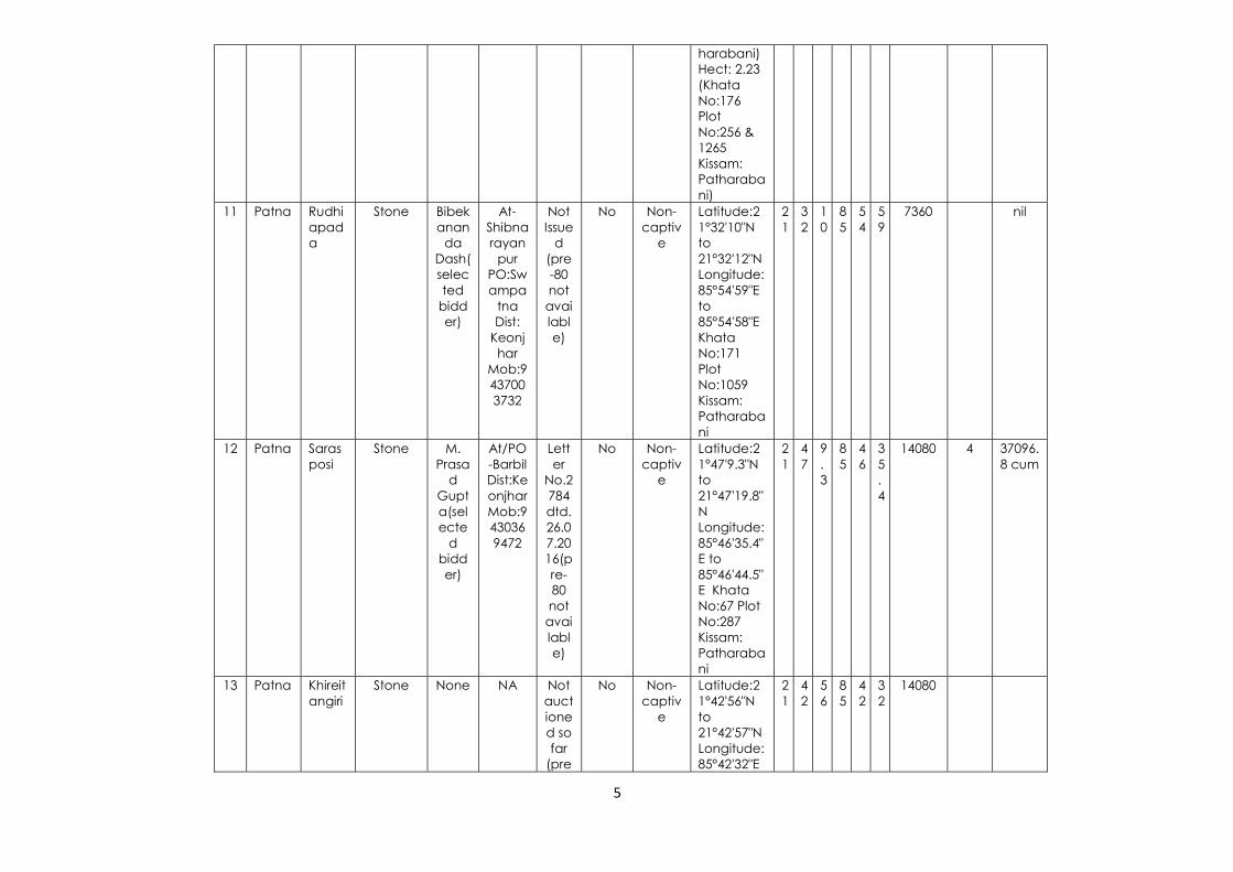
5
harabani) Hect: 2.23 (Khata No:176 Plot No:256 & 1265 Kissam: Patharabani)
11 Patna Rudhiapada
Stone Bibekanan
da Dash(selected
bidder)
At-Shibnarayan
pur PO:Swampa
tna Dist:
Keonjhar
Mob:9437003732
Not Issue
d (pre-80 not available)
No Non-captiv
e
Latitude:21°32'10"N to 21°32'12"N Longitude:85°54'59"E to 85°54'58"E Khata No:171 Plot No:1059 Kissam: Patharabani
21
32
10
85
54
59
7360 nil
12 Patna Sarasposi
Stone M. Prasa
d Gupta(selecte
d bidder)
At/PO-Barbil Dist:Keonjhar Mob:9430369472
Letter
No.2784 dtd. 26.07.2016(pre-80 not available)
No Non-captiv
e
Latitude:21°47'9.3"N to 21°47'19.8"N Longitude:85°46'35.4"E to 85°46'44.5"E Khata No:67 Plot No:287 Kissam: Patharabani
21
47
9.3
85
46
35.4
14080 4 37096.8 cum
13 Patna Khireitangiri
Stone None NA Not auctioned so far
(pre
No Non-captiv
e
Latitude:21°42'56"N to 21°42'57"N Longitude:85°42'32"E
21
42
56
85
42
32
14080

6
-80 Sabi
k kisam
JUNGLE)
to 85°42'35"E Khata No: 338 Plot No: 1600 & 1606 Kissam: Patharabani
14 Patna Baliaposi (KA)
Stone None NA Not auctioned so far
(pre-80 not available)
No Non-captiv
e
Latitude:21°45'36"N to 21°45'27"N Longitude:85°44'50"E to 85°44'47"E Khata No: 128 Plot No: 1810 Kissam: Patharabani
21
45
36
85
44
50
18210 nil
15 Patna Baliaposi (KHA)
Stone None NA Not auctioned so far
(pre-80 not available)
No Non-captiv
e
Latitude:21°45'48"N to 21°45'45"N Longitude:85°45'07"E to 85°45'07"E Khata No: 128 Plot No: 1771 Kissam: Patharabani
21
45
48
85
45
07
4930 nil
16 Anandpur
Sunduria
Stone/ 5.078 Ha.
Pabitra mohan Peda
S/O- Parsuram Peda, At/Po- Bangore, PS- Soso, Dist-
Letter No- 3666 dated 11.07.2016
Yes Non-captive
Latitude- 21.16'03.97" to 21.16'12.96"N Longitude- 86.09'05.27"- 86.09'09.64
21
16
03.9
86
09
05.2
33993.59
20 465408

7
Keonjhar, Mob. No- 9337331085
"E Khata No- 91 Plot No- 1648 Area- Ac.12.55 Kissam- Parbata-II
17 Anandpur
Kantipal
Stone/ 5.261 Ha.
Mr. N.Ravi(Director) Macons Infratech Pvt. Ltd.
Plot No-1116, 2nd floor, 23rd Cross, 23 Sector, II-HSR Layout, Banglore- 560102, Contact No- 9845888599
Letter No.-5382 dtd.22.12.2015
Yes Non-captive
Latitude- 21.15'40.00" to 21.15'52.00"N Longitude- 86.12'36.30"- 86.12'43.60"E Khata No- 863 Plot No- 2004 Area- Ac.13.00 Kissam- Patharabani
21
15
40.0
86
12
36.3
52609.1
22 813450
18 Champua
Laxmiposhi
Laxmiposhi Stone quarry-2 & 4.852
Swagatika Rout
At/PO-
Baneikala,PS- Joda, Dist-
Keonjhar
mob-7978342499
4531/03.11.2017
31-Mar-
22
Non captiv
e
21°57’06” N to
21°57’18” N and
85°41’36”E to
85°41’48”E Khata-108 & plot no. 426 Area Ac 12.00,
Kisam- Patharban
i
21
57
06
85
41
36
48562.2771
Nil 310965.3
19 Champua
Mukundap
ur
Mukundapur stone
Promad
Kum
At- Murusuan,
3842/dt. 26.0
31-Mar-
21
Non captiv
e
22°02’32.7” N to
22°02’45.8
22
02
32.
22
02
45.
25697.5383
Nil 54270

8
quarry-1 & 2.56
ar Mahanta
P.O- Chamakpur ,PS-
Champua, Dist-
Keonjhar
mob-9438492609
8.2016
to ” N and 85°33’36.3
”E to 85°33’43.6”E Khata-123 & plot no. 771 & 793 , Area 2.32 & Ac. 4.03, Total Area Ac
6.35, Kisam-
Patharbani
7 8
20 Ghatagaon
Balabhadrapur
Road Metal
Dillip Kumar Dwibedy
At- Swampatna P.O.- Patna Dist.- Keonjhar
2786/ 01.09.2016
Non-captive
Khata-155 Plot-670
5260.91
21 Ghatagaon
Kandasar
Road Metal
Pravat Chandra Das
At/P.O.- Keonjhargarh, Dist- Keonjhar
2786/ 01.09.2016
Non-captive
Khata-102 Plot-2272
6879.66
22 Ghatagaon
Jharbeda
Road Metal
Sankarsan Behera
At-Pipilia Dist.- Keonjhar
2786/ 01.09.2016
Non-captive
N21°558651 E85°720051 Khata-280 Plot-122
12140.6
23 Ghatagaon
Pichhula
Road Metal
Subrat Kumar Dash
At- Swampatna P.O.- Patna Dist.- Keonjhar
2786/ 01.09.2016
Non-captive
N21°522758 E85°689062 Khata-218 Plot-349
19991.47

9
24 Ghatagaon
Pichhula
Road Metal
Shiba Prasad Sahoo
At- Dimbo, Dist.- Keonjhar
2786/ 01.09.2016
Non-captive
N21°522758 E85°689062 Khata-218 Plot-349/1
19991.47
25 Ghatagaon
Upardiha
Road Metal
Dusmanta Kumar Palei
At- Uperdiha, P.O.- Kusunupur, P.S.- Ghatagaon, District- Keonjhar
2807/ 12.09.2017
Non-captive
Khata-158Plot-46/1849
8093.71
26 Harichandanpur
Brajamohanpur
Stone 1.238 ha
Sambit nandan Mohanty
At/Po harichandanpur Mob- 9437003716
2234/Dt.08.09.16
NC Khata No : 33 Plot No : 737
1.283 ha
27 Harichandanpur
Sagadapata I
Stone 1.740 ha
No Bidder
NC Khata No : 247 Plot No : 38, 431, 555, 586
1.740 ha
28 Harichandanpur
Bhagamunda
Stone No Bidder
NC Khata No : 348 Plot No : 4354
1.5985 ha
29 Harichandanpur
Kusumjodi
Stone No Bidder
NC Khata No : 23 Plot No : 257
0.7931
30 Hatadihi
Dhenka
Dhenka Lt. Stone Quarry Hc. 1.49
Baidhar
Pahi
At/Po- Hatadi
hi
3225, Dt. 27.9.16
2015-16 to 2019-
20
N.C.
Khata No- 484, Plot No 389,
390, 391,392
N-210
13'
12.40"
E-860
17'
08.90"
11200 NA 33600
31 Jhumpura
Gundunia
Gundunia Stone
Sanjay
At/PO-
1818, dt.
N.C. Khata No- 276 Plot-
37231.
1 10 27731.
25

10
Quarry (3.72 Ha)
Kumar
Apat
Kamarjoda, PS-
Joda, Dist-
Keonjhar
28.8.2016
701 Area- 9.20
32 Keonjhar
Murusuan
Road Metal Area- Ha 3.52
Pramod Kumar Sahoo
S/O-Brundaban Sahoo At-Palaspanga, Via-Jhumpura, Keonjhar Mob- 9937607295
7481/21.12.18
- Non captive
Khata No. 146 ,Plot No. 971(P), Area- Hc 3.52
21
46
41.21
85
33
42.98
59467.50
33 Keonjhar
Kathabaunsuli
Road Metal Area- Ha 2.557
Chittaranjan Parida
S/O- Surendra Parida, Kainshi, Keonjhar Mob-8763527820
2374/ 1.06.19
- Non captive
Khata No. 204-AAA, Plot No. 345 (P), Area- Hc 2.5587
21
48
28
85
39
5.1
10320.00

1
ANNEXURE III
POTENTIAL OF ROAD METAL IN THE DISTRICT
Sl. No.
Name of Tahasil
Name of village
Status Name of
Minor Mineral
Location of the Source
(Total Hillock)
recommended for
mineral concession
(GPS co-ordinates or Khata & Plot No) (Sketch map to be attached)
Longitude
Lattitude
Area of the
mineral potential patch (in
sq m)
Average
height of
potential
patch (in m)
Mineable mineral
potential (in cum) D
egree
Minute
Second
Degree
Minute
Second
1 2 3 4 5 6 7 8 9 10
11
12
13 14 15
1 Barbil Bhagalpur New Bhagalpur Stone quarry 0.3642
22°03’ 45.8” N to 22° 03’ 47.08” N
& 85°27’ 42.5” E to
85° 27’ 46” E K. No.78, P.No.
754, Area Ac.0.90,
SK- Jungle
22
03
45.8
85
27
42.5
4000 Nil -
2 Barbil Kandara Running Kandara-I stone quarry 0.777
N22°40’35.65” to N22° 02’ 38.11”
& E85°29’ 25.64”
to E85° 29’31.64”
Khata No. 1/1, Plot No. 127 &
22
40
35.65
22
02
38.11
6400 Nil -

2
128 Kisam- Taila-II
3 Barbil Kandara Running Kandara-II stone quarry 1.367
N 22°02’ 42.74” to N 22° 02’
46.21” & E 85°29’ 32.34”
to E 85° 29’ 37.19”
Khata No. 1/1, Plot No. 134 &
135 Area Ac. 3.38
,Kisam- Taila-II
22
02
42.74
85
29
3234
7200 Nil -
4 Barbil Bhagalpur LOI Issued Bhagalpur Stone quarry 0.3642
22°03’ 45.8” N to 22° 03’ 47.08” N
& 85°27’ 42.5” E to
85° 27’ 46” E K. No.78, P.No.
754, Area Ac.0.90,
SK- Jungle
22
03
45.8
85
27
42.5
4000 Nil 11,840
5 Patna Tentulikhunti Running Stone 4.046 Latitude:21°47'01.4"N to 21°47'14.9"N Longitude:85°44'40.2"E to 85°44'53.5"E Khata No: 44 Plot No:92 Kissam: Patharabani
21
47
01.4
85
44
40.2
40460 3 106760 cum
6 Patna Jamunaposi Running Stone 1.012 Latitude:21°42'39.3"N to
21°42'46.3"N Longitude:85°45'
56.7"E to 85°46'01.5"E Khata No: 211 Plot No:2658
Kissam: Patharabani
21
42
39.3
85
45
56.7
10120 3 5033.7 cum
7 Patna Padmapur Running Stone 3.545 Latitude:21°43'2. 2 4 2 8 4 4 35450 3 169568 cum

3
8"N to 21°43'19.7"N
Longitude:85°46'44.1"E to
85°46'58.5"E Khata No: 40 Plot No:186 &
190 Kissam:Parbat-I
1 3 .8
5 6 4.1
8 Patna Raikala (KHA) Running Stone 6.034 Block-I Plot No:1222 Latitude:21°44'42.8"N to 21°44'51.5"N Block-II Plot No:140 Latitude:21°45'13.8"N to 21°45'29.2"N Block-III Plot No:142 Latitude:21°45'34"N to 21°45'45.3"N Block-I Plot No:122 Longitude:85°45'7.1"E to 85°45'12.1"E Block-II Plot No:140 Longitude:85°45'8.8"E to 85°45'15.4"E Block-III Plot No:142 Longitude:85°48'17.9"E to 85°48'25.8"E Khata No: 176 Plot No:140 & 1222 Khata No: 177 Plot No:142 Kissam:Patharabani
21
44
42.8
85
45
7.1
60340 3 163786.2 cum

4
9 Patna Murusuan Running Stone 5.171 Latitude:21°43'38.2"N to 21°43'59.2"N Longitude:85°48'8.5"E to 85°48'17.7"E Khata No:233 Plot No:1663 Kissam:Patharabani
21
43
38.2
85
48
8.5
51710 5 167481 cum
10 Patna Dumuria Running Stone 4.289 Latitude:21°34'16.8"N to 21°34'34.2"N Longitude:85°58'5"E to 85°58'12.2"E Khata No: 215 Plot No:471 Kissam: Patharabani
21
34
16.8
85
58
5 42890 5 513540 cum
11 Patna Kumudabahali Running Stone 0.870 Latitude:21°33'21.8"N to 21°33'29.6"N Longitude:85°55'4.6"E to 85°55'6.5"E Khata No:123 Plot No:1279 Kissam: Patharabani
21
33
21.8
85
55
4.6
8700 5 24342.5 cum
12 Patna Kantiapada Running Stone 0.307 Latitude:21°42'30.0"N to 21°42'37.6"N Longitude:85°44'27.8"E to 85°44'29.7"E Khata No:215 Plot No:01 Kissam:Patharabani
21
42
30.0
85
44
27.8
3070 2 2086 cum
13 Patna Nuakhaman Running Stone 3.400 Latitude:21°44'54"N to 21°45'12"N Longitude:85°47'59"E to
21
44
54
85
47
59
34000 3 146911.2 cum

5
85°48'8.3"E Khata No: 149 Plot No: 329 Kissam:Patharabani
14 Patna Ankura New Stone 4.338 Latitude:21°40'13"N to 21°40'15"N Longitude:85°51'08"E to 85°51'16"E Khata No. 214 Plot No.339 Kissam: Pathar Chatan
21
40
13
85
51
08
43380 NA NA
15 Patna Godipokhari LOI Issued Stone Latitude:21°42'37.4"N to
21°42'50.8"N Longitude:85°44'
29.7"E to 85°44'22.9"E Khata No:177
Plot No:2585 & 2629
Kissam:Patharabani
21
42
37.4
85
44
29.7
10117 2 6393.6 cum
16 Patna Tangarpada(KHA)
LOI Issued Stone Latitude:21°39'13.8"N to 21°38'59.5"N Longitude:85°51'47.44"E to 85°51'38.9"E Khata No:242 Plot No:2949 Kissam:Hudi
21
39
13.8
85
51
47.44
4000 2 4746 cum
17 Patna Tangarpada(KA)
LOI Issued Stone Latitude:21°38'41"N to 21°38'35"N Longitude:85°51'32"E to 85°51'30"E Khata No:242 Plot No:2741 Kissam:Hudi
21
38
41
85
51
32
12100 nil

6
18 Patna Ankura LOI Issued Stone Latitude:21°39'50"N to 21°39'55"N Longitude:85°51'05"E to 85°51'07"E Khata No:214 Plot No:1692 Kissam:Parbat-III
21
39
50
85
51
5 15200 nil
19 Patna Erendei LOI Issued Stone Latitude:21°36'49.1"N to 21°36'58.1"N Longitude:85°55'00"E to 85°55'9.3"E Khata No:356 Plot No:5 Kissam:Hudi
21
36
49.1
85
55
0 40670 3 74034 cum
20 Patna Baunsuli LOI Issued Stone Latitude:21°44'6.3"N to 21°44'15.5"N Longitude:85°42'9.2"E to 85°42'15.2"E Khata No:317 Plot No:3270 Kissam:Patharabani
21
44
6.3
85
42
9.2
30270 5 124866 cum
21 Patna Dabarchua LOI Issued Stone Latitude:21°43'2"N to 21°43'10"N Longitude:85°42'29"E to 85°42'31"E Khata No:129 Plot No:351 Kissam: Patharabani
21
43
2 85
42
29
6470 nil
22 Patna Denuan LOI Issued Stone Latitude:21°41'24.80"N to 21°41'24.85"N Longitude:85°46'57.86"E to 85°46'57.93"E Khata No:171 Plot No:1446
21
41
24.8
85
46
57.86
4650 nil

7
Kissam: Patharabani
23 Patna Raikala (KA) LOI Issued Stone Plot:258Latitude:21°46'2"N to 21°46'3"N Longitude:85°47'24"E to 85°47'25"E Plot:256:Latitude:21°46'1"N to 21°46'2"N Longitude:85°47'23"E to 85°47'24"E Plot:1265:Latitude:21°44'48"N to 21°44'50"N Longitude:85°48'23"E to 85°47'24"E ( Khata No:176 Plot No:258 Kissam:Patharabani) Hect: 2.23 (Khata No:176 Plot No:256 & 1265 Kissam: Patharabani)
21
46
2 85
47
24
22338 nil
24 Patna Rudhiapada LOI Issued Stone Latitude:21°32'10"N to 21°32'12"N Longitude:85°54'59"E to 85°54'58"E Khata No:171 Plot No:1059 Kissam: Patharabani
21
32
10
85
54
59
7360 nil
25 Patna Sarasposi LOI Issued Stone Latitude:21°47'9.3"N to 21°47'19.8"N Longitude:85°46'35.4"E to 85°46'44.5"E Khata No:67 Plot
21
47
9.3
85
46
35.4
14080 4 37096.8 cum

8
No:287 Kissam: Patharabani
26 Patna Khireitangiri LOI Issued Stone Latitude:21°42'56"N to 21°42'57"N Longitude:85°42'32"E to 85°42'35"E Khata No: 338 Plot No: 1600 & 1606 Kissam: Patharabani
21
42
56
85
42
32
14080
27 Patna Baliaposi (KA) LOI Issued Stone Latitude:21°45'36"N to 21°45'27"N Longitude:85°44'50"E to 85°44'47"E Khata No: 128 Plot No: 1810 Kissam: Patharabani
21
45
36
85
44
50
18210 nil
28 Patna Baliaposi (KHA)
LOI Issued Stone Latitude:21°45'48"N to 21°45'45"N Longitude:85°45'07"E to 85°45'07"E Khata No: 128 Plot No: 1771 Kissam: Patharabani
21
45
48
85
45
07
4930 nil
29 Anandpur Kanto New Stone/ 1.031 Ha.
Khata No- 183 Plot No- 110/1008 Area- Ac.2.55 Kissam- Parbata-II
10379
30 Anandpur Kolimati New Stone/ 0.35 Ha.
Khata No- 267 Plot No- 403 Area- Ac0.87 Kissam- Patharabani
3521
31 Anandpur Sunduria LOI Issued Stone/ Latitude- 2 1 0 8 0 0 33993.59 20 465408

9
5.078 Ha. 21.16'03.97" to 21.16'12.96"N Longitude- 86.09'05.27"- 86.09'09.64"E Khata No- 91 Plot No- 1648 Area- Ac.12.55 Kissam- Parbata-II
1 6 3.9
6 9 5.2
32 Anandpur Kantipal LOI Issued Stone/ 5.261 Ha.
Latitude- 21.15'40.00" to 21.15'52.00"N Longitude- 86.12'36.30"- 86.12'43.60"E Khata No- 863 Plot No- 2004 Area- Ac.13.00 Kissam- Patharabani
21
15
40.0
86
12
36.3
52609.1 22 813450
33 Banspal Ambadahara Running Amabadahara Stone Quarry/ Ha 6.00
21` 37' 53.8"N to 21`38'3.8"N & 85`32' 5.9"E to 85` 32' 13.0"E
21
37
53.8
85
32
5.9
44514 -- -
34 Banspal Ichinda Running Ichinda Stone Quarry Ha 6.80
21` 39`01.7"N to 21`39" 11.9" N & 85`31" 25.8" to 875` 31" 40.3"
21
39
01.7
85
31
25.8
48582 -- ---
35 Banspal Baitarani Bhuyan
Running Baitarani Bhuyan Stone Quarry Ha 4.6358
21`32'28.6" N to 21`32'38" N & 85`27'58.4" E to 85`28'02.3" E
21
32
28.6
85
27
58.4
50000 - -
36 Banspal Karangadihi Running Karangadihi Stone Quarry Ha 4.800
21`33'320" N to 21`33'39.4' N & 85`27'31.5" E to 85`27'40.3" E
21
33
32
85
27
31.5
3200 - -
37 Banspal Benidihi Running Benidihi West Stone Quarry Ha 3.440
21`28'10.6"N to 21`28'19.6" N & 85`21'30.8"E to 85`21'36.1" E
21
28
10.6
85
21
30.8
4000 - -
38 Banspal Benidihi Running Benidihi East Stone Quarry Ha 4.00
21`28'10.6"N to 21`28'19.6" N & 85`21'30.8"E to
21
28
10.
85
21
30.
4000 - -
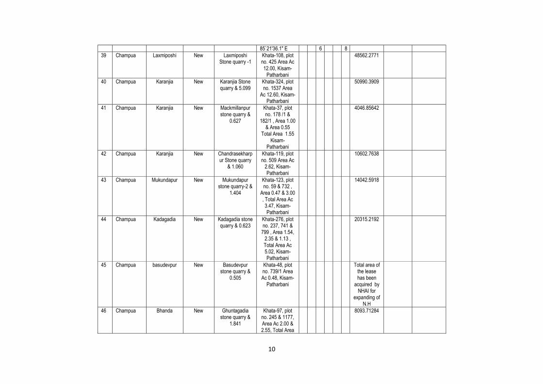
10
85`21'36.1" E 6 8 39 Champua Laxmiposhi New Laxmiposhi
Stone quarry -1 Khata-108, plot no. 425 Area Ac 12.00, Kisam-
Patharbani
48562.2771
40 Champua Karanjia New Karanjia Stone quarry & 5.099
Khata-324, plot no. 1537 Area
Ac 12.60, Kisam- Patharbani
50990.3909
41 Champua Karanjia New Mackmillanpur stone quarry &
0.627
Khata-37, plot no. 178 /1 &
182/1 , Area 1.00 & Area 0.55
Total Area 1.55 Kisam-
Patharbani
4046.85642
42 Champua Karanjia New Chandrasekharpur Stone quarry
& 1.060
Khata-119, plot no. 509 Area Ac
2.62, Kisam- Patharbani
10602.7638
43 Champua Mukundapur New Mukundapur stone quarry-2 &
1.404
Khata-123, plot no. 59 & 732 ,
Area 0.47 & 3.00 , Total Area Ac 3.47, Kisam- Patharbani
14042.5918
44 Champua Kadagadia New Kadagadia stone quarry & 0.623
Khata-276, plot no. 237, 741 &
799 , Area 1.54, 2.35 & 1.13 , Total Area Ac 5.02, Kisam- Patharbani
20315.2192
45 Champua basudevpur New Basudevpur stone quarry &
0.505
Khata-48, plot no. 739/1 Area Ac 0.48, Kisam-
Patharbani
Total area of the lease has been
acquired by NHAI for
expanding of N.H
46 Champua Bhanda New Ghuntagadia stone quarry &
1.841
Khata-97, plot no. 245 & 1177, Area Ac 2.00 & 2.55, Total Area
8093.71284

11
4.55 , Kisam- Patharbani
47 Champua Sasanga New Sasanga stone quarry & 0.651
Khata-147 plot no. 4 Area Ac 1.44, Kisam- Patharbani
5827.47325
48 Champua Sirapur New Sirapur Stone quarry & 1.205
Khata-51 plot no. 336 Area Ac 2.98, Kisam- Patharbani
12059.6321
49 Champua Fulkanlei New Fulkanlei stone quarry & 0.202
Khata-207 plot no. 645/1 Area Ac 0.50, Kisam-
Patharbani
2023.42821
50 Champua Fulkanlei New Kusumgoda Stone quarry &
0.133
Khata-207, plot no. 4 Area Ac 0.33, Kisam- Patharbani
1335.46262
51 Champua Laxmiposhi LOI Issued Laxmiposhi Stone quarry-2 &
4.852
21°57’06” N to 21°57’18” N and
85°41’36”E to 85°41’48”E
Khata-108 & plot no. 426 Area Ac 12.00, Kisam-
Patharbani
21
57
06
85
41
36
48562.2771 Nil 310965.3
52 Champua Mukundapur LOI Issued Mukundapur stone quarry-1 &
2.56
22°02’32.7” N to 22°02’45.8 to ” N
and 85°33’36.3”E to 85°33’43.6”E
Khata-123 & plot no. 771 & 793 , Area 2.32 & Ac. 4.03, Total Area Ac 6.35, Kisam-
Patharbani
22
02
32.7
22
02
45.8
25697.5383 Nil 54270
53 Ghasipura Bholanuagaon
Running Bholanuagaon Stone Quarry
BOLANUAGAON K-145 P-3
21
13
39.42N
86
4 22.22E
Ac.14.00 ---- ---
54 Ghasipura Narangapur Running Narangapur NARANGAPUR 2 1 0 8 5 5 Ac.3.23 ---- ---

12
Stone quarry K-560 P-89,93,231,263
1 1 1.01N
5 9 7.9
55 Ghasipura Biragobindapur
Running Biragobindapur stone quarry
BIRAGOBINDAPUR K-209 P-724
21
15
37N
86
5 19.9
Ac.2.38 ---- ---
56 Ghasipura Ostapura
Running Ostapura stone quarry
Ostapura k-169 P-905/1
21
13
34.0N
86
4 9.3E
Ac.13.00 ---- ---
57 Ghatagaon Khajirijiani
Running
Road Metal N21°30'03.6" - N21°31'10.5" E85°48'46.3" - E85°48'54.1" Khata-60, Plot-739
57,500 245859.1
58 Ghatagaon Khajirijiani
Running
Road Metal N21°31'18.70" - N21°31'30.30" E85°48'9.50" - E85°48'15.50" Khata-60, Plot-519
16,800 48256
59 Ghatagaon Mellan
Running
Road Metal N21°21'55.5" - N21°22'01.7"E85°59'11.4" - E85°59'15"Khata-142,Plot-2602
4,800 55890
60 Ghatagaon Rutisila
Running
Road Metal N21°30'11.10" - N21°31'19.50" E85°43'09.20" - E85°43'18.40" Khata-190, Plot-951
63,000 913507
61 Ghatagaon Basantpur Running Road Metal N21°32'15.04" - 10,400 99560

13
N21°32'18.02" E85°39'0.8" - E85°39'25.06" Khata-300, Plot-3439, 3441
62 Ghatagaon Khantaghar New Road Metal N21°31'84" - N21°31'16" E85°48'58" - E85°49'3.3" Khata-120, Plot-765
19424 67599
63 Ghatagaon Balabhadrapur
LOI Issued Road Metal Khata-155 Plot-670
5260.91
64 Ghatagaon Kandasar LOI Issued Road Metal Khata-102 Plot-2272
6879.66
65 Ghatagaon Jharbeda LOI Issued Road Metal N21°558651 E85°720051 Khata-280 Plot-122
12140.6
66 Ghatagaon Pichhula LOI Issued Road Metal N21°522758 E85°689062 Khata-218 Plot-349
19991.47
67 Ghatagaon Pichhula LOI Issued Road Metal N21°522758 E85°689062 Khata-218 Plot-349/1
19991.47
68 Ghatagaon Upardiha LOI Issued Road Metal Khata-158Plot-46/1849
8093.71
69 Harichandanpur
Hunda
Running
Stone Khata No : 875 Plot No : 5857/1 2
0 23 1
85
37
5.5
1.214 ha
70 Harichandanpur
Salabeda
Running
stone Khata No : 145 Plot No : 263
21
27
47
85
41
25.1
4.9879 ha
71 Harichandan Sagadapata Running Stone Khata No : 246 2 1 5 8 5 4 2.428 ha

14
pur Plot No : 1275/1 1 5 5 4 9.5
72 Harichandanpur
Raghunathpur
Running
Stone Khata No : 49 Plot No : 223
21
21
17.4
85
47
38.7 0.2509ha
73 Harichandanpur
Brajamohanpur
LOI Issued Stone 1.238 ha Khata No : 33 Plot No : 737
1.283 ha
74 Harichandanpur
Sagadapata I LOI Issued Stone 1.740 ha Khata No : 247 Plot No : 38, 431, 555, 586
1.740 ha
75 Harichandanpur
Bhagamunda LOI Issued Stone Khata No : 348 Plot No : 4354
1.5985 ha
76 Harichandanpur
Kusumjodi LOI Issued Stone Khata No : 23 Plot No : 257
0.7931
77 Hatadihi
Baniapanka Running Baniapanka
Stone Quarry
Khata No 267, plot No. 939
N-210
15'
43.03"
E-860
21'
38.29"
8 1 4720
78 Hatadihi
Dhenka
LOI Issued
Dhenka Lt. Stone Quarry
Hc. 1.49
Khata No- 484, Plot No 389, 390, 391,392
N-210
13'
12.40"
E-860
17'
08.90"
11200 NA 33600
79 Jhumpura Gundunia LOI Issued Gundunia Stone Quarry (3.72
Ha)
Khata No- 276 Plot- 701
Area- 9.20
37231.1 10 27731.25
80 Jhumpura Naradpur New Naradpur Stone Quarry-II (4.61
Ha)
Khata- 134 Plot- 762- 1.25 Plot- 787- 1.38 Total - 2.63
10643.23 12
81 Jhumpura Durgapur New Durgapur Stone Quarry (1.78 Ha)
Khata- 106 Plot-1020- 1.05 Plot- 1126- 3.35 Total- 4.40
17806.2 15
82 Jhumpura Gandabarei New Gandabarei Stone Quarry (0.32 Ha)
Khata- 221 Plot- 619- 0.80
3237.49 17
83 Jhumpura Tukudiha New Tukudida Stone Quarry-I (1.76
Khata - 303 Plot - 61- 4.35
17603.83 12

15
Ha) 84 Jhumpura Tukudiha New Tukudida Stone
Quarry-II (0.06 Ha)
Khata - 303 Plot -3287- 0.15
607.02 10
85 Jhumpura Asanpat New Asanpat Stone Quarry (1.21 Ha)
Khata - 316 Plot - 1772- 3.00
12140.6 17
86 Jhumpura Arshala New Arshala Stone Quarry (2.32 Ha)
Khata - 401 Plot -3819 - 5.74
23228.96 19
87
Keonjhar
Raghunathpur ( Quarry No-I)
Running Road Metal Hc1.2145
Khata No.75.Plot No.287/01, Area- Hc1.2145
21
33
37
85
42
32
88
Keonjhar
Raghunathpur ( Quarry No.-II)
Running Road Metal Hc1.2145
Khata No.75.Plot No.287/02, Area- Hc1.2145
21
36
3.5
85
42
30
89
Keonjhar
Nischintapur ( Quarry-1)
Running Road Metal Hc 0.8623
Khata No.36.Plot No.97 , Area- Hc 0.8623
21
34
26
85
42
10.01
90
Keonjhar
Gopalpur ( quarry-1)
Running Road Metal Hc 0.9716
Khata No. 83 ,Plot No. 145 , Area- Hc 0.9716
21
33
52.3
85
42
43.3
91
Keonjhar
Badaposi Quarry-III
Running Road Metal Hc.0.7894
Khata No. 68 ,Plot No. 624/1126 , Area- Hc 0.7894
21
38
33.5
85
35
0.1
92
Keonjhar
Gopinathpur Nuagaon Stone Quarry
Running Road Metal (Hc 2.0242
Khata No. 99 ,Plot No. 229/02 , Area- Hc 2.0242
21
34
5.66
85
40
44.98
93
Keonjhar
Tikarapada Stone quarry-I
Running Road Metal Area Hc4.85
Khata No. 273 ,Plot No. 61/01 , Area- Hc 4.85
21
41
32.85
85
33
3.17
94 Keonjhar
Murusuan Stone Quarry-I
Running Road Metal Area Hc.1.0562
Khata No. 146 ,Plot No. 1229/ 1359 ,
21
46
38.
85
33
40.

16
Area- Hc 1.0562 6 06
95
Keonjhar
Murusuan Stone Quarry-II
Running Road Metal Area Hc.4.75
Khata No. 146 ,Plot No. 1226, 1235 , Area- Hc4.75
21
46
22.05
85
33
22.07
96 Keonjhar
Kathabaunsuli Stone Quarry-II
Running Road Metal Area Hc. 1.3765
Khata No. 204 ,Plot No. 06, , Area- Hc 1.3765
21
48
45
85
38
55
97
Keonjhar
Tangarani Stone Quarry
Running Road Metal Area-1.7327
Khata No. 203 ,Plot No. 1499 , Area- Hc 1.7327
21
48
9.7
85
34
40.6
98 Keonjhar Murusuan LOI Issued Road Metal Area- Ha 3.52 Khata No. 146
,Plot No. 971(P), Area- Hc 3.52
21
46
41.21
85
33
42.98
59467.50
99 Keonjhar Kathabaunsuli LOI Issued Road Metal Area- Ha 2.557
Khata No. 204-AAA, Plot No. 345 (P), Area- Hc 2.5587
21
48
28
85
39
5.1
10320.00
100 Telkoi PITANLI New STONE
2.860 Ha, Vill-Pitanali, Khata
No.14, Plot-63/1, Kisam-Parbata
12.00

MINERAL MAP OF KEONJHAR DISTRICTSCALE:. 1:180,000
ALASOREDISTRICT
JAJPUR
LegendBlock Headquarter
District BoundaryNH Road I SH Road/Major District Road
Railway Line
~ RiverfLake/Waterbody
Amphibolite
~ BHJ & Quartzite
~ Banded Quartzite & SMa
~ Basiclntrusives
~!ili§;;Dyke•• Gabbro & Anorthosite
Granite & Gneiss
Gritty Sandstone & Quartzite
Laterite and Alluvium
PLATE NO-4
Lava & Tuff
Older Metamorphics
Phyllite
Pyrophyllile
Quartzite
Soap Slone
Ultrabasics
•• Upper Shale
•• Vein Quartz

LEASE/POTENTIAL MAP OF ROAD METAL/BUILDING STONE/BLACK STONE/WHITE STONEIN KEONJHAR DISTRICT
PLATE NO-5
Legend
Block Headquarter
District Boundary
NH ISH Road/Major District Road
Railway Line
River/Lake/Walerbody--Lease/Potential Area forRoad Metal/Building Stone/Black StonelWhite Stone
SCALE:-1:180,OOO