Department of History - Pakistan Research Repository
300
Agrarian Economy of the Bahawalpur State: 1866-1947 By Zahra Akram Hashmi Session: 2010-2013 Ph.D. History Department of History The Islamia University of Bahawalpur 2017
-
Upload
khangminh22 -
Category
Documents
-
view
0 -
download
0
Transcript of Department of History - Pakistan Research Repository

Agrarian Economy of the Bahawalpur State:
1866-1947
By
Zahra Akram Hashmi
Session: 2010-2013
Ph.D. History
Department of History
The Islamia University of Bahawalpur
2017
Agrarian Economy of the Bahawalpur State: 1866-1947
By
Zahra Akram Hashmi
A Dissertation Submitted to the Islamia University of
Bahawalpur in Partial Fulfillment of the Requirement for the
Degree of Doctor of Philosophy in History
Department Of History
The Islamia University of Bahawalpur Pakistan
2017
i

ii

iii

iv
To
My Father

v
Acknowledgement
I am grateful to Allah Almighty who gave me courage and power to conduct my
research and enable me to complete this dissertation.
During the course of this research, I have received great help and support from my
PhD supervisor Dr. Aftab Hussain Gillani. I am particularly indebted to Dr. Abdul
Razzaq Shahid, Chairman of the Department of History. I would like to thank Dr.
Muhammad Akbar Malik and Dr. Shahid Hassan Rizvi for their academic and moral
support. Many thanks are due for Dr. Muhammad Khurshid Ahmad who provided me
great academic support.
I owe my particular thanks to Dr. Mubarak Ali, world fame historian of Pakistan, for
his valuable suggestions on the development of conceptual framework. This work
would not have been possible without his cooperation. I am also grateful to
Muhammad Abbas Chughtai, the Director of Punjab Archives Department and the
staff at Punjab Archives Lahore, where I have consulted the valuable manuscript. I am
also thankful to the staff at Commissioner Office Bahawalpur Division Bahawalpur
and the staff of Muhafiz Khana Bahawalpur, who gave me full access to the old
records of the Bahawalpur State. I am also grateful to the staff of Sadiq Reading
Library of IUB, Central Library Bahawalpur and Library of Lahore High Court
branch Bahawalpur. Many thanks are due for the staff of Punjab Public Library
Lahore and Library of Lahore Museum. Countless words of thanks are due to my
parents whose motivation and prayers have always kept me going.
For any lapses in the thesis however, I alone am responsible.
Zahra Akram Hashmi
vi
Abstract
This research aims at providing a historical analysis of the Agrarian
perspective of a regional economy and the development process of its parameters
using the State of Bahawalpur as both a specific context as well as a perspective. It
approaches the State as a distinct entity, which had its own specific social, economic,
and political conditions that interacted with external ideas especially during the period
in its history when it was under the British Agency administration. Generally, the
studies on economic history, particularly on the themes of agrarian history,
agricultural development and its social impact, and the phenomena of State and
society relationship are rare, which renders this discipline largely an unchartered
territory in the princely India context. This thesis is an effort towards that end and
adds to the scant body of literature on the topic.
The native agrarian system of the State, having a pastoral outlook, had large
potential for socio-economic uplift. This provided the basis for new initiatives of
fundamental importance to develop the State‟s infrastructure in socio-economic
sectors, especially under the Agency rule, which overhauled almost each department
of the administration and adapted the constitutional mechanism of political power to
shore up the economic growth. The provision of proprietary rights to the peasantry
ensured the secure lease of land to them and acted as the major income-generator in
the agricultural economy of the region. As a result, it also significantly increased the
land revenue of the State, which was realized through the colonial apparatus of the
settlements of land. This revenue largely was subsequently reinvested into two major
areas; irrigation and colonization projects. These projects remain the major focus and
form the main research questions of this study, which scopes both the ventures
because they were broadly interlinked and consequential, and played a significant part
in updating and leveraging the economy of the State. In parallel, a transformation
from an aboriginal outlook to agricultural character was also occurring in the States‟
economy and the social matrix of the State was changing under the influence of the
skillful and experienced colonists from the British Punjab. Along with the above
noted projects, the research methodology also scopes and scales this phenomenon.
Mainly, archival research and analysis methods have been employed to investigate the
socio-economic dynamics underpinning the traditional agricultural practices and

vii
customary relations that were gradually replaced by the modern cultivating
accomplishment. Relevant official documents provided the substance in this regard
and both the qualitative and quantitative methods have been used to extract and glean
required data. A wide range of other more specific methodological practices- from
fundamental historiographic skills and strategies for archival investigations to formal
analytic techniques such as content analysis and multidimensional scaling are used to
interpret the phenomena of socio-economic development and administrative control
of the Bahawalpur State in the context of main research questions outlined above.

viii
Table of Contents
Acknowledgement v
Abstract vi
Glossary xi
List of Abbreviations xiv
List of Tables xv
List of Figures xvii
List of Appendix xviii
Map xx
Chapter 1 1
Introduction 1
1.1. The State of Bahawalpur 2
1.2. The Princely India and the British 8
1.3.The British-Bahawalpur Relations 10
1.4. The British Agency and Political Structure of the Bahawalpur State 14
1.5. Historiography 17
1.6. Theoretical Framework 23
1.7. Scope and Significance of the Study 25
1.8. Terminologies, Methodology and Sources 26
1.9. Chapters Outline 29
Chapter 2 31
Agrarian Structure of the Bahawalpur State 31
2.1 The Origin and Growth of Agriculture in the State 31
2.2 Agricultural Production in the State 32
2.2.1 Cultivation Patterns and Crops Yields 33
2.2.2 Inducement of Modern Inputs 39
2.3 Agrarian Structure 42
2.3.1 Pastoralism 43
2.3.2 Peasants and the Ownership Rights 46
2.4 Socio-Economic Organization of the Village Communities 49
2.4.1 The Land Owning Class 53
2.4.1.1 The Big Land Owners 54
ix
2.4.1.2 The Small Landowners 55
2.5 Tenancy Cultivation (Mustajri) 56
2.6 TheVillage Menial 62
2. 7 Indebtedness 66
Chapter 3
Land Revenue System of the Bahawalpur State 74
3.1 Land Revenue Structure in the Pre Agency (1727-1866) 74
3.2 Development of the Land Revenue System during the Agency Period 77
3.2.1 Land Revenue Settlements 78
3.2.2 The Summary Settlement (1868-89) 80
3.2.3 The Records of Rights 81
3.2.4 The Regular Settlements 83
3.2.5 First Phase of the Revenue Settlement (1889-91) 83
3.2.6 Second Phase of the Revenue Settlement (1900-11) 85
3.2.7 Third Phase of the Revenue Settlement (1915-26) 86
3.2.8 Fourth Phase of the Revenue Settlement (1929-31) 90
3.2.9 Fifth Phase of the Revenue Settlement (1944-51) 93
3.3 The Standard for the State Demand 96
3.3.1 The Other taxes 103
3.3.2 Remissions on Kharaba and Role of Revenue Bureaucracy 104
3.4 Revenue Free Land Grants 106
Chapter 4 118
Irrigation System of the Bahawalpur State 118
4.1. Irrigation in the Pre-Agency Period 118
4.2. Irrigation System under the Agency 122
4.2.1. Traditional Irrigation 124
4.2.2. Canal Irrigation 127
4.2.3. Chherr System of Water Management 129
4.2.4.New Canal Works 135
4.2.5. Sadqia Twin Canal System 136
4.3. The Sutlej Valley Project 140
4.3.1. Antecedent of the Project 140
4.3.2. Thomas Ward Recommendations and the Final Project of 1919 142
4.3.3. Losses for the Bahawalpur State and loan Dilemma 147

x
4.3.3.1.Water Discourse and Role of Custodian Government 150
4.3.4. Impacts of the Project 153
4.3.4.1. Progress in Communication Resources 154
Chapter 5
Canal Colonization in the Bahawalpur State 158
5.1 Colonization in the State 158
5.2. Canal Colonization in Punjab 162
5.3. Colonization Scheme under Sutlej Valley Project in the Bahawalpur State 163
5.3.1. The Attributes and Implications of the Bahawalpur Colony 165
5.3.1.1. Sale and Purchase 165
5.3.1.2. Peasant Grantees / Abadkars 168
5.3.1.3. Military Grants 169
5.3.1.4. Temporary Cultivation 171
5.3.1.5. Arboriculture 172
5.3.2.The Early Problems and Remedies 173
5.3.3. Proprietary Rights in the Bahawalpur Colony 177
5.3.4. The Social Origins and Composition of the Colonists 179
5.4. Impact of Canal Colonization 182
5.5. Trade Policy of the Bahawalpur State 189
5.6. Trade of Food Grains and Famine Prevention 195
Conclusion 202
Biblography 211
Appendix 234

xi
Glossary
Abadi Population
Abiana Water rates
Amlak Property
Banya Local Moneylender
Barani Rain fed areas
Bigha A scale for the measurement of land having 2483 of square
miles or 21780 of square feet or half of the acre
Bunds Stop dam
Bupari Merchant
Chahi Well irrigated land
Chakk Village
Chakbandi Gross area of land fixed for irrigation in relation
Chherr Unpaid labour
Cheharsala Four yearly
Crore Ten million
Dahar Mud flats
Darbar Court of native ruler
Dhunds Natural creeks to feed the fields
Dhanwai Weightman
Duck Cubic contents
Gadi Throne
Gosain Hindu religious nobles
Hal Plough
Hatti Small village shop
Hittar Low laying riverine land

xii
Inam Grant of land in reward
Iwz-e-Lashkari In lieu of Military Services
Jama Land revenue collection
Jagir Estate
Jagirdar Feudal lord
Jammabandi Settlement of the amount of revenue assessed upon an estate, a
village, district rent-roll or a register of the village holdings
Kami Menial
Kassur Grant of land with partial remission of revenue
Khanqah Sufi hospice
Kharif Autumn crops
Khu Well
Khwaja A Caste of Muslim traders, a rich or respectable man
Kuccha Raw, unbaked temporary
Kumhars Potter Caste
Khushhaisyate Water advantage rates
Lac 100,000
Lammah Southern part of Bahawalpur State along the bank of Punjnad
Maund 80 Ibs approximately
Maufi Remission
Moga Outlet
Mussavis Maps
Nagha Absentee fund
Naib Deputy
Nawab Assistant to the central government or Native Ruler
Nazar An offering, present
Nazrana Gift or price of land specified for the peasant grantees

xiii
Nehri Canal irrigated
Peshkari Small administrative unit, next to tehsil
Rabi Spring crops
Rupee 16 annas = 64 pices (paise) = 192 pie
Sailaba Flooded land
Sajjada Successor of khanqah or tomb
Sanad Written authority for holding land or office
Siyala Winter
Tary-e-daryie Tax on crossing the river
Tehsil A Sub-divisional Administrative Zone under a District.
to an outlet.
Toba Open water tank in pure Cholistan
Ubha Northern side of Bahawalpur State along the bank of river
Sutlej
Un‟hala Six months of summer
Uttar Uplands
Warabandi Water delivery system.
Wazir Minister
Zilladar Head of a section of irrigation subdivision.

xiv
List of Abbreviations
CO Colonization officer
EIC East India Company
ESC Eastern Sadqia Canal
FC Financial Commissioner
GOI Government of India
GOP Government of Punjab
IVC Indus Valley Civilization
PALA Punjab Alienation of Land Act
PWD Punjab Public works Department
SCO Settlement Commissioner of Punjab
SVP Sutlej Valley Project

xv
List of Table
Table 1.1. Bifurcation of the State Area in Square Miles and its Specification 4
Table 1.2. Administrative Division and Area of the Bahawalpur State in 1872-73 15
Table: 1.2-A. Administrative Division and Area of the Bahawalpur State in 1939 16
Table 1.3. Political and Administrative Division of the Bahawalpur State during the
Pre-Independence Period 16
Table 2.1. Acreage of Kharif and Rabi Area 34
Table2.2.Cultivated Area in Acres Covered by Each Crop (1867-1876) 36
Table 2.3.Cultivated Area in Acres Covered by Each Crop(1890-1911) 37
Table 2.4. Cultivated Area in Acres Covered by Each Crop (1920-1946) 39
Table 2.5.Development in the Production of Livestock 46
Table 2. 6. Agriculturists Population in the State in the First Census of 1870. 50
Table 2.7. Number of Holdings with More than 500 Acre 55
Table:2.8. Occupancy Patterns in the Cultivated Area in 1900-01 58
Table 2.9. Occupancy Patterns in the Cultivated Area in 1910-11 60
Table: 2.10.Occupancy Patterns in the Cultivated Area in 1940-41 61
Table 2.11.Proportion of the Menial Servants in the total Population of the State 64
Table: 2.12. Proportion of Artisans in the total Population of the State 65
Table:2.13. Detail of Sold and Mortgaged Land in Acres 70
Table 3.1. Revenue Rates of the First Regular Settlement 84
Table 3.2. Revenue Rates in Second Settlement in Bahawalpur and Ahmadpur 85
Table 3. 3. Division of Land under new Scheme of Rectangles 87
Table:3.4. Revenue Rates in Third Settlement 89
Table: 3. 5. Revenue Rates in the Fourth Settlement 92
Table:3.6. Revised Revenue Rates for Minchinabad and Bahawalnagar in 1937 92
Table:3.7-A.Revenue Rates as per Sliding Scale of Assessment 95
Table:3.7-B.Revenue Rates as per Sliding Scale of Assessment in Ahmadpur 95
Table:3.7-C.Revenue Rates for Minchinabad, Bahawalnagar and Chishtian Tehsils 95
Table:3.8. The Land Revenue under Fixed Assessment (1873-1877) 98
Table:3.9. The Land Revenue under Fixed Assessment (1901-1922) 99
Table:3.10.The Land Revenue under Fluctuating Assessment. (1935-1941) 100
Table:3.11. Land Revenue and Cultivated Area of the Phulkian States and the
Bahawalpur State 102

xvi
Table 3.12 Rent-Free Grants in 1866 108
Table:3. 13. Estimated Area under Revenue Free Holdings till 1947 115
Table:4.1. Major Inundation Canals existed in 1866 121
Table:4.2.Land Distribution According to the Sources of Irrigation in 1867 124
Table:4.3. Share of the Zamindars and the State in Canals Work 133
Table:4.4. Share of each Nizamat in new Canal works under the First Agency 135
Table:4.5. Area in Acres Irrigated by Inundation Canals 1900-1911 138
Table:4.6 .Area in Acres Irrigated by Inundation Canals 1920-1932 138
Table:4. 7 Area in the Original SVP Plan of the 1920 143
Table:4. 8 Cost Estimates of SVP in the Original and Revised Plans 144
Table:4.9. Commanded Area under State Canals 147
Table:4.10.Outlay of SVP Loan for the Bahawalpur State 149
Table:5.1. Price of Land in the Ahsani Terms 1872 160
Table:5.2 Punjab Canal Colonies 163
Table:5.3.Grants of Land 1927- 1933 176
Table:5.4. Total Colony Area under Each Type of Grant till 31-3-1947 178
Table:5.5.Caste and Communal Distribution Plan for Peasant Grantees 180
Table:5.6.Major Castes and their Recruiting Centers 181
Table:5.7. The Population of the Bahawalpur State at Defferent Time Intervals 182
Table:5.8.Tehsil wise Population in the Bahawalpur State in 1941 Census 183
Table:5.9. Eastablishment of New Mandi Towns 185
Table:5.10.Number of Immigrants in the Bahawalpur State 1881 to 1901 200

xvii
List of Figures
Figure: 2.1. Acreage of Kharif and Rabi Area 35
Figure. 3.1. The Land Revenue under Fixed Assessment (1973-77) 99
Figure: 3.2. The Land Revenue under Fixed Assessment (1901-1922) 100
Figure: 3.3. The Land Revenue under Fluctuating Assessment (1935-1941) 101
Figure: 3.4. The Land Revenue and Cultivated Area of the Phulkian States and the
Bahawalpur State 102
Figure: 4.1. Land Distribution According to the Sources of Irrigation in 1867 125
Figure: 4.2. Shares of the State in Canal Works 134
Figure: 4.3. Area in Acres under Inundation Canals 1900-1911 138
Figure: 4.4. Area in Acres under Inundation Canals 1920-1932 139
Figure: 5.1. Grants of Land 1927- 1933 177
Figure: 5.2. Total Colony Area till 31-3-1947 178

xviii
List of Appendix
Appendix I: Rulers of Bahawalpur State
Appendix II: Weights and measures used in this research
Appendix III: Seasonal Names of Months commonly used in Bahawalpur State
(Hindi)
Appendix IV: List of stages for accommodation and provision of commodities to the
British forces for Afghan Campaign
Appendix V: Title sheet containing the agreements of Bahawalpur with the EIC
Appendix VI: Partially population and housing census
Appendix VII: Native States under Punjab Government
Appendix VIII: Agricultural Classes as declared by Bahawalpur State according to
the PALA 1900
Appendix IX: Establishment for killabandi in Minchinabad District of Bahawalpur
State in 1915
Appendix X: Measurement of Inam lands
Appendix XI: Ratification of Asnad by the Agency
Appendix XII: Inheritance matters in the Royal family of Bahawalpur
Appendix XIII: Treatment of the heirs of Kasur Grantees
Appendix XIV: Partition of Inam land
Appendix XV: Appointment of irrigation Establishment
Appendix XVI: Native proposal for the construction of dam to fed the desert area
Appendix XVII: Community demand to augment the less supply of water
Appendix XVIII: Detail of SVP Loan by Accountant General
Appendix XIX: Amounts borrowed by the State from the various internal sources for
the pre-payment of SVP debt and due to be repaid after the liquadation
of SVP loan
Appendix XX: Commencement of colonization plan
Appendix XXI: Distribution plan of colony land
Appendix XXII: Initial prices of lands
Appendix XXIII: Military grants
Appendix XXIV: Division of Land in the Soil Survey
Appendix XXV: Zamindara League of colony areas demanded to augment the short
water supply

xix
Appendix XXVI: Percentage schedule for abadkars
Appendix XXVII: Dispatch of food grains from the Bahawalpur State
Appendix XXVIII: Auction plan of colony town sites

xx

1
Chapter 1
Introduction
This research aims at providing a historical analysis of the agrarian
perspective of economy of the Bahawalpur State, a former Princely State of India and,
later, of Pakistan. The agrarian discourse of a region is usually connected to its
political discourse shaped by authorities and has its roots in the agricultural
communities. The term „Agrarian‟ implies the socio-economic structure and
encapsulates the wider notion of „economy‟ within agricultural context. The time span
of this study is from 1866 to 1947, a period when the Indian Subcontinent was passing
through its transitory phase of direct British rule. The decade of 1870s was the
beginning of the „modernity‟ period of the British India associated with the
emergence of colonial institutions, ideologies of development and technical system of
management, which formed the economic and social context of agrarian life of that
time. Agrarian conditions of that era appeared in the statistical chronicles and became
a part of political and administrative records.1
The political chronicles of those days highlight the impact of the above noted
modern trends, regardless of the respective degrees of their influence on the economy
of both the British Districts and the Princely States. However, the Princely States,
which were considered the „Indians India‟, and also regarded somewhat sluggish in
adapting to the new trends as compared to the British India.2 The present study on the
other hand suggests that some of the native rulers were in the front line to absorb the
impact of new trends in order to stimulate their regional development. The economies
of native India was almost agrarian based though the nature of land administration,
revenue and irrigation methods, and agricultural practices were different as per their
ecological and indigenous conditions.
The purpose of this research is to analyze the agrarian structure of the
Bahawalpur State and the development of its parameters. The traditional agriculture
was a source of the State‟s income in the form of land revenue, which was
subsequently utilized for the improvement of the agriculture sector in particular and
the other organs of the State in general. The motive of the State was to attain a stable
1 David Ludden, The New Cambridge History of India IV. 4, An Agrarian History of South Asia
(Cambridge: Cambridge University Press, 1999), 7. 2 Raghubir Singh, Indian States and the New Regime (Bombay: H.D.B. Taraporsvau, 1938), 3.

2
and consolidated economy for the welfare of its people as well as to achieve
recognition of a modern State. In this regard, land revenue generated from agriculture
was largely reinvested into two major areas; irrigation and colonization projects. This
study scopes both the ventures because they were broadly interlinked and
consequential, and played a significant part in updating and leveraging the economy
of the State. This not only endeavours to conceptualize a new paradigm for
explaining and interpreting the phenomena of socio-economic development based on
new administrative structure, but it also points out the relative strengths and
weaknesses in the existing paradigms.
1.1. The State of Bahawalpur
Regarding the evolution of princely states in India, Barbara Ramusack has
categorized them in three groups; the antique states; independent entities; and states
created by legendary warriors. Antique states that predated the Mughal regime were
mostly the Rajput states and became allies of the Mughals. Second group consisted of
the successors of Mughal governors, who declared independence during the anarchy
period and started functioning as independent entities, such as Oudh, Bengal, Mysore,
Hyderabad etc. Third group of states was carved out through military campaigns of
ambitious warriors.3
However, Richard B. Barnett placed the emergence of
Bahawalpur State in none of the three categories and emphasized;
But another category was of proto-princely state, since it may have
been one of a kind, but a novel, and distinct 18th century political system that
fits into none of the three. Instead, this new realm, the Bahawalpur State
emerged in a vacuum both demographically and politically. It was because of
that vacuum that it was never considered a viable part of the empire. It
created on a separate agrarian, commercial and political foundation …4
The Bahawalpur State was situated in the Northwest of the Indian
Subcontinent. On the North, it was surrounded by river Sutlej that separated it from
Multan and Montgomery districts of Punjab. On the West, a natural boundary of
combined waters of five rivers of the Punjab separated it from Muzafargarh district of
Punjab while on the South-West it was covered by the province of Sind. The State
3Barbara N. Ramusack, The New Cambridge History of India: III. 6, The Indian Princes and their States (Cambridge: Cambridge University Press, 2004), 4. 4 Richard B. Barnett, The Greenings of Bahawalpur: Ecological Pragmatism and State Formation in
Pre-British Western India 1730-1870, Indo British Review: A Journal of History Vol. XV, No. 2
(December: 1988), 5-15.
3
was bordered on the Northeast by the British district of Ferozpur and on the East and
Southeast by the deserted portion of native states of Bikaner and Jaisalmer. It lied
between 27º.42 to 30º.25 North latitude and 69º.31º to 74º .1º East longitude.5
From an agri-based irrigation perspective, the Bahawalpur State was a part of
the great Indus basin.6 The State had a river border of 180 miles on Sutlej, 100 miles
on Chenab and 70 miles on Indus.7 The river and the desert both served as natural
boundaries. This geographical diversity was significant in shaping its economic
structure, thus, greatly enhancing the geo-strategic importance of the State. In the pre-
Agency period, river water played a very important role in the lives of its people;
inundation, moisture, trade, travel and defense line all were interwoven with this
natural resource.
The gross area of the State was 15,918 square miles, of which 9881square
miles consisted of desert. The climate of the State was hot and dry with summer
temperature reaching a maximum of 100° to 120° F and dropping to 65° to 60° F in
winter.8 The usual draught occurred in the adjoining desert caused by rarefaction and
heated air, which produced high winds during the summer months. Occasionally,
there was biometric depression when the winds changed to a Northerly or Easterly.9
A large part of the State territory was out of direct track of the monsoon
system except Minchinabad tehsil that was within Himalayan range. Therefore,
average annual rainfall was minimal, varying from 7 inches in the northeast to 3 inches
in the extreme southwest. The extreme length of the State was 300 miles from northeast to
southwest while extreme width was about 50 miles.10
The State consisted mainly of a flat
alluvial plain and divided into three natural tracts running parallel to one another but different
in appearance and nature of soil. Table 1.1 composes the main features of the all three tracts.
5 Henry Field, An Anthropological Renaissance in West Pakistan 1955: with Appendixes on the
Archaeology and Natural History of Baluchistan and Bahawalpur (Massachusetts: Peabody Museum
Cambridge, 1959), 145, 147. However, this area was increased to 17158 in 1939 due to the alluvium
rules. 6The Indus system comprises the Indus and its five tributaries; the Jhelum, the Chenab, the Ravi, the
Beas and the Sutlej from the East. The Indus and eastern most river Sutlej originated from Tibetan
plateau. Salman M.A. Salman and Kishor Uprety, Conflict and Cooperation on South Asia’s
International Rivers: A Legal Perspective (Washington D.C: World Bank, 2003), 37. 7 J.W. Burns, Notes on the Physical Geography of the Bahawalpur State, Journal of the Royal
Geographical Society of London, Vol. 42 (1872), 394-95. 8 Henry Field, An Anthropological Renaissance in West Pakistan 1955, 144-148. 9Annual Administration Report of the Bahawalpur State1868-69, 76. 10 Henry Field, An Anthropological Renaissance in West Pakistan 1955, 144, 147.

4
The first tract, called Khddar or Uttar was an alluvial strip lying with the river Sutlej,
and combined waters of Indus and its five tributaries.
This portion was very fertile mainly due to the rich silt brought down by the
annual flooding in the rivers. Almost all populated areas of the State were located
along this strip.11
Later on, a railway line was constructed upon the edge of this
portion. The central tract, called Bangar or Hittar, contained loamy soil and stiff clay
and cultivation depended on the rainfall and ponds. Afterwards, this part of the State
was irrigated through Sutlej valley canal system and became part of the colonization
programme. The Southernmost part of the State, called Cholistan or rohi was pure
desert and consisted merely of sand dunes. It was a continuation of the great desert of
the Subcontinent, called differently in different parts of this region such as Rajasthan
in India, Thar in Sind and Cholistan in Bahawalpur.
Table: 1.1. Bifurcation of the State Area in Square Miles and its Specification
Sr. Tract Name Length Width Commonly known Specification
1 Khaddar / Uttar 6037 11 Proprietary Areas Fertile
2 Bangar / Hittar
9881
20 Lesser Cholistan Cultivable
3 Cholistan / Rohi 20 Greater Cholistan Non-Cultivable
Sources: Derived from: i. Annual Administration Report of Bahawalpur 1874-75, 4.
ii. Henry Field, An Anthropological Renaissance in West Pakistan 1955,145.
Historically, Cholistan tract of the State is better known and has not always
been arid. Once it was well-watered and fertile land. Around four thousand BC, this
region was populated and cultivated by an old river, locally known as Hakra.12
The
river Hakra flew down the whole length of Cholistan, irrigated the areas of
Bahawalpur and Bikaner, and discharged itself into Indus at the point of Rohri and
Bhakkar in Sindh.13
The old bed of Hakra is still visible and serves as a boundary line
11Annual Administration Report of the Bahawalpur State 1870-71, 1. 12 Muhammad Rafiq Mughal, Recent Archeological Research in the Cholistan Desert, ed. Gregory L.
Possehl, Harrapan Civilization (New Delhi: Oxford and IBH publishers, 1993), 84. 13 James Tod, Annals and Antiquities of Rajasthan, Vol. II (London: Oxford, 1920), 1134.

5
between pure desert and Lesser Cholistan. Actually, the charisma of Hakra valley was
connected with the central system of Indus Valley Civilization (IVC).
The history of Bahawalpur region dates back to the time of IVC.14
The then
metropolitan of Ganveriwala, situated 27 miles from Derawar in the Cholistan,
existed right in the middle of Mohenjo-Daro and Harappa with the same status.15
Available records of its history specifically support all stages of its economic
development and it was one among the five urban centers of IVC.16
In the subsequent
periods, the territory comprising the Bahawalpur State remained a frontier region
through which the successive waves of migrants and invaders entered the plains of
Central India. The Aryans, the Scythians, and the Greeks left their marks on the soil
of this region.17
During relatively more recent times, this territory remained a central part of
Buddhist Empire,18
Roy dynasty,19
and the Arabs‟ rule.20
With the disintegration of
Abbasid dynasty in Baghdad, Multan and Mansurah appeared as independent
principalities, the Bahawalpur region passed to Multan principality until the
foundation of an independent State during 1730s.21
On the other hand, Cholistan part
of the State was throughout associated with the Rajasthan.22
The administrative
change for the Bahawalpur region from Mansura to Multan was not only a political
14 Encyclopedia of Archeology: History and discoveries Volume II, E-M, ed., Tim Murray: Indus
Civilization by Dilip Chakrabarti, 654-55. 15Ganweriwala was one out of 172 great urban centers of Mature Harappan phase in Hakra Valley. See
Muhammad Rafiq Mughal, Ancient Cholistan (Lahore: Ferozsons, 1992), 56. 16J. M. Kenoyer, Early City-States in South Asia: Comparing the Harappan Phase and the Early
Historic Period. The Archaeology of City-States: Cross Cultural Approaches, edit. Deborah L. Nichols
and T. H. Charlton (Washington: Smithsonian Institution Press, 1997), 54. 17 At present Uch, is a small town located 38 miles away from Bahawalpur city, located on the
confluence of five rivers, was once the hub of highest culture and learning. Almost two thousand years
ago, Alexander the great, conquered the region, paid inclusive attention to boost the status of the town
and named the city as „Alexandria Second‟. By the time, its material glory vanished with the downfall
of Sultanate of Delhi. But its spiritual and religious splendor sustained for a long time. The present status is merely a forgotten city with many shrines of early periods. See for details Ahmad Nabi Khan,
UCHCH: History and Architecture (Islamabad: NIHCR, 2001). 18A Buddhist monastery belonged to Kushan dynasty erected at Sui Vihar was the evidence. See Re-
Organization Report of Bahawalpur State1867, 12. 19 Roy Dynasty extended from Kashmir and Qanuj to Qandahar and Seistan and on the West to Makran
and on the South to Surat. Out of six famous forts constructed by Roy Sahans Kahore in his kingdom,
two were erected at Mau and Uch inside the territory of Bahawalpur State. Mir Sher Ali Qanae, Tuhfa-
tul-Karam, in The History of India: as Told by Its Own Historians: The Muhammadan Period, Vol. I,
translated by Henry Miers Elliot, ed. John Dowson (London: Trubner and Co, 1967), 406. 20 Nazir Ali Shah, Sadiq Nama (Lahore: Maktaba-E-Jaded, 1959), 18. 21Muhammad Ashraf Gorgani & Mohammad Din, Sadiq-ut-Tawarikh (Bahawalpur: Sadiq-Ul-Anwar Press, 1866), 110. 22 Nurul Zaman Ahmad.Auj, Legacy of Cholistan (Multan: Carvan Books, 1995), 131.

6
change but also was a cultural transition from Sindhi to Multani influence. However,
the part of Punjnad23
valley in the State constantly remained under Sindhi influence
until the colonization program in early 20th
century.
The political history of the State commenced with its foundation in 1727, by
Daudputra Abbasids who claimed their lineage to the the Abbasid dynasty in Baghdad
and then in Egypt.24
The Abbasids landed in Sindh during last half of the 14th century,
owing to the internecine wars and succeeded in establishing their political power
here.25
Over time, they increasingly attained the position of spiritual guides besides
their political control.26
Their political supremacy was acknowledged by the Mughal
court and chief of the Abbasids tribe, Ghani Khan (known as Channi Khan in the local
dialect), was awarded with Punjhazari title, with a jagir at Swistan and a permit of
revenue collection from Ubauro to Lahori Bundar.27
After the death of Ghani Khan,
the Abbasids broke away into two factions; Kalhoras and Daudputras. The former
were the political successors of Ghani Khan in Sindh and latter were considered
spiritual and religious leaders.28
However, the Daudputra, after passing through many vicissitudes, succeeded
in establishing the city of Shikarpur on the right bank of Indus River in 1617 AD and
settled their clan over there. However, once again they became the victim of inter-clan
clashes and had to leave Shikarpur due to defeat in a combat with Kalhoras and
settled in the Bahawalpur regions.29
Here they professed allegiance to the Mughal
court and performed excellent military services for the Mughals in the subsequent
years that ultimately earned them the trust of the Mughal Court. As a reward, the chief
of Daudputra clan, Sadiq Mohammad, received a productive area as jagir (sort of
23Punjnad was called for Punjab in the pre-Mughal period. See Hari Ram Gupta, Latter Mughal History
of the Punjab (Lahore: Sang-e-Meel, 1976), 1. In the Bahawalpur region, Punjnad was and still is
applied for the Lamma part of the State, where five rivers of Punjab, joining each other at different
points. 24Gorgani & Mohammad Din, Sadiq-ut-Tawarikh, 127-149. 25
Auj, Legacy of Cholistan, 116. 26 Shahamet Ali, The History of Bahawalpur, With Notices of the Adjacent Countries of Sindh, Afghanistan, Multan, and the West of India (London: James Madden, 1848), 8-10. 27 Auj, Legacy of Cholistan, 117. 28 Shahamet Ali, The History of Bahawalpur, 12-14. 29 Auj, Legacy of Cholistan, 123.

7
independent territories) called Chaudarri30
from the Mughal governor of Multan,
Hayat Ullah Khan in 1727.
The ensuing period was marked by political unrest and anarchy. It was
actually during this period of the downfall of Mughal dynasty that the tracts
comprising of the Bahawalpur region slipped from the control of central government
and came under the sway of different regional chieftains of adjacent principalities. It
was a crucial time for the Mughal government, which was in search of the influential
and prominent warriors, who could control the areas and restore their income. The
Abbasids proved to be a best choice for that purpose in this region. By the time, the
Abbasid consolidated their position at their jagir and established the town of
„Allahabad‟, which was their foremost settlement as well as political headquarter.31
They also occupied the fort of Derawar, which was a stronghold of Bhatti rulers of
Jaislmer.32
This victory gave them a powerful stroke to the defense of Northwestern
frontiers for all times to come when they redrew the boundaries of the region and
extended economic opportunities.33
From a geo-political and historical perspective, establishment of the city of
Bahawalpur in 1748, on the left bank of Sutlej was a turning point for the region for a
range of reasons. First, the hub of power and center of all activities moved to Sutlej
valley from its ancient hub of Punjnad and Indus valley. Second, all possessions under
Daudputra Abbasid rule were organized into one entity named „the Bahawalpur
State‟.34
Nevertheless, it was still a loose confederacy under nominal leadership of
Daudputra chief. His chieftaincy was recognized by all kinsmen who were
independent in their respective jagirs, and constituted a complete standing army
always on war footing. During the infancy of the State, these kinsmen were its
powerbase. Gradually, the Abbasids extended their supremacy over all those
30 The word is a corruption of Saraiki word, which means four wall or Char Dewari in Urdu. In 1842,
Captain Leopold Orlich, traveled the India, when he passed through the area, only a tower of check
post in deplorable condition was existed over there. See Leopold Von Orlich, Travels in India
including Sinde and the Punjab Vol. I, translated from the German by H. Evans Lloyd (London:
Longman,1845), 137. 31 Masuad Hassan Shahab, Bahawalpur Ki Siyassi Tarikh (Lahore: Maktaba Illham, 1977), 17. 32 Gorgani and Muhammad Din, Sadiq-ut-Tawarikh, 154. 33 See Appendix I for the list of rulers of Bahawalpur State. 34 Aziz-ur-Rehman Aziz, Subah Sadiq (Bahawalpur: Urdu Academy, 1943), 83.
8
independent regional entities. The last jagir to fall was that of Garhi Ikhtiar Khan,
which came under the Abbasids‟ control in 1806.35
In a way, Daudputra Abbasids succeeded in composing the region into one
unit and organized it into a proper State with centralized power and hereditary form of
government.36
However, the „tattered imperial umbrella of Mughals‟ was maintained.
They divided the State into two administrative parts: the Northern part, locally called
Ubbha, was located on the strip of Sutlej, which was its sole source of irrigation. Its
main cities were Minchinabad, Khairpur, Shehrfarid and Bahawalpur. The Southern
part, called Lamma located in the valley of Punjnad and Indus. Its main cities were
Uch, Allahbad, Khanpur, Noushehra and Sadiqabad. Moreover, 19 forts in the
Cholistan were also under the control of the Nawabs.37
The early history of Daudputras was full of struggle for their political survival.
Besides the natural sterility, they greatly suffered from the exertions of Kalhoras,
Sikhs, Afghans and other depredators.38
At that time, they were distinctively warriors
and overcame all the challenges. Their enduring greatness lies in the fact that they
maintained law and order, and replaced the anarchy in their domain with absolute
peace that extended from Sabzal Kot in Southwest to Rana Watwan in Northeast.39
1.2. The Princely India and the British
During the 18th century, occurred the political and economic changes in India
that led to a new politico-economic and social formation. On the political scene, the
East India Company (EIC) emerged as a supreme entity. As William Lee has analyzed
its policy with regard to native states evolved in three stages. In the first stage (1757-
1813), the EIC adopted a Policy of Ring Fence with the allied states in order to
protect its territorial possessions. In the second phase (1813-1857), it adopted a policy
of Subordinate Isolation that substantially succeeded in subduing all native states of
India to the British through treaties and engagements. 40
35 Gorgani & Muhammad Din, Sadiq-ut-Tawarikh , 190. 36 Shahamet Ali, The History of Bahawalpur, xii. 37Mohammad Tahir, Riasat Bahawalpur Ka Nazm-E-Mumlikat: 1866-1947 (Multan: Bazm-e-Saqafat,
2008), 129. 38 Nazir Ali, Sadiq Nama, 40-45. 39The boundary of State continuously changed in certain times as the Pergana of Rana Watwan was
taken by British and Sabzal Kot and Bhong Bara was given to the State. See Government of India,
Memoranda on the Indian States 1930 (Calcutta: 1931), 112. 40 William Lee -Warner, The Native States of India (London: Macmillan, 1910), 43-44.

9
Essentially, this means that the States lost their control over foreign affairs and
defense, but were independent in internal matters of administration. During this
period, policy of Escheat and Laps was enforced by Lord Earl Auckland and strictly
followed by his successor Lord Dalhousie.41
Resultantly, the Oudh, Sind, Punjab, and
many small states were annexed by the British. In the third phase (1857-1947), the
EIC adopted the Policy of Union. This means the effective transfer of administration
from EIC to the British Crown, which brought a change in the policy towards native
states because the native rulers remained loyal to the British during the uprising that
partially was the fruit of the earlier policy of annexation.42
After the transfer of power to British Crown, the administrative structure of
the country divided into two categories; the British India and the Princely India. The
British India ruled by crown and its administration was carried in accordance with the
enactments of the British Parliament. The princely India was indirectly controlled
through Rajas, Maharaja and Nawabs who enforced the laws of the British India as
well as held the powers to make laws for their respective States.43
The princely India
was originally independent entities and the rights and obligation of the British only
rested in the mutual agreements. At its peak, the princely India included 600 big and
small native states that covered an area of 600000 square miles or 43% of the total
area and 23% of the total population of India.44
Therefore, the vitality of the princely
India was undoubted. However, the Government of India (GOI) desisted from
interrupting the traditions of the native India unless their economic interests were
affected.
In fact, without the assistance of the princely states, it was impossible for the
GOI to develop a British India and to fulfill their imperial interests. For example, the
pace of railway could not be accomplished without engaging the native India because
the country was geographically knit together. Therefore, the policy was adopted to
integrate them into the imperial system. Towards this end, colonial institutions were
promoted in the native states and the new designation given to Indian forces was
Imperial Service Troops. The series of darbars, honour system and titles were the
41
Ibid, 156. 42 William Lee -Warner, The Protected Princes of India (London: Macmillan and Co, 1894), 153. 43 Raghubir Sing, Indian States and the New Regime (Bombay: H.D.B. Taraporsvau, 1938), 3. 44 Caroline Keen, Princely India and the British: Political Development and the Operation of Empire
(London; New York: I.B.Tauras, 2012), 1. Further in A.R. Ashton, British Policy Towards the Indian
States (London: Curzon Press, 1982), 1.

10
flummeries to deal with the princes according to their royal temperament and for
maintaining the status quo where possible and necessary.45
The preservation of
traditional patterns and the measure of internal autonomy were supposed to transform
the princely states into solid bulwarks of the empire. As Sugata Bose and Ayesha Jalal
asserted;
‘The colonial reinvention of ‘traditional’ authority as part of its ideology of
the state had large consequences, helping transform the princely India into
a reliable base of support for the empire and freeing rulers legitimized by
colonial ‘tradition’ from the trouble of seeking popular sanction’.46
However, the subsequent events showed that the uprising of 1857 was
significant in determining the worth of the princely states for the British. The princely
states were their great supporter. For example, GOI receive full cooperation from the
Maharaja of Kashmir during the uprising. The Maratha states particularly Gwalior had
one of the best armies in the native states. The Maharaja of Patiala furnished recruits
to Indian army and kept their forces at the disposal of GOI.47
The later history also
witnessed that these states had always been large beneficiaries of the material support
from and development priorities of the British. Even the first experiment of weir
control irrigation in princely India was made on the urge of Maharaja of Patiala who
had served the British during the uprising.
1.3. The British-Bahawalpur Relations
The British-Bahawalpur formal relations started during the second stage of the
three-phased policy of the British as noted above and were strengthened within the
international political environment largely due to the apprehension of combined land
attack of Napoleon and Russia on India. Against this threat, the British required a
fence between the British India and Russia. On the external side, Kabul, Herat and
Persia formed the barrier and on the internal side, Sind, Bahawalpur and Sikh territory
made a boundary wall.48
To save the external side, two missions were sent: Mount
Stuart Elphinston to Kabul and John Malcolm to Tehran. Whereas in order to secure
the internal side C.T. Metcalfe was sent to Lahore.
45 V.B.Kulkarni, British Dominion in India and After (Bombay: 1959), 155. 46
Sugata Bose; Ayesha Jalal, Modern South Asia: History, Culture and Political Economy (Delhi:
Oxford, 1997), 103. 47 William Barton, Post-War Development Schemes in Northern and Central Indian States. Journal of
Royal Society of Arts, Vol. 94, No.4708 (January: 4th 1944), 91-99. 48 P.N. Khera, British Policy towards Sindh upto the Annexation 1843 (Lahore: Menvara Books, 1941),
5.

11
The geo-strategic location of the Bahawalpur State played an important role in
shaping the relations with British. Particularly, the Bahawalpur State was located in
the close proximity to Sindh and the Cis-Sutlej States. Located at the base of Punjab
and having a long conjoint river border that formed a natural boundary and could
serve as a barrier against in roads from the Punjab province. On the other hand,
advancing power of Ranjit Singh was a threat not only to Bahawalpur but also to the
other areas. In fact, his plan was to extend his rule over Sindh and then towards the
sea. The Bahawalpur State was the first hindrance in his way, though the Sikh-British
treaty of 1809 had already restricted the Sikh troops to the right bank of Sutlej.49
This
pact indirectly secured the frontiers of the Bahawalpur State from the Sikh fury.
The evidence from the archives documents that the nawab ruler made several
requisitions to EIC for the protection of its possessions from the Sikhs but those were
not considered.50
Later in 1830, the Sikh army occupied the State‟s possessions of
Dera Ghazi Khan, Mailsi, Kehror Pakka, Lodhran, Muzafaer Garh and Shujaabad, and
constantly camped across the Sutlej to attack on the State.51
Nevertheless, when the
British realized their own geo-political and strategic interests in protecting the
Bahawalpur State, they moved to have a treaty. Captain Wade personally approached
the then ruler of the State, Nawab Bahawal Khan, who agreed to settle the matters by
a treaty.52
Moreover, the commercial visit of Lt. Alexander Burns in 1830 to the Sindh
was another move in favour of the State. Mr. Burns found the Indus and Sutlej
suitable for commercial navigation. Therefore, the British planned to open traffic in
the rivers Indus and Sutlej. The Indus ran through the territory of Khairpur and
Hyderabad, which were headed by Rustam Ali Khan and Ali Murad Khan,
respectively. To cater to the British commercial interests, both the States entered a
treaty with the British in 1832, and gave them right to use their rivers and inlands. On
49 Herriet Martineau, British Rule in India: A Historical Sketch (London: 1857), 237. 50 There were many requisitions from nawab to EIC for the protection of his possessions from Sikh
aggression. See Punjab Records, Book 9, Application of nawab for protection of his Cis-Sutlej
possessions from Ranjit Sing on 15 January 1815, 21-26. Book 31, Application of nawab protection
against Ranjit Sing on 19 July 1815, 241-252. Book 33, Application of nawab for Sutlej side
protection on 29 July 1815, 58-59. Book 38, Application of nawab to declare his possessions of Cis-
Sutlej side as under British protection on 7 August 1815, 271-72. 51 Murad Shah Gardezi, Tarikh-e-Murad, 12. 52 Khera, 331, with reference to letter 105/17, Mackeson to Wade on 14 July 1833 and Wade to GOI
139/10.

12
the other hand, Sutlej, ran through the territories under Ranjit Singh and the nawab of
Bahawalpur. So, separate treaties to this effect were also carried out.
By the Indus Navigation Treaty of 1832 with the Sikh government, the EIC
obtained the rights of trade in the Sikh territory.53
While with regard to the
Bahawalpur State, the matters were settled through the Indus Toll Treaty in 1833. The
foremost impact of this agreement on the State was that it secured the State from Sikh
threat that help discarded the latter increasing plans for further political and territorial
extension.54
For instance, the right of the Bahawalpur State on the rivers within its
territory was also recognized by the paramount power and the State became entitled to
levy a moderate duty on all merchandise in transit. This pact was the first in the series
of treaties that the British India made with the State for its commercial interests and
was followed by many supplementary accords.
However, by the treaty of „Subordinate Cooperation‟ in 1838, the absolutism
of the nawab ruler was ended and he became subordinate to the British. In this
capacity, the State rendered assistance for the Afghan campaign (1838-41) both in
facilitating the strategic roads for troops and in furnishing the supplies.55
The State‟s
loyalty in Kabul campaign had strengthened its strategic importance for the British
and as a reward it received the Pargana of Bhung Bhara and Kot Sabzal.56
The
bestowal of these areas was actually in favour of the British as they found all the left
bank of Sindh and Sutlej from Rohri to Ferozpur, as a friendly line.57
In their effect, all these treaties contained the spirit of the British superiority
and bound the nawab ruler to the British wishes while in turn they secured the native
political aristocracy. There was only one occasion of the 1857 uprising when the
Bahawalpur State was not in the frontline of the British because it had an
53 Khera, British Policy towards Sindh, 22. 54 C.U. Aichtison, A Collection of Treaties, Engagements and Sanads Relating to India and
Neighbouring Countries, Vol. III (Calcutta: 1909), 402. 55 Punjab Records, Book 110 (ii), Letter no 103, From C. Mackeson to C. M. Wade, Political Agent
Ludhiana on 28 October, 1838. For the detachment of troops to support Shah Shuja, Bahawalpur State
not only constructed a pacca road throughout its length but also supplied the grains, firewood and other
commodities. See Appendix IV. 56Punjab Records, Book 163, Letter no. 3, Dated 10 February 1843, Transfer of Districts of Sabzal Kot
and Bhoong to Bahawalpur, 4. See further Appendix V for the covering page of agreements with EIC
and all pacts are included in that file in original. However, the basic theme of almost all pacts was that
of the commercial and military interests. 57On 22 December 1838, Shah Shuja accompanied with armed forces under Sir W. McNaughton and
G. Nott, had been received warmly by the Bahawalpur State. See H.T. Lambrick, Sir Charles Napier
and Sind (Oxford: Clarendon Press, 1952), 77, with reference to Lord Ellenborough‟s remarks in Blue
Book, 1843, No.388, (Para 13).
13
overwhelmingly Muslim population and was the only administrative unit in the
Subcontinent where civil suits pertaining to legacy, matrimony divorce and debts
were settled in the light of Islamic Shariah.58
In this capacity, it was difficult to appear
hostile to the Mughals. However, it provided the services of 500 cavalry and 500
infantry in response of a kharita from John Lawrence and then provided a passage to
the Indian army towards Sindh.59
This gesture was also an indirect support to the
British because otherwise they would not have been able to put forwarded to Sindh.
However, the blessings of new British system can be traced even before the
uprising and its first sign was the commencement of partial census in 1854 in the
settlements adjacent to the British districts.60
Since the transfer of political power
from the EIC to the British Crown in 1858, the administrative set up of the country
changed. The territories of the British India were under the direct control of the GOI
while the Princely India was administered through Governor, Lt. Governor and
Financial Commissioner. The Princely States were independent in their internal
matter except defense, communication and foreign affairs departments, which were
under the control of the GOI. The British policy of non-intervention in internal affairs
of the Princely States was adhered to even during the years of civil war and internal
disturbances.61
The Bahawalpur State was in direct political relationships with the
GOI through the Agent to Governor General of Punjab States Agency.62
With the British protection, the political and economic conditions of the State
became more stable. Nonetheless, the period from 1859 to 1866 was a sad record of
court intrigues and civil war that ended with the death of the de facto ruler of the
State, Muhammad Bahawal Khan Abbassi-IV (1858-1866). During this period, the
crown prince Mohammad Sadiq Khan was a minor, therefore, the British took over
the management of the State. Mr. Ford, the Commissioner of Multan, was appointed
58 Auj, Legacy of Cholistan, 261. 59 Muhammad Din, The Political History of Bahawalpur State, Part II, (Bahawalpur), 39. 60 Punjab Records, Misl No: 12, on 25 June 1855, Selections from the old Record of Bahawalpur State.
See Appendix VI. However, the complete figures are not found in native chronicles because it was the
period of political chaos and civil war in the State and system of native structure was halted therefore, the pace of newly introduced British methods could not be persisted and followed until the direct
interference of GOI. 61 Rughubir Sing, Indian States and the New Regime, 22. 62The Short History of Bahawalpur (Unpublished), reserved in Muhafiz Khana Bahawalpur, 57.

14
as Political Agent and Superintendent of the State in 1866.63
Mr. C. Minchin
succeeded him.
The British continued to manage the State affairs until the installation of
crown prince in 1879. Again, in January 1899, the British took over the charge of the
State after the death of Muhammad Sadiq Khan-IV (18679-1899) until Prince
Mohammad Bahawal Khan-V assumed his responsibilities in 1903. After a brief
interval of the native rule, the State again went under the British management in 1907
and remained so until 1924. In all three cases, the Government of India executed the
affairs of the State through a Council of Regency.
The Council of Regency was a part of political and administrative structure for
native states according to the proclamation of 1858 by Queen Victoria that entitled the
GOI to take charge of any state in the event of the death or removal of a ruler and a
fresh succession was not recognized, or the recognized one was a minor.64
This
ensured that a stabile administrative framework was in place at the end of each
Agency regime, which was subsequently followed during the native rule. This also
ensured that the princes were well-educated from the Western institutions and
politically trained under the guidance of the British officers. Therefore, they were able
to follow the sophisticated administrative lines of British Agency and ensure smooth
and stable running of the state administration.
1.3. The British Agency and Political Structure of the Bahawalpur
State
The Bahawalpur State was under the direct control of Lieutenant Governor of
Punjab and was one out of 36 princely states under the Punjab dependencies.65
The
introduction of the British institutions in the State almost radically influenced the
political culture, economic conditions and class structure. The chief administrative
measure of the Agency was to employ the foreign administrators in the State both
from amongst the British officers and Indians from the British India who were
educated and trained in the British political and bureaucratic techniques. These
63 Aichtison, A Collection of Treaties, 413. 64 William Lee, The Native States of India, 334 65 The Government of Punjab, The Administration Report of Punjab and its Dependencies for the Year
1882-83 (Lahore: 1983), 1. See Appendix VII, for all native states under Punjab dependencies.

15
administrators reorganized the existing administrative set up on the pattern of the
British districts with the collaboration of the natives.
Table 1.2 provides a snapshot of the new setup. There was a complete
overhauling of each department of the administrative structure. From the outset, the
Agency set up an administrative system based on the understanding of the Indians‟
India. In fact, the British power was in search of the collaborators to sustain their rule
over India after the uprising of 1857. A nazim was in charge of each nizamat (district)
and a kardar was caretaker of each kardari (tehsil). The overall head of each
department including revenue branch was the Prime Minister who was accountable to
the Assistant Political Agent. Detailed rules were drawn for the conduct of business in
every department. The British laws replaced the personalized form of justice. The
civil and criminal codes were introduced. This political structure provided the base
line for new development. There were time-to-time changes in the administrative
structure of the State. Table 1.2-A presents the tehsil wise area according to the
amended civil division in 1939 and also displays weather tehsils consisted of colony
areas or old proprietary areas. Table 1.3 is an overview of the political divisions and
changes in the States‟ administrative units before the partition period.
Table: 1.2. Administrative Division and Proprietary Area of the Bahawalpur State in
1872-73
Nizamats/ District Kardaris Area in Sq. miles
Minchinabad
Minchinabad 743
Sadiqpur 712
Khairpur 478
Bahawalpur
Bahawalpur 238
Ahmadpur 313
Uch 230
Khanpur
Allahbad 315
Shidani 281
Khanpur 166
Noushehra
Kotsamaba 220
Noushehra 474
Ahmadpur Lamma 426
Total ---- 4596
Source: i. Annual Administration Report 1872-73, Appendix 1.B. ii. Sadiq-ul-Akhbar, 22
May, 1871.

16
Table: 1.2-A. Administrative Division and total Area of the Bahawalpur State in 1939
District Tehsils Total Area in Sq.
miles
Colony/ Proprietary
Bahawalpur
Minchinabad 667 Proprietary
Bahawalnagar 639 Proprietary
Chishtian 1838 Both
Fort Abbas 1472 Colony
Bahawalpur 7441 Proprietary
Yazman (sub-tehsil) Colony
Rahimyar Khan
Ahmadpur East 475 Proprietary
Allahbad 1241 Proprietary
Khanpur 1407 Proprietary but a very small
was colony area
Rahimyar Khan 1076 Both
Sadiqabad 902 Both
Total ---- 17158
Source: Bahawalpur Darbar Secretariat, Revenue and Public Works Department: File. 29/A,
Part ii, Census 1941.
Table: 1.3. Political and Administrative Division of the Bahawalpur State during
Pre-Independence Period
1903 1933 1939
Districts Tehsils Districts Tehsils Districts Tehsils
i.M
inch
inab
ad
i.Minchinabad
ii.Bahawalnagar
iii.Khairpur
i.B
ahaw
alnag
ar
i.Minchinabad
ii.Bahawalnagar
iii.Chishtian
i.B
ahaw
alpu
r
i.Minchinabad
ii.Bahawalnagar
iii.Chishtian
iv.Fortabbas
v.Bahawalpur
ii.B
ahaw
alp
ur
i.Bahawalpur
ii.Ahmadpur East
iii.Allahbad
ii. B
ahaw
alpu
r
i.Bahawalpur
ii.Ahmadpur East
iii.Allahbad
ii. R
ahim
yar
K
han
i.Ahmadpur
East
ii.Allahabad
iii.Khanpur
iv.Rahimyar
Khan
v. Sadiqabad
iii.
Khan
pur
i.Khanpur
ii.Noushehra
iii.Ahmadpur
Lamma
iii.
Rah
imyar
K
han
i.Rahimyar
Khan
ii. Khanpur
iii. Ahmadpur
Lamma
Sources: i. Dairy of Phulkian States Agency by Dunlop Smith, Political Agent, from 1st April
1903 to 31st
March 1905, 90-93. ii. File: 98/13-36, Part IV, Bahawalpur State Gazetteer Part
B, 1936, (Unpublished). iii. File: 205, Part III, Bahawalpur State Gazetteer Part B, 1939-40,
(Unpublished).

17
The Bahawalpur State remained in existence for 228 years. It willingly
acceded to Pakistan in 1947. Its distinctive status as a State, which had been achieved
after a long and ferocious struggle, was emasculated by one unit scheme in 1955. In a
way, the era of political and historical legacies of the Bahawalpur State was lost and it
was made merely a division of the Province of West Pakistan. On the dissolution of
One Unit in 1970, the region comprising of Bahawalpur State became an
Administrative Division of the Punjab Province with Bahawalpur City as its
headquarter. At present, Bahawalpur division has three sub-administrative units called
districts: Bahawalpur, Bahawalnagar and Rahimyar Khan.
1.5 Historiography
The regional specialization of agrarian discourse is a potent domain for
research but its early coverage was limited to only a few areas of South Asia. The
agrarian scholarships seeped into the regions where high production by intensified
agriculture had manifested itself.66
Therefore, the traditional agriculture does not
occupy the concentration of research elsewhere. Some regions of the British India
had been more concentrated in this regard as Northwestern Provinces, Punjab,
Western Bengal, UP and, particularly, the Southern India were central to early
agrarian studies.67
While Central Provinces, Eastern Bengal, Bihar, Burma, the tribal
areas and the native states were neglected in the field of agrarian studies.
For interpreting the phenomena of socio-economic development and
administrative control of the Bahawalpur State, this study has been based on the data
from three broad categories: regional history of Bahawalpur; works on Princely States
of India and the general historical work related to the economic discussions in South
Asian context. The regional writings of the State period focused mostly on
appeasement of the rulers and published work on socio-economic history provides
information in bits and pieces. This applies to all the princely India. The early
scholarship of the princely states was confined to the study of politics of the ruling
house. In the South Asia too, political historians wrote the early writings.
66 Arun Agarwal & K. Sivaramakrishnan, Agrarian Environments: Resources, Representation and Rule
in India (Durham & London: Duke University Press, 2000). 67 Burton Stein, Peasant State and Society in Medieval South India (Delhi: Oxford, 1980).

18
With regard to the regional history of the Bahawalpur State, however,
Mohammad Tahir‟s study is a notable change; his focus being on the administrative
infrastructure of the State that conferred upon it the status of a Modern State.68
The
published work of Nur-ul-Zaman Ahmad Auj contained a brief but influential account
of the socio-economic patterns and the irrigation project in the Cholistan part of the
State.69
Essentially, his work has contributed to developing some research questions
for this study. The work of Penderel Moon concerns mainly with the military aspects
of the State, yet he also discussed the financial constrains regarding the Sutlej Valley
Project and its after effects.70
Nazir Ali Shah in his work provides a concise narrative history of important
political events of the State up to the year 1926.71
His work also contains the
extractions from different travelogues with a slight mention of agricultural produce of
the State. The work by Hafeez ur Rehman is infect a socio-cultural summary of the
Persian book Sairistan written by Pir Ibrahim, the first Native Agent in the
Bahawalpur State. It presents a brief sketch of the socio-cultural conditions and the
traditional agriculture.72
An introduction to the rich historical background of the region has been
explored through archaeological investigations. R.E. Mortimer Wheeler produced the
first research on that subject.73
Hennery Field also contributed to this field of
research.74
However, the most extensive and inclusive survey of Cholistan has been
conducted by Dr. Rafiq Mughal. Marvelous discovery of his research was the
metropolitan city of Ganveriwala that is as much important as the unearthing of
Mohenjo-Daro and Harappa per se.75
Regarding the work on the native states of India, the scope is quite limited and
has been panoramically viewed with the exception of few works. Raghubir Sing gives
68 Mohammad Tahir, Riasat Bahawalpur Ka Nazm-E-Mumlikat: 1866-1947 (Multan: Bazm-e-Saqafat,
2008). 69Nurul Zaman Ahmad.Auj, Legacy of Cholistan.
____________________, Cholistan Land and People (Multan: Carvan, 1991).
70 Penderel Moon, Divide and Quit (London: Chatto and Windus, 1961). 71
Nazir Ali Shah, Sadiq Nama. 72Hafeez ur Rehman, Tamadan-e-Hind. (Bahawalpur: 1923). 73 R.E. Mortimer Wheeler. The Indus Valley Civilization (Cambridge: Cambridge University Press,
1953). 74Henry Field, An Anthropological Renaissance in West Pakistan 1955. 75 Mughal, Ancient Cholistan.

19
the background of the policies of the EIC and the GOI towards the native states in
detail and explores the political and constitutional factors of change enshrined in those
policies. He examines the efforts of the princes to maintain the dignity of their
princely institution as well as provides insights from the course of events, which led
them in making the federation of the undivided India.76
No doubt, the well-managed
native states were those, which adopted the English set up with the modifications as
per their local requirements. This demonstration is cited in the work of Lapel H.
Griffin.77
However, in the beginning of 21st century, the study on the princely states has
started to chart new dimensions and considered them as important as the study on the
British India. The princely states in their social, cultural relations were considered the
Indian India. Barbara Ramusack delineates that the prevalent trends in scholarships of
the princely states are limited to the political narratives of the rulers and their regimes.
She finds the lack of primary sources or impossibility to access them as the major
hurdle to conduct research on the native states.78
Yaqoob Khan Bangash has recently
contributed to the study on the subject of princely states that are associated with
Pakistan. His work is an analysis regarding the identity, integration, and the policies
of both the British and the government of Pakistan towards their rulers. 79
For insights into the princely India as a field of research, it seems almost
impossible not to talk about the hegemonic influence of and the imposed values by the
British India. This research is integrated into the historiography of South Asia and has
conceptualized from the writings on the diverse aspects of the region‟s economy. Karl
Marx was the pioneer of the discussion on the economic field of historical writings.
His synthesis of Asian Mode of Production opened a wide forum for discussion.80
Prominent names of historians of the Marxist School of Indian Historiography are
Kosambi, Sharma, Chandra, Rumila Thapar and Habib. As a result of the influence of
these Marxist historians, the scope of history has broadened to include social and
76 Raghubir Sing, Indian States and the New Regime. 77 Lepel H. Griffin The Rajas of the Punjab: Being the History of the Princely States in the Punjab and
their Political Relations with British Government (Lahore: 1870). 78
Barbara N. Ramusack, The Indian Princes and their States. 79Yaqoob Khan Bangash, A Princely Affair: the Accession and Integration of the Princely States of
Pakistan, 1947-1955 (Karachi: Oxford, 2015).
80 Karl Marks, Grundrisse, trans. with a foreword, Martin Nicolaus (New York: Vintage Books, 1973).
See also L. Krader, The Asiatic Mode of Production (Netherland: Van Gorcum, 1975).

20
economic dimensions. Moreover, the work of Dr. Mubarak Ali has also provided a
great inspiration for the historical background of this research.81
Burton Buckley in his research on irrigation provides a comprehensive study
of the soil and the ecological aspects in general and the sources of irrigation in
particular. He also provides the context and practical insights for irrigation planning.82
However, R.C. Dutt wrote the first nationalist history of the economic policies of the
GOI.83
William Moreland was the first who discussed agrarian history academically
and his work spans the Mughal period.84
However, a systematic analysis on agrarian
discourse was developed by Irfan Habib from the Marxian perspective and left
everlasting imprints on the agrarian scholarship.85
Karl Wittfogel who pioneered the study of water possession and its relation
with the state, determines that in the agro-managerial character of all Asiatic societies,
the bureaucracy held all the power. He labeled the small-scale irrigation as hydro-
agriculture based on traditional pattern and large-scale irrigation as the hydraulic
agriculture. His theory of Oriental Despotism argued that the control over water
would lead to the political despotism over society.86
Dr. Elizabeth Whitcombe‟s work provides valuable insights on the colonial
institutions and their impact over peasantry. She endorsed the extension of irrigation
in creating ecological disturbance, drainage issues and causing epidemics in the
Northwestern Provinces of India.87
Ian Stone writing in the same vein further
delineates the issue in the context of peasant adaptation to new technology, capacity
and decision-making, and concludes that canals play a vital role in fostering the
agricultural output in spite of their several side effects.88
The work by Sugata Bose
81
Mubarak Ali, Jagirdari (Lahore: Fiction House,1996).
_____________,Tarikn AurTehqiq (Lahore: Fiction House, 2002).
82 Robert Burton Buckley, Irrigation Works of India (London: E.&F. N. Spon, 1905 ). 83 R.C. Dutt, The Economic History of India (London: Routledge, 1963). 84
William Harrison. Moreland, The Agrarian System of Moslem India (Delhi: Oriental Books,1968). 85 Irfan Habib, The Agrarian System of Mughal India: 1556-170 (Delhi: Oxford University Press,
1999). 86
Karl A. Wittfogel, Oriental Despotism: A comparative study of total power (New Haven: Yale
University Press, 1957). 87Elizabeth Whitcombe, Agrarian Conditions in Northern India, The United Provinces under British
Rul:1860-1900 (Berkeley: University of California Press, 1972). 88Ian Stone, Canal Irrigation in British India: Perspectives on Technological Change in a Peasant
Economy (Cambridge: Cambridge University Press, 1985).

21
and Ayesha Jalal provides an excellent background to the understanding of political
economy of the British Crown in India.89
In the field of irrigated agriculture, Punjab has been a much-studied area with
rich literature, which highlights this socio-agricultural phenomenon. This body of
literature has a significant impact on this study. The great infrastructure of the
commercial towns, railways and roads were the symbol of modernity yet it resulted in
increased debt for the region. Malcolm Darling has explained this idea from a
comparative perspective.90
David Gilmartin studied the interaction among the colonial
policy in Punjab, change in Muslim identity and the regional politics.91
Using its rivers‟ water, natural setting of Punjab plains was replaced by
permanent settlement for the extractive imperial needs as well as to accommodate the
Punjab army in the canal colonies. On this subject, the study by Imran Ali is very
influential and unique in its genre. He examined the consequences of canal
colonization in the Western districts of Punjab.92
Mufakhrul Islam agrees with Ali‟s
scholarship and further connects the issue with the expansion of railway in India as a
means of transportation of agricultural produce to England.93
Indu Agnihotri has also
discussed the causes and consequences of the new era of agriculture development
enabled by canal colonies in the Punjab districts.94
However, Trithankar Roy labels
this agrarian change as disempowerment of the pastoral communities.95
H. Calvert presents some interconnected features of agricultural development
in Punjab and shows how the construction of canals developed communications,
increased production and extended trade that brought about a wealthy professional
89Sugata Bose & Ayesha Jalal, Modern South Asia: History, Culture and Political Economy (Delhi:
Oxford University Press, 1997). 90Malcolm L.Darling, The Punjab Peasant in Prosperity and Debt (London: Oxford University Press,
1925).
________________,The Old light and the New in Punjab Villages, (Cambridge: 1929). 91David Gilmartin, Empire and Islam: Punjab and the Making of Pakistan (Berkeley: University of
California Press, 1988). 92 Imran Ali, The Punjab under Imperialism: 1885-1947 (New Delhi: Oxford, 1989). 93 M. Mufakharul Islam, Irrigation, Agriculture and Raj: Punjab, 1887-1948 (New Delhi: Manohar,
1997).
__________________, Bengal Agriculture 1920-1946: A Quantitative Study (Cambridge: Cambridge University Press, 1978). 94 Indu Agnihotri, Agrarian Change in the Canal Colonies Punjab 1890-1935, PhD. Dissertation
(Jawahir Lal Nehru University New Delhi: 1987). 95Trithankar Roy, The Economic History of India: 1857-1947 (Oxford: Oxford University Press, 2011).
22
class. The work is limited largely to Central and Western Punjab.96
More recently,
Hamadri Banerjee in his book gives an account of the agrarian society at the outset of
British rule and traces the change in the social framework of the agriculturists. He
discusses the programme of land settlement, commercialization of agriculture,
colonization, the growing predominance of moneylenders and the changing
relationship between peasant groups and kamins. His work also primarily concentrates
on the central and western Punjab.97
Mridula Mukherjee‟s work is concerned with the peasantry, their social
relations and commercial accretions. She highlights capital accumulation and
investment in Punjab and the eastern India. This pioneering research work raises
important issue about the British agrarian policies.98
On ecological environment and
the agriculture, Arun Agarwal and K. Sivaramakrishnan collect the works of leading
intellectuals in their edited volumes. Their work established the novel environmental
concepts in agrarian studies in the context of India and South Asia. They tagged the
classic themes of agrarian development with the state formation, agriculture
production, commercial patterns and tenure relations as well as with the complex
social construction of nature.99
Daniel Haines in his study lays emphasis on the water politics and irrigation
development in the colonial and post-colonial Sindh. He determines a relationship
between administration, environment and modern science.100
Ayesha Siddiqa in his
excellent work analyzes the personal economic interests of military institution in
Pakistan. She argues that the lacunas in political system brought the military to the
forefront. In the seventh chapter of her study, she gives a detailed account of how
military controls and dominates its commercial interests regarding the rural and urban
lands. She traces the roots of this legitimacy in the colonial rule. This notion
substantiates the beginning of military dominance in the desert lands of the
96H. Calvert, The Wealth and Welfare of the Punjab: Being Some Studies in Punjab Rural Economics
(Lahore: 1922). 97 Himadri Banerjee, Agrarian Society of the Punjab 1849-1901 (Delhi: Manohar, 1982). 98
Mridula Mukherjee, Colonializing Agriculture: The Myth of Punjab Exceptionalism (New Delhi:
Sage Publications, 2005). 99 Arun Agarwal & K. Sivaramakrishnan, Agrarian Environments: Resources, Representation and Rule
in India. 100Timothy Daniel Haines, Building the Empire, Building the Nation: Water, land, and the Politics of
River-Development in Sind, 1898-1969. Phd dissertation (Royal Holloway College London, 2011).

23
Bahawalpur State on the eve of colonization programme when large tracts of
productive land were set aside for the military men.101
1.6 Theoretical Framework
This study examines the process of socio-economic and agricultural
transformation enforced through political control of the State. It focuses on the
policies that were somewhat different from the native traditions while analogous to
the British Indian districts. The agrarian change was a by-product of the modernity, a
concept elaborated at the start of this chapter. If a stable peasantry was the social
bedrock for a colonial state, it was more than fundamental to the native states. This
section demonstrates some of the approaches that largely deal with a complex
politico-socio-economic phenomenon.
The concept of “Challenge and Response” considerably facilitates the
understanding of Daudputra Abbasids‟ early struggle for accommodating in a new
country of diverse geo-political features and adopting the agriculture sector as a major
source of income. Besides the natural sterility, the region had to face: the
confrontation with Bhattis; the Sikhs exertions, the Afghan aggression; and lack of
human capital for cutting jungles and cultivating the wastelands. Daudputra Abbasids
overcame all the challenges, formed a single geographical entity and created political
homogeneity. This concept based on unpredictable factors remained prevalent
throughout the history of the Bahawalpur State, where ecological changes were also
continuously at play either by cutting of jungle or irrigating the desert.
The continuous process of the ecological changes and habitation resulted in
Peace and Harmony on the political scene created by the Abbasid in the pre-Agency
Bahawalpur State. It worked in various socio-economic dimensions like protection of
life and property, security of trade routes and defense from calamities. On the other
hand, peace attracted the educated and skilled strata from the rest of India. It remained
a significant and permanent force and a feature of the history of the State and resulted
in increase in the population and extension of the cultivation, which ultimately
strengthened the agrarian economy.
101 Ayesha Siddiqa, Military Inc. Inside Pakistan’s Military Economy (Karachi: Oxford University
Press, 2007).

24
The British Agency did not impose complicated laws of the British India in
the native states where it assumed the status of a guardian government owing to the
minority of the Prince. Rather, it depended on the maintenance of indigenous political
base for the purpose of political control. This research also draws on the theory of
collaboration, which led the British Agency to recognize the expediency of
maintaining the remnant of the native rule while engaging the rural native elites. The
centre of power coinciding with the agro-economic network of the State created a sort
of political economy, in which the fundamental aspect was the concept of
conciliation. With the new mode of governance, this political cooperation
strengthened the local economy. In fact, the native officers and the elites were more
effective in the implementation of the new irrigation principles. The patterns of the
modernity intermeshed with local practices and transformed the socio-economic make
up of the Bahawalpur State.
The AMP model by Karl Marks may also be relevant here. However, this
approach may slash down by the increasing impact of modernity, and by the
expansion in trading activities and social movements. For instance, the concept of
Wittfogel refers to the complex form of Asiatic empires in which majority of agrarian
society is ruled by the bureaucratic tool of government. The economic base for such
rule remained the self-sufficient village communities. This social base always
supported the state elite through taxes off its surplus produce. This approach has been
widely employed in this thesis when irrigated agriculture based on community
participation was developed by the State managed irrigation and led to the hydraulic
agriculture. Moreover, hydraulic-agricultural practices for irrigation as suggested by
Wittfogel in other ancient river-based civilizations can also be employed to study the
similar phenomenon in the Bahawalpur State, particularly useful in this regard is his
approach that water is an object of social and political power. The large-scale water
control, mainly in the dry zones led to the concentration of power into the hands of
state. The ideas formulated by Wittfogel are relatively more valid for the study of
agro-based economy and have strongly influenced the course of this research.
The ethnographic change under the political patronage was imperative to alter
the landscape of the Bahawalpur State, where a great part of land was barren. It was
not an easy task to convert a desert into a populated region but thanks to the arrival of
immigrants form Punjab, the whole scenario changed. This created a diaspora

25
different from the other canal colonies of Punjab. In this diaspora, the anthropology of
the British India was a model and the princely State was the testing ground. The
princely states had a constant feat for a responsible and practical relationship with
their subjects. There was no sudden transformation imposed on the native states as
was in the British India but a slow transition in which elements of the old were
enabled to survive alongside the new.
The undergoing study is an evidence of the William Barton‟s scholarship that,
The princes are not the people who trail about Europe wearing pearls
and diamonds and exploit their people but many of them are as up-to-
date and patriotic as many other Indians in the British India and are
making a very valuable contribution to the national life of a very
special character.102
1.7. Scope and Significance of the Study
This thesis covers the time span from 1866 to1947 when India was under the
influence of European advancement and experiencing the waves of technology as well
as the introduction of colonial instruments of administration. In the regional history of
the Bahawalpur State, 1870s was the period when the individual rights to land
ownership were legally recognized and the economic data was started to be recorded
in the chronicles of government. The economic landscape of the State, however,
remains clouded due to a lack of scholarly investigation.
A review of the historiography of the State in the preceding section indicates
that the studies on its economic history, particularly on themes of agriculture,
economy and its social impact are rare. Likewise, the research on agrarian dimension
of the State, which is the basic source to judge the most sensitive phenomena of State
and Society relationship, has remained untouched by historians and scholars. This
thesis is an effort towards this end.
The work approaches the State as distinct entity, which had its own specific
social, economic, political conditions that interacted with external ideas under the
British Agency. This interaction had far-reaching impact in the realm of state, society
and collective identity. This scholarly work focuses on the agrarian structure, policies,
and developmental measures of the State. These were precisely compared to similar
developments in the British Punjab and in other Princely States wherever it appeared
102 William Barton, Post-War Development Schemes, 98.

26
necessary and possible. There is common notion that Sutlej Valley Project (SVP), an
achievement of great proportions, changed the destiny of its catchment area.
However, the cost was also quite exorbitant. The cost benefit analysis of SVP from a
socio-economic perspective has never been made. This research also attempts a first
ever reasoned evaluation in this regard and tries to shed some light on that aspect.
Moreover, by analyzing the economic past of the Bahawalpur State, this
research highlights the existing agrarian potential of Bahawalpur in order to
contribute to the economic growth both regionally and nationally. At present
Bahawalpur is the largest division of the Punjab province in Pakistan. It comprises
1,12,60,232 acres of land but only less than 40% is cultivated while 60% is
uncultivated and requires to be usefully utilized.103
The region is facing, poverty,
illiteracy, disparity and overall backwardness as compare to the other part of the
province; even the swift of development that commenced with the completion of
Sutlej Valley Project could not be sustained. Poverty is prevalent in the villages of
ancient and remote areas. The poor economy of the region has widely affected the
society and led to the increase in crimes and other social disorders.
However, Bahawalpur region has significant economic potential in agrarian
sector as it is endowed with the right resources of land, optimum climate and human
capital. Moreover, there is a pressing need to investigate the historical paradigms of
agrarian-based, economic policies, which were successfully implemented and got
robust results in maintaining the economic relief and social contentment in the region.
A concerted effort towards the agricultural growth of the region will certainly support
the overall economic growth of the country. In this context, this study is also an
attempt to seek the attention of the regional and national authorities in order to
triumph over the problems of food insecurity, scarcity of water, low agriculture
output, widespread poverty, unemployment, and low human development faced by
this region.
1.8 Terminologies, Methodology and Sources
The term „the Bahawalpur region‟ refers to the land and territories before the
establishment of the State. The term „Agency‟ used in this document refers to the
103Malik Mohammad Akbar, Bahawalpur Mein Bahali-e-Subah Ki Tehri: Aik Tajziati Mutalia, Ph.D
Dissertation (The Islamia University Bahawalpur: 2003), 37.

27
period under British controlled administration known as Council of Regency during
the minority of a Prince. „The State‟ denotes the political period of both under the
Agency and the darbar. The terminological use of local words for weights, measures,
tenures, rates and taxes are based on the Indian local terms, which were normally in
Persian, Arabic and Hindi. The Muslim conquest introduced the Persian and Arabic
terms regarding land administration all over India.104
For the Persian terms, Ghais-ul-
Lughat has been used being a source not only for Persian but also contained the origin
of the words in Hindi or Arabic.105
Common words of indigenous origin regarding crops, agricultural practices
and irrigation have been rendered in their usual forms in Indian perspective as well as
in local Saraiki language. Pure native words have been italicized in the text and
detailed in the glossary. The glossary is based on two main sources; the Saraiki
dictionary compiled by Nur Ali Zamin Hussaini106
and the Glossary of Multani
Language compiled by Edward O‟Brien107
.
The study is based on comparative, analytical and descriptive methods and
uses both the primary and secondary sources. As the research is associated with the
economic interpretation of history so, both quantitative and qualitative methods have
been used for data analysis. The ancient Bahawalpur was connected with Sindh so,
the historical accounts of Sindh presented by Arab historians also covered the
Bahawalpur region. Tuhfatul Karam is the old source on ancient history of the Sindh
province after the Arab conquest.108
This work has been relied upon.
The historiography of the Bahawalpur region indicates that this region was
uncharted in its records of medieval and Mughal period except for the outstanding
compilation of Abul Fazal.109
Likewise, the State was unmapped in the first century
of its early records that was set down in the subsequent years by the EIC. Official
documents provide the substance for this research. A variety of documentary
104 Baden Powell, The Land-System in British India, Vol. I, 7. 105 Muhammad Ghias uddin, Ghias-ul-Lughat ( Kanpur: Matba Razaqi, 1243 Hijra). 106 Nur Ali Zamin Hussaini, Muaarif-e-Saraiki (Ahmadpur East: Mustafa Shah Academy, 1972). 107Adward O‟Brien, Glossary of the Multani Language Compared with Punjabi and Sindhi (Lahore:
1881). 108
Mir Sher Ali Qanae, Tuhfa-tul-Karam, in The History of India: as Told by Its Own Historians: The
Muhammadan Period, Vol. I. 109 Abulfazal Allami ,Ain e Akbari, translated in English by H. Blochmann & Colonel H. S. Jarret
(Calcutta: Asiatic Society of Bengal, 1873 – 1907); translated in Urdu by Fida Hussain (Lahore: Sange
Meel, 2000).

28
evidences of the political picture of the State was recorded in the official sources of
the EIC and the GOP and an effort was made to consult all the relevant document
from this source. For the pre-Agency period the major sources are: the official
correspondence between the State and the British officials, the reports of commercial
missions, the secret reports of British officers deputed for Kabul mission and Multan
campaign, communications of the British in India with the British Government in
London and Financial Commissioner‟s records. These records contained the picture of
the then economic, political and strategic environs.
Some records were based on fictional accounts, which came from European
travelers and historians including Mohan Lal, Boileau, Leopold, Masson and
Alexander Barnes. These records lacked analysis of ethnographic aspects and their
accounts either concentrated on the trade in the State or was coloured with political
motives, which gave an overall shallow picture of the State. Majority of the sources
for this study have been obtained from: Punjab Archives Lahore and the
Commissioner Office, Bahawalpur.
As the Bahawalpur State remained under Punjab dependency, many records
pertaining to the State are to be found in the holdings of Punjab Archives. All the
records relating are found in „the Files A and B‟ and in the manuscripts record under
„Ludhiana Agency‟ and „Lahore Agency‟. The central library of Bahawalpur also
holds valuable records and secondary sources related to this study. The record room
of Bahawalpur Branch of Punjab High Court provides a good deal of record mainly of
weekly Sadiq-ul-Akhbar gazette. Official files reserved in Muhafiz Khana of the
Bahawalpur State though in a deplorable condition, have been used for this study.
These records provide great deal of contextual details. The following unpublished
primary sources largely contained the administrative details and provide the social,
economic and cultural information as well as hardly used before this research are:
Settlement and Assessment Reports separate for each tehsil,
Agricultural reports
Canal Colony Administration Reports
Colony Progress Reports
Irrigation Reports
Revenue Reports

29
Sutlej Valley Canals Reports
Official Files under different departments of Bahawalpur darbar and
Bahawalpur government
Moreover, the Annual Administration Reports both published and unpublished
are the best way to analyze the period under study and formed the basis of the
documentation used throughout this work. In addition, published and unpublished
gazetteers for the Bahawalpur State and some of the gazetteers for the British districts
and the other Princely States are valuable resources this study has benefitted from.
1.9. Chapters outline
The nineteenth century economy of India was agrarian. Therefore, the focus of
the British was on the efficient administration of agriculture and land. Similarly based
on agriculture produce, the Bahawalpur State‟s economy was self-sufficient. So, this
study covers the following agrarian parameters of the State‟s economy:
Reorganization of the agriculture structure;
distribution and settlements of land for revenue generation;
Up gradation and development irrigation system and infrastructure; and
Colonization of the newly irrigated areas.
The above parameters and their sequence have influences the structure and
organization of this thesis. The paragraphs below explain the content of its each
chapter.
Chapter One introduces both this research and the region in terms of its physical
space, geographical features, political discourse and economic spectrum.
Chapter Two examines the agricultural trends and production that became the central
points of the agrarian policy of the State to generate additional income. The selection,
utilization and prioritization of land potential of the State for crop production and the
socio-economic setup of the peasantry, the major driver of the State‟s productivity are
also discussed. It also provides an understanding of relationship between the
landowning and landless classes.
Chapter Three examines the amelioration of the land revenue system of the State.
For the assessment of land, the State conducted five regular settlement operations

30
from 1867 to 1947. Individualization of land rights, cohesive set of land records, and
definite boundaries of holdings smoothened the system of assessing and collecting the
State demands. The chapter also analyzes the ways and the extent of revenue
collection. It also investigates the nature and the mode of the revenue-free holdings.
Chapter Four investigates that the major consideration behind revenue generation
was the investment in irrigation system to increase the cultivable land by extending
the agriculture activity to the deserted areas of Cholistan as well as to the arid plains
of inhabited areas. Mapping this procedure, this study explores the gap between
estimates and factual details along with the focus on the difficulties faced and the
losses suffered by the Bahawalpur State in harvesting the fruits of controlled water
system. It also analyzes the strides made by the State to meet its financial liabilities
and the ultimate consequences of SVP.
Chapter Five finally examines the process of human settlement that resulted from
extensive irrigation, particularly the colonization policy under SVP that was a part of
the overall policy on colonization by the British. It also discusses the basis of
allotment, the categories of grants and the extent to which they fulfilled the financial
expectations and targets. It further discusses how the State maintained its traditional
role of Indian India while incorporating the influx of colonists from the British
Punjab. It traces the impact of the colonization policy on the demographic index,
largely on the economic growth, and the existing trade patterns, as well.

31
Chapter 2
Agrarian Structure of the Bahawalpur State
This chapter examines the agrarian structure and process of agricultural
growth in the Bahawalpur State. It traces the roots of cultivation in the territory of the
State and probes as to how the native rulers tried to give impetus to agriculture in the
State. The Agency government instituted an agricultural structure in tune with the
existing patterns of the time, which were the product of a gradual process of
evolution. This chapter focuses on the magnitude of this change in cultivation
practices, which led to an increase in agricultural yields despite the poor soil and lack
of rainfall that was always considered a barrier to the development.
Early patterns of landholding in the region were shaped by the social
requirements of aboriginal population. Agricultural exertions for growth and success
were associated with work input of the population. This chapter also discusses the
peasantry, their role in agricultural development and the social framework of village
communities. Primarily, the region was a land of self-cultivators but tenancy
cultivation also formed a major component of the agrarian economy. The latter
sections of this chapter discuss the land-less labour and menials, which were essential
to the health of the rural agrarian economy of the State and their worth had increased,
particularly owing to the paucity of labour in the State. The chapter also analyzes the
conditions of agricultural indebtedness in the State.
2.1 The Origin and Growth of Agriculture in the State
The earliest traces of cultivation activity in this region date back to the
preliminary era of Hakra Wares in the fourth millennium BC that was supposed to be
a part of food producing era.110
In Bahawalpur region, 99 village sites belonging to
this phase were discovered along the old bed of Hakra between Fort Abbas and
Derawar. The region had been reckoned as one of the prime areas known for grain
production in the overall mature Harappan economy.111
Wheat and rice were the
oldest crops of this region.
110 Mughal, Ancient Cholistan, 42. This era is recognized by international scholars as Regionalization Era: Hakra Phase from 5000 to 2600 BC. See in Jonathan Mark Kenoyer, The Indus Valley Tradition
in Pakistan and Western India Journal of World Pre-History, Vol. 5, no. 4 (December, 1991), 333. 111 Gregory. L. Possehl, “The Transformation of Indus Civilization” Journal of World Prehistory, 11,
no. 4 (December, 1997), 443, 463.

32
In the first millennium BC, due to some hydrographic changes Hakra River
dried up, which wiped out the agriculture as well.112
With that, the areas along the
bank of the five rivers of the region became the hub of economic and cultural
activities in the region.113
However, pastoral mode of living occupied first place and
agriculture was the secondary profession. Later, cultivation and population became
more limited to the tracts on that river-line. This state of affairs in the economic sector
of the time persisted till the establishment of the Bahawalpur State.
When the Abbasids stepped in the region, agriculture structure was
dominantly shallow. A large proportion of cultivable land was covered by the jungle
of tamarisk trees and destitute of grass. The area under crops was very small and
confined to the ancient towns, which produced largely the food grains and non-food
crops though to a lesser extent. Wheat and rice were the oldest grain crops prevailing
in all these areas. Particularly Jajja, Butta Wahn and Uch were the main centers of
their production.114
Within the non-food crops, indigo had a large-scale production.
With time, the primary endeavor of the State became the increase in its income
through the extension of cultivation. Therefore, big area covered by jungles was
cleared to cultivate the food grains. However, it was a slow process because
population was sparse and subsistence agriculture was sufficient to feed.
2.2 Agricultural Production in the State
In the late 19th century, agriculture was the largest occupation for the
population of the State. Still there was significant scope for extending the cultivation
because large tracts of wasteland were lying vacant.115
The Agency government
streamlined the State administration in line with the requirements of the time and
established a separate department that focused on the land administration with the aim
of stimulating crop production to stabilize the agrarian economy of the State. The
Nazim116
and Kardar respectively were the main fiscal officers at Nizamat and
Kardari levels. The Kardar was actually the multifunctional officer being head of
illaqa with control over the entire administration of land within his jurisdiction. The 112 Hakra is mentioned as Sarswati, river in the Rig-Veda. See Aural Stein, A Survey of Ancient Sites
Along the “Lost” Sarswati River, The Geographical Journal, Vol. 99, No. 4 (April, 1942),182. 113
Mughal, Ancient Cholistan, 36. 114 Charles Masson Various Journeys in Balochistan, Punjab and Afghanistan: From Lahore to Karachi; via Multan, Uch, Khairpur, Hydarabad, Vol. I (London: Richard Bentley, 1844), 19-20. 115 Muhammad Din, Gazetteer of the Bahawalpur State (Lahore: Sang e Meel, 2001), 218. 116Nazim was the Persian term used for Governor and followed in India by the Sikhs rule in Punjab.
Baden Powell, the Land System in India, Vol. II, 540.
33
functions under his direct control included were the Settlement of Land, Revenue,
Police, Forest, and Canals and he was directly accountable to the Prime Minister of
the State.
Actually, it was the formative phase of maintaining the statistical chronicles in
the native India. The initial task of the government was to figure out the exact area of
the State through the measurement of land. The Agricultural area was measured as
3178136 bigha117
(1589069 acres), out of which the cultivated area was only 1423520
bigha. Cultivable but not cultivated land was 862401 bigha and uncultivated
wasteland was 892215 bigha.118
In lamma part of the State, cultivation was
comparatively old and the ancient areas were the best grower of food grains.119
2.2.1 Cultivation Patterns and Crops Yields
Agriculture was mainly based on subsistence farming and occasionally
commercial crops. A bi-annual cropping system existed. Different crops were grown
in rotation in rabi and kharif harvests. The difference in rotation was based on the
water availability, temperature and physical condition of the soil, which had variation
in term of quality. The proportion of acreage under crops and ratio of the total area
cropped during the two harvests varied with the availability of moisture. The rabi
crops wheat, gram, barley and pulses used to provide the staple food. The indigo, rice
and cotton were important kharif crops.
In the statistical data, the acreages of cultivated land under different crops
represented the area actually sown, whether the crops were matured or not. The table
2.1 displays the predominance of rabi harvest over kharif harvest and this ratio was
changed after the economic depression of 1930 when the kharif harvest area increased
significantly. There were several factors for the overall dominance of rabi crops.
Particularly, the sandy soil during winter would require less water and large area
under crops would successfully mature. Above all, the extensive cultivation of wheat
on large scale contributed to increase in area for rabi harvest.
The kharif crops were grown for profit. The monsoon rains were the major
source of water supply for kharif harvest. The rivers would commonly spill in the
summer during the months of July and August and leave a large area under water.
117 A bigha used in the State was half of the acre. 118Re-organization Report 1867, 75. 119 Charles Masson, Various Journeys in Balochistan, Punjab and Afghanistan, 19.

34
This abundance of water would usually cause frequent floods and destroy the kharif
crops mainly in the lamma part of the State where large part of the kharif became
kharaba (crops destroyed by calamities and had partial or full remission from the
payment of land revenue). Moreover, high temperature of the desert and frequent
thunderstorm caused further injury to kharif harvest.
The most important crops of kharif were indigo and rice while in rabi it was
wheat. These distinct crops had been grown in the region from the prehistoric time.
Cultivation of rice depended upon special conditions, which were found only in the
areas of adequate water or near riverbeds. Khanpur, Jajja, Pattan, Allahbad and Uch
were renowned for the superior quality of rice locally called belanga.120
This kind was
famous for its fine taste and substantially exported to the rest of India. The wheat was
a major item of food as well as of export all over Punjab. It was sown throughout the
State however, Khanpur area produced high proportion of wheat followed by cotton.
Indigo was the most valuable kharif produce, planted throughout the State since
primordial times. About 50,000 maunds of indigo were produced during the pre-
Agency period.121
Its trade was extensive and traders of Multan would export it to
Kabul and Bukhara, and to Karachi to be shipped to Bombay port.
Table: 2.1. Acreage of Kharif and Rabi Area
Source: Derived from the published and unpublished Annual Administration Reports for
Bahawalpur State of the concerned years.
120Annual Administration Report of the Bahawalpur State 1873-74, 25-26. 121
Captain Wade‟s letter written to the Government of India; The Secret Department, from July to
December 1837. Letter no. 92, on 27 August 1837. On The Trade of Bahawalpur By Munshi Mohan
Lal, 101.,
Year
Kharif Rabi
Total Acreage % Acreage %
1872-73 239908 47.56 264522 52.43 504430
1876-77 187503 34.46 356585 65.53 544088
1906-07 292703 33.63 577622 66.36 870325
1926-27 315095 31.09 698262 68.90 1013357
1946-47 1164087 51.87 1114553 48.91 2278640

35
Figure 2.1: Acreage of Kharif and Rabi Area (graphical presentation of the same data)
The time period covering the table 2.2 was the commencement of modern
trends under the First British Agency. The agricultural statistics and cultivated area
was to be recorded. It was a transition from traditional methods of agriculture to the
new farming skills in this period. The data of this table shows that the dominant
produces were the food grains, which covered almost 75% of the total sown area. The
rice cultivation gradually came down from 40% area to merely 10% of the total
cultivated area.
However, overall importance of wheat and rice remained unchallenged during
this period. Further, the nominal cultivation of pulses increased up to 13% of the total
area. Bajra yield per acre became double in the successive years, when canal
irrigation reached to the arid areas of Cholistan. The production of jowar also
increased while barley production decreased and completely ended during the
subsequent years.
Of the non-food crops, indigo was the largest produce in the year 1867-68 but
it showed an unusual fall during the subsequent years. Decrease in indigo produce
gave rise to the production of cotton, which attained a notable place among the
commercially available crops. The cultivation of fodder crops in the State was started
in 1870s with the arrival of settlers from Punjab. Narcotic based crops showed
significant decline and ultimately vanished. Crops providing oil seeds also lost their
position over the years considered in this table. Moreover, miscellaneous items in this
table referred to vegetable, till, mustard and fodder etc. The overall satisfactory crops
0
10
20
30
40
50
60
70
80
1872-73 1876-77 1906-07 1926-27 1946-47
kharif
rabi

36
yield during this period was largely dependent on the selection of the best seed as well
as the crop that suited to a particular soil or condition of water availability.
The most noticeable feature in the agriculture under the Agency administration
was improvement in the style of cultivation.122
The small holdings were properly
ploughed, manured and sown and the trend of cultivating the large fields with slight
attention was terminated. This brought more profit than in the former case. Therefore,
despite the failure of inundation canal in 1874-75, the overall revenue from
agriculture still increased due to the aforementioned factors and better quality of
crops.123
Table: 2.2.Cultivated Area in Acres Covered by Each Crop (1867-1876)
Crops 1867-68 1871-72 1875-76
Wheat 21.09 ----- 38.02
Barley 1.08 ----- -----
Wheat &Barley ----- 36.47 -----
Jowar 16.95 ----- -----
Jowar& Bajra 9.86 ----- 24.05
Gram 0.62 3.59 4.00
Pulses 1.03 ----- 3.72
Cotton 0.64 4.44 3.69
Rice 40.11 11.32 10.70
Indigo 6.46 3.58 3.36
Sugarcane 0.09 0.05 0.07
Oil seeds ----- 2.92 2.3
Cereals ----- 28.21
Nangli,Sanwak,
&Channa
0.29 ----- 1.47
Opium ----- 0.06 -----
Tobacco 0.11 o.29 0.33
Miscellaneous 1.64 9.07 8.02
Total 100% 100% 100%
Source: Derived from the Annual Administration Reports of the mentioned years.
122Annual Administration Report of the Bahawalpur State 1870-71, 9. 123Annual Administration Report of the Bahawalpur State 1874-75, 123.

37
Table 2.3 covered the period from 1890-91 to 1910-11. During this phase,
there was shortage of water in the State canals particularly due to the perennial canals
in the upper course of Sutlej in Punjab. The table shows that during this period, wheat
and rice occupied the first and second place respectively in crop production. This
status of both main food grains remained constant. Pulses and cereals were also grown
on large area though the oil seeds production reduced to almost 50%. The cultivation
of gram, barely and maize was marginal. Jowar production gradually dropped down
while gram increased its share repeatedly.
The former combination of jowar-bajra, and wheat-barley production was
replaced by rice-wheat rotation. The magnificent plantation of indigo for which the
State was well-known, largely decreased in this period. It should be made clear that
the period before 1890, only matured area for each crop is shown and failed area is
not included. Afterwards, the whole area sown whether matured or failed had to be
given as per the instruction of the GOI.124
The figures for table 2.3 are derived from
the Bahawalpur State Gazetteers of 1904 and 1913, therefore contained the details of
crops failed.
Table: 2.3.Cultivated Area Covered by Each Crop (1890-1911)
Year 1890-91 1895-96 1900-01 1905-06 1910-11
Wheat 36.74 34.11 30.82 34.23 34.56
Barley 2.99 2.50 2.08 2.29 1.24
Jowar 17.81 8.65 7.20 6.42 4.62
Bajra 7.50 7.97 7.32 6.27 3.48
Gram 1.05 4.34 4.66 7.11 9.36
Cotton 0.76 2.75 1.05 1.73 0.84
pulses 9.49 7.11 12.57 9.86 10.45
Rice 11.14 11.79 12.68 13.36 13.21
Indigo 2.84 3.31 3.01 1.73 0.65
Sugarcane 0.06 0.08 0.09 0.12 0.06
Oil seeds 9.63 8.18 5.36 4.85 4.06
Cereals 9.69 9.15 9.49 11.97 17.40
Crops failed 1.63 1.31 2.31 6.19 5.44
Source: Bahawalpur State Gazetteer Part B 1904, xxx-xliii and Part B 1913, lvi-lxxi.
124 Gulshan Rai, Agricultural Statistics of the Punjab 1901-02 to 1935-36. Board of Economic Enquiry
(1937), 17.

38
Table 2.4 covers the period from 1920-21 to 1945-46 that was the beginning
of perennial irrigation in the State. The previous cropping pattern was changed and
priority was given to the cash crops. Wheat area was dropped down, which was
favourable to staple foods, mainly to gram. The decline in the area under food grains
coincided with a significant decline in the area under wheat. This made all the
difference to the rabi harvest. There had been considerable increase almost in all other
items. Maize production also increased that was mostly grown in moist land. It
remained fixe at high rate due to its high price and frequent consumption in the diet of
the settlers from Punjab.
For instance, the increased cultivation of fodder crops was an impact of
extensive canal irrigation and many zamindars of newly irrigated areas had large
cattle herds as a supplementary source of income. Therefore, cultivation of fodder
crops increased and reached about 15% of the total irrigated area in 1947. Moreover,
the areas, where ample water was available in the latter part of kharif and early of
rabi, oilseeds were good choice mainly the cultivation of toria and taramira gave
high yields.125
The extension of water supply to the desert land brought a trend to cultivate
those crops, which were fit for loamy soil of the desert and easy to grow as toria and
gram. The gram furnished 7 % to 15 % per acre. From 1930 to 1940, gram production
had been rapidly increased but dramatically fell down in the next five years while the
production of sugarcane and oilseeds increased considerably. During this period, cane
crushing and gur making, as subsidiary source of earning, became popular into the
economic system of farming. Rice, formerly grown on very small scale in
Bahawalnagar district and on large scale in Rahimyar Khan district, was declined
while jowar and barley occupied a fixed area.126
Climatic conditions of sandy land also supported the barley production and the
area under non-food crops was increased throughout this period. The production of
cotton jumped up in the year of 1935-36 due to less water consumption and was
suitable for the reclamation of the land therefore, encouraged in colony areas. Among
the commercial crops, sugarcane was grown on a small scale while oil seeds covered
125 The Government of India, Report of the Sutlej Valley Project Inquiry Committee Bahawalpur 1932
(Lahore:1932), 48. 126ibid, 46.
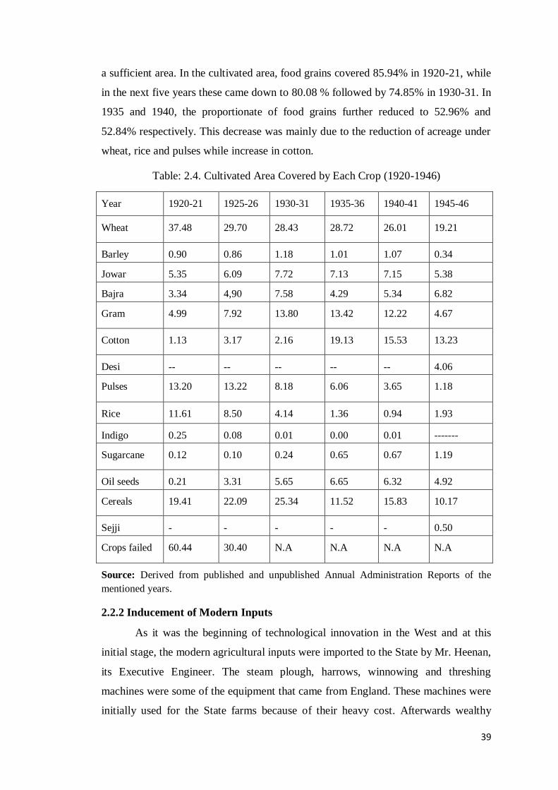
39
a sufficient area. In the cultivated area, food grains covered 85.94% in 1920-21, while
in the next five years these came down to 80.08 % followed by 74.85% in 1930-31. In
1935 and 1940, the proportionate of food grains further reduced to 52.96% and
52.84% respectively. This decrease was mainly due to the reduction of acreage under
wheat, rice and pulses while increase in cotton.
Table: 2.4. Cultivated Area Covered by Each Crop (1920-1946)
Year 1920-21 1925-26 1930-31 1935-36 1940-41 1945-46
Wheat 37.48 29.70 28.43 28.72 26.01 19.21
Barley 0.90 0.86 1.18 1.01 1.07 0.34
Jowar 5.35 6.09 7.72 7.13 7.15 5.38
Bajra 3.34 4,90 7.58 4.29 5.34 6.82
Gram 4.99 7.92 13.80 13.42 12.22 4.67
Cotton 1.13 3.17 2.16 19.13 15.53 13.23
Desi -- -- -- -- -- 4.06
Pulses 13.20 13.22 8.18 6.06 3.65 1.18
Rice 11.61 8.50 4.14 1.36 0.94 1.93
Indigo 0.25 0.08 0.01 0.00 0.01 -------
Sugarcane 0.12 0.10 0.24 0.65 0.67 1.19
Oil seeds 0.21 3.31 5.65 6.65 6.32 4.92
Cereals 19.41 22.09 25.34 11.52 15.83 10.17
Sejji - - - - - 0.50
Crops failed 60.44 30.40 N.A N.A N.A N.A
Source: Derived from published and unpublished Annual Administration Reports of the
mentioned years.
2.2.2 Inducement of Modern Inputs
As it was the beginning of technological innovation in the West and at this
initial stage, the modern agricultural inputs were imported to the State by Mr. Heenan,
its Executive Engineer. The steam plough, harrows, winnowing and threshing
machines were some of the equipment that came from England. These machines were
initially used for the State farms because of their heavy cost. Afterwards wealthy

40
zamindars also started to purchase these inputs.127
The traditional crops gave low
production and had less value in the market as compare to high yielding varieties of
cash crops. Therefore, new varieties of seeds were adopted in the State as were in the
other parts of India, largely for the commercial crops.128
Actually, the GOI and GOP
encouraged the production of American cotton under the pressure from the British
manufacturers who were actively lobbying for support to the British textile industry.
After World War I, many speedy measures were adopted to increase the production of
wheat and cotton in order to fulfill the imperial needs. The crop experiments, seed
provisions, conditional grants and high prices of cotton were in fact the major
incentives to this end.
Agriculture department of Punjab supplied the varieties of hybrid seeds in the
province. The two hybrid varieties of wheat in this regard were Punjab -11 and Punjab
-8. For example, during the second half of the 20th century, the area under new
varieties of wheat in Montgomery district was 301334 acres and in Lyallpur district, it
reached to 231800 acres. During 1905-1940, the acreage under American cotton
variety 4-F was 400,000 acres in Montgomery and 250,000 acres in Lyallpur.
However, much of the cultivation of the American cotton was halted in slump years
of 1930-1937 all over the province and substituted by sugarcane.129
In the Bahawalpur State, improved seeds were introduced in the last two
decade of 19th century and a shift in the acreage under high-yielding varieties
occurred after the SVP. Particularly, cotton cultivation became more organized and
productive. The long staple varieties of American cotton were 4-F, 124 F and K T 25,
which gave more yield and income than the desi cotton. The first sort was more
effective in the non-perennial areas of the Rahimyar Khan District and Minchinabad
127
Government of the Punjab, Proceedings of the Government Punjab in the Political Department for
the Month of February 1871 (Lahore ), 201-204. 128 Actually, the new varieties came from Europe in the first half of 19th century through royal
horticulture society Calcutta. The society was setup in 1830 to extend the agriculture and to introduce
the technological improvements in India. It introduced the seeds of American and Peruvian cotton in
1831. The improved varieties of sugarcane and wheat came in 1838 and 1840 respectively. M.S.
Randhawa, A History of Agriculture in India Vol. III, 1757-1947 (New Delhi: Indian Council for
Agricultural Research, 1983), 75-77. Moreover, the Punjab horticulture society was founded in 1851
under Henry Lawrence. It proved to be a locomotive for the agricultural development. In first instance, improved varieties of seeds and new implements at the time were spreading in all parts of the province.
See General Report on the Administration of the Punjab Territories for the year 1854-55 to1855-56,
104. 129 Indo Agnihotri, Agrarian Changes, 306.

41
tehsil of the Bahawalpur district while the latter two sorts were successful on
perennial tracts mainly of the Bahawalpur district.130
The average yield of American cotton 124-F was 9.2 maunds per acre against
4.9 mounds of 4-F. In Allahbad tehsil, very significant increase in area under cotton
cultivation was noticed in sailaba (flood land), which in 1927-28 was only 69 acre
and rose to 35815 acre in 1939-41. But it was grown at the expense of rice, which had
been produced from the ancient times in the region. Rice production dwindled from
69% to only 4% in this tehsil.131
The overall production of cotton in the State went up
by two lac of bales annually.132
In addition, the two additional new varieties (C-518
and C-591) of wheat were introduced. The former yielded highest returns on good soil
and the latter one gave good results on average types of land.133
With the inception of the Agriculture Department in 1938, research oriented
practices were started. The major orientation by the department was to introduce the
latest scientific methods among the cultivators mainly about the hybridization. The
circulation of new seeds was the responsibility of the Department and more officials
were appointed to supply new seed to the farmers. Moreover, rat-destruction work and
eradication of pestilential weeds were the main undertakings of the department over
an area of 347736 acres and 37390 acres respectively.
Another influential step of the agricultural department was the demonstration
plots of wheat, gram, bajra, jowar and sugarcane comprising of the 100-200 acres.
The land for this purpose was selected in the rural area of each tehsil of the State.
They were also marked as the centers of producing and selling good seeds. These
demonstrating plots were supported well by the farmers. The crops were sown
following the new methods of cultivation as cotton was started to be grown in lines,
wheat sown by drills instead of broadcasting, and sugarcane sown on ridges.134
The
cultivators were also provided with training for the management of their fields.
Moreover, an agricultural school was established to teach solely agricultural
130Administration Report of Agriculture 1946-47, 6. 131Assessment Report Allahbad Tehsil 1946, 1. 132Annual Administration Report of the Bahawalpur State1945-46, 9. 133Administration Report of Agriculture1946-47, 6. 134Administration Report of Agriculture1939-40, 3-6.

42
education. Its main purpose was to provide farm management training to the sons of
zamindars and cultivators to manage their farm.135
There were also some downsides of the new methods. A vast amount of
money got-wasted each year due to the mixed nature of seeds used especially for
wheat, which negatively affected the wheat yield. Above all, the peasants were found
commonly slacking in adopting new methods. This required an advertisement
campaign by the agriculture department, which emphasized for plantation of more
orchards and selection of good seeds.136
The training about judicious cropping, a
balanced rotation, and the use of green manure combined with the control and
avoidance of common crop diseases ensured the higher yields and preserved the soil
fertility. This motivated the peasantry to take more interest in the land. As a
consequent of these measures, the agriculture sector that formerly provided livelihood
to about 60% of the population in the State, became a source of earning for 77% of
the population at the dawn of 20th
century.137
2.3 Agrarian Structure
A village was the primary unit of agrarian formation comprising cultivated fields,
wastelands and wells with dwelling houses. The term commonly used for a village in
the State was „basti‟. On the formation of the State, very few proper villages existed
mostly in its lamma part.138
While in the bet areas (low lands on the bank of rivers),
some huts of reeds and mud formed a temporary village for flood cultivation. The
new villages were constituted around the well in the sailaba land. Communities
usually formed and congregated on the high banks of the rivers front and above the
flood level. The early villages faced certain common difficulties as the land area for
them was reclaimed from jungle or desert by a constant and concerted struggle of the
people.139
The foundation of villages was a continuous process in the State because
135
Administration Report of Agriculture 1946-47, 5. 136 Ibid. 137
This percentage is extracted from Annual Administration Report of the Bahawalpur State 1872-73,
Appendix, IV ; Gazetteer of the Bahawalpur State 1904,218. 138 Charles Masson, Various Journeys in Balochistan, Punjab and Afghanistan, 9. 139
Orlich Leopold gave a sketch of a number of villages located on the strip of lamma, which were
bounded by desert on one side and the fertile valley of Sutlej to the other side but covered with tamarisk jungle particularly, Mamoo Kot, Choudarri, and Chan-Di-goth. See Orlich Leopold, 137.
Further F. Mackeson, journal of captain C.M. Wade‟s Voyage from Ludhiana to Mithonkot by the river
Satlaj on his Mission to Lahore and Bahawalpore in 1832-33, The journal of the Asiatic Society of
Bengal, Vol. VI, Part 1, January to June (Calcutta: 1937), 205.
43
ample land was available. A village economy was self-sufficient as farmers, artisans,
labourers and banya (the traditional moneylender) were the compulsory segments of
this local autonomy. The prominent feature of the preliminary agrarian fabric in the
State was essentially the pastoral economy.
2.3.1 Pastoralism
Integration of agriculture with pastoralism was the main economic feature of
the economy of the State.140
The existence of animal husbandry in the region could
also be traced back to the Hakra phase in the 4th
millennium BC through archeological
evidence.141
The animal figures in stone found in thirty-two sites of that period,
demonstrate that cattle breeding was clubbed with farming.142
With the
commencement of desertification in Hakra belt, green areas turned into merely
grazing grounds, which remained consistent until the formation of the State.
The ecology of Cholistan was favourable for the growth of livestock. The
areas in smaller desert held a variety of stunted trees and bushy grass interspersed by
sand dunes, which provided good forage and fodder for livestock. While in the
proprietary areas of lamma part, large portions were covered with tamarisk jungle,
which was valuable as pastures for the cattle.143
Owing to these regional physical
conditions, the rearing of cattle held much importance for village economy and
households. In the absence of machines, ploughing of fields and irrigation by wells
was dependent on animal power. Even the ownership of agricultural land and its
expansion were also connected to the quantity of yokes.
Semi-nomadic population of the State was also equally dependent on
pastoralism and cultivation in the pre-Agency period. The pastro-nomadic way of life
was well suited to the people of Cholistan. Pastoralists usually stayed in the desert
during the monsoon and used to move towards the banks of the rivers during summer
when harsh climate and shortage of water were more acute. This pastro-nomadic
mode of existence underwent drastic changes under the influence of the modernity
when new trends in agriculture stimulated better crop production.
140
Ibid, 148. 141 Grewal, Historical Geography of Punjab, 1. 142
Mughal, New Archeological Evidence from Bahawalpur, in Dani, A. H. ed. Indus civilization: New
Perspective (Islamabad: Centre for the Study of the Civilizations of Central Asia, Quaid-e-Azam
University,1980), 35. 143 Auj, Cholistan: Land and People (Multan: Carvan Books, 1991), 17.

44
Nevertheless, primacy of the livestock sustained because the drier regions
normally practiced cattle breeding that continued to hold importance in the diet of
local people.144
The main livestock included camels, sheep, cow and goats, which
were the sources of wealth and comfort for the locals. These were also the main items
of export and furnished considerable revenue to the State.145
Camel was the most
useful livestock in the intense climate of desert where shrubs for camel grazing were
also abundant. Local inhabitants kept large herds of camels used them for transport in
the desert and carrying the agricultural produce to market.146
The young camel (todas)
was very much in demand in Punjab and a good source of revenue for the cattle
farmer.
The bullocks and bulls were yoked to the plough therefore, held permanent
economic value. Horse breeding was mainly to fulfill the army needs but was also
done by wealthy zamindars for the own needs. Besides catering to the local dairy and
meat consumption needs, surplus milk, oil and butter were sent to the adjacent areas
mainly to Jaisalmer.147
Orchards were also grown in ample quantity and became a
beneficial business. Mainly in the riverine tracts, the zamindars possessed large
pastures, where cattle grazed in lieu of payment at rates varying from six pies to eight
annas per head monthly, while on public grazing, a tax tirni was leveid. The cattle
engaged in agriculture were exempted from grazing dues. The forest and the pastures
on the crown land constituted the grazing land, which were common property in the
villages and called shamlat-e-deh (village common lands).148
The extension of
cultivation had decreased the grazing grounds but the fodder crops were profusely
cultivated to feed the cattle.
The local industry that used the byproducts from livestock as raw material
thrived since long. The hides of cattle were a significant input to the indigenous
industry and trade. As Mohan Lal described that buffaloes hides from the Bahawalpur
State were well known for their durability.149
The camel hairs were another valuable
input to the domestic industry and was used in manufacturing bed rugs, bags for
144 Orlich, 148. 145Annual Administration Report of the Bahawalpur State, 1873-74, 148. 146 James Tod, Annals and Antiquities of Rajasthan, 1305-1306. 147 Ibid. 148Gazetteer of the Bahawalpur State 1904, 293. 149 Captain Wade, Letters written to the Government of India in the Secret Department: From July to
December 1937, 25 September 1837, On the Trade of Bahawalpur by Munshee Mohun Lal, 174.

45
carrying grains and ropes. Camel leather was also important in the growth of domestic
leather processing. Further, sheep breeding was also significant as a source of revenue
and it supplied the raw material for leather, wool, and tallow.
Moreover, pasturing the large flocks of sheep was helpful in reclaiming of
inferior soil from the sandy desert. There were two types of sheep: butchi (short ears)
was common in Cholistan and produced fine fleece; while lohi (long ear) was usually
found in old riverine area. Their wool was utilized in the making of rugs, darris and
khess. Further, agricultural based local products were also combined with the use of
livestock, e. g. The State was famous for its peculiar but excellent silk lungi (used in
place of trouser) fabrics prepared from the wool of Cholistani sheep. Silk lungis, kora
cloth, loofees and soosee, were distinguished types of indigenous cloth that were
renowned for the fineness of their texture and the beauty of their pattern.150
Cotton
lungis with silk border made by Hindu weavers were the specialty of the State
artisanship and had a large market outside the State. Moreover, the State produced
superior quality carpet wool and woolen blankets.
In 1890, the State introduced the practice of cattle enumeration (malshumari)
through lambardars and zaildars. While, quinquennial census of livestock on regular
basis was undertaken from 1935 under the direction of GOI for the entire Punjab
province.151
Table 2.5 provides a comparison of the growth of livestock for the
selected period. The period under study witnessed an overall increase in almost each
category of animal. However, the period after World War I witnessed a decline in
each category, which again showed an upward trend after the slump years. A vital
increase in the production of household cattle resulting from the extension in
cultivation was also seen, which was instrumental in catering to the food requirements
of the increased population. The agriculturist immigrants from Punjab replaced the
sparsely located cattle breeders and agricultural growth in the early twentieth century
brought the transformation from the Pastoral to the Agrarian economy.
150
Punjab Record, Book 107, Letter no. 25 on 25 September 1837 by Lieutenant R. Leech,
Commercial Information regarding Bahawal Khan’s Territory, 396 151The collection of livestock statistics all over India was actually the outcome of Indian Famine
Commission of 1880. The first cattle census in India was undertaken in the year of 1912-13 and 1913-
14 in Bengal, Bihar and Orissa, which were the victim of frequent famines. In Punjab, the first cattle
census was undertaken in 1922-23. See File 29-B (1941), Cattle Census.
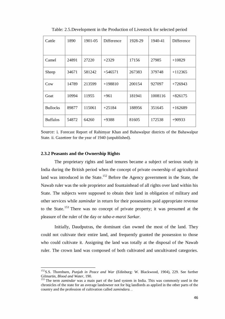
46
Table: 2.5.Development in the Production of Livestock for selected period
Cattle 1890 1901-05 Difference 1928-29 1940-41 Difference
Camel 24891 27220 +2329 17156 27985 +10829
Sheep 34671 581242 +546571 267383 379748 +112365
Cow 14789 213599 +198810 200154 927097 +726943
Goat 10994 11955 +961 181941 1008116 +826175
Bullocks 89877 115061 +25184 188956 351645 +162689
Buffalos 54872 64260 +9388 81605 172538 +90933
Source: i. Forecast Report of Rahimyar Khan and Bahawalpur districts of the Bahawalpur
State. ii. Gazetteer for the year of 1940 (unpublished).
2.3.2 Peasants and the Ownership Rights
The proprietary rights and land tenures became a subject of serious study in
India during the British period when the concept of private ownership of agricultural
land was introduced in the State.152
Before the Agency government in the State, the
Nawab ruler was the sole proprietor and fountainhead of all rights over land within his
State. The subjects were supposed to obtain their land in obligation of military and
other services while zamindar in return for their possessions paid appropriate revenue
to the State.153
There was no concept of private property; it was presumed at the
pleasure of the ruler of the day or taba-e-marzi Sarkar.
Initially, Daudputras, the dominant clan owned the most of the land. They
could not cultivate their entire land, and frequently granted the possession to those
who could cultivate it. Assigning the land was totally at the disposal of the Nawab
ruler. The crown land was composed of both cultivated and uncultivated categories.
152S.S. Thornburn, Punjab in Peace and War (Edinburg: W. Blackwood, 1904), 229. See further Gilmartin, Blood and Water, 190. 153 The term zamindar was a main part of the land system in India. This was commonly used in the
chronicles of the state for an average landowner not for big landlords as applied in the other parts of the
country and the profession of cultivation called zamindara. .
47
For untilled waste, Mughal term Khalsa was used in revenue papers. 154
A certain
numbers of villages and other scattered areas within the State were private property of
the Nawab and known as chakuk sarkari. These lands were exempted from revenue.
Only a nominal share of the produce was obtained from the cultivators and debited to
the treasury.
At the outset of the Agency regime, the proprietorship of the peasants was
maintained in the State with same practice as in the British India. But the ultimate
authority over the land ownership in all the princely India belonged to the native ruler.
The proprietary rights were granted to the individuals. A zamindar when assumed or
given the status of proprietor of the land had complete rights to transfer, sale, and
mortgage of their land at will. The land was abundant, so there was no competition for
land. Therefore, the State had always encouraged people to get the ownership rights.
The ownership rights were confined to the irrigated land. On the eve of the Agency
regime, 35831 owners were entered on the rent-roll of the State. Out of those, 20954
were cultivating for their proprietors, while 14877 did not.155
Essentially, the State owned all the land except what had been purchased by
the public. The entire Cholistan was State property, where the original communities
were thinly scattered.156
In the case of water availability, the land under use of these
communities was available on lease or with proprietary rights under wasteland rules.
Moreover, customary rights had been established to certain tobbas and grazing
grounds. The wells and water cuts were also the unit of property. However, the owner
or his clan never denied drinking water to anyone. All clans recognized a reciprocal
obligation to provide water to the travelers and their cattle at tobbas and wells.
The mode of rights to land and its classification were necessary segments for
not only the assessment of the land revenue demand but also for the registration of
land ownership, for the protection of land rights and for settlement of rent and
charges. The villages in the State held different forms of tenure as was the custom in
the other parts of India. This had developed under the influence of historical, cultural
and economic factors. The tenure of zamindari was concerned with the single
154Old Jamabandi Record, Mauza Mahrabwala 1915-16, (manuscript) 10. 155Annual Administration Report of the Bahawalpur State 1874-75, 2. 156 The Cholistani community mainly belonged to the tribes of Buhor, Rather, Pirhar, Varyah, Jat, Naik
and Manghwall. They were mostly cattle breeders and makers of sajji or carries of traffic in Rajputana
and Bahawalpur. See, Gazetteer of the Bahawalpur State 1904, 293.

48
ownership of a village or a group of villages, which was assessed as a whole but jama
was divided among many co-sharers. Primarily, this tenure was the creation of the
Mughal government.157
This zamindari form was also common in Bengal, Northwestern Provinces
and Punjab.158
In the Bahawalpur State, this tenure was connected to the members of
ruling tribe, State officers and a few religious persons from the Mughal times. They
held large tracts of land and dominated the majority of cultivators, who had limited
rights as tenants. However, with time this tenure kept divided among successive
generation. Therefore, zamindari villages of the Mughal period were not typical of the
arrangement existed in the rest of India.159
Nevertheless, the rulers of the State never allowed land ownership power to
the other chiefs of Abbasid clan to the extent where they could pose a threat to them.
At the onset of the Agency period, zamindari tenure was also granted in the newly
established villages of Cholistan, mainly in Minchinabad and Khairpur tehsils. These
villages belonged to the Sikh and Marwari Bishnoi settlers who received vast estates
of land under single ownership or in the name of a group, to be subsequently allocated
to many cultivators.160
Actually, they exercised this joint tenure like their home
villages in Punjab, where the zamindari system was well established and the
proprietors jointly paid revenue.161
In the late 19th century, there were only 105 village
under the zamindari tenure in the State. The proprietor was responsible for payment
of revenue to the State by collecting it from his co-sharers in proportion to the land
held and cultivated by each.162
Another type of tenure was Pattidari, wherein villages were divided into
several pattis or sections by individual proprietors. The property rights and tax
obligations were also vested in the individual peasants. This tenure existed in old
cultivated areas of the State, where right to land was generally inherited. Under this
157 Sulekh Chandra Gupta, Agrarian Relations and Early British Rule in India: A Case Study of Ceded
and Conquered Provinces (Uttar Pradesh) 1801-1833 (London: Asia Publishing House, 1963), 300. 158 Under this tenure, only one great landlord estate comprised on 197 villages was that of khattak chief
of Kohat. Next to him was an estate of 13 villages by seven co-sharers. See Baden Powel, The Land-
System of British India, Vol. II, 622. 159W. Crook, The North-Western Provinces of India: their History, Ethnology, and Administration (London: Metheon & Co, 1897), 301. 160Annual Administration Report of the Bahawalpur State1873-74, 7. 161 Himadri Banerjee, Agrarian Society of Punjab, 77. 162Gazetteer of the Bahawalpur State1904, 292.

49
tenure, 49 villages were linked to perfect or ancestral pattidari tenure and 30 villages
held imperfect or customary tenure. Later, the newly settled areas in Minchinabad
Nizamat were brought under this pattern because shares in land were large and
number of shareholders was small. Gradually, ancestral fractioning led to the increase
in the number of owners.
The most common form of tenure was Bhaiwal or Bhaycharah. This term was
first used in India for a zamindari village, but was used subsequently as a measure of
individual right.163
This tenure had direct link to government and each individual held
separate holdings under ownership rights or inheritance laws. The shares kept by
plough and wells were more common while pastures were a village‟s common
property (shamlat e deh). Eight hundred and twenty five villages were under bhaiwal
form in old bastis. In Cholistan, almost all villages held this tenure.164
The custom was the un-written law and ruled stronger. The Shariah law was
practiced in some instances but the traditions ruled over law, and inheritance law was
not followed in the early Abbasid period in the State. Only male offspring were
entitled to receive the land. However, there was no any law to deprive the female
offspring from property inheritance but there was will or haq. On the introduction of
civil courts, people adopted the legal way to transfer the property back to male
offspring from the female ones. Though, examples also existed where female
offspring were given their right.
2.4 Socio-Economic Organization of the Village Communities
Economic activity in villages had always been based on the labour of its
communities. The village communities in India varied from place to place but their
common feature was that they tilled the land, shared the harvest among them and paid
the government share. Another general attribute of the Indian village was the tribal
and communal divisions. In the agrarian social setup of the Bahawalpur State, there
was co-existence of different communities and the countryside was an amalgam of
different religions and tribes. The Muslims and the Hindus were the old cultivating
inhabitants of the State while the Sikhs came in the aftermath of agriculture extension
in the later periods. All of them were composed of different casts and tribes and
163Obrien, Glossary of Multani Language, 29. Further in Baden Powell, the Land System in British
India Vol. II, 620. 164
Gazetteer of the Bahawalpur State 1904, 292-293.

50
distinguished by the territorial divisions. In fact, their territorial formations also
affected the human behaviour towards the agricultural trends and farming skills.
Caste being a distinctive expression of identity was vitally expressed within
the territorial framework. This territorial organization normally manifested itself
through the hegemony and control of dominant clans and lineages. However, a strong
caste system was absent in the State as it existed in the Hindu majority areas of India.
Whatever little caste system in the State was there, it existed to recognize menial
professions. In their economic life, all people followed the common laws of a village
community, while in respect of their personal lives they followed their own clan. The
rights and privileges of these different groups were determined by their role in village
economy.
Table 2.6 displays an overview of cultivating and non-cultivating population
in each tehsil. The Muslims were the major agrarian community on the eve of the
Agency period while the Hindus had a minor proportion in the cultivation. The
kardaris of Kot Samaba and Uch had the highest density of farmers and peasants
while Minchinabad and Sadiqpur kardaris had the lowest density of them because
both kardaris were comprised of newly settled areas and the process of settling the
outsiders for extending the cultivation had hardly started.
Table: 2. 6. Agriculturalists Population in the State according to the First Census of
1870
Kardari
Cultivators Non-cultivators
Muslims Hindus Muslims Hindus Total
1 Minchinabad 11382 2149 6243 2398 22172
2 Sadiqpur 14240 824 10732 3277 29073
3 Khairpur 19603 606 12800 6621 39630
4 Bahawalpur 23709 1100 23943 11628 60410
5 Ahmadpur 17221 320 12755 6035 36331
6 Uch 30025 619 11043 4072 45759
7 Allahbad 28619 896 9357 3723 42595
8 Shidani 19492 428 6315 2086 28321
9 Khanpur 29116 972 11776 5784 47648

51
10 Kotsamaba 32880 778 9172 4032 46857
11 Noushehra 25786 402 4711 3597 34496
12 Ahmadpur
Lamma
25841 1092 6852 5714 39499
13 Total 277914 10181 125699 58967 472791
14 60.93% 39.05 100%
Source: Annual Administration Report of the Bahawalpur State for the years 1872-73,
Appendix, IV.
The royal tribe of the Daudputras Abbasid had already established a chain of
clan controlled areas through their patrilineal kin group. They entered the region with
many branches of their sub-clans, whose chiefs established villages on the lands under
their respective control and gave them their respective names.165
Afterwards, the land
was also given to individuals or group of individuals belonging to other tribes. The
clan ties worked strongly in the contagious territorial forms among all strong social
groups.
The Muslims, a top layer community, formed the bulk of agriculturists and
caste differentiation was important in their social setup in the periphery agriculture.
The farming skills of landowners varied from tribe to tribe. As regards their territorial
organization, the Wattus were the dominant clan in Minchinabad tehsil. In Khairpur
and Hasilpur tehsils, Joyas, Daudputras and Chishtis were more numerous. In
Bahawalpur, Channars, Danwanjs, Daudputras, Kulyarrs and Arains were common.
In Ahmadpur East, Sayyeds, Aarbis, Langahs, Baloches Buhars and Naichs; in
Khanpur and Allahabad, Baloches, Daudputras, Lars, Chachars, Machhis and Siyals
prevailed. In Noushehra and Ahmadpur Lamma, Bhuts, Baloches, Sammas, and
Machhis were the major agricultural communities. Jats were considered a superior
class of agriculturist and Arain were second to them in agricultural skills particularly
in vegetable orcharding.166
The position of the both in village economy was relatively
more secure. The Balochs and the Kharals were considered good cultivators while the
Daudputras were thought to be the worst.167
Second major religion based community in the State was that of the Hindus.
Mostly they were in animal husbandry alongside the farming. The majority of the
Hindu community were Brahmans and Aroras. The Brahmans had immigrated from
165 Hafeez-ur-Rehman, Subah Sadiq, 83. 166 Denzil Charles Jeff Ibbetson, Punjab Castes (Patiala, 1995), 189-195. 167 Mir Nasir Ali, Geographia Riyassat Bahawalpur, Bahawalpur, 1892, 8.

52
Multan and Hissar during the reign of the Nawab Bahawal Khan Abbassi II (1772-
1809). A small number of the Brahmans owned large portions of land in the State but
they tilled their land through tenants. The Aroras were basically commercial caste and
considered originally belonging to lower Sindh. They were contractors, moneylenders
and being trustworthy employees played an important part in the delivery of the State
services. Their share in agriculture was initially marginal but they became owners of
thousands of acre of cultivated land through the mortgage or purchase from the other
agriculturists.168
The important class of Hindu agriculturists was Bishnoi Hindus. They were
hardworking and tactful farmers and preferred self-cultivation. Actually, the Hindu
landowner all over Punjab though numerically less important was the most
industrious and thrifty as a cultivator.169
The other important religion based
community in the State was the Sikhs who migrated from Ludhiana, Ferozpur,
Amritsar, Patiala, and Nabha. They mostly settled in upper part of the desert, where
cultivation was barani. They were painstakingly hardworking with the experience of
barani cultivation in their former lands. Majority of the Sikhs consisted of retired
military men of active and industrious habits. The Sikh Jats of Punjab were the finest
peasantry in India.170
They succeeded in lifting the area agriculturally and output of
crops in the deserted land.171
This tribal and communal character of agricultural
population changed on the arrival of the colonists from Punjab under colonization
programme in the State.
The cooperation among the village communities was a glaring feature of the
village life because unceasing struggle was required for clearing of jungles to
cultivate grains, for irrigating the sandy desert, and to face the fury of nature in the
form of floods and draughts.172
Besides, during the early days of the State, the need to
fence against the brutes also needed a bond of unity.173
Agricultural activities for
subsistence economy were also based on group efforts either in fields or in managing
the irrigation resources and providing chherr.
168A Glossary of the Tribes and Castes of the Punjab and North-West Frontier Province, Vol. II,
(Lahore: 1911), 16 -17. 169 Darling, Punjab Peasant in Prosperity and Debt, 230. 170 Thorburn, Musalmans and Moneylenders in Punjab, 15. 171Annual Administration Report of the Bahawalpur State, 1873-74, 11. 172 Radhika Lal, The History of State Canals, 5. 173 Orlich, 147. He mentioned that villages of Tawakul and Laleka, were the place of lion.
53
Being independent from outside influence, this organic and evolving rural
structure led to local autonomy. The village cooperation had evolve through time in
both the patrilineal and exogamic features of this society. These ties were linked to
territorial bond, economic cooperation, political linkages and social necessity. Later,
the introduction of colonial institutes of Revenue, Police and Civil Courts caused this
local autonomy to vanish. The canal irrigation, which required more labour, also
changed the former social trends of the society.
The tribal discrimination and social restriction were the distinctive features of
rural life though its degree of rigidity varied from place to place. In the social
hierarchy, the royal family of Daudputra Abbasid, was considered of the highest
status. In the pre-Agency period, the ruler awarded the landed property as well as high
official ranks to the persons of high order and high birth in their territory. Sometimes
low castes got land in lieu of their services but without ownership rights.
The extremes of privilege and deprivation were commonly observed in the ancient
and remote areas of the State. Such deeds obviously resulted in some negative
aftermaths. The social norms encouraged the high castes to exploit the lowest social
groups. Moreover, this gave birth to the phenomenon of changing the caste altogether
to achieve social mobilization. This would take the form of a certain family leaving
their low caste to adopt a higher social caste and move to another place in order to
veil their original caste identity. The role of land owning class in the agricultural
pursuits and is discussed in the following pages.
2.4.1 The Land Owning Class
The attachment with land stratifies the rural societies into agrarian classes
comprising of owners, tenants and landless labour. The land owning class enjoyed the
higher status than the marginal farmer class. The landowner could be divided in two
sub-classes; big landholders and small farmers. The class disparity was distinctively
prominent between both classes and a pattern of land ownership was synonymous to
the social status, the power, the privileges and the social identity. The Punjab
Alienation of Land Act 1900 was enforced in the State in 1923. It determined the

54
ownership of land among the agricultural classes that were declared separately in all
three districts of the Bahawalpur State.174
2.4.1.1 The Big Land Owners
In the agrarian social setup, big zamindars were the most privileged class. In
the initial days of the State, they constituted the main force of the State, received
holdings in lieu of their military services, which were in addition to the holdings in
the villages established by them.175
They were mostly the descendents of the royal
tribes, the high-ranking State officers or the revered religious tribes. Their role was
imperative to the political support and dominance the Nawab ruler had. 176
On the eve of the Agency period, former warlords assumed the status of
landlords with extra control over peasants. Moreover, some influential native officers
and immigrants who had already been permanently settled in the State obtained large
tracts of land. This category of zamindars was called dankhani and they employed
tenants to manage their estates.177
A prominent feature of this class was that they were
generally well organized and quick to utilize the improved varieties of seeds and
agricultural implements. Owing to their resources, they had more access to the latest
techniques in agriculture than the peasants. Moreover, landlords would consciously
withhold innovations to maintain their exploitative control over the tenants.178
This
class included the families such as Sayeds, Qureshis, Gardezis, Gillanis, Chishtis and
Daudputras. The Chishti family of Minchinabad tehsil held a large estate including
several villages.179
These families were designated as co-sharers because of division and
subdivisions among latter generations. Table 2.7 posits the number of holdings
containing more than 500 acres. In Khanpur tehsil, ownership of large holdings was
more than that in the other tehsils. Ahmadpur East and Allahbad had least ownerships
of large area because both tehsils consisted of the old proprietary area, where large
tracts of land were under self-cultivation. Actually, the big landowners were
responsible for the creation of the worst form of absentee landlordism, which mostly
174 Manzoor Ahmad, Guldasta-e-Manzoor, 89. See for the Recognized Agricultural Classes Appendix
VIII. 175
Shahamet Ali, A History of Bahawalpur, 209. 176 Ibid. 177 Those grantees on cultivated lands, called Chhakar in other parts of India, and in Multan Chakdar
used for grantees by State officers and outsiders, while the term Muzaria was used in Bahawalpur. 178Assessment Report of Sadiqabad Tehsil, 1944, 8. 179Gazetteer of the Bahawalpur State 1904, 117.

55
prevailed in the old proprietary areas of the State. This class enjoyed higher status
than the marginal farmers resulting in insecure tenancy and unequal sharecropping.
Table: 2.7. Number of Holdings with More than 500 Acre
Tehsil No. of Holdings As % of the total area
Minchinabad 61 41%
Bahawalnagar 82 56%
Bahawalpur 66 43%
Ahmadpur 11 19%
Allahbad 19 21%
Khanpu r 130 49%
Rahimyar Khan 47 21%
Sadiqabad 63 45%
Source: Derived from Settlement Reports of Bahawalpur and Rahimyar Khan Districts
1945 and 1946-47.
2.4.1.2. The Small Landowners
Agricultural yields were overwhelmingly dependent on the individual efforts
of small peasants. The great mass of inhabitants in the State was self-cultivator. In the
early twentieth century, 53% of the cultivated area belonged to small owners who
tilled their land as khudkkasht or self-cultivators.180
In fact, variation in the nature of
soil and shortage of water were leading factors in the management of the independent
smallholdings. Small owners had to cultivate their land intensively. The average size
of the holding varied from three to four acres in the western part and ten to twenty-
seven acres in the eastern part. This share size was mainly due to the inheritance
practices under Shariah law.181
An average cultivator who owned one pair of bullocks
for plough held 5 to 7 acres of cultivated land. The highest size of holdings for a self-
cultivator was 30 acres, which existed in Sadiqabad tehsil.182
The smallness of the holding was not a barrier to prosperity because hard
labour, entrepreneurial spirit and quick mind were the real elements to yield high
returns from a small area. Small peasants were the main force behind a self-sufficient
village economy. They were independent in maintaining control over their production
180Report of Inquiry Committee, 44. 181Gazetteer of the Bahawalpur State 1904, 294. 182Assessment Report of Sadiqabad Tehsil, 1944, 8.

56
for subsistence needs. This class of peasants was more punctual in paying revenue,
while big zamindars were used to indulge in the unnecessary delays.
In addition to the labour in the fields, there were many other works to
consume the time and labour of the people such as to update implements, collect fuel
wood or cotton sticks, carry the produce to hatti, bunya or mandi. Above all,
clearance of the watercourses took a lot of time until the period of inundation canals.
A small proprietor also reared cattle as a supplementary source for living. In this way,
he was fully occupied for the most of a year. However, the matter of the fact was that
local peasants were the least progressive and lazy in their attitude and approach.183
This general slackness was to be found almost in all the tasks of agrarian life and was
the main reason behind the immigration of the peasants from outside the State who
very successfully filled this gap.
The local peasantry would usually indulge in useless habits as resting,
roaming, and gabbing. This trend was common among the small landholders and
tenants as well. Therefore, poverty was the corollary in the old proprietary areas, not
due to the overpressure on land or lack of other sources as was in case with the rest of
India. Instead, their backwardness was mainly due to the wastage of time in useless
activities. In the colony tracts, the situation was quite different. The virgin land, sandy
soil and canal irrigation needed hard labour. Therefore, the colonists spent much of
their time in overcoming these early problems, ensuring the water supply and looking
after their cattle. They mostly worked with the help of their family and were less
inclined to employ the tenants.
2.5. Tenancy Cultivation (Mustajri)
The tenancy was the main institution in the agrarian structure of Punjab and its
dependencies. The tenants were the real work force, actually responsible for
generating the production. The extension in agriculture had led to an enhanced
demand for tenants all over the State. The tenants in the State were commonly of two
types: occupancy tenants and tenants at will. The former were fewer in number and
their holdings were inheritable but not transferable. They did not pay rent except the
revenue and were not ousted as long as they paid revenue. The latter had no
183 Sadiq-ul-Akhbar, 6 December, 1888.

57
occupancy rights therefore had no security of tenure. A considerable area under
tenancy was tilled by tenants at will, who were used to cultivate their holdings with
the assistance of their family.184
There were mainly two causes of tenancy. Firstly, tenants were employed by
zamindars that had more lands than they could till themselves. For better tillage, they
had to appoint labourers. Secondly, the high ranked officers and elite class did not like
to cultivate land. Their high social status restricted them to indulge in cultivation. This
was the dilemma in the social set up of the State that the ownership of land was a
pride and prestige for the rural elite but the implications of cultivation were
unbearable for them.
There was a clear distribution of responsibilities between the tenant and the
owner. The rights and obligations of the tenants were settled by a contract (patta
mustajri) for one or more harvests. By custom, the tenants were responsible for
managing seeds, cattle, plough, oxen, and other ordinary well gears. They used to
operate their holdings with family resources and were not allowed to leave the land
between sowing and harvesting. By rule, a tenant only abscond those duties, which
were commonly over and above the normal price or rent.
There were two diverse pictures in the tenant-owner relationship. The tenants
on smallholdings were prosperous. In fact, tenants were few and land was abundant,
which gave them a strong position. In certain cases, tenants were much better than the
owners. Actually, in some cases there was a trend among the tenants to flee after
obtaining some advance money from the owner to look out for a wealthier property
owner.185
To avoid such vagaries of the tenants, small landowners often preferred to
cultivate their land themselves though it was difficult because the precariousness of
cultivation urged them to hire labour.186
On the other hand, the tenants on big estates had to suffer severely and were
subject to unjust conditions. In the first decade of twentieth century, there were 3083
tenants on the disposal of landlords in the State. They were comparatively poor and
could be evicted without any advance notice.187
The main reason for their expulsion
was that there was no tenancy act in the State until 1910 when the Punjab Tenancy
184Gazetteer of Bahawalpur State 1904, 308. 185Annual Administration Report of the Bahawalpur State 1873-74, 153. 186Gazetteer of the Bahawalpur State 1904, 259. 187 Ibid.

58
Act of 1887 came into force.188
This law was a remedy for the ill effects of the
tenancy, especially it prevented the owner from evicting the tenants without due
notice and from undue enhancement of rent. It generally brought in an atmosphere of
good relationship between the tenant and the landowner. In practice, majority of the
tenants were illiterate and ignorant of their rights even after the imposition of Tenancy
Act in the State. It took a long period for them just to understand it.
However, the role of the landowner was substantial in providing security and
assurance to the moneylender to obtain advances by the tenant. Sometimes, the
tenants would build houses on the land given to them by the owner but on the
condition with the full control over their life. Generally, the local tenants were not
good cultivators and were devoid of competitive spirit. Therefore, outsiders were
preferred compared to the local tenants.189
Table 2.8, shows that 55% holdings of the
total in the State were under khudkasht cultivation and while 44% was under tenancy
cultivation. The tendency towards tenancy cultivation was higher in old proprietary
areas particularly in Bahawalpur and Ahmadpur tehsils, in the latter case almost
whole tehsil was under tenancy. While in Khairpur, Khanpur and Sadiqabad tehsils,
the self-cultivation was dominant. Moreover, occupancy tenants were unknown
throughout the State during this period. This trend continued until the eve of weir
control irrigation.
Table: 2.8. Occupancy Patterns in the Cultivated Area in 1900-01
Det
ail
of
Ho
ldin
gs
Total % B
ahaw
alpu
r
Kh
airp
ur
Min
chin
abad
Ah
mad
pu
r
Eas
t
Kh
anp
ur
Sad
iqab
ad
Holdings
cultivated by
owners
55.88
32.99
63.98
58.82
4.69
65.74
65.32
By tenants at
nominal rate or
rent free
--- ------ ---- ---- ----- ---- ----
By tenants with
rights of
occupancy
--- ------ ---- ---- ---- ---- ----
By tenants
without rights
44.11
67.00
36.01
41.17
95.30
34.25
34.67
188 Manzoor Ahmad, Guldasta-e-Manzoor, 87. 189 Annual Administration Report of the Bahawalpur State 1908-09, 49.

59
of occupancy
Total number of
holdings
-----
5167
2360
1275
11515
32162
32316
Source: Derived from the Bahawalpur State Gazetteer part B for the year 1908, xcvi-xcvii.
After the introduction of the weir control irrigation, some changes occurred in
the traditional pattern of the renting system. The rates varied according to
circumstances of the area. In perennial areas, the tenants paid water rates so the batai
was 10% for owner. In chahi land, the owner‟s share was 25% and on sailaba land, it
was 50%. In the western part, usual batai was 33% on nahri and 25% on chahi
land.190
However, in Ahmadpur East, batai was 33% on chahi-nahri, 50% on nahri-
sailaba, 20% on chahi and 33% on chahi-sailaba.191
In the Minchinabad district, the
average rate remained 33% for the owner as before while in the other colony areas,
the batai was half of the produce and half was the State demand on the perennial land.
On non-perennial sailaba lands, the rates varied with each village and each owner.192
The cash rents were very few, except in the immediate vicinity of Bahawalpur
and Ahmadpur East. These were equal to the revenue demands and fixed on
appraisement of standing crops and payments were taken at the time of harvest as per
the deed.193
The patterns of bearing the expenditures varied as per local
circumstances. In the colony areas, the State demand was equal to the rates of rent
while artisan dues were a joint charge. The average cost of cartage from threshing
floor to mart was also deducted. The maintenance of wells was owner‟s responsibility.
Its average expense before World War I was 20 rupees per acre of land, which rose to
104 rupees after the war. The day labour employed at the time of cutting the harvest
received four to eight annas. In Ahmadpur East, half of the tenants were ex-owners
who sold their land to moneylender and influential State officers. The prevailing rate
of the batai was 66% for the tenant and 33% for the owner while the tenant paid the
water rate and the owner the land revenue. 194
As table 2.9 exhibits, there was a decline in khudkasht cultivation category and
small increase in the tenancy category, which was less than the half of the total land.
The trend of awarding lands on nominal rent or rent-free basis commenced during this
190Settlement Report of Allahbad Tehsil 1939-40, 1-2. 191Settlement Report of Bahawalpur and Ahmadpur East Tehsils1930, 17. 192Assessement Report of Sadiqabad Tehsil 1944, 11. 193Gazetteer of the Bahawalpur State1904, 260. 194Settlement Report of Bahawalpur and Ahmadpur East Tehsils 1930, 17.

60
period, when Colonel Grey granted lands to the immigrants and their claims to the
land was recognized. The wastelands in the Khairpur, Bahawlnagar and Ahmadpur
Lamma areas were the first to be transferred to the new owners under this category.
Likewise, the holdings to the occupancy tenants who had the status almost of an
owner were also granted. In the first two tehsils, its ratio out of the total was very little
while in the last one, it was 9% of the total area of that tehsil.
Table: 2.9. Occupancy Patterns in the Cultivated Area in 1910-11
Det
ail
of
hold
ings
Total %
Bah
awal
pur
Khai
rpur
Bah
awal
nag
ar
Min
chin
bad
Ahm
adpur
Eas
t
All
ahab
ad
Khan
pur
Noush
ehra
Ahm
adpur
lam
ma
Holdings
cultivated by
owners
51.33
70.14
32.75
40.34
25.24
55.35
69.21
49.70
51.30
25.44
By tenants at
nominal rate or
rent free
0.30
----
0.09
2.81
1.39
0.18
-----
-----
-----
0.11
By tenants with
rights of
occupancy
0.95
----
0.01
0.02
----- ---- ----- ----- ----
9.36
By tenants
without rights
of occupancy
47.40
29.85
67.14
56.81
73.35
44.50
30.78
56.57
48.69
65.60
Total number of
holdings
--- 7872 9221 7329 3715 27161 21152 5301 12817 10731
Source: Derived from the unpublished Bahawalpur State Gazetteer part B for the year 1913,
ccii-cciii.1
The changes in term of the tenancy and the land ownership occurred after the
slump years as table 2.10 shows an increase in the ownership pattern. The previous
pattern had been reversed and the tenancy cultivation had grown significantly from
44% in 1900-01 to 53% in 1940-41, while 43% area was still under khudkasht
cultivation. The khudkasht tenants were actually crown tenants who were either
landless or did not have sufficient land. The decline of this cultivation was prevalent
in Bahawalnagar and Sadiqabad tehsils. There was significant increase of khudkasht
owners in Ahmadpur East, which rose from 4% in 1900-01 to 53% in 1940-41. As
regards the sharing the yield, it was equally divided between the cultivator and the
owner after defraying the allowances for the menials at each harvest. The traditional
method of division of crops was the sharecropping or the batai. In old proprietary
areas, the rent was higher because owner had to provide labour for canal clearance.

61
Table: 2.10 Occupancy Patterns in the Cultivated Area in 1940-41
Det
ails
of
hold
ings
Tota
l
%
Bah
awal
pur
Chis
hia
n
Bah
awal
nag
ar
Min
chin
bad
Fort
ab b
as
Ahm
adpur
Eas
t
All
ahab
ad
Khan
pur
Rah
imyar
Khan
Sad
iqab
ad
Holdings
cultivated
by owners
43.77
36.79
31.10
25.53
32.35
51.63
53.45
63.86
51.96
55.57
26.26
By
tenants at
nominal
rate or
rent free
2.41 2.25 0.82 1.06 3.10 --- 4.04 4.07 2.60 1.57 0.67
By tenants with rights
of
occupancy
0.25 0.26 ----- 0.13 0.57 ---- 0.13 ----- ----- ----- 1.84
By tenants
without
rights of
occupancy
53.79 60.68 68.07 85.13 63.96 48.36 42.35 32.06 45.43 42.84 71.21
Total
number of
holdings
---- 42090 38343 32881 43766 19568 69179 55011 39921 61666 30957
Source: Derived from the unpublished Bahawalpur State Gazetteer part B for the year 1940-
41 (unpublished).
In the colony areas, the owner‟s share was less than the tenant‟s rent because
the latter had to clear the water channels. However, sharecropping varied as per
quality of the soil and the means of irrigation available. In nehri land, sharecropping
was 50%, 33%, or 20% of the produce. In nehri-chahi land, the owner received the
25% of the produce. In hither tract of Cholistan, the proprietors received 50% of
sharecropping with chherr labour and 33% share without providing chherr labour.
Apart from this, the owner was also used to take kharach from the common heap only
for wheat and cotton to pay the State demand.
Besides, some extra dues or local cesspool was also paid to the proprietors as per
custom. These dues were levied only in those areas, where the proprietor had the
zamindari rights or landlords had a strong hold and tenants were weak. All the
following dues had traditionally been charged in Sindh, Multan, D.G. Khan and
Muzafergarh and the State also followed the tradition.
Jholi was the heaviest cess, which originally was the amount of grain equal to
the folds of shirts.

62
Tobra was the considerable quantity of grain being given to feed the
zamindar‟s horse.
Rajkharcha was levied to entertain the owner‟s guests.
Piyada was paid for his private servant.
Kutrana was a quantity of grain, levied in lieu of the unclean corn left at the
bottom of the heap. It was taken at random and generally exceeded the amount
due fairly to the owners.
Sardari, levied in some tracts of the region, was the relic of the old exactions
by the feudal chiefs and was taken as lump sum.
Hathrakkhi was an amount paid by tenants to zamindar at the time of
commencing each harvest in lieu of occupying the land. It was, afterwards
extracted from owner‟s share of produce.
Bahtaliya was proprietors claim to have their shares weighed at 42 sers to the
maund.
These dues were remained in practice during the inundation period. After the
introduction of the weir control irrigation, only hathrakhi was intact while all others
were gradually abolished.
2.6 The Village Menials
The menial classes were the main labour force in the village economy
throughout the India known as kami. They connected indirectly with the agricultural
activities and identified by their caste corresponding to their occupation. They were
divided in two broad categories; artisans and village servants. Artisans were the
skilled labour as blacksmiths, potters, weavers, carpenters, chammars, and cobblers.
The services of artisans were essential in making plough and other implements for the
farming and other domestic industry. The menial servants provided services to all the
occupational communities including oil crushers, barbers, washmen and chuhras.
Various categories of skilled labour also existed in the State and the State prided on
their skills artisanship. Particularly, the weavers formed the largest occupational
group among the artisans. In the 19th century, the weavers of the State were famous
for expertise in their art.195
195 Wade Letters, 25 September 1837, On the Trade of Bahawalpur by Mohun Lal, 170.

63
The occupation of skilled labour was varied according to the types of the land.
As the kumhars were affluent in the chahi and sailaba tracts because the surface of
such areas was well suited for their work. In this regard, the kumhars of Khanpur and
Ahmadpur East were considered excellent in their profession. The barber performed
multiple functions for the household of zamindars. The significant aspect of the lives
of the kamis was that they often remained quite independent of the control of
lumberdar and did not have to bear the harsh treatment at the hands of the zamindar.
In spite of the vital hereditary role they played in the agrarian economy, the
menial class was the lowest in social standing, demographically insignificant and
without any ownership. Table 2.11 and 2.12 shows the demographics of the menial
population of the State. The main reason for the low population of the menials was the
poor economic conditions of the cultivators who could not afford the appointment of
large-scale menial staff. Among the menial, the machhi and mussali were somewhat
more in demand than the other kamis because ordinary people were unable to perform
the tasks performed by them. While the percentage shares of almost all the artisans
were more than those of other servants. With the time, the numerical strength of
weavers, potters and shoemakers reduced as showed in both the tables. Particularly,
the periods after World War I and II, witnessed a social change in the position and
status of kamis.
The complementarities between agriculture and manufacturing activities had been
disturbed by the developments under the modernity. The villages came in touch with
the outside world and imported goods caused a decline in the demand for local
handicrafts, for which the State was famous. New commodities poured into the
villages. Imported sugar started to replace gur and bross, and copper utensils replaced
the clay pottery in the village. The development in the means of communication and
transportation stimulated the import of many other articles in the towns and cities.
Therefore, the occupations of the artisans also got affected but it did not declined
rapidly as compared to the decaying of their professions in the other parts of
Punjab.196
The weavers and potters in the State were more affected than the other
artisans.
196 Himadri Banerjee, „Kamis of Punjab‟. The Punjab Past and Present XIII: X (October, 1985): 304-
306.

64
The handlooms were replaced by cotton factories. However, the more famous
articles did not completely vanish and continued to be demanded by the locals.
Technological changes caused social mobilization among the menial classes. With the
import of foreign goods, the menial classes changed their occupation and moved to
adopt other occupations. The spread of education and the up gradation of agricultural
activities also contributed to this end. The growth of new tasks in villages provided
additional sources of income. But the movement towards new occupations was slow
in the State due to the lack of awareness and motivation among the menials.
Sometimes, small portions of land were also allotted to engage them in
cultivation.197
Land acquisition provided them an opportunity to elevate their social
status in the rural society. Among artisans, the chammar and the mochi were regarded
unclean but not considered as untouchables as in the other parts of India. There
existed a degree of compassion towards them in the State, which was due to the
limited population of these categories of the menials. They were to be found in both
rural and urban areas in the State. In the pre-Agency economy, though the role of
skilled labour was essential in the agrarian sphere but they were not legally
recognized as professionals. In Punjab, they were recognized as professional labour
and menial staff through amended Act of Canal Drainage in Northern India 1873,
enforced in the State in 1911.198
However, the Punjab Alienation of Land Act (PALA)
of 1900 did not recognize them among the agricultural class.
Table: 2.11. Proportion of the Menial Servants in the total Population of the State
Occupation 1881 1891 1901 1911 1921 1931
Chuhras ----- ----- ----- 0.50 1.84 0.53
Dhobi 1.83 1.43 0.70 1,28 1.29 1.10
Kanjar 0.20 0.12 0.07 0.07 0.10 -----
Machhi 3.82 3.42 3.32 3.61 2.08 3.14
Mirasi 1.48 1.19 1.23 1.10 1.05 0.88
Mussali ----- ----- 0.30 2.89 1.75 2.76
Nai 1.28 1.05 0.55 0.96 0.88 0.74
Teli ----- ----- ----- 0.07 0.09 0.18
Thori 0.28 0.32 0.43 0.72 1.28 0.46
197Gazetteer of the Bahawalpur State 1904, 220. 198 Manzoor Ahmad, Guldasta-e-Manzoor, 59.

65
Source: Bahawalpur State Gazetteer Part B 1913, xxvii-xxxiil and 1935 xlvi-liv.
Table: 2.12. Proportion of the Artisans in the total Population of the State
Occupations 1881 1891 1901 1911 1921 1931
Julaha/ weavers 3.47 0.83 1.28 2.17 1.61 1.40
Kumhar potters 2.17 1.86 1.53 1.78 1.70 1.77
Lohar blacksmith 0.56 0.45 0.18 0.34 0.35 0.34
Mochi shoemakers 2.56 2.08 1.36 1.86 1.66 1.49
Chammar 1.07 0.13 0.57 1.36 0.46 1.94
Tarkhan 1.99 1.67 1.13 1.60 1.39 1.38
Total
Source: Bahawalpur State Gazetteer Part B 1913, xxvii-xxxiil and 1935, xlvi-liv.
The menial class was economically dependent on the other classes. Their
social context in the State was very close to that of the Jujmani system prevailing in
the rest of India. In Jujmani system, each family of the menials was attached to a
zamindar to perform its occupational services.199
In sporadic villages, the menials
might had been attached to more than one zamindar and obtained a fixed portion at
harvest from the each landholder. Their dues were customarily paid in kind out of
undivided yield but with the extension of canal irrigation, cash payments were also
made and their increased demand led to the favourable rates of wages.
Their remuneration determined by local customs varied from place to place
and usually was not oppressive. Generally, the payment to all categories of the
artisans was almost equal while for the unclean professions, it was half of the artisans.
The local musician was also considered a menial, and performed the job of a
messenger and received grain or money at the good will of people. Besides wages, the
menials were also entitled to bundle of fodder and to the tips for their services on the
social ceremonies. In a way, they were not miserable or poverty-stricken set of men.
199 The menials worked under interdependence system or Jujmani system in the Hindu society of India.
See William H Wiser, The Hindu Jajmani System, (Lucknow: Lucknow Publishing House, 1958), xxii.

66
However, no members of Scheduled Caste200
could be absorbed in customary
occupations and some of them were seasonally mobilized to work as day labourers,
mainly on canals. Their share was specific in the produce share of the landowner. Gur
making charges were 10% of the product. Transplanting of rice was paid at four
rupees per acre.201
In the colony areas, the payment for cutting and threshing the crops
or cotton picking was estimated from 10-20% of the produce.202
There was a 10%
increase in the wages of skilled and unskilled labour due to the increased cost of
living after the slump years.203
The analysis of the agrarian development in the preceding sections determines
that the important feature of the State‟s economic life was the transition in the patterns
of economy. Before the Agency period, the rural society was self-sufficient. They
produced almost all that was required for their consumption. That attribute highlights
the static nature and character of the traditional Indian village life largely attributable
to the lack of communication means that kept them isolated from the outside world.
While urban centers of the State had connections with the rest of world through
trading activities but their number was not sufficient as to alter the stagnation of the
rural communities.
The improvements in the communication means facilitated the trade and broke
down the self-reliance and self-sufficiency patterns of the rural communities. Peasants
cultivated the most valuable crops according to the nature of their land. This led to the
money economy in place of the old barter system, which also went to link with the
outside world. To cope with the market requirements of the new reality, the simple
and illiterate peasantry was ill equipped while the banya was more active. The role of
the moneylender in the agrarian development is discussed below.
2.7 Indebtedness
The State‟s subsisting economy developed gradually and its impact was
visible in the increasing income of the cultivators, which also increased their
200 The inferior castes or untouchables were officially listed in the 1931-Census of India and defined as
depressed castes in 1932. See Praveen Jadhav, Relative Disparity in the Implementation of Reservation
Policy in India (with Respect to Scheduled Castes) edited, Jagan Karade, Development of Scheduled
Castes and Scheduled Tribes in India (Newcastle: Cambridge Scholars Publishing, 2008), 2. 201 Ibid. 202Assessment Report of Rahimyar Khan District 1944, 45. 203 File 502- 1942, Part I, Exchange of Information: Fortnightly Report, 4th July, 1942.
67
expenditures and ultimately resulted in the curse of indebtedness as Darling claimed
that debt was the result of prosperity. Before 1866, agricultural indebtedness in the
State was marginal due to the batai system, which had clear distribution of crops.204
Moreover, the subsistence agriculture with simple living did not allow them to exceed
their income. Therefore, the need for the money was not acute. Grain obtained in
advance as loan and was repaid at harvest. With the increasing trend of cultivation,
the money required for the agricultural expenditure also increased. The shift from
kind to cash transaction opened the way to debt. There were few opportunities to
obtain credit for poor peasants in remote areas. Their sole hope was the moneylender
or banya, who was the only credit agency in the rural economy.
There were many kinds of mortgage available and the nature of the transaction
depended on many economic and social factors. In the Rehn bilqabza, the
moneylender would obtain the complete possession of the land. He was responsible to
manage the cultivation and to pay the revenue to the landowner while appropriate
remaining produce in lieu of the debt. In the Rehn bilaqabza, the moneylender would
receive a fixed rate of interest and possession of property remained with the debtor.
The most common form of lending was lekhamukhi contract.205
Under this form, the
debtor would hand over his entire crop to the moneylender who would pay all the
expenses, deduct his interest charge and deposit the remaining amount for the
liquidation of original debt amount. This form was the worst of all and existed all over
in Punjab. Ultimately, this would reduce the landowning peasant to the status of a
tenant. 206
Apart from this, the personal guarantee of the landowner was compulsory
for his tenants if they did not have any material guarantee.
The material guarantee was generally received in the form of land or in
jewelry.207
The interest rate on moveable items was 9% and on grains was 24% per
annum.208
The most tragic situation was that the cash rate in most cases became more
than the actual sum of the advance through compound interest. The advance was 10%
to 20% of the total, deducted at the start. Resultantly, the cultivator turned wretched
204 Gazetteer of the Bahawalpur State 1904, 234. 205 Ibid, 236. 206 S.S. Thorburn, Musalmans and Moneylenders in Punjab (Edinburg: W. Blackwood, 1886), 83. 207 Annual Administration Reports of the Bahawalpur State 18 74-75, 2. 208 Annual Administration Report of the Bahawalpur State 1875-76, 56.
68
and had to sell his mortgaged land to banya.209
This situation brought about a socio-
economic change in the structure of the rural society. The moneylenders were mostly
Hindu with few exceptions of wealthy Muslim zamindar or the State officials.
The bunya, who hardly held any land came to own hundreds of acres. In
Bahawalpur district, the Hindus owned 13.58% of the total area and 17.62% of the
cultivated area. They were able to purchase the protection of the ruling power.
Actually, the moneylender dealt in land as business and disposed it off when
favourable prices were available.210
There were several reasons as to why did people borrow. Debt was actually, a
reflection of indolence and incompetence of the peasants in the State. The majority of
creditors were poor Muslim cultivators or few Sikh immigrants.211
Some local
cultivators generally had large holdings that required higher amount of working
capital and uncertain inundation supply further multiplied their miseries, which forced
them to seek loan. Besides, they had to borrow money usually to meet the agricultural
expenses such as the purchase of cattle and seeds. Above all, the general poverty,
which among the peasant class was mainly due to bad season, flood and water
scarcity, became the major trigger of debt in the State.
Moreover, the prevailing trend in litigation, mainly to pay fines for the crime
of cattle stealing and women abduction, and exorbitant rates of interest were the main
factors of their indebtedness.212
On the other hand, some big zamindars were also
indulged in debt because of their lust for more land, extravagance and traditional
hospitality.213
However, M.R. Darling‟s analysis was apt that Muslim landlord was
too lazy, too indebted and devoid of developmental spirit.214
Debt for paying revenue
to the State was very rare in the Bahawalpur whereas, this was common in Punjab.
To overcome the debt dilemma, the proper organization of agricultural credit
system was essential. The State opened various avenues for the peasants. Colonel
Grey brought some developments in 1878 and prepared the regulations for the
209 Gazetteer of the Bahawalpur State 1904, 238 210
Assessment Report of Bahawalpur and Ahmadpur Tehsils 1930, 3. 211 Annual Administration Reports of the Bahawalpur State 1900-1901, 6. Further see in Sadiq-ul-Akhbar, 29 August, 1918. 212 Gazetteer of the Bahawalpur State 1904, 235. 213 Assessment Report of the Mincninabad Tehsil 1947, 36. 214 Darling, The Old light and the New in Punjab Villages, 333.

69
agricultural loans. The takavi loans on easy terms were provided to the cultivators for
the purchase of cattle, seeds and wells. In 1899, new rules for takavi grant were made
and eight lac rupees were sanctioned. The period of repayment was extended to ten
years in the flood and canal irrigated areas, and for 27 years in Cholistan.215
In Punjab, takavi scheme came under Land Improvement Act of 1871 and
Agricultural Loan Act of 1879 and 1884. In the first year, the advance of more than
one lac rupees was given for agricultural purpose.216
This lending scheme was not
very successful because of procedural complications to apply for the loan from the
government and rigid implementation of repayment schedule even in the bad season
when even bunya would postpone the collection though the interest charge would
accumulate. The Punjab peasantry found it convenient to obtain loan from the
moneylender. While in the State, the takavi loans were given on easy terms and
comfortable repayment options. The State did not charge interest on the loan rather
during any calamity, the collection was postponed and in more severe condition, it
was remitted.217
Therefore, results were contrary to what were in Punjab and demand
for more takavi kept increasing in the State, even after the advent of cooperative
institutions.
The first legal attempt of the native government to check the excessive interest
rates was the „Law of Interest and Imprisonment in Satisfaction of Decree 1896‟. The
law fixed the interest rate at less than half of the original amount or quantity of debt.
Moreover, the rate for pledged items was fixed at 6%. However, in case of
nonpayment; it could be increased to 24% of the debt. This measure seemed to be a
security for the peasants and minimized their miseries to a certain extent.218
The growing debt owed by the cultivators resulted in a substantial increase in
the transfer of land ownership to commercial classes and in the dispossession of the
peasantry from their ancestral holdings. This trend was so intense that during 1867 to
1901, the indebted peasants sold 296181 acres of land to the moneylenders at a small
whereas 74349 acres were mortgaged.219
Actually, this state of affairs was prevailing
215 Gazetteer of the Bahawalpur State 1904, 241; Settlement of Cholistan 1927, 7. 216 S.S. Thorburn, Musalmans and Moneylenders in Punjab, 101. 217 Annual Administration Report of the Bahawalpur State 1908-09, 49. 218 Ibid. 219 Ibid, 237.
70
all over the province and transfer of land from the debtor to the moneylender was
more severe in Punjab. Its root cause was the absence of any legislation for land
alienation.
To overcome the debt dilemma and to shore up the land owning classes, the
GOP formulated the PALA 1900. Its major contribution was the restriction on the
transfer of land to the professional moneylenders and alienation was allowed only
within same agricultural castes. A schedule of agricultural and non-agricultural castes
was drawn and land transfers were considered valid only if according to this
schedule.220
This act was introduced in the State in 1910 with the same spirit as in
Punjab. The PALA prevented the commercial classes from acquiring the land owned
by the agricultural classes. The purchase and sale of land was also limited to the
agricultural classes.221
The distributions of the agricultural classes in the State were
the outcome of the PALA.
This also resulted in several discrepancies as some groups manipulated their
caste identity to claim an affiliation to be registered to the agricultural tribes. The act
failed to achieve the desired objectives and the moneylenders were able to sustain
themselves in the land market even after the enforcement of this act. They acquired
land during the overlapping period of the legislation by legal purchase and
mortgage.222
This strengthened the hold of the agricultural moneylender, who was
usually a big zamindar and his extortion was not less cruel than the professional
moneylender.
Table: 2.13. Detail of Sold and Mortgaged Land in Acres
Year Sale Price in Rs. Mortgage Price in Rs.
1880-81 to 1889-90 237187 576060 34124 149540
1890-91 to 1899-1900 257153 178428 61408 451363
1900-01 20274 195867 6224 50419
1904-05 26000 188115 5916 59739
1909-10 30894 533786 7344 149423
220Baljit Singh, Wither Agriculture in India. (Agra: N.R. Agarwal & Co, 1945), 248. 221 Barbara D. Metcalf & Thomas R. Metcalf. A Concise History of India (New York: Cambridge,
2006), 134. 222Settlement of Bahawalpur and Ahmadpur East 1930, 7.
71
1919-20 13573 814380 2877 195670
1929-30 25604 2002661 10955 612534
1834-35 44819 2438410 18726 659805
1939-40 41197 6792661 25176 1318116
1944-45 24780 3536148 29079 1459699
Source: Derived from Bahawalpur State Gazetteer; Annual Administration Report of
Bahawalpur State of the concerned Years (Published and unpublished).
In the canal-irrigated colonies of the State, the prevalence of the debt among
the small and average colonists was very little. The tenants were only nominally
indebted and that too only to their zamindars. This debt free environment was mainly
the result of the increase in prices of agricultural commodities after the slump years,
which significantly washed out the debt.223
Besides, the State lavishly granted the
takavi in the colony areas, which resulted in a progressive increase in the cultivation
and consequently in the revenue as well. However, Darling‟s perception was exactly
true regarding the Minchinabad tehsil of the State, where the big landholders were
indulged in the debt, not because of the insufficiency of assets but their extravagancy.
For example, a wealthy businessman of the tehsil sold his land to clear off his debt
incurred for establishing a cotton ginning factory.224
The Punjab canal colonies in the initial period were also free of debt. After
1912, when the proprietary rights were given to the colony districts, there was an
increase in mortgage debt. In order to rectify this problem, the cooperative department
was set up as a sort of semi lending official source by the GOP in 1904.225
In the
State, the cooperative societies were introduced in 1914, with the staff consisting of
only one superintendent and Mr. Calvert was the registrar of the cooperative societies.
These provided assistance in the purchase of seeds, implements and cattle. Initially, it
did not receive a warm welcome because people were doubtful about the potency of
new option. The moneylenders considered this a menace to their hereditary
profession. Therefore, the State established the central bank and contributed a loan of
Rs. 50000 to it.
223 Assessment Report of Sadiqabad 1944, 8. 224 Assessment of Minchinabad Tehsil 1947. 36. 225 Darling, The Punjab Peasant in Prosperity and Debt, 175.

72
Initially, there were 162 agricultural societies and comprised of 15451
members. The societies issued the loan of 61328 rupees in their very first year.226
Over the time, a sufficient proportion of people joined the societies as members. The
membership in the State was more than what was in Punjab. It was 23 per thousand of
the population in the State, while in Punjab it was 11 per thousand. The main feature
of these societies in the State was that the average of loan held their members was
very low at Rs. 10, whereas the same amount in Punjab was Rs.97. Moreover, per
member cost in the State was four anna and four pie, against one rupee and eight anna
in Punjab. Moreover, in Punjab as compare to takavi, cooperative societies were
successful but this success was not spread across the colonies. The big landholders
generally were the dominated and overall cooperation could not come to the rescue of
small agriculturists. The moneylenders were working against cooperative institution.
They organized several boycotts in almost all canal colonies of Punjab.227
Because majority of the peasants in the State were illiterate, so the government
combined the societies‟ work with that of the education department and engaged
school teachers as secretaries to inform the illiterate borrower about the benefits of the
system. With the advent of society‟s cooperative movement, the cultivators‟ miseries
reduced but did not vanish completely. However, it paved the way for further reforms
to control the debt problem. The societies remained a significant institution till 1947.
Conclusion
Being an agrarian zone, the idea of agricultural development in the State was
always there. Because the progress of the State was associated with the progress of
agriculture therefore, the Agency government redefined the parameters of growth. It
strategically directed agrarian economy of the State towards the modern agriculture
with the collaboration of the natives. Improvements in agricultural techniques and
practical skills, and use of improved seeds and manures resulted in increased output
from the agriculture sector and upgrading the standard of cultivation. The style of
cultivation also improved, e.g. the peasants found it more profitable to cultivate a
small area with the proper farming approach like more attention, deeper tilling and
removal of the shrubs. Resultantly, the agriculture gradually assumed the first place in
226 Annual Administration Report of the Bahawalpur State 1915-16, 57-58. 227 Report on the Progress of Cooperative Societies in the Bahawalpur State, 5.

73
the State economy and traditional exchange transactions changed into monetary
exchanges. During this development period and process, the role of the agrarian
communities and the agricultural labour was quite vibrant. However, their traditional
agricultural practices and customary relations were replaced by the modern cultivating
accomplishment and professional farming attitude. This new agrarian environment
brought an increase in the State income, as the revenue from agricultural land was
more than the other sectors of the economy. This is going to be discussed in the next
chapter.

74
Chapter 3
Land Revenue System of the Bahawalpur State
This chapter examines the revenue structure of the Bahawalpur State and the
course of its gradual development. It analyzes that how indigenous land revenue
structure of initial phase of the state took a concrete and refined form. In this context,
the introduction of land revenue settlements was the nub of the system for assessing
and apportioning the State‟s share as well as for maintaining the complete agricultural
statistics. The killabandi system created a symmetry and order in fields that made the
assessment process easier. The chapter explores the nature of the feats by the rulers
achieved over time to raise the revenue demand and the reasons for this increase as
well as the situation of kharaba and to what extent it was given.
The peculiar role of revenue establishment was influential in determining the
relations of the peasantry with the State. This study postulates that how the
settlements of land became the major contributing factor towards the economic
advancement. The revenue free assignments are examined as a major part of the
revenue structure of the State. The beneficiary of rent-free holdings was generally the
elite class, which had successfully been defending their interests by obtaining
relaxation from the State demand.
3.1 Land Revenue Structure in the Pre-Agency Period (1727-1866)
Land revenue is an essential segment of income in any properly established
system of a governing body. Being the ruling power the government is entitled to a
share of the produce from the land under its control. In a country like India where
70% of population was associated with agriculture, the land revenue had always been
considered a part of the natural order of the society from the time immemorial.228
In the modern history of India, Sher Shah Suri (1540-1545) was the first
emperor who instituted an indigenous scheme of land revenue. His regulations
provided the grounds for a tentative revenue plan to the rulers who followed him.
During the reign of Jallal-ud-Din Akbar (1556-1605), his finance Minister Todarmul,
effectively imposed a comprehensive system of revenue assessment and collection.
228 P.J. Fagan, Land Revenue: its Origin and Development with Special Reference to the Punjab (Simla:
1921), 27.

75
The revenue administration consisted of heterogeneous classes, under direct control of
central government. The revenue demand was 33% of the gross produce while the
cultivators had the option to pay either in cash or in batai.229
This system remained in practical working in all parts of India in the
subsequent Mughal period. With some modifications, this pattern formed the
foundation of the institutions that existed under the British rule over India. In regard
to the princely India, the native states had their separate administrative and revenue
setup, yet the basic features were those from the Mughal period. In the State,
continuity subsisted in the land revenue system inherited from the Mughals, which
was modified by the Nawab rulers according to the local requirements.
The fiscal history of Bahawalpur was largely connected with Multan and Sind
because the State territories remained under the control of these provinces in the pre-
Abbasid period. The first known account of revenue generating areas connected with
the State region was mentioned in the work Ain-e-Akbari. These territories comprised
of thirteen perganas,230
which were; Jajja, Bhutta Wahan, Dulai Kosh, Derawar, Daud
Machhi231
, Ghazipur, Mau, Mahand, Uch, Marot, Rahri, Sarwahi, and Khai Bodla.
These areas were the revenue payers on feudal tenure under Multan province and
contributed a yearly income of Rs. 5, 11, 399.232
The Mughal governor awarded the jagir of Choudarri to Daudputra Abbasid
with the chief motive of restoring the revenue from these areas because owing to the
disintegration of the Mughal dynasty, many territories were slipping away from the
control of the central government. Later, the rulers of the State gradually brought the
surrounding areas under their control and paid a large amount in form of tribute to the
Mughals and afterwards to the Afghan ruler, which was in excess 1,50,000 rupees per
annum out of its total revenue of 1,500,000 rupees in 1816.233
During the initial period of the State, the revenue was collected in two ways:
first was the direct collection from the cultivators in those abodes, which were under
229 Radharoman Mukherjee, Occupancy Rights: its History and Incidents, together with an Introduction
Dealing with Land Tenure in Ancient India (Calcutta: University of Calcutta, 1919), 42. 230 Pergana was used for an administrative unit of district or tehsil in India from the Sultanate period.
However, in Bahawalpur, it was equal to a kardari or tehsil. 231 A village near the present town of Shidani in Khanpur tehsil. 232Derived from Gazetteer of the Bahawalpur State 1904, 302. 233 Mountstaurt Elphinston, An Account of the Kingdom Of Caubul, and its dependencies, in Persia,
Tartary and India: Comprising a view of the Afghan Nation, and a History of the Dooraunee
Monarchy, Vol.II (London: Richard Bentley, 1842), 233.
76
the complete control of the Nawabs like Allahbad, Derawar and Bahawalpur. In these
areas, jama was lenient.234
In the other areas where tribal chiefs had founded separate
principalities upon their jagirs, they were independent in their financial matters and
usually received a high pitch of revenue through their workers.235
It was also the
emergence of intermediates in the State that sustained until 1806, when the Nawab
Bahawal Khan II (1772-1809) had annexed all independent jagirs and established his
authority over the entire State. He reorganized the administration by dividing the State
into four kardaris, which were originally revenue units.236
The usual demand varied from 17% to 25% of the gross produce.237
The
significant aspect of native rule was that the State revenue demand was dependent on
the conditions of soil and irrigation. The customary method of assessing and
collecting the land revenue was batai for grain crops.238
However, the State share in
indigo was always collected in kind while the indigo fees „moghla and zabta’ were
paid in cash. The batai was preceded by visual observation of kardar, assisted by two
other petty officials called chanjus and piyada. In batai, crops were stacked in equal
heaps at each harvest and one heap taken in accordance with the state demand. The
kardar was responsible to collect and deposit the grains in the state granaries known
in local dialect as sarkari-bhanda.
During the reign of Nawab Bahawal Khan III, the revenue was collected
partially in batai and partially in cash. The cash payments were realized for non-grain
crops generally when season was favourable and crops were abundant. The sum of the
revenue was presented on the eve of birthday of the Nawab.239
Before the Agency
rule, the revenue structure essentially existed but with shallow features. The concept
of land settlement since the inception of the State was unknown and there was
complete unavailability of statistical record of the land rights. The fields were of
234 Ibid. 235 Most of the towns and villages were established in the period between 1727 -1773. In 1737, the
Daudputras occupied Derawar fort and Bahawal Khan I was recognized the formal head of his tribe.
See Jan Muhammad Pirjani, Tarikh Khandan-e-Daudputra, 313-315. 236 Ibid, 186. 237 Punjab Records, Book 107, Lieutenant R. Leech, Commercial Information Regarding Bahawal
Khan’s Territory, 396. See also Andrew D Cruz, Political Relations existing between the British
Government and Native States and Chiefs subject to the Government of the North Western Provinces
(London: 1862), 94. 238 The division before threshing was batai or ghalla bakhshi and after threshing, was called lang batai.
On standing crops divided by demarcation of fields was khet batai. See Jagdesh Narayan Sarkar,
Mughal Polity (Delhi: Idarah-i-Adabiyar-i-Delli, 2009), 262. 239 Wade Letter, 25 September 1937, On the Trade of Bahawalpur by Mohan Lal, 166
77
uneven shape, plots were splintered into countless scattered fragments and village
boundaries were meandered. There were neither fixed boundaries for the fields nor
any clear bifurcation between the crown land and the cultivators‟ possession. This
ambiguity caused great loss to the State income.
Moreover, many illegal practices also existed among the cultivators and the
petty officials. The officials extorted excessive revenue from the poor peasants and
left a slender margin to them. Occasionally, they would make people to pay 8 to 10
times more than their due share. Some misdemeanors also existed on the part of the
natives such as bribery, or unnecessary delay in paying the revenue. Above all, there
was an absence of proper system of revenue collection and a common notion
prevailed that influential persons were exempted from the state revenue. Therefore,
annual revenue collection gradually lowered down and did not exceed the ten lacs
amount.240
These conditions were more severe during the days of political instability.
From 1852 to 1865, the regime was politically weak, which also weakened the
revenue system of the State. This system with several loopholes remained in practice
until the establishment of the Agency.
3.2 Development of the Land Revenue System during the Agency
Period
Under the auspices of the Agency, the land revenue structure began to take a
specific form. Primarily, the State purpose was threefold; to introduce a system,
which would relieve the peasantry; to increase the State income; and ensure the
collection from the maximum strata of the rural society. The political administrative
division was in fact the revenue division. Patwaris, girdawar and qanungo were the
most significant officials introduced in the revenue structure. The patwari assisted the
lumberdar in assessment, fixation and collection of the revenue for each village.241
A regular Revenue Department or Mushiraat e Mal was setup in 1871 with the
separate establishment of 62 revenue officials under the head of Land Administration.
The Nazim and Kardar held the premier position within this system. Both the State
branches, i.e. revenue and police, worked in close cooperation with each other. The
government added some more functionaries to strengthen the administration.
240 Wade Letter, From January to July 1838, 12 December 1838, Report from A.C. Gordon to D. J.
Cunningum, 88. See also Annual Administration Report of the Bahawalpur State 1873-74, 152. 241Sadiq-ul-Akhbar 1st April, 1872.

78
Lumberdar to each village and zaildar to each mauza, were appointed to assist the
tehsildar in the revenue matters and to police in criminal proceedings.242
In fact, the articulation of power in villages of the Punjab province was
achieved through the appointment of local powerful men to the hereditary office of
lumberdar and to higher office of zaildar all over Punjab.243
The lumberdar occupied
important position in the system and, his official function was to assist police and
revenue authorities. For this he was allowed to retain the charge of five rupees and,
later, five acres of rent-free grant.244
He was an intermediary between the village and
the administration. His appointment was always made from among the leading men of
peasant proprietors. Therefore, Hamza Alvi called him the holder of a quasi-political
officer, not the servant of the State.245
The reorganization of the State administration by Colonel Grey in1977 gave a
considerable impetus to the revenue system and introduced the post of Mushir e Mall,
a rank equal to the Commissioner of a division in Punjab. The jurisdiction of the
Mushir e mal comprised of the departments of Land Revenue, Settlements, Domain
Lands and Studs while the Police became a separated department.246
The tehsildar
assumed the place of kardar at each tehsil with further responsibility of the
supervision of settlement work with his staff. Baden Powell cited that naib tehsildar
and Qanungo for each tehsil were appointed for conducting the settlement work.247
In
the following years, there was further time-to-time up gradation in the administrative
setup of the State.
3.2.1 Land Revenue Settlements
The land revenue settlement was a process of ascertaining the state revenue
demand. Its primary purpose was the revision of the assessments to ascertain the State
share and to maintain the records of the land rights.248
The settlement policy of the
British in India actually, commenced from Bengal in 1793, and was subsequently
242Annual Administration Report of the Bahawalpur State 70-71, 5. 243H. G. Trevaskis, An Economic History of Punjab (1890-1925) Vol. II (Gurgaon: Vintage, 1989),151. 244Ian John Stone Kerr, The Punjab Province and the Lahore District, 1849-1872: A Case Study British
Colonial Rule and Social Change in India, Vol II (University of Minnesota, 1975), 284. 245 Hamza Alvi, Rural Elites and Agricultural Development in Pakistan. Pakistan Economic and Social
Review, Vol. 14, No 1/4, 204. 246Proceedings of Political Department February 1879: Administration of the Bahawalpur State, 99-103,145. 247 B. H. Baden Powell, Land Revenue and Tenure in British in British India (London: Oxford, 1894),
554. 248 James M. Douie, Punjab Settlement Manual (Lahore: Government of the Punjab, 1930), 3.

79
followed in other provinces and districts with their annexation.249
In Punjab, the
process of the land revenue settlement had started in 1846 after the First Sikh war for
the areas of Cis-Sutlej and Trans Sutlej.250
After annexation in 1849, the summary
settlement was started to the other districts by pursuing the Thompson Directive for
the North-Western Provinces, which was the first Land Settlement Code of the
region.251
Under the new administration of John Lawrence (1849-1859) in the Punjab,
the land revenue system of Northwestern provinces was introduced in Punjab with
certain changes for Punjab. Its main features were the fixed assessment, the cash rates
and determining the records of rights.252
Later, the Financial Commissioner of Punjab Colonel Wace (1879-89) brought
several improvements in the revenue system of Punjab in 1885. The fundamental
development was the recognition of the principal that the preparation of reliable
agricultural statistics and the records of rights would be continued from settlement to
settlement. The Punjab settlements became the pioneer of the modern land revenue
system. The first legislative instance in the revenue system of Punjab was the Land
Revenue Act of 1871, which was also followed by the native states within the Punjab
dependencies. In the Bahawalpur State, the settlement process was adopted on the
Punjab model, which was passing through its second period of regular settlement.253
Therefore, the early settlements of the State were mature and polished proceedings.
The land revenue settlements were the first and foremost operations under
taken by the Agency to regularize the extraction from the agriculture sector. Lala
Daulat Rai, the Commissioner of Multan was appointed as Superintendent of Land
Settlements while being the Settlement Commissioner and the Revenue
administrator.254
Surveys for the purpose of assessing the revenue paying capacity of
the land were immediately started and were executed by the professional survey
parties from Punjab. Each village of the proprietary area was surveyed Mouza-wide
249 Baden Powell, Land systems of British India, Vol. I (London: oxford, 1894), 400 250Cis-Sutlej states were Faridkot, Nabha, Patiala, Malerkotla and Kalsia, while Cis-Sutlej districts
were Ferozepur, Ludhiana and Ambala. Trans Sutlej areas were Pakpattan, Depalpur and Dunyapur. 251
B.H. Baden Powell, The Land- systems of British India Vol. II, 533. 252 Northwestern provinces were come under British from 1801. See Doui, Punjab Settlement Manual, 9. 253 The districts under settlement in 1881-82, were Kohat, Ludhiana, Hoshiarpur Jallundhar, Sirsa
Rawalpindi and Sirsa. See Douie, Punjab Settlement Manual, 46. 254Sadiq-ul-Akhbar, December, 1867.

80
on the full village scale.255
There were two sorts of surveys associated with the land
settlements; topographical and cadastral. The topographical survey dealt with the
village as a whole by using the scale 4 inches that was equal to one mile, mapping the
boundaries and showing the main features as roads, abadi area, cultivated and
uncultivated lands and canals while the cadastral survey contained the preparation of
complete field maps and the record of titles.256
For the cadastral survey, the local revenue officials; patwaris and qanungo
were trained for the purpose. Their work was based on the data furnished by the
topographical survey.257
As concerned the internal ingredients of revenue assessment,
collection and mode of demand, the Agency remodeled the ongoing patterns.
Moreover, the land revenue system of the State consolidated through the revision of
the settlements and each revision was a refined version of the previous one. Before
the permanent settlement, a summary settlement was conducted to provide the
foundation for the regular settlement.258
3.2.2 The Summary Settlement (1868-89)
The first initiative to reform the revenue structure was the holding of the
summary settlement for which the work had to be started from scratch requiring
considerable amount of time. It was a cursory inspection to provide the basis for the
regular settlements. The State territory was divided into three parts having more or
less homogenous blocks for the assessment purpose. First part was the proprietary
area in the Western part of the State, covering Bahawalpur and Khanpur Nizamats. It
was settled in 1877-89 for a term of 12 years and a total area of 768162 acres were
assessed.259
Second part was the Eastern part of the State consisting of Minchinabad
Nizamat and settled from 1868 to 1876 for a three years term. The total area under
assessment was 710573 acres. In this circle, the summary settlement was revised in
1879-80, for a further term of ten years. Third part of the assessment exercise
comprised the Cholistan area of Bahawalgarh260
kardari, locally called Uttar, and was
255
Proceedings of Political Department April 1871: Bahawalpur Survey, 292-294. 256 Trevaskis, An Economic History of Punjab, 209-10. 257 Annual Administration Report of the Bahawalpur State 1874-1875, 4. 258Gazetteer of the Bahawalpur State 1904, 304, 312. 259Annual Administration Report Bahawalpur 1877-78 (Urdu), 9. 260The kardari of Bahawalgarh was given the name of Bahawalnagar in 1872.

81
settled in 1868-78 for a term of ten years. The tehsil was the basic unit of assessment
for the entire exercise.261
A major consideration to secure the interests of peasantry was the
measurement of cultivated area in place of batai. In batai, though the risks associated
with the weather were equally divided but with greater complications. Mainly, the
peasants had to pay the expenses of carriage, and the prices in the market usually
remained low at harvest time and the peasants had to wait for repress or had to sell at
the lower rates. Gradually the batai system was replaced by the cash rate in the State
by 1867 except in Minchinabad Nizamat, where settlement operations were in
progress and the adoption of a new method was difficult.262
The peasants had the choice to pay the revenue in a form of their convenience
until the areas were granted on lease at fixed rates. The cash payment in fact linked
the cultivators more directly to the market system. The measurement system along
with the cash rates was first introduced in 1868 in Khanpur and Ahmadpur Lamma
and later on, in other proprietary areas of the State. The revenue demand, which
generally was at 20% of the produce, was levied on different crops based on the
measurement of the cultivated area. Moreover, the triangulation system was adopted
for the measurement of fields by using the scales of bigha, kanal and marla.263
For
assessment of the revenue rates, both fluctuating and fixed methods of assessment
were exercised. The former was adopted for the settled lands of old areas, where
cultivation was patchy and prone to flooding. The latter was embraced in the newly
cultivated areas, where the revenue demand was fixed at different crops rates based on
the produce of last seven years. Another important measure was that grain rates were
commuted to the cash rates per bigha basis.264
This was a progressive measure
towards the market economy.
3.2.3 The Records of Rights
The fundamental development in the revenue structure was the preparation of
agricultural statistics and records of land rights, which served as the major source of
establishing the property status. In the proprietary areas of the State, the boundary of
261
Government of Bahawalpur, Manuscript of the Report on Bandobast of Bahawalpur State, by
Settlement Commissioner Abdul Malik on 22nd May 1915 (unpublished). 262Proceedings of Political Department, November 1870: Bahawalpur Budget Estimate for 1871, 949. 263Annual Administration Report of the Bahawalpur State1875-76, 7. 264Proceedings of Political Department, April 1870:Bahawalpur Administration Report for 1868-69 ,
291.

82
each village was demarcated and holdings were divided into a bigha or an acre.265
This was a necessary element to register the rights over each plot of land in order to
fix the responsibility for the payment of revenue as well as for the accurate collection
of the revenue. The land rights determined and maintained the individualization in the
property rights, which was a marked shift from possession to the ownership of the
property. The contents of the standing record of rights consisted of the following
documents.
I. A Preliminary robkar was the initial proceedings containing the papers of
record with the dates of beginning and completion of the documentation.
II. A shajra kishtwar or field map was a detailed plan of any property belonging
to the State.
III. Shajra nasab was a genealogical table comprising of the pedigree details, and
the sorts of land tenure and co-sharers whether by plough, well or fractions
under the law of inheritance.
IV. A Jamabandi or record of titles held an index of field number, ownership and
tenancy details of each holding, and the details of revenue and rent for each
field. It was the most useful of all papers having complete records of all rights,
and interest in all the holdings.
V. Wajib-ul-arz or village administration papers having the rights and liabilities
of each owner and customary law.
VI. A statement of the revenue assignments and pensions.
VII. A statement of the rights over wells or other sources of irrigation.
Some other agricultural statistics were also a novel of this new system. The
land revenue roll was drawn up yearly through a process called qistbandi, which
contained the progress and lapse of assignments, alluvium and diluvium details and
maps of changes occurred during that year. The revenue demand and the receipt
details were prepared in khatuni by patwari for each holding along with the detail of
each landowner. Another important record was khasra girdawari prepared by
girdawar qanungo. It contained the list of fields, name of owner and tenants, area and
types of land and crops grown in each harvest together with the changes occurred in
265 Annual Administration Report of the Bahawalpur State 1873-1874, 152.
83
ownership or in rent. The records of rights were maintained in Urdu and its
verification by the Settlement Officer was a compulsory undertaking.266
The jamabandi, the mutation cases and the field maps were prepared only for
Minchinabad district and Cholistan where the schemes of irrigation for the settlements
were going to be started. While for Bahawalpur and Khanpur Nizamat, maps were
made only for riverine villages; for remaining area, the exercise was postponed till the
next settlement. The land revenue was to be realized every year but jamabandi was
cheharsala, done every four years.267
At the end of the summary settlement, the land
revenue structure had assumed a systematic form.
Maintaining the land records and determining the individual rights was a
laborious and complicated task, as the most cases regarding ownership required an
elaborate investigation. Therefore, the process of the summary settlement took a long
time. As regards the response of the peasantry to the new system, initially the illiterate
peasants were unable to understand the new setup and they put of cultivation during
the first assessment and measurement. Gradually, they understood the benefits of new
patterns because their complicated matters regarding ownership rights were settled
and it secured them against any discrepancy and uncertainty in future. So after a while
they fully cooperated in adopting the new structure.
3.2.4 The Regular Settlements
The regular land revenue settlements in the Bahawalpur State were processed
under different periods. The main constituents of the assessment were soil, water
resources and human factor. These elements had the tendency to change over time;
therefore, assessment was fixed for a certain period and after that, a resettlement
would become imperative. In the regular settlement, while assessing the villages, their
circumstances, probabilities of increase or decrease in size, prospectus of extension of
irrigation were considered and based on that higher or lower rates were imposed
accordingly. Variations in the demand as per different sources of irrigation were a
permanent feature in all the regular settlements.
3.2.5 First Phase of the Revenue Settlement (1889-91)
The first regular settlement was conducted for the Western part in 1889-90,
while for the Eastern part and Cholistan, it was done in 1890-91. The life span of
266Gazetteer of the Bahawalpur State 1904, 314. 267Annual Administration Report of the Bahawalpur State1900-1901, 30.

84
settlement was ten years. The significant change in this phase was the adoption of the
„square laying‟ system for measurement instead triangulation.268
The State demand
was levied according to the classification of soil in place of crops, whereas in newly
settled areas of Minchinabad Nizamat, the demand was fixed on each holding. In
Bahawalpur and Khanpur districts, 410924 and 826869 bigha of land were assessed
for this purpose respectively.269
The State demand was assessed on average annual
market value of the produce of the last five years.270
Furthermore, all papers of the
land rights in the summary settlement were reviewed and updated. Village field maps
and record registers were the new addition adopted in the State in accordance with the
revenue system in Punjab.271
Colonel Wace had reorganized the Punjab system of the record of rights and
the agricultural statistics, which was followed in the Bahawalpur State.272
Table 3.1
presents the details of how the land revenue was assessed for a variety of classes of
land based on the sources of irrigation. Pure chahi land was assessed in Bahawalpur
and Khanpur Nizamats. In Minchinabad Nizamat, all kinds of land were almost
equally assessed, except for the orchards, for which the rates were somewhat higher
than other two Nizamat. The reason was that the orchard in the newly cultivated areas
had already additional relaxations. Resultantly, most of the landholders in the State
who abandoned the orchard cultivation under the former system now started
cultivating their lands.
Table: 3.1. Revenue Rates of the First Regular Settlement (Rupees-Anna -Pai)
No Type of land Minchinabad Bahawalpur and Khanpur
R-A-P R-A-P
1 BanjirJadid 0-4-0 0-4-0
2 Culturable waste 0-2-0 0-2-0
3 Chahi ---- 0-12-0
4 Chahi –Nehri 1-4-0 1-4-0
5 Chahi – jhallari 1-0-0 1-0-0
268 Colonel Wace Settlement Commissioner Punjab introduced Square system in 1883 for the
assessment of Punjab districts. This system had less enticement for fudging. See James M. Douie,
Punjab Settlement MAnual, 46. 269Gazetteer of the Bahawalpur State 1904, 315. 270Assessment Report of Bahawalpur and Ahmadpur Tehsils, 1930, 16. 271Annual Administration Report of the Bahawalpur State1920-21, 19. 272 Trivaskis, An Economic History of Punjab, 207.

85
6 Chahi – sailaba 0-12-0 to 1-0-0 0-12-0 to 1-0-0
7 Nehri 1st class
2nd
class
1-0-0
0-10-0
1-0-0
0-8-0
8 Jhallari 0-8-0 0-8-0
9 Sailaba 0-8-0 0-8-0
10 Barani 0-4-0 0-4-0
Source: Gazetteer of the Bahawalpur State 1904, 309, 316.
3.2.6 Second Phase of the Revenue Settlement (1900-11)
This phase covered the years 1900-05 in the Western part and 1904-05 in the
Eastern part for a term of 20 years. In 1905, the Nawab Bahawal Khan II reorganized
the administrative structure once again and the State was divided into three districts.
Each district was subdivided into tehsils and previous kardaris and peshkaris were
dissolved. During this period, the Cholistan Uttar part was first settled in 1910-11, for
a term of ten years. In this part, the revenue demand was minimal owing to the scant
water resources and was levied at the rate of 5 anna and 6 pai per bigha.273
In the
previous settlement, the demand on each holding in Minchinabad tehsil did not work
well; therefore, the fixed revenue rates were assessed for every village at a rate of one
anna per acre. This lump sum rate of the demand was convenient for cultivators
because of their joint tenures of the land revenue.
Moreover, khushhaisyate or water advantage rates were introduced in the
State. In fact, the Settlement Commissioner Mr. Edward Prinsep (1846-1871) started
this tax with the opening of Bari Doab canal at the rate varied from 1 rupee and 8
anna to 12 anna.274
In the State, khushhaisyate was imposed on the area under Sadqia
twin canal system at a lower rate of four anna per acre. The following table shows
that the revenue rates for Bahawalpur and Ahmadpur tehsils were almost double in all
the classes of land than the previous period and two more classes were added for the
nehri land catagory. The increase in the rates was owing to the overall boost in prices
prevailing in India and partially with the opening of Sadqia twin canal system.
Table: 3.2. Revenue Rates in Second Settlement in Bahawalpur and Ahmadpur
(Rupees-Anna -Pai)
273Re- Assessment of Proprietary Cholistan 1936, 3. 274 The Government of Punjab, Selections from Records: Financial Commissioner Punjab. No.47.
Papers relating to the Canals (Lahore: 1900), 17. See also Doui, Punjab Settlement Manual, 39.
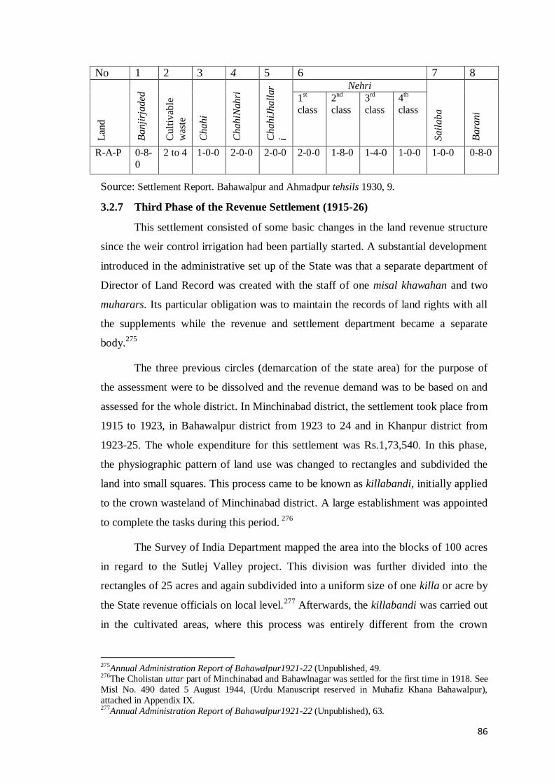
86
No 1 2 3 4 5 6 7 8
Lan
d
Ba
nji
rja
ded
Cu
ltiv
able
was
te
Ch
ah
i
Ch
ah
iNah
ri
Ch
ah
iJh
all
ar
i
Nehri
Sa
ila
ba
Ba
ran
i
1st
class
2nd
class
3rd
class
4th
class
R-A-P 0-8-
0
2 to 4 1-0-0 2-0-0 2-0-0 2-0-0 1-8-0 1-4-0 1-0-0 1-0-0 0-8-0
Source: Settlement Report. Bahawalpur and Ahmadpur tehsils 1930, 9.
3.2.7 Third Phase of the Revenue Settlement (1915-26)
This settlement consisted of some basic changes in the land revenue structure
since the weir control irrigation had been partially started. A substantial development
introduced in the administrative set up of the State was that a separate department of
Director of Land Record was created with the staff of one misal khawahan and two
muharars. Its particular obligation was to maintain the records of land rights with all
the supplements while the revenue and settlement department became a separate
body.275
The three previous circles (demarcation of the state area) for the purpose of
the assessment were to be dissolved and the revenue demand was to be based on and
assessed for the whole district. In Minchinabad district, the settlement took place from
1915 to 1923, in Bahawalpur district from 1923 to 24 and in Khanpur district from
1923-25. The whole expenditure for this settlement was Rs.1,73,540. In this phase,
the physiographic pattern of land use was changed to rectangles and subdivided the
land into small squares. This process came to be known as killabandi, initially applied
to the crown wasteland of Minchinabad district. A large establishment was appointed
to complete the tasks during this period. 276
The Survey of India Department mapped the area into the blocks of 100 acres
in regard to the Sutlej Valley project. This division was further divided into the
rectangles of 25 acres and again subdivided into a uniform size of one killa or acre by
the State revenue officials on local level.277
Afterwards, the killabandi was carried out
in the cultivated areas, where this process was entirely different from the crown
275Annual Administration Report of Bahawalpur1921-22 (Unpublished, 49. 276The Cholistan uttar part of Minchinabad and Bahawlnagar was settled for the first time in 1918. See
Misl No. 490 dated 5 August 1944, (Urdu Manuscript reserved in Muhafiz Khana Bahawalpur),
attached in Appendix IX. 277Annual Administration Report of Bahawalpur1921-22 (Unpublished), 63.

87
wastelands. In the Bahawalpur district, the process of killabandi was started but was
completed in the next phase.
During the killabandi, many new villages were created and 10563 mutations
took place in the whole areas under killabandi process. This process in Cholistan was
too difficult because over one-lac shares of single holdings had to be recorded in acre,
kanals and marlas. The zigzag boundaries of 475 villages of Cholistan were brought
into a proper shape.278
In old proprietary areas, the killabandi involved a complete
repartition of estates and became more complicated than that of the newly settled
areas of Cholistan.
Table: 3. 3. Division of Land in under New Scheme and Nomenclature in three
Districts of the State
District Total Tehsils Total Area in
acres
Total Rectangles
Minchinabad Minchinabad,
Bahawalpnagar, Khairpur
500000 23725
Khanpur Allahbad, Khanpur,
Noushehra, Ahmadpur
lamma
1200000 49602
Bahawalpur Ahmadpur East,
Bahawalpur
900000 36000
Source: i. Settlement Report of Khanpur District 1922, 5. ii. Assessment Report of Cholistan
1929, 12.
The details of the area under killabandi and rectangle demarcations is
presented in table 3.3, which shows that Khanpur district had more land to be
processed in killabandi. In fact, all three tehsils of Khanpur district contained a
significant jungle area, where killabandi was impossible. Therefore, rectangles were
prepared in cultivated areas while in the area covered by the jungle; blocks were
made on the scale cutting system. In this system, fields were formed by means of a
scale on the map of squares called massavis. That was the reason that numbers of the
rectangles were less when compared to its gross area.279
The mutation in and shuffling of the boundaries of old populated areas was a
difficult task. The landowners were hardly willing to accept any change in their
278Assessment Report of Cholistan 1929, 12 279Settlement Report of Khanpur 1922, 1.

88
hereditary holdings and protested against this pattern. However, they gradually
realized the benefits of this system, in the form of shaped fields, less waste of water,
saving of time and above all, their enhanced ability to manage their own partition
without interference of the revenue officials.280
Moreover, killabandi provided the
foundation for a cartographic network for a civilized society. The delineation of field
boundaries created organized units for the assessments. These rectangles contained
all necessary components of homogeneity, symmetry, and neatness.
The other significant development of this phase was the conversion of the
fixed assessment into the fluctuating assessment, comprising a field-to-field
appraisement of crops at each harvest. Actually, fixed method was prevailing in the
Punjab districts, where agrarian and hydraulic conditions were favourable. However,
in the canal colonies of Punjab, fluctuating principal was adopted during the initial
years of colonization, which was suitable to the tracts with unsettled economic and
demographic conditions.
In 1863-1871, Mr. Edward Principe applied fluctuating water advantage
scheme to the district traversed by the Bari Doab canal. This system was extended
during the third period of the regular settlement of Punjab in 1871-78. Mr. Lyell
(1871-78), (FCP) imposed fluctuating scheme initially in the rainless tracts of
Southern Punjab mainly Lower Chenab and Lower Jhelum. Afterwards fluctuating
method was adopted in the other districts, where the land was liable to extreme
variations and the harvests were precarious.281
As the agricultural conditions became stable and land started to give good
yields, this method proved to be highly inconvenient for the Punjab government
because it required a great deal of extra work and loss of substantial money. Besides,
this method opened many avenues for dishonesty among the officials. While fixed
method of assessment had small margin for illegal practices but could not be imposed
in the Punjab colony areas due to the opposition of the grantees.282
Contrary to the Punjab conditions, the soil conditions in Bahawalpur had
extreme variation throughout the State. It would change at some places due to kalar
and silt brought down by the canals. Moreover, human factor also had not always
280Bandobast-e-Riyasat, Minchinabad District 1921 (Urdu Manuscript in Bahawalpur Muhafiz Khana). 281 Doui, Punjab SettlementManual, 257. 282 Imran Ali, Punjab under Imperialism, 169-170

89
been uniform due to continuous arrival of new settlers in the State. Therefore, fixed
method was useless in the State while fluctuating method was the best choice for the
assessment. However, illegal gratifications of this system also existed in the State and
the cultivators would use it to lower the revenue burden by bribing a little sum of
money. The rural elite would generally use the flexibility of the fluctuating
assessment to their interest of and their secret dealings with lower bureaucracy would
continue. Nevertheless, orchards and date trees were always assessed by fixed
method.
The fluctuating rates were equal to the fixed rates. The revenue was levied on
the means of irrigation and was further divided into two seasonal classes of crops.
First class included the food grains of kharif and rabi, fruits, vegetable, cotton and
sugarcane. All others were in the second category of crops including indigo.283
Table
3.4 displays the revenue rates per acre of matured crop. The rates for items 1, 4 and 10
in the first column of the table for Allahbad tehsil were 3.5% less than the same items
for Bahawalpur and Ahmadpur tehsils, the reason being the poor economic condition
of the peasants owing to periodical floods.284
In Cholistan, the State demand was three
rupees per acre for a term of three years when the Sutlej valley irrigation scheme
became operational in 1926-27.
Table: 3.4. Revenue Rates in Third Settlement
Type of land
Bahawalpur District
Minchinabad District
Rahimyar Khan District
1st
class 2
nd
class 1
st
class 2
nd 1
st class 2
nd
class
1 Chahi 1-14-0 1-14-0 1-12-0
1-12-0 2-2-0 1-10-0
2 Chahi-nehri 2-6-0 2-0-0 2-8-0 2-2-0 2-8-0 1-12-0
3 Nehri 1-14-0 1-6-0 2-0-0 1-8-0 2-14-0 1-12-0
4 Chahi-jhallari-nehri
2-0-0 2-0-0 ------ ----- 2-8-0 1-12-0
5 Sailaba 2-4-0 1-8-0 ------ ------ 2-14-0 1-14-0
6 Chahi-sailaba 2-8-0 2-0-0 ------
-
------ 2-14-0 1-14-0
7 Jhalari ------ ------ 1-12-0
1-4-0 ------ ------
8 Chahi-jhallari ------ ------ 2-4-0 2-2-0 ------ ------
283 Re- Assessment of Proprietary Cholistan, 1936, 12. 284Assessment Report of Allahbad Tehsil 1926, 41.

90
9 Dertai-jhallari-
nehri
1-4-0 1-4-0 ------
-
------ ------ ------
10 Jhallari-daryai 1-8-0 1-0-0 -------
------ 2-8-0 1-12-0
11 Jhallari-nehri 1-8-0 1-0-0 ------ ------ 2-8-0 1-12-0
12 Chahi-jhallari-
daryai
2-8-0 2-0-0 ------ ------ 2-0-0 1-12-0
13 Bariani 1-0-0 1-0-0 2-2-0 ------ 1-0-0 1-0-0
14 Sailaba 1-14-0 1-6-0 ------ ------ 2-14-0 1-14-0
Source: i. Assessment Report of Cholistan portion of Bahawalnagar and Minchinabad
Tehsils, and Revision of Records and Water Rates, 11.
ii. Settlement of Bahawalpur and Ahmadpur East tehsils 1930, 11.
This phase had a progressive outlook and positive effects on the system
though some loopholes also existed. As geographical consideration was ignored in
imposing the rates. Distances level from the market for remote and easy access areas
were treated alike. Likewise, well-established areas were treated equally to the lands
in precarious conditions. So, these inequalities were to be removed and the
multiplicities of the rates needed to be shortened in the next phase.285
3.2.8 Fourth Phase of the Revenue Settlement (1929-31)
This phase of the settlement was designed for Bahawalpur and Bahawalnagar
districts. Since the Sutlej Valley canals had become operational and the large
wastelands of both the districts were ready for colonization. Therefore, the revision in
the land revenue was planned to increase the State revenue and to levy the new water
charges in colony areas. In the Bahawalpur district, tehsil remained the basic unit of
the assessment while in the Bahawalnagar district, tehsil unit had been further divided
into three circles; kacha, pacca and Cholistan. The assessed area for Bahawalnagar
district was 1224410 acres.286
In Bahawalpur and Ahmadpur East, total assessed area
for both the tehsils was 617538 acres.287
The State demand was based on four factors:
rents, output quantity, prices of land and market value of agricultural produces.
The significant improvement was that separate revenue rates for perennial and
non-perennial irrigated lands were introduced in place of old inundation rates. Table
3.5 displays that the former minute division for the sources of irrigation was
285 Review of Mr. Oliver on the Settlement Forecast Report of Bahawalpur District by Department of
Revenue and Public Works department of Bahawalpur State (1946), 3. 286Assessment Report of Cholistan1929, 3. 287Assessment Report of Bahawalpur and Ahmadpur East Tehsils, 1930, 1.

91
discarded. In Bahawalnagar district, the land was classified into four classes and in
Bahawalpur district into six classes. Moreover, the assessment of separate crops was
also abolished. There were flat rates for all kinds of crops regardless of their kind. The
kharif rates were somewhat higher than the rabi rates because the latter one mostly
used for self-consumption while the kharif crops were of commercial value.
Moreover, the State share increased to 40% of net assets rather than the 25%
previously and khushhaistati was absorbed in the revenue demand. These revenue
rates were 8% higher than the previous demand while the water rates were 63.5%
higher.288
However, in practice, these rates did not come into operation due to the
significant fall in agricultural prices. This slump in prices persisted throughout in
India forcing the Punjab Government to postpone the assessment in the Montgomery
district. But, the Bahawalpur State could not take such step and had to bear the loss in
form of large-scale remission since the very first year of this settlement.289
In addition to the price fall, there were some other setbacks, particularly the
geographical considerations were ignored in imposing the new rates. Further, distance
levels from the market for remote and easy accessed areas were treated alike and the
uniform rate for all kinds of crops was also unfair because the consumption and
surplus of grains had never been equal at each harvest.290
The assessment of the fourth
period had to be revised in 1937 and its term was fixed for three years. Table 3.6
depicts the revised rates for Bahawalnagar district, in which the revenue demand was
levied separately on area irrigated by each canal. The previous division based on the
two classes of crops and the varied rates for both kharif and rabi harvests were
restored.
The premier standard of the State revenue demand of 25% was also fixed. In
practice, this assessment like the previous one could not contribute much to the
development process of the State. However, the factors for the failure of both
settlements were different. The last one had failed because it was undertaken at a time
of the high prices consequent to the effects of World War I.291
Moreover, for non-
perennial canal, the land was assessed alike for both the harvests, which was
unjustifiable.
288Assessment Report of Cholistan1929, 12-16. 289Assessment Report of Bahawalpur and Ahmadpur East Tehsil 1930, 1. 290Review by Mr. Oliver 1944, 1. 291Assessment Report of Minchinabad Tehsils1947, 20-A.

92
Table: 3. 5. Revenue Rates in the Fourth Settlement
Minchinabad and Bahawalnagar Tehsils Bahawalpur and Ahmadpur East
Tehsils
Circles Rs-A-P Rs-A-P
Chahi 2-0-0 2-0-0
Perennial 4-0-0 4-4-0
Non-perennial Kharif
Non-perennial Rabi
3-0-0
2-8-0
2-8-0
2-0-0
Barani 1st
= 2nd
= 3rd
1-8-0
1-4-0
1-0-0
1-0-0
-----
-----
ChahiSailaba
Chahi-Jhallari-Daryai
------
------
1-13-9
2-3-11
Sources: i. Report on the Revision of Assessment for Cholistan area in Bahawalnagar
tehsil 1930, 4-12. ii. Assessment Report of Bahawalpur and Ahmadpur EastTehsils
1930, 20-24.
Table: 3.6. Revised Revenue Rates for Minchinabad and Bahawalnagar in 1937
Classification
of Land
Eastern Grey
canal
Sadqia Canal Fordwah
Canal
1st
class
2nd
class
1st class 2
nd
class
1st
class
2nd
class
Chahi 2-0-0 ------ ---------- -------- -------- --------
Perennial 2-0-0 1-8-0 3-4-0 2-12-0 -------- ---------
Non-perennial ------ ------- ------- ------- 2-8-0 2-0-0
Barani 1st
= 2nd
1-4-0
1-0-0
-------- ------- -------
-------- --------
Source: Assessment Report of Minchinabad Tehsil 1947, 18.

93
3.2.9 Fifth Phase of the Revenue Settlement (1944-51)
The term of the previous settlement expired in 1938 and new operations were
postponed due to the two main reasons: commencement of World War-II and shortage
of the trained officers in the State.292
Meanwhile, the reorganization of the State took
place with the division of the Bahawalpur State into two districts; Bahawalpur and
Rahimyar Khan, each under a Deputy Commissioner who held the powers of a
revenue collector as well. The Rahimyar Khan District contained the tehsils of
Allahbad, Khanpur, Rahimyar Khan, Sadiqabad, and Ahmadpur East. The
Bahawalpur district consisted of Chishtian, Khairpur Tamenwali, Minchinabad,
Bahawalngar, Fort Abbass and Bahawalpur. Moreover, the Revenue and Colony
Departments were amalgamated and the posts of Revenue and Chief Engineer were
merged.293
In 1942, an experienced ex-settlement Officer Sheikh Nur Muhammad was
appointed as Deputy Commissioner and Settlement Officer at Rahimyar Khan District
who immediately started the settlement work in five tehsils of that district. Revenue
assessment was applied in Sadiqabad from 1944 while in the remaining four tehsils
from 1946 for the term of 30 years.294
In Minchinabad, Bahawalnagar and Chishtian
tehsils, the settlement began in 1946 and completed in 1948. While Bahawalpur and
Fort Abbass tehsils were assessed in 1949-50. The system of assessment followed the
Punjab Act of 1926, in which standard of assessment was enhanced from 50% to 25%
on the net assets.295
The important feature of this settlement was the imposition of a uniform
system of assessment for all the tehsils. Three circles of assessment were made for
each tehsil: sailaba, perennial and non-perennial circles except for Bahawalpur where
five circles were made; sailaba, non-perennial pacca, non-perennial Cholistan,
perennial and barani. The rectangle was the unit of assessment. A more liberal
treatment was seen in assessing the revenue demand during this period as the demand
was levied keeping in view the quality of soil, quantity of water, distance from market
and financial position of owners.296
Separate rates for both the harvests were laid
292
Annual Administration Report of the Bahawalpur State 1942-43, 18. 293 File C-79, 1939, Bahawalpur Darbar Secretariat, Part I, Official Correspondence between Secretary of Punjab States and Prime Minister of Bahawalpur State on 20-6-1940. 294 Dastur-ul-Amal Barai Amla-e- Mal, Rahimyar Khan District1948, 3. 295Assessment Report of Minchinabad Tehsil 1947, 63. 296Assessment Report of Khanpur Tehsil 1945, 84.

94
down. However, in Ahmadpur East rates were further divided on crops due to the
extensive mutation in soil. The fertile tracts combined with the patches of inferior
land covered 70% of the cultivated area of that tehsil.297
This settlement introduced the sliding scale method, which approximated a
balance between fixed and fluctuating assessment and was more rational. This
formula was borrowed from Punjab, where this scheme was introduced in 1930 but its
imposition was postponed due to the slump years until the prices were back to the
normal.298
In the State, this scale was adapted to the local circumstances and
introduced at a time when rural economy of the State was emerging out of the
devastation of depression years. Under this scale, the revenue rates were
automatically adjusted with the downfall of the prices. In case of fall in prices, the
scale gave automatic relief by following a comparison of index figures.
The standard for the index figures was extracted from yields, commutation
prices, and specific crops for the selected year. Its upper ceiling was fixed at 50% of
the basic revenue rates to be attained by three stages within six years.299
In Sadiqabad,
Rahimyar Khan, Khanpur, and Allahabad tehsils, the soil and water conditions were
similar therefore, sliding scale was applied on the same lines. Whereas, In Ahmadpur
East, due to the significant variation in soil, this scale was applied merely to perennial
circle of Bahawal canal and upper ceiling was fixed at 25%.300
This modern system
worked successfully and saved the peasantry from the significant loss consequent to
the fall in prices. Table 3.7-A shows that the kharif rates in all circles were higher
than the rabi rates. There was 32% increase in the revenue than that from the previous
settlement. In Khanpur and Allahbad tehsils, the rates were low due to lower yields
while higher rates in Rahimyar Khan and Sadiqabad tehsils were due to the higher
rates of the batai.301
297Draft Orders on the Assessment Report of the Ahmadpur East Tehsil 1946. 298Assessment Report of Rahimyar Khan District 1944, Part I, 2. 299Annual Administration Report of the Bahawalpur State 1945-46, 24. 300Assessment Report of Rahimyar Khan District1944, Part I, 3-8. 301Assessment Report of Rahimyar Khan District1945, Part II, 74.

95
Table: 3.7-A.Revenue Rates as per Sliding Scale of Assessement Tehsils Sailaba circle Non-perennial Circle Perennial Circle
Kharif Rabi Kharif Rabi Kharif Rabi
Sadiqabad 3-2-6 2-2-4 3-11-10 ½ 2-2-11 4-1-10 2-14-7
Rahimyar khan 2-13-2¼ 2-5-9 ½ 3-5-3 2-1-5 ¼ 4-4-1 1/6 2-15-11 ¾
Khanpur 2-15-1 2-3-11 ¾ 3-2-3 1-15-9 4-1-11 ½ 2-13-15
Allahabad 2-0-0 2-1-7 2-7-8 2-5-5 2-15-7 2-7-5
Source. Assessment Report of Rahimyar Khan District 1945, Part II, 77.
Table: 3.7-B. Revenue Rates as per Sliding Scale of Assessment in Ahmadpur
Tehsil
Type Kharif Rabi
Sailaba 1-12-9 1-13-4
Non-
per
innia
l
Ahmadpur branch 2-2-3 2-8-7
Abbassia branch 2-4-3 2-2-5
Punjnad branch 2-2-5 2-3-3
Source: Assessment Report of Ahmadpur East 1946, 6.
The settlement for the Bahawalpur district was sanctioned in 1946 and the
assessment for Minchinabad, Bahawalnagar and Chishtian tehsils was to be done from
the rabi season of 1948 while Bahawalpur and Ahmadpur East were planned to be
assessed and settled after additional two years.302
The scheme of assessment adopted
at the same pattern that had been applied at the Rahimyar Khan District. In assessing
the nehri rates, quality of soil, quantity of water, distance from market and
circumstances of the owner were considered. Moreover, the excavation of wells had
more incentives and was exempted from revenue consideration for 20 years.303
Table: 3.7-C. Revenue Rates for Minchinabad, Bahawalnagar and Chishtian Tehsils
Circles
Minchinabad Bahawalnagar and
Chishtian
Kharif Rabi 2-7-5 Rabi
Sailab 2-6-6 2-2-3 2-6-3 2-0-10
302Assessment Report of Minchinabad and Bahawalnagar Tehsils 1948, 13. 303Settlement Forecast Report of Bahawalpur District 1946, 25.

96
Non-Perinnal
Pacca
2-12-0 2-3-11 2-9-3 2-6-7
Non-Perennial
Cholistan
2-3-8 1-14-10 ------ ------
Perennial 3-9-4 3-8-0 2-6-10 3-9-0
Barani 1-10-9 1-5-6 ------
Source: Assessment Report of Minchinabad and Bahawalnagar Tehsils 1948, 6.
3.3 The Standard for the State Demand
The standard for the assessment of the State revenue demand was a fixed part
of any net asset liable for the revenue levy. The net assets referred to the average of
the surplus produce after subtracting the expenditures on cultivation.304
With the
advent of the Agency government, the old system changed. The Land revenue had
formerly been settled by custom. Now it had come to be assessed and fixed
considering all the contingencies involved. The land revenue had always been charged
to the actual owner, who held more than five bighas. The assessment of land was
based on the cultivated area rather than the entire occupied area.305
The State share
was 20% and 17% of the estimated value of the produce but as canal irrigation
extended the cultivation, the State share raised from 20% to 25% of the gross produce
on the nehri land.306
In Khanpur Nizamat, cultivation mainly dependent on flood water and the
peasants were poorer than that of their counterpart elsewhere in the State, therefore,
17% of the net assets were demanded. Even after the opening of Eastern Sadqia canal
in Cholistan, revenue remained the same and khushhaisyate was levied at 4 anna and
water rates at 2 anna.307
Moreover, thirty bighas were allotted to each well at a lump
sum rate of twelve rupees. In Cholistani hittar tract, cultivation was erratic and
possible only by rainwater therefore, demand was levied at 25% per acre. In the
surroundings of forts, the revenue rates were fixed at 20%, 17%, or even at 11% of
the produce depending on the nature of soil and other contingencies. If no rain fell,
land remained uncultivated. On the dominion lands (in the personal use of Nawab), a
304 Doui, Punjab Settlement Manual, 55. 305Annual Administration Report of the Bahawalpur State 1908-09, 48. 306Sadiq- ul-Akhbar, 1st April, 1872. 307 Radhika Lal, History of Bahawalpur State Canals (Bahawalpur: 1932), 12.
97
fixed share of 12% of the produce used to be taken and deposited in the treasury under
the head of amlak-sarkari.308
During the second period of this settlement phase, the revenue demand was
fixed at 25% on the net assets. This was somewhat excessive than previous
assessments because of the extension in irrigation resources. In Khanpur and Allabad
tehsils, this amount was hardly received and thousands of acres of land belonging to
the defaulters were confiscated for the nonpayment of the revenue. It was the single
instance of its kind in the entire history of the State.309
After the completion of Sutlej Valley Project, the colony areas contributed a
large chunk of revenue to the State accounts. The State demand in the colony tracts
consisted of two broad heads: the land revenue and the water charges. Both were of
fluctuating nature. The theoretical basis of the demand 33% of the average produce
remained intact but it rose to half of the produce after the inclusion of local rates and
cess.310
This increase in the State demand was necessary because now water was
adequately available and the State had to liquidate its heavy external loan, obtained to
meet the capital outlay for the Sutlej valley canals. Nevertheless, these rates were
practically difficult to collect due to the economic depression therefore, the customary
rates of 25% had to be restored from 1937 onwards.311
The extension of canal irrigation to the colony areas brought good returns but
the rates were not as exorbitant as in the Punjab colonies, where the principle of
setting the rate at half of the net produce remained in practice. For example in
Pakpattan tehsil of Montgomery district, the province demand imposed in 1892 was
81% more than the previous settlement.312
In the Rakh branch circle of the Chenab
colony, increase in the land revenue was perhaps the most critical at 258% more than
that was made in the previous years. It was more than any other district of the
province and several estates in Punjab turned miserable due to the pressure of such
exorbitant revenue demands. At times, the owners themselves had to work as
labourers on their and other‟s tracts.313
Moreover, the peasantry in Punjab had to pay
308
Gazetteer of the Bahawalpur State 1904, 318. 309Assessment Report of Allahbad Tehsil 1926, 31. 310Assessment Report of Cholistan 1930, 155. 311Assessment Report of Bahawalpur and Ahmadpur East 1930, 19. 312Settlement Report of Montgomery District 1892, 81. 313 Indu Agnihotri, Agrarian Changes, 192.

98
revenue by the specific time in acute set of circumstances and the nonpayment of the
land revenue could lead to loss of the land ownership.
Ultimately, GOP had to revise the scale of the enhancements. The Punjab
Land Revenue Amendment Act III of 1928 lowered the maximum standard of
assessment to the 20% and the term was fixed at forty years.314
Instead, the State rates
were moderate throughout in its fiscal history. Consequently, the land revenue was
increased over time. Table 3.8 shows the details of the revenue received for the
different years under the fixed assessment regime. The fixed method was adopted
from the non-colony districts of Punjab. It proved to be an easy way of settling
demand and saved labour of extra work required by the fluctuating method. In the
early years of this phase, there was a marked increase in the land revenue collection
despite a fall in the cultivated area.
Table: 3.8. The Land Revenue under Fixed Assessment (1873-1877)
Kardari 1873-74 1875-76 1876-77
Minchinabad 93116 87714 118831
Sadiqpur 72815 73281 ----
Khairpur 65845 65298 101928
Bahawalpur 189021 183829 166013
Ahmadpur 48556 ----- ----
Uch 72509 116957 128665
Allahbad 108936 129026 113516
Shidani 82592 84906 ------
Khanpur 78003 92053 183713
Kotsamaba 103612 118024 --------
Noushehra 101970 107730 120968
Ahmadpur Lamma 81113 87794 72058
Total 1100119 1146612 1005692
Source: Annual Administration Reports of the Bahawalpur State for the
concerned years.
314 Doui, Punjab Settlement Manual, 46.

99
Figure 3.1: The Land Revenue under Fixed Assessment (1973-77)
Table 3.9 shows that Minchinabad, Khanpur and Noushehra tehsils
contributed proportionately more to the State income. The obvious reason perhaps
was that all the three tehsils were bifurcated into further administrative subunits,
which brought efficiency to the collection process. However, in 1910-11, there was an
overall increase due to the enforcement of the Act of 1887 in the State and the strict
measures were taken by the Agency for the recoveries. The receipts fell short again in
1921-22 owing to the war effects.
Table: 3.9. Land Revenue under Fixed Assessment (1901-1922)
Tehsils 1901-02 1910-11 1921-22
Minchinabad 223651 239721 137544
Bahawalnagar ----- ------ 90411
Khairpur 194357 214982 36508
Bahawalpur 126001 181509 200325
Ahmadpur 198379 218795 230080
Allahbad ----- 192617 20073
Khanpur 294209 175551 179307
Naushehra 311862 204047 230092
Ahmadpur lamma ----- 143271 89190
Total 1348460 1570492 1256360
1873-74
1875-76

100
Source: The data extracted from the Table 39of Bahawalpur State Gazetteer Part B
1904, 1913 and 1935.
Figure 3.2: Land Revenue under Fixed Assessment (1901-1922)
On the commencement of the weir control irrigation, as table 3.10 posits, the
mode of assessment changed from fixed to fluctuating and jama was substantially
increased to 33% of the produce. There was a gradual rise in all the tehsils of the State
with the Bahawalnagar district topping the league. Most amazing increase was seen in
Fort Abbass, which was a newly established tehsil on the desert land. It quite visible
that the colony areas generated more revenue than the old areas. However, there was
an overall increasing trend in the land revenue receipts among all the units of the
State.
Table: 3.10. Land Revenue under Fluctuating Assessment. (1935-1941)
0
200000
400000
600000
800000
1000000
1200000
1400000
1600000
1800000
1901-02
1910-11
1921-22
Tehsils 1935-36 1939-40 1940-41
Minchinabad 372079 370258 419633
Bahawalnagar 521044 536836 594323
Fortabbas 400425 357001 452816
Chishtian 212674 520991 567470
Bahawalpur 196275 291407 283666
Ahmadpur 225459 273491 304068
Allahbad 201462 246448 251340

101
Source: Data is taken from the unpublished Gazetteer Part B of Bahawalpur State for the
Years 1936, 1940 and 1941.
Figure 3.3: Land Revenue under Fluctuating Assessment (1935-1941)
Moreover, the orchards and the wells were exempted from the land revenue
for a term of certain years depending upon their location and other contingencies. This
measure was adopted in order to enable the cultivators to regain their capital
expenditure and to stabilize their economy.315
Almost all orchards existed in areas
affected by flood, especially in the Western part of the State.316
The assessment of the
orchards gardens was very generous. To encourage the peasants to grow more
orchards, chherr labour and the land revenue was waived for 20 years.317
Later on, the
term for revenue exemption was fixed for the first ten years and after that, the
orchards were assessed through quadrennial enumeration.318
Table 3.11 demonstrates
a comparison between the Phulkian States Agency319
and the Bahawalpur State. In the
period 1900-01, the land revenue of Phulkian States was 111.88% more as compare to
the area while Bahawalpur had 151.47% increase in the land revenue. This strong
position of the State was the result of the canals extension particularly Eastern Sadqia
315P.J. Fagan, Land Revenue, 26. 316Settlement Report of Bahawalpur and Ahmadpur tehsils 1930,11. 317Sadiq-ul-Akhbar, 10 April 1919. 318Assessment Report of Minchinabad Tehsil 1947, 71. 319
Phulkian States Agency comprised on the native states of Patiala, Jind and Nabha. The rulers of all
three originally belonged to one ancestor named „Phul‟. See Dr. Bhagat Singh, „Phulkian Ruling
Houses‟ in the Punjab Past and Present, Vol XIX-1: April 1985, 11.
0100000200000300000400000500000600000700000
1935-36
1939-40
1940-41
Khanpur 205680 301421 336211
Rahimyar 385061 478697 527514
Sadiqabad 371943 387867 426417
Total 3091202 3764417 4163458

102
Canal. However, in the next decade, the State obtained about 5% less revenue than the
Patiala State. The Nabha State revenue in both comparing years was more than the
Bahawalpur state but the reverse was true in the Jind State.
Table: 3.11. Land Revenue and Cultivated Area of the Phulkian States and the
Bahawalpur State
Patiala Acres Revenue in Rs. % of Land
Revenue
1900-01 2964711 3317181 111.88
1910-11 2918221 4471614 153.23
Jind
1900-01 739514 594332 80.36
1910-11 688129 594983 86.46
Nabha
1900-01 505863 931636 184.16
1910-11 507909 862611 169.83
Bahawlpur
1900-01 883536 1338344 151.47
1910-11 1000243 1489709 148.93
Source: The Punjab State Gazetteers Vol. XVII-B, Statistical Table 1913, Patiala ii; Jind ii;
Nabha ii, and Bahawalpur State Gazetteer 1913, cciv.
Figure 3.4: Land Revenue and Cultivated Area of the Phulkian States and the Bahawalpur
State
0
20
40
60
80
100
120
140
160
180
200
Patiala Jind Nabha Bahawalpur
1900-01
1910-11
Column1
103
3.3.1 The Other taxes
Besides the land revenue, some other charges were levied on the landowners
by the State, mainly after the completion of Sutlej valley project. The major
imposition was that of water rates, also called the occupier‟s rate or the abiana levied
after the first two harvests. Actually, it was the price of canal water for cultivators.
However, there was no volumetric assessment and the cultivators were free to employ
as much water as they required. It was received along with the land revenue in the
State while in Punjab province the land revenue and the water rates were collected
separately.320
The water rates in the State were determined by the quality of soil with
a view to harmonize the revenue demand as per the productive capacity of the land.
The khushhaisyate was due in return for using water supply from Sutlej valley
canals at 2 rupees and 8 anna in perennial and 8 anna on non-perennial areas. The
zamindars of the concerned areas frequently insisted that this levy should be
abolished although its rates were justified, yet it was extended till 1940.321
Another
tax was malikana paid by the grantees until the acquisition of the property rights. It
was a sort of acknowledgement of the ownership rights by the State over crown land.
In the Bahawalpur colony, malikana was levied at the rate of 1 rupee and 8 anna per
acre with mature crop.322
In Punjab, its rate was somewhat higher. In lower Jhelum
colony, it was fixed at four anna per acre while in the lower Chenab colony at six
anna for the first ten years and nine anna thereafter till the acquisition of the
proprietary rights.323
Another charge was „Acreage Rate‟ received by the State in lieu of
infrastructural expenditures mainly constructing the watercourses and the culverts.
The acreage rate was fixed at 8 anna per acre and total amount incurred till 1944 was
34, 45,522. However, in the inferior land of Ahmadpur East, acreage rate for wheat
and cotton was 2 rupees and 4 anna per acre and for fodder crops and others was 1-
12-0 per acre.324
In the colony areas, lump sum payment of the acreage rate was a
320 Indu Agnihotri, Agrarian Changes, 214. 321
Levy of Water Advantage Rates1937, Official Correspondence from PWD and Revenue Minister to
Prime Minister of Bahawalpur State. 322Report of Inquiry Committee, 118. 323 Indu Agnihotri, Agrarian Changes, 198. 324 Official Correspondence from Prime Minister Bahawalpur State to FC Revenue Punjab on 23 May
1944.

104
compulsory condition for getting the ownership rights.325
During economic
depression, recovery of the acreage rate was suspended throughout the State.
However, the Punjab government abolished the acreage rate in proprietary area,
because the construction of the watercourses was the cultivator‟s responsibility.326
A further charge was the local rates credited to the district board for local
development. It was 12 rupees and 8 anna. Further, there were different cess: one was
for zaildari at the rate of one rupee and another lumberdari at five rupees.327
These
cesses and the local rates were purely local charges and were imposed all over Punjab.
However, the position of cess varied in each province, district, or in native state.328
The roots for local cess laid in the context of Famine Policy of the GOI. Thorburn
traced the local rates to a directive of the GOI to the GOP, which asked for a
contribution of £ 120000 per year to the Famine Insurance Fund and this amount was
to be received from agricultural resources.329
Apart from these, no other tax was
levied and other illegal exactions were abolished in the Bahawalpur State.
3.3.2 Remissions on Kharaba and Role of Revenue Bureaucracy
The assessment was reframed each harvest on matured crops after subtracting
for the kharaba. The kharaba term is used for all sort of crop failure or soiling of or
damage to the produce due to the peculiar physical environment or weather related
factors afflicting a big part of the region defining the state boundary. It was a fairly
common and regular phenomenon in the region that would partly or wholly destroy
the harvest and some sort of remissions would become necessary to relieve the
peasants as a result of its vagaries. The Mughal and the British both offered
remissions to the destitute cultivators. An elaborate system of suspension of the land
revenue was also an old tradition in the Bahawalpur State.
Kharaba was allowed after the joint inspection of the canal and revenue
department. However, tehsildar was responsible officer to grant the remission on the
written requisition of peasants. Sometimes, on the spot remissions were given by
concerned officer. Usually the State reduced the revenue because of internal factors
like; calamities of flood and low rainfall, scarcity of canal water and locust blight. In
325
Sadiq-ul-Akhbar, 8 November 1928. 326 File: 12-A, 1942, Part III, Levy of Acreage Rate Notice with Reference to Revenue Minister on 12 April 1944. 327Assessment Report of Ahmadpur Tehsil 1923, 29. 328Trevaskis, An Economic History of Punjab, 151, 176. 329 S.S.Thorburn, The Punjab in Peace and War, 236.

105
1873-74, due to intense flooding large-scale remissions were granted and continued in
the subsequent years.330
The external factors also involved in granting remissions.
There were two examples of remission for external reasons. In 1871, the rates were
reduced by four annas for each crop because of an overall price fall in grains.331
Again, the price deflation of 1931 caused a great decline in prices throughout
India. The State made substantial reductions and granted a remission of 30% on the
State demand.332
The total remissions in the State during the seven years of economic
depression were 78 lac rupees.333
This reduction in the State revenue looks even more
significant when viewed in the backdrop of Sutlej valley project when the State was
already in debt.334
The other native States such as Faridkot, Maler Kotala and Nabha
were also facing the same conditions of economic depression but did not grant any
remission while Patiala, Kapurthala and Bikaner granted nominal remission of five
lac, one lac and three lac rupees respectively.335
The satisfactory results from revenue system depend upon the transparent
performance of the revenue administration and commitment to their job. However, the
discrepancies were to be commonly found in the process of revenue assessment and
remission.336
The demand sometimes lacking justification and unreliability of water
supply would reflect itself in the incidence of kharaba throughout the province. The
small-scale peasant would cultivate bad land and benefit the least from the remissions
announced while big landowners were the largest beneficiaries. This situation was
largely the result of the despotic role of the officials therefore, the Punjab government
abolished the kharaba custom except for the special circumstances.
The revenue system itself had some inbuilt flaws and faults that the State,
despite repeated efforts, could not eliminate. These flaws reduced the control of the
State over its bureaucratic apparatus. Further, the elite would also coerce and threaten
the collection staff. The lower bureaucracy had always been reluctant to work against
the the interests of the powerful people, rather it worked for the interests of the big
330Annual Administration Report of the Bahawalpur State 1973-74, 9. 331
Annual Administration Report of the Bahawalpur State1872-73, 1. 332Assessment Report of Bahawalpur and Ahmadpur East Tehsils 1930, 1. 333Sadiq-ul- Akhbar, 1st April, 1939. 334Sadiq-ul- Akhbar , 20 August , 1939. 335Sadiq-ul- Akhbar , 20 August , 1931 336Annual Administration Report of the Bahawalpur State 1873-74, 2.

106
owners. The combination of the subordinate officials and the landlords not only
compromised the government efficiency but also reduced the public income.
The Agency government adopted strict measures to collect the arrears but
during the native rule, the rural elite used their position to their full advantage.
Actually, the absence of any law for recovery of arrears made the process of revenue
collection more difficult. The imposition of the Land Revenue Act of 1887 in the
State reduced the curse of arrears though very slowly. In case of non-recovery, the
Agency introduced the bold step of making the revenue administration accountable
for non-recovery of the revenue and the water rates.337
Overall, the administrative
reforms in the system detailed in the preceding paragraphs improved the State revenue
collection that had profound impact on the society as well. Moreover, the individual
peasant was made responsible for direct payment to the State contrary to the Punjab
where joint mode of payment was prevalent.
3.4 Revenue Free Land Grants
The grant of land to warriors and loyal courtiers was a significant aspect of
Muslim rule in India. During the Mughal regime, large tracts of land were awarded to
the local elites on service tenure and were entirely accountable to the central
government. Therefore, they never grew into big landlords and remained merely
chiefs with jagirs having partial or total remission. The Sikhs followed same pattern
in Punjab to maintain their political influence.338
The British brought a change in this practice and flourished a new tradition in
the administrative set up of India. They awarded rent-free land grants with ownership
rights for some additional purposes; to support the religious institution, to individuals
for some particular service or for livelihood of noble families. Regarding the revenue
liability of such land grants towards the Government, Baden Powell specified the
Punjab province as „the land par excellence of muafidars and of jagirdars’.339
In the formative decades of the Bahawalpur State, there were some estates
belonging to the other tribal groups, which were contemporary to the Abbasid in this
area. Among them, Lakhweras and Bhattis were the warlords, while Gillanis and
Bukharis were the holders of the religious endowments. The Nawab rulers of the
337Annual Administration Report of the Bahawalpur State 1920-21, 34. 338 I.H. Malik, Sikandar Hayat Khan: A Political Biography (Islamabad: NIHCR, 1985), 14. 339 Baden Powell, The Land Systems of British India, Vol. II, 698.

107
Bahawalpur State maintained the legacy of former regimes and followed the ongoing
pattern of awarding further grants to individuals in perpetuation of jagir or muafi.340
These grants were initially limited to the Daudputras and the Balochs for
maintaining the troops to provide personnel for military campaigns. The grantees
were eight thousand men and each was allotted 50 bighas but responsible to pay
revenue for 25 bigha. This salary tenure was not inheritable and dependent on the will
of the Nawab. Latter, a considerable portion of the revenue was assigned to different
purposes on certain terms and conditions. The unconditional grant of one-lac acres
was conferred to religious and learned persons.341
Their jagirs were semi-feudal by
nature, alienable with hereditary rights but ancestral division shrank their size.
These grants held partial or total remission or muafi, which were mostly
extended first for ten years and afterwards for lifetime. In this context, the sanad was
the most important document, which held all particulars of grant. The grants unlike
jagirs were inalienable and always based on the pleasure of ruler (tabe-ie-marzi
sarkar). The loyalty with the State and good character was the primary condition.
However, the repossession by the State was very rare and the property had come
down for decades through the process of ratification of asnad in favour of the
descendants of the grantee.
Upon assuming the political control of the State, the Council of Regency had
to deal with a large group of people who held various forms of revenue free land
assignments.342
Under the new political set up, the Agency government maintained
the status of the grantees because each grantee held some special significance.
Furthermore, it was the British policy in India that landed aristocracy should be
maintained.343
The State laid down a set of rules to recognize the rent-free tenures. All
grants having asnad344
were scrutinized and restored. However, the grants of the
340 Same in NWFP, tribesman encouraged the sanad and other reputed holy man to settle down and
frequently gave them rent free grants called seri, for their own support or kept up a mosque or shrine. 341 Shahamet Ali, A History of Bahawalpur State, 208. 342
All grants were to be measured under Agency. See Appendix X. 343 Ian John Stone Kerr, The Punjab Province and the Lahore District, 1849-1872, 278.
344 For the Ratification of Sanad by Agency, sanad has been attached in Appendix XI.
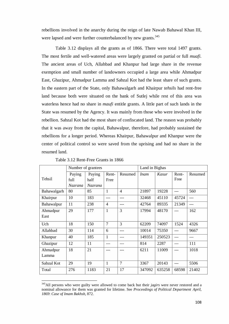
108
rebellions involved in the anarchy during the reign of late Nawab Bahawal Khan III,
were lapsed and were further counterbalanced by new grants.345
Table 3.12 displays all the grants as of 1866. There were total 1497 grants.
The most fertile and well-watered areas were largely granted on partial or full muafi.
The ancient areas of Uch, Allahbad and Khanpur had large share in the revenue
exemption and small number of landowners occupied a large area while Ahmadpur
East, Ghazipur, Ahmadpur Lamma and Sabzal Kot had the least share of such grants.
In the eastern part of the State, only Bahawalgarh and Khairpur tehsils had rent-free
land because both were situated on the bank of Sutlej while rest of this area was
waterless hence had no share in maufi entitle grants. A little part of such lands in the
State was resumed by the Agency. It was mainly from those who were involved in the
rebellion. Sabzal Kot had the most share of confiscated land. The reason was probably
that it was away from the capital, Bahawalpur, therefore, had probably sustained the
rebellions for a longer period. Whereas Khairpur, Bahawalpur and Khanpur were the
center of political control so were saved from the uprising and had no share in the
resumed land.
Table 3.12 Rent-Free Grants in 1866
Tehsil
Number of grantees Land in Bighas
Paying
full
Nazrana
Paying
half
Nazrana
Rent-
Free
Resumed Inam Kasur Rent-
Free
Resumed
Bahawalgarh 80 85 1 4 21897 19228 --- 560
Khairpur 10 183 --- --- 32468 45110 45724 ---
Bahawalpur 11 238 4 --- 42764 89335 21349 ---
Ahmadpur
East
29 177 1 3 17994 48170 --- 162
Uch 18 150 7 3 62209 74097 1524 4326
Allahbad 30 114 6 --- 10014 75350 --- 9667
Khanpur 40 185 1 --- 149351 250523 --- ---
Ghazipur 12 11 --- --- 814 2287 --- 111
Ahmadpur
Lamma
18 21 --- --- 6211 11009 --- 1018
Sabzal Kot 29 19 1 7 3367 20143 --- 5506
Total 276 1183 21 17 347092 635258 68598 21402
345All persons who were guilty were allowed to come back but their jagirs were never restored and a
nominal allowance for them was granted for lifetime. See Proceedings of Political Department April,
1869: Case of Imam Bakhsh, 872.

109
Source: C. Minchin, Selection from the Records of the Government of the Punjab and its
Dependencies: Administration of the Bahawalpur, Chumba and Patowdie States (Lahore:
1869)22-23.
Moreover, the Agency regime brought changes to the character of jagirdars.
Their jagirs, which had not been assessed for revenue purpose previously but now
were liable for assessment so that the spirit of subjugation might be maintained in this
elite group. Their holdings were charged with the water rates but not included in the
calculation of the cultivated area of the State.346
The term landed aristocracy or feudal
lords was used for the owners of 500 acres or more.347
There were five sorts of
Revenue Free Assignments in the State.
A. Jagirs
The term „jagir’ was usually appropriated to the larger grants for the members
of the royal family. The jagirs were totally revenue free and alienable. The main
jagirs were related with the Queen Mother and her father, some of the Princes and
their wives, and Dhais (mid wives) attached to the palace. Some jagirs were given for
subsistence purpose to other close relatives of the Nawab.348
According to the royal
tradition, the oldest son was the successor and entitled to get all jagirs and amlak.
All other heirs were ennobled to attain guzara allowance and some jagir. The
female heirs were given only jewelry and monthly allowance.349
The personal jagirs
of the Nawab ruler were maintained through a separate Jagirat Department. The
jagirs were extended to a cluster of villages. The large jagirs were; Taif (14663),
Chhaneli (7600 acres), Sadiqnagar (4800 acres) Shamsabad (2820 acres),
Sadiqabad(2630 acres), Rashidabad (2000 acres), Changla (1840 acres), Abbaspur
(1220 acres) and many others. Some of these jagirs were also offered for sale on the
commencement of colonization in the Bahawalpur State.350
Total area in jagir was
26000 till 1947.351
B. Inam
346Annual Administration Report of the Bahawalpur State 1873-74, 153. 347 Hamza Alvi, The Rural Elites and Agricultural Development, 194. 348Re-Organization Report 1867, 55. See also Sadiq-ul-Akhbar, 3 October 1867. 349Old Record from Muhafiz Khana Bahawalpur, dated 15 May 1899. See Appendix XII. 350 File: 279-A, 1951, His Highness jagir in Taif, Letter from Household Minister Bahawalpur to the
Deputy Commissioner Bahawalpur, dated 14-4-52. 351 Bahawalpur Darbar Secretariat: File 275-12-A, 1951, Agricultural Income Tax and Auqaf Land.

110
The other large grant was inam given to courtly subordinates, high ranked
officers, the persons of distinctive merits and to the religious institutions. In many
cases, this grant had absolute revenue remission. The large tracts under inam jagir
belonged to Uch, Maharan Sharif and Chachrhan. The distinctive aspect of inam jagir
in the Bahawalpur State was that it was largely given to the religious leaders
commonly known as pir. Makhdum Nuo Bahar Shah of Uch Bukhari and Makhdum
Shamsudin Gillani of Uch Gillani were the sajjada and big jagir holders at Uch. Mian
Mohammad Yousuf Kherri, son of Nurjahanian and sajjada of his ancestral darbar of
Maharan Sharif was the owner of lacs of bighas.352
Khawaja Mohammad Mueen
Uddin Koreja of Shedani was one of the leading jagirdar in the State as well as the
sajjada of the tomb of Qazi Aaqil Mohammad of Kotmitthan. Moreover, Mian
Mohammad Bakhsh of Chachran held the status of jagirdar and pir as well. The jagir
of the last one was completely exempted from land revenue.353
All these nobles were recognized as jagirdars by the GOP and were
mentioned in the official list of the notables by the GOI.354
Besides, the inam jagirs of
Bhong, Rahimabad and Mianwali Qureshian were of political nature in order to elicit
support for the native rule. Moreover, inam lands were awarded to the people from
outside the State and included newly recognized warriors, courtiers and officials.
Besides, a number of assignments under the head of inam were given to the various
noble families of Sayyed, Pattan, Qureshi, Baloch, Sial, Panwar, Kharal and
Lakhwera clans. The nature and extent of inam grant in Bahawalpur was somewhat
different from the inam grant in rest of India. Here it was specific to large parcels of
land while in Hyderabad Deccan, it was awarded to both the high ranked and the petty
official but the area was less than 100 acres.355
Likewise, in Lahore District, inam
ranged in size for less than an acre to almost two hundred acres or two pacca wells.356
The inam grant was usually in the form of land. However, in some instances
marginal cash inam was also given but confined only to Minchinabad tehsils, where
only 124 rupees was paid as nazrana and it was rent-free. All inam lands had to
provide chherr as per fixed quota but for the collection of their dues, inam holders had
352
Bahawalpur State Gazetteer 1904,320. 353The Government of India, Ruling Princes and Chiefs, Notables and Principal Officials of the Punjab Native States (Lahore: 1918), 6. 354 Ibid. 355 Harold. H. Mann, Land and Labour in a Deccan Village (Bombay: Oxford, 1917), 36. 356 Johnstone Kerr, The Punjab Province and the Lahore District, 1849-1872, 288.

111
to made arrangements on their own.357
In 1873, the major inam jagirs were 137 in
number.358
C. Kussur
The receivers of this grant were largely, the Daudputras and the Blochs who
received the land in return for their military service called iwz e lashkri. This sort of
grant was initiated when the Nawab Bahawal Khan III sent his troops to render
services to Multan campaign of the British Empire.359
The Nawab gave rent-free lands
to the military men of his clan as a reward of the excellent services in that campaign.
Later, this land grant remained continue and fixed for the provision of two footmen or
one mounted in the State service.360
This grant was assigned in the form of one well
with 12.5 acres of land or one jhallar with ten acre of land. The kussur grant was also
given to noble families for their livelihood. It was inheritable and was equally divided
among the heirs while in case of being issueless; the widow of deceased was eligible
for monthly wazifa.361
The Agency recognized all the kussur grants despite the
abolition of their war services. However, it increased the amount of nazrana on the
ratification of sanads.362
D. Takhfif-e-Ushri-Wa-Nahum
It was purely a local grant by the State and would entitle the grantee 1/9th
and
1/10th
remission on the land revenue. The grantee had to be permanently resident
within the State and in case of emigration; the muafi was to be abolished. In Chishtian
tehsil, a separate local term called „pokh‟ was used for this grant.363
The area under
this grant was 2361 acres.
E. Istamrar
Istamrar grant was prevailing in the other parts of India mainly in Delhi and
Kohat. It was given to improve the agriculture in uncultivated areas. A tract of thirty
bigha was given to sink a well on the State wasteland at the rate of 22 rupees per year.
357Annual Administration Report of the Bahawalpur State, 1973-74, 10. 358 Figures compiled from the manuscript record with total list of each inam holder, no 313, reserved in
Muhafiz khana Bahawalpur. 359
Murad Shah, Tarikh-e-Murad, 146. 360 Shahamet Ali, A History of Bahawalpur, 209. 361 Record in Bahawalpur Archives, see Appendix XIII. 362Proceedings of Political Department November 1870: Bahawalpur Budget Estimate for 1871, 949. 363 This term is originally mokh, which means hadya or nazar, given to the prestigious and religious
men. In Chishtian tehsil, it was used for official grant, while in other state, for private gifts to pirs.

112
The Istamrar was entirely confined to Minchinabad Nizamat.364
The area of 15993
acres was granted for the term of settlement, afterwards reverted to the State.365
The maufi holders had to pay a rent called nazrana, which was a fixed
proportionate of the grant held by a grantee and was different for different grantees.
For inam and kussur, the average exemptions were from 2 anna to 7 anna per rupees.
The extension or reduction of these grants was based on the goodwill of Nawab and
their persistency was depended on the good behavior of maufidar. There were 1497
rent-free assignments or maufi in 1873.366
In 1901-02, the area under maufi was 173537 acres. Out of which 26456 acres
were granted on perpetuity grounds, 133130 acres for two or three generations and
6925 acres for the term of settlement on istamrar grant. The blocks of 18105 acres
paid revenue in kind while 155432 acres were assessed with cash rent of Rs. 86384.367
In 1920-21, the area under muafi was 137982 acres. Out of which 47138 acres were
granted on perpetuity bases, 74851 acres for two or three generations and 15993 acres
for the term of settlement. The total muafi in revenue on these grants was 80910
rupees in that period.368
The table 3.7 shows all the grants with respective paying
revenue payment details. The inam and kussur grants were sometimes also awarded to
the same landholder as was the case with the jagir of Garhi Ikhtiar Khan, which
consisted of 7624 acres of inam and 4016 acres of kussur.369
The dominating feature of the inam jagir was that the Nawab lavishly
endowed it for the maintenance of the religious institutions of khanqah and shrines.
For shrines, the land was conferred to the sajjada who was the functionary head of the
institution. The position of sajjada was that of a caretaker and the darbar had the final
authority for its succession approval. By custom, there were certain terms and
conditions for gaddi nasheen, which had to be accomplished. As sajjada must be an
heir from a Sayed mother, he was responsible of looking after the other members of
family.370
The local tradition of the nomination of son for the grant on the death of
muafi holder was also maintained under the Agency rule. In case of an issueless
364Gazetteer of Bahawalpur State 1904, 321. 365Annual Administration Report of the Bahawalpur State1920-21, 35. 366
Annual Administration Report of the Bahawalpur State 19 73-74, 153. 367Gazetteer of the Bahawalpur State 1904, 321. 368Annual Administration Report of the Bahawalpur State 1920-21, 35. 369 Bahawalpur Darbar Secretariat, File: 89-1941, Court of Wards of Garhi Ikhtiar Khan. 370 Bahawalpur Darbar Secretariat, Translation of Farman of the Nawab Ruler regarding Makhdum ul
Mulk Ghulam Meeran Shah on 15-8-41.

113
sajjada, the widow of the deceased was entitled to a grant or monthly pension called
as wazifa and rozina.371
The matter of the fact was that the religious grants were without any
obligation or service to the State and, thus, remained retrogressive. By the rule, the
income from a jagir was only for lungar, dars and urs but in practice, the income was
in the personal use of the sajjada. Mostly, the sajjada was not in favour of giving land
to his siblings except nominal allowances. With the time, the institution of khanqah in
the State became powerful and the sajjada nasheen assumed the role of both a
spiritual guide and a landowner. They became the most privileged group in the State
commonly known as pir.
The oldest endowment of this type existed in the State was that of Uch Gillani.
It began in 1467 A.D. for the shrine of Hazrat Bandgi Sahib. The Bahawalpur State
further granted 60134 bigha of inam land, out of which 15285 bigha for the shrines of
Uch Bukhari and 44849 bigha for charity and lunger.372
Makhdoom Hamid Gunj was
a powerful jagirdar of Uch.373
The nuzrana levied on his jagir ranged from 25% to
12% according to the harvest condition of the year and was taken from the share of
both the jagirdars and the tenants.374
A considerable area was further added to the
jagir land for kitchen and other expenses of the khanqah. Moreover, annuities to the
mosques attached to the khanqah were separate from these grants. The other minor
charitable grants were paid in kind at head quarter of each kardari.375
This form of
jagir was not transferable and a formal official confirmation was required for its
transfer to the heirs.
Besides, a number of patronages also persisted. They were exempted from the
usual court and were only called through murasla instead of summon. Their presence
was compulsory in the annual function of birthday. Another relaxation was that the
goods purchased by a sajjada nasheen, were exempted from the transit duty.376
The
Makhdoms of Uch were entitled to dastarbandi by the Nawab.377
Actually, the
371 Bahawalpur Darbar Secretariat, Revenue and Public Works Department: File 520- 1945, Late
Makhdoom Hamid Mahmood Sajjadah Nashin of Uch Bokhari, 2. 372 Bahawalpur Darbar Secretariat, Office of the Alimartabat Prime Minister Bahawalpur State, File:
520-A 1946, Matters Relating to Uch Gillani. 373Administration Report of the Bahawalpur State1904-05, 9. 374Matters Relating to Uch Gillani. 375Re-Organization Report 1867, 55. 376 Sadiq-ul-Akhbar, 28 July, 1938. Manzoor Ahmad, Guldasta-e- Manzoor, 205-06, 237. 377 Murad Shah, Tarikh-I-Murad, 413.

114
Nawabs of Bahawalpur, were religious minded and had great regard for the institution
of khanqah.378
Likewise, the large tracts of lands were conferred to the Hindu community for
mandir. The major grant receivers were Radhka Lal Bairagi and Gosain Kanhaya Lal
Bairagi till the establishment of mandir. Both were big zamindaar and spiritual guide
of Hindus. Further inam land was awarded in 1885 to Dayal Das, in 1927 to Attar
Nath, and in 1937 to Thao Ram and many others in the different periods as well.
Some sanyasi faqirs personally received the grants.379
The jagir holders in fact held a
status of rural aristocrats and were the most prestigious group of the society in the
State. They were given high protocol but were kept isolated from the power and
authority, particularly they were never invested with the powers of police or revenue.
Therefore, they were under the control of the Nawab ruler who did not face the
condition, which other native states had to confront in relation with their landowners.
For example, in Patiala the rural elites became so powerful against princely
aristocracy that Maharaja of Patiala had to reorganize his police departments against
their expected challenge.380
The financial aid to pirs and expenditure on shrines from the State treasury
was a legacy of the Abbasids. Along with the recognition of their rights over the river,
Nawab Bahawal Khan III assigned the collection of duties at Mitthankot to the pirs of
Mitthankot as a sort of free grant.381
Moreover, provision of sufficient amounts for
the day-to-day expenditures of lunger and khanqah, was also a legacy of the Abbasid
family. For example, Nawab Bahawal Khan V was very careful in spending money on
unnecessary expenditure but was fervent in his endowments for the shrines. On his
visit to Ajmir, he awarded ten thousand for the khanqah and forty thousand for the
deg. Apart from this, he often donated large sums for the maintenance of local tombs
378 Ibid, 199. See in C.M. Wade, Journal of a Voyage from Ludhiana to Mithonkot by the Satlaj River,
Journal of Asiatic Society of Bengal, January to June 1837, VI, Part 1, 208. 379
Bahawalpur Darbar Secriteriate, selections from the Old Record of Inam and Kasoor, reserved in
Muhafizkhana Bahawalpur. 380 Barbara Ramusake, Indian Princes, 173. 381 Wade Letter, 7 August 1937, Report on the Trade by the River Ghara and by the Indus between
Dera Ghazi Khan, Mithon kot and Hyderabad before and Since the Treaty of 1932-33 by F. Mackeson,
33.

115
and lungar as well.382
The table 3.13 provides an estimate percentage of revenue free
holdings in the State.
Table: 3. 13. Estimated Area under the Revenue Free Holdings till 1947
(Acres-Kanal- Marla)
Name of grant Paying Nuzrana Non-Paying Total
Inam 27598-5-17 21113-5-4 48612-0-21
Kassur 8624-1-1 2538-4-6 11162-5-7
Takhfif 3218-5-13 13250-0-5 16268-5-18
Istmrar 616-2-14 136-2-8 752-4-22
Grand total 40056-13-0 37037 77093
Source: Figures are extracted and compiled from Bahawalpur Darbar Secretariat, Revenue
and PWD, File: 275-12-A 1951, Agricultural Income Tax on Auqaf Lands and Jagirs.
There was yet another dimension to this situation. The big landowners were
responsible to create the worst form of absentee landlordism, which was the most
prevalent in the old proprietary areas of the State. All the areas given in jagirs, were
the most fertile and rich tracts of the state but the majority of the people in those area
was on the verge of starvation and unable to pay even the lowest revenue rates. There
were also cases of poverty-stricken people paying a token amount as nazar when
paying the visit to their wealthy jagirdar or pir to to seek their barakat (spiritual
blessing). According to Gregory Kozlowski, this association between people and pirs
was based on spiritual connection. The former considered the pirs as a symbol of
blessing and divine support.383
M. Darling, rightly analyzed that the landlords and pirs were quit strong in the
Western Punjab: the former in material terms and the latter in spiritual sphere, and
they were responsible for the entrenched poverty of that area.384
However, the repute
of the landlords in the Bahawalpur State was not of the worst kind as was of the
landlords of Muzaffargarh and Dera Ghazi Khan areas. M. Darling called the latter
382Confidential Dairy of Political Agent of the Phulkian States and Bahawalpur, for the period ending
9th April , on Ajmeer visit, Vol, III, 144. 383 Gregory C. Kozlowski, Muslim Endowments and Society in British India (Cambridge: Cambridge
University Press, 1985), 23. 384 Darling, The Old Light and the New in Punjab Village, 336.

116
category as „throat stranglers‟.385
The reason behind this was the concept of welfare
State adopted by the Nawab rulers and the application of a good system of justice.
But, a grave social problem of perennial nature still persisted. All jagirs promoted a
strong landowning lobby in the agrarian society.
The crux of the matter, however, was that despite the claims of having a
paternal character, the native rulers indirectly sheltered the social disparity. For
example, the colonization program of the early 20th century was an apt chance to
abolish the strong hold of big landlords. There was a decision by the committee
constituted for the partition of inam lands with regard to a specific case in Khairpur.
The decision was in favour of breaking the large parcels of land and to offer it for
auction but it was not approved by the darbar.386
Moreover, the commercialization of
agriculture during early 20th
century had further strengthened the domination of the
rural elites in the Bahawalpur State as they diversified their surplus money from land
into trading activities. This increased their control over land and commodity markets,
which ultimately affected the agrarian dependents.
3.5 Conclusion
A lenient system of revenue existed in the State, which no doubt was the
legacy of the Mughals, modified by the Nawab rulers and refined by the Agency. The
nature of the Agency government in the native states was not extractive like it was in
the other provinces of India, where major purpose was to collect the revenue. Instead,
here traditional leniency of the princely India was dominant because its persistence
was a political necessity for the Nawab. In this scenario, the Agency did not adopt a
new system; instead it polished the existing native principles combined with the
adoption of the most influential colonial tool of the land revenue settlements. The
settlement policy was generated to ensure a long-term increase in fiscal demand. As
land survey and settlement operations progressed, the cultivated area increased,
ensuring more funds. On the other side, new system brought comforts to the subjects
and the records of rights rendered a valuable public service. The maps once made
were practically permanent in nature and saved the state from the labour of annual
385 Ibid, 286. 386 The committee was comprised on Foreign Secretary, Senoir Judge of Chief Court and Naib Mushir-
e-Mal. Letter from Prime Minister Bahawalpur State on the 26-4-1933, related with the khanqah
Khuda Bakhsh, Khairpur Tamenwali is attached in Appendix XIV.

117
measurement and the peasantry also knew quite well the boundaries of their property,
and about the nature of their rights and obligations. Nonetheless, the rent-free holders
enjoyed all the advantages but contributed least to the wellbeing of the peasant
society. They merely exploited the devotional feelings, particularly of the backward
communities. Their greed brought about a decline in the material conditions of the
peasantry. However, the variables of survey, measurement, killabandi and sliding
scale were the major components of a modern system of land revenue assessment and
became the triggers and the dynamics of the agrarian change as well. The funds
generated by the land revenue were spent locally on large-scale public works. In this
regard, the irrigation projects were the core of the state‟s focus that is going to be
discussed in the coming chapter.

118
Chapter 4
Irrigation System of the Bahawalpur State
This chapter examines the transition process and progress of irrigation activity
from a traditional system to modern and calculated water management system. The
close proximity of the rivers, intensity of the weather in term of dry climate, hot
temperature, and less rainfall all combined created a need and dynamics for an
artificial irrigation system in the State. This chapter analyzes the process that of how
river waters in Sutlej, Punjnad and Indus valleys beset the stage for agricultural
development in the State. The native irrigation, based on community management,
had been gradually converted into the State controlled system and provided the
baseline for the new progressive front. Inadequate water supply was the most
significant limiting factor for agricultural production, therefore the focus of the State
was to overcome this grim situation. The development of canal-based irrigation was
planned at the initiative of the Agency government. This study examines the politico-
economic process of mega change in the State triggered by the Sutlej Valley canals
along with the challenges it had to face. This chapter also highlights the State‟s
successful response through a well-crafted politico-economic strategy to the
significant financial challenge. The impact of these schemes on the rural economy of
that tract of the State is also discussed.
4.1 Irrigation in the Pre-Agency Period
The archeological evidence indicates the irrigation networks in the
Bahawalpur region and existence of hydraulic societies along the bank of river
Hakra.387
Present Cholistan was the catchment area of Hakra. Since the desiccation of
Hakra, the irrigational regime in its valley ended. The probable notion about the
desertification of Hakra valley was also the hydrographic changes.388
During second
to first millennium BC, Hakra gradually dwindled down and desolated the whole
valley.389
Whereas the Northern parts of Cholistan, fed by Indus and its tributaries
387 Mughal, Ancient Cholistan, 49. 388 Irfan Habib, Pre-History, People‟s History of India (New Delhi: Aligarh Historians Association,
2001), 68-71. 389 Mughal, Ancient Cholistan, 56.

119
became populous.390
In a way, the indus based system had been used for irrigtion
since the IVC.391
This scenario had persisted in these areas up to the medieval rule.
After a prolonged period, climate became more arid and rainfall more scanty, which
increased the dependence for subsistence on river water.
However, since the drying up of Hakra up to the eve of the Abbasid rule, the
Bahawalpur region had no traces of planned system of irrigation. The aridness and
scarcity of rains were more severe and cultivation was confined to the tracts
contiguous to the rivers, particularly in the Punjnad valley.392
On the arrival of the
Abbasids, high ridges of these areas became their first inhabited localities, while a
large part of the region was barren owing to the inadequate natural precipitation.393
Therefore, artificial irrigation was a necessity to feed and clothe the increasing
population of the region. Primarily, the peasants utilized the natural creeks and
depressions to irrigate their fields. These depressions were locally called dhunds. To
expand the irrigation, the water carried through small channels, which were
subdivided into nalas.394
Because water surface level in the rivers remained always
high in summer, therefore the rulers constructed the bunds or stop dams to protect the
areas from flood. These bunds were temporary and sometimes washed away by the
high flow of the river.
The wells or khu were the oldest form of irrigation used for both
complementary irrigation and domestic purpose. Nevertheless, the geo-physical
environment of the region provided an ideal base for canal irrigation, which was
focused in parallel to the foundation of new towns in the early Abbasid period. The
initial canal structure gradually developed with the full participation of irrigators and
nature of those canals was zamindari. The first zamindari canal Qaimwah was
constructed in 1747.
While the first canal excavated by the Abbasids was Khanuwah that was
established along the Bahawalpur town in 1748. In the same year, old canal Dajla,
390 J. S. Gerwal, “Historical Geography of Punjab” Journal of Punjab Studies, 11, No. 1 (2004), 4. 391
Salman M..A. Salman and Kishore UPrety, 38. 392 Radhika Lal, History of Bahawalpur State Canals, 5. 393 Khanbela, Allahabad, Taranda, Jajja etc. were the high lands located in the ancient areas of lamma. 394 Wade Letter, 25 September 1837, On the Trade of Bahawalpur by Mohan Lal, 166.

120
originally constructed during the reign of Aurangzeb Alamgir (1656-1707), was
reopened with the name of Nurangwah. At the same time, other tribal chiefs dug out
many canals in their concerned principalities.395
The history of every canal was full of
struggle against the heavy flashes of river. This struggle could not have been
successful without engaging the social fabric. Thus, a proper irrigation structure
gradually evolved but with certain limitations.
The matter of the fact was that the construction of canals usually depended
upon the ability of the ruler to mobilize the irrigators to the water affairs. The canal
building had a close link with the political stability and peaceful regime.396
Such as
the reign of Amir Mubarak Khan (1749-1772), was free from any sort of political
disturbance, therefore, it afforded a room for the construction of large canals;
Sabzalwah, Ikhtiarwah, and Ahmadwah. The large canals were also major conduits
for inland transportation.
The Nawab also ordered excavation of the canals in his possessions on the
right bank of Sutlej, named Mubarakwah, Sardarwah and Khanwah.397
Though the
Nawab ruler was the caretaker of all areas however, the centre for irrigation power
vested in the property based management; even the canals constructed by the Nawab
rulers were also based on community participation. The initial role of the State was
limited to the supervision of the canal operations while native regulations were
promulgated only in the distribution of water and appointment of labour for canal
clearance.
The irrigation arrangements were limited to the old proprietary areas. Before
the Agency administration, there were 38 existing canals. Out of which, 26 were
drawn from the Sutlej, 6 from the Chenab and 6 from the Indus.398
The table 4.1 gives
the details of 26 canals, which were more than 10 feet in breadth. The canals with a
395 The first canal was Qaimwah constructed in 1747, by Qaim Khan Arbani in Qaimpur. In 1748,
Bahadur Khan Hillali, excavated Nala Bahawalwah, with the establishment of Bahadurpur town.
Ahmadwah was excavated in 1758 in Ahmadpur East; in 1759, in Ahmadpur Lammah and in 1763 in
Mud Manthaar. Gorgani and Muhammad Din, Sadiq-ut-Tawarikh, 158-163. 396Hugo James, A Volunteer’s Scrambles through Scinde, the Punjab, Hindustan and the Himalayah Mountains Vol. I (London: W. Thacher & Co, 1854), 70. 397Hafeez-ur-Rehman Hafeez, Khulasa Tarikh Tajdaran-e-Riyasat Bahawalpur (Bahawalpur: 1924),
13. 398Gazetteer of the Bahawalpu State 1904, 243.

121
length more than 20 miles were zamindari canals. This table highlights that kardaris
of Khairpur Bahawalpur, Ahmadpur, and Noushehra had more share in canal building
while Minchinabad had only one stream. The pre-Agency canals had a total length of
817 miles including the tiny channels, which are not mentioned in the following
table.399
Table: 4.1. Major Inundation Canals existed in 1866 (LM =Length in miles)
SR. Kardari/
Tehsil
Canals L
M
S
R.
Kardari/
Tehsil
Canals L
M
1 Minchinabad Harsukhwah 25 14 Ibid Bahawal wah I 21
½
2 Khairpur
Tamewali
Kabeerwah 26 15 Ahmadpur
East
Qutub wah 34
3 Ibid Kallarwah 14 16 Ahmadpur
East
Mubarik wah I 13
4 Ibid Qaim wah 28 17 Ahmadpur
East
Ahmad wah I 15
5 Ibid Ahmad wah
II
39 18 Allahbad Bahawal wah II 33
6 Ibid Sher Ali wah 12 19 Khanpur Minchin wah 26
7 Ibid Tola wah 10 20 Noushra Kudan wah 44
8 Ibid Mauroofwah 10
½
21 Noushra Sone wah 12
9 Bahawalpur Gaganwah 16 22 Noushra Bahadur wah 14
10 Ibid Hussain wah 21 23 Sadiqabad Muhammadwah 19
11 Ibid Khan wah I 33 24 Sadiqabad Khan wahII 15
12 Ahmadpur
East
Nauranga 33 25 Sadiqabad Fazal wah II 19
13 Ibid Sultanwah 29 26 Sadiqabad Sabzal wah 21
Source: Extracted from Bahawalpur State Gazetteer 1904, 243; Annual Administration
Report of Bahawalpur 1875-76, Appendix vi.
399 Proceedings of Political Department December 1879: Administration Report of Bahawalpur1878-
79, 1263.

122
However, certain drawbacks existed in the pre-Agency canal system. There
was no standard code for executing the canals. Actually, all canals were originally
natural drainage channels, which extended in the form of inundation canals.
Individual administrators constructed these canals without scientific calculation,
therefore, they created many difficulties for the system, mainly the unstable heads
were responsible for the link break between river and canal supply.400
The channels
were broad and shallow instead of narrow and deep, which were essential to maintain
flow. Therefore, many of them vanished within fifty years of their excavation. The
major defect identified in the old system was the institutional vacuum. The
professional management orientation among the irrigators was minimal. Apart from
this, there was no mechanism for regulating the water supply in deluge canals during
the height of the flow in rivers and this caused great floods. Large volume of water
used to be available for rabi crop while kharif crops were dependent on the velocity
of river flow in winter.
These shortcomings were due to the lack of sound technical specifications and
their incidence was more common and acute in the other inundated areas of Punjab
and Sindh. The existing system also lacked expertise to deal with the new
environment of water competition created by canal excavations and the extension of
agricultural land. Actually, the traditional irrigation was efficient when need for
irrigation was likely to be at its lowest but inadequate to irrigate a wide stretch of
territory. With the expansion in cultivated area by either clearing of jungles or
irrigating the desert, it was necessary to improve and organize the irrigation system on
modern lines.
4.2 Irrigation System under the Agency
Under the British administrative control, a strong institutional evolution
originated in the irrigation infrastructure. In 1869, a joint department of Irrigation and
Public Works with a regular engineering section was set up in the Bahawalpur
State.401
This engineering branch was novel in India borne out of the international
400 Radhika Lal, History of Bahawalpur State Canals, 5. 401 Mr. Burns and Mr. Bucket were the first Superintendent of Irrigation and Public Works,
respectively. See Annual Administration Report of Bahawalpur1868-69, 86-89. Proceedings of
Political Department September 1869, attached in Appendix XV.

123
discourse on water technology, which was based on the conversion of water as a
commodity. In this context, the hydraulic engineers, who all were civil servants of
GOI, appointed on the Indian hydraulic projects to construct the canals on scientific
grounds.402
Moreover, during the period from 1870s to 1947, the government of India
made large investments in the Indus Basin irrigation to utilize its agricultural potential
for the development of economic sector.403
The new global hydraulic environment
influenced the emerging irrigation patterns in the State on one hand and on the other
hand, they were based on the native collaboration in canal building.404
In the Bahawalpur State, the Irrigation and Public Works departments were
working together but with separate responsibilities. The early character of the canal
department was that of an advisory organization. Its primary concern was only to
prepare longitudinal section of existing canal and to assist the civil officials with
technical advice in leveling and surveying the new canals. The excavation and
clearance of canals was the responsibility of PWD, which was further responsible for
preparing plans, sanctioning the estimated sum and handing them over to Nazim who
was in charge for executing the canal work by engaging the community. In this way,
the collaboration with natives was the nucleus of the system. In fact, it was the
integration of British engineers and officers with natives that stimulated a strong
political economy.
The changes in the administrative structure through time improved the
irrigation sector. In 1905, the irrigation and the revenue functions were separated from
PWD and the post of Mushir-e-Anhar was created with a separate establishment.405
In
1912, canal section passed from the revenue officers to canal engineers.406
This
organization was to cope with the trends of the time, which ultimately was a step
towards the perennial irrigation that started in 1920s. The initial motives behind
irrigation system building were essentially social and political in nature. The goals set
by the Agency were to provide the food security, increase in irrigated area and to
402 Proceedings of Political Department November 1871: Precedence of Bahawalpur Officers, 1096. 403 Ashok Swain, Environmental Cooperation in South Asia, eds. Ken Conca and Geoffrey D. Dabelko
Environmental Peacemaking (Washington, D.C: Woodrow Wilson Press, 2002), 66. 404
David Gilmartin, „Models of the Hydraulic Environment: Colonial Irrigation, State Power and
Community in the Indus Basin‟ in David Arnold and Ramachandra Guha (ed) Nature, Culture, Imperialism: Essays on the Environmental History of South Asia (New Delhi: Oxford University Press,
1995), 210-236. 405Annual Administration Report of the Bahawalpur State1904-05, 10. 406Assessment Report of Minchinabad Tehsil 1947, 17.

124
bring financial returns in order to expend on further public works. Therefore, first pre-
occupation of the British administration in the State was to improve the canals
operation and maintain the available sources of traditional irrigation.407
4.2.1 Traditional Irrigation
The existing cultivated area of the time was divided into three broad classes of
irrigation, which also made a difference in the pattern of agriculture. Table 4.2 gives a
picture of land distribution according to the sources of irrigation excluding the desert
area. The share of pure chahi land in this distribution was the least, sailaba had the
medium and nehri land had the highest share. The sailaba and nehri land existed in
Khanpur and Bahawalpur Nizamat. The cultivation on chahi land was more valuable
because it was fit for commercial crops, therefore, it had always been assessed at a
higher rate. Pure chahi land found only in the riverine tract of Bahawalnagar, where
water level in Sutlej was normally high. The proportion of barani land was very small
and found only in the desert area of Minchinabad and Bahawalnagar, comprising
135331 acres of land.408
Table: 4.2.Land Distribution According to the Sources of Irrigation in 1867
Description of source of irrigation Area in Bighas %
Chahi 215361 6.77
Sailaba 520754 16.38
Nehri 687405 21.62
Total cultivated land 1423520 44.79
Culturable Waste 862401 27.13
Non-Culturable Waste 892215 28.07
Grand total 3178136 100%
Source: Re-Organization Report 1867, 75
407Gazetteer of the Bahawalpur State 1904,239. 408Report of Inquiry Committee, 86.

125
Figure 4.1: Land Distribution According to the Sources of Irrigation in 1867
The wells and seasonal inundation were the main sources of traditional
irrigation. The well sinking for cultivation was the proprietor‟s responsibility,
therefore it was a unit of his personal possession. An ordinary ceiling of cultivation on
chahi land was 15 bigha whereas on nehri land, it was 30 bigha and on sailaba land,
it was 40 bigha. In the dry season, average in all cases reduced by one-third.409
This
smallness of chahi area was due to the operational dependence on bullock power.
The wells were important to buttress any decrease in supply from the rivers,
which resulted from canal works in Punjab. Particularly, the fall of water in Sirhind
canal had lowering effect upon the water level of wells. It caused to reduce the
average area irrigated by the well from 28636 bigha in 1883-84 to 11539 bigha in
1900 and increased the depth of wells to 25 to 30 feet, which previously was 10 to 20
feet. Actually, the wells were indispensable auxiliary of deluge irrigation that would
defuse the chemical impurities and improve the level of waters, therefore, existed
throughout the populated areas.410
409Gazetteer of the Bahawalpur State 1904, 241. 410 A Report Showing how far the Prosperity of Bahawalpur State Reverain Territory has been Injured
by the Construction of the Sirhind Perennial Canal, From Wazir Bahawalpur State to Colonel L.J.H.
Grey, Superintendent Bahawalpur State, Dated 14 October 1900.
Chahi
Sailaba
Nehri
Barani
Total cultivated land
Culturable Waste
Non-Culturable Waste

126
Khanpur and Allahbad tehsils had 3266 wells while Minchinabad tehsil had
only 674 wells because here well sinking commenced after the construction of
Fordwah. Fort Abbass tehsil of Minchinabad district had no well because it was
situated in the sandy desert. Nonetheless, irrigation from wells was costly and time
consuming. To save the cultivators from this exhaustion and also to increase the well
area, the Agency government provided many incentives. Mainly, it sunk many wells
on its own behalf and sold to the zamindars.411
Further, it provided loans to cultivators without interest but with easy
installments. Newly constructed wells were exempted from water rates for 12 years
and 30 bigha of land was to be allotted to the person who constructed one well.
Resultantly, landholders were encouraged and paid sufficient amount for the
construction of wells. From 1878-79 to 1898-99, the zamindar had spent 512084
rupees on well sinking. With the introduction of perennial canals, wells were
frequently used to supplement the poor water supply until the advent of tube well
technology.412
The other traditional mean of irrigation was sailaba, available in the tracts
contiguous to the river. This natural source was the least expensive but the supply was
available to the summer cultivation only. Historically, there were three major natural
overflow points in the State that irrigated sufficient area of their concerned tehsils
during the flood season. First overflow occurred above the junction of Sutlej and
Chenab near Uch and expanded fifty miles towards Khanpur in the Southwest.
Second overflow was near the junction of Chenab and Sindh eighteen miles from Uch
spilling from two to ten miles of land; and third overflow took place on Indus just
above the Subzalkot and would spread over fifteen miles in the State then flowed
towards Sindh. The combined discharge from these overflows was 30,000 cubic feet
per second and almost all was absorbed in the land.413
The land nourished by overflow had always been productive and more
retentive of moisture as water left a rich deposit of fertile silt. The silt consisted of
organic and mineral matter was a source of nourishment to the fields. But such
watering was irregular, only possible during flooding and only riparian owners could
411Annual Administration Report of the Bahawalpur State, 1868-69, 29. 412 Muhammad Tahir, Riasat Bahawalpur Ka Nazm-e-Mumlikat, 343. 413 J.W. Burns, Notes on the Physical Geography of the Bahawalpur State, Journal of the Royal
Geographical Society of London, Vol. 42 (1872), 402.

127
take full advantage of it. In 1867, sailaba area was 5,20754 bighas, which by 1883,
had increased to 10,40934 bighas. By 1900, it decreased to 6,48624 bighas, owing to
the shortage of water subsequent to the construction of the perennial canals in
Punjab.414
This source of irrigation largely shrank down with the advent of weir
control system in 1924.
Furthermore, there were some natural creeks in the interior of the State.
Eleven small storage dames or reservoirs were constructed out of these water beds.
Seven of these were located in Minchinabad and four in Khairpur.415
To irrigate the
elevated tracts of lands from the reservoirs, a lift, locally called jhallar, was used,
which raised the water by the Persian wheel. The Native Political Agent, Murad Shah
Gardezi, introduced the jhallar system first in the Minchinabad Nizamat, where 600
jhallars were constructed on the Fordwah to feed the uplands. Later, this system
expanded to the districts of Bahawalpur and Khanpur.416
By 1867, 1249 jallars were
working.417
In 1872, these were reduced to 900 owing to the improvement in the
leveling of canals.418
On a very small scale, a lever operated lift, locally called dhekla,
was also introduced. However, the lift irrigation was very expensive and used only for
those places, where banks were spoiled and the use of the Persian wheel was
impossible.419
4.2.2 Canal Irrigation
The single natural input of water from rivers, the scarcity of rains and long
river frontage provided the base for artificial irrigation setup in the Bahawalpur State.
As Mr. Burns postulates;
“…the whole State (with the exception of well-cultivated and the land
submerged by the rivers during floods) would be reduced to desert
and therefore, it is only in a country of its kind where the blessings of
canal irrigation can be properly understood and appreciated.”420
The inundation canals were limited to the valley of Punjnad and Indus, and to
the lower part of Sutlej. The combine discharge from all such canals was estimated at
roughly 20,000 cubic feet per second at the peak of flood. In winter, this draw off was
414A Report of the Sirhind Perennial Canal, October 1900, 5. 415
Gazetteer of the Bahawalpur State 1904, 254. 416Annual Administration Report of the Bahawalpur State1868-69,29 417Re-Organization Report, 80. 418Annual Administration Report of the Bahawalpur State 1873-74, 2. 419Annual Administration Report of the Bahawalpur State, 1870-71, 9. 420 Burns, Notes on the Physical Geography of the Bahawalpur State, 395.

128
half of that quantity.421
Increasing the irrigated agriculture to raise the revenue was the
primary objective for which the State was ready to spend additional money. In this
regard, Colonel Grey, the Political Agent of the State (1871-1879 and 1899-1908)
offered the GOP that the Bahawalpur State would bear half of the expenses of
railway, if railway authorities build protective works on Sutlej.422
The motive of the Agency government was that public irrigation could serve
the country far better if it pursued a strategy to reform the irrigation management with
greater professionalism and a performance orientation. Towards that end, the
overhauling of the irrigation system was one of the central focuses of the Agency.
Therefore, it brought major transition in the basic structure of the canal system in that
all the controlling and authoritative rights over the system vested in the State. The
State held control over regulation of water supplies, distribution, and management.
Moreover, with the State control both the State and the landowners became partners in
irrigation. The individual responsibility of the landholders for the canal management
was abolished. However, their partial involvement in the canal work was a necessary
feature of the system. The improvements on old canals engaged the zamindars by
asking them to provide labour under chherr system.
The overhauling of irrigation system in the State was undertaken in two steps.
The initial emphasis was on the existing canals and afterwards the new work was
undertaken. The first effort of the Agency was directed towards the maintenance and
operation of native canal structure by using new technology and technical
monitoring.423
The canals were provided with regulating bridges and stop dams,
which controlled the discharge during high floods. The head regulators were fixed for
all the State canals to control the flow of water and secure the crops from the flood
damage. All details regarding measurement of the discharge and abnoshes were
maintained. For the observation of the discharge, local educated youths were
employed.424
There was complete remodeling of all existing channels in terms of
alignments, gradients and leveling. From the main canals, branch canals, distributaries
and minor channels were drawn to distribute the water to the fields. Larger branches
421 Ibid. 422Proceedings of Political Department May 1871: Railway Works in Bahawalpur, 892. 423Sadiq-ul-Akhbar, 1st September, 1867. 424 Radhika Lal,16. See also Tejveez Committee Mutauliq Intizam-e-Anhar on 15th April, 1901.

129
of Minchinwah and Sadiqwah canals in Khanpur tehsil were re-adjusted to irrigate the
intervening tract. In Ahmadpur Lamma tehsil, Bahadurwah and Ahmadwah canals
were extended. Moreover, new water heads on principal canals of Hussainwah,
Naurangwah and Khanwah were built. Two new canals Bakhtwah and Charleywah
were sources from river.425
The capital cost of improved work was funded with the assistance from the
landowners.426
Actually, the cultivators being inhibitors of a rainless region fully
realized the value of water. They showed great zeal in prosecuting canal clearance and
opening new cuts in existing canals. They paid for the cost of the extension and the
repair, while the State borne the expenditures on the improvements of the water
heads, the alignments and the gradients. In addition, the construction of rajbahs,
bridges, and sluices was also financed by the State. This early extension work
engaged ten thousand men from the State.427
Besides, a large number of labourers
from Bikaner obtained their living on the States‟ canal work. Moreover, the prisoners
from the State jail were employed for the minor work of canal improvement.428
4.2.3 Chherr System of Water Management
Water management had been a careful canal affair guided and determined by
socio-political and economic factors. In fact, the need for community cooperation and
its understanding was more evident in the areas suffering from water scarcity. The
task of annual silt clearance was the major obligation of the landowners to induce the
better flow in the canals.429
This method was based on a native principle that all
people who were entitled to water supply were bound to supply labour for the
clearance and repair of canals in return. The procedure was accomplished through
chherr tradition and this practice was called chherrbandi.430
Actually, the chherr system of water management was a distinctive feature of
the canal irrigation in Northern India and was particularly prevailed in Sindh and
Punjab.431
Being the partial or complete owner and caretaker of canal works, the local
425Annual Administration Report of the Bahawalpur State 1868-69, 10-11. 426Annual Administration Report of the Bahawalpur State 1870-71, 9. 427Proceedidngs of Political Department September 1869, 268. 428
Annual Administration Report of the Bahawalpur State 18 70-71, 21. 429 Ibid. 430 The Government of Punjab, Selections from Records: Financial Commissioner Punjab. No.34.
Papers relating to the Canals (Lahore: 1887), 366. 431However, tank irrigation was unknown in Punjab and Sind, while all other parts of India, it was
common feature particularly of South India. See Burton Bucklay, The Irrigation Works in India, 70.

130
communities had always been well aware about the soil composition, the rise and fall
of the river and the environment of their region. This collective action of village
communities was a symbol of social cohesion and would significantly preserve the
kinship practices, therefore Robert Wade called it a „public realm‟.432
The premiere communities of canal water sharers emerged in the infancy of the
Bahawalpur State and each irrigator became responsible for providing unpaid labour
proportionate to his irrigated area, wells or yokes. In case of the non-availability of
water, the chherr would be postponed.433
Peasants‟ participation was a centerpiece of
the irrigation planning while the State‟s role was just to assist the supervisory body,
comprising villagers and headman, through kardars and peshkars.
The Agency regime provided legal basis to chherrbandi and this property-
based management retained its control over the organization and maintenance of the
canals up to the early 20th
century. However, with the State control in irrigation
matters, the organization of silt clearance became an official concern. To supervise
the chherbandi on each canal, two officials were appointed: Mir-e-Aab and
Honourary Munsif. The former was selected from amongst the lumberdars of
concerned villages and the latter was one of the zamindars to help the irrigation staff
in chherbandi and warabandi as well. In order to keep the record of labour, a muharer
was appointed at each canal and the kardar had the responsibility to organize and
supervise the chherr labour at tehsil level.434
The necessary document in chherbandi was „the statement of task
assignment‟. It contained the record of cultivators and their part of task in canal work
along with the data of defaulters and their fines.435
The chherr labour was engaged to
redeem the silted canals through a fixed quota, which was usually one man for thirty
acres of cropped land. An average clearance generally employed 1600 men per day
for three month periods. However, the State granted aid in case of unusual silt deposit.
Apart from this, labour on daily wages was also engaged in case of heavy or
additional canal work, which was a source of earning for poor people.436
432Robert Wade, Village Republics: Economic Conditions for Collective Action in South India (San
Francisco: ICSG, 1994), 158. 433Proceedings of Political Department March 1872: Bahawalpur Administration Report 1871-72, 501. 434Sadiq-ul- Akhbar, 1st January, 1872. Further see Annual Administration Report of Bahawalpur 1900-
01, 5, 32. 435 Financial Commissioner Records, 539. 436Annual Administration Report of the Bahawalpur State 1873-74, 154.

131
Nonetheless, some discrepancies did exist. Although, the self-organized
activity was more concerned with efficiency rather than dignity but through secret
dealing with the lower bureaucracy the influential persons usually got off the
clearance quota and marginal peasants fell in trouble. The latter would sometimes
give their lands to the shrines in order to avoid this unpaid labour. In a way, both the
State and the cultivators had to bear losses.437
To overcome these abuses, Colonel
Grey remodeled the entire administration of canals in 1877.
The major improvement introduced in the chherr system was the introduction
of duck system based on the estimation of cubic contents instead the number of
labours. In this method, the canal length was partitioned in pieces called ducks. These
ducks were allotted to landowners to be cleared within the fixed period.438
The bench
mark at every 330 feet in the bed of all canals were fixed. Theoretically, one owner of
25 acres was liable to provide one man for 90 days. This method was very reasonable
and brought about quick execution of work on the part of the landowners by engaging
more men. However, in case of unfinished work, the irrigator had to pay double cost
as penalty. This tradition of fine for a nagha was followed from Multan district where
Diwan Sawan Mal had originated this penalty during his rule.439
Colonel Grey introduced the duck system in both the Bahawalpur State and the
Ferozepur district at the same time. However, the penalty was imposed only in the
case of the Bahawalpur State. The rationale behind this was that enforcing the penalty
in native states without legal jurisdiction was possible as the State government was
authorized within its jurisdiction. But it was risky in the British districts until the
measure became a part of the legal order.440
That is why the duck system was
enforced in Multan and Muzafargarh almost eleven years after its implementation in
the Bahawalpur State, and this system was considered more successful in the
Bahawalpur State than the British District.441
The sharing of water by cultivators was generally based on warabandi, a
rotational method of water delivery and allocation. The share of cultivators was called
the duty and it was based on the notion of fixing the timed turns for water as per size
437
Proceedings of Political Department March 1872: Bahawalpur Administration Report for 1871-72,
501. 438Annual Administration Report of the Bahawalpur State 1876-1877 (Urdu), 2. 439 Financial Commissioner Records, 520-521. 440Ibid, 518. 441Ibid, 521.
132
of holding and distance from mogga. The duty of water had always encompassed
multiple measures, standards, values, and justifications. It involved the distribution of
scarce water in an equitable manner over maximum area irrigated.442
With the
reorganization of the State in 1905, the warabandi system was also reorganized and
each kind of crop was allowed water for three times, and if more was required, chherr
was to be doubled.
The duty of water varied primarily with the nature of crops, as rice needs more
water than indigo and indigo more than wheat. Average duty was 45.6 cusecs per
acre. In fact, the economy of distribution depended upon the proper working of
regulators and masonry outlets as well as the honesty of the distributors of water – the
Mirabs who treated water sharing as a control entity and the ties of kinship were not
influential in this method.443
The State in recognition of the difficulties in chherr
work, imported three dredgers, which locally called chhikkar boat. These were mainly
for the clearance of three large canals; Sadiqwah, Burnswah and Minchinwah, which
collectively covered the one-third cultivated area of the total. These canals fed an area
of 93159 acres and engaged 6570 chherr labour for three months.444
However, with the extension of irrigation, chherrbandi also became harder to
manage, as the landowners with their tenants had to move miles off from their homes,
where they stayed in temporary sheds for the whole winter season. The rural elite
would exploit this situation in search of concessions and the small landowners bear
the additional burden.445
The solution to this problem was the imposition of water
rates, an exercise already in practice in the British Punjab. The chher system was
converted into abiana during the reign of the Nawab Bahawal Khan Abbassi V.
There were two main reasons behind this decision. First the reign of Bahawal
V was distinguished by more public oriented reforms and had penchant for adoption
of the new techniques, implemented in the British Punjab, for the welfare of his
masses. Second was his passionate attitude in favour of the peasantry. While on his
tours of the State, he would receive, many complaints against lower machinery of the
revenue and canal departments regarding discrimination, unequal distribution of water
442
Tejveez Committee Mutauliq Intizam-e-Anhar on 15th
April 1901. 443File: 284-A 1900, Note on Canal Establishment addressed to Mushir e Mal by Colonel H Grey dated
12 November 1900, 1-2. See also Annual Administration Report of the Bahawalpur State 1911-12, 35. 444Annual Administration Report of the Bahawalpur State 1872-73, 18-19. 445 Bahawalpur Archive, Manuscript of Political Proceedings on 6 January 1913, (Urdu), 49-53.
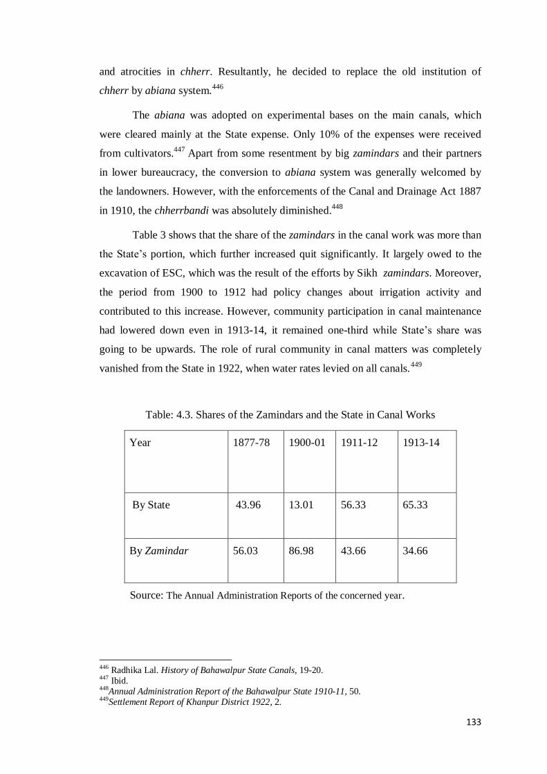
133
and atrocities in chherr. Resultantly, he decided to replace the old institution of
chherr by abiana system.446
The abiana was adopted on experimental bases on the main canals, which
were cleared mainly at the State expense. Only 10% of the expenses were received
from cultivators.447
Apart from some resentment by big zamindars and their partners
in lower bureaucracy, the conversion to abiana system was generally welcomed by
the landowners. However, with the enforcements of the Canal and Drainage Act 1887
in 1910, the chherrbandi was absolutely diminished.448
Table 3 shows that the share of the zamindars in the canal work was more than
the State‟s portion, which further increased quit significantly. It largely owed to the
excavation of ESC, which was the result of the efforts by Sikh zamindars. Moreover,
the period from 1900 to 1912 had policy changes about irrigation activity and
contributed to this increase. However, community participation in canal maintenance
had lowered down even in 1913-14, it remained one-third while State‟s share was
going to be upwards. The role of rural community in canal matters was completely
vanished from the State in 1922, when water rates levied on all canals.449
Table: 4.3. Shares of the Zamindars and the State in Canal Works
Year 1877-78 1900-01 1911-12 1913-14
By State 43.96 13.01 56.33 65.33
By Zamindar 56.03 86.98 43.66 34.66
Source: The Annual Administration Reports of the concerned year.
446 Radhika Lal. History of Bahawalpur State Canals, 19-20. 447 Ibid. 448Annual Administration Report of the Bahawalpur State 1910-11, 50. 449Settlement Report of Khanpur District 1922, 2.

134
Figure 4.2: Share in Canal Works by the State
4.2.4 New Canal Works
Having improved the existing canals, the new work was initiated under the
Engineering branch of the irrigation department. In the new environment, the
administrative power and water provision were closely associated with each other and
the State expended a great deal of capital in fortifying this relationship. For irrigation
projects, 1/8th of the average yearly income was set aside.
450 All new work was the
joint effort of the cultivators and the State except the Fordwah. The first focus of the
new canal work was the Minchinabad district, which was still without any canal due
to its proximity to the desert.
The Fordwah was the foremost canal from Sutlej, which Colonel Minchin
decided to construct totally on the State expenses, costing 311603 rupees. It was also
the first work undertaken on engineering principles and became 106 miles long after
subsequent improvements.451
It was the largest inundation canal in Punjab at the time
and the first in the whole desert of Rajasthan, where initially it looked impossible to
run the water. The canal was limited in scale but had great impact on politics, society
450Annual Administration Report of the Bahawalpur State 1875-76, 3. 451Annual Administration Report of the Bahawalpur State 1870-71, 20.
1977-78
1900-01
1911-12
1913-14

135
and demographics. After subsequent extensions, it made an area of 32500 acres
cultivable.452
Table 4.4 shows that the pattern of irrigational investment in all three
Nizamats is almost similar and no part of the State was neglected with the exception
of the desert area. In Khanpur district, new canals of Burnswah from Chenab irrigated
the whole district. Sadiqwah fed the area of Sadiqabad and Noushehra kardari.
Hussainwah, Sardarwah, Qutabwah, Tolawah, Khanwah, Sultanwah and Fordwah
were continuously supplying water in the cold months except during the silt clearance
period.
Table: 4.4. Share of Each Nizamat in the New Canals Work under the First Agency
Nizamat/
District
Canal Length in
miles
(initially)
Area
irrigated
(initially)
Total Cost
in Rs.
Minchinabad
1 Ford wah 113 31120
2 Muradwah 30 9494
3 Katorap wah
4 Sotri - 2290
5 Daulat wah 55 15979
6 Grey wah I 13 1770
7 Hari wah
Bahawalpur
8 Barns wah 42 40503
9 Birch wah
10 Calthropwah
Khanpur
11 Barns wah 45 13483
12 Grey wha II 35 6963
13 Minchin wah 26 48241
14 Sadiq wah 53 41346
Total --------- 412 211189 1720976
Source: The Gazetteer of Bahawalpur State 1904, 244.
452 Burns, Notes on the Physical Geography of the Bahawalpur State, 396.

136
4.2.5 The Sadqia Twin Canal System
Under the first Agency, 810 miles of new canals and their branches were
scientifically constructed.453
The encouraging results from them, particularly of the
Fordwah, paved the way for more similar projects in the desert and its direct outcome
was Eastern Sadqia canal. The Sadqia system comprised two canals: Eastern Sadqia
canal, excavated in 1882 and Western Sadiqia canal, completed in 1889. The Eastern
Sadqia canal was drawn from Sutlej near the boundary of Ferozpur district. This
system was developed because the Abbasid rulers were anxious to irrigate arid land
towards Derawar that was their ancestral place as well as the cantonment of the State.
In this regard, the first practical step was taken during the reign of the Nawab
Bahawal Khan V. Throughout his reign, he evinced keen interest in pushing the
State‟s agrarian frontier in the desert.454
With his full support, the Superintendent of
irrigation J.W. Burns planned to revive the Hakra system from Fort Abbas to Derawar
via Marot. He made some alignments and masonry work on a channel called
Derawarwah. But it was not found feasible at the time to elevate water to the high
sandy lands of Cholistan and repeated efforts in this regard failed. However, these
efforts became successful with the opening of Eastern Sadqia canal in amidst of the
desert. In fact, this canal was the culmination of untiring efforts of the Sikhs who
were the early settlers in the Minchinabad district and majority of them consisting
retired military men.455
The construction was originally a tiny stream of 20 feet width and forty miles
long for supplying the drinking water to the area. Some patches of land in the way of
channel were choked up with sand but the Sikh pioneers did not feel disappointed. In
their first trail, no Sikh settlement received water however; getting merely the
drinking water was a boon for them. After subsequent extension, the canal became
148 miles in length and covered an area of 250000 acres, specifically in Cholistan.456
453 Proceedings of Political Department December 1879, 1263. 454 Auj, Legacy of Cholistan, 243-44. 455 Radhika Lal, History of Bahawalpur State Canals, 13. 456Dairy of Political Agent, Vol. III, From 1st April 1903 to 31 March 1904, 3. See also Annual
Administration Report of the Bahawalpur State1900-01, 5.

137
The canal proved to be a dynamic start to irrigation in this part of the State, where no
agriculture existed before. It also relied on migrant labour from outside the State
mainly from Bikaner and Hissar.
The Western Sadqia canal was drawn on the combine waters of Sutlej and
Chenab, and irrigated one-lac acres.457
It was projected to supply the old canals of
Pirwah, Kuddanwah, Kabirwah, Greywah Bahadurwah, Muhammadwah and
Khanwah. These old canals were cut off from the river because of the intervention of
Dera Ghazi Khan under the avulsion rules.
It is pertinent to note that the contemporary irrigation policy in Punjab seemed
to be focused more on the wastelands of Western and South Western districts of the
Punjab. As the Southern district of Hissar and Rohtak were rainless, devoid of any
canal and had great potential for man-made irrigation but somehow did not get
attention of the government. In contrast, the Bahawalpur irrigation development
covered all the State on uniform basis. However, there remained distinct differences
in the level of irrigation supplied to both the areas.
The table 4.5 shows the nehri cultivated area for each tehsil of the State. In
1905, Sadiqabad tehsil was abolished and two tehsils of Noushehra and Ahmadpur
Lamma were constituted. The Bahawalnagar tehsil was also created in the same year.
The tehsils of Khanpur, Ahmadpur East and Sadiqabad held a great part of nehri
cultivated land. During 1904-05, the total irrigated area in all the tehsils was increased
due to the adequate water supply from the rivers to the State canals. However, the
supply was somewhat low in the following period again owing to the paucity of
water.
The table 4.6 shows that in the Bahawalnagar district of the State, canal
irrigated area took a jump and doubled as compare to the previous period. It
enormously increased the agricultural production and the State income from backward
areas. However, in the tehsils of Ahmadpur Lamma, Khanpur and Khairpur the fall in
inundated land was constant. The inundated area in this phase was gradually reduced
owing to the commencement of perennial canals under SVP. In the following period,
457Annual Administration Report of the Bahawalpur State 1899-1900, 2.
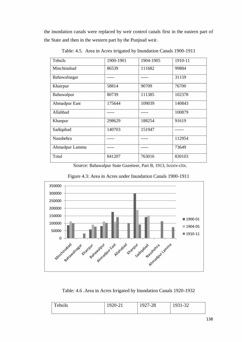
138
the inundation canals were replaced by weir control canals first in the eastern part of
the State and then in the western part by the Punjnad weir.
Table: 4.5. Area in Acres irrigated by Inundation Canals 1900-1911
Tehsils 1900-1901 1904-1905 1910-11
Minchinabad 86539 111682 99884
Bahawalnagar ----- ----- 31159
Khairpur 58814 90709 76700
Bahawalpur 80739 111385 102378
Ahmadpur East 175644 109039 140843
Allahbad ----- ----- 100879
Khanpur 298629 188254 91619
Sadiqabad 140703 151947 ------
Naushehra ----- ----- 112954
Ahmadpur Lamma ----- ----- 73649
Total 841207 763016 830103
Source: Bahawalpur State Gazetteer, Part B, 1913, lxxxiv-clix.
Figure 4.3: Area in Acres under Inundation Canals 1900-1911
Table: 4.6 .Area in Acres Irrigated by Inundation Canals 1920-1932
0
50000
100000
150000
200000
250000
300000
350000
1900-01
1904-05
1910-11
Tehsils 1920-21 1927-28 1931-32

139
Source: Bahawalpur State Gazetteer, Part B, 1935. xcviii-clxv.
Figure 4.4: Area in Acres under Inundation Canals 1920-1932
Before SVP, the State owned 26 big canals, 195 branch canals and 24872
distributaries drawn from Sutlej and Punjnad.458
The total area irrigated by the canals
increased from 34702 acres in 1867 to 807846 acres in 1924. It was equal to the
irrigated area of Eastern Jamna canal, more than double the Western Jamna canal and
458Annual Administration Report of the Bahawalpur State 1899-1900, 4.
0
20000
40000
60000
80000
100000
120000
1920-21
1927-28
1931-32
Minchinabad 84094 ----- ----
Bahawalnagar 90613 ----- ----
Khairpur 57732 ----- ----
Bahawalpur 90415 82859 -----
Ahmadpur East --- 108174 23265
Allahbad 82287 92084 75733
Khanpur 52076 63848 68732
Naushehra 80572 109318 98952
Ahmadpur Lamma 47026 59659 71813
Total 584815 515942 338495
140
more than one-third of the area irrigated by Bari Doab.459
The ESC and Fordwah in
the Bahawalpur State contributed to dramatic population growth and two-fold
increase in the immigrants into the State from Rajasthan and Punjab. At almost all
feasible points of Sutlej, canals were constructed and there was no room for further
excavation of inundation canals except improving and lengthening of the existing one.
4.3 Sutlej Valley Project
The Sutlej Valley Project (SVP) was a joint scheme, designed by the GOP on
river Sutlej to provide weir control irrigation to the waterless zones of the Punjab
province.460
For the Bahawalpur State, three rivers- the Sutlej, the Chenab and the
Indus, had a year-round supply of water, but none of the State canal was perennial.
The handicaps associated with inundation supply further worsened this situation. The
inundation canals had no control at the off-take point to limit the quantity of water
and wreaking abnormal supplies causing the destruction to crops. Moreover, all
inundation canals in the State were seasonal. This seasonality meant excess in one
season and shortage in the other.
In monsoon, there were frequent floods and breaches in the embankments, and
in winter, there was no water to raise spring crops. Thus, most of the agricultural land
remained unproductive for half of the year. Owing to these conditions, native rulers
had some indigenous plans at local level. The Nawab Bahawal Khan V proposed a
weir at Hasil Sarhhu, 12 miles below ESC to irrigate an area of 34500 acre in the
desert. However, due to the technological constraint, it did not prove feasible.461
4.3.1 Antecedent of the Project
The modern era of the development of large-scale irrigation system for the
area has its roots in 19th century development plans initiated by the British in India,
which has the administrative dexterity and advanced technology to execute such
plans. First plan for the utilization of Sutlej water was formulated by the EIC in 1854,
when Lieutenant Anderson proposed a weir on Sutlej near Ferozpur. However, this
459 Eastern and Western Jamna canals were originally constructed by Mughal rulers and reopened by
British in 1821 and 1830 respectively. John William Kaye The Administration of the East India
Company; A History of Indian Progress (London: Richard Bentley, 1853), 281-287. See also Barnard Darlay, The Development of Irrigation in India. Journal of Royal Society of Arts. Vol. 90, No.4602
(December 12th: 1941), 40. 460 H.G. Trevaskis. The Economic History of Punjab, 267. 461Dairy of Political Agent, Vol.III (From 1st April 1903 to 31 March 1904). See Appendix XVI.

141
suggestion was abandoned for its high cost.462
With the transfer of power in 1858, the
GOI had under taken different irrigation projects to boost the agricultural economy of
India in order to consolidate their rule. Further, the occurrence of severe famine in
India stimulated hydel based plans for increased food production.463
The GOI decided to convert the Indus plain into an area suitable for
cultivation and to push the agricultural frontier towards the wasteland of Western
Punjab. Upper Bari Doab and Sirhind canals were the steps in this direction. The
genesis of Sutlej valley scheme can be traced to year 1901, when the Irrigation
Committee of India concluded a decision that the waters of Sutlej and Beas should not
be utilized to the right bank of Sutlej, where land received irrigation by Jhelum.
Instead, waters of both the rivers should conserve for the wasteland on left banks.
This decision paved the way for further plans.464
The different proposals for irrigation
development in Punjab were discussed at this time but no decision was reached.
Meanwhile, the Government of India appointed Mr. Glass to survey the
proposed areas of the project. Mr. Glass conducted a detailed soil survey between
1906-09 and 1912-13, in the desert areas of Bikaner and Bahawalpur. According to
his report, irrigation had to be limited to 1621764 acres inside the State because the
remaining part was surrounded by sand hills and was impossible to irrigate.465
Suddenly, the availability of water caused a big controversy between Punjab
and princely states of Bahawalpur and Bikaner. The Bahawalpur State, as a lower
riparian and being the owner of 300 miles river frontage was the major partner in all
the schemes. It had reservation on the withdrawal of water from Sutlej and Beas,
which was already diverted to Punjab canals. Moreover, the inclusion of the Bikaner
State was a main objection by the Bahawalpur State because it would reduce its share
of water.
Ultimately, the GOI deputed an Executive Engineer, Mr. Shirra Gibb to
prepare the final report about the project. He seconded Mr. Glass‟s opinion and
proposed a weir at Ferozepur with a canal to irrigate the British Punjab, Bikaner and
462 Montgomery District Gazetteer, 54. 463 Bernard Darley, The Development of Irrigation in India. Journal of Royal Society of Arts. Vol. 90,
No.4602 (December 12th : 1941), 41. 464Montgomery District Gazetteer, 55. See further John Benton, „Irrigation Works in India‟ Journal of
the Royal Society of Arts, Vol. 61, No. 3160 (June 13, 1913), 721. 465 All proposals are detailed in Report of Inquiry Committee, 1-3.

142
Bahawalpur. Another canal on the right bank of Sutlej was added to irrigate the
Nilibar in the then Montgomery district. In this plan, 40.8% of the proposed area was
British territory, 18.0% was of Bikaner and 41.2% of Bahawalpur.466
On the lines of
Gibb‟s report, a tripartite conference was held at Delhi that was the first effective
move to resolve the dispute over SVP. Though Bahawalpur expostulated for the
inclusion of Bikaner being a non-riparian State, yet all parties accepted the main
features of the plan based on Mr. Gibb‟s report.467
Sutlej Valley Tripartite Agreement
was substantially the first agreement over the sharing of water in the Indus Basin.
4.3.2 Thomas Ward Recommendations and the Final Project of 1919
On the findings of the Gibb‟s report, Sir Thomas Ward, the Irrigation
Inspector of India recommended a plan that became the forerunner of the final
scheme. It comprised of three weirs on Sutlej river at Gundasinghwala in Ferozpur,
Sulemanki and Islam, and a fourth one at Punjnad on the confluence of Sutlej and
Chenab. On the right bank of Sutlej, three canals were under taken in the British
territory of Debalpur, Mailsi and Pakpattan. On the left bank, six canals of the
Bahawalpur State namely; Sadqia, Ford, Qaim, Bahawal, Abbassia and Punjnad were
planned in addition to the one canal for the Bikaner State.468
The project was sent to the State government for final approval. But the State
engineers particularly, Mr. John Benton who was now the technical advisor of the
State, refused to accept the plan on following reservation.
The project was devoid of primary data, maps, plans, soil surveys and estimates of
receipts and expenditures.
Expenses had been grossly under estimated, so any addition in future would create
a financial embarrassment.
The data for last six out of ten years demonstrated that water supply remained
below average and had gradually decreased. This deficiency had badly affected
the cash crops during these years. All this showed that water in Sutlej would not
be sufficient to irrigate the whole area mentioned in the scheme.469
466Ibid, 3. 467Ibid, 7-8 468A Report by Thomas Ward Inspector General of Irrigation in India on Sutlej Valley Canal Project
1920, reserved in Bahawalpur Archive, 15. 469Review on Sir Barnard Darley project by Prime Minister of Bahawalpur, 6.
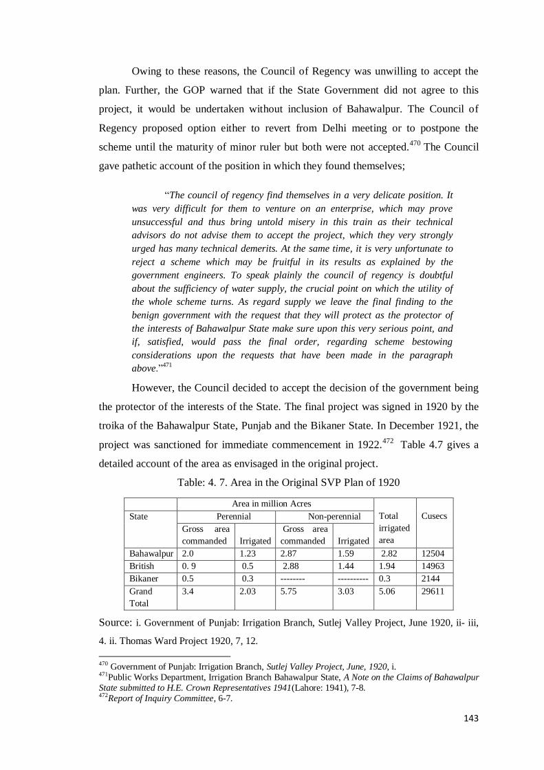
143
Owing to these reasons, the Council of Regency was unwilling to accept the
plan. Further, the GOP warned that if the State Government did not agree to this
project, it would be undertaken without inclusion of Bahawalpur. The Council of
Regency proposed option either to revert from Delhi meeting or to postpone the
scheme until the maturity of minor ruler but both were not accepted.470
The Council
gave pathetic account of the position in which they found themselves;
“The council of regency find themselves in a very delicate position. It
was very difficult for them to venture on an enterprise, which may prove
unsuccessful and thus bring untold misery in this train as their technical
advisors do not advise them to accept the project, which they very strongly
urged has many technical demerits. At the same time, it is very unfortunate to
reject a scheme which may be fruitful in its results as explained by the
government engineers. To speak plainly the council of regency is doubtful
about the sufficiency of water supply, the crucial point on which the utility of
the whole scheme turns. As regard supply we leave the final finding to the
benign government with the request that they will protect as the protector of
the interests of Bahawalpur State make sure upon this very serious point, and
if, satisfied, would pass the final order, regarding scheme bestowing
considerations upon the requests that have been made in the paragraph
above.”471
However, the Council decided to accept the decision of the government being
the protector of the interests of the State. The final project was signed in 1920 by the
troika of the Bahawalpur State, Punjab and the Bikaner State. In December 1921, the
project was sanctioned for immediate commencement in 1922.472
Table 4.7 gives a
detailed account of the area as envisaged in the original project.
Table: 4. 7. Area in the Original SVP Plan of 1920
Area in million Acres
Total
irrigated
area
Cusecs State Perennial Non-perennial
Gross area
commanded
Irrigated
Gross area
commanded
Irrigated
Bahawalpur 2.0 1.23 2.87 1.59 2.82 12504
British 0. 9 0.5 2.88 1.44 1.94 14963
Bikaner 0.5 0.3 -------- ---------- 0.3 2144
Grand
Total
3.4 2.03 5.75 3.03 5.06 29611
Source: i. Government of Punjab: Irrigation Branch, Sutlej Valley Project, June 1920, ii- iii,
4. ii. Thomas Ward Project 1920, 7, 12.
470 Government of Punjab: Irrigation Branch, Sutlej Valley Project, June, 1920, i. 471Public Works Department, Irrigation Branch Bahawalpur State, A Note on the Claims of Bahawalpur
State submitted to H.E. Crown Representatives 1941(Lahore: 1941), 7-8. 472Report of Inquiry Committee, 6-7.

144
Immediately after the commencement of the plan, World War I generally
caused inflation throughout the world. The price of land and the cost of work and
materials increased massively while the prices of agricultural products fell. The value
of agricultural products in the Indian market decreased by 50%. Thereafter, the GOP
had to revise the scheme twice in 1924 and in 1926 but both revisions brought great
increase in the budget estimates. Table 4.8 shows that basis of the original data was
entirely changed. The total expenses of the scheme were 35.17% and 63% more than
the original estimate in the first and second revisions, respectively.473
However, upto
the end of 1933, the total amount further increased to 33.31 million rupees due to the
worldwide economic depression.
Table: 4. 8. Cost Estimates of SVP in the Original and Revised Plans
State Original plan 1920 Revised plan 1924 Revised plan 1926
Fist plan 1920
Cost million Rs.
Revised plan 1924
Cost million Rs.
Revised plan
1924 Excess in
% from original
Revised plan
1926 Cost million
Rs.
Revised plan
1926 Excess in
% from
original
Bahawalpur 71.8 92.4 28.76 109.5 52.3
British 50.0 80.6 49.17 106.6 86.1
Bikaner 20.12 24.2 20.46 27.4 36.0
142.0 197.2 98.39 243.5 174.4
Source: i. The Government of Punjab, Public Works Department: Irrigation Branch, Sutlej
Valley Project 1924, Vol. 1, 2. ii. Sutlej Valley Project 1926, Vol. I, 2.
The matter of the fact was that neither the Council nor the Nawab ruler
consented to any such project as was dealt within the estimate of 1926. Penderal
Moon in this regard concluded that;
“it soon became apparent that Bahawalpur authorities had been
right. The supply of water was found insufficient for the designed
capacity of the canals at the Sulemanki and Islam weirs; in
particular the shortage during the critical seasons of the year was
serious and chronic.”474
473Administration Report of Bahawalpur State for the Year 1926-27 (Unpublished), (Sutlej Valley
Project), 5. 474 Penderal Moon, Divide and Quit, 199.

145
Hence, in order to investigate the matters and to suggest the best course of
action for the future, the GOI appointed an enquiry committee.475
The committee‟s
report identified the following loopholes in the scheme.
There was absence of proper soil survey before the preparation of project.
The average supplies in Sutlej valley canals were much less than assumed in
the plan.
Total share capacity was estimated at 16611 cusecs for non-perennial and at
1300 cusecs for perennial and total became 29611 cusecs. But actual supply in
last ten years was 8084, and 13584 cusecs, which further reduced to 7000 and
1200 cusecs in 1930-31.476
The enquiry committee proposed to reduce the area for colonization from
2,000,000 to 9,04,982 acres.477
Thus, a large tract of land on Sadqia and Bahawal
canals, supposed to be cultivable in the original project had to be abandoned. In
addition, the construction of Abbasia canal was postponed, while Punjnad perennial
canal was converted into non-perennial. The Darley report confirmed the anticipations
of the State engineers, which were pointed out at the planning stage of the project.
The necessity of augmenting the supply was insisted upon not only by the State but
also by the British districts and the Bikaner State.
Actually, the confrontation on water was not a new issue in the Indus basin.
The first dispute emerged on the construction of Upper Bari Doab Canal (UBDC)
between Punjab and Sindh as Sindh had objection on the project because it reduced
the water supply in the lower Sindh.478
Apart from SVP, there also were some
contemporary water issues causing political confrontation between provinces in India.
The proposal of Thal project by GOP was strongly opposed by the GOB (Sindh was
part of Bombay presidency till 1935) because this was detrimental to the lower
riparian Sindh, so it was not taken into consideration. Another water issue appearing
at that time on the political horizon of India was that of the GOB submitting a
complaint to the GOI against the GOP regarding the withdrawal of water by Sutlej
475 This committee consisted on Sir Barnard Darley, (Chairman), Chief Engineer of UP; B.H. Dobsen
(Advisor), Commissioner of Punjab and W. Roberts (Advisor), Representative for India. 476Report of Inquiry Committee, 25. 477 Ibid, 20. 478 Rasul Bax Palijo, Sindh-Punjab Water Dispute 1859-2003 (Hyderabad: Centre For Peace and
Human Development, 2003), 9-10.

146
valley canals, which affected the irrigation system in Sindh. This issue was resolved
with the approval of the Sukkar Barrage in Sindh by the Secretary of the State through
executive order.479
To redistribute the waters of Indus and its tributaries, the GOI in 1935
appointed a „Committee of Central Board of Irrigation‟ under the Chief Engineer of
UP, Mr. Frederick Anderson. The Committee‟s recommendations on Thal project
were in favour of Sindh. With regard to the Bahawalpur State, its recommendations
were not encouraging. The area commended for irrigation was reduced to 8.50 lac
acres under perennial category and to 17.76 lac acres non-perennial category. The
State‟s share in the water supply was reduced from 57% to 49% in rabi season and
from 42.2% to 37% in kharif season. In addition, the supply volume was also dropped
from 15049 to 13034 cusecs.480
These reductions were made by keeping in view the actual state of affairs in
the supply and soil conditions, for which the State engineers advised to reject the
initial plan. However, Anderson committee further suggested more means to augment
the supply for Sutlej valley canals, particularly the plan of Bhakra dam on Sutlej.
Finally, the total area to be irrigated was set at 51, 08000 acres, of which 28,25000
acres belonged to the Bahawalpur State, 19,42000 acres in the Punjab, and 341009
acres in the Bikaner State. The total length of channels in the State became 4000
miles.481
The table 4.9 shows the final and actual detail of the State canals under the
project.
479 T. Daniel Hanes, Building the Empire, 185. 480 A Note on the Claims of Bahawalpur State, 12. 481 Information and Publicity Department, Bahawalpur State: 1949-50 (Bahawalpur: 1950), 22.

147
Table: 4.9. Commended Area under the State Canals
Canals Length
in miles
Gross
Commended
Area
Cultivable
Commended Area
Perennial Non-
Perennial
State Distributory
of British Eastern
canal
58 64115 ------ 60474
Eastern Sadqia 742 1107425 887012 20897
Fordwah 398 455557 60731 358297
Bahawalpur 637 768215 227472 371936
Qaimpur 56 45781 - 42,723
Punjnad 1336 1380783 350899 880813
Abbassia 31 42808 - 34897
Total 3258 3864684 1535114 17700 37
Source: i. Special Administration Report of Irrigation Branch on Sutlej Valley Project from
1925-26 to 1942-43, 1-2. ii. Report of Inquiry Committee, 42.
4.3.3 Losses for the Bahawalpur State and Loan Dilemma.
In fact, the Bahawalpur State was eager to benefit from weir control irrigation
following the example of Punjab. No doubts, it gained benefits but at a heavy cost
such that a significant part of cultivable commanded area had to be abandoned owing
to the shortage of water.482
The dropped out area was 7,00,000 acres. Besides, the
construction of distributaries, rest houses, residential quarters, and gauge readers were
almost completed. Even the watercourses as per proposed chakbandi plan were
dugout for the allotment. The expenditures on abandoned areas afforded a loss of
17087543 rupees including interest.483
Moreover, during the nine out of ten years in the period from 1930 to 1940,
the State canals faced heavy shortage of water that was significantly less than what
482 Annual Administration Report 1930-31 (Unpublished), 4. 483Bahawalpur Darbar Secretariat, Office of the Prime Minister Bahawalpur State, Sutlej Valley Project
Case 1946, 7. The abandoned areas were located in the dry bed of lost river Hakra particularly the
Hakra branch and Derawar branch of Sadqia canal. The rest houses in the abandoned areas of Cholistan
are still existed under the control of Cholistan Development Authority.

148
had been envisaged in the project plan.484
The shortage in water supply created a
gloomy prospect and shrank the area mainly under cotton and sugarcane cultivation.
Both were the major crops in the new colony areas. The decreased production of these
crops reduced the State income from the revenue and the water rates. In addition, the
paucity of irrigation water caused the land prices to fall. However, Punjnad weir was
more secure as it was situated below the junction of Sutlej and Chenab. There was
generally sufficient water for the designed capacity of the canals.485
The arrival of millions of colonists in the State colony areas might also have
created the food security problem if it were not for the sufficient production of grains
in the old propriety area and its transparent distribution in the colony area. Another
bad incident occurred during the project was the collapse of six bays of Islam weir
after two years of its completion. For its reconstruction, Bahawalpur State had to bear
Rs. 341438 with 4% interest.486
Apart from it, the Islam weir disaster postponed the colonization process and
all the allotted area on Bahawal canal was suspended. Furthermore, in order to fulfill
this loss, the expenditures were enhanced to adopt alternative sources.487
The State on
its own level had to design small storage schemes, sinking wells and tube-wells,
linking of channel and remodeling of old inundation canals. The working expenses on
alternative arrangements borne were one crore that was further increased due to the
inflation caused by the great depression.488
The mistakes in the estimation produced a serious effect on the finances of the
State. Thus, the State had to incur 140 million rupees out of total amount of 333.1
million. To finance this un-envisaged burden, the State paid 1.5 million rupees from
its treasury, used the proceeds of 20 million from the sale of more land and for the rest
a commitment for annual installments was scheduled. But the sale was postponed by
GOP until the sale process would start in British districts of Punjab because the sale
of land in the Bahawalpur State might affect the market and the prices in Punjab.489
It
was an ironic expression of imperialism that when all arrangements for auction of
484A Note on the Claims of the Bahawalpur State, 13. 485
Annual Administration Report of Bahawalpur 1942-43, 65. The community also demanded to
counterbalance the less supply of water. See Appendix XVII. 486File: 19-35, 1946, Bahawalpur Darbar Secretariat, Repayment of Project Loan 1946, 4. 487 Ibid. 488 Draft Memorandum by the Bahawalpur Government on the Sutlej Valley Project Debt, 8. 489 Report of Inquiry Committee, 6-8.

149
land had been completed by spending large amount, the GOP froze the process.
Further, the expectations about the immediate returns also did not realize. The State
had no way except to accept the loan. Without economic appendage of the British, it
was not possible to finance the project.
The loan dilemma was the atrocious aspect of the plan because the State
sources were unable to finance 63% increase in cost along with other losses whereas
the original plan did not make any provision for this sort of financial burden. This
created a serious financial crisis for the State for a number of years. Table 4.10 shows
a picture of total loan impact. The amount would have to be obtained from the sale of
land and to be paid in installment was 90.60 million rupees, which in fact, could not
be realized. Initially, it had to take a loan of 5 million from the GOP with 6% interest.
Later on, it had to borrow 120.11 million rupees from GOI, out of which 90 million
was the principal amount and 20.5 million.490
It was 50 years financing loan,
scheduled in annual installments until March 1986.
Table: 4.10. Outlay of SVP Loan for the Bahawalpur State
Detail Amount
Actual Loan
9,84,16,064 (principal amount)
2,57,79,804 (arrears of interest)
12,41,95,868
2,03,40,918 (Compound interest)
Total paid 14,45 ,36,786
Source: i.Bahawalpur Darbar Secretariat, Sutlej Valley Project Case 1947.
ii. Draft Memorandum by the Bahawalpur Government on the Sutlej Valley
Project Debt, 3-4.
Moreover, the GOP held control over revenue, finance and colonization
departments of the State. Due to these heavy installments loaded with compound
490Draft Memorandum by the Bahawalpur Government on the Sutlej Valley Project Debt, 3-4.

150
interest rate, the State was unable to undertake any other development schemes. Even
the State had to face difficulty in paying the salaries to its employs and expending on
nation building programs.491
The GOI was the originator of this project but in
imposing rigorous terms and compound interest for loan, its role was more of a
creditor. Therefore, the first priority of the State was to liquidate the loan as early as
possible.492
In this regard, some emergency steps were taken to overcome the constrains in
arranging the finances needed for the liquidation. These were: launching a National
Saving Scheme that brought ten million rupees and setting up a Trust Fund. The
national saving officers under the Revenue Minister were given the responsibility to
advertise the purpose of these schemes to square off the debt. In both schemes, 3%
interest was to be given on the amount invested. Further, 1.5 million rupees were
borrowed from other indigenous sources.493
In this regard, the colonists were offered
to get ownership rights by paying actual payment at once and without interest. The
culmination of these measures was that within 11 years, the State had been able to pay
the amount it owed to GOI; almost forty years before its due time.494
4.3.3.1. The Water Discourse and Role of the Custodian Government in the
Bahawalpur State
In reality, the standpoint of the Bahawalpur State was that the treaties with
the EIC particularly that of 1833, later with the Crown, were a clear
acknowledgement of the rights of the State over the waters of Sindh and Sutlej rivers
within its territory. The binding agreement of 1920 actually followed the agreement of
1838 Subordinate Cooperation. Moreover, the Foreign and Political Department
(through its Resolution No. 1894-1A, dated 27th August 1917) clearly defined that,
“…government of India’s position is that of trustee and custodian of the
rights, interests and traditions of native states during a minority
administration…”495
491
Repayment of Government of India Loan: Note on the Financial Position of the State and Working of
the 1936 Settlement 1946, 2. 492 See for the detail account of paid and expected to be paid in 1951 in Appendix XIII. 493See Appendix XIX. 494 File: G8-193, 1948, Bahawalpur Darbar Secretariat, Repayment of Sutlej Valley Project Debt, 1948. 495A Note on the Claims of the Bahawalpur State, 16.

151
This situation put the GOI in a position to exercise its power as the regent of
the minor Prince. Nevertheless, Mr. Claude‟s pressure under the threat of exclusion
from the scheme should be considered contrary to the rights of a riparian State. After
the lapse of many years, the reservations and objections by the State engineers were
acknowledged by the GOI, and verified by the Darley Committee. The cost of the
project was too high and land under irrigation was too small than anticipated.
Likewise, water supply was insufficient and sale of land was very disappointing than
in the financial forecast.496
The State engineers had pointed out these estimations well
in time but it was taken as „destructive criticism‟.497
This miscalculation crippled the
project from the inception, caused financial difficulties for the State and left a legacy
of unsolved problems, which the Bahawalpur State had to tackle alone. Crushing
burden of interest charges made it impossible for the project to be remunerative for
many years to come.
This discussion leads to two diverse pictures. First, the GOI‟s intention
literally, was never to let down the State. In fact, the introduction of weir control
Irrigation was an entirely new discipline not only for the State but also for the whole
of India and mistakes were made at the planning stages. Accordingly, subsequent
years kept experiencing significant shortfalls between estimated and actual positions.
After the war, prices of land, the cost of work and materials increased
massively while the prices of agricultural products fell due to international economic
crises.498
In order to find quick economic returns from water extension, the GOI at
that time hurriedly sanctioned three huge canal projects: the Sukkar barrage in Sindh
(1923-1932), the Sarda Canal in United Province (1920-28) and the SVP in Punjab.499
The each of the three schemes had commanded a total area more than the whole of
cultivated area in Egypt.500
It was unfortunate that these schemes were sanctioned in
the chaotic days of war and came into operation during the slump years of 1930. The
global depression and war broke down the marketing and credit supply system in
India. During these years, as Sir Barnard Darley postulates that,
496 Barbara Ramusack, The Indian Princes and their States, 190. 497 Sutlej Valley Project, June, 1920, 1. 498 Annual Report of Agriculture 1926-27 (Unpublished), (Sutlej Valley Project), 5. 499 Sukkar project irrigated the area 7.5 million acres. See for details Aloys Arthur Michel, The Indus
Rivers: A Study of the Effects of Partition (London: Yale University Press, 1967), 110. 500 Barnard Darley, The Development of Irrigation in India, 47.

152
None of them has worked up to expectation and the crushing
load of interest charges has made it doubtful if any of them
will be remunerative for many years to come.501
While on the other side, this project in the State proved to be a vital example
of despotic behavior of the British. The Bahawalpur State, which helped the British to
promote their imperial interests, and took a stand with the British government just to
secure the benevolence of its people, was treated just like another ordinary subject of
the British Empire.502
For instance, the construction of all three weirs was beyond the
ambit of the State. As both weirs, Sulemanki and Islam were constructed in the
adjacent British districts at Sulemanki village and at Jamlera village some 65 miles
below the Sulemanki. The Punjnad weir was constructed in the tehsil Alipur of
Muzafar Garh district.
This is an evidence of imperial control over the waters of the State that if any
act of reluctance occurred in future on the part of the Bahawalpur State, it could be
deprived of water. The control over water created a culture of power on the part of
imperial power over a native State, which manifested itself in naked form during the
process of loan dilemma for the Bahawalpur State.
The despotic power, in this regard, had no concern as to how and where from
a native State would manage the finances imposed on it. The magnitude of the loan
crisis was much more than the capacity of a small princely state and it became the
victim of imperialism just to desire perennial irrigation facility. This agreement
essentially pledged the Bahawalpur State to the British. The strong desire for the
restoration of its sovereignty as early as possible underpinned the efforts of the
Bahawalpur darbar. The situation was a challenge and the State responded to it
courageously and successfully.
Despite many innovative features, irrigation projects were rooted in political
and economic concerns that governed the province. On the other side, the internal role
of the State machinery in the fields of irrigation and agriculture remained
authoritarian. According to the hydraulic thesis of Wittfoggel, the large-scale work
501
Ibid. However, the estimates in Sukkar and Sarda canals did not exceed 5% while in Bahawalpur;
there was 63% increase over the original estimates. 502Statement of Chairman Claud Hill is evidence of the British imperialistic approach; he warned
“British government had sole right over Sutlej water and where to be used. Bahawalpur had right over
its own irrigation and anything above the requirement of this irrigation was a concession not claimable
by right but by grace”. See A Note on the Claims of Bahawalpur State, 5.

153
gave the devolution of power in the hands of canal bureaucracy and caused to create a
culture of power in the social formulation. This was a natural consequence of
irrigation and a common feature in all irrigated arid lands of the India and anywhere
else.503
The subordinate canal bureaucracy got substantial but illegal benefits from the
canal works. The government salaries were only one source of income for this class
and the other was the graft and corruption resulting in sufferings for the cultivators at
the hands of the canal bureaucracy. To address some of the alleged grievances of the
public against this autocracy, a Divisional Canal Advisory Committee was
established. The formation of this committee was a reaction to the despotic character
of canal bureaucracy.504
4.3.4. Impact of the Project
With the time, the difficulties were subdued and the project turned out to be a
blessing in disguise during the following years. It was a matter of great prestige for
the State to be the sole owner of one of the greatest irrigation schemes in the
Subcontinent and the second largest barrage of the world at the time.505
Actually,
canal based irrigation system was an overwhelmingly positive contribution to
agricultural development and exhibit of human ingenuity harnessing a natural
resource to increase the State‟s revenue and expanding the agriculture sector for the
ultimate welfare of its subjects.
Perennial and non-perennial canals had replaced all naturally inundating
tributaries and waterways of the State by 1930.506
Through the hydel engineering
techniques to harness a natural water resource, the State successfully overcame its
uncertain water supply and saved the region from the danger of floods particularly,
the Punjnad valley. The project proved to be a triumph of British scientific irrigation
over the native cultivator‟s techniques.
In the Bahawalpur State, Sutlej valley canals had converted the extensive
sandy tracts into fertile cultivable lands. Moreover, the direction of State‟s investment
on irrigation became extractive to increase the land revenue in the context of its huge
503 Wittfoggel, Oriental Despotism, 126-136. 504 File: 119-1939 Part I, Procedure to be Followed under the New Constitution in Dealing with
Irrigation Projects etc. 505Bernard Darley, The Development of Irrigation in India, 47. 506Annual Report of Irrigation 1929-30, 1.

154
loan for SVP. This large-scale work was indirectly connected with the modernization
in irrigation structure worldwide. All the machinery and equipment were imported
from Europe under the supervision of the British engineers and technicians. As David
Gilmartin elicits that the hydraulics of the canal system and mechanics of the dam
construction in India were the same as it were used in the western world or in the
Indus basin.507
On the other side, however the project brought a social change in a way that
the construction or maintenance of weirs has often weakened social cohesion and
collective action. Old customs vanished with the increasing of technological
advancement, according to Gilmartin;
… the labour mobilized by zamindar was replaced by more
sophisticated techniques of scientific adoption…508
However, irrigation extension had its cost too. The canals developed seepage
and with the passage of time resulted in the rise of water levels, which led to water
logging and salinity. Actually, this was traced in 1875, when UBDC experienced the
water logging that spread at an alarming rate.509
These developments coupled with the
most serious challenge to the productive land under canal based irrigation in Punjab
further worsened the problem. This overburdened the management of the drainage
schemes. Therefore, Dr. Whitecombe labeled the canal system as a „costly
experiment‟.510
In the old proprietary areas of the State, which were already under
intensive irrigation, excessive moisture caused a great deal of water logging, which
rendered a great proportionate of land uncultivable. The reclamations of such land
would take a period of 2 to 4 years to be productive again.511
4.3.4.1 Progress in Communication Resources
With the extension of the canal network, an appropriate communication
system was the first requirement. The railway network in Bahawalpur had already
been developed during the initial days of its expansion in India. Actually, the rapid
507 David Gilmartin, Scientific Empire and Imperial Science: Colonialism and Irrigation Technology in
the Indus Basin, The Journal of South Asian Studies no. 53(4) (November: 1994), 1136. 508 Ibid, 1138 509
F. w. Woods, „Irrigation Enterprise in India‟. Journal of the Royal Society of Arts. Vol. 70,
3642(September 8, 1922), 707. See further M.H. Panwar, Six Thousand Years of History of Irrigation in Sindh (2011), 252. 510 Whitecmbe, Agrarian Conditions, 91. 511 File: Post War Reconstruction, Public Works Post War Proposals: Land Drainage and Reclamation
in Bahawalpur State, 1946.

155
extension of railway in India was the British need for their commercial and military
imperatives but that need provided the efficient transportation facilities to the natives
of India. The traditional means of transport either navigational or using different
domestic animal for the purpose were slow. Railway network radically altered the
native transportation system, specially its lower costs and increased speed paved the
way for new opportunities of trade.
By 1928, India held 40000 miles of rail lines in efficient working conditions,
of which 5500 miles were within Punjab.512
In the Bahawalpur State, the railway
system was started in 1872 and three tracks were constructed by GOI.513
For which,
the Bahawalpur State not only provided the land free of cost but also purchased the
proprietary rights from owners and rendered to the railway company.
Moreover, the State paid three-tenth of the police charges incurred on
railways. First line was the North Western Railway from Lahore to Karachi. Its length
within the State was 148 miles and track was doubled in 1906-07. It passed into the
State from Multan and Adam Wahan by the empress bridge across Sutlej. Second
line, the Southern Punjab Railway line opened in 1898. After subsequent extension,
its length within the State territory was 158 miles from Fort Abbas to Qatul
Ammarah, where it joined the track Sammasata to Bhatinda. Third line was
constructed to connect Delhi with Karachi, through Cholistan from MeCleodganj to
Ferozepur. It opened in 1906 having 16 miles length within the State territory.514
In addition, two lines were set up entirely on State expense called as darbar lines
with the purpose of facilitating the populated areas. First line was from Khanpur to
Chachran, set up in 1924. Its length was 27 miles and it had four stations.515
Second
was started in 1928 for colony area called Cholistan-Bahawalnagar line having 110
miles length. This track was entirely for colony use and Minchinabad emerged a large
trading centre in the late nineteenth century locating on that rail track. With the
railway net work, the interior towns of the State were directly connected with the
major export outlets of Karachi and Lahore. Furthermore, the economic effect of
512 In 1853, railway started with twenty miles track. It became an important source of employment for
all communities. In 1880, 9000 miles, by the end of century 23627 miles expanded. 513
The first agreement regarding railway was made in 1872 between Bahawalpur and GOI for the
North Western line to Karachi. The other two lines were also constructed by agreements with GOI. In all three cases, GOI attained full control and jurisdiction over the lines. While for the darbar lines,
Bahawalpur had paid for its construction. See Atchison Treaties, 240-253. 514Sadiq-ul-Akhbar , 1st March , 1906. 515Sadiq-ul-Akhbar , 31st May, 1906.
156
railways was immediate and widespread. It broke down the State‟s isolation and made
for better transport of raw materials and goods within the country and to the ports.
The railway established a close link of the State‟s towns with the rest of India and
increased the export of food grains.
Furthermore, with the completion of SVP, a system of trunk roads was
developed in the colony areas. The earlier road structure in the State was confined to
the Bahawalpur and other tehsil headquarters. Actually, the road structure was based
on the feature of pre-Agency system that was constructed to provide the passage for
British military expedition for Kabul mission. A significant State kachha road was
constructed from Sabzal Kot to Hasil Sarho running throughout the State and further
to Delhi in 1836.516
Under the Agency, all roads were repaired annually and
supervised by the tehsildar. The total number of major roads in 1870-71 was 11,
having length of 811 miles. In the period subsequent to the Sutlej valley project, road
system was developed under the State control. There were 566 miles roads for motor
transport and 803 miles for carts, while 46 miles were pacca roads.517
Camel and carts were the antiquated means of transport. The gadda system
was the subsidiary means of livelihood for the early agriculturists. After SVP, most of
the settlers also came with their carts while already made arrangements and a bus
service was started to carry them to colony areas. The pacca roads of 358 miles and
kachha roads of 448 miles for carts were built up in the colony areas.518
After the
World War II, the road system was further improved and three circles were made for
transport purpose, two of which were for the colony areas.
However, the new modes of transportation and carriage of goods reduced the
primacy of water navigation and ultimately vanished. Many boats men lost their
former source of income. With that, many significant towns of the State lost their
former position and went down due to the decline of previous mode of
communication. Particularly, Allahabad, Taranda Gorganj, Ghazipur, Uch, Garhi
Ikhtiar Khan, Pattan and Rajgarh, which were the first and foremost centre of
economic activities in the State, lagged behind due to the distance from main railway
line. Same situation was faced by the Eastern part of the State, where the ancient trade
516 Punjab Record, Book 103, 28 October, 1838, 679-688. 517Annual Administration Report of the Bahawalpur State 1942-43, 75. 518 Muhammad Tahir, Riasat Bahawalpur Ka Nazm-E-Mumlikat, 445.

157
route of forts was cut off from the main areas. At the same time, railway stimulated
the growing importance of new trading centers like Noushehra, which now called
Rahimyar Khan where previously poverty was prevalent but with the railway, it
developed soon. For instance, if cart man and boatman lost their occupation then the
railway system opened the ways for employment and created jobs.
Conclusion
In the pre-Agency period, the unit of irrigation organization were village
communities while under the Agency, it was the State managed system. However, the
participation of farmers in self-management of canals was maintained. The early
Nawab rulers could not extend the cultivable area of their State because of less
population and inadequate facilities for irrigation. However, their initial canal work
formed the basis of new work under the Agency, which as compare to the grandiose
schemes by the Agency was very nominal. The era of restoration, extension, and
development of canals, commenced by the Agency government, provided the
environment for perennial irrigation. However, mistakes in the project cost estimation
brought a setback to the finances of the State and debt was the key issue in wreaking
the perennial irrigation projects. Some of the difficulties faced by the SVP were
obvious. From the long-term perspective, the project became a locomotive for socio-
economic development of the arid areas of the State. With the help of advanced
technology, the British utilized the irrigation potential and changed the landscape of
the State. This project optimized the irrigation water availability to a vast area,
reduced wastage and enlarged the cultivated area. These projects also helped to
increase the communication system and means of transportation. The transformation
of barren tracts into populated region for commercialized agricultural production was
the most fruitful result of the SVP, which is discussed in the next chapter.
158
Chapter 5
Canal Colonization in the Bahawalpur State
The establishment of weir control irrigation facilitated the emergence of canal
colonies of settlers to make the land cultivatable. The colonization in the State became
the ultimate preposition of agricultural development. This chapter explores the
exploits of peasantry of the British Punjab made from the newly opened agrarian
avenues on the land of a princely state as well as the role played by the State in
facilitating them. The new patterns of development created new economic nexus with
the growth of commercial towns. However, at the same it marginalized the traditional
hubs of economic power to certain extent. The chapter examines the impact of the
colonization phenomenon on the economic development of the State and on the trade
patterns vis-a-vis the magnitude of trade policy of the State used as insurance for
famine protection.
5.1 Colonization in the State
Canal colonization is a process of human settlement on canal-irrigated land. In
the history of the Bahawalpur region, human settlements are very old. With the drying
of water in Hakra, the habitation along its course began to disappear.519
The
population moved towards the upper basin of that river, and to the North and the
Northeast of Cholistan.520
While a few adopted nomadic lives with pastorlism. The
Northwestern areas situated on the fringes of rivers, became the hub of habitation.521
The towns of Uch, Jajja, Bhutta Wahan, Patan, Sheikh Wahan, Khaibodla, Sarwahi,
Mau, Taranda and Mahend were ancient settlements situated in the valley of
Punjnad.522
In the course of historical events, their population gradually decreased and
on the eve of the Abbasids in this region, population was sparse with semi- nomadic
outlook, while rest of the countryside was abandoned.
In the formative years, the main objective of the Abbasid rulers was to
increase both the cultivated area and the population. Therefore, human settlement
became a continuous process throughout the history of the Bahawalpur State. The
519
Grewal, Historical Geography of Punjab, 4. 520 Mughal, Ancient Cholistan, 22. 521 Ibid, 36. 522Auj, Legacy of Cholistan, 33. Some ancient settlements have been mentioned in the Persian records
of Punjab archive while discussing the trade through the river borne traffic in Punjnad and all ancient
settlements were located in the Punjnad valley.

159
Pathans were the first to be recruited in the State army in 1797 by the Nawab Bahawal
Khan II during a civil war while Daudputras and Balochs were already a part of his
army.523
Over time, people from various parts of India got land and acclimatized in
the proprietary areas. Particularly, peaceful inhabitants from the disturbed Punjab
during the late Sikh period came and settled down in the State.524
The grant of land on
lease had always been encouraged in the subsequent regime to the locals and the
outsiders yet a cohesive program of colonizing the wastelands was coincided with the
first British Agency period in the State‟s history.
The British Agency, with its new scientific approach, turned its attention
towards the desert Cholistan, where 26 land grants were already existed as a legacy of
the native regimes. The Agency government not only maintained all those leases but
also granted further leases. The Fordwah was the first irrigation settlement introduced
in the limited barani areas of the State. The Sikhs were the very first settlers to yoke
on that barani land and settled with the excavation of Fordwah.525
In fact, this canal
was a political necessity and it served initially the same purpose that Bari Doab Canal
served for Punjab districts being settling down the disbanded Sikh soldiers.
Ludhiana, Amritsar, Jalandhar, Multan, Hissar and Ferozepur, served as the
recruiting centers of agricultural communities for the Bahawalpur colony.526
The
hardy Sikhs had the experience of taking high yield from the crops on barani lands.
They preferred to be independent from the State interference. Therefore, they had
little interest in canal irrigation, which was based on chherr system. In a way,
Bahawalpur region was the early place where disbanded Sikh personnel were
accommodated and engaged in agricultural pursuits.527
On the other hand, local
inhabitants, being part of a rainless country, were not used to barani cultivation.
The first settlers had to face many hardships: the barren tracts, beasts, warm
temperature and above all the scarcity of water.528
The ubha and the lamma, both
parts of the State faced issues of different nature. Living in sandy land of the ubha
was more difficult than clearing thick jungles and leveling the grounds in the lamma.
However, the attempt to accommodate the peasants from outside provided a
523
Gurgani & Muhammad Din, Sadiq-ut-Tawarikh, 13. 524Shahamet Ali, A History of Bahawalpur, 193. 525Re-organization Report 1867, 10. 526Sadiq-ul- Akhbar, 6th October, 1867. 527Radhika Lal, History of Bahawalpur State Canals, 12-13. 528Report of Inquiry Committee, 25.

160
satisfactory output. Unfortunately, owing to a famine-like situation in 1868, many
colonists went back to their home districts.529
The second attempt to lease out the Cholistani land was made during the
incumbency of Colonel Grey. He formulated a cohesive set of rules for colonists on
specific conditions locally called Ahsani terms. In this phase, a Sanad-e-Ahsan was
awarded to the settlers for ten years. The wastelands in Cholistan were leased out at
one anna per bigha.530
The table 5.1 shows that price of land were very reasonable
and with the increasing quantity of land, the basic price was minimized.
Table: 5. 1. Price of Land in the Ahsani Terms1872
Land in Bigha Less than
100
More than
100
More than
300
More than
2000
Price in Rupees 8 6 4 3-4
Source: Annual Administration Report of Bahawalpur 1872-73, 87.
It was mandatory for the occupant to bring his tenants from outside of the
State. They were given many relaxations like exemption from tirni tax and providing
the chher labour. Their part of chher had to be arranged by Nazims. The complete
ownership rights were awarded on the completion of the specific period. The locals
were also entitled to attain the Sanad-e-Ahsan but they were bound to arrange the
tenants beyond the State and fulfill the other conditions.531
Encouraged by these incentives, more groups of immigrants came to the State.
However, perennial canal construction in Multan and Montgomery reduced the water
supply to the State canals, forcing the people on canal-irrigated lands to go back. The
third and the most influential phase for colonizing the barren tracts of the State started
with the excavation of ESC. The canal was, in fact, a result of constant efforts of Sikh
settlers and its excavation was a tale of sacrifices. As Radhika Lal notes;
‘ … the memory of their adventures in Cholistan , the difficulties they
had to experience and the forbearance exhibited by those sturdy Sikhs
529 Radhika Lal, History of Bahawalpur State Canals, 12. 530
Proceedings of Political Department December 1871: Wastelands in Bahawalpur, 1112. 531Sadiq-ul-Akhbar, 18 March, 1872.

161
with white beards and grey eyebrows shall ever remain green in the
history of canal construction in the state.532
In 1908, the new rules for leasing the land were framed according to the new
requirements. These had a lenient outlook in order to attract more strata of peasantry
from Punjab. The term of the lease was reduced from ten to five years to improve the
land as early as possible. Furthermore, the previous condition of importing tenants
from outside the State was removed and the lessee was required to arrange the tenants
on his own. Another relaxation was in the revenue assessment. Now only the cropped
area was to be assessed in place of the entire leased area, as was the case earlier.533
In
Cholistan area of Minchinabad Nizamat, the leases were granted without
measurement and records of rights until 1910-11, when this territory was first settled.
In cultivating the desert land, natives of Cholistan made only a small
contribution because they were mainly cattle breeders and to engage them towards
agricultural pursuits would take time. The Nawab Bahawal Khan V, however, was
very keen to involve the locals in agriculture. So, he formulated regulations of
granting land to the locals and awarded some tracts of land to the State officials on
nominal price. The policy, however failed to elicit a positive response rather it
promoted absentee cultivation. Therefore, the third Agency government stopped this
practice, though the State officials continued secret dealings.534
The next phase of the land leasing policy began during the land settlement of
1910-11 in Minichinabad Nizamat. There were 109,000 bighas of cultivable land
available in Cholistan on ESC. According to the new policy, land would lease out
through auction for which one fourth of the price would have to be paid in advance
and the remaining in six half-yearly installments.535
Actually, the purpose of auction
policy was to get more income in order to finance the expenditure on canal
maintenance. In this phase, the Cholistan Uttar area was settled for habitation for the
first time and local owners of adjoining lands were largely considered for the grant of
land.
532 Radhika Lal, History of Bahawalpur State Canals, 13. 533Annual Administration Report of the Bahawalpur State 1908-9, 8. 534ibid, 49. 535 File: 222-II, 1929. Official Letter from Office of Political Agent Phulkian States and Bahawalpur
dated 1-4-1912, no. 24/ 699.

162
This attempt made good strides because of the regular and systematic process
followed on the lines of Punjab canal colonies. The native colonization staff was sent
to Lyallpur and Sargodha to learn the colonization work under Mr. Dobson the
Settlement Officer of those colonies.536
After the World War I, the prices of canal-
irrigated land increased all over India. The State government raised the price of canal-
irrigated land on ESC for two main reasons; first, this land required less effort to
plough owing to its loamy soil and suitable for every kind of grain. Second, this was
more valuable because it located along the railway line and contributed to reverse the
trend of wealthy zamindars venturing into the State colony areas.537
5.2 Canal Colonization in the Punjab
The canal colonization in the State was influenced by the extensive schemes of
canal colonization in Punjab. Nine canal colonies were developed in the wastelands of
the western Punjab from 1885 to1926. Each colonization scheme had its own
strategies and priorities of development based on the needs of local environs. The
objectives behind these wide-ranging plans were both political and economic in
nature. The congested districts of the Eastern and the Central Punjab were facing
shortages of agricultural land caused by the increasing population. This agricultural
population occupied the newly irrigated Punjab plains, which ensured a surplus in
economic production.538
Actually, canal irrigation required intensive labour and hard work, which
made the sturdy and efficient Punjabis the best choice to gain economic benefits for
the GOI. The other motive behind the establishment of the Punjab canal colonies was
to re-employ the disbanded Sikh soldiers in agricultural pursuits.539
The provision of
food security to the increasing population of India was another objective of the GOI
behind launching this scheme. Moreover, the contingent factors also existed, which
included the needs of army, special grants on conditional terms and the patronage
grants to ensure political support in the region.540
536
Annual Administration Report of the Bahawalpur State, 1912-13, 4. 537Sadiq-ul- Akhbar, 20 July 1922. 538 Imran Ali, The Punjab under Imperialism, 13. 539 Ibid, 50 540Ian Talbot, Punjab under Colonialism: Order and Transformation in British India, Journal of Peasant
Studies Vol. 14, NO.1 (Spring 2007), 8.
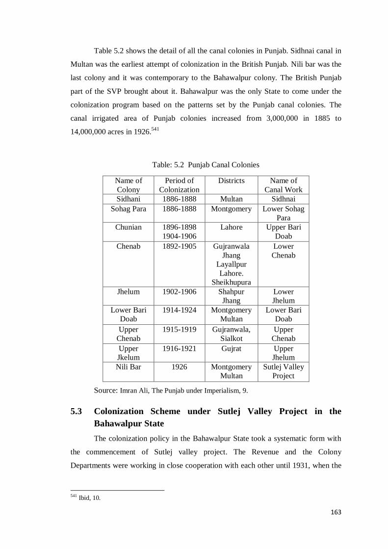
163
Table 5.2 shows the detail of all the canal colonies in Punjab. Sidhnai canal in
Multan was the earliest attempt of colonization in the British Punjab. Nili bar was the
last colony and it was contemporary to the Bahawalpur colony. The British Punjab
part of the SVP brought about it. Bahawalpur was the only State to come under the
colonization program based on the patterns set by the Punjab canal colonies. The
canal irrigated area of Punjab colonies increased from 3,000,000 in 1885 to
14,000,000 acres in 1926.541
Table: 5.2 Punjab Canal Colonies
Name of
Colony
Period of
Colonization
Districts Name of
Canal Work
Sidhani 1886-1888 Multan Sidhnai
Sohag Para 1886-1888 Montgomery Lower Sohag
Para
Chunian 1896-1898
1904-1906
Lahore Upper Bari
Doab
Chenab 1892-1905 Gujranwala
Jhang
Layallpur
Lahore.
Sheikhupura
Lower
Chenab
Jhelum 1902-1906 Shahpur
Jhang
Lower
Jhelum
Lower Bari
Doab
1914-1924 Montgomery
Multan
Lower Bari
Doab
Upper
Chenab
1915-1919 Gujranwala,
Sialkot
Upper
Chenab
Upper
Jkelum
1916-1921 Gujrat Upper
Jhelum
Nili Bar 1926 Montgomery
Multan
Sutlej Valley
Project
Source: Imran Ali, The Punjab under Imperialism, 9.
5.3 Colonization Scheme under Sutlej Valley Project in the
Bahawalpur State
The colonization policy in the Bahawalpur State took a systematic form with
the commencement of Sutlej valley project. The Revenue and the Colony
Departments were working in close cooperation with each other until 1931, when the
541 Ibid, 10.

164
administration of the Colony Department was reorganized. It consisted of a
Colonization Officer and his three Assistant for each canal colony.542
The Bahawalpur State colony developed with its own unique dynamics. In
fact, the scope for human settlement in the State was vast because a wide stretch of
land was unoccupied in proprietary areas and almost all newly irrigated area was
unpopulated. There were specific political motives behind the grants of land, which
amongst other things encompassed the need to procure skilled agricultural labour to
increase not only its population but also to create revenue, which could be used to
service the heavy loan for SVP. The imperial determinants also existed, yet the
benevolent hand of the State remained prevalent.
The Bahawalpur colony is a broader term and covers the three canal colonies
under the project: Sadqia colony, Bahawal colony and Punjnad colony. The three
colonies were adjacent to each other and formed an alluvial plain. The area
commanded by Sadqia canal and some part of Bahawal canal comprised the lost
Hakra valley, where only a wide shallow depression existed. On the southern side of
the Hakra depression, there were high ranges of sand hills, while on the Northern side,
the sand drifts were less formidable. Moreover, ruins of large villages were found at
frequent intervals and a chain of forts on the northern bank of the depression
evidenced that these areas were once highly populated and presumably, cultivated by
inundation of old Hakra river.543
These areas held very small population of semi
nomadic tribes.
The conditions and clauses of the scheme were largely the same as in the
Punjab scheme, although some changes were made as per indigenous environment.
However, the State was free in adopting the pattern of internal ingredients of
colonization policy. But the high echelon of the State which had the powers of
decision making, were all occupied by the British officers who were bound to act
according to the prevailing British policy. The process of colonization was undertaken
through the Colony Act of India 1912, which was implemented in the State in 1926.544
The irrigable area of the State under Sutlej valley canals projected for colonization
was 2,000,000 acres. Such a large area was disposed of through many stages,
542 In 1931, Mr. L.M. Mackeown was appointed as the first Colonization Officer in Bahawalpur. 543 Panwar, Six Thousand Years of History of Irrigation in Sindh, 46. 544Sadiq-ul- Akhbar 13 May 1926. See Appendix XX.

165
commencing with the partial completion of the plan in 1926 at Islam weir and
continuing after the partition of India.
5.3.1. The Attributes and Implications of the Bahawalpur Colony
The canal colonization in the State was originally a consequential part of the
SVP. To cultivate the land, the great mass of population was migrated from the
British Punjab to the State. The whole area was categorized into certain specific sorts
of grants. The capital element was included to encourage the enterprising farmers
while agricultural classes of abadkar were the main thrust of the plan. Landless
labours, artisans and menial classes were also moved to the Bahawalpur colony and
some specific space was allocated for them as well. These groups gave the touch of a
traditional social set up of a village in the colony called chakk.
According to the distribution plan for the area, 50% barren areas were set
aside for auction to purchaser and 80% of the remaining 50% was reserved for
peasant grants. The other 20% from this allocation was set aside for miscellaneous
grants.545
A very small proportion was ghair mumkin land, which was reserved for
roads, abadis, graveyard etc. The distribution of land was under the control of the
State. The physical layout was characterized by the division of land into chakks in
which each holding was complete in a single field.
The structure of each colony chakk stood on a uniform basis. Each chakk was
laid out according to a model plan with wide streets and central squares with half
rectangle fixed for lubmerdar, one rectangle for kamis and two rectangles for
sanitation grounds. Besides these, three acres were reserved for the Mohammaden
graveyard and one acre for Hindu cremation place.546
Each village was given one or
more watercourses and cultivators divided the water amongst themselves on a
recurring turn system fixed by canal officers. The process of allotting the colony areas
was executed in the five following categories.
5.3.1.1 Sale and Purchase
The reservation of land for sale was expected to bring immediate returns and
this was an urgent requirement to liquidate the SVP loan and overcome the other
545 Letter From the Minister for Revenue and Public Works to the Nawab Bahadur on Colonization
Scheme: 5 April 1927. 546 File: 184, 1926, Part 1. Notices and Conditions of Sale in Bahawalpur Colony, 179. See Appendix
XXIV for distributing plan of the land in colony chakks.

166
financial constraints. The auction of agricultural land and town sites in Bahawalpur
varied from time to time and from place to place due to the variation in soil condition.
The best tracts of land were set aside for auction to ensure more revenue.547
The
perennial irrigated areas of ESC, which had great economic value, were the first to be
colonized. As per Sutlej valley agreement, the annual limit for public sale was 40,000
acres. Land was auctioned in blocks and there was no limit for purchasing that land.548
In the first year, 18518 acres of perennial land were sold at Rs.220 per acres
and non-perennial land at Rs. 63 per acre to be paid in installments over three years.
The advance money was 10% of the total at 7% interest on unpaid balance. In the next
year, 3988 acres of land was sold at Rs. 230 per acre. Both initial auctions were
successful. However, in these years, Sutlej and Beas rivers flowed at low level and the
short supply of water caused failure in cultivation or resulted in poor quality of crops
particularly in the Bahawal colony. The yields were so little as to make it impossible
for the farmer to pay his dues.549
This resulted in the accumulation of massive arrears on the part of farmers and
badly affected the sale of land. It was realized very soon that the terms needed to
change and there had to be leniency in recognition of initial difficulties. Therefore, a
new scheme was launched in 1930 to sell the land on concessional terms. Under the
new scheme, the period of installments was extended from five to eight years. The
first two harvests were exempt from the land revenue and the water charges. An
important relaxation in the terms was the imposition of a nominal tax malikana, in
place of interest.550
Moreover, installments and acreage rate were suspended as a
temporary measure of relief until conditions improved.
The purpose of installment was to enable the purchasers to pay money
gradually from the profit obtained from the cultivation of land. However, it did not
yield the desired results and failure in cultivation broke down the installment system
resulting in the State having to give the proprietary rights to purchasers voluntarily.
The State initiated further two schemes for granting concessions to purchasers. The
first was a Lump Sum Payment Scheme to encourage the buyers to pay the entire
547
First auction was held for the perennial land of Gujjani distributary of Eastern Sadqia canal on 7th
and 8th April 1926. Second auction held on 7th and 8th March 1927. See Annual Administration Report 1926-27 (Unpublished), (Colonization), 1. 548Notices and Conditions of Sale of Land in Bahawalpur State 1926, 98. 549Annual Administration Report 1926-27 (Unpublished) , (Colonization), 1. 550Annual Administration Report 1931-32 (Unpublished), (Colonization), 2.

167
amount of land at once, at a concessional rate, instead of installments. It offered a
concession of 25% on initial deposit and 10% concession in revenue for the first few
years. This scheme continued till 1941, when the colony flourished and agricultural
prices risen.551
The other was the Compensation and Surrender Scheme for dealing with the
purchasers whose land had been confiscated due to nonpayment of their dues. Some
private individuals and the State officials had acquired land in the initial period of
allotment, but they could not manage to cultivate it. In this scheme, such purchasers
had to surrender the part of their holding for which they were unable to pay. In this
way, their allotments were reduced to a maximum one square at 3% interest rate per
annum. Under this scheme, the State avoided the confiscations and brought back the
settlers to their allotted land.552
With regard to the Punjnad colony, land was
auctioned in the form of lots instead of entire chakk. This step was taken to encourage
the local peasants and to promote self-cultivation. The blocks of up to five acres were
auctioned at a rate of Rs. 100/- per acre for superior quality land and Rs. 62/- per acre
for inferior quality land.553
Contrary to expectations, most of the State purchasers belonged to zamindar class
without large capital.554
Only a few capitalists or rural notables were attracted to the
Bahawalpur colony because majority was inclined to the Nilibar colony due to its
closeness with Punjab although the land quality was similar to as was in the
Bahawalpur colony.555
The significant capitalists in the Bahawalpur colony were Khan
Abdul Majid Khan of Kashmir who purchased 2500 acres, Sardar Hamidulla of Issa Khel
who held 5000 acres in Mauza Bahishti near Kot Samaba and Sir Daya Krishna Kaul who
acquired 5495 acres of land in Taranda. The largest purchaser was the entrepreneur of the
Union of Agricultural Syndicate, Rahimyar Khan, which bought 10,000 acres of land.556
The
State policy regarding capitalist class was based on a careful demonstration. Land was sold to
the strong enough parties after thoroughly examining their financial position. Those who did
not meet the criteria were denied the land. One such example was that of Diwan Syed
551Colony Administration Report 1931-32, 1. (Unpublished) 552
Annual Report of Agriculture 1931-32, 2. 553 Notices and Conditions of Sale of Land in Bahawalpur State: Sale of Land by Auction in Bahawalpur State 1926, 32. 554 Colony Administration Report 1929-30, 1. (Unpublished). 555 Colony Land 1928, 6. 556 File: 179-17, Part IV, 1937, Purchase of Land by Union of Agricultural Syndicate, Rahimyar khan.

168
Muhammad of Pak Pattan, whose application was not forwarded by Mr. Barron, owing to his
weak economic position.557
The allotment of land to big capitalists was in fact advantageous for political
reasons but unsuitable for the social and economic structure of the State because both
big zamindars and moneylenders relied on tenants and gave rise to absentee
landlordism. This policy, therefore, was not suitable to increase agricultural
production from small and scattered lands. In this context, self-tilling was an
imperative requirement for the success of the Bahawalpur colony.
5.3.1.2 Peasant Grants / Abadkari
Peasant grants were the mainstream of the project. The selection of grantees
was entrusted to the revenue department whereas, locating the colonists and looking
after their future interests was the responsibility of the colonization officer. For the
convenience of abadkars, a system of receiving and dispatching the necessary details
was sanctioned. One such arrangement was Chakk Abdulla, which was the focal
point, from where motor lorry and camel would take them to the spot.558
Unlike the purchasers, there were certain conditions for the abadkari grants. In
particular, land was confined to the self-farming peasants. The size of this grant
ranged from half acre to fifty acres. However, on an experimental basis, a few chakks
were leased out to a couple of zamindars who could afford the capital expenditure. In
1926, chakks on ESC were first to be notified on abadkari grants. The initial purchase
price, locally called nuzrana, was Rs. 150 per acre. The one-fourth of this price was to
be paid in advance while the remaining amount was to be paid in six half-yearly
installments at 6% interest. Actually, the purpose of installments was to enable the
purchasers to pay off debt gradually from the profit obtained from the cultivation of
the land.559
The abadkars were required to permanently move to their lands within six months
of possession and build their houses within one year. They were exempt from revenue
for the first two harvests but exchanges were not allowed.560
Initially, the old
inhabitants of riverine tracts of Ahmadpur and Allahbad tehsils, were given
557 File: 179-25, 1929, Purchase of Land by Diwan Syed Mohammad of Pak Pattan. 558Sadiq- ul-Akhbar, 17 February 1927. 559Notices and Conditions of Sale of Land in Bahawalpur State, 3-25. See Appendix XXII for the initial
attributes and prices of lands. 560Ibid.

169
preference in the abadkari allotments because they were severely affected by constant
floods.561
The first batch of abadkars came in 1927 from Punjab. Their payment of
nuzrana was due in 1930, but this could not be properly recovered owing to the
difficulties similar to what the purchasers had to face. Such circumstances had badly
affected the returns. Therefore, the installment period was further extended to twelve
years and abadkars had the right to exchange poor land with better land somewhere
else. The fact of the matter was that for the most part abadkars were poverty-stricken
and possessed fewer resources to help them tide over difficult times. In the following
years, the influx of abadkars was slow and limited to those who clung to their land
under every conceivable difficulty until the conditions improved.
The total allotment for abadkars area was 318732 acres in 1940. The
colonization in the Punjnad colony was the last in the process; it started when the
price fall was over. In the non-perennial area, there was more relaxation in the terms
as peshgi was reduced to Rs. 50 and the remaining amount had to be paid in 60
installments of Rs. 25 each. Further, well sinking was a compulsory measure for the
owner of two squares. These concessions saw rapid increase in the population of the
Bahawalpur colony.
5.3.1.3 Military Grants
Military grants were an offshoot of peasant grants. The military men of Indian
States serving with the units of the Indian army were selected by their commanding
officers for the grant of land in the newly built colonies in Punjab. In the Bahawalpur
colony, the State nominated only those military men who were Muslim and belonged
to agricultural class. In this regard, claims from the State‟s own army were preferred.
The first batch of military men was selected in 1924 in lieu of their services during the
World War I. 562
Twenty two chakks were allotted to the Indian army from 1928 to
1933 in the Sadqia colony. The viceroy‟s commissioned men were granted two
squares of land each whereas the soldiers and the Non-Commissioned officers were
561 Department of PWD and Revenue, File: 179-31, Land to Major Shamsud Din, Letter 4-c on 6-1 1942, from Deputy Commissioner Rahimyar Khan to PWD and Revenue Minister Bahawalpur State. 562 Military Department Darbar Sahib Bahawalpur State, Office of the Military Secretary, File: 225-A,
1924-25, Grant of Land to the Military Men. Application of State Soldiers to the Nawab Ruler on 18-3-
1924.

170
granted one square each. Five thousand acres in the Sadqia colony were reserved to
the State Force.563
The superiority of military institution was dominant and the conditions for
military grants were somewhat more lenient than the peasant grants. The required
advance of military grants was one-eighth of the total amount and revenue was
remitted for five years. This grant was for the better land and allowed greater freedom
in the matter of exchange. In case of dissatisfaction, the grantees had the right to get
their nuzrana refunded and conditions of self-cultivation were not enforced. In spite
of this relaxation, military men were reluctant to take grant in the Bahawalpur colony,
mainly for two reasons. First, though the land allotted to army personnel was of good
quality, it was suitable only for self-farming peasants while the majority of grantees
was in service and was not living in their allotted areas. The other reason was the lack
of efficient tenants or labour in the Cholistan area. Therefore, a large part of the land
reserved for military grants remained vacant.564
Actually, these grantees were warriors and did not have experience of
cultivation so 70% of military grantees went back. Some of them lived on their land
by engaging tenants, while the rest were absentees, who cultivated their lands through
their agents.565
In 1931, this scheme was practically wound up, with the exception of a
small area reserved for the State‟s military men and pensioners.566
In regard with
Punjab, the military grants were a successful attempt. The Jhelum colony was under
taken to fulfill the military needs.567
The lower Bari Doab was also associated with
the army and recognized as a very important horse breeding areas. 568
In fact, the
focus of land grants in Punjab colonies was determined by the fact that 40% of the
British Indian army in 1914 was recruited from Punjab.569
563 Department of PWD and Revenue, File: 232, Part XI, 1944. Military Services : Application of Hev.
Baker Ahmad Din from Batala District Gurdaspur. 564 Bahawalpur Darbar Secretariat: Revenue and PWD, File: 9-36, 1943, Post War Settlement, Note on
Military Chakks by Prime Minister Bahawalpur on 4 June 1943, 1-3. 565Ibid, Letter from Assistant Commissioner Rahimyar Khan to Deputy Commissioner Rahimyar Khan, on 29-7-1943. See Appendix XXIII. 566Report of Inquiry Committee, 108. 567 Imran Ali, The Punjab under Imperialism, 168. See also The Government of Punjab, Lower Jhelum
Canal: Punjab Canal Gazetteer Vol. 1 (Lahore: 1921), 35. 568 The Government of Punjab, The Youngest Punjab Canal Colony (Lahore: 1930), 4. 569 Talbot, Punjab under Colonialism: Order and Transformation in British India, 4.

171
After the World War II, the scheme for military grants in the State was revived
with the hope of success because by then, the irrigation and communication system
had sufficiently improved. Two chakks covering 1803 acres were reserved for State
forces. In the Punjnad colony, 6059 acres of military grants were reserved for the post
war settlement, which was partially allotted. In Allahabad tehsil, 125 acres perennial
and 127 non-perennial land was reserved for the demobilized State soldiers.570
This
revised phase of post war allotment became more successful than the previous one
and many grantees settled on their allotted land. At the same time, the military grants
on good concessional terms by the Bahawalpur darbar encouraged the tradition of
tenancy cultivation in place of self-cultivation. It opened the ways for military
dominance over the agricultural land, which expanded in the successive years to the
urban areas and was a major cause of the military officers becoming the large
stakeholders. This legacy increasingly nourished and contributed to transforming the
military men into feudal-lords and then into entrepreneurs as Ayesha Siddiqa asserts
that;
The military justifies its acquisition of agricultural land as part of the
inherited colonial tradition of granting land to military personnel ...in
fact, the military land acquisition, especially agricultural land, has
transformed the military into one of the many land barons or feudal
lords… 571
5.3.1.4 Temporary Cultivation
In order to utilize areas with rough soil, short-term leases for temporary
cultivation were granted. Temporary cultivation mostly involved the surrendered and
confiscated land as well as the land reserved for specific purposes, such as for
artisans, lumberdari allowance or tree plantation. Temporary cultivation was best
suited to reclaim poor land, test soil capacity and increase its market value. Its
purpose was to increase cultivation and earn money quickly. However, it confined to
those lands that had possibility of irrigation and cultivable.
570
Bahawalpur Darbar Secretariat: Revenue and PWD, File: 9-39 1943, Post War Settlement: Chakks reserved for Demobilized Soldiers: Letter from Revenue Minister to the General Officer Commanding
Bahawalpur State Forces on 14-12-43. 571Ayesha Siddiqa, Military Inc. Inside Pakistan’s Military Economy (Karachi: Oxford University
Press, 2007), 174.
172
Before the SVP, tauhad system was actually a form of temporary cultivation,
which under the new colonization scheme was made more systematic. In 1929, the
land on the Hakra distributory was first granted on temporary lease and possession
was for the time being or till the arrival of the purchaser. Its rent per matured acre was
1 rupee and 8 anna along with Rs. 2/- malikana for a period of one year.572
Initially,
temporary cultivation did not produce good results, because neither the colonists nor
the locals were willing to get lease for such a short period. So, frequent changes were
made according to local circumstances.
In the revised rules of 1933, the period of temporary cultivation was extended
from two to five years by adopting an auction system. The upper ceiling was set as
five squares for each individual. In 1938, the State notified new terms for temporary
cultivation at the rate of 4 rupees per acre with one-third of the total amount as down
payment. Resultantly, one-fourth of the leased area was cultivated in the first year and
malikana was levied for the entire allotted area, and not just for the cultivated area.
The receivers of temporary lease were both agriculturists and non-agriculturists. In the
proprietary areas of the Punjnad colony, large area of crown waste was reserved for
temporary cultivation for four years. It was a successful experience and produced
sufficient returns.573
5.3.1.5 Arboriculture
There were some other forms of grants to suit the special circumstances of
some of the tracts of land and the State needs. The tree planting along the new roads
was important in the colony areas not only for the growth of trees but also for the
future use of timber as a source of income. Tree plantation grant was a compulsory
element in all the Punjab canal colonies from 1912. In fact, the grant of five acres of
land to lumberdar was also a sort of supplementary grant in order to encourage the
arboriculture. The purpose of this grant was to develop and refine the communication
resources. The growth of trees on the both sides of main roads towards the market
towns would create a beautiful landscape. The grant was generally limited to one
square per mile. In 1940, 16815 acres of land were allotted for 673 miles of roads.
572Colony Administration Report 1932-33, 3. (Unpublished). 573 Bahawalpur Darbar Secretariat, File: 242, 1935. Temporary Cultivation and Development of
Proprietary Area 1934-35, 137.

173
In 1943, all the grants were stopped except those for tree planting.
Consequently, the barren sandy tracts covered only with shrubs were replaced by the
rows of shisham trees extending the avenues of various roads on the canals, branches
and distributaries. This grant became more effective in changing the unedifying sight
of a vast desert into a green and pleasant landscape. In addition, a special grant for
sheep and goat breeding was started on experimental basis in 1943-44. It was given at
the rate of Rs. 250 per square and the grantee was to get only the occupancy rights.
5.3.2 The Early Problems and Remedies
Initially, both the State and the colonists had to face a tough time. In fact, in the
original scheme, the entire cultivable area under the SVP was treated as having same
quality and all irrigated land was deemed for selling and allotment. All pros and cons
emerged with the passing of time. Two major problems appeared; the poor nature of
soil and water scarcity. As far as land quality was concerned, it had been realized
from the very inception of the Bahawalpur colony, that the quality of land under
settlement was not as good as suggested by original estimates. According to these
estimates, which had been made without conducting a proper soil survey, all the land
was equally good. However, when cultivated, most of it turned out to be of inferior
quality. Its quality was not uniform and varied from village to village and in some
instances even within the same village.
As a result, a contraction occurred under each head of land grant to an extent that
sufficient land of average quality was not available for those who had already
deposited nazrna. The situation around the Bahawal canal was the worst. Likewise,
the upper portion of the Sadqia colony was ripe for colonization but its tail channels
had the same position as the Bahawal colony. Therefore, many chakks became
depopulated. Around the Abbassia canal, the water supply was satisfactory but soil
quality was poor.
The non-perennial Punjnad canal commanded the two lacs acres, scattered over
the old proprietary areas and in large blocks on the south of the railway line. In this
part of the State, there were great prospects for development because water was
available but the constraining factors were the shortage of work force and lack of
capital on the part of the settlers. The inferior quality land also existed in the Punjab
canal colonies, particularly in Chenab and Jhelum. However, it was not at dangerous

174
level while in the smaller colonies, it placed a serious check on the development
objective of the colonization scheme.574
The root of all these evils was the absence of proper soil survey. Rather the
classification of the soil was based on a rough soil survey conducted by the State
revenue staff in 1925-26, just for stone marking purpose at the fixed boundaries of
squares.575
The maps of soil survey were optimistic and the land not covered with
heavy sand was considered good and fit for colonization.576
However, after the
allotments, the actual result was contrary to expectations. Particularly, the peasant
grantees chakks on desert branch of the Bahawal canal and on the Bahawalpur
distributory were substandard. The hard soil, which contained a mixture of kallarathi
salts, provided very poor germination and was unsuited for valuable crops. In the
Nilibar colony, the quality of soil was also similar to the Bahawalpur colony.577
This inferior quality land became a major dilemma, which the State had to
negotiate along with other difficulties. In fact, this kind of soil required sufficient time
and labour to produce returns. The inferior land was granted mostly to the self-
cultivators of agricultural tribes. In spite of irrigation facilities and hard labour,
improvement was very slow. With low profit, only the marginal classes of abadkars
persisted in the very early stages. These conditions gave little agricultural output,
despite the frequent Free Harvest facility by the State, only a small proportion of land
was cultivated. Hence, very little revenue was paid to the State.578
The other major issue in the Bahawalpur colony was that of water scarcity,
which became more critical at the time of sowing the cash crops in April and May
each year. In these months, the colonists were usually free from their tenancy
contracts in Punjab and were ready to come into the new colony. The shortage of
water was the main cause that prevented them from settling down in the State where
unpromising soil already had bad reputation.579
The problems that were faced by the
574 Imran Ali, The Punjab under Imperialism, 215. 575 See Appendix XXIV for soil survey. 576Report of Inquiry Committee, 9-10. 577Montgomery Gazetteer 1935, 58 578 File: 291, 1933 Part I, Inferior Land, 36. 579 There were also demands from the various sections of colonists to augment the short supply of
water. See Appendix XXV.

175
early settlers were much more than the unmet expectations. Thousands of them died
of snakebites, pneumonia and typhoid.580
Moreover, economic crises of 1930s also disruptive the colonization program
of the State and collection of revenue from the colonists declined due to severe
downturn in the price of land and reduced agricultural produces. Furthermore,
facilities for selling, obtaining credit and communication resources to carry the
produce to the market were in their infancy. The major difficulty was the paucity of
labour, which was direly needed to root out the bushes and to clear the jungles
because the local tenants were fewer and importing the tenants entailed a heavy cost
for abadkars who already were short of capital. However, they managed to work with
the aid of their families.
In order to overcome the initial difficulties, a very lenient treatment was
adopted by the State. The special conditions for the low quality land and free harvest
were the main part of the State policy. Free harvest was given for three years without
any peshgi and the grantee was eligible to acquire occupancy rights or proprietary
rights after five years by paying 10 and 30 rupees per acre respectively. Later, this
period was extended from three to four years. Further, installments and acreage rates
were suspended as a temporary measure of relief until conditions improved. To
provide financial relief to zamindars, the State granted takavi grants of Rs. 4567. 581
The result of these concessions was satisfactory and succeeded in securing the
cultivations of poor quality land.582
In fact, the early difficulties were a common
phenomenon prevailing in all the Punjab canal colonies. However, a great difference
was that these people were not facing the scarcity of water, as was the case with the
Bahawalpur State. Table 5.3 shows that sale of land was marginal and peasant grants
were the significant feature of this early period. However, this situation was very
discouraging with regard to revenue returns. Most of the peasants were from the
poorer classes and they had no resources except their labour.583
The early hardships
were smoothed away when market confidence returned to the levels of pre-slump
years. Later, the colonists took full benefit of high prices, particularly in the Sadqia
580 Auj, The Legacy of Cholistan, 260. 581 Department of PWD and Revenue, Colony Progress Report 1933 (General), .3. See also in Colony
Administration Report 1932-33, 6. 582Colony Progress Report 1942-43, 3. (Unpublished) 583 File: 328, Part I 1931, Disposal of Colony Land: Notes on the Progress of Colonization, 5.

176
and Punjnad colonies due to their location, which was near the railway line and the
proprietary areas. Large-scale sale was conducted in both the colonies at a rate of
Rs.372 per acre for perennial lands and Rs. 281 per acre for non-perennial lands and
Rs. 120 per acre for riverine land. Moreover, the variation in prices was the result of
different factors like; quality of soil, water availability, and distance from market and
railway.584
The larger part of the vacant area consisted of high land or sand dunes and was
situated at the ends of canals. The State made every effort to hold the colonists on the
land in order to attain the success. Irrigation arrangements were remarkably improved
and very few chakks were left without water supply. The trend of going back among
the settlers came to an end. Owing to the war effects, the prices of agricultural goods
went up, which automatically raised the cost of lease. Therefore, sale of land
increased and temporary cultivation decreased. Before 1947, a large proportion of the
population consisted of Hindus and Sikhs who at the time of partition left the country.
The evacuee land, which they left behind, was initially allotted to the families of
incoming refugees on the basis of 1 acre for one family.585
Table: 5.3.Grants of Land 1927- 1933
Type of
Grant
Sale Peasant
grants
Temporary
cultivation
Tree
plantation
Miscellaneous Total
In Acres 60912 370153 60000 8546 50159 546770
% 11.14 67.69 10.97 1.56 9.17 100%
Source: Colony Administration Report 1932-33, 9, (unpublish).
584Colony Progress Report 1943-44, 1. 585 Hamza Alvi, The Rural Elites and Agricultural Development in Pakistan, 194.

177
Figure 5.1: Grants of Land 1927- 1933
5.3.3 Proprietary Rights in the Bahawalpur Colony
The State was the sole owner of all the land under colonization program. As
per the SVP agreement, the State was willing in simple words, to withdraw its
ownership rights for the sake of a beneficial development for its people. The rights,
which were secured two centuries ago, were now going to be discharged. It was a
turning point in the life of a native State. The proprietary rights were transferred
directly from the State to the colonist. The table 5.4 shows that owners of 53%
agricultural land had been attained their property rights until 1947.
It reveals the increasing trend in the sale of land that became double on
passing the slump years while the peasant grants maintained their premier dominant
position. In the sale of land category, the pattern of lower Bari Doab was followed
with some modifications as per local customs. In the initial period of the colonization
process, the grantees were slow in getting the proprietary rights. In transferring the
land, the condition of self-cultivation was strictly adhered to and in case of absentee
purchaser, the land was usually resumed by the State.
0
50000
100000
150000
200000
250000
300000
350000
400000
Sale Peasant grants Temporary cultivation
Tree plantation
Miscellaneous

178
Table: 5.4. Total colony Area under Each Type of Grant till 31-3-1947
Type
of
Grant
Sale Peasant Vacant Total Fully paid
land
In
Acres
2,27,707 7,21,905 1,23,117 1072729 53%
% 21.22 67.29 11.47 100%
Source: Colony Progress Report 1946-47, 15.
Figure 5.2: Total Colony Area till 31-3-1947
The post-war period was a great stimulation in getting sufficient returns from
agriculture activity. The total output and value went up remarkably. The rise in prices
attracted the wealthy families throughout India and a sizeable amount of land was
sold to them who soon acquired proprietary rights. All sections of the colonists gained
the economic benefits. Moreover, the colonists used their surplus funds in the
acquisition of the proprietary rights during the high prices.586
This caused immense
increase in the revenue for the State, which was vividly reflected in the subsequent
years. This huge rise in prices of agricultural produces during the war considerably
improved the financial position of the colonists and a large majority of whom utilized
this surplus money in acquiring the proprietary rights for their lands.
586Colony Progress Report 1942-43, 14.
0.00%
10.00%
20.00%
30.00%
40.00%
50.00%
60.00%
70.00%
80.00%
Abadkar Vacant Sale
179
The conditions sanctioned by the State to the settlers were more favourable
than those prevalent in Punjab. The main reason for this was that the GOP obtained
higher prices due to the higher quality of land, which would create feelings of security
and brought good returns. The Bahawalpur State offered easier terms due to uncertain
irrigation and low quality soil. Moreover, the colonists were poor with no resources
but had great motivation, therefore, they were fully supported by the State.587
5.3.4 The Social Origins and Composition of the Colonists
The central Punjab districts were the main recruiting areas for the Bahawalpur
colony and for all the canal colonies of Punjab as well. It was the first occasion in the
history of India that an extensive migration of peasant families that had been residents
of the British Punjab for generations occurred within India. These migrants departed
their ancestral places and became the mainstay of the economy of the Bahawalpur
colony.
A large number of the colonists came in the initial phase of the allotment, i.e.
during 1927-29. Their social background and origin were different in each colony.
With regard to the purchasers, there was no communal restriction. With regard to
abadkars, caste and religion compatibility was the primary consideration in allotting
the land. A definite schedule of communal distribution was issued, in which the
percentage for agricultural classes was fixed. Table 5.5 shows the specific proportion
of land distributed to the various castes. With the passage of time, some modifications
were made. In this schedule, formerly the non-Muslims were not given any share
because the State‟s purpose was to maintain its identity as a Muslim society. Later on,
this program was revised in recognition of the fact that non-Muslims particularly the
Sikh Jats were the best cultivators and well reputed in getting the higher yields from
poor land through their hard labour.588
Thus, the Sikhs and the Hindus also became
eligible for grants however, Akali Sikhs were barred from settling in the State in order
to maintain a peaceful atmosphere and to avoid the intrigues during the formation of
the new colony. For instance, from the defense point of view, non-Muslims were not
allowed to settle in the vicinity of Dera Nawab and Derawar, which were the hub of
the State armed forces.
587
Colony Administration Report 1930-31, 1. 588 Assessment Report of Minchinabad Tehsil 1947, 38.

180
The State inhabitants received no preference in allotment nevertheless, a small
share for nomads was necessary to encourage them to substitute their occupation as
cattle grazers with farming. Besides, their inclusion in the list of those eligible for
land allotment was a measure to keep them calm by showing them that the State was
serious to protect their interests. Though the indigenous grantees were not efficient
cultivators but they were not as hostile towards the colonists as the indigenous
population of Chenab and Nilibar colonies was hostile for settlers in their region
where 35.4% and 40% of the abadkari grant were allotted to the locals
respectively.589
In contrast, the Cholistani people were less interested at the time in
getting land; they were hardly willing to leave their nomadic way of life. Therefore
their share in the schedule was only 10%.590
In practical terms, this schedule did not work out in the end. Many
discrepancies were found in collecting nuzrana and advance. The applications for
allotment were enormous and a large amount of nuzrana was deposited daily, which
remained unaccounted. The continuation of the policy at this scale was impossible
and those who paid nuzrana were given preference in later allotments rather than the
observing of caste and religion compatibility condition, which was a lengthy process.
Resultantly, this scheme was ended and land was allotted on priority, following the
principle of first come first served, to those who had already deposited money.591
Table: 5.5.Caste and Communal Distribution Plan for Peasant Grantees
Caste 1926 1928
Arains 30% 22 ½ %
Jats 20% 22 ½ %
589 Neelandri Bhatcharya, „Promise of Modernity, Antinomies of Development‟, Yale University Program in Agrarian Studies, Colloquium (20 January, 2012) , 20. See also Imran Ali, The Punjab
under Imperialism, 45, 49. 590 For the schedule by the State, see Appendix XXVI. 591 Department of PWD and Revenue, File: 184-III, 1927, Notices and Conditions of Land Sale,
Official Letter from Colonization Officer to Mr. Dobson, Member of SVP Enquiry Committee on 30th
January 1932.

181
Rajputs 20% 15%
Pathans and Awans 15% 15%
Doggar and Gujjars 5% Nill
Cholistani 10% 10%
Non Muslims Nill 10%
Miscellaneous Nill 5%
Source: Department of PWD and Revenue, File: 184, Notices and Conditions of Sale of Land
in Bahawalpur State Colony 1927, 2.
The selection criteria for allottees were also different in each canal colony of
the Punjab but as a common feature preference was given to the best agriculturists;
Arain, Jats and Sikhs in place of Muslims or original inhabitants. In the Lower
Chenab Colony, the choice of selecting abadkars was restricted to Jat, Arain and three
other minor tribes of industrious repute. In Amritsar, the young people with good
health were preferred. In the Nilibar colony, abadkars were carefully selected by the
district officers and they were bound to reside for 5 years on their cultivated lands.592
Whereas in the Bahawalpur colony, owing to the appearance of inferior land and
square off the SVP debt, the State preferred those who paid nuzrana. However, the
completion of the basic conditions was imperative. Table 5.6 highlights the recruiting
centers of these abadkars. This colony was started with the best agriculturist elements
of Punjab. In spite of their ethnic diversity, the colonists became a part of the
mainstream of the State.
Table: 5.6. Major Castes and their Recruiting Centers
Caste Hailing Areas
Arains Lyallpur, Montgomery, Jalindhar, Sheikhupura, Gurdaspur,
Amritsar, Hoshiarpur, and Bahawalpur itself.
592Report of Enquiry Committee, 35. Further in Douie, The Punjab Canal Colonies, Journal of the
Royal Society of Arts, Vol. 62, No. 3210 (May 29th, 1914).
182
Jats Lyallpur, Sheikhupura, Gurdaspur, Amritsar, Shahpur and
Sialkot.
Rajputs Hoshiarpur, Shahpur, Jhelum and Rohtak.
Pathans and
Awans
Shahpur, Jehlum, Attock, Mianwali and Peshawar.
Source: i. Report of Enquiry Committee, 114-115. ii. Assessment Report of Minchinabad
1947, 38.
5.4 Socio-Economic Impact of the Canal Colonization
Colonization in the State was centered on the land consisting of sand hills and
barren plains. With the passing of time, as the difficulties were going to be reduced
and satisfactory results appeared, the colonization increased the population level in
the State, which was the foremost purpose of the Nawab rulers from the inception of
the State. There were probably seven lacs of colonists adjusted in the Bahawalpur
colony under the canal colonization.593
Table 5.7 indicates that from 1867 to 1941, there was 367.95% increase in the
State population, while 36% increase was only within the final ten years. Table 5.8 is
explicit about the tehsil wise numerical strength in both the old areas and the colony
areas during the year of 1941. It reveals that Fort Abbass and Yazman were the pure
colony areas while at serial 1, 2, 6, 7 and 8 was the proprietary areas and other tehsils
consisting of both types. Fort Abbas had the largest ratio of the colonists. However,
after the World War II, this proportion of population changed and increased rapidly.
Table: 5.7 The Population of the Bahawalpur State at Different Time Intervals
Year Population Difference
1867 364502
593 Statesman, 4 December, 1945.

183
1870 472,791 +108289
1891 650,042 +177251
1901 720,877 +70835
1911 780,641 +59764
1921 781,191 +550
1931 984,612 +203421
1941 1,341,209 +356597
Source: Census of India 1941, Vol. vi, Punjab tables by Sheikh Fazal Illahi, 1941.
Table: 5.8.Tehsil wise population in Bahawalpur State in 1941 Census
Source: Extracted from the Bahawalpur State Gazetteer 1941 (Unpublished). 2
Sr.
Tehsil Proprietary area Colony area Total
1 Minchinabad 130206 ----- 130206
2 Bahawalnagar 123062 ----- 123062
3 Chishtian 105520 80817 186337
4 Fort Abbass ------- 111766 111766
5 Yazman ---- 32051 32051
6 Bahawalpur 122059 ------ 122059
7 Ahmadpur East 159576 ------ 159576
8 Allahabad. 111538 ------ 111538
9 Khanpur 107680 5377 113057
10 Rahimyar Khan 93700 43668 137368
11 Sadiqabad 86393 27796 114189
12 Total 1039734 301475 1341209
13 As % 77.52 % 22.47 % 100%

184
There was a sea change in the cropping pattern and cash crops were
extensively cultivated in the colony areas. This turned food production economy of
the state into a market-oriented economy and resulted in a huge increase in the
production of food grains, which were supplied to the other parts of India. In fact, the
GOI laid emphasis on the cultivation of wheat, cotton and sugarcane in all the colony
areas in Punjab so that they might be exported to the British markets. This process,
known as the commercialization of agriculture, however, brought little benefit to the
peasants of Punjab.594
In compliance with the food grain policy of the GOI, the
Bahawalpur State was able to provide 500,000 tons of food grains for the food deficit
areas of India.595
The total rise in cultivated area of the Bahawalpur and Rahimyar
Khan districts was 40% and 80% respectively. In the latter case, the cultivated area of
the district was in excess because it comprised the old proprietary tracts.596
Revenue generation and collection remained the prime focus to make the
colonization project remunerative. Financial motives were preferred in the plan but
not at the expense of the settlers. Though, due to poor quality soil, the State had to
strive hard to attract the colonists and had to show large degree of flexibility in the
terms and the facilities offered to them. The colony areas generated immense revenue.
According to the official estimates, prior to 1938-39, the Bahawalpur colony areas,
though not fully developed provided 20.9% of the gross revenue.597
The establishment of a series of market towns was another significant
consequence of this agricultural development. Many towns were developed into major
marketing centers. Earlier they had been either non-existent or with inconsequential
amounts of habitants such as Harunabad earlier called Badruwala, Fort Abbas, being
Phulra and Yazman earlier called Rohatwala. These were set up on the ruins of
ancient towns.598
The market work proceeded in stages.599
Table 5.9 shows the newly
established network of mandi towns. In the Sadqia colony, all mandis were successful
while in the Bahawal colony, Yazman mandi suffered a setback due to its location on
594 Himadri Banerjee, Agrarian Society of the Punjab, 67. 595Memo from Prime minister Bahawalpur to the secretary of Punjab States, Lahore (6 April, 1947) in
File: Sutlej Valley Project Case 1947, Appendix III. See attachment in Appendix XXVII for food grains
exported from Bahawalpur State. 596
This percentage is extracted from the Forcast Reports of Bahawalpur and Rahimyar Khan. 597Administration Reports of Irrigation Department 1925-26 to 1942-43, 7. 598 File: 22-H, 1931, Factory at Harudabad, 1. 599Baghdad ul jaded, a railway station in Bahawalpur, constructed on a regular pattern. It was actually a
plan aimed at the renaissance of the Baghdad of Iraq in all its dignity and as hub of business in
Bahawalpur. But this aim could not be accomplished.

185
poor land of the Bahawal canal. Moreover, a mandi on Baghdad-ul-jaded railway
station in Bahawalpur was planned but it could not be accomplished.
In the Punjnad colony, also having the old proprietary area, no new market
town was set up. Instead, the already existing major towns such as Sadiqabad,
Rahimyar Khan and Khanpur were commercially developed. These towns already
held the status of business centers and more markets with shops and separate
buildings were constructed. Furthermore, the abandoned area of the Abbasia canal of
about 1.5 lac acres was reopened and was colonized in the following years. Its
development was so fast that the target of eighty percent land distribution was
attained within five years. In all small towns of that colony, new markets were
established. To setup a new market at Choudarri railway station on the main Lahore-
Karachi line, hydro electricity was proposed at the end of the Abbassia canal, also to
be used for domestic and light industrial use and to boost irrigation.600
In the initial
phases, the actual situation was that only 5% zamindars sold their produce in market
while others continued on previous practices to sell the produce to beupari who was
an agent of mandi dealers. In the case of cotton, only the owners of large holdings
sent their produce direct to factory or to dealer, which saved them the mandi charges.
Table: 5.9. Eastablishment of New Mandi Towns
Colony Mandi towns Year Status
The Sadqia Colony Bahawalnagar 1928 Successful
Chishtian 1929 Successful
Harunabad 1933 Successful
Fort Abbas 1934 Successful
Hasilpur 1934 Successful
The Bahawal
Colony
Yazman 1932 Average
600 Assessment Report of Rahimyar Khan District 1945, 24.

186
Baghdad-ul- Jaded 1946 Flopped
Source: Review of Mr. Oliver on the Settlement Forecast Report of Bahawalpur District
1946, 1. Further in Official files for each market town separately reserved in Muhafiz Khana
Bahawalpur.
The Physical division of the colony urban area was systematic and contained a
preplanned structure of shops, enclosure wall, metal roads and tree plantation. The
mandi sites were sold to enterprising shopkeepers and wealthy zamindars on 20%
deposit and remaining price to be paid in six weeks.601
The progress on the
construction of buildings was slow mainly due to the scarcity of building materials
and shortage of labour. The buildings of the towns in the colony were constructed by
employing the gangs of trans-frontier labourers.602
In spite of low incidence of crime
in the colony, police department was fortified. Additionally, in all major urban
centers, the notified area committee members were appointed in 1943, to strictly
watch the overall welfare of the people.
Furthermore, through time family based subsistence farming to market
oriented farming raised the standard of living in the colony. The colony areas
consisted of the self-cultivators so there emerged a self-supporting peasantry in place
of big landlords. Therefore, Bahawalpur remained a land of small farmers from
Punjab who succeeded into obtaining sufficient production from a minimal quantity
of land.
In its economic impact, the village sites of the princely India experienced the
modern age and the colonies were the forerunner of industrialization process. In the
development of each market town, the foundation of cotton and pressing factory was a
compulsory condition. The yearly turn out of cotton was enhanced by 47000 mun,
which lent great support to cotton industry. In this regard, a great success was
achieved with the establishment of Abbasia textile mill. The mill provided
employment to the colonists and encouraged the zamindars to enhance their cotton
production.603
There was the beginning of industrial process though the increased
cotton was exported to Britain in order to support its textile industry.
601 For the auction detail of colony in Bahawalpur district, see Appendix XXVIII. 602 File: 328-Confidential, Part I, Colony Progress Report 1928, 603 It was the first mega project, resulted by the agricultural progress, commenced on 17 January 1947.

187
The improved methods of pest control crop and artificial manure were
demonstrated in the agricultural exhibitions conducted during the cattle fairs. These
celebrations were customarily held at Uch, Jetha Bhutta, Mandi Sadiq Ganj,
Chishtian, Harunabad and Bahawalnagar.604
The good specimens of agricultural
produces were also brought by zamindars in these shows.
The crop experimental farms were opened at Khanpur, Rahimyar khan and
Chakk Katora with 275 acres, 998 and 1200 acres respectively in order to get better
yields and by advising the peasants on different agricultural aspect and techniques.
Contrary to the Punjab case, the farms at Bahawalpur became successful in achieving
their targets. The Khanpur and Rahimyar Khan farms gave net profit of Rs.19723 and
Rs. 33842 respectively.605
Another striking feature of subsequent period of the SVP
was the utilization of the latest machinery. Improved implements were incorporated
into agricultural procedures like furrow turning, drills, threshers and cutters. These
simplified the heavy work in fields and facilitated the work of farmers as the
indigenous tools like ploughs, harrows and hoes were improved.606
The most important change was that the ethnography of the princely India
transformed by the long-standing customs of the British India. It was a large-scale
arrival of martial races of Punjab in the native India. George MacMunn cited that the
martial races are mostly the yeoman peasantry and small landholders.607
Prior to the
colonization, their ratio in Bahawalpur was little in spite of their demand being hardy
cultivators. After the canal colonization, most of the colony areas were dominated by
the martial races of Punjab particularly that of Jats.
The tribes from the rest of India were converged in the new land of
Bahawalpur and changed the traditional moorings of native social set up. They
established an entirely new society on the wasteland of the Indian India. In addition,
604Administration Report of Agriculture Department 1939-40, 4. 605Administration Report of Agriculture Department 1946-47,7. 606Administration Report of Agriculture Department1939-40, 3. 607 George MacMunn, The Martial Races of India (Sampson Low, Marston & Co, 1930), 52, 276.

188
there was a structural transformation in the emergent society. The social structure of
Punjab exerted its influence on the shape and nature of the Bahawalpur colony. The
colonists had their separate language, traditions, even dress sense and building
structure.
By sale purchasers, the urban-based strata of bourgeois and working class of
Punjab emerged in the colony towns. By peasant grantees, the culture of marginal
classes of Punjab introduced and changed the semi nomadic atmosphere of the
colonies. Nonetheless, the established norms of behavior, self-perception of status,
values and relations with others in the native India faced a challenge. Moreover, the
culture of the British India, where values were considered less important than the
princely India, exerted its impact on the cultural norms of the centuries old native
social pattern.
With the availability of water, the pastoral grounds and deserted areas brought
into order and the agriculturists from the rest of Punjab replaced the sparse cattle
breeders. The local character and social matrix changed under the influence of the
superior agriculturists. The natives had much to learn from their examples in
improved methods of agriculture, greater industry and in the judicious choice of
seeds.608
Moreover, the colonists had connections with their ancestral places in the
other parts of the province; this back and forth flow made them more open-minded
and had a positive impact over the traditional environment of the native State.
There was yet another side of the situation. The social cohesion among the
peasantry declined. As agriculture had moved from subsistence to commercialization,
the villagers diversified their economic activities. Irrigation based on community,
which previously had strong local authority, became State managed with the end of
self-support structure. This increased the State‟s role over agrarian society of the
native India. The colonization, on the other hand, generally affected the old
inhabitants who had already less social mobility. Regional differences and social
608Review of Mr. Oliver, 1946, 7.

189
disparities increased between the old proprietary areas and the colony lands. Large
amount of capital was invested by the State in the projection of the canal colonies,
which were provided with public services and amenities.
Actually, in all the colony areas of Punjab, the postal and telegraph facilities,
veterinary hospitals, and schools were the beginning of a civilized age in the arid
areas.609
In the Bahawalpur colony, it was not possible for the government to facilitate
the old areas at the same time with these provisions, at least until the liquidation of the
SVP debt. This created a division between the old and the new. On the other side, the
locals lacked in agricultural skills needed for cultivating the cash crops, which were
compulsory for economic viability of newly irrigated areas. Therefore, the colonists
looked down upon the locals and this resulted in the inter-regional encounters in the
coming period.
In the colony areas, agriculture production and land were regulated by the
State and the role of State machinery was essential from excavation of canals to the
allotment of land for cultivation. However, this often plagued with corruption at the
local level, with powerful local landlords and government officials using their
authority to manipulate the rights of the poor peasants. One of the most widespread
practices of this nature was visible during the system of warabandi. Further, the
wealthy peasantry cajoled the lower bureaucracy and received more than their due
share by paying less revenue and the lower water rate. To overcome this situation, the
State took some measures as government servants were not allowed to purchase the
land without official permission. They were admissible into this policy after the close
inspection of their resources and with the details of already owned property.610
5.5 Trade Policy of the Bahawalpur State
Trade and commerce formed a significant segment in the economic life of the
State. It existed substantially in the pre-Agency period, consolidated under the
Agency and progressed in the aftermath of the colonization with a modified and
developed structure. In practice, the Bahawalpur State had both internal and external
609C.H. Buck, Canal Irrigation in the Punjab, The Geographical Journal, Vol. 27, no 1, (January:
1906), 64, 66. 610Sadiq-ul-Akhbar, 4 December, 1919.

190
trade connections with the rest of India from the old times. In this context, the State
had an edge that its desert portion along the old course of river Hakra, served the
ancient caravan route from Bahawalpur to Rajasthan and Delhi. F. Mackson
expressed the commercial importance of Bahawalpur region as;
The town of Bahawulpore, or a site in its immediate neighbourhood,
would unite advantages that could not be found in any other place. It is
situated both on the high road of the trade from Afghanistan to India, and
on what promises at no distant period, and with due encouragement, to
become the high road of trade from Bombay to Delhi, or from Europe to
the marts in Upper India. It is moreover easily accessible from the
capitals of Rajpootana, from Delhi, and from Amritsir, and is near to
Multan, itself a great mart.611
In the inhabited localities of Cholistan, twenty-one forts of medieval period
were existed. Besides the military purpose, these forts formed a line of
communication and provided protection to the merchants and travelers. Under the
auspices of the Nawab rulers in the pre-Agency period, the traders were generously
facilitated. Many wells and inns were also established on Delhi-Bahawalpur road for
the accommodation of merchants.612
The geographical position of Bahawalpur town gave another economic edge to
the State and its river frontier proved to be a major means of water transport. The
Indus Toll Treaty of 1833 induced great impetus in the economic life of Bahawalpur
and a proper trade policy was developed with the opening of navigation. Further, the
confluence of rivers at Punjnad became the bulwark of trade linked towards
Mitthonkot, which being the hub of commercial activities served the traders
throughout the Subcontinent. The river navigation was carried on by means of ferries,
which were usually private property and run by professional boatmen. In 1843, the
numbers of these boats were 1125 in the five rivers of the State used for both carriage
and ordinary travelers.613
Local water traffic used inundation canals for five to six
611 F. Mackeson, Report on the Rout from Seersa to Bahawalpur, Journal of the Asiatic Society of
Bengal, Vol. XIII, From January to June 1844, Part 1 (Calcutta: 1844) , 307. 612Shahamet Ali, A History of Bahawalpur, xxiii. 613 F. Mackeson, Report on the Rout from Seersa to Bahawalpur, 308.

191
months of summer. Particularly, Qutabwah, Bihariwah, and Ikhtiarwah canals were
the major sources of trade and exchange of the commodities.614
There existed a solid trade system. Even the signs of hondee (hundi)
transaction was also found when A.C. Gordon came on his commercial mission to
Bahawalpur in 1837, he received 500 rupees dispatched from Shikarpur and cashed at
Khanpur.615
The trading network was centered on the river ports, which accelerated
the foreign trade of the State. It extended the commercial contacts of the State with
Persia, Central Asia, Gulf and Europe. While the commercial relations with Sindh and
Afghanistan also existed since the infancy of the State. The trade of the State
depended upon the agricultural produce for which sufficient warehouses were
established. When the British forces passed through the State for Kabul mission, there
were 26 stores in the Bahawalpur State, which were well-maintained to facilitate the
British army.616
Food grains were the main articles of trade within the State. The
principal exports were wheat, gram, indigo, cotton, dates, mangoes and other fruits. A
special sort of rice locally known as belonga was considered the finest quality and
was a major item of export. Molasses produced in Ahmadpur East was exported to
Shikarpur to the quantity of 100 maunds in a year.617
The mixed silk, cotton cloth, indigo and some cotton of Bahawalpur was
distinctively exported to the rest of India in the early nineteenth century.618
The
annual value of these exports was 80,000 rupees. There were three hundred shops of
weavers in Bahawalpur where two sorts of temurshahi and shahjahani were
considered to be of excellent texture.619
Besides, the manufactured articles of pottery,
carpets, rugs, and brass and kansi utensils were of excellent quality manufactured by
private enterprise in the State.620
614 Wade Letters, 20 July 1837, On the Trade of Bahawalpur by Mohan Lal, 170-175. 615 Wade letter, 12 December, 1838 A.C. Gordon, Chachar on 6 February 1838. 616 Punjab Records, Book 110 (ii), Letter no 81, From C. Mackeson to C. Wade, Political Agent
Ludhiana on 29 August 1838. 617
Ibid. 618 Walter Hamilton, A Geographical, Statistical and Historical Description of Hindostan and the
Adjacent Countries, Vol. II (London: John Murray, 1920), 541. 619 Punjab Record, Book 107, Lieutenant R. Leech, Commercial Information regarding Bahawal
Khan’s Territory , 386-389. See further Wade Letters, 20 July 1837, On the Trade of Bahawalpur by
Mohan Lal, 166. 620Annual Administration Report of the Bahawalpur State 1904-05, 9.

192
The towns were the focal points of trade that were divided by Charles Masson
into two commercial categories. First class commercial towns were Khanpur,
Ahmadpur East, Bahawalpur, Uch, and Khairpur. Second class included Ahmadpur
Lammah, Allahbad, Chan di Got, and Ghazipur in the Western part while Kinjar,
Phulra, Marot, Mojgarh, and Gudiana in the desert areas of the Eastern portion.
Bahawalpur town was emporium of the State as it located on the junction of three
routes. Khanpur was the center of trade primarily for agricultural produces. In regard
with the trading agencies, private entrepreneurs were dominant. Aroras occupied the
internal transaction of the State business and had agents in all tehsil towns of
Bahawalpur while Lohani Afghans predominantly carried out the long distance
trade.621
Lohani merchants had 700 camel and others had 300 camels in the desert for
the purpose of trade.622
Central Asia was the major market for Bahawalpur fabrics of cloth and indigo.
The demand for indigo in Central Asia was solid because all natives used to put on
blue trouser.623
Indigo exported via Multan to Peshawar, Afghanistan and then to
Central Asia. It was also merchandised to Masqat via Tando Allayar, Hyderabad,
Karachi and then Bombay.624
Indigo seeds were also sent to Bombay. The imports in
Bahawalpur were not considerable because country was rich in natural productions.
Therefore, the portion of imports in the State was less than exports. The main imports
were metals, English cloth, species, fruits, white sugar, horses and, particularly,
silver.625
The metals, saffron and horses were imported from Afghanistan; English
wears, spices and fruits from Punjab.626
Sugar was imported from Ludhiana and
Amritsar, groceries from Shikarpur and Tando Allayar, silk from Kharasan and
English thread from Bombay. Silver was a major item for the purpose of coin making
usually imported from Kabul. Another major import was that of gunny bags,
621Punjab Record, Book 107, Leech, Commercial Information regarding Bahawal Khan’s Territory,
396. 622 F. Mackeson, Report on the Rout from Seersa to Bahawalpur, 306. 623 Punjab Record, Book 107, Leech, Commercial Information regarding Bahawal Khan’s Territory,
387-388. 624Annual Administration Report the Bahawalpur State 1873-74, 26. 625 A comprehensive overview of imports and exports of pre-Agency time was provided in Wade
Letters, 20 July 1837, On the Trade of Bahawalpur by Mohan Lal, 166 626 Gazetteer of Adjacent Countries 1844, 140.

193
extensively used by grain dealers and traders.627
The traders of silk fabrics to Central
Asia and Sindh had to pay 12% of the articles as a custom duty, which was more than
any other article of export. Custom rates for Afghanistan were fixed in 1843 and
revised in 1847 at the rate of five anna per rupee on imports and six pies per rupee on
exports. In case of nonpayment, trader was liable to pay ten times of actual sum as a
penalty.
The transit permit or rahdari by the State was issued for six pies for one place
and six annas to move around the whole of the State.628
For the local transaction of
goods through river from Kot Sabzal to Bahawalpur, traders had to pay tary-e-daryie.
In spite of check and balance on trade and commerce by the State, the tradition of
secret dealing was also found when trade items were physically checked by village to
village. It caused a custom of corruption and influential merchants were exempted
from tax, and passed their goods by bribing the officials.
On the eve of the Agency rule, the villages were truly self-sufficient in
economy but they were connected to urban centers through banya who had strong
connections with trading centers of the towns. The surplus food of villages was
hidden in the economic life of urban centers to serve the purpose of food and raw
material. It also provided the base to the domestic industry and trade. Therefore, the
change in the trend of crop production influenced the trend of trade. For instance, the
British political involvement opened the way for the British traders and manufacturers
in Bahawalpur. The indigo cultivation was reduced with the shrinkage of its export
mainly due to the emergence of dying industry in the Europe. While the oilseeds
became the major item of export along with the food grains.
The Agency formulated new rules for trade and custom and once custom was
paid, the items were free to circulate everywhere within the State.629
The rahdari was
totally remitted but custom dues were taken as before. The development of
communication resources brought drastic changes in the patterns of trade and
commerce as well as took place with the premier river born traffic. Custom dues
included ferries, fisheries, sajjee and salt paper were taken always in cash. On food
grains, subsidence in custom was also given for the convenience of the people.
627 Dairy of Political Agent o Phulkian States Agency, 18 July 1903, 6. 628Annual Administration Report of the Bahawalpur State 1872-73, Appendix iv, cxxx. 629Sadiq-ul-Akhbar, 3 October, 1867.

194
The Agency government introduced the new handlooms with the increasing
production of cotton in the State. In this regard, the establishment of jail institution at
Bahawalpur contributed largely in the waving industry brought by improved
handlooms. Very soon, Bahawalpur jail started to manufacture the export quality
carpets of cotton and wool, silk fabric, furs, mats, bed sheets, as well as stool and
chairs of reeds.630
But the major exports were that of food grains and raw cotton. The
opposite aspect of the new means of communication was that the zamindars sold their
surplus produce easily in the foreign market to earn more profit while poor classes
suffered greatly. This left a little margin for local consumption and in certain years,
the State had to face grain shortage in the local market.
A remarkable improvement in trade came with the introduction of permit system
for the export of food grains in order to fill the local requirements. This measure was
adopted during the World Wars I & II and in the year of less rainfall when inter-State
trade for wheat was not allowed more than one thousand mun.631
In 1942, the prices
of agricultural commodities increased throughout India, the export of food grains was
prohibited without permit as advised by GOI. The export permits were to be issued to
grain dealers through newly notified „Food Grain Control Order‟.632
In concern with the trading agencies, the Aroras maintained their former
position and were dominant in all trade and commerce in the State. Besides, there
were four private registered trading firms; Ralli Brothers, Sanday Patrick & Co,
Clements & Co, David Sassoon & Co. These firms had their branches at each tehsil
and entered in transactions with the other parts of India.633
Rice was exported to
Bengal and wheat to Ceylon, Rajasthan, Baluchistan, Calcutta and many other parts of
the country. With the progress in industry, there was an infrastructural change in the
patterns of trade and commerce as well as the domestic industry was going to be
reduced particularly, the handlooms were replaced by new factories. The cotton cloth
and yards was imported from the cotton mills of Lyallpur, Okara and Delhi.
The allotment of cotton on quota system was made by the GOI throughout the
country. Bahawalpur had fixed quota of cotton cloth, which was 3.4% of the quota
630Annual Administration Report the Bahawalpur State 1908-09, 5. 631Sadiq- ul-Akhbar, 11 January 1942. 632Annual Administration Report the Bahawalpur State 1942-43, 34 633Gazetteer of Bahawlapur State 1904, 274.

195
allotted for the Punjab zone. The importing agencies in the State changed their
working as per their share in the quota system.634
Messrs Owen Roberts &co, Lahore
was the biggest purchaser of food grains.635
The colony areas created a mechanism in
which, they became a part of national and international economy. The commercial
link of regional economy was maintained first through the internal market towns then
with Karachi through arhti who was an intermediary in commercial network. By
agricultural commercialization and vast trading activities, the regional economy
became interlinked with the world markers. Further, under the British patronage, the
focus of export was shifted from Central Asia to the Europe and England via Karachi.
The annual sum of custom was increased to 298974 rupees in 1867 and further rose to
572978 rupees in 1945-46.
On the other hand, the change in the trade pattern caused the domestic industry
to suffer, particularly that of cloth for which Bahawalpur was famous. The export of
cloth was replaced by the export of raw cotton to stimulate the British textile industry.
Actually, this was a uniform phenomenon all over the India, which became the
producer of raw cotton for the British industry. The new trade items were largely for
the interests of the imperial needs.
5.5.1 Trade of Food Grains and Famine Prevention
The incidence of famine in the Subcontinent has a long history, occurring
from time to time in different parts of the region. During the last quarter of the
19thcentury, India encountered severe scarcities, which affected the entire country
though different regions were affected in varying degree.636
After 1858, 10 serious
famines occurred in India. Out of these 10 famines, three were widespread and
officially recognized as „Great Indian Famines‟, happening in the years of 1876-78,
1896-97, and 1899-1901.637
The GOI took many steps to ameliorate the situation. In 1880, the Indian
Famine Commission was formed and famine codes were promulgated, which
634 Muslim Bazaz Association had 50% of the total state quota, Hindu Bazaz Subha had 6.8%, L.
Girdial Mul Bahawalnagar had 19.8, and I. Lekh Raj Ahmadpur East had 24%. See Annual
Administration Report of the Bahawalpur State 1946-47, 5. 635Exchange of Information Report for the First Fortnight of April 1942. 636B.M. Bhattia, The Famines in Indi (New York: Asia Publishing House, 1963), 5. 637Trithankar Roy, The Economic History of India: 1857-1947, 278
196
contained the manual of instructions for provinces and native states.638
Usually, in a
great part of India, lack of monsoon rains caused large-scale destruction of kharif
crops and fodder and then the breakout of famine. The climatic changes became the
reasons for the dearth even in those few areas, which were formerly saved from
famine owning to their government policies.
In the Pre-Agency period in the Bahawalpur State, there was no sign of famine
because subsistence-based agriculture was sufficient for human needs and thick
jungles spreading over large tracts provided pastures to their cattle and saved them
from hunger. The first known scarcity took place in 1867, owing to late summer
rains.639
The second dearth occurred in 1872, which was averted by successful
working of canals.640
In both cases, scarcity was at small level and there were no signs
of famine in the State even during the First Great Indian famine.
The State faced first draught during the Second Great Indian famine in 1896. It
was largely caused by the dwindling water supply in canals owing to insufficient
rainfall in Himalayas. The same situation appeared in 1897, when canals dried up
earlier, which produced below average kharif crops. Insufficient water supply
devastated the cultivated areas of Minchinabad, Khairpur, Bahawalpur and
Ahmadpur. Late rains and floods worsened the situation. A large part of cultivated
area was rendered unfit for the next cultivation. Almost half of the State faced food
shortage causing prices of basic commodities to rise dramatically and inflation
sharply. It affected 3.36 million population of the State.641
This situation had affected
various segments of population in different ways and at different levels, depending
upon their livelihood, gender and social status.
The menial class and daily workers suffered more due to the failure of crops
than did the zamindar class. One great loss was that of livestock. The constant arrival
of immigrants added further fuel to fire and became the major cause for the increase
in prices. Actually, Rajasthan States were recurrently vulnerable to famine during the
period from 1868 to 1890 and their subjects were moved to the adjacent area.642
The
638The Government of India, Report of Famine Commission 1901 (Calcutta, 1901), 2. 639Re-organization Report, 54. 640Annual Administration Report of the Bahawalpur State 1873- 74, 3. 641Revenue and Agriculture Department (scarcity),Report on the Famine Relief Measures adopted in
the Bahawalpur State. (March 1897). 642Trithankar Roy, The Economic History of India: 1857-1947, 281.

197
Indian Famine Codes for the Native States authorized the local governments of the
Native States to arrange the protective and relief measures.643
According to these codes, the Bahawalpur State made a careful use of its
resources to overcome exacerbation. The local administration was declared as the
Famine Control Agency. The Revenue Minister was in charge of overall relief and
Nazim was the first rank responsible officer of the area concerned.644
During the
draught, the first strategy adopted by the State was instant supply of food to the
affected areas. In this regard, geographical diversity of the State having two distinct
parts had always been a blessing. If one part of the State produced poor crops, the
shortage was made up by the abundant production in the other part, which ensured
that the State‟s residents would have sufficient food supply.
Fortunately, the western part of the State produced normal crops due to
sufficient quantity of water in Chenab and Indus rivers. Therefore, no food shortage
occurred in the State. The State made immediate arrangements to purchase food
grains from areas of excess production and to provide them to the scarcity-hit areas
within a short span of time. Furthermore, a nominal excise duty was imposed on the
export of the grains to compensate the reduction of food grains dispatched towards
Bikaner, Jaisalmir and Hissar but soon it was abolished. However, the most important
protective measure was the policy of prohibition on grain export. There were certain
circumstances that led to this step but mainly the western part was the only area that
had to meet the food requirements of the rest of the State as well as to afford a large
stock of grain to export to the famine stricken areas of India.645
The dispatch of grains caused severe shortage of food within the State and it
was difficult to keep a balance between supply and demand. In order to mitigate the
increasing threat of food scarcity, the export of grains was ceased. The decision was
also indispensable to meet the growing demand of food by constant arrival of refugees
from the Rajasthan States.646
Montgomery, Kashmir and many other parts of India
also stopped the export of grains during the scarcity. The Bahawalpur State was not
willing to snatch the food from its masses and give it to others, especially at a time
643Revenue and Agriculture Department (scarcity),Abstract Famine Code for Native States, (May
1896). 644Report on the Famine Relief measures adopted in the Bahawalpur State. (March 1897). 645Revenue and Agriculture Department (December: 1896). 646 Ibid.

198
when it already had a problem of food shortage and was shouldering the burden of
many immigrants. Moreover, the existing stock of grain was enough for the State uses
until the next harvest. In this situation, the removal of export restriction would have
resulted in famine in the State. Further, the inter-state trade in scarcity days was
limited merely to one thousand maund of wheat.
On the other hand, there existed some evidences that in the British districts
non-intervention policy in private trade permitted the merchants to export grain even
from famine-stricken districts to the markets.647
In contrast, the native states were
independent in their interim policies and generally had a hold over trade affairs. In
Bahawalpur, a complete check and control was abided by till the danger of famine
was over and only then the restriction policy was terminated. In addition, the peasants
were never forced to grow commercial crops. This step was just in contrast with the
commercialization policy of the GOI, where it was a blessing for the commercial class
but was a burden to the cultivators. 648
The peasants in the State were mostly self-cultivators and grew the crops
according to the availability of water. Indeed, the subsistence agriculture was their
first priority. Most of the peasants would first meet their own requirement of food
grains, and then would send the surplus to the market.649
However, the cultivation of
commercial crops was preferred with the beginning of the weir control irrigation. In
addition, moneylenders of the State were bound to keep their interest rate low during
scarcity days. In this connection, some examples were found in Gujarat and
Rajasthan, where during the dearth moneylenders compelled the cultivators to give
their lands as security. In this way, many peasants became their tenants.650
No such
incident occurred in the State during the scarcity days. Instead, the State advanced
money without interest to retain the people at work on their own land and saved them
from becoming insolvent. The takavi advance without interest and remissions in
revenue saved them from becoming insolvent. Sir Theodore Morison called these
sorts of precautions as “prophylactic treatment of famine”.651
647Report on the Administration of Punjab and its Dependencies for 1896-1897, 2. 648Bhattia, The Famines in India, v-vi. 649Auj, Legacy of Cholistan, 248-259. 650David Hardiman, Usury, Dearth and Famine in Western India, Past and Present, No 152, (August:
1996), 133. 651Theodore Morison, The Economic Transition in India (London: John Murray, 1911), 125.

199
The Bahawalpur government involved zamindars and merchants in alleviating
the agonies of the scarcity. The zamindars in the State were encouraged to work in
close cooperation with the State officials mainly on canal projects. They were asked
to employ the immigrants. On the part of zamindars, an amount of Rs.34,000 was
paid to refugees as wages to clear the canals. In connection with merchant class, the
State adopted a strict system of keeping a check on traders, and Bunyas. They were
directed to split the hoards of grain on fixed prices and the desecration of this
directive was prone to a penalty of minimum Rs.1000.
The adjacent states of Rajasthan and other parts of India were still in the grip
of famine and a large part of their population was moving towards the protected parts
of the country, including the Bahawalpur State.652
The movement of famine-stricken
people to the State was mainly due to three factors. First was the availability of
commodities of life at cheaper rates.653
Second, the epidemics, which had been
widespread in drought-hit areas, had not affected in the State and several public works
were going to be started in Bahawalpur, which employed the immigrants to work on
these projects. Third, the other major public work undertaken by the State was the
construction of railways, which commenced in 1872 and employed a large number of
refugees mainly from the Bikaner State. In this way, the public work was being done
in tandem with scarcity relief work. Overall, these projects enabled thousand of
famine-stricken people to make some money.654
The following table depicts the number of immigrants in the State. These
figures show that very few of the famine-stricken people returned to their native areas.
Most of them were integrated in the State and frequently continued to be settled in the
upcoming years.
652Measures to stop the Immigration from Native States in the Punjab, (Scarcity), (January: 1902). 653Revenue and Agriculture Department (December: 1896). 654Nazir Ali, Sadiq Nama, 87.
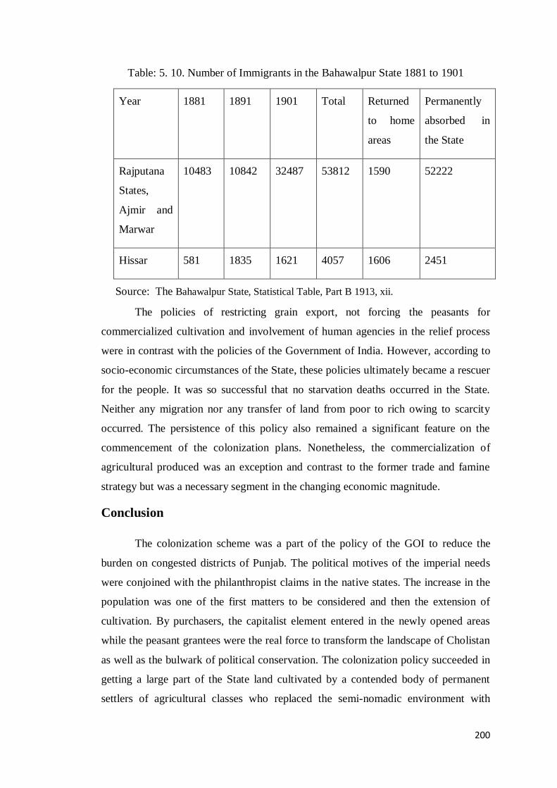
200
Table: 5. 10. Number of Immigrants in the Bahawalpur State 1881 to 1901
Year 1881 1891 1901 Total Returned
to home
areas
Permanently
absorbed in
the State
Rajputana
States,
Ajmir and
Marwar
10483 10842 32487 53812 1590 52222
Hissar 581 1835 1621 4057 1606 2451
Source: The Bahawalpur State, Statistical Table, Part B 1913, xii.
The policies of restricting grain export, not forcing the peasants for
commercialized cultivation and involvement of human agencies in the relief process
were in contrast with the policies of the Government of India. However, according to
socio-economic circumstances of the State, these policies ultimately became a rescuer
for the people. It was so successful that no starvation deaths occurred in the State.
Neither any migration nor any transfer of land from poor to rich owing to scarcity
occurred. The persistence of this policy also remained a significant feature on the
commencement of the colonization plans. Nonetheless, the commercialization of
agricultural produced was an exception and contrast to the former trade and famine
strategy but was a necessary segment in the changing economic magnitude.
Conclusion
The colonization scheme was a part of the policy of the GOI to reduce the
burden on congested districts of Punjab. The political motives of the imperial needs
were conjoined with the philanthropist claims in the native states. The increase in the
population was one of the first matters to be considered and then the extension of
cultivation. By purchasers, the capitalist element entered in the newly opened areas
while the peasant grantees were the real force to transform the landscape of Cholistan
as well as the bulwark of political conservation. The colonization policy succeeded in
getting a large part of the State land cultivated by a contended body of permanent
settlers of agricultural classes who replaced the semi-nomadic environment with

201
agricultural attribute. The transformation of barren tracts into populated region
stimulated the commercialized agricultural production and a great increase in the
demography and income of the State. At the same time, the centuries old hub of
socio-economic activities was disappearing into oblivion of history with the
emergence of the new urban centers. The extensive trade and commercial network
connected the Princely State not only with the rest of India but also with the world
market.
202
Conclusion
The present study is an insight into the economic aspect of the agrarian history
of the Princely State of Bahawalpur. The princely states of India, in fact had their own
independent administrative system and separate socio-economic character borne out
of the indigenous environment. In the territory comprising the Bahawalpur State,
agriculture was the dominant profession. The political supremacy of the region came
into the hands of the Abbasid rulers during the fall of the Mughal dynasty. They
obtained a jagir as a grant from Mughals, extended its borders entirely with the help
of their tribe Daudputra Abbasids on the battlefield and knit the scattered surrounding
areas into one united regional entity with heritable form of rule. This newly emerged
political unit gradually came to occupy an important strategic position, laying at the
base of Punjab and having a long conjoint river frontage that could serve as a barrier
against in roads from the Punjab province. The first striking thing on the newly
appeared face of the area was the establishment of Peace and Harmony that provided
an environment for a viable political structure and stable subsistence based economy.
The idea of agrarian development in the State was present in its formative years.
However, its pastoral character was of equal importance in the initial stage of the
State economy.
The relations with the British stimulated the economic activities in the State
and later when all the Indian India became subordinate to the EIC, the Bahawalpur
State served in the various military expeditions being an ally of the British under
various agreements. However, being a guardian government the intervention of the
GOI in the internal administration of the State left a modern and sophisticated impact
on the traditional polity. The Agency in fact, was the foundational juncture of
institutional framework. There was an overhauling in each department of
administration and the constitutional mechanism of political power was used to shore
up the economic development. The first and foremost feat of the British Agency rule
in the State was to consolidate the economic sector particularly the realm of
agriculture. The economic life of the State under the first Agency rule was
transformed from its aboriginal outlook to an agricultural character.
The statistical accounts combined with spatial conception, emerging from
surveys, census and measurements provide an indispensible basis for rational

203
discussions. Subsequently, this knowledge paved the way for formulating the novel
economic policies. Exact area of land and average crops yield have been obtained for
the first time. The impact of modernity manifested in the form of picturesque villages,
precise measurements and ordering of space. There emerged a qualitative shift in
agriculture from inferior quality food crops to superior food crops. A proper farming
attitude among the native population appeared, which improved the style of
cultivation such as deeper tilling and focus on quality in place of quantity of yields.
The subsistence agriculture was sufficient to feed the sparse population of the
State. However, a conducive agrarian environment attracted the people from the rest
of India. The vital feature of the time was that in the Bahawalpur State was the
premier region where the disbanded Sikh personnel were engaged in agricultural
pursuits. The Sikh Jats, the best class of agriculturists in India were the pioneers of
agriculture production from the barren and sandy soil of Cholistan. Afterwards, the
other outsiders from the different parts of India joined them and were absorbed into
the socio-economic arena of the State.
In regard with the ownership of agricultural land, the proprietary rights were
fully acknowledged in 1867, which were confined to the irrigated areas largely in the
lamma part of the State where proper village communities were to be found. The
proprietary rights over land were the most influential move towards agrarian
development and were a guarantee for a secure agricultural economy. Consequently,
the land became a source of pride within the social structure of the State. However,
class disparity was distinctively apparent in the agrarian structure and the land owners
were the most privileged section of rural society.
The Bahawalpur region was the land of self-cultivators but the institution of
tenancy was also valuable and the demand for tenants was always recognized. A
common feature of the indigenous peasants was that they were sluggish in doing hard
labour but expected the best of future. The reason behind was probably that the local
society spent a long time in the stagnant environment of subsistence economy. The
Agency regime proved to be a first step towards the breakdown of this stagnation and
it coincided with the refined style of cultivation and modern farming. This new
agrarian environment brought an increase in the State income, as the revenue from
agricultural land was more than the other sectors of economy.

204
Being an agrarian based country, land revenue on the soil and its produce was
a major source of the State income. There existed a traditional leniency in the system
particularly, due to seasonal variation. Under the aegis of the British Agency, the
leniency was maintained because the nature of the Agency government in the native
states was not extractive like in the British India. Instead, here the traditional patterns
of the princely India were dominant because their persistence was a political necessity
for the native governments. In this scenario, the Agency did not adopt a new system;
instead it polished the existing native principles
The process of land settlements were the significant operations in land revenue
system. Its primary undertaking was to settle the land for assessing and apportioning
the State‟s share. The assessment was made at a rate less than that in Punjab where
initially the assessment was taken at 50% and later at 33%, whereas the State received
formerly 33% and after the Sutlej valley project it collected 25%. The maintenance of
records of rights and agricultural statistics was to facilitate the assessment of revenue
as well as brought comforts to the subjects and provided a valuable public service.
However, the variables of surveys, measurements, killabandi and sliding scale were
the major components of a sophisticated system as well as the dynamics of the
agrarian change happening in the State.
The revenue free` jagirs in the State consisted mainly of religious endowments
and prompted by political imperatives. By examining their nature and configuration,
two results are observed. First, the former warlords appropriated large tracts of land
and assumed the status of feudal lords. This feudalistic element of the agrarian
economy entered in the commercial and political arena of the State. Second, the
religious persons wielded extraordinary power due to their land holdings and the
reigns of rural society were totally in their hands. They held the status of both a pir
and a landlord. But this joint control was seditious for the peasantry because this
highest stratum of society was slacking the development and in grooming of the
masses. On the other side, the lower bureaucracy, despite the existence of a proper
system of checks and balances, continued the secret dealings with this class just to
gratify its illegal interests. With the conjoint working of both these elements and the
connivance of the lower bureaucracy, the ownership of land and the water resources
underpinning the agrarian economy of the region became concentrated in a few hands
in the ensuing years.

205
To shore up the land revenue, large-scale public works of „irrigation‟ were
initiated. The scarcity of rain and long river frontage provided the base for artificial
irrigation. River water was the main force behind the economic development and
agricultural prosperity. The native rulers were enthusiastic to increase the cultivated
area by bringing more and more waste or pasture lands under cultivation through
irrigation plans. Their attention thus far had been confined to the proprietary areas.
The Agency that had knowledge of and access to advance technology of the time,
focused on both plains and desert as well. The preference was given to strengthen the
existing water channels in the ancient areas and then irrigating the desert land.
However, the desert area gradually occupied first place in the government programs.
The traditional irrigation was closely linked to the social set up. The local
people and regional elites were responsible for digging and maintaining canals
through chherr – the collective labour- while the State was their partner. Under the
Agency, the maintenance of collective action of community management was
maintained and improved because the need of periodically mobilized labour to
maintain the flow of canals remained essential for the sustenance of traditional
irrigation. By the time, the control of the State over irrigation matters was increasing
and the canal department was reorganized and restructured, which lessened the
community participation in irrigation matters. With the new infrastructure, the
refurbishment of existing inundation canals was focused along with the new projects.
Chherr system was retained, during the Agency period with some
modifications and improvements. The community-based structure persisted and the
canal schemes were implemented through district Nazims and tehsil officials by
engaging the zamindars. Fordwah and ESC were the primary stimulation to transition
the economy from pastorlism to agriculture. Both ventures contributed to two-fold
increase in immigrants into the State from Rajasthan and Punjab. It also set down a
precedent for the later projects in the sandy soil of Cholistan.
In the early 20th century, when the GOI decided to utilize the irrigation
potential of India with the help of their advanced technology and financial resources,
the arid Cholistan became a part of this mega scheme. The plank of scientific
techniques by British engineers made it possible to flow the water in the sandy desert.
The SVP was a joint venture to provide weir-controlled irrigation to the waterless
zones of the Bahawalpur State, the British Punjab and the Bikaner State. The Sutlej

206
Valley Tripartite Agreement was substantially the first agreement over the sharing of
water in Indus Basin. It was of course, an agrarian conquest over nature in term of
both the controlling the water and converting the desert into agricultural land.
However, to obtain the fruits of the scheme, the Bahawalpur State had to struggle
more than the other two partners in the project.
Actually, the project was prepared in the midst of World War-I and executed
during the slump years. The over estimation of water supply and under estimation of
expenditures in original plan was the major mistake. These mistakes in the estimation
brought a serious effect on the finances of the State. There was 63% increase in cost
and the State had no way except to borrow the loan, which was initially Rs. 50,00,000
lacs from the GOP and then further RS 12, 11, 00,000 from the GOI on compound
interest. In lieu of the debt, the GOP held control over revenue, finance and
colonization departments of the State. For the GOI, the success of the Bahawalpur
colony was essential to the security of the SVP loan.
The GOI was originator of the project but in imposing rigorous terms and
compound interest for the loan, its role was despotic. Due to heavy installments with
compound interest, the State was unable to undertake any other productive schemes.
Even the State had to face difficulty in paying the salaries to its employees and in
expending on other services or nation building programs. Therefore, the first priority
of the State was to liquidate the loan as early as possible. In this regard, some
emergency steps were taken to overcome the financial constrains to collect money for
the urgent need of liquidation. The culmination of these measures was that the State
successfully responded to this great challenge and within 11 years, it was able to pay
the amount to the GOI; almost forty years before it was due.
From a long-term perspective, the project became a locomotive for socio-
economic development of the arid areas. A developed canal system optimized the
water supply to a vast area, reduced wastage and enlarged the cultivated area. It also
stimulated the progress in communication system in the State. Irrigation became a
large-scale commercial operation after the SVP. However, at the same time, old
sailaba land increasingly converted into swamp and saline tracts. This was a problem
confronted by all canal-irrigated areas in India.

207
However, this fact cannot be overlooked that without the British influence and
establishment of colonial institutions, there could have been no significant change
towards socio-eocnomic progress in the Indian society whether in the British India or
in the princely India. The SVP did provide an impetus for change in the ethnography,
demography and landscape of the region. The human settlement in the sandy soil of
Cholistan and in the wastelands of old areas was a fascinating undertaking. The newly
settled lands were populated with the colonists from Punjab and sizeable allotments of
land were made on a variety of bases. The Purchasers and the peasant grantees were
the major stakeholder. To be a Muslim and the member of agricultural tribe was
major condition for abadkars while purchasers had less restriction and more free
treatment. In a way, the State maintained its identity as a Muslim entity. Almost all
applicants were given land due to the want of the peasants in the State. Besides, there
were some other patterns to brought capital from the canal lands. These were for
military and civilian officers and camel breeding. Military grants generated an
antecedent of transforming the military into feudal elements in the ensuing years.
Initially, the yields were poor because of uncertain supply. However; the
development in crop production and peasantry was visible after the slump years. After
the war, the colonists were able to consolidate their economic position and expanded
their holdings. There was increased activity in getting the ownership rights after the
World War-II. The settlers turned their allotted arid areas into flourished ones. It
brought an increase in the production of surplus food and finally resulted in the urban
growth. Many towns were developed into major marketing centers, which earlier were
not there or existed with insignificant habitants. The village sites of the State
experienced a mechanical age such as the colonies were the forerunner of
industrialization. It was mandatory for each market town to have one cotton and
pressing factory.
The aftermaths of industrial revolution in the Great Britain were also seen in
the State. With the increasing urban growth, handlooms vanished, artisans became
unemployed particularly weavers and potter. Likewise, labour on indigo production
and boatmen lost their professions. For instance, new patterns affected the local
industries for which the State was famous. Local cloth export replaced by the raw
cotton supplied to imperial metropolises.

208
Class based tension did not emerge initially but territorial based complexities
and regional differences appeared between the old proprietary areas and the new
colonies. For instance, the colonies were provided with public services and amenities.
It was not possible for government to facilitate the old areas at the same time with
these provisions due to financial stringenceis. This created a division of socio-
economic standards between the old and the new. The colonization program in the
State was distinctive in many respects. First, it helped mingle the socio-cultural
patterns of the British India into the princely India. With settling of the outsiders, the
colony tracts developed into a multi-clan territory of agricultural classes, interwoven
through various social, economic, political and historical-cultural ties. However, the
caste and the biradri system were strong in the new social setup. Second, the Indian‟s
India has always welcomed the foreign elements of change. The land of Bahawalpur
region has always been very fertile to absorb the outsiders, which was the beginning
of the breakdown of centuries old patterns of semi-nomadic life. In a way, stagnant
make up of the traditional India was also going to be altered.
On the other side, the Nawab rulers indirectly, sheltered social disparity. There
was a chance to abolish the monopoly of big landlords on the eve of the colonization
programme in 1930s. The Council and Prime Minister of the State suggested
auctioning the large tracts under waqf and jagir but the Nawab refused to break his
power-base. Therefore, it could be assessed that this step was not aimed at solving
the issues confronted by the rest of the peasantry and were indirectly in favour of the
native aristocracy.
The study bridges two paradigms of economy; a traditional and unscientific
phase of economy and an era full of prospects of sea pack economy. The research
summarizes the development of most of the variables of an agrarian economy
examined in this study. The chapter one provides an introduction to the research and
introduced the princely state of Bahawalpur that had a great potential of development
almost in all organs of an agrarian economy. The crux of chapter two displays that
there was four-fold increase in the area under agricultural production as well as the up
gradation in the style of farming, which essentially improved the socio-economic
standard of the peasant classes. Chapter three shows the progress in the revenue
structure. An organized system of revenue and settlements of land enhanced the State
income from Rs.1316021 in 1870-71 to Rs. 5812474 in 1945-46.

209
Chapter four displays the progress of irrigation from traditional system to
modern and measured water system, which resulted in an increase in the canal-
irrigated area from 34702 acres in 1867 to 807846 acres in 1924 and further raised to
20, 00,000 acres in 1940s. The length of the canal network also extended from 810
miles to 4000 miles. Chapter five demonstrates the progress in the population index,
which went up from 364502 in 1867 to 1341209 in 1941. For instance, the
construction of roads and railway, bridging the river, launching the educational
institutions, providing the public health amenities, and above all founding a number
of market towns were all the reflectors of a growth oriented economy and were a
move towards the urbanization. At the time of partition of India, there was a
development-oriented administrative and economic structure.
All these developments were undertaken at a time when the Bahawalpur State
was part of an imperial system of the British India and its resources were also lavishly
exhausted for the sake of the British interests at different levels. Imperial Service
Troops, Camel Corps, War Funds were the new forms of old war services and proved
to be a heavy burden on the financial resources of the Princely States. In spite of these
extra expenses, the development index of the State was quite high. In the present
scenario of regional backwardness of Bahawalpur division, when all the resources are
under the control of a single government, the paradigms of development can be
adopted in a more sophisticated and systematic way. However, some suggestions are
given to make the research present oriented.
Firstly, education through counseling are the best way to address the
prolonged intellectual stagnation as well as an influential tool for awakening the
political consciousness among the people, particularly that of the old proprietary
areas, which are still under the control of big landlords. Secondly, the large parcels of
land, expanding over thousands acres, under the control of demigods should be
repossessed by the government or distributed among the occupancy tenants. Thirdly,
in the un-colonized and uncultivated areas of Cholistan, which are far from the reach
of artificial irrigation, sheep and camel breeding are the significant source of the
region‟s economy. This potent source can be extensively commercialized by
promoting the large-scale wool and cotton industry by the government.
This research quantifies all data pertaining to production, revenue collection,
irrigation and enterprises carried out both by the local rulers and the British. It will
210
draw the attention of researchers to look into different areas of research with more
logical, scientific and calculated point of view. The present research has raised a
number of questions, which can be addressed in further research. The correlation of
agrarian economy with the socio-cultural life of old village communities might be
focused in the vast spectrum of the princely India. The comparison with similar
processes in the British India and other Princely States will also provide a solid
platform for intellectual discussion. The broader perspective of ethnography of
agrarian societies in the Bahawalpur State in both the old proprietary areas and the
colony tracts will be an important theme for a separate investigation. The arrival and
allotment of refugees to the colony areas and the socio-cultural changes brought by
them in the existing set up of this region, also demands a separate study. Moreover,
the insights into the trade, labour relations and the role of the State bureaucracy in the
irrigation-based development thrust have a vast potential for study, which can be seen
in the light of new research dimensions.

211
Bibliography
1. MANUSCRIPT
Persian
Rai, Daulat. Maraat-e-Doulat –e- Abbasia (Delhi: 1809). Translated in Urdu by
Nizam-Ud-din, Mohammad. Aaina Abbas-e-Sultani (Sadiqabad: 1974).
Urdu
Gardezi, Murad Shah. Tarikh-e-Murad, Vol IV & V (Bahawalpur: 1875).
English
Din, Mohammad. The Political History of Bahawalpur State: 1833-1866 Part II
(Bahawalpur: 1930).
Mehta, Radhika Lal. The History of Bahawalpur Canals (Bahawalpur: 1927).
2. OFFICIAL DOCUMENTS
I. Unpublished Record
i. Punjab Archive
Persian Documents (Ludhiana Agency)
Treaties between East India Company and the Government of Bahawalpur;
22nd
February 1833.
5th October 1935.
13th September 1838.
English Documents
Captain Wade‟s Letter written to the Government of India in the Secret Department:
from January to June 1837; July to December 1837; January to July 1838.
Correspondence files A & B between Bahawalpur State and East India Company.
Correspondence files A & B between Bahawalpur State and Government of India.

212
Dairy of Phulkian States Agency by Dunlop Smith, Political Agent, from 1st April
1903 to 31 March 1905.
Punjab Records. Book 9, Application of nawab for protection of his Cis-Sutlej
possessions from Ranjit Sing on 15 January 1815.
_________. Book 31, Application of nawab protection against Ranjit Sing on 19 July
1815.
_________. Book 33, Application of nawab for Sutlej side protection on 29 July 1815.
_________. Book 38, Application of nawab to declare his possessions of Cis-Sutlej side
as under British protection on 7 August 1815.
_________. Book; 107, no, 25, Lieutenant R. Leech, Commercial Information
regarding Bahawal Khan’s Territory, on July 1837,110.
_________. Book 110 (ii), Letter no 81, From C. Mackeson to C. Wade, Political
Agent Ludhiana on 29 August 1838.
_________. Book 110 (ii), Letter no 103, From C. Mackeson to C. M. Wade, Political
Agent Ludhiana on 28 October, 1838
_________. Book 163, Letter no. 4, Transfer of Districts of Sabzal Kot and Bhoong to
Bahawalpur on 10 February 1843.
_________. Misl No: 12, Selections from the old Record of Bahawalpur State, 25
June 1855.
ii. Muhafiz Khana Bahawalpur
Urdu Records
Bandobast State, Mehakma-e-Mal 1900-01.
Bandobast of Bahawalpur State, by Settlement Commissioner Abdul Malik on 22nd
May 1915.
Bandobast-e-Riyasat, Minchinabad District 1921, Mehakma-e-Mal.
Darakht Pal Scheme, 1941.
Dasturul Amal Barai e Amla Mal, District Rahimyar Khan, 1948.

213
Jamabandi Record, Mauza Mahrabwala 1915-16, (manuscript)
Register Babat Afzaish-e-Riyaa 1879.
Tejveez Committee Mutauliq Intizam-e-Anhar on 15 April 1901.
English Records
Bahawalpur Darbar Secretariat, Office of the Prime Minister Bahawalpur State
Abadkari Grants 1928.
Administrative Files Regarding the Changes in Administrative Division of
Bahawalpur State 1933.
Area Allotted to the Sikh Population in the State
Draft Memorandum by the Bahawalpur Government on Sutlej Valley Project Debt.
From Wazir Bahawalpur State, A Report Showing how far the Prosperity of
Bahawalpur State Riverain Territory has been Injured by the Construction of the
Sirhind Perennial Canal. October, 1900.
Levy of Water Advantage Rates, 1937.
Lump Sum Payment and Concession Scheme, 1931.
Old Record of Inam and Kasoor, (date is omitted).
Reclamation in Bahawalpur State, 1946.
Re-organization of Revenue Department and Amalgamation of Revenue and Colony
Department, 1939.
Repayment of Government of India Loan: Note on the Financial Position of the State
and Working of the 1936 Settlement, 1946.
Sale of Land in Bahawalnagar District, 1947.
Terms of Agreement for Sutlej Valley Project Loan, 1932.
Translation of Farman of the Nawab Ruler regarding Makhdumul Mulk Ghulam
Meeran Shah on 15-8-41.

214
Military Department Dera Nawab Sahab, Office of the Military Secretary
Bahawalpur State
File: 225-A, 1924-25, Grant of Land to the Military Men.
Office of the Chief Minister Bahawalpur State
Extension of Khushhasiyate Levy, 1926.
Joint Programme of Colonization and Sale of Land in Connection with the Punjab
Government.
Scheme for the Military Colonization of the Lower Sutlej (Nili Bar) Canal.
Office of Public Works Member Council of Regency, Bahawalpur State
Notes on the Colonization of State lands.
Unpublished Reports:
Public Works and Revenue Department Bahawalpur State
Administration Report of Agriculture for the year: 1931-32, 1939-40, 1946-47.
Annual Administration Reports for the Year: 1921-22, 1922-23, 1927-28, 1929-30,
1930-31, 1931-32, 1932-33, 1933-34, 1939-40.
Assessment Report of Ahmadpur East for the year: 1923, 1946.
______________ Allahbad Tehsil for the year: 1926, 1946.
______________ Bahawalnagar and Minchinabad, 1948.
______________ Chishtian Tehsil, 1949.
______________ Cholistan, 1929.
______________ Cholistan, 1930.
______________ Cholistan Portion of Bahawalnagar and Minchinabad Tehsils,1929.
______________ Minchinabad Tehsil, 1947.
______________ Sadiqabad Tehsil, 1944.

215
______________ Rahimyar Khan District, 1944.
Colony Administration Reports for the years: 1929-30, 1930-31, 1931-32, 1932-33.
Colony Progress Reports for the years: 1939-40, 1940-41, 19441-42, 1942-43,
1943-44, 1944-45, 1945-46.
Cooperation between Land Revenue, Colonization and Irrigation Department, 1937.
Crop Experiment Report, 1946.
Division of Land Revenue, Forest and Irrigation Receipts between the State and Sutlej
Valley Project, 1933.
Draft Orders on the Assessment Report of the Ahmadpur East Tehsil, 1946.
Irrigation Reports for the Year: 1945-46, 1948-49.
Post War Reconstruction, Public Works Post War Proposals: Land Drainage and
Preparation of Shajras, 1947.
Reports on Mandi Lands, 1941.
Re- Assessment of Proprietary Cholistan, 1936.
Restoration of Wells in the State, 1939.
Revenue Rates, Fluctuating Assessment, Nazrana on Land etc., 1923.
Revenue rates in Adjacent Punjab districts, 1932.
Report on Land Revenue Arrears and Remissions 1930.
Special Administration Report of Irrigation Branch on Sutlej Valley Project 1925-26
to 1942-43.
Settlement Report for Bahawalpur and Ahmadpur East Tehsils, 1930.
________________ . Allahbad Tehsil 1939-40.
________________ . Cholistan, 1927.
________________. Khanpur District, 1922.
216
________________. Forecast Rahimyar Khan District, 1943.
________________. Forecast Bahawalpur District, 1946.
Settling of outsiders in the State, 1947.
Statement of Demand and General Remissions, 1936-37.
Temporary Cultivation and Development of Proprietary Area 1934-35.
Unpublished Gazetteers of Bahawalpur State:
Gazetteers of Bahawalpur State Part B for the Year: 1928, 1936, 1939-40, 1940-41,
1944-45.
Files :
File: 284-A, 1900. Note on Canal Establishment addressed to Mushir e Mal by
Colonel H Grey dated 12 November 1900
File: 328 -I, 1928. Disposal of Colony Land.
File: 222-II, 1929. Official Letter from Office of Political Agent Phulkian States and
Bahawalpur on dated 1-4-1912, No. 24/ 699.
File: 179-25, 1929. Purchase of Land by Diwan Syed Mohammad of Pak Pattan.
File: 22-H, 1931, Factory at Harudabad.
File: 179-17, Part IV, 1937. Purchase of Land by Union of Agricultural Syndicate,
Rahimyar Khan.
File: 119, Part I, 1939. Procedure to be Followed under the New Constitution in
Dealing with Irrigation Projects etc.
File C-79, Part I, 1939. Bahawalpur Darbar Secretariat, Official Correspondence
between Secretary of Punjab States and Prime Minister of Bahawalpur State on 20-6-
1940.
File: 29-B, 1941. Cattle Census.
File: 22-Q, 1941. Mandi Lands.
File: 184, 1941. Notices and Conditions of Sale of Land in Bahawalpur State Colony,
1926-1941.
File 502, 1942. Exchange of Information Fortnightly Reports for 1942-47.

217
File: 179-31, 1942. Land to Major Shamsud Din, Deputy Commissioner Rahimyar
Khan, Letter 106-c on 8 March 1942.
File: 12-A, Part III, 1942. Levy of Acreage Rate 1944.
File: 9-36, 1943, Post War Settlement: Note on Military Chakks by Prime Minister
Bahawalpur on 4 June 1943.
File: 9-39, 1943. Post War Settlement: Chakks reserved for Demobilized Soldiers:
Letter from Revenue Minister to the General Officer Commanding Bahawalpur State
Forces on 14-12-43.
File: 232, Part XI, 1944. Military Services : Application of Hev. Baker Ahmad Din
from Batala District Gurdaspur.
File 520, 1945. Late Makhdoom Hamid Mahmood Sjjadah Nashin of Uch Bokhari,
File: 520-A, 1946. Matters Relating to Uch Gillani.
File: 19-35, 1946, Bahawalpur Darbar Secretariat, Repayment of Project Loan 1946.
File: G8-193, 1948, Part II, Bahawalpur Darbar Secretariat, Repayment of Sutlej Valley
Project Debt, 1948.
File: 271-A, 1951, His Highness jagir in Taif.
File 275-12-A, 1951. Agricultural Income Tax and Auqaf Land.
II Published Record Official
The Government of Bahawalpur. The Annual Administration Report of the
Bahawalpur State for Years:1866-67, 1867-68, 1868-69, 1869-70, 1871-72, 1872-73,
1873-74, 1874-75, 1875-76, 1876-77, 1877-78, 1878-79, 1888-89, 1898-99,1899-
1900, 1904-05, 1905-06, 1908-09, 1910-11, 1911-12, 1914-15, 1919-20, 1920-21,
1934-35, 1941-42, 1942-43, 1944-45, 1945-46.
____________________. A Note on the Claims of Bahawalpur State submitted to
H.E. Crown Representatives 1941(Lahore: 1941).
_____________________. The Century of the British-Bahawalpur Alliance (Lahore:
1933).
_____________________. Information and Publicity Department, Bahawalpur State:
1949-50 (Bahawalpur: 1950).

218
_____________________. Review on Sir Barnard Darley project by Prime Minister
of Bahawalpur.
______________________. Sutlej Valley Project, June 1920.
_____________________. Report of the Sutlej Valley Project Inquiry committee
(Lahore: 1932).
The Government of India. The Imperial Gazetteer of India (Oxford: 1909).
_____________________. Measures to stop the Immigration from Native States in
the Punjab (scarcity), (January: 1902).
_____________________. Memoranda on the Indian States (Calcutta: 1930).
_____________________. Revenue and Agriculture Department Abstract Famine
Code for Native States (scarcity), (May: 1896).
____________________. Report on the Famine Relief Measures adopted in the
Bahawalpur Stat (March: 1897).
The Government of Pakistan. Census Report of Punjab 1998 (Islamabad: 2001).
The Government of Punjab. Lower Jhelum Canal: Punjab Canal Gazetteer Vol. 1
(Lahore: 1921).
____________________. Political Proceeding for the Year: 1870-71; 1872-73; 1978-
79.
____________________. Punjab Colony Manual (Lahore: 1926).
____________________. Punjab States Gazetteers: Vol. XXXVI-B. Bahawalpur
State, Statistical Table 1904 (Lahore: 1908).
____________________. Punjab States Gazetteers: Vol. XXXVI-B. Bahawalpur
State, Statistical Table 1913 (Lahore: 1913).
____________________. Punjab States Gazetteers: Vol. XLV-B. Bahawalpur State,
Statistical Table 1935 (Lahore: 1935).
219
____________________. Punjab District Gazetteers Vol. XVIII- Montgomery District
with Maps193 I (Lahore: 1935).
____________________. Punjab State Gazetteers Vol. XVII- B Phulkian States,
Statistical Table 1913 (Lahore: 1915).
____________________. Punjab State Gazetteers: Vol. XLII-B. Patiala State,
Statistical Table 1936 (Lahore: 1937).
____________________. Selections from Records from the office of the Financial
Commissioner Punjab, No. LXXV. Principles Applicable to State Canal Assessment
in Punjab (1900).
____________________. Papers relating to the Canals (Lahore: 1887).
The Government of West Pakistan. Bahawalpur Code (Lahore: 1967).
The Government of West Pakistan. The Colony Manual Vol. II: 1967 (Bahawalpur:
1967).
Urdu
The Bahawalpur Government. Hidaayat-e-Kkhet Bandi (Bahawalpur: Sadiq-ul-
Anwar Press, 1915).
___________________, Sadiq-ul-Akhbar, December, 1867.
___________________, _____________, 1 January, 1872.
___________________, _____________, 1 April, 1872.
___________________, _____________, 1 April, 1874.
___________________, _____________, 8 December, 1888.
___________________, _____________, 1 March, 1906.
___________________, _____________, 31 May, 1906.
___________________, _____________, 20 July, 1922.
___________________, _____________, 13 May, 1926.
___________________, _____________, 17 February, 1927.
___________________, _____________, 8 November, 1928.
___________________, _____________, 20 August, 1931.
220
3. SECONDARY SOURCES
Research Papers in Journals:
Alvi, Hamza. „Rural Elites and Agricultural Development in Pakistan‟. Pakistan
Economic and Social Review, Vol. 14, No 1/4, (1976).
Arora, A.C. „British Government and Minorities of Native Chiefs (1858-1905): A
Case Study of Bahawalpur State‟. The Past and Present vol. X, No. I (April 1976).
Banerjee, Himadari. „Kamis of Punjab‟. The Punjab Past and Present XIII: X
(October, 1985).
Barnett, Richard B. „The Greenings of Bahawalpur: Ecological Pragmatism and State
Formation in Pre-British Western India 1730-1870‟. Indo British Review: A Journal
of History, Vol. XV, No.2 (December, 1988).
Benton, John. „Irrigation Works in India‟ Journal of the Royal Society of Arts, Vol. 61,
No. 3160 (June 13, 1913).
Barton, William. „Post-War Development Schemes in Northern and Central Indian
States‟. Journal of Royal Society of Arts, Vol. 94, No.4708 (January 4th
, 1944).
Buck, C.H. „Canal Irrigation in the Punjab‟. The Geographical Journal, Vol. 27, No.
1 (January, 1906).
Burns, J. W. „Notes on the Physical Geography of the Bahawalpur State‟. Journal of
The Royal Geographical Society of London, Vol. 42. (1872).
Byres, Terence J. „Political Economy, Agrarian Question and Comparative Method‟.
Economic and Political Weekly. Vol. 30, No. 10 (Mar 11, 1995).
Darley, Bernard. „The Development of Irrigation in India‟. Journal of Royal Society
of Arts. Vol. 90, No.4602 (December 12th, 1941).
Dhawan, B. D. „Indian Irrigation: An Assessment‟. Economic and Political Weekly.
Vol. 23, No. 19 (May 7, 1988).
Doui, James M. „The Punjab Canal Colonies‟. Journal of the Royal Society of Arts,
vol. 62, No. 3210 (May 29th, 1914).

221
Gilmartin, David. „Scientific Empire and Imperial Science: Colonialism and Irrigation
Technology in the Indus Basin‟. The Journal of South Asian Studies Vol.3,
No.4 (November, 1994).
_____________. „Religious Leadership and the Pakistan Movement in the Punjab‟.
Modern Asian Studies’. Vol. 13, No. 3 (1979).
Grewal, J. S. „Historical Geography of Punjab‟. Journal of Punjab Studies, Vol. 11,
No. 1, (2004).
Habib, Irfan. „Economics and the Historian‟. Social Scientist. Vol. 37, No. 5/6 (May-
June, 2009),
Hardiman, David. „Usury, Dearth and Famine in Western India‟. Past and Present,
No. 152 (August, 1996).
Islam, M. Mufakharul. „The Punjab Land Alienation Act and Professional
Moneylenders‟. Modern Asian Studies, Vol. 29, No. 2 (May, 1995).
Kenoyer, Jonathan Mark. „The Indus Valley Tradition in Pakistan and Western India‟.
Journal of World Pre-History, Vol. 5, No. 4 (December, 1991).
Mackeson, F. „Report on the Rout from Seersa to Bahawalpur‟. Journal of the Asiatic
Society of Bengal, Vol. XIII, From January to June 1844, Part 1 (Calcutta: 1844)
Possehl, Gregory. L. „The Transformation of Indus Civilization‟ Journal of World
Prehistory, Vol.11, No. 4 (December, 1997).
Stein, Aural. „A Survey of Ancient Sites Along the “Lost” Sarswati River‟. The
Geographical Journal, Vol. 99, No. 4 (April, 1942).
Talbot, Ian. „Punjab under Colonialism: Order and Transformation in British India‟.
Journal of Peasant Studies Vol. 14, NO.1 (Spring, 2007).
Wade, C.M. „Journal of a Voyage from Ludhiana to Mithonkot by the Satlaj River‟.
journal of Asiatic Society of Bengal, Vol. VI, Part I, January to June 1837.
Woods, F. W. „Irrigation Enterprise in India‟. Journal of the Royal Society of Arts.
Vol. 70, 3642 (September 8, 1922).
Dissertations:

222
Urdu
Gillani Aftab Hussain. Riyyasat –e-Bahawalpu ka Nizam-e-Adl: (1727-1955) aik
Tarikhi Jaizah (The Islamia University Bahawalpur: 2003).
Malik, Mohammad Akbar. Bahawalpur Mein Bahali-e-Subah KiTehri: AikTajziati
Mutalia (The Islamia University Bahawalpur: 2003).
Mohammad Tahir. Riasat Bahawalpur Ka Nazm-E-Mumlikat:1866-1947 (Zakariya
University Multan: 2008).
Rizvi, Shahid Hassan. Bahawalpur State Ki Taalimee-wo-Samaji Tarikh 1955
Tak (The Islamia University Bahawalpur: 2000).
English
Ian John Stone Kerr, The Punjab Province and the Lahore District, 1849-1872: A
Case Study British Colonial Rule and Social Change in India (University of
Minnesota: 1975).
Indu Agnihotri, Agrarian Change in the Canal Colonies Punjab 1890-1935 (Jawahir
Lal Nehru University New Delhi: 1987).
Timothy Daniel Haines, Building the Empire, Building the Nation: Water, Land, and
the Politics of river-Development in Sind, 1898-1969 (Royal Holloway College
London: 2011).
Published Books:
Persian
Muhammad Ghiasuddin, Ghias-ul-Lughat (Kanpur: Matba Razaqi,1243 Hijra).
Urdu
Abbassi, Mamoon. Sadiq Dost (Lahore: Maktaba- e- Jaded Press, 1972).
Abbassi, Muhammad Qamar-uz-Zaman. Baghdad se Bahawalpur (Lahore: Al-Fazal
Publications, 1987).

223
Ali, Mubarak. Akbar Ka Hindustan (Lahore: Fiction House, 1999).
_____________. Jagirdari (Lahore: Fiction House,1996).
_____________. Tarikn Aur Tehqiq (Lahore: Fiction House, 2002).
_____________.Tarikh: Sind Number16 (Lahore: Fiction House,2003).
Ali, Mir Nasir. Geographia Riasat Bahawalpur (Delhi: Matbaa-e- Rizvi, 1892).
Aziz, Aziz Ur Rehman. Subah Sadiq (Bahawalpur: Urdu Academy,1943).
_____________.Hayyat-e-Bahawal Khan (Bahawalpur:1939).
_____________. Mukhtasir Geographia Riasat-e-Bahawalpur (Bahawalpur: Aziz
-ul-Matabea Press, 1941).
Feroz, Mohammad Anwar. Aaena Darus Saroor Bahawalpur (Bahawalpur: Aaena
Darus Saroor, 1989).
Gurgani, Muhammad Ashraf & Muhammad Din. Sadiq-ut-Tawarikh (Bahawalpur:
Sadiqul Anwar Press, 1899).
Hafeez-ur-Rehman. Tamadan-e-Hind (Bahawalpur: 1923).
Hafeez-ur-Rehman. Ziker e Kram (Delhi: Mahboob Ul Matabe Press, 1937).
Hassan, Muhammad Manzoor. Guldasta- e- Manzoor (Bahawalpur: 1926).
Joya, Aftab Maqbool, Kitab Qaum-e-Joya, (Islamabad: NIHCR, 2011).
Khan, Khalifa Muhammad Hassan. Tarikh-e-Patiala (Amratsir: Hind Safeer Press,
1878).
Pirjani, Muhammad Jan Muhammad. Tarikh Khandan-e-Daudpotra (Bindur
Abbasian: 1941).
Shahab, Hassan Masud. Bahawal Pur ki Seyasi Tarikh (Lahore: Maktaba Illham,
1977).
____________. Khittai Pak Uch (Bahawalpur: Urdu Academy, 1964).
English

224
Agarwal, A. N. Indian Economy: Nature, Problems and Progress (New Delhi: Vikas
Publishing House, 1978).
Agarwal Arun. & K. Sivaramakrishnan. Agrarian Environments: Resources,
Representation and Rule in India (Durham & London: Duke University Press, 2000).
Ali, Imran. The Punjab under Imperialism, 1885-1947 (New Delhi: Oxford, 1989).
Ali, Shahamet. The History of Bahawalpur, With Notices of the Adjacent Countries of
Sindh, Afghanistan, Multan, and West of India (London: James Madden 1848).
Amini, Mohammad Taqi. The Agrarian System of Islam (Delhi: 1991).
Ansari, Sara. Life after Partition: Migration, Community and Strife in Sindh, 1947-
1962 (Oxford; Karachi: Oxford University Press, 2005).
Ashton, A.R. British Policy towards the Indian States (London: Curzon Press, 1982).
Auj, Nurul Zaman Ahmad. Cholistan: Land and People (Multan: Carvan Books,
1991).
Auj, Nurul Zaman Ahmad. Legacy of Cholistan (Multan: Carvan Books, 1995).
Bandopadhyay, Arun. The Agrarian Economy of Tamilnadu: 1820-1855 (Calcutta:
1992).
Banerjee, Himadari. Agrarian Society of the Punjab: 1849-1901 (Delhi: Manohar,
1982).
Barbara, N. Ramusack. The New Cambridge History of India: III. 6, The Indian
Princes and their States (Cambridge: Cambridge University Press, 2004), 4.
Bhattia, B.M. The Famines in India (New York: Asia Publishing House, 1963).
Boileau, A.H.E. Personal Narrative of a Visit to the Indus and Bahawalpur in 1835
(Calcutta: 1837).
Bose, Sugata & Ayesha Jalal. Modern South Asia: History, Culture and Political
Economy (Delhi: Oxford, 1997).
225
Bose, Sugata. Agrarian Bengal; Economy Social Structure, and Politics 1919-
1947(Cambridge: Cambridge university press, 2007).
Buckley, Robert Burton. Irrigation Works of India (London: E.&F. N. Spon, 1905).
Bangash, Yaqoob Khan. A Princely Affair: the Accession and Integration of the
Princely States of Pakistan, 1947-1955 (Karachi: Oxford, 2015).
Burnes, Alexander. A Voyage on the Indus (Karachi: 1973).
Burnes, Alexander. Cabool a personal narrative (Lahore: 1961).
Calvert, H. The Wealth and Welfare of the Punjab: Being Some Studies in Punjab
Rural Economics (Lahore: 1922).
Chamber of Princes. The British Crown & the Indian States (London: P.S. King &
Sons, 1929).
Cohen, G. A. Karl Marx’s Theory of History: A Defense (Oxford: Clarendon Press,
1978),
Copland, Ian. The Princes of India in the Endgame of Empire, 1917-47 (Cambridge:
Cambridge University Press, 1997).
Charlesworth, Neil. Peasant and Imperial Rule: Agriculture and Agrarian Society in
the Bombay Presidency 1850-1935 (Cambridge: Cambridge University Press, 1985).
Crook, W. The North-Western Provinces of India: their History, Ethnology, and
Administration (London: Metheon & Co, 1897).
D Cruz, Andrew. Political Relations existing between the British Government and
Native States and Chiefs subject to the Government of the North Western Provinces
(London: 1862) .
Darling, Malcolm Lyall. Wisdom and Waste in the Punjab Village (London: Oxford
University Press, 1934).
______________. The Old light and the New in Punjab Villages, (Cambridge: 1929).
______________. The Punjab Peasant in Prosperity and Debt (London: Oxford
University Press, 1925).

226
Denzil Charles Jeff Ibbetson, Punjab Castes (Patiala: 1995).
Douie, James M. Punjab Settlement Manual (Lahore: the Punjab Government, 1930).
Douie, James M. The Punjab, North-West Frontier Province and Kashmir
(Cambridge: Cambridge University Press).
Dutt, R.C. The Economic History of India (London: Routledge, 1963).
Elphinstone, Mountstaurt. An Account of The Kingdom of Caubul, and its
Dependencies, in Persia, Tartary and India: Comprising a view of the Afghan Nation,
and a History of the Dooranee Monarchy Vol. II (London: Richard Bentley, 1842).
Fagan, P.J. Land Revenue: its Origin and Development with Special Reference to the
Punjab. (Simla: 1921).
Field, Henry. An Anthropological Renaissance in West Pakistan 1955: with
Appendixes on the Archaeology and Natural History of Baluchistan and Bahawalpur
(Massachusetts: Peabody Museum Cambridge, 1959).
Ghose, Loke Nath. The Modern History of the Indian Chiefs, Rajas, Zamindars, Part I
(Calcutta: J.N. Ghose & Co, 1879).
Ghosh, O.K. The Changing Indian Civilization (Columbia: South Asia Book, 1976).
Gilmartin, David. „Models of the Hydraulic Environment: Colonial Irrigation, State
Power and Community in the Indus Basin‟ in David Arnold and Ramachandra
Guha(eds). Nature, Culture, Imperialism: Essays on the Environmental History of
South Asia (New Delhi: Oxford University Press, 1995).
Gilmartin, David. Empire and Islam: Punjab and the Making of Pakistan (Berkeley:
University of California Press, 1988).
Griffin, Lepel. H. The History of the Principal States of the Punjab and Their
Political Relations with the British Government (Lahore: 1976).
Griffiths, Percival Josef. The British Impact on India (London: Macdonald, 1952).
Guha, Sumit. The Agrarian Economy of Bombay Deccan (Delhi: Oxford, 1985).
Gundappa, D.V. The States and Their People in Indian Constitution (Mysore:
Karnataka Publishing House, 1931).

227
Gupta, Sulekh Chandra. Agrarian Relations and Early British Rule in India: A Case
Study of Ceded and Conquered Provinces (Uttar Peradesh) 1801-1833 (London: Asia
Publishing House, 1963).
Habib, Irfan. The Agrarian System of Mughal India:1556-1707 (Delhi: Oxford
University Press, 1999).
Habib, Irfan. Pre-History, People’s History of India (New Delhi: Aligarh Historians
Association, 2001).
Henry Miers Elliot, ed. John Dowson. The History of India: as Told by Its Own
Historians: The Muhammadan Period, Vol. I (London: Trubner and Co, 1967).
Hussaini, Nur Ali Zamin. Muaarif-e-Saraiki (Ahmadpur East: Mustafa Shah
Academy, 1972).
Islam, M. Mufakharul. Irrigation, Agriculture and Raj: Punjab, 1887-1948( New
Delhi: Manohar, 1997).
Islam, M. Mufakharul. Musalmans and Moneylenders in the Punjab (Edinburg and
London: W. Blackwood).
Jadhav, Praveen. Relative Disparity in the Implementation of Reservation Policy in
India (with Respect to Scheduled Castes) edit. Jagan Karade, Development of
Scheduled Castes and Scheduled Tribes in India (Newcastle: Cambridge Scholars
Publishing, 2008).
James, Hugo. A Volunteer’s Scrambles through Scinde, the Punjab, Hindustan and
the Himalayah Mountains (London: W. Thacher & Co, 1854).
Javed, Anmbreen. Politics of Bahawalpur from State to Region, 1947-2000 (Lahore:
Classic Publishers, 2004).
Jayasree, K. Agrarian Economy in Andhra under Vijayanagar (New Delhi: 1991).
Kaye, John William. The Administration of the East India Company; A History of
Indian Progress (London: Richard Bentley, 1853)
Keen, Caroline. Princely India and the British: Political Development and the
Operation of Empire (London; New York: I.B.Tauras, 2012).

228
Kenoyer, J. M. Early City-States in South Asia: Comparing the Harappan Phase and
the Early Historic Period, The Archaeology of City-States: Cross Cultural
Approaches, edit. Deborah L. Nichols and T. H. Charlton (Washington: Smithsonian
Institution Press, 1997).
Khalid, A. K. The Bahawalpur Perspective (Bahawalpur: 1974).
Khan, Ahmad Nabi. UCHCHH: History and Architecture (Islamabad: NIHCR, 2001).
Khan, Hussain Ahmad. Re-thinking Punjab: the Construction of Saraiki Identity
(Lahore: NCA publication, 2004).
Khera, P.N. British Policy towards Sind: Up to the Annexation 1843 (Lahore:
Minerva Book Shop, 1941).
Kosambi, Damodar Dharmanand. An Introduction to the Study of Indian History
(Mumbai: Popular Prakashan, 1998).
Kozlowski, Gregory C. Muslim Endowments and Society in British India (Cambridge:
Cambridge University Press, 1985).
Krader, L. The Asiatic Mode of Production (Netherland: Van Gorcum, 1975).
Krishnamurti, Y.Y. Indian States and Federal Plan (Bombay: Ratansey Parker,
1939).
Kulkarni,V.B. British Dominion in India and After (Bombay: 1959).
Kumar, Dharma. The Cambridge History of India (Calcutta: K.L. Mukhopadhyay,
1960).
Lambrick, H.T. Sir Charles Napier and Sind (Oxford: Clarendon Press, 1952).
Low, Sidney. The Indian States and Ruling Princes (London: 1929).
Ludden, David. The New Cambridge History of India: An Agrarian History of South
Asia , IV, 4 (Cambridge: Cambridge University Press, 1999).
MacMunn, George. The Martial Races of India (London: Sampson Low, Marston &
Co, 1933).

229
Madsen, Stig Toft. State, Society and the Environment in South Asia (Richmond:
Curzon, 1999).
Malik, I.H. Sikandar Hayat Khan: A Political Biography (Islamabad: NIHCR, 1985),
Malik, Muhammad Din. Gazetteer of the Bahawalpur State with Map 1904-A
(Lahore: Sang e Meel, 2001).
Mann, Harold. H. Land and Labour in a Deccan Village (Bombay: Oxford, 1917).
Martineau, Herriet. British Rule in India: A Historical Sketch (London: 1857)
Marx, Karl. Grundrisse, trans. with a foreword, Martin Nicolaus (New York: Vintage
Books, 1973).
Masson, Charles. Narrative of Various Journeys in Balochistan, Afghanistan and the
Punjab (London: Richard Bentley, 1844).
Menon, V. P. The Story of the Integration of the India (New York: Macmillan, 1956).
Metcalf, Barbara Daly and Thomas R. Metcalf. A Concise History of India (New
York: Cambridge, 2006).
Michel, Aloys Arthur. The Indus Rivers: A Study of the Effects of Partition (London:
Yale University Press, 1967).
Mookerjee, Radharomon. Occupancy Rights: its History and Incidents, Together with
an Introduction Dealing with Land Tenure in Ancient India (Calcutta: university of
Calcutta, 1919).
Moon, Penderel. Divide and Quit (London: Chatto and Windus, 1961).
Mosse, David. Cultivating Development: An Ethnography of Aid Policy and Practice
(London: Pluto Press, 2005).
Moosvi, Shireen. The Economy of the Mughal Empire, c. 1595: A Statistical Study
(Delhi: Oxford University Press, 1987)
Moreland, W.H. The Agrarian System of Muslim India at the Death of Akbar (Delhi:
Morison, Theodore. The Economic Transition in India (London: John Murray, 1911

230
Mughal, Mohammad Rafiq. Ancient Cholistan: History and Architecture (Lahore:
Ferozesons, 1992).
Mughal, Mohammad Rafiq. The Post-Harappan Phase in Bahawalpur District,
Pakistan, eds. Lal, B.B. and Gupta, S.P. Frontiers of the Indus Civilization (New
Delhi: Books and Books, 1984).
Mughal, Mohammad Rafiq. New Archeological Evidence from Bahawalpur, in Dani,
A. H. ed. Indus civilization: New Perspective (Islamabad: Centre for the Study of the
Civilizations of Central Asia, Quaid-e-Azam University,1980).
Mughal, Mohammad Rafiq. Recent Archeological Research in the Cholistan Desert, in
Gregory L. Possehl. ed. Harrapan Civilization (New Delhi: Oxford and IBH
publishers, 1993).
Mukherjee, Mridula. Colonializing Agriculture: The myth of Punjab Exceptionalism
(New Delhi: Sage, 2005).
Nabi, Ijaz, Naved Ahmid and Shahid Zahid. The Agrarian Economy of Pakistan:
Issues and Policies (Karachi: Oxford University Press, 1986).
O‟Brien, Adward. Glossary of the Multani Language Compared with Punjabi and
Sindhi (Lahore: 1881).
Orlich, Leopold Von. Travels in India including Sinde and Punjab, translated by
Travels in India including Sinde and Punjab, Vol. I, translated by H. Evans Lloyd,
(London: Longman, 1845).
Palijo, Rasul Bax. Sindh-Punjab Water Dispute 1859-2003 (Hyderabad: Centre For
Peace and Human Development, 2003).
Panwar, M.H. Six Thousand Years of History of Irrigation in Sindh (2011).
Paustian, Paul. Canal Irrigation in the Punjab (New York: AMS, 1968).
Peter Lane. The Industrial Revolution: The Birth Of Modern Age (London: Widened
and Nicholson, 1978).
Peter Robe. Rural India: Land, Power and Society under British Rule (London:
1983).
231
Powell, B. H. Baden. The Land- Systems of British India: Being a Manual of the land-
Tenures and of the Systems of Land-Revenue Administration Prevalent in the Several
Provinces (Delhi: Low Price Publication, 1892).
Powell, B. H. Baden. Land Revenue and Tenures in British India (London: Oxford,
1894 ).
Rai, Gulshan. Agricultural Statistics of the Punjab 1901-02 to 1935-36. (Lahore:
Board of Economic Enquiry,1937).
Randhawa, M.S. A History of Agriculture in India vol. III, 1757-1947 (New Delhi:
Indian Council for Agricultural Research, 1983)
Raverty, Henry George. The Mihran of the Sind and Its Tributaries (Lahore: 1979).
Rose, H.A. A Glossary of the Tribes and Castes of the Punjab and North-West
Frontier Province, Vol. II. (Lahore:1911).
Rudra, Ashok. Agrarian Power and Agricultural Productivity in South Asia
(Berkeley: 1984).
Salman, M.A. Salman and Kishor Uprety , Conflict and Cooperation on South Asia’s
International Rivers: A Legal Perspective (Washington D.C: the World Bank, 2003).
Sarkar, Jagadish Narayan. Mughal Economy: Organization and Working (Calcutta:
Naya Prokash, 1987).
Sarkar, Jagadish Narayan. Mughal Polity (Delhi: Idara Adbiyat-e-Delli, 1984).
Shah , Nazir Ali. Sadiq Nama (Lahore: Maktaba-E-Jaded, 1959).
Shah, Zulfiqar. Indus delta: and environmental assessment (Karachi: Pakistan fisher
folk forum, 2005).
Siddiqa, Ayesha. Military Inc. Inside Pakistan’s Military Economy (Karachi: Oxford
University Press, 2007).
Singh, Baljit. Wither Agriculture in India (Agra: N.R. Agarwal & Co, 1945).
Singh, Raghubir. Indian States and the New Regime (Bombay: H.D.B. Taraporsvau,
1938).
232
Srivastava, S.K. Bishamver Sahai, R.S.Nigam & Mrityunjot Baner Jee, Industrial
Economics (New Delhi: Chand & Co, 1967).
Stein, Burton. Peasant State and Society in Medieval South India (Delhi: Oxford,
1980).
Stone, Ian. Canal Irrigation in British India: Perspectives on Technological Change
in a Peasant Economy (Cambridge: Cambridge University Press, 1985).
Swain, Ashok. Environmental Cooperation in South Asia, eds. Ken Conca and
Geoffrey D. Dabelko, Environmental Peacemaking (Washington, D.C: Woodrow
Wilson Press, 2002).
Thorburn, S.S. Musalmans and Moneylenders in Punjab (Edinburg: W. Blackwood,
1886).
Thorburn, S.S. Punjab in Peace and War, (Edinburg: W. Blackwood, 1904).
Tod , James. Annals and Antiquities of Rajhistan, Vol.III (London: Oxford, 1920).
Toynbee, Arnold Joseph. A Study of History: Abridgement of Volumes I-VI by D.C.
Sumervell (London: Oxford University Press, 1946).
Trevaskis, Hugh Kennedy. An Economic History of Punjab. Vol.II (Gurgaon: Vintage
Books, 1989).
Wade, Robert. Village Republics: Economic Conditions for Collective Action in South
India (San Francisco: ICSG, 1994).
Warner, William Lee. The Native States of India (London: Macmillan and Co, 1910).
Warner, William Lee. The Protected Princes of India (London: Macmillan and Co,
1894).
Wheeler, Mortimer. The Indus Civilization (London: 1953).
Wilson, H.H. A Glossary of Judicial and Revenue Terms, and of Useful Words
Occurring in Official Documents relating to the Administration of the Government of
British India (London: W. H. Allen and CO, 1855).

233
Whitcombe, Elizabeth. Agrarian Conditions in Northern India, the United Provinces
under British Rule: 1860-1900 (Berkeley: University of California Press, 1972).
Wittfogel, Karl A. Oriental Despotism: A Comparative Study of Total Power (New
Haven: Yale University Press, 1957).
Yong, Tan Tai. The Garrison State: Military, Government and Society in Colonial
Punjab. 1849-1947 (New Delhi: Sage, 2005).
ENCYCLOPEDIAS:
Encyclopedia of Archeology: History and Discoveries Volume II, E-M, ed., Tim
Murray.

234
Appendixes

235
Appendix I: Rulers of Bahawalpur State
Period Ruler
1727-1746 Amir Sadiq Muhammad Khan I
1746-1749 Amir Bahawal Khan I
1749-1772 Amir Mubarak Khan
1772-1809 Nawab Bahawal Khan II
1809-1825 Nawab Sadiq Muhammad Khan II
1825-1852 Nawab Bahawal Khan III
1852-1853 Nawab Sadiq Muhammad Khan III
1853-1858 Nawab Fateh Khan
1858-1866 Nawab Bahawal Khan IV
1866-1879 First Council of Regency
1879-1899 Nawab Sadiq Muhammad Khan IV
1899-1903 Second Council of Regency
1903-1907 Nawab Bahawal Khan V
1907-1924 Third Council of Regency
1924-1954 Nawab Sadiq Muhammad Khan V

236
Appendix II: Weights and measures used in this research
Units of weights
1 seer = 0.93310 kilogram
40 seer = 1 maund
Units of Area
Begha= Half acre
1 acre = 2 Bigha or 4840 square yard
640 acre = 1 square mile
Units of length
Shahjahani small hath = 18 English inches
A common hath = 22 inches
2 hath = 1 Guz
12 inches = 1 foot
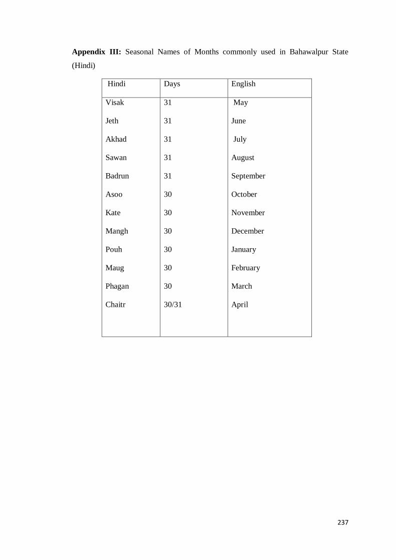
237
Appendix III: Seasonal Names of Months commonly used in Bahawalpur State
(Hindi)
Hindi Days English
Visak
Jeth
Akhad
Sawan
Badrun
Asoo
Kate
Mangh
Pouh
Maug
Phagan
Chaitr
31
31
31
31
31
30
30
30
30
30
30
30/31
May
June
July
August
September
October
November
December
January
February
March
April

238
Appendix IV: List of stages for accommodation and provision of commodities to
the British forces for Afghan Campaign

239
Appendix IV:continued

240
Appendix V: Title sheet containing the agreements of Bahawalpur with the EIC

241
Appendix VI: Partially population and housing census
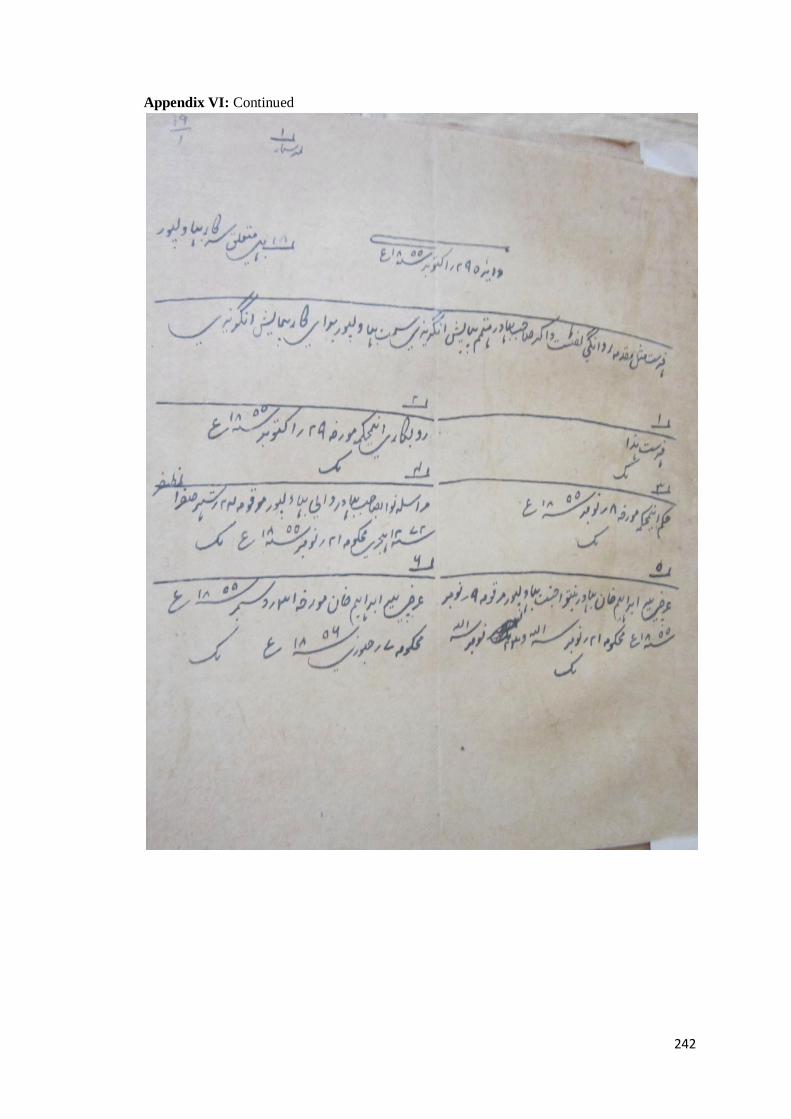
242
Appendix VI: Continued

243
Appendix VII: Native States under Punjab Government

244
Appendix VIII: Agricultural Classes as declared by Bahawalpur State according to
the
PALA 1900
Sr. Bahawalnagar Bahawalpur Rahimyar Khan
1 Arain Arain Arain
2 Langah Awan Langah
3 Afghan Pathan Baloch Awan
4 Baloch Bhatti Baloch
5 Bodla Bodla Pathan
6 Jat Afghan Pathan Jat
7 Rajput Panwar Daudpotra
8 Daudpotra Jat Rajput
9 Qureshi Chouhan Syed
10 Kamboh Daudpotras Qureshi
11 Sial Rajput Aarbi
12 Sayyed Sial Khokar
13 Mahar Syed Khagha
14 Mughal Abbassi Gujjar
15 Muhtam Aarbi Machi
16 Bishnoi Qureshi Mughal
17 Larr Kharal Muhtam
18 Minhans Kamboh Mahar
19 ------ Khokar Turk
20 ------ Khagha Sial
21 ------ Gujjar Sheikh
22 ------ Majawau ------
23 ------ Muhtam ------
24 ------ Mughal ------
25 ------ Minhans ------
26 ------ Mocharr ------
27 ------ Machhi ------
28 ------ Aheer ------
29 ------ Ansari ------
30 ------ Sheikh ------

245
Appendix IX: Establishment for killabandi in Minchinabad District of
Bahawalpur State in 1915
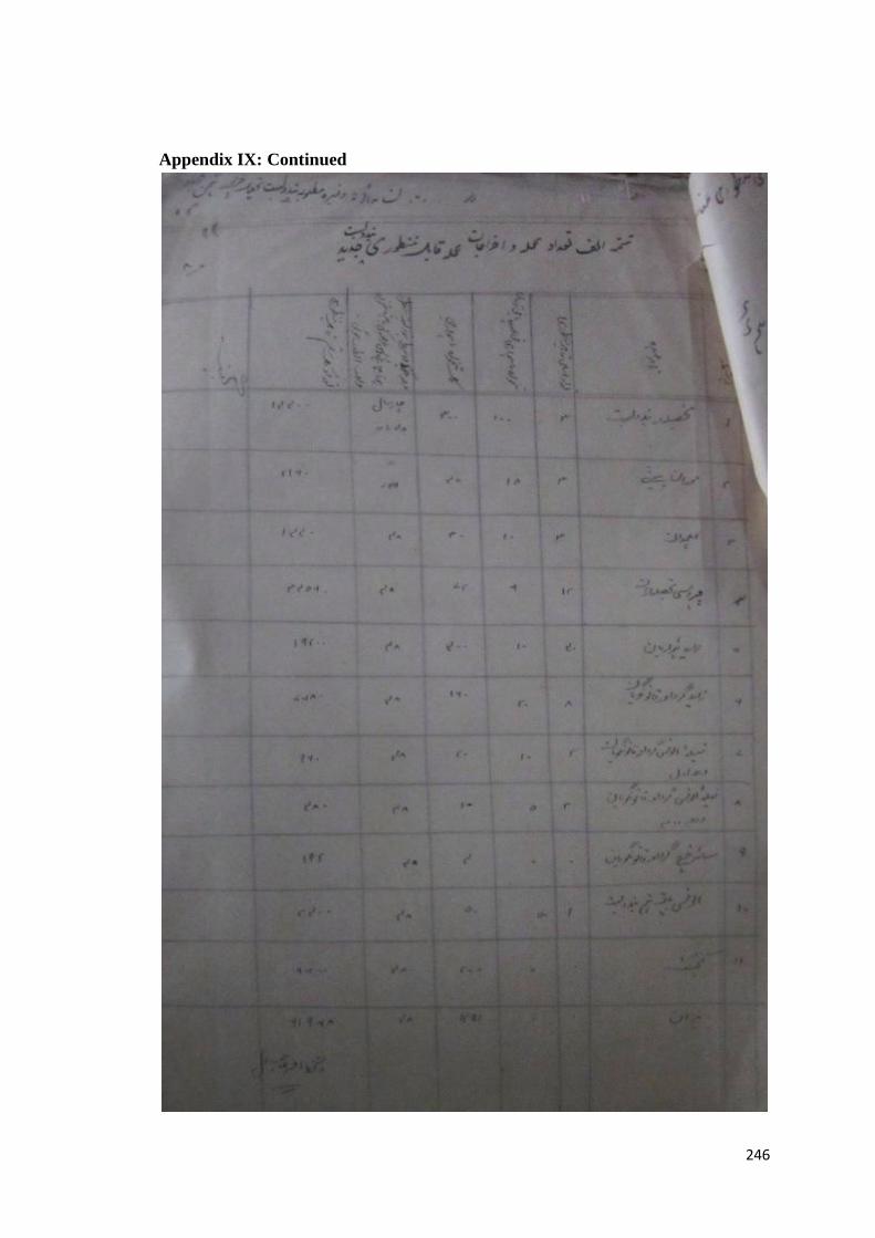
246
Appendix IX: Continued

247
Appendix IX: Continued

248
Appendix X: Measurement of inam lands

249
Appendix XI: Ratification of Asnad by the Agency

250
Appendix XII: Inheritance matters in the Royal family of Bahawalpur
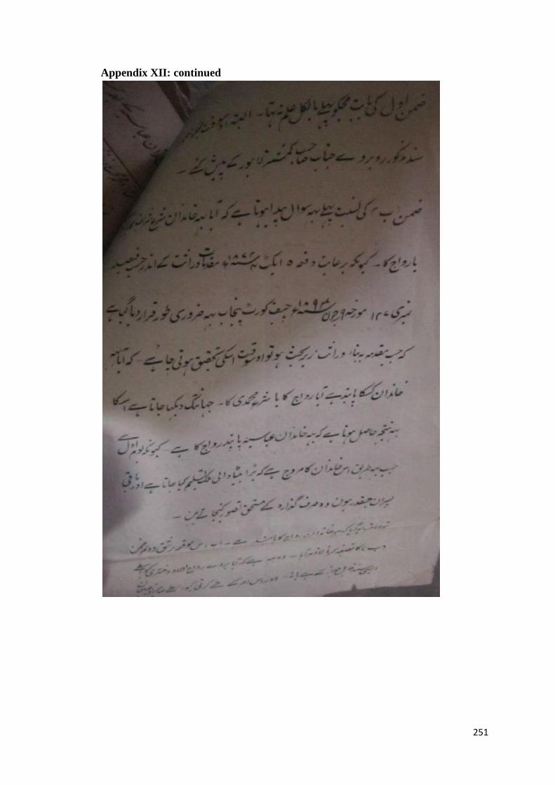
251
Appendix XII: continued

252
Appendix XII: continued

253
Appendix XII: continued

254
Appendix XIII: Treatment of the heirs of Kasur grantees

255
Appendix XIII: Continued

256
Appendix XIV: Partition of Inam Land

257
Appendix XV: Appointment of irrigation Establishment

258

259

260
Appendix XVI: Native proposal for the construction of dam to fed the desert area.

261
Appendix XVI: continued

262
Appendix XVII: Community demand to augment the less supply of water

263
Appendix XVII: continued

264
Appendix XVIII: Detail of SVP Loan by Accountant General
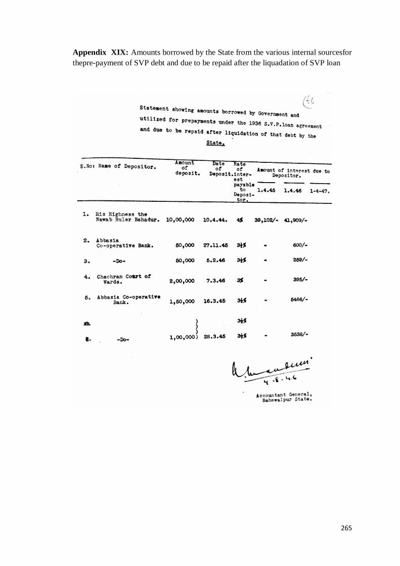
265
Appendix XIX: Amounts borrowed by the State from the various internal sourcesfor
thepre-payment of SVP debt and due to be repaid after the liquadation of SVP loan

266
Appendix XX: Commencement of colonization plan

267
Appendix XXI: Distribution plan of colony land

268
Appendix XXII: Initial prices of lands
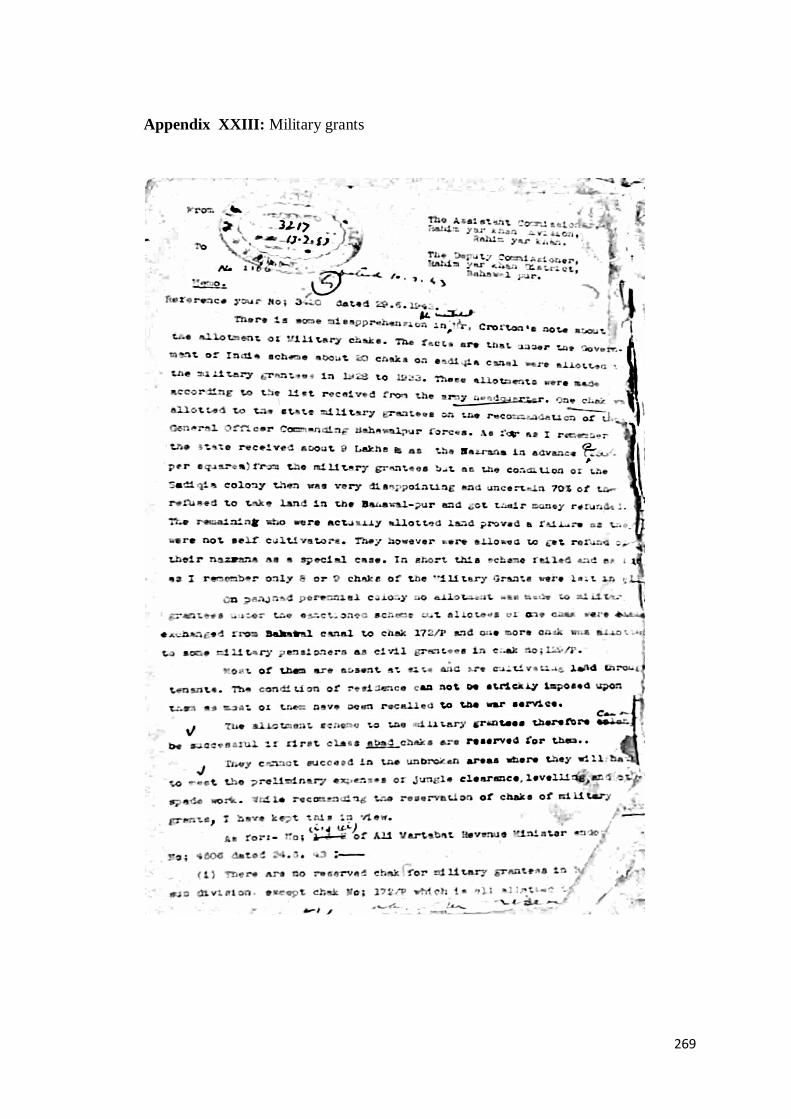
269
Appendix XXIII: Military grants

270
Appendix XXIII: Continued

271
Appendix XXIV: Division of Land in the Soil Survey 1925-26
The Good land was high quality land.
The Average land was actually inferior quality land, which took one or two
years to be productive.
The Poor land was much inferior and took many years to be productive.
The Unallottable land held hard soil and excessive salt.
The Uncommanded land was un-irrigable and was covered with sand hills on
its surface.

272
Appendix XXV: Zamindara League of colony areas demanded to augment the
Short water supply

273
Appendix XXV: continued

274
Appendix XXV: Continued

275
Appendix XXVI: Percentage schedule for abadkars

276
Appendix XXVI: continued
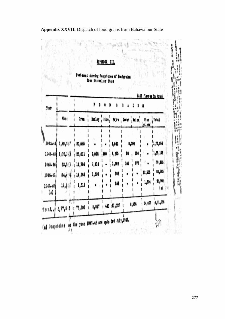
277
Appendix XXVII: Dispatch of food grains from Bahawalpur State

278
Appendix XXVIII: Auction plan of colony town sites