Daniel Ferrés Domènech - TDX (Tesis Doctorals en Xarxa)
284
Knowledge-based and data-driven approaches for geographical information access Daniel Ferrés Domènech ADVERTIMENT La consulta d’aquesta tesi queda condicionada a l’acceptació de les següents condicions d'ús: La difusió d’aquesta tesi per mitjà del repositori institucional UPCommons (http://upcommons.upc.edu/tesis) i el repositori cooperatiu TDX ( http://www.tdx.cat/ ) ha estat autoritzada pels titulars dels drets de propietat intel·lectual únicament per a usos privats emmarcats en activitats d’investigació i docència. No s’autoritza la seva reproducció amb finalitats de lucre ni la seva difusió i posada a disposició des d’un lloc aliè al servei UPCommons o TDX. No s’autoritza la presentació del seu contingut en una finestra o marc aliè a UPCommons (framing). Aquesta reserva de drets afecta tant al resum de presentació de la tesi com als seus continguts. En la utilització o cita de parts de la tesi és obligat indicar el nom de la persona autora. ADVERTENCIA La consulta de esta tesis queda condicionada a la aceptación de las siguientes condiciones de uso: La difusión de esta tesis por medio del repositorio institucional UPCommons (http://upcommons.upc.edu/tesis) y el repositorio cooperativo TDR (http://www.tdx.cat/?locale- attribute=es) ha sido autorizada por los titulares de los derechos de propiedad intelectual únicamente para usos privados enmarcados en actividades de investigación y docencia. No se autoriza su reproducción con finalidades de lucro ni su difusión y puesta a disposición desde un sitio ajeno al servicio UPCommons No se autoriza la presentación de su contenido en una ventana o marco ajeno a UPCommons (framing). Esta reserva de derechos afecta tanto al resumen de presentación de la tesis como a sus contenidos. En la utilización o cita de partes de la tesis es obligado indicar el nombre de la persona autora. WARNING On having consulted this thesis you’re accepting the following use conditions: Spreading this thesis by the institutional repository UPCommons (http://upcommons.upc.edu/tesis) and the cooperative repository TDX (http://www.tdx.cat/?locale- attribute=en) has been authorized by the titular of the intellectual property rights only for private uses placed in investigation and teaching activities. Reproduction with lucrative aims is not authorized neither its spreading nor availability from a site foreign to the UPCommons service. Introducing its content in a window or frame foreign to the UPCommons service is not authorized (framing). These rights affect to the presentation summary of the thesis as well as to its contents. In the using or citation of parts of the thesis it’s obliged to indicate the name of the author.
-
Upload
khangminh22 -
Category
Documents
-
view
0 -
download
0
Transcript of Daniel Ferrés Domènech - TDX (Tesis Doctorals en Xarxa)
Knowledge-based and data-driven approaches for geographical
information access
Daniel Ferrés Domènech
ADVERTIMENT La consulta d’aquesta tesi queda condicionada a l’acceptació de les següents condicions d'ús: La difusió d’aquesta tesi per mitjà del r e p o s i t o r i i n s t i t u c i o n a l UPCommons (http://upcommons.upc.edu/tesis) i el repositori cooperatiu TDX ( h t t p : / / w w w . t d x . c a t / ) ha estat autoritzada pels titulars dels drets de propietat intel·lectual únicament per a usos privats emmarcats en activitats d’investigació i docència. No s’autoritza la seva reproducció amb finalitats de lucre ni la seva difusió i posada a disposició des d’un lloc aliè al servei UPCommons o TDX. No s’autoritza la presentació del seu contingut en una finestra o marc aliè a UPCommons (framing). Aquesta reserva de drets afecta tant al resum de presentació de la tesi com als seus continguts. En la utilització o cita de parts de la tesi és obligat indicar el nom de la persona autora.
ADVERTENCIA La consulta de esta tesis queda condicionada a la aceptación de las siguientes condiciones de uso: La difusión de esta tesis por medio del repositorio institucional UPCommons (http://upcommons.upc.edu/tesis) y el repositorio cooperativo TDR (http://www.tdx.cat/?locale-attribute=es) ha sido autorizada por los titulares de los derechos de propiedad intelectual únicamente para usos privados enmarcados en actividades de investigación y docencia. No se autoriza su reproducción con finalidades de lucro ni su difusión y puesta a disposición desde un sitio ajeno al servicio UPCommons No se autoriza la presentación de su contenido en una ventana o marco ajeno a UPCommons (framing). Esta reserva de derechos afecta tanto al resumen de presentación de la tesis como a sus contenidos. En la utilización o cita de partes de la tesis es obligado indicar el nombre de la persona autora.
WARNING On having consulted this thesis you’re accepting the following use conditions: Spreading this thesis by the i n s t i t u t i o n a l r e p o s i t o r y UPCommons (http://upcommons.upc.edu/tesis) and the cooperative repository TDX (http://www.tdx.cat/?locale-attribute=en) has been authorized by the titular of the intellectual property rights only for private uses placed in investigation and teaching activities. Reproduction with lucrative aims is not authorized neither its spreading nor availability from a site foreign to the UPCommons service. Introducing its content in a window or frame foreign to the UPCommons service is not authorized (framing). These rights affect to the presentation summary of the thesis as well as to its contents. In the using or citation of parts of the thesis it’s obliged to indicate the name of the author.
Knowledge-Based and Data-DrivenApproaches for Geographical Information
Access
Ph.D. Thesis
This thesis is presented for the degree of Doctorof the Universitat Politècnica de Catalunya
by
Daniel Ferrés Domènech
advisor
Dr. Horacio Rodríguez Hontoria
Ph.D. Program in Artificial IntelligenceDepartment of Computer Science
Universitat Politècnica de Catalunya
September 2017


AbstractGeographical Information Access (GeoIA) can be defined as a way of retrieving informa-tion from textual collections that includes the automatic analysis and interpretation of thegeographical constraints and terms present in queries and documents. This PhD thesispresents, describes and evaluates several heterogeneous approaches for the following threeGeoIA tasks: Geographical Information Retrieval (GIR), Geographical Question Answer-ing (GeoQA), and Textual Georeferencing (TG). The GIR task deals with user queries thatsearch over documents (e.g. “vineyards in California”) and the GeoQA task treats questionsthat retrieve answers (e.g. “What is the capital of France?”). On the other hand, TG is thetask of associate one or more georeferences (such as polygons or coordinates in a geodeticreference system) to electronic documents.
Current state-of-the-art AI algorithms are not yet fully understanding the semanticmeaning and the geographical constraints and terms present in queries and document col-lections. This thesis attempts to improve the effectiveness results of GeoIA tasks by: 1)improving the detection, understanding, and use of a part of the geographical and the the-matic content of queries and documents with Toponym Recognition, Toponym Disambigua-tion and Natural Language Processing (NLP) techniques, and 2) combining GeographicalKnowledge-Based Heuristics based on common sense with Data-Driven IR algorithms.
The main contributions of this thesis to the state-of-the-art of GeoIA tasks are:1) The presentation of 10 novel approaches for GeoIA tasks: 3 approaches for GIR, 3
for GeoQA, and 4 for Textual Georeferencing (TG).2) The evaluation of these novel approaches in these contexts: within official evaluation
benchmarks, after evaluation benchmarks with the test collections, and with other specificdatasets. Most of these algorithms have been evaluated in international evaluations andsome of them achieved top-ranked state-of-the-art results, including top-performing resultsin GIR (GeoCLEF 2007) and TG (MediaEval 2014) benchmarks.
3) The experiments reported in this PhD thesis show that the approaches can combineeffectively Geographical Knowledge and NLP with Data-Driven techniques to improve theefectiveness measures of the three Geographical Information Access tasks investigated.
4) TALPGeoIR: a novel GIR approach that combines Geographical Knowledge Re-Ranking (GeoKR), NLP and Relevance Feedback (RF) that achieved state-of-the-art resultsin official GeoCLEF benchmarks (Ferrés and Rodríguez, 2008a; Mandl et al., 2008) and pos-terior experiments (Ferrés and Rodríguez, 2015a). This approach has been evaluated withthe full GeoCLEF corpus (100 topics) and showed that GeoKR, NLP, and RF techniquesevaluated separately or in combination improve the results in MAP and R-Precision effec-tiveness measures of the state-of-the-art IR algorithms TF-IDF, BM25 and InL2 and showstatistical significance in most of the experiments.
5) GeoTALP-QA: a scope-based GeoQA approach for Spanish and English and its eval-uation with a set of questions of the Spanish geography (Ferrés and Rodríguez, 2006a).
6) Four state-of-the-art Textual Georeferencing approaches for informal and formal doc-uments that achieved state-of-the-art results in evaluation benchmarks (Ferrés and Ro-dríguez, 2014) and posterior experiments (Ferrés and Rodríguez, 2011a; Ferrés and Ro-dríguez, 2015b).

ResumL’Accés a la Informació Geogràfica (GeoAI) pot ser definit com una forma de recuperar in-formació de col·lecions textuals que inclou l’anàlisi automàtic i la interpretació dels termes irestriccions geogràfiques que apareixen en consultes i documents. Aquesta tesi doctoral pre-senta, descriu i avalua varies aproximacions heterogènies a les seguents tasques de GeoAI:Recuperació de la Informació Geogràfica (RIG), Cerca de la Resposta Geogràfica (GeoCR),i Georeferenciament Textual (GT). La tasca de RIG tracta amb consultes d’usuari quecerquen documents (e.g. “vinyes a California”) i la tasca GeoCR tracta de recuperar re-spostes concretes a preguntes (e.g. “Quina és la capital de França”). D’altra banda, GT esla tasca de relacionar una o més referències geogràfiques (com polígons o coordenades en unsistema de referència geodètic) a documents electrònics. Els algoritmes de l’estat de l’artactual en Intel·ligència Artificial encara no comprenen completament el significat semàntici els termes i les restriccions geogràfiques presents en consultes i col·leccions de documents.
Aquesta tesi intenta millorar els resultats en efectivitat de les tasques de GeoAI de laseguent manera: 1) millorant la detecció, comprensió, i l’utilització d’una part del con-tingut geogràfic i temàtic de les consultes i documents amb tècniques de reconeixementde topònims, desambiguació de topònims, i Processament del Llenguatge Natural (PLN),i 2) combinant heuristics basats en Coneixement Geogràfic i en el sentit comú humà ambalgoritmes de Recuperació de la Informació basats en dades.
Les principals contribucions d’aquesta tesi a l’estat de l’art de les tasques de GeoAI són:1) La presentació de 10 noves aproximacions a les tasques de GeoAI: 3 aproximacions
per RIG, 3 per GeoCR, i 4 per Georeferenciament Textual (GT).2) L’avaluació d’aquestes noves aproximacions en aquests contexts: en el marc d’avaluacions
comparatives internacionals, posteriorment a avaluacions comparatives internacionals ambles col·lections de test, i amb altres conjunts de dades específics. La majoria d’aquestsalgoritmes han estat avaluats en avaluacions comparatives internacionals i alguns d’ellsaconseguiren alguns dels millors resultats en l’estat de l’art, com per exemple els resultatsen comparatives de RIG (GeoCLEF 2007) i GT (MediaEval 2014).
3) Els experiments descrits en aquesta tesi mostren que les aproximacions poden combi-nar coneixement geogràfic i PLN amb tècniques basades en dades per millorar les mesuresd’efectivitat en les tres tasques de l’Accés a la Informació Geogràfica investigades.
4) TALPGeoIR: una nova aproximació a la RIG que combina Re-Ranking amb Coneix-ement Geogràfic (GeoKR), PLN i Retroalimentació de Rellevancia (RR) que aconseguí re-sultats en l’estat de l’art en comparatives oficials GeoCLEF (Ferrés and Rodríguez, 2008a;Mandl et al., 2008) i en experiments posteriors (Ferrés and Rodríguez, 2015a). Aquestaaproximació ha estat avaluada amb el conjunt complert del corpus GeoCLEF (100 topics) iha mostrat que les tècniques GeoKR, PLN i RR avaluades separadament o en combinaciómilloren els resultats en les mesures efectivitat MAP i R-Precision dels algoritmes de l’estatde l’art en Recuperació de la Infomació TF-IDF, BM25 i InL2 i a més mostren significacióestadística en la majoria dels experiments.
5) GeoTALP-QA: una aproximació a GeoCR per espanyol i anglès i la seva avaluacióamb un conjunt de preguntes de la geografía espanyola (Ferrés and Rodríguez, 2006a).
6) Quatre aproximacions per al georeferenciament de documents formals i informals queobtingueren resultats en l’estat de l’art en avaluacions comparatives internacionals (Ferrésand Rodríguez, 2014) i en experiments posteriors (Ferrés and Rodríguez, 2011a; Ferrés andRodríguez, 2015b).


AcknowledgmentsFirst of all I want to thank my PhD thesis advisor Dr. Horacio Rodríguez for his advicementand guidance. I want to thank my colleagues and ex-colleagues at UPC from the NaturalLanguage Processing Group and the TALP Research Center for their help. I want to thankthe coordination and management team of the Ph.D. program in Artificial Intelligence atUPC and the anonymous thesis reviewers. I want to thank the professors that helped myduring my research stages abroad:
• Dr. Eduard Hovy (ISI-USC).
• Dr. Flavia Barros (CIn-UFPE).
I also want to thank the help of the administration and technical staff of the UDGSIunit of UPC.
This research has been realized in the framework of the following grants and researchprojects:
• grants: UPC-Recerca, BE (AGAUR), EBW II Project (European Comission).
• research projects (Spanish and European): ALIADO (TIC2002-04447-C02), TEXT-MESS (TIN2006-15265-C06-05), KNOW 2 (TIN2009-14715-C04-04), SKATER (TIN2012-38584-C06-01), and CHIL (IST-2004-506909).
Finally I would like to thank my family, friends, and all the other people that helpedme.
AgraïmentsPrimerament vull agrair al meu director de tesi Horacio Rodríguez la seva tutoria i suport.Vull agrair també a tots els meus companys i ex-companys del Grup de Processament delLlenguatge Natural i del centre de recerca TALP de la Universitat Politècnica de Catalunyaper la seva ajuda i suport. Vull donar gràcies a l’equip de coordinació i gestió del programade doctorat en Intel·ligència Artificial de la UPC i als revisors anònims de la tesi.
Estic molt agrait als professors que m’ajudaren durant les meves estades a l’estranger:
• Dr. Eduard Hovy (ISI-USC).
• Dr. Flavia Barros (CIn-UFPE).
També vull agrair la ajuda i suport del l’administració i del laboratori de càlcul de laUnitat de Gestió dels Departaments CS i ESSI.
El treball de tesi ha estat realitzat en el marc de les seguents beques i projectes derecerca:
• beques: UPC-Recerca, BE (AGAUR), EBW II Project (European Comission).
• projectes de recerca españols i europeus: ALIADO (TIC2002-04447-C02), TEXT-MESS (TIN2006-15265-C06-05), KNOW 2 (TIN2009-14715-C04-04), SKATER (TIN2012-38584-C06-01) i CHIL, IST-2004-506909.
Finalment, vull donar gràcies a la meva família, amics i a totes les altres persones quem’han ajudat.

viii

Contents
1 Introduction 11.1 Geographical Information Access . . . . . . . . . . . . . . . . . . . . . . . . . 21.2 Researched Areas and Tasks Investigated . . . . . . . . . . . . . . . . . . . . 31.3 Toponym Recognition and Disambiguation . . . . . . . . . . . . . . . . . . . . 31.4 Geographical Information Retrieval . . . . . . . . . . . . . . . . . . . . . . . . 61.5 Geographical Question Answering . . . . . . . . . . . . . . . . . . . . . . . . . 71.6 Textual Georeferencing . . . . . . . . . . . . . . . . . . . . . . . . . . . . . . . 91.7 Objectives . . . . . . . . . . . . . . . . . . . . . . . . . . . . . . . . . . . . . . 91.8 Research Methodology . . . . . . . . . . . . . . . . . . . . . . . . . . . . . . . 101.9 International Benchmarking . . . . . . . . . . . . . . . . . . . . . . . . . . . . 101.10 Work Hypotheses . . . . . . . . . . . . . . . . . . . . . . . . . . . . . . . . . . 111.11 Scope and Focus of the Thesis . . . . . . . . . . . . . . . . . . . . . . . . . . . 11
1.11.1 Geographical Information Retrieval Scope . . . . . . . . . . . . . . . . 111.11.2 Geographical Question Answering Scope . . . . . . . . . . . . . . . . . 121.11.3 Textual Georeferencing Scope . . . . . . . . . . . . . . . . . . . . . . . 12
1.12 Summary of Contributions . . . . . . . . . . . . . . . . . . . . . . . . . . . . . 131.13 Publications . . . . . . . . . . . . . . . . . . . . . . . . . . . . . . . . . . . . . 151.14 Structure of the Document . . . . . . . . . . . . . . . . . . . . . . . . . . . . 20
2 Toponym Recognition and Disambiguation - State-of-the-art 232.1 Toponym Recognition Approaches . . . . . . . . . . . . . . . . . . . . . . . . 24
2.1.1 Geographical Gazetteers . . . . . . . . . . . . . . . . . . . . . . . . . . 242.1.2 Named Entity Recognition and Classification . . . . . . . . . . . . . . 27
2.2 Toponym Disambiguation Approaches . . . . . . . . . . . . . . . . . . . . . . 312.2.1 Toponym Recognition and Disambiguation Systems . . . . . . . . . . 342.2.2 Toponym Disambiguation Evaluation . . . . . . . . . . . . . . . . . . 36
3 Geographical Information Access Tasks - State-of-the-art 393.1 Geographical Information Retrieval - State-of-the-art . . . . . . . . . . . . . . 39
3.1.1 GIR Issues . . . . . . . . . . . . . . . . . . . . . . . . . . . . . . . . . 413.1.2 GIR Approaches . . . . . . . . . . . . . . . . . . . . . . . . . . . . . . 42
ix
x
3.1.2.1 Topic Processing and Collection Processing . . . . . . . . . . 423.1.2.1.1 Natural Language Processing . . . . . . . . . . . . . 433.1.2.1.2 Geographical Analysis . . . . . . . . . . . . . . . . . 43
3.1.2.2 Document Retrieval . . . . . . . . . . . . . . . . . . . . . . . 453.1.2.2.1 Query Expansion . . . . . . . . . . . . . . . . . . . 453.1.2.2.2 Information Retrieval . . . . . . . . . . . . . . . . . 453.1.2.2.3 Document Filtering . . . . . . . . . . . . . . . . . . 46
3.1.2.3 Document Ranking . . . . . . . . . . . . . . . . . . . . . . . 473.1.3 IR Evaluation Measures . . . . . . . . . . . . . . . . . . . . . . . . . . 483.1.4 Systems Comparison and Statistical Testing . . . . . . . . . . . . . . . 493.1.5 GIR Relevant Approaches . . . . . . . . . . . . . . . . . . . . . . . . 503.1.6 GIR Evaluation . . . . . . . . . . . . . . . . . . . . . . . . . . . . . . . 51
3.1.6.1 GeoCLEF . . . . . . . . . . . . . . . . . . . . . . . . . . . . . 513.1.6.2 Results of the Monolingual English Systems at GeoCLEF . . 54
3.2 Geographical Question Answering - State-of-the-art . . . . . . . . . . . . . . . 563.2.1 Classification of QA Systems . . . . . . . . . . . . . . . . . . . . . . . 573.2.2 Architecture of QA Systems . . . . . . . . . . . . . . . . . . . . . . . . 58
3.2.2.1 Question Classification . . . . . . . . . . . . . . . . . . . . . 583.2.2.2 Passage Retrieval . . . . . . . . . . . . . . . . . . . . . . . . 603.2.2.3 Answer Extraction . . . . . . . . . . . . . . . . . . . . . . . . 64
3.2.3 Evaluation Benchmarks of QA systems . . . . . . . . . . . . . . . . . . 663.2.4 Evaluation Metrics of Factoid QA Systems . . . . . . . . . . . . . . . 66
3.3 Textual Georeferencing - State-of-the-art . . . . . . . . . . . . . . . . . . . . . 703.3.1 Approaches for Textual Georeferencing . . . . . . . . . . . . . . . . . 703.3.2 Textual Geographical Focus Detection . . . . . . . . . . . . . . . . . . 723.3.3 The MediaEval Placing Task Geo-Estimation Challenge . . . . . . . . 723.3.4 Georeferencing Systems at MediaEval 2010-2013 Evaluations . . . . . 723.3.5 Georeferencing Systems at MediaEval 2014 . . . . . . . . . . . . . . . 743.3.6 Georeferencing Systems at MediaEval 2015-2016 . . . . . . . . . . . . 76
4 Geographical Information Retrieval Approaches 794.1 GeoTALP-IR 2005 Approach . . . . . . . . . . . . . . . . . . . . . . . . . . . 80
4.1.1 Collection Pre-processing . . . . . . . . . . . . . . . . . . . . . . . . . 804.1.2 Topic Analysis . . . . . . . . . . . . . . . . . . . . . . . . . . . . . . . 81
4.1.2.1 Linguistic Analysis . . . . . . . . . . . . . . . . . . . . . . . . 814.1.2.2 Geographical Analysis . . . . . . . . . . . . . . . . . . . . . . 824.1.2.3 Topic Keywords Selection . . . . . . . . . . . . . . . . . . . . 83
4.1.3 Document Retrieval . . . . . . . . . . . . . . . . . . . . . . . . . . . . 834.1.4 Document Ranking . . . . . . . . . . . . . . . . . . . . . . . . . . . . . 854.1.5 Experiments and Results at GeoCLEF 2005 . . . . . . . . . . . . . . . 86
4.2 TALPGeoIR 2006 Approach . . . . . . . . . . . . . . . . . . . . . . . . . . . . 884.2.1 Collection Processing . . . . . . . . . . . . . . . . . . . . . . . . . . . . 884.2.2 Topic Analysis . . . . . . . . . . . . . . . . . . . . . . . . . . . . . . . 89
4.2.2.1 Linguistic Analysis. . . . . . . . . . . . . . . . . . . . . . . . 894.2.2.2 Geographical Analysis. . . . . . . . . . . . . . . . . . . . . . 894.2.2.3 Topic Keywords Selection. . . . . . . . . . . . . . . . . . . . 90
4.2.3 Geographical Document Retrieval with Lucene . . . . . . . . . . . . . 90
xi
4.2.4 Document Retrieval using the JIRS Passage Retriever . . . . . . . . . 914.2.5 Document Ranking . . . . . . . . . . . . . . . . . . . . . . . . . . . . . 914.2.6 Experiments and Results at GeoCLEF 2006 . . . . . . . . . . . . . . . 914.2.7 Experiments after GeoCLEF 2006 . . . . . . . . . . . . . . . . . . . . 94
4.3 TALPGeoIR 2007 Approach . . . . . . . . . . . . . . . . . . . . . . . . . . . . 964.3.1 Textual and Geographical Indexing . . . . . . . . . . . . . . . . . . . . 964.3.2 Geographical Information Retrieval . . . . . . . . . . . . . . . . . . . . 96
4.3.2.1 Linguistic and Geographical Knowledge Processing of thetopics and the collections . . . . . . . . . . . . . . . . . . . . 97
4.3.2.2 Textual Document Retrieval . . . . . . . . . . . . . . . . . . 984.3.2.3 Geographical Document Retrieval . . . . . . . . . . . . . . . 1004.3.2.4 Geographical Knowledge Re-Ranking . . . . . . . . . . . . . 1014.3.2.5 Geographical Border Filtering Re-Ranking . . . . . . . . . . 101
4.3.3 Initial Tuning with the GeoCLEF 2006 Test Collection . . . . . . . . . 1014.3.4 Experiments at GeoCLEF 2007 . . . . . . . . . . . . . . . . . . . . . . 101
4.3.4.1 Results at GeoCLEF 2007 Evaluation Benchmark . . . . . . 1024.3.5 Experiments with the GeoCLEF Test Collections . . . . . . . . . . . . 106
4.4 Conclusions . . . . . . . . . . . . . . . . . . . . . . . . . . . . . . . . . . . . . 114
5 Geographical Question Answering Approaches 1175.1 GeoTALP-QA Geographical Question Answering Approach . . . . . . . . . . 118
5.1.1 System Description . . . . . . . . . . . . . . . . . . . . . . . . . . . . . 1195.1.1.1 Additional Knowledge Sources . . . . . . . . . . . . . . . . . 1195.1.1.2 Language-Dependent Processing Tools . . . . . . . . . . . . . 1215.1.1.3 Question Processing . . . . . . . . . . . . . . . . . . . . . . . 1225.1.1.4 Passage Retrieval . . . . . . . . . . . . . . . . . . . . . . . . 124
5.1.1.4.1 Knowledge-Based Off-line Corpus Retrieval . . . . . 1245.1.1.4.2 Data-Driven Online Web Snippet Retrieval . . . . . 124
5.1.1.5 Answer Extraction . . . . . . . . . . . . . . . . . . . . . . . . 1245.1.1.5.1 Knowledge-Based ODQA Extraction . . . . . . . . . 1255.1.1.5.2 Data-Driven Frequency-Based Extraction . . . . . . 125
5.1.2 Resources for Scope-Based Experiments . . . . . . . . . . . . . . . . . 1255.1.2.1 Language and Scope Based Geographical Question Corpus . 1255.1.2.2 Document Collection for the Knowledge-Based ODQA Pas-
sage Retrieval . . . . . . . . . . . . . . . . . . . . . . . . . . 1285.1.2.3 Geographical Scope-Based Resources . . . . . . . . . . . . . 128
5.1.3 Experiments . . . . . . . . . . . . . . . . . . . . . . . . . . . . . . . . 1295.1.4 Results . . . . . . . . . . . . . . . . . . . . . . . . . . . . . . . . . . . 129
5.2 Geographical QA Approach over the Wikipedia . . . . . . . . . . . . . . . . . 1325.2.1 System Description . . . . . . . . . . . . . . . . . . . . . . . . . . . . . 1325.2.2 Experiments at GikiCLEF 2009 . . . . . . . . . . . . . . . . . . . . . . 1335.2.3 Results at GikiCLEF 2009 . . . . . . . . . . . . . . . . . . . . . . . . . 134
5.3 Geographical Query Parsing Approach . . . . . . . . . . . . . . . . . . . . . . 1355.3.1 System Description . . . . . . . . . . . . . . . . . . . . . . . . . . . . . 136
5.3.1.1 Topic Analysis . . . . . . . . . . . . . . . . . . . . . . . . . . 1365.3.1.2 Linguistic Analysis . . . . . . . . . . . . . . . . . . . . . . . . 1365.3.1.3 Geographical Analysis . . . . . . . . . . . . . . . . . . . . . . 136
xii
5.3.1.4 Question Classification . . . . . . . . . . . . . . . . . . . . . 1375.3.2 Experiments and Results at GeoQuery 2007 . . . . . . . . . . . . . . . 138
5.4 Conclusions . . . . . . . . . . . . . . . . . . . . . . . . . . . . . . . . . . . . . 140
6 Textual Georeferencing Approaches 1416.1 Geographical Knowledge Approach . . . . . . . . . . . . . . . . . . . . . . . . 142
6.1.1 Toponym Recognition . . . . . . . . . . . . . . . . . . . . . . . . . . . 1426.1.2 Geographical Focus Detection . . . . . . . . . . . . . . . . . . . . . . . 143
6.2 Information Retrieval Approach . . . . . . . . . . . . . . . . . . . . . . . . . . 1446.3 Information Retrieval with Re-Ranking Approach . . . . . . . . . . . . . . . . 1466.4 GeoFusion: Knowledge-Based and Data-Driven Georeferencing . . . . . . . . 1476.5 Experiments Georeferencing Informal Documents . . . . . . . . . . . . . . . . 148
6.5.1 Experiments at MediaEval Placing Task 2010 . . . . . . . . . . . . . . 1496.5.2 Experiments after MediaEval Placing Task 2010 . . . . . . . . . . . . 151
6.5.2.1 Experiments with the IR Approach . . . . . . . . . . . . . . 1536.5.2.2 Experiments with the IR Re-Ranking and GeoFusion Ap-
proaches . . . . . . . . . . . . . . . . . . . . . . . . . . . . . 1536.5.3 Experiments at MediaEval Placing Task 2011 . . . . . . . . . . . . . . 1566.5.4 Experiments after MediaEval Placing Task 2011 . . . . . . . . . . . . 1596.5.5 Experiments at MediaEval Placing Task 2014 and Posterior Results . 161
6.5.5.1 Official Experiments at MediaEval Placing Task 2014 . . . . 1616.5.5.2 Experiments after MediaEval Placing Task 2014 . . . . . . . 163
6.6 Experiments Georeferencing Informal Texts in Emergency Scenarios . . . . . 1666.7 Experiments Georeferencing Formal Documents . . . . . . . . . . . . . . . . . 1686.8 Conclusions . . . . . . . . . . . . . . . . . . . . . . . . . . . . . . . . . . . . . 170
7 Conclusions 1737.1 Contributions . . . . . . . . . . . . . . . . . . . . . . . . . . . . . . . . . . . . 173
7.1.1 Design of novel Geographical Information Access Approaches . . . . . 1747.1.2 Evaluation of Geographical Information Access Approaches . . . . . . 1757.1.3 Effective Use of Geographical Knowledge and Natural Language Pro-
cessing in Geographical Information Access tasks . . . . . . . . . . . . 1767.1.4 Passage Retrieval Approaches for GIR . . . . . . . . . . . . . . . . . . 1787.1.5 TALPGeoIR, a State-of-the-art GIR Approach . . . . . . . . . . . . . 1797.1.6 GeoTALP-QA. An Scope-based Geographical Question Answering
Approach . . . . . . . . . . . . . . . . . . . . . . . . . . . . . . . . . . 1807.1.7 New state-of-the-art Textual Georeferencing Approaches . . . . . . . . 1807.1.8 A Geographical Query Parsing algorithm . . . . . . . . . . . . . . . . 1837.1.9 GikiTALP: a Data-Driven Baseline for Geographical Question An-
swering over Wikipedia . . . . . . . . . . . . . . . . . . . . . . . . . . 1837.2 Limitations and Future work . . . . . . . . . . . . . . . . . . . . . . . . . . . 184
7.2.1 Geographical Information Retrieval . . . . . . . . . . . . . . . . . . . . 1847.2.2 Geographical Question Answering . . . . . . . . . . . . . . . . . . . . 1847.2.3 Textual Georeferencing . . . . . . . . . . . . . . . . . . . . . . . . . . 185
xiii
A Annex A: Test Collections 187A.1 Test Collections for Geographical Information Retrieval . . . . . . . . . . . . 187A.2 Test Collections for Geographical Question Answering . . . . . . . . . . . . . 187
A.2.1 Geo-QA corpus: a set of 123 Geographical QA questions . . . . . . . . 187A.2.2 GeoQuery 2007 Dataset . . . . . . . . . . . . . . . . . . . . . . . . . . 187A.2.3 GikiCLEF 2009 test collections . . . . . . . . . . . . . . . . . . . . . . 188
A.3 Test Collections for Textual Georeferencing . . . . . . . . . . . . . . . . . . . 188A.3.1 MediaEval Placing Tasks of 2010 and 2011 Training and Test set. . . . 188A.3.2 MediaEval Placing Task 2014 Training and Test set. . . . . . . . . . . 188A.3.3 W&B Training Set and Wikipedia UK spot test . . . . . . . . . . . . 188A.3.4 Test set of Flickr Metadata for Emergency Scenarios . . . . . . . . . . 189
B Annex B: GeoCLEF Topics 191B.1 Classification of the GeoCLEF Topics . . . . . . . . . . . . . . . . . . . . . . 210
C Annex C: GeoCLEF PerQuery Results 211
D Annex D: GeoQA Questions 223
E Annex E: GikiCLEF Questions 227
F Annex F: Geographical Data Mappings 231F.1 Mapping of GNS and GNIS gazetteers to the ADL Feature Type Thesaurus) 231
G Annex G: Web Person Search experiments at WePS-3 239G.1 Development and Test Data at WePS-3 . . . . . . . . . . . . . . . . . . . . . 239G.2 System Description . . . . . . . . . . . . . . . . . . . . . . . . . . . . . . . . . 240
G.2.1 Lingo . . . . . . . . . . . . . . . . . . . . . . . . . . . . . . . . . . . . 240G.2.2 Hierarchical Agglomerative Clustering . . . . . . . . . . . . . . . . . . 240G.2.3 2-step Clustering with Agglomerative Clustering . . . . . . . . . . . . 241
G.3 Development experiments with WePS-3 trial data . . . . . . . . . . . . . . . 241G.4 Test experiments with WePS-3 test data . . . . . . . . . . . . . . . . . . . . 241G.5 Conclusions . . . . . . . . . . . . . . . . . . . . . . . . . . . . . . . . . . . . . 242G.6 Official Team Results at WePS-3 . . . . . . . . . . . . . . . . . . . . . . . . . 243

CHAPTER 1
Introduction
Nowadays, there is a growing need for humans for more intelligent accessing and searchingthe electronic textual information stored in computers, locally (PCs, laptops, tablets, cellphones,...) or remotely (e.g. Internet, Local area networks (LANs), servers,...). In thiscontext, academic and industrial efforts try to research and develop new techniques thatfacilitate this intelligent access to the information. Most of this work is classified under thefield of Artificial Intelligence (AI).
This PhD thesis presents geographically aware methods to access to the electronic tex-tual information by natural language (i.e. user defined keywords and query searching) usingAI techniques. The research presented here involves the use of several concepts and tech-niques developed in the AI sub-fields of Natural Language Processing (NLP), InformationRetrieval (IR) and Knowledge Bases (KB) and its application to some Geographical Infor-mation Access tasks. Geographical Information Access (GeoIA) can be defined as a wayof retrieve information through the automatic analysis of queries that include geographicalconstraints.
The GeoIA tasks investigated in this dissertation are the following: Geographical Infor-mation Retrieval (GIR), Geographical Question Answering (GeoQA), and Textual Georef-erencing (TG). IR and Question Answering techniques can be defined as algorithms thathelp the user to satisfy an information need. Question Answering (QA) is the task of, givena question expressed in Natural Language (NL), retrieving its correct answer (a single item,a text snippet, a list of items,...) from closed collections or the Web. This task is consid-ered a step beyond IR which consists in searching information in documents, documentsthemselves, or metadata which describe documents (Baeza-Yates and Ribeiro-Neto, 1999).Therefore, GIR and GeoQA can be defined as algorithms that help the user to satisfy aninformation need that includes a geographical restriction. GIR deals with user queries thatsearch over documents (e.g. “vineyards in California”), and GeoQA treats questions thatretrieve answers (e.g. ”What is the capital of France?). On the other hand, TG is thetask of associating one or more georeferences (such as polygons or unique coordinates in
1
2 Chapter 1. Introduction
the World Geodetic System1 (WGS)) to an electronic document or text. As an example,the sentence “Gustave Eiffel built the Eiffel Tower in Paris in 1889” can undoubtfully beassociated to the location of Paris in France (and even with the Eiffel Tower monument)with precise WSG842 coordinates or bounding boxes. TG can be applied to improve bothGIR and GQA tasks.
In the last years has emerged a growing community of researchers that explore Infor-mation Access tasks on Restricted-Domains (RDs), including the Geographical Domain.The geographical domain has been investigated in several GIR workshops and evaluationbenchmarks such as GIR international workshops3 since 2004, GeoCLEF at CLEF work-shops from 2005 to 2008 (F. Gey et al., 2005; F. Gey et al., 2006; Mandl et al., 2008; Mandlet al., 2008), GeoQuery at CLEF 2007 (Z. Li et al., 2007b), GikiCLEF at CLEF 2008 and2009 (D. Santos et al., 2008; D. Santos and L. M. Cabral, 2009; D. Santos and L. Cabral,2010), GeoTime in 2010 and 2011 (F. C. Gey et al., 2010; F. C. Gey et al., 2011), and Plac-ing Task at MediaEval workshops from 2010 to 2016 (Choi et al., 2014; M. Larson et al.,2015; Choi et al., 2015; Choi et al., 2016). Building RDs applications implies the need ofmore precision and the use of specific knowledge of the domain (e.g. lexicons, dictionaries,corpora, axioms, etc.). Data-driven methods based on exploiting redundancy in big datacollections are not always useful in these contexts. It must also be taken into considerationthat the geographical domain can be considered a special case of RDs because many opendomain texts contain a high density of geographical terms (Benamara, 2004).
This thesis investigates Geographical Information Access techniques for the GIR, GeoQAand TG tasks and proposes and evaluates several approaches to deal with these GeoIA tasks.Current state-of-the-art techniques for GeoIA use generally Data-Driven or Knowledge-Based approaches based on Geographical Knowledge Bases. This thesis applied these twomajor approaches and the combination of both.
1.1 Geographical Information AccessInformation Access (IA) is an area of research concerned with technologies that satisfy user’sinformation needs about the information contained in electronic text collections (or singledocuments). According to Gaussier and Yvon (2012) the following applications facilitateinformation access: information extraction and retrieval; text classification and clustering;opinion mining; comprehension aids (automatic summarization, machine translation, vi-sualization). Currently Information Retrieval is the dominant form of information access(Manning et al., 2008), but in recent years Question Answering emerged as a new researchtask for Information Access. Information Access tasks deal with the problem of Natu-ral Language Understanding; that means to interpret the semantic meaning of the texts.Whereas Geographical Information Access not only deals with the semantic meaning butalso with the geographical meaning of the texts. Geographic terms are commonly used inInformation Access applications such as users queries to the web: 1) in 2004 a study bySanderson and Kohler (2004a) over a random sample of 2,500 queries of the 2001 Excitequery log showed that a 18,6% of the queries contained a geographic term and 14.8% con-tained a place name, 2) according to Asadi et al. (2005) it was estimated that 22 percent of
1The World Geodetic System is a standard for use in cartography, geodesy, and navigation.2WSG84 is the latest revision of the World Geodetic System. WGS84 is an Earth-centered, Earth-fixed
terrestrial reference system and geodetic datum that was established in 1984.3http://www.geo.uzh.ch/~rsp/gir14/index.html
1.2. Researched Areas and Tasks Investigated 3
web searches had a geospatial dimension, 3) in 2008 Gan et al. (2008) reported 12,7 % ofquery rewrites in Yahoo! query logs add a geographical term and 4) R. Jones et al. (2008)found geographical terms in 12.7% of user query rewrites in Yahoo! search sessions.
Current web search engines (e.g. google, yahoo, bing,...) and IR engines are not fully“understanding” the geographical terms in the queries and in their retrieved documentsbecause these terms are usually processed as normal keywords. There are no AI tech-niques that perform geographical reasoning in their results. Usually these systems treatgeographical terms from queries as simple textual tokens without having into account itsgeographical meaning and the possible geographical restrictions that these terms can imply.As an example, the previous example of geographical query could led to find documentsthat mention “vineyards” in California by matching only both tokens “vineyards” and thegeographical token “California” with all the indexed documents. In this way the IR systemwill not return or will return without appropiate ranking positions documents that couldreport “vineyards” in places of California but not mentioning California (e.g. “vineyardsin Santa Barbara County”). On the other hand the IR system should also understand thesemantic meaning of the thematic part (“vineyards”). For this reason the system will haveto recognize documents that do not mention explicitly “vineyards” but synonyms or setsof words with the same or similar meaning such as: ”farm of grapevines” or ”plantation ofgrapevines”.
Theoretically, the treatment and automatic understanding of geographical terms ap-pearing in user queries and indexed documents from IR systems (and major search engines)should provide an improvement of the results by retrieving documents that match the geo-graphical restrictions in the query. There is evidence for a need for a more intelligent accessto the information that could led to index more detailed informations for each geographicaltoken.
In this context, Geographical Information Access (GIA) can be defined as a way ofretrieving information that includes the automatic analysis and interpretation of querieswith geographical constraints and geographical terms in document collections.
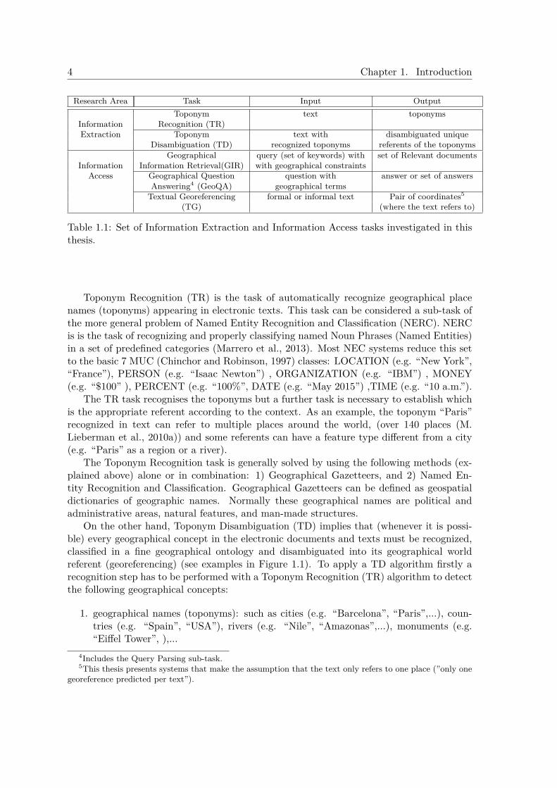
1.2 Researched Areas and Tasks InvestigatedThe research areas investigated in this thesis are both Information Extraction and Geo-graphical Information Access. The following tasks related with Geographical InformationAccess were investigated: Geographical Information Retrieval, Geographical Question An-swering, and Textual Georeferencing. Moreover GeoIA tasks require the research of Infor-mation Extraction methods to automatically understand geographical terms in electronictexts. So the areas of Toponym Recognition and Toponym Disambiguation were also re-searched. The Table 1.1 contains a description of the research areas investigated.
1.3 Toponym Recognition and DisambiguationFrom the need of this geographically aware access to the information stored locally or onthe web emerged the research task of understanding the geographical terms and expressionsappearing in digital information. The tasks that allow this understanding are ToponymRecognition and Toponym Disambiguation (a detailed explanation of these tasks and itsstate-of-the-are is presented at Chapter 2).
4 Chapter 1. Introduction
Research Area Task Input OutputToponym text toponyms
Information Recognition (TR)Extraction Toponym text with disambiguated unique
Disambiguation (TD) recognized toponyms referents of the toponymsGeographical query (set of keywords) with set of Relevant documents
Information Information Retrieval(GIR) with geographical constraintsAccess Geographical Question question with answer or set of answers
Answering4 (GeoQA) geographical termsTextual Georeferencing formal or informal text Pair of coordinates5
(TG) (where the text refers to)
Table 1.1: Set of Information Extraction and Information Access tasks investigated in thisthesis.
Toponym Recognition (TR) is the task of automatically recognize geographical placenames (toponyms) appearing in electronic texts. This task can be considered a sub-task ofthe more general problem of Named Entity Recognition and Classification (NERC). NERCis is the task of recognizing and properly classifying named Noun Phrases (Named Entities)in a set of predefined categories (Marrero et al., 2013). Most NEC systems reduce this setto the basic 7 MUC (Chinchor and Robinson, 1997) classes: LOCATION (e.g. “New York”,“France”), PERSON (e.g. “Isaac Newton”) , ORGANIZATION (e.g. “IBM”) , MONEY(e.g. “$100” ), PERCENT (e.g. “100%”, DATE (e.g. “May 2015”) ,TIME (e.g. “10 a.m.”).
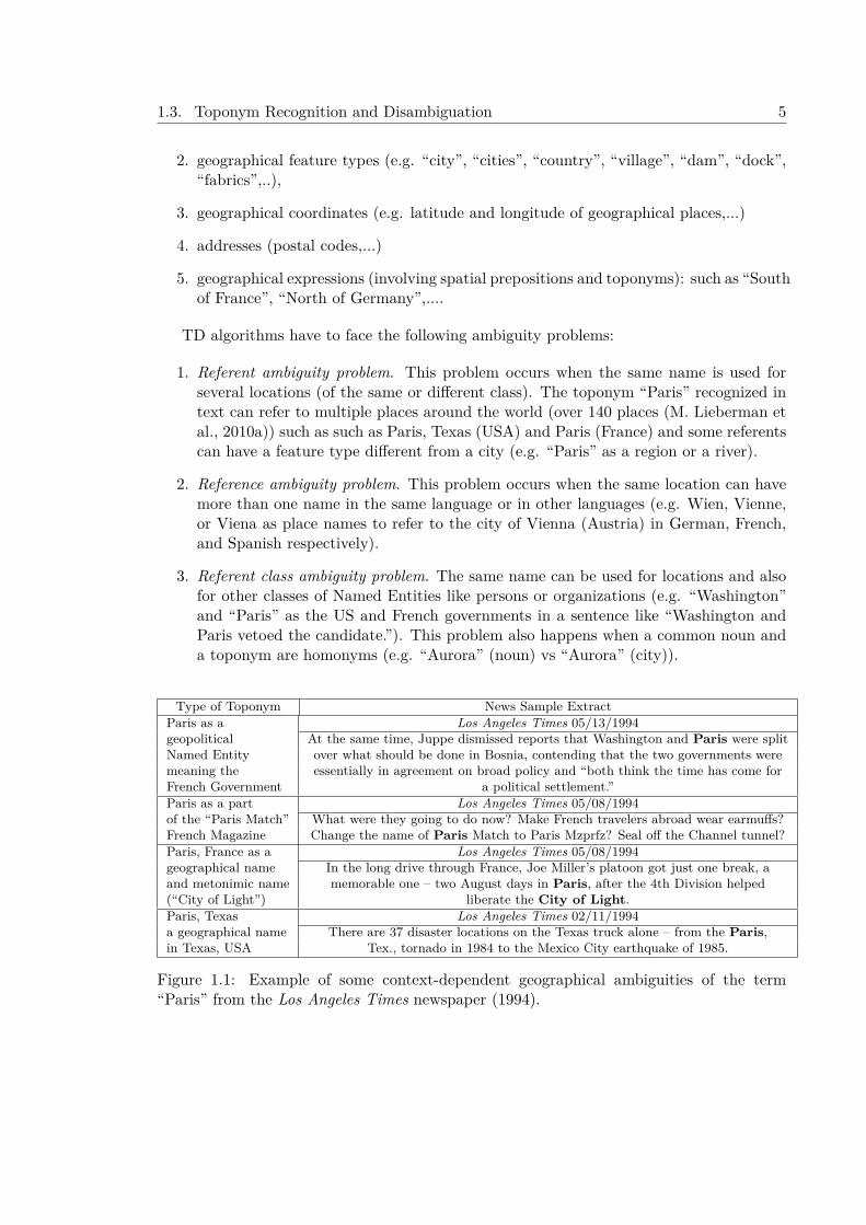
The TR task recognises the toponyms but a further task is necessary to establish whichis the appropriate referent according to the context. As an example, the toponym “Paris”recognized in text can refer to multiple places around the world, (over 140 places (M.Lieberman et al., 2010a)) and some referents can have a feature type different from a city(e.g. “Paris” as a region or a river).
The Toponym Recognition task is generally solved by using the following methods (ex-plained above) alone or in combination: 1) Geographical Gazetteers, and 2) Named En-tity Recognition and Classification. Geographical Gazetteers can be defined as geospatialdictionaries of geographic names. Normally these geographical names are political andadministrative areas, natural features, and man-made structures.
On the other hand, Toponym Disambiguation (TD) implies that (whenever it is possi-ble) every geographical concept in the electronic documents and texts must be recognized,classified in a fine geographical ontology and disambiguated into its geographical worldreferent (georeferencing) (see examples in Figure 1.1). To apply a TD algorithm firstly arecognition step has to be performed with a Toponym Recognition (TR) algorithm to detectthe following geographical concepts:
1. geographical names (toponyms): such as cities (e.g. “Barcelona”, “Paris”,...), coun-tries (e.g. “Spain”, “USA”), rivers (e.g. “Nile”, “Amazonas”,...), monuments (e.g.“Eiffel Tower”, ),...
4Includes the Query Parsing sub-task.5This thesis presents systems that make the assumption that the text only refers to one place (”only one
georeference predicted per text”).
1.3. Toponym Recognition and Disambiguation 5
2. geographical feature types (e.g. “city”, “cities”, “country”, “village”, “dam”, “dock”,“fabrics”,..),
3. geographical coordinates (e.g. latitude and longitude of geographical places,...)
4. addresses (postal codes,...)
5. geographical expressions (involving spatial prepositions and toponyms): such as “Southof France”, “North of Germany”,....
TD algorithms have to face the following ambiguity problems:
1. Referent ambiguity problem. This problem occurs when the same name is used forseveral locations (of the same or different class). The toponym “Paris” recognized intext can refer to multiple places around the world (over 140 places (M. Lieberman etal., 2010a)) such as such as Paris, Texas (USA) and Paris (France) and some referentscan have a feature type different from a city (e.g. “Paris” as a region or a river).
2. Reference ambiguity problem. This problem occurs when the same location can havemore than one name in the same language or in other languages (e.g. Wien, Vienne,or Viena as place names to refer to the city of Vienna (Austria) in German, French,and Spanish respectively).
3. Referent class ambiguity problem. The same name can be used for locations and alsofor other classes of Named Entities like persons or organizations (e.g. “Washington”and “Paris” as the US and French governments in a sentence like “Washington andParis vetoed the candidate.”). This problem also happens when a common noun anda toponym are homonyms (e.g. “Aurora” (noun) vs “Aurora” (city)).
Type of Toponym News Sample ExtractParis as a Los Angeles Times 05/13/1994geopolitical At the same time, Juppe dismissed reports that Washington and Paris were splitNamed Entity over what should be done in Bosnia, contending that the two governments weremeaning the essentially in agreement on broad policy and “both think the time has come forFrench Government a political settlement.”Paris as a part Los Angeles Times 05/08/1994of the “Paris Match” What were they going to do now? Make French travelers abroad wear earmuffs?French Magazine Change the name of Paris Match to Paris Mzprfz? Seal off the Channel tunnel?Paris, France as a Los Angeles Times 05/08/1994geographical name In the long drive through France, Joe Miller’s platoon got just one break, aand metonimic name memorable one – two August days in Paris, after the 4th Division helped(“City of Light”) liberate the City of Light.Paris, Texas Los Angeles Times 02/11/1994a geographical name There are 37 disaster locations on the Texas truck alone – from the Paris,in Texas, USA Tex., tornado in 1984 to the Mexico City earthquake of 1985.
Figure 1.1: Example of some context-dependent geographical ambiguities of the term“Paris” from the Los Angeles Times newspaper (1994).
6 Chapter 1. Introduction
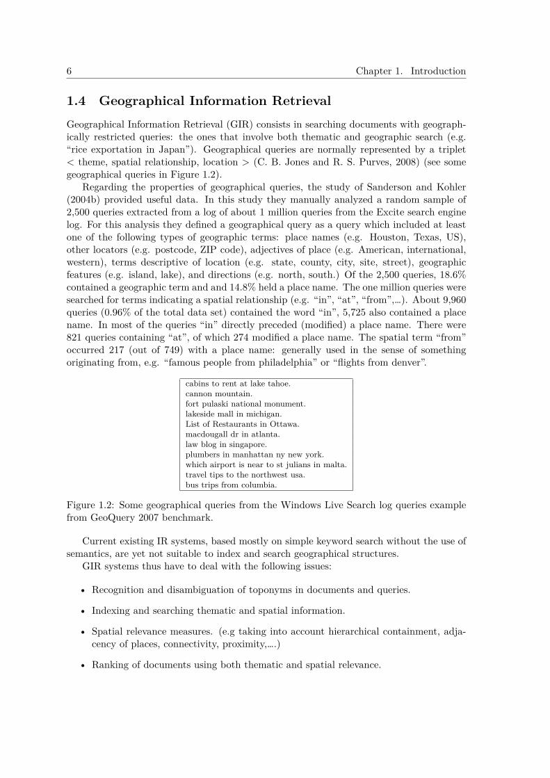
1.4 Geographical Information RetrievalGeographical Information Retrieval (GIR) consists in searching documents with geograph-ically restricted queries: the ones that involve both thematic and geographic search (e.g.“rice exportation in Japan”). Geographical queries are normally represented by a triplet< theme, spatial relationship, location > (C. B. Jones and R. S. Purves, 2008) (see somegeographical queries in Figure 1.2).
Regarding the properties of geographical queries, the study of Sanderson and Kohler(2004b) provided useful data. In this study they manually analyzed a random sample of2,500 queries extracted from a log of about 1 million queries from the Excite search enginelog. For this analysis they defined a geographical query as a query which included at leastone of the following types of geographic terms: place names (e.g. Houston, Texas, US),other locators (e.g. postcode, ZIP code), adjectives of place (e.g. American, international,western), terms descriptive of location (e.g. state, county, city, site, street), geographicfeatures (e.g. island, lake), and directions (e.g. north, south.) Of the 2,500 queries, 18.6%contained a geographic term and and 14.8% held a place name. The one million queries weresearched for terms indicating a spatial relationship (e.g. “in”, “at”, “from”,…). About 9,960queries (0.96% of the total data set) contained the word “in”, 5,725 also contained a placename. In most of the queries “in” directly preceded (modified) a place name. There were821 queries containing “at”, of which 274 modified a place name. The spatial term “from”occurred 217 (out of 749) with a place name: generally used in the sense of somethingoriginating from, e.g. “famous people from philadelphia” or “flights from denver”.
cabins to rent at lake tahoe.cannon mountain.fort pulaski national monument.lakeside mall in michigan.List of Restaurants in Ottawa.macdougall dr in atlanta.law blog in singapore.plumbers in manhattan ny new york.which airport is near to st julians in malta.travel tips to the northwest usa.bus trips from columbia.
Figure 1.2: Some geographical queries from the Windows Live Search log queries examplefrom GeoQuery 2007 benchmark.
Current existing IR systems, based mostly on simple keyword search without the use ofsemantics, are yet not suitable to index and search geographical structures.
GIR systems thus have to deal with the following issues:
• Recognition and disambiguation of toponyms in documents and queries.
• Indexing and searching thematic and spatial information.
• Spatial relevance measures. (e.g taking into account hierarchical containment, adja-cency of places, connectivity, proximity,….)
• Ranking of documents using both thematic and spatial relevance.
1.5. Geographical Question Answering 7
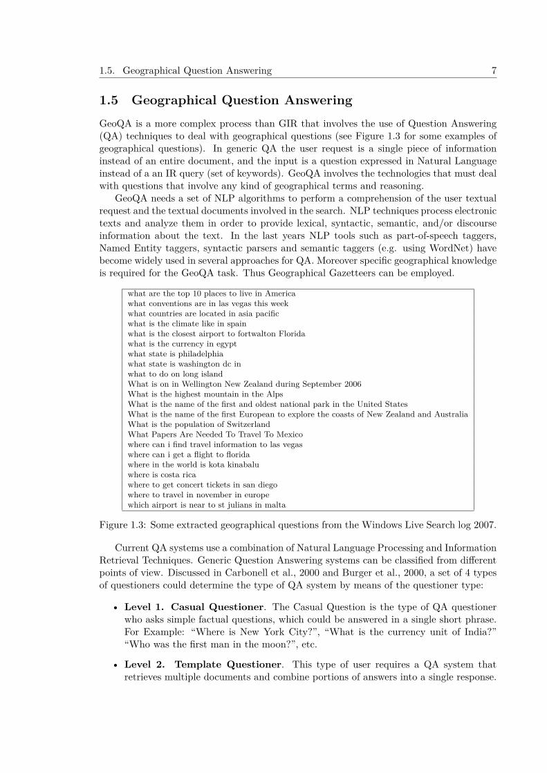
1.5 Geographical Question AnsweringGeoQA is a more complex process than GIR that involves the use of Question Answering(QA) techniques to deal with geographical questions (see Figure 1.3 for some examples ofgeographical questions). In generic QA the user request is a single piece of informationinstead of an entire document, and the input is a question expressed in Natural Languageinstead of a an IR query (set of keywords). GeoQA involves the technologies that must dealwith questions that involve any kind of geographical terms and reasoning.
GeoQA needs a set of NLP algorithms to perform a comprehension of the user textualrequest and the textual documents involved in the search. NLP techniques process electronictexts and analyze them in order to provide lexical, syntactic, semantic, and/or discourseinformation about the text. In the last years NLP tools such as part-of-speech taggers,Named Entity taggers, syntactic parsers and semantic taggers (e.g. using WordNet) havebecome widely used in several approaches for QA. Moreover specific geographical knowledgeis required for the GeoQA task. Thus Geographical Gazetteers can be employed.
what are the top 10 places to live in Americawhat conventions are in las vegas this weekwhat countries are located in asia pacificwhat is the climate like in spainwhat is the closest airport to fortwalton Floridawhat is the currency in egyptwhat state is philadelphiawhat state is washington dc inwhat to do on long islandWhat is on in Wellington New Zealand during September 2006What is the highest mountain in the AlpsWhat is the name of the first and oldest national park in the United StatesWhat is the name of the first European to explore the coasts of New Zealand and AustraliaWhat is the population of SwitzerlandWhat Papers Are Needed To Travel To Mexicowhere can i find travel information to las vegaswhere can i get a flight to floridawhere in the world is kota kinabaluwhere is costa ricawhere to get concert tickets in san diegowhere to travel in november in europewhich airport is near to st julians in malta
Figure 1.3: Some extracted geographical questions from the Windows Live Search log 2007.
Current QA systems use a combination of Natural Language Processing and InformationRetrieval Techniques. Generic Question Answering systems can be classified from differentpoints of view. Discussed in Carbonell et al., 2000 and Burger et al., 2000, a set of 4 typesof questioners could determine the type of QA system by means of the questioner type:
• Level 1. Casual Questioner. The Casual Question is the type of QA questionerwho asks simple factual questions, which could be answered in a single short phrase.For Example: “Where is New York City?”, “What is the currency unit of India?”“Who was the first man in the moon?”, etc.
• Level 2. Template Questioner. This type of user requires a QA system thatretrieves multiple documents and combine portions of answers into a single response.
8 Chapter 1. Introduction
The questions are basically factual but is required more information than a singlephrase (e.g. “What do we know about X?”, ”What are all of the countries thatborder Brazil?”).
• Level 3. Questioner as a Reporter. The QA questioner focus on factual questionsthat need to pull together information from a variety of sources including multiplemedias and multiple foreign languages.
• Level 4. Professional Information Analyst. This profile requires analytic toolscapable of providing answers to complex, multi-faceted questions involving judgementterms that analysts might wish to pose to multiple, very large, very heterogeneousdata sources, media types, multiple languages, multiple styles, formats, etc., ”
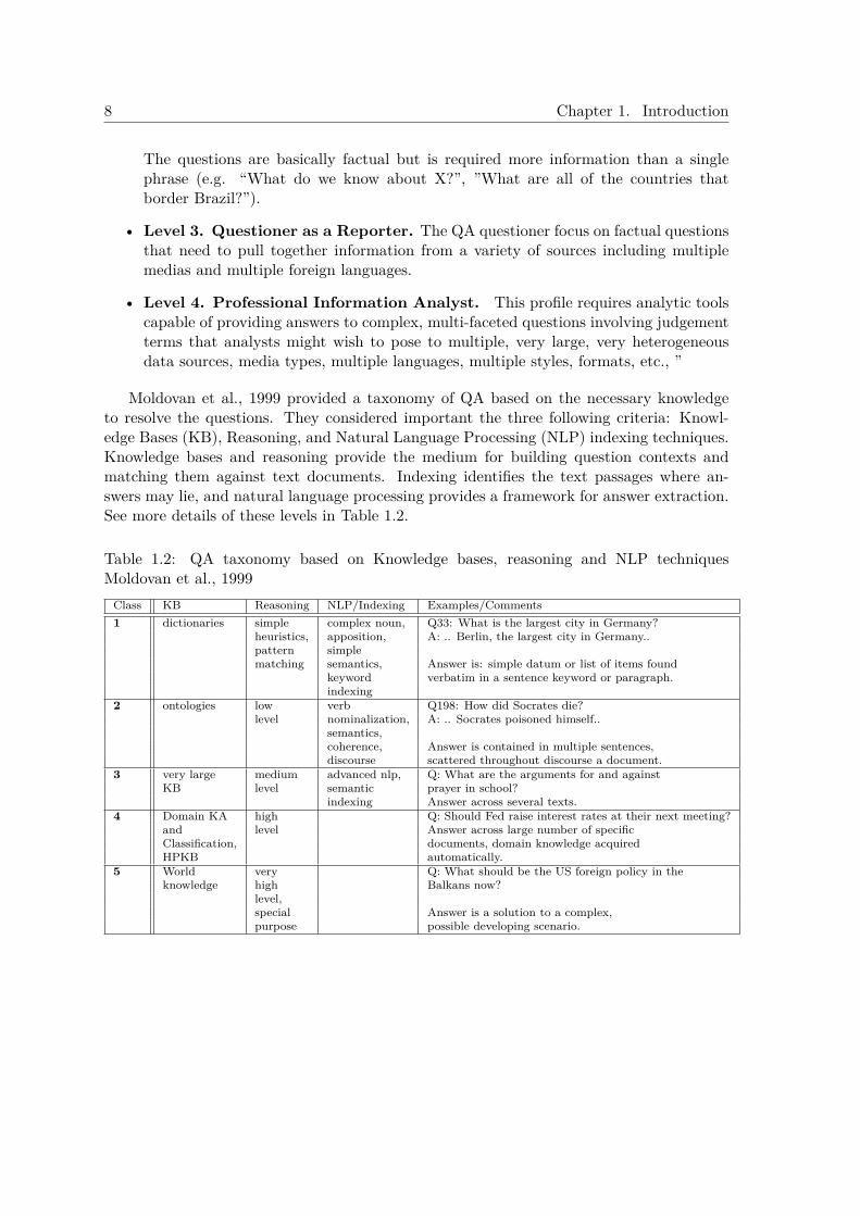
Moldovan et al., 1999 provided a taxonomy of QA based on the necessary knowledgeto resolve the questions. They considered important the three following criteria: Knowl-edge Bases (KB), Reasoning, and Natural Language Processing (NLP) indexing techniques.Knowledge bases and reasoning provide the medium for building question contexts andmatching them against text documents. Indexing identifies the text passages where an-swers may lie, and natural language processing provides a framework for answer extraction.See more details of these levels in Table 1.2.
Table 1.2: QA taxonomy based on Knowledge bases, reasoning and NLP techniquesMoldovan et al., 1999
Class KB Reasoning NLP/Indexing Examples/Comments1 dictionaries simple complex noun, Q33: What is the largest city in Germany?
heuristics, apposition, A: .. Berlin, the largest city in Germany..pattern simplematching semantics, Answer is: simple datum or list of items found
keyword verbatim in a sentence keyword or paragraph.indexing
2 ontologies low verb Q198: How did Socrates die?level nominalization, A: .. Socrates poisoned himself..
semantics,coherence, Answer is contained in multiple sentences,discourse scattered throughout discourse a document.
3 very large medium advanced nlp, Q: What are the arguments for and againstKB level semantic prayer in school?
indexing Answer across several texts.4 Domain KA high Q: Should Fed raise interest rates at their next meeting?
and level Answer across large number of specificClassification, documents, domain knowledge acquiredHPKB automatically.
5 World very Q: What should be the US foreign policy in theknowledge high Balkans now?
level,special Answer is a solution to a complex,purpose possible developing scenario.

1.6. Textual Georeferencing 9
1.6 Textual GeoreferencingTextual Georeferencing consists of extending the information of texts by predicting anexplicit location in space and time6 where and when the text refers. According to Hill (Hill,2006) ”The application of georeferencing extends to almost all fields of academic and appliedstudy, including the arts and humanities; social , physical, and life sciences; medicine;government administration; petroleum and mineral exploration; message understanding (textanalysis); historical and genealogical research; and the documentation of personal histories”.
Most of the textual and media content in the web is not georeferenced and this meansthat TG can be used in applications that need to know exactly or at least predict with someconfidence geographical information related to these texts such as: the author’s location,the place where the textual content refers or both informations.
Current state-of-the-art Textual Georeferencing (TG) approaches use Knowledge-Basedalgorithms based on Geographical Gazetteers (Ferrés and Rodríguez, 2011a) or Data-Drivenalgorithms based on models learnt from huge data collections (Van Laere, 2013).
Textual georeferencing does automatic understanding of the geographical content intexts and involves the need (whenever is possible) for its recognition, disambiguation andgrounding.
On the other hand, it must be taken into account that Georeferencing is a predictiontask that in some cases it is not possible (or very difficult) to perform in some texts. See inFigure 1.4 a set of keywords associated to georeferenced photos.
violet, video, home, diego, book, dancing, kiss, 2009, august2009, queens, justvioletcanonsd870is, dubocepark, dog, dogs, chihuahua, bug, chieka, rolling, stinky.crucible, oakland, fire, december132008, openhouse, art, craft, california, unitedstates, usa, pleaseaddtags.egypt, scuba, diving, saabsehr, underwater, shaabshear, shabsheer, redsea.cavern, airpocket, vortexspring, vortexsprings, vortex, florida, diving, scubadiving, scuba, underwater.maddy, beagle, pool, phoenix, arizona, bob, beer, corona, whitley, gary.estonia, tallinn, oldtown.vancouver.manifestation, crise, montpellier.
Figure 1.4: Sample of keywords (tags) associated to georeferenced Flickr photos extractedfrom MediaEval Placing Task 2010 Development Dataset. (Note: each line contains a setof tags associated to a photo.)
1.7 Objectives
The main objective of this thesis is the study, implementation, and evalua-tion of approaches that can improve effectiveness measures of the followingGeographical Information Access tasks: GIR, GeoQA and TG.
6This thesis treats georeferencing in space.
10 Chapter 1. Introduction
1.8 Research MethodologyThe research methodology followed involve these steps:
1. A definition of the Work Hypotheses: the first step of the research methodology is toestablish the work hypotheses.
2. An initial research study: a study of the existing state-of-the-art techniques andsystems.
3. An incremental and iterative Design-Test-Evaluation-Improvement research cycle:
• Design and implementation of algorithms that theoretically can solve the tasks.• Evaluation and comparative research. Design of appropriate experiments and
evaluation of the proposed algorithms with datasets that can serve as a goodanalysis of the results.
• Error analysis.• Perform improvements of the algorithms by using state-of-the art algorithms
and/or propose and implement novel solutions.
1.9 International BenchmarkingMost of the datasets and experiments of this thesis have been performed during evalua-tion benchmarks or after them with its provided datasets and judgements. An EvaluationBenchmark is a task or set of tasks in which the participants submit manual or automaticpredictions to be assessed by human experts or automatically. Benchmarking is useful inresearch for these reasons: 1) allows the organization of workshops, collaborations and dis-cussion among research groups, 2) provides datasets for experimentation to the participantsand further researchers improve the state of the art, 3) provides high-quality evaluationplatforms for the comparison state-of-the-art algorithms (M. Larson et al., 2015).

1.10. Work Hypotheses 11
1.10 Work HypothesesThe Work Hypotheses of this thesis are two following ones:
• Hypothesis 1. Existing Geographical Knowledge Bases and Natural Language Pro-cessing techniques can help to face the problems related with Geographical InformationAccess. This hypothesis emerge from the common-sense reasoning that both WorldKnowledge (geography) and Semantic Knowledge help us humans to classify, discover,and extract information from written text, and therefore it should have to be usefulin computational ways to access the information.
• Hypothesis 2. Common-Sense Heuristics that use existing Geographical KnowledgeBases and Natural Language Processing techniques can improve state-of-the-art Data-Driven algorithms for Geographical Information Access. From the first hypothesisemerged this one: if the Geographical Knowledge and the Semantic Knowledge canhelp the automatic computational access to the information an easy way to prove itis to do it with heuristics derived from human common-sense.
1.11 Scope and Focus of the ThesisThis section describes the Scope of the Geographical Information Access approaches re-searched in this thesis.
1.11.1 Geographical Information Retrieval ScopeThe scope of the GIR approaches implemented in this thesis is the following:
1. Part-of-relationship queries. In this thesis the main type of GIR queries treated arethe part-of-relationship type of queries (i.e. those that contain the spatial relationship“in” (including ”at” and ”from”), such as “Tornados in Texas”). The other types ofqueries (e.g. ”near”, ”close”, ...) are treated like “in” queries. In few experiments thespatial relationship operators “near” and “close” have been taken into account.
2. English Test Collections in the journalistic domain. The document collections used toperform the GIR experiments described in this thesis come from the journalistic do-main. The document collection consists of 169,477 stories from the British newspaperThe Glasgow Herald (1995) and the American newspaper Los Angeles Times (1994).
3. Testing with evaluation benchmarks datasets in official GIR evaluations and posteriorexperiments. The approaches for GIR have been evaluated within the GeoCLEF GIRevaluations of 2005, 2006 and 2007 and posterior experiments with the full collection(2005, 2006, 2007, and 2008).
4. Toponym Recognition is performed with NERC and Toponym Disambiguation usespartial and conservative context-independent heuristics based on Geographical Knowl-edge.
5. Evaluation of effectiveness measures. The focus of the thesis is to improve effectivenessmeasures of GeoIA. In this thesis GIR is evaluated only with efectiveness measures:
12 Chapter 1. Introduction
concretely Mean Average Precision (MAP), R-Precision and Recall (these measuresare defined in Chapter 3). Efficiency measures for GIR such as indexing and searchingspeed or index size are not reported and are out of the scope of this thesis. Statisticalsignificance testing has been employed to compare GIR experiments but practicalsignificance is not evaluated in this thesis.
1.11.2 Geographical Question Answering ScopeThe scope of the GeoQA approaches implemented in this thesis is the following:
1. Restricted-Domain and Open-Domain evaluations. The main approach, which is anScope-Based GeoQA system, has been evaluated in the Spanish geography domain.It means that the queries are focused on geographical entities, geographical namessuch as: cities, rivers, states or quantities such as: altitudes, population or extesion ofplaces. The other approaches for GeoQA and Geographical Query Parsing have beenevaluated in official GeoQA and Geographical Query parsing evaluation benchmarks:GikiCLEF (2009) and GeoQuery (2007).
2. Text-based approaches. The approaches receive questions in natural language andperform QA over collections of textual documents.
3. Treatment of English and Spanish languages for GeoQA.
4. Geographic-scope based factoid questions at basic level of complexity. The scope of thethesis deals with the treatment and processing of natural language queries in the formof factoid questions (”Where is Washington located?”) at a casual level of complexity(Carbonell et al., 2000). The kind of questions that can be answered are determinedby a geographic scope (region, country, state) in which the system has to be adapted.
1.11.3 Textual Georeferencing ScopeThe scope of the TG approaches implemented in this thesis is the following:
1. One georeference per text. The hypothesis of “one sense per discourse” applied inWord Sense Disambiguation (Gale et al., 1992) is applied in TG as “one georeferenceper text” in our formal and informal experiments (i.e. despite having many toponymsin the text, the predicted georeferencing of the text is a unique coordinates pair).
2. Testing in official Textual Georeferencing evaluation benchmarks and posterior exper-iments with the datasets when evaluating informal documents. The evaluation of theapproaches has been performed in the context of the MediaEval 2010, 2011, and 2014Placing Task multimodal georeferencing evaluation.
3. A multilingual test collection is used when the approaches are evaluated with informaldocuments. The MediaEval Placing Task evaluation used informal documents fromFlickr photos and videos (Flickr Meta-Data).
4. Toponym Recognition is performed with a Geographical Gazetteer and Toponym Dis-ambiguation is performed with Geographical Knowledge and Population Heuristics.
1.12. Summary of Contributions 13
5. English language is used when the approaches are evaluated with formal documents: aWikipedia collection is used for testing with formal documents.
6. Geographical coordinates (latitude and longitude) use the WGS84 revision of the WorldGeodetic System.
1.12 Summary of Contributions
This PhD thesis contributes to the state-of-the-art of Geographical Information Access(GeoIA) with the presentation and evaluation of several novel approaches that use ef-fectively Geographical Knowledge and Natural Language Processing to deal with severaltasks related to GeoIA. Several approaches have been implemented and evaluated inthe tasks of Geographical Information Retrieval, Geographical Question Answering andTextual Georeferencing. Most of these algorithms have been presented in internationalbenchmarking evaluations and some of them achieved state-of-the-art results (includingsome of the best results in GIR and TG tasks). The other experiments presented in thisthesis achieved average or low performance compared with the other participants in thebenchmarks but these experiments have shown scientific relevance by: a) showing thatGeographical Knowlegdge and Natural Language Processing combined with Data-Drivenmethods can improve effectiveness measures of GeoIA tasks, or b) establishing baselinesfor future improvements in the task.
This section contains a brief summary of the contributions of this thesis (see in Chapter7 a detailed description of these contributions). The main contributions of this thesis are:
1. The presentation and description of several novel approaches for Geo-graphical Information Access tasks.
2. The evaluation of these novel approaches for Geographical InformationAccess tasks.
3. The effective use of Geographical Knowledge and Natural Language Pro-cessing for the Geographical Information Retrieval tasks evaluated.
4. Passage Retrieval Approaches for GIR. Implementation and evaluation of twoapproaches that combine sucessfully Geographical Knowledge and Passage Retrievalpresented at GeoCLEF 2005 and GeoCLEF 2006.
5. TALPGeoIR. An approach that combines Geographical Knowledge Re-Ranking,Natural Language Processing and Relevance Feedback for Geographical InformationRetrieval that achieved state-of-the-art results in official GeoCLEF benchmarks (Fer-rés and Rodríguez, 2008a; Mandl et al., 2008) and posterior experiments (Ferrés andRodríguez, 2015a).
6. GeoTALP-QA. A scope-based Geographical Question Answering Approach.This thesis contributed to both GeoQA and Restricted-Domain QA state-of-the-artwith the design and implementation of a Scope-based GeoQA system for Spanish andEnglish and its evaluation with a set of questions of the Spanish geography (Ferrésand Rodríguez, 2006a).
14 Chapter 1. Introduction
7. State-of-the-art Textual Georeferencing approaches. This thesis presented fournovel approaches to generic Textual Georeferencing for informal and formal documentsthat achieved state-of-the-art results in evaluation benchmarks (Ferrés and Rodríguez,2014) and posterior experiments (Ferrés and Rodríguez, 2011a; Ferrés and Rodríguez,2015b).
8. A Geographical Query Parsing algorithm. A Geographical Query Parsing al-gorithm that detects and extracts information from geographical queries that hasbeen evaluated with search engine log queries in an evaluation benchmark (Ferrés andRodríguez, 2008b).
9. GikiTALP: a simple Data-Driven baseline for Geographical Question An-swering over Wikipedia.
1.13. Publications 15
1.13 PublicationsThis section details the publications (grouped by chapter) that disseminate the researchstudies and results obtained from the work presented in this thesis.
Chapter 4. Geographical Information Retrieval Approaches. The following pub-lications are related with approaches for GIR and its evaluation in the context of severalGeoCLEF official evaluations and posterior experiments:
Book chapters
Daniel Ferrés, Alicia Ageno and Horacio Rodríguez.The GeoTALP-IR System at GeoCLEF 2005: Experiments Using a QA-BasedIR System, Linguistic Analysis, and a Geographical Thesaurus.In Accessing Multilingual Information Repositories: 6th Workshop of the Cross-LanguageEvaluation Forum, CLEF 2005, Vienna, Austria, Revised Selected Papers. Lecture Notesin Computer Science. 2006. Vol 4022. Pages 947-955.
This paper presents GeoTALP-IR, the first GIR approach developed by the author isdescribed and evaluated at GeoCLEF 2005 evaluation benchmark.
Daniel Ferrés and Horacio Rodríguez.TALP at GeoCLEF 2006: Experiments Using JIRS and Lucene with the ADLFeature Type Thesaurus.Evaluation of Multilingual and Multi-modal Information Retrieval. Lecture Notes inComputer Science. Vol. 4730. Pages. 962-969. 2007.
This paper describes the second GIR approach proposed, TALPGeoIR 2006, and itsevaluation in the context of the GeoCLEF 2006 evaluation benchmark.
Daniel Ferrés and Horacio Rodríguez.TALP at GeoCLEF 2007: Results of a Geographical Knowledge Filtering Ap-proach with Terrier.Advances in Multilingual and Multimodal Information Retrieval. Lecture Notes in Com-puter Science. Vol. 5152. Pages 830-833. Springer. 2008.
This paper reports an analysis of the results of the TALPGeoIR 2007 approach evalu-ated at GeoCLEF 2007 evaluation benchmark, where it achieved the top-ranked position inMonolingual English GIR.
16 Chapter 1. Introduction
Daniel Ferrés and Horacio Rodríguez.Evaluating Geographical Knowledge Re-Ranking, Linguistic Processing andQuery Expansion Techniques for Geographical Information Retrieval .Proceedings of the 22th International Symposium on String Processing and InformationRetrieval (SPIRE 2015). September, 2015. London, UK. Lecture Notes in ComputerScience. Vol. 9309, pages 311-323. Springer. 2015.
This paper shows the evaluation of the different components of the TALPGeoIR appliedover three state-of-the-art IR algorithms: TF-IDF, BM25 and InL2. The components evalu-ated were: Geographical Knowledge-Reranking, Linguistic Processing, and Query Expansionwith Relevance Feedback. The evaluation was done with the full GeoCLEF collections from2005 to 2008 (100 topics) and showed improvement of the MAP effectiveness measure overof the best official results at GeoCLEF evaluations of 2005, 2006, and 2007.
Conference Proceedings
Daniel Ferrés and Horacio Rodríguez.TALP at GeoCLEF 2007: Using Terrier with Geographical Knowledge Fil-teringWorking Notes for CLEF 2007 Workshop co-located with the 11th European Conferenceon Digital Libraries (ECDL 2007), Budapest, Hungary, September 19-21, 2007.
The third GIR approach proposed, TALPGeoIR 2007, is described and evaluated atGeoCLEF 2007 evaluation benchmark (where it achieved the top-ranked runs in MonolingualEnglish GIR) in this paper.
Chapter 5. Geographical Question Answering Approaches: The following pub-lications are related with GeoQA and Geographical Query Parsing approaches evaluatedwith closed collections or within evaluation benchmarks:
Book Chapters
Daniel Ferrés and Horacio Rodríguez.TALP at GeoQuery 2007: Linguistic and Geographical Analysis for QueryParsing.Advances in Multilingual and Multimodal Information Retrieval. Lecture Notes in Com-puter Science, Vol. 5152. Pages 834-837. 2008.
This paper describes the system presented at GeoQuery2007 and analyzes the results.
Daniel Ferrés and Horacio Rodríguez.TALP at GikiCLEF 2009.Multilingual Information Access Evaluation Vol. I Text Retrieval Experiments. LectureNotes in Computer Science. Vol. 6241. Pages 322-325. 2010.
1.13. Publications 17
This paper describes experiments in Geographical Information Retrieval with the Wikipediacollection in the context of the participation in the GikiCLEF 2009 Multilingual task in En-glish and Spanish.
Conference Proceedings
Daniel Ferrés and Horacio Rodríguez,Experiments Adapting an Open-Domain Question Answering System to theGeographical Domain Using Scope-Based Resources.Proceedings of the Multilingual Question Answering Workshop of the EACL 2006. 2006.Trento, Italy.
This paper describes an approach to adapt an existing multilingual Open-Domain Ques-tion Answering (ODQA) system for factoid questions to a Restricted Domain, the Geo-graphical Domain.
Jordi Luque and Daniel Ferrés and Javier Hernando and José B. Mariño and HoracioRodríguez.GeoVAQA: A Voice Activated Geographical Question Answering System.Actas de las IV Jornadas en Tecnología del Habla (4JTH). November, 2006, Zaragoza,Spain
This paper describes GeoVAQA, a voice-activated Geographical QA system. The authorof this thesis contributed to this paper with a textual Geographical QA system that receivesquestions previously recognized by an automatic speech recognition (ASR) system.
Chapter 6. Textual Georeferencing Approaches: These publications are relatedwith TG in the context of official Media Eval Placing Task (MEPT) evaluations and pos-terior experiments with the MEPT datasets:
Book Chapters
Daniel Ferrés and Horacio RodríguezKnowledge-Based and Data-Driven Approaches for Georeferencing of Infor-mal Documents. Proceedings of the 8th International Conference on Text, Speech andDialogue TSD 2015. September, 2015. Plzen, Czech Republic.Lecture Notes in Computer Science. Vol 9302. Springer. Pages 452-460.
This paper describes four Georeferencing approaches, experiments, and results at theMediaEval 2014 Placing Task (ME2014PT) evaluation, and posterior experiments. Someof the approaches achieved state-of-the-art results at ME2014PT evaluation and posteriorexperiments, including the best results for distance accuracies of 1000km and 5,000km inthe task where only the official training dataset can be used to predict the coordinates.

18 Chapter 1. Introduction
Conference Proceedings
Daniel Ferrés and Horacio RodríguezTALP at MediaEval 2010 Placing Task: Geographical Focus Detection ofFlickr Textual Annotations.Working Notes of the Mediaeval 2010 Evaluation. October 2010. Pisa, Italy.
This paper describes the textual georeferencing experiments in the context of the Mul-timedia Placing Task at the MediaEval 2010 evaluation benchmark. In these experimentsonly Geographical Knowledge (gazetteers) and limited NLP (stopwords and dictionaries)were used to predict.
Daniel Ferrés and Horacio RodríguezGeoreferencing Textual Annotations and Tagsets with Geographical Knowl-edge and Language ModelsActas de la SEPLN (Sociedad Española para el Procesamiento del Lenguaje Natural).September 2011. Huelva, Spain.
This paper proposed 4 new generic textual georeferencing approaches based on Geograph-ical Knowledge Bases, Linguistic Knowledge, and Information Retrieval. These approacheshave been evaluated with the MediaEval 2010 dataset and outperformed the best results inaccuracy reported by the state-of-the art systems that participated at MediaEval 2010 officialPlacing task.
Daniel Ferrés and Horacio RodríguezTALP at MediaEval 2011 Placing Task: Georeferencing Flickr Videos withGeographical Knowledge and Information Retrieval.Working Notes of the Mediaeval 2011 Evaluation. October 2011. Amsterdam, Holand.
This paper describes the textual georeferencing experiments in the context of the Multi-media Placing Task at the MediaEval 2011 evaluation benchmark.
Daniel Ferrés and Horacio RodríguezTALP-UPC at MediaEval 2014 Placing Task: Combining GeographicalKnowledge Bases and Language Models for Large-Scale Textual Georefer-encing.Working Notes of the Mediaeval 2014 Evaluation. October 2014. Barcelona, Spain.
This paper describes the textual georeferencing experiments in the context of the Multi-media Placing Task at the MediaEval 2014 evaluation benchmark.

1.13. Publications 19
Annex G: Web Person Search experiments at WePS-3
Conference Proceedings
Daniel Ferrés and Horacio RodríguezTALP at WePS-3 2010.CLEF 2010 LABs and Workshops, Notebook Papers, 22-23 September 2010, Padua,Italy. Ed. by M. Braschler, D. Harman, and E. Pianta. Vol. 1176. CEUR WorkshopProceedings.
This paper describes the Web Person Search experiments at WePS-3.
20 Chapter 1. Introduction
1.14 Structure of the DocumentThe rest of this thesis is structured as follows:
Chapter 2 - Toponym Recognition and Disambiguation - State-of-the-artGeographical Information Access applications require the recognition and sometimes the
disambiguation of the toponyms. This Chapter describes the state of the art of ToponymRecognition and Toponym Disambiguation, including: 1) the two main approaches for TR:Geographical Gazetteers lookup and Named Entity Recognition and Classification based onNLP tools, and 2) state-of-the-art TD heuristics and systems.
Chapter 3 - Geographical Information Access Tasks - State-of-the-artThis Chapter describes the state-of-the-art of the three Geographical Information Access
tasks that are treated in this thesis: GIR, GeoQA, and TG.
Chapter 4 - Geographical Information Retrieval ApproachesThis Chapter describes the approaches that the author of this thesis presented at several
GeoCLEF GIR evaluations (2005, 2006, and 2007) and performs a depth evaluation of thelast approach presented with new experiments that have been performed in 2015 (Ferrésand Rodríguez, 2015a).
Chapter 5 - Geographical Question Answering ApproachesThis Chapter describes the GeoQA approaches, the experiments to evaluate them and
the results. First, describes a system that consists of an adaptation of an ODQA (Open Do-main Question Answering) to the Geographical Domain. Then, a system for GeographicalQA over the wikipedia is evaluated at CLEF’s GikiCLEF 2009 evaluation. Finally, a sys-tem for analyzing Geographical queries is presented in the context of the CLEF’s GeoQuery2007 evaluation.
Chapter 6 - Textual Georeferencing ApproachesThis Chapter describes generic approaches for georeferencing formal and informal doc-
uments. The informal documents have been evaluated in the context of several MediaEval Placing Task evaluations (2010, 2011, and 2014) and posterior experiments after theseevaluations. The formal documents have been evaluated with an existing test set for geo-referencing Wikipedia documents. Moreover a set of experiments with emergency scenarioshave been performed using a subset of the Media Eval Placing Task 2014 dataset.
Chapter 7 - ConclusionsThe last Chapter describes the contributions of the author of this dissertation to the
research fields investigated, reports the limitations of the work, and proposes further workto develop in the researched areas.
1.14. Structure of the Document 21
Annex A - Test CollectionsThis annex describes the datasets employed in the experiments performed in this thesis
and provides links to download them.
Annex B - GeoCLEF Topics List and Topics ClassificationThis annex shows the GeoCLEF topics used in the GeoCLEF evaluation benchmarks
from 2005 to 2008 (a total of 100 topics). This annex also includes several classificationtypes of these topics.
Annex C - GeoCLEF Per-Query ResultsThis annex shows the GeoCLEF Per Query results of the three IR algorithms used:
TF-IDF, BM25 and HLM. The results include the experiments with the following fields:title alone, title and description, and all tags (title, description and narrative).
Annex D - Spanish GeoQA QuestionsThis annex shows the test set of the GeoQA experiments. These sets contain 62 questions
about the Spanish geography.
Annex E - GikiCLEF QuestionsThis annex shows the GikiCLEF topics in English and Spanish used in the GikiCLEF
2009 evaluation benchmark (a total of 50 questions per language).
Annex F - Geographical Feature Types MappingsThis annex shows the geographical feature types data mappings developed in this thesis.
Annex G - Web Person Search experiments at WePS-3This annex describes the Web Person Search experiments at the WePS-3 benchmark.

22 Chapter 1. Introduction

CHAPTER 2
Toponym Recognition and Disambiguation -State-of-the-art
Toponym Recognition (TR) is the task of automatically recognize geographical place names(toponyms) appearing in electronic texts. This task can be considered a sub-task of themore general problem of Named Entity Recognition and Classification (NERC), in whichNamed Entities (NE) are recognized in text and classified into a set of categories. Marreroet al. (2013) discusses that NE can be defined by four criteria according to the experts in thefield: 1) grammatical category (proper nouns or common names acting as common nouns),2) rigid designator 3) unique identifier and 4) purpose and domain of the application, beingthis later definition criteria the only one consistent with the literature, evaluation forumsand tools.
The TR task recognises the toponyms but a further task is necessary to establish whichis the appropiate referent according to the context. As an example, the toponym “Paris”recognized in text can refer to multiple places around the world, (over 140 places (M. Lieber-man et al., 2010a)) and some referents can hava a feature type different from a city (e.g.“Paris” as a region or a river). Toponym Disambiguation is the task of automatically dis-ambiguate the toponyms recognized in electronic texts by chosing their unique referents inthe context (if possible). This task implies that (whenever it is possible) every geograph-ical concept in the text must be classified in a geographical class (or feature type) anddisambiguated into its geographical world referent. The process that involves ToponymRecognition and Toponym Disambiguation has been named “geotagging” in the literature(Amitay et al., 2005; M. Lieberman et al., 2010a).
Once the TD process has been completed the disambiguated entries can be associatedto a unique spatial coordinates and regions. Geotagging thus allows to pass from the name-based and discrete informal way of expressing locations to the continuous, formal way ofspatial representation of places by coordinates, polygons, boxes,... (Hill, 2006).
23
24 Chapter 2. Toponym Recognition and Disambiguation - State-of-the-art
2.1 Toponym Recognition ApproachesToponym Recognition implies also the task of Toponym Normalization (e.g. understandingthat “UK”, “U.K.”, and “United Kingdom” are refering to the same geographical or geo-political entity) and solve geo/non-geo ambiguities (e.g. deciding which word is correctin the context: “Metro” (noun) or “Metro” (city)). Although Toponym Normalization iseasily solved with Gazetteers that include alternate names of toponyms, the geo/non-geoambiguity is a more complex problem. For instance, Volz et al. (2007) show that 11,5%of WordNet 2.0 names intersect with geographic names. Amitay et al. (2005) presentedapproach to the geo/non-geo ambiguity that consists to create lists of place names with avery common non-geo sense by counting the names of the place names occurred in a largecorpus and filtering those with a high frequency and those with small population. Theirapproach required manual pass to remove errors or add missing names.
The Toponym Recognition task is generally solved by using the following methods (ex-plained above) alone or in combination: 1) Geographical Gazetteers, 2) Named EntityRecognition.
2.1.1 Geographical GazetteersGeographical Gazetteers can be defined as geospatial dictionaries of geographic names.Normally these places can be political and administrative areas, natural features, and man-made structures. They contain large lists of geographical entities, normally enriched withsome information such as: geographical feature type (e.g. “city”, “country”), location (e.g.geographical coordinates such as longitude and latitude), elevation, population, language,inclusive relations (e.g. referent of the state and/or country where is located) (Hill, 2006).Some of the most relevant geographical gazetteers are described here:
• GEOnet Names Server (GNS1). A worldwide database of geographic featurenames, excluding the United States and Antarctica, with 5.5 million entries. Thecoordinate system for data served by GNS is WGS84. Each gazetteer entry containsa geographical name (toponym) and its feature class and code, geographical coordi-nates (latitude, longitude), language of the geographical name and other features ascountry, first administrative division, etc.
• Geographic Names Information System (GNIS2). A gazetteer with 2.0 millionentries about geographic features of the United States and its territories. GNISgazetteer was developed by the U.S. Geological Survey in cooperation with the U.S.Board on Geographic Names (BGN). The entries contain the following fields: geo-graphical name , feature Type, U.S. County, U.S. State, Geographical Coordinates,Elevation, etc.
• Alexandria Digital Gazetteer3 (ADL). The ADL gazetteer is a geospatially de-fined geographic name datasets with about 4 million entries (Frew et al., 1998).
1 GNS. http://geonames.nga.mil/gns/html/namefiles.html2 GNIS. http://geonames.usgs.gov/domestic/download_data.htm3ADL. http://legacy.alexandria.ucsb.edu/gazetteer/
2.1. Toponym Recognition Approaches 25
• Alexandria Digital Gazetteer Feature Type Thesaurus (ADLFTT). TheADL Feature Type Thesaurus 4 is a hierarchical (4 levels) set of about 210 geo-graphical terms used to type named geographic places in English (Hill, 2000). Thetop level of the ADLFTT hierarchy has the following classes: administrative areas,hydrographic features, land parcels, manmade features, physiographic features, andregions.
• GeoWorldMap5 gazetteer with approximately 40,594 entries (countries, regions andimportant cities). The countries data contains information associated to world coun-tries such as:
– Country Name (e.g. “India”, “United States”,…).– FIPS10-4 code6: a four letter code that identifies geopolitical entities. This code
was established by the Federal Information Processing Standarts institution ofU.S.A.
– ISO2 code: is a 2 alpha-numeric characters code that represents a country (e.g.“US” represents the United States of America). More information on the ISO2code can be found at the ISO 3166 standard7.
– ISO3 code: is a 3 alpha-numeric characters code that represents a country (e.g.“GTM” represents Guatemala). More information on the ISO3 code can befound at the ISO 3166 standard.
– ISON: is the number column in the ISO 3166 document which lists each countrywith associated alpha and numeric codes (e.g. “036” represents Australia).
– Internet; the “ccTLD” code designated by Internet Assigned Numbers Authority(IANA)8. This code is employed in the DNS to identify hosts in various countriesaround the world (e.g. the code “uk” is assigned to the United Kingdom). The“ccTLD” codes are based on ISO2 codes.
– Capital; this field is a string representation of a given countries capital city, forexample, the capital of United States is “Washington, DC”.
– MapReference; this field is a string representation of a given countries, majorreference point in the world, for example, the map reference for Canada is “NorthAmerica”.
– Nationality Demonyms in singular and plural: the singular and plural expressionof a given countries nationality (e.g. “German” and “Germans” for Germany).
– Currency: a string with the country currency (e.g. “Yen” for Japan and “USDolar” for United States).
– CurrencyCode: is a 3 character string representation of a given countries currencycode based on the ISO 42179 standard. The first 2 characters are made up of thecountries Internet code and the last is a currency designator (e.g. the currencycode “USD” is the code for the US Dollar and “JPY” for Japan).
4ADLFTT. http://www.alexandria.ucsb.edu/gazetteer/FeatureTypes/ver070302/index.htm5Geobytes Inc.: http://www.geobytes.com/6FIPS-104 publication. www.nimal.mil/gns/html/index.html7http://www.iso.org/iso/en/prods-services/iso3166ma/02iso-3166-code-lists/list-en1.html8http://www.iana.org,9www.iso.org
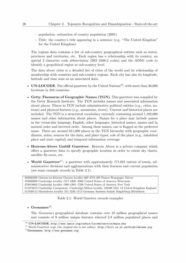
26 Chapter 2. Toponym Recognition and Disambiguation - State-of-the-art
– population: estimation of country population (2001).– Title: the country’s title appearing in a sentence (e.g. “The United Kingdom”
for the United Kingdom).
The regions data contains a list of sub-country geographical entities such as states,provinces and territories, etc. Each region has a relationship with its country, anspecial 2 character code abbreviation (ISO 3166-2 codes) and the ADM1 code toidentify a geopolitical region at sub-country level.The data about cities is a detailed list of cities of the world and its relationship ofmembership with countries and sub-country regions. Each city has also its longitude,latitude and time zone as an associated data.
• UN-LOCODE. The official gazetteer by the United Nations10, with more than 36,000locations in 234 countries.
• Getty Thesaurus of Geographic Names (TGN). This gazetteer was compiled bythe Getty Research Institute. The TGN includes names and associated informationabout places. Places in TGN include administrative political entities (e.g., cities, na-tions) and physical features (e.g., mountains, rivers). Current and historical places areincluded. The TGN is a structured vocabulary currently containing around 1,102,000names and other information about places. Names for a place may include namesin the vernacular language, English, other languages, historical names, names and innatural order and inverted order. Among these names, one is flagged as the preferredname. There are around 911,000 places in the TGN hierarchy with geographic coor-dinates, notes, sources for the data, and place types, role of the place (e.g., inhabitedplace and state capital) and temporal information coverage.
• Heavens-Above GmbH Gazetteer. Heavens Above is a private company whichoffers a gazetteer data to specify geographic location in order to orient sky charts,satellite fly-overs, etc.
• World Gazetteer11: a gazetteer with approximately 171,021 entries of towns, ad-ministrative divisions and agglomerations with their features and current population(see some example records in Table 2.1).
493866395 Ouroux-en-Morvan Ouroux locality 669 4718 395 France Bourgogne Nièvre478809098 Cambridge locality 1217 4300 -8902 United States of America Wisconsin478918662 Cambridge locality 1900 4303 -7338 United States of America New York511974013 Cambridge Caergrawnt, Cambridge-Milton locality 128488 5221 13 United Kingdom England511939112 Marienborn locality 531 5220 1112 Germany Sachsen-Anhalt Magdeburg Bördekreis
Table 2.1: World Gazetter records examples
• Geonames12.The Geonames geographical database contains over 10 million geographical namesand consists of 9 million unique features whereof 2.8 million populated places and
10 UN-LOCODE. http://www.unece.org/cefact/locode/service/main.htm11 World Gazetteer copy (the original site is not online). http://biit.cs.ut.ee/biodc/dataen.zip12Geonames. http://www.geonames.org
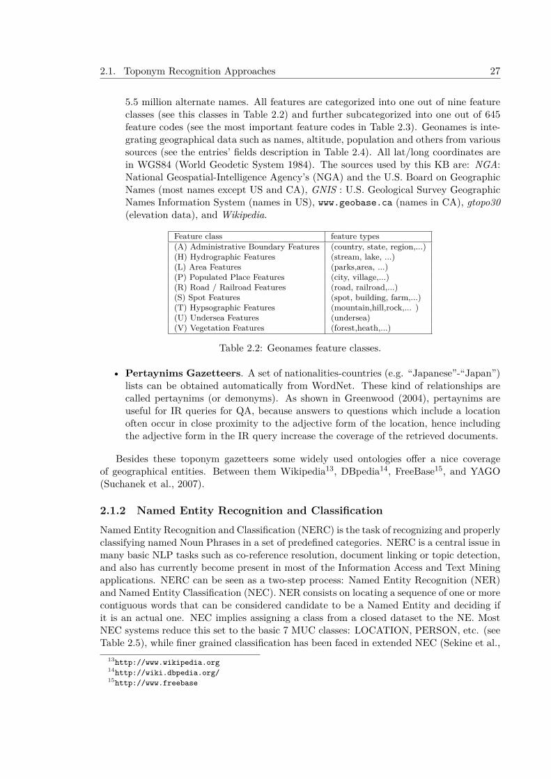
2.1. Toponym Recognition Approaches 27
5.5 million alternate names. All features are categorized into one out of nine featureclasses (see this classes in Table 2.2) and further subcategorized into one out of 645feature codes (see the most important feature codes in Table 2.3). Geonames is inte-grating geographical data such as names, altitude, population and others from varioussources (see the entries’ fields description in Table 2.4). All lat/long coordinates arein WGS84 (World Geodetic System 1984). The sources used by this KB are: NGA:National Geospatial-Intelligence Agency’s (NGA) and the U.S. Board on GeographicNames (most names except US and CA), GNIS : U.S. Geological Survey GeographicNames Information System (names in US), www.geobase.ca (names in CA), gtopo30(elevation data), and Wikipedia.
Feature class feature types(A) Administrative Boundary Features (country, state, region,...)(H) Hydrographic Features (stream, lake, ...)(L) Area Features (parks,area, ...)(P) Populated Place Features (city, village,...)(R) Road / Railroad Features (road, railroad,...)(S) Spot Features (spot, building, farm,...)(T) Hypsographic Features (mountain,hill,rock,... )(U) Undersea Features (undersea)(V) Vegetation Features (forest,heath,...)
Table 2.2: Geonames feature classes.
• Pertaynims Gazetteers. A set of nationalities-countries (e.g. “Japanese”-“Japan”)lists can be obtained automatically from WordNet. These kind of relationships arecalled pertaynims (or demonyms). As shown in Greenwood (2004), pertaynims areuseful for IR queries for QA, because answers to questions which include a locationoften occur in close proximity to the adjective form of the location, hence includingthe adjective form in the IR query increase the coverage of the retrieved documents.
Besides these toponym gazetteers some widely used ontologies offer a nice coverageof geographical entities. Between them Wikipedia13, DBpedia14, FreeBase15, and YAGO(Suchanek et al., 2007).
2.1.2 Named Entity Recognition and ClassificationNamed Entity Recognition and Classification (NERC) is the task of recognizing and properlyclassifying named Noun Phrases in a set of predefined categories. NERC is a central issue inmany basic NLP tasks such as co-reference resolution, document linking or topic detection,and also has currently become present in most of the Information Access and Text Miningapplications. NERC can be seen as a two-step process: Named Entity Recognition (NER)and Named Entity Classification (NEC). NER consists on locating a sequence of one or morecontiguous words that can be considered candidate to be a Named Entity and deciding ifit is an actual one. NEC implies assigning a class from a closed dataset to the NE. MostNEC systems reduce this set to the basic 7 MUC classes: LOCATION, PERSON, etc. (seeTable 2.5), while finer grained classification has been faced in extended NEC (Sekine et al.,
13http://www.wikipedia.org14http://wiki.dbpedia.org/15http://www.freebase
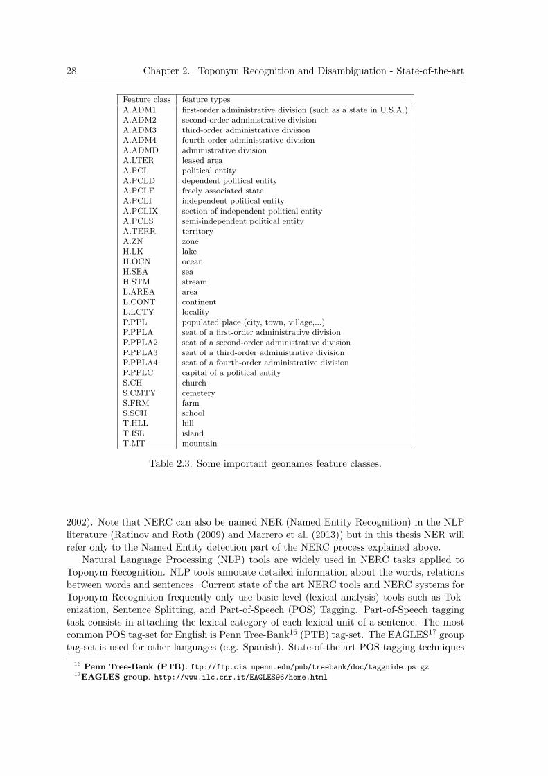
28 Chapter 2. Toponym Recognition and Disambiguation - State-of-the-art
Feature class feature typesA.ADM1 first-order administrative division (such as a state in U.S.A.)A.ADM2 second-order administrative divisionA.ADM3 third-order administrative divisionA.ADM4 fourth-order administrative divisionA.ADMD administrative divisionA.LTER leased areaA.PCL political entityA.PCLD dependent political entityA.PCLF freely associated stateA.PCLI independent political entityA.PCLIX section of independent political entityA.PCLS semi-independent political entityA.TERR territoryA.ZN zoneH.LK lakeH.OCN oceanH.SEA seaH.STM streamL.AREA areaL.CONT continentL.LCTY localityP.PPL populated place (city, town, village,...)P.PPLA seat of a first-order administrative divisionP.PPLA2 seat of a second-order administrative divisionP.PPLA3 seat of a third-order administrative divisionP.PPLA4 seat of a fourth-order administrative divisionP.PPLC capital of a political entityS.CH churchS.CMTY cemeteryS.FRM farmS.SCH schoolT.HLL hillT.ISL islandT.MT mountain
Table 2.3: Some important geonames feature classes.
2002). Note that NERC can also be named NER (Named Entity Recognition) in the NLPliterature (Ratinov and Roth (2009) and Marrero et al. (2013)) but in this thesis NER willrefer only to the Named Entity detection part of the NERC process explained above.
Natural Language Processing (NLP) tools are widely used in NERC tasks applied toToponym Recognition. NLP tools annotate detailed information about the words, relationsbetween words and sentences. Current state of the art NERC tools and NERC systems forToponym Recognition frequently only use basic level (lexical analysis) tools such as Tok-enization, Sentence Splitting, and Part-of-Speech (POS) Tagging. Part-of-Speech taggingtask consists in attaching the lexical category of each lexical unit of a sentence. The mostcommon POS tag-set for English is Penn Tree-Bank16 (PTB) tag-set. The EAGLES17 grouptag-set is used for other languages (e.g. Spanish). State-of-the art POS tagging techniques
16 Penn Tree-Bank (PTB). ftp://ftp.cis.upenn.edu/pub/treebank/doc/tagguide.ps.gz17EAGLES group. http://www.ilc.cnr.it/EAGLES96/home.html

2.1. Toponym Recognition Approaches 29
Databased Field Descriptiongeonameid (id) geonames database identifier (id)name name of geographical point (utf8)asciiname name of geographical point in plain ascii charactersalternatenames alternatenameslatitude latitude in decimal degrees (wgs84)longitude longitude in decimal degrees (wgs84)feature class feature class (9 types)feature code feature code (635 types)country code ISO-3166 2-letter country codecc2 alternate country codesadmin1 code fipscodeadmin2 code code for the second administrative division (a county in the US)admin3 code code for third level administrative divisionadmin4 code code for fourth level administrative divisionpopulation population countelevation elevation in metersdem digital elevation modeltimezone timezone idmodification date date of last modification in yyyy-MM-dd format
Table 2.4: Geonames Database Entry Fields Description.
achieve high effectiveness. The HMM statistical-based tagger Trigrams ’n’ Tags (TnT)(Brants, 2000) performs 96.7% of accuracy in English when trained with the WSJ corpus.Collins (2002) used algorithms based on the perceptron algorithm and Viterbi decoding,performing an accuracy of 97.11% On the other hand, Toutanova et al. (2003) reportedan accuracy of 97.24% over the Penn Tree-bank WSJ corpus using Bidirectional Depen-dency Networks. Finally, a Support Vector Machines approach, SVMTagger (Giménez andMárquez, 2004) outperformed TnT with a 97.2% of accuracy in the WSJ corpus. SVMTag-ger achieves also good results for Spanish: 96.89% of accuracy.
Different NERC systems have been evaluated in several NERC tasks in different interna-tional Information Extraction conferences and workshops. In 1996 the Multilingual EntityTask (Merchant and Okurowski, 1996; Sundheim, 1995a) in the Message UnderstandingConference (MUC-6) (Sundheim, 1995b), was the first evaluation on NERC. In the MUCevaluations the following expressions to detect were considered: Named Entities (persons,locations and organizations), temporal expressions (time and date) and numeric expressions(percentage and money) (see Table 2.5). An example is given in Figure 2.1.
<ENAMEX TYPE=”ORGANIZATION”>Grupo Televisa</ENAMEX> and <ENAMEXTYPE=”ORGANIZATION”>Globo</ENAMEX> plan to offer national and local programmingin Spanish and Portuguese. Initially, the venture’s partners said they planned to invest <NUMEXTYPE=”MONEY”>$500 million</NUMEX>.But a similar explosion <TIMEX TYPE=”DATE”>last year</TIMEX> delayed the plans ofseveral American media companies to offer a package of satellite television services in <ENAMEXTYPE=”LOCATION”>Asia</ENAMEX>.
Figure 2.1: Example of NERC tagging from MUC-7 Conference.
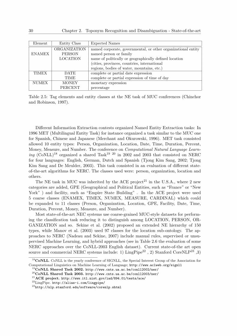
30 Chapter 2. Toponym Recognition and Disambiguation - State-of-the-art
Element Entity Class Expected NamesORGANIZATION named corporate, governmental, or other organizational entity
ENAMEX PERSON named person or familyLOCATION name of politically or geographically defined location
(cities, provinces, countries, internationalregions, bodies of water, mountains, etc.)
TIMEX DATE complete or partial date expressionTIME complete or partial expression of time of day
NUMEX MONEY monetary expressionPERCENT percentage
Table 2.5: Tag elements and entity classes at the NE task of MUC conferences (Chinchorand Robinson, 1997).
Different Information Extraction contests organized Named Entity Extraction tasks: In1996 MET (Multilingual Entity Task) for instance organized a task similar to the MUC onefor Spanish, Chinese and Japanese (Merchant and Okurowski, 1996). MET task consistedallowed 10 entity types: Person, Organization, Location, Date, Time, Duration, Percent,Money, Measure, and Number. The conference on Computational Natural Language Learn-ing (CoNLL)18 organized a shared Task19 20 in 2002 and 2003 that consisted on NERCfor four languages: English, German, Dutch and Spanish (Tjong Kim Sang, 2002; TjongKim Sang and De Meulder, 2003). This task consisted in an evaluation of different state-of-the-art algorithms for NERC. The classes used were: person, organization, location andothers.
The NE task in MUC was inherited by the ACE project21 in the U.S.A., where 2 newcategories are added, GPE (Geographical and Political Entities, such as “France” or “NewYork” ) and facility, such as “Empire State Building” . In the ACE project were used5 coarse classes (ENAMEX, TIMEX, NUMEX, MEASURE, CARDINAL) which couldbe expanded to 11 classes (Person, Organization, Location, GPE, Facility, Date, Time,Duration, Percent, Money, Measure, and Number).
Most state-of-the-art NEC systems use coarse-grained MUC-style datasets for perform-ing the classification task reducing it to distinguish among LOCATION, PERSON, OR-GANIZATION and so. Sekine et al. (2002) proposed an extended NE hierarchy of 150types, while Manov et al. (2003) used 97 classes for the location sub-ontology. The ap-proaches to NERC (Nadeau and Sekine, 2007) include manual rules, supervised or unsu-pervised Machine Learning, and hybrid approaches (see in Table 2.6 the evaluation of someNERC approaches over the CoNLL-2003 English dataset). Current state-of-the art opensource and commercial NERC systems include: 1) LingPipe22 , 2) Stanford CoreNLP23 ,3)
18CoNLL. CoNLL is the yearly conference of SIGNLL, the Special Interest Group of the Association forComputational Linguistics on Machine Learning of Language; http://www.aclweb.org/signll
19CoNLL Shared Task 2002. http://www.cnts.ua.ac.be/conll2002/ner/20CoNLL Shared Task 2003. http://www.cnts.ua.ac.be/conll2003/ner/21ACE project. http://www.itl.nist.gov/iad/894.01/tests/ace/22LingPipe. http://alias-i.com/lingpipe/23http://nlp.stanford.edu/software/corenlp.shtml
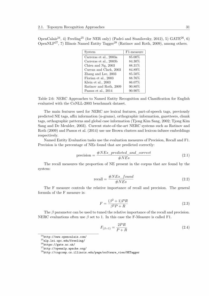
2.1. Toponym Recognition Approaches 31
OpenCalais24, 4) Freeling25 (for NER only) (Padró and Stanilovsky, 2012), 5) GATE26, 6)OpenNLP27, 7) Illinois Named Entity Tagger28 (Ratinov and Roth, 2009), among others.
System F1-measureCarreras et al., 2003a 85.00%Carreras et al., 2003b 84.30%Chieu and Ng, 2003 88.31%Curran and Clark, 2003 84.89%Zhang and Lee, 2003 85.50%Florian et al., 2003 88.76%Klein et al., 2003 86.07%Ratinov and Roth, 2009 90.80%Passos et al., 2014 90.90%
Table 2.6: NERC Approaches to Named Entity Recognition and Classification for Englishevaluated with the CoNLL-2003 benchmark dataset.
The main features used for NERC are lexical features, part-of-speech tags, previouslypredicted NE tags, affix information (n-grams), orthographic information, gazetteers, chunktags, orthographic patterns and global case information (Tjong Kim Sang, 2002; Tjong KimSang and De Meulder, 2003). Current state-of-the-art NERC systems such as Ratinov andRoth (2009) and Passos et al. (2014) use use Brown clusters and lexicon-infusee embeddingsrespectively.
Named Entity Evaluation tasks use the evaluation measures of Precision, Recall and F1.Precision is the percentage of NEs found that are predicted correctly:
precision =#NEs_predicted_and_correct
#NEs(2.1)
The recall measures the proportion of NE present in the corpus that are found by thesystem:
recall = #NEs_found#NEs
(2.2)
The F measure controls the relative importance of recall and precision. The generalformula of the F measure is:
F =(β2 + 1)PR
β2P +R(2.3)
The β parameter can be used to tuned the relative importance of the recall and precision.NERC evaluations often use β set to 1. In this case the F-Measure is called F1.
F(β=1) =2PR
P +R(2.4)
24http://www.opencalais.com/25nlp.lsi.upc.edu/freeling/26https://gate.ac.uk/27http://opennlp.apache.org/28http://cogcomp.cs.illinois.edu/page/software_view/NETagger
32 Chapter 2. Toponym Recognition and Disambiguation - State-of-the-art
2.2 Toponym Disambiguation ApproachesToponym Disambiguation (TD) approaches usually have the following phases:
• Toponym Feature Type Disambiguation . Some approaches can apply fine sub-classification using extended NE hierarchies to classify the Named Entities identitifiedas LOCATION as the Perseus system Smith and Crane (2001) or Ferrés et al. (2004b)for geographical NEs. Sekine et al. (2002) uses an extended NE hierarchy of 150 typesand Manov et al. (2003) use 97 classes for the location sub-ontology. At this pointsometimes a geographical feature type disambiguation procedure must be applied todecide at which subclass pertains the place name (e.g. in some contexts the NamedEntity “Buffalo” could be a city or a river). A Geographical Name Place Class Disam-biguator normally tries to disambiguate those NEs using features from the documentin which the Named Entity appears and optionally features from external resources todecide in which subclass pertains. But some systems apply a class-based disambigua-tion in which some feature types are more important than others (e.g. the featuretype “country” has priority over “city”),
• Toponym Resolution. The disambiguation phase in which a set of possible referentsfor each toponym in the text is computed and then a set of heuristics or algorithmsis applied to reduce the number of referents per toponym or get a unique one (ifpossible).
• Toponym Grounding. Finally, the last process is the Grounding of geographicalNEs, i.e. mapping a geographical NE to its appropriate physical (spatial) location(coordinates, area, etc.) using information derived from Geographical Gazetteers, asin Leidner et al. (2003).
Geographical ambiguity problems treated by TD systems include:
• Referent ambiguity problem. This problem occurs when the same name is usedfor several locations (of the same or different class). Some authors (H. Li et al.,2003) note the similarity of this problem to the Word Sense Disambiguation (WSD)problem.In some texts sometimes it is impossible to solve this ambiguity, and, in this case,we have to accept as correct all of the possible interpretations (or a superclass ofthem). Otherwise, a trigger phrase pattern can be used to resolve the ambiguity (e.g.“Madrid” is an ambiguous NE, but in the phrase, “State of Madrid”, the ambiguityis solved by the feature type).The basic approaches to this problem are:
1. One referent per discourse. Some of the approaches to the Toponym Dis-ambiguatin task use the one referent per discourse heuristic following a similarapproach to the Word Sense Disambiguation (WSD) heuristic one sense per dis-course (Gale et al., 1992). In this method for WSD, it is assumed that a wordappearing in a discourse refers to the same sense throughout the discourse. Theapproach for geographical referent disambiguation with this heuristic is to assumethat a place name used in a discourse refers to the same location throughout the
2.2. Toponym Disambiguation Approaches 33
discourse (Leidner et al., 2003). Obviously this heuristic is not error free andsome texts (rarely) could include place names that are equal homonyms but referto different places (e.g. “Georgia” (country) vs “Georgia” (US state)).
2. Proximity of place names. This approaches assumes that there is a highdegree of spatial correlation in geographic references that are in textual proximity(Rauch et al., 2003).
3. Spatial minimality heuristic. This approach tries to disambiguate placesassuming that the small region that is able to ground the whole set of placesappearing in the discourse is the correct interpretation of these toponyms (Lei-dner et al., 2003). Buscaldi and Rosso (2008c), for instance, used GeoWordNetto implement a map-based disambiguation method based on the one proposedby Smith and Crane (2001).
4. Contextual Pattern Matching. Applying contextual patterns (e.g. “loca-tion1 at South of location2”, “city of X”) is the most widely used approach (H.Li et al., 2002; Rauch et al., 2003; Manov et al., 2003).
5. Population heuristics. Population data in geographical gazetteers is used indifferent ways: ignoring small places and/or promoting dense populated place(Leidner, 2007). Rauch et al. (2003) assumed that “A place with a high popula-tion is more likely mentioned than a place with a lower one”.
6. Co-occurrence models. H. Li et al. (2003) used discourse features based on co-occurring toponyms (e.g., a document with “Buffalo” , “Albany” and “Rochester”will likely have those toponyms disambiguated to New York State). S. Overellet al. (2006) applied co-occurrence models trained with Wikipedia for place namedisambiguation. X. Wang et al. (2010) uses co-ocurrence of toponyms by com-puting semantic relations (metric, topological, and typological) and then usingthe Dempster-Shafer theory to select the correct candidate.
7. Comma groups. The study of M. Lieberman et al. (2010b) presents a setof heuristics to resolve toponym resolution of comma groups (three or moretoponyms in a list) in news text. They found in their experiments that 49% ofcomma groups are resolved by the sibling heuristic in the geographic hierarchy,a 39% by population based prominence, and a 12% by distance-based proximityheuristic.
8. Use of default and salience. Some methods set a default location when aplace name is ambiguous, the most common heuristic to decide the default placeis the use of the candidate with the largest population.
9. Topological and Knowledge based measures. Buscaldi and Rosso (2008c)uses a Conceptual Density method based on WordNet. K. Roberts et al. (2010)shows the importance of event structures when disambiguating toponyms by us-ing a a probabilistic model that only estimates probabilities of events. Bensalemand Kholladi (2010) proposed a new measure of geographical correlation calledGeographical Density. Their toponym disambiguation heuristic is based on thearborescent proximity between toponyms (e.g. the proximity in the hierachicaltree of the world places). Their results over the GeoSemCor corpus outperformedstate-of-the art methods in the term of recall and coverage
34 Chapter 2. Toponym Recognition and Disambiguation - State-of-the-art
10. Machine Learning. J. Santos et al. (2015) used the LambdaMART and Ran-dom Forest machine learning algorithms for some toponym disambiguation sub-tasks of English using both textual and geographical features. On the otherhand, system such as Speriosu and Baldridge (2013) and DeLozier et al. (2015)used georeferenced language models learnt from georeferenced Wikipedia pages.
• Reference ambiguity problem. This problem occurs when the same location canhave more than one name (in Spanish texts this frequently occurs as many place namesoccur in languages other than Spanish, as Basque, Catalan or Galician). Knowledgesources as GNS or TGN are used to deal with this problem. For instance, Ferrésand Rodríguez (2006a) applies a grouping process over GNS to create groups of placenames that refer to the same locations. On the other hand, Leveling and Veiel (2006)implemented a metonymic location classifier trained with the manual annotated datafrom the GERMAN CONLL-2003 shared task. The classifier achieves a performanceof 81.7% of F1-measure in differentiating between literal and metonymic senses oflocation names.
• Referent Class Ambiguity. The same name can be used for locations and alsofor other classes of Named Entities like persons or organizations. An example ofthis ambiguity can be the person name Paris (e.g. in “Paris Hilton”) that can beerroneously tagged as a location when used without the Surname in some texts. Ferréset al. (2005a) apply a NEC correction filter to correct the Person/Location ambiguityerrors. This filter stores in a hash table all the tokens that compose the NEs classifiedas person. Then location or organization NEs are checked against the hash table. Z.Li et al. (2006) apply a set of rules for resolving the location-person ambiguity.
2.2.1 Toponym Recognition and Disambiguation SystemsThis part presents some of the most relevant Toponym Resolution systems:
• Rauch et al. (2003) use data mining procedures and domain knowledge repositories(such as first names) to generate sets of contexts with positive or negative indicators.Positive context for geographic names could be trigger words before of after a name(e.g. “city”, “mayor”, “community college”).
• S. Overell et al. (2006) applied co-occurrence models trained with Wikipedia for placename disambiguation with a Naive Bayes classifier.
• Garbin and Mani (2005) describes a corpus-based method for disambiguating to-ponyms with an unsupervised Machine Learning system that develops disambiguationrules. They used the ALTAS Gazetteer and the World Gazetteer and the LexScantool. They used a Human Annotated Corpus of news (from TimeBank 1.2, and Gi-gaword NYT Sept. 2001 and June 2) (Section 5). This corpus contains 83,872 wordswith 1275 place names (435 distinct) annotated with 3 geographical classes: nationalcapital, civil politicaladministrative region, and populated place. This method achievesa 78.5% of accuracy in the human-annotated corpus.
• Leidner (2006) presented the first systematic account of the utility of different heuris-tics for the toponym resolution task, based on experimental comparison on two novel
2.2. Toponym Disambiguation Approaches 35
large-scale gold-standard annotated corpora: TR-CoNLL (a gold-standard corpus ofnearly 1,000 news articles from CoNLL 2003 with the correct referents annotated byhumans) and TR-MUC4 (an annotated corpus of 100 MUC-4 documents focused onCentral America). Both corpora were annotated with these populated place classes:city, state, country, and continent. Leidner (2006) replicated two methods: Perseus(Smith and Crane, 2001) and LSW03 (Leidner et al., 2003) for a set of large-scaleexperiments. LSW03 outperformed Perseus in both corpora. LSW03 achieved 0.4736and 0.4598 of Toponym Score (see the explanation of these evaluation metric at theend of this chapter) in TR-CoNLL and TR-MUC4 respectively. Perseus achieved0.3431 and 0.4023 of Toponym Score in the same corpora.
• Yi Li et al. (2006) used a probabilistic approach for toponym resolution based on afive-level normalization of the gazetteer. Assigning more probabilities to the top lev-els (country or nations). Initial probabilities are also adjusted based on the followingevidences: local contextual information: for example, geo-types in close proximity toeach other (e.g. city, state), population information, Trigger Words. (e.g. “county”,“river”, etc.), global contextual information, occurrences in the document of countrygeo-terms that are gazetteer ancestors to the candidate, and Mutual disambiguation:Candidates that are closely related to each other in the gazetteer hierarchy boosteach others’ probability assignment for their respective terms. They used a hand an-notated subset of the GeoCLEF corpus to determine the performance of the NamedEntity Classification System, and the toponym disambiguation algorithm. The cor-pus consists of a set of 106 Glasgow Herald and 196 LA times news articles, whichcontained 2,311 tagged locations in total. LingPipe achieved a 50% of Precision anda 65% of recall . The TR algorithm achieved an accuracy of 90.3% on the 1502 placenames identified by LingPipe. The disambiguation accuracy with respect to the totalnumber of total locations achieved an accuracy of 60.8%.
• Buscaldi and Rosso (2008c) used two algorithms: a knowledge-based method and amap-based method evaluated over the GeoSemCor corpus and compared them. Theyused GeoWordNet to implement a map-based disambiguation method based on theone proposed by Smith and Crane (2001). The other method is Conceptual Densitymethod based on WordNet. The Conceptual Density approach achieved better resultsthan the Map-based evaluated at sentence, paragraph, and document level. The bestresults at document level in F-measure and their corresponding precision, recall andcoverage were 0.832, 89.9%, 77.5%, and 86.2%.
• Bensalem and Kholladi (2010) proposed a Toponym Disambiguation system based onthe arborescent proximity between toponyms (e.g. the proximity in the hierarchicaltree of the world places). Their results over the GeoSemCor corpus outperformedstate-of-the art methods presented by Buscaldi and Rosso (2008c) in the term ofrecall (87.4%) and coverage (99%) at document level.
• M. D. Lieberman and Samet (2012) presented an approach that used adaptative con-text features for toponym resolution in streaming news. They use a POS taggerand a NER package to recognize toponyms. For toponym disambiguation they useGeonames and Random Forests classifiers based on adaptative context features. Theapproach was evaluated with the following datasets: ACE, LGL, and CLUST.
36 Chapter 2. Toponym Recognition and Disambiguation - State-of-the-art
• Speriosu and Baldridge (2013) used the non-toponym textual context at local or doc-ument level for toponym disambiguation. English NER models from the OpenNLPproject are used for toponym recognition. For toponym disambiguation text-drivenmodels were created using Geonames and geotagged Wikipedia articles. Their re-sults on the TR-CoNLL and CWar datasets show that their text classifiers are moreaccurate than knowledge-based algorithms based on spatial proximity or metadata.
• Habib and Keulen (2013) presented a toponym extraction and disambiguation language-independent approach based on Hidden Markov Models (HMM), Geonames, and Sup-port Vector Machines (SVM) over a dateaset of the EuroCottage portal in English,German, and Dutch. An HMM model was used to extract the toponyms that arethen filtered using Geonames. Then a disambiguation process is applied using a clus-tering approach. Finally the SVM is used to classify between true positives and falsepositives.
• J. Santos et al. (2015) used machine learning for toponym disambiguation of Englishcorpus of SpatialML, LGL and a subset of Wikipedia. They used the Stanford NER(3.2.0) for toponym extraction and a Wikipedia based Knowledge Base for toponymdisambiguation combined with ML. Then a disambiguation process is applied withthe following steps: 1) Query expansion to detect altenative names of the toponymin the text, 2) candidate generation: searches for entities with string similarity withthe query (toponym) in a KB, 3) candidate ranking using the LambdaMART learningto rank algorithm with several textual and geographical features such as: candidatecount, population count, geospatial (area,containment and distance), distance to theclosest reference, area of the geometric hull, Jaccard similarity between geographicalentities, missed geographical entities, 4) candidate validation using a Random Forestclassifier with the same features of the candidate ranking.
• DeLozier et al. (2015) modeled the geographic distributions of words using georefer-enced language models learnt from the GeoWiki (a subset of georeferenced Wikipediapages). They also can use the Geonames Gazetteer and the Natural Earth gazetteerin combination with the georeferenced models. They used the TR-CoNLL, CWar andLGL corpus to perform an evaluation of the approach.
• Spitz et al. (2016) built a network of place similarities based on the text of the En-glish Wikipedia that includes entity linking to WikiData for toponym disambiguation.They used the AIDA CoNLL-YAGO dataset to evaluate the approach.
2.2.2 Toponym Disambiguation EvaluationToponym Disambiguation is evaluated with test collections specifically annotated with cor-rect referents and metrics adapted from Natural Language Processing task such Word SenseDisambiguation and NERC, usually precision, recall and F-1 although finer metrics are usedfor more specific tasks (Leidner, 2006). Some of these test collections are the following:
• ACE corpus annotatted with SpatialML SpatialML (Mani et al., n.d.) is anannotation scheme for marking up references to places in natural language. It cov-ers both named and nominal references to places, grounding them where possible

2.2. Toponym Disambiguation Approaches 37
with geo-coordinates, including both relative and absolute locations, and character-izes relationships among places in terms of a region calculus.29 A corpus of 428 ACEdocuments, originally from the University of Pennsylvania Linguistics Data Consor-tium (LDC), has been annotated in SpatialML. This corpus, drawn mainly frombroadcast conversation, broadcast news, news magazine, newsgroups, and weblogs,contains 6338 PLACE tags, of which 4,783 are named PLACEs with geo-coordinates.This ACE SpatialML Corpus (ASC) has been re-released to the LDC, and is availableto LDC members (LDC Catalog LDC2008T0313).
• TR-CLEF The TR-CLEF corpus was created by Andogah (2010) from the relevantdocuments of GeoCLEF 2006 evaluation contest. The current version of the TR-CLEFcorpus consists of a subset of 321 documents relevant to GeoCLEF 2006 campaigntopics. The place names in these documents have been resolved (5,783 toponyminstances). These documents contain a total of 802 unique references to places witha 86% of references ambiguous.
• GeoSemCor GeoSemCor (Buscaldi and Rosso, 2008c) was obtained from SemCor,the most used corpus for the evaluation of WSD methods. SemCor is a collection oftexts extracted from the Brown Corpus of American English, where each word hasbeen labelled with a WordNet sense (synset). It contains 1,210 toponym instances inits final version.
• LGL corpus LGL (Local/Global Lexicon) (M. Lieberman et al., 2010a) is a corpusof 588 articles collected from 78 different data sources, containing 4,793 toponyms.This corpus is based on smaller newspapers with a localised audience.
• TR-CoNLL The TR-CoNLL corpus (Leidner, 2007) contains 946 news articles fromthe CoNLL 2003 shared task, in which 6,980 toponym instances have been annotatedin TRML (Toponym Resolution Markup Language), an XML-based markup languagecreated by Leidner. This data set can be used as a gold standard to evaluate automaticsystems that can do toponym resolution.
• TR-RNW The TR-RNW corpus is derived from the Radio Netherlands Worldwide(RNW) summaries in English (Andogah, 2010). The TR-RNW consists of 556 newssummaries from RNW. This corpus contains 2,339 toponym instances (432 are uniquetoponyms). The 76.5% of TR-RNW unique toponyms are ambiguous.
• TR-MUC4 The TR-MUC4 (Leidner, 2007) is a corpus of 100 documents form the4th Message Understanding Contest (MUC-4) (Sundheim, 1992). The collection ismade up of intelligence reports covering Central America.
• RCV1 The Reuters Corpus Volume 1 (RCV1) (Lewis et al., 2004) is an archiveof 806,791 English language news stories coded for topic, region (geography) andindustry. The type of regions referred to in a story can be: countries (e.g., UK),geographical groups (e.g., BENELUX), and, economic groupings (e.g., G7).
• AIDA CoNLL-YAGO: (Hoffart et al., 2011) is collection of 1393 news documentsfrom the Reuters RCV-1 collection annotated with YAGO2 entities.
29http://sourceforge.net/projects/spatialml
38 Chapter 2. Toponym Recognition and Disambiguation - State-of-the-art
• CWar: the Perseus Civil War and 19th Century American Collection (CWAR)30 con-tains 341 books written primarily about and during the American Civil War (Crane,2000). The corpus was annotated using a semi-automated process (Speriosu andBaldridge, 2013).
• CLUST: (M. D. Lieberman and Samet, 2011) is a corpus with articles from differentnews sources.
30http://www.perseus.tufts.edu/hopper/collection?collection=Perseus:collection:cwar
CHAPTER 3
Geographical Information Access Tasks -State-of-the-art
This section describes the state of the art of the three Geographical Information Accesstasks faced in this thesis: 1) Geographical Information Retrieval, 2) Geographical QuestionAnswering, and 3) Textual Georeferencing.
3.1 Geographical Information Retrieval - State-of-the-artGeographical Information Retrieval (GIR) consists in searching documents with geograph-ically restricted queries. GIR queries consist in requests that involve both thematic andgeographic search (e.g. “rice exportation in Japan” or “shark attacks in California”). InSanderson and Kohler (2004a) a geographic query is defined as: “A query which includes atleast one of the following types of geographic terms: place names (e.g. Houston, Texas, US);other locators (e.g. postcode, ZIP code); adjectives of place (e.g. American, international,western); terms descriptive of location (e.g. state, country, city, site, street); geographicfeatures (e.g. island, lake); and directions (e.g. north, south). “. GIR systems have veryspecific issues due to its restricted domain (geography) specificity. Some of these issueshave been detailed in the GIR literature (C. B. Jones and R. S. Purves, 2008):
• geographical names detection (toponym recognition).
• spatial natural language qualifiers detection (e.g. “north”, “south of”, “near”, “closeby”,…).
• toponym disambiguation (e.g. Paris, Texas (USA) vs Paris (France)).
• vague place names detection and interpretation. (e.g. “Scottish Trossachs”, “Mid-lands”,…).
• thematic and geospatial indexing and retrieval.
39
40 Chapter 3. Geographical Information Access Tasks - State-of-the-art
Since earlier 2000s GIR has become a popular task in the IR community mainly forthese reasons: 1) the inclusion of new GIR evaluation benchmarks and GIR workshops inseveral international IR conferences, 2) the inclusion of geographic search in major searchengines (C. Jones and R. Purves, 2005), 3) the publication of some PhD theses in GIR, and4) the emergence of research projects in GIR.
The organization of several GIR evaluation benchmarks started initially with the inclu-sion a the GeoCLEF GIR track in CLEF 2005, 2006, 2007 and 2008 (F. Gey et al., 2005;F. Gey et al., 2006; Mandl et al., 2008; Mandl et al., 2008), and then with GeoTime statio-temporal GIR track in NTCIR in 2008 and 2009 (F. C. Gey et al., 2010; F. C. Gey et al.,2011). The GeoCLEF GIR evaluation forum took place during 4 years (1 as a pilot task)between 2005 and 2008 in the framework of the CLEF conferences1. The GeoCLEF contestevaluated GIR for monolingual and bilingual experiments in the following languages: En-glish (in all the evaluations from 2005 to 2008), Portuguese (from 2006 to 2008), Spanish(2006), German (2005 to 2008), Japanese (only in topics, not in collections) in 2006. Onthe other side, the International Workshop on Geographic Information Retrieval (GIR) hasbeen organized in several international IR conferences since 20042.
The following PhD theses related with GIR have been recently published: 1) Leidner(2007) proposed heuristics and algorithms, collections and metrics for Toponym Disam-biguation, 2) Martins (2008) proposed Geographical Scope Detection of documents withpage rank , 3) S. Overell (2009) mined and extracted and identified useful knowledge fromthe Wikipedia and used it to GIR and TD, 4) Andogah (2010) proposed methods for Ge-ographical Scope Resolution and GIR, 5) Buscaldi (2010) applied TD algorithms for GIR,and 6) J. M. Perea-Ortega (2010) used query reformulation and geographical documentre-ranking to improve GIR, 7) Villatoro-Tello (2010) proprosed a GIR re-ranking strategyusing a set of example documents for relevance feedback, 8) Palacio (2010) presented andevaluated an approach that combines special indexing for spatial, temporal and thematicdimensions for GIR.
Some well-known past research projects and systems related with GIR were:• GIPSY, and earlier GIR system that indexed text using spatial coordinates derived
from knowledge-bases (Woodruff and Plaunt, 1994).
• Web-a-where, a system that performed Toponym Detection and Disambiguation andassigned to each page a geographic focus (Amitay et al., 2005).
• SPIRIT3 (Spatially-Aware Information Retrieval on the Internet) was a researchproject (funded through the EC Fifth Framework Programme) that was engaged inthe design and implementation of a search engine to find documents and datasets onthe web relating to places or regions referred to in a query (C. Jones et al., 2002;C. B. Jones et al., 2004; R. S. Purves et al., 2007).
• DIGMAP was a project focused on historical digitized maps and provided access tohistorical cartography (Martins et al., 2007a).
• STEWARD was a spatio-textual search engine that allowed queries and visualizationof textual references to geographic locations in unstructured text documents4 (M.
1http://www.clef-initiative.eu2http://www.geo.uzh.ch/~rsp/gir14/index.html3SPIRIT project. http://www.geo-spirit.org4STEWARD online demo. http://steward.umiacs.umd.edu/
3.1. Geographical Information Retrieval - State-of-the-art 41
Lieberman et al., 2007).
• PIV. The Virtual Itineraries in the Pyrenees (PIV) project was a web-based platformwith an in-depth geo-semantic identification (Gaio et al., 2008).
• NewsStand. is an existing search engine that does Toponym Recognition and Disam-biguation in news and plots them in a world map5 (Teitler et al., 2008).
3.1.1 GIR IssuesGIR requires appropriate indexing and search structures and algorithms to determine boththematic and spatial relevance. Spatial relevance similarity measures require that the fol-lowing aspects had to be taken into account: hierarchical containment, adjacency of places,connectivity, and proximity. Different multi-dimensional indexing approaches have beenproposed to manage spatial data: such as grid indexes, quad-trees, R-trees, and k-d-trees(Martins et al., 2005). R-Tree, that allows efficient geographical search, is the most popularspatial indexing method (Guttman, 1984). On the other hand, c-squares is a grid indexingapproach that uses grid representation and can be encoded in textual strings (Rees, 2003),so it could be easily implemented in a normal IR system.
On the other hand, Geographical Knowledge and Reasoning is required to deal withgeographical resolution problems. These are the common issues related with the use ofGeographical Knowledge for IR:
• Using efficiently Geographic Knowledge in GIR queries. F. Gey et al. (2005) reportedon deteriorated performance when applying manual query expansion of geographic ref-erences. Guillén (2005) concludes that adding geographic information in the queriescould not significantly improve retrieval performance. Metacarta (Kornai, 2005) im-proved its results using geographic bounding boxes, but with a bit low MAP. Asreported by Toral et al. (2006) in GeoCLEF 2005 three of the top-4 systems for theEnglish monolingual run were based only on IR (the remaining one used geographicNERC).
• Person-Location ambiguity problems. It is common for proper name of persons andplaces to be the same and this leads to potential false associations between articlesmentioning persons with such name and particular places.
• Multilinguality. (i.e. handling toponyms in different languages). In many gazetteers,mostly English names are used.
• Name Variants. Leveling et al. (2005) defined these variants: 1) endonymic names: alocal name for a geographical entity (e.g. “Wien”, “Köln”, and “Milano”), 2) exonymnames: is a place name in a language used outside its region; (e.g. “Viena”, “Cologne”,and “Milán”), and 3) historical names: traditional names such as “New Amsterdam”for “New York”.
• Multiword Names. Two or more words form the place name (e.g. “Mount Cook”,“Island of Sylt”).
5http://newsstand.umiacs.umd.edu/web/

42 Chapter 3. Geographical Information Access Tasks - State-of-the-art
• Semantic relations between toponyms and related concepts. Concepts related to atoponym such as the language, inhabitants of a place, or other kind of phrases are notconsidered in geographic tagging (i.e. expressions such as “latin american countries”,“French speaking part”, “catholic communities”,...).
• Temporal changes in toponyms.
• Metonymic usage. Metonymy is defined as a figure of speech in which a speaker uses“one entity to refer to another that is related to it” (Leveling and Veiel, 2006). As anexample in the following sentence: “At the meeting of France and Germany in Lisbonlast year, Paris vetoed the decision”, Paris is a metonymy of France, and France andGermany are a metonymy of the French and German governors.
• Query expansion. Adding terms to the original query in order to increase the retrievalperformance can lead to obtain additional relevant documents (i.e. increasing Recall),possibly at the expense of Precision.
• Gazetteers problems. Incompleteness of the major gazetteers. Fonseca et al. (2002)discussed about the problems of selecting and using gazetteers. As an example,the GeoNet Names Server geographical gazetteer presents the following problems: i)highly ambiguity on some names, ii) geographic entities that have a certain area/length(like rivers or large cities) but only a single latitude/longitude pair is given (Hauff etal., 2006), iii) bad data (out of range longitude/latitude pairs, parent information canoverlap or is not fully accurate), iv) lack of data (Leveling et al., 2005) (e.g. lack ofnative language forms). v) relations or modifiers generate name variants not coveredby a gazetteer (e.g. Southern Germany), vi) data representation may be inconsis-tent. (e.g. some streams or rivers are represented with only one point), vii) it doesnot provide sufficient information for a successful disambiguation from context (e.g.temporal information is missing), viii) incomplete ontological basis, and ix) uncov-ered mame inflection. Ahlers (2013) described some problems with the GeonamesGazetteer accuracy: including inaccuracies ranging from grid patterns, imprecise co-ordinates, overlaps, repetitions, and misclassifications.
3.1.2 GIR ApproachesMajor approaches in GIR (F. Gey et al., 2005) include: adhoc techniques, QA modules,Gazetteer construction, Geoname Entity Extraction, Term expansion using WordNet, ge-ographical thesauri, toponym resolution, NLP-Geofiltering predicates, latitude-longitudeassignment, gazetteer based query expansion, conventional IR systems, geographic entityrecognition, Knowledge Bases, query expansion strategies (e.g. blind feedback, addition ofproper names, geographic reference expansion using hierarchical information on GKB), andgeo-spatial query restriction strategies: minimum bounding box based, geo-scope based.
Despite of the diversity of approaches at GIR, two major phases are usually present inall the system architectures: Topic and Collection Processing and Document Retrieval. Ageneric system architecture of a GIR system is shown in Figure 3.1.
3.1.2.1 Topic Processing and Collection Processing
Topic and Collection Processing consists in analyze the topics and/or documents of thecollection in order to enrich them with useful information derived from Natural Language
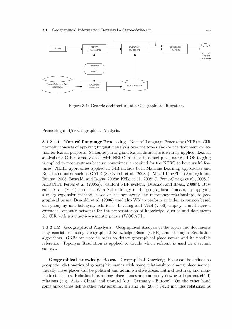
3.1. Geographical Information Retrieval - State-of-the-art 43
Query
Relevant
Documents
Textual Collections, Web,
Databases,...
DOCUMENT
RANKING
QUERY
PROCESSING
DOCUMENT
RETRIEVAL
NLP Tools
&
GeoKB
DOCUMENT
INDEXINGCORPUS INDEX
Figure 3.1: Generic architecture of a Geographical IR system.
Processing and/or Geographical Analysis.
3.1.2.1.1 Natural Language Processing Natural Language Processing (NLP) in GIRnormally consists of applying linguistic analysis over the topics and/or the document collec-tion for lexical purposes. Semantic parsing and lexical databases are rarely applied. Lexicalanalysis for GIR normally deals with NERC in order to detect place names. POS taggingis applied in most systems because sometimes is required for the NERC to have useful fea-tures. NERC approaches applied in GIR include both Machine Learning approaches andRule-based ones: such as GATE (S. Overell et al., 2008a), Alias-I LingPipe (Andogah andBouma, 2008; Buscaldi and Rosso, 2008a; Kölle et al., 2008; J. Perea-Ortega et al., 2008a),ABIONET Ferrés et al. (2005a), Stanford NER system, (Buscaldi and Rosso, 2008b). Bus-caldi et al. (2005) used the WordNet ontology in the geographical domain, by applyinga query expansion method, based on the synonymy and meronymy relationships, to geo-graphical terms. Buscaldi et al. (2006) used also WN to perform an index expansion basedon synonymy and holonymy relations. Leveling and Veiel (2006) employed multilayeredextended semantic networks for the representation of knowledge, queries and documentsfor GIR with a syntactico-semantic parser (WOCADI).
3.1.2.1.2 Geographical Analysis Geographical Analysis of the topics and documentsmay consists on using Geographical Knowledge Bases (GKB) and Toponym Resolutionalgorithms. GKBs are used in order to detect geographical place names and its possiblereferents. Toponym Resolution is applied to decide which referent is used in a certaincontext.
Geographical Knowledge Bases. Geographical Knowledge Bases can be defined asgeospatial dictionaries of geographic names with some relationships among place names.Usually these places can be political and administrative areas, natural features, and man-made structures. Relationships among place names are commonly downward (parent-child)relations (e.g. Asia - China) and upward (e.g. Germany - Europe). On the other handsome approaches define other relationships, Hu and Ge (2006) GKB includes relationships
44 Chapter 3. Geographical Information Access Tasks - State-of-the-art
between entities such as part-of adjacency and similar (e.g. if two entities have a similaritysuch as being administrative divisions of the same country or if they are countries, …).Lana-Serrano et al. (2006a) provided a flexible structure that allows define other typesof relationships between resources: based on its languages (“latin america”, “anglo-saxoncountries”) or religion (“catholic countries”, “protestant towns”,…).
The most commonly used GKBs in GeoCLEF evaluations are publicly available hugegazetteers such as: GeoNet Names Server, Geonames, GNIS, andWorldGazetteer. WorldGazetteerwas widely used due to its population statistics (Cardoso et al., 2005; Leidner, 2005; Ferrésand Rodríguez, 2006b; F. Gey et al., 2005). Some approaches used the Wikipedia to collectinformation (Cardoso et al., 2005). S. Overell et al. (2006) and Yi Li et al. (2006) used theGetty Thesaurus of Geographic Names, a propietary Gazetteer.
GIR systems often tend to merge some these gazetteers into a unique one. Hauff et al.(2006) used a merge of GNS, GNIS, and World Gazetteer (WG), that provides informationabout the parent-child relationships. Andogah (2006) used geographic resources such asWikipedia, World-Gazetteer, GeoNet names server, and WordNet. Hu and Ge (2006) joinedseveral resources to build a GKB: a) FIPS 10-4 for countries and administrative divisions,b) World Factbook for border countries, coastlines, country capital cities, c) Wikipedia foroceans, seas, gulfs, rivers and regions, d) A set of large cities collected from TravelGis.com,e) The Standard Country and Area Codes Classifications (M49) for regions and continents,f) The ESRI Gazetteer server developed by the Environmental Systems Research Institute,Inc. for Minimum Boundary Rectangle (MBR) of countries, and g) WordNet for variantplaces names. Toral et al. (2006) used Geonames DB6.
Toponym Disambiguation in GIR. Toponym Disambiguation is used in severalGIR approaches. TR Algorithms usually decide the best referent candidate among a setof possible referents for a place name applying a set of heuristics (see Chapter 2 for adetailed explanation of the TR methods). Cardoso et al. (2005) at GeoCLEF 2005 andMartins et al. (2006) at GeoCLEF 2006 used the one single scope per document heuris-tic (Martins and Silva, 2005) with a PageRank variation graph based algorithm. Leidner(2005) used a maximum-population heuristic. S. Overell et al. (2006) applied co-occurrencemodels trained with Wikipedia for place name disambiguation with a Naive Bayes. Yi Liet al. (2006) used a probabilistic approach for toponym resolution based on the follow-ing evidences: local contextual information, population information, Trigger Words, globalcontextual information, and Mutual disambiguation.
Leveling and Veiel (2006) implemented a metonymic location classifier training with themanual annotated data from the GERMAN CONLL-2003 shared task and a subset of theGeoCLEF newspaper corpus. The features used were shallow (PoS tags, position of wordsin a sentence, word length and base forms of verbs). The classifier achieved a performanceof 81.7% of F1-measure in differentiating between literal and metonymic senses of locationnames.
On the other hand few systems apply geo-disambiguation to resolve the person- orga-nization - location ambiguity (i.e distinguish if the candidate was correctly tagged as atoponym or is really a person name or an organization name). Ferrés et al. (2005a) applya NEC correction filter to correct these errors. Z. Li et al. (2006) apply a set of rules forresolving the location-person ambiguity.
6Geonames. http://www.geonames.org
3.1. Geographical Information Retrieval - State-of-the-art 45
3.1.2.2 Document Retrieval
The main goal of this phase is to retrieve a set of relevant documents to the topic. Themain process of this phase is the Information Retrieval process which usually requires theuse of an IR system. This phase can be complemented by a Query Expansion phase and apost phase of Document Filtering.
3.1.2.2.1 Query Expansion Query Expansion (QE) techniques in IR usually consistin adding related terms to the query manually or automatically in order to retrieve morerelevant documents. In GIR is also normal to use conventional IR QE techniques in or-der to modify the thematic search. For instance, García-Vega et al. (2006a) performed athesaurus-based expansion using words with a high rate of document co-occurrence. Butfor geographical IR, usually terms geographically related to the topic terms are added tothe query. The GIR QE can be done guided by several heuristics based on spatial relationsand location type.
Before QE, the desired keywords are extracted to compose the query. Some approachesapply special algorithms for this Query Processing or Query Parsing step. Toral et al.(2006) collected required words and geographical items. Required words are all the nounsof the topic, description and narrative without geographic ones, stopwords and guidanceinformation,
Sometimes document expansion is applied previously. Document expansion and queryexpansion techniques are used to match the location in a query to all its gazetteer childrenand nearby locations. Yi Li et al. (2006) used a geographic-based query expansion, usinga gazetteer to extend geospatial terms to “nearby” locations, and included sublocations. Ageo-term in the query may be expanded upwards (for “close/near “ relations, influencingall or some of its ancestors) or downwards (for “in” relations, extending the influence to allof its descendants in the gazetteer hierarchy).
Leidner (2005), Buscaldi et al. (2005), and Leveling and Veiel (2006) applied queryexpansion with meronyms (e.g. for California, “Orange County” and “Los Angeles” areincluded), and Toral et al. (2006) and García-Vega et al. (2006a) used automatic queryexpansion consisting in expanding the locations of the topics with geographical informationfrom Geonames gazetteer. Leveling and Veiel (2006) also employed multilayered extendedsemantic networks for the representation of knowledge, queries and documents for GIR.Geographical concepts from the query network are expanded with semantically connectedvia topological, directional, and proximity relations.
3.1.2.2.2 Information Retrieval Information Retrieval approaches for GIR often usecombined search (i.e. both thematic and geographical search). There are few systemsthat do not use Geographical Knowledge (GK) in IR (F. Gey et al., 2005; Guillén, 2005;Guillén, 2006; Toral et al., 2006). But some of these systems, based only in pure IRtechniques achieved the top-ranked results in the GeoCLEF evaluations of 2005 and 2006,and competitive results in the following GeoCLEF evaluations in 2007 and 2008.
Boolean models are rarely used for GIR, if used, they are only used for geographicalsearches (Ferrés and Rodríguez, 2006b; Bischoff et al., 2006). Most of the IR enginesat GeoCLEF are based on the Vector Space Model (Lucene, SMART, Zettair, etc.) orProbabilistic frameworks ( Lemur (Indri), Terrier, Zapian, etc). Lucene with a TFIDFweighting scheme is used frequently by many approaches (Leidner, 2005; Buscaldi et al.,
46 Chapter 3. Geographical Information Access Tasks - State-of-the-art
2006; Andogah, 2006). This system is preferentially used for thematic search rather than forgeographical search. The Lemur toolkit (Indri) was also used for several systems (Guillén,2006; García-Vega et al., 2006a; Hauff et al., 2006). Passage Retrieval was used by fewapproaches: Ferrés and Rodríguez (2006b) used JIRS for thematic and geographical search,and Ferrández et al. (2005) and Toral et al. (2006) used IR-n. On the other hand alsoRDBMS systems were used specially for geographical isolated search (i.e. queries with onlygeographical terms): Postgres (used by S. Overell et al. (2006)), MySQL (used by Hu andGe (2006)), and Toral et al. (2006) used SQL queries over the Geonames DB.
Normal textual indexing is vastly used for all the systems. Some of them take profit ofthe “field search” capabilities of some IR search engines. Several systems indexed separatelytextual terms and geographical terms. Andogah (2006), for instance, indexed and searchedseparately geographical relevant terms (place names, geo-spatial relations, geographic con-cepts and geographic adjectives) and thematic terms. Ferrés et al. (2005a) and Yi Li et al.(2006) used hierarchically expanded geo-terms indexing (i.e. a concatenated string consist-ing of a candidate and its ancestors in the gazetteer). Z. Li et al. (2006) performed thisidea with a different way: utilizes the inverted index to store all the explicit and implicitlocations of documents.
Other systems employed indexing structures specially designed for Geographical IR: R-Tree structures were used by S. Overell et al. (2006), Z. Li et al. (2006) used grid indexingwith a textual index IR engine dividing the surface of the earth into 1000x2000 grids, andKornai (2005) used the Metacarta search engine with a bounding box derivation scheme.
Relevance Feedback (RF) (which consists in performing a new retrieval loop with aset of manually or automatically collected terms from the initial retrieved documents) hasemerged as a efficient method for improving the results in GIR. Systems such as Guillén(2005) and F. Gey et al. (2005) achieved the best results at GeoCLEF 2005 using RelevanceFeedback (RF) techniques with a Probabilistic IR approach, and Ferrés and Rodríguez(2008a) achieved the top-ranked results at GeoCLEF 2007 with an approach that includesRF among other features. Term weighting schemas applied for GIR systems are: TF-IDF,BM25, DFR, and Boolean. TF-IDF and Okapi’s BM25 are the most widely used. Pre-processing techniques such as stemming, stopwords removal are extensively used in most ofthe systems. Porter’s stemmer in combination with the SMART stop words list are usedin some GIR systems (Guillén, 2005; Ruiz et al., 2006), etc. But other approaches uselemmatization in combination with stemming (Ferrés and Rodríguez, 2008a).
3.1.2.2.3 Document Filtering Document filtering strategies for GIR try to filter outgeographically irrelevant documents by using GKBs. Hauff et al. (2006) retrieved by con-tent and subsequently filtered by geographical relevance using a gazetteer and coordinatesrestrictions. Leidner (2005) used Minimal bounding Rectangles (MBR) to approximate thepolygons described by the locations in the query.
3.1.2.3 Document Ranking
The Document Ranking (DR) phase consists in combining scores from thematic searchand geographic search (i.e. geographically isolated terms search). Relevant approaches in-clude linear interpolation (Leidner, 2005; Andogah, 2006) and geographic similarity ranking(Martins et al., 2006).
3.1. Geographical Information Retrieval - State-of-the-art 47
3.1.3 IR Evaluation MeasuresIR Evaluation Measures indicate how fast (indexing and searching speed) and how well(efficiency and size index) the process is done. The measures that show the the speed ofindexing and retrieval are called efficiency measures. There are various ways to measurehow well the retrieved information matches the desired information. These ways are calledeffectiveness measures (Rijsbergen, 1979). The effectivenes measures involve the use thefollowing information based on the Cranfield methodology (Cleverdon and Keen, 1996)commonly used in evaluation forums:
• corpus of documents: set of documents in which the user wants to find relevant doc-uments.
• topics: set of user query needs. In TREC-style evaluations normally contains thefollowing parameters: title, description and narrative.
• relevance judgments: a set of relevant documents associated to each topic. Theserelevant documents had been marked as relevant by human assessors. Pooling isusually used in TREC-style evaluations to have a set of documents (provided by thetop-ranked documents of each participant system) to be reviewed by the assessorswithout having to judge the whole corpus.
• system output: a set of ranked documents associated to each topic.
Some of the most used IR effectiveness measures are reported here:
• Precision. The proportion of retrieved and relevant documents to all the documentsretrieved:
precision =|{relevant documents} ∩ {retrieved documents}|
|{retrieved documents}| (3.1)
Precision can also be evaluated at a given cut-off rank, denoted P@n, instead of allretrieved documents.
• Recall. The proportion of relevant documents that are retrieved, out of all relevantdocuments available:
recall = |{relevant documents} ∩ {retrieved documents}||{relevant documents}| (3.2)
• F1-measure. The weighted harmonic mean of precision and recall.
F =PR
2P +R(3.3)
• Precision at N. This measure computes the precision after N retrieved documents (Ncan be 1,5,20,100,…).

48 Chapter 3. Geographical Information Access Tasks - State-of-the-art
• Average Precision. Average Precision is the average of the precision after each relevantdocument is retrieved. Where r is the rank, N the number retrieved, rel() a binaryfunction on the relevance of a given rank, and P() precision at a given cut-off rank:
AveP =
∑Nr=1(P (r)× rel(r))
number of relevant documents (3.4)
• Mean Average Precision (MAP). MAP is the most used effectiveness measure in eval-uation exercises and IR research. Over a set of queries, find the mean of the averageprecisions, where Average Precision is the average of the precision after each relevantdocument is retrieved.
• R-Precision (R-Prec). R-Precision is the precision computed after R retrieved docu-ments, being R the total number of relevant documents for the query. The averageR-Precision for a set of queries is the mean of the R-Precision of all the queries.
3.1.4 Systems Comparison and Statistical TestingIn order to compare IR systems two or more effectiveness measures can be used. Thedifference in effectiveness can be influenced by several important factors such as: the rel-evance assesments, the evaluation measures themselves, the document collection size, andthe topics.
T. Jones et al. (2014) reported good evidence that collection size and document sourcehave and strong influence in comparing IR systems by showing that different collectionsubsets can produce different evaluation results. Urbano et al. (2013) studied the reliabilityof 43 TREC test collections evidencing that some of them are very little reliable. Theyshowed that the ideal topic set size varies significantly across tasks and the traditionalchoice of 50 queries is not enough for stable rankings. Despite these factors influencing thedifference in effectiveness among different IR systems, a realiable conclusion to rank systemsshould have into account the possibility of the difference in efectiveness is not real and couldbe produced by random chance. Statistical significance testing methods are employed inIR to get reliable conclusions to compare systems. Sanderson and Zobel (2005) comparedthe properties of the t-test, Wilcoxon and sign test concluding that the use of the t-testand the Wilcoxon tests allowed for more accurate prediction over the sign test of whichrun was better. According to Smucker et al. (2007) the most commonly used tests in IR(in 2007) were: Student’s paired t-test, the Wilcoxon signed rank test and the sign test.Smucker et al. (2007) recommended to use the randomization test. Although, statisticalsignificance tests are the most popular data analysis in IR they had been criticised inseveral ways that include over-use and mis-use (Gigerenzer, 2004). As reported by Ellis(2012): “A statistically significant result is one that is unlikely to be the result of chance.But a practically significant result is meaningful in the real world. It is quite possible, andunfortunately quite common, for a result to be statistically significant and trivial. It is alsopossible for a result to be statistically nonsignificant and important.”

3.1. Geographical Information Retrieval - State-of-the-art 49
3.1.5 GIR Relevant ApproachesThis subsection reports some relevant approaches for GIR. Some special relevance has beengiven to the systems that achieved top-ranked results at official GeoCLEF evaluations orhave used effectively its test collection in posterior experiments. These approaches usethe different strategies to perform: 1) stand-alone probabilistic models (R. Larson et al.,2006), 2) combination of textual and geographical search (Martins et al., 2007b; Ando-gah, 2010; Zaila and Montesi, 2015), 3) filtering or reranking without geographical knowl-edge (Villatoro-Tello et al., 2010) 4) filtering or reranking the documents with geographicalknowledge (Ferrés and Rodríguez, 2008a; Cumbreras et al., 2009; J. Perea-Ortega et al.,2011; Ferrés and Rodríguez, 2015a), 5) geographical query expansion (Buscaldi and Rosso,2011; R. Wang and Neumann, 2008; Cumbreras et al., 2009), and 6) Machine Learningtechniques for re-ranking (Martins and Calado, 2010).
Markowetz et al. (2005) presented a geographic search engine prototype for web pagesof Germany using a grid indexing approach and a ranking that combines textual and geo-graphic scores. R. Larson et al. (2006) used a logistic regression algorithm. Their systemachieved the highest result with a MAP of 0.3936 at GeoCLEF 2005 in a run that usedthe spatial tags included in the topics. Martins et al. (2007b) presented a GIR sytem atGeoCLEF 2006 that used a geographical ontology. They used this ontology combined witha graph-ranking approach to detect scope of documents and topics and a relevance rank-ing that combined BM25 and a geographical similarity function for scopes. R. Wang andNeumann (2008) applied an approach that, besides including geographical knowledge, alsoincluded knowledge of natural and human events mined from Wikipedia. They use QueryExpansion with ontologies both for events and geographic terms. Their system achievedthe best MAP at GeoCLEF2008 with a 0.3037 with a run with manual work and a MAPof 0.2924 in an automatic run.
Cumbreras et al. (2009) compared the query-expansion and document filtering ap-proaches for GIR. the toponym recognition phase used GATE for recognition and GeonamesGazetteer to verify. They used manual rules to find spatial relationships. Indexing was per-formed with Lemur creating a document index collection with stems and a geographicalindex with locations (continents, countries, cities, and other places). Both query expansionand document filtering approaches take into account both the query location type and thespatial relationship. They used the topics of GeoCLEF 2006 and GeoCLEF 2007 to eval-uate the system. The document filtering approach outperformed the query-expansion butachieves similar results compared with the baseline BM25 with Pseudo-Relevance Feedback.
Palacio et al. (2010) presented the PIV GIR system, a system that combines 3 indexing-searching dimensions for GIR: geographic, temporal and thematic. They used functions thatcombine the results of the 3 dimensions, the Comb* functions and Borda count. The evalu-ation was performed over the MIDR_2010 test collection showing a 73.9% of improvementover the baseline.
Villatoro-Tello et al. (2010) presented and approach to re-rank the GIR results withMarkov Random Field model that combines: 1) the original ranking, 2) the similaritybetween documents, and 3) a relevance feedback approach with full documents. The eval-uation was done with the GeoCLEF dataset and queries of the 2005,2006,2007, and 2008editions. The results showed an improvement of performance with respect to the baseline(TF-IDF with Lemur IR software) using 1, 5 or 10 documents for relevance feedback. The
50 Chapter 3. Geographical Information Access Tasks - State-of-the-art
experiments using 10 documents achieved MAPs of 0.5910 (GeoCLEF2005), 0.6942 ( Geo-CLEF2006), 0.4960 (GeoCLEF2007) and 0.4959 (GeoCLEF2008), thus outperforming thebest official results obtained at GeoCLEF evaluations.
In his PhD thesis, Andogah (2010) presented experiments combining non-geographicand geographic relevance scores. They used linear interpolation and weighted harmonic-means. The harmonic mean based combination achieved the best performance achievinga MAP of 0.2935 on the GeoCLE2007 dataset, outperforming the best official results atGeoCLEF 2007 (the best MAP was 0.2850).
Buscaldi and Rosso (2011) applied the GeoCLEF (2005-2008) topics to test diversity inGIR. They reformulated queries using the meronyms of the places contained in the originalqueries (using only the title field), with the help of a geographical ontology. J. Perea-Ortega et al. (2011) using the GeoCLEF data showed that in each evaluation a re-rankingbased on the combination of geographical similarity and textual similarity outperforms thebaseline (textual based IR). A geographical index was built with Geo-NER to recognizegeographical entities. The textual index uses the stemmed and stopwords filtered textand the geographical entities in its original word form. They applied Lemur7, Terrier8
and Lucene9 for the IR process. Lemur was applied with BM25 with Pseudo RelevanceFeedback, Lucene with BM25 and Query Expansion, and Terrier with InL2 and Bo1 (QueryExpansion).
Zaila and Montesi (2015) presented a GIR system with these tools: 1) GeoNW, a geo-ontology for toponym recognition based on GeoNames, WordNet and Wikipedia; 2) a to-ponym disambiguation algorithm based on candidates feature type frequencies for geo-classdisambiguation between physical and administrative feature types and hierarchical distancesbased on GeoNW between toponyms in text for referential disambiguation, 3) dcoumentgeographic focus detector based on topological and distance influences and the geographicfrequencies, 4) query geographical focus detection, and a 5) spatial similarity measure. Theranking is performed with a combination function that uses textual and spatial similar-ity. This function benefits documents retrieved in both lists and penalizes those that wereretrieved only by their geographical information. The evaluation of the GIR system wasperformed with 25 topics of the GeoCLEF 2008 using the Terrier IR sofware with thesethree baselines: BM25, DLH13 and LGD models. The best results reported were obtainedwith the combination of textual and spatial similarity and the LGD approach with MAPvalues of 0.489. This result outperforms the best MAP results at GeoCLEF2008 (0.3037).
3.1.6 GIR EvaluationGeographical Information Retrieval has been recently evaluated in some evaluation bench-marks such as GeoCLEF and GeoTime. This Section describes the GeoCLEF GIR evalua-tion task and reports the results of GeoCLEF evaluations from 2005 to 2008.
3.1.6.1 GeoCLEF
GeoCLEF was an IR task at the CLEF evaluation framework that evaluated GIR from 2005to 2008. GeoCLEF started as a cross-language geographic retrieval task at the CLEF 2005
7www.lemurproject.org/8http://www.terrier.org9http://lucene.apache.org

3.1. Geographical Information Retrieval - State-of-the-art 51
campaign (F. Gey et al., 2005). The goal of the GeoCLEF task was to find as many relevantdocuments as possible from the document collections, using a topic set. Topics at GeoCLEF2005 were textual descriptions with the following fields: title, description, narrative, location(e.g. geographical places like continents, regions, countries, cities, etc.) and a geographicaloperator (e.g. spatial relations like “in”, “near”, “north of”, etc.). From GeoCLEF 2006the topics did not contain explicit expressions with geographic references and geographicoperators (see an example of a topic of GeoCLEF 2006 in Figure 3.2). This implies thatgeographical references (geographic places, and geographic relations) were embedded inthe title, description, and narrative. In addition, new geographic relationship were added,such as geographic distance (e.g. “within 100km of Frankfurt”) and complex geographicexpressions (e.g. “Northern Germany”).
<top><num>GC033</num><EN-title> International sports competitions in the Ruhr area</EN-title><EN-desc> World Championships and international tournaments inthe Ruhr area</EN-desc><EN-narr> Relevant documents state the type or name of the competition,the city and possibly results. Irrelevant are documents where only part of the competition takes placein the Ruhr area of Germany, e.g. Tour de France,Champions League or UEFA-Cup games.</EN-narr></top>
Figure 3.2: Example of a topic of the GeoCLEF 2006 edition.
In GeoCLEF 2007 (Mandl et al., 2008) the following three difficulties were introduced: 1)specifying complex (multiply defined) geographic relations: “East Coast of Scotland”; “Eu-rope excluding the Alps”, “main roads north of Perth”, “Mediterranean coast”, “Portugueseislands”, and “the region between the UK and the Continent”, 2) politically defined regionssmaller than countries such as: “French speaking part of Switzerland”, “the Bosphorus”,“Northern Italy”, “Grande Lisboa”, or larger than countries: “East European countries”,“Africa and north western Europe”, 3) finer geographic subjects, such as: “lakes”, “air-ports”, “F1 circuits”, and even one cathedral as place. Mandl et al. (2009) reports that inorder to increase the difficulty of the topic set, the following issues were explicitly includedin the topics of GeoCLEF 2008: 1) imprecise /vague geographic regions (“Sub-SaharanAfrica”, “Western Europe”), 2) geographical relations beyond IN (“forest fires on Spanishislands”), 3) granularity below the country level (“fairs in Lower Saxony”), 4) terms whichare not explicitly mentioned in documents (“Portuguese communities in other countries”).
The relevance judgements were binary, i.e. the document either meets the informationneed expressed in a topic (1) or not (0) (Leidner, 2005). The test collections for Englishare composed of 100 topics (25 topics per year from 2005 to 2008). The GeoCLEF Englishdocument collection consists of 169,477 documents composed by stories from the Britishnewspaper The Glasgow Herald of 1995 (GH95) and the American newspaper Los AngelesTimes of 1994 (LAT94).
In Martins and Calado (2010) the different kind of geographical topics at GeoCLEFGIR evaluations are reported:
• Feature types with non-geographic restrictions (e.g. “rivers with vineyards”).
• Feature type with geographical place restriction (e.g. “cities in Germany”).
52 Chapter 3. Geographical Information Access Tasks - State-of-the-art
• Thematic subject associated to a toponym (e.g. “independence of Quebec”).
• Topics with a non-geographic subject that is a complex function of place (e.g. “Euro-pean football cup matches”).
• Vague topics (e.g. “Sub-Saharan Africa”).
• Geographical relations among toponyms (e.g. “Oil and gas extraction found betweenthe UK and the Continent”).
• Geographical relations among events (e.g. “F1 circuits where Ayrton Senna competedin 1994”).
• Relations between events in specific toponyms (e.g. “Casualties in fights in Nagorno-Karabakh”).
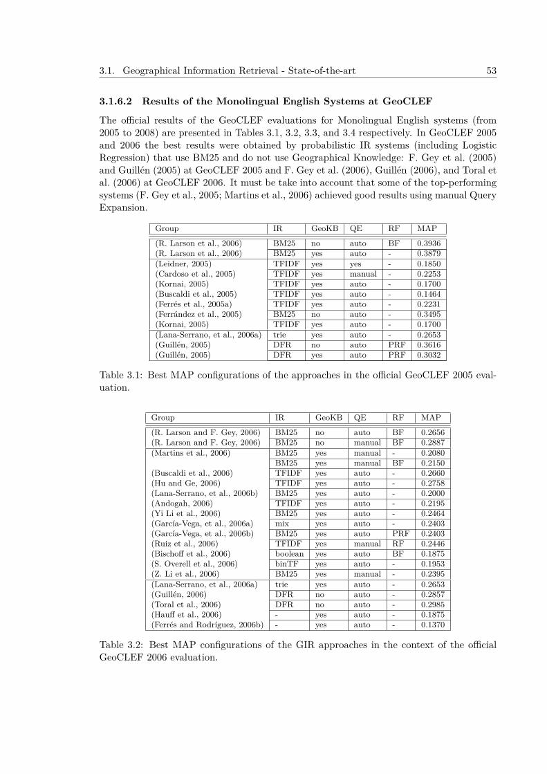
3.1. Geographical Information Retrieval - State-of-the-art 53
3.1.6.2 Results of the Monolingual English Systems at GeoCLEF
The official results of the GeoCLEF evaluations for Monolingual English systems (from2005 to 2008) are presented in Tables 3.1, 3.2, 3.3, and 3.4 respectively. In GeoCLEF 2005and 2006 the best results were obtained by probabilistic IR systems (including LogisticRegression) that use BM25 and do not use Geographical Knowledge: F. Gey et al. (2005)and Guillén (2005) at GeoCLEF 2005 and F. Gey et al. (2006), Guillén (2006), and Toral etal. (2006) at GeoCLEF 2006. It must be take into account that some of the top-performingsystems (F. Gey et al., 2005; Martins et al., 2006) achieved good results using manual QueryExpansion.
Group IR GeoKB QE RF MAP
(R. Larson et al., 2006) BM25 no auto BF 0.3936(R. Larson et al., 2006) BM25 yes auto - 0.3879(Leidner, 2005) TFIDF yes yes - 0.1850(Cardoso et al., 2005) TFIDF yes manual - 0.2253(Kornai, 2005) TFIDF yes auto - 0.1700(Buscaldi et al., 2005) TFIDF yes auto - 0.1464(Ferrés et al., 2005a) TFIDF yes auto - 0.2231(Ferrández et al., 2005) BM25 no auto - 0.3495(Kornai, 2005) TFIDF yes auto - 0.1700(Lana-Serrano, et al., 2006a) trie yes auto - 0.2653(Guillén, 2005) DFR no auto PRF 0.3616(Guillén, 2005) DFR yes auto PRF 0.3032
Table 3.1: Best MAP configurations of the approaches in the official GeoCLEF 2005 eval-uation.
Group IR GeoKB QE RF MAP
(R. Larson and F. Gey, 2006) BM25 no auto BF 0.2656(R. Larson and F. Gey, 2006) BM25 no manual BF 0.2887(Martins et al., 2006) BM25 yes manual - 0.2080
BM25 yes manual BF 0.2150(Buscaldi et al., 2006) TFIDF yes auto - 0.2660(Hu and Ge, 2006) TFIDF yes auto - 0.2758(Lana-Serrano, et al., 2006b) BM25 yes auto - 0.2000(Andogah, 2006) TFIDF yes auto - 0.2195(Yi Li et al., 2006) BM25 yes auto - 0.2464(García-Vega, et al., 2006a) mix yes auto - 0.2403(García-Vega, et al., 2006b) BM25 yes auto PRF 0.2403(Ruiz et al., 2006) TFIDF yes manual RF 0.2446(Bischoff et al., 2006) boolean yes auto BF 0.1875(S. Overell et al., 2006) binTF yes auto - 0.1953(Z. Li et al., 2006) BM25 yes manual - 0.2395(Lana-Serrano, et al., 2006a) trie yes auto - 0.2653(Guillén, 2006) DFR no auto - 0.2857(Toral et al., 2006) DFR no auto - 0.2985(Hauff et al., 2006) - yes auto - 0.1875(Ferrés and Rodríguez, 2006b) - yes auto - 0.1370
Table 3.2: Best MAP configurations of the GIR approaches in the context of the officialGeoCLEF 2006 evaluation.
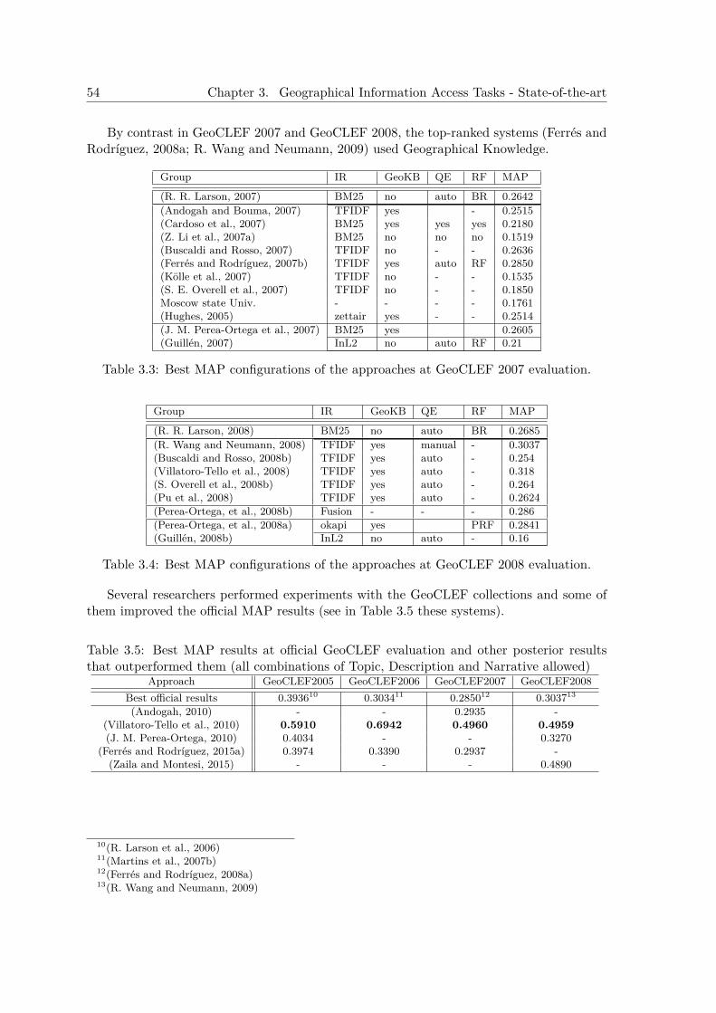
54 Chapter 3. Geographical Information Access Tasks - State-of-the-art
By contrast in GeoCLEF 2007 and GeoCLEF 2008, the top-ranked systems (Ferrés andRodríguez, 2008a; R. Wang and Neumann, 2009) used Geographical Knowledge.
Group IR GeoKB QE RF MAP
(R. R. Larson, 2007) BM25 no auto BR 0.2642(Andogah and Bouma, 2007) TFIDF yes - 0.2515(Cardoso et al., 2007) BM25 yes yes yes 0.2180(Z. Li et al., 2007a) BM25 no no no 0.1519(Buscaldi and Rosso, 2007) TFIDF no - - 0.2636(Ferrés and Rodríguez, 2007b) TFIDF yes auto RF 0.2850(Kölle et al., 2007) TFIDF no - - 0.1535(S. E. Overell et al., 2007) TFIDF no - - 0.1850Moscow state Univ. - - - - 0.1761(Hughes, 2005) zettair yes - - 0.2514(J. M. Perea-Ortega et al., 2007) BM25 yes 0.2605(Guillén, 2007) InL2 no auto RF 0.21
Table 3.3: Best MAP configurations of the approaches at GeoCLEF 2007 evaluation.
Group IR GeoKB QE RF MAP
(R. R. Larson, 2008) BM25 no auto BR 0.2685(R. Wang and Neumann, 2008) TFIDF yes manual - 0.3037(Buscaldi and Rosso, 2008b) TFIDF yes auto - 0.254(Villatoro-Tello et al., 2008) TFIDF yes auto - 0.318(S. Overell et al., 2008b) TFIDF yes auto - 0.264(Pu et al., 2008) TFIDF yes auto - 0.2624(Perea-Ortega, et al., 2008b) Fusion - - - 0.286(Perea-Ortega, et al., 2008a) okapi yes PRF 0.2841(Guillén, 2008b) InL2 no auto - 0.16
Table 3.4: Best MAP configurations of the approaches at GeoCLEF 2008 evaluation.
Several researchers performed experiments with the GeoCLEF collections and some ofthem improved the official MAP results (see in Table 3.5 these systems).
Table 3.5: Best MAP results at official GeoCLEF evaluation and other posterior resultsthat outperformed them (all combinations of Topic, Description and Narrative allowed)
Approach GeoCLEF2005 GeoCLEF2006 GeoCLEF2007 GeoCLEF2008Best official results 0.393610 0.303411 0.285012 0.303713
(Andogah, 2010) - - 0.2935 -(Villatoro-Tello et al., 2010) 0.5910 0.6942 0.4960 0.4959(J. M. Perea-Ortega, 2010) 0.4034 - - 0.3270
(Ferrés and Rodríguez, 2015a) 0.3974 0.3390 0.2937 -(Zaila and Montesi, 2015) - - - 0.4890
10(R. Larson et al., 2006)11(Martins et al., 2007b)12(Ferrés and Rodríguez, 2008a)13(R. Wang and Neumann, 2009)
3.2. Geographical Question Answering - State-of-the-art 55
3.2 Geographical Question Answering - State-of-the-artQuestion Answering (QA) is the task of, given a question expressed in natural language,retrieving its correct answer(s) (single items, text snippets,...) from closed collections or theWeb. This task could be considered a step beyond Information Retrieval (IR). IR systemsretrieve all the documents which are relevant to a user query while retrieving as few non-relevant documents as possible (Baeza-Yates and Ribeiro-Neto, 1999). In IR, the user querynormally consists on a set of relevant keywords and/or regular expressions. In QA the userrequest is a natural language question that demands for a single piece of information insteadof an entire document, and the input is a question expressed in Natural Language insteadof a query. Document collections, digital libraries, web search engines and other sources ofelectronic documents are often used in both IR and QA.
Geographical Question Answering (GeoQA) can be defined as Question Answering typein which questions include geographical expressions (e.g “What is the capital of UnitedStates?”). This Section describes specific GeoQA systems and the generic QA approachesand modules that can be used and adapted for the geographical domain.
Some well-known past research projects and systems related with Geographical QA are:CITYTOUR, GeoQuery, START. The CITYTOUR project (Andre et al., 1986) was de-signed to answer natural language questions about the spatial relationship between objectsin a city. GeoQuery14 is a learned Natural Language Interface to a US Geography Database(Zelle and Mooney, 1996). Geoquery contains a small database of information about UnitedStates geography and can be trained with machine learning for semantic parsing to mapnovel natural language queries. START15, was the first Web-based question answering sys-tem (Katz et al., 2002) that was dealing efficiently with geography. START was able toresolve several types of geographical questions by consulting knowledge databases.
Waldinger et al. (2003) presented GeoLogica, a system that deduces answers to geo-graphical questions based on querying agents (knowledge bases). GeoLogica translate ques-tions into logic by a natural language parser called Gemini. GeoLogica incorporates theAlexandria Digital Library feature type classification. The agents used were: the Alexan-dria Digital Library Gazetteer, the CIA World Factbook, the ASCS search engine, mapproviders (TerraVision, NIMA’s Geospatial Engine, Generic Mapping Tools, the NASAGoddard Distributed Active Archive, and the NASA Landsat Project), and procedures forperforming numerical and geographical computations.
Minock (2005) presented a demo of a the STEP system for natural language accessto relational databases. The demo allowed to perform queries to a geographical database.Behrangi et al. (2007) proposed a density-based algorithm that uses fuzzy logic withoutNLP tools. They selected 400 “where-is” questions from TREC and used google snippetsto find the answers achieving a 62.40% of accuracy.
Mishra et al. (2010) used a Semantic approach for textual-based Geographical-DomainGeographical Question Answering with mapping abilities. Some parts of this approach aresimilar to the approach of Ferrés and Rodríguez (2006a) (explained in Chapter 5, Section1). Text collections from various cities of India were collected from Wikipedia and othersites. They applied Stanford NLP PoS-Tagging, NERC, and Parsing tools and WordNet3.0 to perform the analysis of queries and texts. Both Question classification and Expected
14GeoQuery. http://www.cs.utexas.edu/users/ml/geo-demo.html15START. http://start.csail.mit.edu/
56 Chapter 3. Geographical Information Access Tasks - State-of-the-art
Answer Type are performed. Passage Retrieval is based on pre-processed texts. The An-swer Extraction phase employs measures of confidence estimation over semantic similarities(through Wornet) among the question and the documents. The evaluation of the systemswas performed with a closed collection of documents about 5 cities of region of India and aset of 152 questions. The results were about 80% of accuracy.
Younis et al. (2012) performed hybrid structured question answering over a structureddatabase, the DBpedia.
Chen (2014) uses a knowledge-based GeoQA system that relies on GIS instead of textsto treat some types of geographical questions using the following techniques: 1) ontologiesof spatial relationships, 2) GIS (Geographical Information Systems) data 3) NLP to treatthe queries, 4) ontological reasoning, and 5) spatial SQL queries. The type of geographicalquestions treated in Chen (2014) are: 1) location (e.g. “Where is X?”), 2) distace (“Howfar is X from Y?”,3) “Which city is the nearest to X?”), and 4) proximity buffer (e.g “Whatcities are within 5 miles of Columbus?”).
3.2.1 Classification of QA SystemsQuestion Answering systems can be classified from different points of view. This sectionpresents different QA categorization types. This categorization types can be applied alsoto Geographical Question Answering systems.
• Classification by Knowledge Used. Moldovan et al. (1999) provided a taxonomy of QAbased on the necessary knowledge to resolve the questions. They considered importantthe three following criteria: Knowledge Bases (KB), Reasoning, and Natural LanguageProcessing (NLP) indexing techniques. Knowledge bases and reasoning provide themedium for building question contexts and matching them against text documents.Indexing identifies the text passages where answers may lie, and natural languageprocessing provides a framework for answer extraction (Moldovan et al., 1999).
• Classification by Question Types. There are several types of questions: definitional,list, context, interactive and factoid questions. Factoid questions are the most com-mon researched ones and have been largely evaluated in several international QAcontests such as TREC, CLEF, and NTCIR. Factoid questions are questions thatseek short fact-based answers like entities, organizations, persons, dates,…(e.g. Whatis the capital of France?, Who is the President of the United States?, Which is thecolor of the sky?). Usually the answer is a noun (e.g. blue), a noun phrase (slightlyblue) or a Named Entity (e.g. 1979, Paris, George Bush). But some times an adjectiveor an adverb could be the answer (i.e. in most of the “How” questions).
• Classification by Domain. Open-Domain Question Answering (ODQA) systems dealwith general questions about many themes. Normally these systems use huge corpusand/or the World Wide Web to extract the answer. On the other hand, Restricted-Domain QA (RDQA) systems deal with questions about a specific domain (e.g. ge-ography, medicine, etc.) (Molla and J. Vicedo, 2005). They often use domain-specificknowledge bases and corpus. Usually, for RDQA, the answers are searched in rela-tively small domain specific collections, so methods based on exploiting the redun-dancy of answers in several documents are not useful. Furthermore, a highly accuratePassage Retrieval module is required because frequently the answer occurs in a very

3.2. Geographical Question Answering - State-of-the-art 57
small set of passages. RDQAs are frequently task-based. So, the repertory of ques-tion patterns is limited allowing a good accuracy in Question Processing with limitedeffort. User requirements regarding the quality of the answer tend to be higher inRDQA. As Chung et al. (2004) pointed out, “no answer” is preferred to a wrong an-swer. In RDQA not only NEs but also domain specific terminology plays a centralrole. This fact usually implies that domain specific lexicons and gazetteers have tobe used. In some cases, as in Geographical Domain, many documents included inthe collections are far to be standard NL texts but contain tables, lists, ill-formedsentences, etc. sometimes following a more or less defined structure. Thus, extractionsystems based on the linguistic structure of the sentences have to be relaxed in someway to deal with this kind of texts.
• Classification by Information Access Two basic types of Question Answeringsystems can be distinguished depending of the structure of the knowledge that theyuse to answer.
– Database-oriented: systems that access to structured information contained ina database in order to answer the questions. The main challenge of these systemsis to transform a natural language question into a database query (Monz, 2003).The fact that this systems are focused in good results, but expand to otherdomains is a hard task, expertise is required.
– Text-based: Most systems use unstructured information such as plain texts:newspapers, manuals, encyclopedias, etc. to find the answer. Textual questionanswering systems match the question with text units, e.g., phrases or sentences,in the document collection, and within those units, identify the element the ques-tion is asking for. The task of identifying elements of the appropriate type isclosely related to the research area of Information Extraction and Named En-tity Recognition and Classification. Moreover, for text-based QA system dataredundancy plays and important role for answer extraction (i.e. more data im-plies higher chance that appear occurrences in text where this information isexpressed in a way similar to the question). On the other hand, huge amountsof data increases the computational costs of finding an answer.
3.2.2 Architecture of QA SystemsThe common architecture of most of the existing QA and GeoQA systems is generallydivided into 3 phases: Question Classification, Passage Retrieval (sometimes divided intoDocument Retrieval and true Passage Retrieval) and Answer Extraction (sometimes di-vided into Candidates Extraction and Answer Selection) (see in Figure 3.3 a generic QAarchitecture). In most systems, these phases are executed sequentially, but some systemssuch as PowerAnswer (S. Harabagiu et al., 2005) perform several iterations in order to getthe correct answer. In every system NLP and IR techniques are applied, some times withmanually built rules or databases or learned approaches using ML techniques.
3.2.2.1 Question Classification
The Question Classification task consists in: given a question q, assign one or more classlabels ci from a class set C to the question. Question Classification for QA could be seen
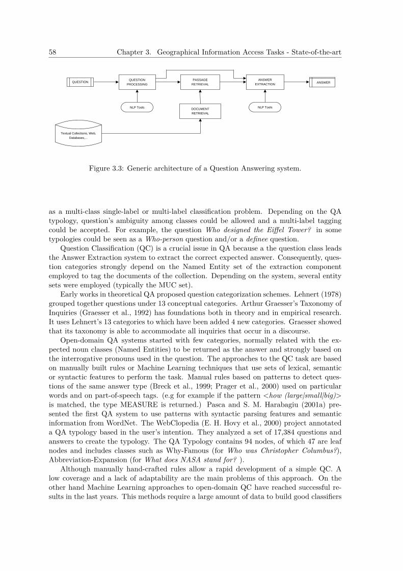
58 Chapter 3. Geographical Information Access Tasks - State-of-the-art
QUESTIONQUESTION
PROCESSING
PASSAGERETRIEVAL
ANSWEREXTRACTION
DOCUMENTRETRIEVAL
NLP Tools NLP Tools
Textual Collections, Web,Databases,...
ANSWER
Figure 3.3: Generic architecture of a Question Answering system.
as a multi-class single-label or multi-label classification problem. Depending on the QAtypology, question’s ambiguity among classes could be allowed and a multi-label taggingcould be accepted. For example, the question Who designed the Eiffel Tower? in sometypologies could be seen as a Who-person question and/or a definee question.
Question Classification (QC) is a crucial issue in QA because a the question class leadsthe Answer Extraction system to extract the correct expected answer. Consequently, ques-tion categories strongly depend on the Named Entity set of the extraction componentemployed to tag the documents of the collection. Depending on the system, several entitysets were employed (typically the MUC set).
Early works in theoretical QA proposed question categorization schemes. Lehnert (1978)grouped together questions under 13 conceptual categories. Arthur Graesser’s Taxonomy ofInquiries (Graesser et al., 1992) has foundations both in theory and in empirical research.It uses Lehnert’s 13 categories to which have been added 4 new categories. Graesser showedthat its taxonomy is able to accommodate all inquiries that occur in a discourse.
Open-domain QA systems started with few categories, normally related with the ex-pected noun classes (Named Entities) to be returned as the answer and strongly based onthe interrogative pronouns used in the question. The approaches to the QC task are basedon manually built rules or Machine Learning techniques that use sets of lexical, semanticor syntactic features to perform the task. Manual rules based on patterns to detect ques-tions of the same answer type (Breck et al., 1999; Prager et al., 2000) used on particularwords and on part-of-speech tags. (e.g for example if the pattern <how (large|small|big)>is matched, the type MEASURE is returned.) Pasca and S. M. Harabagiu (2001a) pre-sented the first QA system to use patterns with syntactic parsing features and semanticinformation from WordNet. The WebClopedia (E. H. Hovy et al., 2000) project annotateda QA typology based in the user’s intention. They analyzed a set of 17,384 questions andanswers to create the typology. The QA Typology contains 94 nodes, of which 47 are leafnodes and includes classes such as Why-Famous (for Who was Christopher Columbus?),Abbreviation-Expansion (for What does NASA stand for? ).
Although manually hand-crafted rules allow a rapid development of a simple QC. Alow coverage and a lack of adaptability are the main problems of this approach. On theother hand Machine Learning approaches to open-domain QC have reached successful re-sults in the last years. This methods require a large amount of data to build good classifiers
3.2. Geographical Question Answering - State-of-the-art 59
automatically. Radev et al. (2002) applied decision rule induction using Ripper with 17question types (person, place, date, number, definition, organization, description, abbrevi-ation, knowfor, rate, length, money, reason, duration, purpose, nominal, and other) andusing for learning 1200 questions from TREC-8, TREC-9 and TREC-10. The Results ofusing Ripper to identify question types with primitive lexical features were 30% of errorin the testing using the TREC-10 and the other collections to train. On the other hand,X. Li and Roth (2002) used SNoW (Winnow algorithm) to learn two simple classifiers (acoarse classifier and a fine one). They used two-layer taxonomy which represents a semanticclassification of typical TREC questions. The hierarchy contains 6 coarse classes (ABBRE-VIATION, ENTITY, DESCRIPTION, HUMAN, LOCATION and NUMERIC VALUE)and 50 finer classes. This was a successful approach, achieving a 98.80% of precision forcoarse classes with question features and 95% for the fine classes over the 500 TREC-10questions. Zhang and Lee (2003) experimented with five machine learning algorithms: Near-est Neighbors (NN), Nave Bayes (NB), Decision Tree (DT), Sparse Network of Winnows(SNoW), and Support Vector Machines (SVM) using two kinds of features: bag-of-wordsand bag-of-ngrams. They used the same two-layer taxonomy and training-testing datasetsof X. Li and Roth (2002). Their experiments results showed that with only surface textfeatures SVM outperforms the other four methods for this task. They also discussed aboutthe importance of the syntactic structures of questions because SVMs with a kernel treecan improve the results of a single-layer SNoW using the same syntactic features. Suzukiet al. (2003) used a hierarchical SVM to experiment with feature sets that include words,named entities and semantic information. They measured a question type hierarchy atdifferent depths and achieved accuracy rate ranging from 95% at depth 1 to 75% at depth4. Solorio et al. (2004) proposed an algorithm for a Language-independent QC based onSupport Vector Machines (SVMs) using 7 classes (person, place, date, measure, organiza-tion, object, other). They employed lexical features and Internet features avoiding semanticand syntactic information. They used the DISEQuA corpus (Magnini et al., 2003) , whichconsists in 450 questions formulated in four languages: Dutch, English, Italian and Spanish,with 10-fold cross-validation for English, Spanish and Italian, obtaining a results of 81.77%for English, 88.70% for Italian and 81.45% for Spanish. X. Li and Roth (2004) repeatedtheir experiments in QC using their framework test set with the use of semantic informa-tion sources for this task. Their experiments results show that semantic information canimprove the performance of the QA task. Classification accuracies over 1,000 TREC-2002questions reached 92.5% for 6 coarse classes and 89.3% percent for 50 fine grained classes.On the other hand Shen et al. (2006) obtained a classification accuracy of 80.8 % in finegrained classes with the previous experiments. They used a Language Modelling approachwith a Kneser-Ney smoothing for bigram features.
Most systems perform in parallel QC and extraction of information from the question(as question keywords, expected answer type, etc.). Keywords Selection is one of the mostimportant steps in the Question Processing phase. Lexical terms (keywords) from thequestion normally used as a query to an IR/PR system lead to the relevant documents.These keywords could possibly expanded with lexical/semantic variations.
3.2.2.2 Passage Retrieval
Given a textual corpus and a user query (a question, a set of keywords, …), Passage Retrieval(PR) could be defined as the task of retrieving a set of passages from the textual corpus

60 Chapter 3. Geographical Information Access Tasks - State-of-the-art
relevant to the user query. Obviously, a passage is considered a portion of a whole document.A passage could have fixed size (words, bytes or sentences) or a dynamic size (paragraph,sentence,…). In QA the aim of Passage Retrieval is to get small fragments of text (withenough context) which probably contain the answer of the question.
A typical PR system has normally two phases, an indexing phase and a searching phase.The first one, called Indexing, consists in processing all the collection and extract its essentialinformation. Then, in a following step of the same process, the information is stored in astructure that allows an easy recovery of the primordial data by querying for some features.
The core of each PR system has an Information Retrieval algorithm. IR techniques canbe sub-classified in tree classes depending on its mathematical model:
• Set Models. These models represent documents by sets. The Standard Booleanmodel is the most popular.
• Algebraic Models. These algorithms represent documents and queries usually asvectors, matrices or tuples. The Vector Space model is the algebraic model most widelyused in the IR community. In the vector space model, all the documents are mappedinto a N-dimensional space in which each term represents a dimension. Each documentand query is represented as a vector in this vectorial space. Document relevance withrespect to a query is computed using distance measures between the document vectorand the query vector. Term weighting is usually performed by TFIDF (Salton andBuckley, 1988) or Okapi’s BM25 (Robertson and Walker, 1994) schemas.
• Probabilistic Models. These models represent similarities as probabilities. In theprobabilistic models the estimated relevance of a document to a query is a function ofthe estimated probabilities that each of the various terms in the document occur inat least one relevant document but in no irrelevant documents. Currently, Languagemodels (LM) and Divergence From Randomness (DFR) models (Amati, 2003) are onesof the most established probabilistic models.
Information Retrieval engines are the core of most text-based QA and GeoQA systems.This paragraph lists and describes some of the most relevant existing IR engines.
• Lucene. Lucene16 IR system uses the standard tf.idf weighting scheme with thecosine similarity measure, and it allows ranked and boolean queries.
• Terrier17. Performing very well at TREC Terrier includes: parameter-free probabilis-tic retrieval approaches such as Divergence from Randomness (DFR) models (Ounis etal., 2006), the TF-IDF (with Robertson’s TF) weighting scheme, other recent languagemodelling approaches, and the well-established Okapi’s BM25 probabilistic rankingformula.
• Indri (Lemur project). Indri18 (an IR component of the Lemur toolkit) is anInformation Retrieval system that supports retrieval algorithms based on LanguageModelling (Ogilvie and Callan, 2001).
16Lucene. http://lucene.apache.org/java/docs/17Terrier. http://ir.dcs.gla.ac.uk/terrier/18Indri. http://www.lemurproject.org/
3.2. Geographical Question Answering - State-of-the-art 61
• JIRS. The JAVA Information Retrieval System (JIRS) software (Soriano et al., 2005)is used to retrieve relevant passages related to a question. JIRS19 was specially de-signed for Question Answering (QA). This system gets passages with a high similaritybetween the largests n-grams of the question and the ones in the passage. It has 3modes: simple n-gram model, term weight n-gram model, and distance n-gram model.
• Sphinx. Sphinx20 is a full-text search engine that provides fast, size-efficient andrelevant full-text search functions to other applications. Sphinx has two types ofweighting functions: Phrase rank and Statistical rank. Phrase rank is based on alength of longest common subsequence (LCS) of search words between document bodyand query phrase. Statistical rank is based on classic BM25 function which only takesword frequencies into account.
Indexing
Rijsbergen (1979) defined an index language as the language used to describe documentsand requests. The elements of the index language are index terms, which may be derivedfrom the text of the document to be described, or attached to it. Usually, documents areindexed using its words as an indexed terms. In the indexing phase some dimensional reduc-tion techniques (Term Normalization) are applied. The most popular indexing techniqueis the use of Inverted Indexes, that consists in having a inverted list for each index term.Some pre-process over the terms before indexing include:
• stopwords removal: avoids the indexing of irrelevant information by filtering outwords with high frequency of occurrences is text that they lose their utility as searchkeywords and/or words without semantic importance such as articles, prepositions,pronouns, etc.
• stemming: a stemmer is an algorithm that given a word form determines its stemform. The stem is not necessarily identical to the root of the word. As an example,for English, an stemmer will possibly identify the string “build” as the stem of thefollowing word forms: “building”, “builders”. The Porter algorithm is very widelyused as a standard stemmer for English (Porter, 1997). This method removes thecommoner morphological and inflexional endings from words in English.
• lemmatization: a lemmatizer is an algorithm that given a word form determines itslemma by using the part of speech of the word in a sentence. It requires a lexiconthat store the necessary knowledge of the language (i.e. a lemma and its associatedlexeme, the pair <word form, part-of-speech>). lemmatization differs from Stemmingin the fact that requires the knowledge of the POS tag of the word in the sentence andneeds a knowledge base of lexemes. Stemming does not take into account the functionof the word in the sentence, does not require a great knowledge of the language, andnormally works by stripping morphological and inflexional endings of the words. Asan example, the word “went” has “go” as a lemma, but its stem is the word formitself.
19JIRS. http://sourceforge.net/projects/jirs/20Sphinx. http://www.sphinxsearch.com
62 Chapter 3. Geographical Information Access Tasks - State-of-the-art
• Named Entity indexing: indexing Named Entities as a multi-word class can im-prove the recall and avoid noise in the retrieval. However, a high precision NERC isrequired in order to lose recall. (Prager et al., 2000) started this approach by indexingNamed Entities and their class (predictive annotation). This method identifies po-tential answers in the text and then indexes their corresponding Named Entity classor Expected Answer Type.
• semantic indexing: using WordNet synsets to index collections can improve therecall of IR systems respect to word based indexing. Gonzalo et al. (1998) used theSMART IR and SemCor (a disambiguated collection) to index by synsets with dubiousresults. In fact the increase in recall (29%) has a decrease in precision counterpart dueto polysemy. What is true is that with accurate WSD module (currently not existing)the results could be good. Mihalcea and Moldovan (2000) experiments indexing bysynsets reported also an improvement in IR effectiveness using the Cranfield collection.Liu et al. (2004) used effectively WordNet to disambiguate word senses of query terms.
Searching
Searching documents in IR systems implies the use of a textual query in a booleanor ranked manner to obtain a set of ordered or unordered relevant documents. Booleansearches involve the use of logical operators such as: AND, OR, and NOT over the queryterms to find a set of documents that satisfy the logical expression. Ranked retrieval, onthe other side, does a ranking over a set of documents based on keywords similarities.
IR systems sometimes offer capabilities like phrasal search (searching for a phrase or aspecific sequence of words (e.g. “Tom Cruise”)), fuzzy matches (e.g. “*at” will match “Pat”or “rat” ), regular expression (regexp) matches or boosting terms (i.e. weighting searchterms). A frequent approach in Searching is Query Expansion (QE). The QE approachis often used to increase the recall of the system by adding similar terms to the ones inthe original query. WordNet has been used for this purpose by expanding terms withits synonyms, hyponyms, and hypernyms21. On the other hand, Gazetteers, encyclopedicknowledge, and abbreviations, can be used in certain domains to realize QEs.
The number of documents to retrieve depends on the task. In QA, normally it dependson the document processing capability of the system. The processing capability dependson the computational resources available to process and the computational costs of thealgorithms designed to process the documents. Sometimes deep NLP approaches mightrequire expensive computational resources and processing time and use only few documents(and/or passages), and some simple approaches with lesser requirements can cope with moredata.22
In the Information Retrieval field, for research purpose the first top 1,000 documents aretaken into account to evaluate the systems (e.g. TREC, and CLEF adhoc IR tasks). In thereal world, normally the user wants the search engines for no more than 50 documents. ForQA, usually few documents/passages are used to extract the answer. In PR the searching
21Without a good WSD this kind of expansion has to be done very carefully for avoiding the introductionof noisy terms.
22In online-QA the response time is a critical constraint while in TREC or CLEF contests time processcan be huge.
3.2. Geographical Question Answering - State-of-the-art 63
process retrieves passages sometimes with overlapping and sometimes with fixed size. JorgTiedemann (2004) does comparison of different IR systems for QA, in which Zettair andLucene obtained the best results.
An often used approach to improve searching is Relevance Feedback for IR/PR. Rele-vance Feedback (RF) consists in using the most relevant terms collected from the top rankeddocuments of an initial query to compose manually or automatically a second query withmore information.
3.2.2.3 Answer Extraction
The Answer Extraction phase has the aim of recover the answer(s) of a certain question.This phase normally takes place after Question Processing and Passage Retrieval and pro-cessing.
After passage processing the AE algorithms can use simple and fast answer patternmatching or sophisticated reasoning modules. The Answer Extraction phase is often com-posed by three subphases: Sentence Retrieval, Answer Ranking, and Answer Selection.
Current approaches to Answer Extraction can be divided into the following points de-pending on the use of different NLP processing techniques and the type of data used tosearch the answer:
1. Linguistic Pattern Matching.Answer pattern matching is one of the most common approaches to the QA task.Answer patterns consists of series of regular expressions based on lexical, syntac-tic and/or semantic features that allows easily to match the answer sentence con-text to extract properly the answer. As an example, the following lexical pattern<X;is/are;[a/an/the];A> matches “Michigan’s state flower is the apple blossom”.On the other hand, the semantic pattern <PERSON> was born in <BIRTHDAY>matches “Mozart was born in 1756”.Several groups used manually built rules with great success. Soubbotin (2001); forinstance, obtained the best results at the TREC 2001 QA evaluation task (MRR:0.676) with a system that uses massively indicative lexical answer patterns for a broadrange of question types.Ravichandran and E. H. Hovy (2002) presented an approach for automatically learninganswer patterns (regular expressions) from the web, for certain types of questions.Their method uses bootstrapping learning to build a large tagged corpus staring withonly a few examples of QA pairs.
2. Semantic Matching.Semantic matching is performed using ontologies (e.g WordNet, SUMO, or CYC)sometimes helped by syntactic parsing structures. J. L. Vicedo (2002) used the Se-mantic Content of the Concept, a semantic representation of questions and sentencesbased on weights obtained by using idf weights and WordNet relationships: synonymy,hypernymy and hyponiny. Ferrés et al. (2004a) represents semantically sentences andquestions with binary and unary predicates and applies an iterative relaxation ap-proach by means of structural and hierarchical relaxation of predicates. Lo and Lam(2006) presented a system with a sophisticated grammatical framework that parsesthe question and candidate answers and the semantic relations are obtained. Then,
64 Chapter 3. Geographical Information Access Tasks - State-of-the-art
these relations are compared base on the level of consistency as well as the linkagesfrom the Wikipedia.
3. Context-based Linguistic Features. This method uses linguistic features fromthe candidate’s context to perform a ranking of the candidates. FALCON (S. M.Harabagiu et al., 2000), for instance, was an early advanced QA system that appliedthese approach integrating semantic information using WordNet, Expected AnswerType, Query Expansion, syntactic parsing with Collins’ parser and abductive reason-ing.
4. Lexical Matching with Expected Answer TypeExpected Answer Type (EAT) matching (Pasca and S. M. Harabagiu, 2001a) is acommon strategy for the Answer selection process in most of the current QA sys-tems. Detecting the EAT of a question could be useful in the Passage Retrieval andthe Answer Extraction phases. A mapping of answer types to Named Entity typesis required. During the PR phases it can be used filtering out the passages withoutconcepts of the same category as the expected answer type. Finally, in the AnswerExtraction phase the EAT can be used to select the candidates with the same type.Pasca and S. M. Harabagiu (2001b) used an answer taxonomy that includes 8707concepts from 129 WordNet subhierarchies. Predictive Annotation and Virtual An-notation are also successful techniques for Answer Extraction introduced by Prageret al. (2000).
5. Data-Driven Statistical Modelling.Statistical modelling for answer extraction relies in Statistical Machine Learning usingannotated corpus of question-answer pairs to learn probability models. Whittaker etal. (2006) presented a non-linguistic multilingual data-driven statistical QA systemtrained with the TREC QA evaluation datasets and the Knowledge Master KM data23.Ittycheriah et al. (2001) created statistical algorithms for both expected answer typeprediction and named entity tagging. The answer selection model used maximumentropy with the following feature sets: sentence features, entity features, definitionfeatures, and linguistic features.
6. Cache-Based Services.Although is a simple strategy, some QA systems such as QUARTZ (Jijkoun et al.,2004), Aranea (J. Lin and Katz, 2003) among others have a Database of question-answer pairs that it is consulted before using the QA algorithms given a question.
7. Inference & Reasoning. This methods require the use of ontologies and Bases ofKnowledge for inferences. LCC’s language logic prover, COGEX (Moldovan et al.,2003), is an example of abductive reasoning for QA.
8. Web-based External Knowledge Mining. Using the Web as a data source toextract the answer and then apply this information into the extraction process hasemerged as new research line in QA. Major search engines and confident data sources
23Knowledge Master data. Academic Hallmarks, http://www.greatauk.com. A non-free library of 142,000questions about different subjects
3.2. Geographical Question Answering - State-of-the-art 65
as Wikipedia are often used. Systems such as: Aranea (J. Lin and Katz, 2003), andPowerAnswer 3 (Moldovan et al., 2006), among others used this technique.
9. Complex Hypothesis Generation and Evidence Scoring. This is a unique ap-proach created by IBM that uses massive resources to perform the generation of severalhypothesis from the questions, get candidates from different evidence sources, and getthe answer with high confidence. DeepQA (Watson) (Ferrucci, 2012) performs state-of-the-art ML and NLP techniques such as parsing, entity disambiguation, relationsdetection and textual entailment.
10. Linked Data Answer Extraction. These systems consult Knowledge Bases withnatural language queries. Pradel et al. (2011) presented the SWIP system, a systemthat allows consult Knowledge Bases with natural languages queries. QAKiS (Cabrioet al., 2012) is a system for ODQA over linked data that uses relational textualpatterns.
3.2.3 Evaluation Benchmarks of QA systemsQA has become a popular task in the NL Processing (NLP) research community in theframework of different international ODQA evaluation contests such as: Text Retrieval Con-ference (TREC) for English (Voorhees, 2003), Cross-Lingual Evaluation Forum (CLEF) forEuropean languages (Magnini et al., 2003), and NII-NACSIS Test Collection for IR Systems(NTCIR) for Asian languages (Sasaki et al., 2005). More recent QA evaluations focusedon several domains and approaches such as Biomedical (BioASQ track from CLEF 2013to CLEF 2015, and ACL 2016-2017), Geographical (GikiP and GikiCLEF at CLEF 2008and 2009), Linked Data (QALD track from CLEF 2011 to CLEF 2015, ESWC 2016., andCLEF 2017),…. QA evaluation contests usually provide test collections (data sets usable forexperiments) and unified evaluation procedures for experiment results (Voorhees and Tice,1999). Each participating group conducts research and experiments using the common dataprovided by the organization with various approaches. The TREC24 conference is the mostpopular international evaluation framework in the field of Information Retrieval for English.It has different tracks (areas of IR) that propose different tasks related to IR. NIST providesparticipating groups with test sets and evaluates the results of the participants. From 1999to 2007, a special open domain QA track was carried out every year. The TREC conferencehas fostered and has inspired a substantial set of publications and current QA systems. TheCLEF25 is an international evaluation framework for IR in European Languages. CLEFprovides the infrastructure for the testing, tuning and evaluation of information retrievalsystems operating on European languages in both monolingual and cross-language contexts.Within the framework of the CLEF, a Multilingual QA track for was succesfully carriedout from 2003 to 2008. Both QA tracks (at CLEF and TREC) included some geograph-ical questions in their questions. GikiCLEF (at 2009) was an evaluation task under thescope of CLEF with the aim to evaluate systems which find Wikipedia entries/documentsthat answer a particular information need. For GikiCLEF, systems needed to answer oraddress geographically challenging topics on the Wikipedia collections returning Wikipediadocument titles as list of answers in all languages it can find answers.
24TREC. http://trec.nist.gov25CLEF. http://www.clef-initiative.eu
66 Chapter 3. Geographical Information Access Tasks - State-of-the-art
3.2.4 Evaluation Metrics of Factoid QA SystemsThe main capabilities in QA were discussed by the QA road-map committee (Burger et al.,2000). The following capabilities are the most relevant.
• Timeliness. The answer to a question must be provided in real-time, and the questioncould refer to most recent events and facts.
• Accuracy. The precision of QA systems is extremely important as incorrect answersare worse than no answers. To be accurate, a QA system must incorporate worldknowledge and mechanisms that mimic common sense inference.
• Usability. This capability implies the rapid prototyping of domain-specific knowl-edge and its incorporation in the open-domain ontologies, the use of heterogeneousdata sources, deal with heterogeneous data formats and allow the user to describe thecontext of the question.
• Completeness. Complete answers to a user’s question is desirable. Some timesanswer fusion is required.
• Relevance. The answer to a user’s question must be relevant within a specific con-text. The evaluation of QA system must be user-centered: humans are the ultimatejudges of the usefulness and relevance of QA systems and of the ease with which theycan be used.
The main issues on evaluation of the different components of QA systems are reportedhere:
Question Processing. The Question Processing phase consists in the analysis of thequestion using NLP tools (morphosyntactic analyzers, syntactic parsers, Named EntityRecognizers, semantic parsing,…). Although is not common, the evaluation of this partis an important step to avoid cumulative errors in the following phases. So, for example,Named Entity Recognition and Classification could be influenced by POS-tagging errorsand semantic pre-processing could depend on the errors in the NERC and the syntacticparsing steps.
Question Classification. In the Question Classification phase normally, is evaluatedits global accuracy (number of correct questions classified divided by the total number ofquestions) and the accuracy of the classifiers for a specific class c.
Accuracy =#correct_predictions
#predictions(3.5)
Accuracy(c) =#correct_predictions_of_class_c
#predictions_of_class_c (3.6)
Passage Retrieval. Let Q be the question set, D the document (or passage) collection,AD,q the subset of D which contains correct answers for q ∈ Q, and RS
D,q,n be the n top-ranked documents (or passages) in D retrieved by a retrieval system S given question q.The following metrics of a retrieval system S for a question set Q and document collectionD at rank n are defined:
3.2. Geographical Question Answering - State-of-the-art 67
• Coverage (or Accuracy): the Coverage, sometimes called Accuracy, gives the pro-portion of the question set for which a correct answer can be found within the top ndocuments retrieved for each question.
coverageS(Q,D, n) =|{q ∈ Q|RS
D,q,n ∩AD,q = ∅}|Q|
• Redundancy: the answer redundancy gives the average number, per question, ofpassages within the top n ranks retrieved which contain a correct answer.
redundancyS(Q,D, n) =
∑q∈Q |RS
D,q,n ∩AD,q||Q|
• Maximum Redundancy: the maximum answer redundancy any system could achieve.
maximum_redundancy(Q,D, n) =
∑q∈Q |AD,q|
|Q|
• Precision: the precision of a system for a given question set and document collectionat rank n is the average proportion of the n returned documents or passages thatcontain a correct answer.
• Recall: the Recall is the average proportion of answer bearing documents that arepresent in the top n returned documents or passages.
The most useful evaluation metrics to evaluate PR for QA are coverage and redundancy.On the other hand, precision and recall are not helpful for PR in a QA context (I. Robertsand Gaizauskas, 2004). Precision cannot capture the goodness of the overall queries, whichis crucial for QA, the evaluation is done over a set of questions and these measures can beconfusing. Recall is not as unhelpful as precision, because it can show how the retrieveddocument set approaches to the maximum redundancy obtainable. Redundancy, on theother hand, tells one only how many answering bearing passages per question are beingreturned on average. However, redundancy gives a measure of how many chances perquestion on average an answer extraction component has to extract an answer. In addition,Ferrés et al. (2005b) designed two different measures to evaluate the Passage Retrievalfor Factoid questions: the first one (called answer) is the accuracy taking into accountthe questions that have a correct answer in its set of passages. The second one (calledanswer+docID) is the accuracy taking into account the questions that have a minimum ofone passage with a correct answer and a correct document identifier in its set of passages.
Answer Extraction. The evaluation of the Answer Extraction module can be donein different modes depending on the number of sub-tasks that has this module. Whenthe Answer Extraction is a single module the evaluation takes into account the retrievedpassages with a correct answer to perform an evaluation of the Answer Extraction accuracy.
AnwserExtractionAccuracy =#questionsWithCorrectAnswerExtracted&1passageEntailsAnswer
#questions_withAtLeast1passageEntailsAnswer(3.7)

68 Chapter 3. Geographical Information Access Tasks - State-of-the-art
Sometimes Answer Extraction uses two steps: Candidate Extraction (CE) module, andAnswer Selection module. Then every step can be evaluated separately.
CandidatesExtractionAccuracy =#questionsWithCorrectCandidateExtracted&1passageEntailsAnswer
#questionsWithAtLeast1passageEntailsAnswer(3.8)
AnswerSelectionnAccuracy =#questionsWithCorrectAnswerExtractedFromASupportedPassage
#questionsWithCorrectCandidateFromASupportedPassage(3.9)
Question Answering. QA judgements of factoid questions in current QA evaluationsoften consider a response as a single pair of answer-string and document identifier. If apair <answer-string, document-identifier> pair is given as a response, the answer-stringmust contain nothing other than the answer, and the document identifier must be theglobal identifier of a document in the collection that supports answer-string as an answer.Sometimes if the system detects that there is no answer in the collection the responsepair reflects that the question answer is nil. These answers will be judged correct if thereis no answer known to exist in the document collection; otherwise it will be judged asincorrect. An answer string must contain a complete, exact answer and nothing else. Aswith correctness, exactness will be in the opinion of the assessor. Responses will be judgedby human assessors who will assign one of four possible judgments to a response:
• incorrect: the answer-string does not contain a correct answer or the answer is notresponsive.
• unsupported: the answer-string contains a correct answer but the document returneddoes not support that answer (i.e does not textually entails the answer).
• non-exact: the answer-string contains a correct answer and the document supportsthat answer, but the string contains more than just the answer (or is missing parts ofthe answer).
• correct: the answer-string consists of exactly a correct answer and that answer issupported by the document returned.
Mean Reciprocal Rank (MRR). MRR represents the mean score over all questionsand is one of the most used evaluation measure in QA. MRR takes into considerationboth recall and precision of the systems performance, and can range between 0 (no correctresponses) and 1 (all the queries have a correct answer at position one). Two versionsof MRR can be applied in a QA evaluation: a) ’strict’, where unsupported responses arecounted as wrong, and b) ’lenient’ where unsupported responses are counted as correct.
MRR =
∑|Q|i=1
1far(i)
|Q|(3.10)
Accuracy. The accuracy measure is commonly used in all the QA evaluations (TREC,CLEF, NTCIR). The accuracy measures the precision giving the answer at the top-N rankof answers. Accuracy is the fraction of questions judged to have at least one correct answerin the first n answers to the questions. Let C be the correct answers.
3.2. Geographical Question Answering - State-of-the-art 69
accuracys(Q,D, n) =|{q ∈ Q|AD,q,n}|
|Q|(3.11)
F-measure. The F measure is controls the relative importance of recall and precision(Voorhees, 2003). The general formula of the F measure is:
F =β2PR
(β2 + 1)P +R(3.12)
The β parameter can be used to tune the relative importance of the recall and precision.
70 Chapter 3. Geographical Information Access Tasks - State-of-the-art
3.3 Textual Georeferencing - State-of-the-artTextual Georeferencing consists in assigning a set of geographical coordinates to formal(news, reports,..) or informal (blogs, social networks, chats, tagsets,...) texts and doc-uments. The approaches to deal with the Textual georeferencing task generally use: 1)data-driven models to predict, and/or 2) Geographical Knowledge bases for toponym recog-nition, toponym disambiguation, and toponym grounding. But this prediction task it is notpossible, or very difficult to perform, in some texts because of lack of enough information.Currently some platforms allow users to georeference (geotag) their content automatically(GPS-enabled cameras) or manually, but most of existing textual and media content is notgeoreferenced, and thus this task could be applied in many data sources.
The automatic understanding or prediction of the georeference of informal texts fromsocial networks (and other document sources) can be applied to different areas such astourism (Zheng et al., 2012), discovery of Points of Interest (Skovsgaard et al., 2014), andemergency scenarios (De Longueville et al., 2009) among many others. For instance Zhenget al. (2012) extracts topological characteristics of travel routes by using a pool of geotaggedphotos of the internet, (Skovsgaard et al., 2014) proposes automatic discovery of Points ofInterest from geo-tagged microblog posts, and De Longueville et al. (2009) analyzed thetemporal, spatial and social dynamics of Twitter activity during a major forest fire event inthe South of France in July 2009.
3.3.1 Approaches for Textual GeoreferencingMany approaches to Textual Georeferencing of formal and informal texts such as usergenerated data have been presented in last years. Most of them addressed to solve thefollowing problems:
• predict users’ location from textual content (Mahmud et al., 2014; Chang et al., 2012;Kordopatis-Zilos et al., 2016),
• predict the geographical focus of the text (Van Laere et al., 2013; Serdyukov et al.,2009; Intagorn and Lerman, 2014),
• predict both the users’ location and the geographical focus of the text. (Han et al.,2014; Schulz et al., 2013).
Some of these approaches have been applied over different textual inputs such as Twittermessages, Flickr metadata, Wikipedia pages or other collections. Many approaches to theGeoreferencing task for predicting the most appropiate coordinates for tagged images havebeen presented in last years (Hays and Efros, 2008; Crandall et al., 2009; Serdyukov et al.,2009; Van Laere et al., 2010b) using mainly textual features. Also some of the georeferencingresearch authors use their own and different corpus collections, and another ones participateand use corpora from specific evaluation benchmarks such as the MediaEval Placing Task.Crandall et al. (2009) presented a system that uses textual (tags), visual, and temporalfeatures for placing Flickr images on map. They used automatic classifiers based on NaïveBayes and Support Vector Machines trained over a corpus of 35 million images. Theirresults show that visual and texual features together outperform text features alone bya significant margin. Serdyukov et al. (2009) used a language model based on the tagsprovided by the users to predict the location of Flickr images. The language model follows
3.3. Textual Georeferencing - State-of-the-art 71
a Multinomial distribution. In addition several smoothing strategies were taken into accountto test: 1) spatial neighbourhood for tags, 2) cell relevance probabilities, 3) toponym-basedsmoothing, 4) spatial ambiguity-aware smoothing. They used a set of 140,000 geo-taggedFlicker photos in which there is at most one photo per user with the same tagset. They used120,000 to train models, 10,000 for tuning parameters and 10,000 for testing purposes. Allthe smoothing strategies outperformed the Language Modelling baseline. Van Laere et al.(2010b) presented a system that uses clustering (k-medoids) and classification (Naïve Bayes)algorithms to predict geographic coordinates of Flickr photos by using users tags. Hays andEfros (2008) used only visual features and dataset of over 6 million GPS-tagged images fromthe Flickr online photo collection to estimate the geographical coordinates of the image.Their results evaluating over a set of 237 images. They use a measure of visual featuressimilarity between test image and dataset image to find the 1-NN (Nearests Neighbours) andthe 120-NN. Mean-shift clustering then is applied to the estimated probability distributionderived from the 120-NN photos with GPS-coordinates.They report results in predictionlocations up to 30 times better than chance.
Rattenbury and Naaman (2009) extracts place and event semantics for tags using Flickrdata. C. Wang et al. (2007) for instance tries to find relationships between tags and coun-tries. Baba et al. (2010) research introduces tag georeferencing. They proposed a methodfor extracting places related to Flickr tags using the co-occurrence of a tag and a geolocation.
Some approaches use twitter data to predict georeferences. Schulz et al. (2013), forinstance, uses a multi-indicator approach that uses mapping to polygons to determine thelocation where a tweet was created and the location of the user’s residence. Intagorn andLerman (2014) presented a framework to predict the location of short text using spatialgranularity prediction with confidence. Mahmud et al. (2014) presented a hierarchicalensemble algorithm to predict the home location of twitter users at different granularitiesusing location classification approaches, content-based heuristics, and behavior-based timezone classifiers. Han et al. (2014) investigated the impact of several factors in geolocationprediction accuracy in Twitter: explicit words selection, non-geotagged tweets, languageinfluences, metadata and temporal posting.
Regarding the approaches over formal documents, B. Wing and Baldridge (2011) usedlanguage modelling with geodesic grid cells of 1◦x 1◦with Kullback-Leibler Divergence tofind the most probable cell for a given document. They evaluated the approach withWikipedia and Twitter corpora, obtaining a median prediction error of just 11.8 kilometersfor Wikipedia documents. Roller et al. (2012) used and adaptative-grid strategy with a k-dtree with Language Models for geolocation. The adaptative grid cells are created with doc-uments labelled with latitude/longitude coordinates. They also evaluated the approach onWikipedia and Twitter corpora. B. Wing and Baldridge (2014) employed logistic regresionmodels on a hierarchic k-d tree grid evaluated over both Wikipedia and Twitter corporaseparately. They obtained a median error of 15.3 Km with the English Wikipedia.
On the other hand, Van Laere et al. (2014) applied probabilistic language models trainedon Flickr and Twitter to geolocate Wikipedia articles. They showed that language modelssubstantially outperform methods based on Gazetteers and that social media data outper-form Wikipedia data alone to geolocate. They used Yahoo! Placemaker and Geonames asthe gazetteer based methods. Yahoo! Placemaker is capable of georeferencing documentsand webpages and Geonames was used in combination of Natural Language Toolkit andStanford Named Entity Recognizer to extract toponyms. Then Geonames was used to re-trieve the coordinates of the extracted toponyms. To assign coordinates to the Wikipedia
72 Chapter 3. Geographical Information Access Tasks - State-of-the-art
article they used the medoid of the places that were found, choosing for each place thenearest coordinates in case of ambiguity.
3.3.2 Textual Geographical Focus DetectionTextual Geographical Focus Detection consists of detecting which place name (disam-biguated) represents the scope of the text (Andogah et al., 2008). This task is very similarto the Textual Georeferencing task but it assigns geographical scopes to generic texts orweb pages at different levels instead of predicting the geographical coordinates related withtexts. Andogah et al. (2008) for instance assigns geographical scopes up to six levels: conti-nent, continent-directional, country, country- directional, province and province-directional.The experiments of Amitay et al. (2005) with the Web-a-Where system for geotagging Webcontent performed 80% of accuracy in place names tagging and a 91% of accuracy in webpage focus detection. Amitay et al. (2005) used a selected gazetteer of 75,000 place names(includes cities, states and countries) extracted from different sources. Martins and Silva(2005) computes the geographic scope of a document using references extracted from thetext, information from an ontology, and the PageRank algorithm. The GSR sophisticatedapproach reported by Andogah et al. (2008) exploits the following Geographical Knowledgeto perform the task: placename frequency of occurrence, geographical adjectives, placetype (e.g., city), place importance (e.g., based-on population size and place type), and ver-tical (transitive parent/child) and horizontal (adjacency) relationships among places. BothAmitay et al. (2005) and Andogah et al. (2008) use population heuristics and hierarchicalrelationships between toponyms. TextGrounder system (Speriosu et al., 2010) performsgeolocation connecting natural language texts, expressions, and individual words to geo-graphical coordinates by topic-region probabilistic models.
3.3.3 The MediaEval Placing Task Geo-Estimation ChallengeThe MediaEval Placing Task is a multi-modal georeferencing challenge to evaluate algo-rithms that can predict the location of randomly selected photos and videos from Flickr(Choi et al., 2014; M. Larson et al., 2015). It has been organized in seven editions from2010 to 2016. The challenge has the following evaluation criteria (Choi et al., 2014) :
• Multiple modalities: georeferencing can exploit the information of the different modal-ities of the multimedia (audio, video, textual metadata, users info).
• Scalability: the dataset contains images and videos of the entire world. Thus, thealgorithms must build locations models of the entire world.
• Noise handling: the benchmark dataset is not filtered by content and has been sampledrandomly, and limited only in images/video per used to avoid user bias.
• Location bias and sparsity problem: the distribution of the training data is uneven.Some locations are highly represented, and other locations have little or no data.
3.3.4 Georeferencing Systems at MediaEval 2010-2013 EvaluationsThe MediaEval Placing tasks from 2010 to 2013 required that participants automaticallyassign geographical coordinates (latitude and longitude) to Flickr videos/images using one

3.3. Textual Georeferencing - State-of-the-art 73
or more of: Flickr metadata, visual content, audio content, and social information (M.Larson et al., 2015). Evaluation of results is done by calculating the Haversine distancefrom the actual point (assigned by a Flickr user) to the predicted point (assigned by aparticipant). Runs are evaluated finding how many videos were placed at least within somethreshold distances. Some of the top performing and relevant textual based algorithmspresented at MediaEval from 2010 to 2013 are reported in this subsection.
Van Laere et al. (2010a) obtained the best results at the MediaEval Placing Task 2010obtaining a 67,23% of accuracy predicting georeferences up to 100 Km (5,091 videos) witha system that applies Language Modelling and Clustering. They used a corpus of 8,685,711annotated metadata from Flickr photos to train the models. Kelm et al. (2010) presented anapproach at MediaEval 2010 that combines three different methods to estimate geographicalregions: a natural language processing approach with geographical knowledge filtering,probabilistic latent semantic analysis (pLSA) document indexing, and classification methodbased on colour and edge visual features to train a support vector machine (SVM). Inorder to apply NLP processors they detected and translated the textual annotations toEnglish using the Google translate service. Their NLP approach is based on the use of aNLP processor, Wikipedia26 and Geonames27 with the use of population and higher-levelcategories salience. They achieve their best results in accuracy for prediction at a maximumof 100 Km with the combination of NLP and Geographic Knowledge method and visualfeatures with a result of 60.46% of accuracy. J. Perea-Ortega et al. (2010) presented asystem at MediaEval 2010 that uses an approach based on applying a geographical NamedEntity Recognizer (Geo-NER) on the textual annotations. Geo-NER is a geographical entityrecognizer that makes use of Wikipedia and GeoNames. Ferrés and Rodríguez (2010b)presented a Geographical Knowledge based approach to predict geographical points fromtextual user annotations (including tags) at MediaEval 2010, achieving an accuracy of 52%georeferencing up to a distance of 100 Km (this approach is explained in Chapter 6).
Ferrés and Rodríguez (2011b) presented an approach at MediaEval 2011 that used geo-graphical knowledge and Data-Driven IR algorithms derived from previous work (Ferrés andRodríguez, 2011a) (this approach is presented in detail in Chapter 6). They achieved thebest results with the combination of both techniques with up to 59.30% of videos correctlygeoreferenced within a margin of error of 100km. Hauff and Houben (2011) used a geograph-ical spread selection process to filter out terms that are very geographically spread achievinga competitive margin of error at 100km of 82.6% of 5,347 videos correctly georeferenced atMediaEval Placting Task 2011. Van Laere et al. (2011b) extended their approach presentedin 2010 using language models with a more adaptative granularity and taking into accountthe home location of the user. They achieve a 62.47% of accuracy up to 100km in the runin which they only used textual information. In MediaEval 2012 Popescu and Ballas (2012)explored the use of users models with successful results, Van Laere et al. (2012) extendedagain their approach including the geospread feature selection introduced by Hauff andHouben (2011). In the same evaluation Trevisiol et al. (2012) used a grid based approachusing square grids of 0.1◦to compute a co-ocurrence matrix of tags associated with eacharea in which appear and BM25 feature weighting.
Popescu (2013) presented a system that uses machine tags to predict in combinationwith user modeling, geographicity and location models based on external training data (90million items) that achieves the bests results at Media Eval Placing Task 2013. In the same
26Wikipedia. http://www.wikipedia.org27Geonames. http://www.geonames.org

74 Chapter 3. Geographical Information Access Tasks - State-of-the-art
evaluation Cao (2013) presented a system that uses language models and similarity search(Van Laere et al., 2013) as baseline in combination with photo set refinement (photos withinthe same collection) and the user’s location.
3.3.5 Georeferencing Systems at MediaEval 2014The Media Eval 2014 Placing Task (MEPT2014) (Choi et al., 2014) introduced a web-scalegeo-tagged dataset that contains 5.5 million photos and 35,000 videos. This large scaledataset addresses the research challenges in multimedia georeferencing.
The MEPT2014 dataset was extracted from the Yahoo Flickr Creative Commons 100Million (YFCC100M) dataset2829 which contains the metadata for 99.2 million photos and0.8 million videos that have been uploaded to Flickr with a Creative Commons license bythe uploader. A subset of the geotagged videos of the YFCC100M (about a half of thedataset) were used to create the dataset. 5 million images and 25,000 videos were selectedfor the training set and 500,000 images and 10,000 videos for the test set. The selection wasdone with the following constraints: 1) each user only contributed at most 250 images and50 videos, and that the recordings for a given user were all made more than 10 minutes apartfrom each other; 2) none of the users who contributed videos or images to the training setalso contributed to the test set, and vice versa. This subsection presents all the approachespresented at MEPT2014 with the exception of the thesis author’s approach (TALP-UPC(Ferrés and Rodríguez, 2014)) that is described in detail in Chapter 6. The results of theseapproaches are presented in Tables 3.6 and 3.7.
USEMP (Popescu et al., 2014) presented a text metadata based approach that usedprobabilistic place modeling and also machine tag and/or user modeling. The approachused was similar to their participation in MediaEval 2013 (Popescu, 2013). At MediaEval2014 they used rectangular cells of size 0.01◦of latitude and longitude degree (approximaltelyof 1 km2 size) and compute the probability of a tag (taken from user tags and titles) in a cellby dividing its user count in that cell by its total user counts in all cells. The most probablecell for a given set of tags from the metadata of the image or video to georeference wasfound suming the contributions of individual tags. The user modelling technique computesthe most probable cell of a user using 500 geotagged images per user. The machine tagmodelling method models only machine tags that are strongly associated to locations. Thefusion schema of the different modeling methods (machine tags, location and user) was donein the following way: machine tags are used in priority, if are not available then locationmodels were used; finally if there are no tags available or the prediction score is below athreshold (empirically determined on the validation set) the user model is used by placingthe photo to the most problable cell of the user who uploaded it. The user models wereused for the 30% of test images which had the lowest placing scores. Their best resultswere achieved in when the three models (locations tags, machine tags, user tags) are usedin combination and trained with all geotagged metadata from the YFCC100M dataset(removing all test items). CEALIST (Popescu et al., 2014) presented an approach similarto USEMP but trained with less amount data.
SonSens-CERTH (Kordopatis-Zilos et al., 2014) used a text metadata based approachin some of the runs of MEPT2014. Their approach is based on a geographical-tag modelbuilt from the tags and locations of the trainig set. This baseline approach uses a grid of
28http://bit.ly/yfcc100md29YFCC100M Documentation. http://arxiv.org/pdf/1503.01817v1
3.3. Textual Georeferencing - State-of-the-art 75
rectangular cells with a side length of 0.01◦for both latitude and longitude and the languagemodel approach of Popescu (2013) with some extensions including: 1) similarity search, 2)internal grid, and 3) spatial tag entropy. Similarity search is based on Van Laere et al.(2011a). The internal grid extension was done for reliable prediction of finer granularities.Thus, a cell site of 0.001◦for both latitude and longitude has been used to build a languagemodel. Similarity search is be applied inside the finer (0.001◦) instead of the coarse (0.01◦) cell depending if the estimate based on the finer granularity falls inside the coarse. The
spatial tag entropy values are used to adjust the original languag model tag probabilitieswith a Gaussioan weight function.
In Run 1, using the language model, similarity search, internal grid and spatial entropy,they achieved accuracies of 23.02, 39.92 and 46.87 for margin of errors of 1, 10 and 100kms. respectively. Run 4, using the language model and the center of cells as estimatedlocation, hey achieved accuracies of 21.87, 38.96 and 46.13 for margin of errors of 1, 10 and100 kms. respectively. And finally, Run 5, using the language model and similarity searchthey achieved accuracies of 22.24, 38.96, and 46.13 for margin of errors of 1, 10 and 100kms. respectively.
The approach of RECOD (L. Li et al., 2014) at MediaEval 2014 combines runs with onlytextual features for prediction and another runs with a combination of textual and visualfeatures using re-ranking and clustering approaches to geocode multimedia items based onthe similarity of ranked lists. The textual runs used the following features of the metadata:title, description, and tags of photos/videos. They used the BM25 and TF-IDF retrievalmodels implemented by a Lucene index with stemming and stopwords filtering. In Run 1,they achieved best accuracies of a textual based approach with 21.04, 37.59 and 46.16 formargin of errors of 1, 10 and 100 kms. respectively.
The UQ-DKE approach (Cao et al., 2014) uses a language model-based document re-trieval model (Metzler and Croft, 2004) in combination with a spatial-aware tag weightingschema to find the most similar item of the training set given a query (test item). The Flickrtags (excluding title and description) are used as a document. The query is constructedwith the tags of the test item and a weighting process is applied to give different weight toeach tag in the query. They used the Ripley’s K statistic (Ripley, 2005) to calculate tagweighting and Bayesian Smoothing with Dirichlet priors is applied. They use also collectiongeo-correlation to predict test items without tags by using the most frequent location of wellestimated test items within the same collection. In run 1 they applied the spatial aware tagweighting schema and a default location (a New York city coordinate ) was used for testitems without tags. In this run they achieved the accuracies of 19.57, 41.71 and 52.46 formargin of errors of 1, 10 and 100 kms. respectively. In run 3 ,spatial aware tag weightingand geo-correlation were applied. In this run they achieved the accuracies of 20.23 ,43.68and 56.03 for margin of errors of 1, 10 and 100 kms. respectively. They showed that bothmethods improve geotagging accuracy by comparing with a baseline run. In Run 1, theyachieved best accuracies of a textual based approach with 21.04, 37.59 and 46.16 for marginof errors of 1, 10 and 100 kms. respectively.
The ICSI/TU Delft system (Choi and X. Li, 2014) presented at MEPT2014 used twotext-based approaches: spatial variance and graphical model framework. These algorithmsused the user tags, title and also machine tags from the textual metadata. The spatialvariance algorithm (Friedland et al., 2011) tries to find the estimation by finding the lowestspatial variance of the keywords. The graphical model framework (Choi et al., 2012) uses aGaussian Mixture Model for the distribution of the location given a particular tag. In run
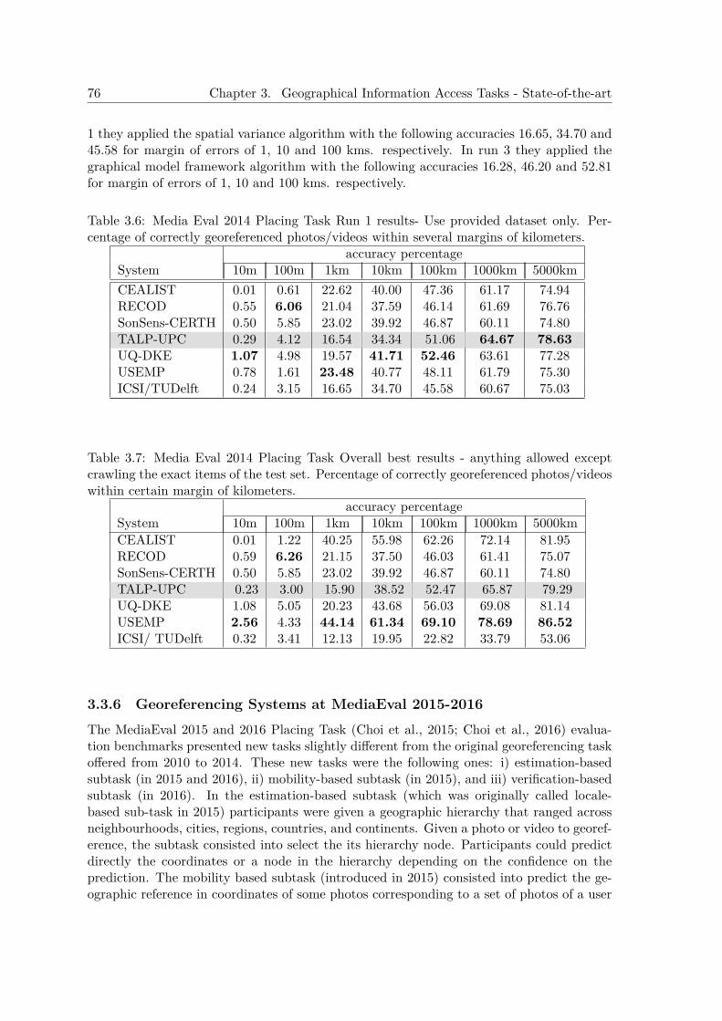
76 Chapter 3. Geographical Information Access Tasks - State-of-the-art
1 they applied the spatial variance algorithm with the following accuracies 16.65, 34.70 and45.58 for margin of errors of 1, 10 and 100 kms. respectively. In run 3 they applied thegraphical model framework algorithm with the following accuracies 16.28, 46.20 and 52.81for margin of errors of 1, 10 and 100 kms. respectively.
Table 3.6: Media Eval 2014 Placing Task Run 1 results- Use provided dataset only. Per-centage of correctly georeferenced photos/videos within several margins of kilometers.
accuracy percentageSystem 10m 100m 1km 10km 100km 1000km 5000kmCEALIST 0.01 0.61 22.62 40.00 47.36 61.17 74.94RECOD 0.55 6.06 21.04 37.59 46.14 61.69 76.76SonSens-CERTH 0.50 5.85 23.02 39.92 46.87 60.11 74.80TALP-UPC 0.29 4.12 16.54 34.34 51.06 64.67 78.63UQ-DKE 1.07 4.98 19.57 41.71 52.46 63.61 77.28USEMP 0.78 1.61 23.48 40.77 48.11 61.79 75.30ICSI/TUDelft 0.24 3.15 16.65 34.70 45.58 60.67 75.03
Table 3.7: Media Eval 2014 Placing Task Overall best results - anything allowed exceptcrawling the exact items of the test set. Percentage of correctly georeferenced photos/videoswithin certain margin of kilometers.
accuracy percentageSystem 10m 100m 1km 10km 100km 1000km 5000kmCEALIST 0.01 1.22 40.25 55.98 62.26 72.14 81.95RECOD 0.59 6.26 21.15 37.50 46.03 61.41 75.07SonSens-CERTH 0.50 5.85 23.02 39.92 46.87 60.11 74.80TALP-UPC 0.23 3.00 15.90 38.52 52.47 65.87 79.29UQ-DKE 1.08 5.05 20.23 43.68 56.03 69.08 81.14USEMP 2.56 4.33 44.14 61.34 69.10 78.69 86.52ICSI/ TUDelft 0.32 3.41 12.13 19.95 22.82 33.79 53.06
3.3.6 Georeferencing Systems at MediaEval 2015-2016The MediaEval 2015 and 2016 Placing Task (Choi et al., 2015; Choi et al., 2016) evalua-tion benchmarks presented new tasks slightly different from the original georeferencing taskoffered from 2010 to 2014. These new tasks were the following ones: i) estimation-basedsubtask (in 2015 and 2016), ii) mobility-based subtask (in 2015), and iii) verification-basedsubtask (in 2016). In the estimation-based subtask (which was originally called locale-based sub-task in 2015) participants were given a geographic hierarchy that ranged acrossneighbourhoods, cities, regions, countries, and continents. Given a photo or video to georef-erence, the subtask consisted into select the its hierarchy node. Participants could predictdirectly the coordinates or a node in the hierarchy depending on the confidence on theprediction. The mobility based subtask (introduced in 2015) consisted into predict the ge-ographic reference in coordinates of some photos corresponding to a set of photos of a user
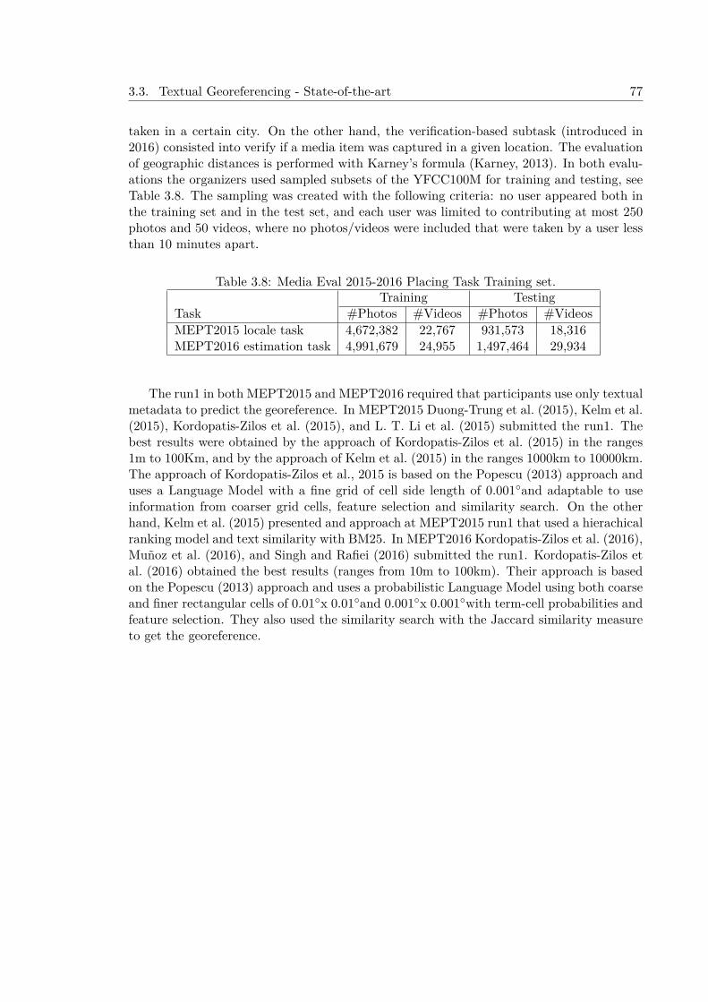
3.3. Textual Georeferencing - State-of-the-art 77
taken in a certain city. On the other hand, the verification-based subtask (introduced in2016) consisted into verify if a media item was captured in a given location. The evaluationof geographic distances is performed with Karney’s formula (Karney, 2013). In both evalu-ations the organizers used sampled subsets of the YFCC100M for training and testing, seeTable 3.8. The sampling was created with the following criteria: no user appeared both inthe training set and in the test set, and each user was limited to contributing at most 250photos and 50 videos, where no photos/videos were included that were taken by a user lessthan 10 minutes apart.
Table 3.8: Media Eval 2015-2016 Placing Task Training set.Training Testing
Task #Photos #Videos #Photos #VideosMEPT2015 locale task 4,672,382 22,767 931,573 18,316MEPT2016 estimation task 4,991,679 24,955 1,497,464 29,934
The run1 in both MEPT2015 and MEPT2016 required that participants use only textualmetadata to predict the georeference. In MEPT2015 Duong-Trung et al. (2015), Kelm et al.(2015), Kordopatis-Zilos et al. (2015), and L. T. Li et al. (2015) submitted the run1. Thebest results were obtained by the approach of Kordopatis-Zilos et al. (2015) in the ranges1m to 100Km, and by the approach of Kelm et al. (2015) in the ranges 1000km to 10000km.The approach of Kordopatis-Zilos et al., 2015 is based on the Popescu (2013) approach anduses a Language Model with a fine grid of cell side length of 0.001◦and adaptable to useinformation from coarser grid cells, feature selection and similarity search. On the otherhand, Kelm et al. (2015) presented and approach at MEPT2015 run1 that used a hierachicalranking model and text similarity with BM25. In MEPT2016 Kordopatis-Zilos et al. (2016),Muñoz et al. (2016), and Singh and Rafiei (2016) submitted the run1. Kordopatis-Zilos etal. (2016) obtained the best results (ranges from 10m to 100km). Their approach is basedon the Popescu (2013) approach and uses a probabilistic Language Model using both coarseand finer rectangular cells of 0.01◦x 0.01◦and 0.001◦x 0.001◦with term-cell probabilities andfeature selection. They also used the similarity search with the Jaccard similarity measureto get the georeference.

78 Chapter 3. Geographical Information Access Tasks - State-of-the-art
CHAPTER 4
Geographical Information Retrieval Approaches
This chapter describes three approaches to the Geographical Information Retrieval task inEnglish and its evaluation in the context of the 2005, 2006 and 2007 GeoCLEF evaluationsand posterior experiments with the full GeoCLEF test collections (from 2005 to 2008)in English (see Table 4.1 for some details and differences of these approaches). Theseapproaches use Geographical Knowledge and some NLP techniques in order to improvetheir baseline results. The approaches are the following:
1. GeoTALP-IR (2005). The first approach, GeoTALP-IR (Ferrés et al., 2005a), uses amodified version of a Passage Retrieval module designed for Question Answering. Thissystem uses a Keyword Selection algorithm based on a Linguistic and GeographicalAnalysis of the topics and a Geographical Thesaurus (GT) that has been build usinga set of Geographical Gazetteers and a Geographical Ontology.
2. TALPGeoIR (2006). The second approach, TALPGeoIR 2006 (Ferrés and Rodríguez,2007a) was a modified version of the GeoTALP-IR system presented at GeoCLEF 2005(Ferrés et al., 2005a) with some changes in the retrieval modes and the GeographicalKnowledge Base (KB). The TALPGeoIR 2006 used JIRS, a Passage Retrieval algo-rithm, to perform the IR phase. This approach also introduced the use of AlexandriaDigital Library (ADL) Feature Type Thesaurus for GIR.
3. TALPGeoIR (2007-2015). The third approach, TALPGeoIR 2007 (Ferrés and Ro-dríguez, 2007b; Ferrés and Rodríguez, 2008a; Ferrés and Rodríguez, 2015a), is an evo-lution of the TALPGeoIR 2006 that uses the Terrier IR system and a custom buildgeographical index. Partial and conservative toponym disambiguation is applied incombination with automatic Query Expansion with Relevance Feedback.
79
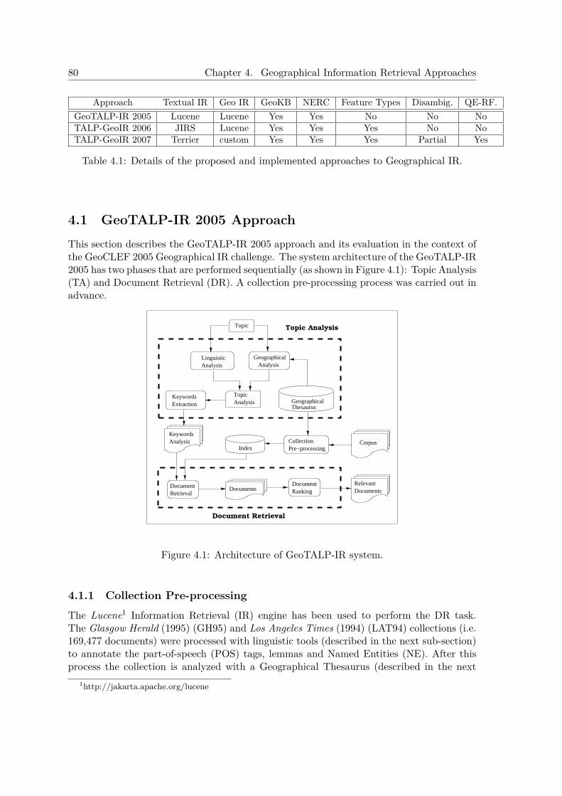
80 Chapter 4. Geographical Information Retrieval Approaches
Approach Textual IR Geo IR GeoKB NERC Feature Types Disambig. QE-RF.GeoTALP-IR 2005 Lucene Lucene Yes Yes No No NoTALP-GeoIR 2006 JIRS Lucene Yes Yes Yes No NoTALP-GeoIR 2007 Terrier custom Yes Yes Yes Partial Yes
Table 4.1: Details of the proposed and implemented approaches to Geographical IR.
4.1 GeoTALP-IR 2005 ApproachThis section describes the GeoTALP-IR 2005 approach and its evaluation in the context ofthe GeoCLEF 2005 Geographical IR challenge. The system architecture of the GeoTALP-IR2005 has two phases that are performed sequentially (as shown in Figure 4.1): Topic Analysis(TA) and Document Retrieval (DR). A collection pre-processing process was carried out inadvance.
Documents
Index
TopicAnalysis
RelevantDocuments
Corpus
Topic
Document Retrieval
ThesaurusGeographical
AnalysisKeywords
DocumentRetrieval
CollectionPre−processing
KeywordsExtraction
Geographical Analysis
LinguisticAnalysis
DocumentRanking
Topic Analysis
Figure 4.1: Architecture of GeoTALP-IR system.
4.1.1 Collection Pre-processingThe Lucene1 Information Retrieval (IR) engine has been used to perform the DR task.The Glasgow Herald (1995) (GH95) and Los Angeles Times (1994) (LAT94) collections (i.e.169,477 documents) were processed with linguistic tools (described in the next sub-section)to annotate the part-of-speech (POS) tags, lemmas and Named Entities (NE). After thisprocess the collection is analyzed with a Geographical Thesaurus (described in the next
1http://jakarta.apache.org/lucene

4.1. GeoTALP-IR 2005 Approach 81
sub-section). This information was used to build an index (see an example in Table 4.2)that contains the following fields for each document:
• Form Field: this field stores the original text (word forms) with the Named Entitiesrecognized.
• Lemma Field: this part is built using the lemmas of the words, the POS tags, andthe results of the Named Entity Recognition and Classification (NERC) module andthe Geographical Thesaurus.
• Geo Field: it contains all NEs classified as location or organization that appear in theGeographical Thesaurus. This part has the geographical information about these NE:including geographical coordinates and geographical relations with the correspondingplaces of its path to the top of the geographical ontology (i.e. a city like “Barcelona”contains its state, country, sub-continent and continent). If a NE is an ambiguouslocation, all the possible ambiguous places are stored in this field.
Field Indexed ContentForm Watson flew off with his wife for a weekend in Barcelona, returned to
London on Monday,Lemma Watson#NNP#PERSON fly#VBD off#RP with#IN his#PRP$ wife#NN
for#IN a#DT weekend#NN in#IN Barcelona#NNP#LOCATION#city,#, return#VBD to#TO London#NNP#LOCATION#capital on#INmonday#NNP ,#,
Geo Europe#Europe#Spain#Cataluña#Barcelona#41.383_2.183Europe#Europe#United_Kingdom#England#London#51.517_-0.105
Table 4.2: Example of an indexed document.
4.1.2 Topic AnalysisThe goal of this phase is to extract all the relevant keywords from the topics enrichingthem as a result of the analysis. These keywords are then used by the Document Retrievalphase. The Topic Analysis phase has three main components: a Linguistic Analysis, aGeographical Analysis and a Keyword Selection algorithm.
4.1.2.1 Linguistic Analysis
This process extracts lexico-semantic and syntactic information using the following set ofNLP tools:
• Morphological components, a statistical POS tagger (TnT) (Brants, 2000) and theWordNet 2.0 (Fellbaum, 1998) lemmatizer are used to obtain POS tags and lemmas.The TnT POS tagger used a pre-defined model trained on the Wall Street Journalcorpus.
• Spear, a modified version of Collins parser that performs full parsing and robustdetection of verbal predicate arguments (Collins, 1999). It is limited to three predi-cate arguments: agent, direct object (or theme), and indirect object (benefactive orinstrument).
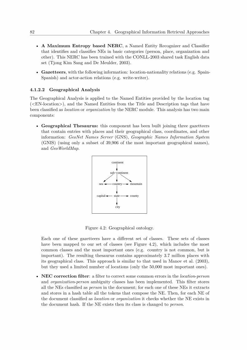
82 Chapter 4. Geographical Information Retrieval Approaches
• A Maximum Entropy based NERC, a Named Entity Recognizer and Classifierthat identifies and classifies NEs in basic categories (person, place, organization andother). This NERC has been trained with the CONLL-2003 shared task English dataset (Tjong Kim Sang and De Meulder, 2003).
• Gazetteers, with the following information: location-nationality relations (e.g. Spain-Spanish) and actor-action relations (e.g. write-writer).
4.1.2.2 Geographical Analysis
The Geographical Analysis is applied to the Named Entities provided by the location tag(<EN-location>), and the Named Entities from the Title and Description tags that havebeen classified as location or organization by the NERC module. This analysis has two maincomponents:
• Geographical Thesaurus: this component has been built joining three gazetteersthat contain entries with places and their geographical class, coordinates, and otherinformation: GeoNet Names Server (GNS), Geographic Names Information System(GNIS) (using only a subset of 39,906 of the most important geographical names),and GeoWorldMap.
state
sub−continent
continent
country
city
sea mountain
capital county
Figure 4.2: Geographical ontology.
Each one of these gazetteers have a different set of classes. These sets of classeshave been mapped to our set of classes (see Figure 4.2), which includes the mostcommon classes and the most important ones (e.g. country is not common, but isimportant). The resulting thesaurus contains approximately 3.7 million places withits geographical class. This approach is similar to that used in Manov et al. (2003),but they used a limited number of locations (only the 50,000 most important ones).
• NEC correction filter: a filter to correct some common errors in the location-personand organization-person ambiguity classes has been implemented. This filter storesall the NEs classified as person in the document; for each one of these NEs it extractsand stores in a hash table all the tokens that compose the NE. Then, for each NE ofthe document classified as location or organization it checks whether the NE exists inthe document hash. If the NE exists then its class is changed to person.
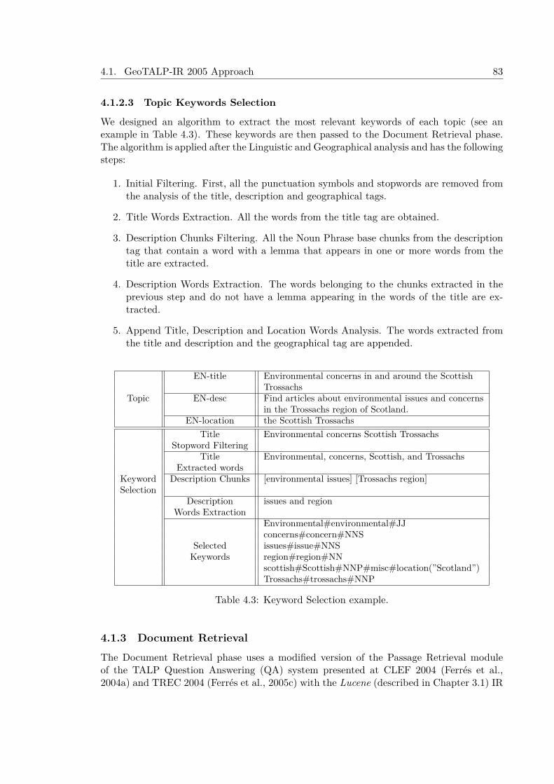
4.1. GeoTALP-IR 2005 Approach 83
4.1.2.3 Topic Keywords Selection
We designed an algorithm to extract the most relevant keywords of each topic (see anexample in Table 4.3). These keywords are then passed to the Document Retrieval phase.The algorithm is applied after the Linguistic and Geographical analysis and has the followingsteps:
1. Initial Filtering. First, all the punctuation symbols and stopwords are removed fromthe analysis of the title, description and geographical tags.
2. Title Words Extraction. All the words from the title tag are obtained.
3. Description Chunks Filtering. All the Noun Phrase base chunks from the descriptiontag that contain a word with a lemma that appears in one or more words from thetitle are extracted.
4. Description Words Extraction. The words belonging to the chunks extracted in theprevious step and do not have a lemma appearing in the words of the title are ex-tracted.
5. Append Title, Description and Location Words Analysis. The words extracted fromthe title and description and the geographical tag are appended.
EN-title Environmental concerns in and around the ScottishTrossachs
Topic EN-desc Find articles about environmental issues and concernsin the Trossachs region of Scotland.
EN-location the Scottish TrossachsTitle Environmental concerns Scottish Trossachs
Stopword FilteringTitle Environmental, concerns, Scottish, and Trossachs
Extracted wordsKeyword Description Chunks [environmental issues] [Trossachs region]Selection
Description issues and regionWords Extraction
Environmental#environmental#JJconcerns#concern#NNS
Selected issues#issue#NNSKeywords region#region#NN
scottish#Scottish#NNP#misc#location(”Scotland”)Trossachs#trossachs#NNP
Table 4.3: Keyword Selection example.
4.1.3 Document RetrievalThe Document Retrieval phase uses a modified version of the Passage Retrieval moduleof the TALP Question Answering (QA) system presented at CLEF 2004 (Ferrés et al.,2004a) and TREC 2004 (Ferrés et al., 2005c) with the Lucene (described in Chapter 3.1) IR
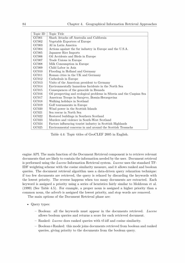
84 Chapter 4. Geographical Information Retrieval Approaches
Topic ID Topic TitleGC001 Shark Attacks off Australia and CaliforniaGC002 Vegetable Exporters of EuropeGC003 AI in Latin AmericaGC004 Actions against the fur industry in Europe and the U.S.A.GC005 Japanese Rice ImportsGC006 Oil Accidents and Birds in EuropeGC007 Trade Unions in EuropeGC008 Milk Consumption in EuropeGC009 Child Labor in AsiaGC010 Flooding in Holland and GermanyGC011 Roman cities in the UK and GermanyGC012 Cathedrals in EuropeGC013 Visits of the American president to GermanyGC014 Environmentally hazardous Incidents in the North SeaGC015 Consequences of the genocide in RwandaGC016 Oil prospecting and ecological problems in Siberia and the Caspian SeaGC017 American Troops in Sarajevo, Bosnia-HerzegovinaGC018 Walking holidays in ScotlandGC019 Golf tournaments in EuropeGC020 Wind power in the Scottish IslandsGC021 Sea rescue in North SeaGC022 Restored buildings in Southern ScotlandGC023 Murders and violence in South-West ScotlandGC024 Factors influencing tourist industry in Scottish HighlandsGC025 Environmental concerns in and around the Scottish Trossachs
Table 4.4: Topic titles of GeoCLEF 2005 in English.
engine API. The main function of the Document Retrieval component is to retrieve relevantdocuments that are likely to contain the information needed by the user. Document retrievalis performed using the Lucene Information Retrieval system. Lucene uses the standard TF-IDF weighting scheme with the cosine similarity measure, and it allows ranked and booleanqueries. The document retrieval algorithm uses a data-driven query relaxation technique:if too few documents are retrieved, the query is relaxed by discarding the keywords withthe lowest priority. The reverse happens when too many documents are extracted. Eachkeyword is assigned a priority using a series of heuristics fairly similar to Moldovan et al.(1999) (See Table 4.5). For example, a proper noun is assigned a higher priority than acommon noun, the adverb is assigned the lowest priority, and stop words are removed.
The main options of the Document Retrieval phase are:
• Query types:
– Boolean: all the keywords must appear in the documents retrieved. Luceneallows boolean queries and returns a score for each retrieved document.
– Ranked: Lucene does ranked queries with tf-idf and cosine similarity.– Boolean+Ranked: this mode joins documents retrieved from boolean and ranked
queries, giving priority to the documents from the boolean query.
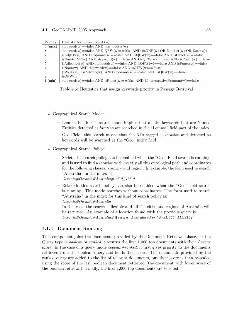
4.1. GeoTALP-IR 2005 Approach 85
Priority Heuristic for current word (w)9 (max) stopword(w)==false AND has_quotes(w)8 stopword(w)==false AND QFW(w)==false AND (isNNP(w) OR Number(w) OR Date(w))7 isAdjNP(w) AND stopword(w)==false AND isQFW(w)==false AND isPunct(w)==false6 isNonAdjNP(w) AND stopword(w)==false AND isQFW(w)==false AND isPunct(w)==false5 isAdjective(w) AND stopword(w)==false AND isQFW(w)==false AND isPunct(w)==false4 isNoun(w) AND stopword(w)==false AND isQFW(w)==false3 (isVerb(w) || isAdverb(w)) AND stopword(w)==false AND isQFW(w)==false2 isQFW(w)1 (min) stopword(w)==false AND isPunct(w)==false AND isInterrogativePronoun(w)==false
Table 4.5: Heuristics that assign keywords priority in Passage Retrieval
• Geographical Search Mode:
– Lemma Field: this search mode implies that all the keywords that are NamedEntities detected as location are searched in the “Lemma” field part of the index.
– Geo Field: this search means that the NEs tagged as location and detected askeywords will be searched at the “Geo” index field.
• Geographical Search Policy:
– Strict: this search policy can be enabled when the “Geo” Field search is running,and is used to find a location with exactly all this ontological path and coordinatesfor the following classes: country and region. In example, the form used to search“Australia” in the index is:Oceania#Oceania#Australia#-25.0_135.0
– Relaxed: this search policy can also be enabled when the “Geo” field searchis running. This mode searches without coordinates. The form used to search“Australia” in the index for this kind of search policy is:Oceania#Oceania#AustraliaIn this case, the search is flexible and all the cities and regions of Australia willbe returned. An example of a location found with the previous query is:Oceania#Oceania#Australia#Western_Australia#Perth#-31.966_115.8167
4.1.4 Document RankingThis component joins the documents provided by the Document Retrieval phase. If theQuery type is boolean or ranked it returns the first 1,000 top documents with their Lucenescore. In the case of a query mode boolean+ranked, it first gives priority to the documentsretrieved from the boolean query and holds their score. The documents provided by theranked query are added to the list of relevant documents, but their score is then re-scaledusing the score of the last boolean document retrieved (the document with lower score ofthe boolean retrieval). Finally, the first 1,000 top documents are selected.

86 Chapter 4. Geographical Information Retrieval Approaches
4.1.5 Experiments and Results at GeoCLEF 2005The GeoCLEF was a cross-language geographic retrieval task at the CLEF 2005 campaign.The goal of the task was to find as many relevant documents as possible from the documentcollections, using a topic set of 25 topics (see in Chapter 3.1 an example of a GeoCLEF2005 topic). Topics are textual descriptions with the following fields: title, description,narrative, location (e.g. geographical places like continents, regions, countries, cities, etc.)and a geographical operator (e.g. spatial relations like in, near, north of, etc.). Table 4.4presents the titles of the 25 topics of the GeoCLEF 2005.
A set of four experiments that consist in applying different query strategies and tagsto an automatic GIR system (see Table 4.6) were designed to participate in the GeoCLEF2005 GIR benchmark. Two baseline experiments were performed: the runs geotalpIR1 andgeotalpIR2. These runs differed uniquely in the Query type used: a boolean+ranked re-trieval in geotalpIR1 run and only ranked retrieval in geotalpIR2 run. These runs considerthe Title and Description (TD) tags, and they use the “lemma” index field. The thirdrun (geotalpIR3) differs from the previous ones in the use of the Location tag (consideringTitle, Description and Location (TDL)) and uses the “Geo” field instead of the “lemma”field. The “Geo” field is used with a Strict Query search policy. This run also performs aboolean+ranked retrieval. The fourth run (geotalpIR4) is very similar to the third run (geo-talpIR3), but uses a Relaxed Query search policy. On the other hand, the “spatialrelation”tag included in the topics (e.g. “south”, “in”, “near”,...) is not used because the systemtreats all queries as “in” queries.
Table 4.6: Description of the Experiments at GeoCLEF 2005.Run Run type Tags Query Type Geo. Index Geo. Search
geotalpIR1 automatic TD Boolean+Ranked Lemma -geotalpIR2 automatic TD Ranked Lemma -geotalpIR3 automatic TDL Boolean+Ranked Geo StrictgeotalpIR4 automatic TDL Boolean+Ranked Geo Relaxed
The results of the GeoTalpIR system at the GeoCLEF 2005 Monolingual English taskare summarized in Table 4.7 and Figure 4.3. This table shows the following IR measures foreach run: Average Precision, R-Precision, Recall, and the increment over the median of theaverage precision (0.2063) obtained by all the systems that participated in the GeoCLEF2005 Monolingual English task.
Table 4.7: GeoCLEF 2005 results.
Run Tags MAP R-Prec. Recall (%) Recall ∆ MAP Diff.(%)over GeoCLEF avg. MAP
geotalpIR1 TD 0.1923 0.2249 49.51% 509/1028 -6.78%geotalpIR2 TD 0.1933 0.2129 49.22% 506/1028 -6.30%geotalpIR3 TDL 0.2140 0.2377 62.35% 641/1028 +3.73%geotalpIR4 TDL 0.2231 0.2508 66.83% 687/1028 +8.14%
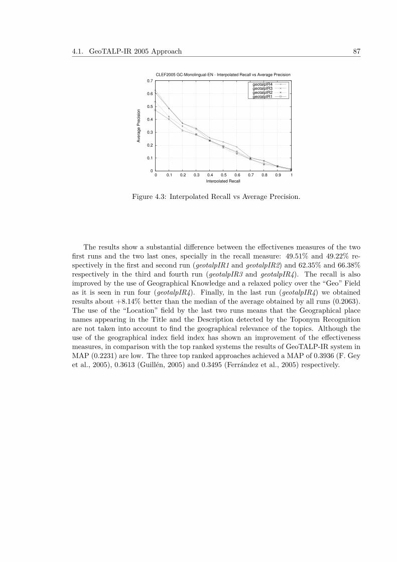
4.1. GeoTALP-IR 2005 Approach 87
0
0.1
0.2
0.3
0.4
0.5
0.6
0.7
0 0.1 0.2 0.3 0.4 0.5 0.6 0.7 0.8 0.9 1
Ave
rag
e P
recis
ion
Interpolated Recall
CLEF2005 GC-Monolingual-EN - Interpolated Recall vs Average Precision
geotalpIR4geotalpIR3geotalpIR2geotalpIR1
Figure 4.3: Interpolated Recall vs Average Precision.
The results show a substantial difference between the effectivenes measures of the twofirst runs and the two last ones, specially in the recall measure: 49.51% and 49.22% re-spectively in the first and second run (geotalpIR1 and geotalpIR2) and 62.35% and 66.38%respectively in the third and fourth run (geotalpIR3 and geotalpIR4). The recall is alsoimproved by the use of Geographical Knowledge and a relaxed policy over the “Geo” Fieldas it is seen in run four (geotalpIR4). Finally, in the last run (geotalpIR4) we obtainedresults about +8.14% better than the median of the average obtained by all runs (0.2063).The use of the “Location” field by the last two runs means that the Geographical placenames appearing in the Title and the Description detected by the Toponym Recognitionare not taken into account to find the geographical relevance of the topics. Although theuse of the geographical index field index has shown an improvement of the effectivenessmeasures, in comparison with the top ranked systems the results of GeoTALP-IR system inMAP (0.2231) are low. The three top ranked approaches achieved a MAP of 0.3936 (F. Geyet al., 2005), 0.3613 (Guillén, 2005) and 0.3495 (Ferrández et al., 2005) respectively.
88 Chapter 4. Geographical Information Retrieval Approaches
4.2 TALPGeoIR 2006 ApproachThis section describes the TALPGeoIR 2006 approach and the experiments and results ofthe system in the context of our participation in the CLEF 2006 GeoCLEF MonolingualEnglish task. The TALPGeoIR system is a modified version of the GeoTALP-IR systempresented at GeoCLEF 2005 (Ferrés et al., 2005a) with some changes in the retrieval modesand the Geographical Knowledge Base (KB) and the inclusion of a feature type thesaurus.The experiments with the GeoTALP-IR in the context of the GeoCLEF 2005 showed thatthe Geographical Knowledge improved the effectiveness measures but our results were lowwith respect to the top ranked approaches.
For this reason the following changes were done: 1) the textual IR retrieval system hasbeen changed from Lucene to JIRS in order to test JIRS, a Passage Retrieval QA-orientedsystem, in a GIR challenge, 2) the Geographical Knowledge Base has been improved withthe inclusion of the World-Gazetteer and the extension and mapping of the allowed featuretypes to the ones used in the Alexandria Digital Libray Feature Type Thesaurus.
The TALPGeoIR 2006 has four phases performed sequentially: 1) a Keywords Selectionalgorithm based on a linguistic and geographical analysis of the topics, 2) a geographicaldocument retrieval with Lucene, 3) a textual document retrieval with the JIRS PassageRetrieval (PR) software, and 4) a Document Ranking phase.
4.2.1 Collection ProcessingThe Glasgow Herald 1995 (GH95) and Los Angeles Times 1994 (LAT94) collections (i.e.169,477 documents) were processed with linguistic tools (described in the next sub-section)to annotate the part-of-speech (POS) tags, lemmas and Named Entities (NE). After thisprocess the collection is analyzed with a Geographical Thesaurus (described in the nextsub-section). This information was used to build two indexes: one with the geographicalinformation of the documents and another one with the textual and geographical informa-tion of the documents. Two Information Retrieval (IR) systems were used to create theseindexes: Lucene for the geographical index and JIRS for the textual and geographical index(see a sample of both indexes in Table 4.8). These indexes are described below:
• Geographical Index: this index contains the geographical information of the docu-ments and its Named Entities. The Geographical index contains the following fieldsfor each document:
– docid: this field stores the document identifier.– ftt: this field indexes the feature type of each geographical name and the Named
Entity classes of all the NEs appearing in the document.– geo: this field indexes the geographical names and the Named Entities of the
document. It also stores the geographical information (hierarchical ancestors’path, and coordinates) about the place names. Even if the place is ambiguousall the possible referents are indexed.
• Textual and Geographical Index: this index stores the lemmatized content ofthe document and the geographical information (feature type, hierarchical ancestors’path, and coordinates) about the geographic place names appearing in the text. If
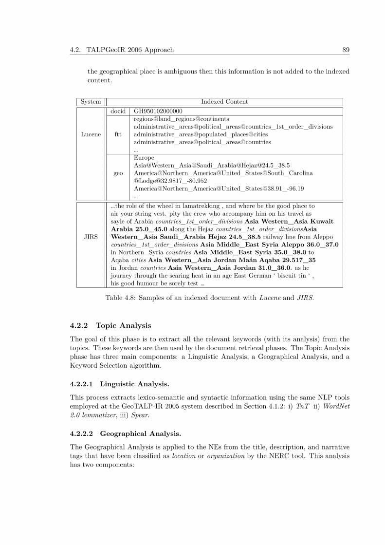
4.2. TALPGeoIR 2006 Approach 89
the geographical place is ambiguous then this information is not added to the indexedcontent.
System Indexed Contentdocid GH950102000000
regions@land_regions@continentsadministrative_areas@political_areas@countries_1st_order_divisions
Lucene ftt administrative_areas@populated_places@citiesadministrative_areas@political_areas@countries…EuropeAsia@Western_Asia@Saudi_Arabia@[email protected]_38.5
geo America@Northern_America@United_States@South_Carolina@[email protected]_-80.952America@Northern_America@[email protected]_-96.19…
…the role of the wheel in lamatrekking , and where be the good place toair your string vest. pity the crew who accompany him on his travel assayle of Arabia countries_1st_order_divisions Asia Western_Asia KuwaitArabia 25.0_45.0 along the Hejaz countries_1st_order_divisionsAsia
JIRS Western_Asia Saudi_Arabia Hejaz 24.5_38.5 railway line from Aleppocountries_1st_order_divisions Asia Middle_East Syria Aleppo 36.0_37.0in Northern_Syria countries Asia Middle_East Syria 35.0_38.0 toAqaba cities Asia Western_Asia Jordan Maán Aqaba 29.517_35in Jordan countries Asia Western_Asia Jordan 31.0_36.0. as hejourney through the searing heat in an age East German ‘ biscuit tin ‘ ,his good humour be sorely test …
Table 4.8: Samples of an indexed document with Lucene and JIRS.
4.2.2 Topic AnalysisThe goal of this phase is to extract all the relevant keywords (with its analysis) from thetopics. These keywords are then used by the document retrieval phases. The Topic Analysisphase has three main components: a Linguistic Analysis, a Geographical Analysis, and aKeyword Selection algorithm.
4.2.2.1 Linguistic Analysis.
This process extracts lexico-semantic and syntactic information using the same NLP toolsemployed at the GeoTALP-IR 2005 system described in Section 4.1.2: i) TnT ii) WordNet2.0 lemmatizer, iii) Spear.
4.2.2.2 Geographical Analysis.
The Geographical Analysis is applied to the NEs from the title, description, and narrativetags that have been classified as location or organization by the NERC tool. This analysishas two components:

90 Chapter 4. Geographical Information Retrieval Approaches
• Geographical Knowledge Base: this component has been built joining four geo-graphical gazetteers: GEOnet Names Server (GNS), Geographic Names InformationSystem (GNIS) (using only a subset of 39,906 entries with the most important places),GeoWorldMap Gazetteer, and the World Gazetteer (adding only the 29,924 cities withmore than 5,000 inhabitants).
• Geographical Feature Type Thesaurus: the feature type thesaurus of our Geo-graphical KB is the ADL Feature Type Thesaurus (ADLFTT). The ADL Feature TypeThesaurus is a hierarchical set of geographical terms used to type named geographicplaces in English (Hill, 2000). Both GNIS and GNS gazetteers have been mapped tothe ADLFTT, with a resulting set of 575 geographical types. Our GNIS mapping issimilar to the one exposed in Hill (2000).
4.2.2.3 Topic Keywords Selection.
This algorithm extracts the most relevant keywords of each topic. The algorithm wasdesigned for GeoCLEF 2005 (Ferrés et al., 2005a). Once the keywords are extracted, threedifferent Keyword Sets (KS) are created (see an example in Table 4.9):
• All: all the keywords extracted from the topic tags.
• Geo: geographical places or feature types appearing in the topic tags.
• NotGeo: all the keywords extracted from the topic tags that are not geographicalplace names or geographical types.
EN-title Wine regions around rivers in EuropeTopic EN-desc Documents about wine regions along the banks of European
rivers.EN-narr Relevant documents describe a wine region along a major river
in European countries. To be relevant the document mustname the region and the river.
Not Geo wine EuropeanKeywords Geo Europe#location#regions@land_regions@continents#EuropeSet (KS) regions
hydrographic_features@streams@riversAll wine regions rivers European Europe
Table 4.9: Keyword sets sample of Topic 026.
4.2.3 Geographical Document Retrieval with LuceneLucene is used to retrieve geographically relevant documents given a specific GeographicalIR query. Lucene uses the standard TF-IDF weighting scheme with the cosine similaritymeasure and allows ranked and boolean queries. We used boolean queries with a Re-laxed geographical search policy (as explained in the previous section (Ferrés et al., 2005a)).This search policy allows to retrieve all the documents that have a token that matchestotally or partially (a sub-path) the geographical keyword. As an example, the keywordAmerica@Northern_America@United_States will retrieve all the U.S. places (e.g. Amer-ica@Northern_America@United_States@Ohio).

4.2. TALPGeoIR 2006 Approach 91
4.2.4 Document Retrieval using the JIRS Passage RetrieverThe JIRS Passage Retrieval System (Soriano et al., 2005) is used to retrieve relevant doc-uments related to a GIR query. JIRS is a Passage Retriever specially designed for QA.This system gets passages with a high similarity between the largests n-grams of the ques-tion and the ones in the passage. JIRS has the following steps executed sequentially: 1) aPassage Retrieval phase that gets a set of relevant passages using a set of keywords fromthe question, and 2) a search for all the n-grams of the question in the retrieved passageand weighting of them using the number and the weight of the n-grams appearing in thepassages Soriano et al., 2005. In the specific context of our GIR system, JIRS is used con-sidering a topic keyword set as a question. Then, a set of relevant passages are retrievedusing the n-gram distance model of JIRS with a length of 11 sentences per passage. Thefirst 100,000 top-scored passages per topic are obtained. Finally, a process selects the rel-evant documents from the set of retrieved passages. Two document scoring strategies wereused:
• Best: the document score is the score of the top-scored passage in the set of theretrieved passages that belong to this document.
• Accumulative: the document score is the sum of the scores of all the retrievedpassages that belong to this document.
4.2.5 Document RankingThis component ranks the documents retrieved by Lucene and JIRS. First, the top-scoreddocuments retrieved by JIRS that appear in the document set retrieved by Lucene areselected. Then, if the set of selected documents is less than 1,000, the top-scored documentsof JIRS that don’t appear in the document set of Lucene are selected with a lower prioritythan the previous ones. Finally, the first 1,000 top-scored documents are selected. On theother hand, when the system uses only JIRS for retrieval, only the first 1,000 top-scoreddocuments by JIRS are selected.
4.2.6 Experiments and Results at GeoCLEF 2006GeoCLEF 2006 was a cross-language geographic retrieval task at the CLEF 2006 campaign.Like the first GIR task in GeoCLEF 2005 (F. Gey et al., 2005), the goal of the GeoCLEFtask was to find as many relevant documents as possible from the document collections,using a topic set of 25 topics. Topics are textual descriptions with the following fields: title,description, narrative. In GeoCLEF 2006 the fields “location”, “concept” and “spatialrela-tion” (that were available in GeoCLEF 2005) are not included in the topics. See in Figure4.4 an example of one topic of the GeoCLEF 2006 test collection and the complete list oftopic titles in Table 4.10.
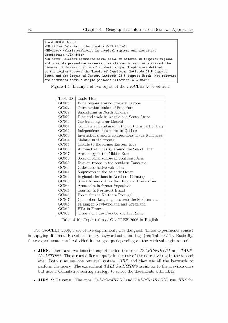
92 Chapter 4. Geographical Information Retrieval Approaches
<num> GC034 </num><EN-title> Malaria in the tropics </EN-title><EN-desc> Malaria outbreaks in tropical regions and preventivevaccination </EN-desc><EN-narr> Relevant documents state cases of malaria in tropical regionsand possible preventive measures like chances to vaccinate against thedisease. Outbreaks must be of epidemic scope. Tropics are definedas the region between the Tropic of Capricorn, latitude 23.5 degreesSouth and the Tropic of Cancer, latitude 23.5 degrees North. Not relevantare documents about a single person's infection.</EN-narr>
Figure 4.4: Example of two topics of the GeoCLEF 2006 edition.
Topic ID Topic TitleGC026 Wine regions around rivers in EuropeGC027 Cities within 100km of FrankfurtGC028 Snowstorms in North AmericaGC029 Diamond trade in Angola and South AfricaGC030 Car bombings near MadridGC031 Combats and embargo in the northern part of IraqGC032 Independence movement in QuebecGC033 International sports competitions in the Ruhr areaGC034 Malaria in the tropicsGC035 Credits to the former Eastern BlocGC036 Automotive industry around the Sea of JapanGC037 Archeology in the Middle EastGC038 Solar or lunar eclipse in Southeast AsiaGC039 Russian troops in the southern CaucasusGC040 Cities near active volcanoesGC041 Shipwrecks in the Atlantic OceanGC042 Regional elections in Northern GermanyGC043 Scientific research in New England UniversitiesGC044 Arms sales in former YugoslaviaGC045 Tourism in Northeast BrazilGC046 Forest fires in Northern PortugalGC047 Champions League games near the MediterraneanGC048 Fishing in Newfoundland and GreenlandGC049 ETA in FranceGC050 Cities along the Danube and the RhineTable 4.10: Topic titles of GeoCLEF 2006 in English.
For GeoCLEF 2006, a set of five experiments was designed. These experiments consistin applying different IR systems, query keyword sets, and tags (see Table 4.11). Basically,these experiments can be divided in two groups depending on the retrieval engines used:
• JIRS. There are two baseline experiments: the runs TALPGeoIRTD1 and TALP-GeoIRTDN1. These runs differ uniquely in the use of the narrative tag in the secondone. Both runs use one retrieval system, JIRS, and they use all the keywords toperform the query. The experiment TALPGeoIRTDN3 is similar to the previous onesbut uses a Cumulative scoring strategy to select the documents with JIRS.
• JIRS & Lucene. The runs TALPGeoIRTD2 and TALPGeoIRTDN2 use JIRS for
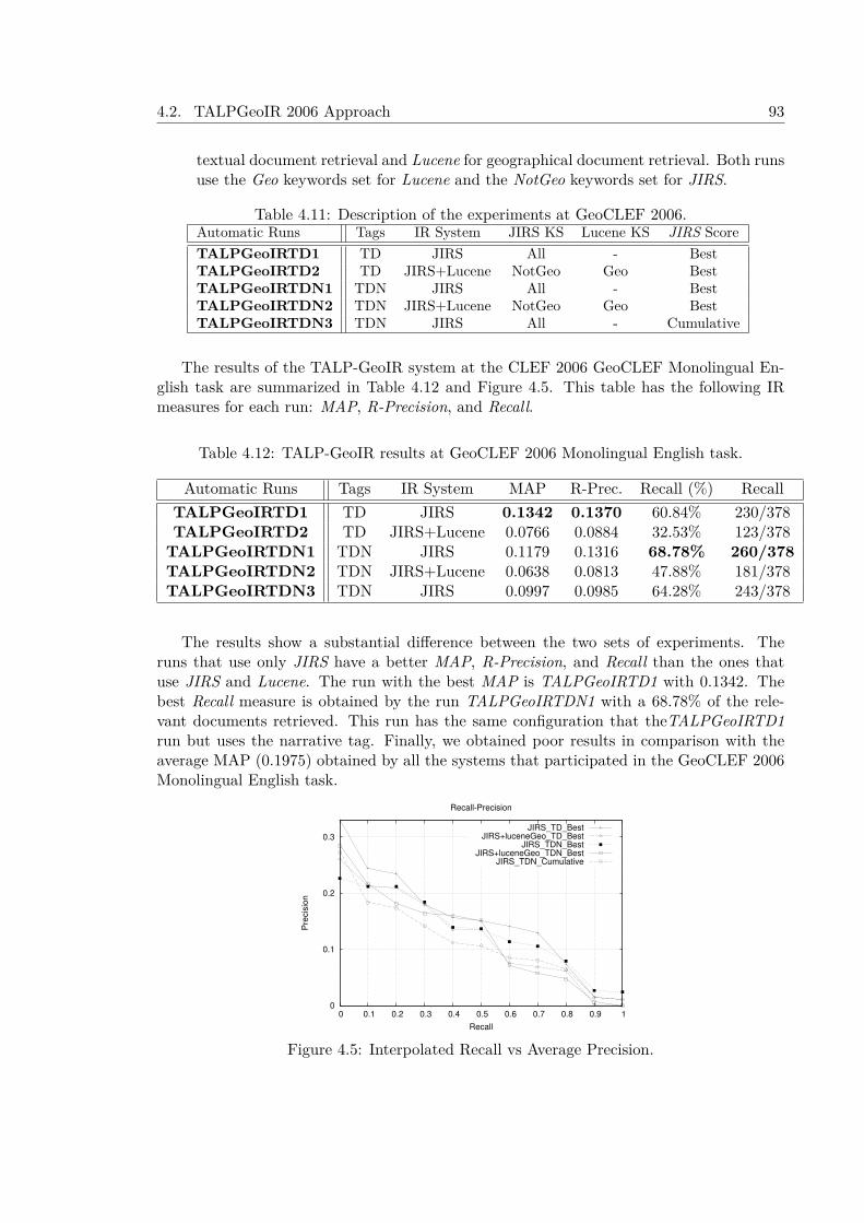
4.2. TALPGeoIR 2006 Approach 93
textual document retrieval and Lucene for geographical document retrieval. Both runsuse the Geo keywords set for Lucene and the NotGeo keywords set for JIRS.
Table 4.11: Description of the experiments at GeoCLEF 2006.Automatic Runs Tags IR System JIRS KS Lucene KS JIRS ScoreTALPGeoIRTD1 TD JIRS All - BestTALPGeoIRTD2 TD JIRS+Lucene NotGeo Geo BestTALPGeoIRTDN1 TDN JIRS All - BestTALPGeoIRTDN2 TDN JIRS+Lucene NotGeo Geo BestTALPGeoIRTDN3 TDN JIRS All - Cumulative
The results of the TALP-GeoIR system at the CLEF 2006 GeoCLEF Monolingual En-glish task are summarized in Table 4.12 and Figure 4.5. This table has the following IRmeasures for each run: MAP, R-Precision, and Recall.
Table 4.12: TALP-GeoIR results at GeoCLEF 2006 Monolingual English task.
Automatic Runs Tags IR System MAP R-Prec. Recall (%) RecallTALPGeoIRTD1 TD JIRS 0.1342 0.1370 60.84% 230/378TALPGeoIRTD2 TD JIRS+Lucene 0.0766 0.0884 32.53% 123/378
TALPGeoIRTDN1 TDN JIRS 0.1179 0.1316 68.78% 260/378TALPGeoIRTDN2 TDN JIRS+Lucene 0.0638 0.0813 47.88% 181/378TALPGeoIRTDN3 TDN JIRS 0.0997 0.0985 64.28% 243/378
The results show a substantial difference between the two sets of experiments. Theruns that use only JIRS have a better MAP, R-Precision, and Recall than the ones thatuse JIRS and Lucene. The run with the best MAP is TALPGeoIRTD1 with 0.1342. Thebest Recall measure is obtained by the run TALPGeoIRTDN1 with a 68.78% of the rele-vant documents retrieved. This run has the same configuration that theTALPGeoIRTD1run but uses the narrative tag. Finally, we obtained poor results in comparison with theaverage MAP (0.1975) obtained by all the systems that participated in the GeoCLEF 2006Monolingual English task.
0
0.1
0.2
0.3
0 0.1 0.2 0.3 0.4 0.5 0.6 0.7 0.8 0.9 1
Pre
cis
ion
Recall
Recall-Precision
JIRS_TD_BestJIRS+luceneGeo_TD_Best
JIRS_TDN_BestJIRS+luceneGeo_TDN_Best
JIRS_TDN_Cumulative
Figure 4.5: Interpolated Recall vs Average Precision.
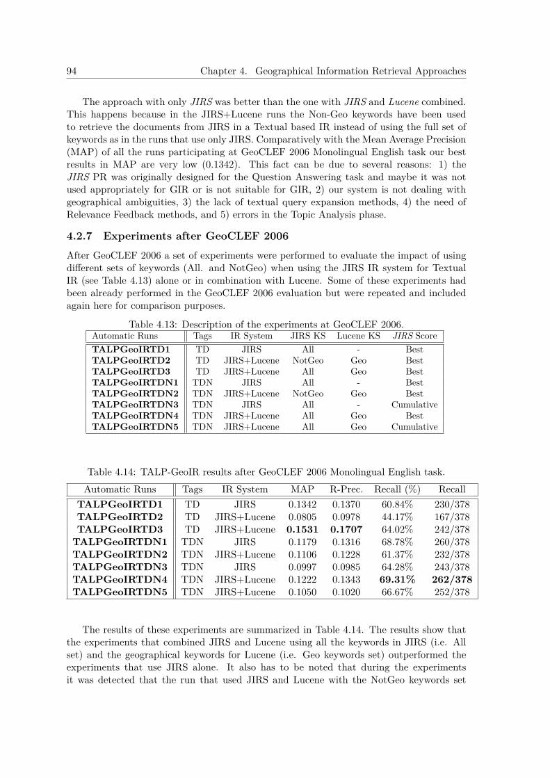
94 Chapter 4. Geographical Information Retrieval Approaches
The approach with only JIRS was better than the one with JIRS and Lucene combined.This happens because in the JIRS+Lucene runs the Non-Geo keywords have been usedto retrieve the documents from JIRS in a Textual based IR instead of using the full set ofkeywords as in the runs that use only JIRS. Comparatively with the Mean Average Precision(MAP) of all the runs participating at GeoCLEF 2006 Monolingual English task our bestresults in MAP are very low (0.1342). This fact can be due to several reasons: 1) theJIRS PR was originally designed for the Question Answering task and maybe it was notused appropriately for GIR or is not suitable for GIR, 2) our system is not dealing withgeographical ambiguities, 3) the lack of textual query expansion methods, 4) the need ofRelevance Feedback methods, and 5) errors in the Topic Analysis phase.
4.2.7 Experiments after GeoCLEF 2006After GeoCLEF 2006 a set of experiments were performed to evaluate the impact of usingdifferent sets of keywords (All. and NotGeo) when using the JIRS IR system for TextualIR (see Table 4.13) alone or in combination with Lucene. Some of these experiments hadbeen already performed in the GeoCLEF 2006 evaluation but were repeated and includedagain here for comparison purposes.
Table 4.13: Description of the experiments at GeoCLEF 2006.Automatic Runs Tags IR System JIRS KS Lucene KS JIRS ScoreTALPGeoIRTD1 TD JIRS All - BestTALPGeoIRTD2 TD JIRS+Lucene NotGeo Geo BestTALPGeoIRTD3 TD JIRS+Lucene All Geo BestTALPGeoIRTDN1 TDN JIRS All - BestTALPGeoIRTDN2 TDN JIRS+Lucene NotGeo Geo BestTALPGeoIRTDN3 TDN JIRS All - CumulativeTALPGeoIRTDN4 TDN JIRS+Lucene All Geo BestTALPGeoIRTDN5 TDN JIRS+Lucene All Geo Cumulative
Table 4.14: TALP-GeoIR results after GeoCLEF 2006 Monolingual English task.Automatic Runs Tags IR System MAP R-Prec. Recall (%) Recall
TALPGeoIRTD1 TD JIRS 0.1342 0.1370 60.84% 230/378TALPGeoIRTD2 TD JIRS+Lucene 0.0805 0.0978 44.17% 167/378TALPGeoIRTD3 TD JIRS+Lucene 0.1531 0.1707 64.02% 242/378
TALPGeoIRTDN1 TDN JIRS 0.1179 0.1316 68.78% 260/378TALPGeoIRTDN2 TDN JIRS+Lucene 0.1106 0.1228 61.37% 232/378TALPGeoIRTDN3 TDN JIRS 0.0997 0.0985 64.28% 243/378TALPGeoIRTDN4 TDN JIRS+Lucene 0.1222 0.1343 69.31% 262/378TALPGeoIRTDN5 TDN JIRS+Lucene 0.1050 0.1020 66.67% 252/378
The results of these experiments are summarized in Table 4.14. The results show thatthe experiments that combined JIRS and Lucene using all the keywords in JIRS (i.e. Allset) and the geographical keywords for Lucene (i.e. Geo keywords set) outperformed theexperiments that use JIRS alone. It also has to be noted that during the experimentsit was detected that the run that used JIRS and Lucene with the NotGeo keywords set

4.2. TALPGeoIR 2006 Approach 95
(experiments TALPGeoIRTD2 and TALPGeoIRTDN2) had an small error in the officialGeoCLEF 2006 experiments and its results have changed in these new experiments. Thebest MAP achieved was 0.1531 and compared with the official results (best MAP was 0.3034)was still a very low MAP.

96 Chapter 4. Geographical Information Retrieval Approaches
4.3 TALPGeoIR 2007 ApproachThe TALPGeoIR 2007 GIR system is a modified version of TALPGeoIR 2006 system pre-sented at GeoCLEF 2006 (Ferrés and Rodríguez, 2006b) with some changes in the retrievalmodes and the Geographical Knowledge Base. The system has four phases performedsequentially: i) a Linguistic and Geographical Analysis of the topics, ii) a thematic Docu-ment Retrieval with Terrier, iii) a Geographical Retrieval task with Geographical KnowledgeBases (GKBs), and iv) a Document Filtering phase. In addition, a toolbox based on ’shapefiles’2 for countries (Pouliquen et al., 2004) has been added to the system.
The system is composed of two main phases: 1) Textual and Geographical Indexing, 2)Geographical Information Retrieval. The IR software used in both indexing and retrievalphases is Terrier (version 4.0) (Ounis et al., 2006). We used the TF-IDF. BM25, and InL2IR algorithms implemented in the Terrier IR engine. Stopwords filtering is applied by oursystem using the stopwords list provided in the Terrier IR engine. The baseline systemuses all the terms from the topics. This means that no separation between thematic andgeographical terms and themes or events is performed by the textual search.
4.3.1 Textual and Geographical IndexingThe GH95 and LAT94 collections (used in the previous GeoCLEF evaluations) were pro-cessed with linguistic tools (described in the next sub-section) to annotate the part-of-speech(POS) tags, lemmas and Named Entities (NE). After this process the collection is analyzedwith a Geographical Knowledge Base and conservative Toponym Disambiguation heuristics(both components are described in the next sub-section). This information was used tobuilt two types of indexes:
• Geographical Index. This is a custom-build index that contains the geographicalinformation of the documents. For each toponym in the document (detected withthe NERC detector) the feature type, GeoKB ontology information and coordinatesare stored in the index. Even if the place is ambiguous all the possible geographicalreferents are indexed.
• Textual Indexes. These are Terrier based indexes that store the original or the lin-guistically processed information of the document. Note that in all these indexes ge-ographical entities (toponyms) have been indexed without linguistic processing withexception of the stemmed indexes. The following indexes have been created: 1) orig-inal index with word forms, 2) lemmatized index, 3) stemmed index (using the PorterStemmer, and 4) lemmatized and stemmed index (the Porter Stemmer applied overthe lemmatized content).
4.3.2 Geographical Information RetrievalThe retrieval system has four phases performed sequentially: 1) a Linguistic and Geographi-cal Processing of the topics, 2) a textual Document Retrieval with Terrier, 3) a GeographicalDocument Retrieval with Geographical Knowledge Bases (GKBs), and 4) a GeographicalRe-Ranking phase.
2 http://www.esri.com
4.3. TALPGeoIR 2007 Approach 97
4.3.2.1 Linguistic and Geographical Knowledge Processing of the topics andthe collections
The goal of this phase is to extract all the relevant keywords (with its analysis) from thetopics. These keywords are then used by the Textual and Geographical Document Retrievalphases. The Topic Analysis phase has two main sub-phases: a Linguistic Analysis and aGeographical Analysis. The Linguistic Analysis sub-phase extracts lexico-semantic andsyntactic information using the following set of Natural Language Processing (NLP) tools:1) TnT an statistical POS tagger (Brants, 2000), 2) WordNet lemmatizer (version 2.0),3) A Maximum Entropy based NERC trained with the CONLL-2003 shared task Englishdata set, 4) a list of demonyms relationships for each country (e.g. Japanese - Japan). TheGeographical Analysis is applied to the Named Entities from the Title and Description andNarrative tags of the topics that have been classified as LOCATION or ORGANIZATIONby the NERC module. This analysis uses a Geographical Knowledge Base that has twomain components: a Geographical Thesaurus and a Feature type thesaurus.
The Geographical Thesaurus used is the same used in the TALPGeoIR 2006 approach(see Section 4.2.2). This thesaurus has been built joining four gazetteers (GNS, GNIS, Ge-oWorldMap, and World Gazetteer ) that contain entries with places and their geographicalclass, coordinates, part-of relationships and other information. Each one of these gazetteershas a different set of classes that have been mapped to the ADL Feature Type Thesaurus(ADLFTT) with a resulting set of 575 geographical types. The ADL Feature Type The-saurus is a hierarchical collection of geographical terms used to type named geographicplaces in English (Hill, 2000). The GNIS mapping is similar to the one exposed in Hill(2000).
The following Toponym Disambiguation heuristics are applied using the informationfrom the GeoKB:
• H1. Hierarchical ranked ontology of feature types. The ranked hierarchy of the featuretypes ontology is applied when a toponym can refer to several kinds of feature types(e.g. Africa (the continent) vs Africa, Mexico). The following list of ordered prioritiesfor the different feature types is used: 1) continent, 2) subcontinent (e.g. SouthAmerica), 3) country capital, 4) country, 5) first order administrative divisions (e.g.states), 6) sea, 7) summit, 8) river, 9) county, 10) important city , 11) other place(can include less important cities and other types).
• H2. Important places are disambiguated excluding other places with the same name.The data of the GeoWorldMap and the Word Gazetteer has priority to disambiguateplaces because contains less but important places compared with GNIS and GNS.
• H3. Treatment of toponym vs person name type of Geo/Non-Geo ambiguity when thetoponym has the lowest priority (12). A list of common first and last names is usedto filter out Named Entities erroneously recognized as toponyms.
• H4. Small places are not taken into account (only for USA). Due to the high amountof places in the GNIS (USA only) gazetteer, only a small part of its data is used (theUS concise gazetteer).
• H5. Lowest priority toponyms are not disambiguated. Toponyms with the lowestpriority in the hierarchy are not disambiguated and all the possible geographical ref-erents are taken into account in the collection processing and indexing, and the topic
98 Chapter 4. Geographical Information Retrieval Approaches
analisys phases.
These processes are applied to the topics but have been applied also to the entire doc-ument collection before indexing. The GeoKB and the Toponym Disambiguation pro-cesses take into account the part-of relationships of the toponyms detected and are usedin the retrieval and indexing process (e.g. the toponym “United States” is indexed asAmerica@North_America@United_States). Geographical coordinates (point-based) for eachtoponym are also included in the index with exception to the continent and subcontinentfeature types. The feature types of each toponym disambiguated is also detected andstored (e.g the toponym “United States” will have the following feature type associatedadministrative_areas@political_areas@countries).
In addition to the gazetteers and the ADL feature type thesaurus, a Shape Files toolboxhas been implemented. This idea has been inspired by the work of Pouliquen et al. (2004),that propose the use of a publicly available database of ’shape files’ for countries. The shapefile used is the ESRI First Level World Administrative Boundaries 1998. The ESRI 1998shapefile contains the political boundaries for each country, and states/provinces within eachcountry as of 1998.3 Each ’shape file’ contains a set of non overlapping regions (representedas polygons), each one consisting of a set of points (X-Y coordinates) representing the’border’ of the area. For most countries the ’shape file’ contains only one area but some ofthem contain more than one, for instance, Italy contains 22 areas (the continental area andseveral islands). In order to cope with ’shape files’ a toolbox was implemented to obtainthe following information:
• Obtaining the border points of a country.
• Detecting if a point belongs to a country or area.
• Obtaining a polygon which encodes a certain area of a country using a 9-grid zonedivision (North, North-West, North-East, West, Central, East, South, South-West,Sout-East).
• Getting the border points around a point P at a distance D.
• Getting near points around a point P.
To deal with the toolboox operations, each country is assigned several areas correspond-ing to unconnected areas of its territories. One of these areas is assigned to be the mainzone and this zone is used as default one when no information points to another zone. In oursetting we compute the area of each zone and consider the main zone as the most extenseone. For instance, for Spain the main zone corresponds to the Spanish territory within theIberian peninsula while other small zones correspond to each of the Cantary and BalearicIslands, Spanish cities in Morocco and so... For dealing with expression as ”in the north ofItaly” we further divide each area into 9 subzones (9-grid) using the covering rectangle ofthe zone into 3 horitzonal and 3 vertical subzones.
3ESRI Admin98 shapefile.http://geodata.grid.unep.ch/download/admin98_li_shp.zip
4.3. TALPGeoIR 2007 Approach 99
4.3.2.2 Textual Document Retrieval
The textual IR phase is performed retrieving the top 10,000 documents related to the topicusing the Terrier IR software. The default stopwords in English of the IR engine Terrierare used. This phase can perform Stemming (Porter’s algorithm) and automatic QueryExpansion (QE) using two state-of-the art Query Expansion models based on DivergenceFrom Randomness: Bose-Einstein 1 (Bo1) and Kullback-Leibler (KL) (Amati, 2003). Thispseudo-relevance feedback option extracts the T most informative terms from the X top-returned documents in first-pass retrieval as the expanded query terms 4.
The Bose-Einstein 1 term weighting model uses Bose-Einstein statistics Amati, 2003 toweight the terms in the top-returned documents. The Equation 1 shows the weight of aterm t in the top X documents: tfX is the term frequency in the top X documents, ptc isthe probability of the term t in the collection c, and tfN is the frequency of the term t inthe collection c (being N the number of documents in the collection).
ptc =tfNN
(eq. 1)
weight(t) = tfX ∗ log2(1 + ptc
ptc) + log2(1 + ptc) (eq. 2)
The Kullback-Liebler term weighting model uses the Kullback-Liebler divergence (Am-ati, 2003) to get the most relevant terms. The Equation 4 shows the weight of a term t inthe top X documents: tfX is the term frequency in the top X documents, ptx is the proba-bility of the term t in the collection X (being x the number of documents in the collectionX), ptc is the probability of the term t in the collection c, and tfN is the frequency of theterm t in the collection c (being N the number of documents in the collection).
ptx =tfXx
(eq. 3)
weight(t) =
0 if ptx < ptc
ptx ∗ log2(ptx
ptc) otherwise (eq. 4)
The Terrier IR weighting models used in the experiments are the TF-IDF, BM25 andInL2.
• TF-IDF: The TF-IDF algorithm implemented in Terrier is slightly different from theoriginal TF-IDF. The term frequency tf parameter is given by Robertson’s tf . The idfparameter is given by the standard Sparck Jones’ idf formula (Sparck-Jones, 1972).The current document length and the average document length in the collection areused also as a parameters. The original constants k : 1 and b are set by default atk1 = 1.2 and b = 0.75 respectively. The keyFrequency is the term frequency in thequery.
Robertsontf = k1 ∗ tf/(tf + k1 ∗ (1− b+ b ∗ docLength/averageDocumentLength)) (eq. 5)4The values of X=10 (top returned documents) and T=40 (most informative terms) were used in the
experiments
100 Chapter 4. Geographical Information Retrieval Approaches
idf = log(numberOfDocuments/TermDocFrequency + 1) (eq. 6)
Score(t, q, d) = keyFrequency ∗Robertsontf ∗ idf (eq. 7)
• BM25: The BM25 Terrier’s implementation of the Okapi BM25 weighting model wasused. The default parameters used are: k1 = 1.2, k3 = 8, and b = 0.75.
K = k1 ∗ ((1− b) + b ∗ docLength/averageDocumentLength) + tf (eq. 8)
idf = log((numberOfDocuments−TermDocFrequency+0.5)/(TermDocFrequency+0.5))(eq. 9)
Score(t, q, d) = (tf ∗ (k3 + 1) ∗ keyFrequency/((k3 + keyFrequency) ∗K)) ∗ idf (eq. 10)
• InL2: Inverse document frequency model for randomness (Amati, 2003). The defaultparameters used are: c = 1.
TF = tf ∗ log(1 + (c ∗ avgDocLength)/docLength) (eq. 11)
NORM = 1d/(TF + 1d); (eq. 12)
idfDFR(tDF ) = log((numberOfDocuments+ 1)/(tDF + 0.5)) ∗ (1/log(2))); (eq. 13)
Score(t, q, d) = TF ∗ idfDFR(TermDocFrequency) ∗ keyFrequency ∗NORM ; (eq. 14)
4.3.2.3 Geographical Document Retrieval
The Geographical Document Retrieval can be performed with two approaches: Geograph-ical Knowledge Based Retrieval and Border Filtering Retrieval. The first approaches usedthe Geographical Knowledge Base to retrieve geographically relevant documents using thefollowing types of geographical terms from GIR queries: 1) toponyms, 2) feature types (e.g.”cities”,”countries”, …). The GeoKB uses a relaxed search policy method over toponymsand feature types that allows to retrieve all the documents that have a token that matchestotally or partially the toponyms or the feature types appearing in the topic. As an ex-ample for the case of toponyms, the keyword America@Northern_America@United_States willretrieve U.S. places like Los Angeles, CA, USA and Baltimore, MD, USA (see Table 4.15).In addition, each geographical feature type in the query can be expanded using a set offeature type synonyns and related words that has been manually extracted from the GNISfeature types.
On the other hand the Border Filtering Retrieval uses the shape files toolbox to retrievegeographicall relevant documents. This process uses the Shape files toolbox of the GKB tocreate polygons of geographical points that enclose the geographical restriction describedby the geographical terms of the topic. The documents that have at least one toponym thatis included in one of these polygons are selected as relevant documents.
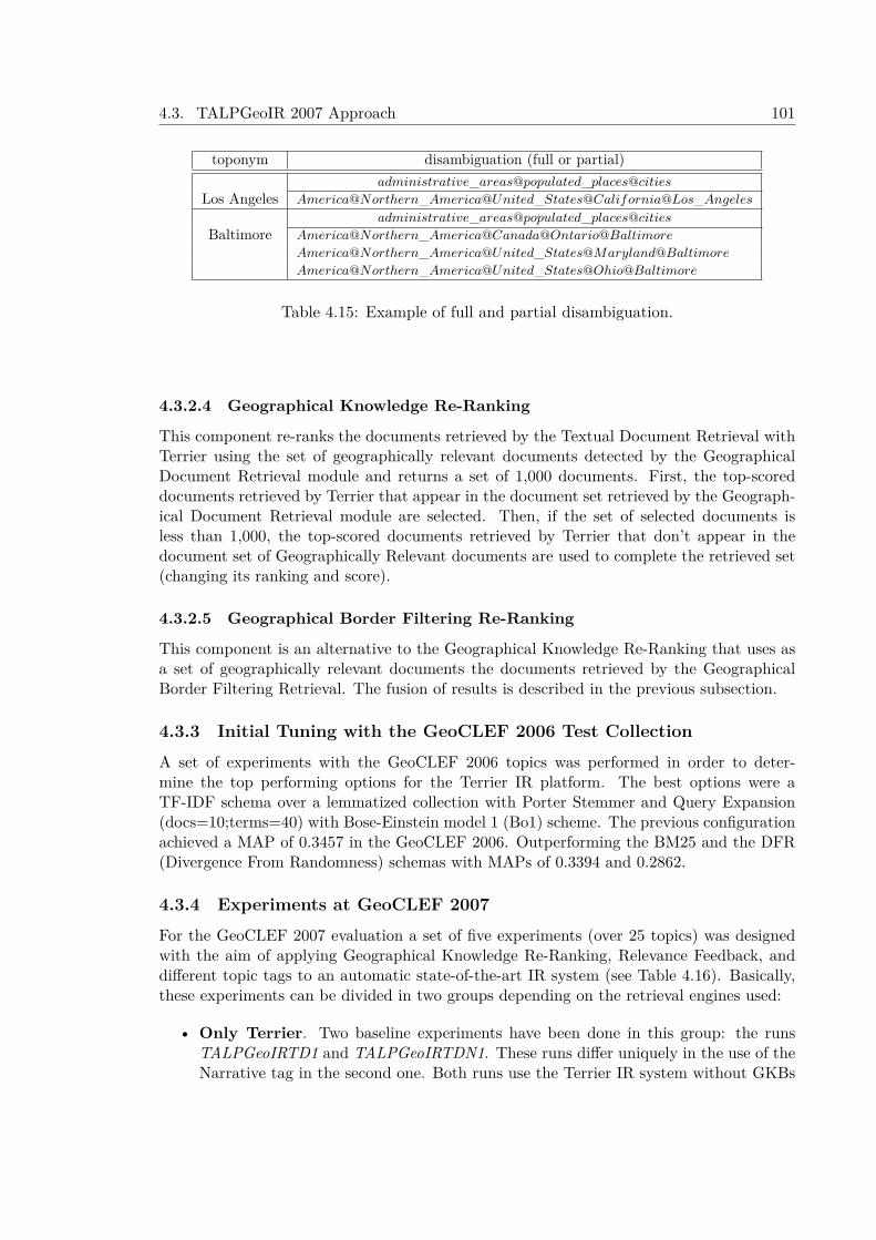
4.3. TALPGeoIR 2007 Approach 101
toponym disambiguation (full or partial)administrative_areas@populated_places@cities
Los Angeles America@Northern_America@United_States@California@Los_Angeles
administrative_areas@populated_places@cities
Baltimore America@Northern_America@Canada@Ontario@Baltimore
America@Northern_America@United_States@Maryland@Baltimore
America@Northern_America@United_States@Ohio@Baltimore
Table 4.15: Example of full and partial disambiguation.
4.3.2.4 Geographical Knowledge Re-Ranking
This component re-ranks the documents retrieved by the Textual Document Retrieval withTerrier using the set of geographically relevant documents detected by the GeographicalDocument Retrieval module and returns a set of 1,000 documents. First, the top-scoreddocuments retrieved by Terrier that appear in the document set retrieved by the Geograph-ical Document Retrieval module are selected. Then, if the set of selected documents isless than 1,000, the top-scored documents retrieved by Terrier that don’t appear in thedocument set of Geographically Relevant documents are used to complete the retrieved set(changing its ranking and score).
4.3.2.5 Geographical Border Filtering Re-Ranking
This component is an alternative to the Geographical Knowledge Re-Ranking that uses asa set of geographically relevant documents the documents retrieved by the GeographicalBorder Filtering Retrieval. The fusion of results is described in the previous subsection.
4.3.3 Initial Tuning with the GeoCLEF 2006 Test CollectionA set of experiments with the GeoCLEF 2006 topics was performed in order to deter-mine the top performing options for the Terrier IR platform. The best options were aTF-IDF schema over a lemmatized collection with Porter Stemmer and Query Expansion(docs=10;terms=40) with Bose-Einstein model 1 (Bo1) scheme. The previous configurationachieved a MAP of 0.3457 in the GeoCLEF 2006. Outperforming the BM25 and the DFR(Divergence From Randomness) schemas with MAPs of 0.3394 and 0.2862.
4.3.4 Experiments at GeoCLEF 2007For the GeoCLEF 2007 evaluation a set of five experiments (over 25 topics) was designedwith the aim of applying Geographical Knowledge Re-Ranking, Relevance Feedback, anddifferent topic tags to an automatic state-of-the-art IR system (see Table 4.16). Basically,these experiments can be divided in two groups depending on the retrieval engines used:
• Only Terrier. Two baseline experiments have been done in this group: the runsTALPGeoIRTD1 and TALPGeoIRTDN1. These runs differ uniquely in the use of theNarrative tag in the second one. Both runs use the Terrier IR system without GKBs
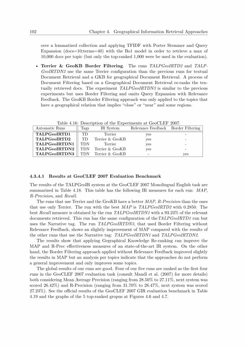
102 Chapter 4. Geographical Information Retrieval Approaches
over a lemmatized collection and applying TFIDF with Porter Stemmer and QueryExpansion (docs=10;terms=40) with the Bo1 model in order to retrieve a max of10,000 docs per topic (but only the top-ranked 1,000 were be used in the evaluation).
• Terrier & GeoKB Border Filtering. The runs TALPGeoIRTD2 and TALP-GeoIRTDN2 use the same Terrier configuration than the previous runs for textualDocument Retrieval and a GKB for geographical Document Retrieval. A process ofDocument Filtering based on a Geographical Document Retrieval re-ranks the tex-tually retrieved docs. The experiment TALPGeoIRTDN3 is similar to the previousexperiments but uses Border Filtering and omits Query Expansion with RelevanceFeedback. The GeoKB Border Filtering approach was only applied to the topics thathave a geographical relation that implies “close” or “near” and some regions.
Table 4.16: Description of the Experiments at GeoCLEF 2007.Automatic Runs Tags IR System Relevance Feedback Border FilteringTALPGeoIRTD1 TD Terrier yes -TALPGeoIRTD2 TD Terrier & GeoKB yes -TALPGeoIRTDN1 TDN Terrier yes -TALPGeoIRTDN2 TDN Terrier & GeoKB yes -TALPGeoIRTDN3 TDN Terrier & GeoKB - yes
4.3.4.1 Results at GeoCLEF 2007 Evaluation Benchmark
The results of the TALPGeoIR system at the GeoCLEF 2007 Monolingual English task aresummarized in Table 4.18. This table has the following IR measures for each run: MAP,R-Precision, and Recall.
The runs that use Terrier and the GeoKB have a better MAP, R-Precision than the onesthat use only Terrier. The run with the best MAP is TALPGeoIRTD2 with 0.2850. Thebest Recall measure is obtained by the run TALPGeoIRTDN1 with a 93.23% of the relevantdocuments retrieved. This run has the same configuration of theTALPGeoIRTD1 run butuses the Narrative tag. The run TALPGeoIRTDN3, that used Border Filtering withoutRelevance Feedback, shows an slightly improvement of MAP compared with the results ofthe other runs that use the Narrative tag: TALPGeoIRTDN1 and TALPGeoIRTDN2.
The results show that applying Gegraphical Knowledge Re-ranking can improve theMAP and R-Prec effectiveness measures of an state-of-the-art IR system. On the otherhand, the Border Filtering approach applied without Relevance Feedback improved slightlythe results in MAP but an analysis per topics indicate that the approaches do not performa general improvement and only improves some topics.
The global results of our runs are good. Four of our five runs are ranked as the first fourruns in the GeoCLEF 2007 evaluation task (consult Mandl et al. (2007) for more details)both considering Mean Average Precision (ranging from 28.50% to 27.11%, next system wasscored 26.42%) and R-Precision (ranging from 31.70% to 28.47%, next system was scored27.23%). See the official results of the GeoCLEF 2007 GIR evaluation benchmark in Table4.19 and the graphs of the 5 top-ranked gropus at Figures 4.6 and 4.7.

4.3. TALPGeoIR 2007 Approach 103
Topic ID Topic TitleGC-51 Oil and gas extraction found between the UK and the ContinentGC-52 Crime near St AndrewsGC-53 Scientific research at east coast Scottish UniversitiesGC-54 Damage from acid rain in northern EuropeGC-55 Deaths caused by avalanches occurring in Europe, but not in the AlpsGC-56 Lakes with monstersGC-57 Whisky making in the Scottlsh IslandsGC-58 Travel problems at major airports near to LondonGC-59 Meetings of the Andean Community of Nations (CAN)GC-60 Casualties in fights in Nagorno-KarabakhGC-61 Airplane crashes close to Russian citiesGC-62 OSCE meetings in Eastern EuropeGC-63 Water quality along coastlines of the Mediterranean SeaGC-64 Sport events in the french speaking part of SwitzerlandGC-65 Free elections in AfricaGC-66 Economy at the BosphorusGC-67 F1 circuits where Ayrton Senna competed in 1994GC-68 Rivers with floodsGC-69 Death on the HimalayaGC-70 Tourist attractions in Northern ItalyGC-71 Social problems in greater LisbonGC-72 Beaches with sharksGC-73 Events at St. Paul’s CathedralGC-74 Ship traffic around the Portuguese islandsGC-75 Violation of human rights in Burma
Table 4.17: Topic titles of GeoCLEF 2007 in English.
Figure 4.6: Interpolated Recall-Precision graphs of the 5 official top ranked systems atGeoCLEF 2007.
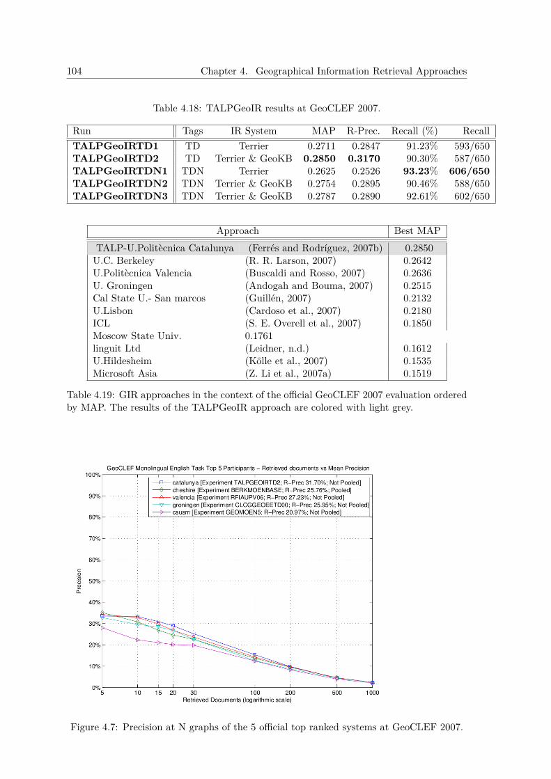
104 Chapter 4. Geographical Information Retrieval Approaches
Table 4.18: TALPGeoIR results at GeoCLEF 2007.
Run Tags IR System MAP R-Prec. Recall (%) RecallTALPGeoIRTD1 TD Terrier 0.2711 0.2847 91.23% 593/650TALPGeoIRTD2 TD Terrier & GeoKB 0.2850 0.3170 90.30% 587/650TALPGeoIRTDN1 TDN Terrier 0.2625 0.2526 93.23% 606/650TALPGeoIRTDN2 TDN Terrier & GeoKB 0.2754 0.2895 90.46% 588/650TALPGeoIRTDN3 TDN Terrier & GeoKB 0.2787 0.2890 92.61% 602/650
Approach Best MAPTALP-U.Politècnica Catalunya (Ferrés and Rodríguez, 2007b) 0.2850U.C. Berkeley (R. R. Larson, 2007) 0.2642U.Politècnica Valencia (Buscaldi and Rosso, 2007) 0.2636U. Groningen (Andogah and Bouma, 2007) 0.2515Cal State U.- San marcos (Guillén, 2007) 0.2132U.Lisbon (Cardoso et al., 2007) 0.2180ICL (S. E. Overell et al., 2007) 0.1850Moscow State Univ. 0.1761linguit Ltd (Leidner, n.d.) 0.1612U.Hildesheim (Kölle et al., 2007) 0.1535Microsoft Asia (Z. Li et al., 2007a) 0.1519
Table 4.19: GIR approaches in the context of the official GeoCLEF 2007 evaluation orderedby MAP. The results of the TALPGeoIR approach are colored with light grey.
Figure 4.7: Precision at N graphs of the 5 official top ranked systems at GeoCLEF 2007.
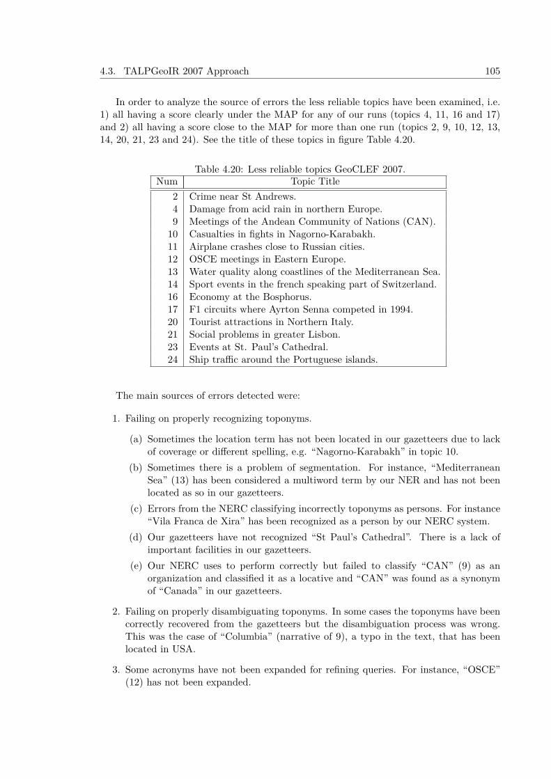
4.3. TALPGeoIR 2007 Approach 105
In order to analyze the source of errors the less reliable topics have been examined, i.e.1) all having a score clearly under the MAP for any of our runs (topics 4, 11, 16 and 17)and 2) all having a score close to the MAP for more than one run (topics 2, 9, 10, 12, 13,14, 20, 21, 23 and 24). See the title of these topics in figure Table 4.20.
Table 4.20: Less reliable topics GeoCLEF 2007.Num Topic Title
2 Crime near St Andrews.4 Damage from acid rain in northern Europe.9 Meetings of the Andean Community of Nations (CAN).10 Casualties in fights in Nagorno-Karabakh.11 Airplane crashes close to Russian cities.12 OSCE meetings in Eastern Europe.13 Water quality along coastlines of the Mediterranean Sea.14 Sport events in the french speaking part of Switzerland.16 Economy at the Bosphorus.17 F1 circuits where Ayrton Senna competed in 1994.20 Tourist attractions in Northern Italy.21 Social problems in greater Lisbon.23 Events at St. Paul’s Cathedral.24 Ship traffic around the Portuguese islands.
The main sources of errors detected were:
1. Failing on properly recognizing toponyms.
(a) Sometimes the location term has not been located in our gazetteers due to lackof coverage or different spelling, e.g. “Nagorno-Karabakh” in topic 10.
(b) Sometimes there is a problem of segmentation. For instance, “MediterraneanSea” (13) has been considered a multiword term by our NER and has not beenlocated as so in our gazetteers.
(c) Errors from the NERC classifying incorrectly toponyms as persons. For instance“Vila Franca de Xira” has been recognized as a person by our NERC system.
(d) Our gazetteers have not recognized “St Paul’s Cathedral”. There is a lack ofimportant facilities in our gazetteers.
(e) Our NERC uses to perform correctly but failed to classify “CAN” (9) as anorganization and classified it as a locative and “CAN” was found as a synonymof “Canada” in our gazetteers.
2. Failing on properly disambiguating toponyms. In some cases the toponyms have beencorrectly recovered from the gazetteers but the disambiguation process was wrong.This was the case of “Columbia” (narrative of 9), a typo in the text, that has beenlocated in USA.
3. Some acronyms have not been expanded for refining queries. For instance, “OSCE”(12) has not been expanded.
106 Chapter 4. Geographical Information Retrieval Approaches
4. The system did not refined the query with hyponyms. This limited in some casesthe coverage. Neither “Crime” (2) nor “Economy” (16) have been refined beyond theexamples included in the narrative.
5. GEO relations (as in 20) have been properly extracted but are used only in TDN3run to apply a border filtering algorithm that has been used in 6 topics.
6. Sometimes as in (”F1 circuits”, 17) no locative has been found.
7. We have failed to attach complementary locative descriptors to the geographic termas in “Russian cities” (11) or “coastlines” (13).
The border filtering algorithm has been used in the following topics of the run TDN3:2, 8, 16, 19, 21, and 25, applying a configuration of the Terrier IR without query expansion.Compared with the run TDN2 the MAP improves slightly in topics 8, and 25 but dropsin topics 2, 16, and 19. The use of border filtering without query expansion seems notproviding a general improvement neither in MAP nor in recall. On the other side, analyzingthe topics that do not use border filtering without query expansion (19 topics) in run TDN3and comparing them with the same topics in run TDN2, seems that at least in three topicsavoiding query expansion has supposed a great improvement in recall and MAP (topics 1,3,and 7), only there is a sligthly drop in MAP in topics 10 and 20 and a noticeable drop inrecall in topic 23.
4.3.5 Experiments with the GeoCLEF Test CollectionsSeveral experiments with the full collection of GeoCLEF5 (100 topics) have been designedto evaluate the relative impact of different features (alone and in combination among them)in the GIR over some state-of-the-art effectiveness measures (Ferrés and Rodríguez, 2015a).These experiments will be evaluated with the binary relevance assessments collected withpooling during the GeoCLEF forums (see Table 4.21 for details about the relevance asses-ments).
2005 2006 2007 2008#topics 25 25 25 25#relevant_documents 1,028 378 650 747#judged_documents 14,546 17,964 15,637 14,528
Table 4.21: Relevance assesment information about GeoCLEF evaluations
The baselines to compare are the IR algorithms TF-IDF, BM25, and InL2 with wordforms in the indexed collection and the set of queries (topics). These experiments havebeen performed with three possible uses of the topics metadata: a) title (T), b) title anddescription (TD), c) title, description and narrative (TDN) . Several experiments have beenperformed with the full GeoCLEF collection (100 topics) to evaluate the following systemcomponents alone or in combination:
1. Linguistic Processing features evaluated in isolation or in combination: a) Lemmati-zation, b) Stemming, c) Lemmatization + stemming,
5The GeoCLEF test topics, relevance assesments and the official experiments performed at GeoCLEFfrom 2005 to 2008 can be downloaded at http://direct.dei.unipd.it/
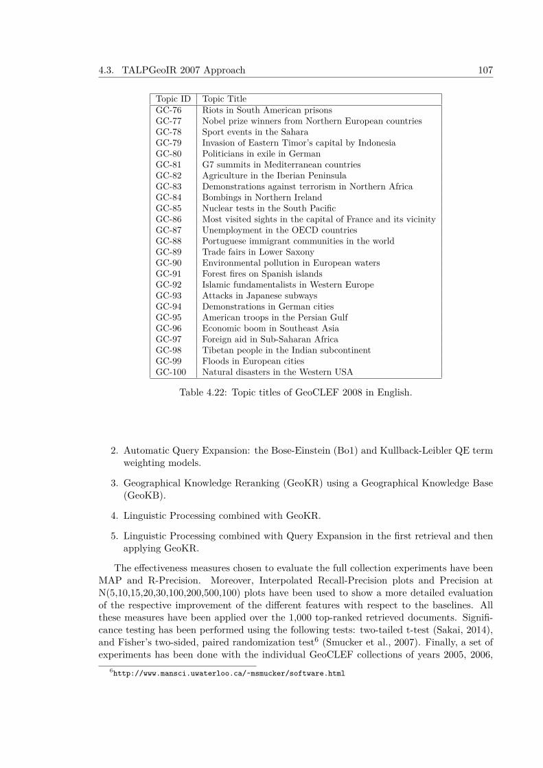
4.3. TALPGeoIR 2007 Approach 107
Topic ID Topic TitleGC-76 Riots in South American prisonsGC-77 Nobel prize winners from Northern European countriesGC-78 Sport events in the SaharaGC-79 Invasion of Eastern Timor’s capital by IndonesiaGC-80 Politicians in exile in GermanGC-81 G7 summits in Mediterranean countriesGC-82 Agriculture in the Iberian PeninsulaGC-83 Demonstrations against terrorism in Northern AfricaGC-84 Bombings in Northern IrelandGC-85 Nuclear tests in the South PacificGC-86 Most visited sights in the capital of France and its vicinityGC-87 Unemployment in the OECD countriesGC-88 Portuguese immigrant communities in the worldGC-89 Trade fairs in Lower SaxonyGC-90 Environmental pollution in European watersGC-91 Forest fires on Spanish islandsGC-92 Islamic fundamentalists in Western EuropeGC-93 Attacks in Japanese subwaysGC-94 Demonstrations in German citiesGC-95 American troops in the Persian GulfGC-96 Economic boom in Southeast AsiaGC-97 Foreign aid in Sub-Saharan AfricaGC-98 Tibetan people in the Indian subcontinentGC-99 Floods in European citiesGC-100 Natural disasters in the Western USA
Table 4.22: Topic titles of GeoCLEF 2008 in English.
2. Automatic Query Expansion: the Bose-Einstein (Bo1) and Kullback-Leibler QE termweighting models.
3. Geographical Knowledge Reranking (GeoKR) using a Geographical Knowledge Base(GeoKB).
4. Linguistic Processing combined with GeoKR.
5. Linguistic Processing combined with Query Expansion in the first retrieval and thenapplying GeoKR.
The effectiveness measures chosen to evaluate the full collection experiments have beenMAP and R-Precision. Moreover, Interpolated Recall-Precision plots and Precision atN(5,10,15,20,30,100,200,500,100) plots have been used to show a more detailed evaluationof the respective improvement of the different features with respect to the baselines. Allthese measures have been applied over the 1,000 top-ranked retrieved documents. Signifi-cance testing has been performed using the following tests: two-tailed t-test (Sakai, 2014),and Fisher’s two-sided, paired randomization test6 (Smucker et al., 2007). Finally, a set ofexperiments has been done with the individual GeoCLEF collections of years 2005, 2006,
6http://www.mansci.uwaterloo.ca/~msmucker/software.html

108 Chapter 4. Geographical Information Retrieval Approaches
2007 and 2008 to compute the performance in MAP of the best configurations with the fullcollection experiments. These experiments will be compared with the best official run ofeach GeoCLEF task.
The results of the full GeoCLEF collection experiments are shown in Table 4.23. Theresults of evaluating separately Geographical Knowledge Ranking, Linguistic Processing(lemmatization, stemming, and the combination of both), and Query Expansion show thatall these processes improve the Mean Average Precision (MAP) and R-Precision in all theexperiments and show statistical significance over the baselines in most of them. All theexperiments that use only the title (T) field show statistical significance (p-value < 0.01)over baselines in MAP and R-Precision. The experiments with title and description (TD)obtained statistical significance (p-value < 0.01) in MAP (including R-Prec statistical sig-nificance with the ones that used the TF-IDF). MAP and RPrecision also show statisticalsignificance (p-value < 0.01) in all the experiments that combine Lemmatization with stem-ming, GeoKB and Query Expansion. The best results in MAP (0.3116) and R-Precision(0.3142) are obtained with the InL2 algorithm with Title and Description, and using thefollowing techniques: GeoKR, Lemmatization with Stemming, and Kullback-Leibler QueryExpansion. This configuration and each method tested alone with respect the baselineshow improvements in Precision at @(5,10,15,20,30,100,200,500,1000) in the majority of theexperiments (see Figures 4.8, 4.9, and 4.10).
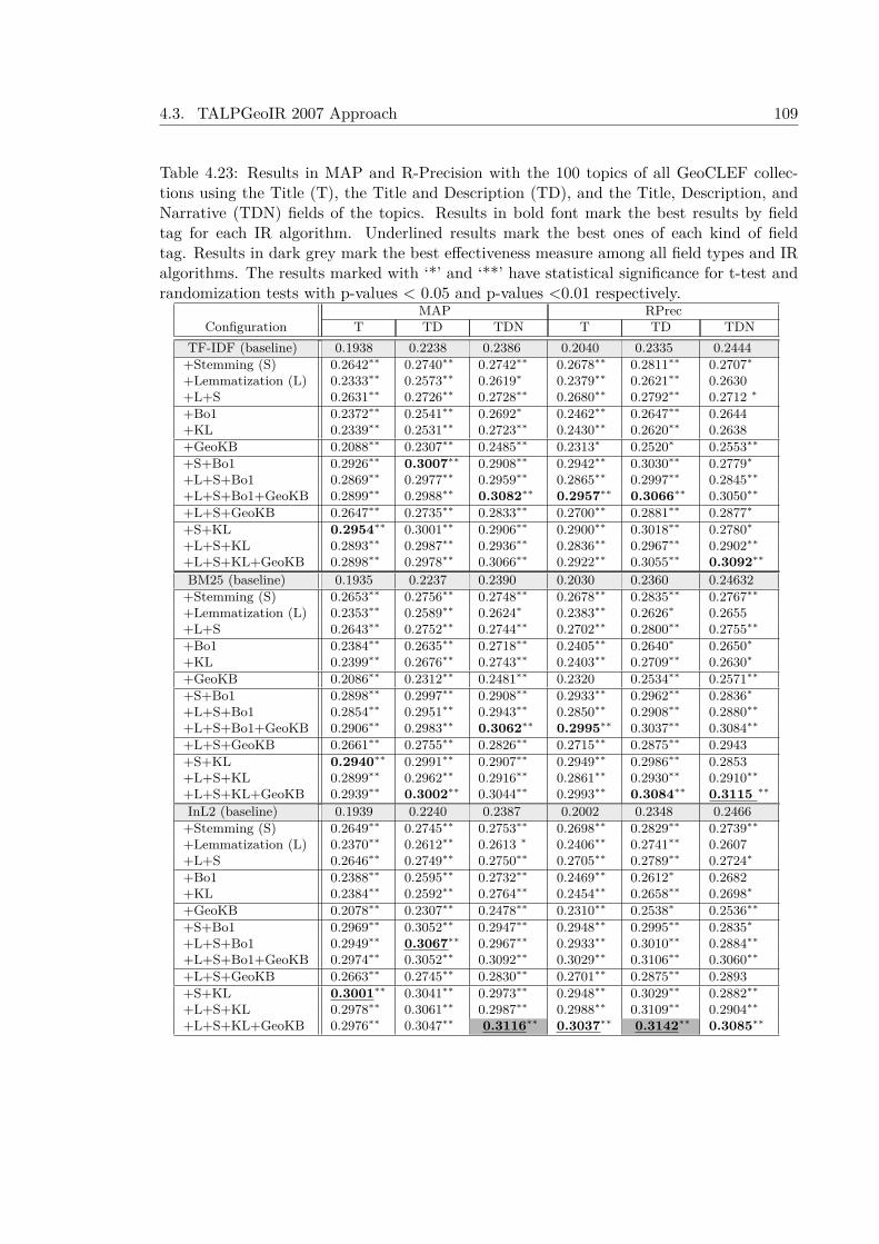
4.3. TALPGeoIR 2007 Approach 109
Table 4.23: Results in MAP and R-Precision with the 100 topics of all GeoCLEF collec-tions using the Title (T), the Title and Description (TD), and the Title, Description, andNarrative (TDN) fields of the topics. Results in bold font mark the best results by fieldtag for each IR algorithm. Underlined results mark the best ones of each kind of fieldtag. Results in dark grey mark the best effectiveness measure among all field types and IRalgorithms. The results marked with ‘*’ and ‘**’ have statistical significance for t-test andrandomization tests with p-values < 0.05 and p-values <0.01 respectively.
MAP RPrecConfiguration T TD TDN T TD TDN
TF-IDF (baseline) 0.1938 0.2238 0.2386 0.2040 0.2335 0.2444+Stemming (S) 0.2642∗∗ 0.2740∗∗ 0.2742∗∗ 0.2678∗∗ 0.2811∗∗ 0.2707∗
+Lemmatization (L) 0.2333∗∗ 0.2573∗∗ 0.2619∗ 0.2379∗∗ 0.2621∗∗ 0.2630+L+S 0.2631∗∗ 0.2726∗∗ 0.2728∗∗ 0.2680∗∗ 0.2792∗∗ 0.2712 ∗
+Bo1 0.2372∗∗ 0.2541∗∗ 0.2692∗ 0.2462∗∗ 0.2647∗∗ 0.2644+KL 0.2339∗∗ 0.2531∗∗ 0.2723∗∗ 0.2430∗∗ 0.2620∗∗ 0.2638+GeoKB 0.2088∗∗ 0.2307∗∗ 0.2485∗∗ 0.2313∗ 0.2520∗ 0.2553∗∗
+S+Bo1 0.2926∗∗ 0.3007∗∗ 0.2908∗∗ 0.2942∗∗ 0.3030∗∗ 0.2779∗
+L+S+Bo1 0.2869∗∗ 0.2977∗∗ 0.2959∗∗ 0.2865∗∗ 0.2997∗∗ 0.2845∗∗
+L+S+Bo1+GeoKB 0.2899∗∗ 0.2988∗∗ 0.3082∗∗ 0.2957∗∗ 0.3066∗∗ 0.3050∗∗
+L+S+GeoKB 0.2647∗∗ 0.2735∗∗ 0.2833∗∗ 0.2700∗∗ 0.2881∗∗ 0.2877∗
+S+KL 0.2954∗∗ 0.3001∗∗ 0.2906∗∗ 0.2900∗∗ 0.3018∗∗ 0.2780∗
+L+S+KL 0.2893∗∗ 0.2987∗∗ 0.2936∗∗ 0.2836∗∗ 0.2967∗∗ 0.2902∗∗
+L+S+KL+GeoKB 0.2898∗∗ 0.2978∗∗ 0.3066∗∗ 0.2922∗∗ 0.3055∗∗ 0.3092∗∗
BM25 (baseline) 0.1935 0.2237 0.2390 0.2030 0.2360 0.24632+Stemming (S) 0.2653∗∗ 0.2756∗∗ 0.2748∗∗ 0.2678∗∗ 0.2835∗∗ 0.2767∗∗
+Lemmatization (L) 0.2353∗∗ 0.2589∗∗ 0.2624∗ 0.2383∗∗ 0.2626∗ 0.2655+L+S 0.2643∗∗ 0.2752∗∗ 0.2744∗∗ 0.2702∗∗ 0.2800∗∗ 0.2755∗∗
+Bo1 0.2384∗∗ 0.2635∗∗ 0.2718∗∗ 0.2405∗∗ 0.2640∗ 0.2650∗
+KL 0.2399∗∗ 0.2676∗∗ 0.2743∗∗ 0.2403∗∗ 0.2709∗∗ 0.2630∗
+GeoKB 0.2086∗∗ 0.2312∗∗ 0.2481∗∗ 0.2320 0.2534∗∗ 0.2571∗∗
+S+Bo1 0.2898∗∗ 0.2997∗∗ 0.2908∗∗ 0.2933∗∗ 0.2962∗∗ 0.2836∗
+L+S+Bo1 0.2854∗∗ 0.2951∗∗ 0.2943∗∗ 0.2850∗∗ 0.2908∗∗ 0.2880∗∗
+L+S+Bo1+GeoKB 0.2906∗∗ 0.2983∗∗ 0.3062∗∗ 0.2995∗∗ 0.3037∗∗ 0.3084∗∗
+L+S+GeoKB 0.2661∗∗ 0.2755∗∗ 0.2826∗∗ 0.2715∗∗ 0.2875∗∗ 0.2943+S+KL 0.2940∗∗ 0.2991∗∗ 0.2907∗∗ 0.2949∗∗ 0.2986∗∗ 0.2853+L+S+KL 0.2899∗∗ 0.2962∗∗ 0.2916∗∗ 0.2861∗∗ 0.2930∗∗ 0.2910∗∗
+L+S+KL+GeoKB 0.2939∗∗ 0.3002∗∗ 0.3044∗∗ 0.2993∗∗ 0.3084∗∗ 0.3115 ∗∗
InL2 (baseline) 0.1939 0.2240 0.2387 0.2002 0.2348 0.2466+Stemming (S) 0.2649∗∗ 0.2745∗∗ 0.2753∗∗ 0.2698∗∗ 0.2829∗∗ 0.2739∗∗
+Lemmatization (L) 0.2370∗∗ 0.2612∗∗ 0.2613 ∗ 0.2406∗∗ 0.2741∗∗ 0.2607+L+S 0.2646∗∗ 0.2749∗∗ 0.2750∗∗ 0.2705∗∗ 0.2789∗∗ 0.2724∗
+Bo1 0.2388∗∗ 0.2595∗∗ 0.2732∗∗ 0.2469∗∗ 0.2612∗ 0.2682+KL 0.2384∗∗ 0.2592∗∗ 0.2764∗∗ 0.2454∗∗ 0.2658∗∗ 0.2698∗
+GeoKB 0.2078∗∗ 0.2307∗∗ 0.2478∗∗ 0.2310∗∗ 0.2538∗ 0.2536∗∗
+S+Bo1 0.2969∗∗ 0.3052∗∗ 0.2947∗∗ 0.2948∗∗ 0.2995∗∗ 0.2835∗
+L+S+Bo1 0.2949∗∗ 0.3067∗∗ 0.2967∗∗ 0.2933∗∗ 0.3010∗∗ 0.2884∗∗
+L+S+Bo1+GeoKB 0.2974∗∗ 0.3052∗∗ 0.3092∗∗ 0.3029∗∗ 0.3106∗∗ 0.3060∗∗
+L+S+GeoKB 0.2663∗∗ 0.2745∗∗ 0.2830∗∗ 0.2701∗∗ 0.2875∗∗ 0.2893+S+KL 0.3001∗∗ 0.3041∗∗ 0.2973∗∗ 0.2948∗∗ 0.3029∗∗ 0.2882∗∗
+L+S+KL 0.2978∗∗ 0.3061∗∗ 0.2987∗∗ 0.2988∗∗ 0.3109∗∗ 0.2904∗∗
+L+S+KL+GeoKB 0.2976∗∗ 0.3047∗∗ 0.3116∗∗ 0.3037∗∗ 0.3142∗∗ 0.3085∗∗
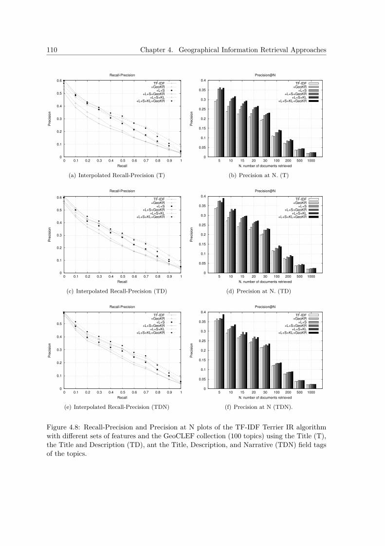
110 Chapter 4. Geographical Information Retrieval Approaches
0
0.1
0.2
0.3
0.4
0.5
0.6
0 0.1 0.2 0.3 0.4 0.5 0.6 0.7 0.8 0.9 1
Pre
cis
ion
Recall
Recall-Precision
TF-IDF+GeoKR
+L+S+L+S+GeoKR
+L+S+KL+L+S+KL+GeoKR
(a) Interpolated Recall-Precision (T)
0
0.05
0.1
0.15
0.2
0.25
0.3
0.35
0.4
5 10 15 20 30 100 200 500 1000
Pre
cis
ion
N. number of documents retrieved
Precision@N
TF-IDF+GeoKR
+L+S+L+S+GeoKR
+L+S+KL+L+S+KL+GeoKR
(b) Precision at N. (T)
0
0.1
0.2
0.3
0.4
0.5
0.6
0 0.1 0.2 0.3 0.4 0.5 0.6 0.7 0.8 0.9 1
Pre
cis
ion
Recall
Recall-Precision
TF-IDF+GeoKR
+L+S+L+S+GeoKR
+L+S+KL+L+S+KL+GeoKR
(c) Interpolated Recall-Precision (TD)
0
0.05
0.1
0.15
0.2
0.25
0.3
0.35
0.4
5 10 15 20 30 100 200 500 1000
Pre
cis
ion
N. number of documents retrieved
Precision@N
TF-IDF+GeoKR
+L+S+L+S+GeoKR
+L+S+KL+L+S+KL+GeoKR
(d) Precision at N. (TD)
0
0.1
0.2
0.3
0.4
0.5
0 0.1 0.2 0.3 0.4 0.5 0.6 0.7 0.8 0.9 1
Pre
cis
ion
Recall
Recall-Precision
TF-IDF+GeoKR
+L+S+L+S+GeoKR
+L+S+KL+L+S+KL+GeoKR
(e) Interpolated Recall-Precision (TDN)
0
0.05
0.1
0.15
0.2
0.25
0.3
0.35
0.4
5 10 15 20 30 100 200 500 1000
Pre
cis
ion
N. number of documents retrieved
Precision@N
TF-IDF+GeoKR
+L+S+L+S+GeoKR
+L+S+KL+L+S+KL+GeoKR
(f) Precision at N (TDN).
Figure 4.8: Recall-Precision and Precision at N plots of the TF-IDF Terrier IR algorithmwith different sets of features and the GeoCLEF collection (100 topics) using the Title (T),the Title and Description (TD), ant the Title, Description, and Narrative (TDN) field tagsof the topics.

4.3. TALPGeoIR 2007 Approach 111
0
0.1
0.2
0.3
0.4
0.5
0.6
0 0.1 0.2 0.3 0.4 0.5 0.6 0.7 0.8 0.9 1
Pre
cis
ion
Recall
Recall-Precision
BM25
+GeoKR
+L+S
+L+S+GeoKR
+L+S+KL
+L+S+KL+GeoKR
(a) Interpolated Recall-Precision (T)
0
0.05
0.1
0.15
0.2
0.25
0.3
0.35
0.4
5 10 15 20 30 100 200 500 1000
Pre
cis
ion
N. number of documents retrieved
Precision@N
BM25
+GeoKR
+L+S
+L+S+GeoKR
+L+S+KL
+L+S+KL+GeoKR
(b) Precision at N. (T)
0
0.1
0.2
0.3
0.4
0.5
0.6
0 0.1 0.2 0.3 0.4 0.5 0.6 0.7 0.8 0.9 1
Pre
cis
ion
Recall
Recall-Precision
BM25
+GeoKR
+L+S
+L+S+GeoKR
+L+S+KL
+L+S+KL+GeoKR
(c) Interpolated Recall-Precision (TD)
0
0.05
0.1
0.15
0.2
0.25
0.3
0.35
0.4
5 10 15 20 30 100 200 500 1000
Pre
cis
ion
N. number of documents retrieved
Precision@N
BM25
+GeoKR
+L+S
+L+S+GeoKR
+L+S+KL
+L+S+KL+GeoKR
(d) Precision at N. (TD)
0
0.1
0.2
0.3
0.4
0.5
0 0.1 0.2 0.3 0.4 0.5 0.6 0.7 0.8 0.9 1
Pre
cis
ion
Recall
Recall-Precision
BM25
+GeoKR
+L+S
+L+S+GeoKR
+L+S+KL
+L+S+KL+GeoKR
(e) Interpolated Recall-Precision (TDN)
0
0.05
0.1
0.15
0.2
0.25
0.3
0.35
0.4
5 10 15 20 30 100 200 500 1000
Pre
cis
ion
N. number of documents retrieved
Precision@N
BM25
+GeoKR
+L+S
+L+S+GeoKR
+L+S+KL
+L+S+KL+GeoKR
(f) Precision at N (TDN).
Figure 4.9: Recall-Precision and Precision at N plots of the BM25 IR algorithm with differ-ent sets of features and the GeoCLEF collection (100 topics) using the Title (T), the Titleand Description (TD), ant the Title, Description, and Narrative (TDN) field tags of thetopics.
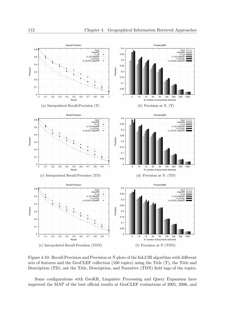
112 Chapter 4. Geographical Information Retrieval Approaches
0
0.1
0.2
0.3
0.4
0.5
0.6
0 0.1 0.2 0.3 0.4 0.5 0.6 0.7 0.8 0.9 1
Pre
cis
ion
Recall
Recall-Precision
InL2+GeoKR
+L+S+L+S+GeoKR
+L+S+KL+L+S+KL+GeoKR
(a) Interpolated Recall-Precision (T)
0
0.05
0.1
0.15
0.2
0.25
0.3
0.35
0.4
5 10 15 20 30 100 200 500 1000
Pre
cis
ion
N. number of documents retrieved
Precision@N
InL2+GeoKR
+L+S+L+S+GeoKR
+L+S+KL+L+S+KL+GeoKR
(b) Precision at N. (T)
0
0.1
0.2
0.3
0.4
0.5
0.6
0 0.1 0.2 0.3 0.4 0.5 0.6 0.7 0.8 0.9 1
Pre
cis
ion
Recall
Recall-Precision
InL2+GeoKR
+L+S+L+S+GeoKR
+L+S+KL+L+S+KL+GeoKR
(c) Interpolated Recall-Precision (TD)
0
0.05
0.1
0.15
0.2
0.25
0.3
0.35
0.4
5 10 15 20 30 100 200 500 1000
Pre
cis
ion
N. number of documents retrieved
Precision@N
InL2+GeoKR
+L+S+L+S+GeoKR
+L+S+KL+L+S+KL+GeoKR
(d) Precision at N. (TD)
0
0.1
0.2
0.3
0.4
0.5
0.6
0 0.1 0.2 0.3 0.4 0.5 0.6 0.7 0.8 0.9 1
Pre
cis
ion
Recall
Recall-Precision
InL2+GeoKR
+L+S+L+S+GeoKR
+L+S+KL+L+S+KL+GeoKR
(e) Interpolated Recall-Precision (TDN)
0
0.05
0.1
0.15
0.2
0.25
0.3
0.35
0.4
5 10 15 20 30 100 200 500 1000
Pre
cis
ion
N. number of documents retrieved
Precision@N
InL2+GeoKR
+L+S+L+S+GeoKR
+L+S+KL+L+S+KL+GeoKR
(f) Precision at N (TDN).
Figure 4.10: Recall-Precision and Precision at N plots of the InL2 IR algorithm with differentsets of features and the GeoCLEF collection (100 topics) using the Title (T), the Title andDescription (TD), ant the Title, Description, and Narrative (TDN) field tags of the topics.
Some configurations with GeoKR, Linguistic Processing and Query Expansion haveimproved the MAP of the best official results at GeoCLEF evaluations of 2005, 2006, and
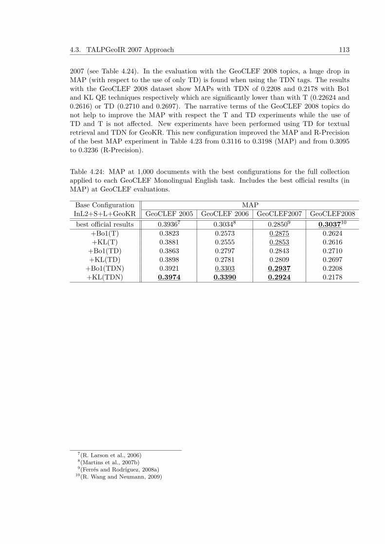
4.3. TALPGeoIR 2007 Approach 113
2007 (see Table 4.24). In the evaluation with the GeoCLEF 2008 topics, a huge drop inMAP (with respect to the use of only TD) is found when using the TDN tags. The resultswith the GeoCLEF 2008 dataset show MAPs with TDN of 0.2208 and 0.2178 with Bo1and KL QE techniques respectively which are significantly lower than with T (0.22624 and0.2616) or TD (0.2710 and 0.2697). The narrative terms of the GeoCLEF 2008 topics donot help to improve the MAP with respect the T and TD experiments while the use ofTD and T is not affected. New experiments have been performed using TD for textualretrieval and TDN for GeoKR. This new configuration improved the MAP and R-Precisionof the best MAP experiment in Table 4.23 from 0.3116 to 0.3198 (MAP) and from 0.3095to 0.3236 (R-Precision).
Table 4.24: MAP at 1,000 documents with the best configurations for the full collectionapplied to each GeoCLEF Monolingual English task. Includes the best official results (inMAP) at GeoCLEF evaluations.
Base Configuration MAPInL2+S+L+GeoKR GeoCLEF 2005 GeoCLEF 2006 GeoCLEF2007 GeoCLEF2008best official results 0.39367 0.30348 0.28509 0.303710
+Bo1(T) 0.3823 0.2573 0.2875 0.2624+KL(T) 0.3881 0.2555 0.2853 0.2616
+Bo1(TD) 0.3863 0.2797 0.2843 0.2710+KL(TD) 0.3898 0.2781 0.2809 0.2697
+Bo1(TDN) 0.3921 0.3303 0.2937 0.2208+KL(TDN) 0.3974 0.3390 0.2924 0.2178
7(R. Larson et al., 2006)8(Martins et al., 2007b)9(Ferrés and Rodríguez, 2008a)
10(R. Wang and Neumann, 2009)
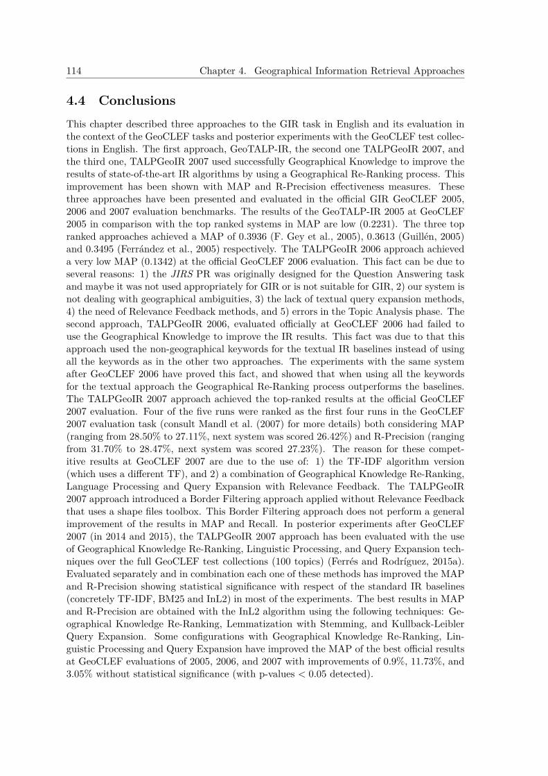
114 Chapter 4. Geographical Information Retrieval Approaches
4.4 ConclusionsThis chapter described three approaches to the GIR task in English and its evaluation inthe context of the GeoCLEF tasks and posterior experiments with the GeoCLEF test collec-tions in English. The first approach, GeoTALP-IR, the second one TALPGeoIR 2007, andthe third one, TALPGeoIR 2007 used successfully Geographical Knowledge to improve theresults of state-of-the-art IR algorithms by using a Geographical Re-Ranking process. Thisimprovement has been shown with MAP and R-Precision effectiveness measures. Thesethree approaches have been presented and evaluated in the official GIR GeoCLEF 2005,2006 and 2007 evaluation benchmarks. The results of the GeoTALP-IR 2005 at GeoCLEF2005 in comparison with the top ranked systems in MAP are low (0.2231). The three topranked approaches achieved a MAP of 0.3936 (F. Gey et al., 2005), 0.3613 (Guillén, 2005)and 0.3495 (Ferrández et al., 2005) respectively. The TALPGeoIR 2006 approach achieveda very low MAP (0.1342) at the official GeoCLEF 2006 evaluation. This fact can be due toseveral reasons: 1) the JIRS PR was originally designed for the Question Answering taskand maybe it was not used appropriately for GIR or is not suitable for GIR, 2) our system isnot dealing with geographical ambiguities, 3) the lack of textual query expansion methods,4) the need of Relevance Feedback methods, and 5) errors in the Topic Analysis phase. Thesecond approach, TALPGeoIR 2006, evaluated officially at GeoCLEF 2006 had failed touse the Geographical Knowledge to improve the IR results. This fact was due to that thisapproach used the non-geographical keywords for the textual IR baselines instead of usingall the keywords as in the other two approaches. The experiments with the same systemafter GeoCLEF 2006 have proved this fact, and showed that when using all the keywordsfor the textual approach the Geographical Re-Ranking process outperforms the baselines.The TALPGeoIR 2007 approach achieved the top-ranked results at the official GeoCLEF2007 evaluation. Four of the five runs were ranked as the first four runs in the GeoCLEF2007 evaluation task (consult Mandl et al. (2007) for more details) both considering MAP(ranging from 28.50% to 27.11%, next system was scored 26.42%) and R-Precision (rangingfrom 31.70% to 28.47%, next system was scored 27.23%). The reason for these compet-itive results at GeoCLEF 2007 are due to the use of: 1) the TF-IDF algorithm version(which uses a different TF), and 2) a combination of Geographical Knowledge Re-Ranking,Language Processing and Query Expansion with Relevance Feedback. The TALPGeoIR2007 approach introduced a Border Filtering approach applied without Relevance Feedbackthat uses a shape files toolbox. This Border Filtering approach does not perform a generalimprovement of the results in MAP and Recall. In posterior experiments after GeoCLEF2007 (in 2014 and 2015), the TALPGeoIR 2007 approach has been evaluated with the useof Geographical Knowledge Re-Ranking, Linguistic Processing, and Query Expansion tech-niques over the full GeoCLEF test collections (100 topics) (Ferrés and Rodríguez, 2015a).Evaluated separately and in combination each one of these methods has improved the MAPand R-Precision showing statistical significance with respect of the standard IR baselines(concretely TF-IDF, BM25 and InL2) in most of the experiments. The best results in MAPand R-Precision are obtained with the InL2 algorithm using the following techniques: Ge-ographical Knowledge Re-Ranking, Lemmatization with Stemming, and Kullback-LeiblerQuery Expansion. Some configurations with Geographical Knowledge Re-Ranking, Lin-guistic Processing and Query Expansion have improved the MAP of the best official resultsat GeoCLEF evaluations of 2005, 2006, and 2007 with improvements of 0.9%, 11.73%, and3.05% without statistical significance (with p-values < 0.05 detected).
CHAPTER 5
Geographical Question Answering Approaches
This Chapter describes three heterogeneous approaches to the Geographical Question An-swering task in texts for Spanish and English and its evaluation in different contexts (seeTable 5.1 for some details and differences between these approaches). The approaches arethe following:
• GeoTALP-QA: a scope-based Geographical Question Answering approach. This ap-proach has two execution modes: Knowledge-Based and Data-Driven
– GeoTALP-QA Knowledge-Based. This approach uses Geographical Knowledgeto deal with Geographical Question Answering. The GeoTALP-QA has beenadapted from an existing Open-Domain Question Answering system with geo-graphically oriented resources and specific domain adaptation. Due its languageprocessing, answer extraction, and ontological reasoning requirements this ap-proach is more oriented to answer questions contained in closed collections ofdocuments that can be linguistically pre-processed.
– GeoTALP-QA Data-Driven. This approach is similar to the GeoTALP-QAKnowledge-Based but uses a frequency-based approach to rank the answers. Thisapproach is more oriented to answer questions contained in huge collections inorder to exploit answer redundancy.
• GikiTALP: this approach uses a Data-Driven algorithm with limited Natural Lan-guage Processing and without Geographical Knowledge and it has been evaluated atGikiCLEF 2009 GeoQA evaluation benchmark.
• GeoQuery2007 Parsing Approach: this is an approach to the Geographical QueryParsing task that has been evaluated in the context of the official GeoCLEF 2007GeoQuery task.
115
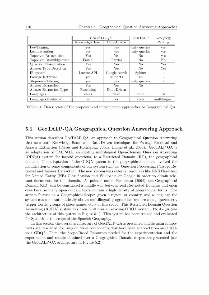
116 Chapter 5. Geographical Question Answering Approaches
GeoTALP-QA GikiTALP GeoQueryKnowledge-Based Data-Driven Parsing
Pos-Tagging yes yes only queries yesLemmatization yes yes only queries yesToponym Recognition Yes Yes No yesToponym Disambiguation Partial Partial No NoQuestion Classification Yes Yes No YesAnswer Type Detection Yes Yes No YesIR system Lucene API Google search Sphinx -Passage Retrieval yes snippets no -Stopwords filtering yes yes only queries -Answer Extraction Yes Yes No -Answer Extraction Type Reasoning Data-Driven - -Languages en-es en-es en-es enLanguages Evaluated es es en-es multilingual
Table 5.1: Description of the proposed and implemented approaches to Geographical QA.
5.1 GeoTALP-QA Geographical Question Answering ApproachThis section describes GeoTALP-QA, an approach to Geographical Question Answeringthat uses both Knowledge-Based and Data-Driven techniques for Passage Retrieval andAnswer Extraction (Ferrés and Rodríguez, 2006a; Luque et al., 2006). GeoTALP-QA isan adaptation of TALP-QA, an existing multilingual Open-Domain Question Answering(ODQA) system for factoid questions, to a Restricted Domain (RD), the geographicaldomain. The adaptation of the ODQA system to the geographical domain involved themodification of some components of our system such as: Question Processing, Passage Re-trieval and Answer Extraction. The new system uses external resources like GNS Gazetteerfor Named Entity (NE) Classification and Wikipedia or Google in order to obtain rele-vant documents for this domain. As pointed out in Benamara (2004), the GeographicalDomain (GD) can be considered a middle way between real Restricted Domains and openones because many open domain texts contain a high density of geographical terms. Thesystem focuses on a Geographical Scope: given a region, or country, and a language thesystem can semi-automatically obtain multilingual geographical resources (e.g. gazetteers,trigger words, groups of place names, etc.) of this scope. This Restricted Domain QuestionAnswering (RDQA) system has been built over an existing ODQA system, TALP-QA (seethe architecture of this system in Figure 5.1). This system has been trained and evaluatedfor Spanish in the scope of the Spanish Geography.
In this section the overall architecture of GeoTALP-QA is presented and its main compo-nents are described, focusing on those components that have been adapted from an ODQAto a GDQA. Then, the Scope-Based Resources needed for the experimentation and theexperiments and results obtained over a Geographical Domain corpus are presented (seethe GeoTALP-QA architecture in Figure 5.2).

5.1. GeoTALP-QA Geographical Question Answering Approach 117
5.1.1 System DescriptionThe GeoTALP-QA system architecture uses a common classical Question Answering ar-chitecture with three phases that are performed sequentially without feedback: QuestionProcessing (QP), Passage Retrieval (PR) and Answer Extraction (AE). More details aboutthe original TALP-QA architecture can be found in Ferrés et al. (2005c) and Ferrés et al.(2004a).
NLP Tools
Question
QUESTIONCLASSIFICATION
PASSAGERETRIEVAL
ANSWERSELECTION
NLP Tools
Textual Collections
Answer
SEMANTICEXTRACTION
QUESTIONANALYSIS
KEYWORDS�SELECTION
NLP Tools
DOCUMENTINDEXING
Passages
CANDIDATESEXTRACTION
Candidates
PASSAGEANALYSIS
SEMANTICREPRESENTATION
INDEX
QUESTION
PROCESSING
PASSAGE
RETRIEVAL
ANSWER EXTRACTION
Figure 5.1: Original architecture of TALP-QA system.
Before describing these subsystems, some additional knowledge sources are described.These knowledge sources have been added to our system for dealing with the geographicdomain and some language-dependent NLP tools for English and Spanish. The aim ofthis approach is to develop a language independent system (at least able to work withEnglish and Spanish). Language dependent components are only included in the QuestionPre-processing and Passage Pre-processing components, and can be easily substituted bycomponents for other languages.
5.1.1.1 Additional Knowledge Sources
One of the most important task to deal with the problem of GeoQA is to detect and classifyNEs with its correct geographical feature types. Geographical scope based Knowledge Bases(KB) are used to solve this problem. These KBs can be built using these resources:
• GEOnet Names Server (GNS). A worldwide gazetteer, excluding the USA andAntarctica, with 5.3 million entries.
• Geographic Names Information System (GNIS). A gazetteer with 2.0 millionentries about geographic features of the USA.
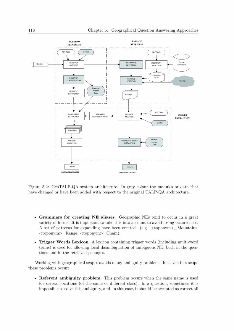
118 Chapter 5. Geographical Question Answering Approaches
NLP Tools
Question
QUESTION
CLASSIFICATIONPASSAGE
RETRIEVAL
ANSWER
SELECTION
NLP Tools
Textual
Collections
Answer
SEMANTIC
EXTRACTION
QUESTION
ANALYSIS
KEYWORDS
SELECTION
NLP Tools
DOCUMENT
INDEXING
Passages
CANDIDATES
EXTRACTION
Candidates
PASSAGE
ANALYSIS
SEMANTIC
REPRESENTATION
INDEX
QUESTION
PROCESSING
PASSAGE
RETRIEVAL
ANSWER
EXTRACTION
GeoKB
GeoKB
Internet
FREQUENCY-BASED
EXTRACTION
Expected
Answer
Type
Expected
Answer
Type
KNOWLEDGE-BASED
Answer
FREQUENCY-BASED
Figure 5.2: GeoTALP-QA system architecture. In grey colour the modules or data thathave changed or have been added with respect to the original TALP-QA architecture.
• Grammars for creating NE aliases. Geographic NEs tend to occur in a greatvariety of forms. It is important to take this into account to avoid losing occurrences.A set of patterns for expanding have been created. (e.g. <toponym>_Mountains,<toponym>_Range, <toponym>_Chain).
• Trigger Words Lexicon. A lexicon containing trigger words (including multi-wordterms) is used for allowing local disambiguation of ambiguous NE, both in the ques-tions and in the retrieved passages.
Working with geographical scopes avoids many ambiguity problems, but even in a scopethese problems occur:
• Referent ambiguity problem. This problem occurs when the same name is usedfor several locations (of the same or different class). In a question, sometimes it isimpossible to solve this ambiguity, and, in this case, it should be accepted as correct all
5.1. GeoTALP-QA Geographical Question Answering Approach 119
of the possible interpretations (or a superclass of them). Otherwise, a trigger phrasepattern can be used to resolve the ambiguity (e.g. “Madrid” is an ambiguous NE, butin the phrase, “comunidad de Madrid” (State of Madrid), ambiguity is solved). Givena scope, the system can semi-automatically obtain the most common trigger phrasepatterns of the scope from the GNS gazetteer.
• Reference ambiguity problem. This problem occurs when the same location canhave more than one name (in Spanish texts this frequently occurs as many placenames occur in languages other than Spanish, as Basque, Catalan or Galician). Ourapproach to solve this problem is to group together all the geographical names thatrefer to the same location. All the occurrences of the geographical NEs in bothquestions and passages are substituted by the identifier of the group they belongto. The geographical knowledge available in the GNS gazetteer is used to obtain thisgeographical NEs groups. First, for each place name in the scope-based GNS gazetteer,all the NEs that have the same feature designation code, latitude and longitude areobtained. For each group, is selected an identifier choosing one of the NE included in itusing the following heuristics: the information of the GNS field ”native” tells if a placename is native, conventional, a variant, or, is not verified. So the group representativeis decided assigning the following order of priorities to the names: native, conventionalname, variant name, unverified name. If there is more than one place name in thegroup with the same name type, then the additional length gives more priority tobe cluster representative. It is necessary to establish a set of priorities among thedifferent place names of the group because in some retrieval engines (e.g. web searchengines) is not possible to do long queries.
5.1.1.2 Language-Dependent Processing Tools
A set of general purpose NLP tools are used for Spanish and English. The same tools areused for the linguistic processing of both the questions and the passages (see Ferrés et al.(2005c) and Ferrés et al. (2004a) for a more detailed description of these tools). The toolsused for Spanish are:
• FreeLing, which performs tokenization, morphological analysis, POS tagging, lemma-tization, and partial parsing.
• ABIONET, a NE Recognizer and Classifier (NERC) on basic categories.
• EuroWordNet, used to obtain a list of synsets, a list of hypernyms of each synset, andthe Top Concept Ontology class.
The following tools were used to process English:
• TnT, a statistical POS tagger.
• WordNet lemmatizer.
• ABIONET.
• WordNet .
• Spear. A modified version of the Collins parser for dealing with questions.
• Alembic, a NERC with MUC classes.
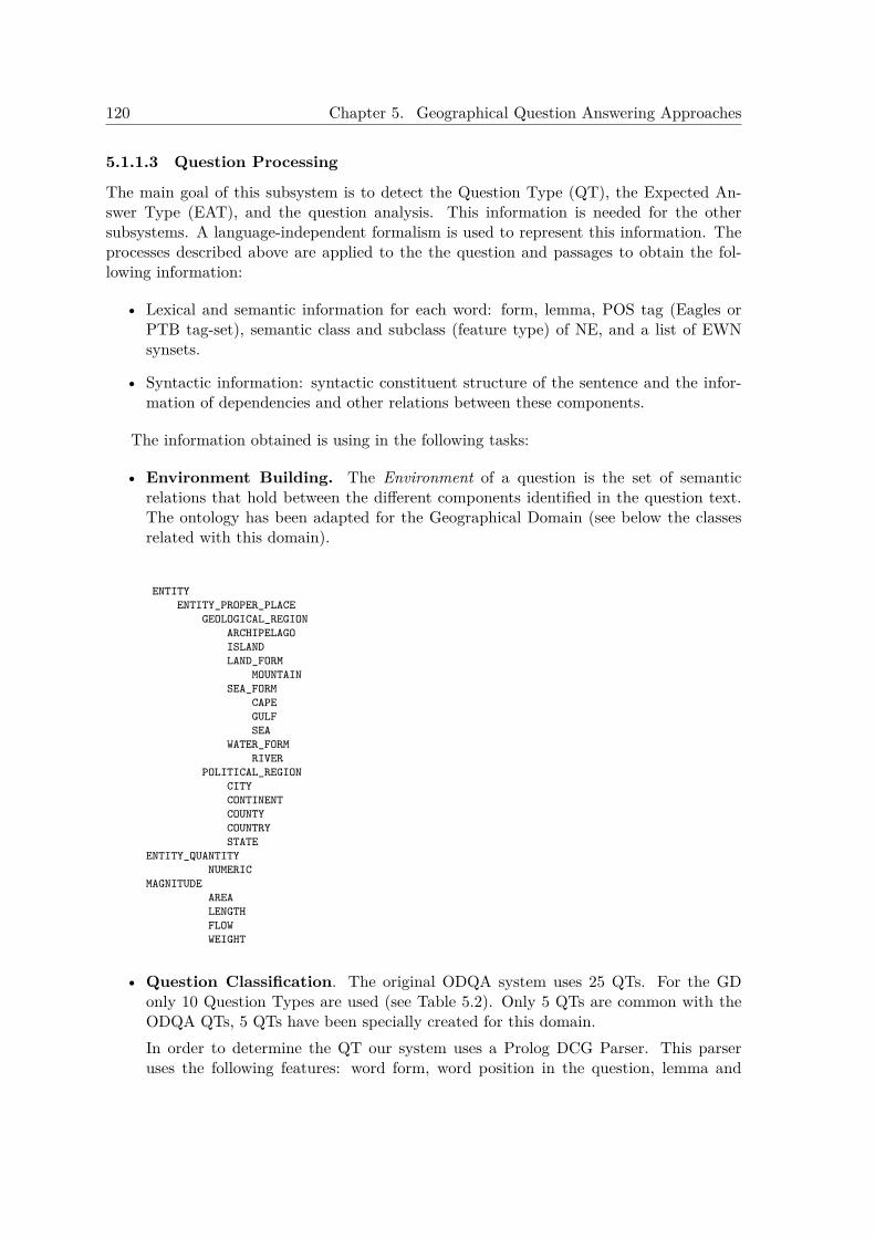
120 Chapter 5. Geographical Question Answering Approaches
5.1.1.3 Question Processing
The main goal of this subsystem is to detect the Question Type (QT), the Expected An-swer Type (EAT), and the question analysis. This information is needed for the othersubsystems. A language-independent formalism is used to represent this information. Theprocesses described above are applied to the the question and passages to obtain the fol-lowing information:
• Lexical and semantic information for each word: form, lemma, POS tag (Eagles orPTB tag-set), semantic class and subclass (feature type) of NE, and a list of EWNsynsets.
• Syntactic information: syntactic constituent structure of the sentence and the infor-mation of dependencies and other relations between these components.
The information obtained is using in the following tasks:
• Environment Building. The Environment of a question is the set of semanticrelations that hold between the different components identified in the question text.The ontology has been adapted for the Geographical Domain (see below the classesrelated with this domain).
ENTITYENTITY_PROPER_PLACE
GEOLOGICAL_REGIONARCHIPELAGOISLANDLAND_FORM
MOUNTAINSEA_FORM
CAPEGULFSEA
WATER_FORMRIVER
POLITICAL_REGIONCITYCONTINENTCOUNTYCOUNTRYSTATE
ENTITY_QUANTITYNUMERIC
MAGNITUDEAREALENGTHFLOWWEIGHT
• Question Classification. The original ODQA system uses 25 QTs. For the GDonly 10 Question Types are used (see Table 5.2). Only 5 QTs are common with theODQA QTs, 5 QTs have been specially created for this domain.In order to determine the QT our system uses a Prolog DCG Parser. This parseruses the following features: word form, word position in the question, lemma and
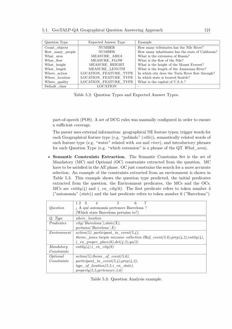
5.1. GeoTALP-QA Geographical Question Answering Approach 121
Question Type Expected Answer Type ExampleCount_objects NUMBER How many tributaries has the Nile River?How_many_people NUMBER How many inhabitants has the state of California?What_area MEASURE_AREA What is the extension of Russia?What_flow MEASURE_FLOW What is the flow of the Nile?What_height MEASURE_HEIGHT What is the height of the Mount Everest?What_length MEASURE_LENGTH What is the length of the Amazonas River?Where_action LOCATION_FEATURE_TYPE In which city does the Turia River flow through?Where_location LOCATION_FEATURE_TYPE In which state is located Seattle?Where_quality LOCATION_FEATURE_TYPE What is the capital of U.S.A.?Default_class LOCATION -
Table 5.2: Question Types and Expected Answer Types.
part-of-speech (POS). A set of DCG rules was manually configured in order to ensurea sufficient coverage.The parser uses external information: geographical NE feature types, trigger words foreach Geographical feature type (e.g. “poblado” (ville)), semantically related words ofeach feature type (e.g. “water” related with sea and river), and introductory phrasesfor each Question Type (e.g. “which extension” is a phrase of the QT What_area).
• Semantic Constraints Extraction. The Semantic Constrains Set is the set ofMandatory (MC) and Optional (OC) constraints extracted from the question. MChave to be satisfied in the AE phase. OC just constrains the search for a more accurateselection. An example of the constraints extracted from an environment is shown inTable 5.3. This example shows the question type predicted, the initial predicatesextracted from the question, the Environment predicates, the MCs and the OCs.MCs are entity(4) and i_en_city(6). The first predicate refers to token number 4(”autonomia” (state)) and the last predicate refers to token number 6 (”Barcelona”).
1 2 3 4 5 6 7Question ¿ A qué autonomía pertenece Barcelona ?
(Which state Barcelona pertains to?)Q. Type where_locationPredicates city(’Barcelona’),state(X),
pertains(’Barcelona’,X)Environment action(5), participant_in_event(5,4),
theme_jones turpin mizzano collection IRof_event(5,6),prep(4,2),entity(4),i_en_proper_place(6),det(4,3),qu(3)
Mandatory entity(4),i_en_city(6)ConstraintsOptional action(5),theme_of_event(5,6),Constraints participant_in_event(5,4),prep(4,2),
type_of_location(5,5,i_en_state),property(5,5,pertenecer,3,6)
Table 5.3: Question Analysis example.

122 Chapter 5. Geographical Question Answering Approaches
5.1.1.4 Passage Retrieval
Two different approaches were used for Passage Retrieval. The first one used a pre-processedcorpus as a document collection. The second one used the web as document collection.
5.1.1.4.1 Knowledge-Based Off-line Corpus Retrieval This approach used a pre-processed and indexed corpus with Scope-related Geographical Information as a documentcollection for Passage Retrieval. The processed information was used for indexing thedocuments. Storing this information allowed to avoid the pre-processing step after retrieval.The Passage Retrieval algorithm used is the same used in the TALP-QA ODQA system andused also in the GeoCLEF2005 approach for GIR: a data-driven query relaxation techniquewith dynamic passages implemented using Lucene IR engine API (See Chapter 4.1.3 andFerrés et al. (2005c) for more details).
5.1.1.4.2 Data-Driven Online Web Snippet Retrieval The other approach useda search-engine to get snippets with relevant information. It was expected to get a highrecall with few snippets. In our experiments, Google was chosen as the search-engine usinga boolean retrieval schema that takes advantage of its phrase search option and the Geo-graphical KB to create queries that can retrieve highly relevant snippets. This approachtried to maximize the number of relevant sentences with only one query per question.
The algorithm used to build the queries is simple. First, some expansion methodsdescribed below can be applied over the keywords. Then, stop-words (including normalstop-words and some trigger words) are removed. Finally, only the nouns and verbs areextracted from the keywords list. The expansion methods used are:
• Trigger Words Joining (TWJ). Uses the trigger words list and the trigger phrasepattern list (automatically generated from GNS) to join trigger phrases (e.g. “islaConejera” o “Sierra de los Pirineos”).
• Trigger Words Expansion (TWE). This expansion is applied to the NEs that werenot detected as a trigger phrase. The expansion uses its location subclass (featuretype) to create a keyword with the pattern: TRIGGER + NE (e.g. “Conejera” isexpanded to: (”isla Conejera” OR “Conejera”)).
• GNS Grouping Expansion (CE). Noun Phrase expansion based on the groupsgenerated from GNS Gazetteer.
• Question-based Expansion (QBE). This method appends keywords or expandsthe query depending on the question type. As an example, in the case of a questionclassified as What_length, trigger words and units associated to the question class like“longitud” (length) and “kilómetros” (kilometers) are appended to the query.
5.1.1.5 Answer Extraction
The system can use two different sub-systems for Answer Extraction: our ODQA system(adapted for the GD) and a frequency based system.
5.1. GeoTALP-QA Geographical Question Answering Approach 123
5.1.1.5.1 Knowledge-Based ODQA Extraction The Candidates Extraction phaseis based on a relaxation process of the set of semantic constraints that is performed bymeans of structural or semantic relaxation rules, using the semantic ontology (see Ferréset al. (2005c)). Then an extraction process applies a set of extraction rules on the set ofsentences that have satisfied the Mandatory Constraints. In order to select the answer fromthe set of candidates, the following scores are computed for each candidate sentence: i) therule score (which uses factors such as the confidence of the rule used, the relevance of theOC satisfied in the matching, and the similarity between NEs occurring in the candidatesentence and the question), ii) the passage score, iii) the semantic score , iv) the relaxationscore (which takes into account the level of rule relaxation in which the candidate has beenextracted). For each candidate the values of these scores are normalized and accumulatedin a global score. The answer to the question is the candidate with the best global score.
5.1.1.5.2 Data-Driven Frequency-Based Extraction This extraction algorithm isquite simple. First, all snippets are pre-processed. Then, a ranked list of all the tokenssatisfying the expected answer type of the question is created. The score of each token inthe snippets is computed using the following formula:
Score(tki) =∑
o∈Occurrence(tki)
1
snippet_rank(o)
Finally, the top-ranked token is extracted.
5.1.2 Resources for Scope-Based ExperimentsThis subsection describes how we obtained the resources needed to carry out experiments inthe Spanish Geography domain using Spanish language. These resources were: the questioncorpus (validation and test), the document collection required by the Knowledge-Based off-line ODQA Passage Retrieval, and the geographical scope-based resources. Finally, theexperiments performed are described.
5.1.2.1 Language and Scope Based Geographical Question Corpus
A corpus of Geographical questions was obtained from Albayzin, a speech corpus (Diazet al., 1998) that contains a geographical subcorpus with utterances of questions aboutthe geography of Spain in Spanish. A set of 6,887 question patterns were obtained fromAlbayzin. This corpus were analyzed and the following type of questions were extracted:Partial Direct, Partial Indirect, and Imperative Interrogative factoid questions with a sim-ple level of difficulty (e.g. questions without nested questions). A set of 2,287 questionpatterns was selected. To create the question corpus a random process selected a set of 177question patterns from the previous selection (see Table 5.4). These patterns have beenrandomly instantiated with Geographical NEs of the Albayzin corpus. Then, the answerswere searched in the Web and the Spanish Wikipedia (SW). The results of this processwere: 123 questions with answer in the SW and the Web, 33 questions without answer inthe SW but with answer using the Web, and finally, 21 questions without answer (due tothe fact that some questions when instantiated cannot be answered (e.g. which sea bathesthe coast of Madrid?)). The 123 questions with answer in the SW were divided in two sets:61 questions for development (setting thresholds and other parameters) and 62 for test (seethis questions in Table 5.5.

124 Chapter 5. Geographical Question Answering Approaches
¿A qué comunidad autónoma pertenece el <PICO>?At which state pertains <PEAK>?¿Cuál es el capital de <COMUNIDAD>?Which is the capital of <STATE>?¿Cuál es la comunidad en la que desemboca el <RíO>?What is the state in which <RIVER> flows into?¿Cuál es la extensión de <COMUNIDAD>?Which is the extension of <STATE>?Longitud del río <RíO>.Length of river <RIVER>.¿Cuántos habitantes tiene la <COMUNIDAD>?How many people does <STATE> has?
Table 5.4: Some question patterns from Albayzin.
1 ¿A qué comunidad autónoma pertenece el Puigcampana?To what autonomous community does the Puigcampana belongs?2 ¿A qué comunidad pertenece El Ferrol?To what autonomous community does El Ferrol belongs?3 ¿A qué comunidad pertenece la isla La Gomera?To what community belongs the island La Gomera?4 ¿A qué mar desemboca la ría de Betanzos?To what sea leads the ria of Betanzos?5 ¿Cuál es el sistema de la comunidad autónoma Canaria?What is the mountain range of tha Canary autonomous community?6 ¿Cuál es el capital de Andalucía?What is the capital of Andalusia?7 ¿Cuál es el nombre de la comunidad autónoma en la que se encuentra Cullera?What is the name of the autonomous community in which Cullera is located?8 ¿Cuál es la capital Navarra?What is the capital of Navarre?9 ¿Cuál es la capital de las islas Las Canarias?What is the capital of the Canary Islands?10 ¿Cuál es la comunidad en la que desemboca el Guadalentín?What is the community in which Guadalentín ends?11 ¿Cuál es la extensión de la comunidad Madrileña?What is the extension of the Madrid community?12 ¿Cuál es la extensión de la comunidad autónoma donde está el golfo de Vizcaya?What is the extension of the autonomous community in which the Bay of Biscay is located?13 ¿Cuál es la extensión de la comunidad de Castilla y León?What is the extension of the community of Castilla y León?14 ¿Cuántos habitantes tiene la comunidad autónoma de Castilla?How many inhabitants has the autonomous community of Castile?15 ¿Cómo se llama la capital de la comunidad autónoma de La Rioja?What is the capital of the autonomous community of La Rioja called?16 ¿Cómo se nombra el río que pasa por Granada?How is the river that passes through Granada named?17 Dime a qué sistema pertenece el pico Teide?Tell me which system belongs the peak Teide?18 Dime a qué comunidad pertenece el cabo de La Nao?Tell me which community is the Cape of La Nao?19 Dime a qué comunidad pertenece la ría de Vigo?Tell me which community is the Vigo estuary?20 Dime el mar en que desemboca el Llobregat?Tell me the sea where the Llobregat flows?21 Dime el mar que baña las islas Canarias?Tell me the sea that bathes the Canary Islands?22 Dime en qué sistema nace el río Aragón?
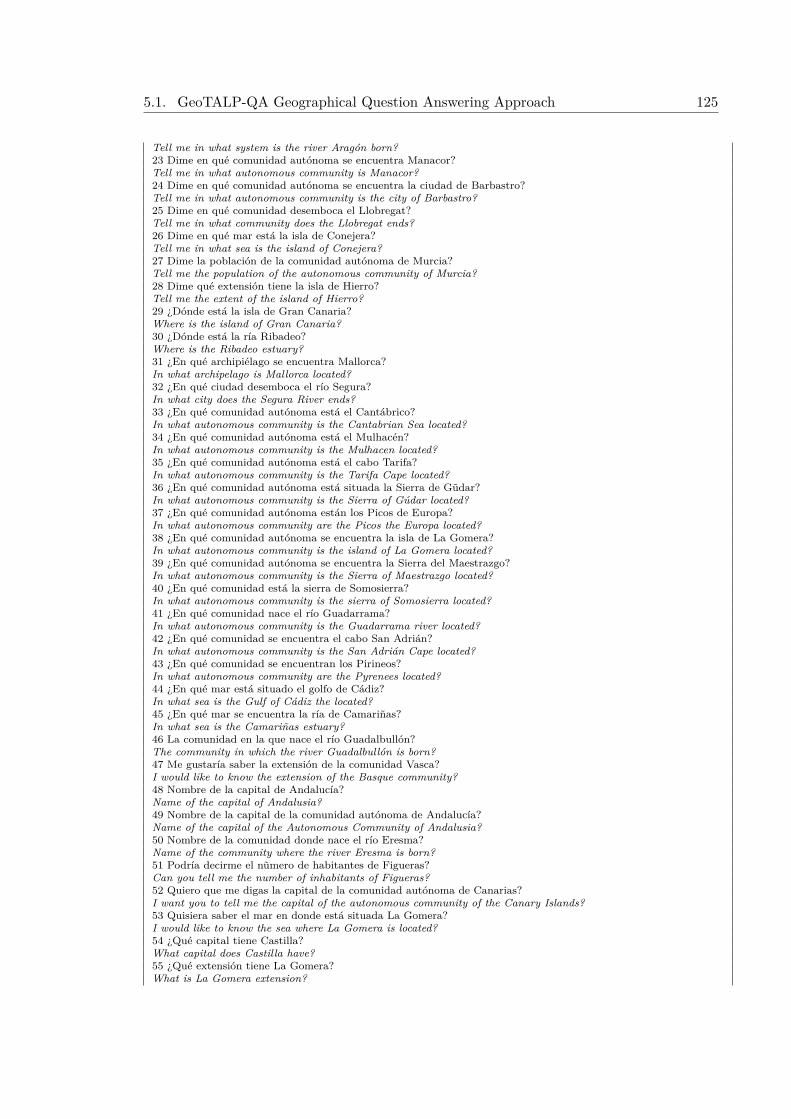
5.1. GeoTALP-QA Geographical Question Answering Approach 125
Tell me in what system is the river Aragón born?23 Dime en qué comunidad autónoma se encuentra Manacor?Tell me in what autonomous community is Manacor?24 Dime en qué comunidad autónoma se encuentra la ciudad de Barbastro?Tell me in what autonomous community is the city of Barbastro?25 Dime en qué comunidad desemboca el Llobregat?Tell me in what community does the Llobregat ends?26 Dime en qué mar está la isla de Conejera?Tell me in what sea is the island of Conejera?27 Dime la población de la comunidad autónoma de Murcia?Tell me the population of the autonomous community of Murcia?28 Dime qué extensión tiene la isla de Hierro?Tell me the extent of the island of Hierro?29 ¿Dónde está la isla de Gran Canaria?Where is the island of Gran Canaria?30 ¿Dónde está la ría Ribadeo?Where is the Ribadeo estuary?31 ¿En qué archipiélago se encuentra Mallorca?In what archipelago is Mallorca located?32 ¿En qué ciudad desemboca el río Segura?In what city does the Segura River ends?33 ¿En qué comunidad autónoma está el Cantábrico?In what autonomous community is the Cantabrian Sea located?34 ¿En qué comunidad autónoma está el Mulhacén?In what autonomous community is the Mulhacen located?35 ¿En qué comunidad autónoma está el cabo Tarifa?In what autonomous community is the Tarifa Cape located?36 ¿En qué comunidad autónoma está situada la Sierra de Gũdar?In what autonomous community is the Sierra of Gúdar located?37 ¿En qué comunidad autónoma están los Picos de Europa?In what autonomous community are the Picos the Europa located?38 ¿En qué comunidad autónoma se encuentra la isla de La Gomera?In what autonomous community is the island of La Gomera located?39 ¿En qué comunidad autónoma se encuentra la Sierra del Maestrazgo?In what autonomous community is the Sierra of Maestrazgo located?40 ¿En qué comunidad está la sierra de Somosierra?In what autonomous community is the sierra of Somosierra located?41 ¿En qué comunidad nace el río Guadarrama?In what autonomous community is the Guadarrama river located?42 ¿En qué comunidad se encuentra el cabo San Adrián?In what autonomous community is the San Adrián Cape located?43 ¿En qué comunidad se encuentran los Pirineos?In what autonomous community are the Pyrenees located?44 ¿En qué mar está situado el golfo de Cádiz?In what sea is the Gulf of Cádiz the located?45 ¿En qué mar se encuentra la ría de Camariñas?In what sea is the Camariñas estuary?46 La comunidad en la que nace el río Guadalbullón?The community in which the river Guadalbullón is born?47 Me gustaría saber la extensión de la comunidad Vasca?I would like to know the extension of the Basque community?48 Nombre de la capital de Andalucía?Name of the capital of Andalusia?49 Nombre de la capital de la comunidad autónoma de Andalucía?Name of the capital of the Autonomous Community of Andalusia?50 Nombre de la comunidad donde nace el río Eresma?Name of the community where the river Eresma is born?51 Podría decirme el nũmero de habitantes de Figueras?Can you tell me the number of inhabitants of Figueras?52 Quiero que me digas la capital de la comunidad autónoma de Canarias?I want you to tell me the capital of the autonomous community of the Canary Islands?53 Quisiera saber el mar en donde está situada La Gomera?I would like to know the sea where La Gomera is located?54 ¿Qué capital tiene Castilla?What capital does Castilla have?55 ¿Qué extensión tiene La Gomera?What is La Gomera extension?
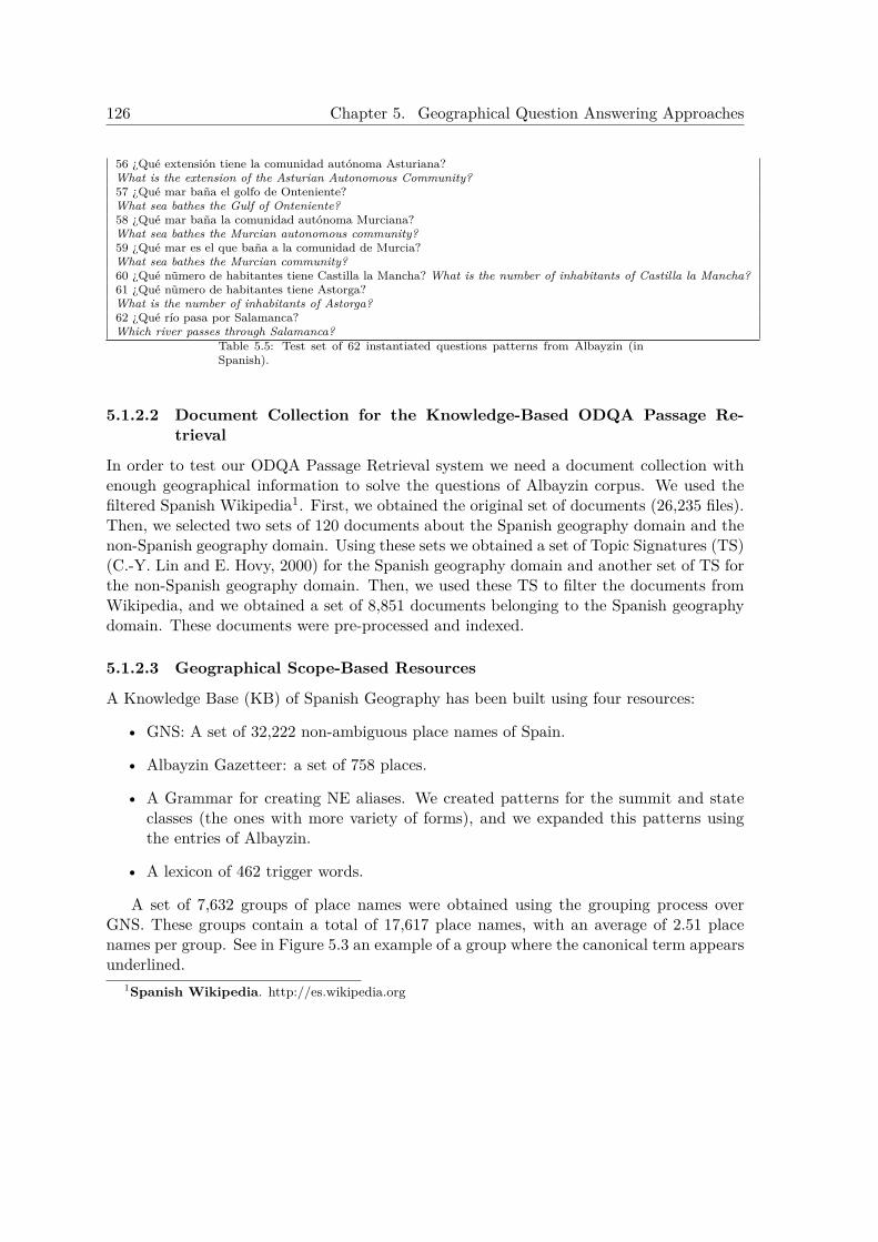
126 Chapter 5. Geographical Question Answering Approaches
56 ¿Qué extensión tiene la comunidad autónoma Asturiana?What is the extension of the Asturian Autonomous Community?57 ¿Qué mar baña el golfo de Onteniente?What sea bathes the Gulf of Onteniente?58 ¿Qué mar baña la comunidad autónoma Murciana?What sea bathes the Murcian autonomous community?59 ¿Qué mar es el que baña a la comunidad de Murcia?What sea bathes the Murcian community?60 ¿Qué nũmero de habitantes tiene Castilla la Mancha? What is the number of inhabitants of Castilla la Mancha?61 ¿Qué nũmero de habitantes tiene Astorga?What is the number of inhabitants of Astorga?62 ¿Qué río pasa por Salamanca?Which river passes through Salamanca?
Table 5.5: Test set of 62 instantiated questions patterns from Albayzin (inSpanish).
5.1.2.2 Document Collection for the Knowledge-Based ODQA Passage Re-trieval
In order to test our ODQA Passage Retrieval system we need a document collection withenough geographical information to solve the questions of Albayzin corpus. We used thefiltered Spanish Wikipedia1. First, we obtained the original set of documents (26,235 files).Then, we selected two sets of 120 documents about the Spanish geography domain and thenon-Spanish geography domain. Using these sets we obtained a set of Topic Signatures (TS)(C.-Y. Lin and E. Hovy, 2000) for the Spanish geography domain and another set of TS forthe non-Spanish geography domain. Then, we used these TS to filter the documents fromWikipedia, and we obtained a set of 8,851 documents belonging to the Spanish geographydomain. These documents were pre-processed and indexed.
5.1.2.3 Geographical Scope-Based Resources
A Knowledge Base (KB) of Spanish Geography has been built using four resources:
• GNS: A set of 32,222 non-ambiguous place names of Spain.
• Albayzin Gazetteer: a set of 758 places.
• A Grammar for creating NE aliases. We created patterns for the summit and stateclasses (the ones with more variety of forms), and we expanded this patterns usingthe entries of Albayzin.
• A lexicon of 462 trigger words.
A set of 7,632 groups of place names were obtained using the grouping process overGNS. These groups contain a total of 17,617 place names, with an average of 2.51 placenames per group. See in Figure 5.3 an example of a group where the canonical term appearsunderlined.
1Spanish Wikipedia. http://es.wikipedia.org

5.1. GeoTALP-QA Geographical Question Answering Approach 127
{Cordillera Pirenaica, Pireneus, Pirineos,Pyrenaei Montes, Pyrénées, Pyrene, Pyre-nees}
Figure 5.3: Example of a group obtained from GNS.
In addition, a set of the most common trigger phrases in the domain has been obtainedfrom the GNS gazetteer (see Table 5.6).
Geographical ScopeSpain UK
TRIGGER de NE NE TRIGGERTop-ranked TRIGGER NE TRIGGER NETrigger TRIGGER del NE TRIGGER of NEPhrases TRIGGER de la NE TRIGGER a’ NE
TRIGGER de las NE TRIGGER na NE
Table 5.6: Sample of the top-ranked trigger phrases automatically obtained from GNSgazetteer for the geography of Spain and UK.
5.1.3 ExperimentsThe experiments to evaluate the accuracy of different subsystems and operational modeswere performed over the 62 instantiated test questions patterns from albayzin corpus. Theaccuracy measures of the GDQA system and its subsystems (Question Processing , PassageRetrieval, and Answer Extraction) with its two execution modes (Knowledge-Based andData-Driven) were calculated. For the Data-Driven operational mode of the system, thePassage Retrieval phase and the global system accuracy were evaluated over the web-basedsnippet retrieval with queries to Google API with some variants of query expansions. Forthe Knowledge-Based operational mode of the system, the Passage Retrieval phase wasevaluated over the dataset extracted from the filtered Spanish Wikipedia; and the AnswerExtraction phase and the global accuracy were evaluated over tw the web-based snippetretrieval an the set of filtered geographically relevant documents from Spanish Wikipedia.
5.1.4 ResultsThis section evaluates the behavior of our GDQA system over a test corpus of 62 questionsand reports the errors detected on the best run. The whole system and its three maincomponents are evaluated.
• Question Processing. The Question Classification task has been manually evalu-ated. This subsystem has an accuracy of 96.77%.
• Passage Retrieval. The results of the evaluation of this subsystem for both the twokinds of Retrieval: ODQA+Wiki and google snippets with query expansions.are shown in Table 5.7. The answer accuracy at N passages/snippets measure com-putes the ratio of questions that have a correct answer in its set of passages or snippets.
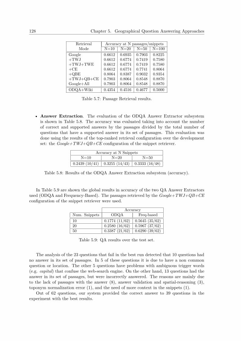
128 Chapter 5. Geographical Question Answering Approaches
Retrieval Accuracy at N passages/snippetsMode N=10 N=20 N=50 N=100
Google 0.6612 0.6935 0.7903 0.8225+TWJ 0.6612 0.6774 0.7419 0.7580+TWJ+TWE 0.6612 0.6774 0.7419 0.7580+CE 0.6612 0.6774 0.7741 0.8064+QBE 0.8064 0.8387 0.9032 0.9354+TWJ+QB+CE 0.7903 0.8064 0.8548 0.8870Google+All 0.7903 0.8064 0.8548 0.8870ODQA+Wiki 0.4354 0.4516 0.4677 0.5000
Table 5.7: Passage Retrieval results.
• Answer Extraction. The evaluation of the ODQA Answer Extractor subsystemis shown in Table 5.8. The accuracy was evaluated taking into account the numberof correct and supported answers by the passages divided by the total number ofquestions that have a supported answer in its set of passages. This evaluation wasdone using the results of the top-ranked retrieval configuration over the developmentset: the Google+TWJ+QB+CE configuration of the snippet retriever.
Accuracy at N SnippetsN=10 N=20 N=50
0.2439 (10/41) 0.3255 (14/43) 0.3333 (16/48)
Table 5.8: Results of the ODQA Answer Extraction subsystem (accuracy).
In Table 5.9 are shown the global results in accuracy of the two QA Answer Extractorsused (ODQA and Frequency-Based). The passages retrieved by the Google+TWJ+QB+CEconfiguration of the snippet retriever were used.
AccuracyNum. Snippets ODQA Freq-based10 0.1774 (11/62) 0.5645 (35/62)20 0.2580 (16/62) 0.5967 (37/62)50 0.3387 (21/62) 0.6290 (39/62)
Table 5.9: QA results over the test set.
The analysis of the 23 questions that fail in the best run detected that 10 questions hadno answer in its set of passages. In 5 of these questions it is due to have a non commonquestion or location. The other 5 questions have problems with ambiguous trigger words(e.g. capital) that confuse the web-search engine. On the other hand, 13 questions had theanswer in its set of passages, but were incorrectly answered. The reasons are mainly dueto the lack of passages with the answer (8), answer validation and spatial-reasoning (3),toponym normalization error (1), and the need of more context in the snippets (1).
Out of 62 questions, our system provided the correct answer to 39 questions in theexperiment with the best results.

5.1. GeoTALP-QA Geographical Question Answering Approach 129
The Passage Retrieval for ODQA offers less attractive results when using the SW corpus.The problem of using a corpus of the SpanishWikipedia to extract the answers is that it givesfew documents with the correct answer, and, it is difficult to extract the answer becausethe documents contain tables, lists, ill-formed sentences, etc. The ODQA AE needs agrammatically well-structured text to extract correctly the answers. The QA system offersa low performance (33% of accuracy) when using this AE over the web-based retrievedpassages. In some cases, the snippets are cut and better performance will be expected byretrieving the whole documents from Google.
On the other hand, web-based snippet retrieval, with only one query per question, givesgood results in Passage Retrieval. The QA system with the Frequency-Based Answer Ex-tractor obtained better results than the system witht the ODQA Answer Extractor (62.9%versus 33.87% of accuracy using a set of 50 snippets).
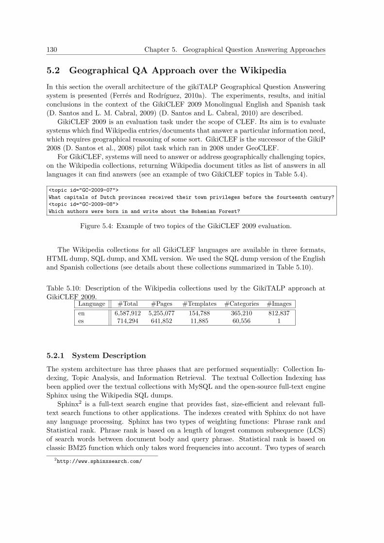
130 Chapter 5. Geographical Question Answering Approaches
5.2 Geographical QA Approach over the WikipediaIn this section the overall architecture of the gikiTALP Geographical Question Answeringsystem is presented (Ferrés and Rodríguez, 2010a). The experiments, results, and initialconclusions in the context of the GikiCLEF 2009 Monolingual English and Spanish task(D. Santos and L. M. Cabral, 2009) (D. Santos and L. Cabral, 2010) are described.
GikiCLEF 2009 is an evaluation task under the scope of CLEF. Its aim is to evaluatesystems which find Wikipedia entries/documents that answer a particular information need,which requires geographical reasoning of some sort. GikiCLEF is the successor of the GikiP2008 (D. Santos et al., 2008) pilot task which ran in 2008 under GeoCLEF.
For GikiCLEF, systems will need to answer or address geographically challenging topics,on the Wikipedia collections, returning Wikipedia document titles as list of answers in alllanguages it can find answers (see an example of two GikiCLEF topics in Table 5.4).
<topic id="GC-2009-07">What capitals of Dutch provinces received their town privileges before the fourteenth century?<topic id="GC-2009-08">Which authors were born in and write about the Bohemian Forest?
Figure 5.4: Example of two topics of the GikiCLEF 2009 evaluation.
The Wikipedia collections for all GikiCLEF languages are available in three formats,HTML dump, SQL dump, and XML version. We used the SQL dump version of the Englishand Spanish collections (see details about these collections summarized in Table 5.10).
Table 5.10: Description of the Wikipedia collections used by the GikiTALP approach atGikiCLEF 2009.
Language #Total #Pages #Templates #Categories #Imagesen 6,587,912 5,255,077 154,788 365,210 812,837es 714,294 641,852 11,885 60,556 1
5.2.1 System DescriptionThe system architecture has three phases that are performed sequentially: Collection In-dexing, Topic Analysis, and Information Retrieval. The textual Collection Indexing hasbeen applied over the textual collections with MySQL and the open-source full-text engineSphinx using the Wikipedia SQL dumps.
Sphinx2 is a full-text search engine that provides fast, size-efficient and relevant full-text search functions to other applications. The indexes created with Sphinx do not haveany language processing. Sphinx has two types of weighting functions: Phrase rank andStatistical rank. Phrase rank is based on a length of longest common subsequence (LCS)of search words between document body and query phrase. Statistical rank is based onclassic BM25 function which only takes word frequencies into account. Two types of search
2http://www.sphinxsearch.com/

5.2. Geographical QA Approach over the Wikipedia 131
modes in Sphinx were used (see 3 for more information about the search mode and weightingschemes used):
• MATCH ALL: the final weight is a sum of weighted phrase ranks.
• MATCH EXTENDED: the final weight is a sum of weighted phrase ranks and BM25weight, multiplied by 1000 and rounded to integer.
The Topic Analysis phase extracts some relevant keywords (with its analysis) from thetopics. These keywords are then used by the Document Retrieval phases. This process ex-tracts lexico-semantic information using the following set of Natural Language Processingtools: TnT POS tagger (Brants, 2000), WordNet lemmatizer (version 2.0) for English, andFreeling (Atserias et al., 2006) for Spanish. Some of these NLP tools were used also for theGIR task in GeoCLEF 2007 (Ferrés and Rodríguez, 2007b) as described in Chapter 4. Thelanguage processing with these NLP tools is applied only in the queries. The Wikipedia col-lection is indexed without applying the stemming and stopword filtering options of Sphinx.The retrieval is done with Sphinx and then the final results are filtered. The Wikipediaentries without Categories are discarded.
5.2.2 Experiments at GikiCLEF 2009For the GikiCLEF 2009 evaluation a set of three experiments were designed (Ferrés and Ro-dríguez, 2010a). These experiments consisted in applying different baseline configurations(see Table 5.11) to retrieve Wikipedia entries (answers) of 50 geographically challengingtopics.
The three baseline runs were designed changing two parameters of the system: theIR Sphinx search mode and the Natural Language Processing techniques applied over thequery. The first run (gikiTALP1) do not uses any NLP processing technique over thequery and the Sphinx match mode used is MATCH_ALL. The second run (gikiTALP2)uses stopwords filtering and the lemmas of the remaining words as a query and the Sphinxmatch mode used is MATCH_ALL. The third run (gikiTALP3) uses stopwords filteringand the lemmas of the remaining words as a query and the Sphinx match mode used isMATCH_EXTENDED.
Table 5.11: Description of the experiments at GikiCLEF 2009.Automatic Runs NLP in Query Sphinx MatchgikiTALP1 - MATCH_ALL (phrase rank)gikiTALP2 lemma + stopwords filtering MATCH_ALL (phrase rank)gikiTALP3 lemma + stopwords filtering MATCH_EXTENDED (BM25)
3http://www.sphinxsearch.com/docs/current.html. Sphinx 0.9.9 documentation.
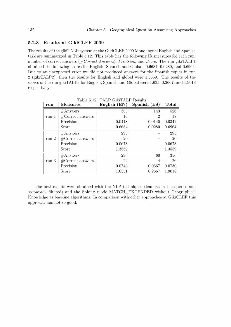
132 Chapter 5. Geographical Question Answering Approaches
5.2.3 Results at GikiCLEF 2009The results of the gikiTALP system at the GikiCLEF 2009 Monolingual English and Spanishtask are summarized in Table 5.12. This table has the following IR measures for each run:number of correct answers (#Correct Answers), Precision, and Score. The run gikiTALP1obtained the following scores for English, Spanish and Global: 0.6684, 0.0280, and 0.6964.Due to an unexpected error we did not produced answers for the Spanish topics in run2 (gikiTALP2), then the results for English and global were 1,3559. The results of thescores of the run gikiTALP3 for English, Spanish and Global were 1.635, 0.2667, and 1.9018respectively.
Table 5.12: TALP GikiTALP Resultsrun Measures English (EN) Spanish (ES) Total
#Answers 383 143 526run 1 #Correct answers 16 2 18
Precision 0.0418 0.0140 0.0342Score 0.6684 0.0280 0.6964#Answers 295 – 295
run 2 #Correct answers 20 – 20Precision 0.0678 – 0.0678Score 1.3559 – 1.3559#Answers 296 60 356
run 3 #Correct answers 22 4 26Precision 0.0743 0.0667 0.0730Score 1.6351 0.2667 1.9018
The best results were obtained with the NLP techniques (lemmas in the queries andstopwords filtered) and the Sphinx mode MATCH_EXTENDED without GeographicalKnowledge as baseline algorithms. In comparison with other approaches at GikiCLEF thisapproach was not so good.
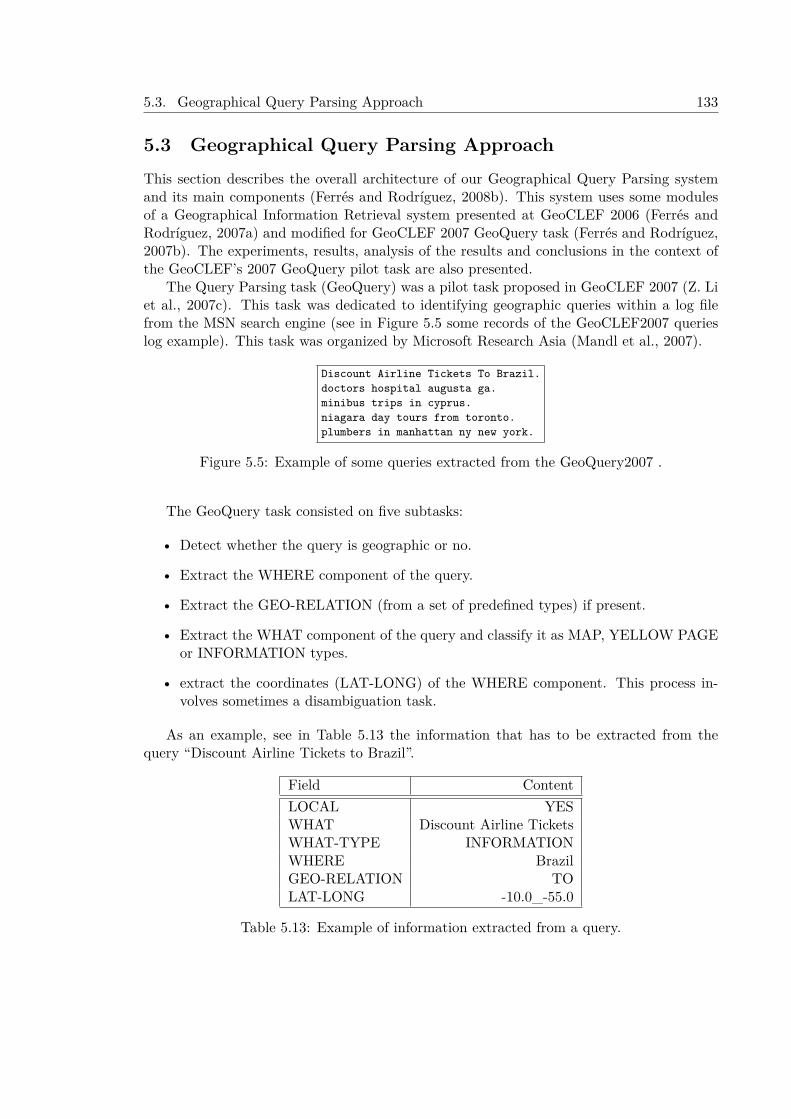
5.3. Geographical Query Parsing Approach 133
5.3 Geographical Query Parsing ApproachThis section describes the overall architecture of our Geographical Query Parsing systemand its main components (Ferrés and Rodríguez, 2008b). This system uses some modulesof a Geographical Information Retrieval system presented at GeoCLEF 2006 (Ferrés andRodríguez, 2007a) and modified for GeoCLEF 2007 GeoQuery task (Ferrés and Rodríguez,2007b). The experiments, results, analysis of the results and conclusions in the context ofthe GeoCLEF’s 2007 GeoQuery pilot task are also presented.
The Query Parsing task (GeoQuery) was a pilot task proposed in GeoCLEF 2007 (Z. Liet al., 2007c). This task was dedicated to identifying geographic queries within a log filefrom the MSN search engine (see in Figure 5.5 some records of the GeoCLEF2007 querieslog example). This task was organized by Microsoft Research Asia (Mandl et al., 2007).
Discount Airline Tickets To Brazil.doctors hospital augusta ga.minibus trips in cyprus.niagara day tours from toronto.plumbers in manhattan ny new york.
Figure 5.5: Example of some queries extracted from the GeoQuery2007 .
The GeoQuery task consisted on five subtasks:
• Detect whether the query is geographic or no.
• Extract the WHERE component of the query.
• Extract the GEO-RELATION (from a set of predefined types) if present.
• Extract the WHAT component of the query and classify it as MAP, YELLOW PAGEor INFORMATION types.
• extract the coordinates (LAT-LONG) of the WHERE component. This process in-volves sometimes a disambiguation task.
As an example, see in Table 5.13 the information that has to be extracted from thequery “Discount Airline Tickets to Brazil”.
Field ContentLOCAL YESWHAT Discount Airline TicketsWHAT-TYPE INFORMATIONWHERE BrazilGEO-RELATION TOLAT-LONG -10.0_-55.0
Table 5.13: Example of information extracted from a query.
134 Chapter 5. Geographical Question Answering Approaches
5.3.1 System DescriptionThe system architecture has two main phases that are performed sequentially: Topic Anal-ysis and Question Classification.
5.3.1.1 Topic Analysis
The Topic Analysis phase has two main components: a Linguistic Analysis and a Geograph-ical Analysis.
5.3.1.2 Linguistic Analysis
This process extracts lexico-semantic and syntactic information using the following set ofNatural Language Processing tools (explained previously in Chapter 4): i) TnT an statisti-cal POS tagger (Brants, 2000), ii) WordNet lemmatizer (version 2.0), iii) A MaximumEntropy based NERC trained with the CONLL-2003 shared task English data set, iv)Spear a modified version of the Collins parser (Collins, 1999).
A dataset of 800.000 queries in English from a web search-engine was pre-processed withlinguistic tools to obtain the following data structures:
• Sent, which provides lexical information for each word: form, lemma, POS tag (Penn-Tree-Bank (PTB) tag-set for English), semantic class of NE, list of EWN synsets and,finally, whenever possible the verbs associated with the actor and the relations betweensome locations (specially countries) and their gentiles (e.g. nationality).
• Sint, composed of two lists, one recording the syntactic constituent structure of thequestion (basically nominal, prepositional and verbal phrases) and the other collectingthe information of dependencies and other relations between these components.
• Environment. The environment represents the semantic relations that hold betweenthe different components identified in the question text. These relations are organizedinto an ontology of about 100 semantic classes and 25 relations (mostly binary) be-tween them. Both classes and relations are related by taxonomic links. The ontologytries to reflect what is needed for an appropriate representation of the semantic envi-ronment of the question (and the expected answer). The environment of the questionis obtained from Sint and Sent. A set of about 150 rules was built to perform thistask. Refer to Ferrés et al. (2004a) for details.
5.3.1.3 Geographical Analysis
The Geographical Analysis is applied to the Named Entities from the queries that havebeen classified as LOCATION or ORGANIZATION by the NERC module. A GeographicalThesaurus is used to extract geographical information about these Name Entities. Thiscomponent has been built joining four gazetteers that contain entries with places and theirgeographical class, coordinates, and other information (this thesaurus has been describedin Chapter 4). This thesaurus contains subsets of data from: GNS, GNIS, GeoWorldMapand World Gazetteer.
A subset of the most important features from this thesaurus has been manually set using46.132 places (including all kind of geographical features: countries, cities, rivers, states,…).
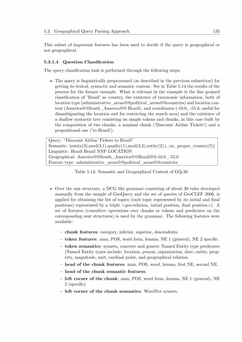
5.3. Geographical Query Parsing Approach 135
This subset of important features has been used to decide if the query is geographical ornot geographical.
5.3.1.4 Question Classification
The query classification task is performed through the following steps:
• The query is linguistically preprocessed (as described in the previous subsection) forgetting its lexical, syntactic and semantic content. See in Table 5.14 the results of theprocess for the former example. What is relevant in the example is the fine grainedclassification of ’Brazil’ as country, the existence of taxonomic information, both oflocation type (administrative_areas@@political_areas@@countries) and location con-tent (America@@South_America@@ Brazil), and coordinates (-10.0_-55.0, useful fordisambiguating the location and for restricting the search area) and the existence ofa shallow syntactic tree consisting on simple tokens and chunks, in this case built bythe composition of two chunks, a nominal chunk (’Discount Airline Tickets’) and aprepositional one (’to Brazil’).
Query: “Discount Airline Tickets to Brazil”Semantic: [entity(3),mod(3,1),quality(1),mod(3,2),entity(2),i_en_proper_country(5)]Linguistic: Brazil Brazil NNP LOCATIONGeographical: America@@South_America@@Brazil@@-10.0_-55.0Feature type: administrative_areas@@political_areas@@countries
Table 5.14: Semantic and Geographical Content of GQ-38.
• Over the sint structure, a DCG like grammar consisting of about 30 rules developedmanually from the sample of GeoQuery and the set of queries of GeoCLEF 2006, isapplied for obtaining the list of topics (each topic represented by its initial and finalpositions) represented by a triple <geo-relation, initial position, final position>). Aset of features (consultive operations over chunks or tokens and predicates on thecorresponding sent structures) is used by the grammar. The following features wereavailable:
– chunk features: category, inferior, superior, descendents.– token features: num, POS, word form, lemma, NE 1 (general), NE 2 specific.– token semantics: synsets, concrete and generic Named Entity type predicates
(Named Entity types include: location, person, organization, date, entity, prop-erty, magnitude, unit, cardinal point, and geographical relation.
– head of the chunk features: num, POS, word, lemma, first NE, second NE.– head of the chunk semantic features.– left corner of the chunk: num, POS, word form, lemma, NE 1 (general), NE
2 (specific)– left corner of the chunk semantics: WordNet synsets.
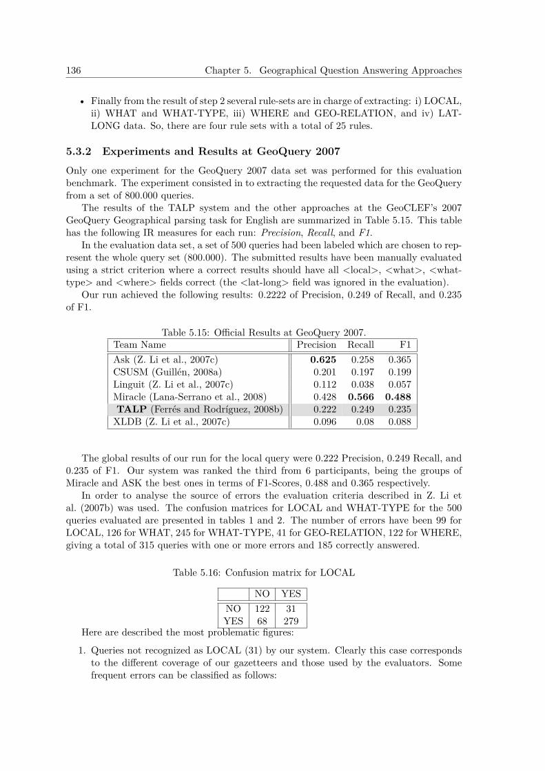
136 Chapter 5. Geographical Question Answering Approaches
• Finally from the result of step 2 several rule-sets are in charge of extracting: i) LOCAL,ii) WHAT and WHAT-TYPE, iii) WHERE and GEO-RELATION, and iv) LAT-LONG data. So, there are four rule sets with a total of 25 rules.
5.3.2 Experiments and Results at GeoQuery 2007Only one experiment for the GeoQuery 2007 data set was performed for this evaluationbenchmark. The experiment consisted in to extracting the requested data for the GeoQueryfrom a set of 800.000 queries.
The results of the TALP system and the other approaches at the GeoCLEF’s 2007GeoQuery Geographical parsing task for English are summarized in Table 5.15. This tablehas the following IR measures for each run: Precision, Recall, and F1.
In the evaluation data set, a set of 500 queries had been labeled which are chosen to rep-resent the whole query set (800.000). The submitted results have been manually evaluatedusing a strict criterion where a correct results should have all <local>, <what>, <what-type> and <where> fields correct (the <lat-long> field was ignored in the evaluation).
Our run achieved the following results: 0.2222 of Precision, 0.249 of Recall, and 0.235of F1.
Table 5.15: Official Results at GeoQuery 2007.Team Name Precision Recall F1Ask (Z. Li et al., 2007c) 0.625 0.258 0.365CSUSM (Guillén, 2008a) 0.201 0.197 0.199Linguit (Z. Li et al., 2007c) 0.112 0.038 0.057Miracle (Lana-Serrano et al., 2008) 0.428 0.566 0.488TALP (Ferrés and Rodríguez, 2008b) 0.222 0.249 0.235XLDB (Z. Li et al., 2007c) 0.096 0.08 0.088
The global results of our run for the local query were 0.222 Precision, 0.249 Recall, and0.235 of F1. Our system was ranked the third from 6 participants, being the groups ofMiracle and ASK the best ones in terms of F1-Scores, 0.488 and 0.365 respectively.
In order to analyse the source of errors the evaluation criteria described in Z. Li etal. (2007b) was used. The confusion matrices for LOCAL and WHAT-TYPE for the 500queries evaluated are presented in tables 1 and 2. The number of errors have been 99 forLOCAL, 126 for WHAT, 245 for WHAT-TYPE, 41 for GEO-RELATION, 122 for WHERE,giving a total of 315 queries with one or more errors and 185 correctly answered.
Table 5.16: Confusion matrix for LOCAL
NO YESNO 122 31YES 68 279
Here are described the most problematic figures:
1. Queries not recognized as LOCAL (31) by our system. Clearly this case correspondsto the different coverage of our gazetteers and those used by the evaluators. Somefrequent errors can be classified as follows:
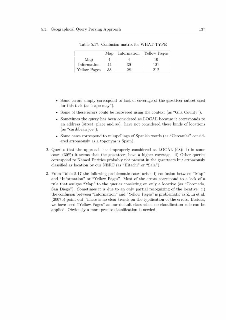
5.3. Geographical Query Parsing Approach 137
Table 5.17: Confusion matrix for WHAT-TYPE
Map Information Yellow PagesMap 4 4 10
Information 44 39 121Yellow Pages 38 28 212
• Some errors simply correspond to lack of coverage of the gazetteer subset usedfor this task (as “cape may”).
• Some of these errors could be recovered using the context (as “Gila County”).• Sometimes the query has been considered as LOCAL because it corresponds to
an address (street, place and so). have not considered these kinds of locations(as “caribbean joe”).
• Some cases correspond to misspellings of Spanish words (as “Cercanías” consid-ered erroneously as a toponym is Spain).
2. Queries that the approach has improperly considered as LOCAL (68): i) in somecases (30%) it seems that the gazetteers have a higher coverage. ii) Other queriescorrespond to Named Entities probably not present in the gazetteers but erroneouslyclassified as location by our NERC (as “Hitachi” or “Sala”).
3. From Table 5.17 the following problematic cases arise: i) confusion between “Map”and “Information” or “Yellow Pages”. Most of the errors correspond to a lack of arule that assigns “Map” to the queries consisting on only a locative (as “Coronado,San Diego”). Sometimes it is due to an only partial recognizing of the locative. ii)the confusion between “Information” and “Yellow Pages” is problematic as Z. Li et al.(2007b) point out. There is no clear trends on the typification of the errors. Besides,we have used “Yellow Pages” as our default class when no classification rule can beapplied. Obviously a more precise classification is needed.

138 Chapter 5. Geographical Question Answering Approaches
5.4 ConclusionsThis Chapter describes three heterogeneous approaches for Geographical Question Answer-ing in English and Spanish: 1) GeoTALP-QA system with the Knowledge-Based and Data-Driven operational modes, 2) GikiTALP, and 3) GeoQuery2007 Query Parsing.
GeoTALP-QA is an adaptation of an existing multilingual Open-Domain Question An-swering (ODQA) system for factoid questions to a Restricted Domain, the GeographicalDomain, that has two kind of operational modes for Answer Extraction (Knowledge-Basedand Data-Driven), and two kind of sources of passages: indexed documents from a prepro-cessed corpora or a query-expansion based Passage-Retrieval that uses the Google searchAPI. The system focuses on a Geographical Scope: given a region, or country, and a lan-guage the system can semi-automatically obtain multilingual geographical resources (e.g.gazetteers, trigger words, groups of place names, etc.) of this scope. The system has beentrained and evaluated for Spanish in the scope of the Spanish Geography. A set of 62 ques-tions about Spanish Geography has been used to evaluate the Geo-TALP-QA approaches.Out of 62 questions, our system provided the correct answer to 39 questions in the ex-periment with the best results using the GeoTALP-QA Data-Driven approach (62.9% ofaccuracy) and 21 questions (33% of accuracy) in the experiment with the Knowledge-Basedapproach.
The GikiTALP Geographical Question Answering approach uses a Data-Driven ap-proach based on the Sphinx full-text search engine with limited NLP and without usingGeographical Knowledge. This approach has been tested in the context of the GikiCLEF2009 Geographical Question Answering over the Wikipedia. The best results were obtainedwith the NLP techniques (lemmas in the queries and stopwords filtered) and the Sphinxmode MATCH_EXTENDED algorithms. Although in comparison with other approachesat GikiCLEF this approach had poor results the experiments be useful as a baseline forfurther developments. These poor results are due to the lack of Geographical Knowledgeapplied in the task: including Toponym Resolution, Geographical Question Classification,and Answer Extraction.
This Chapter also describes a Geographical Query Parsing Approach that has beenevaluated in the context of the official GeoCLEF 2007 GeoQuery task. This approach isbased on a linguistic and geographical knowledge analysis of the queries. The global resultsof our run for the local query were 0.222 Precision, 0.249 Recall, and 0.235 of F1. Oursystem was ranked the third from 6 participants achieving the top ranked groups F1-Scoresof 0.488 and 0.365. The analysis of the results show that the selection of a subset of themost important features to create a gazetteer of only the most important places implies alost of coverage and thus missing geographical places and classifying queries as non-local.
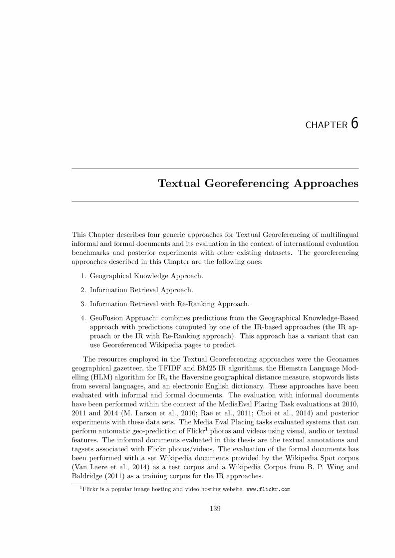
CHAPTER 6
Textual Georeferencing Approaches
This Chapter describes four generic approaches for Textual Georeferencing of multilingualinformal and formal documents and its evaluation in the context of international evaluationbenchmarks and posterior experiments with other existing datasets. The georeferencingapproaches described in this Chapter are the following ones:
1. Geographical Knowledge Approach.
2. Information Retrieval Approach.
3. Information Retrieval with Re-Ranking Approach.
4. GeoFusion Approach: combines predictions from the Geographical Knowledge-Basedapproach with predictions computed by one of the IR-based approaches (the IR ap-proach or the IR with Re-Ranking approach). This approach has a variant that canuse Georeferenced Wikipedia pages to predict.
The resources employed in the Textual Georeferencing approaches were the Geonamesgeographical gazetteer, the TFIDF and BM25 IR algorithms, the Hiemstra Language Mod-elling (HLM) algorithm for IR, the Haversine geographical distance measure, stopwords listsfrom several languages, and an electronic English dictionary. These approaches have beenevaluated with informal and formal documents. The evaluation with informal documentshave been performed within the context of the MediaEval Placing Task evaluations at 2010,2011 and 2014 (M. Larson et al., 2010; Rae et al., 2011; Choi et al., 2014) and posteriorexperiments with these data sets. The Media Eval Placing tasks evaluated systems that canperform automatic geo-prediction of Flickr1 photos and videos using visual, audio or textualfeatures. The informal documents evaluated in this thesis are the textual annotations andtagsets associated with Flickr photos/videos. The evaluation of the formal documents hasbeen performed with a set Wikipedia documents provided by the Wikipedia Spot corpus(Van Laere et al., 2014) as a test corpus and a Wikipedia Corpus from B. P. Wing andBaldridge (2011) as a training corpus for the IR approaches.
1Flickr is a popular image hosting and video hosting website. www.flickr.com
139
140 Chapter 6. Textual Georeferencing Approaches
6.1 Geographical Knowledge ApproachThe approach of using only Geographical Knowledge for georeferencing has two main phases:Toponym Recognition and Geographical Focus Detection (see the architecture of this ap-proach in Figure 6.1). Some place name disambiguation techniques are applied in bothphases: place name normalisation and geo/non-geo ambiguities solved in the first one andthe geographical class ambiguities and reference ambiguity applied in the second one. Amain difference from the text and gazetteer based approaches systems of Kelm et al. (2010)and J. Perea-Ortega et al. (2010) with respect to the Geoographical Knowledge approachis that this approach do not use Named Entity Recognizers and NLP processors.
TOPONYM
DETECTION
GEOGRAPHICAL
AMBIGUITY
FILTERING
English
Dictionary
Geonames Gazetteer
Multilingual
Stopwords
GEOKNOWLEDGE
HEURISTICS
POPULATION
HEURISTICS
PREDICTED
LOCATION &
GEOGRAPHICAL
COORDINATES
TOPONYM RECOGNITION
GEOGRAPHICAL FOCUS DETECTION
Textual
Input
Geonames Gazetteer
Figure 6.1: Geographical Knowledge-Based Approach.
6.1.1 Toponym RecognitionThe Toponym Recognition phase uses the Geonames Gazetteer (explained in Section 2.1.1)for detecting the place names in the textual annotations. NERC was not applied for severalreasons: 1) multilingual textual annotations and tags complicate the application of NLPtools such as POS-tagging and NERC because of lowercased entities (e.g. ”barcelona”) andjoined named entities (e.g. ”riodejaneiro”) , 2) textual annotations and tags are not suit-able for most NERC systems trained in news corpora, and 3) some NERC systems are notperforming better than Toponym Recognition from gazzetteer lookup (Stokes et al., 2008).On the other hand is interesting to notice also some limitations of a Gazetteer lookup ap-proach: highly irregular coverage (Popescu et al., 2008), and poor spatial inclusion defined(Popescu and Kanellos, 2009). The Geonames gazetteer has been used in GIR (Toral etal., 2007), Geographical Scope Resolution (Andogah et al., 2008) and textual georeferenc-ing (Serdyukov et al., 2009). The information contained in this gazetteer is used by thetoponym recognition phase to deal with the following issues: multilinguality (e.g ”Wien”and ”Viena” refer to the city ”Vienna” with German and Spanish respectively), acronyms(e.g. ”USA”), lowercased place names (e.g. ”lisboa, portugal”) , uppercased place names(e.g ”BARCELONA”), and joined place names (e.g. ”newyorkcity”). The following fieldsfrom each Geonames toponym entry are used: country, state, and continent of the place,feature type, coordinates, and population. In the initial experiments at Media Eval 2010the Gazetteer employed for the recognition of place names was used limiting the n-grams

6.1. Geographical Knowledge Approach 141
to a maximum of five tokens (5-grams) (e.g. “Sierra Nevada de Santa Marta”), that wereincreased after the official Media Eval 2010 experiments to seven tokens in new experiments(without improvements noticed). A toponym disambiguation technique is applied to solvethe geo/non-geo ambiguity in of toponyms. This ambiguity occurs because there are a highnumber of place names with meaning that lowercased could be a noun in English or otherlanguages (e.g. ”dog” (noun) vs ”dog” (refering to Dog, a city in Guinea). This phaseuses stopwords lists in several languages2 (including English) and an English Dictionaryof 71,348 words obtained from the Freeling3 toolbox (v2.1) to filter out non-geographicalwords that could be erroneously tagged as place names. Obviously there are some casesin which a word could refer both to a common word and a geographical toponym (e.g.”aurora” (noun) vs ”aurora” (city in USA)”, but this algorithm assumes that these caseswould be generally rare and could only be solved with complex toponym disambiguationtechniques.
6.1.2 Geographical Focus DetectionThe Geographical Focus Detection phase uses some of the Toponym Disambiguation strate-gies presented in the GIR literature (Leidner, 2007). This phase has been designed withsome heuristics described in Hauptmann et al. (1999) and Leidner (2007). The one referenceper discourse hypothesis: one geographical place/coordinates per image/video is assumed;and if there are no detected place names in the textual annotations the georeference isunresolved. The approach uses topological knowledge and population knowledge. Usingthe information of all possible referents of all the place names detected by the ToponymRecognition the following sets of heuristics can be applied separately (each set) or in com-bination:
• Geographical Knowledge heuristics. This set of heuristics is similar to the to-ponym resolution algorithm applied by Hauptmann et al. (1999) to plot on a maplocations mentioned in automatically transcribed news broadcasts.The system first resolves the geo-class ambiguities in the following way: 1) the am-biguity between country and city names is resolved by giving priority to the countrynames (e.g. “Brasil” (city in Colombia) versus “Brasil” (country)), 2) the ambiguitybetween state and city names is resolved by giving priority to city names.Once the set of different toponyms appearing in the text have been obtained andgeo-class disambiguated then the following sets rules can be applied in priority orderto select the scope (focus) and geographical coordinates assigned to the text:
– H1) The top-priority rule selects the geographical coordinates of the most pop-ulated toponym that is not a state, country or continent and has its state ap-pearing in the text as another toponym (e.g. if the toponyms ”San Francisco”,”Sacramento” and ”California” appear in the text, then the focus will be ”SanFrancisco”).
– H2) Otherwise, select the geographical coordinates of the most populated to-ponym that is not a state, country or continent and has its country appearing
2http://search.cpan.org/dist/Lingua-StopWords. Includes stopwords for Danish, Dutch, English, Finnish,French, German, Hungarian, Italian, Norwegian, Portuguese, Spanish, Swedish, and Russian.
3http://nlp.lsi.upc.edu/freeling/
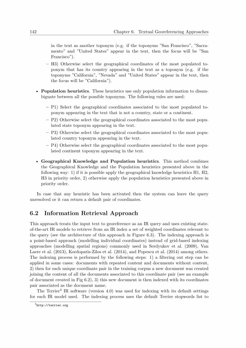
142 Chapter 6. Textual Georeferencing Approaches
in the text as another toponym (e.g. if the toponyms ”San Francisco”, ”Sacra-mento” and ”United States” appear in the text, then the focus will be ”SanFrancisco”).
– H3) Otherwise select the geographical coordinates of the most populated to-ponym that has its country appearing in the text as a toponym (e.g. if thetoponyms ”California”, ”Nevada” and ”United States” appear in the text, thenthe focus will be ”California”).
• Population heuristics. These heuristics use only population information to disam-biguate between all the possible toponyms. The following rules are used:
– P1) Select the geographical coordinates associated to the most populated to-ponym appearing in the text that is not a country, state or a continent.
– P2) Otherwise select the geographical coordinates associated to the most popu-lated state toponym appearing in the text.
– P3) Otherwise select the geographical coordinates associated to the most popu-lated country toponym appearing in the text.
– P4) Otherwise select the geographical coordinates associated to the most popu-lated continent toponym appearing in the text.
• Geographical Knowledge and Population heuristics. This method combinesthe Geographical Knowledge and the Population heuristics presented above in thefollowing way: 1) if it is possible apply the geographical knowledge heuristics H1, H2,H3 in priority order, 2) otherwise apply the population heuristics presented above inpriority order.
In case that any heuristic has been activated then the system can leave the queryunresolved or it can return a default pair of coordinates.
6.2 Information Retrieval ApproachThis approach treats the input text to georeference as an IR query and uses existing state-of-the-art IR models to retrieve from an IR index a set of weighted coordinates relevant tothe query (see the architecture of this approach in Figure 6.3). The indexing approach isa point-based approach (modelling individual coordinates) instead of grid-based indexingapproaches (modelling spatial regions) commonly used in Serdyukov et al. (2009), VanLaere et al. (2013), Kordopatis-Zilos et al. (2014), and Popescu et al. (2014) among others.The indexing process is performed by the following steps: 1) a filtering out step can beapplied in some cases: documents with repeated content and documents without content,2) then for each unique coordinate pair in the training corpus a new document was createdjoining the content of all the documents associated to this coordinate pair (see an exampleof document created in Fig 6.2), 3) this new document is then indexed with its coordinatespair associated as the document name.
The Terrier4 IR software (version 4.0) was used for indexing with its default settingsfor each IR model used. The indexing process uses the default Terrier stopwords list to
4http://terrier.org
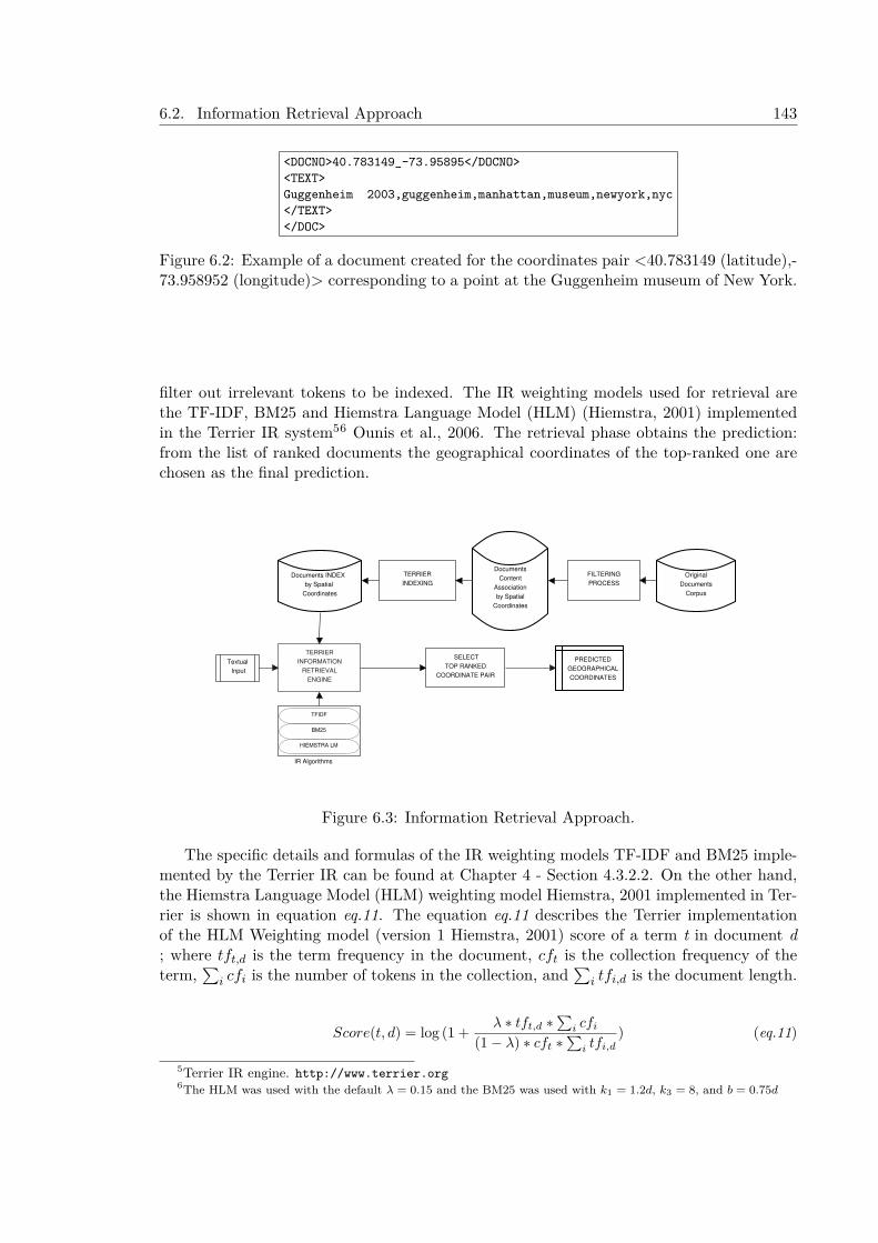
6.2. Information Retrieval Approach 143
<DOCNO>40.783149_-73.95895</DOCNO><TEXT>Guggenheim 2003,guggenheim,manhattan,museum,newyork,nyc</TEXT></DOC>
Figure 6.2: Example of a document created for the coordinates pair <40.783149 (latitude),-73.958952 (longitude)> corresponding to a point at the Guggenheim museum of New York.
filter out irrelevant tokens to be indexed. The IR weighting models used for retrieval arethe TF-IDF, BM25 and Hiemstra Language Model (HLM) (Hiemstra, 2001) implementedin the Terrier IR system56 Ounis et al., 2006. The retrieval phase obtains the prediction:from the list of ranked documents the geographical coordinates of the top-ranked one arechosen as the final prediction.
TERRIER
INFORMATION
RETRIEVAL
ENGINE
SELECT
TOP RANKED
COORDINATE PAIR
Documents INDEX
by Spatial
Coordinates
PREDICTED
GEOGRAPHICAL
COORDINATES
Original
Documents
Corpus
FILTERING
PROCESS
TERRIER
INDEXING
Documents
Content
Association
by Spatial
Coordinates
TFIDF
BM25
HIEMSTRA LM
Textual
Input
IR Algorithms
Figure 6.3: Information Retrieval Approach.
The specific details and formulas of the IR weighting models TF-IDF and BM25 imple-mented by the Terrier IR can be found at Chapter 4 - Section 4.3.2.2. On the other hand,the Hiemstra Language Model (HLM) weighting model Hiemstra, 2001 implemented in Ter-rier is shown in equation eq.11. The equation eq.11 describes the Terrier implementationof the HLM Weighting model (version 1 Hiemstra, 2001) score of a term t in document d; where tft,d is the term frequency in the document, cft is the collection frequency of theterm,
∑i cfi is the number of tokens in the collection, and
∑i tfi,d is the document length.
Score(t, d) = log (1 + λ ∗ tft,d ∗∑
i cfi(1− λ) ∗ cft ∗
∑i tfi,d
) (eq.11)
5Terrier IR engine. http://www.terrier.org6The HLM was used with the default λ = 0.15 and the BM25 was used with k1 = 1.2d, k3 = 8, and b = 0.75d
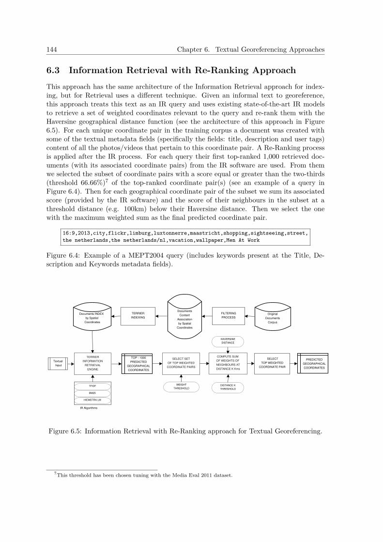
144 Chapter 6. Textual Georeferencing Approaches
6.3 Information Retrieval with Re-Ranking ApproachThis approach has the same architecture of the Information Retrieval approach for index-ing, but for Retrieval uses a different technique. Given an informal text to georeference,this approach treats this text as an IR query and uses existing state-of-the-art IR modelsto retrieve a set of weighted coordinates relevant to the query and re-rank them with theHaversine geographical distance function (see the architecture of this approach in Figure6.5). For each unique coordinate pair in the training corpus a document was created withsome of the textual metadata fields (specifically the fields: title, description and user tags)content of all the photos/videos that pertain to this coordinate pair. A Re-Ranking processis applied after the IR process. For each query their first top-ranked 1,000 retrieved doc-uments (with its associated coordinate pairs) from the IR software are used. From themwe selected the subset of coordinate pairs with a score equal or greater than the two-thirds(threshold 66.66%)7 of the top-ranked coordinate pair(s) (see an example of a query inFigure 6.4). Then for each geographical coordinate pair of the subset we sum its associatedscore (provided by the IR software) and the score of their neighbours in the subset at athreshold distance (e.g. 100km) below their Haversine distance. Then we select the onewith the maximum weighted sum as the final predicted coordinate pair.
16:9,2013,city,flickr,limburg,luxtonnerre,maastricht,shopping,sightseeing,street,the netherlands,the netherlands/nl,vacation,wallpaper,Men At Work
Figure 6.4: Example of a MEPT2004 query (includes keywords present at the Title, De-scription and Keywords metadata fields).
TOP - 1000
PREDICTED
GEOGRAPHICAL
COORDINATES
TFIDF
BM25
HIEMSTRA LM
SELECT SET
OF TOP WEIGHTED
COORDINATE PAIRS
PREDICTED
GEOGRAPHICAL
COORDINATES
WEIGHT
THRESHOLD
COMPUTE SUM
OF WEIGHTS OF
NEIGHBOURS AT
DISTANCE K Kms
DISTANCE K
THRESHOLD
SELECT
TOP WEIGHTED
COORDINATE PAIR
Textual
Input
Documents INDEX
by Spatial
Coordinates
Original
Documents
Corpus
FILTERING
PROCESS
TERRIER
INDEXING
Documents
Content
Association
by Spatial
Coordinates
TERRIER
INFORMATION
RETRIEVAL
ENGINE
HAVERSINE
DISTANCE
IR Algorithms
Figure 6.5: Information Retrieval with Re-Ranking approach for Textual Georeferencing.
7This threshold has been chosen tuning with the Media Eval 2011 dataset.
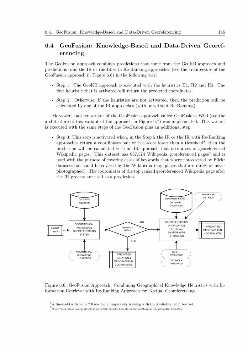
6.4. GeoFusion: Knowledge-Based and Data-Driven Georeferencing 145
6.4 GeoFusion: Knowledge-Based and Data-Driven Georef-erencing
The GeoFusion approach combines predictions that come from the GeoKB approach andpredictions from the IR or the IR with Re-Ranking approaches (see the architecture of theGeoFusion approach in Figure 6.6) in the following way:
• Step 1. The GeoKB approach is executed with the heuristics H1, H2 and H3. Thefirst heuristic that is activated will return the predicted coordinates.
• Step 2. Otherwise, if the heuristics are not activated, then the prediction will becalculated by one of the IR approaches (with or without Re-Ranking).
Moreover, another variant of the GeoFusion approach called GeoFusion+Wiki (see thearchitecture of this variant of the approach in Figure 6.7) was implemented. This variantis executed with the same steps of the GeoFusion plus an additional step:
• Step 3: This step is activated when, in the Step 2 the IR or the IR with Re-Rankingapproaches return a coordinates pair with a score lower than a threshold8, then theprediction will be calculated with an IR approach that uses a set of georeferencedWikipedia pages. This dataset has 857,574 Wikipedia georeferenced pages9 and isused with the purpose of covering cases of keywords that where not covered by Flickrdatasets but could be covered by the Wikipedia (e.g. places that are rarely or neverphotographed). The coordinates of the top ranked georeferenced Wikipedia page afterthe IR process are used as a prediction.
GEOGRAPHICAL
KNOWLEDGE
GEOREFERENCING
SYSTEM
Geonames
Gazetteer
PREDICTED
GEOGRAPHICAL
COORDINATES
WEIGHT
THRESHOLD
DISTANCE K
THRESHOLD
GEOGRAPHICAL
KNOWLEDGE
HEURISTICS
PREDICTED
LOCATION &
GEOGRAPHICAL
COORDINATES
GEOREFERENCING
INFORMATION
RETRIEVAL
SYSTEM WITH
RE-RANKING
YES
NO
HEURISTICS
MATCH
Documents INDEX
by Spatial
Coordinates
HAVERSINE
DISTANCE
Textual
Input
Figure 6.6: GeoFusion Approach: Combining Geographical Knowledge Heuristics with In-formation Retrieval with Re-Ranking Approach for Textual Georeferencing.
8A threshold with value 7.0 was found empirically training with the MediaEval 2011 test set.9http://de.wikipedia.org/wiki/Wikipedia:WikiProjekt_Georeferenzierung/Hauptseite/Wikipedia-World/en
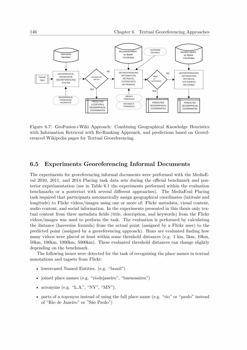
146 Chapter 6. Textual Georeferencing Approaches
GEOGRAPHICAL
KNOWLEDGE
GEOREFERENCING
SYSTEM
Geonames
Gazetteer
PREDICTED
GEOGRAPHICAL
COORDINATES
WEIGHT
THRESHOLD
DISTANCE K
THRESHOLD
GEOGRAPHICAL
KNOWLEDGE
HEURISTICSPREDICTED
LOCATION &
GEOGRAPHICAL
COORDINATES
GEOREFERENCING
INFORMATION
RETRIEVAL
SYSTEM WITH
RE-RANKING
YES
NO
HEURISTICS
MATCH
Documents INDEX
by Spatial
Coordinates
GEOREFERENCING
INFORMATION
RETRIEVAL
TOP-RANKED
RETURNED
GeoWIKI INDEX
by Spatial
Coordinates
YES
weight
is >
minThreshold
NO
PREDICTED
GEOGRAPHICAL
COORDINATES
HAVERSINE
DISTANCE
Textual
Input
Figure 6.7: GeoFusion+Wiki Approach: Combining Geographical Knowledge Heuristicswith Information Retrieval with Re-Ranking Approach, and predictions based on Georef-erenced Wikipedia pages for Textual Georeferencing.
6.5 Experiments Georeferencing Informal DocumentsThe experiments for georeferencing informal documents were performed with the MediaE-val 2010, 2011, and 2014 Placing task data sets during the official benchmark and pos-terior experimentation (see in Table 6.1 the experiments performed within the evaluationbenchmarks or a posteriori with several different approaches). The MediaEval Placingtask required that participants automatically assign geographical coordinates (latitude andlongitude) to Flickr videos/images using one or more of: Flickr metadata, visual content,audio content, and social information. In the experiments presented in this thesis only tex-tual content from three metadata fields (title, description, and keywords) from the Flickrvideos/images was used to perform the task. The evaluation is performed by calculatingthe distance (haversine formula) from the actual point (assigned by a Flickr user) to thepredicted point (assigned by a georeferencing approach). Runs are evaluated finding howmany videos were placed at least within some threshold distances (e.g. 1 km, 5km, 10km,50km, 100km, 1000km, 5000km). These evaluated threshold distances can change slightlydepending on the benchmark.
The following issues were detected for the task of recognizing the place names in textualannotations and tagsets from Flickr:
• lowercased Named Entities. (e.g. “brazil”)
• joined place names (e.g. “riodejaneiro”, “buenosaires”)
• acronyms (e.g. “L.A.”, “NY”, “MN”),
• parts of a toponym instead of using the full place name (e.g. “rio” or “paulo” insteadof ”Rio de Janeiro” or ”São Paulo”)
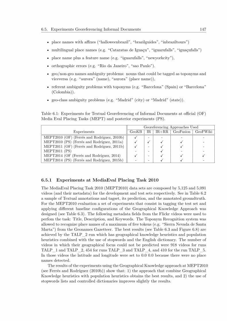
6.5. Experiments Georeferencing Informal Documents 147
• place names with affixes (“halloweenbrazil”, “brazilguides”, “inbraziltours”)
• multilingual place names (e.g. “Cataratas de Iguaçu”, “iguazufalls”, “iguaçufalls”)
• place name plus a feature name (e.g. “iguazufalls”, “newyorkcity”),
• orthographic errors (e.g. “Rio da Janeiro”, “sao Paulo”).
• geo/non-geo names ambiguity problems: nouns that could be tagged as toponyms andviceversa (e.g. “aurora” (name), “aurora” (place name)),
• referent ambiguity problems with toponyms (e.g. “Barcelona” (Spain) or “Barcelona”(Colombia)).
• geo-class ambiguity problems (e.g. “Madrid” (city) or “Madrid” (state)).
Table 6.1: Experiments for Textual Georeferencing of Informal Documents at official (OF)Media Eval Placing Tasks (MEPT) and posterior experiments (PS).
Georeferencing Approaches UsedExperiments GeoKB IR IR+RR GeoFusion GeoFWiki
MEPT2010 (OF) (Ferrés and Rodríguez, 2010b) ✓ - - - -MEPT2010 (PS) (Ferrés and Rodríguez, 2011a) ✓ ✓ ✓ ✓ -MEPT2011 (OF) (Ferrés and Rodríguez, 2011b) ✓ - ✓ ✓ -MEPT2011 (PS) - - ✓ - -MEPT2014 (OF (Ferrés and Rodríguez, 2014) ✓ - ✓ ✓ ✓MEPT2014 (PS) (Ferrés and Rodríguez, 2015b) - - ✓ ✓ -
6.5.1 Experiments at MediaEval Placing Task 2010The MediaEval Placing Task 2010 (MEPT2010) data sets are composed by 5,125 and 5,091videos (and their metadata) for the development and test sets respectively. See in Table 6.2a sample of Textual annotations and tagset, its prediction, and the annotated groundtruth.For the MEPT2010 evaluation a set of experiments that consist in tagging the test set andapplying different baseline configurations of the Geographical Knowledge Approach wasdesigned (see Table 6.3). The following metadata fields from the Flickr videos were used toperfom the task: Title, Description, and Keywords. The Toponym Recognition system wasallowed to recognize place names of a maximum of five tokens (e.g. “Sierra Nevada de SantaMarta”) from the Geonames Gazetteer. The best results (see Table 6.3 and Figure 6.8) areachieved by the TALP_2 run which has geographical knowledge heuristics and populationheuristics combined with the use of stopwords and the English dictionary. The number ofvideos in which their geographical focus could not be predicted were 918 videos for runsTALP_1 and TALP_2, 454 for runs TALP_3 and TALP_4, and 410 for the run TALP_5.In those videos the latitude and longitude were set to 0.0 0.0 because there were no placenames detected.
The results of the experiments using the Geographical Knowledge approach at MEPT2010(see Ferrés and Rodríguez (2010b)) show that: 1) the approach that combine GeographicalKnowledge heuristics with population heuristics obtains the best results, and 2) the use ofstopwords lists and controlled dictionaries improves slightly the results.
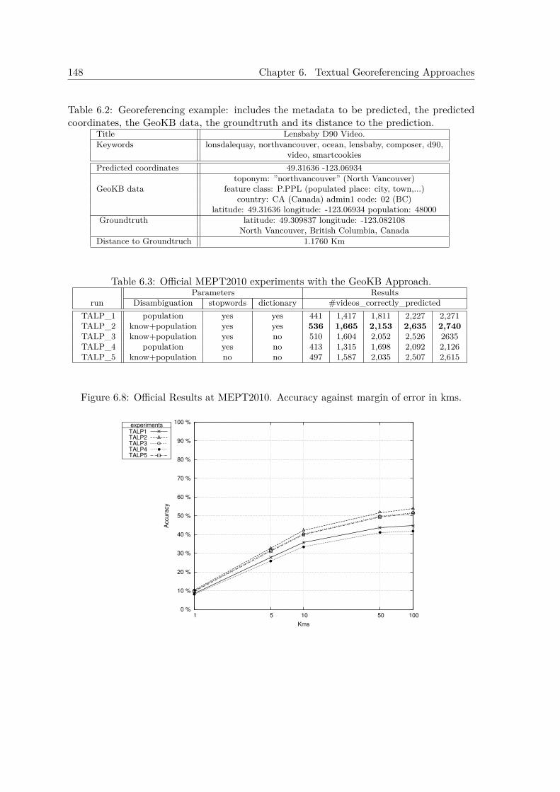
148 Chapter 6. Textual Georeferencing Approaches
Table 6.2: Georeferencing example: includes the metadata to be predicted, the predictedcoordinates, the GeoKB data, the groundtruth and its distance to the prediction.
Title Lensbaby D90 Video.Keywords lonsdalequay, northvancouver, ocean, lensbaby, composer, d90,
video, smartcookiesPredicted coordinates 49.31636 -123.06934
toponym: ”northvancouver” (North Vancouver)GeoKB data feature class: P.PPL (populated place: city, town,...)
country: CA (Canada) admin1 code: 02 (BC)latitude: 49.31636 longitude: -123.06934 population: 48000
Groundtruth latitude: 49.309837 longitude: -123.082108North Vancouver, British Columbia, Canada
Distance to Groundtruch 1.1760 Km
Table 6.3: Official MEPT2010 experiments with the GeoKB Approach.Parameters Results
run Disambiguation stopwords dictionary #videos_correctly_predictedTALP_1 population yes yes 441 1,417 1,811 2,227 2,271TALP_2 know+population yes yes 536 1,665 2,153 2,635 2,740TALP_3 know+population yes no 510 1,604 2,052 2,526 2635TALP_4 population yes no 413 1,315 1,698 2,092 2,126TALP_5 know+population no no 497 1,587 2,035 2,507 2,615
Figure 6.8: Official Results at MEPT2010. Accuracy against margin of error in kms.
0 %
10 %
20 %
30 %
40 %
50 %
60 %
70 %
80 %
90 %
100 %
1 5 10 50 100
Accu
racy
Kms
experimentsTALP1TALP2TALP3TALP4TALP5
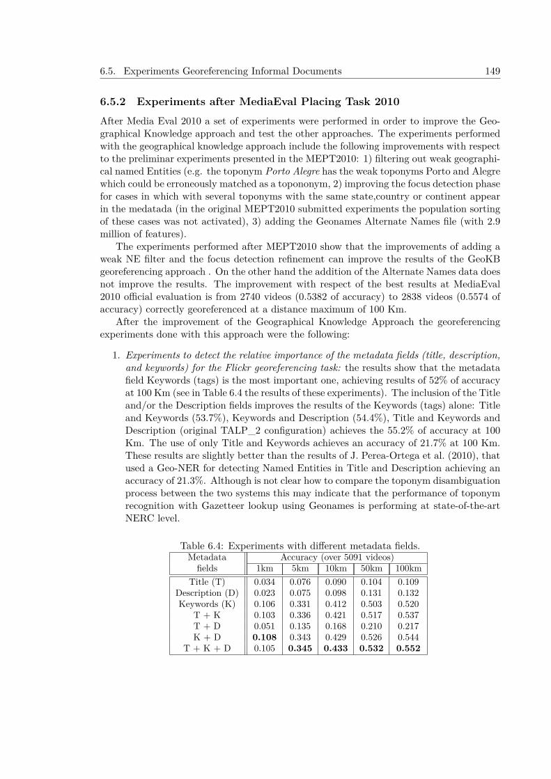
6.5. Experiments Georeferencing Informal Documents 149
6.5.2 Experiments after MediaEval Placing Task 2010After Media Eval 2010 a set of experiments were performed in order to improve the Geo-graphical Knowledge approach and test the other approaches. The experiments performedwith the geographical knowledge approach include the following improvements with respectto the preliminar experiments presented in the MEPT2010: 1) filtering out weak geographi-cal named Entities (e.g. the toponym Porto Alegre has the weak toponyms Porto and Alegrewhich could be erroneously matched as a topononym, 2) improving the focus detection phasefor cases in which with several toponyms with the same state,country or continent appearin the medatada (in the original MEPT2010 submitted experiments the population sortingof these cases was not activated), 3) adding the Geonames Alternate Names file (with 2.9million of features).
The experiments performed after MEPT2010 show that the improvements of adding aweak NE filter and the focus detection refinement can improve the results of the GeoKBgeoreferencing approach . On the other hand the addition of the Alternate Names data doesnot improve the results. The improvement with respect of the best results at MediaEval2010 official evaluation is from 2740 videos (0.5382 of accuracy) to 2838 videos (0.5574 ofaccuracy) correctly georeferenced at a distance maximum of 100 Km.
After the improvement of the Geographical Knowledge Approach the georeferencingexperiments done with this approach were the following:
1. Experiments to detect the relative importance of the metadata fields (title, description,and keywords) for the Flickr georeferencing task: the results show that the metadatafield Keywords (tags) is the most important one, achieving results of 52% of accuracyat 100 Km (see in Table 6.4 the results of these experiments). The inclusion of the Titleand/or the Description fields improves the results of the Keywords (tags) alone: Titleand Keywords (53.7%), Keywords and Description (54.4%), Title and Keywords andDescription (original TALP_2 configuration) achieves the 55.2% of accuracy at 100Km. The use of only Title and Keywords achieves an accuracy of 21.7% at 100 Km.These results are slightly better than the results of J. Perea-Ortega et al. (2010), thatused a Geo-NER for detecting Named Entities in Title and Description achieving anaccuracy of 21.3%. Although is not clear how to compare the toponym disambiguationprocess between the two systems this may indicate that the performance of toponymrecognition with Gazetteer lookup using Geonames is performing at state-of-the-artNERC level.
Table 6.4: Experiments with different metadata fields.Metadata Accuracy (over 5091 videos)fields 1km 5km 10km 50km 100km
Title (T) 0.034 0.076 0.090 0.104 0.109Description (D) 0.023 0.075 0.098 0.131 0.132Keywords (K) 0.106 0.331 0.412 0.503 0.520
T + K 0.103 0.336 0.421 0.517 0.537T + D 0.051 0.135 0.168 0.210 0.217K + D 0.108 0.343 0.429 0.526 0.544
T + K + D 0.105 0.345 0.433 0.532 0.552
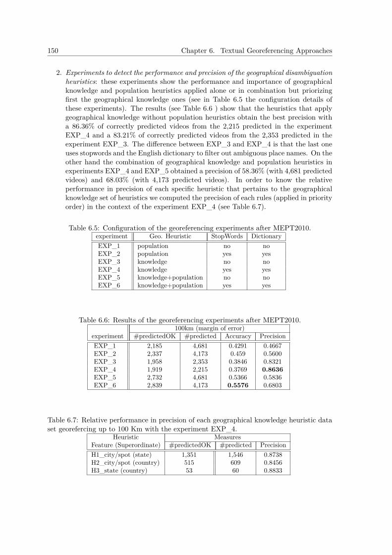
150 Chapter 6. Textual Georeferencing Approaches
2. Experiments to detect the performance and precision of the geographical disambiguationheuristics: these experiments show the performance and importance of geographicalknowledge and population heuristics applied alone or in combination but priorizingfirst the geographical knowledge ones (see in Table 6.5 the configuration details ofthese experiments). The results (see Table 6.6 ) show that the heuristics that applygeographical knowledge without population heuristics obtain the best precision witha 86.36% of correctly predicted videos from the 2,215 predicted in the experimentEXP_4 and a 83.21% of correctly predicted videos from the 2,353 predicted in theexperiment EXP_3. The difference between EXP_3 and EXP_4 is that the last oneuses stopwords and the English dictionary to filter out ambiguous place names. On theother hand the combination of geographical knowledge and population heuristics inexperiments EXP_4 and EXP_5 obtained a precision of 58.36% (with 4,681 predictedvideos) and 68.03% (with 4,173 predicted videos). In order to know the relativeperformance in precision of each specific heuristic that pertains to the geographicalknowledge set of heuristics we computed the precision of each rules (applied in priorityorder) in the context of the experiment EXP_4 (see Table 6.7).
Table 6.5: Configuration of the georeferencing experiments after MEPT2010.experiment Geo. Heuristic StopWords DictionaryEXP_1 population no noEXP_2 population yes yesEXP_3 knowledge no noEXP_4 knowledge yes yesEXP_5 knowledge+population no noEXP_6 knowledge+population yes yes
Table 6.6: Results of the georeferencing experiments after MEPT2010.100km (margin of error)
experiment #predictedOK #predicted Accuracy PrecisionEXP_1 2,185 4,681 0.4291 0.4667EXP_2 2,337 4,173 0.459 0.5600EXP_3 1,958 2,353 0.3846 0.8321EXP_4 1,919 2,215 0.3769 0.8636EXP_5 2,732 4,681 0.5366 0.5836EXP_6 2,839 4,173 0.5576 0.6803
Table 6.7: Relative performance in precision of each geographical knowledge heuristic dataset georefercing up to 100 Km with the experiment EXP_4.
Heuristic MeasuresFeature (Superordinate) #predictedOK #predicted PrecisionH1_city/spot (state) 1,351 1,546 0.8738H2_city/spot (country) 515 609 0.8456H3_state (country) 53 60 0.8833
6.5. Experiments Georeferencing Informal Documents 151
6.5.2.1 Experiments with the IR Approach
The IR indexes were created with a metadata corpus of Flickr photos provided in theMediaEval 2010 for development purposes. The corpus consists of 3,185,258 Flickr photosuniformly sampled from all parts of the world. The photos are georeferenced with geotagswith 16 zoom accuracy levels. The accuracy shows the zoom level used by the user whenplacing the photo on the map ((e.g., 6 - region level, 12 - city level, 16 - street level).The medatada of the corpus is represented by the following information: UserID, PhotoID,HTMLLinkToPhoto, GeoData (includes longitude, latitude, and zoom accuracy level), tags,date taken, and date uploaded. From the metadata corpus of photos we filtered out somedata: 1) if a user has several photos metadata with the same tagset then only one photometadata of them is kept, 2) metadata without existing tags is filtered. After this filteringsteps a set of 1,723,090 metadata entries for each photo was obtained. Then, from thefiltered corpus we selected four subsets depending on the values of the zoom level accuracy:1) level 16 (715,318 photos), 2) levels from 14 to 16 (1,140,031 photos), 3) levels from 12 to16 (1,570,771 photos), 4) levels from 6 to 16 (1,723,090 photos). Moreover, for each uniquecoordinate pair in the corpora all the tagsets associated to the same coordinate pair werejoined resulting of: 1) level 16 (511,222 coordinate pairs), 2) levels from 14 to 16 (756,916coordinate pairs), 3) levels from 12 to 16 (965,904 coordinate pairs), 4) levels from 6 to16 (1,026,993 coordinate pairs). The indexing of the metadata subsets was done with thecoordinates as a document number and their associated tagsets the document text. Indexingwas performed by filtering out tokens that match a multilingual stopwords list and withoutstemming. The retrieval experiments have been done with the metadata of the videos asqueries to the IR system. The following metadata fields were used for the query: Keywords(tags), Title and Description. The metadata fields Title and Description were lowercasedfor the query. The experiments shown in Table 6.8 show that BM25 achieves the best resultsin accuracies from 10 to 100 Km and the Hiemstra Language Model IR algorithm achievesthe best results in accuracies georeferencing up to 1 and 5 km.
6.5.2.2 Experiments with the IR Re-Ranking and GeoFusion Approaches
The GeoFusion approach is applied by combining the results of the Geographical Knowl-edge approach and the IR approach with Re-Ranking (see the results of this approach inTable 6.9). The results are combined in the following way: from the set of Geographicalbased experiments we selected the experiment with best precision (EXP_4). From theGeographical Knowledge-based experiment with highest precision the system selects thepredicted coordinates, and the ones that are not predicted because the geographical rulesdo not match are selected from the Information Retrieval approaches with Re-Ranking.This means that from the EXP_4 were selected 2,215 predictions and the rest (2,876 pre-dictions) were selected from the IR with RR approaches. The results of the IR Re-Rankingand the GeoFusion approaches (see Table 6.9 ) show that both approaches outperform theGeographical and the IR approaches and the baselines. The baselines presented in Table6.9 are three: 1) the best results obtained at the MEPT2010 with the test set (Van Laereet al., 2010a), 2) the experiment with BM25 trained with a corpus with accuracies from 6to 16 levels, and 3) the Hiemstra LM trained with accuracies from 14 to 16 levels. Theselast two baselines were the ones that obtained the best results in accuracies compared tothe other IR and corpus training models.
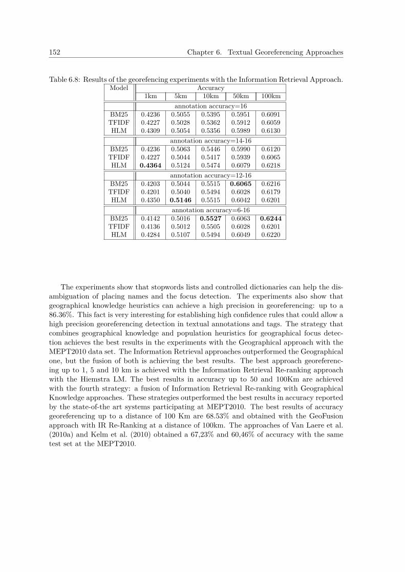
152 Chapter 6. Textual Georeferencing Approaches
Table 6.8: Results of the georefencing experiments with the Information Retrieval Approach.Model Accuracy
1km 5km 10km 50km 100kmannotation accuracy=16
BM25 0.4236 0.5055 0.5395 0.5951 0.6091TFIDF 0.4227 0.5028 0.5362 0.5912 0.6059HLM 0.4309 0.5054 0.5356 0.5989 0.6130
annotation accuracy=14-16BM25 0.4236 0.5063 0.5446 0.5990 0.6120TFIDF 0.4227 0.5044 0.5417 0.5939 0.6065HLM 0.4364 0.5124 0.5474 0.6079 0.6218
annotation accuracy=12-16BM25 0.4203 0.5044 0.5515 0.6065 0.6216TFIDF 0.4201 0.5040 0.5494 0.6028 0.6179HLM 0.4350 0.5146 0.5515 0.6042 0.6201
annotation accuracy=6-16BM25 0.4142 0.5016 0.5527 0.6063 0.6244TFIDF 0.4136 0.5012 0.5505 0.6028 0.6201HLM 0.4284 0.5107 0.5494 0.6049 0.6220
The experiments show that stopwords lists and controlled dictionaries can help the dis-ambiguation of placing names and the focus detection. The experiments also show thatgeographical knowledge heuristics can achieve a high precision in georeferencing: up to a86.36%. This fact is very interesting for establishing high confidence rules that could allow ahigh precision georeferencing detection in textual annotations and tags. The strategy thatcombines geographical knowledge and population heuristics for geographical focus detec-tion achieves the best results in the experiments with the Geographical approach with theMEPT2010 data set. The Information Retrieval approaches outperformed the Geographicalone, but the fusion of both is achieving the best results. The best approach georeferenc-ing up to 1, 5 and 10 km is achieved with the Information Retrieval Re-ranking approachwith the Hiemstra LM. The best results in accuracy up to 50 and 100Km are achievedwith the fourth strategy: a fusion of Information Retrieval Re-ranking with GeographicalKnowledge approaches. These strategies outperformed the best results in accuracy reportedby the state-of-the art systems participating at MEPT2010. The best results of accuracygeoreferencing up to a distance of 100 Km are 68.53% and obtained with the GeoFusionapproach with IR Re-Ranking at a distance of 100km. The approaches of Van Laere et al.(2010a) and Kelm et al. (2010) obtained a 67,23% and 60,46% of accuracy with the sametest set at the MEPT2010.
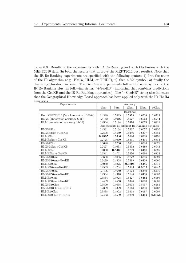
6.5. Experiments Georeferencing Informal Documents 153
Table 6.9: Results of the experiments with IR Re-Ranking and with GeoFusion with theMEPT2010 data (in bold the results that improve the MEPT2010 best results). Note thatthe IR Re-Ranking experiments are specified with the following syntax: 1) first the nameof the IR algorithm (e.g. BM25, HLM, or TFIDF), 2) then a ’@’ symbol, 3) finally theclustering threshold in kms. The GeoFusion experiments follow the same syntax of theIR Re-Ranking plus the following string: ”+GeoKB” (indicating that combines predictionsfrom the GeoKB and the IR Re-Ranking approaches). The ”+GeoKB” string also indicatesthat the Geographical Knowledge-Based approach has been applied only with the H1,H2,H3heuristics.
Experiments Accuracy1km 5km 10km 50km 100km
BaselinesBest MEPT2010 (Van Laere et al., 2010a) 0.4329 0.5425 0.5879 0.6509 0.6723BM25 (annotation accuracy 6-16) 0.4142 0.5016 0.5527 0.6063 0.6244HLM (annotation accuracy 14-16) 0.4364 0.5124 0.5474 0.6079 0.6218
Experiments at different Re-Ranking distancesBM25@1km 0.4331 0.5134 0.5507 0.6057 0.6230BM25@1km+GeoKB 0.2598 0.4549 0.5246 0.6307 0.6552HLM@1km 0.4535 0.5336 0.5690 0.6338 0.6491HLM@1km+GeoKB 0.2728 0.4670 0.5391 0.6491 0.6733BM25@5km 0.3698 0.5266 0.5631 0.6216 0.6375BM25@5km+GeoKB 0.2427 0.4633 0.5332 0.6389 0.6643HLM@5km 0.4030 0.5433 0.5739 0.6468 0.6595HLM@5km+GeoKB 0.2541 0.4761 0.5470 0.6590 0.6823BM25@10km 0.3688 0.5055 0.5772 0.6256 0.6399BM25@10km+GeoKB 0.2429 0.4568 0.5389 0.6409 0.6660HLM@10km 0.4030 0.5275 0.5894 0.6485 0.6611HLM@10km+GeoKB 0.2563 0.4704 0.5523 0.6611 0.6847BM25@50km 0.3496 0.4680 0.5124 0.6340 0.6470BM25@50km+GeoKB 0.2304 0.4378 0.5148 0.6438 0.6682HLM@50km 0.3834 0.4928 0.5427 0.6482 0.6599HLM@50km +GeoKB 0.2439 0.4553 0.5346 0.6590 0.6831BM25@100km 0.3500 0.4635 0.5008 0.5957 0.6485BM25@100km+GeoKB 0.2309 0.4399 0.5116 0.6318 0.6702HLM@100km 0.3838 0.4902 0.5358 0.6187 0.6609HLM@100km+GeoKB 0.2433 0.4539 0.5299 0.6464 0.6853
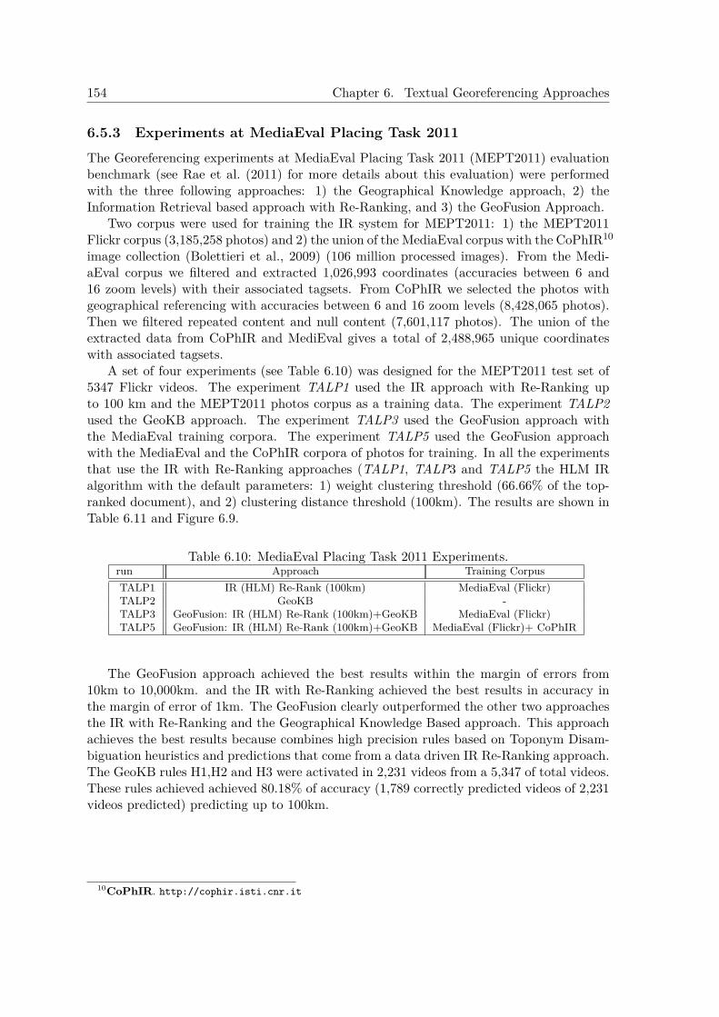
154 Chapter 6. Textual Georeferencing Approaches
6.5.3 Experiments at MediaEval Placing Task 2011The Georeferencing experiments at MediaEval Placing Task 2011 (MEPT2011) evaluationbenchmark (see Rae et al. (2011) for more details about this evaluation) were performedwith the three following approaches: 1) the Geographical Knowledge approach, 2) theInformation Retrieval based approach with Re-Ranking, and 3) the GeoFusion Approach.
Two corpus were used for training the IR system for MEPT2011: 1) the MEPT2011Flickr corpus (3,185,258 photos) and 2) the union of the MediaEval corpus with the CoPhIR10
image collection (Bolettieri et al., 2009) (106 million processed images). From the Medi-aEval corpus we filtered and extracted 1,026,993 coordinates (accuracies between 6 and16 zoom levels) with their associated tagsets. From CoPhIR we selected the photos withgeographical referencing with accuracies between 6 and 16 zoom levels (8,428,065 photos).Then we filtered repeated content and null content (7,601,117 photos). The union of theextracted data from CoPhIR and MediEval gives a total of 2,488,965 unique coordinateswith associated tagsets.
A set of four experiments (see Table 6.10) was designed for the MEPT2011 test set of5347 Flickr videos. The experiment TALP1 used the IR approach with Re-Ranking upto 100 km and the MEPT2011 photos corpus as a training data. The experiment TALP2used the GeoKB approach. The experiment TALP3 used the GeoFusion approach withthe MediaEval training corpora. The experiment TALP5 used the GeoFusion approachwith the MediaEval and the CoPhIR corpora of photos for training. In all the experimentsthat use the IR with Re-Ranking approaches (TALP1, TALP3 and TALP5 the HLM IRalgorithm with the default parameters: 1) weight clustering threshold (66.66% of the top-ranked document), and 2) clustering distance threshold (100km). The results are shown inTable 6.11 and Figure 6.9.
Table 6.10: MediaEval Placing Task 2011 Experiments.run Approach Training CorpusTALP1 IR (HLM) Re-Rank (100km) MediaEval (Flickr)TALP2 GeoKB -TALP3 GeoFusion: IR (HLM) Re-Rank (100km)+GeoKB MediaEval (Flickr)TALP5 GeoFusion: IR (HLM) Re-Rank (100km)+GeoKB MediaEval (Flickr)+ CoPhIR
The GeoFusion approach achieved the best results within the margin of errors from10km to 10,000km. and the IR with Re-Ranking achieved the best results in accuracy inthe margin of error of 1km. The GeoFusion clearly outperformed the other two approachesthe IR with Re-Ranking and the Geographical Knowledge Based approach. This approachachieves the best results because combines high precision rules based on Toponym Disam-biguation heuristics and predictions that come from a data driven IR Re-Ranking approach.The GeoKB rules H1,H2 and H3 were activated in 2,231 videos from a 5,347 of total videos.These rules achieved achieved 80.18% of accuracy (1,789 correctly predicted videos of 2,231videos predicted) predicting up to 100km.
10CoPhIR. http://cophir.isti.cnr.it
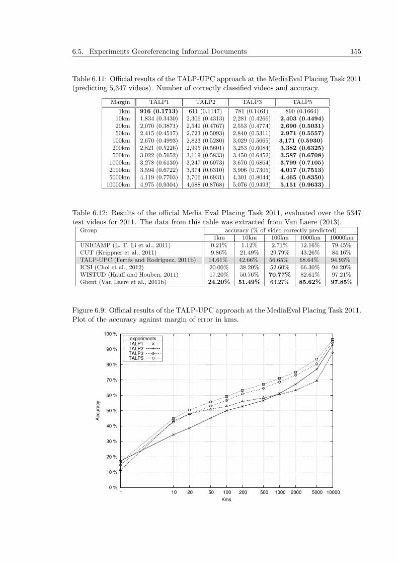
6.5. Experiments Georeferencing Informal Documents 155
Table 6.11: Official results of the TALP-UPC approach at the MediaEval Placing Task 2011(predicting 5,347 videos). Number of correctly classified videos and accuracy.
Margin TALP1 TALP2 TALP3 TALP51km 916 (0.1713) 611 (0.1147) 781 (0.1461) 890 (0.1664)
10km 1,834 (0.3430) 2,306 (0.4313) 2,281 (0.4266) 2,403 (0.4494)20km 2,070 (0.3871) 2,549 (0.4767) 2,553 (0.4774) 2,690 (0.5031)50km 2,415 (0.4517) 2,723 (0.5093) 2,840 (0.5311) 2,971 (0.5557)
100km 2,670 (0.4993) 2,823 (0.5280) 3,029 (0.5665) 3,171 (0.5930)200km 2,821 (0.5226) 2,995 (0.5601) 3,253 (0.6084) 3,382 (0.6325)500km 3,022 (0.5652) 3,119 (0.5833) 3,450 (0.6452) 3,587 (0.6708)
1000km 3,278 (0.6130) 3,247 (0.6073) 3,670 (0.6864) 3,799 (0.7105)2000km 3,594 (0.6722) 3,374 (0.6310) 3,906 (0.7305) 4,017 (0.7513)5000km 4,119 (0.7703) 3,706 (0.6931) 4,301 (0.8044) 4,465 (0.8350)
10000km 4,975 (0.9304) 4,688 (0.8768) 5,076 (0.9493) 5,151 (0.9633)
Table 6.12: Results of the official Media Eval Placing Task 2011, evaluated over the 5347test videos for 2011. The data from this table was extracted from Van Laere (2013).
Group accuracy (% of video correctly predicted)1km 10km 100km 1000km 10000km
UNICAMP (L. T. Li et al., 2011) 0.21% 1.12% 2.71% 12.16% 79.45%CUT (Krippner et al., 2011) 9.86% 21.49% 29.79% 43.26% 84.16%TALP-UPC (Ferrés and Rodríguez, 2011b) 14.61% 42.66% 56.65% 68.64% 94.93%ICSI (Choi et al., 2012) 20.00% 38.20% 52.60% 66.30% 94.20%WISTUD (Hauff and Houben, 2011) 17.20% 50.76% 70.77% 82.61% 97.21%Ghent (Van Laere et al., 2011b) 24.20% 51.49% 63.27% 85.62% 97.85%
Figure 6.9: Official results of the TALP-UPC approach at the MediaEval Placing Task 2011.Plot of the accuracy against margin of error in kms.
0 %
10 %
20 %
30 %
40 %
50 %
60 %
70 %
80 %
90 %
100 %
10000 5000 2000 1000 500 200 100 50 20 10 1
Accu
racy
Kms
experimentsTALP1TALP2TALP3TALP5

156 Chapter 6. Textual Georeferencing Approaches
6.5.4 Experiments after MediaEval Placing Task 2011A set of development experiments has been done with the MEPT2011 training and testset data. These experiments were done to detect appropiate thresholds for the HLM Re-Ranking algorithm. The Re-Ranking algorithm has two main thresholds: 1) the 1,000top-ranked documents weight threshold, 2) clustering distance threshold. The top rankeddocuments weight threshold indicates at which percentage of the weight of the top-rankeddocument is established the threshold to create the set of documents that will be used inthe reranking process (i.e. a threshold of 100% indicates that only the documents withthe same weight of the top-ranked document will be selected for the clustering process,and a threshold of 0% indicates that all 1,000 top-ranked documents will be used). Notethat at lower thresholds the clustering processing time is increased. The distance clus-tering threshold indicates at which distance between geographical coordinates associatedto documents (from the set of documents selected for clustering) their weight will be re-calculated by adding the weight of their neighbour at certain distance. The MediaEval2011 Flickr corpus has 3,185,258 photos for training. From the MediaEval corpus we fil-tered and extracted 1,026,993 coordinates (accuracies between 6 and 16 zoom levels) withtheir associated tagsets. The test set consists of 5,347 Flickr videos. Four experiments wereperformed in order to test all the threshold ranges of the following clustering Re-Rankingdistances: 0.1 km, 1 km, 10 km and 100km. The experiments show the Mean error in kms,Median error in kms, and the accuracies of prediction at different Kms (0,1, 1, 10 and 100kms respectively) of the different thresholds (clustering Re-Ranking distance threshold andtop-ranked documents weight threshold). See these results in Figures 6.10 and 6.11. Theresults indicate that both re-rankings at distance 10km and 100km outperform the 0.1kmand 1km distances in median and mean error rates in documents weight thresholds below70% (of the weight of the top-ranked document).
Figure 6.10: Median and Mean error in Kms at different clustering Re-Ranking distancesand threshold values.
0
100
200
300
400
500
600
700
0 0
.05
0.1
0.1
5 0
.2 0
.25
0.3
0.3
5 0
.4 0
.45
0.5
0.5
5 0
.6 0
.65
0.7
0.7
5 0
.8 0
.85
0.9
0.9
5 1
Media
n E
rror
in k
ms.
weight % ratio clustering Re-Ranking threshold
distance threshold0.1km
1km10km
100km
(a) Median Error
0100200300400500600700800900
10001100120013001400150016001700180019002000210022002300240025002600270028002900300031003200330034003500
0 0
.05
0.1
0.1
5 0
.2 0
.25
0.3
0.3
5 0
.4 0
.45
0.5
0.5
5 0
.6 0
.65
0.7
0.7
5 0
.8 0
.85
0.9
0.9
5 1
Mean E
rror
in k
ms.
weight % ratio clustering Re-Ranking threshold
distance threshold0.1km
1km10km
100km
(b) Mean Error
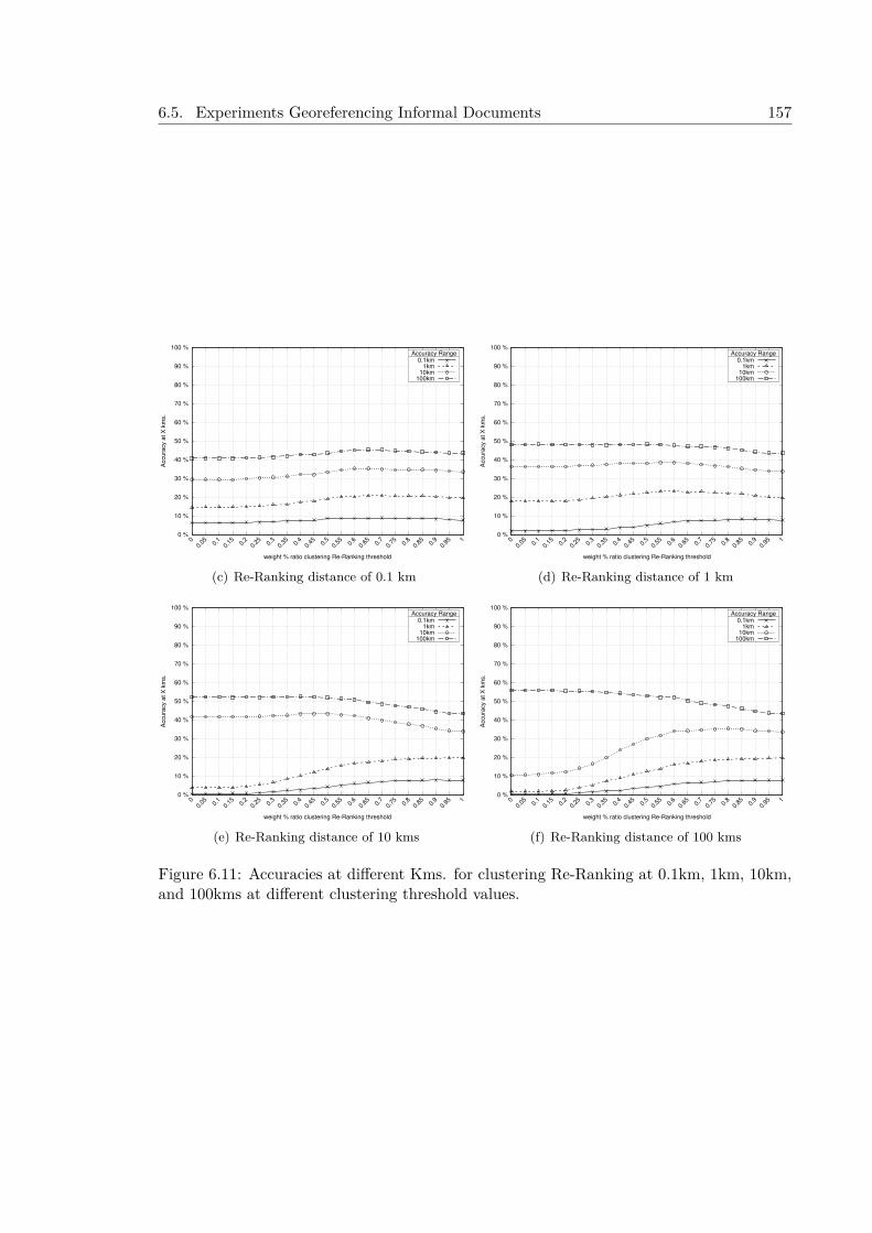
6.5. Experiments Georeferencing Informal Documents 157
0 %
10 %
20 %
30 %
40 %
50 %
60 %
70 %
80 %
90 %
100 %
0 0
.05
0.1
0.1
5 0
.2 0
.25
0.3
0.3
5 0
.4 0
.45
0.5
0.5
5 0
.6 0
.65
0.7
0.7
5 0
.8 0
.85
0.9
0.9
5 1
Accura
cy a
t X
km
s.
weight % ratio clustering Re-Ranking threshold
Accuracy Range0.1km
1km10km
100km
(c) Re-Ranking distance of 0.1 km
0 %
10 %
20 %
30 %
40 %
50 %
60 %
70 %
80 %
90 %
100 %
0 0
.05
0.1
0.1
5 0
.2 0
.25
0.3
0.3
5 0
.4 0
.45
0.5
0.5
5 0
.6 0
.65
0.7
0.7
5 0
.8 0
.85
0.9
0.9
5 1
Accura
cy a
t X
km
s.
weight % ratio clustering Re-Ranking threshold
Accuracy Range0.1km
1km10km
100km
(d) Re-Ranking distance of 1 km
0 %
10 %
20 %
30 %
40 %
50 %
60 %
70 %
80 %
90 %
100 %
0 0
.05
0.1
0.1
5 0
.2 0
.25
0.3
0.3
5 0
.4 0
.45
0.5
0.5
5 0
.6 0
.65
0.7
0.7
5 0
.8 0
.85
0.9
0.9
5 1
Accura
cy a
t X
km
s.
weight % ratio clustering Re-Ranking threshold
Accuracy Range0.1km
1km10km
100km
(e) Re-Ranking distance of 10 kms
0 %
10 %
20 %
30 %
40 %
50 %
60 %
70 %
80 %
90 %
100 %
0 0
.05
0.1
0.1
5 0
.2 0
.25
0.3
0.3
5 0
.4 0
.45
0.5
0.5
5 0
.6 0
.65
0.7
0.7
5 0
.8 0
.85
0.9
0.9
5 1
Accura
cy a
t X
km
s.
weight % ratio clustering Re-Ranking threshold
Accuracy Range0.1km
1km10km
100km
(f) Re-Ranking distance of 100 kms
Figure 6.11: Accuracies at different Kms. for clustering Re-Ranking at 0.1km, 1km, 10km,and 100kms at different clustering threshold values.

158 Chapter 6. Textual Georeferencing Approaches
6.5.5 Experiments at MediaEval Placing Task 2014 and Posterior ResultsThe MediaEval Placing Task 2014 (ME2014PT) required that participants use systems thatautomatically assign geographical coordinates (latitude and longitude) to Flickr photos andvideos using one or more of the following data: Flickr metadata, visual content, audiocontent, and social information (see Choi et al. (2014) for more details about this evalua-tion). The ME2014PT training data consisted of 5,000,000 geotagged photos and 25,000geotagged videos, and the test data consists of 500,000 photos and 10,000 videos. Thisdata has been extracted from the YFCC100M11 dataset (Yahoo Flickr Creative Commons100M) (Thomee et al., 2015). This resource has 99.3 million images and 0.7 million videos.
6.5.5.1 Official Experiments at MediaEval Placing Task 2014
A set of four experiments was designed for the MEPT2014 (Main Task) test set of 510,000Flickr photos and videos (see the description of the experiments in Table 6.13 and the resultsin Figure 6.12 and Table 6.14):
1. The experiment run1 used the HLM approach with Re-Ranking up to 100 km andthe MediaEval 2014 training set metadata as a training data. From a set of 5,050,000photos and videos of the MediaEval 2014 training set, a set of 3,057,718 coordinatepairs with related metadata info were created as textual documents and then indexedwith Terrier.
2. The experiment run3 used the GeoKB approach.
3. The experiment run4 used the GeoFusion approach with the MediaEval training cor-pora.
4. The experiment run5 used the GeoFusion approach with the MediaEval training cor-pora in combination with the English Wikipedia georeferenced pages HLM model.
Table 6.13: MediaEval Placing Task 2014 Experiments.run Approachrun1 IR (HLM) Re-Rank (100km)run3 GeoKBrun4 GeoFusion: IR (HLM) Re-Rank (100km) + GeoKBrun5 GeoFusionWiki: R(HLM) Re-Rank (100km) + GeoKB+ GeoWiki
11http://www.yli-corpus.org/
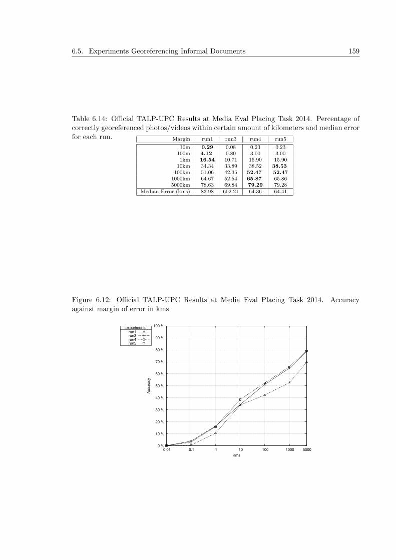
6.5. Experiments Georeferencing Informal Documents 159
Table 6.14: Official TALP-UPC Results at Media Eval Placing Task 2014. Percentage ofcorrectly georeferenced photos/videos within certain amount of kilometers and median errorfor each run. Margin run1 run3 run4 run5
10m 0.29 0.08 0.23 0.23100m 4.12 0.80 3.00 3.001km 16.54 10.71 15.90 15.90
10km 34.34 33.89 38.52 38.53100km 51.06 42.35 52.47 52.47
1000km 64.67 52.54 65.87 65.865000km 78.63 69.84 79.29 79.28
Median Error (kms) 83.98 602.21 64.36 64.41
Figure 6.12: Official TALP-UPC Results at Media Eval Placing Task 2014. Accuracyagainst margin of error in kms
0 %
10 %
20 %
30 %
40 %
50 %
60 %
70 %
80 %
90 %
100 %
0.01 0.1 1 10 100 1000 5000
Accura
cy
Kms
experimentsrun1run3run4run5
160 Chapter 6. Textual Georeferencing Approaches
6.5.5.2 Experiments after MediaEval Placing Task 2014
The approaches were tested with three corpora for training (see Table 6.15): 1) the ME2014Training dataset, 2) YFCC100M_A, the YFCC100M geotagged dataset (47,959,829 geo-tagged items) with items that are not contained in the test set, and 3) YFCC100M_B,the YFCC100M geotagged dataset (47,959,829 geotagged items) with items that are notcontained in the test set and items that do not pertain to any user of the test set. From theME2014PT training and the YFCC100M geotagged datasets we extracted all the uniquecoordinates with associated text: about 2,741,717, 11,382,289, and 11,253,099 coordinatesrespectively.
Table 6.15: Features of the training corpus in official and posterior experiments.Training Corpus #items #unique_coordinates #coordinates_with_text #users
MEPT2014 5,025,000 3,057,718 2,741,717 172,024YFCC100M_A 47,959,829 12,578,450 11,382,289 212,877YFCC100M_B 44,000,224 11,619,425 11,253,099 205,988
Two sets of experiments were performed:
1. Official experiments with the ME2014PT dataset and posterior experi-ments with and without gazetteer use. The results of this experiments areshown in Table 6.16. The official run1 at the benchmark was done with the HLMmodel and a distance threshold of 100km for Re-Ranking and it achieved the bestofficial results in accuracies at high distances (1,000km and 5,000km). It is worthnoting that in the benchmark there is not a system performing well in all distances.The GeoFusion approaches achieved the best results in the experiments at ranges from10 km to 5,000 km with the ME2014PT Training dataset, clearly outperforming theGeoKB, IR, and IR with Re-Ranked approaches. The GeoFusion approaches achievedthe best results at these evaluation ranges because this approach combines high pre-cision rules based on Toponym Disambiguation heuristics and predictions that comefrom an IR model when these rules are not activated. When these rules are activated(144,074 cases of 510,000), they achieve accuracy percentages of 87.37% (125,878 of144,074 items) predicting up to 100 km. By contrast, the HLM IR model trainedwith the ME2014PT training set with Re-Ranking achieved a 78.34% of accuracy at100 km when evaluated over this subset (144,074 cases). The HLM approach withRe-Ranking obtained the best results in distance ranges from 10m to 1 km because itcaptures non-geographical highly descriptive and unique keywords and place namesappearing in the geographical coordinates’ associated metadata that are not presentin the gazetteer. The approach that uses the English Wikipedia georeferenced pagesto handle difficult cases does not generally offer better performance than the originalGeoFusion approach.
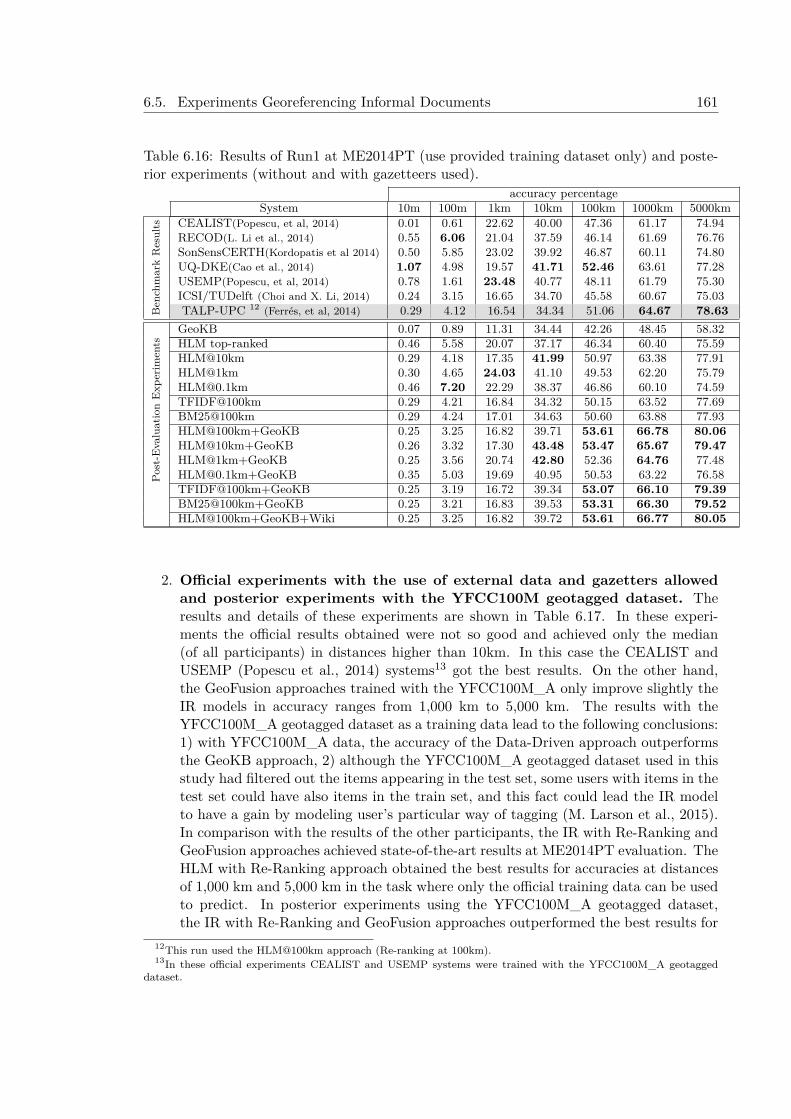
6.5. Experiments Georeferencing Informal Documents 161
Table 6.16: Results of Run1 at ME2014PT (use provided training dataset only) and poste-rior experiments (without and with gazetteers used).
accuracy percentageSystem 10m 100m 1km 10km 100km 1000km 5000km
Ben
chm
ark
Res
ults CEALIST(Popescu, et al, 2014) 0.01 0.61 22.62 40.00 47.36 61.17 74.94
RECOD(L. Li et al., 2014) 0.55 6.06 21.04 37.59 46.14 61.69 76.76SonSensCERTH(Kordopatis et al 2014) 0.50 5.85 23.02 39.92 46.87 60.11 74.80UQ-DKE(Cao et al., 2014) 1.07 4.98 19.57 41.71 52.46 63.61 77.28USEMP(Popescu, et al, 2014) 0.78 1.61 23.48 40.77 48.11 61.79 75.30ICSI/TUDelft (Choi and X. Li, 2014) 0.24 3.15 16.65 34.70 45.58 60.67 75.03TALP-UPC 12 (Ferrés, et al, 2014) 0.29 4.12 16.54 34.34 51.06 64.67 78.63
Post
-Eva
luat
ion
Exp
erim
ents
GeoKB 0.07 0.89 11.31 34.44 42.26 48.45 58.32HLM top-ranked 0.46 5.58 20.07 37.17 46.34 60.40 75.59HLM@10km 0.29 4.18 17.35 41.99 50.97 63.38 77.91HLM@1km 0.30 4.65 24.03 41.10 49.53 62.20 [email protected] 0.46 7.20 22.29 38.37 46.86 60.10 74.59TFIDF@100km 0.29 4.21 16.84 34.32 50.15 63.52 77.69BM25@100km 0.29 4.24 17.01 34.63 50.60 63.88 77.93HLM@100km+GeoKB 0.25 3.25 16.82 39.71 53.61 66.78 80.06HLM@10km+GeoKB 0.26 3.32 17.30 43.48 53.47 65.67 79.47HLM@1km+GeoKB 0.25 3.56 20.74 42.80 52.36 64.76 [email protected]+GeoKB 0.35 5.03 19.69 40.95 50.53 63.22 76.58TFIDF@100km+GeoKB 0.25 3.19 16.72 39.34 53.07 66.10 79.39BM25@100km+GeoKB 0.25 3.21 16.83 39.53 53.31 66.30 79.52HLM@100km+GeoKB+Wiki 0.25 3.25 16.82 39.72 53.61 66.77 80.05
2. Official experiments with the use of external data and gazetters allowedand posterior experiments with the YFCC100M geotagged dataset. Theresults and details of these experiments are shown in Table 6.17. In these experi-ments the official results obtained were not so good and achieved only the median(of all participants) in distances higher than 10km. In this case the CEALIST andUSEMP (Popescu et al., 2014) systems13 got the best results. On the other hand,the GeoFusion approaches trained with the YFCC100M_A only improve slightly theIR models in accuracy ranges from 1,000 km to 5,000 km. The results with theYFCC100M_A geotagged dataset as a training data lead to the following conclusions:1) with YFCC100M_A data, the accuracy of the Data-Driven approach outperformsthe GeoKB approach, 2) although the YFCC100M_A geotagged dataset used in thisstudy had filtered out the items appearing in the test set, some users with items in thetest set could have also items in the train set, and this fact could lead the IR modelto have a gain by modeling user’s particular way of tagging (M. Larson et al., 2015).In comparison with the results of the other participants, the IR with Re-Ranking andGeoFusion approaches achieved state-of-the-art results at ME2014PT evaluation. TheHLM with Re-Ranking approach obtained the best results for accuracies at distancesof 1,000 km and 5,000 km in the task where only the official training data can be usedto predict. In posterior experiments using the YFCC100M_A geotagged dataset,the IR with Re-Ranking and GeoFusion approaches outperformed the best results for
12This run used the HLM@100km approach (Re-ranking at 100km).13In these official experiments CEALIST and USEMP systems were trained with the YFCC100M_A geotagged
dataset.
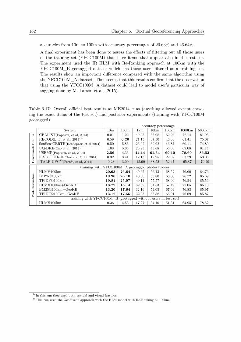
162 Chapter 6. Textual Georeferencing Approaches
accuracies from 10m to 100m with accuracy percentages of 20.63% and 26.64%.A final experiment has been done to assess the effects of filtering out all those usersof the training set (YFCC100M) that have items that appear also in the test set.The experiment used the IR HLM with Re-Ranking approach at 100km with theYFCC100M_B geotagged dataset which has those users filtered as a training set.The results show an important difference compared with the same algorithm usingthe YFCC100M_A dataset. Thus seems that this results confirm that the observationthat using the YFCC100M_A dataset could lead to model user’s particular way oftagging done by M. Larson et al. (2015).
Table 6.17: Overall official best results at ME2014 runs (anything allowed except crawl-ing the exact items of the test set) and posterior experiments (training with YFCC100Mgeotagged).
accuracy percentageSystem 10m 100m 1km 10km 100km 1000km 5000km
Ben
chm
ark
Res
ults CEALIST(Popescu, et al, 2014) 0.01 1.22 40.25 55.98 62.26 72.14 81.95
RECOD(L. Li et al., 2014)14 0.59 6.26 21.15 37.50 46.03 61.41 75.07SonSensCERTH(Kordopatis et al 2014) 0.50 5.85 23.02 39.92 46.87 60.11 74.80UQ-DKE(Cao et al., 2014) 1.08 5.05 20.23 43.68 56.03 69.08 81.14USEMP(Popescu, et al, 2014) 2.56 4.33 44.14 61.34 69.10 78.69 86.52ICSI/ TUDelft(Choi and X. Li, 2014) 0.32 3.41 12.13 19.95 22.82 33.79 53.06TALP-UPC15(Ferrés, et al, 2014) 0.23 3.00 15.90 38.52 52.47 65.87 79.29
Post
-Eva
luat
ion
training with YFCC100M_A geotagged photos/videosHLM@100km 20.63 26.64 40.65 56.13 68.52 76.60 84.76BM25@100km 19.96 26.10 40.30 55.80 68.30 76.72 85.69TFIDF@100km 19.84 25.97 40.11 55.57 68.06 76.54 85.56HLM@100km+GeoKB 13.72 18.14 32.62 54.53 67.49 77.05 86.10BM25@100km+GeoKB 13.20 17.64 32.16 54.05 67.09 76.83 85.97TFIDF@100km+GeoKB 13.12 17.55 32.03 53.88 66.91 76.69 85.87
training with YFCC100M_B (geotagged without users in test set)HLM@100km 0.36 4.53 17.27 34.10 51.31 64.95 78.52
14In this run they used both textual and visual features.15This run used the GeoFusion approach with the HLM model with Re-Ranking at 100km.

6.6. Experiments Georeferencing Informal Texts in Emergency Scenarios 163
6.6 Experiments Georeferencing Informal Texts in EmergencyScenarios
A set of experiments with a subset of the MEPT2014 test set has been performed to evaluatethe TG algorithms in emergency scenarios over informal texts from social networks. Theexperiments done in this article have been inspired by the ones described in Kordopatis-Ziloset al., 2015, in which a set of items (about 6,000) from the MEPT2014 test set with keywordsrelated with emergency scenarios (6 keywords) have been extracted and evaluated comparedwith the predictions of the full test set. Kordopatis-Zilos et al., 2015 used the followingkeywords to create an ”emergency scenario” test set derived from MEPT2014 test set:“demonstration”, “earthquake”, “fire” , “flood”, “hurricane” and “riot”. The experimentspresented in this thesis only used 4 of these keywords (“earthquake”, “flood”, “hurricane”and “riot’) because of the ambiguity of the “demonstration” and “fire” keywords (see inTable 6.18 some samples of the MEPT2014 test set that include these keywords).
Table 6.18: Sample of some metadata associated to Flickr photos that include at least oneof these keywords: ”earthquake”, ”flood”, ”hurricane”, and ”riot”.
ID Keywords6091040955 View of the Raritan River’s South Branch from Downtown Clinton clinton flood
hunterdon hurricane new jersey raritan river stormSunday Morning Aug 28th as Hurricane Irene leaves the area
4119131675 Rapids bridge cork flood flooding ireland rain rapid rescue submerged water3848366492 Roio Poggio 138 giorni dopo earthquake l’aquila poggio roio terremoto7788469962 Untitled activists affairs brussels demonstration dog foreign
ministry palestine police pro protest riot Brussels Ministry of Foreign affairs4295769184 Larry King was recording downstairs c cnn hospital larry king live As we were checking
in CNN was setting up for an interview between Larry Kingand a Haiti earthquake survivor that is being treated at the same
hospital where C was eventually born3846634179 Greater Baton Rouge Food Bank crisis corps hurricane katrina
louisiana peace corps response15487966 Mississippi River Flood May 2002 flood martin luther king bridge
mississippi river riverfront saint louis st louis <a href=”http://wwwgeobloggers com”>GeoTagged</a>
5352575983 Pay your tax london revolts riot riots student tax Takenduring December 2010 student revolts
From the set of 510,000 items (photos/videos) of the MEPT2014 test set were extracteda total of 784 items that contain at least one of these keywords using the Keywords (usertags) metadata field. A total of 63 items contain the keyword “riot”, 229 items contain thekeyword “hurricane”, 366 contain the keyword “flood”, and 144 items contain the keyword“earthquake”. The algorithms evaluated were the GeoKB, the IR with Re-Ranking at aclustering distance of 100km and a document weight threshold of 0.66 with the HLM model,and the GeoFusion approach. See the results of the approaches over the full MEPT2014test set and the emergency scenario test set in Figure 6.19.
The evaluation of the emergency scenario data set shows that the GeoKB approachachieved the best results in the ranges of 0.01km, 0.1km, 1km and 10km in comparison withthe other approaches over the same test set. On the other hand, the GeoFusion approachachieved the best results in the ranges of 100km, 1,000km and 5,000km. These results of
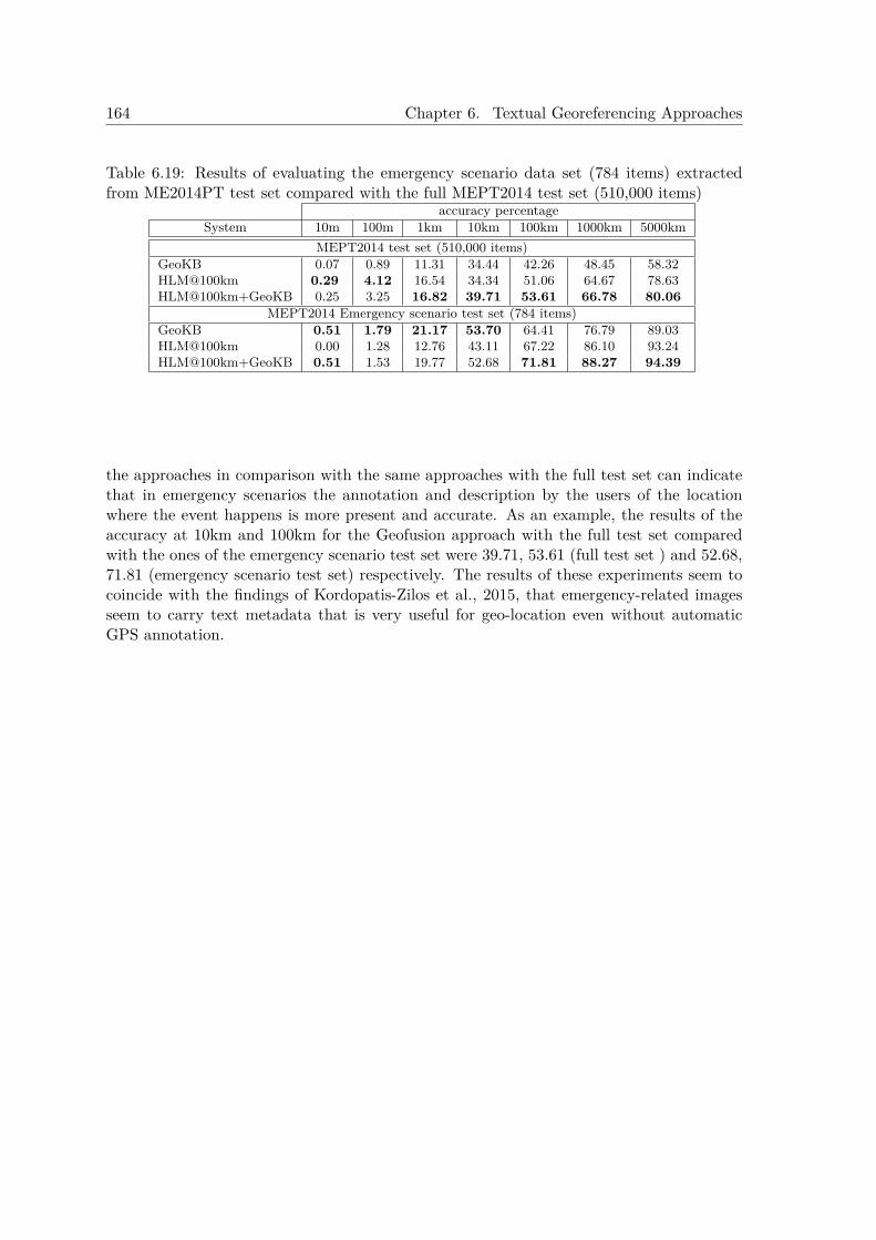
164 Chapter 6. Textual Georeferencing Approaches
Table 6.19: Results of evaluating the emergency scenario data set (784 items) extractedfrom ME2014PT test set compared with the full MEPT2014 test set (510,000 items)
accuracy percentageSystem 10m 100m 1km 10km 100km 1000km 5000km
MEPT2014 test set (510,000 items)GeoKB 0.07 0.89 11.31 34.44 42.26 48.45 58.32HLM@100km 0.29 4.12 16.54 34.34 51.06 64.67 78.63HLM@100km+GeoKB 0.25 3.25 16.82 39.71 53.61 66.78 80.06
MEPT2014 Emergency scenario test set (784 items)GeoKB 0.51 1.79 21.17 53.70 64.41 76.79 89.03HLM@100km 0.00 1.28 12.76 43.11 67.22 86.10 93.24HLM@100km+GeoKB 0.51 1.53 19.77 52.68 71.81 88.27 94.39
the approaches in comparison with the same approaches with the full test set can indicatethat in emergency scenarios the annotation and description by the users of the locationwhere the event happens is more present and accurate. As an example, the results of theaccuracy at 10km and 100km for the Geofusion approach with the full test set comparedwith the ones of the emergency scenario test set were 39.71, 53.61 (full test set ) and 52.68,71.81 (emergency scenario test set) respectively. The results of these experiments seem tocoincide with the findings of Kordopatis-Zilos et al., 2015, that emergency-related imagesseem to carry text metadata that is very useful for geo-location even without automaticGPS annotation.
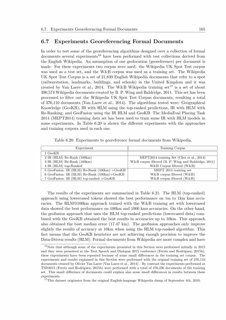
6.7. Experiments Georeferencing Formal Documents 165
6.7 Experiments Georeferencing Formal DocumentsIn order to test some of the georeferencing algorithms designed over a collection of formaldocuments several experiments16 have been performed with test collections derived fromthe English Wikipedia. An assumption of one geolocation (georeference) per document ismade. For these experiments two corpus were used: the Wikipedia UK Spot Test corpuswas used as a test set, and the W&B corpus was used as a training set. The WikipediaUK Spot Test Corpus is a set of 21,839 English Wikipedia documents that refer to a spot(railwaystation, landmarks, buildings, and schools) in the United Kingdom and it wascreated by Van Laere et al., 2014. The W&B Wikipedia training set17 is a set of about390,574 Wikipedia documents created by B. P. Wing and Baldridge, 2011. This set has beenprocessed to filter out the Wikipedia UK Spot Test Corpus documents, resulting a totalof 376,110 documents (Van Laere et al., 2014). The algorithms tested were: GeographicalKnowledge (GeoKB), IR with HLM using the top-ranked predictions, IR with HLM withRe-Ranking, and GeoFusion using the IR HLM and GeoKB. The MediaEval Placing Task2014 (MEPT2014) training data set has been used to train some IR with HLM models insome experiments. In Table 6.20 is shown the different experiments with the approachesand training corpora used in each one.
Table 6.20: Experiments to georeference formal documents from Wikipedia.
Experiment Training Corpus1 GeoKB -2 IR (HLM) Re-Rank (100km) MEPT2014 training Set (Choi et al., 2014)3 IR (HLM) Re-Rank (100km) W&B corpus filtered (B. P. Wing and Baldridge, 2011)4 IR (HLM) top-Ranked W&B Corpus filtered (W&B)5 GeoFusion: IR (HLM) Re-Rank (100km) +GeoKB MEPT 2014 training set6 GeoFusion: IR (HLM) Re-Rank (100km)+GeoKB W&B corpus filtered (W&B)7 GeoFusion: IR (HLM) top-ranked +GeoKB W&B corpus filtered (W&B)
The results of the experiments are summarized in Table 6.21. The HLM (top-ranked)approach using lowercased tokens showed the best performance on 1m to 1km kms accu-racies. The HLM@100km approach trained with the W&B training set with lowercaseddata showed the best performance on 100km and 1000 kms accuracies. On the other hand,the geofusion approach that uses the HLM top-ranked predictions (lowercased data) com-bined with the GeoKB obtained the best results in accuracies up to 10km. This approachalso obtained the best median error (17.47 km). The geofusion approaches only improveslightly the results of accuracy at 10km when using the HLM top-ranked algorithm. Thisfact means that the GeoKB heuristics are not achieving enough precision to improve theData-Driven results (HLM). Formal documents from Wikipedia are more complex and have
16Note that although some of the experiments presented in this Section were performed initially in 2015and they were presented at the Text Speech and Dialogue 2015 conference (Ferrés and Rodríguez, 2015b),these experiments have been repeated because of some small differences in the training set corpus. Theexperiments and results explained in this Section were performed with the original training set of 376,110documents created by Olivier Van Laere (Van Laere et al., 2014) . By contrast the experiments performed atTSD2015 (Ferrés and Rodríguez, 2015b) were performed with a total of 376,236 documents of the trainingset. This small difference of documents could explain also some small differences in results between theseexperiments.
17This dataset originates from the original English-language Wikipedia dump of September 4th, 2010.
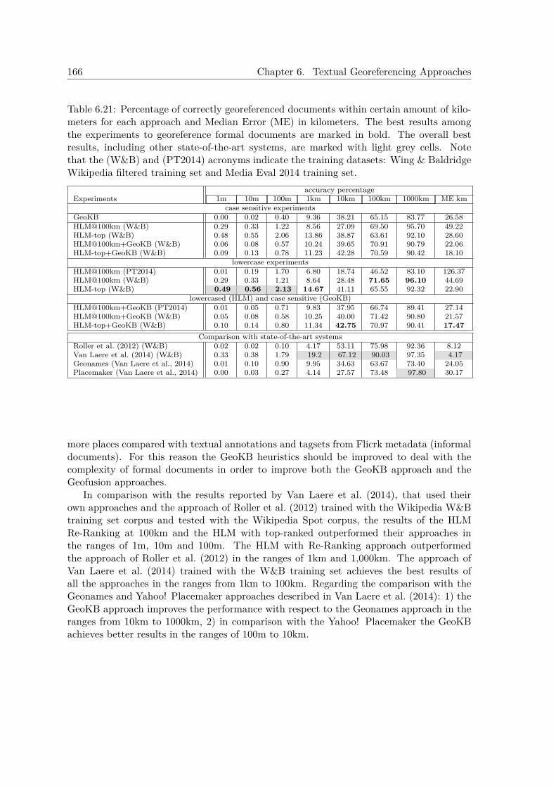
166 Chapter 6. Textual Georeferencing Approaches
Table 6.21: Percentage of correctly georeferenced documents within certain amount of kilo-meters for each approach and Median Error (ME) in kilometers. The best results amongthe experiments to georeference formal documents are marked in bold. The overall bestresults, including other state-of-the-art systems, are marked with light grey cells. Notethat the (W&B) and (PT2014) acronyms indicate the training datasets: Wing & BaldridgeWikipedia filtered training set and Media Eval 2014 training set.
accuracy percentageExperiments 1m 10m 100m 1km 10km 100km 1000km ME km
case sensitive experimentsGeoKB 0.00 0.02 0.40 9.36 38.21 65.15 83.77 26.58HLM@100km (W&B) 0.29 0.33 1.22 8.56 27.09 69.50 95.70 49.22HLM-top (W&B) 0.48 0.55 2.06 13.86 38.87 63.61 92.10 28.60HLM@100km+GeoKB (W&B) 0.06 0.08 0.57 10.24 39.65 70.91 90.79 22.06HLM-top+GeoKB (W&B) 0.09 0.13 0.78 11.23 42.28 70.59 90.42 18.10
lowercase experimentsHLM@100km (PT2014) 0.01 0.19 1.70 6.80 18.74 46.52 83.10 126.37HLM@100km (W&B) 0.29 0.33 1.21 8.64 28.48 71.65 96.10 44.69HLM-top (W&B) 0.49 0.56 2.13 14.67 41.11 65.55 92.32 22.90
lowercased (HLM) and case sensitive (GeoKB)HLM@100km+GeoKB (PT2014) 0.01 0.05 0.71 9.83 37.95 66.74 89.41 27.14HLM@100km+GeoKB (W&B) 0.05 0.08 0.58 10.25 40.00 71.42 90.80 21.57HLM-top+GeoKB (W&B) 0.10 0.14 0.80 11.34 42.75 70.97 90.41 17.47
Comparison with state-of-the-art systemsRoller et al. (2012) (W&B) 0.02 0.02 0.10 4.17 53.11 75.98 92.36 8.12Van Laere et al. (2014) (W&B) 0.33 0.38 1.79 19.2 67.12 90.03 97.35 4.17Geonames (Van Laere et al., 2014) 0.01 0.10 0.90 9.95 34.63 63.67 73.40 24.05Placemaker (Van Laere et al., 2014) 0.00 0.03 0.27 4.14 27.57 73.48 97.80 30.17
more places compared with textual annotations and tagsets from Flicrk metadata (informaldocuments). For this reason the GeoKB heuristics should be improved to deal with thecomplexity of formal documents in order to improve both the GeoKB approach and theGeofusion approaches.
In comparison with the results reported by Van Laere et al. (2014), that used theirown approaches and the approach of Roller et al. (2012) trained with the Wikipedia W&Btraining set corpus and tested with the Wikipedia Spot corpus, the results of the HLMRe-Ranking at 100km and the HLM with top-ranked outperformed their approaches inthe ranges of 1m, 10m and 100m. The HLM with Re-Ranking approach outperformedthe approach of Roller et al. (2012) in the ranges of 1km and 1,000km. The approach ofVan Laere et al. (2014) trained with the W&B training set achieves the best results ofall the approaches in the ranges from 1km to 100km. Regarding the comparison with theGeonames and Yahoo! Placemaker approaches described in Van Laere et al. (2014): 1) theGeoKB approach improves the performance with respect to the Geonames approach in theranges from 10km to 1000km, 2) in comparison with the Yahoo! Placemaker the GeoKBachieves better results in the ranges of 100m to 10km.
6.8. Conclusions 167
6.8 ConclusionsThis chapter presented a description and an evaluation of four generic georeferencing ap-proaches that deal with formal and informal documents. Some of these approaches achievedstate-of-the-art results in official georeferencing evaluations and posterior experiments.
These georeferencing approaches were the following ones:
1. A Geographical Knowledge-Based Approach. This approach uses only Geo-graphical Knowledge for georeferencing. It uses Toponym Recognition and Geograph-ical Focus Detection Heuristics to predict the georeferenced coordinates of the text.The Geographical Focus Detection Heuristics can use Geographical Knowledge BasedHeuristics and/or Population Heuristics. In some experiments with the ME2010PTdataset (metadata of 5091 videos) the Geographical Knowledge heuristics achieved ahigh precision (when activated) in georeferencing (up to a 86.36%). In MEPT2014when the GeoKB rules H1,H2, and H3 are activated (144,074 cases of 510,000), theyachieve accuracy percentages of 87.37% (125,878 of 144,074 items) predicting up to100 km. By contrast, the HLM IR model trained with the ME2014PT training setwith Re-Ranking achieved a 78.34% of accuracy at 100 km when evaluated over thissubset (144,074 cases). These results with informal documents were very useful forestablishing high confidence rules that could allow a high precision georeferencingdetection in textual annotations and tags.
2. An Information Retrieval Approach. This approach treats the document togeoreference as an IR query and uses existing state-of-the-art IR models to retrievethe top-ranked coordinates pair as the final prediction for query. The IR models usedare the TF-IDF, BM25 and Hiemstra Language Model (HLM) (Hiemstra, 2001).
3. Information Retrieval with Re-Ranking Approach. This approach is a variantof the IR approach that re-ranks the set of ranked predictions associated with a georef-erenced document by means of a clustering process that uses a geographical distancefunction (Haversine distance). In some experiments after the MEPT2010 benchmarkthis approach achieved the best results (compared with the other approaches pre-sented by the author) georeferencing at 1, 5 and 10 km of margin of errors distancesusing the Hiemstra Language Model algorithm for IR. At the MEPT2014 the HLMapproach with Re-Ranking obtained the best results (compared with the other ap-proaches presented by the author) in distance ranges from 10m to 1 km because itcaptures non-geographical highly descriptive and unique keywords and place namesappearing in the geographical coordinates’ associated metadata that are not present inthe gazetteer. In comparison with the results of the other participants at MEPT2014,the IR with Re-Ranking and GeoFusion approaches achieved competitive state-of-the-art results. The HLM with Re-Ranking approach obtained the best official results foraccuracies at distances of 1,000 km and 5,000 km in the task where only the officialtraining data can be used to predict.
4. GeoFusion approaches. A combination of predictions from the Geographical Knowl-edge Heuristics H1,H2, and H2 and from the IR approaches (with and without Re-Ranking). In experiments after MEPT2010 the GeoFusion approach with Re-Rankingoutperformed the best results in accuracy reported by the state-of-the art systemsparticipating at MEPT2010, achieving a 68.53% of accuracy georeferencing up to a
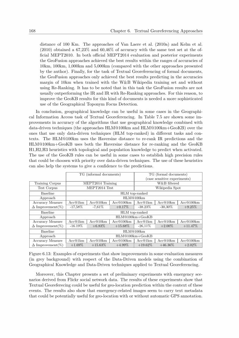
168 Chapter 6. Textual Georeferencing Approaches
distance of 100 Km. The approaches of Van Laere et al. (2010a) and Kelm et al.(2010) obtained a 67,23% and 60,46% of accuracy with the same test set at the of-ficial MEPT2010. In both official MEPT2014 evaluation and posterior experimentsthe GeoFusion approaches achieved the best results within the ranges of accuracies of10km, 100km, 1,000km and 5,000km (compared with the other approaches presentedby the author). Finally, for the task of Textual Georeferencing of formal documents,the GeoFusion approaches only achieved the best results predicting in the accuraciesmargin of 10km when trained with the W&B Wikipedia training set and withoutusing Re-Ranking. It has to be noted that in this task the GeoFusion results are notusually outperforming the IR and IR with Re-Ranking approaches. For this reason, toimprove the GeoKB results for this kind of documents is needed a more sophisticateduse of the Geographical Toponym Focus Detection.
In conclusion, geographical knowledge can be useful in some cases in the Geographi-cal Information Access task of Textual Georeferencing. In Table 7.5 are shown some im-provements in accuracy of the algorithms that use geographical knowledge combined withdata-driven techniques (the approaches HLM@100km and HLM@100km+GeoKB) over theones that use only data-driven techniques (HLM top-ranked) in different tasks and con-texts. The HLM@100km uses the Haversine distance to re-rank IR predictions and theHLM@100km+GeoKB uses both the Haversine distance for re-ranking and the GeoKBH1,H2,H3 heuristics with topological and population knowledge to predict when activated.The use of the GeoKB rules can be useful in some cases to establish high precision rulesthat could be choosen with priority over data-driven techniques. The use of these heuristicscan also help the systems to give a confidence to the predictions.
TG (informal documents) TG (formal documents)(case sensitive experiments)
Training Corpus MEPT2014 Training W&B filteredTest Corpus MEPT2014 Test Wikipedia Spot
Baseline HLM top-rankedApproach HLM@100km
Accuracy Measure Acc@1km Acc@10km Acc@100km Acc@1km Acc@10km Acc@100km∆ Improvement(%) -17,58% -7,61% +0.17% -38.23% -30,30% +9.25%
Baseline HLM top-rankedApproach HLM@100km+GeoKB
Accuracy Measure Acc@1km Acc@10km Acc@100km Acc@1km Acc@10km Acc@100km∆ Improvement(%) -16.19% +6.83% +15.68% -26,11% +2.00% +11.47%
Baseline HLM@100kmApproach HLM@100km+GeoKB
Accuracy Measure Acc@1km Acc@10km Acc@100km Acc@1km Acc@10km Acc@100km∆ Improvement(%) +1.69% +15.63% +4.99% +19.62% +46.36% +2.02%
Figure 6.13: Examples of experiments that show improvements in some evaluation measures(in grey background) with respect of the Data-Driven models using the combination ofGeographical Knowledge and Data-Driven techniques applied to Textual Georeferencing.
Moreover, this Chapter presents a set of preliminary experiments with emergency sce-narios derived from Flickr social network data. The results of these experiments show thatTextual Georeferecing could be useful for geo-location prediction within the context of theseevents. The results also show that emergency-related images seem to carry text metadatathat could be potentially useful for geo-location with or without automatic GPS annotation.

CHAPTER 7
Conclusions
This chapter outlines and describes the main contributions of this thesis, points out itslimitations, and proposes further work.
7.1 Contributions
This PhD thesis contributes to the state-of-the-art of Geographical Information Accesswith these main contributions:
• The presentation and description of several novel approaches for Geo-graphical Information Access tasks. These approaches deal with the followingtasks related to Geographical Information Access: Geographical Information Re-trieval, Geographical Question Answering and Textual Georeferencing.
• The evaluation of these novel approaches for Geographical InformationAccess tasks. These approaches have been evaluated in these contexts: 1) withinofficial evaluation benchmarks, 2) after evaluation benchmarks with the bench-marks test collections, 3) with other specific datasets.
• The effective use of Geographical Knowledge and Natural Language Pro-cessing for the Geographical Information Retrieval tasks evaluated.
• Passage Retrieval Approaches for GIR. Implementation and evaluation oftwo approaches that combine sucessfully Geographical Knowledge and Passage Re-trieval presented at GeoCLEF 2005 and GeoCLEF 2006.
• TALPGeoIR. An approach that combines Geographical Knowledge Re-Ranking,Natural Language Processing and Relevance Feedback for Geographical Informa-tion Retrieval that achieved state-of-the-art results in official GeoCLEF bench-marks (Ferrés and Rodríguez, 2008a; Mandl et al., 2008) and posterior experiments(Ferrés and Rodríguez, 2015a).
169
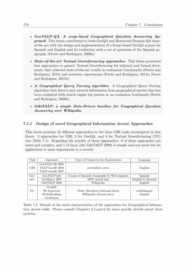
170 Chapter 7. Conclusions
• GeoTALP-QA. A scope-based Geographical Question Answering Ap-proach. This thesis contributed to both GeoQA and Restricted-Domain QA state-of-the-art with the design and implementation of a Scope-based GeoQA system forSpanish and English and its evaluation with a set of questions of the Spanish ge-ography (Ferrés and Rodríguez, 2006a).
• State-of-the-art Textual Georeferencing approaches. This thesis presentedfour approaches to generic Textual Georeferencing for informal and formal docu-ments that achieved state-of-the-art results in evaluation benchmarks (Ferrés andRodríguez, 2014) and posterior experiments (Ferrés and Rodríguez, 2011a; Ferrésand Rodríguez, 2015b).
• A Geographical Query Parsing algorithm. A Geographical Query Parsingalgorithm that detects and extracts information from geographical queries that hasbeen evaluated with search engine log queries in an evaluation benchmark (Ferrésand Rodríguez, 2008b).
• GikiTALP: a simple Data-Driven baseline for Geographical QuestionAnswering over Wikipedia.
7.1.1 Design of novel Geographical Information Access Approaches
This thesis presents 10 different approaches to the three GIR tasks investigated in thisthesis: 3 approaches for GIR, 3 for GeoQA, and 4 for Textual Georeferencing (TG)(see Table 7.1). Regarding the novelty of these approaches: 9 of these approaches arenovel and complex, and 1 of them (the GikiTALP 2009) is simple and not novel but itsapplication in some experiments is a novelty.
Task Approach Type of Corpus in the Experiments LanguageGeoTALP-IR 2005
GIR TALP-GeoIR 2006 journalistic news EnglishTALP-GeoIR 2007
Geo GeoTALP-QA Corpus of Spanish Geography & Web snippets SpanishQA GeoQuery 2007 MSN search logs English & Spanish
GikiTALP 2009 Wikipedia EnglishGeoKB
TG IR-Approach Flickr Metadata (informal docs) multilingualIR-ReRanking Wikipedia (formal docs) English
GeoFusion
Table 7.1: Details of the main characteristics of the approaches for Geographical Informa-tion Access tasks. Please consult Chapters 4,5,and 6 for more specific details about thesesystems.
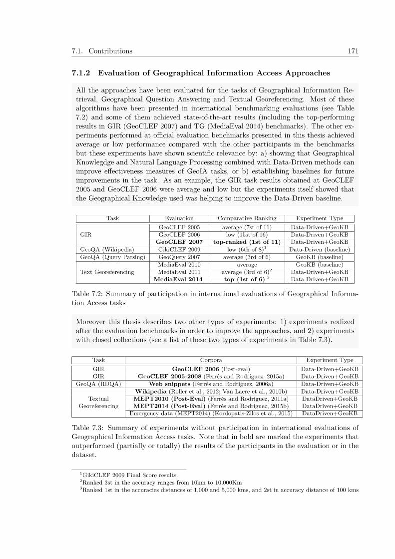
7.1. Contributions 171
7.1.2 Evaluation of Geographical Information Access Approaches
All the approaches have been evaluated for the tasks of Geographical Information Re-trieval, Geographical Question Answering and Textual Georeferencing. Most of thesealgorithms have been presented in international benchmarking evaluations (see Table7.2) and some of them achieved state-of-the-art results (including the top-performingresults in GIR (GeoCLEF 2007) and TG (MediaEval 2014) benchmarks). The other ex-periments performed at official evaluation benchmarks presented in this thesis achievedaverage or low performance compared with the other participants in the benchmarksbut these experiments have shown scientific relevance by: a) showing that GeographicalKnowlegdge and Natural Language Processing combined with Data-Driven methods canimprove effectiveness measures of GeoIA tasks, or b) establishing baselines for futureimprovements in the task. As an example, the GIR task results obtained at GeoCLEF2005 and GeoCLEF 2006 were average and low but the experiments itself showed thatthe Geographical Knowledge used was helping to improve the Data-Driven baseline.
Task Evaluation Comparative Ranking Experiment TypeGeoCLEF 2005 average (7st of 11) Data-Driven+GeoKB
GIR GeoCLEF 2006 low (15st of 16) Data-Driven+GeoKBGeoCLEF 2007 top-ranked (1st of 11) Data-Driven+GeoKB
GeoQA (Wikipedia) GikiCLEF 2009 low (6th of 8)1 Data-Driven (baseline)GeoQA (Query Parsing) GeoQuery 2007 average (3rd of 6) GeoKB (baseline)
MediaEval 2010 average GeoKB (baseline)Text Georeferencing MediaEval 2011 average (3rd of 6)2 Data-Driven+GeoKB
MediaEval 2014 top (1st of 6) 3 Data-Driven+GeoKB
Table 7.2: Summary of participation in international evaluations of Geographical Informa-tion Access tasks
Moreover this thesis describes two other types of experiments: 1) experiments realizedafter the evaluation benchmarks in order to improve the approaches, and 2) experimentswith closed collections (see a list of these two types of experiments in Table 7.3).
Task Corpora Experiment TypeGIR GeoCLEF 2006 (Post-eval) Data-Driven+GeoKBGIR GeoCLEF 2005-2008 (Ferrés and Rodríguez, 2015a) Data-Driven+GeoKB
GeoQA (RDQA) Web snippets (Ferrés and Rodríguez, 2006a) Data-Driven+GeoKBWikipedia (Roller et al., 2012; Van Laere et al., 2010b) Data-Driven+GeoKB
Textual MEPT2010 (Post-Eval) (Ferrés and Rodríguez, 2011a) DataDriven+GeoKBGeoreferencing MEPT2014 (Post-Eval) (Ferrés and Rodríguez, 2015b) DataDriven+GeoKB
Emergency data (MEPT2014) (Kordopatis-Zilos et al., 2015) DataDriven+GeoKB
Table 7.3: Summary of experiments without participation in international evaluations ofGeographical Information Access tasks. Note that in bold are marked the experiments thatoutperformed (partially or totally) the results of the participants in the evaluation or in thedataset.
1GikiCLEF 2009 Final Score results.2Ranked 3st in the accuracy ranges from 10km to 10,000Km3Ranked 1st in the accuracies distances of 1,000 and 5,000 kms, and 2st in accuracy distance of 100 kms
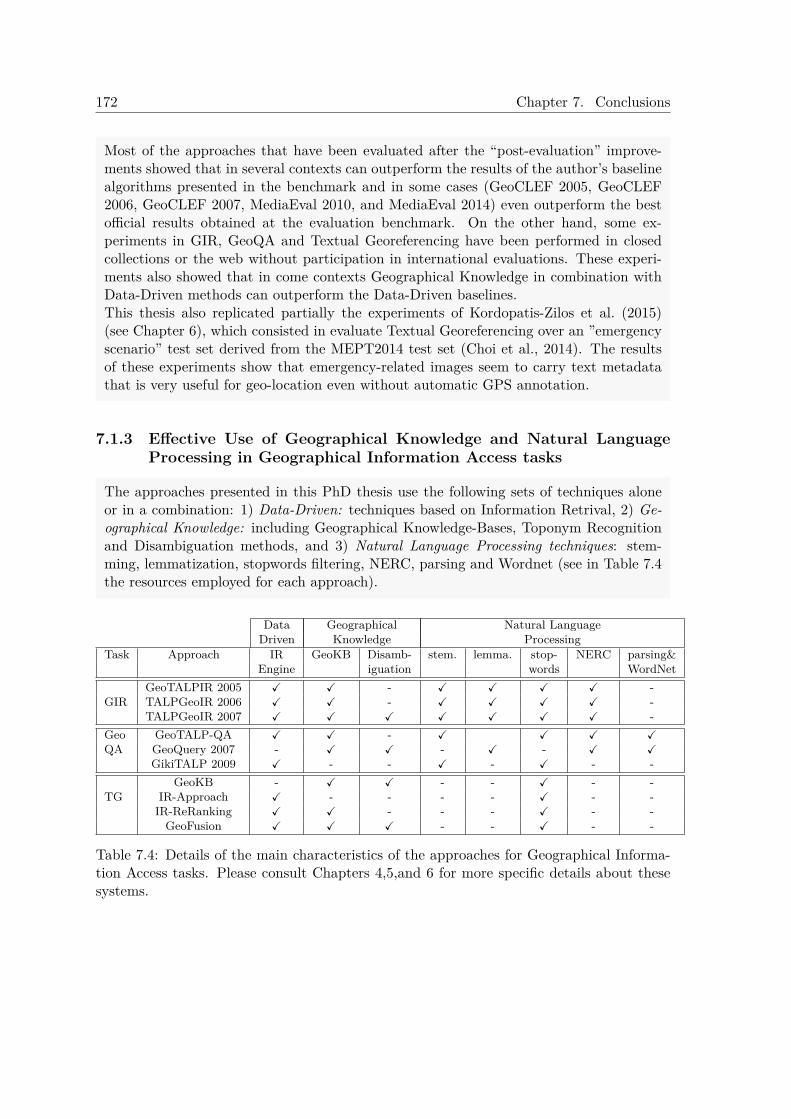
172 Chapter 7. Conclusions
Most of the approaches that have been evaluated after the “post-evaluation” improve-ments showed that in several contexts can outperform the results of the author’s baselinealgorithms presented in the benchmark and in some cases (GeoCLEF 2005, GeoCLEF2006, GeoCLEF 2007, MediaEval 2010, and MediaEval 2014) even outperform the bestofficial results obtained at the evaluation benchmark. On the other hand, some ex-periments in GIR, GeoQA and Textual Georeferencing have been performed in closedcollections or the web without participation in international evaluations. These experi-ments also showed that in come contexts Geographical Knowledge in combination withData-Driven methods can outperform the Data-Driven baselines.This thesis also replicated partially the experiments of Kordopatis-Zilos et al. (2015)(see Chapter 6), which consisted in evaluate Textual Georeferencing over an ”emergencyscenario” test set derived from the MEPT2014 test set (Choi et al., 2014). The resultsof these experiments show that emergency-related images seem to carry text metadatathat is very useful for geo-location even without automatic GPS annotation.
7.1.3 Effective Use of Geographical Knowledge and Natural LanguageProcessing in Geographical Information Access tasks
The approaches presented in this PhD thesis use the following sets of techniques aloneor in a combination: 1) Data-Driven: techniques based on Information Retrival, 2) Ge-ographical Knowledge: including Geographical Knowledge-Bases, Toponym Recognitionand Disambiguation methods, and 3) Natural Language Processing techniques: stem-ming, lemmatization, stopwords filtering, NERC, parsing and Wordnet (see in Table 7.4the resources employed for each approach).
Data Geographical Natural LanguageDriven Knowledge Processing
Task Approach IR GeoKB Disamb- stem. lemma. stop- NERC parsing&Engine iguation words WordNet
GeoTALPIR 2005 ✓ ✓ - ✓ ✓ ✓ ✓ -GIR TALPGeoIR 2006 ✓ ✓ - ✓ ✓ ✓ ✓ -
TALPGeoIR 2007 ✓ ✓ ✓ ✓ ✓ ✓ ✓ -Geo GeoTALP-QA ✓ ✓ - ✓ ✓ ✓ ✓QA GeoQuery 2007 - ✓ ✓ - ✓ - ✓ ✓
GikiTALP 2009 ✓ - - ✓ - ✓ - -GeoKB - ✓ ✓ - - ✓ - -
TG IR-Approach ✓ - - - - ✓ - -IR-ReRanking ✓ ✓ - - - ✓ - -
GeoFusion ✓ ✓ ✓ - - ✓ - -
Table 7.4: Details of the main characteristics of the approaches for Geographical Informa-tion Access tasks. Please consult Chapters 4,5,and 6 for more specific details about thesesystems.
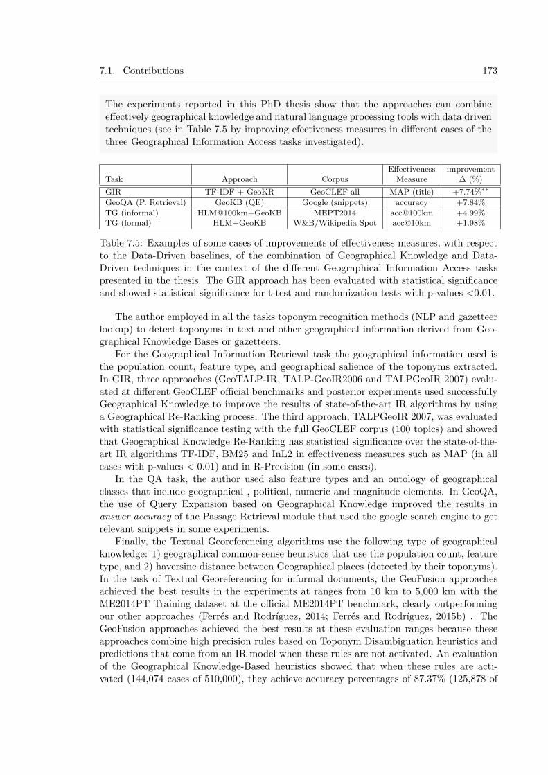
7.1. Contributions 173
The experiments reported in this PhD thesis show that the approaches can combineeffectively geographical knowledge and natural language processing tools with data driventechniques (see in Table 7.5 by improving efectiveness measures in different cases of thethree Geographical Information Access tasks investigated).
Effectiveness improvementTask Approach Corpus Measure ∆ (%)GIR TF-IDF + GeoKR GeoCLEF all MAP (title) +7.74%∗∗
GeoQA (P. Retrieval) GeoKB (QE) Google (snippets) accuracy +7.84%TG (informal) HLM@100km+GeoKB MEPT2014 acc@100km +4.99%TG (formal) HLM+GeoKB W&B/Wikipedia Spot acc@10km +1.98%
Table 7.5: Examples of some cases of improvements of effectiveness measures, with respectto the Data-Driven baselines, of the combination of Geographical Knowledge and Data-Driven techniques in the context of the different Geographical Information Access taskspresented in the thesis. The GIR approach has been evaluated with statistical significanceand showed statistical significance for t-test and randomization tests with p-values <0.01.
The author employed in all the tasks toponym recognition methods (NLP and gazetteerlookup) to detect toponyms in text and other geographical information derived from Geo-graphical Knowledge Bases or gazetteers.
For the Geographical Information Retrieval task the geographical information used isthe population count, feature type, and geographical salience of the toponyms extracted.In GIR, three approaches (GeoTALP-IR, TALP-GeoIR2006 and TALPGeoIR 2007) evalu-ated at different GeoCLEF official benchmarks and posterior experiments used successfullyGeographical Knowledge to improve the results of state-of-the-art IR algorithms by usinga Geographical Re-Ranking process. The third approach, TALPGeoIR 2007, was evaluatedwith statistical significance testing with the full GeoCLEF corpus (100 topics) and showedthat Geographical Knowledge Re-Ranking has statistical significance over the state-of-the-art IR algorithms TF-IDF, BM25 and InL2 in effectiveness measures such as MAP (in allcases with p-values < 0.01) and in R-Precision (in some cases).
In the QA task, the author used also feature types and an ontology of geographicalclasses that include geographical , political, numeric and magnitude elements. In GeoQA,the use of Query Expansion based on Geographical Knowledge improved the results inanswer accuracy of the Passage Retrieval module that used the google search engine to getrelevant snippets in some experiments.
Finally, the Textual Georeferencing algorithms use the following type of geographicalknowledge: 1) geographical common-sense heuristics that use the population count, featuretype, and 2) haversine distance between Geographical places (detected by their toponyms).In the task of Textual Georeferencing for informal documents, the GeoFusion approachesachieved the best results in the experiments at ranges from 10 km to 5,000 km with theME2014PT Training dataset at the official ME2014PT benchmark, clearly outperformingour other approaches (Ferrés and Rodríguez, 2014; Ferrés and Rodríguez, 2015b) . TheGeoFusion approaches achieved the best results at these evaluation ranges because theseapproaches combine high precision rules based on Toponym Disambiguation heuristics andpredictions that come from an IR model when these rules are not activated. An evaluationof the Geographical Knowledge-Based heuristics showed that when these rules are acti-vated (144,074 cases of 510,000), they achieve accuracy percentages of 87.37% (125,878 of
174 Chapter 7. Conclusions
144,074 items) predicting up to 100 km. By contrast, the HLM IR model trained with theME2014PT training set with Re-Ranking achieved a 78.34% of accuracy at 100 km whenevaluated over this subset (144,074 cases).
For the task of Textual Georeferencing of formal documents, the GeoFusion approachesonly achieved the best results predicting in the accuracies margin of 10km when trained withthe WB Wikipedia training set and without using Re-Ranking. It has to be noted that inthis task the geofusion results are not usually outperforming the IR and IR with Re-Rankingapproaches. For this reason, to improve the GeoKB results for this kind of documents isneeded a more sophisticated use of the Geograhical Toponym Focus Detection.
The proposal, implementation and evaluation of approaches that combine successfullyGeographical Knowledge Heuristics based on human common-sense with Data-Drivenmethods in most of the Geographical Information Access Tasks is one of the most signif-icant contributions of this thesis. The main idea of these approaches is that Knowledge-Based Heuristics based on human common-sense combined with Data-Driven approachescan improve the results of Data-Driven methods.
7.1.4 Passage Retrieval Approaches for GIRThe initial GIR approaches by this author’s thesis were those presented at GeoCLEF 2005and GeoCLEF2006. The approach presented by the author at GeoCLEF 2005 achieved itsbest MAP with 0.2231, which is clearly low respect with the best MAP presented (0.3936).The author presented 4 runs (experiments) at GeoCLEF 2005 and the two experimentsthat used geographical information outperformed the author’s baselines, based on PassageRetrieval. Regarding the official results at GeoCLEF 2006, these ones shows that the systemfailed to use the Geographical Knowledge to improve the IR results. But this fact was due tothat this approach used the non-geographical keywords for the textual IR baselines insteadof using all the keywords as in the other two approaches. The experiments with the samesystem after GeoCLEF 2006 have proved this fact, and showed that when using all thekeywords for the textual approach the Geographical Re-Ranking process outperforms thebaselines;
In both evaluations the approaches used Passsage Retrieval systems for QA as baselines;being ones of the few attempts to try Passage Retrieval techniques for GIR. In GeoCLEF2005 the baseline was a Passage Retrieval for QA applied in the GIR context, and forGeoCLEF 2006 the baseline was the JIRS passage retrieval system. In both cases theMAP measure obtained with these baselines was low compared with the MAP of the bestsystems presented (0.1923 and 0.1342 of MAP measure respectively in GeoCLEF2005 andGeoCLEF2006). The other Passage Retrieval system tested by other researches for GIR wasIR-n (Pascual, 2002): Ferrández et al. (2005) and Toral et al. (2007) used it in GeoCLEF2005and GeoCLEF2006 with MAP values of 32.53 and 0.2985 respectively and García-Vega etal. (2006b) used IR-n but combined with other IR engines in GeoCLEF2006.
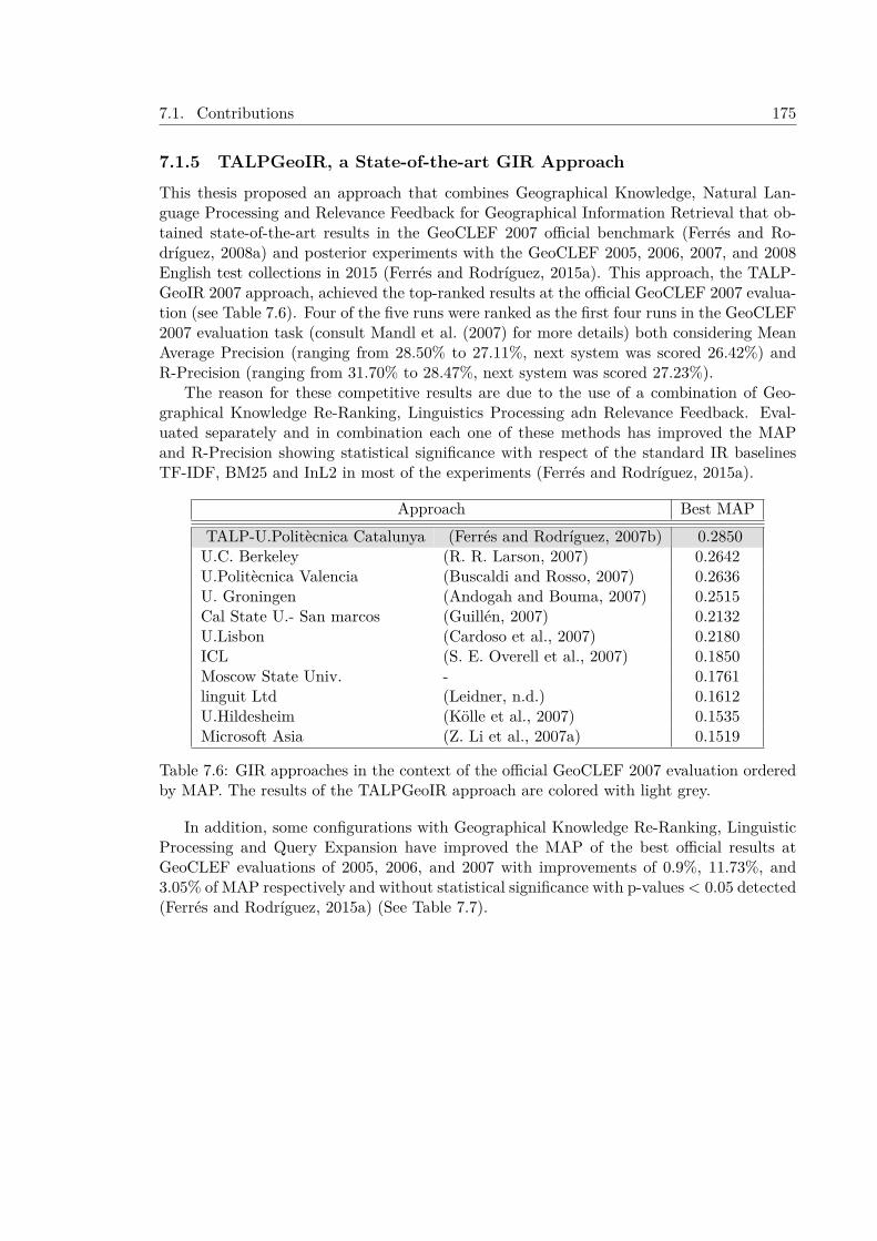
7.1. Contributions 175
7.1.5 TALPGeoIR, a State-of-the-art GIR ApproachThis thesis proposed an approach that combines Geographical Knowledge, Natural Lan-guage Processing and Relevance Feedback for Geographical Information Retrieval that ob-tained state-of-the-art results in the GeoCLEF 2007 official benchmark (Ferrés and Ro-dríguez, 2008a) and posterior experiments with the GeoCLEF 2005, 2006, 2007, and 2008English test collections in 2015 (Ferrés and Rodríguez, 2015a). This approach, the TALP-GeoIR 2007 approach, achieved the top-ranked results at the official GeoCLEF 2007 evalua-tion (see Table 7.6). Four of the five runs were ranked as the first four runs in the GeoCLEF2007 evaluation task (consult Mandl et al. (2007) for more details) both considering MeanAverage Precision (ranging from 28.50% to 27.11%, next system was scored 26.42%) andR-Precision (ranging from 31.70% to 28.47%, next system was scored 27.23%).
The reason for these competitive results are due to the use of a combination of Geo-graphical Knowledge Re-Ranking, Linguistics Processing adn Relevance Feedback. Eval-uated separately and in combination each one of these methods has improved the MAPand R-Precision showing statistical significance with respect of the standard IR baselinesTF-IDF, BM25 and InL2 in most of the experiments (Ferrés and Rodríguez, 2015a).
Approach Best MAPTALP-U.Politècnica Catalunya (Ferrés and Rodríguez, 2007b) 0.2850U.C. Berkeley (R. R. Larson, 2007) 0.2642U.Politècnica Valencia (Buscaldi and Rosso, 2007) 0.2636U. Groningen (Andogah and Bouma, 2007) 0.2515Cal State U.- San marcos (Guillén, 2007) 0.2132U.Lisbon (Cardoso et al., 2007) 0.2180ICL (S. E. Overell et al., 2007) 0.1850Moscow State Univ. - 0.1761linguit Ltd (Leidner, n.d.) 0.1612U.Hildesheim (Kölle et al., 2007) 0.1535Microsoft Asia (Z. Li et al., 2007a) 0.1519
Table 7.6: GIR approaches in the context of the official GeoCLEF 2007 evaluation orderedby MAP. The results of the TALPGeoIR approach are colored with light grey.
In addition, some configurations with Geographical Knowledge Re-Ranking, LinguisticProcessing and Query Expansion have improved the MAP of the best official results atGeoCLEF evaluations of 2005, 2006, and 2007 with improvements of 0.9%, 11.73%, and3.05% of MAP respectively and without statistical significance with p-values< 0.05 detected(Ferrés and Rodríguez, 2015a) (See Table 7.7).

176 Chapter 7. Conclusions
Table 7.7: MAP at 1,000 documents with the best configurations for the full collectionapplied to each GeoCLEF Monolingual English task. Includes the best official results (inMAP) at GeoCLEF evaluations.
Approach MAP with GeoCLEF test collection (year)2005 2006 2007 2008
median of official runs 0.2600 0.2700 0.2097 0.2370best official results 0.39364 0.30345 0.28506 0.30377
InL2+S+L+GeoKR+Bo1(TDN) 0.3921 0.3303 0.2937 0.2208InL2+S+L+GeoKR+KL(TDN) 0.3974 0.3390 0.2924 0.2178
Moreover this is the first system that combines NLP (lemmatization level), GeographicalKnowledge Re-Ranking and Relevance Feedback and has been tested exhaustively withall the GeoCLEF topics (100 topics from the evaluation benchmarks of GeoCLEF2005,GeoCLEF2006, GeoCLEF2007,and GeoCLE2008). The testing was done with the TF-IDF,BM25 and InL2 baselines. All the improvements were tested separately and as a whole andwith the three usual combinations of the metadata topic fields (Topic(T), Description(D)and Narrative(N): T, TD, and TDN.
7.1.6 GeoTALP-QA. An Scope-based Geographical Question AnsweringApproach
This thesis contributed to the Geographical Question Answering (GeoQA) state-of-the-artwith the design and implementation of a scope-based textual GeoQA system for Spanishand English and its evaluation with a set of questions of the Spanish geography (Ferrésand Rodríguez, 2006a). The GeoTALP-QA approach has been adapted from an existingOpen-Domain Question Answering system with geographically oriented resources and spe-cific domain adaptation (special ontology and question types). This thesis describes allthe geographical resources and domain adaptation needs to do this process. GeoTALP-QA(Ferrés and Rodríguez, 2006a) was one of the first approaches to propose a scope-based ap-proach to deal with geographical questions regarding the geography of a country or a regionand semi-automatically obtain resources (gazetteers, geographical feature types, groups ofplace names) related with a geographical region and a language.
7.1.7 New state-of-the-art Textual Georeferencing ApproachesAn important contribution of this dissertation is the presentation and evaluation of fourgeneric georeferencing approaches based on Geographical Knowledge Bases, Linguistic Pro-cessing, and Information Retrieval to deal with formal and informal documents. Theseapproaches assume the “one geographical referent per discourse” hypothesis and some ofthem achieved competitive state-of-the-art results in official georeferencing evaluations andposterior experiments. These georeferencing approaches are the following ones:
4(R. Larson et al., 2006)5(Martins et al., 2007b)6(Ferrés and Rodríguez, 2008a)7(R. Wang and Neumann, 2009)
7.1. Contributions 177
1. A Geographical Knowledge-Based Approach. This novel approach uses onlyGeographical Knowledge for georeferencing. It uses Toponym Recognition and Ge-ographical Focus Detection Heuristics to predict the georeferenced coordinates of aninput text. The Toponym Recognition approach uses the Geonames gazetteer. Geon-ames has been used in GIR (Toral et al., 2006), Geographical Scope Resolution (An-dogah et al., 2008) and georeferencing approaches (Serdyukov et al., 2009). The in-formation contained in this gazetteer allows the approach to deal with the recognitionof issues related with multilinguality, acronyms, lower and uppercase place names,and joined place names. Thus this gazetteer provides a robust Knowledge-Basedmethod to solve these issues. The Geographical Focus Detection Heuristics use bothGeographical Knowledge Based Heuristics and Population Heuristics described in theToponym Disambiguation literature Hauptmann et al. (1999) and Leidner (2007). Amain difference from the text and gazetteer based approaches systems of Kelm etal. (2010) and J. Perea-Ortega et al. (2010) with respect to our system is that theapproach presented in this thesis does not use Named Entity Recognizers and NLPprocessors. The approach presented here only uses the Geonames Gazetteer and somelimited NLP resources that are stopwords lists from several languages and an Englishdictionary to treat the geo/non-geo ambiguity of some toponyms.Regarding the results obtained by this approadch in evaluation benchmarks: in someexperiments with the ME2010PT dataset (metadata of 5,091 videos) the GeographicalKnowledge heuristics achieved high precision (when activated) in georeferencing (upto a 86.36%). In MEPT2014 when the GeoKB rules are activated (144,074 casesof 510,000), they achieved accuracy percentages of 87.37% (125,878 of 144,074 items)predicting up to 100 km. These results were very useful for establishing high confidencerules that could allow a high precision georeferencing detection in textual annotationsand tags.
2. An Information Retrieval Approach. This approach treats the document togeoreference as an IR query and uses existing state-of-the-art IR models to retrievea set of weighted coordinates relevant to the query. The IR models used are theTF-IDF, BM25 and Hiemstra Language Model (Hiemstra, 2001).The novelty of this algorithm is the use of IR techniques for indexing and retrieval ofrelevant geographical coordinates as a way of georeferencing texts. The main noveltyof the indexing approach is that instead of using grid-based indexing (or languagemodelling) approaches Serdyukov et al. (2009), Van Laere et al. (2013), Kordopatis-Zilos et al. (2014), and Popescu et al. (2014) each different coordinates pair in theoriginal collection will generate an associated document with all the metadata relatedwith this specific coordinate pair. This means that instead modelling regions thisalgorithm is modelling unique individual geographical coordinates. The IR weightingmodels used are the TF-IDF, BM25 and Hiemstra Language Model (HLM) (Hiemstra,2001) implemented in the Terrier IR system8 Ounis et al., 2006. To the best ofthe author’s knowledge, these are the first approach and experiments with the HLMalgorithm in Textual Georeferencing. Some experiments with informal documents alsoshowed that the HLM algorithm outperforms TFIDF and BM25 in some cases (seeChapter 6).
8Terrier IR engine. http://www.terrier.org
178 Chapter 7. Conclusions
3. Information Retrieval with Re-Ranking Approach. This approach is a variantof the IR approach that re-ranks the set of ranked predictions associated with ageoreferenced document by means of a clustering process that uses a geographicaldistance function (Haversine distance). It achieved state of the art results (and someof the top results in some accuracy ranges) comparing with other systems at theMediaEval 2010, 2011 and 2014 international benchmarks. The novelty of the IR withRe-Ranking approach presented in this thesis is that it models individual coordinates(instead of grid cells or regions) in the first stage and then in a posterior the Re-Ranking phase a clustering process based on the Haversine distance re-ranks the topretrieved coordinates.In some experiments after the MEPT2010 benchmark this approach achieved our bestresults georeferencing at 1, 5 and 10 km of margin of errors distances using the HLMIR model. At the MEPT2014 the HLM approach with Re-Ranking obtained the bestresults (compared with the other approaches presented by the author) in distanceranges from 10m to 1 km because it captures non-geographical highly descriptive andunique keywords and place names appearing in the geographical coordinates’ associ-ated metadata that are not present in the gazetteer. In comparison with the resultsof the other participants at MEPT2014, the IR with Re-Ranking and GeoFusion ap-proaches achieved competitive state-of-the-art results (Ferrés and Rodríguez, 2015b).The HLM with Re-Ranking approach obtained the best official results for accuraciesat distances of 1,000 km and 5,000 km in the task where only the official training datacan be used to predict (See Table 7.8).
4. GeoFusion Approaches. GeoFusion is a novel state-of-the-art approach that com-bines predictions from the Geographical Knowledge Heuristics and from the IR ap-proaches (with and without Re-Ranking). This is a unique approach that combinesheuristics based on common-sense (indicating a high confidence when one of thisheuristic is activated) and uses Data-Driven (IR approaches) predictions (activatedwhen the heuristics were not activated).In experiments after MEPT2010 the GeoFusion approach with Re-Ranking outper-formed the best results in accuracy reported by the state-of-the art systems participat-ing at MediaEval 2010 Placing task, achieving an 68.53% of accuracy georeferencingup to a distance of 100 Km (Ferrés and Rodríguez, 2010b). The approaches of VanLaere et al. (2010a) and Kelm et al. (2010) obtained a 67,23% and 60,46% of accuracywith the same test set at the official MediaEval 2010 placing task. In both officialMEPT2014 evaluation and posterior experiments the GeoFusion approaches achievedthe best results within the ranges of accuracies of 10km, 100km, 1,000km and 5,000kmcompared with the other approaches presented by the author.Regarding the official experiments with the ME2014PT dataset and posterior ex-periments with gazetteer use (see the results in Table 7.8): the official run1 at thebenchmark was performed with the HLM model and a distance threshold of 100kmfor Re-Ranking and it achieved the best official results in accuracies at distances of1,000km and 5,000km.For the task of Textual Georeferencing of formal documents, the GeoFusion ap-proaches only achieved the best results predicting in the accuracies margin of 10kmwhen trained with the W&B Wikipedia training set and without using Re-Ranking.
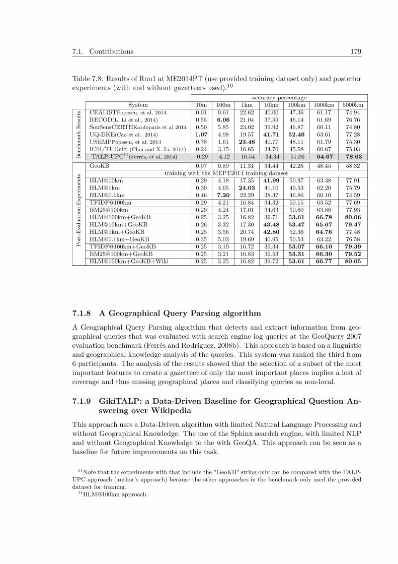
7.1. Contributions 179
Table 7.8: Results of Run1 at ME2014PT (use provided training dataset only) and posteriorexperiments (with and without gazetteers used).10
accuracy percentageSystem 10m 100m 1km 10km 100km 1000km 5000km
Ben
chm
ark
Res
ults CEALISTPopescu, et al, 2014 0.01 0.61 22.62 40.00 47.36 61.17 74.94
RECOD(L. Li et al., 2014) 0.55 6.06 21.04 37.59 46.14 61.69 76.76SonSensCERTHKordopatis et al 2014 0.50 5.85 23.02 39.92 46.87 60.11 74.80UQ-DKE(Cao et al., 2014) 1.07 4.98 19.57 41.71 52.46 63.61 77.28USEMPPopescu, et al, 2014 0.78 1.61 23.48 40.77 48.11 61.79 75.30ICSI/TUDelft (Choi and X. Li, 2014) 0.24 3.15 16.65 34.70 45.58 60.67 75.03TALP-UPC11(Ferrés, et al, 2014) 0.29 4.12 16.54 34.34 51.06 64.67 78.63
Post
-Eva
luat
ion
Exp
erim
ents
GeoKB 0.07 0.89 11.31 34.44 42.26 48.45 58.32training with the MEPT2014 training dataset
HLM@10km 0.29 4.18 17.35 41.99 50.97 63.38 77.91HLM@1km 0.30 4.65 24.03 41.10 49.53 62.20 [email protected] 0.46 7.20 22.29 38.37 46.86 60.10 74.59TFIDF@100km 0.29 4.21 16.84 34.32 50.15 63.52 77.69BM25@100km 0.29 4.24 17.01 34.63 50.60 63.88 77.93HLM@100km+GeoKB 0.25 3.25 16.82 39.71 53.61 66.78 80.06HLM@10km+GeoKB 0.26 3.32 17.30 43.48 53.47 65.67 79.47HLM@1km+GeoKB 0.25 3.56 20.74 42.80 52.36 64.76 [email protected]+GeoKB 0.35 5.03 19.69 40.95 50.53 63.22 76.58TFIDF@100km+GeoKB 0.25 3.19 16.72 39.34 53.07 66.10 79.39BM25@100km+GeoKB 0.25 3.21 16.83 39.53 53.31 66.30 79.52HLM@100km+GeoKB+Wiki 0.25 3.25 16.82 39.72 53.61 66.77 80.05
7.1.8 A Geographical Query Parsing algorithmA Geographical Query Parsing algorithm that detects and extract information from geo-graphical queries that was evaluated with search engine log queries at the GeoQuery 2007evaluation benchmark (Ferrés and Rodríguez, 2008b). This approach is based on a linguisticand geographical knowledge analysis of the queries. This system was ranked the third from6 participants. The analysis of the results showed that the selection of a subset of the mostimportant features to create a gazetteer of only the most important places implies a lost ofcoverage and thus missing geographical places and classifying queries as non-local.
7.1.9 GikiTALP: a Data-Driven Baseline for Geographical Question An-swering over Wikipedia
This approach uses a Data-Driven algorithm with limited Natural Language Processing andwithout Geographical Knowledge. The use of the Sphinx seardch engine, with limited NLPand without Geographical Knowledge to the with GeoQA. This approach can be seen as abaseline for future improvements on this task.
11Note that the experiments with that include the ”GeoKB” string only can be compared with the TALP-UPC approach (author’s approach) because the other approaches in the benchmark only used the provideddataset for training.
11HLM@100km approach.
180 Chapter 7. Conclusions
7.2 Limitations and Future workThis section discusses the limitations of the work presented in this thesis and describes somepossible further research in the context of the three Geographical Information Access tasksinvestigated.
7.2.1 Geographical Information RetrievalThe GIR approaches presented in this thesis were evaluated with corpora from importantnewspapers in English. An evaluation of the algorithms with other kind of documents,other languages, and more locally oriented documents is necessary to know the boundsof the approach. It is expected that the approach will not be as good in local news dueto the Toponym Disambiguation strategies based on salience and population counts. TheToponym Recognition and Disambiguation strategies performed with the TALPGeoIR ap-proach were context independent and were using heuristics that gave more importanceto some places (with more political salience or population count) and some geographicalfeature types. Although this method has proven to be useful to improve the effectivenesresults of the GIR GeoCLEF English test collections in MAP and R-Precision, contextaware methods that could disambiguate toponyms taking into account semantic clues inthe text and inter-relationships with other toponyms in text will be expected to improvethe results of both general and locally oriented documents. Regarding the evaluation withother languages, it is expected that the improvements shown in GIR still apply but it will benecessary to study the coverage of the name variants in different languages in the gazetteersemployed to build the Geographical Knowledge Base and perhaps use a database such asGeonames to improve this coverage. For these reasons further work can include: 1) a changethe NLP and NERC phases for a simple Geonames gazetteer lookup of tokens and evaluatethe performance this method, 2) apply context aware Toponym Disambiguation heuristicsthat could disambiguate fully or partially (reducing the degree or geographical ambiguity)toponyms in the collection and the topics, 3) use Data-Driven methods for Toponym Dis-ambiguation trained with data from Flickr or Wikipedia to help with difficult cases. 4)evaluate the approach with other existing test collections for other languages at GeoCLEFevaluations such as Spanish, Portuguese, and German. 5) perform more specific analysis ofthe heuristics,
Finally, it should be pointed out that the use of only the spatial operator and part-of-relationship ”in” as the default way of treat the geographical part of queries instead of amore detailed analysis (that could treat spatial relationships such as “near”, “close”, “northof”) means that there is also more room for improvement.
7.2.2 Geographical Question AnsweringThe Geographical Question Answering approach presented in this thesis, GeoTALP-QA, isa language and scope-based approach, meaning that it has to be adapted to a certain geo-graphical scope region and a language. The Geographical Knowledge resources needed forthis adaptation can be obtained from existing geographical Gazetteers with semi-automaticmethods. The approach can solve geographical questions about this restricted region.
The evaluation of GeoTALP-QA was done in the scope of the Spanish Geography withSpanish as a source and target language and with google search as a passage retrievalmethod. A set of snippets extracted from google search were used for the evaluation of
7.2. Limitations and Future work 181
the Knowledge-Based and the Data-Driven Answer Extraction operational modes. Butextracting the answer from snippets with a Knowledge-Based Answer Extraction modulethat applies Language Processing and some reasoning have some difficulties because thesnippets are sometimes cut and sentences are broken. A new evaluation of good qualitysnippets or passages of full documents will be needed to test the Knowledge-Based AnswerExtraction in a more fair environment for its requirements. As a future work the Knowledge-Based AE module could also be improved with the treatment of questions that need theextraction of the answer from two or more sentences (e.g. treating coreference).
7.2.3 Textual GeoreferencingThe TG approaches presented in this thesis have the limitations of the “one georeference pertext” that is assumed in this thesis. Future research can investigate to adapt the approachesfor documents that can refer to several locations. Further work can also explore: 1) researchabout high precision Geographical Focus Detection heuristics for formal documents, 2)new experiments to combine other geo/non geo ambiguity approaches based on spatialprobability distribution models (Hauff and Houben, 2011) with the presented approaches.3) experiments with context-aware Toponym Disambiguation Heuristics that can be adaptedto different kind of contexts; for these experiments the TAC-KBP Entity Linking12 datasetsthat include newswire, web texts, and discussion fora could be used.
12http://nlp.cs.rpi.edu/kbp/2014/

182 Chapter 7. Conclusions
APPENDIX A
Annex A: Test Collections
This Annex describes how to obtain the test collections employed in the experiments pre-sented in this thesis.
A.1 Test Collections for Geographical Information RetrievalThe tests collections employed in this thesis for GIR are the GeoCLEF test collections.The GeoCLEF test topics, relevance assesments and the official experiments performedat GeoCLEF from 2005 to 2008 can be downloaded at http://direct.dei.unipd.it/.The collection of documents to perform the experiments are The Glasgow Herald (1995)(GH95) and Los Angeles Times (1994) (LAT94) collections (i.e. 169,477 documents). Thesetwo collections can be obtained through the ”The CLEF AdHoc-News Test Suites (2004-2008) Evaluation Package” or the ”CLEF Question Answering Test Suites (2003-2008) –Evaluation Package” corpora. These corpora are available at http://catalog.elra.info.
A.2 Test Collections for Geographical Question AnsweringA.2.1 Geo-QA corpus: a set of 123 Geographical QA questionsA corpus of Geographical questions was obtained from Albayzin, a speech corpus (Diazet al., 1998) that contains a geographical subcorpus with utterances of questions about thegeography of Spain in Spanish. The 123 questions with answer in the SW were divided intwo sets: 61 questions for development (setting thresholds and other parameters) and 62for test. The test set questions are listed in the Annex D - Geo-QA Questions.
A.2.2 GeoQuery 2007 DatasetThe Geoquery 2007 Geographic Query Parsing Data Set (Microsoft) can be downloadedfrom the following site: http://research.microsoft.com/en-us/people/xingx/geoquery.aspx
183
184 Appendix A. Annex A: Test Collections
A.2.3 GikiCLEF 2009 test collectionsThe GikiCLEF 2009 Test collections can be downloaded from the following site: http://www.linguateca.pt/GikiCLEF/GIRA/
A.3 Test Collections for Textual GeoreferencingA.3.1 MediaEval Placing Tasks of 2010 and 2011 Training and Test set.The datasets of the MediaEval Placing Tasks of 2010 and 2011 can be downloaded fromthis site: https://github.com/dferres/placingtask_2010-2011_textual_metadata
A.3.2 MediaEval Placing Task 2014 Training and Test set.The training data consists of 5 million geotagged photos and 25,000 geotagged videos (down-loadable at https://multimedia-commons.s3-us-west-2.amazonaws.com/subsets/YLI-GEO/docs/mediaeval2014_placing_train.bz2) , whereas the test set consists of 500,000 pho-tos and 10,000 videos (downloadable at https://multimedia-commons.s3-us-west-2.amazonaws.com/subsets/YLI-GEO/docs/mediaeval2014_placing_test.bz2). (see Choiet al. (2014) for more details about this evaluation and dataset). The training and the testset are mutually exclusive with respect to the users who contributed the media (i.e., theusers in the training set will be different from the users in the test set). All photos andvideos used in the benchmark have been taken from the YFCC100M dataset.
This data has been extracted from the YFCC100M1 dataset (Yahoo Flickr CreativeCommons 100M) (Thomee et al., 2015). This resource has 99.3 million images and 0.7million videos.
The YFCC100M must be separately requested via the Yahoo! Webscope portal athttp://webscope.sandbox.yahoo.com/catalog.php?datatype=i&did=67. Yahoo! Labsmakes this data available for free, subject to the terms of the Webscope agreement on datause (which you will be asked to sign). Your use of the YFCC100M dataset is not tied inany way to your use of the YLI-GEO features, nor vice versa.
https://multimedia-commons.s3-us-west-2.amazonaws.com/subsets/YLI-GEO/features/README_YLI-GEO_10-9-2015.txt
http://www.multimediacommons.org/
A.3.3 W&B Training Set and Wikipedia UK spot test
In the georeferencing experiments for formal documents reported in this PhD thesis theWikipedia UK Spot Test corpus was used as a test set, and the W&B corpus was used asa training set. The Wikipedia UK Spot Test Corpus is a set of 21,839 English Wikipediadocuments that refer to a spot (railwaystation, landmarks, buildings, and schools) of UnitedKingdom and it was created by Van Laere et al. (2014). It can be downloaded at: https://github.com/ovlaere/georeferencing_wikipedia The W&B Wikipedia training set isa set of about 390,574 Wikipedia documents created by Roller et al. (2012). http://web.corral.tacc.utexas.edu/utcompling/wing-baldridge-2011/enwiki-20100905/ This set
1http://www.yli-corpus.org/
A.3. Test Collections for Textual Georeferencing 185
has been processed to filter out the Wikipedia UK Spot Test Corpus documents, resultinga total of 376,110 documents (Van Laere et al., 2014).
A.3.4 Test set of Flickr Metadata for Emergency ScenariosFrom the set of 510,000 items (photos/videos) of the MEPT2014 test set were extracteda total of 784 items that contain at least one of these keywords using the Keywords(user tags) metadata field. A total of 63 items contain the keyword “riot”, 229 itemscontain the keyword “hurricane”, 366 contain the keyword “flood”, and 144 items con-tain the keyword “earthquake”. The MEPT2014 test set can be downloaded at https://multimedia-commons.s3-us-west-2.amazonaws.com/subsets/YLI-GEO/docs/mediaeval2014_placing_test.bz2

186 Appendix A. Annex A: Test Collections

APPENDIX B
Annex B: GeoCLEF Topics
This annex shows the GeoCLEF topics used in the GeoCLEF evaluation benchmarks from2005 to 2008 (a total of 100 topics). This annex also includes several classification of thesetopics.
187
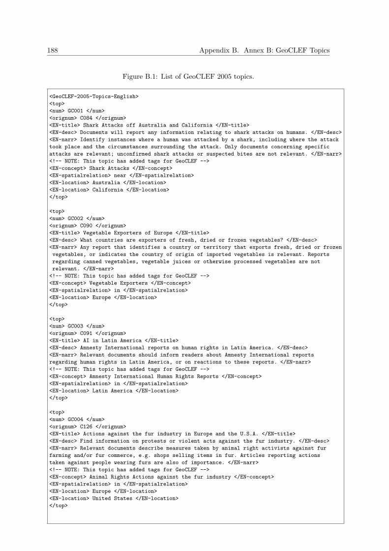
188 Appendix B. Annex B: GeoCLEF Topics
Figure B.1: List of GeoCLEF 2005 topics.
<GeoCLEF-2005-Topics-English><top><num> GC001 </num><orignum> C084 </orignum><EN-title> Shark Attacks off Australia and California </EN-title><EN-desc> Documents will report any information relating to shark attacks on humans. </EN-desc><EN-narr> Identify instances where a human was attacked by a shark, including where the attacktook place and the circumstances surrounding the attack. Only documents concerning specificattacks are relevant; unconfirmed shark attacks or suspected bites are not relevant. </EN-narr><!-- NOTE: This topic has added tags for GeoCLEF --><EN-concept> Shark Attacks </EN-concept><EN-spatialrelation> near </EN-spatialrelation><EN-location> Australia </EN-location><EN-location> California </EN-location></top>
<top><num> GC002 </num><orignum> C090 </orignum><EN-title> Vegetable Exporters of Europe </EN-title><EN-desc> What countries are exporters of fresh, dried or frozen vegetables? </EN-desc><EN-narr> Any report that identifies a country or territory that exports fresh, dried or frozenvegetables, or indicates the country of origin of imported vegetables is relevant. Reportsregarding canned vegetables, vegetable juices or otherwise processed vegetables are notrelevant. </EN-narr>
<!-- NOTE: This topic has added tags for GeoCLEF --><EN-concept> Vegetable Exporters </EN-concept><EN-spatialrelation> in </EN-spatialrelation><EN-location> Europe </EN-location></top>
<top><num> GC003 </num><orignum> C091 </orignum><EN-title> AI in Latin America </EN-title><EN-desc> Amnesty International reports on human rights in Latin America. </EN-desc><EN-narr> Relevant documents should inform readers about Amnesty International reportsregarding human rights in Latin America, or on reactions to these reports. </EN-narr><!-- NOTE: This topic has added tags for GeoCLEF --><EN-concept> Amnesty International Human Rights Reports </EN-concept><EN-spatialrelation> in </EN-spatialrelation><EN-location> Latin America </EN-location></top>
<top><num> GC004 </num><orignum> C126 </orignum><EN-title> Actions against the fur industry in Europe and the U.S.A. </EN-title><EN-desc> Find information on protests or violent acts against the fur industry. </EN-desc><EN-narr> Relevant documents describe measures taken by animal right activists against furfarming and/or fur commerce, e.g. shops selling items in fur. Articles reporting actionstaken against people wearing furs are also of importance. </EN-narr><!-- NOTE: This topic has added tags for GeoCLEF --><EN-concept> Animal Rights Actions against the fur industry </EN-concept><EN-spatialrelation> in </EN-spatialrelation><EN-location> Europe </EN-location><EN-location> United States </EN-location></top>
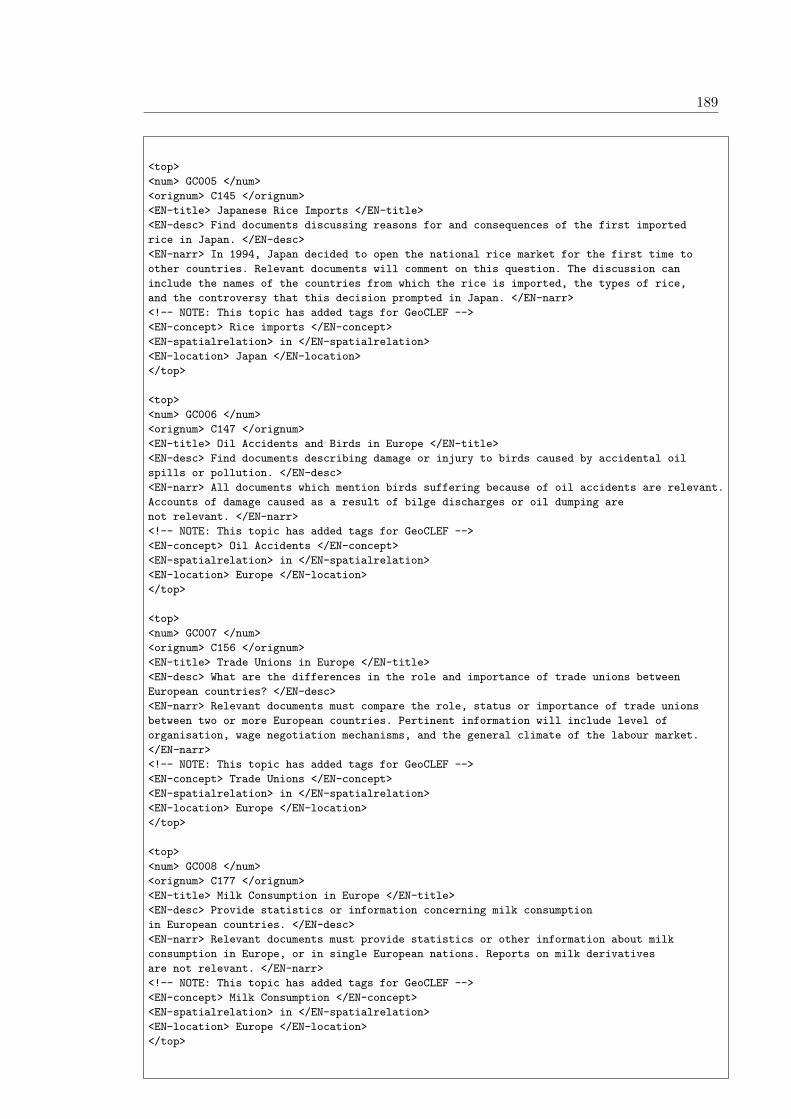
189
<top><num> GC005 </num><orignum> C145 </orignum><EN-title> Japanese Rice Imports </EN-title><EN-desc> Find documents discussing reasons for and consequences of the first importedrice in Japan. </EN-desc><EN-narr> In 1994, Japan decided to open the national rice market for the first time toother countries. Relevant documents will comment on this question. The discussion caninclude the names of the countries from which the rice is imported, the types of rice,and the controversy that this decision prompted in Japan. </EN-narr><!-- NOTE: This topic has added tags for GeoCLEF --><EN-concept> Rice imports </EN-concept><EN-spatialrelation> in </EN-spatialrelation><EN-location> Japan </EN-location></top>
<top><num> GC006 </num><orignum> C147 </orignum><EN-title> Oil Accidents and Birds in Europe </EN-title><EN-desc> Find documents describing damage or injury to birds caused by accidental oilspills or pollution. </EN-desc><EN-narr> All documents which mention birds suffering because of oil accidents are relevant.Accounts of damage caused as a result of bilge discharges or oil dumping arenot relevant. </EN-narr><!-- NOTE: This topic has added tags for GeoCLEF --><EN-concept> Oil Accidents </EN-concept><EN-spatialrelation> in </EN-spatialrelation><EN-location> Europe </EN-location></top>
<top><num> GC007 </num><orignum> C156 </orignum><EN-title> Trade Unions in Europe </EN-title><EN-desc> What are the differences in the role and importance of trade unions betweenEuropean countries? </EN-desc><EN-narr> Relevant documents must compare the role, status or importance of trade unionsbetween two or more European countries. Pertinent information will include level oforganisation, wage negotiation mechanisms, and the general climate of the labour market.</EN-narr><!-- NOTE: This topic has added tags for GeoCLEF --><EN-concept> Trade Unions </EN-concept><EN-spatialrelation> in </EN-spatialrelation><EN-location> Europe </EN-location></top>
<top><num> GC008 </num><orignum> C177 </orignum><EN-title> Milk Consumption in Europe </EN-title><EN-desc> Provide statistics or information concerning milk consumptionin European countries. </EN-desc><EN-narr> Relevant documents must provide statistics or other information about milkconsumption in Europe, or in single European nations. Reports on milk derivativesare not relevant. </EN-narr><!-- NOTE: This topic has added tags for GeoCLEF --><EN-concept> Milk Consumption </EN-concept><EN-spatialrelation> in </EN-spatialrelation><EN-location> Europe </EN-location></top>

190 Appendix B. Annex B: GeoCLEF Topics
<top><num> GC009 </num><orignum> C190 </orignum><EN-title> Child Labor in Asia </EN-title><EN-desc> Find documents that discuss child labor in Asia and proposals to eliminate it or toimprove working conditions for children. </EN-desc><EN-narr> Documents discussing child labor in particular countries in Asia, descriptions ofworking conditions for children, and proposals of measures to eliminate child laborare all relevant. </EN-narr><!-- NOTE: This topic has added tags for GeoCLEF --><EN-concept> Child Labor </EN-concept><EN-spatialrelation> in </EN-spatialrelation><EN-location> Asia </EN-location></top>
<top><num> GC010 </num><orignum> C200 </orignum><EN-title> Flooding in Holland and Germany </EN-title><EN-desc> Find statistics on flood disasters in Holland and Germany in 1995. </EN-desc><EN-narr> Relevant documents will quantify the effects of the damagecaused by flooding that took place in Germany and the Netherlands in 1995 in terms ofnumbers of people and animals evacuated and/or of economic losses. </EN-narr><!-- NOTE: This topic has added tags for GeoCLEF --><EN-concept> Floods, Flooding </EN-concept><EN-spatialrelation> in </EN-spatialrelation><EN-location> Holland </EN-location><EN-location> Germany </EN-location></top>
<top><num> GC011 </num><EN-title> Roman cities in the UK and Germany </EN-title><EN-desc> Roman cities in the UK and Germany. </EN-desc><EN-narr> A relevant document will identify one or more cities in the UnitedKingdom or Germany which were also cities in Roman times. </EN-narr><EN-concept> Roman Cities </EN-concept><EN-spatialrelation> in </EN-spatialrelation><EN-location> UK </EN-location><EN-location> Germany </EN-location></top>
<top><num> GC012 </num><EN-title> Cathedrals in Europe </EN-title><EN-desc> Find stories about particular cathedrals in Europe, including theUnited Kingdom and Russia. </EN-desc><EN-narr> In order to be relevant, a story must be about or describe a particular cathedralin a particular country or place within a country in Europe, the UK or Russia. Not relevantare stories which are generally about tourist tours of cathedrals or about the funeralof a particular person in a cathedral. </EN-narr>
<EN-concept> Cathedrals </EN-concept><EN-spatialrelation> in </EN-spatialrelation><EN-location> Europe </EN-location></top>
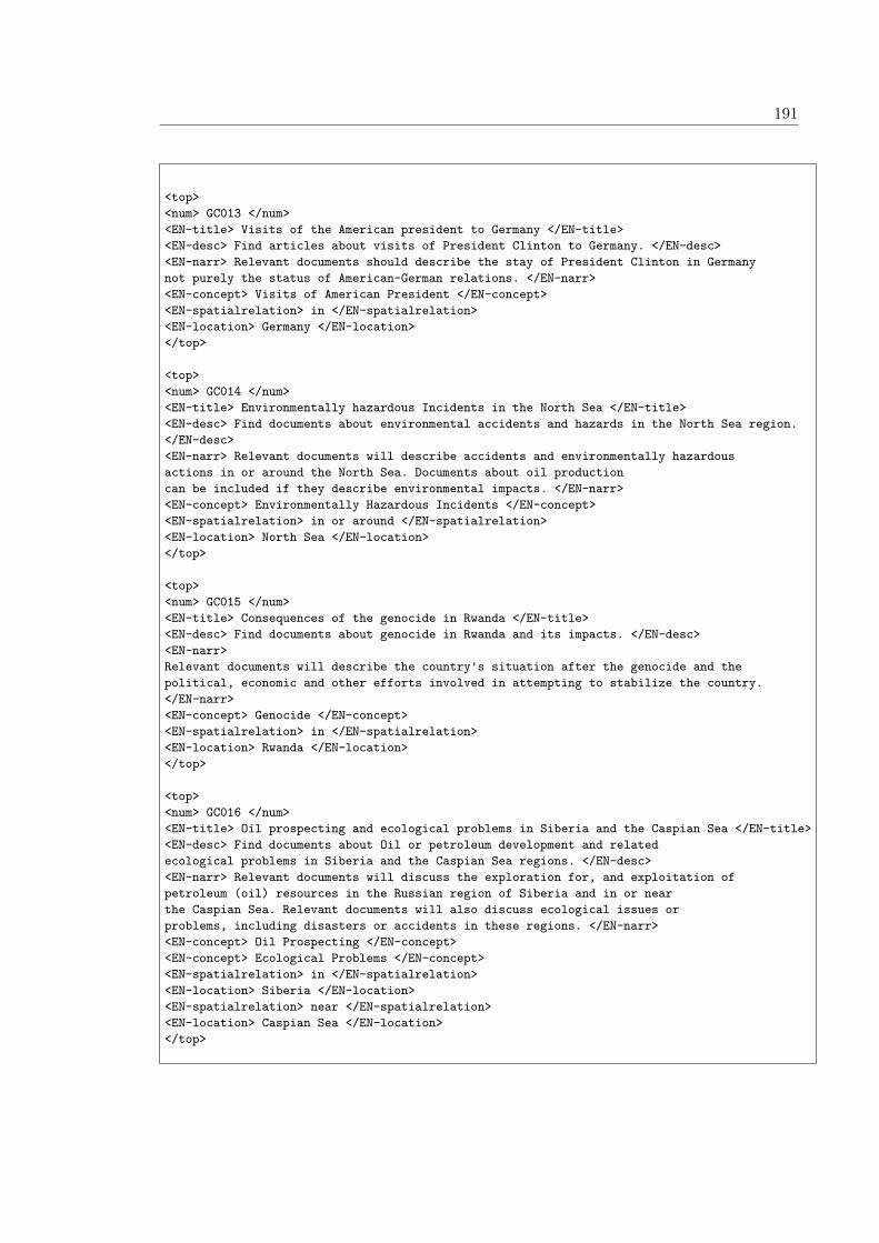
191
<top><num> GC013 </num><EN-title> Visits of the American president to Germany </EN-title><EN-desc> Find articles about visits of President Clinton to Germany. </EN-desc><EN-narr> Relevant documents should describe the stay of President Clinton in Germanynot purely the status of American-German relations. </EN-narr><EN-concept> Visits of American President </EN-concept><EN-spatialrelation> in </EN-spatialrelation><EN-location> Germany </EN-location></top>
<top><num> GC014 </num><EN-title> Environmentally hazardous Incidents in the North Sea </EN-title><EN-desc> Find documents about environmental accidents and hazards in the North Sea region.</EN-desc><EN-narr> Relevant documents will describe accidents and environmentally hazardousactions in or around the North Sea. Documents about oil productioncan be included if they describe environmental impacts. </EN-narr><EN-concept> Environmentally Hazardous Incidents </EN-concept><EN-spatialrelation> in or around </EN-spatialrelation><EN-location> North Sea </EN-location></top>
<top><num> GC015 </num><EN-title> Consequences of the genocide in Rwanda </EN-title><EN-desc> Find documents about genocide in Rwanda and its impacts. </EN-desc><EN-narr>Relevant documents will describe the country's situation after the genocide and thepolitical, economic and other efforts involved in attempting to stabilize the country.</EN-narr><EN-concept> Genocide </EN-concept><EN-spatialrelation> in </EN-spatialrelation><EN-location> Rwanda </EN-location></top>
<top><num> GC016 </num><EN-title> Oil prospecting and ecological problems in Siberia and the Caspian Sea </EN-title><EN-desc> Find documents about Oil or petroleum development and relatedecological problems in Siberia and the Caspian Sea regions. </EN-desc><EN-narr> Relevant documents will discuss the exploration for, and exploitation ofpetroleum (oil) resources in the Russian region of Siberia and in or nearthe Caspian Sea. Relevant documents will also discuss ecological issues orproblems, including disasters or accidents in these regions. </EN-narr><EN-concept> Oil Prospecting </EN-concept><EN-concept> Ecological Problems </EN-concept><EN-spatialrelation> in </EN-spatialrelation><EN-location> Siberia </EN-location><EN-spatialrelation> near </EN-spatialrelation><EN-location> Caspian Sea </EN-location></top>
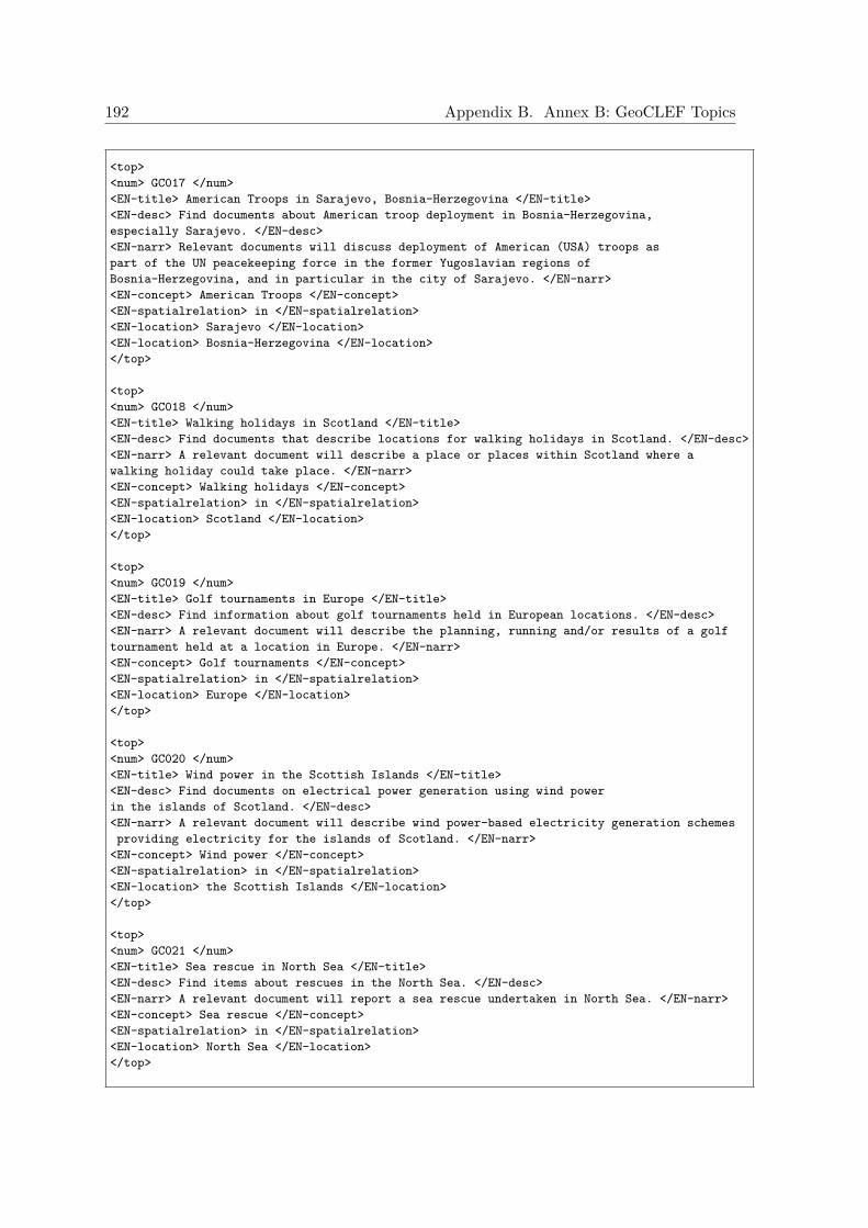
192 Appendix B. Annex B: GeoCLEF Topics
<top><num> GC017 </num><EN-title> American Troops in Sarajevo, Bosnia-Herzegovina </EN-title><EN-desc> Find documents about American troop deployment in Bosnia-Herzegovina,especially Sarajevo. </EN-desc><EN-narr> Relevant documents will discuss deployment of American (USA) troops aspart of the UN peacekeeping force in the former Yugoslavian regions ofBosnia-Herzegovina, and in particular in the city of Sarajevo. </EN-narr><EN-concept> American Troops </EN-concept><EN-spatialrelation> in </EN-spatialrelation><EN-location> Sarajevo </EN-location><EN-location> Bosnia-Herzegovina </EN-location></top>
<top><num> GC018 </num><EN-title> Walking holidays in Scotland </EN-title><EN-desc> Find documents that describe locations for walking holidays in Scotland. </EN-desc><EN-narr> A relevant document will describe a place or places within Scotland where awalking holiday could take place. </EN-narr><EN-concept> Walking holidays </EN-concept><EN-spatialrelation> in </EN-spatialrelation><EN-location> Scotland </EN-location></top>
<top><num> GC019 </num><EN-title> Golf tournaments in Europe </EN-title><EN-desc> Find information about golf tournaments held in European locations. </EN-desc><EN-narr> A relevant document will describe the planning, running and/or results of a golftournament held at a location in Europe. </EN-narr><EN-concept> Golf tournaments </EN-concept><EN-spatialrelation> in </EN-spatialrelation><EN-location> Europe </EN-location></top>
<top><num> GC020 </num><EN-title> Wind power in the Scottish Islands </EN-title><EN-desc> Find documents on electrical power generation using wind powerin the islands of Scotland. </EN-desc><EN-narr> A relevant document will describe wind power-based electricity generation schemesproviding electricity for the islands of Scotland. </EN-narr>
<EN-concept> Wind power </EN-concept><EN-spatialrelation> in </EN-spatialrelation><EN-location> the Scottish Islands </EN-location></top>
<top><num> GC021 </num><EN-title> Sea rescue in North Sea </EN-title><EN-desc> Find items about rescues in the North Sea. </EN-desc><EN-narr> A relevant document will report a sea rescue undertaken in North Sea. </EN-narr><EN-concept> Sea rescue </EN-concept><EN-spatialrelation> in </EN-spatialrelation><EN-location> North Sea </EN-location></top>
193
<top><num> GC022 </num><EN-title> Restored buildings in Southern Scotland </EN-title><EN-desc> Find articles on the restoration of historic buildings in the southernpart of Scotland. </EN-desc><EN-narr> A relevant document will describe a restoration of historical buildings inthe southern Scotland. </EN-narr><EN-concept> Restored buildings </EN-concept><EN-spatialrelation> south of </EN-spatialrelation><EN-location> Scotland </EN-location></top>
<top><num> GC023 </num><EN-title> Murders and violence in South-West Scotland </EN-title><EN-desc> Find articles on violent acts including murders in the South Westpart of Scotland. </EN-desc><EN-narr> A relevant document will give details of either specific acts of violence or deathrelated to murder or information about the general state of violence in South West Scotland.This includes information about violence in places such as Ayr, Campeltown,Douglas and Glasgow. </EN-narr>
<EN-concept> Murders and violence </EN-concept><EN-spatialrelation> South-West of </EN-spatialrelation><EN-location> Scotland </EN-location></top>
<top><num> GC024 </num><EN-title> Factors influencing tourist industry in Scottish Highlands </EN-title><EN-desc> Find articles on the tourism industry in the Highlands of Scotlandand the factors affecting it. </EN-desc><EN-narr> A relevant document will provide information on factors which have affected orinfluenced tourism in the Scottish Highlands. For example, the construction of roads orrailways, initiatives to increase tourism, the planning and construction of new attractionsand influences from the environment (e.g. poor weather). </EN-narr>
<EN-concept> influences on tourist industry </EN-concept><EN-spatialrelation> in </EN-spatialrelation><EN-location> Scottish Highlands </EN-location></top>
<top><num> GC025 </num><EN-title> Environmental concerns in and around the Scottish Trossachs </EN-title><EN-desc> Find articles about environmental issues and concerns inthe Trossachs region of Scotland. </EN-desc><EN-narr> A relevant document will describe environmental concerns (e.g. pollution,damage to the environment from tourism) in and around the area in Scotland known asthe Trossachs. Strictly speaking, the Trossachs is the narrow wooded glen betweenLoch Katrine and Loch Achray, but the name is now used to describe a much largerarea between Argyll and Perthshire, stretching north from the Campsies and westfrom Callander to the eastern shore of Loch Lomond. </EN-narr>
<EN-concept> Environmental concerns </EN-concept><EN-spatialrelation> in and around </EN-spatialrelation><EN-location> the Scottish Trossachs </EN-location></top>
</GeoCLEF-2005-Topics-English>
194 Appendix B. Annex B: GeoCLEF Topics
Figure B.2: List of GeoCLEF 2006 topics.
<GeoCLEF-2006-Topics-English><top>
<num>GC026</num><EN-title>Wine regions around rivers in Europe</EN-title><EN-desc>Documents about wine regions along the banks of European rivers</EN-desc><EN-narr>Relevant documents describe a wine region along a major river in European countries.
To be relevant the document must name the region and the river.</EN-narr></top><top><num>GC027</num><EN-title>Cities within 100km of Frankfurt</EN-title><EN-desc>Documents about cities within 100 kilometers of the city of Frankfurt in WesternGermany</EN-desc><EN-narr>Relevant documents discuss cities within 100 kilometers of Frankfurt am Main Germany,latitude 50.11222, longitude 8.68194. To be relevant the document must describe the city oran event in that city. Stories about Frankfurt itself are not relevant</EN-narr>
</top><top><num>GC028</num><EN-title>Snowstorms in North America</EN-title><EN-desc>Documents about snowstorms occurring in the north part of the American continent</EN-desc><EN-narr>Relevant documents state cases of snowstorms and their effects in North America.
Countries are Canada, United States of America and Mexico. Documents about other kindsof storms are not relevant (e.g. rainstorm, thunderstorm, electric storm, windstorm)</EN-narr>
</top><top><num>GC029</num><EN-title>Diamond trade in Angola and South Africa</EN-title><EN-desc>Documents regarding diamond trade in Angola and South Africa</EN-desc><EN-narr>Relevant documents are about diamond trading in these two countries and itsconsequences (e.g. smuggling, economic and political instability)</EN-narr></top><top><num>GC030</num><EN-title>Car bombings near Madrid</EN-title><EN-desc>Documents about car bombings occurring near Madrid</EN-desc><EN-narr>Relevant documents treat cases of car bombings occurring in the capital of Spainand its outskirts</EN-narr>
</top><top><num>GC031</num><EN-title>Combats and embargo in the northern part of Iraq</EN-title><EN-desc>Documents telling about combats or embargo in the northern part of Iraq</EN-desc><EN-narr>Relevant documents are about combats and effects of the 90s embargo in the northernpart of Iraq. Documents about these facts happening in other parts of Iraq are not relevant</EN-narr></top><top><num>GC032</num><EN-title>Independence movement in Quebec</EN-title><EN-desc>Documents about actions in Quebec for the independence of this Canadian province</EN-desc><EN-narr>Relevant documents treat matters related to Quebec independence movement(e.g. referendums) which take place in Quebec</EN-narr></top><top><num>GC033</num><EN-title> International sports competitions in the Ruhr area</EN-title><EN-desc> World Championships and international tournaments inthe Ruhr area</EN-desc><EN-narr> Relevant documents state the type or name of the competition,the city and possibly results. Irrelevant are documents where only part of the competitiontakes place in the Ruhr area of Germany, e.g. Tour de France,
Champions League or UEFA-Cup games.</EN-narr></top>

195
<top><num> GC034 </num><EN-title> Malaria in the tropics </EN-title><EN-desc> Malaria outbreaks in tropical regions and preventivevaccination </EN-desc><EN-narr> Relevant documents state cases of malaria in tropical regionsand possible preventive measures like chances to vaccinate against thedisease. Outbreaks must be of epidemic scope. Tropics are defined as the region between theTropic of Capricorn, latitude 23.5 degrees South and the Tropic of Cancer, latitude 23.5degrees North. Not relevant are documents about a single person's infection. </EN-narr>
</top><top><num> GC035 </num><EN-title> Credits to the former Eastern Bloc </EN-title><EN-desc> Financial aid in form of credits by the InternationalMonetary Fund or the World Bank to countries formerly belonging tothe "Eastern Bloc" aka the Warsaw Pact, except the republics of the former USSR</EN-desc><EN-narr> Relevant documents cite agreements on credits, conditions orconsequences of these loans. The Eastern Bloc is defined as countriesunder strong Soviet influence (so synonymous with Warsaw Pact) throughoutthe whole Cold War. Excluded are former USSR republics. Thus the countries are Bulgaria,Hungary, Czech Republic, Slovakia, Poland and Romania. Thus not all communist orsocialist countries are considered relevant.</EN-narr>
</top><top><num> GC036 </num><EN-title> Automotive industry around the Sea of Japan </EN-title><EN-desc> Coastal cities on the Sea of Japan with automotive industry or factories </EN-desc><EN-narr> Relevant documents report on automotive industry or factories incities on the shore of the Sea of Japan (also named East Sea (of Korea))including economic or social events happening there like planned joint-venturesor strikes. In addition to Japan, the countries of North Korea, South Korea and Russiaare also on the Sea of Japan.</EN-narr></top><top><num> GC037 </num><EN-title> Archeology in the Middle East </EN-title><EN-desc> Excavations and archeological finds in the Middle East </EN-desc><EN-narr> Relevant documents report recent finds in some town, city, region or countryof the Middle East, i.e. in Iran, Iraq, Turkey, Egypt, Lebanon, Saudi Arabia, Jordan,Yemen, Qatar, Kuwait, Bahrain, Israel, Oman, Syria, United Arab Emirates, Cyprus,West Bank, or the Gaza Strip</EN-narr>
</top><top><num> GC038 </num><EN-title> Solar or lunar eclipse in Southeast Asia </EN-title><EN-desc> Total or partial solar or lunar eclipses in Southeast Asia</EN-desc><EN-narr> Relevant documents state the type of eclipse and the region or countryof occurrence, possibly also stories about people travelling to see it. Countries ofSoutheast Asia are Brunei, Cambodia, East Timor, Indonesia, Laos, Malaysia, Myanmar,Philippines, Singapore, Thailand and Vietnam.</EN-narr></top><top><num> GC039 </num><EN-title> Russian troops in the southern Caucasus </EN-title><EN-desc> Russian soldiers, armies or military bases in the Caucasus regionsouth of the Caucasus Mountains </EN-desc><EN-narr> Relevant documents report on Russian troops based at, moved to orremoved from the region. Also agreements on one of these actions or combatsare relevant. Relevant countries are: Azerbaijan, Armenia, Georgia, Ossetia,Nagorno-Karabakh. Irrelevant are documents citing actions between troops ofnationality different from Russian (with Russian mediation between the two.)</EN-narr></top>
196 Appendix B. Annex B: GeoCLEF Topics
<top><num> GC040 </num><EN-title> Cities near active volcanoes </EN-title><EN-desc> Cities, towns or villages threatened by the eruption of a volcano</EN-desc><EN-narr> Relevant documents cite the name of the cities, towns, villages thatare near an active volcano which recently had an eruption or could erupt soon.Irrelevant are reports which do not state the danger (i.e. for example necessarypreventive evacuations) or the consequences for specific cities , but justtell that a particular volcano (in some country) is going to erupt, has erupted or thata region has active volcanoes. </EN-narr></top>
<top><num>GC041</num><EN-title>Shipwrecks in the Atlantic Ocean</EN-title><EN-desc>Documents about shipwrecks in the Atlantic Ocean</EN-desc><EN-narr>Relevant documents should document shipwreckings in any part of the Atlantic Oceanor its coasts.</EN-narr>
</top>
<top><num>GC042</num><EN-title>Regional elections in Northern Germany</EN-title><EN-desc>Documents about regional elections in Northern Germany</EN-desc><EN-narr>Relevant documents are those reporting the campaign or results for the stateparliaments of any of the regions of Northern Germany. The states of northern Germanyare commonly Bremen, Hamburg, Lower Saxony, Mecklenburg-Western Pomerania andSchleswig-Holstein. Only regional elections are relevant; municipal, nationaland European elections are not.</EN-narr>
</top>
<top><num>GC043</num><EN-title>Scientific research in New England Universities</EN-title><EN-desc>Documents about scientific research in New England universities</EN-desc><EN-narr>Valid documents should report specific scientific research or breakthroughsoccurring in universities of New England. Both current and past research are relevant.Research regarded as bogus or fraudulent is also relevant. New England states are:Connecticut, Rhode Island, Massachusetts, Vermont, New Hampshire, Maine. </EN-narr>
</top>
<top><num>GC044</num><EN-title>Arms sales in former Yugoslavia</EN-title><EN-desc>Documents about arms sales in former Yugoslavia</EN-desc><EN-narr>Relevant documents should report on arms sales that took place in the successorcountries of the former Yugoslavia. These sales can be legal or not, and to any kindof entity in these states, not only the government itself. Relevant countries are:Slovenia, Macedonia, Croatia, Serbia and Montenegro, and Bosnia and Herzegovina.
</EN-narr></top>
<top><num>GC045</num><EN-title>Tourism in Northeast Brazil</EN-title><EN-desc>Documents about tourism in Northeastern Brazil</EN-desc><EN-narr>Of interest are documents reporting on tourism in Northeastern Brazil,including places of interest, the tourism industry and/or the reasons for takingor not a holiday there. The states of northeast Brazil are Alagoas, Bahia, Ceara,Maranhao, Paraiba, Pernambuco, Piaui, Rio Grande do Norte and Sergipe.</EN-narr>
</top>
197
<top><num>GC046</num><EN-title>Forest fires in Northern Portugal</EN-title><EN-desc>Documents about forest fires in Northern Portugal</EN-desc><EN-narr>Documents should report the ocurrence, fight against, or aftermath offorest fires in Northern Portugal. The regions covered are Minho, Douro Litoral,Tras-os-Montes and Alto Douro, corresponding to the districts of Viana do Castelo,Braga, Porto (or Oporto), Vila Real and Bragana.
</EN-narr></top>
<top><num>GC047</num><EN-title>Champions League games near the Mediterranean </EN-title><EN-desc>Documents about Champion League games played in European cities bordering theMediterranean </EN-desc>
<EN-narr>Relevant documents should include at least a short description of a EuropeanChampions League game played in a European city bordering the Mediterranean Sea orany of its minor seas. European countries along the Mediterranean Sea are Spain,France, Monaco, Italy, the island state of Malta, Slovenia, Croatia, Bosnia andHerzegovina, Serbia and Montenegro, Albania, Greece, Turkey, and theisland of Cyprus.</EN-narr>
</top>
<top><num>GC048</num><EN-title>Fishing in Newfoundland and Greenland</EN-title><EN-desc>Documents about fisheries around Newfoundland and Greenland</EN-desc><EN-narr>Relevant documents should document fisheries and economical, ecological orlegal problems associated with it, around Greenland and the Canadian islandof Newfoundland. </EN-narr>
</top>
<top><num>GC049</num><EN-title>ETA in France</EN-title><EN-desc>Documents about ETA activities in France</EN-desc><EN-narr>Relevant documents should document the activities of the Basque terroristgroup ETA in France, of a paramilitary, financial, political nature or others. </EN-narr>
</top>
<top><num>GC050</num><EN-title>Cities along the Danube and the Rhine</EN-title><EN-desc>Documents describe cities in the shadow of the Danube or the Rhine</EN-desc><EN-narr>Relevant documents should contain at least a short description ofcities through which the rivers Danube and Rhine pass, providing evidence for it.The Danube flows through nine countries (Germany, Austria, Slovakia, Hungary,Croatia, Serbia, Bulgaria, Romania, and Ukraine). Countries along the Rhineare Liechtenstein, Austria, Germany, France, the Netherlands and Switzerland. </EN-narr>
</top></GeoCLEF-2006-Topics-English>
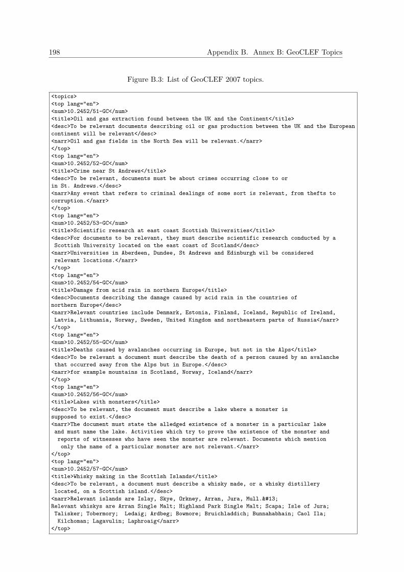
198 Appendix B. Annex B: GeoCLEF Topics
Figure B.3: List of GeoCLEF 2007 topics.
<topics><top lang="en"><num>10.2452/51-GC</num><title>Oil and gas extraction found between the UK and the Continent</title><desc>To be relevant documents describing oil or gas production between the UK and the Europeancontinent will be relevant</desc><narr>Oil and gas fields in the North Sea will be relevant.</narr></top><top lang="en"><num>10.2452/52-GC</num><title>Crime near St Andrews</title><desc>To be relevant, documents must be about crimes occurring close to orin St. Andrews.</desc><narr>Any event that refers to criminal dealings of some sort is relevant, from thefts tocorruption.</narr></top><top lang="en"><num>10.2452/53-GC</num><title>Scientific research at east coast Scottish Universities</title><desc>For documents to be relevant, they must describe scientific research conducted by aScottish University located on the east coast of Scotland</desc>
<narr>Universities in Aberdeen, Dundee, St Andrews and Edinburgh wil be consideredrelevant locations.</narr>
</top><top lang="en"><num>10.2452/54-GC</num><title>Damage from acid rain in northern Europe</title><desc>Documents describing the damage caused by acid rain in the countries ofnorthern Europe</desc><narr>Relevant countries include Denmark, Estonia, Finland, Iceland, Republic of Ireland,Latvia, Lithuania, Norway, Sweden, United Kingdom and northeastern parts of Russia</narr>
</top><top lang="en"><num>10.2452/55-GC</num><title>Deaths caused by avalanches occurring in Europe, but not in the Alps</title><desc>To be relevant a document must describe the death of a person caused by an avalanchethat occurred away from the Alps but in Europe.</desc>
<narr>for example mountains in Scotland, Norway, Iceland</narr></top><top lang="en"><num>10.2452/56-GC</num><title>Lakes with monsters</title><desc>To be relevant, the document must describe a lake where a monster issupposed to exist.</desc><narr>The document must state the alledged existence of a monster in a particular lakeand must name the lake. Activities which try to prove the existence of the monster andreports of witnesses who have seen the monster are relevant. Documents which mentiononly the name of a particular monster are not relevant.</narr>
</top><top lang="en"><num>10.2452/57-GC</num><title>Whisky making in the Scottlsh Islands</title><desc>To be relevant, a document must describe a whisky made, or a whisky distillerylocated, on a Scottish island.</desc>
<narr>Relevant islands are Islay, Skye, Orkney, Arran, Jura, Mull. Relevant whiskys are Arran Single Malt; Highland Park Single Malt; Scapa; Isle of Jura;Talisker; Tobermory; Ledaig; Ardbeg; Bowmore; Bruichladdich; Bunnahabhain; Caol Ila;Kilchoman; Lagavulin; Laphroaig</narr>
</top>
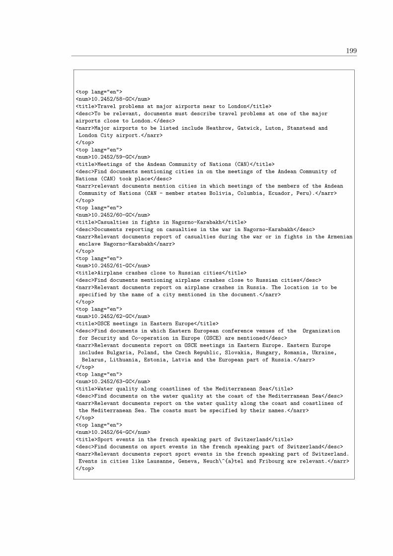
199
<top lang="en"><num>10.2452/58-GC</num><title>Travel problems at major airports near to London</title><desc>To be relevant, documents must describe travel problems at one of the majorairports close to London.</desc><narr>Major airports to be listed include Heathrow, Gatwick, Luton, Stanstead andLondon City airport.</narr>
</top><top lang="en"><num>10.2452/59-GC</num><title>Meetings of the Andean Community of Nations (CAN)</title><desc>Find documents mentioning cities in on the meetings of the Andean Community ofNations (CAN) took place</desc><narr>relevant documents mention cities in which meetings of the members of the AndeanCommunity of Nations (CAN - member states Bolivia, Columbia, Ecuador, Peru).</narr>
</top><top lang="en"><num>10.2452/60-GC</num><title>Casualties in fights in Nagorno-Karabakh</title><desc>Documents reporting on casualties in the war in Nagorno-Karabakh</desc><narr>Relevant documents report of casualties during the war or in fights in the Armenianenclave Nagorno-Karabakh</narr>
</top><top lang="en"><num>10.2452/61-GC</num><title>Airplane crashes close to Russian cities</title><desc>Find documents mentioning airplane crashes close to Russian cities</desc><narr>Relevant documents report on airplane crashes in Russia. The location is to bespecified by the name of a city mentioned in the document.</narr>
</top><top lang="en"><num>10.2452/62-GC</num><title>OSCE meetings in Eastern Europe</title><desc>Find documents in which Eastern European conference venues of the Organizationfor Security and Co-operation in Europe (OSCE) are mentioned</desc>
<narr>Relevant documents report on OSCE meetings in Eastern Europe. Eastern Europeincludes Bulgaria, Poland, the Czech Republic, Slovakia, Hungary, Romania, Ukraine,Belarus, Lithuania, Estonia, Latvia and the European part of Russia.</narr>
</top><top lang="en"><num>10.2452/63-GC</num><title>Water quality along coastlines of the Mediterranean Sea</title><desc>Find documents on the water quality at the coast of the Mediterranean Sea</desc><narr>Relevant documents report on the water quality along the coast and coastlines ofthe Mediterranean Sea. The coasts must be specified by their names.</narr>
</top><top lang="en"><num>10.2452/64-GC</num><title>Sport events in the french speaking part of Switzerland</title><desc>Find documents on sport events in the french speaking part of Switzerland</desc><narr>Relevant documents report sport events in the french speaking part of Switzerland.Events in cities like Lausanne, Geneva, Neuch\^{a}tel and Fribourg are relevant.</narr>
</top>
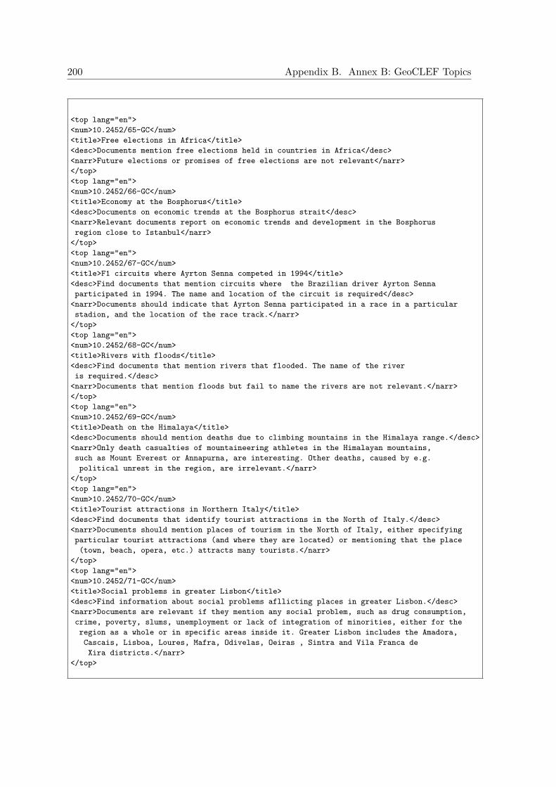
200 Appendix B. Annex B: GeoCLEF Topics
<top lang="en"><num>10.2452/65-GC</num><title>Free elections in Africa</title><desc>Documents mention free elections held in countries in Africa</desc><narr>Future elections or promises of free elections are not relevant</narr></top><top lang="en"><num>10.2452/66-GC</num><title>Economy at the Bosphorus</title><desc>Documents on economic trends at the Bosphorus strait</desc><narr>Relevant documents report on economic trends and development in the Bosphorusregion close to Istanbul</narr>
</top><top lang="en"><num>10.2452/67-GC</num><title>F1 circuits where Ayrton Senna competed in 1994</title><desc>Find documents that mention circuits where the Brazilian driver Ayrton Sennaparticipated in 1994. The name and location of the circuit is required</desc>
<narr>Documents should indicate that Ayrton Senna participated in a race in a particularstadion, and the location of the race track.</narr>
</top><top lang="en"><num>10.2452/68-GC</num><title>Rivers with floods</title><desc>Find documents that mention rivers that flooded. The name of the riveris required.</desc>
<narr>Documents that mention floods but fail to name the rivers are not relevant.</narr></top><top lang="en"><num>10.2452/69-GC</num><title>Death on the Himalaya</title><desc>Documents should mention deaths due to climbing mountains in the Himalaya range.</desc><narr>Only death casualties of mountaineering athletes in the Himalayan mountains,such as Mount Everest or Annapurna, are interesting. Other deaths, caused by e.g.political unrest in the region, are irrelevant.</narr>
</top><top lang="en"><num>10.2452/70-GC</num><title>Tourist attractions in Northern Italy</title><desc>Find documents that identify tourist attractions in the North of Italy.</desc><narr>Documents should mention places of tourism in the North of Italy, either specifyingparticular tourist attractions (and where they are located) or mentioning that the place(town, beach, opera, etc.) attracts many tourists.</narr>
</top><top lang="en"><num>10.2452/71-GC</num><title>Social problems in greater Lisbon</title><desc>Find information about social problems afllicting places in greater Lisbon.</desc><narr>Documents are relevant if they mention any social problem, such as drug consumption,crime, poverty, slums, unemployment or lack of integration of minorities, either for theregion as a whole or in specific areas inside it. Greater Lisbon includes the Amadora,Cascais, Lisboa, Loures, Mafra, Odivelas, Oeiras , Sintra and Vila Franca deXira districts.</narr>
</top>
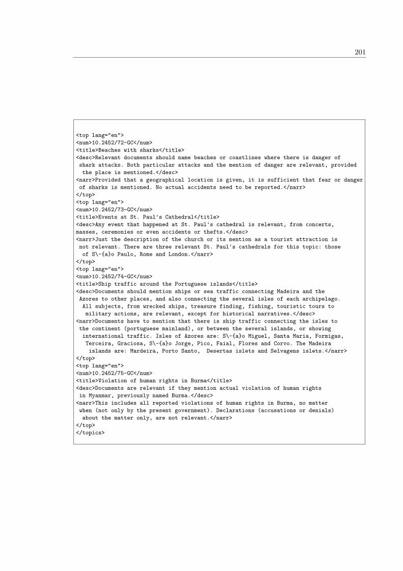
201
<top lang="en"><num>10.2452/72-GC</num><title>Beaches with sharks</title><desc>Relevant documents should name beaches or coastlines where there is danger ofshark attacks. Both particular attacks and the mention of danger are relevant, providedthe place is mentioned.</desc>
<narr>Provided that a geographical location is given, it is sufficient that fear or dangerof sharks is mentioned. No actual accidents need to be reported.</narr>
</top><top lang="en"><num>10.2452/73-GC</num><title>Events at St. Paul's Cathedral</title><desc>Any event that happened at St. Paul's cathedral is relevant, from concerts,masses, ceremonies or even accidents or thefts.</desc><narr>Just the description of the church or its mention as a tourist attraction isnot relevant. There are three relevant St. Paul's cathedrals for this topic: thoseof S\~{a}o Paulo, Rome and London.</narr>
</top><top lang="en"><num>10.2452/74-GC</num><title>Ship traffic around the Portuguese islands</title><desc>Documents should mention ships or sea traffic connecting Madeira and theAzores to other places, and also connecting the several isles of each archipelago.All subjects, from wrecked ships, treasure finding, fishing, touristic tours tomilitary actions, are relevant, except for historical narratives.</desc>
<narr>Documents have to mention that there is ship traffic connecting the isles tothe continent (portuguese mainland), or between the several islands, or showinginternational traffic. Isles of Azores are: S\~{a}o Miguel, Santa Maria, Formigas,Terceira, Graciosa, S\~{a}o Jorge, Pico, Faial, Flores and Corvo. The Madeiraislands are: Mardeira, Porto Santo, Desertas islets and Selvagens islets.</narr>
</top><top lang="en"><num>10.2452/75-GC</num><title>Violation of human rights in Burma</title><desc>Documents are relevant if they mention actual violation of human rightsin Myanmar, previously named Burma.</desc>
<narr>This includes all reported violations of human rights in Burma, no matterwhen (not only by the present government). Declarations (accusations or denials)about the matter only, are not relevant.</narr>
</top></topics>
202 Appendix B. Annex B: GeoCLEF Topics
Figure B.4: List of GeoCLEF 2008 Topics
<topics><topic lang="en"><identifier>10.2452/76-GC</identifier><title>Riots in South American prisons</title><description>Documents mentioning riots in prisons in South America</description><narrative>Relevant documents mention riots or uprising on the South American continent.Countries in South America include Argentina, Bolivia, Brazil, Chile, Suriname, Ecuador,Colombia, Guyana, Peru, Paraguay, Uruguay and Venezuela. French Guiana is a Frenchprovince in South America.</narrative>
</topic><topic lang="en"><identifier>10.2452/77-GC</identifier><title>Nobel prize winners from Northern European countries</title><description>Documents mentioning Noble prize winners born in a Northern Europeancountry.</description><narrative>Relevant documents contain information about the field of research and thecountry of origin of the prize winner. Northern European countries are: Denmark,Finland, Iceland, Norway, Sweden, Estonia, Latvia, Belgium, the Netherlands, Luxembourg,Ireland, Lithuania, and the UK. The north of Germany and Poland as well as the north-eastof Russia also belong to Northern Europe.</narrative></topic><topic lang="en"><identifier>10.2452/78-GC</identifier><title>Sport events in the Sahara</title><description>Documents mentioning sport events occurring in (or passing through) theSahara.</description><narrative>Relevant documents must make reference to athletic events and to the placewhere they take place. The Sahara covers huge parts of Algeria, Chad, Egypt, Libya,Mali, Mauritania, Morocco, Niger, Western Sahara, Sudan, Senegal and Tunisia.</narrative></topic><topic lang="en"><identifier>10.2452/79-GC</identifier><title>Invasion of Eastern Timor's capital by Indonesia</title><description>Documents mentioning the invasion of Dili by Indonesian troops</description><narrative>Relevant documents deal with the occupation of East Timor by Indonesia andmention incidents between Indonesian soldiers and the inhabitants of Dili.</narrative></topic><topic lang="en"><identifier>10.2452/80-GC</identifier><title>Politicians in exile in Germany</title><description>Documents mentioning exiled politicians in Germany</description><narrative>Relevant documents report about politicians who live in exile in Germany andmention the nationality and political convictions of these politicians.</narrative></topic><topic lang="en"><identifier>10.2452/81-GC</identifier><title>G7 summits in Mediterranean countries</title><description>Documents mentioning G7 summit meetings in Mediterranean countries</description><narrative>Relevant documents must mention summit meetings of the G7 in the mediterraneancountries: Spain, Gibraltar, France, Monaco, Italy, Malta, Slovenia, Croatia, Bosnia andHerzegovina, Montenegro, Albania, Greece, Cyprus, Turkey, Syria, Lebanon, Israel,Palestine, Egypt, Libya, Tunisia, Algeria and Morocco.</narrative></topic><topic lang="en"><identifier>10.2452/82-GC</identifier><title>Agriculture in the Iberian Peninsula</title><description>Relevant documents relate to the state of agriculture in the IberianPeninsula</description><narrative>Relevant docments contain information about the state of agriculturein the Iberian peninsula. Crops, protests and statistics are relevant. The countriesn the Iberian peninsula are Portugal, Spain and Andorra.</narrative></topic>
203
<topic lang="en"><identifier>10.2452/83-GC</identifier><title>Demonstrations against terrorism in Northern Africa</title><description>Documents mentioning demonstrations against terrorism in NorthernAfrica</description><narrative>Relevant documents must mention demonstrations against terrorism in theNorth of Africa. The documents must mention the number of demonstrators and the reasonsfor the demonstration. North Africa includes the Magreb region (countries: Algeria, Tunisia,and Morocco, as well as the Western Sahara region) and Egypt, Sudan,Libya and Mauritania.</narrative></topic><topic lang="en"><identifier>10.2452/84-GC</identifier><title>Bombings in Northern Ireland</title><description>Documents mentioning bomb attacks in Northern Ireland</description><narrative>Relevant documents should contain information about bomb attacks inNorthern Ireland and should mention people responsible for and consequencesof the attacks.</narrative></topic><topic lang="en"><identifier>10.2452/85-GC</identifier><title>Nuclear tests in the South Pacific</title><description>Documents mentioning the execution of nuclear tests in SouthPacific</description><narrative>Relevant documents should contain information about nuclear tests which werecarried out in the South Pacific. Intentions as well as plans for future nuclear testsin this region are not considered as relevant.</narrative>
</topic><topic lang="en"><identifier>10.2452/86-GC</identifier><title>Most visited sights in the capital of France and its vicinity</title><description>Documents mentioning the most visited sights in Paris andsurroundings</description><narrative>Relevant documents should provide information about the most visitedsights of Paris and close to Paris and either give this information explicitly orcontain data which allows conclusions about which places were most visited.</narrative></topic><topic lang="en"><identifier>10.2452/87-GC</identifier><title>Unemployment in the OECD countries</title><description>Documents mentioning issues related with the unemployment in the countriesof the Organisation for Economic Co-operation and Development (OECD)</description><narrative>Relevant documents should contain information about the unemployment (rateof unemployment, important reasons and consequences) in the industrial states of theOECD. The following states belong to the OECD: Australia, Belgium, Denmark, Germany,Finland, France, Greece, Ireland, Iceland, Italy, Japan, Canada, Luxembourg, Mexico,New Zealand, the Netherlands, Norway, Austria, Poland, Portugal, Sweden, Switzerland,Slovakia, Spain, South Korea, Czech Republic, Turkey, Hungary, the United Kingdom andthe United States of America (USA).</narrative></topic><topic lang="en"><identifier>10.2452/88-GC</identifier><title>Portuguese immigrant communities in the world</title><description>Documents mentioning immigrant Portuguese communities in other countries</description><narrative>Relevant documents contain information about Portguese communities who liveas immigrants in other countries.</narrative>
</topic>
204 Appendix B. Annex B: GeoCLEF Topics
<topic lang="en"><identifier>10.2452/89-GC</identifier><title>Trade fairs in Lower Saxony</title><description>Documents reporting about industrial or cultural fairs in Lower Saxony</description><narrative>Relevant documents should contain information about trade or industrialfairs which take place in the German federal state of Lower Saxony, i.e. name, typeand place of the fair. The capital of Lower Saxony is Hanover. Other cities includeBraunschweig, Osnabr{\"u}ck, Oldenburg and G{\"o}ttingen.</narrative></topic><topic lang="en"><identifier>10.2452/90-GC</identifier><title>Environmental pollution in European waters</title><description>Documents mentioning environmental pollution in European rivers, lakesand oceans.</description><narrative>Relevant documents should mention the kind and level of the pollution andfurthermore contain information about the type of the water and locate the affectedarea and potential consequences.</narrative></topic><topic lang="en"><identifier>10.2452/91-GC</identifier><title>Forest fires on Spanish islands</title><description>Documents mentioning forest fires on Spanish islands</description><narrative>Relevant documents should contain information about the location, causesand consequences of the forest fires. Spanish Islands are: the Balearic Islands(Majorca, Minorca, Ibiza, Formentera), the Canary Islands (Tenerife, Gran Canaria,El Hierro, Lanzarote, La Palma, La Gomera, Fuerteventura) and some islands locatedjust off the Moroccan coast (Islas Chafarinas, Alhucemas, Albor\'{a}n, Perejil, IslasColumbretes and Pen\'{o}n de V\'{e}lez de la Gomera).</narrative></topic><topic lang="en"><identifier>10.2452/92-GC</identifier><title>Islamic fundamentalists in Western Europe</title><description>Documents mentioning Islamic fundamentalists living in WesternEurope</description><narrative>Relevant Documents contain information about countries of origin andcurrent whereabouts and political and religious motives of the fundamentalists.Western Europe consists of Western Europe consists of Belgium, Ireland,Great Britain, Spain, Italy, Portugal, Andorra, Germany, France, Liechtenstein,Luxembourg, Monaco, the Netherlands, Austria and Switzerland.</narrative> </topic><topic lang="en"><identifier>10.2452/93-GC</identifier><title>Attacks in Japanese subways</title><description>Documents mentioning attacks in Japanese subways</description><narrative>Relevant documents contain information about attackers, reasons,number of victims, places and consequences of the attacks in subways inJapan.</narrative></topic><topic lang="en"><identifier>10.2452/94-GC</identifier><title>Demonstrations in German cities</title><description>Documents mentioning demonstrations in German cities</description><narrative>Relevant documents contain information about participants, and numberof participants, reasons, type (peaceful or riots) and consequences ofdemonstrations in German cities.</narrative></topic>
205
<topic lang="en"><identifier>10.2452/95-GC</identifier><title>American troops in the Persian Gulf</title><description>Documents mentioning American troops in the Persian Gulf</description><narrative>Relevant documents contain information about functions/tasks of theAmerican troops and where exactly they are based. Countries with a coastlinewith the Persian Gulf are: Iran, Iraq, Oman, United Arab Emirates, Saudi-Arabia,Qatar, Bahrain and Kuwait.</narrative></topic><topic lang="en"><identifier>10.2452/96-GC</identifier><title>Economic boom in Southeast Asia</title><description>Documents mentioning economic boom in countries in SoutheastAsia</description><narrative>Relevant documents contain information about (international) companiesin this region and the impact of the economic boom on the population. Countries ofSoutheast Asia are: Brunei, Indonesia, Malaysia, Cambodia, Laos, Myanmar (Burma),East Timor, the Phillipines, Singapore, Thailand and Vietnam.</narrative></topic><topic lang="en"><identifier>10.2452/97-GC</identifier><title>Foreign aid in Sub-Saharan Africa</title><description>Documents mentioning foreign aid in Sub-Saharan Africa</description><narrative>Relevant documents contain information about the kind of foreign aidand describe which countries or organizations help in which regions of Sub-SaharanAfrica. Countries of the Sub-Saharan Africa are: state of Central Africa (Burundi,Rwanda, Democratic Republic of Congo, Republic of Congo, Central African Republic),East Africa (Ethiopia, Eritrea, Kenya, Somalia, Sudan, Tanzania, Uganda, Djibouti),Southern Africa (Angola, Botswana, Lesotho, Malawi, Mozambique, Namibia, South Africa,Madagascar, Zambia, Zimbabwe, Swaziland), Western Africa (Benin, Burkina Faso, Chad,C\^{o}te d'Ivoire, Gabon, Gambia, Ghana, Equatorial Guinea, Guinea-Bissau, Cameroon,Liberia, Mali, Mauritania, Niger, Nigeria, Senegal, Sierra Leone, Togo) and theAfrican isles (Cape Verde, Comoros, Mauritius, Seychelles, S\~{o} Tom\'{e} and Pr\'{i}ncipeand Madagascar).</narrative></topic><topic lang="en"><identifier>10.2452/98-GC</identifier><title>Tibetan people in the Indian subcontinent</title><description>Documents mentioning Tibetan people who live in countries of the Indiansubcontinent.</description><narrative>Relevant Documents contain information about Tibetan people living inexile in countries of the Indian Subcontinent and mention reasons for the exile orliving conditions of the Tibetians. Countries of the Indian subcontinent are: India,Pakistan, Bangladesh, Bhutan, Nepal and Sri Lanka.</narrative></topic><topic lang="en"><identifier>10.2452/99-GC</identifier><title>Floods in European cities</title><description>Documents mentioning resons for and consequences of floods inEuropean cities</description><narrative>Relevant documents contain information about reasons and consequences(damages, deaths, victims) of the floods and name the European city where theflood occurred.</narrative></topic><topic lang="en"><identifier>10.2452/100-GC</identifier><title>Natural disasters in the Western USA</title><description>Douments need to describe natural disasters in the WesternUSA</description><narrative>Relevant documents report on natural disasters like earthquakes orflooding which took place in Western states of the United States. To the Westernstates belong California, Washington and Oregon.</narrative></topic></topics>
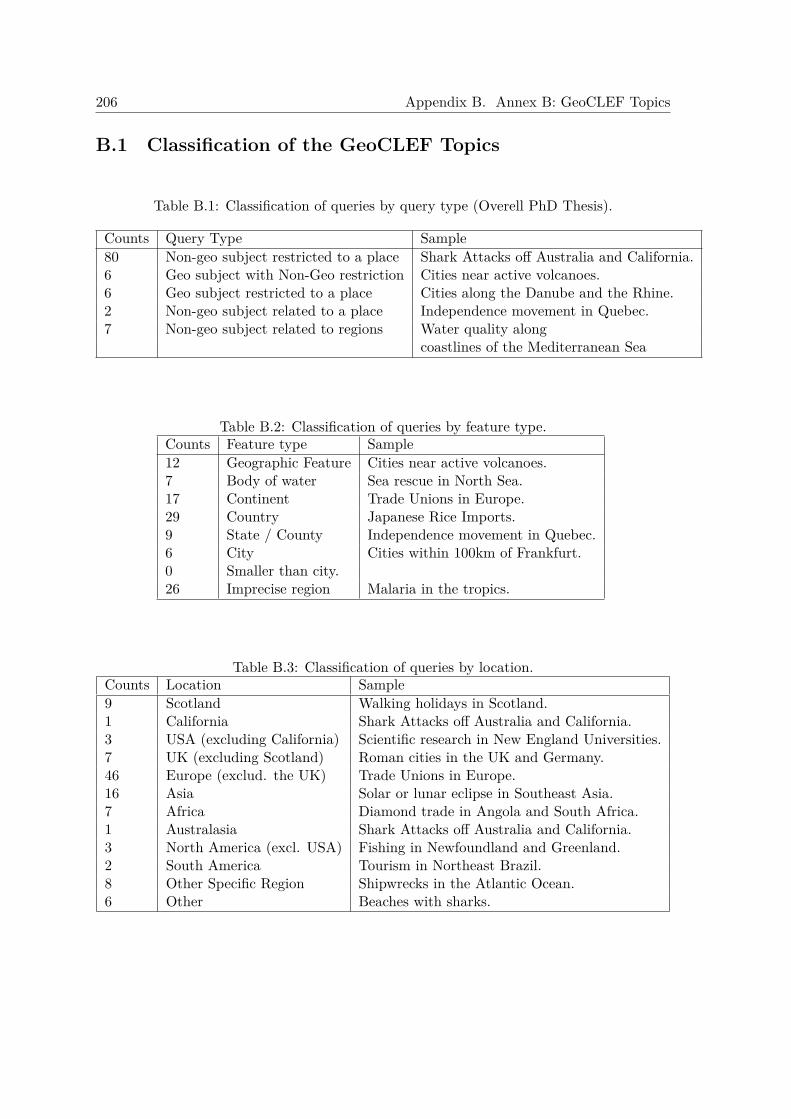
206 Appendix B. Annex B: GeoCLEF Topics
B.1 Classification of the GeoCLEF Topics
Table B.1: Classification of queries by query type (Overell PhD Thesis).
Counts Query Type Sample80 Non-geo subject restricted to a place Shark Attacks off Australia and California.6 Geo subject with Non-Geo restriction Cities near active volcanoes.6 Geo subject restricted to a place Cities along the Danube and the Rhine.2 Non-geo subject related to a place Independence movement in Quebec.7 Non-geo subject related to regions Water quality along
coastlines of the Mediterranean Sea
Table B.2: Classification of queries by feature type.Counts Feature type Sample12 Geographic Feature Cities near active volcanoes.7 Body of water Sea rescue in North Sea.17 Continent Trade Unions in Europe.29 Country Japanese Rice Imports.9 State / County Independence movement in Quebec.6 City Cities within 100km of Frankfurt.0 Smaller than city.26 Imprecise region Malaria in the tropics.
Table B.3: Classification of queries by location.Counts Location Sample9 Scotland Walking holidays in Scotland.1 California Shark Attacks off Australia and California.3 USA (excluding California) Scientific research in New England Universities.7 UK (excluding Scotland) Roman cities in the UK and Germany.46 Europe (exclud. the UK) Trade Unions in Europe.16 Asia Solar or lunar eclipse in Southeast Asia.7 Africa Diamond trade in Angola and South Africa.1 Australasia Shark Attacks off Australia and California.3 North America (excl. USA) Fishing in Newfoundland and Greenland.2 South America Tourism in Northeast Brazil.8 Other Specific Region Shipwrecks in the Atlantic Ocean.6 Other Beaches with sharks.
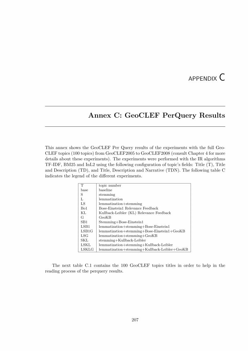
APPENDIX C
Annex C: GeoCLEF PerQuery Results
This annex shows the GeoCLEF Per Query results of the experiments with the full Geo-CLEF topics (100 topics) from GeoCLEF2005 to GeoCLEF2008 (consult Chapter 4 for moredetails about these experiments). The experiments were performed with the IR algorithmsTF-IDF, BM25 and InL2 using the following configuration of topic’s fields: Title (T), Titleand Description (TD), and Title, Description and Narrative (TDN). The following table Cindicates the legend of the different experiments.
T topic numberbase baselineS stemmingL lemmatizationLS lemmatization+stemmingBo1 Bose-Einstein1 Relevance FeedbackKL Kullback-Leibler (KL) Relevance FeedbackG GeoKBSB1 Stemming+Bose-Einstein1LSB1 lemmatization+stemming+Bose-Einstein1LSB1G lemmatization+stemming+Bose-Einstein1+GeoKBLSG lemmatization+stemming+GeoKBSKL stemming+Kullback-LeiblerLSKL lemmatization+stemming+Kullback-LeiblerLSKLG lemmatization+stemming+Kullback-Leibler+GeoKB
The next table C.1 contains the 100 GeoCLEF topics titles in order to help in thereading process of the perquery results.
207
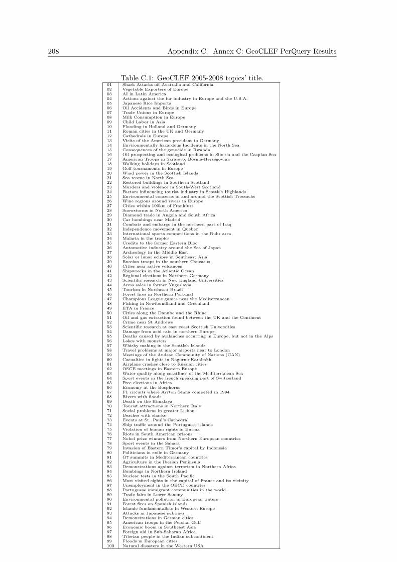
208 Appendix C. Annex C: GeoCLEF PerQuery Results
Table C.1: GeoCLEF 2005-2008 topics’ title.01 Shark Attacks off Australia and California02 Vegetable Exporters of Europe03 AI in Latin America04 Actions against the fur industry in Europe and the U.S.A.05 Japanese Rice Imports06 Oil Accidents and Birds in Europe07 Trade Unions in Europe08 Milk Consumption in Europe09 Child Labor in Asia10 Flooding in Holland and Germany11 Roman cities in the UK and Germany12 Cathedrals in Europe13 Visits of the American president to Germany14 Environmentally hazardous Incidents in the North Sea15 Consequences of the genocide in Rwanda16 Oil prospecting and ecological problems in Siberia and the Caspian Sea17 American Troops in Sarajevo, Bosnia-Herzegovina18 Walking holidays in Scotland19 Golf tournaments in Europe20 Wind power in the Scottish Islands21 Sea rescue in North Sea22 Restored buildings in Southern Scotland23 Murders and violence in South-West Scotland24 Factors influencing tourist industry in Scottish Highlands25 Environmental concerns in and around the Scottish Trossachs26 Wine regions around rivers in Europe27 Cities within 100km of Frankfurt28 Snowstorms in North America29 Diamond trade in Angola and South Africa30 Car bombings near Madrid31 Combats and embargo in the northern part of Iraq32 Independence movement in Quebec33 International sports competitions in the Ruhr area34 Malaria in the tropics35 Credits to the former Eastern Bloc36 Automotive industry around the Sea of Japan37 Archeology in the Middle East38 Solar or lunar eclipse in Southeast Asia39 Russian troops in the southern Caucasus40 Cities near active volcanoes41 Shipwrecks in the Atlantic Ocean42 Regional elections in Northern Germany43 Scientific research in New England Universities44 Arms sales in former Yugoslavia45 Tourism in Northeast Brazil46 Forest fires in Northern Portugal47 Champions League games near the Mediterranean48 Fishing in Newfoundland and Greenland49 ETA in France50 Cities along the Danube and the Rhine51 Oil and gas extraction found between the UK and the Continent52 Crime near St Andrews53 Scientific research at east coast Scottish Universities54 Damage from acid rain in northern Europe55 Deaths caused by avalanches occurring in Europe, but not in the Alps56 Lakes with monsters57 Whisky making in the Scottlsh Islands58 Travel problems at major airports near to London59 Meetings of the Andean Community of Nations (CAN)60 Casualties in fights in Nagorno-Karabakh61 Airplane crashes close to Russian cities62 OSCE meetings in Eastern Europe63 Water quality along coastlines of the Mediterranean Sea64 Sport events in the french speaking part of Switzerland65 Free elections in Africa66 Economy at the Bosphorus67 F1 circuits where Ayrton Senna competed in 199468 Rivers with floods69 Death on the Himalaya70 Tourist attractions in Northern Italy71 Social problems in greater Lisbon72 Beaches with sharks73 Events at St. Paul’s Cathedral74 Ship traffic around the Portuguese islands75 Violation of human rights in Burma76 Riots in South American prisons77 Nobel prize winners from Northern European countries78 Sport events in the Sahara79 Invasion of Eastern Timor’s capital by Indonesia80 Politicians in exile in Germany81 G7 summits in Mediterranean countries82 Agriculture in the Iberian Peninsula83 Demonstrations against terrorism in Northern Africa84 Bombings in Northern Ireland85 Nuclear tests in the South Pacific86 Most visited sights in the capital of France and its vicinity87 Unemployment in the OECD countries88 Portuguese immigrant communities in the world89 Trade fairs in Lower Saxony90 Environmental pollution in European waters91 Forest fires on Spanish islands92 Islamic fundamentalists in Western Europe93 Attacks in Japanese subways94 Demonstrations in German cities95 American troops in the Persian Gulf96 Economic boom in Southeast Asia97 Foreign aid in Sub-Saharan Africa98 Tibetan people in the Indian subcontinent99 Floods in European cities100 Natural disasters in the Western USA
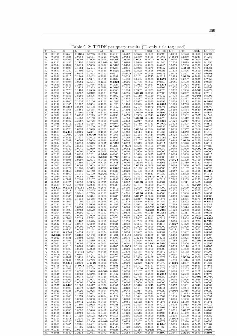
209
Table C.2: TFIDF per query results (T. only title tag used).T base S L LS Bo1 KL G SB1 LSB1 LSB1G LSG SKL LSKL LSKLG01 0.6125 0.6753 0.6845 0.6746 0.6043 0.6048 0.5567 0.6626 0.6601 0.6596 0.6240 0.6623 0.6621 0.658102 0.0065 0.1528 0.0953 0.1531 0.0221 0.0226 0.0084 0.1360 0.1411 0.1466 0.1536 0.1250 0.1243 0.128703 0.0005 0.0007 0.0004 0.0006 0.0009 0.0008 0.0006 0.0011 0.0011 0.0011 0.0006 0.0010 0.0010 0.001004 0.1151 0.1433 0.1492 0.1443 0.1848 0.1762 0.0865 0.1648 0.1652 0.1246 0.1234 0.1679 0.1628 0.123605 0.5314 0.5102 0.5119 0.5063 0.6022 0.6088 0.5430 0.4968 0.4908 0.5245 0.5259 0.5206 0.5131 0.551106 0.2219 0.2528 0.1664 0.2494 0.2188 0.2283 0.2311 0.4048 0.3277 0.2842 0.2014 0.4102 0.3473 0.306107 0.3891 0.1730 0.1809 0.1727 0.4510 0.4523 0.3393 0.0872 0.0868 0.0721 0.1378 0.0876 0.0860 0.072308 0.0582 0.0568 0.0579 0.0572 0.0397 0.0379 0.0803 0.0409 0.0416 0.0633 0.0778 0.0407 0.0420 0.066809 0.2836 0.2915 0.2269 0.2432 0.2919 0.2991 0.3015 0.3101 0.2745 0.2812 0.2499 0.3158 0.2899 0.299210 0.4646 0.5759 0.4414 0.5681 0.6937 0.6102 0.4689 0.7465 0.7553 0.7574 0.5716 0.7287 0.7337 0.735911 0.0494 0.0495 0.0562 0.0561 0.1251 0.1321 0.0506 0.0708 0.0657 0.0659 0.0585 0.0690 0.0636 0.063812 0.0630 0.2536 0.2560 0.2546 0.1393 0.1327 0.0606 0.2912 0.2957 0.3231 0.2772 0.2924 0.2934 0.322013 0.1617 0.3333 0.3422 0.3333 0.5026 0.5063 0.3119 0.4307 0.4204 0.4209 0.3372 0.4395 0.4289 0.429714 0.1230 0.2570 0.1459 0.2580 0.4982 0.5053 0.1623 0.6337 0.6329 0.4326 0.2712 0.6330 0.6338 0.427915 0.6766 0.7239 0.6757 0.7219 0.7574 0.7539 0.6875 0.8028 0.7798 0.7808 0.7309 0.7997 0.7812 0.781916 0.8214 0.8385 0.8286 0.8306 0.8975 0.8862 0.7959 0.9110 0.9110 0.8042 0.7718 0.9159 0.9165 0.809617 0.4515 0.4462 0.4439 0.4474 0.4700 0.4760 0.4355 0.4487 0.4508 0.4352 0.4304 0.4577 0.4596 0.443518 0.1483 0.3105 0.2726 0.3106 0.1101 0.1088 0.1747 0.2927 0.2935 0.3293 0.3234 0.3172 0.3236 0.360319 0.1142 0.1365 0.1227 0.1384 0.1939 0.1823 0.1484 0.1925 0.2005 0.2397 0.1809 0.1793 0.1808 0.219920 0.2015 0.3315 0.2892 0.3198 0.1760 0.1842 0.0030 0.2197 0.1972 0.0071 0.0028 0.2252 0.2253 0.007621 0.4898 0.5468 0.5465 0.5455 0.5230 0.5119 0.4802 0.4396 0.4724 0.5899 0.5160 0.4554 0.4840 0.598322 0.2080 0.4381 0.2760 0.4287 0.3254 0.3194 0.2310 0.5105 0.4688 0.4894 0.4826 0.5060 0.4632 0.485423 0.0059 0.0218 0.0226 0.0219 0.0135 0.0138 0.0173 0.0535 0.0543 0.1553 0.0385 0.0502 0.0507 0.154924 0.4916 0.5162 0.4950 0.5150 0.5996 0.6029 0.4834 0.6456 0.6440 0.6270 0.5185 0.6412 0.6394 0.622325 0.3056 0.3687 0.3687 0.3778 0.8095 0.6984 0.3333 0.7917 0.8095 0.8333 0.4028 0.7917 0.7917 0.809526 0.0088 0.2413 0.2532 0.2418 0.0176 0.0167 0.0119 0.2719 0.2723 0.2920 0.2512 0.2495 0.2496 0.287527 0.0190 0.0200 0.0201 0.0200 0.0375 0.0403 0.0190 0.0107 0.0133 0.0133 0.0200 0.0140 0.0176 0.017628 0.0275 0.0526 0.0523 0.0523 0.0909 0.0913 0.0004 0.0964 0.0914 0.0037 0.0018 0.0957 0.0916 0.004329 0.1884 0.2410 0.2395 0.2381 0.1098 0.1055 0.1788 0.1114 0.1124 0.1063 0.2245 0.1352 0.1358 0.131030 0.3501 1.0000 0.4723 1.0000 0.1585 0.1363 0.5225 0.9444 0.9444 0.6393 0.6728 0.9306 0.9583 0.639431 0.3825 0.3623 0.3517 0.3602 0.3966 0.3899 0.4069 0.4083 0.4097 0.4165 0.3859 0.3986 0.3976 0.404332 0.6707 0.7047 0.6668 0.7058 0.9019 0.8897 0.6560 0.9167 0.9078 0.8852 0.6843 0.9168 0.9160 0.893433 0.0014 0.0013 0.0016 0.0013 0.0027 0.0029 0.0012 0.0019 0.0019 0.0017 0.0012 0.0020 0.0020 0.001934 0.3056 0.5667 0.3056 0.5667 0.4444 0.5139 0.7500 0.6556 0.6465 0.7381 0.7436 0.6556 0.6556 0.743635 0.0052 0.0040 0.0041 0.0040 0.0083 0.0081 0.0052 0.0089 0.0089 0.0089 0.0040 0.0090 0.0092 0.009236 0.0000 0.0000 0.0000 0.0000 0.0000 0.0000 0.0000 0.0000 0.0000 0.0000 0.0000 0.0000 0.0000 0.000037 0.0121 0.0247 0.0116 0.0231 0.0702 0.0643 0.0022 0.0698 0.0625 0.0127 0.0024 0.0688 0.0605 0.011538 0.0667 0.0435 0.0435 0.0435 0.0769 0.0769 0.0015 0.0476 0.0500 0.0000 0.0011 0.0526 0.0588 0.000039 0.0691 0.0695 0.0697 0.0694 0.0409 0.0407 0.0721 0.0404 0.0405 0.0409 0.0724 0.0399 0.0400 0.040440 0.0000 0.2106 0.1495 0.2109 0.1166 0.1148 0.0000 0.2394 0.2363 0.2363 0.2109 0.2389 0.2382 0.238241 0.0003 0.0003 0.0003 0.0003 0.0003 0.0000 0.0009 0.0053 0.0006 0.0008 0.0008 0.0036 0.0005 0.000842 0.0486 0.0672 0.1288 0.0672 0.1769 0.1909 0.0943 0.0123 0.0121 0.0536 0.1357 0.0167 0.0166 0.062943 0.0020 0.0156 0.0101 0.0152 0.0032 0.0033 0.0029 0.0108 0.0105 0.0233 0.0157 0.0108 0.0105 0.025944 0.2115 0.2169 0.1975 0.2190 0.2267 0.2217 0.2170 0.1824 0.1847 0.1730 0.2173 0.1872 0.1853 0.174145 0.0084 0.0084 0.0085 0.0085 0.0781 0.0726 0.0140 0.0863 0.0879 0.0879 0.0140 0.0822 0.0834 0.083446 0.8095 0.7167 0.7193 0.7167 0.5222 0.5193 1.0000 0.7292 0.7292 0.7917 0.7667 0.7255 0.7255 0.833347 0.0527 0.0325 0.0696 0.0305 0.0725 0.0662 0.0527 0.0963 0.0601 0.0601 0.0305 0.0911 0.0485 0.048548 0.7331 0.7254 0.7332 0.7258 0.8970 0.9038 0.5586 0.9181 0.9200 0.5978 0.5605 0.9196 0.9204 0.597649 0.6111 0.6111 0.6111 0.6111 0.2679 0.2679 0.5000 0.2679 0.2679 0.5000 0.5000 0.2679 0.2679 0.500050 0.1850 0.2511 0.2782 0.2495 0.2430 0.2442 0.3507 0.1703 0.1719 0.4697 0.4271 0.1742 0.1767 0.452551 0.4088 0.3786 0.3941 0.3725 0.4133 0.4225 0.4781 0.6126 0.4944 0.5508 0.4409 0.6008 0.4875 0.549752 0.0265 0.0335 0.0254 0.0314 0.0280 0.0235 0.0284 0.0827 0.0596 0.0604 0.0389 0.0676 0.0596 0.060353 0.0948 0.1433 0.1538 0.1448 0.1178 0.1199 0.1201 0.1217 0.1222 0.1873 0.1894 0.1365 0.1373 0.195154 0.1018 0.1169 0.1006 0.1172 0.0996 0.1036 0.1278 0.1240 0.1255 0.1455 0.1341 0.1202 0.1300 0.153255 0.0111 0.1054 0.1374 0.1066 0.1519 0.1487 0.0136 0.2091 0.2092 0.2069 0.1299 0.2044 0.2058 0.204156 0.0003 0.2316 0.0258 0.2323 0.0006 0.0006 0.0003 0.3392 0.3523 0.3523 0.2323 0.3014 0.2956 0.295657 0.1023 0.1520 0.0733 0.1520 0.1232 0.1173 0.1023 0.2261 0.2286 0.2286 0.1520 0.2233 0.2253 0.225358 0.0254 0.0193 0.0205 0.0194 0.0367 0.0373 0.0410 0.0348 0.0349 0.0554 0.0337 0.0311 0.0316 0.053159 0.0000 0.0000 0.0000 0.0000 0.0000 0.0000 0.0000 0.0000 0.0000 0.0000 0.0000 0.0000 0.0000 0.000060 0.7520 0.7704 0.7624 0.7721 0.7630 0.7676 0.7527 0.7837 0.7814 0.7814 0.7721 0.7864 0.7897 0.789761 0.0975 0.1391 0.1467 0.1445 0.0295 0.0255 0.1675 0.0709 0.0730 0.5167 0.3576 0.0699 0.0728 0.529962 0.2812 0.3352 0.2718 0.3350 0.2813 0.2831 0.2839 0.3305 0.3117 0.3118 0.3377 0.3320 0.3222 0.322563 0.0000 0.0000 0.0000 0.0000 0.0000 0.0000 0.0000 0.0000 0.0000 0.0000 0.0000 0.0000 0.0000 0.000064 0.0046 0.0135 0.0099 0.0134 0.0047 0.0048 0.0071 0.0115 0.0076 0.0108 0.0181 0.0120 0.0074 0.010965 0.3298 0.4242 0.4224 0.4191 0.3274 0.3237 0.3394 0.3847 0.3884 0.3884 0.4235 0.3832 0.3857 0.385766 0.3436 0.3425 0.3430 0.3430 0.1825 0.1291 0.3436 0.1863 0.1307 0.1307 0.3430 0.1042 0.0698 0.069867 0.2922 0.3331 0.3302 0.3335 0.3769 0.3796 0.2916 0.4284 0.4241 0.4241 0.3332 0.4225 0.4206 0.420668 0.3014 0.7594 0.7385 0.7589 0.4282 0.4230 0.3014 0.7676 0.7683 0.7683 0.7589 0.7681 0.7691 0.769169 0.0001 0.0572 0.0003 0.0569 0.0001 0.0001 0.0001 0.2836 0.2890 0.2890 0.0569 0.2806 0.2792 0.279270 0.0280 0.0313 0.0209 0.0312 0.0112 0.0105 0.0859 0.0143 0.0144 0.0731 0.0715 0.0110 0.0111 0.070571 0.0000 0.0000 0.0000 0.0000 0.0000 0.0000 0.0000 0.0000 0.0000 0.0000 0.0000 0.0000 0.0000 0.000072 0.3310 0.5670 0.5772 0.5677 0.4446 0.4435 0.3310 0.5145 0.5172 0.5172 0.5677 0.5162 0.5200 0.520073 0.0223 0.0205 0.0207 0.0207 0.0202 0.0202 0.0100 0.0160 0.0162 0.0053 0.0097 0.0162 0.0163 0.005374 0.0196 0.4167 0.3426 0.3939 0.0093 0.0076 0.0600 0.3889 0.2407 0.2679 0.4340 0.5556 0.2500 0.283475 0.2299 0.2744 0.2743 0.2749 0.5540 0.5103 0.4748 0.7089 0.7086 0.6782 0.4289 0.6815 0.6805 0.660776 0.0000 0.4316 0.2319 0.4316 0.0000 0.0000 0.0000 0.1370 0.1370 0.1370 0.4316 0.1837 0.1837 0.183777 0.3768 0.4016 0.4023 0.4003 0.3832 0.3828 0.3768 0.3771 0.3757 0.3757 0.4003 0.3869 0.3863 0.386378 0.0205 0.1269 0.1111 0.1269 0.0324 0.0272 0.0622 0.2306 0.2286 0.2071 0.1031 0.2253 0.2255 0.202779 0.8028 0.8028 0.8028 0.8028 0.9306 0.9107 0.8028 0.9107 0.9107 0.9107 0.8028 0.9107 0.9107 0.910780 0.0347 0.0859 0.0860 0.0859 0.1169 0.1042 0.0618 0.2500 0.2500 0.2917 0.1303 0.2500 0.2679 0.267981 0.0366 0.0586 0.0578 0.0587 0.0719 0.0729 0.0366 0.0788 0.0789 0.0789 0.0587 0.0797 0.0799 0.079982 0.0018 0.0004 0.0018 0.0004 0.0032 0.0028 0.0015 0.0034 0.0034 0.0029 0.0003 0.0026 0.0026 0.002283 0.0000 0.0000 0.0000 0.0000 0.0000 0.0000 0.0000 0.0000 0.0000 0.0000 0.0000 0.0000 0.0000 0.000084 0.0577 0.2488 0.1006 0.2477 0.0352 0.0357 0.0582 0.0610 0.0645 0.0671 0.2477 0.0631 0.0649 0.068985 0.3865 0.3400 0.3612 0.3379 0.4782 0.4763 0.3420 0.4481 0.4448 0.3744 0.2990 0.4234 0.4195 0.357486 0.0020 0.0028 0.0020 0.0028 0.0004 0.0004 0.0048 0.0017 0.0017 0.0029 0.0050 0.0018 0.0019 0.002987 0.2329 0.2685 0.2704 0.2677 0.2331 0.2286 0.2329 0.2939 0.2933 0.2933 0.2677 0.2962 0.2958 0.295888 0.0799 0.2963 0.2374 0.2889 0.1664 0.1724 0.1292 0.3641 0.3520 0.2581 0.2514 0.3675 0.3533 0.255789 0.0000 0.0000 0.0000 0.0000 0.0000 0.0000 0.0000 0.0000 0.0000 0.0000 0.0000 0.0000 0.0000 0.000090 0.0781 0.1439 0.0742 0.1461 0.0460 0.0470 0.0781 0.1172 0.1177 0.1177 0.1461 0.1150 0.1171 0.117191 0.1250 0.5051 0.1306 0.5052 0.0235 0.0228 0.2500 0.2575 0.2576 0.5012 0.5010 0.5083 0.5085 0.501292 0.0891 0.0707 0.0869 0.0712 0.1323 0.1378 0.1839 0.1198 0.1179 0.2401 0.1868 0.1164 0.1166 0.248393 0.3525 0.8053 0.8052 0.8046 0.8467 0.8559 0.3929 0.8893 0.8888 0.8710 0.8231 0.8957 0.8940 0.876994 0.1157 0.4136 0.2799 0.4135 0.0498 0.0514 0.1220 0.0516 0.0503 0.0506 0.4191 0.0469 0.0465 0.046895 0.4469 0.4518 0.4628 0.4523 0.6677 0.6558 0.3305 0.6662 0.6650 0.3826 0.3208 0.6559 0.6512 0.378296 0.2104 0.2718 0.2170 0.2736 0.2471 0.2428 0.2256 0.2890 0.2860 0.2614 0.2925 0.2755 0.2750 0.253197 0.0359 0.0356 0.0360 0.0356 0.0409 0.0399 0.0328 0.0407 0.0408 0.0372 0.0326 0.0390 0.0392 0.035598 0.2083 0.2485 0.2101 0.2481 0.3482 0.3342 0.2771 0.7351 0.7361 0.7848 0.3839 0.7495 0.7495 0.780499 0.1020 0.1350 0.1005 0.1365 0.2140 0.2179 0.1020 0.1645 0.1666 0.1666 0.1365 0.1699 0.1730 0.1730100 0.0110 0.0162 0.0178 0.0161 0.0343 0.0323 0.0037 0.0414 0.0426 0.0210 0.0093 0.0375 0.0381 0.0194all 0.1938 0.2642 0.2333 0.2631 0.2372 0.2339 0.2088 0.2926 0.2869 0.2899 0.2647 0.2954 0.2893 0.2898
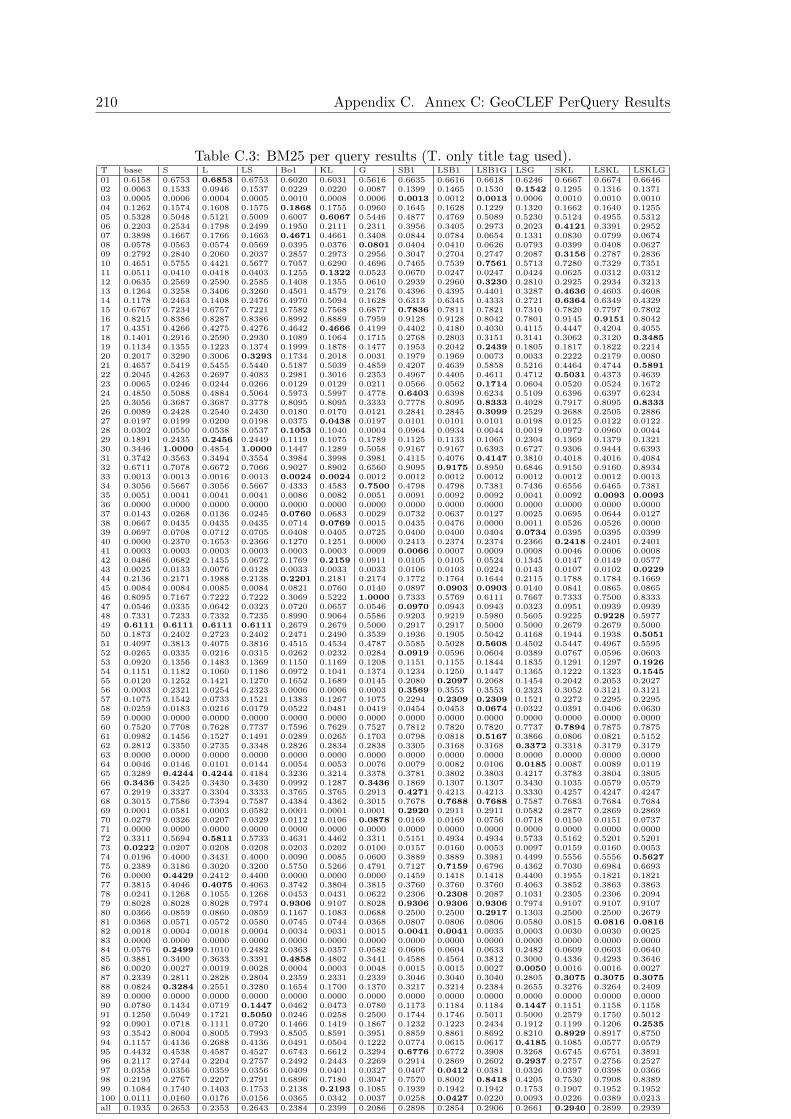
210 Appendix C. Annex C: GeoCLEF PerQuery Results
Table C.3: BM25 per query results (T. only title tag used).T base S L LS Bo1 KL G SB1 LSB1 LSB1G LSG SKL LSKL LSKLG01 0.6158 0.6753 0.6853 0.6753 0.6020 0.6031 0.5616 0.6635 0.6616 0.6618 0.6246 0.6667 0.6674 0.664602 0.0063 0.1533 0.0946 0.1537 0.0229 0.0220 0.0087 0.1399 0.1465 0.1530 0.1542 0.1295 0.1316 0.137103 0.0005 0.0006 0.0004 0.0005 0.0010 0.0008 0.0006 0.0013 0.0012 0.0013 0.0006 0.0010 0.0010 0.001004 0.1262 0.1574 0.1608 0.1575 0.1868 0.1755 0.0960 0.1645 0.1628 0.1229 0.1320 0.1662 0.1640 0.125505 0.5328 0.5048 0.5121 0.5009 0.6007 0.6067 0.5446 0.4877 0.4769 0.5089 0.5230 0.5124 0.4955 0.531206 0.2203 0.2534 0.1798 0.2499 0.1950 0.2111 0.2311 0.3956 0.3405 0.2973 0.2023 0.4121 0.3391 0.295207 0.3898 0.1667 0.1766 0.1663 0.4671 0.4661 0.3408 0.0844 0.0784 0.0654 0.1331 0.0830 0.0799 0.067408 0.0578 0.0563 0.0574 0.0569 0.0395 0.0376 0.0801 0.0404 0.0410 0.0626 0.0793 0.0399 0.0408 0.062709 0.2792 0.2840 0.2060 0.2037 0.2857 0.2973 0.2956 0.3047 0.2704 0.2747 0.2087 0.3156 0.2787 0.283610 0.4651 0.5755 0.4421 0.5677 0.7057 0.6290 0.4696 0.7465 0.7539 0.7561 0.5713 0.7280 0.7329 0.735111 0.0511 0.0410 0.0418 0.0403 0.1255 0.1322 0.0523 0.0670 0.0247 0.0247 0.0424 0.0625 0.0312 0.031212 0.0635 0.2569 0.2590 0.2585 0.1408 0.1355 0.0610 0.2939 0.2960 0.3230 0.2810 0.2925 0.2934 0.321313 0.1264 0.3258 0.3406 0.3260 0.4501 0.4579 0.2176 0.4396 0.4395 0.4401 0.3287 0.4636 0.4603 0.460814 0.1178 0.2463 0.1408 0.2476 0.4970 0.5094 0.1628 0.6313 0.6345 0.4333 0.2721 0.6364 0.6349 0.432915 0.6767 0.7234 0.6757 0.7221 0.7582 0.7568 0.6877 0.7836 0.7811 0.7821 0.7310 0.7820 0.7797 0.780216 0.8215 0.8386 0.8287 0.8386 0.8992 0.8889 0.7959 0.9128 0.9128 0.8042 0.7801 0.9145 0.9151 0.804217 0.4351 0.4266 0.4275 0.4276 0.4642 0.4666 0.4199 0.4402 0.4180 0.4030 0.4115 0.4447 0.4204 0.405518 0.1401 0.2916 0.2590 0.2930 0.1089 0.1064 0.1715 0.2768 0.2803 0.3151 0.3141 0.3062 0.3120 0.348519 0.1134 0.1355 0.1223 0.1374 0.1999 0.1878 0.1477 0.1953 0.2042 0.2439 0.1805 0.1817 0.1822 0.221420 0.2017 0.3290 0.3006 0.3293 0.1734 0.2018 0.0031 0.1979 0.1969 0.0073 0.0033 0.2222 0.2179 0.008021 0.4657 0.5419 0.5455 0.5440 0.5187 0.5039 0.4859 0.4207 0.4639 0.5858 0.5216 0.4464 0.4744 0.589122 0.2045 0.4263 0.2697 0.4083 0.2981 0.3016 0.2353 0.4967 0.4405 0.4611 0.4712 0.5031 0.4373 0.463923 0.0065 0.0246 0.0244 0.0266 0.0129 0.0129 0.0211 0.0566 0.0562 0.1714 0.0604 0.0520 0.0524 0.167224 0.4850 0.5088 0.4884 0.5064 0.5973 0.5997 0.4778 0.6403 0.6398 0.6234 0.5109 0.6396 0.6397 0.623425 0.3056 0.3687 0.3687 0.3778 0.8095 0.8095 0.3333 0.7778 0.8095 0.8333 0.4028 0.7917 0.8095 0.833326 0.0089 0.2428 0.2540 0.2430 0.0180 0.0170 0.0121 0.2841 0.2845 0.3099 0.2529 0.2688 0.2505 0.288627 0.0197 0.0199 0.0200 0.0198 0.0375 0.0438 0.0197 0.0101 0.0101 0.0101 0.0198 0.0125 0.0122 0.012228 0.0302 0.0550 0.0538 0.0537 0.1053 0.1040 0.0004 0.0964 0.0934 0.0044 0.0019 0.0972 0.0960 0.004429 0.1891 0.2435 0.2456 0.2449 0.1119 0.1075 0.1789 0.1125 0.1133 0.1065 0.2304 0.1369 0.1379 0.132130 0.3446 1.0000 0.4854 1.0000 0.1447 0.1289 0.5058 0.9167 0.9167 0.6393 0.6727 0.9306 0.9444 0.639331 0.3742 0.3563 0.3494 0.3554 0.3984 0.3998 0.3981 0.4115 0.4076 0.4147 0.3810 0.4018 0.4016 0.408432 0.6711 0.7078 0.6672 0.7066 0.9027 0.8902 0.6560 0.9095 0.9175 0.8950 0.6846 0.9150 0.9160 0.893433 0.0013 0.0013 0.0016 0.0013 0.0024 0.0024 0.0012 0.0012 0.0012 0.0012 0.0012 0.0012 0.0012 0.001334 0.3056 0.5667 0.3056 0.5667 0.4333 0.4583 0.7500 0.4798 0.4798 0.7381 0.7436 0.6556 0.6465 0.738135 0.0051 0.0041 0.0041 0.0041 0.0086 0.0082 0.0051 0.0091 0.0092 0.0092 0.0041 0.0092 0.0093 0.009336 0.0000 0.0000 0.0000 0.0000 0.0000 0.0000 0.0000 0.0000 0.0000 0.0000 0.0000 0.0000 0.0000 0.000037 0.0143 0.0268 0.0136 0.0245 0.0760 0.0683 0.0029 0.0732 0.0637 0.0127 0.0025 0.0695 0.0644 0.012738 0.0667 0.0435 0.0435 0.0435 0.0714 0.0769 0.0015 0.0435 0.0476 0.0000 0.0011 0.0526 0.0526 0.000039 0.0697 0.0708 0.0712 0.0705 0.0408 0.0405 0.0725 0.0400 0.0400 0.0404 0.0734 0.0395 0.0395 0.039940 0.0000 0.2370 0.1653 0.2366 0.1270 0.1251 0.0000 0.2413 0.2374 0.2374 0.2366 0.2418 0.2401 0.240141 0.0003 0.0003 0.0003 0.0003 0.0003 0.0003 0.0009 0.0066 0.0007 0.0009 0.0008 0.0046 0.0006 0.000842 0.0486 0.0682 0.1455 0.0672 0.1769 0.2159 0.0911 0.0105 0.0105 0.0524 0.1345 0.0147 0.0149 0.057743 0.0025 0.0133 0.0076 0.0128 0.0033 0.0033 0.0033 0.0106 0.0103 0.0224 0.0143 0.0107 0.0102 0.022944 0.2136 0.2171 0.1988 0.2138 0.2201 0.2181 0.2174 0.1772 0.1764 0.1644 0.2115 0.1788 0.1784 0.166945 0.0084 0.0084 0.0085 0.0084 0.0821 0.0760 0.0140 0.0897 0.0903 0.0903 0.0140 0.0841 0.0865 0.086546 0.8095 0.7167 0.7222 0.7222 0.3069 0.5222 1.0000 0.7333 0.5769 0.6111 0.7667 0.7333 0.7500 0.833347 0.0546 0.0335 0.0642 0.0323 0.0720 0.0657 0.0546 0.0970 0.0943 0.0943 0.0323 0.0951 0.0939 0.093948 0.7331 0.7233 0.7332 0.7235 0.8990 0.9064 0.5586 0.9203 0.9219 0.5980 0.5605 0.9225 0.9228 0.597749 0.6111 0.6111 0.6111 0.6111 0.2679 0.2679 0.5000 0.2917 0.2917 0.5000 0.5000 0.2679 0.2679 0.500050 0.1873 0.2402 0.2723 0.2402 0.2471 0.2490 0.3539 0.1936 0.1905 0.5042 0.4168 0.1944 0.1938 0.505151 0.4097 0.3813 0.4075 0.3816 0.4515 0.4534 0.4787 0.5585 0.5028 0.5608 0.4502 0.5447 0.4967 0.559552 0.0265 0.0335 0.0216 0.0315 0.0262 0.0232 0.0284 0.0919 0.0596 0.0604 0.0389 0.0767 0.0596 0.060353 0.0920 0.1356 0.1483 0.1369 0.1150 0.1169 0.1208 0.1151 0.1155 0.1844 0.1835 0.1291 0.1297 0.192654 0.1151 0.1182 0.1060 0.1186 0.0972 0.1041 0.1374 0.1234 0.1250 0.1447 0.1365 0.1222 0.1323 0.154555 0.0120 0.1252 0.1421 0.1270 0.1652 0.1689 0.0145 0.2080 0.2097 0.2068 0.1454 0.2042 0.2053 0.202756 0.0003 0.2321 0.0254 0.2323 0.0006 0.0006 0.0003 0.3569 0.3553 0.3553 0.2323 0.3052 0.3121 0.312157 0.1075 0.1542 0.0733 0.1521 0.1383 0.1267 0.1075 0.2294 0.2309 0.2309 0.1521 0.2272 0.2295 0.229558 0.0259 0.0183 0.0216 0.0179 0.0522 0.0481 0.0419 0.0454 0.0453 0.0674 0.0322 0.0391 0.0406 0.063059 0.0000 0.0000 0.0000 0.0000 0.0000 0.0000 0.0000 0.0000 0.0000 0.0000 0.0000 0.0000 0.0000 0.000060 0.7520 0.7708 0.7628 0.7737 0.7596 0.7629 0.7527 0.7812 0.7820 0.7820 0.7737 0.7894 0.7875 0.787561 0.0982 0.1456 0.1527 0.1491 0.0289 0.0265 0.1703 0.0798 0.0818 0.5167 0.3866 0.0806 0.0821 0.515262 0.2812 0.3350 0.2735 0.3348 0.2826 0.2834 0.2838 0.3305 0.3168 0.3168 0.3372 0.3318 0.3179 0.317963 0.0000 0.0000 0.0000 0.0000 0.0000 0.0000 0.0000 0.0000 0.0000 0.0000 0.0000 0.0000 0.0000 0.000064 0.0046 0.0146 0.0101 0.0144 0.0054 0.0053 0.0076 0.0079 0.0082 0.0106 0.0185 0.0087 0.0089 0.011965 0.3289 0.4244 0.4244 0.4184 0.3236 0.3214 0.3378 0.3781 0.3802 0.3803 0.4217 0.3783 0.3804 0.380566 0.3436 0.3425 0.3430 0.3430 0.0992 0.1287 0.3436 0.1869 0.1307 0.1307 0.3430 0.1035 0.0579 0.057967 0.2919 0.3327 0.3304 0.3333 0.3765 0.3765 0.2913 0.4271 0.4213 0.4213 0.3330 0.4257 0.4247 0.424768 0.3015 0.7586 0.7394 0.7587 0.4384 0.4362 0.3015 0.7678 0.7688 0.7688 0.7587 0.7683 0.7684 0.768469 0.0001 0.0581 0.0003 0.0582 0.0001 0.0001 0.0001 0.2920 0.2911 0.2911 0.0582 0.2877 0.2869 0.286970 0.0279 0.0326 0.0207 0.0329 0.0112 0.0106 0.0878 0.0169 0.0169 0.0756 0.0718 0.0150 0.0151 0.073771 0.0000 0.0000 0.0000 0.0000 0.0000 0.0000 0.0000 0.0000 0.0000 0.0000 0.0000 0.0000 0.0000 0.000072 0.3311 0.5694 0.5811 0.5733 0.4631 0.4462 0.3311 0.5151 0.4934 0.4934 0.5733 0.5162 0.5201 0.520173 0.0222 0.0207 0.0208 0.0208 0.0203 0.0202 0.0100 0.0157 0.0160 0.0053 0.0097 0.0159 0.0160 0.005374 0.0196 0.4000 0.3431 0.4000 0.0090 0.0085 0.0600 0.3889 0.3889 0.3981 0.4499 0.5556 0.5556 0.562775 0.2389 0.3186 0.3020 0.3200 0.5750 0.5266 0.4791 0.7127 0.7159 0.6796 0.4362 0.7030 0.6984 0.669376 0.0000 0.4429 0.2412 0.4400 0.0000 0.0000 0.0000 0.1459 0.1418 0.1418 0.4400 0.1955 0.1821 0.182177 0.3815 0.4046 0.4075 0.4063 0.3742 0.3804 0.3815 0.3760 0.3760 0.3760 0.4063 0.3852 0.3863 0.386378 0.0241 0.1268 0.1055 0.1268 0.0453 0.0431 0.0622 0.2306 0.2308 0.2087 0.1031 0.2305 0.2306 0.209479 0.8028 0.8028 0.8028 0.7974 0.9306 0.9107 0.8028 0.9306 0.9306 0.9306 0.7974 0.9107 0.9107 0.910780 0.0366 0.0859 0.0860 0.0859 0.1167 0.1083 0.0688 0.2500 0.2500 0.2917 0.1303 0.2500 0.2500 0.267981 0.0368 0.0571 0.0572 0.0580 0.0745 0.0744 0.0368 0.0807 0.0806 0.0806 0.0580 0.0815 0.0816 0.081682 0.0018 0.0004 0.0018 0.0004 0.0034 0.0031 0.0015 0.0041 0.0041 0.0035 0.0003 0.0030 0.0030 0.002583 0.0000 0.0000 0.0000 0.0000 0.0000 0.0000 0.0000 0.0000 0.0000 0.0000 0.0000 0.0000 0.0000 0.000084 0.0576 0.2499 0.1010 0.2482 0.0363 0.0357 0.0582 0.0606 0.0604 0.0633 0.2482 0.0609 0.0603 0.064085 0.3881 0.3400 0.3633 0.3391 0.4858 0.4802 0.3441 0.4588 0.4564 0.3812 0.3000 0.4336 0.4293 0.364686 0.0020 0.0027 0.0019 0.0028 0.0004 0.0003 0.0048 0.0015 0.0015 0.0027 0.0050 0.0016 0.0016 0.002787 0.2339 0.2811 0.2828 0.2804 0.2359 0.2331 0.2339 0.3046 0.3040 0.3040 0.2805 0.3075 0.3075 0.307588 0.0824 0.3284 0.2551 0.3280 0.1654 0.1700 0.1370 0.3217 0.3214 0.2384 0.2655 0.3276 0.3264 0.240989 0.0000 0.0000 0.0000 0.0000 0.0000 0.0000 0.0000 0.0000 0.0000 0.0000 0.0000 0.0000 0.0000 0.000090 0.0780 0.1434 0.0719 0.1447 0.0462 0.0473 0.0780 0.1173 0.1184 0.1184 0.1447 0.1151 0.1158 0.115891 0.1250 0.5049 0.1721 0.5050 0.0246 0.0258 0.2500 0.1744 0.1746 0.5011 0.5000 0.2579 0.1750 0.501292 0.0901 0.0718 0.1111 0.0720 0.1466 0.1419 0.1867 0.1232 0.1223 0.2434 0.1912 0.1199 0.1206 0.253593 0.3542 0.8004 0.8005 0.7993 0.8505 0.8591 0.3951 0.8859 0.8861 0.8692 0.8210 0.8929 0.8917 0.875094 0.1157 0.4136 0.2688 0.4136 0.0491 0.0504 0.1222 0.0774 0.0615 0.0617 0.4185 0.1085 0.0577 0.057995 0.4432 0.4538 0.4587 0.4527 0.6743 0.6612 0.3294 0.6776 0.6772 0.3908 0.3268 0.6745 0.6751 0.389196 0.2117 0.2744 0.2204 0.2757 0.2492 0.2443 0.2269 0.2914 0.2869 0.2602 0.2937 0.2757 0.2756 0.252797 0.0358 0.0356 0.0359 0.0356 0.0409 0.0401 0.0327 0.0407 0.0412 0.0381 0.0326 0.0397 0.0398 0.036698 0.2195 0.2767 0.2207 0.2791 0.6896 0.7180 0.3047 0.7570 0.8002 0.8418 0.4205 0.7530 0.7908 0.838999 0.1084 0.1740 0.1403 0.1753 0.2138 0.2193 0.1085 0.1939 0.1942 0.1942 0.1753 0.1907 0.1952 0.1952100 0.0111 0.0160 0.0176 0.0156 0.0365 0.0342 0.0037 0.0258 0.0427 0.0220 0.0093 0.0226 0.0389 0.0213all 0.1935 0.2653 0.2353 0.2643 0.2384 0.2399 0.2086 0.2898 0.2854 0.2906 0.2661 0.2940 0.2899 0.2939
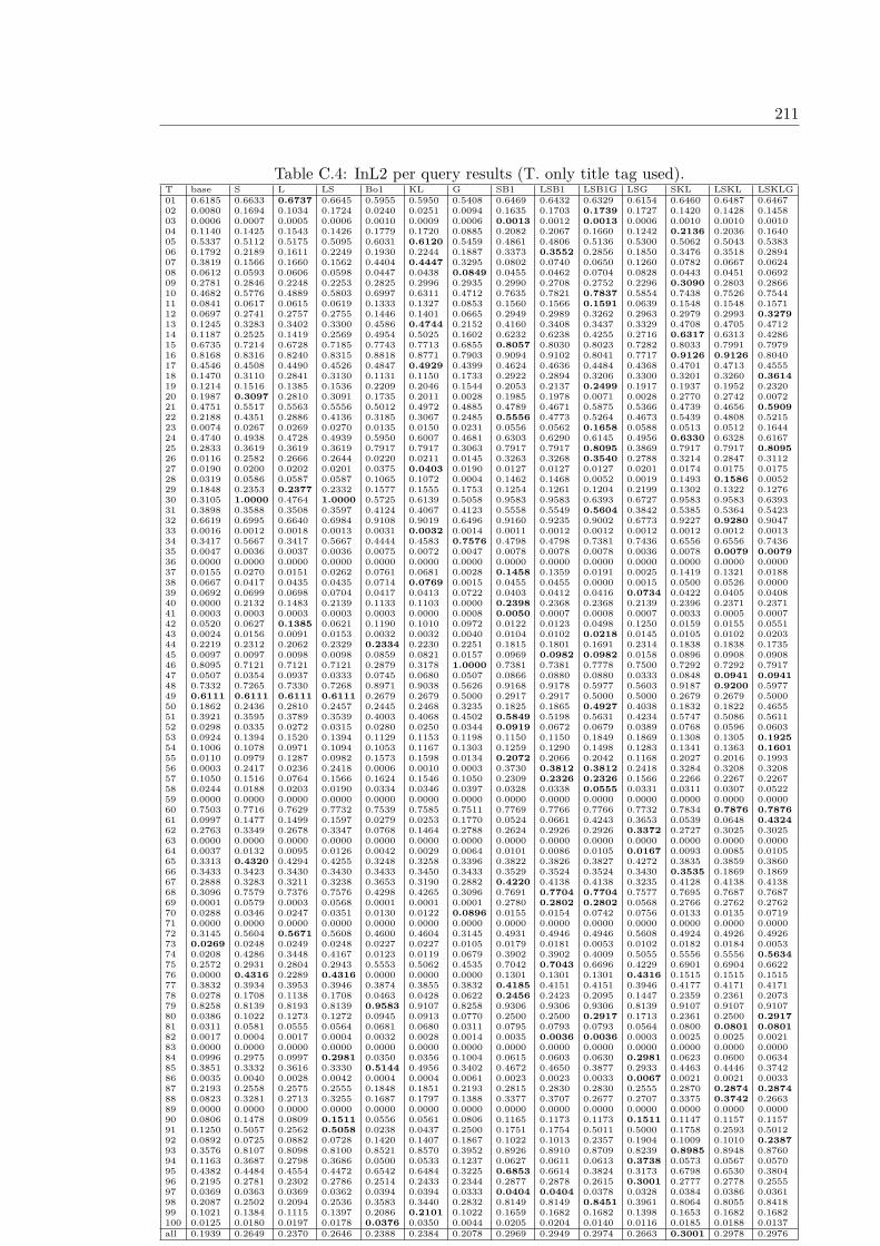
211
Table C.4: InL2 per query results (T. only title tag used).T base S L LS Bo1 KL G SB1 LSB1 LSB1G LSG SKL LSKL LSKLG01 0.6185 0.6633 0.6737 0.6645 0.5955 0.5950 0.5408 0.6469 0.6432 0.6329 0.6154 0.6460 0.6487 0.646702 0.0080 0.1694 0.1034 0.1724 0.0240 0.0251 0.0094 0.1635 0.1703 0.1739 0.1727 0.1420 0.1428 0.145803 0.0006 0.0007 0.0005 0.0006 0.0010 0.0009 0.0006 0.0013 0.0012 0.0013 0.0006 0.0010 0.0010 0.001004 0.1140 0.1425 0.1543 0.1426 0.1779 0.1720 0.0885 0.2082 0.2067 0.1660 0.1242 0.2136 0.2036 0.164005 0.5337 0.5112 0.5175 0.5095 0.6031 0.6120 0.5459 0.4861 0.4806 0.5136 0.5300 0.5062 0.5043 0.538306 0.1792 0.2189 0.1611 0.2249 0.1930 0.2244 0.1887 0.3373 0.3552 0.2856 0.1850 0.3476 0.3518 0.289407 0.3819 0.1566 0.1660 0.1562 0.4404 0.4447 0.3295 0.0802 0.0740 0.0650 0.1260 0.0782 0.0667 0.062408 0.0612 0.0593 0.0606 0.0598 0.0447 0.0438 0.0849 0.0455 0.0462 0.0704 0.0828 0.0443 0.0451 0.069209 0.2781 0.2846 0.2248 0.2253 0.2825 0.2996 0.2935 0.2990 0.2708 0.2752 0.2296 0.3090 0.2803 0.286610 0.4682 0.5776 0.4889 0.5803 0.6997 0.6311 0.4712 0.7635 0.7821 0.7837 0.5854 0.7438 0.7526 0.754411 0.0841 0.0617 0.0615 0.0619 0.1333 0.1327 0.0853 0.1560 0.1566 0.1591 0.0639 0.1548 0.1548 0.157112 0.0697 0.2741 0.2757 0.2755 0.1446 0.1401 0.0665 0.2949 0.2989 0.3262 0.2963 0.2979 0.2993 0.327913 0.1245 0.3283 0.3402 0.3300 0.4586 0.4744 0.2152 0.4160 0.3408 0.3437 0.3329 0.4708 0.4705 0.471214 0.1187 0.2525 0.1419 0.2569 0.4954 0.5025 0.1602 0.6232 0.6238 0.4255 0.2716 0.6317 0.6313 0.428615 0.6735 0.7214 0.6728 0.7185 0.7743 0.7713 0.6855 0.8057 0.8030 0.8023 0.7282 0.8033 0.7991 0.797916 0.8168 0.8316 0.8240 0.8315 0.8818 0.8771 0.7903 0.9094 0.9102 0.8041 0.7717 0.9126 0.9126 0.804017 0.4546 0.4508 0.4490 0.4526 0.4847 0.4929 0.4399 0.4624 0.4636 0.4484 0.4368 0.4701 0.4713 0.455518 0.1470 0.3110 0.2841 0.3130 0.1131 0.1150 0.1733 0.2922 0.2894 0.3206 0.3300 0.3201 0.3260 0.361419 0.1214 0.1516 0.1385 0.1536 0.2209 0.2046 0.1544 0.2053 0.2137 0.2499 0.1917 0.1937 0.1952 0.232020 0.1987 0.3097 0.2810 0.3091 0.1735 0.2011 0.0028 0.1985 0.1978 0.0071 0.0028 0.2770 0.2742 0.007221 0.4751 0.5517 0.5563 0.5556 0.5012 0.4972 0.4885 0.4789 0.4671 0.5875 0.5366 0.4739 0.4656 0.590922 0.2188 0.4351 0.2886 0.4136 0.3185 0.3067 0.2485 0.5556 0.4773 0.5264 0.4673 0.5439 0.4808 0.521523 0.0074 0.0267 0.0269 0.0270 0.0135 0.0150 0.0231 0.0556 0.0562 0.1658 0.0588 0.0513 0.0512 0.164424 0.4740 0.4938 0.4728 0.4939 0.5950 0.6007 0.4681 0.6303 0.6290 0.6145 0.4956 0.6330 0.6328 0.616725 0.2833 0.3619 0.3619 0.3619 0.7917 0.7917 0.3063 0.7917 0.7917 0.8095 0.3869 0.7917 0.7917 0.809526 0.0116 0.2582 0.2666 0.2644 0.0220 0.0211 0.0145 0.3263 0.3268 0.3540 0.2788 0.3214 0.2847 0.311227 0.0190 0.0200 0.0202 0.0201 0.0375 0.0403 0.0190 0.0127 0.0127 0.0127 0.0201 0.0174 0.0175 0.017528 0.0319 0.0586 0.0587 0.0587 0.1065 0.1072 0.0004 0.1462 0.1468 0.0052 0.0019 0.1493 0.1586 0.005229 0.1848 0.2353 0.2377 0.2332 0.1577 0.1555 0.1753 0.1254 0.1261 0.1204 0.2199 0.1302 0.1322 0.127630 0.3105 1.0000 0.4764 1.0000 0.5725 0.6139 0.5058 0.9583 0.9583 0.6393 0.6727 0.9583 0.9583 0.639331 0.3898 0.3588 0.3508 0.3597 0.4124 0.4067 0.4123 0.5558 0.5549 0.5604 0.3842 0.5385 0.5364 0.542332 0.6619 0.6995 0.6640 0.6984 0.9108 0.9019 0.6496 0.9160 0.9235 0.9002 0.6773 0.9227 0.9280 0.904733 0.0016 0.0012 0.0018 0.0013 0.0031 0.0032 0.0014 0.0011 0.0012 0.0012 0.0012 0.0012 0.0012 0.001334 0.3417 0.5667 0.3417 0.5667 0.4444 0.4583 0.7576 0.4798 0.4798 0.7381 0.7436 0.6556 0.6556 0.743635 0.0047 0.0036 0.0037 0.0036 0.0075 0.0072 0.0047 0.0078 0.0078 0.0078 0.0036 0.0078 0.0079 0.007936 0.0000 0.0000 0.0000 0.0000 0.0000 0.0000 0.0000 0.0000 0.0000 0.0000 0.0000 0.0000 0.0000 0.000037 0.0155 0.0270 0.0151 0.0262 0.0761 0.0681 0.0028 0.1458 0.1359 0.0191 0.0025 0.1419 0.1321 0.018838 0.0667 0.0417 0.0435 0.0435 0.0714 0.0769 0.0015 0.0455 0.0455 0.0000 0.0015 0.0500 0.0526 0.000039 0.0692 0.0699 0.0698 0.0704 0.0417 0.0413 0.0722 0.0403 0.0412 0.0416 0.0734 0.0422 0.0405 0.040840 0.0000 0.2132 0.1483 0.2139 0.1133 0.1103 0.0000 0.2398 0.2368 0.2368 0.2139 0.2396 0.2371 0.237141 0.0003 0.0003 0.0003 0.0003 0.0003 0.0000 0.0008 0.0050 0.0007 0.0008 0.0007 0.0033 0.0005 0.000742 0.0520 0.0627 0.1385 0.0621 0.1190 0.1010 0.0972 0.0122 0.0123 0.0498 0.1250 0.0159 0.0155 0.055143 0.0024 0.0156 0.0091 0.0153 0.0032 0.0032 0.0040 0.0104 0.0102 0.0218 0.0145 0.0105 0.0102 0.020344 0.2219 0.2312 0.2062 0.2329 0.2334 0.2230 0.2251 0.1815 0.1801 0.1691 0.2314 0.1838 0.1838 0.173545 0.0097 0.0097 0.0098 0.0098 0.0859 0.0821 0.0157 0.0969 0.0982 0.0982 0.0158 0.0896 0.0908 0.090846 0.8095 0.7121 0.7121 0.7121 0.2879 0.3178 1.0000 0.7381 0.7381 0.7778 0.7500 0.7292 0.7292 0.791747 0.0507 0.0354 0.0937 0.0333 0.0745 0.0680 0.0507 0.0866 0.0880 0.0880 0.0333 0.0848 0.0941 0.094148 0.7332 0.7265 0.7330 0.7268 0.8971 0.9038 0.5626 0.9168 0.9178 0.5977 0.5603 0.9187 0.9200 0.597749 0.6111 0.6111 0.6111 0.6111 0.2679 0.2679 0.5000 0.2917 0.2917 0.5000 0.5000 0.2679 0.2679 0.500050 0.1862 0.2436 0.2810 0.2457 0.2445 0.2468 0.3235 0.1825 0.1865 0.4927 0.4038 0.1832 0.1822 0.465551 0.3921 0.3595 0.3789 0.3539 0.4003 0.4068 0.4502 0.5849 0.5198 0.5631 0.4234 0.5747 0.5086 0.561152 0.0298 0.0335 0.0272 0.0315 0.0280 0.0250 0.0344 0.0919 0.0672 0.0679 0.0389 0.0768 0.0596 0.060353 0.0924 0.1394 0.1520 0.1394 0.1129 0.1153 0.1198 0.1150 0.1150 0.1849 0.1869 0.1308 0.1305 0.192554 0.1006 0.1078 0.0971 0.1094 0.1053 0.1167 0.1303 0.1259 0.1290 0.1498 0.1283 0.1341 0.1363 0.160155 0.0110 0.0979 0.1287 0.0982 0.1573 0.1598 0.0134 0.2072 0.2066 0.2042 0.1168 0.2027 0.2016 0.199356 0.0003 0.2417 0.0236 0.2418 0.0006 0.0010 0.0003 0.3730 0.3812 0.3812 0.2418 0.3284 0.3208 0.320857 0.1050 0.1516 0.0764 0.1566 0.1624 0.1546 0.1050 0.2309 0.2326 0.2326 0.1566 0.2266 0.2267 0.226758 0.0244 0.0188 0.0203 0.0190 0.0334 0.0346 0.0397 0.0328 0.0338 0.0555 0.0331 0.0311 0.0307 0.052259 0.0000 0.0000 0.0000 0.0000 0.0000 0.0000 0.0000 0.0000 0.0000 0.0000 0.0000 0.0000 0.0000 0.000060 0.7503 0.7716 0.7629 0.7732 0.7539 0.7585 0.7511 0.7769 0.7766 0.7766 0.7732 0.7834 0.7876 0.787661 0.0997 0.1477 0.1499 0.1597 0.0279 0.0253 0.1770 0.0524 0.0661 0.4243 0.3653 0.0539 0.0648 0.432462 0.2763 0.3349 0.2678 0.3347 0.0768 0.1464 0.2788 0.2624 0.2926 0.2926 0.3372 0.2727 0.3025 0.302563 0.0000 0.0000 0.0000 0.0000 0.0000 0.0000 0.0000 0.0000 0.0000 0.0000 0.0000 0.0000 0.0000 0.000064 0.0037 0.0132 0.0095 0.0126 0.0042 0.0029 0.0064 0.0101 0.0086 0.0105 0.0167 0.0093 0.0085 0.010565 0.3313 0.4320 0.4294 0.4255 0.3248 0.3258 0.3396 0.3822 0.3826 0.3827 0.4272 0.3835 0.3859 0.386066 0.3433 0.3423 0.3430 0.3430 0.3433 0.3450 0.3433 0.3529 0.3524 0.3524 0.3430 0.3535 0.1869 0.186967 0.2888 0.3283 0.3211 0.3238 0.3653 0.3190 0.2882 0.4220 0.4138 0.4138 0.3235 0.4128 0.4138 0.413868 0.3096 0.7579 0.7376 0.7576 0.4298 0.4265 0.3096 0.7691 0.7704 0.7704 0.7577 0.7695 0.7687 0.768769 0.0001 0.0579 0.0003 0.0568 0.0001 0.0001 0.0001 0.2780 0.2802 0.2802 0.0568 0.2766 0.2762 0.276270 0.0288 0.0346 0.0247 0.0351 0.0130 0.0122 0.0896 0.0155 0.0154 0.0742 0.0756 0.0133 0.0135 0.071971 0.0000 0.0000 0.0000 0.0000 0.0000 0.0000 0.0000 0.0000 0.0000 0.0000 0.0000 0.0000 0.0000 0.000072 0.3145 0.5604 0.5671 0.5608 0.4600 0.4604 0.3145 0.4931 0.4946 0.4946 0.5608 0.4924 0.4926 0.492673 0.0269 0.0248 0.0249 0.0248 0.0227 0.0227 0.0105 0.0179 0.0181 0.0053 0.0102 0.0182 0.0184 0.005374 0.0208 0.4286 0.3448 0.4167 0.0123 0.0119 0.0679 0.3902 0.3902 0.4009 0.5055 0.5556 0.5556 0.563475 0.2572 0.2931 0.2804 0.2943 0.5553 0.5062 0.4535 0.7042 0.7043 0.6696 0.4229 0.6901 0.6904 0.662276 0.0000 0.4316 0.2289 0.4316 0.0000 0.0000 0.0000 0.1301 0.1301 0.1301 0.4316 0.1515 0.1515 0.151577 0.3832 0.3934 0.3953 0.3946 0.3874 0.3855 0.3832 0.4185 0.4151 0.4151 0.3946 0.4177 0.4171 0.417178 0.0278 0.1708 0.1138 0.1708 0.0463 0.0428 0.0622 0.2456 0.2423 0.2095 0.1447 0.2359 0.2361 0.207379 0.8258 0.8139 0.8193 0.8139 0.9583 0.9107 0.8258 0.9306 0.9306 0.9306 0.8139 0.9107 0.9107 0.910780 0.0386 0.1022 0.1273 0.1272 0.0945 0.0913 0.0770 0.2500 0.2500 0.2917 0.1713 0.2361 0.2500 0.291781 0.0311 0.0581 0.0555 0.0564 0.0681 0.0680 0.0311 0.0795 0.0793 0.0793 0.0564 0.0800 0.0801 0.080182 0.0017 0.0004 0.0017 0.0004 0.0032 0.0028 0.0014 0.0035 0.0036 0.0036 0.0003 0.0025 0.0025 0.002183 0.0000 0.0000 0.0000 0.0000 0.0000 0.0000 0.0000 0.0000 0.0000 0.0000 0.0000 0.0000 0.0000 0.000084 0.0996 0.2975 0.0997 0.2981 0.0350 0.0356 0.1004 0.0615 0.0603 0.0630 0.2981 0.0623 0.0600 0.063485 0.3851 0.3332 0.3616 0.3330 0.5144 0.4956 0.3402 0.4672 0.4650 0.3877 0.2933 0.4463 0.4446 0.374286 0.0035 0.0040 0.0028 0.0042 0.0004 0.0004 0.0061 0.0023 0.0023 0.0033 0.0067 0.0021 0.0021 0.003387 0.2193 0.2558 0.2575 0.2555 0.1848 0.1851 0.2193 0.2815 0.2830 0.2830 0.2555 0.2870 0.2874 0.287488 0.0823 0.3281 0.2713 0.3255 0.1687 0.1797 0.1388 0.3377 0.3707 0.2677 0.2707 0.3375 0.3742 0.266389 0.0000 0.0000 0.0000 0.0000 0.0000 0.0000 0.0000 0.0000 0.0000 0.0000 0.0000 0.0000 0.0000 0.000090 0.0806 0.1478 0.0809 0.1511 0.0556 0.0561 0.0806 0.1165 0.1173 0.1173 0.1511 0.1147 0.1157 0.115791 0.1250 0.5057 0.2562 0.5058 0.0238 0.0437 0.2500 0.1751 0.1754 0.5011 0.5000 0.1758 0.2593 0.501292 0.0892 0.0725 0.0882 0.0728 0.1420 0.1407 0.1867 0.1022 0.1013 0.2357 0.1904 0.1009 0.1010 0.238793 0.3576 0.8107 0.8098 0.8100 0.8521 0.8570 0.3952 0.8926 0.8910 0.8709 0.8239 0.8985 0.8948 0.876094 0.1163 0.3687 0.2798 0.3686 0.0500 0.0533 0.1237 0.0627 0.0611 0.0613 0.3738 0.0573 0.0567 0.057095 0.4382 0.4484 0.4554 0.4472 0.6542 0.6484 0.3225 0.6853 0.6614 0.3824 0.3173 0.6798 0.6530 0.380496 0.2195 0.2781 0.2302 0.2786 0.2514 0.2433 0.2344 0.2877 0.2878 0.2615 0.3001 0.2777 0.2778 0.255597 0.0369 0.0363 0.0369 0.0362 0.0394 0.0394 0.0333 0.0404 0.0404 0.0378 0.0328 0.0384 0.0386 0.036198 0.2087 0.2502 0.2094 0.2536 0.3583 0.3440 0.2832 0.8149 0.8149 0.8451 0.3961 0.8064 0.8055 0.841899 0.1021 0.1384 0.1115 0.1397 0.2086 0.2101 0.1022 0.1659 0.1682 0.1682 0.1398 0.1653 0.1682 0.1682100 0.0125 0.0180 0.0197 0.0178 0.0376 0.0350 0.0044 0.0205 0.0204 0.0140 0.0116 0.0185 0.0188 0.0137all 0.1939 0.2649 0.2370 0.2646 0.2388 0.2384 0.2078 0.2969 0.2949 0.2974 0.2663 0.3001 0.2978 0.2976
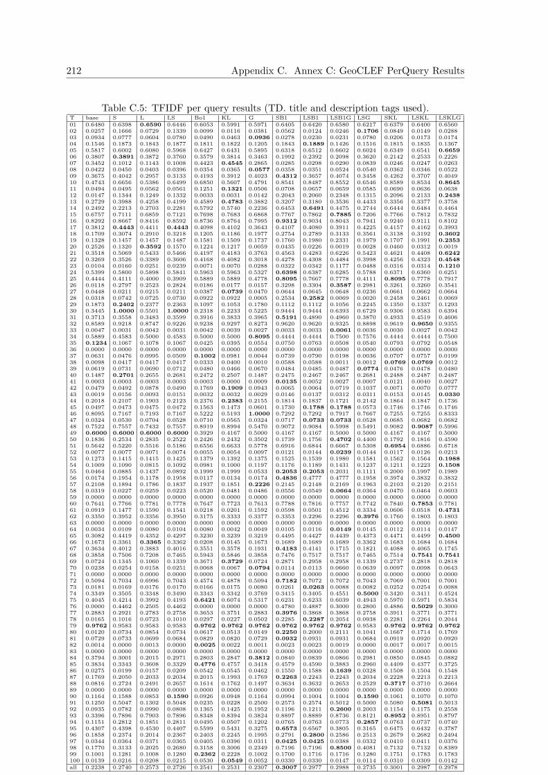
212 Appendix C. Annex C: GeoCLEF PerQuery Results
Table C.5: TFIDF per query results (TD. title and description tags used).T base S L LS Bo1 KL G SB1 LSB1 LSB1G LSG SKL LSKL LSKLG01 0.6480 0.6398 0.6590 0.6446 0.6053 0.5991 0.5971 0.6405 0.6420 0.6580 0.6217 0.6379 0.6400 0.656002 0.0257 0.1666 0.0729 0.1339 0.0099 0.0116 0.0381 0.0562 0.0124 0.0246 0.1706 0.0849 0.0149 0.028803 0.0934 0.0777 0.0604 0.0780 0.0490 0.0463 0.0936 0.0278 0.0230 0.0231 0.0780 0.0206 0.0173 0.017404 0.1546 0.1873 0.1843 0.1877 0.1811 0.1822 0.1205 0.1843 0.1889 0.1426 0.1516 0.1815 0.1835 0.136705 0.5817 0.6002 0.6080 0.5968 0.6427 0.6431 0.5895 0.6318 0.6512 0.6602 0.6024 0.6349 0.6541 0.665906 0.3807 0.3891 0.3872 0.3760 0.3579 0.3814 0.3463 0.1992 0.2392 0.2098 0.3620 0.2142 0.2533 0.222607 0.3452 0.1012 0.1143 0.1008 0.4423 0.4545 0.2865 0.0285 0.0298 0.0290 0.0839 0.0246 0.0247 0.026308 0.0422 0.0450 0.0403 0.0396 0.0354 0.0365 0.0577 0.0358 0.0351 0.0524 0.0540 0.0362 0.0346 0.052209 0.3675 0.4042 0.2957 0.3133 0.4193 0.3912 0.4023 0.4312 0.3657 0.4074 0.3458 0.4262 0.3707 0.404910 0.4743 0.6656 0.5386 0.6499 0.6850 0.5607 0.4791 0.8541 0.8487 0.8552 0.6546 0.8589 0.8534 0.864511 0.0494 0.0495 0.0562 0.0561 0.1251 0.1321 0.0506 0.0708 0.0657 0.0659 0.0585 0.0690 0.0636 0.063812 0.0147 0.1344 0.1249 0.1332 0.0033 0.0031 0.0142 0.2043 0.2060 0.2348 0.1315 0.2096 0.2133 0.243813 0.2729 0.3988 0.4258 0.4199 0.4589 0.4783 0.3882 0.3207 0.3180 0.3536 0.4433 0.3356 0.3377 0.375814 0.2492 0.2213 0.2703 0.2281 0.5792 0.5740 0.2236 0.6453 0.6491 0.4475 0.2744 0.6444 0.6484 0.446415 0.6757 0.7111 0.6859 0.7121 0.7698 0.7683 0.6868 0.7767 0.7862 0.7885 0.7206 0.7766 0.7812 0.783216 0.8292 0.8667 0.8416 0.8592 0.8736 0.8764 0.7995 0.9312 0.9034 0.8043 0.7941 0.9240 0.9111 0.810217 0.3812 0.4443 0.4411 0.4443 0.4098 0.4102 0.3643 0.4107 0.4080 0.3911 0.4225 0.4157 0.4162 0.399318 0.1709 0.3074 0.2910 0.3218 0.1205 0.1186 0.1977 0.2754 0.2789 0.3133 0.3561 0.3138 0.3192 0.360219 0.1328 0.1457 0.1457 0.1487 0.1581 0.1509 0.1737 0.1760 0.1980 0.2331 0.1979 0.1707 0.1991 0.235320 0.2526 0.1320 0.3592 0.1570 0.1224 0.1217 0.0059 0.0435 0.0226 0.0019 0.0028 0.0460 0.0312 0.001921 0.3518 0.5069 0.5433 0.5466 0.4197 0.4183 0.3763 0.4563 0.4283 0.6226 0.5423 0.4621 0.4408 0.624222 0.3269 0.3526 0.3389 0.3606 0.4168 0.4082 0.3018 0.4278 0.4308 0.4484 0.3998 0.4256 0.4323 0.454823 0.0104 0.0160 0.0251 0.0239 0.0071 0.0070 0.0288 0.0322 0.0342 0.1177 0.0488 0.0316 0.0314 0.121024 0.5399 0.5800 0.5898 0.5841 0.5963 0.5963 0.5327 0.6398 0.6387 0.6285 0.5788 0.6371 0.6360 0.625125 0.4444 0.4111 0.4000 0.3909 0.5889 0.5889 0.4778 0.8095 0.7667 0.7778 0.4111 0.8095 0.7778 0.791726 0.0118 0.2797 0.2523 0.2824 0.0186 0.0177 0.0157 0.3298 0.3304 0.3587 0.2981 0.3261 0.3260 0.354127 0.0448 0.0211 0.0215 0.0211 0.0387 0.0739 0.0470 0.0644 0.0645 0.0648 0.0236 0.0661 0.0662 0.066428 0.0318 0.0742 0.0725 0.0730 0.0922 0.0922 0.0005 0.2534 0.2582 0.0069 0.0020 0.2458 0.2461 0.006929 0.1873 0.2402 0.2377 0.2363 0.1097 0.1053 0.1780 0.1112 0.1112 0.1056 0.2245 0.1350 0.1337 0.129330 0.3445 1.0000 0.5501 1.0000 0.2318 0.2233 0.5225 0.9444 0.9444 0.6393 0.6729 0.9306 0.9583 0.639431 0.3713 0.3558 0.3483 0.3599 0.3916 0.3833 0.3965 0.5191 0.4890 0.4960 0.3870 0.4933 0.4519 0.460632 0.8589 0.9218 0.8747 0.9226 0.9238 0.9297 0.8273 0.9620 0.9620 0.9325 0.8898 0.9619 0.9650 0.935533 0.0047 0.0031 0.0042 0.0031 0.0042 0.0039 0.0027 0.0033 0.0033 0.0061 0.0036 0.0030 0.0027 0.004234 0.5889 0.4583 0.5000 0.4583 0.5000 0.5000 0.8095 0.4444 0.4444 0.7500 0.7576 0.4444 0.4444 0.750035 0.1234 0.1067 0.1078 0.1067 0.0425 0.0395 0.0554 0.0750 0.0763 0.0508 0.0540 0.0793 0.0792 0.054836 0.0000 0.0000 0.0000 0.0000 0.0000 0.0000 0.0000 0.0000 0.0000 0.0000 0.0000 0.0000 0.0000 0.000037 0.0631 0.0476 0.0995 0.0509 0.1002 0.0981 0.0044 0.0739 0.0790 0.0198 0.0036 0.0707 0.0757 0.019938 0.0098 0.0417 0.0417 0.0417 0.0333 0.0400 0.0010 0.0588 0.0588 0.0011 0.0012 0.0769 0.0769 0.001239 0.0619 0.0731 0.0690 0.0712 0.0480 0.0466 0.0670 0.0484 0.0485 0.0487 0.0774 0.0476 0.0478 0.048040 0.1487 0.2701 0.2655 0.2681 0.2472 0.2507 0.1487 0.2475 0.2467 0.2467 0.2681 0.2488 0.2487 0.248741 0.0003 0.0003 0.0003 0.0003 0.0003 0.0000 0.0009 0.0135 0.0052 0.0027 0.0007 0.0121 0.0040 0.002742 0.0479 0.0492 0.0878 0.0490 0.1769 0.1909 0.0943 0.0065 0.0064 0.0719 0.1037 0.0071 0.0070 0.077743 0.0019 0.0156 0.0093 0.0151 0.0032 0.0032 0.0029 0.0146 0.0137 0.0312 0.0311 0.0153 0.0145 0.033044 0.2018 0.2107 0.1903 0.2123 0.2376 0.2383 0.2155 0.1814 0.1837 0.1721 0.2142 0.1864 0.1847 0.173645 0.0497 0.0473 0.0475 0.0472 0.1563 0.1473 0.0601 0.1730 0.1788 0.1788 0.0573 0.1746 0.1746 0.174646 0.8095 0.7167 0.7193 0.7167 0.5222 0.5193 1.0000 0.7292 0.7292 0.7917 0.7667 0.7255 0.7255 0.833347 0.0324 0.0530 0.0704 0.0528 0.0710 0.0565 0.0324 0.0717 0.0733 0.0733 0.0528 0.0685 0.0682 0.068248 0.7522 0.7557 0.7432 0.7557 0.8919 0.8994 0.5470 0.9072 0.9084 0.5998 0.5491 0.9082 0.9087 0.599649 0.6000 0.6000 0.6000 0.6000 0.3929 0.4167 0.5000 0.4167 0.4167 0.5000 0.5000 0.4167 0.4167 0.500050 0.1836 0.2534 0.2835 0.2522 0.2426 0.2432 0.3502 0.1739 0.1756 0.4702 0.4400 0.1792 0.1816 0.459051 0.5642 0.5220 0.5516 0.5186 0.6556 0.6633 0.5778 0.6916 0.6844 0.6667 0.5308 0.6954 0.6886 0.671852 0.0077 0.0077 0.0071 0.0074 0.0055 0.0054 0.0097 0.0121 0.0144 0.0239 0.0144 0.0117 0.0126 0.021353 0.1273 0.1415 0.1415 0.1425 0.1379 0.1392 0.1375 0.1525 0.1539 0.1980 0.1581 0.1562 0.1564 0.198854 0.1009 0.1090 0.0815 0.1092 0.0981 0.1000 0.1197 0.1176 0.1189 0.1431 0.1237 0.1211 0.1223 0.150855 0.0464 0.0885 0.1437 0.0892 0.1999 0.1999 0.0533 0.2053 0.2053 0.2031 0.1111 0.2000 0.1997 0.198956 0.0174 0.1954 0.1178 0.1958 0.0117 0.0134 0.0174 0.4836 0.4777 0.4777 0.1958 0.3974 0.3832 0.383257 0.2108 0.1894 0.1786 0.1837 0.1937 0.1851 0.2226 0.2145 0.2148 0.2169 0.1963 0.2103 0.2120 0.215158 0.0319 0.0227 0.0259 0.0223 0.0520 0.0481 0.0486 0.0556 0.0549 0.0664 0.0364 0.0470 0.0464 0.060359 0.0000 0.0000 0.0000 0.0000 0.0000 0.0000 0.0000 0.0000 0.0000 0.0000 0.0000 0.0000 0.0000 0.000060 0.7641 0.7766 0.7781 0.7778 0.7647 0.7723 0.7613 0.7788 0.7816 0.7757 0.7742 0.7840 0.7853 0.778161 0.0919 0.1477 0.1590 0.1541 0.0218 0.0201 0.1592 0.0598 0.0501 0.4512 0.3334 0.0606 0.0518 0.473162 0.3350 0.3952 0.3356 0.3950 0.3175 0.3333 0.3377 0.3353 0.2296 0.2296 0.3976 0.1760 0.1803 0.180363 0.0000 0.0000 0.0000 0.0000 0.0000 0.0000 0.0000 0.0000 0.0000 0.0000 0.0000 0.0000 0.0000 0.000064 0.0034 0.0109 0.0080 0.0104 0.0080 0.0042 0.0049 0.0105 0.0116 0.0149 0.0145 0.0112 0.0114 0.014765 0.3082 0.4419 0.4352 0.4297 0.3230 0.3239 0.3219 0.4495 0.4427 0.4439 0.4373 0.4471 0.4499 0.450066 0.1673 0.3361 0.3365 0.3362 0.0208 0.0145 0.1673 0.1689 0.1689 0.1689 0.3362 0.1683 0.1684 0.168467 0.3634 0.4012 0.3883 0.4016 0.3551 0.3578 0.1931 0.4183 0.4141 0.1715 0.1821 0.4088 0.4065 0.174568 0.3858 0.7506 0.7208 0.7465 0.5943 0.5846 0.3858 0.7476 0.7517 0.7517 0.7465 0.7514 0.7541 0.754169 0.0724 0.1345 0.1060 0.1339 0.3671 0.3729 0.0724 0.2871 0.2958 0.2958 0.1339 0.2737 0.2818 0.281870 0.0238 0.0254 0.0158 0.0251 0.0068 0.0067 0.0794 0.0114 0.0113 0.0660 0.0639 0.0097 0.0098 0.064371 0.0000 0.0000 0.0000 0.0000 0.0000 0.0000 0.0000 0.0000 0.0000 0.0000 0.0000 0.0000 0.0000 0.000072 0.5094 0.7034 0.6996 0.7043 0.4574 0.4878 0.5094 0.7182 0.7072 0.7072 0.7043 0.7069 0.7001 0.700173 0.0181 0.0169 0.0176 0.0170 0.0166 0.0175 0.0080 0.0261 0.0263 0.0088 0.0082 0.0252 0.0254 0.008874 0.3349 0.3505 0.3348 0.3490 0.3343 0.3342 0.3769 0.3415 0.3405 0.4551 0.5000 0.3420 0.3411 0.452475 0.4045 0.4214 0.3992 0.4193 0.6421 0.6074 0.5317 0.6231 0.6233 0.6039 0.4943 0.5970 0.5971 0.583476 0.0000 0.4462 0.2505 0.4462 0.0000 0.0000 0.0000 0.4780 0.4887 0.3000 0.2800 0.4886 0.5029 0.300077 0.2883 0.2921 0.2783 0.2758 0.3653 0.3751 0.2883 0.3976 0.3868 0.3868 0.2758 0.3911 0.3771 0.377178 0.0165 0.1016 0.0723 0.1010 0.0297 0.0227 0.0502 0.2285 0.2287 0.2054 0.0938 0.2281 0.2264 0.204479 0.9762 0.9583 0.9583 0.9583 0.9762 0.9762 0.9762 0.9762 0.9762 0.9762 0.9583 0.9762 0.9762 0.976280 0.0120 0.0734 0.0854 0.0734 0.0617 0.0513 0.0149 0.2250 0.2000 0.2111 0.1041 0.1667 0.1714 0.176981 0.0729 0.0733 0.0699 0.0684 0.0829 0.0820 0.0729 0.0932 0.0931 0.0931 0.0684 0.0919 0.0920 0.092082 0.0014 0.0000 0.0013 0.0000 0.0025 0.0022 0.0011 0.0023 0.0023 0.0019 0.0000 0.0017 0.0017 0.001583 0.0000 0.0000 0.0000 0.0000 0.0000 0.0000 0.0000 0.0000 0.0000 0.0000 0.0000 0.0000 0.0000 0.000084 0.3794 0.3001 0.2015 0.2971 0.2803 0.2847 0.3812 0.0840 0.0839 0.0866 0.2981 0.0850 0.0845 0.088285 0.3834 0.3343 0.3608 0.3329 0.4776 0.4757 0.3418 0.4579 0.4590 0.3883 0.2960 0.4409 0.4377 0.372586 0.0275 0.0199 0.0157 0.0209 0.0542 0.0545 0.0462 0.1550 0.1588 0.1639 0.0328 0.1508 0.1504 0.154887 0.1769 0.2050 0.2033 0.2034 0.2015 0.1993 0.1769 0.2263 0.2243 0.2243 0.2034 0.2228 0.2213 0.221388 0.0816 0.2724 0.2491 0.2657 0.1614 0.1762 0.1497 0.3634 0.3632 0.2653 0.2529 0.3717 0.3710 0.266489 0.0000 0.0000 0.0000 0.0000 0.0000 0.0000 0.0000 0.0000 0.0000 0.0000 0.0000 0.0000 0.0000 0.000090 0.1164 0.1588 0.0853 0.1590 0.0926 0.0948 0.1164 0.0994 0.1004 0.1004 0.1590 0.1061 0.1070 0.107091 0.1250 0.5047 0.1302 0.5048 0.0235 0.0228 0.2500 0.2573 0.2574 0.5012 0.5000 0.5080 0.5081 0.501392 0.0935 0.0782 0.0990 0.0808 0.1365 0.1425 0.1952 0.1196 0.1211 0.2600 0.2003 0.1154 0.1175 0.255893 0.3396 0.7896 0.7903 0.7896 0.8348 0.8394 0.3824 0.8897 0.8889 0.8736 0.8121 0.8952 0.8951 0.879794 0.1151 0.2812 0.1851 0.2811 0.0495 0.0507 0.1202 0.0765 0.0763 0.0773 0.2857 0.0763 0.0737 0.074095 0.4307 0.4398 0.4530 0.4407 0.5599 0.5431 0.3275 0.6573 0.6567 0.3805 0.3165 0.6475 0.6432 0.378796 0.1858 0.2374 0.2014 0.2367 0.2403 0.2245 0.1995 0.2791 0.2800 0.2586 0.2513 0.2679 0.2682 0.249497 0.0344 0.0364 0.0371 0.0365 0.0405 0.0396 0.0311 0.0425 0.0425 0.0388 0.0332 0.0410 0.0411 0.037698 0.1770 0.3133 0.2025 0.2680 0.3158 0.3006 0.2349 0.7196 0.7196 0.8500 0.4081 0.7132 0.7132 0.838999 0.1001 0.1281 0.1008 0.1280 0.2362 0.2228 0.1002 0.1700 0.1716 0.1716 0.1280 0.1751 0.1783 0.1783100 0.0139 0.0216 0.0208 0.0215 0.0530 0.0549 0.0052 0.0330 0.0330 0.0147 0.0114 0.0310 0.0309 0.0142all 0.2238 0.2740 0.2573 0.2726 0.2541 0.2531 0.2307 0.3007 0.2977 0.2988 0.2735 0.3001 0.2987 0.2978
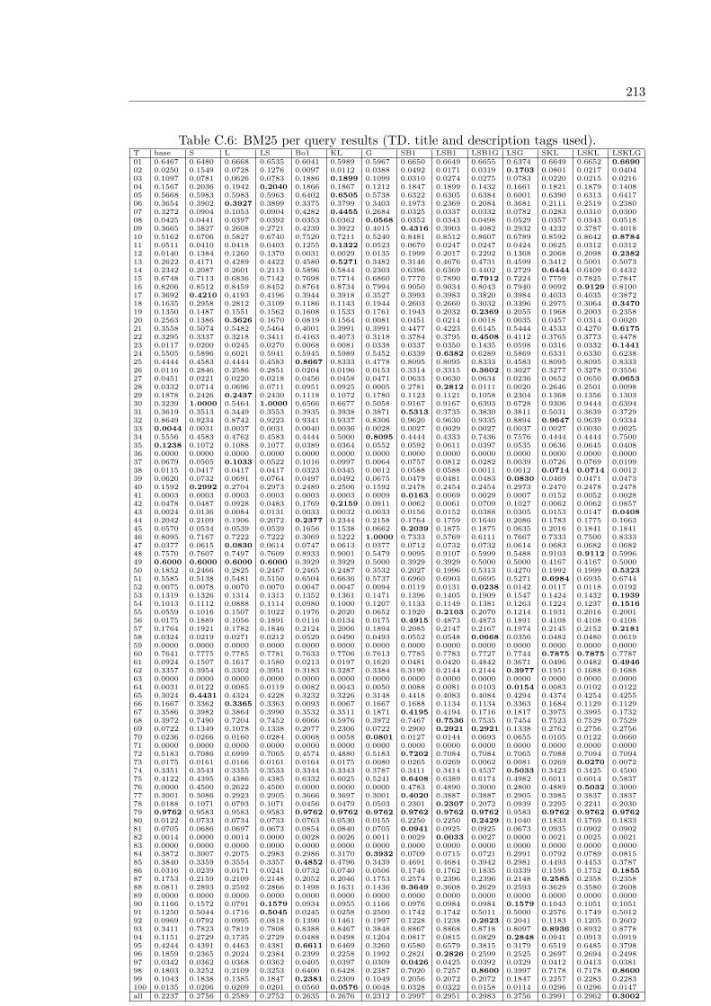
213
Table C.6: BM25 per query results (TD. title and description tags used).T base S L LS Bo1 KL G SB1 LSB1 LSB1G LSG SKL LSKL LSKLG01 0.6467 0.6480 0.6668 0.6535 0.6041 0.5989 0.5967 0.6650 0.6649 0.6655 0.6374 0.6649 0.6652 0.669002 0.0250 0.1549 0.0728 0.1276 0.0097 0.0112 0.0388 0.0492 0.0171 0.0319 0.1703 0.0801 0.0217 0.040403 0.1097 0.0781 0.0626 0.0783 0.1886 0.1899 0.1099 0.0310 0.0274 0.0275 0.0783 0.0220 0.0215 0.021604 0.1567 0.2036 0.1942 0.2040 0.1866 0.1867 0.1212 0.1847 0.1899 0.1432 0.1661 0.1821 0.1879 0.140805 0.5668 0.5983 0.5983 0.5963 0.6402 0.6505 0.5738 0.6322 0.6305 0.6384 0.6001 0.6390 0.6313 0.641706 0.3654 0.3902 0.3927 0.3899 0.3375 0.3799 0.3403 0.1973 0.2369 0.2084 0.3681 0.2111 0.2519 0.238007 0.3272 0.0904 0.1053 0.0904 0.4282 0.4455 0.2684 0.0325 0.0337 0.0332 0.0782 0.0283 0.0310 0.030008 0.0425 0.0441 0.0397 0.0392 0.0353 0.0362 0.0568 0.0352 0.0343 0.0498 0.0529 0.0357 0.0343 0.051809 0.3665 0.3827 0.2608 0.2721 0.4239 0.3922 0.4015 0.4316 0.3903 0.4082 0.2932 0.4232 0.3787 0.401810 0.5162 0.6706 0.5827 0.6740 0.7520 0.7211 0.5240 0.8481 0.8512 0.8607 0.6789 0.8592 0.8642 0.878411 0.0511 0.0410 0.0418 0.0403 0.1255 0.1322 0.0523 0.0670 0.0247 0.0247 0.0424 0.0625 0.0312 0.031212 0.0140 0.1384 0.1260 0.1370 0.0031 0.0029 0.0135 0.1999 0.2017 0.2292 0.1368 0.2068 0.2098 0.238213 0.2622 0.4171 0.4289 0.4422 0.4580 0.5271 0.3482 0.3146 0.4676 0.4731 0.4599 0.3412 0.5001 0.507314 0.2342 0.2087 0.2601 0.2113 0.5896 0.5844 0.2303 0.6396 0.6369 0.4402 0.2729 0.6444 0.6409 0.443215 0.6748 0.7113 0.6836 0.7142 0.7698 0.7714 0.6860 0.7770 0.7890 0.7912 0.7224 0.7759 0.7825 0.784716 0.8206 0.8512 0.8459 0.8452 0.8764 0.8734 0.7994 0.9050 0.9034 0.8043 0.7940 0.9092 0.9129 0.810017 0.3692 0.4210 0.4193 0.4196 0.3944 0.3918 0.3527 0.3993 0.3983 0.3820 0.3984 0.4033 0.4035 0.387218 0.1635 0.2958 0.2812 0.3109 0.1186 0.1143 0.1944 0.2603 0.2660 0.3032 0.3396 0.2975 0.3064 0.347019 0.1350 0.1487 0.1551 0.1562 0.1608 0.1533 0.1761 0.1943 0.2032 0.2369 0.2055 0.1968 0.2003 0.235820 0.2563 0.1386 0.3626 0.1670 0.0819 0.1564 0.0081 0.0451 0.0214 0.0018 0.0035 0.0457 0.0314 0.002021 0.3558 0.5074 0.5482 0.5464 0.4001 0.3991 0.3991 0.4477 0.4223 0.6145 0.5444 0.4533 0.4270 0.617522 0.3295 0.3337 0.3218 0.3411 0.4163 0.4073 0.3118 0.3784 0.3795 0.4508 0.4112 0.3765 0.3773 0.447823 0.0117 0.0200 0.0245 0.0270 0.0068 0.0081 0.0338 0.0337 0.0350 0.1435 0.0598 0.0316 0.0332 0.144124 0.5505 0.5896 0.6021 0.5941 0.5945 0.5989 0.5452 0.6339 0.6382 0.6289 0.5869 0.6331 0.6330 0.623825 0.4444 0.4583 0.4444 0.4583 0.8667 0.8333 0.4778 0.8095 0.8095 0.8333 0.4583 0.8095 0.8095 0.833326 0.0116 0.2846 0.2586 0.2851 0.0204 0.0196 0.0153 0.3314 0.3315 0.3602 0.3027 0.3277 0.3278 0.355627 0.0451 0.0221 0.0220 0.0218 0.0456 0.0458 0.0471 0.0633 0.0630 0.0634 0.0236 0.0652 0.0650 0.065328 0.0332 0.0714 0.0696 0.0711 0.0951 0.0925 0.0005 0.2781 0.2812 0.0111 0.0020 0.2646 0.2501 0.009829 0.1878 0.2426 0.2437 0.2430 0.1118 0.1072 0.1780 0.1123 0.1121 0.1058 0.2304 0.1368 0.1356 0.130330 0.3239 1.0000 0.5464 1.0000 0.6566 0.6677 0.5058 0.9167 0.9167 0.6393 0.6728 0.9306 0.9444 0.639431 0.3619 0.3513 0.3449 0.3553 0.3935 0.3938 0.3871 0.5313 0.3735 0.3830 0.3811 0.5031 0.3639 0.372932 0.8649 0.9234 0.8742 0.9223 0.9341 0.9337 0.8306 0.9620 0.9630 0.9335 0.8894 0.9647 0.9639 0.933433 0.0044 0.0031 0.0037 0.0031 0.0040 0.0036 0.0028 0.0027 0.0029 0.0027 0.0037 0.0027 0.0030 0.002534 0.5556 0.4583 0.4762 0.4583 0.4444 0.5000 0.8095 0.4444 0.4333 0.7436 0.7576 0.4444 0.4444 0.750035 0.1238 0.1072 0.1088 0.1077 0.0389 0.0364 0.0552 0.0592 0.0611 0.0397 0.0535 0.0636 0.0645 0.040836 0.0000 0.0000 0.0000 0.0000 0.0000 0.0000 0.0000 0.0000 0.0000 0.0000 0.0000 0.0000 0.0000 0.000037 0.0679 0.0505 0.1033 0.0522 0.1016 0.0997 0.0064 0.0757 0.0812 0.0282 0.0039 0.0726 0.0769 0.019938 0.0115 0.0417 0.0417 0.0417 0.0323 0.0345 0.0012 0.0588 0.0588 0.0011 0.0012 0.0714 0.0714 0.001239 0.0620 0.0732 0.0691 0.0764 0.0497 0.0492 0.0675 0.0479 0.0481 0.0483 0.0830 0.0469 0.0471 0.047340 0.1592 0.2992 0.2704 0.2973 0.2489 0.2506 0.1592 0.2478 0.2454 0.2454 0.2973 0.2470 0.2478 0.247841 0.0003 0.0003 0.0003 0.0003 0.0003 0.0003 0.0009 0.0163 0.0069 0.0029 0.0007 0.0152 0.0052 0.002842 0.0478 0.0487 0.0928 0.0483 0.1769 0.2159 0.0911 0.0062 0.0061 0.0709 0.1027 0.0062 0.0062 0.085743 0.0024 0.0136 0.0084 0.0131 0.0033 0.0032 0.0033 0.0156 0.0152 0.0388 0.0305 0.0153 0.0147 0.040844 0.2042 0.2109 0.1906 0.2072 0.2377 0.2344 0.2158 0.1764 0.1759 0.1640 0.2086 0.1783 0.1775 0.166345 0.0570 0.0534 0.0539 0.0539 0.1656 0.1538 0.0662 0.2039 0.1875 0.1875 0.0635 0.2016 0.1841 0.184146 0.8095 0.7167 0.7222 0.7222 0.3069 0.5222 1.0000 0.7333 0.5769 0.6111 0.7667 0.7333 0.7500 0.833347 0.0377 0.0615 0.0830 0.0614 0.0747 0.0613 0.0377 0.0712 0.0732 0.0732 0.0614 0.0683 0.0682 0.068248 0.7570 0.7607 0.7497 0.7609 0.8933 0.9001 0.5479 0.9095 0.9107 0.5999 0.5488 0.9103 0.9112 0.599649 0.6000 0.6000 0.6000 0.6000 0.3929 0.3929 0.5000 0.3929 0.3929 0.5000 0.5000 0.4167 0.4167 0.500050 0.1852 0.2466 0.2825 0.2467 0.2465 0.2487 0.3532 0.2027 0.1996 0.5313 0.4270 0.1992 0.1999 0.532351 0.5585 0.5138 0.5481 0.5150 0.6504 0.6636 0.5737 0.6960 0.6903 0.6695 0.5271 0.6984 0.6935 0.674452 0.0075 0.0078 0.0070 0.0070 0.0047 0.0047 0.0094 0.0119 0.0131 0.0238 0.0142 0.0117 0.0118 0.019253 0.1319 0.1326 0.1314 0.1313 0.1352 0.1361 0.1471 0.1396 0.1405 0.1909 0.1547 0.1424 0.1432 0.193954 0.1013 0.1112 0.0888 0.1114 0.0980 0.1000 0.1207 0.1133 0.1149 0.1381 0.1263 0.1224 0.1237 0.151655 0.0559 0.1016 0.1507 0.1022 0.1976 0.2020 0.0652 0.1920 0.2103 0.2070 0.1214 0.1931 0.2016 0.200156 0.0175 0.1889 0.1056 0.1891 0.0116 0.0134 0.0175 0.4915 0.4873 0.4873 0.1891 0.4108 0.4108 0.410857 0.1764 0.1921 0.1782 0.1846 0.2124 0.2006 0.1894 0.2085 0.2147 0.2167 0.1974 0.2145 0.2152 0.218158 0.0324 0.0219 0.0271 0.0212 0.0529 0.0490 0.0493 0.0552 0.0548 0.0668 0.0356 0.0482 0.0480 0.061959 0.0000 0.0000 0.0000 0.0000 0.0000 0.0000 0.0000 0.0000 0.0000 0.0000 0.0000 0.0000 0.0000 0.000060 0.7641 0.7775 0.7785 0.7781 0.7633 0.7706 0.7613 0.7785 0.7783 0.7727 0.7744 0.7875 0.7875 0.778761 0.0924 0.1507 0.1617 0.1580 0.0213 0.0197 0.1620 0.0481 0.0420 0.4842 0.3671 0.0496 0.0482 0.494662 0.3357 0.3954 0.3302 0.3951 0.3183 0.3287 0.3384 0.3190 0.2144 0.2144 0.3977 0.1951 0.1688 0.168863 0.0000 0.0000 0.0000 0.0000 0.0000 0.0000 0.0000 0.0000 0.0000 0.0000 0.0000 0.0000 0.0000 0.000064 0.0031 0.0122 0.0085 0.0119 0.0082 0.0043 0.0050 0.0088 0.0081 0.0103 0.0154 0.0083 0.0102 0.012265 0.3024 0.4431 0.4324 0.4228 0.3232 0.3226 0.3148 0.4418 0.4083 0.4084 0.4294 0.4374 0.4254 0.425566 0.1667 0.3362 0.3365 0.3363 0.0093 0.0067 0.1667 0.1688 0.1134 0.1134 0.3363 0.1684 0.1129 0.112967 0.3586 0.3982 0.3864 0.3990 0.3532 0.3511 0.1871 0.4195 0.4194 0.1716 0.1817 0.3975 0.3995 0.173268 0.3972 0.7490 0.7204 0.7452 0.6066 0.5976 0.3972 0.7467 0.7536 0.7535 0.7454 0.7523 0.7529 0.752969 0.0722 0.1349 0.1078 0.1338 0.2077 0.2306 0.0722 0.2900 0.2921 0.2921 0.1338 0.2762 0.2756 0.275670 0.0236 0.0266 0.0160 0.0284 0.0068 0.0058 0.0801 0.0127 0.0144 0.0693 0.0655 0.0105 0.0122 0.066071 0.0000 0.0000 0.0000 0.0000 0.0000 0.0000 0.0000 0.0000 0.0000 0.0000 0.0000 0.0000 0.0000 0.000072 0.5183 0.7086 0.6999 0.7065 0.4574 0.4880 0.5183 0.7202 0.7084 0.7084 0.7065 0.7088 0.7094 0.709473 0.0175 0.0161 0.0166 0.0161 0.0164 0.0175 0.0080 0.0265 0.0269 0.0062 0.0081 0.0269 0.0270 0.007274 0.3351 0.3543 0.3355 0.3533 0.3344 0.3343 0.3787 0.3411 0.3414 0.4537 0.5033 0.3423 0.3425 0.450075 0.4122 0.4395 0.4386 0.4385 0.6332 0.6025 0.5241 0.6408 0.6389 0.6174 0.4982 0.6011 0.6014 0.583776 0.0000 0.4500 0.2622 0.4500 0.0000 0.0000 0.0000 0.4783 0.4890 0.3000 0.2800 0.4889 0.5032 0.300077 0.3001 0.3086 0.2923 0.2905 0.3666 0.3697 0.3001 0.4020 0.3887 0.3887 0.2905 0.3985 0.3837 0.383778 0.0188 0.1071 0.0793 0.1071 0.0456 0.0479 0.0503 0.2301 0.2307 0.2072 0.0939 0.2295 0.2241 0.203079 0.9762 0.9583 0.9583 0.9583 0.9762 0.9762 0.9762 0.9762 0.9762 0.9762 0.9583 0.9762 0.9762 0.976280 0.0122 0.0733 0.0734 0.0733 0.0763 0.0530 0.0155 0.2250 0.2250 0.2429 0.1040 0.1833 0.1769 0.183381 0.0705 0.0686 0.0697 0.0673 0.0854 0.0840 0.0705 0.0941 0.0925 0.0925 0.0673 0.0935 0.0902 0.090282 0.0014 0.0000 0.0014 0.0000 0.0028 0.0026 0.0011 0.0029 0.0033 0.0027 0.0000 0.0021 0.0025 0.002183 0.0000 0.0000 0.0000 0.0000 0.0000 0.0000 0.0000 0.0000 0.0000 0.0000 0.0000 0.0000 0.0000 0.000084 0.3872 0.3007 0.2075 0.2983 0.2986 0.3170 0.3932 0.0709 0.0715 0.0721 0.2991 0.0792 0.0789 0.081585 0.3840 0.3359 0.3554 0.3357 0.4852 0.4796 0.3439 0.4691 0.4684 0.3942 0.2981 0.4493 0.4453 0.378786 0.0316 0.0239 0.0171 0.0241 0.0732 0.0740 0.0506 0.1746 0.1762 0.1835 0.0339 0.1595 0.1752 0.185587 0.1753 0.2159 0.2109 0.2148 0.2052 0.2046 0.1753 0.2574 0.2396 0.2396 0.2148 0.2585 0.2358 0.235888 0.0811 0.2893 0.2592 0.2866 0.1498 0.1631 0.1436 0.3649 0.3608 0.2629 0.2593 0.3629 0.3580 0.260889 0.0000 0.0000 0.0000 0.0000 0.0000 0.0000 0.0000 0.0000 0.0000 0.0000 0.0000 0.0000 0.0000 0.000090 0.1166 0.1572 0.0791 0.1579 0.0934 0.0955 0.1166 0.0976 0.0984 0.0984 0.1579 0.1043 0.1051 0.105191 0.1250 0.5044 0.1716 0.5045 0.0245 0.0258 0.2500 0.1742 0.1742 0.5011 0.5000 0.2576 0.1749 0.501292 0.0969 0.0792 0.0995 0.0818 0.1390 0.1461 0.1997 0.1228 0.1238 0.2623 0.2041 0.1183 0.1205 0.260293 0.3411 0.7823 0.7819 0.7808 0.8388 0.8467 0.3848 0.8867 0.8868 0.8718 0.8097 0.8936 0.8932 0.877894 0.1151 0.2729 0.1735 0.2729 0.0488 0.0498 0.1204 0.0817 0.0815 0.0829 0.2848 0.0941 0.0913 0.091995 0.4244 0.4391 0.4463 0.4381 0.6611 0.6469 0.3260 0.6580 0.6579 0.3815 0.3179 0.6519 0.6485 0.379896 0.1859 0.2365 0.2024 0.2384 0.2399 0.2258 0.1992 0.2821 0.2826 0.2599 0.2525 0.2697 0.2694 0.249897 0.0342 0.0362 0.0368 0.0362 0.0405 0.0397 0.0309 0.0426 0.0425 0.0392 0.0329 0.0412 0.0413 0.038198 0.1803 0.3252 0.2109 0.3253 0.6400 0.6428 0.2387 0.7020 0.7257 0.8600 0.3997 0.7178 0.7178 0.860099 0.1043 0.1838 0.1385 0.1847 0.2381 0.2309 0.1049 0.2056 0.2072 0.2072 0.1847 0.2257 0.2283 0.2283100 0.0135 0.0206 0.0209 0.0201 0.0560 0.0576 0.0048 0.0328 0.0322 0.0158 0.0114 0.0296 0.0296 0.0147all 0.2237 0.2756 0.2589 0.2752 0.2635 0.2676 0.2312 0.2997 0.2951 0.2983 0.2756 0.2991 0.2962 0.3002

214 Appendix C. Annex C: GeoCLEF PerQuery Results
Table C.7: InL2 per query results (TD. title and description tags used).T base S L LS Bo1 KL G SB1 LSB1 LSB1G LSG SKL LSKL LSKLG01 0.6326 0.6412 0.6585 0.6456 0.6018 0.6126 0.5918 0.6336 0.6337 0.6446 0.6225 0.6466 0.6362 0.650202 0.0270 0.1773 0.0734 0.1558 0.0099 0.0115 0.0398 0.0577 0.0290 0.0513 0.1880 0.0906 0.0392 0.062903 0.0946 0.0733 0.0623 0.0735 0.1724 0.1788 0.0948 0.0273 0.0272 0.0272 0.0736 0.0229 0.0229 0.022904 0.1526 0.1755 0.1556 0.1764 0.1733 0.1770 0.1205 0.1869 0.1843 0.1391 0.1439 0.1837 0.1822 0.138105 0.5709 0.5935 0.5962 0.5965 0.6340 0.6422 0.5787 0.6315 0.6281 0.6384 0.6011 0.6253 0.6220 0.634706 0.3729 0.3655 0.3764 0.3677 0.2019 0.2295 0.3376 0.1881 0.2246 0.1985 0.3537 0.2017 0.2391 0.214607 0.3349 0.0874 0.1041 0.0882 0.4112 0.4226 0.2767 0.0189 0.0190 0.0188 0.0769 0.0182 0.0183 0.018008 0.0431 0.0448 0.0414 0.0399 0.0379 0.0382 0.0597 0.0368 0.0365 0.0551 0.0548 0.0372 0.0369 0.055009 0.3707 0.3857 0.2621 0.2877 0.4300 0.3955 0.4025 0.4324 0.3772 0.3986 0.3104 0.4291 0.3687 0.394710 0.5273 0.6689 0.6049 0.6798 0.7245 0.6757 0.5311 0.7334 0.8525 0.8586 0.6841 0.7516 0.8577 0.865311 0.0841 0.0617 0.0615 0.0619 0.1333 0.1327 0.0853 0.1560 0.1566 0.1591 0.0639 0.1548 0.1548 0.157112 0.0237 0.1480 0.1367 0.1484 0.0057 0.0060 0.0229 0.2161 0.2158 0.2442 0.1481 0.2204 0.2214 0.251613 0.2520 0.3913 0.4170 0.4156 0.4568 0.4312 0.3274 0.2669 0.4737 0.4795 0.4286 0.3009 0.4867 0.494314 0.2393 0.2162 0.2640 0.2228 0.5893 0.5861 0.2267 0.6400 0.6437 0.4455 0.2740 0.6443 0.6492 0.448515 0.6716 0.7088 0.6822 0.7138 0.7784 0.7801 0.6839 0.7818 0.7940 0.7956 0.7230 0.7794 0.7879 0.789716 0.8331 0.8688 0.8485 0.8695 0.8760 0.8738 0.8038 0.9312 0.9312 0.8099 0.7942 0.9284 0.9270 0.814917 0.3841 0.4417 0.4411 0.4426 0.4088 0.4087 0.3681 0.4125 0.4285 0.4132 0.4220 0.4121 0.4339 0.418218 0.1688 0.3118 0.2972 0.3302 0.1238 0.1244 0.1969 0.2753 0.2805 0.3185 0.3620 0.3125 0.3238 0.365019 0.1415 0.1593 0.1653 0.1674 0.1630 0.1571 0.1831 0.1961 0.2306 0.2605 0.2134 0.2004 0.2221 0.255020 0.2510 0.1268 0.3296 0.1684 0.1199 0.1162 0.0060 0.0339 0.0358 0.0025 0.0030 0.0502 0.0370 0.002321 0.3690 0.5225 0.5671 0.5667 0.4055 0.4039 0.4179 0.4329 0.4304 0.6392 0.5548 0.4399 0.4369 0.635222 0.3461 0.3600 0.3443 0.3566 0.4315 0.4240 0.3332 0.4623 0.4296 0.4780 0.4194 0.4588 0.4191 0.478223 0.0118 0.0194 0.0281 0.0268 0.0069 0.0080 0.0325 0.0189 0.0358 0.1295 0.0570 0.0179 0.0342 0.132924 0.5271 0.5587 0.5791 0.5620 0.5983 0.5959 0.5220 0.6286 0.6313 0.6197 0.5556 0.6278 0.6267 0.614825 0.4444 0.4583 0.4444 0.4444 0.9167 0.8667 0.4778 0.8095 0.8095 0.8333 0.4583 0.8095 0.8095 0.833326 0.0140 0.2763 0.2775 0.2768 0.0289 0.0282 0.0183 0.4118 0.4128 0.4508 0.3241 0.4077 0.4078 0.444327 0.0398 0.0228 0.0219 0.0219 0.0384 0.0473 0.0415 0.0634 0.0635 0.0640 0.0238 0.0655 0.0656 0.065828 0.0340 0.0828 0.0832 0.0829 0.0839 0.0842 0.0005 0.3256 0.3399 0.0092 0.0020 0.3207 0.3280 0.008129 0.1837 0.2344 0.2355 0.2310 0.1573 0.1552 0.1744 0.1252 0.1252 0.1200 0.2199 0.1300 0.1305 0.126430 0.2979 1.0000 0.5520 1.0000 0.5696 0.6100 0.5058 0.9583 0.9583 0.6393 0.6727 0.9583 0.9583 0.639331 0.3786 0.3595 0.3542 0.3667 0.4284 0.4236 0.4018 0.6476 0.6525 0.6575 0.3931 0.6332 0.6354 0.640532 0.8646 0.9281 0.8854 0.9250 0.9371 0.9381 0.8302 0.9641 0.9641 0.9336 0.8908 0.9669 0.9669 0.936433 0.0048 0.0030 0.0041 0.0030 0.0040 0.0040 0.0028 0.0017 0.0021 0.0025 0.0035 0.0019 0.0022 0.002434 0.5889 0.4583 0.5556 0.4583 0.4583 0.5139 0.8095 0.5000 0.4889 0.7436 0.7576 0.5000 0.5000 0.750035 0.1230 0.1064 0.1081 0.1064 0.0468 0.0430 0.0551 0.0604 0.0686 0.0520 0.0546 0.0661 0.0696 0.052036 0.0000 0.0000 0.0000 0.0000 0.0000 0.0000 0.0000 0.0000 0.0000 0.0000 0.0000 0.0000 0.0000 0.000037 0.0800 0.0533 0.1021 0.0505 0.1021 0.1008 0.0055 0.0869 0.0664 0.0386 0.0038 0.0803 0.0665 0.028238 0.0102 0.0385 0.0417 0.0400 0.0256 0.0294 0.0012 0.0588 0.0588 0.0011 0.0012 0.0714 0.0714 0.001139 0.0616 0.0729 0.0710 0.0730 0.0476 0.0472 0.0668 0.0487 0.0488 0.0490 0.0793 0.0479 0.0484 0.048640 0.1472 0.2747 0.2641 0.2762 0.2443 0.2479 0.1472 0.2473 0.2485 0.2485 0.2762 0.2491 0.2491 0.249141 0.0003 0.0003 0.0003 0.0003 0.0003 0.0000 0.0008 0.0115 0.0052 0.0027 0.0007 0.0109 0.0041 0.002642 0.0513 0.0478 0.0947 0.0478 0.1190 0.1010 0.0972 0.0075 0.0076 0.0552 0.0942 0.0075 0.0075 0.055843 0.0023 0.0157 0.0091 0.0154 0.0031 0.0031 0.0039 0.0165 0.0163 0.0378 0.0257 0.0165 0.0160 0.038044 0.2112 0.2255 0.1994 0.2270 0.2438 0.2380 0.2223 0.1805 0.1793 0.1684 0.2270 0.1830 0.1826 0.172345 0.0726 0.0682 0.0682 0.0692 0.1816 0.1773 0.0784 0.2068 0.2061 0.2061 0.0764 0.1993 0.1949 0.194946 0.8095 0.7121 0.7121 0.7121 0.2879 0.3178 1.0000 0.7381 0.7381 0.7778 0.7500 0.7292 0.7292 0.791747 0.0324 0.0564 0.0791 0.0557 0.0484 0.0474 0.0324 0.0719 0.0739 0.0739 0.0557 0.0688 0.0686 0.068648 0.7512 0.7546 0.7436 0.7552 0.8904 0.8978 0.5466 0.9071 0.9082 0.5998 0.5487 0.9077 0.9084 0.599649 0.6000 0.6000 0.6000 0.6000 0.3929 0.3929 0.5000 0.6429 0.6429 0.5000 0.5000 0.6429 0.6250 0.500050 0.1835 0.2520 0.2894 0.2530 0.2434 0.2463 0.3225 0.2140 0.2121 0.5503 0.4107 0.2075 0.2088 0.538251 0.5516 0.5001 0.5385 0.4994 0.6759 0.6809 0.5620 0.6832 0.6098 0.6235 0.5106 0.6905 0.6086 0.623952 0.0104 0.0084 0.0093 0.0075 0.0060 0.0061 0.0136 0.0108 0.0101 0.0181 0.0165 0.0130 0.0113 0.018053 0.1280 0.1351 0.1356 0.1365 0.1311 0.1380 0.1411 0.1464 0.1461 0.1945 0.1583 0.1499 0.1507 0.198054 0.0922 0.1089 0.0869 0.1102 0.0969 0.0962 0.1139 0.1184 0.1206 0.1460 0.1285 0.1267 0.1286 0.157555 0.0441 0.0808 0.1303 0.0818 0.1988 0.1933 0.0501 0.1879 0.2019 0.1990 0.1001 0.1922 0.1989 0.197456 0.0170 0.2008 0.1178 0.2056 0.0142 0.0145 0.0170 0.4861 0.4861 0.4861 0.2056 0.4174 0.4259 0.425957 0.1791 0.1999 0.1717 0.1888 0.1903 0.1861 0.1928 0.1933 0.2104 0.2129 0.2009 0.1962 0.2099 0.217458 0.0320 0.0235 0.0281 0.0230 0.0397 0.0378 0.0481 0.0716 0.0703 0.0791 0.0368 0.0590 0.0676 0.078559 0.0000 0.0000 0.0000 0.0000 0.0000 0.0000 0.0000 0.0000 0.0000 0.0000 0.0000 0.0000 0.0000 0.000060 0.7647 0.7764 0.7780 0.7775 0.7636 0.7690 0.7638 0.7754 0.7768 0.7724 0.7738 0.7795 0.7806 0.776361 0.0943 0.1568 0.1673 0.1630 0.0215 0.0199 0.1679 0.0556 0.0406 0.3995 0.3364 0.0570 0.0487 0.406962 0.3346 0.3532 0.3154 0.3537 0.3177 0.3250 0.3370 0.3186 0.1995 0.1995 0.3558 0.1947 0.1512 0.151263 0.0000 0.0000 0.0000 0.0000 0.0000 0.0000 0.0000 0.0000 0.0000 0.0000 0.0000 0.0000 0.0000 0.000064 0.0025 0.0105 0.0077 0.0101 0.0083 0.0041 0.0043 0.0089 0.0064 0.0086 0.0136 0.0084 0.0062 0.008665 0.3129 0.4539 0.4380 0.4342 0.3326 0.3341 0.3243 0.3797 0.3793 0.3795 0.4413 0.3947 0.4005 0.401066 0.1667 0.3362 0.3366 0.3363 0.0152 0.0104 0.1667 0.3357 0.3355 0.3355 0.3363 0.3351 0.3351 0.335167 0.3555 0.3969 0.3858 0.3972 0.3526 0.3494 0.1819 0.4132 0.4085 0.1716 0.1768 0.3997 0.3995 0.172768 0.3912 0.7530 0.7222 0.7486 0.6121 0.5870 0.3912 0.7500 0.7551 0.7551 0.7487 0.7526 0.7578 0.757769 0.0733 0.1307 0.1074 0.1308 0.3648 0.3678 0.0733 0.2913 0.2907 0.2907 0.1308 0.2769 0.2762 0.276270 0.0253 0.0295 0.0175 0.0311 0.0073 0.0070 0.0808 0.0142 0.0140 0.0717 0.0693 0.0107 0.0109 0.067171 0.0000 0.0000 0.0000 0.0000 0.0000 0.0000 0.0000 0.0000 0.0000 0.0000 0.0000 0.0000 0.0000 0.000072 0.5085 0.6886 0.6728 0.6898 0.4930 0.4891 0.5085 0.7116 0.7124 0.7124 0.6898 0.7111 0.7127 0.712773 0.0215 0.0203 0.0210 0.0205 0.0186 0.0197 0.0084 0.0328 0.0318 0.0101 0.0098 0.0314 0.0319 0.010274 0.3348 0.3522 0.3359 0.3512 0.3340 0.3333 0.3709 0.3426 0.3420 0.4601 0.4952 0.3439 0.3429 0.462175 0.4004 0.4160 0.4135 0.4134 0.6304 0.6015 0.5140 0.6084 0.6030 0.5828 0.4774 0.5884 0.5880 0.569376 0.0000 0.4400 0.2488 0.4400 0.0000 0.0000 0.0000 0.4621 0.4688 0.2800 0.2800 0.4688 0.4688 0.280077 0.2876 0.2929 0.2774 0.2750 0.3682 0.3743 0.2876 0.3994 0.3924 0.3924 0.2750 0.3960 0.3819 0.381978 0.0208 0.1087 0.0822 0.1087 0.0549 0.0567 0.0503 0.2266 0.2267 0.2057 0.0939 0.2249 0.2250 0.202679 0.9762 0.9583 0.9762 0.9583 1.0000 1.0000 0.9762 0.9762 0.9762 0.9762 0.9583 0.9762 0.9762 0.976280 0.0113 0.1016 0.1267 0.1266 0.1964 0.1964 0.0141 0.1526 0.1714 0.1769 0.1703 0.1455 0.1556 0.158881 0.0681 0.0737 0.0699 0.0731 0.0833 0.0865 0.0681 0.0938 0.0935 0.0935 0.0731 0.0926 0.0923 0.092382 0.0013 0.0000 0.0013 0.0000 0.0025 0.0022 0.0011 0.0023 0.0023 0.0019 0.0000 0.0017 0.0017 0.001683 0.0000 0.0000 0.0000 0.0000 0.0000 0.0000 0.0000 0.0000 0.0000 0.0000 0.0000 0.0000 0.0000 0.000084 0.3948 0.3209 0.2083 0.3206 0.1871 0.1890 0.4008 0.0722 0.0722 0.0729 0.3211 0.0786 0.0766 0.078585 0.3820 0.3293 0.3532 0.3290 0.5138 0.4950 0.3399 0.4700 0.4701 0.3948 0.2914 0.4575 0.4568 0.389586 0.0275 0.0279 0.0163 0.0281 0.0795 0.0795 0.0436 0.1739 0.1746 0.1823 0.0391 0.1628 0.1724 0.180587 0.1624 0.1944 0.1930 0.1931 0.1866 0.1877 0.1624 0.2171 0.2156 0.2156 0.1931 0.2133 0.2125 0.212588 0.0812 0.3113 0.2889 0.3103 0.1625 0.1931 0.1520 0.3767 0.3746 0.2715 0.2727 0.3795 0.3788 0.272489 0.0000 0.0000 0.0000 0.0000 0.0000 0.0000 0.0000 0.0000 0.0000 0.0000 0.0000 0.0000 0.0000 0.000090 0.1170 0.1639 0.0902 0.1638 0.0942 0.0980 0.1170 0.0895 0.0904 0.0904 0.1638 0.0992 0.1002 0.100291 0.1250 0.5053 0.2557 0.5054 0.0237 0.0437 0.2500 0.1750 0.1754 0.5011 0.5000 0.1757 0.2592 0.501292 0.0968 0.0795 0.0997 0.0821 0.1425 0.1427 0.1981 0.1228 0.1269 0.2663 0.2024 0.1178 0.1212 0.260493 0.3451 0.7967 0.7962 0.7972 0.8410 0.8473 0.3848 0.8933 0.8904 0.8733 0.8170 0.8973 0.8972 0.879794 0.1158 0.2449 0.1846 0.2528 0.0499 0.0525 0.1221 0.0735 0.0727 0.0730 0.2572 0.0700 0.0691 0.069495 0.4195 0.4319 0.4431 0.4299 0.5619 0.5510 0.3193 0.6549 0.6536 0.3815 0.3116 0.6436 0.6423 0.378696 0.1863 0.2531 0.2029 0.2530 0.2394 0.2324 0.1991 0.2702 0.2698 0.2469 0.2665 0.2603 0.2596 0.239097 0.0358 0.0364 0.0371 0.0364 0.0390 0.0390 0.0323 0.0413 0.0413 0.0388 0.0330 0.0402 0.0402 0.037798 0.1768 0.2655 0.2095 0.2662 0.2430 0.2365 0.2320 0.7249 0.7249 0.8500 0.3836 0.7221 0.7213 0.850099 0.0979 0.1462 0.1040 0.1479 0.2233 0.2183 0.0979 0.1686 0.1702 0.1702 0.1479 0.1819 0.1822 0.1822100 0.0156 0.0222 0.0241 0.0222 0.0352 0.0354 0.0060 0.0379 0.0383 0.0200 0.0119 0.0348 0.0347 0.0181all 0.2240 0.2745 0.2612 0.2748 0.2595 0.2592 0.2307 0.3052 0.3067 0.3052 0.2745 0.3041 0.3061 0.3047
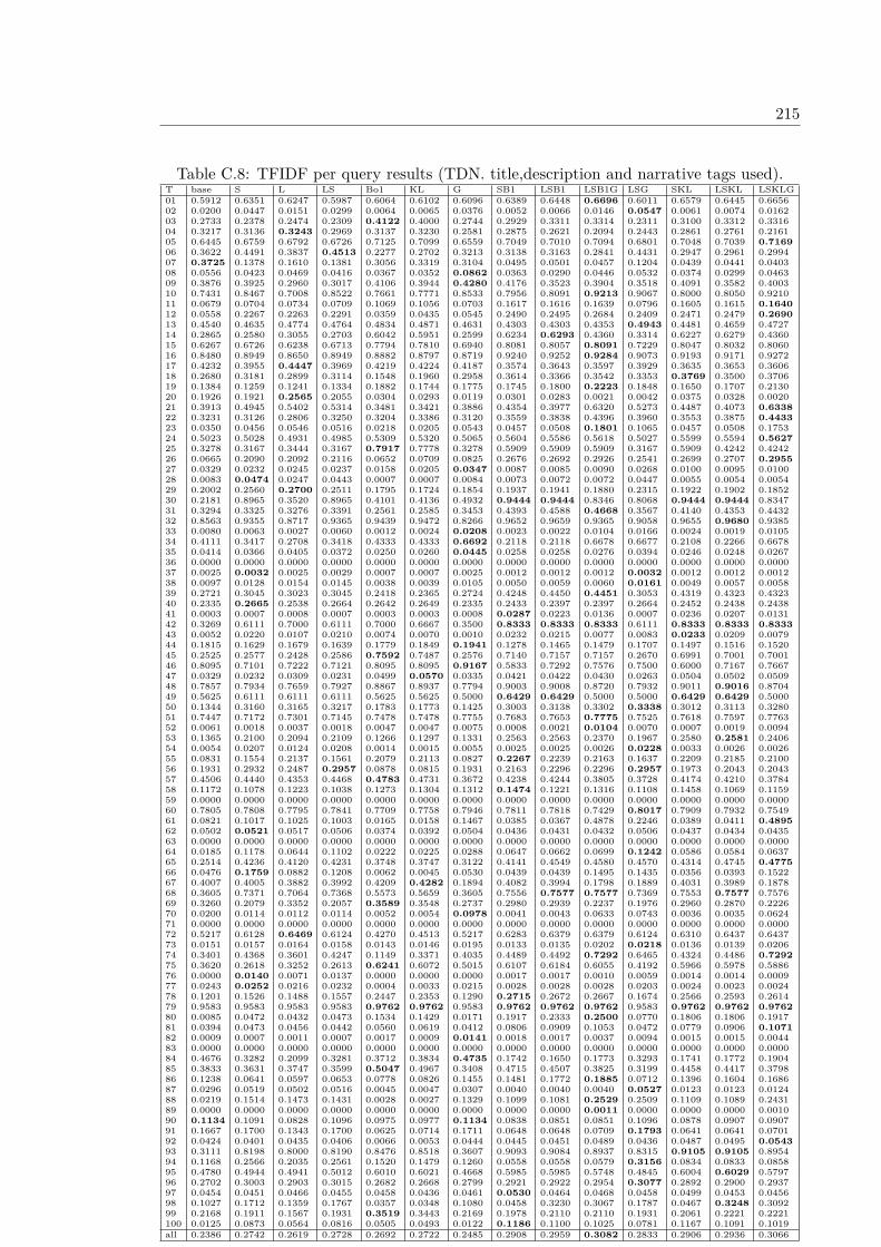
215
Table C.8: TFIDF per query results (TDN. title,description and narrative tags used).T base S L LS Bo1 KL G SB1 LSB1 LSB1G LSG SKL LSKL LSKLG01 0.5912 0.6351 0.6247 0.5987 0.6064 0.6102 0.6096 0.6389 0.6448 0.6696 0.6011 0.6579 0.6445 0.665602 0.0200 0.0447 0.0151 0.0299 0.0064 0.0065 0.0376 0.0052 0.0066 0.0146 0.0547 0.0061 0.0074 0.016203 0.2733 0.2378 0.2474 0.2309 0.4122 0.4000 0.2744 0.2929 0.3311 0.3314 0.2311 0.3100 0.3312 0.331604 0.3217 0.3136 0.3243 0.2969 0.3137 0.3230 0.2581 0.2875 0.2621 0.2094 0.2443 0.2861 0.2761 0.216105 0.6445 0.6759 0.6792 0.6726 0.7125 0.7099 0.6559 0.7049 0.7010 0.7094 0.6801 0.7048 0.7039 0.716906 0.3622 0.4491 0.3837 0.4513 0.2277 0.2702 0.3213 0.3138 0.3163 0.2841 0.4431 0.2947 0.2961 0.299407 0.3725 0.1378 0.1610 0.1381 0.3056 0.3319 0.3104 0.0495 0.0501 0.0457 0.1204 0.0439 0.0441 0.040308 0.0556 0.0423 0.0469 0.0416 0.0367 0.0352 0.0862 0.0363 0.0290 0.0446 0.0532 0.0374 0.0299 0.046309 0.3876 0.3925 0.2960 0.3017 0.4106 0.3944 0.4280 0.4176 0.3523 0.3904 0.3518 0.4091 0.3582 0.400310 0.7431 0.8467 0.7008 0.8522 0.7661 0.7771 0.8533 0.7956 0.8091 0.9213 0.9067 0.8000 0.8050 0.921011 0.0679 0.0704 0.0734 0.0709 0.1069 0.1056 0.0703 0.1617 0.1616 0.1639 0.0796 0.1605 0.1615 0.164012 0.0558 0.2267 0.2263 0.2291 0.0359 0.0435 0.0545 0.2490 0.2495 0.2684 0.2409 0.2471 0.2479 0.269013 0.4540 0.4635 0.4774 0.4764 0.4834 0.4871 0.4631 0.4303 0.4303 0.4353 0.4943 0.4481 0.4659 0.472714 0.2865 0.2580 0.3055 0.2703 0.6042 0.5951 0.2599 0.6234 0.6293 0.4360 0.3314 0.6227 0.6279 0.436015 0.6267 0.6726 0.6238 0.6713 0.7794 0.7810 0.6940 0.8081 0.8057 0.8091 0.7229 0.8047 0.8032 0.806016 0.8480 0.8949 0.8650 0.8949 0.8882 0.8797 0.8719 0.9240 0.9252 0.9284 0.9073 0.9193 0.9171 0.927217 0.4232 0.3955 0.4447 0.3969 0.4219 0.4224 0.4187 0.3574 0.3643 0.3597 0.3929 0.3635 0.3653 0.360618 0.2680 0.3181 0.2899 0.3114 0.1548 0.1960 0.2958 0.3614 0.3366 0.3542 0.3353 0.3769 0.3500 0.370619 0.1384 0.1259 0.1241 0.1334 0.1882 0.1744 0.1775 0.1745 0.1800 0.2223 0.1848 0.1650 0.1707 0.213020 0.1926 0.1921 0.2565 0.2055 0.0304 0.0293 0.0119 0.0301 0.0283 0.0021 0.0042 0.0375 0.0328 0.002021 0.3913 0.4945 0.5402 0.5314 0.3481 0.3421 0.3886 0.4354 0.3977 0.6320 0.5273 0.4487 0.4073 0.633822 0.3231 0.3126 0.2806 0.3250 0.3204 0.3386 0.3120 0.3559 0.3838 0.4396 0.3960 0.3553 0.3875 0.443323 0.0350 0.0456 0.0546 0.0516 0.0218 0.0205 0.0543 0.0457 0.0508 0.1801 0.1065 0.0457 0.0508 0.175324 0.5023 0.5028 0.4931 0.4985 0.5309 0.5320 0.5065 0.5604 0.5586 0.5618 0.5027 0.5599 0.5594 0.562725 0.3278 0.3167 0.3444 0.3167 0.7917 0.7778 0.3278 0.5909 0.5909 0.5909 0.3167 0.5909 0.4242 0.424226 0.0665 0.2090 0.2092 0.2116 0.0652 0.0709 0.0825 0.2676 0.2692 0.2926 0.2541 0.2699 0.2707 0.295527 0.0329 0.0232 0.0245 0.0237 0.0158 0.0205 0.0347 0.0087 0.0085 0.0090 0.0268 0.0100 0.0095 0.010028 0.0083 0.0474 0.0247 0.0443 0.0007 0.0007 0.0084 0.0073 0.0072 0.0072 0.0447 0.0055 0.0054 0.005429 0.2002 0.2560 0.2700 0.2511 0.1795 0.1724 0.1854 0.1937 0.1941 0.1880 0.2315 0.1922 0.1902 0.185230 0.2181 0.8965 0.3520 0.8965 0.4101 0.4136 0.4932 0.9444 0.9444 0.8346 0.8068 0.9444 0.9444 0.834731 0.3294 0.3325 0.3276 0.3391 0.2561 0.2585 0.3453 0.4393 0.4588 0.4668 0.3567 0.4140 0.4353 0.443232 0.8563 0.9355 0.8717 0.9365 0.9439 0.9472 0.8266 0.9652 0.9659 0.9365 0.9058 0.9655 0.9680 0.938533 0.0080 0.0063 0.0027 0.0060 0.0012 0.0024 0.0208 0.0023 0.0022 0.0104 0.0166 0.0024 0.0019 0.010534 0.4111 0.3417 0.2708 0.3418 0.4333 0.4333 0.6692 0.2118 0.2118 0.6678 0.6677 0.2108 0.2266 0.667835 0.0414 0.0366 0.0405 0.0372 0.0250 0.0260 0.0445 0.0258 0.0258 0.0276 0.0394 0.0246 0.0248 0.026736 0.0000 0.0000 0.0000 0.0000 0.0000 0.0000 0.0000 0.0000 0.0000 0.0000 0.0000 0.0000 0.0000 0.000037 0.0025 0.0032 0.0025 0.0029 0.0007 0.0007 0.0025 0.0012 0.0012 0.0012 0.0032 0.0012 0.0012 0.001238 0.0097 0.0128 0.0154 0.0145 0.0038 0.0039 0.0105 0.0050 0.0059 0.0060 0.0161 0.0049 0.0057 0.005839 0.2721 0.3045 0.3023 0.3045 0.2418 0.2365 0.2724 0.4248 0.4450 0.4451 0.3053 0.4319 0.4323 0.432340 0.2335 0.2665 0.2538 0.2664 0.2642 0.2649 0.2335 0.2433 0.2397 0.2397 0.2664 0.2452 0.2438 0.243841 0.0003 0.0007 0.0008 0.0007 0.0003 0.0003 0.0008 0.0287 0.0223 0.0136 0.0007 0.0236 0.0207 0.013142 0.3269 0.6111 0.7000 0.6111 0.7000 0.6667 0.3500 0.8333 0.8333 0.8333 0.6111 0.8333 0.8333 0.833343 0.0052 0.0220 0.0107 0.0210 0.0074 0.0070 0.0010 0.0232 0.0215 0.0077 0.0083 0.0233 0.0209 0.007944 0.1815 0.1629 0.1679 0.1639 0.1779 0.1849 0.1941 0.1278 0.1465 0.1479 0.1707 0.1497 0.1516 0.152045 0.2525 0.2577 0.2428 0.2586 0.7592 0.7487 0.2576 0.7140 0.7157 0.7157 0.2670 0.6991 0.7001 0.700146 0.8095 0.7101 0.7222 0.7121 0.8095 0.8095 0.9167 0.5833 0.7292 0.7576 0.7500 0.6000 0.7167 0.766747 0.0329 0.0232 0.0309 0.0231 0.0499 0.0570 0.0335 0.0421 0.0422 0.0430 0.0263 0.0504 0.0502 0.050948 0.7857 0.7934 0.7659 0.7927 0.8867 0.8937 0.7794 0.9003 0.9008 0.8720 0.7932 0.9011 0.9016 0.870449 0.5625 0.6111 0.6111 0.6111 0.5625 0.5625 0.5000 0.6429 0.6429 0.5000 0.5000 0.6429 0.6429 0.500050 0.1344 0.3160 0.3165 0.3217 0.1783 0.1773 0.1425 0.3003 0.3138 0.3302 0.3338 0.3012 0.3113 0.328051 0.7447 0.7172 0.7301 0.7145 0.7478 0.7478 0.7755 0.7683 0.7653 0.7775 0.7525 0.7618 0.7597 0.776352 0.0061 0.0018 0.0037 0.0018 0.0047 0.0047 0.0075 0.0008 0.0021 0.0104 0.0070 0.0007 0.0019 0.009453 0.1365 0.2100 0.2094 0.2109 0.1266 0.1297 0.1331 0.2563 0.2563 0.2370 0.1967 0.2580 0.2581 0.240654 0.0054 0.0207 0.0124 0.0208 0.0014 0.0015 0.0055 0.0025 0.0025 0.0026 0.0228 0.0033 0.0026 0.002655 0.0831 0.1554 0.2137 0.1561 0.2079 0.2113 0.0827 0.2267 0.2239 0.2163 0.1637 0.2209 0.2185 0.210056 0.1931 0.2932 0.2487 0.2957 0.0878 0.0815 0.1931 0.2163 0.2296 0.2296 0.2957 0.1973 0.2043 0.204357 0.4506 0.4440 0.4353 0.4468 0.4783 0.4731 0.3672 0.4238 0.4244 0.3805 0.3728 0.4174 0.4210 0.378458 0.1172 0.1078 0.1223 0.1038 0.1273 0.1304 0.1312 0.1474 0.1221 0.1316 0.1108 0.1458 0.1069 0.115959 0.0000 0.0000 0.0000 0.0000 0.0000 0.0000 0.0000 0.0000 0.0000 0.0000 0.0000 0.0000 0.0000 0.000060 0.7805 0.7808 0.7795 0.7841 0.7709 0.7758 0.7946 0.7811 0.7818 0.7429 0.8017 0.7909 0.7932 0.754961 0.0821 0.1017 0.1025 0.1003 0.0165 0.0158 0.1467 0.0385 0.0367 0.4878 0.2246 0.0389 0.0411 0.489562 0.0502 0.0521 0.0517 0.0506 0.0374 0.0392 0.0504 0.0436 0.0431 0.0432 0.0506 0.0437 0.0434 0.043563 0.0000 0.0000 0.0000 0.0000 0.0000 0.0000 0.0000 0.0000 0.0000 0.0000 0.0000 0.0000 0.0000 0.000064 0.0185 0.1178 0.0644 0.1102 0.0222 0.0225 0.0288 0.0647 0.0662 0.0699 0.1242 0.0586 0.0584 0.063765 0.2514 0.4236 0.4120 0.4231 0.3748 0.3747 0.3122 0.4141 0.4549 0.4580 0.4570 0.4314 0.4745 0.477566 0.0476 0.1759 0.0882 0.1208 0.0062 0.0045 0.0530 0.0439 0.0439 0.1495 0.1435 0.0356 0.0393 0.152267 0.4007 0.4005 0.3882 0.3992 0.4209 0.4282 0.1894 0.4082 0.3994 0.1798 0.1889 0.4031 0.3989 0.187868 0.3605 0.7371 0.7064 0.7368 0.5573 0.5659 0.3605 0.7556 0.7577 0.7577 0.7369 0.7553 0.7577 0.757669 0.3260 0.2079 0.3352 0.2057 0.3589 0.3548 0.2737 0.2980 0.2939 0.2237 0.1976 0.2960 0.2870 0.222670 0.0200 0.0114 0.0112 0.0114 0.0052 0.0054 0.0978 0.0041 0.0043 0.0633 0.0743 0.0036 0.0035 0.062471 0.0000 0.0000 0.0000 0.0000 0.0000 0.0000 0.0000 0.0000 0.0000 0.0000 0.0000 0.0000 0.0000 0.000072 0.5217 0.6128 0.6469 0.6124 0.4270 0.4513 0.5217 0.6283 0.6379 0.6379 0.6124 0.6310 0.6437 0.643773 0.0151 0.0157 0.0164 0.0158 0.0143 0.0146 0.0195 0.0133 0.0135 0.0202 0.0218 0.0136 0.0139 0.020674 0.3401 0.4368 0.3601 0.4247 0.1149 0.3371 0.4035 0.4489 0.4492 0.7292 0.6465 0.4324 0.4486 0.729275 0.3620 0.2618 0.3252 0.2613 0.6241 0.6072 0.5015 0.6107 0.6184 0.6055 0.4192 0.5966 0.5978 0.588676 0.0000 0.0140 0.0071 0.0137 0.0000 0.0000 0.0000 0.0017 0.0017 0.0010 0.0059 0.0014 0.0014 0.000977 0.0243 0.0252 0.0216 0.0232 0.0004 0.0033 0.0215 0.0028 0.0028 0.0028 0.0203 0.0024 0.0023 0.002478 0.1201 0.1526 0.1488 0.1557 0.2447 0.2353 0.1290 0.2715 0.2672 0.2667 0.1674 0.2566 0.2593 0.261479 0.9583 0.9583 0.9583 0.9583 0.9762 0.9762 0.9583 0.9762 0.9762 0.9762 0.9583 0.9762 0.9762 0.976280 0.0085 0.0472 0.0432 0.0473 0.1534 0.1429 0.0171 0.1917 0.2333 0.2500 0.0770 0.1806 0.1806 0.191781 0.0394 0.0473 0.0456 0.0442 0.0560 0.0619 0.0412 0.0806 0.0909 0.1053 0.0472 0.0779 0.0906 0.107182 0.0009 0.0007 0.0011 0.0007 0.0017 0.0009 0.0141 0.0018 0.0017 0.0037 0.0094 0.0015 0.0015 0.004483 0.0000 0.0000 0.0000 0.0000 0.0000 0.0000 0.0000 0.0000 0.0000 0.0000 0.0000 0.0000 0.0000 0.000084 0.4676 0.3282 0.2099 0.3281 0.3712 0.3834 0.4735 0.1742 0.1650 0.1773 0.3293 0.1741 0.1772 0.190485 0.3833 0.3631 0.3747 0.3599 0.5047 0.4967 0.3408 0.4715 0.4507 0.3825 0.3199 0.4458 0.4417 0.379886 0.1238 0.0641 0.0597 0.0653 0.0778 0.0826 0.1455 0.1481 0.1772 0.1885 0.0712 0.1396 0.1604 0.168687 0.0296 0.0519 0.0502 0.0516 0.0045 0.0047 0.0307 0.0040 0.0040 0.0040 0.0527 0.0123 0.0123 0.012488 0.0219 0.1514 0.1473 0.1431 0.0028 0.0027 0.1329 0.1099 0.1081 0.2529 0.2509 0.1109 0.1089 0.243189 0.0000 0.0000 0.0000 0.0000 0.0000 0.0000 0.0000 0.0000 0.0000 0.0011 0.0000 0.0000 0.0000 0.001090 0.1134 0.1091 0.0828 0.1096 0.0975 0.0977 0.1134 0.0838 0.0851 0.0851 0.1096 0.0878 0.0907 0.090791 0.1667 0.1700 0.1343 0.1700 0.0625 0.0714 0.1711 0.0648 0.0648 0.0709 0.1793 0.0641 0.0641 0.070192 0.0424 0.0401 0.0435 0.0406 0.0066 0.0053 0.0444 0.0445 0.0451 0.0489 0.0436 0.0487 0.0495 0.054393 0.3111 0.8198 0.8000 0.8190 0.8476 0.8518 0.3607 0.9093 0.9084 0.8937 0.8315 0.9105 0.9105 0.895494 0.1168 0.2566 0.2035 0.2561 0.1520 0.1479 0.1260 0.0558 0.0558 0.0579 0.3156 0.0834 0.0833 0.085895 0.4780 0.4944 0.4941 0.5012 0.6010 0.6021 0.4668 0.5985 0.5985 0.5748 0.4845 0.6004 0.6029 0.579796 0.2702 0.3003 0.2903 0.3015 0.2682 0.2668 0.2799 0.2921 0.2922 0.2954 0.3077 0.2892 0.2900 0.293797 0.0454 0.0451 0.0466 0.0455 0.0458 0.0436 0.0461 0.0530 0.0464 0.0468 0.0458 0.0499 0.0453 0.045698 0.1027 0.1712 0.1359 0.1767 0.0357 0.0348 0.1080 0.0458 0.3230 0.3067 0.1787 0.0467 0.3248 0.309299 0.2168 0.1911 0.1567 0.1931 0.3519 0.3443 0.2169 0.1978 0.2110 0.2110 0.1931 0.2061 0.2221 0.2221100 0.0125 0.0873 0.0564 0.0816 0.0505 0.0493 0.0122 0.1186 0.1100 0.1025 0.0781 0.1167 0.1091 0.1019all 0.2386 0.2742 0.2619 0.2728 0.2692 0.2722 0.2485 0.2908 0.2959 0.3082 0.2833 0.2906 0.2936 0.3066
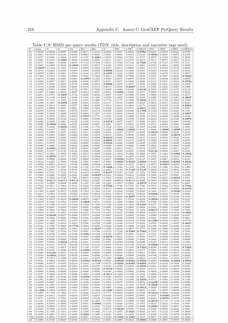
216 Appendix C. Annex C: GeoCLEF PerQuery Results
Table C.9: BM25 per query results (TDN. title, description and narrative tags used).T base S L LS Bo1 KL G SB1 LSB1 LSB1G LSG SKL LSKL LSKLG01 0.6040 0.6502 0.6495 0.6386 0.6011 0.6112 0.6056 0.6421 0.6504 0.6761 0.6231 0.6618 0.6524 0.675602 0.0201 0.0513 0.0149 0.0310 0.0063 0.0065 0.0381 0.0064 0.0064 0.0143 0.0594 0.0068 0.0073 0.016003 0.2857 0.2340 0.2484 0.2276 0.4127 0.4281 0.2870 0.3024 0.3750 0.3757 0.2278 0.3193 0.3841 0.384904 0.3285 0.3165 0.3355 0.3060 0.3159 0.3205 0.2611 0.2817 0.2776 0.2213 0.2515 0.2877 0.2817 0.221505 0.6571 0.6621 0.6820 0.6676 0.7115 0.7094 0.6651 0.7092 0.7133 0.7245 0.6738 0.7127 0.7075 0.721706 0.3507 0.4498 0.3943 0.4569 0.2255 0.2657 0.3182 0.3359 0.3151 0.2801 0.4552 0.2934 0.2984 0.303007 0.3607 0.1354 0.1561 0.1354 0.2958 0.3254 0.3009 0.0614 0.0607 0.0561 0.1183 0.0742 0.0745 0.066508 0.0573 0.0421 0.0458 0.0395 0.0360 0.0350 0.0898 0.0333 0.0329 0.0501 0.0504 0.0344 0.0337 0.051809 0.3870 0.3894 0.2681 0.2793 0.4164 0.3973 0.4275 0.4246 0.3505 0.3832 0.3203 0.4078 0.3516 0.387710 0.7405 0.8476 0.7201 0.8503 0.7655 0.7623 0.8554 0.7968 0.7986 0.9123 0.9018 0.7987 0.8031 0.922311 0.0674 0.0466 0.0468 0.0465 0.1070 0.1062 0.0696 0.0876 0.0879 0.0918 0.0517 0.0838 0.0839 0.088212 0.0589 0.2257 0.2257 0.2296 0.0658 0.0677 0.0571 0.2471 0.2508 0.2680 0.2413 0.2471 0.2514 0.272013 0.4972 0.4756 0.4699 0.4770 0.4086 0.4853 0.5066 0.4270 0.4277 0.4330 0.4903 0.4431 0.4509 0.456314 0.2734 0.2598 0.2956 0.2683 0.6104 0.6134 0.2613 0.6229 0.6267 0.4343 0.3339 0.6225 0.6265 0.436815 0.6339 0.6764 0.6286 0.6740 0.7951 0.7943 0.6949 0.8083 0.8130 0.8146 0.7230 0.8057 0.8107 0.811916 0.8407 0.8968 0.8658 0.8967 0.8912 0.8847 0.8651 0.9306 0.9245 0.9277 0.9090 0.9244 0.9197 0.927217 0.4051 0.3737 0.4237 0.3734 0.4030 0.4044 0.4007 0.3447 0.3496 0.3450 0.3696 0.3515 0.3523 0.347718 0.2415 0.3146 0.2969 0.3248 0.1316 0.1382 0.2738 0.3005 0.3022 0.3232 0.3466 0.3423 0.3281 0.360719 0.1383 0.1313 0.1305 0.1412 0.1970 0.1800 0.1774 0.1777 0.1850 0.2242 0.1874 0.1718 0.1804 0.219420 0.1898 0.1967 0.2603 0.2088 0.0304 0.0331 0.0147 0.0318 0.0256 0.0024 0.0054 0.0411 0.0352 0.002321 0.3949 0.4914 0.5380 0.5377 0.4084 0.4086 0.4014 0.4012 0.3862 0.6171 0.5262 0.4183 0.4106 0.629422 0.3075 0.2902 0.2605 0.2951 0.3308 0.3401 0.3204 0.2869 0.2771 0.3831 0.3823 0.2851 0.2789 0.375123 0.0370 0.0510 0.0601 0.0570 0.0161 0.0173 0.0638 0.0488 0.0496 0.1799 0.1249 0.0458 0.0503 0.179124 0.5060 0.5082 0.4899 0.5073 0.5304 0.5327 0.5104 0.5635 0.5616 0.5645 0.5114 0.5633 0.5622 0.565725 0.3167 0.3076 0.3354 0.3076 0.7917 0.7778 0.3167 0.4048 0.3492 0.3492 0.3076 0.4048 0.4048 0.404826 0.0605 0.2092 0.2122 0.2161 0.0649 0.0708 0.0736 0.2689 0.2709 0.2945 0.2634 0.2715 0.2720 0.297527 0.0362 0.0236 0.0201 0.0192 0.0108 0.0121 0.0374 0.0077 0.0077 0.0082 0.0213 0.0083 0.0081 0.009228 0.0085 0.0588 0.0286 0.0554 0.0008 0.0007 0.0085 0.0077 0.0076 0.0076 0.0574 0.0064 0.0064 0.006429 0.1951 0.2546 0.2650 0.2501 0.1806 0.1735 0.1822 0.1951 0.1936 0.1857 0.2308 0.1918 0.1920 0.186130 0.3004 0.9167 0.3695 0.9167 0.4690 0.4224 0.4636 1.0000 1.0000 0.8345 0.8068 1.0000 1.0000 0.834631 0.3213 0.3295 0.3237 0.3347 0.2411 0.2439 0.3383 0.2817 0.2777 0.2850 0.3519 0.2822 0.2841 0.291232 0.8634 0.9383 0.8687 0.9402 0.9460 0.9472 0.8319 0.9659 0.9659 0.9365 0.9096 0.9669 0.9673 0.937833 0.0079 0.0058 0.0028 0.0055 0.0014 0.0024 0.0210 0.0020 0.0028 0.0101 0.0162 0.0023 0.0024 0.010134 0.3909 0.3440 0.2768 0.3441 0.4103 0.4242 0.6693 0.1997 0.2119 0.6678 0.6689 0.2108 0.2108 0.667835 0.0411 0.0372 0.0392 0.0363 0.0245 0.0252 0.0440 0.0228 0.0229 0.0248 0.0385 0.0229 0.0229 0.024836 0.0000 0.0000 0.0000 0.0000 0.0000 0.0000 0.0000 0.0000 0.0000 0.0000 0.0000 0.0000 0.0000 0.000037 0.0025 0.0031 0.0025 0.0027 0.0007 0.0007 0.0025 0.0012 0.0011 0.0012 0.0027 0.0012 0.0011 0.001138 0.0095 0.0127 0.0139 0.0132 0.0040 0.0039 0.0103 0.0050 0.0055 0.0056 0.0145 0.0050 0.0055 0.005639 0.2817 0.3064 0.3002 0.3069 0.2912 0.3069 0.2820 0.4259 0.4268 0.4268 0.3076 0.4304 0.4306 0.430640 0.2416 0.2776 0.2574 0.2752 0.2574 0.2588 0.2416 0.2456 0.2407 0.2407 0.2752 0.2453 0.2442 0.244241 0.0003 0.0008 0.0008 0.0007 0.0003 0.0003 0.0007 0.0324 0.0276 0.0147 0.0007 0.0267 0.0254 0.014342 0.3214 0.6250 0.7000 0.6429 0.7000 0.6667 0.3500 0.8333 0.8333 0.8333 0.6429 0.8333 0.8333 0.833343 0.0056 0.0207 0.0110 0.0198 0.0068 0.0068 0.0009 0.0230 0.0225 0.0074 0.0073 0.0234 0.0226 0.007344 0.1765 0.1545 0.1597 0.1538 0.1725 0.1759 0.1868 0.1246 0.1353 0.1356 0.1585 0.1480 0.1403 0.140645 0.2867 0.2807 0.2746 0.2783 0.6952 0.6926 0.2908 0.7140 0.7148 0.7148 0.2828 0.6944 0.6931 0.693146 0.8095 0.7101 0.7222 0.7121 0.8333 0.8095 0.9167 0.3547 0.7333 0.7576 0.7500 0.5833 0.7143 0.757647 0.0309 0.0225 0.0299 0.0225 0.0469 0.0537 0.0310 0.0304 0.0313 0.0299 0.0230 0.0377 0.0391 0.038248 0.7935 0.7992 0.7729 0.7992 0.8878 0.8945 0.7862 0.9022 0.9024 0.8738 0.7989 0.9027 0.9034 0.872149 0.5625 0.6111 0.6111 0.6111 0.5625 0.5625 0.5000 0.6111 0.6111 0.5000 0.5000 0.6000 0.6000 0.500050 0.1153 0.2605 0.2602 0.2628 0.1447 0.1460 0.1203 0.2857 0.2855 0.2978 0.2722 0.2836 0.2838 0.296151 0.7512 0.7211 0.7384 0.7215 0.7624 0.7658 0.7792 0.7726 0.7707 0.7785 0.7559 0.7694 0.7673 0.779252 0.0057 0.0015 0.0035 0.0016 0.0053 0.0052 0.0073 0.0008 0.0009 0.0153 0.0068 0.0007 0.0008 0.015653 0.1265 0.2009 0.2075 0.2032 0.1254 0.1263 0.1247 0.2504 0.2506 0.2325 0.1895 0.2517 0.2520 0.234954 0.0051 0.0204 0.0100 0.0205 0.0010 0.0015 0.0052 0.0019 0.0019 0.0019 0.0206 0.0019 0.0019 0.002055 0.0958 0.1669 0.2193 0.1679 0.2131 0.2132 0.0956 0.2069 0.2267 0.2176 0.1724 0.2059 0.2194 0.210456 0.1303 0.2878 0.2424 0.2903 0.0874 0.0817 0.1303 0.2231 0.2358 0.2358 0.2903 0.2059 0.2121 0.212157 0.4510 0.4442 0.4354 0.4450 0.4805 0.4751 0.3670 0.4209 0.4266 0.3798 0.3702 0.4295 0.4221 0.377758 0.1211 0.1180 0.1187 0.1168 0.1304 0.1256 0.1336 0.1238 0.1231 0.1342 0.1217 0.1299 0.1153 0.123459 0.0000 0.0000 0.0000 0.0000 0.0000 0.0000 0.0000 0.0000 0.0000 0.0000 0.0000 0.0000 0.0000 0.000060 0.7809 0.7802 0.7804 0.7813 0.7696 0.7731 0.7941 0.7798 0.7823 0.7434 0.8017 0.7835 0.7889 0.750361 0.0876 0.1079 0.1067 0.1064 0.0165 0.0159 0.1453 0.0347 0.0365 0.4854 0.2294 0.0362 0.0413 0.495162 0.0466 0.0506 0.0497 0.0486 0.0379 0.0394 0.0467 0.0435 0.0403 0.0405 0.0486 0.0442 0.0426 0.042763 0.0000 0.0000 0.0000 0.0000 0.0000 0.0000 0.0000 0.0000 0.0000 0.0000 0.0000 0.0000 0.0000 0.000064 0.0209 0.1280 0.0757 0.1270 0.0287 0.0213 0.0326 0.0686 0.0742 0.0780 0.1383 0.0632 0.0674 0.071065 0.2591 0.4402 0.4272 0.4337 0.3790 0.3725 0.3160 0.4488 0.4515 0.4532 0.4593 0.4616 0.4647 0.465166 0.0341 0.1768 0.0889 0.1776 0.0064 0.0046 0.0523 0.0439 0.0440 0.1464 0.1398 0.0395 0.0396 0.148867 0.3997 0.3998 0.3875 0.3992 0.4212 0.4237 0.1892 0.4010 0.3975 0.1775 0.1886 0.3996 0.3949 0.184068 0.3733 0.7391 0.7076 0.7378 0.5681 0.5780 0.3733 0.7558 0.7584 0.7584 0.7378 0.7562 0.7583 0.758369 0.3220 0.2156 0.3362 0.2138 0.3461 0.3432 0.2556 0.2877 0.2895 0.2217 0.1976 0.2828 0.2921 0.221470 0.0194 0.0121 0.0113 0.0122 0.0055 0.0062 0.0979 0.0051 0.0044 0.0669 0.0775 0.0040 0.0035 0.064871 0.0000 0.0000 0.0000 0.0000 0.0000 0.0000 0.0000 0.0000 0.0000 0.0000 0.0000 0.0000 0.0000 0.000072 0.5307 0.6255 0.6552 0.6195 0.4261 0.4533 0.5307 0.6289 0.6206 0.6206 0.6195 0.6313 0.6350 0.635073 0.0133 0.0147 0.0155 0.0149 0.0136 0.0141 0.0187 0.0124 0.0126 0.0189 0.0209 0.0128 0.0131 0.019474 0.3414 0.4535 0.3657 0.4372 0.1158 0.3377 0.4068 0.4493 0.4494 0.7255 0.6389 0.4487 0.4489 0.725575 0.3792 0.3135 0.3590 0.3081 0.6393 0.6191 0.5068 0.6269 0.6287 0.6077 0.4289 0.6108 0.6012 0.588376 0.0000 0.0145 0.0075 0.0143 0.0000 0.0000 0.0000 0.0018 0.0018 0.0011 0.0065 0.0015 0.0015 0.001077 0.0243 0.0254 0.0227 0.0230 0.0004 0.0036 0.0213 0.0028 0.0028 0.0028 0.0198 0.0025 0.0024 0.002578 0.1207 0.1313 0.1400 0.1345 0.2411 0.2356 0.1282 0.2654 0.2644 0.2642 0.1432 0.2554 0.2559 0.257579 0.9583 0.9583 0.9583 0.9583 0.9762 0.9762 0.9583 0.9762 0.9762 0.9762 0.9583 0.9762 0.9762 0.976280 0.0096 0.0517 0.0470 0.0518 0.1833 0.1742 0.0173 0.6250 0.6250 0.6250 0.0767 0.3333 0.3409 0.340981 0.0324 0.0399 0.0396 0.0381 0.0568 0.0570 0.0339 0.0629 0.0833 0.0943 0.0401 0.0645 0.0676 0.076182 0.0011 0.0009 0.0014 0.0009 0.0034 0.0028 0.0152 0.0024 0.0021 0.0039 0.0104 0.0019 0.0019 0.004983 0.0000 0.0000 0.0000 0.0000 0.0000 0.0000 0.0000 0.0000 0.0000 0.0000 0.0000 0.0000 0.0000 0.000084 0.4537 0.3286 0.2179 0.3286 0.4097 0.4300 0.4611 0.1420 0.1429 0.1531 0.3296 0.1519 0.1535 0.159685 0.3863 0.3607 0.3748 0.3580 0.5073 0.5010 0.3446 0.4774 0.4728 0.3965 0.3186 0.4480 0.4445 0.379886 0.1292 0.0653 0.0598 0.0640 0.0748 0.0804 0.1459 0.1734 0.2166 0.2270 0.0721 0.1654 0.1650 0.174087 0.0248 0.0407 0.0392 0.0405 0.0045 0.0049 0.0250 0.0079 0.0079 0.0079 0.0408 0.0086 0.0085 0.008988 0.0238 0.1587 0.1519 0.1559 0.0027 0.0026 0.1403 0.1108 0.1101 0.2534 0.2596 0.1122 0.1121 0.248989 0.0000 0.0000 0.0000 0.0000 0.0000 0.0000 0.0000 0.0000 0.0000 0.0013 0.0000 0.0000 0.0000 0.001290 0.1245 0.1094 0.0825 0.1101 0.0977 0.1020 0.1245 0.0819 0.0831 0.0831 0.1101 0.0878 0.0904 0.090491 0.1667 0.1710 0.1352 0.1711 0.0625 0.0714 0.1717 0.0656 0.0656 0.0720 0.1814 0.0646 0.0646 0.070792 0.0430 0.0411 0.0455 0.0418 0.0070 0.0055 0.0449 0.0453 0.0069 0.0081 0.0457 0.0499 0.0078 0.007993 0.3071 0.8132 0.7954 0.8128 0.8483 0.8530 0.3499 0.9076 0.9068 0.8929 0.8249 0.9078 0.9076 0.893894 0.1167 0.2163 0.2022 0.2230 0.1521 0.1464 0.1270 0.1071 0.0999 0.1065 0.2613 0.1115 0.1139 0.118995 0.4656 0.4783 0.4806 0.4788 0.5941 0.5966 0.4543 0.5928 0.5932 0.5701 0.4616 0.5924 0.5936 0.570796 0.2636 0.2958 0.2878 0.3008 0.2621 0.2584 0.2725 0.2950 0.2960 0.2988 0.3062 0.2923 0.2931 0.296497 0.0465 0.0458 0.0476 0.0462 0.0465 0.0442 0.0472 0.0539 0.0450 0.0454 0.0465 0.0500 0.0442 0.044598 0.1094 0.1790 0.1521 0.1881 0.1596 0.1442 0.1118 0.3076 0.3221 0.3043 0.1845 0.3123 0.3198 0.302999 0.2226 0.2291 0.1912 0.2308 0.3561 0.3480 0.2227 0.2594 0.2425 0.2425 0.2308 0.2726 0.2578 0.2578100 0.0150 0.0851 0.0572 0.0858 0.0551 0.0518 0.0144 0.1093 0.1093 0.1019 0.0817 0.1083 0.1081 0.1002all 0.2390 0.2749 0.2624 0.2744 0.2714 0.2743 0.2481 0.2908 0.2943 0.3062 0.2826 0.2907 0.2916 0.3044
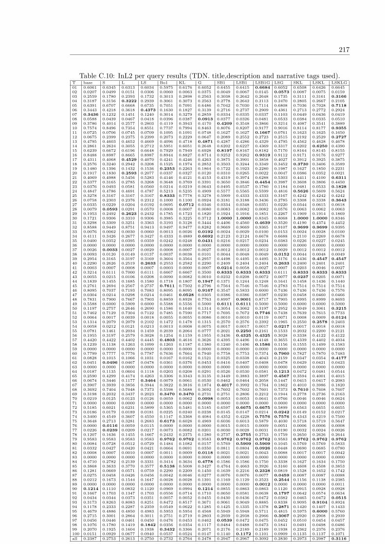
217
Table C.10: InL2 per query results (TDN. title,description and narrative tags used).T base S L LS Bo1 KL G SB1 LSB1 LSB1G LSG SKL LSKL LSKLG01 0.6061 0.6345 0.6313 0.6034 0.5975 0.6176 0.6052 0.6455 0.6415 0.6684 0.6052 0.6508 0.6426 0.664502 0.0207 0.0499 0.0151 0.0306 0.0060 0.0063 0.0375 0.0049 0.0067 0.0145 0.0573 0.0087 0.0075 0.015903 0.2559 0.1780 0.2393 0.1732 0.3013 0.2898 0.2563 0.3038 0.2642 0.2648 0.1735 0.3111 0.3161 0.316604 0.3187 0.3156 0.3222 0.2939 0.3061 0.3073 0.2563 0.2778 0.2642 0.2113 0.2470 0.2805 0.2667 0.210505 0.6391 0.6707 0.6668 0.6735 0.7051 0.7091 0.6486 0.7042 0.7030 0.7114 0.6808 0.7036 0.7028 0.711806 0.3443 0.4218 0.3618 0.4373 0.1630 0.1827 0.3139 0.2716 0.2737 0.2909 0.4361 0.2713 0.2772 0.292407 0.3436 0.1232 0.1451 0.1240 0.3014 0.3279 0.2859 0.0334 0.0335 0.0337 0.1103 0.0449 0.0436 0.041908 0.0588 0.0439 0.0467 0.0418 0.0396 0.0387 0.0913 0.0377 0.0326 0.0481 0.0533 0.0384 0.0335 0.051009 0.3786 0.4014 0.2577 0.2803 0.4119 0.3943 0.4170 0.4209 0.3548 0.3866 0.3214 0.4087 0.3541 0.388910 0.7574 0.8496 0.7354 0.8551 0.7737 0.7994 0.8463 0.8076 0.8207 0.9177 0.9016 0.8114 0.8177 0.935511 0.0725 0.0706 0.0745 0.0709 0.1095 0.1091 0.0748 0.1627 0.1627 0.1667 0.0761 0.1623 0.1625 0.165012 0.0675 0.2399 0.2375 0.2399 0.2073 0.2229 0.0647 0.2089 0.2552 0.2723 0.2515 0.2192 0.2529 0.272713 0.4795 0.4603 0.4652 0.4669 0.4096 0.4718 0.4871 0.4287 0.4286 0.4329 0.4795 0.4562 0.4628 0.467814 0.2861 0.2624 0.3055 0.2712 0.5951 0.6051 0.2648 0.6202 0.6227 0.4369 0.3317 0.6202 0.6250 0.439015 0.6239 0.6672 0.6196 0.6648 0.7929 0.7949 0.6928 0.8197 0.8167 0.8182 0.7170 0.8164 0.8145 0.815516 0.8488 0.8987 0.8665 0.8987 0.8944 0.8827 0.8714 0.9252 0.9262 0.9319 0.9112 0.9171 0.9176 0.927717 0.4311 0.4068 0.4529 0.4070 0.4241 0.4246 0.4263 0.3875 0.3901 0.3858 0.4027 0.3912 0.3925 0.387518 0.2576 0.3240 0.2942 0.3208 0.1525 0.1974 0.2852 0.3503 0.3244 0.3349 0.3452 0.3730 0.3406 0.358919 0.1480 0.1396 0.1432 0.1536 0.2353 0.2263 0.1864 0.1722 0.1923 0.2280 0.1987 0.1627 0.1850 0.223120 0.1917 0.1830 0.2593 0.2077 0.0337 0.0327 0.0120 0.0310 0.0265 0.0022 0.0047 0.0386 0.0352 0.002121 0.4069 0.4988 0.5456 0.5283 0.4146 0.4121 0.4153 0.4319 0.3974 0.6288 0.5303 0.4411 0.4100 0.631122 0.3377 0.3165 0.2785 0.3268 0.3648 0.3769 0.3391 0.3650 0.3846 0.4454 0.3987 0.3608 0.3806 0.445023 0.0376 0.0493 0.0581 0.0560 0.0214 0.0219 0.0643 0.0495 0.0537 0.1780 0.1184 0.0481 0.0533 0.182824 0.4847 0.4786 0.4691 0.4787 0.5213 0.5235 0.4909 0.5577 0.5565 0.5599 0.4816 0.5626 0.5609 0.562425 0.3278 0.3167 0.3167 0.3167 0.8333 0.7778 0.3278 0.5909 0.4333 0.4333 0.3167 0.4242 0.4242 0.424226 0.0758 0.2303 0.2376 0.2312 0.1000 0.1100 0.0924 0.3181 0.3188 0.3436 0.2785 0.3308 0.3338 0.364327 0.0335 0.0229 0.0204 0.0192 0.0695 0.0712 0.0346 0.0334 0.0348 0.0351 0.0220 0.0344 0.0615 0.061828 0.0079 0.0593 0.0291 0.0570 0.0008 0.0007 0.0080 0.0083 0.0082 0.0082 0.0576 0.0063 0.0062 0.006329 0.1953 0.2492 0.2623 0.2432 0.1785 0.1723 0.1820 0.1924 0.1916 0.1851 0.2267 0.1909 0.1914 0.186930 0.1721 0.9306 0.3310 0.9306 0.3985 0.3225 0.3712 1.0000 1.0000 0.8345 0.8068 1.0000 1.0000 0.834631 0.3298 0.3309 0.3251 0.3363 0.3193 0.3128 0.3444 0.4406 0.4560 0.4639 0.3520 0.4190 0.4374 0.445232 0.8588 0.9449 0.8751 0.9413 0.9497 0.9477 0.8282 0.9669 0.9669 0.9365 0.9107 0.9699 0.9699 0.939533 0.0076 0.0062 0.0030 0.0060 0.0013 0.0026 0.0192 0.0024 0.0029 0.0100 0.0153 0.0024 0.0028 0.010034 0.4111 0.3426 0.2677 0.3427 0.4333 0.4889 0.6692 0.2123 0.2124 0.6678 0.6688 0.2110 0.2269 0.667835 0.0400 0.0352 0.0395 0.0359 0.0242 0.0248 0.0431 0.0216 0.0217 0.0234 0.0383 0.0226 0.0227 0.024536 0.0000 0.0000 0.0000 0.0000 0.0000 0.0000 0.0000 0.0000 0.0000 0.0000 0.0000 0.0000 0.0000 0.000037 0.0026 0.0033 0.0027 0.0029 0.0008 0.0007 0.0027 0.0012 0.0012 0.0012 0.0029 0.0012 0.0012 0.001238 0.0093 0.0120 0.0149 0.0137 0.0037 0.0038 0.0101 0.0044 0.0048 0.0049 0.0152 0.0044 0.0048 0.004939 0.2954 0.3165 0.3197 0.3169 0.3604 0.3564 0.2957 0.4498 0.4495 0.4495 0.3176 0.4436 0.4547 0.454740 0.2290 0.2626 0.2519 0.2633 0.2553 0.2582 0.2290 0.2409 0.2404 0.2404 0.2633 0.2400 0.2401 0.240141 0.0003 0.0007 0.0008 0.0007 0.0003 0.0000 0.0007 0.0214 0.0058 0.0027 0.0007 0.0203 0.0046 0.002742 0.3214 0.6111 0.7000 0.6111 0.6667 0.6667 0.3500 0.8333 0.8333 0.8333 0.6111 0.8333 0.8333 0.833343 0.0055 0.0215 0.0106 0.0208 0.0090 0.0082 0.0010 0.0232 0.0208 0.0072 0.0077 0.0237 0.0205 0.007144 0.1839 0.1455 0.1685 0.1580 0.1718 0.1807 0.1947 0.1371 0.1244 0.1248 0.1641 0.1458 0.1436 0.144045 0.2761 0.2694 0.2567 0.2737 0.7611 0.7502 0.2796 0.7564 0.7546 0.7546 0.2783 0.7514 0.7514 0.751446 0.8095 0.7037 0.7193 0.7083 0.8095 0.8095 0.9167 0.3547 0.5833 0.6000 0.7436 0.7436 0.7436 0.757647 0.0304 0.0214 0.0298 0.0214 0.0461 0.0528 0.0305 0.0386 0.0386 0.0387 0.0230 0.0458 0.0460 0.046648 0.7831 0.7900 0.7667 0.7903 0.8859 0.8928 0.7763 0.8997 0.9001 0.8717 0.7905 0.8995 0.8999 0.869349 0.5588 0.6000 0.5909 0.6000 0.5588 0.5556 0.5000 0.6111 0.6111 0.5000 0.5000 0.6000 0.6000 0.500050 0.1197 0.2757 0.2646 0.2690 0.1586 0.1640 0.1314 0.3054 0.3062 0.3197 0.2952 0.3049 0.3061 0.321551 0.7462 0.7129 0.7304 0.7122 0.7485 0.7590 0.7717 0.7695 0.7672 0.7746 0.7438 0.7639 0.7615 0.773352 0.0064 0.0017 0.0039 0.0018 0.0055 0.0055 0.0086 0.0010 0.0010 0.0119 0.0071 0.0008 0.0009 0.012453 0.1314 0.2079 0.2079 0.2102 0.1472 0.1478 0.1315 0.2570 0.2576 0.2392 0.1965 0.2550 0.2578 0.240354 0.0058 0.0212 0.0121 0.0213 0.0013 0.0008 0.0075 0.0017 0.0017 0.0017 0.0217 0.0017 0.0018 0.001855 0.0781 0.1461 0.2034 0.1459 0.2039 0.2064 0.0777 0.2021 0.2250 0.2161 0.1533 0.2032 0.2200 0.212156 0.1955 0.3197 0.2579 0.3028 0.1254 0.1159 0.1955 0.3436 0.4325 0.4325 0.3028 0.3338 0.4122 0.412257 0.4420 0.4422 0.4402 0.4445 0.4803 0.4616 0.3626 0.4395 0.4496 0.4148 0.3655 0.4339 0.4402 0.403458 0.1239 0.1138 0.1263 0.1099 0.1263 0.1187 0.1380 0.1240 0.1496 0.1586 0.1156 0.1555 0.1499 0.158359 0.0000 0.0000 0.0000 0.0000 0.0000 0.0000 0.0000 0.0000 0.0000 0.0000 0.0000 0.0000 0.0000 0.000060 0.7799 0.7777 0.7776 0.7787 0.7636 0.7664 0.7940 0.7758 0.7753 0.7374 0.7960 0.7827 0.7870 0.748361 0.0828 0.1015 0.1066 0.1031 0.0167 0.0162 0.1521 0.0325 0.0338 0.4043 0.2159 0.0347 0.0354 0.417762 0.0451 0.0496 0.0467 0.0478 0.0361 0.0376 0.0453 0.0416 0.0407 0.0408 0.0478 0.0429 0.0421 0.042363 0.0000 0.0000 0.0000 0.0000 0.0000 0.0000 0.0000 0.0000 0.0000 0.0000 0.0000 0.0000 0.0000 0.000064 0.0187 0.1135 0.0604 0.1118 0.0203 0.0208 0.0291 0.0526 0.0530 0.0581 0.1213 0.0472 0.0481 0.054465 0.2590 0.4299 0.4174 0.4263 0.3306 0.3343 0.3135 0.3449 0.3883 0.3897 0.4567 0.3594 0.4001 0.401566 0.0674 0.3446 0.1177 0.3464 0.0079 0.0061 0.0530 0.0462 0.0464 0.2058 0.1447 0.0415 0.0417 0.208367 0.3907 0.3939 0.3856 0.3944 0.3822 0.3816 0.1874 0.4017 0.3992 0.1764 0.1862 0.4010 0.3986 0.182068 0.3692 0.7404 0.7048 0.7373 0.5598 0.5688 0.3692 0.7602 0.7602 0.7601 0.7373 0.7610 0.7608 0.760769 0.3198 0.2032 0.3437 0.2023 0.3470 0.3470 0.2731 0.2751 0.2806 0.2212 0.1944 0.2778 0.2736 0.216370 0.0219 0.0125 0.0123 0.0126 0.0059 0.0062 0.0998 0.0053 0.0053 0.0641 0.0766 0.0046 0.0046 0.062471 0.0000 0.0000 0.0000 0.0000 0.0000 0.0000 0.0000 0.0000 0.0000 0.0000 0.0000 0.0000 0.0000 0.000072 0.5185 0.6021 0.6231 0.5899 0.5365 0.5481 0.5185 0.6597 0.6675 0.6675 0.5899 0.6563 0.6655 0.665573 0.0186 0.0179 0.0189 0.0181 0.0225 0.0240 0.0238 0.0145 0.0147 0.0214 0.0242 0.0149 0.0152 0.021774 0.3400 0.4549 0.3607 0.4550 0.1147 0.3368 0.4084 0.4352 0.4228 0.7576 0.7576 0.4343 0.4219 0.750075 0.3648 0.2713 0.3281 0.2683 0.6173 0.6028 0.4969 0.6036 0.6013 0.5879 0.4030 0.5718 0.5719 0.564776 0.0000 0.0116 0.0059 0.0115 0.0000 0.0000 0.0000 0.0015 0.0015 0.0009 0.0051 0.0006 0.0006 0.000877 0.0226 0.0239 0.0209 0.0217 0.0073 0.0082 0.0201 0.0030 0.0028 0.0031 0.0190 0.0032 0.0024 0.002678 0.1207 0.1636 0.1455 0.1667 0.2432 0.2375 0.1280 0.2737 0.2755 0.2753 0.1759 0.2650 0.2626 0.264479 0.9583 0.9583 0.9583 0.9583 0.9762 0.9762 0.9583 0.9762 0.9762 0.9762 0.9583 0.9762 0.9762 0.976280 0.0084 0.0728 0.0512 0.0729 0.1484 0.1082 0.0157 0.5769 0.5909 0.5909 0.1045 0.5769 0.5769 0.583381 0.0332 0.0427 0.0420 0.0421 0.0664 0.0691 0.0350 0.0811 0.0804 0.0926 0.0448 0.0690 0.0685 0.078082 0.0008 0.0007 0.0010 0.0007 0.0011 0.0009 0.0118 0.0021 0.0021 0.0043 0.0088 0.0017 0.0017 0.004283 0.0000 0.0000 0.0000 0.0000 0.0000 0.0000 0.0000 0.0000 0.0000 0.0000 0.0000 0.0000 0.0000 0.000084 0.4710 0.2782 0.2139 0.3331 0.3414 0.3634 0.4778 0.1586 0.1586 0.1750 0.3338 0.1627 0.1634 0.175085 0.3868 0.3633 0.3770 0.3577 0.5138 0.5008 0.3427 0.4764 0.4663 0.3926 0.3160 0.4608 0.4508 0.385386 0.1281 0.0669 0.0571 0.0759 0.2290 0.2209 0.1450 0.1639 0.2216 0.2328 0.0819 0.1528 0.1652 0.174287 0.0275 0.0458 0.0426 0.0456 0.0042 0.0046 0.0277 0.0076 0.0076 0.0077 0.0459 0.0087 0.0087 0.008888 0.0212 0.1673 0.1544 0.1647 0.0028 0.0028 0.1391 0.1169 0.1129 0.2523 0.2544 0.1156 0.1138 0.238589 0.0000 0.0000 0.0000 0.0000 0.0000 0.0000 0.0000 0.0000 0.0000 0.0012 0.0000 0.0000 0.0000 0.001190 0.1214 0.1110 0.0832 0.1120 0.0969 0.0994 0.1214 0.0855 0.0863 0.0863 0.1120 0.0915 0.0928 0.092891 0.1667 0.1703 0.1347 0.1703 0.0556 0.0714 0.1710 0.0650 0.0581 0.0638 0.1797 0.0642 0.0574 0.063492 0.0434 0.0344 0.0373 0.0351 0.0057 0.0052 0.0455 0.0430 0.0436 0.0472 0.0382 0.0465 0.0472 0.051593 0.3173 0.8263 0.8083 0.8251 0.8472 0.8517 0.3671 0.9061 0.9049 0.8885 0.8338 0.9095 0.9104 0.892494 0.1178 0.2333 0.2287 0.2359 0.0549 0.0622 0.1285 0.1425 0.1335 0.1378 0.2871 0.1420 0.1407 0.143395 0.4679 0.4886 0.4850 0.4983 0.5953 0.5954 0.4568 0.5949 0.5948 0.5711 0.4815 0.5975 0.6000 0.576096 0.2715 0.3001 0.2864 0.3011 0.2751 0.2719 0.2803 0.2939 0.2938 0.2966 0.3067 0.2920 0.2908 0.293997 0.0456 0.0446 0.0461 0.0450 0.0476 0.0453 0.0462 0.0539 0.0472 0.0475 0.0452 0.0510 0.0454 0.045798 0.1076 0.1780 0.1419 0.1842 0.0356 0.0354 0.1117 0.0484 0.0488 0.0473 0.1841 0.0491 0.0498 0.048699 0.2070 0.1925 0.1604 0.1938 0.3432 0.3366 0.2071 0.2176 0.2189 0.2189 0.1938 0.2362 0.2376 0.2376100 0.0151 0.0929 0.0677 0.0940 0.0537 0.0524 0.0147 0.1140 0.1172 0.1101 0.0909 0.1135 0.1137 0.1071all 0.2387 0.2753 0.2613 0.2750 0.2732 0.2764 0.2478 0.2947 0.2967 0.3092 0.2830 0.2973 0.2987 0.3116

218 Appendix C. Annex C: GeoCLEF PerQuery Results
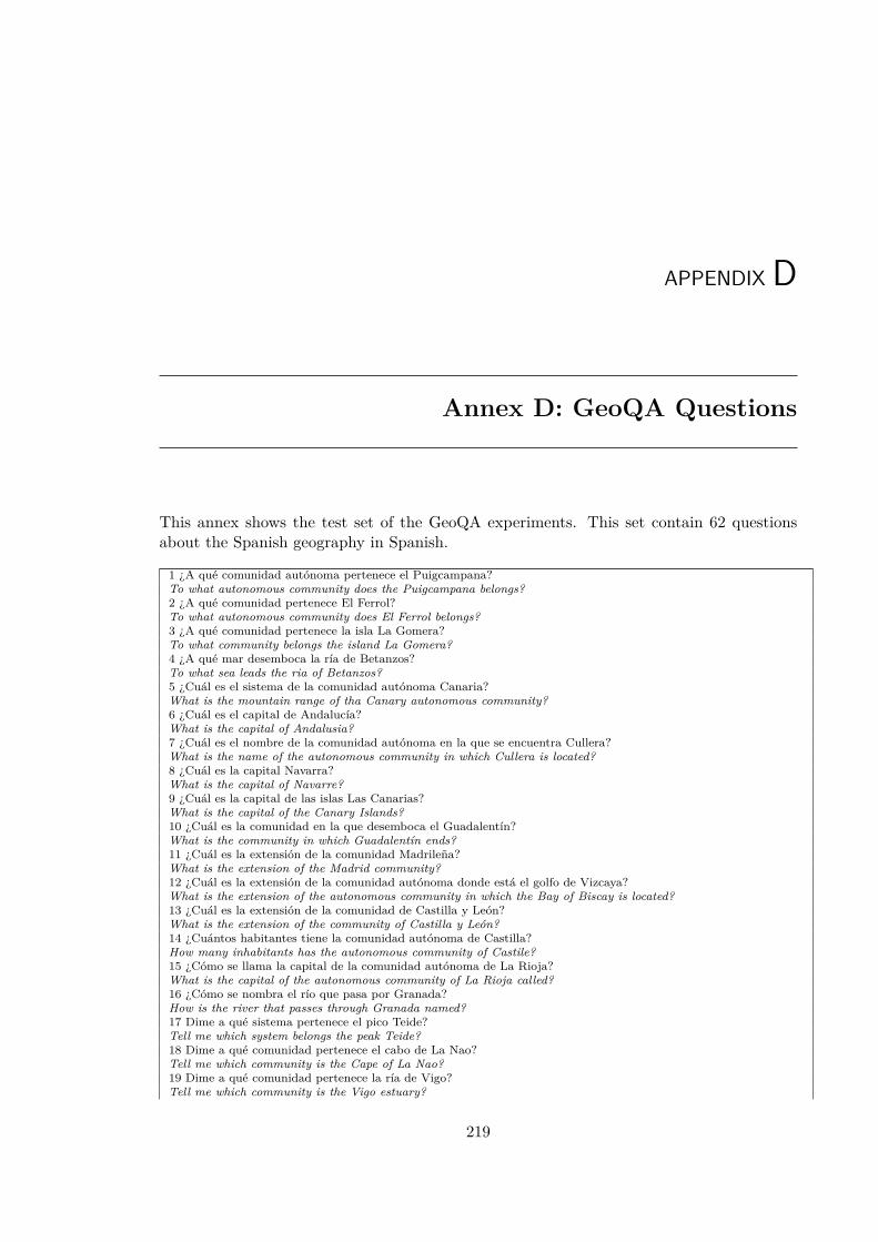
APPENDIX D
Annex D: GeoQA Questions
This annex shows the test set of the GeoQA experiments. This set contain 62 questionsabout the Spanish geography in Spanish.
1 ¿A qué comunidad autónoma pertenece el Puigcampana?To what autonomous community does the Puigcampana belongs?2 ¿A qué comunidad pertenece El Ferrol?To what autonomous community does El Ferrol belongs?3 ¿A qué comunidad pertenece la isla La Gomera?To what community belongs the island La Gomera?4 ¿A qué mar desemboca la ría de Betanzos?To what sea leads the ria of Betanzos?5 ¿Cuál es el sistema de la comunidad autónoma Canaria?What is the mountain range of tha Canary autonomous community?6 ¿Cuál es el capital de Andalucía?What is the capital of Andalusia?7 ¿Cuál es el nombre de la comunidad autónoma en la que se encuentra Cullera?What is the name of the autonomous community in which Cullera is located?8 ¿Cuál es la capital Navarra?What is the capital of Navarre?9 ¿Cuál es la capital de las islas Las Canarias?What is the capital of the Canary Islands?10 ¿Cuál es la comunidad en la que desemboca el Guadalentín?What is the community in which Guadalentín ends?11 ¿Cuál es la extensión de la comunidad Madrileña?What is the extension of the Madrid community?12 ¿Cuál es la extensión de la comunidad autónoma donde está el golfo de Vizcaya?What is the extension of the autonomous community in which the Bay of Biscay is located?13 ¿Cuál es la extensión de la comunidad de Castilla y León?What is the extension of the community of Castilla y León?14 ¿Cuántos habitantes tiene la comunidad autónoma de Castilla?How many inhabitants has the autonomous community of Castile?15 ¿Cómo se llama la capital de la comunidad autónoma de La Rioja?What is the capital of the autonomous community of La Rioja called?16 ¿Cómo se nombra el río que pasa por Granada?How is the river that passes through Granada named?17 Dime a qué sistema pertenece el pico Teide?Tell me which system belongs the peak Teide?18 Dime a qué comunidad pertenece el cabo de La Nao?Tell me which community is the Cape of La Nao?19 Dime a qué comunidad pertenece la ría de Vigo?Tell me which community is the Vigo estuary?
219
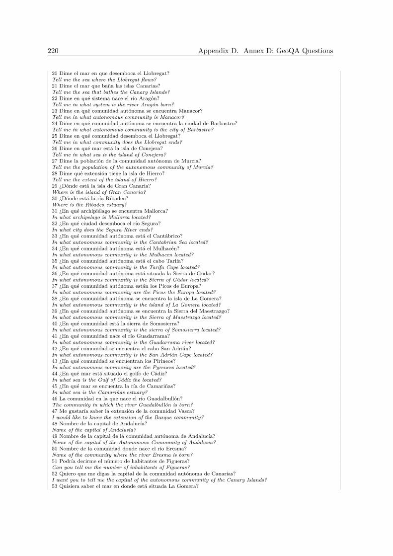
220 Appendix D. Annex D: GeoQA Questions
20 Dime el mar en que desemboca el Llobregat?Tell me the sea where the Llobregat flows?21 Dime el mar que baña las islas Canarias?Tell me the sea that bathes the Canary Islands?22 Dime en qué sistema nace el río Aragón?Tell me in what system is the river Aragón born?23 Dime en qué comunidad autónoma se encuentra Manacor?Tell me in what autonomous community is Manacor?24 Dime en qué comunidad autónoma se encuentra la ciudad de Barbastro?Tell me in what autonomous community is the city of Barbastro?25 Dime en qué comunidad desemboca el Llobregat?Tell me in what community does the Llobregat ends?26 Dime en qué mar está la isla de Conejera?Tell me in what sea is the island of Conejera?27 Dime la población de la comunidad autónoma de Murcia?Tell me the population of the autonomous community of Murcia?28 Dime qué extensión tiene la isla de Hierro?Tell me the extent of the island of Hierro?29 ¿Dónde está la isla de Gran Canaria?Where is the island of Gran Canaria?30 ¿Dónde está la ría Ribadeo?Where is the Ribadeo estuary?31 ¿En qué archipiélago se encuentra Mallorca?In what archipelago is Mallorca located?32 ¿En qué ciudad desemboca el río Segura?In what city does the Segura River ends?33 ¿En qué comunidad autónoma está el Cantábrico?In what autonomous community is the Cantabrian Sea located?34 ¿En qué comunidad autónoma está el Mulhacén?In what autonomous community is the Mulhacen located?35 ¿En qué comunidad autónoma está el cabo Tarifa?In what autonomous community is the Tarifa Cape located?36 ¿En qué comunidad autónoma está situada la Sierra de Gũdar?In what autonomous community is the Sierra of Gúdar located?37 ¿En qué comunidad autónoma están los Picos de Europa?In what autonomous community are the Picos the Europa located?38 ¿En qué comunidad autónoma se encuentra la isla de La Gomera?In what autonomous community is the island of La Gomera located?39 ¿En qué comunidad autónoma se encuentra la Sierra del Maestrazgo?In what autonomous community is the Sierra of Maestrazgo located?40 ¿En qué comunidad está la sierra de Somosierra?In what autonomous community is the sierra of Somosierra located?41 ¿En qué comunidad nace el río Guadarrama?In what autonomous community is the Guadarrama river located?42 ¿En qué comunidad se encuentra el cabo San Adrián?In what autonomous community is the San Adrián Cape located?43 ¿En qué comunidad se encuentran los Pirineos?In what autonomous community are the Pyrenees located?44 ¿En qué mar está situado el golfo de Cádiz?In what sea is the Gulf of Cádiz the located?45 ¿En qué mar se encuentra la ría de Camariñas?In what sea is the Camariñas estuary?46 La comunidad en la que nace el río Guadalbullón?The community in which the river Guadalbullón is born?47 Me gustaría saber la extensión de la comunidad Vasca?I would like to know the extension of the Basque community?48 Nombre de la capital de Andalucía?Name of the capital of Andalusia?49 Nombre de la capital de la comunidad autónoma de Andalucía?Name of the capital of the Autonomous Community of Andalusia?50 Nombre de la comunidad donde nace el río Eresma?Name of the community where the river Eresma is born?51 Podría decirme el nũmero de habitantes de Figueras?Can you tell me the number of inhabitants of Figueras?52 Quiero que me digas la capital de la comunidad autónoma de Canarias?I want you to tell me the capital of the autonomous community of the Canary Islands?53 Quisiera saber el mar en donde está situada La Gomera?
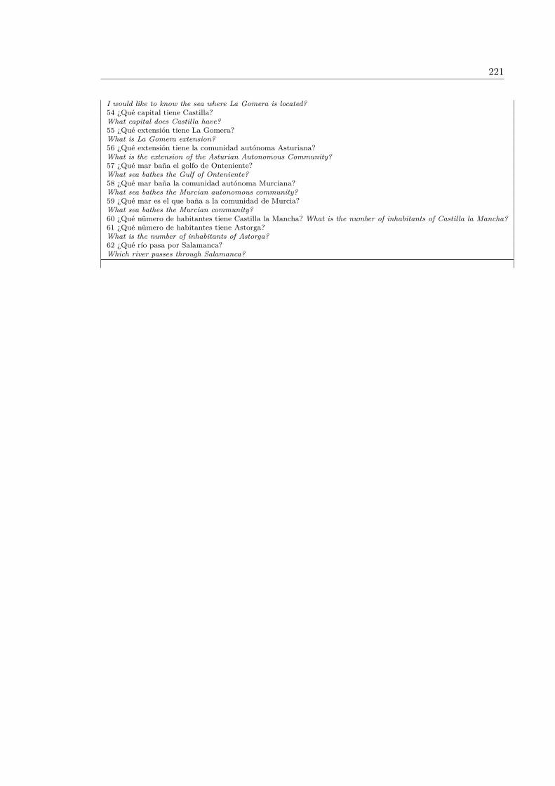
221
I would like to know the sea where La Gomera is located?54 ¿Qué capital tiene Castilla?What capital does Castilla have?55 ¿Qué extensión tiene La Gomera?What is La Gomera extension?56 ¿Qué extensión tiene la comunidad autónoma Asturiana?What is the extension of the Asturian Autonomous Community?57 ¿Qué mar baña el golfo de Onteniente?What sea bathes the Gulf of Onteniente?58 ¿Qué mar baña la comunidad autónoma Murciana?What sea bathes the Murcian autonomous community?59 ¿Qué mar es el que baña a la comunidad de Murcia?What sea bathes the Murcian community?60 ¿Qué nũmero de habitantes tiene Castilla la Mancha? What is the number of inhabitants of Castilla la Mancha?61 ¿Qué nũmero de habitantes tiene Astorga?What is the number of inhabitants of Astorga?62 ¿Qué río pasa por Salamanca?Which river passes through Salamanca?

222 Appendix D. Annex D: GeoQA Questions
APPENDIX E
Annex E: GikiCLEF Questions
This annex shows the GikiCLEF topics in English and Spanish used in the GikiCLEF 2009evaluation benchmark.
223
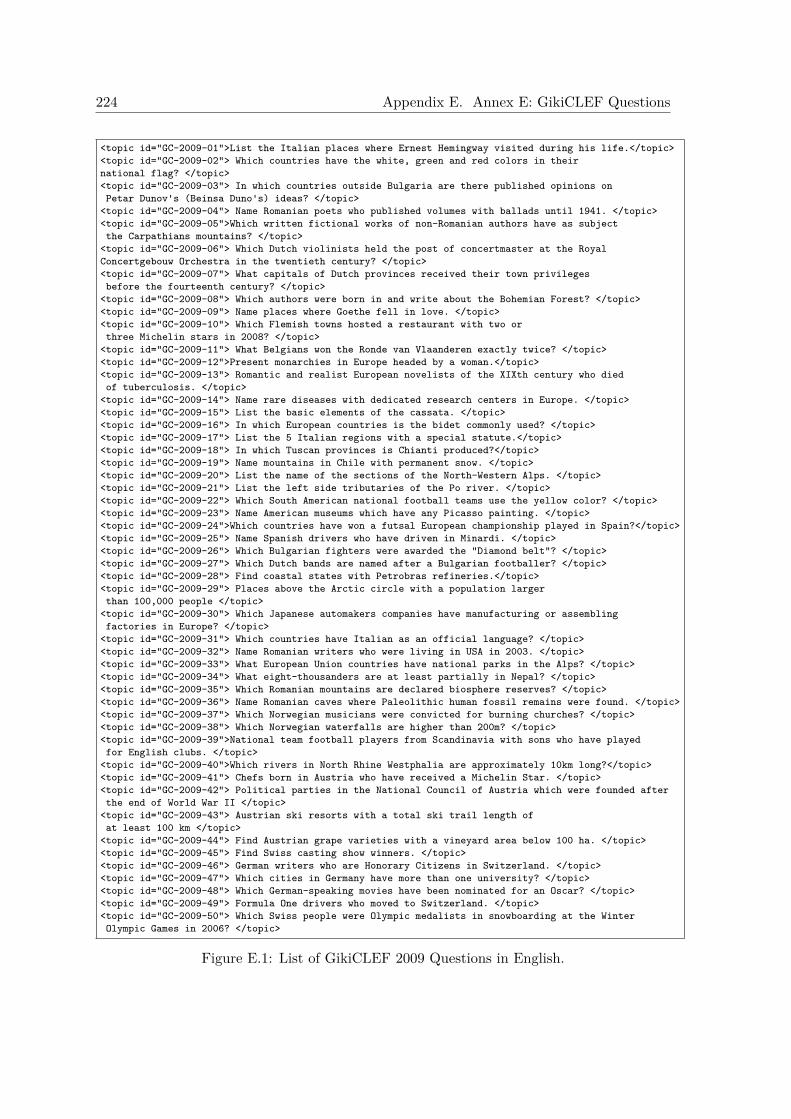
224 Appendix E. Annex E: GikiCLEF Questions
<topic id="GC-2009-01">List the Italian places where Ernest Hemingway visited during his life.</topic><topic id="GC-2009-02"> Which countries have the white, green and red colors in theirnational flag? </topic><topic id="GC-2009-03"> In which countries outside Bulgaria are there published opinions onPetar Dunov's (Beinsa Duno's) ideas? </topic>
<topic id="GC-2009-04"> Name Romanian poets who published volumes with ballads until 1941. </topic><topic id="GC-2009-05">Which written fictional works of non-Romanian authors have as subjectthe Carpathians mountains? </topic>
<topic id="GC-2009-06"> Which Dutch violinists held the post of concertmaster at the RoyalConcertgebouw Orchestra in the twentieth century? </topic><topic id="GC-2009-07"> What capitals of Dutch provinces received their town privilegesbefore the fourteenth century? </topic>
<topic id="GC-2009-08"> Which authors were born in and write about the Bohemian Forest? </topic><topic id="GC-2009-09"> Name places where Goethe fell in love. </topic><topic id="GC-2009-10"> Which Flemish towns hosted a restaurant with two orthree Michelin stars in 2008? </topic>
<topic id="GC-2009-11"> What Belgians won the Ronde van Vlaanderen exactly twice? </topic><topic id="GC-2009-12">Present monarchies in Europe headed by a woman.</topic><topic id="GC-2009-13"> Romantic and realist European novelists of the XIXth century who diedof tuberculosis. </topic>
<topic id="GC-2009-14"> Name rare diseases with dedicated research centers in Europe. </topic><topic id="GC-2009-15"> List the basic elements of the cassata. </topic><topic id="GC-2009-16"> In which European countries is the bidet commonly used? </topic><topic id="GC-2009-17"> List the 5 Italian regions with a special statute.</topic><topic id="GC-2009-18"> In which Tuscan provinces is Chianti produced?</topic><topic id="GC-2009-19"> Name mountains in Chile with permanent snow. </topic><topic id="GC-2009-20"> List the name of the sections of the North-Western Alps. </topic><topic id="GC-2009-21"> List the left side tributaries of the Po river. </topic><topic id="GC-2009-22"> Which South American national football teams use the yellow color? </topic><topic id="GC-2009-23"> Name American museums which have any Picasso painting. </topic><topic id="GC-2009-24">Which countries have won a futsal European championship played in Spain?</topic><topic id="GC-2009-25"> Name Spanish drivers who have driven in Minardi. </topic><topic id="GC-2009-26"> Which Bulgarian fighters were awarded the "Diamond belt"? </topic><topic id="GC-2009-27"> Which Dutch bands are named after a Bulgarian footballer? </topic><topic id="GC-2009-28"> Find coastal states with Petrobras refineries.</topic><topic id="GC-2009-29"> Places above the Arctic circle with a population largerthan 100,000 people </topic>
<topic id="GC-2009-30"> Which Japanese automakers companies have manufacturing or assemblingfactories in Europe? </topic>
<topic id="GC-2009-31"> Which countries have Italian as an official language? </topic><topic id="GC-2009-32"> Name Romanian writers who were living in USA in 2003. </topic><topic id="GC-2009-33"> What European Union countries have national parks in the Alps? </topic><topic id="GC-2009-34"> What eight-thousanders are at least partially in Nepal? </topic><topic id="GC-2009-35"> Which Romanian mountains are declared biosphere reserves? </topic><topic id="GC-2009-36"> Name Romanian caves where Paleolithic human fossil remains were found. </topic><topic id="GC-2009-37"> Which Norwegian musicians were convicted for burning churches? </topic><topic id="GC-2009-38"> Which Norwegian waterfalls are higher than 200m? </topic><topic id="GC-2009-39">National team football players from Scandinavia with sons who have playedfor English clubs. </topic>
<topic id="GC-2009-40">Which rivers in North Rhine Westphalia are approximately 10km long?</topic><topic id="GC-2009-41"> Chefs born in Austria who have received a Michelin Star. </topic><topic id="GC-2009-42"> Political parties in the National Council of Austria which were founded afterthe end of World War II </topic>
<topic id="GC-2009-43"> Austrian ski resorts with a total ski trail length ofat least 100 km </topic>
<topic id="GC-2009-44"> Find Austrian grape varieties with a vineyard area below 100 ha. </topic><topic id="GC-2009-45"> Find Swiss casting show winners. </topic><topic id="GC-2009-46"> German writers who are Honorary Citizens in Switzerland. </topic><topic id="GC-2009-47"> Which cities in Germany have more than one university? </topic><topic id="GC-2009-48"> Which German-speaking movies have been nominated for an Oscar? </topic><topic id="GC-2009-49"> Formula One drivers who moved to Switzerland. </topic><topic id="GC-2009-50"> Which Swiss people were Olympic medalists in snowboarding at the WinterOlympic Games in 2006? </topic>
Figure E.1: List of GikiCLEF 2009 Questions in English.
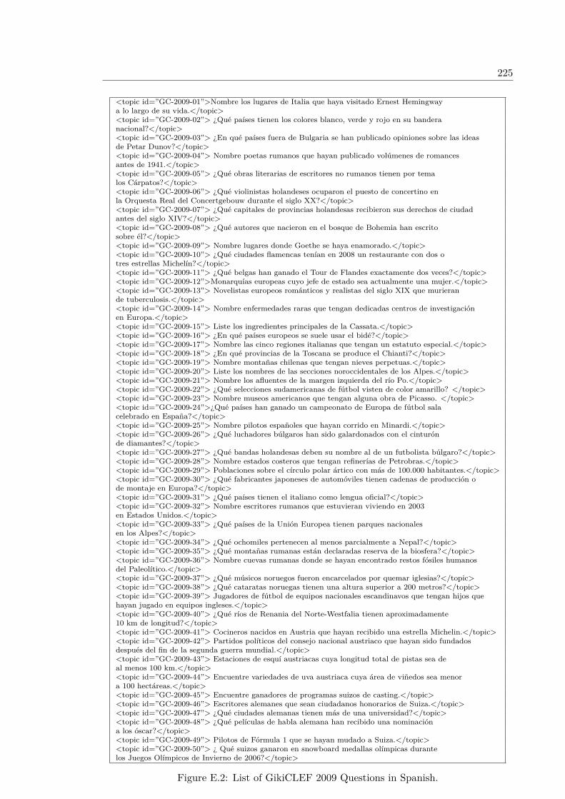
225
<topic id=”GC-2009-01”>Nombre los lugares de Italia que haya visitado Ernest Hemingwaya lo largo de su vida.</topic><topic id=”GC-2009-02”> ¿Qué países tienen los colores blanco, verde y rojo en su banderanacional?</topic><topic id=”GC-2009-03”> ¿En qué países fuera de Bulgaria se han publicado opiniones sobre las ideasde Petar Dunov?</topic><topic id=”GC-2009-04”> Nombre poetas rumanos que hayan publicado volúmenes de romancesantes de 1941.</topic><topic id=”GC-2009-05”> ¿Qué obras literarias de escritores no rumanos tienen por temalos Cárpatos?</topic><topic id=”GC-2009-06”> ¿Qué violinistas holandeses ocuparon el puesto de concertino enla Orquesta Real del Concertgebouw durante el siglo XX?</topic><topic id=”GC-2009-07”> ¿Qué capitales de provincias holandesas recibieron sus derechos de ciudadantes del siglo XIV?</topic><topic id=”GC-2009-08”> ¿Qué autores que nacieron en el bosque de Bohemia han escritosobre él?</topic><topic id=”GC-2009-09”> Nombre lugares donde Goethe se haya enamorado.</topic><topic id=”GC-2009-10”> ¿Qué ciudades flamencas tenían en 2008 un restaurante con dos otres estrellas Michelín?</topic><topic id=”GC-2009-11”> ¿Qué belgas han ganado el Tour de Flandes exactamente dos veces?</topic><topic id=”GC-2009-12”>Monarquías europeas cuyo jefe de estado sea actualmente una mujer.</topic><topic id=”GC-2009-13”> Novelistas europeos románticos y realistas del siglo XIX que murierande tuberculosis.</topic><topic id=”GC-2009-14”> Nombre enfermedades raras que tengan dedicadas centros de investigaciónen Europa.</topic><topic id=”GC-2009-15”> Liste los ingredientes principales de la Cassata.</topic><topic id=”GC-2009-16”> ¿En qué países europeos se suele usar el bidé?</topic><topic id=”GC-2009-17”> Nombre las cinco regiones italianas que tengan un estatuto especial.</topic><topic id=”GC-2009-18”> ¿En qué provincias de la Toscana se produce el Chianti?</topic><topic id=”GC-2009-19”> Nombre montañas chilenas que tengan nieves perpetuas.</topic><topic id=”GC-2009-20”> Liste los nombres de las secciones noroccidentales de los Alpes.</topic><topic id=”GC-2009-21”> Nombre los afluentes de la margen izquierda del río Po.</topic><topic id=”GC-2009-22”> ¿Qué selecciones sudamericanas de fútbol visten de color amarillo? </topic><topic id=”GC-2009-23”> Nombre museos americanos que tengan alguna obra de Picasso. </topic><topic id=”GC-2009-24”>¿Qué países han ganado un campeonato de Europa de fútbol salacelebrado en España?</topic><topic id=”GC-2009-25”> Nombre pilotos españoles que hayan corrido en Minardi.</topic><topic id=”GC-2009-26”> ¿Qué luchadores búlgaros han sido galardonados con el cinturónde diamantes?</topic><topic id=”GC-2009-27”> ¿Qué bandas holandesas deben su nombre al de un futbolista búlgaro?</topic><topic id=”GC-2009-28”> Nombre estados costeros que tengan refinerías de Petrobras.</topic><topic id=”GC-2009-29”> Poblaciones sobre el círculo polar ártico con más de 100.000 habitantes.</topic><topic id=”GC-2009-30”> ¿Qué fabricantes japoneses de automóviles tienen cadenas de producción ode montaje en Europa?</topic><topic id=”GC-2009-31”> ¿Qué países tienen el italiano como lengua oficial?</topic><topic id=”GC-2009-32”> Nombre escritores rumanos que estuvieran viviendo en 2003en Estados Unidos.</topic><topic id=”GC-2009-33”> ¿Qué países de la Unión Europea tienen parques nacionalesen los Alpes?</topic><topic id=”GC-2009-34”> ¿Qué ochomiles pertenecen al menos parcialmente a Nepal?</topic><topic id=”GC-2009-35”> ¿Qué montañas rumanas están declaradas reserva de la biosfera?</topic><topic id=”GC-2009-36”> Nombre cuevas rumanas donde se hayan encontrado restos fósiles humanosdel Paleolítico.</topic><topic id=”GC-2009-37”> ¿Qué músicos noruegos fueron encarcelados por quemar iglesias?</topic><topic id=”GC-2009-38”> ¿Qué cataratas noruegas tienen una altura superior a 200 metros?</topic><topic id=”GC-2009-39”> Jugadores de fútbol de equipos nacionales escandinavos que tengan hijos quehayan jugado en equipos ingleses.</topic><topic id=”GC-2009-40”> ¿Qué ríos de Renania del Norte-Westfalia tienen aproximadamente10 km de longitud?</topic><topic id=”GC-2009-41”> Cocineros nacidos en Austria que hayan recibido una estrella Michelin.</topic><topic id=”GC-2009-42”> Partidos políticos del consejo nacional austriaco que hayan sido fundadosdespués del fin de la segunda guerra mundial.</topic><topic id=”GC-2009-43”> Estaciones de esquí austriacas cuya longitud total de pistas sea deal menos 100 km.</topic><topic id=”GC-2009-44”> Encuentre variedades de uva austriaca cuya área de viñedos sea menora 100 hectáreas.</topic><topic id=”GC-2009-45”> Encuentre ganadores de programas suizos de casting.</topic><topic id=”GC-2009-46”> Escritores alemanes que sean ciudadanos honorarios de Suiza.</topic><topic id=”GC-2009-47”> ¿Qué ciudades alemanas tienen más de una universidad?</topic><topic id=”GC-2009-48”> ¿Qué películas de habla alemana han recibido una nominacióna los óscar?</topic><topic id=”GC-2009-49”> Pilotos de Fórmula 1 que se hayan mudado a Suiza.</topic><topic id=”GC-2009-50”> ¿ Qué suizos ganaron en snowboard medallas olímpicas durantelos Juegos Olímpicos de Invierno de 2006?</topic>
Figure E.2: List of GikiCLEF 2009 Questions in Spanish.

226 Appendix E. Annex E: GikiCLEF Questions

APPENDIX F
Annex F: Geographical Data Mappings
This annex describes shows different geographical data mappings developed in this thesis.
F.1 Mapping of GNS and GNIS gazetteers to the ADL Fea-ture Type Thesaurus)
This section contains the mapping of GeoNet Names Server (GNS) and GNIS gazetteersfeature types to Alexandria Digital Library Feature Type Thesaurus (ADLFTT). The fea-ture type thesaurus of the Geographical KB for the GIR task is the ADL Feature TypeThesaurus (ADLFTT). The ADL Feature Type Thesaurus is a hierarchical set of geograph-ical terms used to type named geographic places in English (Hill, 2000). Both GNIS andGNS gazetteers have been mapped to the ADLFTT, with a resulting set of 575 geographicaltypes. Our GNIS mapping is similar to the one exposed in Hill (2000).
GNS or GNIS ADLFTTADM1 administrative_areas@@political_areas@@countries_1st_order_divisionsADM2 administrative_areas@@political_areas@@countries_2nd_order_divisionsADM3 administrative_areas@@political_areas@@countries_3rd_order_divisionsADM4 administrative_areas@@political_areas@@countries_4th_order_divisionsADMD administrative_areas@@administrative_divisionsADMF manmade_features@@buildings@@administrative_facilityAGRC administrative_areas@@populated_placesAGRF manmade_features@@agricultural_sitesAIRB manmade_features@@transportation_features@@airport_features@@airbasesAIRF manmade_features@@transportation_features@@airport_features@@airfieldsAIRH manmade_features@@transportation_features@@airport_features@@heliportsAIRP manmade_features@@transportation_features@@airport_features@@airportsairport manmade_features@@transportation_features@@airport_features@@airportsAIRQ manmade_features@@transportation_features@@airport_features@@airfields@@abandoned_airfieldAIRS manmade_features@@transportation_features@@airport_features@@seaplane_bases@@seaplane_landing_areasAMTH manmade_features@@recreational_facilities@@performance_sites@@amphitheatresANCH manmade_features@@hydrographic_structures@@harbors@@anchoragesANS manmade_features@@historical_sites@@archaeological_sites@@ancient_sites
227
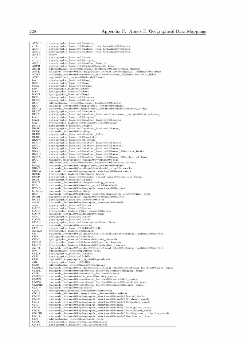
228 Appendix F. Annex F: Geographical Data Mappings
APNU physiographic_features@@aprons_arch physiographic_features@@natural_rock_formations@@arches_ARCH physiographic_features@@natural_rock_formations@@arches_ARCU physiographic_features@@natural_rock_formations@@arches_AREA othersarea physiographic_features@@areasarroyo physiographic_features@@arroyos_ARRU physiographic_features@@seafloor_featuresASPH physiographic_features@@basins@@asphalt_lakesASTR administrative_areas@@reference_locations@@astronomical_stationsASYL manmade_features@@buildings@@institutional_sites@@medical_facilities@@asylumsATHF manmade_features@@recreational_facilities@@sports_facilities@@athletic_fieldsATOL regions@@land_regions@@islands@@atollsbar physiographic_features@@bars_BAR physiographic_features@@barsbasin physiographic_features@@basinsbay hydrographic_features@@baysBAY hydrographic_features@@baysBAYS hydrographic_features@@baysBCH physiographic_features@@beachesBCHS physiographic_features@@beachesBCN administrative_areas@@reference_locations@@beaconsBDG manmade_features@@transportation_features@@bridgesBDGQ manmade_features@@transportation_features@@bridges@@ruined_bridgeBDLD physiographic_features@@badlandsBDLU physiographic_features@@seafloor_features@@continental_margins@@borderlands_beach physiographic_features@@beachesbench physiographic_features@@seafloor_features@@benches_bend hydrographic_features@@streams@@rivers@@bends_BGHT physiographic_features@@bightsBKSU physiographic_features@@seafloor_features@@banks_BLDG manmade_features@@buildingsBLDR physiographic_features@@boulder_fieldsBLHL physiographic_features@@blowholesBLOW physiographic_features@@blowoutsBNCH physiographic_features@@seafloor_features@@benches_BNCU physiographic_features@@seafloor_features@@benches_BNK physiographic_features@@seafloor_features@@banks_BNKR physiographic_features@@seafloor_features@@banks_@@stream_banksBNKU physiographic_features@@seafloor_features@@banks_BNKX physiographic_features@@seafloor_features@@banks_@@section_of_bankBOG regions@@biogeographic_regions@@wetlands@@bogsBP administrative_areas@@reference_locations@@boundary_markersbridge manmade_features@@transportation_features@@bridgesBRKS manmade_features@@buildings@@residential_sites@@barracksBRKW manmade_features@@hydrographic_structures@@breakwatersBSND hydrographic_features@@drainage_basinsBSNP physiographic_features@@mineral_deposit_areas@@petroleum_basinsBSNU physiographic_features@@basinsBSTN manmade_features@@buildings@@baling_stationBTL manmade_features@@historical_sites@@battlefieldsBTYD manmade_features@@hydrographic_structures@@harborsbuilding manmade_features@@buildingsBUR manmade_features@@historical_sites@@archaeological_sites@@burial_cavesBUSH regions@@biogeographic_regions@@shrublands@@bushesBUTE physiographic_features@@mesas@@buttescanal manmade_features@@hydrographic_structures@@canalscape physiographic_features@@capesCAPE physiographic_features@@capesCAPG hydrographic_features@@ice_masses@@icecapsCARN manmade_features@@landmarks@@cairnscave physiographic_features@@cavesCAVE physiographic_features@@cavesCDAU physiographic_features@@mountains@@cordillerascemetery manmade_features@@cemeteriesCFT physiographic_features@@cliffs@@cleftschannel hydrographic_features@@channelsCH manmade_features@@buildings@@institutional_sites@@religious_facilities@@churchesCHN hydrographic_features@@channelsCHNL hydrographic_features@@channels@@lake_channelsCHNM hydrographic_features@@channels@@marine_channelsCHNN hydrographic_features@@channels@@navigation_channelschurch manmade_features@@buildings@@institutional_sites@@religious_facilities@@churchescivil administrative_areas@@political_areasCLDA physiographic_features@@cratersCLF physiographic_features@@cliffsCLG regions@@biogeographic_regions@@grasslandscliff physiographic_features@@cliffsCMN administrative_areas@@parks@@commonsCMPLA manmade_features@@buildings@@institutional_sites@@correctional_facilities@@labor_campsCMPL manmade_features@@recreational_facilities@@camps@@logging_campsCMP manmade_features@@recreational_facilities@@campsCMPMN manmade_features@@mine_sites@@mining_campsCMPO manmade_features@@recreational_facilities@@camps@@oil_campsCMPQ manmade_features@@recreational_facilities@@camps@@abandoned_campCMPRF manmade_features@@recreational_facilities@@camps@@refugee_campsCMTY manmade_features@@cemeteriesCNFL hydrographic_features@@streams@@confluencesCNLA manmade_features@@transportation_features@@aqueductsCNLB manmade_features@@hydrographic_structures@@canals@@canal_bendsCNLD manmade_features@@hydrographic_structures@@canals@@drainage_canalsCNLI manmade_features@@hydrographic_structures@@canals@@irrigation_canalsCNL manmade_features@@hydrographic_structures@@canalsCNLN manmade_features@@hydrographic_structures@@canals@@navigation_canalsCNLQ manmade_features@@hydrographic_structures@@canals@@abandoned_canalCNLSB manmade_features@@hydrographic_structures@@canals@@underground_irrigation_canalsCNLX manmade_features@@hydrographic_structures@@canals@@section_of_canalCNS administrative_areas@@concession_areasCNSU physiographic_features@@valleys@@canyonsCNYN physiographic_features@@valleys@@canyons
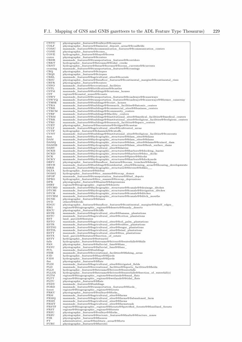
F.1. Mapping of GNS and GNIS gazetteers to the ADL Feature Type Thesaurus) 229
CNYU physiographic_features@@valleys@@canyonsCOLF physiographic_features@@mineral_deposit_areas@@coalfieldsCOMC manmade_features@@telecommunication_features@@communication_centersCONE physiographic_features@@cones_COVE hydrographic_features@@bays@@covescrater physiographic_features@@cratersCRDR manmade_features@@transportation_features@@corridorsCRKT hydrographic_features@@streams@@tidal_creeksCRNT hydrographic_features@@seas@@oceans@@ocean_currents@@currentscrossing manmade_features@@transportation_features@@crossingsCRQ physiographic_features@@cirquesCRQS physiographic_features@@cirquesCRRL manmade_features@@agricultural_sites@@corralsCRSU physiographic_features@@seafloor_features@@continental_margins@@continental_risesCRTR physiographic_features@@cratersCSNO manmade_features@@recreational_facilitiesCSTL manmade_features@@fortifications@@castlesCSTM manmade_features@@buildings@@customs_housesCST regions@@coastal_zones@@coastsCSWY manmade_features@@transportation_features@@roadways@@causewaysCSWYQ manmade_features@@transportation_features@@roadways@@causeways@@former_causewayCTHSE manmade_features@@buildings@@court_housesCTRA manmade_features@@buildings@@research_facilities@@atomic_centersCTRB manmade_features@@buildings@@commercial_sites@@business_centersCTRCM manmade_features@@buildings@@community_centersCTRF manmade_features@@buildings@@facility_centersCTRM manmade_features@@buildings@@institutional_sites@@medical_facilities@@medical_centersCTRR manmade_features@@buildings@@institutional_sites@@religious_facilities@@religious_centersCTRS manmade_features@@buildings@@research_facilities@@space_centersCUET physiographic_features@@mountains@@ridges@@cuestasCULT manmade_features@@agricultural_sites@@cultivated_areasCUTF hydrographic_features@@channels@@cutoffs_CVNT manmade_features@@buildings@@institutional_sites@@religious_facilities@@conventsdam manmade_features@@hydrographic_structures@@dam_sites@@damsDAM manmade_features@@hydrographic_structures@@dam_sites@@damsDAMQ manmade_features@@hydrographic_structures@@dam_sites@@dams@@ruined_damDAMSB manmade_features@@hydrographic_structures@@dam_sites@@sub_surface_damsDARY manmade_features@@agricultural_sites@@dairiesDCKB manmade_features@@hydrographic_structures@@harbors@@docking_basinsDCKD manmade_features@@hydrographic_structures@@harbors@@dry_docksDCK manmade_features@@hydrographic_structures@@piers@@docksDCKY manmade_features@@hydrographic_structures@@harbors@@dockyardsDEPU physiographic_features@@seafloor_features@@ocean_trenches@@deeps_DEVH manmade_features@@buildings@@residential_sites@@housing_areas@@housing_developmentsDIKE manmade_features@@hydrographic_structures@@levees@@dikes__DLTA hydrographic_features@@deltasDOMG hydrographic_features@@ice_masses@@icecap_domesDPOF manmade_features@@transportation_features@@fuel_depotsDPRG hydrographic_features@@ice_masses@@icecap_depressionsDPR physiographic_features@@basins@@depressionsDSRT regions@@biogeographic_regions@@desertsDTCHD manmade_features@@hydrographic_structures@@canals@@drainage_ditchesDTCHI manmade_features@@hydrographic_structures@@canals@@irrigation_ditchesDTCH manmade_features@@hydrographic_structures@@canals@@ditchesDTCHM manmade_features@@hydrographic_structures@@canals@@ditch_mouthsDUNE physiographic_features@@dunesDVD others@@divideEDGU physiographic_features@@seafloor_features@@continental_margins@@shelf_edges_ERG regions@@biogeographic_regions@@deserts@@sandy_desertsESCU physiographic_features@@cliffsESTB manmade_features@@agricultural_sites@@banana_plantationsESTC manmade_features@@agricultural_sites@@cotton_plantationsEST land_parcels@@estatesESTO manmade_features@@agricultural_sites@@oil_palm_plantationsESTR manmade_features@@agricultural_sites@@rubber_plantationsESTSG manmade_features@@agricultural_sites@@sugar_plantationsESTSL manmade_features@@agricultural_sites@@sisal_plantationsESTT manmade_features@@agricultural_sites@@tea_plantationsESTX land_parcels@@estates@@section_of_estateESTY hydrographic_features@@estuariesfalls hydrographic_features@@streams@@rivers@@waterfalls@@fallsFAN physiographic_features@@alluvial_fans@@fans_FANU physiographic_features@@alluvial_fans@@fans_FCL manmade_features@@buildingsFISH manmade_features@@recreational_facilities@@fishing_areasFJD hydrographic_features@@bays@@fjordsFJDS hydrographic_features@@bays@@fjordsflat physiographic_features@@flatsFLDI manmade_features@@agricultural_sites@@irrigated_fieldsFLD manmade_features@@recreational_facilities@@sports_facilities@@fieldsFLLS hydrographic_features@@streams@@rivers@@waterfallsFLLSX hydrographic_features@@streams@@rivers@@waterfalls@@section_of_waterfall(s)FLTM regions@@biogeographic_regions@@wetlands@@mud_flatsFLTT regions@@biogeographic_regions@@wetlands@@tidal_flatsFLTU physiographic_features@@flatsFNDY manmade_features@@buildingsFORD manmade_features@@transportation_features@@fords_forest regions@@biogeographic_regions@@forestsFRKU physiographic_features@@valleys@@forks_FRM manmade_features@@agricultural_sites@@farmsFRMQ manmade_features@@agricultural_sites@@farms@@abandoned_farmFRMS manmade_features@@agricultural_sites@@farmsFRMT manmade_features@@agricultural_sites@@farmsteadsFRSTF regions@@biogeographic_regions@@forests@@petrified_forests@@fossilized_forestsFRST regions@@biogeographic_regions@@forestsFRSU physiographic_features@@valleys@@forks_FRZU physiographic_features@@tectonic_features@@faults@@fracture_zonesFSR physiographic_features@@fissuresFT administrative_areas@@military_areas@@fortsFURU physiographic_features@@furrows
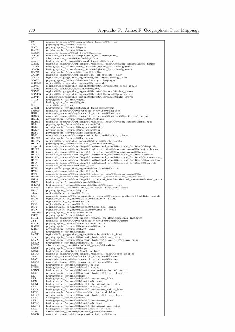
230 Appendix F. Annex F: Geographical Data Mappings
FY manmade_features@@transportation_features@@ferriesgap physiographic_features@@gapsGAP physiographic_features@@gapsGAPU physiographic_features@@gapsGASF manmade_features@@oil_fields@@gasfieldsGATE manmade_features@@transportation_features@@gates_GDN administrative_areas@@parks@@gardensgeyser hydrographic_features@@thermal_features@@geysersGHSE manmade_features@@buildings@@residential_sites@@housing_areas@@guest_housesglacier hydrographic_features@@ice_masses@@glacier_features@@glaciersGLCR hydrographic_features@@ice_masses@@glacier_features@@glaciersGLYU physiographic_features@@arroyos@@gulliesGOSP manmade_features@@buildings@@gas_oil_separator_plantGRAZ regions@@biogeographic_regions@@grasslands@@grazing_areasGRGE physiographic_features@@valleys@@canyons@@gorgesGRSLD regions@@biogeographic_regions@@grasslandsGRVC regions@@biogeographic_regions@@forests@@woods@@coconut_grovesGRVE manmade_features@@cemeteries@@gravesGRVO regions@@biogeographic_regions@@forests@@woods@@olive_grovesGRVPN regions@@biogeographic_regions@@forests@@woods@@pine_grovesGRVP regions@@biogeographic_regions@@forests@@woods@@palm_grovesGULF hydrographic_features@@gulfsgut hydrographic_features@@gutsGVL others@@gravel_areaGYSR hydrographic_features@@thermal_features@@geysersharbor manmade_features@@hydrographic_structures@@harborsHBR manmade_features@@hydrographic_structures@@harborsHBRX manmade_features@@hydrographic_structures@@harbors@@section_of_harborHDLD physiographic_features@@capes@@headlandsHERM manmade_features@@buildings@@residential_sites@@housing_areas@@hermitagesHLL physiographic_features@@mountains@@hillsHLLS physiographic_features@@mountains@@hillsHLLU physiographic_features@@mountains@@hillsHLSU physiographic_features@@mountains@@hillsHLT manmade_features@@transportation_features@@halting_places_HMCK physiographic_features@@hammocksHMDA regions@@biogeographic_regions@@deserts@@rock_desertsHOLU physiographic_features@@seafloor_features@@holes_hospital manmade_features@@buildings@@institutional_sites@@medical_facilities@@hospitalsHSEC manmade_features@@buildings@@residential_sites@@housing_areas@@country_housesHSE manmade_features@@buildings@@residential_sites@@housing_areas@@housesHSPC manmade_features@@buildings@@institutional_sites@@medical_facilities@@clinicsHSPD manmade_features@@buildings@@institutional_sites@@medical_facilities@@dispensaries_HSPL manmade_features@@buildings@@institutional_sites@@medical_facilities@@leprosariumHSP manmade_features@@buildings@@institutional_sites@@medical_facilities@@hospitalsHSTS manmade_features@@historical_sitesHTH regions@@biogeographic_regions@@shrublands@@heathsHTL manmade_features@@buildings@@hotelsHUT manmade_features@@buildings@@residential_sites@@housing_areas@@hutsHUTS manmade_features@@buildings@@residential_sites@@housing_areas@@hutsINDS manmade_features@@buildings@@commercial_sites@@industrial_sites@@industrial_areasINLT hydrographic_features@@channels@@inletsINLTQ hydrographic_features@@channels@@inlets@@former_inletINSM administrative_areas@@military_areas@@military_installationsINTF physiographic_features@@plainsisland regions@@land_regions@@islandsISLF manmade_features@@hydrographic_structures@@offshore_platforms@@artificial_islandsISLM regions@@land_regions@@islands@@mangrove_islandsISL regions@@land_regions@@islandsISLS regions@@land_regions@@islandsISLT regions@@land_regions@@islands@@land_tied_islandsISLX regions@@land_regions@@islands@@section_of_islandisthmus physiographic_features@@isthmusesISTH physiographic_features@@isthmusesITTR manmade_features@@buildings@@research_facilities@@research_institutesJTY manmade_features@@hydrographic_structures@@piers@@jettiesKNLU physiographic_features@@mountains@@knollsKNSU physiographic_features@@mountains@@knollsKRST physiographic_features@@karst_areaslake hydrographic_features@@lakesLAND regions@@biogeographic_regions@@tundras@@Arctic_landlava physiographic_features@@volcanic_features@@lava_fieldsLAVA physiographic_features@@volcanic_features@@lava_fields@@lava_areasLBED hydrographic_features@@lakes@@lake_bedsLCTY administrative_areas@@populated_places@@localitiesLDGU physiographic_features@@ledgesLDNG hydrographic_structures@@boat_landingsLEPC manmade_features@@buildings@@residential_sites@@leper_colonieslevee manmade_features@@hydrographic_structures@@leveesLEV manmade_features@@hydrographic_structures@@leveesLEVU manmade_features@@hydrographic_structures@@leveesLGN hydrographic_features@@lakes@@lagoonsLGNS hydrographic_features@@lakes@@lagoonsLGNX hydrographic_features@@lakes@@lagoons@@section_of_lagoonLKC physiographic_features@@volcanic_features@@crater_lakesLK hydrographic_features@@lakesLKI hydrographic_features@@lakes@@intermittent_lakesLKN hydrographic_features@@lakes@@salt_lakesLKNI hydrographic_features@@lakes@@intermittent_salt_lakesLKO hydrographic_features@@lakes@@oxbow_lakesLKOI hydrographic_features@@lakes@@intermittent_oxbow_lakesLKSB physiographic_features@@caves@@underground_lakesLKSC physiographic_features@@volcanic_features@@crater_lakesLKS hydrographic_features@@lakesLKSI hydrographic_features@@lakes@@intermittent_lakesLKSN hydrographic_features@@lakes@@salt_lakesLKSNI hydrographic_features@@lakes@@intermittent_salt_lakesLKX hydrographic_features@@lakes@@section_of_lakelocale administrative_areas@@populated_places@@localesLOCK manmade_features@@transportation_features@@locks
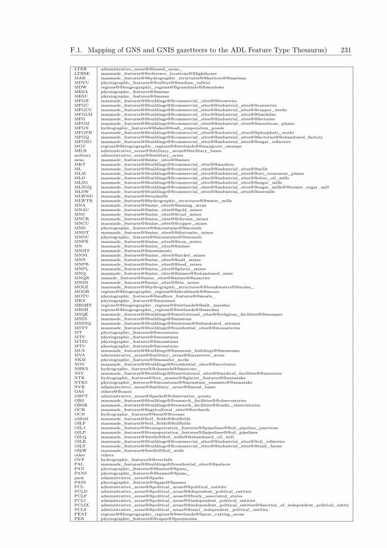
F.1. Mapping of GNS and GNIS gazetteers to the ADL Feature Type Thesaurus) 231
LTER administrative_areas@@leased_areas_LTHSE manmade_features@@reference_locations@@lighthouseMAR manmade_features@@hydrographic_structures@@harbors@@marinasMDVU physiographic_features@@valleys@@median_valleysMDW regions@@biogeographic_regions@@grasslands@@meadowsMESA physiographic_features@@mesasMESU physiographic_features@@mesasMFGB manmade_features@@buildings@@commercial_sites@@breweriesMFGC manmade_features@@buildings@@commercial_sites@@industrial_sites@@canneriesMFGCU manmade_features@@buildings@@commercial_sites@@industrial_sites@@copper_worksMFGLM manmade_features@@buildings@@commercial_sites@@industrial_sites@@limekilnsMFG manmade_features@@buildings@@commercial_sites@@industrial_sites@@factoriesMFGM manmade_features@@buildings@@commercial_sites@@industrial_sites@@munitions_plantsMFGN hydrographic_features@@lakes@@salt_evaporation_pondsMFGPH manmade_features@@buildings@@commercial_sites@@industrial_sites@@phosphate_worksMFGQ manmade_features@@buildings@@commercial_sites@@industrial_sites@@factories@@abandoned_factoryMFGSG manmade_features@@buildings@@commercial_sites@@industrial_sites@@sugar_refineriesMGV regions@@biogeographic_regions@@wetlands@@mangrove_swampsMILB administrative_areas@@military_areas@@military_basesmilitary administrative_areas@@military_areasmine manmade_features@@mine_sites@@minesMKT manmade_features@@buildings@@commercial_sites@@marketsML manmade_features@@buildings@@commercial_sites@@industrial_sites@@millsMLM manmade_features@@buildings@@commercial_sites@@industrial_sites@@ore_treatment_plantsMLO manmade_features@@buildings@@commercial_sites@@industrial_sites@@olive_oil_millsMLSG manmade_features@@buildings@@commercial_sites@@industrial_sites@@sugar_millsMLSGQ manmade_features@@buildings@@commercial_sites@@industrial_sites@@sugar_mills@@former_sugar_millMLSW manmade_features@@buildings@@commercial_sites@@industrial_sites@@sawmillsMLWND manmade_features@@windmillsMLWTR manmade_features@@hydrographic_structures@@water_millsMNA manmade_features@@mine_sites@@mining_areasMNAU manmade_features@@mine_sites@@gold_minesMNC manmade_features@@mine_sites@@coal_minesMNCR manmade_features@@mine_sites@@chrome_minesMNCU manmade_features@@mine_sites@@copper_minesMND physiographic_features@@mountains@@moundsMNDT manmade_features@@mine_sites@@diatomite_minesMNDU physiographic_features@@mountains@@moundsMNFE manmade_features@@mine_sites@@iron_minesMN manmade_features@@mine_sites@@minesMNMT manmade_features@@monumentsMNNI manmade_features@@mine_sites@@nickel_minesMNN manmade_features@@mine_sites@@salt_minesMNPB manmade_features@@mine_sites@@lead_minesMNPL manmade_features@@mine_sites@@placer_minesMNQ manmade_features@@mine_sites@@mines@@abandoned_mineMNQR anmade_features@@mine_sites@@mines@@quarriesMNSN manmade_features@@mine_sites@@tin_minesMOLE manmade_features@@hydrographic_structures@@breakwaters@@moles_MOOR regions@@biogeographic_regions@@shrublands@@moorsMOTU physiographic_features@@seafloor_features@@moats_MRN physiographic_features@@morainesMRSHN regions@@biogeographic_regions@@wetlands@@salt_marshesMRSH regions@@biogeographic_regions@@wetlands@@marshesMSQE manmade_features@@buildings@@institutional_sites@@religious_facilities@@mosquesMSSN manmade_features@@buildings@@missionsMSSNQ manmade_features@@buildings@@missions@@abandoned_missionMSTY manmade_features@@buildings@@residential_sites@@monasteriesMT physiographic_features@@mountainsMTS physiographic_features@@mountainsMTSU physiographic_features@@mountainsMTU physiographic_features@@mountainsMUS manmade_features@@buildings@@museum_buildings@@museumsMVA administrative_areas@@military_areas@@maneuver_areasNKM physiographic_features@@meander_necksNOV manmade_features@@buildings@@residential_sites@@novitiatesNRWS hydrographic_features@@channels@@narrows_NSY manmade_features@@buildings@@institutional_sites@@medical_facilities@@nurseriesNTK hydrographic_features@@ice_masses@@glacier_features@@nunataksNTKS physiographic_features@@mountains@@mountain_summits@@nunataksNVB administrative_areas@@military_areas@@naval_basesOAS others@@oasesOBPT administrative_areas@@parks@@observation_pointsOBS manmade_features@@buildings@@research_facilities@@observatoriesOBSR manmade_features@@buildings@@research_facilities@@radio_observatoriesOCH manmade_features@@agricultural_sites@@orchardsOCN hydrographic_features@@seas@@oceansoilfield manmade_features@@oil_fields@@oilfieldsOILF manmade_features@@oil_fields@@oilfieldsOILJ manmade_features@@transportation_features@@pipelines@@oil_pipeline_junctionsOILP manmade_features@@transportation_features@@pipelines@@oil_pipelinesOILQ manmade_features@@wells@@oil_wells@@abandoned_oil_wellOILR manmade_features@@buildings@@commercial_sites@@industrial_sites@@oil_refineriesOILT manmade_features@@buildings@@commercial_sites@@industrial_sites@@tank_farmsOILW manmade_features@@wells@@oil_wellsother othersOVF hydrographic_features@@overfallsPAL manmade_features@@buildings@@residential_sites@@palacesPAN physiographic_features@@basins@@pans_PANS physiographic_features@@basins@@pans_park administrative_areas@@parksPASS physiographic_features@@gaps@@passesPCL administrative_areas@@political_areas@@political_entitiesPCLD administrative_areas@@political_areas@@dependent_political_entitiesPCLF administrative_areas@@political_areas@@freely_associated_statesPCLI administrative_areas@@political_areas@@independent_political_entitiesPCLIX administrative_areas@@political_areas@@independent_political_entities@@section_of_independent_political_entityPCLS administrative_areas@@political_areas@@semi_independent_political_entitiesPEAT regions@@biogeographic_regions@@wetlands@@peat_cutting_areasPEN physiographic_features@@capes@@peninsulas

232 Appendix F. Annex F: Geographical Data Mappings
PENX physiographic_features@@capes@@peninsulas@@section_of_peninsulaPGDA manmade_features@@towers@@pagodasPIER manmade_features@@hydrographic_structures@@pierspillar physiographic_features@@natural_rock_formations@@pillars_PKLT manmade_features@@transportation_features@@parking_sites@@parking_lotsPK physiographic_features@@mountains@@mountain_summits@@peaksPKS physiographic_features@@mountains@@mountain_summits@@peaksPKSU physiographic_features@@mountains@@mountain_summits@@peaksPKU physiographic_features@@mountains@@mountain_summits@@peaksplain physiographic_features@@plainsPLAT physiographic_features@@@@plateausPLATX physiographic_features@@plateaus@@section_of_plateauPLDR physiographic_features@@poldersPLFU manmade_features@@hydrographic_structures@@offshore_platforms@@platforms_PLN physiographic_features@@plainsPLNU physiographic_features@@plainsPLNX physiographic_features@@plains@@section_of_plainPLTU physiographic_features@@plateausPMPO manmade_features@@transportation_features@@pipelines@@oil_pumping_stationsPMPW manmade_features@@transportation_features@@pipelines@@water_pumping_stationsPND hydrographic_features@@lakes@@pondsPNDI hydrographic_features@@lakes@@intermittent_pondsPNDN hydrographic_features@@lakes@@salt_pondsPNDNI hydrographic_features@@lakes@@intermittent_salt_pondsPNDSF hydrographic_features@@lakes@@fishpondsPNDS hydrographic_features@@lakes@@pondsPNDSI hydrographic_features@@lakes@@intermittent_pondsPNDSN hydrographic_features@@lakes@@salt_pondsPNLU physiographic_features@@natural_rock_formations@@pinnacles__po manmade_features@@buildings@@post_office_buildingsPO manmade_features@@buildings@@post_office_buildings@@post_officesPOOLI hydrographic_features@@lakes@@intermittent_poolsPOOL manmade_features@@recreational_facilities@@sports_facilities@@poolsPopulated Place_administrative_areas@@populated_placesPost Office__manmade_features@@buildings@@post_office_buildingsPPLA administrative_areas@@populated_places@@cities@@capitalsppl administrative_areas@@populated_placesPPL administrative_areas@@populated_placesPPLC administrative_areas@@populated_places@@cities@@capitalsPPLL administrative_areas@@populated_places@@populated_localitiesPPLQ administrative_areas@@populated_places@@abandoned_populated_placePPLR manmade_features@@buildings@@institutional_sites@@religious_facilities@@religious_populated_placesPPLS administrative_areas@@populated_placesPPLW administrative_areas@@populated_places@@destroyed_populated_placePPLX administrative_areas@@populated_places@@section_of_populated_placePP manmade_features@@buildings@@police_postsPPQ manmade_features@@buildings@@police_posts@@abandoned_police_postPRK administrative_areas@@parksPRKGT administrative_areas@@parks@@park_gatesPRKHQ manmade_features@@buildings@@park_headquartersPRMN manmade_features@@transportation_features@@trails@@promenadesPRNJ manmade_features@@buildings@@institutional_sites@@correctional_facilities@@reformatoriesPRN manmade_features@@buildings@@institutional_sites@@correctional_facilities@@prisonsPRNQ manmade_features@@buildings@@institutional_sites@@correctional_facilities@@prisons@@abandoned_prisonPROM physiographic_features@@capesPRSH administrative_areas@@political_areas@@countries_2nd_order_divisionsPRT manmade_features@@hydrographic_structures@@harbors@@portsPRVU administrative_areas@@political_areas@@countries_1st_order_divisionsPSH manmade_features@@buildings@@commercial_sites@@industrial_sites@@power_generation_sites@@hydroelectric_power_stationsPS manmade_features@@buildings@@commercial_sites@@industrial_sites@@power_generation_sites@@power_stationsPSTB manmade_features@@buildings@@border_postsPSTC manmade_features@@buildings@@customs_postsPSTP manmade_features@@buildings@@patrol_postsPTGE manmade_features@@transportation_features@@portagesPT physiographic_features@@capes@@points_PTS physiographic_features@@capes@@points_PYR manmade_features@@monuments@@pyramidsPYRS manmade_features@@monuments@@pyramidsQCKS physiographic_features@@barsQUAY manmade_features@@hydrographic_structures@@piers@@quaysrange physiographic_features@@mountains@@mountain_ranges@@ranges_rapids hydrographic_features@@streams@@rivers@@rapidsRAVU physiographic_features@@valleys@@canyons@@ravinesRCH hydrographic_features@@channels@@reaches_RDA manmade_features@@transportation_features@@roadways@@ancient_roadsRDB manmade_features@@transportation_features@@roadways@@road_bendsRDCUT manmade_features@@transportation_features@@roadways@@road_cutsRDGB physiographic_features@@mountains@@ridges@@beach_ridgesRDGE physiographic_features@@mountains@@ridgesRDGG physiographic_features@@mountains@@ridges@@icecap_ridgesRDGU physiographic_features@@mountains@@ridgesRDJCT manmade_features@@transportation_features@@roadways@@road_junctionsRD manmade_features@@transportation_features@@roadways@@roadsRDST manmade_features@@hydrographic_structures@@harbors@@roadsteads_RDSU physiographic_features@@mountains@@ridgesRECG manmade_features@@recreational_facilities@@sports_facilities@@golf_coursesRECR manmade_features@@recreational_facilities@@sports_facilities@@racetracksREG regions@@biogeographic_regions@@deserts@@stony_desertsREP administrative_areas@@political_areas@@countries@@republicsRESA administrative_areas@@reserves@@agricultural_reservesRES administrative_areas@@reservesreserve administrative_areas@@reservesreservoir manmade_features@@hydrographic_structures@@reservoirsRESF administrative_areas@@reserves@@forest_reservesRESH administrative_areas@@reserves@@hunting_reservesRESN administrative_areas@@reserves@@nature_reservesRESP administrative_areas@@reserves@@palm_tree_reservesRESV administrative_areas@@tribal_areas@@reservations_RESW administrative_areas@@reserves@@wildlife_reservesRFC physiographic_features@@reefs@@coral_reefs

F.1. Mapping of GNS and GNIS gazetteers to the ADL Feature Type Thesaurus) 233
RF physiographic_features@@reefsRFSU physiographic_features@@reefsRFU physiographic_features@@reefsRFX physiographic_features@@reefs@@section_of_reefRGNE regions@@economic_regionsRGNL regions@@land_regions@@lake_regionsRGN regionsRHSE manmade_features@@transportation_features@@resthousesridge physiographic_features@@mountains@@ridgesRISU physiographic_features@@seafloor_features@@rises_RJCT manmade_features@@transportation_features@@railroad_features@@railroad_junctionsRKFL physiographic_features@@rockfallRK physiographic_features@@natural_rock_formations@@rocksRKRY regions@@biogeographic_regions@@habitats@@rookeriesRKS physiographic_features@@natural_rock_formations@@rocksRLG manmade_features@@buildings@@institutional_sites@@religious_facilities@@religious_sitesRLGR manmade_features@@buildings@@institutional_sites@@religious_facilities@@retreats_RMPU physiographic_features@@seafloor_features@@ramps_RNCH manmade_features@@agricultural_sites@@ranchesRNGA administrative_areas@@military_areas@@artillery_rangesRNGU physiographic_features@@mountains@@mountain_ranges@@ranges_RPDS hydrographic_features@@streams@@rivers@@rapidsRR manmade_features@@transportation_features@@railroad_featuresRRQ manmade_features@@transportation_features@@railroad_features@@abandoned_railroadRSD manmade_features@@transportation_features@@railroad_features@@railroad_sidingRSGNL manmade_features@@transportation_features@@railroad_features@@railroad_signalRSRT manmade_features@@recreational_facilities@@resortsRSTN manmade_features@@transportation_features@@railroad_features@@railroad_stationsRSTNQ manmade_features@@transportation_features@@railroad_features@@railroad_stations@@abandoned_railroad_stationRSTP manmade_features@@transportation_features@@railroad_features@@railroad_stopsRSTPQ manmade_features@@transportation_features@@railroad_features@@railroad_stops@@abandoned_railroad_stopRSVI manmade_features@@hydrographic_structures@@reservoirs@@intermittent_reservoirsRSV manmade_features@@hydrographic_structures@@reservoirsRSVT manmade_features@@storage_structures@@water_tanksRTE manmade_features@@transportation_features@@caravan_routesRUIN manmade_features@@historical_sites@@ruinsRVN physiographic_features@@valleys@@canyons@@ravinesRYD manmade_features@@transportation_features@@railroad_features@@railroad_yardsSALT physiographic_features@@mineral_deposit_areas@@salt_areasSAND physiographic_features@@bars@@sand_areaSBED hydrographic_features@@streams@@dry_stream_bedSBKH physiographic_features@@flats@@sabkhasSCHA manmade_features@@buildings@@institutional_sites@@educational_facilities@@agricultural_schoolsSCHC manmade_features@@buildings@@institutional_sites@@educational_facilities@@collegesSCH manmade_features@@buildings@@institutional_sites@@educational_facilities@@schoolsSCHM manmade_features@@buildings@@institutional_sites@@educational_facilities@@military_schoolsSCHN manmade_features@@buildings@@institutional_sites@@educational_facilities@@schoolsschool manmade_features@@buildings@@institutional_sites@@educational_facilities@@schoolsSCNU physiographic_features@@seafloor_features@@seachannels_SCRB regions@@biogeographic_regions@@shrublands@@scrublandsSCRP physiographic_features@@cliffs@@escarpmentsSCSU physiographic_features@@seafloor_features@@seachannels_SD hydrographic_features@@channels@@sounds_SDL physiographic_features@@gaps@@saddles_SDLU physiographic_features@@gaps@@saddles_sea hydrographic_features@@seasSEA hydrographic_features@@seasSHFU physiographic_features@@seafloor_features@@continental_margins@@shelvesSHLU physiographic_features@@bars@@shoalsSHOL physiographic_features@@bars@@shoalsSHOR regions@@coastal_zones@@shoresSHPF manmade_features@@agricultural_sites@@sheepfoldsSHRN manmade_features@@monuments@@shrinesSHSE manmade_features@@storage_structures@@storehouseSHSU physiographic_features@@bars@@shoalsSHVU physiographic_features@@valleys@@shelf_valleys_SILL physiographic_features@@gaps@@sills_SILU physiographic_features@@gaps@@sills_SINK physiographic_features@@sinkholesSLCE manmade_features@@hydrographic_structures@@sluicesSLID physiographic_features@@slides_slope physiographic_features@@slopesSLP physiographic_features@@slopesSLPU physiographic_features@@slopesSMSU physiographic_features@@seafloor_features@@seamountsSMU physiographic_features@@seafloor_features@@seamountsSNOW regions@@biogeographic_regions@@snow_regions@@snowfieldsSNTR manmade_features@@buildings@@institutional_sites@@medical_facilities@@sanitariumsSPA manmade_features@@recreational_facilities@@spasSPIT physiographic_features@@bars@@spitsSPLY manmade_features@@hydrographic_structures@@dam_sites@@spillwaysSPNG hydrographic_features@@streams@@springs_SPNS hydrographic_features@@streams@@springs@@sulphur_springsSPNT hydrographic_features@@thermal_features@@hot_springsspring hydrographic_features@@streams@@springs_SPRU physiographic_features@@mountains@@ridges@@spurs_SPUR physiographic_features@@mountains@@ridges@@spurs_SQR administrative_areas@@parks@@squaresSTBL manmade_features@@recreational_facilities@@stablesSTDM manmade_features@@recreational_facilities@@stadiumSTKR manmade_features@@transportation_features@@stock_routesSTLMT administrative_areas@@populated_places@@Israeli_settlementSTMA hydrographic_features@@streams@@anabranchST manmade_features@@transportation_features@@roadways@@streetsSTMB hydrographic_features@@streams@@stream_bendsSTMC manmade_features@@hydrographic_structures@@canals@@canalized_streamsSTMD hydrographic_features@@streamsdistributariesSTMH hydrographic_features@@drainage_basins@@headwatersSTM hydrographic_features@@streamsSTMI hydrographic_features@@streams@@intermittent_streams
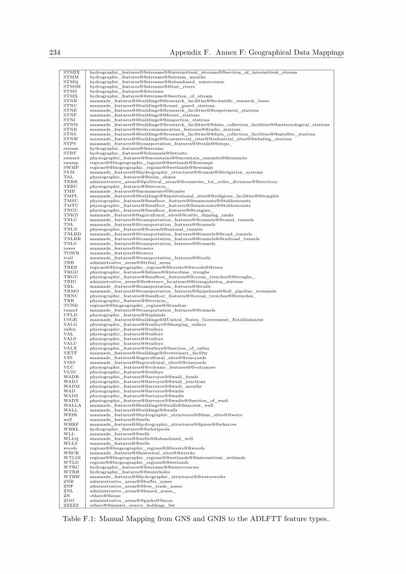
234 Appendix F. Annex F: Geographical Data Mappings
STMIX hydrographic_features@@streams@@intermittent_streams@@section_of_intermittent_streamSTMM hydrographic_features@@streams@@stream_mouthsSTMQ hydrographic_features@@streams@@abandoned_watercourseSTMSB hydrographic_features@@streams@@lost_riversSTMS hydrographic_features@@streamsSTMX hydrographic_features@@streams@@section_of_streamSTNB manmade_features@@buildings@@research_facilities@@scientific_research_basesSTNC manmade_features@@buildings@@coast_guard_stationsSTNE manmade_features@@buildings@@research_facilities@@experiment_stationsSTNF manmade_features@@buildings@@forest_stationsSTNI manmade_features@@buildings@@inspection_stationsSTNM manmade_features@@buildings@@research_facilities@@data_collection_facilities@@meteorological_stationsSTNR manmade_features@@telecommunication_features@@radio_stationsSTNS manmade_features@@buildings@@research_facilities@@data_collection_facilities@@satellite_stationsSTNW manmade_features@@buildings@@commercial_sites@@industrial_sites@@whaling_stationsSTPS manmade_features@@transportation_features@@trails@@steps_stream hydrographic_features@@streamsSTRT hydrographic_features@@channels@@straitssummit physiographic_features@@mountains@@mountain_summits@@summitsswamp regions@@biogeographic_regions@@wetlands@@swampsSWMP regions@@biogeographic_regions@@wetlands@@swampsSYSI manmade_features@@hydrographic_structures@@canals@@irrigation_systemsTAL physiographic_features@@talus_slopesTERR administrative_areas@@political_areas@@countries_1st_order_divisions@@territoryTERU physiographic_features@@terraces_TMB manmade_features@@monuments@@tombsTMPL manmade_features@@buildings@@institutional_sites@@religious_facilities@@templesTMSU physiographic_features@@seafloor_features@@seamounts@@tablemountsTMTU physiographic_features@@seafloor_features@@seamounts@@tablemountsTNGU physiographic_features@@seafloor_features@@tongues_TNKD manmade_features@@agricultural_sites@@cattle_dipping_tanksTNLC manmade_features@@transportation_features@@tunnels@@canal_tunnelsTNL manmade_features@@transportation_features@@tunnelsTNLN physiographic_features@@caves@@natural_tunnelsTNLRD manmade_features@@transportation_features@@tunnels@@road_tunnelsTNLRR manmade_features@@transportation_features@@tunnels@@railroad_tunnelsTNLS manmade_features@@transportation_features@@tunnelstower manmade_features@@towersTOWR manmade_features@@towerstrail manmade_features@@transportation_features@@trailsTRB administrative_areas@@tribal_areasTREE regions@@biogeographic_regions@@forests@@woods@@treesTRGD physiographic_features@@dunes@@interdune_troughsTRGU physiographic_features@@seafloor_features@@ocean_trenches@@troughs_TRIG administrative_areas@@reference_locations@@triangulation_stationsTRL manmade_features@@transportation_features@@trailsTRMO manmade_features@@transportation_features@@pipelines@@oil_pipeline_terminalsTRNU physiographic_features@@seafloor_features@@ocean_trenches@@trenches_TRR physiographic_features@@terraces_TUND regions@@biogeographic_regions@@tundrastunnel manmade_features@@transportation_features@@tunnelsUPLD physiographic_features@@uplandsUSGE manmade_features@@buildings@@United_States_Government_EstablishmentVALG physiographic_features@@valleys@@hanging_valleysvalley physiographic_features@@valleysVAL physiographic_features@@valleysVALS physiographic_features@@valleysVALU physiographic_features@@valleysVALX physiographic_features@@valleys@@section_of_valleyVETF manmade_features@@buildings@@veterinary_facilityVIN manmade_features@@agricultural_sites@@vineyardsVINS manmade_features@@agricultural_sites@@vineyardsVLC physiographic_features@@volcanic_features@@volcanoesVLSU physiographic_features@@valleysWADB physiographic_features@@arroyos@@wadi_bendsWADJ physiographic_features@@arroyos@@wadi_junctionsWADM physiographic_features@@arroyos@@wadi_mouthsWAD physiographic_features@@arroyos@@wadisWADS physiographic_features@@arroyos@@wadisWADX physiographic_features@@arroyos@@wadis@@section_of_wadiWALLA manmade_features@@buildings@@walls@@ancient_wallWALL manmade_features@@buildings@@wallsWEIR manmade_features@@hydrographic_structures@@dam_sites@@weirswell manmade_features@@wellsWHRF manmade_features@@hydrographic_structures@@piers@@wharvesWHRL hydrographic_features@@whirlpoolsWLL manmade_features@@wellsWLLQ manmade_features@@wells@@abandoned_wellWLLS manmade_features@@wellswoods regions@@biogeographic_regions@@forests@@woodsWRCK manmade_features@@historical_sites@@wrecksWTLDI regions@@biogeographic_regions@@wetlands@@intermittent_wetlandsWTLD regions@@biogeographic_regions@@wetlandsWTRC hydrographic_features@@streams@@watercoursesWTRH hydrographic_features@@waterholesWTRW manmade_features@@hydrographic_structures@@waterworksZNB administrative_areas@@buffer_zonesZNF administrative_areas@@free_trade_zonesZNL administrative_areas@@leased_zones_ZN others@@zoneZOO administrative_areas@@parks@@zoosZZZZZ others@@master_source_holdings_list
Table F.1: Manual Mapping from GNS and GNIS to the ADLFTT feature types..
APPENDIX G
Annex G: Web Person Search experiments atWePS-3
This annex presents a set of experiments performed by this thesis author at the ThirdWeb People Search Workshop (WePS-3) task for clustering web people search documentsin English (Ferrés and Rodrıguez, 2010). The WePS-3 workshop was an evaluation Taskunder the scope of TebleCLEF (Artiles et al., 2010). Its aim was to evaluate systems whichcluster and extract information from web people searches in English. According to Andogah(2010) PhD thesis Very Important People (VIPs) (e.g., political leaders) mentioned in adocument can be used to determine the geographical coverage of a document. For thisreason technologies related with Person Name Recognition and Disambiguation can bepotentially useful for Geographical Information Access tasks.
The approaches presented are Lingo, Hierachical Agglomerative Clustering (HAC), anda 2-step HAC algorithm. The best results were obtained with with HAC and 2-step HACalgorithms. This annex describes the experiments with the WePS-3 development and testdata, results and initial conclusions in the context of the WePS-3 Task 1 and the comparisonwith the official results of all the participants.
G.1 Development and Test Data at WePS-3The development data used for WePS-3 is based on the test data of WePS-2 Clustering Task(Artiles et al., 2009). Test data for WePS-2 is composed of 30 ambiguous names: 10 namesets from the 1990 US Census, 10 from participants in ACL’08 and 10 from Wikipedia.Each name is made of two tokens, a first name and a last name. See more details of theWePS-2 data set in Artiles et al. (2009). Around 100 documents have been downloadedfrom the top ranked search results.
The test data for WePS-3 was composed of 300 person names and 200 web documentsfor each name. As the WePS organizers did in WePS-2, some person names were obtainedfrom the following sources: US Census (50), Wikipedia (50) and Computer Science ProgramCommittee lists (50). In addition to that, the organizers provided names for which at least
235
236 Appendix G. Annex G: Web Person Search experiments at WePS-3
one person is an attorney (50), corporate executive (50) or realtor (50). For each name thetop 200 web search results from Yahoo! were provided (URL, HTML pages, search snippetsand ranking information).
G.2 System DescriptionThe system architecture has two phases that are performed sequentially: HTML Cleaningand Clustering. The HTML cleaning phase consists in to convert HTML documents intoplain text. We used the existing HTMLParser1 (version 1.6) open-source software to performthis task. For Clustering phase the following algorithms were used (separately): Lingo,Hierarchical Agglomerative Clustering (HAC), and 2-steps HAC.
G.2.1 LingoLingo is an algorithm that combines Phrase Discovery (detection of topics and phrases) andLatent Semantic Indexing to organize web search results in groups based on their contentOsinski and Weiss, 2005. The approach of Lingo tries to seek short and clear labels withuseful meanings that could cover most of the topics of the input text collection. Lingo getsphrases with semantic content to use them as labels in the clusters, then documents areassigned to the labels to create the groups. Lingo is implemented in the Carrot2 Project2.Carrot2 is an Open Source Clustering software that can group automatically small collec-tions of documents or web search results in thematic categories.
Lingo uses the Vector Space Model and Singular Value Decomposition to find the labelsof the clusters. It uses 3 methods of Natural Language Processing: Stemming, stop-words,and textual segmentation heuristics. Using stemming and stop-words according Lingo de-velopers is important when we are working with small textual information and some noise(like working with snippets).
The most used parameters for the tuning of the Lingo algorithm are the Cluster as-sigment threshold and the Cluster candidate label threshold. The Cluster AssignmentThreshold (tcA) controls the assignments of documents to the clusters. This threshold isbased on the Cosine similarity between a label and a document and its common range isfrom 0.15 (default) to 0.3. The Cluster Candidate Label Threshold (tcL) controls the num-ber of clusters (labels created). This threshold is based on the Cosine similarity betweena candidate cluster label and the basis vectors of the SVD decomposition. This thresholddefault value is 0.775 and its common value range is from 0.70 to 0.90.
G.2.2 Hierarchical Agglomerative ClusteringThe Hierarchical Agglomerative Clustering method used is agglomerative, it starts at theleaves and successively merges clusters together. HAC can be stopped by distance criterionand number of clusters criterion. The Lemur3 Information Retrieval software includes animplementation of Hierarchial Agglomerative Clustering. The clustering algorithms imple-mented for Lemur and used in this paper are described in Steinbach et al. (2000). Thesealgorithms use cosine similarity in the vector space model as their metric. Stemming is
1HTMLParser. http://htmlparser.sourceforge.net/2Carrot2 Project. http://project.carrot2.org3Lemur Project. http://www.lemurproject.org

G.3. Development experiments with WePS-3 trial data 237
used using the Porter algorithm. The HAC algorithm implemented in Lemur was used inWePS2 with good results (Balog et al., 2009). The parameters accepted by Cluster are:1) Type of cluster to use, either agglomerative or centroid (centroid is agglomerative usingmean as a scoring method). 2) The scoring method to use for the agglomerative cluster overdocuments in a cluster maximum (max), minimum (min), average (avg), mean (mean). 3)The threshold, the minimum score for adding a document to an existing cluster.
G.2.3 2-step Clustering with Agglomerative ClusteringThis is a two step algorithm that consists to cluster the results of an initial clustering pro-cess. The process follows these steps: 1) initial clustering with an agglomerative clusteringalgorithm that produces a set of clusters, 2) merging the content of each cluster in one newdocument by merging all the documents that pertain to a cluster into a one representativedocument for the whole cluster, 3) a second clustering step does agglomerative clustering(centroid or agglomerative configurations) over the collection of representative documentsfor the initial clusters.
G.3 Development experiments with WePS-3 trial dataFor the WePS-3 trial evaluation a set of several experiments that consist in applying differentbaseline configurations (see Table G.1) to the WePS-3 trial data (WePS-2 test data) weredesigned.
The baseline runs were designed changing the parameters of the algorithms and theClustering method. We did experiments with the three algorithms described before: Lingo,HAC, and 2-step HAC. We present here a set of these experiments. The experiments withLingo share the same parameters (tcL=0.15, tcA=0.7), and differ in the kind of input touse as source documents. The following four experiments were done: full documents (1),snippets and title (2), context of the person name with 100 and 500 chars (3) (4). Theexperiments with agglomerative clustering differ with the type of cluster (agglomerative orcentroid), type of scoring (minimum or maximum), and threshold. We did the followingexperiments: (5) aglomerative (agglo) with maximum score (max) and 0.07 as threshold,(6) centroid (cent) with minimum score (min) and 0.20 as threshold, (7) centroid (cent)with max and 0.05 as threshold. The experiments with 2-step clustering were in four types,i) centroid (first step) & centroid (second step) (8), ii) centroid (first step) & agglomera-tive (second step) (9) iii) agglomerative (first step) & centroid (second step) (10) and iv)agglomerative (first step) & agglomerative (second step): experiments from (11) to (15).
G.4 Test experiments with WePS-3 test dataFor the WePS-3 evaluation with the test data the author designed a set of five experimentsthat consist in applying different baseline configurations to the development set data(seeTable G.2). The first run (TALP_1) uses agglomerative clustering and the second run(TALP_2) uses a 2-step clustering approach with both Agglomerative clustering algorithmsof Lemur. The first step does agglomerative clustering and the second step does againagglomerative clustering with the output of the first step. The third run (TALP_3) appliesthe algorithm Lingo for clustering. The fourth run (TALP_4) uses the centroid algorithm

238 Appendix G. Annex G: Web Person Search experiments at WePS-3
Table G.1: Results with WePS-3 trial (development) data using B-Cubed measuresMacro-averaged Scores
F-measures B-CubedAlgorithm & Parameters alfa=0,5 alfa=0,2 Prec. Rec.
(10) Agglo(0.07;max)+Centroid(0.20;min) 0,58 0,63 0,55 0,67(12) Agglo(0.07;max)+Agglo(0.15;max) 0,58 0,63 0,53 0,70(11) Agglo (0.07;max)+Agglo(0.20;max) 0,58 0,62 0,55 0,66(13) Agglo (0.07;max)+Agglo(0.10;max) 0,57 0,65 0,49 0,75(14) Agglo (0.07;max)+Agglo (0.20;min) 0,57 0,60 0,56 0,63(8) Centroid (0.20;min)+Cent (0.20;min) 0,56 0,67 0,47 0,80(15) Agglo (0.07;max)+Agglo (0.07;max) 0,55 0,65 0,45 0,79(7) Centroid (0.05;max) 0,54 0,58 0,54 0,62(5) Agglo (0.07;max) 0,54 0,55 0,58 0,56(6) Centroid (0.20;min) 0,53 0,52 0,61 0,52(9) Centroid/0.07;min)+Agglo(0.03;min) 0,52 0,57 0,49 0,62(baseline) ALL_IN_ONE 0,53 0,66 0,43 1,00(baseline) CHEAT_SYS 0,52 0,65 0,43 1,00(1) Lingo (Full document) 0,45 0,54 0,39 0,64(2) Lingo (Snippets + Title) 0,43 0,44 0,47 0,46(3) Lingo (context 500 chars) 0,42 0,42 0,51 0,43(4) Lingo (context 100 chars) 0,43 0,42 0,53 0,42(baseline) ONE_IN_ONE 0,34 0,27 1,00 0,24
from the Lemur. The fifth run (TALP_5) used a 2 step clustering, the first step appliesthe centroid algorithm of lemur and the second step applies agglomerative clustering.
Table G.2: Results with the WePS-3 Test data Task evaluated with BCubed mesures.run Algorithm Parameters. avgPrec. avgRec. avgF-m.(0,5)TALP_1 Agglo (t=0.10;max) 0.56 0.41 0.42TALP_2 Agglo + Agglo (t=0.10;max) 0.38 0.70 0.43TALP_3 Lingo (tcl=0.15;tca=0.7) 0.40 0.49 0.39TALP_4 Centroid (t=0.10;max) 0.60 0.41 0.43TALP_5 Centroid + Agglo (t=0.10;max) 0.40 0.66 0.44
G.5 ConclusionsThe author presented three clustering algorithms (Lingo, HAC, and 2-step HAC) to performthe task of clustering web people search in the context of the WePS-3 Task-1.
In the preprocessing of documents HTML filtering is a crucial step to avoid noise.It is convenient to avoid noise from input documents to achieve better results, speciallyin the Lingo algorithm. Input noise as broken sentences and random strings could have
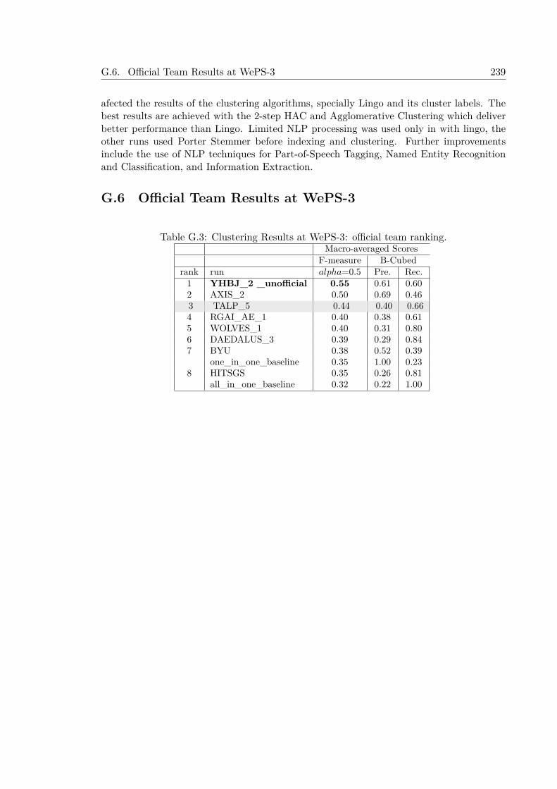
G.6. Official Team Results at WePS-3 239
afected the results of the clustering algorithms, specially Lingo and its cluster labels. Thebest results are achieved with the 2-step HAC and Agglomerative Clustering which deliverbetter performance than Lingo. Limited NLP processing was used only in with lingo, theother runs used Porter Stemmer before indexing and clustering. Further improvementsinclude the use of NLP techniques for Part-of-Speech Tagging, Named Entity Recognitionand Classification, and Information Extraction.
G.6 Official Team Results at WePS-3
Table G.3: Clustering Results at WePS-3: official team ranking.Macro-averaged Scores
F-measure B-Cubedrank run alpha=0.5 Pre. Rec.1 YHBJ_2 _unofficial 0.55 0.61 0.602 AXIS_2 0.50 0.69 0.463 TALP_5 0.44 0.40 0.664 RGAI_AE_1 0.40 0.38 0.615 WOLVES_1 0.40 0.31 0.806 DAEDALUS_3 0.39 0.29 0.847 BYU 0.38 0.52 0.39
one_in_one_baseline 0.35 1.00 0.238 HITSGS 0.35 0.26 0.81
all_in_one_baseline 0.32 0.22 1.00

240 Appendix G. Annex G: Web Person Search experiments at WePS-3
Bibliography
Ahlers, D. (2013). “Assessment of the Accuracy of GeoNames Gazetteer Data”. In: Pro-ceedings of the 7th Workshop on Geographic Information Retrieval. GIR ’13. Orlando,Florida: ACM, pp. 74–81. isbn: 978-1-4503-2241-6. doi: 10.1145/2533888.2533938.url: http://doi.acm.org/10.1145/2533888.2533938.
Amati, G. (2003). “Probability Models for Information Retrieval Based on Divergence FromRandomness”. PhD thesis. University of Glasgow.
Amitay, E., N. Har’el, R. Sivan, and A. Soffer (2005). “Web-a-where: Geotagging WebContent”. In: SIGIR ’04: Proceedings of the 27th annual international ACM SIGIRconference on Research and development in information retrieval. New York, NY, USA:ACM Press, pp. 273–280. isbn: 1581138814.
Andogah, G. (2006). “GIR Experimentation.” In: Working Notes of the Cross-Lingual Eval-uation Forum (CLEF) 2006. Ed. by A. Nardi, C. Peters, and J. L. Vicedo. Alicante,Spain. isbn: 2-912335-23-x.
Andogah, G. (2010). Geographically Constrained Information Retrieval. University of Gronin-gen, The Netherlands: PhD Thesis.
Andogah, G. and G. Bouma (2007). “University of Groningen at GeoCLEF 2007”. In: Work-ing Notes for the CLEF 2007 Workshop. Budapest, Hungary.
Andogah, G. and G. Bouma (2008). “Relevance Measures Using Geographic Scopes andTypes”. English. In: Advances in Multilingual and Multimodal Information Retrieval.Ed. by C. Peters, V. Jijkoun, T. Mandl, H. Müller, D. Oard, A. Peñas, V. Petras, andD. Santos. Vol. 5152. Lecture Notes in Computer Science. Springer Berlin Heidelberg,pp. 794–801. isbn: 978-3-540-85759-4. doi: 10.1007/978-3-540-85760-0100. url:http://dx.doi.org/10.1007/978-3-540-85760-0100.
Andogah, G., G. Bouma, J. Nerbonne, and E. Koster (2008). “Geographical Scope Resolu-tion”. In: Methodologies and Resources for Processing Spatial Language, Workshop at the6th Conference on Language Resources and Evaluation (LREC). Marrakech, Marocco,pp. 4–10.
Andre, E., G. Bosch, G. Herzog, and T. Rist (1986). “Characterizing trajectories of movingobjects using natural language path descriptions”. In: Proceedings of the 7th ECAI.Vol. 2. Brighton, UK, pp. 1–8. url: citeseer.ist.psu.edu/andre86characterizing.html.
241
242 Bibliography
Artiles, J., A. Borthwick, J. Gonzalo, S. Sekine, and E. Amigó (2010). “WePS-3 Evalua-tion Campaign: Overview of the Web People Search Clustering and Attribute Extrac-tion Tasks”. In: CLEF 2010 LABs and Workshops, Notebook Papers, 22-23 September2010, Padua, Italy. Ed. by M. Braschler, D. Harman, and E. Pianta. Vol. 1176. CEURWorkshop Proceedings. CEUR-WS.org. isbn: 978-88-904810-0-0. url: http://ceur-ws.org/Vol-1176/CLEF2010wn-WePS-ArtilesEt2010.pdf.
Artiles, J., J. Gonzalo, and S. Sekine (2009). “WePS 2 Evaluation Campaign: Overviewof the Web People Search Clustering Task”. In: 2nd Web People Search EvaluationWorkshop (WePS 2009), 18th WWW Conference.
Asadi, S., C.-Y. Chang, X. Zhou, and J. Diederich (2005). “Searching the World Wide Webfor Local Services and Facilities: A Review on the Patterns of Location-Based Queries”.In: Advances in Web-Age Information Management. Ed. by W. Fan, Z. Wu, and J. Yang.Vol. 3739. Lecture Notes in Computer Science. 10.1007/115639529. Springer Berlin /Heidelberg, pp. 91–101. url: http://dx.doi.org/10.1007/115639529.
Atserias, J., B. Casas, E. Comelles, M. González, L. Padró, and M. Padró (2006). “FreeLing1.3: Syntactic and Semantic Services in an Open-Source NLP Library”. In: Proceedingsof the 5th International Conference on Language Resources and Evaluation (LREC’06),pp. 48–55.
Baba, Y., F. Ishikawa, and S. Honiden (2010). “Extraction of Places Related to FlickrTags”. In: ECAI. Ed. by H. Coelho, R. Studer, and M. Wooldridge. Vol. 215. Frontiersin Artificial Intelligence and Applications. IOS Press, pp. 523–528. isbn: 978-1-60750-605-8.
Baeza-Yates, R. A. and B. A. Ribeiro-Neto (1999). Modern Information Retrieval. ACMPress / Addison-Wesley. isbn: 0-201-39829-X.
Balog, K., J. He, K. Hofmann, V. Jijkoun, C. Monz, M. Tsagkias, W. Weerkamp, and M.de Rijke (2009). “The University of Amsterdam at WePS2”. In: 2nd Web People SearchEvaluation Workshop (WePS 2009), 18th WWW Conference.
Behrangi, E., H. Ghasemzadeh, K. S. Esmaili, and B. M. Bidgoli (2007). “A GEOGRAPHI-CAL QUESTION ANSWERING SYSTEM”. In: Proceedings of the Third InternationalConference on Web Information Systems and Technologies, pp. 308–314. isbn: 978-972-8865-78-8. doi: 10.5220/0001287203080314.
Benamara, F. (2004). “Cooperative Question Answering in Restricted Domains: the WEB-COOP Experiment”. In: Proceedings of the Workshop Question Answering in RestrictedDomains, within ACL-2004.
Bensalem, I. and M.-K. Kholladi (2010). “Toponym Disambiguation by Arborescent Rela-tionships ”. In: Journal of Computer Science 6 (6), pp. 653–659.
Bischoff, K., T. Mandl, and C. Womser-Hacker (2006). “Blind Relevance Feedback andNamed Entity based Query Expansion for Geographic Retrieval at GeoCLEF 2006.” In:Working Notes of the Cross-Lingual Evaluation Forum (CLEF) 2006. Ed. by A. Nardi,C. Peters, and J. L. Vicedo. Alicante, Spain. isbn: 2-912335-23-x.
Bolettieri, P., A. Esuli, F. Falchi, C. Lucchese, R. Perego, T. Piccioli, and F. Rabitti(2009). “CoPhIR: a Test Collection for Content-Based Image Retrieval”. In: CoRRabs/0905.4627v2. url: http://cophir.isti.cnr.it.
Brants, T. (2000). “TnT – A Statistical Part-Of-Speech Tagger”. In: Proceedings of the 6thApplied NLP Conference (ANLP-2000). Seattle, WA, United States. url: citeseer.ist.psu.edu/brants00tnt.html.
Bibliography 243
Braschler, M., D. Harman, and E. Pianta, eds. (2014). CLEF 2010 LABs and Workshops,Notebook Papers, 22-23 September 2010, Padua, Italy. Vol. 1176. CEUR WorkshopProceedings. CEUR-WS.org. isbn: 978-88-904810-0-0. url: http://ceur-ws.org/Vol-1176.
Breck, E., J. Burger, L. Ferro, D. House, M. Light, and I. Mani (1999). “A Sys CalledQanda”. In: Proceedings of the Eighth Text REtrieval Conference (TREC-8). Ed. by E. M.Voorhees and D. K. Harman. NIST Special Publication, Gaithersburg, Md., November1999., pp. 499–506.
Burger, J., C. Cardie, V. Chaudhri, R. Gaizauskas, S. Harabagiu, D. Israel, C. Jacquemin,C.-Y. Lin, S. Maiorano, G. Miller, D. Moldovan, B. Ogden, J. Prager, E. Riloff, A.Singhal, R. Shrihari, T. Strzalkowski, E. Voorhees, and R. Weishedel (2000). “Issues,Tasks, and Program Structures to Roadmap Research in Question & Answering (Q&A)”.In: url: http://www-nlpir.nist.gov/projects/duc/roadmapping.html.
Buscaldi, D. (2010). “Toponym Disambiguation in Information Retrieval”. PhD thesis. Uni-versitat Politècnica de València.
Buscaldi, D. and P. Rosso (2007). “The UPV at GeoCLEF 2007”. In: Working Notes forCLEF 2007 Workshop co-located with the 11th European Conference on Digital Libraries(ECDL 2007), Budapest, Hungary, September 19-21, 2007. Ed. by A. Nardi, C. Peters,and N. Ferro. Vol. 1173. CEUR Workshop Proceedings. CEUR-WS.org. url: http://ceur-ws.org/Vol-1173/CLEF2007wn-GeoCLEF-BuscaldiEt2007.pdf.
Buscaldi, D. and P. Rosso (2008a). “On the Relative Importance of Toponyms in GeoCLEF”.English. In: Advances in Multilingual and Multimodal Information Retrieval. Ed. by C.Peters, V. Jijkoun, T. Mandl, H. Müller, D. Oard, A. Peñas, V. Petras, and D. Santos.Vol. 5152. Lecture Notes in Computer Science. Springer Berlin Heidelberg, pp. 815–822. isbn: 978-3-540-85759-4. doi: 10.1007/978- 3- 540- 85760- 0103. url: http://dx.doi.org/10.1007/978-3-540-85760-0103.
Buscaldi, D. and P. Rosso (2008b). “The UPV at GeoCLEF 2008: The GeoWorSE System”.In: Working Notes for the CLEF 2008 Workshop. Aarhus, Denmark.
Buscaldi, D. and P. Rosso (2011). “Explicit Query Diversification for Geographical Informa-tion Retrieval”. In: ECIR 2011 - the 33rd European Conference on Information Retrieval.Ireland, pp. 73–80. url: https://hal.archives-ouvertes.fr/hal-00596899.
Buscaldi, D., P. Rosso, and E. S. Arnal (2005). “Using the WordNet Ontology in the Geo-CLEF Geographical Information Retrieval Task”. In: Accessing Multilingual InformationRepositories: 6th Workshop of the Cross-Language Evaluation Forum, CLEF 2005, Vi-enna, Austria, Revised Selected Papers. Ed. by C. Peters, F. C. Gey, J. Gonzalo, G.J.F.Jones, M. Kluck, B. Magnini, H. Müller, and M. de Rijke. Vol. 4022. Lecture Notesin Computer Science. Berlin: Springer, pp. 939–946. isbn: 978-3-540-45697-1.
Buscaldi, D., P. Rosso, and E. Sanchis (2006). “WordNet-based Index Terms Expansion forGeographical Information Retrieval.” In: Working Notes of the Cross-Lingual EvaluationForum (CLEF) 2006. Ed. by A. Nardi, C. Peters, and J. L. Vicedo. Alicante, Spain.isbn: 2-912335-23-x.
Buscaldi, D. and P. Rosso (2008c). “A Conceptual Density-based Approach for the Disam-biguation of Toponyms”. In: International Journal of Geographical Information Science22.3, pp. 301–313. doi: 10.1080/13658810701626251. eprint: http://dx.doi.org/10.1080/13658810701626251. url: http://dx.doi.org/10.1080/13658810701626251.

244 Bibliography
Cabrio, E., J. Cojan, A. P. Aprosio, B. Magnini, A. Lavelli, and F. G (2012). “QAKiS:an open domain QA system based on relational patterns”. In: In Proc. of the 11thInternational Semantic Web Conference (ISWC 2012), demo paper.
Cao, J. (2013). “Photo Set Refinement and Tag Segmentation in Georeferencing FlickrPhotos”. In: Proceedings of the MediaEval 2013 Multimedia Benchmark Workshop,Barcelona, Spain, October 18-19, 2013. Ed. by M. A. Larson, X. Anguera, T. Reuter,G. J. F. Jones, B. Ionescu, M. Schedl, T. Piatrik, C. Hauff, and M. Soleymani. Vol. 1043.CEUR Workshop Proceedings. CEUR-WS.org. url: http://ceur-ws.org/Vol-1043/mediaeval2013submission49.pdf.
Cao, J., Z. Huang, Y. Yang, and H. T. Shen (2014). “UQ-DKE’s Participation at MediaEval2014 Placing Task”. In: Working Notes Proceedings of the MediaEval 2014 Workshop,Barcelona, Catalunya, Spain, October 16-17, 2014. Ed. by M. A. Larson, B. Ionescu,X. Anguera, M. Eskevich, P. Korshunov, M. Schedl, M. Soleymani, G. Petkos, R. F. E.Sutcliffe, J. Choi, and G. J. F. Jones. Vol. 1263. CEUR Workshop Proceedings. CEUR-WS.org. url: http://ceur-ws.org/Vol-1263/mediaeval2014submission71.pdf.
Carbonell, J., D. Harman, E. Hovy, S. Maiorano, J. Prange, and K. Sparck-Jones (2000).“Vision Statement to Guide Research in Question & Answering (Q&A) and Text Sum-marization”. In: NIST draft paper.
Cardoso, N., D. Cruz, M. Chaves, and M. J. Silva (2007). “The University of Lisbon atGeoCLEF 2007”. In: Working Notes for the CLEF 2007 Workshop. Budapest, Hungary.
Cardoso, N., B. Martins, M. Chaves, L. Andrade, and M. J. Silva (2005). “The XLDB Groupat GeoCLEF 2005”. In: Accessing Multilingual Information Repositories: 6th Workshopof the Cross-Language Evaluation Forum, CLEF 2005, Vienna, Austria, Revised SelectedPapers. Ed. by C. Peters, F. C. Gey, J. Gonzalo, G. J.F.Jones, M. Kluck, B. Magnini, H.Müller, and M. de Rijke. Vol. 4022. Lecture Notes in Computer Science. Berlin: Springer,pp. 997–1006. isbn: 978-3-540-45697-1.
Carreras, X., L. Màrquez, and L. Padró (2003a). “A Simple Named Entity Extractor usingAdaBoost”. In: Proceedings of CoNLL-2003. Ed. by W. Daelemans and M. Osborne.Edmonton, Canada, pp. 152–155.
Carreras, X., L. Màrquez, and L. Padró (2003b). “Learning a Perceptron-Based NamedEntity Chunker via Online Recognition Feedback”. In: Proceedings of CoNLL-2003. Ed.by W. Daelemans and M. Osborne. Edmonton, Canada, pp. 156–159.
Chang, H.-w., D. Lee, M. Eltaher, and J. Lee (2012). “@Phillies Tweeting from Philly?Predicting Twitter User Locations with Spatial Word Usage”. In: Proceedings of the2012 International Conference on Advances in Social Networks Analysis and Mining(ASONAM 2012). ASONAM ’12. Washington, DC, USA: IEEE Computer Society,pp. 111–118. isbn: 978-0-7695-4799-2. doi: 10.1109/ASONAM.2012.29. url: http://dx.doi.org/10.1109/ASONAM.2012.29.
Chen, W. (2014). “Developing a Framework for Geographic Question Answering SystemsUsing GIS, Natural Language Processing, Machine Learning, and Ontologies.” PhD the-sis. Ohio State University.
Chieu, H. L. and H. T. Ng (2003). “Named Entity Recognition with a Maximum EntropyApproach”. In: Proceedings of CoNLL-2003. Ed. by W. Daelemans and M. Osborne.Edmonton, Canada, pp. 160–163.
Chinchor, N. and P. Robinson (1997). “MUC-7 Named Entity Task Definition (Version3.5)”. In: Proceedings of the 7th Message Understanding Conference (MUC-7). url:http://www.itl.nist.gov/iaui/894.02/relatedprojects/muc/.
Bibliography 245
Choi, J., G. Friedland, V. N. Ekambaram, and K. Ramchandran (2012). “Multimodal Lo-cation Estimation of Consumer Media: Dealing with Sparse Training Data”. In: Pro-ceedings of the 2012 IEEE International Conference on Multimedia and Expo, ICME2012, Melbourne, Australia, July 9-13, 2012. IEEE Computer Society, pp. 43–48. doi:10.1109/ICME.2012.141. url: http://dx.doi.org/10.1109/ICME.2012.141.
Choi, J., C. Hauff, O. Van Laere, and B. Thomee (2015). “The Placing Task at MediaEval2015”. In: Working Notes Proceedings of the MediaEval 2015 Workshop.
Choi, J., C. Hauff, O. Van Laere, and B. Thomee (2016). “The Placing Task at MediaEval2016”. In: Working Notes Proceedings of the MediaEval 2016 Workshop.
Choi, J. and X. Li (2014). “The 2014 ICSI/TU Delft Location Estimation System”. In:Working Notes Proceedings of the MediaEval 2014 Workshop, Barcelona, Catalunya,Spain, October 16-17, 2014. Ed. by M. A. Larson, B. Ionescu, X. Anguera, M. Eskevich,P. Korshunov, M. Schedl, M. Soleymani, G. Petkos, R. F. E. Sutcliffe, J. Choi, andG. J. F. Jones. Vol. 1263. CEUR Workshop Proceedings. CEUR-WS.org. url: http://ceur-ws.org/Vol-1263/mediaeval2014submission84.pdf.
Choi, J., B. Thomee, G. Friedland, L. Cao, K. Ni, D. Borth, B. Elizalde, L. Gottlieb, C.Carrano, R. Pearce, and D. Poland (2014). “The Placing Task: A Large-Scale Geo-Estimation Challenge for Social-Media Videos and Images”. In: Proceedings of the 3rdACM Multimedia Workshop on Geotagging and Its Applications in Multimedia. GeoMM’14. Orlando, Florida, USA: ACM, pp. 27–31. isbn: 978-1-4503-3127-2. doi: 10.1145/2661118.2661125. url: http://doi.acm.org/10.1145/2661118.2661125.
Chung, H., Y. Song, K. Han, D. Yoon, J. Lee, H. Rim, and S. Kim (2004). “A Practical QASystem in Restricted Domains”. In: Proceedings of the Workshop Question Answering inRestricted Domains, within ACL-2004.
Cleverdon, C. W. and M. Keen (1996). Cranfield CERES: Aslib Cranfield research project -Factors determining the performance of indexing systems; Volume 2, Test results. Tech.rep. url: https://dspace.lib.cranfield.ac.uk/handle/1826/863.
Collins, M. (1999). “Head-Driven Statistical Models for Natural Language Parsing.” PhDthesis. University of Pennsylvania.
Collins, M. (2002). “Discriminative training methods for hidden Markov models: theory andexperiments with perceptron algorithms”. In: EMNLP ’02: Proceedings of the ACL-02conference on Empirical methods in natural language processing. Morristown, NJ, USA:Association for Computational Linguistics, pp. 1–8.
Crandall, D. J., L. Backstrom, D. Huttenlocher, and J. Kleinberg (2009). “Mapping theWorld’s Photos”. In: Proceedings of the 18th international conference on World wideweb. WWW ’09. Madrid, Spain: ACM, pp. 761–770. isbn: 978-1-60558-487-4. doi: http://doi.acm.org/10.1145/1526709.1526812. url: http://doi.acm.org/10.1145/1526709.1526812.
Cumbreras, M. A. G., J. M. Perea-Ortega, M. G. Vega, and L. A. U. López (2009). “In-formation retrieval with geographical references. Relevant documents filtering vs. queryexpansion”. In: Inf. Process. Manage. 45.5, pp. 605–614.
Curran, J. R. and S. Clark (2003). “Language Independent NER using a Maximum En-tropy Tagger”. In: Proceedings of CoNLL-2003. Ed. by W. Daelemans and M. Osborne.Edmonton, Canada, pp. 164–167.
De Longueville, B., R. S. Smith, and G. Luraschi (2009). “”OMG, from Here, I Can Seethe Flames!”: A Use Case of Mining Location Based Social Networks to Acquire Spatio-temporal Data on Forest Fires”. In: Proceedings of the 2009 International Workshop on
246 Bibliography
Location Based Social Networks. LBSN ’09. Seattle, Washington: ACM, pp. 73–80. isbn:978-1-60558-860-5. doi: 10.1145/1629890.1629907. url: http://doi.acm.org/10.1145/1629890.1629907.
DeLozier, G., J. Baldridge, and L. London (2015). “Gazetteer-Independent Toponym Res-olution Using Geographic Word Profiles”. In: Twenty-Ninth AAAI Conference on Arti-ficial Intelligence.
Diaz, J., A. Rubio, A. Peinado, E. Segarra, N. Prieto, and F. Casacuberta (1998). “Devel-opment of Task-Oriented Spanish Speech Corpora”. In: Procceedings of the First Inter-national Conference on Language Resources and Evaluation. ELDA. Granada, Spain,pp. 497–501.
Duong-Trung, N., M. Wistuba, L. R. Drumond, and L. Schmidt-Thieme (2015). “Geo_ML@ MediaEval Placing Task 2015”. In: MediaEval. Vol. 1436. CEUR Workshop Proceed-ings. CEUR-WS.org.
Ellis, P. D. (2012). The essential guide to effect sizes : statistical power, meta-analysis,and the interpretation of research results. Cambridge, UK: Cambridge University Press.isbn: 9780521194235; 0521194237; 9780521142465; 0521142466.
Fellbaum, C., ed. (1998). WordNet: An Electronic Lexical Database. pub-MIT. url: http://www.cogsci.princeton.edu/~wn/.
Ferrández, O., Z. Kozareva, A. Toral, E. Noguera, A. Montoyo, R. Muñoz, and F. Llopis(2005). “University of Alicante at GeoCLEF 2005”. In: Accessing Multilingual Informa-tion Repositories: 6th Workshop of the Cross-Language Evaluation Forum, CLEF 2005,Vienna, Austria, Revised Selected Papers. Ed. by C. Peters, F. C. Gey, J. Gonzalo, G.J.F.Jones, M. Kluck, B. Magnini, H. Müller, and M. de Rijke. Vol. 4022. Lecture Notesin Computer Science. Berlin: Springer, pp. 924–927. isbn: 978-3-540-45697-1.
Ferrés, D., A. Ageno, and H. Rodríguez (2005a). “The GeoTALP-IR System at GeoCLEF2005: Experiments Using a QA-Based IR System, Linguistic Analysis, and a Geograph-ical Thesaurus”. In: Accessing Multilingual Information Repositories: 6th Workshop ofthe Cross-Language Evaluation Forum, CLEF 2005, Vienna, Austria, Revised SelectedPapers. Ed. by C. Peters, F. C. Gey, J. Gonzalo, G. J.F.Jones, M. Kluck, B. Magnini, H.Müller, and M. de Rijke. Vol. 4022. Lecture Notes in Computer Science. Berlin: Springer,pp. 947–955. isbn: 978-3-540-45697-1.
Ferrés, D., S. Kanaan, A. Ageno, E. González, H. Rodríguez, M. Surdeanu, and J. Turmo(2004a). “The TALP-QA System for Spanish at CLEF 2004: Structural and HierarchicalRelaxing of Semantic Constraints.” In: CLEF. Ed. by C. Peters, P. Clough, J. Gonzalo,G. J. F. Jones, M. Kluck, and B. Magnini. Vol. 3491. Lecture Notes in Computer Science.Springer, pp. 557–568. isbn: 3-540-27420-0.
Ferrés, D., S. Kanaan, D. Domínguez-Sal, E. González, A. Ageno, M. Fuentes, H. Rodríguez,M. Surdeanu, and J. Turmo (2005b). “TALP-UPC at TREC 2005: Experiments UsingVoting Scheme Among Three Hetereogeneous QA Systems”. In: Proceedings of the Four-teenth TREC Conference (TREC 2005). Gaithersburg, MD, USA.
Ferrés, D., S. Kanaan, E. González, A. Ageno, H. Rodríguez, M. Surdeanu, and J. Turmo(2005c). “TALP-QA System at TREC 2004: Structural and Hierarchical Relaxation OverSemantic Constraints”. In: Proceedings of the Text Retrieval Conference (TREC-2004).
Ferrés, D., M. Massot, M. Padró, H. Rodríguez, and J. Turmo (2004b). “Automatic Clas-sification of Geographical Named Entities”. In: Proceedings of the 4th InternationalConference on Language Resources and Evaluation, LREC. Lisbon, Portugal.

Bibliography 247
Ferrés, D. and H. Rodríguez (2006a). “Experiments Adapting an Open-Domain QuestionAnswering System to the Geographical Domain Using Scope-Based Resources.” In: Pro-ceedings of the Multilingual Question Answering Workshop of the EACL 2006. Trento,Italy, pp. 69–76. isbn: 2-9524532-4-1.
Ferrés, D. and H. Rodríguez (2006b). “TALP at GeoCLEF-2006: Experiments Using JIRSand Lucene with the ADL Feature Type Thesaurus.” In: Working Notes of the Cross-Lingual Evaluation Forum (CLEF) 2006. Ed. by A. Nardi, C. Peters, and J. L. Vicedo.Alicante, Spain. isbn: 2-912335-23-x.
Ferrés, D. and H. Rodríguez (2007a). “TALP at GeoCLEF 2006: Experiments Using JIRSand Lucene with the ADL Feature Type Thesaurus”. English. In: Evaluation of Multi-lingual and Multi-modal Information Retrieval. Ed. by C. Peters, P. Clough, F. Gey,J. Karlgren, B. Magnini, D. Oard, M. de Rijke, and M. Stempfhuber. Vol. 4730. LectureNotes in Computer Science. Springer Berlin Heidelberg, pp. 962–969. isbn: 978-3-540-74998-1. doi: 10.1007/978-3-540-74999-8124. url: http://dx.doi.org/10.1007/978-3-540-74999-8124.
Ferrés, D. and H. Rodríguez (2007b). “TALP at GeoCLEF 2007: Using Terrier with Geo-graphical Knowledge Filtering”. In: Working Notes for CLEF 2007 Workshop co-locatedwith the 11th European Conference on Digital Libraries (ECDL 2007), Budapest, Hun-gary, September 19-21, 2007. Ed. by A. Nardi, C. Peters, and N. Ferro. Vol. 1173.CEUR Workshop Proceedings. CEUR-WS.org. url: http : / / ceur - ws . org / Vol -1173/CLEF2007wn-GeoCLEF-FerresEt2007a.pdf.
Ferrés, D. and H. Rodríguez (2008a). “TALP at GeoCLEF 2007: Results of a GeographicalKnowledge Filtering Approach with Terrier”. English. In: Advances in Multilingual andMultimodal Information Retrieval. Ed. by C. Peters, V. Jijkoun, T. Mandl, H. Müller, D.Oard, A. Peñas, V. Petras, and D. Santos. Vol. 5152. Lecture Notes in Computer Science.Springer Berlin Heidelberg, pp. 830–833. isbn: 978-3-540-85759-4. doi: 10.1007/978-3-540-85760-0105. url: http://dx.doi.org/10.1007/978-3-540-85760-0105.
Ferrés, D. and H. Rodríguez (2008b). “TALP at GeoQuery 2007: Linguistic and Geograph-ical Analysis for Query Parsing”. English. In: Advances in Multilingual and MultimodalInformation Retrieval. Ed. by C. Peters, V. Jijkoun, T. Mandl, H. Müller, D. Oard,A. Peñas, V. Petras, and D. Santos. Vol. 5152. Lecture Notes in Computer Science.Springer Berlin Heidelberg, pp. 834–837. isbn: 978-3-540-85759-4. doi: 10.1007/978-3-540-85760-0106. url: http://dx.doi.org/10.1007/978-3-540-85760-0106.
Ferrés, D. and H. Rodríguez (2010a). “TALP at GikiCLEF 2009”. English. In: MultilingualInformation Access Evaluation I. Text Retrieval Experiments. Ed. by C. Peters, G. DiNunzio, M. Kurimo, T. Mandl, D. Mostefa, A. Peñas, and G. Roda. Vol. 6241. LectureNotes in Computer Science. Springer Berlin Heidelberg, pp. 322–325. isbn: 978-3-642-15753-0. doi: 10.1007/978-3-642-15754-738. url: http://dx.doi.org/10.1007/978-3-642-15754-738.
Ferrés, D. and H. Rodríguez (2010b). “TALP at MediaEval 2010 Placing Task: GeographicalFocus Detection of Flickr Textual Annotations”. In: Working Notes of the MediaEval2010 Workshop, October 24, 2010. Pisa, Italy.
Ferrés, D. and H. Rodríguez (2011a). “Georeferencing Textual Annotations and Tagsetswith Geographical Knowledge and Language Models”. In: Actas de la SEPLN 2011.Huelva, Spain.
Ferrés, D. and H. Rodríguez (2011b). “TALP at MediaEval 2011 Placing Task: Georeferenc-ing Flickr Videos with Geographical Knowledge and Information Retrieval”. In: Working

248 Bibliography
Notes Proceedings of the MediaEval 2011 Workshop, Santa Croce in Fossabanda, Pisa,Italy, September 1-2, 2011. Ed. by M. Larson, A. Rae, C. Demarty, C. Kofler, F. Metze,R. Troncy, V. Mezaris, and G. J. F. Jones. Vol. 807. CEUR Workshop Proceedings.CEUR-WS.org. url: http://ceur-ws.org/Vol-807/FerresUPCPlacingme11wn.pdf.
Ferrés, D. and H. Rodríguez (2014). “TALP-UPC at MediaEval 2014 Placing Task: Combin-ing Geographical Knowledge Bases and Language Models for Large-Scale Textual Geo-referencing”. In: Working Notes Proceedings of the MediaEval 2014 Workshop, Barcelona,Catalunya, Spain, October 16-17, 2014. Ed. by M. A. Larson, B. Ionescu, X. Anguera,M. Eskevich, P. Korshunov, M. Schedl, M. Soleymani, G. Petkos, R. F. E. Sutcliffe,J. Choi, and G. J. F. Jones. Vol. 1263. CEUR Workshop Proceedings. CEUR-WS.org.url: http://ceur-ws.org/Vol-1263/mediaeval2014submission77.pdf.
Ferrés, D. and H. Rodríguez (2015a). “Evaluating Geographical Knowledge Re-Ranking,Linguistic Processing and Query Expansion Techniques for Geographical InformationRetrieval”. In: String Processing and Information Retrieval - 22nd International Sym-posium, SPIRE 2015, London, UK, September 1-4, 2015. Proceedings. (to appear).Springer.
Ferrés, D. and H. Rodríguez (2015b). “Knowledge-Based and Data-Driven Approaches forGeoreferencing of Informal Documents.” In: 8th International Conference on Text, Speechand Dialogue TSD2015. Plzen, Czech Republic, September, 2015.
Ferrés, D. and H. Rodrıguez (2010). “TALP at WePS-3 2010”. In: CLEF 2010 LABs andWorkshops, Notebook Papers, 22-23 September 2010, Padua, Italy. Ed. by M. Braschler,D. Harman, and E. Pianta. Vol. 1176. CEUR Workshop Proceedings. CEUR-WS.org.isbn: 978-88-904810-0-0. url: http://ceur-ws.org/Vol-1176/CLEF2010wn-WePS-FerresEt2010.pdf.
Ferrucci, D. (2012). “Introduction to “This is Watson””. In: IBM Journal of Research andDevelopment 56.3.4, 1:1–1:15. issn: 0018-8646. doi: 10.1147/JRD.2012.2184356.
Florian, R., A. Ittycheriah, H. Jing, and T. Zhang (2003). “Named Entity Recognitionthrough Classifier Combination”. In: Proceedings of CoNLL-2003. Ed. by W. Daelemansand M. Osborne. Edmonton, Canada, pp. 168–171.
Fonseca, F., M. Egenhofer, P. Agouris, and G. Camara (2002). “Using ontologies for in-tegrated geographic information systems”. In: Transactions in Geographic InformationSystems 6.3.
Frew, J., M. Freeston, N. Freitas, L. L. Hill, G. Janee, K. Lovette, R. Nideffer, T. R. Smith,and Q. Zheng (1998). “The Alexandria Digital Library Architecture.” In: ECDL. Ed. byC. Nikolaou and C. Stephanidis. Vol. 1513. Lecture Notes in Computer Science. Springer,pp. 61–73. isbn: 3-540-65101-2.
Friedland, G., J. Choi, H. Lei, and A. Janin (2011). “Multimodal Location Estimation onFlickr Videos”. In: Proceedings of the 3rd ACM SIGMM International Workshop onSocial Media. WSM ’11. Scottsdale, Arizona, USA: ACM, pp. 23–28. isbn: 978-1-4503-0989-9. doi: 10.1145/ 2072609.2072619. url: http:/ /doi. acm.org /10. 1145/2072609.2072619.
Gaio, M., C. Sallaberry, P. Etcheverry, C. Marquesuzaa, and J. Lesbegueries (2008). “AGlobal Process to Access Documents’ Contents from a Geographical Point of View”. In:J. Vis. Lang. Comput. 19.1, pp. 3–23. issn: 1045-926X. doi: 10.1016/j.jvlc.2007.08.010. url: http://dx.doi.org/10.1016/j.jvlc.2007.08.010.
Bibliography 249
Gale, W. A., K. W. Church, and D. Yarowsky (1992). “One Sense per Discourse”. In: HLT’91: Proceedings of the Workshop on Speech and Natural Language. Harriman, New York:Association for Computational Linguistics, pp. 233–237. isbn: 1-55860-272-0.
Gan, Q., J. Attenberg, A. Markowetz, and T. Suel (2008). “Analysis of Geographic Queriesin a Search Engine Log”. In: Proceedings of the First International Workshop on Locationand the Web. LOCWEB ’08. Beijing, China: ACM, pp. 49–56. isbn: 978-1-60558-160-6.doi: 10.1145/1367798.1367806. url: http://doi.acm.org/10.1145/1367798.1367806.
Garbin, E. and I. Mani (2005). “Disambiguating Toponyms in News.” In: HLT/EMNLP.The Association for Computational Linguistics.
García-Vega, M., M. García-Cumbreras, L. Ureña-López, and J. Perea-Ortega (2006a).“SINAI at GeoCLEF 2006: Expanding the Topics with Geographical Information andThesaurus.” In: Working Notes of the Cross-Lingual Evaluation Forum (CLEF) 2006.Ed. by A. Nardi, C. Peters, and J. L. Vicedo. Alicante, Spain. isbn: 2-912335-23-x.
García-Vega, M., M. Á. García-Cumbreras, L. A. Ureña-López, J. M. Perea-Ortega, F. J.Ariza-López, O. Ferrández, A. Toral, Z. Kozareva, E. Noguera, A. Montoyo, R. Muñoz,D. Buscaldi, and P. Rosso (2006b). “R2D2 at GeoCLEF 2006: a Mixed Approach.” In:Working Notes of the Cross-Lingual Evaluation Forum (CLEF) 2006. Ed. by A. Nardi,C. Peters, and J. L. Vicedo. Alicante, Spain. isbn: 2-912335-23-x.
Gaussier, É. and F. Yvon (2012). Textual Information Access: Statistical Models. John Wiley& Sons, p. 448.
Gey, F. C., R. R. Larson, N. Kando, J. Machado, and T. Sakai (2010). “NTCIR-GeoTimeOverview: Evaluating Geographic and Temporal Search”. In: Proceedings of the 8thNTCIR Workshop Meeting on Evaluation of Information Access Technologies: Informa-tion Retrieval, Question Answering and Cross-Lingual Information Access, NTCIR-8,National Center of Sciences, Tokyo, Japan, June 15-18, 2010. Ed. by N. Kando, K.Kishida, and M. Sugimoto. National Institute of Informatics (NII), pp. 147–153. url:http://research.nii.ac.jp/ntcir/workshop/OnlineProceedings8/NTCIR/01-NTCIR8-OV-GeoTime-GeyF.pdf.
Gey, F. C., R. R. Larson, J. Machado, and M. Yoshioka (2011). “NTCIR9-GeoTime Overview- Evaluating Geographic and Temporal Search: Round 2”. In: Proceedings of the 9thNTCIR Workshop Meeting on Evaluation of Information Access Technologies: Informa-tion Retrieval, Question Answering and Cross-Lingual Information Access, NTCIR-9,National Center of Sciences, Tokyo, Japan, December 6-9, 2011. Ed. by N. Kando,D. Ishikawa, and M. Sugimoto. National Institute of Informatics (NII). url: http://research.nii.ac.jp/ntcir/workshop/OnlineProceedings9/NTCIR/01-NTCIR9-OV-GEOTIME-GeyF.pdf.
Gey, F., R. Larson, M. Sanderson, K. Bischoff, T. Mandl, C. Womser-Hacker, D. Santos,P. Rocha, G. Di Nunzio, and N. Ferro (2006). “GeoCLEF 2006: the CLEF 2006 Cross-Language Geographic Information Retrieval Track Overview.” In: Working Notes of theCross-Lingual Evaluation Forum (CLEF) 2006. Ed. by A. Nardi, C. Peters, and J. L.Vicedo. Alicante, Spain. isbn: 2-912335-23-x.
Gey, F., R. Larson, M. Sanderson, H. Joho, P. Clough, and V. Petras (2005). “GeoCLEF:the CLEF 2005 Cross-Language Geographic Information Retrieval Track Overview.” In:CLEF. Ed. by C. Peters, F. C. Gey, J. Gonzalo, G. J.F.Jones, M. Kluck, B. Magnini, H.Müller, and M. de Rijke. Vol. 4022. Lecture Notes in Computer Science. Berlin: Springer,pp. 908–919. isbn: 978-3-540-45697-1.
250 Bibliography
Gigerenzer, G. (2004). “Mindless statistics”. In: Journal of Behavioral and ExperimentalEconomics (formerly The Journal of Socio-Economics) 33.5, pp. 587–606. url: http://EconPapers.repec.org/RePEc:eee:soceco:v:33:y:2004:i:5:p:587-606.
Giménez, J. and L. Márquez (2004). “SVMTool: A general POS tagger generator based onSupport Vector Machines”. In: Proceedings of the 4th LREC.
Gonzalo, J., F. Verdejo, I. Chugur, and J. Cigarran (1998). “Indexing with WordNet synsetscan improve Text Retrieval”. In: Proceedings of the COLING/ACL ’98 Workshop onUsage of WordNet for NLP. Montreal, Canada, pp. 38–44. url: citeseer.ist.psu.edu/gonzalo98indexing.html.
Graesser, A. C., N. Person, and J. Huber (1992). “Mechanisms that Generate Questions”.In: Lawrence Erlbaum Associates. Chap. 9, pp. 167–187.
Greenwood, M. A. (2004). “Using Pertainyms to Improve Passage Retrieval for QuestionsRequesting Information About a Location.” In: Proceedings of the Workshop on Infor-mation Retrieval for Question Answering (SIGIR 2004).
Guillén, R. (2005). “CSUSM Experiments in GeoCLEF2005: Monolingual and BilingualTasks”. In: Accessing Multilingual Information Repositories: 6th Workshop of the Cross-Language Evaluation Forum, CLEF 2005, Vienna, Austria, Revised Selected Papers. Ed.by C. Peters, F. C. Gey, J. Gonzalo, G. J.F.Jones, M. Kluck, B. Magnini, H. Müller, andM. de Rijke. Vol. 4022. Lecture Notes in Computer Science. Berlin: Springer, pp. 987–996. isbn: 978-3-540-45697-1.
Guillén, R. (2006). “Monolingual and Bilingual Experiments in GeoCLEF2006.” In: WorkingNotes of the Cross-Lingual Evaluation Forum (CLEF) 2006. Ed. by A. Nardi, C. Peters,and J. L. Vicedo. Alicante, Spain. isbn: 2-912335-23-x.
Guillén, R. (2007). “GeoCLEF2007 Experiments in Query Parsing and Cross-languageGIR”. In: Working Notes for the CLEF 2007 Workshop. Budapest, Hungary.
Guillén, R. (2008a). “GeoParsing Web Queries”. English. In: Advances in Multilingual andMultimodal Information Retrieval. Ed. by C. Peters, V. Jijkoun, T. Mandl, H. Müller, D.Oard, A. Peñas, V. Petras, and D. Santos. Vol. 5152. Lecture Notes in Computer Science.Springer Berlin Heidelberg, pp. 781–785. isbn: 978-3-540-85759-4. doi: 10.1007/978-3-540-85760-098. url: http://dx.doi.org/10.1007/978-3-540-85760-098.
Guillén, R. (2008b). “Multi-lingual Geographical Information Retrieval”. In: Working Notesfor the CLEF 2008 Workshop. Aarhus, Denmark.
Guttman, A. (1984). “R-Trees: A Dynamic Index Structure for Spatial Searching.” In: SIG-MOD Conference. Ed. by B. Yormark. ACM Press, pp. 47–57.
Habib, M. B. and D. M. van Keulen (2013). “A hybrid approach for robust multilingualtoponym extraction and disambiguation”. In: International Conference on LanguageProcessing and Intelligent Information Systems, LP&IIS 2013. Lecture notes in com-puter science. Berlin, Germany: Springer.
Han, B., P. Cook, and T. Baldwin (2014). “Text-based Twitter User Geolocation Prediction”.In: J. Artif. Int. Res. 49.1, pp. 451–500. issn: 1076-9757. url: http://dl.acm.org/citation.cfm?id=2655713.2655726.
Harabagiu, S. M., D. I. Moldovan, M. Pasca, R. Mihalcea, M. Surdeanu, R. C. Bunescu,R. Girju, V. Rus, and P. Morarescu (2000). “FALCON: Boosting Knowledge for AnswerEngines.” In: TREC.
Harabagiu, S., D. Moldovan, C. Clark, M. Bowden, A. Hickl, and P. Wang (2005). “Em-ploying Two Question Answering Systems in TREC 2005.” In: Proceedings of the TextRetrieval Conference (TREC-2005).
Bibliography 251
Hauff, C. and G. Houben (2011). “WISTUD at MediaEval 2011: Placing Task”. In: WorkingNotes Proceedings of the MediaEval 2011 Workshop, Santa Croce in Fossabanda, Pisa,Italy, September 1-2, 2011. Ed. by M. Larson, A. Rae, C. Demarty, C. Kofler, F. Metze,R. Troncy, V. Mezaris, and G. J. F. Jones. Vol. 807. CEUR Workshop Proceedings.CEUR-WS.org. url: http://ceur-ws.org/Vol-807/HauffWISTUDPlacingme11wn.pdf.
Hauff, C., D. Trieschnigg, and H. Rode (2006). “University of Twente at GeoCLEF 2006:Geofiltered Document Retrieval.” In: Working Notes of the Cross-Lingual EvaluationForum (CLEF) 2006. Ed. by A. Nardi, C. Peters, and J. L. Vicedo. Alicante, Spain.isbn: 2-912335-23-x.
Hauptmann, A. G., E. G. Hauptmann, and A. M. Olligschlaeger (1999). “Using Loca-tion Information From Speech Recognition Of Television News Broadcasts”. In: Pro-ceedings of the ESCA ETRW Workshop on Accessing Information in Spoken Audio.http://www.scientificcommons.org/43058913: University of Cambridge, pp. 102–106.
Hays, J. and A. A. Efros (2008). “im2gps: Estimating Geographic Information from a SingleImage”. In: Proceedings of the IEEE Conf. on Computer Vision and Pattern Recognition(CVPR).
Hiemstra, D. (2001). “Using Language Models for Information Retrieval”. PhD thesis. En-schede. url: http://doc.utwente.nl/36473/.
Hill, L. L. (2000). “Core Elements of Digital Gazetteers: Placenames, Categories, and Foot-prints”. In: ECDL 00: Proceedings of the 4th European Conference on Research andAdvanced Technology for Digital Libraries. London, UK: Springer-Verlag, pp. 280–290.isbn: 3-540-41023-6.
Hill, L. L. (2006). Georeferencing: The Geographic Associations of Information (DigitalLibraries and Electronic Publishing). The MIT Press. isbn: 026208354X.
Hoffart, J., M. A. Yosef, I. Bordino, H. Fürstenau, M. Pinkal, M. Spaniol, B. Taneva, S.Thater, and G. Weikum (2011). “Robust disambiguation of named entities in text”. In:Proceedings of the Conference on Empirical Methods in Natural Language Processing.Association for Computational Linguistics, pp. 782–792.
Hovy, E. H., L. Gerber, U. Hermjakob, M. Junk, and C.-Y. Lin (2000). “Question Answeringin Webclopedia.” In: TREC.
Hu, Y.-H. and L. Ge (2006). “UNSW at GeoCLEF 2006.” In: Working Notes of the Cross-Lingual Evaluation Forum (CLEF) 2006. Ed. by A. Nardi, C. Peters, and J. L. Vicedo.Alicante, Spain. isbn: 2-912335-23-x.
Hughes, B. (2005). “NICTA i2d2 in GeoCLEF 2005”. In: Working Notes for CLEF 2005Workshop co-located with the 9th European Conference on Digital Libraries (ECDL2005), Wien, Austria, September 21-22, 2005.
Intagorn, S. and K. Lerman (2014). “Placing User-generated Content on the Map withConfidence”. In: ACM GIS. url: http://www.isi.edu/integration/people/lerman/papers/Intagorn14acmgis.pdf.
Ittycheriah, A., M. Franz, and S. Roukos (2001). “IBMś Statistical Question AnsweringSystem - TREC-10.” In: TREC.
Jijkoun, V., G. Mishne, M. de Rijke, S. Schlobach, D. Ahn, and K. Mller (2004). “TheUniversity of Amsterdam at QA@CLEF 2004”. In: Results of the CLEF 2004 Cross-Language System Evaluation Campaign, Working Notes for the CLEF 2004 Workshop.Ed. by C. Peters and F. Borri. Bath, England, pp. 321–324.
252 Bibliography
Jones, C. B., A. I. Abdelmoty, D. Finch, G. Fu, and S. Vaid (2004). “The SPIRIT SpatialSearch Engine: Architecture, Ontologies and Spatial Indexing”. In: Proceedings of theGeographic Information Science: Third International Conference, GIScience 2004. Ed.by M. J. Egenhofer, C. Freksa, and H. J. Miller. Vol. 3234 / 2004. Springer Berlin /Heidelberg. Chap. p. 125. url: http://www.geo-spirit.org/publications/cbjone-giscience04.pdf.
Jones, C., R. Purves, A. Ruas, M. Sanderson, M. Sester, M. van Kreveld, and R. Weibel(2002). “Spatial Information Retrieval and Geographical Ontologies – an Overview ofthe SPIRIT Project”. In: Proceedings of the 25th Annual International Conference onResearch and Development in Information Retrieval (SIGIR 2002). url: citeseer.ist.psu.edu/jones02spatial.html.
Jones, C. and R. Purves (2005). GIR 05: Proceedings of the 2005 Workshop on GeographicInformation Retrieval. Bremen, Germany. url: http://portal.acm.org/citation.cfm?id=1096985.
Jones, C. B. and R. S. Purves (2008). “Geographical Information Retrieval”. In: Interna-tional Journal of Geographical Information Science 22.3, pp. 219–228. doi: 10.1080/13658810701626343. url: http://dx.doi.org/10.1080/13658810701626343.
Jones, R., W. Zhang, B. Rey, P. Jhala, and E. Stipp (2008). “Geographic Intention andModification in Web Search”. In: Int. J. Geogr. Inf. Sci. 22.3, pp. 229–246. issn: 1365-8816. doi: 10 . 1080 / 13658810701626186. url: http : / / dx . doi . org / 10 . 1080 /13658810701626186.
Jones, T., A. Turpin, S. Mizzaro, F. Scholer, and M. Sanderson (2014). “Size and SourceMatter: Understanding Inconsistencies in Test Collection-Based Evaluation”. In: Pro-ceedings of the 23rd ACM International Conference on Conference on Information andKnowledge Management. CIKM 14. Shanghai, China: ACM, pp. 1843–1846. isbn: 978-1-4503-2598-1. doi: 10.1145/2661829.2661945. url: http://doi.acm.org/10.1145/2661829.2661945.
Jorg Tiedemann (2004). “A Comparison of off-the-shelf IR Engines for Question Answering”.In: CLIN 2004. Leiden, The Netherlands.
Karney, C. F. F. (2013). “Algorithms for geodesics”. In: Journal of Geodesy 87.1, pp. 43–55.issn: 1432-1394. doi: 10.1007/s00190-012-0578-z. url: http://dx.doi.org/10.1007/s00190-012-0578-z.
Katz, B., J. J. Lin, and S. Felshin (2002). “The START Multimedia Information System:Current Technology and Future Directions.” In: Multimedia Information Systems. Ari-zona State University, pp. 117–123.
Kelm, P., S. Schmiedeke, and L. Goldmann (2015). “Imcube @ MediaEval 2015 PlacingTask: Hierarchical Approach for Geo-referencing Large-Scale Datasets”. In: MediaEval.Vol. 1436. CEUR Workshop Proceedings. CEUR-WS.org.
Kelm, P., S. Schmiedeke, and T. Sikora (2010). “Video2GPS: Geotagging Using Collabora-tive Systems, Textual and Visual Features”. In: Working Notes of the MediaEval 2010Workshop, October 24, 2010, Pisa, Italy. Pisa, Italy.
Klein, D., J. Smarr, H. Nguyen, and C. D. Manning (2003). “Named Entity Recognitionwith Character-Level Models”. In: Proceedings of CoNLL-2003. Ed. by W. Daelemansand M. Osborne. Edmonton, Canada, pp. 180–183.
Kölle, R., B. Heuwing, T. Mandl, and C. Womser-Hacker (2007). “Monolingual RetrievalExperiments with Spatial Restrictions at GeoCLEF 2007”. In: Working Notes for theCLEF 2007 Workshop. Budapest, Hungary.
Bibliography 253
Kölle, R., B. Heuwing, T. Mandl, and C. Womser-Hacker (2008). “Mono-and Crosslin-gual Retrieval Experiments with Spatial Restrictions at GeoCLEF 2007”. English. In:Advances in Multilingual and Multimodal Information Retrieval. Ed. by C. Peters, V.Jijkoun, T. Mandl, H. Müller, D. Oard, A. Peñas, V. Petras, and D. Santos. Vol. 5152.Lecture Notes in Computer Science. Springer Berlin Heidelberg, pp. 850–855. isbn: 978-3-540-85759-4. doi: 10.1007/978-3-540-85760-0109. url: http://dx.doi.org/10.1007/978-3-540-85760-0109.
Kordopatis-Zilos, G., G. Orfanidis, S. Papadopoulos, and Y. Kompatsiaris (2014). “So-cialSensor at MediaEval Placing Task 2014”. In: Working Notes Proceedings of theMediaEval 2014 Workshop, Barcelona, Catalunya, Spain, October 16-17, 2014. Ed.by M. A. Larson, B. Ionescu, X. Anguera, M. Eskevich, P. Korshunov, M. Schedl,M. Soleymani, G. Petkos, R. F. E. Sutcliffe, J. Choi, and G. J. F. Jones. Vol. 1263.CEUR Workshop Proceedings. CEUR-WS.org. url: http : / / ceur - ws . org / Vol -1263/mediaeval2014submission44.pdf.
Kordopatis-Zilos, G., S. Papadopoulos, and Y. Kompatsiaris (2015). “Geotagging SocialMedia Content with a Refined Language Modelling Approach”. English. In: Intelligenceand Security Informatics. Ed. by M. Chau, G. A. Wang, and H. Chen. Vol. 9074. LectureNotes in Computer Science. Springer International Publishing, pp. 21–40. isbn: 978-3-319-18454-8. doi: 10.1007/978-3-319-18455-52. url: http://dx.doi.org/10.1007/978-3-319-18455-52.
Kordopatis-Zilos, G., A. Popescu, S. Papadopoulos, and Y. Kompatsiaris (2015). “CERTH/CEALIST at MediaEval Placing Task 2015”. In: MediaEval. Vol. 1436. CEUR Workshop Pro-ceedings. CEUR-WS.org.
Kordopatis-Zilos, G., A. Popescu, S. Papadopoulos, and Y. Kompatsiaris (2016). “PlacingImages with Refined Language Models and Similarity Search with PCA-reduced VGGFeatures”. In: MediaEval. Vol. 1739. CEUR Workshop Proceedings. CEUR-WS.org.
Kornai, A. (2005). “Evaluating Geographic Information Retrieval”. In: Accessing Multilin-gual Information Repositories: 6th Workshop of the Cross-Language Evaluation Forum,CLEF 2005, Vienna, Austria, Revised Selected Papers. Ed. by C. Peters, F. C. Gey,J. Gonzalo, G. J.F.Jones, M. Kluck, B. Magnini, H. Müller, and M. de Rijke. Vol. 4022.Lecture Notes in Computer Science. Berlin: Springer, pp. 928–938. isbn: 978-3-540-45697-1.
Krippner, F., G. Meier, J. Hartmann, and R. Knauf (2011). “Placing media items using theXtrieval Framework”. In: Working Notes Proceedings of the MediaEval 2011 Workshop,Santa Croce in Fossabanda, Pisa, Italy, September 1-2, 2011. Ed. by M. Larson, A. Rae,C. Demarty, C. Kofler, F. Metze, R. Troncy, V. Mezaris, and G. J. F. Jones. Vol. 807.CEUR Workshop Proceedings. CEUR-WS.org. url: http://ceur-ws.org/Vol-807/KrippnerCUTPlacingme11wn.pdf.
Lana-Serrano, S., J. Goñi-Menoyo, and J. González-Cristóbal (2006a). “MIRACLE at Geo-CLEF 2005: First Experiments in Geographical IR”. English. In: Accessing MultilingualInformation Repositories. Ed. by C. Peters, F. Gey, J. Gonzalo, H. Müller, G. Jones,M. Kluck, B. Magnini, and M. de Rijke. Vol. 4022. Lecture Notes in Computer Sci-ence. Springer Berlin Heidelberg, pp. 920–923. isbn: 978-3-540-45697-1. doi: 10.1007/11878773102. url: http://dx.doi.org/10.1007/11878773102.
Lana-Serrano, S., J. Goñi-Menoyo, and J. González-Cristóbal (2006b). “Report of MIRA-CLE Team for Geographical IR in CLEF 2006.” In: Working Notes of the Cross-Lingual
254 Bibliography
Evaluation Forum (CLEF) 2006. Ed. by A. Nardi, C. Peters, and J. L. Vicedo. Alicante,Spain. isbn: 2-912335-23-x.
Lana-Serrano, S., J. Villena-Román, J. González-Cristóbal, and J. Goñi-Menoyo (2008).“MIRACLE at GeoCLEF Query Parsing 2007: Extraction and Classification of Geo-graphical Information”. English. In: Advances in Multilingual and Multimodal Informa-tion Retrieval. Ed. by C. Peters, V. Jijkoun, T. Mandl, H. Müller, D. Oard, A. Peñas, V.Petras, and D. Santos. Vol. 5152. Lecture Notes in Computer Science. Springer BerlinHeidelberg, pp. 786–793. isbn: 978-3-540-85759-4. doi: 10.1007/978-3-540-85760-099. url: http://dx.doi.org/10.1007/978-3-540-85760-099.
Larson, M., M. Soleymani, P. Serdyukov, V. Murdock, and G. Jones, eds. (2010). Pisa,Italy. isbn: 9789081348904. url: http://www.multimediaeval.org/mediaeval2010/2010worknotes/.
Larson, M. A., B. Ionescu, X. Anguera, M. Eskevich, P. Korshunov, M. Schedl, M. Soley-mani, G. Petkos, R. F. E. Sutcliffe, J. Choi, and G. J. F. Jones, eds. (2014). WorkingNotes Proceedings of the MediaEval 2014 Workshop, Barcelona, Catalunya, Spain, Oc-tober 16-17, 2014. Vol. 1263. CEUR Workshop Proceedings. CEUR-WS.org. url: http://ceur-ws.org/Vol-1263.
Larson, M., P. Kelm, A. Rae, C. Hauff, B. Thomee, M. Trevisiol, J. Choi, O. Van Laere,S. Schockaert, G. Jones, P. Serdyukov, V. Murdock, and G. Friedland (2015). “TheBenchmark as a Research Catalyst: Charting the Progress of Geo-prediction for SocialMultimedia”. English. In: Multimodal Location Estimation of Videos and Images. Ed. byJ. Choi and G. Friedland. Springer International Publishing, pp. 5–40. isbn: 978-3-319-09860-9. doi: 10.1007/978-3-319-09861-62. url: http://dx.doi.org/10.1007/978-3-319-09861-62.
Larson, M., A. Rae, C. Demarty, C. Kofler, F. Metze, R. Troncy, V. Mezaris, and G. J. F.Jones, eds. (2011). Working Notes Proceedings of the MediaEval 2011 Workshop, SantaCroce in Fossabanda, Pisa, Italy, September 1-2, 2011. Vol. 807. CEUR Workshop Pro-ceedings. CEUR-WS.org. url: http://ceur-ws.org/Vol-807.
Larson, R. R. (2007). “Cheshire at GeoCLEF 2007: Retesting Text Retrieval Baselines”. In:Working Notes for the CLEF 2007 Workshop. Budapest, Hungary.
Larson, R. R. (2008). “Cheshire at GeoCLEF 2008: Text and Fusion Approaches for GIR”.In: Working Notes for the CLEF 2008 Workshop. Aarhus, Denmark.
Larson, R., F. Gey, and V. Petras (2006). “Berkeley at GeoCLEF: Logistic Regressionand Fusion for Geographic Information Retrieval”. English. In: Accessing MultilingualInformation Repositories. Ed. by C. Peters, F. Gey, J. Gonzalo, H. Müller, G. Jones,M. Kluck, B. Magnini, and M. de Rijke. Vol. 4022. Lecture Notes in Computer Sci-ence. Springer Berlin Heidelberg, pp. 963–976. isbn: 978-3-540-45697-1. doi: 10.1007/11878773108. url: http://dx.doi.org/10.1007/11878773108.
Larson, R. and F. Gey (2006). “GeoCLEF Text Retrieval and Manual Expansion Ap-proaches.” In: Working Notes of the Cross-Lingual Evaluation Forum (CLEF) 2006.Ed. by A. Nardi, C. Peters, and J. L. Vicedo. Alicante, Spain. isbn: 2-912335-23-x.
Lehnert, W. G. (1978). The Process of Question Answering. Hillsdale, N. J.: LawrenceErlbaum Associates.
Leidner, J. (2007). Toponym Resolution: a Comparison and Taxonomy of Heuristics andMethods. University of Edinburgh: PhD Thesis.
Leidner, J. “Re-Ranking for Geo-Relevance With Non-Contextual Heuristics at GeoCLEF2007”. In:
Bibliography 255
Leidner, J. (2005). “Experiments with Geo-Filtering Predicates for IR”. In: Accessing Mul-tilingual Information Repositories: 6th Workshop of the Cross-Language Evaluation Fo-rum, CLEF 2005, Vienna, Austria, Revised Selected Papers. Ed. by C. Peters, F. C.Gey, J. Gonzalo, G. J.F.Jones, M. Kluck, B. Magnini, H. Müller, and M. de Rijke.Vol. 4022. Lecture Notes in Computer Science. Berlin: Springer, pp. 987–996. isbn:978-3-540-45697-1.
Leidner, J. (2006). Toponym Resolution: A First Large-Scale Comparative Evaluation. Re-search Report EDI–INF–RR–0839. Edinburgh, Scotland, UK: School of Informatics,University of Edinburgh.
Leidner, J., G. Sinclair, and B. Webber (2003). “Grounding Spatial Named Entities forInformation Extraction and Question Answering”. In: Proceedings of the HLT-NAACL2003 workshop on Analysis of geographic references. Ed. by A. Kornai and B. Sundheim.Morristown, NJ, USA: Association for Computational Linguistics, pp. 31–38. doi: http://dx.doi.org/10.3115/1119394.1119399.
Leveling, J., S. Hartrumpf, and D. Veiel (2005). “Using Semantic Networks for GeographicInformation Retrieval”. In: CLEF. Ed. by C. Peters, F. C. Gey, J. Gonzalo, G. J.F.Jones,M. Kluck, B. Magnini, H. Müller, and M. de Rijke. Vol. 4022. Lecture Notes in ComputerScience. Berlin: Springer, pp. 977–986. isbn: 978-3-540-45697-1.
Leveling, J. and D. Veiel (2006). “University of Hagen at GeoCLEF2006: Experiments withmetonymy recognition in documents”. In: CLEF. Ed. by A. Nardi, C. Peters, and J. L.Vicedo. Alicante, Spain. isbn: 2-912335-23-x.
Lewis, D. D., Y. Yang, T. G. Rose, and F. Li (2004). “RCV1: A New Benchmark Collectionfor Text Categorization Research”. In: J. Mach. Learn. Res. 5, pp. 361–397. issn: 1532-4435. url: http://dl.acm.org/citation.cfm?id=1005332.1005345.
Li, H., K. Srihari, C. Niu, and W. Li (2003). “InfoXtract location normalization: a hybridapproach to geographic references in information extraction”. In: HLT-NAACL 2003Workshop: Analysis of Geographic References. Ed. by A. Kornai and B. Sundheim.Edmonton, Alberta, Canada: Association for Computational Linguistics, pp. 39–44.
Li, H., R. Srihari, C. Niu, and W. Li (2002). “Location Normalization for InformationExtraction.” In: COLING.
Li, L. T., J. Almeida, and R. Torres (2011). “RECOD Working Notes for Placing TaskMediaEval 2011”. In: Working Notes Proceedings of the MediaEval 2011 Workshop, SantaCroce in Fossabanda, Pisa, Italy, September 1-2, 2011. Ed. by M. Larson, A. Rae, C.Demarty, C. Kofler, F. Metze, R. Troncy, V. Mezaris, and G. J. F. Jones. Vol. 807.CEUR Workshop Proceedings. CEUR-WS.org. url: http://ceur-ws.org/Vol-807/LiUNICAMPPlacingme11wn.pdf.
Li, L. T., J. A. V. Muñoz, J. Almeida, R. T. Calumby, O. A. B. Penatti, Í. C. Dourado, K.Nogueira, P. R. Mendes-Junior, L. A. M. Pereira, D. C. G. Pedronette, J. A. dos Santos,M. A. Gonçalves, and R. da Silva Torres (2015). “RECOD @ Placing Task of MediaEval2015”. In: MediaEval. Vol. 1436. CEUR Workshop Proceedings. CEUR-WS.org.
Li, L., O. Penatti, J. Almeida, G. Chiachia, R. T. Calumby, P. R. Mendes-Junior, D. C. G.Pedronette, and R. da Silva Torres (2014). “Multimedia Geocoding: The RECOD 2014Approach”. In: Working Notes Proceedings of the MediaEval 2014 Workshop, Barcelona,Catalunya, Spain, October 16-17, 2014. Ed. by M. A. Larson, B. Ionescu, X. Anguera,M. Eskevich, P. Korshunov, M. Schedl, M. Soleymani, G. Petkos, R. F. E. Sutcliffe,J. Choi, and G. J. F. Jones. Vol. 1263. CEUR Workshop Proceedings. CEUR-WS.org.url: http://ceur-ws.org/Vol-1263/mediaeval2014submission81.pdf.
256 Bibliography
Li, X. and D. Roth (2002). “Learning Question Classifiers”. In: Proceedings of the 19thInternational Conference on Computational Linguistics, 2002. url: citeseer.ist.psu.edu/article/li02learning.html.
Li, X. and D. Roth (2004). “Learning Question Classifiers: The Role of Semantic Informa-tion”. In: Natural Language Engineering 1.1.
Li, Z., C. Wang, X. Xie, and W. Ma (2006). “MSRA Columbus at GeoCLEF 2006.” In:Working Notes of the Cross-Lingual Evaluation Forum (CLEF) 2006. Ed. by A. Nardi,C. Peters, and J. L. Vicedo. Alicante, Spain. isbn: 2-912335-23-x.
Li, Z., C. Wang, X. Xie, and W. Ma (2007a). “MSRA Columbus at GeoCLEF2007”. In:Working Notes for the CLEF 2007 Workshop. Budapest, Hungary.
Li, Z., C. Wang, X. Xie, and W. Ma (2007b). “Query Parsing Task for GeoCLEF2007Report”. In: This volume. Ed. by A. Nardi and C. Peters. Budapest, Hungary. isbn:2-912335-23-x.
Li, Z., C. Wang, X. Xie, and W. Ma (2007c). “Query Parsing Task for GeoCLEF2007 Re-port”. In: Working Notes for CLEF 2007 Workshop co-located with the 11th EuropeanConference on Digital Libraries (ECDL 2007), Budapest, Hungary, September 19-21,2007. Ed. by A. Nardi, C. Peters, and N. Ferro. Vol. 1173. CEUR Workshop Proceed-ings. CEUR-WS.org. url: http://ceur-ws.org/Vol-1173/CLEF2007wn-GeoCLEF-LiEt2007a.pdf.
Lieberman, M., H. Samet, and J. Sankaranarayanan (2010a). “Geotagging with local lexi-cons to build indexes for textually-specified spatial data”. In: Data Engineering (ICDE),2010 IEEE 26th International Conference on, pp. 201–212. doi: 10.1109/ICDE.2010.5447903.
Lieberman, M. D. and H. Samet (2011). “Multifaceted Toponym Recognition for StreamingNews”. In: Proceedings of the 34th International ACM SIGIR Conference on Researchand Development in Information Retrieval. SIGIR ’11. Beijing, China: ACM, pp. 843–852. isbn: 978-1-4503-0757-4. doi: 10.1145/2009916.2010029. url: http://doi.acm.org/10.1145/2009916.2010029.
Lieberman, M. D. and H. Samet (2012). “Adaptive Context Features for Toponym Resolu-tion in Streaming News”. In: Proceedings of the 35th International ACM SIGIR Con-ference on Research and Development in Information Retrieval. SIGIR ’12. Portland,Oregon, USA: ACM, pp. 731–740. isbn: 978-1-4503-1472-5. doi: 10.1145/2348283.2348381. url: http://doi.acm.org/10.1145/2348283.2348381.
Lieberman, M., H. Samet, J. Sankaranarayanan, and J. Sperling (2007). “STEWARD: Ar-chitecture of a Spatio-textual Search Engine”. In: Proceedings of the 15th Annual ACMInternational Symposium on Advances in Geographic Information Systems. GIS ’07.Seattle, Washington: ACM, 25:1–25:8. isbn: 978-1-59593-914-2. doi: 10.1145/1341012.1341045. url: http://doi.acm.org/10.1145/1341012.1341045.
Lieberman, M., H. Samet, and J. Sankaranayananan (2010b). “Geotagging: Using Prox-imity, Sibling, and Prominence Clues to Understand Comma Groups”. In: GIR ’10:Proceedings of the 6th Workshop on Geographic Information Retrieval. Zurich, Switzer-land: ACM, pp. 1–8. isbn: 978-1-60558-826-1. doi: 10.1145/1722080.1722088. url:http://dx.doi.org/10.1145/1722080.1722088.
Lin, C.-Y. and E. Hovy (2000). “The Automated Acquisition of Topic Signatures for TextSummarization.” In: COLING. Morgan Kaufmann, pp. 495–501.
Lin, J. and B. Katz (2003). “Question Answering From the Web Using Knowledge Anno-tation and Knowledge Mining Techniques”. In: CIKM ’03: Proceedings of the twelfth
Bibliography 257
international conference on Information and knowledge management. New Orleans, LA,USA: ACM Press, pp. 116–123. isbn: 1-58113-723-0. doi: http://doi.acm.org/10.1145/956863.956886.
Liu, S., F. Liu, C. Yu, and W. Meng (2004). “An Effective Approach to Document Retrievalvia Utilizing WordNet and Recognizing Phrases”. In: SIGIR ’04: Proceedings of the27th annual international ACM SIGIR conference on Research and development ininformation retrieval. Sheffield, United Kingdom: ACM Press, pp. 266–272. isbn: 1-58113-881-4. doi: http://doi.acm.org/10.1145/1008992.1009039.
Lo, K. K. and W. Lam (2006). “Using Semantic Relations with World Knowledge for Ques-tion Answering”. In: ”The Fifteenth Text REtrieval Conference (TREC 2006) Notebook”.Gaithersburg, MD, USA: NIST.
Luque, J., D. Ferrés, J. Hernando, J. B. Mariño, and H. Rodríguez (2006). “GeoVAQA: AVoice Activated Geographical Question Answering System.” In: Actas de las IV Jornadasen Tecnología del Habla (4JTH). Zaragoza, Spain.
Magnini, B., S. Romagnoli, A. Vallin, J. Herrera, A. Peñas, V. Peinado, F. Verdejo, and M.de Rijke (2003). “Creating the DISEQuA Corpus: A Test Set for Multilingual QuestionAnswering.” In: CLEF. Ed. by C. Peters, J. Gonzalo, M. Braschler, and M. Kluck.Vol. 3237. Lecture Notes in Computer Science. Springer, pp. 487–500. isbn: 3-540-24017-9.
Mahmud, J., J. Nichols, and C. Drews (2014). “Home Location Identification of TwitterUsers”. In: ACM Trans. Intell. Syst. Technol. 5.3, 47:1–47:21. issn: 2157-6904. doi:10.1145/2528548. url: http://doi.acm.org/10.1145/2528548.
Mandl, T., P. Carvalho, G. Di Nunzio, F. Gey, R. Larson, D. Santos, and C. Womser-Hacker (2009). “GeoCLEF 2008: The CLEF 2008 Cross-Language Geographic Informa-tion Retrieval Track Overview”. English. In: Evaluating Systems for Multilingual andMultimodal Information Access. Ed. by C. Peters, T. Deselaers, N. Ferro, J. Gonzalo,G. Jones, M. Kurimo, T. Mandl, A. Peñas, and V. Petras. Vol. 5706. Lecture Notes inComputer Science. Springer Berlin Heidelberg, pp. 808–821. isbn: 978-3-642-04446-5.doi: 10.1007/978-3-642-04447-2106. url: http://dx.doi.org/10.1007/978-3-642-04447-2106.
Mandl, T., F. Gey, G. Di Nunzio, N. Ferro, R. Larson, M. Sanderson, D. Santos, C. Womser-Hacker, and X. Xie (2008). “GeoCLEF 2007: The CLEF 2007 Cross-Language Geo-graphic Information Retrieval Track Overview”. English. In: Advances in Multilingualand Multimodal Information Retrieval. Ed. by C. Peters, V. Jijkoun, T. Mandl, H.Müller, D. Oard, A. Peñas, V. Petras, and D. Santos. Vol. 5152. Lecture Notes in Com-puter Science. Springer Berlin Heidelberg, pp. 745–772. isbn: 978-3-540-85759-4. doi:10.1007/978-3-540-85760-096. url: http://dx.doi.org/10.1007/978-3-540-85760-096.
Mandl, T., F. Gey, G. D. Nunzio, N. Ferro, R. Larson, M. Sanderson, D. Santos, C. Womser-Hacker, and X. Xie (2007). “GeoCLEF 2007: the CLEF 2007 Cross-Language GeographicInformation Retrieval Track Overview”. In: Results of the CLEF 2007 Cross-LanguageSystem Evaluation Campaign, Working Notes for the CLEF 2007 Workshop. Ed. by A.Nardi and C. Peters. Budapest, Hungary. isbn: 2-912335-23-x.
Mani, I., J. Hitzeman, J. Richer, D. Harris, R. Quimby, and B. Wellner. “SpatialML: An-notation Scheme, Corpora, and Tools”. In:
Manning, C. D., P. Raghavan, and H. Schütze (2008). Introduction to Information Retrieval.New York, NY, USA: Cambridge University Press. isbn: 0521865719, 9780521865715.
258 Bibliography
Manov, D., A. Kiryakov, B. Popov, K. Bontcheva, D. Maynard, and H. Cunningham (2003).“ Experiments with geographic knowledge for information extraction ”. In: HLT-NAACL2003 Workshop: Analysis of Geographic References. Ed. by A. Kornai and B. Sundheim.Edmonton, Alberta, Canada: Association for Computational Linguistics, pp. 1–9.
Markowetz, A., Y. Chen, T. Suel, X. Long, and B. Seeger (2005). “Design and Implemen-tation of a Geographic Search Engine”. In: WebDB, pp. 19–24.
Marrero, M., J. Urbano, S. Sánchez-Cuadrado, J. Morato, and J. M. Gómez-Berbís (2013).“Named Entity Recognition: Fallacies, challenges and opportunities”. In: Computer Stan-dards & Interfaces 35.5, pp. 482–489. issn: 0920-5489. doi: http://dx.doi.org/10.1016/j.csi.2012.09.004. url: http://www.sciencedirect.com/science/article/pii/S0920548912001080.
Martins, B. (2008). “Geographically Aware Web Text Mining”. PhD thesis. Faculty of Sci-ences, University of Lisbon.
Martins, B., J. Borbinha, G. Pedrosa, J. Gil, and N. Freire (2007a). “Geographically-awareInformation Retrieval for Collections of Digitized Historical Maps”. In: Proceedings of the4th ACM Workshop on Geographical Information Retrieval. GIR ’07. Lisbon, Portugal:ACM, pp. 39–42. isbn: 978-1-59593-828-2. doi: 10.1145/1316948.1316959. url: http://doi.acm.org/10.1145/1316948.1316959.
Martins, B. and P. Calado (2010). “Learning to Rank for Geographic Information Retrieval”.In: Proceedings of the 6th Workshop on Geographic Information Retrieval, GIR 2010,Zurich, Switzerland, February 18-19, 2010. Ed. by R. Purves, P. D. Clough, and C. B.Jones. ACM. isbn: 978-1-60558-826-1. doi: 10.1145/1722080.1722107. url: http://doi.acm.org/10.1145/1722080.1722107.
Martins, B., N. Cardoso, M. Chaves, L. Andrade, and M. Silva (2006). “The University ofLisbon at GeoCLEF 2006.” In: Working Notes of the Cross-Lingual Evaluation Forum(CLEF) 2006. Ed. by A. Nardi, C. Peters, and J. L. Vicedo. Alicante, Spain. isbn:2-912335-23-x.
Martins, B., N. Cardoso, M. Chaves, L. Andrade, and M. Silva (2007b). “The Universityof Lisbon at GeoCLEF 2006”. English. In: Evaluation of Multilingual and Multi-modalInformation Retrieval. Ed. by C. Peters, P. Clough, F. Gey, J. Karlgren, B. Magnini, D.Oard, M. de Rijke, and M. Stempfhuber. Vol. 4730. Lecture Notes in Computer Science.Springer Berlin Heidelberg, pp. 986–994. isbn: 978-3-540-74998-1. doi: 10.1007/978-3-540-74999-8127. url: http://dx.doi.org/10.1007/978-3-540-74999-8127.
Martins, B. and M. J. Silva (2005). “A Graph-Ranking Algorithm for Geo-referencing Doc-uments”. In: Proceedings of ICDM-05, the 5Th IEEE International Conference on DataMining.
Martins, B., M. J. Silva, and L. Andrade (2005). “Indexing and ranking in Geo-IR systems”.In: GIR ’05: Proceedings of the 2005 workshop on Geographic information retrieval.Bremen, Germany: ACM Press, pp. 31–34. isbn: 1-59593-165-1. doi: http://doi.acm.org/10.1145/1096985.1096993.
Merchant, R. and M. E. Okurowski (1996). “The Multilingual Entity Task (MET) Overview”.In: Proceedings of TIPSTER Text Program (Phase II).
Metzler, D. andW. B. Croft (2004). “Combining the Language Model and Inference NetworkApproaches to Retrieval”. In: Inf. Process. Manage. 40.5, pp. 735–750. issn: 0306-4573.doi: 10.1016/j.ipm.2004.05.001. url: http://dx.doi.org/10.1016/j.ipm.2004.05.001.
Bibliography 259
Mihalcea, R. and D. Moldovan (2000). “Semantic indexing using WordNet senses”. In: Pro-ceedings of the ACL-2000 workshop on Recent advances in natural language process-ing and information retrieval. Hong Kong: Association for Computational Linguistics,pp. 35–45.
Minock, M. (2005). “A phrasal approach to natural language interfaces over databases”. In:International Conference on Application of Natural Language to Information Systems.Springer, pp. 333–336.
Mishra, A., N. Mishra, and A. Agrawal (2010). “Context-Aware Restricted GeographicalDomain Question Answering System”. In: 2010 International Conference on Computa-tional Intelligence and Communication Networks, pp. 548–553.
Moldovan, D., M. Bowden, and M. Tatu (2006). “A Temporally-Enhanced PowerAnswer inTREC 2006”. In: ”The Fifteenth Text REtrieval Conference (TREC 2006) Notebook”.Gaithersburg, MD, USA: NIST.
Moldovan, D., S. Harabagiu, M. Pasca, R. Mihalcea, R. Goodrum, R. Girju, and V. Rus(1999). “LASSO: A tool for surfing the answer net”. In: Proceedings of the Eighth TextRetrieval Conference (TREC-8). url: citeseer.ist.psu.edu/moldovan99lasso.html.
Moldovan, D., C. Clark, S. Harabagiu, and S. Maiorano (2003). “COGEX: a logic proverfor question answering”. In: NAACL ’03: Proceedings of the 2003 Conference of theNorth American Chapter of the Association for Computational Linguistics on HumanLanguage Technology. Edmonton, Canada: Association for Computational Linguistics,pp. 87–93.
Molla, D. and J. Vicedo (2005). AAAI-05 Workshop on Question Answering in RestrictedDomains. to appear. AAAI Press.
Monz, C. (2003). “From Document Retrieval to Question Answering.” PhD thesis. Universityof Amsterdam.
Muñoz, J. A. V., L. T. Li, Í. C. Dourado, K. Nogueira, S. G. Fadel, O. A. B. Penatti,J. Almeida, L. A. M. Pereira, R. T. Calumby, J. A. dos Santos, and R. da Silva Tor-res (2016). “RECOD @ Placing Task of MediaEval 2016: A Ranking Fusion Approachfor Geographic-Location Prediction of Multimedia Objects”. In: MediaEval. Vol. 1739.CEUR Workshop Proceedings. CEUR-WS.org.
Nadeau, D. and S. Sekine (2007). “A survey of named entity recognition and classification”.In: Lingvistic� Investigationes 30.1, pp. 3–26. doi: http://dx.doi.org/10.1075/li.30.1.03nad. url: http://www.jbe-platform.com/content/journals/10.1075/li.30.1.03nad.
Ogilvie, P. and J. P. Callan (2001). “Experiments Using the Lemur Toolkit”. In: Proceedingsof the Text REtrieval Conference (TREC-10). url: citeseer.ist.psu.edu/610389.html.
Osinski, S. and D. Weiss (2005). “A Concept-Driven Algorithm for Clustering Search Re-sults”. In: IEEE Intelligent Systems 20.3, pp. 48–54.
Ounis, I., G. Amati, V. Plachouras, B. He, C. Macdonald, and C. Lioma (2006). “Terrier:A High Performance and Scalable Information Retrieval Platform”. In: Proceedings ofACM SIGIR’06 Workshop on Open Source Information Retrieval (OSIR 2006). Seattle,Washington, USA.
Overell, S. (2009). “Geographic Information Retrieval: Classification, Disambiguation andModelling”. PhD thesis. Imperial College London. url: http://www.numenore.co.uk/wiki.
260 Bibliography
Overell, S. E., J. Magalhães, and S. M. Rüger (2007). “GIR Experiments with Forostar atGeoCLEF 2007”. In: Working Notes for CLEF 2007 Workshop co-located with the 11thEuropean Conference on Digital Libraries (ECDL 2007), Budapest, Hungary, September19-21, 2007. Ed. by A. Nardi, C. Peters, and N. Ferro. Vol. 1173. CEUR WorkshopProceedings. CEUR-WS.org. url: http://ceur- ws.org/Vol- 1173/CLEF2007wn-GeoCLEF-OverellEt2007.pdf.
Overell, S., J. Magalhaes, and S. Ruger (2006). “Place disambiguation with co-occurrencemodels.” In: Working Notes of the Cross-Lingual Evaluation Forum (CLEF) 2006. Ed.by A. Nardi, C. Peters, and J. L. Vicedo. Alicante, Spain. isbn: 2-912335-23-x.
Overell, S., J. Magalhães, and S. Rüger (2008a). “GIR Experiments with Forostar”. English.In: Advances in Multilingual and Multimodal Information Retrieval. Ed. by C. Peters, V.Jijkoun, T. Mandl, H. Müller, D. Oard, A. Peñas, V. Petras, and D. Santos. Vol. 5152.Lecture Notes in Computer Science. Springer Berlin Heidelberg, pp. 856–863. isbn: 978-3-540-85759-4. doi: 10.1007/978-3-540-85760-0110. url: http://dx.doi.org/10.1007/978-3-540-85760-0110.
Overell, S., A. Rae, and S. Rüger (2008b). “MMIS at GeoCLEF 2008: Experiments in GIR”.In: Working Notes for the CLEF 2008 Workshop. Aarhus, Denmark.
Padró, L. and E. Stanilovsky (2012). “FreeLing 3.0: Towards Wider Multilinguality”. In:Proceedings of the Language Resources and Evaluation Conference (LREC 2012). ELRA.Istanbul, Turkey.
Palacio, D. (2010). “Combination of criteria with constraints for Geographic InformationRetrieval”. Theses. Université de Pau et des Pays de l’Adour. url: https : / / tel .archives-ouvertes.fr/tel-00551889.
Palacio, D., G. Cabanac, C. Sallaberry, and G. Hubert (2010). “On the evaluation of Geo-graphic Information Retrieval systems - Evaluation framework and case study”. In: Int.J. on Digital Libraries 11.2, pp. 91–109. doi: 10.1007/s00799- 011- 0070- z. url:https://doi.org/10.1007/s00799-011-0070-z.
Pasca, M. and S. M. Harabagiu (2001a). “Answer mining from on-line documents”. In: Pro-ceedings of the workshop on ARABIC language processing. Toulouse, France: Associationfor Computational Linguistics, pp. 1–8.
Pasca, M. and S. M. Harabagiu (2001b). “High Performance Question/Answering”. In: Re-search and Development in Information Retrieval, pp. 366–374. url: citeseer.ist.psu.edu/pasca01high.html.
Pascual, F. L. (2002). “IR-n Un Sistema de Recuperación de Información Basado en Pasajes.”PhD thesis. Universidad de Alicante.
Passos, A., V. Kumar, and A. McCallum (2014). “Lexicon Infused Phrase Embeddings forNamed Entity Resolution”. In: Proceedings of the Eighteenth Conference on Compu-tational Natural Language Learning, CoNLL 2014, Baltimore, Maryland, USA, June26-27, 2014. Ed. by R. Morante and W. Yih. ACL, pp. 78–86. url: http://aclweb.org/anthology/W/W14/W14-1609.pdf.
Perea-Ortega, J. M., M. A. García-Cumbreras, M. García-Vega, and A. Montejo-Ráez(2007). “GEOUJA System. University of Jaén at GeoCLEF 2007”. In: Working Notesfor the CLEF 2007 Workshop. Budapest, Hungary.
Perea-Ortega, J. M. (2010). “Recuperacion de informacion geografica basada en multiplesformulaciones y motores de busqueda”. PhD thesis. Universidad de Jaén.

Bibliography 261
Perea-Ortega, J., M. García-Cumbreras, L. Ureña-López, and M. García-Vega (2010). “SINAIat Placing Task of MediaEval 2010”. In: Working Notes of the MediaEval 2010 Workshop,October 24, 2010, Pisa, Italy. Pisa, Italy.
Perea-Ortega, J., M. García-Cumbreras, L. Ureña-López, and M. García-Vega (2011). “Geo-Textual Relevance Ranking to Improve a Text-Based Retrieval for Geographic Queries”.English. In: Natural Language Processing and Information Systems. Ed. by R. Muñoz,A. Montoyo, and E. Métais. Vol. 6716. Lecture Notes in Computer Science. SpringerBerlin Heidelberg, pp. 278–281. isbn: 978-3-642-22326-6. doi: 10.1007/978-3-642-22327-338. url: http://dx.doi.org/10.1007/978-3-642-22327-338.
Perea-Ortega, J., M.-A. García-Cumbreras, M. García-Vega, and L.-A. Ureña-López (2008a).“SINAI-GIR System. University of Jaén at GeoCLEF 2008”. In: Working Notes for theCLEF 2008 Workshop. Aarhus, Denmark.
Perea-Ortega, J., L. Ureña-López, D. Buscaldi, and P. Rosso (2008b). “TextMESS at Geo-CLEF 2008: Result Merging with Fuzzy Borda Ranking ”. In: Working Notes for theCLEF 2008 Workshop. Aarhus, Denmark.
Peters, C., F. C. Gey, J. Gonzalo, G. J.F.Jones, M. Kluck, B. Magnini, H. Müller, and M.de Rijke, eds. (2006). Accessing Multilingual Information Repositories: 6th Workshop ofthe Cross-Language Evaluation Forum, CLEF 2005, Vienna, Austria, Revised SelectedPapers. Vol. 4022. Lecture Notes in Computer Science. Berlin: Springer. isbn: 978-3-540-45697-1.
Popescu, A. (2013). “CEA LIST’s Participation at MediaEval 2013 Placing Task”. In: Pro-ceedings of the MediaEval 2013 Multimedia Benchmark Workshop, Barcelona, Spain,October 18-19, 2013. Ed. by M. A. Larson, X. Anguera, T. Reuter, G. J. F. Jones,B. Ionescu, M. Schedl, T. Piatrik, C. Hauff, and M. Soleymani. Vol. 1043. CEURWorkshop Proceedings. CEUR-WS.org. url: http : / / ceur - ws . org / Vol - 1043 /mediaeval2013submission59.pdf.
Popescu, A. and N. Ballas (2012). “CEA LIST’s Participation at MediaEval 2012 PlacingTask”. In: Working Notes Proceedings of the MediaEval 2012 Workshop, Santa Crocein Fossabanda, Pisa, Italy, October 4-5, 2012. Ed. by M. A. Larson, S. Schmiedeke,P. Kelm, A. Rae, V. Mezaris, T. Piatrik, M. Soleymani, F. Metze, and G. J. F. Jones.Vol. 927. CEUR Workshop Proceedings. CEUR-WS.org. url: http://ceur-ws.org/Vol-927/mediaeval2012submission32.pdf.
Popescu, A. and I. Kanellos (2009). “Creating Visual Summaries for Geographic Regions”.In: ECIR Workshop on Information Retrieval over Social Networks.
Popescu, A., P.-A. Moëllic, and I. Kanellos (2008). “Themeexplorer: Finding and BrowsingGeo-Referenced Images”. In: Proceedings of the International Workshop Content-BasedMultimedia Indexing. London, United Kingdom, pp. 576–583.
Popescu, A., S. Papadopoulos, and I. Kompatsiaris (2014). “USEMP at MediaEval PlacingTask 2014”. In: Working Notes Proceedings of the MediaEval 2014 Workshop, Barcelona,Catalunya, Spain, October 16-17, 2014. Ed. by M. A. Larson, B. Ionescu, X. Anguera,M. Eskevich, P. Korshunov, M. Schedl, M. Soleymani, G. Petkos, R. F. E. Sutcliffe,J. Choi, and G. J. F. Jones. Vol. 1263. CEUR Workshop Proceedings. CEUR-WS.org.url: http://ceur-ws.org/Vol-1263/mediaeval2014submission70.pdf.
Porter, M. F. (1997). “An algorithm for suffix stripping”. In: San Francisco, CA, USA:Morgan Kaufmann Publishers Inc., pp. 313–316. isbn: 1-55860-454-5.
Pouliquen, B., R. Steinberger, C. Ignat, and T. D. Groeve (2004). “Geographical infor-mation recognition and visualization in texts written in various languages”. In: SAC
262 Bibliography
’04: Proceedings of the 2004 ACM symposium on Applied computing. Nicosia, Cyprus:ACM Press, pp. 1051–1058. isbn: 1-58113-812-1. doi: http://doi.acm.org/10.1145/967900.968115.
Pradel, C., O. Haemmerlé, and N. Hernandez (2011). “A Semantic Web Interface UsingPatterns: The SWIP System”. In: Graph Structures for Knowledge Representation andReasoning - Second International Workshop, GKR 2011, Barcelona, Spain, July 16,2011. Revised Selected Papers. Ed. by M. Croitoru, S. Rudolph, N. Wilson, J. Howse,and O. Corby. Vol. 7205. Lecture Notes in Computer Science. Springer, pp. 172–187.doi: 10.1007/978-3-642-29449-57. url: http://dx.doi.org/10.1007/978-3-642-29449-57.
Prager, J., E. Brown, A. Coden, and D. Radev (2000). “Question-answering by predictiveannotation”. In: SIGIR ’00: Proceedings of the 23rd annual international ACM SIGIRconference on Research and development in information retrieval. Athens, Greece: ACMPress, pp. 184–191. isbn: 1-58113-226-3. doi: http://doi.acm.org/10.1145/345508.345574.
Pu, Q., D. He, and Q. Li (2008). “University of Pittsburgh at GeoCLEF 2008: TowardsEffective Geographic Information Retrieval”. In: Working Notes for the CLEF 2008Workshop. Aarhus, Denmark.
Purves, R. S., P. Clough, C. B. Jones, A. Arampatzis, B. Bucher, D. Finch, G. Fu, H.Joho, A. K. Syed, S. Vaid, and B. Yang (2007). “The design and implementation ofSPIRIT: a spatially aware search engine for information retrieval on the Internet”. In:International Journal of Geographical Information Science 21.7, pp. 717–745. doi: 10.1080/13658810601169840. eprint: http://dx.doi.org/10.1080/13658810601169840.url: http://dx.doi.org/10.1080/13658810601169840.
Radev, D., W. Fan, H. Qi, H. Wu, and A. Grewal (2002). “Probabilistic question answeringon the web”. In: WWW ’02: Proceedings of the 11th international conference on WorldWide Web. Honolulu, Hawaii, USA: ACM Press, pp. 408–419. isbn: 1-58113-449-5. doi:http://doi.acm.org/10.1145/511446.511500.
Rae, A., V. Murdock, P. Serdyukov, and P. Kelm (2011). “Working Notes for the PlacingTask at MediaEval 2011”. In: Working Notes of the MediaEval 2011 Workshop. Pisa,Italy.
Ratinov, L. and D. Roth (2009). “Design Challenges and Misconceptions in Named EntityRecognition”. In: Proceedings of the Thirteenth Conference on Computational NaturalLanguage Learning. CoNLL ’09. Boulder, Colorado: Association for Computational Lin-guistics, pp. 147–155. isbn: 978-1-932432-29-9. url: http://dl.acm.org/citation.cfm?id=1596374.1596399.
Rattenbury, T. and M. Naaman (2009). “Methods for Extracting Place Semantics fromFlickr Tags”. In: ACM Trans. Web 3 (1), 1:1–1:30. issn: 1559-1131. doi: http://doi.acm.org/10.1145/1462148.1462149. url: http://doi.acm.org/10.1145/1462148.1462149.
Rauch, E., M. Bukatin, and K. Baker (2003). “ A confidence-based framework for disam-biguating geographic terms ”. In: HLT-NAACL 2003 Workshop: Analysis of GeographicReferences. Ed. by A. Kornai and B. Sundheim. Edmonton, Alberta, Canada: Associa-tion for Computational Linguistics, pp. 50–54.
Ravichandran, D. and E. H. Hovy (2002). “Learning surface text patterns for a QuestionAnswering System.” In: ACL, pp. 41–47.
Bibliography 263
Rees, T. (2003). “C-Squares, a new spatial indexing system and its applicability to thedescription of oceanographic data.” In: Ocenography 16.1, pp. 11–19.
Rijsbergen, C. J. V. (1979). Information Retrieval. 2nd. Newton, MA, USA: Butterworth-Heinemann. isbn: 0408709294.
Ripley, B. (2005). Spatial Statistics. Wiley Series in Probability and Statistics. Wiley. isbn:9780471725206. url: http://books.google.ca/books?id=eB%5CXYz3B7qQC.
Roberts, I. and R. J. Gaizauskas (2004). “Evaluating Passage Retrieval Approaches forQuestion Answering.” In: ECIR. Ed. by S. McDonald and J. Tait. Vol. 2997. LectureNotes in Computer Science. Springer, pp. 72–84. isbn: 3-540-21382-1.
Roberts, K., C. A. Bejan, and S. Harabagiu (2010). “Toponym Disambiguation UsingEvents”. In: Proceedings of the Twenty-Third International Florida Artificial IntelligenceResearch Society Conference (FLAIRS 2010).
Robertson, S. E. and S. Walker (1994). “Some Simple Effective Approximations to the 2-Poisson Model for Probabilistic Weighted Retrieval.” In: SIGIR. Ed. by W. B. Croft andC. J. van Rijsbergen. ACM/Springer, pp. 232–241. isbn: 3-540-19889-X.
Roller, S., M. Speriosu, S. Rallapalli, B. Wing, and J. Baldridge (2012). “Supervised Text-based Geolocation Using Language Models on an Adaptive Grid”. In: Proceedings ofthe 2012 Joint Conference on Empirical Methods in Natural Language Processing andComputational Natural Language Learning. EMNLP-CoNLL ’12. Jeju Island, Korea:Association for Computational Linguistics, pp. 1500–1510. url: http://dl.acm.org/citation.cfm?id=2390948.2391120.
Ruiz, M. E., S. Shapiro, J. Abbas, S. B. Southwick, and D. Mark (2006). “UB at GeoCLEF2006.” In: Working Notes of the Cross-Lingual Evaluation Forum (CLEF) 2006. Ed. byA. Nardi, C. Peters, and J. L. Vicedo. Alicante, Spain. isbn: 2-912335-23-x.
Sakai, T. (2014). “Statistical Reform in Information Retrieval?” In: SIGIR Forum 48.1,pp. 3–12. issn: 0163-5840. doi: 10.1145/2641383.2641385. url: http://doi.acm.org/10.1145/2641383.2641385.
Salton, G. and C. Buckley (1988). “Term-Weighting Approaches in Automatic Text Re-trieval.” In: Inf. Process. Manage. 24.5, pp. 513–523.
Sanderson, M. and J. Kohler (2004a). “Analyzing Geographic Queries.” In: Proceedings ofthe Geographic Information Retrieval Workshop of the SIGIR 2004.
Sanderson, M. and J. Kohler (2004b). “Analyzing Geographic Queries”. In: SIGIR Workshopon Geographic Information Retrieval 2.
Sanderson, M. and J. Zobel (2005). “Information retrieval system evaluation: effort, sen-sitivity, and reliability”. In: SIGIR 2005: Proceedings of the 28th Annual InternationalACM SIGIR Conference on Research and Development in Information Retrieval, Sal-vador, Brazil, August 15-19, 2005. Ed. by R. A. Baeza-Yates, N. Ziviani, G. Marchion-ini, A. Moffat, and J. Tait. ACM, pp. 162–169. doi: 10.1145/1076034.1076064. url:http://doi.acm.org/10.1145/1076034.1076064.
Santos, D. and L. M. Cabral (2009). “GikiCLEF: Crosscultural Issues in an InternationalSetting: Asking non-English-centered Questions to Wikipedia”. In: Working Notes forCLEF 2009 Workshop co-located with the 13th European Conference on Digital Libraries(ECDL 2009) , Corfù, Greece, September 30 - October 2, 2009. Ed. by C. Peters andN. Ferro. Vol. 1175. CEUR Workshop Proceedings. CEUR-WS.org. url: http://ceur-ws.org/Vol-1175/CLEF2009wn-QACLEF-SantosEt2009.pdf.
Santos, D. and L. Cabral (2010). “GikiCLEF: Expectations and Lessons Learned”. English.In: Multilingual Information Access Evaluation I. Text Retrieval Experiments. Ed. by
264 Bibliography
C. Peters, G. Di Nunzio, M. Kurimo, T. Mandl, D. Mostefa, A. Peñas, and G. Roda.Vol. 6241. Lecture Notes in Computer Science. Springer Berlin Heidelberg, pp. 212–222. isbn: 978-3-642-15753-0. doi: 10 . 1007 / 978 - 3 - 642 - 15754 - 723. url: http ://dx.doi.org/10.1007/978-3-642-15754-723.
Santos, D., N. Cardoso, P. Carvalho, I. Dornescu, S. Hartrumpf, J. Leveling, and Y. Skalban(2008). “Getting Geographical Answers from Wikipedia: the GikiP pilot at CLEF”. In:Working notes for the CLEF 2008 Workshop. Ed. by Francesca Borri and AlessandroNardi and Carol Peters. Aarhus, Denmark: CLEF 2008 Organizing Committee.
Santos, J., I. Anastácio, and B. Martins (2015). “Using machine learning methods for dis-ambiguating place references in textual documents”. In: GeoJournal 80.3, pp. 375–392.issn: 1572-9893.
Sasaki, Y., H.-H. Chen, K.-h. Chen, and C.-J. Lin (2005). “Overview of the NTCIR-5Cross-Lingual Question Answering Task (CLQA1).” In: Proceedings of the Fifth NT-CIR Workshop Meeting on Evaluation of Information Access Technologies: InformationRetrieval, Question Answering and Cross-Lingual Information Access, pp. 54–68.
Schulz, A., A. Hadjakos, H. Paulheim, J. Nachtwey, and M. Mühlhüser (2013). A Multi-Indicator Approach for Geolocalization of Tweets. url: https://www.aaai.org/ocs/index.php/ICWSM/ICWSM13/paper/view/6063/6397.
Sekine, S., K. Sudo, and C. Nobata (2002). “Extended Named Entity Hierarchy”. In: Pro-ceedings of Thirth International Conference on Language Resources and Evaluation(LREC-2002). Las Palmas, Spain.
Serdyukov, P., V. Murdock, and R. van Zwol (2009). “Placing Flickr Photos on a Map”. In:SIGIR. Ed. by J. Allan, J. A. Aslam, M. Sanderson, C. Zhai, and J. Zobel, pp. 484–491.isbn: 978-1-60558-483-6.
Shen, D., J. L. Leidner, A. Merkel, and D. Klakow (2006). “The Alyssa System at TREC2006: A Statistically-Inspired Question Answering System”. In: ”The Fifteenth Text RE-trieval Conference (TREC 2006) Notebook”. Gaithersburg, MD, USA: NIST.
Singh, S. K. and D. Rafiei (2016). “Geotagging Flickr Photos And Videos Using LanguageModels”. In: MediaEval. Vol. 1739. CEUR Workshop Proceedings. CEUR-WS.org.
Skovsgaard, A., D. idlauskas, and C. S. Jensen (2014). “A Clustering Approach to theDiscovery of Points of Interest from Geo-Tagged Microblog Posts”. In: 2014 IEEE 15thInternational Conference on Mobile Data Management. Vol. 1, pp. 178–188. doi: 10.1109/MDM.2014.28.
Smith, D. A. and G. Crane (2001). “Disambiguating Geographic Names in a HistoricalDigital Library.” In: ECDL. Ed. by P. Constantopoulos and I. Sølvberg. Vol. 2163.Lecture Notes in Computer Science. Springer, pp. 127–136. isbn: 3-540-42537-3.
Smucker, M. D., J. Allan, and B. Carterette (2007). “A Comparison of Statistical Signifi-cance Tests for Information Retrieval Evaluation”. In: Proceedings of the Sixteenth ACMConference on Conference on Information and Knowledge Management. CIKM ’07. Lis-bon, Portugal: ACM, pp. 623–632. isbn: 978-1-59593-803-9. doi: 10.1145/1321440.1321528. url: http://doi.acm.org/10.1145/1321440.1321528.
Solorio, T., M. Pérez-Coutiño, M. Montes-y-Gómez, L. Villaseñor-Pineda, and A. López-López (2004). “A Language Independent Method for Question Classification”. In: COLING-2004, pp. 1374–1380.
Soriano, J. M. G., M. Montes-y-Gómez, E. S. Arnal, and P. Rosso (2005). “A PassageRetrieval System for Multilingual Question Answering.” In: TSD. Ed. by V. Matousek,
Bibliography 265
P. Mautner, and T. Pavelka. Vol. 3658. Lecture Notes in Computer Science. Springer,pp. 443–450. isbn: 3-540-28789-2.
Soubbotin, M. M. (2001). “Patterns of Potential Answer Expressions as Clues to the RightAnswers.” In: Proceedings of the Text Retrieval Conference TREC-2001.
Sparck-Jones, K. (1972). “A STATISTICAL INTERPRETATIONOF TERM SPECIFICITYAND ITS APPLICATION IN RETRIEVAL”. In: Journal of Documentation 28.1, pp. 11–21. doi: 10.1108/eb026526. eprint: http://dx.doi.org/10.1108/eb026526. url:http://dx.doi.org/10.1108/eb026526.
Speriosu, M., T. Brown, T. Moon, J. Baldridge, and K. Erk (2010). “Connecting Languageand Geography with Region-Topic Models”. In:
Speriosu, M. and J. Baldridge (2013). “Text-Driven Toponym Resolution using Indirect Su-pervision”. In: Proceedings of the 51st Annual Meeting of the Association for Computa-tional Linguistics. Sofia, Bulgaria: Association for Computational Linguistics, pp. 1466–1476. url: http://www.aclweb.org/anthology/P13-1144.
Spitz, A., J. Geiß, and M. Gertz (2016). “So far away and yet so close: Augmenting toponymdisambiguation and similarity with text-based networks”. In: Proceedings of the ThirdInternational ACM SIGMOD Workshop on Managing and Mining Enriched Geo-SpatialData. ACM, p. 2.
Steinbach, M., G. Karypis, and V. Kumar (2000). “A Comparison of Document ClusteringTechniques”. In: KDD-2000 Workshop on Text Mining, August 20. Ed. by M. Grobelnik,D. Mladenic, and N. Milic-Frayling. Boston, MA, pp. 109–111. url: http : / / www -users.cs.umn.edu/~karypis/publications/ir.html.
Stokes, N., Y. Li, A. Moffat, and J. Rong (2008). “An Empirical Study of the Effects of NLPComponents on Geographic IR performance”. In: International Journal of GeographicalInformation Science 22.3, pp. 247–264.
Suchanek, F. M., G. Kasneci, and G. Weikum (2007). “Yago: A Core of Semantic Knowl-edge”. In: Proceedings of the 16th International Conference on World Wide Web. WWW’07. Banff, Alberta, Canada: ACM, pp. 697–706. isbn: 978-1-59593-654-7. doi: 10.1145/1242572.1242667. url: http://doi.acm.org/10.1145/1242572.1242667.
Sundheim, B. (1995a). “MUC6 named entity task definition, Version 2.1.” In: Proceedingsof the Sixth Message Understanding Conference (MUC6). Columbia, MD, USA: MorganKaufmann.
Sundheim, B. (1995b). “Overview of results of the MUC-6 evaluation.” In: Proceedings ofthe Sixth Message Understanding Conference (MUC6). Columbia, MD, USA: MorganKaufmann.
Suzuki, J., H. Taira, Y. Sasaki, and E. Maeda (2003). “Question classification using HDAGkernel”. In: Proceedings of the ACL 2003 workshop on Multilingual summarization andquestion answering. Morristown, NJ, USA: Association for Computational Linguistics,pp. 61–68.
Teitler, B. E., M. D. Lieberman, D. Panozzo, J. Sankaranarayanan, H. Samet, and J. Sper-ling (2008). “NewsStand: A New View on News”. In: Proceedings of the 16th ACMSIGSPATIAL International Conference on Advances in Geographic Information Sys-tems. GIS ’08. Irvine, California: ACM, 18:1–18:10. isbn: 978-1-60558-323-5. doi: 10.1145/1463434.1463458. url: http://doi.acm.org/10.1145/1463434.1463458.
Thomee, B., D. A. Shamma, G. Friedland, B. Elizalde, K. Ni, D. Poland, D. Borth, andL.-J. Li (2015). “The New Data and New Challenges in Multimedia Research”. In: ArXive-prints. arXiv: 1503.01817 [cs.MM].
266 Bibliography
Tjong Kim Sang, E. F. (2002). “Introduction to the CoNLL-2002 Shared Task: Language-Independent Named Entity Recognition”. In: Proceedings of CoNLL-2002. Taipei, Tai-wan, pp. 155–158.
Tjong Kim Sang, E. and F. De Meulder (2003). “Introduction to the CoNLL-2003 SharedTask: Language-Independent Named Entity Recognition”. In: Proceedings of CoNLL-2003. Ed. by W. Daelemans and M. Osborne. Edmonton, Canada, pp. 142–147.
Toral, A., O. Ferrández, E. Noguera, Z. Kozareva, A. Montoyo, and R. Muñoz (2006).“Geographic IR Helped by Structured Geospatial Knowledge Resources.” In: WorkingNotes of the Cross-Lingual Evaluation Forum (CLEF) 2006. Ed. by A. Nardi, C. Peters,and J. L. Vicedo. Alicante, Spain. isbn: 2-912335-23-x.
Toral, A., O. Ferrández, E. Noguera, Z. Kozareva, A. Montoyo, and R. Muñoz (2007).“GIR with Geographic Query Expansion”. English. In: Evaluation of Multilingual andMulti-modal Information Retrieval. Ed. by C. Peters, P. Clough, F. Gey, J. Karlgren,B. Magnini, D. Oard, M. de Rijke, and M. Stempfhuber. Vol. 4730. Lecture Notes inComputer Science. Springer Berlin Heidelberg, pp. 889–892. isbn: 978-3-540-74998-1.doi: 10.1007/978-3-540-74999-8112. url: http://dx.doi.org/10.1007/978-3-540-74999-8112.
Toutanova, K., D. Klein, C. D. Manning, and Y. Singer (2003). “Feature-rich part-of-speechtagging with a cyclic dependency network”. In: NAACL ’03: Proceedings of the 2003 Con-ference of the North American Chapter of the Association for Computational Linguisticson Human Language Technology. Edmonton, Canada: Association for ComputationalLinguistics, pp. 173–180.
Trevisiol, M., J. Delhumeau, H. Jégou, and G. Gravier (2012). “How INRIA/IRISA identifiesGeographic Location of a Video”. In: Working Notes Proceedings of the MediaEval 2012Workshop. Italy. url: https://hal.archives-ouvertes.fr/hal-00757453.
Urbano, J., M. Marrero, and D. Martín (2013). “On the measurement of test collection reli-ability”. In: The 36th International ACM SIGIR conference on research and developmentin Information Retrieval, SIGIR ’13, Dublin, Ireland - July 28 - August 01, 2013. Ed. byG. J. F. Jones, P. Sheridan, D. Kelly, M. de Rijke, and T. Sakai. ACM, pp. 393–402. doi:10.1145/2484028.2484038. url: http://doi.acm.org/10.1145/2484028.2484038.
Van Laere, O. (2013). “Georeferencing text using social media”. PhD thesis. Ghent Univer-sity.
Van Laere, O., S. Schockaert, and B. Dhoedt (2010a). “Ghent University at the 2010 PlacingTask”. In: Working Notes of the MediaEval 2010 Workshop, October 24, 2010, Pisa, Italy.Pisa, Italy.
Van Laere, O., S. Schockaert, and B. Dhoedt (2010b). “Towards Automated Georeferencingof Flickr Photos”. In: Proceedings of the GIR’10 Workshop. Zurich, Switzerland.
Van Laere, O., S. Schockaert, and B. Dhoedt (2011a). “Finding Locations of Flickr ResourcesUsing Language Models and Similarity Search”. In: Proceedings of the 1st InternationalConference on Multimedia Retrieval, ICMR 2011, Trento, Italy, April 18 - 20, 2011.Ed. by F. G. B. D. Natale, A. D. Bimbo, A. Hanjalic, B. S. Manjunath, and S. Satoh.ACM, p. 48. doi: 10.1145/1991996.1992044. url: http://doi.acm.org/10.1145/1991996.1992044.
Van Laere, O., S. Schockaert, and B. Dhoedt (2011b). “Ghent University at the 2011 PlacingTask”. In: Working Notes Proceedings of the MediaEval 2011 Workshop, Santa Crocein Fossabanda, Pisa, Italy, September 1-2, 2011. Ed. by M. Larson, A. Rae, C. De-marty, C. Kofler, F. Metze, R. Troncy, V. Mezaris, and G. J. F. Jones. Vol. 807.
Bibliography 267
CEUR Workshop Proceedings. CEUR-WS.org. url: http : / / ceur - ws . org / Vol -807/vanLaereUGENTPlacingme11wn.pdf.
Van Laere, O., S. Schockaert, and B. Dhoedt (2013). “Georeferencing Flickr ResourcesBased on Textual Meta-Data”. In: Information Sciences 238, pp. 52–74. issn: 0020-0255. doi: http://dx.doi.org/10.1016/j.ins.2013.02.045. url: http://www.sciencedirect.com/science/article/pii/S002002551300162X.
Van Laere, O., S. Schockaert, J. A. Quinn, F. C. Langbein, and B. Dhoedt (2012). “Ghentand Cardiff University at the 2012 Placing Task”. In: Working Notes Proceedings ofthe MediaEval 2012 Workshop, Santa Croce in Fossabanda, Pisa, Italy, October 4-5,2012. Ed. by M. A. Larson, S. Schmiedeke, P. Kelm, A. Rae, V. Mezaris, T. Piatrik,M. Soleymani, F. Metze, and G. J. F. Jones. Vol. 927. CEUR Workshop Proceedings.CEUR-WS.org. url: http://ceur-ws.org/Vol-927/mediaeval2012submission35.pdf.
Van Laere, O., S. Schockaert, V. Tanasescu, B. Dhoedt, and C. Jones (2014). “Georefer-encing Wikipedia Documents Using Data from Social Media Sources”. In: ACM Trans.Inf. Syst. 32.3, 12:1–12:32. issn: 1046-8188. doi: 10.1145/2629685. url: http://doi.acm.org/10.1145/2629685.
Vicedo, J. L. (2002). “SEMQA: Un Modelo Semántico Aplicado a los Sistemas de Búsquedade la Respuesta.” PhD thesis. Universidad de Alicante.
Villatoro-Tello, E. (2010). Ordenamiento Basado en Ejemplos para la Recuperación de Infor-mación Geográfica. Computer Science Department, National Institute of Astrophysics,Optics and Electronics (INAOE) Puebla, México: Ph.D. thesis.
Villatoro-Tello, E., R. O. C. Garcıa, M. Montes-y-Gómez, L. V. Pineda, and L. E. Sucar(2010). “A Probabilistic Method for Ranking Refinement in Geographic InformationRetrieval”. In: Procesamiento del Lenguaje Natural 44. url: http://journal.sepln.org/sepln/ojs/ojs/index.php/pln/article/view/291.
Villatoro-Tello, E., M. Montes-y-Gómez, and L. Villaseñor-Pineda (2008). “INAOE at Geo-CLEF 2008: A Ranking Approach based on Sample Documents”. In: Working Notes forthe CLEF 2008 Workshop. Aarhus, Denmark.
Volz, R., J. Kleb, and W. Mueller (2007). “Towards Ontology-based Disambiguation ofGeographical Identifiers”. In: Proceedings of the 6th International World Wide WebConference (WWW2007). Banff, Alberta,Canada.
Voorhees, E. M. (2003). “Overview of the TREC 2003 Question Answering Track.” In:Proceedings of the Text Retrieval Conference (TREC-2003), pp. 54–68.
Voorhees, E. M. and D. M. Tice (1999). “The TREC-8 Question Answering Track Evalua-tion.” In: TREC.
Waldinger, R., P. Jarvis, and J. Dungan (2003). “Pointing to places in a deductive geospatialtheory”. In: Proceedings of the HLT-NAACL 2003 workshop on Analysis of geographicreferences-Volume 1. Association for Computational Linguistics, pp. 10–17.
Wang, C., J. Wang, X. Xie, and W.-Y. Ma (2007). “Mining Geographic Knowledge UsingLocation Aware Topic Model”. In: Proceedings of the 4th ACM Workshop on GeographicalInformation Retrieval. GIR ’07. Lisbon, Portugal: ACM, pp. 65–70. isbn: 978-1-59593-828-2. doi: 10 . 1145 / 1316948 . 1316967. url: http : / / doi . acm . org / 10 . 1145 /1316948.1316967.
Wang, R. and G. Neumann (2008). “Ontology-based Query Construction for GeoCLEF”.In: Working Notes for the CLEF 2008 Workshop. Aarhus, Denmark.

268 Bibliography
Wang, R. and G. Neumann (2009). “Ontology-Based Query Construction for GeoCLEF”.English. In: Evaluating Systems for Multilingual and Multimodal Information Access.Ed. by C. Peters, T. Deselaers, N. Ferro, J. Gonzalo, G. Jones, M. Kurimo, T. Mandl,A. Peñas, and V. Petras. Vol. 5706. Lecture Notes in Computer Science. Springer BerlinHeidelberg, pp. 880–884. isbn: 978-3-642-04446-5. doi: 10.1007/978-3-642-04447-2116. url: http://dx.doi.org/10.1007/978-3-642-04447-2116.
Wang, X., Y. Zhang, M. Chen, X. Lin, H. Yu, and Y. Liu (2010). “An evidence-basedapproach for Toponym Disambiguation”. In: The 18th International Conference onGeoinformatics: GIScience in Change, Geoinformatics 2010, Peking University, Beijing,China, June, 18-20, 2010, pp. 1–7. doi: 10.1109/GEOINFORMATICS.2010.5567805. url:https://doi.org/10.1109/GEOINFORMATICS.2010.5567805.
Whittaker, E., J. Novak, P. Chatain, and S. Furui (2006). “TREC 2006 Question Answer-ing Experiments at Tokyo Institute of Technology (Draft)”. In: ”The Fifteenth TextREtrieval Conference (TREC 2006) Notebook”. Gaithersburg, MD, USA: NIST.
Wing, B. P. and J. Baldridge (2011). “Simple Supervised Document Geolocation withGeodesic Grids”. In: Proceedings of the 49th Annual Meeting of the Association for Com-putational Linguistics: Human Language Technologies - Volume 1. HLT ’11. Portland,Oregon: Association for Computational Linguistics, pp. 955–964. isbn: 978-1-932432-87-9. url: http://dl.acm.org/citation.cfm?id=2002472.2002593.
Wing, B. and J. Baldridge (2011). “Simple supervised document geolocation with geodesicgrids”. In: ACL-HLT 2011 - Proceedings of the 49th Annual Meeting of the Associationfor Computational Linguistics: Human Language Technologies. Vol. 1, pp. 955–964. isbn:9781932432879.
Wing, B. and J. Baldridge (2014). “Hierarchical Discriminative Classification for Text-BasedGeolocation”. In: Proceedings of the 2014 Conference on Empirical Methods in NaturalLanguage Processing, EMNLP 2014, October 25-29, 2014, Doha, Qatar, pp. 336–348.
Woodruff, A. G. and C. Plaunt (1994). “GIPSY: Automated geographic indexing of textdocuments”. In: Journal of the American Society for Information Science 45.9, pp. 645–655. issn: 1097-4571. doi: 10.1002/(SICI)1097- 4571(199410)45:9<645::AID-ASI2>3.0.CO;2-8. url: http://dx.doi.org/10.1002/(SICI)1097-4571(199410)45:9%3C645::AID-ASI2%3E3.0.CO;2-8.
Yi Li, N. S., L. Cavedon, and A. Moffat (2006). “NICTA I2D2 Group at GeoCLEF 2006.”In: Working Notes of the Cross-Lingual Evaluation Forum (CLEF) 2006. Ed. by A.Nardi, C. Peters, and J. L. Vicedo. Alicante, Spain. isbn: 2-912335-23-x.
Younis, E. M., C. B. Jones, V. Tanasescu, and A. I. Abdelmoty (2012). “Hybrid geo-spatialquery methods on the Semantic Web with a spatially-enhanced index of DBpedia”. In:International Conference on Geographic Information Science. Springer, pp. 340–353.
Zaila, Y. L. and D. Montesi (2015). “Geographic Information Extraction, Disambiguationand Ranking Techniques”. In: Proceedings of the 9th Workshop on Geographic Informa-tion Retrieval. GIR ’15. Paris, France: ACM, 11:1–11:7. isbn: 978-1-4503-3937-7.
Zelle, J. and R. J. Mooney (1996). “Learning to Parse Database Queries Using InductiveLogic Programming.” In: AAAI/IAAI, Vol. 2, pp. 1050–1055.
Zhang, D. and W. S. Lee (2003). “Question classification using support vector machines”.In: SIGIR ’03: Proceedings of the 26th annual international ACM SIGIR conferenceon Research and development in informaion retrieval. Toronto, Canada: ACM Press,pp. 26–32. isbn: 1-58113-646-3. doi: http://doi.acm.org/10.1145/860435.860443.

Bibliography 269
Zheng, Y.-T., Z.-J. Zha, and T.-S. Chua (2012). “Mining Travel Patterns from GeotaggedPhotos”. In: ACM Trans. Intell. Syst. Technol. 3.3, 56:1–56:18. issn: 2157-6904. doi:10.1145/2168752.2168770. url: http://doi.acm.org/10.1145/2168752.2168770.