D McOmish, M Barber (1994). A New Earthwork Survey of Windmill Hill, Wiltshire. RCHME Survey Report.
14
ffi COMMISSION f,}HISTORICAL MONUMENTS O'ENGLAND ANew EarthworkSurvey of Windmill HiIl, Wiltshire
-
Upload
historicengland -
Category
Documents
-
view
5 -
download
0
Transcript of D McOmish, M Barber (1994). A New Earthwork Survey of Windmill Hill, Wiltshire. RCHME Survey Report.
ffiCOMMISSIONf,}HISTORICALMONUMENTSO'ENGLAND
ANew EarthworkSurveyof
Windmill HiIl, Wiltshire
A New Earthwork Survey of Windmill Hill, Wiltshireby Martyn Barber and David McOmish, RCHME Swindon
Introduction, location and history
The survey of the causewayed enclosure at windmill Hill (su 086714; NMR No. SU 07
sn zi; *ur carried out by the Royal Commission on the Historical Monuments ofenghnd (RCHME) at the request ot et*aair whittle of university college cardiff as
pai of trii ongoing research into the Neolithic of the Avebury area _an! c-overed a total
ef:ea of 25 hectares at a scale of 1:1000. The enclosure is scheduled (former county
number Wilts 101;new English Heritage national RSM number 21717) and falls within
the boundary of the Avebury world Heritage site. Two long barrows ar9 lituatgd glose
by, one Miilbarrow, g. lkm to the north-east, the other Windmili Hill/Horslip long
barrow, c. 600m further south (Whittle 1994).
The survey recorded three partially concentric circuits of causewayed enclosures; ten
round barrows, including a pieviousiy undiscovered example, and of which three impinge
on the enclosuie circuiti; trices of f,eld system, holloways and a post medieval boundary
bank.
The site lies on the northern edge of a locally prominent undulating chalk ridge whose
domed surface rises to a height of 187 m above oD at windmill Hi1l, and commands
extensive views in all directions, particularly to the north which include the lower lying
areas of Lower chalk and clay which form the southern periphery of the upper Thames
valley in north wiltshire. The site is roughly blt*t{ by the Avebury - winterbourne
Moniton parish boundary which has had a significant impact on monument survival and
destruction. The land included within the Avebury parish has seen more recent and
extensive plough damage and, therefore, the earthwolks are less well preserved here'
i1" A.""tu.y ienge coirple* is highly visible c.2 km to the southwest and is separated
from Windmill fflt Uy ttre Winterbourne valley, itself a tributary of the ! iver Kennet'
io the south, Silbury Hill is a conspicuous landmark, and the horizon is fringed by the
steep face of the Marlborough Downs chalk escarpment'
The enclosures do not occupy the highest point on the hilltop, with the _centle of the
inner enclosure lying some diitance to the north of the summit. Indeed, they appear to
be false-crest silrrt6a on a slope facing north-eastwafds. According to smith theiwindmitl' place
"name derives fr-om the positioning of such a structure on one of the
barrows on the hilltop (1965, xxvii), possibly Winterbourne Monkton 1'
Anti quari an o b s eruat i on
The earthwork on Windmill Hill was noted
described as follows (quoted in Colt Hoareby Stuketey in the early 18th century, and
1821, rr, 95-6) :
.There is a very delicate hill north of Abury of a round form, with an easy ascent
quite round; it is called Windmill Hill. The turf as soft as velvet '" Tis
encompassed with a circular trench exceeding old''
I
-
FFHt
When Colt Hoare visited the site in the early 19th century, he wrote that:
'the plough, since the time of Stukeley, has committed sad havoc with this hill,deprived of its verdant turf, and levelled very considerably its sepulchral mounds,and earthen bank of enclosure. I have no doubt but that in remote times, thiswas one of the simple and primitive circles of the Britons . ..'.
Smith suggests that the ploughing began at the site during Colt Hoare's lifetime, pointingto the Napoleonic Wars as a possible context for opening up new areas of downland(smith 1959).
Merewether (1851,93) mentioned the earthwork briefly:
'The apex of Windmill Hill is surrounded by a slight and single foss, in diameter -for it is almost an exact circle - about 150 yards'.
Smith (1885, 88-89) describes it as ;
'...a conspicuous eminence ...crowned with some remarkable earthworks... Inall probability this was a Bdtish camp: the bank and ditch, though in placessomewhat indistinct, may be traced on the land when fallow, al1 round the southand east of the hill, and partly on the north...'
The causewayed enclosure has seen a number of campaigns of excavation includingthose of Alexander Keiller who purchased the site in 1924. Two years before thisKendall, Rector of Winterbourne Bassett, had explored the north-eastern sectors of theouter ditch augmenting his large collection of flints from the ploughed ltelds aroundWindmill Hill (Kendall 1923). It is clear from the published sources that thecausewayed nature of the enclosure was not apparent to Kendall, though he noted that'a ffench dug some years ago a few yards (from his excavation) to carry a water-pipeshowed that at that point there was no fosse and no trace ofa bank. Possibly this marksan original entrance with a causeway over the ditch...' A very brief summary ofKendall's work appeared in Smith (1965) based on surviving sources, including Kendall'snotebooks in the Keiller Museum at Avebury. According to Smith, Kendall was alsounaware of the existence of the two inner circuits until 1923, when, with Crawford inattendance, 'the slanting rays of the sun revealed the two rings of almost imperceptiblehollows'.
Keiller's excavations continued from 1925 -29 and again from 1937 - 38, by which timehe had acquired all of the land containing the enclosure: the results being published in1965 by Smith. During his second campaign of work at the site much activity centredaround restoration of the archaeological remains and thek presentation to the public.This involved re-excavating those ditches previously dug, as well as re-turfing the moundand ditches of the bell and bowl barrows (\Minterbourne Monkton 1 & 2) and theenclosure ditches. The original edge of the outer ditch was restored in the area whereit had been cut into by the adjacent chalk quarry. Keiller also had rabbit-proof fencingerected around the site and converted the arable fields on the south to pasture. Theentire site was then opened up to the public.
I2
Further excavation was undertaken in 1957-8 by Smith in order to assist in thepreparation of the results of Keiller's work for publication. This was followed in 1959-60 by the refilling of the ditches. A11 of the open ditch segments from earlier excavationwere filled with soii and rubble brought from elsewhere, and then sown with grass.Shallow depressions were deliberately left in order to mark the location of thesesegments and to show the intervening causeways. The remains of these renovationsretain a fresh and distinctive profile and today, are the most clearly visible elements ofthe surviving Neolithic enclosures on Windmill Hill.
IlIFFF
Description
The CausewayetJ Enclosures
Outer Enclosure
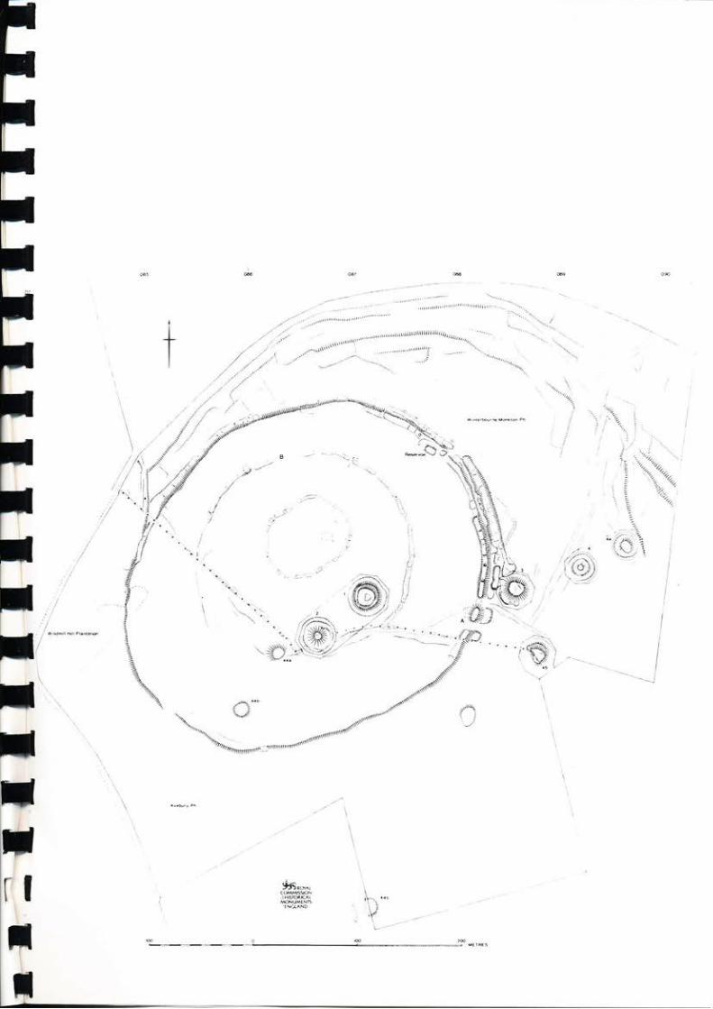
The outer enclosure, 8.45 ha in area measures a maximum 360 m in diameter on itslongest, north-east - south-west, axis. It is therefore, the largest surviving causewayedenclosure in the British Isles. Only one other neolithic enclosure, that at the nowflattened site of Crofton, Wiltshire, is larger, covering an area of c.28ha (I-obb 1995,18-25). On close inspection the outer enclosure is polygonal in shape, and appears tohave been constructed in a series of short straight sections, which vary from 50 m to 120m in length.
The enclosure is now most clearly defined at the north-east, where there has been mostof the recent reconstruction. Here a substantial bank is accompanied by an externalditch. The bank, in its present form, appears to be a continuous feature, surviving to aheight of 0.7 m and 5 m across; it has an undulating profile. It is unclear whether ornot the peaks and troughs are odginal features, however, this seems unlikely in view ofthe renovation and reconstruction. Although frequent interruptions occur along itscourse, there are no convincing entrance gaps through the bank. The possible east-facing double entrance break at (fig 00, A), is not an original feature. The southernmostof the two breaks may be an original feature but it has clearly been widened since thebank terminals on either side of the gap are sharply truncated. Additionally, there aretraces of a slight bank 0.3m high, crossing the 10 m wide gap to the north; this appearsto be the vestige of an earlier continuous bank underneath.
Slight traces of the bank survive on the south-eastern side of the hi1l, in an area that hasbeen severely damaged by ploughing. The bank has been reduced to a height of only0.1 m above internal ground level and is 10 m wide. Elsewhere the enclosure is amarked by a continuous, outward facing lynchet or terrace which varies between 0.2 mand 2.3 m in height. The more substantial dimensions are recorded on the northeastemside, to the north ofthe parish boundary, where the enclosure spills over the edge ofthenatural escarpment: lesser dimensions are recorded along the plough damaged south andwestem sectors.
An external ditch survives intermittently around much of the northern part of theenclosure. Quarrying has destroyed a short stretch, 120 m long, to the north of theWinterbourne Monkton 3 round barrow. North of the reservoir, in an area excavatedand subsequently restored by Keiller, the ditch survives as a continuous hollow 4 m wide.Along its base there are numerous interruptions defining deeper pockets of ditch 2 m -10 m in length, surviving to a depth of 0.3 m. Elsewhere, where excavation has not
taken place, the ditch is represented by a series of elongated depressions, 4 m wide,2m - 14 m in length and up to 0.5 m deep. In places, especially on the north-west, thecausewayed ditch is accompanied by an extemal lynchet, measuring 0.3 m in height. Thisis either the remains of an outer, though now much damaged, bank, or more likely,given the presence of fie1d system in this area, the remains of a slight negative lynchet.
:ta
tlr
Middle Enclosure
The middle enclosure is almost circular in plan and measures 220 m in diameter; itencloses an area of 3.32 ha. It is of a much slighter construction than the outerenclosure and survives to a greatest height north of the parish boundary, particularly onthe east, where it has been excavated and subsequently restored by Keiller. This is
visible now as a shallow trench, 1.5 m - 3 m wide and up to 0.2 m deep. There arefrequent interruptions along its course, caused by deeper ditch or pit segments, whichare 0.5 m deep at best. Beyond the areas excavated, principally on the north and north-west, the original course of the enclosure survives as a series of irregular elongated pitor ditch segments up to 4 m wide and 0.3 m deep. In places, these are flankedinternally by a slight lynchet, 0.3 m in height, which may be the last traces of a nowdesfoyed intemal bank. The southem part of the enclosure survives intermittently andas a slight outward facing lynchet 0.2 m high.
One possible entrance into the enclosure was recorded during the survey. This faces
north and consists of a gap, 16 m across, between ditch or pit segments (X).
Inner Enclosure
The inner enclosure is sub-circular in outline with a slight indentation on thenorthwestern side and encloses an area of 0.52 ha. It is the slightest of the threeenclosures and is the one which has been most extensively excavated. At least 75% ofthe ditch circuit has been excavated, together with the eastern half of the interior. Onlythe short section of ditch forming the western side of the enclosure appears undisturbed.
Overall the ditch consists of a discontinuous hollow, 2 m wide, which survives to a depthof 0.2 m. Within its bottom there are numerous deeper segments which tend to be
narower and measure 1 m - 1.5 m wide and up to 0.4 m in depth. Occasionalcauseways are evident; they vary in width from I m -3 m. It is not clear whether thosevisible in the eastern half of the enclosure are original features or the result of theexcavations.
Rourul. Barrows
A total of ten round barrows were recorded during the survey. All but one of these,
that at SU 08811129, have been previously recorded and the nomenclature used herewill follow that established by Grinsell in the Victoria County History for Wiltshire(Grinsell 1957).
The barrow grouping includes bow1, bell, saucer and possible disc variants and are
ananged in a dispersed linear fashion. The largest examples, Winterbourne Monkton
I and 2, occupy the highest point of the hill and are very conspicuous landscape features.
The others, placed on false-crests on the gentle east facing slope overlooking the
Winterboume valley, are also prominent features when viewed from below. Three ofthe barrows, Winterbourne Monkton 2 and 3, Avebury 44a, cleatly impinge upon the
middle and outer circuits of the enclosure. The barrows are listed and described inappendix 1.
Field System
Slight remains of a held system are present on much of the steep, north-facing slope tothe north of the outer Neolithic enclosure within Winterbourne Monkton parish'Numerous north-facing lynchets, now spread, generally follow the contour of the hill withthe most substantial suwiving to a height of 2 m. Transverse field boundaries at rightangles to these are visible as a series of very slight scarps, 0. 1m high. These dehnesmall rectangular fields which range in area from 0.1 ha to 0.8 ha. The overallmorphology of this field system suggests that it is of prehistoric or Roman origin. It is
likely that similar fie1ds also extended across the south-facing slopes of the hill inAvebury Parish, but have been destroyed by ploughing. Ridge and furrow cultivationof medieval or post-medieval date is visible on aerial photographs, though not surveyed,over much of the southern part of the hilltop and this has been truncated by a series ofparallel modern drainage features (again not surveyed).
A hollowed trackway approaches the site from the north-west and impinges upon the
outer circuit of the enclosure. This holloway is in turn bisected by the boundary bankwhich separates the parishes of Winterbourne Monkton and Avebury. This survives as
a low bank 1m-2 m wide and up to 0.3m in height' with a slight and intermittentditch 1.5m wide and 0.2m deep on the northem side. Another slightly hollowed trackapproaches the site from the east and enters the enclosure through the gap in the outercircuit to the south of round barrow Winterbourne Monkton 3.
Discussion
The most striking feature of the multiple enclosure complex at Windmill Hill relates toits topographical positioning. Al1 three enclosures have been carefully placed on thehilltop in a location which does not take advantage of the natural topography. Themiddle and outer circuits in particular, enclose an area well to the north of and belowthe summit of the hill and the course of the enclosure boundaries in this area spilldramatically over the well-defined northern edge of the chalk ridge. Indeed, it is clearthat these enclosures are false-crest sighted perhaps to provide, or afford, a prospect toor from the lower lying areas to the north and north-west. False-crest sighting is a
common feature in the positioning of, for instance, many burial mounds includingNeolithic long mounds, and is usually regarded as a deliberate attempt to maximise thevisual impact of the burial mound placing it at a point where it appears, from the valleybottom, to be on the horizon (Dunn 1988,36). Thus, when seen from a lower altitude,the feature becomes conspicuous, as the whole of its profile is outlined against the sky.This implies that the contemporary landscape was relatively open and allowed this formof related visibility, an argument which may or may not be applicable in the case of theenclosures at Windmill Hi1l. Nonetheless, the enclosures here dominate the skylinewhen seen from the north, east and west and it seems reasonable to conjecture that, atthe very least, defence or fear of attack was not an over-riding consideration in theplanning and construction of the enclosure boundaries.
Each circuit of enclosure has a slightly different morphology, although this may, ofcourse, relate to the effects of subsequent land-use, damage and the effects ofexcavation. It is clear though, that moving from the interior outwards, the enclosureboundaries become more substantial, with the outer circuit being the most monumental.There are no banks or ramparts associated with the inner and middle circuits, forinstance, and it is unclear whether or not banks originally accompanied all of the ditchsegments. Smith has suggested that the asymmetdcal silting of the inner and middleditches does point to the existence of internal banks (i965, 5).
Although the monument on first impression appears to have been causewayed, suweysuggests that the outer enclosure bank may in fact have been continuous. It isunfortunate that the best preserved sections of the bank are those that have beenreconstructed by Keiller, so a definitive statement as to their original condition isdifficu1t. It may be interesting to note that a recent RCHME survey of the causewayedenclosure at Whitesheet Hill has shown there to be a slight but continuous bankunderneath the interrupted rampart (RCHME forthcoming a). Continuously ditched andbanked Neolithic enclosures are known elsewhere in southern England, being recorded,for instance,at Court Hili, West Sussex and Bury Hi1l, West Sussex (Bedwin 1984).
The enclosure complex has at a later stage formed the focus for an extensive groupingof round barrows. Ten burial mounds were surveyed and these are arranged in a
dispersed linear alignment, on a roughly east-west axis. As has been stated, at leastthree of the barrows impinge upon the enclosure circuits, and this general associationbetween Neolithic enclosures and round barrow cemeteries is a commonly repeated one(RCHME forthcoming b). At Whitesheet Hill, for example, several barrows are locatedin the vicinity of the enclosure and one of these, Kilmington 4 (Grinsell, 1957,179),
overlies the ditch of the causewayed enclosure.
The effect of the later episodes of ploughing on the hilltop undoubtedly contributes to
the slight nature of the earlier remains. It is difficult to date the origin of this freld
system, with any precision, however, Smith (1965, 12) notes a ploughsoil of Romano-
dritish date in a number of the ditch sertions, although she was unaware of the presence
of the lynchets of this field system. That this episode of ploughing was longlived is
suggested by substantial size ofthe associated held boundaries. They themselves appear
to have been overploughed, probably in recent times, since much of the survey area
retained slight traces of ridge and furrow.
Suney Method
The ground survey was carried out using a Wild TC 2000 Total Station theodolite.Individual survey stations were established as a ring traverse around the enclosure and
field system. Dala was computed using Mathshop survey software linked to a Cal-comp
plotter Detailed measurements were then added to the framework by taped off-sets.
Ackn.owledgements
The survey was carried out by D S McOmish and C R Irwis. Comments on the textwere prouided by David Field, Mark Comey and Chris Dunn. The plan was drawn byDeborah Cunliffe.
Appendix 1
Parish
Winterboume Monkton
No. i su 087097140
No. 2 su 08667137
No. 3 sU 08857141
No. 4 su 08917144
No. 4a sU 08957146
Bowl barrow c.34 m in diameter surviving to a heightof 1.8 m and surrounded by a ditch 5 m wide andup to 0.4 m deep. A partial break or ledge c. 0.5 mfrom the markedly flat topped summit suggests thatthe mound profile is not original and has seen somealteration. It is possible that this is the site of the millmentioned by Smith (1965, xxvii).NMR No. SUO7SE21.
Bell barrow c.22 m in diameter and s.3 m high; itis separated from the enclosing ditch by a berm, 4 mwide. The ditch, which varies between 2 m - 5 m inwidth, is up to I m deep and is interrupted bynumerous shallow causeways. It impinges upon theline of the middle circuit of the Neolithic enclosureand is further overlain by the Winterbourne Monkton- Avebury parish boundary bank. NMR No. SUO7SE21..
Bowl barrow c. 25 m in diameter, 2 m high is partiallyenclosed by an interupted ditch, in places, 4m wideand up to 0.8m deep. This barrow overlies the ditchof the outer Neolithic enclosure. NMR No. SUO7SE16.
Grinsell records this as a saucer banow (1957,224).Survey suggests, however, that it may be a small discbarrow. It consists of a low mound 10 m in diameter,standing to a height of c. I m, placed on a circularplatform 18 m wide. This is enclosed by a continuousditch 5 m wide and 0.6 m deep with an external bank2 m wide and 0.3 m in height above ground level.NMR No. SUO7SE 16.
Saucer barrow consisting ofa low spread oval mound15 m long (maximum). The surrounding ditch is 6 mwide and up to 0.3 m deep with traces of an externalbank, 2 m wide and 0.2 m high, surrounding it on allbut the north-western sides. NMR No. SUO7SE 16.
su 08637135
No. 44b su 08607130
No.44c srr 08717110
No. 45 su 08877135
sU 08817129
Bowl barrow reduced by ploughing to a 1ow sub-circular mound, 20 m in diameter, standing to a heightof 0.5 m. The barrow overlies the line of middleenclosure. NMR No. SUO7SE 21.
Bowl barrow severely damaged by ploughing; itsurvives as a low sub-circular mound, 17 m indiameter, and 0.3 m high. NMR No. SUO7SE 21.
Bowl barrow reduced by ploughing and bisected bya modern fence line. Only the eastern half survivesas a semi-circular mound 18 m wide and up to 0.3 mhigh.
Bowl barrow, now sub-rectangular in shape with amaximum diameter of 23 m. The mound, where bestpreserved, stands to a height of 2 m and is enclosedby a ditch which varies from 1.5 m - 3 m in width and0.3 m in depth. The parish boundary bank hasencroached upon the western half of the site. NMRNo. SUO7SE 16.
? Bowl barrow recorded for the first time. Oval inplan with a maximum length of 22 m. It has beenreduced by ploughing to a height of 0.2 m.
It;
ilt;
ttttII;
:
'ltt
l0
Bibliography
Bedwin, o. 1984. The Excavation of a Small Hilltop Enclosure on court Hil1, Singleton,---
west Sussex, 1982, Sussex Archaeological Collections 122:13-22 '
Colt Hoare. R. 1821. The Ancient
Crawford, O.G.S. 1927. Windmill
Dunn, C.J. 1988. The BarrowsCXXXYIL21-42.
History of Wiltshire. Vo1 2. London.
Hill, Wiltshire, AntiquitY I: 104-5.
of East-Central Powys, Archaeologia Cambrensis
Grinsell, L.V.G. 1957. 'Archaeological Gazetteer'., in^R'P' Pugh & E' Crittall 9)am'wctoria Cou.nry History of fiilrchire l(2): 2l-279. Oxford: oxford university Press.
Keiller, A. 1934. Excavation at windmill H11:-, Proceet]ings of the First Internati'onal
Congress of Prehistoric aruJ Protohistoric Sciences , 135-8' London'
Kendall, H.G.O. 1914' Flint Implements from -the
Surface near Avebury: Their
classiircationanddates.ProceedingsoftheSocietyofAntiquariesofLondon2ndseries. vol XXVI:73-85.
Kendall,H.G.o.lg23.ExcavationsconductedontheNEsideofWindmillHill...;in------- ihe neport of the Earthworks committee...for 1922, 25-6; Congress ofArchaeological. Societies /Sociery rf Antiquaries of t'ondon '
Lobb,s.lgg5.ExcavationatCroftonCausewayedEnclosure,WiltshireArchaeologi.calarul Natural History Magozine 88:18-25'
Merewether, J. 1851. Diary of the Examination of Barrows and other Earthworks in..-theNeighbourhoodofSilburyHillandAvebury,Wilts,inJulyandAugust_1849.
proceeiings of the Annu.al Mieting of lng {gnggglogical Institu.te of Great Brirain
and lrelaid., -held
at Salisbury, July 1849,82-107' George Bell: London'
R.C.H.M'E'Forthcominga'TheArchaeol.ogyoJ'aWessexLa'ntlscape:Sou'thWiltshire.
R.C.H.M.E. Forthcoming b. The Neolithic en'closures of England'
smith, I.F. 1958. The 1957-8 Excavations at windmill Hrll, Antirluiry 32:268-9.
Smith,I.F,lg5g.ExcavationsatWindmillHill,Avebury,Wilts'1951-S,WiltshireArchaeologica.l and Natural History Magazine 51:149-62'
smith, I.F. 1965. Winrlmill HilI anct Avebury: Etcavations by Al.exrt.nder Keiller 1925-1939'
Clarendon Press: Oxford.
Whittle. A. 1989. Winclnill Hill 1988, Pasr No'6:7'
l1
Whittle, A. 1993. The Neolithic of the Avebury Area: Sequence, Environment,Settlement and Monuments, Oxford Journal of Archaeology l2(l): 29-53.
Whittle, A. 1994. Excavations at Millbarrow Neolithic Chambered Tomb, WinterbourneMonllon, North Wiltshire, Wiltshire Archaeological and Natural History Magazinc87: 1-53.
l2
t'ft