
iRAP Survey Manual
19
iRAP Survey Manual www.irap.org
-
Upload
khangminh22 -
Category
Documents
-
view
1 -
download
0
Transcript of iRAP Survey Manual

iRAP Survey Manual | 1
ABOUT IRAP The International Road Assessment Programme (iRAP) is a registered charity dedicated to saving lives by
eliminating high risk roads throughout the world. Like many life-saving charities working in the public health
arena, we use a robust, evidence-based approach to prevent unnecessary deaths and suffering.
iRAP works in partnership with governments, road authorities, mobility clubs, development banks, NGOs and
research organisations to:
• inspect high-risk roads and develop Star Ratings, Risk Maps and Safer Roads Investment Plans
• provide training, technology and support that will build and sustain national, regional and local capability
• track road safety performance so that funding agencies can assess the benefits of their investments.
The programme is the umbrella organisation for EuroRAP, AusRAP, ChinaRAP, KiwiRAP, USRAP, IndiaRAP,
BrazilRAP and SARAP. Road Assessment Programmes (RAP) are now active in more than 100 countries
throughout Europe, Asia Pacific, the Americas and Africa.
iRAP is financially supported by the FIA Foundation for the Automobile and Society. Projects receive support
from the Global Road Safety Facility, mobility clubs, regional development banks and donors. Our partners,
charities, the motor industry and institutions such as the European Commission also support RAPs in the
developed world and encourage the transfer of research and technology to iRAP. In addition, many individuals
donate their time and expertise to support iRAP.
For more information
For general enquiries, contact us at:
International Road Assessment Programme (iRAP)
Worting House, Basingstoke
Hampshire, UK, RG23 8PX
Telephone: +44 (0) 1256 345598
Email: [email protected]
To find out more about the programme, visit www.irap.org.
You can also subscribe to ‘WrapUp’, the iRAP e-newsletter, by signing up on the website homepage.
iRAP Survey Manual Version 4.0 (English)
© International Road Assessment Programme (iRAP) 2019
iRAP technology including protocols, processes and brands may not be altered or used in any way without the express
written agreement of iRAP.
iRAP is registered in England & Wales under company number 05476000. Registered Office: 60 Trafalgar Square, London, WC2N 5DS.
Print warning
Printed copies of this document or parts thereof should not be relied upon as a current reference document. Always refer
to the electronic copy for the latest version at: http://www.irap.org.

iRAP Survey Manual | 2
CONTENTS 1 INTRODUCTION ........................................................................................................................................... 3
What is an iRAP survey? ....................................................................................................................... 4
Training and accreditation ...................................................................................................................... 4
2 SURVEY PROCESS ..................................................................................................................................... 6
Familiarisation with manual and project requirements .......................................................................... 7
Survey planning ..................................................................................................................................... 7
Health and safety ................................................................................................................................... 8
Survey team ......................................................................................................................................... 10
Survey vehicle ...................................................................................................................................... 11
Survey images ..................................................................................................................................... 11
Daily survey records............................................................................................................................. 12
Flow and speed sample process ......................................................................................................... 12
Quality and compliance reviews .......................................................................................................... 14
3 STANDARD DELIVERABLES .................................................................................................................... 17
iRAP Survey Manual | 3
1 INTRODUCTION iRAP was established to help tackle the devastating social and economic cost of road crashes. Without
intervention, the annual number of road deaths worldwide is projected to increase to some 2.4 million by 2030.
The majority of these will occur in low-income and middle-income countries, which already suffer nine out of ten
of the world’s road deaths. Almost half of those killed will be vulnerable road users – motorcyclists, bicyclists
and pedestrians.
Large as the problem is, making roads safe is by no means an insurmountable challenge. The requisite research,
technology and expertise to save lives already exists. Road safety engineering makes a direct contribution to
the reduction of road death and injury. Well-designed intersections, safe roadsides and appropriate road cross-
sections can significantly decrease the risk of motorised vehicle crashes occurring and the severity of crashes
that do occur. Sidewalks, pedestrian crossings and bicycle paths can substantially cut the risk that pedestrians
and bicyclists will be killed or injured by avoiding the need for them to mix with motorised vehicles. Motorcycle
lanes can minimise the risk of death and injury for motorcyclists.
By building on the work of Road Assessment Programmes (RAP) in high-income countries (EuroRAP, AusRAP,
USRAP and KiwiRAP) and with the expertise of leading road safety research organisations worldwide, including
ARRB Group (Australia), TRL (United Kingdom), MRI Global (United States) and MIROS (Malaysia), iRAP has
developed four globally-consistent protocols to assess and improve the safety of roads.
The iRAP Protocols
1. Risk maps use detailed crash data to illustrate the actual number of deaths and injuries on a road network.
2. Star Ratings provide a simple and objective measure of the level of safety provided by a road’s design.
3. Safer Roads Investment Plans (SRIP) draw on approximately 90 proven road improvement options to
generate affordable and economically sound infrastructure options for saving lives.
4. Performance Tracking enables the use of Star Ratings and Risk Maps to track road safety performance and
establish policy positions.
This manual relates to Protocols 2 and 4. The iRAP Survey Manual is one of a number of specifications and
guides provided for completing projects, accreditation and results analysis shown below.
• Project Planning Manual (includes the Standard Terms of Reference)
• Inspection System Accreditation Specification
• iRAP Survey Manual
• iRAP Coding Manual
• iRAP Star Rating and Investment Plan Manual
• Upload File Specification
• ViDA User Guide
• Star Rating for Designs User Guide (for users of the SR4D web app)
The figure below illustrates the process used to undertake Star Ratings and Safer Roads Investment Plans,
which can be used as part of a systematic, proactive approach to road infrastructure risk assessment and
renewal based on research about where severe crashes are likely to occur and how they can be prevented.

iRAP Survey Manual | 4
The iRAP Star Rating and Safer Roads Investment Plan process
What is an iRAP survey?
The primary purpose of an iRAP survey is to collect geo-referenced images of roads which can be used for road
attribute coding. Collection of samples of traffic flows, pedestrian flows, bicyclist flows and speeds on the roads
is also typically performed during a survey. This manual provides guidance on the survey process and standard
deliverables. Adherence to this guidance will help ensure that:
• Data collected can be used in subsequent coding activities and to produce Star Ratings and Safer
Roads Investment Plans (SRIP).
• Poor quality or erroneous data is quickly identified so it can be rectified.
• Data is collected in a repeatable way in future Star Rating and SRIP assessments.
Training and accreditation
iRAP activities require specialist skills and knowledge. iRAP strongly recommends training for people preparing
to undertake an iRAP project. Information about the training courses available can be found on the iRAP website,
at https://www.irap.org/training.
iRAP also manages an accredited supplier scheme. There are two categories of iRAP accreditation:
1. Activity accreditation. Suppliers that hold activity accreditation have completed training and
successfully completed a test and have demonstrated experience. They have also signed the iRAP
Accredited Supplier Code of Conduct. Activity accreditation is renewed annually based on
demonstrated experience and may include refresher training and consideration of client feedback.
2. Inspection system accreditation, which relates to equipment and software used to perform surveys
and coding. Inspection systems that are accredited have met the requirements described in the iRAP
Inspection System Accreditation Specification, and their manufacturers have signed the iRAP
Accredited Supplier Code of Conduct. Inspection system accreditation is renewed every three years
and may include retesting of the system and consideration of client feedback.
It is beneficial that accredited suppliers and an accredited inspection system are used in iRAP assessments,
though it is not mandatory. Information about accreditation can be found on the iRAP website, at
https://www.irap.org/accreditation.
If it is decided that accredited suppliers and/or an accredited inspection system will be used in a survey project,
the following information on the team members and inspection system should be included in terms of references
(TORs) and contracts.

iRAP Survey Manual | 5
Survey team members
Name Email address Role(s) in project iRAP
accreditation
number
iRAP accredited
since date
iRAP
accreditation
renewal due date
Inspection system
Inspection system
name
Manufacturer iRAP accreditation
number
iRAP accredited
since date
iRAP accreditation
renewal due date
iRAP Survey Manual | 6
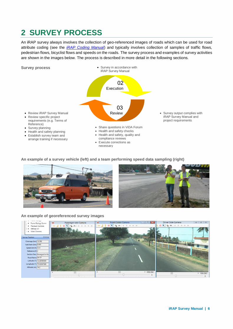
2 SURVEY PROCESS An iRAP survey always involves the collection of geo-referenced images of roads which can be used for road
attribute coding (see the iRAP Coding Manual) and typically involves collection of samples of traffic flows,
pedestrian flows, bicyclist flows and speeds on the roads. The survey process and examples of survey activities
are shown in the images below. The process is described in more detail in the following sections.
Survey process
An example of a survey vehicle (left) and a team performing speed data sampling (right)
An example of georeferenced survey images
02
Execution
03
Review
01
Preparation
04
Compliance
• Survey in accordance with iRAP Survey Manual
• Review iRAP Survey Manual
• Review specific project requirements (e.g. Terms of Reference)
• Survey planning
• Health and safety planning
• Establish survey team and arrange training if necessary
• Share questions in ViDA Forum
• Health and safety checks
• Health and safety, quality and compliance reviews
• Execute corrections as necessary
• Survey output complies with iRAP Survey Manual and project requirements

iRAP Survey Manual | 7
Familiarisation with manual and project requirements
An iRAP survey project should begin with a clear understanding of the guidance in this manual and the specific
requirements of the project, which are usually set out in a project plan or terms of reference. A substantial
investment of time and resources can be consumed in a project, so it is desirable that all requirements are well
understood by everyone involved in the survey. Survey data that does not comply with the guidelines in this
document cannot be accepted.
Survey planning
Survey planning requires the preparation and maintenance of a survey plan. A plan will include the following
topics:
1. Health and safety (see 2.3 for more details).
2. Project roads. A complete list of the roads to be surveyed including exact names and survey start and
end points (such as GPS location, chainage, intersection or cross street names or landmarks).
3. Selection of vehicle, equipment and software. The survey system to be used should to reflect a number
of factors such as:
o Length of road network: For short surveys of less than 100 km, it may be feasible to use an off-
the-shelf video camera. For longer surveys where very large amounts of data is generated and
needs to be managed, it may be desirable to select system that is tailor-made for road surveys,
such as those that are iRAP accredited (see: https://www.irap.org/accreditation).
o Type of roads: When surveying roads in cities, it is easy to lose a GPS signal because buildings
can block the line of sight. More sophisticated inspection systems, such as differential GPS and
distance measuring instruments (DMI), can help compensate for this.
o How the survey data will be stored and shared: There are a number of off-the-shelf cameras
compatible with Google Streetview, which provides a powerful platform for sharing survey data.
For other camera types, planning will need to consider how data can be transferred and stored
on hard drives or servers.
o Inspection systems already in use: Many road agencies have well-established road data
collection programs and systems. It is often desirable that iRAP survey data be collected in a
format that is compatible with data collected in the past.
4. Vehicle, equipment and software setup and maintenance. This includes the set-up of cameras to
capture images of requisite quality for coding, cleaning camera lenses, calibration of distance
measuring instruments (DMI) and/or cameras (when on-screen length measurements are to be used).
It also includes preparation of equipment to be used in flow and speed sampling and back-up equipment
(hard drives). It is important the plan contains precise information as errors made in the calibration or
set up of the hardware will result in poor quality or erroneous data that will affect the coding phase of
the project.
5. Travel to the start of the survey. The distance from the overnight accommodation to the survey start
location should be considered when planning each day’s survey. If overlooked, the survey team will
need to catch up this time during the day, which may impact the safety of the survey and the quality of
the data collection.
6. Travel speed. iRAP surveys must be carried out at a safe speed. The survey vehicle should not exceed
the legal speed limit.
iRAP Survey Manual | 8
7. Traffic congestion. It is possible that during the survey the vehicle may be slowed by traffic congestion,
particularly in busy urban environments. The team should anticipate and allow for these delays, or plan
to avoid peak hours, so that they are not rushing to make up lost time.
8. Time of day. If the survey is undertaken in low level light this can make the images hard to read,
therefore requiring re-survey. Sun-glare can also lead to poor image quality.
9. Weather conditions. Adverse weather conditions such as snow, high winds and heavy rain can delay
the survey and make progress slow. Avoid surveying during periods of prolonged bad weather and
allow extra time to complete the survey as necessary.
10. Supporting data collection. Time should be allowed for traffic, pedestrian and bicyclist counts and speed
sampling. The plan should include a complete list of locations where traffic, pedestrian and bicyclist
flows and speed data samples will be collected.
11. Driving hours. For safety, regular breaks from driving should be made by the survey team.
12. Navigation. When a survey team is operating in an unfamiliar territory, allowance should be made for
the possibility that they get lost.
13. Travelling to the overnight location. Care must be taken when driving to the overnight location at the
end of the survey day as this is when the survey team are at their most fatigued. Also, poor light can
make the driving task more demanding and can make it harder to find a predetermined destination.
14. Rest days. Time should be built into the schedule to allow the survey team to rest and recover.
15. Briefings and presentations. A survey team is often asked to give presentations on their work during
the survey, for example at a district highway department office. Time should be allocated for these
briefings.
16. Health and safety, quality and compliance reviews. Allocating time for these reviews is essential.
Health and safety
iRAP assessments are typically focussed on high-risk roads. Therefore, it is very important that everyone
involved in the survey is informed of—and manage—all risks associated with the completion of the survey
activities.
A health and safety plan should take into account the following issues:
• Operational working hours: How many hours will be worked by the survey each day, including travel to
and from survey start and end points.
• Road travel: Safety and security issues on the selected routes and what to do in the case of a break
down, crash or security threat.
• Inspections and data collection: Vehicle operation protocols, safety equipment (hi-vis vests for road side
inspections), safety instructions for selecting and stopping at road side locations.
• Vehicle safety details: Seat-belts for all passengers, air-bags and safe mounting of equipment.
• Traffic and personnel management during flow and speed data sampling: Supervision and safety
training, personnel communications, length of time, rendezvous points (if required), emergency and
incident protocols.
• Country specific requirements: Immunisations, letters of authority and security arrangements.
• Office conditions: Safe and healthy workspace for data management and quality control.
• Arrangements for regular check-ins with home office: Regular reporting intervals, protocols for alerting
home office of any issues that threaten the safety or security of the survey team.
iRAP Survey Manual | 9
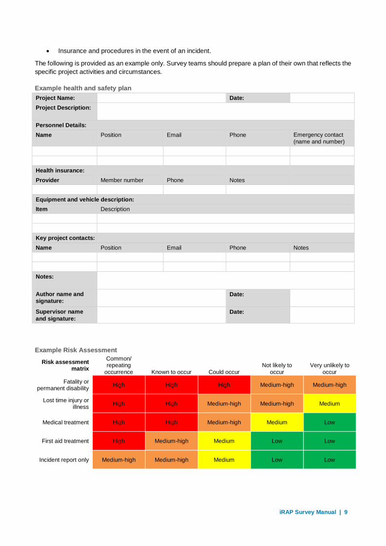
• Insurance and procedures in the event of an incident.
The following is provided as an example only. Survey teams should prepare a plan of their own that reflects the
specific project activities and circumstances.
Example health and safety plan
Project Name: Date:
Project Description:
Personnel Details:
Name Position Email Phone Emergency contact (name and number)
Health insurance:
Provider Member number Phone Notes
Equipment and vehicle description:
Item Description
Key project contacts:
Name Position Email Phone Notes
Notes:
Author name and signature:
Date:
Supervisor name
and signature: Date:
Example Risk Assessment
Risk assessment matrix
Common/ repeating
occurrence Known to occur Could occur Not likely to
occur Very unlikely to
occur
Fatality or permanent disability
High High High Medium-high Medium-high
Lost time injury or illness
High High Medium-high Medium-high Medium
Medical treatment High High Medium-high Medium Low
First aid treatment High Medium-high Medium Low Low
Incident report only Medium-high Medium-high Medium Low Low

iRAP Survey Manual | 10
No. Job Sequence
Potential Hazard
Probability Consequence Risk Rank
Required Hazard Control
1 Road survey Crash due to fatigue
Known to occur
Fatality or permanent disability
High The driver shall stop in a safe location and take a break every 2 hours.
2 Manual pedestrian flow counts
Struck by vehicle
Known to occur
Fatality or permanent disability
High People taking flow counts will wear high visibility vests and shall stand in a location as far a practical from moving traffic.
3 Road survey Crash due to
speeding
Could occur Fatality or permanent disability
High The driver shall always comply with official speed limits and drive at speeds that respect safety of themselves and others.
4 Etc…
Survey team
The survey team should include (noting that one person may play multiple roles):
1. A supervisor who oversees the survey and is able to represent the project and present basic
information at stakeholder briefings.
2. One or more professional drivers or personnel trained to operate the survey vehicle.
3. Technical staff capable of completing activities in this manual.
The following should also be considered:
1. During a survey, the team may be required to conduct demonstrations of data collection during
stakeholder briefings.
2. All team personnel should have necessary travel documentation and approvals.
3. The team should be suitably attired to participate in stakeholder briefings and demonstrations as
required.
4. Team members should be responsible for, and act in accordance with, the health and safety plan and
ensure all safety and security issues are adequately addressed.
5. Additional stakeholder personnel may participate in the survey at their request. This may include, for
example, a local navigator from the local road agency to ensure all road referencing details align to
authority practices. Other stakeholders may participate in the survey from a training and awareness-
raising perspective. The survey team should ensure that any additional personnel comply with the
health and safety plan, including using seat belts inside the survey vehicle at all times and wearing hi-
vis vests during roadside inspections and supporting data collection.

iRAP Survey Manual | 11
Survey vehicle
A range of technologies and systems may be used to collect georeferenced images of the road. Systems that
are iRAP accredited are listed on the iRAP website (http://www.irap.org). In most cases, a survey system is
attached to a car or van, though it is feasible that surveys are performed using trucks, motorcycles and bicycles.
The following are standard requirements for a vehicle used in a survey:
1. The survey vehicle should be in a safe, well-maintained condition and comply with the Health and
Safety Plan.
2. The survey vehicle should meet all licence, registration and insurance requirements (e.g. width,
height, signage) for operation in the survey jurisdiction.
3. The survey vehicle should be clean and presentable (suitable for media, steering committee,
stakeholder and promotional activities).
4. High quality logos of the stakeholder organisations can be placed on the survey vehicle for the
duration of the survey.
5. The survey vehicle should have sufficient space for the survey team as well as provide for additional
stakeholder personnel and their luggage who may participate in parts of the activities.
6. The vehicle should be available for viewing and inspection during events such as a commencement
mission or official project launch.
Survey images
The minimum requirements for images collected during a survey are:
1. Resolution of 1280 x 960 pixels.
2. 140-degree field of view (centred on the travel lane). This may be accomplished with either a single
camera or with multiple cameras with overlapping fields of view.
3. For still images, captured at fixed intervals of no greater than 20 metres.
4. Geo-referenced with the following data recorded for each image:
a. Unique image number
b. Road name
c. Road section
d. Distance along the road
e. Section length
f. Date
g. Time
h. Latitude and longitude.
5. Recorded with latitude and longitude data in WGS84 projection and decimal degrees units. Latitude
and longitude data are recorded with a minimum accuracy of < +/- 10 metres for at least 90% of
images and must not ‘drop-out’ for any more than 500 metres at a time.
6. Road and roadsides are clearly visible. Images should not be compromised by factors such as sun
glare, rapid changes in shade/sun, poor lighting, dirty camera lenses, fog and blurring.
7. Forward space within the images is kept clear of vehicles as much as possible to ensure the required
attributes can be viewed and assessed. This may require an escort for congested urban areas.
iRAP Survey Manual | 12
8. Recorded for a minimum of 500 metres before the official start point and 500 metres after the official
end point of each section of road. Road sections should be segmented in accordance with advice
from the relevant road authority.
9. Collected for all divided carriageway road lengths (surveyed in both directions) regardless of length.
The definition of a divided carriageway road for the purposes of this project is all road sections where
the median type is classified as code 1-7, 12, 15 as listed in iRAP Coding Manual.
Daily survey records
Each day’s survey activities should be recorded. The records should include the date, start and end locations,
total length surveyed, the name of the road or corridor being surveyed, the file name, and any other details,
such as landmarks or if the day’s survey is a repeat of a previous days to address quality issues and so on.
Daily survey records are valuable for tracing data issues and understanding where errors may have been made.
As part of this, it is useful to check that road names and sections are labelled correctly in the data, and that the
correct roads have been surveyed.
Example of a daily survey record
Survey Log Job Number: 048_iRAP_EARIV
Region: East Riviera
Vehicle Reg # HVT298
File Name Survey Date Start Location
End Location
Total length
Survey Corridor
Comments
Springfield to Georgetown 01
30/04/2018 Eastern Freeway interchange
Goldfields Road
26km A86
Springfield to Georgetown 02
30/04/2018 Goldfields Road
M2 interchange
8.9km A86
Georgetown to Newport 01
30/04/2018 Georgetown Airstrip
Quarry Road intersection
16.7km A86 Resurvey of 4.2 km of Springfield to Georgetown section between Georgetown airstrip and M2 Interchange.
Georgetown to Newport 02
30/04/2018 Quarry Road intersection
Newport Railway Station
22km A86
TOTAL 73.6km
Team members 1. Marcus Smith
2. Gillian Walter
All surveys are imported into processing toolkit
Video files check for image quality (camera focus/ zoom)
All surveys processed for roughness, rutting, texture and
geometry
All data copied from vehicle hard drive to portable hard drive
YES
YES
YES
YES
Flow and speed sample process
Flow and speed data is required for a Star Rating and SRIP analysis. Samples of these data are typically
collected during the survey. However, in circumstances where reliable traffic flow, pedestrian flow, bicyclist flow

iRAP Survey Manual | 13
and speed data are already available, collection of these data may excluded from the survey. If this data is not
required, this should be clearly stated in the project plan or terms of reference.
The minimum requirements for flow and speed data is as follows:
1. The sample locations should be representative of the network including, for example, rural, urban,
schools, straight, curved, flat and sloping sections of road.
2. The number of sites at which data is collected must be sufficient to describe the general flow and
speed characteristics various types of sections of the road network. Unless otherwise specified, the
number of locations should be at least:
a. 3 for surveys less than 100km in length
b. 10 for surveys for less than 2,500km in length
c. 20 for surveys less than 10,000km in length
d. 40 for surveys greater than 100,000km in length.
3. Sample periods should be a minimum of 1 hour. Sampling should not be conducted on days of
abnormal traffic periods, such as national, local and school holidays. Special attention should be given
to schools. Data collection periods should overlap with school start and finish times.
4. The following descriptive information should be collected for each location:
a. Site number
b. Road name
c. Road section
d. Area type (urban/rural)
e. Location description (e.g. rural, urban, school, straight, curved, flat and sloping)
f. Latitude
g. Longitude
h. Date
i. Start time
j. End time
k. Posted speed limit(s)
l. Number of traffic lanes in each direction.
5. All motorised vehicles passing each location during the sample period should be counted. Where the
road is divided, numbers of vehicles should be reported separately for each travel direction.
6. All pedestrians walking along and across the road during the sample period should be counted and
recorded separately. Numbers of people walking along the road should be reported separately by
travel direction.
7. All bicycles, including conventional bicycles and e-bikes, passing the location during the sample
period should be counted. Numbers of bicycles should be reported separately by travel direction.
8. Speed data should be recorded as follows:
a. Locate vehicles, personnel, and equipment in a concealed location that does not attract the
attention of drivers or affect their speeds. Ideally, drivers should not know their speeds are being
measured as they approach the speed measurement location.
iRAP Survey Manual | 14
b. Measure speeds of at least 100 motor vehicles at each location and record the speeds. Do not
record speeds for bicycles or other non-motorized vehicles. At sites with very low vehicle
volumes, the collection of speed data may be ended after 1 hour, even if 100 vehicles have not
yet been measured.
c. Measure speeds only for vehicles that are not being delayed by another vehicle or impeded by
traffic at intersections, property access points or other temporal factors.
d. Record speeds separately for cars, trucks and motorcycles.
e. Select the vehicle to measure in an unbiased way, so that the vehicles selected are
representative of the vehicle stream.
f. At most sites, measure speeds for vehicles travelling in only one direction of travel. The direction
of travel for which vehicle speeds are measured should be recorded on the form as northbound,
southbound, eastbound, or westbound. At sites with very low vehicle volumes, speeds of vehicles
may be measured for both directions of travel so that it will take less time to get speed data for
100 vehicles.
Quality and compliance reviews
It is good practice to perform quality and compliance reviews on a daily basis. If problems are found and
corrected early, then subsequent complications can be minimised and/or the need for re-surveys can be avoided.
These reviews involve checking that each of the guidelines described in this manual have been complied with
and should particularly include:
1. Checks of compliance with the health and safety plan and recording any issues that have occurred and
responses.
2. Checks that the specific requirements of the project (i.e. the project’s terms of reference) have been
complied with.
3. Completion of a daily survey record (see 2.7).
4. Reviewing images to ensure that they comply with the minimum requirements. It useful to plot the survey
points on a map to check GPS and distance measurement accuracy (see example below).
5. Reviewing flow and speed sample data to ensure that they comply with the minimum requirements.
6. Checking the condition of hardware, such as checking that cameras are free of dirt and insects, and
that all the components are secure.
7. Making a daily back-up of the survey data to avoid the need for costly resurveys to capture lost data.

iRAP Survey Manual | 15
Example of good quality GPS data collected during a survey
Example of poor quality GPS data collected during a survey (in this case the GPS was affected by the
presence of tall buildings)

iRAP Survey Manual | 16
Example of a good quality survey image
Example of a poor quality survey image (sun glare)
iRAP Survey Manual | 17
3 STANDARD DELIVERABLES Standard deliverables for an iRAP survey are:
1. An inception report including details on the following:
a. Survey plan
b. Health and safety plan
c. Survey team
d. Survey vehicle
e. Survey images
f. Daily survey records
g. Flow and speed sampling, and
h. Quality and compliance reviews.
2. Licensed copies of any specialised software used for viewing georeferenced images and data.
3. Short weekly reports summarising:
a. Progress (measured in terms of km completed)
b. A summary of key activities completed
c. Health, quality and compliance review processes completed
d. Health, quality and compliance issues that have been identified and rectifications made
e. Photos of activities
f. Planned activities for the next 2 weeks
g. Any issues that may affect performance of the survey, and
h. Samples of survey data for the road sections where surveys are complete.
4. An electronic copy of all geo-referenced images upon completion of the survey.
5. An electronic copy of traffic flow, pedestrian flow, bicyclist flow and traffic speed data and
corresponding descriptive information for each sample location in Microsoft Excel format (where
collection of this data is required in the project).
6. A final report describing activities undertaken, key data and results and any issues that those who
will use the data need to take into consideration.
It is suggested that final acceptance of road survey data is withheld until a review by the road coding team is
completed. This review may reveal previously unidentified issues with the survey that may require correction
or update.
iRAP Survey Manual | 18
Document version
Version Update
June 2011 iRAP model version 3 compatible specification, Road Survey and Coding Specification, created.
May 2013 Appendix A updated to reflect May update to the upload specification.
April 2014 Revisions made to reflect creation of the Standard iRAP Term of Reference document.
Adjustments made to section describing supplier staff. Appendix A removed and replaced with a
link to an online list of road attributes.
May 2019 iRAP Survey Manual Version 4.0 released as part of a full update to iRAP specifications, user
guides and manuals. The new iRAP Survey Manual combines information from previous versions
of the Road Survey and Coding Specification, Quality Assurance Guide and Supporting Data
Template. The new iRAP Survey Manual now includes requirements for the collection of speed
and flow data as part of the survey process (if data is not currently available).