Contents - Forest Survey of India
97
('t{)VFR"MENT OF INDIA r..n:-.;ISTR'r OF ENVIRONMENT AND FORfST REPORT ON , FOREST RESOURCES S'CRVEY OF AMARA VA TI DISTRICT (MAHARASHTRA) FOREST SURVEY OF INDIA CENTRAL ZONE NAGPUR 1999 (for officail use only)
-
Upload
khangminh22 -
Category
Documents
-
view
0 -
download
0
Transcript of Contents - Forest Survey of India

('t{)VFR"MENT OF INDIA r..n:-.;ISTR'r OF ENVIRONMENT
AND FORfST REPORT ON ,
FOREST RESOURCES S'CRVEY OF
AMARA V A TI DISTRICT (MAHARASHTRA)
FOREST SURVEY OF INDIA
CENTRAL ZONE NAGPUR
1999
(for officail use only)

REPORT
ON
(for official use only)
FOREST RESOURCES SURVEY
OF
AMRA V ATI DISTRICT
(MAHARASHTRA STATE)
GOVERNMENT OF INDIA
MINISTRY OF ElWIRONMENT & FORESTS
FOREST SURVEY OF INDIA
CENTRAL ZONE, NAGPUR
1999

"
2.
',~
"
!
'-----.,,-,... -------""'l'Ii=~.
MAP OF INDIA
'SHOWIHG
SURVEY MEI\ SHOWN lHUS
SURVEYED
-------~~ ~--------------~.4T.·~------------.;r.~,
AREA
'f .
~ !l f. Al10 4.MMI
• & () NICOBAR
.. I
\,,11 a:
INDEX MAP OF .AMRAVATI DISTT. M.S.
KHAN INA
12
5
6
REFERENCES
S TATE BOUNDARY .......... -.-....
flSTRICT BOUNDARY -.... ----DISTRICT Hd.atr. <i)
ROAD I -RIVER _...._.c:::::::
RAILWAY ~

PREFACE
'. Central Zone of Forest Survey of India, Nagpur carried out the. inventory of forest resources of Amravatl district of Maharashtra State from January to June,1995. The report in your hands is the outcome of the tremendous hard work done by the field staff of ·this office. An attempt has been made to present useful qualitative and quantitative information pertaining to various forestry parameters viz. methodology of the survey, data processing, details of area surveyed/inventoried and findings with regard to forest resources of the district.
Findings of this report reveal that Amravati district, spread pver an area of J 2212 sq.km. contains forest area of 3574.35 sq.km. Two broad forest types have been identified in the district as a whole viz. Teak forests and Miscellaneous forests. Total vegetated area in the district is ,3035.18. sq.km·. out of which 79% is the Teak forests and rest is the Miscellaneous forests. Of the' entire vegetated area 19.99 sq.km. are dense tree forests, 2455.55 sq.km. (68.70%) are moderately dense forest with crowh density 30-70%, 324.68 sq.km. (9.08%) are open tree forest with crown density 5% -30%, 9.99 sq.km. are bamboo brakes, 224.98 sq.km. are young plantations, scrub are found over 1.4% forest area i.e. 51 .18 sq.km. The results of this inventory further reveal that 57.8% of the teak forests and 36.5% of the Miscellaneous forests'are in the small timber category with diameter ranging from 20-30 cm.. 53.3% of the 10tal forest is in this category, 7.4% of the total crop is in regeneration stage of which 81 .8% is in Miscellaneous forests and 18.2% is in Teak forests type.
Further, the district forests contain 73,44 million stems with an average of 241.954 stems/ha. Total standing volume is to the tune of 36.80 million cubic metre with an average of 121.233 cubic metre per hectare. 65% of the entire growing stock is contributed by Teak species and 35% by the other species. Per hectare volume in the case of Teak stratum is 79.12 whereas that in the case of other species is 42.11. Teak has the maximum contribution towards growing stock while that of other species is insignificant.
Field work was carried ~ut by t,re field parties led by S/Shri M.K.Madaria, J.S.Kumbhkar, P.R.Singh, S.S.Kumbhare, R.P.Sao, R.K.Mahobe, all Junior Technical Assistantspnd S/Shri N.C.Dewangan and S.S.Baghel, both Deputy Rangers. The field work was supervised by Shri B.R.Pandey, Sr.Technical Assistant. The entire field work was carried out under the supervision of Shri P.V.Savant, IFS, Joint Director and Shri

S.B.Elkunchwar, IFS, Deputy Director. Data processing was done at the Headquarter Office, Dehradun by Shri S.K.Chakravarty, Deputy Director. S/shri V.P. Malik. DPA (B), N.S.Mathur, OPA(B), O.V. Sangolkar. OPA (A) and Smt. Girija Arora, DPA(A). The report has been prepared by Shri T.S.K.Reddy, IFS, Deputy. Director under the guidance of Shri F.S.Jofry,IFS, Joint Director. Forest Survey of Indio, Central Zone. Nagpur. Maps and diagrams have been prepared by S/Shri D.S.Gulkari and C.B.Murty, Draftsmen. The report has been typed by Shri D.N.Kadu, Jr.Stenographer. ~.-
Excellent co-operation extended by the Officers and stoff of Maharashtra Forest Department is thankfully acknowledged without which it would not have been feasible to complete this work within the stipulated time frame.
Further. it is hoped that the report in your hands will be useful to the planners in the. State Forest Department.
Dr. Devendra Pandey Director, Forest Survey of India, DEHRADUN (U.P).

SUMMARY
Inventory of Forest Resources of Amravati district of Maharashtra was carried out by Forest Survey of India, Central Zone, Nagpur in the year 1995. The field work was carried out during the months between January to June,1995. The salient features of the survey can be summarised as under: i) The district forest area is mostly of moderately dense forests. It
comprises about 70% of the total forest area with a crown density of 30% to 70%. 324.68 sq.km. is open forest and 51.18 sq.km. is scrub forest. Young plantations of forestry species in 132.84 sq.km. of area.
ii) The forest of the district can be classified into two strata, viz; Teak and Miscellaneous. The percentage distribution of Teak growing stock is 90% and that of Miscellaneous forest is 34.\ 0%.
iii) In Teak stratum, 69.77% is Teak and in Miscellaneous stratum Boswellia serrata is the major species making 26.15% of forest species and percentage of Teak is 25.7.
iv) 78% of Teak and 19.8% of Miscellaneous forest is of 1-5 m top height class and only 1.6% of Teak and Miscellaneous forest is of 6-10 m top height class.
v) Big timber class crop comprises of only 6.6% of forest and small timber is 53.28% of the total crop and not much of natural regeneration is seen in the forests of Amravati district.
vi) The total volume per hectare in Teak stratum is 138 cU.m. per ha of which teak percentage is 69.77 and in Miscellaneous stratum the total volume per hectare is 58.54 cU.m. of which Boswellia serrato is 15.31 cU.m. and teak comprises 15.05 cU.m.
vii} The district has q plantation potential of 376.60 sq.km. which forms 10.5% of the' forest area.
viii) The total number of stems in the forests of the district is about 73.44 million with an average of 241.96 stems per hectare.
-ix) The total standing volume of the forest is about 36.79 million cU.m.
with an average of 121 :23 cU.m. per hectare. -The important species whose contribution to growing stock is significant are: Tectona grandis (65%), Boswellia serrata (5.96%), Anogeissus latifolia (5.04%) and Lagerstroemia parviflora (3.95%) etc.
FOREST SURVEY OF INDIA CENTRAL ZONE, NAGPUR
ACKNOWLEDGEMENT
This Organisation wishes to express deep gratitude and sincere
thanks to the Conservator of Forests, Amravati Circle, Amravati, the
Deputy Conservators of Forests, Amravati Forest Division, East Melghat
Forest Division, South Melghat (Akot) Forest Division, West Melghat Forest
Division based at Amravati and Director, Melghat TIger Project based at
Paratwada. Our sincere thanks are also due to the entire field staff of
Moharashtra Forest Department in Amravati district who extended
valuable co-operation to our field parties during the survey work in the
district without which it would not .have been possible for us to complete
the task in the stipulated time.
F.S. JAFRY JOINT DIRECTOR,
FOREST SURVEY OF INDIA, CENTRAL ZONE, NAG PUR.

CONTENTS
Para Pag No, CHAPTER I c
No. BACKGROUND INFORMATION
1.1 General 1 1.2 Location of the area 1 1.3 Topography, Relief and drainage 1 1.4 Area and population 3 1.5 Forest areas 5 1.6 Climate 5 1.7 Land use pattern 7 1.8 Soils 7 1.9 Socio-economic features 8
CHAPER II
THE FORESTS 2.1 General 10 2.2 Forest Types 10 2.3 Wild life 13 2.4 Forest produce 14 2.5 Forest Management practices 15
CHAPTER III RESOURCES SURVEY METHODOLOGY
3.1 General 17 3.2 Forest area defmed 17 3.3 Sampling Design 18 3.4 Methodology 19 3.5 Field work 22 3.6 Maps and plots 22 3.7 Field checking 23
(:HAPTER IV DATA PROCESSING
4.1 Sampling Design 24 4.2 Field Data 24 4.3 Plot details in Amravati district 25 4.4 Data Processing - 25 4.4.1 Manual Processing 26 4.4.2 Processing on electronic computer 26

Lf.:l Area 27 4.6 Volume estimation 28 4.7 Enumerated tree volume 32 4.8 Plot volume 32 4.9 Stand tables 32 4.10 Stock tables 33 4.11 Bamboo processing 32 4.11.1 Bamboo area 33 4.11.2 Clumps per hectare 33 4.11.3 Culms per clump 34 4.11.4 Clumps per hectare 34 4.11.5 Total number of culms 34 4.11.6 Bamboo Stock 34 4.11. 7 Bamboo weight 35 4.12 Sampling error 36
CHAPTER V INVENTORY RESULTS:'AREA
5.1 General 38 5.2 Land use pattern 38 5.3 Area by crop compositions 39 5.3 M Map showing land use of Amravati. 5.4 Area by crop compositions and topography 40 5.5 Area by crop compositions and slope classes 41 5.6 Area by crop compositions and soil depth classes 41 5.4M Map showing topograhpy of Amravati 5.5M Map showing slope classes of Amravati 5.6M Map showing soil depth classes of Amravati 5.7 Area by crop compositions and top height classes 42 5.7M Map showing top height classes of Amravati 5.8 Area by crop compositions and size class 43 5.8M Map showing size classes of Amravati 5.9 Canopy layer 44 5.10 Plantation potential 44 5.11 'Regeneration status 45
CHAPTER VI INVENTORY RESULTS- GROWING STOCK
6.1 Growing stock and stand 46 6.2 Stems per ha and total no. of stems- Stratum - Teak 47 6.3 Stems per ha and. total no. of stems- Stratum - 48
Miscellaneous 6.4 Stems per ha and total no. of stems - Combined urn 48 6.5 Vol.lha and total volume - Stratwn Teak 49

6.6 VoJlha and total volume - Stratum Miscellaneous 50 6.7 Volume per ha total volume - Combined Stratum 50 6.8 Mean volume per ha by topography 51 6.9 Mean volume per ha by slope classes 51 6.10 Mean volume per ha by soil depth classes 52 6.11 Mean volume per ha by canopy layer classes 52 6.12 Mean volume per ha top height classes 53 6.13 Mean volume per ha size classes 53 6.14 Growing stock with estimation of standard error 54
CHAPTER-VII INVENTORY RESULTS-GROWING STOCK _
BAMBOO 7.1 Area
1 55 7.2 Bamboo area by density and quality 55 7.3 Clumpsfha by quality and clump size classes 57 7.4 Mean number of bamboo culmslha by age 58 7.5 Mean number of bamboo cuhns!clurnp by soundness 59 7.6 Total no. of bamboo culms (000) by quality, size 59
class, age and soundness. 7.7 Mean number of bamboo culmsfclumps by soundnes, 60
age and clump size classes 7.8 Mean number of bamboo culmsfha by age and cuhn 60
size classes 7.9 Distribution of bamboo culms(OOO) by age and culm 61 '
size classes 7.10 Distribution of green-bamboo stock in (000) by age 61
and soundness 7.11 Dry bamboo stock (000) tonnes by quality size 61
class, age and soundness of culms taking 60% of the green weight of bamboo
Tables Growing- stock tables (Table No. 6.2T(a&b) to Table 62-No.6.7T(a&b) 73 Bamboo Table No. 7.7T to 7.11T 74-
78 Annexure - I Bio bliography Annexure - II List of staff associated with survey
**************~****

CHAPTER
BACKGROUND INFORMATION
1.1 GENERAL:
Forest Survey Of India carried out inventory of forest areas of Amravati district of Maharashtra State between January, 1995 to June, 1995. During the course this inventory work qualitative as well as quantitative data pertaining to various forestry parameters e.g. crop compositions, density classes, tree height, soil depth classes, intensity of regeneration etc. were collected and analysed. The total growing stock, both in terms of stand and stock, ,were assessed. The data thus collected has been analysed so as to make it useful at the district and the state level planning.
1.2 LOCATION OF THE AREA:
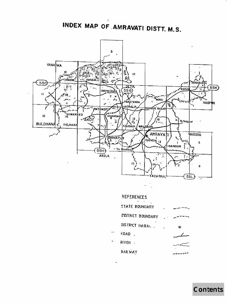
Amravati district is located between 200 -32' and 210-46' north latitude and 760 -37' and 780 -27' east longitude. The survey area consists of entire forest areas of Amravati district which have been depicted as green wash on the Survey of India (SOl) toposheets. The district is situated right in the centre of the northern border of Maharashtra State. The north-western and the eastern boundaries of the district are respectively demarcated by the Tapti and the Wardha rivers. The district is bounded on the north and north-west by Khandwa, Setul and Chhindwara districts of Madhya Pradesh. On the east, it is bounded by Nagpur and Wardha districts and on the south and south-west by Yeotmal, Akola and Buldhana di~tricts.
1.3 TOPOGRAPHY, RELIEF AND DRAINAGE:
The district can be distinctly divided into two natural zones viz; the dominating hilly areas of tl1e Melghat region comprising two tahsils of Dharni and Chikhaldara and the plains consisting of the remaining eleven tahsils.
Forest Resources of .Amravati District.Forest Survey of !lIdia. Cemral Zone.Nagpur_

; I
The geographical situation of Amravati district clearly indicates that the district is pre-dominantly undulating plain of black cotton soil. The richest tracks He in the neighbourhood of the Wardha and the Purna rivers. With the exception of the Gwaligar,h hills of the Satpudas passing through the Melghat and Dharni tahsils of the district all other areas of the district are nothing but a plain fertile track, lying in the basin of the Tapti and the Wardha rivers.
Though the fertility of the soil in Amravati district is mainly due to the Tapti basin and the Wardha valley, the area is drained by a number of streams originating from the Satpudas in the north of the district.
The river Purna, the largest of such streams, rises near Bhaisdehi in Betul distritct of Madhya Pradesh, traverses the plains of ,the district in south-westernly direction. Another important tributary of the Puma river is Pedhi. It rises in the lower hills near Ridhapur and flows in a general south easternly course passing through Batkuli block to join the Purna outside Amravati, in Akola district.
The river Chandrabhaga is also an important tributary flowing in a general south westernly direction and joins the Puma again. The Chandrabhaga rises just below the southern top of Chikhaldara and the Gawilgarh plateau forming a cultivable track of about 2 kms width breaking the continuity of the forested areas on either side. The principal right bank affluent of the Chandrabhaga is the river Bhuleshwari which itself receives the Gangadhari river, another Satpuda stream.
The western-most tributory of the Puma, the Shahanur river with its affluent, the border river. The Shahanur rises in the Gawilgarh hills and enters the plains near Malkapur and flows down southwards to join the Purna beyond the district boundaries.
Similarly, another important river having importance in the drainage of Amravati district is the river Wardha. It also forms the boundary of the district demarcating the districts of Amravati and Wardha. The Wardha river rises from the east of Multai town of Setul district of Madhya Pradesh and traverses a long course along the Satpuda hills while forming the eastern boundaries it receives a number
2 Forest Resources of Amravati District. Forest Survey oj India, Cemral ZDne,Nagpur ..

of small tributories flowing through the district. The Sakti and the Dhawagiri are the small rivers joining the Wardha river.
A!",other important river rising from the Dabka forests is the Paknala river, having the Paknala project, providing irrigation facilities to the orange growing areas, particularly in the north of Morshi-Warud road.
The river Maru, another important tributary rises south of Athner in the adjoining Betul district of Madhya Pradesh and after traversing along a winding Course in the Satpudas, enters the district boundary and flows in south-easternly direction to join the main river Wardha.
Amongst the small rivers or streams draining the areas of the district, the Narha and the Chargar are important. Apart from that there are few minor rivers which deserve special mention are: namely, the Bore, the Panglai, the Chandrabhaga, the Bemla etc.
1.4 AREA AND POPULATION:
AREA: The district is spread over qn area of 12212 sq.km occupying 3.96% of the total area of Maharashtra State. The district Is divided into 13 tahsils, viz. Amravati, Bhatkuli, Nandgaon-Khandeshwar, Achalpur, Chandur Bazar, Morshi, Warud, Chandur Railway, TIwasa, Daryapur, Anjangaon, Dharni and Chikhaldara for administrative purposes. Further details are given in the following table:
3 Forest Resources of Amravafi District. Forest Survey of India , Central Zont.Nagpur ..

ADMINISTRATIVE SUB-DIVISIONS/TAHSILS OF AMRAVATI DISTRICT:
! " .~
Amravati' .tU' "'1:.'\.", ''1 ~;-': ;J\$" ,> ·.l('\~' 690 '--~;!l~ 110 :t' t 1 ,,;)IJY!: Morshi I~: .w ~; ft,:;l1 .~ ' .. ~:,'~~~:;~~, .<..;1;1:: BOO, ~'Ni:~t .. ,~\ ?~. I' .i.~ 1 .. m,~ Warud '. ,t • '''')'''1' '\ . .. <, l' " i ",II ';' 747.. ';It,:i'l~ ·121 ",' 'II' ~ 'l 2 ~ Tiwasa .: •.. o!i. i~. ~·~i .... ~ 't ":~ ! ~~f:t ,...' of. '':~'':1oi.,''Y890 11lifH ·10h.,·~ .. ". r 't ~~':-.7l<' Chandur Railway ~~ ,~~" rJ ... ,~ 906 - I'U' ·137 -:-,::: .. '~'f ' 2 .. ~'" Nandgaon- Khandeshwar. . . . , :; 725 ... j 1 133 ',,' :t.: ~ .:!I!; '~'
~. ;')I~
Bhatkuli .... ~" . ,.~ ", • • ! ~ . 580 1~r1 112 , .. ~ -.~.' Daryapur f ",,' I" 761 " J 130 .1 1 . , .~ ..
." Anjangaon • ' .. 1 J:" 560 . ,'.t.: 110 I 1 Dhami ~/t~< ~i'" .... , '" .\ 1896 148 '1 -~ .~~ Chikhaldara .r "Ot1f. ~.~t 2115 '" 169 t ~,+ 1 ~. ·r' Achalpur ., : ... : • ,., ,-, ... 643 145 1 .., ,I Chandur Bazar " , "'11 .. '
" i~ 633 0' 144 l 1 , ... " District Total p." , ~. .~' i'.!'!' 12212 1681 f 11 I
OTHER INFORMATIVE DETAILS dF THE DISTRICT: t
.!' Gram Panchayats u 832 Panchayat Sam/ties ·t •. "i" 13
" . Towns ~1 :Hl :>, .. 11 ;- - .'"
•.. Vlllarles ~ I' I!I 'r 1996 . ,
Inhsblted vlllsJles I 1681 Munclpal Corporation 1
.1 Muncipalitias : 10 Police Stations ~ 37 Police outposts 21
The district is also the Divisional Headquarters of Amrovoti Division which comprises of four districts: namely, Amravati, Akola, Yeotmal and Buldhana.
POPULATION: The district has a population of 2200057 persons as per 1991 Census. Other demographic details of the district are given hereunder:
Forest Resources 01 Amravali DiJlricf.ForeJf Survey of India, Central Zone,Nagpur ..

DEMOGRAPHIC DETAILS OF THE DISTRICT:
Female~1;i!-·"··~ I1!'i'':·;\;.~.ii'~M'(''~~ In thousands' 'l!f;11::ti'iQ"'~N.!nfn:r.t~~ !.""'1064~ Sex ratiO'1!"~~iil;"~~~~u!iij~m~ No.' of females r thousand of males ~li!'1937~ Oensi ,'of 0 ulation't.~lft Po ulation r .km:·~~~~~~'l *,1:i'180:!li~ Scheduled caste~if~{~$li-i~ In thousands *,H~~,-,,"~~l,It~W;:;;;WfJ .,ei~~ 384 ... ~ Scheduled triber;w~;'~r~ .... "il:' In thousands ..:s;mir\:'-;;~;~'l~I~~ <t'.~.,1 316~ Per~.e~tago,:of ~~~o~~-,~~:~ Z~i~:rq;-~~~Hft. .:~;-. !E:~~;r~~ caste 0 uJation ",tti ..... ~;1'ifM~ ·lliw ,M;~'; .. "(ilH~ ~ {"1;lf"17.47~ PercElntage of. SC_!1.~~!lJ~~{~~. ~if~~.';~~ .. ';~':~ !~f ;~lU!f" -"~' \o'"~~t~i :' : ·::.:t~~J U.:-~, ).;:~! tribe 0 ulatlo" ,.;1;iiJtJ.""J'~.:n.t ~~l(f'.,:~.; "Ajfl~~."" .... ~fI~ :\t.,,~. ,~~. ,.~';;... :. _";\,;c.~,,,~ Jt:~ 14.38 hi
,
, Rural population forms 67% 04,82,928}' and urban population
r . forms 33% (7,17,129) of the total. The decadal growth rate {1981-1991) for the district is 12.60% whereas for the urban areas it is 31 .70% and for the rural areas it is 12.60%.
1.5 FOREST AREAS:
As per the records availc:ible with the State Forest Department, the total forest area of Amravati district is 3577.22 sq.km. Of the total forest area 3455.71 sq.km. is the Reserved Forest, 3.75 sq.km. is the Protected Forest and 117.76 sq.km. is the Unclassed Forest.
1.6 ClIMA,TE:
The climate of the district is characterised by a hot summer and general dryness throughout the year except during the south-west monsoon season. The climate of the year can be well divided into four distinct periods viz. the winters from December to February, the summers from March to May, the southwest monsoon season. from June to September and the post monsoon period from October fo November.
5 Forest Resources of Amravot; DiJlrict.Fores/ Survey of India. Central ZDne,Nagpur ..

IV\INrI\LL:
The average annual rainfall in the district is 877.4 mm in the plains. The rainfall at Chikhaldara and other hilly areas of the district is about twice as much as in the plains.
The rainfall during June-September constitues almost 85% of the total rainfall. July is the rainiest month of the rainy season. Interestingly, the variation in the rainfall pattern of the district from year to year is quite significant. On an average the number of rainy days in the plains of the district are 49 in a year. However, at Chikhaldara, there are 77 rainy days in a year.
TEMPERATURE:
As regards the atmospheric temperature, it decreases progressively till December which is the coolest month. The mean daily maximum average temperature at Amravati is 28.4oC (83.20 F) and the mean daily minimum temperature is 14.70 C (58.4F). At Chikhaldaro, the mean daily maximum temperature is about 220 C (72oF) and the mean daily minimum temperature is about 130 C ( 55oF). The diffierence in the temperature of Amravati plains and the hilly areas has made Chikhaldara a hill station for the entire Vidarbha region.
In the wake of western disturbances which move across north India in the winter months, cold waves affect the district at times and night temperature sometimes touches as low as SoC.
Temperature rises rapidly after February till May which is the hottest. In May, the mean daily maximum temperature at Amravati is 42.1 °C (107.8oF) and the m·ean daily minimum temperature is 27.2cC (80.9oF). The heat in the summer season is very severe during the day but nights are comparatively cooler.
Except during the monsoon season when the humidity is high, the air is generally dry. The summer months are the driest with relative humidity ranging between 25% and 35%.
6 Forest Re.rourc!s of Amravati DistriCt.Forest Survey of India. Centraf Zone,NagpLir ..

In association with monsoon depressions which--originate in the Bay of Bengal and move eastward, the district experiences strong winds and wide5pread heavy downpour. Storms and depressions of the post monsoon months of October and November also affect the weather of the district. Thunder storms occur in all seasons though their frequency is least in the period between November to January.
1.7 LAND-USE PATTERN:
THE LAND-USE PATTERN OF THE DISTRICT:
60%
3%
4% 2%
1.8 SOILS:
LAND USE PA TTERNS iii 8a",," Bnd UncuJtiveOle lend.
e Land pullo rKln-41gricullulllf U$9
a lBna under miscellan60UJ Illle crops and groves nol {ncluded in am. shown
D Permanent past""" ana other grazing lends
D Net 81f18 sOivn
a CUInI.?t fallow.
!CIAma sown motU than onCII
The soils of the district have been developed on the hilly and undulating topography. The soils, therefore, show a wide variation in their depth. The soil on the hills and slopes have shallow to medium depth while those present in the low lying areas and river valleys are deep which have been formed due to accumUlation and deposition of the soils from upland. Thus, three main types of soils are found in the district: viz,
7 Forest Resources of Amravall. DisrriCI.Fort!sl Suney of India, Central Zone,Nagpur ..

1. Shallow soil
2. Medium deep soill and
3. Deep soil
The shallow soils are dark brown in colour, clayey in texture and blocky in structure. It is suitable for cultivations of kharif crop. -The surface layer of these medium deep soils is dark brown or greyish black. They possess clayey texture and blocky structure. Such soils are fairly good and fertile. The deep soils invariably found in the river valleys of the Purna and the Wardha rivers are known for their high production of cotton crop. On the whole, it can be said that the soils of Amravati district are very fertile and highly suitable for growing cotton crop.
1.9 SOCIO-ECONOMIC FEATURES:
Amravati is predominantly an agricultural district where agriculture is is the main source of livelihood of the people. Agriculture in the district mainly depends upon rainfall which ultimately determines the pattern of crops, rotation of crops and productivity of the land. About 70% of the entire population depends upon agriculture either directly or indirectly.
Most of the industries in the district have an agricultural base, involving processing of agricultural produce such as cotton ginning and pressing, dol mill, oil extraction plants etc. Various other industries have, however, been established only recently, like engineering works, metal works, chemical factories etc. Establishment of an industrial estate at Amravati and the proposed industrial estates at'various other places including M.I.D.C., Chemical Zone at Nandgaonpeth have marked the begining of an era of industrialization in the district.
Principal crops being cotton and oil seeds, most of the large scale factories in the district pertain to cotton processing and oil crushing. There are about 10 units functioning under medium and large scale sectors in the district. Out of these, all milling, refining, solvent
8 Forest Resources of A mrQvari District. Forest Survey of India. Central Zol1e.Nagpur ..

extraction and cotton ginning and pressing activities cover six big units. Raw, materials required by these units are available locally.
As regards small scale industries there are about 900 registered units out of which about 250 are agro-based industries which include 100 oil mills, 26 ginning and pressing units and 8 dal mills. There are 101 units of building materials and 8 ceramics, 90 chemical based units and 86 forest based industries (saw mills). 15 textile based industries 'and 2 mineral industreis are mainly concentrated around Amravati, the reason being readily available market and infrastruc,ture. Beside Amravati, oil mills and dol mills are also located at Achalpur, ginning and pressing sawmillis at Paratwada and Daryapur and saw mills at Paratwada.
In addition to this, there are about 350 artisans based units like processing of grai,ns and pulses, carpentry and black-smithy, leather, cane and barylboo etc. providing employment to about 1000 persons. The main items of production in these units are bakery products, papad, furniture, agricultural implements, footwears, leather tanning, soap etc
•••••••••••••
9 Forest Resource. of Amravati District,Forest Survey of India. Central Zone.Nagpur ..

CHAPTER II
THE FORESTS
2.1 GENERAL:
As per the records available with the State Forest Department, the total forest area of Amravati district is 3577.22 sq.km. Of the total forest area 3455.71 sq.km. is the Reserved Forest, 3.75 sq.km is the Protected Forest and 117.76 sq.km. is the Unclassed Forest. The unclassed forests are under the possession of the Revenue Department whereas reserved forests are being looked after by the State Forest Department. Amravati district comprises of the following Forest Divisions:
1. Amravati Forest Division,
2. East Melghat Forest Division,
3. West Melghct Forest Division,
4. Akot (South Melghat) Forest Division, and
5. Melghot TIger Project, a Wild-life Forest Division at Parotwada.
The forest areas in charge of the State Forest Department are being managed scientifically in accordance with Working Plans.
2.2 FOREST TYPES:
The forests of West Melghat Division are of deciduous nature and have been classified as Dry Deciduous Forests in the Champion and Seth's Revised Survey of Forest types of rndia. These forests come under Sub-Group SA. Southern Tropical Dry Deciduous Forests. within this sub group the following sub-types were described by Champion and Seth's, which are due to local variations like edaphic factors, topography etc.
10 Forest Resources of Amravatj DistriCI. ForeJr Sun'ey of India, Centra{ Zone.Nagpur ..

FOREST TYPES:
Sub-Group SA: Southern Tropical Dry Deciduous Forests:
Sub-types:
1. Dry Teak Bearing Forests c. Very Dry Teak Forests b. Dry Teak Forests
2. Southern Dry Mixed Deciduous Forests
3. Boswellia Forests
4. Butea Forests
5. Dry Deciduous Scrub
6. Dry Tropical Reverain Forests
1. Dry Teak Bearing Forests 5A/e1:
- 5A/Cl - 5A C1a - SA Clb
- 5A/C3
- 5/E2
- 5/E5
- 5/DS1
- 5/1 S1
These forests are further sub-divided into two sUb-types:
c. 5A/Cla - Very Dry Teek Forests: These forests are found in expropriotary forests of lot. Kulangana and in Chitri resereve. This type of forests also exist on the top of the hills where the soil condition is very dry. The teak occurs in a high proportion and at some places forms a pure crop. The ground cover is scauty and seedling regeneration is practically absent.
b. 5A/Cl b - Dry Teak Forests: These are further divided into:
(1) Good quality teak forests on alluvial deposits; (2) Good quality teak on trap zone; (3) Poor quality teak on trap zone.
The good quality teak forests on alluvial deposits are found around the Tapti river and also around the minor traibutories and near Chaurakund area. The good quality teak forest on trap zone occurs in
11 Forest Resources of A mravati District,Forest Survey oj India, Central Zone,Nagpur ..

Harisal, Dhakna, Chanuralund and Tarubanda areas. Here, good quality teak forests, usually upto 135 em and above, are found. Bamboo is present on well drained soils but not adequately. The poor quality forests on trap zone are found in dry exposed localities and low quality teak forests of quality Iva and Ivb and are found in Bod and Dhakna areas.
The associates commanly found are:
Anogeissus latifolia, lagerstroemia parviflora, Terminalia tomentosa, Adina cordifolia, Ougeinia oogeinensis. Emblica officinalis, Grewia tieliaefolia, Boswellia serrato, Garuga pinn~ta, lannea coromandelicQ, Terminalia belleriea, Mitragyna parviflora, Zizyphus xylopyra, Madhuca indica, Schrebera sweitenioides. Terminalia 10menlosa and Adina cordifolia are abundantly found on the well stocked valleys.
2.South Dry Mixed Deciduous Forests:
These forests are found in upper hills of the Chandrabhaga river on the northern hills of Chikha\dara range. These forests are distinguished by the presence of thorny trees which remain dry. There is plenty of regeneration of miscellaneous species in biotic free zone. These forests exist in part of Dhakua range on dry precipituous slope. The trees growing on good soils do touch the site quality Ill.
The floristics are as follows:
Terminalia tomentosa, Anogeissus lafifolia, Mitragyna parviflora, Schrebera swietenioides, Madhuca indica, Diospyros melanoxylon, Buchanania lanzan, Lagerstroemia parviflora. Emblica officinalis, Cassia fistula, Butea monospermo, Boswellio serrato, Helictes isoro, Woodfordia floribundo, Lantana camara (the last three forms under canopy) .
3.Boswellia Forests - 5/E2:
These forests occur as the float tops of the hills and mostly occur on the dry part ot the hills, usually demanded devised of moisture. It grows on refractory solis. It is a strong coppice. Natural regeneration is
12 Fare!t Resources of Amravati District.FortSI Survey o/ India. Cenlral Zone.Nagpur ..

absent. These forests are mostly found in and around Patulda and Chikaldara areas.
4.Butea Monosperma Forests - S/E-S:
These forests are found on badly drained clayey soils or very dry clayey soils. These forests are comprised of stunted, malformed trees or thicket standing over short grass bare ground. These forests are found in Dharni and Chikaldara areas. The soil depth varies from 25 to 30 ems.
S.Dry Deciduous Scrub Forests - 5/0-S 1:
These forests consist of broken soils covered with shrubby g~owth of around 3 to 6 metres height including some stunted tree crop reduced to similar conditions usually many-stemmed from base. The plants are fire resistant. These are found near Dharni where biotic pressure is high and few patches are also found near Chikaldara.
6.0ry Tropical Reverine Forests - 5/151:
These forests consist of an irregular overwood of greater height than the climax dry deciduous forests. The trees are of larger size and are found in narrow strips along the hilly sections of the larger streams and widens as the valleys get broader soils are sandy often overlying more or less impervious rocks liable to be temporarily sub-merged' during the short monsoon season and usually retains adequate water supply during most of the year. Terminalia and Arjuna are found in the overwood and other species associated are Mitragyna parviflora, Butea monosperma, Emblica officinalis, Syzygium cumini, Ficus histrida, Vitex neguado and Pangamia pinnata.
2.3 WILD-U FE:
Melghat TIger Project at Para twa do is located in Amravati district. The forests are fairly dense and terrain is highly undulating and suitable for certain species. The carnivorous species found in this area are: 1) Panthera tigris (tiger); 2) Panthera pardus (panther); 3) Hyaena hyaena (hyaena); 4) Cuon alpinus (wild dog); 5) Cains lupus (wolf); 6)
13 Fore.!t Resources of Amra\'ali District.Forest Survey of India. Central Zone.Nagpur ..

Canis aureus Uackal); 7) Vulpes bengalensis (fox); 8) Felis bengalensis (leopard cat), 9) Felis chaus (jungle cat).
Herbivorus species found in this area are: 1) Bos gaurea (gaen); 2) Cervus unicolor (sambhar); 3) Axix axix (cheetah);. 4) Boselaphus tragocamelus (nilgai); 5) Muntiacus muntijak (barking deer); 6) Bus scrola (wild bear); 7) Antilope ceivicapro (black buck); 8) Melursees ursinus (sloath bear); 9) Tectraceus quadricornis (fore-horned antelope); & 10) Gazella gazella (chinkara). .
Pteromya finbria flying squiril is also seen in this area. Omnivorous porcufone, hare are also seen in this area.
Amongst the birds peafow!, painted sand grouse, common sand frouse, grey patridges, jungel bush quaiks, rain quails, red spur fowl ete. are commonly seen.
2.4 FOREST PRODUCE:
The main forest produce of the district are timber, firewood, bamboo, grasses, tendu leaves, mahuwa flowers, charoli, honey, wax etc. Teak is the most valuable timber found in the district. Timber is used for construction of houses, furniture and other articles. Other tree species used for this purpose are Terminalia tomentosa, Anogeissus latitolia, Lagerstroemia parviflora and bamboo.
The villagers collect mahua flowers and fruits, charoli, gum, honey wax, bark, roots, leaves etc. from forest and sell them locally to supplement their meagre income. The tendu leaves collected by villagers from forests are auctioned by the State Forest Department and as such they get collection charges and suuplement their livelihood by additional earnings during tendu season. Fuel wood and grass are also collected from the forests by these people for local selling.
14 Forest Resources of Amravati District.Forest Survey of India , Central Zone,Nagpur ..

2.5 FOREST MANAGEMENT PRACTICES:
Working Plans to manage the forests of Amravati district divisions are in vogue. The forests are being managed under following Working Circles
A. Selection-cum-Improvement Working Circle; B. Protection Working Circle; C. Miscellaneous Working Circle; D. Bamboo Overlapping Working Circle; and E. Wildlife Overlapping Working Circle.
A. SElECTION CUM IMPROVEMENT WORKING CIRCLE:
are: The objectives of Selection-cum-Improvement .Working Circle
I) To obtain a supply of big sized timber, II) To increase the stocking of teak and other valuable speCies and III) To produce and to tend the available teak reproduction and other valuable species so as to increase the proportion of valuable species and to improve the condition of growing stocks by natural regeneration method as principal method supplemented by artificial.
B. PROTECTION WORKING CIRCLE:
The main objective of this Working Circle is the need to conserve the forests for the indirect benefits they confer to prevent the denudation of the forests and resultant protection of growing stands of commercial timber and the preservation of the water regime.
C. MISCelLANEOUS WORKING CIRCLE:
The objective of this Working Circle is to reboise the forest area.
15 Forest Resources oj Amravati District.Forest Survey oj India, Central mne.Nagpur_.

D. BAMBOO OVERLAPPING WORKING CIRCLE:
This Working circle has been created:
I) to meet the local needs and II) to introduce scientific harvesting of bamboo so as to get
the maximum sustained yield.
E. WILDLIFE OVERLAPPING WORKING CIRCLE:
. The special objects of the wildlife management are:
I) to preserve the bio-diversity of these forests, II) to promote the wild-life habitat, III) to promote the awareness of wild-life conservation among the public, and IV) to ensure effective anti-poaching measures.
"'********
16 Forest Resources of A mravati District.Forest Survey of India, Central Zone,Nagpur ..

CHAPTER III
DESIGN AND METHODOLOGY OF THE SURVEY
3.1 GENERAL:
The toposheets prepared by Survey of India were taken as base
maps for carrying out inventory work. The maps used were of 1 :50,000
scale. In these maps the extent of forest areas was shown in green
colour. Each toposheets of the above scale was divided into 36 grids
of 2 1/2' x 2 1/2' intervals, which formed basic sampling units. Data
were collected from two plots of 0.1 ha falling in each grid in forest
areas. Thus the sampling design adopted was a cluster sampling, in
which grids were taken as cluster. Actually, the sampling design was
cluster sampling of unequal size, because of the fact that in many grids
only one plot was laid out. The survey work was carried out as per
prescriptions contained in The Manual Of Instructions For Field Inventory
prepared by Forest Survey of India, Dehradun and the technical terms
used in the reports are as defined in the manual.
3.2 FOREST AREA DEFINED:
The following categories of lands were treated as FOREST AREA
for the purpose of the forest inventory:
i) All those areas shown in green wash on Survey of India
toposheets;
ii) All such areas in which vvords such as thick jungle, thick forest,
dense jungle, open forest with bamboo etc. are mentioned;
17 Forest Resources of Amravati District. Forest Survey of India, Central Zone.Nagpur ..

iii) All those areas indicated by dotted line or spotted line or a pillar line as forest area and
iv) Any other area reported to be forest area by the local
Divisional Forest Officers.
3.3 SAMPLING DESIGN:
After dividing ttle toposheet of 1 :50,000 scale into 36 grids of 2
1/2' x 2 1/2' each, the length 'X' and width 'Y' of each grid was
measured to the smallest convenient scale. The length (d) of the side
of the plot on the map corresponding to 0.1 ha. of square plot in the
ground was calculated. After subtracting the side' d' from length and
width of the grid, the numbers X': (x-d) and Y' = (Y-d) were obtained.
From the random table, two numbers in the range of 0 to X' and 0 to Y'
were selected. Let them be pi and P2. To these numbers, half of the
plot side (d/2) was added to get x and y co-ordinates of the first plot
centre, considering left hand bottom (S-W) corners of the grid as the
origin. To get the centre of the second plot in the same grid, the
centre of the first plot was joined with grid centre and was extended in
the opposite direction upto the distance equal to the distance
between the grid centre and the first plot centre. This point became
the centre of the second plot.
Qualitative and quantitative data were collected from the
sample plots falling in the forest areas only. The quantitative data
regarding tree characteristics, terrain, soil depth, tree canopy and
bamboo etc. were collected from the plots. Qualitative data such as
18 Forest Resources of Amravati District.Forest Survey of India. Central Zone.Nagpur ..

forest types, topography, erosion status, etc. were collected by
considering 2 ha. area surrounding the plot centre . .
3.4 METHODOLOGY:
The inventory data were collected by t~e field parties headed
by a Junior Technical Assistant who worked as crew leader. The crew
leader was assisted by one Deputy Ranger and two Fieldmen. The
services of Camp Khalasi and unskilled labourers engaged locally on
Muster Roll were also utilised. The crew leaders were provided with
necessary camp equipments, a set of toposheets and instruments used
in the survey work such as Silva compass, Blumeleis5 hypsometer,
caliper, and measuring tape etc.
The camp locations were decided by the crew leaders based on
the number of plots to be tackled in any specific locality. After
selecting the plots to be surveyed on the day, the crew leader along
with his crew members and the local forest staff proceeded to the
reference point marked on toposheet and identified the same on the
ground. After reaching the reference point the crew leader took the
bearing of that reference point and measured the distance of the
plot centre from that point on the toposheet. The crew leader
proceeded to the plot centre traversing the same distance with the
help of a 50 m rope in the same direction as indicated by itsbearing' to
the reference point.
19 Forest Resources 0/ Amravati District.Forest Survey of India, Central Zone,Nagpur .•

After reaching the plot centre, a square plot of 0.1 ha. with
diagonals measuring 44.72 metres in north-south and east-west ,
directions was laid on the ground. The required data was collected
from the plot in the following prescribed forms. The sketch showing
layout of the plot on the ground is appended in the report.
(i) Plot Approach Form:
This form is filled by the crew leader when he starts from the
camp to the sample plot and also while returning to the camp. It is not
used in data processing but instead it is used in locating the plot during
verification or resurvey in future.
(ii) Plot Description Form:
By observing 2 ha area around the plot centre, the qualitative
data such as land use, crop composition, tree density, erosion status,
intensity of fire and grazing, regeneration status, presence of bamboo
etc. are recorded in this form.
(iii) Plot Enumeration Form:
The trees and bamboo occurring in an area of 0.1 ha plot are
enumerated and recorded in this form. Only the trees which are 10
cm. diameter and above at breast height over bark are enumerated.
The dead trees having utility less than 70% are not enumerated. The
diameter of a bamboo clump is measured at its base.
20 Forest Resources 0/ Amrol'ati District. Forest Survey of India, Central Zone,Nagpur ..

(iv) Sample Tree Form: , ,
This form is filled after" filling up the Plot Enumeration Form. The
data of trees with .diameter 10 cm. and above at BHOB (breast height
over bark) are collected from 1/4th of the total plot, starting from
northwest quadrant. For each sampl~ tree, diameter at breast height,
bark thickness, tree height, length of clear bole, f<;>rm of tree etc. are
recorded. Abstract of this information is wriften on the Sample Tree
Card which is nailed to the respective tree. This ~acilitates the checking
by the supervising officers.
(v) Bamboo Enumeration & Clump Analysis Form:
The data of individual culms occurring in the selected clumps are
recorded in this form. The clumps bearing Serial Nos. 1, 9, 17, 25, 33,
etc. (first and ev~ry eighth clump thereafter) of each bamboo species
are selected for detailed analysis. The number of bamboo culms per
clump classified on the basis of age, greenness and soundness are
recorded.
(vi) 8amboo Weight Form:
This form has been designed for collecting data to determine the
green weight of bamboo of different species and sizes and further for
establishing relationship between green ~eight and dry weight of
bamboo culms. The data were recorded in respect of two selected
21 Forest Resources 0/ Amrallali Districl.Forest Survey a/India, Central Zone,Nagpur ..
culms from each diameter class i.e. 2 to 5 cm, 5 to 8 em, 8 em and
above and the green weight of t~ree SO cm long sub-samples, each ,
taken from the bottom, the middle and the top portions of the cu!ms
were recorded. With the help of duta of this form, the total green
bamboo stock was estimated. On the basis of past experience of
complete drying of bamboo and in estimating air dry weight it has
been well established that the air dry weight comes to 60% of green
weight in Central India. As such this factor was applied and total air dry
weight was also estimated accordingly.
3.5 FiElD WORK:
The field work in Amravati district was completed during the
period between January,1995 to June, 1995. In all. four field parties
each consisting of a Junior Technical Assistant, a Deputy Ranger and
two Fieldmen were deployed in the survey area. The work was
supervised by Senior Technical Asistants and the Deputy Director
designated as Group Officer.
3.6 MAPS AND PLOTS: .
The details of the Survey of India toposheets used during the field
inventory of Amravati district and number of plots tackled in each of
them is given below:
22 Forest Resources of Amravati Dis trict. Forest Suruy a/India, Central20ne,Nagpur ..

LIST OF MAPS PERTAINING TO AMRAVATI DISTRICT AND NO. OF PLOTS TACKLED IN EACH ONE OF THEM(scole 1 :50,000)
No. Of 0 ,
No. Of S.No Map
plots S.No Map sheet I; plots sheet No
tackled No 'tackled
1 55C/11 7 16 55G/16 1 2 55C/14 7 17 55H/1 N.F. 3 55C/15 50 18 55Hf5 N.F. 4 55C/16 16 19 55H/9 N.F. 5 55G/2 49 20 55H/10 N.F. 6 55G/3 69 21 55H/13 12 7 55G/4 6 22 55H/14 1 8 55G/5 3 23 55K12 4 9 55G/6 62 24 55K13 1 10 55G17 38 25 55K14 2 11 55G/8 1 26 55K16 5 12 55G/10 4 27 55K17 1 13 55G/11 4 28 551/1 4 14 55G/12 N.F. 29 55112 o N.F. 15 55G/15 6 30 55115 N.F.
TOTAL NO OF PlOTS TACKLED --353
3.7 FJElD CHECKING:
During the course of field work, the checking of the surveyd plots
was done by the Deputy Director and Senior Technical Assistant. The
Deputy Director was in-Charge of the survey work. Approximately 12%
of the total plots tackled by the crews were checked in the field and
mistakes found, if any, were also rectified. All the filled-up field forms
were also checked manually as per guidelines in the Manual of
Instructions For Field Inventory available with the Zonal Office before
sending them for data processing to the Machine Data Management
Unit (MDMU) at Dehradun Head Office.
"'********
23 Forest Resources of Amravati District.Forest Survey of India. Central Zone.Nagpur,.

CHAPTER IV
DATA PROCESSING
4.1 SAMPLING DESIGN:
Existing design and methodology, developed by Forest Survey of
India, was used to carry out forest inventory work in Amravati district of
Maharashtra. For this purpose, Survey of India toposh-eets on 1 :50,000
scale were selected for the area to be surveyed and in each of these
toposheets, g~ids at an interval of 2.5' latitude by 2.5' longitude were
marked. Two centres of sample plots of 0.1 ha each were marked in
each of these grids. The firsf plot centre was ma'rked by random
method and the second was selected in the opposite quadrant at an
equal distance of the first plot centre from the grid centre. The plot
centres marked on the toposheets were laid on the ground by the field
parties and the data was collected in the prescribed field forms.
4.2 FIELD DATA:
The basic data of the inventory survey were collected in Plot
Description Forms, Plot Enumeration Forms, Sample Tree Forms, Bamboo
Enumeration Forms etc. The field forms containing field data were pre
coded so that the data could be easily transferred to the
floppy/tape/disk directly. There were in all 3729 field records which
required data entry of the following number of records in each card
design for Amravati district
24 Forest Resources oj Amrovoti Di5t"ict.Forest Survey 0/ India, Central Zone,Nagpur.

FIELD DATA DETAILS
CARD DESIGN NO. OF RECORDS
Melghat Tiger Other than Amravati Project(MTPl MTP - combined
Plot Description Forms 162 191 353 Plot Enumeration Forms 595 479 1074 Sam_2_le Tree Forms *** *** 1873 Bamboo Enumerarion Form 188 92 280 Bamboo Weight Forms 98 51 149
TOTAL 1043 813 3729
4.3 PLOT DETAILS IN AMRAVATI DISTRICT:
There were 353 plots in Amravati district (Le.· MTP = 162 and
other than MTP = 191) giving weightage to each plot of 10.13 sq.km. for
the district as a whole. It is, however, 9.99 sq.km for MTP and 10.24
sq.km. for other than MTP. Only two forest strata were identified in
Amravati district Le. Teak Forest Type and Miscellaneous Forest Type. 7
plots of Khair Forest Type, 1 plot of Bamboo Forest Type and 17 plots of
Salai Forest Type, because of their miniscule numbers and consequent
inability to form a forest type of their own, were merged with the
Miscellaneous Forest Type.
4.4 DATA PROCESSING:
The data processing involved the following steps:
25 Fortst Rl:salJrces of Amrnvati J)j.flr(ct.For('st Survty of [m/ia, Central 7.one, Nagpur ..

4.4.1 MANUAL PROCESSING:
The field forms received in the Machine Data Management Unit
(MDMU) were checked with the list suppfied by the Zonal Office. Entries
of the field forms were made in the register regarding the number of
field forms relating to each map sheet, grid and plot. The total number
of records required to be entered under each card design were also
counted and indicated in the register for future references.
Job number, card design and left hand zeros, wherever missing
were filled-in the field forms to avoid any mistake dCiriAg data entry
on the floppy or disk. Each entry in the field form was checked for
consistency in the data. The maximum and minium value of the
codes were checked. The data was loaded on the floppy/disk and
verified. Then the listings were taken and checked manually. Sample
statistics were calculated and checked with the . computer output
results. The programmes were developed according to the
requirement of the data processing. Final computer output results were
checked for consistency and relevance of results. Area tables were
also prepared by Using the weightage of each plot.
4 .4.2 PROCESSING ON ELECTRONIC COMPUTER:
The data were loaded on floppy/disk through direct data entry
operations and verified. The listings of loaded data were taken to
check the data. As described in the Chapter VI of Volume
Estimation, volume of each tree was estimated with the help of the
26 Forest Resources oj Amravati District. Forest Slirvey oj India. Central Zone.Nagpur ..

local volume equations borrowed directly from previous inventory
surveys of Melgha!, Dhula districts of Maharashtra and Betul district of
Madhya Pradesh and Valsad, the Dangs, Bharuch and Surat districts of
Gujarat states.
After taking into consideration contribution of volume of each
enumerated tree, volume per hectare was calculated and was stored
in a tree/plot volume file created for further processing. Using the
tree/plot volume file, growing stock tables by species and diameter
class-wise under each crop composition were prepared and standard
error of the estimated growing stock was calculated. Data processing
for Melghat Tiger Project (MTP), other than Melghat Tiger Project and
Amravati as a whole have been done.
The data of this survey was processed on our own system - Vax
11/780 at Dehradun.
4.5 AREA:
Following area figures for Amravati district were supplied by the
Zonal Office, Nagpur.
27 Forest Resources 0/ Amravati Districl. Forest Survey o/India. Central Zone.Nagpur ..

AREA FIGURES OF AMRAVATI DISTRICT
~ ..
AREA IN SQ.KM,. __ n,:,:1 TYP~OFAREA " . Total Geooraphlcal area 12210 Total Forest area 3574.35 We_jghta~e of prot for Amravati 10.13 Forested area of MTP 1619 WeightaQe per plot of MTP 9.99 Forested Area of other than MTP 1955.35
Weightage per plot for other than MTP 10.24
Total Forested area of Arnravati 3574.35
For above area weightages of each plot were calculated by
dividing the total forest area by respective total number of sample
plots. The areas under different parameters were estimated by
multiplying the number of sample plots occurring in that class by- the
area weightages of each sample plot.
The total surveyed/forested areas were claculated on the above
basis and were further classified by land use classes. The actual tree
forest were further classifed by different parameters such as soil depth,
soil texture, soil erosion, grazing incidence, fire incidence, plantation
potential etc.
4.6 VOLUME ESTIMATION:
In order to calculate volume of each tree species .. Jollowing local
volume equations for different species were borrowed from the earlier
reports of Melghat, Dhule, Betul and Gujarat surveys and were used
directly.
28 Forest Re.1OlJrce3 of Amravati DisrriCI_Fore3t Survey of India. Central Zcne.Nagpur.

LOCAL VOLUME EQUATIONS:
Species
code
Name of species and local volume equation
1. 006 AcacIa catechu
v = -0.048108 + 5.873169 D2 (Gujarat & Dhule surveys)
2. 028 Adina cordlfolla
V = 0.060564 - 1.509868 D + 11.156229 0 2 (Melghat survey)
3. 072 Anogelssus lamolla
V = 0.030502 - 1.105937 D + 12.261268 D2 (Melghat survey)
4. 133 Boswellfa serraHa
V = 0.050452 - 1.228748 D + 9.12338 02 (Melghat survey)
5. 143 Buchnanla lanzan
..J v = -0.100210 + 2. 599120 D (Betul survey)
29 Forest Resources of Amravati District.Ft;Jrest Survey of India. Central Zone.Nagpur ..

6. 266 Dalbergla lollfolla
"'v = -0.144504 + 2.943115 D (Gujarat & Dhule survey)
7. 285 Dlospyros melanox~lon
"'v = -0.062340 + 2.768180 0 ( Betul survey)
8. 407 Garuga pinnate
-Jv = 0.053434 + 3.530350 0 - 0.810548 "'0 (Gujarat & Dhule survey)
9. 505 Lagerstroemle porviflora
v = 0.030595 - 1.025799 0 + 10.4135502 (Melghat survey)
10. 509 Lannea coromandellca
Log eV = 2.960505 + 2.958718 log e D (Melghat survey)
11. 561 Madhuca lamolla
Log e V = 2.990552 + 2.972433 log e D (Melghat survey)
12. 611 Mitra gyna parvrflora
V = 0.048795 - 1.2413640 + 9.496613 0 2 (Melghat survey)
30 Forest ReSOlirces oj Amravoti District.Forest Survey of India, Central Zone,Nagpur ..

13. 653 Ougelnla ooJelnensls
y = 0.025941 - 0.832619 D + 8.285841 0 2 (Melghat survey)
14. 722 Pterocarpus marsupium
...Jy = 0.175068 + 4.598243 D - 1.500562...JD (Gujarat & Dhule survey)
15. 858 Tectona grandts
Y = O. 32011 - 0.995414 D + 9.911290 D2 (Melghat 's-urvey)
16. 861 T ermlnalla beler1ca
Y = 0.074706 - 1.4300820 + 10.181971 D2 (Gujorot & Dhule survey)
17. 866 Termlnalla crenulata
Y = 0.060344 - 1.569539 D+ 12.090296 D2 (Melghot survey)
18. 944 Miscellaneous species
Y = 0.042264 - 1.098756 D + 9.231891 D2 (Melghot survey)
3 1 Forest Resourcel of Amravati District. Forest Survey of India, Cenlral Zone,Nagpur_

4.7 ENUMERATED TREE VOLUME:
The volume of each enumerated tree of a species was
calculated by substituting its breast height overbark diameter in the
local volume equation of that species. The enumerated tree volumes.
were converted to per hectare volumes and stored in a tree/plot
volume file together with species code, diameter of trees, parameters
of Plot Description Form, per hectre volume/stems and total volume of
that plot. The elements of information stored in the above files were
utilised to classify the tree by species and diameter classes. Estimates of
number of stems and volume per hectre and total stems/volume by
species and diameter classes were obtained for different strata viz,
district, crop compositions etc.
4.8 PLOT VOLUME:
The estimated volume of each enumerated tree in a plot when
added up over the whole plot, provided the plot volume. It was
converted to per hectare volume and also stored -In- the tree/plot ,j
volume file. The per hectare plot volumes were used to estimate
volume under different classes of desired parameters. The plot volumes
were also used to estimate the sampling error of the growing stock for
each crop composition.
4.9 STAND TABLES:
The elements of tree/plot volume tile were utilised to classify the
tree by species, diameter, crop composition etc. Estimates of the
number of stems per hectare and total stems by species and diameter
32 Forest Resourc~s of Amra vat; DistriCI.Forest Survey of India, Central Zone,Nagpur ..

classes Were obtained for two major strata i.e. for Teak and
Miscellaneous, crop composition were also derived.
4.10 STOCK TABLES:
Estimates of volume per hectare and total volumes by species
and diameter classes were obtained for Teak and Miscellaneous crop
compositions from the tree/plot volume file.
4.11 BAMBOO PROCESSING:
Bamboo processing involved following steps:
4.11.1 BAMBOO AREA:
The presence of bamboo was examined in an area of about 2
ha around the plot centre. Its quality and density were recorded in
the Plot Description Form. The area under bamboo was estimated from
this information by applying the area weightage of each plot. Area
under each plot by quality and density was also estimated from the
number of plots falling in each quality and density.
4.11.2 CLUMPS PER HECTARE:
The bamboo clumps occurring in each sample plot were
enumerated by species and diameter classes for estimating the
number of clumps per hectare by species and clump size classes. In
order to estimate the number of clumps per hectare in each quality
33 Forest Resources of Amravati Dis/rict.Forest Survey 0/ India. Central Zene,Nagpu,. ..
and clump size class, the data of Plot Description Form and Plot
Enumeration FOfrrr were merged together.
4.11.3 CU LMS PER CLUMP:
Every eighth clump starting from first clump in a sample plot
was selected and the number of culms by age and soundness were
enumerated and recorded . The culms were further classified by culm
diameter classes 2<5 cm, 5<8 em and 8 cm and above for
estimating the number of culms per clump under different classes.
4.11.4 CLUMPS PER HECTARE:
The estimate of the number of clumps per hectare and the
number of culms per clump give~ an estimate of the number of culms
per hectare.
4.11.5 TOTAL NUMBER OF CULMS:
The estimates of the number of eulms per hectare and the
bamboo area under the specific quality classes were used to estimate
the total number of bamboo culms in the inventoried area.
4.1 1.6 BAMBOO STOCK:
Weight of the utilisable length of green culms in each diameter
class 2<5 em, 5<8 em and 8 em and above were recorded by felling
34 Forest Resources oj A mravati District. Forest Survey rJf £,!dia. Central Zone.Nagpur ..

mature bamboo culms from the first clump in each ploJ. Thus, average
green weight .of a culm was obtained for separate d iameter classes of
aculm.
The following factors were used to obtain green 'equivalent
weight under different categories of culms :
Dry sound culms = 2.0
Dry damaged culms = 1 .0
Green sound culms = 1.0
Green damaged culms = 0.5
Decayed culms = 0.00
Applying the above factors to the green weight of
bamboo culms and the total number of culms, the total green
bamboo stock was estimated.
Name of the Area 2<5cms I 5<8 ems ., ~;:...
No ofculms Weight No ofculms Wei~ht·~: Melghat Tiger Project (MTP) 95 444.4 15 163.72 Other than MTP 46 186.16 4 46.82 Amravati as a whole 141 630.56 19 210.54
4.11.7 BAMBOO WEIGHT:
60% of green weight of bamboo was taken as the dry bamboo
stock.
35 Foresr Resources of Amra'Vati Disrrict. Foresr Survey of India. Cemral Zone,Nagpur ..

4.12. SAMPLING, ERROR:
The sample was considered as a systematic cluster, sample
having two sample plots in each cluster. In order to estimate the
sampling error, the sample was considered to constifute simple random
sample of unequal clusters because in many cases only one plot was
enumerated in a grid. As such, the ratio method of estimate was
used and the sampling error was estimated as follows:
Let n = total number of clusters (grids) in the sample Yi = sum of per hectare volumes in the ith grid Xi = number of plots in the grid
n X = l. L = xi '" average number of plots per grid
n 1"'1
n 1 L Yi
R = n i= 1 '" estimo1e of overage volume per ha overall n
.1 L Xi n i=l
Estimate of ,¥;ariance of R is
Var (R) = N - n n
--- (.t Yi- R Xi)2
Nn X -2 1"'1 n-!
36 Forr,fl Rts()flI"Ct'l of Amral'ali DIJtr/cI,Porut Survey a/India, Central 7.orre, Nagpur"

ignoring li.:n, the finite population correction factor
n
n Var (R) = --------- (2: Yj2
n L Yi Xi
n (n-l) X-2 j"'l j;}
Estimate of the standard error (SE) of R is
SE =..JV (R)
SE S E % = --------- x 1 00
R
n
Standard errors have been estimated for the growing stock in
each forest type and over the entire area irrespective of the strata.
*************
37 Forest Resources of Amrm'atl District. Forest Survey of India, Central Zon~~agpur ..

'I I '~
CHAPTER V 5.1 GENERAL:
The data collected from 353 sample plots scattered over entire forest area of Amravati district were analysed. The information about different land use pattern in the forest a rea, distribution of area in various topography, slope, soil, depth, top height classe's w ere obtained. Intensity of regeneration were a lso assessed. Information regarding incident of fire and grazing were also obtained by.analysing the collected data. The inventory results are given in the succeeding paragraphs. ~
5.2 LAND USE PATIERN :
The dense forest with crown density 70% and above covers a n area of 0.56% i.e. it is less than one percent. Out of total 3574.35 sq.km, 2455.55 sq.km. i.e. 68.70% consists of moderately dense forests with crown density 30% - 70%, 9.08% i.e. 324.68 sq.km. is open forest (5% _ 30% crown density) and 51.18 sq.km. 11.4%) area has scrub forest. Table 5.2T gives the distribution of forest area under different categories of forest land use.
FOREST AREA BY LAND USE CLASSES COMBINING ALL LEGAL STATUS:
TABLE NO. 5.2T
{ti~T~~~:' t~ij;~~<\(:~-".>lot'~lt».t'i'*" 'io!'~""'~"~flfi !I·'t\;f,::" ·'" ''4. /~~ •. ~, ~~~~:~~~~7Jlft N. Land-use ClasseS:(COde~nos.)j;f.::?~~t~ , ~:'f~t'w :.t~;'~.'!f:! • '~:I."""., ~r;c;~'JP'\.i:i,:'.' ,;Jl':~r.~~';:~~I·.j I'i:~-""",.,~, . .r~f> .~. ft'. " . ~
1 Dense tree forests (01) - q 19.99 1 ~'tt· 2 Moderately dense tree forests (021 2455.55 3 O_l)_en tree forests JO:n " . it 324.68 -,,:
4 Scrub forests_(04) !!" , 51.18 5 Bamboo brakesJ051 9 .99 6 Young_E)antations of forestry s_Q_ecies (07) 132.84 .. 7 Barren lands (11) :!I 10.24 . 8 Agriculture land without trees in'surround (12) 20.47 I
9 Agri. land with trees in surround 113) 214.74 "
10 Water bodies(16) ., ittqa 20.47 ; 11 You~antations_(_1~} ,(;tin l 92.14 . 12 Inaccessible " ,Iii 222.06
Total ';1'11'1 ~ ; . I 3574.35
38 Forest Resources of Amrovati District.Forest S urvey of India. Central Zone.Nagp~! ..

Note: Area tables prepared merely by addition of .figures of Tiger National park and other than TIger National Park tables.
,
LAND USE PATIERNS
D Open FotMI
C Scrub ForNI
a Youno p"""'_ ofl'DRa1ry _peelN
II s.r.n I.Mt<*
a AQrlt:u1DJraIlIncfII _, oOUf ,.... .urrounct
DW.,.,bodIM' I:! y_ p_ .0."" ...... _
5.3 AREA BY CROP COMPOSITIONs :
To assess the distribution of vegetated area under different parameters such as crop compositions, topography, slope, soil depth and size classes etc. only the sample plots containing actual tree cover have been taken into account. The total vegetated area Le. tree forest area of the district is 3035.18 sq.km. the distribution of which under various crop compositions is indicated in Table No. 5.3T. 78.8% of
. the tree 'forest area is teak forest. Rest of the area is covered by miscellaneous forest comprising of bamboo, khair and salai etc.
BREAK-UP OF VEGETATED AREA (LAND USE 01,02,03,05,07& 18) BY DIFFERENT STRATA:
TABLE NO. 5.3T .
~~~i S.No:-~!&;:. >.,;! '~~~:l.. "';: ';, Forest types if :; ,,,\" ;, ~t~ , .. ~· ,;t¥~~fl( riiji;Area ( Sq.km)~
1 Teak 2392.66 2 Miscellaneous (Bamboo -1+Khair-7+Salai-17) 642.52
Total , ~ 3035.18
Map NO.5.3M gives the location of two main forest types.
39 Forest Resources of Amravati Di3lricl.Foresl Survey of India, Central Zone,Nagpur.,

« - • 0:: tI Vl « 0:: « I « L tLJ
0:: tVl Cl
t« > « 0:: L: « u... o
'. ~ i \ ~ .....
"
N ..... ,r ('

Area In sq.km
5.4 AREA BY CROP COMPOSITIONS AND TOPOGRAPHY:
85.3% of the vegetation exists on hilly terrian, of this 81.5% comprises of Teak and rest 19.5% is Miscellaneous forest '(bamboo, khair salai etc.). About 13.3% forest cover .is on gently rolling slopes. Thus, from the Table No. 5.4T given below it is clearly depicted that most of the forest is on slopy surfaces of Amravati district. The table gives the distribution of area in various topography classes.
BREAK UP OF TOPOGRAPHY
VEGETATED AREA BY CROP COMPOSITIONS AND
TABLE NO. 5.4T
Teak 10.24 272.28 2110.14, o 2392.66 2 Miscellaneous 20.47 133.09 478.97 9.99 642.52
Total 30.71 405.37 2589.11 9.99 3035.18
40 Foresc Resources of Amravati District. Forest Survey of India, Cenlrat hme,Nagpur ..

VEGETATION BREAK UP BY CROP COMPOSITION AND TOPOGRAPHY
Flat Gont.IY Roiling
Hilly Very Hilly .
Map No. SAM indicates the location of forest in different topography classes.
5.5 AREA BY CROP COMPOSITIONS AND SLOPE CLASSES:
The distribution of vegetated area by slopes and forest vegetation types is indicated in Table No. S.ST. The forest is confined to 1-9% slopes only .
. BREAK UP OF FOREST VEGETATED AREA BY CROP COMPOSITIONS AND SLOPE CLASSES
TABLE NO. 5.5T
S.NO. Crop % of slo~ e classes Total , I
composition 1·9 . 10·59 60·99 100+ ~ I
1 Teak 2392.66 0 0 0 2392.66 2 Misc. 642.52 0 0 0 642.52
Total 3035.18 0 0 0 3035.18
Map No. 5.5M shows location of forest crop on different slope dasses.
5.6 AREA BY CROP COMPOSITIONS AND SOIL DEPTH CLASSES:
In Amrovati district, 70.4% of Teak forest and 47.5% of Miscellaneous forest is supported by the soil with medium depth and
41 Forest Resources of Anrravati Dislricl, Fore:rl Surv'ey of Indio, Central Zont,NagplJr ..
<{ a::: I:t: V1 « 0:: « :c « L_ ILJ
0: lV)
Cl
t« > « 0::: « L « u_ o >:c a.. « 0:: L:J o a.. o t-L:J Z
3 o :r: V1
0... « ~
o :z
N
~ yi ".
-0 .- '.
N .....
N
_._'5'-._. \.-
'~. p.. \. ' ..
\ f""-
'-. ~ ."
.... i......,
J ..)
r
.1...... ( ~ ? j' , ~ -..
.,;'_
~ ~ ~ .. .... 5 · r-c:> ~ ~ ....
I . II I ~ '-=' >< ::z:
j..:: LLJ :5 -<
-'
3 ~ CI = >--< _, ~ _, Z a..
;z: ~ r-J tv)
~ ""' ~ _,
I >--' _, ~ >-0: ...., >-
-
I Iw ~ I-~ o
I« > « a:: « 1: « u.. o III III « ...J w I.I.J a.. o -J III
l:J 3; 3; o ::r: Vl
c... « :1:.
.. o
Z
, I \ IS.L ..... ·
\ 1
~ (
. ...t-_. ._ • .I'_
~
f" •. ~ __ a
.J
r'
i .,,'
\ \
""f .~
, . s
X u.J
0
:z
00'11 ~i . .1; . . ...
~ ~ ,
::.:
~ 0 .... 0 >-
:a ~ ~ ~ ...
~ ... ... N ""

~ c:::: lI Vl « c:::: « :c « L -IU
0:::: lV)
o I~ > « 0:::: L « I..L a j: ln.. L.U o ...J
o Vl
l:J Z
3 o :c Vl
n.. « L:
(:) :z
N
. /
'"l ~ (,--" "
~
~ '4!' (
" ) ~ ~ ;:::\ ~i ~
:::
CD
CD U"I
~
X ): <:> LJ.J -J ....J
CJ ~ :z VI
.,.J
./'".) .. \ .... . ....
.:J
x: :::I
Q.. i5 LU UJ 1&.1 x: 0
rJ rrl

50.9% of Miscellaneous forest exists on soil with shallow depth (10 to 30 cm). Table No. 5.6T gives the distribution of crop in various soil depth classes and location Map No. 5.6M indicates their locations in the district.
BREAK UP OF VEGETATED AREA BY CROP COMPOSITIONS AND DEPTH CLASSES
TABLE NO. 5.6T
1 Teak 0 0 316.39 1684.32 391.95 2392.66 2 Miscellaneous 0 0 326.85 305.43 10.24 642.52
Total 0 0 643.24 1989.75 402.19 3035.18
5.7 AREA BY CROP COMPOSITIONS AND TOP HEIGHT C LASSES:
98.3% of Teak and Miscellaneous forest is of 0-5 metres and only 1.89% is of 6 to 10 metres height class. The Table No. 5.7T shows that the forest pre-dominently belongs to 0-5 metre height class. It shows distribution of the crop composition by height classes. Map No. 5.7M gives the location of vegetation pertaining to diff~Jent top height classes in the district.
BREAK UP OF VEGETATED AREA BY CROP COMPOSITIONS AND TOP HEIGHT CLASSES
TABLE NO. 5.7T
." . Crop ~,., ,- ', Top height classes in meters) . ~ ~'~ TOlal ',~ S.No. rw.~~ '. 1
composition 1-5 6-10 11-15 16-20 21-25 26-30 31-39 'f\<... , ' . ..... . 1 Teak 2382.42 10.24 0 0 0 0 0 2392.66 2 Miscellaneous 601.58 40.94 0 0 0 0 0 642.52
Total 2984 51.18 0 0 0 0 0 3035.18
42 Fores/ Resources of Amravali Dis/rict. Fores! Survey of Indio, Central Zone,Nagpur ..

l: r-: IJ'l .. 0 z
~ 0: I-:x: V)
~ 0:: « ::x:
\ .i N . \. ~t.",.
\.
" <c. L. J--\...J
0: l-V)
Cl
I-<{ >, ~
« Q: E <{
li-0
I--:r: l:)
UJ :c a_ 0 )-
t.=)
z. .3 0 ':r. Vl
~ <t L.
.... . ,..._ . ..,. .'-.$'..1
~
'() ..-
N I
.....
< 0: ::I:' <
0-
x w o :z
....
~ \. .
'-. ,,",j
{
;! \.(
"
Iv ...... , t; C.
. ::-. 0 .,....s - ....

5.8 AREA BY CROP COMPOSITIONS AND SIZE CLASSES:
The crop in the sample was classified into the following size classes depen'ding upon the use to which the tree crop of the stand can be put.
1. Regeneration crop - Crop between 10 cm diameter predominating.
2. Pole crop - Crop between 10-20 em. diameter predominating.
3. Small crop Crop between 20 - 30 cm diameter predominating
4. Big timber - Trees with diameter 30 cm •. q[ld above dominating
5. Mixed size closses - Trees erop with no marked domination of any size class.
Tobie No. 5.8 gives the distribution of forest crop under different size classes. 57.8% of Teak forest and 36.5% of Miscellaneous forest area is in small timber category. Thus, 53~3% of total forest is of small timber category. Regeneration is only 7.4% of the crop. There is more regeneration seen in Mlscellanesous crop i.e. 81.8% in Miscellaneous and Teak ;s only 18.2%. Map 5.8 M indicates the location of the ,vegetation by its size classes. BREAK UP OF VEGETATED AREA BY CROP COMPOSITIONS AND SIZE CLASSES
TABLE NO. 5.8T
Size classes S.No Crop
,J
Mixed . -;.
c()mposit~on Reger:te- Pole. Small Big
size ration crop timber timber '<. .,;;' ." classes 1 Teak 40.94 284.48 1382.79 140.64 533.57 2 Miscellaneous 184.02 71.41 234.52 60.93 81 .65 9.99
Total 224.96 355.89 1617.31 201.57 615.22 20.23
43 Forest ResourceJ of Amravati Disrrict.Foresl SUrvey ()f India. Cemral Zone. Nagpur ..

~ 0: ._ :c l/)
~ a:: <!: :z: « L ._
"W
0:: ._ 1.11 Cl
I« > « 0:: l: « u_ a l/) VI « -J \..J
LLJ N l/)
L:l Z
3 a :r: l/)
o_ « ~
o z
f I
~{-"
...
-t 1.-~~r,1' vr. .... ·l.r .r .'- . ...jJ ..
~.
x
Cl
Z
P..r-':. . i Co. <... ) . ..., _,' ~
(
\Il Vl
cr :5 ::z: u ..... 0 IJl 0: '""' ~ :r: UJ N <t ;:: co Vi a:: ::1: w -.J t= 0 ::z: ...J cr W IJ...I
~ X -.J ~ L:l
0 :i: w
VI IQ 0:: a..

5.9 CANOPY LAYER:
62.82% of, Teak forest is two storeyed forest---and 44.4% of Miscellaenous forest is single storeyed forest. The Table No. 5.9T below gives the distribution of forest area in different canopy classes.
BREAK UP OF VEGETATED AREA BY CROP COMPOSITIONS AND CANOPY LAYER CLASSES
TABLE NO. 5.9T
Canopy layers -- - , .,' ... ,. ._. I
Crop compo- "~J , S.No. One Two' Threeo~ T?t~I;~· i sitlon ~O.8tOrvy storeyed ~toreyed more ' NR ~ ., ~~. , fnrests forests storeyed ., .,. .. ,;,~i, r4'~~"''': ,_ - . , .. - . -.
1 Teak 40.94 848.51 1503.21 0 0 2392.66 2 Miscellaneous 173.79 285.44 163.06 0 20.23 642.52
Total 214.73 1133.95 1666.27 0 20.23 3035.18
5.10 PLANTATION POTENTIAL:
While assessing plantation potential in the forest area due consideration has been given to aspect, soil depth, drainage, crop in the surrounding area, and other biotic and climatic factors, the maximum permissible slope and minimum soil depth upto which plantation can be raised. All those areas where the crown density is 30% or more. plantations are not of any significance and hence they are categorized under not applicable. Thus, from the Table No. 5.10T given below it is observed that only 10.5% of the area is available for plantations. Due to better forest density most of the areas need not be supplemented with plantations.
44 Forest Resources oJ Amravati District. Forest Survey oj India. Central Zcne.Nagpur_

BREAK UP OF AREAS BY PLANTATION POTENTIAL
TABLE NO. 5.1 OT
S.No. ." "~"-:.;'''' "~" " I 'e"l' :""'Area' . :~." ~.: 'Plantation potential'! . '~.'~~ t '11' . 2,£J
, . ,." -.. . ;~, ,; II~" ! . _tkm _L'
1 Plantable 376.6 2 Unplantable 9.99 3 Not a.flpl icable 2761.2 4 Not recorded 426.56
Total 3574.35
PLANTATION POTENTIAL OF THE DISTRICT
Area In sq.km
5.11 REGENERATION STATUS:
CPlantable
a Unplantable
[J Not applicable
[J Not recorded
The status of regeneration was assessed during the survey work by counting the number of established seedlings in 4m x 4m area around the plot centre. The Table No. 5.11 T given below indicates the regeneration status in the forest area.
DISTRIBUTION OF AREA BY REGENERATION STATUS
TABLE NO. 5.1lT
S.No. Intensity of regeneration Area (km2) 1 Ad~uate 140.88 2 Ina~uate 182.57 3 Absent 162.83 4 Not recorded 3088.07
Total 3574.35
********** 45
Forest Resources of Amra~'ati District.Forest Survey of India. Central mne.Nagp llr ..

CHAPTER VI
INVENTORY RESULTS - GROWING STOCK
6.1 GROWING STOCK AND STAND:
The growing stock of the forests in tems of total 'standing volume and growing stands were assessed by method described in Chapter IV. The assessment was also made for each forest type. The forests of Amravati district can be classified into two strata, viz.: Teak and Miscellaneous (Bamboo, Khair, Salai etc.) In Teak forest, the . percentage of teak tree in the forest is more than 78%. Miscellar:l_eous forest consists of Bamboo, Khair, Salai and other species inter-mixed with other species. The distribution of growing stock can be summarised in the following Table No. 6.1 T.
GROWING STOCK AND STAND AT A GLANCE
TABLE NO. 6.lT
. ~hage of Total, I· ':%ago Area In Standing Stratum
kmz area Total stems dlstrl butl-on standing vol
Teak Misc.
covered Of stems Inm3 vol.per ha
2392.7 78.8 62084887 84.59 33034811 138.07 642.52 21.2 11357468 15.46 3761264 58.54 TOTAL 73442355 36796075
GRAPH SHOWING STEMS AND VOLUME RELA TION
40000000 35000000 30000000 25000000 20000000 15000000 10000000
500000~~m~~~~~~~~~~ Total Stems Total Standing volume in
Cum.
46
·%age~~ .,
.,
distribution of growlng stock
89.78 10.22
Forest Resources of Amravati District.Forest Sun'ey of India, Central Zcne,Nagpur ..

Thus, about 79% of forest area is covered with Teak forest which contributes about 90% of growing stock, whereas contribution of Miscellaneous forest. in this respect is 10%.
6.2 STEMS PER HA AND TOTAL NO. OF STEMS - STRATUM TEAK:
The distribution of per hectare stand and total stand by species and diameter classes for Teak stratum has been shown respectively in Table No. 6.2T(a) and 6.2T(b). The fol lowing Table No. 6.2T shows the distribution of stems of different species in Teak stratum.
TOTAL NO. OF STEMS AND STEMS/HA IN TEAK STRATUM
TABLE NO. 6.2T
Tectona grandis 34180202 142.855 55.1 Anogeissus latifolia 2979706 12.455 4.8 Lagerstroemia parviflora 2605268 10.889 4.2 Boswellia serrata 1940581 8,111 3.1 Ougeinia oojeinensis 1n1478 7.403 2.8 Lannea coromandelica 1361911 5.692 2.2 Terminalia crenulata 1253424 5.239 2.02
Total 62084887 259.477 100%
STEM PER HECTARE -TEAK STRATUM(percentage
4 values given)
3 3
55
47
a urze,.lnJmJ.a parvlflora
a Boa_III • •• mrc.
IlOugeJ"IIt ooj.Jf1fIn.'.
II un"., COIOmIIndllllc.
a T.rrtJI"./I. e,."ul ••
Forest ReSOllrces of Amra~'ati District. Forest Slirvey of India, Cenlrai Zone.Nagpur ..
6.3 STEMS PER HA AND TOTAL NO. OF STEMS - STRATUM MISCELLANEOUS:
Miscellaneous stratum does not depict a discernible domination of any particular species like that in Teak stratum but Boswellia serrata followed by teak and Anogeissus latifolia are conspicuously dominant in Miscellaneous stratum. The distribution of per ha stems and total number of stems by species and diameter classes for Miscellaneous stratum has been shown in Table No.6.3.T(a) and 6.3Tlb) respectively. The following Table No. 6.3T shows the distribution of stems of different species in Miscellaneous stratum . . TOTAL NO. OF STEMS AND STEMS/HA IN MISCELLANEOUS STRATUM
TABLE NO. 6.3T
Boswellia serrata 2236416 37.92 Tectona__g_randis 1906511 29.672 Ano~eissus latifolia 720000 11.205 Ougeinia oojeinensis 321651 6.736 Gmelina arborea 432791 5.006 Acacia catechu 276826 4.305
Total 11357468 176.765
SPECIESWISE DISTRIBUTION-MISC. STRATUM( percent values given}
C Boswellia serrata
CTectona grandis
19.69 16.79 6.34 3.81 2.83 2.44
100%
C Anogelssus Jatlfolla
C Ougeinla ooJelnensls
[] Gmelina arboria
[J Acacia catachu
5 7
6.4 STEMS PER HA AND TOTAL NO. OF STEMS - COMBINED STRATUM:
The stems per ha for the entire tree forest area of 3035.18 sq.km. of the district has been worked out and produced in Table No. 6.4T. In all 241.954 stems per ha were assessed. The distribution of per ha stand and total stand by species and diameter classes for combined stratum
48 Forest Resources of Amral/at; District. Forest Survey of Indio, Central Zone.NagplJr.
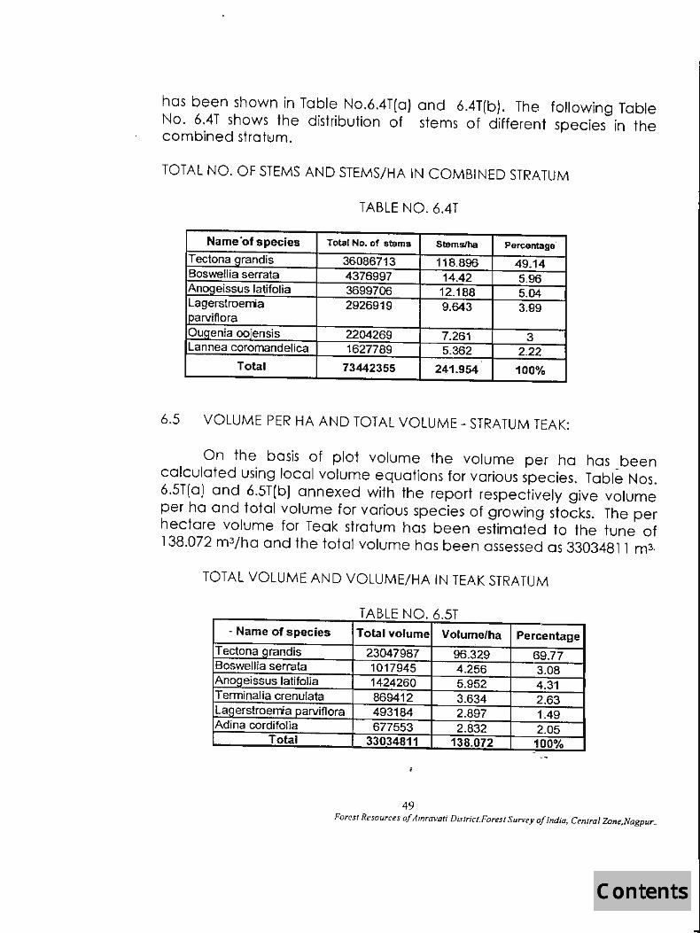
has been shown in Table No.6.4T(a) and 6.4T(b). The following Table No. 6.4T shows the distribution of stems of different species in the combined stratlUm.
TOTAL NO. OF STEMS AND STEMS/HA IN COMBINED STRATUM
TABLE NO. 6.4T
Name'of species Total No. of stems Stemslha Percentage
Tectona _grandis 36086713 118.896 49.14 Boswellia serrata 4376997 14.42 5.96 Anogeissus latifolia 3699706 12.188 5.04 Lagerstroenia 2926919 9.643 3.99 ~rvif1ora
O~enia oojensis 2204269 7.261 3 Lannea coromandelica 1627789 5.362 2.22
Total 73442355 241.954 100%
6.5 VOLUME PER HA AND TOTAL VOLUME - STRATUM TEAK:
On the basis of plot volume the volume per ha has been calculated using local volume equations for various species. Table Nos. 6.5T(0) and 6.5T(b) annexed with the report respectively give volume per ha and total volume for various species of growing stocks. The per hectare volume for Teak stratum has been estimated to the tune of 138.072 m3/ha and the total volume has been assessed as 33034811 m3.
TOTAL VOLUME AND VOLUME/HA IN TEAK STRATUM
TABLE NO. 6.5T " Name of species Total volume Volume/ha Percentage
T ectona _grandis 23047987 96.329 69.77 Boswellia serrata 1017945 4.256 3.08 Ano_g_eissus latifolia 1424260 5.952 4 .31 TerminaJia crenu[ata 869412 3.634 2.63 Lagerstroemiaparviflora 493184 2.897 1.49 Adina cordifolia 677553 2.832 2.05
Total 33034811 138.072 100%
.,
49 Forest Resourc(';s of Amravati District.Forest SUnley of India. Central Zone.Nagpur ..

6.6. VOLUME PER HA AND TOTAL VOLUME - STRATUM MISCELLANEOUS
On the basis of plot volume, the volume per .ha has been calculated using local volume equations. Table No. 6.6T(a) and 6.6T(b) annexed with the report respectively give volume per hectare' and total volume for various species 'of growing stock. The per. hectare volume for miscellaneous stratum has been estimated as 58.539 m 3/ho and the total volume has been assessed to the tune of 3761264 m3.
TOTAL VOLUME AND VOLUME/HA IN MISCELLANEOUS STRATUM
TABLE NO. 6.6 T
Name of species Total volume VOlumelha Percentage
Boswellia serrata 983480 15.307 26.15 T ectona qrandis 966962 15.05 25.71 Anogeissus latifolia 254524 3.96 6.76 Oogeinia ooieinensis 84888 1.321 2.26 Lannea coromandelica 83383 1.296 2.21
Total 3761264 58.539 100
6.7 VOLUME PER HA AND TOTAL VOLUME - COMBINED STRATUM:
On the basis of plot volume, the volume per ha has been calculated using local volume equations. Table Nos. 6.7T(0) and 6.7T(b) annexed with the report respectively give volume per hectare and total volume for various species of the growing stock. The per hectare volume for - combined stratum has been estimated to the tune of 121.233 m3/ha and the total volume has been assessed to the extent of 36796075 m3.
50 Forest Resources of Amravatj Distrjct. Forest Survey oj Indio, Central Zone,Nagpur ..

TOTAL VOLUME AND VOLUME/HA IN COMBINED STRATUM
TABLE NO. 6.7T
Tectona ~randis 24014949 79.121 65.26 Boswellia serrata 2001425 6.595 5.44 Ancmeissus latifolia 1678789 5.532 4.56 Terrninalia crenulata 939672 3.093 2.55 La_g_erstroemia parviflora 740407 2.441 2.01 Adina cordifolia 682012 2.246 1.85
Total 36796075 121.233 100
6.8 MEAN VOLUME PER HA BY TOPOGRAPHY:
The mean volume /ha has been assessed in both the strata by topography classes and the same is produced below in Table No. 6.8T. The table indicates that the hilly terrain yields more mean volume/ha as compared to flat lands.
MEAN VOLUME PER HA BY TOPOGRAPHY CLASSES
TABLE NO. 6.8T
Forest type Topography classes Flat Gently roiling Hilly
Teak 119.601 151.128 137.02 Miscellaneous 0 11.558 75.206
6.9 MEAN VOLUME PER HA BY SLOPE CLASSES:
The mean volume/ha has been further computed for both slope classes. The table indicates that mean volume/ha is predominant on 0-9%, 10-59% slopes for Teak stratum. For Miscellaneous stratum the mean volume is more on 60-99% slopes.
51 Forest Resources of Amravati District. Forest Survey of India, Central Zone,Nagpur ..

MEAN VOLUME PER HA BY SLOPE CLASSES
TABLE NO. 6.91
Forest types Slope classes 0<10% 10<6oY. 60<100& >100%
Teak 147.368 137.333 0 0 Miscellaneous 38.114 65.301 94.715 0
6.10 MEAN VOLUME PER HA BY SOIL DEPTH CLASSES:
The mean volume/ha has been worked ouf by soil depth classes for both the strata and is produced in Table No.6.10T. The table shows obvious trend of stocking with mean volume per hectare depicting gradual increase from soil having shallow depth to the deep soil in both the strata.
MEAN VOLUME PER HA BYSOIL DEPTH CLASSES
TABLE NO.6. lOT
Forest types Soil depth classes Shallow Medium Deep
Teak 98.072 137.407 171.658 Miscellaneous 42.679 75.486 0
6.11 MEAN VOLUME PER HA BY CANOPY LAYER CLASSES:
The mean volume per hactare by canopy layer classes has been worked out for both the strata and the same is produced in the Table No. 6.111. The table clearly indicates that both the strata have upto two storeyed forest only and N.R. is seen only with miscellaneous strata only.
52 Forest Resources of Amral'ati District. Forest Survey of India. Central Zone.Nagpur ..

MEAN VOLUME PER HA BY CANOPY LAYER CLASSES
TABLE NO. 6.1lT Canopy layer classes -. .... -
'~:4: .
Forest types Single Two storeyed Two or more
.( No storey storeyed .~:~ .. ~
forest storeyed forests ,
forests
Teak 41.821 126.268 148.461 0 0 Miscellaneou 7.474 60.281 121.852 0 98.188
6.12 MEAN VOLUME PER HA BY TOP HEIGHT CLASSES : --- __
The mean volume/ha has been worked out for both the strata by top height classes of vegetation and the same is produced in the Table No. 6.12T. The table indicates that in both the strata it is in increasing order upto top height class 26-30 m but beyond this top height the Teak and Miscellaneous strata do not possess any volume and N.R. is seen only in Miscellaneous stratum.
MEAN VOLUME PER HA BY TOP HEIGHT CLASSES
TABLE NO. 6.12T
Forest type Top height classes (in meters
1·5 6-10 11-15 16-20 21-25 26--30 31-99 NR
Teak 23.832 38.27 106.38 134.46 177.54 195.55 0 0 Miscellaneou 9.687 26.03 93.322 118.45 0 3.836 0 98.188
6.13 MEAN VOLUME PER HA BY SIZE CLASSES:
Mean volume/ha has been worked out for both the strata by size classes of vegetation and produced in Table No. 6.13T. In case of Miscellaneous stratum, the volume is in increasing order from regeneration to mixed size timber whereas in case of Teak stratum it is increasing upto big timber and the volume per hectare in big sized timber is more than mixed size classes.
53 Fores' Resources oj Amra"ali District.Forest Survey oj Indio. Central Zone,Nagpur_

MEAN VOLUME PER HA BY SIZE CLASSES
TABLE NO. 6.13T
Regene. Small " ":tt' " ' ,'~ .i:af Forest types Pole crop Big timber Mixed .~C! ' 'N R.1I·""i ration timber .:: ' ~.~ ,':l~
Teak 41.821 110.708 141.027 163.632 148.595 0
Miscellaneous 7.474 45.936 71.605 124.105 99.863 98.188
6.14 GROWING STOCK WITH ESTIMATION OF STANDARD ERROR:
Table No. 6.14T produced below gives the standard error computed for both the strata for the estimation of area, volume per ha and total volume of the growing stock f9und in Amravafi d istrict.
GROWING STOCK WITH ESTIMATION OF STANDARD ERROR
TABLE NO. 6.14T
Forest Area In S.E% VolJha (m1 S.E.%
Total S.E.% types sq.km. volume (m')
Teak 2392.66 4.24 138.072 3.34 33034.84 5.4 Miscellaneol 642.52 12.24 52.539 14.11 3761.264 18.68
Total 3035.18 4.25 121.233 5.2 36796.08 6.72
***************
54 Forest Resources of Amra~'ati District.Forest S urvey o/India. Central Zone,Nagpur ..

CHAPTER VII
INVENTORY RESULTS - GROWING STOCK - BAMBOO
7.1 AREA
In Amaravati district 78~8% of the forest area is teak
forest area is teak forest with bamboo and resLof the drea is
covered by Miscelkmeous forest comprising of bamboo, Khair,
Salai etc. The occur of bamboo by quality, density ,clump sizes, age
group and condition etc are discussed in detail in the following
paragraphs.
7.2 BAMBOO AREA BY DENSITY AND QUALITY
The table no 7.2 below gives distribution of bamboo areas
by density and quality. The table indicates that 1439.11 sq. km area (
81.22%) was found under first quality bamboo (average culm height
6m or more), 50.70 sq km area is of quality two bamboo (average
culm height 4-6m) and the rest 282.01 sq km is of quality four
bamboo. It is regenation crop of bamboo wherec1ump formatuon
has not yet taken place.
55
Fo...." ~ of .4mnnutt distrfd. F" ,..:tt Survq "flnella. ('_lUI ZDn#tP agpur

DISTRBUTION OF TOTAL BAMBOO AREA BY DENSITY AND QUALITY
COMBINING ALL LEGAL STATUS
TABLE NO 7.2 ,
'll"'..,.-t,~.,,~,,> "'"., .... W~~~~l!t!!tBamboo Quality~~~tit~ ~TOTAL~~ Bamboo d~nsityl ~i.:~1~~ ~2~ ~~31,~ ~'4~ g~~~ ~-
1 50.22 0 r. 0 0 50.22 ' ,' , 2 130.65 0 ,
0 0 130.65 3 130.65 0 ' 0 0 "130.65 .' 4 311.76 0 "'0 0 . 311.76 ~.". .,.il'c:
5 311.76 20.47 0 0 332.23 . 6 504.07 30.23 0 0 534.3 7 0 0 0 201.58 201.58 ~ '. 8 0 0 0 80.43 80.43 :~. ;;
TOTAL 1439.11 50.7 0 282.01 1771.82
BAMBOO DENSITY & QUALITY
-.. ~ 500 ~ 400~-+--~~~~~·1~--~~
~ 300~-+--~-w.~ ~ 200~-+--+_"lftIH~I .. +rnIIH-..r+---l :::J § 100~-+~~~~OHm~~~,r~~r~~~ o
1 234 567 8
DENSITY
56
tlQuality (clumps/ha )
Fo,'''' &~s of Amrcm,,; district, Fore." S""""Yoflndia. c.,.,,,,r Z,m'.Nagpur

"cODil ~~}.'Wjt~~~~~'···' ~~~.m~~. . ., ~.. . ~", ,ii .. :, . '" ", IDESCRIPTION .. . ' .. ',., .. :, " "t, \,,, . .. ' , ' , 1 Pure barrboo 200 or more clumPSlha . , . .:t', ';' .::: •. I.;:t.
2 Very dense banboo 150-200 clum~s/ha I
3 Dense 100-150 clumpslha 4 Moderately Dense 50-100 clum_Qs/ha , -5 Scattered 20-50 clumpslha t 6 Sparse 1-20 clumps/ha ,. ...
Banboo present but clumps , , 7 hacked by peaple .. '" o '
8 Notarooo totally bamboo absent 9 Regeneration crop clump formation has not yet taken place ~;, ......... ~,'* "'":
7.3 CLUMPS/HA BY QUALITY AND CLUMP SIZE CLASSES
The table below shows the number of clumps per
hectare in the forests of Amaravoti district by their quality and clump
sizes. Bamboo clumps of less than 1 m dia are 65.87 and 50 clumps
per hectare, in quality 1 and 2 respectively . In 1 to 2m diameter
classes the number is 21.82 and 12, in quality 1 and 2 respectively.
Bamboo clumps with more than 2 metre diameter are just about·2 in
both quality bamboos.
NUMBER OF CLUMPS PER HECTARE BY QUALITY AND SIZE CLASSES
TABLE NO 7.3
. ';:':"Q '1": '. ~ ,,,,. '. ,, ~ .. ~ ' ' ::;i;SIZE,C,LASSESJ~.:~ ,~t . ;f~~.~~ , )'~ u~ ity.:.. _. ~
~.~ , <1m 1·2m >2m 1 65.87 21 .82 2.66
., :.... 2 50 12 " 2
57
Fol"UI Rt.'f01II'f;f!J 0/ Nrrrrnvri distrla. Fo":rt Survey,,/Indlo, e mt",,1 Zotw.NagptI,

CLUMPSIHA. BY QUALITY AND SIZE CLASSES rC-I-s~tQ-u-a-zy~
70 Am~~~~~~~~~~~~~~~~~
60
<1m 1-2m >2m clumps1i:e
7.4 MEAN NUMBER OF BAMBOO CULMSf, CLUMP BY AGE
The table below gives distribution of culms/clump by age of
the culms. Accordingly it was estimated that in clump size-I having
diametre below. 1 m has 505.487 culms/clump od different age
groups where as in clump size II having diameter 1-2m, there are
447.528 culms/clump of different age groups. The second quality -' -
bamboo of clump size I having diamerer below 1 mhos 51.426
culms/clump of different age groups.
~~ • Quality ~~~;.~.~
1
2
MEAN NUMBER OF BAMBOO CULMS/CLUMP
TABLE 7.4
I . cl,ump Io! • C:UlTetlt i~ :;'1to2~ Mora than ~!DtYa1 ~t, "'~~ :lriiiG:~~~':I1 • .yt :f'1~IDIY:_~' . ; Decaf8dJ size class l ; seasons 2sea.sons ,sound · . damaged year.~. , . !fo{,«"' '' . ,"' •• ,,!.y,_ .• 1j. .~~.
1 56.05 60.73 219.1 60.73 81.81 27.1 2 40.65 40.63 180.12 50.7 107.37 28.67 3 7.98 11.52 14.18 2.66 14.18 0.89 1 42.9 64.25 142.85 28.55 57.15 7.15
58
iB 505.49 447.53 51.43 342.85

7.5 MEAN NUMBER OF BAMBOO CULMS/CLUMP BY SOUNDNESS
The table below shows distribution of cultns pere clump by.
the soundness of the culms. Accordingly it was estimated that out of
a total of 7.674 culms in size class 1 only 3.375 are green and sound
bamboo. In other size classes the green an~ sound bamboos are less
than 50% of the culms/ clump the rest are having some defects. The
same trend is observed in second quality bamboo.
MEAN NO OF BAMBOO CULMS/ CLUMP BY SOUNDNESS
TABLE NO 7.5
_ ~. . Clump size Greeo&,
auarrty~ ;,,::f" class mfl "Sound t l Green & damaged .~1Y6~~
""t';' ;.c,'
Ory·daffiagecI_ ~'~. IiQ!~' 1 3.375 1.724 0.922 1.242 0.411
1 2 7.686 4.294 2.295 4.921 1.314 3 5.334 7.333 1.000 5.333 0,333
2 1 3.000 2.000 0.571 1.143 0:143
7.6 TOTAL NUMBER OF BAMBO CULMS/CLUMP BY QUALlTY,SIZE
CLASS, AGE AND SOUNDNESS
7.674
20.51 19.516 6.837
The table no 7.6 below gives distribution of culms/c1ump by
quality, age and soundness of culms. The table indicates that major
occurrence of culms/clump is under small sized culms having clump
size classes 1 and 2.
59

TOTAL CULMS (000) BY QUALITY, SOUNDNESS AND CLUMP SIZE CLASSES:
TABLE 7.6
.•.. --CIIJI1l) size ' Green & Green &, " "f, .,';' " H
~'!OIALl :<?ua)ity. ,~:;)·CJaSs; ,II!! i)scund~ Ory sOtll1C:! ~:,~,~ 1r~J. 1 32175.574 16444.79 8848.166 11874.701 3969.14 73312.369 1 2 24240.027 13880.18 7560.228 15912.883 4478.215 66071.533 3 2531.988 3009.317 493.890 2021.538 164.63 8221 .363
2 1 803426 622.174 188.363 376.726 47.091 2037.78
7.7 MEAN NUMBER OF BAMBOO CUlMS/CLUMPS BY SOUNDNESS,
AGE AND CLUMP SIZE CLASSES
The table no 7.7 given in annexure - shows the
distributuon of mean number of bamboos culms/clump by
soundness age and clump size classes.The bamboo of first quality
has green sound culms about fifty percent of the total bamboo
available. This shows the good quality bamboo forest of the area.
Bamboos of 8cm Plus are not available in any of the quality class.
The same trend _is.observed in other two qualifies of bamboos
7.8 MEAN NUMBER OF BAMBOO CULMS/HA BY AGE AND CULM
SIZE CLASSES
The tpble no 7.8 given in annexure - shows the distribution
of bamboos oy mean number of culms/ha by age and culm size
clos$es. The bamboo distribution trend is same as is discussed in the
above table
60
f'o,..., ~s of A"'",,"'I diSlri<t, FolTS/ Survq a/India, emf",1 z"" • .Nagpur

7.9 DISTRIBUTION OF BAMBOO CUlMS (000) BY AGE AND CULM SIZE
CLASSES
The table 7.9 given in annexure - shows the distribution of . bamboo culms in thousands by age and culm size classes. In first
quality of size classes first and second the green sound bamboo in
the forest. The bamboo of 8cm and above is not available in all the
three qualities of bamboo
7.10. DISTRIBUTION OF GREEN BAMBOO STOCK IN (000) TONNES BY
AGE AND SOUNDNESS
The distribution of green bamboo stock in tonnes by age and
soundness is given in the table The green bamboo availability trend
has been discussed in above paras. The first and second clump size
class bamboos are available in good quantities as compared to
other defective bamboos. This shows the soundness of bamboo
forest of the district.
7.11 DRY BAMBOO STOCK (000) TONNES BY QUALITY SIZE CLASS AGE
AND SOUNDNESS OF CUlMS TAKING 60 %OF THE GREEN
WEIGHT OF BAMBOO
The table 7.11 given in annexure - shows the distribution
of dfy bamboo in tonnes (taking 60 percent of the green weight of
pompoo) by quality, size class, age and soundness of-culms. The dry
bamboo availability trend is similar to the discussion done in the
preceding para 7.10. Only first and second quality bamboos are
available in the district.
************
61
Fo='Iir~,oJ Am1tnmi dstrld, F",""SI Suneyojlndia, Ccrrt",IZon~.NagptJr

ro ~ E .l!l (J)
c o -g. III
~ o III Q)
'u ,~ (J)
+ o c:o
o 00 a ,...._
o ,...._ o to
1O v 1O vc:o (") .
• C'I O"<t ..-
~U;~~ (")C'lOC'l 000<0
O~OOOOOOOOOOOO~OOO~~OOO~~ o 0 00 00
10 m lOC'lC'I""'_m ogooooooOOOOO~OOOO~~~OO~(,,)
o 0 000 00
0>
o~o o
..., C'I co "<t CIQ ~oooooooooo~ooo~ooo~o~ o 0 0 0 0
o N m ,...._ v(")~ ('ICO 1O tOC'lCIQ
~ O~O~O~OOOOOOO~NOO~~Ogo~g~ 1O 0 0 0 00 00 0 00..-
...,
..I o .....
62

:0-t=' N cO ci Z Q)
:a «l t-
b 0 9 E Q)
ii5
Q} a.. ;:;. iii ~ o u..
+ o 00
0 00
6 ,.._
0 ~ , 0 to
0 <.0 6 II")
0 II")
6 "<t
0 ,. lC') (")
L() C")
6 C")
0 • C")
E';' ON
.S Vl
~L() VlN «l ' 13~ .... Q)
Q)
~O .- N 0,;,
c o .g u VI Ql a VI Ql 'u I,~ (/)
......
Ii) ...... a ......
~ ~ ~~ ~~ O<OOOOOOOOOOOOO~OOO~"""OOO""'O o 0 00 O~
0
0
0
0
0
0
~ ~ ~N N~
Ol to I.q 0 0 0
0 0 0 ..-
,.._ 0>
(") to ~ 0 I.q 0 00 ...... 0 N .-
~ ~ to tD (V) C")
~ 0 ~ 0 I'-: 0 0 ...... 0 ...... N N
C') tD L() 0 0 ...... C'l 0 C'l 0 '<I: 0 ..... N III 0> <.0 0)
N (") ...... ~ ;1; '<t ~ 0 0> 0 ..,f '<I: c-; N .,.....
00 co III (") .-
N (!)
CS '<t ..- N ..-0 <0
0 co ~ N ~ g .-Ii) (!) ...... (")
0 0 0 0
0 0 0 0
0 0 0 0
'<t C')
0 0 """: 0 0 N
0> ~ ~ ([) 8 (0 ([) 0 0 0 0 0 .- ...... ......
0) to ~ (")
0 01 0 0 0 ...... lC')
~C") NO
O""':~O 00 ...... (")
...... '<t 010 N <:0
63
0
0
0
~ ([) q 0 ......
(0 (")
~ 0 Ii)
~ N co
(") 0
0 CJ:! 0 0 0 (")
,.._ 0 0
<0 ~ 0 0 ..-
'<t (0 C') (")
0 """: ~ 0 0 0 N Ii)
~
0 0 CD 0 0 0 ......
~~ 0) 0) (0 ([) . ...... (0 ([)
N . 0 0 co~ ...... ......
~ '<t CO (") 0 N ....... ~ 0 N .
...... 0 (") (")
...... N 01
Ol ,.._ ~ CD IOtD
0 0 ~ ~~ 0 0 00 ............ ......
~ (0
00 N 0 0 0
0
0
0
0) CD I.q 0 ......
0 '<t
~ 00 0) to (")
CD ~ 0 0 ~ 0 0 ...... 0 ...... ...... ...... ....
~ 0) ~ ~ 8 ~ ([) 0 0 0
0 (") 0 ...... ...... ..... co
C")
;:r; ~ ~ ([) 0 0 """: q 0
0 0 0 (0 N ...... ......
...... to lC') to (") co (")
I'-: 0 0 ~ 0 0(") 0 NOl N
N
to '<t(") ON '<1:.0000 ...... 0) (")<:0
lC')
to ...... 0
(") ...... ~o
OM NO)
~ '<t ~ '<t ...... 0 N 0
N 0 ......
~ ......
N to Ii) ..... 0 0 cO C') 0 ...... 0) N
co ~ 00 0 N to I.q 0 '<t
0 N N ~ N C') ...... ......
0> N
~ ~ ~
~ tD
~ (") ...... N ~
~ ......
'<t lC')
~ Ul Ii) ~ ......
('; cO ...... ..... 0 ...... N ~ (")
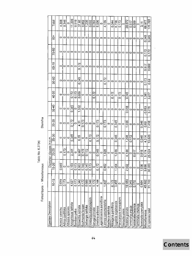
g o I-
+ o CO
o CO
6 I'-
~ , o (0
o 10
6 "<t
10 M , o M
o (")
E,f> <..iN c: til
~lI') rl)N ro6 UN '-
lI') ~
ooooooooooooooooooooooo~~
00
'"'IN OOOOOOOOOOOOOOOOOOOOOOO~~
00
N I'-m OOOOO~OOOOOOOOOOOOOOOOO~~
o 00
ooo~o~oooooooooooo~oooo~~ o ~ 0 OM
10 10 M ~ (0 CON OOO~OIOOO~O~Oooo~oo~~oo
a ~ 0 0 0 ~o
<l.l w~'_-r-t~r-+-;--r-+_'--~+-'_-r-t~r-+-;--r-+_'~r-+--r-r-t __ ~ EO roN 0,f>
c: ,2 :g (.) <J) Q)
Cl til Q) '(3
.~ (/)
..-
Ii) ..
I o ..-
6ft.

b 0 9 E a>
U5
c::: o
~ If) (l)
o If) (l)
'u .~ (J)
<D('() + "<t '<t gooooooooooooooooooooooo~~
NN
o ~ ~ 6oooooooooooooooooooooo0~~ ~ ~~
o ~ ~ ~~ ~ooooo,"":oooooo~oooooOOOOO"""'M g ~ ~ ~;
C') '<t N t"l (") "<t r-- .,..... r--0 ,..._ 0 OJ r-- ,... 0 ,..._ '<t (") LO
0 0 0 C! ..--. C"! 0 0 0 ~ 0 0 0 0 ~ 0 '"": 0 or: 0 0 0 0 "- ~ a .,..... ..-- "<t .,..... ..- .,..... N cO 0 "<t .,..... ,... "<t .,..... ...... .... N to .,..... N
o ~ ~ ~ ~ooo,"":O<DOOooooooooooC"!oooo Il"l N oi (") (") N 0> (")
\0 C') N '<t '<l" '<l" <D Il"l OJ Il"l .,..... (")
,..._ OJ 0 0 0 "<t OJ 0 Il"l (.() a 0 0 0 C! 0 <0 '"": 0 0 0 '"": 0 '"": 0 0 ..... , 00 ~ 00 Col C"! ~ cci .,..... r-. .... ..-- .,..... N (.() N ~ f"-C") ..... N ... ..-- .... N (.() N "'<t
0> Il"lr') o or-.
ooooC"!oo(.()°oo N .....:...: N r-- ......
6S

"iii o I-
+ o CO
o CO o I'-
o I'-a m
o ~ a lC)
o lC)
a '<t
o
J, ~
~ ~ ~m rnm o8oooooooooooo8000~8ooo~g
o 0 00 00
~ ~ ~MM ~N o800ooooooooo~oooo888oo~~
o 0 000 00
I'- ~ ~ M M ~mN oOo808oooooooo8ooo~ooo8~~
o 0 0 ci ci ood
/66 I I
ll) :tM 8o~8 . ~. o .... 0
.... MI'-O
OOO~""""'1 Oo)('f)
'<t

c .2
.~ UJ OJ a <I) OJ Ti )~ C/)
+ o co
o ~
I o W
o <0 6 l{)
o l{)
o ..,.
l{) cry
o cry
l{) ..... 6 ....
m ~ ~ o~~ooooooooooo~ooo~ 0
00 ~ ~ ~
m W
oWooooooooooo o ~
~ m cry ~ M W ~ W
0~0~0~000000000000 ~ a ~ ci N ~ ~ T"""
(") o
o~ .... 0)
I'- ~ o <0 ooo~oooo
..... 0 (") .,...
67
~~ .,....<0 .0 o . ~~

Q) a. ~
c a
l'g u V) Q)
o tJ) Q) "(3
.~ (/)
+ o CO
o ~ o ID
o ID o ~
1.0 ~ . o ~
~ m m~ ~N o~oooooooooooo~ooo~~ooogm
a a 00 ~N
~ m MIDm ID~ o~ooooooooooo~oooo~~~oo~~
o ~ 0 00 ON
co ~ ~ 00 N o~o~oooooooooo~OOO~OOOMO"O~ a 0 a a ~
~ co ~ ~~ ~ID ~ ID~~ 0~0"ogo~ooooooo~*oo8~o~0~8~
a a 00 o~ 0 OOM
68
co ID IDN o Ii? "~
0,-

E
+ o CO
on C")
a M
o M .n N
...... ex:>
000000000000"'000
18 o
~ g_ omOOOOOOOOOOOO
M <.0 <D N
000
00
«) (0 M
OOOOOOOOOO~OOO~OOO M to
0000000
N ...... en C") en <.0
OMOMONOOO
~ ~ ~ en m t-["} co N '<tOCOOONOO
ex) N
o~o o ......
...... ...... cj <ri '<t' <.0...... ......
.,...
<D<D ...... N en r-~tri ...... Ol M<Jj
o~;--+~~+-;--+~--~;--r~~~;--r~~~+--r-+~~+-;--+~~+-;-~ .S (I)
~U') (/) N ro I
u~ '-
;!l Q)
~~r-r-r-~~~~~~-+-+-+-+-+-+~~~~-r~~~~~ °0 J: ..-
...... Ol C")0l m~ . t--...... ""
69
00
N o o~
en '<t
00
MCO 00
~~ ...... N '<t'<t

(f)
(\) Q_
z. u; ~ o
LL
0 co 6 r--
0 f'--
6 <D
0 CD 6 I.[)
a LO 6 v-
0 ,. LO ("')
o ("')
EJ, UN
ooopooooooooooooooooooo
0 0 00 00 0 0 0 0 0 0 0 0 0 0 0 0 0 (0 to
0 0 00 f'-- f'--0 c:)
I.[) t- N
00 ("')
0 0 0 <D 0 0 0 0 ~ 0 0 0 0 0 0 0 0 0 0 0 0 00 "': ("') 0 ..... N
t- f'-- <D f'--0 0 0 0 0 .....
0 0 0 0 0 0 ~ 0 0 0 0 0 a 0 a a co f'--~ a ("') a c:) 6 .....
t- ..... t- l.() .- o.n 0> to ..... a a ~ ..... N 0 0 a to
0 0 0 a ..... 0
v- a ~ 0 a 0 0 LO ..... 0 ("') M 01 ~ C') C') (.() ..... 10 c:) c:) c:) c:) 0 0 0 N to
~ .,.... ..... N co
0 0 co
0 0 0 0 a 0 0 0 0 0 0 co a 0 0 0
C') N 0 0 l.() ~ 0 r-- ~ co c:) c:) C"i ..... 0
f'-- ..... C') vOl co 0> C')~CO ooo~o~~oaoo~~oo~oo~aoa~~~
c:) C"ie 00 0 ..... oo~
.S~+-~-+_'--~+-1-~-+_'--r-+-~~-+_'--r-+-~-r-+_'~t-+-~-+-; (/)
~l.() <1'lN <136 UN W Q)r-~~--~~~--r-'_-+~r-t--+-;~+-~~--~'_-+--r-'_-+-; __ +-~-; __ +-, EO <13 N OJ,
c a
I~ til W o
.....
70

:0 f=' co ill o
Z <l>
:0 ro I-
b o 9 <ll E ::;,
g
r.n ::;, o <ll C lY OJ (.) IJ}
~ I
IJ) Q) D.. C
]i o I-
+ o 00
o I'--
I o co
o <9 o LO
o l[)
I
o '<f'
l[) ("")
I o ("")
0~~0;::~l[) N(",,) ..... col'--
~~ ~~~o N
0000000000000000
0000000
0000000000000000
N...;r (J)CO co~ 0>.,CO (0 01'-..- ("")
CO CO CO<!) 0) en
"" NN ..- .,-.
I.OLQ 'o;t'o;t
ooooooocooo
000001'--0000000000 en ("")
CO 00 '<;t'<;t
'<;t ("")
N O'l '<;t("") LO en
0000 000 (,<,)"
00000 cooooooOO)OOO co l[) '<f' ~ N co l[) ("") 0000000
000
00 I'--l[) LO cooooo~o 0) CJ) N .,.-
I.[') ~ co
~0~000000000000;; ..f 0 I.[') ("")
("") co
ooocoo N
I.[')
~oo cO
......
(0 ,..... CO("")CO I';..-co CJ)N" LO O'l
cot--...;r<'? CJ)~
. 0 ON
en CJ) oogooo~oo " .,-
71
000
..- v ..- .,.-

(1l
~ E ::l (5 >
Q)
E C1l <:: en Q)
'(3
,~ U)
+ a ro
~~~Nro~ro~ro~~~mro~m~M~~roM~~M ~~OMNm~~~O~~~N~M~~N~~NmN~ ~NO~~~~~~~O~~~~~~N~ro~OO~~ oNo~o~ooo~oN~~~~oomoooMN~
~ ..... N
ONOOOOOOOOOOOONO ~ N
~ 0
O ..... OOOOOOOOooomoo .,... L[) N ro o 0
O~OroOMOOOOOOOO<OO ~ L[) ~ 0 N ~ ~ ~
000 0
o(Oor')omOOOOOONMmo ~ ~ ~ ;;~~ o 0 0 00
.....
N(D m~
OONO·:2000~r::: o ..... N
..... <.QT"'" C'l" oo~~~oo~~
000 ON
o~~o§og~~ --0..- 0 oOM
ro ~(DL[) ro (0 r') r')~~~ Ll) ..... (D o~o*~~ooo~0200~0~g~qoo~~~
o 000 0 0 0 OO~O o..-m
72

b o o =(1)
E :J (5
>
0<0000000000000..-0 LO ro
+ o ro
<0 to
~ g
Q)
E ('0 c· en Q) ·0
.~ (/')
o~ooo.oooooooo
o 0> ex;> C")
0> 0 0 o to
o to t--
c:i CD N
o r-;-o (0
O'<:to«)ot-OOOOOOOO(!)O N N 0> t--0) (7) ("') N g ~ ~ C"}
Or'lovo<oooooooo>coroo N V N LOL()ro C'l I'-; t-- Vt--O) to C"} ill <.Or--.:r--.: N t-- O'l r'lCD..-
..-
t- 0> V 0) CO CO
OOO",!O~OO"-O o to o:i 0>..- C"}
LOO> C"}..-LO ..-t-- Nt--N t--C')oc.q~LO ,.....:~ T-oui N..- N..-tO
73
00
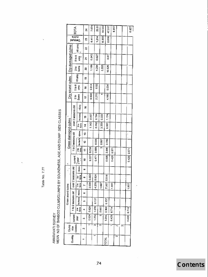
.., ;n M .... ,_ .... ~
.... M .., '" .., U>
~ M 111 00 <0
N ,...: en ,.. cD cD ~ ~ .., lIUJlno ~ ..,
~ 00
~ <1 III PQ~eooa, d 0 , ... 0 ('oj
~ III
E fi N
"'5 00 N
(.) J\ '. rl "0 M ,__ ,_ 9 00
~ I~ ~ N CO ..9 .. '" d N d c:i ro Lt) ,
E C1l
'" .., ..., fD "0
~ .. ~ Q) Cl) ..., N
5 0 ~ N .... CD N ~ ..f- ..0 ~ ..
<I) 5 ~ E 10 a " .., N ~ "C <0 in ;; 0 c:: ..9 5', 10 0 0
:::l ... 0 c:i 0 III
In co Lt) ~ M
cS '0 III 0 .... co
~ .. ~ ... en N ... ... c:i ~ -i
il ,f;. '" .... if) w if) if)
:5 u w b!
.., A c: ~ .j .... ~ M .., . 1'0
~ U") M ~ 51 0 r-.. M
en 0 d 0 d ...: E N iO ...
N N M .... "'5 ell ;;>
~~ .., ~ '" M Ul U 0 ("') (") 00 ... ... ~ M rD "C
if)
a.. ~ ::J ..J U 0 Z « w C> « (/) (/) W
~ :s! ~;. M ;:'
ro E 0 ....
III . co c 'j '" ,... :g "0 ~ M :fl c:: ; N 0 ....
Q.l
'* ...
0 0 0 fl! N 00 00 '" ~ C> ..9
~~ ... en 0 ~ .... ;:: N CO 0> III 01) ... ... c:i 0 M 0 c:i , ,.._ ;:: 00 '" 0) c ~ J: ~ '" N N
~ 0 ..,
'" .., 'of QJ ; ... ci d d ci d
"i o,,~
t:: z 0
~ z =>
ci 0 z if) (!) >-:c 00 ro if) I- a..
:::2 => ..J
~ (/)
::::E ..J => U 0
>-0 WOO >~ 0::« =>00
"0 .. "0 g en ., ..
" ~ ,,_ III N .., '" 0) N ~
~. ~s 00 0 00 <» ; c:i d c:i
N III III .... .... ,... .... ...
~~ E ~ .. .... M III
~ '" U") Lt) 0 N <» ~ ~ 0 ~ -i ... ,...: .-~ B '-r-1:l :s! ~ U> C
§ 0
'" A
C
J .... .... c: g ("') M <II
~ It) ... .-~
~ d c:i I.!) N .., 00 ,_
'" ~ :! ..9 ~J N ,... ~ '" ..,
'" ~ M r-.. ,_ ~
ci ... ci N ci ci C ... N '" CD '" '" ~
N '" N N ~ .... U> ~ 0 .., .., :> 0 ..0 ci 0 u
if) u..
j::0 ;;0 «z o::z « US ~~
c. '" ... N M ... " . M Q) E Q) U) :J .~ U) N (3 ., ..
tl
. ~ ... N _, "IV ... ~ ::l 0 0
t-
,74

CI) w CI) en :s (J
w b! CI)
Cl.. :::E
~ ;:, ..J ex:> (J r-..: a
0 z z « (l) w :0 <-' ~ «
>--co « ~ C/)
~ _, :J (J
° >-0 w CO >~ Q(<( :::>Cl) cnu. i=0 «0 >z c:( o:: z c:(c:( ~UJ «~
75

Ien r...: ci z S! .c ro I-
I I
sWln:> ~ ~
pa~eoaa ~ ~ ~ ,'_' .. , v...:-
C7> .,....
~ "" ~ g} ~ "" '<t
r-: 0> 10 CO r-: r-: <0 ll) ; 0) ~ ~ ~ ~ 'I"-
E Q) CIl
~ .~:.~ ~ C'\( - N M" G,c_U
g ....
76
"" 10 CO c::) <')
-<0 N N -

b r...:
° z Q)
:0 ~
~ o 1-,
sWlno ' " M
paAeOaa~ N
"
V ..... M r-- I() M (0 ci oj r...: N .....
..... V d
..... C":! .....
f./) 00 CI)(_'I
~~'=~~~~I_,5_:_'+-~~~~---t---r--+---t-_, __ -t __ ~ -g~~ ; ~ o~ ~ :::l I()U do 0
g~-----+--~--;-~+---r-~---+---r--+--; '> III CO I() M
Q :N_o,,~ r-. ~ ~ ..... ~ ~, .... 6 N -i
°
c: ... Q) ro
~ ~ u-
N .- N
....
77
N (0
6 I() 0) N 6
N
N
'O'! .....
N (0
6

(/) ill CJ') CJ')
:5 ° ill t:::! UJ
0.. :2 ::l _J
o LL o CJ')
UJ W Z o Z ::l o (/)
o z <C ill ~ <C
CIi (/)
:5 l)
w t:::! CJ')
~ :J § a ?n g e. ::.:::
>-0 wO ~ti; ::lo ~o t-cn ;;~ ~~ <C>:20: «0
,.. <'I
o N
~ ~'E <7>
o o 0 o
I,{) m I,{)
ci
C r-~ ~---r~~m=-r--t~~~r--t---r--t-~
~ ~, C( co ~ ~ g .' I/) b--l---+---t---t--t---r--+---r--t---t
'l i ~J ~ 2 § ~ ~ N CXJ ~
:~, I-::"'O~""(.)-.'-: ",t---l--+--+---t--t--+--+--jl--f .?; '0<1) ~/E CD
",0;' c: . J-7-'-';' -;t---t--t---r--t---lr--+-+-t--I
c:i
~: r. ~ ' o' ::g U)
: ~ ' : ~ r.,> It) -.i ':i (:),: . s,tB r-',:-" E +-'Ot--t-r.o-t-~-.+-~-t-~-,+-~--t-+-t-~-I ~,~' J o-i ci ~ ci ci
N
.:t:: '-:; ': ;::: ~ >. ..... o
_J
~ o t-
78
M

ANNEXURE-I
BIBLIOGRAPHY
1. A statistical outline - Current Salient Forest Statistics, 1997(MS).
2. Working Plans of Amravati disrict.
3. Socio-economic review and District Statistical Abstract of Amravati District.
4. District Census Hand book (Amravati district).

ANNI~xunE ·11
LIST OF OFFICEHS AND STAFF ASSOCIATlm WITH SURVEY WOltK IN AMltA V ATI UlSTIUCT Olf MAIIAItASJlTRA STAn~
1. S/shii P.V.Savant, IFS, Joint Director 2. S.B.ElkW1chwar, IFS, Deputy Director 3. B.R.Pandey, STA 4. M.K.Madaria,JTA 5. P.R.Singh, ITA 6. R.P.Sao,ITA 7. R.K.Mahobe,ITA 8. J.S.Kumbhkar,JTA 9. S.S.Kumbhare,JTA 10. M.H.Kanoje, Dy.Ranger 11. R.C.Verma, II
12. N.P.Singh 1t
13. S.S.Baghel It
14. N.C.Dewangan " 1 5. A.K.Bose " 16. Jagdeo Prasad " 17. R.K.Rai, Fieldman 18. D.G.K.PiJlai, " 19. C.S.Rawat II
20. Fagoo Ram " 21. M.K.Singh, " 22. Sarwan Das " 23. B.P.Shanna " 24. R.P.Thapliy~ fI
25. P.A.Swamy n
26. Dwarika Prasad " 27. Chandan Singh " 28. Bhagbali Dawana " 29. R.R.Singll, n
30. Ramadhin Yadav " 31. Bharat Singh " 32. Chandrika Prasad " 33 .. V.S.Bist, 11
34. Dharam Singh " 35. B.D.Vaishnav " 36. R.S.Pandey Driver 37 .. R.A.Dongre, " 38. N.C.Malakar n
39. David Kumar 11
40. V.l.0ondane " 41. G.S.Gaikwad "