Climate Change and the Cost of Conserving Species in Madagascar
Upload
khangminh22Category
view
3download
0
Conserving the Irreplaceable Open Space and Recreation Plan
Pembroke, MA
2017
The Conway SchoolWinter 2017
Devan Arnold, Ben Covino, & Ben Rippe

PEMBROKE OSRP 1

PEMBROKE OSRP 2

PEMBROKE OSRP 3
Section 1: Plan Summary
Pembroke is a growing south shore community with a rich history and wealth of natural, cultural, and historic resources. Foremost amongst these are copious ponds, rivers, streams, and wetlands that dominate the landscape. It is a town that many of its residents identify as being semi-rural, and possessing a charming, small New England town character. This character and the sense of community that accompany it are some of the most highly enjoyed aspects of living within Pembroke. Part of what makes up this character is the abundance of open spaces where people can enjoy recreating or simply basking in the beauty and wonder of undeveloped natural landscapes. The 2017 Open Space and Recreation Plan (OSRP) Update provides guidance for protecting and enhancing the many valued natural and cultural resources within the town.
Through two community meetings, an online survey, and conversations with members of assorted town boards and committees, five main goals have been articulated to satisfy Pembroke’s conservation and recreation needs moving into the future:
1. Pembroke’s abundant water resources are clean and sustainably managed. 2. Future development is consistent with and protects Pembroke’s environmental, historic, and cultural
resources. 3. An interconnected network of forest, riparian and wildlife habitats enhance Pembroke’s ecological
integrity and sustain a resilient landscape. 4. The citizens of Pembroke enjoy better access and increased recreational use of town open space. 5. Planning and management for Pembroke’s extensive open space and recreation lands is more
efficient and coordinated with an accessible database.
To achieve these goals, this plan recommends that the Town of Pembroke, in cooperation with neighboring towns, private and nonprofit organizations, and landowners, undertake the following:
Protect the town’s ground and surface water resources;
Prioritize areas of environmental, historic, and culturally significant resources for protection;
Explore smart growth strategies to focus development away from valued resources;
Increase public awareness of existing resources;
Extend and connect protected areas to create contiguous corridors;
Educate the public about the value of healthy ecosystems;
Increase and improve access to open spaces;
Connect existing trail systems for enhanced recreational use;
Create an accessible electronic data repository for information pertaining to Pembroke’s open space and recreation lands;
Monitor and manage open space lands in Pembroke;
Provide adequate staffing for the planning and management of open space lands; and,
Improve inter-departmental and inter-town communication regarding open space.

PEMBROKE OSRP 4

PEMBROKE OSRP 5
Section 2: Introduction
A. STATEMENT OF PURPOSE
●
●
●

PEMBROKE OSRP 6
●
●
B. PLANNING PROCESS AND PUBLIC PARTICIPATION

PEMBROKE OSRP 7

PEMBROKE OSRP 8
Section 3: Community Setting
3.A REGIONAL CONTEXT
Pembroke is located in the South Shore area of southeastern Massachusetts, 26 miles southeast of Boston and 12 miles east
of Brockton. Pembroke has a total area of 23.5 square miles. The predominant land covers in town are forests (40.9%),
wetlands and water (21.3%), and residential (21.3%) (MassDEP, 2006).
Pembroke shares its borders with Hanover, Norwell, and Marshfield to the north, Duxbury to the east, Kingston, Plympton,
and Halifax to the south, and Hanson to the west.
Pembroke’s proximity to Boston has a large influence on the town in terms of its development pressure. Over the last forty
years the South Shore has been rapidly developing as improvements to roads and other transportation infrastructure has
enticed commuters to live further away from the city and their places of employment. Today 92% of Pembroke’s working
residents commute out of town for work (towncharts.com).
Pembroke also shares numerous water bodies with
neighboring towns, including two rivers, and five
ponds. Two of the major waterbodies in Pembroke
serve as reservoirs for neighboring towns. Given
these shared resources, and the fact that many of
these water bodies are hydrologically connected with
other water resources in the area, regional efforts to
protect and manage these resources are incredibly
important to ensure the long-term health of these
water bodies and the sustainability of their continued
use.
According to Biomap2 (see Map 4.9 Wetland
Habitats) core habitat areas are shared across town
boundaries to the north with Hanover and Norwell,
and to the east with Duxbury. Efforts to adequately

PEMBROKE OSRP 9
protect these areas need to be coordinated across town borders. The Wildlands Trust of southeastern Massachusetts, a
regional non-profit land trust, is carrying out this work.
Water is a dominant feature in Pembroke’s landscape, and is present in a myriad of forms. It has defined the town’s character
and has had a strong influence on its history and development. It is also an invaluable resource for recreation and municipal
use.
Pembroke straddles two watersheds (Map 3.2). Most of the town is in the South Coastal watershed which drains to the
Massachusetts Bay, while the southwest corner of the town is located in the Taunton River watershed, which eventually
drains into Narragansett Bay in Rhode Island. Both bays are considered important resources in the region for their recreation,
scenic and cultural qualities. Efforts to maintain healthy waters are needed throughout their watersheds to attain a healthy
coastline.
The Indian Head River and North River form Pembroke’s northern border and are connected hydrologically to the town’s
many water bodies. These rivers once served as a major transportation route in the region and ship building along the rivers
was one of the first industries in Pembroke.
Multiple brooks and streams meander across
Pembroke’s landscape, connecting the lakes and
ponds to marshes and to the rivers to the north.
In addition to their historical value once
powering mills significant to the town’s
economy, these brooks provide migration routes
for species, such as herring, which have historic,
cultural, and ecological value to Pembroke and
the region. Pembroke has a Herring Fisheries
Commission dedicated to the protection of
these fish and their habitat and migration routes
within the town.
The largest concentration of surface water is
located in the western side of Pembroke where
there are six major lakes and ponds. This is one
of the most densely populated areas of the town
where once seasonal cottages have been
converted to year-round residences. Two of these water bodies are shared across town borders: Oldham Pond is shared with
Hanson to the west, and Silver Lake on Pembroke’s southern border straddles both Halifax and Kingston to the south. Two
water bodies serve as reservoirs for neighboring towns: Great Sandy Bottom Pond is the drinking water for the Abington-
Rockland Water Supply; and, Silver Lake provides water to the city of Brockton.
Marshes and wetlands scattered around the town have strongly influenced Pembroke’s development pattern which has largely
been directed to available dry land and avoided the wet areas. With continued development pressure, the town is seeing
increased encroachment upon these wetland areas.

PEMBROKE OSRP 10
Pembroke’s abundance of water in combination with its sandy soils once made it an ideal location for the cultivation of
cranberries. Bright red berries would fill these bogs in Fall, contributing to the town’s rural character as well as its economy.
Ice-skating on these flooded bogs in winter was common. While these bogs were culturally and economically significant, they
did negatively affect water quality. Synthetic water-soluble fertilizers were commonly used which would run off into
connected waterways, eventually reaching the Atlantic Ocean. Today, cranberry bogs in the region are struggling to remain
economically viable. There is only one cranberry bog left in operation within Pembroke, a couple of others lay fallow. There
are many decommissioned bogs in Pembroke which continue to contribute to the town’s semi-rural scenery as they make
their slow return to forested wetlands. Tubb’s Meadow located off Route 36 is a large area of protected open space highly
valued by town residents as a recreation space for walking and nature watching. It has multiple bogs and irrigation ponds
intersected by trails.
Pembroke draws its potable water from a large aquifer via six wells located around town. Due to the low water table and
highly permeable soils across the town, efforts to protect the aquifer from pollutants and contaminants are particularly
important to maintaining water quality (NRCS 2016).
3.B HISTORY OF THE COMMUNITY
Pembroke has a long and rich history intimately tied to its resources. The lands today called Pembroke were once home to
the Massachusett and Wampanoag tribes, who settled in the area and relied on the abundant fertile soils and copious fish and
other wildlife. In the 1600’s, European settlers came to the continent, settling first in Plymouth and eventually making their
way farther north and west. Sometime around 1650, Robert Barker, Dolor Davis, and an accompanying servant traveled
along the North River, eventually coming to, and overwintering at the area today known as Herring Run. It is believed that
these were the first white settlers in what would eventually become the town of Pembroke. In the proceeding years, there
would be other European settlers to make the journey from the established settlements in the south and east, and in 1662
Josiah Wampatuck, grand sachem of the Massachusett tribe, sold a large tract of land known as Mattakeesett meaning “the
place between the two lakes where the corn grows best”, to the European settlers for twenty-one English pounds. This land
deal included areas to the north that would later become Marshfield, Norwell, and Hanson (Pembroke 300th Anniversary
Committee 2012).
In 1711, the people in the western reaches of Duxbury had grown increasingly frustrated with the long journey to the
Duxbury Parish. In the following year, in 1712, after successfully petitioning the local government officials, the area once
known as Mattakeesett broke away from Duxbury and was officially incorporated as the town of Pembroke, which soon
thereafter built its own meeting house.
The eighteenth century was a prosperous time for the town, which flourished with mills powered by the town’s many streams
and brooks, as well as iron works utilizing iron ore found in some abundance in the sediments of the many ponds in town.
Today’s Furnace Pond was named for an iron furnace constructed on its shores in 1702 (Pembroke Historical Society 2014).
As the eighteenth century wore on, ship building grew to be one of the leading industries in the town, with shipyards
predominantly along the North River. There were at least five shipyards in Pembroke turning out over a thousand ships
before the end of the nineteenth century. The most famous was the Brick Kiln Shipyard. It turned out many well known
ships including the Beaver, which in 1773 was one of the ships involved in the Boston Tea Party, as well as the Columbia,
which was the first U.S. ship to successfully circumnavigate the globe (Boston Harbor Beacon 2015). During this time period,
box and nail manufacturing were important economic drivers, with the Jonathan Jackson nail factory being potentially the
very first of its kind in the America. Aside from powering mills and factories, the abundant waters of Pembroke also
contributed to the local industry in the form of ice harvesting for summer storage and food preservation, as well cranberry

PEMBROKE OSRP 11
cultivation, which would prove to be one of the longer lived industries within the town (although declining over recent years,
there are still at least a handful of commercial cranberry bogs within Pembroke’s borders) (2005 OSRP).
The early 1900s were a time of more leisurely industry in Pembroke with the development of the town’s designation as a
vacation and tourism destination. The many lakes and ponds throughout the town provided scenic shores which attracted
great throngs of vacationing visitors. This time period saw the merging of the Brockton and Pembroke trolley lines which
brought scores of passengers through town by rail. This increase in travelers helped usher in a booming tourism industry with
a great many vacation homes and resorts constructed along the town’s picturesque water bodies, most notable of which was
the Mayflower Grove Resort on the shores of Little Sandy Bottom Pond. This resort operated and thrived for nearly forty
years until it suffered terrible damages in the great 1938 hurricane and was demolished, with the land being quickly sold off to
developers (2005 OSRP).
Today, Pembroke’s character and development continue to be influenced by its rich and abundant water resources, as well as
its charming scenic qualities. These characteristics
continue to draw people in and have been a great driver
of the town’s growth and development in the 21st
century.
3.C POPULATION CHARACTERISTICS
The town of Pembroke conducts population and
demographic updates every ten years to comply with the
national census updates. The most recent up-to-date
census data was conducted in 2010. More recent
information comes from the American Community
Survey (ACS) and the Population Estimate Program
(PEP), both of which provide population estimates for
2015. According to the Town of Pembroke’s 2015
Annual Report, Pembroke had a population of 19,473.
The 2015 population is a 11.8% increase from the 2000 population (17,701). The ACS population estimate for 2015, which
was 18,273, was 1.1% lower than the recorded population of 2015. There is an estimated average of 819 people per square
mile. As the population continues to grow in Pembroke, there will be more demands placed on access to open space and
recreation resources.
PEMBROKE OSRP 12
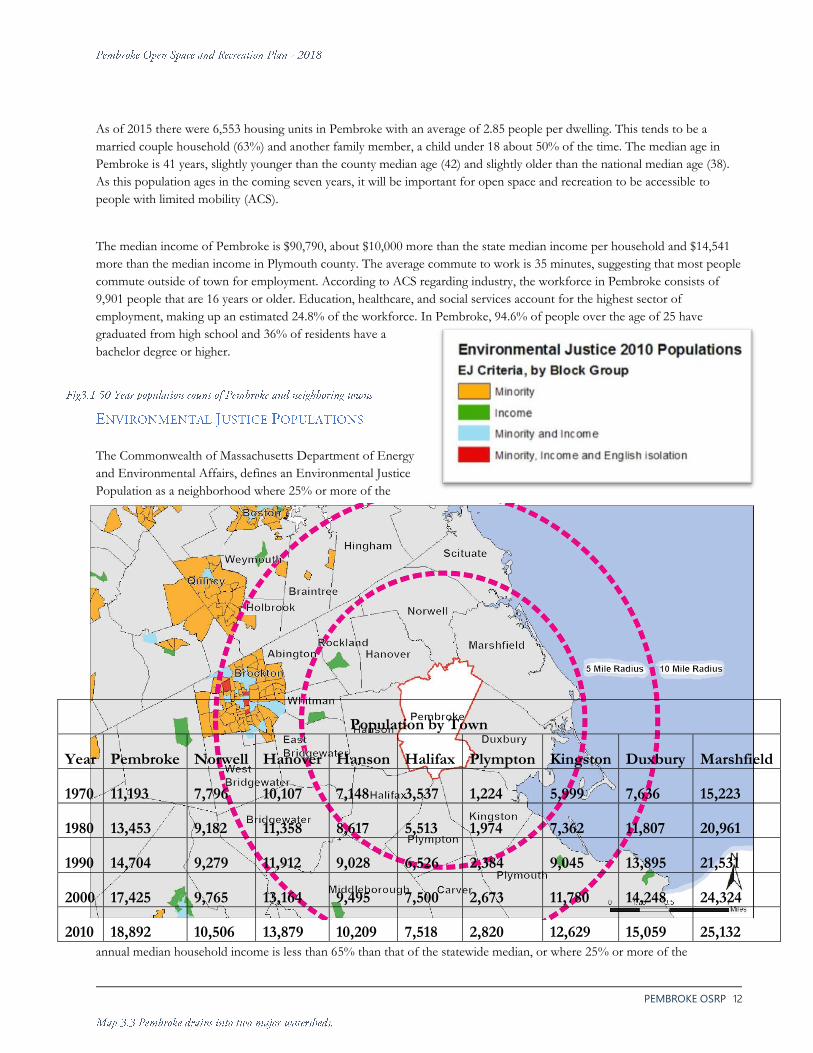
As of 2015 there were 6,553 housing units in Pembroke with an average of 2.85 people per dwelling. This tends to be a
married couple household (63%) and another family member, a child under 18 about 50% of the time. The median age in
Pembroke is 41 years, slightly younger than the county median age (42) and slightly older than the national median age (38).
As this population ages in the coming seven years, it will be important for open space and recreation to be accessible to
people with limited mobility (ACS).
The median income of Pembroke is $90,790, about $10,000 more than the state median income per household and $14,541
more than the median income in Plymouth county. The average commute to work is 35 minutes, suggesting that most people
commute outside of town for employment. According to ACS regarding industry, the workforce in Pembroke consists of
9,901 people that are 16 years or older. Education, healthcare, and social services account for the highest sector of
employment, making up an estimated 24.8% of the workforce. In Pembroke, 94.6% of people over the age of 25 have
graduated from high school and 36% of residents have a
bachelor degree or higher.
The Commonwealth of Massachusetts Department of Energy
and Environmental Affairs, defines an Environmental Justice
Population as a neighborhood where 25% or more of the
annual median household income is less than 65% than that of the statewide median, or where 25% or more of the
Population by Town
Year Pembroke Norwell Hanover Hanson Halifax Plympton Kingston Duxbury Marshfield
1970 11,193 7,796 10,107 7,148 3,537 1,224 5,999 7,636 15,223
1980 13,453 9,182 11,358 8,617 5,513 1,974 7,362 11,807 20,961
1990 14,704 9,279 11,912 9,028 6,526 2,384 9,045 13,895 21,531
2000 17,425 9,765 13,164 9,495 7,500 2,673 11,780 14,248 24,324
2010 18,892 10,506 13,879 10,209 7,518 2,820 12,629 15,059 25,132

PEMBROKE OSRP 13
population is minority or identifies as a household that has English isolation. Environmental Justice Populations were
defined so that all people, regardless of race, class, income, color, origin, or English proficiency, would have the right to a
clean and healthful environment and protection from environmental hazards.
As of 2010 there are no state-recognized Environmental Justice populations found within the town boundaries of Pembroke.
Within a 5-mile radius there are two small Environmental Justice populations in the towns of Whitman and Rockland. Both
populations are recognized as lower income populations. Within a 10-mile radius there are six more towns that have
Environmental Justice Populations, the largest being in the City of Brockton, which has income, minority, and English-
isolation populations. Environmental Justice populations continue to increase in number and density past the 10-mile radius,
especially in the Boston Metropolitan area (MassGIS 2010).
Because there are no state-recognized Environmental Justice populations found in Pembroke, preservation, and maintenance
of open space land, both existing and proposed, will not take into account the bolstering of income, minority, or English-
isolated neighborhoods in Pembroke. Although these populations may not be recognized in Pembroke, it is important that
residents of the town have access to a safe, hazard-free environment.
Pembroke 2000
Age # %
Total Population 16,927 100
Under 5 1,342 7.9
5 to 9 1,349 8
10 to 14 1,423 8.4
15 to 19 1,104 6.5
20 to 24 632 3.7
25 to 34 2,287 13.5
35 to 44 3,262 19.3
45 to 54 2,472 14.6
55 to 59 974 5.8
60 to 64 670 5
65 to 74 849 4
75 to 84 433 2.6
85 and over 130 0.8
Pembroke 2010
Age # %
Total Population 17,837 100
Under 5 1,033 5.8
5 to 9 1,339 7.5
10 to 14 1,466 8.2
15 to 19 1,221 6.8
20 to 24 809 4.5
25 to 29 772 4.3
30 to 34 872 4.9
35 to 39 1,159 6.5
40 to 44 1,611 9
45 to 49 1,647 9.2
50 to 54 1,574 8.8
55 to 59 1,321 7.4
60 to 64 1,012 5.7
65 to 69 760 4.3
70 to 74 492 2.8
75 to 79 338 1.9
80 to 84 235 1.3
85 and over 176 0.9

PEMBROKE OSRP 14
From the earliest census count in Pembroke (1765) until the 1945 census count, Pembroke’s population remained under 2000 (except for one count in 1810). Pembroke’s population began to dramatically increase starting in 1945. Pembroke experienced its most dramatic population increase between 1965 and 1970 about a 58% population increase from 7,708 to 11,193. The trend of population growth has generally continued. The last town census count recorded the town’s population at 19,473. The general trend within the region is a slight increase, potentially bringing Pembroke’s population beyond 20,000 people.
3.D GROWTH AND DEVELOPMENT
PATTERNS
Through the nineteenth century, Pembroke, was
largely an agricultural and industrial community. As
early as the turn of the twentieth century though, the
town became a center for vacation and recreation
activity, in large part drawing on its scenic and
picturesque water bodies and forests to attract
throngs of city dwellers looking to escape the
crowded hustle and bustle of the metropolitan areas.
This led to an extensive development of the areas
around the lakes and ponds within Pembroke for
seasonal vacation homes, many of which have since
been converted into year-round residences. Today,
the abundance of water resources and the
accompanying scenic character of the town, in
combination with its proximity to larger urban areas
(Boston in particular), has helped push the town’s
residential growth, rather than commercial or
industrial development.
Today, the shorelines continue to be some of the
most densely developed areas of town, and residential
development continues to be the dominant form of
developed land use. From 1971 to 2005, Pembroke saw a 3.14%
increase in residential land use, which equates to an increase in
nearly 550 acres. This change accompanied a corresponding
2.94% decrease in the amount of natural, undeveloped lands
(MassGIS 2005) (See Map 3.5a,b Land Use and Fig. 3.3). According to the MassGIS 2005 Land Use datalayer, commercial
establishments made up about 2.05% of the total area of the town, and are concentrated within the historic center district
along Route 14 as well as in the northeastern portions of town, along Routes 3 and 53. This area is also home to the greatest
concentration of industrial development within town, including a concrete block factory. The amount of active agricultural
lands diminished by 1.25%, or 186 acres between 1971 and 2005, with a sharp decline in the number of active cranberry bogs
in town. According to a study conducted by the Mass Audubon, from 2005 to 2013 there were 4.6 -8.0 acres of new
development per square in Pembroke. This puts the total percent of developed land in Pembroke at a range of 12-26% for
2013, with 66-83% of land remaining natural under forest, wetland, or water cover (Mass Audubon 2014).
The current zoning bylaws (see Map 3.6 Zoning), which were adopted in 2005, accommodate a focus on residential
development. Pembroke has five different zoning areas, but nearly 90% of the town’s area is classified for residential zoning.

PEMBROKE OSRP 15
Much smaller areas are given to commercial, mixed, and industrial activities. Some of the commercial, industrial, and mixed
districts also allow for some residential uses specific to their zones. One of the important changes to occur to the zoning
structure with the 2005 version was the creation of a wellhead protection district in the southern end of town that restricts
a
ctivities and structures that pose a threat to water quality near aquifer-fed wellheads. Although these 2005 regulations limit
new constructions or renovations, they have little power over the many densely sited converted summer homes which make

PEMBROKE OSRP 16
up the bulk of structures within these sensitive areas. This threat should be considered as a priority for further protection
measures which will be discussed in the Seven-Year Action-Plan (See chap. 9)
Population growth in a community can often require a town to increase infrastructure needs to accommodate for the needs
of residents. Infrastructure development, such as maintenance to and construction of roads, municipal water mains, and
storm water and sewer systems must meet the needs of a growing community to ensure a safe and orderly delivery of public
services.
Growth in a region generally means more cars and more impact on roads, leading to increased road maintenance. Residents
who responded to the 2017 OSRP survey voiced concerns about the increase in traffic. The Old Colony Planning Council’s
(OCPC) Traffic Volume Report for 1985 to 2015 showed that the annual daily traffic (ADT) in Pembroke has generally
decreased. The areas of increased traffic were along major roads close to the borders of neighboring towns. Increased ADT
was found on Routes 3, 14, and 139 where these roads connect with bordering towns. Although traffic has not substantially
increased in the last thirty years, OCPC’s Traffic Volume Report shows an increase in the percentage of heavy vehicles
driving through Pembroke.
Within the town of Pembroke, the major roads leading north-south are Route 3, a principal arterial connecting Boston with
Cape Cod, Route 53, and Route 36. Roads running east-west include Route 14, Route 139 and Route 27. Routes 36 and 27
run through Zone I well-protection areas, and Route 14, 27 and 36 run through the Zone II protection area. Routes 3, 53,
139, 14, and 27 all cross over major lakes and streams within Pembroke. As traffic increases and road maintenance needs
become more frequent, it is likely that water and air pollution from cars and construction will negatively impact these water
resources. (See Map 4.13 Impermeable Surfaces).
Although Pembroke is part of the 78-member Massachusetts Bay Transportation Authority (MBTA) and was assessed
$149,114 in 2005, the town received no direct transportation service. The neighboring towns of Halifax, Hanson and
Kingston all have passenger rail services which connect people in the region to the Boston metropolitan area. The MBTA
services in these towns provide Pembroke residents that work in or around Boston with an alternative transportation
opportunity.
The Bay Circuit Trail extends across thirty-seven towns in eastern Massachusetts, connecting many parks and open spaces in
fifty-seven communities. In Pembroke, this trail crosses the southern portion of the town, connecting many protected open
spaces within the town. It crosses town boundaries shared with Hanson to the west, Kingston to the south, and Duxbury to
the east.
As Pembroke’s population has grown it has transitioned from rural to suburban, yet the town lacks some amenities for
alternate forms of transportation like walking and biking. Cul de sacs, subdivisions, and neighborhoods are filled with active
families and residents who desire safe and walkable places to take a morning jog, an evening dog-walk, or an afternoon bike
ride. According to the February 2017 Pembroke OSRP survey, the highest ranking responses in regards to what people liked
least about the town pertained to a lack of sidewalks and safe road conditions (37.9%). Many survey respondents voiced
PEMBROKE OSRP 17
concerns over dangerously narrow roads and speeding motorists, and vied for safer conditions for walking and biking.
Sidewalks and bike lanes provide many opportunities to improve quality of life for Pembroke’s residents, and future plans for
both have been confirmed along Routes 14, 36, and 53 as these roads are widened and resurfaced.
Six gravel packed wells draw from the aquifer in and around the western portion of Pembroke. There are 3 water tanks in
town that store treated water from the aquifer. The water department recently acquired land around Pudding Brook near an
abandoned cranberry bog to install a seventh well which would pump from a high contribution aquifer in the northern part
of town. Although the town has underground infrastructure to supply municipal water to residents, some residents still pump
from private wells. According to Pembroke’s Board of Health, there are an estimated 250 private wells operating in the town.
Pembroke lacks a central sewer service, so all households and businesses are on septic systems. This in conjunction with high
water tables and well drained soils poses a continued threat to both surface and groundwater resources, especially as
development encroaches on wetland and water bodies.
High desirability and increasing market value has led to many of the lakeside homes being sold and retrofitted, which requires
septic system inspection, and often upgrades, to comply with Title 5 septic requirements. However, septic systems still
require regular maintenance and periodic replacement. When septic systems are not well maintained, they pose a risk of
failure causing leakage of effluent and excessive nutrients. In Pembroke, where the groundwater level is high, septic failure
has the potential to pollute water resources.
The previous 2005 OSRP stated a Comprehensive Wastewater Treatment Plan was in the approval stage with the DEP.
Although the plan was close to completion in 2005, it has not been made available to the team developing this OSRP.
Pembroke has a stormwater management infrastructure which includes hundreds of catch basins across town. Many of these
lead to outfalls, a few of which are monitored, most are not. Of particular concern are those outlets within the water supply
protection zones. All the outfalls pose a threat to surface and groundwater quality, and the town could likely benefit from
adapting stormwater gray infrastructure to green infrastructure practices which focus on removal of pollutants and infiltration
of stormwater back into the ground close to where it falls.
Current population trends in combination with recent development practices and current zoning bylaws show that Pembroke
will likely see increases in population as well as residential and commercial development. According to the UMASS Donahue
Institute’s population change estimates, Plymouth county will experience slight population increases within the next twenty-
five years. The population estimates from 2010 to 2015 showed a 0.01-0.5% increase in Pembroke’s population and this
trend may continue, potentially raising the town’s population beyond 20,000 by 2020. Population increases in Pembroke and
Plymouth county will increase development and the pressures associated with development, like road maintenance and water
distribution. Regionally, withdrawal from Pembroke’s aquifer, which supplies water to other towns in Plymouth county, may
increase which could threaten both the quality and quantity of water resources.

PEMBROKE OSRP 18
Most of the town of Pembroke is zoned Residential A, requiring about one-acre of land to have ample room for a septic
system that will not affect neighboring properties. Because most of the land is zoned residential (about 90%) and those
residences have large lot size requirements, Pembroke has conditions that allow for residential sprawl. Sprawl has already
begun to occur and dwellings continue to be built each year. From 2010 to 2015, 133 dwellings were constructed with an
average of 22 per year. As residential development continues, the town risks continued infringement upon the numerous
wetlands throughout the town.
40B development projects have allowed for cluster development to become more common in Pembroke. As of 2014, 9.6%
of Pembroke’s dwellings were listed as affordable dwellings. To meet the 10% goal of the state, 40B development, which
bypasses local zoning requirements, has taken place allowing for the construction of cluster houses in areas that usually
require over an acre of land. Simultaneously, lakeside properties, which were once affordable housing units, have started to
become renovated to increase their property values, diminishing the number of affordable housing units. These two trends
combined create an environment suitable for negative ecological consequences. Renovations to lake houses may ensure
better septic installations, but cluster housing may concentrate septic systems which could potentially pollute groundwater.
As these trends continue, the town’s residential development projects infringe upon wetlands, threatening the natural
resources associated with wetlands, such as water and habitat. If these wetlands are lost, the town will lose ecosystem services
like flood mitigation, stormwater infiltration, and pollution filtration. Through increased and more intensely concentrated
construction as well as increased non-point source pollution from increased growth (e.g. brake dust, fertilizers, pesticides, pet
waste, and road salt), wetlands may become more stressed and unable to properly handle contaminants. The danger of
polluting water resources may be exacerbated by the construction of cluster housing near water resources due to the
combined septic needs of the many residents. These effects all potentially threaten the quality of the aquifer.
As these population and development trends continue to increase; so will the need for ADA Accessibility to Recreation areas in town. By making Recreation areas and parks accessible for individuals with disabilities improves the quality of the experience for everyone. Increasing opportunities and accessibility for those with disabilities to open space and recreational resources is a priority for the town of Pembroke. According to the 2018 Census inhabitants living with a disability, under the age of 65 years old makes up 7.2% of the town’s population. Also consider the Persons that are 65 years and older at 13.3% of the town’s population. Combining those two populations, demonstrates the significant amount of people that could benefit directly from improved accessibility. It should also be stated that the current Seniors and the following generation is more active than prior generations and has different interests; which should also offer new opportunities for all the town’s residents.
An ADA Transition Audit was conducted in July 2018 for 6 public facilities and 6 public Recreation areas. The audit reinforces that the Town of Pembroke makes accessibility a priority with some of the most recent improvements to the town’s Recreation assets; related to improving access and enjoyment of the facilities to people of all ages and abilities. However, the ADA Accessibility Self-Evaluation reveals that there are notable latent issues in the Public Facilities and multiple recreation properties that offer opportunities for improvement. The Audit is ongoing for the rest of the Recreational Properties, and will be completed by the end of the year. Planning for the recreational needs of this population involves understanding their needs and this is the first step in making progress towards full ADA compliance.

PEMBROKE OSRP 19
The is Town beginning preparations to update its Master Plan and a formal Build Out Analysis has been requested by the Open Space Committee to be included in their preparations and will be reviewed and adapted to the Open Space Plan when it has been completed.

PEMBROKE OSRP 20
.

PEMBROKE OSRP 21

PEMBROKE OSRP 22
Map 3.4
Regional Resources
Regional Resources
Water is the defining feature in Pembroke’s landscape and is present in many forms. The Indian Head and North river form the northern border of the town and are shared with Hanover and Norwell. Numerous ponds straddle town boundaries, as well as aquifers and core habitat areas. Reservoirs provide water to towns that don’t share borders with Pembroke.
Because these resources are shared across town boundaries, they require more complex protection and management efforts to ensure that they remain healthy and able to meet the community's needs. In the case of the reservoirs, these ponds are connected to the towns hydrologic system and should be protected from being overdrawn. The critical habitat should be protected as best as is possible and efforts should extend beyond town boundaries to create contiguous areas of protected land.

PEMBROKE OSRP 23
Map 3.5a – 1971 Land Use Map 3.5b – 2005 Land Use

PEMBROKE OSRP 24
Maps 3.5a & 3.5b
Land Use History
Land Use Change

PEMBROKE OSRP 25

PEMBROKE OSRP 26
Map 3.6 Zoning Pembroke’s Zoning

PEMBROKE OSRP 27

PEMBROKE OSRP 28
Pembroke 2010
Race # %
Total Population 17,837 100
One Race 17,664 99
Two or more 173 1
White 17,274 96.8
Black or African American 109 0.6
American Indian and Alaskan Native 29 0.2
Asian 170 1
Native Hawaiian and Other Pacific Islander 3 < 0.1
Hispanic or Latino 193 1.1
Other 79 0.4
Plymouth County 2010
Race # %
Total Population 494,919 100
One Race 482,128 97.4
Two or more 12,791 2.6
White 423,133 85.5
Black or African American 35,608 7.2
American Indian and Alaskan Native 1,213 0.2
Asian 5,974 1.2
Native Hawaiian and Other Pacific Islander 136 < 0.1
Hispanic or Latino 15,619 3.2
Other 16,064 3.2

PEMBROKE OSRP 29
3.A: Regional Context Works Cited:
MassDEP South Shore Coastal Watersheds 2001 Water Quality Assessment Report. Rep. no. 94-AC-2 . Worcester, MA: Massachusetts Department of Environmental Protection Division of Watershed Management , 2006. Print.
Towncharts.com "Pembroke MA Economy data." Pembroke MA Economy data. N.p., n.d. Web. 20 Mar. 2017. http://www.towncharts.com/Massachusetts/Economy/Pembroke-town-MA-Economy-data.html
USDA NRCS Web Soil Survey United States Department of Agriculture Natural Resources Conservation Service. Web. 2016. 26 Feb. 2017
http://websoilsurvey.sc.egov.usda.gov
Map 3.1.1 Regional Context Data Sources
Office of Geographic Information (MassGIS), Commonwealth of Massachusetts, Information Technology Division: New England Boundaries, Community Boundaries (Cities and Towns)
Map 3.1.2 Regional Watershed Data Sources
Office of Geographic Information (MassGIS), Commonwealth of Massachusetts, Information Technology Division: Community Boundaries (Cities and Towns), Major Basins
Map 3.1.3 Regional Resources Data Sources
Office of Geographic Information (MassGIS), Commonwealth of Massachusetts, Information Technology Division: Public Water Supplies, MassDOT Major Roads, 1:25,000 USGS/MassDEP Hydography; Water Bodies, Aquifers, Eotroads231
Old Colony Planning Council (http://ocpcrpa.org/data.html): Pembroke Hydrology
3.B: History of the Community Works Cited:
Pembroke 300th Anniversary Committee. “Sachems of the Massachuset” Pembroke Ancient Trails to the 21st Century 1712-2012. Silverlake Press Inc. Pembroke MA. 2012.
Pembroke Historical Society. “Town History”. Pembroke Historical Society Home. Web. 2014. 11 Feb. 2017. http://pembrokehistoricalsociety.org/sample-page/
Boston Harbor Beacon. “The Shipbuilding and Manufacturing History of the North River” The Boston Harbor Beacon. 2015 Web. 09 Feb. 2017. http://www.bostonharborbeacon.com/2014/07/05/shipbuilding-on-the-north-river/
3.C: Population and Demographics Works Cited: Map 3.2 EJ Populations Data Sources
Office of Geographic Information (MassGIS), Commonwealth of Massachusetts, Information Technology Division:

PEMBROKE OSRP 30
3.D:Growth and Development Patterns Works Cited:
Arbeene, Eric, and Kyle Mowatt. Natural Hazard Mitigation Plan for the Old Colony Region. Rep. Brockton, MA: Old Colony Planning Council, 2015. Print.
Department of Housing and Community Development “Chapter 40B Subsidized Housing Inventory (SHI)” December 5, 2014. Web. 20 Mar. 2017
Mass Audubon. “Land Use/Recent Development by Town.” Our Conservation Network. 2014. Web. 20 Mar. 2017. http://www.massaudubon.org/our-conservation-work/advocacy/shaping-the-future-sustainable-planning/publications-community-resources/losing-ground-report/losing-ground-fifth-edition-maps/(map)/land-use-recent-development US Census Bureau. “Quick Facts: Pembroke town, Plymouth County, Massachusetts” Quick Facts. 2018. Web 29 Sep. 2018 https://www.census.gov/quickfacts/fact/table/pembroketownplymouthcountymassachusetts,US/POP010210
Pembroke MA Economy data."Pembroke MA Economy data." N.p., 2017. http://www.towncharts.com/Massachusetts/Economy/Pembroke-town-MA-Economy-data.html. Accessed 16 Mar. 2017.
UMASS Donahue Institute “Long-term Population Projections for Massachusetts Regions and Municipalities” March 2015.
UMASS Donahue Institute“Summary of U.S. Census Bureau’s 2015 Population Estimates for Massachusetts Cities and Towns” May 19, 2016.
Town of Pembroke “Annual Report of the Building Department” 2010 Annual Report p. 125.
Town of Pembroke “Annual Report of the Building Department” 2011 Annual Report.
Town of Pembroke “Annual Report of the Building Department” 2012 Annual Report.
Town of Pembroke “Annual Report of the Building Department” 2013 Annual Report p. 123.
Town of Pembroke “Annual Report of the Building Department” 2014 Annual Report p. 97.
Town of Pembroke “Annual Report of the Building Department” 2015 Annual Report p. 95.
Map 3.3 1971 Land Use Data Sources
Office of Geographic Information (MassGIS), Commonwealth of Massachusetts, Information Technology Division: Eot Roads 231, Towns Poly, Land Use 2005
OCPC, Town of Pembroke: Pembroke Lakes, Pembroke Streams Map 3.4 2005 Land Use Data Sources
Office of Geographic Information (MassGIS), Commonwealth of Massachusetts, Information Technology Division: Eot Roads 231, Towns Poly, Land Use 2005
OCPC, Town of Pembroke: Pembroke Lakes, Pembroke Streams Map 3.5 Zoning Data Sources
Office of Geographic Information (MassGIS), Commonwealth of Massachusetts, Information Technology Division: Towns Poly

PEMBROKE OSRP 31
OCPC, Town of Pembroke: Pembroke Lakes, Pembroke Streams, Zoning Map

PEMBROKE OSRP 32
Section 4: Environmental
Analysis
4.A GEOLOGY, SOILS, AND TOPOGRAPHY
Pembroke’s surficial landscape (See Map 4.1 Soil Characteristics) was formed over 18,500 years ago by the Laurentide ice sheet, a large glacier which covered the northeastern portion of the continent. As this mile-high glacier expanded southwards from eastern Canada it scoured its way across the landscape, picking up bedrock and surficial materials and depositing these as it advanced. After extending southward to southern New England, the climate warmed and the glacier began to melt, depositing the remaining materials as it receded northward. These materials were deposited onto the region’s geological bedrock base. In Pembroke, the eastern quarter of the town is seated on Avalon granite bedrock, while the western three-quarters are sedimentary bedrock of the Narragansett basin. Mixed till materials that were deposited in the northern portion of Pembroke likely built upon existing bedrock topography to create the upland hills of this part of the town. Deposits of sand and gravel washed down off the glaciers as they melted, thinly covered the upland till deposits, and created the predominantly sandy loam soils found there now. These soils are of the Birchwood-Poquonock-Mattapoisett series, and are generally poorly suited for development with septic systems due to their slow permeability and perched, seasonally high water tables (nesoil.com). This soil series extends from the north-central upland areas of Pembroke, down to the southeast corner of the town, and includes an isolated area in the northwest corner. Melting ice carrying finer sands and gravels also created the glacial outwash plains of the southern portion of Pembroke. Here, the glacial ice melted and deposited various materials at its edges and left depressions in the ground. In many cases today, these depressions occur below ground-water level and are now the ponds, bogs and wetlands that characterize Pembroke’s southern landscape. Soil types found in these areas include the Hinkley-Windsor-Deerfield series, which are generally well suited to development where the water table is not shallow and the ground water too high. Lastly, alluvial deposits were developed in low-lying areas along rivers as slower water released these finer materials. These areas make up many of Pembroke’s wetlands, bogs and marshes to the north, where soils are characterized by deposits of organic peat and muck. A high water table and low soil strength make them unsuitable for development, but prime areas for wetland and marshland ecosystems. These soils types tend to be Freetown-Swansea-Scarboro series, with a variety of minor soils within these map units. (Turenne 2016). A small area in the North River basin consists of the Ipswich-Pawcatuck-Hooksan series, soils formed in organic and sandy marine deposits; in sheltered areas along coastal shorelines and bordering brackish water bodies (Turenne 2016). The northeast corner of Pembroke has soils of the Scituate-Montauk-Norwell series, sandy loams underlain by a dense glacial till. Considered well suited for woodland and croplands, these soil types are not well suited for septic systems as the dense substratum prevents proper absorption and drainage. This layer also causes a perched seasonal high water table (Turenne 2016).

PEMBROKE OSRP 33
Analysis of Pembroke’s soils via the USDA Natural Resource Conservation Service Web Soil Survey, indicate that much of
Pembroke is limited in its suitability for development. In cases where suitability is considered somewhat or very limited, this
indicates that additional measures must be taken to ensure the intended development will be done in a safe and dependable
manner. In some cases, it makes the case that specific sites are clearly unsuitable for development.
The table below lays out percentages of soil in Pembroke with varying degrees of limitation for intended uses associated with
development.
Pembroke has very little soil that is considered suitable for septic tank absorption fields. According to the Web Soil Survey, soils are evaluated for their ability to absorb effluent, for properties which may affect construction and maintenance, and for public health implications. The majority of Pembroke (89 percent) is considered very limited for septic suitability, with no soils in Pembroke falling within the “Not Limited” category. Despite these limitations, there is no public sewer in Pembroke, and all houses have septic systems. This suggests that very little of the town’s soil can support functioning septic systems; however, with improved septic technology, such as mound systems, towns and developers have found ways to address native soil impediments. These systems still require maintenance and could have negative influence on surface and ground-water quality if not properly maintained. Relatedly, houses with septics built within these less-than suitable areas previous to the establishment of current state and federal standards could be contributing to ground and surface water contamination. A similar, though less severe, situation is found for the suitability of construction of dwellings in Pembroke. Web soil survey defines a dwelling as a single-family unit of three stories or less. Dwelling suitability is determined based on “soil properties that affect the capacity of the soil to support a load without movement and on the properties that affect excavation and construction costs.” These factors can include depth to water table, ponding and flooding, compressibility, and depth to and type of bedrock. Depending on whether the dwelling will have a basement or not affects the depth to which the soil is evaluated. Dwellings with basements are significantly more restricted. In general, soils with poor drainage, perched water tables and poor supportive structure pose the highest challenges to both septic function and sound construction of dwellings. (See Map 4.2a,b,c Soil Suitability)
Although there is not currently an active agricultural industry in Pembroke and only a handful of working farms, there are
significant concentrations of NRCS-classified prime agricultural soils, soils of statewide importance, and soils of unique

PEMBROKE OSRP 34
importance (See Map 4.3 Prime Agricultural Soils). These soils are classified on their agricultural merits, with specific
attention paid to their chemical makeup and structural characteristics (MassGIS 2012).
The largest tracts of prime soils are in the southeast of town between Silver Lake and Chandler Pond. There are also
moderate concentrations along Route 14 in the northern central areas. Soils of Statewide importance are more common
throughout Pembroke, but the largest contiguous tract is in the northwest corner along the Hanover border. Soils of unique
agricultural importance, largely composed of mucks, peats and heavy sands are mostly found in the southern ponds with the
largest area between Great Sandy Bottom and Stetson Ponds.
Changes in elevation are generally subtle throughout the town. Most of the town is relatively flat or gently sloping. The
elevations in Pembroke range from 135 feet near the Hobomock Elementary school to 60 feet around the ponds, to just 10
feet above sea level in the North River and the Herring Brook Valley. However, there are some hills such as Long Hill off
Pleasant Street, the slopes up from Robinson Creek, the slopes to the west of Herring Brook Valley, and the area between
the Hobomock Elementary school and the Mill Ponds.
Pembroke’s topographic character is not found in its elevational relief, but rather in the diversity of its low-lying wet areas.
These areas include the North River Tidal Basin, the Herring Brook Valley which includes the Atlantic Cedar Swamp,
Pembroke’s numerous ponds and lakes, and its various rivers, streams, bogs, and wetlands.
4.B LANDSCAPE CHARACTER
The character of a town, how it feels to the residents and
visitors, is extremely important in how a community defines
itself. Landscape character includes offers many unique
habitats and recreation destinations. The many waters of
Pembroke have influenced the history of the community and
shape the community. Rivers and streams flow into the many
ponds, wetlands, and marshes, creating an interconnected
network of corridors, habitats, and resource areas that make
up an even larger patchwork of forests.
The North River, a designated scenic river, forms the northern
boundary of Pembroke and is its major tributary, connecting
the town with the Atlantic Ocean. Along Pembroke’s northern
boundary Herring Brook joins with the North River. Herring
Brook offers passage to migrating alewife, who return to
spawn. The annual return of the alewife to the town’s ponds is
recognized by the residents of Pembroke as a celebratory
occasion.
Many smaller streams, perennial and ephemeral, flow into

PEMBROKE OSRP 35
Herring Brook, forming a sinuous matrix that spreads through the northern part of town, helping form many interesting
habitats like the Atlantic Cedar Swamp and tidal marshes. The streams flow from the multiple stream and aquifer fed water
bodies along the western and southwestern areas of Pembroke. These include, Oldham Pond, Furnace Pond, Great Sandy
Bottom, Little Sandy Bottom, Stetson Pond, and Silver Lake. These water bodies offer ample opportunities for recreation
and some provide drinking water for the communities of Abington, Rockland, and Brockton.
Active cranberry bogs used to dot the landscape of Pembroke, like many other southeastern Massachusetts towns, yet only
one actively continues production today. Cranberry bogging was the most prevalent form of agricultural cultivation in
Pembroke during the last two-hundred years and they offered economic opportunities for seasonal workers and they acted as
ice skating rinks in the winter. Today, the characteristic canals cut into sandy soil still mark the landscape, creating unique
habitat areas for such wildlife as deer and blue jays. These distinct areas connect the natural and cultural landscape of
Pembroke.
Wooded areas spread through most of the town on private and public land. The woods have many distinct configurations
and components, creating unique ecosystems, such as wooded swamps and mixed coniferous and hardwood stands. Many
people’s properties sit nestled in these wooded pockets, offering many a feeling of seclusion and privacy. The sinuous and
narrow back roads throughout the town also contribute to this feeling of seclusion, making the forests seem large and
unbroken.
Pembroke has many historical structures throughout the town, which provide a defining description of the town’s
development. The historical features in Pembroke range from stone walls, churches, and cemeteries to homes, a factory, and
a fire station. These historical building range in age from 357 to 70 years of age. Most of these historical features are located
along Route 53 (the Historic District) and on Route 14, in the historical Town Center.
4.C WATER RESOURCES
Roughly 95% of Pembroke is in the South
Coastal watershed, which drains east into the
Massachusetts Bay. The remaining 5%,
located in the southwest corner of
Pembroke, sits within the Taunton River
watershed, which drains to Rhode Island’s
Narragansett Bay. This area includes Stetson
Pond and multiple smaller water bodies just
south of Little Sandy Bottom Pond.
Like other communities in the area,
Pembroke has extensive surface water
resources. Rivers, streams, ponds and
wetlands provide a myriad of human benefits
and ecosystem functions, including drinking

PEMBROKE OSRP 36
water, recreation, wildlife habitat and migration routes, flood mitigation and aquifer recharge. A number of organizations and
governmental bodies have formed over the years to manage and protect these resources, a task increasingly important as
various land uses encroach on these sensitive areas.
The Pembroke Watershed Association was formed in 2004 as a volunteer-run non-profit organization whose mission is “to
educate the public and to restore the ponds of Pembroke for clean and safe recreational use.” The PWA oversees Furnace,
Hobomock, Little Sandy Bottom, Oldham, and Stetson Ponds. It monitors water quality in the ponds, conducts annual clean-
up days, and runs a Weed Watchers program to address invasive aquatic species. The PWA also conducts educational
outreach to the general public and the youth of Pembroke. They do this through informational pamphlets and through the
Junior Watershed Rangers program, which engages school children in learning about the importance of watersheds and their
protection.
Another entity involved in on-going efforts to protect Pembroke’s water resources is the Herring Fisheries Commission,
whose mission is “to keep the rivers, streams, brooks and ponds clear of debris for the safe passage of the alewife herring
fishery.” Additionally, it works to educate the public about water quality and the migration of the herring.
The North and South Rivers Watershed Association, Inc. (NSRWA) is a non-profit grassroots environmental organization
with 1,150 members whose mission is “to preserve, restore, maintain and conserve in their natural state, the waters and
related natural resources within the watershed.” Its goals are to:
Protect the watershed and promote responsible growth by working in partnerships to preserve open space, scenic vistas and sensitive natural resources;
Educate and encourage stewardship of the watershed through public education, outreach and recreation programs; and
Restore the water quality of the rivers by identifying and correcting adverse impacts.
The NSRWA works with Pembroke and the eleven other towns within the watershed: Norwell, Hingham, Scituate,
Marshfield, Hanover, Whitman, Hanson, Duxbury, Weymouth, Rockland and Abington.
The North River Commission was formed by the state legislature to administer the Massachusetts Scenic Rivers Act for the
North River. It serves to review and regulate activities within 300 feet of the river in Pembroke and five other towns along
the North River (Hanson, Hanover, Scituate, Marshfield and Norwell).
Under Section 305(b) of the Federal Clean Water Act (CWA), every two years MassDEP must submit to the EPA a statewide
report that describes the status of water quality in the Commonwealth. The CWA Section 305(b) water quality reporting
process is an essential aspect of the nation's water pollution control effort. It is the principal means by which the EPA,
Congress, and the public evaluate existing water quality, assess progress made in maintaining and restoring water quality, and
determine the extent of remaining problems. In so doing the state reports on waterbodies according to their designated uses
(described below in each class). Each class is identified by the most sensitive and, therefore, governing water uses to be
achieved and protected: Aquatic Life, Fish Consumption, Drinking Water, Primary Contact Recreation, Secondary Contact
Recreation, Shellfish Harvesting and Aesthetics. Each designated use within a given water body or river segment is

PEMBROKE OSRP 37
individually assessed as support or impaired. When too little current data exist or no reliable data are available, the use is not
assessed.
Classification of water bodies determines their assessed use, while the category rating reflects to what degree the water quality
of a given water body meets the standards for its intended use. The Integrated List of Waters report lists each waterbody or
segment in one of the following five categories:
Category 1) Unimpaired and not threatened for all designated uses;
Category 2) Unimpaired for some uses and not assessed for others;
Category 3) Insufficient information to make assessments for any uses;
Category 4) Impaired for one or more uses, but not requiring the calculation of a Total Maximum Daily Load (TMDL). (Impairment is due to influences such as low flow, habitat alterations or non-native species infestations).
Category 5) Impaired for one or more uses and requiring the calculation of a TMDL. (Impairment is due to pollutant(s) such as nutrients, metals, pesticides, solids, or pathogens.)
Waters listed in Category 5 constitute the 303(d) List. The formulation of the 303(d) List includes a more rigorous public
review and comment process than does reporting under Section 305(b), and the final version of the list must be formally
approved by the EPA. (MassGIS Data - MassDEP 2014 Integrated List of Waters (305(b)/303(d))
It is important to note that not all waters are assessed. Many of the small and/or unnamed ponds, rivers, and estuaries in
Pembroke are currently unassessed; the status of their designated uses has never been reported to EPA in the
Commonwealth’s 305(b) Report or the Integrated List of Waters nor is information on these waters maintained in the
Waterbody System database (WBS) or the new assessment database (ADB).
According to MassDEP policy, water bodies that have not been classified are assumed to be class B if freshwater or SA if salt
water. The water classifications as defined in the South Shore Coastal Watersheds 2001 Water Quality Assessment Report are
as follows:

PEMBROKE OSRP 38

PEMBROKE OSRP 39
North River, Classification SA, Category 5
The North River, which drains to the Massachusetts Bay, is a
tidal river. It plays a critical role in the annual herring
migration, providing a route from the Atlantic Ocean to the
smaller tributary streams and ponds which are the herrings’
spawning grounds. Its tidal influence also creates freshwater
tidal marsh conditions, providing habitat for numerous plant
and animal species which are discussed in detail in the
vegetation and wildlife sections of this chapter.
The North River is also appreciated by residents of the region
as a recreational resource for canoeing and kayaking. Limited
public access to the North River exists in Pembroke.
Currently these include a little known access point at the end
of Brick Kiln Road, and from the Nature Preserve, Inc.
property on Washington Street. Residents have expressed the
need for improved access and adequate parking.
The North River was recognized by the federal government
in 1977 as a national natural landmark. In 1978, the North
River received protection status under the Massachusetts Scenic River Act, and the North River Commission was formed.
Today the North River is considered an Outstanding Water
Resource (Pembroke’s 2005 OSRP, 4-8).
According to the MassDEP 2014 Integrated List of Waters, the North River doesn’t meet its assessed use for fish
consumption due to mercury contamination. Other impaired uses are primary contact recreation and shellfish harvesting due
to fecal coliform bacteria counts exceeding recommended limits.
Indian Head River, Classification B Category 5
A tributary to the North River, the Indian Head River forms the border between Pembroke and Hanover to the north. The
presence of a closed fireworks factory upstream of Pembroke has contributed persistent pollutants to this river, affecting
water quality and making fish caught here inedible (MassDEP. 2006).
Additionally, municipal point source discharges contribute phosphorus and cause decreased dissolved oxygen levels in the
river, impairing its aquatic life and wildlife assessed use classification. (MassGIS. 2014)
Public access to the Indian Head River can be found at the Tucker Preserve off West Elm Street. This preserve is owned by
Pembroke’s Conservation Commission and it abuts Hanover conservation and Wildlands Trust lands. Within this area hiking,
picnicking, and bird watching are common.

PEMBROKE OSRP 40
Herring Brook, unclassified
A primary tributary to the North River, the Herring Brook is a primary migration route for herring, and has protected park
known locally as “Herring Run” located on Barker Street (Route 14) where an annual fish fry and herring monitoring events
take place each spring.
Pudding Brook, unclassified
Pudding Brook makes up part of the herring migration corridor as it flows into the Herring Brook. Pudding Brook can be
seen from Washington Street (Route 53).
Robinson Creek, unclassified
Robinson Creek is located in the northeast corner of Pembroke and has an expansive panorama of tidal marshes. This habitat
supports vegetation and wildlife adapted to the tide’s influences. For this reason, Pembroke’s school teachers have used this
area as an outdoor classroom.
Tubb’s Meadow Brook, unclassified
Tubb’s Meadow Brook once ran from Silver Lake and connected to Herring Brook. In the early 1900s at the same time that
Silver Lake became a reservoir, its ties to Herring Brook were severed due to the transition of nearby wetlands to cranberry
bogs. However, it now carries diverted waters from Furnace Pond to Silver Lake.
The surface waters of the town include scores of small ponds. The larger, named ponds that have scenic and recreational
significance to the town at large include the following:
Oldham Pond, Classification A, Category 4C
Oldham Pond is a 235-acre pond shared between the
towns of Pembroke and Hanson. It is also the
headwaters of Herring Brook. Oldham Pond has several
small tributaries and drains directly into Furnace Pond
through a culvert under Mattakeesett Street. Oldham
Pond has a public beach with adjacent boat ramp off
Wampatuck Street on the eastern side of the pond.
Most of the shoreline is occupied by private residences.
In recent years, blue green algal blooms have occurred
during summer months, indicating excess nutrients are
finding their way into the pond and causing eutrophication. Various chemical treatments have been used to address the algae
(Mann, 2010). Additionally, MassDEP cites the presence of non-native plant species as impairing the aquatic and wildlife
assessed use of the pond. It is unclear which species is of concern.

PEMBROKE OSRP 41
Furnace Pond, Classification A, Category 5
Furnace Pond, located to the southeast of Oldham Pond, is a 107-acre great pond. It is a man-made water body, created in
the early 1700s in order to facilitate the construction of a blast furnace on its shores. Out-flow from Oldham Pond as well as
water from several small tributaries and storm drains flow into Furnace Pond, primarily along the eastern side of the pond.
On occasion, overflow from Great Sandy Bottom Pond enters Furnace Pond from the southwest. Furnace Pond’s outlet to
the southeast marks the beginning of Herring Brook.
Furnace Pond is also largely ringed by residential property but has a semi-public beach at its southern end, which is
maintained by the Furnace Pond Neighborhood Association. Boats can be launched at the northern edge of the pond along
Mattakeesett Street.
Furnace Pond’s water is seasonally diverted to Silver Lake to supplement Brockton’s reservoir. Serving as an “on demand”
tributary to Silver Lake has an influence on the ecology of both Furnace and Oldham Ponds. When water levels drop, water
temperatures increase, and outflow to tributaries such as Herring Brook can be slowed or stopped altogether, which could
have a disastrous effect on the springtime herring migration. Although state legislation put in place in 1964 provides some
protection to Furnace Pond by setting limits on when withdrawals can happen, the use of Furnace Pond as a source of
Brockton’s water supply continues to be an unresolved and contentious issue in the town of Pembroke.
Great Sandy Bottom Pond, Classification A
Great Sandy Bottom Pond is a source of drinking water for the Abington-Rockland Joint Water Works. It is a 109-acre pond
surrounded by residential homes and the Abington-Rockland treatment plant.

PEMBROKE OSRP 42
Little Sandy Bottom Pond, unclassified
This 54-acre pond sits just north of the Taunton watershed basin divide. Discharge from a cranberry farm operation to the
north of the pond occasionally puts water removed from Little Sandy Bottom Pond into Great Sandy Bottom (Pembroke
2005 OSRP, 4-9). The east and west shorelines of Little Sandy Bottom Pond are densely residential.
Stetson Pond, unclassified
Stetson Pond is in the Taunton River basin and flows to East Monponsett Pond in Halifax via Stetson Brook and a direct
outlet. It receives water mainly from ground-water inflow and a cranberry farm to the north and passes water into the
Monponsett Pond system through its outlet (Pembroke 2005 OSRP, 4-9).
There is a public beach and boat launch area off Plymouth Street along the southwest edge of the pond. Most of the
shoreline is residentially developed. Stetson Pond experienced a severe infestation of blue-green algae in 2010 (Mann, 2010).
Hobomock Pond, unclassified
Hobomock Pond is a kettle hole that is used for swimming and fishing. Public access can be found on the southern edge of
Hobomock Street. Its shoreline is both residential and wooded.
Silver Lake, Classification A
At 640 acres, Silver Lake is the twelfth-largest natural lake in Massachusetts. It straddles the towns of Pembroke, Kingston
and Plympton, and is the primary water supply serving the City of Brockton. The Central Plymouth County Water District
was established by the Acts of 1964, Chapter 371 as an emergency law authorizing the City of Brockton to extend its source
of water supply. Beyond acquiring a desalinization plant which is rarely used, Silver Lake and its tributary ponds remain the
primary source for the city. In addition to Brockton’s water treatment and pumping facility, Silver Lake’s shoreline is
residential, wooded and swampland (Pembroke 2005 OSRP, 4-10).
As of January 2017, Silver Lake’s water level was at a 30-year low, creating flow alterations in many connected waterways and
causing significant water quality degradation. The city is pumping an average of ten million gallons from the lake daily (Carini,
2017).
An aquifer in the western part of town supplies Pembroke with all of its municipal water. Pembroke draws water from six
wellheads and distributes it throughout the town. This aquifer also lies beneath the towns of Hanover to the west and Halifax
to the south. Both towns have wells that draw from this aquifer. Brockton, Abington, and Rockland draw water from Great
Sandy Bottom Pond and Silver Lake both of which sit in the aquifer contribution zone and are hydrologically connected to
this aquifer. In combination with a high water table, sandy soils, and minor tributaries, ponds like Oldham Pond are spring-
fed by the aquifer. Since the aquifer feeds all the water bodies in the western portion of town, drawing water from wells or
from the reservoirs has an impact on the entire hydrological system (Carlson and Lyford).
The contribution zone of this aquifer encompasses the south and western portions of Pembroke and expands to the towns
of Hanson, Halifax, Plympton, Kingston, and Duxbury of which are found in Pembroke. In 1989, Pembroke adopted the
Groundwater Protection District to protect its municipal water resources. The Groundwater Protection District encompasses
most of this aquifer’s zone of contribution but also includes areas in eastern Hanson (see Map 3.6 Zoning Map).

PEMBROKE OSRP 43
Another aquifer lies in the northern part of town, between Routes 139 and 53. Although the town does not currently draw
water from this aquifer, according to Pembroke’s water department the town plans to construct another wellhead in this area.
The wellhead will be located close to Pudding Brook, on the site of a decommissioned cranberry bog. The land that overlays
this aquifer’s zone of contribution (748 acres), is much smaller than that of the south (MassGIS MassDEP Wellhead
Protection Areas). As in the south, residential development has covered much of the land overlaying the aquifer. It is
important for residents located over this aquifer to understand the existence of this water source and what impacts residential
properties might have on the quality of water that contributes to the aquifer.
A third aquifer lies on the northern border of town, extending into Marshfield. There are at least eight wellheads within this
aquifer that Marshfield uses for municipal needs. Busy Route 3 crosses over this aquifer. Part of Pembroke’s industrially
zoned districts overlay this aquifer. High volumes of traffic and swaths of impermeable surfaces reduce infiltration
capabilities of stormwater, due to their lack of vegetation (see Map 4.13 Impermeable Surfaces). Impermeable surfaces might
contribute to concentrated amounts automobile and industrial pollution entering into this aquifer’s zone of contribution.
The southern aquifer, which provides drinking water for Pembroke residents and many other towns, must be protected. In
light of recent drought conditions and future climate change projections it will be important for Pembroke to monitor the
quantity and quality of the water in the aquifer as well as the water sources in the aquifer’s zone of contribution. It will be
imperative to reduce non-essential draws from ground and surface water sources and ensure that all communities that draw
from these water resources do so in a fashion that does not impair hydrological function. Nonpoint source pollution from
residents within the zone of contribution should also be monitored to reduce the risk of contamination to the aquifer.
Reducing the use of fertilizers and pesticides, repairing leaking septic systems, and implementing stormwater infiltration in
and around the zone of contribution will reduce the likelihood of contaminating the aquifer and keeping the drinking-water
supply of Pembroke safe for the use of Pembroke’s citizens.
Many rivers, streams, and brooks traverse the town. Periodically, these interconnected water bodies become inundated, which
can be hazardous to the residents.
The Federal Emergency Agency (FEMA) has determined which areas in Pembroke have a one percent chance of being
flooded in the course of a year. These areas are referred to as the 100-year flood zones. FEMA divides the 100-year flood
zone into two categories: A (the 100-year flood zone without a determined Base Flood Elevation) and AE (the 100-year
flood zone with a determined Base Flood Elevation). The 100-year flood zones encompass land adjacent to four open water
bodies (Silver Lake, Furnace Pond, Oldham Pond, and Hobomock Pond), along the North River and Indian Head River, and
along the two main tributaries in town (Herring Brook and Pudding Brook). However, the largest 100-year flood zone is
located within the northern wetlands, in the Atlantic Cedar Swamp area.The 500-year flood zone (X) is an area predicted to
have 0.2% chance of being flooded in the course of a year. Some areas surrounding Great Sandy Bottom Pond and Little
Sandy Bottom Pond and the land between these two ponds, FEMA considers to be within a 500-year flood zone. Climate
change predictions forecast that areas in eastern Massachusetts the 100-year flood zones could overflow every three to five
years by 2050 (Climate Change Adaptation Report).
Routes 139, 53, 14, and 27 all cross 100-year flood zones. In these cases, Pembroke might find it useful to prioritize these
areas for the implementation of flood mitigation infrastructure. Protecting and enhancing green infrastructure, such as
increased riparian plantings along the flood zones may reduce negative deluge effects through the capture and storage of

PEMBROKE OSRP 44
water. In light of climate change and sea-level rise, these flood
zones may become more inundated more frequently. It is
important to continue protecting the wetlands and river areas
which reduce the frequency and intensity of floods by soaking
up and storing water (See Map 4.6).
Wetlands cover about a quarter of the total surface area of
Pembroke, roughly 3,625 acres (See Map 4.7). They take many
different forms due to the varying substrates, water levels, and
histories. These areas provide habitat for an array of flora and fauna, both common and rare. Wetlands also offer ecosystem
services, including flood mitigation, storm damage suppression,
and pollution filtration.
Swamps have highly saturated soils with high levels of nutrient-rich organic matter, defined by predominantly woody species
such as red maple and Atlantic white cedar. The majority of Pembroke’s wetlands are classified as wooded swamps, but there
are some shrub swamps (See Section 4D for further details).
Marshes are frequently inundated wetlands which are predominantly inhabited by emergent soft-stemmed vegetation, such as
cattails. Surface water sources usually feed marshes, but some are saturated by groundwater. Marshes have a relatively neutral
pH and can support a large diversity of wildlife. Marshes are divided into two categories: tidal and non-tidal. The marshes of
Pembroke are mostly non-tidal which includes poorly drained depressions and seasonally inundated depressions, including
vernal pools. (See Section 4D for further details).
Bogs are wetlands characterized by the prevalence of sphagnum which captures and stores moisture mainly from
precipitation. This vegetation can spread over lakes and ponds or form in dry lands as the thick carpets of moss absorb water.
Bogs also have high contents of peat moss (dead sphagnum moss which falls to bottom of the bog) which add to the low-
nutrient and acidic environments. Most of Pembroke’s bogs are located in the southeastern areas of town. (See Section 4D
for further details).
In addition to wetlands. the Wetlands Protection Act regulates lands within a 200-foot Riverfront protection area, certified
vernal pools, flood zones, and a 100-foot wetland buffer. These areas are protected under the Act because they provide
ecosystem services like habitat, flood mitigation, stormwater infiltration, and pollution infiltration. Any development or
alteration within these areas must be reviewed and approved by the local conservation commission.

PEMBROKE OSRP 45
Within the region and in other states where cranberry harvesting has taken place, some efforts have begun to restore the bogs to their natural states. The Eel River restoration project in Plymouth restored an abandoned cranberry bog closer to its natural state, restoring the hydrologic flow to sections of the Eel River and restoring wetlands. The Eel River restoration project had many partners, including: USDA, the Nature Conservancy, MA DEP, the Corporate Wetland Restoration Partnership, and many more. In Halifax and Hanson, land around Burrage Pond, formerly known Bog 18, was acquired by the Massachusetts Division of Fisheries and Wildlife in 2002 to help restore natural communities. Today it is wildlife management area, which is habitat to many bird species. Pembroke might try to restore some of their abandoned cranberry bogs to provide habitat and potential corridors for species.
4.D VEGETATION
Much of Pembroke’s scenic beauty is derived from the variety of forests, agricultural fields, swamps and marshes, and the
many different plant communities found in these areas.
Sprawling development and the resulting fragmentation of habitat as well as pollution from human activity threaten the size,
health, and functioning of these plant communities. These stressors combined with the threat of rising temperatures and
increase of drought frequency associated with climate change place Pembroke’s plant and wildlife communities at further
risk. By protecting these areas and directing development and human activity away from them, these resources will continue
to provide essential ecosystem services, as well as recreational use where appropriate.
The coastal lowland oak-pine forests typical in this region contain white pine (Pinus strobus); jack pine (P. banksiana); hemlock
(Tsuga canadensis); black, white and chestnut oaks
(Quercus velutina, Q. alba and Q. montana); shagbark
hickory (Carya ovata); and black gum (Nyssa sylvatica).
The town-owned J.J. Shepard Memorial Forest and
Veteran’s Memorial Forest are examples of this
forest type.
Willowbrook Farm contains a stand of black cherry
(Prunus serotina) and a dense grove of ironwood
(Carpinus caroliniana). It is uncommon to find such a
large stand of mature ironwoods in the region.
Willowbrook Farm, and the abutting properties
make one of the largest tracts of undeveloped land
and uninterrupted woodlands in southeastern
Massachusetts (OSRP 2005).
Forests can provide many ecological and social
benefits, including ground water infiltration, carbon
sequestering, wildlife habitat, air and water filtration,
timber products, and recreational opportunities.
Cranberry bogs were once a part of Pembroke’s
working landscape. Today many decommissioned
bogs contribute to the town’s semi-rural character as
they make their slow return to forested wetlands.
Allowing these wetlands to return to a more
biologically diverse plant community would allow for
improved ecosystem functions and wildlife habitat.
Tubb’s Meadow located off Route 36 is a large area

PEMBROKE OSRP 46
of protected open space highly valued by town residents as a recreation space for walking. It has multiple bogs and irrigation
ponds, intersected by trails.
Because residential development is the largest growing landuse type in Pembroke, it stands to reason that it is also the largest
threat to natural plant communities. This is largely through the loss of habitat area to new construction and environmental
degradation associated with runoff and other environmental impacts. Lawns and conventional landscapes are generally
resource-intensive landscapes which are maintained with regular fertilizing and watering regimes, and are not as biologically
diverse as the natural plant communities they replace. This leads to fragmentation and loss of existing habitat, which can have
detrimental effects on the population levels of many plant species.
Pembroke is home to an unusually high quantity of wetland areas. In total, these important and sensitive habitat resources
make up 24 percent of the town, totaling approximately 3,625 acres. These areas provide a wide variety of important
ecological resources on top of supporting a rich variety of plant and animal species, many of which are now rare and/or
threatened within the Commonwealth.
A great variety of wetland habitats and plant communities have been identified in Pembroke by the Natural Heritage and
Endangered Species Program (NHESP), including brackish and freshwater marshes, tidal shrublands, wooded swamps,
shallow and deep marshes, bogs, and alluvial Atlantic white cedar swamps. The differences between these types of wetlands is
highlighted in the previous section (4.C) in the discussion of water resources. (see Map 4.9 Habitat Areas for locations of
different wetland types.)
Tidal Swamps
Though not a coastal community, the ocean still has
an influence on Pembroke’s wetlands. An important
and regionally uncommon type of wetland found in
Pembroke is the tidal swamp. It is found in both
freshwater and brackish forms in town. Although
flooded twice a day with high tides, and unlike other
tidal wetland types, tidal swamps still maintain a
three-tiered structure of trees, shrubs, and
herbaceous plant species. These special habitat types
are found in the northern end of Pembroke, with
the freshwater tidal swamps found along the
confluence of the North River and Herring Brook,

PEMBROKE OSRP 47
and the brackish tidal swamps located farther to the east just north of Water Street, and to the south of the North River. The
tree or upper canopy layer contains a greater diversity of tree species than the Atlantic white cedar swamp, with a less
pronounced dominance by the white cedar. Other species within this layer include red maple, white swamp oak (Quercus
bicolor), and occasionally green ash (Fraxinus pennsylvanica) and American elm (Ulmus americana). Because of the saturated soil
conditions that come with the tidal flooding, all of these tree species are typically found on elevated mounds called
hummocks, which help prevent the roots of these trees from becoming waterlogged and suffocating (NHESP a 2016).
The woody shrub layer in the tidal swamp is noticeably denser than the tree canopy and contains a multitude of species.
Some of the shrubs found within this habitat include Northern arrow wood (Viburnum recognitum), winterberry holly (Illex
verticillata), swamp rose (Rosa pulustris), and silky dogwood. There are also several woody vining species that cling and climb
over the other tree and shrub species to reach the sunny patches in the upper layers of the canopy. The vining species include
common greenbrier (Smilax rotundifolia), poison ivy (Toxicodendron radicans), and wild grapes (Vitis spp.).
Below the shrub layer, growing within the mucky hollows that form as a result of regular water inundation, are a variety of
herbaceous plant species that are typical of saturated and sometimes totally inundated soil conditions. Some of the more
common elements of the herbaceous layer within this type of wetland are sensitive fern, arrow arum (Peltondra virginica),
assorted members of the Polygonaceae family (also known the smartweed or knotweed family), water purslane (Ludwigia
palustris), water cress (Cardimine hirsuta), and both estuary and Eaton’s beggar ticks (Bidens hyperborea and B. eatronii).
Additionally, wild rice (Ziziana spp.) is also a common component of the freshwater but not the brackish versions of the tidal
swamps (NHESP a 2016).
Tidal Shrublands
In Pembroke, there are also wetland areas that are influenced by the daily rising and falling of the tides but which lack the
overstory canopy characteristic of the tidal swamp. These areas are a transitional habitat between the swamps and the
marshes, and are referred to as tidal shrublands. Like the other tidally influenced wetlands, there are freshwater and brackish
forms and all experience flooding on a twice-daily basis. The freshwater tidal shrublands are concentrated around the
confluence of the Herring Brook and the North River near the tidal swamp but on the east side of Herring Brook and just
north of the Indian Head River, as well as to the west of Robinson Creek. The brackish tidal shrubland habitat is less
extensive than the freshwater, and is largely confined to a small area on the east side of Robinson Creek (NHESP b 2016).
This habitat type is devoid of overstory tree cover and is dominated by several wet-loving shrub species, with the most
prevalent being sweet gale (Myrica gale) and both the smooth and speckled alders (Alnus serrulata and A. incana ssp. rugosa).
Other, less prevalent shrub species in this habitat include silky dogwood, swamp rose, winterberry holly, common elderberry
(Sambucus nigra ssp. canadensis), buttonbush (Cephalanthus occidentalis) and poison ivy.
On the ground level there are a variety of herbaceous plant species specially adapted to live in the wet and soggy conditions
that characterize the tidal shrubland habitat. Some of these species include royal and marsh ferns, arrow arum, assorted
bedstraw species (Galium spp.), and common cattail (Typha latifolia). There are also a number of more showy and colorful
species such as false nettle (Boehmeria cylindrica), jewelweed (Impatiens capensis), swamp milkweed (Asclepias incarnata), and New
York aster (Symphytotrichum novi-belgii) (NHESP b 2016).
Tidal Marshes
Marshes are characterized by their lack of significant tree or shrub presence, and the clear dominance of herbaceous plant
species, the majority of which can be classified as either grasses or reeds. In Pembroke there are both freshwater and brackish
tidal marshes, with the brackish tidal marshes found along the portion of the North River where Pembroke borders Norwell

PEMBROKE OSRP 48
and the freshwater tidal marshes farther to the west across Route 53, and in the area where Herring Brook meets the North
River. The most common grass or grass-like plants (graminoid) found in the tidal marshes are a combination of the narrow
leaved cattail (Typha angustifolia) and the aggressive exotic common reed (Phragmites australis). Other commonly encountered
but less prevalent species are freshwater cordgrass (Spartina pectinata) in the freshwater areas, and the salt marsh bulrush
(Bolboschoenus robustus) in the more brackish environments. Other species typical of this particular wetland habitat, especially
along the banks of the river or stream, are switchgrass (Panicum virginicum), seaside goldenrod (Solidago sempervirens), rose
mallow (Hibiscus moscheutos), saltmarsh sedge (Carex paleacea) and bentgrass (Agrostis stolinefera) (NHESP c 2016).
In the lowest lying areas of the tidal marshes,which experience the greatest level of inundation and sedimentation, are the
mudflat species which include salt marsh cordgrass (Spartina alternifolia), common three-square (Schoenoplectus pugens), salt
marsh fleabane (Pluchea odorata), water pimpernel (Samolus reptans), mud lily (Lilaeeopsis chinensis), and creeping spearwort
(Ranunculus reptans). Less commonly found are Atlantic mudwort (Limosella australis), Parker’s piperwort (Eriocaulon parkeri),
and Eaton’s beggar-ticks (NHESP c 2016).
Pembroke also has a number of wetland areas that are not affected by the movements of the tide, and therefore are not
exposed to the twice daily flooding that occurs in the tidal habitats. Although there are many familiar species from the tidal
habitat types, the non-tidal wetlands can also be home to a slightly different array of botanic characters than those which
have adapted to the flooding regimes of the tidal habitats. The non-tidal wetland environments, similarly to their tidal
variants, include tree-dominated swamps, intermediary wet shrublands, herbaceous predominantly graminoid marshes, and
the nutrient-poor and sphagnum-dominated bogs, as well as the richer and more diverse fens.
The largest tract of wetland habitat is the Great Cedar Swamp, in the northern portion of town (though there are several
much smaller Atlantic white cedar swamps in the southwest area of town). This swamp floods one or more times per year,
and the sediments deposited during those events create a nutrient- and mineral-rich soil that supports a three-tiered structure
of canopy trees, shrubs and understory trees, and a ground layer of herbaceous vegetation. The overstory for the Atlantic
white cedar swamp is dominated, as the name would imply, by Atlantic white cedar (Chamaecyparis thyoides), with a strong
representation of red maple (Acer rubrum). Additionally there is a strong representation of yellow birch (Betula allegheniensis)
which is characteristic of alluvial (as opposed to coastal) Atlantic white cedar
swamps (NHESP d 2016).
In the understory grows a number of water-loving shrub species, which are
adapted to survive and thrive in somewhat to fully saturated soil conditions.
These species include highbush blueberry (Vaccinium corymbosum), summer sweet
(Clethra alnifolia), and silky dogwood (Swida amomum formerly part of the Cornus
genus). In the ground cover below these shrubs grows various herbaceous
species, including sensitive fern (Onoclea sensibilis), royal fern (Osmunda regalis),
and marsh fern (Thelypteris palustris). There are also forb species such as
bugleweed (Lycopus spp.), and marsh St. John’s wort (Triadenum virginicum), and
the heart leaved twayblade (Neottia cordata), all of which intermingle with a
somewhat sparse patchwork of sphagnum moss (Sphagnum spp.) (NHESP d
2016).

PEMBROKE OSRP 49
The wooded swamps, wetlands that are dominated by an overstory of tree species, are more widely distributed through
Pembroke than their tidal variations. The largest wooded swamp can be found along Herring Brook around the eastern edge
of the Great Cedar Swamp, with smaller patches scattered throughout the town.These wooded swamp areas contain many of
the same overstory tree species found in Atlantic white cedar swamps and tidal swamps, including red maples, yellow birch,
ash, American elm, white pine and swamp white oak.The main difference is the size and distribution of the trees. In the
wooded swamps the tree species tend to be less confined to raised hummocks because the flooding of these areas is less
frequent, resulting in soil conditions that are more favorable for supporting more and larger trees (NHESP e 2016).
Below the overstory is a shrub layer of smaller woody species, including highbush blueberry, winterberry holly, swamp azalea,
wild raisin (Viburnum cassinoides), summer sweet, and red-osier dogwood (Swida sericea). Typically in this type of habitat,
greenbriers can also be found winding their way through the shrub layer.
On the rich and moist ground level a variety of herbaceous species take advantage of the abundant moisture and shade to
grow in lush carpets. The dominant plant form in this layer are ferns such as sensitive, cinnamon, and royal ferns. Mixed in
with these are also skunk cabbage, jewelweed, and an
assortment of different sedge species (NHESP e
2016).
Shrub swamps are characterized by a small percentage
of stunted tree species, and a dense and diverse shrub
layer that makes up as much as 75% of the total
species composition.The trees found in the shrub
swamps are typically small red maples, gray birches,
and white pines. These trees often range in size from
less than three feet to no more than fifteen feet in
height (NHESP f 2016).
Dominating this habitat type are a diverse cast of shrubs and bushes including species such as the speckled and smooth
alders, winterberry holly, sweet gale, buttonbush and both meadowsweet and steeple bush (Spirea alba ssp. latifolia and S.
tomentosa). There is also swamp azalea, arrow wood, low growing willows (Salix spp.) poison sumac (Toxicodendron vernix)
dewberry (Rubus hispidus) and water willow (Decodon verticillatus).
Some of the herbaceous species typically associated with the wet and shady environment of the shrub swamp include many
of the species of ferns and sedges listed in the previous sections, but the shrub swamps are also home to clearweed (Pilea
pumila), turtle head (Chelone glabra) and the vining and climbing devil’s darning needles (Clematis virginiana) (NHESP f 2016).

PEMBROKE OSRP 50
As the trees become less prominent, the shrubs cover less than 25% of the landscape, and the graminoid species come to
dominate, the habitat becomes classified as a marsh. These largely herbaceous areas have mucky, saturated soils that are
seasonally inundated, with large areas year-round of standing water ranging in depth from three inches to three feet. In
Pembroke the largest area of this habitat type is located along the Herring Brook northwest of Barker Street, with smaller
patches distributed along Pudding Brook to the east (NHESP g and h 2016).
The sparse shrub layer in this community is made up of such species as smooth and speckled alders, and often sweet gale,
steeple bush and meadow sweet. Most of this habitat (75% or more) is made up of herbaceous species, with a significant
proportion of grass or grasslike plants, including common and narrow leaf cattails (Typha angustifolia), common reed,
woolgrass (Scirpus cyperinus), common three-square, blue joint grass, reed canary grass, rice cut-grass (Leersia oryzoides), and
assorted sedge species (NHESP h 2016).
There are also a slew of non-graminoid plant species that although they appear in lesser density and number than the
grasslike plants, still are valuable contributors to the overall functioning and health of the marsh environment. These include
tear thumb, bulblet water hemlock (Cicuta bulbifera), swamp candles, beggar’s-ticks, bedstraws, arrowleaf, and the slender-
leaved goldenrod (Euthamia caroliniana). The only fern species typically found in the marsh environment is the marsh fern
(NHESP g and h 2016).
The defining characteristic of a bog is the substantial presence of sphagnum ground cover and acidic, still, oxygen-poor
water, which prevents the decomposition of organic material below its surface, thereby forming deposits of peat. Although
there are a number of old and abandoned cranberry bogs located in town, the NHESP natural communities data has listed
only a single occurrence of naturally formed and unmanaged bog.
There are typically few and very stunted tree species found within this habitat type, the most common of which is red maple,
and in particular instances, Atlantic white cedar. Other woody vegetation common to this community include several shrub
species, most of which are members of the heath family and are
specially adapted to thrive in very acidic and nutrient-poor
conditions, including highbush blueberry, cranberry species
(Vaccinium spp.), sheep and bog laurels (Kalmia angustifolia and K.
polifolia), bog rosemary (Andromeda polifolia), Labrador tea (Ledum
spp.), and rhodora (Rhododendron canadense) (NHESP i and j
2016).
Along with the sphagnum moss, the herbaceous understory of
the bog environment is made up of a variety of specialized plant
species that have developed adaptations allowing them to live in
the harsh conditions, including carnivorous plants such as the
pitcher plants (Sarracenia spp.) and sundews (Drosera spp.), as
well as three-leaved solomon’s seal (Maianthemum trifolium), bog
orchids (Platenthera spp.), and as assortment of sedges (NHESP i
and j 2016).

PEMBROKE OSRP 51
Similar to bogs but of a less acidic and nutrient-poor character are fens. These habitat types are still quite water-logged and
experience long periods of saturation and seasonal fluxes of inundation, but are home to a greater diversity of species than
bogs, and additionally are less dominated by sphagnum formations and peat deposits. In Pembroke, fens are found east of
Hobomock Street, and a small patch has been identified off Valley Street between Upper and West Chandler Ponds (NHESP
k and l 2016).
Fens typically include a light to moderate peat and sphagnum base with moderately dense layer of small, mostly deciduous
shrubs. These include groupings of sweet gale and water-willow, with less sporadic appearances of summer sweet, spireas,
and leatherleaf (chamaedaphne calyculata). Additionally saplings or very stunted forms of red maple, white pine, or Atlantic white
cedar typically reside in these habitats.
The herbaceous layer is highly variable, sometimes being dense and diverse, while in other instances being thinly distributed
and made of only a small handful of species. Some of the more common species are St. John’s worts (Hypericum spp.),
arrowheads, arrow-arrum, rose pogonia (Pogonia ophioglossoides), and Virginia chain fern (Woodwardia virginica). Typical of fens in
New England are an assortment of graminoid species including cotton-grass (Eriophrum Spp.), pond shore rush (Juncus
pelocarpus), beak-rushes (Rhynchospora Spp.), beaked sedge (Carex utriculata), wooly-fruited sedge (C. lasiocarpa ssp. americana),
white-beaked sedge (Rhynchospora alba), and twig sedge (Dulichium arundinaceum) (NHESP k and l 2016).
As the preceding sections have demonstrated, there are many diverse habitat types found in Pembroke. These habitats are
home to many familiar species as well as rare species that have been officially recognized as being endangered, threatened, or
rare to the point of being a listed species of special concern within the Commonwealth of Massachusetts. There are no
species found in Pembroke that are on the federal list of endangered or threatened plant species (NHESP 2017).
According to the Massachusetts Division of Fisheries and Wildlife, there are six plant species categorized as endangered,
threatened or of special concern in Massachusetts. Among these are seabeach needlegrass (Aristida tuberculosa), which is
considered to be a threatened species that is an annual grass that is typically found in coastal sand dunes, but is less
commonly found along sandy roadways and other loose substrates that have been disturbed. The most recent recorded
observation of this species in Pembroke was from 2004 according to the Division of Fisheries and Wildlife data (NHESP a
2015).
Another critical species that is currently listed as endangered is the estuary beggar-ticks (Bidens hyperborea), which was observed
in Pembroke as recently as 2015. This annual species from the aster family is often found in the tidal wetland habitats in
Pembroke and is more commonly found in regions farther north, it being at its southern range limit within Massachusetts.
This means that there is increased threat of habitat loss as the climate changes and we experience an increase in global
heating (NHESP b 2015).
Long’s bittercress (Cardamine longii) is also an endangered species in Massachusetts. The last recorded observation of it in
Pembroke was 2012. This particular bittercress is a small, perennial member of the mustard family that is dependent of the
tidal wetland habitats for its survival. Like the estuary beggar-ticks it is currently at the southern end of its range in Pembroke,
and as such is facing increasing pressure and threat as climate change progresses and the planet warms (NHESP c 2015).
One of the species listed as being of special concern is the New England blazing star (Liatris scariosa var. novae-angliae). It was
last seen in Pembroke in 1997. This endemic species of the Aster family is found in disturbed and open habitats that are

PEMBROKE OSRP 52
characterized by poor soil fertility and sandy, coarse substrate. It does not fare well in later successional stages dominated by
shrubs and trees (NHESP d 2015).
A threatened plant species of concern in Pembroke is the pale green orchis (Platanthera flava var. herbiola), which has had no
confirmed observations within the town since 1932, as reported by the Division of Fisheries and Wildlife, but it is still
believed to be present within the town’s borders in small and discreet populations. Its habitat is characteristically rich and wet
environments that experience cyclic flooding and changes in water level. These conditions are most commonly associated
with the tidal wetlands found around the northern portions of Pembroke. (NHESP e 2015).
Hemlock parsley (Conioselinum chinense), a perennial species in the carrot family is rare to the point of being listed in
Massachusetts as a species of special concern. It is found in moist habitats such as swamps, bogs and wet meadows. It is one
of the few carrot family species found in wooded swamps, it being one of the more shade tolerant species of that family. It
has been noted as being particularly sensitive to disturbances, alterations in moisture regime and pollution. Encroaching
development in and around wetlands certainly has negative impacts on the few existing populations in Pembroke (NHESP f
2015).
The final plant species of concern found in Pembroke is the slender marsh pink (Sabatia campanulata), which is listed as
endangered in Massachusetts and has had no confirmed observations within Pembroke since 1884. A small-statured
perennial of the gentian family, the slender marsh pink is found in a variety of different habitat types from sandy or pebbly
pond shores to mucky, rich wetlands to brackish tidal environments. Unlike many of the other listed rare and threatened
species in Pembroke, the slender marsh pink is at the northern end of its natural range in Massachusetts, and although it is
one of the more seldom-seen plants listed, it could potentially become more common as the climate changes and warms
(NHESP g 2015).
4.E FISHERIES AND WILDLIFE
The great variety of environments found in Pembroke offer great habitat for a number of animal species. The largest, most
commonly encountered habitat type found in Pembroke is the coastal lowland oak pine forest, which makes up most of the
wooded, undeveloped areas of town. This habitat type is home to many animal species, though none of them are obligate to
that habitat, meaning that there are no species which rely solely upon this type of community.
Animals found in the lowland oak pine forest include the catbird (Dumetella spp.), an assortment of warblers (Mniotilta spp.),
the white footed mouse (Peromyscus leucopus), gray squirrel (Sciurus carolinensis), and white-tailed deer (Odocoileus virginianus).
Additionally this habitat often supports some reptile species such as the Eastern box turtle (Terrapene carolina) (NHESP a
2016).

PEMBROKE OSRP 53
The Atlantic white cedar swamp is important habitat for several species of amphibians and invertebrates including spring
peepers (Pseudacris crucifer) and fairy shrimp (Eubranchipus vernalis) (Mass Audubon 2017). Deciduous wooded swamps can
host a great number of animal species similar to those found in the upland forest communities described above (NHESP b
2016). Shrub swamps provide many migratory bird species and small mammals such as cottontail rabbits (Sylvilagus
transitionalis) with protection and food sources (NHESP c 2016).
Freshwater marshes are a favorite nesting area for many bird species such as grebes (Podicipedidae family) and a variety of
duck (Anatidae family) species. These special habitats also support a great variety of frog and other salamander species such
as leopard frogs (Lithobates pipiens) and red backed salamanders (Plethodon cinereus) (NHESP d 2016).
Bogs and fens have conditions that are inhospitable to most reptiles and amphibians, but larger mammal species and birds
often pass through and use them as temporary foraging sites or seasonal nesting grounds. Examples of animal species
potentially found in this community include white tailed deer (Odocoileus virginianus), red-winged blackbirds (Agelaius phoeniceus),
and catbirds (NHESP e 2016).
Freshwater and brackish swamps and marshes in Pembroke contain many similar species to those found in the other habitats
described above with some variations, notably roosting great blue and green herons (Ardea herodias and Butorides striatus),
raptor species such as the red-tailed hawk (Buteo jamaicensis), and wood duck (Aix sponsa) (NHESP f and g 2016).
The following inventory covers many of the macro-fauna found in Pembroke, but is not a definitive listing of every species
present.
Fish and Shellfish
Largemouth bass (Micropterus salmoides)
White perch (Morone americana)
Yellow perch (Perca flavescens)
Bluegill (Lepomis macrochirus)
Pumpkinseed (Lepomis gibbosus)
Chain pickerel (Esox niger)
American eel (Anguilla rostrata)
Golden shiner (Notemigonus crysoleucas)
Brown bullhead (Ameiurus nebulosus)
White crappie (Pomoxis annularis)
White sucker (Catostomus commersonii)
Herring (Clupeidae family)
Freshwater mussel (Unionoida family)
Waterfowl
Common loon (Gavia immer)
Pied billed grebe (Podilymbus podiceps)
Double crested cormorant (Phalacrocorax auritus)

PEMBROKE OSRP 54
Mute swan (Cygnus olor)
Canada goose (Branta canadensis)
American black goose (Branta hutchinsii)
Mallard (Anas platyrhynchos)
Wood duck (Aix sponsa)
Greater scaup (Aythya marila)
Lesser scaup (Aythya affinis)
Common goldeneye (Bucephala clangula)
Bufflehead (Bucephala albeola)
Ruddy duck (Oxyura jamaicensis)
Hooded merganser (Lophodytes cucullatus)
Common merganser (Mergus merganser)
Red breasted merganser (Mergus serrator)
American coot (Fulica americana)

PEMBROKE OSRP 55
Herons, Sandpipers and Gulls
Great blue heron (Ardea herodias) Green heron (Butorides virescens)
Great egret (Ardea alba) Snowy egret (Egretta thula)
Black crested night heron (Nycticorax nycticorax) Herring gull (Larus smithsonianus)
Yellow crowned night heron (Nyctanassa violacea) Ring billed gull (Larus delawarensis)
Spotted sandpiper (Actitis macularius) Greater black back gull (Larus marinus)
Arctic tern (Sterna paradisaea)
Hawks and Eagles
Cooper’s hawk (Accipiter cooperii) Red tailed hawk (Buteo jamaicensis)
Osprey (Pandion haliaetus) Bald eagle (Haliaeetus leucocephalus)
American kestrel (Falco sparverius) Marsh hawk (Circus cyaneus)
Other Birds
Mourning dove (Zenaida macroura) Common flicker (Colaptes auratus)
Ruby throated hummingbird (Archilochus colubris) Purple martin (Progne subis)
Hairy woodpecker (Leuconotopicus villosus) Downy woodpecker (Picoides pubescens)
Eastern kingbird (Tyrannus tyrannus) Eastern phoebe (Sayornis phoebe)
Tree swallow (Tachycineta bicolor) Barn swallow (Hirundo rustica)
Rough winged swallow (Stelgidopteryx serripennis) Blue jay (Cyanocitta cristata)
Fish crow (Corvus ossifragus) Black capped chickadee (Poecile atricapillus)
Tufted titmouse (Baeolophus bicolor) White breasted nuthatch (Sitta carolinensis)
Red breasted nuthatch (Sitta canadensis) Brown creeper (Certhia americana)
Carolina wren (Thryothorus ludovicianus) Catbird (Dumetella carolinensis)
Northern mockingbird (Mimus polyglottos) American Robin (Turdus migratorius)
Yellow Warbler (Setophaga petechia) Pine warbler (Setophaga pinus)
Yellow rumped warbler (Setophaga coronata) House sparrow (Passer domesticus)
Red winged blackbird (Agelaius phoeniceus) Baltimore oriole (Icterus galbula)
Common grackle (Quiscalus quiscula) Brown headed cowbird (Molothrus ater)
Northern cardinal (Cardinalis cardinalis) Purple finch (Haemorhous purpureus)
American goldfinch (Spinus tristis) Junco (Junco hyemalis)
White crowned sparrow (Zonotrichia leucophrys) Song sparrow (Melospiza melodia)
White throated sparrow (Zonotrichia albicollis) Cedar waxwing (Bombycilla cedrorum)
Indigo bunting (Passerina cyanea) Pine grosbeak (Pinicola enucleator)

PEMBROKE OSRP 56
Wood thrush (Hylocichla mustelina) Great horned owl (Bubo virginianus)
Scarlet tanager (Piranga olivacea) Partridge (Perdix perdix)
Woodcock (Scolopax minor)
Mammals
Racoon (Procyon lotor) Muskrat (Ondatra zibethicus)
Skunk (Mephitis mephitis) Cottontail rabbit (Sylvilagus transitionalis)
Gray squirrel (Sciurus carolinensis) Red squirrel (Sciurus vulgaris)
Mole (Scalopus aquaticus) Opossum (Didelphimorphia spp.)
Chipmunk (Tamias striatus) Shrew (Sorex araneus)
Mouse (Mus spp.) White tailed deer (Odocoileus virginianus)
Otter (Lontra canadensis) Red fox (Vulpes vulpes)
Woodchuck (Marmota monax) Mink (Neovison vison)
Reptiles and Amphibians
Snapping turtle (Chelydra serpentina) Spotted turtle (Clemmys guttata)
Painted turtle (Chrysemys picta) Stinkpot turtle (Sternotherus odoratus)
Box turtle (Terrapene carolina) Garter snake (Thamnophis sirtalis)
Water snake (Nerodia sipedon) Milk snake (Lampropeltis triangulum)
Black racer snake (Coluber constrictor) Leopard frog (Lithobates pipiens)
Green frog (Rana clamitans melanota) Bullfrog (Lithobates catesbeianus)
Spotted salamander (Ambystoma maculatum) American toad (Anaxyrus americanus)
(2005 OSRP)
Vernal Pools
Vernal pools (sometimes called autumnal pools) are small, localized and isolated areas of temporarily standing shallow water
that have no fish for at least two months, and which typically develop in woodlands and low-lying areas. They can form in
the fall or spring months, and result from raised groundwater levels associated with precipitation, snowmelt and/or the
decreased evapotranspiration of deciduous trees after they drop their leaves. They typically range in size from a few yards to a
few acres (NHESP 2009). They often retain their waters into the summer months or in some cases even through to the next
year, becoming a year-round water body for several years concurrently. These vanishing pools serve as crucial habitat for a
number of amphibian and invertebrate species that rely on the fish-free, shallow water environment to lay their eggs and in
which the young amphibians can live out their aquatic life stages (NHESP 2017).
One example of a species which is entirely dependent on vernal pools and is considered to be an indicator species for
certifying the presence of vernal pools is fairy shrimp (Eubranchipus vernalis), which are tiny crustaceans that live their entire
lives in the pools, even through the dry periods of high summer and frozen periods of winter. Also, dependent on these
water bodies are several amphibian species such the spotted salamander (Ambystoma maculatum) and the blue spotted
salamander (A. leterale).

PEMBROKE OSRP 57
Species that are not dependent on the pools but which make great and frequent use of them include the American toad
(Anaxyrus americanus), and the small spring peeper frog (Pseudacris crucifer). Insects such as the caddishfly (classInsecta, order
Tricoptera) can often be found using the protection and warmth of the temporary pools to hatch and grow their larval forms
(Mass Audubon 2017).
Birds, mammals, and reptiles that are not as dependant on vernal pools as some of the amphibians and invertebrates benefit
from their presence. Vernal pools provide valuable water resources and prey opportunities for many species in the
surrounding woodland ecosystem. Their influence ripples out from their immediate locations to help sustain the rest of the
forest (NHESP 2009). (See Map. 4.8 and 4.9 for certified vernal pools in Pembroke.)
In Massachusetts there are at least five regulations which protect certified vernal pools. Vernal pools are eligible for
protection under the Massachusetts Wetland Protection Act (WPA) as a function which provides habitat. The area of
protection includes the vernal pool and up to 100-feet around the vernal pool borders. To receive protection, the vernal pool
must be within a wetland resource area. The Massachusetts Surface Water Quality Standards designate certified vernal pools
as Outstanding Water Resources that cannot receive new or increased discharges. This applies even if the certified vernal
pool is not in a WPA designated resource area. The Massachusetts Environmental Title 5 protects certified vernal pools by
setting a 50-foot minimum away from septic tanks and a 100-foot boundary away from septic leach fields. The Massachusetts
Forest Cutting Practices Act Regulations requires that no more than 50% of trees are cut within 50-feet of a certified vernal
pool. They also require that no trees or tree tops are felled into certified vernal pools and restrict the pools as staging areas or
skidder trails. Communities can create zoning bylaws which further protect vernal pool. Pembroke has not written any
zoning bylaws which further protect vernal pools, but they may be able to protect both certified and uncertified vernal pools
through bylaw amendments.
Corridors
Wildlife corridors provide migration routes for many species and connect large patches of habitat. Corridors allow wildlife to
travel unimpeded with access to food and shelter and relative protection from predators and the dangers of development
(e.g., cars and pollution). By connecting habitats, these corridors provide access to resources that help populations thrive.
Development, including homes and roads, has altered the landscape, blocking access to resources for many species. This
fragmentation of travel routes has negatively impacted many migratory species, and created the need to prioritize protecting
of still intact corridors, as well as trying to mend some of those already altered by development.
Different species have different corridor needs. Power lines, for example, offer travel routes for larger animals like coyote
and fox. Contiguous tracts of woodlands also serve as important corridors for species such as the white-tailed deer. Currently
the largest contiguously protected parcels are in the wetlands of the Great Cedar Swamp, which is included on the maps
created by University of Massachusetts’ Conservation Assessment and Prioritization System (CAPS) project. This project
processes its results in an Index of Ecological Integrity (IEI). The corresponding map showed that the largest uninterrupted
habitat areas in Pembroke, which could also be used as corridors, were found in the Great Cedar Swamp and in the wetland
areas in the southeast corner of town.
At a broader regional scale, many of Pembroke’s ponds and flowing water bodies are connected to the Atlantic Ocean and
provide important corridors for anadromous species that live most of their adult lives in the sea but return to freshwater to
spawn, such as the herring and American eel. Streams and their corresponding riparian areas in Pembroke, such as Pudding
Brook and Herring Brook, are crossed by major roads including Routes 53 and 14. It is important to assess whether these

PEMBROKE OSRP 58
areas can provide sufficient migration access to species that use these aquatic and semi-aquatic corridors. Additionally some
efforts are in the works to monitor and ensure passage of fish species within the region. The North and South Rivers
Watershed Association has worked to ensure that access is available for herring migration through the installation of fish
ladders. One such ladder was built in Pembroke in Herring Brook.
Rare Species
The Massachusetts Department of Fisheries and Wildlife’s Natural Heritage and Endangered Species Program (NHESP) has
collected information on rare species and landscapes of concern. Many species have been sighted and recorded in Pembroke,
mostly along waterways and wetlands. Habitat areas are dispersed throughout Pembroke and cross into the surrounding
towns. The largest concentration of the many rare species in Pembroke is in the wetlands in the north of town, which
encompasses the Atlantic Cedar Swamp. BioMap2 built off of the work produced by NHESP to guide the conservation of
species of concern as well as natural communities and core habitats. Their list of species and natural communities includes:

PEMBROKE OSRP 59
According to the BioMap2 data, the most expansive tract of land that contains the largest diversity of rare species extends
beyond the boundaries of Pembroke (see Map 4.9 Wetland Habitat) . The area shown contains species that are not listed as
observed in Pembroke, including the Mocha Emerald (Somatochlora linearis), Least Tern (Sternula hirundo), and Parker’s
Pipewart (Eriocaulon parkeri). This core habitat area is important to species diversity within Pembroke but also the adjacent
towns of Hanover and Norwell. Other habitat and critical natural landscapes ignore town boundaries to the north and east,
linking land in Pembroke and with that in Duxbury and Marshfield. Conservation efforts looking to protect species habitat
must look beyond town boundaries and work to protect open space between communities.
In addition to the data collecting through the BioMap2 project, NHESP maintains a list of all MESA (Massachusetts
Endangered Species Act) documented observations by town. This list includes species not found in BioMap2, such as:
Additionally, NHESP has listed various natural communities of conservation importance within Pembroke. However, some
natural communities are not found within their database, but explored in other research. The Atlantic White Cedar Swamp
that is in the northern wetlands of Pembroke is not listed. Because of this, some species of concern, such as Hessel’s
Hairstreak (Callophrys hesseli), might be found in Pembroke but not recognized. Further study to delineate this habitat would
be important for more accurate conservation efforts focused on specific species and their habitats.
4. F SCENIC RESOURCES AND UNIQUE ENVIRONMENTS
Pembroke’s many water resources (previously described) offer rich ecological diversity, cultural and historic relevance, and a
source of recreation. As such, they figure prominently in the town’s scenic and unique features:
Rivers and Streams
Indian Head River
North River
Herring Brook
Pudding Brook
Lakes and Ponds
Oldham Pond
Furnace Pond
Great Sandy Bottom Pond
Little Sandy Bottom Pond
Hobomock Pond
Stetson Pond
Silver Lake

PEMBROKE OSRP 60
Although the DCR has not officially
categorized any areas in Pembroke as scenic
landscapes, the town abounds with beauty. Its
combination of historical sites such as the
Adah Hall farmhouse, many water features
such as Herring Brook, and recreational
opportunities like the Tucker Preserve nature
trail provide habitat, scenic interest, and
contribute to the character of Pembroke.
According to the results of the 2017 OSRP
survey, the place most widely considered to
strongly contribute to the town’s scenic
character is the Herring Run. This historic
park highlights water, history, habitat and
recreation in a picturesque manner and is the
site of the town’s annual Fish Fry. Other
notable landscape features in town include:
Cranberry bogs
Atlantic Cedar Swamp
Freshwater tidal marshes
Tubb’s Meadow
Robinson Creek
Horse farms
Town forest/ Mattakeesett Field
The historic town center along Route 14 acts as a crossroads in the center of Pembroke. The town center includes public
buildings like the Town Hall and newly built public library as well as significant public spaces like the town green and Center
Cemetery. Although the town center is a significant feature that helps define the community, there are many more historic
sites throughout Pembroke, the largest concentration of which sit along Route 53. Some of the most notable historic sites
include:
Adah Hall House
The town pound
Pembroke Friends Meeting House
Gilbert H. West Box Factory
North River Bridge

PEMBROKE OSRP 61
Pembroke’s long and rich history has left a number of
culturally significant and historic sites throughout the
town. One such site which holds significant ties to the
early American Revolution is the Friends Meeting House.
This 1706 structure, which can still be seen standing today
on Washington Street, is the oldest building in Pembroke,
and also one of the oldest Quaker Meeting Houses in the
United States. It was also the site of one of the very first
active public outcries and declarations against British rule
in the early American colonies. The people assembled in
that small meetinghouse and drafted an official
declaration which they sent to the King of England
espousing their discontent in reaction to the unjust
taxation applied to the colonies (2005 OSRP).
Another culturally significant site pertaining to the
founding of the United States is the Brick Kiln Shipyard.
Located on the banks of the North River in the northern
reaches of Pembroke, the Brick Kiln Shipyard turned out
some of the most famous eighteenth-century New
England vessels, including the British brig The Beaver,
which was one of several boats involved in the Boston Tea Party in 1773. Other well known vessels built here were the
Columbia, which was the first ship to successfully circumnavigate the globe, and The Bedford, which was the first ship to take
the American flag into a foreign port.
The old blast furnace site, which was constructed in 1702 on the shores of what is today known as Furnace Pond (the pond
is a manmade pond made to support the furnace), was the home of the very first American-made cannon, cast from the iron
ore dredged from the sediments of the pond.
Pembroke also is home to one of very few (estimated no more than a half dozen in New England) original town pounds.
This small stone enclosure can still be seen today at the Town Common not far from the Town Hall, and was originally
constructed in 1824 for the purpose of temporarily housing “strays and other disturbers of the bovine peace” (2005 OSRP).
In total there are 50 designated historic sites in Pembroke, which range in age from 357 to 70 years and include a
combination of still-standing structures and sites where historic structures once stood. They are concentrated along Routes
53 and 14 in the northern end of town, in the Historic District and the Center District, but also occur in less dense grouping
in the northeast and southwest portions of the town (MassGis 2016). (See Map 4.11 for locations of historic sites and Fig. 4.1
for inventory of sites.)

PEMBROKE OSRP 62
Unique Environments
The previous sections on plant and animal communities (Section 4 Parts D and E) have outlined how the many wetland
environments and copious water resources, in combination with a large amount of undeveloped land (approximately 70%),
have contributed to the formation of a great variety of habitat types throughout Pembroke. Most notable of these are the
tidal swamps, marshes, and the large Atlantic white cedar swamp. All of these environments are concentrated in the north-
central portion of the town. There are currently no officially recognized Areas of Critical Environmental Concern in
Pembroke as defined and delineated by the Massachusetts Bureau of Land Management.

PEMBROKE OSRP 63
4.G ENVIRONMENTAL CHALLENGES
The Commonwealth of Massachusetts is already experiencing climate change in the form of hotter summers and warmer
winters, rising sea levels and sea water temperatures, more frequent flooding, and change in precipitation patterns both in
frequency and intensity. These climatic changes are having effects upon natural and human communities across the state
(Rao, 2011).
Changes in precipitation, winter snowpack and snowfall, and extreme storm events have increased base and average stream
and river flows in many parts of New England. (Climate Action Tool, a) Increased intensity of rain events can increase the
delivery of excess nutrients and pollutants to downstream and coastal habitats. Fluctuations in rainfall seasonally have effects
upon stream and river flow volume and can affect groundwater and aquifer recharge, and the frequency and severity of
flooding events (Rao, 2011).
Temperature changes are leading to a shifting of seasons. Spring is arriving earlier and fall is changing later, resulting in longer
summers and milder winters. This has far reaching implications on plant and wildlife as species have adapted to rely on
climatic signals for almost every aspect of their survival in Massachusetts including migration, hibernation and emergence,
reproduction and development (Climate Action Too, b).
Impacts of climate change on humans include health and safety issues, and disruption to infrastructure and natural systems
we all depend upon.
Climate projections point towards these changes continuing to increase for the foreseeable future. Implementing strategies
for adapting to and mitigating these changes are integral to the longevity and sustainability of Pembroke. Strategies often can
achieve multiple benefits, offering adaptive and mitigative values, such as aggregation and protection of large parcels of core
critical habitat or creating open spaces where surface and stormwater can be directed and allowed to infiltrate such as what
has been done at the Pembroke High School. Suggested actions in the seven-year action plan (see Section 9) aim to help
Pembroke adapt to and mitigate climate change whenever possible. Creating a town-wide or region-wide Climate Action Plan
is strongly recommended to help coordinate efforts across municipalities and town government bodies (Rao, 2011).
Although it was reported to be a non-issue in the 2005 OSRP, it is likely that erosion does occur to some extent around the
town. Observations of overgrazed horse paddocks, inadequately vegetated slopes and stream banks, and non-paved roads
and driveways, in combination with reports of sedimentation issues in some of the town’s ponds lead to the conclusion that
erosion is occurring. Construction sites or areas of disturbed and exposed soil, of which many have been observed in
Pembroke, can also be prone to erosion and practices such as silt fences and retention ponds are now common practices for
most developers. It is unclear to what extent these techniques are being practiced in Pembroke.

PEMBROKE OSRP 64
Sedimentation is caused by the deposition of particles that have been eroded by wind or water. Sediment that is deposited in
a waterbody can cause high turbidity, loss of depth, and cover fish spawning areas. Often this deposition of soil materials
adds excess nutrients to the water body, leading to eutrophication and algal blooms (MassDEP, NPS manual).
Sedimentation is a concern around Oldham and Furnace Ponds. In Furnace Pond, the 2005 OSRP cites a state-funded
project to install catch basins and trap systems to manage sedimentation into ponds. At the time, the project was 72%
complete, and sedimentation chambers were installed at Indian Head Park (the head of North River) to control street
drainage into Indian head pond and the North River.
A dredging feasibility study was conducted in 2007 to explore the removal of the sediment layer in Furnace Pond. As the
pond decreases in depth, its waters warm up increasing undesirable plant growth and algal formations. Subsequently, in 2011
an investigation was conducted to study the hydrological effect dredging may have on the town’s aquifer. Initial
recommendations prioritize dredging where sediment is deepest and its removal is likely to have the least effect on
groundwater. The report also provides rough estimates on the cost of dredging and suggests selling the dredged material “for
beneficial uses.” As of March 2017, the town has yet to proceed with dredging Furnace Pond. The town’s limited resources
have gone to control of algae and invasive aquatic species in these water bodies (conversation with town representatives
3/4/17). Pembroke needs to address erosion and resulting sedimentation to maintain the health and recreation opportunities
in these water bodies.
According to the Massachusetts Emergency Management Agency (MEMA), as of 2015 there were 39 National Flood
Insurance Program (NFIP) policies in force in Pembroke. Only eleven claims were made from 1978 to November 2013,
totaling $21,590. Additionally, there are no Repetitive Loss (RL) or Severe Repetitive Loss Properties (SRL) in Pembroke.
According to the 2005 OSRP update for Pembroke, the property at Oldham and Pheasant Lane is the lowest point in town
and has experienced flooding problems. It is unclear whether the property owners or the town have made any efforts to
address this issue.
Sea level rise and more intense rainfall events are projected for Massachusetts in the coming years. This suggests that
flooding may become a more regular event and that the extent of these events may exceed current trends (Rao, 2011).
Protecting areas that can mitigate flooding through absorption and ground infiltration, and minimizing the development of
more impermeable surfaces throughout Pembroke, will help reduce the threat of flooding.
At the current writing, there are no recognized brownfield sites in town according to the Massachusetts Department of
Environmental Protection (DEP). The closest official brownfield sites are located to the west and northwest in the
neighboring communities of Hanson and Hanover, with the nearest site being a little more than a mile over the town
boundary. There are designated sites within five of the eight abutting towns (Mass DEP 2014). The proximity to Pembroke
and the total number of sites upstream from Pembroke make the risk of contamination a real concern, especially given the
likelihood of increased flooding events in the wake of continued climate change.

PEMBROKE OSRP 65
According to Massachusetts DEP, there are no listed hazardous waste sites in Pembroke. There are, however, several sites
that are registered as large quantity toxic users (LQTU), and large quantity toxic generators (LQG) (MassGIS 2016). Several
of these sites are located near Pembroke and located upslope of the town. There are also several sites that are overtop the
aquifer that provides Pembroke with its public water supply. Given the great interconnection of the waterways in the south
shore, the position of these sites could potentially pose a contamination threat during a high intensity water event. The two
closest LQTUs are a Litecontrol Corp property in Hason just over a mile over the western border, which manufactures light
fixtures and associated products (LiteControl 2017), and a Hapco Inc. property in Hanover just short of two miles northwest
of the town line, which manufactures industrial heating components and commercial roofing materials (Hapco Inc 2017).
Several sites in the neighboring towns generate large quantities of waste product that could potentially pose a contamination
threat. The two closest sites to Pembroke are an Allied Waste Service center and a Sullivan Tire property that are both less
than a mile northeast of the Pembroke town line. In total there are three LQGs of hazardous waste products within a mile
radius of Pembroke and thirteen sites within a two-mile radius (MassGIS 2016).
There are no active landfill sites in Pembroke; the 19-acre site on Hobomock Street was officially closed and
decommissioned in 1991. The former landfill was successfully capped in 2011 with a three-foot-thick site-wide cap that also
included a 1-foot-thick hydraulically conductive clay layer, four drainage basins, and approximately 4,000 square feet of
replicated wetland (Environmental Partners Group 2014). The Hobomock site is now slated to be developed into the site of
a 2-megawatt solar array (Laidler 2016).

PEMBROKE OSRP 66
Development has been identified by residents and
town officials as one of the most ubiquitous threats
to the cultural and natural resources in Pembroke.
Residential zoning requires that houses be built on
a lot of one acre or more (due to septic setbacks, so
that human waste does not become concentrated),
which has contributed to the trend of sprawl. The
industrial zoning district, located in the northern
section of town where Route 3 enters Pembroke,
also contributes to increased volumes of traffic,
especially heavy vehicles (OCPC), and increased
impervious surfaces.
Residential land use is the most common form of
development and of new construction in
Pembroke. It cuts into forests and abuts wetlands
and water resources. With the trend toward growth,
sprawl is expected to continue encroaching on the
natural landscape, contributing to fragmentation,
and increasing demands on water resources and on
town infrastructure, including new roads, drainage
systems, and municipal water.
From the beginning of the twentieth century, residential development left a legacy of vacation cottages concentrated near and
around water bodies like Oldham and Furnace Ponds. Many of these old cottages have been converted into year-round
residences and are on much smaller lots than are required by the zoning regulations (some are as small as quarter-acre lots
since their construction pre-dates the adoption of zoning regulations). These dense clusters of dwellings along the waterfront
can contribute to pollution of water resources through the runoff of fertilizers, pesticides, stormwater, and septic leaks which
potentially add excess nutrients to ground and surface waters.
The concentrated industrial and commercial zones in the north part of town create conditions for nonpoint source pollution.
Increased traffic and impervious surfaces can increase automobile pollution. The industrial section of town is located near the
North River, which is an impaired water body. It is possible that the proximity of the industrial district to the river may be
contributing to the pollution of the North River. The section of the North River that is closest to Route 3 has impaired water
quality, with elevated mercury and fecal coliform. The sources of these contaminants are currently not known, but it might
serve the communities of Pembroke, Marshfield, and Hanover to assess whether the high traffic and large impervious area
has contributed to the pollution of the North River.
On the west side of Pembroke, four of the seven major waterbodies (Oldham Pond, Furnace Pond, Stetson Pond, and Silver
Lake), are considered impaired to varying degrees, according to MassDEP. The Indian Head River and North River are also

PEMBROKE OSRP 67
considered impaired. The waters of the Indian Head River, along the western half of Pembroke’s northern border, has
elevated levels of phosphorus and diminished levels of dissolved oxygen from municipal point source discharges into the
river, which threaten habitat quality for aquatic species. There are also elevated levels of mercury in the fish in the Indian
Head River, due to contaminated sediments. Fish from the North River are unsafe to eat due to elevated mercury; similarly,
shellfish harvesting is prohibited due to the presence of fecal coliform. Primary contact recreation is also not recommended
due to fecal coliform. The sources of pollution along the North River are currently unknown.
Fish and aquatic habitat in Oldham Pond is currently impaired due to the presence of non-native invasive species. Furnace
Pond has low levels of dissolved oxygen which impairs the quality of aquatic species. Stetson Pond suffers from increased
level of phosphorus and diminished levels of dissolved oxygen, as well as the presence of non-native invasive aquatics, all of
which impair the habitats of aquatic species. Due to water flow diversions, probably from water withdrawing, Silver Lake
does not fully support habitat for fish and other aquatic life.
Indian Pond and Great Sandy Bottom Pond have not been evaluated for safe use. It would be wise for the town to test the
quality of these waters, especially as they residents enjoy recreating in them.
Pembroke is home to a great variety and diversity of desirable plant and animal species. However, over the years the number
of exotic invasive species has increased, drawing great concern from the Conservation Commission as well as private and
nonprofit environmental groups and members of the public. These species threaten the overall and long-term health of many
of Pembroke’s rich natural habitats because they outcompete native species for precious resources and, in extreme cases,
eliminate native species from those habitat areas.
Pastinaca sativa
poisonous plant and can cause a severe burning skin
rash, Aisatic bittersweet (Celastrus orbiculatus) is a vine that overwhelms vegetation and kills trees. Others include: multiflora rose (Rosa multiflora), Japanese honeysuckle (Lonicera japonica), European privet (Ligustrum vulgare), burning
bush (Euonymus alatus) Ailanthus altissima).
These plants are
Of greatest concern are those invasive species that reside in
some of the town’s water bodies. These species degrade the
ecological health of these systems and limit recreational use.
Hobomock Pond is occasionally closed for recreation due to
an abundance of the aquatic plant hydrilla (Hydrilla ssp).
Efforts to eradicate the persistent weed have lasted for years
with varying degrees of success. Other problematic aquatic
and riparian species include common reed (Phragmites
australis), purple loosestrife (Lythrum salicaria), fanwort
(Cabomba spp), and variable milfoil (Myriophyllum heterophyllum)
(Glover 2012).

PEMBROKE OSRP 68
In addition to the aggressive exotic plant species, there are also concerns around invasive insects threatening the local
landscape in Pembroke. The gypsy moth (Lymantria dispar
dispar) is an Eurasian species that was introduced in the late
1800s and since that time has been responsible for the mass
defoliation of countless acres of woodlands. (Mass Audubon 2016) Though still a common problem in region, there have not
been large scale gypsy moth infestations in Pembroke for the last seven or eight years according to one of the town’s
conservation agents (personal communication 3/12/17).
There are no current Environmental Justice populations located in Pembroke (see Map 3.2). However, there are some within
a ten-mile radius, in the towns of Whitman, Rockland, Middleborough, Weymouth, Plymouth, Holbrook, Braintree, and
Brockton. According to the 2015 American Community Survey estimates, 4.7% of the population of Pembroke is below
poverty. Despite the absence of an Environmental Justice population and a low poverty rate, it is important that all residents
are able to access open space and recreate without discrimination.

PEMBROKE OSRP 69

PEMBROKE OSRP 70

PEMBROKE OSRP 71

PEMBROKE OSRP 72
Map 4.1
Soil Characteristics
Soil Characteristics

PEMBROKE OSRP 73
Map 4.2a. Septic Suitability
Map 4.2 b. Dwellings with Basements Map 4.2 c. Dwellings without Basements

PEMBROKE OSRP 74
Maps 4.2 A,B & C
Soil Suitability
Soil Suitability

PEMBROKE OSRP 75

PEMBROKE OSRP 76

PEMBROKE OSRP 77
Map 4.3
Prime Agricultural Soils
Prime Agricultural Soils

PEMBROKE OSRP 78

PEMBROKE OSRP 79

PEMBROKE OSRP 80
Map 4.4
Aquifers and Wellhead
Protection Areas
Aquifers and Wellhead Protection Areas
Pembroke’s primary aquifer lies under the
southwest side of town and extends into
Hanson and Halifax. The town draws
from six wells within this area for
drinking water needs. This aquifer also
encompasses most of the open water
sources in town. Another smaller aquifer
lies in the north part of town, which is a
potential source of drinking water for the
town. Other aquifers located mainly
under Duxbury and Marshfield are also in
Pembroke. Efforts to protect water
resources that lay underneath multiple
towns would assist those communities
that draw from these aquifers. Protection
of these aquifers may also prevent the
degradation of the hydrology of aquifer
supported systems and the natural
communities that rely on these
groundwater resources.

PEMBROKE OSRP 81

PEMBROKE OSRP 82

PEMBROKE OSRP 83
Map 4.5
Surface Water
Resources
Surface Water Resources

PEMBROKE OSRP 84

PEMBROKE OSRP 85

PEMBROKE OSRP 86
Map 4.6
Flood Hazard Areas
Flood Hazard Areas

PEMBROKE OSRP 87

PEMBROKE OSRP 88

PEMBROKE OSRP 89
Map 4.7
Wetland Types
Wetland Types

PEMBROKE OSRP 90

PEMBROKE OSRP 91

PEMBROKE OSRP 92
Map 4.8
Wetland Resource Areas
Wetland Resource Areas

PEMBROKE OSRP 93

PEMBROKE OSRP 94

PEMBROKE OSRP 95
Map 4.9
Wetland Habitats
Wetland Habitats

PEMBROKE OSRP 96

PEMBROKE OSRP 97

PEMBROKE OSRP 98
Map 4.10
Scenic Resources
Scenic Resources

PEMBROKE OSRP 99

PEMBROKE OSRP 100

PEMBROKE OSRP 101
Map 4.11
Historic Sites
Historic Sites

PEMBROKE OSRP 102

PEMBROKE OSRP 103
Map 4.12
Hazardous Waste Sites
Hazardous Waste

PEMBROKE OSRP 104

PEMBROKE OSRP 105
4.A: Geology, Soils, and Topography:
Turenne, James D. "Plymouth County General Soil Map Units." Plymouth County General Soil Map Units. n.d. Web. 16
Mar. 2017. http://nesoil.com/plymouth/index.htm
MassGIS “NRCS SSURGO-Certified Soils” Information Technology Services. 2012. Wed. 8 March, 2017.
http://www.mass.gov/anf/research-and-tech/it-serv-and-support/application-serv/office-of-geographic-information-
massgis/datalayers/soi.html
NRCS Web Soil Survey United States Department of Agriculture Natural Resources Conservation Service, Modified on
August 10, 2016.
http://websoilsurvey.sc.egov.usda.gov
4.C: Water Resources:
Carini, Frank. "Brockton's Water Setup Draining Silver Lake, Stressing Ponds." EcoRI News. N.p., 9 Jan. 2017. Web. 16
Mar. 2017.
MassDEP. South Shore Coastal Watersheds 2001 Water Quality Assessment Report. Rep. no. 94-AC-2 . Worcester:
Massachusetts Department of Environmental Protection Division of Watershed Management, 2006. Print.
Office of Energy and Environmental Affairs. Massachusetts Climate Change Adaptation Report. September 2011.
http://www.mass.gov/eea/docs/eea/energy/cca/eea-climate-adaptation-report.pdf
EPA. “Economic Benefits of Wetlands” United States Environmental Protection Agency, May 2006. Accessed March
17, 2017. https://nepis.epa.gov/Exe/ZyPDF.cgi/2000D2PF.PDF?Dockey=2000D2PF.PDF
EPA. “Functions and Values of Wetlands” United States Environmental Protection Agency, March 2002. Accessed
March 17, 2017. https://nepis.epa.gov/Exe/ZyPDF.cgi/200053Q1.PDF?Dockey=200053Q1.PDF
EPA. “Wetlands Classifications and Types” United States Environmental Protection Agency,
Mann, Jennifer. "Algae infestation closes Stetson Pond in Pembroke." The Patriot Ledger, Quincy, MA. The Patriot Ledger,
Quincy, MA, 04 Sept. 2010. Web. 15 Mar. 2017.

PEMBROKE OSRP 106
NRCS. “Environmental Uniqueness, Functions, and Values” Natural Resources Conservation Service,August 1996.
Web. 17 Mar. 2017. https://www.nrcs.usda.gov/wps/portal/nrcs/detail/national/technical/?cid=nrcs143_014199
4.D: Vegetation:
NHESP a "Brackish/Freshwater Tidal Swamps." Natural Communities Fact Sheet. Massachusetts Natural Heritage and
Endangered Species Program, 2016. Web. 07 Mar. 2017.
http://www.mass.gov/eea/docs/dfg/nhesp/natural-communities-facts/fresh-brackish-tidal-swamp-fs.pdf
NHESP b “Fresh/Brackish Tidal Shrublands”. Natural Communities Fact Sheet. Massachusetts Natural Heritage and
Endangered Species Program, 2016. Web. 07 Mar. 2017.
http://www.mass.gov/eea/docs/dfg/nhesp/natural-communities-facts/fresh-brackish-tidal-shrubland.pdf
NHESP c "Brackish Tidal Marsh." Natural Communities Fact Sheet. Massachusetts Natural Heritage and Endangered
Species Program, 2016. Web. 07 Mar. 2017. http://www.mass.gov/eea/docs/dfg/nhesp/natural-communities-
facts/brackish-tidal-marsh.pdf
NHESP d "Alluvial Atlantic White Cedar Swamp." Natural Communities Fact Sheet. Massachusetts Natural Heritage and
Endangered Species Program, 2016. Web. 07 Mar. 2017. http://www.mass.gov/eea/docs/dfg/nhesp/natural-
communities-facts/alluvial-atlantic-white-cedar-swamp.pdf
NHESP e "Red Maple Swamp." Natural Communities Fact Sheet. Massachusetts Natural Heritage and Endangered Species
Program, 2016. Web. 07 Mar. 2017. http://www.mass.gov/eea/docs/dfg/nhesp/natural-communities-facts/red-maple-
swamp-fs.pdf
NHESP f "Shrub Swamp." Natural Communities Fact Sheet. Massachusetts Natural Heritage and Endangered Species
Program, 2016. Web. 07 Mar. 2017. http://www.mass.gov/eea/docs/dfg/nhesp/natural-communities-facts/shrub-
swamp.pdf
NHESP g "Brackish/Freshwater Marsh." Natural Communities Fact Sheet. Massachusetts Natural Heritage and
Endangered Species Program, 2016. Web. 07 Mar. 2017. http://www.mass.gov/eea/docs/dfg/nhesp/natural-
communities-facts/fresh-brackish-tidal-shrubland.pdf
NHESP h "Deep Emergent Marsh." Natural Communities Fact Sheet. Massachusetts Natural Heritage and Endangered
Species Program, 2016. Web. 07 Mar. 2017. http://www.mass.gov/eea/docs/dfg/nhesp/natural-communities-
facts/deep-emergent-marsh.pdf
NHESP i "Level Bogs." Natural Communities Fact Sheet. Massachusetts Natural Heritage and Endangered Species
Program, 2016. Web. 07 Mar. 2017. http://www.mass.gov/eea/docs/dfg/nhesp/natural-communities-facts/level-bog-
fs.pdf

PEMBROKE OSRP 107
NHESP j "Kettle Hole Bogs." Natural Communities Fact Sheet. Massachusetts Natural Heritage and Endangered Species
Program, 2016. Web. 07 Mar. 2017. http://www.mass.gov/eea/docs/dfg/nhesp/natural-communities-facts/kettlehole-
level-bog.pdf
NHESP k "Acidic Shrub Fen." Natural Communities Fact Sheet. Massachusetts Natural Heritage and Endangered Species
Program, 2016. Web. 07 Mar. 2017 http://www.mass.gov/eea/docs/dfg/nhesp/natural-communities-facts/acidic-
shrub-fen.pdf
NHESP l "Acidic Graminoid Fen." Natural Communities Fact Sheet. Massachusetts Natural Heritage and Endangered
Species Program, 2016. Web. 07 Mar. 2017.
http://www.mass.gov/eea/docs/dfg/nhesp/natural-communities-facts/acidic-graminoid-fen.pdf
NHESP m "Town Species Viewer." Species Information and Conservation. Massachusetts Division of Fisheries and Wildlife,
2017. Web. 09 Mar. 2017. http://www.mass.gov/eea/agencies/dfg/dfw/natural-heritage/species-information-and-
conservation/town-species-viewer.html
NHESP a "Seabeach Needlegrass." Species Information and Conservation. Massachusetts Natural Heritage and Endangered
Species Program, 2015. Web. 8 Mar. 2017. http://www.mass.gov/eea/docs/dfg/nhesp/species-and-
conservation/nhfacts/aritub.pdf
NHESP b "Estuary Beggar-ticks." Species Information and Conservation. Massachusetts Natural Heritage and Endangered
Species Program, 2015. Web. 8 Mar. 2017. http://www.mass.gov/eea/docs/dfg/nhesp/species-and-
conservation/nhfacts/bidens-hyperborea.pdf
NHESP c "Long’s Bitter Cress." Species Information and Conservation. Massachusetts Natural Heritage and Endangered
Species Program, 2015. Web. 8 Mar. 2017. http://www.mass.gov/eea/docs/dfg/nhesp/species-and-
conservation/nhfacts/cardamine-longii.pdf
NHESP d "New England Blazing Star." Species Information and Conservation. Massachusetts Natural Heritage and
Endangered Species Program, 2015. Web. 8 Mar. 2017. http://www.mass.gov/eea/docs/dfg/nhesp/species-and-
conservation/nhfacts/liatris-scariosa-var-novae-angliae.pdf
NHESP e "Pale Green Ochris." Species Information and Conservation. Massachusetts Natural Heritage and Endangered
Species Program, 2015. Web. 8 Mar. 2017. http://www.mass.gov/eea/docs/dfg/nhesp/species-and-
conservation/nhfacts/platantherea-flava.pdf
NHESP f “Hemlock Parsley” Species Information and Conservation. Massachusetts Natural Heritage and Endangered Species
Program, 2015. Web. 8 Mar. 2017. http://www.mass.gov/eea/docs/dfg/nhesp/species-and-
conservation/nhfacts/conioselinum-chinense.pdf
NHESP g "Slender Marsh Pink." Species Information and Conservation. Massachusetts Natural Heritage and Endangered
Species Program, 2015. Web. 8 Mar. 2017. http://www.mass.gov/eea/docs/dfg/nhesp/species-and-
conservation/nhfacts/sabatia-campanulata.pdf

PEMBROKE OSRP 108
4.E: Fisheries and Wildlife:
“IEI Maps” UMass Amherst Conservation Assessment and Prioritization System (CAPS).
http://umasscaps.org/data_maps/maps.html Accessed March 17, 2017
Mass Audubon "About Vernal Pools." Nature and Wildlife. Mass Audubon, 2017. Web. 9 Mar. 2017.
http://www.massaudubon.org/learn/nature-wildlife/reptiles-amphibians/vernal-pools/about
NHESP a "Coastal forest woodlands." Natural Communities Fact Sheet. Massachusetts Natural Heritage and Endangered
Species Program, 2016. Web. 13 Mar. 2017. http://www.mass.gov/eea/docs/dfg/nhesp/natural-communities-
facts/coastal-forest-woodland.pdf
NHESP b "Red Maple Swamp." Natural Communities Fact Sheet. Massachusetts Natural Heritage and Endangered Species
Program, 2016. Web. 07 Mar. 2017. http://www.mass.gov/eea/docs/dfg/nhesp/natural-communities-facts/red-maple-
swamp-fs.pdf
NHESP c "Shrub Swamp." Natural Communities Fact Sheet. Massachusetts Natural Heritage and Endangered Species
Program, 2016. Web. 07 Mar. 2017. http://www.mass.gov/eea/docs/dfg/nhesp/natural-communities-facts/shrub-
swamp.pdf
NHESP d "Deep Emergent Marsh." Deep Emergent Marsh. Massachusetts Natural Heritage and Endangered Species
Program, 2016. Web. 07 Mar. 2017. http://www.mass.gov/eea/docs/dfg/nhesp/natural-communities-facts/deep-
emergent-marsh.pdf
NHESP e "Level Bogs." Natural Communities Fact Sheet. Massachusetts Natural Heritage and Endangered Species
Program, 2016. Web. 07 Mar. 2017. http://www.mass.gov/eea/docs/dfg/nhesp/natural-communities-facts/level-bog-
fs.pdf
NHESP f "Brackish/Freshwater Tidal Swamps."Natural Communities Fact Sheet. Massachusetts Natural Heritage and
Endangered Species Program, 2016. Web. 07 Mar. 2017. http://www.mass.gov/eea/docs/dfg/nhesp/natural-
communities-facts/fresh-brackish-tidal-swamp-fs.pdf
NHESP g "Brackish/Freshwater Marsh." Natural Communities Fact Sheet. Massachusetts Natural Heritage and
Endangered Species Program, 2016. Web. 07 Mar. 2017. http://www.mass.gov/eea/docs/dfg/nhesp/natural-
communities-facts/fresh-brackish-tidal-shrubland.pdf
NHESP "Vernal Pools." Vernal Pools. Massachusetts Natural Heritage and Endangered Species Program, 2017. Web. 09
Mar. 2017. http://www.mass.gov/eea/agencies/dfg/dfw/natural-heritage/vernal-pools/

PEMBROKE OSRP 109
NHESP "Guidelines for the Certification of Vernal Pool Habitat." Vernal Pools. Massachusetts Natural Heritage and
Endangered Species Program, Mar. 2009. Web. 09 Mar. 2017. http://www.mass.gov/eea/docs/dfg/nhesp/vernal-
pools/vpcert.pdf
North and South Rivers Watershed Association. “‘Take Ten’ to Help River Herring (These Little Fish Need Big Help!)”
http://www.nsrwa.org/count-river-herring/. Accessed March 17, 2017
4.F: Scenic Resources and Unique Environments:
MassGis, “MHC Historic Inventory”, Information and Technology Services. MACRIS. 2016. Web. 07 Mar. 2017.
http://www.mass.gov/anf/research-and-tech/it-serv-and-support/application-serv/office-of-geographic-information-
massgis/datalayers/srhp.html
4.G: Environmental Challenges:
Environmental Partners Group “Hobomock Street Landfill Pembroke, Massachusetts” Case Studies. 2014. Web. 1 Mar.
2017 http://www.envpartners.com/case-studies/case-study-2/
Glover, William . "Weed Watchers' Guide to Pond Weeds on Pembroke Ponds." Pembroke Watershed Association.
Pembroke Watershed Association, Mar. 2012. Web. 17 Mar. 2017.
http://www.pembrokewatershed.com/upload/Guide%20to%20Pond%20Weeds%20on%20Pembroke%20Ponds.
Hapco Inc “Hapco Inc Home” Hapco Inc Home. 2017. Wed. 27 Feb. 2017
http://hapcoinc.com/
Laidler, John “Solar array coming soon to Pembroke’s former landfill” The Boston Globe. Dec. 16 2016. Web. 28 Feb.
2017
https://www.bostonglobe.com/metro/regionals/south/2016/12/16/solar-array-coming-soon-pembroke-former-
landfill/H3eDDHn7uCi9jLvijfa01H/story.html
LiteCorp “LiteCorp Home” LiteCorp Home. 2017. Web. 27 Feb. 2017
http://www.litecontrol.com/
Mass Audubon “Gypsy Moths” Insects and Arachnids. 2016. Web. 18 Mar. 2017.
http://www.massaudubon.org/learn/nature-wildlife/insects-arachnids/nuisance-moths/gypsy-moths

PEMBROKE OSRP 110
Massachusetts Wildlife. a. "Massachusetts Wildlife Climate Action Tool." Changes in Hydrology | Massachusetts Wildlife
Climate Action Tool. N.p., n.d. http://climateactiontool.org/content/learning-about-climate-change. Accessed 15 Mar.
2017.
Massachusetts Wildlife b. "Massachusetts Wildlife Climate Action Tool." Change in timing of seasons | Massachusetts Wildlife
Climate Action Tool. N.p., n.d. Web. 15 Mar. 2017.
MassDEP Integraded List of Waters Map http://maps.massgis.state.ma.us/images/dep/omv/il2014viewer.htm
MassDEP “Map of Massachusetts Brownfields Sites” Brownfields. 2014. Web. 10 Mar. 2017
http://www.mass.gov/eea/docs/dep/cleanup/bfmap1014.pdf
MassDOT and Federal Highway Administration “Old Colony Traffic Volumes Report 1985 -2015” Old Colony
Planning Council. May 2016.
MassGIS “MassDEP Major Facilities” Datalayers. 2016. Web. 05 Mar. 2017
http://www.mass.gov/anf/research-and-tech/it-serv-and-support/application-serv/office-of-geographic-information-
massgis/datalayers/dep-bwp-major-facilities.html
Vandana Rao, ed. Massachusetts CLIMATE CHANGE ADAPTATION REPORT. Rep. N.p.: Executive Office of
Energy and Environmental Affairs and the Adaptation Advisory Committee, 2011. Print.

PEMBROKE OSRP 111
Map 4.2 Soil Suitability Data Source
USDA NRCS Webb Soil Survey-
Map 4.3 Prime Agricultural Soils
Office of Geographic Information (MassGIS), Commonwealth of Massachusetts,
Information Technology Division: Eot Roads 231, Towns Poly, NRCS SSURGO-Certified Soils
OCPC, Town of Pembroke: Lakes Pembroke, Streams Pembroke.
Map 4.4 Aquifer and Wellhead Protection Areas Data Source
Office of Geographic Information (MassGIS), Commonwealth of Massachusetts,
Information Technology Division: Eot Roads 231, Towns Poly, MassGIS Aquifers, MassDEP Wellhead
Protection Areas (Zone I, Zone II, IWPA)
OCPC, Town of Pembroke: Lakes Pembroke, Streams Pembroke.
Map 4.5 Surface Water Resources Data Source
Office of Geographic Information (MassGIS), Commonwealth of Massachusetts,
Information Technology Division: Eot Roads 231, Towns Poly,
OCPC, Town of Pembroke: Lakes Pembroke, Streams Pembroke.
Map 4.6 Flood Hazard Areas Data Source
Office of Geographic Information (MassGIS), Commonwealth of Massachusetts,
Information Technology Division: Eot Roads 231, Towns Poly, FEMA National Flood Hazard Layer
OCPC, Town of Pembroke: Lakes Pembroke, Streams Pembroke.
Map 4.7 Wetland Types
Office of Geographic Information (MassGIS), Commonwealth of Massachusetts,
Information Technology Division: Eot Roads 231, Towns Poly, Mass DEP Wetlands Poly
OCPC, Town of Pembroke: Lakes Pembroke, Streams Pembroke.
Map 4.8 Wetland Resources Data Source
Office of Geographic Information (MassGIS), Commonwealth of Massachusetts,
Information Technology Division: Eot Roads 231, Towns Poly, OCPC, Town of Pembroke: Lakes Pembroke,
Streams Pembroke.
Map 4.10 Scenic Resources Data Source
Office of Geographic Information (MassGIS), Commonwealth of Massachusetts,
Information Technology Division: Eot Roads 231, Towns Poly, BioMap2 Core Habitat Components, Mass DEP
Wetlands Poly

PEMBROKE OSRP 112
OCPC, Town of Pembroke: Lakes Pembroke, Streams Pembroke.
Map 4.9 Core Habitat and Wetland Habitat Types Data Source
Office of Geographic Information (MassGIS), Commonwealth of Massachusetts,
Information Technology Division: Eot Roads 231, Towns Poly, NHESP Certified Vernal Pools, NHESP
Potential Vernal Pools, BioMap2
Town of Pembroke: Lakes Pembroke, Streams Pembroke.
Map 4.10 Scenic and Unique Features Data Source
Office of Geographic Information (MassGIS), Commonwealth of Massachusetts,
Information Technology Division: Eot Roads 231, Towns Poly,
Town of Pembroke: Lakes Pembroke, Streams Pembroke.
Map 4.11 Historic Sites
Office of Geographic Information (MassGIS), Commonwealth of Massachusetts,
Information Technology Division: Eot Roads 231, Towns Poly, MHC Historic Inventory
Town of Pembroke: Lakes Pembroke, Streams Pembroke.
Map 4.12 Hazardous Waste Sites Data Sources
Office of Geographic Information (MassGIS), Commonwealth of Massachusetts,
Information Technology Division: Eot Roads 231, Towns Poly, Contours 250K, DEP BWP Major Facilities
LQG, DEP BWP Major Facilities LQTU.
OCPC, Town of Pembroke: Lakes Pembroke, Streams Pembroke.
Map 4.12 Impervious Surfaces of Pembroke Data Sources
Office of Geographic Information (MassGIS), Commonwealth of Massachusetts,
Information Technology Division: Eot Roads 231, Towns Poly, Impervious Surface Images (SE2)
OCPC Town of Pembroke: Lakes Pembroke, Streams Pembroke.

PEMBROKE OSRP 113
Section 5: Inventory of Lands of
Conservation and Recreation Interest
In a broad sense, open space includes any lands that are minimally or wholly undeveloped. They can accommodate a
wide range of activities such as sports, nature study, and conservation, and have a variety of different ownership types.
Some open space lands are publicly owned by municipal, state or federal government, while others are owned privately
or by nonprofits. Similarly, there are different levels of protection afforded to these natural, historic, and cultural
resources. The highest level of protection is permanent protection that attaches to the deed of a property. Permanently
protected lands in Massachusetts include publicly owned and designated conservation areas, as well as private lands with
permanent conservation restrictions. Public lands that are afforded protection in perpetuity may only have that
protection lifted if authorized by a two-thirds vote of the town governing body, followed by a two-thirds vote of the
Massachusetts legislature. (Although there have been contentious situations in recent years of energy corporations
overriding state land protection to develop pipelines through protected lands.)
There are also open space and recreation lands in public and private ownership which have no level of protection.
Nonetheless, some of these properties are within important resource areas where certain activities could either enhance
or threaten habitat, water quality, historic sites, or scenic beauty. In Pembroke, a number of these properties are
sufficiently large or abut existing protected lands that would make them of great interest for conservation and/or
recreation protection. A full inventory of all of the protected lands in Pembroke, as sourced from the town assessor in
February 2017, is given in tables 5.1-5.6, and are depicted in Map 5.1. This information is subject to change over time,
and represents the state of parcels at the time of writing.

PEMBROKE OSRP 114
5.A PRIVATE PARCELS
One type of privately owned and permanently protected open space is land that has a conservation restriction or
easement (these areas in Pembroke are shown in fig. 5.1). In these instances, private property owners have sold off the
development rights for their land, in exchange for a cash payment; they may also receive tax benefits through donating
the developments (Catanzaro 2017). In Pembroke, conservation restrictions protect a total of 234 acres, none of which
are open to the public. The term of the restriction is negotiable between the parties involved, but is often employed on a
permanent basis. Six Pembroke properties have easements; three are held by the U.S. Natural Resource Conservation
Service, two are held by the Wildlands Trust of Southeastern Massachusetts, and one is held by the town of Pembroke.
The largest of these conservation areas is 124 acres, and sits between Stetson Pond to the south and Furnace Pond to
the north. This method of conservation is a good alternative to town acquisition in fee because the property remains
under private ownership but is nevertheless permanently protected against future development without the great
expenditure of funds required for acquisition.
In Pembroke, there are many properties enlisted in the Chapter 61 working lands program (fig. 5.2) totaling 1,400 acres,
accounting for nearly 10% of the town. There are three different designations within this program: Chapter 61, which is
applied to properties that are at least ten contiguous acres and are dedicated to forestry production and enrolled for a
term of ten years during which they cannot be developed or used for other purposes; Chapter 61A, which applies to
lands that are at minimum five acres and are dedicated to agricultural endeavors and have enrollment terms of five years;
and Chapter 61B, which also have five year enrollment terms and a minimum size of five acres, and are used for
recreational activities and are open to the general public. The intent of this program is to give financial incentives to
private landowners to keep their lands in working production or recreational use, and to resist the temptation to sell or
develop their lands. The lands enrolled in the program have a temporary level of protection against being developed, and
as such are seen as a high priority for permanent protection measures.
According to records from the town assessor in 2017, Pembroke has only two properties enrolled in the Chapter 61
forestry program totaling 196 acres. This is a decrease from the five properties and 216 acres listed in the 2005 OSRP.
Both of the currently enrolled properties were listed in the previous plan, but the larger of the two has added seven acres
to the amount under protection. None of the three properties formerly enrolled in Chapter 61 were subsequently
acquired by the town and are now open to being developed.
As of February 2017, there are 19 properties (467 acres) enrolled in Chapter 61A for agricultural use, ranging in size
from two acres to 112. These numbers are down from 33 properties totaling 903 acres in 2005, but include six new
properties (144 acres). Of the properties no longer enrolled in the program, seven (209 acres) have been purchased by
the town and are now under permanent protection.
Private properties enrolled in Chapter 61B for recreational use include 27 properties that range in size from one acre to
165 acres, totaling 737 acres. This represents an increase of two properties since 2005, but is a 149-acre decrease. Of the
properties no longer enrolled in the program from 2005, one was purchased by the town (48 acres) and is now under
permanent protection.

PEMBROKE OSRP 115
5.B PUBLIC AND NONPROFIT PARCELS
The Town of Pembroke owns approximately 253 properties totaling 3,352 acres. Nearly half of the land held by
Pembroke (185 properties) are not designated to a particular town department in the records provided by the town
assessor, and the level of protection for those lands are yet to be determined. Pembroke owned properties are presented
in fig. 5.3. Of the total 3,352 acres, at least 747 acres (representing 43 different properties) are managed and owned by
the Conservation Commission and have permanent protection. The largest of these properties is 138 acres located on
Monroe Street between Silver Lake and Furnace Pond. There are also 75 acres owned by the town’s water department
that are under permanent protection. Additionally, 431 acres are owned and managed by the Department of Public
Works; the precise function of these properties is unclear at this time, and it is unknown what level of protection these
properties have.
Some of the neighboring municipalities also own and control land within Pembroke’s boundaries. These lands total 117
acres, the bulk of which (108 acres) are owned and managed by the City of Brockton, and are directly associated with the
water supply areas within Pembroke that provide drinking water for that city. Abington/Rockland also have ownership
of eight acres, again in connection with the drinking water resources in Pembroke which provide water for those two
towns. Kingston’s Conservation Commission also owns nearly 7.5 acres in Pembroke. All of the lands owned by other
towns are under permanent protection as water resource protection areas and are shown in fig. 5.4.

PEMBROKE OSRP 116
The Commonwealth of Massachusetts owns five small
parcels totaling just over one acre within Pembroke, (given
the small size, it is unlikely that these are open space or
recreation land) and the federal government has ownership
of just shy of two acres in a single parcel which contains a
post office. These are shown in fig. 5.5 and 5.6.
Nonprofit organizations own 603 acres in Pembroke (fig.
5.7). Eight of these properties, totaling 275 acres, are
owned by the Wildlands Trust of Southeastern
Massachusetts. These lands are all permanently protected
and contain important conservation areas as well as
recreational trails. These parcels range in size from three
acres up to 73, the largest of which is located west of Route
14 and is part of the Great Cedar Swamp. Churches and
church organizations own a total of 188 acres, the second
largest group of lands held by non-profits. These lands are
not formally protected as open space but are nonetheless
important within the town, and offer many recreational
services for the people of Pembroke. Many of the
playgrounds within the town are on church properties and
are widely used by the general public. There are 15
properties totaling 134 acres owned and managed by other
assorted non-profit organizations, including Boy and Girl
Scout headquarters, VFW's, campgrounds, and assisted
living communities. These lands are unprotected, and could
be lost to development at any point.
Tables 5.3 and 5.4 were created using a rating scale 1-5 to enable prioritization and decisions on resource allocation
PEMBROKE OSRP 117
for the Town’s Open Spaces.
“Public Access” Column refers to accessibility to the amenities on the property; 1 represents there is No Street access currently available to the parcel. 5 is easy access and parking available and ADA requirements are satisfied.
“Recreation Potential” Column refers to the intrinsic characteristics of the parcel that has potential for further improvement for the enjoyment of the public.
“Degree of Protection” Column attempts to gauge the threat of further development to the point it is would no longer be considered Open Space. 1 is the best possible protection via a formal Conservation Restriction recorded on the Property. 5 is the lot is readily developed with no restrictions.
“Type of Public Grant Accepted” records any public grants utilized in the acquisition of the property
“Zoning” Column follows the designations made by the Planning and Zoning Department. Determined utilizing the Pembroke Zoning map last revised on October 27, 2015. Zoning Designations are as follows; Historic Business-A Business-B Industrial-A Industrial-B Residential-A Center Protection Residential-Commercial Water Resource And Groundwater Protection District’s Well Head Protection Zone II Well Head Protection Zone III Town Of Pembroke Production Well

PEMBROKE OSRP 118
Fig. 5.1 Private Parcels: Conservation Easements
Fee Owner Easement # Parcel I.D. Easement Holder Date of Establishment GIS Area (Acres)
Zanboni, Robert L. 968396 D6-22 Wildlands Trust 9/20/2011 58.76
The Nicole Striebel Irrevoc Grantor Trust 976896 F9-16 Wildlands Trust 10/13/2009 0.89
Brewster, Evelyn I. 966270 B4-146, B4-42, B4-38 B4-141 NRCS
3/28/2008 123.55
Hoggs Boggs LLC 968451 C5-54 and D5-44 NRCS
12/22/2007 26.09
N/A 992474 Parcel I.D. N/A Town of Pembroke N/A 8.57
Silverado Farm LLC 979748 E12-60 NRCS
3/8/2000 18.97
Total Acres: 236.83
Fig. 5.2 Private Parcels: Chapter 61, 61A and 61B Properties
Chapter 61 Forest Production Lands
Parcel # Street Address Acreage Owner
A12-40 201 DWELLEY ST. 124.95 Red's Realty Trust/Lochard Realty Trust
E10-1 409 WASHINGTON ST. 70.59 Kenneth E. Roberts Trust/ Linda L. Roberts Trust
Total Chapter 61 Forest Lands: 195.54 Acres
Chapter 61A Agricultural Production Lands
Parcel # Street Address Acreage Owner
A10-6 323 OLDHAM ST. 6.43 Hennigan Irene B./ Hennigan Shawn
A4-44 34 LYDIA FORD RD. 6.8 BROOKS STEVEN A. / BROOKS MARILYN C.
B10-3 58 WEST ELM ST. 16.09 PETERSON CARL / PETERSON DOROTHY
C-10-16 27 PHEASANT LN. 6.04 DELOACH MELISSA
C4-16 53 FARNUM RD. 8.20 HATTON DANIEL S. / HATTON KIMBERLY D.
D10-7 25 CENTER ST. 6.11 KELLEY ANDREA L. / KELLEY CHRISTOPHER S.
D13-46 233 WASHINGTON ST. 10.13 MCGEE MARY BETH
E15-8 286 WATER ST. 23.09 CROSSLEY CHARLES W. / CROSSLEY CAROLYN M.

PEMBROKE OSRP 119
E7-2 315 HIGH ST. 60.87
HOLD FAST FARM REALTY TRUST / LINDA MACLEOD MCCOLLUM TRUSTEE
F8-1 170 OLD WASHINGTON ST. 12.42 VAC REALTY TRUST / VINCENT A. COGLIANO TRUSTEE
F8-55 254 TAYLOR ST. 6.60
TAYLOR STREET REALTY TRUST / c/o COSTANZO DANIEL
F9-7 177 TAYLOR ST. 17.85 MORASKI DENISE M.
D5-64 27 STANDISH ST. 78.00 ZANIBONI ROBERT L. /
B2-60 PLYMOUTH ST. 45.20 SMJ CRANBERRY ASSOCIATES, LLC /
C7-100 27 CRANBERRY RD. 6.24 MAC-N-BERRIES INC. /
F2-28 PELHAM ST. 36.30 HARJU BROTHERS CRANBERRY INC.
F4-2 VALLEY ST. 112.08 MATHIAS JEFFREY A. / MATHIAS JENNIFER B.
F7-6 367 TAYLOR ST. 6.56 ANDERSON ANN E. / ANDERSON PHILLIP
D14-90 BRICK KILN LN. 2.10 NATURE PRESERVE INC.
Total Chapter 61A Agricultural Lands: 467.03
Chapter 61B Recreational Lands
Parcel # Street Address Acreage Owner
A11-32 84 HAZELWOOD DR. 55.35 DOWD PAUL / DOWD PAMELA A.
A6-238 30 GARDNER LN. 28.44 DAWE STANLEY A., JR.
B12-56 82 STANDFORD HILL RD. 8.26
LEBLANC FAMILY REALTY TRUST / LEBLANC DIANE E. TRUSTEE
D10-9 44 CENTER ST. 11.87 FORD STANWOOD S. / FORD NANCY S.
D11-26 86 BARKER ST. 10.01 CLOYES PETER S.
D15-27 95 BRICK KILN LN. 6.05 PARKS DAVID M. / PARKS JUDITH A.
D15-9A 2 WASHINGTON ST. 14.20 SULLIVAN ANDREW K.
D9-89 26 JAMES WAY 34.81 JAMES, REALTY TRUST / C/O GARY JAMES
E12-60 331 WASHINGTON ST. 20.00 SILVERADO FARM LLC /
E9-6 45 PUDDING BROOK DR. 20.00 MILTON JEFF W. / MILTON JILL K.
F12-93 38 SPRING ST. 6.19 TARDANICO DANIEL F / TARDANICO CAROL A
F2-5 198 PELHAM ST. 13.92 DOMASZEWICZ AGNETA /
F7-2 374 HIGH ST. 13.33 HALE LYDIA L.

PEMBROKE OSRP 120
G11-12 159 SPRING ST. 26.18 SOUTHWORTH RICHARD / SOUTHWORTH KATHY
B11-33 94 WEST ELM STREET 164.50 PEMBROKE COUNTRY CLUB, LLC
E6-43 155 FOREST STREET 44.80 OLD COLONY SPORTSMEN`S ASSO /
D13-47A WASHINGTON STREET 71.76 NATURE PRESERVE, INC.
A10-5A OLDHAM STREET 16.56 PETERSON FAMILY TRUST / PETERSON ALAN C. + LINDA A., TRS
A10-61 21 LAKE AVENUE 6.57 VENKATESAN THANGARAJ 2008 IRREVOCABLE TRUST / THANGARAJ VENKATESAN
A10-62 13 LAKE AVENUE 1.16 VENKATESAN THANGARAJ 2008 IRREVOCABLE TRUST / THANGARAJ VENKATESAN
A10-63 7 LAKE AVENUE 3.42 VENKATESAN THANGARAJ 2008 IRREVOCABLE TRUST / THANGARAJ VENKATESAN
B10-8 OLDHAM STREET 18.32 ARETINO ELLEN B.
C10-15A OLDHAM STREET 6.90 STANHOPE WILLIAM E. / STANHOPE PETERENE
D10-12 210 BARKER STREET 28.59 CARRARA RICHARD / CARRARA MARGARET R.
D6-1 HOBOMOCK STREET 45.79 GOULD GEORGE R., JR. /
E10-1 409 WASHINGTON STREET 15.34 KENNETH E. ROBERTS TRUST / LINDA L. ROBERTS TRUST
F2-4 183 PELHAM STREET 44.81 DOMASZEWICZ MICHAEL A. / DOMASZEWICZ AGNETA M.
Total Chapter 61B Recreation Lands: 737.13
Total Chapter 61 Lands: 1,399.70

PEMBROKE OSRP 121
Table 5.3 Public Parcels: Town
Owned Properties
1= Land Locked 5=ADA Access
1=Limited 5=High
Potential
1=CR 5=Buildable Today
Per Zoning Map Revised: 10-27-2015
Parcel # Street Address Acreage Owner Management
Agency Use/Description Public Access Recreational
Potential Degree of Protection
Type of Public Grant
Accepted Zoning
Conservation Commission Properties
A11-10 OLDHAM STREET
2.89
TOWN OF PEMBROKE /
CONSERVATION COMMISSION
CON-COM Recharge /
Water Protection 1 2 1
RES-A Zone II WHP
A11-11 OLDHAM STREET
1.12
TOWN OF PEMBROKE /
CONSERVATION COMMISSION
CON-COM Recharge /
Water Protection 1 2 1
RES-A Zone II WHP
B13-17 SUMMER PATH
WAY 14.05
TOWN OF PEMBROKE /
CONSERVATION COMMISSION
CON-COM Recharge /
Water Protection 1 3 1
RES-A Zone II WHP
B2-2930 BEECH STREET 0.06 TOWN OF
PEMBROKE / CONSERVATION
CON-COM Recharge / Water Protection 3 1 1
RES-A Zone II WHP
B2-2939 ELMER AVENUE 0.08 TOWN OF
PEMBROKE / CONSERVATION
CON-COM
Water Buffer 2 1 1
RES-A
B2-3105 BEECH STREET 0.17 TOWN OF
PEMBROKE / CONSERVATION
CON-COM Recharge / Water Protection 2 1 1
RES-A
B2-3117 BEECH STREET 0.06 TOWN OF
PEMBROKE / CONSERVATION
CON-COM Recharge / Water Protection 2 1 1
RES-A
B8-332 INDIAN TRAIL 22.65 TOWN OF
PEMBROKE / CONSERVATION
CON-COM Recharge / Water Protection 2 1 1
RES-A Zone II WHP
C11-9 CEDAR SWAMP 16.69
TOWN OF PEMBROKE /
CONSERVATION COMMISSION
CON-COM
Cedar Swamp 1 3 1
RES-A
C12-50 CEDAR SWAMP 3.07
TOWN OF PEMBROKE /
CONSERVATION COMMISSION
CON-COM
Cedar Swamp 1 3 1
RES-A

PEMBROKE OSRP 122
C13-42 CEDAR SWAMP 6.75
TOWN OF PEMBROKE /
CONSERVATION COMMISSION
CON-COM
Cedar Swamp 1 3 1
RES-A
C13-7 CEDAR SWAMP 43.12
TOWN OF PEMBROKE /
CONSERVATION COMMISSION
CON-COM
Cedar Swamp 1 3 1
RES-A Zone II WHP
C7-7 LIANE WAY 5.00 TOWN OF
PEMBROKE / CONSERVATION
CON-COM Recharge / Water Protection 2 1 1
RES-A Zone II WHP
D12-1 BARKER STREET
70.60 TOWN OF
PEMBROKE / CONSERVATION
CON-COM Cedar Swamp 2 1 1
RES-A Zone II WHP
D13-51 WASHINGTON
STREET 73.69
TOWN OF PEMBROKE /
CONSERVATION COMMISSION
CON-COM
Cedar Swamp 2 4 1
RES-A / RES-COM / Historical
D4-15 PLAIN STREET 6.17
TOWN OF PEMBROKE /
CONSERVATION COMMISSION
CON-COM Recharge /
Water Protection 2 2 1
RES-A
E2-25 760 SCHOOL
STREET 1.13
TOWN OF PEMBROKE /
CONSERVATION COMMISSION
CON-COM Recharge /
Water Protection 2 1 1
RES-A
E2-26 SCHOOL STREET
0.46
TOWN OF PEMBROKE /
CONSERVATION COMMISSION
CON-COM Recharge /
Water Protection 2 1 1
RES-A
E2-29 SCHOOL STREET
75.76
TOWN OF PEMBROKE /
CONSERVATION COMMISSION
CON-COM Recharge /
Water Protection 2 2 1
RES-A
E2-3 STATION STREET
4.79
TOWN OF PEMBROKE /
CONSERVATION COMMISSION
CON-COM Recharge /
Water Protection 1 1 1
RES-A
E8-47A 204 OLD
WASHINGTON STREET
7.59
TOWN OF PEMBROKE /
CONSERVATION COMMISSION
CON-COM Habitat
Conservation 3 2 1
RES-A
F10-65 JUNIPER LANE 0.70 TOWN OF
PEMBROKE / CONSERVATION
CON-COM Gap Parcel 2 1 1
RES-COM
F14-32 CAPTAIN NORTH
WAY 24.00
TOWN OF PEMBROKE /
CONSERVATION COMMISSION
CON-COM
Wetland Buffer 2 2 1
RES-A

PEMBROKE OSRP 123
F16-6 EXPRESSWAY 3.25
TOWN OF PEMBROKE /
CONSERVATION COMMISSION
CON-COM
Buffer 1 1 1
RES-A
F3-4 PELHAM STREET
24.82
TOWN OF PEMBROKE
CONSERVATION COMMISSION
CON-COM
Habitat 3 2 1
RES-A
F4-93 OFF CARDINAL
CIRCLE 23.73
TOWN OF PEMBROKE /
CONSERVATION CON-COM
Habitat 2 2 1
RES-A
F8-34 WASHINGTON
STREET 32.17
TOWN OF PEMBROKE /
CONSERVATION COMMISSION
CON-COM Wetlands /
Buffer 1 2 1
RES-A
F8-50 OFF TAYLOR
STREET 0.42
TOWN OF PEMBROKE /
CONSERVATION COMMISSION
CON-COM
Buffer 1 1 1
RES-A
F9-21E CONGRESS
STREET 1.82
TOWN OF PEMBROKE /
CONSERVATION COMMISSION
CON-COM
Wetlands 3 1 1
RES-COM
A9-39 OLDHAM POND
ISLAND 0.07
TOWN OF PEMBROKE /
CONSERVATION COMMISION
CON-COM
Habitat 1 3 1
RES-A
B12-129 SELTSAM WAY 17.20
TOWN OF PEMBROKE /
CONSERVATION COMMISSION
CON-COM
Cedar Swamp 3 4 1
RES-A
B6-385 FURNACE
COLONY DRIVE 1.00
TOWN OF PEMBROKE /
CONSERVATION COMMISSION
CON-COM Furnace Pond
Beach 4 5 1
RES-A
C10-46E EQUESTRIAN
WAY 16.40
TOWN OF PEMBROKE /
CONSERVATION COMMISSION
CON-COM
Cedar Swamp 1 1 1
RES-A
C12-39 CEDAR SWAMP 0.70
TOWN OF PEMBROKE /
CONSERVATION COMMISSION
CON-COM
Cedar Swamp 1 1 1
RES-A
C5-9 MONROE STREET
137.53
TOWN OF PEMBROKE /
CONSERVATION COMMISSION
CON-COM
Tubbs Meadow 4 4 1
RES-A
D10-1A BARKER STREET
13.07 TOWN OF
PEMBROKE / CON-COM Wetlands /
Buffer 1 3 1
RES-A

PEMBROKE OSRP 124
CONSERVATION COMMISSION
D10-2 211 BARKER
STREET 36.50
TOWN OF PEMBROKE /
CONSERVATION HERRING RUN
CON-COM
Thomas Reading Historical
Herring Run 5 4 1
RES-A / Historical
E14-11 SCHOOSETT
STREET 23.42
TOWN OF PEMBROKE /
CONSERVATION CON-COM
North River Water Buffer 3 3 1
RES-A / BUS-B
E3-13 OFF PELHAM
STREET 10.06
TOWN OF PEMBROKE /
CONSERVATION COMMISSION
CON-COM
Habitat 1 1 1
RES-A
E8-15 PRATT FARM
LANE 19.32
TOWN OF PEMBROKE /
CONSERVATION COMMISSION
CON-COM
Wetlands 1 1 1
RES-A
F10-82 68 EDGEWATER
DRIVE 0.92
TOWN, OF PEMBROKE /
CONSERVATION
CON-COM
Wetlands 2 1 1
RES-A
F10-92 JUNIPER LANE 0.92 TOWN, OF
PEMBROKE / CONSERVATION
CON-COM Wetlands 2 1 1
RES-A
F10-93 JUNIPER LANE 0.96 TOWN, OF
PEMBROKE / CONSERVATION
CON-COM Wetlands 2 1 1
RES-A
F5-44 32 BLACKBIRD
DRIVE 2.96
TOWN OF PEMBROKE /
CONSERVATION COMMISSION
CON-COM
Habitat 2 1 1
RES-A
Total Conservation Commission
Property:
747.83
Water Department Properties
1= Land Locked 5=ADA Access
1=Limited 5=High
Potential
1=CR 5=Buildable Today
Per Zoning Map Revised: 10-27-2015
Parcel # Street Address Acreage Owner Management
Agency Use/Description Public Access Recreational
Potential Degree of Protection
Type of Public Grant
Accepted Zoning
B5-271 35 SANDY LANE 18.95 TOWN OF
PEMBROKE / WATER
Water Dept PW-4 3 2 1
RES-A Zone II WHP

PEMBROKE OSRP 125
DEPARTMENT
C5-2 CENTER STREET
26.89
TOWN OF PEMBROKE /
WATER DEPARTMENT
Water Dept
Well Buffer 2 1 1
RES-A Zone II WHP
C5-26 316 SCHOOL
STREET 10.20
TOWN OF PEMBROKE / WATER SHED
Water Dept Production Well 3 1 1
RES-A Zone II WHP
C5-27 570 CENTER
STREET 16.21
Town of Pembroke
STATION #2 / WATER SHED
Water Dept
Production Well 2 1 1
RES-A Zone II WHP
G14-9 196 OAK STREET 1.52
TOWN OF PEMBROKE /
WATER DEPARTMENT
Water Dept
Water Tower 2 1 3
Industrial-A
E7-18 303 HIGH STREET
0.86
TOWN, OF PEMBROKE /
WATER DEPARTMENT
Water Dept
Water Tower 2 1 3
RES-A
Total Department of
Water Properties:
74.64
Department of Public Works Properties:
1= Land Locked 5=ADA Access
1=Limited 5=High
Potential
1=CR 5=Buildable Today
Per Zoning Map Revised: 10-27-2015
Parcel # Street Address Acreage Owner Management
Agency Use/Description Public Access Recreational
Potential Degree of Protection
Type of Public Grant
Accepted Zoning
B4-141 65 ELMER STREET
35.93 TOWN OF
PEMBROKE / DPW
Water Dept Recharge / Wetlands 3 2 1
RES-A Zone II WHP
B4-146 657 ELMER
STREET 33.84
TOWN OF PEMBROKE /
DPW Water Dept Recharge /
Wetlands 3 2 1
RES-A Zone II WHP
B4-38 120 ELMER
STREET 15.98
TOWN OF PEMBROKE /
DPW Water Dept Recharge /
Wetlands 3 2 1
RES-A Zone II WHP
B4-43 70 ELMER STREET
74.01 TOWN OF
PEMBROKE / DPW
Water Dept Recharge / Wetlands 3 2 1
RES-A Zone II WHP
B4-62 465 CENTER
STREET 0.14
TOWN OF PEMBROKE /
DPW Water Dept
Buffer 3 1 1
RES-A Zone II WHP

PEMBROKE OSRP 126
F12-16 PLEASANT
STREET 268.49
TOWN OF PEMBROKE / C/O
DEPARTMENT OF PUBLIC
WORKS
Water Dept Stump Pond /
Wetlands 3 4 1
RES-A
B10-92 64 WEST ELM
STREET 2.58
TOWN OF PEMBROKE / C/O
DEPARTMENT OF PUBLIC
WORKS
Water Dept
Water Tower 2 1 3
RES-A
Total Department of Public Works Properties:
430.97
Board of Selectmen Properties:
1= Land Locked 5=ADA Access
1=Limited 5=High
Potential
1=CR 5=Buildable Today
Per Zoning Map Revised: 10-27-2015
Parcel # Street Address Acreage Owner Management
Agency Use/Description Public Access Recreational
Potential Degree of Protection
Type of Public Grant
Accepted Zoning
A5-5 CYRIL AVENUE 0.67
TOWN OF PEMBROKE / BOARD OF
SELECTMEN
Wetlands 1 1 2
RES-A Zone II WHP
A10-35 SHORE`S EDGE 0.13
TOWN OF PEMBROKE / BOARD OF
SELECTMEN
Buffer 1 1 2
RES-A Zone II WHP
B12-74 62 STANDFORD
HILL ROAD 7.43
TOWN OF PEMBROKE / BOARD OF
SELECTMEN
Wetlands 2 3 2
RES-A
B5-254 BRAEBURN
AVENUE 0.12
TOWN OF PEMBROKE / BOARD OF
SELECTMEN
Buffer 1 1 2
RES-A Zone II WHP
B9-352 COVE LANE 0.28
TOWN OF PEMBROKE / BOARD OF
SELECTMEN
Wetlands 1 1 2
RES-A Zone II WHP
D6-4C1 62 STANDISH
STREET 2.56
TOWN OF PEMBROKE / BOARD OF
SELECTMEN
Wetlands 1 1 2
RES-A Zone II WHP
E9-12A OLD
WASHINGTON 1.88
TOWN OF PEMBROKE / Wetlands 1 1 3
RES-A

PEMBROKE OSRP 127
STREET BOARD OF SELECTMEN
F12-13 213 PLEASANT
STREET 0.61
TOWN OF PEMBROKE / BOARD OF
SELECTMEN Wetlands /
Buffer 2 1 2
RES-A
F3-160 16 PINE STREET 0.37
TOWN OF PEMBROKE / BOARD OF
SELECTMEN Wetlands /
Buffer 2 1 3
RES-A
F9-37 85 CONGRESS
STREET 1.00
TOWN OF PEMBROKE / BOARD OF
SELECTMEN
Wetlands 2 1 2
RES-COM
G11-30 ELM STREET 1.70
TOWN OF PEMBROKE / BOARD OF
SELECTMEN
Wetlands 1 1 2
RES-A
G4-4 48 CHAPEL
STREET 0.73
TOWN OF PEMBROKE / BOARD OF
SELECTMEN
Wetlands 2 1 2
RES-A
Total Board of Selectmen Properties:
17.49
Housing Authority
Properties:
1= Land Locked 5=ADA Access
1=Limited 5=High
Potential
1=CR 5=Buildable Today
Per Zoning Map Revised: 10-27-2015
Parcel # Street Address Acreage Owner Management
Agency Use/Description Public Access Recreational
Potential Degree of Protection
Type of Public Grant
Accepted Zoning
A5-31A 1 MAYFLOWER
COURT 7.82
TOWN OF PEMBROKE /
HOUSING AUTHORITY
Housing Authority Affordable
Housing 4 1 5
BUS-A
B12-62 295 WEST ELM
STREET 0.92
TOWN, OF PEMBROKE /
HOUSING AUTHORITY
Housing Authority
Affordable Housing 4 1 5
RES-A
B2-7 895 CENTER
STREET 1.33
TOWN OF PEMBROKE /
HOUSING AUTHORITY
Housing Authority Affordable
Housing 4 1 5
RES-A
C6-18D 490 CENTER
STREET 0.50
TOWN, OF PEMBROKE /
Housing Authority
Affordable Housing 4 1 5
RES-A Zone II WHP

PEMBROKE OSRP 128
HOUSING AUTHORITY
C7-57 22 CRANBERRY
ROAD 0.96
TOWN OF PEMBROKE /
HOUSING AUTHORITY
Housing Authority Affordable
Housing 4 1 5
RES-A Zone II WHP
C9-28 1 KILCOMMONS
DRIVE 8.30
TOWN OF PEMBROKE /
HOUSING AUTHORITY
Housing Authority Affordable
Housing 4 1 5
RES-A
C9-99C-42 34
MATTAKEESETT STREET 42
0.00
TOWN OF PEMBROKE /
HOUSING AUTHORITY
Housing Authority Affordable
Housing 4 1 5
RES-A Zone II WHP
C9-99C-8 34
MATTAKEESETT STREET 8
0.00
TOWN OF PEMBROKE /
HOUSING AUTHORITY
Housing Authority Affordable
Housing 4 1 5
RES-A Zone II WHP
D13-52 A MACDONALD
WAY 5.96
TOWN OF PEMBROKE /
HOUSING AUTHORITY
Housing Authority Affordable
Housing 4 1 5
Historic RES-A
D5-6C 42 LAKE STREET 1.32
TOWN OF PEMBROKE /
HOUSING AUTHORITY
Housing Authority Affordable
Housing 4 1 5
RES-A Zone II WHP
E14-1A 176 SCHOOSETT
STREET 1 & 2 0.44
TOWN, OF PEMBROKE /
HOUSING AUTHORITY
Housing Authority
Affordable 4 1 5
BUS-B
G4-85 101 HARVARD
STREET 0.59
TOWN OF PEMBROKE /
HOUSING AUTHORITY
Housing Authority Affordable
Housing 4 1 5
RES-A
Total Housing Authority
Properties:
28.14
Public School/ Library
Properties:
1= Land Locked 5=ADA Access
1=Limited 5=High
Potential
1=CR 5=Buildable Today
Per Zoning Map Revised: 10-27-2015
Parcel # Street Address Acreage Owner Management
Agency Use/Description Public Access Recreational
Potential Degree of Protection
Type of Public Grant
Accepted Zoning
D9-1 128 CENTER
STREET 34.19
TOWN OF PEMBROKE /
CENTER
Recreation Department
Library / Community Center 5 5 2
Historic RES-A

PEMBROKE OSRP 129
LIBRARY
B5-14 29 GURNEY
DRIVE 30.51
TOWN OF PEMBROKE /
BRYANTVILLE ELEMENTARY
SCHOOL
School Department
Bryantville Elementary
School 5 5 2
RES-A Zone II WHP
D6-9 95 LEARNING
LANE 100.02
TOWN OF PEMBROKE / HOBOMOCK
ELEMENTARY
School Department Hobomock
Elementary 5 5 2
RES-A
D7-7 100 LEARNING
LANE 46.14
TOWN OF PEMBROKE / PEMBROKE
HIGH SCHOOL
School Department Pembroke High
School 5 5 2
RES-A
E7-8 340 HIGH STREET
0.56
TOWN OF PEMBROKE / LYDIA DRAKE
LIBRARY
Library Department Lydia Drake
Library 4 4 3
RES-A
F13-74 74 PILGRIM
ROAD 2.11
TOWN OF PEMBROKE /
NORTH PEMBROKE
ELEMENTARY SCHOOL
School Department North
Pembroke Elementary 5 5 2
RES-A
Total Public School/Library
Properties:
213.53
Public Cemetery
Properties:
1= Land Locked 5=ADA Access
1=Limited 5=High
Potential
1=CR 5=Buildable Today
Per Zoning Map Revised: 10-27-2015
Parcel # Street Address Acreage Owner Management
Agency Use/Description Public Access Recreational
Potential Degree of Protection
Type of Public Grant
Accepted Zoning
C9-54 40 OLDHAM
STREET 15.85
TOWN OF PEMBROKE / CEMETERY
Cemetery Department
Center Cemetery 5 1 1
Historic
D13-11 WASHINGTON
STREET 1.73
TOWN OF PEMBROKE /
BRIGGS BURIAL GROUNDS
Cemetery Department Briggs
Cemetery 3 1 1
Historic
F15-57 WATER STREET 0.01
TOWN OF PEMBROKE /
RANDALL CEMETERY
Cemetery Department Randall
Cemetery 2 1 1
BUS-B
F15-9 WATER STREET 0.22 TOWN OF
PEMBROKE / Cemetery
Department Magoun
Cemetery 2 1 1
BUS-B

PEMBROKE OSRP 130
MAGOUN CEMETERY
G11-10 212 ELM STREET 7.20
TOWN OF PEMBROKE / PINE GROVE CEMETARY
Cemetery Department Pine Grove
Cemetery 5 1 1
RES-A
Total Public Cemetary
Properties:
25.02
Misc. Public Properties:
1= Land Locked 5=ADA Access
1=Limited 5=High
Potential
1=CR 5=Buildable Today
Per Zoning Map Revised: 10-27-2015
Parcel # Street Address Acreage Owner Management
Agency Use/Description Public Access Recreational
Potential Degree of Protection
Type of Public Grant
Accepted Zoning
A8-54 TAYLOR POINT
ROAD 0.60
TOWN OF PEMBROKE / THE ROAD
A9-40 OLDHAM POND 2.28
TOWN OF PEMBROKE / MONUMENT
ISLAND Monument
Island 1 2 1
RES-A Zone II WHP
B5-58 WOODBINE
AVENUE 0.03
TOWN OF PEMBROKE / TOWN BEACH
Recreation Department
Town Beach 3 4 1
RES-A Zone II WHP
B7-183 29 FURNACE
ROAD 0.13
TOWN OF PEMBROKE / BEACH AREA
Recreation Department
Town Beach 4 4 1
RES-A Zone II WHP
B8-228 WAMPATUCK
STREET 0.16
TOWN OF PEMBROKE /
TOWN LANDING LOT
Recreation Department
Town Landing 2 2 2
RES-A Zone II WHP
C9-5 CURVE STREET 2.02 TOWN OF
PEMBROKE / TOWN COMMON
Recreation Department
Town Common 5 5 1
Historic
D14-13 SCHOOSETT
STREET 11.53
TOWN OF PEMBROKE /
MAGOUN PARK
Recreation Department
Magoun Ball Park 4 5 1
Historic BUS-B
D6-13 HOBOMOCK
STREET 0.07
TOWN OF PEMBROKE / BOARD OF
HEALTH
Buffer 1 1 2
A7-26 415
MATTAKEESETT STREET
105.77
TOWN OF PEMBROKE / TOWN BARN DOG POUND
DPW JJ Shephard Forest / DPW
Garage 5 5 2
RES-A Zone II WHP

PEMBROKE OSRP 131
B2-4 PLYMOUTH
STREET 1.26
TOWN OF PEMBROKE / TOWN BEACH
Recreation Department
Town Beach 5 5 1
RES-A
B8-72 187
WAMPATUCK STREET
0.75 TOWN OF
PEMBROKE / TOWN LANDING
Town Landing 5 5 1
RES-A Zone II WHP
C9-39 100 CENTER
STREET 1.97
TOWN OF PEMBROKE / TOWN HALL
Town Hall 5 5 3
Historic
D14-20 155
WASHINGTON STREET
0.47 TOWN OF
PEMBROKE / BETHEL CHAPEL
Friends Meeting
House 4 3 1
Historic
D6-2 158A
HOBOMOCK STREET
209.66
TOWN OF PEMBROKE / BOARD OF
HEALTH
Town Landfill 3 5 2 RES-A
C9-34 148 CENTER
STREET 2.41
TOWN OF PEMBROKE / COUNCIL OF
AGING Council of
Aging 5 5 2
Historic
C9-36 120 CENTER
STREET 0.50
TOWN OF PEMBROKE /
HATCH BUILDING
Hatch Building 5 5 2
Historic
A5-22 32 SCHOOL
STREET 0.54
TOWN OF PEMBROKE /
BRYANTVILLE FIRE STATION
Fire Department Volunteer Fire
Station 5 3 3
BUS-A
C10-17 80 CENTER
STREET 1.81
TOWN OF PEMBROKE /
POLICE STATION
Police Department
Police Staton 5 2 3
Historic
C9-30 172 CENTER
STREET 2.01
TOWN OF PEMBROKE / CENTER FIRE
STATION
Fire Department Center Fire
Station 5 2 3
Center Protection
E12-13A 380
WASHINGTON STREET
0.50
TOWN OF PEMBROKE /
NORTH PEMBROKE FIRE
STATION
Fire Department
Volunteer Fire Station 5 2 3
Historic BUS-B
Total Misc. Public
Properties:
344.47
Non-Specified Town
Properties:
1= Land Locked 5=ADA Access
1=Limited 5=High
Potential
1=CR 5=Buildable Today
Per Zoning Map Revised: 10-27-2015
Parcel # Street Address Acreage Owner Management Use/Description Public Access Recreational Degree of Type of Zoning

PEMBROKE OSRP 132
Agency Potential Protection Public Grant
Accepted
A2-1843 LONG AVENUE 0.03 TOWN OF
PEMBROKE / Gore Parcel 1 1 2
RES-A
A2-2070 MAPLE STREET 0.13 TOWN OF
PEMBROKE / Gore Parcel 1 1 2
RES-A
A5-147 ALVERN ROAD 0.04 TOWN OF
PEMBROKE / Gap Parcel 1 1 2
BUS-A
A5-191 VERNAL ROAD 0.03 TOWN OF
PEMBROKE / Gap Parcel 1 1 2
BUS-A
A5-284 SCHOOL STREET
0.08 PEMBROKE TOWN OF / Gap Parcel 1 1 2
BUS-A
A5-93 SCHOOL STREET
0.23 TOWN OF
PEMBROKE /
A6-247 480
MATTAKEESETT STREET
5.43 TOWN OF
PEMBROKE /
3 2 3
RES-A Zone II WHP
A7-114 MATTAKEESETT
STREET 0.49
TOWN OF PEMBROKE / Gap Parcel 2 1 2
BUS-A
A7-135 MATTAKEESETT
STREET 39.29
TOWN OF PEMBROKE /
Water Recharge 2 3 3
RES-A Zone II WHP
A7-25 MATTAKEESETT
STREET 0.44
TOWN OF PEMBROKE /
Buffer 2 3 3
RES-A Zone II WHP
B10-24 BONNEY STREET
0.01 TOWN OF
PEMBROKE / Gap Parcel 1 1 2
RES-A Zone II WHP
B11-13A WEST ELM
STREET 14.78
TOWN OF PEMBROKE / Cedar Swamp 1 2 2
RES-A Zone II WHP
B13-13 369 WEST ELM
STREET 2.21
TOWN, OF PEMBROKE
2 2 2
RES-A
B14-1 WEST ELM
STREET 33.59
TOWN OF PEMBROKE /
North River Buffer 2 4 2
RES-A
B2-1845 LONG AVENUE 0.06 TOWN OF
PEMBROKE / Gore Parcel 1 1 2
RES-A
B2-1916 LONG AVENUE 0.01 TOWN OF
PEMBROKE / Gore Parcel 1 1 2
RES-A
B2-1981 OAK STREET 0.11 TOWN OF
PEMBROKE / Gore Parcel 1 1 2
RES-A
B2-2 PLYMOUTH
STREET 4.70
TOWN OF PEMBROKE
Water Recharge 2 3 2
RES-A
B2-2043 OAK STREET 0.00 TOWN OF
PEMBROKE /
B2-2097 MAPLE STREET 0.01 TOWN OF
PEMBROKE / B2-2147 THOMPSON 0.00 TOWN OF

PEMBROKE OSRP 133
STREET PEMBROKE /
B2-2164 WALNUT STREET
0.11 TOWN OF
PEMBROKE / Buffer 1 1 2
RES-A
B2-2188 WALNUT STREET
0.07 TOWN OF
PEMBROKE / Gore Parcel 1 1 2
RES-A
B2-2216 OFF CHANDLER
STREET 0.03
TOWN OF PEMBROKE / Gore Parcel 1 1 2
RES-A
B2-2217 WALNUT STREET
0.00 TOWN OF
PEMBROKE / Gore Parcel 1 1 2
RES-A
B2-2242 CRESCENT
AVENUE 0.00
TOWN OF PEMBROKE / Gore Parcel 1 1 2
RES-A
B2-2321 LINK STREET 0.06 TOWN OF
PEMBROKE / Gap Parcel 1 1 2
RES-A
B2-2430 CHANDLER
STREET 0.11
TOWN OF PEMBROKE Gap Parcel 1 1 2
RES-A
B2-2461 LINK STREET 0.00 TOWN OF
PEMBROKE / Gore Parcel 1 1 2
RES-A
B2-2464 CHANDLER
STREET 0.11
TOWN OF PEMBROKE / Gap Parcel 1 1 2
RES-A
B2-2500 PLYMOUTH
STREET 0.38
TOWN OF PEMBROKE /
Buffer / Recharge 1 1 2
RES-A
B2-2532 RAMSDELL
STREET 0.06
TOWN OF PEMBROKE / Gap Parcel 1 1 2
RES-A
B2-2544 RAMSDELL
STREET 0.00
TOWN OF PEMBROKE /
B2-2546
PLYMOUTH STREET
0.39 TOWN, OF
PEMBROKE Buffer /
Recharge 1 1 2
RES-A
B2-2659 PLYMOUTH
STREET 0.06
TOWN OF PEMBROKE / Gap Parcel 1 1 2
RES-A
B2-2673 ELMER AVENUE 0.32 TOWN, OF
PEMBROKE Gap Parcel 1 1 2
RES-A
B2-2891 C STREET 0.33 PEMBROKE TOWN OF / Gap Parcel 1 1 2
RES-A
B2-2897 HOLMES AVENUE
0.28 PEMBROKE TOWN OF / Gap Parcel 1 1 2
RES-A
B2-3106 BEECH STREET 0.11 TOWN OF
PEMBROKE / Gap Parcel 1 1 2
RES-A
B2-3108 BEECH STREET 0.17 TOWN OF
PEMBROKE / Gap Parcel 1 1 2
RES-A
B2-3115 BARTLETT
STREET 0.06
TOWN OF PEMBROKE / Gap Parcel 1 1 2
RES-A
B2-3184 HIGH STREET
NORTH 0.06
TOWN OF PEMBROKE / Gore Parcel 1 1 2
RES-A
B2-57 HALIFAX LINE 0.01 TOWN OF
PEMBROKE / Gore Parcel 1 1 2
RES-A
B2-58 HALIFAX LINE 0.01 TOWN OF
PEMBROKE / Gore Parcel 1 1 2
RES-A
B2-725 B STREET 0.06 TOWN OF
Gap Parcel 1 1 2
RES-A

PEMBROKE OSRP 134
PEMBROKE /
B3-3016 CENTER STREET
0.06 TOWN OF
PEMBROKE / Gap Parcel 1 1 2
RES-A
B4-28 SCHOOL STREET
0.23 TOWN OF
PEMBROKE / Buffer 1 1 2
RES-A Zone II WHP
B5-15 555 CENTER
STREET 22.46
TOWN OF PEMBROKE /
Water Recharge 1 1 2
RES-A Zone II WHP
B6-133 WEST
BOUNDARY ROAD
0.88 TOWN OF
PEMBROKE / Water
Recharge 2 1 2
RES-A Zone II WHP
B6-18 SOUTH
BOUNDARY ROAD
0.36 TOWN OF
PEMBROKE / Water
Recharge 2 1 2
RES-A Zone II WHP
B6-351 4 SOUTH
BOUNDARY ROAD
0.27 TOWN, OF
PEMBROKE Gap Parcel 2 1 2
RES-A Zone II WHP
B6-379 FURNACE
COLONY DRIVE 0.07
TOWN OF PEMBROKE / Buffer 2 1 2
RES-A Zone II WHP
B8-92 MATTAKEESETT
STREET 9.81
TOWN OF PEMBROKE Buffer 2 3 3
RES-A Zone II WHP
B8-99 MATTAKEESETT
STREET 0.24
TOWN OF PEMBROKE / Buffer 2 1 2
RES-A Zone II WHP
B9-381 38 FERNDALE
AVENUE 0.21
TOWN, OF PEMBROKE Gap Parcel 2 1 2
RES-A Zone II WHP
B9-7R1 OLDHAM STREET
1.37 TOWN OF
PEMBROKE / Gap Parcel 2 2 2
RES-A
B9-7S 174 OLDHAM
STREET 0.93
TOWN, OF PEMBROKE Gap Parcel 2 2 2
RES-A
C10-1 CEDAR SWAMP 178.27 TOWN OF
PEMBROKE / Cedar Swamp 1 4 1
RES-A
C12-1 CEDAR SWAMP 263.67 TOWN OF
PEMBROKE / Cedar Swamp 1 4 1
RES-A
C3-13 OWL HEAD
BLUFF 0.14
PEMBROKE TOWN OF / Gap Parcel 1 4 2
RES-A
C3-3 OWL HEAD
PROMENADE 12.88
TOWN OF PEMBROKE / Veteran’s Town
Forest 3 5 1
RES-A
C3-3371 LEACH STREET 0.06 TOWN OF
PEMBROKE / Gap Parcel 1 1 2
RES-A
C3-3388 BEACH STREET 0.07 TOWN OF
PEMBROKE / Buffer 1 1 2
RES-A
C3-3409 LEACH STREET 0.22 TOWN OF
PEMBROKE / Gap Parcel 1 1 2
RES-A
C3-3426 LEACH STREET 0.17 TOWN OF
PEMBROKE / Gap Parcel 1 1 2
RES-A
C3-3430 LEACH STREET 0.11 TOWN OF
PEMBROKE / Gap Parcel 1 1 2
RES-A
C3-3432 LEACH STREET 0.06 TOWN OF
Gap Parcel 1 1 2
RES-A

PEMBROKE OSRP 135
PEMBROKE /
C3-3717 MILLER STREET 0.17 TOWN OF
PEMBROKE / Gap Parcel 1 1 2
RES-A
C3-3782 EDGE HILL
ROAD 0.06
TOWN OF PEMBROKE / Gap Parcel 1 1 2
RES-A
C3-3840 OWLS HEAD
STREET 0.14
PEMBROKE TOWN OF / Gap Parcel 1 1 2
RES-A
C4-26 MONROE STREET
2.95 TOWN, OF
PEMBROKE Monroe Street
Pit 4 2 3
RES-A
C4-3397 BEACH STREET 0.06 TOWN OF
PEMBROKE / Buffer 1 1 2
RES-A
C4-4000 MUNROE STREET
2.47 TOWN OF
PEMBROKE / Gap Parcel 1 1 2
RES-A
C4-4044 MUNROE STREET
0.44 TOWN, OF
PEMBROKE Gap Parcel 1 1 2
RES_A
C4-6 BEAVER STREET 0.85 TOWN OF
PEMBROKE / Gap Parcel 1 1 2
RES-A
C6-42 7 MILL POND
ROAD 0.11
TOWN OF PEMBROKE / Buffer 1 1 2
RES-A Zone II WHP
C7-35 HOBOMOCK
STREET 0.03
TOWN OF PEMBROKE /
C7-52 356 CENTER
STREET 11.89
TOWN OF PEMBROKE /
Water Department
Water Recharge /
Production Well 3 2 1
RES-A Zone II WHP
C8-1 GROVE STREET 2.02 TOWN OF
PEMBROKE / Wetlands 1 1 2
RES-A Zone II WHP
C8-1G QUEENSBROOK
ROAD 1.65
PEMBROKE TOWN OF / Gap Parcel 1 1 2
RES-A Zone II WHP
C8-1L ANDREW DRIVE 2.45 TOWN OF
PEMBROKE / Gap Parcel 1 1 2
RES-A Zone II WHP
C9-12 OLDHAM STREET
0.05 TOWN OF
PEMBROKE / Gap Parcel 1 1 2
RES-A
C9-50 OLDHAM STREET
22.48 TOWN OF
PEMBROKE /
Wetlands / Former Bog / Cedar Swamp 2 4 2
RES-A
D10-36 177 FAIRWOOD
DRIVE 1.03
TOWN OF PEMBROKE /
Historical Society Historic Peter’s
Well 3 4 1
RES-A
D10-6 CENTER STREET
0.50 TOWN OF
PEMBROKE / Recreation Department Town Green 3 3 3
RES-A
D11-9 BARKER STREET
9.62 TOWN OF
PEMBROKE / Buffer 1 1 2
RES-A
D13-44 WASHINGTON
STREET 0.01
TOWN OF PEMBROKE / Gap Parcel 1 1 2
RES-COM
D13-45 WASHINGTON
STREET 0.03
TOWN OF PEMBROKE / Gap Parcel 1 1 2
RES-COM
D14-1 WASHINGTON
STREET 0.25
TOWN OF PEMBROKE / Buffer 1 1 2
BUS-B

PEMBROKE OSRP 136
D14-75 HAMILTON
DRIVE 0.00
TOWN OF PEMBROKE / Gap Parcel 1 1 2
RES-A
D15-13 BRICK KILN
LANE 50.19
TOWN OF PEMBROKE / Buffer 2 4 4
RES-A
D2-275 SCHOOL STREET
1.14 TOWN OF
PEMBROKE / Gap Parcel 1 1 2
RES-A
D2-276 SCHOOL STREET
1.23 TOWN OF
PEMBROKE / Gap Parcel 1 1 2
RES-A
D4-46 SCHOOL STREET
3.28 TOWN OF
PEMBROKE / Buffer 4 3 3
RES-A
D4-5 SCHOOL STREET
49.86 TOWN OF
PEMBROKE / Veteran’s Town
Forest 4 4 4
RES-A
D6-11 HOBOMOCK
STREET 0.45
TOWN OF PEMBROKE / Gap Parcel 2 1 2
RES-A
D8-5A MOUNTAIN
AVENUE 19.22
TOWN OF PEMBROKE /
Gap Parcel / Wetlands 2 3 3
RES-A
D9-2N ELLIOTT AVENUE
4.70 TOWN OF
PEMBROKE / Gap Parcel /
Wetlands 2 1 2
RES-A
E10-37 171 FAIRWOOD
DRIVE 0.92
PEMBROKE TOWN OF / Wetlands 2 1 2
RES-A
E10-54 158 FAIRWOOD
DRIVE 0.92
PEMBROKE TOWN OF / Wetlands 2 1 2
RES-A
E13-9 HILLVALE ROAD 140.40 TOWN OF
PEMBROKE / School
Department
North Pembroke Elementary 5 5 5
RES-A
E14-129 WATER STREET 0.00 TOWN OF
PEMBROKE / Gap Parcel 1 1 2
RES-A
E14-8 WATER STREET 1.02 TOWN OF
PEMBROKE / Gap Parcel 2 1 2
RES-A
E14-86 40 BURR AVENUE
0.49 PEMBROKE TOWN OF / Wetlands 2 1 2
RES-A
E2-14 PELHAM STREET
55.06 TOWN OF
PEMBROKE Wetlands 2 2 2
RES-A
E2-2 STATION STREET
12.37 TOWN OF
PEMBROKE / Wetlands 1 1 2
RES-A
E3-2 PELHAM STREET
23.40 TOWN OF
PEMBROKE Wetlands 1 1 2
RES-A
E3-23 PELHAM STREET
0.00 TOWN OF
PEMBROKE /
E3-9 PELHAM STREET
6.30 TOWN OF
PEMBROKE / Gap Parcel /
Wetlands 1 1 2
RES-A
E4-11 PELHAM STREET
3.03 TOWN OF
PEMBROKE / Gap Parcel 2 1 2
RES-A
E4-114 25 BLUEJAY
WAY 1.21
TOWN OF PEMBROKE
Gap Parcel / Wetlands 2 1 2
RES-A
E4-123 10 CARDINAL
CIRCLE 1.02
TOWN OF PEMBROKE /
Gap Parcel / Wetlands 2 1 2
RES-A
E4-28D PELHAM 0.01 TOWN OF
Gap Parcel 1 1 2
RES-A

PEMBROKE OSRP 137
STREET PEMBROKE /
E5-104 16 BLUEJAY
WAY 10.32
TOWN OF PEMBROKE /
Buffer / Wetlands 2 1 2
RES-A
E6-23 29 CLAREMONT
ROAD 0.92
TOWN, OF PEMBROKE
Buffer / Wetlands 2 1 2
RES-A
E6-24 39 CLAREMONT
ROAD 0.92
TOWN, OF PEMBROKE
Buffer / Wetlands 2 1 2
RES-A
E6-43A FOREST STREET 7.10 TOWN OF
PEMBROKE / Wetlands 1 1 2
RES-A
E6-6A 138 FOREST
STREET 1.18
TOWN OF PEMBROKE / Wetlands 2 1 2
RES-A
E8-59 VILLAGE WAY 2.48 TOWN OF
PEMBROKE / Wetlands 2 1 2
RES-A
E9-13 OLD
WASHINGTON STREET
0.95 TOWN OF
PEMBROKE / Buffer /
Wetlands 2 1 2
RES-A
E9-13B 84 OLD
WASHINGTON STREET
1.44 TOWN, OF
PEMBROKE Buffer /
Wetlands 2 1 2
RES-A
E9-14A OLD
WASHINGTON STREET
0.92 TOWN OF
PEMBROKE / Buffer /
Wetlands 2 1 2
RES-A
E9-50 66 PUDDING
BROOK DRIVE 1.73
TOWN OF PEMBROKE /
Buffer / Wetlands 2 1 2
RES-A
E9-62 HIGHLAND
DRIVE 5.16
TOWN OF PEMBROKE /
Buffer / Wetlands 1 1 2
RES-A
F10-113 23 MIRAMAR
DRIVE 2.89
TOWN OF PEMBROKE /
Buffer / Wetlands 2 1 2
RES-A
F10-64 JUNIPER LANE 0.90 PEMBROKE TOWN OF /
Buffer / Wetlands 2 1 2
RES-A
F10-66 JUNIPER LANE 0.81 PEMBROKE TOWN OF /
Buffer / Wetlands 2 1 2
RES-A
F13-21 OAK STREET 12.99 TOWN OF
PEMBROKE /
Open Space / Habitat
Conservation 1 1 1
RES-A
F13-39A PILGRIM ROAD 1.88 TOWN OF
PEMBROKE / Buffer /
Wetlands 2 1 2
RES-A
F14-14 OAK STREET 10.44 TOWN OF
PEMBROKE / Wetlands 1 2 2
RES-A
F2-15 CHAPEL STREET 0.45 TOWN OF
PEMBROKE / Buffer /
Wetlands 2 1 2
RES-A
F3-163 8 Lake Shore
Drive 0.36
TOWN, OF PEMBROKE
Buffer / Surface Water 2 1 2
RES-A
F3-164 LAKESHORE
DRIVE 0.39
TOWN OF PEMBROKE /
Buffer / Surface Water 2 1 2
RES-A
F3-167 LAKESHORE
DRIVE 0.52
TOWN, OF PEMBROKE
Gore Parcel / Buffer / Surface
Water 2 1 2
RES-A
F4-7 160 BIRCH 30.32 TOWN OF
Open Space / 3 4 1
RES-A

PEMBROKE OSRP 138
STREET PEMBROKE / Wetlands
F4-90 33 UNIVERSITY
AVENUE 0.42
TOWN, OF PEMBROKE Gap Parcel 1 1 2
RES-A
F7-3 HIGH STREET 1.08 TOWN OF
PEMBROKE / Historical Society
Sachem Lodge Cemetery 3 3 1
RES-A
F9-1 WASHINGTON
STREET 17.89
TOWN OF PEMBROKE /
Open Space / Wetlands 2 2 1
RES-COM
F9-12B 86 CONGRESS
STREET 1.31
TOWN OF PEMBROKE / Wetlands 2 1 2
RES-COM
F9-38 754
WASHINGTON STREET
0.92 TOWN, OF
PEMBROKE Wetlands 2 1 2
RES-A
G11-13 TAYLOR STREET 3.27 TOWN OF
PEMBROKE / Gore Parcel 1 1 2
RES-A
G12-12 RANDALL STREET
1.30 TOWN, OF
PEMBROKE Gore Parcel 1 1 2
RES-A
G13-11-27 LONG HILL
ROAD 7.34
TOWN OF PEMBROKE /
Conservation Area 2 2 2
RES-A
G13-37 72 HEMLOCK
DRIVE 2.45
TOWN OF PEMBROKE /
Buffer / Wetlands 2 1 2
RES-A
G3-3 DARTMOUTH
CIRCLE 12.53
TOWN OF PEMBROKE / Gore Parcel 1 1 2
RES-A
G3-4 LAKESHORE
DRIVE 0.42
TOWN OF PEMBROKE /
G3-49 CHAPEL STREET 0.46
TOWN OF PEMBROKE / Wetlands 1 1 2
RES-A
G9-1 TAYLOR STREET 8.94 TOWN OF
PEMBROKE / Gore Parcel 1 1 2
RES-A
B6-376 95 GLENWOOD
ROAD 80.00
TOWN OF PEMBROKE /
Water Department
Recharge / Production Well 3 4 1
RES-A Zone II WHP
C3-4 OWL HEAD
PROMENADE 2.35
TOWN OF PEMBROKE /
Buffer Surface Water 1 1 2
RES-A
C3-6 SCHOOL STREET
1.22 TOWN OF
PEMBROKE / Veteran’s
Forest 3 4 1
RES-A
C8-9 CENTER STREET
1.75 TOWN OF
PEMBROKE / Buffer / Wetlands 2 1 2
RES-A
E2-9E-1 STATION STREET
8.34 TOWN OF
PEMBROKE / Wetlands 1 1 2
RES-A
E3-1 PELHAM STREET
14.78 TOWN OF
PEMBROKE / Open Space /
Wetlands 1 1 1
RES-A
E4-16 PLAIN STREET 23.65 TOWN OF
PEMBROKE / Open Space /
Wetlands 1 2 1
RES-A
F11-29 165
EDGEWATER DRIVE
0.92 TOWN OF
PEMBROKE / Buffer /
Wetlands 2 2 2
RES-A
F16-2 WATER STREET 32.01 TOWN OF
PEMBROKE /
Wetlands / Surface Water
Buffer 1 3 4
RES-A

PEMBROKE OSRP 139
G3-37 YALE ROAD 0.51 TOWN OF
PEMBROKE / Wetlands 2 1 2
RES-A
D3-1 559 SCHOOL
STREET 38.96
TOWN OF PEMBROKE /
School Department
Pembroke Community
Middle School 5 5 5
RES-A
A5-112 45 ALVERN
ROAD 0.07
TOWN OF PEMBROKE /
Gap Parcel / Buffer 2 1 2
BUS-A
A6-170 46 FAIRVIEW
AVENUE 0.08
TOWN OF PEMBROKE /
Gap Parcel / Buffer 2 1 2
RES-A Zone II WHP
A7-55 FAIRVIEW AVENUE
0.06 TOWN OF
PEMBROKE / Gap Parcel /
Buffer 2 1 2
RES-A Zone II WHP
A8-56 TAYLOR POINT
ROAD 2.84
TOWN OF PEMBROKE / Gore Parcel 1 1 2
RES-A Zone II WHP
B13-9A 320 WEST ELM
STREET 0.95
TOWN OF PEMBROKE / Gore Parcel 2 2 2
RES-A
B2-1976 OAK STREET 0.06 TOWN OF
PEMBROKE / Gore 1 1 2
RES-A
B2-2207 CHANDLER
STREET 0.22
TOWN OF PEMBROKE /
Wetlands / Buffer 1 1 2
RES-A
B2-2437 MORSE STREET 0.11 TOWN OF
PEMBROKE / Buffer 2 1 2
RES-A
B2-3 CHANDLER
STREET 2.24
TOWN OF PEMBROKE / Wetlands 2 1 2
RES-A
B8-120 224
MATTAKEESETT STREET
0.03 TOWN OF
PEMBROKE / Buffer / Surface
Water 2 1 2
RES-A Zone II WHP
B9-448 BONNEY STREET
0.01 TOWN OF
PEMBROKE / Gap Parcel 1 1 2
RES-A Zone II WHP
C12-10 CEDAR SWAMP 1.00 TOWN OF
PEMBROKE / Cedar Swamp 1 1 1
RES-A
C12-41 OFF WEST ELM
STREET 1.25
TOWN OF PEMBROKE / Cedar Swamp 1 1 1
RES-A
C12-49 LAND LOCKED 1.28 TOWN OF
PEMBROKE / Cedar Swamp 1 1 1
RES-A
C13-37 CEDAR SWAMP 2.00 TOWN OF
PEMBROKE /
C13-38 LAND LOCKED 2.00 TOWN OF
PEMBROKE /
C8-4 CENTER STREET
0.01 TOWN OF
PEMBROKE / Gap Parcel 1 1 2
RES-A Zone II WHP
E10-42 FAIRWOOD
DRIVE 2.54
TOWN OF PEMBROKE /
Buffer / Wetlands 1 1 2
RES-A
E10-59 FAIRWOOD
DRIVE 1.98
TOWN OF PEMBROKE / Wetlands 2 1 2
RES-A
E10-60 FAIRWOOD
DRIVE 1.72
TOWN OF PEMBROKE / Wetlands 2 1 2
RES-A
E14-132 SCHOOSETT
STREET 0.08
TOWN OF PEMBROKE / Gap Parcel 1 1 2
RES-A

PEMBROKE OSRP 140
F10-144 BEVERLY WAY 8.66 TOWN OF
PEMBROKE / Wetlands 1 2 2
RES-A
F4-51C BIRCH STREET 0.04 TOWN OF
PEMBROKE / Gap Parcel 1 1 2
RES-A
G10-10D TAYLOR STREET 5.12 TOWN OF
PEMBROKE / Habitat
Conservation 1 1 2
RES-A
A6-99 16 FAIRVIEW
AVENUE 0.19
TOWN OF PEMBROKE / Buffer 2 1 2
RES-A
B13-9 326 WEST ELM
STREET 44.67
TOWN OF PEMBROKE /
Tucker Preserve / Wetlands 2 3 1
RES-A
G4-30 40 YALE ROAD 0.66 TOWN OF
PEMBROKE / Wetlands Buffer 2 1 2
RES-A
Total Non-Specified Town
Properties:
1,470.13
Total Town of Pembroke
Owned Acres:
3,352.20
Table 5.4 Property
Owned By Other Towns
1= Land Locked 5=ADA Access
1=Limited 5=High
Potential
1=CR 5=Buildable
Today
Per Zoning Map
Revised: 10-27-2015
Parcel # Street Address Acreage Owner Management
Agency Use/Description Public Access Recreational
Potential Degree of Protection Condition
Type of Public Grant
Accepted Zoning
A6-322 FAIRVIEW AVENUE
0.98
INHABITANTS OF ABINGTON & ROCKLAND /
WATER DEPARTMENT
Water Department Buffer / Recharge 2 1 1
RES-A
A7-67 89 FAIRVIEW
AVENUE 0.36
INHABITANTS OF ABINGTON & ROC
/ WATER DEPARTMENT
Water Department Buffer / Recharge 2 1 1
RES-A
B2-877 CENTER STREET
4.32 CITY OF
BROCKTON Water
Department Buffer / Water Works 2 1 3
RES-A
B3-3446 LEACH
STREET 0.19
CITY OF BROCKTON
Water Department Buffer 2 1 1
RES-A Zone II WHP
B3-90 874 CENTER
STREET 91.12
CITY OF BROCKTON
Water Department Buffer / Recharge 2 2 2
RES-A Zone II WHP
B4-84A ELMER STREET
1.00 CITY OF
BROCKTON Water
Department Right of Way 2 1 1
RES-A Zone II WHP
B4-85 ELMER STREET
2.64 CITY OF
BROCKTON Water
Department Right of Way 2 1 1
RES-A Zone II WHP

PEMBROKE OSRP 141
B6-150 RIDGE
AVENUE 0.77
INHABITANTS, OF ABINGTON & ROC
/ WATER DEPARTMENT
Water Department Buffer 2 1 1
RES-A Zone II WHP
B7-14 53 PHILLIPS
ROAD 5.59
INHABITANTS OF ABINGTON & ROCKLAND /
WATER DEPARTMENT
Water Department Water Works 2 1 3
RES-A Zone II WHP
C3-3385 BEACH STREET
0.22
CITY OF BROCKTON /
WATER DEPARTMENT
Water Department Buffer 1 1 1
RES-A
C3-3389 BEACH STREET
0.84
CITY OF BROCKTON /
WATER DEPARTMENT
Water Department Buffer 1 1 1
RES-A
C3-3817 OWL`S HEAD PROMENADE
0.30 CITY OF
BROCKTON Water
Department Buffer 1 1 1
RES-A
C3-3864 OWL`S HEAD
STREET 0.06
CITY OF BROCKTON
Water Department Buffer 1 1 1
RES-A
C6-1A CENTER STREET
0.14 CITY OF
BROCKTON Water
Department Buffer 1 1 1
RES-A
C7-32A CENTER STREET
0.18 CITY OF
BROCKTON Water
Department Buffer 1 1 1
RES-A
C7-63A CENTER STREET
0.36 CITY OF
BROCKTON Water
Department Buffer 1 1 1
RES-A
D1-1 SCHOOL STREET
3.42
TOWN OF KINGSTON /
CONSERVATION COMMISSION
Open Space 1 1 3
RES-A
E2-4 STATION STREET
4.36 CITY OF
BROCKTON Water
Department Buffer 1 1 1
RES-A
Total Property Owned
By Other Towns:
116.84
Fig. 5.5 State Owned Properties

PEMBROKE OSRP 142
Parcel # Street Address Acreage Owner
E10-18A WASHINGTON STREET 0.10 COMMONWEALTH OF MASSACHUSETTS /
E10-64A WASHINGTON STREET 0.21 COMMONWEALTH OF MASSACHUSETTS /
E12-12B WASHINGTON STREET 0.33 COMMONWEALTH OF MASSACHUSETTS /
F15-32B CHURCH STREET 0.16 COMMONWEALTH OF MASSACHUSETTS /
F9-1A WASHINGTON STREET 0.23 COMMONWEALTH OF MASSACHUSETTS /
Total State Owned Properties: 1.04
Table 5.6 U.S. Government Owned Properties
Parcel # Street Address Acreage Owner
C9-96 3 ELLIOTT AVENUE 1.86 UNITED STATES POSTAL SERVICE /
Total U.S. Gov. Properties: 1.86
Table 5.7 Non-Profit Owned Properties
Parcel # Street Address Acreage Owner
Church Properties
F15-1 334 OLD OAK STREET 40.38 NORTH RIVER COMMUNITY CHURCH /
A5-292 540 MATTAKEESETT STREET 3.56 BRYANTVILLE UNITED METHODIST /
C9-4 105 CENTER STREET 0.87 FIRST PARISH UNITARIAN SOCIETY /
D14-18 145 WASHINGTON STREET 11.67 ROMAN CATHOLIC ARCHBISHOP OF BOSTON / ST. THECLA`S PARISH
G12-7 20A RANDALL STREET 129.15 ARNOLD HALL, INC.
C8-52 1 GREENWOOD AVENUE 0.28 FIRST PARISH CHURCH IN PEMBROKE /
F7-17 421 HIGH STREET 0.63 HIGH STREET UNITED METHODIST CHURCH /
C9-38 110 CENTER STREET 0.05 FIRST PARISH UNITARIAN SOCIETY / LADIES SEWING CIRCLE
F7-9 TAYLOR STREET 0.21 WEST DUXBURY METHODIST CHURCH /

PEMBROKE OSRP 143
F8-29 786 WASHINGTON STREET 1.12 PLYMOUTH BAY CHURCH OF THE ASSEMB OF GOD / C/O PEMBROKE ASSEMBLY OF GOD, INC.
Total Church Properties: 187.92793
Parcel # Street Address Acreage Owner
Wildlands Trust Properties
C11-12 CEDAR SWAMP 40.00 WILDLANDS TRUST INC
C14-3 CANOE CLUB LANE 20.03 WILDLANDS TRUST INC
D10-23 10 CENTER STREET 9.30 WILDLANDS TRUST INC
D11-1 BARKER STREET 24.00 WILDLANDS TRUST INC
D11-15 BARKER STREET 3.20 WILDLANDS TRUST INC
D11-2A 99 BARKER STREET 73.00 WILDLANDS TRUST INC
D12-2 WASHINGTON STREET 27.00 WILDLANDS TRUST INC
B13-3 WEST ELM STREET 78.58 WILDLANDS TRUST INC
Total Wildlands Trust Properties: 275.11
Parcel # Street Address Acreage Owner
Historic Society Properties
C9-37 116 CENTER STREET 0.34 PEMBROKE HISTORICAL SOCIETY /
D10-54 FAIRWOOD DRIVE 0.06 PEMBROKE HISTORICAL SOCIETY, INC. / PETER`S WELL
D14-2 70 WASHINGTON STREET 0.88 PEMBROKE HISTORICAL SOCIETY / QUAKER MEETING HOUSE
E11-1A 52 BARKER STREET 5.10 PEMBROKE HISTORICAL SOCIETY, INC.
Total Historic Society Properties: 6.37
Parcel # Street Address Acreage Owner
Misc. Non-Profit Properties

PEMBROKE OSRP 144
A9-38 OLDHAM STREET 0.27 GIRL SCOUTS OF AMERICA / ISLAND
B9-164 41 ADAMS AVENUE 0.23 OLDHAM VILLAGE IMPROVEMENT /
D3-7D 630 SCHOOL STREET 3.92 NEW ENGLAND VILLAGE INC /
G10-3 27 TAYLOR STREET 0.32 EAST PEMBROKE COMMUNITY CLUB /
C9-35 140 CENTER STREET 0.25 VETERANS OF FOREIGN WARS / POLICE BOYS CLUB
D15-67-1 48 SCHOOSETT STREET 8.65 CARDINAL CUSHIING COUNCIL BLDG ASSOCIATION INC / C/O KNIGHTS OF COLUMBUS
A5-59 9 UNION STREET 0.25 COBB LIBRARY /
B10-15 290 OLDHAM STREET 36.70 COHEN ELI / COHEN BESSIE
B9-38 4 COVE LANE 0.18 ELI AND BESSIE COHEN CAMPS OF MASSACHUSETTS IN
B6-97 85 FURNACE COLONY DRIVE 0.14 NONOTUCK RESOURCE ASSOCIATES INC.
D15-70 54 BRICK KILN LANE 2.51 SOUTH SHORE COMMUNITY RESIDENCES INC /
D3-22 664 SCHOOL STREET 74.05 NEW ENGLAND VILLAGES, INC. /
D3-7C 624 SCHOOL STREET 3.54 NEV REALTY TRUST / BRYAN EFRON TRUSTEE
E14-104 9 SABRINA LANE 1.61 CARDINAL CUSHING SCHOOL & TRAINING / CENTER INC.
F11-23 330 PLEASANT STREET 1.24 SEVEN HILLS COMMUNITY SERVICES, INC. /
Total Misc. Non-Profit Properties: 133.87
Total Non-Profit Properties: 603.27

PEMBROKE OSRP 145

PEMBROKE OSRP 146
Map 5.1 Pembroke’s
Open Space Lands
Pembroke’s Open Space
A large amount of Pembroke’s total area
is designated open space under varying
ownership types and levels of protection.
The most apparent gaps in protected
open space areas are around the eastern
part of town abutting Duxbury, and
around the ponds between Routes 14 and
36.
Given the large amount of open space
protected in perpetuity in neighboring
Duxbury, as well as the large core habitat
area found along this border (not depicted
in map, see Map 4.8), connecting
protected open spaces along the eastern
border and coordinating efforts with
Duxbury could create larger contiguous
stretches of protected lands covering this
important natural resource.

PEMBROKE OSRP 147
Catanzaro, Paul "Frequently Asked Questions About Conservation Restrictions." Mass Woods. University of
Massachusetts Amherst, n.d. Web. 14 Mar. 2017
`
Map 5.1 Open Space Data Sources
Office of Geographic Information (MassGIS), Commonwealth of Massachusetts,
Information Technology Division: Eot Roads 231, Towns Poly, M231 Tax Par, Open space.
OCPC, Town of Pembroke: Lakes Pembroke, Streams Pembroke.

PEMBROKE OSRP 148
Section 6: Community Vision
6.A DESCRIPTION OF PROCESS
The Pembroke Open Space Committee engaged the services of the Conway School for the update to their Open Space and Recreation Plan in the winter of 2017. In late January, the Conway student team, consisting of Ben Rippe, Devan Arnold, and Ben Covino, met with the client and chair of the Open Space Committee, Mike McDonough, members of the Open Space Committee, members of the Pembroke Conservation Commission, and Pembroke’s Planning Board. The purpose of this gathering was to meet the stakeholders, collect preliminary input and materials, learn about conservation history in Pembroke, and understand the attendees’ priorities in regard to open space and recreation.
The first public forum to obtain community input on the project was held on February 2, 2017 at the Pembroke Public Library’s meeting room. A dozen people attended, comprising mostly Conservation Commission and Open Space Committee members, as well as representatives from other interested parties, such as the Historical Society and the Recreation Commission. The Conway student team gave a brief presentation about the role of an OSRP and how it could assist a community like Pembroke. The Conway student team facilitated activities to elicit community input on various aspects of the project. Participants were asked whether goals identified from the past OSRP update were still relevant to Pembroke’s community, and to verify if the information collected thus far was accurate and relevant. Overwhelmingly the feedback supported the previously stated goals to protect Pembroke’s natural, cultural, and historical resources. Additionally, participants shared opinions regarding specific struggles and challenges associated with protecting these resources, such as managing invasive species, maintaining access and signage at the town's numerous
open space properties, and the contentious and antiquated water sharing relationships between Pembroke and surrounding towns that use water from its aquifers.
In mid-February, an updated open space survey was published on the town's website and posted to various town Facebook pages and Pembroke Public Schools websites. The survey provided multiple choice, rate-by-importance, and open-ended questions regarding citizens’ needs and concerns about open space and recreation in Pembroke. Active for three weeks, the survey received 278 responses. Assuming each response correlates with one town resident, about 1.4% of the town's population participated in the survey.
A second public forum held on March 2 at the same location drew nine participants. The Conway student team presented their analyses and working recommendations for the town’s open space plan, and conducted activities to obtain feedback from attendees on the recommendations. The attendees identified areas of town they would like to protect from development and guide development towards. The participants also identified areas of open space that were well used and maintained, and those that require attention.

PEMBROKE OSRP 149
Findings from the meetings, survey, and 2005 OSRP revealed the resources that Pembroke’s residents value and wish to see preserved. In general, these community engagement efforts highlighted residents’ concerns about the loss and degradation of natural resources, especially water and woodlands. Pembroke’s citizens regard their natural and historical resources as key contributors to their community’s ‘semi-rural’ character. The development of new homes within Pembroke continues to encroach further into woods and closer to wetland borders. Pembroke’s community feels that continued pressures from long-term water sharing now threaten to diminish the quality and quantity of their ground and surface water, especially with regards to extended drought conditions.
6.B STATEMENT OF OPEN SPACE AND RECREATION GOALS
Through these two public forums, meetings with local officials, the online survey, and the previous iteration of Pembroke’s OSRP, five broad goals emerged for the future development, protection, and enhancement of Pembroke’s open space and recreation areas. These goals largely focus on protecting and improving the areas which strongly contribute to the character of the town, and which enhance the general quality of life for Pembroke’s residents and visitors. Goals involving the protection or preservation of natural, historic, or cultural resources respond to the threats posed by development pressure and the encroachment of residential sprawl. This Open Space and Recreation Plan update presents five goals with the following visions in mind.
Town Goals and Visions
The surface and groundwater of Pembroke are protected through functioning stormwater
infrastructure and planning. Residents of Pembroke reduced their use of fertilizers and pesticides to
prevent excess nutrients and contaminants from entering their drinking water or harming the natural
communities of their town. Pembroke works with the communities of Brockton, Abington, and
Rockland to make sure that withdrawal from reservoirs does not disrupt hydrologic functions nor
imperil aquatic ecosystems, while providing residents with a sufficient supply of potable water.
The cultural and historical character of Pembroke remains intact and has not been compromised to
accommodate growth. The Historical District and the Town Center are revitalized, providing
gathering spaces for citizens and inviting locations for businesses to thrive. Focused development
around village centers has strengthened cohesive communities and directed growth away from the
woods and waters of Pembroke. Historic structures and sites tell the story of how Pembroke evolved
over the course of history, connecting its rich past with those that live in the town today.
Wildlife habitats are protected and the integrity of the landscape is strong. Ecosystems function to
their fullest, reducing flood damage, filtering stormwater, filtering air pollutants, and generally
adapting to climate change in a resilient landscape with high biodiversity. Some of the abandoned
cranberry bogs have been returned to their natural forms, functioning as prosperous ecosystems
which provide habitat for native biota. The rivers and streams flow cleanly and clearly.

PEMBROKE OSRP 150
Pembroke’s citizens value and use the myriad open spaces for their many different recreation needs.
These well maintained lands and facilities allow Pembroke’s citizens to physically engage with their
town’s abundant resources. Residents and visitors of Pembroke regularly hike, play sports, observe
nature, and participate in many other activities associated with the town’s easily accessed open spaces.
The town’s many open space resources are. Clear signs and wayfinding clues direct people to different
resources while educating them about proper uses for each area and sharing interesting facts
pertaining to the history and ecology of Pembroke.
The various departments and boards in Pembroke collaborate in their planning and management of
open space. Members from each department gather to discuss how open space relates to their work
and they work together to come up with solutions that benefit all departments. The town digitally
archives all open space lands and understands where threats currently exist and how to reduce or
prevent impacts of those threats when possible. The town also works with neighboring communities
and regional organizations to jointly manage important resources extending across borders.
Through these goals, this plan seeks to maintain and enhance Pembroke’s character, protect the
health and function of its natural resources, and ensure the quality of life of its residents and visitors.

PEMBROKE OSRP 151
Section 7: Analysis of Needs
7.A SUMMARY OF RESOURCES PROTECTION NEEDS According to the goals of the 2005 OSRP and the OSRP surveys from 2005, 2014, and 2017, water is of paramount concern to Pembroke residents, contributing to the scenic, cultural, and natural resources of Pembroke. Situated within the South Coastal and Taunton watersheds, Pembroke is endowed with a complex web of rivers, streams, wetlands, marshes, ponds, lakes, and vernal pools, as well as a substantial aquifer under the southern half of the town, and a second smaller aquifer underlying portions of the northeast corner. These water resources offer habitat, corridors for migration, recreational opportunities, and drinking water for residents in and around Pembroke. Some of the major running-water sources, like the North River, Herring Brook, and Pudding Brook, intersect with major roads, like Routes 53, 14, and 3, which threaten the quality of these resources. Continued development near many of the water resources also threatens the quality of those waters. The development of Pembroke from a tourist destination to a year-round residential community likely impacted the health of its many water bodies. Summer vacation homes from the early twentieth century that surrounded the ponds in the southwest were retrofitted to become year-round residences. Today, this high-density residential area has small-lot homes with individual septic systems which potentially threaten the water quality of the ponds. On a broader town-wide scale, fertilizers and untreated stormwater runoff from houses, roads, parking lots, and businesses could in part contribute to eutrophication of the water bodies which they surround. Action is necessary to improve the quality of these resources so they may continue to support the town residents and their neighbors. The aquifers in Pembroke not only provide water to the people of Pembroke, but also contribute drinking water to Brockton, Abington, and Rockland. These towns pull water from Great Sandy Bottom Pond, Silver Lake, and Furnace Pond, which are likely fed in part by the underlying aquifers (Carlson and Lyford, 2005). This transfer of water, for which Pembroke receives no monetary or other compensation, has been in effect since the early twentieth century. In light of current drought conditions as well as future drought projections, the withdrawal of water from the aquifer and its hydrologically connected water bodies may threaten its long-term viability and health. This poses a danger not only to the communities that use this water for drinking and irrigation, but also to the communities of plants and animals whose habitats rely on the aquifer-fed waterbodies.

PEMBROKE OSRP 152
A long history of agriculture, predominantly in the form of cranberry bog cultivation, altered the hydrology of some of the water bodies in Pembroke. These bogs were once quite common, and originally constructed along many of the ponds and streams in town. Today there are only a handful of active bog sites, but the legacy of this once booming industry is still apparent in the many decommissioned sites throughout Pembroke. Combined efforts by the town’s Water Department, the Conservation Commission, and the Wildlands Trust have protected these once active bogs from development and allow them to return to semi-wild states in which they can enhance water quality. Further restoration efforts to return bogs to wetland ecosystems (as the Eel River Project has done in Plymouth, MA), could positively contribute to water and habitat quality in these areas. The natural landscapes of Pembroke vary from wetlands to forested uplands. These different environments provide habitat and corridors for rare and threatened species as well as many common species in Pembroke. The extensive water networks also provide important migration routes and spawning areas for fish species. According to the Natural Heritage and Endangered Species Project’s (NHESP) BioMap2 data, Pembroke has approximately 3,239 acres of core habitat that supports rare, threatened, or endangered animal or plant species. The largest tract of identified core habitat in Pembroke is the Great Cedar Swamp in the north, which covers approximately 225 acres. Although most of this habitat area is under permanent protection, there are still portions of identified core habitat throughout the town and in neighboring communities that are not currently protected and are threatened by increased development and the indirect impacts (increased stormwater runoff and pollution) associated with them. Continued efforts within Pembroke and in collaboration with abutting towns is needed to preserve these important and sensitive habitats. All of Pembroke’s largest surface water bodies (Oldham, Furnace, and Stetson Ponds, and Silver Lake) are classified as core habitat. These important natural resources help to support abundant plant and animal species that contribute to a healthy and functional ecosystem and to the scenic character of the town. However, these special environments have been fragmented and have become isolated from one another over the years as development expanded through the more ecologically sensitive parts of town, creating gaps in important corridors and reducing the connectivity of these core habitat areas. There have been efforts by groups, such as Wildlands Trust, to connect these resources by creating inter-town trail networks through protected lands in these habitat areas, but there is still much work to be done. Because these core habitat areas extend beyond the town’s borders, especially along the northern and eastern borders, alliances between Pembroke and its neighbors would be more effective than solo efforts. Additional habitat areas include nine certified vernal pools and eighty-one potential vernal pools. Vernal pools offer habitat and breeding ground for environmentally sensitive species, like fairy shrimp and wood frogs. Certifying vernal pools and connecting vernal pools via upland corridors and landscape block areas could assist in enhancing and protecting biodiversity.
7.B SUMMARY OF COMMUNITY’S NEEDS
Throughout Pembroke, there are ample opportunities to partake in outdoor recreation, from hiking, swimming, and

PEMBROKE OSRP 153
canoeing to organized sports. Pembroke is fortunate to have a wealth of recreational spaces, including woods, rivers, parks, and sports fields, that allow people to be physically active and engaged with both their natural and human community. Through two public meetings and an online survey, many Pembroke residents indicated that the diverse open spaces in town strongly contribute to the town’s overall identity and make it a special and lovable place. When people were asked in the 2017 survey about which specific areas are important contributors to the visual character of the town, the top three responses were the historic town center, the ample water resources, and the abundant forested areas. Specifically, Herring Run was mentioned repeatedly as a place that embodies scenic quality. Continuing to make efforts to protect important resources that could potentially be lost to
development was an often voiced need of the community. Of the respondents to the survey, 63% stated that they consider Pembroke to be a town in transition. Given the trends in growth and development outlined in previous sections, it is apparent that this transition is eroding the town’s rural, small-town character and creating a more developed suburban feel. The fear of losing the defining character of the town was echoed in discussions with residents at two public OSRP meetings. In the 2017 open space survey, 67% of people
reported that continuing development was the most imminent threat to the many special natural, historic, and cultural resources throughout the town. Half of the 67% of people who
considered development to most imminent threat to the town’s resources, specified new housing developments as being particularly dangerous to the town’s character. Many individuals have reported that Pembroke has a number of open spaces not currently used by the public due to the fact that many are unaware that such resources exist. Although 68% of those surveyed thought that the current open space areas within town were easy to find and enjoy, when asked what steps should be made to increase the use of open space, the most common suggestion (35%) was to increase awareness through advertising and promotion, especially through social media platforms and on the town’s website. By increasing awareness and use of the many diverse recreational opportunities within town, these areas may become safer and better cared for through an increased sense of public ownership. Of the already established protected open spaces, most survey respondents mentioned a need for improvements in signs, maintenance, and access. When polled on what activities they enjoy at designated open space areas, nearly all respondents (93%) reported walking as a principal activity. One of the biggest concerns voiced by residents was the lack of proper access to many of the open space areas. Specifically, the lack of connected sidewalk routes was frequently noted. There was also a described desire for greater interconnection of existing trail networks, both in Pembroke and into neighboring towns. Additionally, improving access in the form of increased, clearly designated parking areas was highlighted as a community need, and improving signs at and leading to open space areas was mentioned as a way to encourage awareness and more frequent use.
7.C MANAGEMENT NEEDS, POTENTIAL
CHANGE OF USE
Survey responses and conversations with residents and town officials highlighted the importance of increasing the management of existing open space areas. The threats to natural resources and open space posed by development need to be addressed.

PEMBROKE OSRP 154
Pembroke’s Open Space Committee runs on a volunteer basis and has a fluctuating state of interest and participation. In turn, it has been difficult for the Open Space Committee to organize times to meet and prioritize its actions. Given these constraints, they need a person or people to monitor the continued efforts to implement the actions laid out in the OSRP, and to identify areas for improvement or concern. Coordinated volunteer work days could tackle some of the large maintenance projects associated with many of the town-owned open space areas. A trial adoption program could encourage local faith, school, and other groups to take on longer-term care of some of the town lands. Pembroke would benefit greatly from digitizing their town records to provide a centralized, updated record of town development projects, and the state of current resources. This would make communication more efficient and accurate, and improve the ease and efficiency of coordinating efforts to maintain and protect these resources. The town’s 2004 master plan listed the need to create a centralized digital database of its records. Based on multiple conversations with various town departments and committees, and given the difficulty experienced in accessing compiled and concise data from these various departments, little progress has apparently been made since this recommendation was presented. There is also a need to rethink the current zoning regulations for the town, with specific attention given to regulations pertaining to clustered and mixed use development. Pembroke is a steadily growing town, and it is both unlikely and undesirable that all development should cease. Rather, the challenge is to wisely plan for development in a way that poses minimal threat to the many resources found within the town. Through public meetings and the open space survey, the town’s residents communicated their desire for walkable communities, and they would prefer that development is conducted in ways that reduce impact on the town’s natural and cultural resources. Current zoning regulations limit opportunities for denser infill development, a form of development that could relieve pressure on sensitive resource areas and create mixed use communities and village centers. These types of communities were once the standard for towns in New England, but have been lost as automobile culture and the desire for large lot sizes have directed growth away from this model. Pembroke needs to address the regulatory and social hurdles which currently limit the town from directing growth in this direction.
Carlson, C.S., and Lyford, F.P., 2005, Simulated ground-water flow for a pond-dominated aquifer system near Great
Sandy Bottom Pond, Pembroke, Massachusetts: U.S. Geological Survey Scientific Investigations Report 2004-5269,
43 p.

PEMBROKE OSRP 155
Section 8: Goals and
Objectives
The following goals and objectives were developed through an analysis of growth and development,
natural resources, various forms of community input and consideration of the goals from the 2005 OSRP.
Through discussion with the Open Space Committee, public feedback collected through three community
surveys (2005, 2014, and 2017), and two public meetings in the winter of 2017, the refined goals articulate
the needs and desires of Pembroke’s community.
Goal 1:
Pembroke's abundant water resources are clean and sustainably managed.
Protect the town's groundwater and aquifers.
Protect the town's surface waters.
Goal 2:
Future development is consistent with and protects Pembroke's environmental, historic, and
cultural resources.
Prioritize areas of environmental, historic, and cultural significance for protection.
Explore smart growth strategies to focus growth in developed areas and away from sensitive
resources.
Increase public awareness of existing historic resources and the threats thereto.
Goal 3:
An interconnected network of forest, riparian and wildlife habitats enhance Pembroke's
ecological integrity and sustain a resilient landscape.
Protect and improve Pembroke’s threatened habitats and wildlife corridors.
Extend and connect protected areas to create continuous corridors.
Educate the public about the value of healthy ecosystems and their services to natural and human
communities.
Monitor and manage invasive species in ecologically supportive ways.

PEMBROKE OSRP 156
Goal 4:
The citizens of Pembroke enjoy better access and increased recreational use of town open space
Increase access to open spaces in Pembroke.
Educate the public about the existence importance, and possible uses of town open space.
Improve maintenance of the town’s recreation areas.
Connect existing trail systems for enhanced recreational use.
Goal 5:
Planning and management for Pembroke's extensive open space and recreation lands is more
efficient and coordinated with an accessible database.
Create an accessible data repository for Pembroke's open space and recreation lands.
Monitor and manage open space lands in Pembroke.
Provide adequate staffing for the management of open space and recreation lands.
Improve inter-departmental and inter-town communication regarding open space.

PEMBROKE OSRP 157

PEMBROKE OSRP 158
Section 9: Action Plan
In social and political landscapes, as in nature, no action is singular in its effect. In many cases the OSRP goals and
actions will accomplish multiple benefits. Implemented in concert they will complement and strengthen each other.
While the scope of an Open Space and Recreation Plan is restricted to the tools with which it evaluates and interacts
within a given town, it is important to build awareness and alliances outside of that realm. Addressing all political and
social opportunities (and impediments) to creating healthy and sustainable communities requires a community scale
effort, and a true participatory democracy. This is no small task, however, recent interest in the Water Street 40B
proposal and response to the 2017 public survey indicate that some Pembroke citizens are seeking to participate in
influencing the direction of the town’s growth.
It is the intention of this document to inspire and support the efforts of Pembroke’s citizens to organize around a
common vision to protect the town’s special character, resources, and quality of life. The following actions suggest ways
to begin this effort. Ultimately it is up to the citizens of Pembroke to ensure such efforts are accomplished.
This should be considered a working document, one which changes and adapts to the social, political, and economic
climate of the town, and fundamentally reflects the will of Pembroke’s citizens.
The following seven-year action plan seeks to achieve five ambitious goals outlined in Section 8.
The 5 goals are each supported by highlighted Action Items and individual Tasks that will help to successfully
complete the Action Item.
The plan also attempts to identify resources available that can act as the responsible parties that can act in the
Lead or Support role for an Action Item or Task.
The funding options for each Action Item are outlined although not yet comprehensive. If source is noted as
“N/A” then additional funding is not anticipated because the action is part of an existing capacity of
department, committee, or board.
The timeline is suggested and organized by grouping similar activities.

PEMBROKE OSRP 159
Goal 1. Pembroke's abundant water resources are clean
and sustainably managed
Action Item Responsible Parties Funding
Source
Timeline
A. Protect the town's groundwater and aquifers
1. Explore options to create a centralized sewage treatment
facility for properties within wellhead protection zones
Lead: Board of Health
Support: Water Department,
N/A 2021
2. Ensure sustainable withdrawal from the aquifer
I. Determine safe yield practices compare to past Operating
Experience and other towns Case Studies (know what to
avoid)
Lead: Water Department,
Herring Commission
Support: Board of Selectman
N/A 2019
II. Review and update the agreements with Brockton,
Abington and Rockland to ensure withdrawal doesn't
threaten hydrologic systems
Lead: Town of Pembroke
Support: Towns of Brockton,
Abington and Rockland
N/A 2020
III. Monitor drawdown of the aquifer especially in periods
of drought
Lead: Water Department
Support: Herring
Commission
N/A 2019
3. Promote water conservation efforts
I. Detect and repair leaks in the town's water infrastructure Lead: Water Department
Support: Plumbing
Inspectors
Water
Management
Act Grant
2020
II. Formalize Bans on lawn watering during droughts Lead: Water Department N/A 2018

PEMBROKE OSRP 160
Support: Board of Selectman
III. Further educate residents about water saving measures Lead: Open Space
Committee
Support: Green Scapes,
NSRWA, School
Department, Pembroke
Watershed Association
N/A 2020
B. Protect the town's surface waters
1. Continue to monitor septic systems for leaks and failures
I. Require proof of Title 5 septic compliance as part of
obtaining a building permit for any work on an existing
nonconforming building or lot within the wellhead protection
zones.
Lead: Zoning Board of
Appeals
Support: Building Inspectors
N/A 2022
II. Identify any clusters of failing systems and explore
possibilities to establish a neighborhood treatment system
Lead: Board of Health
Support: Conservation
Commission, NSRWA,
Pembroke Watershed
Association
Water
Management
Act Grant
2022
2. Reduce erosion, sedimentation, and other sources of
contamination and eutrophication from surface runoff into
water bodies
I. Explore and implement Storm Water Best Management
Practices
Lead: Conservation
Commission Support: Open
Space Committee, DPW,
Water Department,
Pembroke Watershed
N/A 2022

PEMBROKE OSRP 161
Association, NSRWA,
Herring Commission
II. Review/Implement erosion and sedimentation bylaws Lead: Conservation
Commission
Support: Planning and
Zoning Board
N/A 2023
III. Educate and outreach to professionals/residents, young
citizens; regarding organic lawn care practices, with
emphasis on wellhead protection zones
Lead: Open Space
Committee
Support: GreenScapes,
NSRWA, Conservation
Commission, Library, School
Department,
N/A 2019
IV. Advocate for organic land care practices on all town
owned properties, included recreation and sports fields,
focusing emphasis on wellhead protection zones
Lead: Recreation
Commission, Support:
Conservation Commission,
DPW, Open Space
Committee
N/A 2020
V. Identify streambanks that show evidence of erosion and
sedimentation and seek restoration design and construction
Lead: Open Space
Committee,
Support: DPW, Herring
Fisheries Commission
N/A 2021
3. Prioritize protecting undeveloped lands along rivers,
streams, ponds and wetlands through acquisition,
conservation easements, and vernal pool certification.
Lead: Conservation
Commission Support: Open
Space Committee,
Community Preservation
Committee, DPW, Wild
MA-
Drinking
Water
Supply
Protection
2019

PEMBROKE OSRP 162
Lands Trust Grant
Goal 2. Future development is consistent with and
protects Pembroke's environmental, historic, and
cultural resources.
Action Item Responsible Parties Funding
Source
Timeline
A. Prioritize areas of environmental, historic and cultural
significance for protection
1. Adopt hierarchy or decision tree for prioritizing parcels
for protection
Lead: Community
Preservation Committee
Support: Historical
Commission, Open Space
Committee, Conservation
Commission
N/A 2019
2. Employ various methods of open space protection,
including acquisition, conservation easements, chapter 61
enrollment, and vernal pool certification
Lead: Open Space
Committee
Support: Community
Preservation Committee ,
Historical Commission
N/A 2020
B. Explore smart growth strategies to focus growth in
developed areas and away from sensitive resources
1. Research and identify appropriate smart growth strategies Lead: Open Space N/A 2019

PEMBROKE OSRP 163
for Pembroke Committee
Support: Old Colony
Planning Council, Town
Planner, DPW, Planning
Board, Recreation
Department
2. Incorporate public input into process to ensure strategies
support community's needs
Lead: Open Space
Committee
Support: Public, Planning
Board, Advisory Committee
N/A 2020
C. Increase public awareness of existing historic
resources and the threats thereto
1. Collaborate with the Historic Society to offer regular
guided historic tours through Pembroke
Lead: Community
Preservation Committee
Support: Open Space
Committee, Historical
Commission, Library
N/A 2020
2. Increase signage and marketing pertaining to historical
sites
Lead: Historical
Commission
Support: Community
Preservation Committee,
Open Space Committee
CPA Funds 2020
3. Protect clusters of unprotected historic sites vulnerable to
development in Northeast, Northwest, and Bryantville areas.
Lead: Historical
Commission
Support: Community
CPA Funds 2019

PEMBROKE OSRP 164
Preservation Commission
Goal 3: An interconnected network of forest, riparian and
wildlife habitats enhance Pembroke's ecological integrity
and sustain a resilient landscape.
Action Item Responsible Parties Funding
Source
Timeline
A. Protect and improve Pembroke's threatened habitats
and wildlife corridors
1. Assess wildlife movement where roadways and
infrastructure intersect water bodies and corridors
DPW, Animal Control,
Water Department, Highway
Department
N/A 2021
I. Identify impediments to wildlife corridors Lead: Animal Control
Support: DPW, Bay Circuit
Trail, Wild Lands Trust,
Open Space Committee
N/A 2019
II. Conduct culvert assessments to determine compatibility
with MA Stream Crossing Standards
Lead: DPW
Support: Conservation
Commission,
2021
III. Improve species migration through culverts by updating
crossing to MA Stream Crossing Standards
Lead: DPW
Support: Conservation
Commission
2022
IV. Evaluate the impacts on water quality from runoff Lead: Board of Health
Support: Water Department,
2019

PEMBROKE OSRP 165
Pembroke Watershed
Association
2. Prioritize and protect key habitats areas as designated by
BioMap2
I. Collaborate with neighboring communities to connect
protected open space areas between towns, specifically
Duxbury to the east and Hanover to the north.
Lead: Open Space
Committee
Support: Conservation
Commission, Planning Board
2023
3. Support the certification of potential vernal pools identified
by the Natural Heritage and Endangered Species Act
I. Adopt local bylaw to increase the protection of certified
vernal pools
Lead: Conservation
Commission
Support: Public, Board of
Selectman, Planning Board
2023
II. Adopt local wetlands bylaw Lead: Conservation
Commission
Support: Public, Board of
Selectman, Planning Board
2023
4. Restore cranberry bogs to their natural forms
I. Explore funding and restoration partnership with various
organizations
Lead: Herring Fisheries
Commission
Support: Recreation
Committee, DPW, Water
Department, Open Space
N/A 2020

PEMBROKE OSRP 166
Committee
B. Extend and connect protected areas to create
continuous corridors
1. Identify gaps between protected habitat areas Lead: Open Space
Committee
Support: Conservation
Commission, Wild Lands
Trust, Bay Circuit Trails,
2019
2. Prioritize those lands that close the gaps between existing
protected lands
Lead: Open Space
Committee Support:
Conservation Commission
2019
3. Prioritize those lands that extend the boundaries of existing
protected lands
Lead: Open Space
Committee Support:
Conservation Commission
2019
C. Educate the public about the value of healthy
ecosystems and services they provide to natural and
human communities
1. Collaborate with local and regional organizations to
facilitate public awareness of ecological functions:
I. Consider Joining Arbor Day Foundation as Tree City
USA Community
Lead: Open Space
Committee
Support: Conservation
Commission, DPW
Existing
Budget
2019
II. Bike Friendly America Community Evaluation Lead: Open Space
Committee Support:
N/A 2019

PEMBROKE OSRP 167
Recreation Commission
III. Lead guided walks through diverse habitats Lead: Open Space
Commission
Support: Wild Lands Trust,
Library
N/A 2019
IV. Explore joint protection efforts with multiple partners Lead: Open Space
Committee Support:
Conservation Commission
N/A 2019
V. Post maps on town website of key wildlife areas Lead: Open Space
Committee
Support: Library
N/A 2019
2. Collaborate with local school systems to incorporate local
ecological studies into curriculum
Lead: Conservation
Commission, Support: Open
Space Committee, Pembroke
Public Schools, Herring
Fisheries Commission
N/A 2020
3. Identify diverse natural communities suitable for field
studies at our Schools or other local programs.
Lead: Open Space
Committee Support:
Pembroke Public Schools
N/A 2019
D. Monitor and manage invasive species in ecologically
supportive ways
1. Assess the effectiveness of past management practices Lead: Conservation
Commission
Support: Open Space
Committee, Wild Lands
2019

PEMBROKE OSRP 168
Trust, Bay Circuit Trail,
Pembroke Watershed
Association, NSRWA
2. Work with Wildlands Trust and US Fish and Wildlife
Service for developing best management plans for specific
invasive species that account for their sources and dispersal
methods
Lead: Conservation
Commission
Support: Open Space
Committee, Wild Lands
Trust, Bay Circuit Trail
2020
3. Disseminate information about current invasive species and
their threats
Lead: Open Space
Committee
Support: NSRWA, Town
Library, Pembroke
Watershed Association,
Conservation Commission
2020
3. Disseminate information about native alternatives for
popularly planted invasive species
Lead: Open Space
Committee Support:
Conservation Commission,
Town Library
2020
4. Explore alternative invasive species management practices
instead of persistent pesticide application and deep excavation
Lead: Conservation
Commission Support: Open
Space Committee
2021
Goal 4. The citizens of Pembroke enjoy better access and
increased recreational use of town open space
Action Item Responsible Parties Funding Timeline

PEMBROKE OSRP 169
Source
A. Increase access to open spaces in Pembroke
1. Assess inadequate parking, right of ways, trail head
maintenance, and other barriers to general public access
Lead: Open Space
Committee and Recreation
Department Support:
Commission on Disabilities,
Conservation Commission,
DPW, Water Department,
Community Preservation
Committee
CPA Funds,
Conservation
Commission
Funds,
PARC Grant
2019
2. Collaborate with the Council on Aging and ADA Coordinator to Finish ADA Accessibility Audit for remaining Recreation properties and determine recreation needs of senior
citizens and the mobility challenged.
Lead: Open Space
Committee and Recreation
Department
Support: Commission on
Disabilities, Conservation
Commission, DPW, Water
Department, Community
Preservation Committee
CPA Funds,
Grant Funds,
Community
Partnerships
2019
3. Develop implementation plan to improve access to various
areas, prioritizing "low hanging fruit" areas which require
least cost or effort to improve access
Lead: Open Space
Committee and Recreation
Department
Support: Commission on
Disabilities, Open Space
Committee, Recreation
Department, School
Department
ADA
Foundation,
CPA Funds
2019

PEMBROKE OSRP 170
B. Educate the public about the existence, importance,
and possible uses of town open space
1. Create Pembroke open space webpage with open space and
recreation information (benefits, history, locations, etc.), trail
maps, and progress of the OSRP
Lead: Open Space
Committee
Support: Library, Recreation
Department
2019
2. Incorporate individual site trail maps into a comprehensive
trail system map
Lead: Open Space
Committee
Support: Library
2019
3. Make printed maps of the town’s open space resources
more widely available
Lead: Open Space
Committee
2019
4. Explore incorporating open space and recreation areas into
Town of Pembroke map which is widely available throughout
Pembroke
Lead: Open Space
Committee Support:
Recreation Department
2020
5. Increase signs at trailheads and on roads leading to
trailheads
Lead: Open Space
Committee, Support:
Conservation Commission,
DPW
PARC
Grant,
Conservation
Commission
Funds
2020
6. Enhance Signage from street to accommodate those
with Vision Impairments for Town
Lead: Open Space
Committee,
Support: Commission on
Disabilities
2019
C. Improve maintenance of the town's recreation areas

PEMBROKE OSRP 171
1. Create property management manuals for all individual
conservation and recreation areas
I. Identifying one-time improvements as well as ongoing
maintenance needs of each area
Lead: Open Space
Committee Support:
Conservation Commission,
DPW, Recreation
Department
2020
II. Create Trails Master Plan for Trails and Fields requiring
ongoing maintenance
Lead: Open Space
Committee
Support: Recreation
Department
2020
2. Organize trail adoption programs for ongoing maintenance
(possible partnerships: scouts, sports teams, businesses,
neighborhood associations, faith groups)
Lead: Open Space
Committee
Support: School
Department, Volunteers,
2020
3. Organize regular volunteer trail maintenance days Lead: Recreation
Department Support: Open
Space Committee, DPW,
Volunteers
2024
4. Create "Friends of" groups for parks, playgrounds, and
natural areas to help with management and to keep to town
informed of specific needs
Lead: Recreation
Department
Support: Open Space
Committee, DPW,
Volunteers
2023
5. Consider using more Native Species for Recreation Fields Lead: Recreation
Department Support: DPW,
2022

PEMBROKE OSRP 172
for lower maintenance demands and lower maintenance cost’s Open Space Committee
D. Connect existing trail systems for enhanced
recreational use
1. Connect trails from behind Community Center to Herring
Run Park
Lead: Open Space
Committee
Support: DPW
2026
2. Connect Bi-centennial Trail to Herring Run Park Lead: Open Space
Committee
Support: DPW
2025
3. Connect Tubb’s Meadow trail to Veteran Memorial Forest Open Space Committee,
Conservation Commission
2024
4. Connect sidewalks with town open space lands to ensure
access
I. Establish visible trailhead areas Lead: Open Space
Committee
Support: Conservation
Commission, DPW
2022
II. Identify other gaps in the trail systems to prioritize areas
for protection
Lead: Open Space
Committee Support:
Conservation Commission,
Bay Circuit Trails
2019

PEMBROKE OSRP 173
Goal 5. Planning and management for Pembroke's extensive
open space and recreation lands is more efficient and
coordinated with an accessible database
Action Item Responsible Parties Funding
Source
Timeline
A. Create an accessible electronic data repository for
Pembroke's open space and recreation lands
1. Archive and digitize existing documents related to open space
and recreation within and around Pembroke, including,
protected, semi-protected and threatened resource parcels
Lead: Conservation
Commission
Support: Town Planner,
Town Assessor, Open
Space Committee, third
party consultant if needed
2019
2. Formalize process for recording data related to open space and
recreation lands, including:
I. Newly acquired lands Lead: Conservation
Commission
Support: Board of
Selectman, Open Space
Committee, Recreation
Department
2019
II. Parcels of conservation concern and their ownership status Lead: Conservation
Commission
Support: Board of
2019

PEMBROKE OSRP 174
Selectman, Open Space
Committee, Recreation
Department
III. Conservation easements Lead: Conservation
Commission
Support: Board of
Selectman, Open Space
Committee, Recreation
Department
2019
B. Monitor and manage open space lands in Pembroke
1. Monitor and evaluate conditions and management practices of
existing open spaces in Pembroke
Lead: Open Space
Committee Support:
Conservation
Commission, Recreation
Department
2019
2. Work with Wildlands Trust to Compile standardized
management practices (SMPs) for Open Space Properties (i.e
Condition Report Form / Condition Report Form available for
printing and/or e-mail ready template)
Lead: Open Space
Committee
Support: Wild Lands
Trust
N/A 2019
C. Provide adequate staffing for the planning and
management of open space and recreation lands
1. Seek town funding for creating a land steward position to
monitor and support OSRP actions
Lead: Open Space
Committee
Support: Public,
Selectman, Town
Meeting
2020

PEMBROKE OSRP 175
2. Get together with staff members from each town department
or board to improve communications with the Open Space
Committee
Lead: Open Space
Committee
2019
3. Create a volunteer position for Local High School Community
Service class programs (Pembroke High School/Silver Lake
Regional High School)
Lead: Open Space
Committee
Support: Conservation
Commission, School
Board
N/A 2020
D. Improve inter-departmental and inter-town
communication regarding open space
1. Attend Town Planning meetings with representatives from all
departments and boards that involve current open space issues
and aid in implementation strategies and future planning
Lead: Open Space
Committee
Support: Recreation
Department,
Conservation
Commission
N/A 2020
2. Develop a program with assessors to promote chapter lands
for eligible property owners and encourage re-enlistment in
Chapter 61 Program (consider mailer insert / brochure along
with tax bills)
Lead: Conservation
Commission
Support: Open Space
Committee, Assessors
Department
Conservation
Commission
Funds
2019
3. Participate more actively in Wildland Trusts Monthly Open
Space Forums representatives to form alliances around
connected resources (like habitat and water). This intertown
committee would meet twice annually.
Lead: Open Space
Committee
Support: Conservation
Commission
Wild Lands
Trust
2019

PEMBROKE OSRP 176

PEMBROKE OSRP 177
Building a town-wide or neighborhood scale wastewater treatment plant to reduce dependence on private septic systems
has been discussed and considered for many years. Of particular concern is the southwest portion of town where the
water supply wells are located and water quality of multiple ponds is compromised. The cost of installing even a
neighborhood scale treatment plant is believed to be prohibitively high, and there is also a worry that by establishing
wastewater infrastructure, there could be an increase in development pressure to the areas on sewer.
Further research is still needed with regard to sewage treatment alternatives. The status of the Comprehensive Waste
Treatment Plan, which was in the submittal stage at the completion of the previous OSRP is still unknown or
unavailable at this time.
To ensure the high quality of Pembroke’s many water resources, continued efforts to regularly monitor the health of the
waters for contaminants and nutrient levels is key. This should be done in collaboration with organizations already
engaged in these activities including the Pembroke Watershed Association (PWA), and the North and South River
Watershed Alliance (NSRWA).
More research is needed to determine safe yield practices for aquifer withdrawal. It is not clear whether Pembroke’s
current practices meet safe yield standards. Furthermore, the withdrawal of Pembroke waters by neighboring
communities is widely believed to be having a negative impact on the local waterbodies. Specifically, there have been
concerns around reduced water levels in surrounding ponds resulting from high rates of withdrawals from Silver Lake.
The terms of uncompensated withdrawals by the neighboring communities is antiquated and needs to be revisited and
revised to better protect the valued water resources of Pembroke.
Resources to acquire properties for permanent protection are limited, so it is useful to have a clear and standard means
to evaluate and prioritize properties for protection. The plan proposes a decision hierarchy to be applied to multiple
parcels to gauge their priority in relation to other potential properties. This potential template may require further
alterations based on the agreed upon values and priorities established by the town.
The first step is to determine what resources are present and/or potentially impacted by changes to the site. Examples of
resources include:
Core habitat areas as identified by NHESP
water resources such as streams, aquifers, or vernal pools
cultural resources like historic structures
recreation areas
areas within the wellhead protection zones
areas of scenic importance
prime agricultural soils

PEMBROKE OSRP 178
Next is a determination of whether or not the property in question is already developed. An undeveloped site is generally
given higher priority as it holds greater conservation value as an undisturbed environment. In some cases, this is not a
black or white scenario, such as with developed lands that have been abandoned, or productive agriculture land that has
been disturbed from its natural state, but is not technically developed. If a property is developed, an assessment of
threats to existing resources by its current use should be made. If the threat is determined to be high, some means of
protection should be employed to protect the resources. An example of this might be to obtain a conservation easement
for woodlands and water resources that abut a cluster development.
If a site is found to be undeveloped, it is then assessed to see whether it is subject to any regulatory or legal mechanism
for protection. If the site is undeveloped and unprotected property, then the next step is to look at the existing
regulations that might limit future development of the site. Specifically, refer to zoning restrictions that can apply to that
property which might protect the parcel from development through regulations. If the risk of being developed,
considering zoning, is found to be high, then the parcel is deemed to have the highest priority for protection.
Responses to the 2017 open space survey overwhelmingly express the need for safe, walkable communities. Concern
was also expressed in the survey about sprawling development encroaching on ecologically sensitive areas and causing
the character of the town to be lost.
Smart Growth directs and concentrates future development away from sensitive and at-risk resources such as core
habitat and water supply areas, and seeks to increase the density of areas that best support development. This policy

PEMBROKE OSRP 179
would necessitate changing the current zoning regulations to focus development in specific locations, possibly with an
existing infrastructure that could accommodate denser development.
The Old Colony Planning Council’s 2011 report “Old Colony Region Priority Development and Priority Protection
Areas” addressed the concept of directing growth through proposed priority development areas (PDAs) and priority
protection areas (PPAs) for the region. The areas recommended in the 2011 report provide a strong starting point, and
require further analysis to ensure that they are adequate areas to site more dense development.
Some approaches that have helped towns around New England redirect and reshape development to best meet their
needs include:
Adoption of Chapter 43D (Local Expedited Permitting)
Transfer of Development Rights (TDR)
Traditional Neighborhood Development (TND)
Low Impact Development (LID)
A further description of these strategies and a resource list is included in appendix C.
As climate change disrupts seasonal norms and inflicts further stress upon natural systems species migration (as a form
of adaptation) is likely to result. Ensuring the ability of plant and animals to safely move across regions is necessary to
ensure their future survival. This can be done through creating corridors of connected open space both of dry land and
uninterrupted water ways. The most effective corridors provide multiple alternative pathways creating a network for
uninterrupted passage. For corridors to function in the long term across the landscape, it will be necessary for these
interconnected nodes to cross town boundaries and extend throughout the region. Through the creation of corridors,
Pembroke can also combat the distorting effects of landscape fragmentation which lowers species richness, alters
microclimate, and reduces ecological function (Beck, 2013).
Further steps can be taken to revitalize natural areas once they have been protected from future development. Ecological
restoration can assist in the return of natural functions within a system. In Southeastern Massachusetts the cultivation of
cranberries has left the distinct remnants of canals and irrigation ditches cut into the landscape. Some of the bogs in
Pembroke have been left to return wild with little human intervention. However, some human intervention could help
to strengthen the ecological integrity of these systems, creating resilient systems that function naturally and provide
ecosystem services such as flood water mitigation, stormwater runoff filtration and infiltration, as well as improve
hydrologic flows.
Integrating local natural history education into schools and community activities can inspire residents, connecting them
more intimately with where they live. As people understand more clearly the history of the landscape they call home,
there comes a more fervent commitment to care for that place and protect it from harm. An environmental ethic is then
cultivated.
The story of the Mill Creek Neighborhood in Philadelphia and the work done by Anne Spirn, her student team, and
teachers and students from Sultzberger Middle School illustrate how an understanding of local ecology and natural
history can empower communities, especially children (Spirn). Through an incorporation of ecology and natural history

PEMBROKE OSRP 180
into the public-school curriculum, schools can lead efforts to steward and protect natural communities and threatened
habitat areas.
Ensuring adequate access to Pembroke’s open spaces allows citizens to make better use of these areas. Making these
areas more widely publicized will not only increase their use, but will by default make them safer, as more people
interacting with these spaces will mean a higher level of public observation which can help to deter some of the less
desired use of these spaces.
Maintenance of these spaces is important to keep them accessible, safe, and inviting. Enlisting the help of local groups to
adopt trails or sponsor areas for regular maintenance can strengthen a community's sense of ownership and pride over
its open space.
Opportunities exist to further connect trail systems to create a more cohesive trail network throughout the town.
Creating a trail from the High School through the town center area behind the rec center and up to Herring Run would
provide residents with access to wooded recreational walking opportunities in the town center and create more
connections between protected open space around the town increasing general accessibility.
Although Pembroke has made some significant strides in protecting its open spaces, very few actions have been
accomplished since the 2005 OSRP update was written. This is likely due to the fact that the majority of Conservation
Commission and Open Space Committee members are volunteers with busy lives. There also seems to be fluctuation in
membership and interest within these two groups. Creating a paid part time position to oversee the majority of these
actions would help to ensure that they are carried out, and that progress is recorded. As part of the position, compiling
and organizing data related to open space in its various forms would create an efficient way for information to be
accessed and used internally and interdepartmentally.

PEMBROKE OSRP 181

PEMBROKE OSRP 182
Map 9
7 Year Action Map

PEMBROKE OSRP 183
Alcott, McAllister, Melchior, Nelson. “Models for Cranberry Bog Stream and Wetland Restoration” Inter-fluve. February 4, 2016. Accessed March 20, 2017 Beck, Travis. Principles of Ecological Landscape Design. Island Press, 2013. pp. 220-228 Pierce, J “Restoring Historical Cranberry Bogs Improves Aquatic Life in the Eel River” United States Environmental Protection Agency, Office of Water. Accessed March 20, 2017 Spirn, Anne. “Restoring Mill Creek: Landscape Literacy, Environmental Justice and City Planning and Design” Landscape Research Vol. 30 No. 3, 2005. pp. 395-413

2017 Pembroke Open Space Survey Responses Question 1 How long have you lived in Pembroke?
Answer Options Response Percent Response Count
Less Than a Year 2.5% 7
One to Five Years 18.5% 51
Six to Ten Years 13.8% 38
Eleven to Twenty 34.4% 95
Twenty One to Thirty 15.9% 44
More Than Thirty 14.9% 41
answered question 276 skipped question 1
Question 2
What is your age?
Answer Options Response Percent Response Count
Under 25 0.7% 2 25-39 24.5% 67 40-59 62.8% 172 60-74 9.9% 27 Over 75 2.2% 6
answered question 274 skipped question 3
2.50%
18.50%
13.80%
34.40%
15.90%
14.90%How Long Have You Lived In Pembroke? 2017
< 1 Year 1-5 Years 6-10 Years 11-20 Years 21-30 Years >30

Question 3
Do you consider Pembroke to be... ?
Answer Options Response Percent
Response Count
a rural town 49.1% 134 a suburb of Boston 33.0% 90 a bedroom community 17.9% 49
answered question 273 skipped question 4
0.70%
24.50%
62.80%
9.90%2.20%
What is your Age? 2017
Under 25 25-39 40-59 60-74 Over 75
49.10%
33.00%
17.90%
Town Character 2017
a rural town a suburb of Boston a bedroom community

Question 4
Do you consider Pembroke to be a Town in Transition
Answer Options Response Percent
Response Count
No 37.3% 100 Yes 62.7% 168 If Yes, please describe the changes you perceive 159
answered question 268 skipped question 9
37.30%
62.70%
Do you consider Pembroke to be in Transition? 2017
No Yes
66.48%
10.44%
7.14%
7.69%
3.30% 4.95%
Percieved Changes 2017
Increased Development/GrowthOtherSidewalks/Infrastructure

Open Responses: Increased Development/Growth More (too much) housing and commercial added every year. Older folks retiring, selling. New generation moving in, buying. The town has gone through a major growth spurt since I have moved here. Population growing too much development growth Many new homes being built; More school age children so larger class sizes More retail Influx of new residential & commercial development Over crowding Homes being built in the last 15 years are substantial. Homes are not being built for under 500k. More family oriented. growing larger Over. Development When we moved here it was more rural. Have noticed more and more commercial construction- which worries me as we moved here to get away from that. Too much new housing going in too fast Too many new homes More developments (housing) Growing from a small town to a big/small town more commercial building, more housing,
0.00%
10.00%
20.00%
30.00%
40.00%
50.00%
60.00%
70.00%66.48%
10.44% 7.14% 7.69%3.30% 4.95%
Percieved Changes 2017

Industry, multifamily housing Concern about the recent increase congregate type housing replacing so much of the woodlands. I fear that there will be more of this, which will change the rural townl still has some rural qualities, but losing them Since we moved here 45 years ago Pembroke has changed from definitely rural to not quite suburbia New businesses and more traffic Growing along with surrounding areas It is rapidly losing vegetation and free land to more and more buildings. I used to love to rake drives through the town to look at the forested land and now there is really no where I need Pembroke to do this. Too many condos and corporate building There looks to be a bunch of construction happening on Oak Street. ,...and I seem to be more and more interested in how the town works. Population growth causing increased staffing of emergency services. New housing An emphasis on acquiring open space yet developing commercial businesses on Rtes 53 and 139. Not good changes...too much building. The town is growing, More business has come into Pembroke. Too many apartment/condo complexes. Increased population being developed quickly Becoming more modern/city-like. Building Growth a little too much developement and condos. nice to keep woods and farm land A growing population that requires changes to be able to accommodate them. First time home buyers moving in... Traffic/vehicle speed are becoming issues. Concerned about appearance of center/community building/area beginning to look tacky. 22 years ago when I moved here, Pembroke was a rural town. As Boston has grown and spread, Pembroke has as well. Lots of development Increased traffic: major road repairs, increased need for traffic planning/lights/routing. Changing from farms & bogs to more densely populated. Changing from rural to suburban Too much development. Too much development Modernizing, developing.. More development forcing a larger infrastructure over-development and loss of trees and nature Increased development! our own high school, increased traffic More modern dining and shopping A lot of building

I grew up on the Pembroke line in Hanover. Since that time, and since moving here, it seems Pembroke has been building...a lot. Roads are congested, the town has it's own high school now (yes, some time, but still evidence of change) and larger developments. More neighborhoods being built. Too many new buildings/houses. I like the small town feel. Unfortunately new developments are ruining the town. More people moving into pembroke Growing and developing Too many housing developments being built Becoming overgrown Getting bigger and requiring action to keep it from becoming overdeveloped. The Building of houses between existing houses. It's sad. Yes I see more fast food places, more stores, condos going up since we moved here. Population growth, like mad. there's a lot more traffic than he used to be in a lot more houses than they used to be on the streets cannot carry that load can't carry that load. More developments Too many houses being built, not enough business to support the needed tax structure; too much natural habitat being destroyed. I see higher density development, Building up Getting to populated More condos, more stores going in A lot of new building, especially condos. too many multi dwellings going in..business districts too big..taxes rising and services insufficient A lot of building and changes going on. We picked Pembroke because it was a more open spaced rural town. It's been in transition for 40 yrs! Too many condos, need to slow down. From a small town to a medium town Population growth yet fewer children and growing senior population. Growing from a rural community to suburb New construction or tear downs to rebuild is growing. Its getting busy in this town since I've moved here Less rural and more suburban. People moving in
It's unfortunately transitioning from a rural community to a much more congested place to live. The traffic is terrible, and all the old farms have been bought and built into sub developments. Happy the selectmen put a moratorium on multi unit structures, wish it was longer than a year. More building though I wish they wouldn't like it quiet Too much construction Younger, more wealthy town Changing demographics and increasing commercial areas young families... up and coming place to live alot of construction happening now from a rural town to a more suburban feel

Growing town, desirable community. More affordable then some surrounding towns New sidewalks and over development It is getting built up more and more and losing the country charm it once had. Suggestions Move to develop a more family friendly town Fix community center We need a town manager, a DPW commissioner that cares about our roads and town commissioners that care about the community. There are too many neighborhoods being subjected to constant construction traffic. Would like more for kids and families and more fitness trails, etc
It has potential if we expand industrial park, connect Oak Street directly to the 14/53 intersection and use that land for more retail/office and industrial. It also eliminates the need for a light at Pleasant St/Rt 53. That would give much easier access from Rt 3 to downtown Pembroke and open up more commerce in the downtown area. I hope to see more improvements in the center. Recreation Building especially. No Change/Unspecified There is no transition (the town is stuck in the 1950s) No It seems it is ever evolving A transition to what? ALL OF SOUTH SHORE IS IN TRANSITION It would be nice if it were though. I hope it becomes a more desirable town to live in.
With the reduced availability of land, and limited amount of commercial property, the Town is faced with some major decisions regarding the future path of re-development to try and keep taxes down but invest in infrastructure and schools more effectively. Sidewalks/Infrastructure The sidewalks near the town center. And info I've heard about recent developments prior to moving here Needing upgrades to town facilities and slowly getting them. Sidewalks more sidewalks and better access to schools and town buildings Well they are redoing sidewalks, and hopefully dredging the ponds fort longevity sake. So it's improving. With the recent renovation of town center and the addition of sidewalks. The town is slowly turning from a rural town to connected community. services need to be updated to meet the needs of our growing population sidewalks,more street lights The sidewalks are being put in and affluence coming in More young families moving in. Creating a need for more family oriented space

It was a sleepy town with lots of summer housing; now more families are moving in. Updating PD & FD to support the growth of the town. The need for more traffic control Other Less like New Braintree and more like Hanson/Abington. I worry that it could become a town in transition if we are not very careful with our development. The school system has developed over the years I believe the town is very up and coming with a bright future. I don't like the increase in over doses and I don't like the increase of crime due to lower class citizens. Sidewalks necessary due to loss of safety in doing pedestrian/biking activities. No need for sidewalks at the expense of trees Updating roadways and utilities, dredging ponds as needed I appreciate the improvements our Town is always striving to make, thus making us a town in transition. Balancing the changing demographics and related demands. Basic needs versus extras. school system needs development People are moving down here thinking it's a big town when in reality it's a small town in the woods
We hope it's a town in transition.. the roads are in terrible condition and the town buildings are lacking in renovations and curb appeal. The long time residents of Pembroke seem to really be resistant to change and making the appropriate steps to beautify the town. In comparison to the surrounding towns Pembroke really falls behind.. my husband and I are considering a move unless the appropriate changes are put in place soon. Mixed ethnicity. Increased Income Levels/Young Families I would say the average home income is going up.
Much more name recognition. There has been a huge influx of white collar families that have moved here since we bought our home in 1997. Traffic has increased substantial along Route 139. Desirable businesses have opened their doors here and done well. I feel it's an up and coming town. 5 years ago homes were cheaper in Pembroke, it's getting expensive now. I believe it will be a town that's hard to get into for less than $400 soon enough.
As in the general population there is an obvious economic disparity between the wealthy and the lower middle class that I see growing here as well. higher priced homes and young families moving here that want a progressive town and a better sense of community More young families moving in I believe the school system is improving according to statistics and that there is an increase in younger upper middle class families. more young families are moving in. More upscale neighborhoods

I think the population is growing with a lot of younger people. Young families are taking the place of the presiding elderly community. It is changing with the recent growth 10-15 yrs and number of new families
Question 5
What do you like best about living in Pembroke?
Answer Options Response Count
258 answered question 258
skipped question 19
29.74%
9.23%
16.15%8.72%
29.23%
6.92%
What Do You Like Best About Living in Pembroke? 2017
Community/People Schools Open Space

Open Responses: Community/People
sense of community; people helping others in need
The people! Very committed to helping the community The people Nice people community spirit The people. Have had good experiences with helpful fire and police as well. small community The events the town puts on in the town center. Very family friendly community friends, It's a comfortable, low crime, friendly town. I especially appreciate the consideration and support provided to our senior residents The people Sense of community; The families. Even with all the growth this town has had, the people for the most part are very caring and kind. I like the people, most. In general people are friendly, there are still some locally-owned businesses able to do well, The people. the people, Community activities on the green & elsewhere . . . People. . . Wonderful neighbors and friends Nice mix of people The people
0
0.05
0.1
0.15
0.2
0.25
0.329.74% 29.23%
16.15%
9.23% 8.72%6.92%
What Do You Like Best About Living in Pembroke? 2017

Pembroke is a small and tight knit community. Also great communication from the town via Facebook, website, etc. I like the close knit community It has a great small town community. We love the town events like the fish fry and the trunk or treat. Nice community, Low crime nice people economic diversity, nice people, My neighborhood. I love my neighbors. not snobby despite median household income is 95k, lots of volunteeers and I feel at home here The kind community. It's (mostly) quiet. There's also a sense of community, which I value. Wonderful people. That's it's not all rich people and a diverse community and solid police dept People The sense of community Safe, quiet Family oriented community Community I like our neighborhood because he's quiet and very safe compare to a big city . Strong community community aspect Nice community with everything we need Small, friendly and safe. Great location Location & the people community spirit and pride in high school sports and clubs friends we have made People. Great sense of pride and willing to help anyway possible. Can be quiet at times The people relatively quiet, laid back, low crime That it has a diverse range of people. The friendly people, and the relaxed lifestyle It's pretty quiet, Diversity of residents, my own neighborhood Quiet nature of the town Some nice people we've met. The people It's a middle class community. Crime rate is low. The community Strong sense of community dark and quiet at night. Good neighbors. It is quiet and safe and people are generally friendly and caring. Other Residents/youth sports programs The town comes together in times of need. People are outgoing and will help a neighbor in need. involved community The feeling of community. It's a blessing and a curse.

the people Quiet community with lots of wooded areas Great community of people, involved families My neighborhood it's peaceful, beautiful and friendly. The community, the activities and ways to stay involved. Community and people, specifically young families joining town. The sense of community is amazing. I have always said that the people of Pembroke are the "salt of the earth!" Quiet, everyone knows each other for the most part Nice community, people are very friendly. Sense of community Great family focus and high level of community commitment small community, The young families and community feel. fish fry and other unique traditions The people in the community Quiet, beauty, safe Sense of community Small community feeling. It is welcoming and safe. Community The community great people community Quiet, safe, not over populated, Good place for children Quiet, safe, friendly The people are genuine and mke a great community The people are great, it's a nice community. Close knit community. A nice community The support structure I have in pembroke is second to none. The small town events: Christmas tree lighting, The grand old fish fry, the town birthday a few years back, parades, Sense of community The people Good people..... The kind people The sense of community that we've formed (ie how we rally around our "Titans") The events in town. and close knit community. Friendly people, Friendly people People The neighborhood feel, safety for our kids,
Schools Schools School system has great teachers and the performing arts at PHS are wonderful. I like events like parades and tree lightin Library is nice. My children received a very good education.

schools good schools, excellent music department Good schools the schools are pretty good School sizes. Great school system with great schools Nice schools schools and teachers I love the schools and appreciate the direction that they seem to be going in since the split from Silver Lake Good schools for the kids (although getting more dangerous) Excellent school system with an awesome find arts program. good schools... Good schools The schools, school system the excellent school system great schools and good schools. schools great schools Good schools I like all of the teachers I've met. The school systems small class sizes for my kids Great schools. great schools, Schools good schools like that I can send my kids to the same school I went to as a kid. good schools, The school system good schools
Prox. To Boston/Cities Close to highways, and Boston. but still proximate to Boston, beaches, cape, Plymouth proximity to my job distance between Boston and the Cape Close to Boston and Cape Cod access to Boston. It's proximity to other places. Distance to Boston & cape cod and it's just close enough to Boston. The commuter rail to Boston the proximity to Boston, the Cape and beaches and convenient location. but access to Boston or Cape Cod isn't too far away. You can commute to Boston, Plymouth, Brockton, Taunton, or the Cape for work, Location to Boston and cape.

close to Boston and Cape Cod. proximity to the ocean. yet close to Boston It's in the middle of everything, beaches, plymouth, weymouth etc. proximity to ocean, boston, cape near highways. near ocean I like that there are many public transportation oppertunities into Boston and like that it is close to the ocean Location to Boston and Cape, proximity to Boston pluses of being able to work and play in the beautiful city of Boston easy commute to boston proximity to Boston & beaches Proximity to Cape and City Close to the beach and Boston. Close to lots of places beaches & Boston still accessible to the city..boston f2f close to highway and Boston Location - relatively close to Boston & the Cape, close to the ocean.
Open Space clean air, quiet, trails open spaces still exist. there is still some room for wildlife. Open space, hiking trails, large swaths of undeveloped land Ponds Trails and ponds are beautiful Walking trails and open land; Open space Walking trails, swimming in ponds ponds, woods, bogs, (walking trails) ponds; Open space. The places to walk. Open spaces for walking I think it is equally important we have walking trails lots of trees, nature, beauty I enjoy the open space and pray it does not change. Great library Great sports fields Town Landing/Boat area The conservation areas! in nature but close to highways The rural open spaces like Willowbrook and Herring Run Green space, nature preserves Woods and water The ponds By the beach, Walking paths plenty of outdoor areas. The nature, hiking trails, and proximity to cool spots including the beach Quiet, open spaces, the cranberry bogs (almost all gone, now),

great parks and walking trails and beaches at the ponds. to be able to walk my dog on its many open spaces. Also love to take my kids swimming at the ponds Several conservation areas. The ponds The lakes and forest areas. and there is some fantastic open space Open space and that we have places to walk/hike that are not a mowed grass field like s town park would be. great wildlife and natural ponds and rivers with protected wetlands. Its open spaces I moved to Pembroke because of the Wildlife. I deliberately chose my home down on the North River for that very reason Farms, open space. open spaces I like the open spaces and amount of trees. Being near the ponds and water and open spaces great open space The lakes and forests beauty of the land Trees and farms. Also love all the ponds and water I love all the trees and space between houses like to take walks in the nature trails the trees and nature all around amount of open space. Open space and walking trails places to hike, bike and walk. beautiful ponds. scenic horse farms. peace and quiet Open space remaining open space. Ponds. Land conservation. conservation areas the good outdoors. The trails Open spaces, ponds, open space
Rural Quality/Small Town lots of country feel Small town feel, Small town with activities for kids, safe It was the quiet, rural area but this atmosphere is rapidly disappearing. 10 Being quiet & all the tree 2/16/2017 7:59 PM It's not an over-developed town like nearby towns such as Hanover which have virtually removed every piece of . . . Small town feel Was rural Quiet and peaceful. Enjoy the areas/places available to walk. Happy that the center was renovated small town feel Rural feel Quiet living but close to everything and small town feel quiet,

quiet Small town feel but still a small twon The rural feel to the town Being away from the city, all the trees Farming community 1 acre lot regulation The farms, the space, the feeling of being more rural but having shopping conveniences so close It's a fairly quiet town, with a lot of family oriented activities, and everything is really close. Small town, and how quite it is. The quiet rural feeling yet close to most amenities. I liked the ruralness,but that's gone. the trees and the historic preservation aspect of town buildings and spaces I love the small town feel. Typical acre lot size. Town "center" (minus the ugly monstrous CVS) The pseudo-country lifestyle. Small town feel involved families, small town feel. There is not a lot of traffic except in a few main areas. I like the feeling of a tranquil setting, quiet back roads and farms Small Town Living I love that it isn't overdeveloped. It keeps the small town charm country town It's scenic, peaceful and quiet, It's a great little town Quaint features Everything i need close by. Overall town atmosphere The small town atmosphere I love what remains of the rural characteristics. The small town atmosphere charm still exists but sometimes feels like it's fading Quiet. Private. Lots of space to have my mini farm! The quiet and the small town feel, activities on town green etc Feels rural but close to everything. and small town feel. beautiful surroundings, , quiet atmosphere Small town feel It's a quiet little town Small town feel The small town feel. It's quiet and away from the city Far enough away from suburban Boston to keep the small town appeal. Small town feel. The undeveloped tracts of land that gives it a country feel. Small town feel It's a quiet town. However there is a lot of activities around town and in neighboring towns. Large yards/houses Small town feel semi-rural Country feel but still near highways. Small town, affordable, Ruralness

The small town Very accessible, historic and scenic Small town for now I like the small town feel. My neighborhood has rural charm, I like the combination of rural and residential, blue-collar and white-collar I like small town feeling where community is key. Quiet rural neighborhood The history and small community feel Rural nature. Larger lots. That it feels like the country yet has amenities of the city. The small town atmosphere where u can still shoot a firearm on ur property Small town feel Small, affordable Be a small quaint town rural nature large, 1 acre lots, or more. Quiet small town. I like the rural feel to it without it being in the middle of nowhere small town feel The 'rural' feel - lots of space in a rural community yet close to many amenities and conveniences. Small town feel. the "small town" feel it's low key Small town feel, quiet, wooded small town feel Rural feel, The quaintness of the town and the country feel. still has a small town feel. Rural, but with easy access to stores and transportation. I love the small town feel, I love the natural, country environment and the prevalence of historic/antique properties and structures The small town feel with many conveniences small-town feel, quaint small town feel, still close to everything I like the rural atmosphere. Has a nice small town feel It's quiet and it feels like a small town. It's small town feel The small town feel Rural character, small town feel. Quiet, feels safe. The rural feel It's country Farmland, woods, scenery, small town feel, small town feel Safe, quiet Quiet town.

other Christmas tree lighting. stores It's History, Homey friendly town. Too many condos My yard. The library It gives me the enjoyments of life without going anywhere. Balancing this are good restaurants and convenience to shopping The familiarity. More land for price. Everything you need is close. Cost of living. but with plenty of shops and amenities in close proximity I like that's it not cookie cutter neighborhoods or subdivisions. Quiet but accessible. Proximity to everything. Lack of traffic lights. It's convenient, Location - close to everything and location Plus the closeness to Rt 3. youth sports leagues pyh pyb pyc IT'S MY HOME The wildlife. It's location. Cost of housing size of lots space Proximity old historical homes
Question 6
What do you like least about living in Pembroke?
Answer Options Response Count
249 answered question 249
skipped question 28

Open Responses:
New Housing
New residential development
too much expensive housing happening too fast Too many condos being built
0.00%5.00%
10.00%15.00%20.00%25.00%30.00%
What Do You Like Least About Pembroke? 2017
6.97%
12.42%
25.15%
9.39%12.73%
7.88%
4.85%3.94%
2.42%
14.24%
What Do You Like Least About Pembroke? 2017
New Housing General Development
Road Conditions/Traffic/Litter Local Gov./ High Taxes
Lack of Sidewalks/Paths Condition of Rec. Center/Down Town
Old Infrastructure Distance to Boston/Other Places
Schools other

all of the new apartment and condo complexes being built, too many neighborhoods going up Apartment buildings. Large developments. Lack of affordable housing (specifically rentals), affordable housing complexes Too many housing projects popping up. The condo/apartment buildings going up everywhere. The tree cutting everywhere More residential building. The houses being built. The fact that a builder is tearing down acres and acres of forest and ruining neighbors lawns Too many McMansions being built, too many condos going in Over populating the town Influx of condo/apartment buildings Too much population growth in too short a time. Not liking changes and build ups of condos and lower income housing Proposed 40B project on Water Street The construction and town houses being built everywhere expansion/population growth is infringing on the niceties The constant knocking down of woods for more houses I am worried about all of the open space that is being developed with the chapter 40b loophole. The news condo developments seeming to pop up everywhere. They are too congested and tax the infrastructure. Too many new condo developments.
New Gen Devel. building up to be like every other town in the us New developments I think the Center looks awful. Unrestricted growth along Rt. 53, tacky signs history of the town is being tore down. Nothing modern is nice. The growth and development. We have enough. It's becoming built up, losing the rural feel we moved here for The development The number of trees being cut down. Growth and overbuilding. the amount of building that is happening. Building Boom The development of all the land We don't like that it seems that builders are building on any and ALL open land. Too much development Some areas are underdeveloped and a little trashy. ugly developments, near stop and shop/Lowes neighborhoods around the ponds are over developed The clearing of trees for new buildings. The over development of the town. Building up How it's building up too fast. The way it is being built out. Construction and the fact it's growing All the development always a push to build something. Recent over development

Our area is being over run by developement developments are popping up all over the place ruining the rural quiet feel of the town. The threat of overdeveloping and having rt 53 turn into Hanovers rte 53- crowded, abandoned businesses The fact that there is so much construction off condos, and businesses
Over development in areas Lack of major industry (local jobs) That we are losing our charm with more and more condos, office space and becoming less and less family friendly. and loosely regulated construction of buildings constant developement The constant construction and new builds. It's getting too built up, everywhere you drive there are new developments going in. Slow down! Pembroke is being built up, we are losing the open spaces where wildlife live and our families can enjoy. Starting to lose small town feel due to development Getting too big, every available space is being built up. All the new retail
Road Conditions/Traffic/Litter The road conditions year round are poor Roads are terrible The roads! The roads are awful to drive on.*] The roads! The roads are in bad shape!! The condition of the roads The roads in general could use some repairs poor roads Widening roads Ahh the road work... horribly paved roads Terrible condition of the roads. crumbling roads The roads at the moment. The roads!!!! the horrible road surfaces street conditions The deplorable condition of Cross Street Road conditions and the roads. They are horrible. Roads in bad shape, the roads need repaired The roads are pretty rough Some of the main roads are frankly in awful condition at the moment The few access roads are all congested and in terrible condition. The roads are in such horrible shape, all over town. Traffic lights and road conditions The potholes-DPW refusing to fix the road, I do not know why???? The crappy roads. Roads/infrastructure the roads are terrible roads....poorly plowed,not maintained well

Roads, The potholes The road itself is almost undrivable now with the uneven asphalt badly maintained roads the roads. The roads are poorly kept with high taxes. The current condition of Centre Street The roads are horrible. The roads on rt. 14. The terrible roads Road conditions, fast traffic, rude drivers speed of vehicles on roadways, especially Rt. 14. Dangerous Traffic in center How fast people drive Traffic in center. pick-up trucks with loud exhaust, lack of vehicle speed enforcement the new rotary, more traffic how fast people drive People speeding in my neighborhood and dumping trash along the roads. people coming up Mattakeesett from the center zoom on when they don’t have the ROW All the new traffic lights The left on 53 needs a street light. I see a lot of accidents there Increased traffic, I dislike the traffic lights in the center. I dislike the lack of a traffic light at 53 and Elm. drivers tailgating traffic near where I live How fast people drive on my street. The traffic at the center, Increasing traffic The busy roads Traffic Population growth is causing unmanageable traffic problems on all the main roads. Traffic is worsening. No light at Pleasant Street and Rt. 53. Traffic has been getting worse Additional traffic during peak hours New construction of needless projects and greedy builders who want to destroy this town's ambiance traffic along 139, and the new traffic lights in the center, and planned for Pleasant street. Also the lights downtown could be the worst I have seen anywhere with 3 lights within feet of each other Route 14 is getting so busy on the weekends and "rush hour", especially through the center of town. traffic has become quite an issue Pembroke seems to need some safety issues addressed with traffic Traffic in the center of town route 3 traffic going in and out of boston traffic The speeding traffic on all our roads. speeding traffic people littering on the lawns I hate the litter problem Issues with trash/litter/large items getting disposed of on side roads

Local Government/High Taxes Shortsighted leadership Ineffective government. Sometimes I feel that our town planning is short sighted. They see a quick monetary gain and loose the interest of the towns long term goals corrupt selectman and corrupt town officials and useless police. higher taxes than Duxbury How slowly it takes for the town to make changes for the better. Feel as though the people who run this town are for themselves only. They are crooked. No money in town for schools, traffic lights, sidewalks, police or fire dept, Town hall politics Needs to be run more professional. I hate how the DPW does not clean the streets I don't like how the Board of Selectman turns a blind eye to the problem The waste in town government small mindedness when it comes to zoning and preservation The poor decisions being made by the zoning board managed by town leadership. The workers at the town hall A lot of conflicting priorities for budget resources: fire station, police station, school turf project, community center I don't like that the town bought the parcel of land on the corner of 14&53 and didn't tell the residents it was for the future fire station It's need for an improved style of government Lack of transparency among leadership (rarely share details of decision making) entrenched board of selectmen The taxes are very high. Almost $4000.00 for a 1000 square foot house with no basement Taxes and fees High taxes High Taxes High taxes high taxes high taxes. tax rate that's gone up 5$ per 1000 High taxes i think the taxes are high rates comparable to Duxbury without comparable standards of scenery, historic preservation of town buildings/center school system -taxes are high for what you get (or don't get)
Sidewalks/Paths Lack of sidewalks Not enough walking, running paths Not enough sidewalks. nice if there were more sidewalks Not enough sidewalks.. No sidewalks lack of sidewalks, Not very walkable Not enough side walks

Lack of sidewalks, Sidewalks are being put on a street where there are no schools Lack of sidewalks in town. not having sidewalks that go from the schools to main roads. Lack of sidewalks, especially joining our schools to neighborhoods... I am concerned about safety when out walking. Lack of sidewalks. I can't let my kids walk or ride their bikes to friends' houses Currently, route 14 and the fact that we were promised sidewalks 11 years ago and they've still not been put in. the lack of sidewalks in and around the schools, Lack of sidewalks No sidewalks near NPES/Oak St No sidewalks or strong town center. wish there will more sidewalks a more of a "town center". Lack of sidewalks. Lack of a real downtown area and limited sidewalks or paved trails. 2/6 and the lack of sidewalks. Not enough sidewalks near recreation areas, such as playgrounds lack of sidewalks The lack of sidewalks. No sidewalks! No sidewalks! No sidewalks, hard to get around without a car, pretty sleepy Lack of sidewalks around the middle school and high school for kids that want to walk or ride bikes to school. sidewalks Lack of sidewalks! No sidewalks. I also do not understand the construction for sidewalks on Rt 14 lack of sidewalks, sidewalks Limited sidewalks Lack of sidewalks. Ability to walk without taking your life in your hands No sidewalks to enjoy a stroll lack of sidewalks
Rec. Center/Town Center rec building/community center in town is horribly run down Com. Center is in dire need of an upgrade and is a waste of potentially useful public space. Old Recreation Center/ The Rec center is disgusting and should be torn down, The dilapidated Recreation Center building the Rec Center. the community center building, Rec center building is an eyesore in need of major overhaul the biggest eye sore is the Community Center community center all in rough shap Too many lights in the center. I think the buildings on main street could use some repairs Town Hall needs updating-they are great spaces with so much potential.

The center of town is a nightmare, needs to be fixed. If you want to buy open space, buy the building housing dunkin donuts and make it open space The center has such potential but the buildings are lacking in curb No real town center, The center of town needs to be modernized, incl police department. It has an aging downtown with the community center but has a tremendous opportunity to define the town center The center of town needs some revitalization, The fields at some of the schools are terrible and town needs some beautification. Doesn't have a good community center. The senior center needs to be updated to be accommodating like the other towns. The run down buildings in town center Lack of a great downtown area - would love to have a downtown like Plymouth or Cohasset It's lack of a true town center. lack of visual cohesiveness of PemCenter and the lack of a really vibrant town center.
Old Infrastructure The lack of modern facilities. general infrastructure updates needed. The outdated Public buildings (library - excepted) The volume of trash on the side of roads Need more street lights Older town infrastructure I live on a pond and have a tight tank and would LOVE to have sewer septic systems Town is growing but infrastructure is not keeping up Limited transit I don't like how run down our town looks No investment in town improvement. infrastructure generally Lack of transportation and limited infrastructure (wide roads, sidewalks (not just 14 Litter, crumbling municipal buildings, Lack of amenities and services
Schools The schools cannot absorb the high number of students Schools- middle & high. NPES is the best, if the rest of the system was as good as this school we would be all set high school is not great I'm unsure of the schools Inconsistency amongst elementary schools. Feel schools are discjointed and could do better job sharing best practices No vocational school A lot of different school district The schools seem further behind the time than they should be
Distance to Boston/Highways How long it takes to get to the highways. To try and go anywhere out of town is so difficult and time consuming.

far from boston Long commute to Boston for work ?? Long commute to work Commute to work on RT3 north in the morning It's farther from Boston and not very convenient or affordable to get downtown. But I knew that, moving here... The distance from Boston Not coastal. The commute to Boston is difficult. Driving is terrible and the commuter rail doesn't run a frequently as I'd like it to. the commute into boston It's a good drive to get anywhere Distance from highways.
Other The people I find the drug/opiate issues to be a major concern in the south shore The drug problem,, The next door neighbor, Resistance to change Would like to see more recreation programs Losing the home town feel Only Comcast for cable. not sure Not a lot of diversity There is not a whole lot to do for teenagers lack of diversity, and lack of a willingness to change with the growing The degeneration of our ponds. Huge recreational, aesthetic, natural resources...turning into smelly swamps all the drunk drivers and drug users. every street is full of liquor bottles in the street. not enough for kids besides sports The increase in lower income Makes me want to move to snobby areas. Maybe they were right. Dirt bikes and the sense of divide that occurs once past the Center heading towards Halifax. Would like to see lands up for sale bought by the town in order to stop this for more parks Not much to do Lack of neighborhood unity Mentality that this is still a town that has 10k residents and is a small town. People who do not want our town to progress lack of programs I see in surrounding towns. no open and safe space for ATVs/dirt bikes That there isn't a skate park or street hockey area for the kids neighbors in the Wampatuck area, it looks like the ghetto it's disgusting, it needs to be fixed up or segrated by fences. beautiful town but the litter makes it look like a ghetto (ghettos are actually LESS littered). I I was surprised that so many residence have a distrust and lack of sympathy for people who don't look like them. The lack of diveristy (racial, religious, socio-economic I do wish we had stronger community pride. People think it's better to live in a more upscale local town. That bugs me I don't want us to be viewed that way. Still an expensive south shore community.

I dislike all the political signs the idea that it's "hick-ville" and the people and "low budget" Losing small town charm Would like more for kids, skate park, pool, clean ponds, more facilities at ponds, parking, bathrooms etc. Comcast exclusive TV so no price competition from Verizon The fact that once the town puts land into Conservation status it neglects is Lack of racial diversity Taking away more open space and limiting that open space to its use. lack of down town stores I would like to see more small shops. Needs more restaurants Not enough restaurants. lack of restaurants the lack of actual GOOD restaurants Lack of restaurants and things to do.
Question 7
In your Opinion; Rate the importance of the following factors which contributes to our town's visual character? (1- Most Important to you; 14-Least Important to you)
Answer Options 1 2 3 4 5 6 7 8 9 10 11 12 13 14
Rating Average
Response Count
Open Fields
27 21 23 26 33 17 16 18 10 8 10 11 3 6
5.68
229
Farmland
15 16 22 21 17 21 25 17 12 16 12 15 14 7
6.87
230
Housing Styles
10 14 18 7 8 15 17 13 17 16 11 15 30 40
8.82
231
Treed Streets
16 23 19 24 17 22 19 24 19 12 5 11 5 5
6.20
221
Marshes and Wetlands
18 16 16 17 20 17 20 14 18 15 19 13 15 6
7.04
224
Cranberry Bogs
3 6 14 16 20 18 18 15 23 18 24 21 18 11
8.29
225

Water
33 33 17 20 16 22 15 8 14 16 10 9 9 1
5.59
223
Views
9 10 19 12 17 18 19 26 22 21 13 16 13 10
7.64
225
Forest and Woods
33 40 29 23 15 18 17 13 12 9 3 6 7 6
5.09
231
Stone Walls
1 7 9 13 16 12 18 20 21 27 31 19 25 14
8.93
233
Horse Farms
4 11 17 17 12 13 18 21 20 21 18 29 20 18
8.47
239
Historic Sites
7 14 27 20 23 20 10 18 15 25 20 19 12 7
7.31
237
Town Center
67 26 17 18 12 10 14 8 10 12 19 12 14 12
5.73
251
Cemetaries
7 11 6 10 12 5 10 11 11 11 15 24 35 85
10.44
253
answered
questio
n
answered
questio
n
answered
questio
n
answered
questio
n
answered
questio
n
answered
questio
n
answered
questio
n
answered
questio
n
answered
questio
n
answered
questio
n
answered
questio
n
answered
questio
n
answered
questio
n
answered
questio
n
answered
questio
n
answered
questio
n
268
268
skipped question 9
0.00 2.00 4.00 6.00 8.00 10.00 12.00
Open Fields
Housing Styles
Marshes and Wetlands
Water
Forest and Woods
Horse Farms
Town Center
In your Opinion; Rate the importance of the following factors which contributes to our town's visual character? (1- Most Important to you; 14-Least Important to you)

Question 8
What areas around town do You consider to be scenic?
Answer Options Response Count
237 answered question 237
skipped question 40
Open Responses: Ponds/Lakes
75
(Cranberry) Bogs 37
North River 37
Horse Farms 39
Herring Run 108
Town Green 8
0.00%
5.00%
10.00%
15.00%
20.00%
25.00%
30.00%
What Areas are Scenic? 2017

Willow Brook 27
Tubbs Meadow 45
Town Center 21
Rivers 8
Other Towns 1
Rt. 14 Parks and Forests/Barker St. 15
Open Fields 7
Walking Trails 19
Cedar Swamp 1
Farms 15
Indian Head River 8
Woodlands 11
Wetlands 7
Town Landing 4
Historic Areas 19
Center Cemetery 5
South and West 1
O.S. on West Elm 9
Ball Fields 3
Windswept (?) Bogs 1
Elm Street 2
Center Street 3
High Street

10 Oldham Street
1 Taylor Street
3 Community Center
1 North Pembroke
2 Furniture Store on 53
1 Parks/Preserves
9 Tree Lined Streets
2 Dwelley St.
1 Bird Tower
1 Elm and Monroe St.
2 River Run
1 Back Streets
1 Luddham's Ford
6 Village
1 Mattakeeset rd
3 Chandler Preserve
1 Streams
1 Misty Meadows
1 Wood(Wild)lands Trust Conser.
4 Tucker Preserve
4 Meadows
1 Church In Town Square
2

Meadow Brook 1
Halifax Side 1
Kenny Lane 1
Question 9
What do you perceive to be currently threatening Pembroke's Natural Resources and visual character? Answer Options Response Count
231
answered question 231
skipped question 46
67.03%
8.79%
14.65%
5.13% 4.40%Threats to Natural Resources and Visual Charcter 2017
DevelopmentWater Degredation/Going to BroctonLitter/Upkeep/Road Conditions

Open Responses: New Housing
new housing developments; removal of trees along streets the density of housing around ponds Loss of historic homes, residential developments Too many multi unit complexes too many houses being built The rapid growth of condo developments condos Housing Too much building and condos Housing! housing I do not think this town needs any more condo type developments. Also, way too many apartment and condo complexes going up. please no large apartment complexes!!!!! too many condos, Building. Tons of land is being cleared to throw up cookie cutter neighborhoods It would be great if we could stop building private cul de sacs. The many condos, apartments, commercial areas are threatening to turn Pembroke into Hanson Condos, apartments, Residential developments The overwhelming growth of condos Growth without proper planning to handle the extra people moving in Housing developments Building houses. Clearing of land. Stripping our forests. New housing Influx of condos and apartments
6.01%
31.69%
12.57%4.92%
44.81%
Development Breakdown
New Development in Wetlands New Housing40B Commercial DevelopmentGeneral Development

Condo developments and people that don't take care of their properties :( Too much residential building. 2/ Cheap housing Condos I think developments with single family colonials take down too many trees Too many housing developments Over development of town houses and condos housing development Water and condos Townhouses! Residential build out developers building housing developments on the little open space we have left. Housing Apartments Unfortunately our lakes have need strangled by houses. We need more natural shore lines with walking trails Over development of condos The condos and ugly buildings going up all over town. Making it feel less small town and more like a city. There seem to be many condo developments going in. Too many developments are going in. We really don't need anymore townhouse developments. Building more houses apartment & condo complexes too much building, condos, construction packing a lot of houses into small lots. Too much new home construction. Residential development and financial resources to maintain open space Condos The town approving too many homes too close together Apartments condos and McMansion All the darn condos Condo developments Condos and town house structures..the roundabout! apartment complexes and condo villages
40B 40B development, Over building 40 b housing (not needed when there are so many affordable older homes) We certainly do not need 60 housing units near the North River Inappropriate Chapter 40B building Proposed development on Water Street Low income housing that can build on natural reserve. Condo project off of Water St Low income housing developments like Pembroke Woods Housing 40B on Water Street 40 b proposed housing on Water St would be no better example of both. The river marsh 40b project as the builder is using the 8 units for 40b to destroy the environment 40 b projects 40B development proposed off of Water Street Extension adjacent to the North River 40B for certain!!! We need to get an affordable housing plan done and approved by the state,

40B projects being potentially pushed into areas that they should not go And now the 200 Center project!) Adding of 40b projects along the north river. It hurts the view, the environment AND peoples homes Oversized affordable housing developments on wetlands or parcels of land that do not support the required 40b housing that bypasses local restriction. Large condo and/or 40B developments. Lack of government planning. 40B. Rotary addition and low income housing. Housing development. To many 40b being built on wetlands and not enough noligable people of the damage being
Commercial Development Industrial park Box stores tattoo parlors and pot dispensaries Cutting down all the natural land to build, especially retail establishments Too much corporate building I do not want to see a taco bell or wendys in the town center The commercial buildings and the center of town Big box chain stores and fast food restaurants Expanding commercial areas and excessive parking lots
General Development too much building Too much development/urban feel Uncontrolled building (commercial & residential), New streets , taking of open land We should be using vacant properties before allowing the destruction of virgin lands development excess growth Development Over Commercialization town center is too commercial Over construction Just modernization in general Commercial and residential development Constant building projects, the new roundabout ?? Over building construction Too much building. Overbuilding. Where will it end?People who do not live here developing every possible square inch Too many multi-unit housing areas, expansion of commercial area in the center Overpopulation and the need to "modernize" everthing areas will be too dense and we will definitely lose the small town feel. New construction. Building Boom Don't over develop! building on untouched land Over building

OVER DEVELOPMENT Development onstruction. developments new developments Over development stupid development over development New construction and building Too much building The growth of the town itself Development Building developers. Over development Development Allowing development anywhere there is land to build on. Over development both residential and commercial Any new building project building projects Over building Development New housing developments Construction New developments for housing and businesses. Buildings and townhouses I'd be concerned about further development of open space that has managed to remain open since colonial times. Increased building Reckless over development We are being over developed. Too much new construction 2/6 Overbuilding Too much new development commercial and residential development, especially when it replaces open space and historic buildings Overpopulation, development condo and commercial development Development Lots of new construction going on right now in all different parts of town. Overdevelopmen Construction overbuilding Development Growth Overbuilding. Too much building Too much development Construction Construction on valley st Development Overbuilding

Development New Construction Continuing building building building Development - condos & commercial construction Developmen
Road Conditions inconsistent signage along main thoroughfares, Roads in disrepair road condition Lack of maintenance to roads and trees/bushes on side of roads the disrepair of the roads Roads repairs, Streets in need of repair, The condition of The roads town roads are terrible The roads Unnecessary roundbouts roads - every street is full of potholes - every street over grown - 0 maintenance street programs.
Water Degredation Ponds are becoming low that won't allow for outdoor activities soon Motor boats on pond the weeds that are choking some ponds (fanwart?) didrepair of the pond areas water quality of Ponds THE PONDS Mud filling up ponds. Ponds are Pembroke. Furnace Pond needs to be dredged before it becomes a swamp. dirty/polluted ponds Water supply needs improvement - the water is terrible, the ponds are gross and scumy!!! The whole town needs sewerage. Bogs that have gone to pot. They look like giant weed growths. Polluted ponds. water pollution the ponds low water levels and problems with the ponds Get rid of the aquatic invasive species that threaten our ponds (milfoil) so that we can use them more Water pollution,
Water Going To Other Towns Brockton using our pond water. depletion/destruction of Silver Lake by Brockton water use....why isn't town taking action against Brockton A huge threat is drought and the use of our water resources by other towns Brockton’s unsustainable water withdrawals from Monponsett Pond Brockton Water and Abington/Rockland. Water diverting to much water from the ponds ocktons use of silver lake

Silver Lake worries me because it is so drained...
Tree Removal Large cleared land on Oak street where all the trees were cut down and large rusted containers left on the property Whatever is going to happen on Route 36 where all thise trees are wrapped up...not sure if they are coming down or All of the trees that they took down in pembroke industrial park. Removing trees to widen roads and sidewalks. Oak street deforestisation cutting down trees for parking lots, apartments and the eye sore with all the cleared land across from Tomassi's by the oak street Taking down trees along the street - corporate park cutting down trees, The destruction of woodlands and building of large condo units or developments are perceived to be threatening the The destruction of trees and open spaces is horrific all the trees that were cut down off 53 To many homes and cutting down trees. the cutting down of trees near industrial park n Pembroke
Litter/Upkeep litter trash that gets thrown on the site of the roads Drunks breaking glass at beaches Other littering Litter Littering. Litter/vandalism, Trash Chemicals from roads Trash & litter Litter The lack of maintenance surrounding them. unfortunate litter that seems like a growing problem. people throwing trash out their windows onto streets and rivers. Trash, littering old buildings in disrepair Run down/out dated houses Lack of homeowner pride- clean yards/maintained houses etc Citizens who do not take care of it older buildings in need of renovations, drug paraphanalia in/near public beach areas Low income homes falling apart, makes the town feel like a dump. Lack of maintenance and investment in natural resources Dilapidated homes with trash and junk in the yards, ramshackle cottages on the shores of the ponds, Deferred maintenance on several dwellings, junk/trash in yards. Would love to see more lighted roads (street lamps), lack of funding for upkeep, lack of citizen engagement add a "Pembroke Pride Day" to create a town-wide effort to work togethe Run down homes community center Trash, small lots sizes, multi unit dwellings, loss of public access to trails and pathways because public properties are Cleanliness inconsistent signage along main thoroughfares,

Roads in disrepair road condition Lack of maintenance to roads and trees/bushes on side of roads the disrepair of the roads Roads repairs, Streets in need of repair, The condition of The roads town roads are terrible The roads Unnecessary roundbouts roads - every street is full of potholes - every street over grown - 0 maintenance street programs.
Other lack of landscaping in the Center Overgrown cranberry bogs lack of rain, Not concerned Well, we are still in a drought. It would be great if people gave more consideration to water bans. the town officials poorly using our money. People Humans. Town government does not seem to be making good decisions. The town center The fact that so many of the cranberry bogs are not being worked anymore. climate change and a lack of education or our watersheds
Question 10
Please check which of the following Open Space Areas you are aware of and which you have visited?
Answer Options know about it have visited Response
Count Indian Head River Park 102 107 163 J.J. Shepard Memorial Park 96 62 135 Veterans Town Forest 107 107 171 Herring Run 132 259 272 Birch Street Playground and Ballfields 139 207 250 Tubb's Meadow Preserve 137 199 245 Misty Meadows 103 101 167 Other (please specify) 23
answered question 274 skipped question 3

0
50
100
150
200
250
300
Indi
an H
ead
Rive
r Par
kIn
dian
Hea
d Ri
ver P
ark
J.J. S
hepa
rd M
emor
ial P
ark
J.J. S
hepa
rd M
emor
ial P
ark
Vete
rans
Tow
n Fo
rest
Vete
rans
Tow
n Fo
rest
Herr
ing
Run
Herr
ing
Run
Birc
h St
reet
Pla
ygro
und
and
Ballf
ield
sBi
rch
Stre
et P
layg
roun
d an
dBa
llfie
lds
Tubb
's M
eado
w P
rese
rve
Tubb
's M
eado
w P
rese
rve
Mist
y M
eado
ws
Mist
y M
eado
ws
102 96 107132 139 137
103107
62
107
259
207 199
101
Open Spaces You Know/ Have Visited 2017
know have visited
42.42%
6.06%6.06%6.06%
24.24%
15.15%
Open Spaces Known/Visited (Other) 2017
Willow Brook Tucker Preserve

Open Responses: Willow Brook
Willow Brook Preserve
willow brook Willowbrook Willow Brook Farm Preserve Willow Brook Farm willowbrook farm (wildlands trust) Willow Brook Willowbrook Preserve Willow Brook Willow Brook Willowbrook Willowbrook preserve Willow brook farm Willowbrook Preserve Tucker Preserve Tucker Preserve Old West Elm Tucker Preserve, woods around the High School woods around the High School open space/forest around schools off Learning Lane Trails behind High School Meadowbrook Meadowbrook Farm Meadowbrook preserve Water/beaches/bogs
0.00%10.00%20.00%30.00%40.00%50.00%
42.42%
6.06% 6.06% 6.06%
24.24%15.15%
Open Spaces Known/Visited (Other) 2017
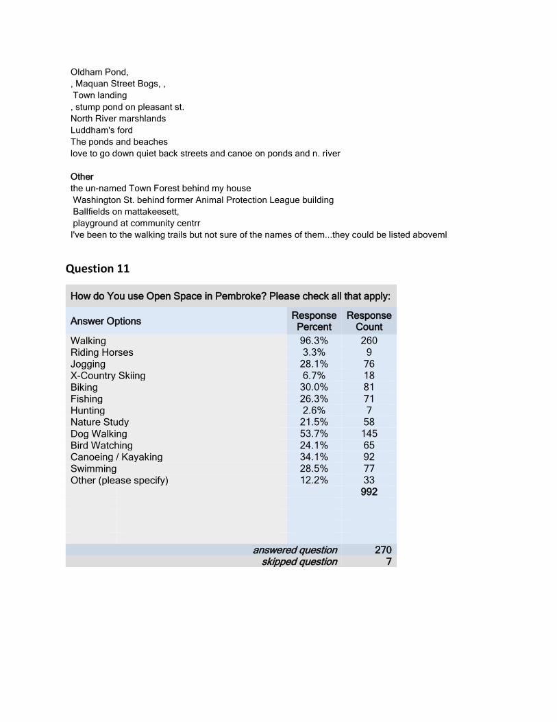
Oldham Pond, , Maquan Street Bogs, , Town landing , stump pond on pleasant st. North River marshlands Luddham's ford The ponds and beaches love to go down quiet back streets and canoe on ponds and n. river Other the un-named Town Forest behind my house Washington St. behind former Animal Protection League building Ballfields on mattakeesett, playground at community centrr I've been to the walking trails but not sure of the names of them...they could be listed aboveml
Question 11
How do You use Open Space in Pembroke? Please check all that apply:
Answer Options Response Percent
Response Count
Walking 96.3% 260 Riding Horses 3.3% 9 Jogging 28.1% 76 X-Country Skiing 6.7% 18 Biking 30.0% 81 Fishing 26.3% 71 Hunting 2.6% 7 Nature Study 21.5% 58 Dog Walking 53.7% 145 Bird Watching 24.1% 65 Canoeing / Kayaking 34.1% 92 Swimming 28.5% 77 Other (please specify) 12.2% 33 992
answered question 270 skipped question 7

Open Responses: Scouting
Scouting in Pembroke
Girl/Boy Scout activities Family Activity/Playgrounds
0
0.1
0.2
0.3
0.4
0.5
0.6
0.7
0.8
0.9
196.30%
3.30%
28.10%
6.70%
30.00% 26.30%
2.60%
21.50%
53.70%
24.10%
34.10%28.50%
12.20%
How Do You Use Open Space? 2017
0
0.05
0.1
0.15
0.2
0.25
5.88%
23.53%
2.94%
5.88%
23.53%
2.94% 2.94%
11.76% 11.76%
2.94%
5.88%
How Do You Use Open Space? (Other) 2017

Family play walking with my kids, playgrounds, getting them outside and active. Playgrounds Picnic Kids play playground play! family/friend gatherings Don't use them Don't use them Boating motor boat, paddle boat Sailing Sports Sports Golf skating/sledding watching my son's sports. Hobomock Fields for soccer, PHS trails for running Hiking and snowshoeing Hiking Ice skating Motorized Rec. would like to be able to snowmobile and dirt bike. farm have 12 acre farm on a pond and that's enough photography photography Photograph photography Photography Observation Just sit and enjoy the sights Just enjoying having trees around instead of housing tracts where all the trees have been removed. I use Pembroke open space between 3-7 times/week Enjoying the views and nature. Service Work Cleaning streams. Biking/Hiking

i would love to bike but no sidewalks or bike trails. The paths that are in Hingham would be nice. Hiking and snowshoeing Hiking
Question 12
In your Opinion what could be done to get the Towns People to use the current Open Space areas more frequently?
Answer Options Response Count
193 answered question 193
skipped question 84
18.35%
35.96%
6.37%
15.73%
8.24%
5.62%
2.25%
2.25% 1.50% 3.75%How to Improve Open Space Use? 2017
Organized Events Promotion/AdvirtisingGuided Tours Better Signage/AccessBetter Maintenace More MapsCreate a Dog Park/Off-Leash Area No Change

Open Responses: Hold Events
more events for families, and the elderly and disabled, would encourage people to check them out
Host festivals or activities in areas outside of Pembroke center. host events at sites to attract visitors Town-sponsored events, ., volunteer litter pick up, pet friendly events. community clean up day Hold different events there. events, Conduct more town events at them Have events at them. Family days. Games, trivia, or scavenger hunts. Recreational programs using the open spaces. Some town sponsored events to make more people aware of what's around have more events at the areas , events, Hold events at those locations-family friendly and low cost Town events nearby the open space areas hold events at them, clean-up days Events, Having community things like the herring run fish fry. Events events hold public events there Hold events at open spaces Have organized activities; special activities for different age groups Activities Host events there. Offer programs at the areas have a nature day, 'Town Clean Up Days' that are sponsored by the town, not by concerned citizens Maybe host events at these areas
0.00%5.00%
10.00%15.00%20.00%25.00%30.00%35.00%40.00%
18.35%
35.96%
6.37%15.73%
8.24% 5.62% 2.25% 2.25% 1.50% 3.75%
How to Improve Open Space Use? 2017

More creative uses of open space in terms of events, enrichment for children, festivals/celebrations utilize the Pembroke Recreation Department to schedule events host walking events. Rec programs at different locations More outdoor space community activities start more traditions such as the fish fry - teach people about our history and it's importance. Hold community events in open spaces Communication and fun events Events More fun family friendly activities like the fish fry. More activities like family days, 5ks through these spaces, etc community opt-outside day with info and activities Town sponsored Events introducing people to parks and their appropriate use (including trash pickup and dog clean Hold events at different areas. Activities or shows at the open spaces events. Have more events at them like the Fish Fry at Herring Run, etc. Walking clubs An option to walk with a group. Walking clubs/bird watching Promotional Material Increase awareness, promote wellness. and marketing publicity More advertising of these treasures Publish where the spaces are, directions to get there, what they offer and parking availability. Multimedia/Socialmedia showcases More community outreach through Social Media, PACTV and newspaper - outlining the benefits, show photos, etc. Facebook and website posts Pembroke connects is very popular Design a website highlighting these Open Spaces. The link could be sent to everyone via broadcast emails publicity Advertising Create ads about them on the PACTV, create flyers for the library. Advertise; Publicize their existence make a list and post it or give it out at the Fish Fry....make it family friendly...low impact exercise, chance to see Inform residents of the location and existence of these sites advertise them. I had no idea half of them exist. I tend to go towards Plymouth and Hingham for nature walks. Make everyone more aware of them, and what you can do ato each place. Also, have like an open house at each one Use of Town email to feature them, Make people more aware of the options, Develop a web site including directions to all areas including trail maps and history of the areas. . School field trips. If only we had a decent newspaper for articles .,, advertise by putting pics and articles in paper. Informing the public that these spaces exist for their use and enjoyment I think additional advertistment could help? Advertising/putting up areas to sit and picnic. Put more information about the different area. Maybe feature one of them once a week on the Facebook page, make people more aware of them

and make people aware they exist and what is available to do in each space Marketing, post on a website for when people are searching for "things to do", Advertise the less used, less familiar areas Social media! Advertisement/more signs. Tell the kids in the elementary schools/cub and/or girl scouts. Advertise more make people aware of them. ive never heard of the unchecked places. Post information about them on the town website Advertise Advertise Advertise photos on Pembroke connect, articles and photos in newspapers More publicity about what it out there more publicity More advertisement of it More info. I saw this on Facebook and didn't know a couple places. Use social media more. Refresher communication to let people know what's available Social media Advertise! Facebook marketing Post on social media where they are featuring a different one every week. Ask residents to submit photos and stories Raise awareness (I don't know where most of #10 is), Awareness Spread the word, Promote on Facebook pages Advertise them better. I have lived here 12 years and still don't know about all the spaces. More publicity Raise awareness of the great spaces we have Let people know Better advertisements of where they are located Publicity. social media so people are aware of what's out there. coordinate with Wildlands Trust to promote various areas more broadly put notices in the town paper to remind people of these open spaces for use - put on social media sites some photos People knowing and understanding what and where they are. create a flier, put on face book More information about the open space areas. Info added to the pembroke town website popularize it. Have something that would cause people to go to the area. Make people aware. Better publicized. The one playground in town was hard enough to find thanks to a random Facebook page. Advertise more Advertisement, Send information home with school kids in their backpacks so parents will know about these areas. More information about them. Should direct fundraisers like fun run etc through them to raise awareness Mail out an informational pamphlet in the spring. list all open spaces on dog registration, get information on all public spaces out to families through school Education. I didn't even know about a couple you listed above. More information on them... Advertise it more,

have more information online about how to get More Info Advertise the local beaches More notice as to where they are. Maybe posted at the Library (one of my favorite buildings) Publicize them more, better Advertising Public awareness Better advertisement Have kids do service projects and publicize. Take a few minutes at town meeting to highlight an area and what is Awareness of all of them Promote. Make it appealing. Community publications. Notices on Facebook open up other town held properties for passive recreation. Don't keep them secret Possibly highlight a different area on social media every week or month Information easily accessed on website remind them that it is there Most of the above mentioned places I have never heard of and I don't know where they are. I didn't know about areas mentioned above. Now that I know about them I will check them out. Guided Information Walks I think that we need to do a better job in organizing walks and guided walks as to what people can see or do within historic tours Run tours informational activity Maybe hold guided tours a few times a year. Walking tours. Guided Tours give history, offer walking tours Guided Walks love the idea of the historic trolley and river tours that happened perhaps offer guided tours Perhaps have someone to lead nature walks Promote walking tours, led by volunteers from various local civic organizations Interpretive guides to introduce them. Host tours Guided walks and naturalist walks Guided walks Better Signage/Access Parking more parking & better condition of parking area Mproved access. Sidewalks to get to these places, it's hard for a mom to pack kids/ dogs into the car for a 5 second ride, A trail system that connects all the areas around town. better parking More parking! Easy access Maybe put signs out front that designate uses. For example: "This path is good for biking, walking, and baby strollers" actual signs along roads to lead people to places Make more accessible by bike

Better parking, better access to ponds Better signs More sidewalks and a better town center would go a long way Pave a walking trail, moms want to use them too and can't due to inability to use strollers. Better parking availability, more well marked signage. Communication, signs posted Make better parking lots for the parks; better signage. more location awareness and open invitation to use it, my guess is that some people are unaware of the offerings we have. signage, welcoming entrances, Have trail markers and historical signs Add sidewalks to allow people to walk/bike to/from these open spaces Perhaps better signage Adding benches Make them more accessible by building sidewalks leading up to them Paved biking trails, sidewalks around town to get to these areas. have benches, have good parking facilities and/or safe sidewalks to get there Better signage Have parking. Lights Make more defined walking trails. better signage better and bigger signs. clear, designated parking areas. designate spots on well traveled roads for pedestrian/bike Paved trails would be great for biking and jogging. Have more signage Also, better signage to indicate trails and regulation of traffic in areas Better signs and markings Parking. Access by way of walking Better signage, maintained parking areas Improve design them for use as an outing activity, tarred bike and walking paths. Making them family friendly. People who want to use them, use them.nPlowing parking areas in winter would help for sure. better signage Better Maintenance maintained trails The walking trails have trash....need to be kept clean keep spaces clean Keep the trails and paths groomed I also think the one entry point to the pond on mattakeeset street could use a little more attention Keep them more clean!!!!!!!!, Clean up the needles everywhere, pick up the other garbage (put more trash barrels in these spaces) Maintain paths privide trash barrels get the ponds cleaner Maintain is all better Tubs Meadow is always a mess at the entrances, which makes it not very appealing cleaning and grooming the trails. Cleaned up and redesigned cleaning up the litter. I'm afraid of ticks and that hogweed fix up the ponds and water spaces put some capital into it and make it more appealing. A little dirt path through woods is not going to attract more people

more investment to make more useful Have garbage and recycling receptacles and empty them on a regular basis upkeep. Clean the ponds Make them clean, safe, drug paraphernalia free and protected If the paths were kept clear. I stopped going to the Elmer Street bogs because the paths are overgrow . Maps Map of open spaces online book with maps; trail maps Maps in the library Trail maps? I nature trail maps available maps. Provide maps, Mail me map Is there a map detailing the areas? They could be made available at the town hall for pick up maps). maps of area maps Easier to read maps trail maps at trail heads. Dog Park/Off Leash Areas Start a dog walking club We need a dog park! Create one space designated for off leash dog exploring Dog park! It would be nice to assign one area as a dog park where dogs could run unleashed. If there was a dog park No change Fine the way it is now...don't really want more people using open space. I don't want to step on any hypodermic needles If they're interested, they'll be there and vice versa. Not sure I always see people on my walks. Maybe throw away their electronic devices? Haha. Jk. I don't know! it is perfect the way it is ??? More Playgrounds More seating. More playgrounds. MOST IMPORTANT: A public playground to encourage young families to enjoy the wildlife that Pembroke has to offer! would love to see a playground get put in at Indian head river I think a playground at Indian Head River park would be great attraction Other Have it's become a profitable entity

enforce bans on motorized crafts on trails (that is very problematic in the paths near me), Build more trails for mixed use including mountain biking. stop building on the property The town is lacking areas that draw people to just "hang out" (sit in a park with a book and a coffee, Make the town center a Hide things there? Bridge the gap between the new and old residents Outside amenities like workout stations on trails. Put a public pool in Continue to allow people to use the lands
Question 13
Have you found the Town's current Open Spaces easy to find and enjoy?
Answer Options Response Percent
Response Count
Yes 68.3% 166 No 31.7% 77 If No, Please explain how you think the Town could better identify these areas? 87
answered question 243 skipped question 34
68.3%
31.7%
Have you found the Town's current Open Spaces easy to find and enjoy?
Yes No

Open Responses: Better Signage
more prominent signage.
26.80%
13.40%
26.80%
5.15%
16.49%
11.34%
How to Improve Open Space? 2017
Signage Maps Advertising See Q:12 Don't know most sites Other
0.00%
5.00%
10.00%
15.00%
20.00%
25.00%
30.00%
Signage Maps Advertising See Q:12 Don't knowmost sites
Other
26.80%
13.40%
26.80%
5.15%
16.49%
11.34%
How to Iprove Open Space? 2017

Clearly posted signs throughout the town would help. How about an outdoor sign of all parks? Place it at entrance of all parks Signage needs to be much better. I only know about most of the areas because I have actively sought them out. Signage, newsletter drive by some but don't see where to park; I have looked in the past and couldn't find useful information better signage see www.mbgraphics.biz Only the ones visible from the street I have used. Maybe clearer signs I only know of the ones I pass and are clearly visible and marked Signs. And what is allowed or not allowed in those areas. Bike paths would be fantastic! Willow brook could use a better sign better signage more signage Signage and parking improvements Signage More signs Better signage; more welcoming better signage more signs and parking I've been here a long time so I know the spaces, but signage could be better Add Signage and easier access with sidewalks Signage Not well marked More signs Need to improve signage. It's a big secret at this time. Better signage Accesible Maps Maps, mailed, at library, and online More maps. or maps at the town hall? Maps A clear map of trails Mass mailing a map to residents Easily accessible maps and location details on town website Where do you get maps and find where these spaces are Maps. Mail me a map and tell me where to park we love new places Signage and parking improvements maps, etc.... Publish a map to the community with the annual census Better Communication/Advertising lots more communication newsletter Is there some kind place that provides and promotes information and use of all of the open spaces in town? Get the word out through schools, library, churches, etc. More advertising

Advertisement. Small cost to the town for long term benefits. Post on website More advertising Use social media. And let people know that you are on social media Town Website, more events scheduled there Awareness and events Social media Advertising Use social media! provide more information. Not well advertised Not enough advertising More information on accessing marketing Better representation on the town site. It can be difficult to navigate. Send out emails about what each place has to offer. More info about those places, Put it on the town website Need more exposure List all and the directions on town website Help new residents to know they exist See Question 12 See #12 Question 12 See my previous response Please see above. My husband grew up here and he didn't know where half of the parks are! See #12 Don't know most sites We stumbled upon them. Again, never was aware of them. Haven't been aware of many of them I have been to two that are nice but disnt know about others I am not familiar with some of those listed above. Probably my fault for not being better informed. I have never heard of most of the parks listed above and I enjoy visiting parks. I had to ask my neighbors and nature lovers Not sure where they are. I didn't know about a few of them listed Not really. We mostly happened upon many of them over the years. But there are several listed above I've never heard of It seems like you have to have local knowledge. I don't know what I don't know I wouldn't have known about a lot of the areas if other people around town didn't tell me aobut them. It might just be because I'm new to town...not that easy to figure out where they are/park I didn't know we had as many as we do (thanks for question # 10!) I didn't know of some of these listed here in the survey No, when I first moved here the trail information was scattered across multiple organizations. Other We have enough - don't need to spend money on more.

Fairly easy. Can't make the rest of this survey work I say this hesitantly. Easy to find, yes, not always easy to enjoy. No, paved walking trails or trails with large roots eliminate young moms and their kids from enjoying the many I'm not sure yes I feel uneasy when I see so many people allow their dogs to run free without a leash. sort of Haven't heard much about them or there is little appeal. Yes but only because I'm specifically looking for them not cleaned, maintained or user friendly. Town Beach could be renovated. New snack bar, cleaner beach, new sand
Question 14
How important is it to you that the town purchase and preserve Open Spaces for the following reasons?
Answer Options 1 2 3 4 5 6
Rating Average
Response
Count
Natural Habitat and Natural Resources
93 57 17 25 13 16 2.3
5 221
Passive Recreation 11 46 48 32 56 27 3.7
1 220
Playing Fields 19 17 25 24 45 99 4.5
5 229
Water Protection 56 52 46 33 24 16 2.8
5 227
Historical Preservation
16 27 49 56 46 28 3.7
8 222
Protecting the Towns character
55 31 41 50 30 35 3.3
1 242
answered question
answered question
250
answered question
answered question
answered question
answered question
answered question 256 256
skipped question 21

Question 15
What areas of Pembroke do you feel should be protected from development and why?
Answer Options Response Count
172 answered question 172
skipped question 105
0.00 1.00 2.00 3.00 4.00 5.00
Natural Habitat and NaturalResources
Passive Recreation
Playing Fields
Water Protection
Historical Preservation
Protecting the Towns character
How important is it to you that the town purchase and preserve Open Spaces for the following reasons?
20.91%
24.71%
9.51%4.94%
5.70%
13.69%
2.66%7.22%
1.52%9.13%
Which Areas Should be Protected from Development? 2017
Water Marsh/Wetland/BogsForests/Woods Historic sitesGeneral Undeveloped Lands Existing Open SpaceFarms All/As Much As Possible

Open Responses: Water
pond on Hobomock
Any areas around our ponds Water areas, need to keep animals safe water areas Near north river, Environmentally sensitive areas around watershed areas including the ponds. places near ponds The ponds, ponds Any land around rivers and streams need protection for wildlife and vegetation and ponds because it interferes with natural habitiat Water Street in North Pembroke. It's our only access to the North River with multiple acres of wetlands and habitat to The North River area Water/rivers/ponds lakes because don't trust housing septic systems and it seems that surrounding towns are taking all our water ponds (not to clean the ponds for the selectman who live on them).. areas around North River north river Anywhere along water Ponds, The North River due to it being a water way and to protect wildlife. Streams, rivers, ponds should be unobstructed and allowed to follow natural courses to protect habitats and water quality
0
0.05
0.1
0.15
0.2
0.25 20.91%
24.71%
9.51%
4.94% 5.70%
13.69%
2.66%
7.22%
1.52%
9.13%
Which Areas Should Be Protected From Development? 2017

Areas near the ponds Any watershed areas. Wetlands North River area because of its sensitive environmental issues Areas along the North River the ponds and river areas lakes The north river is nearly unparalleled for its current relatively low level of development. It is a rare resourse and crucial habitat North River The North River corridor, I am partial to the North River area because that is where I live. North River, lakes and ponds, streams and brooks, Herring fisheries and wildlife. Land near north river North river rivers, and lakes. The river the north river. ponds North River The beautiful North River, we need to manage the type of development too. Anything along the North River. More developments could ruin the scenic beauty. along the lakes & rivers, north river. Anything along a water way waterways. The River because it's night sky and open for wild life habitats Along rivers and ponds. Public water areas. Area along Indian Head and North River The areas around the ponds Anywhere near wetlands and waterways Major rescource and part of our ecosystem you cant replace. any wetlands and any water ways Marsh/wetlands/Bogs The marsh and pond on Hobomock near Four Winds Sensitive terrain in and around wetland/marsh areas. wetlands The land is all wetlands and marshes Wetlands-area near north river/ water street Wetland areas, natural areas should be kept that way and wetlands-- Any area near wetlands, or that would require the removal of healthy trees, should be preserved for the health Wetlands are essential to the well being of the environment wetlands, Water Street in North Pembroke. It's our only access to the North River with multiple acres of wetlands and habitat to Wetlands feel the water Street area that is currently facing 40b development and the Tiny Brown Intrersection are

at risk right now Wetlands and any other wet areas because of the water protection Marshland Land abutting wetlands. Can't list the million reasons why. The marsh and natural protected water pools for wild life. Wetlands, The wetlands are important for biodiversity All marsh, wetland due to animal habitats and keeping the current houses safe Wetlands - disturbing natural habitats and increasing classroom size due to affordable housing vernal pools, wildlife, potential of damaging run off. any wetlands Proposed Housing 40B destroys the wetlands, natural habitat and historic neighborhood, increasing noise and traffice All marsh wetland I heard about the recent proposal of 40B development along Water St. Any wetlands Any conservation land.. marshes, wetlands Wetland areas. Marshlands around north river. conservation/wetlands areas wetlands, Wetlands and sensitive habitats. We only have one Earth, these habitats are important to protect. wetlands, Wetlands--if they are drained and built on we damage habitat, water table health and biodiversit Wetlands. Conservation land Open space with wetlands to protect our water supply Wetlands mostly for animals wetlands because they are precious and you can't always put the wildlife back once wetlands to ensure the health and safety of the people and animals living here. Definitely the bogs and marshes because they are what make Pembroke wetlands Marshes/wetlands, to protect environment and wetlands Any environmentally sensitive areas (wetlands etc) Anywhere near wetlands and waterways Major rescource and part of our ecosystem you cant replace. any wetlands and any water ways The bogs, because they are unique to the area and part of our heritage any of the old bogs should stay open space of some sort. bogs. cranberry bogs, The bogs on Monroe street. And, while many bogs have reverted to overgrowth, I was surprised to see that most aren't filled in bogs Bogs and other natural resources I feel some cranberry bogs that aren't currently being used could be built upon. It seems like valuable land/space Nature trails in old bogs are such a great resource for people who don't want to have to travel to other town

cranberry bogs Bogs Bogs. bogs bogs, Forests/Woods The woods around the bogs also should be saved All forests any current woodlands Rest of Oak street - protect the trees and habitats Woodlands along West Elm & Barker St... The space off of Oak Street that was just cleared is a horrible eyesore. Wooded areas Forests More of the forests!! The poor deer and even the turkeys are literally wandering around the town. So sad forest. forests are why a lot of people live this far away from the city Wooded areas, like Taylor st forests Trees and forests..because we need them!! forests don't like housing developments that encroach close to natural forests Any land that is currently wooded The woods along Pelham Street are lovely Woodlands off the 53 and 14 Wooded areas, the woods. Lush wooded areas forests. Forest, woods Forests. Cutting down is causing wildlife to roam into residential areas, hazard to them/us and Historic sites Luddams Ford area given its ties to American history natural AND historical resource. pembroke center Any historical site The herring run and other historical areas Mattakeeset St due to historical significance. Taylor St for same reason historical sites/homes. areas deemed "historical" because it's unlawful to build on those areas. historic neighborhood, and any areas that are historical Historic sites for obvious reasons. Also areas that will negatively affect traffic or our natural resouces to preserve our place in history we should protect historical locations and open spaces that bear significance Barker street ,west elm street plain and valley street, center street. All old original stagecoach routes! Herring Run

The Herring run, obviously. Herring run, herring run The herring run and other historical areas Herring run Herring Run, herring run. Herring run- I love walking there General Undeveloped Lands All of the land that is currently not developed should stay that way anything that is undeveloped should be protected, because once developed we can NEVER get back the natural resources All of the remaining green spaces should be protected. We have already lost too much in my opinion. any hikable land. or has significant amount of area that is still natural, IE undeveloped Environmentally sensitive areas, Town has grown too fast over 30 years I've been here. Has ruined character of town. Need a plan!!!! Are there areas of Pembroke that haven't been developed? like to have land that isn't developed on every free inch. that's what keep our town quaint and country. NO MORE TOWN HOUSES! Real houses for family's not townhouses. All theses townhouses make it feel like the city or Brocton I think the town needs to halt development period. Current development is haphazard and not well thought out. I think progress is important but development for development sake makes no sense. 40 b have enough condo's no need for more We have enough development now! All areas towns is being built out Existing Open Space open spaces that have already been purchased current open spaces provided already. conservation land All current open space All open spaces There should be a cease on development of open areas any of the already established nature based, recreational, family oriented areas. closeness to open space, nature preserve areas Open spaces should be protected because they are beautiful and provide homes for nature. Our current parks and nature areas should not be developed conservation land, tubbs meadow type places What ever open spaces that are left Especially along Barker St wildlife reserve Current open spaces Tubbs Meadow, I frequent it with my children and there are many forms of wildlife living there. existing open spaces areas immediately abutting existing preserved space conservation land All the walking trails, any Wildlife Preserve.

Any conservation land.. Current open spaces The present open spaces/parks need to be protected. nature reserves are not intended to be populated by residents just observed and observed The current open area we have because it helps the small town vibe and benefits current residents Tubbs Meadow . Conservation land Nature trails in old bogs are such a great resource for people who don't want to have to travel to other town Tubbs Meadow, Luddam's Ford willowbrook preserve, tubs meadow, All of the current natural preserves all existing town parks All public lands & open spaces The surrounding area of Willow Brook Farm Preserve due to its protective habitat Farms open space/ farms to maintain Pembroke character and fields and farms. and farm land. horse farms old farm land should be preserved, as this the the history and character of the town. Horse farms - Farms All/As Much As Possible Everywhere we can. All of them! We really need more! As much as possible, All areas As many areas as possible. We will quickly loose our small town, rural feel and charm if growth is not carefully All All As many as possible. As many open areas as possible to prevent South Shore from becoming as built up as North Shore All of it. Everywhere. We're big enough for now Most. We already have plenty of residential and commercial structures. Any areas that are not under development and available for protection! We've already overdeveloped this town. All of it! So all areas should be protected. All. We have already lost a lot of forestry and open spaces and cannot afford to lose more. Well, if it were up to me I'd stop all building in town. But that's not realistic. All of them - we have enough rampant development. Slow it down for a while and make these parcels off limits Any areas which are important to wildlife. None-Need More Development

None - we need more tax base. We have enough open space. Development is a great thing. Adapting to the changing human nature brings people to start changing for the good. None!! too much wasted land on preservastion crap! We need more development to grow. Other all areas except commercial area near highway Rts. 14 & 53 Rte 14 / Mattakeesett Street Wompatuck Road Hwy 36 East Pembroke. The drainage situation is getting out of hand. All of Monroe Street...Town Landing area. Unsure any area where homes are and where schools are 47 I think it is a balance. If you choose to develop areas have restrictions on the building styles etc. I encourage some smart development All areas except business district on rt 139 and north part of rt 53 which is already businesses Any area of the town that is not appropriate for housing projects Not sure. The Birch street area the center - I don't understand why there has to be commercial development with residential Bryantville. I don't know of anything of hand Not more dense than what's there. Making sure the infrastructure can support it. Anything our kids use first (they should have more options, not less) No more building near center of town Town center. Water street. protect views from obstruction Parts of Mettakeeset, which have (or will have) sidewalks and provide pedestrian access to ponds and views of the water
Question 15
What kind of development would you like to see in Pembroke?
Answer Options Response Percent
Response Count
Clustered Development 15.3% 34 Mixed Use Development 34.7% 77 Affordable Housing 5.0% 11 Other (please specify) 45.0% 100
answered question 222 skipped question 55

15.30%
34.70%
5.00%
45.00%
What Kind of Development Should Happen in Pembroke? 2017
Clustered Development Clustered DevelopmentMixed Use Development Mixed Use DevelopmentAffordable Housing Affordable Housing
0.00%5.00%
10.00%15.00%20.00%25.00%30.00%35.00%40.00%45.00%50.00% 45.28%
12.26%8.49% 10.38%
15.09%
2.83% 1.89% 3.77%
What Kind of Development Should Happen in Pembroke? (Other) 2017

Open Responses: None/Minimal
NONE.
not much more none. None No more! None none! I think we are good--none! None None None No more No more NONE Keep it as it is! none None Less development on large scale Not sure I know of any development I would currently like to see. None...i think Pembroke is perfect the way it is None. Stop building. Leave the land alone NONE
45.28%
12.26%
8.49%
10.38%
15.09%
2.83% 1.89% 3.77%
What Kind Of Development (Other)? 2017
None/Minimal Single Family HomesCommercial Open Space

None we have enough There is enough already Sparse. It's difficult for me development to generate the taxes needed to support the require infrastructure none, we are fine now, need to fix up what we have Hit the max. Done for a bit. New rec center for community use. Other than that, NOTHING! None None None. Leave it alone! :) None No more developments None None we have enough Nothing, we are almost overdeveloped! preferably none, but sustainable as a minimum None. There is already enough. None. SLOW DOWN. nothing No more development on farm lands or open spaces. They should be preserved None None None None None for a while.... What has recently been developed is junk. None None Single Family Homes Those were pretty lousy choices that tend to skew the survey results. Single family homes are fine. No more condos! Single family homes Single family home Single family homes Single family homes Individual homes non clustered. individual houses Single family homes Family homes Neighborhoods!!! Neighborhoods!!! Simple affordable housing with large lot sizes Single homes if there needs to be more development. Commercial Commercial on 139 & 53 Tuning the town center into a more classical New England Main Street with walkable shops. If we need development to increase town revenues, I'd like to see additional commercial development in areas along 53 and 139 Ability to create a balance of more businesses in town to increase tax revenue. Houses and a Starbucks! Industrial in North Pembroke

Better shopping and restaurants buisness but not too much...It would be nice to have a good bakery in town Make pembroke center a hub with restaurants and shops Open Space parks and beautiful spaces plant more trees I would like to see more parks like Birch street and splash pads like in braintree Developed open spaces for public use. Only trails dog park Skate park roller hockey rink behind town hall/police Green Space More walking trails - sidewalks near the schools - more playgrounds, bike lanes, etc. the town structures, playing fields, more playgrounds, gardens historical preservation Infrastructure/Repairs/Community Services Infrastructure and waterway revialization Fix the town center. It has been talked about for years but nothing has been done. I rather improve the current infrastructure we have Maybe a mixed use facility at the community center. As much as I appreciate historic preservation The only development I would love to see is the rec building and the bryantville area New rec center for community use. Other than that, NOTHING! Invest in a recreation department building Tear down the rec center and have the YMCA build a branch New high school Community/Rec center New road to & from the high school, too much traffic 1,000 cars a day!!! Develop the Community Center for mixed use or commercial Invest in community center Senior housing and recreation center senior housing off grid, energy efficient units. pairing senior housing with families. Cluster/Mixed Use Small clustered Use of previously zoned commercial land for clustered residential development. When you say cluster is it business or residential? I would combine mixed use in center with affordable housing. Family Friendly Development that would facilitate small businesses and families. I think that the town should focus on building afforable nice homes in the 300K ballpark people who want to invest in the community, raise families here and spend money eating, shopping etc here. ??? I don't know anything about these types of developments Another tough question, it has to be right for the area. I would only like to see development in areas where the infrastructure can support it Clustered and mixed use needs clarification. No more "affordable housing", keep Pembroke a nice town.

Question 16
To Preserve Open Spaces in town would you be willing to?
Answer Options Yes No Rating Average
Response Count
Contribute Land to the town 32 188 1.85 220 Donate money to buy the land? 101 125 1.55 226 Sell Land to the town at a "bargain" price 41 174 1.81 215 Put a Conservation Restriction on Your Land? 118 99 1.46 217 Vote for the Purchase of Open Space at Town Meeting? 221 22 1.09 243
Support putting Tax Title articles in Open Space 159 57 1.26 216 Other (please specify) 25
answered question 256 skipped question 21
0.00 0.50 1.00 1.50 2.00
Contribute Land to the town
Donate money to buy the land?
Sell Land to the town at a "bargain" price
Put a Conservation Restriction on Your Land?
Vote for the Purchase of Open Space at TownMeeting?
Support putting Tax Title articles in OpenSpace
To Preserve Open Spaces in town would you be willing to?

Question 17
How concerned are you about the potential impacts of climate change on the following aspects of our community?
Answer Options Very Concerned
Some What Concerened
Not Concerened
Rating Average
Response Count
Drought 131 103 28 1.61 262 Flooding 58 87 115 2.22 260 Habitat 140 98 23 1.55 261 Water Supply 173 73 17 1.41 263 Forest Health 133 105 25 1.59 263
answered question 263 skipped question 14
0.00 0.50 1.00 1.50 2.00 2.50
Drought
Flooding
Habitat
Water Supply
Forest Health
How concerned are you about the potential impacts of climate change on the following aspects of our community?

BioMap2 CONSERVING THE BIODIVERSITY OF
MASSACHUSETTS IN A CHANGING WORLD
Pembroke Produced in 2012
This report and associated map provide information about
important sites for biodiversity conservation in your area.
This information is intended for conservation planning, and is
not intended for use in state regulations.

BioMap2
Conserving the Biodiversity of Massachusetts in a Changing World
Natural Heritage Massachusetts Division of Fisheries and Wildlife
1 Rabbit Hill Road, Westborough, MA 01581 & Endangered
phone: 508-389-6360 fax: 508-389-7890
Species Program
For more information on rare species and natural communities, please see our fact sheets online at www.mass.gov/nhesp.
Table of Contents
Introduction
What is BioMap2 Ȯ Purpose and applications
One plan, two components
Understanding Core Habitat and its components
Understanding Critical Natural Landscape and its components
Understanding Core Habitat and Critical Natural Landscape Summaries
Sources of Additional Information
Pembroke Overview
Core Habitat and Critical Natural Landscape Summaries
Elements of BioMap2 Cores
Core Habitat Summaries
Elements of BioMap2 Critical Natural Landscapes
Critical Natural Landscape Summaries

BioMap2
Conserving the Biodiversity of Massachusetts in a Changing World
Natural Heritage Massachusetts Division of Fisheries and Wildlife
1 Rabbit Hill Road, Westborough, MA 01581 & Endangered
phone: 508-389-6360 fax: 508-389-7890
Species Program
For more information on rare species and natural communities, please see our fact sheets online at www.mass.gov/nhesp.
Introduction
The Massachusetts Department of Fish & Game,
ɳɧɱɮɴɦɧ ɳɧɤ Dɨɵɨɲɨɮɭ ɮɥ Fɨɲɧɤɱɨɤɲ ɠɭɣ Wɨɫɣɫɨɥɤ˘ɲ
Natural Heritage & Endangered Species
Program (NHESP), and The Nature
Cɮɭɲɤɱɵɠɭɢɸ˘ɲ Mɠɲɲɠɢɧɴɲɤɳɳɲ Pɱɮɦɱɠɬ developed BioMap2 ɳɮ ɯɱɮɳɤɢɳ ɳɧɤ ɲɳɠɳɤ˘ɲ
biodiversity in the context of climate change.
BioMap2 ɢɮɬɡɨɭɤɲ NHESP˘ɲ ȯȬ ɸɤɠɱɲ ɮɥ rigorously documented rare species and natural
community data with spatial data identifying
wildlife species and habitats that were the focus
ɮɥ ɳɧɤ Dɨɵɨɲɨɮɭ ɮɥ Fɨɲɧɤɱɨɤɲ ɠɭɣ Wɨɫɣɫɨɥɤ˘ɲ ȮȬȬȱ State Wildlife Action Plan (SWAP). BioMap2 also
ɨɭɳɤɦɱɠɳɤɲ Tɧɤ Nɠɳɴɱɤ Cɮɭɲɤɱɵɠɭɢɸ˘ɲ ɠɲɲɤɲɲɬɤɭɳ
of large, well-connected, and intact ecosystems
and landscapes across the Commonwealth,
incorporating concepts of ecosystem resilience
to address anticipated climate change impacts.
Protection and stewardship of BioMap2 Core
Habitat and Critical Natural Landscape is
essential to safeguard the diversity of species
and their habitats, intact ecosystems, and
resilient natural landscapes across
Massachusetts.
Get your copy of the BioMap2 report! Download
from www.mass.gov/nhesp or contact Natural
Heritage at 508-389-6360 or
What Does Status Mean?
The Division of Fisheries and Wildlife
determines a status category for each rare
species listed under the Massachusetts
Endangered Species Act (MESA), M.G.L. c.131A,
and its implementing regulations 321 CMR
10.00. Rare species are categorized as
Endangered, Threatened or of Special Concern
according to the following:
Endangered species are in danger of
extinction throughout all or a significant
portion of their range or are in danger of
extirpation from Massachusetts.
Threatened species are likely to become
Endangered in Massachusetts in the
foreseeable future throughout all or a
significant portion of their range.
Special Concern species have suffered a
decline that could threaten the species if
allowed to continue unchecked or occur in
such small numbers or with such restricted
distribution or specialized habitat
requirements that they could easily become
Threatened in Massachusetts.
In addition NHESP maintains an unofficial
watch list of plants that are tracked due to
potential conservation interest or concern, but
are not regulated under the Massachusetts
Endangered Species Act or other laws or
regulations. Likewise, described natural
communities are not regulated by any law or
regulations, but they can help to identify

BioMap2
Conserving the Biodiversity of Massachusetts in a Changing World
Natural Heritage Massachusetts Division of Fisheries and Wildlife
1 Rabbit Hill Road, Westborough, MA 01581 & Endangered
phone: 508-389-6360 fax: 508-389-7890
Species Program
For more information on rare species and natural communities, please see our fact sheets online at www.mass.gov/nhesp.
ecologically important areas that are worthy of
protection. The status of natural communities
reflects the documented number and acreages of
each community type in the state:
Critically Imperiled communities typically
have 5 or fewer documented good sites or
have very few remaining acres in the state.
Imperiled communities typically have 6-20
good sites or few remaining acres in the state.
Vulnerable communities typically have 21-
100 good sites or limited acreage across the
state.
Secure communities typically have over 100
sites or abundant acreage across the state;
however, excellent examples are identified as
Core Habit to ensure continued protection.
In 2005 the Massachusetts Division of Fisheries
and Wildlife completed a comprehensive State
Wildlife Action Plan (SWAP) documenting the
status of Massachusetts wildlife and providing
recommendations to help guide wildlife
conservation decision-making. SWAP includes
all the wildlife species listed under the
Massachusetts Endangered Species Act (MESA),
as well as more than 80 species that need
conservation attention but do not meet the
requirements for inclusion under MESA. The
SWAP document is organized around habitat
types in need of conservation within the
Commonwealth. While the original BioMap
focused primarily on rare species protected
under MESA, BioMap2 also addresses other
Species of Conservation Concern, their habitats,
and the ecosystems that support them to create a
spatial representation of most of the elements of
SWAP.
BioMap2: One Plan, Two Components
BioMap2 identifies two complementary spatial
layers, Core Habitat and Critical Natural
Landscape.
Core Habitat identifies key areas that are critical
for the long-term persistence of rare species and
other Species of Conservation Concern, as well
as a wide diversity of natural communities and
intact ecosystems across the Commonwealth.
Protection of Core Habitats will contribute to the
conservation of specific elements of biodiversity.
Critical Natural Landscape identifies large
natural Landscape Blocks that are minimally
impacted by development. If protected, these
areas will provide habitat for wide-ranging
native species, support intact ecological
processes, maintain connectivity among
habitats, and enhance ecological resilience to
natural and anthropogenic disturbances in a
rapidly changing world. Areas delineated as
Critical Natural Landscape also include
buffering upland around wetland, coastal, and
aquatic Core Habitats to help ensure their long-
term integrity.
The long-term persistence of Massachusetts
biological resources requires a determined
commitment to land and water conservation.
Protection and stewardship of both Critical
Natural Landscapes and Core Habitats are
needed to realize the biodiversity conservation
vision of BioMap2.
Components of Core Habitat
Core Habitat identifies specific areas necessary
to promote the long-term persistence of rare
species, other Species of Conservation Concern,
exemplary natural communities, and intact
ecosystems.
Rare Species
There are 432 native plant and animal species
listed as Endangered, Threatened or Special
Concern under the Massachusetts Endangered
Species Act (MESA) based on their rarity,
population trends, and threats to survival. For

BioMap2
Conserving the Biodiversity of Massachusetts in a Changing World
Natural Heritage Massachusetts Division of Fisheries and Wildlife
1 Rabbit Hill Road, Westborough, MA 01581 & Endangered
phone: 508-389-6360 fax: 508-389-7890
Species Program
For more information on rare species and natural communities, please see our fact sheets online at www.mass.gov/nhesp.
BioMap2, NHESP staff identified the highest
quality habitat sites for each non-marine species
based on size, condition, and landscape context.
Table 1. Species of Conservation Concern
described in the State Wildlife Action Plan
and/or included on the MESA List and for which
habitat was mapped in BioMap2. Note that
plants are not included in SWAP, and that
marine species such as whales and sea turtles
are not included in BioMap2.
Taxonomic MESA- Non-listed Species
Group listed of Conservation
Species Concern
Mammals 4 5
Birds 27 23
Reptiles 10 5
Amphibians 4 3
Fish 10 17
Invertebrates 102 9
Plants 256 0
Total 413 62
Other Species of Conservation Concern
In addition to species on the MESA List
described previously, the State Wildlife Action
Plan (SWAP) identifies 257 wildlife species and
22 natural habitats most in need of conservation
within the Commonwealth. BioMap2 includes
species-specific habitat areas for 45 of these
species and habitat for 17 additional species
which was mapped with other coarse-filter and
fine-filter approaches.
Priority Natural Communities
Natural communities are assemblages of plant
and animal species that share a common
environment and occur together repeatedly on
the landscape. BioMap2 gives conservation
priority to natural communities with limited
distribution and to the best examples of more
common types.
Vernal Pools
Vernal pools are small, seasonal wetlands that
provide important wildlife habitat, especially for
amphibians and invertebrate animals that use
them to breed. BioMap2 identifies the top 5
percent most interconnected clusters of Potential
Vernal Pools in the state.
Forest Cores
In BioMap2, Core Habitat includes the best
examples of large, intact forests that are least
impacted by roads and development, providing
critical habitat for numerous woodland species.
For example, the interior forest habitat defined
by Forest Cores supports many bird species
sensitive to the impacts of roads and
development, such as the Black-throated Green
Warbler, and helps maintain ecological
processes found only in unfragmented forest
patches.
Wetland Cores
BioMap2 used an assessment of Ecological
Integrity to identify the least disturbed wetlands
in the state within undeveloped landscapesȯ those with intact buffers and little fragmentation
or other stressors associated with development.
These wetlands are most likely to support
critical wetland functions (i.e., natural
hydrologic conditions, diverse plant and animal
habitats, etc.) and are most likely to maintain
these functions into the future.
Aquatic Cores
To delineate integrated and functional
ecosystems for fish species and other aquatic
BioMap2
Conserving the Biodiversity of Massachusetts in a Changing World
Massachusetts Division of Fisheries and Wildlife Natural Heritage 1 Rabbit Hill Road, Westborough, MA 01581
& Endangered phone: 508-389-6360 fax: 508-389-7890
Species Program
For more information on rare species and natural communities, please see our fact sheets online at www.mass.gov/nhesp.
Species of Conservation Concern, beyond the
species and exemplary habitats described above,
BioMap2 identifies intact river corridors within
which important physical and ecological
processes of the river or stream occur.
Components of Critical Natural Landscape
Critical Natural Landscape identifies intact
landscapes in Massachusetts that are better able
to support ecological processes and disturbance
regimes, and a wide array of species and
habitats over long time frames.
Landscape Blocks
BioMap2 identifies the most intact large areas of
predominately natural vegetation, consisting of
contiguous forests, wetlands, rivers, lakes, and
ponds, as well as coastal habitats such as barrier
beaches and salt marshes.
Upland Buffers of Wetland and Aquatic
Cores
A variety of analyses were used to identify
protective upland buffers around wetlands and
rivers.
Upland Habitat to Support Coastal
Adaptation
BioMap2 identifies undeveloped lands adjacent
to and up to one and a half meters above
existing salt marshes as Critical Natural
Landscapes with high potential to support
inland migration of salt marsh and other coastal
habitats over the coming century.
The conservation areas identified by BioMap2
are based on breadth and depth of data,
scientific expertise, and understanding of
Mɠɲɲɠɢɧɴɲɤɳɳɲ˘ ɡɨɮɣɨɵɤɱɲɨɳɸ˅ Tɧɤ ɭɴɬɤɱɮɴɲ
sources of information and analyses used to
Legal Protection of Biodiversity
BioMap2 presents a powerful vision of what
Massachusetts would look like with full
protection of the land most important for
ɲɴɯɯɮɱɳɨɭɦ ɳɧɤ Cɮɬɬɮɭɶɤɠɫɳɧ˘ɲ ɡɨɮɣɨɵɤɱɲɨɳɸ˅
While BioMap2 is a planning tool with no
regulatory function, all state-listed species enjoy
legal protection under the Massachusetts
Endangered Species Act (M.G.L. c.131A) and its
implementing regulations (321 CMR 10.00).
Wetland habitat of state-listed wildlife is also
protected under the Wetlands Protection Act
Regulations (310 CMR 10.00). The Natural
Heritage Atlas contains maps of Priority Habitats
and Estimated Habitats, which are used,
respectively, for regulation under the
Massachusetts Endangered Species Act and the
Wetlands Protection Act. For more information
on rare species regulations, and to view Priority
and Estimated Habitat maps, please see the
Regulatory Review page at
http://www.mass.gov/eea/agencies/dfg/dfw/natur
al-heritage/regulatory-review/.
BioMap2 is a conservation planning tool that
does not, in any way, supplant the Estimated
and Priority Habitat Maps which have
regulatory significance. Unless and until the
BioMap2 vision is fully realized, we must
continue to protect our most imperiled species
and their habitats.
create Core Habitat and Critical Natural
Landscape are complementary, and outline a
comprehensive conservation vision for
Massachusetts, from rare species to intact
landscapes. In total, these robust analyses
define a suite of priority lands and waters that, if
permanently protected, will support
Mɠɲɲɠɢɧɴɲɤɳɳɲ˘ ɭɠɳɴɱɠɫ ɲɸɲɳɤɬɲ ɥɮɱ ɦɤɭɤɱɠɳɨɮɭɲ
to come.

BioMap2
Conserving the Biodiversity of Massachusetts in a Changing World
Natural Heritage Massachusetts Division of Fisheries and Wildlife
1 Rabbit Hill Road, Westborough, MA 01581 & Endangered
phone: 508-389-6360 fax: 508-389-7890
Species Program
For more information on rare species and natural communities, please see our fact sheets online at www.mass.gov/nhesp.
Understanding Core Habitat Summaries
Following the Town Overview, there is a
descriptive summary of each Core Habitat and
Critical Natural Landscape that occurs in your
city or town. These summaries highlight some
of the outstanding characteristics of each Core
Habitat and Critical Natural Landscape, and
will help you learn more about your city or
ɳɮɶɭ˘ɲ ɡɨɮɣɨɵɤɱɲɨɳɸ˅ Yɮɴ ɢɠɭ ɥɨɭɣ ɮɴɳ ɬɮɱɤ information about many of these species and
natural communities by looking at specific fact
sheets at www.mass.gov/nhesp.
Additional Information
For copies of the full BioMap2 report, the
Technical Report, and an interactive mapping
tool, visit the BioMap2 website via the Land
Protection and Planning tab at
www.mass.gov/nhesp. If you have any
questions about this report, or if you need help
protecting land for biodiversity in your
community, the Natural Heritage & Endangered
Species Program staff looks forward to working
with you.
Contact the Natural Heritage & Endangered
Species Program
By phone 508-389-6360
By fax 508-389-7890
By email [email protected]
By Mail 100 Hartwell S treet, Suite 230
West Boylston, MA 01583
The GIS datalayers of BioMap2 are available for
download from MassGIS at
www.mass.gov/mgis.

BioMap2
Conserving the Biodiversity of Massachusetts in a Changing World
Natural Heritage Massachusetts Division of Fisheries and Wildlife
1 Rabbit Hill Road, Westborough, MA 01581 & Endangered
phone: 508-389-6360 fax: 508-389-7890
Species Program
For more information on rare species and natural communities, please see our fact sheets online at www.mass.gov/nhesp.
Town Overview
Pembroke lies on the border of the Bristol
Lowland/Narragansett Lowland and the Southern
New England Coastal Plains and Hills Ecoregions.
The Bristol Lowland/Narragansett Lowland
Ecoregion is an area of flat, gently rolling plains.
Forests are mostly central hardwoods and some
elm-ash-red maple and red and white pine. There
are numerous wetlands, some cropland/pasture,
and many cranberry bogs. Many rivers drain this
area. The Southern New England Coastal Plains
and Hills Ecoregion is comprised of plains with a
few low hills. Forests are mainly central
hardwoods with some transition hardwoods and
some elm-ash-red maple and red and white pine.
Many major rivers drain this area.
Pembroke at a Glance Total Area: 15,072 acres (23.5 square miles)
Human Population in 2010: 17,837
Open space protected in perpetuity: 1,993
acres, or 13.2% percent of total area*
BioMap2 Core Habitat: 3,249 acres
BioMap2 Core Habitat Protected: 1,131 acres
or 34.8%
BioMap2 Critical Natural Landscape: 3,647
acres
BioMap2 Critical Natural Landscape
Protected: 1,248 acres or 34.2%.
BioMap2 Components
Core Habitat
3 Exemplary or Priority Natural Community
Cores
6 Wetland Cores
3Aquatic Cores
9 Species of Conservation Concern Cores**
o 1 bird, 4 reptiles, 1 amphibian, 3 insects, 2
mussels, 4 plants
Critical Natural Landscape 2 Landscape Blocks 5 Wetland Core Buffers 3 Aquatic Core Buffers 5 Coastal Adaptation Areas
* Calculated uɲɨɭɦ MɠɲɲGIS ɣɠɳɠ ɫɠɸɤɱ ȃPɱɮɳɤɢɳɤɣ and Recreational Open SpaceȯMarch, ȮȬȭȮȄ.
** See next pages for complete list of species,
natural communities and other biodiversity
elements.

BioMap2
Conserving the Biodiversity of Massachusetts in a Changing World
Natural Heritage Massachusetts Division of Fisheries and Wildlife
1 Rabbit Hill Road, Westborough, MA 01581 & Endangered
phone: 508-389-6360 fax: 508-389-7890
Species Program
For more information on rare species and natural communities, please see our fact sheets online at www.mass.gov/nhesp.
BioMap2 Core Habitat and Critical Natural Landscape in Pembroke

BioMap2
Conserving the Biodiversity of Massachusetts in a Changing World
Natural Heritage Massachusetts Division of Fisheries and Wildlife
1 Rabbit Hill Road, Westborough, MA 01581 & Endangered
phone: 508-389-6360 fax: 508-389-7890
Species Program
For more information on rare species and natural communities, please see our fact sheets online at www.mass.gov/nhesp.
Species of Conservation Concern, Priority and Exemplary Natural Communities,
and Other Elements of Biodiversity in Pembroke
Mussels
Tidewater Mucket, (Leptodea ochracea), SC
Eastern Pondmussel, (Ligumia nasuta), SC
Insects
Damselflies
New England Bluet, (Enallagma laterale), Non-listed SWAP species
Dragonflies
Spine-crowned Clubtail, (Gomphus abbreviatus), SC Umber Shadowdragon, (Neurocordulia obsoleta), SC
Amphibians
Four-toed Salamander, (Hemidactylium scutatum), Non-listed SWAP
Reptiles
Eastern Box Turtle, (Terrapene carolina), SC
Eastern Ribbon Snake, (Thamnophis sauritus), Non-listed SWAP
Northern Black Racer, (Coluber constrictor), Non-listed SWAP
Spotted Turtle, (Clemmys guttata), Non-listed SWAP
Birds
Sharp-shinned Hawk, (Accipiter striatus), SC
Plants
Seabeach Needlegrass, (Aristida tuberculosa), T
Estuary Beggar-ticks, (Bidens hyperborea), E
Long's Bitter-cress, (Cardamine longii), E
Hemlock Parsley, (Conioselinum chinense), SC
Priority Natural Communities
Estuarine Intertidal: Freshwater Tidal Marsh, S1
Estuarine Intertidal: Fresh/Brackish Tidal Swamp, S1
Other BioMap2 Components
Aquatic Core
Wetland Core
Landscape Block
Aquatic Core Buffer
Wetland Core Buffer
Coastal Adaptation Area

BioMap2
Conserving the Biodiversity of Massachusetts in a Changing World
Natural Heritage Massachusetts Division of Fisheries and Wildlife
1 Rabbit Hill Road, Westborough, MA 01581 & Endangered
phone: 508-389-6360 fax: 508-389-7890
Species Program
For more information on rare species and natural communities, please see our fact sheets online at www.mass.gov/nhesp.
E = Endangered
T = Threatened
SC = Special Concern
S1 = Critically Imperiled communities, typically 5 or fewer documented sites or very few remaining
acres in the state.
S2 = Imperiled communities, typically 6-20 sites or few remaining acres in the state.
S3 = Vulnerable communities, typically have 21-100 sites or limited acreage across the state.

BioMap2
Conserving the Biodiversity of Massachusetts in a Changing World
Natural Heritage Massachusetts Division of Fisheries and Wildlife
1 Rabbit Hill Road, Westborough, MA 01581 & Endangered
phone: 508-389-6360 fax: 508-389-7890
Species Program
For more information on rare species and natural communities, please see our fact sheets online at www.mass.gov/nhesp.
BioMap2 Core Habitat in Pembroke
Core IDs correspond with the following element lists and summaries.

BioMap2
Conserving the Biodiversity of Massachusetts in a Changing World
Natural Heritage Massachusetts Division of Fisheries and Wildlife
1 Rabbit Hill Road, Westborough, MA 01581 & Endangered
phone: 508-389-6360 fax: 508-389-7890
Species Program
For more information on rare species and natural communities, please see our fact sheets online at www.mass.gov/nhesp.
Elements of BioMap2 Cores
This section lists all elements of BioMap2 Cores that fall entirely or partially within Pembroke. The
elements listed here may not occur within the bounds of Pembroke.
Core 875
Species of Conservation Concern
New England Bluet Enallagma laterale Non-listed SWAP
Core 877
Aquatic Core
Species of Conservation Concern
Eastern Pondmussel
Tidewater Mucket
Spotted Turtle
Ligumia nasuta
Leptodea ochracea
Clemmys guttata
SC
SC
Non-listed SWAP
Core 891
Wetland Core
Core 896
Wetland Core
Core 902
Species of Conservation Concern
Seabeach Needlegrass Aristida tuberculosa T
Core 908
Wetland Core
Core 921
Species of Conservation Concern
New England Bluet Enallagma laterale Non-listed SWAP
Core 938
Wetland Core
Core 945
Aquatic Core

BioMap2
Conserving the Biodiversity of Massachusetts in a Changing World
Natural Heritage Massachusetts Division of Fisheries and Wildlife
1 Rabbit Hill Road, Westborough, MA 01581 & Endangered
phone: 508-389-6360 fax: 508-389-7890
Species Program
For more information on rare species and natural communities, please see our fact sheets online at www.mass.gov/nhesp.
Core 1083
Wetland Core
Aquatic Core
Species of Conservation Concern
Mocha Emerald Somatochlora linearis SC
Eastern Box Turtle Terrapene carolina SC
American Bittern Botaurus lentiginosus E
Core 1118
Priority & Exemplary Natural Communities
Estuarine Intertidal: Freshwater Tidal Marsh S1
Core 1326
Wetland Core
Aquatic Core
Priority & Exemplary Natural Communities
Estuarine Intertidal: Fresh/Brackish Tidal Swamp S1
Estuarine Intertidal: Freshwater Tidal Marsh S1
Species of Conservation Concern
American Sea-blite Suaeda calceoliformis SC
Estuary Beggar-ticks Bidens hyperborea E
Hemlock Parsley Conioselinum chinense SC
Long's Bitter-cress Cardamine longii E
Parker's Pipewort Eriocaulon parkeri E
Seabeach Needlegrass Aristida tuberculosa T
Eastern Pondmussel Ligumia nasuta SC
Tidewater Mucket Leptodea ochracea SC
Mocha Emerald Somatochlora linearis SC
Spine-crowned Clubtail Gomphus abbreviatus SC
Umber Shadowdragon Neurocordulia obsoleta SC
Four-toed Salamander Hemidactylium scutatum Non-listed SWAP
Eastern Box Turtle Terrapene carolina SC
Eastern Ribbon Snake Thamnophis sauritus Non-listed SWAP
Northern Black Racer Coluber constrictor Non-listed SWAP
Common Tern Sterna hirundo SC
Least Bittern Ixobrychus exilis E
Least Tern Sternula antillarum SC
Piping Plover Charadrius melodus T
Red Knot Calidris canutus Non-listed SWAP
Ruddy Turnstone Arenaria interpres Non-listed SWAP
Sanderling Calidris alba Non-listed SWAP
Sharp-shinned Hawk Accipiter striatus SC

BioMap2
Conserving the Biodiversity of Massachusetts in a Changing World
Natural Heritage Massachusetts Division of Fisheries and Wildlife
1 Rabbit Hill Road, Westborough, MA 01581 & Endangered
phone: 508-389-6360 fax: 508-389-7890
Species Program
For more information on rare species and natural communities, please see our fact sheets online at www.mass.gov/nhesp.
Core Habitat Summaries
Core 875
A 150-acre Core Habitat featuring a Species of Conservation Concern.
New England Bluets are damselflies whose habitat includes coastal plain ponds, open water in swamps,
and other ponds and lakes. It occurs only in the northeastern United States and is most common from
eastern Massachusetts into Connecticut.
Core 877
An 841-acre Core Habitat featuring Aquatic Core and Species of Conservation Concern.
Aquatic Cores are intact river corridors within which important physical and ecological processes of the
river or stream occur. They delineate integrated and functional ecosystems for fish species and other
aquatic Species of Conservation Concern.
Eastern Pondmussels, large freshwater mussels, are most abundant in southeastern Massachusetts. They
inhabit streams, rivers, and small to large lakes and ponds; they show no preference for substrate, depth,
or flow conditions. As sedentary filter feeders they are vulnerable to the alterations of water bodies.
In Massachusetts, the Tidewater Mucket, a freshwater mussel, prefers natural coastal freshwater ponds of
several acres in size with clear, clean water and sandy substrates. It almost always occurs near the
seacoast.
Strong populations of Spotted Turtles in good habitat - large, unfragmented, protected open space -
continue to be of interest for the conservation of this species. This small, dark-colored turtle with yellow
spots on its carapace inhabits a variety of wetlands year-round and nests in nearby uplands during
spring. Road and collection are the primary conservation concerns.
Core 891
A 29-acre Core Habitat featuring Wetland Core.
Wetland Cores are the least disturbed wetlands in the state within undeveloped landscapesȯthose with
intact buffers and little fragmentation or other stressors associated with development. These wetlands are
most likely to support critical wetland functions (i.e., natural hydrologic conditions, diverse plant and
animal habitats, etc.) and are most likely to maintain these functions into the future.

BioMap2
Conserving the Biodiversity of Massachusetts in a Changing World
Natural Heritage Massachusetts Division of Fisheries and Wildlife
1 Rabbit Hill Road, Westborough, MA 01581 & Endangered
phone: 508-389-6360 fax: 508-389-7890
Species Program
For more information on rare species and natural communities, please see our fact sheets online at www.mass.gov/nhesp.
Core 896
A <1-acre Core Habitat featuring Wetland Core.
Wetland Cores are the least disturbed wetlands in the state within undeveloped landscapesȯthose with
intact buffers and little fragmentation or other stressors associated with development. These wetlands are
most likely to support critical wetland functions (i.e., natural hydrologic conditions, diverse plant and
animal habitats, etc.) and are most likely to maintain these functions into the future.
Core 902
A 9-acre Core Habitat featuring a Species of Conservation Concern.
Seabeach Needlegrass is an annual grass of medium height, usually found on stable dunes growing in
association with beach heather.
Core 908
A 29-acre Core Habitat featuring Wetland Core.
Wetland Cores are the least disturbed wetlands in the state within undeveloped landscapesȯthose with
intact buffers and little fragmentation or other stressors associated with development. These wetlands are
most likely to support critical wetland functions (i.e., natural hydrologic conditions, diverse plant and
animal habitats, etc.) and are most likely to maintain these functions into the future.
Core 921
A 121-acre Core Habitat featuring a Species of Conservation Concern.
New England Bluets are damselflies whose habitat includes coastal plain ponds, open water in swamps,
and other ponds and lakes. It occurs only in the northeastern United States and is most common from
eastern Massachusetts into Connecticut.
Core 938
A 32-acre Core Habitat featuring Wetland Core.
Wetland Cores are the least disturbed wetlands in the state within undeveloped landscapesȯthose with
intact buffers and little fragmentation or other stressors associated with development. These wetlands are
most likely to support critical wetland functions (i.e., natural hydrologic conditions, diverse plant and
animal habitats, etc.) and are most likely to maintain these functions into the future.

BioMap2
Conserving the Biodiversity of Massachusetts in a Changing World
Natural Heritage Massachusetts Division of Fisheries and Wildlife
1 Rabbit Hill Road, Westborough, MA 01581 & Endangered
phone: 508-389-6360 fax: 508-389-7890
Species Program
For more information on rare species and natural communities, please see our fact sheets online at www.mass.gov/nhesp.
Core 945
A <1-acre Core Habitat featuring Aquatic Core.
Aquatic Cores are intact river corridors within which important physical and ecological processes of the
river or stream occur. They delineate integrated and functional ecosystems for fish species and other
aquatic Species of Conservation Concern.
Core 1083
A 2,103-acre Core Habitat featuring Wetland Core, Aquatic Core, and Species of Conservation Concern.
Wetland Cores are the least disturbed wetlands in the state within undeveloped landscapesȯthose with
intact buffers and little fragmentation or other stressors associated with development. These wetlands are
most likely to support critical wetland functions (i.e., natural hydrologic conditions, diverse plant and
animal habitats, etc.) and are most likely to maintain these functions into the future.
The 255-acre Wetland Core is among the largest 20% of Wetland Cores statewide and in this ecoregion.
Aquatic Cores are intact river corridors within which important physical and ecological processes of the
river or stream occur. They delineate integrated and functional ecosystems for fish species and other
aquatic Species of Conservation Concern.
The Mocha Emerald dragonfly breeds in small to medium-sized streams that flow through woods or
swamps. The young spend a year or more in the streams, and then emerge as adults that live in
surrounding upland forests.
The Eastern Box Turtle is a terrestrial turtle, inhabiting many dry and moist woodland and early
successional habitat. Development, roads, collection, and disease are the primary conservation concerns.
American Bitterns are heron-like birds that nest primarily in large cattail, tussock or shrub marshes and
are very sensitive to disturbance.
Core 1118
A <1-acre Core Habitat featuring a Priority Natural Community.
The Freshwater Tidal Marsh community occurs along coastal rivers, upstream of brackish tidal marsh.
Here the marshes are flooded by tidal action twice a day, but with fresh water. These structurally diverse
marshes are globally rare. This example of Freshwater Tidal Marsh is of part of a larger complex of
estuarine and riverine natural communities, and is unusually large for Massachusetts.
Core 1326
A 9,988-acre Core Habitat featuring Wetland Core, Aquatic Core, Priority Natural Communities, and
Species of Conservation Concern.

BioMap2
Conserving the Biodiversity of Massachusetts in a Changing World
Natural Heritage Massachusetts Division of Fisheries and Wildlife
1 Rabbit Hill Road, Westborough, MA 01581 & Endangered
phone: 508-389-6360 fax: 508-389-7890
Species Program
For more information on rare species and natural communities, please see our fact sheets online at www.mass.gov/nhesp.
A long and convoluted Core Habitat winds its way through the northern part of Plymouth County,
following the Drinkwater, Indian Head, North, and South Rivers, along with several of their tributaries.
This watery Core supports 17 rare and uncommon species. Along the ocean part of this Core, the
federally Threatened and globally rare Piping Plovers nest in small numbers, as well as Common and
Least Terns. Along the North River from about where Route 3 crosses, up to and along Herring Brook,
healthy examples of two very uncommon natural communities, Freshwater Tidal Marsh and
Fresh/Brackish Tidal Swamp, host two plants, Long's Bitter-cress and Estuary Beggar-ticks, that grow
only in these types of habitats.
Fresh / Brackish Tidal Swamps occur along free-flowing coastal rivers at the upper limit of tidal influence
and are flooded by daily tides. These low-stature forested wetlands often have a dense shrub understory.
The large, highly unusual tidal swamp includes 3 variants in a continuum from upland to streamside.
The wetlands are well buffered in a well developed landscape.
The Freshwater Tidal Marsh community occurs along coastal rivers, upstream of brackish tidal marsh.
Here the marshes are flooded by tidal action twice a day, but with fresh water. These structurally diverse
marshes are globally rare. Three examples of Freshwater Tidal Marsh including one that is of high-quality
because of its excellent species diversity, absence of invasive exotic species, and association with many
state-listed rare species, in spite of a somewhat urbanized landscape.
Wetlands Cores are the least disturbed wetlands in the state within undeveloped landscapesȯthose with
intact buffers and little fragmentation or other stressors associated with development. These wetlands are
most likely to support critical wetland functions (i.e., natural hydrologic conditions, diverse plant and
animal habitats, etc.) and are most likely to maintain these functions into the future.
Aquatic Cores are intact river corridors within which important physical and ecological processes of the
river or stream occur. They delineate integrated and functional ecosystems for fish species and other
aquatic Species of Conservation Concern.

BioMap2
Conserving the Biodiversity of Massachusetts in a Changing World
Natural Heritage Massachusetts Division of Fisheries and Wildlife
1 Rabbit Hill Road, Westborough, MA 01581 & Endangered
phone: 508-389-6360 fax: 508-389-7890
Species Program
For more information on rare species and natural communities, please see our fact sheets online at www.mass.gov/nhesp.
BioMap2 Critical Natural Landscape in Pembroke
Critical Natural Landscape IDs correspond with the following element lists and summaries.

BioMap2
Conserving the Biodiversity of Massachusetts in a Changing World
Natural Heritage Massachusetts Division of Fisheries and Wildlife
1 Rabbit Hill Road, Westborough, MA 01581 & Endangered
phone: 508-389-6360 fax: 508-389-7890
Species Program
For more information on rare species and natural communities, please see our fact sheets online at www.mass.gov/nhesp.
Elements of BioMap2 Critical Natural Landscapes
This section lists all elements of BioMap2 Critical Natural Landscapes that fall entirely or partially within
Pembroke. The elements listed here may not occur within the bounds of Pembroke.
CNL 494
Aquatic Core Buffer
CNL 501
Wetland Core Buffer
CNL 509
Wetland Core Buffer
CNL 511
Aquatic Core Buffer
CNL 565
Aquatic Core Buffer Landscape Block Wetland Core Buffer
CNL 571
Coastal Adaptation Area
CNL 700
Aquatic Core Buffer Coastal Adaptation Area Landscape Block Tern Foraging Area

BioMap2
Conserving the Biodiversity of Massachusetts in a Changing World
Natural Heritage Massachusetts Division of Fisheries and Wildlife
1 Rabbit Hill Road, Westborough, MA 01581 & Endangered
phone: 508-389-6360 fax: 508-389-7890
Species Program
For more information on rare species and natural communities, please see our fact sheets online at www.mass.gov/nhesp.
Critical Natural Landscape Summaries
CNL 494
An 814-acre Critical Natural Landscape featuring Aquatic Core Buffer.
A variety of analyses were used to identify protective upland buffers around wetlands and rivers. One,
the variable width buffers methodology, included the most intact areas around each wetland and river,
by extending deeper into surrounding unfragmented habitats than into developed areas adjacent to each
wetland. Other upland buffers were identified through the rare species habitat analysis. In this way, the
conservation of wetland buffers will support the habitats and functionality of each wetland, and also
include adjacent uplands that are important for many species that move between habitat types.
CNL 501
A 152-acre Critical Natural Landscape featuring Wetland Core Buffer.
A variety of analyses were used to identify protective upland buffers around wetlands and rivers. One,
the variable width buffers methodology, included the most intact areas around each wetland and river,
by extending deeper into surrounding unfragmented habitats than into developed areas adjacent to each
wetland. Other upland buffers were identified through the rare species habitat analysis. In this way, the
conservation of wetland buffers will support the habitats and functionality of each wetland, and also
include adjacent uplands that are important for many species that move between habitat types.
CNL 509
A 72-acre Critical Natural Landscape featuring Wetland Core Buffer.
A variety of analyses were used to identify protective upland buffers around wetlands and rivers. One,
the variable width buffers methodology, included the most intact areas around each wetland and river,
by extending deeper into surrounding unfragmented habitats than into developed areas adjacent to each
wetland. Other upland buffers were identified through the rare species habitat analysis. In this way, the
conservation of wetland buffers will support the habitats and functionality of each wetland, and also
include adjacent uplands that are important for many species that move between habitat types.
CNL 511
A <1-acre Critical Natural Landscape featuring Aquatic Core Buffer.
A variety of analyses were used to identify protective upland buffers around wetlands and rivers. One,
the variable width buffers methodology, included the most intact areas around each wetland and river,
by extending deeper into surrounding unfragmented habitats than into developed areas adjacent to each
wetland. Other upland buffers were identified through the rare species habitat analysis. In this way, the
conservation of wetland buffers will support the habitats and functionality of each wetland, and also
include adjacent uplands that are important for many species that move between habitat types.

BioMap2
Conserving the Biodiversity of Massachusetts in a Changing World
Natural Heritage Massachusetts Division of Fisheries and Wildlife
1 Rabbit Hill Road, Westborough, MA 01581 & Endangered
phone: 508-389-6360 fax: 508-389-7890
Species Program
For more information on rare species and natural communities, please see our fact sheets online at www.mass.gov/nhesp.
CNL 565
A 2,133-acre Critical Natural Landscape featuring Aquatic Core Buffer, Wetland Core Buffer and
Landscape Block.
A variety of analyses were used to identify protective upland buffers around wetlands and rivers. One,
the variable width buffers methodology, included the most intact areas around each wetland and river,
by extending deeper into surrounding unfragmented habitats than into developed areas adjacent to each
wetland. Other upland buffers were identified through the rare species habitat analysis. In this way, the
conservation of wetland buffers will support the habitats and functionality of each wetland, and also
include adjacent uplands that are important for many species that move between habitat types.
Landscape Blocks, the primary component of Critical Natural Landscapes, are large areas of intact
predominately natural vegetation, consisting of contiguous forests, wetlands, rivers, lakes, and ponds, as
well as coastal habitats such as barrier beaches and salt marshes. Pastures and power-line rights-of-way,
which are less intensively altered than most developed areas, were also included since they provide
habitat and connectivity for many species. Collectively, these natural cover types total 3.6 million acres
across the state. An Ecological Integrity assessment was used to identify the most intact and least
fragmented areas. These large Landscape Blocks are most likely to maintain dynamic ecological processes
such as buffering, connectivity, natural disturbance, and hydrological regimes, all of which help to
support wide-ranging wildlife species and many other elements of biodiversity.
In order to identify critical Landscape Blocks in each ecoregion, different Ecological Integrity thresholds
were used to select the largest intact landscape patches in each ecoregion while avoiding altered habitat
as much as possible. This ecoregional representation accomplishes a key goal of BioMap2 to protect the
ecological stages that support a broad suite of biodiversity in the context of climate change. Blocks were
defined by major roads, and minimum size thresholds differed among ecoregions to ensure that BioMap2
includes the best of the best in each ecoregion.
CNL 571
A <1-acre Critical Natural Landscape featuring Coastal Adaptation Area.
The coastal habitats of Massachusetts are particularly vulnerable to potential sea-level rise in the next
century, which many estimates suggest is likely to exceed one meter. Therefore, in addition to prioritizing
current coastal habitats, the creators of BioMap2 examined the landward side of salt marshes to determine
where these habitats might move to as sea levels rise. Undeveloped lands adjacent to and up to one and a
half meters above existing salt marshes were identified, and included as Critical Natural Landscapes with
high potential to support inland migration of salt marsh and other coastal habitats over the coming
century.
CNL 700
A 14,690-acre Critical Natural Landscape featuring Aquatic Core Buffer, Landscape Block, Coastal
Adaptation Area, and Tern Foraging Area.
A variety of analyses were used to identify protective upland buffers around wetlands and rivers. One,
the variable width buffers methodology, included the most intact areas around each wetland and river,
by extending deeper into surrounding unfragmented habitats than into developed areas adjacent to each

BioMap2
Conserving the Biodiversity of Massachusetts in a Changing World
Natural Heritage Massachusetts Division of Fisheries and Wildlife
1 Rabbit Hill Road, Westborough, MA 01581 & Endangered
phone: 508-389-6360 fax: 508-389-7890
Species Program
For more information on rare species and natural communities, please see our fact sheets online at www.mass.gov/nhesp.
wetland. Other upland buffers were identified through the rare species habitat analysis. In this way, the
conservation of wetland buffers will support the habitats and functionality of each wetland, and also
include adjacent uplands that are important for many species that move between habitat types.
Landscape Blocks, the primary component of Critical Natural Landscapes, are large areas of intact
predominately natural vegetation, consisting of contiguous forests, wetlands, rivers, lakes, and ponds, as
well as coastal habitats such as barrier beaches and salt marshes. Pastures and power-line rights-of-way,
which are less intensively altered than most developed areas, were also included since they provide
habitat and connectivity for many species. Collectively, these natural cover types total 3.6 million acres
across the state. An Ecological Integrity assessment was used to identify the most intact and least
fragmented areas. These large Landscape Blocks are most likely to maintain dynamic ecological processes
such as buffering, connectivity, natural disturbance, and hydrological regimes, all of which help to
support wide-ranging wildlife species and many other elements of biodiversity.
In order to identify critical Landscape Blocks in each ecoregion, different Ecological Integrity thresholds
were used to select the largest intact landscape patches in each ecoregion while avoiding altered habitat
as much as possible. This ecoregional representation accomplishes a key goal of BioMap2 to protect the
ecological stages that support a broad suite of biodiversity in the context of climate change. Blocks were
defined by major roads, and minimum size thresholds differed among ecoregions to ensure that BioMap2
includes the best of the best in each ecoregion.
The coastal habitats of Massachusetts are particularly vulnerable to potential sea-level rise in the next
century, which many estimates suggest is likely to exceed one meter. Therefore, in addition to prioritizing
current coastal habitats, the creators of BioMap2 examined the landward side of salt marshes to determine
where these habitats might move to as sea levels rise. Undeveloped lands adjacent to and up to one and a
half meters above existing salt marshes were identified, and included as Critical Natural Landscapes with
high potential to support inland migration of salt marsh and other coastal habitats over the coming
century.
Terns range widely from their breeding colonies to forage. While the breeding and staging areas for
Roseate, Arctic, Common, and Least Terns were included in the Species of Conservation Concern Core
Habitat for BioMap2, tern foraging areas were included in BioMap2 as part of Critical Natural Landscape.
The extent of foraging habitat for Arctic, Common, and Roseate Terns depends on the size of the breeding
colony. For Least Tern, all shallow marine and estuarine waters within 2 miles of recent colony sites and
up to 1 mile offshore were mapped as foraging habitat.

Help Save Endangered Wildlife!
Please contribute on your Massachusetts income tax form or directly to the
Natural Heritage &
Endangered Species Fund
To learn more about the Natural Heritage & Endangered Species Program ɠɭɣ ɳɧɤ Cɮɬɬɮɭɶɤɠɫɳɧ˘ɲ ɱɠɱɤ ɲɯɤɢɨɤɲˆ ɵɨɲɨɳ ɮɴɱ ɶɤɡ ɲɨɳɤ ɠɳ www.mass.gov/nhesp.

Smart Growth Resource List: Adoption and implementation of Chapter 43D (Local Expedited Permitting) This allows communities to designate Priority Development sites, where development permit decisions are issued within 180 days of application submittal. By adopting 43D, a community becomes eligible for MassWorks Infrastructure Program grants, and receives marketing and promotion assistance. Developers are attracted to 43D sites because the expedited permitting process eliminates some of the uncertainties with local development processes (Mass.gov). In Pembroke, identifying Priority Development sites where development should be directed to, such as the town center or the commercial district in the northeast of town, could be a tool for directing growth away from sensitive and valued areas. Transfer of Development Rights (TDR): This strategy gives landowners the right to transfer the development rights from one parcel to another. By a landowner selling his or her development rights for a given property, it allows a buyer of the rights to develop another piece of land at a greater intensity than would be permitted under regular zoning laws. In this way, development rights are transferred from one district (often called the “sending district”) to another (often referred to as the “receiving district”). Communities that use TDR are generally shifting the density of development within their community without changing the overall development potential of their town. This allows them to achieve both economic goals and protection of resources, such as open space (Smart Growth Toolkit, a). In Pembroke, the sending zones could include areas around water bodies, vernal pools and wetlands, while the receiving zones could include the town center, areas of Route 53, and the commercial district along Route 139. Traditional Neighborhood Development (TND): TND is based on the principle that neighborhoods should be walkable, affordable, accessible, distinctive, and in Massachusetts, true to the significant historic context of each community. TND uses the adoption of different zoning regulatory standards to meet a variety of design goals and principles aimed towards creating vibrant mixed-use neighborhoods with higher densities and a range of complementary uses. Village Commons in South Hadley, and Dennis Village Center in Cape Cod are both examples of communities where TND principles have been successful (Smart Growth Toolkit, b). Low Impact Development (LID): A site planning process and series of design techniques and Best Management Practices which direct development within a site away from critical natural resource areas, and ensure their further protection. LID practices are particularly effective at addressing stormwater runoff and minimizing hydrological disturbances around development areas. This makes LID practices particularly appropriate for Pembroke (Smart Growth Toolkit, c).

Works Cited for Smart Growth Resource List: Mass.gov. "Local Expedited Permitting - 43D." Housing and Economic Development. N.p., 04 Oct. 2011. Web. 14 Mar. 2017. http://www.mass.gov/hed/economic/eohed/pro/zoning-and-permitting/43d/ Smart GrowthToolkit, a. - “Transfer of Development Rights (TDR)." Smart Growth / Smart Energy Toolkit - Transfer of Development Rights (TDR). N.p., n.d. Web. 14 Mar. 2017. http://www.mass.gov/envir/smart_growth_toolkit/pages/mod-tdr.html Smart Growth Toolkit, b. - “Traditional Neighborhood Development (TND)." Smart Growth / Smart Energy Toolkit - Traditional Neighborhood Development (TND). N.p., n.d. Web. 14 Mar. 2017. http://www.mass.gov/envir/smart_growth_toolkit/pages/mod-tnd.html Smart Growth Toolkit, c. - “Low Impact Development." Smart Growth / Smart Energy Toolkit - Low Impact Development. N.p., n.d. Web. 24 Mar. 2017. http://www.mass.gov/envir/smart_growth_toolkit/pages/mod-lid.html Further Resources: Arendt, Randall. Rural by design: planning for town and country. Chicago (Ill.): American Planning Association, Planners Press, 2015. Print. Hughes, Bruce, and James Watson. Old Colony Region Priority Development & Priority Protection Areas. Rep. Brockton, MA: Old Colony PLanning Council, 2010. Print. Lautzenheiser, T.E., J.M. Collins, E.H. Ricci, and J. Clarke. 2014. Losing Ground: Planning for Resilience. Massachusetts Audubon Society, Inc. Lincoln, Massachusetts. 32 pp. Peter Flinker. Village Guidance: Tools and Techniques for Rhode Island Communities. Rep. Ashfield, MA: Dodson & Flinker, Inc., 2015. Print. www.lowimpactdevelopment.org/ www.epa.gov/smartgrowth www.mass.gov/hed/community/planning/smart-growth.html

Section 319NONPOINT SOURCE PROGRAM SUCCESS STORY
Massachusetts
ProblemThe Eel River (Figure 1) is a small spring-fed system that flows east of Long Pond Road in the town of Plymouth, flows through Russell Mill Pond, and discharges into Plymouth Harbor in southeastern Massachusetts. Current land use estimates for the South Shore Coastal watershed (an approximately 15-square-mile subwatershed within the Cape Cod watershed) are forest (70 percent), open land (11 percent), and residential (8 percent). Historically, this area was a wetland known as Finney’s Meadow.
The river’s flow was uninterrupted and supported a wide variety of wildlife until a series of mills and dams were constructed in the early 1800s. In the late 1800s, cranberry farming began and continued until 2002. Cranberry farmers removed trees, modi-fied the stream channel, and built upland berms and water control structures. In addition, the Sawmill Pond dam was a barrier to fish migration, and the impoundment affected habitat, water quality, and natural riverine processes.
The Massachusetts Department of Fish and Wildlife surveyed the fish population on the Eel River in 2001. With the exception of American eel, the overall number of fish was low. This was attributed to the lack of quality fish habitat, including available fish cover which was noted as poor. It was also noted that two small impoundments of this seg-ment of the Eel River were both heavily infested with the non-native aquatic plant Cambomba caro-liniana (fanwort). In order for the Eel River to meet the aquatic life designated use, the fish population
should contain multiple age classes (indicative of reproducing populations) of any cold water fish and there should be no non-native aquatic species. As a result, in 2001 the Massachusetts Department of Environmental Protection listed the 3.9-mile Eel River (Segment MA94-23) as impaired (Category 4c) in the state’s Integrated Report because it was not meeting its designated use for fish, other aquatic life, and wildlife.
Project HighlightsBeginning in 2004, project partners worked to improve water quality and reduce the impacts of hydromodification on fish and wildlife in the Eel River. Project partners naturalized over 40 acres of retired cranberry bogs (Figure 2) to mitigate the effects of historical hydromodification and removed
Restoring Historical Cranberry Bogs Improves Aquatic Life in the Eel RiverHistorical cranberry farming activities in Massachusetts’ Eel River resulted in aquatic life impairments caused by fish
barriers and non-native aquatic plants. As a result, in 2001 the state of Massachusetts listed Eel River as Category 4c in the state’s Integrated Report, for non-attainment of the state’s water quality standard for aquatic life. Project partners performed a series of restoration activities that simplified channel and floodplain structure and addressed barriers to fish and wildlife passage as well as Eel River’s altered hydrology and degraded wetland soils. Aquatic life improved after completion of the restoration project.
Waterbody Improved
Figure 1. The Eel River meanders through a restored wetland area that was once a commercial cranberry bog.
Pho
to b
y U
SDA
NR
CS

For additional information contact:Jane PeirceMassachusetts Department of Environmental Protection508-767-2792 • [email protected]
U.S. Environmental Protection AgencyOffice of WaterWashington, DC
EPA 841-F-14-001XMay 2014
Sawmill Pond Dam, a large stone dam located downstream of the bogs (Figure 3). Restoration techniques included stream channel and floodplain reconstruction, fill removal, extensive wetland plantings, rare-species habitat creation and enhancement, dam removals, and culvert replace-ments (Figures 4 and 5). The project took approxi-mately 5 years to complete from feasibility through construction.
ResultsIn 2006 the town of Plymouth’s Community Preservation Committee purchased the cranberry bogs and upland areas. Through the Eel River Headwaters Restoration Project, the town and proj-ect partners transformed over 40 acres of former commercial cranberry farm into self-sustaining freshwater wetlands. In addition to improving over 40 acres of habitat, the project addressed the flow of 1.7 miles of headwater stream that had been extensively altered and degraded by human use. This project has made dramatic improvements to wetland and riverine habitat that resulted in new and more abundant fish and wildlife, helped the local ecology become more resilient to climate change, and enhanced public use of the conservation land.
Pho
to b
y A
lex
Hac
kman
Figure 5. Removing an impoundment has restored the hydrology of the Eel River and improved fish passage.
Pho
to b
y A
lex
Hac
kman
Pho
to b
y U
SDA
NR
CS
Pho
to b
y B
rian
Gra
ber
Figure 4. Wetlands have been restored in a portion of the river that was once a commercial cranberry bog.
Rare wetland plant communities have also been reestablished. Over 24,000 plants, including more than 17,000 Atlantic white cedar trees, have been planted, representing the first large-scale restoration of this rare wetland type in Massachusetts. Now known as the Eel River Preserve, the area is man-aged by the town of Plymouth for public use and benefit. The Eel River project won the 2011 Coastal America Partnership Award, and provides valuable guidance for other wetland restoration projects.
Partners and FundingPartners included the town of Plymouth, the Massachusetts Division of Ecological Restoration, the Massachusetts Department of Environmental Protection, the U.S. Fish and Wildlife Service, the U.S. Department of Agriculture’s Natural Resource Conservation Service (NRCS), American Rivers, The Nature Conservancy, the Massachusetts Corporate Wetlands Restoration Partnership, and the Horsley Witten Group. The project was funded through several sources with major contributions provided by the U.S. Fish and Wildlife Service ($1 million), the Massachusetts Department of Environmental Protection ($400,000 in Clean Water Act section 319 funds), and NRCS ($350,000).
Figure 2. Land around the Eel River was converted for cranberry farming as early as the late 1800s.
Figure 3. The Sawmill Pond Dam, built downstream of one of the bogs, altered the river’s hydrology and blocked fish passage.
2005 2005
2010 2010


Burrage Pond Wildlife Management Area
Hanson/Halifax 1625 Acres
Longitude: 70 52 16 WLatitude: 42 00 51 N
The Burrage Pond Wildlife Management Area (WMA) is 1625 acres of open water, marsh, Atlantic white cedar and red maple swamps and former cranberry bogs located on the border of Hanson and Halifax. It was purchased in 2002 by the Massachusetts Division of Fisheries and Wildlife from the Northland Cranberry Company. The area is managed for fisheries and wildlife habitats and open space. A management plan to protect, enhance and restore the varied natural habitats on the site is currently being developed.
Access The area is accessible through parking areas at Hawks Avenue in Hanson and at 149 Elm Street in Halifax. One of the attractions of the area is its wide open vistas and easy access over numerous cranberry bog dikes. The regional headquarters for the Massachusetts Environmental Police is also located on the Burrage Pond WMA.
History The area that is now the Burrage Pond Wildlife Management Area was originally known as the Great Cedar Swamp. The outlet from Monponsett Pond, known as Stump Brook or Herring Brook, was dammed for water power and created an artificial pond called Stump Pond. In this area in 1905, industrialist Albert C. Burrage started digging peat for fuel and later developed cranberry bogs. The area was purchased by the United Cape Cod Cranberry Company from Hanson Cedar Company in 1931. The area was later bought by Cumberland Farms, Inc. who developed some of the wetlands into more cranberry bogs between 1977 and 1990. These actions resulted in an enforcement action by the U.S. Environmental Protection Agency. The current USGS topographic maps and this WMA map still show wetlands in some of the areas that were developed into cranberry bogs. The property was eventually purchased by Northland Cranberry Company and known as Bog 18.
Fishing Upper and Lower Burrage Ponds offer excellent warmwater shoreline fishing from the main dike. The fish populations of Upper and Lower Burrage Ponds were sampled in June of 2003 and contained bluegill, yellow perch, largemouth bass, pumpkinseed sunfish, chain pickerel, golden shiner, black crappie, brown bullhead and white perch. The ponds are very fertile, shallow (average depth 3 to 4 feet) and weedy which can make fishing difficult during the summer months. Canoes and small cartop boats can be carried in with difficulty.
Hunting and Wildlife Viewing The Burrage Pond WMA supports a large variety of game and nongame wildlife and is particularly noted for its waterfowl. Hunting opportunities include waterfowl in the marsh and bog areas and deer hunting in the forested areas. The area is also noted for its birdwatching opportunities; a June 2003 bird survey found over 81 species using the area.
For More Information, contact: Southeast Wildlife District, MassWildlife, 195 Bournedale Road, Buzzards Bay, MA 02532 (508) 759 – 3406 MassWildlife Website: www.mass.gov/masswildlife
Draft: Janury 25, 2004 S.T.H. filename: Burrage Pond WMA map narrative

Pembroke Recreation and Open Space Interface
Recreation Location Amenity Name Description
Picnic
FacilitiesPlay Areas
Swimming
FacilitiesTrails Game Areas Boat Docks
Fishing
Facilities Programs Owner Accessibility Improvement Suggestions
(@40) Woodbine Avenue Little Sandy Bottom Pond Beach Swimming Dock / Beach Access on Little Sandy Bottom Pond Rec Dept.
350 Plymouth Street Stetson Pond Beach Swimming Dock / Beach Access on Stetson Pond Rec Dept.
183 Wampatuck Street Town Landing Swimming Dock / Beach Access / Playground on Oldham Pond Rec Dept.
(@71) Furnace Colony DriveFurnace Pond Beach Swimming Dock / Beach Access on Furnace Pond Rec Dept.
128 Center Street Howard Bezanson Field Community Center Lower Ball Fields Rec Dept. HP parking at Lower field
455 Mattakeesett Street Mattakeesett Street Ballfields Rec Dept.
17 Schoosett Street Magoun Park Ballfield Ballfield Rec Dept. Gravel Path to field / Parking Spots w/ Placard
(@20 Brick Kiln Road) Brick Kiln Rd Play Ground Dated Play Ground Equipment Uphill Grade w/ no hard surface Rec Dept. Walking Path to Magoun Park
160 Birch Street Marcus B. Ford Park Ballfield Playground / Ballfield Y Y Y Y Rec Dept.
HP Parking Spot in Blind spot to road; room to add 2
spots / Handicap tables needed/ HP Spot near ballfield /
Gravel paths to field entrance
128 Center Street Tennis Courts Behind Town Hall HP Parking (Need Personnel Gate by spots) Rec Dept.
Need Gate at oppisite end of courts near parking /ramp /
6 inch step at only existing entrance
128 Center Street Libby Short Basketball Courts HP Parking / Ramp Access Athletic Dept.
80 Learning Lane High School Athletic Facilities Athletic Dept.
599 School Street Pembroke Community Middle School Athletic Dept.
29 Gurney Drive Bryantville Elementary School Athletic Dept.
81 Learning Lane Hobomock Elemetary School Pembroke Youth Soccer Fields Athletic Dept.
72 Pilgrim Road North Pembroke Elementary School
128 Center Street Community Center Playground 10 and Under Playground Picnic Tables Y Y Y Rec. Dept HP parking / Swing
128 Center Street Town Green Community Center Green Lawn Y Y Rec. Dept
Acitivity Applicable (Y/N)

Pembroke Recreation and
Open Space Interface
Recreation Location Amenity Name Description Owner
Picnic
FacilitiesPlay Areas
Swimming
FacilitiesTrails Game Areas Boat Docks
Fishing
Facilities Programs
455 Mattakeesett Street JJ Shephard Memorial Forest Nature Trails (Easy) Y Y N Y N N N N Conservation Commission
School Street Veterans Commemorative Town Forest Nature Trails (Easy) Y Y N Y N N N N Conservation Commission
Mill Street Access Tubb's Meadow Conservation Area Nature Trails (Easy) N N N Y N N N N Conservation Commission
Monroe Street Access Tubb's Meadow Conservation Area Nature Trails (Easy) N N N Y N N Y N Conservation Commission
Washington Street / Ingham
Way Misty Meadows Conservation Area N N N N N N N N Conservation Commission
Barker Street Willow Brook Preserve Wildlands Trust Nature Trails (Moderate) N N N Y N N N N Conservation Commission
West Elm Street Tuckers Preserve Wildlands Trust Nature Trails (Easy/Moderate) Y N N Y N N N N Conservation Commission
Washington Street Canoe Club Preserve Wildlands Trust Nature Trails (Moderate) N N N Y N N N N Conservation Commission
Brick Kiln Lane North River Canoe Access Bench and Clearing for Launching Canoe or Kayak N N N N N N N N Conservation Commission
190 Barker Street Lage Preserve Nature Trails (Moderate / Unkept) N N N N N N N N Conservation Commission
(@42) Maquan Street Andruk Bog Nature Trails (Unkept/) N N N N N N N N Conservation Commission
Littles Avenue Bicentennial Trail Nature Trails (Unkept) N N N N N N N N Conservation Commission
Acitivity Applicable (Y)

Pembroke Recreation and Open Space Interface
Recreation Location Amenity Name Description Owner
Picnic
FacilitiesPlay Areas
Swimming
FacilitiesTrails Game Areas Boat Docks
Fishing
Facilities Programs
191 Barker Street Thomas Reading Historical Herring Run Park Y N N N N N N Y Historical Society
52 Barker Street Adah F. Hall House N N N N N N N N Historical Society
70 Washington Street Quaker'sFriends Meeting House N N N N N N N N Historical Society
116 Center Street Pembroke Historical Society Museum Building N N N N N N N Y Historical Society
High Street Lydia Drake Library N N N N N N N Y Historical Society
Fairwood Drive Peters Well Historical Site N N N N N N N N Historical Society
70 Washington Street Friends Burying Ground N N N Y N N N N Historical Society
High Street Sachem Lodge Cemetery N N N Y N N N N Historical Society
Washington Street Magoun Cemetery N N N Y N N N N Historical Society
Turner Cemetery N N N Y N N N N Historical Society
Center Street Center Cemetery N N N Y N N N N Historical Society
Elm Street Pine Grove Cemetery N N N Y N N N N Historical Society
Mattakeesset Street Mount Pleasant Cemetery N N N Y N N N N Historical Society
Washington Street Briggs Cemetery N N N Y N N N N Historical Society
Water Street Paul Magoun Cemetery N N N Y N N N N Historical Society
Water Street Luther Magoun Cemetery N N N Y N N N N Historical Society
High Street Brown Cemetery N N N Y N N N N Historical Society
Water Street / Church Street Two Mile Cemetery N N N Y N N N N Historical Society
Water Street Packet Landing Cemetary N N N Y N N N N Historical Society
Water Street Randall Lot Cemetery N N N Y N N N N Historical Society
Water Street Silas Morton-Barstow Tomb N N N Y N N N N Historical Society
Water Street Seth Hatch Family Cemetery N N N Y N N N N Historical Society
Acitivity Applicable (Y)

The Conway School is the only institution of its kind in North America. Its focus is on sustainable planning and design. Each year, through its accredited, ten-month graduate program students from diverse backgrounds are immersed in a range of real-world design projects, ranging in scale from residences to regions. Graduates go on to play significant professional roles in various aspects of landscape design and planning.
Conway: Real World. Real Results
Pembroke is a growing New England town primarily characterized by its great abundance of scenic water resources and deep historic connections. Its many open spaces are a crucial component of its character. This updated Open Space and Recreation Plan will help to guide Pembroke in retaining and enhancing its great wealth of natural, cultural and historic resources for residents and visitors alike.
Copyright © 2022 FDOKUMEN