Regaining Spiritual Experience : Conserving Sacred Architecture by Intuitive Method

Page I
Managing and Conserving Native Vegetation
Information for land managers in the Border Rivers-Gwydir catchments
Edited by:
Wendy Miller, Alan Ede, Paul Hutchings and Greg Steenbeeke.
Border Rivers-Gwydir Catchment Management Authority (BR-G CMA)Inverell, NSW
Bob McGufficke formerly Department of Primary Industries
Inverell, NSW
July 2013

Page II
ForewordThroughout the Border Rivers - Gwydir catchment, native vegetation is a basic component
of healthy ecosystems. The diversity and resilience of our native vegetation enables landscapes to overcome and recover from the natural extremes of climate and from stresses imposed by anthropogenic landscape use. Native plants have adapted to local conditions and usually present a genetic diversity and tolerance to maintain ecosystems and further evolve despite imposed constraints.
Prior to European settlement, vegetation in our catchment evolved under a regime of fire and selective encouragement of “valuable species”. More recently our landscapes have been subject to a different set of conditions that encourage a different suite of “valuable species”. They have also been subject to species introductions, some of them weeds, some of them species we seek to encourage. In many cases landscape managers have not recognised the full value of our native species and the significant role they have in maintaining ecosystem health throughout the catchment.
Despite this resilience and ability to adapt, our native vegetation is subject to the stresses of an increasingly managed world. To manage effectively we need to understand what we are managing along with what we seek to achieve by managing. The Border Rivers - Gwydir Catchment Management Authority is encouraging land mangers to value our native vegetation and effectively integrate native vegetation into productive systems.
This book brings together authors with extensive experience in managing native vegetation in the Border Rivers - Gwydir catchment. By defining catchment vegetation and outlining management options and the potential impacts the authors provide a very valuable tool for land managers. I look forward to seeing this information being used to develop land management regimes that will improve the health of catchment ecosystems and improve production systems.
I commend the book to land managers throughout our catchment.
Hans Hietbrink
Chair, Border Rivers-Gwydir Catchment Management Authority

Page III
Acknowledgements
Many people helped to produce this book. In particular, the authors who gave their valuable time to contribute
their expertise to the chapters in Part One: Peter Croft, Bruce Gardiner, Ian Hanson, Sue Hudson, Michael Keys, Jonathan Lawson, Mike Lloyd, Bob McGufficke, Laura McKinley, Wendy Miller, Chris Nadolny, Liz Savage and Greg Steenbeeke.
Editors contributed time to checking and providing feedback on each chapter. They have made this a better book by providing their insights.
The species lists and information about which species occur within each province, were provided by Greg Steenbeeke, Wendy Hawes and Alan Ede. All are very experienced botanists and ecologists. Greg in particular, fielded many botanical questions and provided much information and feedback on vegetation profiles and species descriptions.
Paul Hutchings, General Manager with the Border Rivers-Gwydir CMA, provided support and advice throughout the production of this book.
Stephen McLane produced all the maps within the book and Gail Cannon provided the illustrations for the vegetation profiles. Kathleen Davies provided illustrations for chapter headings throughout the book (illustrations within chapters are the work of each individual author). The copyright holders of The Flora of NSW allowed us to use the plant illustrations from each volume to put into our species descriptions. Michelle McKemey provided assistance in the final editing and production of the book.
Thanks to all the staff at the BR-G CMA for helping out when needed with different aspects of the book, including proof reading.
Production for this book was made possible with funding from the Australian and NSW State Governments.

Page IV
production, income, profit and sustainability cannot be achieved at the one time – they are all different. He has contributed to agricultural policy development aimed at the same outcome.
Ian HansonIan Hanson worked with the BR-G CMA
as a seconded officer from (the then) Department of Environment and Climate Change, specialising in biodiversity conservation on private property. Ian has a Bachelor of Forest Science degree with honours and a Master of Forest Science degree from the University of Melbourne. He has lived in Victoria, NSW and Queensland, working variously as a Senior Ranger, Native Forest Extension Officer, Project Officer, Forester, Catchment Officer and Timber Assessor. He also worked as a jackeroo on a large cattle and sheep station in southern NSW in the early 1990s. Ian has an on-going interest in revegetation, particularly as it applies to biodiversity conservation and the rehabilitation of modified landscapes. He is particularly interested in how revegetation can be integrated into existing agricultural systems to enhance both productivity and profitability. He has travelled widely and currently lives with his family in Coffs Harbour.
Sue HudsonSue Hudson is a consulting archaeologist
and counsellor working predominately with Aboriginal groups in Australia. Her work involves reconciliation between landholders and Indigenous people regarding the finding, recording and documenting of Aboriginal sites, relics and places of significance on land in New South Wales, Queensland and Victoria.
In 2000 and 2003, she undertook two major projects in conjunction with Landcare Groups at Peak Hill in central-western NSW and in the Tablelands region of the New England. These projects involved finding, recording and documenting Aboriginal sites on a regional
About the contributorsPeter Croft
Peter Croft has worked in conservation reserves with the NSW National Parks and Wildlife Service for the last 23 years as a ranger, biodiversity officer and senior ranger. Most of this time was in the New England region and North West Slopes. Prior to this he was involved with a pasture research project in the Western Division for seven years. Apart from managing four parks in the Border Rivers-Gwydir catchment, Peter is studying the effects of fire on habitat features of woodlands and he has investigated the impact of Coolatai Grass invasion on native fauna and flora.
Bruce Gardiner
Bruce Gardiner has a Bachelor of Agricultural Economics from University of New England. He has worked with the Bureau of Agricultural Economics in Canberra (now ABARE), been a shearer and a farm manager. In the early 90’s Bruce worked for Greening Australia with the young unemployed before joining NSW Agriculture and commencing work on the Farming for the Future program as a facilitator and economist. Bruce wrote modules for TAFE and University courses and delivered property planning as a consultant, while undertaking research into the socio-economics of regional decline, promoting concepts to streamline the delivery of natural resource management and audit the environmental outcomes resulting from farm management change.
Bruce co-wrote the workshop manual used for the BR–G CMA Property management Planning course, a process that allows farmers to better understand the links between farm profitability and the management of natural resources and trains staff in these concepts.
Bruce has now worked with over 2500 farmers in property management/farm business planning, always emphasising that maximising

Page V
scale. Archaeological projects of this size had never been undertaken before.
She has worked with Armidale Livestock Health and Pest Authority locating, documenting and recording Aboriginal sites on reserves managed by the Authority, an area covering 30,000 ha. Sue and her team have been working with BR-G CMA documenting Aboriginal sites on wetlands, lagoons and swamps located in the CMA area of northern NSW. This is a follow on from recent work on western wetlands with environmental groups, landholders and Aboriginal communities in western NSW.
Sue works with students from schools, TAFE colleges and universities, especially those working in Aboriginal studies, archaeology and anthropology. She also conducts workshops for non-Indigenous people that include cultural awareness, Aboriginal site recognition and working with Indigenous groups.
Mike KeysMichael Keys is a retired agronomist
(special projects), from the NSW Department of Primary Industries, Queanbeyan. Mike has worked on both introduced and native perennial pastures for nearly 30 years, mainly in the slopes and tablelands. He pioneered work on direct drilling of temperate perennial pastures and has been associated with management of native pastures in both research and on-farm demonstration projects. This included a six paddock, 66 ha demonstration of different fertilisers and stocking rates on a wallaby grass dominant, modified native pasture over 12 years. Persistence of the native species, pasture and livestock production and the economics of the different regimes were used to evaluate long-term sustainability.
Jonathan LawsonJonathan Lawson has an Associate
Diploma of Farm Management through Orange Agricultural College completed in 1992 and has since continued his study towards a Bachelor in Farm Management. Jonathan has jackerooed for 4 years on a number of properties in northern
NSW and spent 2 years running the day to day management of a Poll Hereford Stud. From there, Jonathan worked with Greening Australia as a project manager working on revegetation and regeneration projects across Western Sydney. During this time Jonathan completed certificate IV in Bushland Management.
Jonathan then moved to Goulburn to take a position as Environmental Manager with Southern Meats Abattoir. From there Jonathan joined the Namoi CMA as a property planner based in Gunnedah. Jonathan joined the BR–G CMA in June 2006 where Jonathan helped arrange and deliver property management planning workshops across the catchment. He is now Catchment Officer, Invasive Species, with the BR-G CMA.
Mike Lloyd Mike Lloyd is the Principal Consultant
of Red Frog Environmental Solutions Pty. Ltd., an environmental consulting firm based in Inverell, NSW. Prior to establishing the firm in 2004, Mike had worked in the fields of natural resource and environmental management within the public sector since the late 1980’s, when he began a career as a soil conservationist with the Soil Conservation Service of NSW. Since then, Mike has delivered a wide range of NRM extension and educational services to the community through various NSW Government agencies and, more recently, as a private consultant. He is a long-term resident in northern NSW and has a detailed knowledge of soil erosion control, particularly in the Border Rivers and Gwydir catchments, where he has assisted many land managers implement management works. Mike has a Bachelors degree in Science and a Masters degree in Environmental Management.
Bob McGuffickeBob McGufficke retired recently but
has been a District Agronomist with NSW Department of Primary Industries on the North West Slopes for 31 years. He has worked extensively with cropping and pasture production from Manilla to the Queensland border. Bob has been particularly involved in increasing the production and sustainability

Page VI
Specific projects have covered management and conservation of native grassy vegetation, eucalypt dieback and management of environmental weeds. In the past Chris has worked as a property planning adviser, rangeland officer, vegetation surveying contractor and as a university researcher. Chris has been involved in community-based conservation efforts for more than 25 years and is a founding and continuing member of the Armidale Tree Group.
Wendy MillerWendy Miller is the Investment and
Partnerships Officer with the BR-G CMA. Prior to joining the CMA, Wendy completed her Doctor of Philosophy at the University of New England, focusing on freshwater ecology and particularly the effects of urbanisation on streams. She has also worked with the Co-operative Research Centre for Freshwater Ecology and the Department of Natural Resources, where she assisted with research into the effects of salinity on wetland plants and seedbanks. Wendy has lived in various locations in the BR-G catchment, so has an understanding of the different types of vegetation across the region. As well as compiling this book, Wendy has put together a guide to managing and preventing soil erosion for the CMA.
Liz SavagePrior to retiring, Liz Savage worked in
catchment management in the BR-G CMA and its precedent departments since 1995, based in the Moree area. Specialising in the riparian zone, Liz has been involved in water quality sampling over the catchments; vegetation assessment and stream erosion remediation. As the delegated officer for the Rivers and Foreshores Improvement Act 1948 (NSW), Liz negotiated with landholders and designed stream erosion control works. As Vegetation Management Officer, Liz assessed and authorised vegetation management under the Native Vegetation Conservation Act 1997 (NSW).
Liz has been involved in the Wetlands Recovery Plan in the Gwydir Wetlands, and advised landholders on wetlands management
of native pastures over many years. He has conducted projects on the introduction of legumes into native pastures and has published a paper on changes in the botanical composition of native pastures when legumes are introduced and superphosphate is applied.
Bob participated in the development of a Regional Vegetation Management Plan for the Inverell and Yallaroi shires which provided a broad understanding of conservation issues with native vegetation.
Laura McKinleyLaura McKinley completed her degree
in Environmental Management as a mature-aged student at Southern Cross University, Lismore. Since then Laura has worked in a range of temporary positions including Rivercare Facilitator, technician in a soil microbiology lab, planning officer helping to balance conservation with use of parks and reserves with the Parks & Wildlife Division of the Department of Environment Climate Change and Water, as well as assisting with co-ordination of the Parks and Wildlife Discovery education program.
Laura joined the BR–G CMA in May 2005, working with landholders and arranging seminars and field days to encourage the uptake of more sustainable farming practices. During this time Laura completed a Graduate Certificate in Agricultural Studies through the University of Queensland, then worked as a property planner, arranging and helping deliver property planning workshops across the catchment. Laura moved to Dubbo and worked as Waterwatch Officer , followed by a role as Catchment Co-ordinator for Water Management with the Central West CMA. Laura has returned to the BR-G CMA and is currently Catchment Co-ordinator for Community Engagement.
Chris NadolnyChris Nadolny works for the Office
of Environment and Heritage carrying out scientific investigations and providing advice related to conservation and management of native vegetation in agricultural landscapes.

Page VII
on private land. Liz has been a technical advisor to the Environmental Flows Committee. Liz has secured millions of dollars of funding for many group and individual projects aimed at improving the riparian zones of the BR-G catchment, supervised the activities, and monitored the successful results.
Greg SteenbeekeGreg Steenbeeke’s early career was in
environmental education, working at Sydney Aquarium and also teaching high school science for almost 4 years, before being employed in 1994 as a botanist and environmental manager within NSW government departments – a career he is still undertaking. Greg has worked in environments as diverse as the Blue Mountains, the Macquarie Marshes, the North Coast and the Northern Tablelands and Western Slopes of NSW. Primarily working in vegetation mapping and environmental assessment, Greg has also found time to help his wife with raising their three kids, while living in towns throughout
the northern half of NSW. In addition, Greg occasionally produces software titles on botanical themes under the self-publishing brand, Orkology.

Page VIII
Are
a co
vere
d by
this
boo
k
Page 1
ContentsForeword..............................................................................................................................................IIAcknowledgements.............................................................................................................................IIIAbout the contributors........................................................................................................................IVArea covered by this book................................................................................................................VIIIContents................................................................................................................................................1Introduction..........................................................................................................................................3Using the book......................................................................................................................................4
PART ONEChapter 1 Status of vegetation in the Border Rivers - Gwydir catchment....................................7 Chapter 2 Vegetation, property and regional planning................................................................21Chapter 3 Putting a value on native vegetation............................................................................27Chapter 4 Cultural heritage and native vegetation.......................................................................33Chapter 5 The role of vegetation in preventing and managing land degradation.......................41Chapter 6 Management of native pastures for production...........................................................51Chapter 7 Management of native pastures for conservation........................................................57Chapter 8 Managing wetlands......................................................................................................65Chapter 9 Riparian vegetation in the catchment: status and management..................................71Chapter 10 Wildlife habitat and management................................................................................75Chapter 11 Environmental weeds..................................................................................................81Chapter 12 Native vegetation establishment and management techniques...................................87
PART TWO - Vegetation profiles.........................................................................................105Contents of the vegetation profiles....................................................................................................110
PART THREE - Plant descriptions..................................................................................187Index to plant scientific names..........................................................................................................279Index to plant common names...........................................................................................................283
PART FOUR - Appendices................................................................................................287Appendix 1 Propagating native plants..........................................................................................289Appendix 2. Identifying plants......................................................................................................303Appendix 3. Native plant and seed suppliers.................................................................................315Appendix 4. Vertebrate fauna of the Border Rivers - Gwydir catchment......................................319

Page 2

Page 3
Introduction
The Border Rivers (New South Wales portion) and Gwydir catchments cover an area of around 50 000 square
kilometres in the north-east region of NSW, at the headwaters of the Murray-Darling Basin. From the tablelands in the east to the plains in the west, the catchment encompasses a diverse array of land types, soils and relief. Climate also varies across the landscape, with cooler, wetter conditions in the east and warmer, drier conditions in the west. The catchment is spread across four distinct bioregions: the New England Tablelands which is located in the higher altitude region in the east of the catchment, the Nandewar Ranges stretching from Tamworth in the south to near Warwick in Queensland, the Brigalow Belt South bioregion which is an area of hilly ridges and plains country, and the Darling Riverine Plains bioregion consisting of alluvial fans and open plains. The diversity of climate and geology in the catchment is mirrored by the array of different farming and production enterprises that are carried out in the catchment. Broadly, grazing is the major enterprise in the eastern part of the catchment, with cropping being dominant in the western regions.
Not only does the climate and geology influence our farming activities, it influences the type of vegetation we will find across the catchment. The vegetation that is in the catchment represents the last remaining examples of those particular communities. These remnants are a guide to what the catchment once looked like and gives us an idea
of what we could achieve by conserving and managing this remnant vegetation.
Regardless of where you live and work in the catchment, the benefits of native vegetation cannot be overlooked. For producers, this includes better stock shelter, protection from erosion, improved water quality, increased habitat for wildlife with a corresponding decrease in pest insects, increased property value due to aesthetics, timber sources and many more benefits. Environmentally, an increase in the amount of strategically placed and managed native vegetation can result in an increase in biodiversity (the variety of plants and animals in an area) and a healthier, functioning ecosystem. A healthy ecosystem will then provide ecosystem services to landholders, such as cleaner water for stock, more resilient pastures and biological pest control which will result in higher returns.
Native vegetation does not just refer to paddock trees or trees along streams, it also includes wetland vegetation, such as reeds and rushes, as well as the native grasses and shrubs present in woodlands and grasslands. The Border Rivers-Gwydir Catchment Management Authority (BR-G CMA) has undertaken to produce this book to inform landholders and practitioners of the benefits of native vegetation and to ensure that the best possible methods are used in its management. The purpose of the Border Rivers-Gwydir CMA is to help people in our catchments look after their land for future generations.

Page 4
Using the bookPart One of the book concentrates on
the current status of vegetation communities in the catchment as well as property planning, economic benefits and management of native vegetation. Wetland and riparian vegetation management are also dealt with, followed by information on using vegetation for salinity management and soil conservation, environmental weeds and restoring degraded landscapes. All of the chapters were written and edited by people with particular expertise in these areas, so the information can be regarded as up-to-date and informative. Each chapter also contains a comprehensive reference list and suggested further reading on the topics covered.
Part Two contains vegetation profiles for all bioregional provinces within the Border Rivers – Gwydir catchment. Each province is clearly defined on a map of the catchment so that users can easily pin-point their location
within the catchment. These profiles contain important information on the species of native vegetation that naturally occurs on the different landforms within each province.
Part Three gives a detailed list and description of all species in the catchment that are considered important for revegetation purposes and species that are of general interest. The species that appear in this section have been highlighted in bold in the vegetation profiles. The species are listed alphabetically to make them easier to locate.
Appendices: There are several informative appendices at the end of the book which include subjects such as lists of seed and plant suppliers, fauna lists of the Border Rivers-Gwydir catchment, as well as information on weeds and feral animals.

Page 5
Part One

Page 6

Page 7
Chapter OneStatus of vegetation in the Border
Rivers - Gwydir catchment
Greg SteenbeekeOffice of Environment and Heritage, Hurstville
IntroductionThe native vegetation of the Border
Rivers-Gwydir catchment consists of a matrix of vegetation types that reflect the variety of soils, climate, elevation and pre-European history of the area. This chapter is intended primarily as a broad introduction to the variety of native vegetation communities in the catchment. It illustrates a number of the more special communities and highlights the relationships vegetation communities show to the non-biological characteristics of the land on which they occur.
The current extent of native vegetation largely relates to the intensity of historical land use. In the more fertile areas of the alluvial plains (including those along the major watercourses) and the rolling basalt terrain of the slopes and tablelands, an extensive history of land use can be seen. The communities that occurred on these fertile soils were typically forests and woodlands with grassy understoreys, and in the west, extensive areas of natural grasslands. Some tablelands areas also had grasslands, but these were typically restricted to areas of lower topography, where cold air drainage kept the growth of trees and shrubs to a minimum and cold frost hollows developed. Much of the basalt plains and rolling country on the slopes was covered by grassy woodlands of box and red gum. These communities were ideal for grazing and extensive areas were subjected to clearing or thinning to facilitate that land use.
Low fertility soils tend to have a denser occurrence of shrubs, as do rocky and stony terrain on areas of greater slope. These areas were largely avoided by early grazing and
farming enterprises as the costs involved in developing the land were much higher, with little prospect of an economic return due to lower soil fertility. Today the majority of the land with relatively intact native vegetation cover is that which is least productive, such as the sharp slopes in hilly and mountainous terrain, areas of sharply-sloping granite and rhyolite, and poor sandy soils on the sandstones of the Warialda (Pilliga) formation.
Describing vegetation communitiesThe native vegetation of the Border
Rivers-Gwydir catchment consists of a wide diversity of communities. While some are relatively widespread such as the box woodlands, some are highly restricted in their occurrence such as semi-evergreen vine thickets. Given the variety of vegetation types across the catchment it is helpful to understand how vegetation communities are described. Vegetation communities are usually defined by three characteristics. A fourth characteristic, either the region of occurrence or typical landscape position, may be used to refine the community description where a broader context (statewide or nationwide) is considered.
1. The structure of the vegetation
In general, vegetation communities have between one and four layers. Each layer (or ‘stratum’) is generally occupied by one growth form of plants (groundcover often has >1 growth form), and by convention has at least 5 percent coverage of the area (that is, about 1 square metre of coverage for every 20 square metres).

Page 8
The canopy is often dominated by trees, but may be shrubby (in heath) or tussocky (in grassland). The groundcover refers to that layer of plant growth that provides most cover to the ground surface. It may be dominated by grasses, herbs, or in some cases by moisture-loving plants.
A middle layer is often present, but may not be, especially in grassy woodlands or communities that lack a tree layer. Where it is present, the most common growth form is shrubs.
The names of different community structures are compiled from a series of descriptors. Table 1.1 shows how the recognition of particular crown densities provides the structural name.
2. The dominant canopy species
The importance of the canopy species is shown by the usual inclusion of the dominant species (i.e. those which are most common) as part the community name. Certain species tend to occur together, they also tend to define the position of the community in the landscape
and often its general geographic distribution. Common names (such as White Box, Yellow Box, Kurrajong) may be used in labelling the community, but scientific names should be used in preference. This is because common names are often specific to a certain place or group of people, and may change or be used differently even within a catchment. For example; someone using the term ‘apple box’ may be describing Eucalyptus bridgesiana or Angophora floribunda. While the latter is more commonly known as Rough-barked Apple it is also often called ‘apple box’ by people in the Inverell area. Similarly, in the same area, E. bridgesiana is often called ‘peppermint’.
3. The density of the stratum
While the groundcover density is rarely given, the density of tree crowns and of shrubs within the community is often referred to in the community name. The density of trees, in a descending scale, goes from closed forest through forest and woodland to open woodland. Open woodlands (where trees are less than five percent of the canopy cover) are not usually described as woodlands, but as grasslands (or herblands) with ‘emergent trees’. The term
Table 1.1 Crown density and dominant form descriptions. Crown density is taken as projected cover (amount of sky obscured). After Specht (1981) and Walker and Hopkins (1998).
<10% 10-30% 30-50% 50-70% >70%Tall trees(>30m) - Tall
Woodland Tall Open forest Tall Forest Tall Closed forest
Trees(12 - 30m)
Open Woodland Woodland Open Forest Forest Closed forest
Low trees(6 – 12m)
Low Open Woodland
Low Woodland Low Open Forest Low Forest Low Closed
ForestMallee Open Mallee
WoodlandMallee
Woodland Mallee Mallee Mallee
Shrubs(1-6m)
Open Shrubland Shrubland Open Scrub /
Dense Shrubland Scrub Closed Scrub / Thicket
Reeds / Rushes Open Wetland Wetland Reed Wetland Reedbed Reedbed
Herbs Very Open Herbland
Open Herbland Herbland Herbland Closed
Herbland
Grasses Very Open Grassland
Open Grassland Grassland Grassland Closed
Grassland

Page 9
‘emergent’ refers to a scattering of trees that are taller (sometimes much taller) than the uppermost stratum. The uppermost stratum is the layer with at least five percent cover so is identified as the canopy.
The density of shrubs in a multi-layered community (such as a woodland or forest) is often abridged to words that just describe a general density. If the mid-layer is dense it may be described as ‘shrubby’ or ‘heathy’ (although the latter term should really only be used where the shrubs are heath-like (i.e. plants that usually have small, hard leaves). Often where shrubs are sparse or scattered, they may not even be mentioned at all. In the case of ‘grassy box woodlands’, an allowance is made for a scattering of shrubs to be present, but as they don’t normally form a layer of any great density they are not mentioned in the community name. When the descriptor is used to define the mid-layer in a community name, it indicates the layer has at least 20 to 30 percent cover, which is when visibility and passage start to be impeded.
Diversity of vegetation communitiesNative vegetation communities in the
Border Rivers and Gwydir Catchment are largely determined by a combination of underlying geology, rainfall, aspect and temperature. A wide variety of vegetation formations occur in the catchment with woodlands and forests being the most common, but heaths, shrublands, swamps, grasslands and rainforests are all represented. The vegetation communities throughout NSW have been listed in the computer tool Biometric (http://www.environment.nsw.gov.au/projects/BiometricTool.htm). This tool provides a list of local vegetation communities, with major species identified, and also gives suggestions of the distribution. The data is based on review of the literature available as well as on expert opinion and is updated regularly. It supports the decisions for native vegetation management in Property Vegetation Plans, under the Native Vegetation Act, 2003 and incentive programs.
ForestsForests are defined as those communities
dominated by trees (usually over 10m tall) with canopies close to touching, or in the case of
closed forests, with the canopies of adjacent trees tangled together. A forest, when viewed from below, has a minimum of 30% of the sky blocked by the canopy elements (branches and leaves). Closed forests form a special sub-group of forests in which the canopy blocks more than 70% of the sky.
Gum, redgum, apple, box, ironbark and stringybark forests are all found within the catchment. Although often the canopy may be dominated by two or more eucalypts that fall into these categories forming mixed communities, such as box-ironbark or ironbark-apple forests. Apart from a few scattered occurrences, rainforests, of the kind known on the coastal ranges, are rare within the Border Rivers-Gwydir Catchment, although some locations host a dry version of rainforest in vine thicket or ooline communities. Mostly the dry rainforests of the catchment have a relatively low canopy height (10 to 20 m) and are at the lower end of the closed-forest density or even more open in many cases. Indicative of these dry rainforests is the presence of a diversity of soft-leaved plants (Figs, Pittosporums and Quinine Bush – Alstonia spp.) and a range of vines and scrambling plants (Pandorea, Marsdenia, Parsonsia and Carissa spp.). These communities are often described as Semi-evergreen vine thickets – especially if some of the species present are seasonally deciduous.
Two other distinctive forest types occur in the catchment. The first is brigalow forest, dominated by Acacia harpophylla, which form extensive stands in the silty-clay soils of the inland alluvial plains. This community is often dominated by brigalow, but Poplar Box (Eucalyptus populnea) and Belah (Casuarina cristata) may also be common components. The mid-storey is variable in density, but is usually shrubby.
The second specialist forest type is that dominated by the She-oaks, with three distinct sub-types; River-oak forest, Belah forest and woodland, and Buloke woodland. River-oak forest is dominated by Casuarina cunninghamiana and is found mainly along the rivers east of the Newell Highway and on larger streams in the higher parts of the catchment.

Page 10
This community forms part of the riparian or gallery forests that occur on the banks of waterways and has suffered extensive loss through clearing and changes to flow regimes. Belah forest occurs mainly on the alluvial clay soils of the western slopes and eastern plains. The community is dominated by Casuarina cristata and may have a woodland formation, but is more frequently a forest. One of the most notable characters of this community is that its groundcover and/or shrubby component are extremely sparse. Buloke woodland, dominated by Allocasuarina luehmannii, occurs to a limited extent in the north eastern part of the catchment and across the sandstone belt north from Warialda. This community favours sandy loam soils and usually occurs with a sparse shrub layer and moderately dense groundcover. The canopy of this community is rarely denser than a woodland density.
WoodlandsWoodlands form the bulk of the
vegetation types in the catchment. These have canopy densities of between 5 and 30 percent. Tree canopies are separate from each other, often by up to several canopy widths, allowing light to penetrate down through the canopy. Woodlands tend to occur in drier parts of the catchment. In dry areas woodland communities are often sustained by water from nearby rivers and streams, or by groundwater, limiting tree growth, while in wetter areas the growth of the trees is not as limited, so more trees tend to grow creating a forest rather than woodland structure.
In woodlands, as for forests, often two or three species of eucalypt dominate the canopy and again the community can be described as either grassy or shrubby, depending upon the understorey layer. The most abundant woodland communities in the catchment are those dominated by box eucalypt species particularly; White Box (Eucalyptus albens), Poplar Box (E. populnea), Pilliga Box (E. pilligaensis), Coastal Grey Box (E. moluccana) and Yellow Box (E. melliodora), often with red gums (particularly E. blakelyi). Rough-barked apples (Angophora spp.), kurrajongs (Brachychiton populneus) and native cypress pines (Callitris species) are
also frequent elements of the canopy, while the understorey may or may not have an abundance of shrubs such as native olive (Notelaea), daisy bushes (mainly Olearia and Cassinia) and hop bushes (Dodonaea). The groundcover density is highly variable from sparse to very dense, often with a diversity of native perennial grasses and other herbs.
More localised vegetation types include mallee, shrublands (including heaths), swamps and grasslands. Many of these are driven by factors of the local microclimate, soil depth and type, and extent (duration and frequency) of inundation.
Mallee is a particular growth form shown by some eucalypt species. Green Mallee (E. viridis) is found in small, localised patches in the middle of the catchment, near Bingara and Warialda. The canopy is relatively low for a eucalypt (about 8 metres), and the growth form is more shrublike, with multiple stems supporting the canopy of each individual plant. Crown densities can be quite dense, with most representations of the community being of forest density.
ShrublandsShrublands are communities where the
tallest canopy is dominated by shrubs, which are woody plants usually under 3m tall with multiple stems rather than a single trunk. Shrublands range in density from open through to a nearly closed canopy, and occur throughout the catchment. Four types of particular note are; wattle-dominated shrublands; chenopod shrublands; Howell shrublands and granite heaths.
The wattle dominated shrublands come in several different types, with myall shrublands and gidgee shrublands being the most frequent in the catchment. Parts of the alluvial plains in the western half of the catchment are dominated by Weeping Myall or Boree (Acacia pendula), although some areas may also be dominated by River Cooba (A. stenophylla) or Cooba (A. salicina). These communities usually have a tallest canopy of moderate to sparse shrub density of one or more of those species, with a grassy-dominated (or sometimes chenopod-

Page 11
dominated) groundcover, and favour areas with infrequent inundation. Gidgee (A. cambagei and A. melvillei) and in some places Ironwood (A. excelsa) are all capable of forming dense stands. These are less true shrublands than they are low woodlands, as frequently the wattle species is single-stemmed.
Chenopod shrublands also occur in the alluvial plains and are dominated by low-growing shrubby plants in the family Chenopodiaceae, such as Roly Poly (Salsola), Galvanised Burr and Copperburrs (Sclerolaena) and Saltbush (Atriplex). Often these communities are the result of the removal of native grasses and herbs by overgrazing, but in some places they could have occurred naturally.
Heaths are a specialist form of shrubland in which the species forming the canopy have small, hard leaves that may or may not be sharply pointed. The groundcover in heathy communities is often highly patchy occurring mainly where the shallow (or sometimes skeletal) soils are able to support vegetative groundcover.
SwampsSwamps are found on areas where water
ponds for some period of time. Typically plants on these areas are adapted to living and growing in water, and may range from semi-terrestrial species that can tolerate occasional flooding through to species that rely upon regular flooding to maintain a healthy population. The main areas of swamps in the catchment are in the east near the crest of the Great Dividing Range, and in the west on the alluvial flood plains. Swamps do occur elsewhere in the catchment, but are limited in extent and often associated with the broad beds of streams. While some swamp communities have trees or shrubs (especially river redgum and green tea-tree), typical swamp communities have a wide array of grasses, reeds (especially Typha and Phragmites), sedges, herbs and true aquatic plants.
Grasslands
Natural grasslands were originally of fairly limited extent within the catchment. The
two main areas of natural grasslands occur on the deep cracking-clay soils of the western alluvial plains, and the frost hollows of the tablelands and other elevated areas (such as Mount Kaputar). The western grasslands have a wide array of perennial tussock grasses [Mitchell grasses (Astrebla), Bluegrasses (Dichanthium) and Plains grasses (Austrostipa)] with a diverse herb community among the tussocks, while the eastern grasslands are dominated by those grasses tolerant of the very cold conditions of winter nights. Tall tussock (Poa labillardieri) is usually the most dominant grass in these frost-hollow grasslands.
Soils and relationships to vegetationVegetation communities often reflect the
character of the underlying soils. A sandy soil will often be poor in nutrients but drain freely due to its coarse texture, while a clay soil may have high nutrient levels, but due to its finer texture and innate stickiness lack adequate air pores thereby limiting plant growth.
Edaphic vegetation communities are those which show a stronger relationship to the soil on which they grow than they do to the climatic conditions in which they occur. The catchment contains two classic edaphic communities in those related to the occurrence of the Great Serpentinite Belt and those related to the silica-rich, low nutrient soils of the Warialda Sandstones.
Large areas of the slopes have gritty soil or lithosol, which are clay loam soils with abundant small rock fragments. These soils have high nutrient levels and yet drain freely because of the rock fragments, making them highly suitable for agriculture. Native vegetation communities that occur on these soils range from grassy woodlands through to shrubby forests.
The poorest soils in the catchment are those dominated by quartz sands. These derive either from the quartz-rich sandstones that occur in a belt north from Mount Kaputar, around Warialda and towards Yelarbon and Yetman, or the quartz-rich granites in the Howell – Tingha area, south of Bundarra and near Ashford and Torrington. The rhyolite areas

Page 12
between Wandsworth and Emmaville are also typically sandy, with low to moderate nutrient levels. Vegetation communities on these poor, well-drained soils are typically rich in shrubs, and may have dense mid-storey layers. The abundance of shrubs may relate to their slow growth rate and the ability of these deep-rooted, perennial plants to obtain nutrients deep in the soil; while the diversity possibly relates to the nutrient-poor soils not giving one or more species a clear competitive advantage.
The thinnest of soils in the region occur in small pockets on granite outcrops, and in places overlying trachyte and sandstones. These skeletal soils are often only a few centimetres thick, and provide very hostile environments for plants; as they are often sandy, leached of nutrients, hot and dry. Howell shrublands and other heathy communities however, thrive in these sites, often driving roots down thin cracks in the basement rock or having ephemeral growth patterns to cope with the extreme water stress.
Clay soils typically host communities with grassy understoreys, often with a forest or woodland overstorey. Commonly there are few shrubs, although around rocky areas, such as knolls, the frequency of shrubs can increase rapidly. Many of these communities have a great diversity of herbs and grasses, especially where the soils derive from basalt or gabbro (‘blue granite’). Those communities that occur
on the cracking clay soils of the western plains are often dominated by grassy and herbaceous groundcover layers and an overstorey of widely spaced trees. It is possible the swelling and shrinking of the clays in the soil, as they cycle from wet to dry and back again, results in severe root damage, so only those plants capable of withstanding such damage will grow successfully in these soils. Trees in these communities tend to be more common along the waterways, or areas with a higher sand content in the soil. The higher moisture and/or sand content reduces the extent and frequency of shrinking and cracking. This allows trees to establish and develop strong enough root systems either below the extent of cracking or that can withstand the shearing and tearing forces.
Threatened communities and threatening processes
Threatened communities in the catchment are listed within the schedules of the Threatened Species Conservation Act 1997 (NSW) and the Commonwealth Environment Protection and Biodiversity Conservation Act 1999 (Cth). A number of the communities are listed in both Acts. See Table 1.2 for further information.
The vegetation profiles in Part Two of this book describe the plant communities found in the different bioregions in the Border Rivers-Gwydir catchments.

Page 13
Table 1.2 Threatened vegetation communities in the BR-G catchment and their threats (Cth = Commonwealth listed, NSW = State listed).
Community Description Status ThreatsNatural grasslands on basalt and fine-textured alluvial plains of northern New South Wales and southern Queensland (Cth)
Native grasslands typically composed of perennial native grasses. They are found on soils that are fine textured (often cracking clays) derived from either basalt or alluvium on flat to low slopes (< 1 degree). A tree canopy is usually absent, but when present, comprises ≤10% projective foliage cover.
Critically Endangered ecological community
• Clearing for cropping
• Weed invasion• Heavy grazing• Mining• Dryland salinity
• Brigalow (Acacia harpophylla dominant and co-dominant) (Cth) • Brigalow within the Brigalow Belt South, Nandewar and Darling Riverine Plains Bioregions (NSW)
Woodland to forest community with Brigalow as a sole or dominant community element. May include areas of brigalow regrowth. The community may also include areas with Belah, eucalypt and other Acacia species. The community may also be dominated by Belah in the southern parts of its distribution. Silty clay and acidic soils are favoured.
Endangered ecological community
• Clearing for cropping and pasture
• Clearing for regrowth control
Cadellia pentastylis (Ooline) community in the Nandewar and Brigalow Belt South IBRA Regions (NSW)
A forest community with the canopy usually dominated by Ooline (Cadellia pentastylis), but sometimes with Box (E. albens, E. pilligaensis), Red Gum (E. chloroclada) Mallee (E. viridis) or Ironbark (E. melanophloia, E. bayeriana) and Cypress Pine (Callitris glaucophylla) in the canopy also, above a dense shrubby layer with variable groundcover. Highly restricted in its occurrence
Endangered ecological community
• Clearing for agriculture
• Soil compaction and damage by grazing
• Frequent fire • Damage
during road maintenance
• The risk of local extinction is also high as the remnants are small and scattered

Page 14
Community Description Status ThreatsCarbeen Open Forest community in the Darling Riverine Plains and Brigalow Belt South Bioregions (NSW)
An open forest community which occurs on siliceous sands, earthy sands and clayey sands on the riverine plains of the Mehi, Gwydir, Macintyre and Barwon Rivers, with some development also on the sides of basalt-capped hills near Bellata and Yetman. The canopy is dominated by Carbeen (Corymbia tesselaris) and Cypress Pine (Callitris glaucophylla), but there may also be Bloodwood (Corymbia dolichocarpa), Bimble Box (Eucalyptus populnea) and River Red Gum (E. camaldulensis), Belah (Casuarina cristata) and Buloke (Allocasuarina leuhmannii) within the community. The shrub layer density varies from very little in open grassy forms of the community to quite dense where the community has dense growth of a range of shrubby and understorey species.
Endangered ecological community
• Clearing for agriculture
• Grazing • Inappropriate
fire management practices
• Land-forming for irrigated crops
Coolibah-Black Box woodland of the northern riverine plains in the Darling Riverine Plains and Brigalow Belt South bioregions (NSW)
A woodland community on the grey, self-mulching clays of periodically waterlogged floodplains, swamp margins, ephemeral wetlands, and stream levees. The structure of the community may vary from tall riparian woodlands to very open ‘savanna like’ grassy woodlands with a sparse midstorey of shrubs and saplings. Typically these woodlands form mosaics with grasslands and wetlands, and are characterised by Coolibah (Eucalyptus coolabah) and, in some areas, Black Box (E. largiflorens). Other tree species may be present including River Cooba (Acacia stenophylla), Cooba (A. salicina), Belah (Casuarina cristata) and Eurah (Eremophila bignoniiflora).
Endangered ecological community
• Clearing for agriculture
• Alteration of flooding regimes
• Weed invasion • Inappropriate
grazing by domestic stock
• Spray drift

Page 15
Community Description Status ThreatsFuzzy Box on alluvials of South West Slopes, Darling Riverine Plains & the Brigalow Belt South (NSW)
Tall woodland or open forest dominated by Fuzzy Box (Eucalyptus conica), often with Grey Box (E. microcarpa), Yellow Box (E. melliodora), or Kurrajong (Brachychiton populneus). Buloke (Allocasuarina luehmannii) is common in places. Shrubs are generally sparse, and the groundcover moderately dense, although this will vary with season. Favours alluvial soils, and while found mainly to the south of the catchment, has a few isolated occurrences within the BR-G CMA area.
Endangered ecological community
• Clearing of remaining remnants and isolated paddock trees
• Senescence coupled with a lack of (or suppression of) regeneration
• Inappropriate fire regimes (usually lack of fire is the threat)
• Weed invasion
Howell Shrublands in the Northern Tablelands and Nandewar Bioregions (NSW)
A heath-like community usually dominated by low shrubs, particularly Harmogia densifolia and Granite Homoranthus (Homoranthus prolixus), with a range of other shrubs, forbs and slender grasses also present. The mix of species at a site changes over time, and occasionally all the shrubs may be absent, giving the community a grassland structure (on very shallow – skeletal – sandy soils), or various eucalypts and Cypress Pine may be present, giving a low open shrubby woodland structure.
Endangered ecological community
• Clearing for agriculture, mining, roadworks and development
• Grazing by domestic and feral stock, rabbits and goats (especially in combination with soil compaction or disturbance and addition of nutrients)
• Weed invasion, particularly Coolatai Grass (Hyparrhenia hirta), African Love Grass (Eragrostis curvula) and Whisky Grass (Andropogon).

Page 16
Community Description Status ThreatsInland Grey Box Woodland in the Riverina, NSW South Western Slopes, Cobar Peneplain, Nandewar and Brigalow Belt South Bioregions
Inland Grey Box Woodland includes those woodlands in which the most characteristic tree species, (Inland Grey Box) Eucalyptus microcarpa, is often found in association with Poplar Box (Eucalyptus populnea subsp. bimbil), White Cypress (Callitris glaucophylla), Kurrajong (Brachychiton populneus), Buloke (Allocasuarina luehmannii) or Yellow Box (Eucalyptus melliodora), and sometimes with White Box (Eucalyptus albens). Shrubs are typically sparse or absent, although this component can be diverse and may be locally common, especially in drier western portions of the community. A variable ground layer of grass and herbaceous species is present at most sites. The community generally occurs as an open woodland 15–25 m tall but in some locations the overstorey may be absent as a result of past clearing or thinning, leaving only an understorey.
Endangered ecological community
• Small scale clearing for cropping, pasture improvement or other developments
• Firewood cutting, increased livestock grazing, stubble burning, weed invasion, inappropriate fire regimes, soil disturbance and increased nutrient loads
• Degradation of the landscape in which remnants occur including soil acidification, salinisation, extensive erosion scalding and loss of connectivity
• Grazing by introduced European Rabbits
• Poor representation in isolated conservation reserves

Page 17
Community Description Status ThreatsMcKies Stringybark/Blackbutt Open Forest in the Nandewar and New England Tableland Bioregions (NSW)
An open forest community characterised by the presence of McKie’s Stringybark (Eucalyptus mckieana), New England Blackbutt (E. andrewsii), and Black Cypress Pine (Callitris endlicheri). Other tree species (E. melliodora, E. blakelyi, Angophora subvelutina, A. floribunda) may also be present. A wide range of shrub and forb species make up the understorey, which is typically quite grassy.
Endangered ecological community
• Clearing for agriculture, roadworks and development (esp. rural subdivision)
• Logging• Inappropriate
fire regimes• Weed invasion
and disturbance • The small,
scattered remnants make this community prone to local extinction.
• Myall Woodland in the Darling Riverine Plains, Brigalow Belt South, Cobar Peneplain, Murray-Darling Depression, Riverina and NSW South western Slopes bioregions (NSW)• Weeping Myall Woodlands (Cth)
A low woodland to low sparse woodland or open shrubland occurring on red-brown earths and heavy textured grey and brown alluvial soils. The tree layer grows up to a height of about 10 m and invariably includes (Weeping Myall) Acacia pendula as one of the dominant species or the only tree species present. The understorey includes an open layer of chenopod shrubs and other woody plant species and an open to continuous groundcover of grasses and herbs. Other woody species and summer grasses are more common in the BR-G CMA area. In some areas the shrub stratum may have been reduced or eliminated by clearing or heavy grazing.
Endangered ecological community
• Clearing and fragmentation associated with cropping,
• Overgrazing by feral and domestic animals
• Weed invasion • Herbivory
by the processionary caterpillar (Bag-shelter moth) Ochrogaster lunifer

Page 18
Community Description Status ThreatsNew England Peppermint (Eucalyptus nova-anglica) Woodland on Basalts and Sediments in the New England Tableland Bioregion (NSW)
A woodland usually 8-20 m tall dominated by New England Peppermint (Eucalyptus nova-anglica) and occasionally Mountain Gum (E. dalrympleana subsp. heptantha). There is a predominantly grassy understorey with few shrubs. The community typically occurs low in the landscape on areas affected by cold-air drainage.
Endangered ecological community
• Clearing for agriculture, grazing and infrastructure
• Pasture improvement
• Weed invasion • Dieback
Ribbon Gum, Mountain Gum, Snow Gum Grassy Forest/Woodland of the New England Tableland Bioregion (NSW)
This is a moderately tall (often 20 to 30 m) forest or woodland with common overstorey species including Ribbon Gum (Eucalyptus viminalis), Mountain Gum (E. dalrympleana subsp. heptantha), Snow Gum or (E. pauciflora) and Black Sallee (E. stellulata) in areas that are inherently colder (especially along drainage lines). The understorey comprises a sparse layer of shrubs including Silver Wattle (Acacia dealbata), Spreading Pea Bush (Pultenaea microphylla) and Slender Rice Flower (Pimelea linifolia) and a dense to very dense grassy groundcover dominated by Snow Grass (Poa sieberiana var. sieberiana, P. labillardieri var. labillardieri), Kangaroo Grass (Themeda australis) and Elymus scaber with herbs such as Acaena spp., Ammobium alatum, Common Woodruff (Asperula conferta), Native Geranium (Geranium solanderi) and Common Buttercup (Ranunculus lappaceus) among numerous other species.
Endangered ecological community
• Clearing for agriculture and infrastructure
• Inappropriate grazing regimes
• Inappropriate fire regimes
• Weed invasion• Loss of
connectivity and linkages across the landscape
Page 19
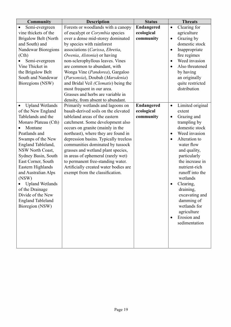
Community Description Status Threats• Semi-evergreen vine thickets of the Brigalow Belt (North and South) and Nandewar Bioregions (Cth) • Semi-evergreen Vine Thicket in the Brigalow Belt South and Nandewar Bioregions (NSW)
Forests or woodlands with a canopy of eucalypt or Corymbia species over a dense mid-storey dominated by species with rainforest associations (Carissa, Ehretia, Owenia, Alstonia) or having non-sclerophyllous leaves. Vines are common to abundant, with Wonga Vine (Pandorea), Gargaloo (Parsonsia), Doubah (Marsdenia) and Bridal Veil (Clematis) being the most frequent in our area.Grasses and herbs are variable in density, from absent to abundant.
Endangered ecological community
• Clearing for agriculture
• Grazing by domestic stock
• Inappropriate fire regimes
• Weed invasion• Also threatened
by having an originally quite restricted distribution
• Upland Wetlands of the New England Tablelands and the Monaro Plateau (Cth) • Montane Peatlands and Swamps of the New England Tableland, NSW North Coast, Sydney Basin, South East Corner, South Eastern Highlands and Australian Alps (NSW) • Upland Wetlands of the Drainage Divide of the New England Tableland Bioregion (NSW)
Primarily wetlands and lagoons on basalt-derived soils on the elevated tableland areas of the eastern catchment. Some development also occurs on granite (mainly in the northeast), where they are found in depression basins. Typically treeless communities dominated by tussock grasses and wetland plant species, in areas of ephemeral (rarely wet) to permanent free-standing water. Artificially created water bodies are exempt from the classification.
Endangered ecological community
• Limited original extent
• Grazing and trampling by domestic stock
• Weed invasion • Alteration to
water flow and quality, particularly the increase in nutrient-rich runoff into the wetlands
• Clearing, draining, excavating and damming of wetlands for agriculture
• Erosion and sedimentation

Page 20
References and further reading
Nadolny, C, Hunter, J.T. and Hawes, W (2009) Native Grassy Vegetation in the Border Rivers-Gwydir Catchment: diversity, distribution and management. Border Rivers-Gwydir Catchment Management Authority, Inverell.
Walker J & Hopkins M.S. (1998) ‘Vegetation’ in McDonald, Isbell, Speight, Walker & Hopkins (eds) Australian Soil and Land Survey Field Handbook, 2nd Edition, CSIRO, Canberra.
Specht R.L. (1981) ‘Foliage Projective Cover and Standing Biomass’ in Gillison A.N. & Anderson D.J. (eds) (1981) Vegetation Classification in Australia, CSIRO, Canberra.
Community Description Status Threats• White Box-Yellow Box-Blakely’s Red Gum Grassy Woodland and Derived Native Grassland (Cth) • White Box Yellow Box Blakely’s Red Gum Woodland (NSW)
Woodland community dominated by one or more Eucalyptus species known as box trees (White Box, Eucalyptus albens, Yellow Box, Eucalyptus melliodora, Grey Box, Eucalyptus molucanna, Apple Box), sometimes with red gum (mainly Blakely’s Red Gum, Eucalyptus blakelyi) as a dominant canopy over a sparse mid-storey containing Kurrajong (Brachychiton populneus), Cypress Pines (Callitris spp.), Wattles (Acaia spp.) and Blackthorn (Bursaria spinosa), and a diverse, dense grassy groundcover.
Critically endangered community (Cth);
Endangered ecological community (NSW)
• Clearing for agriculture, infrastructure and urban development,
• Inappropriate grazing by domestic stock
• Weed invasion. • Inappropriate
fire regimes• Salinity, nutrient
enrichment

Page 21
Chapter twOVegetation, property and
regional planning
Bruce Gardiner1, Laura McKinley2, and Jonathan Lawson3
1. Border Rivers-Gwydir Catchment Management Authority, Armidale
2. Border Rivers-Gwydir Catchment Management Authority, Inverell
3. Border Rivers-Gwydir Catchment Management Authority, Glen Innes
IntroductionConsideration of native vegetation on
farms is a vital part of property, regional and sub-catchment planning. While conservation is promoted through the parks and reserves system, incorporation and good management of native vegetation in farm systems can enhance and extend existing reserves, encourage more viable plant and animal communities, while providing a range of production, quality and financial benefits to the farm business. A wholistic and sustainable approach to managing native
vegetation may be achieved by assessing the farm business of individual properties in terms of the agricultural industry, the enterprise/s, human, financial and natural resource inputs. Groups of farmers in a catchment or region with similar issues are also able to make a difference in the quality of the environment across a wider area, while maintaining or improving profitability for the long term.
Landscape alteration and native vegetation protection
The intensity of land use and management across different landscape types affects the amount and type of native vegetation typically remaining in the landscape (Table 2.1).
Table 2.1 Examples of typical levels of land use in different landscapes showing approximate percentage of landscape with that land use
Landscape type Intensity of land use or management (% of landscape) (alteration state) High Medium Low Very Low
Grassy eucalypt Cropping, sown Cleared native Grazed grassy Environmentalwoodland, temperate pastures (30%) pasture (40%) woodland (20%) reserve (10%)to tropical (variegated)
Tropical eucalypt Heavily grazed Grazed but Environmentalwoodland (intact) in areas of high uncleared (80%) reserve (10%) use (10%)
Woodlands Cropping (60%) Environmental (fragmented) reserve (40%)
Brigalow Cropping, sown Grazed brigalow Environmental(fragmented) pasture (50%) regrowth in rotation reserve (30%) with cropping (20%)
Semi-arid Heavily grazed Grazed, Grazed, long Beyond the reachrangelands close to watering intermediate distance from water of livestock (10%) points (10%) distance from water (40%) (40%)
Source: McIntyre, 2001

Page 22
McIntyre (2001) suggests that ecological integrity of agricultural landscapes requires 30% of native vegetation in multi-purpose areas on farm, while an additional 10% should be included for pure conservation. Studies into the relationship between area of remnant native vegetation and income loss in seemingly uniform areas in the Moree Plains Shire show a maximum of only 2.7% loss in income from 30% cumulative area protected on farm (Sinden, 2005). This figure does not take into account the potential benefits of shelter, habitat for beneficial predators, diversity and groundcover on production and quality aspects of income. Similarly, it does not account for improvements in profitability likely to occur where less productive land is forced to produce beyond its capacity. It also excludes the benefits of carbon sequestration and the costs of carbon released from clearing and more intensive land management. Properties tend to have different areas showing negative and positive profitability and conditions that improve sustainability also maximise farm profit, indicating that farms need a substantial amount of vegetation in the landscape (Gardiner, 2006).
Landscape resilience & extreme eventsLandscape resilience is about the
capacity of the landscape to recover from
disturbance. Disturbance can take many forms, including extreme events such as droughts, floods or changing from grazing to cropping,or slow degradation of the resource through management. The factors that affect resilience (Figure 2.1) are the:
• amplitude of the disturbance - how seriously is the natural resource damaged by the disturbance?;
• duration of the disturbance event - the length of time over which the disturbance occurs;
• frequency of disturbances - how often the disturbance occurs; and
• elasticity of the natural resource - the range of landscape attributes that can buffer the impact of the disturbance and reduce the time taken for the recovery process to be completed.
Landscape condition describes the condition of natural resources such as soil fertility and stability to resist erosion, water quality and availability as well as vegetation cover, for example. Recovery of the natural system to an equivalent condition that enables the landscape to support close to its original capacity is a process requiring a long rest period. The resilience of the system can be maximised by adopting management practices that protect
Landscape Condition
Disturbance Amplitude Elasticity
Duration
Time
Event 1
Event 2
Frequency
reco
very
long
er r
ecov
ery
Figure 2.1 Disturbance and recovery at a landscape scale (Source: Hutchinson, 2005 in Gardiner, 2006).

Page 23
the natural resource base. If the recovery is not well managed, it may take longer to return to equilibrium (Figure 2.1, dotted line). If the frequency of disturbances increases (Figure 2.1, event 2), this may impact the landscape before the recovery from previous disturbance is complete (dashed line relative to dotted line), leading to continual lowering of the landscape condition over time.
Landscape resilience is determined by the difference between carrying capacity, which varies over seasons and stocking rate or planting density. In natural systems for example, animal populations are kept within sustainable limits by available feed. As long as stocking rate is less than or equal to carrying capacity, landscape disturbance is minimised and resilience is maximised. In natural systems, where inputs and outputs are in relative balance, the landscape will be in long-term balance, with stocking rate varying within upper and lower limits. Agricultural systems, however, are open systems as product is exported to other areas, often not replaced and long term balance may not operate, leading to more frequent disturbances of greater amplitude and longer duration, as well as slower recovery. Actions of land managers can either reduce or increase the amplitude, frequency and duration of disturbances. Careful and objective assessment of resource availability should allow farmers to respond to, or even anticipate, changes to carrying capacity and adjust enterprises accordingly.
The resilience of plant communities is highly correlated to their frequency in the landscape. Computer simulations show that, once frequency falls below 30%, many vegetation communities become terminal. Connectivity between areas of low and high plant density can improve the resilience of the low density area. Research shows that, at an evolutionary scale, sustainability requires large areas of remnant vegetation (much larger than can be contained within the National Parks system). Connectivity helps simulate large area processes.
Not all disturbances need be detrimental. In fact many species, such as eucalypts, that
inhabit natural areas rely on disturbance to regenerate. Disturbance events can be a very useful tool for land managers to promote regeneration within remnant areas or shelter belts and these disturbance events can range from fire regimes to simple turning of the top soil with a mattock. The broad scale use of superphosphate and improved pastures during the 1950’s and 1960’s produced a disturbance by balancing the fertility needs of the time, improving pasture growth and quality, as well as groundcover. It is important for farmers to be aware that they can manufacture landscape changes that can redress previous events and increase resilience.
More than 90% of environmental degradation occurs as a result of extreme events. The most common extreme event in Australia is drought broken by flooding rain. How well we manage these events determines the amplitude and frequency of the disturbances associated with them. One extreme event can undo many years of careful management. This is why many of the principles that determine appropriate land management, including retention of native vegetation in the form of trees, shrubs and grasses, relate to the achievement of minimum baseline natural resource measurements. Fortunately, maintaining natural resources not only protects the resilience of the landscape and improves sustainability, it also maximises profitability for the farm business.
The link between profit, native vegetation and natural resource
managementMicro-economic theory clearly shows
that it is not possible to maximise farm profit unless rainfall use efficiency (RUE) is maximised (Gardiner, 2006). The rain that falls is a free input to the business, so if managers are not utilising the rainfall to maximum efficiency, they are paying more on other inputs to achieve the same production. To maximise RUE and profit, a number of natural resource management objectives need to be met. Gardiner (2007) used production economics and marginal principles to identify six factors necessary to ensure sustainable and profitable production from grazing systems:

Page 24
• Sufficient groundcover to minimise water runoff and wind and water erosion.
• Sufficient litter to modify soil temperature to optimise root growth and limit evaporation, and to provide active carbon for decomposition to humus by microbes.
• Sufficient green leaf area to maximise photosynthetic efficiency.
• A diversity of species providing year-round growth potential.
• Sufficient shelter to minimise wind and temperature impacts on plants and animals.
• Replacement of minerals removed through sale of product and correction of any nutrient imbalances.
In short, healthy, biodiverse ecosystems which protect the natural resource base and increase landscape condition and resilience are required to maximise profitability in agriculture. If RUE is not being maximised, existing management practices are unlikely to be sustainable. The volume of inputs required to maximise RUE is the most cost effective solution to the issue of sustainable farm management. If the volume of inputs required to maximise RUE makes an enterprise unprofitable, that area of land should not be used for production. To maximise RUE in such areas, reverting to pre-existing native woody and non-woody vegetation that has evolved to take advantage of those conditions (nature conservation) may be the most profitable way to utilise that landscape.
The strategic planning processStrategic planning in any form is essential
to farm businesses and native vegetation management is only one part of wholistic planning.
The planning cycle considers the following points, with specific examples relating to vegetation management:
• An inventory or current context – status, threats, uses of the resource. Where are you now? On your own farm and in different paddocks, what sort of vegetation remains? Where is it? How much of it? What
condition is it in? Is it connected to larger areas? Is there a range of layers, diversity of species, ages?
• Vision – where do you want to be in the future? What outcomes do you wish to achieve by increasing vegetation, and why is it important to you? Is it improved environmental outcomes, production benefits, aesthetics, wildlife habitat or a combination of these?
• Planning – how are you going to get there? What do you wish to achieve (key goals that contribute to overall outcomes)? What do you need to do this and how do you go about it (actions and strategies)? Where is the best place in the landscape to provide shelter and other benefits? Do you wish the vegetation to be useable for other purposes? What sort of vegetation should be planted on which soil and landscape type? Who is going to do it? You will need to obtain a satellite image or aerial photo of your property, draw on your permanent infrastructure and create separate layers for current infrastructure and land use; land capability, soil types; and a layer for the proposed changes you wish to achieve.
• Prioritising – what needs to be done first in order to achieve the desired outcomes? Do you have time to achieve a particular outcome? Can you control the outcome? Are you initiating, developing or maintaining something? Is it a high feasibility and high value project rather than low? Is it better to work on less degraded sites, requiring less input to improve their state more by regeneration, rather than spending more time and money replanting on more degraded sites? Can you link the works to larger remnant vegetation areas?
• Implementation – actually doing the work. Do you need a grazing strategy, a change in cropping practices, to address soil issues, patch burning, fencing, water supply, weed management, feral animal control? What will be the cost of the project? Can you afford it? Are funding sources available for the works? What are the timeframes for stages of the project – think about site preparation, seasons, ordering seed or seedlings?

Page 25
• Monitoring and Evaluation – what are the results of your actions? How do we know whether we achieved what we set out to do? Do you need to adapt your management because we didn’t achieve your goals, there was an unexpected consequence or something changed external to the business that you now need to plan for? How will you monitor the change in vegetation condition and extent, or the benefits that may flow from this vegetation? What systems, visual, recording or other will you use?
Planning provides clear directions, communication and coordination for resources of the business and minimises the risk of subtle erosion of the values of the area by the cumulative effects of small, unplanned decisions.
Vegetation management on farmFor good vegetation management on your
property, consider the following points:
• Removing reference to existing infrastructure during planning will usually result in better design. Plan on the basis that all existing infrastructure can be re-located and most will need to be replaced at some time in the future. Everything that is not permanent (most infrastructure) should be considered movable. Remember also that a line drawn on a map is the cheapest and easiest fencing to erect and pull down!
• Every time you cross a soil or landscape boundary you are entering a new enterprise and one soil and landscape type in each paddock makes uniform utilisation more likely. This also provides the best platform for meaningful paddock records which may help you identify the causes of production loss.
• Aim to maintain 100% groundcover and 12 mm of vegetative litter to reduce runoff and erosion, evaporation, help maintain optimum soil temperature and reduce weed colonisation of bare spots. One soil and landscape type in each paddock makes this an easier task. Paddock utilisation is limited by the first area to fall below 70% groundcover.
• Plan fencing to achieve as many outcomes as possible, e.g. fencing a laneway may provide opportunities for subdivision and the incorporation of windbreaks and water reticulation pipes within the same fences. Incorporation of a windbreak may make the fence eligible for a subsidy, or provide taxation benefits.
• Reduce wind speed on productive areas. Once wind is stronger than ‘light’ (in some places 30-50% of the time), plants use water inefficiently. Utilising higher points in the landscape increases the effective area of wind protection from planted windbreaks. Put the wind protection in the right place then think about fencing. Reducing wind speed also reduces environmental stress on stock and increases animal production, as does providing shade.
Vegetation should be connected, as close as possible to right angles to the prevailing winds, have some larger remnants, contain a mix of species, trees and shrubs, and a range of ages (no recruitment = not sustainable).
Sub-catchment and regional planningThe principles for on-farm planning can
be applied at a farmer group level, using near neighbours and sub-catchments, to involve the community in planning for achievable vegetation management into the future. What type and amount of native vegetation remains across the catchment? What would the community like the catchment to look like? What are the common issues for most of the landholders and how can these addressed? Is it riparian areas, management for threatened species, public land, salinity or erosion control? What are the most strategic sites to improve native vegetation condition and extent, or address the issues of concern?
Catchment Management Authorities and Landcare groups, for example, are excellent sources of technical advice, information and may help coordinate group projects.
ConclusionThe ecological integrity of agricultural
landscapes has been altered, decreasing

Page 26
landscape resilience and increasing susceptibility to extreme events. Traditional management practices may exacerbate decline in the system, impacting not only on environmental values but leading to lowered profitability of agricultural enterprises. Economic principles and experience show that improvement and maintenance of six key factors in the landscape, to maximise rainfall use efficiency, decreases reliance on paid inputs to achieve the same level of production in a more environmentally sustainable and profitable manner. If these six factors cannot be achieved in particular parts of the landscape while utilising land for production, it is more profitable and less time-consuming to maintain such areas for conservation. Investigation of individual farm enterprises, their physical and financial resources through an integrated and comprehensive property planning process can help identify and better utilise different landscapes and provide own-farm information for on-going monitoring. Applying these principles across a sub-catchment or region through farmer groups is likely to achieve improved environmental outcomes across a wider region and contribute to strong and sustainable communities.
References and further readingBrowne, W. and Gardiner, B. (2006) Farm Management Planning, Training Manual, Border Rivers-Gwydir CMA, Inverell.
Gardiner, B. (2007) ‘Chapter 14, Property Planning’ in UNE RSNR 421 Sustainable agriculture and Catchment Management, pp 14-1 to 14-22, course notes, University of New England, Armidale.
McIntyre, S. (2001) Incorporation of practical measures to assist conservation of biodiversity within sustainable beef production in northern Australia, CSIRO Sustainable Ecosystems, Canberra <http://www.environment.gov.au/land/publications/beef/results.html>
Sinden, J. (2005) The environmental cost curve: an economic approach to the environment/production tradeoff, Agricultural and Resource Economics, School of Economics, University of New England, Armidale.

Page 27
Chapter threePutting a value on native vegetation:
Economics
IntroductionThe need for more robust techniques to
value native vegetation has been made more urgent by the recent introduction of the Native Vegetation Act 2003 (NVA) and the regulation of rivers to achieve environmental flows (Water Management Act 2000).
The value of native vegetation may be determined either explicitly or implicitly. Explicit valuation may be achieved by market forces (carbon offsets) or bio-economic modelling which links land values or productivity gains to vegetation density. The community also values native vegetation implicitly through government legislation which places restrictions on land clearing and penalises breaches and non-market benefits such as existence value by adding vegetation communities to the national estate (Parks network).
Explicit Valuation: Bio-economic Modelling
The Productivity Commission and the Australian Bureau of Agricultural and Resource Economics (ABARE) have used differences in land value and measures of efficiency gain between cleared and uncleared land to cost native vegetation regulation in NSW at $1bn over a 20 year time horizon.
Sinden (2005) attempted to measure the impact of the NVA by including a variable for
Bruce GardinerBorder Rivers-Gwydir Catchment Management Authority, Armidale
area of native vegetation in a disaggregated model of rural land values and the difference in gross margin between cropping and grazing in the Moree Plains Shire. This research revealed a net loss of $20m/year for the study area.
While these models showed a negative value for retained native vegetation, they failed to account for changes in commodity prices that would arise from increased production and the value of net additions to greenhouse gases from changed farming practices.
Explicit valuation: Market Based Instruments
Market Based Instruments (MBIs), such as the Bush Tender process in Victoria (and the On-ground Works Incentives Program used by the Border Rivers-Gwydir CMA), provide a methodology for valuing biodiversity and other non-market benefits of retained native vegetation. Landholders bid for payments from a pool of grant money to provide environmental services. Each area offered is given a measured biodiversity score. The bid price is divided by the biodiversity score to give a price per unit of biodiversity benefit. Projects are prioritised and funded from lowest to highest cost per biodiversity unit. For a detailed discussion of the theory behind the Bush Tender and similar schemes see Stoneham et al. (2003).
Other examples of MBIs include carbon trading and biodiversity and vegetation offsets. Ratification of the Kyoto Protocol has established a market for carbon and vegetation offsets. Carbon is currently valued at about $15/t. It is also possible, under this protocol,

Page 28
to purchase vegetation offsets against carbon additions to the atmosphere.
Bio-banking is another process by which developers can offset vegetation clearing at one site by purchasing an equivalent amount of biodiversity at another site. The area of offset required increases as the biodiversity value of the area to be cleared increases. Offsets can be worth in excess of $240/ha.
Implicit valuation: revealed preference
Legislation to prevent land clearing can be seen as a reflection of the will of the people, i.e. the community would prefer to have native vegetation retained than cleared. Examples of such legislation include the NVA and the Federal Environmental Protection and Biodiversity Conservation Act (EPBC).
The introduction of the NVA made land clearing contingent on the landholder
receiving development consent. The vehicle for development consent is a science-based software package, the Property Vegetation Plan (PVP). This program measures the net change in biodiversity likely to flow from land clearing. A net loss of biodiversity value generates a development refusal. The outcomes of vegetation assessments, using the PVP, allow the theory of revealed preference to be used to value some of the non-market benefits of retained vegetation. In its simplest form, this theory states that a development refusal gives a minimum biodiversity value equivalent to the most valuable alternative use for the assessed area of land.
Implicit valuation: non-market goodsThere are a number of non-market values
for native vegetation. These include existence values, i.e. some people value native vegetation just because it’s there, whether they use it or not; cultural values as an identification of place
Figure 3.1 Trends in key farm performance indicators – 1965 to 2005.

Page 29
and the potential values of genetic traits as yet undiscovered.
McAlpine (2007), using climate modelling, has estimated that average temperatures are 2 degrees higher and rainfall 12% lower as a result of land clearing and replacement of native with introduced species. As each degree rise in temperature leads to 4% higher evaporation, land clearing has potentially reduced available rainfall by 20%.
Socio-economics of Native Vegetation Management
Welfare economics attempts to measure the distributional effects of the actions of one sector of the economy on the incomes of both that and other sectors of the economy. The strong definition of a welfare gain requires that nobody is worse off while somebody is better off. Because so few activities can achieve the above criteria, the definition has been softened such that those who are better off could fully compensate those who were made worse off and still be better off. It makes no provision for that compensation to actually occur. The clearest indicator for the value of land clearing for agricultural purposes is the trend in the real gross value of agricultural production. Neither the strong nor weak definitions of welfare can be sustained unless this trend is rising.
Over the past 40 years, ABARE’s index of the volume of production has tripled in value, a testament to advances made by researchers and the adoption of these more productive technologies by farmers. This has had massive, positive economic consequences for Australia through its addition to consumer surplus. However, over the same time period, the trend real gross cost of production has doubled while the real gross value has remained virtually constant. Not surprisingly, the real net value (and profitability per farmed hectare) has fallen by 70%. Figure 3.1 shows these changes, starting from a base year of 1965.
Because Australian farming is characterised by numerous small producers, it is highly unlikely that the above trends are the result of a few spectacular successes or failures. They are more likely to be the result
of thousands of individual production decisions that have not produced the desired outcomes for farmers. It is hard to accept the premise that farmers have taken deliberate decisions to reduce the profitability and sustainability of their businesses.
The main driver of productivity gain has been a shift from livestock to cropping made possible by the clearing of about 30M ha of farm land. By any measure, agriculture has not benefited from broad-scale land clearing. The flat trend in the real gross value of agricultural production indicates that any change in real income derived by one farmer has come from another, i.e. one producer can only be better off if another(s) is worse off and those who are better off cannot fully compensate those who are worse off and still be better off.
Looking at data from the aggregate perspective shows the inherent problems in drawing conclusions from data collected at an individual farm, group of farms, regional or state levels. Generalising to the national level, if demand for the product to be produced from newly cleared land is price inelastic, an increase in total production will result in lower total income, the increased production being offset by a greater percentage fall in price. In Australia, the demand for agricultural products in aggregate and all the bulk commodities individually is inelastic (Griffith et al, 2001).
If the net benefit of land clearing can be shown to be zero, the minimum value of native vegetation is the saved clearing costs ($150 - $500/ha).
MBIs, such as the Bush Tender scheme, Natural Heritage Trust, Catchment Management Authority incentive funding and other payments to farmers to purchase environmental services, imply an additional value for native vegetation. Indeed, rejection of clearing applications by the PVP process implies environmental values exceed the gross income from any alternative form of production. This may value Coolibah/Black Box woodland in Northern NSW at $300/ha/year.
At a macro scale, native vegetation provides a number of other benefits. Perhaps

Page 30
the most obvious is carbon sequestration. If Australia meets its greenhouse gas emissions set out under the Kyoto protocol, it will be entirely due to the process of bush thickening. About 72M tonnes of carbon have been sequestered by native vegetation since 1994. At $15/t, this values the addition to the native vegetation stock at $1.1bn. The corollary is that any native vegetation cleared and burnt puts carbon dioxide into the atmosphere and exacerbates global warming. Even at a low tree density, carbon storage of 50t/ha is readily achievable, giving retained vegetation a carbon value of $750/ha. It has been clearly demonstrated that soil carbon sequestration is tied to production intensity. Clearing land for more intensive production has additional costs associated with soil carbon loss.
The above analysis indicates that there are many national benefits to be derived from retaining native vegetation and few private benefits from land clearing. As a general rule, land clearing does not meet the weakest definition of welfare gain for farmers, while potentially imposing high costs to society from biodiversity loss and greenhouse gas production.
The following section deals with some of the benefits of native vegetation retention at the farm level. While this section deals with vegetation in general, the fact that native vegetation is better adapted to Australian conditions should be sufficient reason to use native species wherever possible.
Farm profitability and natural resource management
There is now a body of theory that suggests that farmers cannot maximise their profit unless they are maximising rainfall use efficiency (RUE) (Gardiner 2006). RUE is determined by the amount of rainfall that is converted into some form of production. This may take the form of pasture consumed by livestock, grain, hay, vegetable, fruit or fibre production, litter and any positive change in vegetative mass.
Across Australia, only about 10% of rainfall is converted into production. In NSW, this rises to between 15% and 20% of rainfall. Research by Gardiner and Browne (unpublished), in the Tamworth district,
indicates that a RUE of greater than 70% is possible.
Rainfall is lost to run-off, deep drainage, evaporation and inefficiencies. Any of these losses have implications for farmers, both in terms of inefficient use of inputs, leading to lower income and higher costs, and costs to the environment. Run-off leads to soil erosion, deep drainage raises water tables with possible consequences for salinity and/or subsoil constraints, evaporation can concentrate salts to the soil surface and inefficiencies lead to plants using more water to achieve the same amount of green matter production.
To prevent losses due to run-off, deep drainage, evaporation and inefficiencies, the following natural resource management conditions need to be met:
• Sufficient groundcover to minimise water and wind erosion.
• Sufficient litter to minimise evaporation and maintain surface soil condition and infiltration rate.
• Sufficient green leaf area to maintain the photosynthetic efficiency of the plant community and supply sufficient pasture to meet minimal grazing requirements (Pattinson 2006).
• A diverse range of plant species that can utilise rain whenever it falls. Natural systems with a leaf area index above 1.0 allow deep drainage of about 0.5% of total rainfall whereas bare fallows can leak more than 10%, and up to 40%, of fallow rainfall (Young, R. 2001 pers. comm., CSIRO, 2002).
• Wind protection that is sufficient to minimise evaporation and provide shelter for plants and livestock.
• Fertilizer application to balance soil chemical fertility, the main limiting factor of plant growth in Australia (Scott 2006b).
Farmers cannot expect to optimise land-use unless all of these conditions are met. Failure to achieve these conditions implies that the landscape is being used beyond its

Page 31
sustainable capacity with consequent long term resource degradation.
ConclusionsRetained native vegetation has positive
implications for both individual land holders and the nation as a whole. In a carbon economy with increasingly variable climatic conditions, the value of native vegetation can only increase.
References and further readingBird, P. R., Jackson, T., Kearney, G. and Williams, K. (2003) ‘Effect of two tree windbreaks on adjacent pastures in south-western Victoria, Australia.’ Australian Journal of Experimental Agriculture 42, pp 809-830
CSIRO Land and Water (2002) Effectiveness of current farming systems in the control of salinity: Leakage below farming systems, ww.clw.csiro.au/publications/general2002/effectiveness/leakage.html
Browne, W. and Gardiner, B. (2006) Farm Management Planning, Training Manual, Border Rivers-Gwydir CMA, Inverell
Gardiner, B. (2007) ‘Property Planning’, in UNE RSNR 421 Sustainable agriculture and Catchment Management, pp 14-1 to 14-22, course notes, University of New England, Armidale
Griffith, G.R., l’Anson, K., Hill, D.J., Cubbett, R. and Vere, D.T. (2001) ‘Previous Demand Elasticity estimates for Australian Meat Products.’ Economic Research Report No. 5, NSW Agriculture, Orange
Hajkowicz, S., Higgins, A., Williams, K., Faith, D. and Burton, M. (2007) ‘Optimisation and the selection of Conservation Contracts’ Australian Journal of Agricultural and Resource Economics, 51, pp 39-56
Jackson, J. and Ash, A. (2001) ‘The role of trees in enhancing soil nutrient availability for native perennial grasses in open eucalypt woodlands of north-east Queensland’ Australian Journal of Agricultural Research 52, pp 377-386
Jones, H. and Sudmeyer, R. (2003) ‘Economic assessment of windbreaks on the south-eastern coast of Western Australia’ Australian Journal of Experimental Agriculture 42, pp 751-761
McAlpine, C, quoted by Dani Cooper, Native trees key to cooling climate, ABC Science Online, October 2007
McIntyre, Sue (2001) Incorporation of practical measures to assist conservation of biodiversity within sustainable beef production in northern Australia, CSIRO Sustainable Ecosystems, 2001, www.environment.gov.au/land/publications/beef/summary.html
Nuberg, I. and Mylius, S. (2003) ‘Effect of shelter on the yield and water use of wheat’ Australian Journal of Experimental Agriculture 42, pp 773-780
Nuberg, I., Mylius, S., Edwards, J. and Davey, C. (2003) ‘Windbreak research in a South Australian cropping system’ Australian Journal of Experimental Agriculture, 42, pp 781-795
Pattinson, R. (2006) ‘Animal Sustainability’ in Sustainable Agriculture and Catchment Management University of New England, Armidale pp 10-1 to 10-29
Scott, J (2006a) ‘Introduction to Sustainability’ in RSNR 421/521, Sustainable Agriculture and Catchment Management University of New England, Armidale pp 5-1 to 5-17
Scott, J (2006b) ‘Plant Sustainability’ in RSNR 421/521, Sustainable Agriculture and Catchment Management University of New England, Armidale pp 7-1 to7-30
Sinden, J. (2005) The environmental cost curve: an economic approach to the environment/production tradeoff Agricultural and Resource Economics, School of Economics, University of New England, Armidale
Stoneham, G., Chaudhri, V., Ha, A. and Strappazzon, L. (2003) Auctions for conservation contracts: an empirical examination of Victoria’s Bush Tender trial Australian Journal of Agricultural and Resource Economics 47 pp 447-500
Sudmeyer, R., Adams, M., Eastham, J., Scott, P., Hawkins, W. and Rowland, I. (2003) ‘Broadacre crop yield in the lee of windbreaks in the medium and low rainfall areas of south-western Australia’ Australian Journal of Experimental Agriculture 42, pp 739-750
Wright, A. and Brooks, S. (2003) ‘Effect of windbreaks on potato production for the Atherton Tablelands of North Queensland’ Australian Journal of Experimental Agriculture 42, pp797-807

Page 32

Page 33
Chapter FOurCultural heritage and native vegetation
Sue HudsonConsulting Archaeologist
Armidale
Australia prior to human arrivalAustralia was part of a huge continent
known as Gondwana, and the Gondwana Rocks range in age from the Carboniferous (350 million years ago) to the Jurassic (150 million years ago) Ages. These rocks can be found in India, Africa, South America, Australia and Antarctica and inter-bedded with the Australian sequence are the coal beds of the Hunter and Illawarra regions. Embedded in these coal beds are fossils Glossopteris, a variety of seeds of primitive plants and mesosaurs, small aquatic vertebrates. The continents that made up Gondwana have been drifting apart but Australia became a separate island continent when it detached from Gondwana some 80 million years ago (Vickers-Rich & Rich, 1993).
The first Australians must have arrived by sea and almost certainly came from Pleistocene (Ice Age) Southeast Asia, via the islands between the land masses. The dating of sites accelerated with the oldest site dated 20,000 years ago in 1962, and then 30,000 in 1969 and in 1973 it had stretched to 40,000 years ago. Today, the oldest site recorded in Australia comes from Malakunanja shelter in Arnhem Land with a date of 53,000 years (Mulvaney & Kamminga, 1999).
Ethnographic informationMcBryde (1978) states that the only
ethnographic source material available for this area are the records, diaries and letters of the early settlers. The information on Aboriginal life and culture is often fragmentary and contradictory and requires much critical sifting, often revealing more about the
thoughts of nineteenth century Europeans than of Aboriginal culture. McBryde refers to literature describing the use of stone axes to catch possums and Wyndham (1889) recalls a ceremonial gathering on the western fall of the Tablelands where four tribes were present. Mathews (1896) states that ceremonies were of great importance, providing a connection between groups – Daingatti Keeparra (sic) and Gamilaroi Bora (sic) ceremonies. Wyndham (1889) states that the last Boora (sic), an initiation of young men, was held on the western fall of New England. Both men and women attended the ceremony but each had their own special areas after the initial meeting of the groups and much plant food would have been needed to feed the masses who attended these ceremonies.
Aboriginal plant use in the regionAboriginal people of the region enjoyed
a huge range of food resources obtained from trees, bushes and grasses. These plants were usually gathered by the women and children of the group and were used for food, medicine or both from the same source. The expertise needed for gathering and processing these plants was obtained over thousands of years and the skill was then passed on by mother, grandmother and aunts to the young girls, who would then use the plants for her own family when the time came. Listed below are some of the plants used in the region but this list is not all inclusive – there is much more information that needs to be collected. This information is from my own records and experience alone and may not represent all groups living in the region.

Page 34
Bush tucker plantsTrees, shrubs and bushes were used
by Aboriginal people as a food source, food additive, bush medicine and making wooden tools for hunting, gathering, fishing, warfare and relaxation. Most plants had a use for something even if they were poisonous (stunning fish by reducing the oxygen in water for easy capture) or used for smoking native bees or ceremonial
purposes. Some plants were not able to be used immediately as the poison needed to be leached from them before they were safe to use. An example of this were the Macrozamia nuts (Burrawang), which needed to be leached in running water for up to 14 days before they were cooked in ashes, ground, formed into balls and eaten – how did they know how long they needed to be leached before they were safe to eat?
Table 4.1. Plants and trees used by Aboriginal people (note: plants not confined to the BR-G catchment – those in bold are described in Part Three, Plant Descriptions. Underlined words are from the Wiradjuri language).
Quandong Santalum acuminatum Fresh fruit, Dried fruit seeds/kernelsGwandaang medicinal for aches and pains, oil forIwbada keeping skin soft.Wild plum/ S. lanceolatum Fruit, sweet drink with water.Sandalwood Mulga Acacia aneura Seeds used for flour (pods dried, thenBuutrree A. murrayana parched in hot sand, then ground and eaten A. ligulata either raw as a paste or baked as damper). Powder from insects used as glue. Sap used as a sweet/sweet drink when infused in water. Wood used for tools.Glycine Glycine spp. Pea- vegetable.River Red gum Eucalyptus camaldulensis Insect secretion from leaves eaten dry, grubs in branches meat source, bark used as chewing tobacco, bolls used as utensils.Corkwood Hakea spp. Nectar used as sweets, burnt bark as a powder for sores, wounds, burns.Ferns Pteridium esculentum Root-vegetable but only when young and in drought conditions.Mint Bush Prostanthera spp. Pounded and used as a poultice Insect repellent/perfume.Native Fushia Eremophila freelingii Green leaves smouldered and breathed as a decongestant.Bush Tomato Solanum ellipticum Berries eaten raw when juice and seeds squeezed out. Can be baked as well.Rushes Juncus spp. Seeds – flour, stems/leaves –weaving/Dhangang mats/nets etc.Wild Tobacco Ukiri Nicotiana sauveolens Mixed with ashes – smoked.Pigface Portulaca oleracea Whole plants dried in a coolamon to Munyervu collect seeds, then winnowed ground to a paste and baked as small cakes or whole plant baked and the roots eaten. Stems sucked for water content. Fruit eaten.Parakeelya Calandrinia balonensis Plant baked in hot sand and ashes and leaves eaten. Green leaves are sucked for water.
Common Name and Botanical Name UseWiradjuri Name
Continued......

Page 35
Common Name Botanical Name Use
Truffles Choiromyces aborigines Cooked in hot sand and eaten (same as French truffles).Mistletoe Lysiana murrayi Fruit eaten raw.(Snotty gobbles) L. exocarpi Box species (Yellow, Eucalyptus spp. Bark used for making coolamons, shields,Bimble, Grey, White) canoes, burial slabs, woomeras, etc.Nardoo Marsilea drummondii Seeds collected and ground for a wet- milled flour for damper.Banksia Banksia spp. Cones used as fire stick, flowers infused as sweet drink, flowers licked as lolly.Emu Poison Bush Dubosia spp. Poisonous leaves crushed and put in waterholes to stupefy emus and fish.Hop Bush Dodonea spp. Placed in pit, smoke used for relief of pain.Cyprus Callitris Glue/sap, bark/woomera.Native Cherry Exocarpus cupressiformis Sap for snake bite.Grevillea & Banksia Grevillea spp. Banksia spp. Nectar and gum.Honeysuckle Ajuga reptans Nectar and gum.Native Fuchsia Eremophila latrobei Fumigation or smoking ceremony,Aratja flower sucked as sweet.Turpentine Eremophila spp. Smoke used for coughs and general aches and pains.Matspurge Euphoria drummondii Protect children from the sun/hatTea Tree Leptospermum spp. Pegs for skins, clothes, leaves for insect repellent, bark for chewing for tooth ache, leaves as tea substitute.Muckram Melichrus spp. Fruit.Daisy Yam, Murnong Microseris lanceolata Tuber/yam baked. Leaves used as salad.Burrawang, cycad Macrozamia spp. Seeds leached in water for up to 14 days, baked in ashes, ground and eaten. Extremely toxic.Kurrajong Brachychiton populneus Seeds eaten like nuts, young roots eatenGurrajung as vegetables.Native Raspberry Rubus parvifolius Fruit.Kangaroo apple Solanum lineariflolium Fruit.GooyahGeebungs Persoonia cornifolia Fruit.Native Fig Ficus rubiginosa Highly nutritious fruit.Dillon Bush Nitraria billardieri Fruit.Native Lemon Eremocitrus glauca Tart fruit.Cumbungi, bulrush Typha domingensis Starchy rhizomes eaten raw or cooked.Clubrush Bolboschoenus caldwellii As above.River Ribbons Triglochin procera Used for weaving.Native Lily Wurmbea biglandulosa Starchy tuber.Brown Beaks Lyperanthus suaveolens Small tuber, looks like a potato.Gins Onion Bulbine bulbosa Large and starchy tuber.Puff Balls Lycoperidon spp. Eaten when young, sliced and cooked or eaten raw. Dust from ripened puff balls used as deodorant (J Connors, Tingha)
Table 4.1 cont.
......

Page 36
Slender Rats Tail Sporobolus creber Seeds - flour.Bottle Washers Enneapogon nigrans Seeds – flour.Plume Grass Dichelachne micrantha Seeds – flour.Hedgehog Grass Echinopogon ovatus Seeds – flour.Wallaby Grass Austrodanthonia spp. Seeds – flour.Swamp Foxtail Pennisetum alopeculoides Stem/head – broom, weaving.Barbed Wire Grass Cymbopogon refractus Seeds – flour, root/stem - insect repellentKangaroo Grass Themeda australis Seeds – flour.Weeping Grass Microlaenia stipoides Seeds – flour.Wheat Grass Elymus scaber Seeds – flour.Speargrass Austrostipa scabra Broom/paintbrush.Slender Bamboo Grass A. verticillata Broom/mats/weaving.Blown Grass Agrotis avenacea Seeds – flour.Lovegrass Eragrostis leptostachya Seeds – flour.Poa, Tussock Poa spp. Seeds – flour.Wild Sorghum Sorghum leiocladum Seeds – flour.Native Millet Tindi Panicum decompositum Seeds used for flour.Woollybutt Eragrotis eriopoda Seeds winnowed, ground, and then left for next day. Then mixed with water until runny, dripped into ashes and baked as damper. New batch left for the next day. Exceptionally nutritious flour.Greybeard Grass Amphipogon caricinus Grass used as a hat or head pad for carrying heavy things. Also used for straining water or other drinks (especially at dirty waterholes).Blady Grass Imperata cylindrica Leaves/stems - weaving.
Common Name Botanical Name Use
Table 4.2. Grasses used by Aboriginal people (not confined to the BR-G catchment – those in bold are described in Part Three, Plant Descriptions).
Grasses used by Aboriginal peopleGrasses were the most common source of food for people, the seeds being processed for wet-
milled flour, stems used for binding and basket weaving, leaves used as vegetables and roots could be baked, eaten raw or processed for medicinal uses. See Table 4.2 for details.
Rushes Juncus/other spp. Seeds – flour, stems/leaves –weaving/ mats/nets etc. Dock Rumex sp. Medicinal. Tarvine Boerhavia spp. Root/Yam roasted, sap used to trap small birds, animals. Cenna Tea Centaurium Steeped in water – tea, roots/leaves – poultice. Native Flax Linum marginale Oily seeds for eating & rubbing into skin Grass Tree Xanthorrhoea spp. Starch, nectar, fruit, shoots, grubs, gum (glue), stalks (spears)
Table 4.1 cont.
Common Name Botanical Name Use

Page 37
Figure 4.1 Canoe scar.
Figure 4.2 Coolamon scar.
Figure 4.3 Tribal marking.
Figure 4.4 Carved tree.
Figure 4.5 Shield scar on trunk of living tree.
Scarred and carved treesScarred Trees: Aboriginal people used the
trunks and limbs of eucalypt trees for making wooden utensils such as spears, woomeras’ (throwing sticks), coolamons (carrying bowls), canoes and shields. The remnants of this activity can be found on both living and dead trees – see photographs below. It is important to protect these trees from damage from stock and farming procedures and from bush fires and collection of firewood.
Carved trees are very rarely found in the field as they have been removed for garden ornaments in the past. They were used to mark special places including burial sites, male secret places and other ceremonial sites. Women, children and uninitiated males were never allowed to see these places.

Page 38
Aboriginal use of bush foods todayWith changes to modern palates, young
Aboriginal people are generally not interested in eating bush foods but prefer the allure of fast food instead. Depending on the area, the older members of Aboriginal communities still remember collecting and eating bush foods and many of these people continue to eat bush foods and harvest plants for bush medicine. Many of the fruits found in the region are eaten when they become ripe, these include Quondongs, Wild Plums, Bush Tomatoes, Mistletoe, Burrawang, Raspberries, Geebungs, Wild Lemons and Native Figs. Very few grasses are processed for flour as it is far easier to buy bread. The fear of eating fruits, nuts and grass seeds, because Aboriginal people don’t know if they have been sprayed or contaminated, deters them from collecting them for their families.
Protecting Aboriginal plantsIt is the duty of everyone interested in
protecting the environment to care for native plants. Growing these plants commercially can be looked at as a potential for extra on-farm income for the growing lucrative market for ‘native’ products. Wattle seed (used for making a coffee substitute, ice cream, breads, damper and cakes) and Quondongs (preserved fruit, pies, and oil for skin moisturising) are particularly sought after.
Scarred trees are reaching the end of their lives and should be protected from stock, agricultural damage and fires. Soon none will remain to show our children and grandchildren what the scars looked like in their natural context. It will be very hard to explain what they looked like if there are none left.
References and further reading
Allen, H. (1976) ‘Aborigines of the Western Plains of NSW’ in The Aborigines of New South Wales. NPWS, Sydney.
Atchison, J. (1977) ‘The Evolution of Settlement’ in An Atlas of New England. Vol 2. The Commentaries. Department of Geography, UNE pp 137-152.
Balme, J. and Hope, J. (1990) ‘Radiocarbon dates from midden sites in the lower Darling River area of western New South Wales’, Archaeology in Oceania 85-101
Beck, W., Somerville, M., Duley, J. & Kippen, K. (2003) ‘An Assessment of the Cultural Significance of the Mt. Yarrowyck Nature Reserve’, unpublished report to NPWS and Aboriginal Communities of the Region. UNE, Uralla/Armidale.
Belshaw, J. (1978) ‘Population distribution and the pattern of seasonal movement in northern New South Wales’ in McBryde, I. (ed) Records of Times Past: ethnohistorical essays on the culture and ecology of the New England tribes. AIAS, Canberra.
Binford, L. (1983) In Pursuit of the Past – Decoding the Archaeological Record. Thames and Hudson, New York.
Binns, R. & McBryde, I. (1969) ‘Preliminary report of a petrological study of ground edge artefacts from north-eastern NSW’ Proceedings of the Prehistory Society Vol XXXV.
Bowdler, S. (1979) ‘Hunters in the Highlands: Aboriginal adaptations in the eastern Australian Uplands’ in Archaeology in Oceania. Vol 16:99-111.
Bowdler, S. & Coleman, J. (1981) ‘Aboriginal people of the New England Tablelands: ethnohistory and archaeology’ in Armidale and District Historical Society Journal and Proceedings. No. 24 March 1981.
Connah, G., Davidson, I. & Rowland, M. (1977) ‘Prehistoric Settlement’ in An Atlas of New England. Vol 2. The Commentaries. UNE, Armidale
Elkin, A. (1994) Aboriginal Men of High Degree: initiation and sorcery in the World’s oldest tradition. University of Queensland Press, St Lucia.
Furby, J. (1996) Dinnertime at Cuddie Springs: hunting and butchering Megafauna. University of Sydney. pp 1-5.
Godwin, L. (1990) ‘Inside Information: settlement and alliance in the late Holocene of Northeastern New South Wales’, unpublished PhD. Thesis, UNE, Armidale.
Hobden, J. (1988) From the Dreamtime to the Iron Horse. Tamworth Historical Society.
Hudson, S. (1996) ‘Salisbury Axe Quarry: the acquisition, distribution and cross-exchange patterns from a local distribution site’, unpublished Honours thesis, UNE, Armidale.
Hudson, S. (2003) ‘Living in the New England Tablelands: a preliminary report on an individual

Page 39
group’s foraging area’, unpublished report for Uralla Shire Council.
Hudson, S. (2006) ‘Archaeological Assessment of Copeton Dam & Gwydir River in Copeton Dam Upgrade Project’, unpublished report for State Water Corporation.
Hudson, S. (2007) ‘An Archaeological Survey at Copeton Dam, Inverell’, unpublished report for State Water, Sydney.
Hudson, S., Sutherland, M., Holthouse, L. & Plummer, R. (2000) ‘An Archaeological Survey of Genaren Hill Landcare Group Area, Peak Hill’, unpublished report for Genaren Hill Landcare Group, Peak Hill.
Hudson, S., Duncan, L., Kim, M. McKenzie, P., Townsend, L. & Hudson, C. (2003) ‘Anaiwan Lands Education Project’, unpublished report for Southern New England Landcare, Armidale.
Kahn, L. & Heard, B. (1997) Pasture Plants of the Slopes and Tablelands of NSW. DWLC, Armidale.
Long, A. nd. Scarred trees: an identification and recording manual. Aboriginal Affairs, Victoria
McBryde, I. (1974) Aboriginal History in New England. SUP, Sydney.
McBryde, I. (1977) ‘Determinants of assemblage variation in New England Pre-history’ in Wright R. (ed.) Stone Tools as Cultural Markers Canberra.
McBryde, I. (1978) Records of Times Past. AIAS, Canberra
McCarthy, F.D. (1976) Australian Aboriginal Stone Implements. Australian Museum Trust, Sydney.
Macdonald, G.J. (1845) First Report on the New England Aborigines. Governor’s Dispatches, Vol. 40, 1845 ML.A-1229.
Massie, R.G. (1851) Report on New England Aborigines, 1851. Governor’s Despatches Vol. 71, 1852. ML. A-1260.
Mathews, R.H. (1896) The Burbung of the New England Tribes, NSW. Proceedings of the Royal Society of Victoria Vol. IX.
Matthews, R. (1896) ‘Description of two bora grounds of the Kamilaroi (sic) tribe’, Journal of the Royal Society of New South Wales. pp 423-430.
Mulvaney , J. & Kamminga, J. (1999) Prehistory of Australia. Allen & Unwin, Sydney.
O’Sullivan-White, H. (1934) ‘Some Recollections
of the Aborigines of New South Wales in the years 1848, 1849 and 1850’ in Mankind pp 223-227
Oxley, J. (1820) Journals of Two Expeditions into the interior of New South Wales: undertaken by order of the British Government in the years 1817-18, John Murray, London.
Pearson, M. (1981) ‘Seen through other eyes: Changing land use and settlement patterns in the upper Macquarie River Regions of NSW from pre-historic times’, unpublished PhD. Thesis, ANU, Canberra.
Smailes, P.J. & Molyneux, J.K. (1965) ‘The Evolution of an Australian Rural Settlement Pattern: Southern New England, NSW’ in The Institute of British Geographers. Reprinted from Transactions and Papers, 1965. Publication No. 36. Fryer Library, UQ, St. Lucia.
Sutton, S. (1989) Results of a survey for Aboriginal sites in the city of Armidale. Report to the Council of Armidale.
Tindale, N.B. (1974) Aboriginal Tribes of Australia, University of California Press, Berkeley.
Vernon, R. (1961) ‘The Geology and Petrology of the Uralla Area, NSW’ in Journal and Proceedings of the Royal Society of NSW. Vol 95 pp 23-33.
Vickers-Rich, R. & Rich, T. (1993) Wildlife of Gondwana. Reed Books, Sydney.
Warburton, J. (1962) ‘The Aborigines of New England: Their Background and Their Future’ in Armidale and District Historical Society Journal and Proceedings. No. 4 October 1962 pp 19-41.
White, J. (1976) ‘Stone Tools and Dating in the Past’ in The Aborigines of NSW, NPWS, Sydney pp 60-69.
Wyndam, W. (1889) ‘The Aboriginals of Australia’ in Journal and Proceedings of the Royal Society of NSW. Vol XXII 1889:36-42.
Wyndham, W. (1889) The Aborigines of Australia Ucumble (sic) Tribe of western New England. The Royal Society of NSW. Vol. XXIII.
Personal communication:
Jimmy Connors, Tingha
Liza Duncan, Ashford
Sally-Anne Cutmore, Armidale
Craig Alison, Dubbo

Page 40

Page 41
Chapter FiveThe role of native vegetation in preventing and managing land
degradation
Part A: The role of vegetation in reducing
erosion control
Mike LloydRed Frog Environmental Solutions, Armidale
IntroductionSoil erosion is the process of soil particles
being detached from each other and their movement to a subsequent location due to the effects of water, wind and gravity. It is a natural process, but one that can be accelerated due to certain human activities and inappropriate land management practices. Eroded soil and associated nutrients are lost to agricultural production and eventually end up in our streams to degrade the water quality and aquatic ecosystems of the catchment.
Vegetation is the most significant deterrent to soil erosion as it reduces the processes of both detachment and transportation of soil particles. Vegetation can protect the soil from erosive forces, hold it in place and increase surface roughness to lessen the effects of water and wind. Consequently, the loss or removal of vegetation can result in increased rates of surface erosion, higher frequencies of slope failure and accelerated riparian degradation.
Vegetation - A natural stabiliserThe manner in which vegetation can
reduce soil erosion is due to the benefits it provides through its canopy, surface cover and
below surface characteristics. Its effectiveness in doing so at a particular site will vary according to the type, density, arrangement, growth habit and height of the vegetative cover as well as the erosion processes present.
The susceptibility of a landscape to the agents of erosion is generally dependent upon a combination of soil, landform, climate, land use and land management factors. This is largely because these same factors determine the vegetative type and cover of the landscape which significantly affects both the surface and mass stability of terrestrial and riparian landscapes.
Surface stabilityVegetation plays an extremely important
role in controlling erosion and subsequent soil loss from the ground surface. The major benefits of vegetation in maintaining surface stability include:
• Foliage and plant residues intercept raindrops, absorbing rainfall energy to prevent impacts upon the soil surface, such as soil detachment by raindrop splash and compaction;
• Stems and foliage increase surface roughness, slowing the velocity of runoff and wind to reduce their erosive energy. For runoff this provides more time to soak into the soil and allows for deposition of sediments, while for wind this reduces its capacity for suspension of finer soil particles or drifting of sand sized particles;
• Plants and their residues cycle organic matter into the soil, improving soil structure

Page 42
by binding particles together and as a result increases rainwater infiltration into the soil;
• Root systems physically hold and restrain soil particles, while above-ground plant portions filter sediment out of runoff;
• Plants transpire to deplete soil moisture and delay the onset of soil saturation and runoff; and
• Vegetation in colder climates insulates the soil to reduce dislodgement due to frost heave.
Mass stabilityMass movement of soils occurs through
landslips where gravity is the primary force acting to displace material down slope. The loss or removal of slope vegetation can result in either increased rates of erosion or higher frequencies of slope failure. In the case of mass stability, vegetation generally has beneficial effects that include:
• Deep roots, stems and trunks of woody vegetation mechanically reinforce the soil by providing resistance across potential failure planes within the soil;
• Plants extract soil moisture, through evapotranspiration, to lower pore water pressures in soils that can force soil particles apart and increase slope instability;
• The weight of vegetation can, in some circumstances, improve stability by confining stresses on potential failure surfaces.
Riparian stability The condition of riparian landscapes
is largely determined by the type and density of vegetation, as a consequence of land use intensity. This is partly due to the effects that vegetation has on the stability of streams due to its influence upon the erosion processes that occur in riparian environments. All of the beneficial effects that have been listed above for terrestrial landscapes also apply in riparian situations, however, additional stabilising benefits of vegetation include:
• Roots reinforce stream banks and provide drainage paths for sub-surface water;
• Trees and shrubs reduce the flow turbulence and velocities within streams to decrease scouring of the stream bed as well as undercutting and ultimately the collapse of stream banks; and
• Emergent, floating and submerged aquatic plants in wetland areas can also reduce flow rates as well as bind bed materials and trap suspended sediments.
Groundcover - An essential stabiliserWithout doubt the most essential form
of vegetation for reducing soil erosion is ‘groundcover’. This term is used to describe any material occurring on or near the ground surface that provides cover to an otherwise bare soil. On a catchment scale pasture plants, dead plant material and leaf litter are the most common and important forms of groundcover. Good groundcover is the most effective way of minimising erosion as it provides protection to the soil surface against raindrop impact and reduces run-off water by slowing its movement to allow it more time to infiltrate. Plant litter also increases infiltration by providing vital organic matter to improve the soil’s structure, biological activity and water holding capacity. This, and the fact that plant roots also help bind soil aggregates together, makes groundcover the most effective way of controlling soil erosion.
The measurement of groundcover is usually expressed as a percentage value and as such is the proportion of a given area that is not bare soil. Research indicates that to minimise soil loss due to wind erosion, groundcover needs to be more than 50% (Leys, 2003). However, to control degradation due to water runoff in the Border Rivers-Gwydir Catchment, land managers should work toward maintaining at least 70% groundcover on the lower slopes and plains, and up to 100% on steeper areas and drainage lines. As evidence of the effectiveness of groundcover in stabilising our soils, studies show that by increasing cover from 40% to 70%, average annual soil loss can be reduced from about 30 t/ha to only 2t/ha on the north-west slopes of NSW (Lang, 1979 and Lang & McDonald, 2005).

Page 43
Preventing soil erosionThe most efficient and cost effective
form of erosion control is prevention. The most aesthetically pleasing, environmentally friendly and cost-effective form of prevention is through the use of vegetation. Soil erosion can be prevented with appropriate land use and sound land management practices aimed at maintaining or increasing vegetative cover. Strategies for preventing erosion include:
• Managing all lands according to their capability;
• Managing for a minimum of 70% ground cover on the plains, 70% groundcover on the lower slopes and 100% on steeper areas and drainage lines;
• Aiming for 3 or more handfuls per 0.1 m² (30 cm x 30 cm) of plant litter to protect the soil surface and maintain high levels of organic matter in the soil;
• Maintaining vigorous deep-rooted perennial pastures, trees and shrubs; and
• Protecting all remnant vegetation and allowing appropriate levels of regrowth, particularly along drainage lines.
Erosion control strategies using vegetation
While the prevention of soil erosion should be the primary strategy for all land managers, there are also numerous techniques that can be implemented using vegetation to reduce soil loss and rehabilitate degraded areas, including:
• Establishing shelterbelts that reduce wind erosion by intercepting the wind and consequently reducing its speed as it passes through or over the belt;
• Sowing deep-rooted perennial pastures that provide an appropriate level of groundcover to increase infiltration and reduce runoff across barren or disturbed landscapes;
• Planting trees and shrubs to assist in stabilising land slip areas;
• Tree plantings upslope of discharge sites that intercept groundwater and reduce the rate of discharge into saline areas;
• Installing grass or turf flumes to stabilise the heads of gullies in small catchments;
• Planting only scattered trees and shrubs in eroded areas to provide some canopy protection and root stabilisation, while still allowing dense growth of protective groundcovers;
• Fencing degraded areas, to control livestock access, to assist the recovery of naturally occurring vegetation and areas where seedlings have been planted;
• Improving groundcover in eroding cultivation paddocks by retaining crop stubble and implementing no-kill cropping methods; and
• Establishing suitable riparian plants to stabilise stream bank erosion.
The suitability of such vegetative techniques will be dependant upon the circumstances of the degraded site. Also, where accelerated erosion has occurred or where vegetation alone is ineffective against the aerial, hydrologic or fluvial processes present, engineered structures may be necessary to stabilize the site in conjunction with vegetation. Vegetation cannot prevent all erosion, however, in circumstances where the characteristics of the vegetation are a suitable counter to the erosion processes present, there is no better deterrent.
References and Further ReadingGray, DH & Leiser, AT (1982) Biotechnical Slope Protection and Erosion Control, Van Nostrand Reinhold Company, New York.
Gray, DH & Sotir, RB (1996) Biotechnical and Soil Bioengineering Slope Stabilization: A Practical Guide for Erosion Control, John Wiley and Sons.
Lang, RD (1979) ‘The effect of ground cover on surface runoff from experimental plots’ The Journal of the Soil Conservation Service of New South Wales 35, pp. 108-114.
Lang, D & McDonald, W (2005) Maintaining groundcover to reduce erosion and sustain production, Agfact P2.1.14, NSW Department of Primary Industries.
Leys, J (2003) Wind Erosion (Second edition), Centre for Natural Resources, NSW Department

Page 44
of Infrastructure, Planning and Natural Resources, Parramatta.
Lloyd, M. (2005) Ground Truths Uncovered - Ground Cover Fact Sheets for On-farm Environmental and Economic Sustainability, Gwymac Inc., NSW Department of Primary Industries and the Border Rivers-Gwydir Catchment Management Authority.
Lovett, S. & Price, P. (eds.) (1999) Riparian Land Management Technical Guidelines, Volume 1: Principles of Sound Management, LWRRDC, Canberra.
Miller, W. (2008) Practical Guide to Soil Erosion: A guide to preventing, assessing, and treating soil erosion on your farm, Border-Rivers Gwydir Catchment Management Authority, Inverell.
Riding, T. & Carter, R. (1992) The Importance of the Riparian Zone in Water Resource Management, Water Resources, Canberra.

Page 45
Part B: The role native vegetation can play in
preventing and managing dryland salinity
Greg Steenbeeke1 and Wendy Miller2
1. Office of Environment and Heritage, Hurstville
2. Border Rivers - Gwydir Catchment Management Authority, Inverell
IntroductionDryland salinity is a land degradation
issue that affects approximately 40 thousand hectares (about 8%) of the Border Rivers – Gwydir catchment area. While much of this is restricted to the western slopes, some dryland salinity occurs in the east (right up to the top of the tablelands) and in the western plains, where a layer of highly saline water is known to occur beneath many of the important cropping areas.
What is dryland salinity and why does it occur?
Saline areas develop when water, containing dissolved ions (also referred to as ‘salts’ - substances that have either a negative or positive charge), is brought to the soil surface through capillary action or soil water logging. In irrigated regions, the application of large amounts of water to crops can cause a rise in the water table, bringing to the surface salts that were initially deep in the soil profile. In non-irrigated areas, salinity is most commonly caused by the removal of deep-rooted perennial plants in recharge areas, causing increased water infiltration, and the subsequent transport of salts in the subsoil to discharge areas (see Figure 5.1). This process is known as dryland salinity and is the subject of this chapter. Note though, that both processes can occur in the same area if vegetation has been removed and irrigated farming is practiced.
Vegetation cover, water movement and indicators
The mechanism driving dryland salinity is the movement and balance of water within the aquifers and the subsoil (water table), along with the stores of salts found there, so it is important to understand the interactions between these processes.
The native vegetation of inland northern NSW originally consisted of deeply-rooted, perennial species adapted to long periods with low rainfall and occasional wet periods. With the removal of this vegetation cover, water tends to pass through the root zone and into the soil water profile. Excess water may also enter the soil profile when there is insufficient groundcover to make use of it or when the soil is very porous allowing it to pass through the profile too quickly. As the majority of the fine root mass in a site is usually made up of groundcover plants (including herbs and grasses) the health, growth activity and diversity of the groundcover layer is particularly important for slowing the movement of water through the soil profile and therefore capturing much of the water before it has the chance to enter the system. An area where water enters the soil system and underground aquifers is known as the recharge area, and in dryland salinity management it is essential to limit the amount of water entering this part of the system.
As the recharge water moves through the soil it accumulates soluble salts which add to the strength of the solution that occurs in that zone between bedrock and the soil surface. Typically this water is below the reach of all but the most deeply rooted plants such as trees and long-lived shrubs, and it is often an important factor that allows these plants to survive through long dry spells.
Where the landscape allows this soil water to accumulate, such as the lower parts of hill slopes and in areas where clay soils may impede movement, it may eventually rise enough that the capillary action of the soil starts to carry it to the surface. This area is known as the discharge zone. When the water is evaporated, salts remain on the surface. It

Page 46
also produces a body of salt-rich water in the soil within the root zone of many plants, and the effect on these plants is usually the first indicator of salinity.
When salts accumulate in the soil water, some of the minerals are broken down, releasing potentially toxic elements such as aluminium into the system which can exacerbate the problem. A number of plant species are able to withstand higher salt concentrations, and these species tend to dominate an area once salt concentrations become high. Salt tolerant species such as Cynodon spp. (Couch Grass), Atriplex spp. (saltbushes) and Juncus spp. (rushes) are often of lower feed value, and so the grazier will notice that the feed value of that part of the paddock has declined.
Other non-vegetative indications that areas are more saline include a rapid rusting of fences and iron posts. Also, stock may gather at particular places and lick the soil where it is high in salt. This then increases the problem by keeping the area bare or exposed, as well as having stock pug up the surface. As these sites may often have surface water most of the time, they may also be green when the rest of the paddock browns off, although the feed quality will be much lower. Soil tests processed through an accredited laboratory will confirm the presence of salinity (Miller 2008).
Effective control and management of dryland salinity
To limit and manage dryland salinity, both the recharge and the discharge zone need to be treated. These zones occur in different parts of the landscape, but effective treatment for both areas can best be achieved through the use of vegetation.
Recharge zoneThe most effective way to treat dryland
salinity is to limit the amount of water entering the soil profile and aquifers in the recharge zone. By reducing the amount of water ‘flowing downhill’, the extent of an outbreak can be minimised. The best ways to do this is to plant, or encourage the growth of plants, in the recharge zone. These plants will draw moisture out of the soil, and take it through the plant to be transpired. By having a good root mass in a recharge area the amount of water passing below the root zone can be reduced.
Deep rooted perennial plants are a critical part of the recharge management process. These plants will draw moisture from deep in the soil profile. However, it is best to have a vegetation community consisting of plants whose roots grow to a variety of depths, and which are growing over as much of the year as possible.
Stopping the water reaching the deeper parts of the soil profile is easiest by using trees and shrubs with roots that penetrate deep into
Figure 5.1 Schematic diagram of salinity recharge and discharge zones.

Page 47
the soil profile. The placement or retention of trees and shrubs across the landscape is an ideal situation, but often is impractical. The use of strategic planting at the recharge site and the retention of corridors and shelterbelts along the water table flow path will allow deeper-rooted plants to intercept the groundwater across the landscape. A publication by Stirzaker et al. (2001) provides useful information on planting schemes and can be downloaded from the Rural Industries Research and Development Corporation (https://rirdc.infoservices.com.au/items/00-170).
Discharge zoneOnce deep-rooted vegetation has
been established within the recharge zone, attention can then be paid to the discharge zone. Discharge areas are often characterised
by bare ground (often called ‘scalds’) or areas dominated by plants that tolerate elevated salt concentrations.
The aim of discharge area management is to re-establish groundcover or improve the amount and type of vegetation present. This will reduce evaporation (a factor which increases saline water rising to the upper soil profile), and also reduce the likelihood of erosion occurring on the site (Miller 2008). The re-establishment of groundcover has to be a progressive process; it is not possible to instantly establish a fully functioning vegetation community until salt concentrations are progressively reduced. Table 5.1 shows the steps in rehabilitating a saline discharge site. The type of actions needed to start the process will depend on the current condition of your site and the actions are described in the following pages.
Condition of site
Type of vegetation typically present
Preferred appearance of site
Processes needed
Where to next
Bare scald
Rarely anything large, often algal scum. Site is often bare or crusted by salt or dried algae
Higher-plant ground-cover (often grasses), but may be sparse
1. Reducing bare ground and salt concentration at the surface
Sparse groundcover
Sparse groundcover
Scarce grasses (often couch or salt-tolerant annuals), saltbushes, salt-tolerant forbs (e.g. pigface), sedges or rushes
Dense groundcover of species with deeper root systems that are resilient to dry periods
2. Reducing salt concentration in water and ensuring perennial species are established on the site
Continuous groundcover
Continuous groundcover
Perennial grasses, some salt-tolerant forbs, sedges, rushes and some saltbushes, with salt-tolerant species common
Perennial groundcover of tussock grasses and deep-rooted perennial long-lived forbs and scattered shrubs
3. Using the roots of perennial plants to keep soil groundwater well below the capillary zone
Scattered shrubs
Scattered shrubs
Good groundcover (though not always green material) with scattered shrubs and a low percentage of salinity indicator species
Shrubs and scattered trees above a grassy groundcover.
4. Maintaining tree and shrub health and recruitment, and the health of groundcover species and other components of the site ecology
Maintain future tree cover and health and productivity of the ground cover
Table 5.1 Rehabilitation stages for a saline discharge zone.

Page 48
Description of processes needed (from Table 5.1):1. Reducing bare ground and salt concentration at the surfaceBare ground can be reduced by laying straw or hay over the site. This allows a cover to develop over the site, and is particularly important in reducing evaporation of water from the surface. The capillary action that is bringing up the saline water is less effective if evaporation is reduced, and this is easily achieved through the use of a mulch layer. It is also important that stock access be limited to the site, either temporarily or for the longer term depending on the speed with which the site recovers. It is also important to keep some depth to the layer of organic matter (hay or straw) on the site, as experience shows it tends to break down rapidly. Using poor quality and damaged straw is good, as it is not really of use for stock feed, and this process puts it to good use. A minimum of 5 to 10 cm of straw or hay over the site is best and more if possible. This will reduce evaporation but allow rain water through to dilute the saline water.
2. Reducing salt concentration in water and ensuring perennial species are established on the siteReducing the salt concentration, by stopping (or strongly reducing) evaporation and allowing rain water to dilute the salinity of the groundwater, is a critical stage. Once the water is retained on the site, and it becomes less salty, some of the salt tolerant species may establish on the site. These plants include rushes, Couch Grass and some of the salt-tolerant annual grasses such as Hordeum marinum (Sea Barley Grass) and Polypogon monspeliensis (Annual Beard Grass). This can be aided by broadcasting seed onto the site if needed. For many sites this will not be necessary, as sufficient seed is already present on the site. Knowing the limitations of the soil through soil testing will be more important on large sites, and this will also allow for better decisions on suitable species to be made.
3. Using the roots of perennial plants to keep soil groundwater well below the capillary zoneOnce the site has started to have a perennial cover, and the amount of water coming to the
site through the groundwater is reduced by treating the recharge areas, there will be the opportunity for the variety of species on the site to increase. The use of deeper rooted species, and those with long growing periods, will allow the upper levels of soil to recover. Rain will leach the salts deeper into the profile, and will allow those species less tolerant of salt to establish.
As these species continue to draw moisture from deeper in the profile the conditions will be improved and full cover of ground covering species will be possible. Grazing management will be important at this stage, as sufficient growing green matter will be needed to ensure the transpiration occurs that draws water from deep in the soil. If the site is grazed too heavily, the salty water may again rise, and will kill the roots of sensitive species and the condition of the site may again deteriorate. Likewise, the use of a species mix that has species which are growing throughout the year is important, as this widens the time over which the plants are actively growing and therefore drawing water out of the soil.
4. Maintaining tree and shrub health and recruitment, and the health of groundcover species and other components of the site ecologyThis stage is most critical in the recharge zone, but there is also merit in maintaining long-lived, deep perennials in the discharge zone and in strategic places over the shallow aquifer. The most important component is to ensure that the ground surface remains covered with some form of organic material, and in the recharge area this should be actively growing. This acts as mulch, and also reduces erosion from bare ground. At all stages in the process, the aim should be to retain at least 70% groundcover, and more if it is possible. Do not try to rehabilitate the site using what should be there at the end. It is more important to use plants that will survive in the conditions, and gradually replace them (or see them being replaced naturally) as the system returns to a more natural condition.

Page 49
Summary1. Salinity is a natural part of the environment, but when it becomes particularly concentrated, the salt can be a problem.2. If you can get the water out of the system early (in the recharge zone), the effects further along can be minimised.3. Use plants that are growing for as long a period as possible, and combine them to overlap the periods of the year during which they are growing.4. The deeper the roots, the more opportunity there is to use water deep in the soil profile. 5. Treating a scalded (discharge) area is best done in a series of steps, each one needing planning and follow-up.6. Salinity can be detected in the landscape before it gets to the surface. Treat the cause at least as much as you treat the symptoms.7. Take into account the activity of other landholders in your catchment and work with them to solve any ‘across farm boundary’ salinity issues.
References and further readingDunin F.X. (2002) ‘Integrating agroforestry and perennial pastures to mitigate water logging and secondary salinity’, Agricultural Water Management 53(1-3), 259-270.
Farrington, P., Bartle, G.A., Watson, G.D., and Salama, R.B. (2006) ‘Long-term transpiration in two eucalypt species in native woodland estimated by heat-pulse technique’, Austral Ecology 19(1), 17-25.
Miller W. (2008) Practical Guide to Soil Erosion – a guide to preventing, assessing and treating soil erosion on your farm, Border Rivers – Gwydir Catchment Management Authority, Inverell.
Stirzaker R., Vertessy R. and Sarre A. (eds.) (2001) Trees, Water and Salt, an Australian Guide to using trees for healthy catchments and productive farms. Joint Venture Agroforestry Program, RIRDC, Canberra.
Zeppel, M.J.B., Yunusa, I.A.M. and Eamus, D. (2006) ‘Daily, seasonal and annual patterns of transpiration from a stand of remnant vegetation dominated by a coniferous Callitris
species and a broad-leaved Eucalyptus species’, Physiologia Plantarum 127(3), 413-422.
Rowling, L. & Slinger, D. & New South Wales. Dept. of Primary Industries & New South Wales. Dept. of Natural Resources (2007) Salinity Glove Box Guide: NSW Namoi, Border Rivers & Gwydir Catchments NSW DPI, Wagga Wagga NSW.

Page 50

Page 51
Chapter SixManaging native pastures for
production
Mike Keys1 and Bob McGufficke2
1. Former Agronomist, Department of Primary Industries, Quenbeyan
2. Former District Agronomist, Department of Primary Industries, Inverell
What are native pastures?Native pasture is a term that covers
pastures ranging in this catchment from pristine native grasslands dominated by tall, usually summer growing native grass species to highly modified native pastures. There are huge differences in species from the tableland areas in the east to the rangelands of the western fringe but despite this diversity it is possible to identify three broad categories of native pastures occurring in the Border Rivers-Gwydir catchment.
1. Native grasslands are generally dominated by summer growing native perennial grasses, with a variable number of native herbs. They may have high conservation value (HCV), especially if they represent remnants of now uncommon vegetation communities. Well managed rangelands, with high species diversity and resilience are included in this category.
2. Modified native pastures are mainly found on the upper slopes and tablelands and tend to be dominated by native grasses that were often minor components prior to the introduction of sown legumes and fertiliser. These are typically lower growing, winter-green C3 species that are more tolerant of increased grazing pressure, respond positively to increased soil fertility and generally have higher feed quality. On the slopes where C4 species dominate, fertiliser and legumes can also raise the productivity of these pastures, provide excellent groundcover and sustain higher stocking rates. Low fertility, low productivity species such as Wiregrass (Aristida ramosa) tend to become less dominant as other native grasses become more prevalent.
3. Degraded Native Pastures are a less desirable category of native pasture. These pastures often occur when cropping ceases on marginal cropping land, or pasture sowings fail followed by invasion by naturalised weeds some of which can dominate native grasses that are trying to re-establish. Inappropriately managed, modified native pastures which have lost many native species and been invaded by weedy species fall into this category. In the higher rainfall, cooler tablelands the invading species are commonly exotic annual grasses and thistles and the pasture composition tends to become unstable. Other invaders are highly competitive exotic perennials such as Coolatai Grass (Hyparrhenia hirta), Chilean Needle Grass (Nassella neesiana) or African Lovegrass (Eragrostis curvula). These are very difficult to control once substantial populations have established so always try to eradicate such weeds when they are first seen. Where invasive species can be managed to provide reasonable grazing potential, dense stands may need to be accepted and utilised (Hunt, 2006).
Tropical and Temperate Grasses: these terms are broadly used to differentiate between C4 and C3 grasses respectively. C4 grasses have a much higher rate of carbon assimilation per unit of leaf area, dominate in warmer, drier environments, are more water and nutrient efficient but are frost sensitive and need more sunlight to drive photosynthesis. C3 grasses (temperate species) are more shade and frost tolerant, have higher feed quality but require higher fertility and more soil moisture. C4 species include Wiregrass (Aristida ramosa), Red Grass (Bothriochloa macra), Windmill Grass (Chloris truncata), Barbed Wire Grass

Page 52
(Cymbopogon refractus), Queensland Blue Grass (Dicanthium sericeum), Paddock Lovegrass (Eragrostis leptostachya), Silky Browntop (Eulalia aurea), Hairy Panic (Panicum effusum) and Slender Rat’s Tail Grass (Sporobolus creber). They produce the majority of their growth in the hotter months but become frosted and cease growth in winter. C3 species include common Wheat Grass (Elymus scaber), Wallaby Grass (Austrodanthonia linkii), Plains Grass (Austrostipa aristiglumis), Plume Grass (Dichelachne micrantha) and Weeping Grass (Microlaena stipoides). These remain green in winter and generally grow in cooler, more moist conditions. While pastures may contain both C4 and C3 species, maintaining a balance of the two presents difficulties because one type tends to dominate depending on the management and climate (Jones & Lazenby, 1988).
Native pastures are plant communities that are well adapted to the local climate and soils. On the North West Slopes for instance, over 60% of the area is still native pasture (McGufficke 2003). However without modification many of these pastures have relatively low potential for livestock production with low production and/or poor feed quality especially during the winter months. The quality of late summer/autumn feed is also poor on the low fertility soils. Introducing a winter green legume and applying suitable fertiliser to native pastures can greatly increase winter and summer livestock production on the slopes and tablelands. Lodge and Roberts (1979) examined the effects of phosphorus, sulphur and stocking rate on natural pastures from 1971 to 1976 and concluded that with adequate nutrition there were no major changes in botanical composition at the highest stocking rate (4.8 DSE/ha). This result would, however, be dependant on the prior management history of the paddock.
Similarly, McGufficke (2003) showed a three-fold increase in stocking rate to 7.5 DSE/ha when legumes and 125 kg/ha single superphosphate were applied to a native pasture dominated by summer growing perennial grasses such as Pitted Bluegrass (Bothriochloa decipiens), Queensland Bluegrass (Dichanthium sericeum), Tall Windmill Grass (Chloris
ventricosa) and Wiregrass (Aristida ramosa) on a red chromosol soil (shale based sediment or trap) north of Ashford. Despite similar composition initially, after three years of annual fertiliser application the number of native species in that paddock was 12% greater and groundcover 20% higher than in the unfertilised companion paddock having the same soil type, vegetation and landform. Interestingly, soil analysis showed phosphorus levels in the fertilised paddock were at the same low level as the unfertilised paddock. He concluded that 125 kg/ha of single superphosphate (11kg of P) annually had been sufficient at this higher stocking rate to lift the pasture and livestock production but was insufficient to also raise the phosphorus status of the soil.
However, spreading fertiliser and legume seed is generally inappropriate on the plains. On the fertile clay soils where intensive cropping is the major land-use, native pastures make up less than 5% of the area and grassland remnants often have HCV. If that is the case and grassland conservation is the primary goal, fertiliser should be avoided. Grazing regimes should incorporate rest periods at important times such as seeding and recruitment. Grazing is still required to promote new shoots by removing older, often rank growth. Grasslands that are not grazed by either livestock or native fauna will over time become unhealthy and moribund. Experience from travelling stock reserves, that are often very heavily but intermittently grazed, shows that native grasses are able to maintain species diversity under such a grazing regime. Where grazing is not possible, consider the use of fire. Mosaic burning when conditions are cool and damp or fuel loads are below 1500 kg/ha can be beneficial (Conroy et al, 2006).
In the rangeland areas further west, low rainfall, large paddocks and low stocking rates preclude the use of these types of inputs on economic grounds. However, degradation of these grasslands is exacerbated by the harsh climate, particularly if combined with over-stocking, long periods of set stocking and as a result, selective grazing. The virtual elimination of burning as a grassland management practice has contributed to invasion by woody weeds (Driver, 1996). In the rangelands goal setting,

Page 53
grazing management and monitoring are the key elements for sustainable land-use as outlined by Campbell & Hacker (2000). The main factors for sustainable grazing of rangelands include:-
• Determining the most appropriate level of pasture utilisation, for example 30%, that is the trigger for moving stock to another paddock - leaving 70% of plant dry matter means about 50% of the grass height remains when stock are moved.
• Identifying the most important and palatable perennial grasses as these species show the earliest signs of over-grazing.
• Using higher stocking rates where possible for short periods to limit selective grazing of the better species.
• The provision of watering points so that livestock have to travel no more than 1.6 km from where they are grazing to enable all parts of a paddock to be grazed.
• Recognising and factoring in the grazing pressure from non-domestic animals such as kangaroos, goats and rabbits when determining appropriate stocking rates, grazing periods and grazing intervals.
Benefits and responses of native pastures
Native pastures are well adapted to the environment where they grow and tend to be more drought tolerant than many introduced species. A vigorous native pasture can help maintain soil and ecosystem health, provide valuable groundcover and facilitate the harvesting of clean water. However, in many instances the dominant native grasses on low fertility soils have low leaf production, poor palatability and other disadvantages such as the sharp seeds of Wiregrass (Aristida ramosa). Subject to Native Vegetation legislation, in these instances it may be economically viable to implement a program including initial burning followed by heavy grazing and selective spelling, fertilising and broadcasting legumes. These practices promote the more palatable and useful native grasses (and native legumes) and restore the balance in favour of more productive species.
Research on the North West Slopes has shown that a minimum of 70% groundcover is required to reduce runoff, soil erosion and stream pollution and is vital for the maintenance of productive and sustainable pastures (Lang & McDonald, 2005). Lodge (2001) found that appropriate fertiliser use resulted in better groundcover, more productive and sustainable native pasture and greatly increased weight of soil microbes and earthworm numbers. He claimed that at least 3 t/ha of litter (3 handfuls per 30 cm square) is necessary for persistence of perennial grasses.
A longer term study work by Keys and Clements in the Bathurst district on a Wallaby Grass (Austrodanthonia spp.) dominant, modified native pasture in the central tablelands from 1995 to 2006, showed regular fertiliser application resulted in 2-3 times more profit from a 2nd cross prime lamb enterprise without any long-term adverse effect on the persistence of the native grasses (in Langford et al, 2004). However, in that tableland environment with the potential for very high spring production in some years, this work highlighted the critical importance of matching stocking rate to feed production to ensure Wallaby grass persistence, as it is easily overgrown by winter growing annual grasses and sub clover in spring.
A further example of insufficient grazing pressure following the use of fertiliser on native pastures, occurred in the 1960’s when large areas on the central tablelands were aerially spread with high rates of single super (250 kg/ha). Large paddocks and low stocking rates were insufficient to control the annual species which responded to the fertiliser causing severe degradation of Red Grass (Bothriocloa macra) pastures (Clements pers. comm.). A similar situation could occur on the northern tablelands, but recognise that increased stocking rates are not the only consideration. Choosing an appropriate enterprise (such as late July lambing, 2nd cross prime lamb production) provides an additional increase in spring stocking rate which can profitably utilise the extra feed grown and prevent adverse effects on the persistence of the native perennial species like Wallaby Grass and Red Grass.

Page 54
When superphosphate and sub clover are applied to native pastures on the North West slopes (subject to Native Vegetation legislation), it is still necessary to manage pastures to prevent the smothering of native grasses in spring by introduced annuals. However, this is much less likely to occur in the north than the south due to the drier conditions in the north.
Management principlesManagement will vary with the climatic
region and the native pasture species present. Appropriate management options for the different native pasture types and species also varies depending on the land manager’s specific aims. These include maintaining an existing native pasture for agricultural production, management to improve groundcover or the density of an existing native pasture or management for increased biodiversity and grassland conservation. It must be remembered that increasing biodiversity and preserving HCV grasslands may be incompatible with maximising livestock production in the same paddock. However both objectives can be achieved on the same property in different paddocks as demonstrated by McIntyre et al. in their landscape mosaic approach.
It is recommended that landscape and vegetation indicators are used on the one hand to identify those paddocks, soils and pastures with good production potential. It is also important to identify paddocks that are more fragile with lower production potential, where the preservation and enhancement of the existing native pasture and groundcover is more important than livestock production. There are eight factors to consider for sustainable management of perennial pastures, whether they are native or introduced. The relative importance of each will depend on the climate and topography, the native pasture type and the land manager’s objectives.
1. Identifying the main species present and understanding the key features of their growth and response to factors such as grazing, fertility and competition is the first step in pasture management planning.
Unless you know what species are present you can’t apply appropriate management or monitor change.
2. Set goals on a paddock basis. Depending on the species present, the vegetation condition and biodiversity and the land owner’s goals, broad strategies that focus on sustainable production or conservation need to be set. Prior management such as fertilising, the level and type of any degradation, weed invasion issues and productive potential will all influence the choice of strategy. A Property Vegetation Plan may be required under the Native Vegetation Act, 2003 to assess impacts on remnant vegetation.
3. Determine the potential pasture growth each month (kg/ha green dry matter) to produce a feed year curve, based on pasture species/ type and average monthly rainfall. Calculate curves for the best and worst 10% of years as well to provide a guide to potential in extreme seasons.
4. Identify the factors that limit production and response via the grazing animal. These include soil type and fertility, topography, climate, pasture species, paddock size, watering points, enterprise and so on. In many situations on the slopes and tablelands soils are critically deficient in sulphur and phosphorus, so legumes grow poorly, soil nitrogen will be low, grass leaves will have low protein and digestibility and the livestock production will be poor. The Law of the Minimum applies and in those situations, pasture and livestock production will be limited by the sulphur and/or phosphorus deficiency, irrespective of the health and genetics of the livestock or the adequacy of other soil nutrients or micro-organisms. This Law also applies to physical factors (soil depth, rainfall, frost etc.) and management factors such as stocking rate, the grazing system, residual post-grazing groundcover and so on. It should be noted that simply reducing costs (inputs) will generally NOT increase profits, particularly if the cost being reduced is the one that addresses the most limiting factor.

Page 55
5. Match planned enterprise(s) to the land capability based on the potential feed supply. Backgrounding steers on Wiregrass dominated native grasslands with low fertility soils would be an example of an inappropriate match with insufficient quantity or quality of feed to achieve the livestock targets. Conversely, highly fertile, black clay soils that produce an abundance of high quality pasture would be well suited to a finishing enterprise. Determine stocking rate based on the feed year supply and accurate data on the ‘grazeable’ area of each paddock. Set benchmarks for quantity and quality of dry matter at specific times for key paddocks such as those used for lambing, calving or finishing. Remember to have safety valves built into your plans – identify classes of stock to purchase or sell off when conditions are either very good or deteriorating, together with action dates, pasture and groundcover benchmarks etc.
6. Monitor pasture mass, groundcover and livestock condition. The skill in estimating pasture quantity and quality is critical for pasture management and to avoid land and pasture degradation. It is important to remember that livestock will be the last to show adverse effects i.e. the pasture will have been under extreme stress and may even have degraded by the time the livestock condition has fallen noticeably.
7. Develop paddock management and grazing strategies. Identify critical dates, pasture mass, groundcover and stocking rate triggers on both a paddock and a whole farm basis for sustainable pastures. There needs to be a written plan that can be reviewed, modified and improved over time. A practical farm plan with accurate data on the grazeable area of paddocks, fertiliser applications and soil test results (if appropriate), pasture species, groundcover recordings at key times and carrying capacity/livestock production data are all useful in making decisions and maximising the particular outcomes you have chosen.
Remember that there is no one ideal grazing system. For long-term survival of perennial grasses, provision of adequate rest periods, especially under adverse seasonal conditions, is essential. In higher rainfall areas, set stocking for several months when there is good soil moisture will have no adverse effect on perennial grasses and can be beneficial to the livestock enterprise e.g at lambing. Flexibility to change the system to achieve particular pasture or livestock aims is more important than the system used. Mob stocking to reduce rank low quality African Lovegrass or Chilean Needle Grass to a short, green, high quality pasture is an example. For the rangelands, a grazing system that is based on groundcover and pasture utilisation and includes rest periods at key times to permit seeding and regeneration, will be the most appropriate.
The important issues for persistence of perennial species include:-
• Rest from continual grazing, particularly when pastures are under moisture stress.
• Reducing selective over-grazing (and selective under-grazing of less palatable species).
• Maintaining 70% or greater groundcover.
• Leaving sufficient after-grazing residual feed (only 30% dry matter utilisation in rangeland situations).
8. Develop a specific drought management strategy. Again identify critical dates, pasture mass, groundcover and stocking rate triggers on both a paddock and a whole farm basis. Identify sacrifice paddocks for feeding, selling strategies and dates that trigger actions. The plan needs to be written down.
References and further readingCampbell, T. and Hacker, R. (2000) Glove Box Guide to Tactical Grazing Management for the Semi Arid Woodland, NSW Agriculture publication.
Conroy, N., Watson, P., Parker, W. and Hinchliffe, J. (2006) ‘The role of fire in shaping vegetation communities’ Woodland Wanderings Vol 5(2): pp 3-5.

Page 56
Driver M (1996) ‘Riverina Grasslands – a Personal History’ in: Proceedings of the 11th Annual Conference of the Grassland Society of NSW pp 18-23.
Hunt, S. (2006) ‘Utilisation of pastures dominated by Coolatai grass (Hyparrhenia hirta) in northern NSW’ in: The Proceedings of the 21st Annual Conference of the Grassland Society of NSW pp 36-39.
Jones, M. B. and Lazenby, A. (1988) in The Grass Crop Chapman & Hall.
Lang, D. and McDonald, W. (2005) Maintaining groundcover to reduce erosion and sustain production Agfact P2.1.14 NSW Dept of Primary Industries publication.
Langford, C., Simpson, P.C., Garden, D.L., Eddy, D.A., Keys, M.J., Rehwinkel, R., and Johnston, W.H. (2004) Managing Native Pastures for Agriculture and Conservation, NSW Dept of Primary Industries publication.
Lodge, G. & Roberts, E. (1979) ‘The effects of phosphorus, sulphur and stocking rate on the yield and botanical composition of natural pastures, NW Slopes, NSW’, Australian Journal of Experimental Agriculture and Animal Husbandry. 19: pp. 698-705.
McGufficke, B.R. (2003) ‘Native Grassland Management: a botanical study of two native grassland management options on a commercial cattle property’, The Rangeland Journal 25(1): pp. 37-46.
McIntyre, S., McIvor, J.G., and Heard, K.M. (eds.) (2002) Managing and Conserving Grassy Woodlands CSIRO Publishing, Collingwood.
Macintyre Development Unit (2000) Breaking the Dry Spell Action Planning for Drought Management in the Inverell District.
Waters, C., Whalley, W. and Huxtable, C. (2000) Grassed Up – Guidelines for revegetating with Australian Native Grasses, NSW Agriculture publication.

Page 57
Chapter Seven
Management of native pastures for conservation
Chris NadolnyOffice of Environment and Heritage, Armidale
IntroductionMany landholders wish to manage at
least some part of their property primarily to conserve, protect or restore features of natural (or cultural) interest. Often, total grazing exclusion is not necessary for these purposes and sometimes occasional grazing may help to maintain the condition of native vegetation with a grassy understorey. For example, strategic grazing may be used to prevent exotic plants from increasing in abundance or to manage the density of woody regrowth. However, the grazing regime needs to be devised to maximise the benefits and minimise possible harmful effects, of grazing.
This chapter provides some guidelines for managing native grassy vegetation for conservation – with an emphasis on providing advice on grazing decisions. The management guidelines were developed by an expert panel, which included graziers, agronomists and conservation biologists and have been described in greater detail in Nadolny et al. (2003). This chapter is designed to complement Croft (Chapter 10, this book), which deals with wildlife and habitat management and Keys and McGufficke (Chapter 6, this book), which deals with more general aspects of grazing management.
Native grassy vegetation includes grassy woodland, grassy forest and grassland. Both grassy woodlands and natural grasslands (where tree cover is naturally absent or very sparse) have been extensively developed for agriculture
and only relatively small areas remain in good condition. There are also large areas of derived native grassland where tree cover has been lost but native groundcover is still present, although mostly somewhat modified. Such areas may still contain rare species and be valuable for conservation.
Grazing of grasslands and grassy woodlands
Grasses can generally cope with substantial defoliation, although species vary greatly in their growth characteristics and response to defoliation. For example, Kangaroo Grass (Themeda australis) is relatively sensitive to grazing pressure, as it has exposed buds that may be damaged by intense grazing at certain times of the year. Other species, such as Blady Grass (Imperata cylindrica), have buds beneath the ground, which make them resilient to defoliation by grazing or fire, but the underground rhizomes can be damaged by trampling by livestock, especially during wet conditions.
Grasses include both annual species that die off each year and perennial species that are long-lived. Perennial species range from tussock grasses to sod grasses to trailing species, which spread by stolons or rhizomes, to hummock grasses, such as Spinifex (Triodia spp.). Grasses also vary in their seasonality. In general, summer-growing grasses (with a C4 metabolic pathway), such as Kangaroo Grass (Themeda australis), use water more efficiently and have lower nutrient requirements than all-

Page 58
season and winter-growing species (with a C3 metabolic pathway), such as Wallaby Grass (Austrodanthonia spp.) and most sown species, such as Phalaris and Fescue.
Grasslands and grassy woodlands can be rich in species of plants, and while there may be many species of grasses, the herbs between the tussocks of grass often form the most diverse group. These herbs include broad-leaved species as well as lilies, orchids and trailing legumes. Many of these plants are sensitive to prolonged grazing pressure, or grazing that occurs at the same time of year, and have declined in most grazed landscapes. One example of a native herb that was once abundant but has declined is the Yam Daisy (Microseris lanceolata). This daisy, which resembles the introduced flat weed (Hypochaeris radicata) but has leaves that are more erect and more liable to be grazed by livestock, was once abundant and a staple food of Aborigines in the New England region. It is now relatively rare and its presence in an area is considered indicative that other unusual plant species may also be present. A grassy understorey may also contain many small shrubs less than a metre tall, such as peas (e.g. species of Hovea, Lespedeza, Pultenaea) and heaths (e.g. species of Lissanthe, Leucopogon and Melichrus). Most grassy woodlands also contain at least some larger shrubs and small trees, which provide essential habitat for native birds and animals (see Croft, Chapter 10, this book).
At the time of European settlement tussock grasses dominated most grasslands and the understorey of most grassy woodlands in the region. Early accounts indicate that on the Northern Tablelands and Slopes dominant grasses included Kangaroo Grass (Themeda australis), with Native Sorghum (Sorghum leiocladum) and Poa Tussock (Poa sieberiana) on fine soils (e.g. basalt and clay metamorphic) and Wire Grass (Aristida ramosa) and Barbed-Wire Grass (Cymbopogon refractus) on coarser soils (e.g. granite, rhyolite and sandy metamorphic). On the Plains the composition of grasslands was probably more varied with grasslands variously dominated by a range of species. Some grasses, such as Mitchell grasses (Astrebla spp.) and Queensland Blue Grass
(Dichanthium sericeum) were probably more abundant than they are today.
On the tablelands and slopes, Poa Tussock and Wiregrass are both still common and native pastures still cover most of the area. However, most of the other original tussock grasses have declined in response to set stocking and are now usually only found in areas that are infrequently or lightly stocked, such as travelling stock routes. Native grasses that can persist even when paddocks are grazed to the height of a lawn have become relatively more common. In grazed areas with little tree cover, native grasses such as Red Grass (Bothriochloa macra) and Slender Rats-tail Grass (Sporobolus creber) have become abundant in the summer months over much of the Northern Tablelands and Slopes. Naturalised clovers and annual grasses, such as Soft Brome and Rats-Tail Fescue, are often abundant in the cooler seasons. Beneath trees, grasses that actively grow throughout much of the year, such as Weeping Grass (Microlaena stipoides) and Wallaby grasses (Austrodanthonia spp.), are relatively more abundant.
In woodlands, trees and large shrubs influence both the nature of the understorey vegetation and the impact of grazing. Beneath trees temperature extremes are moderated and, in general, humidity is increased but trees can also compete with understorey plants for moisture and release chemical leachates, which can interfere with the growth of some plants. Soil is generally more fertile under trees, including most eucalypts. Trees are natural nutrient collectors; for example, trapping windblown dust and providing perching sites for ground-feeding birds that defecate under the trees (Wilson 2002). In grazed situations livestock also camp and defecate beneath trees. In woodlands there are nutrient enriched areas, such as where logs have decomposed and areas depleted of nutrients, such as eroded areas where water flow has been concentrated. This patchiness of the environment adds to the diversity of understorey plants on the woodland floor.
Grassy woodlands (in contrast to shrubby woodlands) generally occur on deeper, more

Page 59
fertile soils. However, management history also influences the relative occurrence of grasses versus shrubs. For example frequent burning, especially when followed by grazing, favours grasses over most shrubs and tends to reduce the density of eucalypt regeneration.
Woodlands can be rich in native bird and animal life, although some animals here at the time of European settlement have become extinct. In particular, many small-to-medium sized ground-dwelling mammals, such as bettongs and bandicoots, have disappeared from many areas, with some species lost altogether. See Chapter 10, this book, for more information about native vegetation as habitat.
Some indicators of high conservation value grassy vegetation
High conservation value grassland or grassy groundcover may have one or more of the following:
• High diversity of native species, including grasses with native herbs growing between tussocks, such as native legumes, orchids, daisies and lilies;
• Provides a link between other areas of native vegetation including between forests, woodlands, riparian and other grassland areas;
• A large area in relation to other remnants in the locality;
• A non-linear shape (not long and narrow);
• Very few weeds present or weeds limited to the edges of the patch;
• Minimal past disturbance, i.e. ploughing, spraying or fertilising;
• Relatively little land degradation (such as erosion or salinity);
• High level of groundcover (well above 70%);
• High level of litter and decomposing litter;
• Better condition, as an example of its type, relative to other local sites;
• Important conservation status, meaning it is of a type that has been extensively cleared
from the region, is inadequately conserved within it or is at its geographical limit; and
• Habitat for rare or threatened species of native plants and animals.
Goal setting Goal setting is a critical part of vegetation
management. Goals need to be clearly defined, realistic and well integrated. Goals for the management of each site need to be integrated into a harmonious property plan that is compatible with catchment and regional plans. The goals should be consistent with a vision of the landholder’s desired quality of life, the production system and the way they wish the property to look in the future. They need to be based on a sound understanding of the area in question, including: land capability and other physical constraints to landuse; and a detailed knowledge of the existing vegetation and wildlife, its significance and how it is affected by specific management actions.
Conservation goals, like other types of goals, need to be achievable. In most situations we need to accept that our bushland is now less extensive and often very different from the original vegetation. In these circumstances it is often best to focus on retaining what remains and restoring those processes that are critical to the on-going survival of remaining patches. The goals should also reflect that the response of vegetation to management takes time. For example, if grazing is excluded from an area of predominantly native grassy woodland that has been continuously grazed by sheep for decades, then the cover and biomass of ground layer plants may increase relatively rapidly over 3-6 months, but significant changes in the composition of groundcover vegetation may not be apparent for several years.
Management of a site for conservation may involve a management agreement with a Government agency or another organisation that can provide some financial support for conservation management actions in exchange for entering the agreement. In this case it is important for both the landholder(s) and the agency to agree on management goals and how

Page 60
they are to be achieved, and that this information be fully documented.
Management Guidelines:
The following guidelines apply to high conservation value grassy sites that are being managed for conservation rather than being actively restored. The guidelines should be read in conjunction with advice from Croft (Chapter 10, this book) concerning the need to consolidate and expand areas of native vegetation.
1. Retain all mature trees and shrubs, either standing or dead, and leave all debris and litter in place. However, maintaining the grassy layer may require control or encouragement of tree or shrub regrowth to increase or decrease the cover of woody species.
Retention of mature trees, shrubs, woody debris and leaf litter will provide habitat and food resources for wildlife and retain subtle variations in environmental conditions, which will facilitate a greater diversity of both plant and animal species. Old trees, which contain hollows suitable for wildlife, are often scarce in woodlands. Dead standing trees also provide hollows and places where birds can roost. Large trees tend to have a higher and more open canopy and fewer negative effects on the growth of the grassy layer beneath them, than small more densely packed trees do. Also large trees tend to restrict the regrowth of small trees beneath them.
2. Retain a range of tree and shrub age classes.
Ideally, woodland should contain all size-classes of trees from seedling-sized juveniles to ageing trees. A variety of species of small trees and shrubs adds to the diversity of woodlands. Juvenile eucalypts, which often contain a lignotuber (a swollen base containing starch reserves and dormant buds) that can withstand repeated defoliation, are critical for the survival of eucalypts through periods of dieback. Dense patches of saplings may add to habitat value by providing shelter for woodland birds. Saplings will generally tend to self-thin over time. However, this self-thinning process
can be spasmodic with saplings experiencing greater mortality during periods of stress (insect outbreaks, severe droughts) and the tendency of different species to thin varies. So, if saplings are to be thinned, it is wise to leave more saplings than necessary for restocking, especially in situations prone to dieback. Obtain all necessary approvals before any trees are thinned. If in doubt contact the Catchment Management Authority.
3. Grazing by domestic stock may be beneficial to groundcover management. Where grazing by domestic stock is appropriate, it should be of short duration with sufficient (much longer) rest periods to allow plants to recover, produce seed and establish new plants. The timing of grazing and rest episodes should be variable and not occur at the same time each year. The site should not be used as a drought reserve.
Protection from excessive grazing pressure is essential for managing the biodiversity of grasslands and grassy understorey. However, sometimes plant biomass and litter can accumulate in ungrazed grasslands to the extent that small plants, and sometimes even tussock grasses themselves, are smothered. Such accumulation of plant material and litter depends on the vigour of the sward, but usually takes much longer than a year. Short periods of grazing (or fire) can reduce this accumulation of biomass. Long rest periods are required so that high groundcover is maintained (preferably close to 100%) throughout the year, to protect the soil surface from erosion and prevent establishment of weeds. There is also some evidence that occasional grazing can extend the longevity of individual grass plants of some species.
Some useful hints:
• In grassy forests and dense woodlands grazing by livestock to reduce accumulation of biomass is seldom necessary. Just a few native grazing animals will exert enough grazing pressure to keep the grassy vegetation healthy. Rest periods need to be longer beneath dense tree cover because

Page 61
plants will generally take longer to recover from grazing.
• Grazing can sometimes help to reduce fire hazards.
• Specific grazing strategies can be used to reduce the abundance of exotic grasses, which compete with native species in areas managed for conservation. For example, intense grazing of Phalaris when its flowering stalks have just begun to develop (late spring/early summer) can reduce its abundance. More generally, if you wish to encourage a particular species, avoid grazing when it is flowering.
• Livestock can cause soil compaction during wet conditions and should be removed from sensitive sites while those conditions persist.
• Plants become sensitive to grazing pressure when conditions are starting to become dry. Defoliation at this time deleteriously affects their root function and doesn’t allow the build up of reserves plants need to survive an extended drought. Grazing is best avoided in dry spells, especially before the grass has hayed off and become dormant. Plants are also more sensitive to grazing pressure when they are just starting to recover following a drought in comparison to when dormancy has set in during drought.
4. Careful use of herbicides to control noxious and environmental weeds.
Selective use of herbicides is often required to manage noxious and environmental weeds. Care is required to minimise damage to non-target plants so that cover by native plants is quickly restored (see Chapter 11 and 12, this book).
5. Burning for conservation purposes should be in a mosaic pattern and only occur when soil moisture is high. Burnt areas should not be grazed until herbaceous species have produced seed. Burning should not occur more frequently than the recommended fire regime for the community and should not be used in situations where it may favour invasive
species, such as African Lovegrass or Coolatai Grass.
Fire is an important tool for manipulating vegetation, but it is a blunt instrument with both desirable and undesirable effects.
Some hints for fire management of grasslands:
• Fire can create seedbed conditions that favour weed invasions and may not be appropriate in areas near sown pastures or cultivated sites where soils contain weed seeds.
• Fire followed by grazing can reduce the density of many species of regrowth trees and shrubs.
• Intense fires may stimulate germination of wattles and other shrubs with hard seeds.
• Always retain unburnt areas to provide refuges for fire sensitive plant species and small ground-dwelling animals.
• Try burning small areas to see what happens before burning larger areas.
• Ensure all necessary permits have been obtained, and notify neighbours, before using fire.
6. Control feral animals and, if necessary, native grazing animals.
Both feral and native animals contribute to grazing pressure and can interfere with the recovery of plants during rest periods. Ensure all required permits have been obtained before any native animals are culled or pesticides are used to control rabbits or foxes and ensure threatened species are not harmed.
7. Avoid mechanical disturbance of soil (especially when wet) and do not apply fertiliser or introduce non-native plants (as they could threaten what you are aiming to conserve).
In general, fertilizer should not be used, nor non-native pasture species sown in or adjacent to conservation areas. Fertilizers are more likely to favour exotic, rather than native, plants and are seldom needed. For example, a conservation area that is only occasionally

Page 62
stocked would result in virtually negligible export of phosphate, especially if nutrients are accumulating under the trees.
Weeds may become an ongoing problem. Recovery from soil disturbance and compaction caused by heavy equipment can take a long time, and it may be better to carry out works in grassy native vegetation without the use of such equipment, particularly if conditions are wet and the soil is soft.
8. Fencing, if required, needs to be stock proof. Protection of woodland sites usually requires permanent fencing.
Areas with different livestock management requirements should be separated by permanent fencing. However, temporary electric fencing can be used to subdivide large paddocks or concentrate livestock for a particular purpose, such as to apply intensive stocking densities to areas dominated by undesirable plants. Permanent fences around conservation areas should be topped with plain wire rather than barbed to prevent glider injuries and/or deaths.
9. Protection of Aboriginal heritage, European heritage and threatened species, populations or ecological communities may require specific prescriptions that are developed for an individual site.
Protection of heritage values and threatened species, populations and ecological communities are important components of conservation. Disturbing, removing or damaging any Aboriginal relict, such as a scar tree or bora ring, is subject to the requirement to obtain a permit under the National Parks and Wildlife Act 1974. Any artefact should be left in the place where it was found. Disturbance is an offence under State and Federal legislation.
Advice should be sought on species, populations and ecological communities that may be listed under the Threatened Species Conservation Act 1995 that may be subject to licence or have special conservation requirements.
10. Monitoring should be sufficient to assess
progress towards the goal and to provide an early warning of emerging issues of concern.
Monitoring should focus on the issues of concern that relate to management goals. For example, if the intention is to increase regeneration of shrubs, then counts of shrub density in selected areas would be appropriate. Similarly, if the management goal is weed control, recording changes in the distribution and abundance of weeds that are being controlled and details of control measures (e.g. timing, rates of chemical usage) are essential.
It is also worthwhile to inspect areas regularly to ascertain if there are emerging issues of concern and to ensure fencing is intact. Reference photographs taken over time from the same fixed location provide a record of major vegetation changes. Other information recorded will depend upon the outcome to be achieved. For example, compiling an inventory of plant species and their distribution can help focus attention on the appearance or spread of unwanted plants. Bird lists may provide an indication as to whether the quality of habitat is improving. What you record should depend on your interests.
Monitoring does not necessarily have to be too labour intensive and should be planned so that it does not become a burden to complete each year. More monitoring tips are provided in Morsley and Trémont (2000).
While these management guidelines provide some general advice, it is worth seeking more specific information that may be more applicable to your situation. Some publications that provide information about management of grassy native vegetation are listed below or contact your local BR-G CMA office.
References and Further Reading:Barlow, T. and Thorburn, R. (eds) (2000) ‘Balancing conservation and production in grassy landscapes’, in: Proceedings of the Bushcare Grassy Landscapes Conference, 19-21 August, Clare, SA, Environment Australia, Canberra.
Eddy, D. (2002) Managing native grassland: a

Page 63
guide to management for conservation, production and landscape protection, WWF Australia, Sydney.
McIntyre, S. McIvor, J.C. and Heard, K.M. (eds) (2002) Managing and Conserving Grassy Woodlands, CSIRO, Melbourne.
Morsley, R. and Trémont, R. (2000) Managing Farm Bushland A field manual for the Northern Tablelands of New South Wales, World Wide Fund for Nature, Sydney.
Nadolny, C., Ranclaud, H., Whalley, W., McLeish, T., Wheeler, J., Morsley, R., Croft, P., McCormick, L., Ede, A., Hawes, W., Watson, C. and Austin, J. (2003) Grassy vegetation in North-western NSW and guidelines for its management for conservation, Armidale Tree Group Inc., Armidale.
Wilson, B. (2002) ‘Influence of scattered paddock trees on surface soil properties: a study on the Northern Tablelands of NSW’, Ecological Management & Restoration 3: pp. 211-219.

Page 64

Page 65
Chapter eightManaging wetlands
Wendy MillerBorder Rivers-Gwydir Catchment Management
Authority, Inverell
IntroductionWetlands are areas that are inundated with
water, either temporarily or permanently, and support a range of plants and animals that are adapted to life in this environment. Wetlands in the Border Rivers-Gwydir (BR-G) catchment cover a potential area of almost 120 thousand hectares, comprising 4% of the total catchment area (Kingsford et al. 2003). This is regarded as the potential area, as many wetlands are ephemeral and are only fully functioning wetlands when they are flooded or wet. Nearly all are floodplain wetlands in the west of the catchment, with some lagoons and swamps on the New England Tablelands and a small proportion of man-made reservoirs (such as Copeton Dam, Pindari Dam and numerous on-farm storage dams). Many ephemeral wetlands (wetlands that only wet or flood occasionally) may not be recognised when they are dry, but once they are flooded they support wetland plants and animals adapted to this environment.
Around 40 000 ha of wetlands in the catchment have been recognised as being internationally or nationally important, with 823 ha of the Gingham and Lower Gwydir Wetlands listed under the Ramsar Convention on Wetlands and another 30 000 ha of wetlands listed in The Directory of Important Wetlands (DIWA, Environment Australia 2001). The Ramsar Convention is “an inter-governmental treaty which provides the framework for national action and international co-operation for the conservation and wise use of wetlands and their resources” (Ramsar Convention on Wetlands, 2006). The New England Wetlands, which fall partially within the Northern Rivers Catchment Management area, has 258 ha of
their area listed under the Ramsar Convention (Little Llangothlin Lagoon), with the remainder being listed as nationally important wetlands by Environment Australia (2001). Some 82 ha are also under the protection of the Department of Environment, Climate Change and Water (Mother of Ducks Lagoon). Endangered Ecological Communities are protected around many wetlands and are listed on the Department of Environment, Climate Change and Water website: http://www.environment.nsw.gov.au/threatenedspecies/. The Upland wetlands of the drainage divide of the New England Tablelands are an example of one wetland Endangered Ecological Community in the BR-G catchment.
While only around a third of the total area of wetlands in the catchment are formally recognised for conservation, all wetlands play a significant role in maintaining the health and well-being of our catchment and should be managed with care. Wetlands support a unique and diverse assortment of plants and animals and this chapter provides information, advice and guidance on managing wetlands for the benefit of landholders and the environment in the Border Rivers - Gwydir catchment.
What is a wetland?The NSW Wetlands Management Policy
1996, describes wetlands as areas that are inundated on a temporary or permanent basis with water that is slow-moving or stationary and is fresh, brackish or saline. These areas also remain wet long enough to support plants or animals that are adapted to wetland conditions and rely on inundation for at least part of their life cycle. So, wetlands include marshes, lagoons, swamps and other inundated areas, such as farm dams. Farm dams and on-farm storage

Page 66
infrastructure are important habitats for many plants and animals, but do not usually exhibit natural water fluctuations that many unregulated wetlands do. The plants and animals found in wetlands are adapted to this unique environment and require management that is different from their terrestrial counterparts. This is particularly so for wetlands that wet and dry intermittently. These types of wetlands are common due to extremes in climate that are a characteristic of the Australian continent. This also means that many of our wetlands have a dynamic water regime that is not always predictable. Water regime refers to the pattern of flooding and drying of a wetland and encompasses the timing, frequency, duration, extent, variability and depth of flooding (Brock et al. 2000). Differences in the combination of a few or all of these factors mean that many wetlands are vibrant areas with highly unpredictable regimes. Some wetlands can remain dry for many years, so you may not even be aware of the presence of a wetland until there is adequate rain to flood it. Once they do flood, they become a wetland full of life due to the bank of plant seeds and micro-organism eggs that are present in the sediment.
What role do wetlands play in maintaining a healthy catchment?
Wetlands provide services to catchments in many forms. They often behave as ‘sinks’ or sponges that absorb nutrients and sediments which may otherwise have been washed into rivers and streams. Wetlands are also good flood mitigators and can reduce downstream peak flows by retaining flood waters. During wetting and drying phases, plants in wetlands grow and decompose which provides a source of nutrients during the next wetting event. Wetlands provide the basis for many recreational activities such as fishing, swimming and bird watching. Many plants and animals depend on wetlands for habitat and breeding, particularly water birds. For this reason they are also areas that are the focus of many research and education projects. Wetlands are also important from a cultural heritage perspective as many wetlands are closely connected to Indigenous people. Involvement of Indigenous groups in wetland management means that traditional knowledge
can be passed on through many generations and used for structuring appropriate management philosophies (Boulton & Brock 1999). Finally, wetlands increase the diversity of animal and plant life that is found in a catchment.
What lives in a wetland?Wetlands have different zones or habitats
which are home to plants and animals that are well-adapted to the amount of water, and its pattern of fluctuations, present in each zone. (Figure 8.1; Brock & Casanova 2000). The plants that grow in and around wetlands can be categorised as terrestrial, amphibious (cope with flooding and drying), submerged, or floating (Figure 8.1; Brock & Casanova 2000). Many wetland plants are adapted to producing long-lived seed that can germinate after prolonged periods of drying (a seed bank) and these remain in the sediment until they are inundated by the next rise in water-level or flooding (Brock et al. 2003). Terrestrial plants grow in the zone where water rarely or never reaches, so the plants here do not have any specific adaptations to life in a wetland. Examples of this type of plant would include Juncus (rushes) species and grasses. Amphibious plants are adapted to the zones that are intermittently wet and dry, usually around the perimeter of a wetland. Plants growing in this zone include Bullrush/Cumbungi (Typha) and Mudwort (Limosella spp.). In deeper water, submerged species such as Water Milfoil (Myriophyllum) and Ribbon Weed (Vallisneria) can be found. Free-floating plants such as Azolla and Duck Weed (Lemna) species can be found on the water surface, while microscopic algae occur within the water column. Algae can also be found growing on the fronds of vegetation and this provides food for snails and other invertebrates that rely on scraping these micro-organisms from plant surfaces. Bacteria and microscopic algae also inhabit bottom sediments and open water. Plants that are normally found in and around wetlands of the Border Rivers – Gwydir catchment are listed and described in Part 3 of this guide.
The types of animals found in a wetland will also depend on its water regime. In particular, the depth and permanency of flooding will influence whether larger animals, such as

Page 67
fish, will survive in the wetland. From the tiniest invertebrates to large water birds, wetlands support a diverse assortment of animals. Copepods (less than 5mm) and other micro-invertebrates are common in wetlands. Animal groups such as these are able to survive periods of drying by producing eggs that are resistant to drying and remain in the sediment (an ‘egg-bank’) and emerge after inundation (Brock et al. 2003). Larger terrestrial invertebrates, such as dragonflies and mayflies, spend their immature stages in water so depend on the presence of water in the wetland to complete their life cycle. Many other invertebrates spend their entire lifecycle in the wetland and all of these invertebrates play a role in recycling nutrients. Yabbies and shrimp are common animals of wetlands and, along with the other invertebrates, are an important food source for frogs, water rats, fish and birds.
Monitoring your wetlandWith such a wide variety of plants and
animals within a diverse range of habitats, it is important to understand the water regime of your wetland to be able to manage it successfully. It enables predicting what plants should occur in which zone if you are planning for its revegetation and rehabilitation after
disturbance. Be aware that, from time to time, water is released from storages, such as Copeton Dam, for environmental and agricultural purposes. Recording wetting and drying events, their duration, when they occur and how often, will give you a clearer idea of what is occurring in and around your wetland. It will also let you appreciate the sometimes fragile nature of your wetland. Working out a monitoring routine for your wetland is a very important first step to identifying threats. There are many resources available to allow you to fully describe and understand the water regime of your wetland and to identify what is living there (some of these are listed at the end of this chapter). This will, in turn, help you to recognise events that will threaten the health of your wetland.
Wetland threatsWetlands within the BR-G catchment
suffer from many forms of human disturbance, the most serious being changes in water regime, weeds, over-grazing and cropping (Davis et al. 2001). Wetlands support a wide range of flowering native plants and grasses, fish and other vertebrate species such as birds, amphibians and reptiles (NSW Department of Environment, Climate Change and Water, 2010). There are unknown numbers of
Figure 8.1. Schematic diagram of zones in your wetland (Zone A – terrestrial, Zone B – emergent, Zone C – submerged, Zone D - floating).

Page 68
invertebrates that also depend on wetlands for habitat. In the Lower Gwydir Wetlands 165 breeding bird species have been recorded. In August 1998, over 500,000 waterbirds nested in these wetlands following a large flood event (Nickson 1999). Clearly, the Lower Gwydir wetlands are an important breeding habitat for water birds but changes to the water regime, due to the presence of Copeton Dam and high water usage for irrigation, means that large breeding events could only occur in wet years when the wetlands flood from direct runoff. However, some successful large breeding events have occurred since the introduction of new water sharing rules which are aimed at providing environmental flows to the wetlands.
Many wetlands are on private grazing land so it is certain that they are impacted by grazing animals. Grazing of wetlands causes trampling and trimming of vegetation and increased turbidity due to animals stirring up the sediment. Cattle (along with sheep and goats to a lesser degree) will disturb soil structure through “pugging” and increase nutrients via their dung and urine.
Feral animals, such as wild pigs, also cause a large amount of damage to wetland areas, by disturbing large areas of land. Weeds, such as Lippia (Phyla canescens) and Water Hyacinth (Eichhornia crassipes), have the ability to spread rapidly and compete for space and resources with native plants.
Growing crops within, or close to, a wetland can change soil nutrients and structure, native vegetation colonisation and wildlife habitat (McKeon et al. 2003). It also reduces plant and animal diversity, which is important for the healthy functioning of wetlands. If trees or deep-rooted vegetation have been removed, soil salinity may increase. There is also the likelihood that soil from cultivated paddocks will wash into the wetland and cause increased sedimentation (McKeon et al. 2003).
Managing your wetlandAlthough it can be difficult to control
the amount of water entering a wetland from regulated streams (streams that have been dammed or modified, therefore changing
their flow patterns), within your property you should try to ensure that your wetlands are experiencing their natural water regime as far as possible. Mapping the location of your wetlands on an aerial photo is also a good idea, particularly if you also map your other physical farm resources and note their connection to each other. Management options include: limiting the diversion of natural run off away from your wetlands by removing drains and other barriers, removing levee banks that may be situated on a floodplain that originally enclosed wetlands and consider using less water from your wetlands for irrigation or stock watering purposes. While it is important that wetlands fill naturally, it is also important to allow wetlands to drain or dry naturally, thereby maintaining their natural water regime. These types of management options are available to you on a local scale even though catchment scale issues seem outside of your control. By maintaining a natural water regime the diversity of animal and plant life will be conserved, with plant and invertebrate communities thriving and frogs, birds and fishes responding to a plentiful food supply.
Good grazing management is one of the major ways that you can influence the health of your wetland. Constant grazing by sheep and cattle will ultimately reduce the reproductive success of many wetland plants, as they do not get the opportunity to flower and set seed (Crosslé & Brock 2002). If no seeds are dropped into the sediment there can be no recruitment of new plants. Combined with trampling and increases in nutrients, the community of plants and animals in your wetland will change under a heavy grazing system. Strategic grazing of a wetland area, by taking into account the flowering and seeding period of the plants, will allow you to take advantage of the feed reserves whilst conserving the flora and fauna. Fencing out all or part of a wetland and providing alternative watering points is a good long-term plan. However, that doesn’t mean that some strategic grazing cannot occur. Additionally, if you are planning to revegetate your wetland it is better to initially exclude stock to allow good plant establishment.
Cropping temporary wetlands is probably

Page 69
one of the most destructive of all the farming practices, and while cropping lakebeds is a common practice in western NSW (Briggs & Jenkins 1997) there are few guidelines that cover cropping near wetlands in the eastern part of the state. It is advisable that a buffer zone of at least 200m around a wetland is left uncultivated and that vehicles do not enter this area.
Rehabilitating wetlandsWetlands are integral to the health of our
catchment. Where wetlands have been altered, through lack of knowledge, forethought, or by uncontrollable events such as drought, it is never too late to reverse the damage through revegetation and rehabilitation. You should ascertain what your wetlands natural water regime should be by observing other wetlands in the nearby area that have not been modified. The publications: Are there seeds in my wetland?, Are there plants in your wetland?, and Does your wetland flood and dry? are good resources if you want to make a start on rehabilitation. It must be remembered though, that there is a danger in permanently flooding or permanently drying your wetland when it would normally undergo fluctuations.
From there it may be a simple task to restore a wetland’s water regime and to reintroduce wetland plant species. Care should be taken when replanting that you are using
species that do not pose a threat to the wetland. You should obtain plants from a respected nursery or grower and check that the plant is not an environmental weed. If you move plants from one wetland to another also ensure that you are not translocating weeds. Take a specimen to someone with plant identification expertise to ensure that it is not going to pose a threat to wetland health. Alternatively, another cost effective activity is to take samples of soil from other wetlands and use its ‘bank’ of seeds to start off your rehabilitation efforts. See the publication Are there seeds in my wetland? for more detailed information (available from the BR-G CMA). Over time animals will colonise, with the earliest being those species that have terrestrial stages in their lifecycle and can disperse effectively. These include dragonflies and many water beetles. Larger animals, such as crayfish and turtles, will eventually colonise but there may be a need to stock your wetland with appropriate species, particularly fish, if you think its depth and wetting regime is appropriate.
What to plant, and where, in your wetland
As alluded to earlier, wetlands consist of zones and the location of plants in a wetland is influenced by these zones. The following list (Table 8.1) represents the more common and widespread wetland plants that would be suitable for planting in and around your
Table 8.1. Example of some aquatic plant genera that could be suitable for planting in your wetland.
*The planting zones referred to are illustrated in Figure 8.1.
Common name Genus Planting zone*Pin rush Juncus APaperbark Melaleuca AFlat sedge Cyperus BCumbungi Typha BSpike rush Eleocharis BWater snowflake Nymphoides BWater milfoil Myriophyllum CPondweed Potamogeton CEelweed Vallisneria CWater nymph Najas CRed azolla Azolla D

Page 70
wetland. Refer to the vegetation profiles in Part 3 for more specific information on the plants that grow in wetlands in your area.
ConclusionWetlands on your property are important
parts of a functioning environment. It is important that you maintain healthy links between your wetland and the surrounding environment, by: trying to maintain a natural water regime; limiting threats such as over-grazing and cropping; and rehabilitating areas that have suffered from these pressures. Not only will this enhance your wetland areas but it will improve your property’s link with the natural systems that are important to its well-being.
References and further reading
Boulton, A.J. and Brock, M.A. (1999) Australian Freshwater Ecology: processes and management, Glen Eagles Publishing, Glen Osmond.
Briggs, S. and Jenkins, K. (1997) Guidelines for managing cropping on lakes in the Murray-Darling Basin, National Parks and wildlife Service, NSW.
Brock, M.A. (1997) Are there seeds in my wetland? Assessing wetland vegetation, Land and Water Resources Research and Development Corporation, and University of New England.
Brock, M.A. and Casanova, M.T. (2000) Are there plants in your wetland? Revegetating wetlands, Land and Water Resources Research and Development Corporation, University of New England, Department of Land and Water Conservation, and Environment Australia.
Brock, M.A., Casanova, M.T. and Berridge, S.M. (2000) Does your wetland flood and dry? Water regime and wetland plants, Land and Water Resources Research and Development Corporation, University of New England, Department of Land and Water Conservation, and Environment Australia.
Brock, M. A., Nielsen, D. L., Shiel, R.J., Green J.D. and Langley, J.D. (2003) ‘Drought and aquatic community resilience: the role of eggs and seeds in sediments of temporary wetlands’, Freshwater Biology 48: pp. 1207-1218.
Brouer, D. (2003) Put Yourself in the Picture. Caring for your small rural property. NSW Agriculture, Tocal Agricultural Centre, Paterson.
Crosslé K. & Brock M.A. (2002) ‘How do water regime and clipping influence wetland plant establishment from seed banks and subsequent reproduction?’, Aquatic Botany 74: pp. 43-56.
Davis, J.A., Froend, R.H., Hamilton, D.P., Horwitz, P. McComb, A.J. and Oldham, C.E. (2001) Environmental Water Requirements to Maintain Wetlands of National and International Importance, Environmental Flows Initiative Report Number 1, Commonwealth of Australia, Canberra.
Environment Australia (2001) A Directory of Important Wetlands in Australia, Third Edition, Environment Australia, Canberra.
Green, D. and Bennett, M. (1991) Wetlands of the Gwydir Valley: Progress Report, A Progress report to the Murray-Darling Basin Commission for the Barwon-Darling wetland survey, Department of Water Resources, Technical Services Division.
Kingsford, R.T. Brandis, K. Thomas, R., Crighton, P. Knowles, E. and Gale, E. (2003) The Distribution of Wetlands in New South Wales, NSW National Parks and Wildlife Service, Sydney.
Lloyd, P. and Alexander, P. (2003) Wetlands Watch: A Field Guide for Monitoring wetlands in the Southern Section of the Murray-Darling Basin, 2nd Edition, NSW Murray Wetlands Working Group Inc., Albury.
McKeon, J., Richardson, K. and Dunn, I. (eds.) (2002) Managing Wetlands on Your Property – Inland NSW: Guidelines Prepared for the NSW State Wetland Advisory Committee, Department of Land and Water Conservation, Sydney.
Nickson, A. (1999) ‘Ground-breaking agreement marks new era in Australian wetlands conservation’ Wildlife News 86: p. 7.
NSW Department of Environment, Climate Change and Water (2010) NSW Wetlands Policy, NSW Department of Environment, Climate Change and Water <http://www.environment.nsw.gov.au/resources/water/10039wetlandspolicy.pdf>
Ramsar Convention on Wetlands website (2006) www.ramsar.org, updated May 1, 2006.

Page 71
Chapter nineRiparian vegetation in the catchment:
status and management
Liz SavageFormerly of Border Rivers-Gwydir Catchment Management
Authority, Moree
IntroductionRiparian land is land situated next to
a river, stream, lake or wetlands. Riparian vegetation is the collection of plants that grow within this zone. Maintaining a healthy riparian zone has multiple benefits for landholders, including maintaining good water quality, stable stream and river banks and shelter for stock. Riparian areas provide a link between aquatic and terrestrial ecosystems, so it is in the interests of landholders and land managers to preserve and protect riparian vegetation.
Status of riparian vegetation in the catchment
The riparian vegetation of the Border Rivers - Gwydir (BR-G) catchment has been assessed by the NSW Department of Land and Water Conservation (2001, 2001b). This assessment showed that the average tree cover was only 30% of the riparian zone in Gwydir River sub-catchments and 35% in Border Rivers sub-catchments. Even though this study was done at a fairly low resolution from Landsat 7 data, it indicates that the condition of vegetation in riparian zones is generally poor.
The type of vegetation present in a riparian zone is influenced by geographic location within the catchment. Some plants are common to the headwaters, the slopes and the alluvial plains. For example, River Oak (Casuarina cunninghamiana), Rough Barked Apple (Angophora floribunda) , Spiny-Headed Mat-Rush (Lomandra longifolia) and Water Couch (Paspalum distichum) are common
in the headwaters. Yellow Box (Eucalyptus melliodora) and White Box (E. albens) grow on riparian areas of the slopes and River Red Gum (E. camaldulensis) communities line many riparian zones on the plains. The wider floodplains support Coolibah communities (E. coolabah) and Lignum (Muehlenbeckia florentula), Myall (Acacia pendula) and Spike Rush (Juncus spp.) are found in swampy areas. The vegetation profiles in Part 2 of this book show the common species along riparian zones within each province of the catchment.
Benefits of riparian vegetationRiparian vegetation provides shading for
water bodies, and habitat for plants and animals. Many areas in the BR-G catchment are extremely hot, so during summer riparian vegetation provides some protection to animals within the area and also maintains a more consistent water temperature. Riparian vegetation provides a source of food for animals, such as blossoms, nectar, fruit, and also attracts insects that are a food source for other animals. When native vegetation falls into a stream or wetland this provides in-stream habitat for fish and other aquatic animals and plants. Leaves and other organic matter, also provide a food source for invertebrates in the water (e.g. shrimps, yabbies and other opportunistic animals). These invertebrates in turn are consumed by larger animals. So, in many cases, riparian vegetation has a major influence on food webs in most aquatic ecosystems.
A good condition riparian area provides a buffer filtration strip that removes pollution

Page 72
such as excess nutrients from fertiliser and sediments from cultivated land, from the water flowing overland towards the stream. This results in better water quality, both on your land and in the downstream reaches. One of the benefits of this is that stock gain weight more quickly when they have access to good quality drinking water. It is also beneficial to the plants and animals that live in the water.
Shade and shelter for newborn lambs or shorn sheep is an added benefit of having a well-vegetated riparian zone. Riparian areas will also act as a natural windbreak where they follow streams and rivers. They can also act as a ‘feed gap’ if you have it fenced off from stock. Sensible grazing within the riparian zone will ensure that it remains healthy and provides beneficial services to the landholder.
Riparian areas are also enjoyed by many people during the warmer months. It is an Australian tradition to gather at the river for camping, fishing and swimming. By maintaining healthy riparian vegetation along your stream you are ensuring that future generations can enjoy these areas.
Riparian zones along streams and rivers with plenty of native vegetation provide a natural corridor for wildlife. These corridors link other patches of native vegetation, and so allow native birds and other animals to move between areas of native vegetation. The native vegetation also provides habitat for insect-eating birds and animals, so many insect pest populations in nearby crops and pastures will be reduced.
Threats to riparian areas
Clearing is the major threat to riparian vegetation. Many landholders are unaware of their legal responsibilities for management of their riparian zone. Information on the Native Vegetation Act, 2003 (NSW) and advice on how to manage your riparian land for the benefit of your productivity can be obtained from the BR-G CMA. Also, be aware that the Water Management Amendment Act 2004 also has mechanisms to protect riparian areas from threats.
Removal of woody debris from within and alongside streams is another management action that threatens animals within the riparian area. Habitat loss means that animals that would normally inhabit the area will disappear.
Stock trampling and stock tracks are a major cause of bank instability and erosion along streams, rivers and wetlands. Stock impact also causes sedimentation in downstream reaches, as well as increased nutrients causing a decline in water quality.
Fencing the riparian zone
For the protection of your riparian zone, fences (with gates) can be erected to control people and stock movement. The fences should be placed as far back from the stream as is practical, the further back from the stream, the better (>40m). If you decide to graze stock, the timing and duration of their grazing regime can be controlled. Stock should be excluded at times of grass seed flowering, to enable seed set and ensure the continued provision of groundcover. This will protect against erosion and provide resources for future controlled grazing. In cultivation paddocks adjoining riparian vegetation, fences can also be used to limit cultivation close to the riparian area.
Alternative stock watering pointsFencing will restrict stock movement
into the riparian zone and water sources, so alternative stock watering points may be required. Dams are suitable on the slopes and floodplain areas. Many graziers install reticulation systems where water is pumped from the stream and piped to tanks and fed to troughs located in paddocks away from the stream. Other graziers may utilise sub-artesian or artesian bore drains.
Weed and feral animal controlMany weeds thrive in the riparian zone
and feral animals may use the areas for shade and water. This is particularly so if you have fenced the riparian area, as weeds are not being grazed by domestic stock and there is no competition for feral animals with domestic animals for food resources. It is recommended

Page 73
to regularly monitor weed and feral animal populations and undertake control programs when required. Care should be taken if chemical weed control is undertaken, to avoid chemicals entering the water. Be sure to check with local weeds authorities and to check the labels on any chemicals used. Feral animals should be controlled with the local Livestock Health and Pest Authority (LHPA) able to advise on safe control methods for feral animals.
Vegetation planting schemes
Landholders often increase the size or condition of their riparian zones through planting trees, shrubs and grasses. This is particularly important if the riparian area has been completely cleared of native vegetation. As a general guide, trees should be planted away from the stream, at a distance greater than their mature height. Streams in the BR-G catchment belong to some of the most active stream types, e.g. sandy loam streams. Therefore, if some lateral movement of meander bends is expected vegetation can be planted further back. It is recommended that the plantings reflect original vegetation on the site, so identify the species in nearby riparian vegetation and plant the same species. Ideally, local seeds should be used for plant stock, as the same species from a different region may not have the same tolerance to local conditions. Advice can be sought from BR-G CMA on types of plants for different sites. Advice on suitable species and sowing techniques can be found in other chapters of this book.
ConclusionThe riparian areas surrounding your
river, stream or wetland are an important area for plant, animals and humans. These areas provide numerous ecosystem services, such as stabilisation, biodiversity, improved water quality and shade and shelter. By maintaining or improving the condition of your riparian area, you will reap multiple benefits that will persist across time and across the landscape.
References and further readingCroke, J. (2002) Managing phosphorus in
catchments, Fact Sheet 11, Land & Water Australia, Canberra.
Davies, P., Cook, B., Rutherford, K. & Walshe, T. (2004) Managing high in-stream temperatures using riparian vegetation. River Management Technical Guideline No. 5, Land & Water Australia, Canberra.
Department of Land and Water Conservation (2001a) Riverine Condition Assessment of the Gwydir Catchment, Barwon Region Riverine Assessment Unit.
Department of Land and Water Conservation (2001b) Riverine Condition Assessment of the Macintyre Catchment, Barwon Region Riverine Assessment Unit.
Department of Primary Industries (2005) Degradation of native riparian vegetation along NSW Water Courses, Primefact 12.
Lovett, S. & Price, P. (eds) (2007) Principles for riparian lands management, Land & Water Australia, Canberra.
Lovett, S., Price, P. & Cork, S. (2004) Riparian ecosystem services, Fact Sheet 12, Land & Water Australia, Canberra
Lovett, S., Price, P., and Wagg, M. (2006) Managing rivers, streams and creeks: A woolgrowers guide, Land & Water Australia, Canberra.
Price, P. and Lovett, S. (2002) Improving water quality, Fact Sheet 3, Land & Water Australia, Canberra
Price, P. and Lovett, S. (2002) Managing riparian land, Fact Sheet 1, Land & Water Australia, Canberra.
Price, P. and Lovett, S. (2002) Managing stock, Fact Sheet 6, Land & Water Australia, Canberra.
Price, P. and Lovett, S. (2002) Riparian habitat for wildlife, Fact Sheet 5, Land & Water Australia, Canberra.
Price, P. and Lovett, S. (2002) Streambank stability, Fact Sheet 2, Land & Water Australia, Canberra.
Price, P., Lovett, S. & Lovett, J. (2004) Managing riparian widths, Fact Sheet 13, Land & Water Australia, Canberra
Prosser, I. & Karssies, L. (2001) Designing filter strips to trap sediment and attached nutrients, Riparian Land Management Technical Guideline Update, Land & Water Australia, Canberra.

Page 74

Page 75
Chapter tenWildlife habitat and
management
Peter CroftOffice of Environment and Heritage,
Glen Innes
IntroductionNorthern NSW, including the Border
Rivers-Gwydir Catchment Management Area, has the highest diversity of marsupial, frog and snake species in Australia. This is due to its rich variety of habitats, the natural homes of animals where species can survive and reproduce. The Border Rivers-Gwydir Catchment is home to over 490 vertebrate animal species including 34 frogs, 106 lizards and snakes, 300 birds, and 50 mammals. This chapter describes the four major habitat zones of the catchment and how land managers can help retain and restore the catchment’s wildlife. However the number of animal species present on the Northern Tablelands and North West Slopes and Plains has fallen alarmingly since the 1840s, with one species becoming locally extinct every ten years (Figure 10.1).
1820 1900 2000
100
20
30
43 threatened plants
32 threatened animals
Nu
mb
er o
f ex
tin
ct s
pec
ies
Year
Figure 10.1. Local extinction rate for fauna in the catchment area (after Andren 2004). Unfortunately the extinctions of animals and plants will continue with 75 species listed as threatened.
Agricultural practices and pest animals are blamed for most of these extinctions. For example, many of our woodland birds are disappearing as the shrub layers in their habitat are lost to clearing, grazing and fires. Everyone living in the catchment has a role to play in protecting habitat - on private and public land - to help stop animal extinctions, while pursuing sustainable agriculture.
Major habitat zones across the catchment
The Border Rivers-Gwydir Catchment crosses four regions: New England Tableland, Nandewar, Brigalow Belt South and Darling Riverine Plains (Figure 10.2) which are known as bioregions. These bioregions form four distinctly different north-south bands of similar climate, geology, landforms and vegetation. This creates the variety of habitats across the catchment and a rich diversity of animal species. These four bioregions are described below.
New England Tableland Stream headwaters in the east of the
catchment fall from the elevated plateau of the Northern Tablelands where there are eucalypt forests and grassy woodlands on sediments, granites and basalts.
The landscape is marked by striking granite outcrops which provide special habitat for reptiles under rock slabs, including the rare Border Thick-tailed Gecko. Even though about 60% of the New England bioregion has been cleared (Benson 1999), the Blackbutt and Stringybark forests retain four important habitat features:

Page 76
(1) Nectar and insects as food for birds and mammals such as Eastern Spinebills, wattlebirds, lorikeets and Feather-tail Gliders;
(2) A shrub layer for protection and nesting of wrens and Speckled Warblers;
(3) Hollows in older trees for Glossy Black-cockatoos, Greater Gliders and small insect-eating bats and
(4) Larger fallen trees and logs which are the essential den sites for Spotted-tailed Quolls.
The New England Grassy Woodlands occur on more fertile soils where the dominant trees are Yellow Box (Eucalyptus melliodora), Blakely’s Red Gum (E. blakelyi), Apple Box (E. bridgesiana), New England Peppermint (E. nova anglica ), New England Stringybark (E. calignosa) and Mountain Gum (E. dalrympleana). The grassy groundcover in these woodlands and those further west in the Nandewar bioregion is an important feeding area for Turquoise Parrots, finches such as Diamond Firetails and cover for Rainbow Tussock Skink and other reptiles.
High altitude granite swamps occur close to the drainage divide on the tablelands. These unique wetlands provide habitat for wildlife, including threatened frog species such as the Sphagnum Frog.
Nandewar The Nandewar bioregion includes the
North West Slopes which has a mixture of fertile basalt soil with White Box Woodland and metamorphic geology with pine, ironbark and Tumbledown Gum (E. dealbata) and Orange Gum (E. prava). White (E. albens) and Yellow Box (E. melliodora), Tumbledown Gum (E. dealbata) and River Red Gum (E. camaldulensis) are the main local food trees for Koalas and there are still good populations of Koalas in the central parts of the catchment. The blossoming woodlands of the catchment provide homes for 25 species of honeyeater and four species of nectar-feeding lorikeets. Seed-eating finches such as the Plum-headed Finch and Diamond Firetail rely on a native grass groundcover in the woodlands which has been altered by clearing (66% cleared [Benson 1999]), grazing, fire and invasion by weeds such as Coolatai Grass (Hyparrhenia hirta).
Figure 10.2 Bioregions covering the Border Rivers-Gwydir catchment in four north-south bands. Bioregions are areas with similar climate, geology, landform and vegetation. The black areas are national park estate, which makes up 3% of the catchment (in 2007).

Page 77
Rare Bush Stone Curlew are birds that feed in grassy woodlands, on insects including pasture pests.
Brigalow Belt SouthThe main vegetation classes in this
region are Western Slopes Grassy Woodland, Western Slopes Shrubby Forests and Yetman Dry Sclerophyll Forest (Keith 2004). The latter occurs on hilly sandstone terrain that separates the tablelands and slopes from the western floodplains. This vegetation class has distinctive Smooth-barked Apple (E. leiocarpa) with Narrow-leaved Ironbark (E. crebra), Silver-leaved Ironbark (E. melanophloia), Red Stringybark (E. macrorhyncha) and Cypress Pine (Callitris spp.). Babblers, Thornbills, Warblers and Honeyeaters all need the low shrubs in this community for nesting, feeding and shelter. Cracks in the sandstone outcrops hide Cunningham’s Skink and Children’s Python. Small bats such as the Greater Long-eared Bat and Little Pied Bat roost by day in tree hollows and under bark. They feed on insects by night above and below the canopy. Squirrel Gliders require the abundant supply of tree hollows found in the same box-ironbark woodlands for daytime shelter.
Some animals from western semi-arid and arid areas and northern sub-tropical regions extend into this region including the Black-striped Wallaby, Budgerigar, White-plumed Honeyeaters, Blue Bonnets, Red-winged Parrots, Pale-headed Rosellas and Cockatiels.
The Five-clawed Worm Skink is a threatened lizard found in patches on the North West Slopes and Plains in Grassy White Box Woodland on black soils and River Red Gum-Coolibah-Bimble Box Woodland on deep cracking loose clay soils (NPWS 2003). It lives in burrows that come close to the surface, under fallen timber and leaf litter.
Darling Riverine Plains At the lower part of the catchment are
alluvial fans, plains and important wetlands. The Gingham and Lower Gwydir watercourses make one of the largest inland wetlands in NSW and form a site for over 500,000 nesting
and breeding waterbirds, including the Brolga, Black-necked Stork, Magpie Goose and Comb-crested Jacana. On the heavy soils of the floodplains are native grasslands dominated by Mitchell Grass (Astrebla spp.) and Wiregrass (Austrostipa spp.). The Striped-faced Dunnart, a mouse-sized marsupial, lives in low shrublands and tussock grassland, on clay or sandy soils in the west of the catchment.
Coolibah Box Woodland remnants are also present while small patches of Carbeen (Corymbia tessellaris) occur on sandy rises. Mallee Ringneck, Mulga Parrots and Blue Bonnets live in these eucalypt woodlands and Acacia scrubs, wherever there are suitable nesting trees, especially along watercourses. The riverine plains have many reptiles which rely on hollow logs, burrows, rocks or litter for shelter. Some are night-active such as the colourful Coral Snake and the Pale-headed Snake. They need to shelter under the bark of trees during the daytime.
Key habitat features on your property – the fine detail
More than 60% of the catchment has been cleared and the associated habitat has been lost or altered. Only 3% of the catchment is reserved in national parks or nature reserves (Figure 10.2). The remaining habitat remnants are mainly located on private property. The conservation of wildlife requires efforts to protect and enhance the complex of habitat features in remaining forests, woodlands and grasslands. Many animals use more than one component of habitat e.g. Yellow-tufted Honeyeaters feed on nectar in the canopy of trees but build their nests closer to the ground, in the shrubby understorey. Glossy Black-cockatoos require large tree hollows for nesting and a reliable source of mature fruiting native oak (Casuarina and Allocasuarina) trees for feeding.
Vegetation structure or layers When you look at a patch of woodland
or forest you see the tree tops, with shrubs growing underneath and grasses and herbs on the ground. These are the layers of vegetation and usually the more variety in the layers, the

Page 78
greater the numbers and species of mammals and birds. Squirrel Gliders live in hollows high in trees and their diet includes the sap of wattles and banksias from the shrub layer. Grey-crowned Babblers need wattles and low shrubs for nesting and shelter. Small mouse-sized animals like the Yellow-footed Antechinus live amongst the grass tussocks, ground herbs, leaf, bark and twig litter and fallen branches. Habitat with the greatest variety of wildlife includes a complex mix of canopy layer, shrub layer, ground vegetation, litter, logs and rocks. Often one of these layers has been removed through ‘under scrubbing’, where the shrub layer is over-grazed, cleared or fallen timber is ‘tidied-up’ and burnt. Fallen sticks and logs are equally important for wildlife. Land managers can do a lot to stop this reduction in wildlife numbers.
The canopy – branches, leaves, flowers, hollows and bark
This is nature’s ‘bed and breakfast’ with meals supplied. Eucalypts dominate the canopy of the forests and woodlands of the catchment. Their leaves are leathery, have a high oil content and usually hang vertically to create an open canopy. Eucalypt leaves are the food of Koalas and Greater Gliders. Eucalypts produce large amounts of energy-rich carbohydrates. This comes from manna (gum secreted by the tree), honey dew (secreted by sap-sucking insects) and lerps, the sap-sucking insects that live on leaves and branches. This attracts smaller gliders, possums and many birds. Birds also feed on the abundant insects in the canopy. Small insectivorous bats eat night-flying insects from the same canopy. The branches and leaves are used for perching, feeding and nesting. The leafy canopy provides shade and hides nest young from predators such as currawongs and butcherbirds.
Flowers Another important feature of eucalypts
is their huge numbers of flowers. These are a major source of liquid nectar and powdery pollen, a food supply that occurs across the catchment in differing flowering times over years and seasons. Bird populations time their migration according to this flowering.
Bark Farmers often know eucalypts by their
distinctive bark types: boxes with flaky bark, stringybarks with fibrous bark, ironbarks with hard deep furrows and gums with smooth shedding bark. These trees all supply food and shelter for different animals. Spiders and insects squeeze under loose or lifting bark. These are hunted by birds such as tree creepers, sittellas and Crested Shrike-tits. Some snakes and lizards such as skinks and geckos also hide under bark. Fibrous bark is used by many birds to build their nests, while others such as woodswallows, flycatchers and robins will build their nest wedged between peeling bark and the trunk of a tree. Long-eared bats and Chocolate Wattled Bats commonly roost under lifting or peeling bark. Fibrous and loose bark is usually burnt during wildfires and hazard reduction burns so this component of habitat is a casualty of fire removing food, shelter and nesting sites and material.
Hollows Much of the catchment’s wildlife use
hollows in live and dead standing trees and fallen logs. It takes between 150 and 220 years for wildlife-suitable hollows to develop in eucalypts (Gibbons and Lindenmayer, 2002). Nearly three quarters of hollow-using wildlife species in Australia occur in woodlands. The full range of hollow sizes is needed as habitat for different animals. Microbats, Feathertail Gliders, geckos, skinks, snakes, frogs and small birds such as pardalotes and Little Lorikeets use hollow entrances that are up to five centimetres in diameter. Sugar Gliders, Squirrel Gliders, Turquoise Parrots and rosellas require bigger hollows. Glossy Black-cockatoos, owls and Brush-tail Possums use big hollows over 20cm in diameter. Forests and woodlands with old trees have more hollows; so they have a greater variety and abundance of hollow-dependent wildlife.
UnderstoreyShrubby forests and woodlands provide
split-level accommodation for wildlife like a multi-storey building. The understorey of wattles, oaks, tea trees, banksias, heath shrubs and small trees occurs under the top storey or

Page 79
canopy and is well used by birds and small mammals. These shrubs are important food sources, producing nectar, pollen, seeds and many insects, spiders and grubs. Honeyeaters, parrots, robins, thornbills, wrens and Bronzewing Pigeons all dine in the understorey. Sugar Gliders rely on wattle sap in the shrub layer when canopy trees are not flowering. The mouse-sized Yellow-footed Antechinus scrambles over banksia and other flowers to eat pollen.
A dense understorey is essential for many species for shelter to escape predators and to conceal nests. Speckled Warblers, scrubwrens, wrens, fantails, babblers and honeyeaters all nest in the lower shrubs. Ringtail Possums build football-size stick nests called dreys in taller shrubs. Many woodland birds are declining in numbers because the understorey is being lost through clearing or too frequent fires. However, birds in Grassy Woodlands, such as the Bush Stone Curlew, are also threatened. These Grassy Woodlands usually occur on more fertile soil, near Shrubby Woodlands, and have more widely spaced box eucalypts with few shrubs and more grasses. In both, animals are associated with habitat in an ‘untidy’ ground layer of logs, rocks and litter.
Ground layer – logs, litter and rocksThe ground floor and basement of
forests and woodlands offer wildlife places to shelter under branches, in logs, under litter (decomposing leaves, twigs and bark), amongst grass tussocks and herbs, under rocks and in cracks and burrows under the soil surface. These habitat features are used by reptiles, some frogs and small mammals and the insects on which they feed. Logs and rocks provide basking sites, essential daily warm-up places for lizards. Geckos and skinks also shelter under slabs of fallen bark. Velvet Geckos, Spiny Geckos, Stone Geckos and Thick-tailed Geckos must shelter through the day under flat rocks on larger rock pavements. Camouflaged Cunningham’s Skinks live amongst granite boulders in the east of the catchment. They can change colour, from black and brown with white and black spots to a more uniform brown colour when living in cracks in the Warialda Sandstone country. Striped Skinks,
Garden Skinks and Rainbow Skinks are found in ground litter and take refuge in short burrows under ground debris or rocks or logs. Tree Skinks and Wall Lizards hide under bark and rock slabs, while Legless Lizards, Blind Snakes and many other snakes shelter under rocks and logs.
Spotted Quail-thrushes, Babblers, Brush Turkeys, Quails, Song Larks, Choughs, Apostle Birds and Bush Stone Curlews are some of the birds that scratch around for food in the leaf and bark litter, fallen branches and logs, grass tussocks and herbs.
Litter is the first wildlife ‘home’ to burn in wildfires and hazard reduction burns. Logs catch on fire, even during ‘cool’ grazing burns, and eventually turn to ash after the passage of the fire.
Managing habitat on your propertyModern understanding of land
management techniques have discredited clearing and burning practices of the past. It is possible for land managers to both improve wildlife habitat across the catchment and improve farm productivity. Whether local plant and animal species continue on the path to extinction or not depends on the amount of suitable habitat that landowners keep and improve.
Techniques for managing native vegetation in agricultural landscapes are continuing to evolve. Farmers interests in both production and enhancing wildlife habitat are included in the following guidelines for conserving wildlife. You can look at these and implement options according to your financial capacity, time and resources.
Guidelines for conserving wildlifeKeep wildlife habitat. Manage the best
areas of habitat on your farm for wildlife.
Avoid clearing. Native vegetation tree cover over at least 30% of your property is desirable. Only low impact land uses should take place in this area. This means occasional short-term grazing, no ground disturbance or fertilizer application, relying on native pastures,

Page 80
long intervals between fires (>10 years) and no clearing of the shrub layer.
Keep big patches of native vegetation. Big patches (10 ha or more) of native vegetation are better habitat than small patches. They should be large enough to cover the home range of species (the area needed by animals to survive and reproduce with adequate food supply, shelter and breeding sites) and linked to other patches so that offspring can disperse. This option costs little and has large benefits for wildlife as well as assisting production through maintenance of soil structure and regulating hydrological and nutrient cycles.
Join patches with native vegetation corridors. It is beneficial for vegetation patches to be linked on your property and onto neighbouring land. Links are corridors for wildlife and are usually narrower strips of vegetation or stepping stones of suitable habitat for animals to be able to move safely between patches. These links may be paddock shelter belts, fenceline vegetation, roadside vegetation or stock routes. They should include vegetation along water courses and around dams.
Replant areas with native vegetation. It is much easier to keep existing patches and links than revegetating to enhance remnants or establish corridors. Animals need to move safely between patches to find food (e.g. a stand of flowering eucalypts), shelter, mates and breeding sites. Maintain large areas of shrub cover in remnants and corridors. If replanting is necessary use native, locally occurring trees, shrubs, grasses and herbs. Replanting native vegetation is expensive but there is a cumulative benefit of having both remnant vegetation and replantings.
Improve the habitat in patches. Leave logs, branches, bark and rocks where they fall or lie. Allow litter to build up, control weeds and avoid the urge to ‘tidy up’ patches. This may mean restricting firewood collection, increasing the interval between grazing and hazard reduction burns and reducing grazing in patches to short duration and less frequent episodes.
Keep large trees with hollows. Even single paddock trees provide good fauna habitat e.g. Koalas can use single paddock trees as rest stops between tree patches. Old trees will eventually fall down and continue to provide homes for wildlife on the ground. You need to plan for the next generation of hollow -bearing trees by allowing for the regeneration of eucalypt seedlings e.g. by temporarily fencing around mature trees to help young trees to survive.
Protect native vegetation by minimising disturbance. Avoid ploughing within the dripline of trees to reduce damage to the roots, trunk and limbs. This also cuts costs as these areas rarely produce much crop.
Protect wetlands from grazing, fire, pollution and development. Avoid draining wetlands.
Keep and restore native riverbank vegetation to stop erosion, protect water quality and provide nesting sites.
Restore natural river flows by supporting catchment management initiatives.
References and further readingAndren, M. (2004) Nandewar biodiversity surrogates: vertebrate fauna, Report for the Resource and Conservation Assessment Council (RACAC), NSW, Western Regional Assessments, Department of Environment and Conservation, Coffs Harbour
Benson, J.S. (1999) Setting the scene: The native vegetation of New South Wales Background paper number 1, Native Vegetation Advisory Council of NSW, Sydney
Gibbons, P and Lindenmayer, D. (2002) Tree hollows and wildlife conservation in Australia, CSIRO, Collingwood
Keith, D.A. (2004) Ocean Shores to Desert Dunes, The native vegetation of NSW and the ACT, Department of Environment and Conservation (NSW), Hurstville
NSW National Parks and Wildlife Service (2003) Threatened species of the New England Tablelands and North West Slopes of New South Wales, NPWS, Coffs Harbour

Page 81
Chapter elevenEnvironmental weeds
Chris NadolnyOffice of Environment and Heritage, Armidale
IntroductionWeeds are one of the greatest threats to
native vegetation in Australia and infestations of weeds are generally increasing. Weeds that are of concern from an environmental, rather than necessarily from an economic or agricultural perspective, are called environmental weeds. However, there are many plants capable of invading bushland or damaging the environment in some way. Environmental weeds are usually foreign to the locality and most have been introduced to Australia, although some native plants behave as environmental weeds under particular circumstances. Environmental weed problems are increasing as a result of the large and growing number of exotic plant species that have been introduced to Australia since the arrival of Europeans. In Australia, introduced plants now number over 2,500 of a total of about 21,000 species. It is often difficult to separate species that are a minor nuisance from those that are of real environmental concern. We often do not know how plants from elsewhere will behave in our region. Furthermore, newly introduced plants may behave as sleeper weeds, showing little sign of invasive behaviour for many years, while they are slowly adapting to the new environment and then suddenly they start to spread. Many environmental weeds are also of economic importance and some have been listed as noxious weeds.
Obvious examples of environmental weeds in the North West include exotic grasses that spread along roadsides and woody weeds, such as privet and willows that spread along water courses.
Grasses: There are major problems with a range of grassy weeds that are detrimental to
both agriculture and to native vegetation. These include African Lovegrass (Eragrostis curvula), Chilean Needle Grass (Nassella neesiana), Serrated Tussock (Nassella trichotoma) and Coolatai Grass (Hyparrhenia hirta) in upper parts of the catchment. These grasses can spread quickly, particularly along roadsides, although serrated tussock is also extremely well dispersed by wind and serious infestations can develop away from roads at long distances from known sources of infestation. Coolatai Grass is probably the weed that has had most impact on native vegetation on the North Western Slopes. Some grasses are of environmental concern, but either of no real consequence to agriculture, such as Whisky Grass (Andropogon virginicus), or are actually productive species, such as Phalaris (Phalaris aquatica) on the tablelands or Buffel Grass (Cenchrus ciliaris) on the plains. Species like Phalaris represent a delicate management problem. Phalaris is a valuable asset that requires positive management to maintain its abundance in productive pastures, but at the same time may require active control in shelterbelts or areas that have been fenced off to encourage regeneration of native plants.
Woody weeds: Woody weeds are also an insidious problem and the populations of many of them have greatly increased. Most woody weeds were deliberately introduced. These include plants that were once regularly planted in hedges, such as Hawthorn (Crataegus monogyna), Privets (Ligustrum spp.), as well as Pyracantha, Cotoneaster, Pistachio (Pistacia chinensis) and Black Locust (Robinia pseudoacacia). Other garden escapees include Tree-of-heaven (Ailanthus altissima) and various Brooms (Cytisus spp, Genista spp and Spartium spp.). African Box-

Page 82
thorn (Lycium ferocissimum) causes major infestations, especially on the plains, and is both an environmental and economic weed. The European Olive (Olea europaea) is emerging as a major weed, particularly along the western slopes country.
Herbs: Lippia (Phyla canescens) is one of the most serious weeds on the floodplains. It is a mat-forming, perennial woody herb, but very effective at excluding or competing with other ground-cover plants. It is unpalatable and so, like many weeds, is favoured by continual grazing. It spreads during floods, but is readily killed if it is submerged by floodwaters for an extended period. Several other herbs are important weeds from an economic perspective as well as impacting on the environment (e.g. St John’s Wort (Hypericum perforatum), Blue Heliotrope (Heliotropium amplexicaule), Paterson’s Curse (Echium plantagineum) and various thistles) but these seldom grow at the density of Lippia and generally have less impact on species diversity of native plants. Another perennial herb of concern is Mother-of-millions (Bryophyllum delagoense), which is both toxic to stock and extremely good at vegetative dispersal. Its colourful flowers made it a favourite in gardens, where it was very persistent owing to the succulent form.
Impacts of environmental weedsEnvironmental weeds reduce diversity
or entirely displace native plants, or affect the functioning of natural ecosystems in more subtle ways.
Impacts on plant diversity
Some environmental weeds grow densely enough to displace native species either physically or by changing their growing conditions and reduce the total species diversity of infested areas. Such impacts are easy to quantify. For example, 30 m2 plots infested by Coolatai Grass at Kwiambal National Park typically contained about half the number of native species as matched plots that were not infested (McArdle et al. 2004). Coolatai Grass itself comprised about 90% of the living groundcover. Many species would be unable to regenerate beneath this dense grass cover and
such an infestation is likely to lead to the total disappearance of some plant species, especially species that are already naturally rare. In other cases the weeds do not grow as densely but may still affect a few species that may, say, have a similar growth form. For example, an increase in the abundance of flat weed (Hypochaeris radicata) appears to lead to a decline in the abundance of native rosette-forming daisies that occupy a similar space between grass tussocks in woodlands.
Impacts on animals
Some environmental weeds affect the food resources or habitat quality of native wildlife or favour exotic animals by providing habitat more suitable for them. For example, the presence of European trees in a landscape favours the establishment of exotic birds, such as starlings. However, usually some habitat is better than no habitat at all and it is prudent to consider the local wildlife that is using environmental weeds before they are removed. For example, platypus will burrow under the roots of old willows along river banks and possums often nest in European trees, such as elms.
Genetic pollution
The introduction of a new species or hybrid of plant in a locality can sometimes threaten an existing closely-related species of plant by cross-pollinating with it and producing hybrid off-spring. In the worst cases this can lead to the eventual disappearance of rare and geographically restricted species and its replacement by a hybrid swarm. As well as lacking some of the unique features of the parent, often hybrids are inferior to the parents in some respect, such as susceptibility to pest insects. This type of genetic pollution is most common in wattles and eucalypts, which are both genera containing hundreds of species.
Changing the environment
Weed invasions can result in major environmental changes that affect the functioning of ecosystems. The structure of communities can be altered, say by shrub encroachment by woody weeds or invasive

Page 83
grasses forming dense swards. Fire regimes can also change. In particular, some invasive grasses, such as African Love Grass, Buffel Grass and Coolatai Grass, promote hotter, more frequent fires and are themselves favoured by fire. Other plants, particularly legumes, such as clovers and medics, can change the fertility of a site. Increased fertility often promotes the growth of non-natives, such as broad-leafed weeds, in favour of local native species.
There are a number of more subtle ways in which weeds can affect ecosystems. For example, when willows that overhang streams shed their leaves in autumn, the sudden addition of leaf litter can increase microbial activity in the water depleting oxygen in the water, which affects fish, yabbies and other oxygen-dependent life in the bed and waters. Some environmental weeds can reduce the habitat available for wildlife or alter fire regimes.
Spread and establishment of weedsIn order to become established on any
site, weeds require propagules, such as seeds or sometimes a broken-off piece of the plant, as in willows, to be placed in the right situation for establishment. The typical concept of a weed is something like a thistle, with small seeds that are easily dispersed. Such a plant generally requires open bare ground, such as spaces created by overgrazing, to become established and will grow quickly if conditions are optimal. However, environmental weeds encompass a variety of life forms with different requirements for establishment. Trees with relatively large, bird-dispersed seeds, such as Privets and Pistachios, can become established in the shade under trees even in the absence of disturbance, while weeds such as Tiger or Prickly Pear will persist through droughts that would kill many native plants.
Managing environmental weeds
Managing environmental weeds is an integral part of vegetation management. The underlying management principles are similar to those for other aspects of farm management. An overall plan for weed management needs to be consistent with the overall management goals for the property and for each management unit
of land on the property. The weed management goals also need to be clearly defined and achievable. A plan will need to consider how to prevent establishment of new weeds, how to prevent the spread or control existing weeds and how to protect areas of special conservation significance. Also, weed control implications should be a factor in determining which areas for conservation are set aside on a property.
Preventing new weed infestations
To prevent new weed infestations the first step is to learn to recognise weeds. The best way to notice the first new infestation of a new weed species is to become aware of the plants that naturally occur on your property and, preferably, those in nearby areas as well. This can be more difficult than it seems if the vegetation on your property is diverse. However, if you are a grazier there are many good reasons to get to know your local plants. Also, consult with local weed authorities and agronomists to find out both what weeds are on the move in your district, and to identify possible weeds on your land. If you don’t know a plant, possible clues to its weedy behaviour include rapid spread, dense smothering growth, or sudden appearance following disturbance (e.g. road works or earth-moving, flood).
Quarantine is an essential element of preventing new infestation and the measures required are fairly self-evident.
• Plant introductions: Find out the weed potential of any plants that you intend to introduce to your property. Extensive plantings should consist of local natives, or other plants that are identified as having no weed potential. Garden plantings near the residence can be more diverse, but, even in the garden, avoid potential environmental weeds. If you intend to introduce any plant to your property check for any obvious undesirable traits: Does it grow quickly and produce plenty of offsets or seedlings? Does it produce bird-dispersed seeds or abundant wind-dispersed seeds? Is it poisonous? Problem species that are currently popular include Olives, Pistachios and various ornamental grasses. Introduced pasture

Page 84
plants can also become environmental weeds and are especially problematic in areas being managed for nature conservation or where planted trees are being established. Sown pastures are best separated from remnants being managed for conservation with buffer strips of native pasture. Also, be very wary of introducing any new pasture plants that are untested in your district.
• Vehicles: Vehicles are often a source of weed seeds. Don’t just let any vehicle on your property. In particular, check vehicles, such as those belonging to utility companies, that may have travelled through infested sites. Be particularly suspicious of vehicles caked in mud that could contain weed seeds. Keep vehicles to set tracks as much as possible to limit the areas where vehicles can spread weeds and ensure those areas are regularly visited.
• Movement of earth and fodder: Limit movement of earth and fodder as much as possible, and ensure that areas where such products are deposited are localised and regularly checked during the following season. Other products, such as quarried sand, can also contain weed seeds.
• Livestock: Always introduce new livestock to a frequently-visited, relatively small paddock.
Some tips for controlling weeds• Early control is best. Most weeds can be
eliminated from an area if infestations are caught early enough so that the weed hasn’t become fully established and hasn’t set seed.
• Regularly patrol areas likely be become infested. The places most likely to become infested with new weeds include roadsides, waterways and paddocks where stock or fodder, which could be infested with weeds, has been imported.
• For most weeds, inspect previously infested sites regularly to ensure new plants are not emerging.
• For widespread weeds or serious infestations eradication is often not possible and the emphasis needs to be on minimising impacts.
This may involve reducing the abundance of the weed, simply limiting its spread or, in the worst cases, protecting selected areas of high conservation value.
• Note that chemical control of weeds needs to be done in strict accordance with the instructions on the label or with off-label permits. Seek advice from weed authorities concerning the best chemicals to use.
• Minimise damage to neighbouring native plants so that they can rapidly take over the previously infested site. Often careful spot spraying pays off rapidly, as do minimal disturbance techniques advocated by bush regenerators (e.g. cutting stumps and painting them with herbicide), as the surrounding native plants colonise the previously infested site more rapidly.
• Keep accurate records of the extent of weed infestations and the control measures used.
• Learn about the biology of the weed – and find the weak point in its life cycle.
Managing vegetation to avoid weed problems
• Protect native vegetation. In general, existing vegetation will help to protect against the invasion by many environmental weeds and simply fencing off a site to reduce disturbance will protect against some weeds. However, there are other environmental weeds, such as blackberry (Rubus fruticosus agg.), which can take over a fenced-off remnant. So maintain or increase efforts to control such weeds.
• Use your eyes. Observe the vegetation and whether any weeds are becoming more abundant. It may be helpful to photograph a site, or place stakes at the boundary of an infestation to help ascertain whether a particular weed is spreading.
• Avoid unnecessary disturbance. Disturbance, which removes existing plant cover, increases the chances of most plants, including most weeds, to become established. In addition, the type of disturbance will favour different plant species.
• Fire favours some problem perennial

Page 85
grasses such as Buffel grass, Coolatai grass and African Lovegrass and, depending on season, will favour some herbaceous weeds, such as thistles.
• Scalping soil off a site often favours woody shrubs, such as the native Acacia and Dodonaea species, as well as eucalypts. Some weedy grasses, such as Whisky grass, and other weeds, such as Aaron’s rod (Verbascum thapsus) are also favoured.
• Heaping soil, particularly top soil onto a site often favours weedy grasses, such as Paspalum, as well as some broad-leaved weeds.
• Adding fertiliser or allowing livestock to camp in an area will favour weeds that demand nutrients, such as most sown grasses and many broad-leaved weeds.
• Grazing management may favour unpalatable weeds and plants that are advantaged by the particular grazing regime that is employed.
• Be aware of edge effects. Edges usually become infested with weeds first. Actions such as clearing trees along fence lines may create longer edges. Plan to consolidate remnant vegetation wherever possible, for example, by protecting remnant woodlands, by establishing buffers of tree lots or developing native pastures.
• Use livestock appropriately. Livestock can be useful in controlling weeds that can not be eradicated. Sheep browse on lots of herbaceous weeds, as well as on some woody weeds such as blackberries, while goats will do an even better job on most of these species. However, in designing a grazing strategy, the plants that you want to encourage are usually a more important consideration than the plants that you want to discourage. A rotational grazing approach in which stock are concentrated in a site for short periods at a high density so that they tend to feed less selectively and also exert a greater trampling impact, followed by relatively long rest periods when livestock are totally excluded, can be useful in controlling densities of many
relatively unpalatable species. However, grazing is not always appropriate and needs to be used sparingly in many types of native vegetation. To use grazing as an effective tool it is important to pay attention to negative impacts of grazing (e.g. loss of grazing-sensitive plants, groundcover or habitat for ground-dwelling wildlife) and not to lose sight of the overall management objectives for the site. Also, livestock may disperse weed seeds and may need to be excluded when particular plants are flowering and in seed.
• Manage invasive native plants. Some native plants can grow in excessively dense stands that are undesirable from an economic and sometimes also an environmental perspective. Often the dense growth is the consequence of less-than-ideal past management. For example, woody plants tend to effectively compete with grasses on eroded slopes with less top-soil. However, patterns of past clearing and historical events such as the sudden disappearance of the rabbit due to myxomatosis also contributed to the problem. As with other weeds, learning the early signs of woody vegetation thickening and taking pre-emptive action is best. For example, Cypress Pines growing thickly in native pasture are often easy to control using a relatively cool fire, but once the pines are established the grass usually can not grow thickly enough to carry a fire intense enough to thin the pines. Remember that invasive native plants (or invasive native scrub) may be legally protected as remnant native vegetation and that patches of dense native vegetation may also be a benefit to some wildlife species. Contact the BR-G CMA to discuss control options.
Conclusions• Environmental weeds are a serious threat to
native vegetation and need to be considered in how vegetation is managed.
• There are many species of concern in the region and new weed threats continue to emerge.
• It is best to prevent weeds establishing

Page 86
rather than attempting to control weeds after they have become established.
References and further reading:Adair, R. J. and Groves, R. H. (1998) Impact of environmental weeds on biodiversity: a review and development of a methodology Environment Australia, Canberra
Buchanan, Robin A. (1989) Bush regeneration – recovering Australian Landscapes NSW TAFE, Sydney
Low, Tim (1999) Feral Future: the Untold Story of Australia’s Exotic Invaders Viking, Ringwood, Vic.
McArdle, S. L., Nadolny, C. and Sindel, B. M. (2004) ‘Invasion of native vegetation by Coolatai grass (Hyparrhenia hirta (L.) Stapf): impacts on native vegetation and management implications’, Pacific Conservation Biology 10: pp. 49-56
Muyt, Adam (2001) Bush Invaders of South-East Australia: A guide to the identification and control of environmental weeds found in South-East Australia, RG & FJ Richardson, Victoria
Parsons, W. T. and Cuthbertson, E. G. (2001) Noxious weeds of Australia, 2nd Edition, CSIRO, Collingwood

Page 87
Chapter twelveNative vegetation establishment and
management techniques
Ian HansonFormerly of Border Rivers-Gwydir Catchment Management Authority,
Inverell
IntroductionThe social, economic and environmental
benefits of conserving, re-establishing and managing native vegetation are well known. These include potentially enhanced farm productivity and profitability (for example, by providing shade and shelter for crops, pastures and livestock and products for on-farm use or sale) and more effective management of site, local and regional environmental issues (for example, by controlling erosion or protecting water quality). This chapter deals with the establishment and management of locally indigenous native vegetation, that is, trees, shrubs and grasses, across the Border Rivers – Gwydir (BR-G) Catchment. Revegetation using non-native species may also be an option for some landholders (those interested in farm forestry for example) and many of the practices detailed in this chapter may be readily applied to the establishment and management of such species. The term revegetation is used interchangeably with native vegetation establishment and management throughout this chapter and captures natural regeneration, direct seeding and planting, as well as the management of any resulting trees, shrubs and native grasses.
Planning for native vegetation establishment and management
Planning is an essential component of any project. Projects involving the establishment and management of native vegetation are no exception. Planning can help you to:
1. Define your revegetation objectives;
2. Assess your available resources;
3. Identify appropriate revegetation designs;
4. Allocate appropriate resources to your revegetation efforts;
5. Determine when particular steps in the revegetation process should be taken; and
6. Integrate your activities into broader local or regional revegetation initiatives.
Determining your objectivesWhy do you want to revegetate your
property? A clear understanding of why you want to establish and manage native vegetation is paramount. Your reasons will influence the area you revegetate, the resources you allocate, the designs you choose, the species you select, and the levels of on-going management that you may have to commit to. You may be motivated by a number of potentially overlapping reasons, including:
1. Controlling wind and water erosion;
2. Increasing your property’s resilience to drought (for example, by providing fodder);
3. Providing timber and other products for on-farm use or sale;
4. Protecting livestock, pastures and crops from extremes in weather (by providing shade and shelter);
5. Controlling spray drift from, or onto, your property;
6. Halting and possibly reversing dryland salinity;
7. Increasing the amount and quality of habitat for native species, including pest-controlling birds and insects; and

Page 88
8. Beautifying your property and increasing its resale value.
Assessing your available resourcesCan you achieve your goals over the
short, medium and longer terms? Do you have sufficient human, financial and natural resources to support your revegetation efforts? In terms of human resources, some pertinent questions to ask include:
• Are you enthusiastic about revegetating your property, or managing your existing native vegetation?
• How much time and effort do you want, or can you afford, to devote to revegetation?
• Do you have access to additional labour if required? Is reliable contract labour available in your area?
• Do you possess, or can you acquire, the knowledge and skills necessary to ensure successful revegetation?
In terms of financial resources:
• What costs are potentially involved? Do you have sufficient financial resources to meet all the anticipated costs of revegetation (including those associated with on-going management)? What funding opportunities are available? Although the direct financial costs (and benefits) of revegetation are not discussed in this chapter, a useful document for estimating such is ‘The Cost of Revegetation’ by Schirmer and Field (2000).
• How will revegetation affect the productivity of your other agricultural enterprises?
• What are the taxation implications of revegetation?
• How do potentially commercial revegetation options such as farm forestry compare with other agricultural pursuits? What products do you intend producing? If you anticipate selling your products, where are your markets? What quality and quantity of products are sought by these markets? What level of value adding or additional processing would be required? Are there any marketing groups in your area to assist?
In terms of natural resources:
• Where on your property do you feel additional native vegetation may be required? What natural resource management or environmental issues are of concern, and can these be addressed by additional vegetation?
• Where do you want to establish native vegetation? Are these areas suitable and is your proposed design appropriate?
• How large are the sites you intend revegetating, given your available resources?
• Are there areas of existing native vegetation on your property? Where and how large are these areas? Have they been modified by grazing, thinning or weeds? Can different areas be expanded upon, or linked with corridors? A property plan, consisting of an up-to-date aerial photograph or satellite image, and a series of transparent overlays, can help you identify potential revegetation sites, and assess the merits of different revegetation designs.
• What do you know about your revegetation sites, in terms of their climatic and biophysical attributes?
This final question can be answered by carrying out a series of site assessments. The more numerous and detailed the assessments, the better. Site assessments prompt you to collect information that can be used to determine the suitability of your sites for revegetation, as well as the appropriateness of your designs, techniques and species in achieving your revegetation goals. Table 12.1 provides examples of the type of information that can be collected. It is a good idea to record the results of your assessments and incorporate these into your property management plan. The information thus collected can be presented to nursery or Catchment Management Authority staff, who will be able to, after considering your objectives, generate a list of species that can be planted or direct seeded across your sites. Alternatively, the information can be cross-referenced with species lists from a variety of publications.

Page 89
Revegetation Site Characteristic
Site Vegetation
Original Vegetation: What vegetation originally grew on your site?
Existing Vegetation: What type of vegetation will be/ is the most dominant on your revegetation site? How close is existing native vegetation?
Climate
Average annual rainfall: What is the average annual rainfall for your site?
Frost: How often and how severely does your site experience frosts?
Temperatures: What minimum temperatures does your planting site experience?
Site Type
Protection from wind and sun: How protected is your site?
Drought tolerance: Does your site experience drought conditions?
Site Position: Where in the landscape is your site?
Elevation: What is the altitude (height above sea level) of your site?
Rationale for Collecting Information
The vegetation that grew on your planting site before development provides a good indicator of what will grow there naturally. If your planting site is devoid of native vegetation, family or other records may help you determine the type and extent of the vegetation that grew on the site before development.
The type of vegetation that is currently growing on, or in close proximity to your site, provides an indication of how much the site has changed and how much competition seedlings may have to contend with. It will enable you to assess the feasibility of encouraging natural regeneration, determine the level of site preparation required and provide an indication of the species that will naturally grow on your site. (See Part 2 of this book).
Water is essential for plant growth. Up-to-date rainfall information can be found at the Bureau of Meteorology website at: http://www.bom.gov.au
Some plant species are known to be tolerant of frost at all stages of growth, some are only susceptible when young, while others are affected at all stages (Department of Natural Resources, 1999h). Some species can tolerate minor frosts while others can survive prolonged periods of freezing weather.
The minimum (and to a lesser extent maximum) temperatures experienced by your site will have a bearing on the species that can successfully grow on the site (Handy, S. pers. comm.)
Most plants do not require protection from wind and sun. However, some seedlings may be damaged or destroyed if exposed to strong, continuous winds. In addition, delicate plants such as understorey species may require a degree of protection from drying winds and full sunlight.
Most places sustain at least a seasonal drought. Prolonged drought is normally endured in areas west of the Great Dividing Range. Irrigated plantings may not experience drought.
The position of your planting site in the landscape can be critical to the success of your revegetation exercise. Ridge tops are often more exposed than creek beds and plains, and the soils along ridges are often shallower and tend to dry out more rapidly than those along creek beds and plains. Slope influences the efficiency and stability of machinery used in site preparation, planting, harvesting and maintenance. It also has a bearing on erosion and mass movement of soil and/or rock (Wilson 1996).
Different species have specific altitudinal (temperature) ranges in which they grow. This information can be gleaned from topographic maps or Google Earth.
Table 12.1: Site assessment considerations1

Page 90
Revegetation Site Characteristic
Access: How accessible is your site?
Soils
Soil Texture: What is the texture of your topsoil and sub soil?
Topsoil colour: What is the colour of your topsoil?
Soil depth: How deep is your soil?
Soil drainage: After heavy rain, how quickly does your soil drain?
Soil pH: What is the pH of your soil?
Soil salinity: How saline is your soil?
Rationale for Collecting Information
The availability and level of access will influence the revegetation techniques chosen, the transport of materials across the site and on-going site management.
Most plants are very specific in their tolerance or ability to grow in different types of soil. An important indicator of your soil type is its texture. Soil texture is the result of the presence of varying proportions of sand, clay and silt in the soil. Test your soil in as many different locations as possible. This will give you a balanced picture of the texture of the soil across your site.
Determine the colour of your topsoil using a moistened sample. Soil colour can provide information on soil properties and may help in working out why other soil management issues are present. Colour can provide an indication of soil processes including biological activity, chemical reactions and the incidence of waterlogging (McKenzie et al., 2004).
Most trees require relatively deep soils for physical support. Wind-throw and drought death may occur on shallow soils (Wilson 1996). Many soils have an impermeable layer at some depth below the soil surface. This layer may be rock, shale or hard, compacted clay. The roots of many species cannot penetrate hard, compact soil layers unless these layers have been broken up, either by ripping and/or the application of lime or gypsum (if the impervious layer is clay).
The roots of some species are well adapted to waterlogged conditions. Some plants, however, will only tolerate free draining soils.
You can test the pH of your soil using a relatively inexpensive soil pH testing kit (available from nurseries and hardware stores) or you can have it professionally tested (along with assessments of nutrient status and soil texture). Soil pH is an important measure because some plants will not grow in extremely acidic or alkaline soils.
The severity of soil salinity will determine the suitability of species for your planting site and the level of site preparation required. Some species are relatively salt tolerant, while others are very sensitive to saline soils. It is important to note that salinity can occur on the surface of the soil or at some depth (Gammie N. pers. comm.)
1 The information in this table has been sourced from the ‘Queensland Tree Selector’ website at http://www.forests.qld.gov.au/qts/welcome.htm unless otherwise stated. The ‘Queensland Tree Selector’ website is protected by copyright.
Table 12.1 cont.

Page 91
Revegetation designRevegetation design involves looking
at how potential sites can be positioned and configured to meet different revegetation goals. The designs you ultimately adopt will depend on your resources and objectives, and can include blocks, belts, alleyways or scattered trees. Different designs can be developed and modified to suit different objectives. However, a single, considered design can achieve a number of objectives simultaneously. For example, a windbreak can be designed to provide for shelter and timber for on-farm use and habitat for native wildlife (Cleugh 2000). A number of resources are available to help you identify the most appropriate designs for your needs. Although not specific to the BR-G Catchment, the general principles outlined can be employed throughout the region, and may prompt you to develop your own site-specific alternatives. These references include:
• ‘Design Principles for Farm Forestry’ by Abel et al. (1997).
• ‘Farm Revegetation Design – Optimising Your Benefits’ by Bulman and Dalton (2000).
• ‘Trees, water and salt – An Australian guide to using trees for healthy catchments and productive farms’ by Benyon et al. (2002).
• ‘Trees for shelter – A guide to using windbreaks on Australian farms’ by Cleugh (2003).
• ‘Trees and biodiversity – A guide for Australian Farm Forestry’ by Salt et al. (2004).
• ‘Windbreak establishment on farms using native plants’ by the Department of Primary Industries (2005).
Revegetation methodsNatural regeneration, the planting of
seedlings and direct seeding are the 3 most commonly employed revegetation techniques. Each technique has its own set of advantages and disadvantages. These are outlined in Tables 12.2 – 12.4. All 3 techniques are relevant to the BR-G Catchment, although natural regeneration and direct seeding may not be appropriate in all areas. Revegetation invariably serves multiple
purposes, and so it may be appropriate to use all 3 techniques simultaneously.
Natural regeneration, direct seeding and the planting of seedlings are discussed in the following sections. Readers are directed to Venning (1990), Curtis (1991), Haigh (1995), Corr (2003) and in the case of native grasses, Waters et al. (2000) for more detailed information.
Natural regenerationNatural regeneration is the process
by which plants naturally replace or re-establish themselves, either through vegetative means (that is, coppicing, root suckering or lignotuberous growth) or natural seed fall. It is most likely to occur where healthy, mature trees and shrubs are present, the grasses are mostly native (or of low productivity), there is no or intermittent grazing, and there is no recent history of cultivation (Northern Tablelands Tree Management Committee 1994; Land and Water Australia 2006; Vesk and Durrough 2006).
Encouraging natural regeneration through seed fall
Given the erratic nature of natural regeneration events, a number of conditions may have to be met in order for regeneration through seed fall to be successful:
1. Viable seed must be present, either in the crowns of existing plants or in the soil. The season and weight of seed fall depends on species. Not all trees and shrubs produce seed, some retain seeds in their crowns for a number of years, while others shed their seeds as soon as they mature (Department of Natural Resources 1996a; Brouwer 2006). Seeds are often only viable for a short period of time and the seeds of many species, including eucalypts, generally do not persist in the soil (these are often harvested by ants). Seed fall in eucalypts is generally greatest after fire and during dry seasons (Brouwer 2006).
2. There must be adequate rainfall and suitable temperatures. Most eucalypt seed will germinate over a wide range of temperatures but soil moisture is the most

Page 92
Advantages
1. Relatively easy, quick and cheap method of establishing a number of plants in a random design (Department of Natural Resources 1996a; Corr 2003).
2. Local species and provenances are encouraged to regenerate (those often best adapted to local environmental conditions) (Department of Natural Resources 1996a; Anon, undated; McIntyre 2002; Brouwer 2006).
3. Often occurs as a matter of course, requiring very little input or the use of specialised equipment (Corr 2003).
4. Can be adapted for small as well as large scale projects (Corr 2003).
5. Some regenerated seedlings, because they grow from seed, develop deep, strong root systems which help them establish quickly and withstand drought and wind (Corr 2003).
6. Regenerated seedlings are often less attractive to pests than planted seedlings (Department of Natural Resources 1996a).
7. The often random spacings of parent plants, coupled with staggered germination events, can result in structural diversity which favours indigenous wildlife (Anon undated; Corr 2003).
Disadvantages
1. Erratic and may require specific events (Corr 2003). Often depends on many factors, all being favourable in the one season (Hawkins 1988).
2. Regeneration areas must be in close proximity to existing parent plants (Brouwer 2006; Land and Water Australia 2006).
3. Plants may not grow exactly where, or in the configurations they are needed (Corr 2003; Land and Water Australia 2006). For example, wind is the only agent of dispersal known to be important for eucalypts and most seed is dispersed in the direction of the prevailing winds (Cremer et al 1990). The amounts disseminated will rarely be adequate for regeneration at distances greater than 1½ to 2 times the height of the source trees (Cremer et al 1990; NSW Department of Natural Resources 2006). Little regeneration is likely beyond 60 metres from a remnant stand of native vegetation (Dorrough and Moxham 2005, as cited by Land and Water Australia 2006).
4. Final result may be a monoculture of species (for example, if the parents or established plants are only of the one species) and enhancement through planting with understorey species may be required (Corr 2003; Land and Water Australia 2006).
5. Regeneration may be excessive and it may need to be thinned out (Department of Natural Resources 1996a).
6. Seedlings may not establish if weed competition is severe or parent plants do not produce enough seed (Brouwer 2006).
7. May not be possible to influence which species regenerate. Undesirable species may regenerate strongly and create a management problem (Department of Natural Resources 1996a).
Table 12.2: Advantages and disadvantages of natural regeneration
Description: Seed from existing or nearby plants and/or seed stores already present in the soil and/or seeds brought in by animals or blown in by the wind are encouraged to germinate.

Page 93
Table 12.3: Advantages and disadvantages of planting
Description: Nursery-raised seedlings are planted out using mechanical or manual means.
Suitability and Advantages
Planting in general
• Greater control is exercised over planting than natural regeneration or direct seeding.
Mechanical tree planting (adapted from Corr 2003)
1. Efficient option for large-scale revegetation projects on flat-to-undulating country with friable soils.
2. Suitable for planting a variety of seedlings (cells, tubestock and open-rooted seedlings).
3. Suitable for projects requiring regular, known, spacings of seedlings, such as farm forestry or narrow shelterbelt plantings.
4. Useful in planting selected, high performance provenance seedlings which would be too wasteful of seed or too expensive to direct seed.
5. Relatively quick. Mechanical planting can commonly achieve planting rates of 500 to 1,000 plants per hour.
6. Some machines can fertilise and water seedlings in at planting.
7. Generally less tiring than manual planting.
Manual tree planting
1. Suitable for small-scale revegetation projects involving a wide range of species, regular spacings, and species difficult to direct seed or for which there is a limited seed supply (Corr 2003).
2. Allows revegetation of hard to access areas and projects to proceed under a wide variety of conditions (Corr 2003).
3. Some hand tools permit planting without the requirement of the planter to continually bend down.
Disadvantages
Planting in general
• Costlier than natural regeneration or direct seeding (more time consuming and labour intensive).
Mechanical tree planting (adapted from Corr 2003)
1. Intensive site preparation may be required to achieve suitable planting conditions. For example, if the soil has not been sufficiently cultivated and is still cloddy, some seedlings may not be correctly planted and may perish on the soil surface.
2. Works best on relatively flat sites and along long, straight runs.
3. Occupational health and safety is a concern with some mechanical planters.
4. May only be an option for a narrow range of species.
5. Suitable equipment may not be available in your local area.
Manual tree planting
1. Can be tiring and logistically challenging (in terms of organising material and labour access) (Corr 2003).
2. May not be as efficient as mechanical planting for large scale revegetation projects (Corr 2003).

Page 94
limiting factor (above average rainfall preferably over a couple of years appears to be required for successful recruitment) (Brouwer 2006; Vesk and Durrough 2006). Flood events may also be required.
3. A suitable site, free from competition, must be available prior to seed fall, in order for seeds to germinate and seedlings to establish. A suitable site may already exist or it can be prepared by light
cultivation (scarification or scalping), slashing, burning, crash grazing or the application of herbicides (Department of Natural Resources 1996a; Anon undated; Land and Water Australia 2006).
4. The area to be regenerated needs to be protected from fire, grazing, browsing and trampling, at least until seedlings have grown into saplings and are tall enough to withstand such pressures (that
Advantages
1. Areas can be revegetated quickly and cheaply. According to Corr (2003), it is possible, using current technology and providing site preparation is adequate, for 1 person to revegetate 10 to 15 hectares in 1 day (approximately 30 to 45 kilometres of seed line).
2. Seeds cost less than seedlings (Holt 1999).
3. Requires less time and labour, and is therefore cheaper, than planting seedlings (Holt 1999).
4. Seed is easier to handle than seedlings (Holt 1999).
5. A mixture of trees, shrubs and groundcovers is easier to direct-seed than to plant as seedlings. Differing rates of germination and species dominance can mimic natural regeneration, creating better habitats for native species (Holt 1999; Corr 2003).
6. Can be more convenient than planting. Distance from nurseries may be a problem in some areas (Haigh 1995).
7. Transplant shock is avoided. Direct seeded plants tend to have better developed root systems, as they have not been transplanted during development, and are therefore more prepared for climatic extremes (Haigh 1995, Department of Natural Resources 1996b; Corr 2003).
8. On-farm machinery can be used to prepare seedbeds (Corr 2003).
9. Machinery can be used to sow seeds, or areas can be sown by hand.
Disadvantages
1. Success is dependent on soil and climatic conditions (Department of Natural Resources 1996b).
2. Provides for less reliable establishment than seedlings on some sites and across seasons (Holt 1999).
3. May not be appropriate in situations where regular spacings are required.
4. Not as suited to heavily textured soils (heavily textured soils may experience surface drying and sealing) (Holt 1999). Requires highly specialised conditions and machinery in clay soils.
5. Has had limited success and is not widely used or recommended in cotton growing areas due to unsuitable soil conditions and high levels of weed competition (Voller 1999).
6. Some species may require special seed treatments before they are sown and not all species can be successfully direct seeded (Holt 1999; Corr 2003).
7. Limited number of herbicides when a mixture of species is sown (Holt 1999).
8. Often takes 9 to 12 months to properly see the results of direct seeding because new germinants are often hard to recognise (Holt 1999).
9. Whilst labour requirements at the time of seeding are low, the actual collection of seed requires considerable labour (Corr 2003).
10. Mechanical direct seeding requires a greater amount of seed than raising seedlings in a nursery (Corr 2003).
Table 12.4: Advantages and disadvantages of direct seeding
Description: Seeds, ideally collected from the local area, are sown directly into the soil by mechanical or manual means.

Page 95
is, taller than 1 metre). If a eucalypt seedling is burned, grazed, browsed or trampled before it has a chance to form a lignotuber, it will be killed. The use of firebreaks and enclosure fencing are generally the most appropriate means of protecting seedlings.
5. Competition from grasses, particularly exotic grasses, and weeds, must be controlled until seedlings are tall enough to withstand such competition.
Unfortunately, only some of these conditions are controllable by management. Variability in seed supply and rainfall make it difficult to decide whether, where, when and how to invest in natural regeneration (Vesk and Durrough 2006). Nevertheless, there are several steps that can be taken (adapted from Corr 2003):
• Identify suitable areas: Some areas may have higher potential for successful natural regeneration than others. Along watercourses where soil moisture levels are generally higher, steep country where grasses are sparse or animal grazing less frequent, areas supporting native grasses as opposed to exotics (Department of Natural Resources 1996a) and paddocks already containing native trees and shrubs are good examples.
• Exclude livestock: Fence off groups of existing trees and shrubs. Extend fences out to the lee of the existing trees and shrubs so that seed falls beyond the influence of their canopies but inside the fenced areas (existing trees and shrubs will compete with new seedlings for sunlight, moisture and nutrients). Land and Water Australia (2006) suggest locating fences at least 2 canopy widths from the bases of parent trees.
• Improve the seed bed: Different species may respond to different types and intensities of seedbed preparation. As mentioned, light cultivation, burning, crash grazing and herbicide application may be necessary. Semple and Koen (2003) found that in the absence of major disturbance, such as scalping, regeneration of eucalypts in exotic pastures was unlikely on the Central
Western Slopes of NSW. Preparatory activities should be timed to coincide with rainfall and the presence of seed crops.
• Monitor the regeneration: Monitoring can be used to measure the success or otherwise of natural regeneration. The progress of regeneration can be measured, in terms of survivorship, growth rates and composition of species. Regeneration can be managed (thinned or enhanced) and weeds and pest animals can be controlled as appropriate.
Direct seedingDirect seeding may be considered a more
controlled variant of natural regeneration. Like natural regeneration and the planting of seedlings, direct seeding relies on adequate planning, good site preparation and on-going maintenance. Planning includes the additional step of collecting or sourcing locally indigenous seed, from a mix of tree, shrub and groundcover species. If sourcing seed from commercial suppliers, be sure to check the provenance (locality of origin) of the seed, as you could purchase seed collected from outside your local area (and end up growing plants unsuited to your local growing conditions). Also check the age and viability of the seed. Place orders well in advance (2 years is preferable) to allow suppliers enough time to obtain the quantity and diversity of species required and to allow for the fact that some species do not produce seed every year (Corr 2003).
If collecting your own seed, make sure you:
1. Obtain all the necessary permissions and permits.
2. Can identify the plants in your local area and recognise their mature fruits.
3. Have the resources (knowledge and equipment) at your disposal to adequately collect, extract, clean, test and store your seed. A number of publications can assist in this regard, including ‘How to collect seed from native trees and shrubs’ by Perry (1999) and ‘Seed Collection of Australian Native Plants for Revegetation, Tree Planting and Direct Seeding’ by Ralph (1999).

Page 96
4. Only take small amounts of seed from any given plant, minimise damage to areas you collect from and thoroughly dry, store and label your seed (Corr 2003).
5. Keep in mind that some native seeds require pre-treatment before sowing (for example, some acacia seeds require hot water soaking or scarification and some chenopods require leaching).
PlantingThe planting of seedlings is suitable for
areas where natural regeneration is unlikely to occur (that is, where the conditions necessary for successful natural regeneration cannot be met), in situations where the objectives of revegetation require plants to be established within specified timeframes or in particular localities or configurations. In addition to the elements discussed under ‘Planning for Native Vegetation Establishment and Management’ above, planning specifically for planting includes the additional steps of calculating the number of plants of different species required, and sourcing or propagating such plants. If purchasing seedlings from a nursery, be sure to place orders well in advance of your proposed planting date (12 months is considered appropriate). As with purchasing seeds, be sure to check the provenance of your seedlings. If you intend propagating your own seedlings, be sure to consider the points for collecting seed listed under ‘Direct Seeding’ above, and that you have the knowledge, skills and resources necessary to ensure successful propagation.
Site preparation for direct seeding and planting
Site preparation is essential for the success of direct seeding and planting. A well prepared site will provide the best conditions for plant germination, establishment and growth. The applicability of different methods of site preparation will depend on the site itself and the revegetation techniques selected. An important consideration will be the amount of disturbance considered acceptable. For example, a low level of disturbance would be appropriate for a site with an intact coverage of native grasses or other species (Corr 2003). Site preparation can entail any or all of deep ripping,
cultivation, weed control and protection. It should commence well in advance of sowing or planting, ideally within 12 months but in some cases up to 24 (Hawkins 1988; Andrews 2000; Corr 2003; Brouwer 2006).
Deep ripping and cultivationDeep ripping and cultivation aerate the soil,
break up hard layers, physically control weeds, and facilitate the release of soil nutrients. They can also allow for easier sowing and planting. Deep ripping is not always necessary and is not suitable for waterlogged areas, steep slopes, wet or deep friable soils, stream banks, cracking clays, areas prone to mass movement and sites where there is a high level of intact native ground flora (Corr 2003). It is recommended by Corr (2003) and others as a means of aerating clay-loam, clay, hard-pan or compacted soils. Ripping along contours is recommended for gently sloping sites, particularly those with erodible soils (Corr 2003). Lacey et al. (2001) found that deep ripping to a depth of between 40 and 80 centimetres greatly enhanced the survival, and more than doubled the growth to 19 months, of trees planted on a compacted, medium clay soil near Kempsey, compared to a non-ripped control. Andrews (2000) however, found no significant difference in the average growth rates of trees established on deep-ripped sites and those of trees established on un-ripped sites across the North West Slopes and Plains.
If deep ripping is considered necessary, it should be undertaken when the soil is relatively dry, so as to optimise its shattering effect. If the soil is too moist it will not shatter, and if it is clay, it will smear (Department of Natural Resources 1999c). A single, winged ripping tyne results in better (wider and deeper) shattering of the subsoil than a conventional tyne (Corr 2003; Government of Western Australia 2005). Alternatively, it may be preferable to rip 2 or 3 lines 50 centimetres to 1 metre apart, and plant between the rip lines (Department of Natural Resources 1999c; Corr 2003). Proposed planting lines should be ripped to a depth of between 30 and 90 centimetres where possible (Northern Tablelands Tree Management Committee 1994; Department of Natural Resources 1999c; Voller 1999; Corr 2003), noting that the cost of ripping increases with depth (Lacey et al 2001).

Page 97
Cultivation (offset discing or rotary hoeing) over the rip lines can break up any clods that remain after ripping, create a finer soil tilth for easier root penetration and water infiltration, and better prepare a site for mounding, sowing, planting and weed control (Jones 2000; Corr 2003; Government of Western Australia 2005). Mounding is a cultivation technique often carried out to improve soil drainage and aeration across waterlogged sites, to build up a friable bed for rapid root growth and faster seedling establishment in farm forestry plantings, and to better prepare cracking, heavy and saline soils for planting (Corr 2003). Mounding confers nutritional benefits in low-nutrient soils by concentrating topsoil into the centre of the mound and around the roots of planted seedlings (Attiwill et al 1985; Turvey and Cameron 1986, as cited by Lacey et al 2001). Mounds should be between 20 and 50 centimetres high, 1 metre wide and located over rip lines (Hawkins 1988; Government of Western Australia 2005).
Andrews (2000) recommends commencing ripping and cultivation at least 6 months prior to planting on the Northern Tablelands and 12 months prior to planting on the North West Slopes and Plains (preferably up to 12 and 24 months respectively). This allows time for the soil to settle, thereby minimising large air pockets between clods (Corr 2003; Brouwer 2006). Mounding should be undertaken at least 6 months prior to planting to allow for settling and, in saline areas, to allow salts to flush from the mound profile.
Weed controlWeed control is usually the most
important factor in the successful establishment and growth of young plants (Corr 2003). Weeds can compete vigorously with seedlings for moisture, soil nutrients and sunlight. A weed-free zone should be created and maintained around each seedling for at least 1 year, or alternatively, until an acceptable proportion of the seedlings across the revegetation site have established and can adequately compete against local weeds. The point at which a seedling is considered established will depend on the species. In the case of a tree, this is when the seedling has generally grown into a sapling and is from 1½ to 3 metres tall, vigorous, with a full
crown and stout stem, and incapable of being topped by adjacent vegetation (Department of Natural Resources 1999d). The weed-free zone can be either a ring around each seedling or a band along a row. Each zone should be between 1 and 2 metres wide (1 metre radius) and can be created by cultivating the ground or by applying herbicides.
Ideally, a minimum of 2 weed control events should be undertaken prior to sowing or planting, commencing between 6 and 12 months before sowing or planting, or even earlier depending on the weeds present (Hawkins 1988; Corr 2003). The most commonly used herbicides for pre-planting weed control are systemic knockdown herbicides (Corr 2003). Contact and selective herbicides can also be used. Knockdown herbicides can be used with residual or pre-emergent herbicides for the final herbicide application. Voller (1999) suggests glyphosate as a knockdown and Simazine ® as a residual when planting eucalypts in heavy soils. Application rates depend on soil type. It is therefore important to seek professional advice and follow label directions. Note that glyphosate residues in the soil can be taken up by a range of species planted in certain soil types (those with a low adsorption capacity for glyphosate, such as sandy soils). Damage to plants can occur if inappropriate (excessive) quantities of glyphosate are used, sensitive species are planted and/ or planting occurs too soon after the herbicide has been applied (Cornish and Burgin 2005).
Other weed control methods include scalping, cultivation, slashing (topping), strategic (crash) grazing and manual removal. Scalping involves the removal of the weed seed bank in the topsoil. The soil must be scalped to a sufficient depth to get below the seed bank for this method to be effective, and the technique is not recommended on steep erodible slopes (Corr 2003). Cultivation can serve as a method of site preparation and weed control. However, several cultivations are usually necessary (Department of Natural Resources 1999d). Slashers can be used to top weeds following flowering and prior to seed set. Similarly, sites can be heavily grazed before seed set (and before site preparation commences). Manual weed removal can be effective over small areas

Page 98
but does not prevent the growth of new weed seedlings and should also be undertaken prior to flowering and seed set (Horlock 1998, as cited by Corr 2003).
Site and seedling protectionYoung plants require protection from
livestock, pests and some native animals. It may be necessary to fence the revegetation area or, in the case of planting, to use tree guards. Fencing is the most cost-effective method of protecting large numbers of plants (such as those emerging following direct seeding), and fences can be erected before or after planting. Small numbers of plants can be protected with tree guards. Effective tree guards can be made from a range of materials, and their main functions are to protect seedlings from grazing animals and spray drift (during post-planting weed control), and to provide a beneficial microenvironment for early seedling establishment (by providing protection against wind and extreme temperatures) (Figure 12.1) (Russell 2006; Corr 2003). It is important to note that tree guards may not always be appropriate. Russell (2006) found that although plastic tree guards resulted in increased height growth, they also resulted in slower diameter, root and lignotuber growth, leading to unstable top-heavy seedlings. In addition, they did not increase short-term survival rates, nor did they necessarily provide a physical barrier to rabbits and grasshoppers. The benefits of plastic tree guards may outweigh their costs but as seedling
survival may be affected, any decision to use plastic tree guards should be made in light of the conditions expected across your sites (Russell 2006). Both Russell (2006) and Corr (2003) offer a number of alternatives to plastic tree guards. It is also important to note that guarding is no substitute for adequate pest control (Corr 2003), appropriate site preparation, careful species selection and correct planting technique (Russell 2006).
Methods of direct seedingSeed can be sown mechanically or
manually. A number of direct-seeding machines are described by Corr (2003), and include the Burford Tree Seeder (formerly known as the Rodden Tree Seeder), Hamilton Tree Seeder, Rippa Seeder and Eco Seeder. These machines all essentially employ the same process:
• 25 to 50 millimetres of topsoil is scalped to create a weed free strip;
• The scalp line is cultivated to create a seedbed;
• Seed (plus a bulking agent) is deposited into or onto the seedbed and;
• A press wheel is used to ensure good seed-to-damp soil contact (except where the soils are sticky and wet) (Corr 2003).
Similarly, Waters et al. (2000) detail a number of direct seeding machines for native grasses, including the Wiseman/ Kelly Seedbox, Crocodile Seeder and Hydro/Pneumatic Seeder.
Seed can also, of course, be broadcast or spot-sown by hand. These methods are suitable for small or inaccessible areas and can be made easier through the use of bulking agents such as coarse sand and sawdust. Manual alternatives to hand broadcasting and spot sowing are outlined by Waters et al (2000) and Corr (2003), and include niche seeding, whereby small holes are created in the soil and into which pre-germinated (primed) seed is sown. The Department of Natural Resources (1996b), Corr (2003) and the NSW Department of Natural Resources (2007) all provide information on how to calculate the amount of seed required for different revegetation projects.
Figure 12.1 Installing tree guards along a proposed shelterbelt near Moree in 2006 (Photo courtesy Karen Schubert)

Page 99
Depth of sowing
Most eucalypt seed will not germinate if buried deeper than 20 millimetres, with 4 to 10 millimetres considered optimal. Generally speaking, eucalypt seed can be sown to depths of 2 to 3 times the diameter of the seed (NSW Department of Natural Resources 2007). The seeds of many native grasses are equipped with ancillary structures that aid their germination and establishment if sown onto the soil surface. If these structures have been removed or damaged during seed collection, or are naturally absent, then the seeds will have to be buried at an appropriate depth or covered with a file layer of soil (Waters et al. 2000). Chivers (2006) suggests a depth of 10 to 15 millimetres and deeper for self-mulching soils.
Timing
A large number of environmental factors influence seed germination and seedling emergence (Haigh 1995). These include soil temperatures, moisture availability (linked to weed competition), the presence of pests and diseases and the depth of sowing. When pests and diseases are not limiting, seedbed moisture availability is often the main factor determining the success of seedling emergence (Roberts 1984, as cited by Haigh 1995; Chivers 2006). For eucalypt species, seeds should be sown as early as possible after the onset of reliable rainfall (Venning 1988, as cited by Haigh 1995). According to Waters et al. (2000), warm season (C4) native grasses are best sown in spring where summer-dominant rainfall prevails (late summer on the Northern Tablelands), and frost-tolerant cool season (C3) or year-long green species are best sown in late autumn when competing weeds have passed through their major germination events (similarly on the Northern Tablelands). Generally, 2 or more wet days will result in germination of native grasses when other conditions, such as soil temperatures are satisfactory. However, it is the occurrence of follow-up rains, within 4 to 6 weeks of germination that is required for successful establishment (Waters et al. 2000).
Post-sowing management of native grasses
According to Waters et al. (2000), post sowing management of native grasses must
be designed to disadvantage annual grasses and broadleaf weeds, and may involve the selective use of herbicides, slashing, fire (when the fire responses of the species in question are well understood) and/or crash grazing. The application of fertiliser is not recommended, as this invariably advantages weeds over native perennial grasses.
Methods of tree plantingManual planting is considered the best
method of planting (Robinson and Allen 2000) and can be undertaken using a number of devices including plug removing planters (such as the Hamilton tree planter), planting tubes (such as the pottiputki, Figure 12.2), hand and mechanical augers, planting spades and mattocks. On flat sites, tree planting machines can also be used. These machines work by opening up the soil with a broad tyne or shank and dropping a plant into the opening. Press wheels then push the soil back around the plant as the machine moves forward. Different machines are capable of planting different seedling stock, including cells, tube stock and open-rooted seedlings (Corr 2003) and some can water and fertilise the seedlings at planting. Examples and descriptions of various tree planting methods and machines are provided by Corr (2003).
Figure 12.2 Using a ‘pottiputki’ to manually plant seedlings near Moree in 2006 (Photo courtesy Karen Schubert)

Page 100
Timing
Generally speaking, planting should take place when soil moisture availability is good (avoid water logging), there is a high likelihood of follow-up rains and temperatures are moderate. At least a 60 centimetre soil-moisture profile is required (Voller 1999). Native tree species should be planted in mid to late spring (October and November) on the Northern Tablelands and early to late autumn (March to May) or early to mid spring (September to October) on the western slopes and plains (and through winter (June to August) in frost free areas) (George 2005). Seedlings planted in spring may suffer high mortality if hot, dry summer conditions follow planting. Seedlings planted in autumn may have a better chance of survival, but may be subject to frost damage.
Watering in
Watering in at planting removes air pockets from the roots, helps seedlings overcome transplant shock and establishes good root-to-soil contact (Corr 2003). Robinson and Allen (2000) recommend soaking seedlings the day before, or on the morning of, planting. Plant seedlings below the surface of the ground, ensuring that no potting mix is exposed (potting mix is invariably more porous than soil and capillary drying of the potting mix and seedling root area immediately after planting is possible if the potting mix is left exposed). Press the soil firmly around each seedling to remove any air pockets. Water the plants with between 2 and 4 litres of water per plant (Corr 2003; Robinson and Allen 2000). Follow-up waterings are usually unnecessary.
Mulching and fertilising
Mulch can be spread around each seedling, ideally in a radius of 1 to 1½ metres from each stem to help insulate the soil from temperature extremes, assist with moisture retention, and suppress weed growth. If organic mulch is used, the mulch will break down and contribute organic matter to the soil (Department of Natural Resources 1999e). Ensure that the mulch does not touch the stem, as this may result in collar rot, if the mulch is wet, or burning, as the mulch decomposes (Department of Natural Resources 1999f). Note that organic mulches often draw
nitrogen from the soil as they decompose (Department of Natural Resources 1999e), and that in frost prone areas, some organic mulches may increase the risk of frost damage. The labour and material costs of mulching need to be weighted against the benefits of using mulch. It should be applied after the seedling has been planted and watered in, over weed-free soil. Andrews (2000) suggests that mulch is unnecessary on the North West Slopes and Plains and Northern Tablelands if ground preparation has been thorough. Jones (2000) however, recommends using mulch for weed control near Uralla on the Northern Tablelands.
Early seedling growth rates can be increased by the addition of an appropriate type and amount of fertiliser, as most native species (except some members of the Proteaceae) family, will benefit from a small amount of fertiliser (Brouwer 2006). Fertilisers are especially important in sandy soils (Hawkins 1988). Mixed nitrogen, phosphorous and potassium fertilisers are best. Application rates will depend on the soil type, so it is important to get your soils tested. Applying fertiliser at planting is convenient, but the plants are unlikely to need it until they start growing and overcome transplant shock. Fertilisers can be spread in a ring around each seedling if the revegetation site is relatively flat, but should otherwise go in a band on the uphill side (Voller 1999). Alternatively, they can be buried in 1 or 2, 10-centimetre deep holes 20 to 30 centimetres from the base of each seedling. It should not be placed in the planting hole (Department of Natural Resources 1999g; Voller 1999).
Dealing with frosts
Consider the severity of frosts across your revegetation sites (which will be influenced by broad climatic factors as well as local and site factors including location, cold air drainage and heat radiation from the soil) and the frost tolerance of your seedlings (Department of Natural Resources 1999h). To reduce frost damage, planting sites should be located where cold air does not accumulate. Since most trees are susceptible to frost when young, planting in frosty areas should be undertaken in spring or early summer to maximise growth before

Page 101
seasonal frosts occur (Department of Natural Resources 1999h).
Post-establishment maintenanceA revegetation project does not end once
the trees, shrubs and native grasses are in the ground and growing. Post-establishment weed control is essential for successful revegetation. Weed management for trees and shrubs should aim to minimise weed competition for 1 year (ideally 2 years for farm forestry) and be tailored to suit the site conditions (Voller 1999; Corr 2003). A weed-free zone of at least 1 metre in radius around each seedling can be maintained by manually controlling weeds (in the case of small-scale plantings), slashing, applying additional herbicide (over or shield spraying with knockdown and residual herbicides), or by mulching. Additional herbicide treatments usually consist of applying a residual herbicide to the weed-free zone after planting and before weeds reappear. If weeds have reappeared, a knockdown herbicide at low rates can usually be added to the residual herbicide but care is required and herbicide contact with young plants must be avoided (Robinson and Allen 2000). Alternatively, if the weeds are only grasses, a grass-specific knockdown herbicide can be used. If you choose to use mulch, 2 applications of mulch may be necessary before plants become established. Post establishment management activities for native grasses can include burning, herbicide treatment, grazing or slashing (Waters et al. 2000)
Monitoring and evaluationMonitoring and evaluation are essential
components of revegetation projects. Monitoring and evaluation can help you keep track of what is happening across your site (in terms of plant survival, growth rates, and the impact of pests and weeds), assess the success of your revegetation activities and determine whether your objectives are being met. It also provides information that will help you plan for and implement future revegetation works as part of continual improvement processes. Monitoring and evaluation are often required for publicly-funded revegetation projects and ideally should be set up at the start of a project
(at about the same time as your site assessment, to provide baseline information against which you can assess the progress of your sites over time). Corr (2003) discusses some of the monitoring techniques that can be employed. These include:
• Taking regular photos of the site and on-ground activities from a fixed location (photo point).
• Recording the establishment and survival of different plants.
• Recording observed animals.
• Recording pest animal sightings and weed infestations.
ConclusionsRevegetating your property can be a
very rewarding experience and can serve to address a number of potential natural resource management issues. However, the results of your revegetation efforts may take a number of years to become evident. The success of any revegetation project, regardless of its geographic location or scale, depends on careful planning, appropriate site preparation and on-going maintenance. This chapter has served to detail the essential elements of native vegetation establishment and management, so that you may ultimately succeed in your revegetation efforts.
AcknowledgementsThe preparation of this chapter benefited
from advice provided by Nicole Gammie (former Catchment Officer Salinity, BR-G CMA, Inverell) and Shirley Handy (former Technical Officer, Forests NSW, Inverell). Many thanks are extended to Laura McKinley (Catchment Coordinator - Education & Extension, BR-G CMA, Inverell) for sourcing important documents, Jenny Russell (former Community Support Officer, BR-G CMA, Moree) for providing information on tree guards, and Karen Schubert (former Community Support Officer, BR-G CMA, Moree) for providing the photographs of tree planting and tree guard installation.

Page 102
References and further readingAbel, N., Baxter, J., Campbell, A., Cleugh, H., Fargher, J., Lambeck, R., Prinsley, R., Prosser, M., Reid, R., Revell, G., Schmidt, C., Stirzaker, R. and Thorburn, P. (1997) Design Principles for Farm Forestry: A Guide to Assist Farmers to Decide Where to Place Trees and Farm Plantations on Farms, Rural Industries Research and Development Corporation, Canberra
Andrews, A. (2000) Optimising the Growth of Trees Planted on Farms – A survey of farm tree and shrub plantings of the Northwest Slopes and Plains and Northern Tablelands of NSW, NHT Project DD1309.97 Final Report
Anon. (Undated) Trees on Farms – Short Course Notes, Department of Agriculture NSW, Forestry Commission of NSW, Soil Conservation Service of NSW
Benyon, R., Dawes, W., Ellis, T., Harper, R., Hatton, T., Hogdson, G., Lefroy, T., Marcar, N., McJannet, D., Meyers, B., Reggiani, P., Sarre, A., Silberstein, R., Stirzaker, R. and Vertessy, R. (2002) Trees, Water and Salt: An Australian guide to using trees for healthy catchments and productive farms, Joint Agroforestry Program/ Rural Industries Research and Development Corporation, Canberra
Brouwer, D. (2006) Plan for Trees – A Guide to Farm Revegetation on the Coast and Tablelands, Revised 2nd Edition, NSW Department of Primary Industries, Paterson
Bulman, P. and Dalton, G. (2000) Farm Revegetation Design – Optimising Your Benefits, Department of Primary Industries and Resources South Australia, Adelaide
Chivers, I. (2006) ‘The key ingredients in the successful broad-scale sowing of native grasses’, in Proceedings of Veg Futures: The Conference in the Field 2006, 19 – 23 March 2006, Albury
Cleugh, H. (2000) ‘Trees for Shade and Shelter’, in O’Connell, D. and Sarre, A. (eds.) Design Principles for Farm Forestry: A Guide to Assist Farmers to Decide Where to Place Trees and Farm Plantations on Farms, Rural Industries Research and Development Corporation, Barton
Cleugh, H. (2003) Trees for Shelter: A guide to using windbreaks on Australian farms. Joint Agroforestry Program/ Rural Industries Research and Development Corporation, Canberra
Cornish, P. S. and Burgin, S. (2005) ‘Residual Effects of Glyphosate Herbicide in Ecological Restoration’, Restoration Ecology December 2005: pp. 695-702
Corr, K. (2003) Revegetation Techniques – A guide for establishing native vegetation in Victoria, Greening Australia Victoria, Heidelberg
Cremer, K. W., Unwin, G. K., and Tracey, J. G. (1990) ‘Natural Regeneration’, Chapter 6 in Cremer, K. W. (ed.) Trees for Rural Australia, Inkata Press, Melbourne
Curtis, D. (1991) Direct seeding on the Northern Tablelands of NSW, Greening Australia, Armidale
Department of Natural Resources (1996a) Natural regeneration, DNR Tree Fact Number 3, Queensland Department of Natural Resources, Brisbane
Department of Natural Resources (1996b) Direct seeding, DNR Tree Fact Number 6, Queensland Department of Natural Resources, Brisbane
Department of Natural Resources (1996c) Site preparation, DNR Tree Fact Number 20, Queensland Department of Natural Resources, Brisbane
Department of Natural Resources (1999d) Weed control for tree planting, DNR Tree Fact Number 24, Queensland Department of Natural Resources, Brisbane
Department of Natural Resources (1999f) Planting trees, DNR Tree Fact Number 11, Queensland Department of Natural Resources, Brisbane
Department of Natural Resources (1999e) Mulching, DNR Tree Fact Number 10, Queensland Department of Natural Resources, Brisbane
Department of Natural Resources (1999g) Fertilising native plants, DNR Tree Fact Number 8, Queensland Department of Natural Resources, Brisbane
Department of Natural Resources (1999h) Growing trees in frost prone areas, DNR Tree Fact Number 9, Queensland Department of Natural Resources, Brisbane
Department of Primary Industries (2005) Windbreak establishment on farms using native plants, Primefact Number 91, NSW Department of Primary Industries, Sydney
George, B. (2005) Farm Forestry NSW: Recommended tree planting times, Agnote DPI-378, NSW Department of Primary Industries

Page 103
Government of Western Australia (2005) Preparing sites for tree planting in the greater than 600 mm rainfall zone of Western Australia, TreeNote No. 2, Department of Agriculture and Food, Perth
Haigh, A. M. (1995) Direct seeding technologies for Eucalyptus. Final Report for Rural Industries Research and Development Corporation project UWS-3A Direct seeding technologies for farm tree establishment and Roads and Traffic Authority of New South Wales project Direct seeding technologies for cost effective revegetation
Hawkins, B. W. (1988) Establishment Techniques for Farm Trees, Farm Trees Series, Forestry Commission of New South Wales, Sydney
Holt, C (1999) Direct seeding of native plants for revegetation, Farmnote 40/98, Agriculture Western Australia
Jones, B. (2000) A Guide to Successful Tree Planting on Farms, Harnham Landcare Group Inc., New England Tablelands
Lacey, S. T., Brennan, P. D., and Parekh, J. (2001) ‘Deep may not be meaningful: Cost and effectiveness of various ripping tine configurations in a plantation cultivation trial in eastern Australia’, New Forests 21: pp. 231-248
Land and Water Australia (2006) Using natural regeneration to establish shelter on wool properties Extension Note 3, Land and Water Australia
McIntyre, S. (2002) ‘Trees’, Chapter 5 in McIntyre, S., McIvor, J. G. and Heard, K. M. (eds.) Managing and Conserving Grassy Woodlands CSIRO, Collingwood
Northern Tablelands Tree Management Committee (1994) Re-leafing New England: A Farmer’s Guide to Trees on Farms, Northwest Catchment Management Committee
NSW Department of Natural Resources (2006) Silvicultural Guidelines for Draft Code of Practice for Private Native Forestry NSW Department of Natural Resources, Sydney
NSW Department of Natural Resources (2007) Establishing Native Vegetation – Direct Seeding, DNR VegNote Series 4, Number 5, April 2007, NSW Department of Natural Resources, Sydney
Perry, D. (1999) How to collect seed from native trees and shrubs, Landcare Note TG0005, Natural Resources and Environment, Melbourne
Ralph, M. (1999) Seed Collection of Australian Native Plants for Revegetation, Tree Planting and Direct Seeding, Bushland Horticulture, Melbourne
Robinson, R. and Allen, R. (2000) ‘Establishment and care of eucalypt plantations’ in: Proceedings of the Dawson Valley Agroforestry Conference, 28 – 29 September 2000, Theodore
Russell, J. (2006) Tree Guard Fact Sheet, Border Rivers – Gwydir Catchment Management Authority, Moree
Salt, D., Lindenmayer, D. and Hobbs, R. (2004) Trees and Biodiversity: A guide for Australian farm forestry, Joint Venture Agroforestry Program/ Rural Industries Research and Development Corporation, Canberra
Semple, W. S. and Koen, T. B. (2003) ‘Effect of pasture type on regeneration of eucalypts in the woodland zone of south-eastern Australia’, Cunninghamia 8(1): pp. 76–84.
Schirmer, J. and Field, J. (2000) The Cost of Revegetation, Department of Environment and Heritage, Canberra
Vesk, P. A. and Dorrough, J. W. (2006) ‘Getting trees on farms the easy way? Lessons from a model of eucalypt regeneration on pastures’ Australian Journal of Botany 54: pp. 509-519
Voller, P. (1999) Growing trees on cotton farms – A guide to assist cotton farmers to decide how, when, where and why to plant trees Rural Industries Research and Development Corporation, Barton
Water, C., Whalley, W. and Huxtable, C. (2000) Grassed up – Guidelines for revegetating with Australian native grasses, NSW Agriculture, Dubbo
Wilson, P. R. (1996) ‘Soils ain’t soils – Field observations’, in: Proceedings of the Managing and Growing Trees Training Conference, 8 – 10 October 1996, Bundaberg

Page 104
Copyright © 2022 FDOKUMEN