Conservation Status of Hoolock Gibbon (Bunopithecus hoolock) in Mizoram
76
Conservation Status of Hoolock Gibbon in Mizoram 35 Conservation Status of Hoolock Gibbon (Bunopithecus hoolock) in Mizoram Dr. A. K. Gupta and Narayan Sharma 1. Introduction The hills and forests in Mizoram (21087 km 2 ; 20 0 20’N & 24 0 21’N Latitude to 92 0 20’E & 93 0 29’E Longitude) or the ‘land of the Highlanders’ is considered by biologists to be “biogeographic highways” connecting India to Malayan and Chinese Regions. A variety of flora and fauna of Indo-Malayan origin are found in the forests of Mizoram, of which some of them are endemic to this region only. The proximity of the Chin Hills of Myanmar makes Mizoram an important biogeographical area. Most of the protected areas in the state are located just adjacent to the international border. About 9 lakh people reside in 8 districts of the state. The average rainfall is 2000 to 3900 mm and temperature varies from 10-20 0 C in winter to 20-32 0 C in summer. The average height of the hills in Mizoram is about 1000m. These run from north to south, rising in height in the east up to 1300 m and at places up to 2500m. These hills taper from the middle of the state towards north, west and the south. 1.1 Protected Areas in Mizoram The protected areas in Mizoram were set up only after the enactment of the Wildlife (Protection) Act, 1972. Tawi Wildlife Sanctuary was notified in 1978 as first protected area of the state. Subsequently many more protected areas were notified to protect and conserve the diverse floral and faunal elements of the state. At present, there are 2 National Parks, 1 Tiger Reserve, and 9 Wildlife Sanctuaries. One sanctuary has been de-notified, while 3 proposed sanctuaries are in the process of getting finally notified. The protected areas in Mizoram are spread over about 1200 km 2 land area, which is roughly 6% of the total geographical area of the state (Table 1). Table 1: Protected Areas in Mizoram Sl. No. Name of the PA Area (km 2 ) District Status Main Forest Types 1 Dampa Tiger Reserve 500 Mamit Notified Sub-tropical semi- evergreen forests 2 Ngengpui WLS 110 Lawngtlai Notified ---DO------ 3 Phawngpui NP 50 Saiha Notified Sub- Montane tropical Forest 4 Murlen NP 100 Champhai Notified Sub tropical semi- evergreen and sub- montane forests 5 Lengteng WLS 60 Champhai Processing ---DO------ 6 Khawnglung WLS 35 Lunglei Notified Sub-tropical semi- evergreen forests 7 Tawi WLS 35.75 Aizwal Notified --DO----- 8 Thorangtlang WLS 50 Lunglei Notified ---DO---- 9 Palak WLS 15.50 Saiha De-notified ---DO----- 10 Sinemon WLS 143 Lawngtlai Proposed 11 Saza WLS 15 Lunglei Proposed 12 Lohawka WLS 75 Saiha Proposed
Transcript of Conservation Status of Hoolock Gibbon (Bunopithecus hoolock) in Mizoram

Conservation Status of Hoolock Gibbon in Mizoram
35
Conservation Status of Hoolock Gibbon (Bunopithecus hoolock) in Mizoram
Dr. A. K. Gupta and Narayan Sharma
1. Introduction The hills and forests in Mizoram (21087 km2; 20020’N & 24021’N Latitude to 92020’E & 93029’E Longitude) or the ‘land of the Highlanders’ is considered by biologists to be “biogeographic highways” connecting India to Malayan and Chinese Regions. A variety of flora and fauna of Indo-Malayan origin are found in the forests of Mizoram, of which some of them are endemic to this region only. The proximity of the Chin Hills of Myanmar makes Mizoram an important biogeographical area. Most of the protected areas in the state are located just adjacent to the international border. About 9 lakh people reside in 8 districts of the state. The average rainfall is 2000 to 3900 mm and temperature varies from 10-200C in winter to 20-320C in summer. The average height of the hills in Mizoram is about 1000m. These run from north to south, rising in height in the east up to 1300 m and at places up to 2500m. These hills taper from the middle of the state towards north, west and the south. 1.1 Protected Areas in Mizoram The protected areas in Mizoram were set up only after the enactment of the Wildlife (Protection) Act, 1972. Tawi Wildlife Sanctuary was notified in 1978 as first protected area of the state. Subsequently many more protected areas were notified to protect and conserve the diverse floral and faunal elements of the state. At present, there are 2 National Parks, 1 Tiger Reserve, and 9 Wildlife Sanctuaries. One sanctuary has been de-notified, while 3 proposed sanctuaries are in the process of getting finally notified. The protected areas in Mizoram are spread over about 1200 km2 land area, which is roughly 6% of the total geographical area of the state (Table 1). Table 1: Protected Areas in Mizoram
Sl. No.
Name of the PA Area (km2)
District Status Main Forest Types
1 Dampa Tiger Reserve 500 Mamit Notified Sub-tropical semi-evergreen forests
2 Ngengpui WLS 110 Lawngtlai Notified ---DO------ 3 Phawngpui NP 50 Saiha Notified Sub- Montane tropical
Forest 4 Murlen NP 100 Champhai Notified Sub tropical semi-
evergreen and sub-montane forests
5 Lengteng WLS 60 Champhai Processing ---DO------ 6 Khawnglung WLS 35 Lunglei Notified Sub-tropical semi-
evergreen forests 7 Tawi WLS 35.75 Aizwal Notified --DO----- 8 Thorangtlang WLS 50 Lunglei Notified ---DO---- 9 Palak WLS 15.50 Saiha De-notified ---DO----- 10 Sinemon WLS 143 Lawngtlai Proposed 11 Saza WLS 15 Lunglei Proposed 12 Lohawka WLS 75 Saiha Proposed

Conservation Status of Hoolock Gibbon in Mizoram
36
The protected areas in Mizoram are some of the best in the entire northeastern India. Dampa, Phawngpui, and Murlen are among the best reserves in India and present a showcase of an astounding diversity and abundance of wildlife, except in Dampa Tiger Reserve, where the abundance of large mammal is very feeble (Dr. A. J. T. Johnsing, personal communication). The climax forests of Dampa, virgin forests of Chamdur in Murlen NP and richness of avian population in above protected areas make these a heaven for wild flora and fauna. All the protected areas support tropical wet evergreen, tropical semi-evergreen and sub-montane tropical forests (Fig. 1).
Forest types and Protected Areas of Mizoram
NegengpuiWLS
Saiha
Lawngtlai
PhawngpuiNational Park
Champnai
Lenuiteng WLS
Khawnglung WLS
Tawi WLS
Aizawl
LungleiTlabung
Thorang WLS
DampaTiger Reserve
Mamit
Vairengte
Kolasib
Murlen NP
BAN
GLA
DES
H
MYANMAR
ASSAM
TRIPURA
Protected Area
Torpical Wet Evergreen Forest
Tropical Semi Evergreen Forest
Torpical Sub-montane Forest
Major City
Legend
Fig.1: Location of protected areas along with forest types in Mizorm. Besides a rich haul of protected areas, Mizoram is also probably one of those few states who have the community reserves as well. There are 5 following main community reserves in Mizoram (Table 2).
Conservation Status of Hoolock Gibbon in Mizoram
37
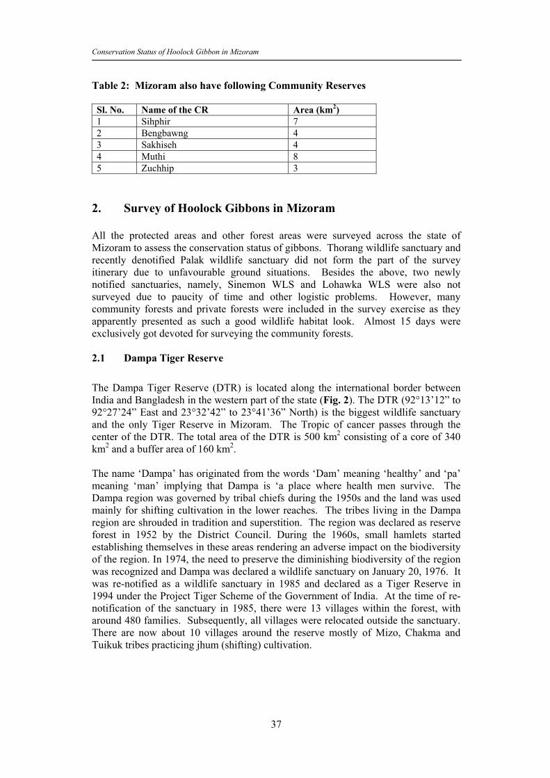
Table 2: Mizoram also have following Community Reserves Sl. No. Name of the CR Area (km2) 1 Sihphir 7 2 Bengbawng 4 3 Sakhiseh 4 4 Muthi 8 5 Zuchhip 3
2. Survey of Hoolock Gibbons in Mizoram All the protected areas and other forest areas were surveyed across the state of Mizoram to assess the conservation status of gibbons. Thorang wildlife sanctuary and recently denotified Palak wildlife sanctuary did not form the part of the survey itinerary due to unfavourable ground situations. Besides the above, two newly notified sanctuaries, namely, Sinemon WLS and Lohawka WLS were also not surveyed due to paucity of time and other logistic problems. However, many community forests and private forests were included in the survey exercise as they apparently presented as such a good wildlife habitat look. Almost 15 days were exclusively got devoted for surveying the community forests. 2.1 Dampa Tiger Reserve
The Dampa Tiger Reserve (DTR) is located along the international border between India and Bangladesh in the western part of the state (Fig. 2). The DTR (92°13’12” to 92°27’24” East and 23°32’42” to 23°41’36” North) is the biggest wildlife sanctuary and the only Tiger Reserve in Mizoram. The Tropic of cancer passes through the center of the DTR. The total area of the DTR is 500 km2 consisting of a core of 340 km2 and a buffer area of 160 km2. The name ‘Dampa’ has originated from the words ‘Dam’ meaning ‘healthy’ and ‘pa’ meaning ‘man’ implying that Dampa is ‘a place where health men survive. The Dampa region was governed by tribal chiefs during the 1950s and the land was used mainly for shifting cultivation in the lower reaches. The tribes living in the Dampa region are shrouded in tradition and superstition. The region was declared as reserve forest in 1952 by the District Council. During the 1960s, small hamlets started establishing themselves in these areas rendering an adverse impact on the biodiversity of the region. In 1974, the need to preserve the diminishing biodiversity of the region was recognized and Dampa was declared a wildlife sanctuary on January 20, 1976. It was re-notified as a wildlife sanctuary in 1985 and declared as a Tiger Reserve in 1994 under the Project Tiger Scheme of the Government of India. At the time of re-notification of the sanctuary in 1985, there were 13 villages within the forest, with around 480 families. Subsequently, all villages were relocated outside the sanctuary. There are now about 10 villages around the reserve mostly of Mizo, Chakma and Tuikuk tribes practicing jhum (shifting) cultivation.

Conservation Status of Hoolock Gibbon in Mizoram
38
Dampa Tiger Reserve, MizoramArea:500 Sq.Km.
Mam
it Fo
rest
Div
isio
n
Bang
lade
sh
Kwarthah Forest Division
Dampa Rangpui
Tulpuibari-II
Tulpuibari-I W.PhailengTo Aizawl (1
00 Km)
Trirei
Lallen
ChhippuiTlang
Saling Lui
1084
1050
Khaw
thla
nglu
i Pui
Persang
Tlang
DTR Boundary
Buffer Area
BRTF Metelled Road
River
Village
Legend
Fig. 2: Map of Dampa Tiger Reserve
Topography and Climate The area comprises fully of steep precipitous hills, deep valley jungle streams and rippling rivulets with the average altitude ranging from 200 to 1000m. The highest point is Chhawrpialtlang with an altitude of 1021m. The other peaks are Dampatlang (869m) and Pathluilunglengtlang (780m). The DTR is drained by Karnaphuli or Khawthlang Tuipui also called the Sazalui or the Tulianpui river towards the west and Teirei River towards the east and its tributaries, Keisalam, Seling and Aivapui. There are extensive flatlands along the rivers, drained by numerous nullahs, especially in the lower reaches.

Conservation Status of Hoolock Gibbon in Mizoram
39
Climate of this region is pleasant and warm throughout the year with moderate to chilled winter during November to December at higher altitude. Even during summer season, strong winds with chilling sensation prevail at higher altitude. A special feature of the climate here is the occurrence of violent storms during March-April. Heavy storms originating from the North-West sweep over the hills in the entire State. DTR gets an annual rainfall in the range of 2000-25000mm. Heavy rains start in June and continue till September. Winter is from November to February. Dampa is a biodiversity hot-spot with a variety of flora and fauna of Indo-Malayan origin. Vegetation and Flora The Dampa Tiger Reserve consists of tropical evergreen, semi-evergreen, tropical moist deciduous and sub-montane type of vegetation in the Dampatlang and Chhawrpialtlang. The lower reaches consist of deciduous forest whereas natural grassland and evergreen forest are found at higher attitude. The main flora in the lower altitudes consists of vegetation such as Diptercarpus turbinates, D.macrocarpus, Artrocarpus chaplasa, Adina cordifolia, Duabanga sonneratiodes, Chukrasia tabularis, Syzygium cumini and toona ciliata, Bombax ceiba. Bamboo and cane are confined to the lower parts of the forest. Different species of bamboo mainly Melocanna bambusoides, Dendrocalamus hookeri and Bambusa tulda are found in shifting cultivation fallows. The buffer zone is mainly bamboo (mostly Melocanna bambusoides) dominated. Ferns and exotic orchids grow profusely here. Natural grasslands predominate at higher altitudes, with herbs such as the cobra’s saffron. Mesua ferrea with pretty white flowers grow here. Fauna The rich, luxuriant rainforests of DTR support rich faunal elements, such as tiger, leopard, clouded leopard, jungle cat, elephant, gaur, Himalayan black bear, sloth bear, sambar, goral, serow, binturong, wild dog, wild boar, flying squirrel, palla’s squirrel, barking deer, porcupine, Malayan Giant squirrel, pangolin, swamp deer, etc. The reptilian species are also in amazing diversity. Among snakes python and the king cobra are fairly common as well as a range of geckos and lizards. Avifauna is also present in greater diversity with three hornbill species, namely, the Great Hornbill, Wreathed Hornbill and the Oriental pied hornbill. The area is also known to be a home to various species of woodpeckers, including the Great slaty woodpecker, Greater yellownaped woodpecker, Bay woodpecker, Greater Flameback, and Greyfaced Woodpeckar. Besides Black Partridge, Black breasted quail, Jungle Bush-quail and pheasants, three species of Chloropsis found in India are endemic to these fabulous forests. Six species of primates (rhesus macaque, Assamese macaque, capped langur, hoolock gibbon, slow loris and Phayre’s langur) are reported from DTR. 2.1.1 Gibbon survey in DTR A thorough survey was undertaken in DTR in the month of June 2003 for a period of 15 days. The survey covered areas under Teirei Range and Phuldungsei Range and focused on the potential habitats of gibbons. The line transect method was followed

Conservation Status of Hoolock Gibbon in Mizoram
40
and groups were counted on the basis of direct sighting and through recording of songs. Secondary information was also collected from villagers and the forest staff. Floristic survey was also carried out for every 500m distance on a plot of 10m radius along the transect to ascertain the qualitative and quantitative features of the habitat. • A total of 31.3 km2 area was surveyed using 12 distinct transects of about 69 km
length across the entire DTR (Table 3).
Table 3: Name and length of the transects and total area surveyed in DTR Sl. No.
Name of the Transezct Transect length
(Kms.)
Area surveyed
(Km2)
1 Teirei IB to Tuichar Cave 8 2.5
2 Tuichar cave to Chhawrpialtlang 7 3.5
3. Tuichar cave to the Tuichar lui 5 2.5
4. Tuichar cave to Tuilutkawn 11 3.5
5. Tuilutkawn to Dampa Rengpui 7 4.2
6. Dampa Rengpui – Teirei via Dampatlang 10 4.2
7. Phuldungsei to Thuruk lui Kawang 4.2 4
8 Thuruk lui Kawang to Thuruk lui 4 2
9. Thuruk lui to Lizawn area 2.5 0.5
10. Lizawn area camp II 4 1.25
11. Camp II to Thaepalungka lui 2.5 1
12. Thaepalungka lui to Phulubian village 4.2 2.2
TOTAL 69.4 31.3
• A total of 10 groups were located, of which 2 groups were actually sighted, the
presence of 2 groups was recorded based on the personal communication of the researcher with the local people and local forest staffs, and remaining 6 gibbons groups were identified through their songs (Table 4).

Conservation Status of Hoolock Gibbon in Mizoram
41
Table 4: Hoolock Gibbon Group from DTR Locality No. of
Groups
Total population
(age and sex)
Mode GPS Reading
Along the Tuichar 4km
from Tuichar Cave
1 3(AM-1/AF-1/INF-1) Sightin
g
N23°40’16.7”
E092°24’00.1”
Chhawrpialtlang (from
Tuicharlui)
1 - Song N23°39’22.4”
E092°24’38.6”
Near Tuichar cave 1 3(AM-1/AF-1/Jur-1) Sightin
g
N23°40’19.3”
E092°25’27.1”
Chhawrpialtlang (from
Tuicharcave)
1 - Song N23°39’53.4”
E092°25’06.7”
Chhawrpialtlang (from
Tuicharcave)
1 - Song N23°39’59.9”
E092°24’47.4”
Sesi 1 - Song N23°42’24.2”
E092°24’26.6”
Pathluilunglengtlang 1 - Song N23°41’57.2”
E092°24’29.7”
Lizawn 1 - song N23°32’22.2”
E092°22’38.4”
Area between saipui lui
and Rawthla lui
1 - PC Did not record
Area between Rawthla
lui and Sai lui
1 - PC Did not record
TOTAL 10 06(2 AM, 2AF, 1INF, 1JUV)
PC= personal communication
• A total of 6 individuals were counted in two groups. The age-sex composition of these 2 groups consisted of 2 adult males, 2 adult females and 1 each juvenile and infant.
• Tuichar cave and Chhawrpialtlang areas have good primate populations.
Hoolock may be present in good numbers in Chhawrpialtlang area as this is having excellent forest cover.

Conservation Status of Hoolock Gibbon in Mizoram
42
Fig. 3 Handsketch of Dampa TR showing locations of different groups • The area between Tuilut to Dampa-Rengpui is dominated and extensively used
for jhuming. Small forest patches are seen but no reporting of gibbons in these patches (Fig. 4).

Conservation Status of Hoolock Gibbon in Mizoram
43
Fig. 4 Hand sketch of Dampa TR showing survey locations of gibbon groups • Other primates seen were capped langur (one group each at Tuichar and
Pathlewitlang tower), Phayre’s langur (1 group in Tuichar cave), rhesus macaque (one group each in Tuichar cave and Paptaltang tower.
Fig. 5: Hand sketch of Dampa TR showing survey locations of gibbon groups
Conservation Status of Hoolock Gibbon in Mizoram
44
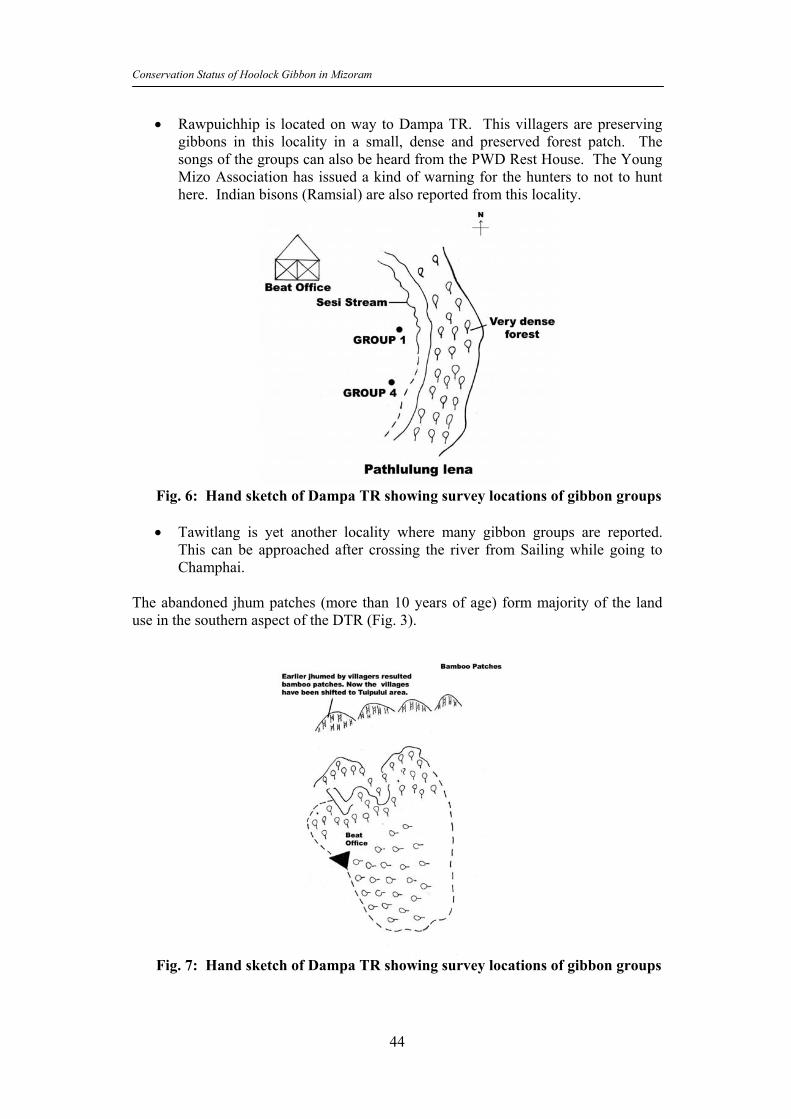
• Rawpuichhip is located on way to Dampa TR. This villagers are preserving gibbons in this locality in a small, dense and preserved forest patch. The songs of the groups can also be heard from the PWD Rest House. The Young Mizo Association has issued a kind of warning for the hunters to not to hunt here. Indian bisons (Ramsial) are also reported from this locality.
Fig. 6: Hand sketch of Dampa TR showing survey locations of gibbon groups • Tawitlang is yet another locality where many gibbon groups are reported.
This can be approached after crossing the river from Sailing while going to Champhai.
The abandoned jhum patches (more than 10 years of age) form majority of the land use in the southern aspect of the DTR (Fig. 3).
Fig. 7: Hand sketch of Dampa TR showing survey locations of gibbon groups

Conservation Status of Hoolock Gibbon in Mizoram
45
Almost equally dense are the patches where the jhum was practiced between 5 to 10 years ago and are those are now lying fallow. There are few patches of evergreen and semi-evergreen forest patches in and around Chhawwrpialtlang and Tuichar Cave. The only two sightings of gibbons in DTR is from Tuichar area. While the gibbon group located at 4 km away from Tuichar cave was reported from the evergreen forests, the other sighted group was found in the abandoned jhum patch of more than 10 years. It suggests that the abandoned jhum patches are still of some use provided further degradation is completely checked. The areas (degraded shown with red color) which have been severely eroded due to heavy biotic pressure were not found having any sign of gibbons, although very near to these areas the gibbons were recorded. All the patches of evergreen and semi-evergreen forests surrounded by abandoned jhum patches of more than 10 years could be the potential areas to support gibbon populations. Attempts are to be made to stop further encroachment in the areas following jhum cultivation and all those fallow jhum areas which were jhumed between 5-10 years should be reclaimed. The tiger reserves holds lots of promises to be able to support large viable population of gibbons as it is ably supported by neighbouring forest rich areas of Tripura and Bangladesh. Few patches of degraded forests could be the cause of concern for the management, but these areas can be reclaimed as these are not present in large numbers and proximate some of the dense forest areas. These areas, after proper reclamation, could be used to provide benefits to the local human populations for their needs on natural resources.
Fig 8: Locations of Hoolock gibbon sightings in Dampa TR with respect to the vegetation types.

Conservation Status of Hoolock Gibbon in Mizoram
46
2.1.2 Vegetation Survey in Dampa Tiger Reserve A total of 61 plots of 10 m radius were surveyed across 12 different transects (traversing 69 km. covering a total of 31 km2 area) in the following 6 areas in DTR:
Name of the Area Number of plots Thunk Lui 07 Rengrui 14 Tuichar Cave 21 Chawrpial Tlang 08 Damptlang 06 Tenei 05 Total 61
The total number of plant species encountered in these plots was 31. The number of plant species in these plots ranged from 1 to 11. In most plots (15, 24.6%), the number of species was only 1 and only in 3 plots, a total of 11 species were noted. In 21 plots (34.4%), the number of species varied from 2 to 3 only. Motak bamboo, Ngiau, Thing-ser-ling, Khiang, Jathu, and Thing-hang were the dominant species in the surveyed plots. Although the number of trees in these plots ranged from 1 to 23, yet, majority of plots (12, 19.7%) were having only 1 tree, followed by 8 plots (13.1%) with 18 trees. The numbers of trees from 2 to 23 were noted only in 2 to 4 plots. The canopy cover in 34 plots (61%) was between medium (25-50%) to very dense (75-100%). The canopy continuity in 31 plots (56%) was also between medium (25-50%) to very dense (75-100%). The plots were very poor in herb concentration as only 18% plots were with medium to very dense herb growth and majority (82%) were either with no herb growth or very poor herb growth (less than 25%). Shrubs were even more poor in their growth as only about 5% of the plots were supporting medium to very dense shrub growth, while almost 95% of the plots either had no shrub growth or very poor (below 25%). Most plots (36, 59%) were with natural forest cover followed by 19 plots (31%) with secondary growth vegetation following shifting cultivation. The remaining plots were supporting either the plantations, a mixture of plantations and natural forests, and grasslands. No human disturbance in form of cut stumps was noted in these plots. Other types of biotic pressures including the grazing by livestock were also not recorded from most plots (58, 95%). No current shifting cultivation area was noted in surveyed plots. Fragmentation was also not recorded inside any of the surveyed plots. Among other animals, only rhesus macaques were encountered as direct sightings from these plots. However, indirect signs such as pug/hoof marks, claw scratch marks, feeding signs and burrows were also noted in these areas which confirmed the presence of sambar, bear, Phayre’s langur and porcupine in these plots. Going by the vegetation density, canopy cover, canopy continuity, and scale of biotic disturbance, almost 34 plots can be attributed the status as Potential gibbon habitat in

Conservation Status of Hoolock Gibbon in Mizoram
47
this area. Of these, at least 12 plots having good population of other wildlife species could be the most potential sites. These potential areas must be surveyed thoroughly for presence of gibbons and suitable mechanisms need be developed to enhance the habitat quality. 2.2 Ngengpui Wildlife Sanctuary The Ngengpui WLS is situated in South-Western Mizoram (Fig 9). It is close to Indo-Myanmar and Indo-Bangladesh border. The total area of the sanctuary is 110 km2 and ranges in altitude from 200 m to 1200 m. Major wild fauna are tiger, clouded leopard, elephant, gaur, barking deer, sambar, wild boar, gibbon, rhesus macaque, capped langur, common langur, etc.
Ngengpui Wildlife Sanctuary
Boundary
BRTF Road
River & Streams
Foot Path
Watch Tower
Water Hole
Village
Natural Pond
R.Vanhne
Paithar
Rulkul
Khangpui Lui
Paw
izaw
h Lu
i
Saik
ah L
ui
Tuip
hal L
ui
NgengpuiKhawmawi
Kawrawing
Duty post
Diphal Lui
Sialphei LuiHmunnuam
Diltang
Bungtlang
Zawhlet Lui
Kawrthindeng
Saizawh Hm
awng
awn
Lui
Nge
ngpu
i Riv
er
Legends
N
S
EW
Area: 110 Sq.Km.
Fig. 9: Hoolock gibbons in and around Ngengpui Wildlife Sanctuary

Conservation Status of Hoolock Gibbon in Mizoram
48
2.2.1 Gibbon Survey in Ngengpui WLS A thorough survey was undertaken in Ngengpui WLS or a period of about 10 days. The survey covered areas under Kailui, Kawrthindeng, Serva lui, Mampui etc. villages outside the WLS and also the areas (Diphal, Pawizah) inside the sanctuary. The line transect method was followed and groups were counted on the basis of direct sighting and through recording of songs. Secondary information was also collected from villagers and the forest staff. Floristic survey was also carried out for every 500m distance on a plot of 10m radius along transects to ascertain the qualitative and quantitative features of the habitat. • A total of 337 km2 area was surveyed using 7 distinct transects of about 29 km
length across the entire sanctuary (Table 5). Table 5: Number of gibbon groups in different localities in Ngengpi Wildlife Sanctuary
No. Locality Mode Group No.
GPS
1 Near Kailui, Kawrthindeng villages (outside WLS
PC 1 221819.3N 924813.9E
2 Between Serva Lui and Zawng Lui Kawrthindeng village (outside WLS)
PC 1 221740.4N 924821.7E
3 Hmeithaitlang locality inside Ngengpui RF Song 1 223201.1N 924007.8E
4 Diphal area (inside WLS) PC 1 222716.4N 924645.7E
5 Between Sialphei lui and Diphal lui (inside WLS)
PC 1 222608.7N 924711.4E
6 Pawizah area (inside WLS) PC 1 222602.3N 924858.5E
7 Pawizah area in between Ngengpui river and Pawizah lui (inside WLS)
Songl 1 222634.5N 924805.5E
8 Selekham locality near Mampui village (outside WLS)
PC 1 -
9 Vamamurkham locality near Mampui village (outside WLS)
PC 1 -
10 Mampui village forest (outside WLS) PC 1 - TOTAL 10
PC = Personal Communication
• A total of 10 groups were recorded from this sanctuary. Of the total 10 groups recorded, 8 groups were recorded based on the personal communication and 2 groups were ascertained based on the songs heard from the groups.
• A total of 4 groups were found inside the sanctuary while the remaining 6 were found outside the protected areas. Of these 6 groups located outside the sanctuary, 5 were present in the village forests and one was found just adjacent to the sanctuary.

Conservation Status of Hoolock Gibbon in Mizoram
49
• The local person (Zokima) informed that he had sighted a group of gibbon (1AM, 1AF) from the locality between Serva Lui and Zawng Lui. At this time, even the song could not be heard.
• It was reported that earlier from this locality (Serva Lui and Zawng Lui) there were many gibbon groups. But due to unrestrained hunting by Bungtlang, Lawngtlai, who killed both gibbons and other animals in large numbers, the population has drastically reduced.
• Hunting and jhuming are two main reasons for decline in the gibbon population.
• About 10 groups of stump-tailed macaques are reported from here. These destry vegetable in the jhum fields (pumpkin, cucumber, til, jhum rice, etc.).
• Semi-evergreen forest patches dot this area with Dipterocarpus as dominant tree species. The forests are more or less contiguous only at the lower ridges and in between jhum fields. Bamboo patches are also seen interspersed with these forest patches. Mikenia scandans is the main weed species all around.
• The transect route between Zawhlet Lui to Kawrthingeng is about 8 km long. All along theroute ony jhum fields were found along with small streams which together form Kawrthindeng river which ultimately join Kolodyne river. The fragmented and isolated patches of forests are present but these are not suitable as gibbon habitat. The enquiries with the local people also confirm that gibbons are neither seen nor heard here. Lots of animal traps were found all along the route. Bamboo is occupying all fallow land. This area has been extensively used for jhuming in the past and is still under use.
Fig. 10: Handsketch of survey area in Ngengpui WLS showing
gibbon groups

Conservation Status of Hoolock Gibbon in Mizoram
50
• Survey from Ngengpui IB and Chawkidar hut confirmed a call from Ngengpui
reserve forest also called riparian reserve forest. • Survey from Ngengpui RH to Khang-pui-lui was undertaken to proceed to
Pawizawh where gibbons are reported. The teak plantations, small forest patches, jhum fields and jhum huts line up the entire route of about 8 km. Jhum fields were having the harvestable rice crop. Hornbills, tree pie, bulbul, crow pheasants were sighted. A total of about 28 km2 was surveyed.
• Northeastern part of the sanctuary is extensively jhumed. This part is encroached by the people of Ngengpui village, claiming it to be village council land, while the forest department claims it to be government land. About 40 families of this village cultivate about 45 ha land for jhum every year. Before declaration of the sanctuary this area was extensively jhumed. But after the declaration of sanctuary, jhuming stopped for few years except on old fallow lands. But for last 3 years or so, it has started again. The jhumias are able to decide the fertility of the soil by seeing the colour of the bamboo leaves. If the color of the bamboo leaves is lush green, the soil quality is good and if the colour is pale yellow, the soil quality is poor. The jhumias also maintain poultry and piggery, which subsist on the left over food thrown down from the machang type of jhum hut.
• Secondary information from the local jhumias revealed presence of gibbons in Pawizah and Diphal areas.
• The area between Lawntlai and Saiha is full of jhum fields for its entirelengthof 1 km. Most of these area abandoned and interspersed with small forest patches. Given the habitat condition, presence of gibbons is doubtful.
• The 2 km long route between Saiha and Sangau has 6 villages and all practicing extensive jhum. There are hardly any forest patches except at the international border with Myanmar where there are dense and continuous patches of forests. This is a potential gibbon habitat.
Fig. 11: Handsketch of survey area in Ngengpui WLS showing gibbon
groups
Conservation Status of Hoolock Gibbon in Mizoram
51
• The area between the Kawrthindeng village and Kolodyne river had a vast tract of land covered primarily with bamboo thickets and jhum fields. Not a single monkey or langur was seen in this area. It could be due to the people from Bungtlang area, who are residing in this area (some makeshift huts were found inside the sanctuary and also people were seen engaged in illegal fishing) and are expert hunter.
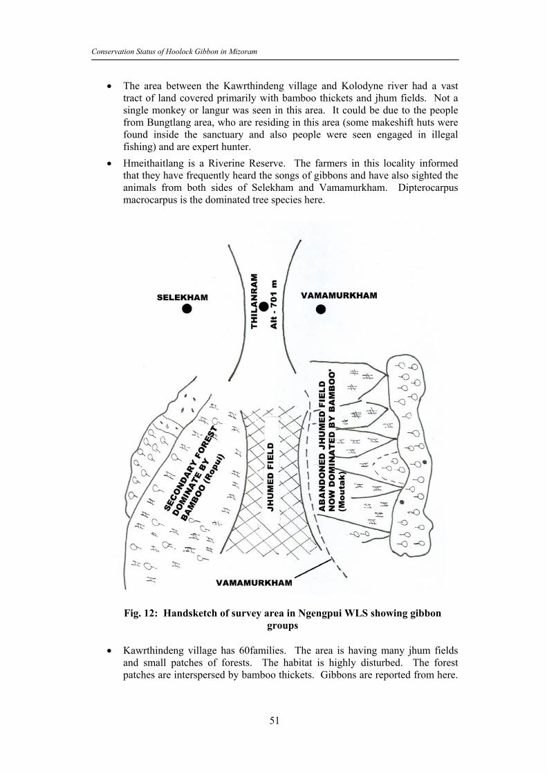
• Hmeithaitlang is a Riverine Reserve. The farmers in this locality informed that they have frequently heard the songs of gibbons and have also sighted the animals from both sides of Selekham and Vamamurkham. Dipterocarpus macrocarpus is the dominated tree species here.
Fig. 12: Handsketch of survey area in Ngengpui WLS showing gibbon groups
• Kawrthindeng village has 60families. The area is having many jhum fields
and small patches of forests. The habitat is highly disturbed. The forest patches are interspersed by bamboo thickets. Gibbons are reported from here.

Conservation Status of Hoolock Gibbon in Mizoram
52
Stump-tailed macaques are also reported from this area who reportedly damage the pumpkin crop inside the jhum fields.
Fig 13: Locations of Hoolock gibbon sightings in Ngengpui WLS with respect to
the vegetation types Most of the gibbon reporting in the Ngengpui sanctuary is from Moist deciduous forests that are of shifting cultivation origin. The reporting of gibbons outside the sanctuary were from abandoned jhum fields. Similar to Dampa TR, the major cause of concern with regard to gibbon conservation here too is related with the jhum cultivation and abandoned jhum fields. Even the village forests are now degraded heavily due to their over exploitation for different forest resources. As is seen above figure, there are very few patches left with evergreen and semi-evergreen forest patches. Basically, jhuming is converting all these dense forest patches into secondary (moist and dry deciduous) forests. 2.2.2 Vegetation Survey in Ngengpui Wildlife Sanctuary A total of 29 plots of 10 m radius were surveyed across 7 different transects in and around the Ngengpui WLS. Following areas were surveyed in and around the sanctuary:
Name of the Area Number of plots Sialphei Lui 08 Ngengpui River 04 Sialphei lui-2 17 Total 29

Conservation Status of Hoolock Gibbon in Mizoram
53
The number of tree species encountered in these plots ranged only from 1 to 6 and in 11 plots (80%) the number of species was 4. Only 6 (21%) plots were having 5 and above species in a given plot. A total of only 67 trees were counted from the surveyed plots. The number of trees ranged between 1 and 12 in different plots surveyed. In most plots (26, 90%), the number of trees was more than 5 in a given surveyed plot and only in 3 (10%) plots the number of trees was less than 5. A total of 10 tree species were dominant across different surveyed plots. Of these, the major dominant species were Motak bamboo, Think Vawkpul, Korthing Dang, Thing-Sen, Char and Tatkawng. The canopy cover in majority of the plots (24, 83%) was between medium (25-50%) to very dense (75-100%). Only in 5 (17%) plots the canopy cover was poor (1-25%). Similarly, the canopy contiguity was also medium (25-50%) to very dense (75-100%) in most (21, 73%) of the total 29 surveyed plots. In 8 (27%) plots, however, the canopy contiguity was poor (below 25%). A total of 18 (62%) surveyed plots were rich in herb concentration that ranged between medium (25-50%) to very high (75-100%). The remaining 11 (38%) plots were however very poor in presence of herb growth (1025%). However, the growth of shrubs was poor (1-25%) in most of the plots (21, 72%) and only in 8 (28%) of the surveyed plots the shrub growth ranged between medium (25-50%) to very dense (75-100%). The area was having mostly the natural forests (23 plots, 79%) followed by the grasslands (4 plots, 14%). In one plot each the vegetation type was plantations and a mixture of natural forests and plantations. The area was almost free from biotic disturbances, except in few cases of grazing and collection of forest products by the local people. There were not any current shifting cultivation plots across the surveyed areas and similarly fragmentation was also not recorded inside any of the surveyed plots. No direct sighting of any other wild animal was made within the surveyed plots. However, indirect signs (call and tracks) of the presence of elephants and sambar were noted from 4 surveyed plots. The vegetation status coupled with the status of canopy cover, canopy continuity, biotic factors, and presence of other wildlife indicate that 24 plots could be termed as Potential gibbon habitat sites. Of these 24 plots, at least 6 plots with dense vegetation and large number of trees and good population of other wildlife species could be the most potential sites. 2.3 Lengteng Wildlife Sanctuary 2.3.1 Introduction to t h e area Name, Location, Constitution and extent The Lengteng Wildlife sanctuary (LWS) located in Champhui District was notified in 1998 covering an area of 60 km2 vide Government of Mizoram No. B.11011/23/89-FST dated 7.9.89. The final notification is yet to be issued by the state government. The Sanctuary is situated about 190 km east of Aizawl,

Conservation Status of Hoolock Gibbon in Mizoram
54
t h e state capital of Mizoram. The sanctuary lies close to the Indo-Myanmar border and ranges in altitude from 400 m to 1900 m above mean sea level. It is adjacent to the Murlen National Park. The hill ranges in the LWS run from north to south direction. Large tracts of relatively undisturbed sub-tropical evergreen/sub-montane forests are present inside the sanctuary. The Lengteng Wildlife Sanctuary is well connected by road from Aizawl to Lamzawl and Ngopa via Kawlkul (Fig. 14).
Pharshi
R. A
ksa
Nauzuarzo Tlang
Highest peak
Bawklui
HG
HG
R. T
uilua
i
HG
Lanzwal
NGOPA
KawlbemHG
Selam
P. Leiva
Dense forest
Nauzuar LuiS
ialkal Tlang
Lengteng Kham
R. Thinkhuang
Bawk Tlang
R. AilianLamlian
Zawngek
Ngpihhih
Dense Mixed Forest
SasawbawkR. Tuimai
Khan Kawn
R. Zamuang
Lungphunlian
R.Dimphai
Rdchehunga
Tualcheng
Pamchung
(2141 m)
Legend
Boundary
River/Stream
Cliffs
Village
Dense Forest
Highest Peak
Lengteng Wildlife SanctuaryArea : 60 Sq Km.
Lui
Fig. 14: Hoolock gibbons in and around Lengteng Wildlife Sanctuary Statement of significance
LWS is significant because of its provmity to the Chin Hill and its richness in both diversity and numbers of wild flora and fauna. However, severe biotic pressures from the adjoining 4 villages in the form of the traditional practices of hunting and jhumming (shifting cultivation) have resulted into huge loss of biodiversity for the last few years. Tiger, leopard, sambar, barking deer, goral were earlier quite common but now their numbers have unfortunately dwindled

Conservation Status of Hoolock Gibbon in Mizoram
55
due to the hunting pressure from the villagers. However, the core area is still rich in many wildlife species that need protection and protection alone. 2.3.2 Physical Features and Attributes: Boundaries The northern boundary is formed from the starting point of Tuiluai river source running north eastern up to the hill top and crosses Diphulmual at the top and meets Pharsihlui. In the east the boundary follows Pharsihlui and crosses Diphulmual thence turn to Southward to meet Hmunphal and proceed to the cliff of Nauzar meet the source of Leiva and follow the source of Lilianlui to meet Tuisalui, which is the meeting point of Dimphailui. In the south-west it follows Tuisalui upstream up to the source and crosses saddle of Khankawn to meet the source of Tuimailui and follows Tuimailui downstream Minpuilui meets Tuimailui. Geology, rock and soil It is characterized by the presence of sedimentary rocks with a light sandy loam soil with a mixture of humus and loamy soil. The rock found on another beds are mostly normal sand stone, clay, silt stone and pebbles. The soil in the hills is usually sufficiently deep, moist, fertile and sandy loam at the proper layer of which are stained with humus. Terrain The terrain is en t i re ly h i l ly except the va l l eys and foothills. The hills slopes are mostly steep to very steep and cut up numerous streams and nallahs. At places it is comprised of steep and undulating high and medium hill ranges intercepted by high cliffs and saddles. Climate Rainfall pattern and distribution and temperature : The LWS falls within the geographical sub-tropic and enjoys sub-tropical climate. The summers are generally warm and wet, but winters are cool and dry. Pre-monsoons rains occur during March -April, whereas regular monsoon commences from June and continues till October. The annual rainfall ranges between 1700 mm to 3900 mm spread over 8 to 10 months. The average temperature varies from 8 – 200 C during winter and 19 – 290 C during summer. Humidity /wind speed: The area is quite humid in summer with low humidity during March and April. The prevailing winds are usually of moderate velocity with occasionally cyclonic storms are experienced during the month of March and April. Water sources : The major water sources of the Sanctuary areas are Leiva lui. Tuiluai Lui, Tuiphal lui and Tuimai lui. Water from these sources also supplied to Lamazwl, Ngopa, Kawlbem and Selam for drinking purposes

Conservation Status of Hoolock Gibbon in Mizoram
56
Habitat attributes, Range of Wildlife Status, distribution Vegetation The biogeographic classification: According to the biogeographic classification, the area comes under the southern part of the Naga-Mizoram mountain region of biotic province 8B, the Assam hills of the North East Indian Zone The Forest type, cover, food for animals and phenology of plants: Floristically, the area has the following plant communities based on Champion and Seth forest type classification:
• Type 8 B/C2 Khasi Sub-Tropical Wet Hill Forest: This type of forest occupies hill area of eastern and central region of the sanctuary from 1000 m to 2000 m. The important tree species belong to the genera Quercus, Schima, Betula, Pyres, Myrica etc.
• Type 9/C2 Assam Sub-Tropical Pine Forest: This type of forest occupies hill
area from 800 m to 1600 m. The middle storey consists of Quercus species, Schima, wallichai, Myrica, Pinus khasia, Rhododendron arboreum, Prunus etc.
Main shrub species are Meara montana, Melastoma malabathricum, Clerodendron viscosum, Hedychium species, etc. Other main species are Chromolama, odorata, Aristacam species, Solanum torvum, Lycianther species, etc. 2.3.3 History of Management and present practices General There was no any Management Plan for Lengteng Wildlife Sanctuary from the very inception of this Sanctuary which was notified during 1998. This Management Plan is the first time effort of bringing the Wildlife Sanctuary under a concrete Scientific Management Plan. At present sanctuary is managed by one R.O. headquarter Lamzawl village, one Forester and four Beat officer under controlling of D.F.O. Wildlife Division, Aizawl. Since sanctuary was declared recently hence development of infrastructure is required for proper management of the sanctuary. Animal The Lengteng WLS is a home to a large number of species like samber, barking deer, serow, goral, porcupine, Malayan giant squirrel, tiger, leopard, clouded leopard, jungle cat, wild dog, Bengal fox, wild boar, Himalayan black bear, etc. There are four species of primates found in the Lengteng WLS, namely, rhesus macaque, Assamese macaque, capped langur and hoolock gibbon. This WLS is also rich in the number of avian fauna.

Conservation Status of Hoolock Gibbon in Mizoram
57
Hunting Hunting is a way of life for the local tribals of Mizoram which is primarily for meat and secondarily for trophies which arc signs of muscularity and valour. An increase in the large numbers of guns in the fringe villages of the LWS has adversely affected the population of wild animals and birds. Poaching and other illegal activities There is no case of poaching in the LWS after area was notified as a sanctuary. But other illegal activities such as collection of fuelwood, small timber, NTFPs are resorted to by the villagers in the buffer areas. Forest fire There is always a threat of forest fires in the LWS due to practices of traditional jhumming by the villagers from the fringe villages. The LWS management has taken up measures for the creation of fire-lines all along the sanctuary boundary and has also facilitated the engagement of fi re fighting squads during fire season to combat the forest fires. The development programme and conservation issues Limited development activities have been taken up by many line departments (Agriculture, Horticulture and District Rural Development Authority, etc.) in the fringe villages of sanctuary. This has facilitated generation of self employment and creation of self sufficiency among the villagers. However, as a result of absence of proper land tenure system and the lack of proper coordination and planning among the different agencies, the results of such measures are far below the expected targets. 2.3.4 Villages outside the P.A. and their Economic status There are 4 tribal villages situated within 5 km radius of the LWS boundary. These villages are Lamzawl, Ngopa, Kawlbem and Selam, all together having a human population of about 4000 individuals. The villagers are traditionally agriculturists and due to the hilly terrains mostly practice jhuming. Of late, the non-traditional jhuming has transformed the primary forests into degraded secondary forests. The main jhum crops are rice, maize, seasonal vegetable, ginger, chilly and sometimes sugarcane, potatoes etc. Mizo and Pait are the major tribal communities in this area, and most of them still prefer to live in thatch roof houses. With marginal jhum lands and low productivity hardly help villagers to earn them a sustenance livelihood. The jhum is supplemented with milk cattle, pigs and domestic fowl as a source of food and income.

Conservation Status of Hoolock Gibbon in Mizoram
58
Presence of these 4 villages in the fringe of the LWS makes it almost obligatory on the part of the management to involve their livelihood and other social and cultural factors into the planning processes for the LWS. 2.3.5 Gibbon Survey in Lengteng Wildlife Sanctuary and Adjecent Villages An extensive survey of hoolock gibbon was carried- out in Lengteng covering both sanctuary and the area out side the sanctuary. The survey was carried out in the month of November to December for a period of 8 days both on foot and by vehicle covering an area of about 73.5 Sq. Kilometers (Table 6). Table 6: Area surveyed in and around Lengteng Wildlife Sanctuary S. No.
Transect Route (distance in Km) Mode Area (km2)
1 Rabung to Ngopa (42) Vehicle 20 2 Lamzawl junction to Lamzawl (7) Foot 12 3 Lamzawl village to Parzao (3) Foot 0.5 4 Lamzawl village to Khumzawl (5) Foot 1 5 Ngopa to Kawlbem village (40) Vehicle 40 TOTAL (97 km) 73.5
Since the terrain was inaccessible due to the presence of steep cliffs and lack of patrolling paths, data collections were done mainly with the help of secondary information. Though the call of gibbon was also taken into account to know the existence of gibbon in an around WLS, sighting was very difficult because of impassable terrain. The findings are shown below in Table 7: Table 7: Number of gibbon groups in different localities in Lengteng Wildlife Sanctuary S.No
Locality Status Group No
Mode GPS Reading
1 Khawte (below the cliffs on eastern aspect of WLS near Lamzawl village).
WLS 1 Song N23°48'37.33" E093°13'26.3"
2 Thingkhaung Muai (below the cliffs on the eastern aspect of WLS near Lamzawl village).
WLS 1 Song N23°46'53.7" E093°12'38.7"
3 Vaidehi (below the cliffs on the eastern aspect of WLS near Lamzawl village).
WLS 1 Song N23°47'07.1" E093°12'23.1"
4 Khumzawl (inhabited in secondary jhum forest adjacent to WLS and Tuiphal River)
Outside WLS
1 PC N23°47'12.4" E093°10'37.1"

Conservation Status of Hoolock Gibbon in Mizoram
59
S.No
Locality Status Group No
Mode GPS Reading
5 Parzau (below the cliffs on the eastern aspect of WLS near Lamzawl village)
WLS 1 PC N23°49'05.6" E093°14'17.3"
6 Tuingo River (in Kawlbem community forest near Kawlbem village)
OUTSI DE WLS
1 PC N23°52'32.4" E093°17'30.8"
7 Sathar Kham (in Kawlbem community forest near Kawlbem village)
Outside WLS
1 PC N23°53'02.7" E093°19'37.5"
8 Thauel (in Kawlbem community forest near Kawlbem village)
Oustside WLS
1 PC N23°53'38.0" E093°19'11.9"
9 Khuaili Dung (in Kawlbem community forest near Kawlbem village)
1 PC N23°51'47.4" E 093°19'39.4"
10 Nauzuar Kham (western aspect of WLS near Kawlbem village having dense forest)
Outside WLS
I PC N23°50'47.6" E093°16'59.0"
11 Tualbung Ram (outside WLS in degraded secondary forest. Call frequently heard from here)
Outside WLS
1 PC N23°53'53.7" E093°l6'07.8"
12 In between Minpui And Tuila Lui (northern tip of WLS. Call can be heard even from Ngopa. Excellent forest).
WLS 1 Song N23°51'52.7" E093°15'03.8"
TOTAL 12 GROUPS PC = Personal communication The gibbon populations also exist outside the sanctuary jurisdiction in some part of the community forests being preserved and protected by the villagers themselves. The habitat quality in those areas of community forests is ideally suitable as gibbon habitat. The only problem is the size of these community forest patches which happen to be very small and the continuity is interrupted by the presence of jhum fields. One such locality was Kawlben village, located just adjacent to the Myanmar border. The reserved forests in this village harbour gibbon groups. Presence of international border calls for coordinated efforts on the part of Myanmar and India to provide viable corridors for outflux and influx of gibbon populations across the border. Moreover, provisions of community and conservation reserves as per the amended WLPA, 2002 can also be used to provide effective continuity and corridors between adjacent community and reserved forests.

Conservation Status of Hoolock Gibbon in Mizoram
60
• From Ngopa northern tip of the sanctuary can be seen and the hill facing western side of the sanctuary is called Nauzuar Tlang. The vegetation is very good. The forest staffs confirmed that the call of the gibbons can be heard quite often from the sides of the said hill. That side of the hill is visible from the Ngopa forest rest house (235242.2N-931300.4E, 1180m), located at an aerial distance of about 3 km.
Fig. 15: Hand sketch of Lengteng WLS showing gibbon survey locatios
• The forest staff (Shri Chhanhima, Forester I, Ngopa Forest Range and Shri Lalrinliana, Guard) also confirmed that many gibbon groups can be sighted and heard from Lamzwal village.

Conservation Status of Hoolock Gibbon in Mizoram
61
Fig. 16: Hand sketch of survey areas in and around Lengteng WLS
• The area between Lamzwal and Ngopa is full of jhum cultivation with sporadinc patches of dense forest. There are banana plantations also around this area.
Fig. 17: Hand sketch of survey areas in and around Lengteng WLS showing vegetation and gibbon potential sites
• From Lamzwal one can see the western middle part of the sanctuary having
steep cliffs and dense forest patches beneath. This is the western boundary of the sanctuary where the vegetation is very dense. Two gibbon groups are

Conservation Status of Hoolock Gibbon in Mizoram
62
reported from this area whose songs can be heard form the village too. The villagers also confirmed the presence of these gibbon groups from these two localities (Parzau and Thingkuank).
• The call atThingkhuang was first heard at 0935 am which lasted for about 35 minutes.
• The Khumzawl area is outside sanctuary which is full of secondary forests after jhum cultivation.
Fig. 18: Hand sketch of survey areas in and around Lengteng WLS showing vegetation and gibbon potential sites
• The area between Ngopa and Junction point is all degraded forest with jhum
fields. No gibbon is reported from this area. • The area between Junction point and Lamzawl is also full of bamboo thickets
and jhum fields. There is no possibility of gibbons present here.
During the survey, some part of the LWS and 3 villages were covered. This entire survey area had habitat suitable for the gibbons. It was discovered that the gibbon groups are located at the edge of the sanctuary in the primary forests as well as in the secondary forests. The presence of gibbons in the secondary forests was a bit unusal. Generally, one would not expect gibbons from such degraded and poor quality habitat following jhuming. But for one group of gibbon, all other groups were heard or reported from secondary forests, which were put to jhuming practices till recent past. The group whose call was heard near the Lamzawl village was located in between the river and very steep cliffs. The habitat was not at all suitable for their presence there. The northern part of the sanctuary is having relatively undisturbed forests which

Conservation Status of Hoolock Gibbon in Mizoram
63
harbour some groups of gibbon and their call can be heard from Ngopa area which is about 5 km (aerial distance) from the call site (Fig. 19).
Fig 19: Locations of Hoolock gibbon sightings in Lengteng WLS with respect to
the vegetation types 2.3.6 Vegetation Survey in Lengteng Wildlife Sanctuary A total of 12 plots of 10 m radius were surveyed across 5 different transects (traversing 97 km.area). Of these, 2 transects of 82 km. were covered by vehicle, and 3 transects were walked over 15 km. in and around the Lengteng WLS. The following areas were covered during the survey: Name of the Area Number of plots Khawte Village 04 Thaepulungka Lui 08 Total 12
The area was very rich in tree species as the number of tree species encountered in these plots ranged from 4 to 14 and in as many as 9 (75%) plots the number of tree species was between 4 and 8. A total of 103 trees were counted from the surveyed plots and their number ranged between 2 and 26 in different surveyed plots. Except one plot, all the remaining 11 plots were having 6 or more trees. A total of 8 tree species were dominant across different surveyed plots. Of these, the major dominant species were Motak bamboo, Khiang, Thing-dol and Thing-sen.

Conservation Status of Hoolock Gibbon in Mizoram
64
The canopy covers in all the surveyed plots was between medium (25-50%) to very dense (75-100%). Similarly, the canopy continuity was also between medium (25-50%) to very dense (75-100%) in all the plots. Most plots (7, 59%) were poor in herb growth (1-25%) and only 5 plots (41%) were having herb growth ranging between medium (25-50%) to very dense (75-100%) growth. Almost similar trend was noted in case of the growth of shrubs in the surveyed plots with 7 plots with poor and remaining 5 plots with medium to very dense growth of shrubs. Most plots (11, 91%) were with natural forest cover and only one plot was having a mixture of plantations and natural forests. All the surveyed plots were found to be free from human disturbance in form of cut stumps, grazing and other kinds of biotic disturbances. By and large, this area was free from human disturbances. The presence of fresh shifting cultivation and fragmentation was also not noted from any surveyed plots. No direct or indirect sightings of any other wild animal were made in any of the surveyed plots. Going by the vegetation density, canopy cover, canopy continuity, and scale of biotic disturbance, almost 9 plots can be attributed the status as Potential gibbon habitat in this area. Most of these plots were free from any kind of human disturbance. These potential areas must be surveyed thoroughly for presence of gibbons and suitable mechanisms need be developed to enhance the habitat quality. 2.4 Murlen National Park 2.4.1 Introduction in the area Name, Location, Constitution and extent The Murlen National Park (MNP), located in the Champhai district of Mizoram, was initially notified as a Murlen Wildlife Sanctuary in 1989 covering an area of 50 km2 vide Government of Mizoram No. B.11011/23/89-FST dated 7.9.89. Later in the year 1991, it was upgraded as Murlen National Park (23º32’ - 23º42’ N and 92º13’- 92º27’ E) vide Government of Mizoram No. B.11011/13/84-FST dated 8.7.91 extending over an area of 150 km2. The Park is situated about 245 km east of Aizawl, the state capital of Mizoram. The Park lies close to the Indo-Myanmar border and ranges in altitude from 400-1900 m above mean sea level. The hill ranges in MNP runs from North to South direction. Large tracts of relatively undisturbed sub-tropical evergreen/sub-montane forests are found in MNP. The MNP is well connected by road from Aizawl to Murlen via Champhai and Rabung. Statement of significance Murlen is significant because of its proximity to the Chin hills. The MNP was very rich in wildlife both in its diversity and numbers till the recent past. But, due to high biotic pressure mainly in the form of the traditional practices of hunting and jhuming (shifting cultivation) from the five surrounding villages, the wildlife has suffered an irreparable loss over the last few years. Once very common populations of tiger,

Conservation Status of Hoolock Gibbon in Mizoram
65
leopard, sambar, barking deer, goral have now reduced to almost unviable status. The presence of large numbers of guns with the local people has added to the loss of rich biodiversity in the area. Nevertheless, still fair amount of wildlife diversity is present inside the core area of the park. The park has virgin forest of Chamdur. About 15 species of mammals, 150 species of birds, 35 species of medicinal plants, 2 species of bamboos, and 4 species of orchids have been recorded from the park so far. The important wild animals and birds found in this sanctuary are tiger, leopard, sambar, barking deer, ghoral, serrow, Hume’s bar-tailed pheasant, kaleej pheasant, gibbon, rhesus macaques, wild boars, serow, and goral etc. The park has representatives of tropical semi-evergreen and sub-montane forests, which perform a very important role in the watershed catchment areas managememt. 2.4.2 Physical Feature Attributes Boundaries The northern boundary of MNP starts from the point of large curvation of Pumpet river and runs up to the top of Lungzeptlang. It then follows ridges up to Murlen Thang and till Murlen road below Bear lodge easterly. Then boundary turns North-East till it meets R. Luiphal. In the east the boundary line follows river Tuiphal downstream till it joins a small stream which originates from Ramrikawn of Vapar and Murlen villages. Thereafter the boundary follows the jeepable road till it meets Ramrikawn (Vapara and Ngur) the extreme source of Ramri lui. The southern boundary follows Ramri lui till it meets R. Tuikual, then follows R. Tuikual downstream to join R. Tuipui. In the west the boundary line follows upstream R. Tuipui till it meets R. Pumpet and then follows R. Pumpet upstream to meet the starting point of the large curve of R. Pumpet.
Geology, rock and soil It is characterized by the presence of sedimentary rocks with a light sandy loam soil with a mixture of humus and loamy soil. The rock found on another beds are mostly normal sand stone, clay, silt stone and pebbles. The soil in the hills is usually sufficiently deep, moist, fertile and sandy loam at the proper layer of which are stained with humus. Terrain The terrain is entirely hilly except the valleys and foothills. The hills slopes are mostly steep to very steep and cut up numerous streams and nallahs. At places it is comprised of steep and undulating high and medium hill ranges increpted by high cliffs and saddles. Climate Rainfall pattern and distribution and tmperature: The MNP falls within the geographical sub-tropic and enjoys sub-tropical climate. The summers are generally warm and wet, but winters are cool and dry. Pre-monsoon rains occur during March-

Conservation Status of Hoolock Gibbon in Mizoram
66
April, whereas regular monsoon commences from June and continues till October. The annual rainfall ranges between 1700 mm to 3900 mm spread over 8 to 10 months. The average temperature varies from 8-200 C during winter and 19-290 C during summer. Humidity/wind speed: The area is quite humid in summers with low humidity during March – April. The prevailing winds are usually of moderate velocity with occasionally cyclonic storms are experienced during the month of March and April. Water sources The major water sources of the Park areas are Pumpet lui, Zanthim lui, Tuithing lui, Chemte lui and Tuiphal lui rivers. Water from these sources is also supplied to Rabung village, Vapar village and Champhai town for drinking purposes. Habitat attributes, Range of Wildlife Status, Distribution Vegetation The biogeographic classification: According to the biogeographic classification, the area comes under the southern part of the Naga-Mizoram mountain region on biotic province 8B, the Assam hills of the North East India Zone. The Forest type, cover, food for animals and phenology of plants: Floristically, the area has the following plant communities based on Champion and Seth forest type classification.
• Type8B/C2 Khasi Sub-Tropical Wet Hill Forest: This type of forest occupies hill area of eastern and central region of park from 1000 m to 2000 m. The important tree species consists of from genus Quercus, Achima, Betula, Pyrus, Myrica etc.
• Type 9/C2 Assam Sub-Tropical Pine Forest: This type of forest occupies hill
area from 800 m to 1600 m. The middle storey consists of Quercuss species, Schima wallichi, Myrica spp., Pinus khasia, Thedodenaran arboreum, Prunus species, etc.
Main shrub species are Meara montana, Melastoma malabaricum, Clerodendron viscosum, Hedychium species, etc. Other main species are Chromolama, odorata, Arisacma species, Solarum torvum, Lycianther species, etc. 2.4.3 History of Management and present practices General There was no management plan for MNP from the very inception of this Park, which was notified as a National Park in 1991. During 1991 to 1995 the MNP was looked after by Sub Divisional Forest Officer of the rank of Assistant Conservator of Forests (HQ) with skeleton field staff under the control of Divisional Forest Officer, Wildlife Division, Aizawl.

Conservation Status of Hoolock Gibbon in Mizoram
67
Hunting Hunting is a way of life for the local tribals of Mizoram which is primarily for meat and secondarily for trophies which are signs of muscularity and valour. The increase in the large numbers of guns in the fringe villages of the MNP has drastically reduced the population of wild animals and birds. Poaching & other illegal activities ]There is no case of poaching in the MNP after its notification. However, other illegal activities such as collection of fuel wood, small timber, minor forest products are resorted to by the local villagers from the buffer areas due to population expansion in the fringe villages. Wildlife Protection For effective wildlife management of the MNP, as a participatory approach, a team of special 20 wildlife guards from amongst the labourer were engaged from the fringe villages. Besides this, few regular staff personnel are also posted in the MNP well equipped with the arms and wireless sets. Tourism The Park has not developed sufficient infrastructure for tourism basically due to the fund constraints. Developments of proper tourist zone and tourist facilities are needed in the Park because the Park is considered ideal for bird watching and other animals due to its unique sub-montane forests. Forest fire There is always a threat of forest fire in MNP due to practices of traditional jhumming by villagers in the fringe villages. It can be addressed suitably by the creation of fire lines in the Park boundary and engagement of fire fighting squads during fire season to combat the forest fires. The development programme and conservation issues An evaluation of government and Non-government agency programmes for development: Limited developmental activities have been taken up by the Agriculture, Horticulture and DRD.A departments in the fringe villages of the Park. This has led to the generation of self employment and creation of self sufficiency. However, in absence of a proper land tenure system and lack of proper coordination planning among the different agencies, the requisite results are hardly satisfactory. Moreover, it is also realized of late that the biotic pressure is mounting due to shortage of fuel wood in the community land. A more coordinated and planned development activities are needed to be taken up with the help of other developmental agencies and through eco-development in these fringe villages to reduce pressure in the buffer areas. The zone of influence is through out the length of the MNP.

Conservation Status of Hoolock Gibbon in Mizoram
68
2.4.4 Villages outside PA and their Economic Status A total of 6 tribal villages are located within 5 km radius of MNP. The villages are Murlen, Vapar, Rabung, N. Khawbung, Tualpui and Ngur. Together these villages support a human population of about 6000 individuals. The villagers are traditionally agriculturists. Due to the hilly terrain, jhumming is a way of life leading to the degradation of the primary forests. The main jhum crops are rice, maize, seasonal vegetable, ginger, chilly and sometimes sugarcane, potatoes etc. These villagers mostly belong to Mizo and Pait tribal communities. The villagers depend on forests for both timber and NTFPs including bamboos. Most of the villagers still live in thatch roof houses with only few families able to afford the galvanized iron sheet roofing. The marginal jhum lands do not even earn them a subsistence livelihood. The production is very low due to poor soil nutrients and also due to other biological factors. Few families keep milk cattle which is the only source of protein for them. They also keep pigs and domestic fowl as a source of food. Presence of these 6 villages in the fringe of the MNP makes it almost obligatory on the part of the management to involve their livelihood and other social and cultural factors into the planning processes for the MNP. 2.4.5 Survey of Hoolock Gibbons in Murlen National Park Despite spending 4 days and three nights inside the Murlen National Park (MNP) at Nature’s camp at the centre of the park by the survey party, not a single incidence of gibbon song was recorded. Even the secondary information was very scanty. Physical survey conducted in many areas across the park also did not yield any good results. However, given the vegetation and habitat type inside the park, there is a great possibility of this park having potential gibbon populations. The areas, however, dominated by the species of the genera Quercus, Prunus, Myrica, etc. are not good habitat for gibbons. A thorough survey was undertaken in Ngengpui WLS or a period of about 10 days. The survey covered areas under Kailui, Kawrthindeng, Serva lui, Mampui etc. villages outside the WLS and also the areas (Diphal, Pawizah) inside the sanctuary. The line transect method was followed and groups were counted on the basis of direct sighting and through recording of songs. Secondary information was also collected from villagers and the forest staff. Floristic survey was also carried out for every 500m distance on a plot of 10m radius along transects to ascertain the qualitative and quantitative features of the habitat.
• A total of 227 km2 area was surveyed using 6 distinct transects of about 29 km length across the entire sanctuary (Table 8).

Conservation Status of Hoolock Gibbon in Mizoram
69
Table 8: Areas Surveyed in and around MNP
S.No. Transect Mode Area (km2) 1 Rabung to Murlenvilage via Champhai
and Vapar (BRTF road) Vehicle 180
2 Murlen to Nature’s Camp (inside MNP) Foot 6 3 Nature’s camp to Chamte (inside MNP) Foot 8 4 Nature’ camp to Kawhituang (inside
MNP) Foot 6
5 Nature’s camp to Murlen village via Chamdur area (inside MNP)
Foot 13
6 Murlen village to Rabung village (inside MNP)
Foot 13
TOTAL 226
• A total of 4 groups were recorded from this park. All the 4 groups were recorded based on the personal communication.
• A total of 2 groups were found inside the national park and the remaining two were located from the village forests and one was found just adjacent to the sanctuary.
Table 9: Distribution of Hoolock Gibbon in and around Murlen National Park
S.No. Locality Source No. of Groups 1 Phunchawng area which is a hill just
adjacent to MNP PC 1
2 Belzael locality near riverside of Tuiphai PC 1 3 Vomluak below Tlangsam and Vaportlang
inside the MNP PC 1
4 Chai Lui aea near Chamdur area inside the MNP
PC 1
PC = Personal communication
• In transect between Nature Camp and Murlen village, many snares were noted for barking deer inside the forest.
• The habitat around Kawhithuang, Chamte, Khamsen, Kelkikawn, etc. is not suitable for gibbons due to steep slopes and lack of fruit trees. The area is having cliffs and sub-montane vegetation. This area is suited for serow and goral.
• The field assistant had heard call of gibbon last year from Vomluak. 2.4.6 Vegetation Survey in Murlen National Park A total of 27 plots of 10 m radius were surveyed across 6 different transects covering a total of 227 km2 area. Of these, one transect was covered by vehicle (180 km2), while other 5 transects were covered on foot. The following areas were covered during these survey plots:

Conservation Status of Hoolock Gibbon in Mizoram
70
Name of the Area Number of plots Rabung to Vapar 07 Camp to Murlen Village 12 Camp to Chamte 05 Murlen to Rabung 03 TOTAL 27
The number of plant species in these plots ranged from 2 to 9. In most plots (15, 56%), the number of species was 5 or more ( up to 9) and in remaining 12 plots (44%) the number of tree species was less than 5. Tiar pui was the most dominant species and was present in 5 (19%) plots. Other dominant species were Hnum (4 plots), Chakle Per, Hnakkar, and Thal in 3 plots each. All the plots were very dense in tree growth and a total of 150 trees were counted in all the 27 plots. Except in 1 (4%) plot where the number of trees was les than 5, in rest of the plots (26, 96%), the number of trees was more than 5 and up to 21 in a given one plot. Most of the plots (21, 78%) were with medium (25-50%) to very dense (75-100%) canopy cover. Only 6 plots (22%) were with light canopy cover (1-25%). A total of 15 plots (56%) were with dense (50-75%) canopy cover. Similarly, the canopy continuity in 21 plots (78%) was also between medium (25-50%) to very dense (75-100%). Only 6 plots (22%) were with light canopy cover (1-25%). A total of 13 (48%) plots were with very dense (75-100%) canopy contiguity. Most plots (21, 78%) were having nil (0%) to very poor (1-25%) herb concentration and only 6 (22%) plots were with medium (25-50%) to dense (50-75%) herb growth. There was no plot with very dense herb growth. Similar status of shrubs was noted in the plots. Most plots (21, 78%) were having nil (0%) to very poor (1-25%) shrub concentration and only 6 (22%) plots were with medium (25-50%) to dense (50-75%) shrub growth. There was no plot with very dense shrub growth. The area was having mostly the natural forests (23, 85% plots) and few plots (4, 15% plots) were having secondary forest vegetation following shifting cultivation. The entire area was found free from any kind of biotic disturbance. No case of cut stumps, collection of firewood and other forest products, grazing, shifting cultivation, and fragmentation was noted in any of the plots during survey. Direct sightings of stump tailed macaque and pig-tailed macaques were made during survey in 2 plots each. The bark of barking deer was heard as indirect sign of presence of barking deer in 3 plots. Going by the vegetation density, canopy cover, canopy continuity, and scale of biotic disturbance, almost 26 plots can be attributed the status as Potential gibbon habitat in this area. Of these, at least 15 plots having good number of tree species and trees, dense canopy cover and continuity without much of biotic disturbance including presence of other wildlife species could be the most potential sites. These potential areas must be surveyed thoroughly for presence of gibbons and suitable mechanisms need be developed to enhance the habitat quality.

Conservation Status of Hoolock Gibbon in Mizoram
71
2.5 Khawnglung Wildlife Sanctuary 2.5.1 Introduction to the area Name, Location, Constitution and extent: The Khaanglung Wildlife Sanctuary (KWLS) was initially notified as a Wildlife Sanctuary in 1991 and final notification was issued vide Notification No. B.12012/10/96-FST dated 12.10.2000. The Sanctuary (920 55’ - 920 59’ E and 230 04 - 230 10’ N) is situated about 170 km from Aizawl, the state capital of Mizoram. It covers an area 35 km2 and ranges in altitude from 400 m to 1300 m. The Sanctuary falls under Lunglei District. All the hills in the Sanctuary run from North to South direction. Large tracts of relatively undisturbed sub-tropical evergreen and semi-evergreen forests are found in this Sanctuary. The Khawnglung Wildlife Sanctuary is well connected by road from Aizawl to Rawpui (139 km), which is the headquarters of the sanctuary (Fig. 20).
Rawpl
Pangzawal
Harpui lui
Rawthla ram
Har
fang
Lui
Hlumpui
Rawpl
R Tuic
hang
110 g
Rawpl
Phungchawng
Tulra
m
Sazuk Sih
Tlangpan Ram20
R Tuikual
3A
Longchuan
S Chawngtui
Rawpl
Cha
lkal
Lung
lei t
o Ai
zaw
al R
oad
54 N
H
Bungtlang
Nghara
mlo
Khannrawn
1190
Khaw
khol
w
R. T
ukha
na
Vaipheilui Sialsir
Chekawn
Scale: Km: 500mtrs
Alkima Ngawilui
R Twichang
Khawnglang Deserted Village
7 Km4 Km
15 14
13
12
10
17
5
6
9
21
4
23
7Tlangpan Ram
Keltan Deserted Village
19
18
16
11
R.F. 1:50000Area : 35 Sq Km
Khawnglung Wildlife Sanctuary
Boundary Line Deserted Villages VillagesMotorable RoadRiverFoot / Inspection PathDuty PostWatch TowerSalt Lick cum Water holeNational Highway
Legends
Fig. 20: Hoolock gibbons in and around Khawnglung Wildlife Sanctuary

Conservation Status of Hoolock Gibbon in Mizoram
72
Statement of significance Khawnglung Wildlife Sanctuary is significant because of its unique natural features of sub-tropical evergreen and semi-evergreen forests. The KWLS also supports a large number of diverse floral and faunal species. Over the last few years excessive hunting by the local people and practice of jhuming has done irreparable damage to the biodiversity of the sanctuary. Tiger, leopard, sambar, barking deer, goral, etc. were earlier quite common but now their numbers have dwindled due to severe biotic pressures. The existing area also plays an important role in the watershed and catchments management. Besides importance from the wildlife point of view, the KWLS also has historical importance. The Khawnglung village (now relocated outside the sanctuary) was located within the present sanctuary and was crucial in the famous north-south war of Mizoram occurred between 1856 and 1859. The north was under two dominant chiefs – Vuta and Vanhnuailiana. The prominent chief in the south was Rolwa. Khawnglung, which was the crucial village in this warfare, was well fortified and situated on the top of a hill. Lalpuithanga was the chief of the village which was assassinated by surprise. The raid of Khawnglung with its glory details is remembered in these villages. 2.5.2 Physical Feature Attributes Boundaries
The north and east boundaries start from the confluence of Nghanam lui with the Tuichang river. The boundary follows the Tuichang river downstream along the left bank up to the mouth of Tuikual lui to the Tuichang. Then the boundary follows the Tuikual lui up stream along the right bank up to the point where Sitea lui falls to the Tuikual lui. Thence, the boundary follows the Sitealui upstream along the right bank upto its (Sitealui) source and then comes over the saddle (Ramrikawan) on the old inter village footpath between Dala (deserted) and Keltan (Deserted) villages.
The southern boundary starts from the saddle (Ramrikawan) and comes over to the extreme source of the Tuikhurlui and then follows Tuikhurlui downstream along the left bank upto its (Tuikhurlui) confluence with the Tuicahng river. Then the boundary follows the Tuichang river upstream along the right bank up to the Khawkho lui confluene with Tuichang river. The west boundary starts from the confluence of Tuichang rive with Khawkho lui and then follows Khawkho lui upstream along the right bank up to its junction with Khankawn lui. Then the boundary follows Khankawnlui upstream along the right bank up to the mouth of a nullah that gives the southern side of the saddle on the old inter village footpath between Rawpui and Khawnglung (deserted) villages. Then the boundary follows nullah upstream along the right bank up till its (nullah) source and then comes over to the mouth to the Nghanam lui. Then, the boundary follows Nghanam lui downstream along the left bank till its (boundary) meets the starting point in north.

Conservation Status of Hoolock Gibbon in Mizoram
73
Geology, rock and soil Geology is characterized by the presence of sedimentary rocks with slightly sandy loam soil along with a mixture of humus and loamy soil exist. The rock found on the river beds are mostly sand stone, clay, silt stone and pebbles. The soil in the hills is usually sufficiently deep, moist, fertile and sandy loam at the upper layer which are stained with humus. Terrain The terrain is entirely hilly except the valleys and foothills. The hills slopes are mostly steep to very steep and cut up numerous streams and nallahs. At places it is comprised of steep and undulating high and medium hill ranges intercepted by high cliffs and saddles. Climate Rainfall pattern and distribution and Temperature : The Khawnglung Wildlife Sanctuary falls within the geographical sub-tropic and enjoys sub-tropical climate. The summers are generally warm and wet, but winters are cool and dry. Pre-monsoons rains. The average temperature varies from 8-200 C during winter and 19-290 C during summer. The area is quite humid in summer with low humidity during March and April. The prevailing winds are usually of moderate velocity with occasionally cyclonic storms are experienced during the month of March and April. Water sources The major water sources of the Sanctuary areas are Tuichang lui, Tukual lui, Khawkho lui, Khankhawn lui, Nghanam lui. Water from these sources also supplied to Bungtlang village and Rawpuir village for drinking purposes. Habitat attributes, Range of Wildlife Status, Distribution Vegetation The biogeographic classification : According to the biogeographic classification, the area comes under the southern part of the Naga-Mizoram mountain region of the biotic province 8B, the Assam hills of the North East India Zone. Vegetation : The Forest type consists of evergreen and semi-evergreen tropical forests. The major species include – Michelia champaca, Terminalia myrocarpa, Chaukrasia tabularis, Toona cliliata, Duabanga sonnerotoides. The middle level mainly consists of Chromolam, ordorata, Arisacma species, Solanum torvum, Lycianther etc. Main species at the ground level vegetation consists mainly of Ageratum conyziodes, Prota begonifolia, Eryncum fectidum etc.

Conservation Status of Hoolock Gibbon in Mizoram
74
2.5.3 History of Management and present practices General There was no Management Plan for Khawnglung Wildlife Sanctuary from the very inception of this sanctuary, which was notified as a Sanctuary during 1991 and final Government Notification was issued on 12.10.2000. This sanctuary is situated in the central part of Mizoram and represent idle home of many rare and endangered flora and fauna. Init ial ly the Khawnglung Area was proposed for declaring it as a sanctuary by the init iat ives of (Late) Pu R. Rozika I.F.S., the then D.F.O. Lunglei during 1989 and Pu C. Ramhluna, IFS, the then CWLW Mizoram. The sanctuary was managed for some times by D.F.O. Thenzawl and later handed over to D.F.O. Wildlife Division, Aizwal in 1995. At present it is managed by one Range Officer, one Forester, two Forest Guard and seven Guard under the direct control of DFO Wildlife Division, Aizawl. Hunting Hunting is a way of life for the local tribal of Mizoram, which is primarily for self consumption as meat and secondarily for trophies which are considered signs of muscularity and valour. The increase of large numbers of guns in the fringe villages of the KWLS has drastically reduced the population of wild animals and birds. Poaching & other illegal activities There is no reporting of any case of poaching in the Sanctuary after its notification. But other illegal activities such as collection of fuel wood, small timber, NTFPs are resorted to by the villagers from the fringe villages. Forest fire There is always a threat of forest fire in this Sanctuary due to practices of traditional jhumming by the fringe villagers. Creation of firelines in the Sanctuary boundary and engagement of fire fighting squads during fire season to combat the forest fire is being developed by the management. 2.5.4 Villages outside the PA and their Economics status There are four tribal villages situated within 5 km radius of sanctuary boundary. These are Rawpui, Bungtlang, Sialsir and Pangzawl having a total human population of about 4000 individuals. The villagers are traditionally agriculturists. Due to the hilly terrains, jhuming is a way of life leading to the degradation of the primary forests. The main jhum crops are rice, maize, seasonal vegetables, ginger, chilly, sugarcane, potatoes etc. These tribals villages were mostly Mizo tribes. These villagers depended on timber and bamboos for meeting their daily needs for various products. The crop production is very low due to poor soil nutrients and other biological factors. Few families keep

Conservation Status of Hoolock Gibbon in Mizoram
75
milch cattle which is the only source of protein for them. Some of the villagers also rear pigs and domestic fowl as a source of food. Survey of gibbons: An extensive survey of gibbon was carried out in Khawnglung WLS and its adjacent areas to ascertain their status. The survey was carried out in the month of December for a period of six days. A total of about 48 km2 area was covered on foot-transects. Secondary information and data were also collected from the local people and forest staff on the presence of gibbon populations in these areas. The vegetation sampling was also done to make an assessment of the habitat quality. The details of the survey results are as follows: 2.5.5 Survey of Hoolock Gibbons in and around Khawnglung Wildlife Sanctuary (KWS) The sanctuary can also be approached from Pangzawl village after covering a walking distance of about 5 km. It leads to the western portion of the sanctuary on the bank of river Tuichang. There is a very good camping site at the Duty Post there. The western boundary at the front part of the sanctuary can also be approached from Rawpui which is about 4 km and from in between Rawpui and Bungtlang which is jeepable road of about 7 km. A thorough survey was undertaken in KWS in the month of June-July 2003 for a period of about 7 days. The survey covered the potential habitats of gibbons both inside and outside the KWS. The line transect method was followed and groups were counted on the basis of direct sighting and through recording of songs. Secondary information was also collected from villagers and the forest staff. Floristic survey was also carried out for every 500m distance on a plot of 10m radius along transects to ascertain the qualitative and quantitative features of the habitat.
• A total of 48 km2 area was surveyed using 5 distinct transects of about 34 km length across the entire KWS (Table 10).
Table 10: Area Surveyed in and around Khawnglung WLS S.No. Name of the Transect/route (distance in Km) Mode Area
(km2) 1 Rawpui to Pangzawl (11) Vehicle 11 2 Pangzawl to Duty Post (5.5) Foot 7 3 Duty Post to River Tuikual (3) Foot 2 4 Duty post to Sajuk Sin at the southern
boundary of the WLS (6) Foot and Boat 10
5 Sajuk Sin to the Pangzawl village (8.5) Foot 8 TOTAL (34 km) 48
• A total of 19 groups were located, of which 11 groups were recorded based on
the songs heard and remaining 8 groups were recorded based on the personal communication of the researcher with the local people and local forest staffs (Table 11).

Conservation Status of Hoolock Gibbon in Mizoram
76
Table 11: Hoolock Gibbon groups in Khawnglung Wildlife Sanctuary Sl No.
Locality Grp.No.
Mode GPS Habitat type
1 Tlangpam area near Tuichang river (inside WLS)
1 Song 230634.9N 925716.6E
Evergreen forests
2 Lungchhuan forest near Lungchhuan village (outside WLS)
1 PC - Village forest
3 Tialgpan area near Tuikual river (inside WLS)
1 PC 230650.8N 925739.8E
Evergreen Forest
4 Khawnglung deserted village area (inside WLS)
1 PC 230715.7N 925728.7E
Evergreen Forest
5 Khawnglung area near Vaiphei Lui across R. Tuichang (inside WLS)
1 PC - Evergreen Forest
6 Tlagpan area near Sakhi Sih 1 PC 230529.6N 925739.3E
Small evergreen forest patch surrounded by bamboo thickets
7 Hlumpui area (outside WLS) 1 PC 230551.2N 925623.7E
Fragmented area under jhuming. Earlier this area was under WLS, now excluded to allow jhuming.
8 Tlangpan area near Sazuk Sih (inside WLS)
1 PC 230430.5N 925747.8E
Small evergreen forest patch surrounded by bamboo thickets
9 Tlangpan area in between Sazuk and Sakhi Sih (inside WLS)
1 Song 230454.4N 925745.9E
Small evergreen forest patch surrounded by bamboo thickets. The call can be heard frequently from Hlumpui area.

Conservation Status of Hoolock Gibbon in Mizoram
77
Sl No.
Locality Grp.No.
Mode GPS Habitat type
10 Khawkhlum (outside WLS)t 1 PC 230356.9N 925736.0E
Forest guards sighted the group and heard the songs as well). Forest patches interrupted by jhum fields.
11 Phungchawng outside WLS) 1 Song - Songs heard. This is an abandoned jhum
12 Tulram (outside WLS) 1 Song - Songs heard. This is an abandoned jhum.
13 Rawthla Ram near Harlui Lui (outside WLS)
2 Song - Songs heard. This is an abandoned jhum.
14 Near Harfang Lui just adjacent to Hlumpui (outside WLS)
1 Song - Songs heard. This is an abandoned jhum..
15 Chalkal near Pangzawl village (outside WLS)
1 Song - Songs heard. This is an abandoned jhum.
16 Near Khawnkawn (NE boundary of WLS)
2 Song - Songs heard from this abandoned jhum field area.
17 Near Rawpui village (outside WLS)
1 Song 1 Songs heard from the abandoned jhum areas.
TOTAL 19 PC = Personal communication
• Of the total 19 sightings, only 7 groups were recorded from the evergreen or semi-evergreen forests. The remaining 12 groups were located in the secondary forests mostly in the plots that were jhumed in the past and have been left abandoned subsequently.
• Presence of large number of abandoned jhumed plots is a cause of concern around the Khawnglung wildlife sanctuary.
• The Khawnglung WLS harbours a significant number of gibbon population.

Conservation Status of Hoolock Gibbon in Mizoram
78
• The sanctuary is in the shape of two big blocks separated by the river Tuichang.
• One block is Khawnglung and another is Tlangpan Ram. • There is another third block adjacent to the Tlangpan Ram. This area was a
part of the sanctuary earlier but now it is an extensively jhumed area. This area also supports gibbon populations.
• The middle and lower ridges of the sanctuary in both the blocks were earlier under shifting cultivation. These are now dominated exclusively by bamboo (Melocanna bambusoides) and dotted with small patches of forests with very dense canopy cover. These constitute ideal habitats for gibbons.
• The hill tops in both the blocks have excellent cover of sub-tropical evergreen forests with high density of wildlife species. Large number of indirect evidences (foot prints) for the presence of sambar and barking deer were seen in these areas.
Fig 21: Hand sketch showing the survey areas under Khawnglung WLS

Conservation Status of Hoolock Gibbon in Mizoram
79
• Unlike other parts of Mizoram, the people in this area show respect for gibbons. Although they resort to hunting other animals, but the gibbons are not hunted. The interactions with the hunters in this area confirmed that hunting of gibbons has reduced drastically. This has resulted into an increase in their number.
• However, jhuming has been and still is a big conservation threat to the populations of the gibbons in this area. The only redeeming feature is the presence of indirect evidence confirming gibbon populations even inside the abandoned jhum areas surrounding sanctuary.
• Another potential threat looms large in this area after the bamboo flowering which is due in the year 2007. The bamboo thickets which form a connecting link between the two patches of the sanctuary are going to get lost following flowering and will leave gibbon populations stranded in island situation. The required corrective measures are to be taken up on the part of the authorities to address this potential threat.
• There are good gibbon populations even outside the sanctuary area in the abandoned jhum fields.
• It was observed that there is some relationships between the songs of the gibbons and the moon. It was observed that the gibbons call from the seven days from the day of full moon. The call ceases during full moon and no-moon days.
Fig. 22: Various phases of moon corresponds with the frequency of call of hoolock gibbon
No call at all
Call frequency decreases
Only occasional call
Amabashya Night Transition period Full MoonNew Moon
Period of HG call frequently or daily heard

Conservation Status of Hoolock Gibbon in Mizoram
80
• Most of the secondary information was collected from Mr. Lalthanzova. • Other primates reported in this sanctuary are stump tailed macaque (Zawng
mowt), Phayre’s langur (Niau dawn), capped langur (Niau), rhesus macaque (Phai Zawng), and Assamese macaque (Zawng chengker).
Fig 23: Locations of Hoolock gibbon sightings in Khawnglung WLS with respect
to the vegetation types
• Most of the sightings of the gibbons were from the abandoned jhum areas present inside the village forests. These plots are supporting secondary forests with a mix of bamboo patches. While some of the areas are abandoned by the villagers after practicing jhuming, other areas are still being used by the villagers for collection of other forestry resources (Fig. 23).
• The evergreen forests make up only a very small part of the sanctuary. The larger portion of the sanctuary is composed of either semi-evergreen, moist deciduous forest patches or abandoned jhum plots. Nevertheless, less biotic disturbance (except jhum cultivation which is considered a part of their livelihood) provides many potential sites for gibbons and other elements of biodiversity. However, protection from the grazing would be needed to have those plots effective for supporting viable populations of gibbon.
• Other primates reported in this sanctuary are stump tailed macaque (Zawng mowt), Phayre’s langur (Niau dawn), capped langur (Niau), rhesus macaque (Phai Zawng), and Assamese macaque (Zawng chengker).

Conservation Status of Hoolock Gibbon in Mizoram
81
2.5.6 Vegetation Survey in Khawnglung Wildlife Sanctuary A total of 15 plots of 10 m radius were surveyed across 5 different transects (traversing 34 km. covering a total of 27 km2 area) in the following 3 areas in KWLS: Name of the Area Number of plots Duty Post 04 Terminal Point 03 Sajuk Sih 08 Total 15
The number of plant species in these plots ranged from 1 to 17. In most plots (10, 65%), the number of species was 5 or more ( up to 17) and only in 5 plots (35%) the number of tree species was less than 5. Motak bamboo was dominant in 6 (40%) number of plots, while other dominant species included Herhse, Rowngal bamboo, Khawi-tur, Ngawihem, Thei-kawr-ak, Lawng-thing, Ramthai-hai, and Vambal. All the plots were very dense in tree growth and a total of 188 trees were counted in all the 15 plots. Except in 3 (20%) plots where the number of trees was less than 5, in rest of the plots (12, 80%), the number of trees was more than 5 and up to 32 in one plot. Most of the plots (13, 87%) were with dense (50-75%) to very dense (75-100%) canopy cover. Only 2 plots (13%) were with light (<25%) canopy cover. Similarly, the canopy continuity in 13 plots (87%) was also between dense (50-75%) to very dense (75-100%). The plots were very poor in herb concentration as only 13% plots were with medium (25-50%) herb growth and majority (12, 87%) were either with no herb growth or very poor herb growth (less than 25%). Shrubs were even poorer in their growth as all the plots were supporting no shrub growth to poor shrub growth. Most plots (10, 67%) were with natural forest cover followed by 4 plots (27%) with secondary growth vegetation following shifting cultivation. Only one plot was having a mixture of plantations and natural forests. The majority of the plots (12, 80%) were free from human disturbance in form of cut stumps, grazing and other kinds of biotic disturbances. Only in 3 plots, the cut stumps were noted whose number ranged from 2 to 11. Grazing and other kinds of biotic disturbances were noted from 4 plots only. By and large, this area was free from human disturbances. The presence of fresh shifting cultivation and fragmentation was not noted from any surveyed plots. No direct sighting of any other wild animal was made in the surveyed plots. However, indirect signs of the presence of barking deer and wild boar were noted from 2 plots. The vegetation status coupled with the status of canopy cover, canopy continuity, biotic factors, and presence of other wildlife indicate that at least 12 of the total 15 plots are Potential gibbon habitat sites. In these plots, the human disturbance is minimal and number of trees and tree species is also substantial to be able to support the gibbons provided further degradation is checked.
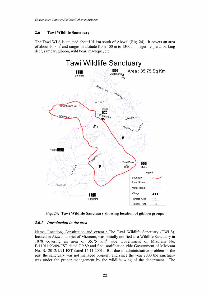
Conservation Status of Hoolock Gibbon in Mizoram
82
2.6 Tawi Wildlife Sanctuary The Tawi WLS is situated about101 km south of Aizwal (Fig. 24). It covers an area of about 50 km2 and ranges in altitude from 400 m to 1300 m. Tiger, leopard, barking deer, sambar, gibbon, wild boar, macaque, etc.
Tawi Wildlife SanctuaryArea : 35.75 Sq Km
Highest Peak
Primate Area
Village
River/Stream
Boundary
Motor RoadSaza Lui
R.Tu
ikum
Bengcha
t Lui
Hualtu
1818
Tawizo
1637Vawmhrawh Lui
Khuai Lui
Saihum Lui
LenchimMualpheng
Tuikhur Lui
Khua
i Lui
Tawi Peak
1889 Maite
Hmuntha
Vaidan Lui
Khurpui Lui1
Sesih Lui
HG
Legend
Fig. 24: Tawi Wildlife Sanctuary showing location of gibbon groups 2.6.1 Introduction in the area Name, Location, Constitution and extent : The Tawi Wildlife Sanctuary (TWLS), located in Aizwal district of Mizoram, was initially notified as a Wildlife Sanctuary in 1978 covering an area of 35.75 km2 vide Government of Mizoram No. B.11011/23/89-FST dated 7.9.89 and final notification vide Government of Mizoram No. B.12012/1/91-FST dated 16.11.2001. But due to administrative problem in the past the sanctuary was not managed properly and since the year 2000 the sanctuary was under the proper management by the wildlife wing of the department. The

Conservation Status of Hoolock Gibbon in Mizoram
83
sanctuary is situated about 180 km east of Aizawl, the state capital of Mizoram. The headquarters of the sanctuary is located at Hualtu. Approach and access : The Tawi Wildlife Sanctuary is well connected by road from Aizawl to Chhingchip. One can go to Mualpheng from Aizwal via Keifang and Saitual after traveling for about 90 kms. Hualtu can be approached from Aizwal via Chhinchip. Statement of significance : The Tawi Wildlife Sanctuary is significant because of it was very rich in wildlife both in its diversity and numbers till the recent past. But, due to high biotic pressure mainly in the form of the traditional practices of hunting and jhuming (shifting cultivation) from the five surrounding villages, the wildlife has suffered an irreparable loss over the last few years. Once very common populations of tiger, leopard, sambar, barking deer, goral have now reduced to almost unviable status. The presence of large numbers of guns with the local people has added to the loss of rich biodiversity in the area. Nevertheless, still fair amount of wildlife diversity is present inside the core area of the Sanctuary. The Tawi Wildlife Sanctuary has a unique distinction of harbouring 5 rare and endangered animals which includes tiger, leopard, hoolock gibbon, serow, and goral. The Sanctuary has representatives of tropical semi-evergreen and sub-montane forests, which perform a very important role in the watershed catchments areas management. 2.6.2 Physical Feature Attributes Boundaries
The northern boundary starts from the source of Khuailui (stream) towards Sakhi sih stream upto Charzawl and goes to Tuilak saddle and then follows Mualpheng deserted approach road up to Vaawk saddle. The eastern boundary starts from Vaawk saddle and goes towards south along the hill ridge (sahmul then zelah) up to Liamkawn. From here it follows Maite road up to Vaidan stream source along the foot hills. It then goes to a small lake above Hrulluai crossing the lake up to Bakpuk. It then goes to Laichat and follows upper portion of deserted jhumland of Khuaihnuai and meets source of Khuailui (stream). It then goes to Riahbuk mual and meets Maite jeep road. It then goes along the foorhills catching Hmuntha road up to the place called ‘Lunghnute’. The southern boundary starts from Lunghnute it follows the foothills of Tawi hill towards north-west direction and then crosses Saza stream and then meets Bengchatlui (stream). The western boundary starts from Bengchatlui (stream) source and then follows the foothills towards north. It then mets river source of R. Tuikum, and then crossing Kawlhawickah-kawn (saddle) and meets Khuailui (stream) the starting point of north boundary.

Conservation Status of Hoolock Gibbon in Mizoram
84
Geology, rock and soil It is characterized by the presence of sedimentary rocks with a light sandy loam soil with a mixture of humus and loamy soil. The rock found on another beds are mostly normal sand stone, clay, silt stone and pebbles. The soil in the hills is usually sufficiently deep, moist, fertile and sandy loam at the proper layer of which are stained with humus. Terrain The terrain is entirely hilly except the valleys and foothills. The hills slopes are mostly steep to very steep and cut up numerous streams and nallahs. At places it is comprised of steep and undulating high and medium hill ranges increpted by high cliffs and saddles.
Climate Rainfall pattern and distribution and temperature: The Tawi Wildlife Sanctuary falls within the geographical sub-tropic and enjoys sub-tropical climate. The summers are generally warm and wet, but winters are cool and dry. Pre-monsoon rains occur during March-April, whereas regular monsoon commences from June and continues till October. The annual rainfall ranges between 1700 mm to 3900 mm spread over 8 to 10 months. The average temperature varies from 8-200 C during winter and 19-290 C during summer. Humidity/wind speed: The area is quite humid in summers with low humidity during March – April. The prevailing winds are usually of moderate velocity with occasionally cyclonic storms are experienced during the month of March and April. Water sources The major water sources of the sanctuary are Tuikum lui, Bengchat lui, Khuai lui rivers. Water from these sources is also supplied to Hualtu, Lenchim, Hmuntha, and Maite villages for drinking purposes. Habitat attributes, Range of Wildlife Status, Distribution Vegetation and the bio-geographic classification: According to the biogeographic classification, the area comes under the southern part of the Naga-Mizoram mountain region on biotic province 8B, the Assam hills of the North East India Zone. The Forest type, cover, food for animals and phenology of plants: Main shrub species are Meara montana, Melastoma malabathricum, Clerodendron viscosum, Hedychium species, etc. Other main species are Chromolama, odorata, Arisacma species, Solarum torvum, Lycianther species, etc. The ground cover consists of Ageratum conyziodes, Porta begonifolia, Eryncum fectidum, etc.

Conservation Status of Hoolock Gibbon in Mizoram
85
2.6.3 History of Management and present practices General There was no management plan for Tawi WLS from the very inception of this Sanctuary, which was notified as a sanctuary in 1978. At present the sanctuary is managed by one Range Officer (Headquarters) at Hualtu, one Forester and four Beat Officers under the control of Divisional Forest Officer, Wildlife Division, Aizawl. Hunting & other illegal activities Hunting is a way of life for the local tribals of Mizoram which is primarily for meat and secondarily for trophies which are signs of muscularity and valour. The increase in the large numbers of guns in the fringe villages of the sanctuary has drastically reduced the population of wild animals and birds. There is no case of poaching in the sanctuary after its notification. However, other illegal activities such as collection of fuel wood, small timber, minor forest products are resorted to by the local villagers from the buffer areas due to population expansion in the fringe villages. Wildlife Protection For effective wildlife management of the sanctuary, as a participatory approach, a team of special 10 wildlife guards from amongst the laborers were engaged from the fringe villages. Besides this, few regular staff personnel are also posted in the sanctuary well equipped with the arms and wireless sets. Tourism The sanctuary has not developed sufficient infrastructure for tourism basically due to the fund constraints. Developments of proper tourist zone and tourist facilities are needed in the sanctuary because the sanctuary is considered ideal for bird watching and other animals due to its unique sub-montane forests. Forest fire There is always a threat of forest fire in sanctuary due to practices of traditional jhumming by villagers in the fringe villages. It can be addressed suitably by the creation of fire lines in the sanctuary boundary and engagement of fire fighting squads during fire season to combat the forest fires. The development programme and conservation issues Limited developmental activities have been taken up by the Agriculture, Horticulture and DRD.A departments in the fringe villages of the sanctuary. This has led to the generation of self employment and creation of self sufficiency. However, in absence of a proper land tenure system and lack of proper coordination planning among the different agencies, the requisite results are hardly satisfactory. Moreover, it is also realized of late that the biotic pressure is mounting due to shortage of fuel wood in the

Conservation Status of Hoolock Gibbon in Mizoram
86
community land. A more coordinated and planned development activities are needed to be taken up with the help of other developmental agencies and through eco-development in these fringe villages to reduce pressure in the buffer areas. The zone of influence is through out the length of the Tawi WLS. 2.6.4 Villages outside PA and their Economic Status A total of 5 tribal villages are located within 5 km radius of Tawi WLS. The villages are Hualtu, Hmunthah, Lenchim, Tawizo, and Maite. Together these villages support a human population of about 6000 individuals. The villagers are traditionally agriculturists. Due to the hilly terrain, jhumming is a way of life leading to the degradation of the primary forests. The main jhum crops are rice, maize, seasonal vegetable, ginger, chilly and sometimes sugarcane, potatoes etc. These villagers mostly belong to Mizo tribal communities. The villagers depend on forests for both timber and NTFPs including bamboos. Most of the villagers still live in thatch roof houses with only few families able to afford the galvanized iron sheet roofing. The marginal jhum lands do not even earn them a subsistence livelihood. The production is very low due to poor soil nutrients and also due to other biological factors. Few families keep milk cattle which is the only source of protein for them. They also keep pigs and domestic fowl as a source of food. Presence of these 5 villages in the fringe of the Tawi WLS makes it almost obligatory on the part of the management to involve their livelihood and other social and cultural factors into the planning processes for the Tawi WLS. 2.6.5 Gibbon Survey in and around Tawi Wildlife Sanctuary (TWS). An area of about 7.5 km radius was surveyed to ascertain the forest condition and secondary information were collected regarding the presence of gibbons. A thorough survey was undertaken in TWS for a period of 10 days. The survey covered areas of potential gibbon habitats. The line transect method was followed and groups were counted on the basis of direct sighting and through recording of songs. Secondary information was also collected from villagers and the forest staff. Floristic survey was also carried out for every 500m distance on a plot of 10m radius along transects to ascertain the qualitative and quantitative features of the habitat. A total of 147 km2 area was surveyed using 7 distinct transects of about 127 km length across the entire TWS. An area of about 100 km2 between Aizwal to Keifang was covered through a vehicle transect, while remaining 47 km2 area mostly inside the TWS was covered using 7 distinct foot transects. Following areas (Table 12) were covered during this survey: A total of 14 gibbon groups were recorded from TWS and its surrounding areas. Of these 4 groups, 7 groups were recorded based on the personal communication with the local villagers, jhum cultivators, and forest staffs; the presence of gibbons was noted from 6 localities on hearing the songs of the gibbon groups. Only 1 group was noted on the basis of actual sighting consisting of one adult male, one adult female and one infant. It was realized that the presence of gibbons is doubtful from areas of secondary forests (post jhum areas of bamboo thickets). Following is the result of the survey (Table 13):

Conservation Status of Hoolock Gibbon in Mizoram
87
Table 12: Areas Surveyed in and around Tawi Wildlife Sanctuary S. No. Transect/Route (distance in Km.) Mode Area (Km2)1 Aizwal to Keifang (74) Vehicle 100 2 Keifang to Saitual (5) Vehicle 5 3 Keifang to Mualpheng (12) Vehicle 8 4 Mualpheng to jhum fields (6) Foot 6 5 Mualpheng to Tawizo village (10) Foot 7 6 Tawizo to Maite village (12) Foot 15 7 Maite to Hmuntha village (8) Foot 6 TOTAL AREA SURVEYED (147 km) 147
Table 13: Gibbon localities in and around Tawi Wildlife Sanctuary
S. No.
Locality Mode Group No.
GPS Habitat type
1 Mualpheng village (outside WLS)
Sight 1 (1AM, 1AF, 1INF)
233625.6N 925909.2E
Secondary forest after jhum cultivation
2 Mualbung near Mualpheng village (outside WLS)
Song 1 233523.6N 925937.0E
Secondary forest after jhum cultivation
3 Lungmul Lui near Mualpheng village (outside WLS)
Song 1 233501.6N 930042.1E
Secondary forest with good canopy contiguity
4 Mualkoe near Mualpheng village (outside WLS)
Song 1 233545.7N 930053.4E
Secondary forest with good canopy contiguity.
5 Khamsang above Khurpui Lui near Tawizo village (Village Forest)
PC and song was also heard earlier
1 233319.7N 925726.8E
Primary tropical evergreen forest. It is a supply reserve forest where jhum cultivation can not be done due to steep cliffs.
6 Tuivamit (Village forest) Song 1 233603.4N 925946.0E
Secondary forest with good canopy contiguity.
7 Mualbung (Village forest) Song 1 233454.1N 930002.9E
Secondary forest with good canopy contiguity.
8 Near Sesih Lui (outside WLS) PC 1 233238.9N 930026.7E
Secondary forest with good canopy contiguity. Jhum abandoned area.
9 Bualpheng forest above Tuivawl Lui near Maite village (outside WLS)
PC 1 232902.1N 930150.2E
Primary forest untouched due to steep terrain.
10 Bualpheng forest above Tuivawl Lui near Maite village (outside WLS)
PC 1 232904.2N 930133.9E
Primary forest untouched due to steep terrain
11 Bualpheng forest above Tuivawl Lui near Maite village (outside WLS)
PC 1 232915.1N 930151.8E
Primary forest untouched due to steep terrain

Conservation Status of Hoolock Gibbon in Mizoram
88
S. No.
Locality Mode Group No.
GPS Habitat type
12 Khamzang Thai near Tuivawl Lui near Maite village (outside WLS)
PC 1 233004.7N 925948.5E
Primary forest untouched due to steep terrain
13 Near Saza Lui Hnar (inside WLS)
PC 1 - Primary forest untouched due to steep terrain
14 Near Vaidan Lui and Khuai Lui (outside WLS)
PC 1 - Primary forest untouched due to steep terrain
TOTAL 14 groups PC = Personal communication Of the total 14 groups, 7 were recorded from the secondary forest of jhum origin but with good canopy cover and contiguity. Remaining 7 groups were located in the evergreen and semi-evergreen forest patches mostly outside the TWS (Fig. 25).
Fig 25: Locations of Hoolock gibbon sightings in Tawi WLS with respect to the vegetation types
It may be worthwhile to note that of the 14 sites recorded for gibbon presence, 13 were inside the village forests and only one was inside the sanctuary. In most of these village forests, the canopy cover and contiguity was good even though the majority of those village forests were supporting secondary forests. The secondary forests were having open forest cover mostly with bamboo covers all across the range. Although, these secondary forests were not good enough for spending most of activity time thereupon, these are found extremely important to supplement their food requirements.

Conservation Status of Hoolock Gibbon in Mizoram
89
Fig. 26: Hand sketch of Tawi WLS showing survey area with vegetation and
gibbon groups
• Group 2 often migrates to Mualpheng village.
Fig. 27: Hand sketch of TWS • Group 4 is just adjacent to the Lungmul Lui group. • Mualpheng village has the safety or supply forest where gibbons are present. This
forest is also called Village Reserve. 2.6.6 Vegetation survey in Tawi Wildlife Sanctuary A total of 26 plots of 10 m radius were surveyed across 7 different transects (traversing roughly through 127 km. distance). Of these, 3 transects of 91 km. were

Conservation Status of Hoolock Gibbon in Mizoram
90
covered by vehicle, and 4 transects were walked over 36 km. in and around the Tawi WLS. Fo l l owing a r ea s we re cove red du r ing t he t r anse c t su r ve ys :
Name of the Area Number of plots Maite Village 05 Tawizo 21 Total 26
The number of tree species encountered in these plots ranged from 2 to 8. A total of 121 trees were counted from the surveyed plots and their number ranged between 4 and 22 in different plots surveyed. In most plots (21, 81%), the number of tree species ranged from 2 to 5 and only in 5 plots (9%), the number of tree species ranged between 6 to 8. A total of 11 tree species were dominant across different surveyed plots. Of these, main dominant species were Thang grass, lung grass and Phar bamboo. Although the number of trees in these plots ranged from 4 to 22, yet, majority of plots (17, 70%) were having only less than 10 trees and only in 5 (12%) plots the number of trees was from 15 to 22. The canopy cover in majority of the plots (18, 70%) was between nil (0%) to low (1-25%) and only in 8 plots (30%) the canopy cover was from medium (25-50%) to very dense (75-100%). Similarly, the canopy continuity in 19 plots (73%) was also between nil (0%) to low (1-25%), and only in 7 plots (27%) the continuity ranged between medium (25-50%) to very dense (75-100%). Most plots (20, 77%) were very rich in herb concentration, which ranged between medium to very high and only 6 plots (23%) were with nil to low (<25%) herb growth. However, the growth of shrubs was nil to medium in most plots (17, 66%) and only in 9 plots (34%), the concentration of shrubs was dense (>50%). The area was having natural forests and grasslands in almost equal proportions [12 plots, (46%) each]. The remaining plots (2, 8%) were supporting either the plantations or a mixture of plantations and natural forests. A total of 75 cut stumps were counted from only 9 (35%) plots across the survey areas, although majority of the plots (16, 65%) were without any sign of cut stumps. Other types of biotic pressures included grazing (9, 35% plots) and collection of firewood and other forest products (9, 35% plots). However, the current shifting cultivation plots were not seen during the surveys and similarly fragmentation was also not recorded inside any of the surveyed plots. Among the other animals, only rhesus macaques were encountered as direct sightings from these plots. No indirect signs of any other animal were noted during the survey in these areas. The vegetation status coupled with the status of canopy cover, canopy continuity, biotic factors, and presence of other wildlife indicate that excepting 9 plots which were suffering from severe biotic pressures, remaining 17 plots could be termed as Potential gibbon habitat sites. Of these 17 plots, at least 8 plots with dense vegetation and large number of trees and good population of other wildlife species could be the most potential sites.

Conservation Status of Hoolock Gibbon in Mizoram
91
2.7 Phawngpui National Park The Phawngpui National Park (PNP) is situated in south eastern Mizoram adjacent to Myanmar border (Fig. 28). The area of the park is 50 km2 and has the highest peak in Mizoram, the Phawngpui (2360m). The important wildlife species are barking deer, sambar, tiger, leopard, clouded leopard, gibbon, rhesus macaque, common langur, capped langur, stump tailed macaque, varieties of birds and orchids.
Phawngpui (Blue Mountain) National ParkArea: 50 Sq. KmSangau
Sentetfiang
Lungkawtpeng
Tri-Junction Thaltlang
Thanngerh-VaTerminal Point
FarpakrhKhamkhuai VA
Cheu
va
Rawlbuk
Cheural
SabulLuncheh Va
Sangau Va
Peak
HG
Lumpher
Siachangkawn
TialparPuk
Thothek Tlang
Bualpui
Archhuang
Lung Phunkawn
Vambuk
Lungzarhtum
Boundary
BRTF Road
Motor Road
River/Stream
Foot Path
Villages
Legend
Siachang Va
Fig. 28: Gibbon group locations in Phawngpui National Park 2.7.1 Survey of hoolock gibbon An extensive survey of gibbons was undertaken in this park to estimate the gibbon population and also to assess the potential habitats. A total of four days in the month of November were spent to cover an area of about 23.5 km2 across 8 different transects for this purpose (Table 14)
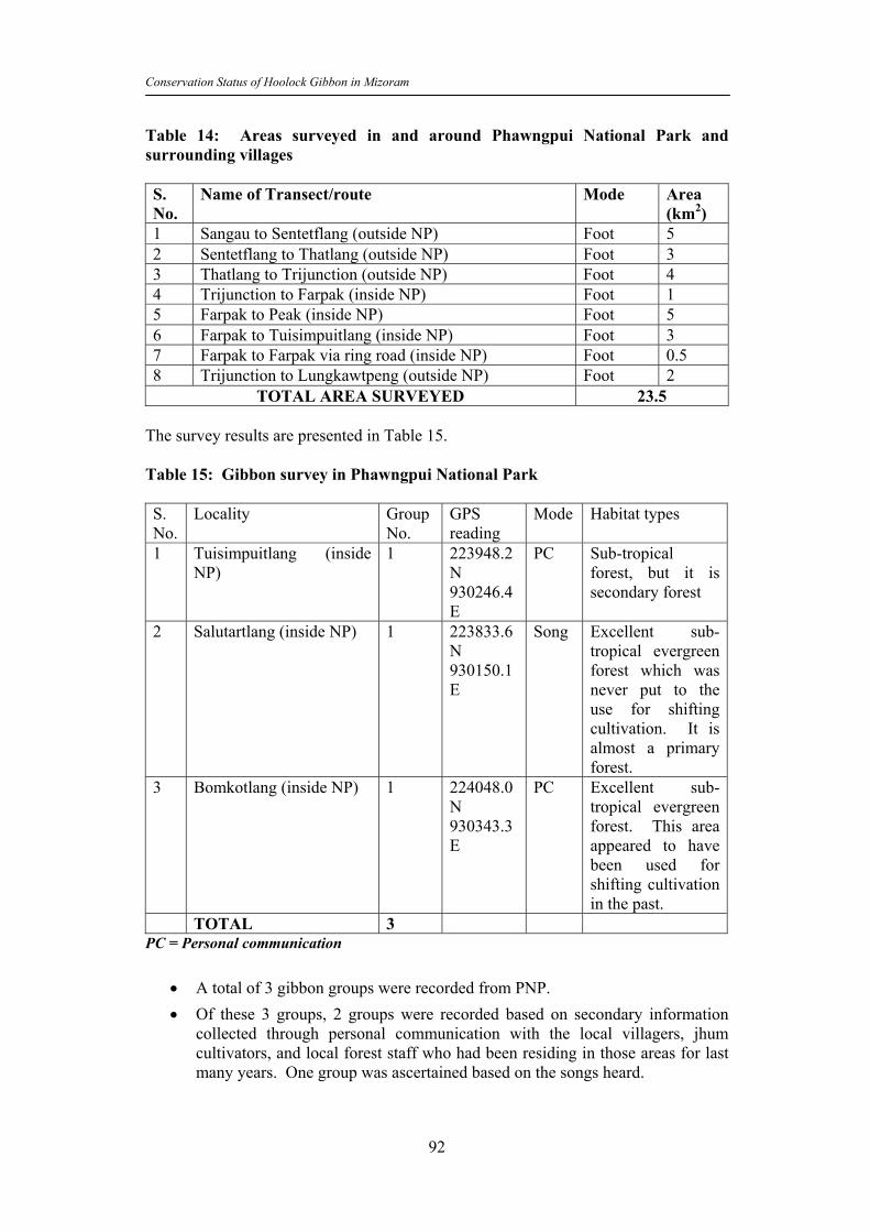
Conservation Status of Hoolock Gibbon in Mizoram
92
Table 14: Areas surveyed in and around Phawngpui National Park and surrounding villages S. No.
Name of Transect/route Mode Area (km2)
1 Sangau to Sentetflang (outside NP) Foot 5 2 Sentetflang to Thatlang (outside NP) Foot 3 3 Thatlang to Trijunction (outside NP) Foot 4 4 Trijunction to Farpak (inside NP) Foot 1 5 Farpak to Peak (inside NP) Foot 5 6 Farpak to Tuisimpuitlang (inside NP) Foot 3 7 Farpak to Farpak via ring road (inside NP) Foot 0.5 8 Trijunction to Lungkawtpeng (outside NP) Foot 2
TOTAL AREA SURVEYED 23.5 The survey results are presented in Table 15. Table 15: Gibbon survey in Phawngpui National Park S. No.
Locality Group No.
GPS reading
Mode Habitat types
1 Tuisimpuitlang (inside NP)
1 223948.2N 930246.4E
PC Sub-tropical forest, but it is secondary forest
2 Salutartlang (inside NP) 1 223833.6N 930150.1E
Song Excellent sub-tropical evergreen forest which was never put to the use for shifting cultivation. It is almost a primary forest.
3 Bomkotlang (inside NP) 1 224048.0N 930343.3E
PC Excellent sub-tropical evergreen forest. This area appeared to have been used for shifting cultivation in the past.
TOTAL 3 PC = Personal communication
• A total of 3 gibbon groups were recorded from PNP. • Of these 3 groups, 2 groups were recorded based on secondary information
collected through personal communication with the local villagers, jhum cultivators, and local forest staff who had been residing in those areas for last many years. One group was ascertained based on the songs heard.

Conservation Status of Hoolock Gibbon in Mizoram
93
• All the 3 groups were recorded inside the national park. Gibbon groups were conspicuously inconspicuous in the adjoining village forests and abandoned jhum patches.
• The vegetation is an admixture of Quercus species, Schima wallichii, Betula species, Prunus khasia, P. myrica, Rhododendron and Orchids.
• Fungkah village is located in between Rawlbuck and Lungpher villages. It is a small village spread over 30 km2 with 15 families. The gibbon is reported from here. Other faunal species include sambar, serow, barking deer, leopard, etc.
• In between peak and Farpak, munting human disturbance was noticed due to unchecked human entry inside the park. People carrying guns and resortingto hunting can not be ruled out.
• There are two types of Rawnal (Dendrocalamus): one is Chimnobambusa callosa having thorns at the nodes at every 20-25 cm distance. The other is called Dendrocalamus hookeri, is without thorns. The nodes in this species are about 2 feet apart from each other.
• The Pangaran locality was earlier inhabited by a village which got shifted to another place in the year 1993. The area had been extensively used for shifting cultivation.
• Farmun locality near old Pangaran village is highly disturbed due to human presence. It is suspected that people from Myanmar come here and camp at Tuisuntlang and adjacent areas inside the park for hunting purposes. This site is very good for gibbons. About 70-80 hornbills were seen by the researcher in this locality.
• In Salutartlang locality inside the park, gibbon presence was confirmed by the field assistant by call.
• Tuisimpuitlang was another locality from where the field assistant had heard the calls from 2 groups.
• Sialamtuipui near Khakharam forest is inside the Myanmar border and the gibbon calls are heard quite frequently from here.
• Many gibbon groups are also reported from Chiriatlang in Myanmar. The forest is very dense and absolutely no jhuming is allowed inside these forests. There is a common belief among the locals that if any one would practice jhuming he will eventually die following a strange illness. They believe that there is one God in that area who punishes the defaulters.
• Bomkotlang is located at the boundary of the park towards Thatlang village. Earlier gibbons were reported from here, but now, as reported by the local guide and people, even the songs are not heard for the last two years. The Council forest is also adjacent.
• Darzouli near S. Vanlaiphai is another locality from where gibbons are reported. This is a small village on the way to Sangau frm Aizwal in Lunglei district.

Conservation Status of Hoolock Gibbon in Mizoram
94
Fig. 29: Hand sketch of PNP showing survey locations
Fig 30: Locations of Hoolock gibbon sightings in Phawngpui National Park with
respect to the vegetation types

Conservation Status of Hoolock Gibbon in Mizoram
95
2.7.6 Vegetation survey in Phawngpui National Park A total of 27 plots of 10 m radius were surveyed across 8 different transects (traversing 23.5 km2.area). All transects traversing across in and around the sanctuary were walked on foot which ranged from .5 to 5 km in length. The following areas were covered during the survey: Name of the Area Number of plots Peak to Farpak 14 Tri-Junction 04 Ringroad-Farpak 03 Farpak Tri-junction 06 Total 27
The number of tree species encountered in these plots ranged from 3 to 10. In most plots (17, 63%), the number of tree species was more than 5 in a given plot and only in 10 plots (37%) the number of tree species were less than 5. The maximum numbers of plots (7 each) were with 4 and 6 tree species. A total of 202 trees were counted from the surveyed plots and their number ranged between 5 and 23 in a given plots. However, the majority of plots (15, 56%) were having more than 10 trees and only in 12 (44%) plots the number of trees was less than 10. A total of 7 plots were with 8 trees while only 1 to 2 plots were having trees ranging from 5 to 23 in a given plot. A total of 13 tree species were dominant across different surveyed plots. Of these, the major dominant species were Ranwal bamboo, Ching-pong-chia, Mum, Vom-ha, Lai-thing, and Phae-ha. The canopy cover in majority of the plots (15, 56%) was between medium (25-50%) to very dense (75-100%) and only in 12 plots (44%) the canopy cover was from between nil (0%) to low (1-25%). The canopy continuity ranged almost evenly between nil (0%) to low (1-25%) in 14 (52%) plots and medium (25-50%) to very dense (75-100%) in 13 (48%) plots. Most plots (16, 59%) were having nil to poor herb growth and in 11 plots (41%) the herb growth varied between medium (25-50%) to very high (75-100%). A very similar trend was noted in the growth of shrubs with 16 plots (59%) having nil to medium and 11 plots (41%) having medium to very high concentration of shrubs. The area was more like a natural forest with 20 plots (74%) having natural forest vegetation. Grasslands were present in 5 (19%) plots and one plot each were having secondary forest growths after shifting cultivation and plantations. A total of 26 cut stumps were counted from only 6 (22%) plots across the survey areas, although majority of the plots (21, 78%) were without any sign of cut stumps. Other types of biotic pressures included grazing (7, 26% plots) and collection of firewood and other forest products (7, 26% plots). However, only one plot with current shifting cultivation signs was noted during the survey and similarly 2 plots were seen having signs of fragmentation. Overall, medium biotic disturbance was recorded from the surveyed plots. There was no direct sighting of any other animal during the survey. However, bark of barking deer was heard on 4 occasions from two plots during the survey.

Conservation Status of Hoolock Gibbon in Mizoram
96
The vegetation status coupled with the status of canopy cover, canopy continuity, biotic factors, and presence of other wildlife indicate that excepting 6 plots which were suffering from severe biotic pressures of grazing and illicit removal of trees, remaining 21 plots could be termed as Potential gibbon habitat sites. Of these 21 plots, at least 15 plots with dense vegetation and large number of trees and good population of other wildlife species could be the most potential sites. 2.8 Thorangtlang Wildlife Sanctuary 2.8.1 Introduction to the area Name, Location, Constitution and extent : The Thorangtlang Wildlife Sanctuary (TRWLS) was notified as a Reserve Forest in 1982 vide Govt. of Mizoram Notification No. FOR. 169/79/130 dated 11.3.1982 and a preliminary notification to declare an area of 50 km2 of these Reserve Forest as Thorangtlang Wildlife Sanctuary had been issued vide Government Notification No. B.12012/17/2001-FST dated 4.9.2001. The final notification was issued by the Government vide letter No. B.12012/17/2001-FST dated 23.4.2002. The sanctuary is situated about 230 Km from Aizawl, the state capital of Mizoram. The altitude at the highest peak is 1336 m and the sanctuary falls under Lunglei District. The Thorangtlang Wildlife Sanctuary is well connected by road from Aizawl to Thenhlum village. Statement of significance: Thorangtlang Wildlife Sanctuary is significant because of its unique natural features of sub-tropical evergreen and semi-evergreen forests. The KWLS also supports a large number of diverse floral and faunal species. Over the last few years excessive hunting by the local people and practice of jhuming has done irreparable damage to the biodiversity of the sanctuary. Tiger, leopard, sambar, barking deer, goral, etc. were earlier quite common but now their numbers have dwindled due to severe biotic pressures. The existing area also plays an important role in the watershed and catchments management. 2.8.2 Physical Feature Attributes Boundaries The northern boundary starts from R. Tu charlui. It follows R. Tuicharki upstream and after crossing Vaawk saddle it follows Mualscilui down stream eastward upto R.Tut. The eastern boundary starts from Mualscilui outlet and then the boundary follows R.Tut upstream till it meets outlet of Zotuilui. The southern boundary starts from the outlet of Zotuilui and follows Zotuilui upstream till it meets deserted footpath of Dampui village at the junction of Kawnpui village footpath. It then goes towards R.Kau crossing Kawnpui village footpath and then it meets R. kau. It follows R .Kau downstream upto Saithah stream outlet and then follows R. Saithah upstream upto upper portion of Bamboo Supply Reserve Area. The western boundary starts from Bamboo supply reserve area and it goes towards north along the virgin forest up to the north boundary starting point at Tuicharlui

Conservation Status of Hoolock Gibbon in Mizoram
97
Geology, rock and soil Geology is characterized by the presence of sedimentary rocks with slightly sandy loam soil along with a mixture of humus and loamy soil exists. The rock found on the river beds are mostly sand stone, clay, silt stone and pebbles. The soil in the hills is usually sufficiently deep, moist, fertile and sandy loam at the upper layer which is stained with humus. Terrain The terrain is entirely hilly except the valleys and foothills. The hills slopes are mostly steep to very steep and cut up numerous streams and nallahs. At places it is comprised of steep and undulating high and medium hill ranges intercepted by high cliffs and saddles. Climate Rainfall pattern and distribution and Temperature : The Thorangtlang Wildlife Sanctuary falls within the geographical sub-tropic and enjoys sub-tropical climate. The summers are generally warm and wet, but winters are cool and dry. Pre-monsoons rains. The annual rainfall ranges between 1700 mm to 3900 mm spread over eight to ten months. The average temperature varies from 8-200 C during winter and 19-290 C during summer. The area is quite humid in summer with low humidity during March and April. The prevailing winds are usually of moderate velocity with occasionally cyclonic storms are experienced during the month of March and April. Water sources: The major water sources of the sanctuary areas are R.Tut, Mualseilui,Tuicharlui and Pualhrang lui. Habitat attributes, Range of Wildlife Status, Distribution Vegetation The biogeographic classification : According to the biogeographic classification, the area comes under the southern part of the Naga-Mizoram mountain region of the biotic province 8B, the Assam hills of the North East India Zone. Vegetation : The Forest type consists of evergreen and semi-evergreen tropical forests. The major species include – Michelia champaca, Terminalia myrocarpa, Chaukrasia tabularis, Toona cliliata, Duabanga sonnerotoides. The middle level mainly consists of Chromolam, ordorata, Arisacma species, Solanum torvum, Lycianther etc. Main species at the ground level vegetation consists mainly of Ageratum conyziodes, Prota begonifolia, Eryncum fectidum etc.

Conservation Status of Hoolock Gibbon in Mizoram
98
2.8.3 History of Management and present practices General There was no any management plan for Thorangtlang Wildlife Sanctuary from the very inception of this sanctuary which was notified as Reserve Forest in 1982 and preliminary notification as Thorangtlang Wildlife Sanctuary was issued in 2001. At present the sanctuary is managed by one Range Officer (Headquarters) at Thenhlum, one Forester and four Beat Officers under the control of DCF(WL), Aizawl. Hunting Hunting is a way of life for the local tribal of Mizoram, which is primarily for self consumption as meat and secondarily for trophies which are considered signs of muscularity and valour. The increase of large numbers of guns in the fringe villages of the KWLS has drastically reduced the population of wild animals and birds. Poaching & other illegal activities There is no reporting of any case of poaching in the Sanctuary after its notification. But other illegal activities such as collection of fuel wood, small timber, NTFPs are resorted to by the villagers from the fringe villages. Forest fire There is always a threat of forest fire in this Sanctuary due to practices of traditional jhumming by the fringe villagers. Creation of firelines in the Sanctuary boundary and engagement of fire fighting squads during fire season to combat the forest fire is being developed by the management. 2.8.4 Villages outside the P. A. and their Economic status There are six tribal villages situated within 5 km radius of sanctuary boundary. These are Thenhlum, Dampui, Kawnpui "W”, Laisawral, Sesawm and Changpui. Together these villages support a population of ten thousand individuals. The villagers are traditionally agriculturists. Due to the hilly terrains, jhuming is a way of life. The practice of non-traditional jhuming leads to the degradation of the primary forests. The main jhum crop are rice, maize, seasonal vegetable, ginger, chilly, sugarcane, potatoes etc. These tribal villages are mostly Mizo tribes who depend on forests for extracting resources to meet their daily needs of food, cover, and water. Due to low productivity of the agriculture land, the production falls short even in meeting their sustenance needs for food. This shortfall is supplemented by the villagers by way of collection of natural resources from the forests for sale, barter and self consumption. Rearing of cattle and other livestock including duckery, piggery and poultry are other supplementary activities to earn their subsistence economy. The management of Thorangtlang Wildlife Sanctuary, with six fringe tribal villages, calls for an integrated approach for management through productive participation of local people. These fringe villages have considerable impact on the sanctuary and the impact zone may go as deep into as 5-7 km inside the sanctuary. The left over

Conservation Status of Hoolock Gibbon in Mizoram
99
primary forests in the sanctuary are abode of many wild flora and fauna and therefore need to be protected from any kind of biotic interference. 2.8.4 Gibbon surveys in Thorangtlang Wildlife Sanctuary The survey could not be undertaken in this sanctuary due to time constraint and compelling logistic problems. However, based on the vegetation and habitat conditions it can be said that the areas has great potential to be good gibbon habitat. The records of the past casual surveys available in the records of the forest department and interactions with the local people substantiate these observations on the status of the gibbons in this sanctuary. However, a thorough survey is required urgently to document and assess the conservation status of gibbons and other biodiversity elements in this area. 3. Discussion A total of 72 gibbon groups were identified from 7 different populations in Mizoram covering an area of about 298 km2 in all the districts of Mizoram. The survey location included all the existing and proposed Protected Areas and the Reserved Forests. The total survey area was visited in 7 study sites consisting of 70 intensive survey sites. The vegetation survey was also conducted in 197 plots of 10 m radius over 50 different transects covering the intensive study sites (Table 16). The most common plant species encountered during the vegetation surveys is presented in Annexure I at the end of this chapter. Table 16: Gibbon survey sites in Mizoram
Study Sites Intensive Survey Sites
Transects Vegetation Plots
Dampa Tiger Reserve 10 12 61 Ngengpui Wildlife Sanctuary 10 7 29 Lengteng Wildlife Sanctuary 12 5 12 Murlen National Park 4 6 27 Khawnglung WLS 17 5 15 Tawi Wildlife Sanctuary 14 7 26 Phawngpui National Park 3 8 27 TOTAL (7) 70 50 197
The survey was also extended into the private forests, village forests wherever secondary information indicated past or present distribution of gibbons in those areas. However, the total area covered during the surveys in and around the villages, private forests and areas just adjacent to the protected areas is not reflected here. Of the total 72 groups, only 3 (4.2%) groups were actually sighted. Of the remaining groups, 20 groups (27.8%) groups were located based on the songs heard during the surveys and the presence of remaining 49 groups (68%) was based on the secondary information (Table 17).

Conservation Status of Hoolock Gibbon in Mizoram
100
Table 17: Population estimates of gibbons in Mizoram
Number of Groups Number of Individuals Sl.No.
Location
PC
S ST
T
AM
AF
SAM
SAF
INF
JUV
TL
Area (km2)
1. Dampa TR 2 6 2 10 2 2 - - 1 1 6 29.4 2. Ngengpui WLS 8 2 - 10 - - - - - - - 33.7 3. Lengteng WLS 8 4 - 12 - - - - - - - 73.5 4. Murlen NP 4 - - 4 - - - - - - - 46.0 5. Khawnglung
WLS 8 11 - 19 - - - - - - - 48.0
6. Tawi WLS 7 6 1 14 1 1 - - 1 - 3 46.6 7. Phawngpui NP 2 1 - 3 - - - - - - - 23.5 TOTAL 39 30 3 72 3 3 - - 2 1 9 298.7
PC = Personal Communication; S = Songs; ST = Sighting; T-Total Groups; AM-Adult Male; AF-Adult Female; SAM-Sun-adult Male; SAF-Sub-adult Female, INF-Infant; JUV-Juvenile A total of only 7 individuals counted from 3 groups of gibbons that were sighted during the surveys. The adult male to female ratio is almost 1:1 and one of the most redeeming features is the presence of infants and juveniles in two of the three groups sighted. However, in Tawi WLS, the isolated adult male was recorded, which is a matter of concern and calls for some corrective measures to facilitate conversion of this solitary group into a family group for its long term viability. Out of a total of 7 protected areas and their adjoining tracts surveyed, not a single direct sighting could be made from 5 protected areas though a total of 48 gibbon groups were recorded based on the songs and secondary information. It definitely directs at undertaking more concerted efforts on the part of the local forest staff to closely and periodically monitor the secondary information to convert those into direct sightings of gibbons. There are hardly any study available based on systematic survey of gibbons in the protected areas and other potential habitats in Mizoram. Only, casual observations as a part of off shoot of some other studies are available that describe merely the presence of gibbons mostly based on secondary information. That is why it is difficult to compare the results of this study to conclude whether the conservations status of gibbons has improved or decreased. . In a report, a total of 120 gibbons from 7 populations were reported from Mizoram from an area of 321 km2 (Source: PHVA Workshop on Western Hoolock Gibbon, Dhaka, Bangladesh, 14-18 February 2005) with the following details (Table 18). Table 18: Number of gibbon groups in different areas in Mizoram (PHVA Workshop)
Locality Number of Gibbons Murlen TR 8 Ngengpui WLS 4 Dampa TR 20 Tawi WLS 22 Phawngpui NP 6 Lengteng WLS 24 Khawnglung WLS 36 TOTAL 120

Conservation Status of Hoolock Gibbon in Mizoram
101
In the current study, the principal investigator and his team has recorded gibbon populations from all the localities mentioned in table 17 as above. However, few additional sites were also surveyed and gibbon groups were recorded from the adjoining community and private forests across the state. This indicates that the habitat condition has not yet worsened to the extent of making gibbons locally extinct. However, presence of isolated individuals and skewed group size and presence of fragmented forest patches (private, community and village forests) surrounded on all sides by barren habitat is a cause of serious concern and need be addressed on priority basis. One of the most interesting findings in this study relates with the location of gibbon groups with respect to the limits of the protected areas and reserved forests. Out of a total of 72 gibbon groups recorded in this study, as many as 37 groups (51.4%) were outside the boundary of either protected areas or reserved forests. Of the remaining 35 groups, 10 groups (13.4%) were recorded from inside the reserved forests, 5 groups from two national parks and remaining 20 groups from 4 wildlife sanctuaries. Of the total groups (37) reported from outside the reserved forests and protected areas, as many as 34 (47.2%) groups were recorded from village forests including private and community forests. Only 3 (4.2%) groups were recorded from the private forests located just adjacent to the boundary of the protected areas (Table 19). Table 19: Locations of the Gibbon Groups in the different Survey areas of Mizoram
Outside Protected Area
Sl.No.
Location
PF SCH VIL ADJ
RF
NP WLS
Total
1. Dampa TR - - - - 10 - - 10 2. Ngengpui WLS - - 5 1 - - 4 10 3 Lengteng WLS - - 6 - - - 6 12 4. Murlen NP - - - 2 - 2 - 04 5. Khawnglung WLS - - 10 - - - 9 19 6. Tawi WLS - - 13 - - - 1 14 7. Phawngpui NP - - - - - 3 - 03 TOTAL - - 34 3 10 5 20 72
PF- Private Forests; SCH-Songacham; VIL-Village Forests; ADJ-Adjacent to Protected Areas; RF-Reserved Forests; NP-National Park; WLS-Wildlife Sanctuary. The information contained in above table clearly indicates that more gibbon groups were recorded from outside the protected areas and reserved forests. In fact, in Mizoram, of the total forest cover, almost 55% is under the control of the village and district councils and remaining 45% is under the control of forest department. In fact, the government management of forests in the form of forest department started as late as in 1974 only in Mizoram. Before this change over, the entire forest wealth was in the form of Village Safety Reserves (VSFR), Village Supply Reserves (VSUR), and Protected Forest Reserves (PFR), which were legally notified under The Mizo District (Forest) Act, 1955. The VSFR were declared mainly for protection against fire and no one was allowed to cut any tree except with the permission of the Village Council. The VSUR were for the supply of the needs of the villagers who were allowed to cut trees and bamboo for his household needs. The PFR were created for the protection of valuable forest from destruction for the interest of the village communities.

Conservation Status of Hoolock Gibbon in Mizoram
102
Similarly, the Act also provides for the regulation of jhum and wet cultivation inside these different categories of village forests in Mizoram. These forest types still exists but the purpose for which these were created has of late got diluted due to explosion of human population resulting into unsustainable extraction of forest resources from these forest types. No wonder, that these forests have supported many groups of gibbons in the past and most of them could still prove to be potential sites provided some ameliorative measures are introduced to remove the anomaly and unsustainable mode of utilization. Most of the forested areas are under the control of the communities as Autonomous District Council (ADC) forests. This peculiar situation and the fact that most of the gibbon groups and for that matter other wildlife species too are not under the direct control of the forests authorities, do call for much for efforts to make the participatory conservation approach more effective. The importance of conservation education to this effect will be immense and has to be adopted with focused approach keeping in mind the target communities. Most gibbon groups in Mizoram are found in degraded and abandoned jhum areas of village forests. In Phawngpui NP. However, all the three recordings of the gibbon were from sub-tropical evergreen forests. These forests were almost intact and had never been under jhuming at nay point of time in the past, except at Bomkotlang, where shifting cultivation was resorted to in these forests in the past. In Murlen NP, of the 4 recordings, 2 were from inside and 2 were from the adjacent hill and riverside areas. The Chamdur area in this Park is having almost virgin forest patches and could be highly potential site for gibbon populations. However, other areas which are dominated with trees belonging to the species such as Quercus, Prunus, Myrica, etc. can not support gibbons. In Ngengpui WLS, all the gibbon recordings were from the village forests adjacent to the protected area. Similar was the case of Tawi WLS, where of the total 14 groups, 13 were detected from the adjoining village forests and only one group was located inside the sanctuary. In practically all the village forests, the vegetation was secondary forests occupying the areas following shifting cultivation in the past. Only in 2 cases, the village forests were having tropical evergreen primary forests. In Lengteng WLS, of the total 12 groups, equal number of groups were located from the sanctuary and village forests. The gibbon groups were occupying the dense forests inside the sanctuary while in the village forests, the gibbons were seen traversing through the secondary forests as an aftermath of jhuming. In Khawnglung WLS maximum number of gibbon groups (19 groups) was recorded, of which 9 were recorded from the sanctuary and 10 groups from the village forests outside the sanctuary. All the gibbon groups inside the sanctuary inhabited evergreen forest with some percentage of bamboo thickets all around. However, the gibbon groups located in the village forests survived on the secondary forest of shifting cultivation origin. Degradation of potential and existing habitat is very clear across the state (Fig. 27).

Conservation Status of Hoolock Gibbon in Mizoram
103
The Dampa Tiger Reserve is undoubtedly an excellent habitat for Hoolock Gibbon given the virgin forests of Dampa Tlang having unique flora of wet/semi evergreen forests. The vegetation at Dampa provides a suitable habitat for many endangered species. The Damptlang, Chhawrpealthang and Pathluilunglengtlang areas under Teirei Range and Lizawn and Kaisalam areas under Phuldungsei Range are particularly important habitat due to the presence of climax forests and their virginity. The bamboo forests dominate a major portion of the Dampa Tiger Reserve as secondary successional seral stages coming up in the fallow lands left unattended after shifting cultivation. However, following successful relocation of the villages outside DTR the shifting cultivation inside the reserve has drastically decreased subsequently. Nevertheless, the possibility of encroachment along the western side of DTR sharing

Conservation Status of Hoolock Gibbon in Mizoram
104
International border cannot be ruled out. This side also possesses inaccessible patches of dense wet evergreen virgin forests, which may be the home of hoolock gibbon. The area outside the reserve is completely degraded with very few forest patches which are depleting very rapidly due to shifting cultivation. In fact a look at the area outside DTR from Tuilutkawn to Dampa region is practically devoid of even a single patch of forest and shifting cultivation is so intense that presence of gibbons in that area would be a remote possibility. This was so reflected from the current surveys in and around these areas. However, still all is not so bad considering the fact that some of the areas outside DTR ranging from West Phaileng to Phuldungsei still have many small forest patches providing suitable habitat conditions for gibbons. A detailed and thorough survey into these areas, repeated over time, may provide a better status of gibbon populations. This may form a part of status survey exercise for DTR. Very similar to the trend across the entire state of Mizoram, the habitat loss is one of the main factors responsible for the diminishing population of gibbons in DTR. However, the biggest threat to the gibbon populations comes from hunting, which is resorted to by locals primarily for consumption of meat. In DTR, the gibbons are subjected as victims of certain traditional beliefs and superstitions. The local people used to kill the animal (gibbons) on assumption of having certain medicinal properties. The gibbons are first killed before the local people slit open the throat to suck the warm blood as a sure cure to malaria. The body parts of the animal are cut into small pieces and are tied with a thread on the arms and on the ankle believing that it can cure the ailments like gout and bowl including inflammation of the joints. In Mizoram, people believe that possessing a tooth and a piece of bone of gibbon will keep them safe and they will not suffer from bad omen. This makes the people wear on their body a talisman containing a tooth and a small piece of bone. In Ngengpui area, it seems the people tie the chin bone of gibbons in the arms and legs with the belief that these body parts become strong and strengthened. Similarly the tooth of gibbon is tied around the neck of the children who cry a lot with the belief that it will cool down their temper and will have a sound sleep. The local people also hunt gibbons, besides using it as a source of meat, for supposedly protecting their crops. Various titles of bravery are associated with hunting among the people of the state. Another anecdote has it that earlier hunters used to be considered brave and honorable among other tribes men. Excellent hunters used to be given the title ‘Tranchua’, if they could hunt animals such as barking deer, bear, wild boar, sambar, eagle, monkeys or viper. According to the prevailing legends, a ‘Tranchua’ is believed to attain paradise after death. The best hunter in the tribe used to be honoured with the title ‘Pasalta’ getting a privilege of marrying the most beautiful woman in the tribe. The homes of ‘Pasalta’ can be seen lined with trophies of hunted wild animals and awards. Some of the surrendered hunters have confirmed with the forest department officials that most of them have to their credit killing of more than 100 animals in their lifetime as hunters so far. The degree of hunting was so high that one can see the trophies in the house of every villager. In the interest of preserving wildlife, the British administration made attempts to curb the compulsive hunting habit of the Mizos by game laws which prescribed particular closed seasons and the licensing of guns to a limit of one per 15 houses. A license was required for hunting rhinos. Shooting elephants, not previously declared to be

Conservation Status of Hoolock Gibbon in Mizoram
105
rogues, and setting traps was prohibited under the Elephant’s Preservation Act, 1879. There are many licensed guns in and around the DTR. Therefore, hunting of animals including gibbons, despite all efforts, cannot be ruled out. The lifestyle and food habits of the people in this region are such that implementation of certain rules and regulations may not provide desired results immediately. The people are very receptive to new ideas especially pertaining to nature conservation. If explained properly, the people will understand the need to protect the animals from wanton destruction through hunting and killing either for food or meeting some religious and superstitious needs. This is evident from the fact that with constant persuasion and efforts of the forest officials many erstwhile hunters have laid down their guns and had promised to render full support in the tasks of wildlife conservation. In this regard, the Range officer of Phuldungsei has been doing some appreciable work by tactfully controlling the hunting activities under his jurisdiction. The following extract taken from an account on the status of possession of fire-arms by the Mizos published in Green Magazine, A Quarterly Magazine, Vol 1 No.2, March 1997 and ‘Licence to Kill – Zohmangaitha, Aizwal, explicitly expresses the concern: “The appearance of firearms among the Mizos dated way back to the early 19th Century even before colonial rule. Old fashioned muskets, muzzle-loading match-locks and the flint-locks had all been there albeit as a status symbol afroded by a coveted few. Even the value of a prime Mithun could not compare the gun. Such was its value. Even till today, to possess guns is still considered to be something great among the average Mizo. This is evident when one thinks about the proliferation of guns in the state – both licensed and unlicensed. Everywhere one goes, one finds people carrying firearms for whatever purpose it may be. It is the possession of the gun that makes the Mizo a more aggressive and compulsive hunter than ever before, contributing much to the depredation of wildlife in the state. Unlike the valiant Pasaltha of yesteryears, today many as upstart would have little regard to what he hunts, shooting everything on sight-age, sex no bar. Although, it may not be feasible and possible too to suddenly put a blanket ban in the issuance of the gun licenses, however, following could be undertaken as mitigation measures:
• Licenses for the guns area issued generally for two purposes – self protection and crop protection. For self-protection, license should be given only for revolver and pistol. And if a license for a shotgun or rifle is to be given under this category, it may be made mandatory to saw off the barrel.
• For crop-protection, mostly shotgun and rifles are prescribed. Strict regulations for the usage of these guns can be designed with strict guidelines. These guidelines might include provisions for specifying the particular season for which the guns for crop protection can be used. This will correspond with the harvest season of major crops. There should be a ban in the use of guns in the intervening period during which time the guns should be hauled and deposited to authority until the next season [Rule 14 (ii) of the Arms Act 1959].
• The provisions contained in the license regarding hunting seasons for wild animals and birds should be deleted as per the provisions of the Wildlife (Protection) Act, 1992 as amended in 1991 and 2002.

Conservation Status of Hoolock Gibbon in Mizoram
106
• The operational area for the use of the licensed guns should also be made explicitly clear in the license document itself. For a villager, the guns should only be allowed for use within the boundary of village itself.
• A very strict vigil is needed to check the possibilities of license holders landing their guns to the villagers for use for a rent or for other benefits. This act is absolutely illegal (Section 3 of the Arms Act 1959) and also ethically wrong.
• Another ancillary aspect attached to the issuance of the gun license is its linkages with illegal trade in wildlife and products. As an effective deterrent, all such cases should be dealt with severely as per the prevalent law of the land without any considerations of the class, clan and communities.
With the initiatives of Forest Department, many Nature’s Clubs are coming up in the villages around DTR and forest staffs are intimately involved in disseminating the conservation education to the local people particularly the children on the usefulness and importance of nature and its conservation. This movement is slowly gaining momentum because villagers are responding positively and are cooperating with the forest department in augmenting the conservation practices in and around DTR. This has prompted the department to undertake many eco-developmental programmes which are providing economic benefits to the local people and thus helping them to earn their livelihoods through various non-forestry activities. The eco-development programmes have provided stability to the income generation options of the local people and this has convinced them to opt for more and more such programmes. Since, the major portion of the Dampa Tiger Reserve is dominated by the bamboo and that the flowering of bamboo is due on 2007, Forest Deptt. should take the opportunity to improve the habitat by initiating the massive plantation of the indigenous tree species in place of bamboo. The implication of bamboo flowering on the forests and the wildlife should be analyzed in advance so that any untoward disastrous could be averted. As far as the Hoolock Gibbons are concerned their future in this Reserve is promising provided hunting stop completely and encroachers do not invade the primary forest, which can be achieved through protection and stringent action against hunters and encroachers. The present strength of the Forest personnel in this Reserve is not adequate. More beat offices should be constructed so as to protect the DTR effectively and efficiently for the better future of all the animals and its primary forest. 3.1 Tribals belief about gibbons There is a strong belief among Mizo people that gibbons sing frequently during full moon day and no song is sung when it is no-moon day. This belief is prevalent among the Garos, Khasis, and Jaintias as well. During surveys in Jaintia Hills, songs were heard from 7 gibbon groupsafter full moon night. However, contrary to belief that gibbons do not sing frequently during rainy season, one instance of singing by gibbon group was noted from Sesi area under Dampa Tiger Reserve. The people at DTR associate gibbon’s songs with a better day without rain. This is in total contrast with the belief of people from Rani region of Assam-Meghalaya border (Personal

Conservation Status of Hoolock Gibbon in Mizoram
107
communication with Shri Narayan, Technical Assistant) who associate the songs of gibbon with rains on the given day. In Garo area, the people believe that gibbons rarely sing in winter months, but sing quite frequently during summer days. The survey reveals that gibbons are still present in good numbers outside the protected areas mostly in the abandoned jhum fields. However, further degradation of these abandoned jhum fields is adversely affecting the already fragmented population of gibbons. Moreover, encroachment of these abandoned jhum fields for converting them into household areas is fast depleting the areas available as habitat for gibbon populations. Besides these abandoned jhum patches outside the protected areas, many patches of dense evergreen forests occupying the inaccessible cliffs and hilltops also harbour good gibbon populations. These areas also have great potential to support viable gibbon populations. However, most of these areas are fragmented without any connectivity. Loss of connectivity between these dense patches of forests force gibbons to descend on the ground to negotiate the canopy gaps and the gibbons thereby run the risk of their life through possibilities of attacks by other ground dwelling animals. In the Garo Hills, the gaps between the fragments are so wide that the gibbons find it difficult to cross over using the ground. These unviable populations of gibbons in the fragmented forest patches and inside the abandoned jhum fields may not last very long unless some steps are taken to provide viable corridors. 3.2 Major recommendations
• A complete check on habitat degradation especially through jhuming. The efforts on the lines of Tripura and Nagaland may be taken to reduce the adverse effects of the jhuming on the biodiversity of the area. A gradual replacement of jhuming with settled cultivation and other sustainable means of earning livelihood will have to be undertaken.
• An effective check on the proliferation of guns and their licenses is a must to avoid a free access to the hunting, which might no sooner lead to poaching for commercial trade. This will directly and indirectly affect the gibbon populations.
• The fragmented secondary and semi-evergreen patches of village forests are to be brought under the purview of afforestation. The village forests are still present in large numbers but their effectiveness to act as biodiversity rich areas is no more available following severe biotic pressures.
• All the protected areas and adjoining areas are having large number of potential sites where gibbons can live a viable life. However, all these sites are to be upgraded in their current habitat conditions.
• It is seen that the gibbons are present in as many number as inside the protected areas and the areas outside the protected areas too. This aspect coupled with the control of district councils on most forest cover, provides an ideal combination that can be harnessed for the benefit of the biodiversity in general and gibbons in particular.
• Thorough survey will have to be undertaken covering all those areas that could not be surveyed in this project due to problems of time and other logistics.

Conservation Status of Hoolock Gibbon in Mizoram
108
Annexure I Common Plant species in Mizoram
Local Name Botanical Name BAMBOO PHUL-RUA Dendrocalamus hamiltonii BAMBOO-MOTAK Melocanna bambusoides BAMBOO-RAWNAL Dendrocalamus hookeri BAMBOO-RAW-MI Dendrocalamus sikkimensis BANPHAR Anthocephalus chinensis BORAW Canarium strictum BUL Alseodaphne petiolanis CHAL-TE Masa paradisiaca CHANGEL(WILD BANANA) Musa paradisiaca CHAR Terminalia myriocarpa CHAWNTUAL Aporusa ectandra D2 Imperata cylinderica FAH Lithocarpus dea;bata FARTUSH Erythrina variegata HERHSE Mesua ferrea HMAWNG Ficus religiosa HNAH-HLUM Ficus curtipes HNUM Engelhardtia spicata HNUM-PHIAH Thysanolaena maxima (broom grass) HRIANG Betula alnoides JAPAN-PANG Ceiba pentandra KAWLKAR Leea indica KAWL-SUNRBIL Phyllanthus acidus KHANG-HU Acacia species KHAWN-HMA Rhus semialata KHIANG Schima wallichi KHUANG-THLA Biscofia javanica KEL-TALH Ficus geniculata KONTHINGDANG Dillenia pentagyna LAI LAI Camellia kissi LAWNG-THING Dipterocarpus indicus LENHMUI Syzygium cumini LUM-LER Prunus nepalensis LUNG GRASS Saccharum longisetosum LUNGKHUP Haldina cordifolia MAU-DAU Xantolis tomentosa NAU-THAK Litsea monopetala NGANBAWN Acrocarpus fraxinifolius

Conservation Status of Hoolock Gibbon in Mizoram
109
Local Name Botanical Name NGIAU Michelia oblongata NGIAU-2 Michelia champaca PANGKAI Baccaurea ramiflora PHAN Ulmas lancifolia PHUANBERH Macropanax dispermus PHUNCHAWNG Bombax ceiba AMTHAI-HMUL Strobilanthus parryorum RAWNAL Dendrocalamus hookeri RAWNGAL Schizostachyum fuchsianum RAWTHING Bambusa tulda RE-ROW Terminalia chebula SAHATAH Chisocheton paniculatus SAHATAK Aglaia hiernii BAMBOO PHUL-RUA Dendrocalamus hamiltonii BAMBOO-MOTAK Melocanna bambusoides BAMBOO-RAWNAL Dendrocalamus hookeri BAMBOO-RAW-MI Dendrocalamus sikkimensis BANPHAR Anthocephalus chinensis BORAW Canarium strictum BUL Alseodaphne petiolanis CHAL-TE Masa paradisiaca CHANGEL(WILD BANANA) Musa paradisiaca CHAR Terminalia myriocarpa CHAWNTUAL Aporusa ectandra D2 Imperata cylinderica FAH Lithocarpus dea;bata FARTUSH Erythrina variegata HERHSE Mesua ferrea HMAWNG Ficus religiosa HNAH-HLUM Ficus curtipes HNUM Engelhardtia spicata HNUM-PHIAH Thysanolaena maxima (broom grass) HRIANG Betula alnoides JAPAN-PANG Ceiba pentandra KAWLKAR Leea indica KAWL-SUNRBIL Phyllanthus acidus KHANG-HU Acacia species KHAWN-HMA Rhus semialata KHIANG Schima wallichi KHUANG-THLA Biscofia javanica

Conservation Status of Hoolock Gibbon in Mizoram
110
Local Name Botanical Name KEL-TALH Ficus geniculata KONTHINGDANG Dillenia pentagyna LAI LAI Camellia kissi LAWNG-THING Dipterocarpus indicus LENHMUI Syzygium cumini LUM-LER Prunus nepalensis LUNG GRASS Saccharum longisetosum LUNGKHUP Haldina cordifolia MAU-DAU Xantolis tomentosa NAU-THAK Litsea monopetala NGANBAWN Acrocarpus fraxinifolius NGIAU Michelia oblongata NGIAU-2 Michelia champaca PANGKAI Baccaurea ramiflora PHAN Ulmas lancifolia PHUANBERH Macropanax dispermus PHUNCHAWNG Bombax ceiba AMTHAI-HMUL Strobilanthus parryorum RAWNAL Dendrocalamus hookeri RAWNGAL Schizostachyum fuchsianum RAWTHING Bambusa tulda RE-ROW Terminalia chebula SAHATAH Chisocheton paniculatus SAHATAK Aglaia hiernii