Comparison of dating results obtained for landslide activity with the use of tree-ring eccentricity...
15
Application of eccentric growth of trees as a tool for landslide analyses: The example of Picea abies Karst. in the Carpathian and Sudeten Mountains (Central Europe) Małgorzata Wistuba a, ⁎, Ireneusz Malik a , Holger Gärtner b , Paweł Kojs c,d , Piotr Owczarek e a Faculty of Earth Sciences, University of Silesia in Katowice, ul. Będzińska 60, 41–200 Sosnowiec, Poland b Swiss Federal Research Institute WSL, Landscape Dynamics, Dendroecology, Zürcherstr. 111, 8903 Birmensdorf, Switzerland c Polish Academy of Sciences Botanical Garden, Center for Biological Diversity Conservation in Powsin, ul. Prawdziwka 2, 02–973 Warsaw, Poland d Silesian Botanical Garden, ul. Sosnowa 5, 43–190 Mikołów, Poland e Institute of Geography and Regional Development, University of Wroclaw, pl. Uniwersytecki 1, 50–137 Wrocław, Poland abstract article info Article history: Received 18 February 2012 Received in revised form 6 June 2013 Accepted 28 June 2013 Keywords: Landslide dating Mass-movement Dendrogeomorphology Eccentricity Tree rings A method based on dendrochronology was developed to analyse the spatial and temporal variability of land- slide activity as an alternative and complement to methods such as field monitoring of landslide relief, aerial-photography, and remote sensing. The method involves a feature of wood anatomy, tree-ring eccen- tricity, which is used in the dating procedure. The degree of eccentricity is used as an indicator of the intensity of the mechanical stress affecting a tree stem in a certain year. The objective was to develop a mathematical indicator of tree-ring eccentricity for dating the recent dynamics of landslides. A method presented in the paper is also designed for practical application in detecting initial landslide activity and allowing the deter- mination of triggering factors. The index developed is dimensionless and for this reason is independent of the absolute ring variations of the single trees analysed. Using reference results (from stable slopes) as thresholds in dating an objective method for detecting landslide activity was developed. The method was used in the Carpathian and Sudeten Mountains on three landslides with different sizes and geological set- tings. It was found that the values of eccentricity index in trees growing on stable slopes rarely exceed at ±100%, while in trees growing on landslides they can reach hundreds to thousands per cent. A spatial anal- ysis of the eccentricity values conducted for a single landslide has revealed that the method developed allows one to identify areas of landslide activation and to observe the down- or upslope propagation of instability. A comparison of the results obtained regarding the precipitation record has shown that, by using the method that has been developed, it is possible to detect past mass-movement episodes caused by heavy, long-term rainfall as well as by single, short-lasting but torrential downpours. © 2013 Elsevier B.V. All rights reserved. 1. Introduction The determination of the spatial and temporal distribution of landslide episodes is important for natural hazard management and the protection of human lives and settlements in mountain areas where landslides are a common phenomenon. When studying land- slides we have noted the possibility of using the eccentricity of tree rings as an indicator of the temporal and spatial diversity of landslide occurrence. On the basis of a survey of the literature we attempted to use those methods of eccentricity analysis that had already been de- veloped, some of them designed for non-geomorphic purposes. The analysis of individual methods has revealed important limitations to their application to dendrogeomorphic studies of landslides. There- fore the aim of the study presented in this paper was to develop a method of tree-ring eccentricity analysis which should be appropriate for studies on mass movements, particularly landslides. The method should be designed for practical application in detecting initial land- slide activity, in predicting future hazards and in determining trigger- ing factors. To achieve this, we focused our work on analysing and comparing the stem shapes and growth patterns of Norway spruce (Picea abies Karst.) trees growing on landslides and on stable slopes, on develop- ing mathematical indicators of tree-ring eccentricity, and finally on the verification of tools developed through the interpretation of the results obtained from the slopes studied. Catena 111 (2013) 41–55 ⁎ Corresponding author. Tel.: + 48 663 260 612, + 48 32 368 94 40; fax: + 48 32 291 58 65. E-mail addresses: [email protected] (M. Wistuba), [email protected] (I. Malik), [email protected] (H. Gärtner), [email protected] (P. Kojs), [email protected] (P. Owczarek). 0341-8162/$ – see front matter © 2013 Elsevier B.V. All rights reserved. http://dx.doi.org/10.1016/j.catena.2013.06.027 Contents lists available at ScienceDirect Catena journal homepage: www.elsevier.com/locate/catena
Transcript of Comparison of dating results obtained for landslide activity with the use of tree-ring eccentricity...

Catena 111 (2013) 41–55
Contents lists available at ScienceDirect
Catena
j ourna l homepage: www.e lsev ie r .com/ locate /catena
Application of eccentric growth of trees as a tool for landslide analyses:The example of Picea abies Karst. in the Carpathian and SudetenMountains (Central Europe)
Małgorzata Wistuba a,⁎, Ireneusz Malik a, Holger Gärtner b, Paweł Kojs c,d, Piotr Owczarek e
a Faculty of Earth Sciences, University of Silesia in Katowice, ul. Będzińska 60, 41–200 Sosnowiec, Polandb Swiss Federal Research Institute WSL, Landscape Dynamics, Dendroecology, Zürcherstr. 111, 8903 Birmensdorf, Switzerlandc Polish Academy of Sciences Botanical Garden, Center for Biological Diversity Conservation in Powsin, ul. Prawdziwka 2, 02–973 Warsaw, Polandd Silesian Botanical Garden, ul. Sosnowa 5, 43–190 Mikołów, Polande Institute of Geography and Regional Development, University of Wroclaw, pl. Uniwersytecki 1, 50–137 Wrocław, Poland
⁎ Corresponding author. Tel.: +48 663 260 612, +4858 65.
E-mail addresses: [email protected] (M.(I. Malik), [email protected] (H. Gärtner), pkojs@[email protected] (P. Owczarek).
0341-8162/$ – see front matter © 2013 Elsevier B.V. Allhttp://dx.doi.org/10.1016/j.catena.2013.06.027
a b s t r a c t
a r t i c l e i n f oArticle history:Received 18 February 2012Received in revised form 6 June 2013Accepted 28 June 2013
Keywords:Landslide datingMass-movementDendrogeomorphologyEccentricityTree rings
A method based on dendrochronology was developed to analyse the spatial and temporal variability of land-slide activity as an alternative and complement to methods such as field monitoring of landslide relief,aerial-photography, and remote sensing. The method involves a feature of wood anatomy, tree-ring eccen-tricity, which is used in the dating procedure. The degree of eccentricity is used as an indicator of the intensityof the mechanical stress affecting a tree stem in a certain year. The objective was to develop a mathematicalindicator of tree-ring eccentricity for dating the recent dynamics of landslides. A method presented in thepaper is also designed for practical application in detecting initial landslide activity and allowing the deter-mination of triggering factors. The index developed is dimensionless and for this reason is independent ofthe absolute ring variations of the single trees analysed. Using reference results (from stable slopes) asthresholds in dating an objective method for detecting landslide activity was developed. The method wasused in the Carpathian and Sudeten Mountains on three landslides with different sizes and geological set-tings. It was found that the values of eccentricity index in trees growing on stable slopes rarely exceed at±100%, while in trees growing on landslides they can reach hundreds to thousands per cent. A spatial anal-ysis of the eccentricity values conducted for a single landslide has revealed that the method developed allowsone to identify areas of landslide activation and to observe the down- or upslope propagation of instability. Acomparison of the results obtained regarding the precipitation record has shown that, by using the methodthat has been developed, it is possible to detect past mass-movement episodes caused by heavy, long-termrainfall as well as by single, short-lasting but torrential downpours.
© 2013 Elsevier B.V. All rights reserved.
1. Introduction
The determination of the spatial and temporal distribution oflandslide episodes is important for natural hazard management andthe protection of human lives and settlements in mountain areaswhere landslides are a common phenomenon. When studying land-slides we have noted the possibility of using the eccentricity of treerings as an indicator of the temporal and spatial diversity of landslideoccurrence. On the basis of a survey of the literature we attempted to
32 368 94 40; fax: +48 32 291
Wistuba), [email protected] (P. Kojs),
rights reserved.
use those methods of eccentricity analysis that had already been de-veloped, some of them designed for non-geomorphic purposes. Theanalysis of individual methods has revealed important limitations totheir application to dendrogeomorphic studies of landslides. There-fore the aim of the study presented in this paper was to develop amethod of tree-ring eccentricity analysis which should be appropriatefor studies on mass movements, particularly landslides. The methodshould be designed for practical application in detecting initial land-slide activity, in predicting future hazards and in determining trigger-ing factors.
To achieve this, we focused our work on analysing and comparingthe stem shapes and growth patterns of Norway spruce (Picea abiesKarst.) trees growing on landslides and on stable slopes, on develop-ing mathematical indicators of tree-ring eccentricity, and finally onthe verification of tools developed through the interpretation of theresults obtained from the slopes studied.

42 M. Wistuba et al. / Catena 111 (2013) 41–55
1.1. Dendrochronological methods of dating past landslide activity
The use of tree rings for absolute dating and reconstructing paststages of landslide activity can be based on (Lang et al., 1999):
- determining the age of dead trees buried by the landslide mass(e.g. Filion et al., 1991),
- determining the age of living trees growing on landslide slopes, in-dicating the minimum age of the landslide body (e.g. Osterkampand Hupp, 1987).
- analysing features of wood anatomy which occur in trees affectedby landslides.
Stems of trees growing on landslides are frequently tilted, bent(Fig. 3; Alestalo, 1971; Shroder, 1980; Braam, 1987a, 1987b; Corominasand Moya, 1999; Fantucci and Sorriso-Valvo, 1999; Stefanini, 2004;Wistuba et al., 2011) and sometimes even wounded as a result ofmass-movement activity (Migoń et al., 2010; Stoffel et al., 2005).These disturbances are reflected in the wood anatomical structure ofthe annual rings and are visible in stem cross-sections such as e.g., scars,rows of traumatic resin ducts (Gärtner and Heinrich, 2009), abruptgrowth release, growth suppression, reaction wood (compression inconifers, tension in deciduous trees — Shroder, 1978; Timell, 1986;Corominas and Moya; 1999, 2010; Stoffel et al., 2005; Pánek et al.,2011), and growth eccentricity (Butler, 1987; Shroder, 1980). Eachtree ring showing disturbances, and with this certain anatomicalcharacteristics, provides a record of environmental stresses influencingthe annual growth. The high accuracy of tree-ring analyses is mostlybased on new techniques to analyse anatomical changes within theannual rings (Gärtner and Heinrich, 2013). Wood-anatomy analysesenable one to obtain a dynamic “year-by-year” picture of the slope inthe last few years, decades or even centuries (depending on the standage). They allow the researcher to date single landslide events and de-tect the temporal pattern of mass-movements on the respective slopes(Braam et al., 1987a, 1987b; Corominas andMoya, 1999, 2010; Fantucciand McCord, 1996; Fantucci and Sorriso-Valvo, 1999; Gers et al., 2001;Krąpiec andMargielewski, 2000; Krąpiec et al., 2008; Pelfini and Santilli,2008; Schweingruber, 1996; Shroder, 1978; Stefanini, 2004).
1.2. Growth eccentricity — the state of the art
Growth eccentricity is the tendency of a single tree to developwider rings on one side of the stem. Eccentricity occurs when growthintensity is uneven within the stem perimeter. It is attributed to theappearance of minor mechanical stress connected with slight orshort-lasting tilting of the tree stem. In tilted stems the impact of theEarth's gravity induces increased growth of the compressed, lowerpart of the stem in conifers (e.g. Norway spruce), and of the upperside of the stem, under tension, in deciduous trees (Schweingruber,2007; Timell, 1986).
Eccentric growth of trees can be caused by diverse factors (e.g. wind,geomorphic mass movements, snow creep, stem wounding, the shapeof the root system, the shape of the crown). Little dendrogeomorphicresearch has so far been done on relations between the developmentof eccentricity, reaction wood and the presence of stresses and defor-mations of tree stems (Schweingruber, 1996). Single analyses for conif-erous species were made for the needs of forestry (Berthier et al., 2001;Krzysik, 1974; Mäkinen, 1998; Stokes and Berthier, 2000), anatomicalstudies (Heinrich and Gärtner, 2008), climatology (Schweingruber,1996) and within studies on the adaptation of trees to environmentalconditions — e.g. wind (Wade and Wendel-Hewson, 1979; Burkhaltervide Schweingruber, 1996).
The phenomenon of external deformation (tilting, bending) of treestems under the impact of geomorphic processes was observede.g. by: Parizek andWoodruff (1957), Schweingruber (1996) for creep-ing and sliding, Braam et al. (1987a, 1987b) for mud flows, Casteller etal. (2007, 2008) for snow avalanches, Malik and Ciszewski (2008) for
fluvial erosion, Hupp (1986), Vanderkerckhove et al. (2001), Malik(2006) for gully erosion, Koprowski et al. (2010) for dune migration,Fantucci and McCord (1996), Corominas and Moya (1999, 2010),Fantucci and Sorriso-Valvo (1999), Stefanini (2004), Krąpiec andMargielewski (2000), Krąpiec et. al. (2008) for landsliding. The subjectsof the studies were usually landslides with complex morphology andmechanisms of movement, and it was observed that the variability ofstem shapes is bigger in cases of more abrupt and large-scale move-ments (Krąpiec and Margielewski, 2000; Parizek and Woodruff, 1957;Schweingruber, 1996). The most accurate description of the pattern oftree tilting and eccentricity development under geomorphic impactwas given by Braam et al. (1987a, 1987b) related to mud-flows.
More recent studies have revealed the advantages of growth eccen-tricity as a tool for landslide dating. Koprowski et al. (2010) found thatin Scots pine, eccentricity is developed with a few-years advance in re-lation to the occurrence of compressionwood. Consequently, eccentric-ity may be more sensitive and for this reason a more accurate indicatorfor geomorphic datings than the occurrence of reactionwood. Using theexample of Scots pine (Pinus sylvestris L.) Mäkinen (1998) has alsodemonstrated another advantage of eccentricity — its independencefrom the age and relative size of the tree. Growth eccentricity is rarelyapplied in dendrochronological reconstructions of landslide activity. Itis the presence of reaction wood that is usually used for dating(Corominas and Moya, 1999, 2010; Pánek et al., 2011; Shroder, 1978;Stoffel et al., 2005). Eccentricity is most often used only in combinationwith reactionwood (e.g. Corominas andMoya, 1999, 2010; Pánek et al.,2011; Stefanini, 2004).
1.3. Former applications of tree-ring eccentricity indices
Eccentricity of tree rings has frequently been applied in environ-mental studies. In some cases it was used without any computationaltool— stem cross sections and tree-ring curves were only analysed vi-sually e.g. in studies on landslides (Krąpiec and Margielewski, 2000)or dune migration (Koprowski et. al., 2010).
An attempt to systemise the use of eccentricity mathematically wasmade by Casteller et al. (2008) in their studies on snow avalanches.They adapted an eccentricity index created by Schweingruber (1996 —
Table 1) for studying snow creep, but also proposed their own, originalsolution (Casteller et al., 2007— Table 1). Another way of calculating aneccentricity index was used in studies of tree adaptation to wind stress(Burkhalter vide Schweingruber, 1996— Table 1). An original approachto analysing eccentricity wasmade by Rozas (2003), who expressed ec-centricity in relation to the estimation of the pith location on incrementcores (Table 1).
Although all these eccentricity indicators were developed to ana-lyse certain phenomena and successfully applied in dendrochrono-logical studies, none of them provides a comprehensive solution foranalyses of landslides (Table 1). So far, some of used indices do notallow one to clearly distinguish the (up- or downslope) direction ofeccentricity. Indices are calculated considering the ring width differ-ence between:
- the lower and the upper side of tilted stem (Alestalo, 1971),- the wider and the narrower part of analysed tree ring Burkhalter(vide Schweingruber, 1996), Rozas (2003),
- the downslope and the perpendicular side of tilted stem (Braamet al., 1987a, 1987b).
Indices are calculated without regard to the direction of tilting inrelation to the slope (Table 1). As we will show below, an analysisof the eccentricity in vertical trees, not affected by landslide activity,and sampled as a reference to tilted trees, suggest that there arenon-geomorphic differences in intensity of eccentric growth betweenup- or downslope sides of stems.
Schweingruber (1996) in his index also considered the position ofthe tree-rings with respect to slope (Table 1) but tree rings having the

Table 1Eccentricity indices used so far and developed for dendroecological and dendrogeomorphical purposes.
Authors Formulae Remarks
Alestalo, 1971 E = (R/D) * 100%Where: E — eccentricity, R — radius of analysed side of stem in a certaincalendar year, D — diameter of the stem
Established for wider use in dendrogeomorphology
Braam et al., 1987a, 1987b Ei = (RAi − RCi)/(RAi + RCi) * 100%Where: Ei — eccentricity in year i, RAi — downslope radius, RCi — radiusperpendicular to RAi
Established and effectively applied for studies onmud flows
Schweingruber, 1996 Iex = tree-ring width valley side/tree-ring width slope sideWhere: Iex — annual eccentricity index
Established and effectively applied for studies on theimpact of snow creep on tree growth
Burkhalter videSchweingruber, 1996
Ep% = 100% * (longer r − smaler r)/(0,5 * stem diameter)Where: Ep% — stem eccentricity
Established and effectively applied for dendroecologicalstudies on wind stress to tree growth
Rozas, 2003 E = (1 − m/M) * 100%Where: E — eccentricity, m — shortest distance between the arc (of disc or ring)and the pith along the disc circumference, M — longest distance between the arc(of disc or ring) and the pith along the disc circumference
Established and effectively applied for tree age estimatesin dendroecology,
Casteller et al., 2007 EI1995–1998 = ∑ trw years 1995–1998 dsr/∑ trw years 1995–1998 usrEI1999–2002 = ∑ trw years 1999–2002 dsr/∑ trw years 1999–2002 usrEI% = 100% * (EI1999–2002 – EI1995–1998)/EI1995–1998Where: EI% — eccentricity index, trw — tree-ring width, dsr — downslope radius,usr — upslope radius, 1995–1998 — period before studied event, 1999–2002 —
period after studied event
Established and effectively applied for studies on snowavalanchesAllows one to calculate eccentricity index before and aftera known event
43M. Wistuba et al. / Catena 111 (2013) 41–55
same level of eccentricity (relation between wider and narrower partof ring) and different direction of eccentricity (up- or downslope,e.g. Table 2) are described by different values of index (span of valuesfor upslope eccentricity is: 0.0–1.0 and for downslope from 1.0 up toinfinity) and then are not comparable. Also the index of Casteller et al.(2007) includes the position of tree rings with respect to slope butit was established for dendroecological analyses of anatomical reac-tion to snow avalanches. It allows comparing the level of eccentricitybefore and after a known avalanche event. This approach requiresknowledge on the date of event disturbing growth of trees. Thusthe aim of Casteller et al. (2007) studies and proposed eccentricityindex is opposite to the aim established in this paper, which is tofind dates of landsliding events.
The indices developed for dendroecological purposes by Burkhalter(vide Schweingruber, 1996) and Rozas (2003) do not distinguish up-and downslope eccentricity and attribute the same values of eccentric-ity indicators to rings with the same level of eccentricity but oppositedirection (Table 1). As it is shown on Fig. 1A (years 1965–1966) thiscan cause certain problems in dating landsliding events. Consideringthe biological conditions of eccentricity development in coniferoustrees (on the lower, compressed sides of stems), moments, whenthe type of eccentricity changes into opposite (e.g. from down- into up-slope in 1965, Fig. 1A) can be recognised as sudden changes in the direc-tion of stem tilting, which suggests abrupt ground instability. Whenusing the index of Rozas (2003, Fig. 1A), and index of Burkhalter (videSchweingruber, 1996) these years are not emphasised and detected asparticularly heavy landsliding events.
These problems can be solved by distinguishing up- and down-slope eccentricity by positive and negative spans of values (respec-tively) and by making these spans comparable. Similar approach isrepresented by index developed by Braam et al. (1987a, 1987b) forstudies on mud flows (Table 1). It is the most advanced method of
Table 2Examples of tree-ring widths (representing one by one: downslope eccentricity, lack ofeccentricity, upslope eccentricity) transformed into chosen, eccentricity indicatorsused so far.
Downsloperadius[mm]
Upsloperadius[mm]
Eccentricity indices
Alestalo(1971)[%]
Burkhalter videSchweingruber(1996)
Schweingruber(1996)
Rozas(2003)[%]
1.5 1.0 60.0 0.40 1.5 33.330.7 0.7 50.0 0.0 1.0 0.01.0 1.5 40.0 0.40 0.67 33.33
eccentricity analysis used so far. The Braam index is a valuable toolused in dendrogeomorphology to determine the frequency of variousmass movements (e.g.: Corominas and Moya, 2010). It can be seen asan advancement of the more basic “eccentricity of radial growth” instems, roots or branches presented by Alestalo (1971). The basicmathematical assumptions of the Braam index and the new indexpresented in this paper are similar, but the method of Braam et al.(1987a, 1987b) compare perpendicular radii of the stem instead ofparallel ones, where increment cores (or radii on discs) are takenand measured on the opposite sides of the stem. Taking the sampleperpendicularly complicates the dating procedure and causes certainproblems during interpretation. When taking samples perpendicular-ly some periods with generally strong eccentricity can be missed infurther datings (e.g. from 1956 or 1994 — Fig. 1B). Perpendicular ap-proach does not also allow one to clearly distinguish up- and down-slope eccentricity (e.g. 1935–1956, Fig. 1B: perpendicular radius iswider than downslope onewhich suggests the presence of upslope ec-centricity, but the upslope radius is even narrower, so in fact the ec-centricity is downslope).
Sampling along one direction (taking two parallel cores) fits betterto general anatomical tendency of eccentric growth, which is to de-velop wider ring on one side of a stem and narrower on the opposite(located in the same axis, not perpendicularly), because in a tiltedstem strains are strongest along one axis (compression on the upper-most and tension on the lowermost side of a tilted stem). Then due totaking samples along one direction tree responses to tilting can bemore marked (Fig. 1B).
Existing methods of eccentricity analyses, except the one byBraam et al. (1987a, 1987b), do not provide criteria for dating singleevents of tilting on the base of received index values and graphs.Thus in this paper:
- we define an eccentricity index which takes into account the up-slope/downslope position of tree rings,
- an attempt was made to develop a method to separate eccentricityevents strong enough to be interpreted as results of landslidingfrom events that are too weak and suspected to be only an effectof disturbances of growth normally present also on stable slopes(e.g. wind stress, impact of snow creep).
As will be presented below we attempted to solve this problemwith the use of empirical, reference thresholds. Developing a mathe-matical approach in addition to classical visual analysis of eccentricitycurves seemed to be especially important for samples characterised
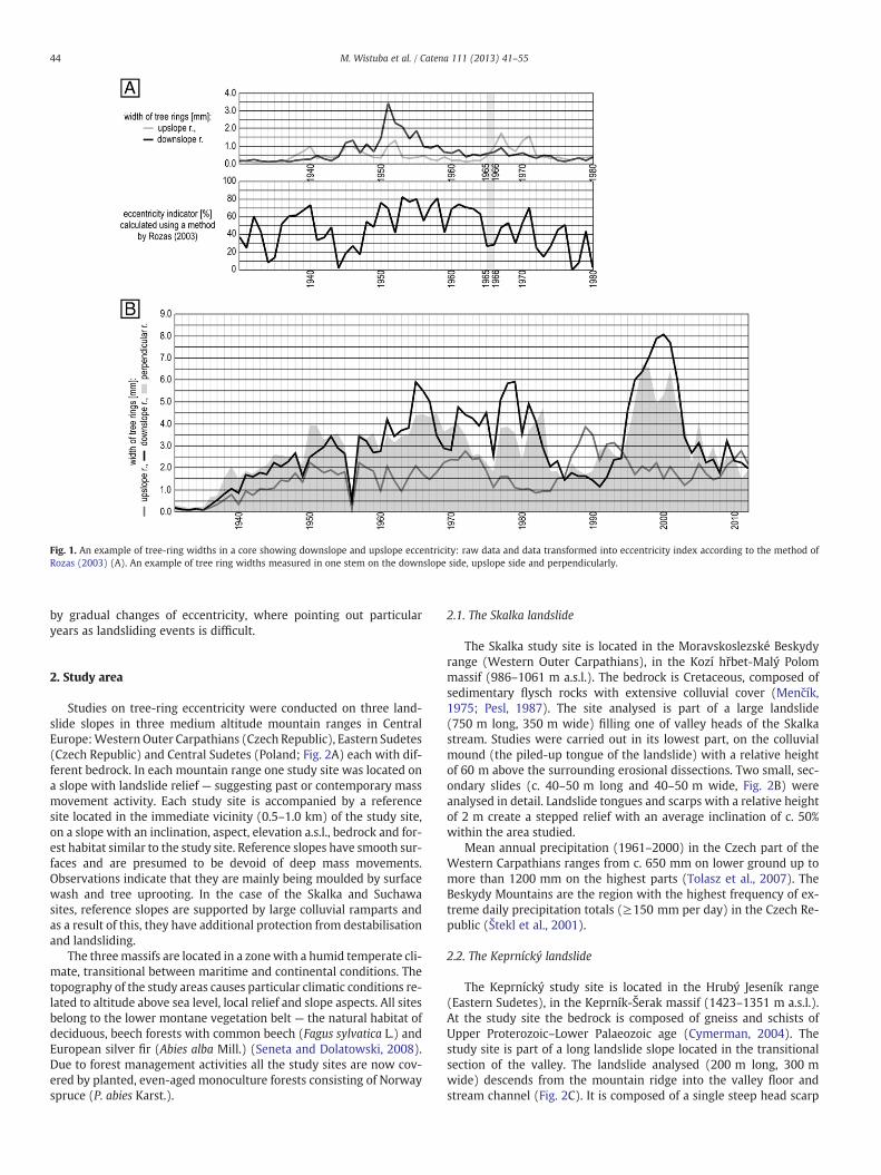
Fig. 1. An example of tree-ring widths in a core showing downslope and upslope eccentricity: raw data and data transformed into eccentricity index according to the method ofRozas (2003) (A). An example of tree ring widths measured in one stem on the downslope side, upslope side and perpendicularly.
44 M. Wistuba et al. / Catena 111 (2013) 41–55
by gradual changes of eccentricity, where pointing out particularyears as landsliding events is difficult.
2. Study area
Studies on tree-ring eccentricity were conducted on three land-slide slopes in three medium altitude mountain ranges in CentralEurope:Western Outer Carpathians (Czech Republic), Eastern Sudetes(Czech Republic) and Central Sudetes (Poland; Fig. 2A) each with dif-ferent bedrock. In each mountain range one study site was located ona slope with landslide relief — suggesting past or contemporary massmovement activity. Each study site is accompanied by a referencesite located in the immediate vicinity (0.5–1.0 km) of the study site,on a slope with an inclination, aspect, elevation a.s.l., bedrock and for-est habitat similar to the study site. Reference slopes have smooth sur-faces and are presumed to be devoid of deep mass movements.Observations indicate that they are mainly being moulded by surfacewash and tree uprooting. In the case of the Skalka and Suchawasites, reference slopes are supported by large colluvial ramparts andas a result of this, they have additional protection from destabilisationand landsliding.
The threemassifs are located in a zonewith a humid temperate cli-mate, transitional between maritime and continental conditions. Thetopography of the study areas causes particular climatic conditions re-lated to altitude above sea level, local relief and slope aspects. All sitesbelong to the lower montane vegetation belt — the natural habitat ofdeciduous, beech forests with common beech (Fagus sylvatica L.) andEuropean silver fir (Abies alba Mill.) (Seneta and Dolatowski, 2008).Due to forest management activities all the study sites are now cov-ered by planted, even-aged monoculture forests consisting of Norwayspruce (P. abies Karst.).
2.1. The Skalka landslide
The Skalka study site is located in the Moravskoslezské Beskydyrange (Western Outer Carpathians), in the Kozí hřbet-Malý Polommassif (986–1061 m a.s.l.). The bedrock is Cretaceous, composed ofsedimentary flysch rocks with extensive colluvial cover (Menčík,1975; Pesl, 1987). The site analysed is part of a large landslide(750 m long, 350 m wide) filling one of valley heads of the Skalkastream. Studies were carried out in its lowest part, on the colluvialmound (the piled-up tongue of the landslide) with a relative heightof 60 m above the surrounding erosional dissections. Two small, sec-ondary slides (c. 40–50 m long and 40–50 m wide, Fig. 2B) wereanalysed in detail. Landslide tongues and scarps with a relative heightof 2 m create a stepped relief with an average inclination of c. 50%within the area studied.
Mean annual precipitation (1961–2000) in the Czech part of theWestern Carpathians ranges from c. 650 mm on lower ground up tomore than 1200 mm on the highest parts (Tolasz et al., 2007). TheBeskydy Mountains are the region with the highest frequency of ex-treme daily precipitation totals (≥150 mm per day) in the Czech Re-public (Štekl et al., 2001).
2.2. The Keprnícký landslide
The Keprnícký study site is located in the Hrubý Jeseník range(Eastern Sudetes), in the Keprník-Šerak massif (1423–1351 m a.s.l.).At the study site the bedrock is composed of gneiss and schists ofUpper Proterozoic–Lower Palaeozoic age (Cymerman, 2004). Thestudy site is part of a long landslide slope located in the transitionalsection of the valley. The landslide analysed (200 m long, 300 mwide) descends from the mountain ridge into the valley floor andstream channel (Fig. 2C). It is composed of a single steep head scarp

Fig. 2. Location of the sites studied in Central Europe, in the Carpathians and Sudetes mountains (A). Relief of the Skalka study site (B). Relief of the Keprnícký study site (C). Relief ofthe Suchawa study site (D).
45M. Wistuba et al. / Catena 111 (2013) 41–55
(inclination of nearly 75%) and a rather flat tongue (not exceeding 10%within flattenings and over 40%within escarpments), locally collapsedwith a peat bog depression. The head scarp is coveredwith loose boul-ders (up to 2 m across), that are emerging out of the slope.
In the uppermost parts of the Hrubý Jeseník range mean annualprecipitation totals can exceed 1500 mm and half of the rainfall oc-curs during summer. Precipitation intensity can reach 220 mm perday and locally even 260–300 mm per 5–12 h (Štekl et al., 2001). Inthe last 500 years these high rainfall rates have caused numerousflood events at a local and regional scale (15 floods during the 20thcentury alone; Polách and Gába, 1998).
2.3. The Suchawa landslide
The Suchawa study site is located in the Kamienne Mts. (CentralSudetes) in the Suchawa–Włostowamassif (928–903 ma.s.l.). The bed-rock is composed of rhyolite rocks — an Early Permian rhyolitic lavasheet (Migoń et al., 2010). We have analysed a section (600 m long,450 m wide) of the large landslide slope (2.5 km long, nearly 300 mrelative height) occupying the entire northern side of the Suchawa-Włostowa massif with remnants of a deep-seated mega landslide. The
study area is located on a tongue of the mega-landslide, just above itslowest part (which is piled up to almost 80 m relative height abovethe surrounding dissections). The slope has a hummocky relief, astep-like cross-profile with small scarps and lobes, partially coveredwith screes (slope inclination locally exceeds 60%; Fig. 2D)— indicatingthe occurrence of secondary landsliding within the study site.
In the Kamienne Mountains area the mean annual rainfall(1977–2007; c. 500 m a.s.l.) is 776 mm, although the amount of rainfallvaries considerably from year to year (e.g. in the period of 1977–2007:from 534 to 977 mm). An absolute monthly maximum of 344 mmwasrecorded in July 1997 (Migoń et al., 2010).
3. A tool for dendrogeomorphic analyses of landslide activitybased on observed deformations of stems and tree rings
A new method of eccentricity analysis was developed on the basisof observations and measurements done for all three studies andthree reference sites and for all trees sampled. We have analysedthe stem shapes observed, their external deformations (see chapter3.1) and also the internal features of their anatomy, comparing valuesof up- and downslope tree-ring widths (see chapter 3.2). On the basis
46 M. Wistuba et al. / Catena 111 (2013) 41–55
of this information formulae were developed for calculating theeccentricity index and dating landslide activity (see chapter 3.3).The procedure developed was applied to all pairs of samples. Samplepreparation and the calculations carried out were identical on thelandslide and reference slopes.
3.1. External deformations of Norway spruce stems on landslide andreference slopes
Initially geomorphic mapping was conducted on all the study sitesas well as on all the reference sites (Fig. 2B-D). Before selecting treesfor later sampling, we documented the shape of tree stems in differ-ent geomorphic locations (above and within head scarps, mid-slopetrenches, flattenings, landslide tongues and toes, channel banks). Bydoing so, we distinguished vertical stems and stems tilted both up-slope and downslope. For the intended tree-ring analysis we concen-trated on Norway spruce (P. abies Karst.) alone. We have chosen treesthat were visually assessed as healthy (without visible loss in assim-ilation apparatus or stem injuries).
Norway spruce on all three landslides showed deformed stems(Fig. 3). The character of deformation depends in each case on the geo-morphic location of the tree and reflects the dynamics of the bedrock.On all three sites we have observed that spruces growing on the lowerpart of the landslide mass, just above the river channels, tend to tiltdownslope (in the direction of valley axes) and to have “pistol-butted”
Fig. 3. Stem deformations of Norway spruce growing in different locations on landslides andsite).
bases of their stems (Fig. 3E). We expect that the downslope directionof tilting is caused by sliding of the lowest parts of slopes resultingfrom stream undercutting. The presence of crevices parallel to the val-ley axis— in the near-channel part of the Skalka landslides (Fig. 2B)—indicates that packets of material have slided into the channel(Fig. 4C) and that slope undermining occurred.
In the upper parts of the landslides studied most spruce trees tendto tilt upslope (Fig. 3C, D)— both on escarpments and flat surfaces.Wehave observed great variability of upslope stem deformations depen-dent on local relief; tilted stems can be both straight or bent, some-times “pistol-butted”. The upslope direction of the tilting can beexplained by the rotational character of the landslide mass (Fig. 4B),however we have also observed a few examples of downslope tiltingon the steep fronts of landslide tongues, which was caused by espe-cially high slope inclinations. Exceptional deformations have been no-ticed in the case of spruce growing on the rear face of rotated landslideblocks (Fig. 3CI), on surfaces showing an inclination opposite to therest of the slope. These spruce were treated as tilted upslope and sam-pled in the same manner as others.
Spruce trees growing on the head scarps of the Skalka landslideswere straight or slightly tilted upslope which indicates that this zoneis relatively stable. On the Keprnícký head scarp we found sprucetrees strongly tilted upslope, which indicates landsliding here. Onthis landslide we also have found trees tilted upslope growing abovethe head scarp (Fig. 3A), indicating that mass movements are starting
stable slopes (A— Keprnícký study site, B, C, D, F— Suchawa study site, E— Skalka study

Fig. 4. Stem deformations and tree-ring structure developed under the impact of gravity by Norway spruce tilted by landsliding and lateral erosion (B — upslope, C — downslope),and spruce with straight stems (A). An example of a core showing clear upslope eccentricity (D).
47M. Wistuba et al. / Catena 111 (2013) 41–55
to develop. On the main head scarp of the Suchawa landslide trees aregrowing on steep, active screes and are tilted downslope with “pistol-butted” bases (Fig. 3B). In this geomorphic location tree stems areinfluenced by superficial, shallow mass movements — falling of rockparticles and creeping of debris.
Spruce trees growing on reference slopes havemore or less straight,vertical stems, sometimes with a weakly developed “pistol-butted”shape on the downslope side (Fig. 3 F).
3.2. Sampling and analysis of internal deformations of Norway sprucestems on landslide and reference slopes
Most trees affected by landsliding have stems tilted in axes parallelto the slope; this is probably a reflection of the downslope direction ofmass movements. All tilted spruces also have deformed cross-sectionsof stems: oval and elongated parallel to the direction of tilting. There-fore, internal differences between tree-ring widths on both sides ofthe stems will be highest in the axes of elongation, coinciding withthe directions of deforming factors and general slope inclinations
(Fig. 4B-C). Because of this we have taken cores along the axesaccording to the slope inclination.
We have sampled specimens with possibly the most deformedstems growing in different geomorphic locations. From each tree twocores were taken at breast height, using common increment corerswith a diameter of 5 mm. Pairs of samples taken from each stem werelocated on one axis parallel to slope inclination (Fig. 4). This mode ofsampling was determined by the character of stem deformations ob-served on particular study sites.
A total of 40 trees (80 cores)were sampled on the Skalka study site,42 trees (84 cores) on the Keprnícký site and 36 trees (72 cores) onthe Suchawa study site. A total of 12 trees (24 cores) were sampledon the Skalka as well as on the Keprnícký reference sites, and on theSuchawa reference site of 10 trees (20 cores)were sampled. The singlecores were glued on to wooden holders and gradually sanded withsand paper grades 60, 120, 240, 600 and sometimes also 1000 to endup with a clearly visible ring structure. Tree-ring width was measuredon all cores with 0.01 mm precision (LinTab measuring stationand TSAPWin Professional 4.65). Cross-dating was conducted using

48 M. Wistuba et al. / Catena 111 (2013) 41–55
standard skeleton plots (Cropper, 1979;Douglass, 1935; Schweingruber,1996).
In all tilted trees, the position of the pith was not in the geometri-cal centre of the stem cross-sections (Fig. 4B-D). Consequently, thecross section of each elongated stem is not concentric. The radiialong the axis of inclination show different lengths resulting in an ec-centric cross section. The character of eccentricity is different in treestilted upslope and those tilted downslope. Spruce tilted upslope havewider upslope radii (upslope eccentricity; Fig. 4B, D); spruce tilteddownslope have wider downslope radii (downslope eccentricity;Fig. 4C). In both cases radial growth of the cambium was increasedon the lower side (with respect to the inclination of the stem and im-pact of gravity) of the respective stems.
Spruce trees growing on stable slopes do not have significant de-formations of stem cross-sections and do not show any signs of pitheccentricity (Fig. 4A).
Similar results were achieved by Braam et al. (1987a, 1987b) for co-niferous trees, who also describedmore complicated external and inter-nal deformations of stems developed in cases where more than oneepisode of tilting/bending, in more than one dominant direction, hadoccurred. The general tendencies of tree-ring development in tiltedstems were also given by Schweingruber (1996) for spruce. Krąpiecand Margielewski (2000) described similar external deformations ofstems of European silver fir (A. alba Mill.) and Norway spruce (P. abiesKarst.) growing on landslide bodies. Stokes and Berthier (2000),Berthier et al. (2001) observed similar regularities as described above,although the origin of eccentricity was correlated rather with wind di-rection thanwith the direction of lean. They have also discussed the for-mation of irregular heartwood in maritime pine (Pinus pinaster Ait.),which was found to be related to eccentric stem growth. Duncker andSpiecker (2005) found that the angle or the direction of a stable slopehad no apparent effect on pith eccentricity. Its directions on stable sur-faceswere found to be dominated by the exposure of the site to the pre-vailing wind direction. Also our observations made for reference slopesindicated that eccentricity shows no clear tendencies connected withthe features of bedrock and slope, which suggests that eccentricity iscontrolled by non-geomorphic factors there.
3.3. Eccentricity of annual tree rings as a tool for landslide dating
3.3.1. Calculation of the eccentricity index and its interpretationAs part of the study carried out on the three sites in the Carpathians
and Sudetes, graphswere created comparing tree-ringwidthsmeasuredon the up- and downslope sides of single stems. Eccentricity is visible onthese graphs (e.g. Fig. 5A) as a long-term divergence of up- and down-slope curves, starting when the ring width on one side of the stemabruptly changes compared to the ring width of the opposite side ofthe stem. As a consequence, eccentricity lasts until ring width on bothsides reaches the same level. If this similar growth level on both sidescontinues for further years, this is recorded as concentric growth.
A new procedure was introduced into the ongoing eccentricity anal-ysis. Procedurewas prepared for studies onmassmovements, particular-ly landslides, and designed for practical application in detecting initiallandslide activity. As a complement to some of the existingmethods it in-cludes criteria for dating single events of tilting and takes into accountthe upslope/downslope position of tree rings. The resulting data forboth sides of the stems were transformed into newly developed eccen-tricity indicators. As the first step in this procedure (Fig. 5A–B, Eq. (1))we subtracted downslope tree-ring widths from the respective upslopevalues resulting in the eccentricity of tree rings expressed inmillimetres:
Ex mm½ � ¼ Ux–Dx; ð1Þ
where: U—width of the tree ring in the upslope part of the stem [mm];D —width of the tree ring in the downslope part of the stem [mm]; E —
eccentricity of tree ring [mm]; x — year (annual tree ring).
Eccentricity values for rings wider on the upslope part of the stemare positive, in contrast the values are negative if the rings are wideron the downslope part (Table 3). This difference permits the determi-nation of the direction of tilting of the tree being considered. Forthis reason we attempted to maintain and use this difference in allfurther calculations. Consequently, in the second step (Fig. 5B–C,Eqs. (2)–(4)) we applied different formulae for rings showing posi-tive and negative eccentricities. Using these formulae, we divided ec-centricity values calculated for tree rings by their narrower side (−upor downslope) and transformed the results into percentages. Positivevalues of upslope eccentricity were divided by the narrower down-slope radii, while negative values of downslope eccentricity valueswere divided by the narrower upslope radii:
when Ex mm½ � N 0 : upslope eccentricity; Eix %½ � ¼ Ex=Dxð Þ100% N 0;
ð2Þ
when Ex mm½ � ¼ 0 : lack of eccentricity; Eix %½ � ¼ Ex mm½ � ¼ 0; ð3Þ
when Ex mm½ � b 0 : downslope eccentricity; Eix %½ � ¼ Ex=Uxð Þ100% b 0; ð4Þ
where: U — width of tree ring in the upslope part of stem [mm]; D —
width of tree ring in the downslope part of stem [mm]; E — eccentric-ity of tree ring [mm]; Ei — eccentricity index of tree ring [%]; x — year(annual tree ring).
In this approach where there is positive upslope eccentricity thenarrower downslope radius of a single tree ring is considered to be100%. Wider upslope radii can be expressed as 100% plus the respec-tive positive value of the eccentricity index (in percent, Table 3). Incases where there is negative downslope eccentricity, the narrowerupslope radius of a single tree ring is considered as −100%. Thewider downslope radii can be expressed as−100% plus the respectivenegative value of the eccentricity index (in percentages, Table 3). Cal-culationsweremade separately for each tree ring in all cores (Table 3).The values determined are presented in graphs (e.g. Fig. 6). In general,the higher the value of upslope eccentricity (N0%) and/or the lowerthe value of downslope eccentricity (b0%), the more intense was thereaction of the tree to tilting in the respective year.
The eccentricity index described above:
- makes the index values independent (% instead of mm) of the in-dividual tendencies of trees to develop relatively wide or narrowannual rings (which enables comparisons between individualtrees, study and reference sites),
- distinguishes up- and downslope eccentricity (positive and nega-tive values respectively),
- enables comparisons of intensity of up- and downslope eccentric-ity (comparable value ranges, respectively from 0 to +∞ and from0 to -∞),
- facilitates the presentation of results in graphs and maps (where 0represents a lack of eccentricity and the values of up- and down-slope eccentricity are clearly separated).
3.3.2. Dating landslide events using the new eccentricity index andreference thresholds
The most crucial issue in dating landslide activation from eccen-tricity records is the relative year-by year change in index values —
not the absolute value of the index, which might maintain the same,high level for several years or might be small even after a relativelylarge jump from a negative value to a positive value. To spot thesechanges (Fig. 5C–D) we focussed on calculating yearly variations ofthe eccentricity index:
vEix %½ � ¼ Eix–Eix−1; ð5Þ

Fig. 5. An example of data obtained from a pair of cores taken from one single tree tilted upslope on the Suchawa landslide. Up- and downslope tree-ring widths (A) transformedinto eccentricity (B), eccentricity index (C), yearly variation of eccentricity index (D). Dating landslide episodes recorded by this single tree with the use of reference thresholds (E).
49M. Wistuba et al. / Catena 111 (2013) 41–55
where: Ei— eccentricity index of tree ring [%]; vEi— yearly variation ofeccentricity index [%]; x — year (annual tree ring).
Yearly variation is the difference between the index value in a cer-tain year and in the previous year (Eq. (5)); it was calculated for eachtree ring in all cores taken. Bar graphs of variation were created for in-dividual samples (Fig. 5D). They resemble skeleton plots, commonlyused in dendrochronology, which facilitates visual interpretation.
Table 3Examples of transformation of the widths of single tree rings into eccentricity, eccentricity itree ring; E — eccentricity of tree ring; Ei — eccentricity index of tree ring; vEi — yearly var
x Ux [mm] Dx [mm] Ex [mm] Eix [%]
1 1.5 1.0 0.5 502 0.9 0.6 0.3 503 0.5 0.1 0.4 4004 0.7 0.7 0.0 05 1.0 1.5 −0.5 −506 0.6 0.9 −0.3 −507 0.1 0.5 −0.4 −400
Themost probablemoments of landslide activationwere identifiedon graphs made for single samples (e.g.: Fig. 5, 6). These are recordedas especially high values of index variation:
- sudden increases in upslope eccentricity (from positive/negativeinto positive values; e.g. tree on Fig. 5D in years 1966, 1967, 2007,2009),
ndex and its yearly variation; U — upslope width of tree ring; D — downslope width ofiation of eccentricity index; x — year (annual tree ring).
vEix [%] Ux [%] Dx [%] Type of eccentricity
– 150 −100 Upslope eccentricity0 150 −100350 500 −100−400 ±100 ±100 Lack of eccentricity−50 100 −150 Downslope eccentricity0 100 −150−350 100 −500
Fig. 6. Examples of the eccentricity record from one tree tilted downslope on the Suchawa landslide (A) and from one vertical, straight tree from the Suchawa reference slope (B).
50 M. Wistuba et al. / Catena 111 (2013) 41–55
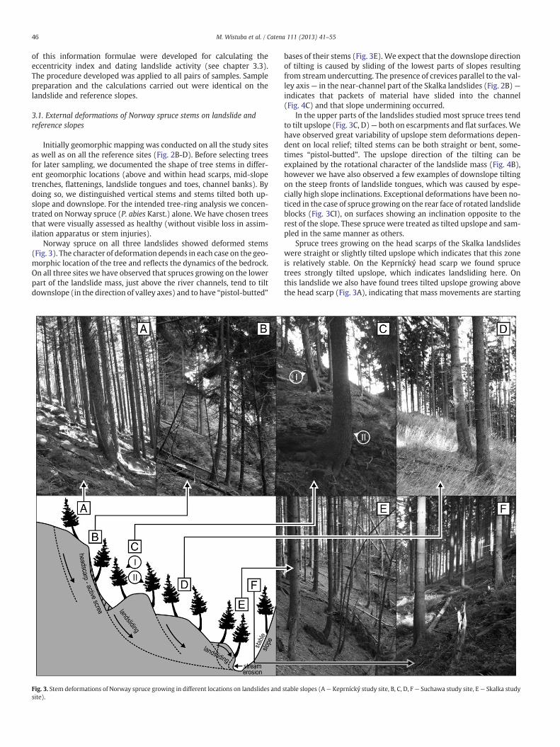
- sudden decreases in downslope eccentricity (from positive/negative into negative values; e.g. tree on Fig. 6A 1948, 1958).
Other types of change (decreases within the positive range ofindex values or increases within the negative range of index values)can result both from landsliding impact and from tree recovery —
returning into balance after periods of landslide disturbance (Fig. 5De.g. 1970–72, 1974, 2008; Fig. 6A e.g. 1949, 1952, 1956). Thereforethey cannot be included in the overall landslide data.
Bar graphs of index yearly variation can be interpreted visually —
which is most recommended when index values change abruptly andthe number of samples taken is relatively small. Also an attemptwas made to identify landsliding events objectively during analysesof large sets of samples or when index values change gradually(e.g. 1946–1959, Fig. 5C). The attempt was based on results achievedfor stable reference slopes matched to certain landslide slopes. Refer-ence results play an important part in dendrogeomorphic studies, es-pecially when using growth eccentricity. To be sure that the tree-ringcurves obtained from sampled cores record landsliding events (butnot superficial, shallow slope processes or other, non-geomorphicfactors e.g. wind stress, snow creep, increase of tree weight in time),they have to be compared with ring series from trees growing on astable (reference) slope. In the established approach results obtainedfor the reference sites serve as comparative material. They representaverage, common level of eccentricity developed by trees underwidespread non-geomorphic factors or under shallow slope process-es, e.g. soil creep. Knowledge on the reference level of eccentricity is abasis for determining extraordinary eccentricity events caused bylandsliding on study sites.
For each reference slope values of the annual variation for all yearsin all samples were considered. Arithmetical means and standard de-viations were calculated, separately for the set of increases (yearlyvariations N0), and decreases (b0). By adding mean values to devia-tions we obtained two threshold values (upslope — positive anddownslope — negative) for each of three locations studied. These ref-erence thresholds were used as criteria for dating the most probablemoments of mass-movement activation on matched landslide slopes.
As the last step of the procedure (Fig. 5D–E), we have consideredthe values of the yearly variation (in relation to thresholds) and thevalues of eccentricity index compared to the direction of its yearlychange (increases and decreases within positive and negative values,as described above). Those years of increases into positive values anddecreases into negative values, which also had values of yearly varia-tion exceeding the reference thresholds obtained, were considered asthe dates of landslide events. Eccentricity patterns were analysed forsingle trees on all the study and reference sites.
4. Results and discussion — potential of the eccentricity index asan indicator of spatial and temporal variability of landsliding
Because of the methodical character of this paper we do not presentall the results for each site, instead we present different aspects of theapplication of eccentricity in landslide studies for different study sites.In three examples we discuss:
- the comparison of the eccentricity pattern in trees sampled onlandslide and reference slopes — Suchawa site,
- spatial variability of the eccentricity record — Skalka site,- temporal variability of the eccentricity record compared with pre-cipitation data — Kepnícký site.
4.1. Eccentricity record at the Suchawa landslide and reference slopes
The results obtained in all the three study areas (Table 4) are similarbut the records of eccentricity obtained for landslide slopes and refer-ence slopes differ considerably (Fig. 5–6). For landslides, the results ofeccentricity studies indicate a high activity of mass-movements. Eccen-tricity index values obtained for reference slopes are considerably lowerthan on landslide slopes (Table 4, Fig. 6). Index values for spruce grow-ing on the stable reference slopes (e.g. Fig. 6B) vary around 0%, rarelyexceeding ±100% for the entire time span covered by the oldest trees.From the total of 701 tree rings measured for the Suchawa referencesite, 669 (95.44%) have index values ranging between −100% and100%. The maximum value of the upslope eccentricity index calculatedfor a single tree ring is only 320.69%, at the same time the minimumdownslope value is −339.22%. At the same time the population of up-slope, positive values have significantly highermean and standard devi-ation (Table 4).
In all the reference samples, single years or short periods with up-and downslope eccentricity occur alternately without any clearly vis-ible trend. This situation was interpreted as a record of a constantbalancing of the trees, which maintain the near-vertical position andequilibrium on a slope. Balancing is an effect of the continuous needto fight the impact of disturbing factors as wind, snow cover and theincrease in tree mass caused by its growth over time.
In general the trees sampled on the Suchawa landslide have a moreuneven pattern of eccentricity than on the reference site. The eccentric-ity index shows more extreme values: the maximum upslope value insamples taken on the Suchawa landslide is 1833.33%. In the case ofdownslope eccentricity the minimum value is −1762.50%. Withingraphs of the eccentricity index made for single trees, longer periods(of up to several decades) with the domination of strong up- or down-slope eccentricity are observed (Fig. 5, 6A). Some trees growing on the

Table 4Comparison of the eccentricity index record from study and reference sites.
Studied slopes Mean values (with confidence limits (0.05) for ref. slopes) Standard deviations Extreme values
Ei N 0% Ei b 0% Ei N 0% Ei b 0% Ei N 0% Ei b 0%
Kepr. Lan. 115.84 −44.88 178.59 56.41 3450.00 −1011.43Ref. 39.55 42.53 −25.86 −19.31 42.03 27.17 334.77 −239.61
36.57 −32.41Skal. Lan. 54.15 −33.05 51.52 51.62 355.88 −496.75
Ref. 42.20 46.12 −23.75 −20,97 45.43 21.30 348.84 −140.0038.28 −26,53
Such. Lan. 64.81 −73.78 97.06 142.99 1833.33 −1762.50Ref. 36.89 40.90 −28.00 −24.47 38.63 33.03 320.69 −339.22
32.88 −31.53
51M. Wistuba et al. / Catena 111 (2013) 41–55
landslide showhigh values of eccentricity index for their entire lifespan,which proves that they germinated on an unstable slope. Some treessampled on the landslide slope in the first period of growth, show thesame pattern of eccentricity index as in reference sites, (oscillatingaround 0%; e.g. Fig. 5C before 1955 and from 1974 to 2006, Fig. 6A be-fore 1948). After that period more or less abrupt changes (increases ordecreases) can be observed (e.g.: Fig. 6A in 1948) and these areinterpreted as sudden disturbances of slope equilibrium — trees weretilted by landslide activation.
4.2. Spatial variability of the eccentricity record at the Skalka landslide
The graphic presentation of eccentricity indicators permits thedepiction of the spatial variability of landslide activity on the slopes
Fig. 7. Spatial variability of the eccentricity index on the Sk
studied. Values of the eccentricity index of annual rings for specificyears and for all samples on one of the Skalka landslides are presentedas a cartodiagram, i.e. within the geomorphic map they are presentedin the form of circles with diameters dependent on the index value(Fig. 7). Maps made for the years 1980–1982 and 1989 (Fig. 7) showzones where trees have reacted on tilting.
Studies of spatial distribution of index values have shown thatdownslope eccentricity dominates in the near-channel zone, whileabove, on the slope — upslope eccentricity is dominant. This is inagreement with observations on stem deformations on the landslideslopes: within range of the impact of fluvial erosion, the underminedpart of the slope is separated from the main body and slides downinto the channel. As a consequence, trees bend downslope and pro-duce downslope eccentricity. On the upper parts of the slope, where
alka landslide slope in the years 1980–1982 and 1989.
52 M. Wistuba et al. / Catena 111 (2013) 41–55
landsliding occurs, rotational movements influence trees which tendto tilt upslope and produce downslope eccentricity (Fig. 7).
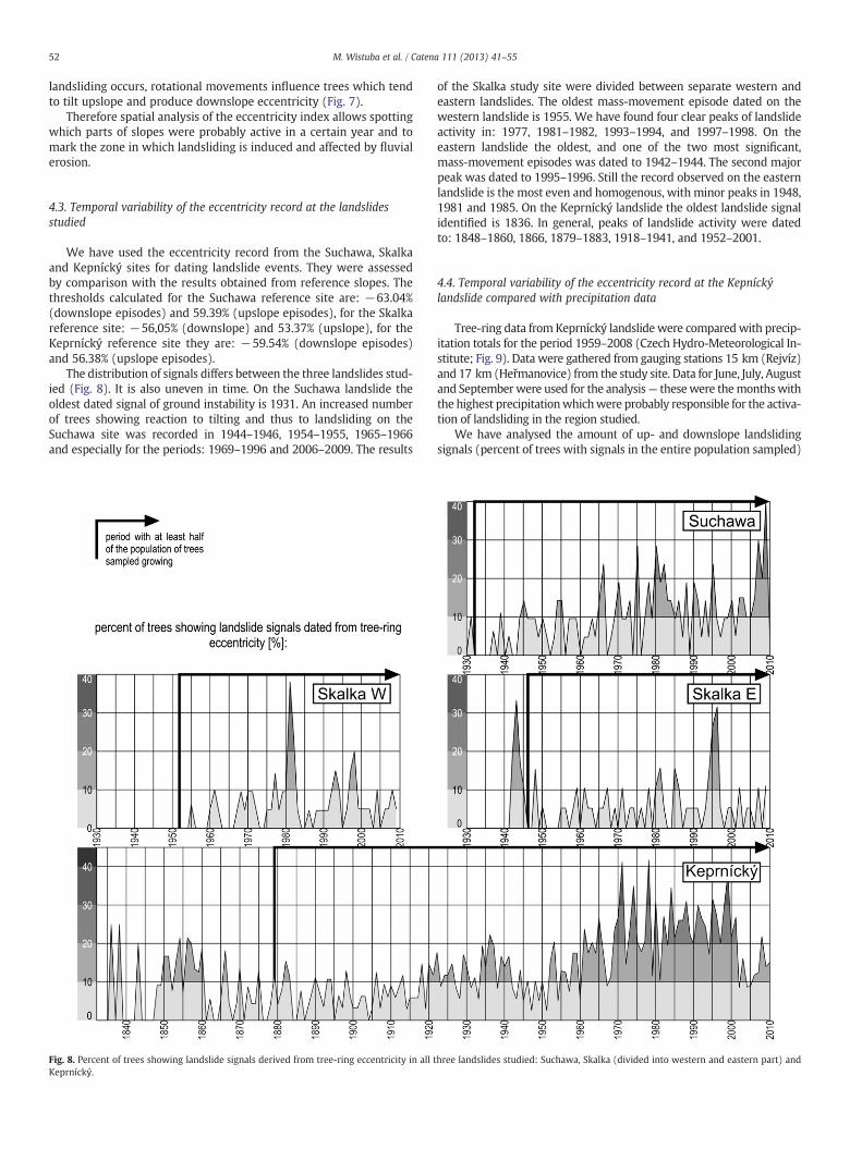
Therefore spatial analysis of the eccentricity index allows spottingwhich parts of slopes were probably active in a certain year and tomark the zone in which landsliding is induced and affected by fluvialerosion.
4.3. Temporal variability of the eccentricity record at the landslidesstudied
We have used the eccentricity record from the Suchawa, Skalkaand Kepnícký sites for dating landslide events. They were assessedby comparison with the results obtained from reference slopes. Thethresholds calculated for the Suchawa reference site are: −63.04%(downslope episodes) and 59.39% (upslope episodes), for the Skalkareference site: −56,05% (downslope) and 53.37% (upslope), for theKeprnícký reference site they are: −59.54% (downslope episodes)and 56.38% (upslope episodes).
The distribution of signals differs between the three landslides stud-ied (Fig. 8). It is also uneven in time. On the Suchawa landslide theoldest dated signal of ground instability is 1931. An increased numberof trees showing reaction to tilting and thus to landsliding on theSuchawa site was recorded in 1944–1946, 1954–1955, 1965–1966and especially for the periods: 1969–1996 and 2006–2009. The results
Fig. 8. Percent of trees showing landslide signals derived from tree-ring eccentricity in all tKeprnícký.
of the Skalka study site were divided between separate western andeastern landslides. The oldest mass-movement episode dated on thewestern landslide is 1955. We have found four clear peaks of landslideactivity in: 1977, 1981–1982, 1993–1994, and 1997–1998. On theeastern landslide the oldest, and one of the two most significant,mass-movement episodes was dated to 1942–1944. The second majorpeak was dated to 1995–1996. Still the record observed on the easternlandslide is the most even and homogenous, with minor peaks in 1948,1981 and 1985. On the Keprnícký landslide the oldest landslide signalidentified is 1836. In general, peaks of landslide activity were datedto: 1848–1860, 1866, 1879–1883, 1918–1941, and 1952–2001.
4.4. Temporal variability of the eccentricity record at the Kepníckýlandslide compared with precipitation data
Tree-ring data from Keprnícký landslide were comparedwith precip-itation totals for the period 1959–2008 (Czech Hydro-Meteorological In-stitute; Fig. 9). Data were gathered from gauging stations 15 km (Rejvíz)and 17 km (Heřmanovice) from the study site. Data for June, July, Augustand Septemberwere used for the analysis— thesewere themonthswiththe highest precipitationwhichwere probably responsible for the activa-tion of landsliding in the region studied.
We have analysed the amount of up- and downslope landslidingsignals (percent of trees with signals in the entire population sampled)
hree landslides studied: Suchawa, Skalka (divided into western and eastern part) and

Fig. 9. Temporal variability of landslide events dated from the eccentricity of tree growth on the Keprnícký landslide compared with the summer precipitation record (1959–2008).
53M. Wistuba et al. / Catena 111 (2013) 41–55
in 1959–2008 (Fig. 9). In the case of the Keprnícký landslide, the largestnumber of eccentricity signals was found in 1978 (N40%), 1971 and1999 (~40%). In case of the year 1999, the precipitation in the area inJune was above average. Two preceding years (1997–1998) are alsowell known for their catastrophic summer floods, even if the numberof eccentricity signals was not very high then. It may be that the initialmass movements took place in 1997–1998, and, by increasing bedrockinstability, these prepared the slope for landsliding in 1999.
A good example of landsliding signals caused by high precipita-tion is 1980 (N30%) with high precipitation in July (Fig. 9). How-ever, years with a great number of eccentricity episodes are notalways characterised by high monthly precipitation, for instancementioned 1971 and 1978, and also: 1974, 1984 (N35%), 1988(N30%), 1991–1992 (30–25%), 1995 (N30%). It is perhaps an effect
of the great local variability of precipitation, especially summerstorms. It also suggests that landsliding can be triggered by a singledownpour that does not influence the total monthly amount of pre-cipitation (which only slightly exceeds average values: Fig. 9), likethose in:
- April 1971 — which, according to Štekl et al. (2001), was cata-strophic in the Keprnícký valley,
- July 1991—when a catastrophic rainfall was observed in the studyarea together with the activation of debris flows (Gába, 1992;Malik and Owczarek, 2009).
In some cases high numbers of mass movement signals arerecorded one or two years after the years in which rainfall eventswere recorded, examples (Fig. 9) include the above mentioned year

54 M. Wistuba et al. / Catena 111 (2013) 41–55
1999 after catastrophic summer floods in 1997–8, 1988 after a wetAugust in 1987, 1992 after catastrophic rainfall in July 1991. The rea-sons for such situations can be:
- increased slope instability after initial mass movements during thecatastrophic rainfall event (landslides can be triggered by smallerprecipitation in following years, as probably occurred in 1997–9),
- a prolonged, strong tree reaction caused by a particularly cata-strophic event in the first year (as probably occurred in 1991–2),
- landsliding at the end of the growing season so that the tree reac-tion lags and takes place at the beginning of the following spring(as probably occurred in 1987–1988 following rainfalls in August1987).
5. Conclusions
The development of a new eccentricity index permitted the analy-sis of activity stages on three sliding slopes in the Carpathian andSudeten Mountains. Compared to the existing eccentricity indicesused until recently, the use of parallel radii as basic input data allowsa more detailed reconstruction of landslide characteristics on singleslopes. The new index is dimensionless and because of this is indepen-dent of the absolute ring variations in the single trees analysed. Thisapproach helps overcome the restrictions of only dating single slidingevents and opens new opportunities for evaluating the spatial andtemporal development of single slopes affected by sliding processes.At the same time, in the case of trees tilted sideways (not exactlyaccording to slope inclination) and trees which suffered from severaltilting episodes the manner of taking only two samples parallel toslope inclination can be insufficient. In such cases one should considertakingmore than one pair of parallel cores from a single stem, onmorethan one axis, also in directions transverse to slope inclination.
In comparison with former studies describing annual-ring eccen-tricity developing in trees growing on unstable slopes, we have alsoanalysed the level of eccentricity on reference, stable slopes. Samplesfrom reference slopes were used as comparative material. Thanks tothe application of reference results as thresholds we have developedan objective, mathematical method for landslide dating. An objective,mathematical standard for landslide dating is important, especiallyfor samples characterised by gradual changes of eccentricity inwhich it is difficult to point out the year of the first or most significantchange.
The most advanced method used so far is that of Braam et al.(1987a, 1987b). Compared to Braam et al. we have adopted a newindex for landslide studies. The dating using reference results whichis proposed in this paper permits the limitation of the impact ofnon-geomorphic factors and superficial geomorphic processes (like:creep, surface wash) in the interpretation of results from landslides.Reference thresholds permit the rejection of all changes of eccentric-ity at a level common to conditions devoid of landsliding. Using refer-ence results as thresholds in dating seems to be a general advantageof established method, but due to local and regional diversity in theenvironmental conditions for tree growth and the occurrence ofmass-movement, an independent reference site needs to be identifiedfor each landslide studied.
The results obtained for Norway spruce specimens in all the threestudy areas located in different mountain ranges and on differentbedrock are similar which suggest broader applicability of the tech-nique. Also, spruce is a common tree species in the Carpathians,Sudetes and other mountain ranges of the temperate, subarctic andsubtropical climatic zones, so the method has probably regional ap-plication. It is also probable that other coniferous species recordmass movements in a similar manner. In consequence, the methodof eccentricity analysis drawn up for Norway spruce should be gener-ally applicable for landslide dating if conifer trees are available, how-ever further detailed studies are required here.
Acknowledgements
Research on the landslide in the Hrubý Jeseník was supportedthrough grants no. N N306 718240 and no. 2011/01/B/ST10/07096;studies in the Kamienne Mountains were supported by grant no. NN306 312636. All projects were funded by the Polish Ministry of Sci-ence and Higher Education. The research done in theMoravskoslezskéBeskydy was funded by the University of Silesia in Katowice, Poland.
References
Alestalo, J., 1971. Dendrochronological interpretation of geomorphic processes. Fennia105, 1–140.
Berthier, S., Kokutse, A.D., Stokes, A., 2001. Irregular heartwood formation in maritimepine (Pinus pinaster Ait.): consequences for biomechanical and hydraulic tree func-tioning. Annals of Botany 87, 10–25.
Braam, R.R., Weiss, E.E.J., Burrough, P.A., 1987a. Dendrogeomorphological analysis ofmass movement a technical note on the research method. Catena Supplement 9,585–589.
Braam, R.R., Weiss, E.E.J., Burrough, P.A., 1987b. Spatial and temporal analysis of massmovement using dendrochronology. Catena Supplement 9, 573–584.
Butler, D.R., 1987. Teaching general principles and applications of dendrogeomorphology.Journal of Geological Education 35, 64–70.
Casteller, A., Stöckli, V., Villalba, R., Mayer, A.C., 2007. An evaluation of dendroecologicalindicators of snow avalanches in the Swiss Alps. Arctic, Antarctic, and Alpine Re-search 39, 218–228.
Casteller, A., Christen, M., Villalba, R., Martinez, H., Stöckli, V., Leiva, J.C., Bartelt, P.,2008. Validating numerical simulations of snow avalanches using dendrochronol-ogy: the Cerro Ventana event in North Patagonia, Argentina. Natural Hazards andEarth System Sciences 8, 433–443.
Corominas, J., Moya, J., 1999. Reconstructing recent landslides activity in relation torainfall in the Llobregat River basin, Eastern Pyrenees, Spain. Geomorphology 30,79–93.
Corominas, J., Moya, J., 2010. Contribution of dendrochronology to the determination ofmagnitude–frequency relationships for landslides. Geomorphology 124, 137–149.
Cropper, J.P., 1979. Tree-ring skeleton plotting by computer. Tree-Ring Bulletin 39,47–59.
Cymerman, Z., 2004. Mapa tektoniczna Sudetów i bloku przedsudeckiego. PaństwowyInstytut Geologiczny (Tectonic map of the Sudety Mts. and Sudetic Foreland – inPolish).
Douglass, A.E., 1935. Accuracy in dating — II. Tree-Ring Bulletin 1 (3), 19–21.Duncker, P., Spiecker, H., 2005. Compression wood formation and pith eccentricity in
Picea abies L. depending on selected site-related factors: detection of compressionwood by its spectral properties in reflected light. Tree Rings in Archaeology, Clima-tology and Ecology 3, 150–158.
Fantucci, R., McCord, A., 1996. Reconstruction of landslide dynamic with dendrochro-nological methods. Dendrochronologia 13, 1–22.
Fantucci, R., Sorriso-Valvo, M., 1999. Dendrogeomorphological analysis of a slope nearLago Calabria (Italy). Geomorphology 30, 165–174.
Filion, L., Quinty, F., Be'gin, C., 1991. A chronology of landslide activity in the valley ofRivie're du Gouffre, Charlevoix, Quebec. Canadian Journal of Earth Sciences 28,250–256.
Gába, Z., 1992. Mury pod Keprníkem v červenci 1991. Severní Morava 64, 5–30 (Debrisflows in the Keprník massif in July 1991 – in Czech).
Gärtner, H., Heinrich, I., 2009. The formation of traumatic rows of resin ducts in Larixdecidua and Picea abies (Pinaceae) as a result of wounding experiments in the dor-mant season. IAWA Journal 30, 199–215.
Gärtner, H., Heinrich, I., 2013. Dendrogeomorphology. In: Elias, S.A. (Ed.), The Encyclo-pedia of Quaternary Science, Vol. 2. Elsevier, Amsterdam, pp. 91–103.
Gers, E., Florin, N., Gärtner, H., Glade, T., Dikau, R., Schweingruber, F.H., 2001. Applica-tion of shrubs for dendrogeomorphological analysis to reconstruct spatial and tem-poral landslide movement patterns. A preliminary study. In: Dikau, R., Schmidt,K.H. (Eds.), Mass Movements in South, West and Central Germany. Z. Geomorphol.Suppl. , 125, 163–175.
Heinrich, I., Gärtner, H., 2008. Variations in tension wood of two broadleaved tree spe-cies in response to different mechanical treatments: implications for dendrochro-nology and mass movement studies. International Journal of Plant Sciences 169,928–936.
Hupp, C.R., 1986. The headward extend of fluvial landforms and associated vegetationon Massanutten Mountain, Virginia. Earth Surface Processes and Landforms 11,545–555.
Koprowski, M., Winchester, V., Zielski, A., 2010. Tree reactions and dune movements:Slowinski National Park, Poland. Catena 81, 55–65.
Krąpiec, M., Margielewski, W., 2000. Analiza dendrogeomorfologiczna ruchówmasowych na obszarze polskich Karpat fliszowych. Geologia Kwartalnik AGH 26(2), 141–171 (Dendrogeomorphic analysis of mass movements in the Polish flyschCarpathians).
Krąpiec, M., Danek, M., Gil, E., Kłusek, M., Rączkowski, W., Zabuski, L., 2008. Monitoringdendrogeomorfologiczny osuwiskwBeskidzie Niskim. Prace Komisji PaleogeografiiCzwartorzędu PAU 6, 173–184 (Dendrogeomorphic monitoring of landslides inBeskid Niski Mts. – in Polish).
Krzysik, F., 1974. Nauka o drewnie. PWN, Warszawa (The wood science – in Polish).
55M. Wistuba et al. / Catena 111 (2013) 41–55
Lang, A., Moya, J., Corominas, J., Schrott, L., Dikau, R., 1999. Classic and new datingmethods for assessing the temporal occurrence of mass movements. Geomorphol-ogy 30, 33–52.
Mäkinen, H., 1998. Effect of thinning and natural variation in bole roundness in Scotspine (Pinus sylvestris L.). Forest Ecology and Management 107, 231–239.
Malik, I., 2006. Gully erosion dating by means of anatomical changes in exposed roots(Proboszczowicka plateau, southern Poland). Geochronometria 25, 57–66.
Malik, I., Ciszewski, D., 2008. Meandering river bank erosion and channel lateral migra-tion recorded in black alder (Alnus glutinosa) tree rings. Tree Rings in Archaeology,Climatology and Ecology 7, 133–139.
Malik, I., Owczarek, P., 2009. Dendrochronological records of debris flow and avalancheactivity in a mid-mountain forest zone (Eastern Sudetes – Central Europe).Geochronometria 34, 57–66.
Menčík, E. (Ed.), 1975. Zakladní geologická mapa ČSSR 1:25 000. List 25–242 Klokočov.Česká geologická služba. (Geological map of Czech-Slovakian Republic 1:25 000 –
in Czech).Migoń, P., Pánek, T., Malik, I., Hrádecký, J., Owczarek, P., Šilhán, K., 2010. Complex land-
slide terrain in the Kamienne Mountains, Middle Sudetes, SW Poland. Geomor-phology 124, 200–214.
Osterkamp, W.R., Hupp, C.R., 1987. Dating and interpretation of debris flows by geolog-ic and botanical methods at Whitney Creek Gorge, Mount Shasta, California. Geo-logical Society of America. Reviews in Engineering Geology 7, 157–163.
Pánek, T., Šilhán, K., Tabořík, P., Hradecký, J., Smolková, V., Lenart, J., Brázdil, R., Kašičková,L., Pazdur, A., 2011. Catastrophic slope failure and its origins: case study of the May2010 Girová Mountain long-runout rockslide (Czech Republic). Geomorphology130, 352–364.
Parizek, E.J., Woodruff, J.F., 1957. Mass wasting and the deformation of trees. AmericanJournal of Science 255, 63–70.
Pelfini, M., Santilli, M., 2008. Frequency of debris flows and their relations with precip-itation: a case study in the Central Alps, Italy. Geomorphology 101, 721–730.
Pesl, V. (Ed.), 1987. Zakladní geologická mapa ČSSR 1:25 000. List M-34–86-A-cMorávka, Česká geologická služba. (Geological map of Czech-Slovakian Republic1:25 000 – in Czech).
Polách, D., Gába, Z., 1998. Historie povodní na šumperském a jesenickém okrese. SeverníMorava 75, 3–30 (History of floods in Šumperk and Jeseník region – in Czech).
Rozas, V., 2003. Tree age estimates in Fagus sylvatica and Quercus robur. Testing previ-ous and improved methods. Plant Ecology 167, 193–212.
Schweingruber, F.H., 1996. Tree Rings and Environment. Dendroecology. Swiss FederalInstitute for Forests, Snow and Landscape Research, WSL/FNP Birmensdorf. PaulHaupt Publishers, Berne, Stuttgart, Vienna.
Schweingruber, F.H., 2007. Wood Structure and Environment. Springer-Verlag, Berlin.Seneta,W., Dolatowski, J., 2008. Dendrologia. PWN,Warszawa (Dendrology – in Polish).Shroder, J.F., 1978. Dendrogeomorphological analysis of mass movement on table cliffs
plateau, Utah. Quaternary Research 9, 168–185.Shroder Jr., J.F., 1980. Dendrogeomorphology: review and new techniques of tree-ring
dating. Progress in Physical Geography 4, 161–188.Stefanini, M.C., 2004. Spatio-temporal analysis of a complex landslide in the Northern
Apennines (Italy) by means of dendrochronology. Geomorphology 63, 191–202.Štekl, J., Brázdil, R., Kakos, V., Jež, J., Tolasz, R., Sokol, Z., 2001. Extrémní denní srážkové
úhrny na území ČR v období 1879–2000 a jejich synoptické příčiny. Národníklimatický program České republiky, 31 (Praha. Extreme daily precipitation recordsin Czech Republic in 1879–2000 and their meteorological conditions – in Czech).
Stoffel, M., Schneuwly, D., Bollschweiler, M., Lièvre, I., Delaloye, R., Myint, M., Monbaron,M., 2005. Analyzing rockfall activity (1600–2002) in a protection forest — a casestudy using dendrogeomorphology. Geomorphology 68, 224–241.
Stokes, A., Berthier, S., 2000. Irregular heartwood formation in Pinus pinaster Ait. is relat-ed to eccentric, radial, stem growth. Forest Ecology andManagement 135, 121–155.
Timell, T.E., 1986. Compression Wood in Gymnosperms. Springer, Verlag, New York.Tolasz, R., Brázdil, R., Bulíř, O., Dobrovolný, P., Dubrovský, M., Hájková, L., Halásová, O.,
Hostýnek, J., Janouch, M., Kohut, M., Krška, K., Křivancová, S., Květoň, V., Lepka, Z.,Lipina, P., Macková, J., Metelka, L., Míková, T., Mrkvica, Z., Možný, M., Nekovář, J.,Němec, L., Pokorný, J., Reitschläger, J.D., Richterová, D., Rožnovský, J., Řepka, M.,Semerádová, D., Sosna, V., Stříž, M., Šercl, P., Škáchová, H., Štěpánek, P., Štěpánková,P., Trnka, M., Valeriánová, A., Valter, J., Vaníček, K., Vavruška, F., Voženílek, V.,Vráblík, T., Vysoudil, M., Zahradníček, J., Zusková, I., Žák, M., Žalud, Z., 2007. ClimateAtlas of Czechia. Český hydrometeorologický ústav.Universita Palackého, Praha,Olomouc (in Czech and English).
Vanderkerckhove, L., Muys, B., Poesen, J., Weerdt de, B., Coppé, N., 2001. Amethod for den-drochronological assessment ofmedium-termgully erosion rates. Catena45, 123–161.
Wade, J.E., Wendel-Hewson, E., 1979. Trees as a local climatic wind indicator. Journal ofClimate and Applied Meteorology 18, 1182–1187.
Wistuba, M., Malik, I., Owczarek, P., 2011. Eccentric growth of trees as a tool for recon-struction of mass movement activity (example from the Carpathian Mountains –
Central Europe). Tree Rings in Archaeology, Climatology and Ecology 9, 103–108.


![genetic variation of norway spruce (picea abies [l.] karst ...](https://static.fdokumen.com/doc/165x107/633d6582b988f9753c06267d/genetic-variation-of-norway-spruce-picea-abies-l-karst-.jpg)