Globale Gerechtigkeit? Feministische Debatte zur Krise des Sozialstaats

13
Kurzfassung der Vorträge und Poster
David Álvarez-Alonso1, María de Andrés-Herrero2, Andrés Díez-Herrero3 & Julio A. Rojo-Hernández.Neanderthal settlement in the interior of the Iberian peninsula: new perspectives and new sites
Interior part of the Iberian Peninsula had been considered as an empty region of human occupation and especially in the north part of Central System Mountain range. Inexistence of archaeological surveys in this area as well as last findings of sites as Abrigo del Molino confirm the possibility that human occupations aren’t as scarce as are shown until this moment (Álvarez-Alonso et al., 2013). We present the results of this recent discovery, as well as other new mousterian archaeological sites in Duero basin, that complement existing gaps, providing us a new vision of continuity in Neanderthal settlements along the first half of the Upper Pleistocene. This area, between Central System Mountain range and Duero’s valley, has short evidences of Middle Pal-aeolithic deposits, and most of them consist in lithic industries in open air sites in fluvial deposits. Archaeo-logical excavations of Pinilla del Valle’s sites confirm the presence of Neanderthal groups since the final part of Middle Pleistocene OIS 6-5, and the beginning of OIS 4 (Márquez et al., 2013); Jarama VI site contains evidences of settlement during OIS 3 and the last OIS 4 (Kehl et al., 2013), while the recent dis-covery of Abrigo del Molino is dated in OIS 4. With this information we can checked that from the begin-ning of the Upper Pleistocene until the end of Mousterian, there is a continued presence of Neanderthal groups in the interior part of the Iberian Peninsula.In this moment, we have a new perspective of the Neanderthal settlement in the interior of Iberia due to new discoveries such as Abrigo del Molino, and by adding some new Mousterian open air sites in the same area, and the rest of the sites that are being excavated during the last years. Furthermore, karstic archaeological sites provide us great information what is completed with lithic evi-dences recovered in Mousterian open air sites between Central System mountain range the South of the Duero basin (Álvarez-Alonso&Andrés-Herrero, 2011), that results very interesting for studying of Nean-derthal occupation in the South of northern Iberian plateau, particularly in the Duero valley.Keywords: Duero basin, Mousterian, settlement patterns.
ReferencesÁlvarez-Alonso, D.; Andrés-Herrero, M. de; Díez-Herrero, A.; Rojo Hernández, J. (2013): ”El Abrigo del
Molino (Segovia, España). Ocupaciones neandertales en el norte del Sistema Central“, VIII Reunión de Cuaternario Ibérico. Sevilla-La Rinconada. El Cuaternario Ibérico. Investigación en el siglo XXI, pp. 91-94.
Álvarez-Alonso, D.; Andrés-Herrero, M. de (2011): ”El Paleolítico inferior y medio en el interfluvio Riaza-Duratón“, Férvedes, 7, pp. 49-56.
Kehl, M.; Burow, C.; Hilgers, A.; Navazo, M.; Pastoors, A.; Weniger, G.C.; Wood, R.; Jordá Pardo, J. F. (2013): ”Late Neanderthals at Jarama VI (Central Iberia)?“, Quaternary Research, 80 (2), pp. 218-234.
Márquez, B.; mosquera, M., Baquedano, E., Pérez-González, A., Arsuaga, J. L., Panera, J., Espinosa, J. A. Y Gómez, J. (2013): ”Evidence of a Neanderthal-made quartz-based technology at Navalmaíllo rock-shelter (Pinilla del Valle, Madrid Region, Spain)“, Journal of Anthropological Research 69 (3), pp. 373-395.
✉ 1Prehistory and Archaeology Department. National University of Distance Education / Associated Centre of Astur-ias. [email protected]
2University of Cologne. Institute of Prehistoric Archaeology / Neanderthal Museum. [email protected] 3Instituto Geológico y Minero de España. [email protected] 4Prehistory and Archaeology Department. National University of Distance Education [email protected]

14
Álvaro Arrizabalaga, María José Iriarte-Chiapusso, Pedro Castaños, Aritza Villaluenga, Naroa Garcia-Ibaibarriaga, Xabier Murelaga, David Alvarez-Alonso, Martin Arriolabengoa, Eneko Iriarte, Arantza Aranburu, Trinidad De Torres & Esteban Alvarez-FernandezA key sequence for the transition from the Middle to the Late Pleistocene in northern Iberia: Lezetxiki cave (Basque Country)
The site of Lezetxiki has been excavated in two different time periods, by teams led by JM Barandiarán (1956-1968) and A. Arrizabalaga (since 1996). Although this last period of fieldwork is not yet complete and is exploring new and older levels, in the excavated area have been recovered basically levels between MIS6 and the transition from Middle to Upper Palaeolithic. Several human fossil and archaeomalacological mate-rial of great antiquity have been recovered during the digs. Obtained faunal sets show an alternation bet-ween intense occupations by carnivores and cave bears and more sporadic and short cycles of human acti-vity. The design of the current fieldwork attempts to complete the excavation of the earliest levels of the site and to get full analytical and geochronological support for the reinterpretation of Lezetxiki karst com-plex.
✉ corresponding author: [email protected]
Michael Baales, Hans-Otto Pollmann, Wilfried Rosendahl & Bernhard StapelFirst Radiocarbon dated Final Palaeolithic sites and organic artefacts from Westphalia
During the last decades, our knowledge on the Upper and Final Paleolithic of Northwestern Europe wasn’t enriched much by Westphalian sites. Although in its mountainous parts, especially to the South (Sauerland), numerous caves are located, the amount of material of Upper and Final Palaeolithic age is rather poor.However, this picture recently slightly changed (apart from publishing a few new sites) by conducting a limited Radiocarbon dating program on late glacial faunal remains and organic artefacts of which some had not been previously analyzed or even recognized.One of these objects, the basal part of a shed reindeer antler, demonstrates the artificial removal of the beam by cutting a circular groove and subsequently breaking off the beam just above the bez tine. This artifact could be dated to around 12.2 kyr cal BC proving the presence of reindeer for northern Westphalia during the mid late glacial interstadial. For regions more to the North this age represents the late Havelte group.Of special interest are two Megaloceros (giant deer) basal antler fragments showing the same artificial features as described for the reindeer antler. Both Megaloceros antlers are single stray finds from the northern part of Westphalia and gave comparable radiocarbon results of around 11.9 kyr cal BC. They prove that during Greenland IS 1d/c Megaloceros was part of the Westphalian fauna. For Central Europe they now supplement to the limited spectrum of early Federmessergruppen organic objects.This is also true for a large barbed point made of (elk?) bone found decades ago in the Seseke river. This interesting object has now been dated to the late Federmessergruppen around 11 kyr cal BC. This find adds to the variable spectrum of barbed points manufactured by hunters of this Final Palaeolithic techno-complex.Furthermore, now for the first time two reindeer remains from the Ahrensburgian assemblage of the Hohler Stein located in the northern Sauerland uphill range could be dated (a femora shaft fragment with cut marks and a bois de massacre of a female individual) demonstrating that spring reindeer mass kills around that site took place (at least) around 9900 cal BC.
Erste Radiokarbondaten für spätglaziale Fundstellen und Einzelfunde aus Westfalen
Erstmals konnten für Westfalen einige organische Artefakte des Spätpaläolithikums bzw. spätglaziale Fau-nenreste datiert werden. Hierzu gehören ein bisher unbekannt gebliebenes Rengeweihfragment mit artifizi-ell abgetrennter Geweihstange (ca. 12.200 cal BC) sowie zwei basale Riesenhirsch-Geweihreste mit umlau-fender Trennrille, durch die die Geweihstange ebenfalls jeweils abgetrennt wurde (11.900 cal BC). Eine seit Jahrzehnten bekannte Widerhakenspitze aus (Elch-?)Knochen, gefunden in Altarmsedimenten der Seseke bei Begkamen, datiert in die späten Federmesser-Gruppen um 11.000 cal BC, nachdem zuvor ein frühme-

15
solithisches Alter favorisiert wurde. Zudem konnten zwei Rentierreste aus dem Hohlen Stein bei Kallen-hardt (Ahrensburger Kultur) in die Zeit um 9900 cal BC und damit in die letzte Hälfte der Jüngeren Dryas-zeit eingeordnet werden.Vor allem die neu datierten organischen Artefakte bereichern nun für gesamt Nordwest-Europa unsere Kenntnis über die Geweih- und Knochentechnologie der spätglazialen Jägergruppen.
LiteraturBaales, M.; Birker, S.; Pollmann, H.-O.; Rosendahl, W. u. Stapel, B. (2013): Erstmals datierte organische Ar-
tefakte aus dem Spätpaläolithikum Westfalens. Archäologie in Westfalen-Lippe 2012, 24-27.Baales, M.; Pollmann, H.-O.; Stapel, B. (2013): Westfalen in der Alt- und Mittelsteinzeit (Münster).
✉ Korrespondierender Autor: [email protected]
Peter Balthasar, Stephan Veil, Felix Bittmann, Andreas Laug, Sandra Petzold, Felix Riede, Ulrich Staesche, Mareike Stahlschmidt & Falko Turner Neue ungestörte Federmesserplätze mit Bernsteinverarbeitung bei Grabow, Ldkr. Lüchow- Dannenberg – Ergebnisse großflächiger Bohrprospektionen in der Talaue der Jeetzel2012
Nach den Ausgrabungen der Federmesserfundstelle Grabow 15 von 2007–2011 stellte sich die Frage nach dem Siedlungskontext. Da federmesserzeitliche Fundplätze sich häufig aus vielen kleinen Fundstellen im Abstand von wenigen Metern zusammensetzen und zudem Oberflächenfundplätze bis an die Jeetzelaue heranreichen, war im Umfeld von Grabow 15 mit weiteren ungestörten Fundstellen unter Hochflutsedi-ment zu rechnen.Aus diesem Grund wurde 2012 eine Sondage auf dem Gelände mit Schneckenbohrungen von 30 cm Durchmesser etwa 100 cm Tiefe durchgeführt. Die Bohrpunkte wurden in einem Dreiecksraster im Ab-stand von etwa 10 m angeordnet und für einen Teil der Fläche noch verdichtet.Dadurch konnte zunächst die Ausdehnung der fundführenden Hochflutsedimentschicht festgestellt wer-den. Außerdem wurden in acht Bohrlöchern Silex- und Bernsteinartefakte ausgeschlämmt. Legt man die Größe der Konzentration Grabow 15 zugrunde und berücksichtigt den Abstand zwischen den fundführen-den Bohrlöcher, kann man von mindestens fünf neuen Fundstellen ausgehen. wenigstens drei stehen in Zusammenhang mit Bernsteinverarbeitung.An zwei besonders ergiebigen Bohrlöchern mit Bernsteinartefakten wurden drei Viertelquadrate geöffnet. Das Viertel 1 des Quadrates 490/804 enthielt etwa 100 Steinartefakte, darunter erste Zusammenpassungen, die auf vorrangige Grundproduktion von Abschlägen hinweisen. Die anderen beiden Viertelquadrate 482/827 (Viertel 2&3) sind mit dem fundreichsten Bohrloch assoziiert. Das Bohrloch selbst ergab bereits gut 100 Steinartefakte und die beiden angrenzenden Viertel weitere 800. Von diesen sind knapp 200 >1 cm. Auch hier waren erste Zusammenpassungen möglich; die Grundproduk-tion zeigt ein abweichendes Bild, nämlich spätere Schritte in der Operationskette mit vielen Sticheln in Kernfunktion. Weiterhin wurde ein feuerstellenartiger Befund mit dunklem Sediment und vielen Holzkoh-leresten sowie calzinierten Knochen angeschnitten. Die Knochenreste stammen von kleinen bis mittelgro-ßen Tieren, wobei detailliertere Aussagen nicht möglich sind. Die mikromorphologische Untersuchung er-gab, dass es sich bei dem Befund mit hoher Wahrscheinlichkeit um eine in-situ-Feuerstelle handelt. Bei der fundführenden Schicht, in die der Befund eingebettet ist, handelt es sich um tonig-sandigen Schluff, welcher durch Bioturbation überprägt ist. Dies wird als eingeschwemmtes Material mit anschließender Bodenbil-dung interpretiert.Die Pollenanalyse gibt Hinweis darauf, dass die Hochflutsedimente allerödzeitlich sind, während die sterile aufliegende Schicht in die jüngere Dryas-Zeit datiert.Obwohl 14C-Daten noch fehlen, sprechen sämtliche archäologische Indizien und palynologische Unter-suchungen dafür, dass die neuen Fundplätze in den gleichen chrono-kulturellen Kontext wie Grabow 15 gehören.
✉ Korrespondierender Autor: [email protected]

16
Alvise Barbieri1, Nicholas J. Conard2 & Christopher E. Miller3
Reconstructing Late Glacial landscapes: GPR data from the Ach and Lone valleys (Baden-Würt-temberg, SW Germany)
Since the first half of the twentieth century, research conducted in the cave sites located within the Ach and Lone valleys of the Swabian Jura (State of Baden-Württemberg) have improved our knowledge about the first arrival of our ancestors in the central European continent, dated to 40.000 years ago. These previous studies have also documented the presence of phases of erosion within the caves that may have been related to large scale geomorphological processes active during or shortly after the Late Glacial Maximum.Our goals are to reconstruct these landscape changes and examine how they impact the record of human occupation in the Swabian region. To this end we combine geophysical and geomorphological prospecting, coring and micromorphology.Here we present preliminary results of the surface mapping of the Lone Valley and a detailed GPR survey we conducted in front of the Hohlenstein Cave, in the Lone valley, and the Hohle Fels Cave, Ach valley. In particular, the surface mapping allowed us to define the main facies of surface sediments present within the valley. In addition, thanks to data collected with the GPR we were able to identify significant buried features that indicate phases of channel migration and colluviation. Based on the GPR data, we have also produced high resolution 3D models and georeferenced time slices in order to obtain an accurate geographic position-ing and enhance our understanding of the identified features. According to the information obtained from the geophysical survey, we were able to identify key areas to be further investigated by coring and opening of trenches.
✉ 1University of Tübingen, Institute for Archaeological Science, Rümelinstrasse 23, 72070 Tübingen, Contact: [email protected]
2University of Tübingen, Institute for Archaeological Science, Pre- and Protohistory and Archaeo-logy of the Middle Ages, Burgsteige 11, 72070 Tübingen, Contact: [email protected]
3University of Tübingen, Institute for Archaeological Science, Rümelinstrasse 23, 72070 Tübingen, Contact: [email protected]
Gerlinde BiggaDer Mensch lebt nicht vom Pferd allein … Die Vegetation von Schöningen 13II-4 und ihre Nutz-barkeit als Nahrungsquelle
Die Fundstelle Schöningen lieferte Speere und Großsäugerknochen mit Zerlegungsspuren und somit Hin-weise auf aktive Jagd. Waren die Menschen allein auf diese Ressource angewiesen oder stellte Fleisch eine willkommene Ergänzung dar? Es wird der Frage nachgegangen wie viel pflanzliche Nahrung in diesem In-terstadial des Reinsdorf-Interglazials, also zur Zeit der Speere, zur Verfügung stand und wie diese über das Jahr verteilt war.Botanische Makroreste (Früchte, Samen, Hölzer) aus der Speerfundstelle Schöningen 13II-4 wurden be-stimmt und die Arten auf ihre Nutzbarkeit als Nahrungsquelle hin untersucht. 27 Sedimentproben und di-verse Einzelfunde standen für die Rekonstruktion der lokalen Umwelt zur Verfügung. Es handelt sich um Pflanzen des unmittelbaren Uferbereichs, bestehend aus Röhrichtgürtel, Seggenried, dem angrenzenden Erlenbruchwald und verschiedenen Wasserpflanzen. Die Artenliste umfasst 69 Taxa, von denen mehr als zwei Drittel als Nahrung nutzbar sind. Die von H. Jechorek bestimmten Arten wurden in die Arbeit integ-riert. Die Ergebnisse werden in einem Saisonalitätskalender mit den essbaren Pflanzenanteilen im Jahresver-lauf dargestellt. Es zeichnet sich ein deutliches Muster ab: im Erlenbruchwald und den angrenzenden Bü-schen finden sich von Frühjahr bis Herbst essbare Blätter, innere Rinde, Früchte, Beeren und Nüsse. Die unmittelbare Seeufervegetation bietet vorwiegend von Herbst bis zum Frühjahr energiereiche Nahrung in Form von jungen Sprossen, Blättern (Frühjahr) und unterirdischen Speicherorganen (Herbst und Winter). Betrachtet man die Nährstoffzusammensetzung von beispielsweise Pferdefleisch, wird deutlich, dass der Mensch für die Energie- und Vitaminversorgung zusätzlich pflanzliche Nahrung genutzt haben muss. Aus-reichend pflanzliche Nahrung stand in der näheren Umgebung das ganze Jahr zur Verfügung. Auch in der Zeit des größten Nahrungsmangels, im Winter und beginnenden Frühjahr, wenn die Tiere mager sind und

17
die Pflanzen noch nicht ausgetrieben haben, gab es im Uferbereich Ressourcen, die der Mensch unter Schnee und Eis ausgegraben haben könnte. Außerdem müssen weitere Nahrungsquellen, die im archäolo-gischen Befund aus taphonomischen Gründen unterrepräsentiert sind (Eier, Vögel, Fisch, Mollusken, In-sekten u.a.) in die Überlegungen einbezogen werden.
✉ Institut für Ur- und Frühgeschichte und Archäologie des Mittelalters, Abteilung für Ältere Urge-schichte und Quartärökologie, Universität Tübingen
Julia Blumenröther, Gerhard Bosinski, Walter Irlinger, Tilmann Lenssen-Erz, Stefan Niggemann, Andreas Pastoors, Sebas-tian Sommer & Thorsten UthmeierNeue Untersuchungen in der Mäanderhöhle und die Frage nach paläolithischer Höhlenkunst in Deutschland
Paläolithische Höhlenkunst ist aus Westeuropa (Frankreich, Spanien, Italien), aus Rumänien und dem Ural-gebirge bekannt. Wie also ist das Fehlen von Höhlenkunst in Deutschland zu erklären? Seit Beginn des 20. Jahrhunderts gab es vereinzelte Hinweise auf deren Existenz – hauptsächlich in den deutschen Jura-gebieten. Neben den zahlreichen Funden vor allem von Kleinkunst, aber auch möglicher Wandkunst aus der Schwäbischen Alb wie dem Geißenklösterle und dem Hohle Fels (Conard – Floss 2001), gibt es in Bayern ausschließlich im Donautal Kleinkunstwerkee des Magdaléniens. Die seit 1991 bekannte Mäanderhöhle bei Bamberg soll sich nun in die fränkischen Fundstellen mit Höh-lenkunst einreihen. Sie hat eine Länge von ca. 75 m mit einer Höhendifferenz von ca. 12 m. Der zentrale Bereich wird als „Kapelle“ bezeichnet und hat eine Fläche von ca. 3 x 5 m. Dort befinden sich sog. Cave Clouds, auf denen jene Linien zu sehen sind, welche bisweilen als paläolithische Gravierungen bezeichnet werden und an einer Stelle schematische Frauenfiguren des Typs Gönnersdorf zeigen sollen. Sie liegen in-mitten von Stalagtiten und Felsspalten. Seit Mai 2013 werden vom Institut für Ur- und Frühgeschichte der Universität Erlangen in Zusammenarbeit mit dem Neanderthal Museum Untersuchungen in der Mäander-höhle durchgeführt, um die Genese der Linien unter Einbeziehung technischer Ausstattung zu klären. Bis-lang wurden eine Fotodokumentation und 3D-Scans angefertigt sowie eine morphologische und typologi-sche Untersuchung der Linien vorgenommen. 2014 sollen mikroskopische Untersuchungen der Linien folgen. Die Zusammenfassung aller Arbeiten ist Ziel einer Masterarbeit an der Universität Erlangen.
LiteraturBosinski, G. (2011): Femmes sans tête. Une icône culturelle dans l’Europe de la fin de l’ère glaciaire. Paris. Conard, N., Floss, H. (2001): Malerei in der Eiszeitkunst des Süddeutsch-Schweizerischen Jura, in: Müller-
Beck, H., Conard, N., Schürle, W. (Hrsg.): Eizeitkunst im süddeutsch-schweizerischen Jura. Anfänge der Kunst. Konrad Theiss Verlag GmbH Stuttgart.
✉ Korrespondierender Autor: Julia Blumenröther, Institut für Ur- und Frühgeschichte, Kochstr. 4/18, D-91054 Erlangen
Utz BöhnerNeue Informationen zu den paläolithischen Kiesgruben-Funden
Durch eine intensive ehrenamtliche Betreuung der Kiesgruben südlich von Hannover hat sich in den letzten 15 Jahren das Fundmaterial erheblich erweitert. Unter den altsteinzeitlichen Funden ist die große Anzahl an Bifazialgeräten hervorzuheben. Bereits 1949 veröffentlichte K.H. Jacob-Friesen das Fundmaterial aus den Kiesgruben von Hannover-Döh-ren, Hemmingen und Rethen. G. Bosinski stellte 1967 die Funde in das Jungacheuléen seiner „Lebenstedter Gruppe“. In einer Arbeit über die „Paläolithischen Funde aus dem Leinetal bei Jeinsen“ legte M. Zedelius-Sanders 1978 einen weiteren Komplex aus dem Leinetal vor. Zusätzlich wurden die Funde aus Meitze im Wietzetal (2006) und Teile der Sammlung K.-W. Frangenberg aus der Kiesgrube bei Sarstedt (2002) wissen-schaftlich bearbeitet. Eine Übersicht über das gesamte Fundmaterial fehlte bislang.
18
Im Rahmen des interdisziplinären Verbundvorhabens „Urmenschen und ihre eiszeitliche Umwelt im Leine-tal“ wurde durch P. Richter ein Katalog aller bisher veröffentlichten oder in den Akten des Niedersächsi-schen Landesamtes für Denkmalpflege dokumentierten altsteinzeitlichen Funde im Bereich der Leine-Flussterrassen südlich von Hannover erstellt und weitere Neufunde aufgenommen.Entgegen früheren Ansprachen zeichnet sich eine andere Interpretation des Fundmaterials ab. Bei den mit-telpaläolithischen Funden sind alle Leitformen des Micoquien, darunter auch Keilmesser und Faustkeilblät-ter, vertreten. Das Jungacheuléen als eigene Formengruppe lässt sich aus dem Material nicht ableiten. Die Faustkeile ordnet der Verfasser nicht einem Jungacheuléen zu. Auffällig ist das weitgehende Fehlen von Retuschen bei den einfach gearbeiteten Faustkeilen. Bereits 2001 wurden aus der Kiesgrube von Sarstedt Reste von Neandertalern publiziert. Die zahlreichen Urmenschenreste aus den Kiesgruben werden zurzeit von M. Schultz vom Zentrum Anatomie der Univer-sität Göttingen wissenschaftlich untersucht.
LiteraturBreest, K. u.a. 2006: Die mittelpaläolithischen Funde aus den Kiesgruben von Meitze FStNr. 4, Gde. Wede-
mark, Region Hannover. In: Die Kunde N.F. 57, 2006, 1-37.Bosinski, G. 1967: Die mittelpaläolithischen Funde im westlichen Mitteleuropa. Köln Graz.Czarnetzki, A. u.a. 2001: Hominid skull fragments from Late Pleistocene layers in Leine Valley (Sarstedt,
District of Hildesheim, Germany). In: Journal of Human Evolution. 41/2, 2001, 133–140,Czarnetzki, A. u.a. 2002: Die Neandertaler-Fundstätte im Leinetal bei Sarstedt, Landkreis Hildesheim. Geo-
logie, Archäologie und Anthropologie. – Die Kunde N.F. 53, 2002, 23-45.Jacob-Friesen, K. H. 1949: Die Altsteinzeitfunde aus dem Leinetal bei Hannover mit einem geologischen
Beitrag von Dr. Fritz Hamm. Veröffentlichungen der urgeschichtlichen Sammlungen des Landes-museums zu Hannover Bd. 10.
Zedelius-Sanders, M. 1978: Die paläolithischen Funde aus dem Leinetal bei Jeinsen, Stadt Pattensen, Land-kreis Hannover mit einem Beitrag von Peter Rohde. Materialhefte zur Ur- und Frühgeschichte Niedersachsens 14. Hildesheim.
Utz Böhner & Pascale Richter Die Speere und ihr Kontext – erste Ergebnisse einer räumlichen Analyse
Im Jahre 1994 begann mit der Ausgrabung eines hölzernen Wurfstocks eine Serie von beispiellosen Entde-ckungen im Tagebau Schöningen (Ldkr. Helmstedt, Niedersachsen), die unser Bild des prähistorischen Menschen nachhaltig verändert hat. Der Ausgräber Hartmut Thieme legte zwischen 1994 und 1999 zahlrei-che Holzwaffen und Werkzeuge frei, über die er in den darauf folgenden Jahren wiederholt berichtete (Thieme 1995; 1996; 1999; 2007).Seit 2001 wird im Niedersächsischen Landesamt für Denkmalpflege eine EDV-gestützte Aufnahme sämtlicher Funde vorgenommen, die heute weitgehend abgeschlossen ist. Danach liegen derzeit ca. 22.000 Fundstücke bzw. Fundeinheiten aus Silex, Knochen und Holz aus 15 Schöninger Fundstellen vor. Parallel dazu wurde in den letzten Jahren eine Ausstellung zu den Highlights – insbesondere den Speeren – im Hau-se konzipiert, welche seit Mai letzten Jahres im Paläon zu sehen ist.Nach Abschluss dieser Arbeiten konnte der Fokus wieder verstärkt auf die wissenschaftliche Auswertung der vorliegenden Daten gerichtet werden. Dazu gehörte vor allem eine räumliche Analyse des Speerhorizon-tes (Schöningen 13 II-4). Sie führte zu einer vorläufigen Abgrenzung einzelnen Fundzonen auf diesem Areal. Gleichzeitig wird seit Sommer letzten Jahres erstmals eine vollständige Erfassung (Basisaufnahme) aller Hölzer aus Schöningen durchgeführt. In Verbindung mit den Holzartenbestimmungen durch Herrn Werner H. Schoch ergeben sich erste Erkenntnisse zu dem damals natürlich vorherrschenden und anthropogen genutzten Baumbestand sowie zur Verbreitung im Gelände. Außerdem gelang es weitere Holzartefakte zu identifizieren, die jetzt präsentiert werden.

19
Literatur:Thieme, H. / Maier, R. 1995. Archäologische Ausgrabungen im Braunkohlentagebau Schöningen, Land-
kreis Helmstedt. Hahnsche Buchhandlung, Hannover.Thieme, H. 1996. Altpaläolithische Wurfspeere aus Schöningen, Niedersachsen. – Ein Vorbericht. Archäo-
logisches Korrespondenzblatt 26, 377–393.Thieme, H., 1999. Altpaläolithische Holzgeräte aus Schöningen, Lkr. Helmstedt: Bedeutsame Funde zur
Kulturentwicklung des frühen Menschen. Germania 77, 451-487.Thieme, H., 2007. Die Schöninger Speere. Mensch und Jagd vor 400 000 Jahren. Niedersächsisches Landes-
amt für Denkmalpflege, Hannover. Theiss Verlag, Stuttgart.
✉ Korrespondierender Autor: [email protected]
Marcel BradtmöllerThe Cave Days – Exploring variability of human cave occupations and mobility pattern during the Gravettian in the Cantabrian Region
Even if the current situation is slightly changing, still over 95% of our knowledge about the Palaeolithic period in northern Iberia is provided by cave sites and rockshelters. This is distorting our understanding of overall settlement systems, but the high number of available information of these site classes’ gains also the possibility for comparing human activity pattern in a specific context. By using well known attributes and new developed methods, a detailed analyse of occupation and mobility pattern during the Gravettian in the Cantabrian Region was done recently. It was conducted in form of a PhD thesis inside the framework of the CRC 806- “Our Way to Europe”. One focus of this study, which should be presented in this paper, was to sharpen and examine the classification of duration and functional-ity of cave occupations for comparing and complementing. This was done primarily using data from an enhanced attribute analysis of several lithic assemblages; the only artefact class, which shows a, somehow, homogenous preservation status (based on site preservation, but also different excavation techniques). In doing so, six assemblages were chosen as a case study. These were excavated in cave sites and rockshelters, situated in different habitats from Asturias to the Pyrenees and covering chronologically the complete Gra-vettian period. In a second step, independent attributes were used to crosscheck the results to prevent cir-cular arguments based on general phenomena like palimpsests or post-sedimentary processes. Not only from the methodological point of view, the outcome is offering a complicated, but also encourag-ing first picture for the selected concept of analysis. The assemblages itself are giving the idea of a flexible and diverse lithic chaîne opératoire, which seems not to be related to a chronological subdivision. In contrast, they are usually connected to different pattern of human mobility and site occupation, often based on alter-ing site conditions (e.g. raw material availability and the topographic situation). In doing so, the results could give not only a broader insight on the variability of human activities in cave sites during the Gravettian. It also provides the possibility for a better understanding of the regional settle-ment system and possible processes of human adaptation on local environments or superregional climatic shifts.
✉ Dpto. de Geografía, Prehistoria y Arqueología, Universidad del País Vasco-Euskal Herriko Unibert-sitatea, c/Francisco Tomás y Valiente s/n. 01006 Vitoria [email protected]
Mareike Brenner1, Knut Bretzke1, Manuel Will1 & Nicholas J. Conard1,2
High resolution spatial analysis of Middle Stone Age assemblages from Sibudu Cave, South Africa
Sibudu Cave, located in the Tongati River Valley of Kwa-Zulu-Natal Province in South Africa, provides one of the best records of cultural change during the Middle Stone Age (MSA). The site’s deposits formed between roughly 80,000 and 30,000 years ago. Researchers from the University of Tübingen began excava-tions at Sibudu in 2011 and have added to the important results achieved by Lyn Wadley’s long-term excava-tions at the site. Sibudu contains numerous finely laminated layers rich in lithic artifacts and other classes of
20
cultural materials. Here we examine how these materials are distributed within multiple find horizons to gain insights into how people used the site and to reconstruct changing patterns of spatial organization during this key phase of human evolution. Due to its thick and well-studied MSA sequence, Sibudu is ideally suited for this kind of analysis. Given the traditional focus on cultural stratigraphic change during the MSA, rela-tively few studies of the spatial distributions of artifacts have been published. The intra-site, spatial analysis from Sibudu promises to produce new results for interpreting the behavioural variability of MSA people living in the Tongati Valley of southeastern Africa, and will help to augment our understanding of the social and economic organization of early modern humans.
✉ 1Abteilung für Ältere Urgeschichte und Quartärökologie, Universität Tübingen, Schloss Hohen-tübingen, D-72070 Tübingen
2Tübingen Senckenberg Center for Human Evolution and Paleoenvironment, Schloss Hohentübin-gen, D-72070 Tübingen
Knut Bretzke1, Elham Ghasidian1, Hans-Peter Uerpmann² & Nicholas J. Conard1,3
The Paleolithic record of the Circum-Persian Gulf region and its implications for modeling human movements between Africa and Eurasia
In recent years the southern route for human dispersal out of Africa via the Arabian Pennisula has moved from being a hypothetical idea to being considered by many researchers the most plausible path of human expansion. The Circum-Persian Gulf region potentially served as a key corridor for movements between Africa and Eurasia. Appraising the southern corridor hypothesis requires reliable data from both Arabia and Iran. Thus far we have documented evidence for the presence of modern humans at Jebel Faya in the Emir-ate of Sharjah starting no later than the last interglacial. In Iran we have documented new early Upper Paleolithic assemblages at our excavations at Ghar-e Boof in the Fars Province of Iran. He we report on our research in Arabia and Iran and assess the claims that the Persian Gulf provided a fertile corridor for movements between Arabia and Asia.
✉ 1Abteilung für Ältere Urgeschichte und Quartärökologie, Universität Tübingen, Schloss Hohen-tübingen, D-72070 Tübingen
²Naturwissenschaftliche Archäologie, Universität Tübingen, Rümelinstr. 19-23, D-72070 Tübingen 3Tübingen Senckenberg Center for Human Evolution and Paleoenvironment, Schloss Hohentübin-
gen, D-72070 Tübingen
María Gema Chacón1-2-3, Anna Rufà1-2, Carlos Sánchez1-2, Maite Arilla1-2, Hugues-Alexandre Blain1-2, Edgard Ca-marós1-2, Bruno Gómez de Soler1-2, Mónica Fernández1-2, Juan Manuel López-García6, Andrea Picin7-1-2, Florent Rivals1-2-4, Ruth Blasco5 & Jordi Rosell1-2
New interdisciplinary data to understand the short-term occupations at Teixoneres cave (Moià, Barcelona, Spain)
Different types of human settlements can be found both in caves and rock-shelters during the Middle Palaeolithic (e.g., camp-sites, seasonal occupations, short settlements, etc.). Distinguishing these types of occupations is not an easy task. Furthermore, the palimpsest character documented in the most of the archaeological sites difficult still more the interpretation of them. Nevertheless, data from multidisciplinary studies can help making approaches and characterizing in a more accurate way these accumulations. Level III of Teixoneres Cave (Moià, Barcelona, Spain) has provided a significant record belonging to the Late Pleistocene (MIS 3). It corresponds to a palimpsest alternating human and carnivorous activities. The stratigraphic sequence, spanning more than 7 m high, is dated between 100.3 ± 6.1 ka and ca. 14-16 ka BP (Tissoux et al. 2006).The multidisciplinary works carried out on Level III assemblage since 2007 showed a significant biological dynamic related to carnivore activities, mainly bears and hyenas. This constant dynamic was perturbed occa-sionally by the presence of human groups, with an occupational model based on the use of the cave as an

21
occasional shelter by small groups of Neanderthals during very short periods of time. This was mainly demonstrated by (Rosell et al. 2010a, 2010b, 2010c):1 the reduced dimensions and the thinness of the hearths and the limited spatial extension of the activity
areas related to them (discrete areas);2 the high diversity of large mammals and low integrity of their skeletons;3 the low number of anthropogenic bone damage (cutmarks, burning damage and intentional bone
breakage);4 high carnivore damage;5 presence of characteristic remains of carnivore dens (immature individuals, coprolites, etc.);6 the diversity of allochthonous stone raw materials;7 the fragmented character of the lithic operative chains realized on allochthonous raw materials in oppo-
sition of the complete reduction sequences realized on local stones (basically the quartz).
A multiproxy palaeoecological approach based on studies of pollen, charcoal, small vertebrates (amphibians, squamates and small mammals)- and large-mammal dental wear indicates temperate and humid conditions for Level III (López-García et al. 2012). More recently, the identification of few remains of cold-adapted ungu-lates, such as woolly mammoth and woolly rhinoceros –which does not fit with the previous climatic interpre-tation–, suggests the occurrence of climatic shifts during the sedimentary formation of this unit. The presence, in the same level, of both cold and temperate taxa clearly supports that Level III correspond to a palimpsest of several occupations. Moreover, the new results obtained from the zooarchaeological and taphonomic anal-ysis of small preys such as the leporid remains corroborate the expeditious character of the human occupation patterns (Rufà 2013). In addition, tooth microwear study on ungulates permits to identify a succession of short and seasonal events (Sánchez Hernández 2013) and allow to distinguish a higher intensity of human activities at the lower part of the palimpsest of Level III. Studying the human occupational pattern provides a frame-work focused on understanding the Neanderthal groups’ behaviour in a territory. The aim of this study is to characterize the short-term occupations and value the human-carnivore interactions at Teixoneres Cave level III and by extension in the European Middle Palaeolithic. Keywords: Teixoneres Cave, Late Pleistocene, Middle Paleolithic, hominids-carnivores, short-term occupa-tion, Neanderthals.
ReferencesLópez-García, J.M., Blain, H.-A., Burjachs, F., Ballesteros, A., Allué, E., Cuevas-Ruiz, G.E., Rivals, F., Blasco,
R., Morales, J.I., Hidalgo, A.R., Carbonell, E., Serrat, D., Rosell, J. (2012) A multidisciplinary ap-proach to reconstructing the chronology and environment of southwestern European Neander-thals: the contribution of Teixoneres cave (Moià , Barcelona, Spain). Quaternary Science Reviews 43: 33-44.
Rosell, J., Blasco, R., Cebrià, A., Chacón, M.G., Menéndez, L., Morales, J.I., Rodríguez-Hidalgo, A. (2010a) Mossegades i Levallois: les noves intervencions a la Cova de les Teixoneres (Moià, Bages). Tribuna d’Arqueologia 2008-2009: 29-43.
Rosell, J., Blasco, R., Rivals, F., Cebrià, A., Morales, J.I., Rodríguez-Hidalgo, A., Serrat, D., Carbonell, E. (2010b) Las ocupaciones en la Cova de les Teixoneres (Moià, Barcelona): Relaciones espaciales y grado de competencia entre hienas, osos y neandertales durante el Pleistoceno superior. Zona Ar-queológica 13: 392-402.
Rosell, J., Blasco, R., Rivals, F., Chacón, M.G., Menéndez, L., Morales, J.I., Rodríguez -Hidalgo, A., Cebrià, A., Carbonell, E., Serrat, D. (2010c) A stop along the way: the role of Neandertal groups at Level III of Teixoneres cave (Moià, Barcelona, Spain). Quaternaire 21(2): 239-253.
Rufà, A. (2013) El consumo de pequeñas presas durante el Paleolítico medio. El caso de los lepóridos del nivel III de la Cova de les Teixoneres (Moià, Barcelona, España). Master thesis. Departament d’His-tòria i Història de l’Art. Universitat Rovira i Virgili, Tarragona: 142 p.
Sánchez Hernández, C. (2013) Estimación de la duración de las ocupaciones neandertales en la Cova de les Teixoneres (Moià, Barcelona, España) a través del análisis del micro-desgaste dental en ungulados. Master thesis. Departament d’Història i Història de l’Art. Universitat Rovira i Virgili, Tarragona: 64 p.
Tissoux, H., Falguères, C., Bahain, J.-J., Rosell, J., Cebrià, A., Carbonell, E., Serrat, D. (2006) Datation par les séries de l’Uranium des occupations moustériennes de la grotte de Teixoneres (Moia, Province de Barcelone, Espagne). Quaternaire 17(1): 27-33.

22
✉ 1IPHES, Institut Català de Paleoecologia Humana i Evolució Social, C. Marcel.lí Domingo s/n, Campus Sescelades URV (Edifici W3), 43007 Tarragona, Spain
2Àrea de Prehistòria, Universitat Rovira i Virgili (URV), Avinguda de Catalunya 35, 43002 Tarrago-na, Spain
3UMR7194 – Département de Préhistoire, Muséum national d’Histoire naturelle, 1, rue René Pan-hard, 75013 Paris, France
4ICREA, Barcelona, Spain 5The Gibraltar Museum, 18-20 Bomb House Lane, PO Box 939, Gibraltar 6Sezione di Scienze Preistoriche e Anthropologiche, Dipartimento di Studi Umanistici, Università
degli Studi di Ferrara, C. so Ercole l d’Este, 32, 44100 Ferrara, Italy 7Neanderthal Museum, Mettmann, Germany
E-mail addresses: corresponding author: [email protected] J. Rosell <[email protected]> R. Blasco <[email protected]> F. Rivals <[email protected]> A. Rufà <[email protected]> M. Arilla <[email protected]> E. Camarós <[email protected]> B. Gómez de Soler <[email protected]> J.M. López-García <[email protected]> H.-A. Blain <[email protected]> M. Fernández <[email protected]> A. Picin <[email protected]> C. Sanchez <[email protected]>
María Gema Chacón1-2-3-*, Amelia Bargalló1-2, Sara Alconchel1-2, Bruno Gómez1-2, María Soto1-2, Francesca Romagnoli4 & Manuel Vaquero1-2
The importance of limestone in the subsistence activities during the Middle Paleolithic: the levels J, M and O assemblages of the Abric Romaní site (Barcelona, Spain)
The limestone is one of the raw materials called “secondary”, on the one hand because its knapping quality and on the other hand because normally their procurement areas are local. This is the “current” idea when the chert is the principal raw material used in a site or in an archaeological level, especially in Middle Paleo-lithic assemblages. Moreover, its use is normally associated to percussion activities as hammerstones. How-ever, this premise it is not always true and limestone may be used in different ways. In particular, it is worth exploring whether the use of limestone is influenced by the technological context. Two main technological contexts may be identified in the Middle Paleolithic: expedient contexts, in which knappers are no very con-cerned about the shape and size of the products, and predetermined context, based on the production of specific blanks. The goal of this paper is to ascertain if this expedient/predetermined dichotomy can be also observed in the use of limestone. In this paper we present the data obtained from the study of limestone remains from Abric Romaní levels J, M and O dated between 50 and 55 Ka BP (Vaquero et al. 2013). These levels show clear technological differences. Levels J and M are characterized by a marked expediency in lithic production, whereas level O shows a clear dominance of predetermined (Levallois) strategies. The information comes from the interdis-ciplinary analysis of their: (1) procurement areas, (2) lithic technology, (3) refits and (4) spatial patterning analysis of the three limestone assemblages. Moreover, the data obtained have been compared with the rest of archaeological remains of these archaeological levels. The results permitted to document various specific functions depending of its use (percussion activities, knapping activities, recycling, structural complex element of combustion and cooking activities), the occu-pation patterns and its duration, and the subsistence activities developed en each level.
23
The importance of their functions are not always the same in the three levels. The role of limestone is very important, not only in the organization of the technological behaviors but also in the other subsistence activities developed by the Neanderthal groups.
Keywords: Limestone remains, procurement, lithic technology, refitting, spatial patterning, Middle Paleo-lithic, Neanderthals, Abric Romaní.
ReferencesVaquero, M., Allué, E., Bischoff, J.L., Burjachs, F. & Vallverdú, J. (2013) Environmental, depositional and
cultural changes in the Upper Pleistocene and Early Holocene: The Cinglera del Capelló sequence (Capellades, Spain). Quaternaire 24(1): 49-64.
✉ 1IPHES, Institut Català de Paleoecologia Humana i Evolució Social, C. Marcel.lí Domingo s/n, Campus Sescelades URV (Edifici W3), 43007 Tarragona, Spain
2Àrea de Prehistòria, Universitat Rovira i Virgili (URV), Avinguda de Catalunya 35, 43002 Tarrago-na, Spain
3UMR7194 – Département de Préhistoire, Muséum national d’Histoire naturelle, 1, rue René Pan-hard, 75013 Paris, France
4Cattedra di Preistoria, Dipartimento di Storia, Geografia, Archeologia, Arte e Spettacolo, Universi-tà degli Studi di Firenze, Via S. Egidio 21, 50122 Firenze, Italy
Email adresses: corresponding author: [email protected] [email protected] [email protected] [email protected] [email protected] [email protected] [email protected]
Nicholas J. ConardAn overview of the ongoing research of the University of Tübingen in Schöningen
Since 2008 a team from the University of Tübingen has worked closely with the Heritage office of Lower Saxony and international researchers in the context of the ongoing excavations at the late Lower Paleolithic locality of Schöningen. This interdisciplinary research group includes specialists from numerous areas of archaeology and Quaternary research. This paper presents some of the main results of these excavations and serves to contextualize the remarkable findings from the earlier excavations by Hartmut Thieme. Our results are of central importance for testing multiple hypotheses that have been put forward for explaining the formation of the main find horizon of Schöningen 13 II-4, which is often referred to as the Horse Butch-ery Site or the Spear Horizon. Additionally, recent excavations have examined other stratigraphic units pre-served on the edges of the Schöningen lignite mine providing important insights into the changing distribu-tion of lithic, faunal and botanical finds within this Middle Pleistocene lakeside environment. The deposits in Schöningen frequently preserve low density concentrations of cultural and natural remains that stand in sharp contrast to the richness of the Horse Butchery Site. Taken together, the uniquely well preserved find horizons in Schöningen provide an ideal setting for studying how early hominins adapted to the Ice Age environments of northern Europe and simultaneously open new perspectives for developing innovative concepts in Paleolithic landscape archaeology.
✉ Department of Early Prehistory and Quaternary Ecology &Tübingen Senckenberg Center for Hu-man Evolution and Paleoenvironment, Schloss Hohentübingen, D-72070 Tübingen

24
Doris Döppes1, Ulrich Joger2 & Wilfried Rosendahl3The Rübeland Caves, two Palaeolithic cave sites in the Harz Mountains (Saxony-Anhalt) – new chronological analyses at the faunal remains
The Baumann´s and Hermann´s Cave, also known as the Rübeland Caves, are situated in the Bode Valley in Elbingerode-Rübeland in Wernigerode County. The caves are developed in Middle Devonian limestone, the formation of the caves is thought to have started in the Neogene. In connection with the neogene-quater-nary development of the Bode Valley many vertically connected horizontal levels emerged. The latest and deepest is a phreatic zone in today´s karst water level. The upper, older, and vadose levels of both caves are partly used as show caves. The measured length of the Baumann´s Cave is 1950 meters that of the Hermann´s Cave 3000 meters. The spatial structure of both caves is characterized by chambers connected by narrow gangways. Due to significant paleontological finds in both caves they are characterized as bear´s caves. Clas-sified as bear´s caves are those with amassed remains of the cave bear.First mentioning of speleothem formations and bone finds in the Baumann´s Cave date back to the 16th century (Kempe et al. 2004). Due to the richness in bones, then interpreted as remains of the Unicornu fos-sile the cave gained the attention of numerous historical characters, as for example G. Agricola, A. Kircher, G.W. Leibniz, and M. Merian. Survey works in 1888 discovered important and bone rich new parts of the cave. This is where the Ducal Museum of Natural History at Brunswick conducted paleontological excava-tions from 1889 until 1902.The majority of the faunal remains found during the excavations belonged to the cave bear. Following Bla-sius (1898, 1902) faunal remains can due to the faunal spectrum be subdivided into an older diluvial fauna and a younger glacial fauna. Following Schütt (1969) the spectrum of large mammal species of the older glacial fauna included, apart from the cave bear (Ursus spelaeus), cave lion (Panthera leo spelaea), leopard (Pan-thera pardus), cave hyena (Crocuta crocuta spelaea), wolf (Canis lupus), red fox (Vulpes vulpes), red deer (Cervus elaphus), roe deer (Capreolus capreolus), chamois (Rupicapra rupicapra), alpine ibex (Capra ibex), steppe wisent (Bison priscus), and the woolly rhinoceros (Coelodonta antiquitatis). The spectrum of large mammal species of the younger glacial fauna included, following Schütt (1969) red fox (Vulpes vulpes), arctic fox (Alopex lagopus), marten (Martes sp.), stoat (Mustela erminea), wolverine (Gulo gulo), wildcat (Felis silvestris), wild horse (Equus sp.), reindeer (Rangifer tarandus), muskox (Ovibos moschatus), and mountain hare (Lepus timidus). Both faunas also included various small mammals (Sickenberg 1969). Recent carbon-14 dating established a time-frame of 44-31 ka (Oxygen Isotope Stage 3) for the Baumann´s Cave. A stratigraphic subdivision into an older and a younger fauna is so far not supported by the dating (Rosendahl et al. 2005; Joger & Rosendahl 2012).The Herrmann´s Cave was found during road construction works in 1866. First paleontological excavations took place in 1875 (Grotrian 1878) and continued until 1897 by the TH Brunswick and the Ducal Natural History Museum at Brunswick under J.H. Kloos and W. Blasius (Kloos & Müller 1889). Further excavations by the State Museum of Prehistory in Halle took place in 1954 and 1962, as well as the Karstmuseum in Uftrungen (Völker 1998).The majority of finds are cave bear bones (Ursus spelaeus, 99%). Furthermore brown bear (Ursus arctos), cave lion (Panthera leo spelaea), hyena (Crocuta crocuta spelaea), wolf (Canis lupus), marten (Martes sp.), stoat (Mustela erminea), the woolly rhinoceros (Coelodonta antiquitatis), reindeer (Rangifer tarandus), red deer (Cervus elaphus), cham-ois (Rupicapra rupicapra), wild horse (Equus sp.), Bos vel Bison and mountain hare (Lepus timidus) as well as a number of smaller mammal species are proven (Schütt 1969). Recent carbon-14 dating of cave bear bones from the Herrmann´s Cave revealed a date of 31 ka and thus established Oxygen Isotope Stage 3 as the origin phase of faunal remains (Rosendahl et al. 2005).Fossil finds from the Rübeland Caves are housed in the State Natural History Museum in Brunswick, Museum für Naturkunde Berlin, State Museum of Prehistory in Halle, as well as at the caves. The most important finds from the earliest excavations are exhibited as part of the public collections of the State Natural History Museum in Brunswick. From Baumann’s Cave seven Middle Palaolithic artefacts (Blasius 1898) are known. From the Hermann’s Cave few Upper Palaeolithic flint blades and a bone point (Schütt 1969) are reported.
ReferencesBlasius, W. 1898. Die anthropologisch wichtigen Funde in den Höhlen bei Rübeland a/H. 29. Allg. Vers. Dt.
Ges. Anthrop., Ethnol., Urgesch., Correspondenz-Bl. 10: 109-113.

25
Blasius, W. 1902. Fortsetzung der Ausgrabungen in den neuen Theilen der Baumannshöhle bei Rübeland am Harze im Jahre 1901. Jahresber. Ver. Naturw. Braunschweig 13: 72-74.
Grotrian, H. 1878. Vorkommen von Knochenresten der quartären Säugethier-Fauna in den Höhlen und Spalten des Devonkalkes von Rübeland am Harz. Zeitschr. deutsch. Geol. Ges. 30: 552-553.
Joger, U. & Rosendahl, W. 2012. The Rübeland Caves (Harz Mts.) – Historical excavations and modern ana-lyses. Braunschweiger Naturkundliche Schriften, 11: 55-68.
Kempe, S., Dunsch, B., Fetkenheuer, K., Naumann, G. & Reinboth, F., 2004. Die Baumannshöhle bei Rü-beland/Harz im Spiegel der wissenschaftlichen Literatur vom 16. bis zum 18. Jahrhundert: Lateini-sche Quellentexte. Braunschweiger Naturkundliche Schriften, 1 (7): 171-215.
Kloos, J.H. & Müller, M. 1889. Die Hermannshöhle bei Rübeland. 76 pp.; Weimar.Rosendahl, W., Döppes, D., Joger, U., Laskowski, R., López Correa, M., Nielbock, R. & Wrede, V. 2005. New
radiometric datings of different Cave Bear sites in Germany – results and interpretations. Bull. Soc. Hist. Nat. de Toulouse et de Midi-Pyrénees, Vol. 141, 1: 39-46.
Schütt, G. 1969. Die jungpleistozäne Fauna der Höhlen bei Rübeland im Harz. Quartär 20: 79-125.Sickenberg, O. 1969. Die Wirbeltierfaunen der Höhlen und Spalten des Harzes und seines südwestlichen
Vorlandes. Jh. Karst- u. Höhlenkde. 9: 91-106; München.Völker, R. .1998. Hundertjahre wissenschaftliche Grabungen in Rübeländer Höhlen. Ber. des Landesamt für
Umweltschutz Sachsen-Anhalt, 3/1998, 36-38.
✉ 1Reiss-Engelhorn-Museen, Zeughaus C5, 68159 Mannheim, E-Mail: [email protected] 2Staatliches Naturhistorisches Museum, Pockelsstr. 10, D-38106 Braunschweig, E-Mail: ulrich.jo-
[email protected] 3Reiss-Engelhorn-Museen, Zeughaus C5, D-68159 Mannheim, E-Mail: wilfried.rosendahl@mann-
heim.de
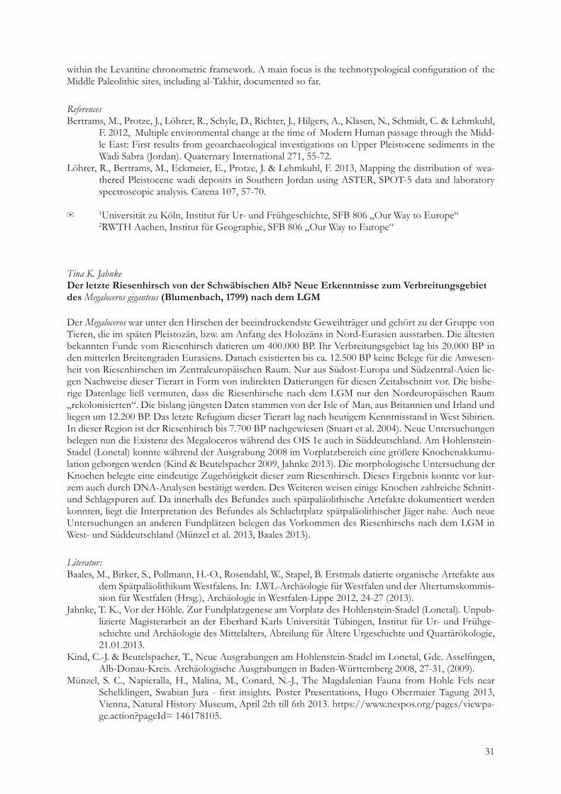
Thomas Einwögerer & Melanie GolebiewskiNeue Rammkernsondagen an der klassischen jungpaläolithischen Fundstelle Krems-Hundssteig, Niederösterreich
Bereits seit 1993 steht der Wachtberg in Krems a. d. Donau, Niederösterreich, im Brennpunkt der Paläolith-forschung. Von einem etwa 160 000 Quadratmeter großen Hangbereich nördlich des Kremser Stadtgebietes liegt heute eine Vielzahl archäologisch relevanter Aufschlüsse vor. Neben modernen Grabungen, Altgra-bungen und Profilschnitten sind es vor allem Rammkernsondagen, die wichtige Informationen über die vielschichtige Quartärstratigraphie des Wachtberges liefern.Zwischen den gegrabenen Fundpunkten Krems-Hundssteig (2000-2002)1, Krems-Wachtberg 2005-20132 und Krems-Wachtberg Ost3 klaffte seit jeher durch die unkontrollierten Abbauarbeiten am klassischen Hundssteig (1894–1904) sowie die nachfolgende Verbauung eine große Lücke, die für die Forschung ver-loren schien. Im Laufe des Jahres 2013 wurden jedoch zwei Parzellen verkauft. Der neue Besitzer plante den Abbruch zwei bestehender Doppelhaushälften, um Platz für einen Neubau mit Keller zu schaffen. Nach bekannt werden des Bauvorhabens beauftragte das Bundesdenkmalamt (BDA) die Forschungsgruppe Quartärarchäologie (OREA, ÖAW) mit Prospektionsarbeiten in Form von Rammkernsondagen. Zweck dieser Arbeiten sollte die Erfassung möglicher Kulturschichten im geplanten Kellerbereich sein. Die Son-dagen wurden in der Zeit vom 18.11. bis 21.11.2013 durchgeführt.Es muss an dieser Stelle hervorgehoben werden, dass Rammkernsondagen paläolithische Kulturschichten im Löss nur bestätigen, aber niemals ausschließen können!Schon die archäologischen Ausgrabungen am südlichen Hundssteig in den Jahren 2000 bis 2002 deuteten an, dass im Bereich des jetzigen Sondagegebietes noch paläolithische Fundschichten anzutreffen wären. Vor
1 Chr. Neugebauer-Maresch (Hrsg.), Krems-Hundssteig – Mammutjäger der Eiszeit, Ein Nutzungsareal paläolithi-scher Jäger- und Sammler(innen) vor 41.000 – 27.000 Jahren, Mitteilungen der Prähistorischen Kommission 67, Wien 2008
2 Einwögerer, T., Händel, M., Neugebauer-Maresch, C., Simon, U., Steier, P., Teschler-Nicola, M., Wild, E.M., 2009. 14C Dating of the Upper Paleolithic site at Krems-Wachtberg, Austria. Radiocarbon 51, 2, 847-855.
3 Einwögerer T. & Schmitsberger O. 2012, Krems an der Donau, FÖ 51, 2012, 199-200.

26
allem die damals erfassten, tief liegenden archäologischen Horizonte (AH) 4 und 5 wurden auf den 2013 untersuchten Parzellen vermutet. Der Horizont AH 4 stellt einen jungpaläolithischen Horizont mit einem 14C-Datum von 30.750 +290 -280 (VERA 1616)4 dar, der AH 5 einen Kulturhorizont mit einem 14C-Datum von 41.000 +1300 -1100 BP (VERA 3516)5.Bei drei der sechs durchgeführten Sondagen konnte eine eindeutige und gut ausgeprägte Kulturschicht im Bereich des geplanten Kellers nachgewiesen werden. Ob diese den bereits genannten archäologischen Horizonten (AH) 4 oder (AH) 5 entspricht, lässt sich nur durch eine Grabung oder die Datierung einer der Holzkohlen, die aus den Rammkernen geborgen wurden, klären.
✉ Mag. Dr. Thomas Einwögerer, Forschungsgruppe Quartärarchäologie, Abteilung Europa, Institut für Orientalische und Europäische Archäologie (OREA), Österreichische Akademie der Wissen-schaften (ÖAW), Fleischmarkt 22, A-1010 Wien. E-mail: [email protected]
Melanie Golebiewski, Institut für Urgeschichte und Historische Archäologie, Franz-Klein-Gasse 1, 1190 Wien. E-mail: [email protected]
Klaus GerkenEine mesolithische, anthropomorphe Darstellung aus Bierden, FStNr. 30, und ihr Kontext
Im Rahmen der Ausgrabungen einer Gaspipeline-Trasse konnten in Bierden, Ldkr. Verden, Niedersachsen, zwei isolierte präboreale Fundstellen entdeckt werden. Sie liegen auf einem Schwemmsandrücken innerhalb der Niederterrasse des Weser/Aller-Tals, welches hier das sog. Bremer Becken bildet. Die beiden sehr ähn-lichen Inventare weisen aus technologisch/typologischer Sicht auf eine Entwicklung aus den Federmesser-Industrien hin. Es sind kleinklingige Inventare, wie sie in Federmesser-Industrien im Großraum üblich sind. Dagegen handelt es sich bei allen bekannten Ahrensburger Komplexen im niedersächsischen Tiefland um großklingige Industrien der sog. Eggstedt-Stellmoor-Gruppe (nach Taute 1968). So finden sich auch im präborealen Inventar von Wehldorf 7, Ldkr. Rotenburg/W. (Gerken 1999, 2001) neben einem großklingi-gen bipoleren Kern weitere großformatige Grundformen und zwei kleine Stielspitzen. Dagegen sind bei
4 Chr. Neugebauer-Maresch und P. Stadler, Absolute Datierung, In: Chr. Neugebauer-Maresch (Hrsg.), Krems-Hundssteig – Mammutjäger der Eiszeit, Ein Nutzungsareal paläolithischer Jäger- und Sammler(innen) vor 41.000 – 27.000 Jahren, Mitteilungen der Prähistorischen Kommission, Band 67, Wien 2008, 168 und 176
5 Chr. Neugebauer-Maresch und P. Stadler, Absolute Datierung, In: Chr. Neugebauer-Maresch (Hrsg.), Krems-Hundssteig – Mammutjäger der Eiszeit, Ein Nutzungsareal paläolithischer Jäger- und Sammler(innen) vor 41.000 – 27.000 Jahren, Mitteilungen der Prähistorischen Kommission, Band 67, Wien 2008, 145
Kre m s -Hun d s s te i g 2013, Rammkernson-dage. Foto: OREA.
27
den Bierdener Fundstellen rückenretuschierte Klingen zu beobachten, wie das Fragment einer Rückenspitze und einige Rückenmesserchen.Die Mikrolithik wird im Übrigen durch einfache Spitzen mit und ohne Basisretusche sowie durch überwie-gend asymmetrische Dreieckspitzen beherrscht. Im Begleitinventar finden sich Stichel, Kratzer und Bohrer. Die Kerne sind zum großen Teil bipolar ange-legt und zeigen spitze Abbauwinkel. Außerdem sind in beiden Inventaren Retuscheure belegt. Eine Besonderheit repräsentiert ein Retuscheur aus der Fundstelle Bierden 30 mit einer gravierten Darstel-lung, die als kopflose anthropomorphe Figur gedeutet wird. Zwei gebogene Linien bilden einen im Hüft-bereich betonten Körper, wobei die linke Linie durch spätere Nutzung des Gerölls zu einem Teil verschlif-fen ist. Die Beinpartie ist verkürzt und nach unten hin verjüngt ausgebildet. Durch eine Kerbe in der oberen Beinpartie wird vermutlich eine Vulva markiert, die die Interpretation als eine Frauendarstellung nahelegt. Affinitäten zu jung- und spätpaläolithischen Darstellungen werfen die Frage zur Entwicklung derartiger Kunstäußerungen im frühen Mesolithikum in Nordeuropa auf. In Niedersachsen ist es bislang die einzige Darstellung ihrer Art. Beide Fundstellen zeichnen sich zudem durch das Vorhandensein von kremierten Knochen aus. Die Analyse hat neben dem Biber, den Wolf, das Wildpferd, Wisent/Ur, Cerviden, Fuchs und das Wildschwein ergeben. Diese Zusammenstellung widerspricht einer frühholozänen Zeitstellung der Fundplätze nicht. Zwei vorliegende 14C-AMS-Daten aus den Holzkohlen einer Konzentration im zentralen Bereich der Fundstelle Bierden 30 bestätigen mit Daten von 9620±50 BP (9225-8823 calBC 2σ, POZ-43938) und 9586±41 (9178-8800 calBC 2σ, AAR-15901) diesen zeitlichen Ansatz.
LiteraturTaute, W. (1968) Die Stielspitzen-Gruppen im nördlichen Mitteleuropa. Ein Beitrag zur Kenntnis der späten
Altsteinzeit. Fundamenta A/5. Köln 1968.Gerken, K. (1999) Wehldorf, FStNr. 7 Eine Station des frühen Mesolithikums ? Archäologische Berichte des
Landkreises Rotenburg (Wümme) 7, 87–91.Gerken, K. (2001) Studien zur jung- und spätpaläolithischen sowie mesolithischen Besiedlung im Gebiet
zwischen Wümme und Oste. Archäologische Berichte des Landkreises Rotenburg (Wümme) 9, 1–360.
Laura GeyerBarbing – Ein Jagdlager des jüngeren Magdalénien im Donautal
Das Fundmaterial von Barbing, Lkr. Regensburg – einer der wenigen in das Magdalénien zu datierenden Freilandfundstellen Süddeutschlands – wurde 1971 beim Kiesabbau auf den Schotterterrassen der Donau entdeckt und im Rahmen einer Notgrabung geborgen. Die knapp 1900 Silices wurden im Rahmen einer Magisterarbeit an der FAU Erlangen untersucht.Trotz der problematischen Bergungsumstände und des Fehlens jeglicher Grabungsdokumentation ermög-lichte es die Bearbeitung, bei der Schwerpunkte sowohl auf die chaîne opératoire der unterschiedlichen Roh-materialien als auch auf deren Verteilung in der Fläche gelegt wurden, das Bild eines mittelfristigen, wohl zu Jagdzwecken aufgesuchten Lagerplatzes zu zeichnen.
✉ Institut für Ur- und Frühgeschichte, Kochstr. 4/18, D-91054 Erlangen
Avi Gopher & Ran Barkai Middle Pleistocene (420-200 ky) Qesem Cave, Israel: Recent finds and studies
Qesem Cave is a Middle Pleistocene site in Israel dated to 420,000-200,000 years ago (Stages 11-7) and assigned to the Acheulo-Yabrudian Cultural Complex (AYCC) of the late Lower Paleolithic. The cave’s rich and well-preserved finds provide a good context in which to test hypotheses concerning the intriguing liai-son between environment, culture, and biology.
28
After a brief survey of the unique cultural transformation seen at Qesem Cave and their relevance to local human evolutionary processes, we comment on a number of new, recently published, or still ongoing, stud-ies from Qesem Cave. These include comments on:• Studies of flint recycling at Qesem Cave. • Lithic oddities from the cave – a large bifacial roughout. • Remarkably well-preserved Quina scrapers showing use signs, residues and signs of gripping. • Bone retouchers. • Microvertebrates and reptiles taphonomy and the question of their accumulation • A study on bat bio-geography and phylogenetics and its relevance to reconstructing cave history. • A 300 ky constructed, repeatedly used fire place in a central location in the Cave. • 3D scanning on human teeth from Qesem.
✉ corresponding author: [email protected]
Daniel GroßMensch und Umwelt im Frühholozän
Im Zuge der Wiedererwärmung nach der letzten Eiszeit fand ein immenser Wandel der Umwelt statt. Glei-chermaßen zeigen die archäologischen Quellen an der Pleistozän/Holozän-Grenze den Übergang von den spätpaläolithischen Rentierjägern der Ahrensburger-Kultur zu Standwild jagenden frühmesolithischen Gruppen. Der Vortrag setzt sich räumlich mit der nordmitteleuropäischen Tiefebene auseinander und be-leuchtet neben Umweltveränderungen auch die Interaktion frühmesolithischer Jäger-und-Sammler-Grup-pen mit ihrem Biotop. Anhand von archäozoologischen Funden und Pollenanalysen werden Paläobiotope rekonstruiert und mit den menschlichen Kulturäußerungen ins Verhältnis gesetzt. Die Artefaktinventare ermöglichen so funktio-nelle Gliederungen der Fundplätze, wohingegen die Einbettung letzterer in das Biotop Rückschlüsse auf die Mensch-Umwelt-Interaktion zulässt. Abschließend findet eine Bewertung der Habitatbindung und Besied-lungsmuster frühholozäner Jäger-und-Sammler-Gruppen statt.
Marc Händel„Eine, sie alle zu steuern!“ Datenbanken in der Quartärforschung – das Beispiel Krems-Wachtberg im Rahmen der Austrian Quaternary Sites
Neben Fund- und Probenmaterial, Plänen, Bild- und beschreibender Dokumentation sind räumliche Daten ein wichtiges Zielprodukt der archäologischen Geländearbeit. In besonderem Maße fallen diese in der Quar-tärforschung bei der Ausgrabung paläolithischer Fundstellen an, da hier einzelfundbasierte Grabungs- und Dokumentationstechniken Anwendung finden, damit auch latente Befunde festgestellt werden können.Es bietet sich also an und ist deshalb auch Usus, die räumlichen Informationen (3D-Koordinaten, Lage-angaben) schon im Gelände mit qualitativen Merkmalen und vor allem einer eindeutigen Kennung (ID) zu verknüpfen. Dabei bleibt die Kennung mit dem Objekt (Fund, Probe, Befund, usw.) im Verlauf der Bear-beitung und Auswertung verbunden, um jederzeit den Rückgriff auf die Gelände- bzw. Primärdaten zu gewährleisten.Im Zuge des Forschungsprojekts Krems-Wachtberg der Österreichischen Akademie der Wissenschaften wurde eine umfangreiche Datenbank aufgebaut, die die Gelände-, Bearbeiter- und Auswertungsdaten nicht nur verwaltet, sondern gleichzeitig den Nutzern zur Eingabe (Artefaktmorphologie, Faunabestimmung, Eintrag von Messwerten bei Proben, usw.) und Weiterverwendung (Fundinventare für Behörden, Räumliche Auswertung mittels GIS, Modellierungen, usw.) der Daten dient. Um dieses System möglichst vielfältig nut-zen zu können, wurde es als MySQL-Datenbank konzipiert und auf einem eigenen Server abgelegt. Damit wird interner und externer Zugriff durch eine Vielzahl von Nutzern möglich.
29
Weil aber Auswertung nicht bei einer Fundstelle stehen bleiben kann, wurde das Datenbank- Projekt von Beginn an für eine unbegrenzte Anzahl Fundstellen konzipiert und als „AQS – Austrian Quaternary Sites“ ins Leben gerufen. In dieser Datenbank unterscheiden wir drei Ebenen:1 AQS: Tabellen zu Fundstellen, Maßnahmen, Literatur2 Fundstellen: Tabellen zu Geländedaten, Befunden, Schichten, Artefaktmorphologie, lithisches Roh-
material, Fauna, Holzkohlen, Proben, usw.3 Servicetabellen: Attributlisten für bestimmte Felder bestimmter TabellenAuf der obersten Ebene befindet sich die Tabelle der AQS-Fundstellen mit ihrem Primärschlüssel, der Fundstellen-ID – ohne diese kann es z.B. keine Maßnahmen, aber auch keine fundstellenspezifischen Tabel-len geben. Auf der zweiten Ebene muss jedes Objekt in der Geländedatentabelle mit eigenem Primärschlüs-sel angelegt sein, um in die übrigen Tabellen angefügt werden zu können. Und selbstverständlich kann es nur Attributlisten geben für Felder bestehender Tabellen.Mittlerweile hat die Datenbank weit über eine halbe Million Einträge und wächst beständig. Der Löwenan-teil entfällt auf das Subsystem Krems-Wachtberg.
✉ Marc Händel, Forschungsgruppe Quartärarchäologie, Institut für Orientalische und Europäische Archäologie, Österreichische Akademie der Wissenschaften, [email protected]
Thomas C. Hauck1, Sorin M. Petrescu2, Ion C. Baltean3 & Thomas Wolter4, Late Pleistocene human occupations around Oase Cave (Romania)
Since the early modern human fossils of Peştera Cu Oase (SW Carpathians) were found deprived of any material context deep inside the karst system, archaeological research now tries to detect Aurignacian sites nearby which can be related with the human finds. Within the framework of the Collaborative Research Centre “Our Way to Europe” (CRC 806) investigations focus on two sites with high scientific potential: the Plopa-Ponor rock-shelter and Hotilor Cave. The latter is a small cave which bears traces of Mesolithic and late Upper Palaeolithic occupations with a mean 14C age of 13’600 cal BP. At Plopa-Ponor rock-shelter our test trenches reached sediments dating back to the Last Glacial Maximum. Lithic artefacts, bones and char-coal found in these deposits are the first evidence for a Gravettian occupation around Oase Cave dating back to 25’500 cal BP. The poster presents the recent results of our ongoing excavation project.
✉ 1Institute for Prehistoric Archaeology, University of Cologne 2Caraş-Severin County Department for Culture and Cultural Heritage, Romania 3Heritage Advice, Alba Iulia, Romania 4Institute for Prehistoric Archaeology, University of Cologne
Stephan M. Heidenreich, Markus Steffen & Thomas BeutelspacherHohlenstein 3D - Archäologische Dokumentation mit terrestrischem Laserscanning
Digitale Dokumentationstechniken sind zu einem Standard in der modernen archäologischen Feldforschung und Denkmalpflege geworden. Neben der regelhaft in der baden-württembergischen Denkmalpflege ange-wandten Photogrammetrie werden archäologische Denkmale, Ausgrabungen und Funde vermehrt mit Laser- und Streifenlichtscannern dreidimensional dokumentiert. Im Rahmen der jüngsten Forschungen am Hohlenstein im Lonetal wurden die Stadel-Höhle und die Bärenhöhle mit einem terrestrischen Laserscan-ner vermessen. Der Vortrag soll eine Einführung in die Methodik des Laserscannings geben sowie Möglich-keiten und Schwierigkeiten des Verfahrens in höchst komplexen Höhlenräumen aufzeigen. Die ersten vor-liegenden 3D-Modelle der Höhlen im Hohlenstein verdeutlichen bereits das Potential dieser neuen Dokumentationstechnik.
✉ Korrespondierender Autor: [email protected] Landesamt für Denkmalpflege im Re-gierungspräsidium Stuttgart

30
Bibiana Hromadová1 & Ľubomíra KaminskáThe Upper Palaeolithic ivory points from the cave sites of Slaninová, Čertova pec and Dzeravá skala (Slovakia)
During the old Upper Paleolithic prehistoric groups with different technological traditions used to live all across Europe, adapted in various kind of environment. The most significantly affected these adaptations in the utilization of different animals and the strategies of use of animal raw material in the production of tools. Mammoths were no exception as a big amount of resources for various uses. Considering the number of artifacts found on archaeological sites, utilization of mammoth bones and tusks in the tool production is one of the characteristic features of Gravettian in Central and Eastern Europe (28-20 ky bp.). Despite the fact, that the majority of sites with bone and ivory inventory in Central Europe usually belongs to the open-air sites, most peculiar finds of mammoth bone and ivory tools in Slovakia comes from gravettian layers in cave sites: Dzeravá skala, Slaninová jaskyňa and Čertova pec. All of them are located in the inner part of Western Carpathians. Due to satisfying preservation, the tool inventory of those sites consist the numerous collection of bone artifacts. The organic inventory contains also a small series of worked ivory objects. Outstanding among them is the series of long massive points made from mammoth tusks. Despite of few artifacts preserved, they play a notable role in the analysis of Gravettian tool assemblage.The study of the ivory points from the Slovakian cave sites allows us to understand some details about interaction between lithic and ivory artifacts, technics of the splitting of the tusk and relationship between production of points and knapping actvities. It`s possible to distinguish also some different technical tradi-tions in the production of ivory points themselves, that could reflect some different types of occupation during Gravettian in Slovakia. Group of points consists mostly in fragments, but some of them might be considered as a specific for that type of object. For example, fragment of ivory point from the cave Čertova pec bears a unique example of ornamental decoration, different from those found on other decorated points known from other sites. Results of the analysis could be compared with some points, well known from other Gravettian sites in Central (Pavlov I, Dolní Věstonice I etc.) and Eastern Europe (Avdeevo New, Kostenki 1/1, Zaraysk etc.). Such comparisons can help to understand the place of that peculiar ivory objects in the strategies of use of animal raw material in Upper Palaeolithic sites.
✉ 1Institute of Archeology SAS, Akademická 2, 949 21, Nitra, Slovakia 2Institute of Archeology, SAS, Dep. of Eastern Slovakia Research, Hrnčiarska 13, 040 01 Košice,
Slovakia
Shumon T. Hussain1, Rene Löhrer2, Frank Lehmkuhl2, Daniel Schyle1, Manuel Bertrams2, Thomas Wolter1 & Jürgen Richter1
Locating and identifying Pleistocene sediment remnants within arid wadi landscapes: iron oxide mapping as geoarchaeological survey method
Systematically documenting an entire archaeological landscape is always a challenge. Ancient wadi land-scapes resulting in highly fragmented depositional environments with often very different sediment genesis pose a special problem for palaeolithic archaeologists due to the nature of surveying and the low visibility of surface finds there. Here, we present a method combining remote sensing, spectroscopic analysis and laboratory testing to characterize and spatially identify “sedimentological fingerprints” which can be used to predict archaeological occurrences (cf. Löhrer et al. 2013). Mapping specific iron oxide (Fe3+) signatures, which serve as proxies for relocation and weathering processes in arid settings, proves to be a practical tool for locating paleolithic site aggregations in the field. This enables us to determine the precise relationship between specific sediments and archaeological remains by combining remote sensing and GIS methods. In the course of the CRC 806 “Our Way to Europe” we used this approach in our Jordanian working area within the Wadi Sabra catchment near the ancient city of Petra (cf. Bertrams et al. 2012). It rapidly became clear that the archaeological sites of the region, which are embedded in these sediments, span the entire Middle to Upper Pleistocene and cover all types of occurrences – from surface scatters to deeply stratified sites. Accordingly, we discuss the archaeological context of the mapped wadi sediments and place them
31
within the Levantine chronometric framework. A main focus is the technotypological configuration of the Middle Paleolithic sites, including al-Takhir, documented so far.
ReferencesBertrams, M., Protze, J., Löhrer, R., Schyle, D., Richter, J., Hilgers, A., Klasen, N., Schmidt, C. & Lehmkuhl,
F. 2012, Multiple environmental change at the time of Modern Human passage through the Midd-le East: First results from geoarchaeological investigations on Upper Pleistocene sediments in the Wadi Sabra (Jordan). Quaternary International 271, 55-72.
Löhrer, R., Bertrams, M., Eckmeier, E., Protze, J. & Lehmkuhl, F. 2013, Mapping the distribution of wea-thered Pleistocene wadi deposits in Southern Jordan using ASTER, SPOT-5 data and laboratory spectroscopic analysis. Catena 107, 57-70.
✉ 1Universität zu Köln, Institut für Ur- und Frühgeschichte, SFB 806 „Our Way to Europe“ 2RWTH Aachen, Institut für Geographie, SFB 806 „Our Way to Europe“
Tina K. Jahnke Der letzte Riesenhirsch von der Schwäbischen Alb? Neue Erkenntnisse zum Verbreitungsgebiet des Megaloceros giganteus (Blumenbach, 1799) nach dem LGM
Der Megaloceros war unter den Hirschen der beeindruckendste Geweihträger und gehört zu der Gruppe von Tieren, die im späten Pleistozän, bzw. am Anfang des Holozäns in Nord-Eurasien ausstarben. Die ältesten bekannten Funde vom Riesenhirsch datieren um 400.000 BP. Ihr Verbreitungsgebiet lag bis 20.000 BP in den mitterlen Breitengraden Eurasiens. Danach existierten bis ca. 12.500 BP keine Belege für die Anwesen-heit von Riesenhirschen im Zentraleuropäischen Raum. Nur aus Südost-Europa und Südzentral-Asien lie-gen Nachweise dieser Tierart in Form von indirekten Datierungen für diesen Zeitabschnitt vor. Die bishe-rige Datenlage ließ vermuten, dass die Riesenhirsche nach dem LGM nur den Nordeuropäischen Raum „rekolonisierten“. Die bislang jüngsten Daten stammen von der Isle of Man, aus Britannien und Irland und liegen um 12.200 BP. Das letzte Refugium dieser Tierart lag nach heutigem Kenntnisstand in West Sibirien. In dieser Region ist der Riesenhirsch bis 7.700 BP nachgewiesen (Stuart et al. 2004). Neue Untersuchungen belegen nun die Existenz des Megaloceros während des OIS 1e auch in Süddeutschland. Am Hohlenstein-Stadel (Lonetal) konnte während der Ausgrabung 2008 im Vorplatzbereich eine größere Knochenakkumu-lation geborgen werden (Kind & Beutelspacher 2009, Jahnke 2013). Die morphologische Untersuchung der Knochen belegte eine eindeutige Zugehörigkeit dieser zum Riesenhirsch. Dieses Ergebnis konnte vor kur-zem auch durch DNA-Analysen bestätigt werden. Des Weiteren weisen einige Knochen zahlreiche Schnitt- und Schlagspuren auf. Da innerhalb des Befundes auch spätpaläolithische Artefakte dokumentiert werden konnten, liegt die Interpretation des Befundes als Schlachtplatz spätpaläolithischer Jäger nahe. Auch neue Untersuchungen an anderen Fundplätzen belegen das Vorkommen des Riesenhirschs nach dem LGM in West- und Süddeutschland (Münzel et al. 2013, Baales 2013).
Literatur:Baales, M., Birker, S., Pollmann, H.-O., Rosendahl, W., Stapel, B. Erstmals datierte organische Artefakte aus
dem Spätpaläolithikum Westfalens. In: LWL-Archäologie für Westfalen und der Altertumskommis-sion für Westfalen (Hrsg.), Archäologie in Westfalen-Lippe 2012, 24-27 (2013).
Jahnke, T. K., Vor der Höhle. Zur Fundplatzgenese am Vorplatz des Hohlenstein-Stadel (Lonetal). Unpub-lizierte Magisterarbeit an der Eberhard Karls Universität Tübingen, Institut für Ur- und Frühge-schichte und Archäologie des Mittelalters, Abteilung für Ältere Urgeschichte und Quartärökologie, 21.01.2013.
Kind, C.-J. & Beutelspacher, T., Neue Ausgrabungen am Hohlenstein-Stadel im Lonetal, Gde. Asselfingen, Alb-Donau-Kreis. Archäologische Ausgrabungen in Baden-Württemberg 2008, 27-31, (2009).
Münzel, S. C., Napieralla, H., Malina, M., Conard, N.-J., The Magdalenian Fauna from Hohle Fels near Schelklingen, Swabian Jura - first insights. Poster Presentations, Hugo Obermaier Tagung 2013, Vienna, Natural History Museum, April 2th till 6th 2013. https://www.nespos.org/pages/viewpa-ge.action?pageId= 146178105.
32
Stuart, A. J., Konsintsev, P. A., Higham, T. F. G., Lister, A. M. Pleistocene to Holocene extinction dynamics in giant dee and woolly mammoth. Nature 431, 684-689 (2004).
Jan F. KeglerJäger- und Sammler der Ostfriesischen Geest. Eine neue Fundstelle der Hamburger Kultur bei Sandhorst (Ldkr. Aurich)
Per Zufall wurde 2010 nordwestlich der ostfriesischen Kreisstadt Aurich eine Fundstelle der spätjungpaläoli-thischen Hamburger Kultur entdeckt (Kegler 2012). Bei planmäßigen Prospektionen für ein neues Gewerbe-gebiet wurden ursprünglich Reste einer eisenzeitlichen Siedlung freigelegt. Zwischen den Siedlungsgruben fanden sich auf eng begrenztem Raum aber auch einige paläolithische Artefakte, die sich bei näherer Betrach-tung als Geschossspitzen der Hamburger Kultur herausstellten. Zwischen Herbst 2010 und Sommer 2011 wurde eine etwa 350m² große Fläche untersucht und einige Tausend Artefakte, zumeist jedoch Absplisse, aus dem anstehenden pleistozänen Sandboden herausgesiebt. Knochen haben sich in den entkalkten Sanden leider nicht erhalten. Die Fundstelle ist nur noch in Teilen vorhanden, da Sie durch die moderne Landwirtschaft so-wie im Mittelalter durch die Anlage von Wölbäckern teilweise gekappt worden ist. Die Fundkonzentration nimmt einen Bereich von ca. 5 zu 7 Metern ein. Im Kern befand sich eine hellgraue Bodenverfärbung, die ursprünglich für einen Baumwurf gehalten worden ist. Bei der Ausgrabung stellte sich heraus, dass es sich um eine ausgewaschene Feuerstelle handelt, aus der einige zum Teile gebrannte Gerölle stammen. Das Artefaktspektrum besteht zu 70% aus Absplissen, gefolgt von einfachen Abschlägen. Für eine jungpa-läolithische Station liegen erstaunlich wenige Klingen oder Lamellen vor. Jedoch zeigt ein Kern regelmäßige Abbaunegative eines sehr regelmäßigen Klingenabbaus. Kernkantenklingen wie auch ein Kernfuß zeugen von der Grundformproduktion regelmäßiger Klingen an der Fundstelle. Der nur wenige Typen umfassende Werkzeugsatz entspricht dem einer spätglazialen Fundstelle. Das gesamte Formengut, wie Rückengestumpf-te Formen (Rückenspitzen und -messer), Kratzer, Bohrer und Stichel sowie wenige Endretuschen und late-ral retuschierte Formen ist somit in Sandhorst vertreten. Für die erste chronologische Einordnung sind drei Rückenspitzen von Bedeutung. Es handelt sich um ein-fach retuschierte Formen, wobei zwei geknickte Rückenspitzen sowie eine Kerbspitze vorliegen. Nach den vorliegenden Formen würde die Fundstelle in das späte Jungpaläolithikum an das Ende der Weichsel-Kalt-zeit datieren. Die Fundstelle liegt etwa zwischen den bekannten Verbreitungsgebieten der spätjungpaläoli-thischen Hamburger Kultur, deren Verbreitung die der Nordwesteuropäischen Tiefebene umfasst, und der Havelte-Gruppe, die hauptsächlich im Nordwesten Europas verbreitet ist (Grimm u. Weber 2008). Auf-grund der geringeren Artefaktgrößen würde die Fundstelle Sandhorst tendenziell daher eher der Havelte-Gruppe zugehören, obwohl die typischen Havelte-Stielspitzen fehlen.
LiteraturGrimm, S.B. und Weber, M.-J., The chronological framework of the Hamburgian in the light of old and new
14C dates. Quartär 55 (2008), 17-40.Kegler, J.F. 2012, Die Fundstelle in der Fundstelle. Eine Station jungpaläolithischer Jäger in Ostfriesland.
Archäologie in Niedersachsen 15 (2012), 100-103.

33
Claus-Joachim KindThe Smile of the Lion Man
Hohlenstein (“hollow rock”) is a large rock formation on the southern edge of the Lone Valley. In this formation, three Palaeolithic sites were discovered. One of them is Stadel cave. To verify the situation, the State Office for National Heritage of the Regional Administrative Authority of Baden-Wuerttemberg carrried out small excavations between 2008 and 2013, at multiple locations inside and in front of Stadel cave. With these test trenches, we attempted to clarify whether archaeological layers remained at the site and how old the possible finds in these layers are. One trench was located in front of the cave, the other about 30m inside the entrance. The excavations quickly showed that the negative fore-casts were wrong. Surprisingly, substantial layers with numerous archaeological finds were recovered from both sites.During the new excavations in the cave also a small area with a mixture of no longer intact sediments was discovered. These sediments are obviously the remains from the 1939 excavation by Robert Wetzel and Otto Voelzing, which were used to refill the previously excavated trench. These previously excavated materials also contained a number of archaeological finds that were overlooked during the original investigation. Bone fragments predominate among these finds. Some stone tools were also recovered. The recovered materials also include hundreds of fragments of mammoth ivory of different sizes. Some fragments show clear signs of being worked and it was very possible that they may belong to the lion man figure. Surpris-ingly, an initial unsystematic attempt to fit the fragments confirmed this. In 2012/2013, the lion man figure was disassembled and then refit as a very complicated three-dimension puzzle. A portion of the new frag-ments was included in the puzzle. As a result, the lion man now looks quite different from the well-know familiar image.
K. Kindermann1, F. Henselowsky2 & O. Bubenzer2
Upscaling and Downscaling – Site formation processes in caves in hyper arid environments, Sodmein Cave, Egypt
Archaeological sites are formed as a result of a sequence of different and often repeated formation pro-cesses. These processes affected both the way in which finds have been buried and what happened to them afterwards. Generally, a distinction can be made between cultural formation processes and natural forma-tion processes. Hyper arid environments – and here especially caves – imply very particular conditions and taphonomic processes about which little is known up to now.Using the example of Sodmein Cave (Eastern Desert, Egypt) the poster will give a first attempt to identify formation processes in caves in hyper arid environments. The cave stratigraphy of Sodmein, with more than four meters of stratified human occupation debris, is one of the rare living sites in Egypt dating from the Middle Palaeolithic until the Holocene. During the last years the geoarchaeological research by the universi-ties of Cologne and Leuven (CRC 806 “Our Way to Europe”) focused on the Middle Palaeolithic layers, for which investigations on the macro level (e.g. artefact distribution and dislocation) and on the micro level (e.g. sedimentological and microphological analysis) were conducted. For the first time micromorphological sam-ples and thin sections were investigated for an archaeological site in hyper arid north-eastern Africa. Due to the high amount of excellent preserved plant remains and coprolites, the thin sections not only offer infor-mation about sediment accumulation processes and pedofeatures, but also of fauna and flora activity. The varying portion of aolian sand and silt indicate diachronic changes in aeolian input to the cave. The analysis of the organic material and aeolian input can be directly linked to climatic changes.
✉ 1University of Cologne, Institute of Prehistoric Archaeology, Bernhard-Feilchenfeld-Straße 11, 50969 Köln, Germany
2University of Cologne, Institute of Geography, Albertus-Magnus-Platz, 50923 Köln, Germany

34
Maria KnippingZwischen Eem und Holstein? Pollenanalytische Untersuchungen an mittelpleistozänen Seesedimenten im Graben E Höhenmoos (Gmd. Rohrdorf, Oberbayern)
Im Zuge der geologischen Landesaufnahme des Blattes 8127 Stephanskirchen wurden im Graben E bei Höhenmoos (ca. 550–570 m NN) präwürmzeitliche feinkörnige Seesedimente aufgefunden. Die durch Eis-auflast stark überkonsolidierten Sedimente sind durch einen Bach in zahlreichen Rutschkör pern auf ca. 200 m Länge im Bereich mehrerer Prallhänge aufgeschlossen. An diesen Aufschlüssen wurden mehrere Profile entnommen und bislang 4 analysiert. Die meist gleichförmigen Schluffe kön nen pollenanalytisch und auch lithologisch über eine etwa 10 cm bis 20 cm mächtige Sandlage paral lelisiert werden. Die Lokalität liegt im südöstlichen Randbereich des würmzeitlichen Inn-Vorland gletschers, nur etwa 6 km NNE der be-kannten Interglazialvorkommen am Samerberg. Die Vegetationsentwicklung zeigt im Liegenden eine offene Vegetation mit einem sehr hohen Anteil von aufgearbeiteten Palynomorphen, danach weist eine lokale Pollenzone (LPZ) mit Pinus, Picea, Betula und zu-nehmenden Anteilen von Thermophilen (Quercus, Ulmus, Tilia) auf den Beginn von warmzeitlichen Bedin-gungen hin. Im Folgenden nehmen die Abies-Anteile stark zu und werden da nach von Picea als dominantem Pollentyp abgelöst. Thermophile Taxa sind weiterhin mit geringen Anteilen vorhanden. Nach einem kurz-fristigen Pinus-Anstieg folgt eine Zone mit hohen Picea-Antei len die mit vier kurzen Phasen mit höheren Nichtbaumpollen-Anteilen (NBP) abwechseln. Es treten ver mehrt schlecht erhaltene Pollenkörner (Inde-terminata) und präquartäre Taxa auf und verweisen auf aufgearbeitete Sedimente und verstärkte Erosion. Diese NBP-reichen Phasen zeigen eine deutliche Auflichtung der Vegetation, welche jeweils durch nachfol-gende erhöhte Juniperus-Anteile wieder zu einer Picea-Phase überleiten. Im Profil sind keine Gleitbahnen erkennbar, die auf eine Störung der Abfolge hinweisen würden. In der folgenden LPZ sind Pinus und Betula dominant, Pollen von Picea, Larix, Pinus cembra-Typ, Alnus viridis und Juniperus ist mit durchgehenden Kurven vertreten. Im weiteren Verlauf nehmen die Betula-Anteile deutlich ab, während Pinus-Pollen zunimmt. Hohe An teile von Corylus, Ulmus, Quercus, und Fraxinus zeigen danach den Beginn einer weiteren Warmzeit an. Es wurden mehrfach Funde von Celtis während dieser Frühphase nachgewiesen. Zunehmende Carpinus-Antei-le leiten zu einer ausgeprägten Abies-Phase über. In dieser Abies-Phase sind regelmä ßig Fagus, Taxus, und Buxus nachgewiesen. Zurückgehende Abies-Anteile bei zunehmenden Picea- und Pinus-Anteilen leiten zu einer kühleren LPZ über. Die oberste LPZ zeigt kaltzeitliche Bedingun gen mit einer deutlichen Auflichtung der Vegetation an.In dieser für Süddeutschland einzigartigen Vegetationsabfolge konnten zwei unterschiedliche Warmzeiten nachgewiesen werden, die durch eine kühl-feuchte und daran anschließend eine kühl-trockene Phase ge-trennt sind. Im Liegenden und im Hangenden sind jeweils Kaltphasen belegt. Bislang wurden keine autochthonen Tertiärrelikte gefunden, die auf ein frühpleistozänes Alter schlie ßen lassen, auch Pterocarya wurde nicht nachgewiesen. Nach dem heutigen Analysenstand ist eine Korrelation der Vegetationsentwicklung in Höhenmoos weder mit dem Eem oder Holstein, noch mit dem Frühwürm möglich (Drescher-Schneider 2000; Grüger 1979, 1983; Müller 2001). Ein Vergleich mit dem Profil von Meikirch II (Preusser et al. 2005) und der Mannheim-Warmzeit (Knipping 2008) lassen bislang eine Korre-lation möglich erscheinen, auch wenn aufgrund der größeren Entfernung und unterschiedlicher Höhenla-gen abweichende Pollenspektren existent sind. OSL-Datierungen weisen Alter von ca. 200 ka auf und zei-gen damit eine mittelpleistozäne Stellung in MIS 7 an.
LiteraturDrescher-Schneider, R. ( 2000): 2. Halt: Kiesgrube Thalgut: Pollen- und großrestanalytische Untersuchun-
gen. In: Kelly, M., Linden, U. & Schlüchter, Chr., Exkursionsführer DEUQUA 2000, Eiszeitalter und Alltag, Bern 6–8 September 2000: 128-136
Grüger, E. (1979): Spätriß, Riß/Würm und Frühwürm am Samerberg in Oberbayern – ein vege ta tions-geschicht licher Beitrag zur Gliederung des Jungpleistozäns. Geologica Bavarica, 80: 5-64
Grüger, E. (1983): Untersuchungen zur Gliederung und Vegetationsgeschichte des Mittelpleistozäns am Samerberg in Oberbayern. Geologica Bavarica, 84: 21-45
Knipping, M. (2008): Early and Middle Pleistocene pollen assemblages of deep core drillings in the north-ern Upper Rhine Graben, Germany. Netherlands Journal of Geosciences – Geologie en Mijnbouw, 87: 51-65

35
Müller, U. (2001): Die Vegetations- und Klimaentwicklung im jüngeren Quartär anhand ausgewählter Pro-file aus dem südwestdeutschen Alpenvorland. Tübinger Geowissenschaftliche Arbeiten, Reihe D7, 118 S.
Preusser, F., Drescher-Schneider, R., Fiebig, M. & Schlüchter, Ch. (2005): Re-interpretation of the Meikirch pollen record, Swiss Alpine Foreland, and implications for Middle Pleistocene chronostratigraphy. Journal of Quaternary Science, 20: 607-620.
✉ Inst. für Botanik, Universität Hohenheim, D-70593 Stuttgart, [email protected]
Jörg Lang1, Jutta Winsemann1, Utz Böhner2, Jordi Serangeli3, Ulrich Polom4 & Christian Brandes1
Die Faziesarchitektur der warmzeitlichen Ablagerungen von Schöningen als Schlüssel zum Verständnis der paläolithischen Fundstellen
Die Fundstellen von Schöningen stellen durch die Überlieferung einzigartiger Artefakte ein herausragendes Archiv des Paläolithikums in Mitteleuropa dar. Die mittelpleistozäne Abfolge wurde in einer elsterzeitlich angelegten subglazialen Rinne („tunnelvalley“) abgelagert und erhalten (Lang et al., 2012). Während der Hol-stein-Warmzeit (MIS 9, Urban et al., 2011) bildete sich in der unvollständig verfüllten subglazialen Rinne ein See, der lateral durch Deltaablagerungen aufgefüllt wurde. Um die räumliche und zeitliche Verteilung der Fundstellen und ihrer internen Fundschichten zu klären präsentieren wir ein neues Ablagerungsmodell, das auf Aufschlussbeobachtungen, Bohrlochdaten, hochauflösenden scherwellenseismischen Profilen und 3D-Untergrundmodellierungen basiert (Lang et al. 2012; in review). Im Verlauf der Warmzeit führten Seespiegelschwankungen zur lateralen Stapelung von unterschiedlichen Deltasystemen. Durch die Progradation nimmt das Alter dieser Deltaablagerungen und der darin eingebet-teten Artefakte von Westen nach Osten sukzessive ab. Die paläolithischen Artefakte treten in uferparallelen Zonen auf und stammen hauptsächlich aus den Ablagerungen der Deltaebenen.Durch Seespiegelanstiege wurden die Artefakte im Sediment eingebettet und blieben so erhalten. Der See stellte trotz wechselnder klimatischer Bedingungen einen sehr attraktiven Ort für Urmenschen und ihre Beutetiere dar (Lang et al., in review). Während des Drenthe-Eisvorstoßes der Saale-Eiszeit wurde der letzte Rest der subglazialen Rinne aufge-füllt. Die Fundschichten blieben durch ihre tiefe, vor Erosion geschützte Lage in der subglazialen Rinne erhalten.
LiteraturLang, J., Winsemann, J., Steinmetz, D., Polom, U., Pollok, L., Böhner, U., Serangeli, J., Brandes, C., Hampel,
A. & Winghart, S., 2012: The Pleistocene of Schöningen, Germany: a complex tunnel valley fill re-vealed from 3D subsurface modelling and shear wave seismics. Quaternary Science Reviews, 39, 86-105.
Lang, J., Winsemann, J., Polom, U., Serangeli, J. & Böhner, U., in review: The Middle Pleistocene tunnel valley at Schöningen as a paleolithic archive. Journal of Human Evolution.
Urban, B., Sierralta, M. & Frechen, M., 2011: New evidence for vegetation development and timing of Up-per Middle Pleistocene interglacials in Northern Germany and tentative correlations. Quaternary International 241, 125-142.
✉ 1Institut für Geologie, Leibniz Universität Hannover, Callinstraße 30, D-30167 Hannover, Email: [email protected]
2Niedersächsisches Landesamt für Denkmalpflege, Scharnhorststraße 1, D-30175 Hannover 3Institut für Ur- und Frühgeschichte, Eberhard Karls Universität Tübingen, Burgsteige 11,
D-72070 Tübingen 4Leibniz Institut für Angewandte Geophysik (LIAG), Stilleweg 2, D-30655 Hannover
36
Ine LeonardReading the past or decoding the archaeological record. A theoretical framework for the identifi-cation of culture contact and migration in the prehistoric archaeological record
Attempts to explain the material variability in the artefact record is one of the oldest and still ongoing dis-cussions in archaeology. Initially, migration and cultural contact were considered the main explanatory pro-cesses for changes in the archaeological record. Implementation and definition problems, however, pushed both processes to the background. The presented M.A. thesis research aims to rekindle the explanatory value of cultural contact and migration by developing a preliminary framework based solely on the archaeological artefacts. Although, all artefact concepts are part of the cultural heritage, not every artefact concept is connected to intrinsic values of social, religious or ideological nature. Some artefact concepts are merely associated with basic sustenance tasks. In order to determine whether or not an archaeological artefact embodied an intrinsic value, proxies were deduced from ethnographic studies of the Australian Aborigines. Some examples of these proxies are rare raw materials, time or energy consuming production and finalization techniques, deposition contexts and artefact-assemblage ratios. Based on these and other proxies, eight different artefact classes were defined, enabling a preliminary divi-sion of the archaeological material concerning their sensitivity to exogenous influences. To determine whether an artefact exhibit exogenous influences and to which degree, a measuring tool based on the prin-ciples of seriation, attribute analysis and statistical formulae was developed. For testing such a measuring tool multiple well understood archaeological sequences that contain multiple consecutive archaeological assemblages are required. It is also important that they are situated within each other’s vicinity – so as to rule out major environmental factors which might also induce inter-site variability.The presented preliminary framework does not claim to resolve the existing uncertainties concerning mate-rial variability but aims to contribute to the current debate.
✉ Research assistant SBF 806 ´Our Way to Europe´, Institut für Ur- und Frühgeschichte, Universität Köln
Tim MatthiesFirst results of a faunal analysis from the excavations (1927) at the Aurignacian open-air site Breitenbach-Schneidemühle
The large settlement Breitenbach-Schneidemühle (Saxony-Anhalt) is one of the few Aurignacian open-air stations known from Germany. At 51 degrees latitude, it is one of the northernmost stations and with an excavated area of over 400 square metres the largest known open-air settlement that can be securely attrib-uted to the Aurignacian in Western Eurasia (see Jöris & Moreau, 2010). Aside from Lommersum, Breiten-bach is also the only Aurignacian open-air settlement with a sizable faunal inventory, thus offering the opportunity to investigate dietary and subsistence patterns in the Early Upper Palaeolithic of northern Central Europe.Presented here are the first results of the first comprehensive faunal analysis of the organic remains recov-ered during excavations by N. Niklasson in 1927 during which approximately 400 square metres were inves-tigated. The faunal inventory is dominated by reindeer and mammoth, but unlike Lommersum is character-ised by a much wider faunal spectrum. Poor bone surface preservation (of larger taxa) and less-than-rigorous recovery of organic remains hinders the detailed analysis of anthropogenic bone modifications and to some extent that of body part representation. However, the majority of the remains were recorded on a two-dimensional grid, allowing for a horizontal reconstruction of their spatial distribution and insight into intra-site organisation. Notwithstanding the methodological problems to be expected with old excavations, Bre-itenbach offers a fresh perspective on Aurignacian subsistence and land-use strategies and will complement the data known from cave settings (e.g. Vogelherd).
Keywords: Faunal analysis, Aurignacian, open-air site, Northern Central Europe, subsistence and land-use strategies
37
ReferencesJöris, O & L. Moreau. 2010. Vom Ende des Aurignacien. Zur chronologischen Stellung des Freilandfund-
platzes Breitenbach (Burgenlandkreis) im Kontext des frühen und mittleren Jungpaläolithikums in Mitteleuropa. Archäologisches Korrespondenzblatt 40, 1–20.
Lutz Christian Maul, K. T. Smith, Arlett Ulbricht, Felicitas Flemming, Ran Barkai & Avi GopherPalaeoenvironmental implications of the Middle Pleistocene microvertebrate remains of Qesem Cave, Israel, and a comparison of faunistic/palaeoecological conditions between the Near East and Central Europe
Archaeological sites from the Near East play a major role in the reconstruction of human history. Lower Palaeolithic (Middle Pleistocene) Qesem Cave in Israel is of particular importance for new information about the cultural and biological evolution/transformations of early humans at the crossroads between Africa, Europe and Asia. In addition to vast amounts of archaeological material and some human dental remains, a huge number of large and small vertebrates have been excavated. Dental and skeletal material of microvertebrates is well known to provide meaningful information about palaeoenvironment, the biostrati-graphic age and taphonomy of the site investigated. At present, microvertebrate material of Qesem Cave is concentrated in two areas. So far ca. 10,000 specimens (of more than 233,000 microvertebrate remains in total) have been identified at least to the genus level; they belong to 26 taxa. Palaeoenvironmental conditions have been inferred from the hitherto known ecological requirements of their extant relatives and from cli-matic parameters of their current distribution areas. The data suggest environmentally equivalent areas in recent Turkey –, Marmara region and East Anatolia – with slightly higher precipitation than at present around Qesem Cave. A comparison of the Qesem Cave microvertebrate-bearing layers to one another reveals more forested conditions in the upper part of the stratigraphic sequence in comparison to the lower part. However, to some extent also taphonomical influences could be responsible for these fluctuations (e.g., selective prey intake of the raptors responsible for the fossil accumulation). Finally, the palaeoecological data from Qesem Cave are compared with those from contemporaneous Central European microvertebrate faunas in order to correlate climate-driven changes in both regions. The faunistic and climatic oscillations are much more pronounced in Central Europe than in the Near East.
Faunen aus dem nahem Osten spielen in der Rekonstruktion der Geschichte der Hominini eine große Rol-le. Eine für die Entwicklung des modernen Menschen besonders wichtige ist die Mittelpleistozän Fundstel-le Qesem in Israel. Hier wurde neben archäologischem und anthropologischem Material auch eine große Zahl an Wirbeltierresten – Großsäuger und Kleinvertebraten – gefunden. Sie werden in Planquadraten zu je 5 cm Schichten abgegraben.Kleinvertebraten können für viele Fragestellungen – neben biostratigraphischen, paläeobiogeographischen und taphonomischen Untersuchungen spielen vor allem die Analysen zum Paläoenvironment eine große Rolle.In Qesem wurden bisher etwa 100000 Reste Kleinvertebraten nachgewiesen, die sich auf 19 Taxa verteilen. Die Kleinvertebraten stammen aus zwei Konzentration Areas.Anhand der nachgewiesenen Arten und deren heutigen Umweltansprüchen sowie den Klimaparameter die aus den heutigen Verbreitungsgebieten zu erschließen wird auf die Umweltverhältnisse geschlossen. Die bisherigen Daten lassen Verhältnisse erkennen, die etwas denen in Kleinasien entsprechen.Bei Vergleich der Schichten untereinander sind gewisse Fluktuationen zu beobachten, die auf schrittweise Zunahme der Vegetation schließen lassen. Schließlich sind auch noch die taphonomischen Beeinflussungen zu berücksichtigenDie Ergebnisse werden mit entsprechenden Daten zum ökologischem Wandel der Mitteleuropäischen Kleinvertebraten verglichen, mit dem Ziel, evolutiv bedingte und klimagesteuerte Veränderungen in beiden Regionen zu korrelieren.
✉ corresponding author: [email protected]
38
Luc Moreau1, Michael Brandl2, Oliver Schmitsberger2 & Christine Neugebauer-Maresch2
So fern und doch so nah! Die ortsfremden Rohmaterialien in Stratzing/Krems-Rehberg
Der Aurignacien Fundplatz Stratzing/Krems-Rehberg gehört neben Willendorf II zu den bedeutendsten Aurignacien-Fundplätzen Österreichs (Neugebauer-Maresch, 1996, 2008) und ist zugleich Österreichs bis-lang umfangreichster paläolithischer Lagerplatz im Freiland (Neugebauer-Maresch 1999). Der Höhenzug, auf dem der Fundplatz liegt, wurde zwischen 1985 und 2003 zunächst als Denkmalschutzgrabung, in der Folge im Rahmen eines interdisziplinären Forschungsprojekts auf einer Gesamtfläche von rund 1200m² untersucht (Neugebauer-Maresch 1996, 2008). Neben der Entdeckung der ältesten figürlichen Kunst Öster-reichs – eine anthropomorphe Kleinplastik aus Amphibolitschiefer – liegt die Bedeutung des Fundplatzes vor allem in den weitgehend sehr guten Erhaltungsbedingungen des Hauptfundhorizontes (AH 2) begrün-det, die zur Freilegung zahlreicher in situ Feuerstellen, darunter auch solche mit Steinkreisen, geführt haben (Neugebauer-Maresch, 1996, 2008). Für den Hauptfundhorizont (AH 2) liegen eine Reihe von zusammen-hängenden Radiokohlenstoffdatierungen vor. Drei unmittelbar aus Feuerstellen des Hauptareals entnom-mene Holzkohlen wurden auf zwischen 31.4 ka und 31.2 ka 14C BP datiert und untermauern somit den spätaurignacienzeitlichen Charakter des Steingeräte-Inventars (Neugebauer-Maresch 1996, 2008). Der numerische Anteil der ortsfremden lithischen Rohmaterialien im Inventar der Grabungen 1988-1991, darunter vor allem der erratische „Baltische“ Feuerstein, ist verhältnismäßig hoch. Daher soll auf diesem Poster der Aspekt der Einbringung der jeweiligen ortsfremden Rohmaterialien präsentiert und die Hypo-these einer gezielten Lamellenproduktion an Sticheln vorgestellt werden.
LiteraturNeugebauer-Maresch, Chr. (1996). Zu Stratigraphie und Datierung der Aurignac-Station am Galgenberg
von Stratzing/Krems-Rehberg, Niederösterreich, in Paleolithic in the Middle Danube Region, Fest-schrift B. Klíma. Arch. ústav AV CR, Brno, pp 67-79.
Neugebauer-Maresch, Chr. (1999). Le Paleolithique en Autriche. Collection L´Homme des origines (Série Préhistoire d´Europe 8), Grenoble.
Neugebauer-Maresch, Chr. (2008). Galgenberg-Stratzing/Krems-Rehberg and its 32,000 years old female statuette. Wissenschaftliche Mitteilungen Niederösterreichisches Landesmuseum 19: 119-128.
✉ 1MONREPOS, Archäologisches Forschungszentrum und Museum für menschliche Verhaltensevo-lution, Schloss Monrepos, Neuwied, Deutschland.
2OREA – Institut für Orientalische und Europäische Archäologie, Arbeitsgruppe Quartärarchäolo-gie. Österreichische Akademie der Wissenschaften, Wien, Österreich.
Hannah Parow-SouchonInitial Blade Production in Ethiopia- A case study from Mochena Borago, Province Wolayta, Ethiopia
The emergence of blade technology is often seen as an important indicator for the spread of modern humans from Africa to Eurasia and its evolution has been widely researched in Europe and the Middle East. However technological studies from the supposed original area of Homo sapiens, the Horn of Africa and especially Ethiopia, are still lacking, as well as a generally accepted lithic typology. Therefore a detailed com-parative technological study of the late Middle Stone Age (40-45 ka) inventories of Mochena Borago rock-shelter, Province Wolayta, Southwest Ethiopia, was conducted, which showed unexpected internal variabil-ity. In comparison to the older inventories from Mochena Borago, the youngest (~41 ka) proved to show already all necessary technological traits required for a formal blade production, but neither were they so consequently used, as it is known from European Upper Palaeolithic inventories, nor does the amount of blade production point to a specific importance of this technology. In comparison to other MSA sites in the Horn of Africa, all inventories from Mochena Borago prove to be of exceptionally small size and fall within the size range of the European Mesolithic. This cannot easily be explained, since a very rich raw material source is only 20 km away. The combination of this very small sized inventory with the emergence of blade production and also backed blades in Mochena Borago can provide further insight concerning the mecha-

39
nisms and environmental factors which might have initiated the dispersal from Africa during the second half of MIS 3.
✉ PhD candidate at CRC 806 – Our Way to Europe, E-mail: [email protected]
Clemens PasdaDie Silexfunde aus dem Mittelpleistozän von Bilzingsleben (Thüringen)
Durch glaziale, glazifluviale, periglaziale, fluviale, litorale und biogene Prozesse sowie Vulkanismus und gra-vitative Massenbewegungen wirken auf Gesteine physikalische Kräfte, die zu Abschlägen mit Schlag-flächenrest, Dorsal- und Ventralfläche sowie den entsprechenden Negativen am Ausgangsgestein bis hin zu retuschiert aussehenden Kanten führen. Dies macht in von diesen Prozessen beeinflussten Sedimenten die Unterscheidung zwischen durch Menschen hergestelltem Steinartefakt und durch Naturbruch verändertem Pseudoartefakt schwierig. Die Urgeschichte hat deshalb Vorgaben entwickelt, dieses Problem nachvollzieh-bar zu formulieren, zu diskutieren und zu lösen. Diese Vorgaben sind:- Ausgrabungen zur Erfassung des geologischen Kontexts der Silexfunde mit Bergung aller Silices ohne
Selektion artefaktähnlicher Stücke,- das Zusammenpassen geschlagener Silices, im Idealfall ganzer Serien, um Artefakte von natürlichen
Silexbestandteilen zu isolieren,- die diakritische Beschreibung,- merkmalanalytische Vergleiche mit natürlichen Silices und- die Auseinandersetzung mit der Forschungsgeschichte.Diese Vorgaben werden zur Diskussion der Silexfunde aus Bilzingsleben (Lkr. Sömmerda, Freistaat Thürin-gen, Bundesrepublik Deutschland) angewandt.
LiteraturW. Müller / C. Pasda: Site formation and faunal remains of the Middle Pleistocene site Bilzingsleben. Quar-
tär 58, 2011, 25-49.C. Pasda: Rocks and flints from Bilzingsleben. Quartär 59, 2012, 7–46.
✉ Bereich für Ur- und Frühgeschichte, Friedrich Schiller-Universität Jena, Löbdergraben 24a, D–07740 Jena, [email protected]
Andreas Pastoors, Robert Bégouën, Jean Clottes & Valérie FeruglioLes Trois-Frères and Enlène – anthology and new research
Les Trois-Frères and Enléne (Ariège, France) belong to the same cave system and their separation is an ar-tefact of the history of research. First scientific publication about archaeological research in Enlène dates back to 1869. This was the starting point for a long succession of discoveries and excavations. This year is the 100th anniversary of the discovery of Les Trois-Frères. Although both sites are well known it is wor-thwhile to review the current scientific knowledge about them.
✉ corresponding author: [email protected]

40
Marco Peresani1, Fabio Fogliazza2, Lorenzo Castellano3, Arianna Cocilova1, Davide Delpiano1, Gabriele Martino4, Rober-ta Pini3 & Cesare Ravazzi3Modern humans above the tre-line during MIS2. Reports from a Gravettian site at the Appennine watershed, Italy.
The Italian Apennine is extremely dearth of evidence dating to the Mid Upper Palaeolithic and at the pre-sent state one of the best know Gravettian settlement in this area is represented by the site of Fonte delle Mattinate, in the Marche region. After that discovery, no advancements have been made in surveying other
Zur Kurzfassung Pasda: Artefakte/artefaktähnliche Feuersteine aus Bilzingsleben (Zeichnung: C. Pasda).

41
patches of this long, but crossable mountain chain, until the recovery of the site of Piovesello, a remarkable radiolarite assemblage buried by lacustrine sediments. This site is located close to the Ligurian-Emilian Appennine watershed at 870 m of elevation, in a zone subjected to the expansion of glaciers during the Last Glacial Maximum in proximity of the site. After the discovery of the first artefacts in 2007 and a survey in 2012, fieldwork has been carried out in 2013 and hundreds of lithics were found in primary position embed-ded in loamy sediments in a very limited area. Radiocarbon datings and analyses of pollens and charred wood remains have contributed to reconstruct the paleoecological context around the human settlement.
✉ 1University of Ferrara, Department of Humanities, Section of Prehistoric and Anthropological Science, Italy
2Natural History Museum of Milan, Italy. 3National Research Council, Institute Dynamics Environmental Processes, Italy. 4Collaborator of the Archeological Superintendence of Ligury, Italy
Katarzyna Pyżewicz1 & Tadeusz Wiśniewski2Biographies of the Magdalenian lithic tools from the Klementowice
The purpose of the presented paper is to investigate the utilization of lithic materials of the Magdalenian settlement from Eastern Poland. The studied artifacts came from the Klementowice 20 excavation site, which is located in the north-west part of the Lublin Upland. The research method applied in the presented studies is the combination of use-wear analysis of flint artifacts and experimental research. Special attention was paid to the analysis of macro and micro traces of hafting, usage or reutilization of lithic materials. The results of these studies reveal correlations between usage, morphology, applied technology and a choice of raw flint material. The applied combination of use-wear analysis and experimentation showed a clear distinction between functional classes of tools and improved characterization of the production technolo-gies used by Magdalenian societies. Additionally, the performed analysis suggest that most of the tool kits were used in hunting and butchering activities. On the basis of these results it is possible to obtain biogra-phies of individual flint artifacts and gain insight into production and use of flint materials in Magdale-nian societies.This subject is realized as a part of the project: Klementowice - Settlement on the Eastern Periphery of the Magdale-nian World is financed by Ministry of Culture and National Heritage of the Republic of Poland (2013–2014).www.klementowice.eu
✉ 1Institute of Prehistory, Adam Mickiewicz University, Poznań, Poland, email: [email protected] 2Institute of Archaeology, Maria Curie-Skłodowska University, Lublin, Poland, email: [email protected]
Florent Rivals1,2,3, Marie-Anne Julien4,5,6, Dorothée Drucker6, Hervé Bocherens6, Margot Kuitems7, Thijs van Kolfschoten7, Jordi Serangeli8 & Nicholas J. Conard8,9
Exploring horse feeding behavior and accumulation processes at Schöningen 13 II-4: insights from tooth wear and isotopic analyses
The Schöningen 13 II site, discovered in 1994, became particularly famous with the discovery of well pre-served Lower Paleolithic wooden spears at the 13 II-4 locality (Thieme, 1997). The stratigraphical (Lang et al., 2012) and the biostratigraphical (van Kolfschoten, 2012) records of Schöningen 13 II-4 indicate a cor-relation with the Marine Isotope Stage (MIS) 9 and an age of about 300 ka B.P. (Geyh and Krbetschek, 2012; Sierralta et al., 2012). Among the archaeological remains (including the wooden spears), the site yielded a rich and well-preserved bone assemblage consisting mainly of large mammal remains. At Schöningen 13 II-4 the main large mammal species is the horse (Equus mosbachensis), and part of this horse assemblage is known to be the result of hominid hunting activities (Thieme, 1997; Voormolen, 2008), and possibly from a single mass-kill event (Thieme, 2007). We tested the hypothesis that the assemblage from Schöningen 13 II-4 is the result of a single hunting event. The study is based on the dietary traits and isotopic inter-individ-ual variability of the horses.

42
We used an approach combining tooth microwear (microscopic scars produced by the interaction of food items on the occlusal surface of the teeth), mesowear analyses (cusp relief and shape), and stable isotopic analyses. The application of tooth wear and stable isotopic analyses on archaeological assemblages offers, besides the classical identification of ungulates dietary behavior, the possibility to identify single or multiple depositional events (Hoppe, 2004, Fenner, 2008; Julien, 2009; Rivals et al., 2009).The paleodiet of the horses from Schöningen 13 II-4 was characterized through tooth meso- and microwear analyses as browse-dominated mixed feeders. Stable isotopic analysis of enamel carbonate points as well to an unselective dietary behavior, with intermittent grazing and browsing. Schöningen horses fed in a mosaic-like vegetation habitat, composed of woodland patches interspersed with open areas, or in an open vegeta-tion with dispersed trees and bushes.Microwear patterns in herbivorous ungulates hunted by humans provide a signal used to find differences between samples of animals hunted during a single season and those that were hunted over an entire year or longer periods (Rivals et al., 2009). The coefficient of variation calculated on the scratches values at Schö-ningen13 II-4 indicates a relatively high variability, significantly different from localities with short occupa-tions, suggesting that the assemblage from Schöningen 13 II-4 cannot be the result of a single short event, and is the consequence of an accumulation during multiple events in various seasons of the year. The iso-topic intra-tooth analysis was performed on different individuals from Schöningen 13 II-4. The inter-indi-vidual trends of isotopic variation are different enough to suggest that the horses did not live together during the formation time of their crown, likely resulting from different seasonality of death.The two methods used in this study lead to the same results concerning the feeding behavior and the pro-cess of formation of the horse assemblage. Combining tooth wear and isotopic analysis allows a fine scale reconstruction of animal behavior and a better understanding of the processes of faunal accumulation.
ReferencesFenner, J.N., 2008. The use of stable isotope ratio analysis to distinguish multiple prey kill events from mass
kill events. Journal of Archaeological Science 35, 704-716.Geyh, M.A., Krbetschek, M., 2012. Zum radiometrischen Alter des Holstein-Interglazials, in: Behre, K.-E.
(Ed.), The chronological setting of the Palaeolithic sites of Schöningen. Verlag des Römisch-Ger-manischen Zentralmuseums, Mainz, pp. 155-170.
Hoppe, K.A., 2004. Late Pleistocene mammoth herd structure, migration patterns, and Clovis hunting strat-egies inferred from isotopic analyses of multiple death assemblages. Paleobiology 30, 129-145.
Julien, M.A., 2009. Chasseurs de bisons - Apports de l’archéozoologie et de la biogéochimie isotopique à l’étude palethnographique et paléoéthologique du gisement épigravettien d’Amvrosievka (Ukraine). PhD dissertation. Muséum national d’Histoire naturelle, Paris (France) & Université de Montréal (Canada).
Lang, J.,Winsemann, J., Steinmetz, D., Polom, U., Pollok, L., Böhner, U., Serangeli, J., Brandes, C., Hampel, A., Winghart, S., 2012. The Pleistocene of Schöningen, Germany: a complex tunnel valley fill re-vealed from 3D subsurface modelling and shear wave seismics. Quaternary Science Reviews 39, 86-105.
Rivals, F., Schulz, E., Kaiser, T.M., 2009. A new application of dental wear analyses: estimation of duration of hominid occupations in archaeological localities. Journal of Human Evolution 56, 329-339.
Sierralta, M., Frechen, M., Urban, B., 2012. 230Th/U dating results from opencast mine Schöningen, in: Behre, K.-E. (Ed.), The chronological setting of the Palaeolithic sites of Schöningen. Verlag des Römisch-Germanischen Zentralmuseums, Mainz, pp. 143-154.
Thieme, H., 1997. Lower Palaeolithic hunting spears from Germany. Nature 385, 807-810.Thieme, H., 2007. Die Schöninger Speere – Mensch und Jagd vor 400 000 Jahren. Konrad Theiss Verlag,
Stuttgart.van Kolfschoten, T., 2012. The Schöningen mammalian fauna in biostratigraphical perspective, in: Behre,
K.-E. (Ed.), The chronological setting of the Palaeolithic
✉ 1ICREA, Barcelona 2InstitutCatalà de Paleoecologia Humana iEvolució Social (IPHES), C. Marcel·lí Domingo s/n,
Campus Sescelades URV (Edifici W3), 43007 Tarragona 3Area de Prehistoria, UniversitatRoviraiVirgili (URV), Avinguda de Catalunya 35, 43002 Tarragona, 4Archaeology Department, University of Southampton, Avenue Campus, Southampton SO17 1BF,
43
5Muséum national d’Histoire naturelle, Dpt de Préhistoire - UMR 7194, CNRS, 1 rue René Panhard, 75013 Paris,
6Department of Geosciences, Biogeology, University of Tübingen, Hölderlinstraße 12, D-72074 Tübingen
7Faculty of Archaeology, Leiden University, Reuvensplaats 3-4, 2311 BE Leiden, the Netherlands 8Institut für Ur- und Frühgeschichte, Eberhard Karls Universität Tübingen, Burgsteige 11, D-72070
Tübingen 9Senckenberg Center for Human Evolution and Paleoecology, Burgsteige 11, D-72070 Tübingen
Florian SauerDie Tunnelhöhle – Ein Basislager des mittleren Magdalénien im Naabtal
Im Herbst 2009 mussten im Rahmen von Bauarbeiten der Deutschen Bahn an der ICE-Strecke zwischen Regensburg und Nürnberg in der Tunnelhöhle bei Sinzing Rettungsgrabungen unternommen werden. Die Höhle war bereits im späten 19. Jahrhundert zum größten Teil dem Trassenbau zum Opfer gefallen und so war nur ein vergleichsweise kleiner Teil des ursprünglichen Höhlentraktes dabei nicht zerstört worden. Bei den Arbeiten im unzerstörten hinteren Höhlenteil konnten zudem keine intakten Fundschichten mehr vor-gefunden werden. Es wurden jedoch neben rund 1000 Steinartefakten auch zwei Knochenspitzen, eine Knochenperle und ein Nadelfragment geborgen. Aus einer der Knochenspitzen wurde ein 14C Datum von 13.335 ± 53 BP gewonnen, mit dem die Fundstelle zu den ältesten Magdalénienfundstellen Bayerns – wie etwa den Klausenhöhlen bei Essing – zu zählen ist. Die Steinartefakte wurden im Rahmen einer Magisterarbeit am Institut für Ur- und Frühgeschichte in Er-langen bearbeitet. Die Bearbeitung konzentrierte sich stark auf die Vollständigkeit der chaîne opératoire, die Herkunft der verwendeten Silexrohmaterialien und die Diversität des Werkzeugspektrums und ermöglichte es, trotz der dürftigen Fundumstände, das umfassende Bild eines Basislagers mit vorwiegend lokaler Roh-materialnutzung zu zeichnen.
Isabell Schmidt1 & Gerd-Christian Weniger2
Looking at more than ‘finished tools’ – technological strategies of Upper Solutrean points from Iberia
Within the conceptual framework of risk and cost in the study of lithic technological organisation, the pres-ent study explores technological strategies applied during life-histories of functionally similar, but typologi-cally distinct tools. During the Upper Solutrean phase, Solutrean points show a high morphological diversity on the Iberian Peninsula. While analysis of macroscopic fractures confirms their consistent use as projec-tiles, the diversity requires explanation. Recent investigations suggest that environmental factors explain much of the observed spatial patterning of point types on the landscape. In this scenario, breaking up of larger networks of prehistoric hunter-gatherer groups at the end of the Middle Solutrean led to the emer-gence of regionally distinct traditions, defined by Solutrean point types. Drawing from optimisation models developed in the field of flaked stone technology, the study investigates and compares ‘biographies’ of different Solutrean point types from northern and southern Iberia by looking at technological strategies applied during raw material procurement, production, use, reuse, and discard. The study shows that identification of technological strategies, considering contextual information, opens up new perspectives on cultural developments and adaptive strategies of hunter-gatherers during the Upper Solutrean.
✉ 1Institute of Prehistoric Archaeology, African Archaeology, University of Cologne, Germany. E-mail: [email protected]
2Neanderthal Museum, Talstraße 300, Mettmann, Germany. E-mail: [email protected]
44
Jordi Serangeli, Jens Lehmann, Thijs van Kolfschoten & Nicholas J. ConardNeue Ergebnisse aus der laufenden Ausgrabung
Die Grabungsaktivität wurde in Schöningen auch in den Jahren 2012 und 2013 fortgesetzt. Dabei wurden die Erkenntnisse über Ökologie, Sedimentologie und Geologie der Fundstelle vertieft und erneut Unerwar-tetes entdeckt. Während dieser Grabungskampagnen wurden vier Arbeitsschwerpunkte festgelegt.- Auf dem „Speersockel“ wurde an verschiedenen Stellen in der Verlandungsfolge 4 gegraben. Der so
genannte Zeugenblock 1, mit noch erhaltenen Sedimenten des „Speerhorizontes“, wurde vollständig abgetragen. Dabei wurden Knochen und Feuersteinartefakte freigelegt sowie die Stratigraphie im Detail dokumentiert. Bis auf „Zeugenblock 2“, ist dadurch der „Speerhorizont“ (Schöningen 13 II 4b Über-gang zu 4c) nun vollständig archäologisch untersucht.
- Die Ausgrabungsarbeiten wurden in der Verlandungsfolge 4 auch in den Schichten unterhalb des Speer-horizontes (4c bis 4i) fortgesetzt. Als besonders interessant, aufgrund seiner Ausdehnung über eine Fläche von mehr als 20 m X 15 m, war eine Spalte in der Schicht 4c. Diese Spalte stellte sich während der Ausgrabung als eine Abfolge von Spalten dar, worüber wir immer wieder diskutierten. Ihre Entstehung ist wahrscheinlich glazialen Ursprungs. In diesen Spalten fanden sich einzelne kleine Knochen und Ar-tefakte aus den darüber liegenden Schichten des „Speerhorizontes“ (4a und 4b) und Sedimente der Verlandungsfolge 5.
- Die im Jahr 2011 durch eine Sondage entdeckte archäologische Fundschicht auf der „Oberen Berme“ konnte auf eine Fläche von ca. 60m² untersucht werden. Auf dieser Fläche wurden über 400 Knochen von Großsäuger so wie einige Hölzer und über 20 Steinartefakte entdeckt. Völlig unerwartet kamen unter den Tierresten aus diesem Areal drei Knochen und vier Zähne einer großen Raubkatze hervor.
Zwar existiert heute keine direkte stratigraphische Anbindung zwischen dem alten Speerhorizont und dem neuen Fundareal, aber dieselbe geologische Abfolge der Schichten, die gleiche absolute Höhe der Fundschichten und die parallel zum ehemaligen Seeufer verlaufenden Fundstreuung sind deutliche Hin-weise, dass die obere Berme die Fortsetzung des Speerhorizontes darstellt. Aufgrund dieser Überlegun-gen bezeichnen wir dieses Areal nun als „Speerhorizont Süd“. Die Fortsetzung der Hauptfundschicht bedeutet, dass die Fundkonzentration der zerschlagenen Pferdeknochen am Ufer des Sees nicht „nur“ ca. 60 m, sondern mindestens 125 m, also doppelt so lang war. Dabei ist das südliche Ende immer noch nicht erreicht und setzt sich unter der Böschung fort. Daher ist in den nächsten Jahren vorgesehen an dieser Stelle die Ausgrabungen fortzusetzen.
- Auf dem Speersockel wurden die Grabungen auch in den Verlandungsfolgen 1 bis 3 fortgesetzt. Das Gesamtbild dieser Schichten konnte anhand kleiner Konzentrationen von Pferde-, Hirsch- und Rinder-knochen, sowie natürlichen Hölzern und Steinartefakten ergänzt werden. Diese Fundkonzentrationen eröffnen die Möglichkeit diachronische Vergleiche anzustellen.
✉ Korrespondierender Autor: [email protected]
Taisiya SoldatovaPoster: A study of antler tools from Sungir, Russia: A preliminary results.
The objects made of bone, antler and ivory are an important source for the study of the Upper Paleolithic culture (Gvozdover 1995).The subject of the present paper is antler objects from the collection of the open-air site Sungir. The mate-rials of the site have been studied for many years, but nevertheless the vast range of antler objects has never been considered fully (Bader 1978; Girya, Khlopatchev, 2006; Zhitenev, 2007).The open-air Upper Paleolithic site Sungir is located near Vladimir, in the basin of Klyazma river, Russia. The majority of radiocarbon dates is ranged from 25 500 ± 200 (Gro-5425) to 28 800 ± 240 (GIN-9028) (Homo sungirensis… 2000). Many researchers attribute Sungir to Kostenki-Streletskaya archaeological cul-ture, and some scientists note in its material Aurignacian and Szeletian features (Bader 1978; Kostenki… 2004).During excavations from 1957 to 2004 there was exposed an area of over 4600 m2. The analysis of the site fauna led to the conclusion that one of the main hunt objects was reindeer (Rangifer tarandus L.) (Homo sungirensis… 2000).

45
An adult reindeer antlers consist of a base – outlet, the main stem – tube that goes up and back, and then up and down, and appendixes – supraorbital, glacial, back and coronal, the latter form a complex branched crown of antlers (Geptner et al. 1961). Traditionally in the collection Sungir there occur objects carved from antler with chopped supraorbital and glacial appendixes. However, it should be particularly emphasized that certain appendixes are not available in the collection of the site.As a part of this work a general analysis of antler findings from Sungir was carried out, including technical and typological characteristics (except two objects and two dropped antlers from burials).The relatively high percentage of objects made from antler (28 objects, or 16% of the total number of the finds from bone material except personal ornaments and art objects) distinguish Sungir from other chrono-logically close sites: Kostenki-Streletskaya and Aurignacian archaeological sites of the Russian Plain, on which tooled antler was found either in minimum number (1-2 objects for the site) or didn’t not occur at all (Bader 1978; Paleolit… 1982).The main method of processing antlers on the site is hitting technique (cutting), traces of which can be seen on 75% of objects. The most frequently used method while forming the working part of the tool is application of long longitudinal splits (7 exemplars). In two cases this splits was subsequently completed by scraping.The largest number of antler finds is objects with tool marks – 11 items. They have traces of chopping, cutting (?), scraping, but they couldn’t be reliably attributed to the finds of any object categories (maybe it’s the preform and/or by-products).Four objects are hoe-like tools. Handle as a separate element of construction is not observed on any objects. The blade portion of all objects of the chosen category is oval, flattened and polished from use. The shape of one find reminds hoe-like tool, whose working end is partly broken and blunted, so that the object could serve as a chisel.One product is a chisel made of a hollow horn. At the distal end there are traces of microflaking and small negatives of splits. One item made from antlers was previously defined as “striker” or “hammer” by the traces of beating at the outlet and the general morphology of the tool. In general, we can say that the antler collection of Sungir is quite monotonous: there are no significant series of tools with finished forms of one type. As distinctive by-products of the antler industry are not fixed in the analysis of the collection, it can be assumed that the people, while collecting raw materials, were deter-mined in advance which parts of the antlers they will require, so that they separated and discarded unused fragments. The cutting as a main technique of processing antlers is evidence of archaism of antler industry (Semenov, 1968).Thus, we can conclude that the use of antlers took place during the time of human habitation on the archaeological site, but the whole cycle of working with antlers (including the bringing and dismemberment of antler) was not performed directly on the investigated territory of the site.This research is supported by RFH grant 13-31-01259.
ReferencesBader O.N. (1978) Sungir. Upper Paleolithic site (in Russian). Moscow.Geptner V.G., Nasimovich A.A. & Bannikov A.G. (1961). Mammals of the Soviet Union. Artiodactyla and
perissodactyle (in Russian). Vol. 1.Мoscow. Girya E.U. & Khlopatchev G.A. (2006) Spear of the double burial teenagers of Sungir site (Technological
analysis) (in Russian). Insitu: On the 85th anniversary of Pr. A.D. Stolyar. St. Petersburg. P. 69-87.Gvozdover M. (1995). Art оf mammoth hunters. The finds from Avdeevo. Oxford Monograph 49. Oxford.Homo sungirensis. Upper Palaeolithic man: ecological and evolutionary aspects of the investigation (in
Russian) (2000). Moscow.Kostenki and Early Upper Paleolithic of Eurasia: general and local. Guide and Abstracts (in Russian).
(2004). Voronezh.Paleolithic of Kostenki-Borwevsky region at the Don (in Russian). (1982). Leningrad.Semenov S.A. (1968). The development of technology in the Stone Age (in Russian). Leningrad. Zhitenev V.S. (2007). Personal ornaments made of animal teeth from the sites on the Russian Plain dating
to the Early and Middle Upper Paleolithic (in Russian). In: Problems of the Stone Age archeology (to anniversary of M.D. Gvozdover). Moscow.
✉ Lomonosov Moscow State University, Faculty of History, Department of Archaeology, GSP-1, Lomonosovsky Prospekt, 27-4. Moscow, 119991, Russia. E-mail: [email protected].

46
M.C. Stahlschmidt1, C.E. Miller1 & P. Goldberg1,2
New geoarchaeological analysis at Schöningen: Depositional environments at 12 II-4 and 13 II Upper Berm
Schöningen is world famous for the preservation of wooden spears of a Middle Pleistocene age at the site Schöningen 13 II-4. However, Schöningen is actually a site complex and numerous other Middle Pleistoce-ne sites are preserved here in association with lacustrine deposits. We report here on the recent geoarchaeo-logical analysis at the find horizons Schöningen 12 II-4 and Schöningen 13 Upper Berm. The latter is thought to present a southern extension of Schöningen 13 II-4 and the former is thought to be roughly contemporary with Schöningen 13 II-4. Both find horizons contain lithics and bone remains with butchery marks.The geoarchaeological analyses are directed at identifying and analyzing the depositional environments of the archaeological remains. We employ micromorphology on the sediments and our analysis reveal differing depositional history of the two find horizons. Both find horizons are associated with open water deposits but reflect differing lake water energy settings and are situated in different lacustrine zone inside the paleo-lake. This has implications for the depositional history of the archaeological remains and human behavior at the two horizons and will be discussed.
✉ 1Institute for Archaeological Sciences, University of Tübingen 2Archaeology Department, Boston University
Britt M. Starkovich1,2 & Nicholas J. Conard2,3
Lower Paleolithic hunting and butchery strategies: faunal evidence from the “Obere Berme” (13II) at Schöningen, Germany
This poster provides the results of an ongoing analysis of the faunal remains from the “Obere Berme” (13II) at the Lower Paleolithic site of Schöningen. The main focus of the study is on the archaeological horizon that yielded multiple wooden spears (13II-4), though results from other stratigraphic layers are also presented for comparative purposes. This comparison contextualizes the accumulation of anthropogenic faunas within the natural input of background taxa found in other layers. Taxonomic data indicate that hominins were primarily hunting large equids (Equus mosbachensis) at the site, suggesting that its lakeside loca-tion routinely attracted these large herbivores, and subsequently their hominin predators. The full range of equid body parts are represented at Schöningen, so the animals were likely killed and consumed locally. Special attention is paid to human and non-human taphonomic impacts on the faunas. Abundant bite and puncture marks indicate that a range of large and small carnivores had access to the remains. Human cut and butchery marks are common, and in some cases are arranged haphazardly on the bones. This suggests that, while there was likely some system in place for the butchery of horse remains, there was not organized provisioning as we tend to see among modern human groups. Rather, multiple individuals had access to the carcasses, or they were butchered over the course of hours or days. This contrasts with the situation at Mid-dle and Upper Paleolithic sites for which similar data are available. The hunting and butchery evidence from the “Obere Berme” at Schöningen indicates that Lower Paleolithic hominins utilizing the site were intelli-gent, cooperative hunters that understood the behaviors of prey species on the landscape, and hunted socially to take down large game. However, their butchery strategies differed from later hominins, which may provide insight into different social structures in the Lower Paleolithic.
✉ 1Institute for Archaeological Sciences, University of Tübingen 2Senckenberg Center for Human Evolution and Paleoecology at Tübingen 3Department of Early Prehistory and Quaternary Ecology, University of Tübingen
47
Leif Steguweit1 & Ralf-Dietrich Kahlke2
Cut marks and other indication: Archaeologist’s imagination, experimental approach and the Early Pleistocene site of Untermassfeld (Central Germany)
Functional and/or deliberate cut marks on animal bones have offered important evidence of anthropogenic activities in Palaeolithic find assemblages since the beginning of functional studies. From the first investiga-tions in the early 1980-ies, the distinction between anthropogenic marks and alterations like trampling, re-deposition or bite marks has been seen as a detachable matter of differential diagnosis (Binford 1981). Microscopic features have been detected as criteria for an objective assessment: regular cross sections, the width and depth of the tracks as well as striations provide some evidence to distinguish cut marks from traces caused by mechanical processes or re-deposition (Steguweit 2003). As to the distinction between carnivore tooth marks and cuts by lithic tools, the diagnostic characteristics have to be examined in more detail: A recent faunal assemblage with bite marks of juvenile Siberian Huskies displays that the dog´s jealousy about food can produce a range of teeth scratches much larger and more heterogeneous than previously believed (Steguweit 2009). While teeth marks are typical implications of carnivore activities, functional cut marks caused by stone tools have been recorded in rarer cases (Steguweit 2003, 117-121). Regular and parallel scratches on bone surfaces are typical features not only for cut marks, but also for car-nivore canine scratches, as it can be demonstrated by means of the extended fossil material from the c. 1.05 ma old (Epivillafranchian) fluviatile site of Untermassfeld. The site is free of any detectable anthropogenic influence (e.g. Kahlke 2006, 35). In contrast to the expected spectrum of "typical traces" by carnivores, the marks can be sharp-angled too, with a trapezoidal cross section. A mark depth of more than 100 microns is more typical for strong carnivore jaws than for anthropogenic cuts. A variety of surface marks on the Unter-massfeld bone assemblage is to be identified as tooth marks. Facing the Untermassfeld record, the question arises whether the spectrum of carnivore teeth marks has been neglected in the archaeological discussion.
ReferencesBinford, L. R., 1981. Bones: Ancient Men and Modern Myths. New York.Kahlke, R.-D., 2006. Untermassfeld – A late Early Pleistocene (Epivillafranchian) fossil site near Meiningen
(Thuringia, Germany) and its position in the development of the European mammal fauna. BAR International Series 1578, 1-114 + 15 fold outs; Oxford (Archaeopress).
Steguweit, L., 2003. Gebrauchsspuren an Artefakten der Hominidenfundstelle Bilzingsleben (Thüringen). Tübinger Arbeiten zur Urgeschichte 2. Rahden/Westf. (Leidorf).
Steguweit, L., 2009. Schnittspur oder Tierverbiss? Ein Beitrag zu Modifikationen auf pleistozänen Kno-chenoberflächen. In: R. de Beauclair, S., Münzel, C., Napierala, H. (Eds. Knochen pflastern ihren Weg. Festschrift für Margarethe und Hans-Peter Uerpmann. Rahden/Westf. (M. Leidorf), 247-258
✉ [email protected] [email protected]
Regine StolarczykNeue Wege zur systematischen Analyse von Innovationen: Die Knochenartefakte des Middle Stone Age (MSA) Südafrikas und Lesothos im Kontext der Entwicklung kultureller Modernität
Das Middle Stone Age (ca. 300 – 20 ka) des südlichen Afrikas stellt aufgrund seines essenziell modernen und sowohl kognitiv als auch verhaltensbedingt komplexen Artefaktspektrums sowie symbolischer Artefak-te wie Muschelperlen eine interessante Periode zur Untersuchung von Innovationen dar. Das MSA wird in der gegenwärtigen Literatur in Verbindung mit den Anfängen kultureller Modernität diskutiert. Hierbei nimmt das Auftreten von Spitzen und Werkzeugen aus Knochen eine besondere Rolle ein, da formale Kno-chenwerkzeuge lange Zeit als Errungenschaft des modernen Menschen Europas zu Beginn des Jungpaläo-lithikums und damit als zentrales Merkmal kultureller Modernität betrachtet wurden. Im Rahmen eines laufenden DFG Projekts wird das Artefaktspektrum des MSA Südafrikas und Lesothos unter typologi-schen, merkmalsanalytischen und kognitiven Gesichtspunkten analysiert. Dabei kann durch ein quantitati-

48
ves Analyseverfahren der Ablauf des kulturellen Wandels nachvollzogen werden, und es gelingt Innovatio-nen auf der Typenebene zu identifizieren. Mit Hilfe von Effektivketten und Kognigrammen, einer von Haidle (2012; Lombard & Haidle 2012) entwickelten Methodik, kann das den Artefakten zugrunde liegende Objektverhalten detailliert rekonstruiert und dargestellt werden, und es wird möglich den kognitiven Hin-tergrund zu erfassen. In diesem Kontext werden verschiedene an archäologischen Objekten fassbare Aspek-te der Verhaltensweisen aufgenommen und durch vergleichende Analysen hinsichtlich ihres innovativen Charakters bewertet. Im Rahmen des Vortrags werden erste Ergebnisse der Analysen vorgestellt, wobei organische Werkzeuge im Fokus stehen. Es zeigt sich, dass formale Artefakte aus Knochen das erste Mal im Middle Stone Age des südlichen Afrikas auftreten und einen kleinen, aber festen Bestandteil im Arte-faktspektrum darstellen. Dabei reicht die Bandbreite von kognitiv einfachen bis komplexen Verhaltenswei-sen. Es lassen sich einige mögliche Innovationen des MSA identifizieren, wie z.B. komplementäre Werk-zeugsets. Die bisherigen Analysen legen nahe, dass die für die Herstellung und Nutzung von Knochenartefakten nötigen kognitiven Fähigkeiten ebenfalls in Verbindung mit den Steinartefakten des MSA zu beobachten sind. Dies weist darauf hin, dass Knochenartefakte nicht per se als Anzeiger kultureller Modernität gewertet werden können. Vielmehr zeigen sich im MSA Südafrikas und Lesothos Problem-Lö-sungs-Konzepte, die Entfaltungen im Bereich der kognitiven Fähigkeiten belegen und in den Kontext der Entwicklung der kulturellen Modernität gestellt werden müssen.
Martin Street1, Liane Giemsch2, Luc Janssens3, Hannes Napierala4 & Ralf W. Schmitz5
New analyses of the Late Palaeolithic dog from Bonn-Oberkassel (German Rhineland)
The year 2014 marks the centenary of the discovery of two almost complete human skeletons during basalt quarrying at Oberkassel in the northern German Rhineland close to Bonn (Verworn et al. 1919). Despite a lack of documentation of the exact circumstances of discovery the skeletons of an older man and a younger woman have long been accepted as the remains of an intentional human double burial (Henke et al. 2006). During the 1980s the mandible of a small canid recovered with the human remains was identified as that of a dog (Nobis 1986), rather than of a wolf, which until then had been the case. Re-examination of associated faunal material during the 1990s identified a number of further specimens as postcranial dog bone, probably of the same animal (Baales & Street 1998; Street 2002), and a series of direct radiocarbon dates on the two human skeletons and the dog confirmed their contemporaneity and attribution to the late Palaeolithic (Street & Wüller 1998).This presentation will focus on results of the most recent and still ongoing analyses of this key specimen (Thalmann et al. 2013) and discuss the Oberkassel dog against the background of increasing acceptance of the Upper Palaeolithic origins of our oldest domestic animal (e.g. Freedman et al. 2014).
ReferencesBaales, M. & Street, M. 1998: Late Palaeolithic Backed-Point assemblages in the northern Rhineland: current
research and changing views. Notae Praehistoricae 18, 77-92.Freedman, A. H., Gronau, I., Schweizer, R. M., Ortega-Del Vecchyo, D., Han, E., Silva, P. M., Galaverni, M.,
Fan, Z., Marx, P., Lorente-Galdos, B., Beale, H., Ramirez, O., Hormozdiari, F., Alkan, C., Vilà, C., Squire, K., Geffen, E., Kusak, J., Boyko, A. R., Parker, H. G., Lee, C., Tadigotla, V., Siepel, A., Bus-tamante, C. D., Harkins, T. T., Nelson, S. F., Ostrander, E. A., Marques-Bonet, T., Wayne, R. K. & Novembre, J. 2014: Genome sequencing highlights the dynamic early history of dogs. PLoS Genet-ics, 10 (1), e1004016.
Henke, W., Schmitz, R. W. & Street, M. 2006: Die späteiszeitlichen Funde von Bonn-Oberkassel. In: G. Uels-berg & S. Lötters (Hrsg.), “Roots / Wurzeln der Menschheit”, 243-255. Philip von Zabern, Mainz. Catalogue for the Exhibition „Roots / Wurzeln der Menschheit“, Rheinisches Landesmuseum Bonn 8th July-19th November 2006.
Nobis, G. 1986: Die Wildsäugetiere in der Umwelt des Menschen von Oberkassel bei Bonn und das Domes-tikationsproblem von Wölfen im Jungpaläolithikum. Bonner Jahrbücher 186, 367–376.

49
Street, M. 2002: Ein Wiedersehen mit dem Hund von Bonn-Oberkassel. In: R. Hutterer (ed.), Animals in History: Archaeozoological Papers in Honour of Günter Nobis (1921-2002). Bonner Zoologische Beiträge 50 (3), 269-290. Zoologisches Forschungsinstitut und Museum Alexander Koenig, Bonn.
Street, M. & Wüller, B. 1998: Comments on the dating of Oberkassel. In: R. E. M. Hedges, P. B. Pettitt, C. Bronk Ramsey & G. J. van Klinken (eds.): Radiocarbon dates from the Oxford AMS system: Ar-chaeometry Datelist 25. Archaeometry (Oxford) 40 (1), 229-231.
Thalmann, O., Shapiro, B., Cui, P., Schuenemann, V. J, Sawyer, S. K., Greenfield, D. L., Germonpré, M. B., Sablin, M. V., López-Giráldez, F., Domingo-Roura, X., Napierala, H., Uerpmann, H.-P., Loponte, D. M., Acosta, A. A., Giemsch, L., Schmitz, R..W., Worthington, B., Buikstra, J. E., Druzhkova, A., Graphodatsky, A. S, Ovodov, N. D, Wahlberg, N., Freedman, A. H., Schweizer, R. M, Koepfli, K.-P., Leonard, J. A., Meyer, M., Krause, J., Pääbo, S., Green, R. E. & Wayne, R. K. 2013: Complete mito-chondrial genomes of ancient canids suggest a European origin of domestic dogs. Science 342 (6160), 871-874.
Verworn, M., Bonnet, R. & Steinmann, G. 1919: Der diluviale Menschenfund von Obercassel bei Bonn. Wiesbaden.
✉ Corresponding author: [email protected] 1MONREPOS Archaeological Research Centre and Museum for Human Behavioural Evolution
Schloss Monrepos, D-56567 Neuwied 2Institut für Archäologie und Kulturanthropologie der Universität Bonn, Abteilung für Vor- und
Frühgeschichtliche Archäologie, Regina-Pacis-Weg 7, D-53113 Bonn 3KSD Rotterdam, Barbarakruid 2, NL-3068 SB Rotterdam 4Institut für Paläoanatomie und Geschichte der Tiermedizin, Ludwig-Maximilian-Universität Mün-
chen und ArchaeoBioCenter LMU, Kaulbachstrasse 37, D-80539 München 5LVR-LandesMuseum Bonn, Bachstraße 5-9, D-53115 Bonn
Yvonne TafelmaierTechnological analysis of laminar production in Aurignacian 0 & 1 assemblages of Labeko Koba (Basque Country/Spain) and its implications for the definition of the first phases of the Aurignacian
The initial phases of the Aurignacian, represented by Aurignacian 0 (proto) and 1 (early) assemblages, have been and still are conceived as the materialized appearance of anatomically modern humans in Europe. Dif-ferent routes of dispersal have even been postulated based on the distribution of the respective sites (Med-iterranean and inner European route along the Danube) (Conard & Bolus 2003; Mellars 2004). However, this simplified picture with early Aurignacian sites in the north and Proto-Aurignacian sites along the Medi-terranean coast is no longer accurate. Within the last years several sites have been re-investigated, most of them in Western Europe such as Les Cottés (Roussel & Soressi 2013) or Isturitz (Szmidt et al. 2010) which feature a stratigraphic succession of Proto-Aurignacian below and early Aurignacian assemblages above, pointing to a chronological rather than a regional difference of the two phenomena. Complementary to a typological differentiation, as originally defined by Laplace (1966), a technological distinction has been put forward (Bon 2002; Teyssandier et al. 2010). Accordingly, Proto-Aurignacian assemblages are defined by a unique operational sequence for the production of laminar blanks, whereas early Aurignacian assemblages yield a dissociated production of blades and bladelets. Nevertheless, both the typological as well as the tech-nological definition are in many cases insufficient to adscribe archaeological assemblages either to an Aurig-nacian 0 or 1 as for instance independent bladelet production is very common within so-called Proto-Aurignacian assemblages (e.g. Talamo et al. 2012).In the course of my PhD project, which is concerned with the technological variability of early Upper Pal-aeolithic assemblages in Northern Iberia, the site of Labeko Koba (Basque Country/ Spain) plays an impor-tant role, since it yields a stratigraphic succession of Châtelperronian, Proto-Aurignacian and early Aurigna-cian assemblages (Arrizabalaga & Altuna 2000). The presentation will resume results of the technological analysis of the blank production system of Aurignacian levels VII, VI, and V with focus on laminar produc-tion. Moreover, the validity of the Proto-Aurignacian and early Aurignacian distinction on the basis of the technological and typological concept will be critically discussed. In addition to the empiric data of Labeko
50
Koba, preliminary results of the investigation of the Aurignacian of Cueva Morín (Cantabria/ Spain) and a database assembling information on several other European (Proto and early) Aurignacian sites including typology, technology, dating and environmental data helps to clarify the current picture.
ReferencesArrizabalaga, Á., Altuna, J. (Eds.) (2000). Hienas y Humanos en los albores del Paleolítico superior. San Sebastián.
Munibe (Antropologia - Arkeologia), 52.Bon, F. (2002). L‘Aurignacien entre Mer et Océan : Réflexion sur l‘unité des phases anciennes de l‘Aurignacien dans le sud
de la France. Paris: Société Préhistorique Française.Conard, N. & Bolus, M. (2003). Radiocarbon dating the appearance of modern humans and timing of cul-
tural innovations in Europe: new results and new challenges. Journal of Human Evolution 44, 331-371. Mellars, P. (2004). Neanderthals and the modern human colonization of Europe. Nature 432, 461-465.Roussel, M. & Soressi, M. (2013). Une nouvelle séquence du Paléolithique supérieur ancien aux marges sud-
ouest du Bassin parisien : Les Cottés dans la Vienne. In : P. Bodu et al. (dir.), Le Paléolithique supéri-eur ancien de l’Europe du Nord-ouest. Réflexions et synthèses à partir d’un projet collectif de re-cherche sur le centre et le sud du Bassin parisien, actes du colloque de Sens, 15-18 avril 2009, Société préhistorique française, Mémoire 56, pp.283-298.
Szmidt, C., Normand, Ch., Burr, G. S., Hodgins, G. W. L. & LaMotta, S. (2010). AMS 14C dating the Pro-toaurignacian/Early Aurignacian of Isturitz, France. Implications for Neanderthal–modern human interaction and the timing of technical and cultural innovations in Europe. Journal of Archaeological Science 37, 758–768.
Talamo, S., Soressi, M., Roussel, M., Richards, M., Hublin, J.-J., 2012. A radiocarbon chronology for the complete Middle to Upper Palaeolithic transitional sequence of Les Cottés (France). Journal of Ar-chaeological Science 39, 175–183.
Teyssandier, N., Bon, F. & Bordes, J.-G. (2010). Within projectile range. Some thoughts on the appearance of the Aurignacian in Europe. Journal of Anthropological Research 66, 209–229.
✉ Neanderthal Museum, Talstr. 300, 40822 Mettmann, Germany & University of Cologne, Weyertal 125, 50923 Cologne, Germany
E. Turner1 & Petr Neruda2
Patterns of Neanderthal subsistence and land-use in a warm phase: results of a new zooarchaeo-logical analysis of the fauna from Kůlna Cave (Level 11).
Research into behavioural strategies of hominins in warm climatic phases is a current core project at the Monrepos Archaeological Research Centre. Analyses of temporally high-resolution sites seek to define how and to what extent these strategies depended on specific climatic conditions. Research also addresses the diachronic development of these responses by analysis of sites dating to between 500,000 and 10,000 years ago. The fauna from Level 11 in the Kůlna Cave in the Czech Republic plays a pivotal role in this research, revealing Neanderthal subsistence strategies during the Last Interglacial at a key cave locality.Located in the Moravian karst, some 30km north of Brno, Kůlna is one of the largest Palaeolithic cave sites in Eastern Europe. Repeated occupations covering well over 150,000 years clearly indicate that the cave was an important focal point in the Palaeolithic landscape. The fauna from the Middle Palaeolithic Level 11 (sec-tor D) is attributed to the Eemian Interglacial: two younger phases located at the entrance of the cave (11b and 11a) have been correlated with oscillations at the end of this warm phase (K. Valoch 1998). Some 30,000 of the approximately 50,000 faunal remains recovered during excavation of this level have already been processed. 8,000 finds were analysed individually applying multiple archaeozoological criteria. A first analysis of the faunal remains by Rudolf Musil (in K. Valoch, 1988) identified mammoth, rhinoceros, horse, wolf, bear, large bovid, elk, red and roe deer, but emphasized the dominance of horse. The current study supports Musil‘s interpretation. The fauna from Level 11 is dominated by horse (60.8%), aurochs or bison (14.8%) and red deer (13.3%). A large cervid (6.6%) is identified as giant deer (Megaloceros). Faunal composition indicates a relatively open environment. Isolated teeth of mammoth, woolly rhinoceros and reindeer – species more commonly associated with colder climatic conditions - could be intrusive.

51
Musil observed numerous bones with traces of human modification, a feature also noted in a later analysis of the fauna by Patrick Auguste and Marylène Patou-Mathis (2002; 2005).Most modifications derive from Neanderthal butchery activities. An unusually high proportion of finds bears cut marks. Impact notches are less frequent, but numerous detached conchoidal bone flakes attest to deliberate smashing for bone marrow. A few bones and a canine of bear show small patches of damage produced during use as tools (compressors?). In contrast, percentages of finds gnawed by carnivores and rodents are relatively low.The percentages of cut-marks identified on the bones of each of the four main species correlate well with the relative frequency of these species (%NISP) in Level 11, with most cut marks observed on the bones of horse. These mainly derive from filleting, suggesting the Neanderthal occupants of Kůlna cave preferen-tially selected horse meat.The picture emerging from Level 11 at Kůlna is of a Neanderthal procurement strategy focussing primarily on large herbivores (horse, large bovid, red deer and giant deer). At Kůlna horse meat was definitely pre-ferred. Similar procurement strategies have been recorded at many Neanderthal cold stage sites. Unusual is, however, the intensity of processing dietary resources at Kůlna. Whether this equates to a generally inten-sive exploitation of faunal resources during this particular period or specifically at this site (i.e. the use of Kůlna as an economically important focal point in the Neanderthal mobility cycle), or is simply a result of good bone preservation in this level of the cave, remains to be seen.
ReferencesAuguste, P. (2002); Fiche éclats diaphyaires du Paléolithique Moyen: Biache-Saint-Vaast (Pas-de-Calais) et
Kůlna (Moravie, République Tchèque). In M. Patou-Mathis (Ed.) Retouchoirs, compresseurs, per-cuteurs…Os á impression et éraillures. Cahier X. Èditions Société Préhistorique Française, Paris, (2002), 39-57.
Patou-Mathis, M., Auguste, P., Bocherens, H., Condemi, S., Michel, V., Moncel, M.-H., Neruda, P., Valoch, K. (2005) ; Les occupations du Paléolithique Moyen de la Grotte de Kůlna (Moravie, République Tchèque) : Nouvelles approches, nouveaux résultats. In A. Tuffreau (Ed.) Peuplements humains et variations environnementales au Quaternaire. BAR International Series 1352 (2005), 69-94.
Valoch, K. (1988); Die Erforschung der Kůlna-Höhle 1961-1976. Mit Beiträgen von Jan Jelínek, W. G. Mook, Rudolf Musil, Emanuel Opravil, Luděk Seitl, Libuše Smolíková, Helena Svobodová, Zdeněk Weber. Moravské muzeum, Anthropos Institut.
✉ Corresponding author: [email protected] 1Monrepos Archaeological Research Centre and Museum for Human Behavioural Evolution,
Römisch-Germanisches Zentralmuseum, Schloss Monrepos, D-56567 Neuwied. 2Anthropos Institute, Moravské zemské muzeum, Zelný trh 6, CZ-659 37 Brno.
Falko Turner1, Johann F. Tolksdorf2, Antje Schwalb3, Knut Kaiser4, Felix Bittmann5, Ulrich Staesche6, Klaus Breest6, Felix Riede7 & Stephan Veil6
Fluss- und Landschaftsdynamik im Umfeld späteiszeitlicher Lagerplätze bei Grabow und Weitsche (Elbe-Jeetzel-Niederung, Norddeutschland)
An vielen paläolithischen Fundstellen sind Landschaftsrekonstruktionen aufgrund fehlender geeigneter Se-dimentschichten in der Umgebung nur schwer möglich. Die direkte Verzahnung eines der größten bekann-ten spätpaläolithischen Siedlungsareale mit späteiszeitlichen Sedimentarchiven erlaubt es in der norddeut-schen Jeetzel-Niederung hingegen, die Landschaftsentwicklung im Umfeld der damaligen Feder messergruppen detailliert und nahezu vollständig zu rekonstruieren. Quartärgeologische und paläoökologische Untersu-chungen an Stillwassersedimenten verlandeter Flussmäander dokumentieren den typischen Wandel der Flusslandschaft von periglazialer Kältesteppe mit Braided-River-System zur späteiszeitlichen sich schließen-den Waldlandschaft mit breitem mäandrierendem Flussverlauf. In situ-Funde von Feuerstein- und Bern-steinartefakten sowie von Holzkohle und Knochen in vom mäandrierenden System abgelagerten Hochflut-sedimenten ermöglichen es zudem, über multidisziplinäre geowissenschaftliche Untersuchungen die späteiszeitliche Besiedlung direkt mit der Landschaftsentwicklung zu verknüpfen. Die Rekonstruktionen

52
zeigen für die Federmesser-Siedlungsphase eine sehr vielfältige Flusslandschaft im Elbe-Urstromtal mit Fließgewässern, Stillgewässern und Feuchtgebieten, eine Sondersituation innerhalb sich schließender Bir-kenwälder des frühen Allerøds. Die Analysen belegen daneben den erhöhten Eintrag von Holzkohleparti-keln in Hochflut- und Stillwassersedimente während der Siedlungsphase, deuten zudem auf wiederholte Einbrüche der Anteile von Baumbirkenpollen hin, welche im norddeutschen Vergleich atypisch sind und nicht auf klimatischem Einfluss beruhen. Die Untersuchungen demonstrieren damit sowohl die im Spätgla-zial schnell wechselnden Klima- und Umweltbedingungen im Umfeld der Siedlungsplätze, geben aber auch erstmals Hinweise auf eine (kleinräumige) direkte Beeinflussung der Umwelt durch die Federmessergrup-pen.
✉ 1InstitutfürGeobotanik, Leibniz Universität Hannover / Institute of Tibetan Plateau Research, Chi-nese Academy of Sciences
2Landesamt für Archäologie Sachsen 3Institut für Geosysteme und Bioindikation, Technische Universität Braunschweig 4GFZ German Research Center for Geoscience, Potsdam 5Niedersächsisches Institut für historische Küstenforschung Wilhelmshaven 6NiedersächsischesLandesmuseum Hannover 7Department of Culture and Society - Section for Prehistoric Archaeology, Aarhus University
Varduhi Vardazaryan1, Boris Gasparyan2, Andreas Taller1 & Andrew W. Kandel3The Upper Paleolithic Lithic Assemblages of Aghitu-3 Cave, Armenia
Since 2009 the Tübingen-Armenian Paleolithic Project has conducted multidisciplinary research at Aghitu-3, an Upper Paleolithic cave site in the southern Armenian Highlands. Over the course of five field seasons, the team has recovered approximately 9000 chipped lithic artifacts larger than 5 mm. Most of the lithic artifacts come from archeological horizon (AH) III, followed by AH VI and VII. AH III is radiocarbon dated between 29–24 ka cal BP and is 60–100 cm thick. AH VI dates between 35–31 ka cal BP and is 180– 200 cm thick. In 2013 we unearthed the oldest archaeological horizon, AH VII, which pre-dates 35 ka cal BP and is 80-100 cm thick. The most characteristic feature of the lithic assemblages of Aghitu-3 is the predominance of blades and bladelets produced on unidirectional volumetric cores and of laterally retouched tools. This poster presents a comparison between AH III and VI and tries to see if the stone artifacts of both layers have parallels in their typology and technology. One of the basic features we are interested in studying is whether the laminar products found in AH III and AH VI have the same form. We are also interested in knowing whether the debitage found in AH VI is more curved and twisted than that of AH III. Another aspect of our research is to describe the variability and side of retouch. A further area of study will include the comparison of cores from both layers to better understand differences and similarities. In addition we discuss the distribu-tion of obsidian versus chert in AH III and AH VI and search for the provenience of these raw materials, including both primary and secondary sources. The study of these assemblages will help us understand if the Upper Paleolithic people who produced the artifacts of AH III followed the traditions of those who manufactured the assemblages of AH VI or if their lithic tradition comes from elsewhere and represents an imported innovation. This study will also help us to find out if these two groups of Upper Paleolithic peo-ple had the same knowledge about their surroundings and raw material sources, or if there are differences in their familiarity with this highland environment. Anyway, both population groups exploited at least two different kinds of raw-material sources located in volcanic (obsidian) and sedimentary (chert) landscapes.
✉ 1Abteilung Ältere Urgeschichte und Quartärökologie, Eberhard Karls Universität Tübingen, Schloss Hohentübingen, Burgsteige 11, 72070 Tübingen, Germany
2Institute of Archaeology and Ethnography, National Academy of Sciences, Charents St. 15, 375025 Yerevan, Armenia
3The Role of Culture in Early Expansions of Humans, Heidelberg Academy of Sciences and Hu-manities at the University of Tübingen, Rümelinstr. 23, 72070 Tübingen, Germany
53
Stephan Veil, Peter Balthasar, Felix Bittmann, Klaus Breest, Knut Kaiser, Antje Schwalb, Johann-Friedrich Tolksdorf & Falko TurnerDas Projekt Grabow/Weitsche 1991-2012: Lagerplätze der Federmessergruppen mit Bernsteinver-arbeitung an der Jeetzel im Elbe-Urstromtal
1986 entdeckte Klaus Breest im Jeetzeltal bei Grabow und Weitsche auf Ackerflächen Oberflächenfundplät-ze der Federmessergruppen. Seit 1991 werden die Streuungen von Feuersteinartefakten auf 3 km längs des Flusses systematisch abgesucht, eingemessen und kartiert. Mit über 100 als Lagerplätze anzusprechenden sich gut abzeichnenden Fundkonzentrationen liegt heute eines der größten bekannten Siedlungsareale der Federmessergruppen vor. 1994 wurde bei systematischen Begehungen in Weitsche 1 ein Bernsteinartefakt entdeckt. Die Umgebung wurde nachfolgend auf einer Fläche von etwa 700 m2 bis in eine Tiefe von 30 cm, ausgesiebt. Dabei konnten mehrere Konzentrationen von Steinartefakten festgestellt und bis 2004 weitere Bernsteinfragmente gefunden werden, aus denen sich eine Elchfigur und ein verzierter Anhänger zusammensetzen ließen. Eine Vermischung mit jüngeren Funden wurde nicht festgestellt. Naturwissenschaftliche und archäologische Untersuchungen an den Begleitfunden datieren den Fundkontext in den älteren Abschnitt des Allerød. Die Bernsteinfunde lassen das fast unbekannte Kunst- und Schmuckschaffen der Federmessergruppen in neuem Licht erscheinen und bieten einen zuverlässigen Fixpunkt für undatierte Bernsteinkunst im Bereich Spätpaläolithikum-Mesolithi-kum wie z.B. das Woldenberger Pferd oder Bernsteintierfiguren und –anhänger aus Dänemark. 2007 konnte wenige 100 Meter von Weitsche 1 entfernt in einem weiträumigen Bohrprogramm in der Talaue unter Hochflutsedimenten in Grabow 15 eine ungestörte Fundstreuung der Federmessergruppen mit ebenerdigen Feuerstellen, verbrannten Knochen, Flintartefakten und Bernsteinartefakten entdeckt und bis 2011 auf knapp 80 m2 ausgegraben werden. Sie datieren pollenanalytisch und nach Radiokarbondaten gleichfalls in das frühe Allerød etwa 14.000 bis 13.500 cal BP. Aus mehreren Tausend Bernsteinfunden ≥ 0,63 mm lässt sich die Produktion von Perlen rekonstruieren, wofür offensichtlich Bernstein aus weichsel-zeitlichen Ablagerungen der Umgebung, aber möglicherweise auch Bruchstücke anderer Gegenstände, wahrscheinlich auch von weiteren Tierfiguren, verwendet wurden. Damit zeichnen sich ungeahnt vielfältige Aktivitäten ab, die sich wahrscheinlich auf die anderen, nur durch Oberflächenfunde nachgewiesenen Auf-enthalte der Federmessergruppen in der Jeetzelniederung übertragen lassen.
✉ Korrespondierender Autor: [email protected]
Aritza Villaluenga1*,Jarod M. Hutson1, Alejandro García-Moreno1, Elaine Turner1and Sabine Gaudzinski-Windheuser1
Preliminary results of the western area of Schöningen 13II-4 “Spear Horizon” layer
Schöningen (Lower Saxony, Germany) is famous for the discovery of well-preserved wooden spears and Middle Pleistocene fauna. Despite the site’s prominence, there have been few efforts to analyse the site within the general framework of hominin behavioural evolution. The Monrepos Archaeological Research Centre and Museum for Human Behavioural Evolution has designed a holistic research project to contextualize the 300,000-year-old (MIS 9) Schöningen 13II-4 “Spear Horizon” on a local and regional scale. This project will offer an interpretive window into the functional organization of hominin behaviour and adaptive mecha-nisms to Pleistocene interglacial environments, and will provide an integrative research framework for human behavioural evolution during the Lower and Middle Palaeolithic. The high-resolution archaeological record within Schöningen 13II-4 “Spear Horizon” layer will allow us to discriminate, through Archaeozoology and Spatial Analysis, between hominin subsistence behaviours, car-nivore modifications and natural accumulation processes. The first archaeozoological results of the western area (180m2) of the “Spear Horizon” layer reveal a variety of taxa, including mammals, birds, fish and insects. The assemblage is overwhelmingly dominated by horses (95% of > 4 000 NISP), with more than 50 Equus mosbachensis individuals whose demographic profile indicates the remains of different horse bands. Our preliminary interpretation points to multiple hunting events by Middle Pleistocene hominin groups. Secondary access by medium-sized carnivores has been identified on the horse and other mammal (Cervidae and Bovidae) remains. ✉ *Corresponding author: [email protected]
54
1Monrepos Archaeological Research Centre and Museum for Human Behavioural Evolution, Rö-misch-GermanischesZentralmuseum (RGZM), SchlossMonrepos, D-56567, Monrepos 2, Neu-wied, Germany.
Ralf Vogelsang & Jürgen RichterWhen humans conquered high-altitude Mountains
High-altitude mountain habitats are regarded as unfavorable for human occupation and basic findings of high altitude human physiology research can impressively illustrate this (e.g. moving in mountains requires a five times higher energy demand than in flat terrain). Therefore, it seems reasonable that humans would only be pushed into such conditions by decreasing land resources in the lowlands following rapid population increase or ecological changes. Archaeological investigations on Mount Dendi (3270 m a.s.l.) located on the Ethiopian Plateau, question this assumption.Archaeological sites from all Stone Age periods were found on the slopes of the caldera enclosing the two crater lakes. Of special importance is a Late Acheulian inventory with handaxes and cleavers that proofs the presence of humans at high altitudes already at this early period. However, it is still an open question, if the area was only used as a refugium during times of environmental stress or as a usual habitat.
✉ corresponding author: [email protected]
Michael WalkerStone procurement and transport at the late Early Pleistocene site of Cueva Negra del Estrecho del Río Quípar (Murcia, SE Spain)
The late Early Pleistocene deposit, dating from ca. 0.8-0.9 Ma, at Cueva Negra del Estrecho del Río Quípar in Murcia, Spain, contains an abundant assemblage of small flaked artifacts of chert, quartzite and lime-stone, and one bifacially-flaked limestone hand-axe. We have investigated several possible sources of the chert in an attempt to throw light on Palaeolithic interaction with the environment. Possible sources on the landscape were sampled at distances of up to 30 km from the site. Trace-element fingerprints were analyzed by laser-ablation inductively-coupled plasma mass-spectrometry (ICP-MS). Factor analysis was used to dif-ferentiate between sources and as a pointer to where chert analyzed from the cave may have been obtained. Our initial assumption was that most had come from less than 1 km away, namely, from a conglomerate outcrop where chert nodules could be quarried readily. Whilst trace-element evidence supports that hypoth-esis, it also points to a fair likelihood that some recovered chert lithics had been brought from sources up to 30 km away from the cave. Although evidence is scarce for transport of stone from a similar distance at other late Early Pleistocene sites in Europe, it nevertheless is present in the archaeological record, particu-larly in Spain where it may be possible to begin to consider differences in stone-procurement strategies between late Early Pleistocene technological assemblages.
Thomas WeberPaläolithische Fundplätze aus der geographischen und chronologischen Nachbarschaft von Schöningen
Die sensationellen Schöninger Holzartefakte gehören in eine Fundlandschaft, in der Entdeckungen schon seit der zweiten Hälfte des 19. Jahrhunderts stattfanden. Zwischen dem Nordsee-Marschland, dem nordost-deutschen Jungmoränengebiet, der Leipziger Tieflandsbucht und dem Nordrand der mitteldeutschen Mit-telgebirge wurden Spuren der Anwesenheit des Altsteinzeitmenschen – zumeist Steinartefakte - in warm-zeitlichen Sedimenten – vom Torfgebiet bis zum Travertinvorkommen, in Flussablagerungen der frühen
55
Kaltzeiten und sogar in glazifluviatilen und glazigenen Schichten nachgewiesen. Eine Besonderheit der Re-gion besteht darin, dass Mensch und Eis einander abwechselten, z. T. sogar in demselben Profil (etwa der Deckschichten auch anderer mitteldeutscher Braunkohlentagebaue) nachweisbar sind. Die Bergungsbedin-gungen differieren allerdings erheblich. Zuweilen bestand die Möglichkeit einer subtilen Ausgrabung; vor mehr als einem halben Jahrhundert wurden in Weimar-Ehringsdorf „Forschungssprengungen“ durchge-führt. Viele Funde stammen von Aufsammlungen in Kieswerken – selten aus dem im Profil angeschnittenen Schotterkörper, öfter aus dem Siebgut der Überkornhalden und zuweilen auch aus Halden, die beim Absie-ben untertägiger Kiesvorkommen entstanden sind. Hier bestanden im Zuge der Baggerarbeiten unter dem Grundwasserspiegel keinerlei stratigraphische Beobachtungsmöglichkeiten.Zahlreiche Fundkomplexe aus Sachsen, Sachsen-Anhalt und Thüringen, aber auch aus dem Hannoverschen Wendland, wurden umfassend typologisch und technologisch untersucht. Derzeit soll dies auch für den in den letzten Jahren sehr angewachsenen Fundstoff aus dem Leinetal erfolgen. Spannend wäre auch eine Einbeziehung der Schöninger Steinartefakt in dieses Entwicklungsbild des Paläolithikum im Raum nördlich der deutschen Mittelgebirge.
Marcel WeißLate Middle Palaeolithic land use in Central Germany – The “Terrassenpfeiler”-site, Pouch/ near Bitterfeld, Central Germany
The “Terrassenpfeiler”-site, Pouch/ near Bitterfeld is situated in the former strip mine “Tagebau Goitzsche”, east of Bitterfeld and is now covered by the lake “Seelhausener See”. Originally, the find spot was located on the riverbank of the river Mulde, approximately 50 km before the river flows near Dessau into the Elbe.In 2002, a few square meters with stratified material were excavated by the State Office for Heritage Man-agementand Archaeology Saxony-Anhalt. Unfortunately, the excavation had to be stopped, because a great flood of the Mulde raised the water level on the present day level of the “Seelhausener See” within just one day. The whole site is now covered with water. Nevertheless, 369 stone artifacts could be excavated, includ-ing cores, flakes and about 67 tools. Bones were not preserved. Even OSL- and radiocarbon dating was possible and the find horizon falls in between 45 ka to 56 ka BP.The tools consist of two backed bifacial knives (Keilmesser), two leaf-shaped scrapers, side scrapers, backed knives and flakes with macroscopic use-wear retouch. Facetted platforms indicate that almost all flake tools were struck off prepared cores. The cutting edges mostly have a convex form and sharp angles. Functionally almost all scrapers can be typed as knifes (the average edge angles between 20 to 35 degrees).The main characteristics of the assemblage are: • high proportion of tools (18%)• functionally the tools are cutting tools • the scrapers have mostly natural and/or retouched backs • the tools are relatively large• with backed bifacial knives and leaf-shaped scrapers, the assemblage culturally belongs to the Keilmes-
sergruppen (KMG)• only a few core fragments are preserved• six refittings show that knapping was done at the site• The abundance of facetted striking platforms of flakes and flake tools indicates the predominant flaking
method was Levallois-technology.
With its high percentage of cutting tools and the few cores, the site represents a butchering place within the cultural framework of the KMG.The analysis of that find spot is embedded in an ongoing PhD thesis, where the following research questi-ons should be worked out:1 How did Neanderthals use the braided river system in the Late Middle Palaeolithic? 2 Could the assemblages of Central Germany, especially the “Terrassenpfeiler”-site, be included in a Eu-
ropean Late Middle Palaeolithic cultural group?For this research a threefold analyses is planned (Ruebens 2012):

56
On the micro-scale, the artifacts form the “Terrassenpfeiler”-site are analysed in detail. The meso-scale in-cludes the artifacts collected along the river Mulde between Bitterfeld and Dessau. On a macro-scale, Late Middle Palaeolithic sites from different ecotopes in Central Germany are incorporated in the discussed analysis of Neanderthal land use.
Reference:K. Ruebens (2012), From Keilmesser to Bout-Coupé Handaxes: Macro-Regional Variability among Western
European Late Middle Palaeolithic Bifacial Tools. PhD thesis, University of Southampton.
✉ Landesamt für Denkmalpflege und Archäologie Sachsen-Anhalt, Landesmuseum für Vorgeschich-te, Richard-Wagner-Str. 9, 06114 Halle (Saale) – Friedrich-Schiller-Universität Jena, Bereich für Ur- und Frühgeschichte, Löbdergraben 24a, 07743 Jena
Markus WildClarks Erben – zur Neubewertung bearbeiteter Hirschschädel des Mesolithikums
Die ins Präboreal datierende Fundstelle Bedburg-Königshoven konnte in den späten 1980ern durch Mitar-beiter des RGZM unter Leitung von Dr. Martin Street ausgegraben werden. Es handelt sich um die im Wasser gelegene „Abfallzone“ eines Lagers an der Erft. Bei der Ausgrabung wurden seitlich durchlochte Hirschschädel gefunden, die als Masken interpretiert werden (Street 1989).Die Gattung der als Hirschgeweihmasken sensu lato bezeichneten, modifizierten Schädel von Elch, Reh, Rentier und Hirsch ist seit den späten 1940ern bekannt. Grahame Clark entdeckte bei der Ausgrabung der frühmesolithischen Fundstelle Star Carr 21 bearbeitete Rothirschschädel, denen gemein ist, dass sie aus dem Schädel herausgetrennt wurden, so dass hauptsächlich das Stirnbein mit Geweih und Teile des Os parietale-temporale-occipitale-Komplexes stehen blieben. In diesem rückwärtigen Bereich weisen sie zwei, seltener drei artifizielle Durchlochungen auf, die einen Durchmesser von ein bis zweieinhalb Zentimetern haben. Das Geweih ist gekürzt und ausgedünnt. In den Folgejahren wurden dieser Fundgattung viele, vornehmlich frühmesolithische, Artefakte hinzugefügt. Dazu zählen, in chronologischer Reihenfolge ihrer Entdeckung, die Hirschmaske von Plau (BB), die Maske aus einem Rothirschschädel und eine Vorarbeit von Hohen Vie-cheln (MV), die spätjungpaläolithische Tanzmaske aus einem Renschädel von der Poggenwisch im Ahrens-burger Tunneltal (SH), die Hirschmaske von Berlin-Biesdorf (BE), die bereits erwähnten Hirschgeweihmas-ken von Bedburg-Königshoven (NW), die Schädeltrophäen von Friesack 4 (BB) sowie das Rehgehörn aus dem Grab der Schamanin von Bad Dürrenberg (SA) (Street und Wild in Druck).Parallel zur uneinheitlichen Nomenklatur der Fundstücke zeigt sich eine heterogene Gattung von Artefak-ten, deren Größe und Gewicht von weniger als 100 g bis fast 3000 g variiert und deren Modifikationen keinem einheitlichen Muster zu folgen scheinen. Für die Artefakte von Star Carr noch typisch, tragen nur wenige der Objekte artifizielle Perforationen, nicht alle haben gekürzte und ausgedünnte Geweihe etc. In der Folge dieser Uneinheitlichkeit und eines fehlenden Verständnisses der denotativen Funktion werden die Fundstücke bis heute als Jagdhilfe und/oder Schamanentracht, seltener als Trophäe verstanden.Zwölf Artefakte werden mit dem Ziel einer umfassenden Synthese untersucht. Neben den Originalen aus Berlin-Biesdorf, Friesack, Hohen Viecheln, Plau und Bedburg-Königshoven, steht zudem ein Abguss von antler frontlet 2 aus Star Carr zur detaillierten archäozoologischen Untersuchung und morphometrischen Vermessung zur Verfügung. Zusammen helfen diese, die Gattung der Hirschgeweihmasken sensu lato erst-malig einzugrenzen und liefern somit eine Grundlage für folgende Untersuchungen dieser, für das Mesoli-thikum aus heutiger Perspektive identitätsstiftenden, Quellengattung. Des Weiteren werden vorläufige Er-gebnisse vorgestellt, die die funktionelle Analyse der beiden auf der Sutura squamosa durchlochten Hirschschädel aus Bedburg-Königshoven erbringen (Wild in Vorbereitung). Bei der funktionellen Analyse wird die Umgebung der Perforationen unter Zuhilfenahme von hochauflösenden Bildern in verschiedenen Vergrößerungen und DSMs auf Oberflächen- und Körperveränderungen untersucht. Die Ergebnisse wer-den mit Perforationen von Rothirschschädeln verglichen, die in einem Experiment kontrollierten Bewegun-gen ausgesetzt werden und die durch unterschiedliche Bänder und Seile, die durch die artifiziellen Löcher gespannt sind, stabilisiert werden.
57
LiteraturStreet 1989, M. Street, Jäger und Schamanen (Mainz 1989).Street und Wild in Druck, M. Street/M. Wild, Technological Aspects of Two Mesolithic Red Deer ‘Antler
Frontlets’ from the German Rhineland. In: N.M. Ashton/C. Fisher (Hrsg.), Papers in Honour of Roger Jacobi.
Wild in Vorbereitung, M. Wild, Funktionelle Analyse an zwei perforierten Hirschschädeln vom frühmesoli-thischen Fundplatz Bedburg-Königshoven.
Jutta Winsemann1, Julia Roskosch1, Jörg Lang1, SumikoTsukamoto2, Ulrich Polom2, Christian Brandes1, Utz Böhner3 & Manfred Frechen2
Ein neues Flussterrassen-Model für das Weser-und Leinetal
Das Leinetal- und Wesertal ist eine der bedeutendsten Fundstätten Mitteleuropas für Urmenschenreste und Steinartefakte aus der Saale- und Weichseleiszeit. Ein großes Problem bereitet dabei die korrekte Altersein-stufung dieser Funde, da es bisher keine numerischen Datierungen der fluviatilen Ablagerungen gibt, in denen die Hominidenreste und Steinartefakte eingebettet sind.In einem vom MWK Niedersachsen geförderten interdisziplinären Verbundvorhaben wurden pleistozäne gla-ziale und fluviatile Ablagerungen im Leine- und Wesertal erstmalig mit Hilfe der Lumineszenz-Methode phy-sikalisch datiert und detaillierte sedimentologische und reflexionsseismische Untersuchungen durchgeführt.Die bisher existierende Terrassengliederung für das Leine- und Weserbergland (z. B. Rohde, 1994) beruht auf der Annahme, dass sich Flüsse im Verlauf des Quartärs sukzessive in den Untergrund eingeschnitten haben und die am tiefsten liegenden Terrassen damit auch die jüngsten darstellen. Hierbei werden traditio-nell Ober-, Mittel- und Niederterrassen unterschieden, denen ein elster-, saale- und weichselzeitliches Alter zugeschrieben wird. Unsere Untersuchungen zeigen jedoch, dass die mittel- bis oberpleistozänen Terrassen im Untersuchungsgebiet teilweise als Reihenterrassen ausgebildet sind. Diese Reihenterrassen zeichnen sich darin aus, dass unterschiedlich alte Terrassenkörper lateral nebeneinander liegen und nur geringe topogra-phische Höhenunterschiede aufweisen. Aggradationsphasen fanden überwiegend in den Kaltzeiten statt, dauerten aber auch noch bis in die Warmzeiten an. Das Einschneiden der Flüsse erfolgte hauptsächlich an den Übergängen von Warm- zu Kaltzeiten (Roskosch et al., in prep).
LiteraturRohde, P., 1994. Weser und Leine am Berglandrand zur Ober- und Mittelterrassen-Zeit. E&G, Quat. Sci. J.
44, 106-133. Roskosch, J., Lang, J., Tsukamoto, S., Polom, U., Brandes, C., Frechen, M. & Winsemann, J. (in prep): Middle
and Late Pleistocene terraces of the River Weser and River Leine (Northern Germany): deposi-tional architecture and luminescence ages.
✉ 1Institut für Geologie, Leibniz Universität Hannover, Callinstraße 30, D-30167 Hannover, Email: [email protected]
2Leibniz Institut für angewandte Geophysik (LIAG), Stilleweg 2, D-30655 Hannover 3Niedersächsisches Landesamt für Denkmalpflege, Scharnhorststraße 1, D-30175 Hannover
Tadeusz WiśniewskiMagdalenian in Eastern Poland. New data from Klementowice
The archaeological site in Klementowice is the north-easternmost settlement point of the Magdalenian in Central Europe. The archaeological works were conducted between 1981-82 and 2007-11. The unique char-acter of the site is connected with its location as well as the amount and the nature of the obtained archae-ological artefacts, whose equivalents can be found across other sites in Central and Western Europe. The
58
new data from several thousands of chipped stone artifacts (ca. 30 000 in all) and the first discovery of faunal remains (Equus Ferus) indicates that there was a multi-seasonal hunting camp in this area. This sea-sonal settlement was connected with late summer and autumn (thin cross-section of horse tooth). Radio-carbon dating complemented with the dating obtained by the luminescent method allowed us to determine the date of the camp in Klementowice around 13,000 BP.
The project: Klementowice - Settlement on the Eastern Periphery of the Magdalenian World is financed by Ministry of Culture and National Heritage of the Republic of Poland (2013–2014). www.klementowice.eu
✉ Institute of Archaeology, Maria Curie-Skłodowska University, Lublin, Poland, email: [email protected]
Vladislav ZhitenevResearch on the nature employment of the Kapova cave with Upper Paleolithic wall paintings
Kapova cave is located in the Ural Mountains in Russia. The cave consists of a system of halls, galleries and corridors, located on three hypsometric floors, on the lower of which flows an underground river.One of the results of long-term researches of the Southern Urals caves with cave paintings (especially of Kapova cave) is a detection of necessity to define correlation between paintings and cultural remains dis-covered in cave deposits of the site. Comprehensive study of the materials from Upper Paleolithic cultural layers, including a research of pigments, comparison of topographic principles of placing pictures and special features of cultural remains located nearby, makes it possible to examine the basic principles of using and human activity in caves with cave paintings.One of the most important points of the research in Kapova cave was a space at a large block of limestone, located near the eastern wall of the Dome chamber. This block lies on several limestone blocks so that between its bottom surface and the floor of the hall there is a small space. The surface of the block has the remains of images (including zoomorphic images) made of red pigment. The image of the animal, made on a vertical surface of limestone block has no head. However, its absence is not a problem of the object preservation. The image is situated on the surface of the block so that there isn’t enough space for proportional image of its head.Next to the block there was recorded an output of carbonaceous cultural layer with a high content of red pigment. The block with drawings is, in fact, was the last block of limestone not covered with argillaceous sediments. Most part of cultural remains distribution area was located directly on the rocks and the depth of unconsolidated sediments between the stones was very small and did not make up a large area any way (50 cm2).The cultural layer was located not only on the stones, but also between them. In the latter case, it was sig-nificantly less thick and the density and intensity of coloration was much higher. Some of the stones, according to the densely colored bottom sides, appeared on the cultural layer soon after its formation.The thickness of the cultural layer at limestone blocks with the image is 5 - 7 cm. Judging by the fairly large number of ocher in the layer, there clearly took place a technical preparatory process, since it is physically impossible to put images on the stones from the location of the cultural layer. It is also impossible to stand long on the stones on the site of cultural remains distribution, therefore there wasn’t a long stamping of ocher. Apparently, the studied area is a reflection of a single short activity of the Paleolithic artist.It should be noted that in the cultural layer near to the stone blocks with images there was not found any of so-called “pencil-shaped” pieces of ocher, the same found was made during the excavation by V. E. Shche-linsky in the Chamber of Signs (Shchelinsky, Sirokov, 1999, p. 83). The presence of ocher “pencils” in the area of active life in the Chamber of Signs and their absence on the studied area near the stone block in the Dome chamber is associated with significant functional difference between these two sites.In fact, different parts of the cultural layer in different halls of Kapova cave represent different functional areas and therefore significantly different areas in the nature of cultural remains.This research is supported by RFBR grant № 13-06-00277.
✉ Lomonosov Moscow State University, Faculty of History, Department of Archaeology, GSP-1, Lomonosovsky Prospekt, 27-4. Moscow, 119991, Russia. E-mail: [email protected]
Copyright © 2022 FDOKUMEN