Market Plaza and Flores Avenue, Laredo, Texas (postcard, circa 1907)
Upload
khangminh22Category
view
1download
0
Update: March 2, 2018
CITY OF LAREDO
LAND DEVELOPMENT CODE
BOOK
LAREDO LAND DEVELOPMENT CODE
CHAPTER 24
ARTICLE I SECTION 24-1 BOARDS AND COMMISSIONS (94-O-247, 12/15/94) Section 24.1.1 Planning & Zoning Commission...................................................................... I-1 Section 24.1.2 Historic District/ Landmark Board (97-O-06, 3/3/97; 05-O-030, 2/7/05) ............................ I-3 Section 24.1.3 Zoning Board of Adjustment (96-O-106, 7/22/96; 04-O-18, 2/02/04) .................................. I-4 Section 24.1.4 Building Standards Board ............................................................................... I-5 Section 24.1.5 Electrical Examination Board ......................................................................... I-6 Section 24.1.6 Air Conditioning Board .................................................................................... I-7 Section 24.1.7 Tree Board (98-O-253, 10/19/98; DELETED: 07-O-089, 5/21/07) ............................................... I-8 Section 24.1.8 Standard Technical Spec. Manual Committee (04-O-18, 2/02/04) ........................... I-8 SECTION 24-2 PLANNING DEPARTMENT (94-O-247, 12/15/94)
Section 24.2.1 Planning Director ............................................................................................ I-8 Section 24.2.2 Building Official ............................................................................................... I-9 Section 24.2.3 Zoning Enforcement Officer ............................................................................ I-10 Section 24.2.4 Local Historic Preservation Officer ................................................................. I-10 Section 24.2.5 Electrical Inspector ......................................................................................... I-10 Section 24.2.6 Plumbing Inspector ......................................................................................... I-11 Section 24.2.7 Building Inspectors & Code Enforcement Officials ......................................... I-11 SECTION 24-3 THROUGH 15 RESERVED
ARTICLE II
BUILDING & BUILDING REGULATIONS
SECTION 24-16 BUILDING PERMITS & REGULATIONS (95-O-057, 3/6/95)
Section 24.15 Codes Adopted ............................................................................................... II-1 Section 24.16.1 Building and Mechanical Permits .................................................................... II-2 Section 24.16.2 Application and Issuance of Building Permits ................................................. II-2 Section 24.16.3 Expiration of Building and Mechanical Permit ................................................ II-3 Section 24.16.4 Certificate of Occupancy ................................................................................ II-3 Section 24.16.5 Record of Building Permits and Certificates of Occupancy ............................ II-3 Section 24.16.6 Compliance of Plans, Permits and Certificates .............................................. II-3 Section 24.16.7 Expedited Plan Review ................................................................................... II-4 SECTION 24-20 ELECTRICAL PERMITS & REGULATIONS (95-O-057, 3/6/95)
Section 24.20.1 Electrical Permit Required .............................................................................. II-5 Section 24.20.2 Work not requiring a Permit ............................................................................ II-5 Section 24.20.3 Application and Permit Issuance .................................................................... II-6 Section 24.20.4 Electrical Inspections ...................................................................................... II-6 Section 24.20.5 Service Connection and Reconnection ........................................................... II-7 Section 24.20.6 Appeals ........................................................................................................... II-7 Section 24.20.7 Responsibility for Safe Work .......................................................................... II-7 Section 24.20.8 Registration and Examination of Electricians Required .................................. II-7 Section 24.20.9 Electrician Bond .............................................................................................. II-9 Section 24.20.10 Approved Wiring Methods RESERVED
Section 24.20.11 Other Trades Performing Electrical Work RESERVED
LAREDO LAND DEVELOPMENT CODE
CHAPTER 24
SECTION 24-21 PLUMBING PERMITS & REGULATIONS Section 24.21.1 Class B Air Conditioning Contractor License Required .................................. II-9 SECTION 24-22 THROUGH 24-30 RESERVED
ARTICLE III
SUBDIVISION REGULATIONS
SECTION 24-31 THROUGH 24-55 RESERVED
SECTION 24-56 PARKLAND DEDICATION ORDINANCE (CREATED: 08-O-058, 4/7/08) Section 24.56.1 Purpose .......................................................................................................... III-1 Section 24.56.2 General Requirements.................................................................................... III-1 Section 24.56.3 Time Requirements for Park Improvements Design and Completion ............ III-4 Section 24.56.4 Prior Dedication; Absence of prior Dedication ................................................ III-5 Section 24.56.5 Special Fund .................................................................................................. III-5 Section 24.56.6 Park and Open Space Master Plan Consideration ......................................... III-6 Section 24.56.7 Park Types ...................................................................................................... III-6 Section 24.56.8 Trail & Pathway Classifications ....................................................................... III-13 Section 24.56.9 Parkland Criteria, Definitions, and Additional Requirements .......................... III-14 Section 24.56.10 Consideration and Approval ........................................................................... III-16 Section 24.56.11 Review of Dedication Requirements ............................................................... III-16 SECTION 24-57 GREEN SPACE PRESERVATION (04-O-105, 5/17/04)
Section 24.57.1 Purpose .......................................................................................................... III-19 Section 24.57.2 Applicability ..................................................................................................... III-19 Section 24.57.3 Preservation and Buffering Requirements ...................................................... III-19 Section 24.57.4 Design Standards for Stream Buffers ............................................................. III-19 Section 24.57.5 Design Standards for Existing Ponds and Buffers .......................................... III-20 Section 24.57.6 Green Space Plan Requirements ................................................................... III-20 Section 24.57.7 Conservation Plan Requirements ................................................................... III-20 Section 24.57.8 Buffer Management and Maintenance ........................................................... III-21 Section 24.57.9 Incentives ........................................................................................................ III-23 Section 24.57.10 Waivers / Variances ........................................................................................ III-25 Section 24.57.11 Enforcement Procedures ................................................................................ III-26 Section 24.57.12 Appeals ........................................................................................................... III-26 Section 24.57.13 Conflict with Other Regulations ...................................................................... III-26 SECTION 24-58 STANDARD TECHNICAL SPECIFICATION MANUAL (04-O-18, 2/02/04) ............. III-27 SECTION 24-59 STORM WATER MANAGEMENT (99-O-186, 6/28/99; 2012-O-101, 8/6/12; 2017-O-061, 6/7/17) SECTION 24-59.1 GENERAL PROVISIONS Section 24.59.1.1 Purpose and Goals ......................................................................................... III-28 Section 24.59.1.2 Scope and Jurisdiction .................................................................................... III-28 Section 24.59.1.3 Definitions and Abbreviations ......................................................................... III-29 SECTION 24.59.2 ADMINISTRATION AND PERMITTING PROCESS Section 24.59.2.1 Designated Administrator ............................................................................... III-29 Section 24.59.2.2 Applicability ..................................................................................................... III-30

LAREDO LAND DEVELOPMENT CODE
CHAPTER 24
Section 24.59.2.3 Responsibility of Licensed Professional Engineer .......................................... III-30 Section 24.59.2.4 Scope of Development Plans III-30 Section 24.59.2.5 Requirements for Permit Exempt Activities .................................................... III-30 Section 24.59.2.6 Storm Water Concept Plans ........................................................................... III-31 Section 24.59.2.7 Storm Water Concept Plan Submittal Requirements ..................................... III-32 Section 24.59.2.8 Storm Water Management Plan ..................................................................... III-32 Section 24.59.2.9 Storm Water Management Plan Submittal Requirements.............................. III-33 Section 24.59.2.10 Storm Water Management Permit Conditions / Suspensions and Revocations .................................................................................................... III-35 Section 24.59.2.10.1 Permit Conditions ........................................................................................... III-35 Section 24.59.2.10.2 Permit Suspension and Revocation ................................................................ III-36 Section 24.59.2.11 Fees RESERVED .................................................................................................... III-36 Section 24.59.2.12 Exemptions from Requirements .................................................................... III-36 Section 24.59.2.13 Variances from Requirements ........................................................................ III-36 Section 24.59.2.14 Appeals ........................................................................................................... III-37 SECTION 24.59.3 DRAINAGE STANDARDS Section 24.59.3.1 Design Criteria and Minimum Control Requirements ..................................... III-37 Section 24.59.3.1.1 Rainfall Intensity Determination ...................................................................... III-37 Section 24.59.3.1.2 Method of Computing Runoff .......................................................................... III-37 Section 24.59.3.1.3 Off-site Drainage............................................................................................. III-38 Section 24.59.3.1.4 Finished Floor Requirements.......................................................................... III-39 SECTION 24.59.3.2 DRAINAGE FACILITIES Section 24.59.3.2.1 Streets and Closed Storm Sewer Systems..................................................... III-39 Section 24.59.3.2.2 Open Channels ............................................................................................... III-39 Section 24.59.3.2.3 Culvert and Bridge Crossings ......................................................................... III-40 Section 24.59.3.2.4 Hydraulic Structures – Energy Dissipation ...................................................... III-40 Section 24.59.3 Retention / Detention Facilities ....................................................................... III-40 Section 24.59.3.2.5.1 Allowable Discharge ....................................................................................... III-40 Section 24.59.3.2.5.2 Storage ........................................................................................................... III-41 Section 24.59.3.2.5.3 Impoundment Design Criteria ......................................................................... III-41 Section 24.59.3.2.5.4 Freeboard and Emergency Spillway ............................................................... III-41 Section 24.59.3.2.5.5 Outflow Structure ............................................................................................ III-41 Section 24.59.3.2.5.6 Fence .............................................................................................................. III-41 Section 24.59.3.2.5.7 Floatable Controls ........................................................................................... III-42 Section 24.59.3.2.5.8 Maintenance Access Requirements ............................................................... III-42 Section 24.59.3.2.5.9 Municipality Participation ................................................................................ III-42 Section 24.59.3.2.6 Regional Storm Water Management Facilities ............................................... III-42 Section 24.59.3.2.7 Retaining Walls in Waterways ........................................................................ III-43 Section 24.59.3.3 Easements ...................................................................................................... III-43 SECTION 24.59.4 TEMPORARY EROSION AND SEDIMENT CONTROL Section 24.59.4.1 General Requirements.................................................................................... III-43 Section 24.59.4.2 Storm Water Pollution Prevention Plan (SWPP) Submittal and Review ........ III-45 SECTION 24-59.5 STORM WATER QUALITY MANAGEMENT Section 24.59.5.1 Applicability ..................................................................................................... III-47 Section 24.59.5.2 Special Land Use ............................................................................................ III-48 Section 24.59.5.3 General Requirements.................................................................................... III-48 Section 24.59.5.3.1 Preliminary Plan (Platting) .............................................................................. III-48 Section 24.59.5.3.2 Final Construction Plans ................................................................................. III-48 Section 24.59.5.4 Design Criteria ................................................................................................ III-48
LAREDO LAND DEVELOPMENT CODE
CHAPTER 24
Section 24.59.5.4.1 Quality Management Criteria .......................................................................... III-48 Section 24.59.5.4.2 Floatable Controls ........................................................................................... III-49 Section 24.59.5.4.3 Spill Control..................................................................................................... III-49 Section 24.59.5.4.4 BMP’s ............................................................................................................. III-49 Section 24.59.5.4.5 Discharges to the Rio Grande ........................................................................ III-49 SECTION 24.59.6 INSPECTION Section 24.59.6.1 Inspection Schedule and Reports ................................................................... III-50 Section 24.59.6.2 Inspection Requirements during Construction ................................................ III-50 Section 24.59.6.3 Final Inspection Reports ................................................................................. III-50 Section 24.59.6.4 Inspection for Prevention Maintenance .......................................................... III-51 SECTION 24.59.7 MAINTENANCE Section 24.59.7.1 Maintenance Agreement ................................................................................. III-51 Section 24.59.7.2 Maintenance Responsibility ............................................................................ III-51 SECTION 24.59.8 ADMINISTRATIVE ENFORCEMENT REMEDIES Section 24.59.8.1 Warning Notice ............................................................................................... III-52 Section 24.59.8.2 Notification of Violation ................................................................................... III-52 Section 24.59.8.3 Consent Orders .............................................................................................. III-52 Section 24.59.8.4 Show Cause Hearing ...................................................................................... III-52 Section 24.59.8.5 Compliance Orders ......................................................................................... III-53 Section 24.59.8.6 Remediation, Abatement, and Restoration Orders ......................................... III-53 Section 24.59.8.7 Emergency Cease and Desist Orders ............................................................ III-53 Section 24.59.8.8 Stop Work Orders ........................................................................................... III-54 SECTION 24.59.9 RIGHT TO RECONSIDERATION, HEARING, AND APPEAL Section 24.59.9.1 Reconsideration and Hearing ......................................................................... III-54 Section 24.59.9.2 Appeal ............................................................................................................. III-55 SECTION 24.59.10 JUDICIAL ENFORCEMENT REMEDIES Section 24.59.10.1 Civil Remedies ................................................................................................ III-55 Section 24.59.10.2 Criminal Penalties ........................................................................................... III-56 Section 24.59.10.3 Civil Suit under the Texas Water Code .......................................................... III-56 Section 24.59.10.4 Remedies Nonexclusive ................................................................................. III-56 SECTION 24.59.11 SUPPLIMENTAL ENFORCEMENT ACTION Section 24.59.11.1 Performance and Maintenance Bonds ........................................................... III-57 Section 24.59.11.2 Liability Insurance ........................................................................................... III-57 Section 24.59.11.3 Public Nuisances ............................................................................................ III-57
ARTICLE IV
ZONING REGULATIONS SECTION 24-60 ZONING REGULATIONS; INTENT AND PURPOSE..................................... IV-1 SECTION 24-61 DEFINITIONS AND INTERPRETATIONS (93-0-177, 9/7/93) ................................. IV-1 SECTION 24-62 ZONING DISTRICTS AND BOUNDARIES (93-0-177, 9/7/93) ................................ IV-1
LAREDO LAND DEVELOPMENT CODE
CHAPTER 24
Section 24.62.1 Land Use Zoning Districts Established (94-0-248, 12/5/94; 2010-O-084, 7/6/10; 2015-O-126, 9/21/15)
.............................................................................................................................. IV-1 Section 24.62.2 District Purpose (2010-O-084, 7/6/10; 2015-O-126, 9/21/15) ..................................................... IV-2 Section 24.62.3 RESERVED ................................................................................................................... IV-4 Section 24.62.4 District Purpose - Specific Use Zoning Overlay Districts ...................................... IV-4 Section 24.62.5 Special Use Permits (95-0-227, 10/23/95; 96-0-196 & 197, 11/4/96; 2002-O-211, 09/03/02) ................... IV-4 Section 24.62.6 Conditional Use Permits ........................................................................................ IV-4 Section 24.62.7 Resolution of District Boundaries .......................................................................... IV-4 Section 24.62.8 Zoning of Newly Annexed Areas (99-O-354, 12/6/99) ..................................................... IV-5 SECTION 24-63 EFFECTS OF DISTRICTS AND GENERAL REGULATIONS Section 24.63.1 General Regulations .............................................................................................. IV-5 Section 24.63.2 Permitted Land Uses (96-0-196 & 197, 11/4/96; 97-O-081, 4/7/97; 98-O-177, 7/6/98; 00-O-052, 3/6/00;
00-0-051, 3/6/00; 2001-O-036, 2/5/01; 2001-O-172, 08/20/01; 2002-O-032, 02/25/02; 2002-O-211, 09/03/02; 2003-O-047, 3/03/03; 04-O-65, 04/05/04; 05-O-024, 2/7/05; 2006-0-112, 6/5/2006; 2006-O-285, 11/20/06; 2007-O-229, 11/5/07; 2009-O-158, 9/21/08; 2010-O-084, 7/6/10; 2015-O-124, 9/21/15; 2015-O-126, 9/21/15;
2017-O-042, 3/20/17; 2017-O-084, 7/17/2017; 2018-O-003, 1/24/18; 2018-O-004, 1/24/18) .............................. IV-5 Section 24.63.3 NON-CONFORMING USES OR BUILDINGS (2001-O-036, 2/5/01) ............................... IV-28 SECTION 24-64 RESERVED SECTION 24.65 SUPPLEMENTARY ZONING DIST. REGULATIONS (93-0-228, 11/22/93) Section 24.65.0 General Supplementary Provisions (95-O-107, 7/3/95; 2015-O-126, 9/21/15;
2016-O-149, 10/20/16) ...................................................................................... IV-30 Section 24.65.1 AG AGRICULTURAL DISTRICT ................................................................ IV-30 Section 24.65.2 R-S RESIDENTIAL SUBURBAN DISTRICT ................................................ IV-30 Section 24.65.3 R-1 SINGLE FAMILY RESIDENTIAL DISTRICT......................................... IV-30 Section 24.65.4 RSM SUBURBAN MULTI-FAMILY RESIDENTIAL DISTRICT ...................... IV-31 Section 24.65.5 R-2 MULTI-FAMILY RESIDENTIAL DISTRICT ........................................... IV-31 Section 24.65.6 R-1-MH SINGLE FAMILY MANUFACTURED HOUSING DIST. ....................... (93-O-102, 5/3/93; 2001-O-036, 2/5/01; 2004-O-157, /07/06/04) ........................................... IV-31 Section 24.65.7 R-3 MIXED RESIDENTIAL DISTRICT (2001-O-036, 2/5/01) ................................. IV-32 Section 24.65.8 R-1A SINGLE FAMILY REDUCED AREA DISTRICT .................................... IV-33 Section 24.65.9 R-1B SINGLE FAMILY HIGH DENSITY DISTRICT (CREATED: 2015-O-126, 9/21/15) ... IV-34 Section 24.65.10 R-O RESIDENTIAL-OFFICE DISTRICT (2013-O-052, 5/6/13) ............................... IV-34 Section 24.65.11 B-1R LIMITED OFFICE / RESIDENTIAL DISTRICT (09-O-224, 12/21/09) .............. IV-34 Section 24.65.12 B-1 LIMITED COMMERCIAL DISTRICT (96-0-048, 4/1/96; 09-O-224, 12/21/09;
2013-O-052, 5/6/13) ........................................................................................ IV-34 Section 24.65.13 CBD CENTRAL BUSINESS DISTRICT (CBD) (96-0-196, 11/4/96; 09-O-224, 12/21/09) .. IV-35 Section 24.65.14 B-3 COMMUNITY BUSINESS DISTRICT (96-0-048, 4/1/96; 2007-O-229, 11/5/07;
09-O-224, 12/21/09) ........................................................................................ IV-35 Section 24.65.15 B-4 HIWAY COM. DIST. (89-0-168, 9/5/89; 96-0-048, 4/1/96; 2003-O-047, 3/03/03;
04-O-65, 04/05/04; 2006-O-286, 11/20/06; 2007-O-229, 11/5/07; 2008-O-084, 4/21/08; 2009-O-086, 6/1/09;
2009-O-225, 12/21/09) ...................................................................................... IV-36 Section 24.65.16 M-1 LIGHT MANUFACTURING DISTRICT (98-O-169, 7/6/98; 2002-O-211, 09/03/02;
2008-O-084, 4/21/08, 2009-O-225; 12/21/09; 2013-O-060, 5/2013; 2015-O-126, 9/21/15) ................ IV-37 Section 24.65.17 M-2 HEAVY MANUFACTURING DISTRICT (2002-O-211, 09/03/02; 2009-O-225, 12/21/09;
2013-O-060, 5/2013; 2015-O-126, 9/21/15) ................................................................ IV-39 Section 24.65.18 MXD MIXED USE DEVELOPMENT DISTRICT (2009-O-225, 12/21/09) .................. IV-39 Section 24.65.19 AE ARTS AND ENTERTAINMENT DISTRICT (CREATED: 2010-O-084, 7/6/10;
2012-O-112, 9/4/12) ........................................................................................ IV-40 SECTION 24-66 HISTORIC DISTRICT SPECIFIC USE OVERLAY DISTRICT Section 24-66.1 Historic District Purpose (95-0-092, 4/17/95) ................................................................... IV-48
LAREDO LAND DEVELOPMENT CODE
CHAPTER 24
Section 24.66.2 Creating Historic Districts ...................................................................................... IV-48 Section 24.66.3 Designating Locally Significant Historic Landmarks (2012-O-160, 9/17/12) ..................... IV-48 Section 24.66.4 Provisions relating to Historic Districts and Locally Significant Historic Landmarks ............................................................................................................ IV-50 Section 24.66.5 Procedural Requirements for Review of plans by Historic District/Landmark Board (2012-O-160, 9/17/12) ............................................................................................ IV-50 Section 24.66.6 Miscellaneous Provisions - Parking Regulations .................................................. IV-50 Section 24.66.7 Violations; Penalties .............................................................................................. IV-50 SECTION 24-67 AIRPORT HAZARD SPECIFIC USE OVERLAY DISTRICT Section 24.67.1 Airport Hazard Zoning District Purpose SECTION 24-68 AIRPORT NOISE SPECIFIC USE ZONING OVERLAY DISTRICT Section 24.68.1 Airport Noise Zoning District Purpose (94-0-012/1/3/94) ................................................ IV-51 Section 24.68.2 Subdistricts Established ........................................................................................ IV-51 Section 24.68.3 Application and Effect............................................................................................ IV-51 Section 24.68.4 Airport Land Use Compatibility Charts .................................................................. IV-51 Section 24.68.5 Additional Requirements ....................................................................................... IV-62 Section 24.68.6 Appeals ................................................................................................................. IV-62 SECTION 24-69 FLOOD DAMAGE PREVENTION (95-O-056, 3/6/95; 2002-O-164, 08/05/02; 2008-O-056, 3/25/08)
Section 24.69.1 Statement of Purpose .......................................................................................... IV-63 Section 24.69.2 Methods of Reducing Flood Losses ...................................................................... IV-63 Section 24.69.3 General Provisions (2004-O-156, 07/06/04) ...................................................................... IV-63 Section 24.69.4 Administration........................................................................................................ IV-64 Section 24.69.5 Provisions for Flood Hazard Reduction (2016-O-076, 7/6/2016) ....................................... IV-67 SECTION 24-70 PLANNED UNIT DEVELOPMENT DISTRICT (94-O-03, 4/2/7/94) Section 24.70.1 Planned Unit Development District Purpose ......................................................... IV-72 Section 24.70.2 Minimum Size Requirements ................................................................................ IV-72 Section 24.70.3 Private Streets & Sidewalks .................................................................................. IV-72 Section 24.70.4 Property owners association required. .................................................................. IV-73 Section 24.70.5 Special Restrictions permitted ............................................................................... IV-73 Section 24.70.6 Approval Site Plan Binding .................................................................................... IV-73 SECTION 24-71 MEDICAL FACILITIES SPECIFIC USE ZONING OVERLAY DISTRICT Section 24.71.1 - 24.71.99 Medical Facilities District RESERVED
SECTION 24-72 COLLEGE CAMPUS SPECIFIC USE ZONING OVERLAY DISTRICT Section 24.72.1 - 24.72.99 College Campus Facilities RESERVED SECTION 24-73 OIL & GAS EXTRACTION & PRODUCTION SPECIFIC USE ZONING OVERLAY
DISTRICT AND PERMIT REQUIREMENTS Section 24.73.1 - 24.73.99 Oil & Gas Production Zones (96-0-043, 3/25/96; 98-0-095, 4-07-98; 00-O-052, 3/6/00;
2012-O-159, 9/17/12)............. .......................................................................................... IV-75 SECTION 24-74 FIRE HAZARD SPECIFIC USE ZONING OVERLAY DISTRICT .......................... IV-88 SECTION 24-75 through Section 24-76. RESERVED

LAREDO LAND DEVELOPMENT CODE
CHAPTER 24
ARTICLE V
PERFORMANCE STANDARDS
SECTION 24-77 ZONING DISTRICT DIMENSIONAL STANDARDS (11/22/93, 93-O-227; 9/22/97, 97-O-214;
5/5/99, 99-O-091; 2000-O-052, 3/6/00; 2001-O-036, 2/5/01; 03-O-217, 9/15/03; 2004-O-57, 7/6/04; 2008-O-084, 4/21/08;
2010-O-084, 7/6/10; 9/21/15, 2015-O-126; 2017-O-084, 7/17/2017) .....................................................................................V-1
SECTION 24-78 OFF-STREET PARKING & LOADING (11/8/2010, 2010-O-166; 8/15/2011, 2011-O-106;
06/02/14, 2014-O-065; 2016-O-174, 12/22/16) ............................................................................. V-4 SECTION 24-79 FENCING REGULATIONS (93-O-229, 11/22/93) ............................................................ V-62 SECTION 24-80 SUBDIVISION WITHIN THE EXTRATERRITORIAL JURISDICTION MODEL
SUBDIVISION RULES (96-O-007, 1/22/96; 2000-O-107, 5/01/00; 02-O-025, 02/11/02; 2012-O-158, 9/17/12)
.............................................................................................................................. V-63 SECTION 24-82 SIGNS & OUTDOOR ADVERTISING (94-O-035, 4/4/94; 97-O-021, 1/27/97; 98-O-196, 8/3/98;
2002-O-172, 08/05/02; REPEALED 2012-O-111, 9/4/12) .................................................................. V-69 SECTION 24-83 LANDSCAPING REQUIREMENTS (98-253-98, 10/19/98) ............................................... V-70 SECTION 24-84 AD VALOREM TAX EXEMPTIONS FOR CERTIFIED HISTORIC REHABILITATION PROJECTS ............................................................................ V-76 SECTION 24-85 SIDEWALK STANDARDS (95-O-123, 6/19/95; 2001-O-037, 2/5/2001; 2015-O-126, 9/21/15) .............. V-80
ARTICLE VI
ADMINISTRATIVE PROCEDURES SECTION 24-90 GENERAL ADMINISTRATIVE PROVISIONS SECTION 24-91 SUBDIVISION PROCEDURES SECTION 24-92 AMENDMENTS TO THE LAREDO LAND DEVEOPMENT CODE OR THE OFFICIAL
ZONING MAP (98-O-197, 8/3/98; 2009-O-144, 8/17/09)
Section 24.92.1 General (2009-O-144, 8/17/2009) ...................................................................................... VI-1 Section 24.92.2 Amendments to the Laredo Land Development Code or Official Zoning Map (2009-O-144, 8/17/2009) .................................................................................................... VI-1 Section 24.92.3 Contents of Application (2009-O-144, 8/17/2009) .............................................................. VI-1 Section 24.92.4 Procedures – Notices, Hearing, Recommendation of Planning & Zoning Commission & Action of City Council (2009-O-144, 8/17/2009) ......................................... VI-2 SECTION 24-93 SPECIAL PERMIT PROCEDURES (94-O-033, 2/7/94) Section 24.93.1 Application (96-O-095, 7/1/96; 2000-O-211, 09/03/02) ................................................................ VI-3 Section 24.93.2 Manufactured Housing Park (2001-O-036, 2/5/01)........................................................... VI-3 Section 24.93.2.1 Recreation Camp .................................................................................................. VI-7 Section 24.93.3 Junk ....................................................................................................................... VI-7 Section 24.93.3.1 Application ............................................................................................................. VI-7 Section 24.93.3.2 Requirements ........................................................................................................ VI-7 Section 24.93.3.3 Uses ...................................................................................................................... VI-8 Section 24.93.4 Extraction of Minerals and Petrochemicals and Gas Extraction Facilities ............ VI-8

LAREDO LAND DEVELOPMENT CODE
CHAPTER 24
Section 24.93.4.1 Application to Extraction of Minerals .................................................................. VI-8 Section 24.93.4.2 Application to storage of Flammable and Explosive Products ........................... VI-8 Section 24.93.4.3 Requirements ..................................................................................................... VI-8 Section 24.93.5 Flea Markets ...................................................................................................... VI-9 Section 24.93.6 Smoking Establishment & Drug & Tobacco Paraphernalia Shop (a/k/a Head Shop) & Tobacco Shop (Added by Ordinance 2014-O-153, 11/17, 2014) Electronic Displays (94-O-246, 12/15/94; 2010-O-050, 5/3/10; Deleted by Ordinance 2014-O-153, 11/17/2014)) .......................... VI-9 Section 24.93.7 Application for Restaurants Serving Alcohol in R-O (Residential/Office District), B-1 (Limited Commercial District), and B-3 (Community Business District) Zoning Districts ..................................................................................... VI-10 Section 24.93.7 Sexually Oriented Businesses (95-O-227, 10/23/95; DELETED: 2002-O-211, 9/3/02) ................... VI-12 Section 24.93.8 Bars, Night Clubs, Cantinas & Saloons in the Historic District within CBD (96-O-196, 11/4/96) ...................................................................................................... VI-12 Section 24.93.9 Mini-Storage / Warehousing (96-O-197, 11/4/96) ......................................................... VI-12 Section 24.93.10 Communication Towers and Antennas (97-O-081, 4/7/97) ......................................... VI-14 Section 24.93.11 Nationalization of Vehicles Enterprise (CREATED: 2007-O-229, 11/5/07) ............................ VI-18 Section 24.93.12 Enforcement and Revocation of Special Use Permit ......................................... VI-18 SECTION 24-94 CONDITIONAL USE PERMIT PROCEDURES (2002-O-257, 10/21/02; 2004-O-088, 5/3/04)
Section 24.94.1 General .............................................................................................................. VI-21 Section 24.94.2 Purpose .............................................................................................................. VI-21 Section 24.94.3 General Contents of a Conditional Use Permit Application and Fees ............... VI-21 Section 24.94.4 Process .............................................................................................................. VI-22 Section 24.94.5 Conditional Use Permit Application Submittal Criteria (2008-O-084, 4/21/08;
2018-O-023, 2/5/18) ..................................................................................................... VI-22 Section 24.94.6 Conditional use Permit Review Standards ......................................................... VI-23 Section 24.94.7 Authorization to Impose Conditions ................................................................... VI-24 Section 24.94.8 Amendment to an Approved Conditional use Permit ......................................... VI-24 Section 24.94.9 Insubstantial Changes to an Approved Conditional Use Permit ........................ VI-24 Section 24.94.10 Revocation ......................................................................................................... VI-25 Section 24.94.11 Transferability..................................................................................................... VI-26 Section 24.94.12 Board of Adjustments......................................................................................... VI-26
SECTION 24.95 APPEALS Section 24.95.1 Appeals to the Zoning Board of Adjustment Section 24.95.2 Appeals from decisions of the Historic District Landmark Board SECTION 24-96 AMENDMENT PROCEDURES FOR THE STANDARD TECHNICAL
SPECIFICATIONS MANUAL (04-O-018, 2/2/04)
Section 24-96.1 General ............................................................................................................. VI-27 Section 24-96.2 Action Required.................................................................................................. VI-27
ARTICLE VII
ENFORCEMENT, PENALTIES AND APPEALS SECTION 24-98 ENFORCEMENT RESERVED SECTION 24-98 PENALTIES RESERVED
LAREDO LAND DEVELOPMENT CODE
CHAPTER 24
APPENDICES
Appendix A Definitions (93-0-177, 9/7/93; 97-0-081, 4/07/97; 98-0-095, 4/07/98; 98-0-197, 8/3/98; 98-0-253, 10/19/98; 99-O-186, 6/28/99; 00-
O-052, 3/6/00; 00-0-051, 3/6/00; 2000-O-107, 5/01/00; 2001-O-036, 02/5/01; 2002-O-211, 09/03/02; 2002-O-257, 10/21/02; 2003-O-047, 3/03/03; 2004-O-105, 5/17/04; 04-O-65, 04/05/04; 05-O-024, 2/7/05;08-O-056, 3/25/08; 2009-O-102, 7/6/09; 2009-O-158, 9/21/08; 2009-O-225, 12/21/09; 2010-O-084, 7/6/10; 2012-O-112, 9/4/12; 2013-O-005, 2/4/13,2013-O-052, 5/6/13; 2013-O-052, 5/6/13; 2013-O-060, 5/2013; 2014-o-153, 11/17/2014; 2017-O-061, 6/7/17)
Appendix B-1 Fees for Copies of Documents (94-0-247, 12/5/94)
Appendix B-2 Subdivision Fees Appendix B-3 Zoning Fees (91-O-243, 11/4/91; 93-0-228, 11/22/93; 2002-O-257, 10/21/02; 04-O-264, 11/15/04; 2012-O-155, 9/17/12)
Appendix C Registration Fees (95-0-057, 3/6/95; 95-0-068, 7/17/95)
Appendix D Permit Fees (95-0-057, 3/6/95; 95-0-068, 7/17/95)
Building Electrical Plumbing Mechanical (HVAC) Miscellaneous fees
Appendix F Recommended Trees for the Laredo Region Appendix G Standard Sidewalk/Driveway Details (95-0-123, 6/19/95)
Appendix N Noise Attenuation Performance (94-0-013, 1/3/94)

LAREDO LAND DEVELOPMENT CODE CHAPTER 24
ARTICLE I
SECTION 24-1 BOARDS AND COMMISSIONS (94-O-247, 12/15/94)
Section 24.1.1 Planning & Zoning Commission.................................................................. I-1 Section 24.1.2 Historic District/ Landmark Board (97-O-06, 3/3/97; 05-O-030, 2/7/05) .......................... I-3 Section 24.1.3 Zoning Board of Adjustment (96-O-106, 7/22/96; 04-O-18, 2/02/04)................................ I-4 Section 24.1.4 Building Standards Board ........................................................................... I-5 Section 24.1.5 Electrical Examination Board .................................................................... I-6 Section 24.1.6 Air Conditioning Board ............................................................................... I-7 Section 24.1.7 Tree Board (98-O-253, 10/19/98; DELETED: 07-O-089, 5/21/07) ........................................... I-8 Section 24.1.8 Standard Technical Spec. Manual Committee (04-O-18, 2/02/04) ........................ I-8
SECTION 24-2 PLANNING DEPARTMENT (94-O-247, 12/15/94)
Section 24.2.1 Planning Director........................................................................................ I-8 Section 24.2.2 Building Official .......................................................................................... I-9 Section 24.2.3 Zoning Enforcement Officer ....................................................................... I-10 Section 24.2.4 Local Historic Preservation Officer ............................................................. I-10 Section 24.2.5 Electrical Inspector ..................................................................................... I-10 Section 24.2.6 Plumbing Inspector .................................................................................... I-11 Section 24.2.7 Building Inspectors & Code Enforcement Officials ...................................... I-11 SECTION 24-3 THROUGH 15 RESERVED
I - 1
ARTICLE I
BOARDS, COMMISSIONS & APPOINTIVE OFFICES Section 24.1.1 PLANNING and ZONING COMMISSION Section 24.1.1.1 Creation, Membership, Qualifications, Officers Forfeiture of Office (a) There is hereby created and established within and for the city a planning and zoning commission
consisting of nine (9) members appointed by the council and mayor for terms of four (4) years from among the qualified voters of the city. The mayor and council shall appoint one (1) member each. Members of the commission shall hold no other city office. The commission shall make recommendations to the city manager and the city council on all matters affecting the physical development of the city, shall be consulted on the comprehensive plan and the implementation thereof, and shall exercise all other responsibilities as may be provided by law.
(b) The members of the Planning and Zoning Commission shall be resident citizens and qualified voters
of the city. The terms of the planning and zoning commissioners shall run concurrently with the four year term of the appointing councilman or the Mayor. A commissioner may be reappointed; however, no person shall serve as a planning and zoning commissioner for more than two four year terms of office, or eight (8) consecutive years. This provision does not preclude the reappointment of persons appointed to serve out an unexpired term.
(c) Commissioners appointed to replace resignations shall serve the unexpired term of the resigned
commissioner. All members of the planning and zoning commission shall remain in office until new appointments are made.
(d) Appointments to any vacancy in the planning and zoning commission shall be made by the
councilman or the Mayor who made the previous appointment. The councilman or the mayor shall appoint and fill such vacancy within thirty (30) days from the commencement of such vacancy.
(e) The Planning and Zoning Commission shall elect a chairman and vice-chairman to serve a term of
one (1) year. The election shall be held at the first regular planning and zoning meeting every October. Upon resignation of any officer, the commission shall elect a replacement from the commission to fill the unexpired term.
(f) A planning and zoning commissioner shall automatically forfeit the office of planning and zoning
commissioner if the commissioner:
(1) Accepts any elected or paid city office; or (2) No longer resides within the city limits; (3) Fails to attend three (3) consecutive regular meetings without being excused by the commission. (4) Is absent for more than twenty-five percent (25%) of regular meetings, with or without excuse,
during a term year. (5) Fails to attend less than fifteen hours of specialized planning workshops during a term year, the
costs of such workshops to be paid by the city. (6) Willfully, intentionally and knowingly violates any standard of conduct adopted by the
commission.
Section 24.1.1.1.2 Compensation The members of the planning and zoning commission shall serve without pay but may be reimbursed for business expenses incurred in relation to commission business and approved by the commission and approved by the City Manager.
I - 2
Section 24.1.1.1.3 Duties and Powers The city planning and zoning commission shall have the following powers and responsibilities: (1) To make and amend a comprehensive plan for the development of the city, to include the making of maps of the whole, or of any portion, of the city and to make changes in, additions to and extensions of such plan or maps when it deems advisable. Such plan and maps shall show the commission's recommendations for location and extend of streets, bridges, playgrounds, parks and other public grounds and public improvements and shall include a twenty-year growth area for the city. The commission may adopt the plan as a whole by single resolution, or by successive resolutions may adopt successive parts of the plan, such parts to correspond with major geographic sections of the city, and may adopt any amendment or extension thereof or addition thereto. Before the adoption of the plan or any such part, amendment or extension or addition, the commission shall hold at least one (1) public hearing thereon after ten (10) days notice published in a daily newspaper of general circulation printed in the city. The adoption of the plan, or any such part, amendment, extension or addition, shall be by resolution carried by the affirmative votes of not less than a majority of the members of the commission. A copy of the plan or part attested by the chairperson and secretary of the commission shall be certified to the city council. If such plan or part, the Planning and Zoning Commission may modify such plan or part thereof and again certify it to the City Council for their approval. (2) To recommend to the City Council alternative zoning plans for the city and approval or disapproval of proposed changes in the zoning plan; and in addition, to recommend certain special permits for specific land uses that may not be adequately regulated by zoning. (3) To exercise control over platting, replatting or subdividing land within the corporate limits of the city and within area of extraterritorial jurisdiction to effectively control all applications for such platting, replatting or subdividing of land, with such plats and maps as is required by law. (4) To make studies and project plans for the improvements of the city with the view of its future development and extension. (5) To act with and assist the city council in formulating and executing proper plans for municipal development. (6) To make recommendations to the city council concerning the procurement of financial and other aid from the state and federal governments when such aid is necessary to the achievement of the commission's planning and objectives. (7) To be responsible for the recommendation of a capital improvements program, that shall assist in guiding land development in the best interests of the city, which program shall be adopted with or without modifications by the City Council. Section 24.1.1.2 Legal Effect of Comprehensive Plan (a) Upon adoption of the comprehensive plan by the city council, no subdivision, street, park nor any public way, ground or space, public building or structure and no public utility, whether publicly or privately owned, which is in conflict with the comprehensive plan shall be constructed or authorized by the city until and unless the location and extent thereof shall have been submitted to and approved by the planning and zoning commission. (b) In case of disapproval, the petitioner may appeal to the city council, which shall have the power to overrule such commission disapproval; and upon such overruling, the city council or the appropriate office, department, agency or business shall have the power to proceed. The widening, narrowing, relocating, vacating or change in the use of any street, watercourse, or other public way or ground shall be subject to similar submission and approval; and failure to approve may be similarly overruled by the city council.
I - 3
Section 24.1.1.3 Planning Commission to Make Rules, Regulations and Bylaws; Meetings, Quorum The City Planning & Zoning Commission shall, subject to the approval of the city council, make such rules and regulations and adopt such bylaws for its own government and shall designate such times and places for holding meetings as it deems proper. A majority of the commission shall constitute a quorum for the transaction of business. If a vacancy exists, that vacancy shall not be counted in determining a quorum. Section 24.1.2 HISTORIC DISTRICT / LANDMARK BOARD Section 24.1.2.1 Historic District / Landmark Board Created; Composition, Appointment; and Terms of
Office of Members (1) The Historic District / Landmark Board is hereby established. The Historic District / Landmark Board shall assume the duties and functions of the Urban Development Action Grant (U.D.A.G.) and the former San Agustin Architectural Board. Such Board shall consist of nine (9) citizen members appointed by City Council and Mayor for terms of four (4) years from among the qualified voters of the city. The Mayor and council shall appoint one (1) member each who shall be:
(a) a resident of the City of Laredo; and (b) a person with a demonstrated interest, competence, or knowledge of historic preservation; and (c) a professional member of one of the following disciplines: architecture, history, architectural history, planning, archaeology, urban planning, American Studies, American civilization, cultural geography, cultural anthropology; or (d) a professional member of other associated disciplines: real estate, construction, banking, or engineering, etc.
(2) Not less than one member of the Board shall attend annually an informational or educational meeting sponsored by the Texas Historical Commission. (3) Terms of Office The term of the Board members shall run concurrently with the four year term of the appointing Councilman or the Mayor. A Board member may be reappointed; however, no person shall serve as a Board member for more than two four year terms of office, or eight (8) consecutive years. This provision does not preclude the reappointment of persons appointed to serve out an unexpired term. Board members named to replace resigning members or members who have forfeited their office under the conditions enumerated in Subsection (4) of this section shall be appointed for the unexpired term of the resigned or forfeited member. If the Chairman resigns, the Board members shall elect a replacement from among their membership to fill the unexpired term.
(4) Forfeiture of Office. A member of the Board shall forfeit his office if:
(a) said Board Member accepts any elected or paid City Office; or (b) no longer resides within the City limits of the City of Laredo; or (c) fails to attend three (3) consecutive scheduled meetings without being excused by vote of the
majority of the members present (As amended Ord. No. 85-0-173, 10/15/85)
(5) Transitional rule: In view of the change of the mode of selection of the Board members by this ordinance, the following transitional rule shall be used. Each of the current Board members will be

I - 4
unofficially assigned to a councilmember. Each councilmember may then decide to keep, nominate, and confirm the Board member assigned to him or her, or to nominate another Board member that may include an existing Board member assigned to another councilmember but not nominated or confirmed by that councilmember. The appointees’ term shall be measured from the date of appointment after this ordinance amendment - any term of office prior to the amendment of this provision shall not be taken into account when measuring the eight year maximum term. Section 24.1.2.2 Historic District / Landmark board; Power and Duties (1) The Historic District / Landmark Board shall meet monthly, at a time and place to be established, such meetings to be open to the public and noticed pursuant to the requirements for any application for rezoning. (2) In granting or denying an application for the demolition, removal, alteration, restoration, reconstruction of any structure located in any historic district, or for any Locally Significant Historic Landmark, the Historic District / Landmark Board shall utilize the Secretary of the Interior's Standards for Rehabilitation and illustrated Guidelines for Rehabilitating Historic Buildings; and the City of Laredo, Texas, Historic Urban Design Guidelines. (3) The Historic District / Landmark Board shall not consider the proposed use, interior arrangement or interior design of any structure requiring their review. (4) Repairs and renovations to existing buildings which do not alter the exterior appearance are excepted from review by the Historic District / Landmark Board. (5) In all applications involving the demolition or partial demolition of a structure in a Historic District or a Locally Significant Historic Landmark, the Historic District / Landmark Board, may order the postponement of demolition for a period of time not to exceed ninety (90) days. (6) Any person aggrieved by the decision of the Historic District / Landmark Board may appeal the decision to the council by filing a written appeal, specifying the reasons therefore, within thirty (30) days of the time the order is issued. (7) The Historic District / Landmark Board shall make recommendations to the City Council, Planning and Zoning Commission, City Manager and City Departments concerning the adoption of policies, the sources of funds, and designation of districts and landmarks that may further the City's preservation effort. (8) The Board shall monitor and report to the Texas Historical Commission any actions affecting any Recorded Texas Historic Landmark, National Register Property, or Archaeological Landmark within the vicinity of the city.
Section 24.1.3 ZONING BOARD OF ADJUSTMENT Section 24.1.3.1 Organization (1) A Zoning Board of Adjustment is created consisting of 5 members and four alternates. The Mayor and council members shall nominate one member each. By lottery the first five nominees selected shall be regular members and the remaining four shall be alternate members for a two year term. The two year term of a member or alternate shall run concurrently with that of the Mayor and council member who made the nomination. A member appointed to fill a vacancy shall serve for the unexpired term. No member shall serve more than four years. Hearings before the Zoning Board of Adjustment shall be public. The Board shall elect a Chairperson and Vice-Chairperson. The Board shall act by motion in which not less than four (4) concurring votes are required to reverse an administrative decision or to grant a variance.
I - 5
(2) The Board may call upon the employees of the City Planning Department, Development Services Department, for assistance in the performance of the administrative duties of the Board. (3) The Board shall establish policy and guidelines that will assist in making its determination. (4) No Board member shall abstain from voting unless there is a conflict of interest, including the Chairperson, and four (4) members constitute a quorum. (5) In the absence or disability of a Board member, an alternate shall serve in the same capacity and with the same duties and responsibilities as a member. (6) A Board member may be removed for cause on a written charge after a public hearing. An alternate is subject to removal on the same basis as a Board member. Section 24.1.3.2 Responsibilities of Zoning Board of Adjustments The Zoning Board of Adjustment shall have the following duties, responsibilities and authority: (1) Administrative Appeals. To hear and decide appeals where it is alleged that there is an error in any order, requirement, or zoning use interpretation by the Building Official, or other city officer. (2) Substantive Appeals. To hear appeals to grant special variances in the following instances:
(a) Permitting the reconstruction of a damaged, non-conforming building. (b) Varying the building set-back, height, distance and area requirements in peculiar and unusual
circumstances which would prevent the reasonable use of the land. (c) The Board shall have no authority to grant variances to the specific performance standards
relating to off-street parking and loading; signs and outdoor advertising; fencing; landscaping; or development standards except as specifically provided.
(d) The Board shall have no authority to grant variances to specifications in the Standard Technical
Specification Manual. Section 24.1.3.3 Standards for Granting Variances, Appeals, and Permits (1) The Board in making its decisions shall be governed by the following basic standards:
(a) The basic spirit and intent of this ordinance, and the City's comprehensive master plan. (b) The protection of residential property values. (c) The health and safety of the general citizenry of Laredo. (d) In applicable cases, the protection of the historic and cultural aspects of the city. (e) In applicable cases, that the strict enforcement of this ordinance shall deny the property owner
the use of his property for any reasonable land use, except as may be specifically stated in variances for parking and loading requirements.
(f) That the essential character of the neighborhood is preserved.
Section 24.1.4 BUILDING STANDARDS BOARD Section 24.1.4.1 Appointment and Term

I - 6
(a) Section 105 of the adopted Standard Building Code©, the Standard Plumbing Code©, the Standard Mechanical Code©, and Section 106 of the Standard Housing Code© are hereby amended as follows: Section 105.1 (106.1) Appointment
(a) There is hereby established a board to be called the building standards board which shall consist of five (5) members and three (3) alternate members, each of whom shall be residents of the City.
(b) The members of such board shall serve without compensation. (c) Such board shall elect one (1) person to be chairperson. The members shall hold office for terms of four (4) years, expiring on the first Tuesday in April in even numbered years. Appointment shall be staggered such that three (3) members are appointed with terms expiring in 1992, and two members are appointed with terms expiring in 1990. Members appointed after that time shall be appointed for four (4) years or until their successors are appointed. Such members shall be appointed by the Mayor subject to confirmation by the city council. Any vacancy on the board shall be filled by the Mayor subject to confirmation by the city council. Any member of such board shall be subject to removal or replacement by the appointing authority at any time for cause or stated charges after a public hearing before the appointing authority. Section 105.3 Powers Section 105.3.1 Variances - The building standards board, when so appealed to and after a hearing, may vary the application of any provision of this code to any particular case when, in its opinion, the enforcement thereof would be manifest injustice, and would be contrary to the spirit and purpose of this code or public interest, or when in its opinion the interpretation of the building official should be modified or reversed. Section 105.3.2 Action - The building standards board shall, in every case, reach a decision without unreasonable or unnecessary delay. Each decision of the building standards board shall also include the reasons for the decision. If a decision of the building standards board reverses or modifies a refusal, order or disallowance of the building official, or varies the application of any provision of this code, the building official shall immediately take action in accordance with such decision. Section 105.3.3 Decisions - Appeals from the decisions of the building standards board may be taken to the city council by the building official or the applicant. The city council shall hear the appeal not later than the second regular meeting of the council following the filing of a written appeal to the building official." Section 105.4 Appeals Section 105.4.1 General - Whenever the building official shall reject the mode or manner of construction proposed to be followed or materials to be used in the installation or alteration of a building or structure, or when it is claimed that the provisions of this code do not apply, or that any equally good or more desirable form of installation can be employed in any specific case, or when it is claimed that the true intent and meaning of this code or any of the regulations there under have been misconstrued or incorrectly interpreted, the owner of such building or structure, or his duly authorized agent, may appeal from the decision of the building official to the building standards board. Notice of appeal shall be in writing and filed within thirty (30) days after the decision is rendered by the building official. Appeals shall be on forms provided by the building official." Section 24.1.5 ELECTRICAL EXAMINING BOARD (a) A board of electrical examiners is hereby created for the city, to be known as the electrical examining board, which shall consist of five (5) members. Such board shall include three (3) appointive members and two (2) ex-officio members. The appointive members shall be appointed by the mayor
I - 7
and confirmed by the council. The ex-officio members shall be the city electrical inspector and the engineer from the electric utility company or companies. (b) Persons who serve on the board of electrical examiners shall be qualified as follows:
(1) One (1) person shall have at least ten (10) years active experience as a master electrician. (2) One (1) person shall have at least five (5) years active experience in the electrical business as
an electrical contractor. (3) One (1) person shall have had business experience, supervisory or proprietary, or experience
closely related thereto.
(c) The appointive members of the electrical examining board shall hold office from the date of appointment until the date of their reappointment, or their successors have been appointed or qualified. The board members shall be appointed for a period of two (2) years beginning on the first Tuesday in July of odd numbered years. Any member of the board may be removed by the governing body of the city for cause. Vacancies within the board may be filled by appointment for the unexpired term. (d) The appointive and ex-officio members of the electrical examining board shall serve without compensation. (e) The electrical examining board may promulgate such policies and procedures as necessary to conduct matters, for which it is responsible. (f) It shall be the duty of the electrical examining board to pass on the qualifications of all applicants for license as a master electrician limited master electrician, maintenance electrician, and journeyman electrician. The board shall authorize the examination and testing of all qualified applicants, and may approve standardized testing which conforms to the requirements of the Southern Standard Building Code Congress International. The board shall also conduct reviews of grievances filed against licensed electricians, and shall render decisions in keeping with the findings of their investigations. Section 24.1.6 AIR CONDITIONING BOARD (a) The Air-conditioning Board is hereby created for the city, which shall consist of five (5) members. Such board shall include three (3) appointive members and two (2) ex-officio members. The appointive members shall be appointed by the mayor and confirmed by the council. The ex-officio members shall be the Building Inspections Superintendent and the City Fire Marshal. (b) Persons who serve on the Air-conditioning Board shall be qualified as follows:
(1) One (1) Class A license holder (2) Two (2) Class B license holders
(c) The appointive members of the board shall hold office from the date of appointment until the date of their reappointment, or their successors have been appointed or qualified. The board members shall be appointed for a period of two (2) years beginning on the first Tuesday in July of odd numbered years. Any member of the board may be removed by the governing body of the city for cause. Vacancies within the board may be filled by appointment for the unexpired term. (d) The appointive and ex-officio members of the board shall serve without compensation. (e) The Air-conditioning Board may promulgate such policies and procedures as necessary to conduct matters, for which it is responsible.
I - 8
(f) It shall be the duty of the board to oversee the examination of all eligible applicants for a Class B Air-conditioning Contractor's license. The board may approve standardized testing which conforms to the requirements of the Southern Standard Building Code Congress International in-lieu of examination administered by the city. The board shall also conduct reviews of grievances filed against licensed contractors, and shall render decisions in keeping with the findings of their investigations. The board shall make recommendations to the Council concerning changes to the provisions of the adopted mechanical code. Section 24.1.7 TREE BOARD (DELETED: Ord. No. 2007-O-089; 5/21/07) Section 24.1.8 STANDARD TECHNICAL SPECIFICATION MANUAL COMMITTEE Section 24.1.8.1 Organization (1) A Standard Technical Specification Manual Committee is created consisting of 11 members. The Committee shall be made up of The Planning Director, The City Engineer, The Director of Utilities, The Environment Services Director, Traffic Safety Director, and 6 representatives from the development community to be appointed by the Laredo Builders Association. The Committee shall elect a Chairperson and Vice-Chairperson. The Committee shall act by consensus. In the event no consensus can be reached, the point of debate will proceed to City Council with a recommendation from dissenting positions for action. (2) The Committee shall establish policy and guidelines that will assist in making its recommendations. (3) In the absence or disability of a Committee member, an alternate shall serve in the same capacity and with the same duties and responsibilities as a member. Section 24.1.8.2 Responsibilities of Standard Technical Specification Manual Committee The Committee shall have the following duties, responsibilities and authority: (1) The Committee shall, on an annual or as needed basis, review the Standard Technical Specification Manual. If no revisions are proposed, the Chairman of the Committee shall prepare correspondence to the City Manager, Mayor, and City Council Members. In the event revisions to the manual are proposed, or dissention exists within the Committee on one or more issues, recommendations shall be forwarded to the City Council for consideration of revisions to the manual. (2) Administrative Appeals. To hear and decide appeals where it is alleged that there is an error in any order, requirement, or interpretation of the Standard Technical Specification Manual by any city officer. Interpretations shall be incorporated into Division D, Section 810, of the Standard Technical Specification Manual. (3) The Committee shall not hear appeals for variance to the Standard Technical Specification Manual. Section 24.2 PLANNING DEPARTMENT Section 24.2.1 Planning Director The Planning director shall have the following responsibilities: (1) To advise the City Manager on any matter affecting the physical development of the City; (2) To formulate and recommend to the City Manager a comprehensive plan and modifications thereof; (3) To review and make a recommendations regarding proposed Council action implementing the comprehensive plan pursuant to established planning procedure;
I - 9
(4) To participate in the preparation and revision of the capital program. (5) To advise the City Planning and Zoning Commission in the exercise of its responsibilities and to provide necessary staff assistance. (6) It shall be the duty of the City Planning Director to keep the official zoning map current and the copies thereof, herein provided for, by entering on such maps any changes which the City Council may from time to time order by amendments to the Zoning Ordinance and Map. (7) The Planning Director shall act as the Flood Plain Administrator for purposes of the Federal Insurance Administration and the Flood Insurance Program. Section 24.2.2 BUILDING OFFICIAL Section 24.2.2.1 Responsibilities for Enforcement of Zoning Regulations The Building Official shall have the following duties with respect to violation of zoning regulations: (1) Upon being informed of a violation of any zoning regulation the Building Official or his designee shall investigate the complaint. (2) Upon finding that any of the provisions of this code are being violated, he or she shall notify in writing the person responsible for such violation(s), ordering the action necessary to correct such violation, and shall
i. Order discontinuance of illegal uses of land, buildings, or structures. ii. Order removal of illegal buildings or structures or illegal additions or structural alterations. iii. Order discontinuance of any illegal work being done. iv. Take any other action authorized by this code to ensure compliance with or to prevent
violation(s). This may include the issuance or denial of zoning and certificate of occupancy permits, the issuance of stop orders, or such other actions as may be authorized by these regulations or adopted building codes.
Section 24.2.2.2 Duty to Secure Vacant or Dangerous Buildings (a) The Building Official or his designee shall give thirty (30) days written notice to the owner of an abandoned or unoccupied building (i.e. a building not in use and to which public and/or private utilities have been disconnected) to secure the building against vandalism. For purposes of this section only, secure shall mean to lock, seal or cover windows, doors and other building openings in a workmanlike manner with materials which are designed and intended to effectively deter building entry by unauthorized persons. (b) Failure of the owner to secure the building within thirty (30) days from the time notice is sent shall result in the City of Laredo securing the building at the owner's expense. (c) The Building Official or his designee shall cause a lien to be placed on the property should the owner fail in the timely reimbursement the costs of securing the building to the City. (As amended Ord. No. 85-0-186, 10/15/85) (d) All buildings and structures which have any of the defects or lack of facilities required by the Standard Housing Code©, or in any way violate the requirements of such code, are hereby declared substandard buildings and are declared to be public nuisances and shall be ordered to be vacated,
I - 10
repaired, or demolished as provided in this article. It shall be the duty of the owner of all such buildings to comply with the requirements of this code. (Ord. of 10-17-78, 1)
Section 24.2.3 ZONING ENFORCEMENT OFFICER The Zoning Enforcement Officer shall have the same duties and responsibilities as the Building Official with respect to violation of zoning regulations including: (1) Investigation of complaints. (2) Written notification to the person responsible for such violation(s), ordering the action necessary to correct such violation, and shall
i. Order discontinuance of illegal uses of land, buildings, or structures. ii. Order removal of illegal buildings or structures or illegal additions or structural alterations. iii. Order discontinuance of any illegal work being done.
(3) Take any other action authorized by this code to ensure compliance with or to prevent violation(s). (As amended Ord. No. 94-O-247, 12-5-94)
Section 24.2.4.1 LOCAL HISTORIC PRESERVATION OFFICER (1) The Historic Preservation Officer shall be a person who has demonstrated an interest, competence, or knowledge in historic preservation who shall be appointed by the Director of Planning.
(2) The Historic Preservation Officer shall act as the Secretary for the Historic District/Landmark Board and shall review each request and make recommendation concerning all matters brought before the Board. (3) The Historic Preservation Officer shall maintain and update the official handbook describing the procedures and the criteria by which the Board shall operate. (4) The Historic Preservation Officer shall maintain and update the inventory of all Locally Significant Historic Landmarks, the structures within the Historic Districts, and all Recorded Texas Landmarks and National Register properties. (5) The Historic Preservation Officer shall attend a minimum of one informational or educational meeting per year sponsored by the Texas Historical Commission. (As amended Ord. No. 94-O-247, 12-5-94)
Section 24.2.5 ELECTRICAL INSPECTOR (a) The electrical inspector shall be well versed in the rules and regulations of the adopted National Electrical Code©. (b) The inspector shall have no financial interest in any firm or organization engaged in electrical contracting business or in the sale of electrical fixtures or appliances or any related businesses in the city. (c) The inspector must have at least five (5) years experience as a master electrician, except that fifteen (15) undergraduate college credit hours in either engineering, architecture, building construction, or other building related field, may be substituted for one year of experience and the inspector shall be certified through a recognized certification program for the appropriate trade within one (1) year of employment.
I - 11
(d) The inspector shall have the right during reasonable hours to enter into any building or premises for the purpose of making inspections, or tests of installations of electrical apparatus or appliances, or materials, or in the discharge of any other of his official duties. (e) The inspector shall have the authority to disconnect, or cause to be disconnected, electrical service serving premises or buildings in case of emergency, or when such electrical current is in this opinion dangerous to life or property. (f) The electrical inspector shall deny electrical service in any case where water and wastewater facilities and service has not been approved by the City of Laredo. (g) The electrical inspector shall keep on file in his office the following data: a complete record of all licensed master electricians in the city; a copy of this chapter, together with the latest changes or revisions that may be made to same; the adopted "National Electrical Code© " and such copies shall be open to inspection by any person, firm or corporation. Section 24.2.6 PLUMBING INSPECTOR The inspector must be licensed by the Texas State Board of Plumbing Examiners as a Plumbing Inspector, within six months of employment. Sect ion 24.2.7 BUILDING INSPECTORS AND CODE ENFORCEMENT OFFICIALS
Section 101.4.3 of the Standard Building Code© and the Standard Mechanical Code© and Section 102.1 of the Standard Housing Code© are hereby amended to read as follows:
(1) The Development Services Director shall appoint or hire such number of officers, inspectors, assistants and other employees as shall be authorized from time to time. The requirements include 5 years experience as a building inspector, engineer, architect, or as a superintendent, foreman, or competent mechanic in charge of construction, except that fifteen (15) undergraduate college credit hours in either engineering, architecture, building construction, or other building related field, may be substituted for one (1) year of experience in the respective field. The inspector shall be certified, through a recognized certification program for the appropriate trade within 1 year of employment. (2) It shall be the duty of a building inspector or a code enforcement officer to conduct inspections of the premises believed to be in violation of the standards of this code and shall take all reasonable steps to secure voluntary compliance. When such officer believes that violations of this article exist, but the owner of such premises disagrees or fails to voluntarily comply with such requirements, it shall be the duty of such officer to file a complaint in the municipal court.
LAREDO LAND DEVELOPMENT CODE CHAPTER 24
ARTICLE II
BUILDING & BUILDING REGULATIONS
SECTION 24-16 BUILDING PERMITS & REGULATIONS (95-O-057, 3/6/95)
Section 24.15 Codes Adopted........................................................................................... II-1 Section 24.16.1 Building and Mechanical Permits................................................................ II-2 Section 24.16.2 Application and Issuance of Building Permits ............................................. II-2 Section 24.16.3 Expiration of Building and Mechanical Permit............................................. II-3 Section 24.16.4 Certificate of Occupancy ........................................................................... II-3 Section 24.16.5 Record of Building Permits and Certificates of Occupancy ......................... II-3 Section 24.16.6 Compliance of Plans, Permits and Certificates ........................................... II-3 Section 24.16.7 Expedited Plan Review .............................................................................. II-4 SECTION 24-20 ELECTRICAL PERMITS & REGULATIONS (95-O-057, 3/6/95)
Section 24.20.1 Electrical Permit Required .......................................................................... II-5 Section 24.20.2 Work not requiring a Permit ....................................................................... II-5 Section 24.20.3 Application and Permit Issuance ................................................................ II-6 Section 24.20.4 Electrical Inspections.................................................................................. II-6 . Section 24.20.5 Service Connection and Reconnection ....................................................... II-7 Section 24.20.6 Appeals ...................................................................................................... II-7 Section 24.20.7 Responsibility for Safe Work ...................................................................... II-7 Section 24.20.8 Registration and Examination of Electricians Required ............................... II-7 Section 24.20.9 Electrician Bond ......................................................................................... II-9 Section 24.20.10 Approved Wiring Methods RESERVED Section 24.20.11 Other Trades Performing Electrical Work RESERVED
SECTION 24-21 PLUMBING PERMITS & REGULATIONS
Section 24.21.1 Class B Air Conditioning Contractor License Required ............................... II-9
SECTION 24-22 THROUGH 24-30 RESERVED
II-1
ARTICLE II
BUILDING & BUILDING REGULATIONS Section 24.15 CODES ADOPTED The Codes and Standards adopted herein shall govern the design and construction of all structures within the City of Laredo. Sections of adopted codes which have been deleted, modified or amended by separate ordinance shall be fully incorporated into the provisions of the adopted codes. (1) Standard Building Code™ There is hereby adopted by the City Council the 1994 edition of the Standard Building Code™, promulgated by the Southern Building Code Congress, and the whole thereof, and the following Appendices attached thereto: A, "Weights of Building Materials"; C, "One an Two Family Dwellings"; D, "Standards for Demolition"; E "Energy Conservation"; F, "Recommended Guide for the Establishment of a Fire District"; H, "Manufactured Homes Tie Down Standards"; and N, "Noise Attenuation Performance Standards for Structures located with Airport Noise Specific Use Zoning Overlay Districts affected by Excessive Aircraft Noise", save and except such portions as may be deleted, modified or amended by ordinance duly adopted by the Council. (2) National Electrical Code™ (a) The National Electrical Code™, 1993 edition, providing rules and regulations and requirements for
the installation of electrical wiring and apparatus, is hereby adopted as a standard for the installation of all electrical wiring and apparatus and fixtures, except as otherwise specifically provided in this chapter, and a copy of the same is made a part of this chapter, as fully as though copied herein in full; however, should there be any conflict between the provisions of this chapter and the National Electrical Code™, the provisions of this chapter shall govern and control, save and except such portions as may be deleted, modified or amended by ordinance duly adopted by the Council.
(b) The "Meter Installation Standard" (with its latest revisions and additions) of the franchised power and
light company are hereby adopted as a standard for the installation of meters and metering devices, auxiliaries and appurtenances, and a copy of the same is attached hereto, incorporated herein and made a part of this chapter as fully and to the same extent as though copied herein in full.
(c) It is provided however, that the provisions of this chapter shall not apply to installations used by
electricity supply, or communication agencies in the generation, transmission or distribution of electricity, or the operation of signal or transmission of intelligence by such an agency, or on public thoroughfares or easements; provided, however, that, such agencies excepted are operating under a valid franchise from the city.
(d) The various departments and buildings of the city and school district shall be subject to the
provisions of this chapter insofar as the same may be applicable. (3) Standard Plumbing Code™ There is hereby adopted by and for the city the Standard Plumbing Code™, 1994 edition, as recommended by the Southern Building Code Congress, which code is published in loose-leaf form, three (3) certified copies of which code are filed of record in the office of the City Secretary, and the adoption of said code includes Appendices A, B, C, D, E, F, G, I, J, and K, and all made a part of this Chapter save and except such portions as may be deleted, modified or amended by ordinance duly adopted by the Council. (4) Standard Gas Code™
II-2
There is hereby adopted by and for the city the Standard Gas Code™, 1994 edition promulgated by the Southern Standard Building Code Congress, save and except such portions as may be deleted, modified or amended by ordinance duly adopted by the Council. (5) Standard Mechanical Code™ There is hereby adopted by the City Council the 1994 edition of the Standard Mechanical Code™, promulgated by the Southern Building Code Congress, save and except such portions as may be deleted, modified or amended by ordinance duly adopted by the Council. (6) Standard Housing Code™ There is hereby adopted by the City Council the Standard Housing Code 1991 edition save and except such portions as may be deleted, modified or amended by ordinance duly adopted by the Council. (7) Standard Amusement Device Code™ There is hereby adopted by the City Council the Standard Amusement Device Code™, 1985 edition, save and except such portions as may be deleted, modified or amended by ordinance duly adopted by the Council. (8) Standard Swimming Pool Code ™ There is hereby adopted by the City Council the Standard Swimming Pool Code™, 1991 edition, save and except such portions as may be deleted, modified or amended by ordinance duly adopted by the Council. (9) Standard Unsafe Building Abatement Code™ There is hereby adopted by the City Council the Standard Unsafe Building Abatement Code™, 1985 edition, save and except such portions as may be deleted, modified or amended by ordinance duly adopted by the Council. (10) SBCCI Standard for Existing High Rise Buildings SSTD 3-84 (11) SBCCI Standard for Flood Plain Management SSTD 4-89 (12) SBCCI Standard for Soil Expansion SSTD 7-86 Section 24.16.1 BUILDING AND MECHANICAL PERMITS (Section 24-80 of the Zoning Ordinance Handbook) It shall be unlawful for an owner to use or permit the use of any structure, building or land, or part thereof, hereafter created, erected, changed, converted or enlarged, wholly or partly, until a permit or permits shall have been issued by the Building Official or his designee. It shall be the duty of the Building Official or his designee to issue a permit, provided he is satisfied that the structure, building or premises and the proposed use thereof conforms with all the requirements of this code. No permit for excavation, construction or reconstruction shall be issued by the Building Official unless the plans, specifications and the intended use conform to the provisions of this code. Section 24.16.2 APPLICATION AND ISSUANCE OF BUILDING and Mechanical PERMITS The following shall apply in the application and issuance of building permits: (1) Written application shall be made for a building permit for the construction of a new building or the alteration or modification of an existing building. Said permit shall be issued within 2l days after a written request for the same has been made to the Building Official or his agent, provided such construction or
II-3
alteration is in conformity with the provisions of adopted codes. If not approved, the permit shall be denied within 2l days with reasons given. (2) Every application for a building permit shall be accompanied by a site plan in duplicate, and such other plans as may be necessary to show the location and type of buildings to be erected or alterations or modifications to be made. a. Site Plan Requirements.
(1) A diagram indicating the location of the lot, the street providing access to the lot and the exact location of the lot in relation to the nearest cross street. Each lot shall have either direct access to a public street, or access by a private driveway easement which shall be a minimum of twenty (20) feet in width, and not longer than one hundred and fifty (150) feet in depth. The situation in which access is provided by private easement is applicable only to existing lots of record. (2) The legal description of the property. (3) The actual dimensions of the lot, the yard and other open space dimensions thereof, and the location and size of any existing structure thereon. (4) The location and size of the proposed structure, and/or the proposed enlargement of the existing structure. (5) Any other information which in the judgment of the Building Official may be necessary to provide for the enforcement of this code, including but not limited to, evidence of ownership or interest in the property, evidence of a lot of record, availability of public water supply and wastewater collection, surveys, and soil tests. (6) Each property owner or authorized agent shall be required to attest to the correctness of the statements and data furnished with the application.
The Building Official shall not issue a building permit for any application requiring approval of the City Council, the Planning and Zoning Commission, the Zoning Board of Adjustment, the Building Standards Board, or the Historic District/Landmark Board until he has been authorized to do so. Section 24.16.3 EXPIRATION OF BUILDING AND MECHANICAL PERMITS The building or mechanical permit shall expire twelve months from the date of issuance in accordance with the provisions of the adopted code. Section 24.16.4 CERTIFICATE OF OCCUPANCY (1) Certificate of occupancy shall be required for any non-residential use requiring new electrical service. Section 24.16.5 RECORD OF BUILDING PERMITS AND CERTIFICATES OF OCCUPANCY The Building Official shall maintain a record of all building permits and certificates of occupancy and copies shall be furnished upon request to any person. Section 24.16.6 COMPLIANCE OF PLANS, PERMITS AND CERTIFICATES Building permits or certificates of occupancy issued on the basis of plans and applications approved by the Building Official authorize only the use and arrangement set forth in such approved plans and applications or amendments thereto, and no other use, arrangement, or construction. Use, arrangement, or construction contrary to that authorized shall be punishable as provided herein.
II-4
Section 24.16.7 EXPEDITED PLAN REVIEW (1) Purpose: The purpose of Expedited Plan Review (EPR) is to streamline the administrative processes associated with the issuance of construction permits consistent with code compliance requirements and fiscal accountability, assigning priority review to those general contractors participating in the program.
(2) Eligibility: Construction professionals utilizing EPR acknowledge that the processes and procedures outlined herein are the key to successful implementation and agree to strict compliance with these procedures. Utilization of EPR does not abrogate the responsibility of the contractor to provide complete and accurate plans, to utilize licensed and/or bonded subcontractors, or of the city to enforce the requirements of adopted codes. Misrepresentation or fraudulent applications shall void permits and bar contractor participation in the future. General contractors only.
(3) Plan Submittals:
a. Standardized Pre-filed: Standardized plans may be pre-filed. Plans should be identified by general contractor name, standardized reference identification, and should include elevations, curb cut requests, foundation and framing information, construction valuation, plumbing and electrical wiring details and fixture cost take-offs. Subcontractor information including name, address, bond and license information shall be submitted with standardized plan, or individually with permit applications. No permit may be issued to any general contractor for electrical, plumbing, or HVAC work unless such contractors are duly licensed and/or bonded by the City of Laredo. Permit applications for approved standardized construction projects may be submitted singly or in batch form with individual site plans and exceptions to standardized plans, if any. The application shall include contractor name, signed or initialed by the owner or authorized agent, plan identification, street address and number, legal lot, block and subdivision information, and standardized fee calculation for all fees, including tap, building, plumbing, electrical, HVAC, plan check, curb cut, water availability, meter installation fees, and water deposit (see example). Standardized pre-filed plans for which provisional electrical service is requested shall include an affidavit signed by the general contractor and the electrical contractor acknowledging their agreement with the terms of provisional electrical service, and shall include payment of a re-inspection fee. b. Non-standardized or customized: Two complete sets of construction drawings shall be submitted to include site plans, curb cut requests, elevations, foundation and framing information, construction valuation, plumbing and electrical wiring details and fixture cost take-offs. Complete subcontractor information including name, address, bond and license information shall be submitted with permit applications. One shall be maintained in the file and one shall be returned to the contractor stamped "Reviewed for Compliance - APPROVED". The application shall include contractor name, signed or initialed by the owner or authorized agent, plan identification, street address and number, legal lot, block and subdivision information, and standardized fee calculation for ALL fees, including tap, building, plumbing, electrical, HVAC, plan check, curb cut, water availability, meter installation fees, and water deposit (see example). Provisional electrical service is not authorized for customized projects.
(4) Plan review:
a. Standardized Pre-filed: Curbs cut and water/wastewater requests shall be forwarded to the appropriate department by the Plan Review Section. Fee payments for pre-filed plans shall be sent to the Collections Department or deposited directly with the city's depository bank. b. Non-standardized or customized: Curbs cut and water/wastewater requests shall be forwarded to the appropriate department by the Plan Review Section. Fee payments for customized plans shall
II-5
be remitted to the Collections Department. Fee adjustments, if any, shall be requested in writing through the Collections Department.
(5) Permit Issuance:
a. Standardized Pre-filed: A Combined Permit shall be issued electronically or by fax to the general contractor for building, plumbing, electrical and HVAC work using licensed and/or bonded contractors once fee verification is received. Where possible curb cut permits shall be issued simultaneously with the combined permit. No permit may be issued unless water and wastewater service is available to the property or is otherwise approved by the Public Utilities Department, or the Health Department where septic systems are authorized. Meter installation schedules must be coordinated with the Collections Department by the general contractor. b. Non-standardized or customized: A Combined Permit shall be issued electronically or by fax to the general contractor for building, plumbing, electrical and HVAC work utilizing licensed and/or bonded contractors, once fee verification is received. The Combined permit may be issued with conditions which shall be noted on the plans and on the face of the permit. Where possible curb cut permits shall be issued simultaneously with the combined permit. No permit may be issued unless water and wastewater service is available to the property or is otherwise approved by the Public Utilities Department, or the Health Department where septic systems are authorized. Meter installation schedules must be coordinated with the Collections Department by the general contractor.
(6) Inspections: All requests for inspections shall be submitted to the Building Official or his designee by the general contractor not later than the day before inspection is necessary. The general contractor or his agent shall be present during the inspections. A copy of inspection reports shall be delivered in person at the site or by fax to the general contractor who shall be responsible for advising subcontractors of any remedial actions which may be required. A complete set of stamped "approved" plans shall be at the site during inspections. All general contractors shall see that trash and debris is properly contained during construction. Provisional electrical service may be approved by the electrical inspector for a period of time not to exceed thirty (30) days. Provisional service shall be discontinued without notice to any contractor if a Certificate of Occupancy has not been issued before the expiration of the thirty day period. Certificates of Occupancy and/or final electrical service shall not be authorized at any location which has not been cleared of debris. No re-inspection fees shall be charged, but re-inspection shall not be made earlier than three days following the time of the original inspection. A second occurrence at the same site shall delay re-inspection for an additional five days. Section 24.20 ELECTRICAL PERMITS & REGULATIONS Section 24.20.1 ELECTRICAL PERMIT - REQUIRED (1) It shall be unlawful for any person except electric utility operating under franchise to hereafter commence the construction, installation or alteration of any electrical work, either outside or inside of any building, without first making application in writing on forms furnished by the city to the inspector for a permit for such construction, installation or alteration of wiring. A permit issued under this section shall expire ninety (90) days after issuance if the work authorized thereby has not commenced within that time or thirty (30) days after suspension or abandonment of the work authorized thereby. All temporary electric service poles used in a project shall be removed upon expiration of the permit issued for the project or within one year. Section 24.20.2 WORKING NOT REQUIRED PERMIT No electrical permit shall be required for the making of minor repairs or maintenance work, the connection of portable electrical equipment or lamps to permanently installed receptacles. No permit shall be required of an established refrigeration firm or organization for the replacing of a refrigerator motor or controls that are a part of the refrigeration system.
II-6
Section 24.20.3 APPLICATION AND PERMIT ISSUANCE (1) The application for the electrical permit required by this article shall contain a description by street and number; or by street, lot and block number, as may be necessary to locate the same; and shall be accompanied fees provided for in this code and a diagram or plan showing the character or kind of work to be done and the manner in which the electrical installation is to be made. (2) The Building Official or his designee shall issue a permit for the construction, installation, or alteration of any electrical work master electricians licensed by the city. (3) The electrical building permit issued by the office of the Building Official must be displayed on the premises where it is visible to the public. Section 24.20.4 ELECTRICAL INSPECTIONS (a) A rough-in inspection is required on all completed wiring systems before the same shall be allowed to be concealed from view. All wiring devices, circuit breaker panels, and all Final connection to equipment shall be permanently installed before final inspection and acceptance except the lighting or other fixtures themselves; and separate permits shall be required for any alteration or changes thereafter, provided however, that provisional service may be approved by the electrical inspector for the purpose of testing equipment subject to the following:
1. Commercial Projects. Provisional electrical service for each commercial project may be approved for a period not to exceed thirty (30) days, provided however:
a. Electrical service shall be terminated without notice to any contractor following the expiration of the thirty (30) day period unless a Final Electrical Inspection is issued. b. Where provisional service was granted and subsequently terminated for failure to secure final inspection, an additional inspection shall be required for reconnection. An electrical contractor who has had electrical service terminated for failure to secure Final Inspection on two occasions shall be ineligible to apply for provisional service for a period of not less than six months. c. A request for the extension of provisional service beyond the thirty (30) day period shall not be granted except in the case where escalators/elevators require testing, special refrigeration problems exist, or where unusual circumstances affect electrical or other subcontractors. The request for extension shall be submitted in writing jointly by the electrical and general contractor, and shall specify the reasons for the request.
2. Residential Projects. Provisional Electrical service for each residential project participating in Pre-filed Expedited Plan Review may be approved for a period not to exceed thirty (30) days, provided however:
a. Electrical service shall be terminated without notice to any contractor following the expiration
of the thirty (30) day period unless a Final Electrical Inspection is issued. b. Where provisional service was granted and subsequently terminated for failure to secure
final inspection, an additional inspection shall be required for reconnection. A general contractor who has had electrical service terminated for failure to secure Final Inspection shall be ineligible to continue participation in EPR for a period of not less than six months.
c. No extensions of provisional service beyond the thirty (30) day period shall be granted.

II-7
3. Eligibility/Participation.
a. Electrical work has been completed in conformance with the National Electrical Code, as it may be amended from time to time, and approved by the Electrical Inspector.
b. Service panels have been installed in accordance with the requirements of the electric
service provider and the Electrical Inspector. c. The permit includes a re-inspection fee of $20.00. d. All requests for inspection were called in timely. e. All deficiencies noted by the electrical inspector were corrected. f. All calls for inspection shall be made by the licensed electrical contractor who shall provide
his name, license number and the type of inspection requested at the time the call is made. . (b) Any person having charge of the construction, alteration, or repair of buildings, who covers or conceals or causes to be concealed or covered, any wiring for which an electrical permit has been issued or required before such wiring has been inspected and approved without having officially notified the office of the Building Official at least twenty-four (24) hours previously (Saturday afternoons and Sundays and Holidays not included), shall be subject to penalties provided in adopted codes, as they may be amended from time to time. Section 24.20.5 SERVICE CONNECTION AND RECONNECTION Whenever the service entrance conductors or interior wiring in a building does not meet requirements of this chapter and has been so declared by the electrical inspector, new service shall be denied until the entire wiring has been made to comply with this chapter. No new service shall be extended unless water and wastewater service has been approved by the City of Laredo. Section 24.20.6 APPEALS (a) Any person or corporation aggrieved by the decision of the electrical inspector may appeal the matter to the Board of Electrical Examiners by filing a written appeal with the Building Official. The Board of Electrical examiners shall hear the appeal following notice to the parties as soon as practicable, but in no event later than 30 days following the date on which the appeal is filed. Section 24.20.7 RESPONSIBLIITY FOR SAFE WORK The provisions of this chapter shall not be construed to relieve from or lessen the responsibility of any person owning, operating or installing any electrical wiring, apparatus, and fixtures, or in installing meters, metering devices, auxiliaries or appurtenances for damage to any one injured or damaged by any defect therein, nor shall the city be held liable for any damages or injuries suffered by any person or property as a result of the enforcement of the provisions and regulations of this chapter, or from any defects in the materials which may be installed or the work which may be done under the provisions hereof, and for which a certificate of inspection has been issued by an electrical inspector. Section 24.20.8 REGISTRATION AND EXAMINATION OF ELECTRICIANS REQUIRED (a) Each person desiring to engage in the occupation of master electrician, limited master electrician, maintenance or journeyman electrician shall be examined in accord with the directions of the electrical examining board, and following payment of the registration fee prescribed in Appendix C, shall be registered in accordance with the provisions of this article. Apprentice electricians shall be required to pay registration fees. The requirements for licensing shall be as follows:
II-8
(1) Master electrician. An applicant for a certificate of registration as master electrician shall file with the application an affidavit setting forth that such applicant is not less than twenty-one (21) years of age and has had not less than five (5) years experience as a journeyman electrician in the installation and repair of electrical equipment and conductors in residential, commercial or industrial wiring, or equally qualifying experience.
(2) Limited master electrician (sign or elevator). If an applicant desires to do work in the electrical
sign or electrical elevator installation, repair and maintenance and obtain a certificate of registration as a limited master electrician for such work, he shall pass a special examination on the same basis as that given to a master electrician but with diagrams and a set of questions applicable to his particular classification.
(3) Maintenance electrician. An applicant for registration as maintenance electrician shall file with
the application an affidavit setting forth that he is not less than twenty-one (21) years of age and has not less than two (2) years experience in building electrical maintenance under competent supervision. The applicant shall file with his application a letter bearing the signature of the person by whom he is regularly employed and the address of the place of his employment and, unless exempt as hereinafter provided, shall take such examination as herein prescribed, o shall state that he intends to work under this classification and will furnish the letter described above when so employed and will notify the electrical inspector of each employment during the life of his license.
(4) Journeyman electrician. Applicants for registration as journeyman electrician shall file with the
application an affidavit, setting forth that he is not less than eighteen (18) years of age and that he has not had less than three (3) years experience as an electrician's helper or apprentice electrician. An applicant shall be examined in the field of work in which he proposes to engage. An applicant shall make in his application affidavit, a statement that he will engage only in the employ of a registered master electrician, and shall perform all installations, alterations and repair of electrical wiring, fixtures and equipment in accordance with this chapter, and that he will not independently engage in the business of contracting such electrical work.
(5) Apprentice electrician. An application filed for registration as apprentice electrician shall state
the age of the applicant and the intent that he is engaging in the learning of and assisting in the installation, maintenance or repair of electrical wiring, fixtures and equipment working directly under the supervision of a person holding a registered certificate.
(6) Education credited as experience. A certification of graduation from or an affidavit of attendance
at a recognized technical school or college shall be credited year for year to satisfy the experience requirements for any time required in excess of one year; provided that, the courses covered shall have been on the installation and repair of electrical conductors and equipment and taught by some person holding a certificate or registration under this chapter for a technical school, or that the education consist of attendance in an engineering college.
(b) Any person already holding a license as master electrician, or renewal thereof, in accordance with the provisions of this and related codes, as they may be amended from time to time, shall display the same in a conspicuous place in the place of business of such person. (c) Suspension of License. Following notice and hearing before the Electrical Examining Board, a license may be revoked or suspended for a period of not less than three months nor more than twelve months where an affirmative finding of the following is made:
i. Fraud or misrepresentation in obtaining a license or permit. ii. Failure to provide supervision of unlicensed employees iii. Failure to perform work in conformance with the conditions of a valid permit.
II-9
iv. Failure to obtain a permit. v. Failure to secure inspections. vi. Fraud or misrepresentation in the performance of services rendered or contracted.
Suspension or revocation of license shall be appealable to the City Council. Section 24.20.9 ELECTRICIAN BOND Each person applying for a certificate of registration as master electrician, as required by this article, before being granted a certificate, shall make and execute and deliver to the electrical inspector, a bond in the sum of two thousand dollars ($2,000) payable to the city. Such bond shall be executed by each applicant and be a recognized and responsible surety company authorized to do surety business in the state. Section 24.20.10 APPROVED WIRING METHODS RESERVED Section 24.20.11 OTHER TRADES PERFORMING ELECTRICAL WORK RESERVED Section 24.21 PLUMBING PERMIT & REQULATIONS Section 24.21.1 CLASS B AIR-CONDITIONING CONTRACTOR LICENSE REQUIRED a. Except as provided by Article 8861 V.T.C.S., no person shall install, alter, or repair any heating, ventilating, air-conditioning or refrigeration system or systems of twenty-five tons or less (or on heating systems of less than 1.5 BTU's of heating capacity, or any part thereof, or obtain any permit to do such work without an active and valid license issued by the City of Laredo, authorizing the performance of such work by the licensee, or employees of the licensee working under the direction and supervision of licensee. b. The applicant for a Class B Air-Conditioning Contractors license shall be not less than twenty-one years of age, with not less than three years of practical experience in the installation, repair, or alteration of heating, ventilating and air-conditioning systems. A degree in air-conditioning or mechanical engineering from an accredited college may be substituted for two years of experience. c. Application for licensing shall be made in the manner and on a form approved by the City of Laredo, subject to such fees as may be approved from time to time by the City Council. The license shall be valid for either one individual or one company. A license holder supplying his license for a sole proprietorship, joint venture, limited liability corporation, or other legal entity shall not supply that license to any other sole proprietorship, joint venture, limited liability corporation, or other legal entity. d. All persons licensed by the City of Laredo shall be required to pass a written test administered by the City of Laredo with a passing score of not less than 70%. Applicants who fail to pass the test shall not be eligible for reexamination for 90 days. Examination shall not be required to reinstate an expired license during 90 days following the date of expiration of such license. e. Suspension of license. Following notice and hearing before the Air-Conditioning Board, a license may be revoked or suspended for a period of not less than three months nor more than twelve months where an affirmative finding of the following is made:
i. Fraud or misrepresentation in obtaining a license or permit. ii. Failure to provide supervision of unlicensed employees iii. Failure to perform work in conformance with the conditions of a valid permit. iv. Failure to obtain a permit. v. Failure to secure inspections. vi. Fraud or misrepresentation in the performance of services rendered or contracted.
II-10
Suspension or revocation of license shall be appealable to the City Council.
f. Insurance. All licensed Class B air-conditioning contractors shall maintain, at his own expense, insurance coverage which requires written advance notice to the Building Official of not less than thirty (30) days of cancellation or material change in coverage and which meets or exceeds the following policy limits:
Comprehensive general liability $100,000 for death and bodily injury per occurrence $100,00 for property damage per occurrence.
The insurance shall be written by a carrier listed with a rating of A or A+ in the last published edition of Best's Insurance Reports - Property Casualty Volume (A.M. Best Company, Oldwich, N.J. 08858). Failure to maintain insurance prescribed by this code shall result in the automatic revocation of license. g. Advertising. No person, partnership, firm, or corporation shall display a sign or advertise authorized heating, ventilating, or air-conditioning services unless licensed pursuant to V.T.C.S. 8861 or this code. h. All automobiles and trucks utilized in the work of installing altering, or repairing an air-conditioning system or systems, shall bear the name of the person, firm or company engaged in such business in legible letters of contrasting color and not less than two inches in height, and shall include the city license number (L.A.C.L.). i. The records of licensed contractors shall be available for inspection by authorized personnel of the City of Laredo during regular business hours.

LAREDO LAND DEVELOPMENT CODE
CHAPTER 24
ARTICLE III
SUBDIVISION REGULATIONS
SECTION 24-31 THROUGH 24-55 RESERVED SECTION 24-56 PARKLAND DEDICATION ORDINANCE (Created: 08-O-058, 4/7/08)
Section 24.56.1 Purpose .......................................................................................................... III-1 Section 24.56.2 General Requirements.................................................................................... III-1 Section 24.56.3 Time Requirements for Park Improvements Design and Completion ............ III-4 Section 24.56.4 Prior Dedication; Absence of prior Dedication ................................................ III-5 Section 24.56.5 Special Fund .................................................................................................. III-5 Section 24.56.6 Park and Open Space Master Plan Consideration ......................................... III-6 Section 24.56.7 Park Types ...................................................................................................... III-6 Section 24.56.8 Trail & Pathway Classifications ....................................................................... III-13 Section 24.56.9 Parkland Criteria, Definitions, and Additional Requirements .......................... III-14 Section 24.56.10 Consideration and Approval ........................................................................... III-16 Section 24.56.11 Review of Dedication Requirements ............................................................... III-16 SECTION 24-57 GREEN SPACE PRESERVATION (04-O-105, 5/17/04)
Section 24.57.1 Purpose .......................................................................................................... III-19 Section 24.57.2 Applicability ..................................................................................................... III-19 Section 24.57.3 Preservation and Buffering Requirements ...................................................... III-19 Section 24.57.4 Design Standards for Stream Buffers ............................................................. III-19 Section 24.57.5 Design Standards for Existing Ponds and Buffers .......................................... III-20 Section 24.57.6 Green Space Plan Requirements ................................................................... III-20 Section 24.57.7 Conservation Plan Requirements ................................................................... III-20 Section 24.57.8 Buffer Management and Maintenance ........................................................... III-21 Section 24.57.9 Incentives ........................................................................................................ III-23 Section 24.57.10 Waivers / Variances ........................................................................................ III-25 Section 24.57.11 Enforcement Procedures ................................................................................ III-26 Section 24.57.12 Appeals ........................................................................................................... III-26 Section 24.57.13 Conflict with Other Regulations ...................................................................... III-26
SECTION 24-58 STANDARD TECHNICAL SPECIFICATION MANUAL (04-O-8, 2/02/04) .................. III-27 SECTION 24-59 STORM WATER MANAGEMENT (99-O-186, 6/28/99; 2012-O-101, 8-6-12;2017-O-061, 6/7/17 )
SECTION 24-59.1 GENERAL PROVISIONS
Section 24.59.1.1 Purpose and Goals ...................................................................................... III-28 Section 24.59.1.2 Scope and Jurisdiction ................................................................................ III-28 Section 24.59.1.3 Definitions and Abbreviations ...................................................................... III-29
SECTION 24.59.2 ADMINISTRATION AND PERMITTING PROCESS
Section 24.59.2.1 Designated Administrator ............................................................................ III-29 Section 24.59.2.2 Applicability .................................................................................................. III-30 Section 24.59.2.3 Responsibility of Licensed Professional Engineer ....................................... III-30 Section 24.59.2.4 Scope of Development Plans ...................................................................... III-30 Section 24.59.2.5 Requirements for Permit Exempt Activities ................................................. III-30 Section 24.59.2.6 Storm Water Concept Plans ........................................................................ III-31 Section 24.59.2.7 Storm Water Concept Plan Submittal Requirements .................................. III-32 Section 24.59.2.8 Storm Water Management Plan .................................................................. III-32 Section 24.59.2.9 Storm Water Management Plan Submittal Requirements ....................... III-33

LAREDO LAND DEVELOPMENT CODE
CHAPTER 24
Section 24.59.2.10 Storm Water Management Permit Conditions / Suspensions and Revocations.............................................................................................. III-35 Section 24.59.2.10.1 Permit Conditions ..................................................................................... III-35 Section 24.59.2.10.2 Permit Suspension and Revocation ......................................................... III-36 Section 24.59.2.11 Fees RESERVED .......................................................................................... III-36 Section 24.59.2.12 Exemptions from Requirements .............................................................. III-36 Section 24.59.2.13 Variances from Requirements ................................................................. III-36 Section 24.59.2.14 Appeals .................................................................................................... III-37
SECTION 24.59.3 DRAINAGE STANDARDS Section 24.59.3.1 Design Criteria and Minimum Control Requirements ............................... III-37 Section 24.59.3.1.1 Rainfall Intensity Determination ................................................................ III-37 Section 24.59.3.1.2 Method of Computing Runoff ................................................................... III-37 Section 24.59.3.1.3 Off-site Drainage ...................................................................................... III-38 Section 24.59.3.1.4 Finished Floor Requirements ................................................................... III-39
SECTION 24.59.3.2 DRAINAGE FACILITIES Section 24.59.3.2.1 Streets and Closed Storm Sewer Systems .............................................. III-39 Section 24.59.3.2.2 Open Channels ........................................................................................ III-39 Section 24.59.3.2.3 Culvert and Bridge Crossings .................................................................. III-40 Section 24.59.3.2.4 Hydraulic Structures – Energy Dissipation ............................................... III-40 Section 24.59.3 Retention / Detention Facilities ................................................................. III-40 Section 24.59.3.2.5.1 Allowable Discharge ................................................................................. III-40 Section 24.59.3.2.5.2 Storage ..................................................................................................... III-41 Section 24.59.3.2.5.3 Impoundment Design Criteria .................................................................. III-41 Section 24.59.3.2.5.4 Freeboard and Emergency Spillway ........................................................ III-41 Section 24.59.3.2.5.5 Outflow Structure ..................................................................................... III-41 Section 24.59.3.2.5.6 Fence ....................................................................................................... III-41 Section 24.59.3.2.5.7 Floatable Controls .................................................................................... III-42 Section 24.59.3.2.5.8 Maintenance Access Requirements......................................................... III-42 Section 24.59.3.2.5.9 Municipality Participation .......................................................................... III-42 Section 24.59.3.2.6 Regional Storm Water Management Facilities ......................................... III-42 Section 24.59.3.2.7 Retaining Walls in Waterways ................................................................. III-43 Section 24.59.3.3 Easements ............................................................................................... III-43
SECTION 24.59.4 TEMPORARY EROSION AND SEDIMENT CONTROL Section 24.59.4.1 General Requirements ............................................................................. III-43 Section 24.59.4.2 Storm Water Pollution Prevention Plan (SWPP) Submittal and Review .. III-45
SECTION 24-59.5 STORM WATER QUALITY MANAGEMENT Section 24.59.5.1 Applicability............................................................................................... III-47 Section 24.59.5.2 Special Land Use ..................................................................................... III-48 Section 24.59.5.3 General Requirements ............................................................................. III-48 Section 24.59.5.3.1 Preliminary Plan (Platting) ........................................................................ III-48 Section 24.59.5.3.2 Final Construction Plans .......................................................................... III-48 Section 24.59.5.4 Design Criteria.......................................................................................... III-48 Section 24.59.5.4.1 Quality Management Criteria .................................................................... III-48 Section 24.59.5.4.2 Floatable Controls .................................................................................... III-49 Section 24.59.5.4.3 Spill Control .............................................................................................. III-49 Section 24.59.5.4.4 BMP’s ....................................................................................................... III-49 Section 24.59.5.4.5 Discharges to the Rio Grande ..................................................................... III-49
LAREDO LAND DEVELOPMENT CODE
CHAPTER 24
SECTION 24.59.6 INSPECTION Section 24.59.6.1 Inspection Schedule and Reports................................................................ III-50 Section 24.59.6.2 Inspection Requirements during Construction ............................................ III-50 Section 24.59.6.3 Final Inspection Reports .............................................................................. III-50 Section 24.59.6.4 Inspection for Prevention Maintenance ....................................................... III-51
SECTION 24.59.7 MAINTENANCE Section 24.59.7.1 Maintenance Agreement ............................................................................. III-51 Section 24.59.7.2 Maintenance Responsibility ......................................................................... III-51
SECTION 24.59.8 ADMINISTRATIVE ENFORCEMENT REMEDIES Section 24.59.8.1 Warning Notice ............................................................................................ III-52 Section 24.59.8.2 Notification of Violation ................................................................................ III-52 Section 24.59.8.3 Consent Orders ........................................................................................... III-52 Section 24.59.8.4 Show Cause Hearing ................................................................................... III-52 Section 24.59.8.5 Compliance Orders ..................................................................................... III-53 Section 24.59.8.6 Remediation, Abatement, and Restoration Orders ..................................... III-53 Section 24.59.8.7 Emergency Cease and Desist Orders ......................................................... III-53 Section 24.59.8.8 Stop Work Orders ....................................................................................... III-54
SECTION 24.59.9 RIGHT TO RECONSIDERATION, HEARING, AND APPEAL Section 24.59.9.1 Reconsideration and Hearing ...................................................................... III-54 Section 24.59.9.2 Appeal ......................................................................................................... III-55
SECTION 24.59.10 JUDICIAL ENFORCEMENT REMEDIES Section 24.59.10.1 Civil Remedies ............................................................................................. III-55 Section 24.59.10.2 Criminal Penalties ........................................................................................ III-56 Section 24.59.10.3 Civil Suit under the Texas Water Code ....................................................... III-56 Section 24.59.10.4 Remedies Nonexclusive .............................................................................. III-56
SECTION 24.59.11 SUPPLIMENTAL ENFORCEMENT ACTION Section 24.59.11.1 Performance and Maintenance Bonds ........................................................ III-57 Section 24.59.11.2 Liability Insurance ........................................................................................ III-57 Section 24.59.11.3 Public Nuisances ......................................................................................... III-57
III - 1
ARTICLE III
PARKLAND DEDICATION ORDINANCE
Section 24.56.1 PURPOSE
This section is adopted to provide recreational areas in the form of neighborhood parks as a function of subdivision and site development in the City of Laredo. This section is enacted in accordance with the home rule powers of the City of Laredo, granted under the Texas Constitution, and the statutes of the State of Texas, including, but not by the way of limitation, Texas Local Government Code Chapter 212 (Vernon 1988; Vernon Supp. 1999). It is hereby declared by the City Council that recreational areas in the form of parks are necessary and in the public welfare, and that the only adequate procedure to provide for same is by integrating such a requirement into the procedure for planning and developing property or subdivisions in the City, consisting of new construction on vacant land. Therefore, the following requirements are adopted to effect the purposes stated above and shall apply to any land to be used for residential purposes:
Section 24.56.2 GENERAL REQUIREMENTS Requirements for Parkland and Improvements shall cover both land dedications and park improvement fees for parkland for all types of residential development. A. Parkland Dedication and Site Approval Process
1. Every master plan that incorporates residential development (single family, multi-family or manufactured housing) must designate park space to be dedicated as a neighborhood park unless otherwise provided for hereunder. 2. The proposed site of the park shall be shown on the master plan and shall be labeled "proposed park." 3. The designation on a master plan of “proposed park” shall in no way obligate the City of Laredo to accept the proposed park until such time as the park site has been approved as set forth herein and submitted and accepted by the City Council of the City of Laredo through a separate dedication instrument, the form of which shall be approved by the City Attorney of the City of Laredo. 4. Once a master plan has been submitted to the Planning and Zoning Department, as set forth above, a copy of the master plan shall immediately be submitted to the Parks & Recreation Department of the City of Laredo. 5. The Director of the City of Laredo Parks and Recreation Department shall review the master plan’s proposed park site and formulate a written recommendation to be presented to the Laredo Parks and Recreation Board at their next scheduled meeting. 6. The master plan’s park site review shall be scheduled by the Laredo Parks and Recreation Board at a meeting to be held within the requisite number of days necessary to submit a recommendation with sufficient time to include the Laredo Parks and Recreation Board and Director’s comments on the master plan to the Planning and Zoning Commission. 7. The Laredo Parks and Recreation Board shall review the proposed park site and the written recommendation of the Parks and Recreation Department Director. The Laredo Parks and Recreation Board shall issue a written recommendation to accept or decline the proposed park site. 8. The written recommendations of the Parks and Recreation Department Director and the Laredo Parks and Recreation Board shall, within two business days, be submitted to the Planning and Zoning Department and shall be included with the comments on the master plan to be deliberated on and approved by the City of Laredo Planning and Zoning Commission. In the event the time frame set out
III - 2
above cannot be met, the Director of the Parks and Recreation Department may present his / her recommendation and that of the Laredo Parks and Recreation Board to the Planning and Zoning Commission at their meeting and submit the written recommendation within five working days after the meeting. 9. Upon approval of the master plan and park site the Director of the Parks and Recreation Department shall submit the park site to the City Council for “Parkland Site Reliance Approval”. Said submission shall include the written recommendation of the Laredo Parks and Recreation Board, the Parks and Recreation Director and the Planning and Zoning Commission. 10. A “Parkland Site Reliance Approval” of the site or sites issued by the City Council is sufficient for the developer to rely on and to continue the development process. It shall insure acceptance of the parkland by the City in compliance with the Parkland Site Reliance Approval. The pendency of the Parkland Site Reliance Approval shall not be construed to prohibit a developer from proceeding with the platting of the first phase of the development. 11. As part of the master plan review process, a letter of approval will be issued to the developer from the Parks Director that shall stipulate the improvements to be built on the dedication parkland (whether improvements are to be made by the developer or the City), and the timeline for park design and construction completion. 12. In the event that a Developer makes any material and substantial change to the master plan, as determined by the Planning Director, the Developer shall be required to initiate the approval process for the park site or sites again.
B. Land Dedication
1. Whenever parkland is included in a final plat to be filed of record with the County Clerk of Webb County for development of a residential area in accordance with the subdivision regulations of the City, such plat shall show the parkland to be dedicated and shall be labeled “open space.” The plat shall include a fee simple dedication of the area of land to the City for park purposes or the parkland may be conveyed as a park by separate dedication instrument as approved by the City Attorney. Dedication and Park Improvement fees shall be calculated as per Appendix A, Fees and Calculations, attached herein and incorporated and made a part of this ordinance for all purposes. 2. The required land dedication of this subsection may be met by a payment of money in lieu of land when permitted or required by the other provisions of this section. 3. Parkland for the entire approved master plan may be dedicated prior to the final approval of the first plat filed at the developer’s discretion. 4. For plats of initial master plan phases in which the initial plat does not include parkland but is subject to dedication of parkland and the master plan is phased through multiple plats the following shall apply:
a) Deferment Contract
(1) If the subdivision is proposed in phases and proposed parkland is shown on a master plan and the first phase includes less than one hundred fifty (150) residential lots or dwelling units then the applicant may plat the first phase and defer the dedication of parkland; however no further subdivision plat within the master plan or the property subject to that master plan shall be accepted or approved unless and until parkland is dedicated as per the requirements of this ordinance. In no event shall any deferral continue more than eighteen (18) months from the date the plat is filed of record with the Webb County Clerk. The developer shall reserve parkland for dedication by entering into an enforceable contract, which shall include the provisions set forth in this section, with the City and approved by the City Attorney.
(2) No development which enjoys the deferral of the parkland dedication shall proceed to plat a subsequent phase irrespective of ownership, the transfer of ownership of the remainder of the

III - 3
undeveloped property subject to the original approved master plan, or the amendment of the master plan, until the provisions set forth in the preceding paragraph have been met.
(3) If the actual number of completed dwelling units exceeds the figure upon which the original dedication was based additional dedication shall be required and shall be made by Cash Payment in lieu of land as calculated in this ordinance. (4) For multi-family development or development where parkland was neither previously dedicated nor payment made with the filing of a plat or the number of completed dwelling units exceeds the figure upon which the original dedication was made, additional park land may be dedicated, private park land and improvements may be provided to accomplish the requirements of this ordinance (so long as the entire requirement of parkland for the multi-family development is met by the private park), or payment in lieu of land required by this section shall be made at the time of the building permit application and the funds so collected shall be used for improvements to the original park dedication.
C. Cash Payment in Lieu of Land 1. A landowner or developer responsible for dedication under this section may, upon request, meet the requirements of section 24.56.2 B in whole or in part by cash payment in lieu of land, in the amount calculated pursuant to Appendix A and amended from time to time by City Council, sufficient to acquire parkland or to improve existing parks. This request is subject to the recommendation of the Director of Parks and the Laredo Parks and Recreation Board and approval by City Council. The recommendation must be based upon the following criteria:
a) A neighborhood park exists within the service area of the new neighborhood and has capacity to serve the new neighborhood or there is additional land adjacent to the park which will be acquired with the funds to meet the needs of the new neighborhood; or b) The master plan or plat subject to dedication has less than 150 residential units and a community park is within the neighborhood service area which has sufficient capacity to meet the needs of the neighborhood seeking the exception within the service area for a neighborhood park; or c) The development making request for cash in lieu of land has 35 or fewer residential units and the funds must be used to improve the nearest park.
2. The fee in lieu of land dedication requirements shall be due and payable prior to plat recordation. Cash payments in lieu of land may only be used for acquisition of new parkland serving the subject development, or improvements to existing parkland serving the subject development, or for capital replacements to existing park facilities serving the neighborhood. D. City Option to Require Cash In Lieu of Land The City may from time to time decide to purchase land for parks or own land in or near the area of actual or potential development. If the City does purchase park land or owns land, the City shall have the right to require subsequent park land dedications in the surrounding area to be in cash so long as the park has the capacity to serve the development’s neighborhood park requirements, meets the service area requirements of a neighborhood park, the cash is used for neighborhood park capital improvements or capital replacements and the land is dedicated as a park. In the event the park is fully improved to neighborhood park standards and no capital replacements are anticipated within two years, the cash may be used for capital improvements to the neighborhood park nearest the development boundary. E. Park Improvement Fee In addition to the land dedication there shall be a Park Improvement Fee, as may be amended from time to time by City Council, to provide improvements to the park to meet the standards for a neighborhood park to serve the service area in which such development is located. Park improvement fee is due at time of filing of the final plat and shall be calculated as per Appendix A, Fees and Calculations, attached herein and incorporated and made part of this ordinance for all purposes.
III - 4
F. Park Improvements by Developer or Landowner 1. A landowner or developer may request that he construct park improvements and dedicate the land and the improvements to the City, in fulfillment of the requirements of this Ordinance. Such improvements shall be in accordance with the needs assessment of the current Parks and Open Space Master Plan, as adopted by the City. Improvement plans and specifications shall be subject to the review and approval or disapproval by the Director of Parks and the Laredo Parks and Recreation Board. All park improvements shall be subject to inspection and approval by the City Engineering Department for compliance with the approved plans and specifications. Improvement plans and specifications must meet all applicable Federal, State, and local regulations. Once improvements are inspected and approved by the City Engineering Department the completed park shall be presented to City Council for acceptance as a park and the landowner or developer shall deed the park and improvements to the City. The criteria listed in Section 24.56.7 still applies to the resulting park. 2. The landowner or developer shall post a financial guarantee for 100% of the cost of those park improvements which have not been completed and approved by the City Engineering Department. This guarantee shall be filed with the City prior to plat recordation. The financial guarantee will be released after the following requirements are met:
a) Improvements must have been constructed in accordance with the Approved Plans. b) All Parkland upon which the improvements have been constructed has been dedicated as required under this ordinance.
c) All manufacturer warranties have been provided for any and all equipment. d) Improvements must meet all applicable Federal, State, and local regulations as of the time of the approval of plans and specifications. e) A Certificate of Completion of the park improvements has been issued by the City Engineer.
3. Upon issuance of the Certificate of Completion, the landowner or developer shall warrant all improvements for a period of one (1) year. The City Manager or his designee shall release the financial guarantee upon issuance of the Certificate of Completion. The developer shall remain liable to the City for any and all warranty repairs for one year pursuant to the certificate of warranty. 4. The City may draw on the financial guarantee if:
a) Landowner or developer fails to complete the improvements in accordance with the Approved Plans b) Landowner or developer fails to dedicate the parkland on which the improvements are constructed
5. Landowner or developer shall be liable for any deficiency between the amount of the guarantee and the cost of completion of the installation of improvements and the amount of any warranty work. Section 24.56.3 TIME REQUIREMENTS FOR PARK IMPROVEMENTS DESIGN AND COMPLETION A. The timeline for park design and construction completion for a one plat development (single phase development) shall begin at plat recordation and the park improvements shall be completed within thirty-six (36) months of plat recordation. B. The timeline for park design and construction completion for phased developments wherein the master development plan calls for several dedicated park sites, where each plat includes dedicated parkland, shall be established in the same manner as for single phase developments.
C. If, however, the master development plan calls for all required parkland dedication in one specific phase (plat) of the development the timeline for park design and construction completion shall run as of the date of recordation of the first plat in the series of plats subject to the approved master development plan and be completed within thirty six months (36) of the platting of the park. The Director of the Planning and
III - 5
Zoning Department and the Director of the Parks Department shall have the right to approve the order of phasing of the development so that development will reach the dedicated parkland as soon as possible. In no event shall more than three phases be developed before the park is platted and improved. In any event said park, including any temporary easements necessary to access the park (For non- contiguous dedications, vehicular access may be provided by a forty foot (40’) minimum width temporary access easement if no other access exists, subject approval of the Parks Director) shall be dedicated within eighteen (18) months of the date of final recordation of the first plat in the series of plats as per the approved master development plan or prior to the final recordation of the second phase (plat) whichever occurs first. Section 24.56.4 PRIOR DEDICATION; ABSENCE OF PRIOR DEDICATION A. Parkland Dedication Credit shall be given for land dedicated and utilized in accordance with Section 24-57.9 of the Green Space Preservation Ordinance toward the dedication of parkland required by this ordinance or credit will be given for dedications pursuant to this ordinance. B. If a landowner or developer wishes to dedicate additional parkland, the parkland dedication in excess of the requirements of this ordinance is deemed a Parkland Dedication Credit. C. Parkland Dedication Credit may be sold or transferred between projects at full credit for the requirements of this ordinance, provided that the receiving project is within or crosses a one and one-half (1 ½) mile radius of the project boundary of the site from which the credit originated if such parkland dedication is made pursuant to this ordinance. D. If a dedication requirement arose prior to passage of this section, that dedication requirement shall be controlled by the “City of Laredo Annexation Agreement and Service Plan” under which the dedication requirement was incurred and approved by the Laredo City Council by and through an Annexation Ordinance. Additional dedication shall be required only for any increase in density and shall be based upon the ratio set forth in said City of Laredo Annexation Agreement and Service Plan. E. The origination of Parkland Dedication Credits and their later use must be acknowledged in writing from the Director of Parks.
F. Parks not accessible to the general public may count towards the required parkland dedication as long as the Parks Department is not responsible for development, construction, or ongoing maintenance of said park. Section 24.56.5 SPECIAL FUND A. There is herby established a special fund for the deposit of all sums paid in lieu of land or pursuant to this ordinance, any preceding ordinance or annexation agreement. Said fund shall be known as the “Parkland Acquisition and Park Improvement Fund”. B. The Director of Parks shall prepare an annual budget for the expenditure of available funds in the Parkland Acquisition and Park Improvement Fund and it shall be included in the City’s annual budget, the Capital Improvement Program and shall be approved by the Laredo City Council. Prior to the preparation of any budget, the Director of Parks shall seek recommendations for the expenditure of Parkland Acquisition and Park Improvement Funds from the Laredo Parks and Recreation Board and insure the expenditures are consistent with any Park Master Plan needs assessment. Parkland Acquisition and Park Improvement Fund shall be used exclusively for the acquisition, development or improvement of parkland.
C. The City shall account for all sums paid under this ordinance with reference to the individual developments and plats involved. Any funds paid for such purposes must be expended by the City within thirty-six (36) months after the filing of the final plat, or, if a phased development, the filing of each phase or section of the contributing subdivision. D. Where funds or a dedication for a phased development have been paid or made for the entire development at one time, and the original developer does not complete all phases of the entire development, the funds or dedication so paid or made shall satisfy the park and money requirements of
III - 6
this ordinance for the undeveloped land and no further dedication or money shall be required unless there is an increase in density, in which case additional parkland and fees may be required. Section 24.56.6 PARK AND OPEN SPACE MASTER PLAN CONSIDERATION Master Park System Plan A) There shall be a Master Park System Plan that will be reviewed and approved by the City Council of the City of Laredo prior to the City Council’s annual budget hearings. B) The Master Park System Plan shall be reviewed and comments and recommendations shall be made by the Planning and Zoning Commission and the Laredo Parks and Recreation Board prior to submission of the Master Park System Plan to City Council. C) The Master Park System Plan shall consist of a map of the corporate limits of the City of Laredo and the extraterritorial jurisdiction of the City of Laredo. Additionally, the Master Park System Plan shall include the most current version of the City’s recreational needs assessment and summary of priority items for Laredo Parks and Open Space. D) The Master Park System Plan shall include a graphical representation (map) of the site of developed parkland, undeveloped parkland, arterials, parkland subject to annexation agreements, proposed parkland and rivers, creeks, arroyos, streams, power line easements 60 feet in width or greater and pipe line easements 50 feet in width or greater.
1. Linear Park System refers to the parks and linear linkage system which connects parks. 2. Linear Linkage System refers to rivers, creeks, arroyos, streams, power line easements 60 feet in width or greater and pipe line easements 50 feet in width or greater, or other easements or conveyances of 60 feet or wider which are intended to connect parks.
E) Park location shall be based on the Master Park System Plan map and the Parks Director, the Laredo Parks and Recreation Board, the Planning Director and the Planning and Zoning Commission shall give preference to Master Development Plans (Master Plans) which designate parkland which is accessible to and/or converges with the Linear Park System. F) Development which proposes in its Master Development Plan to locate a park (which meets park requirements under Section 24.56.7) next to or abutting a public elementary school, middle school or high school shall be given priority and the location of the park shall not require approval of the Parks Director, Laredo Parks and Recreation Board, Planning and Zoning Commission and the Master Development Plan shall be submitted contemporaneously with its submission to the Planning Department to the Parks Director for review and preliminary dedication approval by the City Council of the park. Upon final approval of the Master Development Plan by the Planning and Zoning Commission the Developer may submit a dedication deed to the Parks Director for consideration and acceptance of the park by the City Council. In no event shall the Developer complete more than twenty-five percent of the development without the submission of a dedication deed to the City Council and acceptance thereof. G) When a park is proposed to abut a school the Parks Director shall have the authority to negotiate a joint agreement with the school district subject to City Council approval. Section 24.56.7 PARK TYPES Mini Park
Definition Summary: A play lot or playground provides space for parental supervised recreation of toddlers and young children within a neighborhood. Size Objectives: ½ acre to 1½ acres. Service Area Objectives: Generally within a neighborhood of a ½ mile radius or population of up to one thousand (1,000).

III - 7
Location Objectives: Located in protected areas with separation (fencing or other buffer) from street traffic yet in areas with high visibility; serving local neighborhoods and may adjoin schools, libraries or police and fire facilities. Orientation: Small geographic areas or neighborhoods. Serves youth in ages ranging from toddlers to 12 years, with adult supervision. Function: Provides outdoor play experiences for the young under parental supervision. Generates neighborhood communication and provides physical and health opportunities, diversion from work and domestic chores. Promotes neighborhood solidarity.
Space, Design & Service Area: The size of a play lot or playground may range from as small as 2,500 sq. ft. to 1.5 acres.* The amenities generally include sand play areas, play apparatus, play equipment and other special child-oriented features. The service radius in terms of distance from population served is limited to a ¼ mile. * (NOTE: Stand-alone play lots require more land area than play lots incorporated into larger parks.) Mini Parks are the smallest parks and are used to meet limited or isolated recreational needs. Examples include parks in isolated development areas, limited populations, unique recreational opportunities, urban plazas, scenic overlooks and public use areas.
Typical Mini Park Elements
Active Use Facilities
• Volleyball Courts • Playgrounds • Horseshoe Pits • Splash Areas • Skateboard Areas • Tot lots/Children’s Play Areas
Passive Use Facilities
• Picnic Areas • Arbors • Seating Areas • Fountains • Scenic Overlooks • Themed Gardens
Neighborhood Park
Definition Summary: A neighborhood park, by size, program and location, provides space and recreation activities for the immediate neighborhood in which it is located. It is considered an extension of neighborhood residents' "out-of-yard" and outdoor use area. Size Objectives: Two (2) acres to fifteen (15) acres. Service Area Objectives: Generally a one-half (1/2) mile to a one and one-half mile radius (1.5), but to be further defined by arterial street patterns which form the limits of neighborhood or recreation service area. Population served may range from 1,000 and up to 5,000. The service standard for this park is 1 acre per 1,000.
Location Objectives: Centrally located for equitable pedestrian access within a definable neighborhood service area. In instances where the park is from 2 to 5 acres it is recommended that it be next to or adjoining or adjacent to an elementary, middle school or high school, or fire station/library, if possible.
III - 8
Program Objectives: Compatible with the neighborhood setting and park site constraints. May include the following, which are determined with public input as to use and activities:
Limited Parking if any Restrooms Bike Racks Tot Lot / Children's Play Area Family Event / Group Picnic Facility Informal Family Picnic Area with Benches & Tables Unstructured Turf Grass Play Area / Play or Practice Field for Children, Young Adults & Families Sport Facilities - Compatible with Neighborhood Setting & Park Site Constraints
1) Basketball: half court, full court or tri-court configuration 2) Volleyball area 3) Softball field / soccer practice or game overlay 4) Other features as needs or site conditions allow 5) Skateboard Areas
Orientation: Serves all age groups, with an emphasis on youth and families in neighborhood settings. Function: To provide a combination of active recreation and passive activities, both outdoor and indoor facilities, and special features as required or needed. Neighborhood Parks remain the fundamental element of the park system, serving as the recreational and social focus of the neighborhood. Neighborhood Parks are developed for recreational activities for those living within the immediate area.
Typical Neighborhood Park Elements Active Uses
• Multipurpose Ball Fields • Basketball Courts • Tennis Courts • Playgrounds • Open Play Areas • Volleyball Courts • Horseshoe Pits • Skate Courts
Passive Uses
• Individual / Group Picnic Area • Trails • Open Spaces / Fields • Gardens • Seating Areas / Pavilion
Community Park

III - 9
Definition Summary: A Community Park, by size, program and location, provides space and recreation activities for a defined service area, the entire city or significant geographic segment of the city's population. Size Objectives: Approximately 15 acres up to 99 acres. Service Area Objectives: Generally a 2 to 5 mile radius. Location Objectives: Centrally located if planned to serve a particular geographic segment of the city. Located adjoining or immediately adjacent to a collector street providing community-wide vehicular access, reducing neighborhood traffic impacts. Connected with off-street community trail and bike lane system whenever possible. Adjoining or adjacent to an elementary, middle or high school, library, police and fire facilities if possible. Program Objectives: Compatible with the community setting and park site constraints. May include the following facilities: Off-street parking calculated to satisfy demand of park and recreation activities provided. Includes bike racks and public transit station at the site and both on-site and street parking. Restrooms
1) Should accommodate the level of park and recreation activities provided and number of people served and at a minimum include:
for male restrooms: 4 water closets 4 urinals 4 lavatories for female restrooms: 6 water closets 4 lavatories Restrooms should be located within a reasonable walking distance from children's play equipment and other high-use areas at one or more sites.
Community Recreation Center Park Maintenance & Equipment Storage Building Tot Lot / Children's Play Areas Picnic Shelters Picnic Facilities Sport / recreation facility fulfilling the overall city demand Appropriate program elements include:
Community Pool/Water Feature Soccer Fields Softball, Little League Baseball, Junior Pony League Baseball Football Roller Hockey / Skate Board Area
III - 10
Tennis courts Basketball courts Amphitheater / Performing Arts and Pavilions Volleyball (indoor and outdoor) Jogging Trails/Tracks Other facilities as desirable and park site plan permissible Concessions (Food and Beverage)
Orientation: Multi-purpose service area or a community-wide recreation / resource serving most or all of the population. Function: Provides opportunities for indoor and outdoor recreation of a diverse mix of uses and experiences, including walking and bicycling, outdoor performances, various programmed and non-programmed field sports, swimming, and special events.
Typical Community Park Elements
Active Uses
• Ball Fields • Volleyball Courts • Basketball Courts • Tennis Courts • Archery Ranges • Playgrounds • Handball Courts • Open Spaces / Fields • Horseshoe Pits • Swimming Pools • Skate Park • Shuffleboard Courts • Hike and Bike Trails
Passive Uses
• Individual/Group Picnic Area Trails • Open Spaces/Fields • Gardens • Cultural Activities Facilities • Seating Areas/ Pavilions • Nature Study Areas
Metropolitan Park Metropolitan parks are large park facilities that serve several communities. They range in size from 100-499 acres and serve the entire city. The metropolitan park is a natural area or developed area for a variety of outdoor recreation such as ball fields, playgrounds, boating, fishing, swimming, camping, picnicking, and trail systems.
Regional Park Regional parks are very large multi-use parks that serve several communities within a particular region. They range in size from 500 acres and above and serve those areas within a one hour driving distance. The regional park provides both active and passive recreation, with a wide selection of facilities for all
III - 11
age groups. They may also include areas of nature preservation for activities such as sight-seeing, nature study area, wildlife habitat, and conservation areas.
Special Use Park
Definition Summary: A Special Use Park is often designed as a revenue-generating enterprise created to satisfy the demand for a particular sport, recreational activity or special event. A Special Use Park may also be a sports park combined with enterprise activities and administered as a community recreation resource. Size Objective: The actual size is determined by land availability and facility market demand for special uses or recreation programs. Service Area Objectives: Community or area-wide and determined by the type of recreation program, special events or use activities. Location Objectives: Determined by the property opportunity, service area and size objectives. Program Objectives: Special Use Parks require facility programming that is user- or market-driven and based on community needs or economic and service principles for public and private partnerships. The magnitude and type of special use facilities may include but are not limited to:
a. Water Play Park b. Amphitheater c. Festival Swap Meet Farmers Market d. League Individual Sports Complex e. Fitness Entertainment Center f. Skateboard In-line Hockey Park g. Recreation Programs & Classes
Orientation: Provides recreation programming, sports and special event attractions and activities for all age groups. Function: Special events, fairs, festivals, expositions, symposiums, sports, community gatherings, ethnic / cultural celebrations, plays and numerous other recreational programs and activities. Space, Design & Service Area: The minimum size for special parks varies depending on intended use and programming.
The Special Use Parks classification covers a wide range of parks and recreation facilities oriented toward single-purpose use. Special Use Parks generally fall into three categories: (1) special event facilities; (2) passive recreation facilities; (3) specialized sport facilities.
Typical Special Use Park Elements Special Event Facilities
• Performing Arts Parks • Theaters Community • Amphitheaters
Passive Recreation Facilities
• Community Centers • Senior Centers • Arboretums • Marinas • Gardens • Zoos • Nature Centers
III - 12
• Museums / Historical Areas
Specialized Sport Facilities
• Tennis Centers • Skate Park • Softball / Baseball Complexes • Sports Stadiums • Hockey Arenas • Golf Courses • Aquatic Parks • Football Stadium • Soccer Stadium • And other sport facilities
School-Park
Definition Summary: By combining the resources of two public agencies, the school park classification allows for expanding the recreation, social and educational opportunities available to the public in an efficient and cost-effective manner. Depending on the circumstances, school-park sites often complement other public recreation or open lands. As an example, an elementary/middle school site could also serve as a neighborhood park. Likewise, middle or high school sports facilities could do double duty as a community park or as youth athletic fields. Depending on its size, one school-park site may serve in a number of capacities, such as a neighborhood park, youth athletic fields, and a location for recreation classes. Given the inherent variability of type, size and location, determining how a school-park site is integrated into the park system will depend on case-by-case circumstances. The important outcome in the joint-use relationship is that both the school district and the park system benefit from shared use of facilities and land area. Size Objective: The optimum size of a school-park site depends on its intended use. The size criteria established for Neighborhood Park and Community Park classifications may apply. Service Area Objectives: Neighborhood Park and Community Park classifications criteria should be used to determine school-park functions and area served. For planning purposes, the degree to which school lands, including buildings or facilities, meet community needs depends on the specific inter-local agreements formed. Location Objectives: The location of a school-park site will be determined by the school district based on district policy. Coordinated city and school district planning allows for sitting, acquisition and facility development to be responsive to community needs. Service areas for school-park sites will depend on the type of use and facilities provided. Program Objectives: The criteria established for neighborhood parks and community parks should be used to determine how a school-park site is developed and programmed. Where feasible, if athletic fields are developed at a school-park site, they should be oriented toward youth rather than adult programs. Establishing a clearly defined joint-use agreement between involved agencies is critical to making school-park relationships workable. This is particularly important with respect to acquisition, development, maintenance, liability, use, and programming of facilities issues. The orientation of school-park projects is typically for neighborhood and community recreation services. The functions may include sports, recreation classes, passive recreation activities and other recreation programs suitable to an elementary, middle or secondary education school. School-Parks serve the recreational needs of neighborhoods or large areas within the community. The school-park service area is generally consistent with the established population services design standard for the school.
III - 13
School-parks accommodate recreation programs, sports activities and specialized recreation functions.
Typical School-Park Elements Active Use Facilities
• Ball Fields • Basketball Courts • Tennis Courts • Playgrounds • Soccer Fields • Swimming Pools • Volleyball Courts • Running & Jogging Paths / Tracks • Gym Facilities • Handball Courts
Passive Use Facilities
• Individual/ Group Picnic Areas • Dance Spaces • Open Spaces/Fields • Performance Arts Facilities • Recreation Classrooms • Nature Study Areas • Festival Spaces
The preceding park classification models are provided to assist the department with a graphic definition of the size and character of each park classification used in this document. Actual design and configuration of new facilities will be influenced by property size, topography, surrounding land uses and design criteria for the specific park to be developed. The park design criteria should consider specific needs of the population within a given service area. Standards for park design should be carefully followed to ensure quality of facilities and recreation program services for each park.
Section 24.56.8 TRAIL & PATHWAY CLASSIFICATIONS Pedestrians, bicyclists and users of various other non-motorized transportation modes need safe, convenient and direct routes linking neighborhoods with schools, and, parks. The ultimate goal is for residents of all age groups and skill levels to have the opportunity to travel on a wide variety of trails to reach destinations within and outside of the city. The Master Park System Plan provides the framework for the establishment, growth and maintenance of a citywide trail system that will include linkages to trail systems for access to neighborhoods, schools and parks. In conjunction with the city's Transportation Plan, and various other municipal policies, the trail designations and classifications shall be included in, and are an integral part of the Master Park System Plan. Types of Trails Standards for various types of trail, bikeway and path facilities.
Paved Class I Shared Use Paths: are provided to accommodate non-motorized wheel and pedestrian use. These are often located within a designated greenbelt and/or utility corridor. The need to accommodate multiple users requires a width of 10 to 14 feet, with 2-foot shoulders and a minimum 10-foot height clearance.
Class II Bike Lanes: are associated with roadways. Class II bike lanes are defined by standards as having a minimum 5 foot width-one foot wider than AASHTO minimums.
III - 14
Class Ill Bike Routes (Shared Route): usually involve a combination of a wide curb lane (13-14 feet in width) and designation as a bicycle route. Shared Use Soft Surface Trails: are designed for a 6 to 10-foot trail width, and are intended for predominantly recreation use.
Local Soft Surface Trails: are intended for areas with a less intense use. Intended to preserve the natural setting in which it is located, local soft surface trails are narrower and have somewhat tighter design clearances, appropriate for pedestrian and limited mountain-bike use. Local Paved Path: are often narrower (4 to 6 feet) than a typical Class I trail, these facilities are intended to have the same general design specifications for shoulders, grade and sight distance as other paved facilities. Hillside Connection Trails: are trails intended to provide pedestrian access along steep terrain. These are narrower facilities (3 to 6 feet) with gravel or wood mulch surfaces. Due to steeper grades, these paths may not be suitable for persons with disabilities or for all types of bicycles. Neighborhood Paths: are intended for locations alongside roadways. They may be either a paved or soft-surface facility. Generally not intended for bicycle use, these facilities should have at least a 5-foot lateral separation from the roadway, although more is much preferred.
Section 24.56.9 PARKLAND CRITERIA, DEFINITIONS AND ADDITIONAL REQUIREMENTS A. Any land dedicated to the city under this section must be suitable for park and recreation uses. B. Prior to the dedication of land, the Developer/Owner shall make full disclosure of the presence of any hazardous substances and/or underground storage tanks (UST’s) of which the Developer has any knowledge. The City, at its discretion, may proceed to conduct such initial environmental test and surveys on the land, as it may deem appropriate, and the Developer shall grant to the City and its agents and/or employees such reasonable access to the land as is necessary to conduct such surveys and tests. In the event the City elects to send its agents and/or employees onto the Developer’s land it shall provide for hold harmless, indemnification and liability insurance as necessary to protect the Developer. C. If the results of such surveys and tests indicate a reasonable possibility of environmental contamination or the presence of UST’s the City may require further surveys and tests be performed at the Developer’s expense as the City may deem necessary prior to its acceptance of the dedication, or in the alternative, the Developer may or the City may require that the Developer identify alternative property or pay cash in lieu of such park land dedication.
D. The park site shall be free of trash and debris. At the option of the City, the land shall be left in its natural condition or cleared. If the City opts to have the land remain in its natural condition and the developer disturbs the land then, if requested by the Director of the Parks Department in writing prior to the time of final plat approval, the developer shall return the disturbed land to a condition that is as close as possible to its original natural condition.
(1) Land that is in the unimproved floodway of a one hundred (100) year storm event according to the City’s floodplain administrator is not eligible for fulfilling the dedication requirements of this ordinance.
(2) Land that is in a floodplain of a one hundred (100) year storm event is eligible for fulfilling the dedication requirements of this ordinance, provided that:
a. An amount equal to one and a half (1.5) times the amount of land required under this ordinance is dedicated. b. The entirety of the floodplain that is located within the property boundaries of the development is dedicated. c. The floodplain lands to be dedicated in fulfillment of this ordinance are suitable for recreational uses as determined by Director of Parks.
III - 15
d. The floodplain lands to be dedicated in fulfillment of this ordinance are not cleared, channelized, or altered.
(3) The land to be dedicated in fulfillment of this ordinance, as a general rule should have an overall property proportion ratio (width by depth) of two to one (2:1), unless otherwise approved by the Director of Parks. At least one side of the park shall have a minimum of 150 feet of frontage to a public street. Floodplain areas or parkland dedications along drainage ways/creeks/arroyos and power line easements greater than 100’ in width are exempt from this requirement. (4) Seventy five percent (75%) of the land to be dedicated in fulfillment of this ordinance must be less than an eight percent (8%) gradient in any direction. (5) Criteria for floodplain areas or parkland dedications along drainage ways are stated in section 24.57.9.F of the Green Space Preservation Ordinance. (6) The surface area of perpetually impounded water (wet ponds and / or lakes) are eligible to meet seventy-five (75%), [as these amenities are recognized as being located in the floodplain and natural drainage areas of the Green Space Preservation Ordinance (24-57.9 B 1)], of the parkland dedication requirements provided that there is sufficient land available for recreational amenities. (7) The land to be dedicated in fulfillment of this ordinance along an unimproved creek shall not be cleared or altered except that the understory may be removed for purposes of public health, safety and welfare. (8) Detention improvements may be accepted by the Laredo City Council upon recommendation of the Director of Parks and the Park and Recreation Board provided that the area to be considered is greater than 30 feet wide and meets the gradient requirements for parkland and shall not exceed fifty percent (50%) of the total park area to be dedicated and shall be credited at the rate of fifty percent (50%) of the required parkland dedication. If accepted as part of a park or parkland dedication, the following uses will be allowed for detention areas:
a. Hike / Bike Trails b. Soccer Fields c. Practice Fields d. Other uses as approved by the Director of Parks
(9) Water, sanitary sewer and electric improvements shall be readily accessible to the park from an adjacent street right-of-way or public easement. (10) Recreation facilities built by a landowner or developer within detention areas can be accepted pursuant to Section 24.56.2 F. Additional requirements apply to recreation facilities built within detention areas, including:
a. All improvements must be built one (1) foot higher than the area inundated by a two (2) year storm event. Hydraulic and hydrology models used to calculate such areas must use hydrology generated by ultimate built-out of the contributing watershed (a.k.a. “ultimate hydrology”). b. The area within the detention area that is lower than the area inundated by a two (2) year storm event must be design in such as way to drain completely. Use of trickle channels is encouraged.
c. The cost of any drainage structures, control structures, excavation (except in direct relation to construction of recreational facilities), or other drainage related features shall not be included as meeting the requirements of Section 24.56.2 D.
d. Restrooms, concession stands, and similar buildings must be located out of the detention / retention area.
III - 16
(11) If existing trails (maintained by the City of Laredo), parkland (maintained by the City of Laredo), or public schools abut the property, preference for the land to be dedicated in fulfillment of this ordinance should be given to the land abutting the existing trail or school. (12) All parkland dedications and park development that is dedicated to the city in fulfillment of the requirements of this ordinance must be fully accessible to the general public without hindrance.
E. Parks should be easy to access and open to the public view, enhance the visual character of the city, protect public safety and minimize conflict with adjacent land uses. The following guidelines should be used in designing parks and adjacent development.
(1) Where physically feasible, park sites should be located adjacent to greenways (the linear linkage system), other parks, and/or schools in order to encourage both shared facilities and the potential co-development of new sites. (2) A proposed subdivision adjacent to a park may not be designed to restrict reasonable access to the park from other area subdivisions. Street and linear linkage system connections to existing or future adjoining subdivisions may be required to provide reasonable access to parks. (3) Where a non-residential use must directly abut a park, the use must be separated by a screening wall or fence and landscaping. Access points to the park may be allowed by the Planning and Zoning Commission if public benefit is established. (4) It is desirable that a minimum of forty percent (40%) of the perimeter of a park should abut a public street. In all cases, the Planning and Zoning Commission shall approve the proposed street alignment fronting on city parks. (5) Streets abutting a park shall be built in accordance with the thoroughfare plan and the standards of this ordinance; however, the City may require any residential street built adjacent to a park to be constructed to collector width to ensure access and prevent traffic congestion. Landowner or developer shall be entitled to oversize participation in such instance.
Section 24.56.10 CONSIDERATION AND APPROVAL A. Appeal from any decision by the Director of Parks or the Laredo Parks and Recreation Board in regards to the provisions of this ordinance shall be in writing, submitted to the Parks Director and the Planning Director and placed on the next agenda of the Planning and Zoning Commission. The Commission may make a decision contrary to such recommendations only by a concurring vote of a majority of the Planning and Zoning Commission members present. B. Appeal for any decision by the Planning and Zoning Commission in regards to the provisions of this ordinance shall be the City Council. Section 24.56.11 REVIEW OF DEDICATION REQUIREMENTS The City shall review the requirements of this ordinance and the associated fees set forth in this section every three (3) years or more frequently as needed. Appendix A “Parkland Dedication Fee Methodology” can be modified by City Council ordinance.
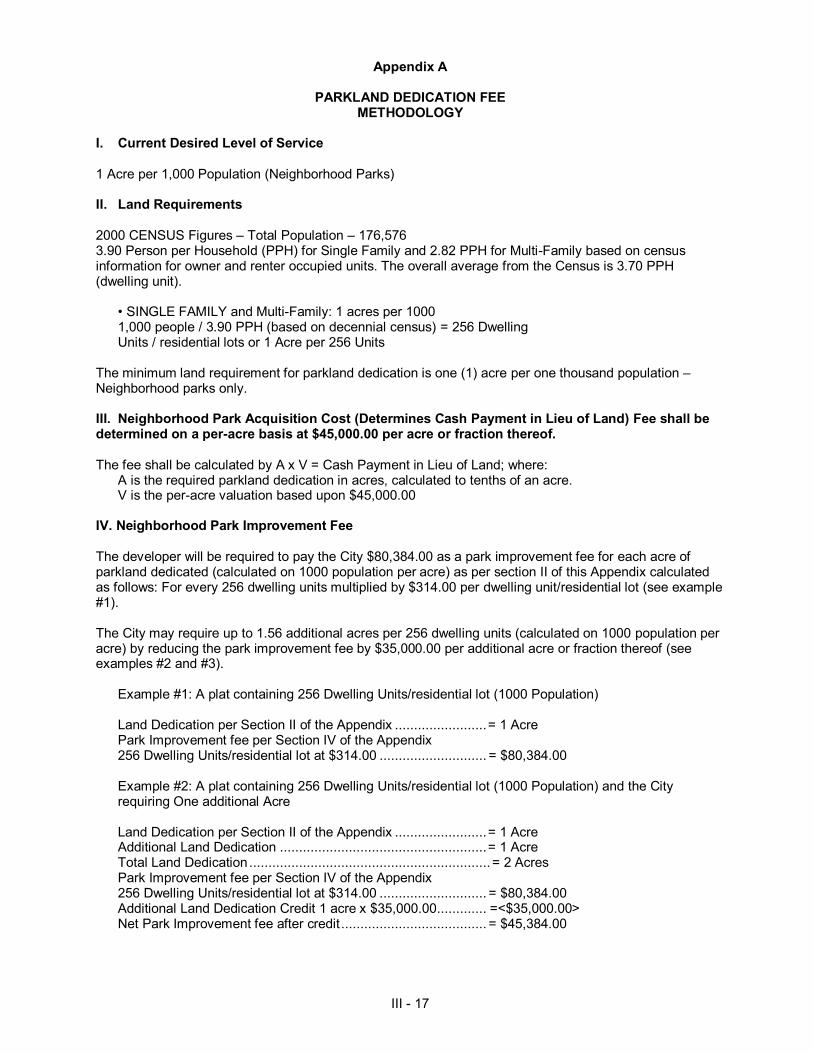
III - 17
Appendix A
PARKLAND DEDICATION FEE METHODOLOGY
I. Current Desired Level of Service 1 Acre per 1,000 Population (Neighborhood Parks) II. Land Requirements 2000 CENSUS Figures – Total Population – 176,576 3.90 Person per Household (PPH) for Single Family and 2.82 PPH for Multi-Family based on census information for owner and renter occupied units. The overall average from the Census is 3.70 PPH (dwelling unit).
• SINGLE FAMILY and Multi-Family: 1 acres per 1000 1,000 people / 3.90 PPH (based on decennial census) = 256 Dwelling Units / residential lots or 1 Acre per 256 Units
The minimum land requirement for parkland dedication is one (1) acre per one thousand population – Neighborhood parks only. III. Neighborhood Park Acquisition Cost (Determines Cash Payment in Lieu of Land) Fee shall be determined on a per-acre basis at $45,000.00 per acre or fraction thereof. The fee shall be calculated by A x V = Cash Payment in Lieu of Land; where:
A is the required parkland dedication in acres, calculated to tenths of an acre. V is the per-acre valuation based upon $45,000.00
IV. Neighborhood Park Improvement Fee The developer will be required to pay the City $80,384.00 as a park improvement fee for each acre of parkland dedicated (calculated on 1000 population per acre) as per section II of this Appendix calculated as follows: For every 256 dwelling units multiplied by $314.00 per dwelling unit/residential lot (see example #1). The City may require up to 1.56 additional acres per 256 dwelling units (calculated on 1000 population per acre) by reducing the park improvement fee by $35,000.00 per additional acre or fraction thereof (see examples #2 and #3).
Example #1: A plat containing 256 Dwelling Units/residential lot (1000 Population) Land Dedication per Section II of the Appendix ........................ = 1 Acre Park Improvement fee per Section IV of the Appendix 256 Dwelling Units/residential lot at $314.00 ............................ = $80,384.00
Example #2: A plat containing 256 Dwelling Units/residential lot (1000 Population) and the City requiring One additional Acre Land Dedication per Section II of the Appendix ........................ = 1 Acre Additional Land Dedication ...................................................... = 1 Acre Total Land Dedication ............................................................... = 2 Acres Park Improvement fee per Section IV of the Appendix 256 Dwelling Units/residential lot at $314.00 ............................ = $80,384.00 Additional Land Dedication Credit 1 acre x $35,000.00 ............. =<$35,000.00> Net Park Improvement fee after credit ...................................... = $45,384.00
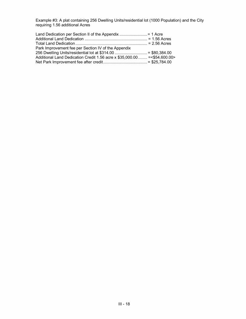
III - 18
Example #3: A plat containing 256 Dwelling Units/residential lot (1000 Population) and the City requiring 1.56 additional Acres Land Dedication per Section II of the Appendix ........................ = 1 Acre Additional Land Dedication ...................................................... = 1.56 Acres Total Land Dedication .............................................................. = 2.56 Acres Park Improvement fee per Section IV of the Appendix 256 Dwelling Units/residential lot at $314.00 ............................ = $80,384.00 Additional Land Dedication Credit 1.56 acre x $35,000.00 ........ =<$54,600.00> Net Park Improvement fee after credit ...................................... = $25,784.00

III - 19
SECTION 24-57
GREEN SPACE PRESERVATION
Section 24-57.1 PURPOSE
The purpose of this ordinance is to establish minimal acceptable requirements for the design of buffers to protect the streams, wetlands and floodplains of Laredo, Texas; to protect the water courses, reservoirs, lakes, and other significant water resources within Laredo, Texas; to protect Laredo’s riparian and aquatic ecosystems; and to provide for the environmentally sound use of Laredo’s land.
Section 24-57.2 APPLICABILITY
A) This ordinance shall apply to development subject to the Land Development Code. A development is exempt from this ordinance if it does not contain a stream system. B) This ordinance shall apply to surface mining operations except that the design standards shall not apply to active surface mining operations that are operating in compliance with an approved U. S. Department of the Interior surface mining permit. C) This ordinance shall apply to the City of Laredo, a municipal corporation. D) This ordinance shall apply to all development except for activities that were initiated prior to the effective date of this ordinance and meets the following criteria:
1. Valid, unexpired permit in accordance with development regulations; 2. A current, executed public works agreement; 3. A valid, unexpired building permit; 4. A complete, unexpired plat application; 5. A current, approved master plan on file with the City of Laredo Planning Department; 6. Platted property.
Section 24-57.3 PRESERVATION AND BUFFERING REQUIREMENTS
A) All third order and higher stream systems including the Rio Grande are required to be preserved and buffered in accordance with this ordinance. B) First and Second order stream systems which include any of the following criteria are required to be preserved and buffered in accordance with this ordinance unless the requirements of 24-57.7 are satisfied.
1. An environmentally sensitive area. 2. Wetlands & Waters of the U.S. according to the Wetland Map. 3. Existing trees with a caliper equal to or greater than 8 inches (excluding salt cedar) within the
stream channel or potential stream buffer.
Section 24-57.4 DESIGN STANDARDS FOR STREAM BUFFERS
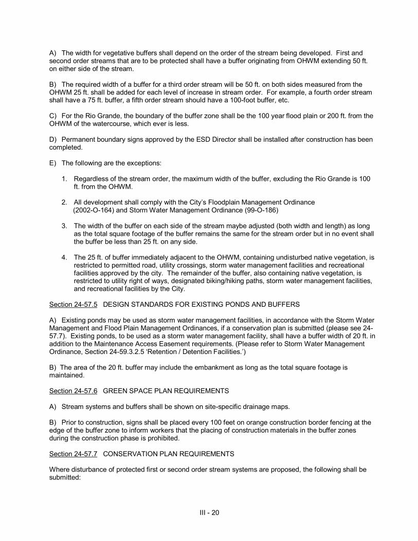
III - 20
A) The width for vegetative buffers shall depend on the order of the stream being developed. First and second order streams that are to be protected shall have a buffer originating from OHWM extending 50 ft. on either side of the stream. B) The required width of a buffer for a third order stream will be 50 ft. on both sides measured from the OHWM 25 ft. shall be added for each level of increase in stream order. For example, a fourth order stream shall have a 75 ft. buffer, a fifth order stream should have a 100-foot buffer, etc. C) For the Rio Grande, the boundary of the buffer zone shall be the 100 year flood plain or 200 ft. from the OHWM of the watercourse, which ever is less. D) Permanent boundary signs approved by the ESD Director shall be installed after construction has been completed. E) The following are the exceptions:
1. Regardless of the stream order, the maximum width of the buffer, excluding the Rio Grande is 100
ft. from the OHWM. 2. All development shall comply with the City’s Floodplain Management Ordinance (2002-O-164) and Storm Water Management Ordinance (99-O-186) 3. The width of the buffer on each side of the stream maybe adjusted (both width and length) as long
as the total square footage of the buffer remains the same for the stream order but in no event shall the buffer be less than 25 ft. on any side.
4. The 25 ft. of buffer immediately adjacent to the OHWM, containing undisturbed native vegetation, is
restricted to permitted road, utility crossings, storm water management facilities and recreational facilities approved by the city. The remainder of the buffer, also containing native vegetation, is restricted to utility right of ways, designated biking/hiking paths, storm water management facilities, and recreational facilities by the City.
Section 24-57.5 DESIGN STANDARDS FOR EXISTING PONDS AND BUFFERS
A) Existing ponds may be used as storm water management facilities, in accordance with the Storm Water Management and Flood Plain Management Ordinances, if a conservation plan is submitted (please see 24-57.7). Existing ponds, to be used as a storm water management facility, shall have a buffer width of 20 ft. in addition to the Maintenance Access Easement requirements. (Please refer to Storm Water Management Ordinance, Section 24-59.3.2.5 ‘Retention / Detention Facilities.’) B) The area of the 20 ft. buffer may include the embankment as long as the total square footage is maintained.
Section 24-57.6 GREEN SPACE PLAN REQUIREMENTS A) Stream systems and buffers shall be shown on site-specific drainage maps. B) Prior to construction, signs shall be placed every 100 feet on orange construction border fencing at the edge of the buffer zone to inform workers that the placing of construction materials in the buffer zones during the construction phase is prohibited.
Section 24-57.7 CONSERVATION PLAN REQUIREMENTS Where disturbance of protected first or second order stream systems are proposed, the following shall be submitted:
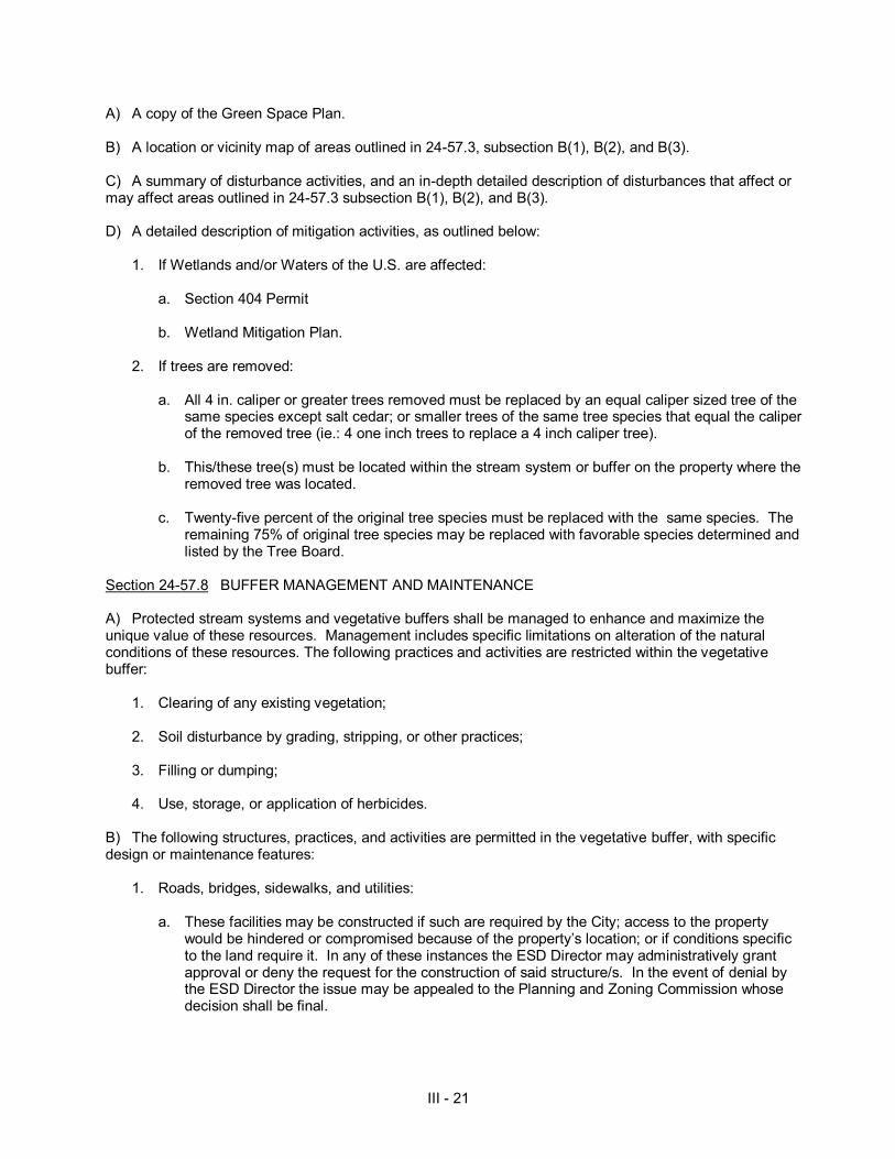
III - 21
A) A copy of the Green Space Plan.
B) A location or vicinity map of areas outlined in 24-57.3, subsection B(1), B(2), and B(3). C) A summary of disturbance activities, and an in-depth detailed description of disturbances that affect or may affect areas outlined in 24-57.3 subsection B(1), B(2), and B(3). D) A detailed description of mitigation activities, as outlined below:
1. If Wetlands and/or Waters of the U.S. are affected:
a. Section 404 Permit b. Wetland Mitigation Plan.
2. If trees are removed: a. All 4 in. caliper or greater trees removed must be replaced by an equal caliper sized tree of the
same species except salt cedar; or smaller trees of the same tree species that equal the caliper of the removed tree (ie.: 4 one inch trees to replace a 4 inch caliper tree).
b. This/these tree(s) must be located within the stream system or buffer on the property where the
removed tree was located. c. Twenty-five percent of the original tree species must be replaced with the same species. The
remaining 75% of original tree species may be replaced with favorable species determined and listed by the Tree Board.
Section 24-57.8 BUFFER MANAGEMENT AND MAINTENANCE
A) Protected stream systems and vegetative buffers shall be managed to enhance and maximize the unique value of these resources. Management includes specific limitations on alteration of the natural conditions of these resources. The following practices and activities are restricted within the vegetative buffer:
1. Clearing of any existing vegetation; 2. Soil disturbance by grading, stripping, or other practices; 3. Filling or dumping; 4. Use, storage, or application of herbicides.
B) The following structures, practices, and activities are permitted in the vegetative buffer, with specific design or maintenance features:
1. Roads, bridges, sidewalks, and utilities:
a. These facilities may be constructed if such are required by the City; access to the property would be hindered or compromised because of the property’s location; or if conditions specific to the land require it. In any of these instances the ESD Director may administratively grant approval or deny the request for the construction of said structure/s. In the event of denial by the ESD Director the issue may be appealed to the Planning and Zoning Commission whose decision shall be final.

III - 22
b. The right-of-way should be the minimum width needed to allow for maintenance access and installation.
c. The angle of the crossing shall be as near to perpendicular as allowed by the ESD Director. In
the event of denial by the ESD Director the issue may be appealed to the Planning and Zoning Commission whose decision shall be final.
d. Every effort shall be made to minimize the number of road crossings within each subdivision
and no more than one road crossing is allowed for every 1,200 ft. of buffer.
2. Storm Water Management:
a. These facilities may be constructed if such are required by the City, the facilities are necessary for flood control or significantly improves water quality or habitat in the stream. In any of these instances the ESD Director may administratively grant approval or deny the request for the construction of said structure/s. In the event of denial by the ESD Director the issue may be appealed to the Planning and Zoning Commission whose decision shall be final.
b. When constructing storm water management facilities “best management practices” shall be
observed (i.e., BMPs). The area cleared will be limited to the area required for construction and adequate maintenance access as outlined in the most recent edition of City of Laredo Storm Water Management Ordinance.
c. Material dredged or otherwise removed (during construction or maintenance) from a storm
water management facility shall be stored outside the buffer. 3. Stream restoration projects approved by the ESD Director are permitted within the vegetative buffer. 4. Water quality monitoring and stream gauging are permitted within the vegetative buffer as approved by the ESD Director. 5. Individual trees within the buffer that are in danger of falling, causing damage to dwellings or other structures, or causing blockage of the stream, may be removed. Other tree cutting techniques approved by the ESD Director may be undertaken within the vegetative buffer under the advice and guidance of the Tree Board if necessary to preserve the riparian forest from extensive pest infestation and disease infestation. 6. Selective clearing for health and safety purposes is allowed as determined by the Fire Chief and/or the Health Department Director.
C) The Final Plat and all right-of-way plans shall clearly show the extent of any vegetative buffer on the subject property. D) All protected vegetative buffer areas and stream systems shall run with the land and continue in perpetuity. Protected vegetative buffer areas and stream systems may be dedicated to the public by separate instrument (which must be submitted to the City Engineer for approval and recorded in the land records) unless the protected vegetative buffer area and stream system is dedicated to the public on the face of an approved plat. If the owner of the property desires to keep the stream system and buffer private, there shall be a covenant (which must be submitted to the City Engineer for approval and recorded in the land records) restricting the use of the stream system and buffer to uses set forth herein, and the owner must ensure that the stream system and buffer shall be maintained by the owner, his heirs successors and assigns for so long as the stream system and buffer remain private.

III - 23
E) The ESD shall inspect the buffer annually and immediately following severe storms for evidence of sediment deposition, erosion, or concentrated flow channels. Corrective actions shall be taken to ensure the integrity and functions of the vegetative buffer. F) The City of Laredo will maintain all vegetative buffer and stream systems that are created pursuant to 24.58-3 and have been dedicated to the public. Section 24-57.9 INCENTIVES
A) If buffer widths on first and second order streams are strictly adhered to, the conservation plan requirement shall be waived. B) Credit shall be given as determined by the Planning Director for the development of Linear Parks around natural drainage and wooded areas that provide potential recreational uses. Criteria for flood plain areas (based upon a hundred-year flood plain) that is dedicated as parkland, will be given credit as determined by the Planning Director by meeting the following requirements:
1. Flood plain and natural drainage area shall generally not exceed 75% of total park site. 2. At least 50% of required dedicated parkland shall have slopes in range of <5%, well-drained and
suitable for active use. 3. Additional flood plain acreage over 75% of required parkland may be dedicated at a (3:1) ratio in
acres in lieu of non flood plain property and any such consideration of acreage shall be at the discretion of the Planning Director in compliance with the Parks and Open Space Master Plan.
4. The Director of the Planning Department shall determine whether land offered for dedication
complies with the standards for dedication as provided in the Parks Master Plan.
C) Storm water discharges into large creeks 1. For development adjacent to the main stem of Sombrerito Creek, below Middle Pasture Lake, and
Chacon Creek below Lake Casa Blanca, storm water discharge does not require detention facilities, so long as there is compliance with the floodplain management ordinance and storm water management ordinance.
D) On-site detention within the plat boundaries of residential subdivision
1. For detention ponds in residential developments voluntarily created to enhance the protection of 1st
& 2nd order streams, the required private maintenance shall extend to the warranty period as provided by other ordinances.
2. When a first or second order stream within development is voluntarily protected, a R.O.W. section may be similarly modified as provided below:
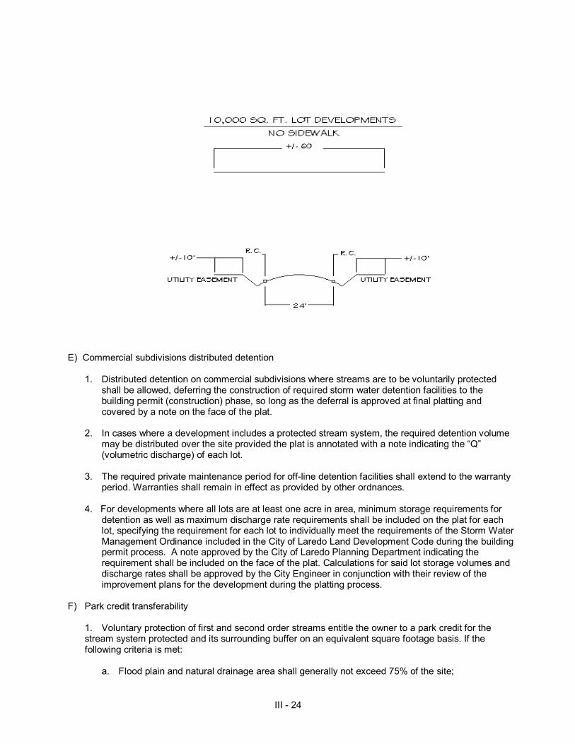
III - 24
E) Commercial subdivisions distributed detention
1. Distributed detention on commercial subdivisions where streams are to be voluntarily protected shall be allowed, deferring the construction of required storm water detention facilities to the building permit (construction) phase, so long as the deferral is approved at final platting and covered by a note on the face of the plat.
2. In cases where a development includes a protected stream system, the required detention volume
may be distributed over the site provided the plat is annotated with a note indicating the “Q” (volumetric discharge) of each lot.
3. The required private maintenance period for off-line detention facilities shall extend to the warranty
period. Warranties shall remain in effect as provided by other ordnances. 4. For developments where all lots are at least one acre in area, minimum storage requirements for
detention as well as maximum discharge rate requirements shall be included on the plat for each lot, specifying the requirement for each lot to individually meet the requirements of the Storm Water Management Ordinance included in the City of Laredo Land Development Code during the building permit process. A note approved by the City of Laredo Planning Department indicating the requirement shall be included on the face of the plat. Calculations for said lot storage volumes and discharge rates shall be approved by the City Engineer in conjunction with their review of the improvement plans for the development during the platting process.
F) Park credit transferability
1. Voluntary protection of first and second order streams entitle the owner to a park credit for the stream system protected and its surrounding buffer on an equivalent square footage basis. If the following criteria is met:
a. Flood plain and natural drainage area shall generally not exceed 75% of the site;
III - 25
b. At least 50% of the buffer shall have slopes in the range of 2% and not to exceed 5%, be well drained and suitable for active use;
c. Additional park requirements, if any, shall be incorporated (be adjacent) to any buffer. d. The buffer and the park space shall be reviewed by the Planning Director to ensure that the
buffer and park space requirement comply with the City Standards for Dedication as a park and buffer.
e. If the buffer and park meet the requirements set forth herein the Planning Director shall make a recommendation to the City Council regarding the acceptance of said buffer and park.
2. Mandatory protected third order streams and higher qualify for a park credit for the surrounding buffer on an equivalent square footage basis. If the following criteria is met:
a. Flood plain and natural drainage area shall generally not exceed 75% of the site; b. At least 50% of the buffer shall have slopes in the range of 2% and not to exceed 5%, well
drained and suitable for active use; c. Additional park requirement, if any, shall be incorporated (be adjacent to) any buffer. d. The buffer and the park space shall be reviewed by the Planning Director to insure that the
buffer and park space requirement comply with the City standards for dedication as a park and buffer.
e. If the buffer and park meet the requirements set forth herein the Planning Director shall make a
recommendation to the City Council regarding the acceptance of said buffer and park. 3. Park credits obtained pursuant to this provision shall be transferable but may only be used within the Council District in which they were originally acquired. 4. In the event there is first or second order stream systems located on a tract ten acres or smaller and the owner or said tract wishes to voluntarily preserve the stream system he shall be entitled to a park credit.
5. Any decision by the Planning Director which does not favor the acceptance of park and buffer may be appealed to the Planning and Zoning Commission for a recommendation regarding the acceptance of the park and buffer to the City Council. Section 24-57.10 WAIVERS / VARIANCES A) The ESD Director may grant a variance for the following:
1. Those projects or activities for which it can be demonstrated that strict compliance with the
ordinance would result in a practical difficulty. 2. Those projects or activities serving a public need where no feasible alternative is available
B) The City of Laredo may, as deemed appropriate by the ESD Director, give credit towards the average buffer width on the platted property for the restoration of riparian habitat and/or installation of a wetlands area within the property boundaries if such installations are ecologically integrated with the riparian system. The square footage of the restored area or wetlands area shall be credited toward the square footage required for the buffer zone.
III - 26
C) The applicant shall submit a written request for a variance to the ESD Director. The application shall include specific reasons justifying the variance and any other information necessary to evaluate the proposed variance request. The ESD Director may require an analysis demonstrating undue hardship would result from a strict application of the ordinance. D) In granting a request for a variance, the Director may require site design, landscape planting, fencing, and signs. Section 24-57.11 ENFORCEMENT PROCEDURES Please Refer to Sections 24-59.8, 24-59.10 and 24-59.11 Section 24-57.12 APPEAL The Planning and Zoning Commission shall hear appeals from ESD and Planning Director whose ruling shall be final. Any person whose petition for variance has not been granted and who remains adversely affected by the Director's order, or who is subject to an order of the Director issued following a Show Cause Hearing may challenge the final action of the Director to the Planning and Zoning Commission. The Planning and Zoning Commission shall hear and decide appeals when it is alleged there is an error in any requirement, decision, or determination made by the ESD or Planning Director in the enforcement or administration of this ordinance. Section 24-57.13 CONFLICT WITH OTHER REGULATIONS Where the standards and management requirements of this buffer ordinance are in conflict with other laws, regulations, and policies regarding streams, steep slopes, erodible soils, wetlands, floodplains, timber harvesting, land disturbance activities, or other environmental protective measures, the more restrictive shall apply.

III - 27
SECTION 24-58
STANDARD TECHNICAL SPECIFICATION MANUAL Section 24-58 STANDARD TECHNICAL SPECIFICATION MANUAL Section 24-58.1 PURPOSE The purpose of the Standard Technical Specification Manual is to provide standardized procedures and materials for the orderly construction and installation of public improvements. Section 24-58.2 APPLICABILITY The Standard Technical Specification Manual shall apply to all public improvements. Divisions A, B, C, and D of the Standard Technical Specification Manual shall apply to any public improvement to be awarded or constructed by the City of Laredo. Divisions A, C, and Sections B-1, 2, 3, and 5 are not applicable to public improvements associated with the private platting of properties. Section 24-58.3 OPTIONAL SPECIFICATIONS PERMISSIBLE Where circumstances warrant, or at the request of the engineer of record, a separate set of specifications for development or public improvements may be submitted to the City Engineer for approval. Under no circumstances shall an engineer submit, nor shall the City Engineer approve, specifications less restrictive than those provided in the manual. In the event the manual does not address some facet of a proposed development or public improvement, a separate set of specifications shall be submitted by the engineer of record for approval by the City Engineer.

III-28
SECTION 24-59
STORM WATER MANAGEMENT Section 24.59.1 GENERAL PROVISIONS Section 24.59.1.1 PURPOSE AND GOALS
The purposes and objectives of this Code are as follows:
1. To protect, maintain, and enhance the public health, safety, and general welfare by establishing
minimum requirements and procedures to control the adverse impacts associated with storm water runoff. Proper management of storm water runoff will minimize damage to public and private property, reduce the effects of development on land and stream channel erosion, assist in the attainment and maintenance of water quality standards, reduce local flooding, and maintain after development, as nearly as possible, the pre-development runoff characteristics.
2. To prevent the discharge of contaminated storm water runoff from development and/or redevelopment
or construction sites into the Municipal Separate Storm Sewer System (MS4) and natural water within the City of Laredo and its extraterritorial jurisdiction.
3. To facilitate compliance with state and federal water quality standards, limitations, and permits by
owners and operators of development and/or redevelopment sites or construction sites within the City of Laredo.
4. To enable the City to comply with all federal and state laws and regulations applicable to storm water
discharges. 5. To maintain and improve the quality of surface water and groundwater within the City of Laredo by
preventing the introduction of pollutants to the maximum extent practicable (MEP) using best management practices (BMPs).
6. To establish responsibility for the reduction of harmful and damaging effects of development-
generated erosion, sedimentation, storm water runoff, and accumulation of debris on other properties and receiving waters.
7. To minimize harm and long-term costs to the community from activities, which may adversely impact
water resources. 8. To encourage the use of Regional Storm Water Detention Facilities.
Section 24.59.1.2 SCOPE AND JURISDICTION
The application of this Code and the provisions expressed herein shall be the minimum storm water management requirements for development and/or redevelopment of a site within the City of Laredo and its extraterritorial jurisdiction. It shall not be deemed a limitation or repeal of any other powers granted by the State statute. In addition, if site characteristics indicate that complying with these minimum requirements will not provide adequate designs or protection for local property or residents, it is the designer’s responsibility to exceed the minimum requirements as necessary. The City Engineer or his/her authorized representative shall be responsible for the coordination and enforcement of the provisions of this code. This Code sets development constraints to ensure compliance with the outlines, obligations, and responsibilities of the City of Laredo as specified in agreements, permits and jurisdictional responsibilities of state and federal governmental agencies for storm water management which may include, but are not limited to, the following:

III-29
1. TCEQ - dam safety, 2. TCEQ - water rights, 3. EPA-NPDES, and/or TCEQ-TPDES, 4. TxDOT, 5. U.S. Army Corps of Engineers, 6. State Historical Officer, 7. Parks and Wildlife, 8. IBWC, 9. FEMA.
This Code does not abrogate responsibilities of the City of Laredo or its citizens from compliance with state and federal regulations. A Storm Water Management Guidance Manual has been developed as a supplement to this Code. The purpose of the Storm Water Management Guidance Manual is to provide specific development and / or redevelopment design standards and criteria and information on best management practices (BMPs) and permanent storm water control mechanisms whose incorporation into a development will ensure compliance with this Code. The manual shall be updated and republished periodically to reflect adopted changes in policies and/or standards. Section 24.59.1.3 DEFINITIONS AND ABBREVIATIONS
See Appendix A. Section 24.59.2 ADMINISTRATION AND PERMITTING PROCESS Section 24.59.2.1 DESIGNATED ADMINISTRATOR
The City Engineer shall implement and enforce the provisions of this Code. Any powers granted to or duties imposed in this Code upon the City Engineer may be delegated by him to other qualified City personnel. Duties of Administrator are as follows:
1. Review all storm water concept plan applications and storm water management permit applications to determine that the permit requirements of this Code have been satisfied.
2. Review all storm water concept plan applications and storm water management permit applications to
determine that all necessary federal, state or local governmental agency approvals have been secured and do not conflict with provisions of this Code.
3. Review all storm water concept plans applications and storm water management permit applications to
determine if the proposed development/redevelopment and construction activity is located in a floodway. If located in a floodway ensure that the provisions of 24.69 of the Land Development Code are satisfied.
4. Require an applicant for a storm water management permit to execute an affidavit on behalf of himself,
his/her heirs, successors and assigns, agreeing that until such time as the drainage improvements are accepted by the City, applicant shall save and hold harmless the City, its officers, employees and appointed officials for any damages arising from loss of property, personal injury or death, loss of access of property, or other consequential damages as a result of a development permit being granted pursuant to this article; except that City shall indemnify and hold applicant harmless from any and all actions or proceedings arising out of the sole negligence or willful act of City. Such affidavits shall be filed with the City Secretary.
5. Develop and implement an inspection program for storm water facilities within the City of Laredo and its
jurisdictional areas.
III-30
Section 24.59.2.2 APPLICABILITY A Storm Water Management Permit shall be required for all land disturbances of 1 acre or larger in accordance with current Environmental Protection Agency/ National Pollutant Discharge Elimination System requirements (EPA/NPDES) for storm water discharges. This includes permit requirements for land disturbances of some sites under 1-acre in environmentally sensitive areas. If any other provision or ordinance of the City of Laredo conflicts with this Code, that which provides more environmental protection shall apply unless specifically provided otherwise in this Code. The City Engineer is authorized to adopt written procedures for the purpose of carrying out the provisions of this Code. The Storm Water Management Guidance Manual shall be the repository of all current and effective procedures. Section 24.59.2.3 RESPONSIBILITY OF LICENSED PROFESSIONAL ENGINEER All documents, calculations, plans, etc. submitted to the City Engineer as part of the storm water management review process shall be signed and sealed by a licensed professional engineer unless stated otherwise in this Code. The engineer shall use the best available information and current acceptable level of practice in the design of storm water management systems taking into consideration their potential off-site impacts. Section 24.59.2.4 SCOPE OF DEVELOPMENT PLANS
1. In developing plans for subdivisions, individual lots in a subdivision development shall not be considered to be separate land disturbing activities and shall not require individual permits. Instead, the subdivision development, as a whole, shall be considered to be a single land disturbing activity. Hydrologic parameters that reflect the ultimate subdivision development shall be used in all engineering calculations.
2. If individual lots or sections in a subdivision are being developed by different property owners, all land
disturbing activities related to the subdivision shall be covered by the approved storm water management plan permit for the subdivision. Individual lot owners or developers shall sign a certificate of compliance that all activities on that lot will be carried out in accordance with the approved storm water management plan permit for the subdivision.
3. Construction drawings for subdivisions which have been submitted for approval prior to the effective date
of these regulations are exempt from these requirements. Development of new phases of existing subdivisions which were not previously approved shall comply with the provisions of these regulations.
Section 24.59.2.5 REQUIRED FOR PERMIT EXEMPT ACTIVITIES
1. For all land disturbing activities that do not require the issuance of a storm water management permit as outlined in 24.59.2.5, the person responsible for the land disturbing activity shall submit a simplified storm water management control plan meeting the requirements listed below. This plan does not require approval by the City Engineer and does not require preparation or certification by a licensed professional engineer. This plan includes:
a. A narrative description of the storm water management facilities to be used. b. A general description of topography and soil conditions of the development site. c. A general description of existing structures, buildings, and other fixed improvements located on
adjacent properties. d. A site plan sketch to accompany the narrative which shall contain:
(1) a site location map of the proposed project, indicating the location of the proposed project in
relation to roadways, jurisdictional boundaries, streams and rivers; (2) the boundary lines of the site on which the work is to be performed;

III-31
(3) all areas within the site which will be included in the land disturbing activities shall be identified
and the total disturbed area calculated; (4) a topographic map of the site; and (5) anticipated starting and completion dates of the various stages of land disturbing activities and the
expected date the final stabilization will be completed. (6) the location of temporary and permanent vegetative and structural storm water management
control measures.
e. The storm water management control plan shall contain certification by the persons responsible for the land disturbing activity that the land disturbing activity will be accomplished in accordance with the plan.
f. The storm water management control plan shall contain authorization by the person responsible for
the land disturbing activity of the right of the City Engineer to conduct on-site inspections. Section 24.59.2.6 STORM WATER CONCEPT PLANS The storm water concept plan is designed to allow the City to review the proposed development / redevelopment or construction activities prior to extensive design. This allows the City to ensure that all aspects of the storm water management code have been addressed early in the design process. Additionally, it allows the developer/engineer the opportunity to address all aspects of the design, with regard to this Code, with the City prior to extensive design and plan development.
1. A storm water concept plan for each development / redevelopment and construction activity shall be submitted for review by the City Engineer prior to submission of the storm water management plan and construction plans for the entire development / redevelopment or construction activity, or any portion thereof.
2. All preliminary plats of the development / redevelopment or construction activity shall be consistent with
the storm water concept plan required in paragraph (1) above. 3. Upon approval of the concept plan, the applicant shall submit a final storm water management plan (as
part of the construction plans) to the City Engineer for review and approval. The City Engineer may accept and submit into the review process a storm water concept plan if it identifies the location and type of facilities to be constructed in sufficient detail to accurately assess proposed impacts and the City Engineer determines that a storm water management plan is not needed. If accepted under this provision, the storm water concept plan then becomes the storm water management plan for this development.
4. Should any storm water management plan involve any storm water management facilities or land to be
dedicated to public use, the same information shall also be submitted for review and approval to the department having jurisdiction over the land or other appropriate departments or agencies identified by the City Engineer for review and approval. Upon approval by all such departments and agencies this storm water management plan shall serve as the basis for all subsequent construction.
5. The developer and his/her engineer shall be responsible for the accuracy of the information furnished in
the design of the storm drainage facilities, pertaining to both the development / redevelopment or construction site in question (on-site) and affected (off-site) properties. Permit approval, by the City of Laredo, of the design plans and specifications shall not be construed to relieve any responsibility of the developer/engineer referred to herein.
6. All drainage easements, both on-site and off-site, shall be dedicated to the City of Laredo, with the
easement called-out and appropriately identified as an easement to be dedicated to the City of Laredo for
III-32
drainage purposes. Appropriate drainage easements on designated floodways (HUD-FEMA Maps) shall be properly described.
7. Compliance with Federal Emergency Management Agency (FEMA) regulations is mandatory. All
subdivisions shall conform to the “Federal Disaster Protection Act of 1973, Public Law 93-234, passed by the 93rd Congress, H.R. 8449, December 31, 1973 (the latest revision thereof).
8. The storm water concept plan may be reviewed, if needed, with the designer, after City Engineer review,
where it will either be approved, approved with changes, or rejected. If rejected, then changes, additional analysis, or other information necessary to approve the next submittal of the concept plan shall be identified. The City Engineer’s review of the storm water concept plan will be completed within ten (10) working days from receipt of the plan.
9. Within ten (10) working days from receipt of the storm water concept plan, the City Engineer shall issue a
decision either approving, rejecting or conditionally approving the plan with modification.
Section 24.59.2.7 STORM WATER CONCEPT PLAN SUBMITTAL REQUIREMENTS At a minimum, the storm water concept plan shall include the following:
1. A completed application for the storm water management concept plan review. (Application forms are contained within the Storm Water Management Guidance Manual.);
2. A completed Applicant’s Affidavit of Ownership and Designation of Agent form. (Forms are contained
within the Storm Water Management Guidance Manual.); 3. A vicinity map showing the location of the development site; 4. The existing topography of the development site; 5. Layout of physical improvements on the site, including existing development and proposed development; 6. Delineation of all areas to be disturbed; 7. Delineation of any regulatory flood plain. 8. Preliminary Hydrologic / Hydraulic calculations showing existing pre- development flows and anticipated
post-development flows; 9. Preliminary layout of proposed on-site storm water management facilities to include water quantity and
quality features; 10. A map indicating any off-site flows draining to the site; and 11. A map indicating any off-site, downstream flow constrictions.
Section 24.59.2.8 STORM WATER MANAGEMENT PLAN The storm water management plan is a report containing calculations, plans, narrative and supplemental information showing the proposed development’s / re- development’s compliance with this Code and all state and federal laws that affect the development. The storm water management plan is submitted to the City after review of the storm water concept plan. All deficiencies indicated by the City review of the concept plan shall be rectified in the storm water management plan. Upon review and approval of the storm water management plan by the City of Laredo, the City will issue a storm water management permit indicating the development’s compliance with this Code and allowing the commencement of construction.
III-33
1. The storm water management plan, after City Engineer review, will either be approved, approved with changes, or rejected. If rejected, then changes, additional analysis, or other information necessary to approve the next submittal of the management plan shall be identified. The City Engineer’s review of the storm water management plan will be completed within ten (10) working days from receipt of the plan.
2. Within ten (10) working days from receipt of the storm water management plan, the City Engineer shall
issue a decision approving, rejecting or conditionally approving the plan with modification. Section 24.59.2.9 STORM WATER MANAGEMENT PLAN SUBMITTAL REQUIREMENTS Storm water management plans shall include, at a minimum, the following:
1. A completed application for the Storm Water Management Permit. (Application forms are contained within the Storm Water Management Guidance Manual.);
2. A completed Applicant’s Affidavit of Ownership and Designation of Agent form. (Forms are contained
within the Storm Water Management Guidance Manual.); 3. A vicinity map indicating a north arrow, scale, boundary lines of the site, and other information necessary
to locate the development site; 4. The existing and proposed topography of the development/redevelopment or construction site except for
individual lot grading plans in single family subdivisions. Existing topography shall be shown by contour lines on a basis of five feet (5') vertical interval unless the shape of the terrain, in the opinion of the City Engineer or his/her authorized designee, warrants two foot (2') vertical intervals; datum shall be that of the United States Coast and Geodetic Survey. The scale shall not be smaller than one inch (1") equals two hundred feet (200') with contour intervals not greater than five feet (5'), unless variation is specifically approved by the City Engineer or his/her authorized designee;
5. Physical improvements on the site, including present development and proposed
development/redevelopment or construction activity; 6. Location, dimensions, elevations, and characteristics of all storm water management facilities; 7. All areas within the site which will be included in the land disturbing activities shall be identified and the
total disturbed area calculated; 8. The location of temporary and permanent vegetative and structural storm water management control
measures; 9. An anticipated starting and completion date of the various stages of land disturbing activities and the
expected date the final stabilization will be completed; 10. A determination that no occupied first floor elevation of any structure is below the 100-year plus eighteen
(18) inch flood elevation. All development/redevelopment or construction activity shall conform to the “Federal Disaster Protection Act of 1973, Public Law 93-234, passed by the 93rd Congress, H.R. 8449, December 31, 1973 (the latest version thereof);
11. At the reasonable discretion of the City Engineer, for all portions of the drainage system which are
expected to carry between 50 and 150 cfs for the 100- year storm, the 100-year plus eighteen (18) inch flood elevation analysis shall be required. To require the 100-year plus eighteen (18) inch flood elevation analysis, the City Engineer should determine that one of the following conditions may exist:
a. The estimated runoff would create a hazard for adjacent property or residents; or b. The flood limits would be of such magnitude that adjacent residents should be informed of these
limits.
III-34
12. For all portions of the drainage system which are expected to carry 150 cfs or more for the 100-year
storm, the 100-year plus eighteen (18) inch flood elevation analysis shall be done and flood limits shall be shown on the storm water management plans;
13. Storm water management plans shall include designation of all drainage easements needed for inspection
and maintenance of the drainage system and storm water management facilities and shall comply with 24.59.3.3 of this Code;
14. At the reasonable discretion of the City Engineer, a landscape plan for all portions of the drainage system
shall be part of the storm water management plan. This landscape plan shall address the following: a. Tree saving and planting plan; b. Types of vegetation that will be used for stream bank stabilization, erosion control, sediment control,
aesthetics and water quality improvement; and c. Any special requirements related to the landscaping of the drainage system and efforts necessary to
preserve the natural aspects of the drainage system. 15. To improve the water quality aspects of the drainage system, the storm water management plan shall
include a storm water pollution prevention plan, as outlined in 24.59.4.2 of this Code, to control the water quality of the runoff during the land disturbing activities and during the life of the development as outlined in this Code.;
16. The storm water management plan shall include all engineering calculations needed to design the system
and associated structures including pre- and post-development velocities, peak rates of discharge, and inflow and outflow hydrographs of storm water runoff at all existing and proposed points of discharge from the site. Computer disks and hard copies of all input and output files are to be submitted if a computer model is used;
17. Description of site conditions around points of all surface water discharge including vegetation and method
of flow conveyance from the land disturbing activity; 18. Construction and design details for structural controls; 19. The expected timing of flood peaks through the downstream drainage system shall be assessed when
planning the use of detention facilities; 20. At the reasonable discretion of the City Engineer, downstream effects from storm water management
structures and the development/ redevelopment or construction activity on receiving streams known to have flooding and erosion problems, hydrologic-hydraulic engineering studies shall extend downstream to a point where the proposed development represents less than ten (10) percent of the total watershed.
21. All storm water management facilities and all major portions of the conveyance system through the
proposed development (i.e., channels, culverts) shall be analyzed, using the design and 100-year storms, for design conditions and operating conditions which can reasonably be expected during the life of the facility. The results of the analysis shall be included in the hydrologic-hydraulic study.
22. If the storm water management plan and/or calculations indicate that there may be a drainage or flooding
problem at the exit to the proposed development or at any location between the exit point and the 10 percent downstream point, the City Engineer may require: a. water surface profiles plotted for the conditions of pre- and post-development for the 25-year design
storm;
III-35
b. water surface profiles plotted for the conditions of pre- and post- development for the 100-year design storm; or
c. elevations of all structures potentially damaged by 25 and/or 100 year flows.
23. All storm water management plans submitted for approval shall contain certification by the person
responsible for the land disturbing activity that the land disturbing activity will be accomplished pursuant to the approved plan and that responsible personnel will be assigned to the project;
24. All storm water management submittals shall include a proposed inspection and construction control
schedule; 25. All storm water management plans shall contain certification by the person responsible for the land
disturbing activity, of the right of the City Engineer to conduct on-site inspections; 26. The storm water management plan shall not be considered approved without the inclusion of an approval
stamp with a signature and date on the plans by the City Engineering Department. The stamp of approval on the plans is solely an acknowledgment of satisfactory compliance with the requirements of these regulations. Approval of construction plans by the City of Laredo Engineering Department is not intended to relieve the owner/developer, consultant engineer, and/or contractor from compliance with the subdivision and storm water management ordinance and other City ordinance, state and federal regulations, and any liabilities or responsibilities with respect to the design, construction, or operation of the project;
27. A maintenance schedule for the permanent maintenance of all storm water management facilities; and 28. Approved storm water management plans remain valid for five (5) years from the date of approval.
Extensions or renewals of the plan approvals will be granted by the City Engineer upon written request by the person responsible for the land disturbing activity.
Section 24.59.2.10 STORM WATER MANAGEMENT PERMIT CONDITIONS / SUSPENSIONS AND
REVOCATIONS
Section 24.59.2.10.1 PERMIT CONDITIONS
a. No storm water management permit shall be issued or modified without the following:
(1) Right of entry by the City for emergency maintenance if necessary; (2) Right of entry by the City for inspections; (3) Any off-site easements needed; and (4) An approved storm water management plan.
b. The approved storm water management plan shall contain certification by the applicant that all land
clearing, construction, development and drainage will be done according to the storm water management plan or previously approved revisions.
c. In addition to the plans and permits required from the City, applicants shall obtain all applicable state and
federal permits required for the proposed development prior to issuance of a storm water management permit.
d. A copy of the approved storm water management plan permit placard shall be posted in clear public view
at the construction site from the date of commencement of construction through the date of final stabilization.
III-36
Section 24.59.2.10.2 PERMIT SUSPENSION AND REVOCATION
a. A storm water management permit may be suspended or revoked if one or more of the following violations have been committed:
(1) violation(s) of the conditions of the storm water management plan approval; (2) construction not in accordance with the intent of the approved plans; (3) noncompliance with correction notice(s) or stop work order(s); or (4) the existence of an immediate danger in a downstream area in the reasonable judgment of the City
Engineer.
If one or more of these conditions is found, a written notice of violation shall be served upon the owner or authorized representative and an immediate stop-work order may be issued. The notice shall set forth the measures necessary to achieve compliance with the plan. Correction of these violations must be started immediately or the owner shall be deemed in violation of this Code.
Section 24.59.2.11 FEES RESERVED Section 24.59.2.12 EXEMPTIONS FROM REQUIREMENTS The following development activities are exempt from the provisions of this Code and the requirements of providing storm water management measures.
1. Land disturbing activities on agricultural land for production of plants and animals useful to man, including but not limited to: forages, and sod crops, grains and feed crops, tobacco, cotton, and peanuts; dairy animals and dairy products; poultry and poultry products; livestock, including beef cattle, sheep, swine, horses, ponies, mules, or goats, including the breeding and grazing of these animals; bees; fur animals and aquaculture; except that the construction of an agricultural structure of one or more acres, such as broiler houses, machine sheds, repair shops and other major buildings, which require the issuance of a building permit shall require the submittal and approval of a storm water management plan prior to the start of the land disturbing activity.
2. Land disturbing activities undertaken on forest land for the production and harvesting of timber and timber
products. 3. Construction or improvement of single family residences or their accessory buildings(less than 1 acre)
which are separately built and not part of a multiple construction of a subdivision development. 4. There will be no exemptions from the requirements imposed upon the City of Laredo as part of its MS4
obligations. 5. The City of Laredo is not exempt from the requirements of this Code.
Section 24.59.2.13 VARIANCES FROM REQUIREMENTS
1. The City Engineer may grant a variance from the requirements of this Code if there are exceptional circumstances applicable to the site such that strict adherence to the provisions of the Code will result in unnecessary hardship and not fulfill the intent of the Code.
2. A written request for a variance shall be required and shall state the specific variance sought and the reasons, with supporting data, for granting said variance. The request shall include descriptions, drawings, calculations and any other information that are necessary to evaluate the proposed variance.

III-37
3. Any substantial variance from the storm water management plan or concept plan shall be referred to all agencies which reviewed the original plan.
4. The City Engineer will conduct a review of the request for a variance within ten (10) working days. Failure
of the City Engineer to act by the end of the tenth working day will result in the automatic approval of the variance.
5. There will be no variances from the requirements imposed upon the City of Laredo as part of its MS4
obligations. Section 24.59.2.14 APPEALS Any person aggrieved by a decision of the City Engineer (including any decision with reference to the granting or denial of a variance from the terms of this Code) may appeal same by filing a written notice of appeal with the City Engineer within thirty (30) calendar days of the issuance of said decision by the City Engineer. The City Engineer can then reverse his/her decision or send this notice to a designated Appeals Board with comments. A notice of appeal shall state the specific reasons why the decision of the City Engineer is alleged to be in error and the City Engineer shall prepare and send to the Appeals Board and Appellant, within fifteen (15) days of receipt of the notice of appeal, a written response to said notice of appeal. All such appeals shall be heard by the Appeals Board which is hereby granted specific authority to hear and determine such appeals in a quasi-judicial capacity. Said appeal shall be heard by the Appeals Board at its next regularly scheduled meeting date, not to exceed thirty (30) days after receipt, by the Appeals Board, of the notice of appeal, or at such other time as may be mutually agreed upon in writing by the Appellant and the Chairperson of the Appeals Board. The Appeals Board will then render a decision within fifteen (15) days after the appeal has been heard. Each party to the appeal shall be entitled to a hearing before the Appeals Board under judicial forms of procedure, at which hearing each party shall have the right to present evidence and sworn testimony of witnesses, to cross-examine witnesses, and to cause a transcription of the proceedings to be prepared. Should either party be dissatisfied with the decision of the Appeals Board, any appeal of said decision may be appealed to the Superior Court by writ of certiorari. Section 24.59.3 DRAINAGE STANDARDS Section 24.59.3.1.2 METHOD OF COMPUTING RUNOFF
The basis of computing runoff shall either be the rational formula, or another method deemed acceptable by the City Engineer. Runoff rates for areas greater than one hundred and thirty acres shall use either a unit hydrograph methodology, or another method deemed acceptable by the City Engineer. Where an approved study exists (i.e. FEMA, or other regulatory agency) for areas less than one hundred and thirty acres, the methodology shall match that used in the study unless otherwise dictated by the City Engineer. In all cases, wet antecedent conditions shall be assumed. Run-off rates shall be computed on the basis of ultimate development of the proposed development/redevelopment, or construction activity. Flows from off-site contributing areas draining to, and/or through, the proposed development / redevelopment or construction activity shall be based on the 25-year existing conditions. In order to determine time of concentration, times shall be calculated on the basis of an improved drainage system upstream from the area under consideration. Run-off coefficients shall be obtained from information presented in the Storm Water Management Guidance Manual. 24.59.3.1.3 OFF-SITE DRAINAGE a. The owner or developer of property to be developed / redeveloped shall be responsible for accepting all
predevelopment storm drainage flowing onto his/her property as calculated per section 24.59.3.1.2. Predevelopment storm drainage shall be adequately conveyed through, or around, the property. This
III-38
responsibility includes all drainage directed to that property by prior development as well as drainage naturally flowing naturally through the property by reason of topography.
b. Adequate consideration shall be given to determine how the storm water discharge leaving the proposed
development will affect downstream property. In determining downstream effects from storm water management structures and the development/redevelopment, or construction activity on receiving streams known to having flooding or erosion problems, the City Engineer may require, at his/her reasonable discretion, that hydrologic-hydraulic engineering studies be extended downstream, to a point where the proposed development/redevelopment or construction activity represents less than ten (10) percent of the total contributing watershed.
c. Any construction activity that requires off-site grading or encompasses an area in compliance with current
EPA/NPDES storm water permitting provisions, where storm water runoff has been collected or concentrated, whether it be by permanent drainage systems or streets, shall not be permitted to drain onto adjacent property except in existing creeks, channels, storm sewers, or streets unless the following is provided:
1) Notarized letter of permission from the affected property owner; 2) Proper drainage easements are obtained; 3) If the owner is unable to acquire the necessary off-site easements, he/she shall provide the City with
documentation of his/her efforts, including evidence of a reasonable offer made to the adjacent property owner. By written request for assistance, the City may assist the negotiations to acquire off-site easements. If the negotiations are unsuccessful, the request may, at the developer's option, be submitted to the City Council for consideration of acquisition through condemnation. In either case, the total cost of the acquisition and the cost of the easements shall be paid by the owner/developer; or
4) If the developer is unable to obtain either (1) or (2) above and chooses not to seek assistance from the
City, as outlined in (3) above, he/she shall provide the City with documentation of his/her efforts. The developer will then execute a notarized letter; said letter shall be in a form approved by the City Attorney and shall provide that the developer shall agree to save and hold harmless the City of Laredo from any and all claims or suits for damage arising out of the required grading and/or concentrations of flow. The City reserves the right to require the notarized letter of permission or easement from the affected property owner prior to construction.
d. The subdivider shall pay for the cost of all (post-development) drainage improvements or offsite downstream
upgrades required for the development of his/her subdivision; these include any necessary off-site channels, or storm sewers, and acquisition of the required easements. In areas where the proposed off-site improvements are to be made within existing City right-of-way(s), an estimate of these off-site costs shall be prepared and submitted with the drainage plans.
e. Where it is anticipated that additional runoff incident to the construction activity will overload an existing
downstream drainage facility, whether natural or man-made, and result in hazardous conditions, the City Engineer may withhold approval of the activity until appropriate provisions has been made to correct the problem. Plans shall be provided which include all necessary off-site improvements including storm sewer systems, channel grading, driveway adjustments, culvert improvements, etc.
24.59.3.1.4 Finished Floor Requirements
The first floor elevations of all residential and other structures shall be set at a minimum elevation as per the latest adopted International Residential Code. The approved drainage system shall provide for positive overflow at all low points. The term "positive overflow" means that when the inlets do not function properly or when the design capacity of the conduit is exceeded, the excess flow can be conveyed overland along a grassed or paved course. The approved drainage system shall provide for positive overflow at all low points. Normally, this would mean along a street alley, or otherwise shall require the dedications of special drainage easements on private property.
III-39
Positive overflow sections shall provide a minimum of two (2) feet from the overflow invert adjacent to the structure and the corresponding first floor elevation of all residential and other structures. All lots affected by positive overflow section shall be labeled and minimum finished floor elevation shall be provided on face of the subdivision plat. The Building Official shall require a finished floor National Flood Insurance Program elevation certificate in compliance with this ordinance as a prerequisite to obtain a Certificate of Occupancy. When the drainage characteristics of a subdivision are such that a portion of the subdivision is within or adjacent to the 100-year floodplain, the City Engineer shall require that minimum finished floor elevations be shown on all lots contained within or adjacent to the 100-year floodplain. These elevations should be based on the most current flood plain management criteria. The elevations shall be shown on the plat prior to filing the plat for record. The following note shall be added to any plat upon which the City Engineer requires the establishment of minimum finished floor elevations: "The City of Laredo reserves the right to require minimum finished floor elevations on any lot contained within this addition. The minimum elevations shown are based on the most current information available at the time the plat is filed and may be subject to change. Additional lots, other than those shown, may also be subject to minimum finished floor criteria." 24.59.3.2 Drainage Facilities
24.59.3.2.1 Streets and Closed Storm Sewer Systems Streets may be used for storm water drainage only if the calculated storm water flow does not exceed ten (10) feet per second. Streets and alleys shall be designed on the basis of a ten (10) year frequency storm event. Storm sewer inlets shall be built along paved streets at such intervals that the depth of flow, based upon the 10-year storm, does not exceed the top of curb. By pass flow is allowed and shall not exceed twenty-five (25) percent of the original discharge. Valley gutters shall be placed when surface drainage crosses any local street or in instances when the change in elevation between curbs returns exceeds six (6) inches. Inlets shall be located as necessary to remove the flow based on a ten (10) year storm. At any intersection, only one street shall be crossed with surface drainage; and preferably this street shall be the lower classified street. When an alley intersects a street, inlets shall be placed in the alley whenever flow down that alley would cause the capacity of the intersecting street to be exceeded. Where streets are not capable of carrying storm waters as outlined above, drainage facilities as required by these standards shall be provided. Where closed storm sewer systems are utilized the excess discharge shall be picked up at the point where the street can no longer handle the runoff flowing curb full. Closed storm sewer pipe size and grade shall be designed based on the following criteria:
a. Minimum pipe size shall be twenty-four (24”) inches in diameter. When circumstances do not allow for a twenty-four (24”) inch diameter, the City Engineer may approve an alternate size.
b. Minimum grade shall be such that the minimum flow velocities are not less than three (3) feet per second
with the pipe flowing full under the design conditions. c. Allowable “n” values for design shall be as specified in the Storm Water Management Guidance Manual. d. Under normal conditions, pipes shall be designed assuming full flow conditions. e. Where conditions or design cause a pipe to flow under pressure, the hydraulic grade line shall be
calculated and plotted in profile. In no case shall the hydraulic grade line be closer than one (1) foot to finished grade unless specifically authorized by the City Engineer.
f. Pipe for storm drains shall be reinforced concrete pipe (RCP) in sizes as shown on the approved plans. All

III-40
RCP shall be minimum Class III. All Class III RCPs shall have a minimum cover of not less than one (1) foot over the top of the pipe. Where added strength of pipe is needed for traffic loads over minimum cover or for excessive height of backfill, concrete pipe shall be ASTM C14 Extra Strength or ASTM C76, Class IV or Class V.
g. City Engineer may approve alternate pipe materials (HDPE, FIBER GLASS, CMP, etc.) within the private
easement, positive overflow area and within the Right-Of-Way (ROW). 24.59.3.2.1.1 Manholes: Manholes (inlets and junction boxes) shall be provided at sewer intersections, and at a maximum of five hundred (500) feet on straight lines. Design of manholes shall conform to the City of Laredo Design Standards, as periodically amended. 24.59.3.2.2 Open Channels Open Channels shall be designed for subcritical flow under normal conditions. If supercritical flow exists, energy dissipation will be required to return flow to subcritical flow conditions. Open channels shall be designed to convey, at a minimum, the twenty five (25) year frequency design storm event. The maximum allowable velocities in constructed channels shall be based on the channel type. The following velocity chart shall be used for scour protection and to determine the maximum velocities for a given type of channel lining:
Channel Type Maximum Velocity Grass Lined 5 fps Concrete Lined > 5 fps
Other methods of bottom and slope protection may be substituted for conditions where concrete lining is required upon the approval of the City Engineer. Requests for substitution shall be accompanied by an engineering analysis of the equivalency to concrete, reasons for substitution, and an evaluation of maintenance issues. Grass-lined channels shall include slope protection in bends, unless the radius of curvature is greater than twice the channel top width. Open channels shall provide a minimum of one (1) foot of freeboard above design flow depth. Additional freeboard shall be provided where design conditions warrant as outlined in the Storm Water Management Guidance Manual. All channels shall have a minimum eight (8) foot bottom width to facilitate maintenance operations. Where the calculated depth of normal flow is less than the required freeboard, the City may consider reducing channel widths (valley gutter, concrete swale) or alternate configurations. 24.59.3.2.3 Culvert and Bridge Crossings All roadway culvert crossings shall be designed for a twenty five (25) year frequency storm event. Crossings located within flood hazard zones shall be designed to ensure compliance with FEMA regulations. The hydraulic capacity of proposed culverts shall be such that headwater depth is at least one (1) foot below the minimum roadway elevation. Proposed bridges shall have a low chord elevation at least one (1) foot above the design storm water surface elevation. All culverts located or expected to be located under paving and bridges shall be structurally designed for an HS-20 loading. Hydrologic and hydraulic calculations for all crossings must be included in the permit application to ensure compliance with this Code.
All culvert and bridge crossing(s) need to have the flood gauge installed by the developer before acceptance by the City.
III-41
24.59.3.2.4 Hydraulic Structures - Energy Dissipation Where hydraulic structures are included in the design of storm water drainage systems, energy dissipation shall be included in the structure as outlined in the Storm Water Management Guidance Manual. Hydraulic structures may include, but are not limited to: pipe outlets, spillways, drop structures, and culvert headwalls. All energy dissipators should be designed to facilitate maintenance. At the reasonable discretion of the City Engineer, the design of outlet structures in or near parks, and/or residential areas must give special consideration to aesthetics. 24.59.3.2.5 Retention/Detention Facilities The following are minimum criteria for detention facilities within the City of Laredo and its extraterritorial jurisdiction. These criteria do not supersede or replace requirements established by the State of Texas for dam safety, dam construction plan review, and/or the impoundment of State Waters. Where the State of Texas requirements apply, the owner/developer and/or engineer shall provide evidence of compliance prior to final approval of the facility by the City of Laredo. 24.59.3.2.5.1 Allowable Discharge - (Pre/Post Analysis for Retention/Detention Facilities) The ultimate one hundred (100) year design storm event shall be used in determining the required retention/detention volume for the development site. The discharge rate from the facility shall be such that the pre-development discharge rate from the site is not exceeded in the post-developed condition for the design storm event. The precondition discharge rate shall be calculated assuming the proposed site is in a natural state. Upstream adjacent properties shall be considered at their existing conditions, provided that the downstream receiving stream/channel/detention pond can accept additional storm water runoff volume without causing flooding as determined by the City Engineer. 24.59.3.2.5.2 Storage The design storage shall be the volume of the design storm event hydrograph that exceeds the allowable discharge rate noted above. Basins without upstream detention areas and with drainage areas of one hundred thirty (130) acres or less may calculate storage using the Modified Rational Method as described in the Storm Water Management Guidance Manual. Basins with drainage areas greater than one hundred thirty (130) acres, or where the Modified Rational Method is not applicable, shall be designed using an approved method as described in the Storm Water Management Guidance Manual. 24.59.3.2.5.3 Impoundment Design Criteria The steepest side slope permitted shall be 4:1 for a vegetated earth embankment, 2:1 for a rock dam, or as determined by a geotechnical investigation that is certified by a licensed professional engineer and approved by the City Engineer. Earth embankments used to temporarily impound the required detention volume shall be constructed according to standard specifications for fill. These specifications should be, at a minimum, adequate for levee embankments and be based on the City of Laredo standard specifications for embankment, topsoil, sodding, and seeding. Where permanent impoundment is to be provided a geotechnical investigation is required. Based on the geotechnical report more stringent specifications may be required. Embankments, spillways and other appurtenances shall be designed to withstand the pressures of the impounded storm water. Excavated detention facilities must provide positive drainage with a minimum bottom grade of three tenths of a percent, 0.3% (0.003/ft). A low flow concrete valley gutter shall also be provided. 24.59.3.2.5.4 Freeboard and Emergency Spillway The top of the embankment shall be a minimum of one (1) foot above the one hundred (100) year maximum

III-42
design elevation. An emergency spillway, or overflow area, shall be provided above the maximum design elevation to ensure that the State of Texas Dam Safety overflow requirements or the one hundred (100) year frequency event, whichever is more stringent, does not overtop the embankment. If the emergency spillway capacity is to be provided over the embankment, the spillway will be structurally designed to prevent erosion and consequent loss of structural integrity. The spillway or the dam portion of the pond shall be constructed of reinforced concrete or with concrete lining. Alternate materials may be approved by the City Engineer. 24.59.3.2.5.5 Outflow Structure Where the outflow structure conveys flow through the embankment in a conduit, the conduit shall be reinforced concrete or other material to be approved by the City Engineer designed to support the external loads with an adequate factor of safety. It shall withstand the internal hydraulic pressures without leakage under full external load or settlement. It must convey water at the designed velocity without damage to the interior surface of the conduit. 24.59.3.2.5.6 Fence
1) Security fencing with a minimum height of six (6) feet shall encompass the detention and maintenance area when required, as determined by the City Engineer, due to potential safety hazards created by prolonged storage of floodwater.
2) Design shall be such that it does not restrict the inflow or outfall of the basin. 3) Adequate access for maintenance equipment shall be provided. 4) In basins to be used for recreation areas during dry periods, pedestrian access may be provided with the
approval of the City Engineer. 24.59.3.2.5.7 Floatable Controls Detention facilities shall incorporate some type of floatable controls (baffles, skimmers, etc.) to ensure that discharge of floatables from the facility is limited to the maximum extent practicable as determined by the City Engineer. As part of the ongoing detention facility maintenance, the detention facilities shall be regularly checked and any floatables removed. A maintenance regimen for the removal of floatables shall be part of the maintenance schedule submitted for permit review and approval. 24.59.3.2.5.8 Maintenance Access Requirements A minimum fifteen (15) foot wide maintenance area shall be provided to serve the detention facility. The crown (top of berm) shall have a minimum width of ten (10) feet unless used for primary maintenance of the detention facility, in which case it shall have a minimum width of fifteen (15) feet. Access must be provided into detention basins designed for periodic desilting and debris removal. Basins with permanent storage must include dewatering facilities to provide for maintenance. 24.59.3.2.5.9 Municipality Participation. When the City Engineer determines that additional storage capacity beyond that required by the applicant for on-site storm water management is necessary in order to enhance or provide for the public health, safety and general welfare, to correct unacceptable or undesirable existing conditions or to provide protection in a more desirable fashion for future development, the City Engineer may: 1) Require that the applicant grant any necessary easements over, through or under the applicant’s property to provide access to or drainage for such a facility; 2) Require that the applicant attempt to obtain from the owners of property over, through or under where the storm water management facility is to be located, any easements necessary for the construction and maintenance

III-43
of same (and failing the obtaining of such easement the City may, at its option assist in such matter by purchase, condemnation, dedication or otherwise, and subject to paragraph (3) below, with any cost incurred thereby to be paid by the City); and/or 3) Participate financially in the construction of such facility to the extent that such facility exceeds the required on-site storm water management as determined by the City Engineer. 4) The City may assume maintenance of the facility as a storm water management facility. To implement this provision both the municipality and developer must be in agreement with the proposed facility that includes the additional storage capacity, and jointly develop a cost sharing plan which is agreeable to all parties. 24.59.3.2.5.10 Fee in-lieu-of Detention City Engineer may waive the detention requirement for small plat (less than five (5) acres) with the options of fee in-lieu-of detention when the downstream receiving stream/channel/detention pond can accept additional storm water runoff volume without causing erosions. The calculation will be based on the combination of the construction cost and land cost of the proposed detention facility and may include the maintenance cost for two (2) years. 24.59.3.2.6 Regional Storm Water Management Facilities For the purposes of this Code a regional storm water management facility shall be any facility constructed on a channel or waterway whose total drainage area is greater than one hundred thirty (130) acres and serves more than one (1) development. Regional storm water management facilities may be maintained by the City. The design of regional storm water management facilities shall assume that all contributing areas are fully developed in accordance with approved future land use plans. A plan of the contributing area will be submitted as part of the permitting process indicating conveyance easements through the property being developed sufficient to convey post development flows to the facility. If the proposed development is upstream of the regional storm water management facilities, pass through conveyance systems shall be included in the design of the development. 24.59.3.2.6.1 Lakes and Dams In the event that a property owner or developer desires to modify an existing pond or lake, or desires to impound stormwater by filling or constructing an above-ground dam, thereby creating a lake, pond, lagoon or basin as part of the planned development of that property – the criteria listed below shall be met before City approval of the impoundment can be given. Ponds or lakes created by excavation of a channel area without erecting a dam above natural ground elevation or instream, low water check dams are also subject to the criteria listed below with the exception of spillway capacity requirements. The City Engineer has the final authority to determine the design criteria for a proposed dam, check dam, or excavated lake. The requirements of the State of Texas must also be met for the construction of dams, lakes, and other impoundments. The design criteria for a dam is dependent on the size and hazard classification of the dam. The size and hazard classification will be based on Chapter 12 of the Texas Water Code. The following criteria will be used to classify a dam:
1. Size
The classification for size is based on the height of the dam and storage capacity, whichever gives the larger size category. Height is defined as the distance between the top of the dam (minus the freeboard) and the existing streambed at the downstream toe. Storage is defined as the maximum water volume impounded at the top of the dam (minus the freeboard).

III-44
Spillway Design Flood (SDF)
Hazard Size SDF Low Minor 100-year Small 1/4 PMF Intermediate 1/4 PMF to 1/2 PMF Large PMF Significant Small 1/4 PMF to 1/2 PMF Intermediate 1/2 PMF to PMF Large PMF High Small PMF Intermediate PMF Large PMF
In all cases, the minimum principal spillway design capacity is the one hundred (100) year design flood. In certain cases, a dam breach analysis may be required to determine the proper classification of the structure. For all structures requiring a spillway design flood equal to the Probable Maximum Flood (PMF), a dam breach analysis is required to determine the downstream consequences of a failure. All dams designed for a Spillway Design Flood (SDF) of half (1/2) PMF or less shall be constructed with a minimum freeboard of two (2) feet above the SDF elevation. 24.59.3.2.7 Retaining Walls in Waterways
1. All retaining structures/walls located within a one hundred (100) year floodplain shall be constructed of reinforced concrete or other materials approved as designed for the specific on-site conditions. Special structural designs shall be submitted with supporting calculations to the City Engineer for approval.
2. Retaining walls shall be designed to achieve a minimum factor of safety of two (2) against overturning and
one and an half (1.5) against sliding. 3. The criteria/parameters used in considering the adequacy of the retaining wall design shall be as outlined
in the Storm Water Management Guidance Manual. 4. Any wall taller than four (4) feet in height will require a building permit and an engineer’s certification that
the wall is structurally sound, and built as per the plan specifications. 24.59.3.3 Easements Property development/redevelopment that includes detention and/or drainage facilities shall dedicate easements to the City. The minimum width of easements shall be determined by the City Engineer, based on the examples set out in the Storm Water Management Guidance Manual. Final plats shall contain standard language addressing the easements and management areas, and on-ground monumentation as outlined below:
1. Floodway easements are to be dedicated for open waterways in nonresidential areas. They will be maintained by the property owner.
2. Drainage easements are to be dedicated for manmade drainage channels, closed storm sewer systems,
or drainage structures in areas not owned by the City, but to be maintained by the City. 3. Detention basins shall be maintained in detention area easements. Detention basins constructed through
private development activities shall be maintained by the property owner or neighborhood association. Detention basins constructed for the City, or constructed as a regional facility approved by the City, shall be maintained by City personnel.
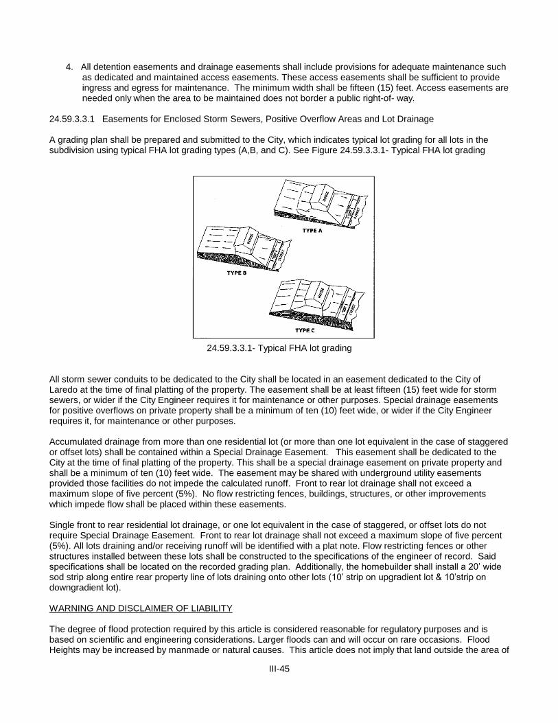
III-45
4. All detention easements and drainage easements shall include provisions for adequate maintenance such as dedicated and maintained access easements. These access easements shall be sufficient to provide ingress and egress for maintenance. The minimum width shall be fifteen (15) feet. Access easements are needed only when the area to be maintained does not border a public right-of- way.
24.59.3.3.1 Easements for Enclosed Storm Sewers, Positive Overflow Areas and Lot Drainage A grading plan shall be prepared and submitted to the City, which indicates typical lot grading for all lots in the subdivision using typical FHA lot grading types (A,B, and C). See Figure 24.59.3.3.1- Typical FHA lot grading
24.59.3.3.1- Typical FHA lot grading All storm sewer conduits to be dedicated to the City shall be located in an easement dedicated to the City of Laredo at the time of final platting of the property. The easement shall be at least fifteen (15) feet wide for storm sewers, or wider if the City Engineer requires it for maintenance or other purposes. Special drainage easements for positive overflows on private property shall be a minimum of ten (10) feet wide, or wider if the City Engineer requires it, for maintenance or other purposes. Accumulated drainage from more than one residential lot (or more than one lot equivalent in the case of staggered or offset lots) shall be contained within a Special Drainage Easement. This easement shall be dedicated to the City at the time of final platting of the property. This shall be a special drainage easement on private property and shall be a minimum of ten (10) feet wide. The easement may be shared with underground utility easements provided those facilities do not impede the calculated runoff. Front to rear lot drainage shall not exceed a maximum slope of five percent (5%). No flow restricting fences, buildings, structures, or other improvements which impede flow shall be placed within these easements. Single front to rear residential lot drainage, or one lot equivalent in the case of staggered, or offset lots do not require Special Drainage Easement. Front to rear lot drainage shall not exceed a maximum slope of five percent (5%). All lots draining and/or receiving runoff will be identified with a plat note. Flow restricting fences or other structures installed between these lots shall be constructed to the specifications of the engineer of record. Said specifications shall be located on the recorded grading plan. Additionally, the homebuilder shall install a 20’ wide sod strip along entire rear property line of lots draining onto other lots (10’ strip on upgradient lot & 10’strip on downgradient lot). WARNING AND DISCLAIMER OF LIABILITY The degree of flood protection required by this article is considered reasonable for regulatory purposes and is based on scientific and engineering considerations. Larger floods can and will occur on rare occasions. Flood Heights may be increased by manmade or natural causes. This article does not imply that land outside the area of

III-46
special flood hazards or uses permitted within such areas will be free from flooding or flood damages. This ordinance does not imply that properties shall always be free from flooding or flood damage, surface water stagnation or nonpoint source pollution or that all flood control and water treatment projects to control the quantity and quality of runoff can be constructed effectively. Nothing whatsoever in this ordinance should be construed as or be deemed to create additional duties, on the part of the city, to hold the city liable for any damages incurred in a flood or from adverse water quality, due to drainage runoff. Nothing in this ordinance shall be deemed to waive the city’s immunity under State law or reduce the need or necessity for flood insurance. Section 24.59.4 TEMPORARY EROSION AND SEDIMENT CONTROL
Section 24.59.4.1 GENERAL REQUIREMENTS
1. All operators of construction sites shall use best management practices (BMPs) to control and reduce the discharge, to the MS4 and to waters of the United States, of sediment, silt, earth, soil, and other material associated with clearing, grading, excavation, land filling, and other construction activities to the maximum extent practicable. Any best management practices (BMPs) capable of installation and/or implementation prior to commencement of construction (for example, structural measures) shall be installed and/or implemented prior to commencement of construction at the site or in compliance with a schedule for installation and/or implementation in an applicable Storm Water Pollution Prevention Plan (SWPPP). The best management practices (BMPs) used at construction sites may include, but are not limited to, the following measures:
a. Ensuring that existing vegetation is preserved where feasible and that disturbed portions of the
site are stabilized as soon as practicable in portions of the site where construction activities have stopped for fourteen days, and no further construction is anticipated for an additional seven days, or have permanently ceased;
b. Use of structural practices to divert flows from exposed soils, to store flows, or to otherwise limit
runoff and the discharge of pollutants from the site to the maximum extent practicable; c. Minimization of the tracking of sediments off-site by vehicles, the generation of dust, and the
escape of other windblown waste from the site; d. Prevention of the discharge of building materials, including cement, lime, concrete, asphalt, or
mortar, to the MS4 or waters of the United States; e. Measures to prevent and contain spills of paints, solvents, fuels, septic waste, and other
hazardous chemicals and pollutants associated with construction, and to assure proper cleanup and disposal of any such spills in compliance with state, federal, and local requirements;
f. Implementation of proper waste disposal and waste management techniques, including covering
waste materials, minimizing ground contact with hazardous chemicals and trash, and installing and maintaining covered receptacles for rubbish and garbage to assure that such waste materials are not blown or carried by rainfall runoff from the site;
g. Timely maintenance of vegetation, erosion and sediment control measures, and other best
management practices (BMPs) to maintain them in good and effective operating condition; and h. Installation of structural measures during the construction process to control pollutants in storm
water discharges that will occur after construction operations have been completed. Structural measures should be placed on upland soils to the degree attainable. Such installed structural measures may include, but are not limited to, the following: storm water detention structures (including wet ponds); storm water retention structures; flow attenuation by use of open vegetative swales and natural depressions; other velocity dissipation devices; infiltration of runoff on site; and sequential systems which combine several practices. Operators of construction sites are only responsible for the installation and maintenance of storm water management measures prior to
III-47
final stabilization of the site, and are not responsible for maintenance after storm water discharges associated with construction activity have terminated.
2. Qualified personnel (provided by the operator of the construction site) shall inspect disturbed areas of
any construction site that have not been finally stabilized, areas used for storage of materials that are exposed to precipitation, structural control
measures, and locations where vehicles enter or exit the site, at least once every seven (7) calendar days and within twenty-four (24) hours of the end of a storm that is 0.5 inches or greater. All erosion and sediment control measures and other identified best management practices (BMPs) shall be observed in order to ensure that they are operating correctly and are effective in preventing significant impacts to receiving waters and the MS4. Based on the results of the inspection, best management practices (BMPs) shall be modified as appropriate, and as soon as is practicable.
3. Any owner of a site of construction activity, whether or not he/she is an operator, is jointly and
severally responsible for compliance with the requirements in this 24.59.4.1 of the Code. 4. Any contractor or subcontractor on a site of construction activity, who is not an owner or operator, but
who is responsible under his/her contract or subcontract for implementing a best management practices (BMPs) control measure, is jointly and severally responsible for any willful or negligent failure on his/her part to adequately implement that control measure.
Section 24.59.4.2 STORM WATER POLLUTION PREVENTION PLAN (SWPPP) SUBMITTAL AND
REVIEW All operators of sites of construction activity, including clearing, grading, excavation, and land filling activities, that result in the disturbance of one (1) or more acres of total land area, or that is part of a common plan of development or sale within which one (1) or more acres of total land area are disturbed, or who are required to obtain an NPDES permit for storm water discharges associated with construction activity, shall comply as a minimum with the following requirements (in addition to those in 24.59.4.1 of this Code and those requirements defined in the most current EPA/NPDES storm water permit):
1. Any operator who intends to obtain coverage for storm water discharges from a construction site
under the NPDES General Permit for Storm Water Discharges from Construction Sites ("the Construction General Permit") shall submit a signed copy of the Notice of Intent (NOI) to the City Engineer, at least fifteen (15) calendar days prior to the commencement of construction activities. If the construction activity is already underway upon the effective date of this Chapter, the NOI shall be submitted within thirty (30) calendar days. For storm water discharges from construction sites where the operator changes, a revised NOI shall be submitted at least two (2) calendar days prior to when the new operator commences work at the site.
2. A SWPPP shall be prepared and implemented prior to the beginning of construction activities in
accordance with the requirements of the Construction General Permit or any individual NPDES permit issued for storm water discharges from the construction site, and with any additional requirement imposed by or under this Code and any other City Code.
3. The SWPPP shall be prepared, dated, signed, and sealed by a licensed professional engineer. The
signature and seal of the licensed professional engineer shall constitute his/her attestation that the SWPPP fully complies with the requirements of the Construction General Permit, or with any applicable individual NPDES permit issued for storm water discharges from the construction site, and with any additional requirement imposed by or under this Code. The SWPPP shall contain the name, title, and business address of the licensed professional engineer signing it.
4. The SWPPP shall be updated and modified as appropriate and as required by the Construction
General Permit and this Code. Any update or modification to the SWPPP shall be prepared, signed, and sealed by a licensed professional engineer.
III-48
5. The SWPPP shall be prepared and submitted to the City Engineer at least fifteen (15) calendar days prior to the commencement of construction activities. If the construction activity is already underway upon the effective date of this Code, the SWPPP shall be submitted within thirty (30) calendar days.
The SWPPP shall be prepared and submitted to the City Engineer in conjunction with the Storm
Water Management Permit and Building Permit application. A Storm Water Management Permit shall be issued prior to commencement of construction activity.
6. A copy of any SWPPP that is required by 24.59.4.2 of this Code shall be submitted to the City in
conjunction with any application for a building permit, and Storm Water Management Permit, and any other City approval necessary to commence or continue construction at the site.
7. If, upon the City Engineer's review of the SWPPP (or any modification to the SWPPP) and any site
inspection that the City Engineer may conduct, the City Engineer determines that the SWPPP does not comply with the requirements of the Construction General Permit, any individual NPDES permit issued for storm water discharge from the construction site, or any additional requirement imposed by or under this Code, the City Engineer may issue an order prohibiting the commencement, or the continuation, of any construction activity at the site. Also, if at any time the City Engineer determines that the SWPPP is not being fully implemented, the City Engineer may similarly issue an order prohibiting the continuation of any construction activity at the site. Any order issued by the City Engineer under the authority of this paragraph may be in the form of a Compliance Order under 24.59.8.5, an Emergency Cease and Desist Order under 24.59.8.7, or a Stop Work Order under 24.59.8.8 of this Code.
8. Upon review of the SWPPP and any site inspection that is conducted, the City may deny approval of
any building permit, Storm Water Management Permit, or any other City approval necessary to commence or continue construction, or to assume occupancy, on the grounds that the SWPPP does not comply with the requirements of the Construction General Permit, any individual or group NPDES permit issued for storm water discharge from the construction site, or any additional requirement imposed by or under this Code. Also, if at any time the City determines that the SWPPP is not being fully implemented, the City may similarly deny approval of any building permit, storm water management plan permit, or any other City approval necessary to commence or continue construction, or to assume occupancy, at the site.
9. All contractors and subcontractors identified in a SWPPP shall sign a copy of the following certification
statement before conducting any professional service identified in the SWPPP: “I certify under penalty of law that I understand the terms and conditions of the National Pollutant
Discharge Elimination System (NPDES) permit that authorizes the storm water discharges associated with industrial activity from the construction site identified as part of this certification.”
The certification must include the name and title of the person providing the signature; the name,
address, and telephone number of the contracting firm; the address (or other identifying description) of the site; and the date the certification is made.
10. The SWPPP, with the licensed professional engineer's signature, seal, and date affixed, and the
certifications of contractors and subcontractors required by 24.59.4.2 of this Code, and with any modifications attached, shall be retained at the construction site from the date of commencement of construction through the date of final stabilization.
11. The operator shall make a copy of the SWPPP and any modification thereto available to the City
Engineer and any other authorized City inspector at the construction site upon request (as well as to EPA and State inspectors).
12. The City Engineer may notify the operator at any time that the SWPPP does not meet the
requirements of the Construction General Permit, any applicable individual NPDES permit issued for storm water discharges from the construction site, or any additional requirement imposed by or under

III-49
this Code. Such notification shall identify those provisions of the permit or code which are not being met by the SWPPP, and identify which provisions of the SWPPP require modifications in order to meet such requirements. Within seven (7) calendar days of such notification from the City Engineer, the operator shall make the required changes to the SWPPP and shall submit to the City Engineer a written certification that the requested modifications have been made.
13. The operator shall modify the SWPPP whenever there is a change in design, construction, operation,
or maintenance, which has a significant effect on the potential for the discharge of pollutants to the MS4 or to the waters of the United States, and which has not otherwise been addressed in the SWPPP, or if the SWPPP proves to be ineffective in eliminating or significantly minimizing pollutants, or in otherwise achieving the general objective of controlling pollutants in storm water discharges associated with construction activity. In addition, the SWPPP shall be modified to identify any new contractor and/or subcontractor that will implement a measure in the SWPPP. All modifications to the SWPPP shall be submitted to the City Engineer within seven (7) calendar days of a change, determination of ineffectiveness (self or City inspection), or effective date of changes in contractor and/or subcontractor.
14. Qualified personnel (provided by the operator of the construction site) shall inspect disturbed areas of
the construction site that have not been finally stabilized, areas used for storage of materials that are exposed to precipitation, structural control measures, and locations where vehicles enter or exit the site, at least once every seven (7) calendar days and within twenty-four (24) hours of the end of any storm that is 0.5 inches or greater. Disturbed areas and areas used for storage of materials that are exposed to precipitation shall be inspected for evidence of, or the potential for, pollutants entering the drainage system. Erosion and sediment control measures identified in the SWPPP shall be observed to ensure that they are operating correctly. Where discharge locations or points are accessible, they shall be inspected to ascertain whether erosion control measures are effective in preventing significant impacts to receiving waters or the MS4. Locations where vehicles enter or exit the site shall be inspected for evidence of off-site sediment tracking.
15. Based on the results of the inspections required by the 24.59.4.2 item 14 of this Code, the site
description and/or the pollution prevention measures identified in the SWPPP shall be modified as appropriate, but in no case later than seven (7) calendar days following the inspection. Such modifications shall provide for timely implementation of any changes to the SWPPP within seven (7) calendar days following the inspection. All modifications to the SWPPP shall be submitted to the City Engineer within seven (7) calendar days of the date of inspection.
16. A report log summarizing the scope of any inspection required by the 24.59.4.2 item 15 of this Code,
and the name(s) and qualifications of personnel making the inspection, the date(s) of the inspection, major observations relating to the implementation of the SWPPP, and actions taken shall be made and retained as part of the SWPPP for at least three years from the date that the site is finally stabilized. Such report shall identify any incidence of noncompliance. Where a report does not identify any incidence of noncompliance, the report shall contain a certification that the facility is in compliance with the SWPPP, the facility's NPDES permit, and this Code. The report shall be certified and signed by the person responsible for making it.
17. The operator shall retain copies of any SWPPP and all reports required by this Code or by the NPDES
permit for the site, and records of all data used to complete the NOI, for a period of at least three years from the date that the site is finally stabilized.
18. Where a site has been finally stabilized and all storm water discharges from construction activities that
are authorized by this Code and by the NPDES permit for those construction activities are eliminated, or where the operator of all storm water discharges at a facility changes, the operator of the construction site shall submit to the City Engineer, a Notice of Termination (NOT).
19. Upon final stabilization of the construction site, the owner (or the duly authorized representative
thereof) shall submit to the City Engineer written certification by a licensed professional engineer that the site has been finally stabilized. The City may withhold occupancy or use of permits for any
III-50
premises constructed on the site until such certification of final stabilization has been filed and the City Engineer has determined, following any appropriate inspection, that final stabilization has, in fact, occurred and that any required permanent structural controls have been completed
Section 24.59.5 STORM WATER QUALITY MANAGEMENT
Section 24.59.5.1 APPLICABILITY (a) Except as provided in subparagraph (2) of this paragraph, a site specific storm water quality management
plan is required for all residential, commercial, and industrial development and/or redevelopment of one acre or more within the City of Laredo and its jurisdictional areas.
(1) For the purpose of this section, the area of the development must include all contiguous land owned
by the responsible party, regardless of the amount of land that will be affected by the development activity.
(2) A storm water quality management plan is not required when a portion of a previously developed tract
of land is redeveloped, unless the redevelopment will result in the conversion of more than ¼ acre from a porous surface to an impervious surface.
(b) The storm water quality plan must be submitted at the time of preliminary plat submission, or submission
of a site plan with an application for a building permit (if the site is more than one (1) acre). (c) The storm water quality management plan must identify the location of the ultimate outfall from the City's
MS4 into the receiving water and any environmentally sensitive areas that will receive any pollutants carried by storm water pollution from the site.
(d) The storm water quality management plan must state whether an NPDES storm water pollution prevention
plan or a pollution control plan will be submitted to the City Engineer. (e) The storm water quality management plan must be signed and sealed by a professional engineer licensed
to practice engineering in the State of Texas. Section 24.59.5.2 SPECIAL LAND USE Requirements A storm water quality management plan and any plans submitted for a building permit for the development of property that will be used for one of the below listed uses must identify the appropriate best management practices (BMPs) to prevent pollutants being discharged into the City's MS4. The owner of a site within City that is currently being used for one of the activities described below is not required to physically alter the existing facility to comply with this section, unless alterations or repairs to the facility require the facility to be brought into compliance with the current City of Laredo building code. The uses are as follows:
(1) Fueling stations. (2) Vehicle/equipment washing and steam cleaning facilities. (3) Facilities engaged in harmful liquid materials loading and unloading. (4) Facilities engaged in harmful liquids storage in aboveground storage tanks. (5) Facilities engaged in container storage of harmful liquids (such as oil, chemical, & hazardous
substances), food wastes, and hazardous wastes. (6) Facilities engaged in outdoor storage of raw materials that are subject to leaching and transport by
erosion and sedimentation, such as gravel, sand, topsoil, compost, sawdust, wood chips, building materials, including lumber, which are subject to leaching; and concrete and metal products, which are subject to chemical erosion, corrosion, and leaching.
III-51
Section 24.59.5.3 GENERAL REQUIREMENTS
Section 24.59.5.3.1 PRELIMINARY PLAN (PLATTING)
A layout of the proposed water quality management system and calculations showing it meets the requirements of 24.59.5.4 below shall be submitted with the other requirements as outlined in 24.59.2.
Section 24.59.5.3.2 FINAL CONSTRUCTION PLANS Final construction plans and specifications, and calculations showing that the water quality management system meets the requirements of 24.59.5.4 below shall be submitted with the other requirements as outlined in 24.59.2.
Section 24.59.5.4 DESIGN CRITERIA
Section 24.59.5.4.1 QUALITY MANAGEMENT CRITERIA The criteria of the water quality management for the new development and redevelopment is that the water quality effects of the development should not be significantly different from the water quality effects of the same site before construction. Development/redevelopment within the City of Laredo shall provide, at the minimum, one of the following methods for storm water treatment, provided that the discharges meet the requirements of the City's storm water NPDES permit and state water quality criteria. More stringent treatment methods may be required by the City Engineer if discharges fail to meet water quality goals. The drainage area for determining treatment volumes shall include all areas draining to the facility (on-site and off-site). If off-site flows are not commingled with on-site flows prior to treatment, they should not be included in the treatment volume. Method Treatment Volume and Recovery Rate
a. Wet Detention: Wet detention treatment volume shall be, at a minimum, the first one (1) inch of
runoff. No more than 1/2 of the volume may be discharged in the first 24 hours. b. Off-line Retention: Off-line retention diverts the first flush of storm water runoff to a facility
separated from the main line storm water conveyance system. The treatment volume for off-line retention shall be one-half (1/2) inch of runoff. The treatment volume shall again be available within a minimum of 24 hours and a maximum of 72 hours following a storm event, with appropriate on-site soils test submitted to verify the infiltration rate.
c. On-line Retention or Detention: For on line retention or detention with under drained filtration,
treatment volume shall be provided equal to one (1) inch of runoff. Only bottom underdrain systems planted with grass that are capable of recovering the treatment volume within 24 hours shall be allowed, to the satisfaction of the City Engineer, to exceed the capabilities of such a bottom underdrain system.
Design criteria and design specifications for the water quality treatment methods described above are outlined in the Storm Water Management Guidance Manual.
Section 24.59.5.4.2 FLOATABLE CONTROLS All detention facilities shall incorporate floatable controls (baffles, etc.) to ensure that no floatables are discharged from the facility. The detention facilities shall be regularly checked and any floatables removed as part of the ongoing detention facility maintenance. Section 24.59.5.4.3 SPILL CONTROL
III-52
All detention facilities shall incorporate in the design of their discharge structures a method for stopping all discharges in case of an accidental spill occurring within the detention facilities drainage area. This discharge control device shall be periodically checked to ensure its continued operation as part of the ongoing detention facility maintenance. Section 24.59.5.4.4 BMPs For residential development/redevelopment areas of more than (1) acre, and with the approval of the City Engineer or his/her authorized representative, the water quality requirements as stated in 24.59.5.4 may be waived in favor of a series of permanent BMPs, i.e., swales, vegetated buffers, small impoundments, etc. that are shown to provide sufficient water quality enhancements to meet the intent of 24.59.4. Section 24.59.5.4.5 DISCHARGES TO THE RIO GRANDE
For sites discharging directly into the Rio Grande the runoff amounts used for the determination of water
quality treatment volume will be 50% greater than those indicated in 24.59.4. The only treatment method for water quality shall be off-line retention unless otherwise approved by the City Engineer and the IBWC.
Section 24.59.6 INSPECTION Section 24.59.6.1 INSPECTION SCHEDULE AND REPORTS
1. Prior to the issuance of a storm water management permit, the developer will submit to the City Engineer a proposed inspection and construction control schedule. The City of Laredo or its authorized representative shall conduct inspections and file reports for periodic inspections necessary during construction of storm water management systems to ensure compliance with the approved plans.
2. No work shall proceed until the City Engineer or his/her authorized representative inspects and approves
the work previously completed and furnishes the developer with the results of the inspection reports as soon as possible after completion of each required inspection.
3. Any portion of the work which does not comply must be promptly corrected by the developer, after written notice from the City Engineer or his/her authorized representative. The notice shall set forth the nature of corrections required and the time within which corrections will be made.
4. The developer shall notify the City Engineer before commencing any work in conjunction with the storm
water management plan and upon completion of the project when a final inspection will be conducted. Section 24.59.6.2 INSPECTION REQUIREMENTS DURING CONSTRUCTION After commencing initial site operations, regular inspections shall be made at the following specified stage of
construction:
1. Infiltration systems at the commencement, during, and upon completion of construction. 2. Flow attenuation devices, such as open vegetated swales, upon the completion of construction. 3. Retention and detention structures at the following stages:
a. Upon completion of excavation to sub-foundation and where required, installation of structural supports or reinforcement for structures, including but not limited to:
(1) Core trenches for structural embankments; (2) Inlet-outlet structures and anti-seep structures, watertight connectors on pipes; and (3) Trenches for enclosed storm drainage facilities.
b. during placement of structural fill, concrete, and the installation of catch basins;
III-53
c. during backfill of foundations and trenches; d. during embankment construction; and e. upon completion of final grading and the establishment of permanent stabilization.
Section 24.59.6.3 FINAL INSPECTION REPORTS A final inspection shall be conducted by the City Engineer or his/her authorized representative upon
completion of the storm water management facility to determine if the completed work is constructed in accordance with the approved plan and this Code. “As-built” certification by a licensed professional engineer licensed in the State of Texas is also required to certify that the facility has been constructed as shown on the “As-built” plans and is substantially compliant with plans and specifications. The developer will receive written notification of the results of the final inspection. The City Engineer shall maintain a permanent file of inspection reports. Section 24.59.6.4 INSPECTION FOR PREVENTION MAINTENANCE 1. Preventive maintenance shall be ensured through inspection of all infiltration systems, retention, or
detention structures by the City Engineer or his/her authorized representative. The inspection shall occur during the first year of operation and at least once every three years thereafter.
2. Inspection reports shall be maintained by the City Engineer or his/her authorized representative for all
storm water management facilities. 3. Inspection reports for retention and detention facilities shall include the following:
a. The date of inspection; b. Name of inspector; c. The condition of the following:
(1) Vegetation; (2) Fences; (3) Spillways; (4) Embankments; (5) Reservoir area; (6) Outlet channels; (7) Underground drainage; (8) Sediment load; or (9) Any other item that could affect the proper function of the storm water management system.
d. Description of needed maintenance.
4. If, after an inspection by the City Engineer or his/her authorized representative, the condition of a storm
water management facility presents an immediate danger to the public health or safety, because of an unsafe condition or improper maintenance, the City Engineer or his/her authorized representative shall take such action as may be necessary to protect the public and make the facility safe.
Section 24.59.7 MAINTENANCE Section 24.59.7.1 MAINTENANCE AGREEMENT
1. Prior to the issuance of any building permit for which storm water management is required, the City Engineer shall require the applicant or owner to execute under oath, an inspection and maintenance agreement binding on all subsequent owners of land served by the private storm water management facility. Such agreement shall provide for access to the facility at reasonable times for regular inspections by the City Engineer or his/her authorized representative and for regular or special assessments of

III-54
property owners to ensure that the facility is maintained in proper working condition to meet design standards and any provision established.
2. The agreement shall be recorded by the applicant and/or owner in the deed records of Webb County,
Texas. 3. The agreement shall also provide that, if after the notice by the City Engineer to correct a violation
requiring maintenance work, satisfactory corrections are not made by the owner(s) within a reasonable period of time (thirty (30) days maximum), the City Engineer may perform all necessary work to place the facility in proper working condition. The owner(s) of the facility shall be assessed the cost of the work and any penalties. This may be accomplished by placing a lien on the property, which may be placed on the tax bill and collected as ordinary taxes by the City.
Section 24.59.7.2 MAINTENANCE RESPONSIBILITY
1. All water quality controls and their appurtenances required for commercial or multifamily development shall be maintained by the owner of the commercial or multifamily development.
2. All water quality controls and drainage required for single family or duplex residential development shall be
maintained by the developer for two (2) years after the final acceptance for the entire development. The City will not accept any drainage structure which is not complete according to the requirements of this Code.
3. The owner of the property on which work has been done pursuant to this Code for private storm water
management facilities, or any other person or agent in control of such property, shall maintain in good condition and promptly repair and restore all grade surfaces, walls, drains, dams and structures, vegetation, erosion and sediment control measures, and other protective devices and remove and properly dispose of all floatable. Such repairs or restoration and maintenance shall be in accordance with approved plans.
4. A maintenance schedule shall be developed for the life of any storm water management facility and shall state the maintenance to be completed, the time period for completion, and who shall perform the maintenance. This maintenance schedule shall be printed on the storm water management plan.
Section 24.59.8 ADMINISTRATIVE ENFORCEMENT REMEDIES
Section 24.59.8.1 WARNING NOTICE When the City Engineer finds that any person has violated, or continues to violate, any provision of this Code, or any order issued hereunder, the City Engineer may serve upon that person a written Warning Notice, specifying the particular violation believed to have occurred and requesting the discharger to immediately investigate the matter and to seek a resolution whereby any offending discharge will cease. Investigation and/or resolution of the matter in response to the Warning Notice in no way relieves the alleged violator of liability for any violations occurring before or after receipt of the Warning Notice. Nothing in this subsection shall limit the authority of the City Engineer to take any action, including emergency action or any other enforcement action, without first issuing a Warning Notice. Section 24.59.8.2 NOTIFICATION OF VIOLATION When the City Engineer finds that any person has violated, or continues to violate, any provision of this Code, or any order issued hereunder, the City Engineer may serve upon that person a written Notice of Violation. Within ten (10) calendar days of the receipt of this notice, an explanation of the violation and a plan for the satisfactory correction and prevention of recurrence thereof, to include specific required actions, shall be submitted by the alleged violator to the City Engineer. If the alleged violator denies that any violation occurred and/or contends that no corrective action is necessary, an explanation of the basis of any such denial or contention shall be submitted to the City Engineer within ten (10) calendar days of receipt of the notice. Submission of an explanation and/or plan in no way relieves the alleged violator of liability for any violations occurring before or after receipt of the Notice of Violation (NOI). Nothing in this section shall limit the authority

III-55
of the City Engineer to take any action, including emergency action or any other enforcement action, without first issuing a Notice of Violation (NOV).
Section 24.59.8.3 CONSENT ORDERS The City Engineer may enter into Consent Orders, assurances of voluntary compliance, or other similar documents establishing an agreement with any person responsible for noncompliance with any provision in this Code or any order issued hereunder. Such documents may include specific actions to be taken by the person to correct the noncompliance within a time period specified by the document. Such documents shall have the same force and effect as the administrative orders issued pursuant to 24.59.8.5, 24.59.8.6, and 24.59.8.7 of this Code and shall be judicially enforceable. Section 24.59.8.4 SHOW CAUSE HEARING The City Engineer may order any person who has violated, or continues to violate, any provision of this Code, or any order issued hereunder, to appear before the City Engineer and show cause why a proposed enforcement action should not be taken. Notice shall be served on the alleged violator specifying the time and place for the hearing, the proposed enforcement action, the reasons for such action, and a request that the alleged violator show cause why the proposed enforcement action should not be taken. The notice of the hearing shall be served personally or by registered or certified mail (return receipt requested) at least ten (10) calendar days prior to the hearing. Such notice may be served on any authorized representative of the alleged violator. The hearing shall be conducted pursuant to the rights and procedures specified in 24.59.9.1 of this Code. A show cause hearing shall not be a bar against, or prerequisite for, taking any other action against the alleged violator. Section 24.59.8.5 COMPLIANCE ORDERS When the City Engineer finds that any person has violated, continues to violate, or threatens to violate, any provision of this Code, or any order issued hereunder, the City Engineer may issue an order to the violator directing that the violator come into compliance within a specified time limit, prior to commencement or continuance of operation, or immediately. Compliance orders may also contain other requirements to address the noncompliance, including additional self- monitoring, and management practices designed to minimize the amount of pollutants discharged to the MS4 and waters of the United States. A compliance order may not extend the deadline for compliance established by a state or federal standard or requirement, nor does a compliance order relieve the person of liability for any violation, including any continuing violation. Issuance of a compliance order shall not be a bar against, or a prerequisite for, taking any other action against the violator. Section 24.59.8.6 REMEDIATION, ABATEMENT, AND RESTORATION ORDERS When the City Engineer finds that a person has violated, or continues to violate, any provision of this Code, or any order issued hereunder, and that such violation has adversely affected the MS4, or the waters of the United States, the City Engineer may issue an order to the violator directing him or her to undertake and implement any appropriate action to remediate and/or abate any adverse effects of the violation upon the MS4, or the waters of the United States, and/or to restore any part of the MS4, or the waters of the United States. Such remedial, abatement, and restoration actions may include, but are not limited to: monitoring, assessment, and evaluation of the adverse effects and determination of the appropriate remedial, abatement, and/or restoration action; confinement, removal, cleanup, treatment, and disposal of any discharged or released pollution or contamination; prevention, minimization, and/or mitigation of any damage to the public health, welfare, or the environment that may result from the violation; and restoration or replacement of City property or natural resources damaged by the violation. The order may direct that the remediation, abatement, and/or restoration be accomplished on a specified compliance schedule and/or be completed within a specified period of time. An order issued under this Subsection does not relieve the violator of liability for any violation, including any continuing violation. Issuance of an order under this Subsection shall not be a bar against, or a prerequisite for, taking any other action against any responsible party.

III-56
Section 24.59.8.7 EMERGENCY CEASE AND DESIST ORDERS When the City Engineer finds that any person has violated, continues to violate, or threatens to violate, any provision of this Code, or any order issued hereunder, or that the person's past violations are likely to recur, and that the person's violation(s), or threatened violation(s), have caused or contributed to an actual or threatened discharge to the MS4 or waters of the United States which reasonably appears to present an imminent or substantial endangerment to the health or welfare of persons or to the environment, the City Engineer may issue an order to the violator directing it to immediately cease and desist all such violations and directing the violator to:
1. Immediately comply with all requirements of this Code; and 2. Take such appropriate preventive action as may be needed to properly address a continuing or
threatened violation, including immediately halting operations and/or terminating the discharge. Any person notified of an emergency order directed to it under this Subsection shall immediately
comply and stop or eliminate its endangering discharge. In the event of a discharger's failure to immediately comply voluntarily with the emergency order, the City Engineer may take such steps as deemed necessary to prevent or minimize harm to the MS4 or waters of the United States, including immediate termination of a facility's water supply, sewer connection, or other municipal utility services. The City Engineer may allow the person to commence or recommence its discharge when it has demonstrated to the satisfaction of the City Engineer that the period of endangerment has passed, unless further termination proceedings are initiated against the discharger under this Code. A person that is responsible, in whole or in part, for any discharge presenting imminent endangerment shall submit a detailed written statement, describing the causes of the harmful discharge and the measures taken to prevent any future occurrence, to the City Engineer within ten (10) calendar days of receipt of the emergency order. Issuance of an emergency cease and desist order shall not be a bar against, or a prerequisite for, taking any other action against the violator.
Section 24.59.8.8 STOP WORK ORDERS Whenever the City Engineer finds that any operator of a construction site has violated, threatens to violate, or continues to violate, any provision of this Code, or any order issued hereunder, the City Engineer may issue a Stop Work Order to the operator, and require that a copy of the Stop Work Order be posted at the construction site and distributed to all City departments and divisions whose decisions affect any activity at the site. Unless express written exception is made by the City Engineer, the Stop Work order shall prohibit any further construction activity, or any commencement of construction activity, at the site and shall bar any further inspection or approval by the City associated with a building permit, grading permit, or any other City approval necessary to commence or continue construction or to assume occupancy at the site. Issuance of a Stop Work Order shall not be a bar against, or a prerequisite for, taking any other action against the violator.
Section 24.59.9 RIGHT TO RECONSIDERATION HEARING, AND APPEAL
Section 24.59.9.1 RECONSIDERTATION AND HEARING 1. Any person subject to a Compliance Order under 24.59.8.5, a Remediation, Abatement, or Restoration
Order under 24.59.8.6, an Emergency Cease and Desist Order under 24.59.8.7, or a Stop Work Order under 24.59.8.8, of this Code may petition the City Engineer to reconsider the basis for his/her order within fifteen (15) calendar days of the affected person's notice of issuance of such an order.
2. Failure to submit a timely written petition for reconsideration shall be deemed to be a waiver of any further
right to administrative reconsideration or review of the order. 3. In its petition, the petitioning party must indicate the provisions of the order objected to, the reasons for the
objection(s), any facts that are contested, the evidence that supports the petitioner's view of the facts, any alternative terms of an order that the petitioner would accept, and whether the petitioning party requests a hearing on its petition.

III-57
4. The effect of any Compliance Order under 24.59.8.5, Remediation, Abatement, or Restoration Order under 24.59.8.6, and any Stop Work Order under 24.59.8.8 shall be stayed pending the City Engineer's reconsideration of the petition, and any hearing thereon, unless the City Engineer expressly makes a written determination to the contrary. The effectiveness of any Emergency Cease and Desist Order under 24.59.8.7 shall not be stayed pending the City Engineer's reconsideration, or any hearing thereon, unless the City Engineer expressly and in writing stays his/her emergency order.
5. Within thirty (30) calendar days of the submittal of a petition for reconsideration, the City Engineer shall
either (1) grant the petition and withdraw or modify the order accordingly; (2) deny the petition, without hearing if no material issue of fact is raised; or (3) if a hearing has been requested and a material issue of fact has been raised, set a hearing on the petition.
6. Written notice of any hearing set by the City Engineer pursuant to 24.59.9.1 item 5 shall be served on the
petitioning party personally or by registered or certified mail (return receipt requested) at least ten (10) calendar days prior to the hearing. Such notice may be served on any authorized representative of the petitioning party.
7. The City Engineer may conduct the hearing and take evidence, or may designate any employee of the City
or any specially-designated attorney or engineer to:
a. issue in the name of the City notices of hearing requesting the attendance and testimony of witnesses and the production of evidence relevant to any matter involved in the hearing;
b. take evidence; and c. transmit a report of the evidence and hearing, including transcripts and other evidence, together with
recommendations to the City Engineer for action thereon. At any hearing held pursuant to this Subsection, testimony taken shall be under oath and recorded.
Any party is entitled to present his/her case or defense by oral or documentary evidence and to conduct such cross-examination as may be required for a full and true disclosure of the facts. A transcript will be made available to any party to the hearing upon payment of the usual charges thereof.
8. After the City Engineer has reviewed the evidence, he/she shall either (1) grant the petition; (2) deny the
petition; or (3) grant the petition in part and deny it in part. The City Engineer may modify his/her order as is appropriate based upon the evidence and arguments presented at the hearing and his/her action on the petition. Further orders and directives as are necessary and appropriate may be issued.
Section 24.59.9.2 APPEAL Any person whose petition for reconsideration by the City Engineer has not been granted in its entirety and who remains adversely affected by the City Engineer's order, or who is subject to an order of the City Engineer issued following a Show Cause Hearing under 24.59.8.4, may challenge the final action of the City Engineer in an appropriate court of competent jurisdiction.
Section 24.59.10 JUDICIAL ENFORCEMENT REMEDIES Section 24.59.10.1 CIVIL REMEDIES
Section 24.59.10.1.1 Whenever it appears that a person has violated, or continues to violate, any provision of this Code that relates to:
a. the preservation of public safety, relating to the materials or methods used in construction of any
structure or improvement of real property;

III-58
b. the preservation of public health or to the fire safety of a building or other structure or improvement;
c. the establishment of criteria for land subdivision or construction of buildings, including street
design; d. dangerously damaged or deteriorated structures or improvements; e. conditions caused by accumulations of refuse, vegetation, or other matter that creates breeding
and living places for insects and rodents; or f. point source effluent limitations or the discharge of a pollutant, other than from a non point source,
into the MS4, City may invoke Sections 54.011 - 54.017 of the Texas Local Government Code and petition the State district court or the county court-at-law of Webb County, through the City Attorney, for either the injunctive relief specified in 24.59.10.1.2 or the civil penalties specified in 24.59.10.1.3 below, or both the specified injunctive relief and civil penalties.
Section 24.59.10.1.2 Pursuant to Section 54.016 of the Texas Local Government Code, the City may
obtain against the owner or the operator of a facility a temporary or permanent injunction, as appropriate, that:
a. prohibits any conduct that violates any provision of this Code that relates to any matter specified in
24.59.10.1.1.a-f above; or b. compels the specific performance of any action that is necessary for compliance with any
provision of this Code that relates to any matter specified in 24.59.10.1.1a-f above.
Section 24.59.10.1.3 Pursuant to Section 54.017 of the Texas Local Government Code, the City may recover a civil penalty of not more than $1,000 per day for each violation of any provision of this Code that relates to any matter specified in 24.59.10.1.1.a-e above, and a civil penalty of not more than $5,000 per day for each violation of any provision of this Code that relates to any matter specified in 24.59.10.1.1.f above, if the City proves that:
a. the defendant was actually notified of the provisions of the Code; and b. after the defendant received notice of the Code provisions, the defendant committed acts in
violation of the Code or failed to take action necessary for compliance with the Code.
Section 24.59.10.2 CRIMINAL PENALTIES
1. Any person who has violated any provision of this Code, or any order issued hereunder, shall be strictly liable for such violation, regardless of the presence or absence of a culpable mental state, and shall, upon conviction, be subject to a fine of not more than $2,000 per violation, per day.
2. Any person who has knowingly made any false statement, representation, or certification in any
application, record, report, plan, or other documentation filed, or required to be maintained, pursuant to this Code, or any order issued hereunder, or who has falsified, tampered with, or knowingly rendered inaccurate any monitoring device or method required under this Code shall, upon conviction, be subject to a fine of not more than $2,000 per violation, per day.
3. In determining the amount of any fine imposed hereunder, the court shall take into account all relevant circumstances, including, but not limited to, the extent of harm caused by the violation, the magnitude and duration of the violation, any economic benefit gained through the violation, corrective actions by the violator, the compliance history of the violator, the knowledge, intent, negligence, or other state of mind of the violator, and any other factor as justice requires.

III-59
Section 24.59.10.3 CIVIL SUIT UNDER THE TEXAS WATER CODE Whenever it appears that a violation or threat of violation of any provision of Section 26.121 of the Texas Water Code, or any rule, permit, or order of the Texas Natural Resource Conservation Commission, has occurred or is occurring within the jurisdiction of the City of Laredo, inclusive of its extraterritorial jurisdiction, the City may have a suit instituted in a state district court through its City Attorney for the injunctive relief or civil penalties or both authorized in Subsection (a) of Section 26.123 of the Texas Water Code, against the person who committed or is committing or threatening to commit the violation. This power is exercised pursuant to Section 26.124 of the Texas Water Code. In any suit brought by the City under this section, the Texas Natural Resource Conservation Commission is a necessary and indispensable party. Section 24.59.10.4 REMEDIES NONEXCLUSIVE The remedies provided for in this Code are not exclusive of any other remedies that the City may have under state or federal law or other City ordinances. The City may take any, all, or any combination of these actions against a violator. The City is empowered to take more than one enforcement action against any violator. These actions may be taken concurrently.
Section 24.59.11 SUPPLEMENTAL ENFORCEMENT ACTION Section 24.59.11.1 PERFORMANCE AND MAINTENANCE BONDS The City Engineer may, by written notice, order any owner or operator of a source of storm water discharge
associated with construction or industrial activity to file a satisfactory bond, payable to the City, in a sum not to exceed a value determined by the City Engineer to be necessary to achieve consistent compliance with this Code, any order issued hereunder, any required best management practice (BMP), and/or any SWPPP provision, and/or to achieve final stabilization of the site. The City may deny approval of any building permit, grading permit, subdivision plat, site development plan, or any other City permit or approval necessary to commence or continue construction or any industrial activity at the site, or to assume occupancy, until such a performance or maintenance bond has been filed.
Section 24.59.11.2 LIABILIITY INSURANCE The City Engineer may, by written notice, order any owner or operator of a source of storm water discharge
associated with construction or industrial activity to submit proof that it has obtained liability insurance, or other financial assurance, in an amount not to exceed a value determined by the City Engineer, that is sufficient to remediate, restore, and abate any damage to the MS4, the waters of the United States, or any other aspect of the environment that is caused by the discharge.
Section 24.59.11.3 PUBLIC NUISANCES A violation of any provision of this Code, or any order issued hereunder, is hereby declared a public nuisance
and shall be corrected or abated as directed by the City Engineer. Any person(s) creating a public nuisance shall be subject to the provisions of the Nuisance Ordinance of the Code of the City of Laredo, including requirements to reimburse the City for any costs incurred in removing, abating, or remedying said nuisance.

LAREDO LAND DEVELOPMENT CODE
CHAPTER 24
ARTICLE IV
ZONING REGULATIONS SECTION 24-60 ZONING REGULATIONS; INTENT AND PURPOSE ........................................ IV-1 SECTION 24-61 DEFINITIONS AND INTERPRETATIONS (93-0-177, 9/7/93) .................................... IV-1 SECTION 24-62 ZONING DISTRICTS AND BOUNDARIES (93-0-177, 9/7/93) ................................... IV-1
Section 24.62.1 Land Use Zoning Districts Established (94-0-248, 12/5/94; 2010-O-084, 7/6/10;
2015-O-126, 9/21/15) ................................................................................................. IV-1 Section 24.62.2 District Purpose (2010-O-084, 7/6/10; 2015-O-126, 9/21/15 ) .............................................. IV-2 Section 24.62.3 Reserved ........................................................................................................ IV-4 Section 24.62.4 District Purpose - Specific Use Zoning Overlay Districts ................................ IV-4 Section 24.62.5 Special Use Permits (95-0-227, 10/23/95; 96-0-196 & 197, 11/4/96; 2002-O-211, 09/03/02) ............ IV-4 Section 24.62.6 Conditional Use Permits ................................................................................. IV-4 Section 24.62.7 Resolution of District Boundaries .................................................................... IV-4 Section 24.62.8 Zoning of Newly Annexed Areas (99-O-354, 12/6/99) ................................................... IV-5
SECTION 24-63 EFFECTS OF DISTRICTS AND GENERAL REGULATIONS
Section 24.63.1 General Regulations ....................................................................................... IV-5 Section 24.63.2 Permitted Land Uses (96-0-196 & 197, 11/4/96; 97-O-081, 4/7/97; 98-O-177, 7/6/98; 00-O-052, 3/6/00;
00-0-051, 3/6/00; 2001-O-036, 2/5/01; 2001-O-172, 08/20/01; 2002-O-032, 02/25/02; 2002-O-211, 09/03/02; 2003-O-047, 3/03/03; 04-O-65, 04/05/04; 05-O-024, 2/7/05; 2006-0-112, 6/5/2006; 2006-O-285, 11/20/06; 2007-O-229, 11/5/07; 2009-O-158, 9/21/08; 2010-O-084, 7/6/10; 2015-O-124, 9/21/15; 2015-O-126, 9/21/15;
2017-O-084, 7/17/2017; 2018-O-003, 1/24/18; 2018-O-004, 1/24/18) ................................................... IV-5 Section 24.63.3 NON-CONFORMING USES OR BUILDINGS (2001-O-036, 2/5/01) ........................ IV-28
SECTION 24-64 Reserved
SECTION 24.65 SUPPLEMENTARY ZONING DIST. REGULATIONS (93-0-228, 11/22/93)
Section 24.65.0 General Supplementary Provisions (95-0-107, 7/3/95; 2015-O-126, 9/21/15;
2016-O-149, 10/20/16) ............................................................................... IV-30 Section 24.65.1 AG AGRICULTURAL DISTRICT .......................................................... IV-30 Section 24.65.2 R-S RESIDENTIAL SUBURBAN DISTRICT ......................................... IV-30 Section 24.65.3 R-1 SINGLE FAMILY RESIDENTIAL DISTRICT .................................. IV-30 Section 24.65.4 RSM SUBURBAN MULTI-FAMILY RESIDENTIAL DISTRICT ............... IV-31 Section 24.65.5 R-2 MULTI-FAMILY RESIDENTIAL DISTRICT .................................... IV-31 Section 24.65.6 R-1-MH SINGLE FAMILY MANUFACTURED HOUSING DIST. (93-O-102, 5/3/93; 2001-O-036, 2/5/01; 2004-O-157, /07/06/04) .................................... IV-31 Section 24.65.7 R-3 MIXED RESIDENTIAL DISTRICT (2001-O-036, 2/5/01) .......................... IV-32 Section 24.65.8 R-1A SINGLE FAMILY REDUCED AREA DISTRICT ............................. IV-33 Section 24.65.9 R-1B SINGLE FAMILY HIGH DENSITY DISTRICT (CREATED: 2015-O-126, 9/21/15)
........................................................................................................ IV-34 Section 24.65.10 R-O RESIDENTIAL-OFFICE DISTRICT (2013-O-052, 5/6/13) ........................ IV-34 Section 24.65.11 B-1R LIMITED OFFICE / RESIDENTIAL DISTRICT (09-O-224, 12/21/09) ....... IV-34 Section 24.65.12 B-1 LIMITED COMMERCIAL DISTRICT (96-0-048, 4/1/96; 09-O-224, 12/21/09;
2013-O-052, 5/6/13) .................................................................................. IV-34 Section 24.65.13 CBD CENTRAL BUSINESS DISTRICT (CBD) (96-0-196, 11/4/96; 09-O-224, 12/21/09)
........................................................................................................ IV-35 Section 24.65.14 B-3 COMMUNITY BUSINESS DISTRICT (96-0-048, 4/1/96; 2007-O-229, 11/5/07;
09-O-224, 12/21/09) .................................................................................. IV-35 Section 24.65.15 B-4 HIWAY COM. DIST. (89-0-168, 9/5/89; 96-0-048, 4/1/96; 2003-O-047, 3/03/03;
04-O-65, 04/05/04; 2006-O-286, 11/20/06; 2007-O-229, 11/5/07; 2008-O-084, 4/21/08;

LAREDO LAND DEVELOPMENT CODE
CHAPTER 24
2009-O-086, 6/1/09; 2009-O-225, 12/21/09) .................................................................... IV-36 Section 24.65.16 M-1 LIGHT MANUFACTURING DISTRICT (98-O-169, 7/6/98; 2002-O-211, 09/03/02;
2008-O-084, 4/21/08, 2009-O-225; 12/21/09; 2013-O-060, 5/2013; 2015-O-126, 9/21/15) ........ IV-37 Section 24.65.17 M-2 HEAVY MANUFACTURING DISTRICT (2002-O-211, 09/03/02; 2009-O-225, 12/21/09;
2013-O-060, 5/2013; 2015-O-126, 9/21/15 ) .............................................................. IV-39 Section 24.65.18 MXD MIXED USE DEVELOPMENT DISTRICT (2009-O-225,12/21/09) ............ IV-39 Section 24.65.19 AE ARTS AND ENTERTAINMENT DISTRICT (CREATED: 2010-O-084, 7/6/10;
2012-O-112, 9/4/12) .................................................................................................. IV-40 SECTION 24-66 HISTORIC DISTRICT SPECIFIC USE OVERLAY DISTRICT
Section 24-66.1 Historic District Purpose (95-0-092, 4/17/95) ............................................................ IV-48 Section 24.66.2 Creating Historic Districts ............................................................................... IV-48 Section 24.66.3 Designating Locally Significant Historic Landmarks (2012-O-160, 9/17/12) .............. IV-48 Section 24.66.4 Provisions relating to Historic Districts and Locally Significant Historic Landmarks ...................................................................................................... IV-50 Section 24.66.5 Procedural Requirements for Review of plans by Historic District/Landmark Board (2012-O-160, 9/17/12) ..................................................................................... IV-50 Section 24.66.6 Miscellaneous Provisions - Parking Regulations ............................................ IV-50 Section 24.66.7 Violations; Penalties........................................................................................ IV-50
SECTION 24-67 AIRPORT HAZARD SPECIFIC USE OVERLAY DISTRICT
Section 24.67.1 Airport Hazard Zoning District Purpose SECTION 24-68 AIRPORT NOISE SPECIFIC USE ZONING OVERLAY DISTRICT
Section 24.68.1 Airport Noise Zoning District Purpose (94-0-012/1/3/94) ......................................... IV-51 Section 24.68.2 Subdistricts Established .................................................................................. IV-51 Section 24.68.3 Application and Effect ..................................................................................... IV-51 Section 24.68.4 Airport Land Use Compatibility Charts ............................................................ IV-51 Section 24.68.5 Additional Requirements ................................................................................. IV-62 Section 24.68.6 Appeals ........................................................................................................... IV-62
SECTION 24-69 FLOOD DAMAGE PREVENTION (95-O-056, 3/6/95; 2002-O-164, 08/05/02; 2008-O-056, 3/25/08)
Section 24.69.1 Statement of Purpose .................................................................................... IV-63 Section 24.69.2 Methods of Reducing Flood Losses ............................................................... IV-63 Section 24.69.3 General Provisions (2004-O-156, 07/06/04) ............................................................... IV-63 Section 24.69.4 Administration ................................................................................................. IV-64 Section 24.69.5 Provisions for Flood Hazard Reduction .......................................................... IV-67
SECTION 24-70 PLANNED UNIT DEVELOPMENT DISTRICT (94-O-03, 4/2/7/94)
Section 24.70.1 Planned Unit Development District Purpose ................................................... IV-72 Section 24.70.2 Minimum Size Requirements .......................................................................... IV-72 Section 24.70.3 Private Streets & Sidewalks ............................................................................ IV-72 Section 24.70.4 Property owners association required. ........................................................... IV-73 Section 24.70.5 Special Restrictions permitted ........................................................................ IV-73 Section 24.70.6 Approval Site Plan Binding ............................................................................. IV-73
SECTION 24-71 MEDICAL FACILITIES SPECIFIC USE ZONING OVERLAY DISTRICT
Section 24.71.1 - 24.71.99 Medical Facilities District RESERVED
SECTION 24-72 COLLEGE CAMPUS SPECIFIC USE ZONING OVERLAY DISTRICT
LAREDO LAND DEVELOPMENT CODE
CHAPTER 24
Section 24.72.1 - 24.72.99 College Campus Facilities RESERVED
SECTION 24-73 OIL & GAS EXTRACTION & PRODUCTION SPECIFIC USE ZONING OVERLAY
DISTRICT AND PERMIT REQUIREMENTS
Section 24.73.1 - 24.73.99 Oil & Gas Production Zones (96-0-043, 3/25/96; 98-0-095, 4-07-98; 00-O-052, 3/6/00;
2012-O-159, 9/17/12)............. .................................................................... IV-75 SECTION 24-74 FIRE HAZARD SPECIFIC USE ZONING OVERLAY DISTRICT ...................... IV-88 SECTION 24-75 through Section 24-76. RESERVED
ARTICLE IV
SECTION 24-60
SECTION 24-60 ZONING REGULATIONS; INTENT AND PURPOSE
(a) The Zoning regulations and districts herein established have been developed in accordance with a comprehensive plan and for the purpose of promoting health, safety, and the general welfare of the citizens of the City of Laredo, and for the protection and preservation of historical and cultural places within the City. They have been designed to provide light and air, prevent the overcrowding of land, avoid undue concentration of population, and facilitate the provision of transportation, water, sewerage, schools, parks and public facilities. They have been made with consideration, among other things, for the character of the district, its peculiar suitability for particular uses and with a view of conserving the value of buildings and encouraging the most appropriate use of land.
(b) The Comprehensive Master Plan passed by the City Council and signed by the Mayor on July 6, 1965, is hereby amended to include this zoning plan. All conflicting element, if any, of the Comprehensive Master Plan are hereby repealed. In cases where other ordinances are in conflict with the Zoning Ordinance, the more stringent will prevail.
(c) It is the intent of this ordinance to consider requests for variances from the literal application of this ordinance only on the grounds that because of physical conditions peculiar to the land, the strict application of this ordinance would result in the property being un-useable unless a variance request is specifically authorized in the body of this ordinance.
SECTION 24-61 DEFINITIONS AND INTERPRETATIONS
a. Definitions and Interpretations in General
Certain terms or words used herein shall be interpreted as follows:
1. The word "person" includes a firm, association, organization, partnership, trust, company or corporation as well as an individual.
2. The present tense includes the future, the singular includes the plural and the plural includes the singular.
3. The word "shall" is a mandatory requirement the word "may" is permissive.
4. The words "used" or "occupied" include the words "intended, designed, or arranged to be used or occupied."
b. Definitions established in Appendix A of this section shall apply. Words not specifically defined shall be interpreted as having the meaning of general usage.
SECTION 24-62 ZONING DISTRICT AND BOUNDARIES
Section 24.62.1 Land Use Zoning District Establishment
(a) For the purpose of this ordinance, the City of Laredo is geographically divided into zoning districts and Specific Use Zoning Overlay Districts which are designated as follows:
AG R-S R-1 R-1A R-18 R-1-MH
Agricultural District Residential Suburban District Single Family Residential District Single Family Reduced Area District Single Family High Density District Single Family Manufactured Housing District
IV-1
RSM Residential Suburban Multi-Family District R-2 Multi-Family District R-3 Mixed Residential District R-0 Residential/Office District B-1 Limited Business District B-1 R Limited Office/Residential District CBD Central Business District B-3 Community Business District B-4 Highway Commercial District M-1 Light Manufacturing District M-2 Heavy Manufacturing District MXD Mixed Use Development District AE Arts and Entertainment District
Districts and Boundaries Established. Said districts and boundaries thereof are hereby adopted and established as shown on the Zoning Map of the City of Laredo, Texas, which map, together with all notations, references, data, district boundaries and other information shown thereon, shall be, and the same are hereby, made a part of this ordinance. Said Zoning Map, properly attested, shall be and remain on file in the office of the City Secretary. Said Ordinance Map may be amended from time to time as provided in this ordinance.
(b) Specific Use Zoning Overlay Districts
((a)) The City Council may create additional zoning districts known as Specific Use Zoning Overlay Districts. Each Specific Use Zoning Overlay District created shall be deemed a separate and distinct zoning district but must be designated as one of the zoning districts listed in Section 24-62.1 (a). The following Specific Use Zoning Overlay Districts are established:
(H) (AH) (AN) (FH) (PUD) (MF) (CF) (OG) (FiH)
Historic District Airport Hazard Zoning District Airport Noise Zoning District Flood Hazard District Planned Unit Development District Medical Facilities District College Campus Facilities Oil & Gas Production Zones Fire Hazard Zone
Section 24.62.2 Zoning District Purpose
1. The purpose of the AG (Agricultural District) is to provide an area for agricultural pursuits protected from infringement of urban development.
2. The purpose of the R-1 (Single Family Residential District) is to provide an area for residential uses and those public and semi-public uses normally considered and integral part of the residential neighborhood they serve.
3. The purpose of the RS (Residential Suburban District) is to provide an area for large-lot residential development and those public and semi-public uses normally considered an integral part of the residential neighborhood they serve.
4. The purpose of the R1-A (Single Family Reduced Area District) is to provide for residential uses and those public uses normally considered an integral part of the residential neighborhood they serve. In addition, this district provides for the subdivision of single family residential lots with a minimum of 4500 square feet.
5. The purpose of the R-1 B (Single Family High Density District) is to provide for residential uses and those public uses normally considered an integral part of the residential neighborhood they serve. In
IV-2
addition, this district provides for the subdivision of single family residential lots with a minimum of 3,000 square feet.
6. The purpose of the R-1 MH (Single Family Manufactured Housing District) is to permit subdivisions designed to meet the dimensional and configuration requirements for manufactured and modular housing neighborhoods.
7. The purpose of the RSM (Residential Suburban Multi-Family District) is to provide for higher residential densities compatible with and complementary to a low-density single-family residential district, thereby preserving and promoting the intent and purpose of such single-family district, and conserving the value and character district.
8. The purpose of the R-2 (Multi-Family Residential District) is to provide an area for higher density residential uses and those public and semi-public uses normally considered an integral part of the neighborhood they serve.
9. The purpose of the R-3 (Mixed Residential District) is to provide an area for higher density residential uses, the use of mobile homes on single lots, and those public and semi-public uses normally considered an integral part of the neighborhood they serve.
10. The purpose of the R-0 (Residential Office District) is to allow a mix of residential and limited businesses and which would restrict the residential to not more than three dwellings on one site, and the businesses to office uses, and very limited commercial.
11. The purpose of the B-1 R Limited Office-Residential District is to provide business and commercial uses which are compatible with urban residential neighborhoods, and permits medical and dental offices to be incorporated into the neighborhood environment.
12. The purpose of the B-1 Limited Business District is to provide for business and commercial development serving a limited geographic area or neighborhood.
13. The purpose of the Central Business District (CBD) is to provide for development and redevelopment of the City's historic urban center, with acknowledgment of the district's unique characteristics and contribution to the community.
14. The purpose of the B-3 District (Community Business District) is to provide for those businesses and services serving a trade area larger than a neighborhood, but smaller than the entire city and located primarily along minor or principal arterial streets, as classified in the Transportation Plan of the City of Laredo. It is intended for this zoning classification to exist primarily abutting minor or principal arterial streets while preserving established residential neighborhoods along such streets.
15. The purpose of the B-4 District (Highway Commercial District) is to provide for those businesses and services serving a regional area which are to be located primarily along principal (major) arterial streets or the freeway, as classified in the Transportation Plan of the City of Laredo. It is intended for this zoning classification to exist primarily along principal arterial streets or the freeway and to impose site development regulations to ensure adequate access of all uses within this classification.
16. The purpose of the M-1 Light Manufacturing District is to encourage the development of manufacturing and wholesale business establishments which are clean, quiet, and free of hazardous or objectionable elements such as noise, odor, dust, smoke or glare. Research activities are encouraged. This district is further designed to act as a transitional use between heavy industrial uses and other less intense and residential uses.
17. The purpose of the M-2 Heavy Manufacturing District is to provide areas for manufacturing, processing, assembling, storing, testing and industrial uses which are extensive in character, and require large sites, open storage and service areas, extensive services and facilities, ready access to regional transportation; and which may be incompatible with less intensive uses by reason of traffic, noise, vibration, dust, glare, or emissions.
IV-3

18. The purpose of the MXD Mixed Use Development District is to permit existing industrial development to continue in areas where redevelopment is expected to alter land use patterns in the future. No additional MXD Mixed Use Development Districts shall be created nor existing districts be expanded.
19. The purpose of the AE District (Arts and Entertainment District) is to provide a mixed-use environment where arts and entertainment venues, commercial, residential and office uses harmoniously co-exist in a higher density, pedestrian-oriented environment.
Section 24.62.3 RESERVED
Section 24.62.4 District Purpose- Specific Use Zoning Overlay Districts
The purpose of the Specific Use Zoning Overlay District is to provide a more restrictive zoning classification than that of the zoning Districts listed in Section 24-62.1 (a) herein. A Specific Use Zoning District Overlay designation is intended to promote development and/or redevelopment consistent with the land use patterns of surrounding property and subject to specific criteria and performance standards applicable in those zones.
Section 24.62.5 Special Use Permits
The City Council may grant a permit for the special uses listed before these special uses may be placed on certain property within the city limits of the City of Laredo. Any property owner desiring to establish one of the uses listed in on land which is not specifically zoned for that use, may apply to the Commission for a Special Use Permit which meets the requirement of this Section. The Special Use Permit must be approved by the Council. Such action does not change the zoning on the land, but establishes a permit for a specific use with an approved plan. Violations of the approved plan are violations of this ordinance and subject to the penalties contained herein. The Council shall execute the provisions of this Section for the protection of the health, safety, comfort, convenience, and welfare of the public. Decisions shall not be detrimental to the economic welfare of the community and will be consistent with the intent and purpose of this Ordinance and the Comprehensive Plan.
The following Special Use Permits are authorized:
• Manufactured Housing Parks and Recreation Camps • Junk and Used Appliance Yards • Petrochemical and Gas Extraction Facilities • Flea Markets • Electronic Displays • Bars, Night Clubs, Cantinas and Saloons in the Historic Districts within the CBD • Mini-Storage/Warehouse Facilities • Communication Towers and Antennas
Section 24.62.6 Conditional Use Permits
(1) The purpose of a Conditional Use Permit is to provide for those land uses where additional regulation is necessary to protect the property and surrounding area. A Conditional Use Permit is primarily for property located in older sections of the City and is intended to promote development and/or redevelopment of such property which is consistent with the land use patterns of surrounding property. The City Council may grant a Conditional Use Permit where there is a finding based on testimony received at the public hearing that the applicant is willing and able to mitigate any negative effects of the proposed use.
(2) A Conditional Use Permit shall be transferable only with the approval of the City Council, and shall be subject to all conditions of the initial approval, and such other conditions as the City Council may require.
Section 24.62. 7 Resolution of District Boundaries
IV-4
Where uncertainty exists with respect to the boundaries of any of the districts shown on the Zoning Map, the following rules shall apply:
1. Where district boundaries are indicated as approximately following lot lines, street or highway right- of-way lines, such lines shall be construed to be such boundaries.
2. Where district boundaries are indicated that approximate the center lines of streets, or the center or rights-of-way lines of highways, such district boundaries shall be construed as being located along the centerline of the right-of-way of such street or highway.
Section 24.62.8 Zoning of Newly Annexed Areas
All territory which may hereafter be annexed to the City shall automatically be classified as R-1 Single Family Residential District until such classification is changed by law or unless otherwise zoned concurrent with annexation. No fee shall be charged for the rezoning of any property located within a newly annexed area for a period of one hundred eighty (180) days following the effective date of the annexation. No fee shall be charged to a property owner for the first rezoning application on a unilateral annexed tract. Notice of proposed zoning shall be included in notice of proposed annexation hearings required pursuant to Section 43.052 of the Texas Local Government Code.
SECTION 24-63 EFFECTS OF DISTRICTING AND GENERAL REGULATIONS
Section 24.63.1 General Regulations
(a) CONFORMANCE REQUIRED: Except as hereinafter specified, no land, building, structure or premises shall hereafter be used, and no building or part thereof, or other structure, shall be located, erected, moved, reconstructed, ex1ended, enlarged or altered except in conformity with the regulations herein specified for the district in which it is located; such regulations include but are not limited to the following: the use of buildings, structures, or land as authorized under Section 24.63.2 Permitted Land Uses, Section 24.65 Supplementary Zoning District Regulations, or Section 24.66 et seq. Specific Use Overlay District Requirements, also including performance standards approved for such use as established in Section 24.77 Dimensional Standards for the height, size dimensions of buildings or structures; the size or dimensions of lots, yards, and other open spaces surrounding buildings; and the requirements for the provision, locations, size, improvement and operation of off-street parking, loading and unloading spaces authorized in Section 24.78 Off-street Parking and Loading; and standards approved in Section 24.82 Signs and Outdoor Displays. Uses which are not specifically authorized under Section 23.63.2 are prohibited.
(b) ADDITIONAL USES- COMMISSION DETERMINATION: Uses other than those mentioned in this ordinance as specifically permitted or similar uses in each of the districts may be allowed only through a zone change, special use permit, or conditional use permit as outlined in this ordinance. Manufactured housing units are prohibited except as and where specifically authorized by the terms of this code.
(c) CONVERSION OF DWELLINGS: The conversion of any building to another use shall be permitted only within a district in which a new building for similar use would be permitted under this ordinance, and only when the resulting occupancy will comply with the requirements governing new construction in such district, with respect to minimum lot size, lot area per dwelling unit, dimensions of yards and other open spaces and off-street parking, and building design approval. Each conversion shall be subject also to such further requirements as may be specified hereinafter within the section applying to such district.
(d) UNSAFE BUILDINGS: Nothing in these regulations shall prevent the strengthening or restoring to a safe condition any part of any building or structure.
Section 24.63.2 Permitted Land Uses
Permitted land uses are identified in the following Land Use Charts. Uses not specifically permitted are prohibited.
IV-5
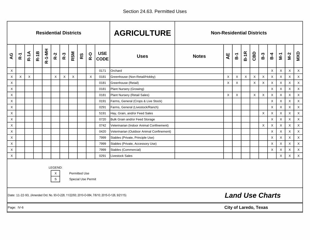
Section 24.63. Permitted Uses
AGRICULTURE
AG
R-1
R-1
A
R-1
B
R-1
-MH
R-2
R-3
RS
M
RS
R-O
USE
CODEUses Notes A
E
B-1
B-1
R
CB
D
B-3
B-4
M-1
M-2
MX
D
X 0171 Orchard X X X X
X X X X X X X 0181 Greenhouse (Non-Retail/Hobby) X X X X X X X X X
X 0181 Greenhouse (Retail) X X X X X X X X
X 0181 Plant Nursery (Growing) X X X X
X 0181 Plant Nursery (Retail Sales) X X X X X X X X
X 0191 Farms, General (Crops & Live Stock) X X X X
X 0291 Farms, General (Livestock/Ranch) X X X X
X 5191 Hay, Grain, and/or Feed Sales X X X X X
X 0720 Bulk Grain and/or Feed Storage X X X X
X 0742 Veterinarian (Indoor Animal Confinement) X X X X X
X 0420 Veterinarian (Outdoor Animal Confinement) X X X X
X 7999 Stables (Private, Principle Use) X X X X
X 7999 Stables (Private, Accessory Use) X X X X
X 7999 Stables (Commercial) X X X X
X 0291 Livestock Sales X X X
LEGEND:
X Permitted Use
S Special Use Permit
Page: IV-6
Residential Districts Non-Residential Districts
Land Use ChartsDate: 11-22-93, (Amended Ord. No. 93-O-228, 11/22/93; 2010-O-084, 7/6/10; 2015-O-126, 9/21/15)
City of Laredo, Texas

Section 24.63. Permitted Uses
RESIDENTIAL
AG
R-1
R-1
A
R-1
B
R-1
-MH
R-2
R-3
RS
M
RS
R-O
USE
CODEUses Notes A
E
B-1
B-1
R
CB
D
B-3
B-4
M-1
M-2
MX
D
X X X X X X X X X X 0001 Single Family Detached X X X X X
X X X X X X X 0002 Single Family Zero Lot Line X X X X X X
X X X X X X X 0004 Single Family Townhouse X X X X X
X X X 0005 Single Family Manufactured Home
X X X X 0006 Two Family (Duplex) X X X X X
X X X X 0007 Three Family (Triplex) X X X X X
X X X 0008 Four Family (Quadraplex) X X X X X
X X X X 0009 Multi-Family X X X X X
X X X Condominiums X X X X X
S S X X Townhouse X X X X X
X X X X X 0010 Garage Conversion X X X X X
X X X X X X X X 0012 Accessory Building/Structure Subject to Supp. Regulations X X X X X
X X X X X X X 0013 Home Occupation "A" X X X X X
X X 0014 Home Occupation "B" X X X X X
S S S S 0015 Travel Trailer/RV Park S S S S X
S S S S 0016 Manufactured Housing Park S S S S
X X Rooming/Boarding House X X X X X
O O College Dormitory (On Campus) O
O O Fraternity/Sorority House O O O O O
X X X X X X Registered Child-Care Home/Licensed Child Care Home X X X X X
X X X X X X Servants Quarters X X X X X
LEGEND:
X Permitted
S Special Use Permit
O Overlay Zones
Page: IV-7
Land Use ChartsDate: 11-22-93 (Amended Ord. No. 93-O-228, 11/22/93; 97-0-082, 4/7/97; 2001-O-036, 2/5/01; 2009-O-158, 9/21/08; 2010-O-084, 7/6/10; 2015-O-126, 9/21/15)
Residential Districts Non-Residential Districts
City of Laredo, Texas

Section 24.63. Permitted Uses
INSTITUTIONAL/
GOVERNMENT
AG
R-1
R-1
A
R-1
B
R-1
-MH
R-2
R-3
RS
M
RS
R-O
USE
CODEUses Notes A
E
B-1
B-1
R
CB
D
B-3
B-4
M-1
M-2
MX
D
X X X X X 4119 Emergency Ambulance Service X X X X X X X
X X X X X 4311 Post Office (Governmental) X X X X X X X X X
7331 Mailing Service (Private) X X X X X X X X
X 4582 Airport X X X
X 4582 Heliport X X X
X 4582 Helistop X X X
X 4911 Electrical Generating Plant X X X
X 4911 Electrical Substation X X X
X 4911 Electrical Transmission Line X X X X X X X X X
X 4923 Gas Transmission Line X X X X X X X X X
X X X X X X X X 4939 Utility Distribution Line X X X X X X X X X
X 4939 Utility Shop and Storage X X X X X
X 4941 Water Treatment Plant X X X
X 4941 Water Supply Facility (Public) X X X X X
X 4941 Water Supply Facility (Private) X X X X X
X X X X X X X X 4952 Sewage Pumping Station(Lift Station) X X X X X X X X X
X X X X X X X X Water Booster Station X X X X X X X X X
X 4952 Wastewater Treatment Plant X X X
X 6553 Cemetery and/or Mausoleum
LEGEND:
X Permitted
S Special Use Permit
Page: IV-8
Land Use ChartsDate: 11-22-93 (Amended Ord. No. 93-O-228, 11/22/93; 2001-O-036, 2/5/01; 2010-O-084, 7/6/10; 2015-O-126, 9/21/15)
Residential Districts Non-Residential Districts
City of Laredo, Texas
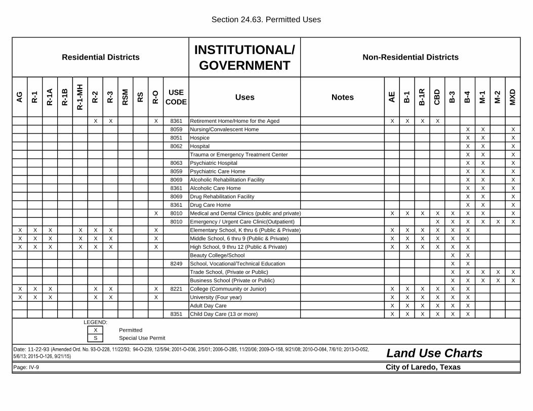
Section 24.63. Permitted Uses
INSTITUTIONAL/
GOVERNMENT
AG
R-1
R-1
A
R-1
B
R-1
-MH
R-2
R-3
RS
M
RS
R-O
USE
CODEUses Notes A
E
B-1
B-1
R
CB
D
B-3
B-4
M-1
M-2
MX
D
X X X 8361 Retirement Home/Home for the Aged X X X X
8059 Nursing/Convalescent Home X X X
8051 Hospice X X X
8062 Hospital X X X
Trauma or Emergency Treatment Center X X X
8063 Psychiatric Hospital X X X
8059 Psychiatric Care Home X X X
8069 Alcoholic Rehabilitation Facility X X X
8361 Alcoholic Care Home X X X
8069 Drug Rehabilitation Facility X X X
8361 Drug Care Home X X X
X 8010 Medical and Dental Clinics (public and private) X X X X X X X X
8010 Emergency / Urgent Care Clinic(Outpatient) X X X X X X
X X X X X X X Elementary School, K thru 6 (Public & Private) X X X X X X
X X X X X X X Middle School, 6 thru 9 (Public & Private) X X X X X X
X X X X X X X High School, 9 thru 12 (Public & Private) X X X X X X
Beauty College/School X X
8249 School, Vocational/Technical Education X X
Trade School, (Private or Public) X X X X X
Business School (Private or Public) X X X X X
X X X X X X 8221 College (Commuunity or Junior) X X X X X X
X X X X X X University (Four year) X X X X X X
Adult Day Care X X X X X X
8351 Child Day Care (13 or more) X X X X X X
LEGEND:
X Permitted
S Special Use Permit
Page: IV-9
Date: 11-22-93 (Amended Ord. No. 93-O-228, 11/22/93; 94-O-239, 12/5/94; 2001-O-036, 2/5/01; 2006-O-285, 11/20/06; 2009-O-158, 9/21/08; 2010-O-084, 7/6/10; 2013-O-052,
5/6/13; 2015-O-126, 9/21/15)
Residential Districts Non-Residential Districts
Land Use ChartsCity of Laredo, Texas

Section 24.63. Permitted Uses
INSTITUTIONAL/
GOVERNMENT
AG
R-1
R-1
A
R-1
B
R-1
-MH
R-2
R-3
RS
M
RS
R-O
USE
CODEUses Notes A
E
B-1
B-1
R
CB
D
B-3
B-4
M-1
M-2
MX
D
X X X X 8361 Orphanage X X X X X
X X X X X X 8322 Community Center X X X X X X X X
X Fraternal Organization or Social Club X X X X X X X X
X X X X X 8641 Civic Club X X X X X X X X X
X X X X X 8641 Philanthropic Organization X X X X X X X X X
X X X X X X 8661 Church/Sanctuary X X X X X X X X X
X Fellowship Halls X X X X X X X X X
X X X X X X 8661 Church affiliated uses X X X X X
X X X X X X Classrooms for Sunday School
X X X X X 8661 Rectory/Parsonage X X X X X
X X 8661 Monastery/Convent X X X X
X 9100 Government Building X X X X X X X X
International Bridge Facility X X X X
9221 Police Station X X X X X X X X
9221 Jail (Criminal Detention) X X X
8361 Half-Way House (Criminal) X X X X
9224 Fire Station X X X X X X X X X
X X X X X 8231 Library X X X X X X X X
X X 8651 Political campaign headquarters X X X X X X X X X
LEGEND:
X Permitted
S Special Use Permit
Page: IV-10
Land Use ChartsDate: 11-22-93 (Amended Ord. No. 9/7/93, 93-O-228, 98-O-177, 7/6/98; 2001-O-172, 8/20/01; 2009-O-224, 12/21/09; 2010-O-084, 7/6/10; 2015-O-126, 9/21/15; 2017-O-042, 3/20/17)
Residential Districts Non-Residential Districts
City of Laredo, Texas
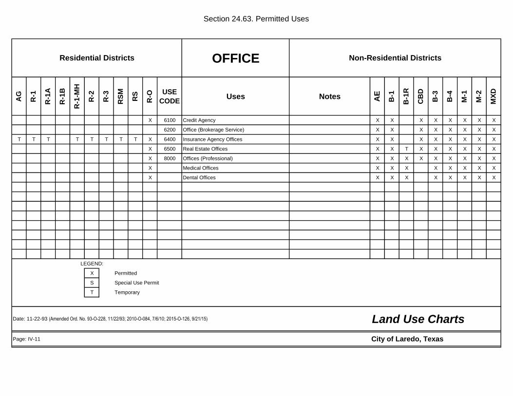
Section 24.63. Permitted Uses
OFFICE
AG
R-1
R-1
A
R-1
B
R-1
-MH
R-2
R-3
RS
M
RS
R-O
USE
CODEUses Notes A
E
B-1
B-1
R
CB
D
B-3
B-4
M-1
M-2
MX
D
X 6100 Credit Agency X X X X X X X X
6200 Office (Brokerage Service) X X X X X X X X
T T T T T T T T X 6400 Insurance Agency Offices X X X X X X X X
X 6500 Real Estate Offices X X T X X X X X X
X 8000 Offices (Professional) X X X X X X X X X
X Medical Offices X X X X X X X X
X Dental Offices X X X X X X X X
LEGEND:
X Permitted
S Special Use Permit
T Temporary
Page: IV-11
Land Use ChartsDate: 11-22-93 (Amended Ord. No. 93-O-228, 11/22/93; 2010-O-084, 7/6/10; 2015-O-126, 9/21/15)
Non-Residential DistrictsResidential Districts
City of Laredo, Texas

Section 24.63. Permitted Uses
PERSONAL / BUSINESS
SERVICES
AG
R-1
R-1
A
R-1
B
R-1
-MH
R-2
R-3
RS
M
RS
R-O
USE
CODEUses Notes A
E
B-1
B-1
R
CB
D
B-3
B-4
M-1
M-2
MX
D
6060 Bank X X X X X X X
6282 Financial Services (Advice/Invest) X X X X X X X X
6030 Savings and Loans X X X X X X X
6060 Credit Unions X X X X X X X X
6099 Check Cashing Agencies X X X X X X X X
6099 Automatic Teller Machines (ATM's) X X X X X X X X
7011 Hotel/Motel X X X X X X
X 7011 Bed & Breakfast X X X X X X X
7211 Laundry/Dry Cleaning X X X X X X X X
7212 Laundry/Dry Cleaning (Drop Off/Pick Up) X X X X X X X X
7215 Laundry/Dry Cleaning (Self-Service) X X X X X X X X
7219 Tailor Shop X X X X X X X X
7251 Shoe Repair & Sales X X X X X X X X
4724 Travel Agency X X X X X X X X
7231 Beauty Shop (Non-College) X X X X X X X X
7241 Barber Shop (Non-College) X X X X X X X X
7221 Photo Studio X X X X X X X X
7261 Funeral Home X X X X X
7299 Kiosk (Providing A Service) X X X X X X X
Nationalization/"Nacionalizacion" of Vehicles
EnterpriseS S S S S
812990 Bail Bonding or Bail Bond Person Services X X X X X X X X
6141Loan Personal/Instalment/Other than Banks
Consumer FinanceX X X X X X X X
LEGEND:
X Permitted
S Special Use Permit
Page: IV-12
Non-Residential Districts
Date: 10/25/95 (Amended Ord. No. 93-O-228, 11/22/93; 95-O-227, 10/23/95; 2000-O-051, 3/6/00; 2002-O-211, 9/3/02; 2004-O-065, 4/5/04; 2007-O-229, 11/5/07; 2010-O-084, 7/6/10;
2015-O-126, 9/21/15; 2018-O-003, 1/24/18; 2018-O-004, 1/24/18) Land Use Charts
Residential Districts
City of Laredo, Texas

Section 24.63. Permitted Uses
PERSONAL / BUSINESS
SERVICES
AG
R-1
R-1
A
R-1
B
R-1
-MH
R-2
R-3
RS
M
RS
R-O
USE
CODEUses Notes A
E
B-1
B-1
R
CB
D
B-3
B-4
M-1
M-2
MX
D
Child Development Center X X X X
Interior Decorating Studio X
7359 Tool Rental (Indoor Storage) X X X X X X X X
7359 Tool Rental (Outdoor Storage) X X X X
7381 Premises Security X X X X
7389 Auction (Indoors) X X X X
7629 Appliance Repair X X X X X X X X
1731 Communication Equipment Repair X X X X X X X X
7699 Locksmith X X X X X X X X
7911 Karate School (Martial Arts) X X X X X X X X
8249 Truck/Heavy Equip. Driving School X X X X
8299 Automobile Driving School X X X X X X X X
X 7911 Dance/Drama/Music/ Schools X X X X X X X X
X 8999 Artist Studio X X X X X X X X
4225 Mini - Storage/Warehouse S S X X X X
X Diet Clinic X X X X X X X X
X Pharmacies and Drug Stores X X X X X X X X
X Health Spa X X X X X X X X
Tattoo Parlor X X X X X
LEGEND:
X Permitted
S Special Use Permit
Page: IV-13
Residential Districts Non-Residential Districts
Land Use ChartsDate: 11-22-93 (Amended Ord. No. 93-O-228, 11/22/93; 95-O-227, 10/23/95; 96-0-197, 11/4/96; 2002-O-211, 9/3/02; 2010-O-084, 7/6/10; 2015-O-126, 9/21/15;
2017-O-084, 7/17/17)
City of Laredo, Texas
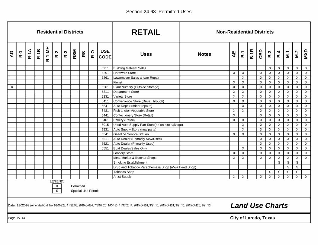
Section 24.63. Permitted Uses
RETAIL
AG
R-1
R-1
A
R-1
B
R-1
-MH
R-2
R-3
RS
M
RS
R-O
USE
CODEUses Notes A
E
B-1
B-1
R
CB
D
B-3
B-4
M-1
M-2
MX
D
5211 Building Material Sales X X X X X
5251 Hardware Store X X X X X X X X
5261 Lawnmover Sales and/or Repair X X X X X X X
Florist X X X X X X X X
X 5261 Plant Nursery (Outside Storage) X X X X X X X X
5311 Department Store X X X X X X X X
5331 Variety Store X X X X X X X X
5411 Convenience Store (Drive Through) X X X X X X X X
5541 Auto Repair (minor repairs) X X X X X X X
5431 Fruit and/or Vegetable Store X X X X X X X X
5441 Confectionery Store (Retail) X X X X X X X
5461 Bakery (Retail) X X X X X X X X
5015 Used Auto Supply Part Store(no on-site salvage) X X X X X X X
5531 Auto Supply Store (new parts) X X X X X X X
5541 Gasoline Service Station X X X X X X X X
5511 Auto Dealer (Primarily New/Used) X X X X X X
5521 Auto Dealer (Primarily Used) X X X X X X
5551 Boat Dealer/Sales Only X X X X X X X
Grocery Store X X X X X X X X
Meat Market & Butcher Shops X X X X X X X X
Smoking Establishment S S S
Drug and Tobacco Paraphemalia Shop (a/k/a Head Shop) S S
Tobacco Shop S S S S
Artist Supply X X X X X X X X
LEGEND:
X Permitted
S Special Use Permit
Page: IV-14
Residential Districts Non-Residential Districts
Date: 11-22-93 (Amended Ord. No. 93-O-228, 11/22/93; 2010-O-084, 7/6/10; 2014-O-153, 11/17/2014; 2015-O-124, 9/21/15; 2015-O-124, 9/21/15; 2015-O-126, 9/21/15)
City of Laredo, Texas
Land Use Charts

Section 24.63. Permitted Uses
RETAIL
AG
R-1
R-1
A
R-1
B
R-1
-MH
R-2
R-3
RS
M
RS
R-O
USE
CODEUses Notes AE B
-1
B-1
R
CB
D
B-3
B-4
M-1
M-2
MX
D
Camera Shop X X X X X X X X
Apparel Stores X X X X X X X X
5561 Recreational Vechicle Dealer/Sales Only X X X X
5271 Mobile Home Dealer /Sales Only X X X X
5571 Motorcycle Dealer X X X X X
5599 All Terrain Vehicle Dealer/Sales Only X X X X X
5599 Aircraft Sales/Sales Only X X X
5712 Furniture Sales (Indoor) X X X X X X X X
5712 Furniture Sales (Outdoor) X X X X
5712 Cabinet Shop (Manufacturing) X X X
2431 Woodworking Shop (Manufacture) X X X
Drapery Shop X X X X X
5714 Upholstery Shop (Non-Auto) X X X X X
5722 Major Appliances Sales (Indoor) X X X X X X X
5722 Major Appliances Sales (Outdoor) X X X X
S 5810 Restaurant (Serving Alcohol) X S X S X X X X
X Restaurant X X X X X X X X
5812 Restaurant (Drive-In) X X X X X X X X
5812 Restaurant (Drive-Thru) X X X X X X X
5812 Restaurant (Kioski) X X X X X X X X
X 5813 Private Club (Alcohol Served) X X X X X X X X
5912 Alcohol Sales/Off-Premise Consumption X X X X X X X X
5932 Antique Shop X X X X X X X X
LEGEND:
X Permitted
S Special Use Permit
Page: IV-15
Non-Residential DistrictsResidential Districts
Land Use ChartsDate: 11-22-93 (Amended Ord. No. 93-O-228, 11/22/93; 2010-O-084, 7/6/10; 2013-O-005, 2/4/13; 2015-O-126, 9/21/15)
City of Laredo, Texas
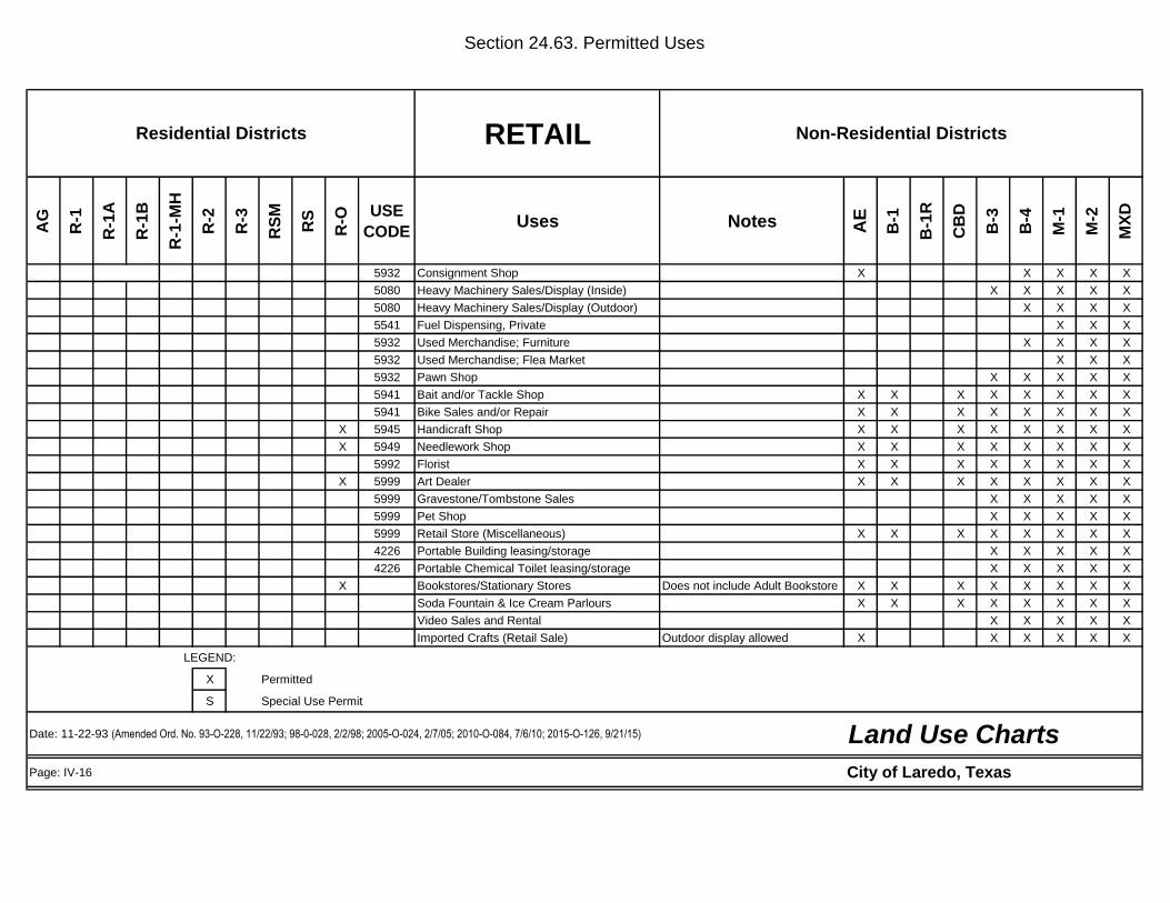
Section 24.63. Permitted Uses
RETAIL
AG
R-1
R-1
A
R-1
B
R-1
-MH
R-2
R-3
RS
M
RS
R-O
USE
CODEUses Notes A
E
B-1
B-1
R
CB
D
B-3
B-4
M-1
M-2
MX
D
5932 Consignment Shop X X X X X
5080 Heavy Machinery Sales/Display (Inside) X X X X X
5080 Heavy Machinery Sales/Display (Outdoor) X X X X
5541 Fuel Dispensing, Private X X X
5932 Used Merchandise; Furniture X X X X
5932 Used Merchandise; Flea Market X X X
5932 Pawn Shop X X X X X
5941 Bait and/or Tackle Shop X X X X X X X X
5941 Bike Sales and/or Repair X X X X X X X X
X 5945 Handicraft Shop X X X X X X X X
X 5949 Needlework Shop X X X X X X X X
5992 Florist X X X X X X X X
X 5999 Art Dealer X X X X X X X X
5999 Gravestone/Tombstone Sales X X X X X
5999 Pet Shop X X X X X
5999 Retail Store (Miscellaneous) X X X X X X X X
4226 Portable Building leasing/storage X X X X X
4226 Portable Chemical Toilet leasing/storage X X X X X
X Bookstores/Stationary Stores Does not include Adult Bookstore X X X X X X X X
Soda Fountain & Ice Cream Parlours X X X X X X X X
Video Sales and Rental X X X X X
Imported Crafts (Retail Sale) Outdoor display allowed X X X X X X
LEGEND:
X Permitted
S Special Use Permit
Page: IV-16
Land Use ChartsDate: 11-22-93 (Amended Ord. No. 93-O-228, 11/22/93; 98-0-028, 2/2/98; 2005-O-024, 2/7/05; 2010-O-084, 7/6/10; 2015-O-126, 9/21/15)
City of Laredo, Texas
Residential Districts Non-Residential Districts
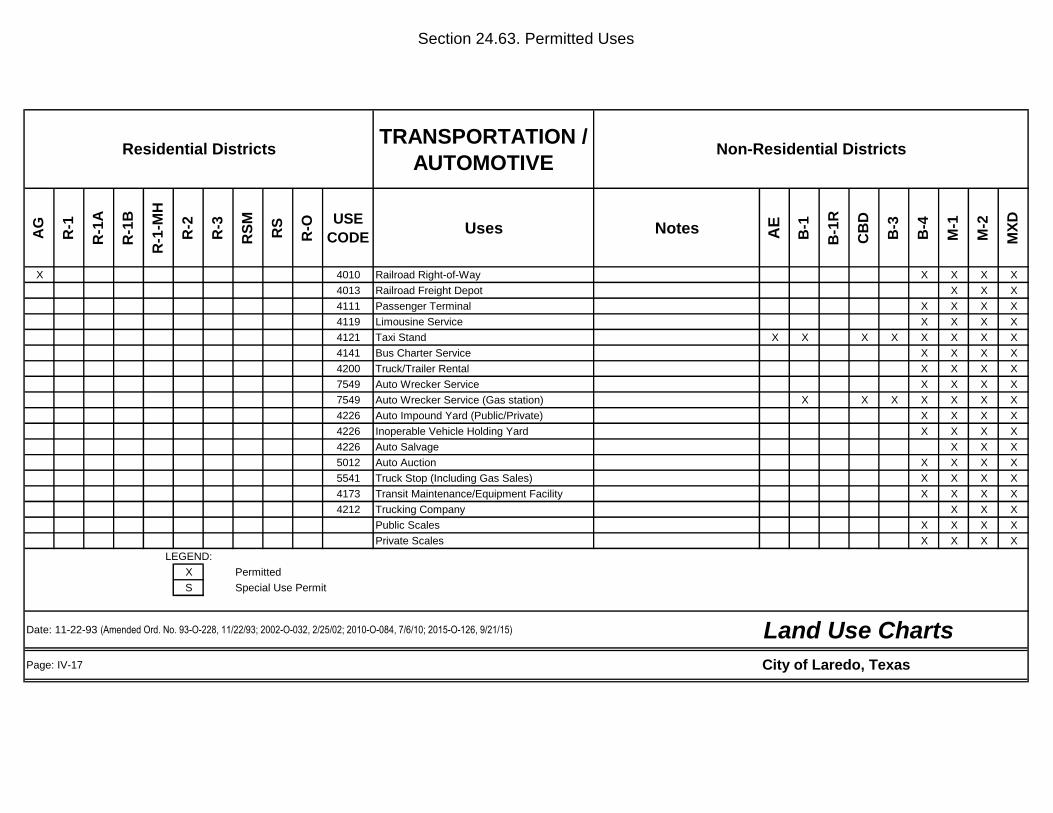
Section 24.63. Permitted Uses
TRANSPORTATION /
AUTOMOTIVE
AG
R-1
R-1
A
R-1
B
R-1
-MH
R-2
R-3
RS
M
RS
R-O
USE
CODEUses Notes A
E
B-1
B-1
R
CB
D
B-3
B-4
M-1
M-2
MX
D
X 4010 Railroad Right-of-Way X X X X
4013 Railroad Freight Depot X X X
4111 Passenger Terminal X X X X
4119 Limousine Service X X X X
4121 Taxi Stand X X X X X X X X
4141 Bus Charter Service X X X X
4200 Truck/Trailer Rental X X X X
7549 Auto Wrecker Service X X X X
7549 Auto Wrecker Service (Gas station) X X X X X X X
4226 Auto Impound Yard (Public/Private) X X X X
4226 Inoperable Vehicle Holding Yard X X X X
4226 Auto Salvage X X X
5012 Auto Auction X X X X
5541 Truck Stop (Including Gas Sales) X X X X
4173 Transit Maintenance/Equipment Facility X X X X
4212 Trucking Company X X X
Public Scales X X X X
Private Scales X X X X
LEGEND:
X Permitted
S Special Use Permit
Page: IV-17
Non-Residential DistrictsResidential Districts
Land Use ChartsDate: 11-22-93 (Amended Ord. No. 93-O-228, 11/22/93; 2002-O-032, 2/25/02; 2010-O-084, 7/6/10; 2015-O-126, 9/21/15)
City of Laredo, Texas
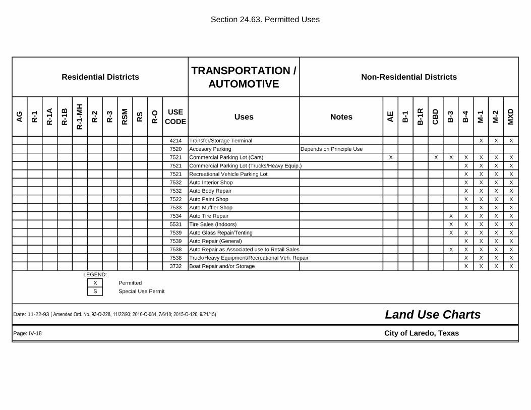
Section 24.63. Permitted Uses
TRANSPORTATION /
AUTOMOTIVE
AG
R-1
R-1
A
R-1
B
R-1
-MH
R-2
R-3
RS
M
RS
R-O
USE
CODEUses Notes A
E
B-1
B-1
R
CB
D
B-3
B-4
M-1
M-2
MX
D
4214 Transfer/Storage Terminal X X X
7520 Accesory Parking Depends on Principle Use
7521 Commercial Parking Lot (Cars) X X X X X X X
7521 Commercial Parking Lot (Trucks/Heavy Equip.) X X X X
7521 Recreational Vehicle Parking Lot X X X X
7532 Auto Interior Shop X X X X
7532 Auto Body Repair X X X X
7522 Auto Paint Shop X X X X
7533 Auto Muffler Shop X X X X
7534 Auto Tire Repair X X X X X
5531 Tire Sales (Indoors) X X X X X
7539 Auto Glass Repair/Tenting X X X X X
7539 Auto Repair (General) X X X X
7538 Auto Repair as Associated use to Retail Sales X X X X X
7538 Truck/Heavy Equipment/Recreational Veh. Repair X X X X
3732 Boat Repair and/or Storage X X X X
LEGEND:
X Permitted
S Special Use Permit
Page: IV-18
Non-Residential DistrictsResidential Districts
Land Use ChartsDate: 11-22-93 ( Amended Ord. No. 93-O-228, 11/22/93; 2010-O-084, 7/6/10; 2015-O-126, 9/21/15)
City of Laredo, Texas
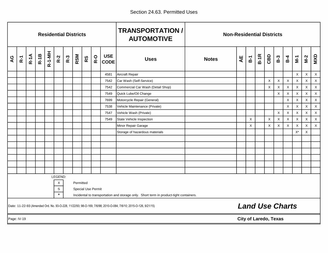
Section 24.63. Permitted Uses
TRANSPORTATION /
AUTOMOTIVE
AG
R-1
R-1
A
R-1
B
R-1
-MH
R-2
R-3
RS
M
RS
R-O
USE
CODEUses Notes A
E
B-1
B-1
R
CB
D
B-3
B-4
M-1
M-2
MX
D
4581 Aircraft Repair X X X
7542 Car Wash (Self-Service) X X X X X X
7542 Commercial Car Wash (Detail Shop) X X X X X X
7549 Quick Lube/Oil Change X X X X X
7699 Motorcycle Repair (General) X X X X
7538 Vehicle Maintenance (Private) X X X X
7547 Vehicle Wash (Private) X X X X X
7549 State Vehicle Inspection X X X X X X X
Minor Repair Garage X X X X X X X
Storage of hazardous materials X* X
LEGEND:
X Permitted
S Special Use Permit
* Incidental to transportation and storage only. Short term in product-tight containers.
Page: IV-19
Residential Districts Non-Residential Districts
Land Use ChartsDate: 11-22-93 (Amended Ord. No. 93-O-228, 11/22/93; 98-O-169, 7/6/98; 2010-O-084, 7/6/10; 2015-O-126, 9/21/15)
City of Laredo, Texas

Section 24.63. Permitted Uses
WHOLESALE
TRADE
AG
R-1
R-1
A
R-1
B
R-1
-MH
R-2
R-3
RS
M
RS
R-O
USE
CODEUses Notes A
E
B-1
B-1
R
CB
D
B-3
B-4
M-1
M-2
MX
D
4225 Warehouse/Storage (Inside) X X X X
4225 Warehouse/Storage (Outside) X X X
5012 Automobile Sales - Wholesale X X X X
5012 Truck Sales - Wholesales X X X
5031 Lumber Sales - Wholesales X X X
5099 Firewood Sales - Wholsales X X X
5080 Heavy Machinery Sales (Wholesales) X X X
5093 Collection Container X X X X X X X X
5093 Collection Container X X X X
5093 Scrap/Waste Recycle Collection X X X X
5110 Paper and/or Paper Products (Wholesales) X X X X X X
5120 Drug, Drug Proprietaries, X X X X X X
5130 Apparrel, Piece Goods, and Notions X X X X X X X
5140 Groceries/Related Products X X X X
LEGEND:
X Permitted
S Special Use Permit
Page: IV-20
Land Use ChartsDate: 11-22-93 (Amended Ord. No. 93-O-228, 11/22/93; 2010-O-084, 7/6/10; 2015-O-126, 9/21/15)
Non-Residential DistrictsResidential Districts
City of Laredo, Texas
Section 24.63. Permitted Uses
WHOLESALE
TRADE
AG
R-1
R-1
A
R-1
B
R-1
-MH
R-2
R-3
RS
M
RS
R-O
USE
CODEUses Notes A
E
B-1
B-1
R
CB
D
B-3
B-4
M-1
M-2
MX
D
5149 Bakery - Wholsale X X X X X
X 5150 Farm (Food) Products - Wholesale X X X
5150 Livestock - Wholesale X X X
Bulk Storage X
5171 Bulk Storage Petroleum and/or Petroleum X
5171 Petroleum Sales (Wholesales) X X X X
5182 Alcoholic Beverage Stoage and Distribution X X X X
4212 Transfer Station (Refuse/Pick - up) X X X
5441 Confectionary Store X X X
3565 Bottling Works X X X
Mail Order
LEGEND:
X Permitted
S Special Use Permit
Page: IV-21
Residential Districts Non-Residential Districts
Date: 11-22-93 (Amended Ord. No. 93-O-228, 11/22/93; 2010-O-084, 7/6/10; 2015-O-126, 9/21/15)
City of Laredo, Texas
Land Use Charts
Section 24.63. Permitted Uses
MANUFACTURING MINING /
CONSTRUCTION
AG
R-1
R-1
A
R-1
B
R-1
-MH
R-2
R-3
RS
M
RS
R-O
USE
CODEUses Notes A
E
B-1
B-1
R
CB
D
B-3
B-4
M-1
M-2
MX
D
s s s s s s s s s 1300 Oil and/or Gas Extraction S S S S S S X S
1400 Mineral Extraction S S X S
1442 Sand/Gravel Sales, Storage & Extraction S S X X
X X X X X 1500 Contractor's On-Site Construction Office Temporary X X X X X X X X X
1500 Contractor's Office/Sales, No outside storage X X X X X
1500 Contractor's Shop with Limited outside storage X X X X
1500 Contractor's Shop with Outside Storage X X X
2000 Light Manufacturing X X X
2010 Meat Products, Manufacturing X X X
2011 Meat Packing/Slaughthouse X
2015 Poultry Slaugtering/Processing X
2030 Food Canning Operation X X X
2080 Alcoholic Beverage Manufacturing X X X
Micro-Brewery X
2300 Apparel Manufacturing X X X
2451 Mobile Home Manufacturing X X X
2711 Printer(Newspaper, etc...) X X X X X
2752 Printer X X X
LEGEND:
X Permitted
S Special Use Permit
Page: IV-22
Residential Districts
Land Use ChartsDate: 11-22-93 (Amended Ord. No. 93-O-228, 11/22/93; 2000-O-052, 3/6/00; 2010-O-084, 7/6/10; 2015-O-126, 9/21/15)
City of Laredo, Texas
Non-Residential Districts

Section 24.63. Permitted Uses
MANUFACTURING MINING /
CONSTRUCTION
AG
R-1
R-1
A
R-1
B
R-1
-MH
R-2
R-3
RS
M
RS
R-O
USE
CODEUses Notes A
E
B-1
B-1
R
CB
D
B-3
B-4
M-1
M-2
MX
D
Chemical & Allied Productsd Manufacturing Non-hazardous S X X
2819 Hazardous Chemical Manufacture S
2911 Petroleum Refining X
2911 Asphaltic Material Manufacturing X
3000 Rubber Product Manufacturing X
3000 Plastic Product manufacturing X
3111 Leather Tanning and/or Finishing X
3200 Stone/Clay/Glass Manufacturing X X
3320 Iron and/or Steel Foundry X
3330 Metal Smelting X
3460 Metal Forging and/or Heavy Stamping X
3531 Batching Plant (Temporary) X
3531 Batching Plant (Permanent) X
3800 Research Lab (Hazardous) S
3800 Sign Manufacturing X X X
3993 Outside Storage X X X
4226 Outside Storage (Accessory Use) X X X
4226 Sanitary Landfill X X X
4953 Refuse Disposal System X X X
4953 Salvage and/or Reclamation (Indoors) S S S
LEGEND:
X Permitted
S Special Use Permit
Page: IV-23
Residential Districts Non-Residential Districts
Land Use ChartsDate: 11-22-93 (Amended Ord. No. 93-O-228, 11/22/93; 2010-O-084, 7/6/10; 2015-O-126, 9/21/15)
City of Laredo, Texas

Section 24.63. Permitted Uses
MANUFACTURING MINING /
CONSTRUCTION
AG
R-1
R-1
A
R-1
B
R-1
-MH
R-2
R-3
RS
M
RS
R-O
USE
CODEUses Notes A
E
B-1
B-1
R
CB
D
B-3
B-4
M-1
M-2
MX
D
7389 Salvage and/or Reclamation (Outdoors) S S S
7692 Welding Shop X X X
7699 Engine Repair/Motor Manufacturing X X X
Re-Manufacturing and/or Repair X X X
3599 Machine Shop X X X
3670 Electronic Assembly X X X
3471 Plating Establishments X X X
Storage and handling of hazardous materials S X
LEGEND:
X Permitted
S Special Use Permit
Page: IV-24
Land Use ChartsDate: 11-22-93 (Amended Ord. No. 93-O-228, 11/22/93; 98-O-169, 7/6/98; 2010-O-084, 7/6/10; 2015-O-126, 9/21/15)
Residential Districts Non-Residential Districts
City of Laredo, Texas
Section 24.63. Permitted Uses
AMUSEMENT /
RECREATION
AG
R-1
R-1
A
R-1
B
R-1
-MH
R-2
R-3
RS
M
RS
R-O
USE
CODEUses Notes A
E
B-1
B-1
R
CB
D
B-3
B-4
M-1
M-2
MX
D
X 4493 Boat Launching Ramp X
X 4493 Marina X
R.V. Dry Storage Facilities X
X 4493 Fishing and Sightseeing Facilities Institutional Concession Only X X X X X X X
X 4493 Retail Sales of Fishing Bait and/or Institutional Concession Only X X X X X X X
X 4493 Snack Bars and Vending Machines Institutional Concession Only X X X X X X X X X
X 4493 Sanitary Sewage Pump-out Facilities Institutional Concession Only X X X X
X 4493 Open Boat and/or R.V. Dry Storage Institutional Concession Only X X X X
X Boat Rental, Repair and/or Service Institutional Concession Only X X X X X
X 7999 Fishing Pier Institutional Concession Only X X X X X X X X X
X 4493 Parking Areas for Vehicles/Trailers/R.V's X X X X X
X 4493 Restrooms with Shower Facilities X X X X X X
7832 Motion Picture Theater (Indoor) X X X X X X X
7832 Motion Picture Theater (Outdoor) X X X X X
7922 Theater (Non-Motion Picture) X X X X X X X
7900 Amusement Services (Indoors) X X X X X X X
X 7900 Amusement Services (Outdoors) X X X X
Children's Amusement Services (Outdoors) X X X X
7933 Bowling Center X X X X X X X
X 7991 Health Club (Physical Fitness) X X X X X X X X
7993 Amusement Devices/Arcade X X X X X X X X
7999 Billiard Parlor (Three or more tables) X X X X X X X
5812 Dinner Theatre X X X X X X X
LEGEND:
X Permitted
S Special Use Permit
Page: IV-25
Date: 11-22-93 (Amended Ord. No. 93-O-228, 11/22/93; 2002-O-226, 9/16/02; 2010-O-084, 7/6/10; 2015-O-126, 9/21/15)
Non-Residential DistrictsResidential Districts
Land Use Charts
City of Laredo, Texas
Section 24.63. Permitted Uses
AMUSMENT /
RECREATION
AG
R-1
R-1
A
R-1
B
R-1
-MH
R-2
R-3
RS
M
RS
R-O
USE
CODEUses Notes A
E
B-1
B-1
R
CB
D
B-3
B-4
M-1
M-2
MX
D
7999 Skating Rink X X X X X X X
Shooting Range - Indoor X X X
Bar, Night Club, Cantina, and Saloon X X * X X X X
7999 Exhibition Hall X X X X
8412 Museum/Wax Museum X X X X
X X X X X Museum /Other than wax X X X X X X X X
X X X X X X 8412 Art Gallery X X X X X X X X X
7941 Stadium X X X X
7997 Membership Sports X X X X X X X X
X 7992 Golf Course (Public/Private) X X X X X
X X X X X X X 7992 Recreational Club (Members Only) X X X X X X X X X
X X X X X X X X 7999 Swimming Pool (Public) X X X X X X X X X
X 7999 Day Camp X X X X X X X
X X X X X X X X X 7999 Park and/or Playground (Public) X X X X X X X X X
X 7999 Fairground X X X X
X 8422 Zoo X X X X
X 7948 Horse Racing Facility/Training X X X X
7948 Race Track Operation X X X X
X 7999 Special Events (Temporary) X X X X X X X X
Amusement Redemption Machine Establishment X X X X
7999 Bingo Parlor X X X X X X
X X X X X X X X X Park or Playground (Private) X X X X X X X X X
Carnival X X X X X X
LEGEND:
X Permitted
S Special Use Permit
* Special Use Permit Required in HCBD
Page: IV-26
Residential Districts Non-Residential Districts
Date: 11-22-93 (Amended Ord. No. 93-O-228, 11/22/93; 95-O-227, 10/23/95; 96-0-196, 11/4/96; 2002-O-211, 9/3/02; 2003-O-047, 3/3/03; 2006-0-112, 6/5/06; 2010-O-084, 7/6/10;
2015-O-126, 9/21/15)
City of Laredo, Texas
Land Use Charts
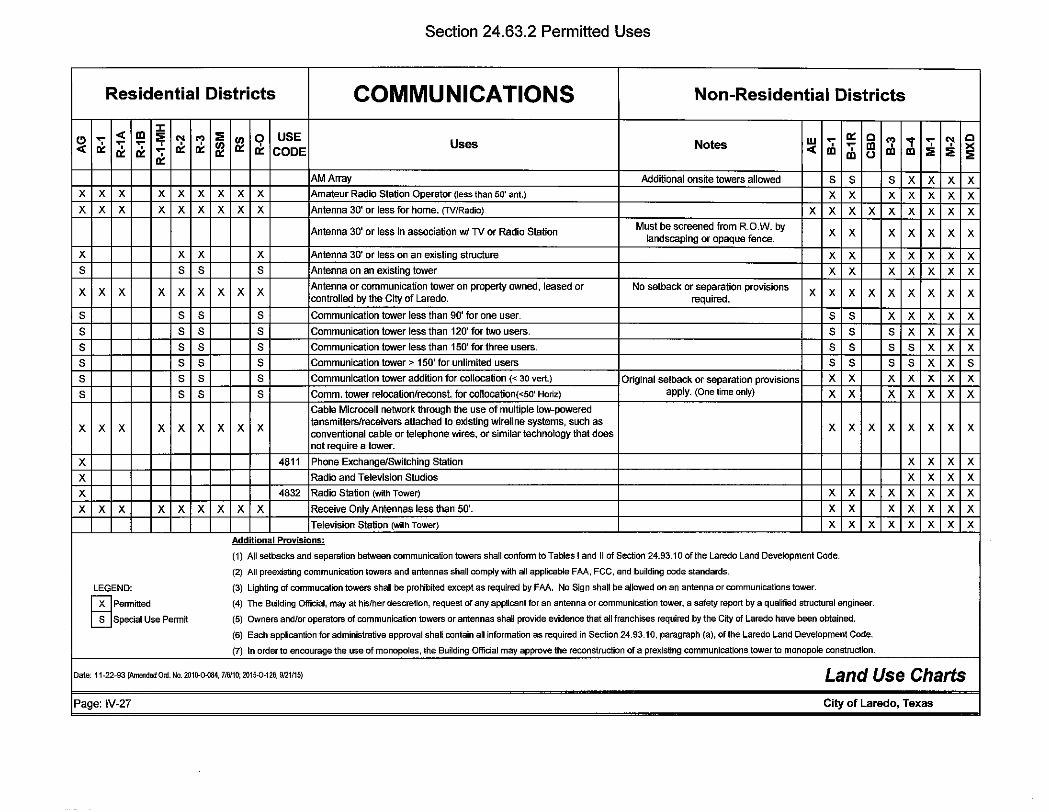
Section 24.63.2 Permitted Uses
Residential Districts COMMUNICATIONS Non-Residential Districts
< m ::t: (!) - :;;
~ ~ :;;
81 ~ USE w - 0:: c '? "t - "!- c
"= -- ' 81 Uses Notes m - m ' >< < "= "= - CODE < m 0 m m :;; :;; :;; ' 0::
AM Array Additional onsite towers allowed s s s X X X X X X X X X X X X X Amateur Radio Station Operator (less than 50' ant.) X X X X X X X X X X X X X X X X Antenna 30' or less for home. (TV/Radio) X X X X X X X X X
Antenna 30' or less in association w/ TV or Radio Station Must be screened from R.O.W. by X X X X X X X landscaping or opaque fence.
X X X X Antenna 30' or less on an existing structure X X X X X X X s s s s Antenna on an existing tower X X X X X X X
X X X X X X X X X Antenna or communication tower on property owned, leased or No setback or separation provisions
X X X X X X X X X controlled by the City of Laredo. required.
s s s s Communication tower less than 90' for one user. s s X X X X X
s s s s Communication tower less than 120' for two users. s s s X X X X
s s s s Communication tower less than 150' for three users. s s s s X X X s s s s Communication tower> 150' for unlimited users s s s s X X s s s s s Communication tower addition for collocation(< 30 vert.) Original setback or separation provisions X X X X X X X
s s s s Comm. tower relocationtreconst. for collocation(<50' Horiz) apply. (One time only) X X X X X X X Cable Microcell network through the use of multiple low-powered
X X X X X X X X X tansmitters/receivers attached to existing wireline systems, such as
X X X X X X X X conventional cable or telephone wires, or similar technology that does not require a tower.
X 4811 Phone Exchange/SWitching Station X X X X
X Radio and Television Studios X X X X
X 4832 Radio Station (with Tower) X X X X X X X X
X X X X X X X X X Receive Only Antennas less than 50'. X X X X X X X Television Station (with Tower) X X X X X X X X
Additional Provisions:
(1) All setbacks and separation between communication towers shall conform to Tables I and II of Section 24.93.10 of the Laredo Land Development Code.
(2) All preexisting communication towers and antennas shall comply with all applicable FAA, FCC, and building code standards.
LEGEND: (3) Lighting of commucation towers shall be prohibited except as required by FAA. No Sign shall be allowed on an antenna or communications tower.
rnPeomitted (4) The Building Official, may at hislher descretion, request of any applicant for an antenna or communication tower, a safety report by a qualified structural engineer.
Special Use Permit (5) Owners andlor operators of communication towers or antennas shall provide evidence that all franchises required by the City of Laredo have been obtained.
(6) Each applicantion for administrative approval shall contain all information as required in Section 24.93.10, paragraph (a), of the Laredo Land Development Code.
(7) In order to encourage the use of monopoles, the Building Official may approve the reconstruction of a prexisting communications tower to monopole construction.
Date: 11-22-93 {Amended Ord. No. 2010-0-084, 7/6110; 2015-0-126, 9121/15) Land Use Charts Page: IV-27 City of Laredo, Texas
Section 24.63.3 NON-CONFORMING USES OR BUILDINGS
(a) EXISTING NON-CONFORMING USES- Except as hereinafter specified, the lawful use of a building, structure, mobile home, or HUD-code manufactured home existing at the time of the adoption of this Ordinance may be continued, even if the existing use, building, structure, mobile home, or HUD-code manufactured home does not conform with the provisions of this Ordinance for the district in which it is located. Temporary variances granted by the Planning and Zoning Commission prior to the effective date of this Ordinance may be continued as a non-conforming use subject to the provisions of this Section and of this Ordinance and all platting requirements.
(b) ENLARGEMENT, ALTERATION OR REMOVAL AND SUBSTITUTION OF BUILDING, STRUCTURE, MOBILE HOME, OR HUD-CODE MANUFACTURED HOME WITH NON-CONFORMING USE
(1) No existing building, structure or premises devoted to a use not permitted by this Ordinance shall be enlarged, substituted, or structurally altered unless required by law, or court order.
a. Exception
1. A non-conforming building or structure on a lot, excluding a mobile home or HUD-code manufactured home, may be expanded by 5% of the area of the lot if,
i. the expansion does not encroach on required set- backs;
ii. paved parking, as required by this code is provided, and;
iii. the non-conforming use is screened and buffered from adjacent uses and zones as determined by Section 24.79 of this Code.
2. The non-conforming structure can be expanded by 5% of the lot area only once and only as authorized by the Board of Adjustment.
(2) A mobile home or HUD-code manufactured home may be enlarged or structurally altered only if required by law or court order.
(3) Land use regulations pertinent to each zoning district shall immediately be applied when a building, structure, mobile home, or HUD-code manufactured home is removed from a lot.
a. Exception
1. A non-conforming mobile home or HUD-code manufactured home may be removed for replacement purposes if,
i. the mobile home or HUD-code manufactured home is replaced in less than six (6) months from the date of removal;
ii. the replacement home is no more than three (3) years old, and;
iii. the replacement home conforms to all setback requirements.
(c) DISCONTINUANCE OF A USE: A building or structure, including a mobile home, or HUD-code manufactured home, where a non-conforming use has been discontinued for a period of six (6) months or more, may not be put to a non-conforming use. Further, a non-conforming mobile home, or HUD-code manufactured home for which occupancy has been discontinued for a period of six (6) months or more cannot be reoccupied or replaced.
IV-28

(d) REPAIRS AND ALTERATIONS: Repair and maintenance work is permitted to keep non-conforming buildings, structures, mobile homes, and HUD-code manufactured home in sound condition.
(e) REPLACING DAMAGED BUILDING: Any non-conforming building, structure, mobile home, or HUDcode manufactured home or group of non-conforming buildings, structures, mobile homes, or HUD-code manufactured homes related to one use and under one ownership, which have been damaged by fire, flood, explosion, earthquake, war, riot, may be reconstructed or replaced subject to this Section and used as before if the application for a permit is submitted within 12 months of such calamity. The area restored cannot exceed the square foot area as it existed before such calamity except, that a mobile home or HUDcode manufactured home shall be replaced as provided above.
(f) EXEMPTION OF ESSENTIAL SERVICES: Essential Services, as defined in Appendix A of this Code, shall be exempt from the provisions of parts (d) and (e) of this Section.
(g) PLAT RESTRICTIONS AND BUILDING CODE REQUIREMENTS: Nothing herein shall invalidate any plat restriction authorized by the Planning & Zoning Commission, nor any provision of adopted building codes. The rules of statutory interpretation shall apply such that specific provisions control over general provisions, provided however that where a conflict exists the most restrictive standard shall apply. Building set-back lines included in a recorded subdivision plat approved by the Planning & Zoning Commission shall control over general setback provisions required under the zoning provisions of this chapter, provided however, that no building setback shall be less than that specified for the type of construction proposed by adopted building codes. It is further provided that the Zoning Board of Adjustment shall have no authority to reduce any building setback required under adopted building codes.
IV-29
IV-30
SECTION 24-65
SUPPLEMENTARY ZONING DISTRICT REGULATIONS Section 24.65.0 GENERAL SUPPLEMENTAL PROVISIONS (a) Residential
i. No commercial vehicle which exceeds 16,000 pounds in manufacturer's gross vehicle weight rating (GVWR) or which has more than two axles, nor any commercial or farm trailer exceeding twelve feet in length, shall be parked or stored on any residential lot in any R-1, R-1A, R-1B, R-1-MH, R-2, R-3, RSM, RS, or R-O single family residential zoning district; ii. No commercial vehicle which exceeds one ton in manufacturer's gross vehicle weight rating (GVWR) or which has more than two axles shall be parked or stored on any public street, or public right-of-way, in any R-1, R-1A, R-1B,R-1-MH, R-2, R-3, RSM, RS, or R-O single family residential zoning district; iii. No commercial, farm or utility trailer shall be parked or stored on any public street, or public right-of-way, in any R-1, R-1A, R-1B, R-1-MH, R-2, R-3, RSM, RS, or R-O, or R-1MH single family residential zoning district; iv. The provisions of Sections 24.65.0 (a) i. ii. and iii. above shall not apply to street construction equipment, maintenance and repair equipment or trucks, rollers or implements, equipment trailers or vehicles used by public service utilities when used, or intended for use, in the general vicinity; motor buses when taking on or discharging passengers at customary bus stops; vehicles parked while in the act of accepting from the immediate shipper or delivering to a consignee or addressee any transportable thing; vehicles with mechanical defects during the time it takes to make emergency repairs, or the temporary parking of said vehicles, with attached trailers, for loading and unloading purposes only between the hours of 8:00 a.m. to 8:00 p.m. and for not more than ninety minutes.
Section 24.65.1 AG - AGRICULTURAL DISTRICT (1) One-family residence, site built or manufactured housing unit, duplex or two residences on one lot provided that the dwelling unit is located on a tract of land which is equal to or greater than ten acres. (2) Accessory uses include those that are normally associated with agricultural pursuits, including barns, corrals, silos, equipment storage sheds, etc. Section 24.65.2 RS - RESIDENTIAL SUBURBAN DISTRICT (1) Site-built single-family dwellings shall not exceed one per lot.
(2) Public or private neighborhood parks, playgrounds, and other similar recreational uses are permitted; provided that any principle building or swimming pool shall be located not less than 75 feet from any other lot line. (3) Servants quarters for domestic employees living on the premises when included as part of the main structure are permitted. (4) Accessory uses shall include swimming pools, tennis courts, cabanas, pool houses, palapas, garden and tool storage sheds, garages, porte-cocheres, barbecue pits or guest quarters separated from the principal structure. (5) Prohibited uses include home occupations and chain link fencing.
IV-31
Section 24.65.3 R-1 - SINGLE FAMILY RESIDENTIAL DISTRICT (1) Only one dwelling per lot.
(2) Churches and other places of worship and Sunday School buildings located not less than 20 feet from
any other lot in any residential district; schools, and colleges for academic instruction, located not less than 40 feet from any other lot in any residential district are permitted.
(3) Public libraries, public museums, public art galleries and other similar public cultural uses, located not
less than 20 feet from any other lot in any residential district are permitted. (As amended 4/6/92, Ord. No. 92-0-75)
(4) Registered family homes offering daycare services for not more than six children under the age of
twelve, duly registered with the State of Texas are permitted. (5) Temporary construction yards and sales offices serving new construction in the subdivision where it
is located are permitted. Section 24.65.4 RSM - MULTI-FAMILY RESIDENTIAL DISTRICTS (1) Those uses permitted in the RS-Residential Suburban District are permitted, provided however that all
single-family development shall meet or exceed the minimum lot width, square footage and set-back requirements of the RS - Residential Suburban District.
(2) Condominiums, apartments and townhouses with a density not to exceed fourteen (14) units per
gross acre, are permitted, subject to the following standards: (a) Exterior wall finish of any building constructed shall be at least seventy five (75%) percent by area
composed of brick or masonry. (b) A minimum of fifteen percent (15%) of the lot area shall be landscaped. (3) Enclosed, garage parking is required on the basis of one (1) for one-bedroom units and two (2)
enclosed spaces for two and three bedroom units; and a minimum of one unenclosed parking space for visitor parking for each dwelling unit. No variances shall be granted.
Section 24.65.5 R-2 - MULTI-FAMILY RESIDENTIAL DISTRICTS (1) Zero lot-line developments part of a planned development are permitted. (2) Town House Developments part of a planned development are permitted. Section 24.65.6 R-1-MH - SINGLE-FAMILY MANUFACTURED HOUSING DISTRICT (1) Manufactured; non-manufactured; single family, detached; or modular housing units - one unit per lot. (2) Any non-residential use is subject to the same requirements as R-1 Single Family Residential. (3) Existing subdivisions may be considered for rezoning under this section under the following
conditions:
a. Eighty percent of the subdivision is developed with existing manufactured housing units. b. The subdivision includes ten or more units.
IV-32
c. The subdivision meets or exceeds the performance standards of this section, provided however that the requirements for park and open space may be waived by the city council on the affirmative recommendation of the Planning & Zoning Commission for existing subdivisions where the per acre density does not exceed 7.5 units per acre, or where an existing public park is located within one half of one mile from the subdivision.
(4) All manufactured housing lots shall have a level and graded pad provided in conformance with standards promulgated by the Department of Housing and Urban Development.
(5) All manufactured housing units shall be skirted in conformance with standards established by the
Building Standards Board and have the pulling hitch removed unless otherwise prohibited by law within ninety (90) days of placement.
(6) Multi-family dwelling units shall not be permitted on lots zoned R-1MH. (7) All public and private utilities shall be placed underground. Water and wastewater utilities shall be
located within the street right-of-way. Private utilities which are not located in the street right-of-way shall be located in dedicated easements.
(8) Park and Open space dedication. Not less than 0.01 acres of land per manufactured housing unit
shall be dedicated for park and open space. Ownership of the area dedicated for park and open space may be conveyed to the city for tracts exceeding five (5) acres in size, or for tracts less than five (5) acres, may be maintained by an association of property owners duly constituted under Section 501(c)(3) of the Internal Revenue Code. The area so dedicated shall be open and accessible to all dwelling units in the subdivision as approved by the Planning & Zoning Commission. Credit may be given for up to 50% of the dedication requirements for park land located adjacent to any public school site. Permanent improvements will be credited at a rate of $35,000 for each acre of park land required up to 50% of the total requirement.
(9) Not less than two paved off-street parking spaces shall be provided per lot. Parking may be provided
on the individual lot or in areas designated exclusively for parking. (10) Additions to manufactured housing units shall be prohibited except for the following conditions:
(a) Porches, carports, awnings, window shading, or housing unit shading that conforms to all building code and setback provisions.
(b) Additions to and expansion of the living quarters (including, but not limited to bedrooms, dining, living, and baths) under the following conditions:
1. Conforms to all applicable building codes. 2. The manufactured home is attached to the land by rendering it for tax purposes as real
property. 3. The manufactured home and all additions must conform to setback provisions established
for non-manufactured homes in the R-1MH District. 4. The exterior wall and roof finish of the manufactured home and addition shall be of the
same material and color. Material options include vinyl, aluminum, and masonry material.
(c) The Board of Adjustment shall have no authority to grant variances to additions to manufactured housing units.

IV-33
Section 24.65.7 R-3 - MIXED RESIDENTIAL DISTRICT (1) Manufactured housing units located on a lot of record that is owned by the owner of the home and maintained in one ownership, and which meets applicable building, set-back and off-street parking requirements are permitted. (2) Second dwelling unit on one lot: Single-family dwelling or a manufactured housing unit on a lot with an existing dwelling, or, a manufactured housing unit, provided that all the following conditions are met: (a) The additional dwelling is to be used by a relative, and is not used for rental income. (b) The lot area is not less than 3000 sq. ft. of lot area per dwelling unit. (c) Not less than one and one-half off-street parking spaces per dwelling unit is provided on the lot. (d) There shall not be more than one manufactured housing unit per lot. (3) All housing units shall be skirted in conformance with standards established by the Building Standards Board and have the pulling hitch removed unless otherwise prohibited by law within ninety (90) within ninety (90) days of placement. (4) Anchors and tie-downs for manufactured housing units shall be in accordance with applicable building codes. (5) Additions to manufactured housing units shall be prohibited except for the following conditions:
(a) Porches, carports, awnings, window shading, or housing unit shading that conforms to all building code and setback provisions.
(b) Additions to and expansion of the living quarters (including, but not limited to bedrooms,
dining, living, and baths) under the following conditions:
1. Conforms to all applicable building codes. 2. The manufactured home is attached to the land by rendering it for tax purposes as real
property.
3. The exterior wall and roof finish of the manufactured home and addition shall be of the same material and color. Material options include vinyl, aluminum, and masonry material.
(c) The Board of Adjustment shall have no authority to grant variances to additions to manufactured
housing units. Section 24.65.8 R-1A - SINGLE FAMILY REDUCED AREA DISTRICT (1) The developer may elect to stagger the front yard setbacks. Should that option be chosen, then within ten consecutive lots at least one-third shall be set back between fifteen (15) feet and seventeen (17) feet; and another third between eighteen (18) feet and twenty (20) feet; and the remaining one-third between (21) feet and twenty-three (23) feet. A development of less than 10 lots shall maintain a set back of not less than twenty (20) feet provided however that no front-loading garage shall be set back less than twenty (20) feet). In the event that front yards are staggered, rear yard set backs are hereby established as follows:

IV-34
Front Yard Setback (ft.)
Rear Yard Setback (ft.)
15 23
16 22
17 21
18 20
19 19
20 18
21 17
22 16
23 15
Section 24.65.9 R-1B - SINGLE FAMILY HIGH DENSITY DISTRICT
(1) Only one single family site built dwelling per lot. (2) Prohibited uses include home occupations and chain link fencing visible from the street. (3) Not less than (3) three off-street parking spaces shall be required per lot. (4) The Board of Adjustment shall have no authority to grant variances to any additions. (5) Shall be for new subdivision developments only.
Section 24.65.10 R-O RESIDENTIAL - OFFICE DISTRICT (1) All dwelling units shall be located within a single principal structure, and only one principal structure shall be located on any one lot. (2) Medical or dental outpatient offices, not including emergency care clinics, urgent care clinics or trauma treatment centers. (3) Professional and business offices including medical and dental offices, pharmaceutical and optical centers associated with medical or dental offices, artist studios, private attorneys and legal services offices including court reporters, planner, engineer, architect, accountant, real estate sales offices, and insurance agents, provided, however, that retail and wholesale sales prohibited except as specifically authorized. (4) Restaurants and clubs which sell alcoholic beverages for consumption on the premises are permitted, provided however, the sale of alcoholic beverages for consumption off the premises is prohibited. These businesses shall not exceed 3,000 sq. ft. in floor area. "Drive-in" or "drive through" restaurants are not allowed. Establishments providing catering services for special events are authorized, but those providing delivery of prepared foodstuffs as a customary service are not. (5) Accessory uses for residential use include swimming pools, pool houses, cabanas, palapas, barbecue grills, tool and garden storage sheds. Section 24.65.11 B-1R - LIMITED OFFICE/RESIDENTIAL DISTRICT (1) Medical and Dental Offices are permitted which do not exceed 10,000 square feet in gross floor area. (2) Exterior wall finish of any building constructed shall be at least seventy-five (75%) percent by area composed of brick or masonry. (3) A minimum of fifteen percent (15%) of the area dedicated for each unit or units shall be landscaped. Section 24.65.12 B-1 - LIMITED COMMERCIAL DISTRICTS (1) Professional offices are permitted, including: Medical and dental, outpatient clinics not including emergency care clinics, urgent care clinics or trauma treatment centers.
IV-35
(2) Studios, (dance, music, drama, health, and reducing) and antique shops, (3) Neighborhood Business, including retail sales, and personal services, and automobile service stations providing minor service work. (4) All businesses, service or processing shall be conducted wholly within a completely enclosed building, except for the sale of automotive fuel, lubricants and fluids at service stations, and such other outdoor display or storage of vehicles, materials and equipment, or the sale of goods associated with a nursery business, or as may be authorized by the Board of Adjustment. (5) All products on the premises whether primary or incidental, shall be sold at retail on the premises where produced. Section 24.65.13 CENTRAL BUSINESS DISTRICT (CBD) (1) Any use permitted in the B-1 District, without limitation in allowable floor area. (2) Entertainment: Night clubs, bars, saloons, cantinas, or carnivals, are permitted when located 300 feet or more from any residential District.
(3) A special use permit is required for night clubs, bars, saloons, and cantinas located in the Historic Districts within the CBD. (4) Theaters, billiard parlors, pool halls, bowling alleys are similar enterprises are permitted but not within 75 ft. of a Residential District; and subject to all applicable regulations and such permits as required by other city ordinances or by State law. (5) Trade or Business Schools are permitted, provided however, that machinery which is used for instructional purposes is not objectionable due to noise, fumes, smoke, odor or vibration. (6) Accessory uses including warehousing in the same building with the main permitted use. (7) All businesses, services or processing shall be conducted wholly within a completely enclosed building, except for the sale of automotive fuel, lubricants and fluids at service stations, and such other outdoor display or storage of vehicles, materials and equipment as hereinbefore specifically authorized; however, merchandise sales such as sidewalk sales are permitted when associated with an established business in this district and conducted on an occasional/infrequent basis. (8) Production for Sale at Retail: All products produced on the premises whether primary or incidental, shall be sold at retail on he premises where produced. Section 24.65.14 B-3 - COMMUNITY BUSINESS DISTRICT (1) Trade or Business School: Provided that machinery which is used for instruction does not create noise, fumes, smoke, odor, vibration or does not involve welding or the use of heavy equipment outdoors. (2) Where the primary business is retail sale of hardware and remodeling supplies such as lumber, concrete, electrical fixtures, plumbing, heating or air-conditioning shops, wiring, masonry or tile, a free-standing structure shall not exceed 35,000 square feet in gross floor area. (3) Sign painting shops shall be located in wholly enclosed buildings. (4) Monument sales and service shops shall be located in enclosed buildings if adjacent to an R-District.

IV-36
(5) Funeral homes and Chapels: shall be located at least one hundred (100) feet from any Residential District; must be screened from all adjacent less intensive uses; and must be located within three hundred (300) feet of a principal arterial street. (6) Small animal veterinary clinics which include treatment, display, grooming, or boarding of small animals or pet shall be located not less than fifty (50) feet from any Residential District, (7) Interior decorating, painting and paper hanging shops, furniture upholstering which do not include contractor yards and cabinetry fabrication. (8) Recycling centers provided however that no recycling center shall be located within 100 feet of any residential district. (9) Retail sale of used clothing and merchandise stores is permitted. (10) Unless otherwise provided, all business, service or processing shall be conducted wholly within an enclosed building; the sale of automobile fuel, lubricants and fluids at service stations, is specifically permitted. (11) Production for Retail on Premises Only: All products produced on the premises shall be primarily sold at retail on the premises where produced, except for the work of skilled craftsmen or artisans. (12) Any nationalization/”nacionalizacion” of vehicles enterprise must be located in a B-3, B-4, M-1, M-2 or MXD district, and must also obtain a Special Use Permit (SUP) prior to commencing operations, and it is a violation of this subsection for any such enterprise to be located in other than one of those five districts; provided, however, any such enterprise operating in a zoning district other than a B-3, B-4, M-1, M-2, or MXD prior to May 1, 2004, will be permitted to continue to operate for a period not to exceed one (1) year from the date. Section 24.65.15 B-4 - HIGHWAY COMMERCIAL DISTRICT (1) Any nonresidential use permitted in the B-3 District: is permitted in the B-4 district without floor area square footage limitation. (2) Agricultural sales and services is permitted, including heavy machinery; sale from premises of feed, grain, fertilizers, pesticides and similar goods as well as incidental storage thereof, provided however that no storage handling or transfer of pesticides, fertilizer or chemicals shall be located within 200 feet of any residential district. (3) Heavy automotive sales and service is permitted along the freeway and State Aid Primary Roads only; includes truck stops maintenance and sales of heavy machinery provided that storage of equipment and vehicles adjoining any Residential or other Commercial District be screened from view. (4) Building Material and Equipment Sales: includes retail lumber yards, and retail and wholesale sales of other building material such as concrete, masonry, plumbing and heating units provided that no construction, assembly, concrete missing or block manufacturing occurs on premise. (5) Business or Trade School. (6) Communications Services such as mobile and cellular telephone services are permitted. (7) Construction Services: including fabrication of cabinetry and related millwork and carpentry is permitted, but no steel or metal fabrication. (8) Night clubs, bars, saloons, cantinas, billiard parlors, or carnivals when located 300 feet or more from an R District are permitted.
IV-37
(9) Theaters, bingo parlors, bowling alleys, and similar enterprises when located 75 feet or more from an R-District. (10) Exterminating Services are permitted, provided that chemicals, fertilizers, or pesticides shall not be stored, processed, or transferred within two hundred (200) feet of a Residential District. (11) Storage of equipment owned or rented by building contractors is permitted, but not of raw materials, including sand, caliche, road-building aggregate or lumber. (12) Beverage Bottling or Distribution Stations: shall not exceed 15,000 square feet floor space. (13) Welding Shops and Custom Manufacturing Shops: on- site production of goods by hand (i.e. involving only the use of hand tools or mechanical equipment not exceeding two horsepower or a single kiln not exceeding 8KW). (14) Facade - exterior surface, (excluding doors, windows and openings for ventilation) which fronts on a street shall be eighty percent (80%) masonry and/or glass. (15) Residential uses are prohibited unless specifically permitted (16) An Amusement Redemption Machine Establishment, as defined in Appendix A, shall be permitted providing the proposed establishment meets the following requirements:
(a) It shall not be located within two hundred (200) feet of: (1) any residential structure; (2) the boundary of any district zoned AG, R-S, R-1, R-1A, R-1-MH, RSM, R-2, or R-3; (3) a church; (4) a public or private park; (5) a public or private elementary or secondary school. (b) For the purposes of subsection (a), measurement shall be made along the property lines of the
street fronts and from front door to front door, or to zoning district, church, park or school, as applicable, and direct lines across intersections.
(c) It shall operate only between the hours of 8:00 a.m. to 2:00 a.m. (d) It shall prominently post signs reading as follows:
(1) “If you or anyone you know has a gambling problem, call 1-800-522-4700. Si usted o alguien que usted conoce tiene un problema de adicción al juego, llame al 1-800-522-4700”.
(e) Amusement redemption machine establishments shall be restricted to the permitted sign dimensions prescribed for B-1 zoned properties.
(f) The Board of Adjustment shall have no authority to grant any variance to any requirement
regarding amusement redemption machine establishments as stated in Laredo Land Development Code Section 24.65.14.16.
(17) Halfway Houses (Criminal) are permitted provided such facility or facilities are located a distance of more than five hundred (500’) feet from the nearest boundary line of the nearest residential district.
Section 24.65.16 M-1 - LIGHT MANUFACTURING DISTRICT

IV-38
(1) Halfway Houses (Criminal). Adult and alien detention facilities are permitted provided such facility or facilities are located a distance of more than five hundred (500') feet from the nearest boundary line of the nearest residential district. (2) Juvenile detention facilities are permitted provided such detention facility or facilities are located a distance of fifty (50') feet from the nearest boundary line of the nearest residential district. (3) Accessory uses and structures incidental to manufacturing activities including warehouse and storage facility; heavy equipment storage and maintenance facilities, offices, on-site security offices; public and private scales; freight-handling; dead-storage facilities. (4) Hazardous materials - Incidental to Transportation and Storage: Hazardous materials receivable for freight-handling shall be in product-tight containers or packings recognized as per the hazardous materials ordinance for the City of Laredo and/or CFR 49 Department of Transportation. Storage of hazardous materials under this section shall be limited to “short term” as defined in the Hazardous Materials Ordinance. No on-site handling (opening, repackaging, etc.) will be permitted. (5) Sexually oriented businesses are permitted provided that such sexually oriented business meets the following distance requirements.
(a) It shall not be located within two thousand (2000) feet of: (1) A church; (2) A public or private elementary or secondary school; (3) A boundary of any residential district; (4) A public park; (5) A boundary of any district zoned AG, R-S, R-1, R-1A, R-1B, R-1-MH, RSM, R-2, R-3, R-O, B-1, B-1R, CBD, B-3, B-4, MXD;
(b) It shall not be located within fifteen hundred (1500) feet of another sexually oriented business. (c) For the purposes of subsection (a), measurement shall be made in a straight line, without regard
to intervening structures or objects, from the nearest portion of the property line where a sexually oriented business is conducted, to the nearest property line of the premises of a church or public or private elementary or secondary school, or to the nearest boundary of an affected public park, residential district, or residential lot or to the nearest boundary line any district listed in (a) (5), supra.
(d) For the purposes of subsection (b) of this section, the distance between two (2) sexually oriented
businesses shall be measured in a straight line, without regard to intervening structures or objects, from the closest property line in which the businesses are located.
(e) The Board of Adjustment shall have no authority to grant any variance to the requirements of (a),
(b) and (c), above. (f) A sexually oriented business shall be restricted to the permitted sign dimensions prescribed for B-
1 zoned properties.
(6) An Amusement Redemption Machine Establishment, as defined in Appendix A, shall be permitted providing the proposed establishment meets the following requirements:
(a) It shall not be located within two hundred (200) feet of:
(1) any residential structure; (2) the boundary of any district zoned AG, R-S, R-1, R-1A, R- 1B, R-1-MH, RSM, R-2, or R-3; (3) a church
IV-39
(4) a public or private park; (5) a public or private elementary or secondary school. (b) For the purposes of subsection (a), measurement shall be made along the property lines of the
street fronts and from front door to front door, or to zoning district, church, park or school, as applicable, and direct lines across intersections.
(c) It shall operate only between the hours of 8:00 a.m. to 2:00 a.m. (d) It shall prominently post signs reading as follows:
(1) “If you or anyone you know has a gambling problem, call 1-800-522-4700. Si usted o alguien que usted conoce tiene un problema de adicción al juego, llame al 1-800-522-4700”.
(e) Amusement redemption machine establishments shall be restricted to the permitted sign dimensions prescribed for B-1 zoned properties.
(f) The Board of Adjustment shall have no authority to grant any variance to any requirement
regarding amusement redemption machine establishments as stated in Laredo Land Development Code Section 24.65.14.16.
Section 24.65.17 M-2 - HEAVY MANUFACTURING DISTRICT (1) All manufacturing activities shall be not less than 200 feet from any R-District. (2) All manufacturing uses requiring a special use permit for flammable products shall be at least 600 feet from any R-District and 200 feet from any B-District. (3) Manufacturing or warehousing activities, including storage and handling of hazardous materials. (4) Sexually oriented businesses are permitted provided that such sexually oriented business meets the following distance requirements: (a) It shall not be located within two thousand (2000) feet of:
(1) A church; (2) A public or private elementary or secondary school; (3) A boundary of any residential district; (4) A public park; (5) A boundary of any district zoned AG, R-S, R-1, R-1A, R-1B, R-1-MH, RSM, R-2, R-3, R-O, B-
1, B-1R, CBD, B-3, B-4, MXD;
(b) It shall not be located within fifteen hundred (1500) feet of another sexually oriented business. (c) For the purposes of subsection (a), measurement shall be made in a straight line, without regard
to intervening structures or objects, from the nearest portion of the property line where a sexually oriented business is conducted, to the nearest property line of the premises of a church or public or private elementary or secondary school, or to the nearest boundary of an affected public park, residential district, or residential lot or to the nearest boundary line any district listed in (a) (5), supra.
(d) For the purposes of subsection (b) of this section, the distance between two (2) sexually oriented
businesses shall be measured in a straight line, without regard to intervening structures or objects, from the closest property line in which the businesses are located.

IV-40
(e) The Board of Adjustment shall have no authority to grant any variance to the requirements of (a), (b) and (c), above.
(f) A sexually oriented business shall be restricted to the permitted sign dimensions prescribed for B-
1 zoned properties. (5) Halfway Houses (Criminal) are permitted provided such facility or facilities are located a distance of more than five hundred (500’) feet from the nearest boundary line of the nearest residential district. Section 24.65.18 MXD - MIXED USE DEVELOPMENT DISTRICT (1) The building front shall consist of masonry, glass, or other materials that present an aesthetically pleasing environment, Metal exterior, as is the case in normal metal warehouse construction, is not allowed on the front, but may be visible on the sides and rear. (2) In no case shall industrial developments, as allowed in the M-l District, be approved with truck access to local residential streets, except as may be permitted below when within three hundred (300) feet of a City designated truck route. All access for truck traffic shall be as follows:
(a) Direct frontage onto a City designated truck route; or, (b) Private drive easement to a designated truck route; or (c) The lot or private drive easement is located within three (300) feet of a designated truck route.
(Three hundred feet is measured excluding public rights-of- way.) (d) Trucks owned or leased shall not use local residential streets, (e) All driveways not located on a truck route, but within the allowed distance from such a route shall
be so constructed as to direct traffic to the truck route and away from residential streets. In those cases in which more than one block of land for development is involved, it is the intent of this section to insure that all truck traffic utilizes one route of access to the truck route.
(3) Property which is otherwise zoned shall not be rezoned MXD (Mixed Use District). (4) Halfway Houses (Criminal) are permitted provided such facility or facilities are located a distance of more than five hundred (500’) feet from the nearest boundary line of the nearest residential district. Section 24.65.19 ARTS AND ENTERTAINMENT DISTRICT (AE DISTRICT)
(1) Only properties located within the area bounded on the north by Scott Street, Zacate Creek on the east, and the Rio Grande River on the south and west may be considered for rezoning to AE (Arts and Entertainment District). (2) The minimum allowable area eligible for consideration for rezoning to AE (Arts and Entertainment District) shall be one city block. (3) Any use permitted in the B-1 and CBD Districts shall be permitted in the Arts & Entertainment (AE) District, without limitation in allowable floor area, unless the use is prohibited elsewhere in the Code of Ordinances or in the Laredo Land Development Code. (4) Night clubs, bars, saloons, and cantinas are permitted and are subject to the following performance standards:
(a) No more than 20 percent of the square footage of the windows and clear doors shall bear advertising or signs of any sort, and all advertising and signage shall be placed and maintained in a
IV-41
manner that ensures that law enforcement personnel have a clear and unobstructed view of the interior of the premises, including the area in which the cash registers are maintained, from the exterior public sidewalk or entrance to the premises. This requirement shall not apply to premises where there are no windows or where existing windows are located at a height that precludes a view of the interior of the premises by a person standing outside the premises. (b) The abovementioned businesses should do everything possible and be designed to discourage criminal activities and vandalism, both on the site and on adjacent properties. Included would be provision of sufficient lighting and perimeter fencing, elimination of dark areas, and the orientation of the building such that it provides maximum visibility of as much as possible of the site from a public street. (c) The abovementioned businesses must make provisions to keep litter to a minimum, and to keep it from blowing onto adjacent streets and properties.
(5) Artisan manufacturing, meaning the on-site production and/or assembling of specialty goods primarily by hand, including jewelry, ceramics, quilts, woodwork, and other small glass and metal arts and crafts, products, shall be conducted wholly within an enclosed building. The manufacture of specialty goods or crafts shall be an accessory use to an artist studio and shall not cause or result in noxious odors, smoke, dust, or dirt, or cause objectionable sounds of an intermittent nature which becomes a nuisance to adjacent uses. (6) Production or manufacture of artisan products or crafts shall be in limited quantities, produced or manufactured on the premises, whether primary or incidental, and shall be sold at retail on the premises where produced or manufactured. (7) Accessory uses within an artist studio include the storage of limited quantities of raw materials to be used in the production or manufacture of artisan “objet d’art” or crafts, which in no event shall be more than 50% of the floor space of any floor of the studio in the same building. (8) Trade or Business Schools are permitted provided, however, that machinery which is used for instructional purposes is not objectionable due to noise, fumes, smoke, odor or vibration. (9) Outdoor displays within the Arts & Entertainment (AE) Zoning District: An outdoor display is defined as a use located on a public sidewalk, which may be within a public right-of-way or easement that is associated with a retail use and consists of a display of goods available for public purchase. A business may display or sell its regularly stocked items directly in front of the business during any hours the business is open to the public without a license, as per City of Laredo Code of Ordinances, Chapter 28, Article V, Section 28-101(b), and Section 24-84.3 (f) of the Laredo Land Development Code shall be waived, provided the following conditions are met:
(a) A clear path of at least 4 feet of sidewalk running parallel to and fronting the business shall remain free and clear of any obstructions to accommodate pedestrian traffic however, all American with Disabilities Act (ADA), Fire Code, and Health and Safety Code requirements shall remain in effect and if there is a conflict with any of the provisions of this Section the more restrictive provision shall apply. (b) All goods for sale (merchandise) must be placed on display tables, racks, or alternative modes of display. Alternative modes of display shall be approved by the Building Services Director or his/her designee so long as the alternative display is sturdy and covered or skirted with cloth from the floor/ground to the display surface. Merchandise shall not be placed directly upon the ground. All display tables, racks, and alternative modes of display must be in conformity with the Historic Urban Design Guidelines. (c) Special event sales are allowable by permit from the City and legally permitted in accordance with Chapter 28, Article V, Section 28-107 Vending Under Special Event Vendor’s Permit of the City of
IV-42
Laredo Code of Ordinances. The Historic Urban Design Guidelines regarding display of items for sale shall also apply.
(10) Outdoor cultural events and performances which are open to the public and that feature visual art, music, dance, theater, performance art, design, or cultural heritage are permitted, subject to the following:
(a) The outdoor event or performance must be presented by an existing business on the property OR be sponsored, cosponsored, or permitted by the City if using public property. All events must comply with all applicable codes and ordinances, in accordance with both the City of Laredo Code of Ordinances Chapter 28, Article V, Commercial Use of Streets, Sidewalks and Other Public Places, and Chapter 23, Article I, Section 23-2(b) Closing of Parks, Playgrounds, Athletic Fields. (b) For consumption of alcoholic beverages in public plazas at special events within the AE District, a permit must be obtained from the Chief of Police in accordance with the City of Laredo Code of Ordinances Chapter 5, Section 5-4(c) Possession, Consumption of Alcoholic Beverages in Certain Public Places. Exceptions.
(11) Noise
(a) A noise nuisance shall be considered to exist in the AE zone only when the noise level exceeds 65 decibels. No outdoor speakers will be allowed between 8 a.m. and 5 p.m. Distance measurement of a noise nuisance shall be made in accordance with the City of Laredo Code of Ordinances Chapter 21, Article XI, Division 2 Sections 21-217(2)c and 21-217(2)d.
(b) Exceptions to the above may be made in accordance with the City of Laredo Code of Ordinances Article XI, Division 3. Section 21-221(4), which include but are not limited to outdoor events sponsored, cosponsored, or permitted by the City.
(12) Sidewalk Cafés
(a) Unlawful unless License Issued. It shall be unlawful for any person to place any furniture including tables, chairs or any obstruction within the public right-of-way (including sidewalks). A restaurant owner desiring to serve food and/or beverages to his/her patrons in a dining area located within the sidewalk in front of his/her restaurant must first obtain a “Sidewalk Café License” from the Building Services Department.
(b) Sidewalk cafés in order to be licensed shall meet the following minimum requirements:
1) A Sidewalk Café shall be allowed on a sidewalk with a minimum width of ten (10) feet from the building façade to the back of curb. 2) A Sidewalk Café shall be allowed on a sidewalk with a minimum of eight (8) feet from the building façade to the back of curb from 6:00 p.m. until 2:00 a.m. 3) A clear pedestrian path of no less than four (4) feet must be maintained at all times and a pedestrian path of no less than three (3) feet must be maintained around obstructions such as trees and parking meters. 4) The Sidewalk Café must be directly in front of a restaurant in which food, prepared and cooked in the restaurant, is offered for sale and for immediate consumption at all times the Sidewalk Café is operational. 5) The area designated for the Sidewalk Café (referred to herein as “Sidewalk Café Area” or “Café Area”) shall not block the restaurant entrance or other entrances exits or driveways.
IV-43
6) There shall be no preparation, cooking, storage, cooling, or refrigeration of food or food service equipment located in a Sidewalk Café Area or on any sidewalk. 7) Pets are not permitted within the Sidewalk Café other than a service dog assisting a handicapped person. 8) No portion of the Sidewalk Café can be elevated in the style of a deck. 9) All areas surrounding the Sidewalk Café shall be kept in a clean and orderly condition, and the restaurant owner shall insure that all wrappings, litter, debris and food are promptly removed from the area and discarded in appropriate containers. Daily sanitary cleaning of the Sidewalk Café Area is required and the sidewalks shall be washed down on a daily basis. 10) Tables and chairs for sidewalk dining shall be placed along the building façade and never along the curbside of the sidewalk. 11) The Sidewalk Café License and approved Site Plan shall be conspicuously displayed on the exterior wall or window of the main entrance of the Sidewalk Café during all hours of operation. The Café Area of the Sidewalk Café shall reflect the approved Site Plan and shall not be modified or altered unless approved by the Building Services Director or his/her designee pursuant to a Sidewalk Café License Amendment. 12) The arrangement and number of tables and chairs within the Café Area of the Sidewalk Café shall reflect the approved Site Plan and shall not be substantially changed, altered, added to or reduced unless approved by the Building Services Director or his/her designee pursuant to a Sidewalk Café License Amendment. 13) Tables and chairs shall, during hours of operation of the restaurant, always be set up and maintained in a manner ready for access and use by patrons. In addition, the capacity of the Sidewalk Café shall not exceed the approved seating capacity number on the Sidewalk Café License. At no time may the Sidewalk Café be used in excess of the approved seating capacity to allow for standing room patrons. 14) Number of table and chairs shall be limited to one (1) table and two (2) chairs per 15 (fifteen) square feet. If space allows, the number of chairs may be increased to four (4) per freestanding table, as long as the required four (4) foot clear pedestrian path is maintained for compliance with ADA requirements and any other codes and local ordinances. The capacity of the Sidewalk Café shall equal one person per approved chair. 15) In the event the owner of a restaurant with a Sidewalk Café chooses to enclose (with a railing, perimeter fencing, ropes, chains or the like) the Café Area from the remainder of the public way. The following criteria shall apply:
a) The railing, perimeter fencing, ropes, chains or the like, (hereinafter also referred to as “Enclosure”) shall be clearly shown on the Sidewalk Café’s Site Plan and be approved. b) The Sidewalk Café entrance shall not have an Enclosure and said entrance shall remain unobstructed. c) The Enclosure shall be maintained in accordance with the approved Site Plan, and shall be no less than twenty four (24) inches or more than thirty six (36) inches in height. d) The Enclosure shall be durable so that it shall not collapse or fall over due to wind or incidental contact with patrons or pedestrians.
IV-44
e) The Enclosure shall be maintained in place during operating hours. No Enclosure may be stabilized by bolting, nailing, gluing or otherwise permanently affixing it to the sidewalk. f) The Enclosure shall be designed to leave no less than four (4) feet of clear and unobstructed Sidewalk space to allow for pedestrian passage. g) In the event the owner of a restaurant with a Sidewalk Café chooses to place railing or fence mounted planter boxes along railings, fencing or other such method used to enclose a Sidewalk Café, no more than 50% of the top of railing, top of fence, etc., may be covered with planter boxes securely fastened to the fence or railing. In no event shall any planter box extend into the required four (4) foot clear pedestrian path.
16) Landscaping: To promote the City of Laredo’s objective of developing an attractive streetscape, the following landscape and standards shall apply to restaurants seeking permission to erect a Sidewalk Café within the AE District:
a) The location and size of self-supporting or floor planter boxes shall be determined during the Sidewalk Café License approval process or may be determined at a later time through a Sidewalk Café License Amendment. b) Self-supporting or floor planter boxes may be used as temporary landscape features, these planter boxes are generally used for small trees and shrubs and may be used to distinguish the corners of the Sidewalk Café boundary or may be placed on the curbside area immediately adjacent to the Sidewalk Café area but in no event may the box or plant material extend into the required four (4) foot clear pedestrian path. c) In the event that large planters are approved, an exception may be made to allow such planters to remain in place as per approved Site Plan. d) All planters and plant material within shall be maintained throughout the entire time the Sidewalk Café or planters are present on the public way. e) Dead, dying, or unhealthy material in any planter box shall be replaced with healthy material. Planter boxes shall not extend over the permitted seating area.
17) The Sidewalk Café Enclosure, furniture and planter boxes may be placed on the public right-of-way once the License is issued, and shall be removed on the expiration of the License. Any Sidewalk Café in operation continuing to keep the Enclosure and/or furniture on the public way when it is closed for business or after its License has expired shall be subject to citation and the Enclosure, furniture, planter boxes or other equipment may be removed by the City. 18) Non permissible enclosure of City property, within the boundaries of the Sidewalk Café, shall include, but is not limited to, parking meters, fire hydrants or any other items can be identified as items which must be accessible to the public or to the City for municipal purposes or emergency services. 19) No portion of the Sidewalk Café Area may be expanded to include sidewalks fronting neighboring businesses, residences, or empty lots. 20) Sidewalk Café Licenses shall only be issued to a restaurant owner, having a valid food products establishment license, at the address stated, within the AE District. 21) Permanent structures in Sidewalk Cafés are prohibited. No furniture, umbrellas, or other sidewalk elements shall be attached permanently to the sidewalk or to any tree, post, sign, or other public fixture.
IV-45
22) Umbrellas and any type of temporary overhead structure shall not interfere with street lights, traffic lights, signage, overhead utility lines, trees or other overhead structure and shall be not less than seven (7) feet above the sidewalk. 23) Furniture and other sidewalk elements for Sidewalk Cafés except for approved planters shall be removed from the sidewalk at the close of each business day. 24) Signs in the right-of-way are prohibited. 25) Lighting shall conform to the Historic Urban Design Guidelines. All lighting shall be consistent with the ambiance of the restaurant and of the general area and there shall be no flashing lights, animated lights, chase lights, strobe lights, high intensity lights or spotlights.
(c) Application Requirements for Sidewalk Café License.
1) An Application for a Sidewalk Café shall be submitted to the Building Services Department for administrative review and once all the criteria of this Section have been met and approved by the Building Services Director or his/her designated representative a Sidewalk Café License may be issued. The Application for a Sidewalk Café shall be on a form provided by the Building Service Department and require, at a minimum the following:
a) Name of restaurant, physical address of restaurant, name of owner of restaurant (hereinafter also referred to as “applicant”), address of the applicant, phone number of the restaurant and the phone number of the applicant. b) Property owner name, address and phone number if different from applicant. If property owner is not the applicant, the application must include an affidavit from the property owner authorizing the applicant or other representative of the property owner to act on the property owner’s behalf. c) Copies of all relevant state and local permits and licenses (including but not limited to health department permits/licenses, sales tax certificate, fire permits, certificate of occupancy, TABC licenses (if applicable) and current tax certificate showing City taxes have been paid up to date.). d) The applicant shall be responsible for notifying, in writing (including a copy of the complete application), and at a minimum, each Property Owner and tenant (if different from the Property Owner) on each side of the restaurant and directly across the street from the restaurant of the submission of an application for a Sidewalk Café License. During the review process the applicant shall submit copies of the notice given to each abutting landowner and tenant of the restaurant owners application for a Sidewalk Café. e) A copy of the restaurant owner’s current certificate of insurance (general liability) which covers the Café Area naming the City of Laredo as an additional insured. f) A Site Plan which shall be drawn to scale (1/8”=1’-0”), preferably on 8 ½ x 11 inch paper; and shall include:
i) North arrow;
ii) Location of property lines; iii) the layout and dimensions of the sidewalk from street corner to street corner, the layout of the area to be utilized for the Sidewalk Café (Sidewalk Café Area or Café Area) and adjacent private properties, to include the sidewalk width remaining for clear path of travel;

IV-46
iv) the size and dimensions of each item of furniture and planter boxes, the number of tables, chairs, umbrellas, trash receptacles, planter boxes and Enclosures or other items used to delineate the area used for the Sidewalk Café; v) location of doorways, fire hydrants, parking meters, bus shelters, sidewalk benches, trees, and any other fixture, structure, or obstruction existing within the area used for the Sidewalk Café. vi) Photographs shall be attached to the site plan and shall:
1. Be clear and accurate representations of the site, 2. Depict the entrance to the restaurant. 3. Depict the proposed site where the Sidewalk Café is to be located and relationship of the proposed Sidewalk Café to the surrounding public right-of-way, 4. Depict each item of proposed furniture and outdoor items (planter boxes /trash receptacle /umbrellas, Enclosures, etc.) to be used.
(d) No Waiver/Variance and Appeal
1) The authority to grant the use of the right-of-way in the AE District for a private purpose is a non-delegable function of the Laredo City Council and the limitations on such use are set forth in this Ordinance. The City has a compelling state interest in the regulation of public rights-of-way and therefore, there shall be no waiver or variance to any of the provisions of this Section. 2) An Applicant whose application for a Sidewalk Café License has been denied may petition, in writing, the Building Services Director to reconsider the basis for his/her denial of a Sidewalk Café License within fifteen (15) calendar days of the Applicants notice of denial of a Sidewalk Café License. 3) Failure to submit a timely written petition for reconsideration shall be deemed to be a waiver of any further right to administrative reconsideration or review of the denial. 4) In its petition, the Applicant must indicate the provisions of the denial objected to, the reasons for the objection(s), any facts that are contested, the evidence that supports the Applicant's view of the facts, any alternative terms that the Applicant would accept. 5) Within thirty (30) calendar days of the submittal of a petition for reconsideration, the Building Services Director shall review the petition, and shall either: a) grant the petition; b) deny the petition; or c) grant the petition in part and deny it in part. 6) Any Applicant whose petition for reconsideration by the Building Services Director has not been granted in its entirety and who remains adversely affected by the Building Services Director’s decision may appeal the decision to the City Council by filing a written appeal with the City Manager, specifying the reasons thereof, within fifteen (15) days of the time the decision is issued and the City Council shall hear the matter within sixty (60) days.
(e) Sidewalk Café License Fee/Duration/ Expiration/Suspension/Revocation/Transferability:
1) Each Sidewalk Café License issued shall contain, at a minimum, the name of the holder of the license (restaurant owner), the address of the restaurant engaged in the Sidewalk Café, the

IV-47
telephone number of the restaurant, the number of tables and chairs allowed in the Café Area, the capacity of the Café Area, whether the Café Area has an Enclosure and a copy of the approved Site Plan. 2) The fee for a Sidewalk Café License shall be fifty dollars ($50.00) for the first year and one hundred dollars ($100.00) for each subsequent year. 3) A Sidewalk Café License may be transferred to a new owner of the restaurant for a fee of twenty-five dollars ($25.00). 4) Each and every Sidewalk Café License shall expire on December 31st of each year. 5) The fee for review and approval of a Sidewalk Café shall be prorated as of the date of issuance of the license (for example the fee for a license issued on March 1 of any given year shall be calculated by dividing the license fee by twelve (months) multiplied by the number of months remaining until the date of expiration of the license (December 31). 6) The Building Services Director shall suspend a Sidewalk Café License upon the issuance of any citation for the violation of any of the provisions of this Section until the violation has been remedied or the Building Services Director or the Municipal Court make a finding that there has been no violation. 7) The Building Service Director shall revoke the Sidewalk Café License upon a finding of guilt by the Municipal Court during any license year of three or more violations of any of the provisions of this Section. 8) A Sidewalk Café License shall not be issued for the remainder of any license year nor the next license year to any restaurant owner who has been found by the Municipal Court to have violated the provisions of this section more than six (6) times during a license year (habitual violator).
(f) Enforcement and Penalties.
1) A person who violates this chapter, or who fails to perform an act required of him by this chapter, commits an offense. A citation shall be issued if any violation and non-compliance of Sidewalk Café rules and regulations are found. 2) A person violating a provision of this chapter commits a separate offense for each day or part of a day during which a violation is committed, continued, or permitted. 3) A culpable mental state is not required for the commission of an offense under this section that is punishable by a fine not exceeding $500, unless the provision defining the conduct expressly requires a culpable mental state. 4) Unless specifically provided otherwise in this chapter, an offense under this chapter is punishable by a fine not to exceed:
a) $2,000 if the provision violated governs public health or sanitation; b) the amount fixed by state law if the violation is one for which the state has fixed a fine; or
c) $500.00 for all other offenses.
IV-48
SECTION 24-66
HISTORIC DISTRICT SPECIFIC USE OVERLAY DISTRICT
Section 24.66.1 HISTORIC DISTRICT PURPOSE The purpose of the historic district specific use zoning overlay district is to establish regulations which will safeguard the historic, archaeological, architectural and cultural resources of the city, promoting preservation, restoration, and rehabilitation of those resources or ensuring the compatibility of new construction within designated historic districts. The requirements of this district are in addition to the requirements of the underlying zoning district. Section 24.66.2 CREATING HISTORIC DISTRICTS 1. Authority. Pursuant to Texas Local Government Code, Chapter 211, Municipal Zoning Authority as amended, municipal governments are given authorization for historic preservation. The City Council of the City of Laredo is authorized to create, define, amend or eliminate historic districts subject to the provisions of this code. Such districts shall bear the word "historic" in the zoning designation as a supplemental zoning designation; property therein shall continue to bear its use designations by letter and number as provided in the zoning ordinance of the city (e.g. H-B-3, H-RO, H-B-1, etc.). (Three historic districts have been designated: San Agustin de Laredo, Old Mercado, and St. Peter's). Before making any such designation, the City Council shall receive a report and recommendation from the Historic District/Landmark Board as established herein, through the Planning and Zoning Commission, which shall recommend for or against such as zoning designation according to the procedures presently used to consider other zoning designations or changes. 2. Requirements for creation. Areas within the city limits of Laredo to be grouped together as a historic district shall meet the following criteria:
(1) a. shall be a "registered" historic district; or b. shall have documentation establishing its contribution to the historic and cultural heritage
of the City, or c. shall have documentation establishing its archaeological or architectural significance; and
d. shall have documentation describing the need for such a district to be created to assist in the preservation of the City's history and cultural heritage and its relationship to the City's Comprehensive Plan.
e. shall be endorsed in writing by the Webb County Historical Commission and the Webb
County Heritage Foundation. (2) A public hearing shall be held to receive testimony for and against the creation of such a District.
Section 24.66.3 DESIGNATING LOCALLY SIGNIFICANT HISTORIC LANDMARKS 1. Authority. The Historic District/Landmark Board is authorized to designate individual sites and structures as locally significant historic landmarks subject to the provisions of this code. 2. Requirements for designation. Structures and sites considered for designation as locally significant historic landmarks shall meet the following criteria:
(1) a. shall be a Recorded Texas Historic Landmark or listed individually on the National Register of Historic Places; or
b. shall have documentation establishing its contribution to the historic and cultural heritage of the city, or
c. shall have documentation establishing its archaeological or architectural significance; and
d. shall retain sufficient structural and architectural integrity to permit rehabilitation, restoration and or preservation as determined by the Building Official; and
e. shall be endorsed in writing by the Webb County Historical Commission and the Webb County Heritage Foundation.
f. shall submit a one hundred dollar ($1 00.00) application tee. (Created: 2012-0-160, 9/17112)
(2) A public hearing shall be held to receive testimony for and against the designation of any structure or site.
(3) The Board shall make finding concerning the following which shall be entered in the minutes of the meeting:
a. The site or structure meets the requirements for local designation established in this section, and that a public hearing(s) was held in conformance with this chapter; and
b. The designation as a locally significant historic landmark is necessary to assist in the preservation of the City's historic and cultural heritage; and
c. The designation conforms to the purposes and intent of the City's Comprehensive Plan.
(4) The designation of any structure or site as a locally significant historic landmark may be appealed to City Council within six months of such designation, subject to such procedures as the Council shall establish. Following a public hearing, the Council shall make a final determination concerning the designation.
3. Procedural Requirements. An application for designation as a locally significant historic landmark shall be submitted to the City Department of Planning on a form approved by the Board, and shall contain the following information:
(1) a. the name, address and telephone number of the individual or entity seeking designation.
b. the location and address of the property to be designated.
c. the name, address and telephone number of the owner of the property if different from that of the applicant.
d. documentation substantiating the historical, cultural, architectural, or archaeological significance of the property.
e. letters of endorsement from the Webb County Historical Commission and the Webb County Heritage Foundation.
(2) Upon receipt of an application, the Building Official or his designee shall inspect the property, and shall prepare a report concerning the structural and architectural integrity of any structure nominated. This report is to be presented to the Board at the public hearing and noted in the official minutes.
(3) The Board shall consider the application at its next regular meeting, and may request additional information as may be required.
IV-49
Section 24.66.4 PROVISIONS RELATING TO HISTORIC DISTRICTS AND LOCALLY SIGNIFICANT HISTORIC LANDMARKS
1. No permit shall be issued for the alteration, construction or demolition of any structure located in a historic district or for any locally significant historic landmark without the approval of the Historic District/Landmark Board, provided, however, that immediate demolition may be ordered by the Building Official for any structure in imminent danger of collapse which in the opinion of the Building Official represents a significant threat to the public safety.
2. No permit shall be issued for the installation of any sign or monument in the historic district without the prior approval of the Historic District/Landmark Board.
Section 24.66.5 PROCEDURAL REQUIREMENTS FOR REVIEW OF LANS BY HISTORIC DISTRICT/LANDMARK BOARD
1. Contents of application
(1) Every application or review involving alterations and/or additions to existing structures in a Historic district, or locally significant historic landmarks, or the erection of any new structure within a historic district shall be accompanied by drawings and submitted for approval by the Historic District/ Landmark Board. For the-proposed alteration, addition or changes and for new construction, plans and exterior elevations shall be drawn to scale and shall include proposed materials, textures, and colors, and site layout, including parking lots, fences, walls, walks, terraces, plantings, accessory buildings, signs, lights and other elements.
(2) The applicant shall submit with the application legible photographs of all sides of the building under consideration and photographs showing contiguous properties.
(3) Applications shall be filed with the Historic Preservation Officer before meeting with the Historic District/Landmark Board not less than twenty days prior to a regularly scheduled meeting of the board.
(4) The fee for each application is one hundred dollars ($1 00.00). (Created: 2012·0·160, 9/17112)
2. In review of applications, the Historic District/Landmark Board shall seek outside expertise in the fields of history, architecture, architectural history, or archaeology, when a professional is not represented on the Board and an action considered is normally evaluated by a professional in such disciplines.
Section 24.66.6 MISCELLANEOUS PROVISIONS- PARKING REGULATIONS
1. The Building Official upon written application and good cause shown may waive twenty five (25%) percent of the off street parking requirements in those cases which involve the rehabilitation, restoration, or preservation of a structure in a historic district or a locally significant historic landmark.
Section 24.66.7 VIOLATIONS; PENALTIES
Any person(s), firm or corporation violating any provision of this ordinance shall be guilty of a misdemeanor, and each shall be deemed guilty of a separate offense for each day or portion thereof during which any violation hereof is committed, continued or permitted, and upon conviction any such violation shall be punishable by a fine not to exceed one thousand dollars ($1 ,000) for each day that the violation exists.
SECTION 24-67 AIRPORT HAZARD SPECIFIC USE OVERLAY DISTRICT RESERVED
IV-50
SECTION 24-68
AIRPORT NOISE ZONING DISTRICT
Section 24.68.1 AIRPORT NOISE ZONING DISTRICT PURPOSE
The purpose of the Airport Noise Specific Use Zoning Overlay District is to protect the public health, safety, and welfare by regulating development and land use within noise sensitive areas and airport hazard areas; to ensure the compatibility of development between the Laredo International Airport and surrounding land uses; and to protect the airport from incompatible encroachment. The requirements of this district are in addition to the requirements of the underlying zone.
Section 24.68.2 SUBDISTRICTS ESTABLISHED
The Airport Noise Specific Use Zoning Overlay District is subdivided into three subdistricts that represent the average level of airport noise impact. The noise contours of the subdistricts are those identified in the FAR 150 Airport Noise Study, endorsed by the Planning & Zoning Commission and the City Council, as amended by the future action of the Federal Aviation Administration. The geographic location of these subdistricts is hereby adopted and indicated by contours on the zoning map of the City of Laredo. Subdistricts are established as follows:
Subdistrict C -shall include the area within the 65 Ldn to 70 Ldn noise exposure area. Subdistrict B- shall include the area within the 70 Ldn to 75 Ldn noise exposure area. Subdistrict A- shall include the area with noise exposure greater than 75 Ldn.
Section 24.68.3 APPLICATION AND EFFECT
1. Uses and structures within the Airport Noise Specific Use Zoning Overlay District shall be subject to the requirements of Section 24.68.4 Airporl Land Use Compatibility- noise and Appendix N Noise Attenuation Performance Standards for Structures Located in Airporl Noise Specific Use Overlay Zoning Districts of the Standard Building Code; which requirements shall be in addition to those established in the underlying zoning districts and those standards of construction established by adopted building codes.
2. Uses and structures not specifically permitted are prohibited.
3. Nothing herein shall affect any legal non-conforming use existing at the time that this section is adopted, nor the right of the council to approve any temporary use or structure by ordinance or resolution.
Section 24.68.4 AIRPORT LAND USE CAMPATIBILITY CHART (See charts page 52)
IV-51
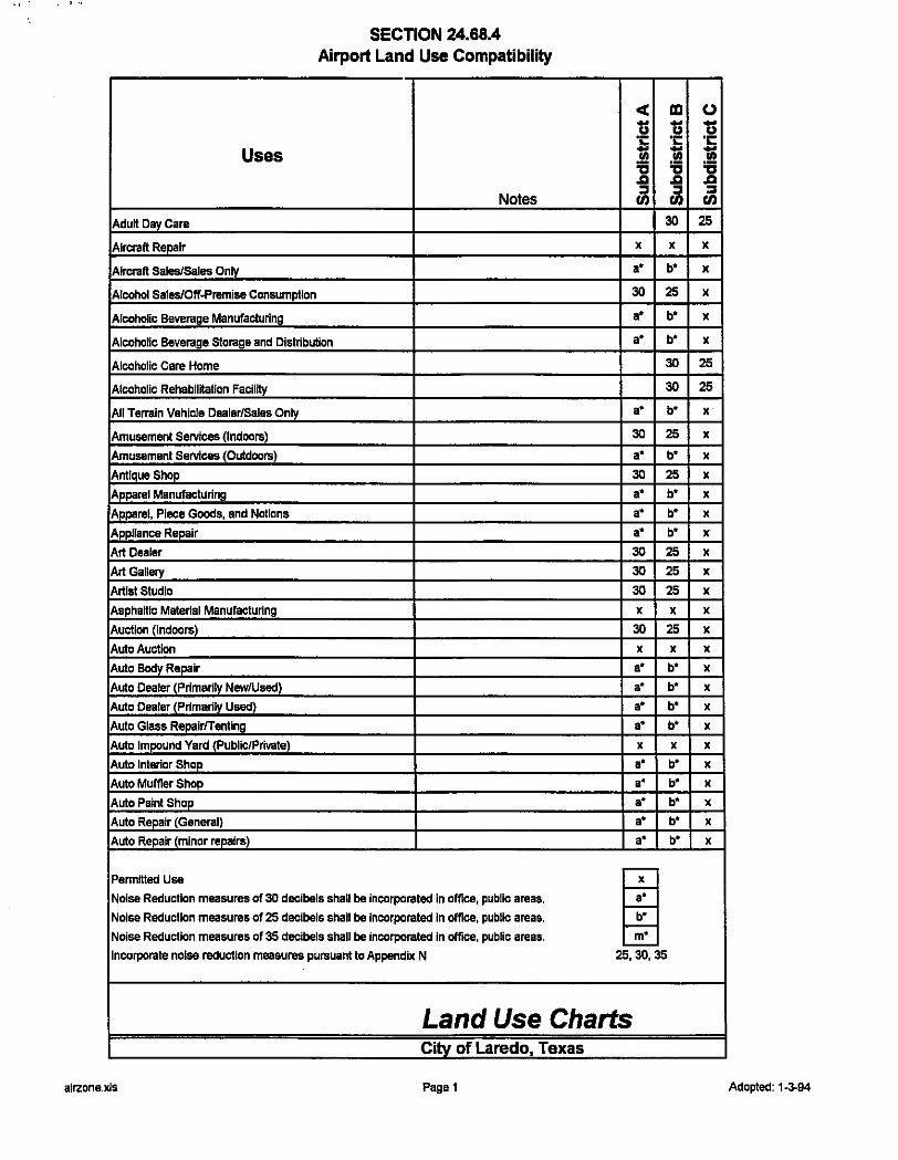
' , .,
Uses
Adu~ Day Care
Aircraft Repair
Aircraft Sales/Sales Only
Alcohol Sales/Off-Premise Consumption
Alcoholic Beverage Manufacturing
SECTION 24.68.4 Airport Land Use Compatibility
Notes
Alcoholic Beverage Storage and Distribution
Alcoholic Care Home
Alcoholic Rehabilitation Facility
All Terrain Vehicle Dealer/Sales Only
Amusement Services (Indoors)
Amusement Services (Outdoors)
Antique Shop
Apparel Manufacturing
Apparel, Piece Goods, and Notions
Appliance Repair
Art Dealer
Art Gallery
Artist Studio
Aspha~lc Material Manufacturing
Auction (Indoors)
Auto Auction
Auto Body Repair
Auto Dealer (Primarily New/Used)
Auto Dealer (Primarily Used)
Auto Glass RepairfTenting
Auto Impound Yard (Public/Private}
Auto Interior Shop
Auto Muffler Shop
Auto Paint Shop
Auto Repair (General}
Auto Repair (minor repairs}
Pennmed Use
Noise Reduction measures of 30 decibels shall be incorporated in office, public areas.
Noise Reduction measures of 25 decibels shall be incorporated In office, public areas.
Noise Reduction measures of 35 decibels shall be incorporated In office, public areas.
Incorporate noise reduction measures pursuant to Appendix N
cC ID u u ·;:: ·;:: '1;; '1;; '6 '6 .CI .CI :I :I Ill Ill
30
X X
a• b.
30 25
a• b.
•• b •
30
30
a• b.
30 25
a• b.
30 25 a• b•
•• b •
a• b•
30 25 30 25 30 25 X X
30 25 X X
a• b.
a• b.
a• b.
a• b.
X X
a• b.
a• b•
a• b.
•• b •
•• b •
~ 25,30,35
Land Use Charts City of Laredo, Texas
alrzone.xls Paget
(J
u ·c::: '1;; '6 .CI :I Ill
25
X
X
X
X
X
25
25
X
X
X
X
X
X
X
X
X
X
X
X
X
X
X
X
X
X
X
X
X
X
X
Adopted: 1-3-94
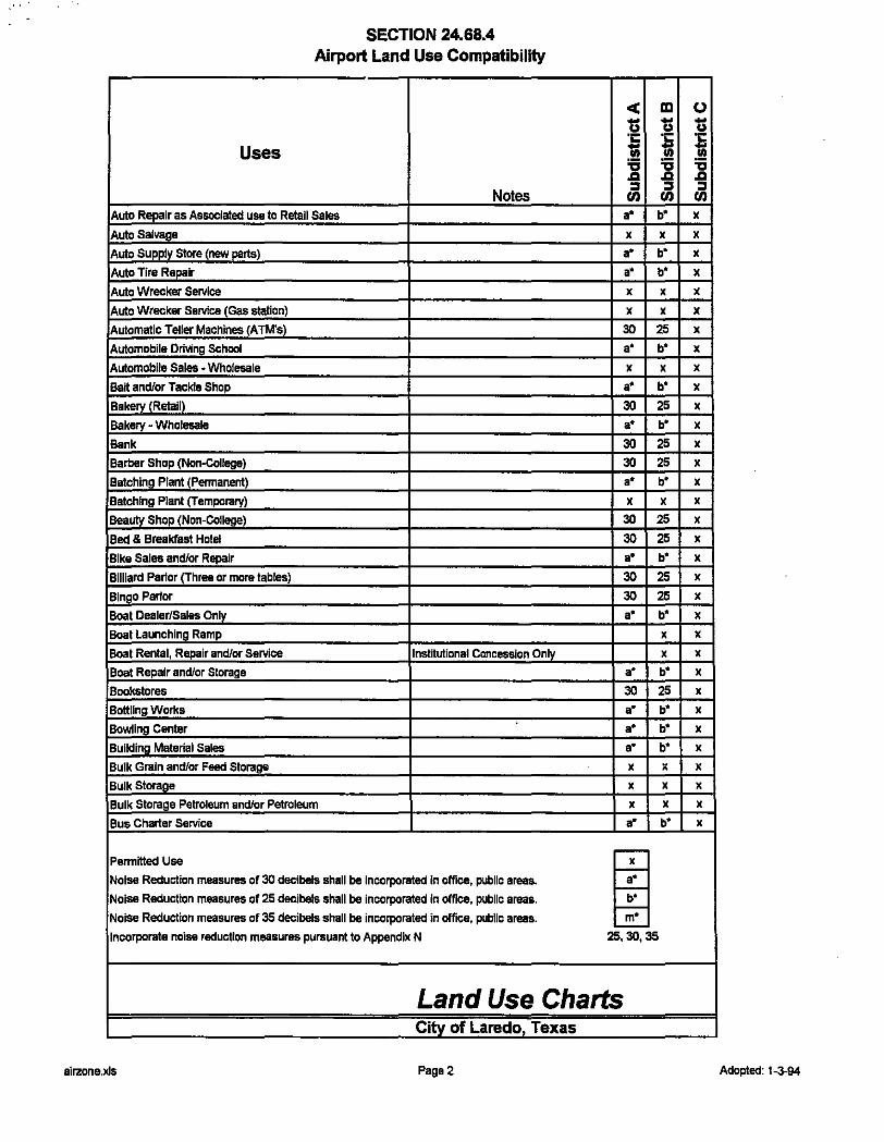
SECTION 24.68.4 Airport Land Use Compatibility
<C lEI CJ 13 13 13 ·;:: ·;:: ·;::
Uses 'Iii 'Iii 'Iii '6 '6 '6 .a .a .a
Notes :I :I :I tn tn tn
Auto Repair as Associated use to Retail Sales a• b* X
Auto Salvage X X X
Auto Supply Store (new parts) a• b* X
Auto Tire Repair a• b* X
Auto Wrecker Service X X X
Auto Wrecker Service (Gas station) X X X
Automatic Teller Machines (ATM's) 30 25 X
Automobile Driving School a• b* X
Automobile Sales ·Wholesale X X X
Ban and/or Tackle Shop a• b* X
Bakery (Retail) 30 25 X
Bakery • Wholesale a• b* X
Bank 30 25 X
Barber Shop (Non-College) 30 25 X
Batchlng Plant (Pennanent) a• b* X
Botching Plant (Temporary) X X X
BeaUiy Shop (Non-College) 30 25 X
Bed & Breakfast Hotel 30 25 X
Bike Salee and/or Repair a• b* X
Billiard Parlor (Three or more tables) 30 25 X
Blnao Parlor 30 25 X
Boat Dealer/Salee Only •• b* X
Boat Launching Ramp X X
Boat Rental, Repair and/or Service Institutional Concession Only X X
Boat Repair and/or Storage a• b' X
Bookstores 30 25 X
Bottling Works a• b' X
Bowling Center a• b' X
Building Material Sales •• b' X
Bulk Grain and/or Feed Storage X X X
Bulk Storage X X X
Bulk Storage Petroleum and/or Petroleum X X X
Bus Charter Service a• b' X
Penmllled Use
~ Noise Reduction measures of 30 decibels shall be incorporated In office, public areas.
Noise Reduction measuree of 25 decibels shall be incorporated In office, public araas.
Noise Reduction measures of 35 decibels shall be incorporated in office, public areas.
Incorporate noise reduction measures pursuant to Appendix N 25,30,35
Land Use Charts City of Laredo, Texas
airzone.xls Page2 Adopted: 1-3-94
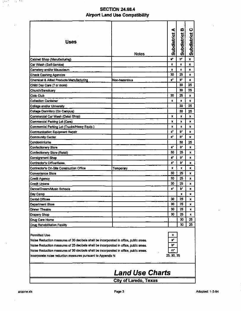
SECTION 24.68.4 Airport Land Use Compatibility
Uses
Notes Cabinet Shop (Manufacturing)
Car Wash (Self-Service)
Cemetery and/or Mausoleum
Check Cashing Agencies
Chemical & Allied Products Manufacturing Non-hazardous
Child Day Care CT or more)
Church/Sanctuary
Civic Club
Collection Container
College and/or University
College DormHory (On Campus)
Commercial Car Wash (Detail Shop)
Commercial Parking Lot (Cars)
Commercial Parking Lot (Trucks/Heaw EauiP.)
Communication Equipment Repair
Community Center
Condominiums
Confectionery Store
Confectionery Store (Retail)
Consignment Shop
Contracto(s Office/Sales,
Contracto(s On-Stte Construction Office Temporary
Convenience Stare
CredH Agency
Credit Unions
Dance/Dream/Music Schools
Day Camp
Dental Offices
Department Store
Dinner Theatre
Drapery Shop
Drug Care Home
Drug Rehabilttation Facility
PermHted Use
Noise Reduction measures of 30 decibels shall be Incorporated in office, public areas.
Noise Reduction measures of 25 decibels shall be incorporated in office, public areas.
Noise Reduction measures of 35 decibels shall be incorporated In office, public areas.
Incorporate noise reduction measures pursuant to Appendix N
< ID ... ... u u "I: "I: -;;; -;;; '6 '6 .a .a :I :I Ul Ul a• b*
X X
X X
30 25 a• b*
30
30
30 25
X X
30
30 X X
X X
X X
a• b* a• b*
30 a• b*
30 25 a• b* a• b*
X X
30 25
30 25
30 25 a• b*
X
30 25
30 25
30 25
30 25
30
30
i 25,30,35
Land Use Charts Citv of Laredo Texas
airzone.xls Page3
u 1) "I:
i "a .a :I Ul X
X
X
X
X
25
25
X
X
25
25 X
X
X
X
X
25 X
X
X
X
X
X
X
X
X
X
X
X
X
X
25
25
Adopted: 1-3-94

SECTION 24.68.4 Airport Land Use Compatibility
< Ill 0 - u u g "1: "I: "1:
Uses 1;; ~ -.!!! '6 "1:1 .a .a .a
Notes ::r ::r ::r II) II) II)
Drug Store 30 25 X
Drug, Drug Proprietaries, a• b' X
Electrical Generating Plant X X X
Electrical Substation X X X
Electronic Assembly a• b' X
Emergency Ambulance Service 3S 30 25
Emergency Care Clinic 30 25 X
Engine Repair/Motor Manufacturing a• b' X
Exhibftlon Hall 30 25 X
Exterminator service 30 25 X
Exterminator Service (Storage) X X X
Fairground X X
Farm (Food) Products • Wholesale a• b' X
Farms, General (Livestock/Ranch) X X X
Financial Services (Advice/invest) 30 25 X
Fire Station 30 25 X
Firewood Sales· Wholesale a• b' X
Fishing and Sightseeing Facll~ies lnst~utional Concession Only X X
Fishing Pier instftutionai Concession Onlv X X
Florist 30 25 X
Food Canning O!"'ra!ion a• b' X
Four Family (Quadraplex) 30 25
Fratemfty/Sorority House 30 25
Fru~ and/or Vegetable Store 30 25 X
Fuel Dispensing, Private a• b' X
Funeral Home 30 25 X
Fumfture Sales (Indoor) a• b' X
FumHure Sales (Outdoor) a• b' X
Garden Shop (Inside Storage) a• b' X
Gasoline Service Station a• b' X
Golf Couraa (Public/Private) 30 25 X
Government Building 30 25 X
Gravestonerrombstone Sales 30 25 X
Greenhouse X X X
Permitted Use
m Noise Reduction measures of 30 decibels shall be incorporated in office, public areas.
Noise Reduction measures of 25 decibels shall be incorporated in office, public areas.
Noise Reduction measures of 3S decibels shall be incorporated In office, public areas.
Incorporate noise reduction measures pursuant to Appendix N 25,30,35 .
Land Use Charts Citv of Laredo. Texas
alrzone.xls Page4 Adopted: 1-3-94

SECTION 24.68.4 Airport Land Use Compatibility
Uses
Notes Grcceries/Related Products
Half-Way House (Criminal)
Handicraft Shop
Hardware Store
Hay, Grain, and/or Feed Sales
Hazardous Chemical Manufacture
Health Club CPhvsical FHness)
Heavy Machinery_ Sales (Wholesales)
Heavy Machinery Sales/Display (Inside)
Heavy Machinery Sales/Display (Outdoor)
Horse Racing FacllltyiTralning
Hosplcs
HospHal
Hotel/Motel
Inoperable Vehicle Holding Yard
lnsurancs Agency_ Officss
Iron and/or Steel Foundry
Jail
Karate School (Martial Arts)
Kiosk (Providing A Servlcs)
Laundry/Dry Cleaning (Drop Off/Pick Up)
Laundry/Dry Cleaning (Greater than 3000 s.f.)
Laundry/Dry Cleaning (less than 3000 s.f.)
Laundry/Dry Cleani1'19_(Self-Servlcs)
Lawnmover Sales and/or Repair
Leather Tanning and/or Finishing
Library
Light Manufacturing
Limousine Service
Livestock - Wholesale
Ltveslock Sales
LocksmHh
Lumber Sales - Wholesales
Permitted Use
Noise Reduction measures of 30 decibels shall be incorporated In office, public areas.
Noise Reduction measures of 25 decibels shall be incorporated in office, public areas.
Noise Reduction measures of 35 decibels shall be Incorporated In office, public areas.
Incorporate noise reduction measures pursuant to Appendix N
cC ID u u ·c ·c 'Iii -'6 ~ .a .a :I :I
U) U)
a• b"
30 25
30 25 a• b"
X X
a• b"
30 25 a• b" a• b" a• b"
30 25
30
30
30 25
X X
30 25
X X
30 25 a• b"
30 25
30 25
30 25
30 25
30 25
a• b"
X X
30 a• b" a• b"
X X
X X
a• b" a• b"
i 25,30, 35
Land Use Charts City of Laredo, Texas
airzone.xls PageS
u u ·c i "CI .a :I U)
X
X
X
X
X
X
X
X
X
X
X
25
25
X
X
X
X
X
X
X
X
X
X
X
X
X
25
X
• X
X
X
X
Adopted: 1-3-94
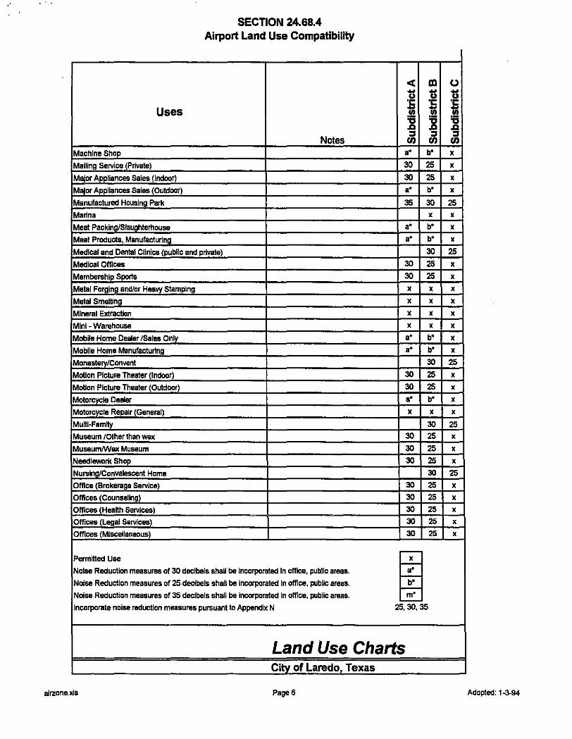
•"
Uses
Machine Shop
Mailing Service (Private)
Major Appliances Sales (Indoor)
Major Appliances Sales (Outdoor)
Manufactured Housing Park
Marina
Meat Packing/Slaughterhouse
Meat Products, Manufacturing
SECTION 24.68.4 Airport Land Use Compatibility
Notes
Medical and Dental Clinics (public and private)
Medical Offices
Membership Sports
Metal Forging and/or Heavy Stamping
Matal Smelling
Mineral Extraction
Mini- Warehouse
Mobile Home Dealer /Sales Only
Mobile Home Manufacturing
Monastery/Convent
Motion Picture Theater (Indoor)
Motion Picture Theater (Outdoor)
Motorcycle Dealer
Motorcycle Repair (General)
MuHI-Famlly
Museum /Other than wax Museum/Wax Museum
Needlework Shop
Nu.,lng/Convalescent Home
Office (Brokerage Service)
Offices (Counseling)
· Offices (HeaHh Services)
Offices (Legal Services)
Offices (Miscellaneous)
Permitted Use
Noise Reduction measures of 30 decibels shall be Incorporated In office, public areas.
Noise Reduction measures of 25 decibels shall be incorporated In office, public areas.
Noise Reduction measures of 35 decibels shall be incorporated in office, public areas.
Incorporate noise reduction measures pursuant to Appendix N
< lXI u u ·c ·c - 'lil Cll '6 '6 .a .a :II :II en en
a• b"
30 25
30 25 a• b"
35 30 X
a• b" a• b"
30
30 25
30 25
X X
X X
X X
X X
a• b" a• b"
30
30 25
30 25 a• b"
X X
30 30 25
30 25
30 25
30
30 25
30 25
30 25
30 25
30 25
~ 25,30, 35
Land Use Charts City of Laredo, Texas
alrzone.xls Page6
(J
u ·c 'lil '6 .a :II en
X
X
X
X
25 X
X
X
25
X
X
X
X
X
X
X
X
25
X
X
X
X
25 X
X
X
25
X
X
X
X
X
Adopted: 1-3-94
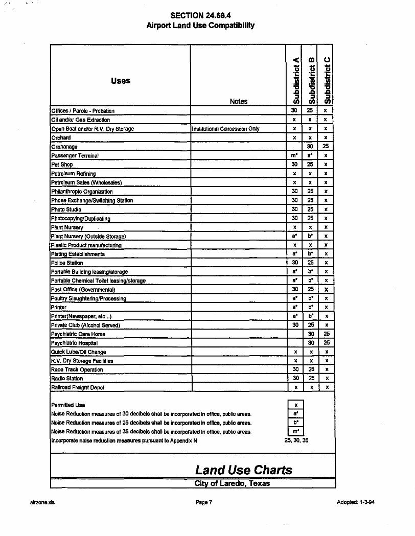
,··
Uses
Offices I Parole - Probation
Oil and/or Gas Extraction
Open Boat and/or R. V. Dry Storage
Orchard
Orphanage
Passenger Terminal
Pet Shop
Petroleum Refining
Petroleum Sales (Wholesales)
Philanthropic Organization
Phone Exchange/SWitching Station
Photo Studio
Photoco~ng/Duplioatlng
Plant Nuraery
Plant Nuraery (Outside Storage)
Plastic Product manufacturing
Plating Establishments
Pollee Station
Portable Building leasing/storage
Portable Chemical Toilet leasing/storage
Post Office (Govemmental)
Pou~ry SlaughterinQ/ProcessinQ
Printer
Printer(Newspaper, etc ... )
Private Club (Alcohol Served)
Psyc!llatric Care Home
Psychiatric Hosp~l
Quick Lube/Oil Change
R.V, Dry Storage FaciiHies
Race Track Operation
Radio Station
Railroad Freight Depot
Permitted Use
SECTION 24.68.4 Airport Land Use Compatibility
Notes
lnstHutional Concession Only
Noise Reduction measures of 30 decibels shall be incorporated In office, public areas.
Noise Reduction measures of 25 decibels shall be incorporated In office, public areas.
Noise Reduction measures of 35 decibels shall be incorporated In office, public areas.
Incorporate noise reduction measures pursuant to Appendix N
< ID
1S 1S ·c ·c -;; -;; '6 '6 .a .a :I :I U) U)
30 25
X X
X X
X X
30 m• a•
30 25 X X
X X
30 25 30 25 30 25 30 25
X X
a• b'
X X
a• b'
30 25 a• b' a• b'
30 25 a• b' a• b' a• b'
30 25 30
30
X X
X X
30 25 30 25
X X
~ 25,30,35
Land Use Charts City of Laredo, Texas
alrzone.xls Page7
u 1S ·c ! "0 .a :I U)
X
X
X
X
25 X
X
X
X
X
X
X
X
X
X
X
X
X
X
X
X
X
X
X
X
25 25 X
X
X
X
X
Adopted: 1-3-94

, .. ' '
Uses
Railroad Right-of-Way
Re-Manufacturing and/or Repair
Real Estate Offices
Recreational Club (Members Only)
Recreational Vehicle Dealer/Sales Only
Recreational Vehicle Parking Lot
Rectory/Parsonage
Refuse Disposal System
Registered Family Home
Registered Family Home
Research Lab (Hazardous)
Restaurant
Restaurant (Drive-In)
Restaurant (Drive-Thru)
Restaurant (Kiosk)
Restaurant (Serving Alcohol)
Restrooms with Shower Facllnles and/or
Retail Sales of Fishing Ban and/or
Retail Store (Miscellaneous)
Retirement Home/Home for the Aged
Rooming/Boarding House
Salvage and/or Reclamation (Indoors)
Salvage and/or Reclamation (Outdoors)
Sand/Gravel Sales, Storage & Extraction
Sannary Landfill
Sannarr_ Sewage Pump-out Facilnies
Savings and Loans
School, K thru t 2 (Private)
School, K thru 12 (Public)
School, Vocational
Scrap/Waste Recycle Collection
Sewage Pumping Station
Shoe Repair
Permitted Use
SECTION 24.68.4 Airport Land Use Compatibility
Notes
Noise Reduction measures of 30 decibels shall be Incorporated In office, public areas.
Noise Reduction measures of 25 decibels shall be incorporated in office, public areas. Noise Reduction measures of 35 decibels shall be incorporated in office, public areas.
Incorporate noise reduction measures pursuant to Appendix N
< ID - ... u u ·c ·c '1;; !! '6 'til .CI .CI :I :I en en
X X
a• b.
30 25
30 25 a• b.
m• a•
30
X X
30 30
•• b.
30 25
30 25
30 25
30 25
30 25 a• b.
•• b.
30 25
30
30 X X
X X
X X
X X
X X
30 25
30
30
30
X X
X X
30 25
m 25,30,35
Land Use Charts Citv of Laredo Texas
airzone.xls PageS
(J -u ·c i 'til .CI :I en
X
X
X
X
X
X
25
X
25
25
X
X
X
X
X
X
X
X
X
25
25
X
X
X
X
X
X
25
25
25
X
X
X
Adopted: 1-3-94
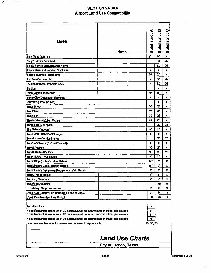
"'
SECTION 24.68.4 Airport Land Use Compatibility
Uses
Notes Sign Manufactunng
Single Family Detached
Single Family Manufactured Home
Snack Bars and Vending Machines
Special Events (Temporary)
Stables (Commercial)
Stables (Private, Principle Use)
Stadium
Slate Vehicle Inspection
Stone!Ciay/Giass Manufactunng
Swimming Pool (Public)
Tailor Shop
Taxi Stand
Television
Theater (Non-Motion Picture)
Three Family (Triplex)
Tire Sales (Indoors)
Tool Rental (Outdoor Storage)
Townhouse Condominiums
Transfer Station (Refuse!Pick - up)
Travel Ag_ency
Travel Traller/RV Park
Truck Sales- Wholesale
Truck Stop (Including Gas Sales)
Truck/Heavy Equip. DrMng School
Truck/Heavy Equipment/Recreational Veh. Repair
Truck/Trailer Rental
Trucking Company
Two Family (Duplex)
Upholstery Shop (Non-Auto)
Used Auto Supply Part Store(no on-stte salvage)
Used Merchandise; Flea Market
Permitted Usa
Noise Reduction measures of 30 decibels shall be incorporated In office, public areas. Noise Reduction measures of 25 decibels shall be incorporated In office, public areas.
Noise Reduction measures of 35 decibels shall be incorporated in office, public areas.
Incorporate noise reduction measures pursuant to Appendix N
<C Ill 13 13 ·c ·c '1;; '1;; '6 '6 .Ill .Ill :I :I tn tn
a• b'
30
30
X X
30 25
X 30
X 30
X
m• a'
X X
X
30 25 m• a'
30 25
30 25
30 a• b'
X X
30
X X
30 25
35 30 a• b' m• a'
m' a' a• b' a• b' a• b'
30 a• b' a• b'
30 25
; 25,30,35
Land Use Charts City of Laredo, Texas
airzone.Kis Page9
u 13 ·c -.!!! 'a .Ill :I tn X
25
25
X
X
25
25
X
X
X
X
X
X
X
X
25 X
X
25
X
X
25 X
X
X
X
X
X
25 X
X
X
Adopted: 1-3-94
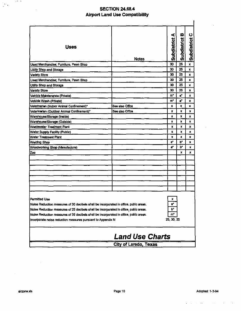
SECTION 24.68.4 Airport Land Use Compatibility
Uses
Notes Used Merchandise; FumHure, Pawn Shop
Utility Shop and Storage
Variety Store
Used Merchandise; FumHure, Pawn Shop
Utility Shop and Storage
Variety Store
Vehicle Maintenance (Private)
Vehicle Wash (Private)
Veterinarian (Indoor Animal Confinement)• See alsc Office
Veterinarian (Outdoor Animal Confinement)" See alsc Office
Warehouse/Storage (Inside)
Warehouse/Storage (Outside)
Wastewater Treatment Plant
Water Supply Facility (Public)
Water Treatment Plant
Welding Shop
Woodwaridng Shop (Manufacture)
Zoo
PermmedUse
Noise Reduction measures of 30 decibels shall be incorporated In office, public areas.
Noise Reduction measurea of 25 decibels shall be incorporated In omce, public areas.
Noise Reduction measures of 35 decibels shall be incorporated In office, public areas.
Incorporate noise reduction measures pursuant to Appendix N
< ID u ...
u ·c ·c 'Iii ...
Ill iS iS .a .a :I :I U) U)
30 25
30 25
30 25
30 25
30 25
30 25
m• a•
m• a•
X X
X X
X X
X X
X X
X X
X X
a• b" a• b"
X
25,30,35
Land Use Charts Citv of Laredo Texas
alrzone.xls Page10
(.)
u ·c :! "'CI .a :I U)
X
X
X
X
X
X
X
X
X
X
X
X
X
X
X
X
X
X
Adopted: 1·3-94

Section 24.68.5 ADDITIONAL REQUIREMENTS
1. Aviation easements shall be required over all property located within the Airport Noise Specific Use Overlay Zoning District as a condition of the approval of any residential subdivision, residential rezoning application, special use or conditional use permit. Such easements shall be in the form approved by the city attorney, and shall be recorded in the deed or map records of Webb County.
2. All proposed subdivisions of land, and applications for rezoning, or special or conditional use permits located within the Airport Noise Specific Use Overlay Zoning District shall include the boundaries of the district and subdistricts established herein, all existing and proposed buildings and structures, and the uses or proposed uses associated with those buildings and structures.
3. All subdivision plats located within the Airport Noise Specific Use Overlay Zoning District shall contain a note which reads as follows: "This property (or a part thereof) is located within an area subject to potentially excessive airport noise levels. All uses and construction shall conform to the noise mitigation standards included in Appendix N - Noise Attenuation Performance Standards for Structures Located within the Airport Noise Specific Use Zoning Overlay District of the City of Laredo, incorporated herein and made a part hereof for all purposes."
Section 24.68.6 APPEALS
Appeals or requests for variances in noise attenuation construction requirements established herein shall be to the Building Standards Board whose decision shall be final. All other appeals or requests for variances shall be approved by both the Airport Advisory Board and the Board of Adjustment.
IV-62

SECTION 24-69
FLOOD DAMAGE PREVENTION
SECTION 24.69.1 STATEMENT OF PURPOSE
It is the purpose of this ordinance to promote the public health, safety and general welfare and to minimize public and private losses due to flood conditions in specific areas by provisions designed to:
(A) Protect human life and health;
(B) Minimize expenditure of public money for costly flood control projects;
(C) Minimize the need for rescue and relief efforts associated with flooding and generally undertaken at the expense of the general public;
(D) Minimize prolonged business interruptions;
(E) Minimize damage to public facilities and utilities such as water and gas mains, electric, telephone and sewer lines, streets and bridges located in floodplains;
(F) Help maintain a stable tax base by providing for the sound use and development of flood-prone areas in such a manner as to minimize future flood blight areas; and
(G) Insure that potential buyers are notified that property is in a flood area.
SECTION 24.69.2 METHODS OF REDUCING FLOOD LOSSES
In order to accomplish its purposes, this ordinance uses the following methods:
(A) Restrict or prohibit uses that are dangerous to health, safety or property in times of flood, or cause excessive increases in flood heights or velocities;
(B) Require that uses vulnerable to floods, including facilities which serve such uses, be protected against flood damage at the time of initial construction;
(C) Control the alteration of natural floodplains, stream channels, and natural protective barriers, which are involved in the accommodation of flood waters;
(D) Control filling, grading, dredging and other development which may increase flood damage;
(E) Prevent or regulate the construction of flood barriers which will unnaturally divert flood waters or which may increase flood hazards to other lands.
SECTION 24.69.3 GENERAL PROVISIONS
A Lands to which this ordinance applies
The ordinance shall apply to all areas of special flood hazard with the jurisdiction of The City of Laredo.
B. Basis for Establishing the Areas of Special Flood Hazard
The areas of special flood hazard identified by the Federal Emergency Management Agency in the current scientific and engineering report entitled, "The Flood Insurance Study (FIS) for Webb County Texas and Incorporated Areas," dated April 2, 2008 (which included Community Number 480651 and
IV-63
index panel numbers: 48479C0975C, 1000C, 1015C, 1020C, 1030C, 1040C, 1045C, 1185C, 1195C, 1205C, 1210C, 1215C, 1220C, 1360C, 1380C, 1385C, 1390C, 1405C, 1535C, 1555C), with accompanying Flood Insurance Rate Maps and/or Flood Boundary-Fioodway Maps (FIRM and/or FBFM) dated April 2, 2008, and any revisions thereto are hereby adopted by reference and declared to be a part of this ordinance.
C. Establishment of Development Permit
A Floodplain Development Permit shall be required to ensure conformance with the provisions of this ordinance and is hereby established for all construction and other development to be undertaken in areas of special flood hazard in this community. It shall be unlawful to undertake any development in an area of special flood hazard, as shown on the Flood Insurance Rate map enumerated in Section 24.69.3 (B), without a valid floodplain development permit.
D. Compliance
No structure or land shall hereafter be located, altered, or have its use changed without full compliance with the terms of this ordinance and other applicable regulations.
E. Abrogation and Greater Restrictions
This ordinance is not intended to repeal, abrogate, or impair any existing easements, covenants, or deed restrictions. However, where this ordinance and another ordinance, easement, covenant, or deed restriction conflict or overlap, whichever imposes the more stringent restrictions shall prevail.
F. Interpretation
In the interpretation and application of this ordinance, all provisions shall be; (1) considered as minimum requirements; (2) liberally construed in favor of the governing body; and (3) deemed neither to limit nor repeal any other powers granted under State statutes.
G. Warning and Disclaimer or Liability
The degree of flood protection required by this ordinance is considered reasonable for regulatory purposes and is based on scientific and engineering considerations. On rare occasions greater floods can and will occur and flood heights may be increased by man-made or natural causes. This ordinance does not imply that land outside the areas of special flood hazards or uses permitted within such areas will be free from flooding or flood damages. This ordinance shall not create liability on the part of the community or any official or employee thereof for any flood damages that result from reliance on this ordinance or any administrative decision lawfully made hereunder.
SECTION 24.69.4 ADMINISTRATION
A Designation of the Floodplain Administrator
The Planning Director is hereby appointed the Floodplain Administrator to administer and implement the provisions of this ordinance and other appropriate sections of 44 CFR (Emergency Management and Assistance- National Flood Insurance Program Regulations) pertaining to floodplain management.
B. Duties & Responsibilities of the Floodplain Administrator
Duties and responsibilities of the Floodplain Administrator shall include, but not be limited to, the following:
(1) Maintain and hold open for public inspection all records pertaining to the provisions of this ordinance.
IV-64
(2) Review permit application to determine whether to ensure that the proposed building site project, including the placement of manufactured homes, will be reasonably safe from flooding.
(3) Review, approve or deny all applications for development permits required by adoption of this ordinance.
(4) Review permits for proposed development to assure that all necessary permits have been obtained from those Federal, State or local governmental agencies (including Section 404 of the Federal Water Pollution Control Act Amendments of 1972, 33 U.S. C. 1334) from which prior approval is required.
(5) Where interpretation is needed as to the exact location of the boundaries of the areas of special flood hazards (for example, where there appears to be a conflict between a mapped boundary and actual field conditions) the Floodplain Administrator shall make the necessary interpretation.
(6) Notify, in riverine situations, adjacent communities and the State Coordinating Agency which is the Texas Water Development Board (TWDB), prior to any alteration or relocation of a watercourse, and submit evidence of such notification to the Federal Emergency Management Agency.
(7) Assure that the flood carrying capacity within the altered or relocated portion of any watercourse is maintained.
(8) When base flood elevation data has not been provided in accordance with Section 24.69.3, the Floodplain Administrator shall obtain, review and reasonably utilize any base flood elevation data and floodway data available from a Federal, State or other source, in order to administer the provisions of Section 24.69.5.
(9) When a regulatory floodway has not been designated, the Floodplain Administrator must require that no new construction, substantial improvements, or other development (including fill) shall be permitted within Zones A1-30 and AEon the community's FIRM, unless it is demonstrated that the cumulative effect of the proposed development, when combined with all other existing and anticipated development, will not increase the water surface elevation of the base flood more than one foot at any point within the community.
(1 0) Under the provisions of 44 CFR Chapter 1, Section 65.12, of the National Flood Insurance Program regulations, a community may approve certain development in Zones A1-30, AE, AH, on the community's FIRM which increases the water surface elevation of the base flood by more than 1 foot, provided that the community first completes all of the provisions required by Section 65.12.
C. Permit Procedure
(1) Application for a Floodplain Development Permit shall be presented to the Floodplain Administrator on forms furnished by him/her and may include, but not be limited to, plans in duplicate drawn to scale showing the location, dimensions, and elevation of proposed landscape alterations, existing and proposed structures, including the placement of manufactured homes, and the location of the foregoing in relation to areas of special flood hazard. Additionally, the following information is required:
(a) Elevation (in relation to mean sea level), of the lowest floor (including basement) of all new and substantially improved structures;
(b) Elevation in relation to mean sea level to which any nonresidential structure shall be floodproofed;
(c) A certificate from a registered professional engineer or architect that the non-residential floodproofed structure shall meet the floodproofing criteria of, Section 24.69 (2);
(d) Description of the extent to which any watercourse or natural drainage will be altered or relocated as a result of proposed development;
IV-65
(e) Maintain a record of all such information in accordance with Section 24.69.4 (B)(1);
(f) An elevation certificate shall be required before pouring of foundation for any new or substantially improved structure.
(g) All applications for a floodplain development permit shall be accompanied by an application fee of $200.00.
(h) Floodplain verification letter requests shall incur a fee of$ 25.00.
(2)Approval or denial of a Floodplain Development Permit by the Flooplain Administrator shall be based on all of the provisions of this ordinance and the following relevant factors:
(a) The danger to life and property due to flooding or erosion damage;
(b) The susceptibility of the proposed facility and its contents to flood damage and the effect of such damage on the individual owner;
(c) The danger that materials may be swept onto other lands to the injury of others;
(d) The compatibility of the proposed use with existing and anticipated development;
(e) The safety of access to the property in times of flood for ordinary and emergency vehicles;
(f) The costs of providing governmental services during and after flood conditions including maintenance and repair of streets and bridges, and public utilities and facilities such as sewer, gas, electrical and water systems;
(g) The expected heights, velocity, duration, rate of rise and sediment transport of the floodwaters and the effects of wave action, if applicable, expected at the site;
(h) The necessity to the facility of a waterfront location, where applicable;
(i) The availability of alternative locations, not subject to flooding or erosion damage, for the proposed use.
(3)A description of the extent to which any watercourse will be altered or relocated as a result of proposed development. Computations by a licensed professional engineer must be submitted that demonstrate that the altered or relocated segment will provide equal or greater conveyance than the original stream segment. If buildable lots are proposed adjacent to the altered watercourse and fall within the existing floodplain, then the applicant must submit any maps, computations or other material required by the Federal Emergency Management Agency (FEMA) to revise the documents enumerated in Section 24.69.2, when notified by the Local Administrator, and must pay any fees or other costs assessed by FEMA for this purpose.
D. Variance Procedures
(1)The Board of Adjustment shall hear and render judgment on requests for variances from the requirements of this ordinance.
(2)The Board shall hear and render judgment on an appeal only when it is alleged there is an error in any requirement, decision, or determination made by the Floodplain Administrator in the enforcement or administration of this ordinance.
(3)Any person or persons aggrieved by the decision of the Board may appeal such decision in the courts of competent jurisdiction.
IV-66
(4)The Floodplain Administrator shall maintain a record of all actions involving an appeal and shall report variances to the Federal Emergency Management Agency upon request.
(5)Variances may be issued for the reconstruction, rehabilitation or restoration of structures listed on the National Register of Historic Places or the State Inventory of Historic Places, without regard to the procedures set forth in the remainder of this ordinance.
(6)Variances may be issued for new construction and substantial improvements to be erected on a lot of 1/2 acre or less in size contiguous to and surrounded by lots with existing structures constructed below the base flood level, providing the relevant factors in C (2) of this Section have been fully considered. As the lot size increases beyond the 1/2 acre, the technical justification required for issuing the variance increases.
(7) Upon consideration of the factors noted above and the intent of this ordinance, the Board may attach such conditions to the granting of variances as it deems necessary to further the purpose and objectives of this ordinance (Section 24.69.1 ).
(B) Variances shall not be issued within any designated floodway if any increase in flood levels during the base flood discharge would result.
(9)Variances may be issued for the repair or rehabilitation of historic structures upon a determination that the proposed repair or rehabilitation will not preclude the structure's continued designation as a historic structure and the variance is the minimum necessary to preserve the historic character and design of the structure.
(10)Prerequisites for granting variances:
(a) Variances shall only be issued upon a determination that the variance is the minimum necessary, considering the flood hazard, to afford relief.
(b) Variances shall only be issued upon: (i) showing a good and sufficient cause; (ii) a determination that failure to grant the variance would result in exceptional hardship to the applicant, and (iii) a determination that the granting of a variance will not result in increased flood heights, additional threats to public safety, extraordinary public expense, create nuisances, cause fraud on or victimization of the public, or conflict with existing local laws or ordinances.
(c) Any application to which a variance is granted shall be given written notice that the structure will be permitted to be built with the lowest floor elevation below the base flood elevation, and that the cost of flood insurance will be commensurate with the increased risk resulting from the reduced lowest floor elevation.
(11 )Variances may be issued by a community for new construction and substantial improvements and for other development necessary for the conduct of a functionally dependent use provided that (i) the criteria outlined in Section 24.69.4 (D) (1 )-(9) are met, and (ii) the structure or other development is protected by methods that minimize flood damages during the base flood and create no additional threats to public safety.
SECTION 24.69.5 PROVISIONS FOR FLOOD HAZARD REDUCTION
A General Standards
In all areas of special flood hazards the following provisions are required for all new construction and substantial improvements:
IV-67

IV-68
(1) All new construction or substantial improvements shall be designed (or modified) and adequately anchored to prevent flotation, collapse or lateral movement of the structure resulting from hydrodynamic and hydrostatic loads, including the effects of buoyancy; (2) All new construction or substantial improvements shall be constructed by methods and practices that minimize flood damage; (3) All new construction or substantial improvements shall be constructed with materials resistant to flood damage; (4) All new construction or substantial improvements shall be constructed with electrical, heating, ventilation, plumbing, and air conditioning equipment and other service facilities that are designed (example: flood proofing) and/or located (example: elevated above the BFE) so as to prevent water from entering or accumulating within the components during conditions of flooding; (5) All new and replacement water supply systems shall be designed to minimize or eliminate infiltration of flood waters into the system; (6) New and replacement sanitary sewage systems shall be designed to minimize or eliminate infiltration of flood waters into the system and discharge from the systems into flood waters; and, (7) On-site waste disposal systems shall be located to avoid impairment to them or contamination from them during flooding.
B. Specific Standards In all areas of special flood hazards where base flood elevation data has been provided as set forth in (i) Section 24.69.3 B, (ii) Section 24.69.4 B (8), or (iii) Section 24.69.5 C (3), the following provisions are required:
(1) Residential Construction - new construction and substantial improvement of any residential structure shall have the lowest floor (including basement), together with attendant utilities (for example, junction boxes, breaker boxes, electrical outlets, switches, plugs, HVAC systems, a/c ductwork, hot water heaters or any non-structural system which when inundated with water would make the structure uninhabitable), elevated 18 inches (or more) above the base flood elevation. A registered professional engineer, architect, or land surveyor shall submit a certification to the Floodplain Administrator that the standard of this subsection as proposed in Section 24.69.4 C (1) a., is satisfied. (2) Nonresidential Construction - new construction and substantial improvements of any commercial, industrial or other nonresidential structure shall either have the lowest floor (including basement), together with attendant utilities (for example, junction boxes, breaker boxes, electrical outlets, switches, plugs, HVAC systems, a/c ductwork, hot water heaters or any non-structural system which when inundated with water would make the structure uninhabitable), elevated 18 inches (or more) above the base flood level or together with attendant utility and sanitary facilities, be designed so that below the base flood level the structure is watertight with walls substantially impermeable to the passage of water and with structural components having the capability of resisting hydrostatic and hydrodynamic loads and effects of buoyancy. A registered professional engineer or architect shall develop and/or review structural design, specifications, and plans for the construction, and shall certify that the design and methods of construction are in accordance with accepted standards of practice as outlined in this subsection. A record of such certification which includes the specific elevation (in relation to mean sea level) to which such structures are flood proofed shall be maintained by the Floodplain Administrator. (3) Enclosures - new construction and substantial improvements, with fully enclosed areas below the lowest floor that are usable solely for parking of vehicles, building access or storage in an area other

IV-69
than a basement and which are subject to flooding shall be designed to automatically equalize hydrostatic flood forces on exterior walls by allowing for the entry and exit of floodwaters. Designs for meeting this requirement must either be certified by a registered professional engineer or architect or meet or exceed the following minimum criteria:
(a) A minimum of two openings on separate walls having a total net area of not less than 1 square inch for every square foot of enclosed area subject to flooding shall be provided. (b) The bottom of all openings shall be no higher than 1 foot above grade. (c) Openings may be equipped with screens, louvers, valves, or other coverings or devices provided that they permit the automatic entry and exit of floodwaters.
(4) Manufactured Homes
(a) Require that all manufactured homes to be placed within Zone A on a community's FHBM or FIRM shall be installed using methods and practices which minimize flood damage. For the purposes of this requirement, manufactured homes must be elevated and anchored to resist flotation, collapse, or lateral movement. Methods of anchoring may include, but are not limited to, use of over-the-top or frame ties to ground anchors. This requirement is in addition to applicable State and local anchoring requirements for resisting wind forces. (b) Require that manufactured homes that are placed or substantially improved within Zones A1-30, AH, and AE on the community's FIRM on sites (i) outside of a manufactured home park or subdivision, (ii) in a new manufactured home park or subdivision, (iii) in an expansion to an existing manufactured home park or subdivision, or (iv) in an existing manufactured home park or subdivision on which a manufactured home has incurred "substantial damage" as a result of a flood, be elevated on a permanent foundation such that the lowest floor of the manufactured home is elevated 18 inches (or more) above the base flood elevation and be securely anchored to an adequately anchored foundation system to resist flotation, collapse, and lateral movement. (c) Require that manufactured homes be placed or substantially improved on sites in an existing manufactured home park or subdivision with Zones A1-30, AH and AE on the community's FIRM that are not subject to the provisions of paragraph (4) of this section be elevated so that either:
(i) the lowest floor of the manufactured home is 18 inches (or more) above the base flood elevation, or (ii) the manufactured home chassis is supported by reinforced piers or other foundation elements of at least equivalent strength that are no less than 36 inches in height above grade and be securely anchored to an adequately anchored foundation system to resist flotation, collapse, and lateral movement.
(5) Recreational Vehicles - Require that recreational vehicles placed on sites within Zones A1-30, AH, and AE on the community's FIRM either (i) be on the site for fewer than 180 consecutive days, or (ii) be fully licensed and ready for highway use, or (iii) meet the permit requirements of Section 24.69.4 C (1), and the elevation and anchoring requirements for "manufactured homes" in paragraph (4) of this section. A recreational vehicle is ready for highway use if it is on its wheels or jacking system, is attached to the site only by quick disconnect type utilities and security devices, and has no permanently attached additions.
C. Standards for Subdivision Proposals
(1) All subdivision proposals including the placement of manufactured home parks and subdivisions shall be consistent with Sections 24.69.1 B and C, and Section 24.69.2 of this ordinance.

IV-70
(2) All proposals for the development of subdivisions including the placement of manufactured home parks and subdivisions shall meet Floodplain Development Permit requirements of Section 24.69.3 C; Section 24.69.4 C; and the provisions of Section 24.69.5 of this ordinance. (3) Base flood elevation data shall be generated for subdivision proposals and other proposed development including the placement of manufactured home parks and subdivisions which is greater than 50 lots or 5 acres, whichever is lesser, if not otherwise provided pursuant to Section 24.69.3 B or Section 24.69.4 B (8) of this ordinance. (4) All subdivision proposals including the placement of manufactured home parks and subdivisions shall have adequate drainage provided to reduce exposure to flood hazards. (5) All subdivision proposals including the placement of manufactured home parks and subdivisions shall have public utilities and facilities such as sewer, gas, electrical and water systems located and constructed to minimize or eliminate flood damage.
D. Standards for Areas of Shallow Flooding (AO/AH Zones) Located within the areas of special flood hazard established in Section 24.69.3 B, are areas designated as shallow flooding. These areas have special flood hazards associated with flood depths of 1 to 3 feet where a clearly defined channel does not exist, where the path of flooding is unpredictable, and where velocity flow may be evident. Such flooding is characterized by ponding or sheet flow; therefore, the following provisions apply:
(1) All new construction and substantial improvements of residential structures have the lowest floor (including basement) elevated 18 inches (or more) above the base flood elevation or the highest adjacent grade at least as high as the depth number specified in feet on the community's FIRM (at least 3 feet if no depth number is specified). (2) All new construction and substantial improvements of non-residential structures;
(a) have the lowest floor (including basement) elevated to or above the base flood elevation or the highest adjacent grade at least as high as the depth number specified in feet on the community's FIRM (at least 3 feet if no depth number is specified), or (b) together with attendant utility and sanitary facilities be designed so that below the base specified flood depth in an AO Zone, or below the Base Flood Elevation in an AH Zone, level the structure is watertight with walls substantially impermeable to the passage of water and with structural components having the capability of resisting hydrostatic and hydrodynamic loads of effects of buoyancy.
(3) A registered professional engineer or architect shall submit a certification to the Floodplain Administrator that the standards of D herein, as proposed in Section 24.69.4 C are satisfied. (4) Require within Zones AH or AO adequate drainage paths around structures on slopes, to guide flood waters around and away from proposed structures.
SECTION E - FLOODWAYS Floodways - located within areas of special flood hazard established in Section 24.69.3 B, are areas designated as floodways. Since the floodway is an extremely hazardous area due to the velocity of flood waters which carry debris, potential projectiles and erosion potential, the following provisions shall apply:
(1) Encroachments are prohibited, including fill, new construction, substantial improvements and other development within the adopted regulatory floodway unless it has been demonstrated through hydrologic and hydraulic analyses performed in accordance with standard engineering practice that
IV-71
the proposed encroachment would not result in any increase in flood levels within the community during the occurrence of the base flood discharge. (2) If Section 24.69.5 E (1) above is satisfied, all new construction and substantial improvements shall comply with all applicable flood hazard reduction provisions of Section 24.69.5. (3) Under the provisions of 44 CFR Chapter 1, Section 65.12, of the National Flood Insurance Program Regulations, a community may permit encroachments within the adopted regulatory floodway that would result in an increase in base flood elevations, provided that the community first completes all of the provisions required by Section 65.12.
SECTION F – SEVERABILITY If any section, clause, sentence, or phrase of this Ordinance is held to be invalid or unconstitutional by any court of competent jurisdiction, then said holding shall in no way affect the validity of the remaining portions of this Ordinance. SECTION G - PENALTIES FOR NON COMPLIANCE No structure or land shall hereafter be constructed, located, extended, converted, or altered without full compliance with the terms of this court order and other applicable regulations. Violation of the provisions of this court order by failure to comply with any of its requirements (including violations of conditions and safeguards established in connection with conditions) shall constitute a misdemeanor. Any person who violates this court order or fails to comply with any of its requirements shall upon conviction thereof be fined not more than $ 500 for each violation, and in addition shall pay all costs and expenses involved in the case. Nothing herein contained shall prevent The City of Laredo from taking such other lawful action as is necessary to prevent or remedy any violation.

SECTION 24-70
PLANNED UNIT DEVELOPMENT DISTRICT
Section 24.70.1 PLANNED UNIT DEVELOPMENT DISTRICT PURPOSE
The purpose of the Planned Unit Development Specific Use Zoning Overlay District is to enable the development of property and projects which because of design considerations, topographical features, environmental and/or other land use considerations may justify mixed uses, special dimensional standards, substitution of standards, or waiver of standards within a specified area. Planned Unit Development Zoning Overlay Zones shall be established prior to or concurrently with any subdivision of land.
Section 24.70.2 MINIMUM SIZE REQUIREMENTS
The minimum area requirements of a Planned Unit Development Specific Use Zoning Overlay District shall be as follows:
Single Family Residential not less than 20 acres Multi-family Residential not less than 15 acres Commercial not less than 20 acres Industrial not less than 45 acres Mixed Use Development not less than 50 acres
Section 24.70.3 PRIVATE STREETS & SIDEWALKS
1. Planned Unit Developments which propose the use of private streets may be required to also provide public arterials, thoroughfares or collectors in or through the proposed project. All streets and access ways shall be adequate to provide traffic circulation, and emergency access to the proposed development.
2. Multi-family, Commercial, and Industrial PUD's may also be required to conduct a traffic study prepared by a competent professional identifying the traffic impact of the proposed development within the boundaries of the development, and on any public street connecting with a proposed private street. The Planning & Zoning Commission may require the mitigation of any adverse impacts or traffic by off- site improvements, including providing additional lanes, providing for turning movements, signalization of intersections, construction of medians and other traffic control devices.
3. Sidewalks may be waived by the Planning & Zoning Commission in residential PUD's only along private local streets where individual lot size exceeds 20,000 square feet. Sidewalks shall be provided along both sides of Major Thoroughfares in residential and commercial areas. No sidewalk shall be required in Industrial Planned Unit Developments.
4. Construction standards for private streets shall meet or exceed those required by the city for public streets. Minimum paving widths shall be specified in the proposal, and are subject to the approval of the Planning & Zoning Commission.
5. Private street developments shall take access from paved public roadways as follows:
IV-72
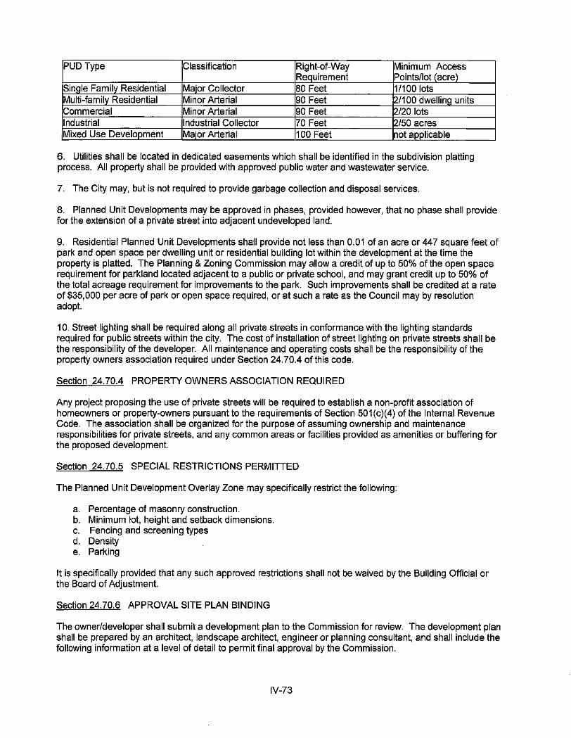
PUD Type Classification Right-of-Way Minimum Access Requirement Points/lot (acre)
SinQie Family Residential Major Collector 80 Feet 11100 lots Multi-family Residential Minor Arterial 90 Feet 2/100 dwelling units Commercial Minor Arterial 90 Feet 2/20 lots Industrial Industrial Collector 70 Feet 2/50 acres IMixed Use Development Major Arterial 100 Feet not applicable
6. Utilities shall be located in dedicated easements which shall be identified in the subdivision platting process. All property shall be provided with approved public water and wastewater service.
7. The City may, but is not required to provide garbage collection and disposal services.
8. Planned Unit Developments may be approved in phases, provided however, that no phase shall provide for the extension of a private street into adjacent undeveloped land.
9. Residential Planned Unit Developments shall provide not less than 0.01 of an acre or 447 square feet of park and open space per dwelling unit or residential building lot within the development at the time the property is platted. The Planning & Zoning Commission may allow a credit of up to 50% of the open space requirement for parkland located adjacent to a public or private school, and may grant credit up to 50% of the total acreage requirement for improvements to the park. Such improvements shall be credited at a rate of $35,000 per acre of park or open space required, or at such a rate as the Council may by resolution adopt.
10. Street lighting shall be required along all private streets in conformance with the lighting standards required for public streets within the city. The cost of installation of street lighting on private streets shall be the responsibility of the developer. All maintenance and operating costs shall be the responsibility of the property owners association required under Section 24.70.4 of this code.
Section 24.70.4 PROPERTY OWNERS ASSOCIATION REQUIRED
Any project proposing the use of private streets will be required to establish a non-profit association of homeowners or property-owners pursuant to the requirements of Section 501 (c)(4) of the Internal Revenue Code. The association shall be organized for the purpose of assuming ownership and maintenance responsibilities for private streets, and any common areas or facilities provided as amenities or buffering for the proposed development.
Section 24.70.5 SPECIAL RESTRICTIONS PERMITTED
The Planned Unit Development Overlay Zone may specifically restrict the following:
a. Percentage of masonry construction. b. Minimum lot, height and setback dimensions. c. Fencing and screening types d. Density e. Parking
It is specifically provided that any such approved restrictions shall not be waived by the Building Official or the Board of Adjustment.
Section 24.70.6 APPROVAL SITE PLAN BINDING
The owner/developer shall submit a development plan to the Commission for review. The development plan shall be prepared by an architect, landscape architect, engineer or planning consultant, and shall include the following information at a level of detail to permit final approval by the Commission.
IV-73
a. Survey of the property, showing existing features of the property, including contours, buildings, structures, trees over 4 inches in trunk diameter, streets, utility easements, right-of-way and land use.
b. Site plan showing proposed building locations and land use areas. c. Streets rights-of-way, parking, layout, and pedestrian walks.
d. Landscaping plans including site grading and/or landscape design.
e. Preliminary drawings for buildings (if any) to be constructed in the current phase, including floor plans, exterior elevations and cross-sections.
f. Preliminary engineering plans, including street improvements, drainage system and public utility extensions.
g. Construction sequence and time schedule for completion of each phase for buildings, parking space and landscaped areas.
Substantive changes to any approved development plan relating to street layout, sidewalk construction and buffering shall be approved by the Planning & Zoning Commission and the City Council.
IV-74
SECTION 24-73
OIL & GAS EXTRACTION & PRODUCTION SPECIFIC USE ZONING OVERLAY DISTRICT AND PERMIT REQUIREMENTS
Section 24.73.1 SPECIAL USE PERMIT REQUIRED
(1) It shall be unlawful and a violation of this article for any person, acting either for himself or as an agent, employee, independent contractor or servant of any other person, to explore for oil and gas, or to commence operations, or to operate or service any well, or to drill, or to re-enter any well including to workover, re-complete, plug back, deepen, or activate any well or to re-enter any well which has been plugged and abandoned, or to engage in related storage of oil, natural gas, and other hydrocarbons within the corporate limits of the city without a specific use permit having first been issued by the authority of the council in accordance with the terms of this chapter. No specific use permit shall be authorized for more than one (1) well.
(2) Each applicant, when filing with the superintendent an application, for a specific use permit shall include a metes and bounds description of the drilling block proposed to be covered by the permit, to be prepared by a surveyor licensed by the state, which shall be situated within the outlines of drilling areas approved by the city council. When so approved, such description shall become the official legal description of the drilling block therein for all purposes hereunder. The superintendent shall take into account the metes and bounds description of all previously approved drilling blocks in determining the propriety of the description furnished in connection with any permit application.
(3) No specific use permit shall be issued except in accordance with the requirements of this section:
(a) The council may establish conditions as part of the special permit, including but not limited to:
(i) The hours of drilling operations, re-entry and well servicing limited to daylight hours only in developed areas, except in the case of an emergency.
(ii) Use of all-electric drilling rigs and generators where any residential structure is less than six hundred (600) feet from the well.
(iii) Lighting of drilling operations shall be screened to avoid adverse impact on adjacent residential neighborhoods.
(iv) In lieu of a cyclone fence, all wells and tanks located in a developed residential or commercial area shall be screened by a solid masonry wall around the well within sixty (60) days of completion of drilling, redrilling, reworking, converting or activation. The wall shall be of solid neutral color, compatible with surrounding uses, and maintained in a neat orderly, secure condition. The wall shall be at least six feet in height and be constructed in accordance with provisions of the city building code. The entry gates shall be of galvanized steel, and shall be kept locked.
(v) For wells visible from a public street in a developed residential or commercial area, the site shall be landscaped in accordance with Appendix F-1, Table 2 "Recommended Shrubs for the Laredo Region" and Appendix F -2 "General Planting and Maintenance Standards for Trees and Shrubs". Shrubs shall be spaced as intervals of not less than three (3) feet along the perimeter of the solid masonry wall adjacent to the right of way, exclusive of driveway entrances, pedestrian walkways and cutback areas. The shrubs shall be maintained at a height of no more than thirty-six (36) inches nor less than eighteen (18) inches. The plan shall be submitted and approved by the superintendent, and shall be implemented with the installation of the masonry wall.
IV-75

(b) Public nuisance declared. The foregoing subsection notwithstanding, no person shall conduct any well operation in a manner that would create a noise, odor or vibration detrimental to the health, safety or welfare of the surrounding neighborhood or any considerable number of persons. Such operation is hereby declared to constitute a public nuisance and subject to the provisions of Chapter 21, Article II, of the Code of Ordinances pertaining to "Nuisances."
Section 24.73.2 ADMINISTRATIVE ENFORCEMENT AND SUPERVISION
It shall be the duty of the superintendent or his/her designee to enforce the provisions of this article and to that end he is hereby vested with police authority. Any violation of this article shall be considered a Class C misdemeanor punishable with a fine of up to five hundred dollars ($500.00).
Section 24.73.3 PERMIT REQUIRED FOR OIL AND GAS EXTRACTION AND PRODUCTION
(1) It shall be unlawful and a violation of this article for any person, acting either for himself or as an agent, employee, independent contractor or servant of any other person, to explore for oil and gas, or to commence operations, or to operate and service any well, or to drill, or to re-enter any well including to workover, re-complete, plug back, deepen, or activate any well, or to reenter any well which has been plugged and abandoned, or to engage in related storage of oil, natural gas, and other hydrocarbons within the corporate limits of the city without a permit for oil and gas extraction and production having first been issued by the authority of the council in accordance with the terms of this section. No permit shall authorize oil and gas extraction and production at more than one (1) well.
(2) No permit for oil and gas extraction and production will be approved unless the applicant for a permit affirms in writing:
(a) That the applicant owns or controls an interest in the total operating rights in the proposed well; and
(b) That applicant has access to the surface on which the operations will be conducted.
(3) Such permit shall constitute sufficient authority for exploration, commence operations, operation of any well, drilling, workover, recompletion, re-entry, deepening, plug back, activation or conversion of any well, or re-entry of any well which has been plugged and abandoned, gathering of production, well servicing, repair, testing, plugging and abandonment of the well, and for the construction and use of all related facilities reasonably necessary or convenient in connection therewith for the storage of oil, natural gas, and hydrocarbons, including gathering lines and discharge lines on the well site; provided, however, that a new permit shall be obtained for the following activities: 1) re-entry for purposes of deepening or converting such well to a depth or use other than that set forth in the then current permit, and 2) re-entry for the purposes of reworking which does not deepen or convert such well to a depth or use other than that set forth in the current permit, and 3) well plugging and abandonment.
Section 24.73.4 APPLICATION FOR OIL AND GAS EXTRACTION AND PRODUCTION PERMIT
An application for a permit shall be filed in duplicate (with all exhibits attached securely thereto) in the office of the superintendent for each separate activity other than that required for operations and well servicing activities. Such application shall be signed, and the accuracy of the contents thereof and exhibits thereto shall be sworn to before a notary public by the applicant, or a representative of applicant having legal authority to enter into contracts binding upon the applicant, shall contain a sworn statement that applicant shall comply with all requirements of this article and shall include, (as exhibits constituting a part of the same) where appropriate, the following:
(1) The name and address of the applicant, and if the applicant is a corporation, the name and address of the registered agent for such corporation, and if the applicant is a partnership, the names and addresses of the general partners.
IV-76
(2) The name, address and telephone number of a person, other than applicant, designated as the local agent of the applicant to receive for the applicant all process, citation, notices and demands hereunder. If appropriate, more than one telephone number should be furnished.
(3) As Exhibit "1 ,"the numerical designation of the drilling block covered thereby, the metes and bounds description as reflected by the survey description of the drilling unit and a signed and dated statement to the effect that, to the best of the knowledge and belief of the applicant, his application for permit to drill complies with all of the requirements of this code.
(4) In addition to the required metes and bounds description, a plat of the drilling unit proposed to be covered by the permit prepared and certified by a surveyor licensed by the state which shall show the proposed surface location of the well, its elevation, together with distances from such proposed surface location to the exterior boundary lines of such drilling unit. Such plat shall show distances from the proposed surface well location to any residence or structures intended for human occupancy which are located within six hundred (600) feet from such surface well location.
(5) Proposed total depth of the well to be drilled.
(6) Proposed casing, cementing and mud program of the well.
(7) True copies of R.R.C. Form W- 1 and R.R.C. drilling permit, shall be attached as Exhibits "2" and "3," respectively. The drilling permit shall show the API number assigned by the Texas Railroad Commission.
(8)A copy of the notice to the Federal Aviation Administration of intention to drill such well shall be attached as Exhibit "4," if such notice is required by such agency.
(9)An insurance certificate dated no more than ten (10) days prior to filing the application shall be attached as Exhibit "5." This certificate shall indicate that the applicant has complied with at least the minimum insurance requirements specified in this section, including the naming of the city as an additional named insured, and that the insurance covers the drilling, production and operation of wells within the city limits.
(10) A copy of such bonds as required by this article shall be attached as Exhibit "6."
(11) In the event the location is situated within the limits of the area subject to the authority of the International Boundary Water Commission (IBWC}, a letter from an officer in authority, of such commission authorizing the location for the drilling of such well should be attached as an Exhibit "7."
(12) Fees shall be required for each of the permits required pursuant to this section. All applications for permits shall be accompanied by a filing fee by cashier's check or money order made payable to the city. The following fees shall be charged for permits in connection with oil and gas operations:
(a) Drilling ...................................................... One thousand three hundred dollars ($1,300.00) (includes operations and well servicing)
(b) Re-entry for deepening or conversion ....... One thousand three hundred dollars ($1 ,300.00)
(c) Re-entry for reworking ............................... Seven hundred fifty dollars ($750.00) (which does not involve deepening or conversion)
(d) Well plugging/abandonment. ..................... Five hundred dollars ($500.00)
(13)Each application shall be accompanied by a list of the names and last known addresses of all record owners of interests in and to oil, gas, and other minerals under the property
IV-77
(14) The applicant shall furnish the superintendent with a signed, dated and sworn inventory of the drilling equipment to be utilized, which inventory shall include but not be limited to the types of pumps, engines, derrick, blow out prevention equipment and other necessary and appurtenant equipment to be used in drilling operations by the drilling contractor or the operator so as to reflect compliance with this article. Any substitution of equipment shall be approved by the superintendent.
(15) The application shall be accompanied by applicants signed and dated statement that he agrees to present any evidence to the council in addition to the requirements of this article as may be requested by the council and that to the best of applicant's belief, the proposed drilling, completion and production operations can be conducted with safety.
(16) The permit application shall include a statement by the applicant authorizing the city to expend such funds as may be necessary under the direction and advice of the Railroad Commission, under the circumstances, to regain well control.
(17) Such application shall also contain a statement in which the applicant agrees to file with the office of the superintendent the reports described in this section.
Section 24.73.5 PUBLIC NOTICE AND HEARING REQUIRED
No application for a permit for the drilling, re-entry for deepening or conversion, or re-entry for reworking of any well shall be approved prior to a public hearing before the city council. The requirements for notice to property owners within two hundred feet of the drill site shall be the same as those required for the issuance of a Specific Use Permit.
Section 24.73.6 TRANSFER OF PERMIT
A permit validly in force may be transferred from permittee to another operator upon approval of a written application by the city council with a transfer fee equal to the original filing fee and a proper showing that such new operator has acquired by assignment obligations of the permittee under this section, and has complied with the insurance, bond, and all other requirements of this section. Upon approval by the city council of such application, the city council shall issue a substitute permit to such new operator and cancel the original permit.
Section 24.73.7 TERM OF PERMIT
The term of a drilling permit shall be for a period of six (6) months, unless within such term operations are commenced, in which event the term shall continue as long thereafter as production is obtained or drilling, reworking, recompletion or well service operations are conducted with no cessation of all such production and operations for more than ninety (90) consecutive days, and until the well is plugged and abandoned in accordance with this article and a recommendation for release of the permit has been issued by the superintendent.
Section 24.73.8 FUTURE ANNEXATION
(1) The owner or operator of every existing well within any territory hereafter annexed shall, within six (6) months after date of annexation register such well or wells with the superintendent. The following information shall be submitted to the superintendent for purposes of registering an existing well:
(a) A sketch or map showing the location in relation to a permanent marker, such as in a street or road intersection, or with metes and bounds referenced to a filed plat so as to show the exact location of the surface installation at the site of such well including the drilling block number and its elevation.
(b) A short description of the surface installations, including tanks, pumping equipment, compressors, L TX units, etc.
IV-78

(c) A specification of existence of any buildings, structures or public roads to the well within six hundred (600) feet of the location.
(d) An affidavit shall be attached verifying the truth of the statements contained in the application as well as showing the name of the operator and the name and addresses of the owners of the working interest.
(e) A certificate of insurance prepared in accordance with the requirements of section 24.73.1.
(f) A copy of all railroad commission forms filed by such operator pertaining to such wells.
(2) In the event the owner or operator of an existing well does not within six (6) months file an application to operate such well and receive the approval of the superintendent, it shall incur a penalty of fifty dollars ($50.00) per day until such application is filed.
Section 24.73.9 SEISMIC SURVEYS
(1) No geophysical work employing underground explosives will be permitted anywhere at any time within the city limits. Other geophysical systems employing the "thumper," "vibroseis," and other techniques not employing explosives will be permitted upon proper application and the payment of a seven hundred fifty dollar ($750.00) application fee. A proper application will include the following:
(a) Letter of application requesting a geophysical permit. The letter shall set out when it is intended to begin the work and also the anticipated date of completion. A statement shall also be made relieving the city of any liability for damages which may result from that operation performed by the applicant.
(b) The letter of application shall be accompanied by proof that applicant has complied with the insurance requirements as set out in section 24.73.10.
(c) A plat outlining the areas proposed to be covered by the survey.
(d) Written and signed proof that applicant has obtained permission from the owners of the surface and subsurface to conduct such operations.
(2) Before granting a permit for seismic survey, the council shall make findings that the work will not create a public nuisance nor be contrary to the public safety.
(3) If the applicant is acting as contractor for another party, then a letter of authorization to perform such work must accompany the application.
Section 24.73.10 BONDS AND INSURANCE
(1) All operators shall maintain or cause to be maintained comprehensive general liability insurance and insurance coverage on their employees, agents and contractors (or require such insurance to be maintained), in addition to required workmen's compensation insurance, in at least the following amounts:
Bodily injury, per individual or per event
Property damage, per accident or accidents Umbrella Insurance, each accident
Cost of Well Control
$1,000,000
$100,000 $1,000,000
$5,000,000
(2) Prior to the issuance of any permit, the applicant shall file a bond with the city secretary executed by the applicant as principal and by a good and sufficient corporate surety company. Such bond shall provide that the principal will remedy any and all damages to the streets, curbs, gutters, water lines, fire,
IV-79
hydrants and other public property, occasioned in any manner by the principal, his agents, employees, servants and contractors, and that applicant will reimburse the city for any expenditures made by the city. Such bonds shall inure to the benefit city; shall be in a form acceptable to the city attorney; and shall be in the amount of one hundred thousand dollars ($100,000.00). The applicant shall not be required to post additional bond if he has in effect and on file with the city secretary an approved bond, filed in connection with some other application for the same applicant, in the amount of one hundred thousand dollars ($100,000.00) as required by this section. Each bond shall be for a term often (10) years and shall be kept in effect by renewal on or before any expiration date unless the applicant is sooner released.
By the term "good and sufficient corporate surety company" is meant a surety company licensed to do business in the state and whose name appears on the current list of accepted surety on federal bonds published by the U. S. Treasury Department. Whenever in this article a bond is mentioned, such bond, to be acceptable, must have a good and sufficient corporate surety company as surety.
(3) Release of bond. The permittee may have the bond released by the superintendent:
(a) When the permittee ceases operations completes plugging of all wells for which permits are in effect removes all equipment and machinery, and files a written request for release of the bond with the superintendent.
(b) When permittee assigns, transfers, or conveys his interest to another and the assignee, transferee, or recipient files a good and sufficient bond in accordance with the terms of this section.
Section 24.73.11 DEED RESTRICTIONS AND SURFACE RIGHTS
(1) Deed restriction provisions. Nothing contained in this section shall be construed as authorizing the drilling of any well where legally enforceable deed restrictions or covenants prohibit the drilling of such well.
(2) Surface rights. Neither this section nor any permit issued hereunder shall be interpreted as granting any right or license to the permittee to enter upon or use any land; nor shall it limit or prevent the owner of such land to contract for any payment of any kind for damages or for rights or privileges with respect to surface rights
Section 24.73.12 ANNUAL INSPECTION FEE
There is hereby levied an annual per well inspection fee of one hundred fifty dollars ($150.00) which shall be due and payable during the month of January of each calendar year, and a failure to pay such fee shall be cause for revocation of any permit issued under this section . The superintendent will prepare an annual well inspection report which is to be made available to the operators prior to January first of each year. In the event an intent to plug and abandon a well has been filed with the superintendent prior to January thirty-first, but which abandonment may not have been completed by January thirty-first, payment of such one hundred fifty dollar ($150.00) fee for that well shall be excused provided such well is finally plugged and abandoned in accordance with this article prior to March first of that same year. A new well on which drilling operations are in progress on the thirty-first day of January shall be exempt from the one hundred fifty dollars ($150.00) fee for the remainder of that calendar year.
Section 24.73.13 OPERATIONAL STANDARDS
(1) In General. The operator is responsible for compliance with this section during all operations at the well. Any violation of any valid law or of any valid rule, regulation or requirement of any state or federal regulatory body having jurisdiction with reference to drilling, completing, equipping, operating, producing, maintaining, or abandoning oil or gas wells or related appurtenances, equipment or facilities, or with
IV-80

reference to firewall, fire protection, blow out protection or safety of persons or property shall be a violation of this section.
(2) Well head setbacks.
(a) No well shall be drilled or re-entered for deepening or conversion, the surface location of which is:
(i) within less than the height of the drilling rig plus twenty-five (25) feet from any street, alley or utility easement, unless the operator obtains a variance to be approved by the council.
(ii) within less than four hundred (400) feet from any residence or other permanent structure intended for human occupancy, unless the operator obtains a variance from council for which the operator provides notarized affidavits from all affected property owners within four hundred (400) feet of the proposed well stating consent to the proposed drilling or re-entry activity for deepening or conversion.
(iii) within less than four hundred (400) feet from any exterior boundary line or six hundred (600) feet from any building or land used by any public or parochial school, college, university, or hospital, or which is occupied by a church or a public building, unless the operator obtains a variance from council for which the operator provides notarized affidavits from all affected property owners within six hundred (600) feet from the proposed well stating consent to the proposed drilling or re-entry activity for deepening or conversion.
(iv) within less than four hundred (400) feet from the exterior boundary line of lands utilized for cemeteries or public parks, unless the operator obtains a variance from council.
(b) No well shall be re-entered for reworking which does not involve deepening or conversion or for plugging and abandonment, the surface location of which is:
(i) within less than two hundred (200) feet from any residence or other permanent structure intended for human occupancy, unless the operator obtains a variance from council for which the operator provides notarized affidavits from all affected property owners within two hundred (200) feet of the proposed well stating consent to the proposed re-entry activity for reworking which does not involve deepening or conversion.
(3) Development setbacks. Development setbacks shall be pursuant to the provisions in Section 24.77.2 (12).
(4) Mud requirements. Drilling mud shall be environmentally safe water-based fluid. No excess mud shall be allowed to accumulate on the site, and residues shall be removed following the completion of drilling operations. All post-drilling shavings shall be hauled out upon completion.
(5) No well may be operated within the corporate limits where the hydrogen sulfide concentration exceeds the minimum standards authorized under Rule 36 of the statewide conservation rules.
(6) Transport lines. Markers shall be installed to identify the location of collection and transport lines to prevent accidental rupture.
(7) Pits. The use of earthen pits for reserve mud or waste material such as drilling mud, contaminated mud, drill stem test returns and the like shall not be permitted. However, earthen pits may be used for storage of fresh water and for drill cuttings only. A sump pit may be constructed and used to collect and temporarily hold runoffs from the rig. Upon completion of any well, any earthen pit and sump pits shall be emptied of contaminated materials, allowed to dry and filled with dirt and smooth leveled with the grade of the drilling block, and reseeded with native grass for erosion control.
IV-81

(8) Derricks and rigs. No operator shall use or operate any wooden derrick in connection with the drilling or reworking of any well, or permit any drilling rig or derrick to remain on the premises or drilling site for a period longer than sixty (60) days after completion or abandonment of any well. All engines shall be equipped with effective mufflers.
(9) Drilling fluid. The bore hole of any well, while being drilled or reworked, shall at all times contain drilling fluid of sufficient density which a reasonably prudent operator in the area would use to keep the well under control.
(10) Blowout preventer. Two (2) dually controlled, hydraulically activated ram-type blowout preventers with a manually operated lock with working pressure rating equal to the maximum anticipated wellhead pressure, but at least equal to the minimum internal yield pressure rating of the casing to which it is connected, shall be used for all drilling or completion operations involving the use of drill pipe or tubing after the surface casing has been set. For wells drilled to depths below protection casing an annular (Hydril) type blowout preventer shall be used in addition to the two (2) dually controlled blowout preventers specified. The mechanical operation of the blowout preventers shall be checked a minimum of every twenty-four (24) hours, recorded in a signed and dated log, and pressure tested prior to installation on each casing string at least once a week thereafter during the drilling and completing point. A choke manifold having the same working pressure rating as the preventers will be installed below the blowout preventer stack. In addition, the drilling rig, as part of its inventory, will have "inside blowout preventers" for each size and thread of tubing or drill pipe to be used in the drilling of such test well and any other type of safety equipment commonly used in the industry that may be requested by the superintendent. It is required that, upon obtaining a depth of three hundred (300) feet, a conductor lining or pipe be set and cemented to the bore hole throughout to the surface with attachment of adequate diverter or blowout preventers and testing thereof prior to drilling further.
(11) Surface casing. All operators commencing drilling operations on a new well shall be required to set and cement a sufficient amount of surface casing to properly protect all fresh water sands in accordance with the requirements of the Texas Natural Resources Conservation Commission, the Texas Department of Health, and any other governmental agency having jurisdiction. The length of surface casing shall in no case be less than fifteen hundredths (0.15) of the length of the next string of pipe proposed to be set. The surface casing shall be new or used casing, inspected and pressure tested to have a minimum internal yield value, as defined by the API formula, of at least the product of one (1.0) pound per square inch times the total depth of which the surface casing is set and shall be cemented by the pump and plug method. A volume of cement shall be used which, according to accepted engineering procedures, is calculated to fill the annular space between the surface casing and well bore to the surface of the ground, the cement will be circulated with the pump until the returns of cement are observed at the surface of the ground, and the cement shall be allowed to stand for a period sufficient to develop one thousand (1 ,000) PSI compressive strength before the plug is drilled. If cement does not circulate to the surface, then in such event, a temperature survey shall be conducted to determine the depth reached by the cement, and at such time such remedial procedures shall be followed as directed by the superintendent. As to wells above four thousand (4,000) feet, the superintendent shall have the authority to grant exception to the surface casing requirements.
(12) Setting and cementing casing. No well shall be drilled within the city limits without properly setting a conductor string of casing to a minimum depth of three hundred (300) feet below the surface of the ground. No wells shall be drilled without first cementing the casing string by the pump and plug method with a sufficient cement to completely fill all of the annular space behind such string to the surface of the ground. The same method shall be used for the cementing of the surface casing string to the sides of the hole. The production and/or protection string shall be cemented by the pump and plug method with sufficient cement to completely fill all of the annular space behind the production string to at least one hundred (1 00) feet above the highest oil and/or gas bearing horizons.
(13) Production and protection casing. The producing or protection strings shall meet API specifications. Cementing shall be by the pump and plug method, and a volume of cement which is according to accepted engineering calculations, sufficient to fill the annular space between the casing and the well
IV-82
bore to a point at least one thousand (1 ,000) feet above the shoe, or the highest producing zone, whichever is the shallower depth. Cement shall be allowed to stand for a period sufficient to develop two thousand (2,000) PSI compressive strength before drilling the plug.
(14) Drill stem tests. Open hole drill stem tests may be conducted only if the well effluent produced during the test is produced through an adequate oil and gas separator to storage vessels, the gas placed into a temporary line to flow into the air at a place approved by the superintendent, and the effluent remaining in the drill pipe at the time the tool is closed is flushed to the surface by circulating drilling fluid down the annulus and up the drill pipe. The superintendent shall shut down operations if, in the opinion of the superintendent, gas is being flared by the operator which is excessive or dangerous.
(15) Formation pressures. No well shall be completed or operated in a zone which is reasonably anticipated to produce shut in pressures in excess of the working pressure rating of the standard API wellhead equipment on the well.
(16) Wellheads. All wells shall be equipped with casingheads, tubingheads, and wellhead connections which conform to API standards. The casing heads used on such wells shall have working pressure ratings of not less than the highest pressure encountered in the area. All Christmas trees to be used by the operator in the city limits shall be tested to the related pressure after the same is installed, and a copy of such testings shall be furnished to the superintendent. The superintendent shall approve tubingheads and wellhead connections to be used on such wells which shall have working pressure ratings in excess of the well's shut in surface pressure. All such wells having a surface shut in pressure of three thousand (3,000) pounds per square inch or less shall be equipped with at least one master valve and one wing valve. All wells having surface shut in pressures in excess of three thousand (3,000) pounds per square inch shall be equipped with at least two (2) master valves and one wing valve, and no such well shall have threaded connections between the surface safety valve and the Christmas tree.
(17) Multiple completions. Multiple completions may be permitted by the superintendent when the casing, tubing and wellhead equipment is adequate, and the well is properly equipped with special packers for such purpose, together with all equipment customarily required for multiple completions. Except as provided in this section, multiple completion shall not be permitted.
(18) Surface safety valves. A high-low surface safety valve shall be installed on all wells with a surface shut in pressure in excess of one thousand five hundred (1 ,500) pounds per square inch. In addition, a cutoff safety valve will be installed downstream from the wellhead equipment, or as directed by the superintendent.
(19) Daily reports. Daily drilling reports shall be furnished by the operator to the superintendent. The superintendent or his agent will make periodic inspections, of all wells in the process of being drilled or completed to ascertain that all provisions of this article are being observed. Prior to the running of casing, cementing operations, installation of production equipment or perforation operations, the operator shall notify the office of the superintendent in sufficient time so that the superintendent may be present.
Section 24.73.14 FINAL REPORT
Within thirty (30) days after completion of any well, the operator shall file in the office of the superintendent a final report including the casing program actually utilized in the well, all cementing affidavits, all tests, a description of equipment and all necessary reports required by all governmental regulatory bodies or agencies having jurisdiction. In addition, such final reports shall specify any changes in well location, depth, and any other variation from the terms of the application. The final report shall specify the perforated interval and include information pertaining to other sands, if any. The superintendent may request from the operator that he furnish to the superintendent copies of all logs run on such well. If such request is made by the city council and such well is not a lite well, the operator shall furnish copies of such logs to the superintendent and if it is a lite well, he shall furnish them six (6) months after the completion of such well.
IV-83
Section 24.73.15 OPERATIONS MANAGEMENT
(1) Well control. In the event of the loss of control of any well, the operator shall immediately take all reasonable steps to regain control of such well, regardless of any other provisions of this article and shall notify the superintendent by telephone and in writing as soon as practicable after receipt of notice of the occurrence of such loss of well control endangering persons or property.
If and when the superintendent certifies in writing to the city secretary that in his opinion,
(a) danger to persons or property exists because of such loss of well control, briefly describing the same, and
(b) the operator is not taking, or is unable to take, reasonable necessary steps to regain control of such well;
The operator shall employ any well control expert or experts or other contractors or suppliers of special services, necessary to regain control of such well.
(2) Relief wells.
(a) Drilling of a relief well may be commenced without first securing a permit if such action is deemed necessary in the good faith opinion of the operator. The operator shall make all reasonable efforts to notify the superintendent by telephone as soon as feasible, but failure to make such notification shall not be deemed a violation of this article. Within twenty-four (24) hours thereafter, the operator drilling the same shall notify the superintendent that such operations have been commenced, stating fully the reasons therefore, and shall within five (5) days after commencement of operations make application to the superintendent for a special permit to drill such well as a "relief well."
(b) No filing fee is required for a "relief well" permit, but the operator drilling such relief well shall furnish the superintendent any information with respect to such relief well as may be requested from time to time by the council or the superintendent. No such well drilled as a relief well under the provisions of this section shall be completed as a producing well unless a permit therefore shall have been issued in the same manner as is required for the drilling of any other well. A "relief well" permit will be for a six (6) months' period only, and any relief well not completed as a producing well shall be plugged and abandoned within six (6) months after commencement of drilling operations, unless an extension is granted by the city council.
(3) Pipelines. Before any excavation or construction work is commenced on any pipeline to move oil, gas, water or other product to or from any well site, on, over, under, along or across any city street, sidewalk, alley or other city property, a franchise shall first be obtained from the city council. All pipelines shall be laid only in accordance with the provisions of such franchise, this code, the city charter and other ordinances of the city. Before a franchise is obtained from the city council, the parties requesting such franchise shall present information to the city pertaining to the safety equipment to be used in the pipeline, the type of pipe to be used, and how the same compares to state and federal regulations for similar type pipelines to be operated within a city. All permanent pipelines, shall meet A.S.A. 331.8 specification or better. Any operator constructing a pipeline shall furnish the superintendent a centerline description plat showing the proposed and as-built location and size of such pipeline. No operator shall interfere with or damage any existing storm sewer, drainage facility, water line, sewer line or gas line, or facility of a public utility located on, under or across the course of any such pipeline. Temporary lines may be laid under revocable easements.
(4) Storage facilities. Steel storage tanks shall be used for the storage of liquid hydrocarbons and shall be constructed, installed and maintained in a good and workmanlike manner. All such steel tanks shall meet the minimum quality and design standards of API 12B standard bolted steel tanks or API 12D standard welded steel tanks including recommended pressure and vacuum relief valves. All such tanks
IV-84
shall be equipped with a vent line and at the point where gas is vented to the atmosphere from such vent line a flame arrester shall be installed. Each tank or tank battery shall be surrounded by an earthen fire wall located at such a distance from the tanks and of sufficient height to hold and retain at least one and one-half (1 1/2) times the maximum capacity of such storage facilities. An operator may use, construct and operate steel conventional separators and such other appurtenances as are reasonably necessary for treating oil, condensate, or gas at each tank battery location. Such facilities shall be constructed and maintained so as to meet or exceed API standards. All pressure vessels shall be equipped with both a regulation pressure relief safety valve and a bursting head.
(5) Fired vessels. No fired vessel or open flame shall be located nearer than one hundred and fifty ( 150) feet from any well or storage tank.
(6) Fences. Within sixty (60) days of completion of drilling, redrilling, reworking or converting, or activation of an idle well, drill sites are to be secured from unauthorized entry by appropriate means which may include gate guards or a cyclone fence of heavy gauge. The entry gates shall be of galvanized steel, and shall be kept locked. All wells and production facilities shall be adequately protected by a cyclone type fence of heavy gauge wire, at least seven (7) feet tall with an eighteen (18) inch or longer barbed wire apron around the top, with the fence and apron extended over entry gates. The entry gates shall be galvanized steel and cyclone-type mesh, and shall be kept locked to prevent unauthorized entry. Flashing red warning lights shall be installed as requested by the superintendent on the tank battery sites. Safety precautions normally taken by reasonably prudent operators shall be observed. The final design of the fence around the wells and production facilities shall be approved by the superintendent.
(7) Pumping unit prime movers. Only electric prime movers shall be permitted for the purpose of pumping wells.
(8) Vented gas. No operator shall allow gas to escape or be vented into the air except for bleed gas normally vented from standard gas flow controls and normal stock tank vapors. All gas burned shall be burned in a manner which does not create or constitute a fire hazard and the location of the torch, pipe or other burning device, the construction thereof, the maintenance thereof, and the operation thereof shall at all times be in full compliance with such regulations as may be from time to time issued by the city.
(9) Salt water and waste water disposal. All salt water produced from any oil or gas well shall be disposed of in accord with the requirements of the Texas Railroad Commission. No person shall permit any crude oil, gas or other flammable petroleum product to spill over, overflow, leak, drain out, escape or accumulate in any sewer or about the premises, or on any surface, or in any open surface ditch or any other exposed surface conduit, or handle any hydrocarbon in any manner or amount which creates a potential fire hazard, or permit any condition which may pollute any surface or subsurface water or damage any publicly owned land.
(10) Production equipment. The operator shall maintain all production equipment in good condition.
(11) Premises to be kept clean. All surface areas utilized by an operator for production facilities shall be kept clear of dry grass, weeds and combustible trash or other rubbish or debris that would, if allowed to accumulate, result in a fire hazard. In the event the operator does not keep the premises clean, the superintendent may have it contracted and the payment of such work performed shall constitute a valid lien against the property.
(12) Signs.
Printed signs with at least two (2) inch letters reading
"DANGER, NO SMOKING OR OPEN FLAMES ALLOWED," or similar words, and in Spanish
IV-85
"PELIGRO, NO FUMAR, MATERIAL COMBUSTIBLE," or similar words,
shall be posted in conspicuous places on each well, storage tank or battery of tanks. The signs shall include well name, drilling block number, R.R.C. identification number, twenty-four hour emergency telephone number, and notification telephone number of the Laredo Fire Department Well and lease designations required by the Railroad Commission or any other governmental authority having jurisdiction shall also be displayed.
(13) Blocking of streets and alleys. No street or alley shall be blocked or obstructed by any drilling or producing operations unless prior consent is obtained from the city, except in connection with emergency operations being conducted under or pursuant to sections 22-81 and 22-82.
Section 24.73.16 WELLS TO BE ABANDONED
(1) All wells within the city limits which are not producing oil or gas on a regular basis will, be plugged and abandoned, except as follows:.
(a) Wells in use as water supply wells in compliance with rules and regulations of the Texas Natural Resources Conservation Commission and the Texas Department of Health.
(b) Wells in use as salt water or waste disposal wells operating under a valid permit
(c) Wells used as injection or observation wells in secondary recovery, pressure maintenance or other improved recovery operations where such operations are conducted under a valid permit from the Railroad Commission.
(d) Wells capable of producing oil or gas on a regular basis which are shut in.
(e) Any well on which drilling, reworking, recompletion, or well servicing operations are in progress and continued with no cessation of more than ninety (90) consecutive days.
(2) Whenever any well is abandoned, it shall be the obligation of the operator to plug such well in accordance with the rules of the Railroad Commission and this section. The operator shall submit to the superintendent's office twenty-four (24) hours in advance of the plugging operation an application for a permit which shall include a notice of intent of plug and abandon a description of the abandonment program and the filing fee. Whenever a drilling or reworking operation has just been completed on a well and the operator desires to plug and abandon such well, the twenty-four (24) hour notice shall be reduced to no less than a two (2) hour notice. The abandonment operations shall be conducted in such a manner to prevent well fluids from reaching the surface or contaminating subsurface fresh water zones.
(3) Where enough of the producing or protective casing, has been removed from the well to expose the shoe of the surface casing, then a two hundred-foot cement plug shall be placed opposite the shoe of the surface casing to extend at least one hundred (100) feet downward and a similar one hundred (100) feet upwards from the shoe of the surface casing. Sufficient time shall be allowed for this cement to harden enough so that it will sustain the weight of drill pipe or tubing to this depth. The operator shall feel for the top of the plug to determine that the top is at least one hundred (1 00) feet above the shoe of the surface casing and is of sufficient hardness to hold the weight of the drill pipe or tubing to this depth. If a mechanical bridge plug or cement retainer is used in the middle of the cement plug, it will not be required to feel for the top of the plug. In the event the top of the plug is not one hundred (1 00) feet upwards from the shoe, then a second cement application will be required and tested as above. After the plug at the shoe has been successfully completed, then a minimum fifty (50) foot cement plug shall be set at the surface, after which the casing shall be cut off a minimum of five (5) feet below the surface of the ground and a one-half-inch steel plate welded over the top. The location shall then be backfilled and leveled.
(4) Where the protective or producing string of casing to be left in the well extends upwards from the shoe of the surface casing so as to prevent the above described method of abandonment, then the
IV-86
following procedure will be used. A packer or cast iron cement retainer shall be set in the surface casing fifty (50) feet above the top of any other casing within the surface casing and sufficient cement shall then be squeezed below the packer or retainer to theoretically extend to one hundred (1 00) feet below the shoe of the surface casing and fill that portion up to the packer or retainer with the cement. The packer or retainer will be left in the well. If cement cannot be pumped into the annulus, the well shall be cemented in accordance with R.R.C. rules.
(5) When casing is to be shot or cut off and pulled, a blowout preventer equipped to completely blank off the well bore and close off around the casing to be pulled shall be installed and tested prior to shooting or cutting off the casing.
(6) In all cases prior to cutting any casing, the annulus between the casing to be recovered and the surface string of casing will be tested to determine whether this annulus is dead or pressured. In the event it is pressured then no casing will be recovered until this pressure is released to zero and the annulus filled with mud laden fluid of sufficient density to maintain zero surface pressure.
(7) The well shall have a safety valve installed on the top of the casing string before any casing is shot or cut off. This safety valve shall not be removed until the first joint of casing has been pulled and shall then be kept immediately at hand so that it may be, if needed, reinstalled.
(8) The well shall be completely filled at all times with mud laden fluid of sufficient density to prevent the entrance of formation fluids which would jeopardize well control during all casing and tubing operations. Periodic checks will be mad~ of the mud fluid during displacing operations.
(9) The operator shall have a responsible representative at the well during the setting and tagging of cement plugs and during the casing pulling operations, to insure that the procedures outlined in the "Notice of Intent to Plug and Abandon" filed with the Railroad Commission are complied with and to insure that other provisions of this article are complied with.
(10) The superintendent shall inspect all abandoned and plugged wells for compliance with these requirements. No operator's bond shall be released unless the superintendent has issued a certificate of inspection.
Section 24.73.17 ACCEPTANCE OF PERMIT
By acceptance of any permit authorized and issued pursuant to this section, any operator or permittee expressly stipulates and agrees to be bound by this section and to comply herewith and that by reference, the terms of this section shall be deemed to be incorporated in any permit issued pursuant to this section with the same force and effect as if this section was set forth verbatim in such permit.
IV-87
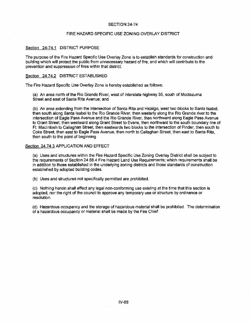
SECTION 24-74
FIRE HAZARD SPECIFIC USE ZONING OVERLAY DISTRICT
Section 24-74.1 DISTRICT PURPOSE
The purpose of the Fire Hazard Specific Use Overlay Zone is to establish standards for construction and building which will protect the public from unnecessary hazard of fire, and which will contribute to the prevention and suppression of fires within that district.
Section 24.74.2 DISTRICT ESTABLISHED
The Fire Hazard Specific Use Overlay Zone is hereby established as follows:
(a) An area north of the Rio Grande River, west of interstate highway 35, south of Moctezuma Street and east of Santa Rita Avenue; and
(b) An area extending from the intersection of Santa Rita and Hidalgo, west two blocks to Santa Isabel, then south along Santa Isabel to the Rio Grande River, then westerly along the Rio Grande river to the intersection of Eagle Pass Avenue and the Rio Grande River, then northward along Eagle Pass Avenue to Grant Street, then westward along Grant Street to Evans, then northward to the south boundary line of Ft. Macintosh to Callaghan Street, then eastwards two blocks to the intersection of Pinder, then south to Coke Street, then east to Eagle Pass Avenue, then north to Callaghan Street, then east to Santa Rita, then south to the point of beginning.
Section 24.74.3 APPLICATION AND EFFECT
(a) Uses and structures within the Fire Hazard Specific Use Zoning Overlay District shall be subject to the requirements of Section 24.68.4 Fire Hazard Land Use Requirements; which requirements shall be in addition to those established in the underlying zoning districts and those standards of construction established by adopted building codes.
(b) Uses and structures not specifically permitted are prohibited.
(c) Nothing herein shall affect any legal non-conforming use existing at the time that this section is adopted, nor the right of the council to approve any temporary use or structure by ordinance or resolution.
(d) Hazardous occupancy and the storage of hazardous material shall be prohibited. The determination of a hazardous occupancy or material shall be made by the Fire Chief.
IV-88

Section 24.7 4.4 Construction Standards
Occupancy Permissable Sprinklers Exterior Wall Interior Fire required Roofing 1 Use Type Construction (Y or N) Rating Separation Materials
Single Family Residential R(3) I-VI2.s N Table BOO n/a A&B
Duplex R(3) 1-VI2'5 N Table600 1 hr. A&B
Triplex R(3) 1-V12'5 N Table600 1 hr. A&B
Accessory to single family or duplex I-VI N Table BOO n/a A&B structures
Multifamily Dwelling R(2) 1-V12'5 Ns.s Table BOO 1 hr. A&B
Boardingfrooming houses R(1) 1-V12'5 N4.s Table BOO 1 hr. A&B
Hotels/motels R(1) I-VI2'5 N4.s Table BOO 1 hr. A&B
Hospitals. hospices I 1-V12'5 y' 2 hrs. 2 hrs. A&B
Schools, public or private E I-Vf·5 N' 2 hrs. 2 hrs. A&B
Non-residential office/retail structure< Business/ I-VI2,s Ns,s Table BOO 1 hr. A&B 5,000 square feet Nlercantile
Non-residential office/retail use Business/ I-VI2.s N' Table600 1 hr. A&B structure> 5,000 square feet Mercantile
warehouse!Storage Storage I·V Y' 2 hrs. 2 hrs. A&B
Ropa Usada Business/
1-V y 2 hrs. 2 hrs. A&B Storage
Theater with stage Group A-1 1-Vf·5 y' 2 hrs. 2 hrs. A&B Large
Civic, social, religious, recreation GroupA-2 1-VI2·5 Ns,7 Table600 2 hrs. A&B
Small
1 A- Standard Building Code Table 706.2 1 B- Standard BuildinQ Code Table 706.3 2 Standard Building Code Table 600- reference notes 3 Standard Building Code Table 901.7.6
4 Standard Buildino Code Table 901.7.5 5 Standard Buildina Code Table 400 6 Standard Buildina Code Table 901.7.1 7 Standard BuildinQ Code Table 901.7.2
Section 24.74.5 APPEALS
Appeals or requests for variances to the standards established herein shall be to the Building Standards Board, whose decision shall be final.
IV-89
LAREDO LAND DEVELOPMENT CODE
CHAPTER 24
ARTICLE V
PERFORMANCE STANDARDS
SECTION 24-77 ZONING DISTRICT DIMENSIONAL STANDARDS (11/22/93, 93-O-227; 9/22/97, 97-O-214;
5/5/99, 99-O-091; 2000-O-052, 3/6/00; 2001-O-036, 2/5/01; 03-O-217, 9/15/03; 2004-O-57, 7/6/04; 2008-O-084,
4/21/08; 2010-O-084, 7/6/10; 9/21/15, 2015-O-126) ....................................................................................................................V-1
SECTION 24-78 OFF-STREET PARKING & LOADING (11/8/2010, 2010-O-166; 8/15/2011, 2011-O-106;
06/02/14, 2014-O-065; 2016-O-174,12/22/16) ................................................................................. V-4
SECTION 24-79 FENCING REGULATIONS (93-O-229, 11/22/93)............................................................... V-62
SECTION 24-80 SUBDIVISION WITHIN THE EXTRATERRITORIAL JURISDICTION MODEL SUBDIVISION RULES (96-O-007, 1/22/96; 2000-O-107, 5/01/00; 02-O-025, 02/11/02; 2012-O-158, 9/17/12) ....V-63
SECTION 24-82 SIGNS & OUTDOOR ADVERTISING (94-O-035, 4/4/94; 97-O-021, 1/27/97; 98-O-196, 8/3/98;
2002-O-172, 08/05/02; REPEALED 2012-O-111, 9/4/12) ..................................................................... V-69 SECTION 24-83 LANDSCAPING REQUIREMENTS (98-253-98, 10/19/98) ................................................ V-70
SECTION 24-84 AD VALOREM TAX EXEMPTIONS FOR CERTIFIED HISTORIC REHABILITATION PROJECTS .............................................................................................................. V-76
SECTION 24-85 SIDEWALK STANDARDS (95-O-123, 6/19/95; 2001-O-037, 2/5/2001; 2015-O-126, 9/21/15) ................. V-80
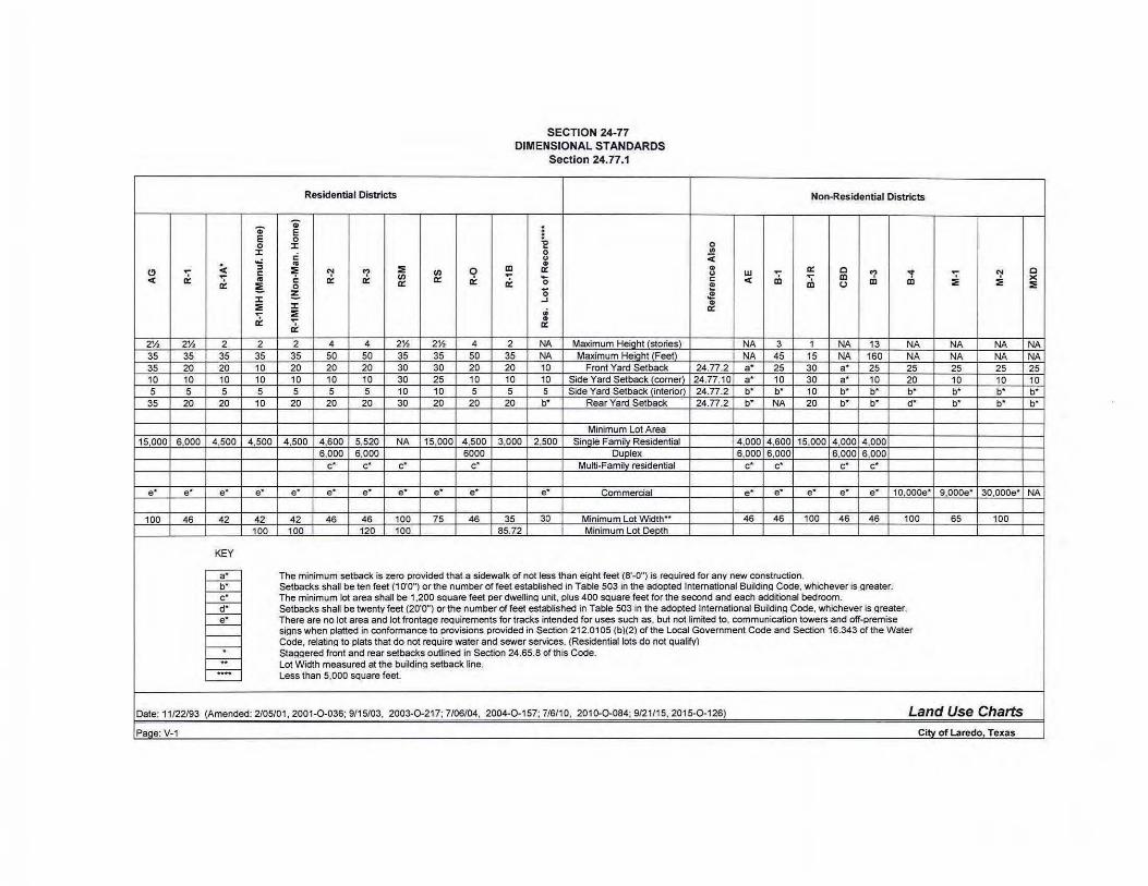
.., E 0 J: ...:
(!) .... < :::1
a: ' c
< .. a: ~
J: ~ .... a:
2Yz 2Yz 2 2 35 35 35 35 35 20 20 10 10 10 10 10 5 5 5 5
35 20 20 10
15.000 6.000 4,500 4,500
e· e· e· e•
100 46 42 42 100
KEY
~ f----b;-~ f---d;-~ t---=--t--t--;-f-;;-f-;;;;-'----
SECTION 24-77 DIMENSIONAL STANDARDS
Section 24.77.1
Residentia l Districts Non-Residential Districts
.., . E i 0 J: "E 0
0 .,
.: u < .. C>
~ ~ '1 ~ (/) Q Ill 0:: .. .... a: 0 "'t c (/) .... u w m ;;; Ill '1 a: a: a: 0:: a: 0 c < Ill Ill 0 a: ~ u ~ 0 J!! ..J .. J: ... a: ~
~ .. 0::
2 4 4 2Yz 2Y, 4 2 NA Maximum Height (stories) NA 3 1 NA 13 NA 35 50 50 35 35 50 35 NA Maximum Height (Feet) NA 45 15 NA 160 NA 20 20 20 30 30 20 20 10 Front Yard Setback 24.77.2 a• 25 30 a• 25 25 10 10 10 30 25 10 10 10 Side Yard Setback (corner) 24.77.10 a• 10 30 a• 10 20 5 5 5 10 10 5 5 5 Side Yard Setback (interior) 24.77.2 b• b' 10 b' b' b'
20 20 20 30 20 20 20 b' Rear Yard Setback 24.77.2 b' NA 20 b' b' d'
Minimum Lot Area 4,500 4,600 5,520 NA 15,000 4 500 3.000 2.500 SinQie Family Residential 4,000 4,600 15,000 4,000 4,000
6,000 6,000 6000 Duplex 6,000 6,000 6,000 6,000 c• c• c• c· Mu~i-Family residential c• c• c• c•
e• e• e• e• e• e• e• Commercial e• e• e• e• e• 10.000e'
42 46 46 100 75 46 35 30 Minimum Lot Width .. 46 46 100 46 46 100 100 120 100 85.72 Minimum Lot Depth
The minimum setback is zero provided that a sidewalk of not less than eiQht feet (8'-0") is required for any new construction. Setbacks shall be ten feet (1 0'0") or the number of feet established in Table 503 in the adopted International Buildin!l Code. whichever is Qreater. The minimum lot area shall be 1.200 sQuare feet per dwellinQ un~. plus 400 SQuare feet for the second and each additional bedroom. Setbacks shall be twenty feet (20'0") or the number of feet established in Table 503 in the adopted International BuildinQ Code, whichever is Qreater. There are no lot area and lot fronta!le reQuirements for tracks intended for uses such as. but not lim~ed to. communication towers and off-premise siQns when platted in conformance to provisions provided in Section 212.01 OS (b)(2) of the Local Government Code and Section 16.343 of the Water Code. relatin!l to plats that do not reQuire water and sewer services. (Residential lots do not Qualify) Sta(lQered front and rear setbacks outlined in Section 24.65.8 of this Code. Lot Width measured at the buildin!l setback line. Less than 5.000 sQuare feet.
.... ~ :E ~
NA NA NA NA 25 25 10 10 b' b' b' b'
9.oooe· JO,oooe•
65 100
Date: 11/22/93 (Amended: 2/05/01, 2001-0-036; 9/15/03, 2003-0 -21 7; 7/06/04, 2004-0-157; 7/6/10, 2010-0-084; 9/21/15, 2015-0-126) Land Use Charts Page: V-1 City of Laredo Texas
0 )(
~
NA NA 25 10 b' b'
NA
SECTION 24-77
DIMENSIONAL STANDARDS
Section 24.77.2 SUPPLEMENTARY PROVISIONS
(1) Where the rear yard of a commercial or industrial building abuts a public street or alley a rear yard setback of not less than ten (10) feet is required .
(2) The minimum lot width shall be measured at the front building setback line. In no event shall the lot width at the property line be less than twenty-four feet.
(3) In cases where the height of a proposed structure on a lot abutting a more restricted district is greater than that allowed in the more restricted district, then the minimum side and/or rear yard requirements for the structure in the less restricted district shall be increased by one foot for every two feet in height that the proposed structure exceeds the height requirement in the more restricted district up to a maximum of fifty feet ("50'-0").
(4) In the areas defined as the CBD (Central Business District) or the AE (Arts and Entertainment District), no front building set-back is required, provided however, that an eight foot (8'-0") unobstructed sidewalk shall be required for all new construction . Side or rear building setbacks shall not be required, except as required by Table 503 of the International Building Code.
(5) Minimum lot area and width applies to all conversions and new construction. Setback and off-street parking requirements shall be met in all cases . (AMENDED: Ordinance No. 86-0-078, 5/5186)
(6) The Commission may modify the front and rear yard requirements of this ordinance, but only in the subdivision approval process, provided that all parking requirements are met.
(7) Height Requirements:
(a) The height regulations prescribed herein shall not apply to television and radio towers, church spires, belfries, monuments, water tanks, chimneys, or smokestacks and flag poles.
(8) Front Yard Setback Requirements:
(a) When existing buildings have been built closer to the front property line than the minimum requirements, a new building, or building extension may have a front yard setback requirement equal to the average depth of the existing structures along that block front, but not closer to the property line than fifty (50) percent of the front yard requirement of this Section.
(b) A porch, carport, or upper floor balcony, not enclosed (all sides open with walls not higher than three (3) feet) , or similar terraces, porches, balconies, or chimneys may project into the front yard but not closer to the front property line than fifty (50) percent of the front yard setback requirement of this Section.
(c) Filling station pumps, pump islands, and accessory buildings may be located within a required yard provided they are not less than fifteen (15) feet from any street right-of-way line. Filling station pumps and pump islands shall not be closer than one hundred (100) feet from any residential district. The requirements of this subsection shall apply within the AE (Arts and Entertainment District) and the CBD (Central Business District).
(9) Side Yard Setback Requirements
(a) No accessory buildings shall be located less than two and one-half (2 1/2) feet from the side lot line.
V-2
(b) A carport, canopy, awning, other window shading, roof eaves or upper floor balcony, may extend into the required side yard if it is unenclosed and not less than two and one-half (2 1/2) feet from any side lot line. Outside unenclosed stairways, enclosed porches, chimneys, or other solid projections shall_not be located less than five (5) feet from the side lot line.
( 1 0) No garage or carport which receives access from the side yard on any corner lot shall be located less than twenty feet (20'-0") from the property line.
(11 ) Rear Yard Setback Requirements
(a) Residential garages which are accessed from an alley located along the rear of the property shall be not less than eighteen (18) feet from the alley. No accessory building shall be less than two and one-half (2 1/2) feet from the rear property line.
(b) A porch, carport, or upper floor balcony, not enclosed (all sides open with walls not higher than three (3) feet), or similar terraces, porches, balconies, or chimneys may project into the rear yard but not closer to the rear property line than fifty (50) percent of the rear yard setback requirement of this Section.
(c) Fire escapes and outside unenclosed stairways may project up to five (5) feet into a rear yard requirement.
(12) Development requirements pertaining to land near existing oil and gas wells and related storage facilities. No structure, including any public or private parking areas, shall be located within two hundred (200) feet from the vicinity of any existing wellhead or related facility used for the storage of oil , natural gas, or hydrocarbons. For all transmission lines of four (4) inches and greater in diameter, a fifty (50) feet no build zone shall be required and shall be based on a twenty-five (25) feet center line from the outermost edge of the transmission lines.
V-3
SECTION 24-78
OFF-STREET PARKING & LOADING REQUIREMENTS
24-78.1 PURPOSE
The purpose of this section is to provide the standard specifications required for the design and layout of off-street parking facilities in the City of Laredo. Said specifications are intended to provide for the minimum adequate level of internal vehicular movement and maneuvering, ingress and egress, and patron security and convenience .
24-78.2 GENERAL REQUIREMENTS
(a) COMMERCIAL PARKING
The general requirements for commercial off-street parking and loading facilities are as follows:
(1 ) Commercial parking lots whether required by the provisions of this ordinance or not, shall be provided in accordance with the provisions of this section. Specifically, any outdoor space, or uncovered plot, place, lot, parcel, yard or enclosure or any portion thereof, where one or more vehicles may be parked, stored, housed or kept, for which any fee is made or which is used for the parking of non-commercial vehicles by the patrons, employees, or residents of businesses or commercial establishments or multi-family dwellings, or which is for the use of trailers, connected to tractors or not, or any other type of commercial vehicle (commercial parking lot) shall be paved and marked in accordance with subsection (e) of this Section.
(2) A building permit is required for the construction of a commercial off-street parking (commercial parking lot) if a building permit is not otherwise required for a building on the same tract, block or lot as the commercial parking lot. Construction plans for a commercial parking lot shall be submitted along with each application for a building permit for construction that includes a commercial parking lot. (AMENDED: Ordinance No. 90-0-88, 5/21/90)
(3) Whenever a building or structure is constructed or its use is changed or its use enlarged by an increase in floor area, number of employees, number of dwelling units, seating capacity, or otherwise creating a need for an increase in the number of existing parking spaces, additional parking spaces shall be provided on the basis of the enlargement or change in compliance with this section. (AMENDED: Ordinance No. 90-0-88, 5/21/90)
(4) All site plans submitted as part of an application for a building permit for a business shall include a parking plan. All construction plans for commercial parking lots shall include the proposed markings and paving material to be used. The site plan and construction plan for a commercial parking lot shall be made a part of the building permit upon the granting thereof. Failure to construct a commercial parking lot in accordance with the site plan and construction plan approved with the building permit shall be deemed a violation of this Section. (AMENDED: Ordinance No. 90-0-88, 5121190)
(5) The number of required parking spaces shall be calculated based on existing or proposed uses on site, both principle and accessory, and shall be calculated in accordance with their respective formulas, as stipulated in 24-78.3, entitled Parking Space Formulas.
(6) Up to Fifty percent (50%) of the minimum required parking spaces as calculated in 5 above may be offset if the principle and accessory uses provide valet parking during times of operation provided that the total number of spaces on-site and valet facility cumulatively meets or exceeds the minimum required spaces. (AMENDED: Ordinance No. 2011-0..023, 2122111)
(7) Where the number of parking spaces required is based on occupancy loads, those loads shall be calculated according to Table 1004.1.1 of the International Building Code 2009.
V-4
V-5
(8) Facilities owned or operated by the City of Laredo shall be exempt from all provisions contained in Laredo Land Development Code, Section 24-78, entitled Off Street Parking and Loading requirements.
(b) CENTRAL BUSINESS DISTRICT AND ARTS AND ENTERTAINMENT DISTRICT EXEMPTIONS
Although encouraged to consider off-street parking for their customers and residents in their planning, customer and resident off-street parking is not a requirement of the individual businesses or residential uses located within the Central Business District and the Arts and Entertainment District. However, if such off-street parking is provided, it shall be constructed in accordance with the provisions of Section 24-78.
(c) PARKING SPACE DIMENSIONAL REQUIREMENTS
(1) Parking space dimensional requirements shall be as indicated in Ordinance 90-O-107, entitled Parking Layout and Design Standards for Parking Lots, unless otherwise herein indicated. In cases of conflicting requirements, the stricter standard shall apply. (2) When off-street parking facilities are located adjacent to a public alley, one-half of the width of said alley may be assumed to be a portion of the maneuvering space requirements. (3) The dimensional standards for parking spaces required of single family dwellings, mobile homes, and duplexes, shall be eight (8) feet wide and sixteen (16) feet long. Stacking of spaces directly behind another and/or using concrete runners 2’ wide for each tire track, is permitted. All spaces for single family dwellings and duplexes shall be paved with concrete or brick.
(d) LOADING SPACE REQUIREMENTS AND DIMENSIONS A loading space shall have minimum dimensions of not less than ten (10) feet with apron and total offset as set forth in Ordinance # 90-0-107 (Layout and Design Standards for Parking Lots), and a height of clearance of not less than fifteen (15) feet. One off-street loading space shall be provided and maintained on the same lot for every separate occupancy requiring pick-up and delivery of goods and having a modified gross floor area of over 5,000 square feet. One loading space shall be provided for each additional 20,000 square feet or major fraction thereof. For those businesses not required to have a loading space, any loading space constructed shall comply with minimum dimensions listed above. (AMENDED: Ordinance No. 92-O-138, 7/6/92) (e) PAVING
(1) COMMERCIAL PARKING LOTS - All commercial parking lots specified under the Zoning Ordinance shall be paved in accordance with the specifications and standards set forth in the Zoning and other Ordinances of the City of Laredo, including but not limited to those standards set forth in Ordinance # 90-O-107 (Parking Layout and Design and Standards for Parking Lots.) The parking lanes, and spaces, shall be clearly marked by traffic paint, buttons or other materials (meeting specifications and standards set forth by the Texas Department of Highways as minimum standards for the suitability of such materials for the herein described purposes). Paving plans shall be a part of the building permit, and failure to construct paved parking in accordance with the building permit shall be a violation of this ordinance. (2) DEAD STORAGE PARKING LOTS - Where the sole purpose of a commercial parking lot is dead storage, and the parking lot does not abut a residential district or development paving shall be provided in the following manner: There shall be a concrete apron at the entrance of the parking lot, concrete landing pads shall be provided and all unpaved areas shall be covered in caliche.
A concrete apron will be provided at the entrance of the parking lot, concrete landing pads shall be provided, unpaved areas shall be covered in caliche and treated with oil or an oil base compound not less than once a year and a solid opaque wall no less than ten (1 0) feet in height shall be erected around the parking lot.
(3) TIME LIMITATIONS AND COMPLIANCE- All commercial parking lots, not presently in compliance with this Ordinance, and subject to the Parking Space Requirements set forth in Section 24-78 (p) (2), (3), (4), (5), and (6) of the Zoning Ordinance or commercial parking lots for which any fee is made or commercial parking lots which abut a residential district or development, shall be required to comply with the provisions of this Ordinance within one year from the effective date of this Ordinance. All other commercial parking lots shall be required to comply with this Ordinance within five (5) years at the rate of twenty (20) percent per year.
(f) DRAINAGE
All parking and loading areas shall provide for proper drainage of surface water to prevent ponding and the drainage of such water onto adjacent properties or walkways.
(g) MAINTENANCE
The owner of property used for parking and/or loading shall maintain such area in good condition without holes and free of all dust, trash, and other debris.
(h) LIGHTING
Any tract, block, or lot, or portion or portions thereof used for parking of vehicles for a fee or used for parking of vehicles by patrons of business or commercial establishment (commercial parking lot) if and when used during non-daylight hours shall illuminated such that the marking thereon is visible from the inside of an automobile parked thereon. Any lights used to illuminate a commercial parking lot shall be so arranged as to deflect the light away from adjoining residential property. (As amended 5/21/90, Ord. # 90-0-88)
(i) LOCATION OF PARKING SPACES
The following regulations shall govern the location of off- street parking spaces and areas:
(1) Parking spaces for all detached residential dwellings shall be located on the same lot as the use which they are intended to serve.
(2) Parking spaces for apartments, dormitories, or similar residential uses shall be located not more than 300 feet from the principal use. Measurement shall be from the property line of the primary use to the driveway of the parking lot using definable pedestrian corridors and street crossings at designated crosswalks.
(3) Parking spaces for commercial, industrial, or institutional uses shall be located not more than 1000 feet from the principal use. Said 1000 feet shall be measured from the driveway entrance of the principal use to the driveway entrance of the parking lot using definable pedestrian corridors and street crossings at designated crosswalks. (As amended 2122111, Ord. # 2011-0-023)
(4) Where an increase in the number of parking spaces is required by a change in use or enlargement, or where such spaces are provided collectively or used jointly by two or more activities or establishments, the required space may be located not to exceed 1000 feet from the principle use. Measurement shall be made in the manner established in 3 above. (As amended 2122111 , Ord. # 2011-0-023)
(5) No required parking areas can be provided for in a manner that will only be temporary. The business must have an interest (i.e., a lease agreement which shall be renewed or verified on an
V-6

annual basis as a condition of authorization to continue the business and shall be in effect until the uses cease, title, or legal share) in off-premises parking. (As amended 2122111 , Ord. # 2011-0-023)
(6) In the R-0 District, parking areas shall not be located in a manner that would destroy landscaping, such as trees, shrubs, lawns. In order to accomplish this, the parking space requirements of Section 24-78 (p) may be modified by up to twenty-five (25) percent, and maneuvering space may be waived.
U) DISABLED VEHICLES
The parking of a non-operable vehicle shall not be permitted on public rights-of-way. These vehicles shall not be stored on any lot unless it is stored in an enclosed garage or other accessory building.
(k) JOINT USE OF PARKING SPACES (ON-SITE)
Two or more non-residential uses may jointly, having cooperatively entered into a recorded written agreement or contract to be in effect until the uses cease, provide and use parking spaces when their hours of operation do not overlap (meaning none of the uses sharing the facilities require the off-street parking facilities at the same time).
(I) WHEEL BLOCKS
Whenever a parking lot extends to a property line, wheel blocks or other suitable devices shall be installed to prevent any part of a parked vehicle from extending beyond the property line.
(m) ACCESS AND MANEUVERING SPACE REQUIREMENTS
All parking areas, excluding single family or two family residences, shall be designed in such a manner that any vehicle leaving the parking area shall be traveling in a forward motion. Maneuvering space dimension shall be as provided in Section 24-78 (c) of this Section, and shall be off the public right-of-way. Access driveways for parking areas or loading spaces shall be located in such a way that any vehicle entering or leaving such area shall be clearly visible for a reasonable distance to any pedestrian or motorist approaching the access or driveway from a public or private street.
(n) WIDTH OF ACCESS DRIVEWAY IN BUSINESS AND INDUSTRIAL DISTRICTS
The entrances and exits to the parking area shall be clearly marked. Entranceways or exits shall maintain the following minimum standards:
(1) For one-way traffic, a minimum width of fourteen (14) feet is required.
(2) Access driveways for two-way traffic shall have a minimum width of twenty four (24) feet, but not to exceed thirty (30) feet.
(3) Parking areas having more than one aisle or driveway shall have directional signs or marking in each aisle or driveway.
(4) On corner lots, in business or industrial districts, driveways shall be at least fifty (50) feet from the property corner nearest the intersection.
(o) PARKING AREAS- MODIFICATIONS The Board may authorize or appeal a modification, reduction , or waiver of all of these parking requirements, except that when there is a change in use in a B-1 or B-3 district (when such a new use requires additional parking), said additional parking requirements shall not be waived or reduced, nor shall maneuvering space requirements be waived or reduced, where access is to those major streets listed on the current, functional classification map of the City, unless in the R-0 District. In no case shall there be
V-7
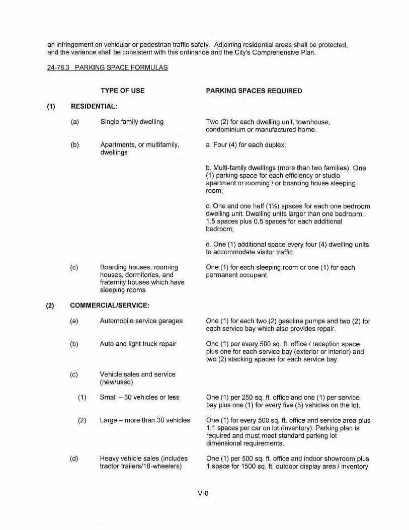
an infringement on vehicular or pedestrian traffic safety. Adjoining residential areas shall be protected, and the variance shall be consistent with this ordinance and the City's Comprehensive Plan.
24-78.3 PARKING SPACE FORMULAS
TYPE OF USE
(1) RESIDENTIAL:
(a)
(b)
(c)
Single family dwelling
Apartments, or multifamily, dwellings
Boarding houses, rooming houses, dormitories, and fraternity houses which have sleeping rooms
(2) COMMERCIAL/SERVICE:
(a) Automobile service garages
(b) Auto and light truck repair
(c) Vehicle sales and service (new/used)
( 1)
(2)
(d)
Small- 30 vehicles or less
Large- more than 30 vehicles
Heavy vehicle sales (includes tractor trailers/18-wheelers)
PARKING SPACES REQUIRED
Two (2) for each dwelling unit, townhouse, condominium or manufactured home.
a. Four (4) for each duplex;
b. Multi-family dwellings (more than two families). One (1) parking space for each efficiency or studio apartment or rooming I or boarding house sleeping room;
c. One and one half (1%) spaces for each one bedroom dwelling unit. Dwelling units larger than one bedroom: 1.5 spaces plus 0.5 spaces for each additional bedroom;
d. One (1) additional space every four (4) dwelling units to accommodate visitor traffic.
One ( 1) for each sleeping room or one ( 1) for each permanent occupant.
One (1) for each two (2) gasoline pumps and two (2) for each service bay which also provides repair.
One (1) per every 500 sq. ft. office I reception space plus one for each service bay (exterior or interior) and two (2) stacking spaces for each service bay.
One (1) per 250 sq. ft. office and one (1) per service bay plus one (1) for every five (5) vehicles on the lot.
One (1) for every 500 sq. ft. office and service area plus 1.1 spaces per car on lot (inventory). Parking plan is required and must meet standard parking lot dimensional requirements.
One (1) per 500 sq. ft. office and indoor showroom plus 1 space for 1500 sq. ft. outdoor display area I inventory
V-8
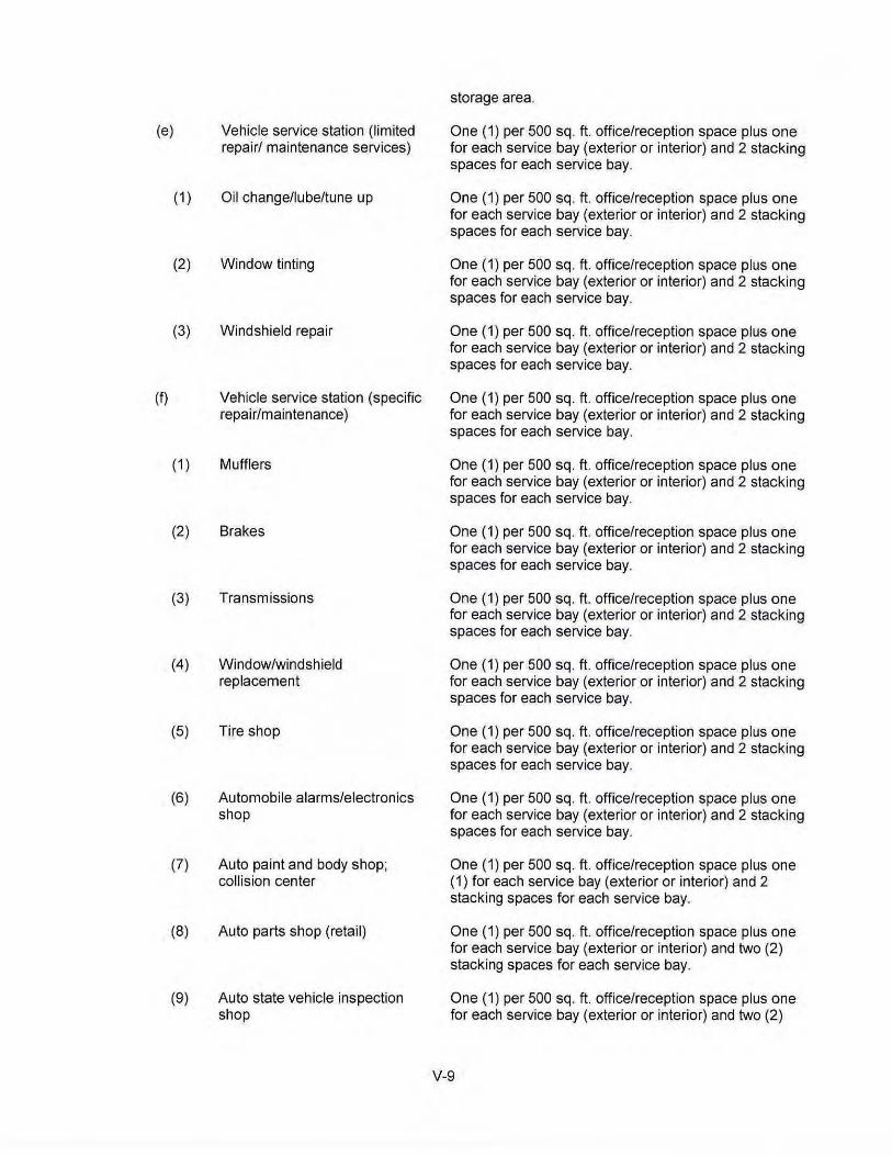
storage area.
(e) Vehicle service station (limited One (1) per 500 sq. ft. office/reception space plus one repair/ maintenance services) for each service bay (exterior or interior) and 2 stacking
spaces for each service bay.
( 1) Oil change/lube/tune up One (1) per 500 sq. ft. office/reception space plus one for each service bay (exterior or interior) and 2 stacking spaces for each service bay.
(2) Window tinting One (1) per 500 sq. ft. office/reception space plus one for each service bay (exterior or interior) and 2 stacking spaces for each service bay.
(3) Windshield repair One (1) per 500 sq. ft. office/reception space plus one for each service bay (exterior or interior) and 2 stacking spaces for each service bay.
(f) Vehicle service station (specific One (1) per 500 sq. ft. office/reception space plus one repair/maintenance) for each service bay (exterior or interior) and 2 stacking
spaces for each service bay.
(1) Mufflers One (1) per 500 sq. ft. office/reception space plus one for each service bay (exterior or interior) and 2 stacking spaces for each service bay.
(2) Brakes One (1) per 500 sq. ft. office/reception space plus one for each service bay (exterior or interior) and 2 stacking spaces for each service bay.
(3) Transmissions One (1) per 500 sq. ft. office/reception space plus one for each service bay (exterior or interior) and 2 stacking spaces for each service bay.
(4) Window/windshield One (1) per 500 sq. ft. office/reception space plus one replacement for each service bay (exterior or interior) and 2 stacking
spaces for each service bay.
(5) Tire shop One (1) per 500 sq. ft. office/reception space plus one for each service bay (exterior or interior) and 2 stacking spaces for each service bay.
(6) Automobile alarms/electronics One (1) per 500 sq. ft. office/reception space plus one shop for each service bay (exterior or interior) and 2 stacking
spaces for each service bay.
(7) Auto paint and body shop; One ( 1) per 500 sq. ft. office/reception space plus one collision center ( 1) for each service bay (exterior or interior) and 2
stacking spaces for each service bay.
(8) Auto parts shop (retail) One (1) per 500 sq. ft. office/reception space plus one for each service bay (exterior or interior) and two (2) stacking spaces for each service bay.
(9) Auto state vehicle inspection One (1) per 500 sq. ft. office/reception space plus one shop for each service bay (exterior or interior) and two (2)
V-9
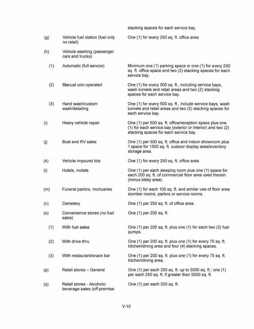
(g) Vehicle fuel station (fuel only no retail)
(h) Vehicle washing (passenger cars and trucks)
(i)
(k)
(I)
( 1)
(2)
(3)
(m)
(n)
(o)
( 1)
(2)
(3)
(p)
(q)
Automatic (full-service)
Manual coin-operated
Hand wash/custom wash/detailing
Heavy vehicle repair
Boat and RV sales
Vehicle impound lots
Hotels, motels
Funeral parlors, mortuaries
Cemetery
Convenience stores (no fuel sales)
With fuel sales
With drive-thru
With restauranVsnack bar
Retail stores - General
Retail stores - Alcoholic beverage sales (off-premise
stacking spaces for each service bay.
One (1) for every 250 sq. ft. office area.
Minimum one (1) parking space or one (1) for every 250 sq. ft. office space and two (2) stacking spaces for each service bay.
One ( 1) for every 500 sq. ft., including service bays, wash tunnels and retail areas and two (2) stacking spaces for each service bay.
One (1) for every 500 sq. ft., include service bays, wash tunnels and retail areas and two (2) stacking spaces for each service bay.
One ( 1) per 500 sq . ft. office/reception space plus one (1) for each service bay (exterior or interior) and two (2) stacking spaces for each service bay.
One (1) per 500 sq. ft. office and indoor showroom plus 1 space for 1500 sq. ft. outdoor display area/inventory storage area.
One (1) for every 250 sq. ft. office area.
One ( 1) per each sleeping room plus one ( 1) space for each 200 sq. ft. of commercial floor area used therein (minus lobby area).
One (1) for each 100 sq. ft. and similar use of floor area slumber rooms, parlors or service rooms.
One (1) per 250 sq. ft. of office area.
One (1) per 200 sq. ft.
One (1) per 200 sq. ft. plus one (1) for each two (2) fuel pumps.
One (1) per 200 sq. ft. plus one (1) for every 75 sq. ft. kitchen/dining area and four (4) stacking spaces.
One (1) per 200 sq . ft. plus one (1) for every 75 sq. ft. kitchen/dining area.
One (1) per each 200 sq. ft. up to 5000 sq . ft .; one (1) per each 250 sq. ft. if greater than 5000 sq. ft.
One (1) per each 200 sq. ft.
V-10
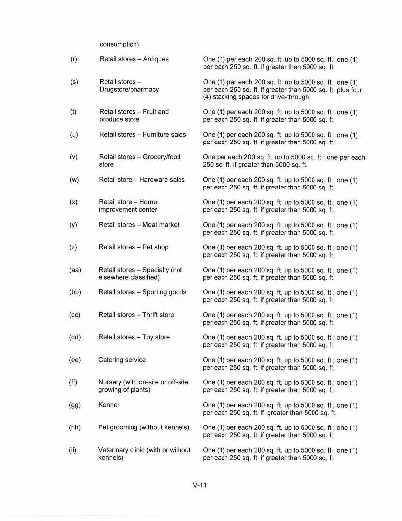
consumption)
(r) Retail stores- Antiques One (1) per each 200 sq. ft. up to 5000 sq. ft.; one (1) per each 250 sq. ft. if greater than 5000 sq. ft .
(s) Retail stores - One (1) per each 200 sq. ft. up to 5000 sq. ft. ; one (1) Drugstore/pharmacy per each 250 sq. ft. if greater than 5000 sq. ft. plus four
(4) stacking spaces for drive-through.
(t) Retail stores- Fruit and One (1) per each 200 sq. ft. up to 5000 sq. ft .; one (1) produce store per each 250 sq. ft. if greater than 5000 sq. ft.
(u) Retail stores- Furniture sales One (1) per each 200 sq. ft. up to 5000 sq. ft.; one (1) per each 250 sq. ft. if greater than 5000 sq. ft.
(v) Retail stores - Grocery/food One per each 200 sq. ft. up to 5000 sq. ft.; one per each store 250 sq. ft. if greater than 5000 sq. ft.
(w) Retail store - Hardware sales One (1) per each 200 sq. ft. up to 5000 sq. ft.; one (1) per each 250 sq. ft. if greater than 5000 sq. ft.
(X) Retail store - Home One (1) per each 200 sq. ft. up to 5000 sq. ft.; one (1) improvement center per each 250 sq. ft. if greater than 5000 sq. ft.
(y) Retail stores - Meat market One (1) per each 200 sq. ft. up to 5000 sq. ft.; one (1) per each 250 sq . ft. if greater than 5000 sq. ft.
(z) Retail stores - Pet shop One (1) per each 200 sq. ft. up to 5000 sq. ft.; one (1) per each 250 sq. ft. if greater than 5000 sq. ft.
(aa) Retail stores- Specialty (not One (1) per each 200 sq. ft. up to 5000 sq. ft.; one (1) elsewhere classified) per each 250 sq. ft. if greater than 5000 sq. ft.
(bb) Retail stores -Sporting goods One (1) per each 200 sq. ft. up to 5000 sq. ft.; one (1) per each 250 sq. ft. if greater than 5000 sq. ft.
(cc) Retail stores -Thrift store One (1) per each 200 sq. ft. up to 5000 sq. ft.; one (1) per each 250 sq. ft. if greater than 5000 sq. ft.
(dd) Retail stores - Toy store One (1) per each 200 sq. ft. up to 5000 sq. ft.; one (1) per each 250 sq . ft. if greater than 5000 sq. ft.
(ee) Catering service One (1) per each 200 sq. ft. up to 5000 sq. ft.; one (1) per each 250 sq . ft. if greater than 5000 sq. ft.
(ff) Nursery (with on-site or off-site One (1) per each 200 sq. ft. up to 5000 sq. ft.; one (1) growing of plants) per each 250 sq. ft. if greater than 5000 sq. ft.
(gg) Kennel One (1) per each 200 sq. ft. up to 5000 sq. ft.; one (1) per each 250 sq. ft. if greater than 5000 sq. ft.
(hh) Pet grooming (without kennels) One (1) per each 200 sq. ft. up to 5000 sq. ft .; one (1) per each 250 sq. ft. if greater than 5000 sq. ft.
(ii) Veterinary clinic (with or without One (1) per each 200 sq. ft. up to 5000 sq. ft.; one (1) kennels) per each 250 sq. ft. if greater than 5000 sq. ft.
V-11

UD Veterinary hospital One (1) per each 200 sq. ft. up to 5000 sq. ft. ; one (1) per each 250 sq. ft. if greater than 5000 sq. ft.
(kk) Banks, financial institutions One (1) for each 200 sq. ft. of floor area plus eight (8) stacking spaces for each drive-thru service lane; two (2) stacking spaces per ATM.
(II) Pawn shop One (1) per each 200 sq. ft. up to 5000 sq. ft.; one (1) per each 250 sq. ft. if greater than 5000 sq. ft.
(mm) Martial arts studio One ( 1) per each 200 sq. ft.
(nn) Dance/Gymnastics/Performing One ( 1) per each 200 sq. ft. arts studio
(oo) Barber or Beauty shop One ( 1) per each 200 sq. ft.
(pp) Dry cleaning One ( 1) per each 200 sq. ft. plus two (2) stacking spaces for drive-through.
(qq) Offices One (1) for each 250 sq. ft. of floor area.
(rr) Medical Clinic (physician and/or One (1) for each 200 sq. ft. of floor area. dentist)
(ss) Medical Clinic (chiropractic) One (1) for each 200 sq. ft. of floor area.
(tt) Medical Clinic (physical One (1) for each 200 sq. ft. of floor area. therapy)
(uu) Medical Clinic (optometry) One (1) for each 200 sq . ft. of floor area.
(vv) Restaurants
( 1) Sit down restaurants Twelve (12) parking spaces per 1,000 sq. ft.
(2) Fast food (with or without drive- One ( 1) per each 200 sq. ft.; with drive-through add six through) (6) stacking spaces for each service lane.
(3) Carry-out restaurants (no One (1) parking space per 200 sq. ft. customer seating or dining area)
(ww) Flea markets One (1) parking space per booth plus one (1) parking space for each 2,000 sq. ft. of land area not used for parking.
(xx) Bed and Breakfast One (1) parking space for each guestroom plus one (1) parking space for the owner I occupant and one ( 1) space for each employee. Except for the driveway, the front yard shall not be used for parking in a Residential Office (R-0) District.
(yy) All other types of commercial One ( 1) for each 200 sq. ft. of business or commercial /service uses floor area uses permitted in any business district.
V-12
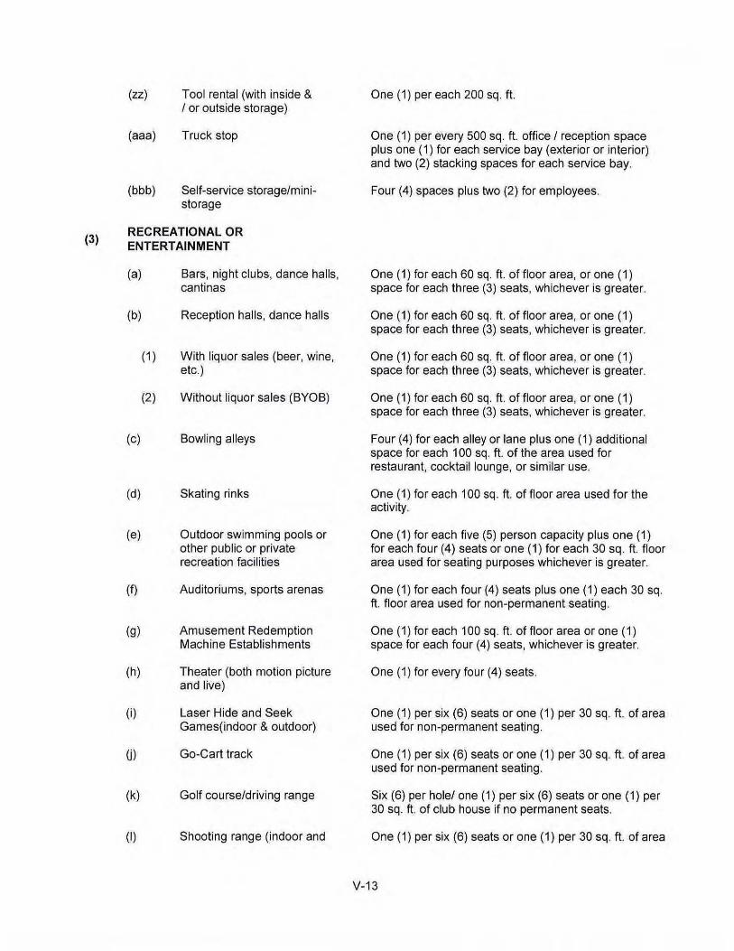
(zz) Tool rental (with inside & One(1)pereach200sq. ft I or outside storage)
(aaa) Truck stop One ( 1) per every 500 sq. ft. office I reception space plus one (1) for each service bay (exterior or interior) and two (2) stacking spaces for each service bay.
(bbb) Self-service storage/mini- Four (4) spaces plus two (2) for employees. storage
(3) RECREATIONAL OR ENTERTAINMENT
(a) Bars, night clubs, dance halls, One (1) for each 60 sq. ft. of floor area, or one (1) cantinas space for each three (3) seats, whichever is greater.
(b) Reception halls, dance halls One (1) for each 60 sq. ft. of floor area, or one (1) space for each three (3) seats, whichever is greater.
(1) With liquor sales (beer, wine, One (1) for each 60 sq. ft. of floor area, or one (1) etc.) space for each three (3) seats, whichever is greater.
(2) Without liquor sales (BYOB) One (1) for each 60 sq. ft. of floor area, or one (1) space for each three (3) seats, whichever is greater.
(c) Bowling alleys Four (4) for each alley or lane plus one (1) additional space for each 1 00 sq. ft. of the area used for restaurant, cocktail lounge, or similar use.
(d) Skating rinks One (1) for each 100 sq. ft. of floor area used for the activity.
(e) Outdoor swimming pools or One (1) for each five (5) person capacity plus one (1) other public or private for each four (4) seats or one (1) for each 30 sq. ft. floor recreation facilities area used for seating purposes whichever is greater.
(f) Auditoriums, sports arenas One ( 1) for each four ( 4) seats plus one ( 1) each 30 sq. ft. floor area used for non-permanent seating.
(g) Amusement Redemption One ( 1) for each 1 00 sq. ft. of floor area or one ( 1) Machine Establishments space for each four (4) seats, whichever is greater.
(h) Theater (both motion picture One ( 1) for every four ( 4) seats. and live)
(i) Laser Hide and Seek One (1) per six (6) seats or one (1) per 30 sq. ft . of area Games(indoor & outdoor) used for non-permanent seating.
U) Go-Cart track One ( 1) per six (6) seats or one ( 1) per 30 sq. ft. of area used for non-permanent seating.
(k) Golf course/driving range Six (6) per hole/ one ( 1) per six (6) seats or one ( 1) per 30 sq. ft. of club house if no permanent seats.
(I) Shooting range (indoor and One (1) per six (6) seats or one (1) per 30 sq. ft. of area
V-13
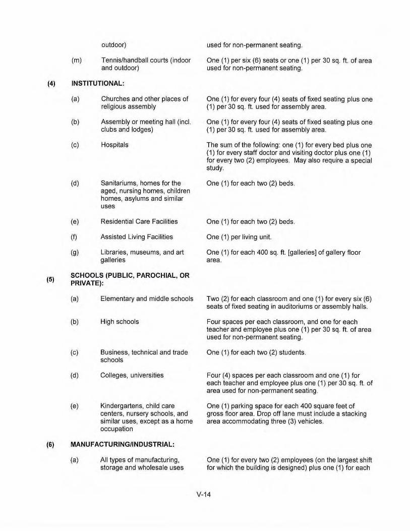
(m)
outdoor)
Tennis/handball courts (indoor and outdoor)
(4) INSTITUTIONAL:
(5)
(a)
(b)
(c)
(d)
(e)
(f)
(g)
Churches and other places of religious assembly
Assembly or meeting hall (incl. clubs and lodges)
Hospitals
Sanitariums, homes for the aged, nursing homes, children homes, asylums and similar uses
Residential Care Facilities
Assisted Living Facilities
Libraries, museums, and art galleries
SCHOOLS (PUBLIC, PAROCHIAL, OR PRIVATE):
(a)
(b)
(c)
(d)
(e)
Elementary and middle schools
High schools
Business, technical and trade schools
Colleges, universities
Kindergartens, child care centers, nursery schools, and similar uses, except as a home occupation
(6) MANUFACTURING/INDUSTRIAL:
(a) All types of manufacturing, storage and wholesale uses
used for non-permanent seating.
One ( 1) per six (6) seats or one ( 1) per 30 sq. ft. of area used for non-permanent seating.
One ( 1) for every four ( 4) seats of fixed seating plus one (1) per 30 sq. ft. used for assembly area.
One (1) for every four (4) seats of fixed seating plus one (1) per 30 sq. ft. used for assembly area.
The sum of the following: one (1) for every bed plus one (1) for every staff doctor and visiting doctor plus one (1) for every two (2) employees. May also require a special study.
One ( 1) for each two (2) beds.
One (1) for each two (2) beds.
One (1) per living unit.
One (1) for each 400 sq. ft. [galleries] of gallery floor area.
Two (2) for each classroom and one ( 1) for every six (6) seats of fixed seating in auditoriums or assembly halls.
Four spaces per each classroom, and one for each teacher and employee plus one (1) per 30 sq. ft. of area used for non-permanent seating.
One (1) for each two (2) students.
Four (4) spaces per each classroom and one (1) for each teacher and employee plus one (1) per 30 sq. ft. of area used for non-permanent seating.
One (1) parking space for each 400 square feet of gross floor area. Drop off lane must include a stacking area accommodating three (3) vehicles.
One (1) for every two (2) employees (on the largest shift for which the building is designed) plus one (1) for each
V-14

(b)
(c)
(d)
(e)
(f)
(g)
(h)
permitted in any manufacturing district unless specified below
Cartage, express, parcel delivery, and freight terminals
Used clothing -wholesale ("empacadoras")
Food and food products, processing
Machine shop
Oil well supplies and machinery
Recycling business [collection and processing]
Salvage yards/junkyards
motor vehicle used in the business, and two (2) tractor truck spaces for each loading dock.
One (1 ) for every two (2) employees (on the largest shift which the building is designed) one (1) for each motor vehicle maintained on the premises, and two (2) tractor truck spaces for each loading dock.
One ( 1) for every two (2) employees (on the largest shift which the building is designed) and one (1) for each motor vehicle maintained on the premises, and two (2) tractor truck spaces for each loading dock.
One (1) for every two (2) employees (on the largest shift which the building is designed) and one (1) for each motor vehicle maintained on the premises, and two (2) tractor truck spaces for each loading dock.
One (1) for every two (2) employees (on the largest shift which the building is designed) and one (1) for each motor vehicle maintained on the premises, and two (2) tractor truck spaces for each loading dock.
One (1) for every two (2) employees (on the largest shift which the building is designed) and one (1) for each motor vehicle maintained on the premise, and two (2) tractor truck spaces for each loading dock.
Four (4) spaces plus one (1) space per 300 sq. ft. office area plus one (1) space per 5000 sq. ft. outdoor area accessible to customers.
Four (4) spaces plus one (1) space per 300 sq. ft. office area plus one (1) space per 5000 sq. ft. outdoor area accessible to customers.
Where occupancy loads exceed the number of parking spaces required by this Section by more than ten (1 0) %, the occupancy load shall be reduced by the Building Official accordingly.
V-15
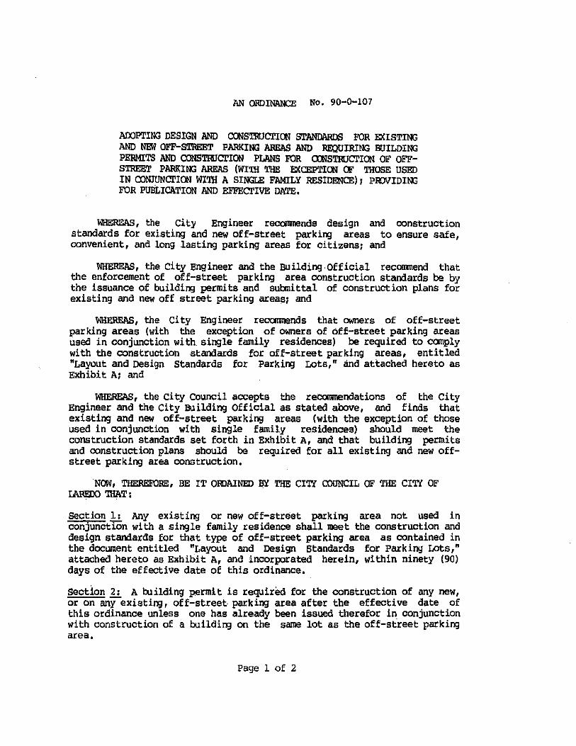
AN ORDINANCE No. 90-0-107
ADOPTING DESIGN AND COOSTRUcriOO STANIWIDS FOR EXISTIN3 AND NE.W OFF-STREET PARKING AREAS AND REI;lUIRING BUILDING PERMITS AND CONS'!WcriON PLANS FOR COOSTRUcriON OF OFFSTREET PARKING AREAS (Willi THE EXCEPTION CF THOSE USED IN CONJUNCTION Wl'n! A SINGLE FAMILY RESIDENCE) r PRJII'IDING FOR PUBLICATION AND EFFEcriVE DATE.
WHEREAS, the City Engineer recommends design and construction standards for existing and new off-street parking areas to ensure safe, convenient, and long lasting parking areas for citizensr and
WHEREAS, the City Engineer and the Building·Official recommend that the enforcement of off-street parking area construction standards be by the issuance of building permits and submittal of construction plans for existing and new off street parking areas; and
~. the City Engineer recommends that owners of off-street parking areas (with the exception of owners of off-street parking areas used in conjunction with. single family residences) be required to comply with the construction standards for off-street parking areas, entitled "Layout and Design Standards for Parking Lots," and attached hereto as Exhibit A; and
WHEREAS, the City Council accepts the reoommendations of the City Engineer and the City Building Official as stated above, and finds that existing and new off-street parking areas (with the exception of those used in conjunction with single family residences) should meet the construction standards set forth in Exhibit A, and that building permits and construction plans should be required for all existing and new offstreet parking area construction,
NOW, THEREFORE, BE IT ORDAINED ~ THE CITY COUNCIL OF THE CITY OF rAREDO mAT :
Section 1: Any existing or new off-street parking area not used in conjunction with a single family residence shall meet the construction and design standards for that type of off-street parking area as contained in the document entitled "Layout and Design Standards for Parking Lots,• attached hereto as Exhibit A, and incorporated herein, within ninety (90) days of the effective date of this ordinance.
Section 2: A building permit is required for the construction of any new, or on any existing, off-street parking area after the effective date of this ordinance unless one has already been issued therefor in conjunction with construction of a building on the same lot as the off-street parking area.
Page 1 of 2
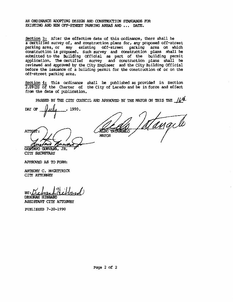
AN ORDINANCE ADOPl'ING DESIGN AND COOST111JC!'IOO STAND11RDS FOR EXISTING AND NE.W OFF-STREET PARKING AREAS AND , • , DATE.
Section 3: After the effective date of this ordinance, there shall be a oert1fied survey of, and construction plans for, any proposed off-street parking area, or any existing off-street parking area on which construction is proposed. Such survey and construction plans shall be submitted to the Building Official as part of the building permit application. '!.'he certified survey and oonstruction plans shall be reviewed and approved by the City Engineer and the city Building Official before the issuance of a building permit for the construction of or on the off-street parking area.
Section 4: This ordinance shall be published as provided in section 2.09(p) of the Charter of the City of Laredo and be in force and effect from the date of publication,
PASSED BY THE CITY CXXJNCIL AND APPROVED BY THE MAYOR 00 THIS THEM 07\Y OF --14--' 1990,
CITY SECRETARY
APPROVED AS TO FORM:
AN'IHONY C, loicGE'l'l'RICK CITl AT'IDRNEY
BY:!i~7LJuJ DEOORAI:I BIBBliRD ASSISTANT CI'!Y ATTORNEY'
PUBLISHED 7-20-1990
Page 2 of 2

Ref. 90-0-107
arking
CITY OF LAREDO
ENGINEERING DEPT.
JUNE 1990
EXHIBIT A
Layout
and
design
standards
for
parking
lots
CONTENTS
PARKING LAYOUT:
STANDAR~ SPECIFICATIONS FOR THE CONSTRUCTION
OF PARKING LOTS
TABLE OF CONTENTS
Page No.
Foreward ........... · ........... , .... , ...........................•.. 1 Dimensions of the Average Automobile and Turning Circle ........... 2 Space Requirements for Parking at Various Angles ...............•.• 3 Overhang ·of Average Automobile ........................•..•....•... I> 90° Parking ...................................................•... 5 60° Parking ................... , .. , ....... , ........................ 6 ~5° Parking ....................................... , ............... 7 3rf' Parking ........................................... , ........•.. 8 Methods of Layout Out Parking Areas on 50' and 60' Lots ........... 9 Me.thods for Marking Parking Stalls ....................... , ........ 10 Driveways .... , , , ............ , ..•...................... , ........... 11 Driveway Approaches ....... , ....... , .......................... , .... 12 Typical Truck Parking Stalls ....................................... 13
CONCRETE PAVEMENT:
Typical Concrete Designs for Parking Areas ........................ 1 Design Criteria ................................................... 2&3 Thickness Design Chart ..................... , ...................... I> California Bearing Ratio-CBR .................. , .. ,., .............. 5 Typical Light Duty In & Out
Parking with Heavy Duty Drive .............................. 6 Typical Parking Lot with Heavy Duty Service Drive ................. 7 Typical Heavy Duty Layout using Distributed Steel ................. 8 Confined Peripheral Reinforced Pavement ..........................• 9 Light Duty Parking & Drive Details ................................ 10 Medium and Heavy Pavement Details ......... , ....................... 11 Special Details ........................ , .......................... 12
BITUMINOUS ASPHALT PAVEMENT:
Bituminous Prime Coat, ....................... , ..... , ...... · ........ 1&2 Bituminous Tack Coat. , .................................. , ......... 3&1> Flexible Base Course .................................... , ......... 5&6 Hot Mix Asphaltic Concrete Pavement .............. , ................ 7 Details .......•... , .................... , .......................... 8 Heavy Traffic ........ , ....•............. , .. , ....................... 9 Pavement Markings ... , .............•....... , ....................... 10&11 Lights for Parking Area ............................... , , .......... 12

PARKING LAYOUT
contents Page No.
FOR EWQF( 0 • •. • • ••• • fi • • • • • • • • • • • • • • • • • • • • • • • • • • .1
Dimensions of th: Average: Automobile and Turning Circle •••••• • • • • • • • • • • • • • • • • • • • • • • • • • • • • • ·2
Space Requirements for Park1ng <lt Various . .Angles • •••••• • • • • • • • • • • • • • • • • • • • • • •• • • • • • .3
Overhang o( A\•er.agc />,utomobilc ........................ 4
90° Parking • • • • • • • ••• • • • • • • • • •• • • • • • • • •• • • •• • • • • • .5
60° Parking .. • • • • •. • • • • • • • • • • • • • • • • • • • • • • • • • • • • • • • .6
45° Pi'!.tkin@. •••• • ................ • • • • • • • • • • • • • • • • • • • • • 7
·l0° ·PaTkinc .......................................... 8
Methods ot .L.ayout Ou1 Pa.zking Areal!. on SO' and 60' Lots • • ..................... •. • • ........ • • • 9
Methods for M2~kin'!: Parking Stalls ••• ••••••••••••• •••• ,.10
Drive'"'a)'S" • • • • • • • •• •• • • • •• • • • • • • • • • • • • • • • • • • • • • • ... 11
DLive...,ay Approac:nes .......... • • •••• • ••••• ~ •••••••••••• 12
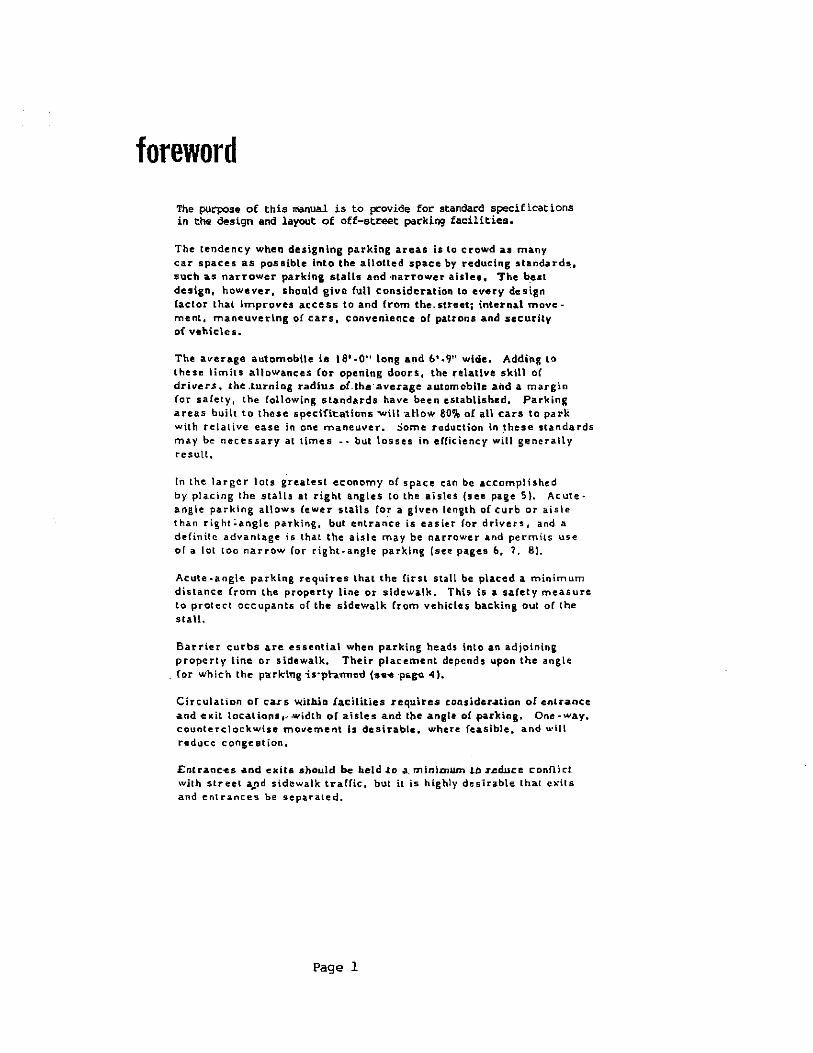
foreword The pu~se of this manual is to pcovide for standard specifications in the design and layout of off-s-tr-eet par:king facilities.
The tendency when designing parking areas is to crowd as many car spaces as possible into the allotted space by reducing standard~. :such as narrower parking stalls and ·narrower aisle•. The b_est design, however, should give Cult consideration to every design factor thal improves access to and {rom the.streeti interna.l movement, maneuverlng of cars, convenience or patrons and security oi vehicles.
The average automobile is 18' .. 0 11 long and 6'·911 wide. Adding ta these limits atlowanc:es Cor opening doors, the .-elative skill oC driver.s, the .turning radius o!.the·.average automobile and a margin Cor salety, the following standards have been established, Parking areas built to these specifi-cations wiH ·aJiow SO% o£ all cars to park with relative ease in one maneuver • .::iome reduction in _these standards may be necessary at limes -. but tosses in elCiciency will generally result,
In the larger lots greatest economy o( space can be accomplished by pl""-cing the stalls at right angles to the aisles (see page 5~. Acuteangle parking allows (ewer stalls for a given length of curb or aisle than right ~angle parkil,g, but entrance is easiH lor drivers, and a definilc advantage is that the aisle may be narrower and permits use of a lot too narrow Cor right-angle parking (see pages 6. 7, 81.
Acute -angle parking requit"es that the first stall be placed a minimum distance from the property line or sidewalk, This is a safety measure to protect occupants of the sidewalk from vehicle& backing out of the stall.
Barrier curbs are essential when parking heads into an adjoining property line or sidewalk. Their placement depends upon the angle
. for ,,,.hich the pa:rk:iTtg i"s·pb.m1c-d (·s-e1! ·p&.~ 4).
Circulation cr ca.rs wUh.ia lac::iHlies requires considel'.atiGn ol cnLI"anc:e and eKiL locaLionsi~·width of aisles and fhe angle ol parking, One-way. counterclockwise movement is desirable, where: feasible, and u.•ill r-educe congestion,
EntraQC-.es and exits •hould be beld ..to .a. minimum Lil .r.cd.uce conflict \Vilh street a,..nd sidewatk traffic, but it is highly deSirable I hal exils and entrances be separated,
Page 1
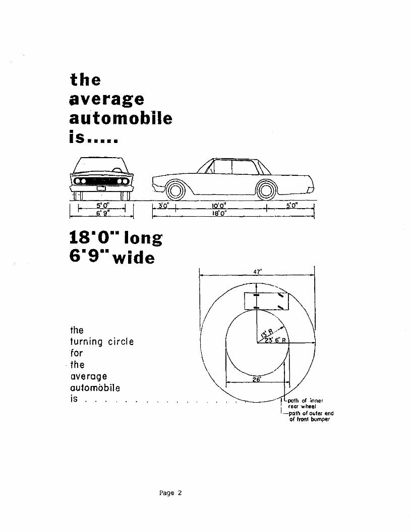
the average automobile • IS •••••
l' ~:~:: I .I 1--1: _3'o_" _1 ___ __!.!?.:~:~~:. ___ 1_· s'o" :1
1s·o··1ong s·g··wide
the turning circle for the average automobile
47'
is . . . . . . . . . . . . . . . .---. .____-· f path of inner rear ·wheel
Page 2
1 .. ·-poth of outer end of front bumper

4' 6. t ' 5 1 •
30'~;::~~*1 =.==·· ~.::;:· =·6~··;:::::'::6 ::::;t;l·=·=·=·_:::l-'~-~-.-1-_ ~·
~
' . I -I~
curb
go'l......-.---r--1 I ,----,---.----1 I_ 1 ~·
•muot be in ·the clear
space requirements for parking at various angles
Page 3
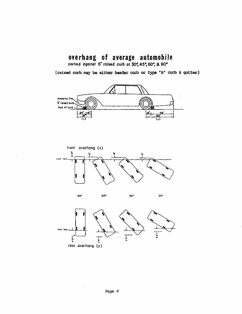
overhang of average automobile parked against 6' raised curb at 30~.45", so•, a 90°
(raised curb may be either header curb or type "A" curb & gutter)
front overhang ( x) t .L
90' 60"
rear .. overhang (y)
Page 4
•••
.ga· so· ( r I
30"
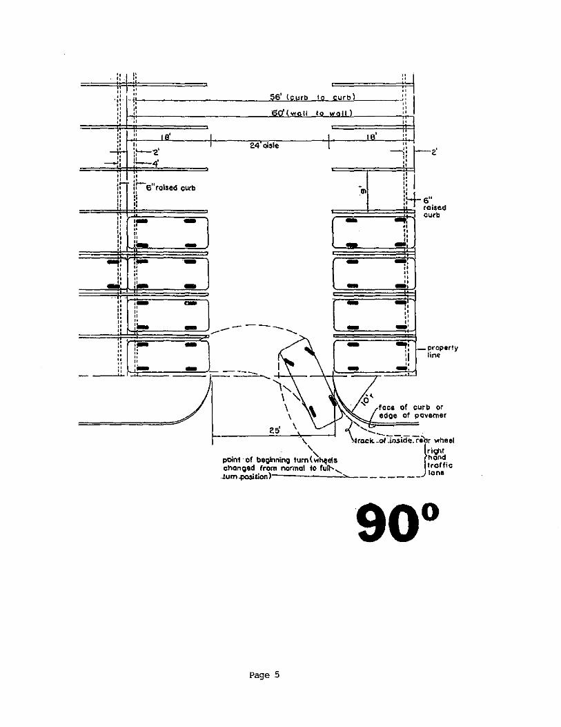
' ,, ·: '
' " " " " " " ,,
G> H-s" raised - .... I curb . , - •• .. _., - -. :.
" " - " -· - .... '• :. •• - -· - .,, ,, property
:I line
" -· ., ,o
face of curb or " edoe of povemer
~s· \''~. point· of beglnnino tu:~~h<jels rack. -ofJliiiife:l'eJU.',~,ito"'n1~1
8
1• 0°1
chanoed from normal to full'--....._ .!um.j)OSitlon)l-------.....:::.,.,_ ------ laM
Page 5

0 •• .. ,. ,, ,, •' •' •' ' .:: --~1\-~~ti::d I:: curb
" ,. .. ' ·' ,, .. ,.
15' IOmin,
·' " " -- -··-- _ __,_,._ --- ...J'--------,
=
54'- ;f'
required
.. I ,, ,, •' " .. I ,. ,, ,, ,. •' •' .. I ,, ,. , . ,.
2.1''
,.
'----~'--~-'·~~ ___ jj \1 \+ face of curb or
edoe: of pavement '-.... .
¥rack of 1nside rear wheel
trof.fic point of beQinnino turn(whee~ changed from normal to full '-turn posl1ionl ~--
------~~~~~ __ _____ __ lana
for 2 woy traffic thia dimension must be increased to .20'
€>'' roi.UCI curb width :nusl be increoseo to !7rin. of IO"wh!n jf" is 0 common barrier for f~o rows of porkin<Q
Page 6

·4s'- s"
4&'- s"'
,.
,. , .
·····1S"
:: 6" :~raised .. curb pro~erty li~e
,. ' -.....-,.
I I
.J..~-.;;......j .\
point of beoinnino turn(wheel~'\, chooQed from normal to full '
•' ,. ,. ,. " " "
face of curb or e dQe of pavernenr:
'.... . /' -.._ ........._trcckOITnside7e0r wheet
\rtght
·1urn ,osition) :--.___----- -- Jnond rraf fie lone
aisle width shown is minimum for 1 way traffic. for lono rowe of porkim.;~,widfh should be 5' wider to oltow care to pass.
11fot 2 woy traff1c fhis d imenslon must be increased to 20'
Page 7

• for 2 way lrcffic this dimensfon mu~r be increased to 19'
req·uired tor
Page 6
15"

---------------=--/ ~~--STREET
~et~od;f, 1 ~~.. l-1 1 laying out II I 1 I parking areas 1 I I on sr & 60"1otsp I E
I I lg·-z:· ~nl jffi~ ~ __ L_L_l.I-~!:t_-JIOIV '-----"
20' ALLEY ;,. i: ',. - ~ .'-::---
_[ood~ I . I ")l W1 TD ..
1 N -+
~l1H! I .._9 -~ I
! I
I I I WALK I I 111911 t¥ I I~ ! I
I so· :; I . 6o· so·_j 60' I ----r)-r=-r' --->---[---~ \._/ '-----------
STREET
------- (:--
Page 9
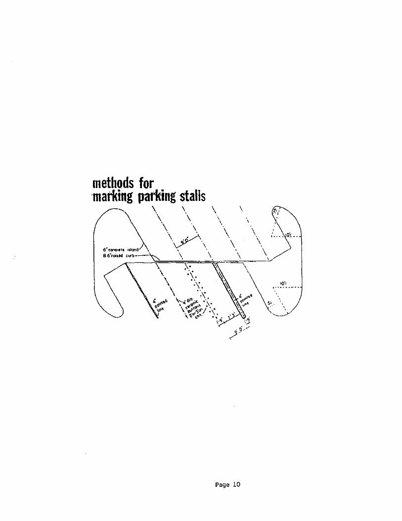
\ \ \
\ \
\
Page 10
\ \
'
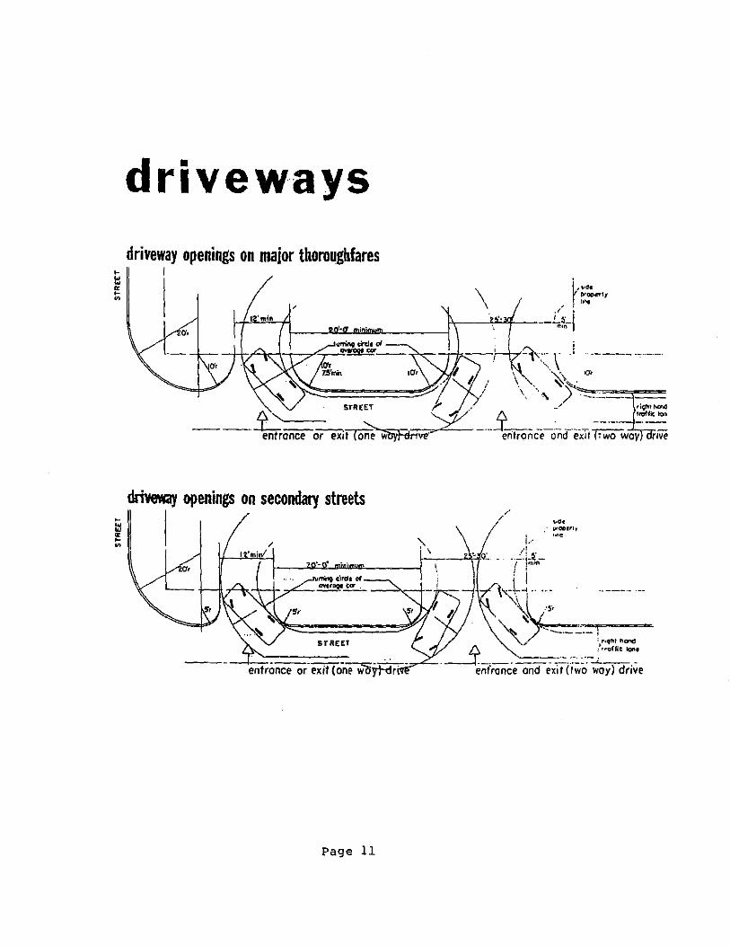
driveways
driveway openings on major thoroughfares I
driveway openings on secondary streets
~ I
STREET
------=---entrance or exit (one woytdr
Page 11
j,.• ·~e
·- ' /~ . Q_ -. ··-··-~l 1rnrn
i i \~~~-· ... ··---- --
/, . \~/'' ~~_:::=-"":.-, .• -.. -,"""~=
. ~----__ --:-:..:: .. -__ ·;-~::_~_· en( ranee and exit (two way) drive
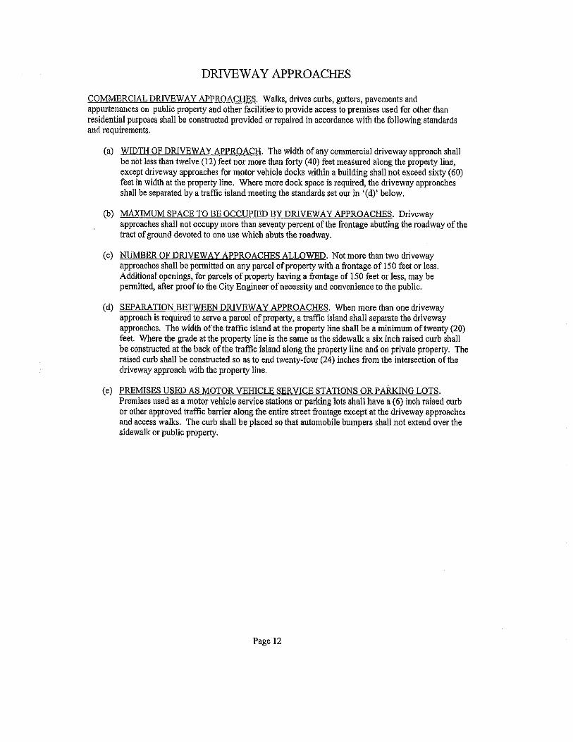
DRIVEWAY APPROACHES
COMMERCIAL DRIVEWAY APPROACHES. Walks, drives curbs, gutters, pavements and appurtenances on public property and other facilities· to provide access to premises used for other tl1an residential purposes shall be constructed provided or repaired in accordance with the following standards and requirements.
(a) WIDTH OF DRIVEWAY APPROACH. The width of any commercial driveway approach shall be not less than twelve (12) feet nor more than forty (40) feet measured along the property liue, except driveway approaches for motor vehicle docks within a building shall not exceed sixty (60) feet in width at the property line. Where more dock space is required, the driveway approaches shall be separated by a traffic island meeting the standards set our in '(d)' below.
(b) MAXIMUM SPACE TO BE OCCUPIED BY DRIVEWAY APPROACHES. Driveway approaches shall not occupy more than seventy percent of the frontage abutting the roadway of the tract of ground devoted to one use which abuts the roadway.
(c) NUMBER OF DRIVEWAY APPROACHES ALLOWED. Not more than two driveway approaches shall be permitted on any parcel of property with a frontage of 150 feet or less. Additional openings, for parcels of property having a frontage of 150 feet or less, may be permitted, after proof to the City Engineer of necessity and convenience to the public.
(d) SEPARATION BETWEEN DRIVEWAY APPROACHES. When more than one driveway approach is required to serve a parcel of property, a traffic island shall separate the driveway approaches. The widih ofthe traffic island at the property line shall be a minimum of twenty (20) feet. Where the grade at the property line is the same as the sidewalk a six inch raised curb shall be constructed at the back of the traffic island along the property line and on private property. The raised curb shall be constructed so as to end twenty-four (24) inches from the intersection ofthe driveway approach with the property line.
(e) PREMISES USED AS MOTOR VEIDCLE SERVICE STATIONS OR PARKING LOTS. Premises used as a motor vehicle service stations or parking lots shall have a (6) inch raised curb or other approved traffic barrier along the entire street frontage except at the driveway approaches and access walks. The curb shall be placed so that automobile bumpers shall not extend over the sidewalk or public property.
Page 12
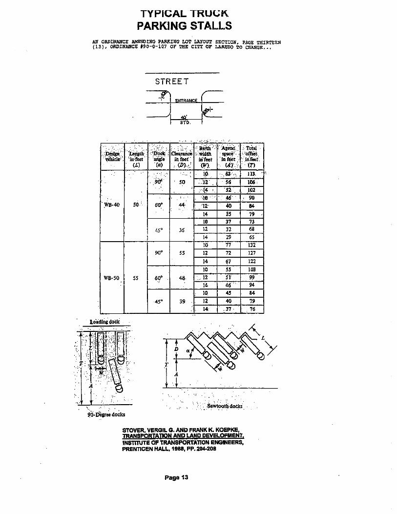
TYPICAL TRU(.;K PARKING STALLS
AU ORDINANCE' AMENDING- PARKING' LO'l' LAYOUT SEC'r!ON, PAGE THIRTEEN (13), OI!D!NANCE 190-0-10.7 OF THE CITY OF LA1lEDO TO CIIAIIGE •••
STREET
__ -_9~ ENT~~NCE ~ I STO. I
,, ... ,;.. ... '·.' 0 ·----;,:';. 0. , .•• , .... ..• Ji&til ·\_·=~ .. -~ • Total . . ,
·~~:. ·;i;e!istii '::·;,D~ct··,: :O~c~ :ivikllh '· ·orrsei ''bdeet · . 'ai\il~ . iii feet' m·reet ·ud~Ct :- ·•~n:r.;et•.
.... (L) '(IX) .. (DJ .. •: (W) <·n·• · :tn 1.0 ... GJ·· •. ,, 113.
!iir so . .1~' 56 106' . \4 '52 .102
<10 -16' 90 :WS-40 50 60° 44 u· 40 84
14 35 19 10 37 73
45° 36 1.2 32 68 14 29 65 10 77 132
90" 55 12 72 127 14 67 122 10 55 103
WB-50 55 60' 48. . 12 5I' 99 14 46 94
10 45 84
45° 39 12 40 79 14. . 37 76
... .. " ·~·: ~y~-L
D ". ·~~~'/ T ~~ ' 1 ~ A +.' ·. · .. · ..
;_ . . , ~O·Desr~ doclcs
.. :• .
OF PRENTICEN HALL, 1988, PP. 2114-208
Page 13
CONCRETE PAVEMENT
Contents Page No.
Typical Concrete Designs for Parking Areas .••....••..•... 1
Design Criteria .......... • ............................... 2&3
Thickness Design Chart .•...........•..................... lo
California Bearing Ratio-CBR •............................ 5
Typical Light Duty In & Out Parking with Heavy Duty Drive ..................... 6
Typical Parking Lot with Heavy Duty Service Drive ........ 7
Typical Heavy Duty Layout using Distributed Steel ........ 8
Confined Peripheral Reinforced Pavement .................. 9
Light Duty Parking & Drive Details ....................... 10
Medium and Heavy Pavement Details ........................ 11
Special Details .......................................... 12
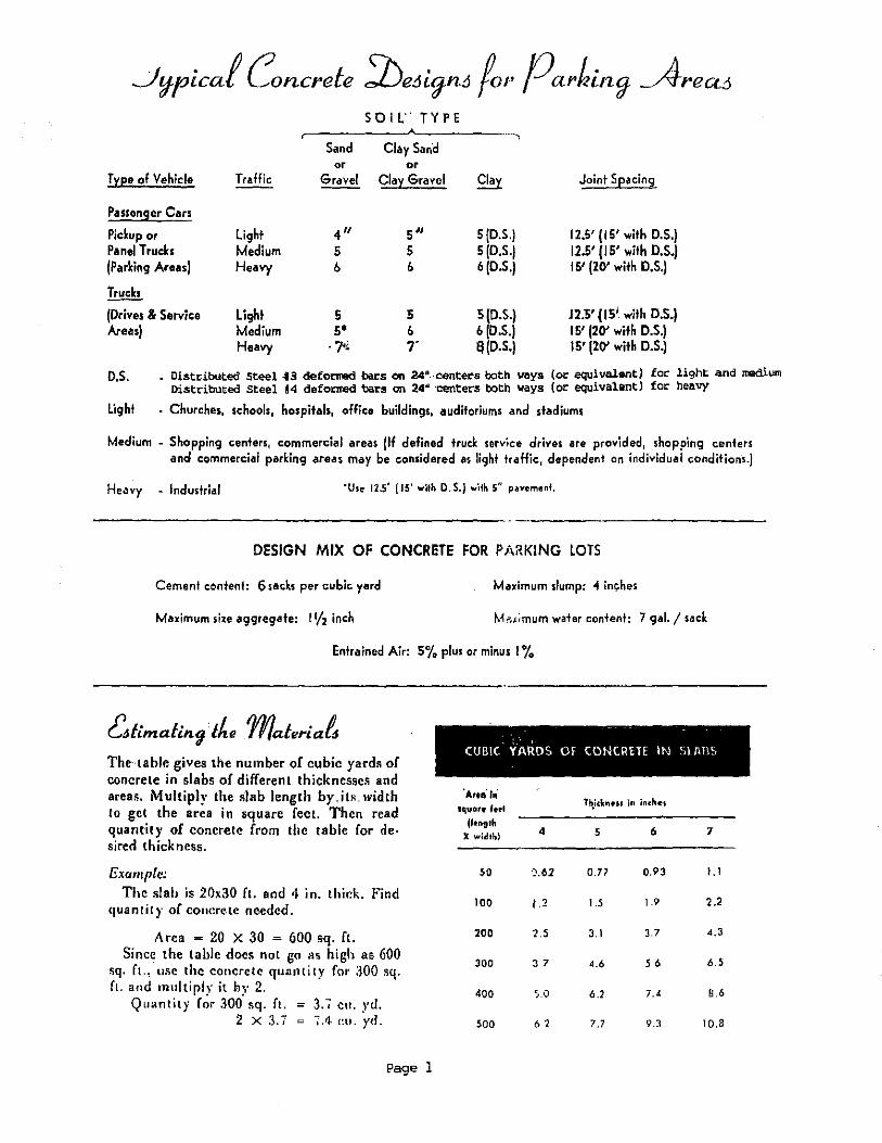
Sand or
Type of Vehicle Traffic Gravel
Passenger Cars
Pickup or Light 4" Panel Trucks Medium 5 {Parking Areas) Heavy b
Trucks
(Drives & Service Light 5 Areas) Medium s•
Heavy . 7'i
S 0 I L'' TYPE
Clay Sand or
Clay Gravel
5" 5 b
5 b ,.
··-·-,
Clay
5(0.5.) 5(0.5.) b (D.S.)
5 (D.S.) 6 (D.S.) !!(D.S.)
Joint Spacing
12.5' ( 15' with D.S.) 12.5' ( 15' with D.S.) 15' (20' with O.S.)
12.5' (IS' with D.S.) 15' (20' with D.S.) 15' (20' with D.S.J
D.S. Distdbuted Steel .f3 deformed bars on 24''--eente~:s both \lays (or equivalent) for light. and medium Distributed Steel 84 defo~ bars on 24u ·centers both ways (or equivalent] for heavy
light · Churches, schools, hospitals, office buildings, auditoriums and stadiums
Medium - Shopping centers, commercial areas (H defined trud: service drives are provided, shopping centers and commercial parking areas may be considered as li9ht traffic, dependent on individual conditions.)
Heavy - Industrial "Use 12.5' (IS' with D.S.J w'dh 5" pavement,
DESIGN MIX OF CONCRETE FOR PARKING LOTS
Cement content: 6sacks per cubic yard Maximum slump: 4 inches
Maximum size aggregate: 11/2 inch Mi'<timum water content: 7 gal./ sack
Entrained Air! S% plus or minus I io
~limaling·the materia~ CUBIC YAROS Of CONC~ETE IN StAllS
The·12ble gives the number of cubic yard• of concrete in slabs of different thicknesse• and areas. Multiply the slab length by.its. width Ia get the area in square feet. Then read quantity of concrete from the table for de· sired thickness.
Example: The slah is 20x30 ft. and •I in. thick. Find
<fUantily of COIICre.Le ne.edc<f.
Area = 20 X 30 = 600 sq. ft. Since the table docs not go as high as 600
sq. ft., li5C the concrete quantity for :lOO sq. ft. and multiply it by 2.
Qu•ntity for ,100 •q. ft. = 3. < cu. yd. 2 X :J.7 ~.1 ""·yd.
Page 1
'Areo' in' squo,e fet-1
(length 4 X width}
50 ·).61
100 , .2
200 1.5
300 37
400 s.o
500 6 2
Th,ickneu in inchet
5 6 7
0.77 0.93 1.1
1.5 1.9 2.2
3.1 3.7 4.3
A.6 56 6.5
6.2 7.4 8.6
7.7 9.3 10.8
'J:Jesign Criteria
The ·plans and specifications in this folder were prepared by the Portland Ce.ment Association for use in Texas.
The purpose of these plans and -specifications is to· provide a·ve·Ty simple method of constructing a concrete parking area. If curbs are not required, the words "integral curb" ·should ·be lined out or deleted.
These specifications are designed for use with ready-mixed concrete. Mix designs for the speci.fl.ed ~oncrete are available from the ready mix producer. The producer will normally certify to the purchaser that he will furnish a concrete contaihing at least 6 sacks of cement and no more than 7 gallons of water per sack, and with a compressive strength of 3500 psi in 28 days. This certification eliminates the need for testing .on small jobs. Care should be l!aken to 'insure that additional water is not added at the job site, causing the water-cetnent ratio to exceed 7 gallons per sa·ck.
If test specimens are taken for small jobs, cylinders are generally used. Mix design data is usuaU.y-av.i,ilable.on compressive strength basis. The strength reco.mmended in the accompanying specification has proven adequate in all parts of Texas.
The detail sheets give suggested joint la)•ou.ts, although the contractor should be allowed to make minor changes in this jointing pattern if it will result in more economical construction and the changes do not exceed the maximum recommended. It is better to use too many joints than not enough. Care should be taken to ins.ure that the one-inch minimum depth is obtained for each joint.
Most soils can be used as a sub-base for concrete with minimum preparation. It is impo.r.ta.ni . ..that .. the .s.ubgrade be thoroughly and uniformly .we.tte.d .to .a depth -of· about ·-6 ·int:he-s··· pri-o' to placing cone rete on it. It is also important that the subgrade be of uniform density to provide uniform support for the slab. Concrete pavement can·. be engineered to perform satisfactorily on any soil condition. Best performance is obtained, however, where subgrade support is reasonably uniform.
Many contractors el·ect toplace about a two-inch layer of sand or its equivalent on the subgrade prior to placing. This is sometimes called fine grading. lt ailows a baseoye~: whi~h. t<work and makes it easier to get a uniform thickness of concrete. thereby· reducing overrun.
Prior to setting forms, the subgrade should be checked for proper grade and alignment. Prior to placement of the concrete, forms should be checked for proper grade and alignment. The parking area should have a fall cf at least lfO inch pe-r foot in the direction of the desired drainage.
Page 2

A complete and uniform cove rage of .curing compound can be obtained by applying the spray compound in one direction and then· making a second applkation i·n a ·perpendicular diT·ection.
The attached chart gives the recommended thickness. for .concr.ete par1ung areas. Use of these recommended thicknesses for c·oncrete will result in pavements lasting as long as the building it serves (30, 40, 50 years or more).
Page 3

"' "' "' II>
General Soil Type**
?oor -Clays & Silty G.lays
Fair to Ciood
Sandy Clays Sandy Silts Sand
Excellent
Gravel Sand Gravel
SUBGRAbE -------! PAVEMENT THICKNESS "t" IN INCHES··------ Str~ngth -- ParkingA:reas (1}--.J-Dr!ve.s &Service Areas (2}-
CBR "k" Light Medi•Jm· Heavy i Light Medium Heavy
z to 5 75 to 100
5 to 10 150 to 200
10 & above ZOO & above
5 *(D.S.)
5
4
5 (D. S.)
5
5
6
6
5 6
5 5
::7 (D. S. I
7 Ro'ck
--------------------------~-----------------~---------------------- Foz ~;..aHty of Concrete st:o: ~~' agraph. .HI of Design C nteria -
(!). Design !or No. of Hqavy Vehicles per Day (Light Panel Trucks and Auto-s Unlimited)
(2) ( 2) If Tru.ck TnL!fic Eq'uals Drive Tra£fic, Use Drive 8c Service Area Thicknesses
Unlimited Axle Load Repetitions (Jbs)
.8, 000 I I z. 000 1 16, OQ()
•o. s.
Light
Medium
Heavy
- Distributed steel 13 deformed bacs on 24" centers both vays (or equivalent) tor Light and Medium Distributed Steel #4 deformed bars on 24" centers both ways (or equivalent) for Heavy
- Churches, schools, hospitals, office buildings, auditqriums, stadiums & apat'tment complexes.
-Shopping centers, corp mercia! areas (i! defined truck service driVes are provided, shopping centers and commercial parking areas may be cpnsidered as light traffic, depende!)t on individual conditions. See load repetition chart.)
- Industrh\1
** See page 5 · 11 PCA Soil Primer" for. interrela[ionships o:C Soils Classiiications

Colifornio Scoring Rolio-CBR (II J ' 5 6 7 8 910 15 20 25 JO -10 ~0 60708090100 --
Un"lfie~ Soil Classificat;on··c:zJ I I I I I I I Corps of Engineers, -· Depa'1menl or the Army, and -Bweau of Recfamaricn
I I I l •
I
AASHO Soil Classification (3) I Bureau of l'ublic Roode
l I --l l I I I I -- -- -
~ - -
.. -- --- - --
FedMal Aviation. Agency e-Soil Classification (4)
I ~~-I I I I ! .I
I I E~~---' ! -- I - ! - i - I - I - i
I Resislance Value-R (~J
I l .b J soj I
20 30 55[ 60 I 70 eo 1 85
I I I I I ! r ! I
Modulus of Subgrade Reaclion-k, psi per in.C6J
100 150 1200 I 250 300 400 500 600 700 80 0 ...
I i I I I I Bea~ing Value, psi C7J
I
I {30-in. diameter plore, 0.1-in. defleclion)
i 40 I
10 20 30 so 60 70 --· ..
I _I_ . .l I I i I .
CaiUomia Searing Ratio-CBR
- .. -3 4 ·:S 6 7 ··s 9. JO 20 25 '30 140 "SO 60 70 80'1'0 100
111 For the bo1ic Ideo. sef! 0, J. Porter, "Faundolioru lor ff,uibk Po..-e"'en~'-'' Hig,...oy ft"1un:\\ lloord Proceedit1Qt ofllttt r'-enly•lf!Con!I AntiJiol Mttelingo, 1942. Vel. ll, PG9C:I 100·1 ]6.
(2) "t,o~ocleriuict of $oil Gro..,pt Pertoininglo Roodt dn.d Airfi~lodt," Apptl'ldi~ 8, file llnilitd•Soil Chmilicolion Sr•lem, V.\. Arllty CorpJ of E"vineers, Technical Memoran4um 3-Hl, 19.53.
(3) "Cioullicotion ot'Highwoy S.uborade Me~teriob,'' Highway Rneor(h Board Proc:Hd'invt ol rflt Tw,nfy.fiflh A1111uol Meeting, 194!i, Vol. 2.5. pove1 376-392.
141 A.irparl Po•in9, U.S. O~porlrnenl of Commerce, fed~rol Aviolion l.o;:en(y, M.cy 19,.8, po9e• 11-16. Elli· moled \/ling volu~J 1JiYIIIII'Ijn F~A oe.ign Molll.lal for Airporl Po .. em~nlt. .
U} f. N. H~>eem, "A New Approach for Pcvemenr Oe1igl'l;' fllgineerin~ New,.R.ecor<l. Vol. J.C I. No 2, Julr 8, 1948, poge1 13~-1 J9. R. it lou or uud in California StabiiCHneler Merhod or Dctign.
{6l See 1", A. Middlebrookt and G. E. Berlrl:!m.. ''Soil Te111 fo• 0Nign of R.,nwoy Po.-tlmtft11:· Hig~ ..-ay Rc:teorch Boord ProcuJingt ol lhe fwei!I)'·I'I:"CO"d"-A.nnuol Mecling, 19-'1, Vol ~:.'.page I 51." b facto• \!'lid;, 'A'cJieTgoatd·, ofto1ytil for de1ig" of c:0!1Crele po;..-~...,ent,
17l See rtoference 161, pa9e l B~.
Approdmalc interrelationships or soil classilica.Uons and bearing values
Page 5
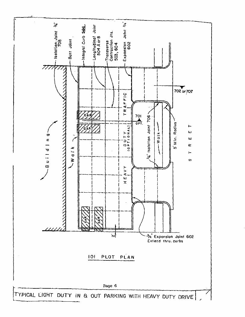
"' c:
::> (D
)
~
c 0
?.U)
-~'R -~ 0 ~
c: :o ..., :: ':)
1Xl
~ :s ·~ .... 0
.E .., .. - 0 .0 -m .., ..., ~ 0 ~ .,c " ;~-0 CN '-/ cn,.2 V
~--< ~u o <>0 e "in<D -«~" ~-~CD~ c 0> a.o 0 .!!! con o'C B Q. 0 X E. .J ~8 10 w
I I I I I ---r--I I I I
--t--
--~--
1 "' I >- Z ·- I 1- 0
(" ---L-- --+-=>.: I I oo. I I o
: I -0 ---r--- -+--
1 I I I I I >-1 I > --,--- ---r~-1 I :r I I j I
---,--- --+--•1 I I I
11-l'.'YI-+-1 ~"f+--~--1
I I
101 PLOT PLAN
70Z or707
- \ f-c: ·c;
w ..., .X
c 0 c w .!? 3: ::: 0
\ a:
0 -., ~ f-~ " "'
·3t4" Expansion Joint 602 Ext end thru. curbs
Page 6
rTYPICAL LIGHT DUTY IN a OUT PARKING WITH HEAVY DUTY DRIVE L. __________ _
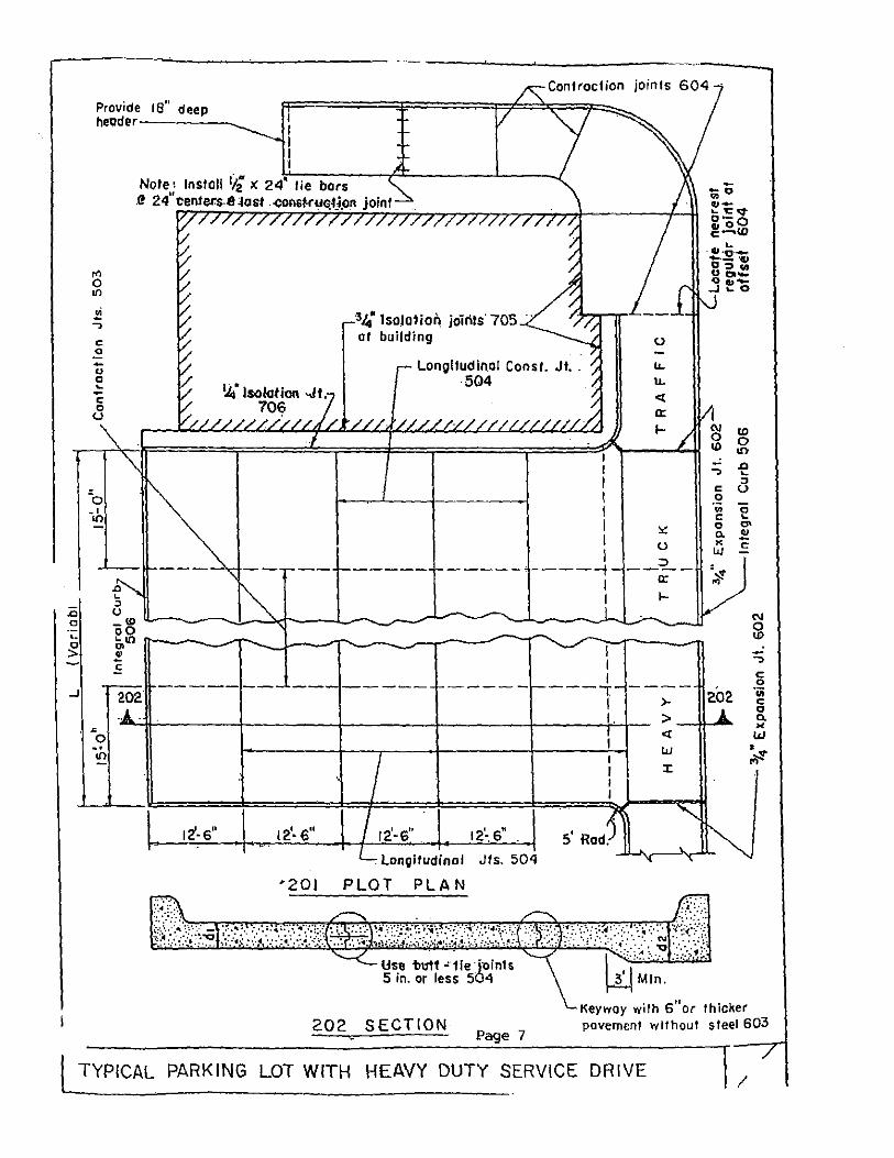
.0 c
Provide 18" deep header------._
Note: Install 1i2 >: 24' tie bars .!! 24" centel's.e ~as! .coosr.ruqtjpn joint
"' 0
"'
c 0
34 lso)olion joints· 705 · building
Contraction joints 604
(.)
-0 0 ~
Longitudinal Const. Jt .. 504
1.1..
u. <(
a: 1-
-c 0 u
\
...l..--1!-----
. longitudinal Jts. 504
'201 PLOT PLAN
Use 'butt "'1ie·j'Oinl$ 5 in. or less 504
202 SECTION Page 7
I I I I I I I I
----t I I
I I I ---, I I.
5' Rod .
0.:
0 __ =2..__
c: 1-
>
..: ., c 0 ·;;; c 0 a. " w =~
"'
202
> -11--' .. <(
w l:
<0 0 tn .0 ~
::J 0
0 ... "' ~ c
., g ·;;; c 0 0. >< w • ,;t!
Keyway with 6"or thicker pavement without steel 603
l TYPICAL PARKING LOT WITH HEAVY DUTY SERVICE DRIVE I

\'¥~' lsofa1ion j-oint "706
B··U·ILO LNG
Walk
. 302 302
I --------.-1 1-
-c ., E "' > 0
CL
L41" ~'<-----
~-- -----
s g
1----- -<D - "' --
~ • 0 ~ -~ -~ -~---~ ~ ~ ..J.-...----.L.--..__...._ ___ .1--__ .......Jl..-. __ _JJ ~
...J
r'---:o .-- - -r'" ·- ---:r--- -, ., ... "" ----- t-- o-- r-- c -- ----- ----- !----- ------ --- c
c .2 "" !<; "" - .~ U1
" '"' 0 ·a. 0 r. IJ)
~ 1-c -e ., --e: 0 -, L
(.) " ---- --v- ----------- r------ ----- ---- (.)
0 L
L I 20' ·max.\ L Integra\ Curb 605 \
"' "' -c N 5' Min. Rod,>-,
3/." £ -· ·, ~ · KjlDnSIOM
3"01 PLOT PLAN
302 SECTION
Page 8
~ Joint 602_j
~ 702 or 70
Flexible pavement\
~
1 TYPICAL HEAVY DUTY LAYOUT USING DISTRIBUTED STEEL
/
7

" .0 0
0
>
..J
Transverse Conlr<Jc1ion Joints-------, 503 or 604
24' ( 20. min.)
12'
c 0
u ::1 L -.. c 0
0 L 0
c ol"l ·- 0 ow 0 L L - 0 c O<>j' uo ~Ill
" ~ c 0 .., 0 c
"' ::1 -"' c 0
..J
·cross hatched oreo- use distributed steel #3 11' 24"ctrs. both ways.
401 PLOT PLAN Schemel ic only
Page 9
CONFINED PERIPHERAL REINFORCED PAVEMENT

.SJopE' \te" per· f!. •
W. (Variable l 01 This dimension. may be varied . .somewhal
let dimensions, but should. no I exceed to occomodale 15 fl.
501 TYPICAL SECTION
Fill with join! sealer to 114" below surface
%" ct4 (Min.·l" 1 · · · \J V 1/a" radius
£;.',{;:.>.\:::·:.:::}ij. 1?:;·::_<::::~·>.\J.:.
502 EXPANSION JOINT
116" rod ius
503 CONT"R~CTION JOINT SAWED OR· DUMMY GROOVE
Page 10
506 INTEGRAL CURB
1/e' radius
·Suit joint formeH bulk head-
504 A BUTT CONSTRUCTION JOINT
&:~~::·:~,:~;:\:;;h·:,h~,l:;:;!nd molding fastened to form.
Use 'ti" J'' for 4' slob • %• X J !f2• for 5" SlOb
504 8 KEYED CONSTRUCTION JOINT
LIGHT DUTY PARKING S DRIVE DETAILS /

Stope: 1/e' per ft.
tr-1 ',.,:f~ ,,,J;;~.~:~:"'"''''k'.~~ ·:.: ' ' ]( ~ " . ' J I. ~ .. ; v~=~~:·: ·.~ .. s/ •• ~ ..... '"''"'·:>:··:i'•"'·'"·'<' .. ;Y·:·i'l
* Except joints 20' Max. may be used wtth distributed steel. Piece steel in middle third of slob thickness.
601 TYPICAL SECTION
Fill wilh joint sealer to 1ti,' below su rfoce
602 EXPANSION JOINT
Fill with joint sealer V4' below surface
60.3 KEYED CONSTRUCTION JOINT :FOR· s"·oo 'GREATER THICKNESS SLAB
Note: Key may be half round molding with oppro<imotely the some dimensions shown.
Page 11
3'R.
605 INTEGRAL CURB
Fill with joint sealer 1/4' 'below surface
't.'- '14" 't8"Rod.~ of4(Min.t")
~r: :~·;:·D~/Ll~-~·::rr~; ·sv-~-~~~;::~J:~~~x\
604 CONTRACTION JOINT SAWED OR DUMMY GROOVE
MEDIUM AND HEAVY PAVEMENT DETAILS /
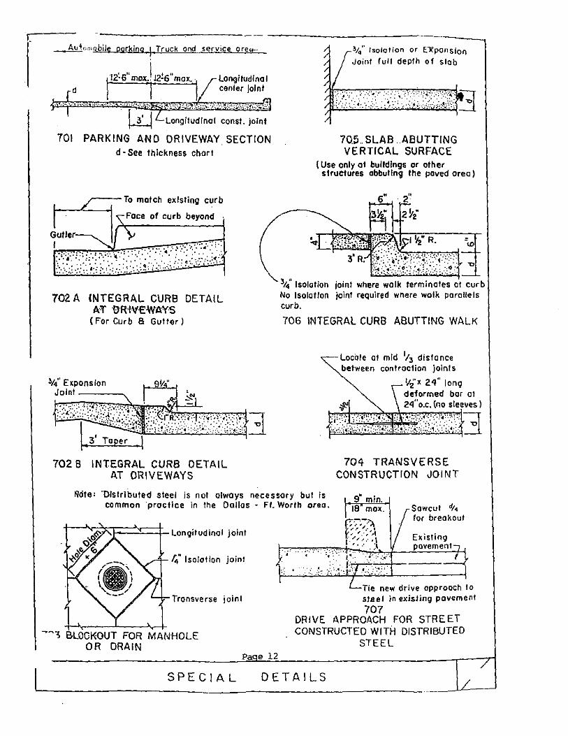
_,Aw'-'+,;mrJbile parking 1 Truck ond_ service Or£.it:_
l··r ... r.~·:~::·~.b:::::~ . l.iJ Longitudinal const. joint
701 PARKING AND DRIVEWAY SECTION d ·See thickness chart
702 A INTEGRAL CURB DETAIL AT IJR'lV€WAYS
(For Curb 8 Gutter)
702 8 INTEGRAL CURB DETAIL AT DRIVEWAYS
~;4'' lsololion or E"Xponsion Joint full depth of slab
7Q5 SLAB .. ABUTTING VERTICAL SURFACE
(Use only of buildings or other structures abbuling the paved orea)
3t4' Isolation joint where walk terminates curb No Isolation joint required wnere wolk parallels curb.
706 INTEGRAL CURB ABUTTING WALK
Locate at mid 1; 3 distance
between controcfion joints
'12'< 24" long deformed bor ot 2<i"o.c. (no sleeves)
704 TRANSVERSE CONSTRUCTION JOINT
~cite: 'Distributed steel is not always necessary but is common ·practice in the Dallas - Ft. Worth area.
s" min. 18 max. Sowcut dt•
for breakout
14" Isolation joint
Transverse joint
-~, &LOOKOUT FOR MANHOLE OR DRAIN
Pa e 12
. ~-: - . .- -~- _:.- ·:
f::-~;':\ ,. .- ~' ,/, .-' ""
I. '"' •I I' • • • • :-' ,, - .....
-· -·---4:' . ·-·--·-
Existing pavement
Tie new drive approach I o sJseJ in e.xisHng pavement
707 DRIVE APPROACH FOR STREET CONSTRUCTED WITH DISTRIBUTED
STEEL
SPECIAL DETAILS

BITUMINOUS ASPHALT PAVEMENT
Contents Page No.
Bituminous Prime Coat •.•......•...•.•.•••....•....•...••• 1&2
Bi turninous Tack Coat •.................•...........•...••. 3 &4
Flexible Base Course ....................................• 5&6
Hot Mix Asphaltic Concrete Pavement ...................... 7
Details ......•.........................•................. 6
Heavy Traffic ......... , .. , ............................... 9
Paverne.nt Markings ........................... : ............ 10&11
Lights for Parking Area .................................. 12

BITUMINOUS PRIME COAT
GENERAL
~~~fil2!i2~~ This item shall consist of an application of asphaltic material on the completed base course in accordance with these specifications and as directed by the Engineer.
MATERIAL
~!!! ~9.£t 6.ECEh9..!.!: The bituminous material shall conform to the following:
Kinematic Vis. at 140 F., CST 30
Flash Point T.o.c. F ...................... 100
t:lg
60
When distilled ASTM ~lethod D-402, the distillate-off volume shall be as follows:
Off at Off at Off at
437 500 600
F.'t F.'t F
Residue from 680 F. Distillation Volume 't
40 75
50
25 70 93
The residue when poured from the flash without cooling immediately upon reaching the maximum temperature specified, shall have the following characteristics:
Penetration at 77 F., ·100 gms., 5 sec. 120 250 Ductility at 77 F., 5 em/min. ems ......... 100 Solubility in CCI 't ........................ 99.5
4
The material shall be free from water.
MC-30 shall be applied uniformly at the rate of 0.25 gallons per square yard. At Contractor's option, appropriate emulsified asphalt, water mixture may be used in lieu of ~C-30. ~umber of applications, mixture rate and depth of penetration shall be approved by Engineer prior to use of emulsified asphalt. Furnishing and placement of prime coat shall be subsidiary to pavement and flexible base construction.
Page 1

CONSTRUCTION NETHODS
b.1212l!.£.!!!.l.2!! 2! b.§.l2h_!!.!_:!:__:_ Asphalt shall not be applied when the air te·mperature is below 50 ·p and is falling, and it may be applied when the air temperature is 40 F., and is rising, the temperature being taken in the shade and away from artificial heat. No asphalt shall be placed when general weather conditions in the apinion of the Engineer are not suitable.
All storage tanks, piping, retorts, booster tanks and distributors used in storing or handling asphalt shall be kept clean and in good operating condition at all times, and they shall be operated in such a manner that there will be no contamination of the asphalt with foreign material. Asphalt shall not be heated abo:v.e 400 L .at anytime and when applied, it shall be at a temperature of not less than 70 F., and not more than 150 F. The Engineer wilL select the temperature within 15 F. of the temperature selected. All asphalt heated above 400 F. will be rejected.
Before the application of asphalt, the surface of the base shall be cleaned of dirt. dust, or other deleterious matter by sweeping or other approved methods and if required by the Engineer, lightly sprinkled with water.
Asphalt shall be applied on the clean surface by an approved type of self-propelled pressure distributor so operated as to distribute the asphalt in the quantity specified evenly and smoothly under a pressure necessary for proper distribution. The Contractor shall provide all necessary facilities for determining the temperature of the asphalt in all the heating equipment and in the distributor for determining the rate at which it is applied and for insuring uniformity at the junction of two distributor loads. Asphalt shall be applied for the full width of the surface treatment in one application unless the width exceeds twenty-two (22) feet. No traffic or haulin~ will be permitted over the freshly applied asphalt.
Page 2
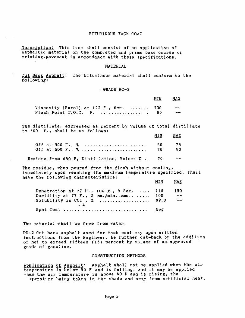
BITUMINOUS TACK COAT
Q~§.£ti.Q1i2.f!-'. This item shall consist of an application of asphaltic material on the completed and prime base course or existing.- pavement .in accordance wtth these specifications.
MATERIAL
£~1 ~~£~ ~eEh~li: The bituminous material shall conform to the following:
GRADE RC-2
Viscosity (Furol) at 122 F., Sec. . . . . . . . 200 Flash Point T.O.C. F. • • .. • • .. • • • . .. .. • BO
The distillate, expressed as percent by volume of total distillate to 600 F., shall be as follows:
Off at 500 F., % Off at 600 F. , '1'. ........................
50 70
Residue from 680 F, Distillation, Volume % • . 70
75 90
The residue, when poured from the flash without cooling, immediately upon reaching the maximum temperature specified, shall have the following characteristics:
!':1.!.~ 1:!~?;
Penetration at 77 F., 100 g., 5 Sec. 110 150 Duct il i ty at 7 7 .. F. , 5 =-/.min .. , . .ems. . . ... . 100 Solubility in CCI , % .................. . 99.0
- 4 Spot Test .............................. . Neg
The material ·sha·l! be "free from water.
RC-2 Cut back asphalt used for tack coat may upon written instructions from the Engineer, be further cut-back by the addition of not to exceed fifteen (15) percent by volume of an. approved grade of gasoline.
CONSTRUCTION METHODS
~~1!!!£~!!.2.!! 2! !l:ei:!l!~l!: Asphalt shall not be applied when the air temperature is below 50 F and is falling, and it may be applied when tl>e air temper.a.ture is a.bove 40 F and is rising, the
nperature being taken ill the shade and away from artificial heat.
Page 3
All storage tanks, p1p1ng, retorts, booster tanks and distributors used in storing or handling asphalt shall be kept clean and in good oper.ating cm1dition .. at all t.ime.s,. and they shall be operated in such a manner that there will be no contamination of the asphalt with foreign material. Asphalt shall not be heated above 500 F., at any-time and when applied, it shall be at a temperature of not less than 70 F., and not more than !50 F. All asphalt heated above 400 F. will 'be ·rejected.
Before the application of asphalt the surface of the base shall be cleaned of. dirt, dust, or other deleterious matter by sweeping or other approved methods and lightly sprinkled with water.
Asphalt shall be applied on the clean surface by an approved type of self-propelled pressure .. distributor so oper·ated ·as· to distribute the asphalt in the quantity specified evenly and smoothly under a pressure necessary for proper distribution. Asphalt shall be applied for the full width of the surface treatment in one application unless the width "exceeds twenty-two Tl2) · fee't. No traffic or hauling will be permitted over the freshly applied asphalt.
Page 4

FLEXIBLE BASE COURSE
Flexible base shall consist of a foundation course tor surfacing, pavement, or other base courses; shall be composed of caliche and stone materials, and shall be constructed as herein specified in conformity with the typical sections shown on the plans.
MATERIALS
The material shall consist of argillaceous limestone, calcareous or calcareous clay particles with or without stone, conglomerate, gravel, sand or other granular materials. The material shall be type F (pit run caliche), conforming to Item No. 246 of ·the State Department of Highways and Public Transportation .Specification, 1982. The plasticity index of caliche shall have a maximum of 12 and a minimum of 5. Stones greater than 3" in any direction shall be removed during construction.
CONSTRUCTION METHODS
The flexible base material shall be placed on the approved subgrade in courses not to exceed the depth shown on plans. It shall be the responsibility of the Contractor that the required amount of material be delivered and uniformly spread and shaped. All .material shall be moved from the place where it is dumped by cutting it windrows. After the material has been cut into 1vindro"·s, it shall be sprinkled, spread and shaped, and rolled in proper sequence to prevent segregation and as necessary for required compaction.
The surface upon completion shall be smooth and in conformity with typical sections and to the established lines and grades. Any deviation in excess of 1/4 inch in cross section and in length of 16 feEt measured longitudinally shall be corrected. All irregularities, depressions, or weak spots which develop shall be corrected.
Flexible base sha II be. compacted to an apparent .dry density of not less than 90 percent (98~) of the maximum dry density as determined in accordance with Texas Department of Highways & Public Transportation 1982, Test Method Tex 113-E. Tests for density will be made within 24 hours after compaction operations are completed. If the material ·fails to meet the.density specified, it shall be reworl'.' .. :d as necessary to meet the densj ty required. Just prior to the pL1cing of any succeeding course of flexible base or surfaci.ng on a pl'eViously competed course, the density and moisture of the top four (4) inches.of flexible base shall be checked and if test show the density to be more than 2 percent (2~) below the specified minimum or the moisture content to be more than 3 percent (3%) •bove or below the optimum, the course shall be reworked as
cessary to obtain the specified compaction and mositure content.
Page 5
Should t!1e base course due to any reason or cause lose the required density or finish before the surface is completed, it shall be recompacted, refinished and retested at the sole expense of the co1,tractor.
Page 6
HOT MIX ASPHALTIC CONCRETE PAVEMENT
TYPE D
.. DESCRIPTION: .This item .. shall. consist of a base <::curse, a leveling up course, a surface ·course or any combination of these courses as shown on the plans, each to be composed of a compacted mixture of mineral aggregate and asphaltic material. The mixture when designed and tested in accordance with these specificatons and methods outlined in TRD. Bulletin c-u, shall have the 'following:
MilL.. 95
DENSITY PERCENT
&lL.. 99
OPTIM!JM 97
STABILIT¥-PERCENT
Not less than 35 nor more than 60 unless otherwise, shown on plans.
The pavement shall be constructed on the previously completed and approved subgrade, base, existing pavement, bituminous surface or in the cas·e of a bridge, on the prepared floor slab, as herein specified and in accordance with the details shown on the plans.
MATERIALS: Materials used in Hot-Mix Asphaltic Concrete Pavement shall meet the reqUirements as set forth in Item 3/oO "Hot Mix Asphaltic Concrete Pavement" of the State Department of Highways and Public Transportation Specifications (1982).
Prior to laying any asphalt, contractor shall submit a Hot-Mix Asphaltic Concrete mix design for approval. He shall also submit written assurance that material stockpiles are sufficient to produce a mix consistent with the design for the duration of the pro:iect. If material source change occurs prior to completion, Contractor.shall provide a revised mix design at no additional expense to the Owner.
The Contractor shall provide for quality control at the plant to ensure that paving material delivered to the site conforms to requirements of these specifi~ations and the mix design.
CONSTRUCTION METHODS: Construction methods used in Hot-Mix Asphaltic Concrete Pavement shall meet the requirements as set forth in Item 340 ''-Hot-Mix ·Asphaltic Concrete Pavement" o'f the state Department of Highways and PUblic Transportation Specifications, 1982, with the following addition:
Application of Hot-Mix Asphaltic Concrete Pavement shall not begin unless the temperature is at least fifty (50 ) Fahrenheit in the shade and rising.
EQUIPMENT: Mixing plants that will not continuously produce a mixture meeting all of requirements of Item 311.0.01.< in the State Department of Highways and Public Transportation Specifications, 1982, shall not be allowed.
Page 7
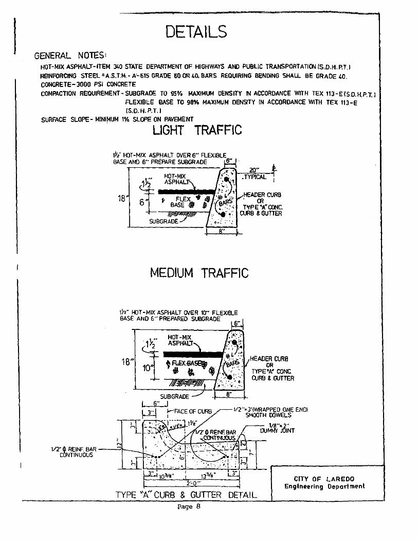
DETAILS GENERAL NOTES:
HOT-MIX ASPHALT-ITEM 340 STATE DEPARTMENT OF HIGHWAYS AND PUBLIC TRANSPORTATIONIS.D.H.P.T.I REtNFOI'ICING STEEL;A.S.T:M.-A'-615 GRA'OE 60'0R40,B)IRS REQUIRING BENDING SHALL BE GRADE 40. CONO!ETE- 3000 PSI CONCRETE COMPACTION REQUIREMENT- SUBGRADE TO 95% MAXIMUM DENSITY IN ACCORDANCE WITH TEX 113 -E (S.D.H.P. T.J
FLEXIBLE BASE TO 98% MAXIMUM DENSITY IN ACCORDANCE WITH TEX 11J -E (S.D. H. P. T.l
SURFACE SLOPE- MINIMUM 1% SLOPE ON PAVEMENT
LIGHT TRAFFIC
20" • TYPICAL
18 HEADER CURB . OR T'I'P E •A" CONC.
MB &GUTTER
R" }
MEDIUM TRAFFIC
ih" 1-«JT -MIX ASPHALT OVER 10" FLEXIEl.E BASE AND 6" PREPARED SUBGRADE
N
2'-0"
6"
HEADER CURB OR
TYPE-A' CONC: CURB & GUTTER
1/2"• 3'!WRAPPEO ONE ENOl SMOOTH DOWELS
• ....
w~·ioiNr
CITY OF LAREDO Engineering Department
TYPE "t( CURB & GUTTER DETAIL Page 8
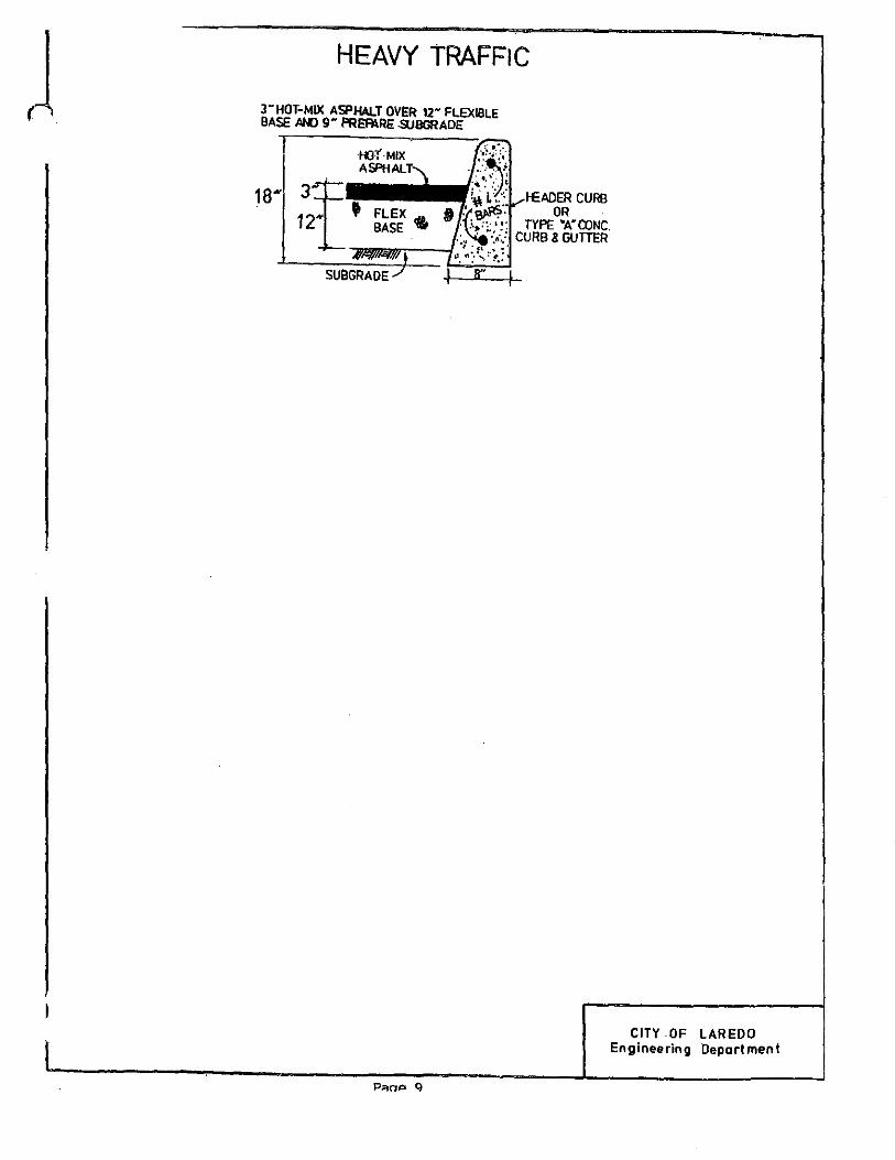
HEAVY TRAFFIC
3- HOT-MIX ASPHALT OVER 12- FLEXIBLE BASE MO g- PREAI.RE .SlJBGRADE
P~oP Q
CITY OF LAREDO Engineering Department

.PAV.f;MENT ··MARKINGS
PART I - GENERAL
1.1 DESCRIPTION
A. Work included: Provide pavement marking in the types and arrangements shown on the Drawings, as specified herein, and as needed for a complete and proper installation.
1.2 QUALITY ASSURANCE
A. Use adequate numbers of skilled workmen who are thoroughly trained and experienced irt the necessary crafts and who are completely familiar with the specified requirements and the methods ·needed· for ·proper pe'rftll:'nta:nce of the ·work of· tbis Section.
1.3 SUBMITTALS
A. Comply with pertinent provisions of Specifications and Drawings
B. Product Data: Within 60 calendar days after the Contractor has received the Owner's Notice to Proceed, submit:
1. Materials list of i terns proposed to be provided under this Section;
2. Manufacturer's specifications and other data needed to prove compliance with the specified requirements;
3. Photographs, scale drawings, or other data acceptable to the Engineer, showing. types of graphics .. proposed to be used. -
1.4 PRODUCT HANDLING
A. Comply with pertinent provisions of Specifications and Drawing·s.
PART 2 - PRODUCTS
2.1 PAVEMENT MARKING PAINT
A. Provide paint specifically formulated.for use as pavement marking in vehicles/trucks traffic-areas; and in the·colors selected by the Engineer from standard colors of the approved manufacturer.
B. Acceptable Products (or equal):
1. "Traffic Paint" manufactured by J.E. Bauer Company. 2. "Traffic Paint" manufactured by Tnemec. 3. "Romark Traffic" manufactured by Glidden-Durkee. 1>. "Traffic and Zone Marking -Paint'' manufactured by PPG.
Page 10
2. 2 JTHER MATERIALS
A. Provide other materials, not specifically described but required for a complete and proper installation, as selected by the Contractor subject to the approval of the Engineer.
PART 3 - EXECUTION
3.1 SURFACE CONDITIONS
A.. Examine the areas and conditions under which work of this Section will be performed. Correct conditions detrimental to timely and proper completion of the work. Do not proceed until unsatisfactory conditions are corrected.
3.2 APPLICATION
A. Secure the Engineer's approval of graphics design and layout prior to start of application.
B. Using proper masking, stencils, and application equipment recommended for the purpose by the manufacturer of the approved paint, apply the approved paint in strict accordance with its manufacturer's recommendations.
3.3 PROTECTION
A. Provide traffic cones, barricades, and other devices needed to protect the paint until it is sufficiently dry to withstand traffic.
3 .~ CLEANUP
A. When paint is thoroughly dry, visually inspect the entire application, and:
1. Touchup as required to provide clean, straight lines and surfaces throughout.
2. Using a permanently opaque paint identical in color to the surface on which the paint was applied, block out and eliminate eill traces o'f splashed, tracked, and/or spilled pavement marking paint from the background surfaces.
3.5 .HANDI~APPED
A. Label on curb parking spaces as indicatd on Drawings "Handicapped". Accessible parking spaces shall be identified and reserved for the Handicapped by a sign incorporating the symbol of accessibility and places so that it will not be obscured by parked vehicles. The signage shall be of such size that.it.is legible from a distance that would be reasonable for the condition.
Page 11
DESCRIPTION: used and for parking area
LIGHTS FOR PARKING AREA
This item shall govern for the materials and equipment the installation of the various types of lights for the as shown on the plans.
The tenn .. '.'Lights" as used herein .. shall constitute .. the ·complete assemblage of parts, equipment and miscellaneous items, including foundations, erected as provided in the plans and in accordance with these specifications, forming a complete and independent lighting unit.
MATERIALS: All materials furnished, assembled, fabricated or installed under this item shall be new,. and .. in strict .. accordance with the details shown on the plans.
The contractor shall furnish six sets of shop drawings of the complete assembly in.accordance with.the. Item,. "Ld.ghUI .for ·Parking Area" with certification that all materials used in the fabrication are in accordance with the plans and specifications. No work shall be per.fo~ed in the shop prior. to approval of the above drawings by the Engineers. Any purchase of material prior to fabrication authorization shall be at the Contractor's risk.
CONSTRUCTION METHODS: Lights for parking area shall be fabricated· and placed in accordance with the details and dimensions shown on the plans or as directed by the Engineer.
The careful erection and aligning of the poles furnished under this item shall be considered an essential feature of the installation of the assembly and shall be as near to true alignment as practicable.
All circuits shall test clear of faults, grounds and open circuits.
After satisfactory completion of the above tests and insulation resistance tests required, the illumination system shall be placed in operation. Final acceptance of the system will not be made until the system has operated s-atisfactorily for ·a period of ·14 days (this includes energizing and de-energizing the lighting· ·circuits at dusk and dawn). Final acceptance inspection of the system will be made at the end of a satisfactory 14-day test period.
Page 12

SECTION 24.79
FENCING AND SCREENING
Section 24.79.1 FENCING AND SCREENING BETWEEN ZONING DISTRICTS REQUIRED
1. All non-residential uses which abut or adjoin any residential property or zoning district, or which abut or adjoin a school, park, or church, shall provide an opaque fence or wall of not less than seven feet in height along all side or rear property lines which abut or adjoin such property. No screening fence shall be required for non-residential property adjoining vacant land in a non-residential zone.
Section 24.79.1.1 R-1MH SINGLE FAMILY MANUFACTURED HOUSING DISTRICT
1. The perimeter of the manufactured housing subdivision shall be buffered from all R-1 , R-1A, RS and nonresidential subdivisions by an opaque masonry fence or wall of not less than seven feet in height.
2. No fencing or permanent wall or structure may be located within the front yard set back.
Section 24.79.1.3 ADDITIONAL REQUIREMENTS FOR COMMERCIAL AND INDUSTRIAL DISTRICTS
1. All outside operations and storage shall be screened from adjacent, more restrictive zoning districts with an opaque fence of seven (7) feet or higher. (As amended 2/26/90, Ord. #90-0-36 and 2/22/93 Ord. #93·0-229)
2. No junk or used appliance yard may be established within 1,000 feet of any Interstate or Federal Aid Primary Highways unless screened by means of an opaque fence or wall in such a manner as to effectively block all view of the junk or used appliance yard.
Section 24.79.2 OTHER REQUIREMENTS
1. All screening fences required under this section shall be constructed of brick, stone, masonry, cement, stucco, cinder block or pressure treated weather resistant lumber, and shall be structurally reinforced to resist wind damage. They shall be constructed in such a manner as to provide visual screening.
2. Plywood, sheet metal , and corrugated steel fencing is prohibited.
3. All fences shall test plumb and square at the time of installation.
4. All fences shall be maintained by the property owner free of accumulations of trash , advertising, and graffiti.
5. No fence exceeding four feet (4'-0") in height shall be located within the front yard building setback along any collector, arterial or thoroughfare, nor less than eight feet (8'-0") from the back of curb to provide for pedestrian circulation .
6. Fences located along side and rear lots lines adjoining public streets shall not be located within the visibility triangle on any corner lot, and shall be set back from the curb line not less than eight feet to provide for pedestrian circulation .
7. No fence exceeding seven feet in height or masonry wall exceeding thirty inches (30") in height shall be constructed without the issuance of a building permit.
V-60
SECTION 24.80
MODEL SUBDIVISION RULES
Section 24.80.1 GENERAL PROVISIONS
(A) Scope of Chapter. This chapter contains model rules which the Texas Water Development Board (board) is required to adopt in accordance with Texas Water Code Section 16.343. Before an application for financial assistance from Economically Distressed Areas Program as Specified in Chapter 355, Subchapter B of the Texas Water Code or Chapter 363, Subchapter E of the same title may be considered by the board, the applicant shall provide documentation satisfactory in form and in substance that the municipality (ET J) and county in which the applicant is located has adopted the necessary orders, ordinances or other rules that meet the requirements of the Model Subdivision rules contained in Chapter 16, Subchapter B of the Texas Water Code.
(B) Purpose. The model rules provide the criteria for assuring that an adequate supply of safe drinking water and adequate safe sewer facilities are available to residential areas in accordance with state standards established by the Texas Department of Health and the TCEQ. The model rules prohibit the establishment of residential developments with lots of five acres or less without adequate water supply and sewer services, prohibit more than one single-family, detached dwelling to be located on each subdivision lot, and establish minimum setbacks to ensure proper operation of water supply and sewer services and to reduce the risk of fire hazards.
Section 24.80.2 SUBDIVISION WITHIN THE EXTRATERRITORIAL JURISDICTION (ETJ)- PLAT REQUIRED.
(A) The owner of a tract of land that divides the tract in any manner that creates two or more lots of five acres or less intended for residential purposes must have a plat of the subdivision prepared. Lots of five acres or less are presumed to be for residential purposes unless the land is restricted to non-residential uses on the final plat and duly noted in all deeds and contracts for deeds.
(B) A division of a tract is defined as including a metes and bounds description, or any description of less than a whole parcel, in a deed of conveyance or in a contract for a deed, using a contract of sale or other executory contract, lease/purchase agreement, or using any other method to convey property.
(C) Every plat creating two or more lots of five acres or less for residential purposes, located within the ET J of the City of Laredo, shall comply with the standards of Section 24.80.3.
(D) The final plat shall include on the plat or have attached to the plat by an engineering report, consistent with Section 364.52 of the Texas Administrative Code (TAC), bearing the signed and dated seal of a professional engineer registered in the state of Texas. The engineering report shall discuss the availability and methodology of providing water facilities and wastewater treatment to individual lots within the subdivision. A detailed cost estimate per lot acceptable to the Planning & Zoning Commission shall be provided for those unconstructed water supply & distribution facilities and wastewater collection & treatment facilities which are necessary to serve each lot of the subdivision. The plan shall include a construction schedule for each significant element needed to provide adequate water or wastewater facilities.
(E) No subdivided land shall be sold or conveyed until the subdivider has received final approval by the Planning & Zoning Commission of the tract and has filed and recorded , with the County Clerk of Webb County, a legally approved plat.
Section 24.80.3 SUBDIVISION WITHIN THE CORPORATE LIMITS OF THE CITY OF LAREDO - PLAT REQUIRED
V-61
(A) The subdivision of a tract of land into two or more lots of five acres or less for residential purposes within the corporate limits of the City of Laredo shall, at a minimum, meet the standards established herein as well as those required in the Subdivision Ordinance of The City of Laredo for the filing of a plat.
Section 24.80.4 FACILITY STANDARDS
The establishment of a residential development with two or more lots of five acres or less where the water supply and sewer services do not meet the minimum standards of this section is prohibited.
(A) Public Water Systems
(1) Where drinking water is to be supplied to a subdivision by the City of Laredo, the water quality and system design, construction and operation shall meet the minimum criteria set forth in 25 T AC 337.201-337.212, "Rules and Regulations for Public Water Systems", and 25 TAC 337.1-337.18, "Drinking Water Standards Governing Drinking Water Quality and Reporting Requirements for Public Water Supply Systems."
(2) Subdividers shall supply drinking water by connecting to the City of Laredo system. The written service agreement permitting the connection to the City of Laredo system shall calculate service charges based on the ultimate development and occupancy of the proposed subdivision for a minimum of thirty (30 years). The agreement must reflect that the subdivider has paid the cost of water meters and other necessary connection equipment, membership fees, water rights acquisition costs, or other fees associated with connection to the City of Laredo system so that service is available to each lot upon completion of construction of the water facilities described on the final plat.
(B) Non-public water systems
(1) Where individual wells or other non-public water systems are proposed for the supply of drinking water to residential establishments, the subdivider shall have prepared and provide a copy of a groundwater availability study that complies with the requirements of 30 TAC §§ 230.1 through 230.11 for water availability for public water supply systems and certifies the water quality of the water produced from the test well must meet the standards of water quality required for community water systems as set forth in 30 TAC Section 290.104, 290.106 and 290.108 and 290.109, either:
(a) without any treatment to the water; or
(b) with treatment by an identified and commercially available water treatment system.
(2) Individual water wells or non-public water systems that do not meet the water quality standards developed by the TCEQ and set out in 30 TAC Sections 290.104, 290.106 and 290.108, and 290.109 shall be prohibited.
(C) Transportation of potable water
(1) The conveyance of potable water by transport truck or other mobile device to supply the domestic needs of the subdivision is not an acceptable method, except on an emergency basis. Absence of a water system meeting the standards of these rules due to negligence of the subdivider does not constitute an emergency.
(D) All water supply systems shall be consistent with the standards developed by the Commission and as set out in 30 T AC Chapter 290.
(E) Wastewater Systems
(1) Organized Sewerage Facilities.
V-62
{a) Subdividers who propose the development of an organized wastewater collection and treatment system other than the City of Laredo municipal system, shall obtain a permit to dispose of wastes from the TCEQ in accordance with 30 T AC Chapter 305 "Consolidated Permits" and obtain approval of engineering planning materials for such systems under 30 TAC Chapter 317 "Design Criteria for Sewerage Systems" from the TCEQ.
(b) Subdividers who propose to dispose of wastewater by connecting to an existing permitted facility must provide a written agreement with the City of Laredo. The agreement must accommodate the total flow anticipated from the ultimate development and occupancy of the proposed subdivision for a minimum of thirty (30) years. This agreement must reflect that the subdivider has paid the cost of all fees associated with connection to the wastewater collection and treatment system so that service is available to each lot upon completion of construction of the wastewater facilities described on the final plat. Engineering plans for the proposed wastewater collection lines must comply with 30 TAC, Chapter 317 and 31 TAC, Section 364.33(a)(12) .
(2) On-site Sewerage Facilities
(a) No on-site wastewater disposal or septic system shall be permitted on any lot or tract which is less than one acre in size or within 200 feet of a public wastewater collection system. No on-site wastewater disposal system shall be permitted on any tract, regardless of size, where soil conditions, flood zones, topography, or other conditions do not permit both an undisturbed septic drain field and sufficient fallow, undisturbed land for a replacement drain field.
(b) No on-site wastewater disposal or septic system shall be permitted within any 100 year flood zone identified by the Federal Emergency Management Agency on the Flood Insurance Rating Maps (FIRM).
(c) On-site facilities which serve residential dwellings with anticipated wastewater generation of no greater than five thousand (5,000) gallons per day must comply with 30 TAC, Chapter 285 and be designed by a registered professional engineer or registered professional sanitarian .
(d) Proposals for on-site sewerage facilities for the on-site disposal of sewage in the amount of five thousand (5,000) gallons per day or greater must comply with 30 TAC, Chapter 317 and be presented to the TCEQ for determination be presented to the Texas Commission of Environmental Quality for determination of the necessity for a wastewater permit from that agency. Each such disposal facility must be designed by a registered professional engineer.
(e) On-site sewerage facilities not required to obtain a wastewater permit from the TCEQ must apply for and receive a permit from the City of Laredo Health Department or its authorized agent as required by the procedures established in 25 TAC 301 .101 through 301.109.
(f) On-site Sewage Disposal near Lakes or water storage reservoirs. On-site sewerage facilities proposed near lakes or water storage reservoirs shall be licensed and installed in strict accordance with requirements established by the TCEQ in their rules 31 TAC Chapter 285.
(g) On-site Wastewater Disposal in Recharge Zones. On-site sewerage facilities proposed within aquifer recharge zones must be licensed and installed in strict accordance with requirements established by the TCEQ and applicable Texas Department of Health regulations.
{h) The TCEQ, the City of Laredo Health Department, or their authorized agents shall review proposals for on-site sewage disposal systems and make inspections of such systems as necessary to assure that the system is in compliance with Chapter 366 of the Texas Health and Safety Code and rules in 30 TAC Sections 285, and in particular Sections 285.4, 285.5, 285.30 through 285.39. In addition to the unsatisfactory on-site disposal systems listed in 30 TAC Section 285.3 (b), pit privies and portable toilets are prohibited.
V-63

(i) Pit privies, portable toilets, and on-site sewerage facilities that do not meet the wastewater treatment standards developed by TCEQ and set out in 30 TAC Chapter 285 are prohibited.
(F) Graywater Systems for Reuse of Treated Wastewater.
(1} Organized Sewerage Facilities. Any proposal for sewage collection, treatment and disposal systems which include graywater reuse shall meet minimum criteria of 30 TAC, Chapter 210 promulgated and administered by the TCEQ.
(2) On-Site Sewerage Facilities. Any proposal for on-site sewage disposal which includes provisions for graywater use shall meet the minimum criteria of 30 TAC, Chapter 285.
(G) Sludge Disposal
The disposal of sludge from water treatment and wastewater treatment facilities shall meet the criteria of 30 TAC, Chapter 312, and Chapter 317.
(H) Setbacks
In areas outside the corporate city limits which lack water lines sized for fire protection, setbacks from private access easements, public or private roads and right-of-ways shall be a minimum of forty-five (45) feet from the centerline of such road, street, or easement. Setbacks from adjacent property lines shall be a minimum of five (5) feet for site built housing and seven (7) feet for any manufactured housing unit, and shall not conflict with separation or setback distances required by rules governing public utilities, on-site sewerage facilities, or drinking water supplies.
(I} Number of Dwellings per Lot
No more than one single family detached dwelling shall be located on an individual lot or tract. A notation of this restriction shall be placed on the face of the approved final plat, in all deeds, and in all contracts for deed for real estate sold within the subdivision. Notice of this restriction must be given by the seller in writing to any purchaser prior to execution of any binding agreement for sale or conveyance of any real estate. Proposals which include multi-family residential shall include adequate, detailed planning materials as required for the determination of proper water and wastewater utility type and design.
(J) Connection to Public Wastewater Collection System
As soon as a public wastewater system is available within 200 feet of the lot or tract, the lot or tract must be connected to the public wastewater collection system. Failure to properly connect to the public system within 30 days of written notice by the City of Laredo shall void any water service agreement, and water service shall be suspended until proper connection to the wastewater collection system is in place.
Section 24.80.5 ENFORCEMENT AND PENALTIES
(A) If it appears that a violation or threat of a violation of Chapter 212, Subchapter B of the Texas Local Government Code or a plan, rule or ordinance adopted under Chapter 212, Subchapter B, or consistent with Subchapter B exists, the City of Laredo is entitled to appropriate injunctive relief against the person who committed , is committing or is threatening to commit the violation.
(B) A suit for injunctive relief may be brought in the county in which the defendant resides, the county in which the violation or threat of violation occurs, or any county in which the City of Laredo is wholly or partly located.
(C) A person commits an offense if the person violates Chapter 212, Subchapter B or a plan, rule, or ordinance adopted under Chapter 212, Subchapter B or consistent with Subchapter B within the limits of
V-64
the City of Laredo. An offense under this section is a Class C misdemeanor. Each day the violation continues constitutes a separate offense.
(D) Civil Penalty. A person who violates any rule adopted under this section pursuant to Section 16.343 of the Texas Water Code is subject to a civil penalty of not less than $50 nor more than $1 ,000 for each violation and for each day of a conning violation but not in excess of $5,000 per day.
(E) Damages. The city of Laredo may recover damages in an amount adequate for the City to undertake any construction or other activity to bring about compliance with a requirement established under this section.
(F) Equitable Remedies. In addition to other remedies, the subdivider may be enjoined for the violation or threatened violation of any requirement of this section by suit for injunction and/or application for temporary injunction, and/or temporary restraining order duly filed by the City Attorney. In addition to enforcement by a political subdivision, the Texas Attorney General may bring suit to enforce a rule adopted under Section 16.350 of the Water Code, to recover the penalty provided by Section 16.352 of the water Code, to obtain injunctive relief to prevent the violation or continued violation of a political subdivision's rules, or to enforce the rules, recover the criminal penalty, and obtain injunctive relief.
Section 24.80.6 CONFLICT OF INTEREST
(A) Any member of the Commission who has a substantial interest in a subdivided tract shall file, before a vote or decision regarding the approval of a plat for the tract, an affidavit stating the nature and extent of the interest and shall abstain from further participation in the matter. The affidavit must be filed with the City Secretary of the City of Laredo.
(B) For the purposes of this section a person with substantial interest is one who:
(1) has an equitable or legal ownership interest in the tract with a fair market value of two thousand five hundred dollars ($2,500) or more;
(2) acts as a developer of the tract;
(3) owns ten percent (1 0%) or more of the voting stock or shares of or owns either ten percent (1 0%) or more or $5,000 or more of the fair market value of a business entity that:
(a) has an equitable or legal ownership interest in the tract with a fair market value of $2,500 or more; or
(b) acts as a developer of the tract; or
(4) receives in a calendar year funds from a business entity described by subdivision (3) that exceed ten percent (1 0%) of the person's gross income for the previous year.
(C) A person also is considered to have a substantial interest if he or she is related within the first degree by consanguinity or affinity to another person who, under Subsection (b), has a substantial interest in the tract.
(D) For the purposes of this section, a tract includes the subdivided tract as a whole, not an individual lot.
(E) The finding by a court of a violation of this section of these rules does not render voidable an action of the commission unless the measure would not have passed the commission without the vote of the member who violated this section.
(F) A violation under this section is a Class A misdemeanor."
V-65
Section 24.80.7 FINANCIAL GUARANTEES FOR IMPROVEMENTS
The requirements for posting a financial guarantee to ensure construction for improvements on a subdivision shall be provided as established in Section 2-4 of the Subdivision Ordinance (#84-00-0006) of the City of Laredo.
Section 24.80.8 CERTIFICATION OF COMPLIANCE FOR UTILITY CONNECTION APPLICATION FEE
The fee for processing an application for Certification of Compliance for Utility Connection shall be fifty dollars ($50.00) .
V-66
SECTION 24-82
SIGNS AND OUTDOOR ADVERTISING
Repealed by Ordinance 2012-0-111 , 9/4/12
V-67
SECTION 24.83
TREES AND SHRUBS
Section 24.83.1 STREET TREE PLANTING REQUIRED IN NEW SUBDIVISIONS
(1) The owner or subdivider of property in new subdivisions shall plant, or require the planting of the total number of street trees (T) required under the following calculations , whichever is greatest:
(a) T = (X x 2)/30 in the case of a street dedication plat and/or where the property to be platted lies adjacent to both sides of a public street. X will represent the length of the public street measured in linear feet at the centerline of the street or thoroughfare; or
(b) T = X/30 where the property to be platted lies adjacent to only one side of a public street or thoroughfare. X shall represent the length of the public street or thoroughfare measured in linear feet at the centerline of the street and adjacent to the property; or
(c) T = Y x 2 where the property is proposed to be platted into single-family residential lots. Y shall represent the number of single family residential lots included in the proposed plat.
(2) Where the subdivider proposes that the trees required under this section are to be planted in conjunction with construction or development of the property, this requirement shall be noted on the plat. Such note shall not relieve the subdivider of the responsibility to plant trees along any collector or arterial where a new single family residential subdivision abuts a collector or arterial street along the rear property line of any single family residential lot.
(3) The trees required under this section shall be planted within the public rights-of-way, within landscape or other reserves restricted for the purpose, or on private property within the ten feet (1 0'-0") parallel and adjacent to a local street right-of-way, or on private non-residential property within twenty-five feet (25'-0") parallel and adjacent to a major thoroughfare.
(4) Median Planting
(a) Trees or shrubs planted within the median of a major arterial shall not be planted less than seventy-five feet (75'-0") from the nose of the median.
(b) Trees or shrubs planted within the median of a minor arterial shall not be planted less than fifty feet (50'-0") from the nose of the median.
(c) Trees or shrubs in any median shall not be planted less than fifty feet (50'-0") from any mid-block opening in the median.
(d) Trees or shrubs planted in the median shall not be planted less than five feet (5'-0") from the back of the final approved design line for the curb, and trees shall be spaced at intervals of not less than thirty feet (30'-0").
(5) Visibility Maintained
(a) Within the visibility triangle no shrub, tree, plant or structure shall be permitted with a height greater than twenty-four inches (0'-24") measured from the centerline of the adjacent roadway.
{b) Trees shall be kept trimmed at all times so that no branch or growth is less than ten feet (1 0'-0") above the adjacent roadway measured from the centerline of that roadway.
V-68

Section 24.83.2 STREET TREE PLANTING REQUIRED IN EXISTING SUBDIVISIONS
(1) The planting of street trees is required as a condition of the issuance of a building permit in the City of Laredo, save and except permits issued for the reconstruction, modification or addition to property used for single family residential purposes, or the expansion of non-residential structures which do not exceed 1,000 square feet or twenty-five percent (25%) of an existing structure, whichever is more. Also excluded are those subdivisions approved before the effective date of this ordinance where the street tree or money-in-lieu of requirement has been met. The requirement for planting shall be as follows:
(a) Two trees per single family residential lot shall be planted within the public right-of-way, within a landscape or other reserve restricted for the purpose, or on private property within the ten feet (1 0'-0") parallel and adjacent to a local street right-of-way.
(b) One tree for each thirty feet (30'-0") of non-residential or multi-family residential property abutting a public street right-of-way shall be planted. Trees shall be planted within the public rights-of-way, within landscape or other reserves restricted for the purpose, or on private property within the ten feet (1 0'-0") parallel and adjacent to a local street right-of-way, or within twenty-five feet (25'-0") parallel and adjacent to a major thoroughfare.
Section 24.83.3 SURFACE PARKING LOT REQUIREMENTS
(1) Number of Trees Required
(a) New surface parking lots with more than fifteen (15) parking spaces shall require one (1) eligible tree for every ten (10) parking spaces or fraction thereof. The trees shall be located within and/or on the perimeter of the parking lot.
(b) Existing parking lots which are to be expanded to comply with the requirements of Section 24.78 of the Laredo Land Development Code "Off-Street Parking & Loading Requirements" and which, after such expansion, will contain more than fifteen (15) parking spaces, shall provide one (1) eligible tree for each ten (1 0) additional spaces or fraction thereof. The trees shall be located within and/or on the perimeter of the parking lot
(c) A permeable area with a radius of not less than three feet (3'-0") measured from the trunk of each eligible tree shall be maintained, and each eligible tree shall be protected from automobiles by curbs or tire stops located at least three feet (3'-0") from the trunk of the tree.
(2) Parking surface areas adjacent to the public street right-of-way shall have shrubs planted at regular intervals along the perimeter of all parking surfaces adjacent to the right-of-way, exclusive of driveway entrances, pedestrian walkways and cutback areas. The shrubs shall be maintained at a height of no more than thirty-six inches (0'-36") nor less than eighteen inches (0'-18"). The number of shrubs required under this section shall be equal to the total number of street trees required under this section multiplied by four. Seventy-five percent (75%) or more of the required shrubs shall be planted along the perimeter of the parking surface.
Section 24.83.4 TREE PRESERVATION CREDIT
(1) In the event that the owner or subdivider of the property proposes to preserve existing healthy trees, credit toward the tree requirement shall be given at the rate of two (2) street trees for each existing tree actually preserved. The owner or subdivider shall propose reasonable measures calculated to ensure the continued survival of existing trees for which credit is claimed. Any eligible tree for which credit is claimed shall have a minimum caliper of six inches (0'-6").
(2) The owner or subdivider of the property may request credit for the planting of up to fifty percent (50%) of the trees required under this code.
V-69

(3) If the preserved tree dies the tree must be replaced with a minimum of a three inch (0'-3") caliper tree.
Section 24.83.5 Removal, Replanting, and Replacement of Protected Trees
(1) All trees on public land within the city limits of Laredo with a caliper of eight inches (8") shall be considered protected trees.
(2) Removal of Protected Trees
(a) No person or corporation shall remove or cause the removal of any protected tree on public land without first securing approval from the Tree Board as provided in subsections (i) and (ii).
(i) When site plan approval is required by Building Services Department for any improvements on public land, the actual or schematic location of existing protected trees shall be shown on those site plans for review by the Tree Board. The Tree Board shall submit their order regarding the proposed plan within fourteen days of the date the plans were received by the Board.
(ii) The Tree Board shall review site plans for all improvement projects from any city, state, and federal government agency. The Tree Board's approval of these public projects shall constitute approval for the removal of any protected tree indicated on the project plans.
(b) The Tree Board shall approve removal of a protected tree located on public property when it is shown that the tree is diseased, severely damaged, dead on the site, or constitutes a hazard. Removal of such protected trees may require replacement trees as deemed necessary by the Tree Board.
(c) The Tree Board shall approve removal of a protected tree located on public property when the tree's location prevents reasonable access to the property or precludes reasonable and lawful use of the property. Removal of such protected trees may require replacement trees as deemed necessary by the Tree Board.
(d) The Tree Board may approve the removal of a protected tree in connection with construction, maintenance, or repair of public facilities in or upon a public street, alley, right-of-way, greenbelt, or other public land under one or more of the following conditions:
(i) The location of the tree prevents the opening of reasonable and necessary vehicular traffic lanes.
(ii) The location of the tree prevents the construction of utility lines or drainage facilities which may not be feasibly rerouted .
(e) Removal of such protected trees shall require replacement trees.
(3) Replacement Trees
(a) Where replacement trees are required the specified criteria shall be followed :
(i) The minimum diameter of replacement trees shall be no less than three (3) caliper inches, unless otherwise approved by the Tree Board.
(ii) When it is found impractical to relocate or replace the removed trees on the same property, replacement may be made upon any public owned property, property of non-profit organizations, public parks, or right-of-ways, subject to the approval of the Tree Board.
V-70

(iii) Tree species used for replacement shall conform with Appendix F-1 of the Laredo Land Development Code.
(4) Any person aggrieved by the decision of the Tree Board may appeal the decision to the City Council by filing a written appeal, specifying the reasons thereof, within thirty (30) days of the time the order is issued.
Section 24.83.6 SPECIAL REQUIREMENTS
(1) Any tree on privately owned property that is found to be a nuisance shall receive a notice to abate such nuisance as described in Chapter 21 of the Code of Ordinances, City of Laredo.
(2) All utility franchise holders shall present scheduled tree pruning plans to the Tree Board prior to the start of pruning work.
(3) Unless specifically authorized by the Tree Board, no person shall remove, intentionally damage, mutilate, allow any gaseous liquid or solid substances which are harmful to protected trees, to come in contact with them; or set fire or permit any fire to burn when such fire or the heat thereof will injure ant portion of any protected tree.
(4) All applicants for permits to work on public trees must comply with State and Local liability insurance requirements, workmen's compensation and safety codes.
Section 24.83.7 VIOLATION AND PENALTY
(1) Each destruction or removal of a protected tree, unless specifically permitted per this ordinance, shall be considered as a separate violation of this ordinance and shall be subject to penalty.
(2) Any person, firm, or corporation violating or failing to comply with any of the provisions of this ordinance shall be guilty of a misdemeanor, and upon conviction thereof, shall be fined a sum of up to $500.00 per violation .
Section 24.83.8 ALTERNATE PLANING PROPOSALS
(1) It is the intent of the City to provide an opportunity for the development of exceptional or unique landscape designs which cannot meet the express terms of this article. Special consideration shall be given to exceptional landscape designs which attempt to preserve and incorporate existing vegetation in excess of the minimum requirement and/or in innovative ways.
(2) Applicants for approval of an alternate tree/shrub plan shall be entitled to demonstrate that the intent of this article can be more effectively met in whole or in part through an alternate tree/shrub plan. An alternate landscape plan shall be reviewed by the Planning and Zoning Commission and, if approved, shall be substituted in whole or in part for a landscape plan meeting the express terms of this section.
Section 24.83.9 MONEY-IN-LIEU OF TREES
(1) Up to thirty percent (30%) of the total planting requirements may be met by depositing, with the Parks and Recreation Department, a sum of money equal to the cost of the required trees and their planting. This money shall be placed in a special fund designated for the purposes of planting of eligible trees in city parks or public rights-of-way. The cost per tree shall be determined by the Tree Board on an annual basis. The remaining seventy percent (70%) of the trees shall be planted as required by this ordinance.
Section 24.83.10 SELECTION AND MAINTENCANCE
V-71
( 1) All trees and shrubs planted in accordance with this Article shall be a native or naturalized species as recommended in Appendix F-1 -Recommended Trees for the Laredo Region, and shall be planted and maintained in accordance with the standards established in Section 24.83.10 (3) .
(2) The list of native and naturalized trees and shrubs in Appendix F-1 is not all-inclusive and may be updated as needed by the Tree Board without formal amendment to this section.
(3) General Planting and Maintenance Standards
(a) All trees shall be planted in holes two (2) to five (5) times wider than the rootball diameter. The depth of the hole should be no deeper than necessary to set the plant at the same depth it was in the nursery. All shrubs shall be planted in holes a minimum of six (6) inches wider on each side than their root spread, whether container grown or balled and burlapped. This enables the plant to extend the small roots in the first few weeks in the ground.
(b) Place the tree or shrub in the hole. If the tree is container grown, pull the container away from the rootball. Do not pull the tree by its trunk. Pulling the tree out of the container by its trunk will damage the small roots within the ball. Place the tree or shrub in the center of the hole and adjust it so that it is straight and at the proper level.
(c) For balled and burlapped plants pull the top and sides of the burlap away from the ball after the hole has been partially backfilled but before watering. Do not attempt to pull the burlap out from under the ball under any condition . All wire and surplus binding from the top and sides of the ball should be removed.
(d) Backfill with the original soil and firm the soil until approximately two- thirds (2/3) full. Before completing, fill the hole with water and allow the soil to settle around the roots. After the water has been absorbed, add topsoil to bring up to grade and form a watering basin around the tree.
(e) An earth basin, approximately four (4) inches in height, shall be formed around the tree or shrub pit to help retain water and protect the trunk from mower damage. Individual plant pits shall be completely encircled by the basin , except on steep slopes where the basin is formed on the downhill side to serve as a dam.
(f) Trees taller than four (4) feet may need to be staked. Rubber hose shall be used to protect the tree from the staking wire.
(g) The trees and shrubs must be watered immediately after planting and as needed during the first two (2) growing seasons. A thorough soaking is preferred over light, frequent soakings.
(h) The entire area formed within the earth basin shall be filled with 3 to 4 inches of mulch to help conserve moisture and reduce competition from weeds.
(i) All trees and shrubs shall be planted in individual holes with the exception of hedges. Hedges may be planted in a continuous trench as long as adequate room is allowed for root development.
(4) Staking, Guying and Wrapping
(a) All evergreen and deciduous trees over four (4) feet tall need to be supported by an acceptable method to keep the tree trunk in an upright position immediately after planting. Bracing prevents the tree from being damaged by strong winds which loosens the soil around the base of the tree and injures the rooting system.
(b) Trees shall be staked or guyed for a minimum of one growing season. All bracing and tree supports should be eliminated as soon as the tree becomes self-supporting.
V-7.2

(c) If the tree has sparse foliage and is exposed to full sun, the trunk shall be wrapped with an appropriate material to prevent sun scalding. Special tree wrap paper is available; however strips of burlap and aluminum foil will also protect the tree.
(5) Irrigation Requirements
(a) The installation of a supplemental irrigation system is required to give the trees and shrubs an adequate amount of water without waste. All required landscaping shall be irrigated by either an underground sprinkling system, drip irrigation system or a hose attachment within 100 feet (1 00'-0") of the landscaped area.
(b) The irrigation systems shall be designed and calibrated in order to thoroughly soak the root area of the plant area with the frequency necessary to establish newly planted trees and shrubs and to sustain their healthy growth.
(c) The system used shall be designed to minimize the amount of spray that will fall on sidewalks, neighboring properties and adjacent buildings in order to achieve water conservation.
(d) The property owner shall be responsible for irrigation as well as regular maintenance of the trees and shrubs.
V-73
SECTION 24-84
AD VALOREM TAX EXEMPTIONS FOR CERTIFIED HISTORIC REHABILITATION PROJECTS
Section 24.84.1 DEFINITIONS
As used in this section, the following words and phrases are specifically defined:
Historic Property - shall mean a building or structure which has been designated as a locally significant historic landmark by the Historic District/Landmark Board, or which contributes to the significance of a historic district, or which has been designated as a Recorded Texas Landmark by the Texas Historical Commission, or which is listed on the National Register of Historic Places, or which is identified as a contributing property in a National Register Historic District.
Certification - shall mean certification by the Historic District/Landmark Board that the property is a 'Historic Property' as defined in this section ; that tax relief is necessary for the rehabilitation of the property; and that the plans for rehabilitation conform to the standards for historic preservation adopted by the Board.
Applicant - shall mean the owner or designated agent of an owner seeking exemption from the payment of ad valorem taxes for the rehabilitation of a historic property.
Certified Historic Rehabilitation Project- shall mean a certified project whose application for tax exemption for historic rehabilitation has been approved by the City Council.
Certified Rehabilitation Expenditures - shall mean any expenditures incurred in connection with the rehabilitation of a Certified Historic Rehabilitation Project that are properly chargeable to a capital account.
These expenditures do not include:
a) costs of acquiring the building or any interest therein
b) enlargement costs which expand the total volume of the existing building, interior remodeling which increases floor space is not considered enlargement
c) new building construction costs
City Council - shall mean the City Council of the City of Laredo.
Board - shall mean the Historic District/Landmark Board of the City of Laredo.
Non-residential structure - shall mean any structure to be used for non-residential purposes following rehabilitation , including industrial, commercial, or rental residential uses.
Rehabilitation - shall mean the act or process of upgrading an older building both structurally and mechanically while preserving its unique historic, architectural or cultural significance.
Residential structure - shall mean a structure to be used following rehabilitation for a single family residence by the owner.
Structure - shall mean a building, edifice, dwelling unit or other construction which is permanently affixed to the land and which is composed of discrete elements.
V-74

Substantial Rehabilitation - shall mean the repair or restoration to standards established by the Board whose value is not less than 50% of the value of the improvements to the property as established by the Webb County Central Appraisal District on the date that application for historic property tax relief is made.
Tax Assessor/Collector- shall mean the Tax Assessor/Collector of the City of Laredo.
Section 24.84.2 PURPOSE
The purpose of this section is to encourage the preservation of the city's historic properties. These tax exemptions apply only to city property taxes and not to taxes owing to other taxing entities. Nothing in this ordinance relieves a person from the responsibility to apply each year to the Chief Appraiser of the Webb County Central Appraisal District for an exemption pursuant to the requirements of the Texas Property Tax Code.
Section 24.84.3 APPLICATION
The owner or designated agent of a historic property may make sworn application to the Board on a form approved by the city containing the following information:
a. The name, address and telephone number of the applicant.
b. The legal description and physical address of the property.
c. Information which establishes its eligibility for historic property tax exemption. In the event that the property seeks designation by the Board as a locally significant Historical Landmark or has been nominated as a Texas Historic Landmark, for the National Register of Historic Places, or as a contributing structure in a National Register Historic District, applicant shall submit documentation of such application for designation or nomination.
d. Plans and specifications detailing the proposed substantial rehabilitation.
e. Estimates of Certified Rehabilitation Expenditures with a statement that the cost of the proposed rehabilitation exceeds the value of existing improvements on the property by fifty percent (50%).
f. Tax certificates indicating that all taxes have been paid.
g. A notarized affidavit indicating the need for tax relief and a statement concerning the proposed use of the structure.
Section 24.84.4 REVIEW BY THE BOARD
1. The Board shall review the application for conformance with the adopted standards for Historic Preservation, and may request changes or alterations in the plans. The Board shall consider the following:
a. The adherence to adopted design standards; and b. The requirement for substantial rehabilitation; and c. Proposed post rehabilitation use; and d. The need for tax relief for historic rehabilitation; and e. Conformance with the Comprehensive Plan.
If the Board finds that the application complies with the requirements of this chapter, the Board shall, following a public hearing, designate the proposed restoration as a Certified Historic Rehabilitation Project.
V-75
2. The Board shall submit its findings to the City Council with a recommendation for the granting of tax relief.
Section 24.84.5 REVIEW BY THE COUNCIL
1. The Council shall review the recommendation of the Board concerning the proposed project, and if it determines, following notice and hearing, that the project is eligible for tax relief, and that the best interests of the citizens of the City of Laredo would be served by granting tax relief, Council shall certify the project, granting tax relief as follows:
a. A residential structure shall be exempt from the payment of ad valorem taxes on the increased value accruing to the property following rehabilitation for a period of eight (8) years following the issuance of a certificate of occupancy by the city's Building Official. Transfer of ownership shall not cause the exemption to be revoked except as otherwise provided.
b. The applicant owner of a non-residential structure shall be exempt from the payment of any ad valorem tax on the land and improvements which are an integral part of the Certified Historic Rehabilitation Project for a period of four (4) years following the issuance of a certificate of occupancy by the city's Building Official. Upon written application by the owner, an additional exemption on the enhanced value of the property following rehabilitation may be granted for a period not to exceed four (4) years. Transfer of ownership shall cause the exemption to lapse on the last day of the tax year in which the transfer occurs, unless the transfer of ownership is effected through devise or descent, or conveyed with a historic easement which qualifies as a charitable contribution under Section 170(f)(3) of the Internal Revenue Code.
c. The exemption shall be effective on January 1 of the year following the date on which the Certificate of Occupancy was issued.
d. The Council, upon the recommendation of the Board, may grant partial certification for projects which will be completed in phases because of the scale or complexity of the proposed restoration .
2. Certified Historic Rehabilitation Projects which have been granted tax relief shall be issued a Certificate of Occupancy by the Building Official within twenty-four (24) months following the effective date of the ordinance granting such relief. Projects failing to meet this deadline shall be ineligible for the exemption of ad valorem taxes, unless an application for an extension of time is filed in writing with the City Secretary prior to the expiration of the 24 month period. Council may approve an extension of time not to exceed twelve (12) months.
3. The applicant owner shall present the Certificate of Occupancy, the Historic DistricULandmark Board's order indicating the property is a Certified Historic Rehabilitation Project, and a letter from the Historic Preservation Officer verifying actual Certified Rehabilitation Expenditures and compliance with rehabilitation plans to the City of Laredo Tax Assessor/Collector to initiate the tax exemption process. The applicant owner shall present proof of application for exemption from the Webb County Appraisal District to the City of Laredo Tax Assessor/Collector on an annual basis to receive the tax exemption.
Section 24.84.6 ADMINISTRATION
1. The Historic Preservation Officer shall conduct an annual inspection to determine whether the property has been maintained in accordance with the approved preservation standards. If the property has deteriorated, been demolished or destroyed, or been modified or altered in a manner which has compromised its historical, architectural or cultural value, the Historic Preservation Officer shall notify the owner, the Historic DistricULandmark Board, the Tax Assessor/Collector and the City Manager of his findings. The Historic DistricULandmark Board shall consider the findings of the Historic Preservation Officer, and, following notice and hearing, act to revoke the exemption.
V-76

2. The owner may appeal the revocation of exemption to the Council upon written application filed within sixty days, stating the reasons why the exemption should not be revoked.
Section 24.84. 7 RECAPTURE
1. Tax receipts and tax certificates for Certified Historic Rehabilitation Projects shall be clearly marked "Historic Property- subject to recapture of additional taxes under Section 24.84.7 of the Laredo Land Development Code."
2. Each year during which the property is granted tax relief, the Tax Assessor/Collector shall note the valuation which would have been made and the taxes which would have been due had the property not qualified for tax relief under this section.
3. If the exemption is revoked because the property was damaged or destroyed, or if taxes become delinquent, the property shall be subject to payment of all taxes, penalty and interest which would have been paid , absent the granting of an exemption under this section, which additional taxes shall be a lien on the property."
V-77

SECTION 24-85
SIDEWALK STANDARDS
Section 24-85.3 SIDEWALK STANDARDS
Sidewalks shall be provided on both sides of all streets, including cui-de-sacs, in conformance with the American Disabilities Act (ADA) and the following standards:
(a) Sidewalks shall be required of any development or structure for which a building permit is issued, except that such sidewalk shall be provided by the subdivider where a new single family residential subdivision abuts a collector or arterial street.
(b) Sidewalks shall be provided along all public and private streets abutting any development or redevelopment and any addition to a non-residential structure exceeding 500 square feet in gross floor area.
(c) Sidewalks shall be constructed immediately adjacent to the curb, except where the continuation of any existing sidewalk on adjacent property requires alternate placement.
(d) Sidewalks shall be required as part of the platting improvements for the subdivision of land in the R1-MH (Single Family Manufactured Housing District) and R-3 (Mixed Residential District) zoning districts.
(e) Sidewalks shall be constructed of four inch (4") concrete (2500 psi) with #6- 6x6 welded wire fabric.
(f) It is expressly provided that all sidewalks within the Central Business District (CBD) shall have unobstructed sidewalks of not less than eight feet (8'-0") in width.
(g) Commercial development located along transit routes shall provide additional sidewalk width at established transit stops in accordance with the requirements of the transit operator based on the location of the transit stop.
(h) Handicap ramps and driveway cuts shall conform to engineering design requirements established in Appendix G.
Section 24.85.4 ALTERNATE PROPOSALS
The Planning and Zoning Commission may authorize alternative proposals for pedestrian circulation in certain circumstances. Application for alternate proposals shall be submitted as part of the preliminary plat.
Section 24.85.5 EXCEPTIONS
(a) Sidewalks shall not be required on local streets if the smallest lot in a new residential subdivision is no less than 15,000 square feet in area.
(b) Sidewalks shall not be required in industrial park developments exceeding ten acres in size, where each lot within the development exceeds one acre in size provided, however, that the sidewalks are required along public streets, industrial collectors and access roads abutting the development if necessary to provide direct pedestrian access from residential neighborhoods to transit, shopping or neighborhood schools as determined by The Planning and Zoning Commission.
(c) Sidewalks shall not be required for replats in existing residential subdivisions where the total area being replatted does not exceed 20,000 square feet.
V-78

Section 24.85.6 DOUBLE FRONTAGE LOTS
In the event double frontage lots are created for the purpose of separating residential property from principal arterials and collectors, the shoulder and sidewalk area of the arterial or collector shall conform to the following standards:
(1) Street tree planting shall conform to the provisions established in Section 24.83, "Trees and Shrubs," of the Laredo Land Development Code.
(2) No right of access shall be allowed from any arterial or collector.
(3) The unpaved area of the shoulder, if proposed to be maintained by the City of Laredo, shall be overlaid with an impervious material or the developer shall provide a low maintenance landscape plan. In either event, the proposed plan shall be subject to the approval of the Planning and Zoning Commission in the preliminary plat. A pervious radius in compliance with Section 24.83.3.c of the Laredo Land Development Code for tree planting shall remain .
V-79
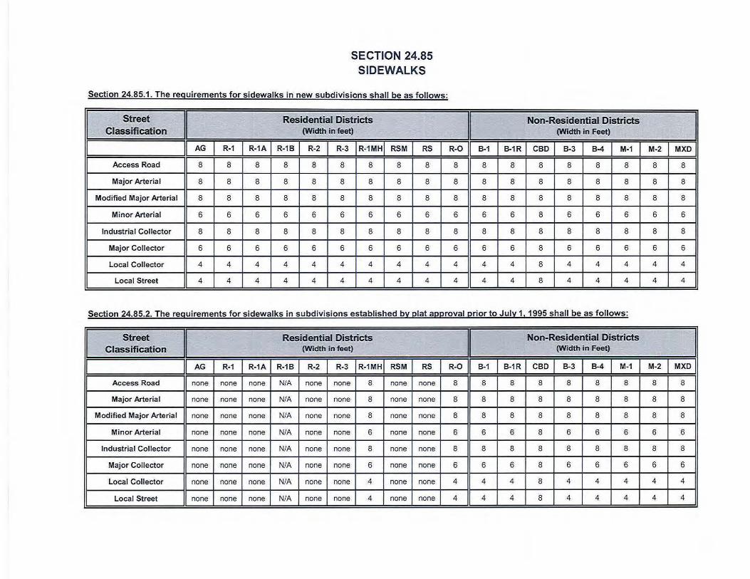
I
SECTION 24.85 SIDEWALKS
Sect ion 24.85.1 . The requirements for sidewalks in new subdivisions shall be as follows:
Street Residential Districts Classification (Width In feet)
AG R-1 R-1A R-18 R-2 R-3 R-1MH RSM RS
Access Road 8 8 8 8 8 8 8 8 8
Major Arterial 8 8 8 8 8 8 8 8 8
Modified Major Arterial 8 8 8 8 8 8 8 8 8
Minor Arterial 6 6 6 6 6 6 6 6 6
Industrial Collector 8 8 8 8 8 8 8 8 8
Major Collector 6 6 6 6 6 6 6 6 6
Local Collector 4 4 4 4 4 4 4 4 4
Local Street 4 4 4 4 4 4 4 4 4
I Non-Residential Districts
(Width in Feet)
R-0 I B-1 I B-1R I CBD I B-3 I B-4 I M-1 I 8 8 8 8 8 8 8
8 8 8 8 8 8 8
8 8 8 8 8 8 8
6 6 6 8 6 6 6
8 8 8 8 8 8 8
6 6 6 8 6 6 6
4 4 4 8 4 4 4
4 4 4 8 4 4 4
Section 24.85.2. The requirements for sidewalks in subdivisions established by plat approval prior to July 1, 1995 shall be as follows:
Street
I Residential Districts
I Non-Residential Districts
Classification (Width in feet) (Width in Feet)
II AG I R-1 I R-1A I R-18 I R-2 I
R-3 I R-1MHI RSM I RS I R-0 II
B-1 I B-1R I CBD I
B-3 I B-4 I M-1 I
Access Road none none none N/A none none 8 none none 8 8 8 8 8 8 8
Major Arteria l none none none N/A none none 8 none none 8 8 8 8 8 8 8
Modified Major Arterial none none none N/A none none 8 none none 8 8 8 8 8 8 8
Minor Arterial none none none N/A none none 6 none none 6 6 6 8 6 6 6
Industrial Collector none none none N/A none none 8 none none 8 8 8 8 8 8 8
Major Collector none none none N/A none none 6 none none 6 6 6 8 6 6 6
Local Collector none none none N/A none none 4 none none 4 4 4 8 4 4 4
Local Street none none none N/A none none 4 none none 4 4 4 8 4 4 4
I M-2 I MXD I
8 8
8 8
8 8
6 6
8 8
6 6
4 4
4 4
M-2 I MXD I
8 8
8 8
8 8
6 6
8 8
6 6
4 4
4 4
LAREDO LAND DEVELOPMENT CODE
CHAPTER 24
ARTICLE VI
ADMINISTRATIVE PROCEDURES SECTION 24-90 GENERAL ADMINISTRATIVE PROVISIONS
SECTION 24-91 SUBDIVISION PROCEDURES
SECTION 24-92 AMENDMENTS TO THE LAREDO LAND DEVEOPMENT CODE OR THE OFFICIAL ZONING MAP (98-O-197, 8/3/98; 2009-O-144, 8/17/09)
Section 24.92.1 General (2009-O-144, 8/17/2009) ................................................................................................................................VI-1
Section 24.92.2 Amendments to the Laredo Land Development Code or Official Zoning Map (2009-O-144, 8/17/2009) ................................................................................................ VI-1 Section 24.92.3 Contents of Application (2009-O-144, 8/17/2009) .......................................................... VI-1 Section 24.92.4 Procedures – Notices, Hearing, Recommendation of Planning & Zoning
Commission & Action of City Council (2009-O-144, 8/17/2009) ..................................... VI-2
SECTION 24-93 SPECIAL PERMIT PROCEDURES (94-O-033, 2/7/94)
Section 24.93.1 Application (96-O-095, 7/1/96; 2000-O-211, 09/03/02) ........................................................... VI-3 Section 24.93.2 Manufactured Housing Park (2001-O-036, 2/5/01) ...................................................... VI-3 Section 24.93.2.1 Recreation Camp .............................................................................................. VI-7 Section 24.93.3 Junk ................................................................................................................... VI-7 Section 24.93.3.1 Application ......................................................................................................... VI-7 Section 24.93.3.2 Requirements .................................................................................................... VI-7 Section 24.93.3.3 Uses .................................................................................................................. VI-8 Section 24.93.4 Extraction of Minerals and Petrochemicals and Gas Extraction Facilities ........ VI-8 Section 24.93.4.1 Application to Extraction of Minerals ................................................................. VI-8 Section 24.93.4.2 Application to storage of Flammable and Explosive Products .......................... VI-8 Section 24.93.4.3 Requirements .................................................................................................... VI-8 Section 24.93.5 Flea Markets ...................................................................................................... VI-9 Section 24.93.6 Smoking Establishment & Drug & Tobacco Paraphernalia Shop (a/k/a Head Shop) & Tobacco Shop (Added by Ordinance 2014-O-153, 11/17, 2014; 2015-O-124, 9/21/15)
Electronic Displays (94-O-246, 12/15/94; 2010-O-050, 5/3/10; Deleted by Ordinance 2014-O-153,
11/17/2014)) ............................................................................................................ VI-9 Section 24.93.7 Application for Restaurants Serving Alcohol in R-O (Residential/Office District), B-1 (Limited Commercial District), and B-3 (Community Business District) Zoning
Districts .............................................................................................................. VI-10 Section 24.93.7 Sexually Oriented Businesses (95-O-227, 10/23/95; DELETED: 2002-O-211, 9/3/02)................... VI-12
Section 24.93.8 Bars, Night Clubs, Cantinas & Saloons in the Historic District within CBD (96-O-196, 11/4/96)...................................................................................................... VI-12 Section 24.93.9 Mini-Storage / Warehousing (96-O-197, 11/4/96) ........................................................ VI-12 Section 24.93.10 Communication Towers and Antennas (97-O-081, 4/7/97) ......................................... VI-14 Section 24.93.11 Nationalization of Vehicles Enterprise (CREATED: 2007-O-229, 11/5/07) ........................... VI-18 Section 24.93.12 Enforcement and Revocation of Special Use Permit ........................................ VI-18
SECTION 24-94 CONDITIONAL USE PERMIT PROCEDURES (2002-O-257, 10/21/02; 2004-O-088, 5/3/04)
Section 24.94.1 General .............................................................................................................. VI-21 Section 24.94.2 Purpose ............................................................................................................. VI-21 Section 24.94.3 General Contents of a Conditional Use Permit Application and Fees ............... VI-21 Section 24.94.4 Process.............................................................................................................. VI-22 Section 24.94.5 Conditional Use Permit Application Submittal Criteria (2008-O-084, 4/21/08;
2018-O-023, 2/5/18) .................................................................................................... VI-22 Section 24.94.6 Conditional use Permit Review Standards ........................................................ VI-23 Section 24.94.7 Authorization to Impose Conditions ................................................................... VI-24

LAREDO LAND DEVELOPMENT CODE
CHAPTER 24
Section 24.94.8 Amendment to an Approved Conditional use Permit ........................................ VI-24 Section 24.94.9 Insubstantial Changes to an Approved Conditional Use Permit ........................ VI-24 Section 24.94.10 Revocation ......................................................................................................... VI-25 Section 24.94.11 Transferability .................................................................................................... VI-26 Section 24.94.12 Board of Adjustments ........................................................................................ VI-26
SECTION 24.95 APPEALS
Section 24.95.1 Appeals to the Zoning Board of Adjustment Section 24.95.2 Appeals from decisions of the Historic District Landmark Board
SECTION 24-96 AMENDMENT PROCEDURES FOR THE STANDARD TECHNICAL
SPECIFICATIONS MANUAL (04-O-018, 2/2/04)
Section 24-96.1 General ............................................................................................................. VI-27 Section 24-96.2 Action Required ................................................................................................. VI-27
VI-1
SECTION 24.92
AMENDMENTS TO THE LAREDO LAND DEVELOPMENT CODE OR THE OFFICIAL ZONING MAP
SECTION 24.92.1 GENERAL Whenever the public necessity, convenience, general welfare, or good zoning practices require, City Council may by ordinance after receipt of recommendation thereon from the Planning and Zoning Commission and subject to procedures provided by law, amend, supplement, change or repeal the regulations, restrictions and boundaries or classification of property contained within the Laredo Land Development Code (LLDC) or Official Zoning Map (OZM). SECTION 24.92.2 AMENDMENTS TO THE LAREDO LAND DEVELOPMENT CODE OR OFFICIAL
ZONING MAP
(a) Initiation
(1) Amendments to the Laredo Land Development Code or the Official Zoning Map may be initiated in one of the following ways:
(A) By the staff of the City of Laredo
(B) By adoption of a motion by the Planning and Zoning Commission
(C) By adoption of a motion by City Council
(D) A property owner may request an amendment to the Official Zoning Map by the filing of an Application for Amendment to the Official Zoning Ordinance Map (Zone Change Request) in conformance with Section 24.92.3.
(b) Reinitiation (Reapplication)
(1) In the event of reapplication for amendment to the zoning regulations, restrictions or boundaries or for changes to the Official Zoning Map due to: withdrawal of a prior application for such amendment, or change after notice of hearing thereon had been published, or due to denial of the amendment or change by the City Council, then said reapplication shall not be made before the end of the waiting periods listed below:
(A) 6 months = Reapplication for changes to the Official Zoning Map of same or more intensive land use classification. (B) 3 months = Reapplication for changes to the Official Zoning Map for a less intensive land use classification, Special Use Permit (SUP) or Conditional Use Permit (CUP).
(2) The above waiting periods begin with either the date of withdrawal of the prior application before the Planning and Zoning Commission or City Council or the date of the City Council's denial of the prior application. (As amended 9/15/86, Ord. # 86-0-170)
Section 24.92.3 CONTENTS OF APPLICATION FOR AMENDMENT TO THE OFFICIAL ZONING
ORDINANCE MAP (Zone Change Request) (a) Applications to Amend the Official Zoning Map adopted as part of this Ordinance shall contain at least the following information:
(1) Copy of recorded deed. (2) Tax certificate for property issued by taxing entity, indicating all taxes are paid to date.

VI-2
(3) Name, address, telephone number of owner. (4) Name, address, telephone number of advocate if the owner is not available for hearing. (5) Present use, proposed use, present zoning and proposed zoning. (6) Deed restrictions, declarations, covenants, and/or restrictions. (7) A separate application is required for each tract of land. Where more than one tract is to be
considered a single application may be used provided that the tracts are contiguous. (8) Any other information or documentation which may be required by the Planning Department as
set forth in the Application for Amendment to the Official Zoning Ordinance Map (Zone Change Request)
Section 24.92.4 PROCEDURES – NOTICES, HEARING, UNFAVORABLE RECOMMENDATION OF
PLANNING AND ZONING COMMISSION, APPEAL TO CITY COUNCIL, OVERRIDE OF UNFAVORABLE RECOMMENDATION
(a) All hearing and notification procedures shall comply with Chapter 211 of the Texas Local Government Code as amended from time to time. (b) Appeal to City Council from an unfavorable recommendation of the Planning and Zoning Commission:
(1) If an application for an amendment to the Official Zoning Map is filed by a property owner/s, and if the Commission votes to recommend to City Council a denial of the application, then the owner/s have the right to appeal to the City Council. (2) The owner/s shall file with the City Planning Department a written request for hearing before the City Council within thirty (30) days of the Commission’s decision. (3) Written notice of the request for hearing before City Council concerning an unfavorable recommendation by the Planning and Zoning Commission on proposed changes in classification shall be sent to all owners of property, or to the person rendering the property for taxes, located within two hundred (200) feet of any property affected thereby within not less than ten (10) days before any such appeal is held.
(4) Such notice may be served by depositing the same, properly addressed and postage paid, in the United States mail.
(5) The affirmative vote of at least three-fourths of all members of City Council is required to overrule a recommendation of Planning & Zoning Commission that a proposed change to zoning map amendment be denied.
VI-3
SECTION 24-93
SPECIAL USE PERMITS Section 24.93.1 APPLICATION 1. Any applicant for a permit under the requirements of this section shall file with the City Planning Department an application for such permit. The processing of the application shall follow the administrative procedures set forth for amendment to the zoning map. When an application for a permit includes a subdivision of land, then subdivision regulations shall also apply. 2. Each application for a special use permit shall be submitted on a form, as approved by the Director of the Planning Department, and contain, at a minimum, the following information:
1. Name, address and telephone number of the property owner.
2. If the property is owned by a business entity, a copy of the articles of incorporation or other documentation of that legal entity.
3. Name, address and telephone number of the business owner (if different from the property owner).
4. Affidavit Authorizing Representation if the property owner will be represented by the business owner (i.e. Lessee) or other person.
5. A complete copy of a recorded deed showing the ownership of the property.
6. Tax certificates generated by the City of Laredo Tax Department showing taxes have been paid and are current.
7. Site plan of the subject property (drawn to scale of 1”=20’) showing existing and proposed features including but not limited to buildings, roads, alleys, utilities, landscaping, fencing, sidewalks, access and egress, parking, and any other features which are relevant to adequately analyze the site for the intended use.
8. If the proposed site is part of a condominium a copy of the condominium declarations (covenants and restrictions).
Section 24.93.2 MANUFACTURED HOUSING PARK (a) APPLICATION PROCEDURES Prior to the commencement of any type of construction work pertaining to a mobile home park, the owner or developer of the property shall obtain from the Council a special use permit for a manufactured housing park. He shall, prior to approval, submit to the Commission an application complete with eight (8) copies of the proposed site plan and construction plans that conform to design standards as set forth in this section.
(1) Application Form. The application shall be made on a form approved by the Director of Planning, and shall include the following information:
a. The name, address, and telephone number of the applicant and the applicant's agent, if any; b. The location and area of the proposed manufactured housing park;
c. The number of manufactured homes, mobile homes, trailers or recreational vehicles which the proposed park is designed to accommodate;

VI-4
d. Restrictions proposed for units placed in the park, including any restrictions concerning the dimensions, make, model or year of manufacture of any manufactured housing unit.
e. The number of parking spaces required and the number of parking spaces provided.
(2) Site plan requirements. The site plan shall include the following information:
a. The location and dimensions of any permanent type house, manufactured or modular home to be occupied by a resident manager; and
b. The location and dimensions of any commercial uses to provide services for the occupants
of the park; c. The location and dimensions of any buildings or permanent structures used exclusively to
provide services for occupants of the park such as a recreation building, swimming pool and bathhouse, laundry room, mobile home park office, storage rooms, or the like; and
d. The location and dimensions of any accessory building or structure that are clearly incidental
to a mobile home such as a carport, cabana, and the like. e. The location and dimensions of any advertising signs provided, however that
1. No signs shall be placed in the interior of the development except for signs located at the
entrances to the development.
2. Directional signs to assist in guiding persons to various locations within the park provided that the maximum area of each sign shall not exceed two square feet.
f. The location and dimensions of all areas for storage of boat and recreational vehicles owned
by residents of the park and maintained by the park management. g. The proposed placement of all manufactured housing units, mobile homes, trailers and
recreational vehicles, and the dimensions of all spaces. h. The name, address, and telephone number of the person or firm preparing the site plan. i. Proposed access to the site from any public road, including the right-of-way and paving
section. j. The alignment of all private roads or sidewalks providing access to individual housing sites. k. The location and dimensions of all parking areas proposed. l. The location of all existing and proposed utility lines and meters, and the source of supply or
service for garbage and trash removal, gas, electricity, telephone, sewage disposal, storm drainage facilities, and water.
m. The location of petrochemical or gas extraction, storage, transportation, or transmission
facilities located within five hundred (500) feet of the proposed project. n. Details of proposed landscaping, fencing or other physical improvements designed to protect
individual privacy or to mitigate the adverse effects of noise, vibration, heat, dust or housing density.
(3) Construction Plans. Construction plans for the proposed manufactured housing park shall
include:

VI-5
a. A contour map and drainage plan which shall be submitted to the City Engineer for his review and approval
b. Plans and specifications for any public or private street construction which shall be submitted
to the City Engineer for his approval. c. Plans and specifications for any water and sewer facilities which shall be submitted to the
Laredo Water Works System for approval. Fire hydrant locations shall conform to the requirements of the Laredo Fire Department.
Once a set of manufactured housing park plans showing the proposed development has been submitted with an application for a manufactured housing park and approved by the council, such plans shall be considered as an integral part of the application, and development of the park shall be in accordance with the plans as approved. Any change in plans or deviation there from shall not be permitted unless a new application with revised plans is filed and another processing fee is paid, and a new manufactured housing park plan approval is issued for the property involved. (b) DESIGN STANDARDS Manufactured housing parks shall meet the following design standards:
(1) A manufactured housing park shall include spaces for not less eight than (8) manufactured housing units and/or recreational vehicle lots.
(2) All manufactured housing parks shall have direct access to one or more public streets. (3) The design and construction of the interior street system shall be sufficient to adequately serve
the size and density of the development and shall be approved by the City Engineer. All streets and areas designated for resident or visitor parking or storage shall be paved. Streets which are to be dedicated to the public shall be dimensioned and improved in accordance with general subdivision regulations. The design and construction of private streets shall have a minimum width of 30 feet.
(4) Not less than 0.01 acres per manufactured housing unit space shall be reserved for
recreational and open space uses. A credit against open space requirements not to exceed 50% of the total requirement may be approved for permanent recreational improvements accessible to all units. The value of the credit shall be established based on $35,000 per acre.
(5) Each manufactured housing unit shall have a dedicated space of not less than 3,500 square
feet for single-wide units and 4,500 for double wide units. Smaller spaces may be allowed with the approval of the Planning & Zoning Commission and the City Council, provided however, that spaces which do not meet the area requirements are specifically limited to units which meet all setback and building code requirements. Recreation camps included in a Special Use Permits shall have not less than 500 feet of dedicated space per camping unit.
(6) There shall be a minimum clearance of not less than fourteen (14) feet between individual
manufactured housing units or other buildings which are not accessory to the manufactured housing unit itself.
(7) Not less than two paved off-street parking spaces shall be provided per manufactured housing
unit space. If recreation camps are included in the Special Use Permit, there shall be not less than one paved parking space per unit required.
(8) Each manufactured housing unit pad shall be provided with a level and stable base upon which
to place the mobile home as recommended by the Federal Housing Administration.

VI-6
(9) Anchors and tie-downs for manufactured housing units shall be in accordance with applicable building codes.
(10) Each manufactured housing unit shall be skirted within 90 days after its placement. Skirting
shall be of a type approved by the Building Standards Board of the City of Laredo. (11) Not less than two (2) trees per manufactured housing unit space shall be provided. The trees
may be planted in any location, provided however, that all trees planted or existing trees preserved for purposes of compliance with this section shall be protected from inadvertent damage occasioned by motor vehicles or mobile home relocation by mean of curbs, curb-stops or other reasonable methods which shall be approved by the city.
(12) The front setback requirements for all manufactured housing units shall be ten (10) feet from
the paving section of any private street or roadway. Setbacks from public streets and roadways shall conform to the requirements of the R-3 (Mixed Residential Zoning District).
(13) Electrical service to all manufactured housing units or recreational vehicles shall be installed
underground in accordance with the underground service policy of the electric utility. Primary, secondary and street light conductors shall be located in dedicated utility easements. The Planning & Zoning Commission may recommend variances to this requirement, provided however, that no variance may be given which would compromise the standards set forth in adopted building codes. The Planning & Zoning Commission may require specific mitigation as a condition of granting a variance.
(14) The manufactured housing park shall be screened by means of an opaque fence of not less
than seven (7) feet in height in conformance with the requirements of Section 24.79.2 Fencing and Screening - Other requirements from any adjacent non-residential use. The Planning & Zoning Commission may recommend variances to this requirement, provided however, that no variance may be given which would compromise the standards set forth in adopted building codes. The Planning & Zoning Commission may require specific mitigation as a condition of granting a variance.
(c) EXCEPTIONS More than one, but not more than three manufactured homes in place on May 30th, 1993 which are located on a platted lot in an R-3 (Mixed Use Residential District) zone with direct access to a paved public street at least one of which is owner-occupied. In addition to meeting all building, off-street parking, and front set-back requirements, the following is also required:
(1) A paved parking area for not less than two motor vehicles per manufactured housing unit; and (2) Paved walkways and a paved patio of 100 square feet adjacent to each manufactured housing
unit; and (3) The placement of a permanent stabilized base for each manufactured housing unit and
anchoring pursuant to standards established by the Department of Housing & Urban Development; and
(4) Skirting of each unit immediately or within ninety days of placement; and (5) Screening from adjacent property by means of an opaque fence of not less than seven feet in
height in conformance with the requirements of Section 24.79.2 Fencing and Screening - Other requirements.
(d) OTHER PROVISIONS

VI-7
All non-conforming mobile home developments continuing in existence after August 9, 1993 are deemed illegal and the property shall be converted to another land use, unless the development has obtained a special use permit. It is specifically provided, however, that no person or entity shall be prosecuted for the failure to comply with the provisions of this section before August 9, 1994. If applicant, in making application for a Special Use Permit proposes a specific schedule for making the improvements required under this section, and such schedule is approved by the City Council, it shall be deemed to be a part of the Special Use Permit, and applicant shall be bound thereby in the same manner as all other requirements of the permit. If no schedule is proposed or submitted, no moving permit shall be issued for any manufactured housing unit until and unless all improvements are in place. No moving permit shall be issued for the placement of any manufactured housing unit unless all improvements required under the terms of the Special Use Permit are in place for the space to be occupied. The parking of recreational vehicles in spaces designated for manufactured housing units shall constitute a violation of the Special Use Permit, rendering such permit void. (e) The conditions and requirements of a Special Use Permit may be amended only by action of the Council, following review by the Planning & Zoning Commission. The Board of Adjustment shall have no authority to permit variances or amendments to the terms of an approved Special Use Permit. Section 24.93.2.1 RECREATION CAMP The special use permit may include provisions for campground areas that are designed for use by tents, recreational vehicles, or other similar camping structures. These areas shall not be located in any sections designed for the placement of manufactured housing units. Areas designed for tent camping and recreational vehicles shall be indicated on the special use permit. Areas set aside for tent camping and recreational vehicles shall be excepted for the requirements of open space. Required under Section 24.93.2 subsection (b) (4)
Section 24.93.3 JUNK, SALVAGE AND USED APPLIANCE YARDS Section 24.93.3.1 APPLICATION No business whereon 3 or more junked items or used appliances are located temporarily or permanently, for whatever purpose, except where located within an enclosed building or which is located in an M-2 Heavy Industrial District and which is otherwise in conformance with this section, shall be established without a special use permit granted by the Council. Both new and any legal non-conforming businesses shall meet the requirements of this section listed. Section 24.93.3.2 REQUIREMENTS (a) Junk, salvage and/or used appliances yards shall be enclosed by an opaque fence or wall not less than seven (7) feet in height, except as otherwise provided, and be constructed and maintained in conformance with the requirements of Section 24.79.1.3 Fencing and Screening in commercial and industrial districts and Section 24.79.2 Fencing and Screening - Other requirements, and the following: (1) Where fences or walls abut residential property, no junk, salvage or used appliance shall be
located less than twenty feet from the property line. (2) Fences or walls on property lines that front on arterial streets shall be set back 20 feet from the
property line, or, shall be set back from the property line a distance equal to the average set back of the buildings on adjoining properties.
(3) All junk, salvage and used appliance yards shall the secured against unauthorized entry or
trespass during non-business hours. (4) Property used for junk, salvage or used appliance storage which is located adjacent to or within
1000 feet of a State Primary Aid Highway shall provide a fence located not less than twenty feet
VI-8
from the front, side, or rear property line of a height not less than the height of accumulated junk, salvage or used appliances.
(5) The storage or display of junk, salvage or used appliances outside the fenced area is expressly
prohibited. (b) All used appliances, parts or other materials located in or on the premises of any junk and/or used appliance yard in the City shall be so arranged as to allow reasonable access to and inspection of, the premises by authorized fire, health, police and building officials of the City of Laredo. Latches and/or doors shall be removed from all refrigerators and freezers located within said yard. Oil, gasoline and other flammable liquids shall be drained from wrecked vehicles. Section 24.93.3.3 ALL JUNK AND/OR USED APPLIANCE YARDS FAILING TO CONFORM TO THE
PROVISIONS OF THIS SECTION AFTER OCTOBER 15, 1986 ARE DEEMED ILLEGAL USES, AND ARE SUBJECT TO ENFORECEMENT UNDER THE PROVISIONS OF THIS SECTION.
Section 24.93.4 EXTRACTION OF MINERALS AND PETROCHEMICAL AND GAS EXTRACTION
FACILITIES Section 24.93.4.1 APPLICATION TO EXTRACTION OF MINERALS The extraction of minerals from the ground to include oil, coal, and gas, sand and gravel, rock and other mineral and chemicals shall require a special use permit granted by the Council and shall be in compliance with all other ordinances of the City of Laredo affecting such extraction, provided however that no special use permit is required within any M-2 Industrial District. Section 24.93.4.2 Application to STORAGE OF FLAMMABLE and EXPLOSIVE PRODUCTS Storage of petroleum products, chemicals, chemical compounds, and aeriform gases, defined by the City Fire Chief as a potentially dangerous explosive, shall not occur without a special use permit granted by the Council, and only after the location and treatment of the premises has been approved by the City Fire Chief, provided however that no special use permit is required for flammable products if located in an M-2 Heavy Industrial District. Section 24.93.4.3 REQUIREMENTS Before granting approval of any Special Use Permit the Commission shall make affirmative findings related to the following considerations: (1) The street carrying capacity for heavy vehicles used in the business shall be sufficient for said traffic. (2) Noise, odors, and air pollutants shall not negatively affect adjacent properties. (3) The proposed operation shall not negatively impact the value of the existing adjacent development. (4) The proposed operation shall not offer unsafe conditions for the adjoining population, due to open pit
mining, improper use of explosive materials, chemicals or gases. (5) The proposed operation shall not present an unsafe attraction for children. (6) In the case of explosive or flammable product storage, the Commission shall make an affirmative
finding that the storage of these products will be accomplished in such a manner as to not create a condition adversely affecting the health, safety, and welfare of the inhabitants of the City.

VI-9
(7) In addition to the foregoing, the Commission may impose such other conditions, requirements or limitations concerning the nature and extent of the use and operation in the extraction of minerals as the Commission may deem necessary for the protection of adjacent properties and the public interest. The findings of the Commission shall be considered by the Council in granting final approval for the issuance of a Special Use Permit.
Section 24.93.5 FLEA MARKETS The Council may grant a special use permit for a flea market not located in an M-1 Light Industrial Zoning District under the following conditions: (1) Direct access to an arterial street is provided. (2) All parking and loading is provided on the premises. (3) The flea market does not adjoin any residential zoning district. (4) Public sewer and water facilities and services shall be available on the premises which meet public
health and adopted building code standards for a public rest room set forth in the Standard Plumbing Code Table 922.2 "Minimum Plumbing Fixtures" for restaurants. Retail sales area shall be measured as all that area of the business grounds excluding parking and building set-back requirements.
(5) The flea market shall be designed such that sales are made from booths and not directly from motor
vehicles.
Section 24.93.6 SMOKING ESTABLISHMENTS AND DRUG AND TOBACCO PARAPHERNALIA SHOP (a/k/a HEAD SHOP) AND TOBACCO SHOP
The Council may grant a special use permit for Smoking Establishments, Drug and Tobacco Paraphernalia shops and Tobacco Shops under the following conditions: (1) Hours of operation shall be limited from 8 a.m. to 12 midnight. (2) No person under 18 years of age shall be permitted to enter the establishment or purchase any
products from the establishment unless accompanied by an adult parent or guardian. (3) Each establishment shall post a sign conspicuously on each public entrance or near each public
entrance notifying the public that no person under the age of eighteen years of age may enter the establishment unless accompanied by an adult parent or guardian.
(4) Smoking Establishments and Drug and Tobacco Paraphernalia Shops may not be located within
eight hundred (800) feet of any residential zoned district, a church, a public or private elementary, middle or high school, a day care licensed by the state, a college or a university, public playgrounds, parks, or stadiums. Measurement shall be made in a straight line, without regard to intervening structure or objects, from the nearest portion of the building or structure used to house the establishment to the nearest property line of the premises of a church or public or private elementary, middle or high school, a day care licensed by the state, a college or a university, public playgrounds, parks, or stadiums.
(5) Tobacco Shops may not be located within three hundred (300) feet of any residential zoned
district, a church, a public or private elementary, middle or high school, a day care licensed by the state, a college or a university, public playgrounds, parks, or stadiums. Measurement shall be made in a straight line, without regard to intervening structure or objects, from the nearest portion of the building or structure used to house the establishment to the nearest property line of the
(6) Landscaping shall be provided in accordance with the City of Laredo Land Development Code.
(7) An opaque fence or wall of not less than 7 (seven) feet in height shall be constructed along any side or rear property lines which abut or adjoin property containing a residential structure or residential zoning district. Apartment complexes, residential condominiums or residential townhomes shall be similarly screened irrespective of which zoning district they occur in.
(8) Establishment must make provisions to keep litter to a minimum, and to keep it from blowing onto adjacent streets and properties.
(9} Signage shall be consistent with the City's Sign Ordinance for a B-1 Zoning District.
(1 0) Off-street parking shall be provided in accordance with the City of Laredo Land Development Code.
(11) There shall be no ground vibrations created or sustained on the site which are perceptible without instruments at any point on any property adjoining the subject property.
(12) The establishment shall undergo an annual Fire Inspection.
(13) The special use permit shall be issued to the establishment owner/operator and shall be nontransferal.
a. A business entity, which has been granted an SUP, is required to report (on a form approved by the Director of Building Services) any change in the entity's ownership status which occurs by virtue of the transfer of a majority of its stock or a majority of its membership interest to the City of Laredo Building Services Director. Any change in ownership interest (occurring by virtue of the transfer of a majority of its stock or a majority of its membership interest) shall be deemed a transfer of the business and the existing SUP shall be null, void and of no force or effect. In every instance of transfer of ownership a new SUP application is required to be submitted and shall be processed as a new SUP request.
b. A publicly traded business entity is exempt from the requirement of (12) a. above.
(14) Additional conditions may be imposed by City Council as deemed necessary for the safety and general welfare of the public.
(15) Nothing herein, including but not limited to the issuance of a Special Use Permit, is intended to, nor shall it be interpreted as legalizing or applying to the delivery, furnishing, transferring, possessing or manufacture of drug paraphernalia or any use otherwise prohibited by state or federal law, including without limitation, Tex. Health & Safety Code §481 .125.
(16} Tobacco Shops shall be required to submit, at the request of the City, an audit or allow an audit, of their gross revenue to insure that not more than 45% of the establishments gross revenue is derived from the sale of Drug paraphernalia. (Ordinance No. 2015-0-124, 9/21/ 15)
Section 24.93.7 APPLICATION FOR RESTAURANTS SERVING ALCOHOL IN R-0 (RESIDENTIAU OFFICE DISTRICT), B-1 (LIMITED COMMERCIAL DISTRICT), AND B-3 (COMMUNITY BUSINESS DISTRICT} ZONING DISTRICTS
(a) No restaurant serving alcohol may operate in a R-0 (Residential/Office District) , B-1 (Limited Commercial District} , or B-3 (Community Business District) zoning district without a Special Use Permit (SUP) granted by the City Council of the City of Laredo. A restaurant which is already located and operating in one of these zones which wishes to add alcohol service is required to apply for a Special Use Permit (SUP).
Vl-10
VI-11
(b) The City Council may grant a Special Use Permit (SUP) for a restaurant serving alcohol in R-O (Residential/Office District), B-1 (Limited Commercial District), and B-3 (Community Business District) under the following conditions: (1) Establishments serving alcohol shall not be located within three hundred (300) feet of any church,
public school, public park, residential structure or residential zoning district. The measurement is to be made from the front door of the establishment serving alcohol to the nearest property line (by shortest route) to the front door of the church, public school, entrance to the public park, front door of the residential structure or zoning district boundary and in a direct line across intersections wherever they occur and consistent with the measurement methodology as has been adopted by the Texas Alcoholic Beverage Commission.
(2) Establishments located within the R-O (Residential/Office District) shall not exceed 3,000 sq. ft. in
floor area. (3) Lighting of property shall be screened to avoid adverse impact on adjacent residential
neighborhoods. (4) Landscaping shall be provided in accordance with the City of Laredo Land Development Code. (5) An opaque fence or wall of not less than 7 (seven) feet in height shall be constructed along any
side or rear property lines which abut or adjoin property containing a residential structure or residential zoning district. Apartment complexes, residential condominiums or residential townhomes shall be similarly screened irrespective of which zoning district they occur in.
(6) Establishments must make provisions to keep litter to a minimum, and to keep it from blowing onto
adjacent streets and properties. (7) Signage shall be consistent with the City’s Sign Ordinance and TABC rule or regulation. (8) Off-street parking shall be provided in accordance with the City of Laredo Land Development
Code. (9) There shall be no ground vibrations created or sustained on the site which are perceptible without
instruments at any point on any property adjoining the subject property. (10) At all times the restaurant is open to the public for business, it shall continually maintain and serve
food from its full service menu. (11) The restaurant shall not exceed the “Occupant Load” as set forth in the Certificate of Occupancy
with Occupant Load. (12) The restaurant shall, during all hours of operation, maintain, free from obstruction or impediment to
full instant use in the case of fire or other emergency, all exit accesses, exits or exit discharges. (13) The restaurant shall undergo an annual Fire Inspection. (14) All permits, licenses, certifications and inspections required by the codes and ordinances of the
City of Laredo shall be kept up to date and current including but not limited to:
a. Food Manager License (annual) b. Food Handler’s Permit (annual) c. Certificate of Occupancy with Occupant Load. Occupant Load being the approved capacity of
a building or portion thereof.
VI-12
(15) The special use permit shall be issued to the restaurant owner/operator and may only be transferred upon application to and with the express permission of the City Council.
a. A business entity, which has been granted an SUP, is required to report (on a form approved
by the Director of Building Services) any change in the entity’s ownership status which occurs by virtue of the transfer of a majority of its stock or a majority of its membership interest to the City of Laredo Building Services Director. Any change in ownership interest shall be deemed a transfer of the business and shall require Council approval of the transfer of the existing SUP.
b. Failure to comply with (15) a., above, shall render the existing SUP null, void and of no force or effect.
c. A publicly traded business entity is exempt from the requirement of (15) a. above.
(16) Additional conditions may be imposed by City Council as deemed necessary for the safety and
general welfare of the public. Section 24.93.7 SEXUALLY ORIENTED BUSINESS (DELETED BY ORDINANCE 2002-O-211, 09-03-02)
Section 24.93.8 APPLICATION FOR BARS, NIGHT CLUBS, CANTINAS, AND SALOONS The City Council may grant a special use permit for a bar, night club, cantina, or saloon to be located in the Historic Districts within the Central Business District under the following conditions: (1) The establishment is equipped with sprinklers and automatic warning systems. (2) The establishment has a window allowing a clear and unobstructed view of the bar and assembly
areas. (3) All interior construction must be in conformance with the provisions of the Fire Hazard Specific Use
Zoning Overlay district. (4) All exterior modifications and signs shall be subject to the review and approval of the Historic
District/Landmark Board. (5) The special use permit shall be non-transferable. Section 24.93.9 MINI-STORAGE/WAREHOUSING (a) Application Procedures Prior to the commencement of any type of construction work pertaining to a mini-storage/warehouse facility, the owner or developer of the property shall obtain from the Council a special use permit for said usage. He/She shall, prior to approval, submit to the Commission an application complete with ten (10) copies of the proposed site plan and construction plans that conform to standards as set forth in this section.
1. Application Form. The application shall be made on a form approved by the Director of Planning, and shall include the following information:
a. The name, address, and telephone number of the applicant and the applicant's agent, if any; b. The location and area of the proposed facilities; c. The number of units and their dimensions, and area;

VI-13
2. Site plan requirements. The site plan shall include the following information:
(1) The location and dimensions of any permanent dwelling or guardhouse intended for security purposes; and
(2) The location and dimensions of any advertising signs provided, however that;
a. All signage shall be in compliance with the underlying zoning. b. Directional signs to assist in guiding persons to various locations within the facility shall
be allowed provided that the maximum area of each sign shall not exceed two square feet; and
(3) The location and dimensions of all drives, and alleys; and (4) The proposed placement and dimensions of all storage units; and (5) The name, address, and telephone number of the person or firm preparing the site plan; and (6) Proposed access to the site from any public road, including the right-of-way and paving
section; and (7) The location and type of security (i.e. cameras, gates, etc.); and (8) The location and dimensions of all parking areas proposed; and (9) The location of all existing and proposed utility lines and meters; and (10) Details of proposed landscaping, fencing or other physical improvements.
3. Construction Plans. Construction plans for the proposed mini-storage/warehousing facility shall
include:
(1) A contour map and drainage plan which shall be submitted to the City Engineer for his review and approval.
(2) Fire hydrant locations, fire preventative measures, and maneuvering space for fire trucks
shall be submitted to the Laredo Fire Department for approval. (3) Plans and specifications for any water and sewer facilities shall be submitted to the Laredo
Water Works System for approval. Once a set of plans showing the proposed development has been submitted with an application for a mini-storage/warehouse facility and approved by the council, such plans shall be considered as an integral part of the application, and development of the facility shall be in accordance with the plans as approved. Any change in plans or deviation there from shall not be permitted unless a new application with revised plans is filed and another processing fee is paid, and a new mini-storage / warehouse facility plan approval is issued for the property involved.
(b) Design Standards Mini-storage/warehouse facilities shall meet the following design standards:
1. The facility shall be located no less than 350 feet from a Major Arterial as identified in the Transportation element of the Comprehensive Plan.
VI-14
2. No less than 5% of the total area of the proposed tract for development shall be reserved for landscape purposes in addition to those provisions established in Section 24-83, "Trees and Shrubs", of the Laredo Land Development Code.
3. Fencing and/or walling shall comply with the provisions established in Section 24-79, "Fencing
and Screening," of the Laredo Land Development Code. In the event additional fencing or walling is proposed, no less than 25% and no more than 70% shall be opaque. A visibility triangle as defined in Appendix 'A' of the Laredo Land Development Code shall be maintained.
4. Dumpsters, trash bins, or locations for refuse collection shall not be permitted.
5. Flammables, combustibles, corrosives, toxins, nuclear waste, hazardous waste water, or any material requiring placards for transport shall not be permitted. No permits for storage of any like materials issued by the Laredo Fire Department shall supersede this provision.
Section 24.93.10 COMMUNICATION TOWERS AND ANTENNAS (a) Application Procedures
1. Application form: The application shall be made on a form approved by the Director of Planning, and shall include the following information:
a. The name, address, and telephone number of the applicant and the applicant's agent, if any.
Identification of the entities providing the backhaul network for the tower(s) described in the application and other cellular sites owned or operated by the applicant in the municipality;
b. A deed and legal description of the property; c. Verification of compliance with FCC, FAA regulations and, if applicable, any other federal or
state agencies; d. A notarized statement by the applicant and a sealed set of plans by a qualified engineer,
confirming the construction of the tower will accommodate collocation of additional antennas for future users;
e. A safety report by a qualified structural engineer establishing the structural integrity of the
tower; f. Any information of an engineering nature that the applicant submits, whether civil,
mechanical, or electrical, shall be certified by a licensed professional engineer; g. A description of the suitability of the use of existing towers, other structures or alternative
technology not requiring the use of towers or structures to provide the services to be provided through the use of the proposed new tower;
h. A description of the feasible location(s) of future towers or antennas within the City of Laredo
based upon existing physical, engineering, technological or geographical limitations in the event the proposed tower is erected;
I. The separation distance from other towers described in an inventory of existing sites shall be
shown on an updated site plan or map. The applicant shall also identify the type of construction of the existing tower(s) and the owner/operator of the existing tower(s).
2. Site plan requirements. The site plan shall include the following information:
a. The location, type and height of the proposed tower;

VI-15
b. On-site land uses and zoning, adjacent land uses and zoning (including when adjacent to other municipalities), Master Plan classification of the site and all properties within the applicable separation distances set forth in this Section;
c. Adjacent roadways, proposed means of access, and parking; d. Setbacks from property lines; e. Elevation drawings of the proposed tower and any other structures; f. Topography; g. The setback distance between the proposed tower and the nearest residential districts as set
forth in this section. h. A landscape plan showing specific landscape materials proposed. I. Method of fencing, and finished color and, if applicable, the method of camouflage and
illumination. j. Any additional information deemed by the Planning Director to be necessary to assess
compliance with this ordinance.
(b) FACTORS TO BE CONSIDERED IN ISSUANCE OF SPECIAL USE PERMIT INCLUDE:
1. Prior to recommending the issuance of a Special Use Permit, the Planning and Zoning Commission shall make findings concerning the following:
a. Height of the proposed tower; b. Proximity of the tower to residential structures and residential district boundaries; c. Nature of uses on adjacent and nearby properties; d. Surrounding topography; e. Surrounding tree coverage and foliage; f. Design of the tower, with particular reference to design characteristics that have the effect of
reducing or eliminating visual obtrusiveness which may include fencing and screening;
g. Access; h. Availability of existing towers, other structures, or alternative technologies not requiring the
use of towers or structures.
2. In granting a special use permit, the City Council may impose conditions deemed necessary to minimize any adverse effect of the proposed tower on adjoining properties.
(c) DESIGN STANDARDS
(1) Existing Towers, Other Structures, or Alternative Technology. No new tower shall be permitted unless no existing tower, structure or alternative technology that does not require the use of towers or structures can accommodate the applicant's proposed antenna, or
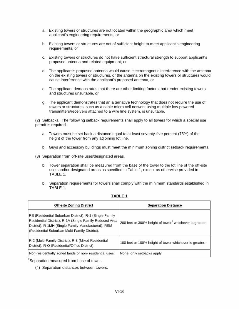
VI-16
a. Existing towers or structures are not located within the geographic area which meet applicant's engineering requirements, or
b. Existing towers or structures are not of sufficient height to meet applicant's engineering
requirements, or c. Existing towers or structures do not have sufficient structural strength to support applicant's
proposed antenna and related equipment, or d. The applicant's proposed antenna would cause electromagnetic interference with the antenna
on the existing towers or structures, or the antenna on the existing towers or structures would cause interference with the applicant's proposed antenna, or
e. The applicant demonstrates that there are other limiting factors that render existing towers
and structures unsuitable, or g. The applicant demonstrates that an alternative technology that does not require the use of
towers or structures, such as a cable micro cell network using multiple low-powered transmitters/receivers attached to a wire line system, is unsuitable.
(2) Setbacks. The following setback requirements shall apply to all towers for which a special use permit is required.
a. Towers must be set back a distance equal to at least seventy-five percent (75%) of the
height of the tower from any adjoining lot line. b. Guys and accessory buildings must meet the minimum zoning district setback requirements.
(3) Separation from off-site uses/designated areas.
b. Tower separation shall be measured from the base of the tower to the lot line of the off-site
uses and/or designated areas as specified in Table 1, except as otherwise provided in TABLE 1. b. Separation requirements for towers shall comply with the minimum standards established in
TABLE 1.
TABLE 1
Off-site Zoning District
Separation Distance
RS (Residential Suburban District), R-1 (Single Family
Residential District), R-1A (Single Family Reduced Area
District), R-1MH (Single Family Manufactured), RSM
(Residential Suburban Multi-Family District).
200 feet or 300% height of tower2 whichever is greater.
R-2 (Multi-Family District), R-3 (Mixed Residential
District), R-O (Residential/Office District).
100 feet or 100% height of tower whichever is greater.
Non-residentially zoned lands or non- residential uses
None; only setbacks apply 2Separation measured from base of tower.
(4) Separation distances between towers.
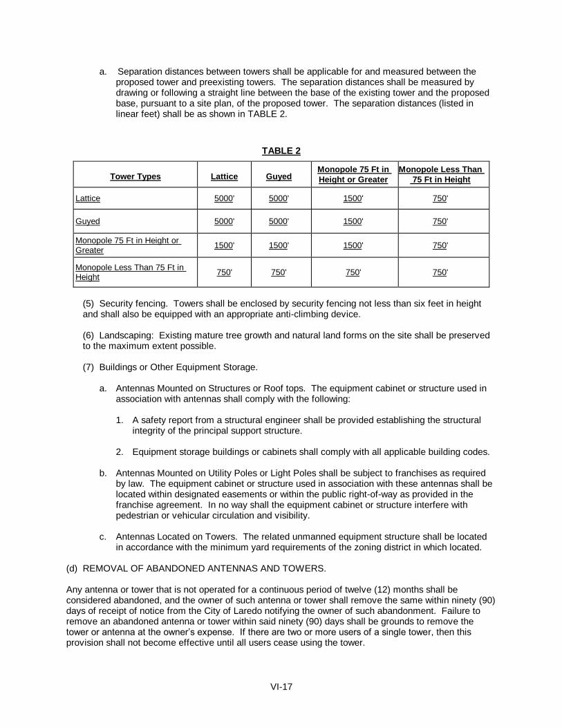
VI-17
a. Separation distances between towers shall be applicable for and measured between the proposed tower and preexisting towers. The separation distances shall be measured by drawing or following a straight line between the base of the existing tower and the proposed base, pursuant to a site plan, of the proposed tower. The separation distances (listed in linear feet) shall be as shown in TABLE 2.
TABLE 2
Tower Types
Lattice
Guyed
Monopole 75 Ft in
Height or Greater
Monopole Less Than
75 Ft in Height
Lattice 5000' 5000' 1500' 750'
Guyed 5000' 5000' 1500' 750'
Monopole 75 Ft in Height or Greater
1500' 1500' 1500' 750'
Monopole Less Than 75 Ft in Height
750' 750' 750' 750'
(5) Security fencing. Towers shall be enclosed by security fencing not less than six feet in height and shall also be equipped with an appropriate anti-climbing device.
(6) Landscaping: Existing mature tree growth and natural land forms on the site shall be preserved to the maximum extent possible.
(7) Buildings or Other Equipment Storage.
a. Antennas Mounted on Structures or Roof tops. The equipment cabinet or structure used in
association with antennas shall comply with the following:
1. A safety report from a structural engineer shall be provided establishing the structural integrity of the principal support structure.
2. Equipment storage buildings or cabinets shall comply with all applicable building codes.
b. Antennas Mounted on Utility Poles or Light Poles shall be subject to franchises as required
by law. The equipment cabinet or structure used in association with these antennas shall be located within designated easements or within the public right-of-way as provided in the franchise agreement. In no way shall the equipment cabinet or structure interfere with pedestrian or vehicular circulation and visibility.
c. Antennas Located on Towers. The related unmanned equipment structure shall be located
in accordance with the minimum yard requirements of the zoning district in which located. (d) REMOVAL OF ABANDONED ANTENNAS AND TOWERS. Any antenna or tower that is not operated for a continuous period of twelve (12) months shall be considered abandoned, and the owner of such antenna or tower shall remove the same within ninety (90) days of receipt of notice from the City of Laredo notifying the owner of such abandonment. Failure to remove an abandoned antenna or tower within said ninety (90) days shall be grounds to remove the tower or antenna at the owner’s expense. If there are two or more users of a single tower, then this provision shall not become effective until all users cease using the tower.

VI-18
Section 24.93.11 NATIONALIZATION OF VEHICLES ENTERPRISE The City Council may grant a special use permit for a nationalization of vehicles enterprise in a B-3 (Community Business District) and higher intensity zoning classification districts under the following conditions:
(1) Minimum lot size of two (2) acres.
(2) It shall not be located within two hundred (200) feet of:
a. Any residential structure; b. The boundary of any district zoned AG, R-S, R-1, R-1A, R-1MH, RSM, R-2 or R-3; c. For the purpose of subsection (2), measurement shall be made in a straight line, without
regard to intervening structures or objects, from the nearest portion of the property line of the premises of any residential structure or the boundary of any district zoned AG, R-S, R-1, R-1A, R-1MH, RSM, R-2, or R-3.
(3) Two public restroom facilities per one acre of land shall be available on the premises which meet
public health and adopted building code standards set forth in the International Plumbing Code Table 403.1 “Minimum Required Plumbing Fixtures”.
(4) Lighting of property shall be screened to avoid adverse impact on adjacent residential
neighborhoods.
(5) Trees and shrubs shall be planted along the perimeter of parking areas in accordance with the City of Laredo Land Development Code.
(6) All parking lots shall be paved of asphalt or concrete materials.
(7) Dumpsters, trash bins, and/or locations for refuse collection shall be provided on site.
(8) A seven foot opaque fence shall be provided adjacent to residential uses.
(9) Signage shall be limited to that permitted in a B-1 district.
Section 24.93.12 ENFORCEMENT AND REVOCATION OF SPECIAL USE PERMIT
(a) Any Special Use Permit, authorized by City Council, shall be considered in noncompliance and shall be suspended or revoked and removed from the City of Laredo Zoning Map if:
(1) A court having jurisdiction or a jury find the holder of the Special Use Permit guilty of a violation or if a holder of an SUP pleads guilty of violating:
(a.) Any requirement or term or condition of the Special Use Permit or has not conformed, at any time, with any or all of the requirements or terms or conditions as set out in the Special Use Permit as approved by the City Council.
(2) The activity authorized by the Special Use Permit commences prior to the institution of all conditions imposed by the Special Use Permit. (3) The use for which the Special Use Permit was authorized does not commence within six months of the effective date of the Special Use Permit.
(a.) An extension of up to six months may be granted, for good cause shown, by the Building Services Director upon petition of the SUP holder.

VI-19
(4) The use for which the Special Use Permit is authorized is discontinued for a period of six (6) consecutive months. (5) In the event of discontinuance or failure to commence as stipulated in Subsection 24.93.12 of this Ordinance, Zoning Enforcement Staff will issue written notification of same. Ten days after issuance of Zoning Enforcement notification of discontinuance or failure to commence, the Planning Director shall then issue the permit holder written notification of the Special Use Permit’s official revocation and removal from the City of Laredo Zoning Map.
(b) Procedures:
(1) Should a City of Laredo Zoning Enforcement Official or Fire Official inspection reveal non-compliance with Laredo Land Development Code, Section 24.93.7.(b) or any of any additional express conditions of the Special Use Permit, Special Use Permit suspension/revocation procedures shall commence as below stipulated:
(a.) A Zoning Officer or Fire Official shall, upon discovery of special use permit non-compliance as per Subsection 24.93.7.(b), issue a written warning, granting a grace period of a minimum of ten (10) working days, within which time the use may be brought into compliance with the current City Council approved Special Use Permit for that location. (b.) If non-compliance persists after the conclusion of the warning grace period, a Zoning Enforcement Official or Fire Official shall issue written citation. (c.) The requirement for the issuance of a written warning and grace period shall not apply to a citation issued as a result of a violation of the “Occupant Load” as set forth in the Certificate of Occupancy with Occupant Load or the failure to, during all hours of operation, maintain, free from obstruction or impediment to full instant use in the case of fire or other emergency, all exit accesses, exits or exit discharges and said citation/s shall be filed for prosecution. (d.) Should a citation result in a court, having jurisdiction or a jury finding the holder of the Special Use Permit guilty of a violation, or if a holder of an SUP pleads guilty, the Special Use Permit will be suspended for such period of time as is necessary to remedy the violation, but in no event shall the suspension be for less than 24 hours to be implemented as follows:.
i. The Zoning Officer or Fire Official shall immediately notify the Planning Director, in writing, of the result of the prosecution of the citation.
ii. The Planning Director shall, within 48 hour notice of the court’s determination (or as soon thereafter as is practicable) issue the permit holder written notification of the Special Use Permit’s official suspension.
iii. The Special Use Permit Holder shall suspend all business operations in accordance with the notice.
iv. The Special Use Permit Holder shall not resume operation until the violation has been corrected and the establishment has been inspected. A “Notice of Termination of Suspension” shall be issued by the Planning Director upon his/her finding that all issues relevant to the suspension have been complied with and the 24 hour suspension period has run. The Planning Director shall issue such notice without unreasonable delay.
(2) Upon the second conviction of a violation of any of the provisions of the Laredo Land Development Code, Section 24.93.7. (b) or any additional express condition of the Special Use Permit, within any twelve month period, the Special Use Permit will be suspended for such period of time as is necessary to remedy the violation, but in no event shall the suspension be for less than 72 hours. This provision shall be implemented in the same manner as set forth above in Section 24.93.12 (b) (1)(a-d).
VI-20
(3) Upon the third conviction of a violation of any of the provisions of the Laredo Land Development Code, Section 24.93.7. (b) or any additional express condition of the Special Use Permit, within any twelve month period, and subject to the revocation/suspension procedures set forth in Section 24.93.12 (b) (1)(a-d), the Special Use Permit will be revoked and the City shall proceed with its removal from the City of Laredo Zoning Map.
(a.) The Planning Director shall issue the permit holder written notification of the Special Use Permit’s official revocation and removal from the City of Laredo Zoning Map and the Special Use Permit Holder shall suspend all business operations which are inconsistent with and in violation of the zoning district in which the business is located. (b.) Once the holder of the Special Use Permit has been notified of the revocation, the permit holder may petition the City Council for reinstatement of the permit. The reinstatement shall be processed and proceed in the same manner as a new application for a Special Use Permit inclusive of all required fees and documentation. (c.) In the event the Special Use Permit Holder appeals the conviction, any suspension or revocation will be abated until the completion of the appeals process.
(4) For purposes of Section 24.93.7.(1), (2), or (3) above, a finding of guilt on more than one citation issued on the same day for the same location shall be counted as only one violation. (5) In the event the Special Use Permit Holder appeals a conviction, any suspension or revocation will be abated until the completion of the appeals process. (6) Effect of Other Violations (Habitual Offenses):
(a.) Twelve violations of City Ordinances which result in an adjudication of guilt (by trial to the court, by jury or by entering a plea of guilt) during any twelve month period shall result in the revocation of the Special Use Permit. The holder of said SUP may avail himself/herself of the remedy set forth in Section 24.93.12(b)(3)(b). (b.) Should the twelve citations, issued during any twelve month period result in a court having jurisdiction or a jury find the holder of the Special Use Permit guilty of each violation or if a holder of an SUP pleads guilty to violation/s, the City of Laredo shall consider the Special Use Permit revoked and proceed with its removal from the City of Laredo Zoning Map. (c.) The Planning Director shall then issue the permit holder written notification of the Special Use Permit’s official revocation and removal from the City of Laredo Zoning Map and the Special Use Permit Holder shall suspend all business operations which are inconsistent with and in violation of the zoning district in which the business is located. (d.) Once the holder of the Special Use Permit has been notified of the revocation, the permit holder may petition the City Council for reinstatement of the permit. The reinstatement shall be processed and proceed in the same manner as a new application for a Special Use Permit inclusive of all required fees and documentation. (e.) In the event the Special Use Permit Holder appeals any of the convictions the revocation will be abated until the completion of the appeals process.
VI-21
SECTION 24-94
CONDITIONAL USE PERMIT PROCEDURES Section 24.94.1 GENERAL Conditional uses are those land uses which are not permitted by a site’s current zoning designation, but are generally compatible with the surrounding land uses, and are authorized by the issuance of a Conditional Use Permit pursuant to the criteria and procedures described by this section. Conditional uses require site review of their location, design, intensity, density, configuration, and operating characteristics, and may require the imposition of appropriate conditions, in order to ensure compatibility of the use to its particular location and mitigate its potentially adverse impact on the surrounding area. Section 24.94.2 PURPOSE The purpose of a Conditional Use Permit is to provide for those land uses where additional regulation is necessary to protect the property and surrounding area. A Conditional Use Permit is primarily intended for property located in older sections of the City and is intended to promote development and/or redevelopment of such property which is consistent with the land use patterns of surrounding property. The City Council may grant a Conditional Use Permit where there is a finding based on testimony received at the public hearing that the applicant is willing and able to mitigate any negative effects of the proposed use. Section 24.94.3 GENERAL CONTENTS OF A CONDITIONAL USE PERMIT APPLICATION AND
FEES Any applicant requesting a Conditional Use Permit under the requirements of this section shall file with the City Planning Department an application for such permit with the appropriate fee. It shall be the applicant’s responsibility to submit a complete application, which addresses the review criteria of this section. All Conditional Use Permit applications shall contain, at a minimum, the following information:
(A) A complete copy of a recorded deed conveying the proposed Conditional Use site to the person identified on the application as the owner.
(B) Tax certificates, generated by the appropriate taxing entity, for the property indicating that all taxes
are paid to date. (C) A site plan of the subject property, showing existing and proposed features, buildings, roads,
alleys, utilities, etc. which are relevant to review of the conditional use application. Current land use of properties on all sides of the property and across streets and alleys
(D) The name, address, and telephone numbers of all owners, applicants, and representatives. (E) The certificate and/or articles of incorporation shall be required of properties owned by business
entities. Supplementary Information The Planning Director may request any information of the applicant as is necessary to evaluate the impacts of the conditional use application. Examples of the information which may be requested are
VI-22
elevations of the proposed new or remodeled structures, analysis of the traffic impacts of the proposed use, or evaluation of the environmental impacts of the proposed use. Fees for conditional use permits shall be as listed in Appendix B-3 of the Laredo Land Development Code. Section 24.94.4 PROCESS The processing of a Conditional Use Permit application shall follow the administrative procedures set forth for amendment of the zoning map in Section 24-92 of the Laredo Land Development Code. Section 24.94.5 CONDITIONAL USE PERMIT APPLICATION SUBMITTAL CRITERIA A. All Conditional Use Permit applications must conform to all of the following criteria:
1. Applications for properties currently zoned A-G, R-S, R-1, R-1A, R-1-MH, or RSM may only seek conditional use status for those uses permitted by zones R-S, R-1, R-1A, R-1-MH, RSM, R-2, R-3, R-O or B-1 of higher intensity.
2. Applications for properties currently zoned, R-2, R-3, or R-O, may only seek conditional use status
for those uses permitted by R-3, R-O, B-1 or B-3 of higher intensity. 3. Applications for properties currently zoned B-1, B-1R, CBD, AE, B-3 or B-4 may only seek
conditional use status for those uses permitted by zones B-1R, CBD, B-3, B-4 or M-1 of higher intensity.
4. Applications for properties currently zoned M-1 or M-2, may only seek conditional use status for
those uses permitted by zones M-2 or MXD of higher intensity. 5. The site of the proposed conditional use or any improvements thereon are not in violation of any
local, state, or federal law (other than zoning violation). 6. Application for Conditional Use Permit is prohibited if the existing underlying zoning requires a
Special Use Permit for the proposed use. 7. Any Conditional Use Permit authorized for a use, normally requiring a Special Use Permit in any
district, must conform at a minimum with the performance standards required of that Special Use Permit.
8. The use and site plan for the proposed conditional use shall conform, at a minimum, with all
applicable provisions of the Land Development Code for the existing underlying zoning designation, including but not limited to:
a. Site Development Standards. All parking, landscaping, signage, improvement and
dimensional standards b. Zoning Districts Standards. The purpose of the zoning district in which the proposed
conditional use is to be located and any standards applicable to the particular proposed use.
9. Conditional use status may only be authorized for proposed use. Application for conditional use status is prohibited for the purpose of deviation from any applicable development standards normally required by the existing underlying zoning, including, but not limited to signage, landscaping, parking, paving or dimensional requirements.
10. Existing or previously legal-nonconforming structures may apply for conditional use status and are
not limited by conditional use permit application parameters as stipulated in Sections 24.94.5.1 through 24.94.5.4 and 24.94.5.9.
VI-23
11. Conditional use status may be sought if the site has a non-conforming use which has been in existence for ten (10) or more years.
12. Conditional use status may not be sought for uses requiring less intense zoning designation than
that which currently exists on site. Section 24.94.6 CONDITIONAL USE PERMIT REVIEW STANDARDS: An application for a Conditional Use shall comply with the following standards: A. Suitability The characteristics of the proposed site are suitable for the proposed use considering the size, shape, location, topography and location of improvements and natural features. B. Timeliness The proposed use and/or development is timely, considering the adequacy of transportation systems, public facilities and services, existing or planned for the area affected by the proposed use. C. Compatibility to Surrounding Area The proposed use will not alter the character of the surrounding area in a manner which substantially limits, impairs, or precludes the use of surrounding properties for the primary uses listed as allowable by the underlying zoning district. D. Comprehensive Plan The proposed use satisfies any applicable goals and policies of the Comprehensive Plan, which apply to the proposed use. E. Overlay Status The proposed Conditional Use Permit is the only zoning overlay on that site. F. Master Plan The proposed use is consistent with any approved Master Plan for that area. G. Use Appropriate and Compatible The use shall be appropriate to it’s proposed location and be compatible with the character of neighboring uses, or enhance the mixture of complementary uses and activities in the immediate vicinity. H. Traffic The use shall not cause undue traffic congestion, dangerous traffic conditions or incompatible service delivery, parking or loading problems. Necessary mitigating measure shall be proposed by the applicant. I. Nuisance The operating characteristics of the use shall not create a nuisance and the impacts of the use on surrounding properties shall be minimized with respect to noise, odors, vibrations, glare, and any other similar conditions. J. Environment
VI-24
The use shall not cause significant deterioration to water resources, wetlands, wildlife habitat, scenic characteristics, or other natural features. As applicable, the proposed use shall mitigate its adverse impacts on the environment. Section 24.94.7 AUTHORIZATION TO IMPOSE CONDITIONS The Planning and Zoning Director and Commission may recommend, and the Council may impose such conditions as are necessary to maintain the integrity of the City’s zoning districts, to ensure the conditional use is consistent with the City’s Comprehensive Plan, conforms with the Land Development Code, is appropriate to it’s location and compatible with neighboring uses, and does not cause undue traffic congestion or significant deterioration of the environment. All requirements imposed by a Conditional Use permit are in addition to and supplement land development code requirements. Authorized conditions include, but are not limited to: (A) Site Plan Features Limitations or requirements regarding the area, setbacks, open space, landscaping, buffering, lighting, fencing, signage, off-street parking, and similar site plan features of the proposal. (B) Operations Limitations or requirements regarding the conditional use’s operating characteristics, duration or any similar feature of the conditional use. (C) Duration In the event Council limits the duration of a conditional use permit, a six month grace period, starting from the Council’s final approval date, shall be afforded the applicant, over and above that time period stipulate by Council.
Section 24.94.8 AMENDMENT TO AN APPROVED CONDITIONAL USE PERMIT Any change to an approved conditional use permit, other than those changes that qualify as insubstantial pursuant to Section 24.94.9 of this article, will require amendment of the existing conditional use permit Amendment of an approved conditional use permit may only be authorized by the City Council pursuant to the administrative procedures set forth in Section 24.92 of the Laredo Land Development Code governing the amendment of the zoning map. Section 24.94.9 INSUBSTANTIAL CHANGES TO AN APPROVED CONDITIONAL USE PERMIT The Planning and Zoning Director may approve insubstantial changes to a previously approved conditional use permit. An insubstantial change is one that becomes necessary during the use’s actual implementation, which could not be reasonably anticipated during it’s review by the City Council and one that the Planning and Zoning Director determines does not significantly change the original approval granted. An amendment to any of the following Conditional Use Permit requirements may not be considered insubstantial: (A) Use - those activities allowed on site by the Conditional Use Permit.

VI-25
(B) Operational Characteristics - the gross limitations or requirements regarding the conditional use’s operating characteristics.
(C) Site Plan Features - the gross limitations or requirements regarding the area, setbacks, open spaces,
landscaping, buffering, lighting, fencing, signage, or the off-street parking of the proposal. (D) Duration - Requirements governing the duration of the permit. (E) Permit Holder - Requirements regarding the person or entity to whom the permit is issued. Section 24.94.10 REVOCATION 1. Criteria Any Conditional Use Permit, authorized by City Council, shall be considered in noncompliance and shall be revoked and removed from the City of Laredo Zoning Map, in the event a court of law finds the use in violation of any of the following conditions:
A. The use established on site does not conform, at any time, with any or all permit condition(s) approved by the Council and or any local, state or federal law. B. The activity authorized by the Conditional Use Permit commences prior to the institution of all conditions imposed by the Conditional Use Permit. C. Discontinuance of the Council approved conditional use for a period of six (6) consecutive months. D. The use for which the Conditional Use Permit was authorized does not commence within six months of City Council’s final approval date.
2. Procedures Should City of Laredo Zoning Enforcement Official inspection reveal noncompliance with Laredo Land Development Code, Subsection 24.94.10, Conditional Use Permit revocation procedures shall commence as below stipulated:
A. A Zoning Officer shall, upon discovery of conditonal use permit noncompliance as per Subsection 24.94.10, issue a written warning, granting a grace period of a minimum of ten (10) working days, within which time the use may be brought into compliance with the current City Council approved Conditional Use Permit for that location. B. If noncompliancce persists after the conclusion of the warning grace period, a Zoning Enforcement Official shall issue written citation. C. Should the citation result in a guilty verdict, the City of Laredo shall consider the Conditional Use Permit revoked and proceed with its removal from the City of Laredo Zoning Map.
D. The Planning Director shall then issue the permit holder written notification of the Conditional Use Permit’s official revocation and removal from the City of Laredo Zoning Map. E. In the event of discontinuance or failure to commence as stipulated in Subsection 24.94.10.1.D and E of the this Ordinance, Zoning Enforcement Staff will issue written notification of same. Ten days after issuance of Zoning Enforcement notification of discontinuance or failure to commence, the Planning Director shall then issue the permit holder written notification of the Conditional Use Permit’s official revocation and removal from the City of Laredo Zoning Map.

VI-26
Section 24.94.11 TRANSFERABILITY A Conditional Use Permit shall be transferable only with the approval of the City Council, and shall be subject to all conditions of the initial approval, and such other conditions as the City Council may require. Section 24.94.12 BOARD OF ADJUSTMENT The Board of Adjustment shall have no authority to grant any variance to any aspect of any Conditional Use Permit duly authorized by the City Council.
VI-27
SECTION 24-96
AMENDMENT PROCEDURES FOR THE STANDARD TECHNICAL SPECIFICATION MANUAL
Section 24-96.1 GENERAL The Standard Technical Specifications Manual shall be, at a minimum, reviewed on an annual basis by the Standard Technical Specifications Committee. Recommendations for revision shall be forwarded to City Council. Prior to City Council consideration, a public hearing on any proposed amendments shall be held before the Planning and Zoning Commission. The Planning and Zoning Commission shall forward a recommendation on the proposed amendments to the City Council. Section 24-96.2 ACTION REQUIRED The Standard Technical Specification Manual may be revised by ordinance after a public hearing by majority vote of the City Council. Recommendations by the Committee and Commission shall be submitted to the City Council with any proposed revision.

LAREDO LAND DEVELOPMENT CODE CHAPTER 24
ARTICLE VII
ENFORCEMENT, PENALTIES ND APPEALS
SECTION 24-98 ENFORCEMENT Reserved
SECTION 24-98 PENALTIES Reserved

LAREDO LAND DEVELOPMENT CODE
CHAPTER 24
APPENDICES
Appendix A Definitions (93-0-177, 9/7/93; 97-0-081, 4/07/97; 98-0-095, 4/07/98; 98-0-197, 8/3/98; 98-0-253, 10/19/98; 99-O-186, 6/28/99; 00-
O-052, 3/6/00; 00-0-051, 3/6/00; 2000-O-107, 5/01/00; 2001-O-036, 02/5/01; 2002-O-211, 09/03/02; 2002-O-257, 10/21/02; 2003-O-047, 3/03/03; 2004-O-105, 5/17/04; 04-O-65, 04/05/04; 05-O-024, 2/7/05;08-O-056, 3/25/08; 2009-O-102, 7/6/09; 2009-O-158, 9/21/08; 2009-O-225, 12/21/09; 2010-O-084, 7/6/10; 2012-O-112, 9/4/12; 2013-O-005, 2/4/13;2013-O-060, 5/2013; 2014-O-153, 11/17/14; 2017-O-061, 6/7/17)
Appendix B-1 Fees for Copies of Documents (94-0-247, 12/5/94)
Appendix B-2 Subdivision Fees Appendix B-3 Zoning Fees (91-O-243, 11/4/91; 93-0-228, 11/22/93; 2002-O-257, 10/21/02; 04-O-264, 11/15/04; 2012-O-155, 9/17/12)
Appendix C Registration Fees (95-0-057, 3/6/95; 95-0-068, 7/17/95) Appendix D Permit Fees (95-0-057, 3/6/95; 95-0-068, 7/17/95) Building Electrical Plumbing Mechanical (HVAC) Miscellaneous fees Appendix F Recommended Trees for the Laredo Region Appendix G Standard Sidewalk/Driveway Details (95-0-123, 6/19/95)
Appendix N Noise Attenuation Performance (94-0-013, 1/3/94)
1
APPENDIX A
Access Street - shall mean any public street within a subdivision or along the boundaries of a subdivision which would serve any properties outside the plat boundaries or provide a connection directly with a collector street.
Accessory Use or Structure - shall mean a use or structure on the same lot with, and of a nature customarily incidental and subordinate to the principal use or structure.
Adult Bookstore - shall mean a business which sells, exhibits, or offers for sale or rental sexually explicit books, devices, films or videotapes.
Adult Day-care Facility - shall mean a licensed or accredited facility that provides counseling, recreation, food, or any or all of these services to four or more elderly or handicapped persons who are not related by blood, adoption, or marriage.
Adult Day Health Care Facility - shall mean a facility that provides health care or physical therapy or both and that may also provide adult day-care services on a daily or regular basis but not overnight to four or more elderly or handicapped persons who are not related by blood, marriage, or adoption to the owner of the facility; and which requires state licensing or accreditation. (Amended 4/6/92, Ord. No. 92-0-076)
Adverse Impact - means any deleterious effect on wetlands, including their quality, quantity, surface area, species composition, aesthetics, or usefulness for human health, welfare, safety or property, to biological productivity, diversity, or stability or which unreasonably interferes with the enjoyment of life or property, including outdoor recreation.
Agricultural Use - shall mean any activity related to the cultivation of the soil, the production of crops for human food, animal feed or planting seed or for the production of fibers; floriculture, viticulture or horticulture; the raising or keeping of livestock; the planting of cover crops or the leaving land idle for the purpose of participating in any governmental program or recognized, normal crop rotation or livestock rotation procedure. A residential unit and related outbuildings located wholly on a tract of land used solely for one or more of the purposes described in the preceding sentence shall be deemed an agricultural use.
Air installation compatible use zone - shall mean those land areas upon which limited control is required with respect to land uses that may obstruct airspace because found generally compatible with airport operations, posing no health or safety hazard for aircraft operations.
Airport - shall mean the Laredo International Airport.
Airport Elevation - shall mean the highest point airport usable landing area measured in feet above mean sea level.
Airport hazard - shall mean any structure or object of natural growth located in the vicinity of the airport which obstructs the airspace required for the flight of aircraft or airport operations.
Airport Obstruction - shall mean any structure or object of natural growth or use of land which would exceed the federal obstruction standards established in 14 CFR sections 77.21, 77.23, 77.25 and 77.28, or which obstructs the airspace required for flight of aircraft in landing or take-off, or is otherwise hazardous to airport operations.
Airspace height - shall mean the height limits established in this chapter, to be measured in feet above mean sea level.
Alley - A minor public right-of-way which affords only a secondary means of access to abutting property.
Alluvial Fan Flooding - means flooding occurring on the surface of an alluvial fan or similar landform
2
which originates at the apex and is characterized by high-velocity flows; active processes of erosion, sediment transport, and deposition; and unpredictable flow paths.
Alternative tower structure - shall mean any man-made trees, clock towers, bell steeples, light poles and similar alternative-design mounting structures that camouflage or conceal the presence of antennas or towers.
Amusement Redemption Machine - an amusement redemption machine is a skill or pleasure coin-operated machine that is designed, made, and adapted solely for bona fide amusement purposes, and that by operation of chance or a combination of skill and chance affords the user, in addition to any right of replay, an opportunity to receive exclusively non-cash merchandise prizes, toys, or novelties, or a representation of value redeemable for those items. An amusement redemption machine does not include:
(1) a machine that awards the user non-cash merchandise prizes, toys, or novelties solely and directly form the machine, including claw, crane, or similar machines, nor; (2) a machine from which the opportunity to receive non-cash merchandise prizes, toys, or novelties, or a representation of value redeemable for those items, varies depending upon the user’s ability to throw, roll, flip, toss, hit, or drop a ball or other physical object into the machine or a part thereof, including basketball, skeeball, golf, bowling, pusher, or similar machines.
Amusement Redemption Machine Establishment - any business, organization, or institution which provides patrons access to amusement redemption machines, excluding a bar with five (5) or fewer machines.
Antenna - shall mean any exterior transmitting or receiving device mounted on a tower, building or structure and used in communications that radiate or capture electromagnetic waves, digital signals, analog signals, radio frequencies (excluding radar signals), wireless telecommunications signals or other communication signals.
Antique Store - shall mean a retail store located within an enclosed structure which sells objects, art, handicrafts, furniture, glassware, guns, linens or other items fabricated more than fifty years earlier which have unique artistic or historical merit.
Apartment - shall mean a dwelling unit designed to be rented as a part of an apartment house or attached to a single-family dwelling.
Apartment Building - shall mean a building under the ownership of a single person or entity containing three (3) or more separate living units for rental or lease, with facilities for living, sleeping, cooking and eating.
Apartment garage - shall mean a dwelling unit with facilities for living, sleeping, cooking, and eating designed or constructed as part of a facility designed primarily to house or store motor vehicles or machinery.
Apex - means a point on an alluvial fan or similar landform below which the flow path of the major stream that formed the fan becomes unpredictable and alluvial fan flooding can occur.
API - shall mean the American Petroleum Institute.
Appeal - means a request for a review of the City Engineer’s interpretation of any provisions of the storm water management code.
Applicant - means any person, firm, or governmental agency who executes the necessary forms to procure official approval of a project or a permit to carry out construction of a project.

3
Appurtenant Structure - means a structure which is on the same parcel of property as the principal structure to be insured and the use of which is incidental to the use of the principal structure.
Area of Future Conditions Flood Hazard - means the land area that would be inundated by the 1-percent-annual chance (100 year) flood based on future conditions hydrology.
Area of Shallow Flooding - means a designated AO, AH, AR/AO, AR/AH, or VO zone on a community's Flood Insurance Rate Map (FIRM) with a 1 percent or greater annual chance of flooding to an average depth of 1 to 3 feet where a clearly defined channel does not exist, where the path of flooding is unpredictable and where velocity flow may be evident. Such flooding is characterized by ponding or sheet flow.
Area of Special Flood Hazard - is the land in the floodplain within a community subject to a 1 percent or greater chance of flooding in any given year. The area may be designated as Zone A on the Flood Hazard Boundary Map (FHBM). After detailed rate making has been completed in preparation for publication of the FIRM, Zone A usually is refined into Zones A, AO, AH, A1-30, AE, A99, AR, AR/A1-30, AR/AE, AR/AO, AR/AH, AR/A, VO, V1-30, VE or V.
Art, artwork or work of art - means any work product of an artist, including all forms of performing arts, literary arts, and plastic or visual arts, conceived in any medium, material, modeling, music, theater, tattooing, literature, painting, printing, drawing, engraving, frescos, stained glass, mosaics, mobiles, tapestries, carving, sculpture, murals, fashion design, jewelry design, photography, film, video, digital imaging, bas- relief, high relief, fountains, kinetics, culinary arts, and collages. (Added 7/6/10, Ord. No. 2010-0-
084)
Art establishment - means an establishment primarily dedicated to the creation, dissemination, teaching or practice of art, its display, exhibition, storage, or offer for sale, and includes but is not limited to antique shops, art galleries, artist live/work spaces, art studios, art supplies stores, bookstores, libraries theaters, art museums, and schools of music, art, culinary arts or dance, but does not include sexually oriented businesses. (Added 7/6/10, Ord. No. 2010-0-084)
Art gallery - means an art establishment dedicated to the promotion and sale of art, open to the public, with standard business hours for more than four (4) days per week. (Added 7/6/10, Ord. No. 2010-0-084)
Art studio - means an art establishment used by an artist exclusively for the creation, production, rehearsing, or performance of art, and/or from where art may be promoted, sold or offered. (Added 7/6/10,
Ord. No. 2010-0-084)
Arterial - shall mean any existing or proposed street identified as such on the adopted Major Thoroughfare Plan of the City of Laredo.
Artist - means a person regularly engaged in and who derives a substantial portion of his/her annual income from the creation of art, either written, composed, produced or otherwise executed. (Added 7/6/10,
Ord. No. 2010-0-084)
Artist live/work space - means an art studio in which an artist is allowed to reside. (Added 7/6/10, Ord. No.
2010-0-084)
As-built Plan - shall mean a set of engineering or site drawings that delineate the specific permitted storm water infrastructure as actually constructed.
Automotive, Mobile Home, Travel Trailer and Farm Implement Sales - The sale or rental of new and used motor vehicles, mobile homes, travel trailers or farm implements, but not including repair work, except incidental warranty repair of same, to be displayed and sold on the premises.

4
Automotive Repairs - shall mean the repair, rebuilding or reconditioning of motor vehicles or parts thereof, including collision service, painting and steam cleaning of vehicles.
Automotive sales - shall mean the sale, rental, or display of passenger cars and light trucks.
Automotive wrecking and salvage - shall mean the wrecking or salvage of used motor vehicles, mobile homes, or trailers, or the storage, sale, disposal of dismantled or partially dismantled, obsolete or wrecked vehicles, or parts of vehicles.
A-Zones - are found on all Flood Hazard Boundary Maps (FHBMs), Flood Insurance Rate Maps (FIRMs), and Flood Boundary and Floodway Maps (FBFMs). An A-Zone is an area that would be flooded by the Base Flood,, and is the same as a Special Flood Hazard Area (SFHA) or a 100-year floodplain. These areas may be unnumbered as AE, AH, or AO Zones. Numbered A-Zones indicate an area’s risk to flooding.
Backwater Effect - The rise in water surface elevation caused by some obstruction such as a narrow bridge opening, buildings, or fill material that limits the area through which the water must flow. Also referred to as “heading up.”
Bar - shall mean an establishment whose primary business is the serving of alcoholic beverages for public consumption on the premises whether or not entertainment, dancing, or food items are also provided. For purposes of this definition, “primary business” means the establishment derives in excess of fifty percent (50%) of its gross revenue on a quarterly basis from the sale or service of alcoholic beverages, as defined in the Texas Alcoholic Beverage Code (as amended), for on-premise consumption. This definition does not include bona fide restaurants, hotels, motels, or sports related facilities such as golf courses, bowling alleys or sports arenas, or the serving of alcoholic beverages at publicly or privately sponsored events such as weddings, public celebrations, quinceañeras or the like. (Amended 2/4/13, Ord. No. 2013-O-005)
Base Flood - means the flood having a 1 percent chance of being equaled or exceeded in any given year.
Base Flood Elevation (BFE) - The elevation shown on the Flood Insurance Rate Map (FIRM) and found in the accompanying Flood Insurance Study (FIS) for Zones A, AE, AH, A1-A30, AR, V1-V30, or VE that indicates the water surface elevation resulting from the flood that has a 1% chance of equaling or exceeding that level in any given year - also called the Base Flood.
Base Floodplain - The floodplain that would be inundated by a one-percent chance (100-year) flood.
Basement - Any area of the building having its floor subgrade (below ground level) on all sides.
Bed and Breakfast - shall mean an owner-occupied detached single family dwelling which provides tourist lodging services and is managed and owned by the owner-occupant and not more than one other person is employed by the owner on the premises except members of the immediate family of the owner/manager who also live on the premises. The owner/operator is required to maintain a current guest register to include names, addresses, fees collected and dates of occupancy, and must provide proof of the collection and payment of state and local Hotel/Motel Occupancy Tax to the City upon request. A bed and breakfast shall have no more than six (6) guest rooms for temporary occupancy by tourists, and individual guest rooms shall be without cooking facilities. Any establishment with more than six (6) rooms shall be considered a hotel and shall be required to comply with the zoning provisions for such uses. The exterior of the premises used for a bed and breakfast must be indistinguishable from any other single family dwellings of like design and character, in that no commercial displays, show windows, exterior storage areas, and outside storage of any nature are evident, with the exception of signs and outdoor advertising provided for in Section 24.82 of the Laredo Land Development Code.
Best Management Practices or “BMP” - shall mean schedules of activities, prohibitions of practices, maintenance procedures, and other management practices to prevent or reduce the pollution of waters of
5
the United States. BMPs also include treatment requirements, operating procedures, and practices to control site runoff, spillage or leaks, sludge or waste disposal, or drainage from raw material storage.
Block - shall mean an identified tract or parcel of land surrounded by a street or streets, and other physical features which may be further subdivided into individual lots or reserves.
Board - shall mean the Zoning Board of Adjustment as authorized by Article IX, Section 9.05, of the Charter of the City of Laredo, l98l and 211.008 Tex. Loc. Govt. Code.
Boarding house - shall mean a rooming house where meals and lodging is provided for compensation for three or more unrelated persons, and where no cooking or dining facilities are provided in the individual rooms.
Breakaway Wall – means a wall that is not part of the structural support of the building and is intended through its design and construction to collapse under specific lateral loading forces, without causing damage to the elevated portion of the building or supporting foundation system.
Buffering - shall mean the planting of trees and/or shrubs, designed to minimize the transmission of unwanted noise, light, vibration, dust, traffic or activity from one property to adjoining public or private properties.
Buildable Width - The width of that part of a lot not included within the set-backs herein required.
Building - See structure. Any structure designed or intended for the support, enclosure, shelter or protection of persons, animals, or property.
Building, Accessory - A subordinate building detached from, but located on the same lot as the principal building the use of which is incidental and accessory to that of the main building.
Building Height - The vertical distance measured from the average elevation of the proposed finished grade at the front of the building to the highest point of the roof for flat roofs, to the deck line of mansard roof and the mean height between eaves and ridge for gable hip and gambrel roofs.
Building Line - See setback line.
Building Permit Application - shall mean an application submitted to the Building Official under the provisions of the Southern Standard Building Code, as amended, for new construction and remodeling which includes exterior remodeling which increases the exterior dimensions of any structure; which includes the replacement of 51% of an existing roof; the construction of a masonry wall or fence exceeding thirty inches in height measured from natural grade; the enclosure of an existing canopy, carport, porte-cochere; or the construction of decking which exceeds thirty inches from natural grade.
Caliper - shall mean the diameter of a tree measured twelve (12) inches above the ground.
Carnival - shall mean temporary entertainment facilities providing rides, exhibits, games, musical productions, food and drink, and items for sale as part of a private commercial venture.
Cemetery - shall mean land used or intended to be used for the burial of the human or animal dead and dedicated for cemetery purposes, including crematories, mausoleums and mortuaries if operated in connection with and within the boundaries of such cemetery.
Certificate of Compliance - shall mean a written certificate issued by the Commission denoting that a subdivision plat or replat has been reviewed and approved.
Certificate of No Plat Required - shall mean certification by the Department based on documented conveyances of real property, that a tract of land is excepted from platting requirements.
6
Certificate of title - shall mean a letter, report, opinion, statement, policy, or certificate prepared and executed by a title company authorized to do business in the State of Texas, or an attorney licensed in Texas, describing all encumbrances of record which affect the property, together with all recorded deeds, including any part of the property included in the plat.
Children’s Amusement Services (Outdoors) - an establishment which provides a service that is oriented towards the amusement of children. The establishment will prohibit the possession and or consumption of alcoholic beverages on its premises. Noise levels shall remain under 70 decibels to be measured no more than eight (8) feet and no less than four (4) feet from the sound source. It will only operate from 8:00 a.m. - 11:00 p.m. Lighting shall be directed away from adjacent properties. Fencing shall be a masonry wall no less than seven (7) feet tall for areas adjacent to residential uses or residential district.
Child-Care Home Types: (Amended Ord. No. 2009-O-158, 9/21/08)
(a) Registered Child-Care Home - shall mean a home in which the registered primary caregiver provides care in the caregiver’s own residence for not more than six children from birth through 13 years, and may provide care after-school hours for not more than six additional elementary school children. The total number of children in care at any given time, including the children related to the caregiver, must not exceed 12.
(b) Licensed Child Care Home – shall mean a home in which the registered primary caregiver provides
in the caregiver’s own residence for children from birth through 13 years. The total number of children in care varies with the ages of the children and the total number of caregivers (see attached chart), but the total number of children in care in a licensed child-care home at any given time, including the children related to the caregiver, must not exceed 12.
City - shall mean the City of Laredo, Texas. For purposes of Section 24-59, Storm Water Management, shall mean the City of Laredo, Texas and its jurisdictional territory.
City Engineer - shall mean the person appointed to the position of Director of the Engineering Department or his/her authorized representative. (Amended 5/17/04, Ord. No. 2004-0-105)
City Petroleum Superintendent - shall mean the representative or official of the city who is charged with the responsibility of carrying out the provisions of this article.
City Tree Official - The Director of Parks and Recreation or his appointed designee.
Clearing - means the removal of trees and brush from the land but shall not include the ordinary moving of grass.
Clinic, medical or dental - shall mean a facility utilized by practitioners or para-professionals providing outpatient services. A clinic may also contain private offices or be a building which may contain three (3) or more physicians and/or dentists, their assistants, laboratory/s and/or apothecary limited to the sale of pharmaceutical and medical supplies, diagnostic equipment (i.e. x-ray, MRI) and/or minor surgical facilities. A clinic shall not include in-patient care or operating rooms for major surgery.
Club - shall mean a structure or portion thereof or premises used for a social, literary, political, educational or recreational purpose of members and their guests which is not open to the general public.
Coin Operated Machine - A coin operated machine includes a machine or device operated by the payment or insertion of paper currency or any other consideration.
Collocation - shall mean, when referring to communication towers and antennas, the placing together of

7
multiple antennas on a single communication tower or structure.
Commencement of Construction - shall mean the initial disturbance of soils associated with clearing, grading, excavating, land filling, and other construction activities.
Commercial condominium - shall mean that portion of a commercial, institutional or office structure under individual ownership, sharing a common lot with ownership and management of common areas held by an organization or association of property owners subject to the Texas Condominium Act.
Commission - shall mean the City Planning and Zoning Commission.
Communication Tower - shall mean any structure that is designed and constructed primarily for the purpose of supporting one or more antennas for telephone, radio and similar communication purposes, including self-supporting lattice towers, guyed towers, or monopole towers. The term includes radio and television transmission towers, microwave towers, common-carrier towers, cellular telephone towers, alternative tower structures, and the like. The term includes the structure and any support thereto.
Completion - shall mean the work conducted upon a well's well bore to establish production of the resource or injection of fluids after the production casing string has been set, cemented, and pressure tested, including perforating casing, setting packers and tubing, and setting the well in place.
Comprehensive Master Plan - shall mean the plan adopted by the Planning Commission and the City Council, showing the general location and extent of present housing, industrial and commercial uses, major thoroughfares, parks, schools and other community facilities, and which sets growth policies and generalized future land uses.
Community - Community means any State or area or political subdivision thereof, or any Indian tribe or authorized native organization, which has the authority to adopt and enforce floodplain management regulations for the areas within its jurisdiction.
Conditional Use - shall be defined as a use allowed within certain zoning districts under certain conditions.
Conditional Use Permit - shall be defined as a permit granted solely on a discretionary and conditional basis by the City Council, which authorizes a land use in a zoning district in which that use is not normally permitted. All requirements of a Conditional Use Permit are in addition to and supplement land development code requirements.
Condominium apartment - shall mean an apartment contained in a structure housing three (3) or more residential units designed for living, eating, cooking or sleeping, under individual ownership, with ownership and management of common areas entrusted to a duly organized association of owners of property as provided in the Texas Condominium Act.
Construction - shall mean any human activity that involves clearing, grading, excavation, land filling, or other placement, movement, removal, or disposal of soil, rock, or other earth materials.
Contaminated - shall mean containing a harmful quantity of any substance.
Conversion - shall mean physically changing the function of a well from one use to another. Developed residential or commercial area - shall mean any property on which a structure is located and is zoned to allow for residential or commercial uses.
Corner lot - shall mean a lot located at the intersection of two local public streets or thoroughfares.
Council - shall mean the City Council of Laredo, Texas.

8
Critical Feature - means an integral and readily identifiable part of a flood protection system, without which the flood protection provided by the entire system would be compromised.
Critical Root Zone - shall mean, for any tree, the area within a circle centered on the location of the trunk. The circle's diameter is one-half the sum of the broadest and narrowest drip line diameters.
Cul-de-sac Street - shall mean a street which is not a through street and which terminates in a turnaround.
Damage - shall mean any action taken which could cause a tree's death, either immediately or after a reasonable period of time, such as severing the main trunk or large branches or large roots, girdling, poisoning, carving, mutilating, touching with live wires, crushing or exposing roots, digging or drilling a hole larger than three (3) cubic feet (or a trench) within the Critical Root Zone, covering a substantial part of the Critical Root Zone, or compacting a substantial part of the soil within the Critical Root Zone. The above are examples and not intended to limit this definition.
Day Care Center - shall mean a facility that provides care for more than 12 children under 14 years of age for less than 24 hours a day which requires state licensing or accreditation. (Amended 4-6-92, Ord. No. 92-0-75)
Department - shall mean the Department of Planning & Building Services.
Density - shall mean the number of dwelling units per acre or square foot of area.
Designated Floodway - The channel of a stream and that portion of the adjoining floodplain designated by a regulatory agency to be kept free of further development to provide for unobstructed passage of flood flows.
Design Flood - Commonly used to mean the magnitude of flood used for design and operation of flood control structures or other protective measures. It is sometimes used to denote the magnitude of flood used in floodplain regulations.
Design Report - shall mean the report that accompanies the storm water management plan and includes data used for engineering analysis, results of all analysis, design and analysis calculations (including results from computer programs), and other engineering data that would assist the City Engineering evaluating proposed storm water management facilities.
Detention Structure - shall mean a permanent storm water management structure whose purpose is to temporarily store storm water runoff and release the stored runoff at controlled rates.
Developed residential or commercial area - shall mean any site on which a structure is located and is zoned to allow for residential or commercial uses.
Development - shall generally mean any of the following actions undertaken by a public or private individual or entity:
1. The division of a lot, tract or parcel of land into two (2) or more lots, plots, sites, tracts, parcels or other divisions by plat or deed, or
2. Any land change, including, without limitation, clearing, tree removal, grubbing, stripping, dredging,
grading, excavating, transporting and filling of land. 3. Any man-made change to improved and unimproved real estate, including but not limited to
buildings or other structures, mining, dredging, filling, grading, paving, excavation or drilling operations or storage of equipment or materials.

9
Director - shall mean the Director of the Department of Planning & Building Services, or his designee.
Discharge - shall mean any addition or introduction of any pollutant, storm water, or any other substance whatsoever into the municipal separate storm sewer system (MS4) or into waters of the United States.
Discharger - shall mean any person who causes, allows, permits, or is otherwise responsible for a discharge, including without limitation, any operator of a construction site or industrial facility.
District - shall mean a zoning district within any section of the City.
Dormitory - shall mean a structure designed for long-term occupancy by three or more unrelated persons, and where no cooking or dining facilities are provided in the individual rooms.
Double-front lot - shall mean a lot located between two public streets with frontage on both.
Drainage area - shall mean that area contributing runoff to a single point measured in a horizontal plane, which is enclosed by a ridge line.
Drainage channel - shall mean a natural or artificially constructed watercourse which provides for stormwater run-off.
Drilling Block - shall mean the surface area of those blocks of land upon which drilling and production operations are to be conducted.
Drilling Unit - shall mean the minimum number of acres surrounding the well required under R.R.C. Form W-1.
Drinking water - shall mean all water distributed by any agency or individual, public or private for the purpose of human consumption or which may be used in the preparation of foods or beverages or for the cleaning of any utensil or article used in the course of preparation of food or beverages for, human bathing or clothes washing.
Dripline Diameter - shall mean an imaginary line on the ground, at the furthest extension of the canopy around the circumference of a tree. Typically the dripline is not a perfect circle.
Drive-In Restaurant - shall mean a restaurant that serves customers who may order from and eat within their vehicles.
Drive-through restaurant - shall mean a business which provides food service to customers through an exterior window.
Drive-through Store - shall mean a retail establishment which supplies merchandise to customers through an exterior window or at the window of their vehicle.
Drug and Tobacco Paraphernalia Shop (a/k/a Head Shop) - shall mean any premises or establishment having a substantial or significant portion of its stock in trade in drug paraphernalia or which has as its main purpose the offering for sale, or that presents or, displays for sale, drug paraphernalia, or items, equipment or products commonly used, intended to be used or commonly known to be used for the ingestion, inhalation, preparation or injection of illegal substances. (Added Ord. No. 2014-O-153, 11/17/14)
Drug paraphernalia means equipment - a product, or material that is used or intended for use in planting, propagating, cultivating, growing, harvesting, manufacturing, compounding, converting, producing, processing, preparing, testing, analyzing, packaging, repackaging, storing, containing, or concealing a controlled substance in violation of this chapter or in injecting, ingesting, inhaling, or otherwise introducing into the human body a controlled substance in violation of this chapter. The term
10
includes: (Added Ord. No. 2014-O-153, 11/17/14)
(A) a kit used or intended for use in planting, propagating, cultivating, growing, or harvesting a species of plant that is a controlled substance or from which a controlled substance may be derived;
(B) a material, compound, mixture, preparation, or kit used or intended for use in manufacturing,
compounding, converting, producing, processing, or preparing a controlled substance; (C) an isomerization device used or intended for use in increasing the potency of a species of plant
that is a controlled substance; (D) testing equipment used or intended for use in identifying or in analyzing the strength,
effectiveness, or purity of a controlled substance; (E) a scale or balance used or intended for use in weighing or measuring a controlled substance; (F) a dilutant or adulterant, such as quinine hydrochloride, mannitol, inositol, nicotinamide, dextrose,
lactose, or absorbent, blotter-type material, that is used or intended to be used to increase the amount or weight of or to transfer a controlled substance regardless of whether the dilutant or adulterant diminishes the efficacy of the controlled substance;
(G) a separation gin or sifter used or intended for use in removing twigs and seeds from or in
otherwise cleaning or refining marihuana; (H) a blender, bowl, container, spoon, or mixing device used or intended for use in compounding a
controlled substance; (I) a capsule, balloon, envelope, or other container used or intended for use in packaging small
quantities of a controlled substance; (J) a container or other object used or intended for use in storing or concealing a controlled
substance; (K) a hypodermic syringe, needle, or other object used or intended for use in parenterally injecting a
controlled substance into the human body; and (L) an object used or intended for use in ingesting, inhaling, or otherwise introducing marihuana,
cocaine, hashish, or hashish oil into the human body, including:
(i) a metal, wooden, acrylic, glass, stone, plastic, or ceramic pipe with or without a screen, permanent screen, hashish head, or punctured metal bowl;
(ii) a water pipe; (iii) a carburetion tube or device; (iv) a smoking or carburetion mask; (v) a chamber pipe; (vi) a carburetor pipe; (vii) an electric pipe; (viii) an air-driven pipe; (ix) a chillum; (x) a bong; or
(xi) an ice pipe or chiller.
Duplex - shall mean a single building or structure designed to contain two (2) separate living units with facilities for living, sleeping, cooking and eating.
Dwelling Unit - shall mean a structure designed for human occupancy with facilities for eating, sleeping

11
and cooking, but not including hotels or motels.
Dwelling, Single-Family detached - shall mean a dwelling unit contained in a free-standing structure designed for occupancy by a single family.
Dwelling, Two-Family - shall mean a single structure containing two dwelling units. See Duplex.
Dwelling, Multi-Family - shall mean a single structure containing three or more dwelling units.
Easement - shall mean the right of use over the property of another. For purposes of Section 24-59, Storm Water Management, shall mean a grant or reservation by the owner of land for the use of such land by others for a specific purpose or purposes, and which must be included in the conveyance of land affected by such easement.
Economically Distressed Area - means an area in which the water supply or sewer services are inadequate to meet minimal needs of residential users as defined by the Texas Water Development Board (board) rules; financial resources are inadequate to provide water supply or sewer services that will satisfy those needs; and an established residential subdivision was located on June 1, 1989, as determined by the board.
Effective Grain Size - shall mean the diameter of filter sand or other aggregate that corresponds to the ten (1 0) percentile finer by dry weight on the grain six distribution curve.
Elevated Building - means, for insurance purposes, a non-basement building, which has its lowest elevated floor, raised above ground level by foundation walls, shear walls, posts, piers, pilings, or columns.
Elevation - The placement of a structure above flood level to minimize or prevent flood damages.
Eligible Tree - shall mean any tree, evergreen or deciduous , which at the time of planting has a caliper equal to or greater than one and one half (1 1/2) inches measured six (6) inches above the soil, and not less than six (6) feet in height.
Emergency Care Clinic (Outpatient) – A facility providing medical care to persons requiring immediate attention for minor medical emergencies which do not require trauma level or major surgical treatment and hospitalization on a 24-hour basis with no provision for continuing medical care on an inpatient basis and which may include incidental medical testing, laboratory and other diagnostic services.
Engineer - shall mean a person licensed and authorized to practice engineering in the State of Texas under the Texas Engineering Practice Act.
Entertainment establishment - means an establishment which provides an ongoing activity or business to which the public is invited or allowed to watch, listen, or participate, to divert or amuse guests or patrons, including but not limited to presentations by single or multiple performers, such as comedians, musical song or dance acts, plays, concerts, demonstrations of talent, shows, reviews, hypnotists, pantomimes, or any other similar activity which may be attended by members of the public. Also included are cabarets, dancehalls, discotheques, discos, music venues, nightclubs, restaurants, and bars. Sexually oriented businesses are excluded from this definition. (Added 7/6/10, Ord. No. 2010-0-084)
Environmental Protection Agency or EPA - shall mean the United States Environmental Protection Agency, the regional office thereof, any Federal department, agency, or commission that may succeed to the authority of the EPA, and any duly authorized official of EPA or such successor agency.
Environmentally Sensitive Area - Any area wherein plant or animal life, listed in the Texas Endangered Species Act and/or the Federal Endangered Species Act, exists or there is evidence of their inhabitance. (Amended 5/17/04, Ord. No. 2004-0-105)
12
Erosion - shall mean the wearing away of land surface by the action of wind, water, gravity, ice or any combination of these forces. (Amended 5/17/04, Ord. No. 2004-0-105)
Escort Agency - means a person or business association who furnishes, offers to furnish, or advertises to furnish escorts as one of its primary business purposes, for a fee, tip, or other consideration.
ESD Director - shall mean the administrative head of the city Environmental Services Department and/or his/her authorized representative. (Amended 5/17/04, Ord. No. 2004-0-105)
Essential Services - shall mean infrastructure for provision of services by public and private utilities but not including buildings.
Existing Construction (For Section 24.69 Flood Damage Prevention only) - means for the purposes of determining rates, structures for which the "start of construction" commenced before the effective date of the FIRM or before January 1, 1975, for FIRMs effective before that date. "Existing construction" may also be referred to as "existing structures."
Existing Manufactured Home Park or subdivision (For Section 24.69 Flood Damage Prevention only) - means a manufactured home park or subdivision for which the construction of facilities for servicing the lots on which the manufactured homes are to be affixed (including, at a minimum, the installation of utilities, the construction of streets, and either final site grading or the pouring of concrete pads) is completed before the effective date of the floodplain management regulations adopted by a community.
Expansion to an Existing Manufactured Home Park or Subdivision - means the preparation of additional sites by the construction of facilities for servicing the lots on which the manufactured homes are to be affixed (including the installation of utilities, the construction of streets, and either final site grading or the pouring of concrete pads).
Extraterritorial jurisdiction - shall mean the unincorporated territory extending five (5) miles beyond the City limits established by the authority and subject to the limitations of Chapters 42 of the Local Government Code.
FAA - shall mean the Federal Aviation Administration.
Facility - shall mean any building, structure, installation, process, or activity from which there is or may be a discharge of a pollutant.
Family - shall mean one or more persons related by blood, marriage, or adoption, or more than one but less than six unrelated individuals who share common living space.
Family Home - A home that regularly provides care in the caretaker's own residence for not more than six children under 14 years of age, excluding the caretaker's own children, and that provides care after school hours for not more than six additional elementary school, but the total number of children, including the caretaker's own, does not exceed 12 at any given time. (Amended 4/6/92, Ord. No. 92-0-75)
FCC - shall mean the Federal Communications Commission.
Federal Emergency Management Agency (FEMA) - This agency was created in 1979 to provide a single point of accountability for all Federal activities related to disaster mitigation, emergency preparedness, response, and recovery.
Federal Insurance Administration (FIA) - The government unit, a part of FEMA, that administers the National Flood Insurance Program.
13
Fee Owner - shall mean the owner of a fee simple mineral estate which is not subject to an oil, gas and mineral lease.
Fence - shall mean an artificially constructed barrier enclosing all or part of a tract of land intended to prevent escape or intrusion, or to establish a boundary.
Fill - Material such as earth, clay, or crushed stone that is dumped in an area and compacted to increase ground elevation.
Filing date - shall mean the date on which a plat is first presented to the Commission for its approval as part of the official agenda.
Filtration or “To Filter” - shall mean the selective removal of suspended matter from storm water by passing the water through at least 2 feet of suitable fine textured granular media such as porous soil, uniformly graded sand and gravel, or other natural or artificial aggregate, which may be used in conjunction with filter fabric and/or underdrain pipe.
Final Stabilization - shall mean the status when all soil disturbing activities at a site have been completed, and a uniform perennial vegetative cover with a density of 70% of the cover for unpaved areas and areas not covered by permanent structures have been established, or equivalent permanent stabilization measures (such as the use of riprap, gabions, or geotextiles) have been employed.
Fire Department - shall mean the Fire Department of the City of Laredo, or any duly authorized representative thereof.
Fire Protection Water - shall mean any water, and any substances or materials contained therein, used by any person other than the Fire Department to control or extinguish a fire.
First Order Stream - No defined tributaries drain into this stream and it normally originates from springs, seeps or rain runoff from the higher elevations in a watershed and conducts water into a higher order stream. First order streams appear on a USGS 1:24000 Topographical Map. (Amended 5/17/04, Ord. No. 2004-
0-105)
Five-Year Frequency Storm - shall mean a storm that is capable of producing rainfall to be equaled or exceeded on the average of once in five (5) years. It may also be expressed as an exceedance probability with a twenty (20%) percent chance of being equaled or exceeded in any given year.
Flag lot - shall mean a lot of irregular shape with reduced frontage on a public or private street with dimensions which are otherwise adequate at the building line. The term flag lot is interchangeable with ‘key lot’.
Flash Flood - A flood that crests in a short length of time and is often characterized by high velocity flow. It is often the result of heavy rainfall in a localized area.
Flea Market - shall mean an enclosed or unenclosed marketplace where second-hand, crafts, antiques or other goods are regularly offered for sale by two or more merchants. Fund raising events sponsored by religious, charitable, education, social or political organizations are not a flea market.
Flood or Flooding - means a general and temporary condition of partial or complete inundation of normally dry land areas from:
(1) the overflow of inland or tidal waters. (2) the unusual and rapid accumulation or runoff of surface waters from any source.
Flood Boundary Floodway Map (FBFM) - The FBFM is a map that may be included with a Flood
14
Insurance Study printed prior to 1986. It identifies the floodway and, along with the study, provides the technical basis for floodplain management regulations.
Flood Control - Keeping flood waters away from specific developments or populated areas by the construction of flood storage reservoirs, channel alterations, dikes and levees, bypass channels, or other engineering works.
Flood Crest - The maximum stage or elevation reached or expected to be reached by the waters of a specific flood at a given location.
Flood Elevation Study - means an examination, evaluation and determination of flood hazards and, if appropriate, corresponding water surface elevations, or an examination, evaluation and determination of mudslide (i.e., mudflow) and/or flood-related erosion hazards.
Flood Frequency - A statistical expression of the average time period between floods equaling or exceeding a given magnitude. For example, a 100-year flood has a magnitude expected to be equaled or exceeded on the average of once every hundred years; such a flood has a one-percent chance of being equaled or exceeded in any given year. Often used interchangeably with recurrence interval.
Flood Fringe - That portion of the floodplain that lies beyond the floodway and serves as a temporary storage area for flood waters during a flood. This section receives waters that are shallower and of lower velocities than those of the floodway.
Flood Hazard - Flood hazard is the potential for inundation and involves the risk of life, health, property, and natural value. Two reference base are commonly used: (1) For most situations, the base flood is that flood which has a one percent chance of being exceeded in any given year (also known as the 100-year flood); (2) for critical actions, an activity for which a one percent chance of flooding would be too great, at a minimum the base flood is that flood which has a 0.2 percent chance of being exceeded in any given year (also known as the 500-year flood).
Flood Insurance Rate Map (FIRM) - means an official map of a community, on which the Federal Emergency Management Agency has delineated both the special flood hazard areas and the risk premium zones applicable to the community.
Flood Insurance Study - see Flood Elevation Study
Floodplain Management - The operation of an overall program of corrective and preventive measures for reducing flood damage, including but not limited to emergency preparedness plans, flood control works and floodplain management.
Floodplain Management Regulations - means zoning ordinances, subdivision regulations, building codes, health regulations, special purpose ordinances (such as a floodplain ordinance, grading ordinance and erosion control ordinance) and other applications of police power. The term describes such state or local regulations, in any combination thereof, which provide standards for the purpose of flood damage prevention and reduction.
Floodplain or Flood-Prone Area - means any land area susceptible to being inundated by water from any source (see definition of flooding).
Flood proofing - Any combination of structural and nonstructural additions, changes, or adjustments to structures which reduce or eliminate flood damage to real estate or improved property, water and sanitary facilities, structures and their contents.
Flood Protection System - means those physical structural works for which funds have been authorized, appropriated, and expended and which have been constructed specifically to modify flooding in order to reduce the extent of the area within a community subject to a "special flood hazard" and the extent of the

15
depths of associated flooding. Such a system typically includes hurricane tidal barriers, dams, reservoirs, levees or dikes. These specialized flood modifying works are those constructed in conformance with sound engineering standards.
Floodway - see Regulatory Floodway
Flood Warning - The issuance and dissemination of information about an imminent or current flood.
Flood Zones - Zones on the Flood Insurance Rate map (FIRM) in which the risk premium insurance rates have been established by a Flood Insurance Study.
Floor Area: Gross - shall mean the total area of a building measured by taking the outside dimensions of the building at each floor level intended for occupancy or storage.
Floor Area: Net - shall mean the gross floor area of a building less stairs, washrooms, elevator shafts, and other common areas open to public or semi-public use.
Food Processing - shall mean the preparation, storage or processing of food or comestibles.
Foundation - The underlying structure of a building, usually constructed of concrete, that supports the foundation walls, piers, or columns.
Fourth Order Stream - is a stream formed by the confluence of two third order streams. (Amended 5/17/04, Ord. No. 2004-0-105)
Freeboard - Freeboard means a factor of safety usually expressed in feet above a flood level for purposes of floodplain management. Freeboard tends to compensate for the many unknown factors that could contribute to flood heights grater than the height calculated for a selected size flood and floodway conditions, such as wave action, bridge openings, and the hydrological effect of urbanization of the watershed.
Frontage - shall mean the portion of any tract which abuts a public street right-of-way affording primary access to the tract.
Functionally Dependent Use - means a use, which cannot perform its intended purpose unless it is located or carried out in close proximity to water. The term includes only docking facilities, port facilities that are necessary for the loading and unloading of cargo or passengers, and ship building and ship repair facilities, but does not include long-term storage or related manufacturing facilities.
Garage - shall mean an enclosed structure designed to provide automobile or motor vehicle storage accessory to a main structure.
Garage or Yard Sale - shall mean the sale or offer of second-hand merchandise for sale on an occasional basis not exceeding two consecutive days nor on more than two separate occasions during a twelve month period.
General Development Plan - shall mean a map or plat designed to illustrate the general design features and street layout of a subdivision which is proposed to be developed and platted in sections.
Grading - shall mean excavating, filling (including hydraulic fill) or stockpiling of earth material, or any combination thereof, including the land in its excavated or filled condition.
Greenbelt - shall mean that section of street or highway right-of-way that is usually unpaved. Greenbelt may also refer to medians and other designated areas reserved for landscaping or pedestrian traffic. Greenbelt areas are not limited to streets or highways on public land.
16
Halfway House (Criminal) - A licensed home for inmates on release from more restrictive custodial confinement or initially placed in lieu of such more restrictive custodial confinement, wherein supervision, rehabilitation, and counseling are provided to mainstream residents back into society, enabling them to live independently. (added 12/21/09; Ord. No. 2009-O-225)
Hedge - shall mean a landscape barrier consisting of a continuous, dense planting of shrubs.
Height - shall mean, when referring to a tower or other structure, the distance measured from the finished grade of the parcel to the highest point on the tower or other structure, including the base pad and any antenna.
Highest Adjacent Grade - means the highest natural elevation of the ground surface prior to construction next to the proposed walls of a structure.
Highway Business Use - a commercial enterprise whose trade relies on locations along or proximate to major traffic arterials, thoroughfares and intersections. Highways uses include but are not limited to auto sales and services, automotive service stations, motels, restaurants.
Historic District - shall mean an historic overlay district subject to the design and preservation standards established by the Historic District/Landmark Board: (1) LEGAL DESCRIPTION OF SAN AGUSTIN DE LAREDO HISTORIC DISTRICT
The San Agustin de Laredo Historic District, Western Division includes: All of Block 2, All of Block 9, All of Block 21, All of Block 1, All of Block 25, All of Block 26; All of Block 18; All of Block 19; All of Block 20; All of Block 10; All of Block 11; and All of San Agustin Plaza. Metes and Bounds Description: The northwest corner of the San Agustin de Laredo Historic District begins at the intersection of Iturbide St. and Convent Ave. The boundary then extends east along Iturbide St. to Santa Ursula Ave., thence south along Santa Ursula St. to Water St., thence west along Water St. to Convent Ave., thence north along Convent Ave. to the point of beginning.
(2) LEGAL DESCRIPTION OF OLD MERCADO HISTORIC DISTRICT
The Old Mercado Historic District, Western Division includes: Block 3, Lots 6, 7, and 8; Block 36, Lots ,3A, 3B, 4A, 4B, 5, 6A, 7A, and 8; Block 40, Lots 3A, 3B, 4, 5, 6, 7, and 8; Block 48, Lots 3A, 3B, 4A, 4B, 5, 6, 7A, 7B, and 8; All of Blocks 32, 33, 34, 35, 41, 41A , 42, 43, 44, 45, 46, and 47. Metes and Bounds Description: The northwest corner of the Old Mercado Historic District begins at the northwest corner of Lot 8, Block 48, and Farragut St. The boundary then extends east along Farragut St. to Santa Ursula Ave., thence south along Santa Ursula Ave. to Iturbide St., thence west along Iturbide St. to Convent Ave., thence south along Convent Ave. to the southeast corner of Lot 6, Block 3, thence west along the southern property lines of Lots 6, 7, 8, thence north along the western property line of Lot 8, Block 3 to the point of the beginning.
(3) LEGAL DESCRIPTION OF ST. PETER'S HISTORIC DISTRICT
St. Peter's Historic District, Western Division includes: Block 151, Lots 6,7,8,9, and 10; Block 152, Lots 6,7,8,9, and 10; Block 153, Lots 6,7,8,9, and l0; Block 154, Lots 6,7,8,9, and 10; Block 287, Lots 6,7,8,9, and 10; Block 322, Lot 6; Block 289, Lots 4,5,6,7,8,9, and 10; Block 326, Lots 4, 5, 6, 7, and the eastern half of Lots 3 and 8; eastern half of Block 327; eastern half of Block 328; All of Blocks 122, 123, 124, 125, 135, 136, 137, 138, 143, 144, 145, 146, 147, 148, 149, 150, 166, 167, 168, 169, 200, 201, 202, 203, 133/281,132/282, 131/283, 130/284, 129/285, 286, 290, 291, 292, 293, and 294. Metes and Bounds Description: The northwest corner of the St. Peter's Historic District begins at the intersection of Moctezuma St. and Santa Isabel Ave. The boundary then extends east along Moctezuma St. to Santa Maria Ave., thence south along

17
Santa Maria Ave. to the southeast corner of Lot 6, Block 151, thence west along the southern property lines of Lots 6, 7, 8, 9, and 10 of Blocks 151, 152, 153, 154, 287 and the southern property line of Lot 6 Block 322 to the southeast corner of Lot 6, Block 322, thence north along the western property line of Lot 6, Block 322 to Hidalgo St., thence west along Hidalgo St. to the southwest corner of Lot 4, Block 289, thence north along the western property line of Lot 4, Block 289 to the northwest corner of Lot 4, Block 289, thence west along the northern property lines of Lots 3, 2, and 1 to Santa Isabel Ave., thence south along Santa Isabel Ave. to Hidalgo St., thence west along Hidalgo St. to the midpoint of Lot 3, Block 326, thence north along an imaginary line dividing the eastern and western halves of Lots 3 and 8 of Block 326 and the imaginary line dividing Blocks 327 and 328 to Houston St., thence east along Houston St. to Santa Isabel Ave., thence north along Santa Isabel Ave. to the point of beginning.
Historic Structure - means any structure that is:
(1) Listed individually in the National Register of Historic Places (a listing maintained by the Department of Interior) or preliminarily determined by the Secretary of the Interior as meeting the requirements for individual listing on the National Register; (2) Certified or preliminarily determined by the Secretary of the Interior as contributing to the historical significance of a registered historic district or a district preliminarily determined by the Secretary to qualify as a registered historic district; (3) Individually listed on a state inventory of historic places in states with historic preservation programs which have been approved by the Secretary of the Interior; or (4) Individually listed on a local inventory or historic places in communities with historic preservation programs that have been certified either:
(a) By an approved state program as determined by the Secretary of the Interior or; (b) Directly by the Secretary of the Interior in states without approved programs.
Home Occupation - shall mean any occupation or activity which meets all of the following tests: (a) HOME OCCUPATION A: For services and professional use:
(1) The occupation is managed or owned by an immediate family member and not more than one other person is employed by the owner/manager on the premises except members of the immediate family of the owner/manager who also live on the premises. (2) The exterior of the premises used for the home occupation is indistinguishable from any other residential dwelling of like design and character, in that no commercial displays, show windows, exterior storage areas, commercial trucks, outside storage of any nature, or parking spaces are evident.
(b) HOME OCCUPATION B All of the requirements of home occupation "A" above, plus: Retail business: Marketing groceries or other food items such as tortillas, raspas, candy, fruit, etc., which in addition meet the following requirements:
(1) The retail business floor area may not exceed 500 square feet. (2) The retail business must be an integral part of the main building.
Hotel and Motel - A building or arrangement of buildings designed for temporary occupancy in which there are more than six (6) individual rooms without cooking facilities located in individual rooms, meeting
18
rooms, banquet, dining and restaurant facilities are considered an integral part of a hotel or motel.
Hydrodynamic Loads - Forces imposed on structures by floodwaters due to the impact of moving water.
Hydrology - The science of the behavior of water in the atmosphere, on the earth’s surface, and underground.
Hydrostatic Loads - Forces imposed on an object, such as a structure, by standing water.
Illegal Dumping - shall mean the act of illegally placing any material as described in City of Laredo Code of Ordinances Sec. 33-405, on any location other than the appropriate place of disposal whether the location is public or private. (Amended 5/17/04, Ord. No. 2004-0-105)
Impervious - shall mean the condition of being impenetrable by water.
Imperviousness - shall mean the degree to which a site is impervious.
Imported Crafts (retail sale) - shall mean a business which is involved in the retail sale of pottery, sculptures, wrought iron products, and/or any crafts that contain an artisan quality and are displayed as skilled art work, including wholesale incidental to retail sales. This shall exclude any building, automotive, and gardening materials, as well as flea markets. (Amended 2/7/05, Ord. No. 2005-O-024)
Improvement - shall mean the construction, enlargement, alteration, repair, removal, conversion, or demolition of a building or structure.
Infiltration - shall mean the passage or movement of water into the soil surface.
Interior Lot - shall mean a lot within a subdivision which is not located at the intersection of any adjacent public or private street.
Interior Street - shall mean a street within a subdivision designed to serve only those properties within the boundaries of the subdivision in which it is established.
International Bridge Facility - shall mean a bridge connecting the United States and Mexico across the Rio Grande River, which may contain, but is not limited to federal, state, and local inspection activities generally associated with the movement of people and/or commerce between the Republic of Mexico and the United States of America.
Junk or Salvage Yard - shall mean a tract of land used for the storage of used appliances, scrapped glass, rags, paper, metals, automotive parts, or equipment, regardless of whether used for remanufacture, resale or recycling.
Kennel - shall mean any lot or premise on which 4 or more domesticated animals are groomed, bred, boarded, trained or sold and which may offer provisions for minor medical treatment.
Land Disturbing Activity - shall mean any use of the land by any person that results in a change in the natural cover or topography that may cause erosion and contribute to sediment and alter the quality and/or quantity of storm water runoff.
Land Filling - shall mean the depositing of soil and other inert materials on the land to raise its grade and/or smooth its features.
Landscape Easements (Landscape Reserve) - shall mean a designation for individual parcels of land within a subdivision plat which are not divided into lots, which are established for the purpose of landscape or open space, lying adjacent and parallel to a public street right-of-way.
19
Legal Non-conforming Use - shall mean any lawful use predating the adoption of zoning regulations and which does not conform to adopted regulations, which has not otherwise lost its legal status through discontinuation or abatement.
Levee - means a man-made structure, usually an earthen embankment, designed and constructed in accordance with sound engineering practices to contain, control, or divert the flow of water so as to provide protection from temporary flooding.
Levee System - means a flood protection system which consists of a levee, or levees, and associated structures, such as closure and drainage devices, which are constructed and operated in accordance with sound engineering practices.
Licensed Professional Engineer or P.E. - shall mean a person who has been duly licensed and registered by the State Board of Registration for Professional Engineers to engage in the practice of engineering in the State of Texas.
Local Street - shall mean a public street not designated as a collector, arterial, major thoroughfare, or a state or federal freeway or highway.
Location Map - shall mean a vicinity map indicating the location of a specific site with reference to established physical landmarks, includes streets, rivers, railroad rights-of-way, and highways.
Lot - shall mean an undivided tract or parcel of land contained within a block and designated on a subdivision plat by numerical identification, or a 'lot of record' as herein defined.
Lot Front - shall mean the side of the lot fronting on a public street or recorded, private drive easement. On corner lots it shall be the narrow lot side.
Lot Line - shall mean the property line.
Lot of Record - shall mean
(i) Any lot, the boundaries of which were established by a plat recorded in the office of the County Clerk and in compliance with State law and the governing Subdivision Ordinance of the City of Laredo; or (ii) Any lot, the boundaries of which was established in a conveyance executed prior to September 9, 1979. (Amended 9/19/88, Ord. No. 88-0-123)
Lounge - see Bar
Lowest Floor - means the lowest floor of the lowest enclosed area (including basement). An unfinished or flood resistant enclosure, usable solely for parking or vehicles, building access or storage in an area
other than a basement area is not considered a building's lowest floor; provided that such enclosure is not built so as to render the structure in violation of the applicable non-elevation design requirement of Section 60.3 of the National Flood Insurance Program regulations.
Major Thoroughfare Plan - shall mean the portion of the comprehensive plan indicating general locations recommended for arterial, collector, and local thoroughfares.
Main Stem- a single line following the bed of the creeks connecting the mouth of the Chacon and Sombreretillo Creeks to the center point of the spillway of Lake Casa Blanca and the Middle Pasture Lake, respectively. (Amended 5/17/04, Ord. No. 2004-0-105)
Maintenance - shall mean any action necessary to preserve storm water management facilities in prime

20
working condition, in order to serve the intended purposes set forth in 24.59.7 of this Code and to prevent structural failure of such facilities. Maintenance shall not include actions taken solely for the purpose of enhancing the aesthetic aspects associated with storm water management facilities.
Maintenance and Storage Facilities - shall mean land, buildings and structures devoted primarily to the maintenance and storage of construction equipment and material.
Manufactured Home (For Section 24.69 Flood Damage Prevention only) - means a structure transportable in one or more sections, which is built on a permanent chassis and is designed for use with or without a permanent foundation when connected to the required utilities. The term "manufactured home" does not include a "recreational vehicle".
HUD-Code Manufactured Home - means a structure constructed on or after June 15, 1976, according to the rules of the United States Department of Housing and Urban Development transportable in one or more sections, which, in the traveling mode, is eight body feet or more in width or 40 body feet or more in length, or, when erected on site, is 320 or more square feet, and which is built on a permanent chassis and designed to be used as a dwelling with or without a permanent foundation when connected to the required utilities, and includes the plumbing, heating, air-conditioning, and electrical systems. The term does not include a recreational vehicle as that term is defined by 24 C.F.R. Section 3282.8(g).
Manufactured Home or Manufactured Housing Unit - shall mean a HUD-code manufactured home or a mobile home and collectively means and refers to both.
Manufactured Home Park or Subdivision - means a parcel (or contiguous parcels) of land divided into two or more manufactured home lots.
Massage Parlour - shall mean an establishment providing massage service, not including therapeutic or rehabilitative exercises provided under the direction of a licensed professional physical therapist, chiropractor or physician. A massage parlour is a sexually oriented business.
Manufactured Housing Park - shall mean a tract of land under single ownership and control which consists of not less than eight spaces leased for manufactured housing units.
Manufactured Housing Unit Pad - shall mean a level and graded area to which the manufacture housing unit will be secured.
Manufactured Housing Unit Space - shall mean an area of land within a Housing Park dedicated for the placement of a dwelling unit.
Mean Sea Level - shall mean the National Geodetic Vertical Datum (NGVD) of 1929 or other datum, to which base flood elevations shown on a community’s flood insurance rate map are referenced.
Median - shall mean the unpaved area between two (2) paved roadway sections located within a public right-of- way.
Mobile Home - means a structure that was constructed before June 15, 1976 transportable in one or more sections, which, in the traveling mode, is eight body feet or more in width or 40 body feet or more in length, or, when erected on site, is 320 or more square feet, and which is built on al permanent chassis and designed to be used as a dwelling with or without a permanent foundation when connected to the required utilities and includes the plumbing, heating, air-conditioning and electrical systems.
Modular Structure - shall mean pre-manufactured structure designed for placement on a permanent foundation.
Mulch - shall mean non-living organic, inorganic, and synthetic materials customarily used in landscape design to retard erosion, retain moisture, maintain even soil temperature, control weeds and enrich the
21
soil.
Multi-family residential unit - shall mean a single building or structure designed to contain three (3) or more separate living units with facilities for living, sleeping, cooking and eating.
Municipal Separate Storm Sewer System or MS4 - shall mean the system of conveyances (including roads with drainage systems, municipal streets, catch basins, curbs, gutters, ditches, man-made channels, or storm drains) owned and operated by the City and designed for collecting or conveying storm water, and which is not used for collecting or conveying sewage.
National Flood Insurance Program (NFIP) - The Federal program created by an act of Congress in 1968, that makes flood insurance available in communities that enact satisfactory floodplain management regulations.
Nationalization/”Nacionalizacion” of Vehicles Enterprise - shall mean a business which is involved in facilitating the necessary documentation required of owners, for the export from the United States and import to Mexico and other countries in Latin America, of vehicles, new and used; and/or a business which must comply with Title 19, Part 192 of the Code of Federal Regulations.
Naturalized Plant - shall mean a plant species introduced to the Laredo region which is capable of sustaining growth and reproduction under local climatic conditions.
Native Plant - shall mean a plant species with a geographic distribution indigenous to the Laredo region which is capable of sustaining growth and reproduction under local climatic conditions.
Natural Waterways - shall mean waterways that are a part of the natural topography. They usually maintain a continuous flow during the year and are characterized as being irregular in cross section with a meandering course. Construction channels such as drainage ditches shall not be considered natural waterways.
New Construction (For Section 24.69 Flood Damage Prevention only) - means, for the purpose of determining insurance rates, structures for which the "start of construction" commenced on or after the effective date of an initial FIRM or after December 31, 1974, whichever is later, and includes any subsequent improvements to such structures. For floodplain management purposes, "new construction" means structures for which the "start of construction" commenced on or after the effective date of a floodplain management regulation adopted by a community and includes any subsequent improvements to such structures.
New Manufactured Home Park or Subdivision (For Section 24.69 Flood Damage Prevention only) - means a manufactured home park or subdivision for which the construction of facilities for servicing the lots on which the manufactured homes are to be affixed (including at a minimum, the installation of utilities, the construction of streets, and either final site grading or the pouring of concrete pads) is completed on or after the effective date of floodplain management regulations adopted by a community.
Nightclub - see Bar
Non-conforming Use - shall mean any lawful use in conflict with these regulations.
Non-erodible - shall mean a material, e.g. natural rock, riprap, concrete, plastic, etc., that will not experience surface wear due to natural forces of wind, water, ice gravity or a combination of those forces.
Nonpoint Source Pollution - shall mean pollution contained in storm water runoff from ill-defined, diffuse sources.
Non-public Water System - Any water system supplying water for domestic purposes which is not a

22
public water system.
Notice of Intent (NOI) - shall mean the Notice of Intent that is required by either the Baseline Industrial General Permit, the Construction General Permit or the Multi-Sector General Permit.
Notice of Termination (NOT) - shall mean the Notice of Termination that is required by either the Baseline Industrial General Permit, the Construction General Permit or the Multi-Sector General Permit.
NPDES General Permit for Storm Water Discharges Associated with Industrial Activity or Baseline
Industrial General Permit - shall mean the Baseline Industrial General Permit issued by EPA on August 27, 1992, and published in Volume 57 of the Federal Register at page 41304 on September 9, 1992, and Volume 63 No. 189 at page 52438 on September 30, 1998 and any subsequent modifications or amendments thereto.
NPDES Permit - shall mean a permit issued by EPA or by the State that authorizes the discharge of pollutants to waters of the United States, whether the permit is applicable to an individual, group, or general area-wide basis.
Nude Model Studio - means any place where a person who appears in a state of nudity or displays "specified anatomical areas" is provided to be observed, sketched, drawn, painted, sculptured, photographed, or similarly depicted by other persons who pay money or any form of consideration.
Nursery, Plant Materials - shall mean land, buildings-structures or combinations thereof for the storage, cultivation, transplanting of live trees, shrubs or plants offered on the premises and including products used for gardening or landscaping.
Office Use - shall mean administrative, executive, professional, managerial premises not a part of retail, wholesale or manufacturing operation. A medical or dental office limited to not more than three practitioners or para-professionals who provide outpatient services shall not be considered a clinic.
Off-Site Storm Water Management Facility - means the design and construction of a facility necessary to control storm water from more than one development.
Off-street Parking and Loading Requirements - Parking requirements applicable to property located within the corporate limits under Section 24.78.
One Hundred-Year Floodplain -The area of land identified on the most current Federal Emergency Management Agency (FEMA) Flood Insurance Rate Maps that is subject to inundation during a storm event that has a recurrence interval of 100 years. (Amended 5/17/04, Ord. No. 2004-0-105)
One Hundred Year Frequency Storm - shall mean a storm that is capable of producing rainfall expected to be equaled or exceeded on the average of once in 100 years. It also may be expressed as an exceedance probability with a one (1%) percent chance of being equaled or exceeded in any given year.
On-Site Storm Water Management Facility - shall mean the design and construction of a facility necessary to control storm water runoff within and for a single development.
Open Space - An area substantially open to the sky which may be on the same lot with a building. The area may include, along with natural environmental features, water areas, swimming pools, tennis courts and any other recreational facilities that the Commission deems appropriate. Streets, parking area, structures for habitation and the like shall not be included.
Operator - shall include every person, and the agents, servants and employees of such person, or its officers or agents, engaged in operations for the drilling, reworking, redrilling, well servicing or plugging and abandonment of any well subject to this article and the production or transportation of any product

23
there from. For purposes of Section 24-59, Storm Water Management, shall mean: The person or persons who, either individually or taken together, meet either of the following two criteria:
(1) they have operational control over the facility specifications (including the ability to make modifications in specifications); or (2) they have the day-to-day operational control over those activities at the facility necessary to ensure compliance with pollution prevention requirements and any permit conditions.
Operating rights - shall mean the ownership or operational control of a fee simple mineral estate or a leasehold estate by a person.
Ordinary High Water Mark (OHWM) - shall mean “that line on the shore established by the fluctuations of water and indicated by physical characteristics such as a clear, natural line impressed on the bank, shelving, changes in the character of soil, destruction of terrestrial vegetation, the presence of litter and debris, or other appropriate means that consider the characteristics of the surrounding areas,” as defined in 33 CFR Part 328 Definition of Waters of the United States - Section 328.3 e. (Amended 5/17/04, Ord. No.
2004-0-105)
Parking Lot - shall mean a paved, surfaced or leveled area used for customer, visitor or employee parking of motor vehicles, including leased premises available for public parking. This does not include parking garages, commercial storage lots, impoundment facilities or sales lots of new or used vehicles. Paved, surfaced or level areas connected by drives, private streets, or other ways in or along which parking is not permitted, shall be considered separate parking lots for purposes of this code.
Commercial Parking Lot - shall mean any outdoor space, or uncovered plot, place, lot parcel, yard or enclosure or any portion thereof, where one or more vehicles may be parked, stored, housed or kept, for which any fee is made or which is used for the parking of non-commercial vehicles by the patrons or employees of a business or commercial establishment, or which is for the use of trailers, connected to tractors or not, or any other type of commercial vehicle. Commercial Dead Storage Parking Lot - A commercial parking lot used solely for the purpose of storing/parking tractor trailers or any commercial vehicle for a minimum of thirty (30) days.
Parking Space, Off-Street - For the purpose of this ordinance, an off-street parking space shall consist of an area adequate for parking passenger vehicles or trucks with room for opening doors on both sides, and maneuvering room, but shall be located totally outside of any street or alley right-of-way.
Park Trees - shall mean those trees located within public parks and all those areas owned by the City, or to which the public has free access as a park.
Parkway - shall mean the area between the street curb or edge of the paving and the sidewalk. If a sidewalk is not present, the parkway shall be the area between the street curb or the edge of the paving and the property line.
Performance - means any theatrical, musical or cultural appearance, exhibition, display, demonstration, presentation, dance, modeling, preview, play, pantomime, show, skit, film, or entertainment of any kind, whether live or not, that is conducted before an audience, including but not limited to motion pictures, live theater, music concerts, opera, drama, comedy, ballet, modern or traditional dance, as well as book or poetry readings, whether for compensation or without charge. Sexually oriented businesses are excluded from this definition. (Added 7/6/10, Ord. No. 2010-0-084)
Perimeter Buffer - shall mean a continuous strip of land along the perimeter of a lot in which landscaping is used to provide a buffer between land uses in order to reduce the environmental, aesthetic and other impacts of one type of land use upon another.
24
Permit - shall mean a permit granted pursuant to this article.
Person - shall mean any Individual, Sole Proprietorship, Partnership, Limited Partnership, Limited Liability Company, Company, Corporation, or any other legal entity. For purposes of Section 24-59, Storm Water Management, Person shall mean:
The federal government, the state, any county, municipal corporation, or other political subdivision of the state, or any of their units, or an individual, receiver, trustee, guardian, executor, administrator, fiduciary, or representative of any kind, or any partnership, firm association, public or private corporation, or any other entity.
Person Responsible for the Land Disturbing Activity shall mean:
(a) The person who has or represents having financial or operational control over the land disturbing activity; and/or
(b) The landowner or person in possession or control of the land who directly or indirectly allowed the land disturbing activity or has benefited from it or who has failed to comply with any provision of this Code.
Planned Unit Development (PUD) - An overlay zone which permits development of more flexible area, setback, density and right-of-way standards than otherwise allowed, upon review and approval by the City Planning Commission.
Plat, amending - shall mean a plat, previously approved by the Commission and duly recorded, which is resubmitted for reapproval and recording to correct dimensional or notational errors and omissions, and to relocate lot lines subject to the requirements of Chapter 42 of the Local Government Code.
Plat: Final Subdivision - shall meant the map or drawing of a proposed subdivision prepared in a manner suitable for recording in the appropriate county records which is prepared in conformance with the conditions of preliminary approval previously granted by the Commission.
Plat: Preliminary Subdivision - shall mean the map or drawing of a proposed subdivision illustrating the features of development for the review of the Commission.
Plat: Street Dedication - shall mean a map or drawing illustrating only the location of a public street within a specific tract of land.
Plug Back - The act of partly filling a well bore with impervious materials for the purpose of shutting off lower rocks in order to permit reservoir rocks above the plugged back point to be produced.
Point Source - shall mean any discernible, confined, and discrete conveyance, including but not limited to, any pipe, ditch, channel, tunnel, conduit, well, discrete fissure, container, rolling stock, concentrated animal feeding operation, landfill leachate collection system, vessel or other floating craft from which pollutants are or may be discharged. This term does not include return flows from irrigated agriculture or agricultural storm water runoff.
Post-Development - conditions shall mean the conditions which exist following the completion of the land disturbing activity in terms of topography, vegetation, land use and rate, volume or direction of storm water runoff.
Pre-Developed Conditions - shall mean those land use conditions that existed prior to the initiation of the land disturbing activity in terms of topography, vegetation, land use and rate, volume or direction of storm water runoff.

25
Preliminary Plat - shall mean the preliminary plat of a subdivision submitted pursuant to the City’s Subdivision Regulations.
Private Street - shall mean a vehicular access-way under private ownership and maintenance, providing access to apartment building(s), condominium apartment(s) or to more than three (3) single family units, either attached or detached, which do not have frontage on an approved public street. Parking lots and private driveways within shopping centers, and/or institutional, commercial or industrial developments will not be considered private streets.
Protected Trees - shall mean any tree, on public property, with a trunk caliper of eight inches (8") or more.
Public Service Facility - The erection, construction, alteration, operation, or maintenance of buildings, power plants or substations, water treatment plants or pumping stations, sewage disposal or pumping plants and other similar public service structures by a public utility, by a railroad, whether publicly or privately owned, or by a municipal or other governmental agency, including the furnishing of electrical, gas, rail transport, communications, public water and sewage services, and the storage and maintenance of related equipment and materials.
Public Street - shall mean a public right-of-way, however designated, dedicated or acquired, which provides access to adjacent properties.
Public Uses - Public parks, schools, administrative and cultural buildings and structures, not including public land or buildings devoted solely to the storage and maintenance of equipment and materials and public service facilities.
Public Water System - shall mean the water supply and delivery system owned and operated by the City of Laredo.
Public Way - An alley, avenue, boulevard, bridge, channel, ditch, easement, expressway, freeway, highway, land, parkway right-of-way sidewalk, street, subway, tunnel, viaduct, walk, bicycle path; or other ways in which the general public or a public entity have a right, or which are dedicated whether improved or not. For purposes of this Section freeway shall mean an expressway or highway with fully controlled access. (Amended 7/20/87, Ord. No. 87-0-117)
Purchaser - shall include purchasers under executory contracts for conveyance of real property.
Qualified Personnel - shall mean persons who possess the appropriate competence, skills, and ability (as demonstrated by sufficient education, training, experience, and/or, when applicable, any required certification or licensing) to perform a specific activity in a timely and complete manner consistent with the applicable regulatory requirements and generally accepted industry standards for such activity.
Radial lots - shall mean lots adjacent to curved streets or circular cul-de-sacs with side lot lines running roughly perpendicular to the street right-of-way.
Railroad Commission or R.R.C. - shall mean the Railroad Commission of Texas.
Recompletion Operations - shall mean the reoccupation or re-entry of an existing well within the existing well within the existing borehole which may include deepening from one zone to another zone, completing a well in an additional zone, plugging back from one zone to another zone, sidetracking to purposefully change the location of the bottom of the well, and conversion of a service well to an oil or gas well in a different zone. Recompletion is also called reworking.
Recreation Camp - shall mean an area of land on which two or more travel trailers, campers, tents or other similar temporary recreational structures are regularly accommodated.
26
Recreational Vehicle - means a vehicle which is (i) built on a single chassis; (ii) 400 square feet or less when measured at the largest horizontal projections; (iii) designed to be self-propelled or permanently towable by a light duty truck; and (iv) designed primarily not for use as a permanent dwelling but as temporary living quarters for recreational, camping, travel, or seasonal use.
Re-entry or re-enter - shall mean any operation intended to reactivate or deepen a well which may include conversion, recompletion, reworking, workovers, plugging and plug backs.
Regional Storm Water Management - shall mean the design and construction of a facility necessary to control storm water runoff within or outside a development and for one or more developments.
Registered Land Surveyor - shall mean a land surveyor properly registered and licensed to conduct work within the City of Laredo.
Registered Landscape Architect - shall mean a landscape architect properly registered and licensed to conduct work within the City of Laredo.
Regulatory Floodway - means the channel of a river or other watercourse and the adjacent land areas that must be reserved in order to discharge the base flood without cumulatively increasing the water surface elevation more than a designated height.
Release - shall mean any spilling, leaking, pumping, pouring, emitting, emptying, discharging, injecting, escaping, leaching, dumping, or disposing, directly or indirectly, into the municipal separate storm sewer system (MS4) or the waters of the United States.
Relief Well - shall mean a well drilled or adapted under emergency circumstances to correct or safeguard against unexpected and inherently hazardous conditions.
Replacement Trees - shall mean a tree meeting the minimum criteria for replacement trees as set out in Article 1, Section 24.1.7, of the Laredo Land Development Code.
Replat - shall mean a plat of all or part of property incorporated in a previously recorded plat which has not been vacated.
Representation of Value - A representation of value includes a gift certificate or gift card that is presented to a merchant in exchange for merchandise.
Reserve - shall mean a designation for individual parcels of land within a subdivision plat which are not divided into lots, which may be established for specific purposes, subject to use restrictions or designated as 'unrestricted' in contemplation of future development.
Responsible Personnel - shall mean any foreman, superintendent, or similar individual who is the on-site person in charge of land disturbing activities.
Restaurant - shall mean any establishment which has as its primary purpose the serving of food to its customers from a kitchen that is separated from the main dining area and the prepared food is for on-premise sale and consumption; the establishment maintains a full service menu with a variety of entrées (eight or more); maintains adequate kitchen facilities (i.e. contains a stove and oven in working order, refrigerator storage with food inventory and contains necessary equipment for food preparation) and where alcoholic beverages may be sold as an incidental activity to the sale of food. Establishments which serve prepared food but derive more than 50% of their quarterly gross revenue from the sale of alcoholic beverages are deemed to be a bar. Customers may be served at tables, at a drive-through window, or in their cars. (Amended 2/4/13, Ord. No. 2013-O-005)
Retention Structure - shall mean a permanent structure whose primary purpose is to permanently store a given volume of storm water runoff. Release of the given volume is by infiltration, evaporation and/or

27
irrigation.
Return Map Agreement - shall mean an agreement authorizing the County Clerk of the county in which a final plat or replat is filed to return the original recorded plat to the Director.
Reworking - see Recompletion
Right of Way (ROW) - shall mean property that has been dedicated for uses of the public including but not limited to any street, highway, road, alley, or land used for vehicular and passenger movement and/or ingress or egress. (Amended 5/17/04, Ord. No. 2004-0-105)
Riverine - means relating to, formed by, or resembling a river (including tributaries), stream, brook, etc.
Sanitarian - shall mean a person registered as a Professional Sanitarian by the Texas Department of Health under the authority of Vernon's Ann. Tex. Civ. Stat. Article 4477-3.
Screening - shall mean any method of visually shielding one land use from another.
Screening Fence - shall mean a solid masonry or wooden fence not less than seven (7) feet in height designed to act as a buffer between adjacent uses.
Second Order Stream - is a stream formed by the confluence of two first order streams. (Amended 5/17/04, Ord. No. 2004-0-105)
Sediment - shall mean solid particulate matter, both mineral and organic, that is in suspension, is being transported or has been moved from its site of origin by water, air, ice, or gravity and has come to rest on the earth's surface either above or below sea level.
Semi-Trailer - shall mean a vehicle designed such that some part of its own weight and that of its own load rests upon a "fifth wheel" carried by a motor vehicle.
Setback Line - shall mean A line established by this ordinance, generally parallel with and measured from the lot line, defining the limits of a yard in which no building, other than accessory buildings nor structure may be located above ground, except as may be provided in this ordinance. See definition of "Yard".
Sewerage facilities - shall mean the devices and systems which collect and transport domestic wastewater from residential property, treat the wastewater, and dispose of the treated water in accordance with the minimum state standards contained or referenced in these rules.
Sewers, Central or Group - shall mean an approved sewage disposal system which provides a collection network and disposal system and central sewage treatment facility for a single development, community or region.
Sewers, On Site - shall mean a septic tank or other individual sewage disposal system on an individual lot which has the approval of health and sanitation officials having jurisdiction.
Sexually Oriented Business - means an adult arcade, adult book store or adult video store, adult cabaret, adult motel, adult motion picture theater, adult theater, escort agency, nude model studio or sexual encounter center or adult drive through (thru)/drive in as further described in Section 18A-2 Definitions, the City of Laredo code of Ordinances, Section 18A Regulation and Licensing of Sexually Oriented Businesses, Section 18A-2 Definitions. (Amended 5/20/13, Ord. No. 2013-O-060)
Shooting Range (Indoor) - shall mean a business establishment open to the general public, private club, or association that operates within an enclosed building or structure for the safe discharge of firearms for the purpose of sport shooting, law enforcement training, target practice, or temporary competition wherein a firearm is used, including archery, rifles, pistols, shot guns, black powder or any similar firearm. (Amended

28
6/5/06, Ord. No. 2006-0-112)
Shrub - shall mean any perennial, evergreen plant at least eighteen (18) inches in height with a minimum twenty-five (25) inches in width at the widest portion when planted, and capable of growth to not less than thirty (30) inches in height within two (2) years from the date of planting under conditions normally revailing in the City.
Sidewalk - shall mean a paved, surfaced of leveled area between the curb line, or the lateral lines of a roadway and the adjacent property lines designed for or ordinarily used for pedestrian travel.
Sidewalk Café - means the licensed use of any street level portion of public right-of-way in which tables and chairs are placed for the sole purpose of patrons consuming food and/or beverages.
Sidewalk Café License - A license issued to a licensed food products establishment (restaurant only) allowing operation of a Sidewalk Café within the AE District.
Sign - shall mean any medium, including its structure and component parts, either a name, identification, description, display, and/or illustration which is affixed to, or represented directly or indirectly upon a building, structure, or piece of land which directs attention to an object, product, place, activity, institution, or business without regard to the message content or lack thereof.
Sign Area (Maximum) - shall mean the total area of all of the separate sign areas of a particular sign type that are located on a property or on a building. The area of a sign is the letters or characters plus any background surface on which they are mounted; in the case of individual letters or separate lines of text or text and a logo which is mounted or painted on a building surface the sign area will be calculated by measuring an invisible rectangle which shall encompass all of the separate signage entities. This area shall exclude the supports, unless they too are designed to attract attention. Similarly, in the case where a multitude of small individual signs, plaques, logos, etc. are mounted on a wall or other structure, the sign area shall be that of an invisible rectangle that encompasses all of the smaller units. The maximum sign area of a sign with back to back parallel faces (no parts of which overlap the other) will be the area of one of the faces, if both sides advertise the same business, product or service. If each side advertises separate businesses or overlap making the back of one faces visible, each side will count as a separate area. This maximum area shall be used to describe the TOTAL area of a certain sign type. For example, if the ordinance allows 72 sq. ft. of freestanding signage, a business can have a 8 ft. x 8 ft. freestanding pole-mounted sign and a 2 ft. x 4 ft. freestanding monument sign; or two freestanding 6 ft. x 6 ft. signs; or one 9 ft. x 8 ft. freestanding sign, etc.
Sign Distance Separation From Another Sign - shall mean the distance from the leading or outward edge of any freestanding sign to the leading or outward edge of any other freestanding sign measured perpendicularly.
Sign (Clearance) - shall mean shall mean the height as measured from natural grade at the base of the sign's structure, or base of the wall or object to which the sign is mounted, to the bottom edge or lowest point of the sign's face.
Sign Height (Maximum) - shall mean the distance as measured from natural grade at the base of the sign's structure to the uppermost element of the sign.
Sign Projection (Maximum) - shall mean the maximum perpendicular distance from the vertical face of the structure to which the sign is attached to the outward leading edge of the sign.
Sign Setback from Property Line - shall mean the perpendicular distance as measured from the property line to the leading edge or the closest point of the sign's face or structure which ever element is the closer to the property line.
Sign - Time Limit - shall mean the number of calendar days including weekends and holidays that a sign

29
can remain in place. This time limit shall begin on the day that the sign is mounted at the property, thereby being visible to the public.
Sign Types - shall mean signs which include signs meeting the following criteria:
(a) Address sign - shall mean a sign that displays only the numbers and street name assigned the structure.
(b) Attached sign - shall mean any type of sign supported by a building or an element of the building; or is directly placed on, hung from, or anchored in a building. This type shall include all varieties of wall, window, and projecting sign as well as any other type that is mounted to a building's vertical surfaces, such as a banner; all types of awning and canopy sign or any other type that is affixed to a building's adjunct element; and all types of roof signs. Attached signs shall include any form of advertising display supported by, hung from, or mounted upon a building, including any figurine or logo that is not an integrated, architectural element
(c) Awning Sign - shall mean a sign that is painted directly on canvas or other material with a framework that creates a sloped shading device for windows and/or entryways.
(d) Banner - shall mean a single sign or linked grouping of pennants of flexible material (e.g. cloth, paper, vinyl, etc.). Banners will include all flags or pennants that are not national, state or municipal flags, or the official flag of a public institution, as well as all forms of inflatable sign, balloons, spinners, etc.
(e) Beacon (or Searchlight) - shall mean a source of high-intensity light with one or more beams directed into the atmosphere or any other point; or any light with one or more beams that rotate or move.
(f) Billboard - shall mean an outdoor display panel designed to carry outdoor advertising which may be categorized as off-premise. See On-Premise or Off-Premise definitions.
(g) Building Marker - Any sign indicating the name of a building and date and information about the structure's historical significance, which is cut into or an integral part of a wall surface; or a wall-mounted or freestanding plaque of bronze or other permanent material describing such information. This is not an address sign.
(h) Canopy Sign - shall mean any sign that is an integral part of or is attached above or below a canopy, awning, or other protective cover. These types include signs hung from the underside of a canopy structure either parallel or perpendicular to the building's facade; signs or letters mounted on the top of the canopy structure; signs on the perpendicular edge (or fascia) of canopies such as those signs on the canopies often used by gasoline stations to cover the pumps; and those on any type of roof overhang that covers an entryway or porch such as the mansard variety or other such protruding overhang that is not an integral part of the roof that encloses the interior of a structure. See Standard Building Code (Signs & Outdoor Displays Chapter - Marquee Signs) for specific criteria on what the City shall define as Canopy.
(i) Changeable Copy Sign - shall mean a freestanding sign, or wall-mounted sign, or part of a larger freestanding sign, usually of secondary importance, describing with manually interchangeable plastic letters and symbols movie listings, lunch specials, welcome greetings, etc. Such a sign type with rearrangeable plastic letters shall include bulletin boards where changing events are noticed; and theater marquees where movie listings are posted (oftentimes in older theaters this type is an integral part of the canopy). This type is not to be confused with a message center.
(j) Conforming Sign - shall mean a sign which is lawfully in place on a tract of land which complies with all zoning ordinance regulations.
(k) Construction Sign - shall mean a sign which indicates the names of architects, engineers,

30
landscape architects, contractors, and/or sponsors, etc. having a role or interest with respect to the structure or project. Such a sign is to be temporary and is to be removed after final completion of the project.
(l) Directional Sign - shall mean a sign relating solely to traffic circulation without any form of advertising. This type includes signs describing pedestrian circulation such as directions to public restrooms and telephone locations or directions to areas of interest for the traveling public such as the location of outdoor recreational facilities or scenic overlooks. This sign will include only those type that are permanent and necessary such as "One Way" or "Entrance Ramp". A large arrow pointing to a specific business or a parking lot shall be considered a Freestanding or attached sign, not a Directional sign, due to its intended eye-catching advertising qualities.
(m) Flag - shall mean any fabric usually of rectangular shape containing distinctive colors and patterns that is used as an official symbol of a nation, state, school, religious group, or other type of public institution. Any other type of fabric pennants shall be considered a banner.
(n) Flashing - shall mean any sign that incorporates the use of a pulsating, blinking, or rotating light source. Such a sign type shall include a light source which changes or alternates the color of the light in sequence as well.
(o) Flyers - shall mean an advertising circular for mass distribution that is mounted with glue, nailed, stapled, or otherwise affixed to a pole, fence, or wall or other structure. These shall include any form of printed sheet or bulletin used as a sign.
(p) For Sale, Rent, or Lease Signs - shall mean an on-premise sign that advertises the availability of a tract of land, a structure, or portions of a structure.
(q) Freestanding (or Ground) sign - shall mean any type of sign supported by structures or supports that are placed on, or anchored in, the ground; are independent from any building or other structure; and are to be of a permanent nature. This type shall include any type of pole or pylon sign and any form of monument signs (those that are directly supported by the earth such as tombstone). This type shall also include any form of advertising display supported by uprights or braces in or upon the ground; or any such forms that are rigidly affixed or attached to the ground (including but not limited to those signs on benches, gasoline pumps, oil racks, vending machines, etc.). Statuary located on a vehicle such as a trailer they will be considered portable; or where such figurines are mounted on a structure they will be an attached sign and further classified as to their mounting location.
(r) Highway sign - shall mean a sign along Interstate Highways and Federal-aid Primary Highways. This shall mean any sign located within 660 ft. of the highway right of way and visible from the main traveled way of the highway. Before erecting or maintaining such a Highway sign, the owner must first obtain an Outdoor Advertising License from the Austin office of the Transportation Department. Such type includes those along U.S.Hwy.59, Interstate Hwy.35, and State Hwy. 83.
(s) Multi-Tenant Complex sign - shall mean a sign type with a primary or overall name description with a list of the individual stores or businesses mounted on one structural element. Such a sign type shall include signage describing a mall arrangement, a strip-center development, an industrial park complex, or a multi-tenant structure or complex of buildings with a unifying name and a listing of the specific businesses contained within the grouping. A sign describing the name of the mall or complex alone, without the individual entities being listed, shall not constitute a Multi-Tenant Complex sign.
(t) Message center sign - shall mean a sign that changes messages electronically with either an alternating light board, flip panels, or such devices. An alternating time and temperature display is considered a message center sign.
(u) Monument signs - shall mean a sign that is directly supported by the earth such as a tombstone or a sign with letters affixed to a freestanding wall. It is a type of Freestanding sign.

31
(v) Mural - shall mean a work of art applied directly to a wall, ceiling, or floor surface where forms and/or figures are the dominant elements. Any form of wording or logo shall be of secondary nature to a mural. Signs are not generally construed as works of art, therefore a wall sign is not a mural.
(w) Non-Conforming Sign - shall mean a sign which does not now conform to the requirements of the current zoning ordinance which when damaged or removed shall be required to conform to the new ordinance standards. These signs must, however, conform with all safety standards described in the Standard Building Code (Signs & Outdoor Displays Chapter).
(x) Obsolete /Abandoned Sign - shall mean an on-premise sign that advertises a product, service no longer available or a business no longer in operation. Any on-premise sign which is not readable, non functional, in disrepair, or hazardous in any way due to lack of maintenance shall be an Obsolete sign. All off-premise signs not rendered for tax purposes prior to March 1, 1994 shall be deemed to be an obsolete/abandoned sign.
(y) Official Sign - shall mean a sign erected by a governmental agency within its territorial jurisdiction for the purpose of carrying out an official duty or responsibility as provided by law.
(z) Off-Premise Sign - shall mean a sign displaying copy that pertains to a business, person, organization, activity, event, place, service, or product not located manufactured or sold on the premises on which the sign is located. An off-premise sign may be a Highway sign or a Rural Sign. See also Billboard.
(aa) On-Premise sign - shall mean a sign which advertises or directs attention to a business, person, organization, activity, event, place, service, or product which is manufactured and/or available on the premises where the sign is located.
(bb) Political sign - shall mean a temporary sign pertaining to a national, state, or local election and erected for the sole purpose of advertising a political candidate, political party or ballot measure.
(cc) Portable sign - shall mean a sign designed to be transported or moved from place to place. This type shall include but not be limited to signs designed to be transported by means of wheels; signs converted to A- or T-frames; menu and sandwich board; statutes or any such figurines situated on a trailer; and signs attached to or painted on vehicles parked and visible from the public right-of-way unless the said vehicle is used in the normal day-to day operation of the business.
(ee) Projecting sign - shall mean any sign affixed to a building or wall in such a manner that its leading edge extends more than twelve inches beyond the surface of the building or wall.
(ff) Roof sign - shall mean an advertising display that is erected, constructed, or maintained above the roof of any building. This type shall be limited to the type of sign that is mounted on the true roof of a structure which encloses the interior space; not the type mounted on a separate overhang or covering of an entryway or porch which shall be instead considered a Canopy sign.
(gg) Rural signs - shall mean a sign erected along all highways and roads located outside of the corporate limits or extraterritorial jurisdiction of cities, towns, and villages. Such a sign requires a permit from the Texas Department of Transportation District office, unless they are an exempt sign or an on-premise sign. Refer to the "Control of Outdoor Advertising Signs" pamphlet published by the Texas Department of Transportation for more information on signage outside of the City limits.
(hh) Subdivision Entrance sign - shall mean a type of Monument sign presenting the name of a subdivision. This sign may be mounted on a traffic median with the approval of the City Traffic Engineer.
(ii) Wall sign - shall mean an outdoor advertising sign affixed to or painted on the wall, or affixed to

32
or painted on any other opaque element that does not project more than 12 inches from the building. Those on transparent surfaces like a window or glass door are considered Window signs.
(jj) Window sign - shall mean a sign that is applied, painted or attached to the exterior or interior of a window or glass door.
Site - shall mean the land or water area where any facility or activity is physically located or conducted, including adjacent land used in connection with the facility or activity.
Smoking establishment - shall mean an establishment that is dedicated, in whole or in part, to the smoking of tobacco or other substances and includes any establishment that allows both (1) the payment of consideration by a customer to the establishment in exchange for on-site delivery of tobacco, tobacco accessories or similar legal substances and products to the customer; and (2) the on-site smoking of tobacco or other substances. These establishments are required to have isolated HVAC systems to remove smoke and odors. This definition shall be construed to include establishments known variously as, cigar lounges, hookah cafes, tobacco clubs, tobacco bars, and similar establishments, but shall not include an establishment that derives 50 percent or more of its gross revenue on a quarterly basis (i.e., three months) from the sale of alcoholic beverages for on-premise consumption or food sales. (Added Ord. No. 2014-O-153, 11/17/15)
Special Event - An event that is registered with and recognized by the parks and recreation department, that has a specific location, purpose, and beginning and ending time and date. A special event includes sporting events, cultural events, festivals, carnivals, fairs, parades, etc. (See City of Laredo Code or Ordinances Article V COMMERCIAL USE OF STREETS, SIDEWALKS AND OTHER PUBLIC PLACES Section 28-102 Definitions). (Added 7/6/10, Ord. No. 2010-0-084)
Special Drainage Easement – For the purpose of Section 24-59 Storm Water Management, Shall Mean: A drainage easement over private residential property that is at least ten (10) feet wide which the City of Laredo shall enforce and the private property owner shall maintain. No flow restricting fences, buildings, structures, or other improvements which impede flow shall be placed within this easement. The maintenance of Private Drainage Facilities shall be provided for by the property owner or assigned agent. The City shall be kept advised of the responsible agent. (Added 6/7/17, Ord. No. 2017-0-061)
Special Flood Hazard Area - see Area of Special Flood Hazard
Stabilization - means providing measures, vegetative and/or structural, that will prevent erosion from occurring.
Stage Work or Stage Construction - shall mean a plan for the staged construction of storm water facilities where portions of the facilities will be constructed as different stages of the development are started or completed.
Standard Building Code - shall mean the 1991 Edition of the Standard Building Code as amended, or such other building code which may be adopted by the City to govern buildings and structures.
Start of Construction (For Section 24.69 Flood Damage Prevention only) - (for other than new construction or substantial improvements under the Coastal Barrier Resources Act (Pub. L. 97-348)), includes substantial improvement and means the date the building permit was issued, provided the actual start of construction, repair, reconstruction, rehabilitation, addition placement, or other improvement was within 180 days of the permit date. The actual start means either the first placement of permanent construction of a structure on a site, such as the pouring of slab or footings, the installation of piles, the construction of columns, or any work beyond the stage of excavation; or the placement of a manufactured home on a foundation. Permanent construction does not include land preparation, such as clearing, grading and filling; nor does it include the installation of streets and/or walkways; nor does it include excavation for basement, footings, piers or foundations or the erection of temporary forms; nor does it include the installation on the property of accessory buildings, such as garages or sheds not occupied as dwelling units or not part of the main

33
structure. For a substantial improvement, the actual start of construction means the first alteration of any wall, ceiling, floor, or other structural part of a building, whether or not that alteration affects the external dimensions of the building.
Start of Development - means the date the storm water management permit was issued, provided the actual start of development, repair, reconstruction, placement or other improvement is within 180 days following the issuance of the permit.
State - shall mean the State of Texas.
Storm Water - shall mean storm water runoff, snow melt runoff, and surface runoff and drainage.
Storm Water Concept Plan - shall mean the preliminary concept plan of the proposed storm water management system intended for preliminary review and comment by the City Engineer.
Storm Water Discharge Associated with Construction Activity - shall mean the construction activity disturbing at least five acres, or construction activity disturbing less than five acres which is a part of a larger common plan of development or sale with the potential to disturb cumulatively five or more acres according to 40 CFR §122.26(b).
Storm Water Discharge Associated with Industrial Activity - shall mean the discharge from any conveyance which is used for collecting and conveying storm water and which is directly related to manufacturing, processing, or raw materials storage areas at an industrial plant which is within one of the categories of facilities listed in 40 CFR §122.26(b)(14), and which is not excluded from EPA’s definition of the same term.
Storm Water Management - shall mean the collection, conveyance, storage, treatment and disposal of storm water runoff in a manner to minimize accelerated channel erosion, flood damage, and/or degradation of water quality and in a manner to enhance and ensure the public health, safety, and general welfare, which shall include a system of vegetative or structural measures, or both, that control the increased volume and rate of storm water runoff caused by man made changes to the land.
Storm Water Management Guidance Manual - shall mean the manual of design, performance, and review criteria for storm water management practices. List of the approved guidance manuals is available in the City Engineering Department.
Storm Water Management Facilities - shall mean those structures and facilities that are designed for the collection, conveyance, storage, treatment and disposal of storm water runoff into and through the drainage system.
Storm Water Management Plan - shall mean the overall proposal for a storm drainage including storm water management structures, and supporting documentation as specified in the Storm Water Management Design Manual, for each proposed private or public development to the extent permitted by law. Also included are the supporting engineering calculations and results of any computer analysis, if necessary.
Storm Water Management Plan - shall mean the set of drawings and other documents that comprise all of the information and specifications for the drainage systems, structure, concepts and techniques that will be used to control water as required by this code and the Storm Water Management Guidance Manual. Also included are the supporting engineering calculations and results of any computer analysis.
Storm Water Management Quality Controls - shall mean a system of vegetative structural or other measures that reduce or eliminate pollutants that might otherwise be carried by storm water runoff.
Storm Water Pollution Prevention Plan or SWPPP - shall mean a plan required by either the Construction General Permit, the Baseline Industrial General Permit, or the Multi-Sector General Permit
34
and which describes and ensures the implementation of practices that are to be used to reduce the pollutants in storm water discharges associated with construction or other industrial activity at the facility.
Storm Water Runoff - shall mean the direct response of a watershed to precipitation and includes the surface and subsurface runoff that enters a ditch, stream, storm drain or other concentrated flow during and following the precipitation.
Story - shall mean the part of a building between the surface of a floor and the ceiling immediately above.
Story, Half - shall mean a space under a sloping roof which has the line of intersection of roof decking and wall face not more than 3 feet above the top floor level; or a story which is one-half below ground level.
Stream Order - is a classification system for streams based on stream hierarchy, with the smallest stream having the lowest numerical classification. (Amended 5/17/04, Ord. No. 2004-0-105)
Streams - are identified on U.S. Geological Survey (1:24,000) maps. (Amended 5/17/04, Ord. No. 2004-0-105)
Stream System- means a stream channel of a given order together with one or more of the following:
1) 100-year floodplain; 2) Hydrologically related wetland; 3) Reservoir receiving water from one or more streams. (Amended 5/17/04, Ord. No. 2004-0-105)
Street, Thoroughfare or Road - shall mean the full width between property lines bounding every public way of whatever nature, with a part thereof to be used for vehicular traffic and designated as follows:
(a) Alley: A minor street used primarily for vehicular access to the back or side of properties abutting on another street.
(b) Arterial Street: A general term denoting a highway primarily for through traffic carrying heavy loads and large volume of traffic, usually on a continuous route.
(c) Collector Street: A thoroughfare, whether within a residential, industrial, commercial or other type of development, which primarily carries traffic from local streets to arterial streets, including the principal entrance and circulation routes within residential subdivision.
(d) Cul-de-sac: A local street of relatively short length with one end open to traffic.
(e) Dead-End Street: A street temporarily having one outlet for vehicular traffic and intended to be extended or continued in the future.
(f) Local Street: A street primarily for providing access to residential or other abutting property.
(g) Loop Street: A type of local street, each end of which terminates at an intersection with the same adjacent street, and whose principal radius points of l80 degree system of turns are not more than l,000 feet from said adjacent street, and normally more than 600 feet from each other.
(h) Marginal Access Street: A local or collector street, parallel and adjacent to an arterial or collector street, providing access to abutting properties and protection from arterial or collector streets (also called "Frontage Street").
Street Tree - shall mean those trees located between property lines on either side of streets, avenues, or ways within the city.

35
Structure - shall mean any vertical construction, including a building or any portion thereof, erected for the purposes of support, shelter or enclosure of persons, animals or property of any kind, including swimming pools, decks in excess of thirty (30) inches in height, and roof overhangs exceeding three (3) feet. A wooden fence of less than seven feet (7'-0") shall not be considered a structure for purposes of this chapter, nor a masonry, brick, concrete, or cinder block wall of less than twenty-four inches in height.
Structure - means a walled and roofed building or any portion thereof, manufactured homes, gas or liquid storage tanks, roadways and utility mains that are principally aboveground and/or restrict the flow of flood waters.
Structure (For Section 24.69 Flood Damage Prevention only) - means, for floodplain management purposes, a walled and roofed building, including a gas or liquid storage tank, that is principally above ground, as well as a manufactured home.
Stub street - shall mean a public street not terminated by a permanent circular turnaround, ending adjacent to undeveloped property or acreage.
Subdivider - shall mean an owner or an owner's authorized agent, proposing to subdivide land into two (2) or more parts to lay out a subdivision of the tract, including an addition to the municipality, or to lay out suburban, building or other lots, or to lay out streets, alleys, squares, parks, or other parts of a tract of land intended to be dedicated to public use or for the use of purchasers or owners of lots fronting on or adjacent to public streets, alleys, squares, or parks.
Subdivision - shall mean a division of land into two (2) or more parts to lay out a subdivision of the tract, including an addition to the municipality, or to lay out suburban, building or other lots, and or to lay out streets, alleys, squares, parks or other parts of the tract intended to be dedicated to public use or for the use of purchasers or owners of lots fronting on or adjacent to public streets, alleys, squares, or parks. For purposes of Section 24-59, Storm Water Management, Subdivision shall mean: (1) The creation of one or more new streets, alleys or other public ways; or the changing of any rights-of-way of any existing streets, alleys or other public ways. (2) Any division or redivision of lot, tract, or parcel or land, regardless of its prospective use. Such subdivision may be accomplished by platting or by description of metes and bounds or otherwise into two (2) or more lots or other divisions of sale or improvement. The following are not defined as subdivisions.
a. The combination or recombination of portions of previously platted lots where the total number of lots is not increased and the resultant lots are in accordance with the rules and regulations contained in the City’s Subdivision Regulations and with the City’s Zoning Ordinance. b. Division or sale of land by judicial decree which shall not be deemed a division for purposes of this code. c. The acquisition of land for the purpose of widening or opening of streets when the acquisition and work is done by the City, State or other governmental agency. d. The division of land into parcels greater than five (5) acres where no street right-of-way dedication is involved.
Submittal date - shall mean the date and time specified in this chapter when plats, related materials and fees must be received by the Department prior to the next regular meeting of the Commission in order to be considered at such meeting.
Substantial Damage - means damage of any origin sustained by a structure whereby the cost of restoring the structure to its before damaged condition would equal or exceed 50 percent of the market value of the structure before the damage occurred.

36
Substantial Improvement - Substantial improvement means any reconstruction, rehabilitation, addition, or other improvement of a structure, the cost of which equals or exceeds 50 percent of the market value of the structure before the “start of construction” of the improvement. This term includes structures which have incurred “substantial damage,” regardless of the actual repair work performed. The term does not, however, include either: (1) Any project for improvement of a structure to correct existing violations of state or local health, sanitary, or safety code specifications which have been identified by the local code enforcement official and which are the minimum necessary to assure safe living conditions or (2) Any alteration of a “historic structure,” provided that the alteration will not preclude the structure’s continued designation as a “historic structure.”
Swale - shall mean a structural measure with a lining of grass, riprap or other material which can function as a detention structure and convey storm water runoff without causing erosion.
TAC - Texas Administrative Code, as compiled by the Texas Secretary of State
TCEQ - Texas Commission on Environmental Quality
Ten-Year Frequency Storm - shall mean a storm that is capable of producing rainfall to be equaled or exceeded on the average of once in 10 years. It may also be expressed as an accidence probability with a 10 percent chance of being equaled or exceeded in any given year.
Theater - shall mean a structure providing for live or taped entertainment with fixed seating.
Third Order Stream - is a stream formed by the confluence of two second order streams. (Amended 5/17/04, Ord. No. 2004-0-105)
Tite well - shall mean a well on which no geological or engineering information has been furnished to any person other than those who have an interest in such well or have contractual arrangements under which there are being or have been furnished geological and engineering information pertaining to the drilling and completion of such well.
Tobacco Shop - shall mean an establishment whose main purpose is the sale of tobacco products (i.e. cigars, cigarettes, chewing and dipping tobacco and related tobacco smoking accessories) and in which the sale of other products is merely incidental and does not account for more than 45% of the establishments gross revenue. (Added Ord. No. 2014-O-153, 11/17/14)
Townhouse - A row of attached dwellings units which constitute an architectural whole and each dwelling is located on a separate, platted lot.
Townhouse - shall mean an attached single-family residence with three (3) or more units with individual fee simple ownership in the land underlying the unit. Common areas are under the ownership and control of an association established for the purpose of maintenance.
Townhouse condominium - shall mean an attached residential unit with three (3) or more units attached with individual ownership only in the living unit. Ownership and management of common areas is entrusted to a duly organized association of owners of property as provided in the Texas Condominium Act.
Trailer - shall mean a vehicle without motor power, designed or used for carrying property wholly on its own structure and to be drawn by a motor vehicle.
Trauma Treatment Center (also called Emergency Treatment Center) - Hospitals and similar facilities engaged primarily in providing diagnostic services, and extensive medical treatment, including surgical and other hospital services. These establishments have an organized medical staff, inpatient beds, and equipment and facilities to provide complete health care. May include on-site accessory clinics and

37
laboratories, accessory retail uses and emergency heliports and Level I through Level IV trauma centers.
Tree - shall mean a woody plant having one well defined stem or trunk and, more or less, definitely formed crown and usually attaining a mature height of at least eight (8) feet.
Uniformity Coefficient - shall mean the number representing the degree of homogeneity in the distribution of particle sizes of filter sand or other granular material. The coefficient is calculated by determining the D 10/D60 ratio where D10 and D60 refer to the particle diameter corresponding to the 10 and 60 percentile of the material which is finer by dry weight.
Unitize - shall mean the grouping of mineral interests in a given production unit for the purpose of producing hydrocarbons as a unit.
Urgent Care Clinic (Outpatient) – A 24 hour outpatient facility, which is not physically attached to a hospital, which seeks to provide scheduled or unscheduled medical services for urgent, immediate or minor emergency which do not require trauma level, or major surgical treatment and hospitalization.
Use - shall mean the specific purposes for which land or building is designated, arranged, intended and for which it is or may be occupied or maintained.
Use, Principal - shall mean the main use of land or building as distinguished from the subordinate or accessory use.
Variance - shall mean a modification of the strict terms of the relevant regulations where such modification will not be contrary to the public interest and where owing to conditions peculiar to the property and not the result of applicant actions, a literal enforcement of the regulations would result in unnecessary and undue hardship, as specifically provided for within this ordinance. For purposes of Section 24-59, Storm Water Management, Variance shall mean:
(1) The modification of the minimum storm water management requirements for specific circumstances where strict adherence of the requirements would result in unnecessary hardship and not fulfill the intent of this code, or, (2) A grant of relief by a community from the terms of a floodplain management regulation.
Variance (For Section 24.69 Flood Damage Prevention only) - means a grant of relief by a community from the terms of a floodplain management regulation. (For full requirements see Section 60.6 of the National Flood Insurance Program regulations.)
Vegetative Buffer - A vegetated area, including trees, shrubs, and herbaceous vegetation, that exists or is established to protect a stream system. A vegetative buffer for a stream system generally consists of a strip of land, with native vegetation, along both sides of a stream system. (Amended 5/17/04, Ord. No. 2004-0-
105)
Venting - A system designed to allow flood waters to enter an enclosure, usually the interior of foundation walls, so that the rising water does not create a dangerous differential in hydrostatic pressure. This is usually achieved through small openings in the wall, such as a missing or rotated brick or concrete block or small pipe.
Veterinary Animal Hospital or Clinic - A place for the care, grooming, diagnosis and treatment of sick, ailing, infirm or injured animals. It may also include boarding that is incidental to the primary activity.
Violation - means the failure of a structure or other development to be fully compliant with City of Laredo’s Code of Ordinances, state laws, and federal laws.
38
Visibility Triangle - shall mean an imaginary triangle located at the intersection of any public street, alley or private drive within which no planting shall be done that would block the sight lines for vehicular traffic. The triangle is established by measuring a distance of forty-five (45) feet in each direction from the intersection of the extended curb or edge of pavement of a major thoroughfare and the cross street, or a distance of twenty-five (25) feet in each direction from the intersection of the extended curb or edge of pavement of a local street and the cross street. A straight line connecting the ends of each measured distance forms the third side of the triangle.
Waiver - shall mean the relinquishment from storm water management requirement by the City Engineer for a specific land disturbing activity on a case-by-case basis.
Warehouse - A building in which more than fifty percent of the ground floor area is utilized for the storage of products, which is not the office or showroom area of the building.
Watercourse - means any natural or artificial stream, river, creek, ditch, channel, canal, conduit, culvert, drain, waterway, gully, ravine or wash, in and including any area adjacent thereto, which is subject to inundation by reason of overflow or flood water.
Water Conservation - means those practices, techniques, and technologies that will reduce the consumption of water, reduce the loss or waste of water, improve the efficiency in the use of water, or increase the recycling and reuse of water so that a water supply is made available for future or alternative uses.
Water facilities - shall mean any devices and systems which are used in the supply, collection, development, protection, storage, transmission, treatment, and/or retail distribution of water for safe human use and consumption.
Water Quantity - shall mean those characteristics of storm water runoff that relate to the rate and volume of the storm water runoff to downstream areas resulting from land disturbing activities.
Water Surface Elevation - means the height, in relation to the National Geodetic Vertical Datum (NGVD) of 1929, or other datum, where specified, of floods of various magnitudes and frequencies in the flood plains of coastal or riverine areas. (Code 1971, §151/2-3)
Watershed - means the total drainage area contributing runoff to a single point.
Waters of the United States - shall mean all waters which are currently used, were used in the past or may be susceptible to use in interstate or foreign commerce, including all waters which are subject to the ebb and flow of the tide; all interstate waters, including interstate wetlands; all other waters the use, degradation, or destruction of which would affect or could affect interstate or foreign commerce; all impoundments of waters otherwise defined as waters of the United States under this definition; all tributaries of waters identified in this definition; all wetlands adjacent to waters identified in this definition; and any waters within the federal definition of “waters of the United States” at 40 CFR §122.2; but not including any waste treatment systems, treatment ponds, or lagoons designed to meet the requirements of the federal Clean Water Act.
Water Surface Elevation - means the height, in relation to the National Geodetic Vertical Datum (NGVD) of 1929, or other datum, where specified, of floods of various magnitudes and frequencies in the flood plains of coastal or riverine areas. (Code 1971, §151/2-3)
Well - shall mean any hole, excavation or bore downward from the surface, intended to extend two hundred (200) feet or more into the subsurface, made by any means or manner, for the purpose of exploring for, discovering, production, or injecting hydrocarbons, water or other minerals, and which has not been plugged and abandoned under the rules and regulations of the R.R.C.
Well Abandonment - The proper plugging and abandoning of a well in compliance with all applicable
39
regulations, and the cleaning up of the site to the satisfaction of any governmental body having jurisdiction with respect thereto and to the reasonable satisfaction of the operator.
Well Service Operations - shall mean routine maintenance and repair operations on a well, other than drilling, plug back, re-entry, reworking, recompletion or workover operations. Well servicing usually involves repairs to installed equipment, such as pumps, rods, gas left valves, tubing packers, etc.
Wetland - shall mean an area that is inundated or saturated by surface or groundwater at a frequency and duration sufficient to support, and that under normal circumstances does support, a prevalence of vegetation typically adapted for life in saturated soil conditions, wetlands generally include swamps, marshes, bogs, and similar areas.
Wholesale business - shall mean those businesses which sell, broker, transfer, receive or otherwise handle volume commodities for fabrication, resale or internal commercial or industrial consumption.
Workover - shall mean work performed on a well to sustain or increase production or injections which may physically change the downhole condition of the well, which may include casing repairs, acidizing, fracture, stimulation, perforating, deepening or plugging back to a different zone in the same horizon, sidetracking or shipstocking and whipstocking due to obstructions, running liners, and gravel packing.
Xeriscape - shall mean landscaping systems designed to conserve water through use of drought resistant and heat tolerant native or naturalized plants which utilize only irrigation meet plant needs.
Yard - shall mean the area between the property line and the building setback line in which no structure may be located
Zoning, District Map - The map or maps incorporated into this ordinance as part hereof delineating zoning districts.
Historic District Definitions - Unless specifically defined below, words or phrases in this ordinance shall be interpreted so as to give them the same meaning as they have in common usage and so as to give this ordinance its most reasonable application.
Alteration - shall mean any act or process that changes one or more of the exterior architectural features of a structure, including, but not limited to, the erection, construction, reconstruction, or removal of any structure. Certificate of Appropriateness - shall mean a certificate issued by the Historic District/Landmark Board indicating its approval of plans for alteration, construction, removal, or demolition of a landmark or of a structure within a historic district. Certified historic structure - shall mean any building that is listed individually in the National Register of Historic Places, or located in a "Registered historic district" and certified as being of historic significance to the district. Certified rehabilitation - is any rehabilitation of a "Certified historic structure" that is certified by the State Historic Preservation officer (SHPO) and the National Park Service (NPS) as being consistent with the historic character of the property and, where applicable, the district in which it is located. Construction - shall mean the act of adding an addition to an existing structure or the erection of a new principal or accessory structure on a lot or property. Demolition - shall mean any act or process that destroys in part or in whole a landmark or structure within a historic district. Depreciable structure - shall mean a building for commercial, industrial, or rental residential purposes
40
or used in a trade or business or held for the production of income. Exterior Architectural Appearance - shall mean the architectural character and general composition of the exterior of a structure, including but not limited to the kind, color, and texture of the building material and the type, design, and character of all windows, doors, light fixtures, signs, and appurtenant elements.
Historic District - shall mean an area so designated by ordinance of the City Council which has outstanding overall historical, architectural and cultural significance in the nation, state, region or community, within which the buildings, structures, accessory buildings, fences, or other appurtenances are of basic and vital importance to the preservation of culture and for the development of tourism because of their association with history, including:
(1) Historic structures, sites or areas which exemplify the cultural, political, economic or social history of the nation, state, region or community. (2) Historic structures, sites or areas that are identified with the lives of historic personages or with important events in national, state, regional or local history. (3) Structures or areas that embody the distinguishing characteristics of an architectural type specimen as to color, proportion, form and architectural details.
Certified historic structure - shall mean any building that is listed individually in the National Register of Historic Places, or located in a "registered historic district" and certified as being of historic significance to the district by the State Historic Preservation Officer (SHPO) and the National Park Service (NPS) Inventory - shall mean the catalog of historic properties, including all locally significant historic Landmarks, the structures within the historic districts, and all Recorded Texas Landmarks and National Register properties, to be maintained, updated, and made accessible to the public, with exception or archeological sites, by the Historic Preservation Officer in partnership with the Webb County Heritage Foundation Locally significant historic landmark - shall mean a place or structure so designated by the Historic District/Landmark Board of the City of Laredo which has outstanding historical, architectural, archeological, or and cultural significance in the nation, state, region or community. The designation "locally significant historic landmark", recognizes that the historic place, or the building(s), structure(s), accessory building(s), fences or other appurtenances at the place, are of basic and vital importance for the preservation of culture and historical development of the City of Laredo. Non-depreciable structure - shall mean an owner-occupied residence. Preservation - shall mean the process of preserving a building as it exists today. Preservation projects will halt deterioration and improve structural stability without significant rebuilding. Registered Historic District - shall mean any district that is listed in the National Register of Historic Places, or designated under a state or local statute which has been certified by the Secretary of the Interior. (as of 12-1-94 only the San Agustin de Laredo Historic District and the Fort McIntosh Historic District are "Registered historic districts"). Rehabilitation - shall mean the process of upgrading the quality of an older building both structurally and mechanically while preserving its unique historic and architectural features. This type of project often involves adaptive reuse. Removal - shall mean any relocation of a structure on its site or to another site.
41
Repair - shall mean the utilization of methods with the least degree of intervention possible such as patching, piecing-in, splicing, consolidating, or otherwise reinforcing or upgrading materials according to recognized preservation methods so that the visual appearance of the structure remains the same. Repair shall also mean the limited replacement using the same kind of materials or compatible substitute material of extensively deteriorated or missing parts where there are surviving prototypes and the visual appearance of the structure remains the same. Restoration - shall mean construction restoring the original appearance and architectural features of a structure. This may include removing later additions and reconstructing missing architectural features. Secretary of the Interior's Standards - shall mean guidelines published by the U.S. Department of the National Park Service for rehabilitating historic structures. These standards, revised in 1990, are used by the NPS and the SHPO to determine if a rehabilitation qualifies as a Certified Rehabilitation for Federal tax purposes. Secretary of the Interior's Standards for Evaluating Significance within Registered Historic Districts - shall mean the criteria published by the U.S. Department of the National Park Service used to determine whether a structure does or does not contribute to the historic significance of a district. This criteria is used to determine if a rehabilitation becomes a "Certified historic structure" for Federal tax purposes. It shall also be used as the City of Laredo's guidelines to determine if a structure qualifies as a "Locally certified historic structure" for the City of Laredo Ad Valorem Tax Exemption. Structure - shall mean a non-movable work of construction made up of interdependent and interrelated parts in a definite pattern of organization. Substantial rehabilitation - shall mean the repair, preservation, restoration, or rehabilitation of a "Locally significant historic landmark" or a structure located within a historic district that has been deemed of significance to the district." The cost of the work must exceed 50% of the value of the improvements to the property as established by the Webb County Central Appraisal District on the date of application.
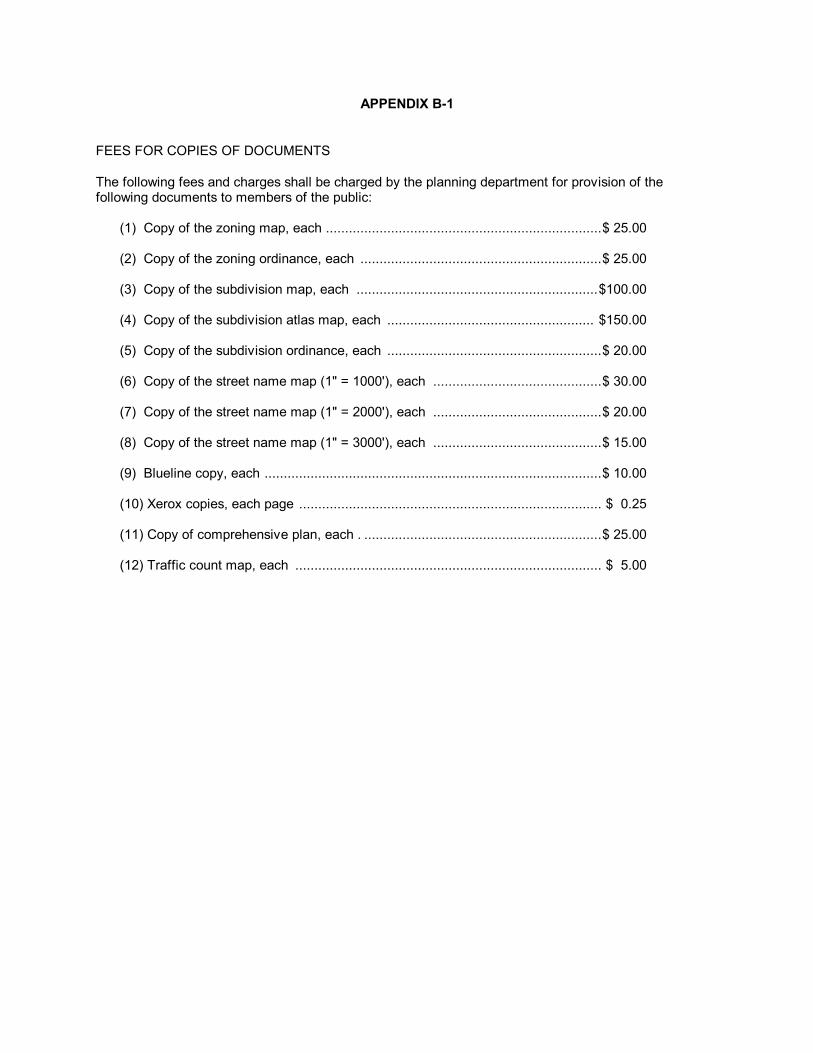
APPENDIX B-1
FEES FOR COPIES OF DOCUMENTS The following fees and charges shall be charged by the planning department for provision of the following documents to members of the public:
(1) Copy of the zoning map, each ........................................................................ $ 25.00 (2) Copy of the zoning ordinance, each ............................................................... $ 25.00 (3) Copy of the subdivision map, each ............................................................... $100.00 (4) Copy of the subdivision atlas map, each ...................................................... $150.00 (5) Copy of the subdivision ordinance, each ........................................................ $ 20.00 (6) Copy of the street name map (1" = 1000'), each ............................................ $ 30.00 (7) Copy of the street name map (1" = 2000'), each ............................................ $ 20.00 (8) Copy of the street name map (1" = 3000'), each ............................................ $ 15.00 (9) Blueline copy, each ........................................................................................ $ 10.00 (10) Xerox copies, each page ............................................................................... $ 0.25 (11) Copy of comprehensive plan, each . .............................................................. $ 25.00 (12) Traffic count map, each ................................................................................ $ 5.00

APPENDIX B-3
ZONING FEES
SCHEDULE OF FEES, CHARGES AND EXPENSES For any petition to amend this ordinance, or application for special use permit, or appeal to the Board of Adjustment there shall be a fee paid that will be in accordance with the following fee schedule:
(1) Change to the Zoning narrative $ 60.00 (2) Change to the Zoning map:
(A) Commercial or Industrial Zones
(i) less than one acre $350.00 (ii) one to five acres $400.00 (iii) over five acres $500.00 plus $75.00 per acre
for each acre over five acres.
(B) Residential Zones (i) less than one acre $300.00 (ii) one to five acres $350.00 (iii) over five acres $500.00 plus $75.00 per acre for each acre over five acres.
The application fees for changes to the zoning classification of land shall in no event exceed three thousand dollars ($3,000). The acreage used in determining the fees under this subsection shall be rounded off to the nearest whole acre.
(3) Application for a Special Use Permit: $400.00 (4) Application for a Conditional Use Permit: $400.00 (5) Appeal to the Board of Adjustment:
(i) Administrative appeals $ 300.00 (ii) Substantive appeals $ 300.00
(6) Zoning Verification Letters: $ 25.00
(As amended 91-O-243, 11/4/91; 93-0-228, 11/22/93; 2002-O-257, 10/21/02; 04-O-264, 11/15/04; 2012-O-155, 9/17/12)

APPENDIX C
REGISTRATION and EXAMINATION FEES
(a) Fees for electrical registration.
The fees for registration shall be payable to the city at the office of the electrical inspector. The fees to be paid are as follows:
Annual
Classification Registration Renewal Master Electrician $200.00 $50.00 Ltd. Master Electrician 100.00 15.00 Maintenance Electrician 25.00 5.00 Journeyman Electrician 25.00 5.00 (b) Fees for Class B Air-conditioning Contractors Examination
Initial examination $ 25.00 Reexamination $ 50.00 Examination Results Analysis $ 25.00
(c) Fees for Class B Air-Conditioning Contractors License
Initial License $200.00 License Renewal $ 50.00 Lost license replacement $ 15.00

1
APPENDIX D
PERMIT FEES (1) Building Fees
(a) The fees for permits required by section 24.16.1 of this code shall be as follows:
BUILDING PERMIT FEES Total Valuation Fee
$1,000 and less no fee, unless inspection required, in which case a $15.00 fee for each inspection shall be charged
$1,001.00 to $50,000.00 $15.00 for the first $1,000.00 plus $5.00
for each additional thousand or fraction thereof, to and including $50,000.00
$50,001 to $100,000.00 $260.00 for the first $50,000.00 plus $4.00
for each additional thousand or fraction thereof, to and include $100,000.00
$100,001.00 to $500,000.00 $460.00 for the first 100,000.00
$500,000.00 plus $3.00 for each additional thousand or fraction thereof, to and including $500,000.00
$500,001.00 to $1,000,000.00 $1660.00 for the first $500,000.00 plus
$2.00 for each additional thousand or fraction thereof, to and including $1,000,000.00
$1,000,001.00 and above $2,000.00 for the first $1,000,000 plus
$0.50 for each additional thousand or fraction thereof
MOVING FEE
For the moving of any building or structure, the fee shall be $100.00
DEMOLITION FEE
For the demolition of any building or structures, the fee shall be:
0 up to 100,000 cu ft $50.00 100,000 cu ft and over $050 / 1,000 cu ft
PENALTIES
Where work for which a permit is required by this code is started or proceeded prior to obtaining said permit, the fees herein specified shall be doubled, but the payment of such double fee shall not relieve any persons from fully complying with the requirements of this code in the execution of the work nor from any other penalties prescribed herein.
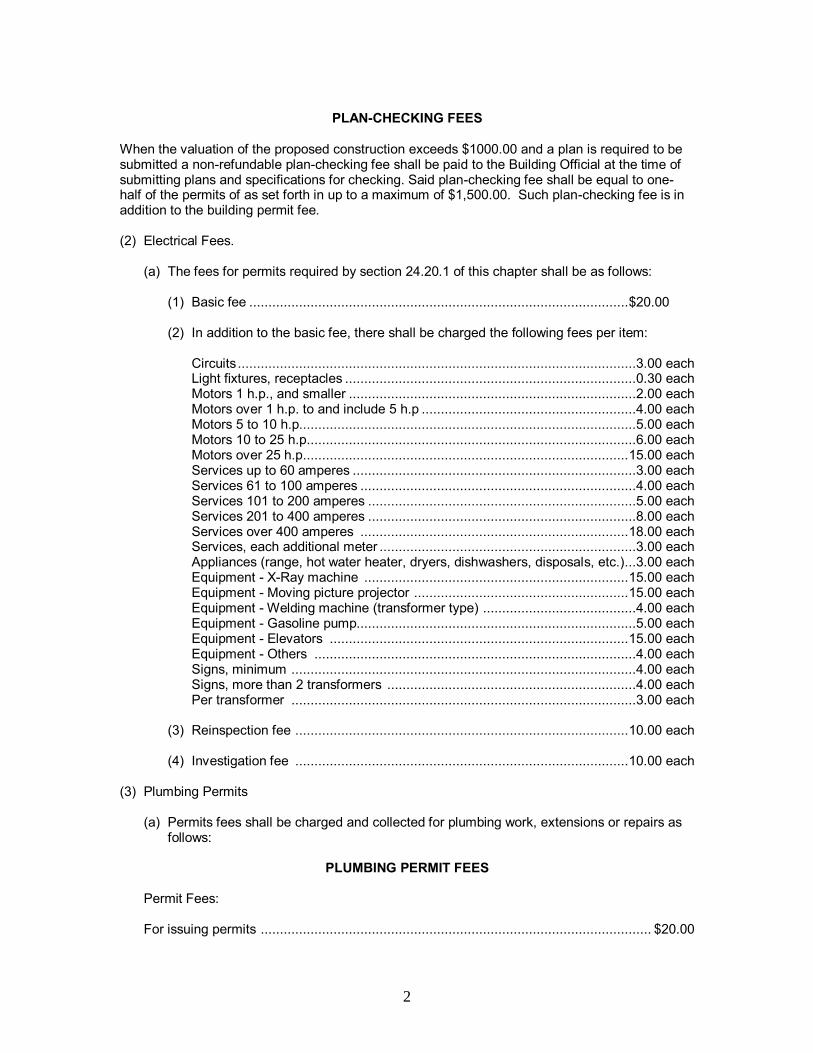
2
PLAN-CHECKING FEES
When the valuation of the proposed construction exceeds $1000.00 and a plan is required to be submitted a non-refundable plan-checking fee shall be paid to the Building Official at the time of submitting plans and specifications for checking. Said plan-checking fee shall be equal to one-half of the permits of as set forth in up to a maximum of $1,500.00. Such plan-checking fee is in addition to the building permit fee. (2) Electrical Fees.
(a) The fees for permits required by section 24.20.1 of this chapter shall be as follows:
(1) Basic fee ................................................................................................... $20.00 (2) In addition to the basic fee, there shall be charged the following fees per item:
Circuits ........................................................................................................3.00 each Light fixtures, receptacles ............................................................................0.30 each Motors 1 h.p., and smaller ...........................................................................2.00 each Motors over 1 h.p. to and include 5 h.p ........................................................4.00 each Motors 5 to 10 h.p. .......................................................................................5.00 each Motors 10 to 25 h.p. .....................................................................................6.00 each Motors over 25 h.p. .................................................................................... 15.00 each Services up to 60 amperes ..........................................................................3.00 each Services 61 to 100 amperes ........................................................................4.00 each Services 101 to 200 amperes ......................................................................5.00 each Services 201 to 400 amperes ......................................................................8.00 each Services over 400 amperes ...................................................................... 18.00 each Services, each additional meter ...................................................................3.00 each Appliances (range, hot water heater, dryers, dishwashers, disposals, etc.) ...3.00 each Equipment - X-Ray machine ..................................................................... 15.00 each Equipment - Moving picture projector ........................................................ 15.00 each Equipment - Welding machine (transformer type) ........................................4.00 each Equipment - Gasoline pump.........................................................................5.00 each Equipment - Elevators .............................................................................. 15.00 each Equipment - Others ....................................................................................4.00 each Signs, minimum ..........................................................................................4.00 each Signs, more than 2 transformers .................................................................4.00 each Per transformer ..........................................................................................3.00 each
(3) Reinspection fee ....................................................................................... 10.00 each (4) Investigation fee ....................................................................................... 10.00 each
(3) Plumbing Permits
(a) Permits fees shall be charged and collected for plumbing work, extensions or repairs as follows:
PLUMBING PERMIT FEES
Permit Fees: For issuing permits ...................................................................................................... $20.00
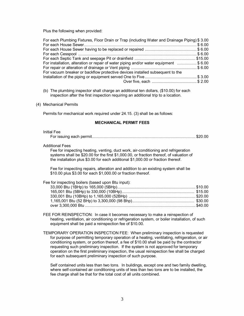
3
Plus the following when provided: For each Plumbing Fixtures, Floor Drain or Trap (including Water and Drainage Piping) $ 3.00 For each House Sewer.................................................................................................. $ 6.00 For each House Sewer having to be replaced or repaired ............................................. $ 6.00 For each Cesspool ....................................................................................................... $ 6.00 For each Septic Tank and seepage Pit or drainfield ..................................................... $15.00 For installation, alteration or repair of water piping and/or water equipment ................. $ 6.00 For repair or alteration of drainage or Vent piping ......................................................... $ 6.00 For vacuum breaker or backflow protective devices installed subsequent to the Installation of the piping or equipment served One to Five ............................................. $ 3.00 Over five, each ....................................... $ 2.00
(b) The plumbing inspector shall charge an additional ten dollars, ($10.00) for each
inspection after the first inspection requiring an additional trip to a location. (4) Mechanical Permits
Permits for mechanical work required under 24.15. (3) shall be as follows:
MECHANICAL PERMIT FEES
Initial Fee For issuing each permit .......................................................................................... $20.00
Additional Fees
Fee for inspecting heating, venting, duct work, air-conditioning and refrigeration systems shall be $20.00 for the first $1,000.00, or fraction thereof, of valuation of the installation plus $3.00 for each additional $1,000.00 or fraction thereof.
Fee for inspecting repairs, alteration and addition to an existing system shall be $10.00 plus $3.00 for each $1,000.00 or fraction thereof.
Fee for inspecting boilers (based upon Btu input):
33,000 Btu (1BHp) to 165,000 (5BHp) .................................................................... $10.00 165,001 Btu (5BHp) to 330,000 (10BHp) ............................................................... $15.00 330,001 Btu (10BHp) to 1,165,000 (52BHp) .......................................................... $20.00 1,165,001 Btu (52 BHp) to 3,300,000 (98 Bhp) ...................................................... $30.00 over 3,300,000 Btu ................................................................................................ $40.00
FEE FOR REINSPECTION: In case it becomes necessary to make a reinspection of heating, ventilation, air conditioning or refrigeration system, or boiler installation, of such equipment shall be paid a reinspection fee of $10.00.
TEMPORARY OPERATION INSPECTION FEE: When preliminary inspection is requested
for purpose of permitting temporary operation of a heating, ventilating, refrigeration, or air conditioning system, or portion thereof, a fee of $10.00 shall be paid by the contractor requesting such preliminary inspection. If the system is not approved for temporary operation on the first preliminary inspection, the usual reinspection fee shall be charged for each subsequent preliminary inspection of such purpose.
Self contained units less than two tons. In buildings, except one and two family dwelling, where self-contained air conditioning units of less than two tons are to be installed, the fee charge shall be that for the total cost of all units combined.
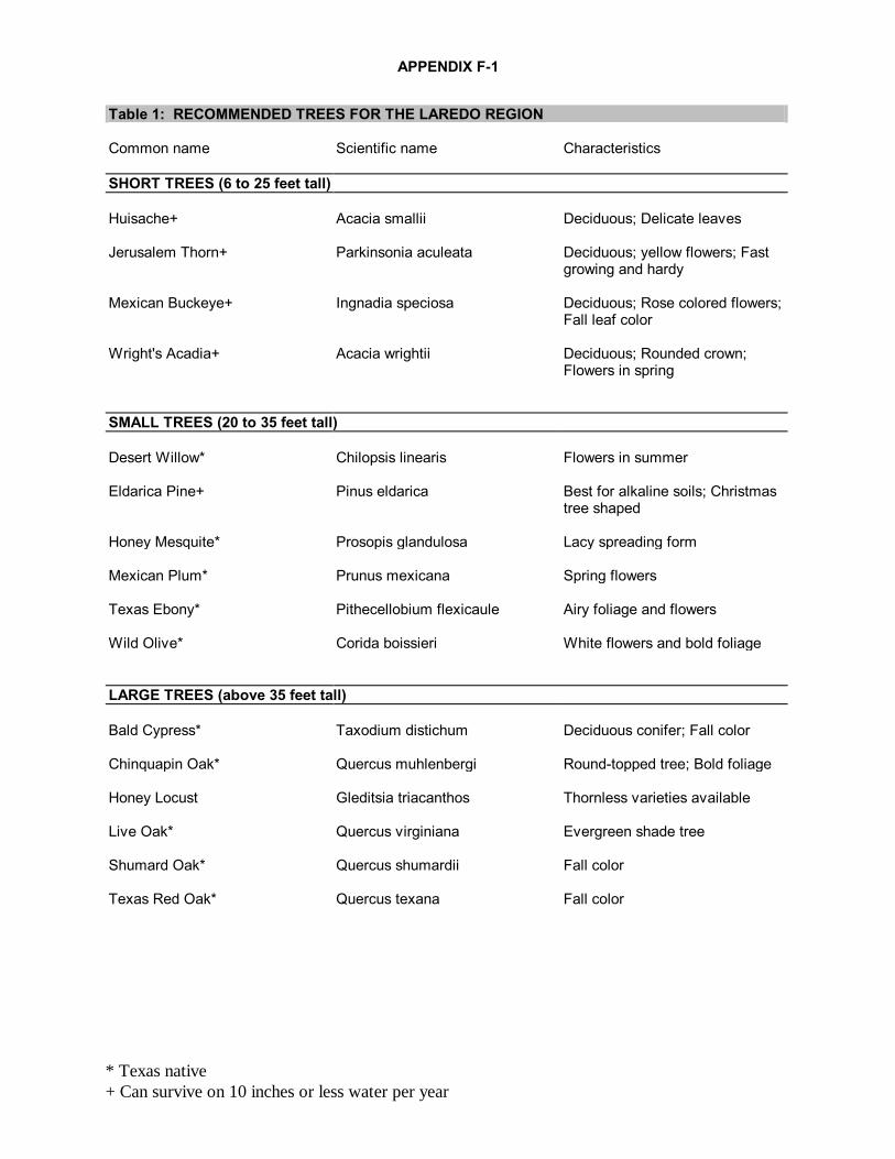
APPENDIX F-1
* Texas native
+ Can survive on 10 inches or less water per year
Table 1: RECOMMENDED TREES FOR THE LAREDO REGION Common name Scientific name Characteristics SHORT TREES (6 to 25 feet tall) Huisache+ Acacia smallii Deciduous; Delicate leaves Jerusalem Thorn+ Parkinsonia aculeata Deciduous; yellow flowers; Fast
growing and hardy Mexican Buckeye+ Ingnadia speciosa Deciduous; Rose colored flowers;
Fall leaf color Wright's Acadia+ Acacia wrightii Deciduous; Rounded crown;
Flowers in spring SMALL TREES (20 to 35 feet tall) Desert Willow* Chilopsis linearis Flowers in summer Eldarica Pine+ Pinus eldarica Best for alkaline soils; Christmas
tree shaped Honey Mesquite* Prosopis glandulosa Lacy spreading form Mexican Plum* Prunus mexicana Spring flowers Texas Ebony* Pithecellobium flexicaule Airy foliage and flowers Wild Olive* Corida boissieri White flowers and bold foliage LARGE TREES (above 35 feet tall) Bald Cypress* Taxodium distichum Deciduous conifer; Fall color Chinquapin Oak* Quercus muhlenbergi Round-topped tree; Bold foliage Honey Locust Gleditsia triacanthos Thornless varieties available Live Oak* Quercus virginiana Evergreen shade tree Shumard Oak* Quercus shumardii Fall color Texas Red Oak* Quercus texana Fall color

APPENDIX F-1
* Texas native
+ Can survive on 10 inches or less water per year
Table 2: RECOMMENDED SHRUBS FOR THE LAREDO REGION Common name Scientific name Characteristics DWARF SHRUBS (1 to 3 feet tall) Autumn Sage+ Salvia greggii Evergreen; Full to part sun;
Flowers Dwarf Pittosporum Pittosporum tobira w. Small, round evergreen Mealy Blue Sage+ Salvia farinacea Evergreen; Blue flowers Mountain Sage+ Salvia farinacea Evergreen; Sun; Flowers spring
thru fall seasons Rosemary Rosmarinus offcinalis Fragrant blue-green foliage; Blue
flowers; Herb SMALL SHRUBS (3 to 5 feet tall) China Rose Rosa chinensis Hardy; Long-blooming; Pest
resistant Dwarf Palmetto* Sabal minor Trunkless, bushy palm Sotol+ Dasylirion texanum Evergreen; Flowers; Cactus-like
narrow leaves Tea Rose Rosa odorata Pest resistant; Flowers; Hardy MEDIUM SHRUBS (6 to 9 feet tall) Agarita* Mahonia trifoliata Yellow spring flowers; Red edible
berries; Evergreen Catclaw Acacia+ Acacia greggii Deciduous; Delicate leaves Central Texas Sage*+ Leucophyllum sp. Evergreen foliage; Summer
flowers Green Pittosporum Pittosporum tobira Large evergreen shrub Italian Jasmine Jasmine humile Sprawling evergreen; summer
flowers Pomegranate punica granatum Orange flowers; Edible fruit Roemer Acacia+ Acacia roemeriana Deciduous; Delicate leaves Variegated Pittospurum Pittosporum tobira variegata Green/white variegated
evergreen
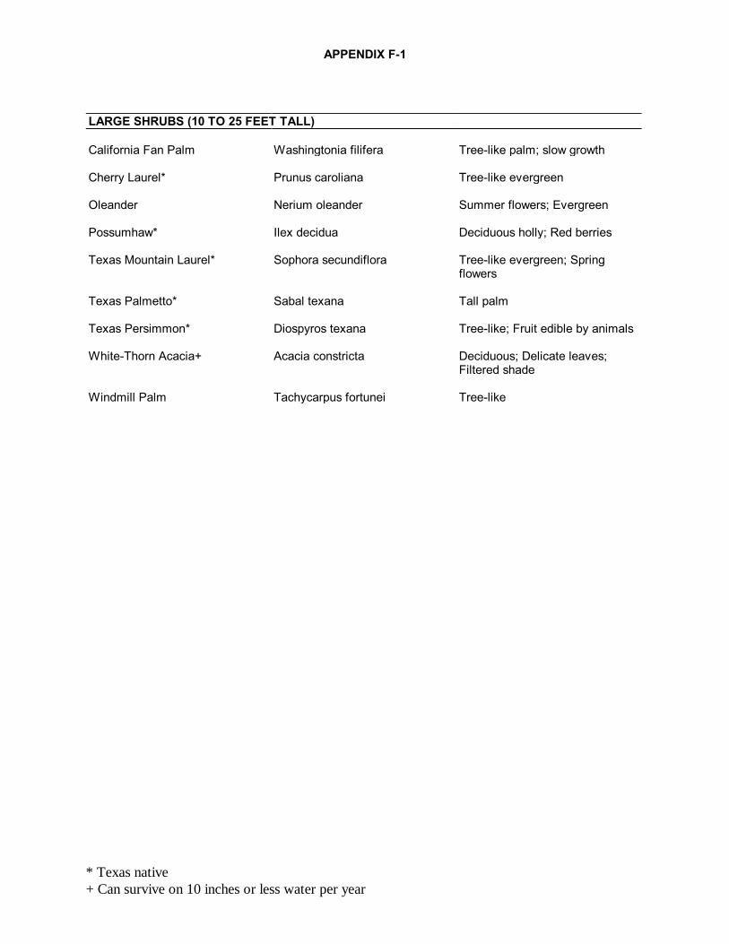
APPENDIX F-1
* Texas native
+ Can survive on 10 inches or less water per year
LARGE SHRUBS (10 TO 25 FEET TALL) California Fan Palm Washingtonia filifera Tree-like palm; slow growth Cherry Laurel* Prunus caroliana Tree-like evergreen Oleander Nerium oleander Summer flowers; Evergreen Possumhaw* Ilex decidua Deciduous holly; Red berries Texas Mountain Laurel* Sophora secundiflora Tree-like evergreen; Spring
flowers Texas Palmetto* Sabal texana Tall palm Texas Persimmon* Diospyros texana Tree-like; Fruit edible by animals White-Thorn Acacia+ Acacia constricta Deciduous; Delicate leaves;
Filtered shade Windmill Palm Tachycarpus fortunei Tree-like
APPENDIX F-2
GENERAL PLANTING AND MAINTENANCE STANDARDS FOR TREES AND SHRUBS
A. Planting Methods
1) All trees shall be planted in holes two (2) to five (5) times wider than the rootball diameter. The depth of the hole should be no deeper than necessary to set the plant at the same depth it was in the nursery. All shrubs shall be planted in holes a minimum of six (6) inches wider on each side than their root spread, whether container grown or balled and burlapped. This enables the plant to extend the small roots in the first few weeks in the ground. 2) Place the tree or shrub in the hole. If the tree is container grown, pull the container away from the rootball. Do not pull the tree by its trunk. Pulling the tree out of the container by its trunk will damage the small roots within the ball. Place the tree or shrub in the center of the hole and adjust it so that it is straight and at the proper level. 3) For balled and burlapped plants pull the top and sides of the burlap away from the the ball after the hole has been partially backfilled but before watering. Do not attempt to pull the burlap out from under the ball under any condition. All wire and surplus binding from the top and sides of the ball should be removed. 4) Backfill with the original soil and firm the soil until approximately two- thirds (2/3) full. Before completing, fill the hole with water and allow the soil to settle around the roots. After the water has been absorbed, add topsoil to bring up to grade and form a watering basin around the tree. 5) An earth basin, approximately four (4) inches in height, is to be formed around the tree or shrub pit to help retain water and protect the trunk from mower damage. Individual plant pits shall be completely encircled by the basin, except on steep slopes where the basin is formed on the downhill side to serve as a dam. 6) Trees taller than four (4) feet may need to be staked. Rubber hose must be used to protect the tree from the staking wire. 7) The trees and shrubs must be watered immediately after planting and as needed during the first two (2) growing seasons. A thorough soaking is preferred over light, frequent soakings. 8) The entire area formed within the earth basin shall be filled with 3 to 4 inches of mulch to help conserve moisture and reduce competition from weeds. 9) All trees and shrubs shall be planted in individual holes with the exception of hedges. Hedges may be planted in a continuous trench as long as adequate room is allowed for root development.
B. Staking, Guying and Wrapping
1) All evergreen and deciduous trees over four (4) feet tall need to be supported by an acceptable method to keep the tree trunk in an upright position immediately after planting. Bracing prevents the tree from being damaged by strong winds which loosens the soil around the base of the tree and injures the rooting system. 2) Trees shall be staked or guyed for a minimum of one growing season. All bracing and tree supports should be eliminated as soon as the tree becomes self-supporting.
3) If the tree has sparse foliage and is exposed to full sun, the trunk shall be wrapped with an appropriate material to prevent sun scalding. Special tree wrap paper is available; however strips of burlap and aluminum foil will also protect the tree.
C. Irrigation Requirements
1) The installation of a supplemental irrigation system is required to give the trees and shrubs an adequate amount of water without waste. All required landscaping shall be irrigated by either an underground sprinkling system, drip irrigation system or a hose attachment within 100 feet (100'-0") of the landscaped area. 2) The irrigation systems shall be designed and calibrated in order to thoroughly soak the root area of the plant area with the frequency necessary to establish newly planted trees and shrubs and to sustain their healthy growth. 3) The system used will be designed to minimize the amount of spray that will fall on sidewalks, neighboring properties and adjacent buildings in order to achieve water conservation. 4) The property owner will be responsible for irrigation as well as regular maintenance of the trees and shrubs.
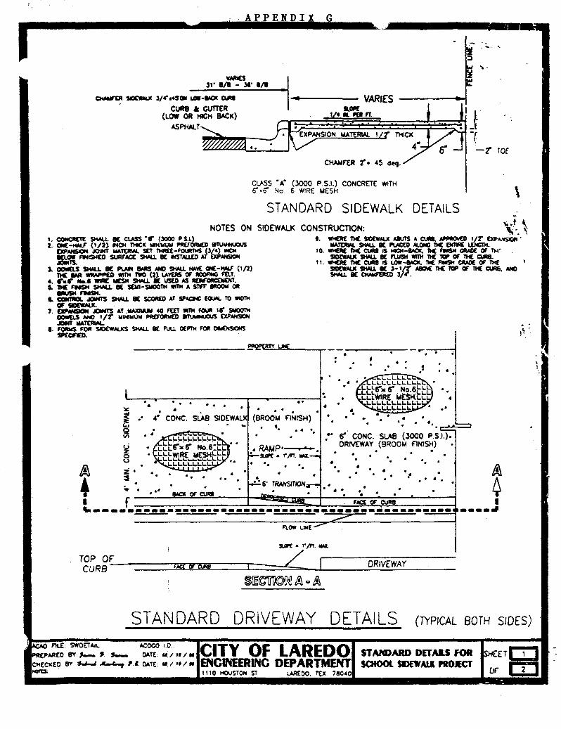
I APPENDIX G
v~s ll' 1/1 - ,.. 1/1 ·1------ VARIES acw
OWo6£R ~ l/~a4SOI/C LOll-~ 0..
• CURB • GVITER (LOW OR HIGH BACK)
ASPHALT
I 1/4 II. liP ff.
CLASS • A" (3000 P.S.t.) CONCRETE WITH o •o No. 6 WIRE MESH
STANDARD SIDEWALK DETAILS
--...
-t' TOf
\ ,.
NOTES ON SIDEWALK CONSTRUCTION: \t \ t. wtCM M SIDEW.IUC AIUTS A CURl.~ 1/T DF,.vsOt•. '
IIAm.L SHALl. II( ~0 ALOfC tiC OI'IWI£ LDICTM. 10. WHEIIE ftC CUA8 1$ ICH-80. tiC A11SH ~ OT ~·
SlotW.tUC StWJ. • FlUSH Wln4 nc w OT nc Cl.fla. 11. WHEIIE nc CUR8 1$ t.Oif-a-oc. 1M[ FNStt ~ OT THt
SIOlW.IUC SHALl. II( l-1/T A8CM: tiC TOP OT ftC CUR6, MO SHALL II( QWiftREO l/~.
• . . .. .
~~.~~~.-.--.-----------,---~----~.~.--~· • • • • • • ~ . . . ; .• 4" CONC. SV.S SIOEWAL
. . .. ~ •· o· CONC. SLAB (3000 P.S.L).
•
n.ow L:NE
SIJP( • '''"· --
DRIVEWAY (BROOM F'INISH)
. . • • . • . . .
I
. . . . . .
TOP OF:_._~====~~~~==~c===~~~--l_ _______ .Q.R~I~E~W~A~Y--~----CURB fACt (i' CURS ~
~~~!@Jt' /)). 0 /)).
I
----J
1':_ • .
STANDARD DRIVEWAY DETAILS (TYPICAL BOTH SIDES)
' '·
Jl--~PIIf"'!!!AU:~Eo!"": "'~sw~:_~AJ~L-,-~--~~~0:~, -~'!"'o>-.. -,-... C~I""'T~Y,....-0~f--l-A-R-E-D-0 ..... ~s-T-AND--ARD--D-ET_AU_'_FOR_..,.._HE_r_r_l -, -, .. =KED BY~~~· DATE: tl/ ••t• ENCINEERINC DEPARTMENT $01001. $1)£T(All PROKT ''F' ,..,-,
1110 HOuSTON ST i.AAEOO. T(X 75040 u ~

'.
I
~ . ';( ~
~ -.. Q. i
I ! e Q. t tl ~
),. !:2 -· Q
-~I z
51 z le ~ • ::r: ,I
,j
"''-$
,_ .. -~
-'
!I
i 1-~ t! II CD
I CD
~~ z 0 i= u UJ c./)
-· . •
"APPENDIX "N"
NOISE ATTENUATION PERFORMANCE STANDARDS FOR STRUCTURES LOCATED WITHIN AIRPORT NOISE SPECIFIC USE ZONING OVERLAY DISTRICTS
N101 SCOPE
The performance standards in this chapter are intended to provide for the insulation of the interior of buildings to an Ldn 45 or less from outside noise levels over Ldn 65. The standards shall be applied to construction of new noise-sensitive uses approved within districts and subdistricts where noise levels are expected to exceed 65 Ldn, and for reconstruction, remodeling, or additions to existing buildings of the types mentioned above when the value of the improvement exceeds 50 percent of the value of the existing structures. Where noise-sensitive activities are carried on in only a portion of new or reconstructed commercial buildings, only those areas judged noise-sensitive need to be protected. The provisions of this section control in the event of a conflict with other provisions of this code.
N102 DEFINITIONS
The special terms used in these provisions are defined as follows:
Day-night average sound level (Ldn) -shall mean the estimated cumulative aircraft or other noise exposure in decibels of noise as measured by an A-weighed sound-level meter. In the Ldn procedure, noise exposures are accumulated for a typical24- hour period. A weighing factor equivalent to a penalty of 10 decibels is applied to aircraft operations or other noise sources between 10:00 p.m. and 7:00a.m. to account for the increased sensitivity of people to night-time noise. The Ldn values in effect in the City of Laredo are those expressed graphically by contour lines approved by the Council.
Decibel (db) - shall mean a unit of measure of a sound expressed from a calibrated sound-level meter using an A-level weighting scale.
Noise -shall mean aircraft or other noise that interferes with speech and hearing, or is intense enough to damage hearing, or is otherwise annoying.
Noise control areas - shall mean those areas officially adopted in the Airport Noise Specific Use Zoning Overlay District (AN) designated to be within a Ldn 65 noise area or greater.
Interior noise level Sound level of noise in any habitable room with windows and doors closed.
N103 STRUCTURES REQUIRING PROTECTION
Structures to be protected shall include, but are not limited to existing residential structures and the portion of non-residential structures in which noise- sensitive activities are conducted (e.g .. , research facilities, hotel sleeping rooms, meeting rooms, and similar activities).
N104 REQUIREMENTS FOR NOISE LEVELS OVER 65 LDN
All structures regulated under this chapter in noise-level area Ldn 65 shall meet the following criteria:
I. General
1. Brick veneer, masonry blocks, or stucco exterior walls shall be constructed airtight. All joints shall be grouted or caulked airtight.
2. At the penetration of exterior walls by pipes, ducts, or conduits, the space between the wall and pipes, ducts, or conduits shall be caulked or filled with mortar.
1

3. Window and/or through-the-wall HVAC type units shall not be used.
4. Operational, vented fireplaces shall not be used.
5. All sleeping spaces shall be provided with a sound- absorbing ceiling and carpeted floor.
6. Through-the-wall/door mailboxes shall not be used.
I. MINIMUM NOISE REDUCTION OF 25 db
A. Exterior Walls
1. Masonry walls having a surface weight of at least 40 pounds per square foot do not require a furred interior wall. In areas over 70 Ldn, masonry walls having a surface weight of at least 75 pounds per square foot do not require a furred interior wall. At least one surface of concrete block wall shall be plastered or painted with heavy "bridging" paint.
2. Stud walls shall be at least four inches in nominal depth and shall be finished on the outside with siding on sheathing, stucco, or brick veneer.
a. Interior surface of the exterior stud walls shall be of gypsum board or plaster at least 1/2-inch thick, installed on the studs. The gypsum board or plaster may be fastened rigidly to the studs if the exterior is brick veneer or stucco. If the exterior is siding-on-sheathing, the interior gypsum board or plaster must be fastened resiliently to the studs.
b. Continuous composition board, plywood, or gypsum board sheathing shall cover the exterior side of the wall studs behind wood or metal siding. The sheathing and facing shall weigh at least four pounds per square foot.
c. All edges of the sheathing shall be sealed with resilient caulking.
d. Insulation material with a minimum thermal resistance factor (R) of 11 which is at least two inches thick shall be installed continuously throughout the cavity space behind the exterior sheathing and between wall studs. Insulation shall be glass fiber or mineral wool.
B. Window
1. Glass of double-glazed windows shall be used and at least 3/16ths inch thick.
2. Double-glazed windows shall employ fixed sash or efficiently weather-stripped operable sash. The sash shall be rigid and weather-stripped with material that is compressed airtight when the window is closed.
3. Glass of fixed-sash windows shall be sealed in an airtight manner with a non-hardening sealant, or a soft elastomeric gasket or glazing tape.
4. The perimeter of the window frame shall be sealed airtight to the exterior wall construction with a resilient sealant.
5. The total area of glass of both windows and exterior doors in sleeping spaces shall not exceed 20 percent of the floor area.
C. Doors
1. All exterior side-hinged doors shall be solid-core wood or insulated or hollow metal at least 1. 75 inches thick and shall be fully weather-stripped.
2

2. The glass of double-glazed sliding doors shall be at least 3/16 of an inch thick and separated by a minimum 1/2-inch airspace with a laboratory sound transmission rating of STC-28 or greater. The frame shall be provided with an efficiently airtight weather- stripping material.
3. The perimeter of door frames shall be sealed airtight to the exterior wall construction.
4. Glass in doors shall be set and sealed in an airtight non-hardening sealant, or a soft elastomeric gasket or glazing tape.
D. Roof
1. With an attic or rafter space at least six inches deep, and with a ceiling below, the roof shall consist of 1/2-inch composition board, plywood, or gypsum board sheathing topped by roofing as required.
2. If the underside of the roof is exposed, or if the attic or rafter space is less than six inches, the roof construction shall have a surface weight of at least six pounds per square foot, except that, in areas over 70 Ldn, the roof construction shall have a surface weight of at least nine pounds per square foot. Rafters, joists, or other framing may not be included in the surface weight calculation.
3. Window or dome skylights shall be double glazed and separately by minimum 1/2-inch airspace. In areas over 70 Ldn, skylights are not permitted.
E. Ceilings
1. Gypsum board of plaster ceilings at least 1/2-inch thick shall be provided below attaic space or roof rafters or roof construction less than 8 pounds per square foot (psf). Ceilings shall be substantially airtight, with minimum number of penetrations.
2. Glass fiber or mineral wood insulation at least six inches thick with a thermal resistance (R) factor of not less than nineteen shall be provided above the ceiling between joists. Insulation in the attic space shall have no paper or foil covering on the face exposed to the attic.
F. Floors
The floor of the lowest occupied rooms shall be slab on grade, below grade, or over a fully enclosed basement. All door and window openings in the fully enclosed basement shall be tightly fitted. All sleeping rooms shall be provided with carpeting or an acoustical ceiling.
G. Ventilation
1. A mechanical ventilation system shall be installed that will provide the minimum air circulation and fresh air-supply requirements for various uses in occupied rooms, without need to open any windows, doors, or other openings to the exterior. Window and wall ventilating units shall not be used.
2. Gravity vent openings in the attic shall not exceed code minimum in number and size. The openings shall be fitted with transfer ducts at least three feet in length, containing approved internal sound-absorbing duct lining. Each duct shall have a line 90-degree bend in the duct such that there is not direct line of sight from the exterior through the duct into the attic.
3. If a fan is used for forced ventilation, the attic inlet and discharge openings shall be fitted with sheet metal transfer ducts of at least 20-gauge steel, which shall be lined with one-inch thick approved duct liner, and shall be at least five feet long with one 90-degree bend. In areas over 70 Ldn, the duct lining shall be at least 10 feet long.
3
4. All vent ducts connecting the interior space to the outdoors, excepting domestic range and dryer exhaust ducts, shall contain at last a 1 0-foot length of approved internal sound-absorbing duct lining. Each duct shall be provided with a line 90-degree bend in the duct such that there is no direct line of sight through the duct.
5. Duct lining shall be a coated glass fiber duct liner at least one-inch thick, approved and suitable for the intended use.
6. Domestic range and dryer exhaust ducts connecting the interior space to the outdoors shall contain a baffle plate across the exterior termination that allows proper ventilation. The dimensions of the baffle plate should extend at least one diameter beyond the line of sight into the vent duct. The baffle plate shall be of the same material and thickness as the vent duct material and shall have the same free area as the vent duct.
7. Building heating units with flues or combustion air vents shall be located in a closet or room closed off from the occupied space by doors.
8. Doors between occupied space and mechanical equipment areas shall be solid-core wood or 20-gauge steel hollow metal at least 1.75 inches thick and shall be fully weather-stripped.
II. MINIMUM NOISE REDUCTION OF 30db
A. Exterior Walls
1. Masonry walls having a surface weight of at least 40 pounds per square foot do not require a furred interior wall. In areas over 70 Ldn, masonry walls having a surface weight of at least 75 pounds per square foot do not require a furred interior wall. At least one surface of concrete block wall shall be plastered or painted with heavy "bridging" paint.
2. Stud walls shall be at least four inches in nominal depth and shall be finished on the outside with siding on sheathing, stucco, or brick veneer.
a. Interior surface of the exterior stud walls shall be of gypsum board or plaster at least 5/8-inch thick, installed on the studs. The gypsum board or plaster may be fastened rigidly to the studs if the exterior is brick veneer or stucco. If the exterior is siding-on-sheathing, the interior gypsum board or plaster must be fastened resiliently to the studs.
b. Continuous composition board, plywood, or gypsum board sheathing of not less than 1/2 inch in thickness shall cover the exterior side of the wall studs behind wood or metal siding. The sheathing and facing shall weigh at least four pounds per square foot.
c. All edges of the sheathing shall be sealed with resilient caulking.
d. Insulation material with a minimum thermal resistance factor (R) of 11 which is at least two inches thick shall be installed continuously throughout the cavity space behind the exterior sheathing and between wall studs. Insulation shall be glass fiber or mineral wool.
B. Window
1. Double-glazed windows shall be used and shall be not less than 3/16ths inch in thickness. Panes of glass shall be separated by an air-space of not less than three inches, and shall be of unequal thickness.
4
2. Double-glazed windows shall employ fixed sash or efficiently weather-stripped operable sash. The sash shall be rigid and weather-stripped with material that is compressed airtight when the window is closed.
3. Glass of fixed-sash windows shall be sealed in an airtight manner with a non-hardening sealant, or a soft elastomeric gasket or glazing tape.
4. The perimeter of the window frame shall be sealed airtight to the exterior wall construction with a resilient sealant
5. The total area of glass of both windows and exterior doors in sleeping spaces shall not exceed 20 percent of the floor area.
C. Doors
1. All exterior side-hinged doors shall be solid-core wood or insulated or hollow metal at least 1.75 inches thick and shall be fully weather-stripped.
2. The glass of double-glazed sliding doors shall be at least 3/16 of an inch thick and separated by a minimum 4 inch airspace with a laboratory sound transmission rating of STC-28 or greater. The frame shall be provided with an efficiently airtight weather- stripping material. Single frame sliding glass doors are prohibited.
3. The perimeter of door frames shall be sealed airtight to the exterior wall construction.
4. Glass in doors shall be set and sealed in an airtight non-hardening sealant, or a soft elastomeric gasket or glazing tape.
D. Roof
1. With an attic or rafter space at least six inches deep, and with a ceiling below, the roof shall consist of 3/4-inch continuous plywood sheathing topped by roofing as required. Exposed roof decks shall not be less than two inches of wood or concrete.
2. If the underside of the roof is exposed, or if the attic or rafter space is less than six inches, the roof construction shall have a surface weight of not less than twelve pounds per square foot Rafters, joists, or other framing may not be included in the surface weight calculation.
3. Window or dome skylights shall be double glazed and separately by minimum 1/2-inch airspace. In areas over 70 Ldn, skylights are not permitted.
E. Ceilings
1. Gypsum board of plaster ceilings at least 1/2-inch thick shall be provided below attic space or roof rafters or roof construction of less than two inches in thickness and weighing less than twelve pounds per square foot (psf).
2. The ceiling shall be not less than twelve inches below the roof sheathing and substantially airtight, with a minimum number of penetrations.
3. Glass fiber or mineral wood insulation at least six inches thick with a thermal resistance (R) factor of not less than nineteen shall be provided above the ceiling between joists. Insulation in the attic space shall have no paper or foil covering on the face exposed to the attic.
F. Floors
5

The floor of the lowest occupied rooms shall be slab on grade, below grade, or over a fully enclosed basement. All door and window openings in the fully enclosed basement shall be tightly fitted. All sleeping rooms shall be provided with carpeting or an acoustical ceiling.
G. Ventilation
1. A mechanical ventilation system shall be installed that will provide the minimum air circulation and fresh air-supply requirements for various uses in occupied rooms, without need to open any windows, doors, or other openings to the exterior. Window and wall ventilating units shall not be used.
2. Gravity vent openings in the attic shall not exceed code minimum in number and size. The openings shall be fitted with transfer ducts at least five feet in length, containing approved internal sound-absorbing duct lining. Each duct shall have a line 90-degree bend in the duct such that there is not direct line of sight from the exterior through the duct into the attic.
3. If a fan is used for forced ventilation, the attic inlet and discharge openings shall be fitted with sheet metal transfer ducts of at least 20-gauge steel, which shall be lined with one-inch thick approved duct liner, and shall be at least five feet long with one 90-degree bend. In areas over 70 Ldn, the duct lining shall be at least 10 feet long.
4. All vent ducts connecting the interior space to the outdoors, excepting domestic range and dryer exhaust ducts, shall contain at last a 10-foot length of approved internal sound-absorbing duct lining. Each duct shall be provided with a line 90-degree bend in the duct such that there is no direct line of sight through the duct.
5. Duct lining shall be a coated glass fiber duct liner at least one-inch thick, approved and suitable for the intended use.
6. Domestic range and dryer exhaust ducts connecting the interior space to the outdoors shall contain a baffle plate across the exterior termination that allows proper ventilation. The dimensions of the baffle plate should extend at least one diameter beyond the line of sight into the vent duct. The baffle plate shall be of the same material and thickness as the vent duct material and shall have the same free area as the vent duct.
7. Building heating units with flues or combustion air vents shall be located in a closet or room closed off from the occupied space by doors.
8. Doors between occupied space and mechanical equipment areas shall be solid-core wood or 20-gauge steel hollow metal at least 1.75 inches thick and shall be fully weather-stripped."
6
Copyright © 2022 FDOKUMEN