Naar_Eastern Sephardic Diaspora (Vida Sefaradi-Portland 2014)
Upload
khangminh22Category
view
0download
0
CITY OF PORTLAND LAND USE CODE
12/1/20


TABLE OF CONTENTS
CITY OF PORTLAND LAND USE CODE | i
TABLE OF CONTENTS
Article 1. INTRODUCTORY PROVISIONS ........................................................................................................................... 1-1 1.1 Title 1.2 Zoning Map 1.3 Purpose 1.4 Applicability 1.5 Enforcement 1.6 Relationship with Other Laws 1.7 Delegation of Authority 1.8 Rules of Interpretation 1.9 Successive Applications 1.10 Amendments 1.11 Transition Rules
Article 2. ADMINISTRATION .................................................................................................................................................... 2-1 2.1 Planning Board 2.2 Historic Preservation Board 2.3 Zoning Board of Appeals
Article 3. DEFINITIONS ................................................................................................................................................................ 3-1 Article 4. NONCONFORMING USES, STRUCTURES, & LOTS ................................................................................. 4-1
4.1 Continuation 4.2 Nonconforming Uses 4.3 Nonconforming Lots 4.4 Nonconforming Buildings/Structures
Article 5. ZONES .............................................................................................................................................................................. 5-1 5.1 Establishment of Zones 5.2 Zoning Map 5.3 Conditional or Contract Zoning 5.4 Base Zone Purpose Statements
Article 6. USE STANDARDS ....................................................................................................................................................... 6-1 6.1 Applicability 6.2 Determination of Use 6.3 Change of Use 6.4 Supplemental Use Standards 6.5 Conditional Uses 6.6 Accessory Uses 6.7 Temporary Uses 6.8 Performance Standards

TABLE OF CONTENTS
ii | CITY OF PORTLAND LAND USE CODE
Article 7. DIMENSIONAL STANDARDS ............................................................................................................................... 7-1
7.1 Applicability 7.2 Rules of Measurement 7.3 Dimensional Standards 7.4 Supplemental Dimensional Standards 7.5 Space and Bulk Exceptions
Article 8. OVERLAY ZONES ....................................................................................................................................................... 8-1 8.1 Compact Urban Residential (R-7) Overlay 8.2 Downtown Entertainment Overlay 8.3 Fort Sumner Park Overlay 8.4 Helistop Overlay 8.5 Institutional Overlay 8.6 Island Transfer Station Overlay 8.7 Munjoy Hill Neighborhood Conservation Overlay District 8.8 Pedestrian Activities District (PAD) Overlay 8.9 Stream Protection Overlay 8.10 University of Southern Maine Overlay 8.11 Waynflete School Overlay
Article 9. FORM-BASED ZONES ..............................................................................................................................................9-1 9.1 India Street Form-Based Zone
Article 10. WATERFRONT ZONES ......................................................................................................................................... 10-1 10.1 In General 10.2 Eastern Waterfront Port Zone 10.3 Waterfront Central Zone 10.4 Waterfront Port Development Zone
Article 11. SHORELAND ZONE ..................................................................................................................................................11-1 11.1 Purpose 11.2 Applicability 11.3 Review Procedure 11.4 Use-Specific Land Use Standards 11.5 Supplemental Site Plan Standards
Article 12. FLOOD PLAIN MANAGEMENT ......................................................................................................................... 12-1 12.1 Purpose 12.2 Applicability 12.3 Definitions 12.4 Flood Hazard Development Permit 12.5 Certificate of Compliance

TABLE OF CONTENTS
CITY OF PORTLAND LAND USE CODE | iii
12.6 Variances 12.7 Records and Reporting 12.8 Penalties
Article 13. RESOURCE PROTECTION ZONE ..................................................................................................................... 13-1 13.1 Use 13.2 Dimensional Requirements 13.3 Off-Street Parking 13.4 Shoreland and Floodplain Management Regulations
Article 14. SITE PLAN ............................................................................................................................ 14-1 14.1 Purpose 14.2 Applicability 14.3 Project Classification 14.4 Review and Approval Authority 14.5 Review Procedures 14.6 Site Plan Review Standards 14.7 Master Development Plan Review Standards 14.8 Waivers 14.9 Phasing 14.10 Conditions of Approval 14.11 Post-Approval Procedures 14.12 Expiration of Approvals 14.13 Extension of Approvals 14.14 Amendments to Approved Plans 14.15 Consistency with Approved Site Plans 14.16 Appeals
Article 15. SUBDIVISIONS ...................................................................................................................... 15-1 15.1 Purpose 15.2 Applicability 15.3 Review Procedures 15.4 Review Standards 15.5 Technical and Development Standards 15.6 Waivers 15.7 Guarantees and Associated Fees 15.8 Construction Records and Inspection 15.9 Transfer of Ownership 15.10 Plat Amendments 15.11 Vacation of Plats 15.12 Exemptions 15.13 Appeals

TABLE OF CONTENTS
iv | CITY OF PORTLAND LAND USE CODE
Article 16. IMPACT FEES ....................................................................................................................... 16-1 16.1 Purpose 16.2 Applicability 16.3 Calculation of Impact Fee 16.4 Annual Adjustment of Impact Fee 16.5 Modification of Impact Fees 16.6 Reduction in Fees for Affordable Housing 16.7 Collection of Impact Fee 16.8 Segregation of Impact Fees from General Revenues 16.9 Use of Impact Fees 16.10 Refund of Unused Impact Fees 16.11 Review and Revision 16.12 Administrative Rules and Regulations 16.13 Effective Date
Article 17. HISTORIC PRESERVATION ................................................................................................................................. 17-1 17.1 Purpose 17.2 Definitions 17.3 Administrative Procedures 17.4 Categories and Criteria for Designation 17.5 Nomination, Consideration, and Designation 17.6 Interim Protections for Nominations 17.7 Certificates of Appropriateness and Non-Applicability 17.8 Standards for Review of Application for Certificate of Appropriateness 17.9 Certificate of Economic Hardship 17.10 Maintenance 17.11 Penalties 17.12 Appeals
Article 18. HOUSING ...................................................................................................................................................................... 18-1 18.1 Housing Preservation and Replacement 18.2 Affordable Housing 18.3 Housing Trust Fund 18.4 Condominium Conversion 18.5 Relocation of Displaced Tenants
Article 19. OFF-STREET PARKING & LOADING .............................................................................................................. 19-1 19.1 Off-Street Parking 19.2 Off-Street Loading 19.3 Sustainable Transportation Fund

TABLE OF CONTENTS
CITY OF PORTLAND LAND USE CODE | v
Article 20. SIGNS............................................................................................................................................................................. 20-1 20.1 Purpose 20.2 Definitions 20.3 Applicability 20.4 Review Procedures 20.5 Sign Districts Established 20.6 General Restrictions for all Signs 20.7 General Requirements for all Signs 20.8 Standards for Permanent Signs 20.9 Standards for Temporary Signs 20.10 Nonconforming Signs 20.11 Enforcement
Article 21. PUBLIC ART ................................................................................................................................................................ 21-1 21.1 Establishment 21.2 Purpose 21.3 Definitions 21.4 Funding 21.5 Administration
Article 22. REGULATION OF EXPLOSIVES ........................................................................................................................ 22-1 22.1 Purpose 22.2 Applicability 22.3 Review Process 22.4 Storage and Handling 22.5 Enforcement 22.6 Penalties 22.7 Notice Requirements 22.8 Hours of Blasting 22.9 Waivers 22.10 Suspension of Blasting Operations


INTRODUCTORY PROVISIONS
CITY OF PORTLAND LAND USE CODE | 1-1
1 INTRODUCTORY PROVISIONS
1.1 TITLE The title of this chapter of the City of Portland Code of Ordinances is the City of Portland Land Use Code and is referred to as the City of Portland Land Use Code or the Land Use Code.
1.2 ZONING MAP The City of Portland zoning map is incorporated by reference.
1.3 PURPOSE The intent of the Land Use Code is to protect the health, safety, and general welfare of the residents of Portland, consistent with the City’s Comprehensive Plan, through standards that govern the orderly and compatible use of land, the form and mass of buildings, and the relationship of development to the public realm, Portland’s open spaces, and the environment.
1.4 APPLICABILITY No building or structure shall be erected, structurally altered, enlarged, repaired, moved, rebuilt, or used, and no land shall be sold, leased, conveyed, used, developed, or altered except in conformity with the provisions of this Land Use Code.
1.5 ENFORCEMENT 1.5.1 Enforcement The Building Authority and/or a City of Portland Code Enforcement Officer is authorized to institute or cause to be instituted by the Corporation Counsel in the name of the City any and all actions, legal or equitable, that may be appropriate or
necessary for the enforcement of the Land Use Code.
1.5.2 Violations Any person being the owner or occupant of, having control of, or having the use of any building or premises or part thereof, who violates any of the provisions of this Land Use Code, shall be guilty of an offense and subject to the penalties and remedies provided in Chapter 1, Section 1-15 of the City of Portland Code of Ordinances and 30-A M.R.S. § 4452.
1.6 RELATIONSHIP WITH OTHER LAWS 1.6.1 Federal and state law Where conditions, standards, or requirements imposed by any provision of this Land Use Code are found to be inconsistent with a provision listed in the law or regulations of the State of Maine or federal government, the more restrictive provision shall control.
1.6.2 City of Portland Land Use Code If any provision of this Land Use Code contains an actual, implied, or apparent conflict with another provision of this code, the more restrictive provision shall control.
1.6.3 Fair Housing accommodation The City of Portland may make reasonable modifications to the requirements of the Land Use Code to accommodate the needs of persons with disabilities as so defined in Title VII of the Civil Rights Act of 1968, as amended by the Fair Housing Amendments Act of 1988.

INTRODUCTORY PROVISIONS
1-2 | CITY OF PORTLAND LAND USE CODE
1.6.4 Comprehensive Plan The Comprehensive Plan serves as the basic policy guide for this Land Use Code. Amendments to this Land Use Code shall be generally consistent with the current Comprehensive Plan. 1.6.5 Current versions and citations All references to other regulations or manuals in this Land Use Code refer to the most current version and citation for those regulations or manuals, unless expressly indicated otherwise. When the referenced regulations or documents have been repealed and not replaced by other regulations or manuals, Land Use Code requirements for compliance are no longer in effect. 1.6.6 Private agreement This Land Use Code does not nullify any private agreement or covenant. However, where this code is more restrictive than a private agreement or covenant, this code controls. The City does not enforce private agreements. 1.7 DELEGATION OF AUTHORITY Whenever a provision requires the head of a department to perform an act or duty, that provision will be interpreted as authorizing the department head or officer to delegate that responsibility to others over whom he or she has authority. 1.8 RULES OF INTERPRETATION 1.8.1 Meaning of words and terms All words and terms shall have the meanings shown in Article 3, unless otherwise expressly stated. For words or terms not specifically defined in this Land Use Code, they are interpreted by their common
dictionary meaning or customary usage consistent with their context. 1.8.2 Graphics and illustrations Graphics and illustrations are included to illustrate the intent of the text. In the case of a conflict between the text and any graphic or illustration, the text controls. 1.8.3 Lists and examples Unless otherwise expressly indicated, lists of items or examples that use “including,” “such as”, or similar terms are intended to provide examples only, and shall not be construed as being limited to the items or examples listed. 1.8.4 Time When a number of days is specified as a period from a certain day within which or after or before which an act is authorized or required to be completed, time is computed as the number of calendar days excluding the calendar day when the act is authorized or required to be completed. Business days shall be interpreted as days on which the City of Portland is open for business. 1.8.5 Obligatory terms and conjunctions The terms in the text of the Land Use Code shall be interpreted in accordance with the following rules of construction: A. The terms “must”, “shall”, or “will” are
mandatory terms that express a requirement or impose an obligation.
B. The terms “must not”, “shall not”, “will not”, and “may not” express a prohibition.
C. The term “should” expresses a recommendation or suggestion and does not express a requirement or imposition.

INTRODUCTORY PROVISIONS
CITY OF PORTLAND LAND USE CODE | 1-3
D. The term “may” is permissive and does not express a requirement or imposition.
E. The conjunction “and” indicates that all connected words or provisions apply.
F. The conjunction “or” indicates that the connected words or provisions may apply singly or in any combination.
G. The conjunction “either […] or” indicates that the connected words or provisions apply singly, but not in combination.
1.8.6 Gender Words denoting one gender apply to all genders. 1.8.7 Abbreviations Building Authority. Either the Department of Permitting and Inspections, its director, or their designee. Council. The Portland City Council. Planning Authority. Either the Department of Planning and Urban Development, its director, or their designee. Public Works Authority. Either the Department of Public Works, its director, or their designee. 1.9 SUCCESSIVE APPLICATIONS Whenever any application, appeal, or other request filed pursuant to this Land Use Code has been finally denied on its merits, a second application, appeal or other request seeking essentially the same relief, whether or not in the same form or on the same theory, shall not be brought within one year of such denial unless, in the opinion of the authority or board before which it is brought, there has been a
substantial change in circumstance or substantial new evidence is available.
1.10 AMENDMENTS 1.10.1 Authority The City Council may amend this Land Use Code and the zoning map incorporated herein.
1.10.2 Procedure A. An application for a text or zoning map
amendment shall be filed with the Planning Authority. A payment of a nonrefundable application fee, as established by the City Council to cover administrative costs and costs of a hearing, shall accompany each application. The fee for text or zoning map amendment applications may be waived or reduced by the Planning Authority in the case of an application submitted by a governmental body or where an applicant can establish financial hardship. If a text or zoning map amendment application is withdrawn by an applicant prior to the submission of the advertisement copy to the newspaper to announce the public hearing, a refund of half of the amount of the application fee will be made to the applicant by the City provided that all costs incurred by the City have been paid in full by the applicant.
B. Once it is determined that the application is complete, the Planning Authority shall give a dated receipt to the applicant and, in the case of a map amendment, shall notify, by mail, all property owners within the limits of the proposed zoning map amendment and all property owners 500 feet beyond said area, except that for map amendments to a site located within industrial zone designations the notice range shall be 1,000 feet. The notice
INTRODUCTORY PROVISIONS
1-4 | CITY OF PORTLAND LAND USE CODE
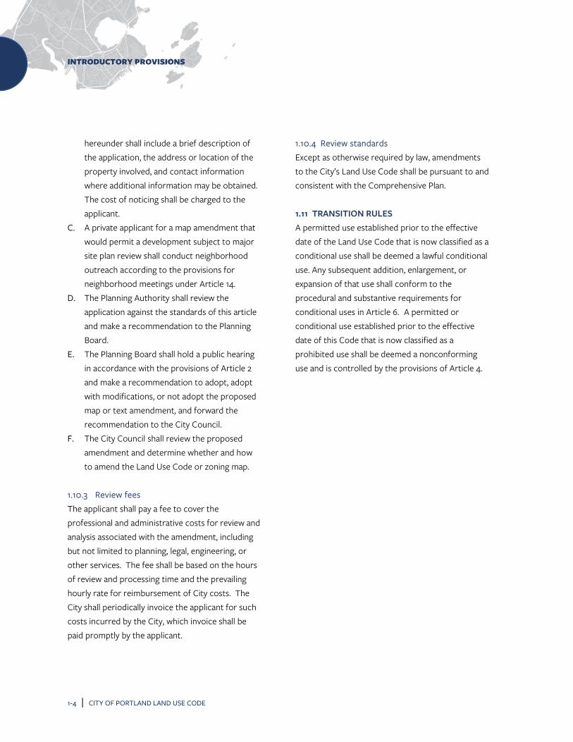
hereunder shall include a brief description of the application, the address or location of the property involved, and contact information where additional information may be obtained. The cost of noticing shall be charged to the applicant.
C. A private applicant for a map amendment that would permit a development subject to major site plan review shall conduct neighborhood outreach according to the provisions for neighborhood meetings under Article 14.
D. The Planning Authority shall review the application against the standards of this article and make a recommendation to the Planning Board.
E. The Planning Board shall hold a public hearing in accordance with the provisions of Article 2 and make a recommendation to adopt, adopt with modifications, or not adopt the proposed map or text amendment, and forward the recommendation to the City Council.
F. The City Council shall review the proposed amendment and determine whether and how to amend the Land Use Code or zoning map.
1.10.3 Review fees The applicant shall pay a fee to cover the professional and administrative costs for review and analysis associated with the amendment, including but not limited to planning, legal, engineering, or other services. The fee shall be based on the hours of review and processing time and the prevailing hourly rate for reimbursement of City costs. The City shall periodically invoice the applicant for such costs incurred by the City, which invoice shall be paid promptly by the applicant.
1.10.4 Review standards Except as otherwise required by law, amendments to the City’s Land Use Code shall be pursuant to and consistent with the Comprehensive Plan. 1.11 TRANSITION RULES A permitted use established prior to the effective date of the Land Use Code that is now classified as a conditional use shall be deemed a lawful conditional use. Any subsequent addition, enlargement, or expansion of that use shall conform to the procedural and substantive requirements for conditional uses in Article 6. A permitted or conditional use established prior to the effective date of this Code that is now classified as a prohibited use shall be deemed a nonconforming use and is controlled by the provisions of Article 4.

ADMINISTRATION
CITY OF PORTLAND LAND USE CODE | 2-1
2 ADMINISTRATION
2.1 PLANNING BOARD 2.1.1 Composition There shall be a Planning Board of seven members. Members of the Planning Board shall be residents of the city and shall not be officers or employees of the City. Members shall serve without compensation.
2.1.2 Appointments A. Terms. The members of the Planning Board
shall be appointed by the City Council for termsof three years. Such members shall serve untiltheir successors are duly appointed andqualified. Such terms shall be staggered so thatthe terms of not more than three membersshall expire in any calendar year; providing,however, such service shall not extend to over120 days after expiration of their term.Members may serve for three consecutivethree-year terms.
B. Vacancies. Permanent vacancies on thePlanning Board shall be filled by the CityCouncil, in the same manner as otherappointments hereunder, for the unexpiredterm of the former member.
2.1.3 Removal of members Any member of the Planning Board may be removed for cause by the City Council at any time, provided, however, that before any such removal, such member shall be given an opportunity to be heard in their own defense at a public hearing.
2.1.4 Officers A. Chair. The members of the Planning Board
shall annually elect one of their number as chairto preside at all meetings and hearings and tofulfill the customary functions of that office.The chair may administer oaths.
B. Vice chair. The members of the PlanningBoard shall annually elect one of their numberas vice chair. In the absence of the chair, thevice chair shall act as chair and shall have all thepowers of the chair. The vice chair shall havesuch other powers and duties as may beprovided by the rules of the Planning Board.
2.1.5 Committees The chair of the Planning Board shall assign the members of the board to such regular and special committees as may be established by the board. Such committees shall have no final authority but shall assist the board in the conduct of its business by making recommendations to it concerning such specific items as may be assigned to them for study and report. The board shall adopt such rules as it shall deem appropriate to govern the organization and operation of its committees. Committee meetings deliberative in nature shall be open to the public in accordance with Title 1 M.R.S. § 401 et seq.
2.1.6 Quorum and necessary vote As to any matter requiring a hearing, no business shall be transacted by the Planning Board without a quorum, consisting of four members, being present. The vote of at least four members shall be necessary to authorize any action by the board. If less than a quorum is present, the hearing may be adjourned for a period not exceeding three weeks at any one time. The Planning Authority shall notify

ADMINISTRATION
2-2 | CITY OF PORTLAND LAND USE CODE
in writing all members of the date of the adjourned hearing and shall notify such other interested parties as may be directed in the vote of adjournment. 2.1.7 Conflicts No member of the Planning Board shall participate in the hearing or disposition of any matter in which he or she has an interest. Any question of whether a member has a conflict of interest sufficient for a member to be recused shall be decided by a majority vote of the members present, except the member whose possible conflict is being examined. Where such vote results in a tie, the subject member shall be recused from the matter. 2.1.8 Meetings and procedures A. Meetings. Regular meetings of the Planning
Board shall be held at the call of the chair or as provided by rule of the board. Special meetings may be called by the chair or any four members of the Board or at the request of the City Council. 1. Workshops. Workshops of the Planning
Board or any of its committees may be held at the call of the board or committee chair, as the case may be, for the presentation of information by the Director of the Department of Planning & Urban Development, their staff, an applicant, or others. These meetings will be open for public comment according to the rules of the Planning Board. Such meetings, unless open to the public as provided in Title 1 M.R.S. § 401 et seq. shall be informational only and shall not result in final decisions on any matter.
2. Public hearings. Public hearings shall be held as required by the various statutes, codes, and ordinances pursuant to which matters are brought before the Planning Board and shall be conducted in accordance with relevant state law, the Land Use Code, and the rules of the board.
B. Notice. The Planning Authority shall give notice of the time and place of public workshops and hearings, including a brief description of the application(s) to be considered, as follows: 1. Site plan and subdivision. Notice shall be
given to the general public by publication in a newspaper of general circulation in the City of Portland at least two times, the date of the first publication to be at least 10 calendar days prior to the workshop or hearing. Notice shall also be sent by regular United States mail at least 10 calendar days in advance of the workshop or hearing date to the applicant, the owner(s) of the subject property, and all owners of property located within 500 feet of the subject property, except that for subdivisions within industrial zones the notice range shall be 1,000 feet.
2. Land Use Code or zoning map amendment. Notice of public hearing shall be publicly posted in the municipal office at least 13 days before the public hearing on such application. In addition, notice of said public hearing must be published at least two times in a newspaper of general circulation in the City of Portland. The date of the first publication must be at least 12 days prior to any public hearing and the date of the second publication must be at

ADMINISTRATION
CITY OF PORTLAND LAND USE CODE | 2-3
least seven days prior to the public hearing. For map amendments, notice shall be sent by regular United States mail to at least 13 calendar days in advance of any workshop or hearing date to all property owners within the area proposed for rezoning and all property owners 500 feet beyond said area, except that rezoning to industrial zone designations the notice range shall be 1,000 feet.
3. Contract or conditional zoning. Notice of public hearing shall be posted in the City Clerk's office at least 13 days prior to the public hearing and shall be published in a newspaper of general circulation within the city at least two times, the date of the first publication to be at least seven days prior to the hearing. Notice shall also be sent to the owners of all property abutting the property to be rezoned at their last known address. This notice shall contain a copy of the proposed conditions and restrictions, with a map indicating the property to be rezoned.
The cost of noticing shall be charged to the applicant.
C. Procedures. The Planning Board shall adopt its own rules for the conduct of its business not inconsistent with the statutes of the state and this article. Such rules shall be filed with the Planning Authority and with the City Clerk. Any and all rule changes shall be placed on a City Council public agenda as a communication requiring a public hearing. Any rule may be vetoed, in whole or in part, by order of the Council within 45 days of the date of filing with the City Clerk. No rules change shall take effect until that time period has elapsed. If a part of a
rule is vetoed, the remainder shall continue in effect. Any rule so adopted, which is not required by the statutes of the state or by this article, may be waived by the chair upon good cause being shown. Except as otherwise provided in Subsection 2.1.8(A)(1), all meetings, hearings, and deliberations of the Planning Board and its committees shall be open to the public in accordance with Title 1 M.R.S. § 401 et seq. Testimony at any hearing may be required by the Planning Board to be given under oath.
D. Keeping of records. The Director of the Department of Planning & Urban Development shall designate a member of their staff who shall attend all Planning Board proceedings. The staff shall provide for the keeping of minutes of the proceedings of the Board, showing the vote of each member on every question, or their absence or failure to vote, and shall maintain the permanent records and decisions of all Board meetings, hearings, and proceedings and all correspondence of the Board, as required by statute. Such records shall be public records open to inspection during working hours upon reasonable notice.
2.1.9 Record and decisions A. Record. The minutes of the staff, and the
transcript if one is made, and all exhibits, papers, applications, and requests filed in any proceeding before the Planning Board and the decision of the Board shall constitute the record.
B. Decision. Every final decision of the Planning Board and every recommendation of the Planning Board to the City Council shall include written findings of fact, and shall specify the reason or reasons for such decision or

ADMINISTRATION
2-4 | CITY OF PORTLAND LAND USE CODE
recommendation. The Planning Authority shall mail notice of any decision of the Planning Board to the applicant.
2.1.10 Jurisdiction and authority In addition to the jurisdiction conferred on it by other provisions of state law and the ordinances of the City and in accordance therewith, the Planning Board shall have the following jurisdiction and authority: A. To prepare and recommend a Comprehensive
Plan to the City Council. B. To prepare and recommend to the City Council
changes in and amendments to the Comprehensive Plan.
C. To aid and assist the City Council and departments and agencies of the City in implementing general plans and in planning, developing, and completing specific projects.
D. To hear, review, and approve, conditionally approve, or deny master development plans and major site plans.
E. To hear, review, and approve, conditionally approve, or deny applications for subdivision approval.
F. To hear, review, and approve or deny applications for conditional uses listed in Article 6.
G. To hear, review, and offer its recommendations to the City Council on applications for amendments to, or revisions of, this Land Use Code.
H. To review and offer its recommendations to the City Council on certain public projects.
I. To review and approve, conditionally approve, or disapprove site plans for regulated projects in shoreland areas.
J. To prepare and offer its recommendations to the City Council with regard to the City's annual Capital Improvement Program.
K. Upon reasonable request, to make its special knowledge and expertise available to any official, department, board, or agency of the city, county, state, or federal governments to aid them in the performance of their respective duties relating to the planning and development of the city and its region, including request from the City Council to review proposed developments in which the developer does not have the right, title, or interest in all the property necessary for the proposed development because some or all of that property is owned by the City.
L. To make such investigations, maps and reports, and recommendations in connection therewith, relating to the planning and development of the city as seem desirable.
M. To employ or contract with such experts and other assistants as may be necessary or convenient to carry out its duties hereunder and to pay for their services and for such other expenses as may be necessary and proper, provided, however, that such expenditures shall not exceed such funds as may be appropriated for such purposes by the City Council.
N. To hear, review, and offer its recommendations to the City Council on petitions for street vacations and discontinuances.
O. To hear, review, and decide appeals where it is alleged there is an error in any decision, requirement, or determination made by the Planning Authority.
P. To approve, following a public hearing and at the recommendation of the Public Works Authority and the Planning Authority, Technical

ADMINISTRATION
CITY OF PORTLAND LAND USE CODE | 2-5
Manual and Design Manual standards, provided that such standards shall be additional to and consistent with the provisions of this Land Use Code, necessary and reasonable, and in accordance with sound engineering and urban design practice.
2.1.11 Administrative appeals A. Application procedures. An appeal may be taken
to the Planning Board by any person affected by a final decision of the Planning Authority except as provided elsewhere in this Land Use Code. Such appeal shall be taken within 30 days of the action complained of by filing with the Planning Authority an application for appeal specifying the grounds thereof. The application shall be in such form as specified by the Planning Authority. A payment of a nonrefundable filing fee, as established by the City Council to cover administrative costs and costs of hearing, shall accompany each application. The Planning Authority shall forthwith transmit to the Planning Board all of the papers constituting the record upon which the action appealed from was taken.
B. Public hearing. A public hearing shall be set, advertised and conducted by the Planning Board in accordance with the provisions of this article.
C. Action. Within 30 days following the close of the public hearing, the Planning Board shall render a decision on the appeal in the manner and form specified in the provisions of this article and the statutes of the state. The failure of the board to act within 30 days shall be deemed a denial of the appeal unless mutually extended in writing by the appellant and the board. Within five days of such decision or failure to act notice thereof shall be mailed to each party.
D. Conditions and limitations. Any right granted by the reviewing board on appeal shall be subject to the same conditions and limitations as if secured without the necessity of an appeal.
2.1.12 Planning Board appeals An appeal from any final decision of the Planning Board as to any matter over which it has final authority may be taken by any party or by any authorized officer or agent of the City to the superior court in accordance with Rule 80B of the Maine Rules of Civil Procedure. No appeal shall lie concerning any matter as to which the power of the Board is limited to the making of a recommendation. 2.2 HISTORIC PRESERVATION BOARD 2.2.1 Composition The Historic Preservation Board shall consist of seven voting members who shall serve without compensation. Members shall not be officers or employees of the City. Members shall have demonstrated interest, knowledge, ability, experience, or expertise in restoration, rehabilitation, or neighborhood conservation or revitalization and shall be residents of the city. 2.2.2 Appointments A. Terms. Members shall be appointed by the
Council for terms of three years. Appointments shall be staggered so that the terms of not more than three members expire in any calendar year. Members may serve for three consecutive three-year terms.
B. Vacancies. Vacancies on the Historic Preservation Board shall be filled within 60 days. However, every member shall continue in office after expiration of the term until a

ADMINISTRATION
2-6 | CITY OF PORTLAND LAND USE CODE
successor has been appointed. Vacancies on the Historic Preservation Board shall be filled for the unexpired term of the former member.
2.2.3 Removal of members Members may be removed for cause by the Council. Cause shall include, but is not limited to, the failure to attend meetings without good cause. Any member proposed to be removed shall be given written notice and an opportunity to be heard prior to final action. 2.2.4 Officers A. Election and terms. Officers of the Historic
Preservation Board shall consist of a chair and vice chair. Officers shall be elected by the Historic Preservation Board and shall serve a term of one year and shall be eligible for re-election.
B. Chair. The chair shall preside at all meetings and hearings and fulfill the customary functions of that office.
C. Vice chair. In the absence of the chair, the vice chair shall act as chair and shall have all the powers of the chair. The vice chair shall have such other powers and duties as may be provided by the rules of the Historic Preservation Board.
2.2.5 Conflicts No member of the Historic Preservation Board shall participate in the hearing or disposition of any matter in which he or she has an interest. 2.2.6 Meetings and procedures A. Meetings. Regular meetings of the Historic
Preservation Board shall be held no less frequently than monthly. Special meetings may
be called by the chair or any four members or at the request of the chair of the Planning Board.
B. Notice. The Planning Authority shall give notice of the time and place of Historic Preservation Board public workshops and hearings, including a brief description of the application(s) to be considered, as follows: 1. Landmark or district nomination. Notice
shall be given to the general public by publication in a newspaper of general circulation in the City of Portland at least two times, the date of the first publication to be at least 10 calendar days prior to the workshop or hearing. Notice shall be sent by regular United States mail at least 10 calendar days in advance of the workshop or hearing date to the applicant and to the owner(s) of the subject property or properties.
2. Certificate of Appropriateness review. Notice shall be given to all property owners within 100 feet of the property at least seven days prior to the date of the workshop or public hearing.
3. Major site plan review. For alteration or new construction that is classified as a major site plan under Article 14, notice shall be given to all property owners within 500 feet of the property at least seven days prior to the date of the workshop or hearing.
The cost of noticing shall be charged to the applicant.
C. Procedures. The Historic Preservation Board may adopt procedural rules for the conduct of its business not inconsistent with this article, including the creation of a subcommittee

ADMINISTRATION
CITY OF PORTLAND LAND USE CODE | 2-7
structure to enhance efficiency in consideration of Historic Preservation Board business. Such rules shall be filed with the Planning Authority and with the City Clerk. All such rules shall be subject to veto, in whole or in part, by the Council within 45 days of such filing. The initial rules shall take effect when filed, subject to veto as provided above. Amendments to the rules shall take effect upon expiration of said veto period. Any rule may be waived by the chair upon good cause being shown.
2.2.7 Record and decisions A. The Director of the Department of Planning &
Urban Development or their designated staff representative shall attend all Historic Preservation Board meetings. The staff shall provide for the keeping of tape recordings or minutes of the proceedings of the Historic Preservation Board, showing the vote of each member on every question or their absence or failure to vote, and shall maintain the records and decisions of all meetings, hearings, and proceedings and all correspondence of the Historic Preservation Board. Copies of permanent records shall be filed with the City Clerk. Staff shall publish and distribute copies of the records, reports, and decisions of the Historic Preservation Board to Historic Preservation Board members and to others upon approval of the Historic Preservation Board.
B. No final action shall be taken by the Historic Preservation Board which could in any manner deprive or restrict the owner of a property in its use, alteration, maintenance, disposition, or demolition until such owner either has
knowledge of the proceeding or is sent notice offering opportunity to be heard. This paragraph shall not affect the interim protection provisions of Section 17.6.
C. Every recommendation or recommended decision of the Historic Preservation Board shall include written findings of fact and shall specify the reason or reasons for such action.
D. Staff shall mail notice of any final determination or recommendation of the Historic Preservation Board to the applicant and property owner(s).
2.2.8 Responsibilities The Historic Preservation Board shall have the following responsibilities: A. To conduct or administer an ongoing survey to
identify historically, culturally, architecturally, and archaeologically significant areas, sites, structures, and objects.
B. To review all areas, sites, structures, and objects listed in the National Register of Historic Places, including the boundaries of areas so listed, and make recommendations to the Planning Board and City Council for the designation of those areas, sites, structures, and objects as local landmarks or districts.
C. To investigate and recommend to the Planning Board and City Council the designation of areas, sites, structures, and objects not listed in the National Register of Historic Places as local landmarks and districts and to make recommendations to the Planning Board concerning sites, structures, and objects that have contributing significance or are intrusions within nominated or designated districts.
D. To keep and make available to the public a register of all areas, sites, structures, and

ADMINISTRATION
2-8 | CITY OF PORTLAND LAND USE CODE
objects that have been designated as landmarks or districts, including all information required as part of each designation.
E. Upon request, to advise and assist owners of landmarks and property, sites, structures, or objects within districts on physical and financial aspects of preservation, renovation, rehabilitation, and reuse and for procedures for inclusion on other registers of significant areas, sites, structures, and objects, including the National Register of Historic Places.
F. To recommend to the Planning Board the nomination of areas, sites, structures, and objects to the National Register of Historic Places or to any State of Maine Register of Historic Places that may be established.
G. To participate in the Certified Local Government Program of the National Historic Preservation Act Amendments of 1980 and the Maine Historic Preservation Commission, and carry out any responsibilities delegated to it under that program, including review and comment on any National Register nominations submitted to the Historic Preservation Board.
H. To seek funding for which the City of Portland is eligible through the Certified Local Government Program to assist in local preservation projects, including projects undertaken by local non-profit organizations.
I. To, upon request by the City Council, participate in any review of federal actions or undertakings pursuant to Section 106 of the National Historic Preservation Act, attend informational and educational programs sponsored by the Maine Historic Preservation Commission, and prepare an annual report of the activities of the Historic Preservation Board.
J. To inform and educate the citizens of Portland concerning the cultural, historic, architectural, and archeological heritage of the city by publishing appropriate maps, newsletters, brochures, and pamphlets and by sponsoring programs and seminars.
K. To hold meetings and public hearings to review applications for Certificates of Appropriateness affecting proposed or designated landmarks and districts and to recommend approval or disapproval of Certificates of Appropriateness.
L. To provide testimony to the Board of Appeals in connection with any application for a Certificate of Economic Hardship.
M. To develop design guidelines affecting landmarks or districts for review and approval by the Planning Board.
N. To advise the Planning Board as to recommendations on any preservation or conservation easements that the City of Portland may have or be offered as a gift or otherwise.
O. To advise the Planning Board as to the administration of such gifts, grants, and money as may be appropriated for the purposes of this article upon authorization and approval by the City Council.
P. To provide comment, as appropriate, to the Planning Board and/or City Council on matters pertaining to historic preservation in Portland.
Q. To confer recognition upon the owners of landmarks or properties, sites, structures, or objects within districts by means of certificates, plaques, or markers.
R. To assist the Planning Board in the development of a preservation component in the Comprehensive Plan of the City of Portland.

ADMINISTRATION
CITY OF PORTLAND LAND USE CODE | 2-9
S. To periodically review the Land Use Code and to make recommendations to the Planning Board concerning any amendments appropriate for the protection and continued use of landmarks or properties, sites, structures, or objects within districts.
2.2.9 Administrative appeals A. Application procedures. An appeal may be
taken to the Historic Preservation Board by any person affected by a decision of the Planning Authority relative to Article 17. Such appeal shall be taken within 30 days of the action complained of by filing with the Planning Authority an application for appeal specifying the grounds thereof. The application shall be in such form as specified by the Planning Authority. A payment of a nonrefundable filing fee, as established by the City Council to cover administrative costs and costs of hearing, shall accompany the application. The Planning Authority shall forthwith transmit to the Historic Preservation Board all of the papers constituting the record upon which the action appealed from was taken.
B. Public hearing. A public hearing shall be set, advertised, and conducted by the Historic Preservation Board in accordance with the provisions of this article.
C. Action. Within 30 days following the close of the public hearing, the Historic Preservation Board shall render a decision on the appeal in the manner and form specified in the provisions of this article and the statutes of the state. The failure of the board to act within 30 days shall be deemed a denial of the appeal unless mutually extended in writing by the appellant and the Board. Within five days of
such decision or failure to act notice thereof shall be mailed to each party.
D. Conditions and limitations. Any right granted by the board on appeal shall be subject to the same conditions and limitations as if secured without the necessity of an appeal.
2.2.10 Historic Preservation Board appeal A. Historic Preservation Board decision. An
appeal from any final decision of the Historic Preservation Board as to any matter over which it has final authority may be taken by any party or by any authorized officer or agent of the City to the Planning Board, adhering to the requirements of Subsection 2.1.11 of this article.
B. The Planning Board shall deny the appeal unless it finds that the action of the Historic Preservation board was arbitrary or capricious or was not based on substantial evidence. Review by the Planning Board under this subsection is intended to be appellate in nature. Except where the Planning Board determines that injustice would result, the Planning Board shall determine the appeal without considering any facts or arguments which were not presented to the Historic Preservation Board. Where the Planning Board finds it necessary to consider such new evidence in order to do substantial justice, it shall remand the matter to the Historic Preservation Board for further consideration, unless it determines that the resulting delay is likely to result in undue hardship to the applicant.
C. Planning Board decision. The Planning Board's decision on an appeal from a decision of the Historic Preservation Board shall be final with respect to the application or matter initially
ADMINISTRATION
2-10 | CITY OF PORTLAND LAND USE CODE
presented to the Historic Preservation Board. An appeal from any final decision of the Planning Board as to any matter over which it has final authority may be taken by any party or by any authorized officer or agent of the city to the superior court in accordance with Rule 80B of the Maine Rules of Civil Procedure. No appeal shall lie concerning any matter as to which the power of the board is limited to the making of a recommendation.
2.3 ZONING BOARD OF APPEALS 2.3.1 Composition There shall be a Board of Appeals of seven members. Members of the Board shall be residents of the city and shall not be officers or employees of the City or any of its agencies or departments. Members shall serve without compensation. 2.3.2 Appointments A. Terms. The members of the Board of Appeals
shall be appointed by the City Council for terms of three years. Terms shall be staggered so that the terms of no more than three members shall expire in any calendar year. Such members shall serve until their successors are duly elected and qualified provided, however, that such service shall not extend to over 120 days after expiration of their term. Members may serve for three consecutive three-year terms.
B. Vacancies. Permanent vacancies on the Board of Appeals shall be filled by the City Council, in the same manner as other appointments under this article, for the unexpired term of a former member whose place has become vacant.
2.3.3 Removal of members Any member of the Board of Appeals may be removed for cause by the City Council at any time, provided, however, that before any such removal, such member shall be given an opportunity to be heard in their own defense at a public hearing. 2.3.4 Officers A. Chair. The members of the Board of Appeals
shall annually elect one of their number as chair to preside at all meetings and hearings and to fulfill the customary functions of that office. In the absence of the chair, the secretary shall act as chair and shall have all the powers of the chair.
B. Secretary. The members of the Board of Appeals shall annually elect one of their number as secretary. The secretary shall fulfill the duties provided by statute and this article and have such other duties as may be provided by the rules of the board.
C. Pro tempore officers. In the absence of both the chair and the secretary, the board shall elect a chair pro tempore from among its number and the chair pro tempore shall have all the powers of the chair during the chair’s and the secretary’s absence. In the absence of the secretary, or when the secretary is serving as chair, the board shall elect a secretary pro tempore from among its number and the secretary pro tempore shall have all the powers of the secretary during the secretary’s absence or service as chair.
2.3.5 Quorum and necessary vote No business shall be transacted by the Board of Appeals without a quorum, consisting of four members, being present. The concurring vote of at

ADMINISTRATION
CITY OF PORTLAND LAND USE CODE | 2-11
least four members of the board shall be necessary to grant any request or application or to sustain any appeal. Any matter that receives fewer than four votes shall be deemed to have been denied. 2.3.6 Conflicts No member of the Board of Appeals shall participate in the hearing or disposition of any matter in which he or she has an interest. Any question of whether a member has a conflict of interest sufficient to disqualify him or her shall be decided by a majority vote of the members, except the member who is being challenged. Where such a vote results in a tie, the challenged member shall be deemed disqualified. 2.3.7 Meetings and procedures A. Staff. The Building Authority or their designee
shall serve as staff to the Board of Appeals. B. Meetings. Regular meetings of the Board of
Appeals shall be held at the call of the chair or as provided by the rules of the board. Special meetings shall be called by the chair at the request of any two members of the board or at the request of the City Council. All meetings and hearings of the board shall be open to the public. For all matters properly brought before the Board of Appeals, the board shall select a reasonable time and place for a public hearing following the submission of the subject application.
C. Notice. The Building Authority shall give notice of public hearings in the form and manner and to the persons herein specified. The notice shall include the time and place of such hearing, a description of the contents of the matter to be heard and the address or location of the property involved. Where notice by mail is
required, it shall be mailed at least seven days in advance of the hearing date by regular United States mail. Notices shall be given to each of the following as specified: 1. In all cases, to the petitioner. 2. In all cases, to all residents of the city by
publication in a newspaper of general circulation in the city at least once, not more than 30 nor less than five days before the date of the hearing, and by mail to the applicant.
3. In the case of hearings relating to zoning appeals, a variance, or a conditional use, to the Planning Board and City Council by reasonable means.
4. In the case of hearings relating to a variance request from the provisions of Article 11, the application and all supporting information supplied by the applicant shall be forwarded to the State of Maine Commission of the Department of Environmental Protection at least 20 days prior to action by the board.
5. In the case of hearings related to a variance or conditional use, by mail to the owners of all the property within 500 feet of such parcel or tract.
6. In the case of hearings related to all other appeals, by mail to the owners of property directly abutting, and directly across a street or alley from the subject property.
For purposes of this subsection, the owners of property shall be considered to be the parties listed by the Assessor's Department as those against whom taxes are assessed. Failure of any property owner to receive a notice of public hearing shall not necessitate another hearing and shall not invalidate any action of the board.

ADMINISTRATION
2-12 | CITY OF PORTLAND LAND USE CODE
The cost of noticing shall be charged to the applicant.
D. Procedures. The Board of Appeals shall adopt its own rules of procedure for the conduct of its business not inconsistent with the statutes of the state and this article. Such rules shall be filed with the City Clerk. Any rule so adopted which relates solely to the conduct of hearings, and which is not required by the statutes of the state or by this article, may be waived by the board upon good cause being shown. 1. Conduct of hearings.
a. Any person may appear and testify at a public hearing, either in person or by a duly authorized agent or attorney, and may submit documentary evidence, provided, however, that the Board shall exclude irrelevant, immaterial and unduly repetitious evidence.
b. The applicant and any abutter or similar person with standing shall in addition have the right to present witnesses on their own behalf and offer rebuttal evidence, to cross examine all witnesses testifying in opposition to their position through the chair, and to examine and introduce any documents produced at the hearing.
2. All other matters pertaining to the conduct of hearings shall be governed by the provisions of the relevant state statutes, this article, and the rules promulgated by the Board of Appeals.
2.3.8 Records and decisions A. Record. The recording of testimony, if any, and
all exhibits, papers, applications, and requests filed in any proceeding before the Board of Appeals and the decision of the board shall constitute the record.
B. Decision. Every decision of the Board of Appeals shall include findings of the fact, shall refer to the evidence in the record and the exhibits, plans or specifications upon which such decision is based, shall specify the reason or reasons for such decision, and shall contain a conclusion or statement separate from the findings of fact setting forth the specific relief granted or denying relief. The Building Authority shall hand deliver or mail a copy of the decision to the applicant, the Planning Board, and City Council within seven days of such decision, and shall also file the decision with the City Clerk.
2.3.9 Jurisdiction and authority The Board of Appeals shall have the following jurisdiction and authority: A. To hear and decide appeals from the granting
or denial of any permit required by Chapter 6, Article II or Chapter 10 of the City of Portland Code of Ordinances.
B. To hear and decide appeals from any decision or order made by the Building Authority pursuant to the provisions of this chapter, except that decisions relating to enforcement of the Shoreland Zone provisions of this chapter may not be appealed to the Board of Appeals and may only be appealed directly to Superior Court in accordance with M.R. Civ. P. 80B and 30-A M.R.S. §§ 2691 & 4483.

ADMINISTRATION
CITY OF PORTLAND LAND USE CODE | 2-13
C. To review interpretations of the Zoning Administrator or their designee, except that decisions on such interpretations shall be advisory only and shall not be appealable.
D. To hear and grant or deny applications for variances from the terms of this Land Use Code, including but not limited to terms related to use; dwelling unit conversion; space and bulk, such as lot size, density, and setbacks; parking; loading; and signs.
E. To hear and grant or deny applications for conditional uses, as specified in Article 6.
2.3.10 Administrative appeals A. Application procedures. Application for any
appeal to the board shall be submitted to the Building Authority. A payment of a nonrefundable application fee, as established by the City Council to cover administrative costs and costs of a hearing, shall accompany each application. The application shall be in such form as prescribed by the Building Authority.
B. Public hearing. A public hearing shall be set, advertised and conducted by the Board of Appeals in accordance with Subsection 2.3.7.
C. Standard of review. The standard of review for appeals pursuant to Subsections 2.3.9(A), (B), and (C) shall be de novo. The appellant shall bear the burden of proof.
D. Conditions and limitations on rights granted by appeal. Any right granted by the Board of Appeals on appeal shall be subject to the same conditions and limitations as if secured without the necessity of an appeal.
2.3.11 Variances A. Application procedures
1. Application for a variance shall be submitted to the Building Authority. A payment of a nonrefundable application fee, as established from time to time by the City Council to cover administrative costs and costs of a hearing, shall accompany each application. The application shall be in such form as prescribed by the Building Authority.
2. A public hearing shall be set, advertised, and conducted by the Board of Appeals in accordance with Subsection 2.3.7.
3. All decisions by the board shall be rendered in a manner and form not inconsistent with the statutes of this state.
B. Undue hardship variance. An undue hardship variance may be granted by the board only where strict application of the ordinance, or a provision thereof, to the petitioner and his or her property would cause undue hardship. The words “undue hardship” as used in this subsection mean the following: 1. The land in question cannot yield a
reasonable return unless a variance is granted.
2. The need for a variance is due to the unique circumstances of the property and not to the general conditions in the neighborhood.
3. The granting of a variance will not alter the essential character of the locality.
4. The hardship is not the result of action taken by the applicant or prior owner.
C. Disability variance 1. By the Board of Appeals. Notwithstanding
the provisions of subsection (B) above, the

ADMINISTRATION
2-14 | CITY OF PORTLAND LAND USE CODE
board may grant a variance to an owner of a residential dwelling for the purpose of making that dwelling accessible to a person with a disability who resides in or regularly uses the dwelling. The board shall restrict any variance granted under this subsection solely to the installation of equipment or the construction of structures necessary for access to or egress from the dwelling by the person with the disability. The board may impose conditions on the variance, including limiting the variance to the duration of the disability or to the time that the person with the disability lives in the dwelling. The term “structures necessary for access to or egress from the dwelling” shall include railing, wall, or roof systems necessary for the safety or effectiveness of the structure. For the purpose of this subsection, a disability has the same meaning as a physical or mental disability under 5 M.R.S. § 4553.
2. By the Building Authority. Notwithstanding the provisions of subsections (B) and (C(1)) above, the Building Authority may issue a permit to the owner of a dwelling for the purpose of making a dwelling accessible to a person with a disability who resides in or regularly uses the dwelling. If the permit requires a variance, the permit is deemed to include that variance solely for the installation of equipment or the construction of structures necessary for access to or egress from the dwelling for the person with a disability.
D. Practical difficulty variance. Notwithstanding the provisions of subsections (B) and (C)
above, the Board of Appeals may grant a variance from the dimensional standards of this Land Use Code that relate to lot area, lot coverage, frontage, and setback requirements when strict application of these standards would both preclude a permitted use of the property and result in significant economic injury to the applicant. Significant economic injury shall mean that the value of the property if the variance were denied would be substantially lower than its value if the variance were granted. To satisfy this standard, the applicant need not prove that denial of the variance would mean the practical loss of all beneficial use of the land. In granting a practical difficulty variance, all of the following conditions must be found to exist: 1. The need for a variance is due to the
unique circumstances of the property, and not to the general conditions in the neighborhood.
2. The granting of the variance will not produce an undesirable change in the character of the neighborhood and will not have an unreasonably detrimental effect on either the use or fair market value of abutting properties.
3. The practical difficulty is not the result of action taken by the applicant or a prior owner.
4. No other feasible alternative is available to the applicant, except a variance.
5. The granting of a variance will not have an unreasonably adverse effect on the natural environment.
6. The property is not located, in whole or in part, within a shoreland area, as defined in 38 M.R.S. § 435, nor within a Shoreland

ADMINISTRATION
CITY OF PORTLAND LAND USE CODE | 2-15
Zone or flood hazard area, as defined in this Land Use Code.
E. Specified variances prohibited 1. No use permitted in medium- and high-
density residential zones shall be permitted in low-density residential zones. No use permitted in mixed-use or office zones shall be permitted in any residential zone. No use permitted in industrial and airport zones shall be permitted in any mixed-use, office, or residential zone. No use permitted in residential zones shall be permitted in any industrial or airport zone. The general use categories are listed below: a. Low-density residential: IR-1, IR-2, IR-3,
R-1, R-2, R-3. b. Medium- and high-density residential:
R-4, R-5/R-5a, R-6/R-6a. c. Mixed-Use/Office: B-1/B-1b, B-2/B-2b/B-
2c, B-3/B-3b/B-3c, B-4, B-5/B-5b, B-6, B-7, I-B, R-P, O-P.
d. Industrial: I-L/I-Lb, I-M/I-Ma/I-Mb, I-H/I-Hb, A-B.
2. A variance may only be granted with respect to the generally applicable space and bulk requirements of the zone in which the property is located and not from any provision that allows a deviation from those requirements.
3. No variance shall be granted which would permit the creation of a lot or parcel that cannot be developed in compliance with the zoning, subdivision, and other regulations applicable thereto.
4. No variance shall be granted which would result in a use or development of the lot or parcel in question which would not be in
harmony with the general purpose and intent of this Land Use Code or the Comprehensive Plan; which would be materially detrimental to the public welfare or materially injurious to the enjoyment, use, or development of property or improvement permitted in the vicinity; or which would materially impair an adequate supply of light and air to properties and improvements in the vicinity, substantially increase congestion in the public streets, increase the danger of flood or fire, or endanger the public safety.
5. No variance shall be granted which would be greater than the minimum variance necessary to relieve the undue hardship or the hardship of the applicant.
6. No variance shall be granted from the minimum lot sizes set forth in Subsection 4.3.1 for lots in the IR-1 and IR-2 zones.
7. No variance shall be granted from the requirements in Subsection 6.4.1.
F. Conditions on variances; variances less than requested. Reasonable conditions and safeguards relating to construction, character, location, landscaping, screening, and other matters may be imposed upon the premises benefited by a variance as considered necessary to prevent injurious effects upon other property and improvements in the vicinity or upon public facilities and services. Such conditions shall be expressly set forth in the resolution granting the variance and in the notice informing the applicant thereof. Violation of such conditions and safeguards shall be a violation of this article. A variance less than or different from that requested may be granted when the record supports the

ADMINISTRATION
2-16 | CITY OF PORTLAND LAND USE CODE
applicant’s right to some relief but not to the relief requested.
G. Limitations on variances. No variance permitting the erection or alteration of a building shall be valid for a period longer than two years, unless a building permit for such erection or alteration is issued and construction is actually begun within that period and is thereafter diligently pursued to completion. No variance relating to the establishment or maintenance of a use not involving a building or structure shall be valid for a period longer than two years, unless an occupancy permit is issued and a use commenced within such period.
H. Recording of variances. No variance shall be valid unless, within 90 days of final approval of the variance, a certificate describing the variance has been recorded by the applicant for the variance in the registry of deeds as required by 30 M.R.S. § 4353(5).
2.3.12 Violations In addition to any other remedies available, the Board of Appeals after notice and hearing may revoke any variance or other relief granted under this section when the provisions of this chapter or the conditions under which the relief was granted have not been complied with. 2.3.13 Appeals An appeal from any final decision of the Board of Appeals may be taken by any aggrieved party to the superior court in accordance with Rule 80B of the Maine Rules of Civil Procedure and 30-A M.R.S. §§ 2691 & 4483., except as otherwise specifically provided in this article.

DEFINITIONS
CITY OF PORTLAND LAND USE CODE | 3-1
3 DEFINITIONS Accessory dwelling unit. A dwelling unit subordinate in size to the principal residential structure(s) on a lot and located either within the principal residential structure(s) or in an accessory structure. Adult business establishment. Any business, including but not limited to any bookstore, newsstand, novelty store, nightclub, bar, cabaret, amusement arcade, or theater, which: A. Keeps for public patronage or permits or allows
the operation of any adult amusement device as defined in Chapter 4 of the City of Portland Code of Ordinances; or
B. Customarily, meaning more often than an average of one calendar week during any calendar month of operation, exhibits motion pictures or displays any other visual representation described or advertised as being “X rated” or “for adults only,” or which customarily excludes persons from any portion of the premises by reason of immaturity of age by the use of such, or similar, phrases; or
C. Is adjudged to be in violation of 17 M.R.S. §§ 2911, 2912.
Affordable housing. Housing for which the percentage of income a household is charged in rent and other housing expenses or must pay in monthly mortgage payments (including condominium/HOA fees, mortgage insurance, other insurance and real estate taxes), does not exceed 30% of a household’s income, or other amount established in City regulations that does not vary significantly from this amount.
After-hours entertainment license. Any of the music, dancing, and special entertainment licenses required or authorized by Chapter 4, Article III of the City of Portland Code of Ordinances. Agriculture. The practice of farming, including the cultivation of the soil for the growing of crops and rearing of animals to provide food and other products. Agriculture may include nurseries, greenhouses, and truck gardens, provided that there is no sale of products not produced on the premises. Airport restricted access areas. Runways, taxiways, and other areas of the Jetport accessible to aircraft, whether access is restricted by the Federal Aviation Administration or not. Alley. Any way designed primarily for vehicular and pedestrian or utility access to the back or side of premises otherwise abutting on a street, except driveways unless officially designated otherwise. Animal-related services. Establishments principally for the training or boarding of animals. Such uses shall not include veterinary services. Approval. An affirmative decision on an application, including an approval with conditions. Appurtenance. A device or structure not designed for human occupancy and attached to the exterior of a building. Auto service station. A business selling gasoline, diesel, or propane fuel, providing services specific to electric vehicles, or providing motor vehicle repairs including, but not limited to, tune-ups, engine repair,

DEFINITIONS
3-2 | CITY OF PORTLAND LAND USE CODE
brake work, muffler replacement, tire repair, or similar activities. Such businesses may also include car-washes and/or vacuums. Back office use. An office‑related use with minimal public visitation and minimal direct service to the general public, primarily to provide support services to larger organizations such as educational institutions, social service agencies, or business headquarters. Bar. Any establishment required to be licensed to sell alcoholic beverages for on‑premises consumption, which is not regularly used for the purpose of providing full‑course meals, as defined in Title 28‑A of the Maine Revised Statutes, on the premises. Bed and breakfast. A building that contains between two and nine guest rooms; is used to provide or offer overnight accommodations for transient guests; has an owner, manager, or operator living in the building as a permanent resident; does not provide cooking facilities in any of the guest rooms; and does not provide meals other than breakfast, which shall be offered only to overnight guests. Blasting operations. The use of explosives for purposes of breaking up and removing soil, rock, and ledge, related to construction and development of real estate within the city. Building. A roofed and walled structure built for permanent use. Building, accessory. A detached roofed and walled structure that is incidental and subordinate in area
and extent, and/or use to the principal building(s) on the property. A lot may have more than one accessory building. Building addition. Any increase to footprint, floor area, or volume of an existing building. Building alteration. A change or rearrangement in the structural supports, exterior appearance, or removing from or otherwise affecting the exterior appearance of a building. Buildings, attached. Two or more independent buildings that share at least one common party wall but have full building separation and independent principal entries; not free-standing. Attached buildings may or may not have common ownership. Building, principal. The main roofed and walled structure on a lot having the predominant area, extent, and/or use. A lot may have more than one principal building. When a garage is attached to the principal building in a substantial manner as by an enclosed area with roof or common wall, it shall be considered as a part of the principal building. Clinics. Any establishment where patients are examined and treated by one or more health care providers, such as, but not limited to, physicians, dentists, psychologists, or social workers. Clinics may include laboratory services and facilities for ambulatory or outpatient surgical procedures. Coastal wetland. All tidal and subtidal lands; all lands with vegetation present that is tolerant of salt water and that occurs primarily in a salt water or estuarine habitat; and/or any swamp, marsh, bog, beach, flat, or other contiguous low land that is

DEFINITIONS
CITY OF PORTLAND LAND USE CODE | 3-3
subject to tidal action during the highest tide level for the year in which an activity is proposed as identified in tide tables published by the National Ocean Service. Coastal wetlands may include portions of coastal sand dunes. Commercial vessel. Any watercraft used principally in a business or trade, including common carriers of passenger or freight, whether for governmental, nonprofit, or emergency purposes, but not including pleasure craft used principally for recreational purposes. Common areas. Portions of a lodging house which are available for use by all residents of the lodging house. Common areas shall include, but are not limited to, one or more of the following: kitchens, living rooms, recreation rooms, improved basements, and finished porches. Bathrooms, stairways, hallways, and storage areas shall not be counted as common areas. Communication studio. A commercial or public communication facility, including radio and television broadcasting and receiving stations and studios. Community hall. A building or portion of a building used for social, recreational, artistic, civic, or educational community functions. Such a facility would be open to the public for such functions, which, for example, could include but not be limited to performances, dance, exhibitions, cultural exchange, training programs and workshops, neighborhood meetings, or gatherings. As part of these functions and activities, it shall be permissible to serve food, subject to other applicable codes and ordinances.
Condominium. Any interest in real estate created pursuant to the Unit Ownership Act, 33 M.R.S. § 560 et seq., or its equivalent, as it may from time to time be amended. Congregate care facility. A residential development which provides individual living or dwelling units with support services which provide assistance to residents. Services to be provided shall include the following: A. Transportation for essential support activities.
This service shall be included in the base rent; B. Provision of at least one meal per day. C. Programmed social activities which are
facilitated by staff. This service shall be included in the base rent.
D. Provision of personal care services including, but not limited to, housekeeping, laundry, and minimal health monitoring.
E. Installation of emergency call buttons or systems in each congregate care living unit.
The population of a congregate care facility shall consist of persons 55 years of age or older and their spouses and/or disabled persons and their spouses. Correctional pre-release facility. A facility housing up to 12 persons, plus staff, serving a primary clientele of persons in correctional pre-release programs. Drive-through. A facility which provides a service directly to a motor vehicle occupant and where the customer drives a motor vehicle onto the premises and to a window or mechanical device through or by which the customer is served with or without exiting the vehicle. Drive-throughs do not include major or minor auto service stations.

DEFINITIONS
3-4 | CITY OF PORTLAND LAND USE CODE
Drive-through features. Features associated with drive-throughs including but not limited to designated travel or stacking lanes, intercom systems, menu boards, service windows, kiosks, mechanical devices, etc. Dwelling unit. One or more rooms forming a single unit for habitation by one family, including food preparation, living, sanitary, and sleeping facilities. Dwelling, multi-family. A building or portion thereof containing three or more dwelling units. Dwelling, single‑family. A single building containing one dwelling unit. Dwelling, two‑family. A single building containing two dwelling units. Earth-moving activity. Any removal or placement, excavation, filling, stockpiling, or grading of soil, earth, loam, sand, gravel, rock, and other mineral deposits. Easement. A right, privilege, or liberty which one has in land owned by another for some special and definite purpose. Emergency operations. Operations conducted for the public health, safety, or general welfare, such as protection of resources from immediate destruction or loss, law enforcement, and operations to rescue human beings and livestock from the threat of destruction or injury. Emergency shelter. A facility providing temporary overnight shelter to homeless individuals in a dormitory‑style or per‑bed arrangement.
Entrance, principal. The main point of access for pedestrians into a building. A building may have more than one principal entrance. Esplanade. That portion of a street which is located between the curbline and the edge of the sidewalk closest to the street. Essential services. The construction, alteration, or maintenance of gas, electrical, or communication facilities; steam, fuel, electric power, or water transmission or distribution lines, towers and related equipment; telephone cables or lines, poles, and related equipment; gas, oil, water, slurry, or other similar pipelines; municipal sewage lines, collection, or supply systems; and associated storage tanks. Such systems may include towers, poles, wires, mains, drains, pipes, conduits, cables, fire alarms and police call boxes, traffic signals, hydrants, and similar accessories, but shall not include service drops or buildings which are necessary for the furnishing of such services. Explosives. Any material or container containing a chemical compound or mixture that is commonly used or intended for the purpose of producing an explosion and that contains any oxidizing and combustible materials or other ingredients in such proportions, quantities, or packaging that an ignition by fire, by friction, by compound or mixture may cause such a sudden generation of highly heated gasses that the resultant gaseous pressures are capable of producing destructive effects on contiguous objects, but shall not mean the components for handloading rifle, pistol and shotgun ammunition, or fireworks.

DEFINITIONS
CITY OF PORTLAND LAND USE CODE | 3-5
Family. One or more individuals related by blood, marriage, civil union, adoption, or guardianship and/or up to eight unrelated individuals living together in a dwelling unit as a single nonprofit housekeeping unit. Fill. Soil, earth, loam, sand, gravel, rock and other mineral deposits. Filling. The placement of soil, earth, loam, sand, gravel, rock and other mineral deposits. Filling shall include stockpiling. Fixture, fully shielded. A light fixture or luminous tube constructed and mounted such that all light emitted by the fixture or tube, either directly from the lamp, tube, or a diffusing element, or indirectly by reflection or refraction from any part of the light fixture, is projected below the horizontal. If the lamp or tube, any reflective surface, or lens cover (clear or prismatic) is visible when viewed from above or directly from the side, from any angle around the fixture or tube, the fixture or tube is not fully shielded. Flag. A fabric sheet of square, rectangular, or triangular shape having no enclosing or supporting framework that is typically mounted on a pole. Foundation. The supporting substructure of a building or other structure, excluding wooden sills and post supports, but including basements, slabs, frost walls, or other base consisting of concrete, block, brick, or similar material. Freshwater wetland. Freshwater swamps, marshes, bogs, and/or similar areas which are both:
A. Of ten or more contiguous acres or of less than ten contiguous acres and adjacent to a surface water body except for any river, stream or brook such that, in a natural state, the combined surface area is in excess of ten acres or of less than ten acres that is depicted on the Shoreland Zoning map.
B. Inundated or saturated by surface or ground water at a frequency and for a duration sufficient to support, and which under normal circumstances do support, a prevalence of wetland vegetation typically adapted for life in saturated soils.
Freshwater wetlands may contain small stream channels or inclusions of land that do not conform to the criteria of this definition. General office. An office for the conducting or managing of a business or the practice of a profession, including that of a licensed health care provider, so long as such office does not include laboratory services and facilities for ambulatory surgical procedures. General services. Establishment primarily engaged in rendering services to persons or business on a fee basis, including but not limited to banks, health clubs, laundries, employment services, management services, personnel services, or maintenance services. Handicapped family unit. A dwelling unit which provides living facilities for handicapped persons. A handicapped family unit may also provide counseling and support services. Staff members may also be included in the population.

DEFINITIONS
3-6 | CITY OF PORTLAND LAND USE CODE
Helistop. An area used for the landing of helicopters at any location other than an airport. Such area shall include a landing area or pad, and may include parking required for access to the landing area or pad, a loading and unloading area for emergency vehicles, and other related facilities other than maintenance and repair facilities. Hospital. An institution providing health services, primarily on an inpatient basis, and medical or surgical care of the sick or injured, including as an integral part of the institution such related facilities as laboratories, outpatient departments, training facilities, central service facilities, and staff offices. Hostel. An overnight lodging facility for transient guests that provides sleeping rooms and common spaces for cooking. A hostel shall not be used as an emergency shelter. Hotel. A building used for more or less temporary occupancy of individuals who are lodged with or without meals. Impervious surface. Area covered with low-permeability material that is highly resistant to infiltration by water, such as asphalt, concrete, or rooftop, and areas such as gravel roads and unpaved parking areas that will be compacted through design or use to reduce their permeability. Industrial, high-impact. Industrial activity involving the manufacturing, packaging, assembly, or distribution of finished products from either raw materials or previously prepared material which are generally incompatible with residential, commercial, and lower-impact industrial uses and sensitive
natural areas due to their high generation of traffic, noise levels, emissions, lighting, and odors. Industrial, low-impact. Industrial activity involving the manufacturing, packaging, assembly, or distribution of finished products from previously prepared material, including but not limited to the following: artist studios, bakeries; breweries; distilleries; bottling; coffee roasters; commercial kitchens; pharmaceuticals; machine shops; watchmakers; makers of precision instruments, musical instruments, toys and sporting goods, pottery and ceramics using only previously pulverized clay, wood products, jewelry; assembly of electrical components; canteen services; tool and die shops; plant and tree nurseries; and the packaging of foods. Low-impact industrial uses do not include the processing of raw materials or salvaging operations. Low-impact industrial uses are generally compatible, due to their size and nature of impact, with residential, commercial and other low impact industrial uses. Intermediate care facility. A facility which provides, on a regular basis, health‑related care and services for more than 13 individuals who do not require the degree of care and treatment which a hospital or extended care facility is designed to provide but who, because of their mental or physical condition, require such care and services above the level of room and board. Said facility must be licensed as a board care, residential care facility or equivalent pursuant to the regulations promulgated by the State of Maine Department of Health and Human Services.

DEFINITIONS
CITY OF PORTLAND LAND USE CODE | 3-7
Kitchen facilities. Facilities used for the preparation of meals, including refrigerators and devices used for the cooking and preparation of food. Lodging house. A house, building or portion thereof containing two or more rooming units, as well as common areas, and providing such units to individuals on not less than a monthly basis for compensation. Long-term or extended care facility. An institution or a distinct part of an institution that is licensed or approved to provide full‑time convalescent or chronic care, or health care under medical supervision for 24 or more consecutive hours, to nine or more individuals who, by reason of advanced age, illness, or infirmity are unable to care for themselves, and who are not related to the governing authority by marriage, blood, or adoption. Lot. A parcel or area of land that is designated as an individual unit for use, development, or ownership that is either: a) a parcel or area of land that is separately described in a deed or on a plan recorded in the Cumberland County Registry of Deeds; b) a contiguous combination of such lots under common ownership and designated as one unit for development; or c) a newly established parcel meeting all the dimensional requirements of the zone in which it is located. Lot of record. A nonconforming parcel or area of land that: a) is separately described in a deed or on a plan recorded in the Cumberland County Registry of Deeds as of the date designated in the relevant provision of this chapter and b) conformed to the requirements of this chapter as of the date designated in the relevant provision of this chapter.
Low-income household. A household having an income not exceeding 80% of median income for area of residence as set forth in regulations promulgated from time to time by the United States Department of Housing and Urban Development pursuant to 42 U.S.C. sections 1437 et seq. Low-income housing unit for rent. A dwelling unit for which: A. The rent is affordable to a household earning
80% or less of Area Median Income (AMI) as defined by the United States Department of Housing and Urban Development (HUD).
B. The unit is rented to a household earning 80% or less of AMI.
C. The requirements of (A) and (B) above are limited by deed restriction or other legally binding agreement for the applicable length of time in this ordinance.
Low-income housing unit for sale. A dwelling unit for which: A. The sale price is affordable to a household
earning 100% or less of Area Median Income (AMI).
B. The unit is sold to a household earning 100% or less of AMI.
C. The requirements of (A) and (B) above are limited by deed restriction or other legally binding agreement for future sales for the applicable length of time in this ordinance.
Manufactured housing. A structural unit or units designed for residential occupancy and constructed in a manufacturing facility and then transported by the use of its own chassis or placement on an independent chassis to a building site. The term includes any type of building which is constructed at
DEFINITIONS
3-8 | CITY OF PORTLAND LAND USE CODE
a manufacturing facility and then transported to a building site where it is utilized for housing and may be purchased or sold by a dealer in the interim. For purposes of this article, two types of manufactured housing are included. They are: A. Those units constructed after June 15, 1976,
which the manufacturer certifies are constructed in compliance with the standards required by the United States Government Department of Housing and Urban Development, as such standards are from time to time revised or amended, meaning structures, transportable in one or more sections, which in the traveling mode are 14 body feet or more in width and are 750 or more square feet, and which are built on a permanent chassis and designed to be used as dwellings, with or without permanent foundations, when connected to the required utilities, including the plumbing, heating, air conditioning, and electrical systems contained therein. This term also includes any structure which meets all the requirements of this subparagraph except the size requirements and with respect to which the manufacturer voluntarily files a certification required by the Secretary of the United States Department of Housing and Urban Development and complies with the standards established under the National Manufactured Housing Construction and Safety Standards Act of 1974, United States Code, Title 42, Section 5401 et seq.; and
B. Those units constructed after June 15, 1976, which the manufacturer certifies are constructed in compliance with the state’s Manufactured Housing Act and regulations, meaning structures, transportable in one or more sections, which are not constructed on a
permanent chassis and are designed to be used as dwellings on foundations when connected to required utilities, including the plumbing, heating, air conditioning, or electrical systems contained therein.
Any unit which does not fall within the definitions of this section and which is legally sited within the city on December 18, 1989, may be relocated to any location in the city in which manufactured housing is allowed. Manufactured housing park. A parcel of land under unified ownership approved by the Planning Board under 30‑A M.R.S. § 4358 for the placement of single‑component manufactured housing. Marijuana cultivation facility. A cultivation facility required to be licensed pursuant to 28-B M.R.S. § 201 or any other facility engaged primarily in the business of planting, propagation, growing, harvesting, drying, curing, grading, trimming, or other processing of marijuana, including mature marijuana plants, immature marijuana plants, seedlings, and marijuana seeds, for use or sale. Marijuana manufacturing facility. A manufacturing facility required to be licensed pursuant to 22 M.R.S. § 2423-F or 28-B M.R.S. § 201. Marijuana product. As defined by 22 M.R.S. § 2422 or 28-B M.R.S. § 102. Marijuana retail store. A retail establishment licensed to sell marijuana, marijuana products, immature marijuana plants, and seedlings to adult use or medical marijuana customers. A marijuana retail store is only authorized as a principal use, and is not permitted as an accessory use. A marijuana

DEFINITIONS
CITY OF PORTLAND LAND USE CODE | 3-9
retail store may not exceed a maximum gross floor area of 2,000 square feet. A marijuana retail store shall not include a registered dispensary. Marijuana testing facility. A facility licensed to develop, research and test marijuana, marijuana products and other substances as defined by 22 M.R.S. § 2422 or 28-B M.R.S. § 102. Marina. A commercial operation providing floats, slips, and piers intended primarily for berthing of noncommercial vessels and the provision of related services such as supplies, fuel, equipment and repairs, which may be provided both to tenants and non-tenants. Military personnel berthing. A building, or portion thereof, which is primarily used as, and intended for, temporary living quarters for military personnel. Moderate-income household. A household having an income not exceeding 120% of median income for area of residence as set forth in regulations promulgated from time to time by the United Sates Department of Housing and Urban Development pursuant to 42 U.S.C. sections 1437 et seq. Multi-family development. The construction or creation of three or more dwelling units on any parcel of land or the addition of two or more dwelling units cumulatively within a three-year period. Multiplex. A residential development consisting of three or more horizontally or vertically attached dwelling units, or a series of such attached dwelling units, and the construction of at least one building.
Neighborhood center. A building or portion of a building used for recreational, artistic, social, educational, health, culture, or similar activities and services, usually owned and operated by a public or nonprofit group or agency. Non-commercial vessel berthing. The use of berthing space for berthing of watercraft other than commercial vessels. Berthing space used in the following manner shall not be included in the calculation of the number of linear feet under this use category: A. Space used principally for sale or repair of
vessels. B. Commercial vessel tenant space used by a
noncommercial vessel for a period not exceeding ten consecutive days while the primary commercial vessel tenant is conducting its business or trade.
Normal high-water line (non-tidal waters). That line which is apparent from visible markings, changes in the character of soils due to prolonged action of the water or changes in vegetation, and which distinguishes between predominantly aquatic and predominantly terrestrial land. Areas contiguous with rivers that support non-forested wetland vegetation and hydric soils and that are at the same or lower elevation as the water level of the river during the period of normal high-water are considered part of the river. Office park. Separate office buildings planned, constructed, or managed on an integrated coordinated basis. Off-peninsula. All land located north of I-295.

DEFINITIONS
3-10 | CITY OF PORTLAND LAND USE CODE
On-peninsula. All land located south of I-295. Open space. Any park and any other area outside of a building open to the public. Owner. Any person that has any interest, legal or beneficial, in any parcel or lot. Piers, docks, wharves, bridges and other structures and uses extending over or beyond the normal high-water line or within a wetland, temporary. Structures which remain in or over the water for less than seven months in any period of 12 consecutive months. Piers, docks, wharves, bridges and other structures and uses extending over or beyond the normal high-water line or within a wetland, permanent. Structures which remain in or over the water for seven months or more in any period of 12 consecutive months. Place of assembly. A building or portion of a building used as a community hall, neighborhood center, private club, or fraternal organization, or place of religious assembly. This definition shall not include buildings or portions of buildings used as a community hall, neighborhood center, private and fraternal organization, or place of religious assembly where 15 or fewer people, not including the permanent residents of a single-family dwelling, assemble. Place of religious assembly. A building or portion of a building used for religious worship or instruction including, but not limited to, churches, synagogues, masjids, mosques, and other places of worship.
Planned residential unit development (PRUD). A residential subdivision consisting of attached or detached dwellings intended for separate ownership and land to be owned and used in common, with open spaces, recreational areas, access ways, and buildings which are designed, built, and managed in accordance with a unified development plan. Planned unit development (PUD). A development consisting of either detached or attached single-family dwelling units and commercial or other uses, on substantially-sized properties of greater than 20 acres and designed to be compatible with the surrounding built and natural environment. Plant canopy. As defined by 28-B M.R.S. § 102. Preschool facility. Facility which provides a regular program of care and protection for children generally younger than those attending elementary school, which may also encompass daycare facilities. Private club or non-profit social and recreational facility. A private club or nonprofit social and recreational facility is open exclusively to members and to their bona fide guests accompanying them, in order to promote fellowship, social living, proper recreation, civic responsibility, neighborhood responsibility, community welfare, or other endeavors. It shall be permissible to serve food and meals on such premises provided adequate dining room space and kitchen facility are available and are provided within all regulations of this Land Use Code and other applicable codes and ordinances. Recent flood plain soils. Recent flood plain soils include the following soil series as described and

DEFINITIONS
CITY OF PORTLAND LAND USE CODE | 3-11
identified by the National Cooperative Soil Survey: Alluvial. Charles, Cornish, Fryeburg, Hadley, Limerick, Lovewell, Medomak, Ondawa, Podunk, Rumney, Saco, Suncook, and Winooski. Recreation and amusement centers. Facilities equipped for the conduct of sports or indoor leisure time recreation activities, including games of skill or games of chance licensed either by the City of Portland or by the State of Maine. Such facilities may limit admission either to members or to persons paying an entrance fee. Registered dispensary. A registered medical marijuana dispensary as defined by 22 M.R.S. § 2422. Registered patient. As defined by 22 M.R.S. § 2422. Repair services. Establishments primarily engaged in rendering services related to the maintenance or repair of goods. In industrial zones only, repair services shall include motor vehicle repair services. Restaurant. Any food service establishment with indoor seating capacity for ten or more patrons. Retail. Any shop or store offering goods or merchandise to the general public for direct consumption and not for resale, or food service establishment with indoor seating capacity for nine or fewer patrons. Retail shall not include gasoline, diesel, or propane fuel sales. Roadway. That portion of a street between the regularly established curblines, or that part of a street or alley devoted to vehicular traffic.
Rooming unit. One or more rooms forming a single unit used, or intended to be used, for living and sleeping purposes by an individual or a family, but not designed for food preparation. In a suite of rooms, each room that provides sleeping accommodations shall be counted as one rooming unit for the purpose of this chapter. Self-storage facility. A fully enclosed building with individual, secured units (accessed with or without supervision) used for the exclusive purpose of storage of non-hazardous business or personal materials. Sexually explicit. The display or depiction of sex organs during actual or simulated sexual intercourse or sexual acts as defined in 17 A M.R.S. § 251. Sheltered care group home. A facility which, in addition to providing food and shelter to a defined population of up to 12 individuals, provides guidance or counseling services as a primary function of the facility. Shore frontage. The length of a lot bordering on a water body or wetland measured in a straight line between the intersections of the lot lines with the shoreline. Sidewalk. That portion of a street not included in the roadway, and devoted in whole or part to pedestrian traffic. Site. All contiguous land under the same ownership or control, whether proposed for development or not, except where development is limited to a lot or lots within a subdivision.
DEFINITIONS
3-12 | CITY OF PORTLAND LAND USE CODE
Small-scale marijuana caregiver. A registered caregiver who sells or dispenses marijuana to no more than five individual registered patients in any one calendar month; does not process or manufacture marijuana using chemicals or solvents; and cultivates no more than: 1) 250 square feet of plant canopy where located in a single-family dwelling or commercial space; or 2) 125 square feet of plant canopy where located in a dwelling unit within a two-family or multi-family building. Solar access. Space open to the sun and clear of overhangs or shade, including orientation of buildings and lots to the sun, so as to permit the use of active and/or passive solar energy systems on individual properties. Solar energy system. A complete assembly consisting of one or more solar collectors and associated mounting hardware or equipment, intended to provide for the collection, storage, and distribution of solar energy for heating or cooling, electricity generation, or solar/thermal hot water systems. Solar energy systems shall include the following: A. Accessory solar energy system. A system as
defined above where power generation is incidental to a principal use, which may take the form of either a building integrated or roof-mounted solar array of any size, or a ground-mounted array occupying less than 1,000 square feet of air-space over ground area.
B. Minor solar energy system. A system as defined above where power generation is considered a principal use, which may take the form of either a building- or roof-mounted solar array of any size, or a ground-mounted system occupying
between 1,000 and 9,999 square feet of ground area.
C. Major solar energy system. A system as defined above where power generation is considered a principal use, which may take the form of either a building or roof-mounted solar array of any size, or a ground-mounted system occupying greater than 10,000 square feet of ground area.
Solar energy system, building-integrated. A solar energy system that is an integral part of a principal or accessory building and include, but are not limited to, photovoltaic or hot water systems that are contained within roofing materials, windows, walls, skylights and awnings. Solar energy system, ground-mounted. Also known as free-standing solar energy systems, a solar energy system that is structurally mounted to the ground. The panels may be stationary or revolving and of any size. Solar energy system, roof-mounted. A solar energy system in which solar panels are mounted on top of the structure of a roof either as a flush-mounted system or as modules fixed to frames which can be tilted toward the south at an optimal angle. Sounds, impulse. Sound events characterized by brief excursions of sound pressure, each with a duration of less than 1 second. Sounds, tonal. Sound waves usually perceived as a hum or whine because their instantaneous sound pressure varies essentially as a simple sinusoidal function of time.
DEFINITIONS
CITY OF PORTLAND LAND USE CODE | 3-13
Special needs independent dwelling unit. A dwelling unit developed and managed by a nonprofit organization for habitation by persons with special social, physical or mental needs beyond strictly economic needs. Such persons shall be provided required levels of supervision, care and/or counseling services appropriate to their special needs, and the services shall be provided by either the sponsoring nonprofit agency or through another entity with which the agency has entered into a contractual arrangement. Sports complex. One or more facilities located on the same parcel of land where athletic events are held and with a combined seating capacity of at least 6,000 seats. Stockpiling. Any placement or creation of piles or loads of soil, loam, sand, gravel, rock, or other mineral deposits upon a site for the purpose of storage, warehousing, or reserving for future use. Stormwater retention area. A pond or basin used for the permanent storage of stormwater runoff. Stormwater detention area. A storage area for the temporary storage of stormwater runoff which does not contain water during non-storm conditions. Stream. A free‑flowing body of water from the outlet of the confluence of two perennial streams as depicted on the most recent edition of a United States Geological Survey 7.5‑minute series topographic map, or if not available, a 15‑minute series topographic map, to the point where the body of water becomes a river or flows to another water body or wetland within a shoreland area, or
any stream designated within a Stream Protection Zone. Street. A public way established by or maintained under public authority, or a way dedicated to the use of the public and appearing on the official map of the city. Street line. The line of demarcation between private property and a street. Street, cul-de-sac or dead end. A street with only one outlet. Structure. Anything constructed or erected of more than one member having a permanent or semi-permanent location on another structure or in or on the ground, including without limitation buildings, fences, gazebos, signs, antennas, satellite sending or receiving dishes, and swimming pools. Stockpiles shall be considered structures for the purposes of dimensional requirements. Studios for artists and craftspeople. A facility for the production of arts and crafts products such as paintings, sculpture, or other arts, or the practice of arts such as music or dance, or the production of custom, hand-crafted, or limited production of products such as furniture, wood, clay, and metal products, publications, and similar low-impact arts and crafts activities. Subdivider. Any individual, firm, association, syndicate, partnership, corporation, trust, or any other legal entity commencing proceedings under these regulations to effect a subdivision of land hereunder for himself, herself, or for another.

DEFINITIONS
3-14 | CITY OF PORTLAND LAND USE CODE
Subdivision. As defined in 30 A M.R.S. § 4401 and 4402. Tasting room. A facility for the sampling of beer, wine, spirits, other alcoholic or non-alcoholic beverages, or food. Telecommunication tower. Radio masts or tower structures built primarily to hold telecommunication antennas. Tenant. Any occupant in lawful possession of a rental unit, whether by lease, sublease, or otherwise. Theater or performance hall. Any establishment devoted to showing motion pictures, or for dramatic, musical, or live performances. Transient guest. A person who occupies a facility offering accommodations on an overnight basis for compensation and whose actual occupancy is limited to no more than 15 days out of any 60‑day period. Tributary stream. A channel between defined banks created by the action of surface water, which is characterized by the lack of terrestrial vegetation or by the presence of a bed, devoid of topsoil, containing waterborne deposits or exposed soil, parent material or bedrock; and which is connected hydrologically with other water bodies. Tributary stream does not include rills or gullies forming because of accelerated erosion in disturbed soils where the natural vegetation cover has been removed by human activity. Upland edge of a wetland. The boundary between upland and wetland. For purposes of a coastal
wetland, this boundary is the line formed by the landward limits of the salt tolerant vegetation and/or the highest annual tide level, including all areas affected by tidal action. For purposes of a freshwater wetland, the upland edge is formed where the soils are not saturated for a duration sufficient to support wetland vegetation, or where the soils support the growth of wetland vegetation but such vegetation is dominated by woody stems that are six meters or taller. Use. The purpose for which land or structures thereon is designed, arranged, or intended to be occupied, or for which it is occupied, maintained, rented, or leased. Utility substation. Any sewage or water pumping station, electric power substation, transformer station, telephone equipment enclosures, or other similar structures owned or operated by a utility. Vegetation. All live trees, shrubs, ground cover, and other plants including, without limitation, trees both over and under four inches in diameter, measured at four and one‑half feet above ground level. Very low-income household. A household having an income not exceeding 50% of median income for area of residence as set forth in regulations promulgated from time to time by the United States Department of Housing and Urban Development pursuant to 42 U.S.C. section 1437 et seq. Warehousing, storage, and distribution. The storage of goods, wares, and merchandise in a warehouse from which distribution occurs. May include wholesale use, but not retail or direct sales to consumers.

DEFINITIONS
CITY OF PORTLAND LAND USE CODE | 3-15
Watercourse. Any natural or artificial stream, river, creek, ditch, channel, swale, canal, conduit, culvert, drain, waterway, gully, ravine, or wash in which water flows in a definite direction or course, either continuously or intermittently, or which has a definite channel, bed, and banks, and includes any area adjacent thereto subject to inundation by reason of overflow or floodwater. Water‑dependent uses. Those uses that require, for their primary purpose, location on submerged lands or that require direct access to, or location in, coastal or inland waters and which cannot be located away from these waters. Wetlands (outside of shoreland zones). Those areas which have two or more of the following: A. A water table at or near the surface during the
growing season; B. Very poorly drained soils, including Sebago
mucky peat; or C. Obligate wetland vegetation. Very poorly drained soils and obligate wetland vegetation shall be as defined and illustrated in the United States Department of Interior, Fish and Wildlife Service publication of Wetland Plants of the State of Maine (1986). Wind energy system. A wind energy generator and all associated facilities. Wind energy system, useful life. The period for which the system has been designed by the manufacturer to operate in a safe manner, including the period during which new parts and refurbishment allow it to continue operating safely.
Wholesale. Sale for resale, not for direct consumption. Workforce housing unit for rent. A dwelling unit which: A. The rent is affordable to a household earning
100% or less than of AMI. B. The unit is rented to a household earning 100%
or less of AMI. C. The requirements of (A) and (B) above are
limited by deed restriction or other legally binding agreement for the applicable length of time in this ordinance.
Workforce housing unit for sale. A dwelling unit for which: A. The purchase price is affordable to a household
earning 120% or less of AMI. B. The unit is sold to a household earning 120% or
less of AMI. C. The requirements of (A) and (B) above are
limited by deed restriction or other legally binding agreement for the applicable length of time in this ordinance.


NONCONFORMING USES, STRUCTURES & LOTS
CITY OF PORTLAND LAND USE CODE | 4-1
4 NONCONFORMING USES, STRUCTURES, & LOTS
4.1 CONTINUATION Any building, structure, lots, or use, that was legally existing at the time of its creation and made nonconforming by the provisions of this Land Use Code or any amendment thereto may be continued although such building, structure, lot, or use does not conform with the provisions of this Land Use Code.
4.2 NONCONFORMING USES 4.2.1 Increase in nonconforming use A. A structure whose use is wholly nonconforming
shall not be altered so as to increase the cubicalcontent or the extent of nonconformity, exceptas provided for in (C), below.
B. A nonconforming use on premises outside of abuilding shall not be extended or allowed tooccupy additional land area.
C. No alterations, modifications, or additions shallbe made so as to increase the cubical contentor the degree of nonconforming use, nor shall anonconforming use be extended to any otherpart of a structure, unless such extension of anonconforming use is solely for the purpose ofbringing the use into compliance with health orsafety codes, or to correct a condition which isdetermined by the Board of Appeals toconstitute a health or safety problem. In eithercase, the expansion shall be limited to theminimum necessary to accomplish thatpurpose.
D. Except as expressly provided herein, anyalteration, modification, or addition permittedunder this subsection shall be in compliancewith all other applicable sections of this Land
Use Code. Nothing within this subsection shall be construed to permit an increase in the number of units in a building which is nonconforming as to the number of dwelling units or will become nonconforming as a result of such alteration, modification, or addition.
4.2.2 Change of nonconforming use When a nonconforming use has been changed to a permitted use, it shall not thereafter be changed back to any non-permitted use. For purposes of this subsection, a use shall be deemed to have been so changed when an existing nonconforming use is terminated and a permitted use is commenced and continued for a period of seven days. Any change of use in violation of this article shall be deemed to be an abandonment of the lawfully existing nonconforming use. A lawful nonconforming use shall not be changed to any use other than a use permitted in the zone in which the use is located or to any use other than a nonconforming use of a more restricted zone, as set forth in the following schedule, provided that in no such case shall any structural alterations be made in any building except those required by law, ordinance, or other regulations: A. In a mixed-use zone, from any use permitted in
an industrial zone to any use permitted in amixed-use zone.
B. In a B-1/B-1b zone, from any use permitted in aB-3 zone to any use permitted in a B-2 zone.
C. In a residential zone, from any use permitted ina B-2 zone to any use permitted in a B-1/B-1bzone.
D. In a residential zone, from any use permitted inany other residential zone to any use permittedin a more restrictive residence zone. For thepurpose of this subsection, an R-6 zone shall be

NONCONFORMING USES, STRUCTURES, & LOTS
4-2 | CITY OF PORTLAND LAND USE CODE
deemed the least restrictive and an R-1 zone shall be deemed the most restrictive, with the intervening zones restricted in order of zone number.
4.2.3 Discontinuance of use of land A nonconforming use of land where no buildings or only incidental or accessory buildings are employed together with such use shall not be changed to any other nonconforming use, and if such use is discontinued for a period of 90 days, it shall not be reestablished. 4.2.4 Discontinuance of use of property If a legally nonconforming nonresidential use is discontinued for a period of 12 months or if a legally nonconforming residential use is discontinued for a period of 24 months, such discontinuance shall constitute an abandonment of the use and the property shall not thereafter be occupied or used except in conformity with the provisions of this article. A nonconforming use of land which is incidental or accessory to such nonconforming use shall be considered as being discontinued at the same time as the nonconforming use of the structure. In cases of foreclosure or similar situations involving a legally nonconforming use, the Planning Authority shall be authorized to extend the aforementioned period up to an additional five years provided that the extension is for good cause and the minimum length considered necessary to resume the legally nonconforming use of the structure. If the Planning Authority extends the period for resuming the nonconforming use, any associated existing nonconformities of structures and land shall also be extended. For buildings in the Shoreland Zone, state regulations may also govern
and provide for a shorter period of time for nonconforming properties. 4.3 NONCONFORMING LOTS 4.3.1 Lots of record A. A lot of record that has been held in separate
and distinct ownership from adjoining lots as of the relevant date below shall be considered a buildable lot if it meets the following minimum standards: 1. A lot of record as of June 5, 1957 may be
considered a buildable lot in the R-1, R-2, R-3, R-4, R-5, R-5a, or R-6 zones provided that: a) the applicable setback dimensions can be met; b) the lot has a minimum street frontage of 40 feet or the applicable street frontage of the zone, whichever is less; and c) the lot has a minimum lot size of 5,000 square feet or the applicable minimum lot size of the zone, whichever is less.
2. A lot of record as of June 5, 1984 may be considered a buildable lot in the R-1, R-2, R-3, R-4, R-5, R-5a, or R-6 zones provided that the applicable setback dimensions can be met.
3. A lot of record as of July 15, 1985 may be considered a buildable lot in the IR-1 and IR-2 zones, provided that the applicable setback dimensions can be met and provided further that a lot in the IR-1 zone has a minimum lot area of 10,000 square feet and a lot in the IR-2 zone has a minimum lot area of 6,500 square feet unless the lot is served by both public sewer and public water, in which case the lot has a minimum area of 5,000 square feet.

NONCONFORMING USES, STRUCTURES & LOTS
CITY OF PORTLAND LAND USE CODE | 4-3
B. A lot of record that has been held in common ownership with any adjoining lot(s) at any point after the relevant date below shall be considered a buildable lot only if: 1) none of the lot(s) are in the Shoreland Zone; 2) any existing structure meets, or will be modified to meet, the applicable setback dimensions; and 3) it meets the following minimum standards: 1. A lot of record as of June 5, 1957 may be
considered a buildable lot in the R-1, R-2, R-3, R-4, R-5, R-5A, or R-6 zones provided that: a) the applicable setback dimensions can be met; b) the lot has a minimum street frontage of 40 feet or the applicable street frontage of the zone, whichever is less; and c) the lot has a minimum lot size of 5,000 square feet or the applicable minimum lot size of the zone, whichever is less.
2. A lot of record as of June 5, 1984 may be considered a buildable lot in the R-1, R-2, R-3, R-4, R-5, R-5A, or R-6 zones provided that the applicable setback dimensions can be met.
3. So long as the setbacks are met, any nonconformities of structures and buildings, existing prior to June 5, 1957, on developed lots of record shall be considered lawfully existing nonconformities.
4.4 NONCONFORMING BUILDINGS/STRUCTURES
4.4.1 Restoration or reconstruction A. A lawful nonconforming nonresidential
structure may be maintained, repaired, or reconstructed in kind within a one-year period or within a two-year period for a lawful
nonconforming residential structure, but no alterations, modifications, or additions shall be made to it, except as provided in Subsections 4.4.2 and 4.4.3.
B. A nonconforming structure damaged by fire, explosion, flood, riot, act of the public enemy, accident of any kind, decay, or otherwise may be maintained, repaired, reconstructed, restored or rebuilt only where: 1. The restoration or reconstruction is of a
building which is lawfully nonconforming only as to lot area, setbacks, or any other dimensional requirements.
2. Where the restoration or reconstruction will occur entirely within the existing footprint and previous shell of the building and where no alterations, modifications, or additions will be made except as provided in this article and as permitted in Subsections 4.4.2 and 4.4.3.
3. Restoration or reconstruction is commenced within one year for a nonconforming nonresidential structure, or two years for a nonconforming residential structure, of the initial damage where such damage is sudden and accidental and is diligently pursued to completion without expiration of permits. For buildings in the Shoreland Zone, state regulations may also govern and provide for a shorter period for restoration or reconstruction of nonconforming structures.
4. Restoration or reconstruction necessitated by decay must be commenced within one year of the demolition of the building and diligently pursued to completion without expiration of permits.

NONCONFORMING USES, STRUCTURES, & LOTS
4-4 | CITY OF PORTLAND LAND USE CODE
5. Any reconstruction, under this provision, in the R-6 zone on a lot with 10,000 square feet or less, other than the exact restoration of a previously existing building on the site, shall comply with the applicable standards contained within the City of Portland Design Manual.
4.4.2 Alteration or modification Alteration or modification may be made to a building which is lawfully nonconforming as to any dimensional requirement where the proposed changes in existing exterior walls and/or roofs would be within the space occupied by the existing shell of the building, and would not create any new nonconformity nor increase any existing nonconformity, except as provided elsewhere in this article and as permitted under Subsection 4.4.3. This subsection shall not apply to buildings located within the Shoreland Zone and existing on June 15, 1992, which are nonconforming only as to setbacks from wetlands, tributary streams, or other water bodies, which shall be regulated in accordance with Subsection 4.4.5.
4.4.3 Building extensions Existing principal buildings which are lawfully nonconforming as to dimensional requirements may be enlarged subject to the following provisions: A. No modification to an existing nonconforming
building shall increase any existing nonconformity of a lot, use, or structure, except as provided in (D) below.
B. No modification to an existing nonconforming building shall create new noncompliance with any provision of this Land Use Code.
C. Existing buildings that are lawfully nonconforming as to required minimum
setbacks may be vertically or horizontally expanded provided that the area of expansion meets all current dimensional requirements, except as provided in (D) below.
D. A vertical expansion above a portion of a building that is lawfully nonconforming as to minimum setbacks may be permitted a one-time increase of one additional story provided that: 1. No portion of the expansion horizontally
extends beyond the nonconforming portion of the first story of the structure.
2. Any portion of a vertical expansion above the permitted one additional story shall meet the required minimum setback.
4.4.4 Enclosure of porches in required setbacks Any open porch existing with a roof over the same on June 5, 1957, and encroaching upon any setback required by this chapter may be enclosed if the major portion of the enclosure is of glass. 4.4.5 Expansions in the Shoreland Zone A nonconforming structure may be added to or expanded if such addition or expansion does not increase the nonconformity of the structure and is in accordance with the following provisions: A. After January 1, 1989, if any portion of a
structure is less than the required setback from the normal high water line of a water body or tributary stream or the upland edge of a wetland that portion of the structure shall not be expanded, as measured in floor area or volume, by 30% or more, during the lifetime of the structure. If a replacement structure conforms with the requirements of this subsection, and is less than the required setback from a water body, tributary stream, or

NONCONFORMING USES, STRUCTURES & LOTS
CITY OF PORTLAND LAND USE CODE | 4-5
wetland, the replacement structure may not be expanded if the original structure existing on January 1, 1989 had been expanded by 30% in floor area and volume since that date.
B. Whenever a new, enlarged, or replacement foundation is constructed under a nonconforming structure, the structure and new foundation must be placed such that the setback requirement is met to the greatest practical extent as determined by Building Authority, basing its decision the criteria specified in (C) below. If the completed foundation does not extend beyond the exterior dimensions of the structure, except for expansion in conformity with (A) above, and the foundation does not cause the structure to be elevated by more than three additional feet as measured from the uphill side of the structure (from original ground level to the bottom of the first floor sill), it shall not be considered to be an expansion of the structure.
C. A nonconforming structure may be relocated within the boundaries of the parcel on which the structure is located, provided that the site of the relocation conforms to all setback requirements to the greatest practical extent as determined by the Building Authority, and provided that the applicant demonstrates that the present subsurface sewage disposal system meets the requirements of state law, the State of Maine Subsurface Wastewater Disposal Rules, or that a new system can be installed in compliance with state law, such rules, and all applicable chapters of the City of Portland Code of Ordinances. In no event shall a structure be relocated in a manner that causes the structure to be more nonconforming. In determining whether the building relocation
meets the setback requirements to the greatest practical extent, the Building Authority shall consider the size of the lot, the slope of the land, the potential for soil erosion, the location of other structures on the property and on adjacent properties, the location of septic system and other on site soils suitable for septic systems, and the type and amount of vegetation to be removed to accomplish the relocation. When it is necessary to remove vegetation within the water or wetland setback are in order to relocate a structure, the Building Authority shall require replanting of native vegetation to compensate for the destroyed vegetation. In addition, the area from which the relocated structure was removed must be replanted with vegetation. Replanting shall be required as follows: 1. Trees removed in order to relocate a
structure must be replanted with at least one native tree, three feet in height, for every tree removed. If more than five trees are planted, no one species of tree shall make up more than 50% of the number of trees planted. Replaced trees must be planted no further from the water or wetland than the trees that were removed.
2. Other woody and herbaceous vegetation and ground cover that are removed or destroyed in order to relocate a structure must be re-established within the setback area. The vegetation and/or ground cover must consist of similar native vegetation and/or ground cover that was disturbed, destroyed or removed.
3. Where feasible, when a structure is relocated on a parcel the original location

NONCONFORMING USES, STRUCTURES, & LOTS
4-6 | CITY OF PORTLAND LAND USE CODE
of the structure shall be replanted with vegetation which may consist of grasses, shrubs, trees, or a combination thereof.
D. Buildings in existence on January 1, 1989, and located in the Shoreland Zone may be expanded once during the lifetime of the structure up to 25 feet toward a freshwater wetland or tributary stream, provided that a minimum setback of 40 feet is maintained and that the existing floor area or volume is not increased by more than 30%, and shall not create any undue environmental impact or flood-prone condition.
4.4.6 Nonconformity as to number of dwelling
units A. Purpose. The purpose of this provision is to
establish a process whereby certain dwellings which contain more dwelling units than the number permitted by the applicable provisions of the Land Use Code may be recognized as legal, nonconforming uses.
B. Application. Application for validation of such nonconforming dwelling units shall be on a form provided by the Building Authority, and will be accompanied by: 1. An application fee as established by the
City Council to cover administrative costs. 2. A plan, drawn to scale, which shows the
location of the building(s) on the lot, parking, easements, dumpsters, fencing, public ways, and any other significant feature.
3. A floor plan for each unit in the dwelling, whether or not it is the subject of the application.
C. Eligibility. In order for a nonconforming dwelling unit to be validated by administrative
action of the Building Authority as authorized herein, the Building Authority must find, based on competent evidence, supported by public records, that: 1. The nonconforming dwelling units were
either in existence April 1, 2005, or the structure in which they are located was originally designed to accommodate more than the number of such units presently in use.
2. The applicant neither constructed nor established the nonconforming dwelling units.
3. The nonconforming dwelling units comply with or can be made to comply with current standards of Chapter 10 of the City of Portland Code of Ordinances, including the National Fire Protection Association Life Safety Code and the National Fire Protection Association 1: Fire Prevention Code, as amended.
4. Each of the nonconforming dwelling units complies with, or can be made to comply with, provisions of the Chapter 6 of the City of Portland Code of Ordinances, as amended, including, but not limited to, the minimum standards for space and occupancy, the minimum plumbing standards, and the minimum ventilation standards.
5. The structure containing the nonconforming dwelling units is located in the R-3, R-4, R-5/R-5a, R-6/R-6a, R-7, B-1/B-1b, B-2/B-2b/B-2c, or IS-FBC zones.
In the absence of legally competent evidence, supported by records (such as, but not limited to, Assessor’s records, purchase and sale agreements, affidavits, deeds, mortgages, as

NONCONFORMING USES, STRUCTURES & LOTS
CITY OF PORTLAND LAND USE CODE | 4-7
well as reliable secondary sources), that the conditions of (C)(1), (2), (3), (4), or (5) above can be met, the Building Authority may not approve the application, but shall advise the applicant that the matter may be appealed to the Board of Appeals.
D. Notice to abutters. Upon receipt of a completed application, the Building Authority will provide the owners of abutting properties and the owners of property situated within 300 feet of the structure notice of the application, along with a notice that they may object to the Building Authority’s acting on the application and require the applicant to appeal to the Board of Appeals. The notice shall advise the abutters and owners of property within 300 feet that any objection must be submitted in writing to the Building Authority within 10 days of the date of the notice sent to them. The failure of any property owner to receive the notice described above shall not invalidate any action by the Building Authority. The Building Authority shall promptly notify the applicant of receipt of the objection, that the Building Authority is without authority to proceed, and advise the applicant that, within 30 days from receipt of the letter, an application may be filed to have the matter reviewed by the Board of Appeals as a conditional use.
E. Approval of application. The Building Authority may approve the application, provided that the evidence presented satisfies all of the requirements of this subsection and provided that no abutter nor person entitled to notice has requested that the application be referred to the Board of Appeals, instead of the Building Authority. Upon approval of the application, final inspection by the Building
Authority certifying the units as in compliance with all applicable codes, and receipt of an inspection fee as established by the City Council for each nonconforming dwelling unit which has been recognized as a lawful, nonconforming use, the Building Authority will issue a certificate of occupancy.
F. Disapproval of application. In the event the application is not approved by the Building Authority or in the event of a timely objection filed by a person qualified herein to file such an objection, the applicant, within 30 days from the decision of the Building Authority or objection, may appeal the matter to the Board of Appeals as a conditional use.
G. Action by Board of Appeals. The Board of Appeals shall treat applications filed under this subsection as an application for a conditional use, applying the standards applicable to conditional uses under Section 6.5 as well as the requirements of this subsection.
H. Dimensional and parking requirements. In making decisions under this subsection, neither the Building Authority nor the Board of Appeals shall apply the dimensional or parking requirements which would otherwise apply in the zones where the nonconforming dwelling units are situated.
I. Exclusions. The provisions of this subsection shall not apply to rooming units, but shall apply to efficiency apartments under Chapter 6 of the City of Portland Code of Ordinances. The Board of Appeals is without jurisdiction to grant any relief (including, but not limited to, variances) which would recognize the particular dwelling units which are the subject of this subsection as legal, nonconforming uses,

NONCONFORMING USES, STRUCTURES, & LOTS
4-8 | CITY OF PORTLAND LAND USE CODE
except in strict compliance with each requirement of this subsection.
J. Prior judicial and administrative action. Decisions of any court or administrative body, including but not limited to, the Building Authority, the Planning Board, or the Board of Appeals, made prior to the effective date of this subsection and which addressed the number of nonconforming dwelling units in a particular structure, will not bar relief under this subsection.

ZONES
CITY OF PORTLAND LAND USE CODE | 5-1
5 ZONES
5.1 ESTABLISHMENT OF ZONES In order to carry out the provisions of this Land Use Code, the City of Portland shall be divided into the zones in Table 5-A.
5.2 ZONING MAP 5.2.1 Zoning map adopted The zones in Table 5-A are shown upon a map filed in the Department of Planning and Urban Development. Such zoning map, with amendments, is hereby adopted as the official zoning map of the City of Portland and as part of this Land Use Code.
5.2.2 Zone boundaries when uncertain Where uncertainty exists with respect to the boundaries of the various zones, as shown on the zoning map, the following rules shall apply: A. Unless otherwise indicated, zone boundary
lines are the center lines of streets, alleys,parkways, waterways, or rights-of-way of publicutilities and railroads or such lines extended.
B. Unless otherwise shown, lines within blocks lessthan 200 feet wide are median lines betweentheir sides, and lines within blocks 200 feet ormore wide are 100 feet distant from the lessrestricted side of the block.
C. The depictions of the Shoreland Zone andStream Protection Zone on the zoning map areillustrative of the general location of suchzones. The actual boundaries of these zonesshall be determined by measurement of thedistance indicated on the map and in this LandUse Code from the normal high-water line ofthe water body or the upland edge of wetlands.Where such measurement is not the same asthe location of the boundary of the zoning
TABLE 5-A: ZONES
Residential R-1, R-2, R-3, R-4, R-5, R-5a, R-6, R-6a
Island IR-1, IR-2, IR-3
I-B Island Business
Mixed-Use B-1, B-1b Neighborhood Business
B-2, B-2b, and B-2c Community Business
B-3, B-3b, and B-3c Downtown Business
B-4 Commercial Corridor
B-5 and B-5b Urban Commercial
B-6 Eastern Waterfront
B-7 Mixed Development
Office O-P Office Park
R-P Residence Professional
Industrial & Airport
I-L and I-Lb Low-Impact
I-M, I-Ma, and I-Mb Moderate Impact
I-H and I-Hb High Impact
A-B Airport Business
Open Space R-OS Recreation and Open Space
Waterfront EWPZ Eastern Waterfront Port
WCZ Waterfront Central
WPDZ Waterfront Port Development
Overlay Zones
Compact Urban Residential (R-7)
Downtown Entertainment Overlay
Fort Sumner Park Height Overlay
Helistop Overlay
Institutional Overlay (IOZ)
Munjoy Hill Neighborhood Conservation
Island Transfer Station Overlay
Pedestrian Activities District Overlay
Stream Protection Overlay
University of Southern Maine Overlay
Waynflete School Overlay
Form-Based IS-FBC India Street Form-Based Code Other Shoreland
Floodplain Management
RPZ Resource Protection

ZONES
5-2 | CITY OF PORTLAND LAND USE CODE
map, the measurement shall control, unless the zoning map indicates that the zone boundary shall follow an existing property line.
5.2.3 Extension of zone lines Where a zone boundary line divides a lot in single or joint ownership of record at the time such line is established, the provisions of this Land Use Code for the less restricted portion of such lot shall extend not more than 30 feet into the more restricted portion, provided that the lot has at least 20 feet of street frontage in the less restrictive zone when taken together with adjacent premises which are under the same or equivalent ownership or control. If such boundary line divides a business or industrial zone from a residential zone, no frontage on a street other than the principal business street in the less restrictive zone may be taken into consideration in connection with the right herein granted. This subsection shall not apply to differing dimensional requirements, including height, within a zoning district. 5.3 CONDITIONAL OR CONTRACT ZONING 5.3.1 Authority and purpose Pursuant to 30-A M.R.S.§ 4352(8), conditional or contract zoning is hereby authorized for rezoning of property where, for reasons such as the unusual nature or unique location of the development proposed, the City Council finds it necessary or appropriate to impose, by agreement with the property owner or otherwise, certain conditions or restrictions in order to ensure that the rezoning is consistent with the City's Comprehensive Plan. Conditional or contract zoning
shall be limited to where a rezoning is requested by the owner of the property to be rezoned. The conditional or contract zoning must be consistent with the Comprehensive Plan, and rezoned areas must be consistent with the existing and permitted uses within the original zone. Nothing in this section shall authorize either an agreement to change or retain a zone or a rezoning which is inconsistent with the City's Comprehensive Plan. 5.3.2 In the I-H zone A conditional or contract rezoning shall only be approved in the I-H or I-Hb zones if, after public hearing and opportunity for public comment, the reviewing body finds that the applicant has carried the burden of proof to show that the proposed development meets the following standards: A. The proposed development is consistent with
the Comprehensive Plan. B. The proposed development is consistent with
the purposes of the underlying zone. C. The proposed development is designed and
operated so that it will prevent undue adverse environmental impacts, substantial diminution of the value or utility of neighboring structures, or significant hazards to the health or safety of neighboring residents by controlling noise levels, emissions, traffic, lighting, odors, and any other potential negative impacts of the proposal.
D. All plans must include complete information of processes, materials, or methods of storage to be used by the development and shall specify how hazardous impacts to neighboring properties will be prevented.

ZONES
CITY OF PORTLAND LAND USE CODE | 5-3
5.3.3 Hearing The Planning Board shall conduct a public hearing in accordance with Section 2.1.8 prior to any property being rezoned under this section. 5.3.4 Conditions and restrictions Conditions and restrictions imposed under the authority of this section shall relate only to the physical development and operation of the property and may include, by way of example: A. Limitations on the number and types of uses
permitted. B. Restrictions on the scale and density of
development. C. Specifications for the design and layout of
buildings and other improvements. D. Schedules for commencement and completion
of construction. E. Performance guarantees securing completion
and maintenance of improvements, and guarantees against defects.
F. Preservation of open space and buffers, and protection of natural areas and historic sites.
G. Contributions toward the provision of municipal services required by the development.
H. Provisions for enforcement and remedies for breach of any condition or restriction.
5.3.5 Amendments Except as expressly modified in any contract or conditional rezoning agreement, the use and occupancy of any property within the City of Portland used or occupied pursuant to a contract
or conditional rezoning agreement otherwise shall be governed by and comply with the provisions of the Land Use Code of the City of Portland and any applicable amendments thereto or replacement thereof. 5.3.6 Enforcement Notwithstanding language in any contract or conditional zoning to the contrary, any violation of a conditional or contract zone shall be enforced pursuant to 30-A M.R.S. § 4452, as may be amended from time to time, or in any other manner available by law. No alleged violation of a contract or conditional rezoning may be prosecuted until the City has delivered written notice of the alleged violation(s) to the owner or operator of the property that is subject to the contract or conditional rezoning and given the owner or operator an opportunity to cure the violation(s) within 30 days of receipt of the notice. In addition, if such an enforcement action should result in a finding that the terms of the conditional or contract zone have been violated, then the City may act to modify or rescind the conditional or contract zone and to rezone the property.
5.4 BASE ZONE PURPOSE STATEMENTS Base zone purpose statements shall be as established in Tables 5-B to 5-G.

ZONES
5-4 | CITY OF PORTLAND LAND USE CODE
TABLE 5-B: RESIDENTIAL ZONE PURPOSE STATEMENTS
R-1 To provide for lower density residential development characterized by single-family homes on individual lots in outlying areas of the city and along traffic corridors with limited additional traffic capacity.
R-2 To provide for low-density residential development characterized by single-family homes on individual lots in outlying areas of the city and along traffic corridors with limited additional traffic capacity.
R-3 To provide for medium-density residential development characterized by single-family homes on individual lots and also to provide for planned residential unit developments on substantially sized parcels.
R-4 To preserve the unique character of the Western Promenade area of the city by controlling residential conversions and by allowing the continued mix of single-family, two-family, and low-rise multi-family dwellings and other compatible development at medium densities.
R-5 To provide appropriate areas of the city for medium-density residential development characterized by single-family, two-family and low-intensity multifamily dwellings on individual lots; to ensure the stability of established medium-density neighborhoods by controlling residential conversions; and to provide for planned residential unit development on substantially-sized parcels.
R-5a To provide for moderate-density residential development in off-peninsula locations that can provide a unique residential living experience with a high degree of natural site amenities; and to provide areas of the city in the general proximity of the peninsula that have the capability for adequate municipal services, including traffic corridors with adequate traffic capacity, that can appropriately accommodate a more intensive use of land than other lower-density zoned land and be compatible with surrounding neighborhoods; and to increase affordable housing opportunities in off-peninsula locations by providing a moderate-density zone.
R-6 To set aside areas on the peninsula for housing characterized primarily by multi-family dwellings at a high density providing a wide range of housing for differing types of households; to conserve the existing housing stock and residential character of neighborhoods by controlling the scale and external impacts of professional offices and other nonresidential uses; and to encourage new housing development consistent with the compact lot development pattern typically found on the peninsula.
R-6a To encourage neighborhood livability with higher density multi-family housing on large parcels located off the peninsula along major public transportation routes, near service areas, and in redevelopment (underutilized) or infill areas.

ZONES
CITY OF PORTLAND LAND USE CODE | 5-5
TABLE 5-C: ISLAND ZONE PURPOSE STATEMENTS
IR-1 To provide for low-intensity residential, recreational, and rural uses in the less developed areas of the islands in order to preserve the rustic character of the islands, to protect groundwater resources and natural and scenic areas, and to permit only appropriate low-intensity development in areas lacking adequate public facilities and services.
IR-2 To protect the character of existing developed residential neighborhoods on the islands and to allow infill where there are adequate public services. Expansion or extension of an existing IR-2 zone should be strictly limited, generally focused toward areas adjacent to existing village IR-2 areas, and restricted by such factors as adequacy of access, whether adequate water will be available for private use and for fire protection, and whether soils in the area are adequate for subsurface water disposal or whether public sewers are available. IR-2 rezoning on substantially sized parcels should not be considered for those sites that should be more appropriately zoned otherwise.
IR-3 To allow for a planned unit development in a manner compatible with both the natural and built environment, which provides for adequate circulation and waterfront access, adequate water supply for private use and fire protection, and safe and clean disposal of solid and septic wastes. The following guidelines shall be considered, among others, in establishing an IR-3 zone: A. An IR-3 zone should have a minimum land area of 20 acres. B. A site for an IR-3 zone should be able to accommodate higher density development by providing
buffers from surrounding areas on a substantially-sized parcel for which natural amenities are capable of being conserved in a development plan for the site.
C. IR-3 zones should not be established unless issues of municipal services, including infrastructure, education, and police and fire services and other municipal services can be appropriately and adequately addressed.
D. The differences in scale and intensity of uses between existing development and the IR-3 zone, and the cumulative impact on the overall density of the island, should be mitigated by appropriate open space and buffer areas.
E. The development plan should have the capability of meeting the development review standards of the zone.
I-B To provide limited areas on the islands for retail and service establishments that primarily serve the needs of the local island market area.

ZONES
5-6 | CITY OF PORTLAND LAND USE CODE
TABLE 5-D: MIXED-USE ZONE PURPOSE STATEMENTS
B-1 To provide limited areas for the location of small-scale commercial establishments intended to serve a local market. Uses that are complimentary, quiet, and generally do not disturb the comfort and enjoyment of the adjoining neighborhood environment are encouraged, and should be designed for the pedestrian scale and to provide convenient access for nearby residents and workers to walk in to purchase goods and services. Buildings and uses shall be designed with attractive storefronts or similar features, with windows and doors convenient to a public sidewalk. This zone encourages mixed-use buildings, such as commercial first floor with residential uses above or combined retail/office uses in a multi-story structure. The zone also provides the opportunity for high residential density. Suitable locations for this zone may include street intersections and arterial streets with existing or proposed traditional neighborhood retail and service uses.
B-1b To provide appropriate opportunities for the establishment of small-scale ground floor commercial uses to serve a local market, while supporting mixed-use buildings with residential uses above ground floor commercial space and on the ground floor where the principal street frontage is maintained for active commercial uses. The zone also provides the opportunity for mixed use and high residential density. Suitable locations for this zone may include street intersections, arterial streets, and sites with existing or traditional neighborhood retail and service uses.
B-2 To provide appropriate locations for the development and operation of community centers offering a mixture of commercial uses, housing, and services serving the adjoining neighborhoods and the larger community. The variety, sites, and intensity of the permitted commercial uses in the B-2 zone are intended to be greater than those permitted in the B-1/B-1b zones. The zone provides a broad range of goods and services with a mixture of large and small buildings, such as grocery stores, shops and services located in major shopping centers and along arterial streets. Such establishments should be readily accessible by automobile, by pedestrians and by bicycle. Development in the B-2 zone should relate to the surrounding neighborhoods by design, orientation, and circulation patterns. The zone should provide locations for moderate to high-density housing in urban neighborhoods along arterials.
B-2b To provide neighborhood and community retail, business and service establishments that are oriented to and built close to the street. The B-2b zone is appropriate in areas where a more compact urban development pattern exists or where a neighborhood-compatible commercial district is established which exhibits a pedestrian scale and character. Such locations may include the peninsula and other arterials and intersections with an existing urban or neighborhood-oriented building pattern. The B-2b should provide locations for moderate to high-density housing in urban neighborhoods along arterials.
B-2c To protect and enhance the quiet enjoyment of adjoining residential neighborhoods from the impacts of businesses that serve liquor and from other uses that are incompatible with adjoining neighborhoods due to noise.
B-3 & B-3b
To maintain and enhance the role of the downtown as the business and commercial center of the region; to enhance and promote the orderly expansion of retail and service businesses downtown, satisfying the related needs of the city’s resident, working, and visitor populations; to encourage increased housing opportunity downtown for a diverse residential population; to enhance the pedestrian environment through the encouragement of intensive mixed-use activities, through the enhancement and maintenance of public and private open space, and through the enlivenment and increased attractiveness of the street environment; to encourage excellence in urban design; to preserve and capitalize on the unique character and historic fabric of the downtown through the encouragement of reuse of significant existing structures; to provide opportunity for an enhanced presence and integration of the arts and cultural activities; to reinforce the role of the downtown as a meeting place for community residents and visitors alike from all walks of life and all socio- economic groups; to provide adequate parking and transportation facilities which promote accessibility, enhance and encourage development opportunity, and enhance and protect the pedestrian environment; In the Pedestrian Activities District (PAD) Overlay Zone, to create continuity of pedestrian-oriented uses along streets where such uses predominate and along streets which, over time, will establish and maintain a strong retail and pedestrian-oriented use pattern; and to provide for the relocation of residents who are displaced by development.

ZONES
CITY OF PORTLAND LAND USE CODE | 5-7
TABLE 5-D (CONT.): MIXED-USE ZONE PURPOSE STATEMENTS B-3c In addition to the purpose of the B-3 and B-3b zone, to promote the safety, quiet enjoyment, and general welfare of
citizens residing in a dense urban neighborhood by decreasing the conflicts between residential uses and loud late-night activities. The B-3c zone recognizes that the business uses appropriate in this zone are constrained by the proximity of multi-unit elderly housing.
B-4 To provide appropriate locations in the city for the development and operation of businesses catering primarily to highway-oriented trade along major arterials (uses which have market areas which are primarily dependent on the regional highway network or serve a regional or larger market), as well as to provide appropriate locations for large-scale commercial uses that require larger land areas to accommodate their operations.
B-5 & B-5b
To provide areas of the peninsula near the downtown where a mixture of uses, including marine, industrial, commercial, and residential, is encouraged. The B- 5 and B-5b zones are characterized by larger underdeveloped lots with great potential for denser, clustered, urban mixed-use development and more efficient reuse of existing land and buildings. It is anticipated that the dense, mixed-uses of the B-5 and B-5b zones will rely on a shared infrastructure system, including service alleys, parking lots, public transportation facilities, stormwater management, and driveways.
B-6 To establish a zoning district for the upland portion of the Eastern Waterfront area. The B-6 zone encourages this district to acquire a distinctly urban form through development that emphasizes a quality pedestrian experience, promotes public transit, and demonstrates exemplary urban design. The zone promotes a range of uses to achieve 24-hour urban vitality and shared use of parking infrastructure as recommended in the Eastern Waterfront Master Plan for redevelopment. The B-6 zone promotes a mixed-use development pattern envisioned for urban land on Portland’s peninsula.
B-7 To establish a zoning district for urban areas in which the City has adopted master plans for redevelopment. Certain areas, including but not limited to Bayside, lie at the perimeter of the established downtown and contain significant redevelopment opportunities. The B-7 zone encourages these districts to acquire a distinctly urban form through dense development featuring a mix of uses such as housing, retail, offices, research and development, and artisan studios and that emphasizes a quality pedestrian experience, promotes public transit, and demonstrates exemplary urban design. Use of multi-modal transportation is strongly encouraged and is advanced by the installation of bicycle amenities, such as bicycle racks and storage areas. The zone promotes a wide range of uses in high quality structures and public open spaces to achieve 24-hour urban vitality and shared parking infrastructure. The B-7 zone promotes a mixed-use development pattern envisioned on Portland’s peninsula.
TABLE 5-E: OFFICE ZONE PURPOSE STATEMENTS
O-P To provide substantial areas for integrated development of offices in a park- or campus-like setting which are of the highest quality, are well-designed and maintained, and are compatible with their natural surroundings.
R-P To provide appropriate location for the development and operation of low-intensity business uses, including offices on or near major arterials, that are compatible in scale, density and use with surrounding and adjacent residential neighborhoods; or to serve as a transition or buffer zone between residential and more intensive nonresidential zones.

ZONES
5-8 | CITY OF PORTLAND LAND USE CODE
TABLE 5-F: INDUSTRIAL AND AIRPORT ZONE PURPOSE STATEMENTS I-L & I-Lb
To provide areas in which low-impact industrial uses, and limited other uses serving employees and residents of the surrounding neighborhood, will be compatible with adjacent residential uses, will provide a buffer between residential neighborhoods and higher impact industrial zones, or will stand alone as a smaller scale industrial district. The I-L zone is located adjacent to residential neighborhoods, business uses and other industrial uses where the low-intensity nature of the uses, as well as their strict performance standards, will ensure the compatibility of the uses with other adjacent industrial and nonindustrial uses. Performance standards for uses in the I-L zone are designed to maintain compatibility between low impact industrial uses and neighboring nonindustrial and industrial uses.
I-M, I-Ma, & I-Mb
To provide zones in areas of the city in which low- and moderate-impact industries and transportation-related uses will coexist. I-M and I-Ma zones are located on arterials or collectors. The I-Mb zone is similarly located on the peninsula. These locations provide for direct access onto arterials, thereby protecting residential neighborhoods from drive-through traffic. The purpose of the I-M, I-Ma and I-Mb industrial zones is also to provide for larger industrial buildings and for the limited or controlled use of areas outside of structures for storage of materials and machinery. These facilities often require large volumes of imported materials and products which result in large volumes of shipping and receiving. Often uses may be highway-oriented and transportation-related, thus relying on citywide and regional transportation infrastructure. Industrial uses in these moderate-impact industrial zones may require separation from higher-impact uses.
I-H & I-Hb
To provide areas suitable for higher impact industrial uses than are permitted in other industrial zones and other uses that are capable of demonstrating, through design, layout and topography, their compatibility with, or non-intrusion on, existing or future higher impact industrial uses on adjacent or neighboring I-H zoned properties. Due to the intensity of use, the I-H zones are intended for uses which may require extensive outdoor storage and usage and may utilize heavy equipment. Processes may require separation from residential or sensitive environmental areas. The I-H zones are separated from other nonindustrial uses as well as natural or constructed features. High-impact industrial uses will be of a higher intensity, with a greater lot coverage, than the other zones.
A-B To provide an area for the development of airport-related enterprises. Appropriate uses permitted in this zone are those customarily associated with the operation of the airport terminal and individual airlines and accessory uses to provide for the comfort and convenience of the airport’s patrons and employees.
TABLE 5-G: OPEN SPACE ZONE PURPOSE STATEMENT
R-OS To preserve and protect open space as a limited and valuable resource; to permit the reasonable use of open space, while simultaneously preserving and protecting its inherent open space characteristics to assure its continued availability for public use as scenic, recreation, and conservation or natural resource area, and for the containment and structuring of urban development; to provide a suitable location for large-scale regional sports and athletic facilities; and to develop an open space system throughout the city, which provides the highest quality parks, plazas, and pedestrian environment. The R-OS zone may include parcels of public property and private property legally restricted from intensive use or development through deed, covenant, or otherwise.

USE STANDARDS
CITY OF PORTLAND LAND USE CODE | 6-1
6 USE STANDARDS
6.1 APPLICABILITY The use of buildings, structures, and land are governed by this article, except when superseded by other applicable laws or ordinances. It is the intent that, when in doubt, this article should be interpreted to accommodate the goals of the City’s Comprehensive Plan and other plans.
6.2 DETERMINATION OF USE 6.2.1 Use tables Tables 6-A to 6-F shall determine if a use is permitted (⏺), conditional (◐), or not permitted( ), as a principal use within a zone. Unless otherwise noted, where a use is listed in terms of square footage, square footage figures shall correspond to the total floor area of the use.
6.2.2 Unlisted uses A. Uses not expressly listed as permitted or
conditional in Tables 6-A to 6-F are prohibitedas principal uses except that a use may bepermitted subject to meeting the followingperformance-based standards:1. The proposed use is consistent with the
purposes of the zone.2. The proposed use is closely related to a
permitted or conditional use in terms ofcharacter, scale, and external impacts.
3. The buildings and structures associatedwith the proposed use are designed andoperated so that it will prevent undueadverse environmental impacts, substantialdiminution of the value or utility of
neighboring structures, or significant hazards to the health or safety of neighboring residents by controlling noise levels, emissions, traffic, lighting, odor, and any other potential negative impacts.
B. The review authority shall determine whetherthe uses not listed as permitted or conditionaluses meet the above standards. If it isdetermined that the use does not meet theabove criteria, it shall not be permitted.
C. The review authority may impose reasonableconditions of approval on the proposed use toensure that it is similar in character and impactto a permitted or conditional use.
6.2.3 Multiple uses A site may contain more than one principal use, so long as each principal use is allowed within the zone.
6.3 CHANGE OF USE A change of use from one use in these tables to another is governed by the requirements of the new use. The use of any part of any building, structure, or property shall not be changed to any other use, whether principal or accessory and whether alterations in the building, structure, or property are involved or not, until a permit and certificate of occupancy authorizing such change of use has first been secured from the Building Authority in accordance with Chapter 6 of the City of Portland Code of Ordinances.

USE STANDARDS
6-2 | CITY OF PORTLAND LAND USE CODE
TABLE 6-A: PERMITTED AND CONDITIONAL USES IN RESIDENTIAL ZONES
R-1 R-2 R-3 R-4 R-5/R-5a R-6/R-6a Use Standards
Resi
dent
ial
Single-family dwellings ⏺ ⏺ ⏺ ⏺ ⏺ ⏺
Two-family dwellings ⏺ ⏺ ⏺
Multi-family dwellings ◐ ◐1/⏺2 ⏺ 6.5.6(G) Multiplex ◐ ⏺1 6.4.12
Handicapped family units ⏺ ⏺ ⏺ ⏺ ⏺ ⏺ Planned Residential Unit Developments ⏺4 ⏺4
Special needs independent dwelling units ⏺ ⏺1 ⏺
Lodging houses ◐1,3 ⏺ 6.4.9 Sheltered care group homes ◐ ◐ ◐ ◐ ◐ ◐ 6.5.6(K)
Inst
itutio
nal
Congregate care facilities ⏺2 6.5.6(F)
Elementary, middle, and secondary schools ◐ ◐ ◐ ◐ ◐1 ◐ Governmental uses ⏺ ⏺ ⏺ ⏺ ⏺ ⏺
Hospitals ◐ ◐1 ◐
6.5.6(F)
Intermediate care facilities ◐ ◐ ◐ ◐1/⏺2 ◐ Long-term and extended care facilities ◐ ◐ ◐ ◐1/⏺2 ◐
Places of assembly (<10,000 SF) ◐ ◐ ◐ ◐ ◐1 ◐ Places of assembly (>10,000 SF) ◐ ◐ ◐ ◐ ◐1 ◐
Preschool facilities ◐ ◐ ◐ ◐ ◐ ◐ 6.5.6(I) Post-secondary schools ◐ ◐1 ◐ 6.5.6(F)
Com
m. Bed and breakfasts ⏺/◐5 6.4.4
General offices (<5,000 SF) ◐ 6.5.6(C) Hostels ⏺/◐6 6.4.8
Oth
er
Agriculture ⏺ ⏺
Cemeteries ◐ ◐ ⏺ ⏺
Off-street parking ◐ ◐ ◐1 ◐ 6.5.6(H) Parks and open spaces ⏺ ⏺ ⏺ ⏺ ⏺ ⏺
Raising of domesticated animals ◐ 6.5.6(J) Solar energy system (minor) ⏺ ⏺ ⏺ ⏺ ⏺ ⏺ 6.4.16
Utility substations ◐ ◐ ◐ ◐ ◐ ◐ 6.5.6(L) 1 In the R-5 zone only. 2 In the R-5a zone only. 3 Conversions of existing two-family or multiplex structures into lodging houses are permitted as a conditional use, provided that the lodging house shall not be located within 500 ft. of another as measured along street lines. 4 Must consist of horizontally attached dwelling units or a series of such units in the R-3 zone and horizontally or vertically attached dwelling units in the R-5/R-5a zone, or a series of such dwelling units, with all land owned and used in common. PRUDs shall be subject to review and approval by the Planning Board under Article 15. 5 Permitted if a conversion of a structure existing as of 3/3/97 to up to four guest rooms and conditional if a conversion of the same to five to nine rooms. 6 Permitted if for no more than 10 overnight transient guests and conditional if for between 11 and 20 overnight transient guests. An owner, manager, or operator shall be a permanent resident of the building.

USE STANDARDS
CITY OF PORTLAND LAND USE CODE | 6-3
TABLE 6-B: PERMITTED AND CONDITIONAL USES IN ISLAND ZONES
IR-1 IR-2 IR-31 I-B Use Standards
Resi
dent
ial
Single-family dwellings ⏺ ⏺ ⏺2 ⏺
Two-family dwellings ◐ 6.5.6(G)
Multi-family dwellings ◐ Handicapped family unit ⏺ ⏺ ⏺ ⏺
Planned Residential Unit Developments ⏺ ⏺
Lodging houses ◐3 ⏺3 ⏺3
Inst
itutio
nal
Elementary, middle, and secondary schools ◐ ◐ ⏺ ◐
6.5.6(F)6
Educational facilities (including seasonal camps) ◐ ◐ Governmental uses ◐ ◐ ⏺ ◐
Places of assembly (<10,000 SF) ◐ ◐ ⏺ ◐ Places of assembly (>10,000 SF) ◐ ◐ ◐
Preschool facilities ◐ ◐ ⏺ ◐ 6.5.6(I)
Com
mer
cial
/Ser
vice
Auto service stations ◐ 6.5.6(A)
Bed and breakfasts ⏺4
General services (<5,000 SF) ⏺
Hotels
⏺5 ◐5 Restaurants
⏺ ⏺
Retail (<10,000 SF) ⏺ ⏺
Oth
er
Studios for artists and craftspeople ⏺ Agriculture ⏺
Boathouses and storehouses for fishing equipment ⏺ ⏺ ⏺ ⏺ Campgrounds ◐ ⏺ 6.4.5
Cemeteries ◐ ◐ Marinas and yacht clubs ⏺ ⏺
Off-street parking ⏺ Parks and open spaces ⏺ ⏺ ⏺ ⏺
Raising of domesticated animals ◐ 6.5.6(J) Solar energy system (minor) ⏺ ⏺ ⏺ ⏺ 6.4.16
Utility substations ◐ ◐ ⏺ 6.5.6(L) Wharves, piers, docks, and landing ramps ◐ ◐ ⏺ ⏺
1 All uses within the IR-3 permitted only within a PUD with a minimum total area of 20 acres of contiguous land subject to the standards of Subsection 6.4.14. 2 Single-family attached permitted provided that new construction shall be limited to no more than six attached dwellings per building. 3 With greater than two but no more than nine rooming units. 4 Permitted on Peaks Island only. 5 Maximum 50 rooms. 6 The standards of Subsection 6.5.6(F) shall not apply to institutional uses within the I-B zone. In the IR-1 and IR-2 ones, institutional uses are subject to the standards of Subsection 6.5.6(F) only if the total land area of the use is two acres or more.

USE STANDARDS
6-4 | CITY OF PORTLAND LAND USE CODE
TABLE 6-C: PERMITTED AND CONDITIONAL USES IN MIXED-USE ZONES
B-1/B-1b
B-2/B-2b/B-2c
B-3/B-3-b/B-3c11 B-4
B-5/ B-5b B-6 B-7
Use Standards
Resi
dent
ial Single-family dwellings ⏺ ⏺ ⏺ ⏺ ⏺ ⏺
Two-family dwellings ⏺ ⏺ ⏺ ⏺ ⏺ ⏺
Multi-family dwellings ⏺1 ⏺ ⏺
⏺ ⏺ ⏺ Handicapped family units ⏺ ⏺ ⏺ ⏺
Combined living/working spaces ⏺ ⏺ ⏺ ⏺ ⏺ ⏺ Lodging houses ⏺2 ⏺ ⏺ ⏺ ⏺ ⏺ 6.4.9
Inst
itutio
nal
Clinics ⏺2 ⏺ ⏺
⏺
⏺ Cultural facilities ⏺ ⏺ ⏺ ⏺
Elementary, middle, and secondary schools ⏺2 ⏺ ⏺
⏺ ⏺ ⏺ Emergency shelters
◐ ◐ ◐
6.5.6(B)
Governmental uses ⏺2 ⏺ ⏺ ⏺ ⏺
⏺ Intermediate care facilities
⏺
Long-term and extended care facilities
⏺
Places of assembly (< 10,000 SF) ⏺2 ⏺ ⏺ ⏺ ⏺ ⏺ ⏺ Places of assembly (> 10,000 SF)
⏺ ⏺ ⏺ ⏺ ⏺ ⏺ Preschool facilities ⏺2 ⏺ ⏺ ⏺ ⏺ ⏺ ⏺
Post-secondary schools ⏺ ⏺ ⏺ ⏺ ⏺ ⏺
Com
mer
cial
/Ser
vice
Adult business establishments ⏺3 ⏺3 6.4.2
Auto, boat, and related dealerships ◐ ⏺ 6.5.6(A)
Auto service stations
◐4
⏺ ⏺
6.5.6(A)
Bars ⏺5 ⏺5 ⏺ ⏺ ⏺ ⏺ 6.4.3 Bed and breakfasts ⏺ ⏺ ⏺
⏺ 6.4.4 Exhibition, meeting, and convention halls
⏺
⏺ ◐ ⏺ Funeral homes ⏺ ⏺
General offices (<5,000 SF) ⏺2 ⏺ ⏺ ⏺ ⏺ ⏺ ⏺ 6.4.6 General offices (>5,000 SF) ⏺ ⏺ ⏺ ⏺ ⏺ ⏺
General services (<5,000 SF) ⏺2 ⏺ ⏺ ⏺ ⏺ ⏺ ⏺ 6.4.6 General services (>5,000 SF) ⏺ ⏺ ⏺ ⏺ ⏺ ⏺
Hostels ⏺
⏺
⏺
⏺ 6.4.6, 6.4.8 Hotels
⏺ ⏺ ⏺ ⏺ ⏺13 ⏺ Marijuana retail store ⏺/◐6 ⏺ ⏺ ⏺ 6.4.10
Recreation and amusement centers ⏺ ⏺ ⏺ Registered marijuana dispensary ⏺/◐6 ⏺ ⏺ ⏺ 6.4.10
Restaurants ⏺2 ⏺ ⏺ ⏺ ⏺ ⏺ ⏺ 6.4.3, 6.4.6 Retail (< 5,000 SF) ⏺2 ⏺ ⏺ ⏺ ⏺ ⏺ ⏺ 6.4.6, 6.4.15
Retail (5,000 – 25,000 SF) ⏺ ⏺ ⏺ ⏺ ⏺ ⏺ 6.4.15 Retail (>25,000 SF) ⏺ ⏺ ⏺ ⏺ ⏺ ⏺ 6.4.15

USE STANDARDS
CITY OF PORTLAND LAND USE CODE | 6-5
TABLE 6-C (CONT.): PERMITTED AND CONDITIONAL USES IN MIXED USE ZONES
B-1/B-1b
B-2/B-2b/B-2c
B-3/B-3b/B-3c11 B-4
B-5/B-5b B-6 B-7
Use Standards
Small-scale marijuana caregiver ⏺ ⏺ ⏺ ⏺ 6.4.10
Theaters and performance halls ⏺ ⏺ ⏺ ⏺ ⏺ ⏺
Veterinary services ⏺ ⏺ ⏺
Indu
stri
al
Communication studios
⏺ ⏺ ⏺ ⏺ ⏺ ⏺ Dairies
⏺7
⏺
High-tech manufacturing ◐ 6.5.6(D)
Intermodal transportation facilities ⏺ ⏺ ⏺
Laboratory and research facilities ◐ ⏺ ◐ ⏺ 6.5.6(E)
Low-impact industrial (<10,000 SF) ⏺8 ◐ ⏺ ⏺ ⏺ ⏺8 6.5.6(E)
Low-impact industrial (>10,000 SF) ⏺8 ⏺ ◐ Marijuana testing facilities ⏺
6.4.10 Marijuana manufacturing facilities ⏺
Marijuana cultivation facilities (<7,000 SF plant canopy)
⏺
Printing and publishing ◐9 ⏺ ⏺ ⏺ ⏺ ◐ Repair services ⏺ ⏺ ⏺ ⏺ ⏺ ⏺
Studios for artists and craftspeople ⏺2 ⏺ ⏺ ⏺ ⏺ ⏺ ⏺ Tow lots ⏺ 6.4.17
Warehousing, storage, and distribution ◐10 ⏺ ⏺10 ◐10, 14 ◐10, 14 6.5.6(E)
Oth
er
Marine uses ⏺ ⏺ 6.4.11 Correctional pre-release facilities ⏺ 6.4.7
Off-street parking ⏺/◐12 ⏺ ◐ ◐ 6.5.6(H) Parks and open spaces ⏺ ⏺ ⏺ ⏺ ⏺ ⏺ ⏺
Solar energy system (minor) ⏺ ⏺ ⏺ ⏺ ⏺ ⏺ ⏺ 6.4.16
Solar energy system (major) ◐ Utility substations ⏺ ⏺ ◐ ⏺ ⏺ ⏺ ◐ 6.5.6(L)
Wind energy system (minor) ◐ ◐ ◐ ◐ ◐ ◐ 6.4.18 1 Permitted if permitted in the adjacent or nearest residential zone. In other cases, permitted if located above first floor commercial, or on first floor where a minimum depth of 25 ft. along the principal frontage is maintained for commercial use. 2 Permitted on the ground floor only in the B-1b zone. 3 Permitted in the B-2 and B-3 zones only. 4 Permitted as a conditional use in the B-2 only. Expansion of auto service stations in existence as of 11/15/99 permitted as a conditional use in the B-2b and B-2c zones. 5 Not permitted in the B-2c and B-3c zones. 6 Permitted in the B-2 zone. Conditional in the B-2b and B-2c. 7 Permitted only if an expansion of an existing dairy. 8 Permitted with a retail component only. Low-impact industrial uses greater than 10,000 SF are permitted in the B-2 only. 9 Printing and publishing of 10,000 SF or less, or expansion of printing and publishing establishments greater than 10,000 SF in existence as of 4/4/88, shall be treated as a conditional use. 10 Permitted in the B-2/B-2b/B-2c as a conditional use if 10,000 SF or less. Self-storage permitted in the B-4 zone. Self-storage permitted as a conditional use in the B-5 zone (on-peninsula locations only) in buildings existing as of 12/16/15. Self-storage not permitted in the B-2/B-2b/B-2c, B-6, and B-7 zones. 11 See PAD Overlay for additional use regulations. 12 Structured parking shall be permitted. Surface parking shall be treated as a conditional use. 13 Hotels shall be limited to no more than 150 rooms. 14 Wholesale is allowed as conditional use, providing the wholesale operation is associated with an onsite retail establishment and occupies less than 15,000 SF.

USE STANDARDS
6-6 | CITY OF PORTLAND LAND USE CODE
TABLE 6-D: PERMITTED AND CONDITIONAL USES IN OFFICE PARK & RESIDENCE PROFESSIONAL ZONES
OP1 R-P2 Use Standards
Any residential use permitted in the nearest residential zone
⏺
Preschool facilities ⏺ ◐ 6.5.6(I)
Funeral homes ⏺
General offices ⏺ ⏺
Indu
stri
al
High tech manufacturing ◐ 6.5.6(D)
Laboratory and research facilities ⏺
Printing and publishing ⏺
Studios for artists and craftspeople
⏺
Oth
er
Parks and open space ⏺ ⏺
Solar energy system (minor) ⏺ ⏺ 6.4.16
Utility substations ⏺
Wind energy system (minor) ◐ 6.4.18 1 All permitted and conditional uses in the O-P zone, with the exception of parks and open spaces, solar energy systems, and wind energy systems, shall be allowed only within an office park of at least three acres of contiguous land subject to the standards of Subsection 6.4.13. 2 Any conditional use that is permitted as a conditional use in the nearest residential zone shall be permitted as a conditional use in the R-P zone. All conditional use standards of the residential zone shall apply.

USE STANDARDS
CITY OF PORTLAND LAND USE CODE | 6-7
TABLE 6-E: PERMITTED AND CONDITIONAL USES IN INDUSTRIAL & AIRPORT ZONES
I-L/I-Lb I-M/I-Mb I-H/I-Hb A-B7
Use Standards
Inst
itutio
nal
Airports
⏺8 Preschool facilities ⏺ ⏺
Emergency shelters ◐ ◐ ◐
6.5.6(B)
Intermediate care facilities
⏺4
Places of assembly (<10,000 SF) ⏺
Com
mer
cial
/Ser
vice
s
Bars ⏺ General offices (<5,000 SF) ⏺1 ⏺ General offices (>5,000 SF) ⏺1 ⏺
General services (<5,000 SF) ⏺ General services (>5,000 SF) ⏺
Hotels
⏺ Recreation and amusement centers ⏺ ⏺
Repair services ⏺ ⏺ ⏺ Restaurants
⏺
Indu
stri
al
Animal-related services ⏺2 Construction & engineering services ⏺ ⏺ ⏺
Dairies ⏺ ⏺ ⏺
Fish waste processing ⏺
Food & seafood processing, packing, and distribution ⏺ ⏺
High-impact industrial uses ⏺
Intermodal transportation facilities ⏺ ⏺ ⏺
Laboratory and research facilities ⏺ ⏺ ⏺
Low-impact industrial ⏺ ⏺ ⏺ Lumber yards ⏺ ⏺ ⏺
Marijuana cultivation facility (<2,000 SF plant canopy) ⏺ ⏺ ⏺
6.4.10
Marijuana cultivation facility (2,000-7,000 SF plant canopy)
⏺ ⏺
Marijuana cultivation facility (>7,000 SF plant canopy) ⏺ Marijuana manufacturing facility ⏺ ⏺ ⏺
Marijuana testing facility ⏺ ⏺ ⏺ Printing and publishing ⏺ ⏺ ⏺
Recycling and solid waste disposal facilities ⏺5 ⏺5 Studios for artists and craftspeople ⏺ ⏺
Telecommunication towers (ground-mounted) ⏺ ⏺ Tow lots ⏺ ⏺ 6.4.17
Warehousing, storage, and distribution facilities ⏺3 ⏺ ⏺

USE STANDARDS
6-8 | CITY OF PORTLAND LAND USE CODE
TABLE 6-E (CONT.): PERMITTED AND CONDITIONAL USES IN INDUSTRIAL & AIRPORT ZONES
I-L/I-Lb I-M/I-Mb I-H/I-Hb A-B7
Use Standards
Correctional pre-release facilities ⏺6 ⏺6 6.4.7
Marinas ⏺
Off-street parking ⏺
Solar energy system (minor) ⏺ ⏺ ⏺ ⏺ 6.4.16
Solar energy system (major) ⏺ ⏺ ◐
Utility substations ⏺ ⏺ ⏺
Wind energy system (minor) ◐ ⏺ ⏺ ⏺ 6.4.18
Wind energy system (major) ⏺ ⏺ ◐ 1 Only back office uses permitted. 2 Not including kennel or boarding facilities. 3 Must be less than 10,000 SF in floor area. No outdoor storage permitted. Self-storage not permitted in the I-L/I-Lb zone. 4 Permitted in existing structures not designed for industrial, amusement, warehouse or manufacturing uses as of 9/15/14 or later. Such structures may be reused or expanded to establish a facility of no more than 30 persons plus staff. 5 Permitted within an enclosed structure only. 6 Not permitted in the I-Ma, I-Mb, or I-Hb zones. 7 Permitted uses on lots within airport restricted access areas shall be limited to those which do not require or encourage access or visits by the public and which provide technical administrative or other support to airport operations. 8 Including airport administration, terminals, carrier operations, concessions, reservations and ticket sales, freight, repair and storage, fueling services, flying schools, car rental operations, and other associated uses.
Oth
er

USE STANDARDS
CITY OF PORTLAND LAND USE CODE | 6-9
6.4 SUPPLEMENTAL USE STANDARDS The following standards shall apply to the following uses as indicated in Tables 6-A to 6-F, whether permitted or conditional. 6.4.1 In general A. No building intended for use as a habitation
shall be erected on a lot which has its only street frontage on a street less than 35 feet wide. No building shall be erected on a lot, except on the islands in Casco Bay, which does not abut a street meeting the minimum requirements for street improvements set forth in this subsection. For purposes of this subsection, street shall be as defined in Article 3, except that a dedicated street which may no longer be accepted due to lapse of time and an accepted street which may have been discontinued by abandonment shall also be deemed to be streets, provided that an applicant for a building permit respecting any
lot abutting such street shall, without compensation or claim for damages, and at his or her own cost and expense, first submit to the Building Authority: 1. A deed from the owner of such lot
conveying to the City all his or her right, title, and interest in and to such street or any portion thereof.
2. An agreement by such owner forever releasing the City from any and all claims for damages for the laying out and taking of such street and indemnifying the City against any and all other such claims, both such instruments to be executed and in recordable form acceptable to the Corporation Counsel and to encumber and run with the land.
B. For a lot abutting any portion of a street which is unimproved or improved but not permanently paved, that portion which abuts the lot, and any like portion between such
TABLE 6-F: PERMITTED AND CONDITIONAL USES IN RECREATION OPEN SPACE ZONE
R-OS1 Use Standards
Cemeteries ⏺
Marinas ⏺
Parks and open space ⏺2
Solar energy system (minor) ◐ 6.4.16, 6.5.7(A)
Solar energy system (major) ◐
Utility substations ⏺/◐3 6.5.6.L, 6.5.7(A)
Wharves, piers, docks, and landing ramps ⏺
Wind energy system (minor) ◐ 6.4.18, 6.5.7(A)
Wind energy system (major) ◐ 1 Accessory uses within structures of 2,500 SF or more shall be treated as a conditional use under Subsection 6.5.7(A). 2 Including active recreational uses, such as playgrounds, golf courses, fields, pools, courts, community gardens, marinas, and sports complexes and passive uses, such as arboretums and picnic areas. 3 Sewage pumping and treatment facilities shall be permitted. Water pumping stations shall be treated as a conditional use under Subsection 6.5.7.
USE STANDARDS
6-10 | CITY OF PORTLAND LAND USE CODE
portion and the nearest permanently paved street or portion which is the principal access to such lot, shall be improved, including sewers, storm drains, pavement, curbs and, if located on a designated school walking route, sidewalks, in accordance with the City of Portland Technical Manual. Where the nearest permanently paved street does not have granite curbing, the Public Works Authority may waive the requirement of curbing under this subsection, if it determines that an acceptable alternative drainage plan will be provided. Prior to the issuance of a building permit for erection of a building on a lot abutting any portion of a street which is unimproved or improved but not permanently paved, the following shall occur: 1. A plan of the street improvements
required by this subsection shall be submitted to the Public Works Authority.
2. Upon determination by the Public Works Authority that the plan meets the street improvement requirements established by this subsection, a performance guarantee and inspection fee for said improvements shall be submitted to the City as set forth under Articles 14 and 15. Also as set forth in Articles 14 and 15, a one-year defect bond shall be tendered to the City prior to release of the performance guarantee required hereby. The provisions of this paragraph (2) shall not apply to the erection of any single-family dwelling on any lot where the owner of the lot establishes that he or she was the owner of that same lot on November 19, 1984, and at all times thereafter, and states his or her
intention under oath to make the structure his or her personal residence.
C. The requirements of this subsection shall not apply to the following city streets upon their construction by the Public Works Authority to such standards as are determined by the authority to be the most feasible: 1. Dingley Court. 2. Morgan Court.
6.4.2 Adult business establishments A. Adult business establishments shall be located
at least 1,000 feet from any other adult business establishment, and at least 500 feet from any residential zone, as measured in a straight line, without regard to intervening structures or objects.
B. No sexually explicit materials, entertainment, or activity shall be visible from the exterior of the premises.
6.4.3 Bars and restaurants in the B-6 zone A. No bars located east of Waterville Street shall
be permitted within 50 feet of Fore Street. B. Restaurants located east of Waterville Street
within 50 feet of Fore Street shall be limited in hours of operation to between 5 a.m. and 11 p.m. each day and food service and consumption shall be the primary function of the restaurant.
6.4.4 Bed and breakfasts A. In the R-6 and R-6a zones, the minimum gross
floor area for bed and breakfasts shall be 2,000 square feet for the first three guest rooms and 500 square feet for each additional guest room.
B. In all mixed-use zones except the B-1/B-1b zones, bed and breakfasts may include a

USE STANDARDS
CITY OF PORTLAND LAND USE CODE | 6-11
meeting facility limited to use for private parties, business meetings, weddings, receptions, seminars, or business and educational conferences, provided that: 1. In the B-2/B-2b/B-2c zones. The meeting
facility must be less than 4,000 square feet.
2. In the B-3/B-3b/B-3c zones. The building in which the bed and breakfast and meeting facility will be located must have existed on March 3, 1997 and have been greater than 4,000 square feet in floor area on that date.
6.4.5 Campgrounds A. Campgrounds shall not include recreational
vehicles. B. Campgrounds shall be licensed by the State of
Maine Department of Human Services. C. No tent shall be located within 75 feet of the
perimeter of site. D. The land area of the campground shall not be
less than the equivalent of 5,000 square feet of land area per tent site exclusive of the roadway network.
6.4.6 Commercial uses in the B-1/B-1b zones A. Commercial uses shall be permitted provided
that such uses generate less than 100 peak hour vehicle trips per 2,000 square feet of floor area and less than 100 peak hour vehicle trips in total.
B. Retail and restaurant uses shall not operate between the hours of 11 p.m. and 6 a.m., and shall not accept deliveries or services between the hours of 10 p.m. and 7 a.m. For restaurants, food service and consumption shall be the primary function.
C. No beverage container redemption centers shall be permitted. Beverage dealers shall be permitted as a retail use provided that the maximum total floor area for redemptions as an accessory use, including the storage of spent containers, shall be no greater than 500 square feet or 10% of the total floor area of the facility, whichever is less.
6.4.7 Correctional pre-release facilities A. No correctional prerelease facility shall be
located within 1,000 feet of another, as measured in a radius from the center of the lot.
B. If a facility requires state or federal licensing, staffing of the facility shall be as required by such license. If a facility does not require state or federal licenses, there shall be a minimum of one staff person for every 10 residents or fraction thereof. The facility shall provide 24-hour supervision of program participants.
6.4.8 Hostels An operations plan must be submitted demonstrating that: A. No unaccompanied minors under the age of 18
shall be permitted in the facility. B. The length of stay for transient guess shall not
exceed 15 days within any 60-day period. C. In the R-6 zone, for hostels greater than 10
guests, a minimum of 250 square feet of land area shall be required per hostel guest.
D. In the B-1/B-1b zones, no more than 20 overnight transient guests shall be permitted.
6.4.9 Lodging houses A. Lodging houses, except for lodging houses
located in the IR-2, IR-3, and I-B zones, shall contain common areas for use by all residents,
USE STANDARDS
6-12 | CITY OF PORTLAND LAND USE CODE
including a kitchen. A kitchen need not be available as a part of the common areas where all meals are provided on a daily basis.
B. Lodging houses shall provide a minimum of 200 square feet of combined rooming unit and common area per rooming unit.
C. Each individual rooming unit shall be a minimum of 70 square feet.
6.4.10 Marijuana-related uses A. The following standards apply to the following
marijuana-related uses: 1. Marijuana cultivation facilities. 2. Marijuana manufacturing facilities. 3. Marijuana products. 4. Marijuana retail stores. 5. Marijuana testing facilities. 6. Small-scale marijuana caregivers. 7. Registered dispensaries.
B. Location criteria 1. No marijuana cultivation facility, marijuana
manufacturing facility, marijuana testing facility, small-scale marijuana caregiver, marijuana store, or registered dispensary may be located within 500 feet of a pre-existing public school, private school, or a public preschool program, as defined by 20-A M.R.S. § 1. Distance shall be measured from nearest property line of the respective marijuana-related use and the property line of the lot containing the public school, private school, or public preschool program.
2. No marijuana cultivation facility, marijuana manufacturing facility, or marijuana testing facility may be located within 300 feet of the following residential zones: R-1, R-2, R-3, R-4, R-5/R-5A, R-6/R-6A, or R-7. Distance
shall be measured from the nearest outer wall of the building housing the marijuana cultivation, manufacturing, or testing facility to the nearest applicable residential zone boundary. If the marijuana-related facility leases a room or suite of rooms within a building, including, without limitation, individual units within a shopping plaza or shopping mall, the nearest outer wall of the room or suite of rooms within which the facility is located shall constitute the nearest outer wall of the building housing that facility.
C. Supplemental standards 1. Marijuana-related uses may only be
permitted within a fully enclosed building. 2. No outside storage of marijuana, marijuana
products, or related supplies is permitted. 3. No drive-through service is permitted for
marijuana-related uses. 4. No marijuana or marijuana product shall
be smoked, eaten, or otherwise consumed or ingested on the premises where sold.
5. An operating plan for marijuana cultivation facilities and marijuana manufacturing facilities shall be provided that, at a minimum, addresses wastewater, disposal of waste, and security at the premises.
6. A ventilation plan shall be included for marijuana cultivation facilities, marijuana manufacturing facilities, and small-scale marijuana caregivers that provides for adequate ventilation so as to prevent pesticides, insecticides, or other chemicals used in the cultivation or processing of marijuana or marijuana-related products from being dispersed or released outside the premises. The plan shall further

USE STANDARDS
CITY OF PORTLAND LAND USE CODE | 6-13
provide for resulting smoke, vapor, fumes, gases, and particulate matter from marijuana or its processing or cultivation to be effectively confined to the premises.
7. Marijuana-related uses shall provide odor control measures so that odor generated on site is mitigated at the property line of the lot containing the marijuana-related use. Applications must demonstrate appropriate measures, such as carbon filtration, ventilation and exhaust systems, facility plans, or other additional practices adequate to mitigate odors for the scale of operations for the uses proposed.
D. For purposes of this ordinance, any approval issued for a marijuana cultivation facility, marijuana manufacturing facility, or marijuana testing facility operated pursuant to 22 M.R.S. § 2421 et seq. shall be deemed to constitute approval for the same corresponding marijuana cultivating, manufacturing, or testing facility use operating under 28 M.R.S. § 101 et seq. Notwithstanding the above, no marijuana cultivation facility, marijuana manufacturing facility, or marijuana testing facility may operate without the applicable state and City license.
6.4.11 Marine uses A. In the B-5/B-5b and B-6 zones, marine uses shall
include marine products wholesaling and retailing and harbor and marine supplies and services.
B. In the B-5/B-5b zones, marine uses shall include marine repair services and machine shops; shipbuilding and facilities for the construction, maintenance, and repair of vessels; marine museums and aquariums; boat repair yards;
boat storage; and seafood processing, packing, and distribution for human consumption.
C. In the B-6 zone, marine uses shall include underground marine fuel storage provided that such storage shall be used solely for the purpose of fueling vessels.
6.4.12 Multiplexes A. No habitable space in a dwelling unit shall be
below grade, except basements that are a part of and below aboveground units.
B. In the R-5 zone, the maximum number of units in a multiplex building shall be six.
C. No dwelling unit shall have less than 600 square feet of floor area, exclusive of common hallways and storage in basement and attic.
6.4.13 Office parks in the O-P zone An office park shall be approved only if the development meets the following development standards: A. Office parks shall have a minimum gross area of
three acres of contiguous land, consisting of either an Office Park Planned Unit Development (OPPUD) on one lot with one or more buildings and with driveways and open areas to be owned and maintained in common, or an office park subdivision (OPS) on one parcel with two or more lots intended for separate ownership.
B. Development proposals shall include a master plan of the office park. The master plan shall include the following: 1. For an OPPUD proposal. The location of
the building(s) on the site; infrastructure of the site; identification of common areas; traffic circulation, architectural character and treatment of the building(s); proposed
USE STANDARDS
6-14 | CITY OF PORTLAND LAND USE CODE
building envelopes; phasing and timing of the development; private development restrictions; and such other information necessary and sufficient to ensure compliance with the standards in this subsection.
2. For an OPS proposal. Delineation of the subdivision of land; infrastructure of the site; identification of common areas, if any; traffic circulation; desired architectural character, including private development restrictions to ensure compatibility of architectural character of future buildings with each other; phasing and timing of the development; private development restrictions; and such other information as necessary and sufficient to ensure compliance with the standards in this subsection.
C. Development proposals shall demonstrate a reasonably unified design of the site, including the architecture, the layout of the buildings, pedestrian and vehicular circulation plan, open space, drainage, and the topography, soil conditions, vegetation and other natural features of the site. Integration of open spaces and natural features shall be achieved by incorporation of outdoor amenities for the benefit of users of the site, such as jogging and walking trails, gardens, and benches.
D. Development proposals shall include a landscape program. All land areas not covered by structures, parking areas, or circulation facilities shall be landscaped and maintained. In order to soften the visual impact of large expanses of pavement in parking lots, vegetation shall be planted or retained in
islands or planting strips where required by the site plan or subdivision ordinance.
E. Parking may not be located in the required front setback. If parking is provided in the area between the building and minimum setback line, the parking area must be adequately screened with landscaping materials and permanently maintained.
F. Development proposals shall include internal sidewalks, illustrating the manner in which the developer will provide this amenity to take advantage of the topography and natural features of the site.
G. Development proposals shall include buffering yard areas abutting a residential zone or residential use and to screen parking lots and driveways from public view, identifying the location, composition, and maintenance of the buffer. The buffer and screening shall be of a dense and continuous nature and shall incorporate trees, shrubs, fencing, berms, and related elements deemed necessary.
H. Development proposals shall identify the extent to which the developer shall preserve natural features including, but not limited to, existing vegetation, flood plains, rock outcroppings, surface water bodies, drainage swales and courses, and wetlands; provided any such program shall consider and be sensitive to the need to preserve such natural features.
I. Development proposals shall identify all proposed traffic controls, parking areas, interior traffic circulation, and demonstrate that additional traffic generated by the project itself can be reasonably accommodated on existing public streets.
J. All buildings shall be designed or approved by a registered architect in the State of Maine and

USE STANDARDS
CITY OF PORTLAND LAND USE CODE | 6-15
shall be in conformance with the proposed master plan. The scale, texture, color and massing of the buildings shall be coordinated. The full range of high quality, permanent, and traditional or contemporary building materials and technology may be incorporated in a manner so that the development as a whole embodies distinguishing attributes that achieve the developer’s desired degree of excellence and are in conformance with the architectural guidelines provided in the private development restrictions. Particular emphasis shall be placed on the appearance of building facades from public streets, from driveway and parking areas, and from other nearby buildings. Building elevation drawings shall be submitted which indicate architectural style, exterior finishes and color, building height and scale, and location and scale of window and door openings. Samples of exterior building materials shall also be submitted.
K. Development proposals shall identify the location and style of lighting to be used in the development. All light fixtures shall be hooded or shielded so that the light shines downward.
L. Development proposals shall identify all proposed signage. Signs shall be designed in proportion and character with the building facades. All signs shall be constructed of permanent materials and shall be coordinated with the building and landscaping design through the use of appropriate materials and finishes.
6.4.14 Planned unit development in the IR-3 zone In addition to other applicable reviews, no development shall occur nor shall any new use be established in the IR-3 zone unless the Planning
Board finds that the final development plan for the site is in compliance with the following standards: A. The development shall demonstrate a
reasonably unified response to the design possibilities of the site, by virtue of such elements as the design and layout of buildings and lots, circulation plan, open space, drainage, and orientation to achieve energy conservation or solar access, to form a functionally integrated whole.
B. The design and layout of the development and buildings shall be reasonably compatible with the surrounding neighborhood by virtue of such features as architectural style, exterior finish, scale, circulation, open space, landscaping, and preservation of natural site amenities.
C. All open spaces on the site shall be functionally integrated into the development plan by virtue of such features as accessibility to residents, recreation, conservation of existing public rights of access to shoreland areas and scenic natural areas, orientation to achieve energy conservation or solar access, preservation of natural site amenities, and use as a buffer between the development and the surrounding neighborhood.
D. The development shall be designed primarily with a pedestrian orientation to minimize the use of and dependency on private motor vehicles. Appropriate areas on the site shall be designated, as necessary, for parking of common service vehicles, golf carts or bicycles to serve the transportation needs of residents and visitors. The internal circulation plan shall also be coordinated with the existing island street network to ensure adequate access for emergency and service vehicles.

USE STANDARDS
6-16 | CITY OF PORTLAND LAND USE CODE
E. A project construction plan shall be developed indicating the anticipated number and types of vehicles such as construction equipment, supply delivery and service vehicles needed for undertaking the construction of the project. Documentation shall be provided as to the proposed transportation route such as roads, piers, beaches, sand bars and the impact of construction related activities on the routes.
F. The development shall not have a substantial adverse impact on the capacity of existing island docking facilities. The developer shall demonstrate that an adequate water transportation system, including docking facilities, exists or will be provided.
G. Adequate provision for off island solid waste disposal shall be demonstrated such that the impact on municipal solid waste disposal is minimized. A development shall incorporate methods such as the following to reduce the amount of solid waste generated by the project: compaction and reduction in waste volume, recycling, incineration or baler system, and private collection and transfer to an off- island location. It shall be demonstrated that there will be no significant environmental impacts from the solid waste disposal system.
H. All sanitary waste from the development shall be disposed of by a public sewer, private community sewer system providing at least secondary treatment, or subsurface sewerage system, in compliance with federal, state and local regulations. The developer shall demonstrate that the project will comply with all applicable federal, state and local water quality and groundwater standards.
I. The proposed development shall have sufficient water for the reasonably foreseeable
needs of the development and shall not cause an unreasonable burden on existing water supply nor adversely affect groundwater resources. Unless the development is to be served entirely by public water and secondary treatment sewer systems, the determination of compliance with this provision shall be based upon one (1) or more comprehensive groundwater analyses and reports prepared by qualified professionals and including assessment of current groundwater aquifer conditions, the impact of the proposed development on the groundwater aquifer, and recommendations for mitigation of potential impacts caused by the development.
J. The development shall preserve the natural features of the shoreland area by minimizing the disturbance of existing vegetation and slopes, avoiding development in areas subject to erosion and sedimentation, and conserving scenic views and vistas to and from the site.
K. The development plan shall preserve significant resources of the site by integrating open space into the development plan and by conserving such features as scenic vistas, historic man made or natural features, existing vegetation, wetland areas, shoreland areas, ground water, natural wildlife habitat, and recommended or registered State of Maine Critical Land Areas, as well as other environmentally sensitive areas.
L. All open spaces on the site shall be functionally integrated into the development plan by virtue of such features as passive and active recreational opportunities, accessibility to residents, preservation of natural site amenities and resources, orientation to achieve energy conservation or solar access, use as a buffer

USE STANDARDS
CITY OF PORTLAND LAND USE CODE | 6-17
between housing clusters and to screen the development from surrounding areas.
M. The applicant shall demonstrate sufficient financial and technical capability for undertaking the proposed project. Financial capability shall include a cost estimate of the proposed improvements, proposed construction and permanent financing, and terms of sale or lease of dwellings and commercial space. Technical capacity shall include the experience and expertise of the developer in implementing projects of similar scope.
N. The applicant shall develop an environmental impact analysis including an inventory of existing environmental conditions at the project site and in the surrounding area with an assessment of the development's probable impact upon the environment. The inventory shall include such resources as air, water quality, water supply, surface water and shoreline, geology, soils, topography, wildlife, botanical and aquatic, including rare and endangered species, historic, archeological and aesthetic. The analysis shall include the direct and cumulative adverse impacts of the project on these resources. The analysis shall also include what steps the applicant proposes to take to identify and minimize adverse environmental impacts during construction, management and use of the property and whether there are alternatives for the project which would decrease the impact of the development.
O. If the project is to be completed in phases, the applicant shall indicate the schedule for completing and implementing infrastructure improvements as well as other improvements,
agreements or services required for compliance with the development standards of this subsection, planned unit development standards, and site plan and subdivision review requirements.
P. The development shall not place an unreasonable burden on the ability of the City to provide police, fire, and other emergency services.
6.4.15 Retail in the B-3/B-3b/B-3c and B-5/B-5b zones
Retail shall not include wholesale and bulk purchase lumber and construction supply sales.
6.4.16 Solar energy systems A. All solar energy systems shall meet the
technical, safety, and maintenance standards in the City of Portland Technical Manual.
B. Solar panel placement should minimize or negate any solar glare impacting nearby properties or roadways, without unduly impacting the functionality or efficiency of the solar energy system.
C. All applicants are encouraged to ensure the maximum solar energy generation from their system by obtaining solar access easements. Solar access easements may be filed consistent with Maine state law.
D. Solar energy systems shall be located away from and screened from public ways and nearby residential/institutional uses to the extent possible and shall be designed so as to minimize impacts on significant scenic views.
E. Layout and fencing shall be integrated with existing landscape and minimize removal of vegetation to the extent possible.

USE STANDARDS
6-18 | CITY OF PORTLAND LAND USE CODE
F. Where any part of the proposed solar energy system (including associated facilities) is within a historic district, such development shall be reviewed and approved by the Planning Authority in accordance with Article 17. Where any part of the proposed solar energy system (including support structures and associated facilities) is within 100 feet of any designated landmark, historic district, or historic landscape district, such development shall meet the standards of Article 14 regarding compatibility with the landmark or historic district.
G. Solar energy systems shall minimize impacts resulting from construction and maintenance of the solar energy system, including lighting, security measures, traffic, and grid connections.
H. Where permitted in residential zones, and in the B-1/B-1b, B-2/B-2b/B-2c, B-3/B-3b/B-3c, B-7 and waterfront zones, all solar energy systems shall be co-located with other land uses.
I. Major solar energy systems shall be located on areas already paved or built upon, or where other development is documented to be unlikely due to local conditions.
6.4.17 Tow lots Tow lots must be at least 300 feet from any residential zone or conforming residential use.
6.4.18 Wind energy systems A. All wind energy generation equipment shall be
approved under a certification program approved by the U.S. Department of Energy such as the Underwriters Laboratories, Germanishcer Lloyd Wind Energies, or other similar certifying organizations. Experimental, homebuilt, and prototype models shall not be permitted.
B. Wind energy systems and associated facilities, including foundations and support structures, electrical connections and control equipment, associated site improvements, and construction techniques, shall be designed, engineered, and installed to comply with all applicable local, state, and federal construction and electrical regulations and Federal Aviation Administration regulations. Applicable state and local approvals shall be obtained prior to installation of any wind energy system.
C. The support structure (e.g. tower, pole) for freestanding wind generating systems shall not be climbable for a minimum height of 12 feet above the surrounding ground level or accessible surface. All ground-mounted electrical and control equipment shall be labeled and secured to prevent unauthorized access.
D. All moving components of a wind energy system shall be a minimum of 12 feet from ground level or accessible surface.
E. All on-site electrical wiring associated with the proposed wind energy system shall be located within the tower/pole/supporting structure and underground. Above ground on-site connections near substations or to the electric grid shall be allowed.
F. The use of guy wires is discouraged. If required, they shall be located away from pedestrian routes/access points and marked with visible, reflective, colored objects, such as flags, reflectors, or tape, which shall be placed on the anchor points of guy wires and along the guy wires up to a height of ten feet from the ground.
G. No wind energy system shall be located within 250 feet of any significant wildlife habitat, as

USE STANDARDS
CITY OF PORTLAND LAND USE CODE | 6-19
defined by Maine Department of Environmental Protection/Maine Department of Inland Fisheries and Wildlife under provisions of the Natural Resources Protection Act (38 M.R.S. § 480 et seq.) including wildlife habitat for species appearing on the official state and federal list of endangered or threatened animal species.
H. For all wind energy systems over 45 feet in height above the ground or over 100kW, evidence shall be provided that the Environmental Coordinator of the Maine Department of Inland Fisheries and Wildlife and the Maine Natural Area Program have been notified of the location, height, and design of the proposed wind energy system at least three weeks prior to any final determination under this subsection. Any comments received therefrom shall be addressed to the satisfaction of these state authorities prior to any final determination under this provision.
I. Wind energy systems shall be designed to avoid electromagnetic interference with the transmission or reception of radio, telephone, television, microwave, navigational, or similar signals to neighboring areas.
J. Wind energy systems and associated facilities shall use non-reflective materials and neutral colors and textures that blend in with the surrounding environment. Ground-mounted systems and associated facilities shall be landscaped to integrate the proposed wind energy system into the existing landscape/streetscape.
K. No part of the system may be illuminated, except as required by the Federal Aviation Administration (FAA) or other authorities for safety and security purposes. Where lighting is
required, it shall be at the lowest intensity allowable with fixtures shielded and directed to minimize glare and visibility from the ground.
L. There shall be no signs, advertisements, flags, or decorative items on a wind energy system or any associated facilities, except for the manufacturer’s/installer’s/owner’s identification (not exceeding one square feet in size), appropriate warning signs, or lights if required by the FAA.
M. Wind energy systems shall be prohibited within any historic landscape district, any historic cemetery, any historic district, except the Congress Street Historic District where it coincides with the B-3 zone, or within 1,000 feet of any designated historic landmark, which shall include Portland Observatory, Cathedral of Immaculate Conception, St. Dominic’s Cathedral, St. Luke’s Cathedral, State Street Church, and City Hall.
N. Wind energy systems within R-OS zones are allowed only where they are co-located within public industrial or utility facilities.
O. Systems shall be screened with a vegetated buffer from public areas and residential buildings.
6.5 CONDITIONAL USES 6.5.1 Conditional use review procedure A. Review authority. The Zoning Board of Appeals
shall review all conditional use applications, with the exception that the Planning Board shall review: 1. All conditional use applications in the B-
3/B-3b/B-3c, B-5/B-5b, B-6, and B-7 zones. 2. All conditional use applications associated
with projects that are otherwise before the Planning Board.

USE STANDARDS
6-20 | CITY OF PORTLAND LAND USE CODE
3. Conditional use applications for specific uses for which the Planning Board is identified as the review authority under Subsection 6.5.6.
B. Application. Applications for conditional use review shall be submitted to the Building Authority for all Zoning Board of Appeals reviews and the Planning Authority for all Planning Board reviews. A nonrefundable application fee, as established from time to time by the City Council to cover administrative costs and costs of a hearing, shall accompany each application. The application shall be in such form and shall contain such information and documentation as shall be prescribed from time to time by the review authority.
C. Public hearing. A public hearing shall be set, advertised, and conducted by the review authority in accordance with Article 2 of this Land Use Code.
D. Action. Within 30 days following the close of the public hearing, the review authority shall render its decision, in a manner and form specified by Article 2 of this chapter, approving the conditional use, approving the conditional use subject to conditions as specified in Subsection 6.5.3, or denying it. The failure of the review authority to act within 30 days shall be deemed an approval of the conditional use, unless such time period is mutually extended in writing by the applicant and the review authority. Within five days of such decision or the expiration of such period, the Building Authority or Planning Authority shall mail notice of such decision or failure to act to the applicant and, if a conditional use is authorized, list therein any and all conditions imposed by the review authority.
6.5.2 General conditional use standards The review authority shall, after review of the application, approve a conditional use upon a finding that the proposed conditional use, at the size and intensity contemplated at the proposed location, will not have substantially greater negative impacts than would normally occur from surrounding uses or other allowable uses in the same zone. The review authority shall find that this standard is satisfied if it finds that: A. The volume and type of vehicle traffic to be
generated, hours of operation, expanse of pavement, and the number of parking spaces required are not substantially greater than would normally occur at surrounding uses or other allowable uses in the same zone.
B. The proposed use will not create unsanitary or harmful conditions by reason of noise, glare, dust, sewage disposal, emissions to the air, odor, lighting, or litter.
C. The design and operation of the proposed use, including but not limited to landscaping, screening, signs, loading, deliveries, trash or waste generation, arrangement of structures, and materials storage will not have a substantially greater effect/impact on surrounding properties than those associated with surrounding uses or other allowable uses in the zone.
D. The proposed use will meet any additional zone or use-specific standards identified in Tables 6-A to 6-F and Subsections 6.5.6 and 6.5.7.
6.5.3 Conditions on conditional use approvals The review authority may impose such reasonable conditions upon the premises benefited by a conditional use as may be necessary to prevent or minimize adverse effects therefrom upon other

USE STANDARDS
CITY OF PORTLAND LAND USE CODE | 6-21
property in the neighborhood. Such conditions shall be expressly set forth in the resolution authorizing the conditional use. Violation of such conditions shall be a violation of this article. 6.5.4 Effect of issuance of a conditional use
approval The approval of a conditional use shall not authorize the establishment or extension of any use nor the development, construction, reconstruction, alteration, or moving of any building or structure, but shall merely authorize the preparation, filing. and processing of applications for any permits or approvals which may be required by the City of Portland Code of Ordinances, including but not limited to a building permit, a certificate of occupancy, subdivision approval, and site plan approval. 6.5.5 Limitations on conditional use approvals No conditional use approval shall be valid for a period longer than six months from the date of approval, or such other time, not to exceed two years, as may be fixed at the time granted, unless the conditional use has been commenced or a building permit is issued and construction has begun within that period and is thereafter diligently pursued to completion, provided, however, that one or more extensions of said time may be granted if the facts constituting the basis of the decision have not materially changed and the two year period is not exceeded thereby. A conditional use approval shall be deemed to authorize only the particular use for which it was issued and such approval shall automatically expire and cease to be of any force or effect if such use shall for any reason be discontinued for a period of 12 consecutive months or more.
6.5.6 Supplemental use-specific conditional use standards
In addition to the general conditional use standards, the following standards shall apply to specific conditional uses: A. Automobile, boat, and related dealerships
and auto service stations 1. The Planning Board shall be the review
authority. 2. Signs shall not adversely affect visibility at
intersections or access drives. Such signs shall be constructed, installed, and maintained so as to ensure the safety of the public. Such signs shall advertise only services or goods available on the premises.
3. No ingress and egress driveways shall be located within 30 feet from an intersection. No entrance or exit for vehicles shall be in such proximity to a playground, school, church, other places of public assembly, or any residential zone that the nearness poses a threat or potential danger to the safety of the public.
4. A landscaped buffer, no less than five feet wide, shall be located along street frontages (excluding driveways). The, buffer shall consist of a variety of plantings in accordance with the City of Portland Technical Manual.
5. Car washes shall be designed to avoid the tracking of residual waters into the street.

USE STANDARDS
6-22 | CITY OF PORTLAND LAND USE CODE
B. Emergency shelters 1. The facility shall provide adequate space
for conducting security searches and other assessments.
2. The facility shall be designed with a centralized shelter operations office on each level providing sight lines to sleeping areas.
3. A management plan adequately outlining the following areas shall be provided: management responsibilities; process for resolving neighborhood concerns; staffing; access restrictions; on-site surveillance; safety measures; controls for resident behavior and noise levels; and monitoring reports.
4. Adequate access to and from METRO service shall be provided. The facility shall be within a ¼ mile of a METRO line, or shall be within ½ mile of a METRO line and provide adequate indoor space to permit all shelter guests day shelter, as well as implement strategies to help residents utilize transit.
5. The facility shall provide on-site services to support residents, such as case management, life skills training, counseling, employment and educational services, housing assistance, or other programs.
6. Suitable laundry, kitchen, pantry, bicycle storage, and secure storage facilities for shelter stayers shall be provided on-site.
7. An outdoor area for guest use shall be provided on-site with adequate screening to protect privacy of guests.
C. General office in the R-6 & R-6a zones 1. Offices shall serve a member of a
recognized profession and be maintained for the conduct of that profession. Professional office uses do not include veterinary offices.
2. For the use of any building designed or constructed for residential use, which was in use as a residence on April 18, 1984, or thereafter: a. A professional office shall not be
located within 500 feet of another as measured along the street line to the respective property lines.
b. A building with one or more professional offices shall have at least 50% of the total floor area of the building devoted to residential uses.
c. The total number of individuals working in a building of professional offices shall not exceed the equivalent of four full time employees.
d. Any additions or exterior alterations shall be compatible with the architecture of the building and maintain the residential appearance of the building. Construction of a new building shall be compatible with the architectural character of the surrounding area.
3. The scale and surface area of parking, driveways, and paved areas shall be arranged and landscaped to be compatible in size and scale with neighboring properties in the area and to properly screen vehicles from adjacent properties and streets.

USE STANDARDS
CITY OF PORTLAND LAND USE CODE | 6-23
D. High-tech manufacturing 1. A minimum of 1/3 of the total square
footage devoted to manufacturing shall be conducted in a laboratory environment, in a controlled environment with specialized air handling systems that exceed levels for pressurization and filtration found in office environments and traditional manufacturing facilities.
2. Rooftop equipment shall be integrated into the overall building design and shall be screened as necessary.
3. In the B-7 zone, accessory warehousing is permitted. Where warehousing cannot be located on the same lot because the land area is too small to accommodate the warehousing on the same lot, one remote warehouse may be located within 600 feet of the principal use referenced above.
4. In the O-P zone, truck traffic serving a single manufacturing business or institution shall not exceed, on a regular basis, more than two tractor-trailer truck deliveries per week. No deliveries shall be accepted between 7:00 p.m. and 7:00 a.m.
E. Industrial uses 1. In the B-2/B-2b/B-2c zones
a. The Planning Board shall be the review authority.
b. The site shall have an adequate traffic circulation pattern designed to avoid hazards to vehicular circulation on adjoining streets. All stacking of motor vehicles shall be on site, and loading facilities shall be located to the rear of the building and shall not be visible from the street.
c. The exterior design of the structures, including architectural style, facade materials, roof pitch, building form, established setbacks, and height shall be of a commercial rather than industrial character. The site shall contain screening and landscaping which shall meet the requirements of Article 14 for screening between land uses and the City of Portland Technical Manual.
2. In the B-3/B-3b/B-3c zones a. The floor area devoted to industrial
use shall not exceed 10,000 square feet. For a building in existence on March 11, 1991, the floor area shall not exceed 10,000 square feet or 50 percent of the total floor area, whichever is greater.
b. The associated vehicular loading, unloading, parking, circulation, and traffic volumes on the site and on adjacent public streets shall not have a more intensive impact than any use on the site within the last five years.
c. Any buildings located in a PAD Overlay Zone shall be subject to the requirements of Section 8.8 in addition to the requirements of this subsection.
d. For buildings that either were not in existence on March 11, 1991, or were in existence on that date but were either in use for any permitted use in the B-3 zone or were designed or constructed for any such use:

USE STANDARDS
6-24 | CITY OF PORTLAND LAND USE CODE
3. In the B-5/B-5b zones a. Truck loading and access and vehicle
parking shall be located in the rear or side yard of the site where possible.
b. Street frontage shall be designed for pedestrian scale or interest.
c. Shared infrastructure to the extent practicable, including, but not limited to, service alleys, parking areas, stormwater treatment, public transportation facilities, and driveways, shall be utilized.
4. In the B-6 zone. No brew pubs or microbreweries east of Waterville Street shall be permitted within 50 feet of Fore Street.
F. Institutional uses (excluding preschools) 1. The Planning Board shall be the review
authority. 2. In the case of expansion of existing
institutional uses onto land other than the lot on which the principal use is located, it shall be demonstrated that the proposed use cannot reasonably be accommodated on the existing site through more efficient utilization of land or buildings, and will not cause significant physical encroachment into established residential areas.
3. The proposed use shall not cause significant displacement or conversion of residential uses existing as of June 1, 1983, or July 15, 1985 in the IR-1 and IR-2 zones, or thereafter.
4. In the case of a use or use expansion which constitutes a combination of the conditional institutional uses with capacity for concurrent operations, the applicable minimum lot sizes shall be cumulative.
5. In the case of community halls: a. The structure shall have been in
existence as of January 4, 2010. b. The structure shall have been built for
institutional or other non-residential uses.
c. The structure shall be operated by, or operated subject to the control of, a not-for-profit entity in accordance with its not-for-profit purposes.
d. A parking management plan shall be submitted for review and approval by the Planning Board.
6. In the case of private club or fraternal organizations, any such establishment serving alcoholic beverages or in possession of a license for serving alcoholic beverages shall meet the minimum lot size requirement for places of assembly greater than 10,000 square feet.
7. Post-secondary schools in the R-2 zone shall only be permitted on a collector or arterial road.
8. In the case of a post-secondary school within the R-5 zone and not including the USM Overlay Zone, such school may build principal structures to a height of 55 feet if the following standards can be met:

USE STANDARDS
CITY OF PORTLAND LAND USE CODE | 6-25
a. Minimum lot size: 10 acres which may include adjacent land owned by the institution on both sides of a public street.
b. Minimum setback between buildings on-site: 20 feet.
c. Minimum setback from external property boundary: 30 feet, except that parking garages over 35 feet in height must be located 50 feet from external property boundaries when adjacent to an adjoining residential use.
d. The area between the structure and adjoining residential uses must be adequately screened with appropriate landscaping or other features to buffer the building and effects thereof (i.e. noise, light, etc.) from abutting properties.
G. Multi-family 1. In the R-3 and R-5 zones. Alteration of a
structure existing and not in residential use as of January 1, 1984 to three or more dwelling units shall be permitted as a conditional use provided that: a. No open outside stairways or fire
escapes above the ground floor shall be constructed or have been constructed in the immediately preceding five years.
b. 3,000 square feet of land area per dwelling unit shall be required.
c. A lower level dwelling unit shall have a minimum of one-half of its floor-to-ceiling height above the average adjoining ground level.
d. Any addition or exterior alteration, such as change in façade materials, building form, or roof pitch, shall be designed to be compatible with the architectural style of the structure.
e. In the R-3 zone, any addition or exterior alteration shall be limited to a gross floor area equal to or less than 25% of the total existing floor area as of June 13, 2018.
f. Paved areas shall be designed to be compatible in size and scale with neighboring properties in the area and properly screened from adjacent streets.
2. In the I-B zone a. Multi-family buildings shall have a
maximum of four units. b. No open outside stairways or fire
escapes above ground floor shall be constructed or have been constructed in the immediately preceding five years.
c. A below grade dwelling unit shall be permitted only if access is provided directly to the outside of the building.
d. Density shall be determined by the most restrictive abutting residential zone, except for those lots which are served by public water and sewer, where density shall be determined by the least restrictive abutting residential zone. If no residential zone is abutting, density shall be determined by the nearest residential zone. Residential uses shall meet the requirements of such abutting or nearest residential zone.

USE STANDARDS
6-26 | CITY OF PORTLAND LAND USE CODE
e. Any additions or exterior alterations shall be compatible with the original architecture of the building. The exterior design of new construction, including the architectural style, facade materials, roof pitch, building form, and height shall be compatible with neighboring properties.
f. No existing dwelling unit shall be decreased to less than 1,000 square feet of floor area.
g. No additional dwelling unit shall have less than 600 square feet of floor area, exclusive of common hallways and storage in basement and attic.
h. All sanitary waste shall be disposed of by a public sewer, subsurface sewerage system, or other method in compliance with all applicable federal, state and local regulations.
i. There shall be sufficient water for the needs of the dwellings such that the use does not cause an unreasonable burden on an existing water supply nor adversely affect groundwater resources.
H. Off-street parking 1. In the R-3, R-4, and R-5 zones
a. Off-street parking must be designed to satisfy the parking requirement of a use located in and conforming with the provisions of a nearby mixed-use or industrial zone.
b. The lot on which the parking is proposed must be located wholly within 300 feet, measured along lines of public access, from the use which requires the off-street parking.
c. The lot where the off-street parking is proposed shall be under the control of the owner of the use which requires the off-street parking. Evidence of such control by deed or lease shall be required before the certificate of occupancy is issued. If such control should be abrogated, the parking use thus allowed shall automatically revert to a nonconforming use in violation of this article and shall be terminated forthwith.
d. Conditions may be imposed to insure development compatible with that of the immediate neighborhood notwithstanding the provisions of any other section of this Land Use Code. Such conditions may include limits on the period of such use.
2. In the R-6 zone. Off-street parking shall be for passenger cars for uses permitted in the R-6 zone.
3. Structured parking in the B-6 and B-7 zones a. Parking garages shall incorporate first
floor retail space or other non-parking and active use along all street frontages.
b. The Planning Board may waive the requirement for first floor mixed-use upon demonstration that the project meets one or more of the following criteria: i. The applicant demonstrates that
steepness of grade or the character of the adjacent street will not support retail or first-

USE STANDARDS
CITY OF PORTLAND LAND USE CODE | 6-27
floor mixed use in the foreseeable future.
ii. The first floor of the garage is set back a minimum of 35 feet from the street right-of-way and its design does not provide an impediment for development of such space for mixed-use in the future. Such space (between the garage and the street) shall, in the interim, not be used for surface parking.
iii. The applicant can demonstrate to the satisfaction of the Planning Board that a market for first floor mixed uses currently does not exist, provided that the structure of the garage is designed to accommodate retail and or mixed-uses in the future. In these cases, the Planning Board will need to find that, on the street-level deck of a proposed parking garage, a minimum of 20 feet horizontal distance of depth from the street and nine feet finished floor-to-finished ceiling clearance could house future retail and or mixed use. The applicant will further need to demonstrate that the garage design anticipates the future development of utilities and circulation necessary for non-parking uses. Where a parking garage fronts on more than one public street and where there is an existing change in grade elevation of over 5% across the
footprint of the garage, the nine-foot floor-to-ceiling requirement only applies to the street with higher traffic volumes.
c. Where the Board allows a waiver of first floor mixed use, garages shall display architecture that enhances the pedestrian experience and disguises the parking use to the extent possible. Use of traditional storefront design concepts and traditional building materials is encouraged.
4. Surface parking in the B-3, B-6, and B-7 zones a. Surface lots shall be laid out in a
manner conducive to development of future buildings, and/or structured parking.
b. Surface parking, including parking aisles, shall be located at least 35 feet from a street. The 35-foot setback shall not apply to driveways perpendicular to the street providing access to the site.
c. In the B-7 zone, surface parking that does not meet the 35-foot parking setback may be permitted as a conditional use, provided that: i. All or a portion of the 35-foot
setback area had a gravel surface on September 29, 2015.
ii. The total gravel surface area on the lot and any contiguous lots did not exceed 15,000 square feet on September 29, 2015.
iii. The parking spaces provide parking to a principal building on a contiguous lot.

USE STANDARDS
6-28 | CITY OF PORTLAND LAND USE CODE
iv. One of the buildings described in (iii) above meets the minimum height requirements of the Bayside Height Overlay Map and/or a building on the site has a floor area of 25,000 square feet or greater.
v. The total number of spaces within 35-foot setback in combination with other spaces on the lot does not exceed the minimum parking spaces required.
vi. The proposed parking spaces meet the landscape and buffer requirements of Subsection 6.8.8.
vii. Parking spaces within the 35-foot setback shall provide stormwater quality treatment if required by the City of Portland Stormwater Management Standards and the Maine DEP Chapter 500 Stormwater Management Standards. If not required, an alternative low impact development treatment system approved by the Planning Board shall be provided.
I. Preschool facilities 1. In all zones
a. Outdoor play areas shall be screened and buffered from surrounding residences with landscaping and/or fencing to minimize visual and noise impacts.
b. Solid waste shall be stored in covered containers. Such containers shall be screened on all sides.
2. In the R-P zone. Facilities for more than 12 children shall meet the following additional standards: a. The facility shall provide a minimum of
75 square feet of outdoor play area per child.
b. The play area shall be located in the side and rear yards only and shall not be located in front yards.
c. Outside play areas shall be separated from abutting properties by a fence at least 48 inches in height.
d. A 10-foot-wide landscaped buffer shall be required outside of the fenced play area, and shall be established in accordance with the landscaping standards of the City's Technical Manual.
3. In residential and island zones a. The facility shall be located in a
structure in which there is one or more occupied residential units or in an existing accessory structure, unless the facility is located in a principal structure that has not been used as a residence in whole or in part within the five years immediately preceding the application for a preschool use, or in a nonresidential structure accessory to the principal nonresidential use.
b. There shall be no maximum limit on the number of children in a facility located in a principal structure that has not been used as a residence in whole or in part within the five years immediately preceding the application for a preschool use, or in a

USE STANDARDS
CITY OF PORTLAND LAND USE CODE | 6-29
nonresidential structure accessory thereto.
c. The maximum capacity shall be 12 children for facilities located in residential or existing structures accessory thereto, unless the additional standards in paragraph (d) below are met.
d. Preschool facilities located either in structures that have been in residential use within the past five years or in existing accessory structures and that serve between 13 and 24 children shall meet the following additional standards: i. The facility shall provide a
minimum of 75 square feet of outdoor play area per child.
ii. The play area shall be located in the side and rear yards only and shall not be located in front yards.
iii. Outside play areas shall be separated from abutting properties by a fence at least 48 inches in height.
iv. A 10-foot-wide landscaped buffer shall be required outside of the fenced play area, and shall be established in accordance with the landscaping standards of the City's Technical Manual.
v. The minimum lot size for a preschool located in a residential or existing accessory structure and serving more than 12 children shall be 20,000 square feet.
vi. The maximum number of children in a preschool facility located in a
residential or existing accessory structure shall be 24.
vii. Any additions or exterior alterations such as facade materials, building form, roof pitch, and exterior doors shall be designed to be compatible with the architectural style of the building and preserve the residential appearance of the building.
J. Raising of domesticated animals for non-commercial purposes 1. No animals shall be kept on any lot less
than three acres or closer than 100 feet to any street or lot line, except domesticated chickens as regulated in Chapter 5 of the City of Portland Code of Ordinances.
2. This use shall not create any odor, noise, health, or safety hazards, or other nuisance to neighboring properties.
3. Raising of pigs or reptiles is not permitted. K. Sheltered care group homes
1. A sheltered care group home shall not be located within 500 feet of another, as measured along street lines to the respective property lines.
2. The facility shall make provision for adequate on-site staffing and supervision in accordance with applicable state licensing requirements. If a facility is not licensed by the state, there shall be a minimum of one staff person for every 10 residents or fraction thereof.
3. The Board of Appeals or Planning Board may impose conditions upon a conditional use permit concerning the creation or operation of a sheltered care group home

USE STANDARDS
6-30 | CITY OF PORTLAND LAND USE CODE
including but not limited to the following: site and building maintenance; lighting, fencing, and other appropriate security measures; screening and buffering of parking areas; compatibility of any additions or alterations with the existing residential structure; compatibility of new structures with the architectural character of the surrounding area; and limitation on the duration of a sheltered care group home permit.
L. Utility substations 1. Utility substations shall be as small in size
as practicable. 2. Substations shall be suitably screened and
landscaped so as to ensure compatibility with the surrounding neighborhood. The remainder of the lot not consumed by the utility substation and its related access shall be designed and designated for future development.
3. If greater than 100 square feet in the B-7 zone, the structure shall be set back at least 35 feet from the street right-of-way except in the case of a lot having frontage on Marginal Way and I-295, provided the minimum 35-foot setback is met along Marginal Way.
4. In the B-7 zone, the substation equipment shall be fully enclosed within a structure.
6.5.7 Supplemental zone-specific conditional use
standards In addition to the general conditional use standards and supplemental use-specific conditional use standards, the following standards shall apply to conditional uses within certain zones:
A. R-OS Zone 1. The use shall be in conformity with or
satisfy a deficiency identified in a federal, state, regional, or city recreation and open space plan, including but not limited to the state Comprehensive Outdoor Recreation Plan, as such plans may from time to time be created or revised.
2. Buildings and structures shall not obstruct significant scenic views presently enjoyed by nearby residents, passersby, or users of the site.
3. Indoor recreation or nonrecreational uses shall serve a significant public purpose that cannot reasonably be accommodated outside of the recreation and open space zone.
6.6 ACCESSORY USES 6.6.1 In general A. Accessory uses shall be permitted in
conjunction with permitted or conditional principal uses. Accessory uses must be: 1. Customarily found in association with the
principal uses. 2. Generally consistent with the impacts of
the primary use. 3. Secondary in nature, clearly incidental and
subordinate to the principal uses in terms of area and function.
4. Located on the same lot as the principal use unless otherwise permitted.
5. Consistent with the intent of the zone. B. No accessory use or uses within a building shall
occupy more than a combined total of 25% of the floor area of the principal building, with the exception of required off-street parking, unless otherwise provided in Subsection 6.6.2 below.

USE STANDARDS
CITY OF PORTLAND LAND USE CODE | 6-31
C. No accessory use or uses not within a building shall occupy more than a combined total of 25% of the unbuilt lot area, or of the required rear yard area, with the exception of off-street parking or as otherwise provided in Subsection 6.6.2.
6.6.2 Standards for specific accessory uses A. Accessory Dwelling Units (ADUs)
1. Accessory Dwelling Units (ADUs) shall be permitted on all lawfully conforming and nonconforming lots with legal residential uses. ADUs shall comply with all dimensional standards of the underlying zone unless otherwise provided below.
2. Up to two ADUs shall be permitted per qualifying property.
3. At the time of an ADU’s initial construction or legal creation, the owner(s) of the property on which the accessory dwelling unit is created must occupy at least one of the dwelling units, with the exception of legally nonconforming lots on Peaks Island.
4. On Peaks Island, neither the accessory unit or principal unit shall be used for short-term rentals as defined under Chapter 6, Section 150.1 of the City of Portland Code of Ordinances.
5. When an ADU is significantly visible from public ways, the building design shall: a. Be clearly subordinate to the principal
structure(s) in scale and position in relationship with the street and principal structure(s).
b. Not include outside stairways or fire escapes above the ground floor.
6. Under circumstances where an existing nonconforming structure is converted to
an ADU, the design of the ADU shall take into consideration to the extent practicable the privacy of adjacent properties.
7. The developer of an ADU shall record a deed restriction requiring that the ADU and at least one other non-accessory unit on-site remain under common ownership.
8. ADUs shall comply with all dimensional requirements of the underlying zone except: a. Lot coverage and lot area per dwelling
unit requirements. b. Within the IR-1 zone, the minimum lot
area shall be 70,000 square feet, except on Peaks Island where this standard shall not apply.
c. Within the IR-2 zone, the minimum lot area shall be 30,000 square feet, except on Peaks Island where this standard shall not apply.
9. An ADU shall be limited to a gross floor area of 2/3 of the gross floor area of the principal unit(s). In no circumstance shall the height of detached ADUs on a lot exceed the height of the primary structure. Additionally, the aggregate square footage of detached ADUs on a lot shall not exceed the gross floor area of the primary structure.
B. Amusement devices. Except where the principal use consists of the sale of alcoholic beverages for consumption on premises or where the principal structure is an airline terminal, pinball machines or amusement devices shall not be considered to be accessory uses whenever there are more than a total of two such machines or devices on the premises.

USE STANDARDS
6-32 | CITY OF PORTLAND LAND USE CODE
C. Antennas, discs, transmitting and receiving equipment. Building-mounted antennas, discs, and other transmitting and receiving equipment shall be: 1. No taller than 15 feet above the highest
structural steel of the building roof. 2. Setback no less than 15 feet from the
building perimeter. 3. Integrated into the architecture of the
building in placement, form, color, and material so as to screen or camouflage such equipment from public view.
D. Drive-throughs. Drive-throughs shall be permitted as an accessory use in the B-4 zone. Drive-throughs shall be reviewed as conditional accessory uses in the B-2/B-2b/B-2c zones, B-3/B-3b/B-3c zones, B-6 zone, and B-7 zone. In all other zones, drive-throughs shall be prohibited. Where a conditional use, drive-throughs shall be subject to the provisions of Section 6.5 and the following additional review standards: 1. In general
a. The Planning Board shall be the review authority.
b. Features such as windows, vacuum cleaners, menu/order boards, and stacking lanes must be placed, where practicable, to the side and rear of the principal building except where such placement will be detrimental to an adjacent residential zone or use, and shall be located no nearer than 40 feet from any adjoining property located in a residential zone. This distance shall be measured from the outermost edge of the outside drive-through feature to such property line. In addition, drive-through features
shall not extend nearer than 25 feet from the right-of-way.
c. The site must have adequate stacking capacity for vehicles waiting to use these service features without impeding vehicular circulation or creating hazards to vehicular circulation on adjoining streets.
d. Any speakers, intercom systems, or other audible means of communication shall not play pre-recorded messages. Any speakers, intercom systems, audible signals, computer prompts, or other noises generated by the drive-through services or fixtures shall not exceed 55 dB or shall be undetectable above the ambient noise level as measured by a noise meter at the property line, whichever is greater.
e. Site and vehicular light sources shall not unreasonably spill over or be directed onto adjacent residential properties and shall otherwise conform to the lighting standards set forth in the City of Portland Technical Manual.
f. Where automobiles may queue, waiting for drive-through services, their impacts must be substantially mitigated to protect adjacent residential properties from headlight glare, exhaust fumes, and noise. As deemed necessary by the review authority, mitigation measures shall consist of installation of solid fencing with landscaping along any residential property line which is exposed to the

USE STANDARDS
CITY OF PORTLAND LAND USE CODE | 6-33
drive-through or the enclosure of the drive-through fixtures and lanes so as to buffer abutting residential properties and to further contain all associated impacts.
g. Drive-through lanes shall be designed and placed to minimize crossing principal pedestrian access-ways or otherwise impeding pedestrian access.
h. The board, as part of its review, may take into consideration the impact hours of operation may have on adjoining uses.
2. In the B-2/B-2b/B-2c zones. Drive-throughs shall only be permitted when accessory to a pharmacy or banking facility use. Drive-throughs shall not be permitted for restaurant, bakery, or other food or beverage service uses. Drive-throughs are only permitted in buildings of three or more stories where a majority of the upper stories is devoted to three or more dwelling units. The drive-through shall be screened as much as practical from the front of the building and shall be no closer than 40 feet from abutting residential zones and 25 feet from the street line.
3. In the B-3/B-3b/B-3c zones. Drive-throughs shall only be permitted when accessory to a bank. Drive-throughs shall be subject to the Downtown Urban Design Guidelines.
4. In the B-6 zone. Drive-throughs shall only be permitted when accessory to a bank and located in the interior of parking structures. Drive-through vehicle circulation shall not create an impediment for retail or mixed-use development for
the first floor of the subject garages along any adjacent public streets.
5. In the B-7 zone a. The drive-through must be accessory
to a bank occupying a minimum floor area of 4,000 square feet.
b. The drive-through must be attached to or included within a building with a minimum floor area of 20,000 square feet, except that for lots of less than 20,000 square feet and in existence as of March 9, 2005, a drive-through may be included in a building of less than 20,000 square feet.
c. The drive-through facility must be attached or included within a building and/or addition meeting the minimum height of four stores in the Bayside Height District A and three stories in the Bayside Height Districts B and C. For the purposes of this conditional use, the minimum height exceptions for the B-7 zone shall not apply.
d. The first floor of the building must include banking or other retail storefront uses with storefront windows, entries, and interior public space oriented to and visible from the street, with front entry access facing the street and directly accessible from the public sidewalk.
e. Drive-through vehicle circulation shall not be located between the building and any adjacent public streets.
f. The drive-through shall be limited to two vehicle drive-through lanes.
g. The location of any drive-through shall be limited to the geographic area

USE STANDARDS
6-34 | CITY OF PORTLAND LAND USE CODE
between Somerset/Kennebec Streets/I-295/Franklin Street/Forest Avenue.
E. Heliports. Heliports shall meet the following minimum specifications: 1. Roof heliport
a. Take-off area (min.): 200 feet x 250 feet
b. Parking area (min.): 30 feet x 90 feet 2. Ground heliport
a. Take-off area (min.): 300 feet x 700 feet
b. Parking area and station building shall be located out of flight area.
3. Elevation of operational area above street (max.): 100 feet
4. Clearance from lateral obstruction (min.): 100 feet
5. Width of approach and departure path (min.): 500 feet at landing area, tapering outward 15 degrees on each side to a width of 1,000 feet
6. Slope with emergency landing areas: 1:8 7. Slope without emergency landing areas:
1:20 8. Curved approach: Minimum radius to turn,
650 feet 9. Approach zone transition area slope: 1:2
F. Home occupations 1. The purpose of home occupations is to
allow the secondary and incidental use of a residence for the conduct of appropriate occupations whose external activity levels and impacts are so limited as to be compatible with the residential character of the neighborhood.
2. Home occupations must be conducted entirely within the dwelling unit by one or
more persons residing within the dwelling unit.
3. In connection with the operation of a home occupation, the following requirements shall be met: a. A home occupation shall not occupy
more than 500 square feet of floor area or more than 25% of the total floor area of such a dwelling unit, whichever is less, or in the case of licensed family day care homes or home babysitting services, to accommodate not more than six children plus two children after school and having no nonresidential employees.
b. There shall be no outside storage of goods and materials nor shall there be exterior displays, or display of goods visible from the outside.
c. Storage of materials related to the home occupation shall count as a part of the occupancy limitations above, but shall not constitute a dominant part of such occupancy, provided, however, storage of such materials or products in garages or other accessory structures is prohibited.
d. Exterior signs shall be limited to one non-illuminated sign not exceeding a total area of two square feet, affixed to the building and not projecting more than one foot beyond the building.
e. Any exterior alterations to the residence shall be compatible with the architecture of the building and maintain the residential appearance by

USE STANDARDS
CITY OF PORTLAND LAND USE CODE | 6-35
virtue of exterior materials, lighting, and signs.
f. The home occupation shall not produce offensive noise, vibration, smoke, dust, or other particulate matter, odorous matter, heat, humidity, glare, or other objectionable effects.
g. There shall be no more than one nonresident employed in the home occupation, provided, however, family day care or home babysitting services shall have no nonresident employees.
h. No traffic shall be generated by the home occupation in greater volumes than would normally be expected in a residential neighborhood.
i. No motor vehicle exceeding a gross vehicle weight of 6,000 pounds shall be stored on the property in connection with the home occupation.
4. No residence shall be occupied, altered or used for any home occupation except the following: a. Accountants and auditors. b. Answering services (telephone). c. Architects. d. Artists and sculptors. e. Authors and composers. f. Computer programming. g. Custodial services. h. Custom furniture repair and
upholstering. i. Dentists, doctors, therapists, and
health care practitioners. j. Direct mail services.
k. Dressmakers, seamstresses and tailors.
l. Engineers. m. Family planning services. n. Hairstylists (limited to no more than
two hair dryers). o. Home crafts, such as model making,
rug weaving, lapidary work, cabinet making, weaving, ceramics.
p. Interior designers. q. Lawyers, justices of the peace, and
notary publics. r. Licensed family day care home or
babysitting services. s. Musicians or music teachers, including
group instruction not to exceed six students at any time but not including performances or band rehearsals, which shall meet the following additional requirements: i. Electronic amplification is
prohibited. ii. The applicant shall demonstrate
that noise attenuation is provided which minimizes perception of sound at property lines at all times during the use. Noise attenuation measures may include, but are not limited to, insulation, double-pane windows, air conditioners, or any combination of these or similar noise attenuation measures.
iii. Hours of operation shall be limited to 8:30 a.m. to 9:30 p.m.
t. Office facility of a minister, rabbi, or priest.
u. Photographic studios.

USE STANDARDS
6-36 | CITY OF PORTLAND LAND USE CODE
v. Professional counseling and consulting services.
w. Professional research services. x. Sales persons provided that no retail
or wholesale transactions are made on the premises.
y. Small appliance repair. z. Snow plowing provided that only one
snow plow vehicle is stored on or generated from the site.
aa. Special tutoring or instruction (not to exceed three pupils at any given time).
bb. Clerical services. cc. Small-scale marijuana caregiver,
except that no more than one small-scale caregiver may operate out of any one dwelling unit.
5. A home occupation that is not listed in (4) above but is similar to and no more objectionable than those home occupations listed, shall be permitted as a conditional use subject to the requirements of Section 6.5 of this article. This provision shall not include veterinarians, kennels, animal raising, funeral homes, retail uses including antique shops, restaurants, dancing studios, towing services, repair and painting of automobiles as home occupations.
G. Letting of rooms. The letting of rooms within an existing dwelling unit in any residential zone shall be permitted as an accessory use provided that: 1. There shall be no more than two persons
occupying such room or rooms. 2. There shall be not more than two rooms
per dwelling unit occupied for such use.
3. There shall be no increase in the bathroom and/or kitchen facilities in the dwelling, and no such facility shall have been constructed in the immediately preceding two years.
H. Makers’ markets in the IL-b zone. Makers’ markets, including periodic or seasonal sale of handcrafted and limited production products for final consumption, which may include prepared or raw foods, shall be permitted as an accessory use in the IL-b zone, provided that: 1. Such sales are located within a lawfully
conforming principal permitted use. 2. Such sales occupy an area no larger than
45% of the floor area devoted to the principal use.
3. Such sales by any single vendor or group of vendors shall occur for no more than a total of 28 hours a week collectively.
4. Such products are produced or permitted to be produced in the IL/IL-b zone.
5. Such products are sold by the producer of the product or their designee.
I. Tasting rooms in industrial zones. Tasting rooms shall be permitted as accessory uses on the premises of facilities where beer, wine, spirits, other alcoholic or non-alcoholic beverages, or food are produced, provided that: 1. Service of food in the facility is limited to
that which does not constitute a full course meal.
2. No more than 10% of the beverage menu in tasting rooms accessory to beverage production or 10% of the food menu in tasting rooms accessory to food production is produced or manufactured off-site.

USE STANDARDS
CITY OF PORTLAND LAND USE CODE | 6-37
Tasting rooms shall not be subject to the limitations on the use of unbuilt lot or yard area in Subsection 6.6.1(C). J. Solar energy generation. Roof-mounted,
building-integrated, or small-scale ground-mounted solar energy systems shall be permitted as accessory uses within all zones except the Stream Protection Zone and within cemeteries. Accessory solar energy systems are only permitted within the Recreation and Open Space Zone where co-located with public industrial or utility infrastructure and are subject to historic preservation review when such systems are either located within or less than 100 feet from an identified historic district or historic landscape district. All accessory solar energy systems are subject to the following conditions: 1. Accessory solar energy systems shall
comply with all general use standards for solar energy systems as stated under Subsection 6.4.16 of this article and with the dimensional requirements as stated under Article 7.
2. Small-scale ground-mounted solar arrays shall occupy less than 1,000 square feet of ground area.
K. Wind energy generation. Freestanding and roof-mounted wind energy systems shall be permitted as accessory uses within all zones except the Stream Protection Zone, within historic districts except where the Congress Street Historic District coincides with the B-3 zone, within historic cemeteries or historic landscape districts, or within 1,000 feet of any designated historic landmark (Portland Observatory, Cathedral of Immaculate Conception, St. Dominic’s Cathedral, St. Luke’s
Cathedral, State Street Church, and City Hall), subject to the following conditions: 1. Accessory wind energy systems shall
comply with all general use standards for wind energy systems as stated under Subsection 6.4.18 of this article.
2. Properties shall be limited to one free-standing wind energy system and/or three roof or building mounted wind energy systems.
3. Accessory wind energy systems shall either be located on the rear half of a building or structure, or within the rear yard and shall be sited to maximize existing vegetative or other screening from nearby residential buildings and public ways. The location shall minimize changes to existing topography and natural vegetation which would result from construction or maintenance of the system.
6.7 TEMPORARY USES 6.7.1 In general Temporary uses may be permitted from time to time as determined by the Planning Authority. In addition to regulations pertaining to temporary uses contained elsewhere in the City of Portland Code of Ordinances, the following standards shall apply for specific temporary uses. 6.7.2 Standards for specific temporary uses A. Temporary parking. Parking of vehicles may be
permitted by a temporary certificate of occupancy for a limited period of time not to exceed one year in anticipation of future development.
B. Temporary private tenting. Temporary private tenting with one tent accessory to a principal

USE STANDARDS
6-38 | CITY OF PORTLAND LAND USE CODE
residential use is permitted in the IR-1 and IR-2 zones provided that adequate water supplies and sanitation facilities are available in connection with the principal residential use.
C. Temporary sales. No “garage sale,” “lawn sale,” “attic sale,” “rummage sale,” or other similar casual sale of tangible personal property which is advertised by any means whatsoever whereby the public at large is or can be made aware of such sale, shall be deemed to be accessory or temporary if such sale occurs after sales have been conducted on the same premises for six or more days previously during the calendar year.
D. Temporary stands 1. No premises shall be used for business
purposes consisting of temporary stands, booths, platforms, or vehicles intended for the sale of merchandise or other mercantile purposes if any part of such stand, booth, platform, or vehicle is proposed to be located nearer than 125 feet to any residential zone, except that a single stand with no more than 200 square feet of floor area for the sale of agricultural products produced on the premises shall be permitted as accessory to a permitted agricultural use.
2. A single produce stand shall be permitted on the premises of a community garden for the sale of flowers, vegetables, herbs, or fruit produced on the premises, provided that the stand is no more than 100 square feet in floor area or open table area and is located a minimum of five feet from any property line; that sales are limited to two days per week between the hours of 9:00 a.m. and 6:30 p.m. during the
growing season from May 25 through October 31; and that the stand has received all necessary permits. The use of produce stands shall be seasonal and temporary. Any properly permitted structure may remain on the premises year-round. If the community garden is owned or operated by a non-profit organization, sales of flowers, vegetables, herbs, or fruit produced in other gardens or farms in Maine owned or operated by said organization shall be permitted within the same limitations listed above. For purposes of this subsection, community garden means a parcel of open land used for the cultivation of flowers, vegetables, herbs, or fruit by a group of city residents either jointly as a single plot or through individual garden plots or beds.
3. A single produce stand shall be permitted on the premises of a non-profit organization incorporated pursuant to the laws of the State of Maine with the permission of the owner and on the premise of public schools with the permission of the school department; provided that the stand is for the sale of local fruit, vegetables, flowers, seedlings, and plants produced by the seller; that the stand is no more than 100 square feet in floor area or open table area and is located a minimum of five feet from any property line; that sales on the premises are limited to two days per week between the hours of 9:00 a.m. and 6:30 p.m. during the growing season from May 25 through October 31; and that the stand has received all necessary permits. The use of

USE STANDARDS
CITY OF PORTLAND LAND USE CODE | 6-39
produce stands shall be seasonal and temporary. Any properly permitted structure may remain on the premises year-round.
4. In the IR-1 and IR-2 zones, a single stand with no more than 200 square feet of floor area for the sale of agricultural products produced on the premises or the sale of fish or shellfish caught by the occupant of the premises shall be permitted as a temporary use.
E. Truck load sales. Truck load sales shall not extend beyond three consecutive days nor occur more frequently than three times a calendar year.
6.8 PERFORMANCE STANDARDS 6.8.1 Design A. In the B-3 zone, all development, all building and
site alterations, and all provision of landscaping or other pedestrian amenities shall be consistent with the Downtown Urban Design Guidelines.
B. In the B-7 zone, all buildings shall have a minimum of one operable public pedestrian entrance facing the street frontage of the lot. Such building entrances shall comply with the B-7 design standards.
6.8.2 Development in the R-OS zone All development in the Recreation and Open Space Zone shall comply with the following development standards: A. All ground areas not used for parking, loading,
vehicular, or pedestrian areas and not left in their natural state shall be suitably landscaped and designed with quality materials that are consistent with adopted City policy or master
plans, and which provide a comfortable, durable, accessible, readily maintainable, and aesthetically pleasing environment.
B. Natural features, such as mature trees and natural surface drainageways, shall be preserved to the greatest possible extent consistent with the uses of the property.
C. Loading areas shall be screened and parking areas shall be screened and landscaped so as to avoid a large continuous expanse of paved area.
D. Buildings and structures shall be sited to avoid obstructing significant scenic views presently enjoyed by nearby residents, passersby, and users of the site.
E. Storage of commodities and equipment shall be completely enclosed within buildings or provided with screening by a fence, wall, or landscaping.
F. The outer perimeter of playfields, play lots, and other active recreational areas shall be screened, or shall be located a reasonable distance from any residential use.
6.8.3 Discharges No discharge shall be permitted at any point into any private sewage disposal system, or stream, or into the ground, of any materials in such a way or of such nature or temperature as to contaminate any water supply, or otherwise cause the emission of dangerous or objectionable elements, except in accordance with standards approved by the Public Health Authority or by the Public Works Authority. No discharge into harbor water areas shall be permitted, unless permitted by the Maine Department of Environmental Protection under a waste discharge license and as approved by the Department of Public Works in accordance with Chapter 24 of the City of Portland Code of

USE STANDARDS
6-40 | CITY OF PORTLAND LAND USE CODE
Ordinances. All private sewage disposal or private wastewater treatment facilities shall comply with the provisions of Chapter 24. 6.8.4 Electromagnetic interference In any industrial zone, there shall be no electromagnetic interference that adversely affects the operation of any equipment other than that belonging to the creator of such interference. 6.8.5 Exterior lighting All exterior lighting shall be designed and installed with full cut-off fixtures to direct illumination onto the site and to prevent illumination from such fixtures on neighboring properties. 6.8.6 Heat, glare, radiation Heat, glare, or radiation shall be imperceptible without instruments at lot boundaries and shall not present a safety hazard. 6.8.7 Historic resources The exterior design of proposed or renovated structures located within historic districts shall be subject to the historic preservation provisions of Article 17. The exterior design of proposed or renovated structures located adjacent to historic districts or historic resources shall be subject to historic preservation requirements of Article 14. 6.8.8 Landscaping and screening A. In all mixed-use zones, the O-P zone, the R-P
zone, and the A-B zone outside of restricted access areas, sites shall be landscaped to screen parking and accessory site elements, including storage and solid waste receptacles, from the right-of-way, public open space, or abutting residential zones.
B. In the I-H and I-Hb zones, where a front yard abuts an arterial or a major collector street, it shall be landscaped. Rear yards, side yards, and the perimeter of any parking area for greater than 15 vehicles shall be landscaped if visible from a right-of-way, public open space, or residential zone.
6.8.9 Noise A. The maximum permissible sound level of any
continuous, regular, or frequent source of sound produced by an activity shall be as shown in Table 6-G.
B. For any noise generated by a use in the B-5/B-5b, B-6, B-7, I-L/I-Lb, I-M/I-Mb, and I-H zones, sound shall be measured at or within the boundaries of any residential zone. For any noise generated by a use in the B-1/B-1b, B-2/B-
TABLE 6-G: NOISE STANDARDS
Zone
Daytime/Evening
(7 a.m.-9 p.m.)
Night
(9 p.m.-7 a.m.)
I-B 60 dBA 55 dBA
R-P 55 dBA 55 dBA
O-P 60 dBA 60 dBA
B-1/B-1b 55 dBA 55 dBA
B-2/B-2b/B-2c 60 dBA 55 dBA
B-3/B-3b/B-3c 60 dBA 55 dBA
B-4 65 dBA 60 dBA
B-5/B-5b, B-6,
B-71
60 dBA 50 dBA
I-L/I-Lb1 60 dBA 50 dBA
I-M/I-Mb1 70 dBA 55 dBA
I-H/I-Hb1 75 dBA 55 dBA
A-B 60 dBA 60 dBA
IS-FBC 60 dBA 55 dBA 1 Daytime/evening noise regulations shall extend until 10 pm, after which time nighttime noise regulations shall apply.
USE STANDARDS
CITY OF PORTLAND LAND USE CODE | 6-41
2b/B-2c, I-B, R-P, O-P, A-B, and IS-FBC zones, sound shall be measured at lot boundaries. For any noise generated by a use in the B-3/B-3b/B-3c, sound shall be measured at lot boundaries or within publicly accessible pedestrian open space. For any noise generated by a use in the B-4 zone, sound shall be measured off premises at the source of complaint.
C. In addition to the sound level standards established in Table 6-G, all uses shall employ best practicable sound abatement techniques to prevent tonal sounds, or sound waves usually perceived as a hum or whine because their instantaneous sound pressure varies essentially as a simple sinusoidal function of time, and impulse sounds, or sound events characterized by brief excursions of sound pressure, each with a duration of less than one second. If such tonal and impulse sounds cannot be prevented, uses shall employ best practicable sound abatement techniques to minimize the impact of such sounds in residential zones.
D. Sound levels shall be measured with a sound level meter with a frequency weighting network manufactured according to standards prescribed by the American National Standards Institute (ANSI) or its successor body. Measurements shall be made at all major lot lines of the site, at a height of at least four feet above the ground surface. In measuring sound levels under this subsection, sounds with a continuous duration of less than 60 seconds shall be measured by the maximum reading on a sound level meter set to the A weighted scale and the fast meter response (L maxfast). Sounds with a continuous duration of 60
seconds or more shall be measured on the basis of the energy average sound level over a period of 60 seconds (LEQ1).
E. Wind energy systems 1. Where the underlying zone is residential
and does not specify sound requirements, or where the system will be within 100 feet of a residential building, the audible sound levels generated by the wind energy system shall not exceed 45 decibels on the A scale between the hours of 9:00 p.m. and 7:00 a.m., and 50 decibels on the A scale between 7:00 a.m. and 9:00 p.m., as measured at the nearest property line in accordance with this provision and technical standards set out in the City of Portland Technical Manual.
2. For any system over 45 feet in total height not in the Recreation and Open Space, Resource Protection, or Island Transfer Station Overlay Zones, the maximum sound levels allowed by this ordinance shall not be exceeded at the nearest property boundary and at the nearest point vertically above the property line that coincides with the maximum building height allowed in the abutting zone.
3. Any system located within the Recreation and Open Space, Resource Protection, or Island Transfer Station Overlay Zones and more than 100 feet from a residential building shall not exceed 55 decibels on the A scale as measured 50 feet from the base of the tower.
4. Audible sound levels of wind energy systems shall include sounds generated in all conditions including low and high winds (furling, yawing, and flutter) and power

USE STANDARDS
6-42 | CITY OF PORTLAND LAND USE CODE
outages (freewheeling). If after installation, the system is determined to be operating at levels above these limits (as measured at the property lines in accordance with this provision and applicable technical standards, the owner shall take (at the owner’s cost) remedial action to ensure compliance with these limits. Required action may include relocation or removal of the system.
F. Exemptions 1. Noises created by construction and
maintenance activities between 7:00 a.m. and 10:00 p.m. are exempt from the maximum permissible sound levels set forth above. Construction activities on a site abutting any residential use between the hours of 10:00 p.m. and 7:00 a.m. shall not exceed 50 dBA.
2. The following uses and activities shall also be exempt from the requirements of Table 6-G: a. The noises of safety signals, warning
devices, emergency pressure relief valves, and any other emergency devices.
b. Traffic noise on public roads or noise created by aircraft and railroads.
c. Noise created by refuse and solid waste collection, provided that the activity is conducted between 6:00 a.m. and 7:00 p.m.
d. Emergency construction or repair work by public utilities, at any hour.
e. Noise created by any recreational activities which are permitted by law and for which a license or permit has been granted by the City, including but
not limited to concerts, parades, sporting events, and fireworks displays.
6.8.10 Odor A. It shall be a violation of this article to create an
odor nuisance. 1. An odor nuisance shall be considered to
exist when 10 confirmed complaints occur in an area within two separate 24-hour periods. The 10 confirmed complaints must originate from 10 different households in an area zoned residential or from 10 different individuals in a commercial or industrial facility. The Building Authority shall only respond to a complainant who confirms that the odor is detectable at the time of the actual complaint. In order to confirm a complaint, the Building Authority or its designee shall first determine that an odor is detectable in the area of the complaint. The Building Authority or its designee shall interview the complainant to verify that the detectable odor is in fact the odor that resulted in the complaint. If the complainant verifies the odor as the source of the complaint, then the Building Authority shall notify the owner or operator of the alleged odor source either in person or by telephone within one working day, with a written confirmation within seven working days of the complaint. In the event that the Building Authority is unable to contact the owner or operator of the alleged odor source in person or by telephone within one working day, then the Building Authority shall send

USE STANDARDS
CITY OF PORTLAND LAND USE CODE | 6-43
written notice to the operator within seven working days of the complaint.
2. In the event that 10 complaints are confirmed as set forth in paragraph (1) above in two separate 24-hour periods within a 90-day period, the Building Authority shall cause a certified odor inspector to investigate any odor complaints received in the next 30 days following the receipt of the tenth confirmed complaint from the second 24 hour period. If the odors remain under the ambient intensity standard as established in this subsection for the next 30 days, then a new odor nuisance must be established after that time in accordance with the requirements of this subsection. The certified odor inspector shall do the following in response to a complaint under this subsection: a. Verify that an odor is detectable in the
area of the complaint and confirm that it is the odor that resulted in the complaint.
b. Quantify the intensity of the odor on the eight point in butanol intensity scale as defined in regulations promulgated by the Planning & Urban Development Director to establish training and technical standards to support this subsection.
c. Track the odor to its source. B. When the certified odor inspector determines
that a violation has occurred because an odor has exceeded the maximum ambient odor levels set forth in this subsection, the Building Authority shall notify the owner or operator either by telephone or in person of the
violation within one working day of the violation. The Building Authority shall confirm this notification in writing within seven working days of this initial notice. In the event that the Building Authority is unable to contact the owner or operator by telephone or in person within the required time period, then it will send written notification within seven working days of the violation.
C. Upon receipt of the written notice of violation, the owner or operator of the odor source shall do the following: 1. Implement odor reduction procedures
immediately upon notification by the Building Authority that the facility has violated this subsection wherever odor reduction can be achieved by operational or procedural changes at the facility.
2. Submit to the Building Authority, within 30 days of the written notice of violation, an odor reduction plan which is designed to reduce ambient odors attributable to emissions from that source to the maximum allowable intensity for that zone. The plan shall include a detailed summary of the measures that the owner or operator will take to mitigate the community annoyance and estimated dates for completion of those measures. In the event that it will take longer than 30 days to develop the odor reduction plan, the owner or operator of the facility shall submit within the 30-day time period a schedule for the development of the odor reduction plan. The Building Authority shall review this plan to determine whether it will be adequate to resolve the odor nuisance in a reasonable time period.

USE STANDARDS
6-44 | CITY OF PORTLAND LAND USE CODE
3. Implement the plan in accordance with the schedule approved by the Building Authority.
D. The maximum ambient intensity standard for odors generated by uses located in the industrial zones shall not exceed the following levels when the odor is measured in the zone indicated: 1. 4.0 in any industrial or mixed-use zone for
odors resulting from uses in industrial or mixed-use zones.
2. 3.0 in any residential zone for odors resulting from uses in industrial or mixed-use zones.
6.8.11 Outdoor effects A. In all mixed-use, office, and industrial zones and
the IS-FBC zone, uses shall be operated within a completely enclosed structure, except for those customarily operated in open air.
B. In the mixed-use and IS-FBC zones, open air activities shall be those licensed by the city.
C. There shall be no outdoor kennels. D. No open exterior stairways or fire escapes shall
be constructed above the ground floor, except that the Building Authority may permit the installation of an exterior egress stair or an upgrade of an existing exterior fire escape for a conforming or lawfully nonconforming dwelling unit existing as of January 5, 1998, if such egress is required to meet current fire or other life safety codes, provided that the owner demonstrates to the Building Authority that:
1. There is no practical and economically reasonable way to provide such egress within the interior of the building, as demonstrated by the submission of detailed floor plans showing the projected cost of and the impact on the existing dwelling from an interior stair.
2. The stairway and associated landings and other building fixtures are designed and will be constructed to have a minimal visual impact upon the building, especially as viewed from any public way or public open space, as demonstrated by photographs of the front and any other affected facades of the building and plans or drawings of the proposed egress stairs.
6.8.12 Outdoor storage Outdoor storage shall comply with the requirements of Table 6-H. 6.8.13 Relocation of displaced residents In the B-3, B-3b, and B-3c zones, any development which results in the displacement of residents of dwelling units currently located on the development site shall meet the requirements of Section 18.5. 6.8.14 Smoke Smoke shall not be emitted at a density in excess of the opacity level designated in Table 6-I, as classified in Method 9 (Visible Emissions) of the Opacity Evaluation System of the U.S. Environmental Protection Agency.

USE STANDARDS
CITY OF PORTLAND LAND USE CODE | 6-45
TABLE 6-H: OUTDOOR STORAGE STANDARDS B-1/B-1b, B-2/B-2b/B-2c,
B-3/B-3b/B-3c, O-P, R-P, A-B1, and
IS-FBC
There shall be no exterior storage with the exception of fully enclosed receptacles for solid waste disposal.
B-4, B-5/B-5b, B-6, B-7, and
Industrial
Outdoor storage of materials shall be done in such a manner as to prevent the breeding and harboring of insects or vermin, to prevent the transfer of such materials from the site by natural causes or forces and to contain fumes, dust, or other materials which constitute a fire hazard. This storage shall be accomplished within enclosed containers or by raising materials above ground, separating materials, preventing stagnant water, or by some other means. In the B-4, B-5/B-5b, B-6, and B-7 zones, no outdoor storage shall be permitted in the front setback, except for storage for plant and tree nurseries or lumber yards if listed as a permitted use. In the B-4, B-5/B-5b, B-6, and B-7 zones, any storage of new materials, finished products, or related equipment must be suitably screened from the public way and abutting properties by a landscaped buffer or solid fence at least five feet in height.
B-1/B-1b and B-2/B-2b/B-2c
Vehicles or truck trailers with or without wheels shall not be used for on-site storage. In the B-2/B-2b/B-2c zone, there shall be an exception where such storage is located in a designated loading zone identified on an approved site plan or such storage is not visible from the street or adjacent residences during winter.
B-5 Outdoor storage of rental and moving equipment shall be located on the site and not within a public right-of-way or sidewalk. A curb, guard rail or other barrier shall be provided to contain such equipment and storage on the site as well as out of landscape buffer areas. A landscape buffer shall be provided. Outdoor storage of rental and moving equipment must be accessory to a building in existence as of the date of this ordinance. Exterior lighting shall not exceed that which is necessary for security purposes.
1 Does not apply to airports.
TABLE 6-I: SMOKE STANDARDS
Zone Opacity Level R-P
20%
O-P B-1/B-1b
B-2/B-2b/B-2c B-3/B-3b/B-3c
B-4 30% B-5/B-5b
40%
B-6 B-7
Industrial and A-B zones
IS-FBC 20%
6.8.15 Storage and repair of vehicles A. In all residential zones, all island zones, the R-P
zone, and the B-3 zone, only one unregistered motor vehicle may be stored outside for a period not exceeding 30 days.
B. In other mixed-use zones, storage of unregistered motor vehicles for more than 10 days and outdoor storage of used automobile tires shall be prohibited.
C. No building in any zone shall be erected, altered or used as a garage for the storage of more than three motor vehicles or for the business of repairing motor vehicles if any part of either old or new building when completed would be

USE STANDARDS
6-46 | CITY OF PORTLAND LAND USE CODE
closer than five feet to any part of any church, public or private hospital, or school or if any part of either old or new building when completed would be less than 15 feet from the boundary line of any lot upon which any part of any church, public or private hospital, or school is located. No existing garage used for the storage of more than three motor vehicles or for the business of repairing motor vehicles shall be deemed to become a nonconforming use through the subsequent erection of such church, hospital, or school closer than the aforesaid distance to such a garage.
6.8.16 Traffic Development in the I-M, I-Ma and I-Mb zones shall utilize streets classified as arterials by the Maine Department of Transportation to the greatest extent possible. 6.8.17 Waste disposal A. All solid waste disposal, including materials
which might cause fumes or dust, or constitute a fire hazard if stored out-of-doors, shall be only in fully enclosed, covered containers or receptacles. In all nonresidential zones with the exception of the industrial zones, such containers or receptacles shall be within designated, screened areas. In industrial zones and the B-4 zone, outdoor storage of refuse, debris, or previously used materials awaiting reuse shall either be in an appropriate container or located within a designated, screened area.
B. Containers or receptacles shall not leak or otherwise permit liquids or solids to escape from the container or be transferred beyond lot boundaries by natural causes or forces.
Areas attracting large numbers of insects or vermin are prohibited.
C. Where food processing is permitted, all food processing waste shall be stored within a completely enclosed structure and if not refrigerated shall be removed from the site in an enclosed container within 48 hours of its generation. All enclosed and exterior food processing waste storage areas shall be cleaned and sanitized on a regular basis.
6.8.18 Vibration A. In any mixed-use zone, the O-P, and the R-P
zones, vibration inherently and recurrently generated shall be imperceptible without instruments at lot boundaries. This shall not apply to vibration resulting from activities aboard a vessel or from railroad vehicle activities, or from activities on a pile-supported pier.
B. In all industrial zones, any use creating earthshaking vibrations, with the exception of airports, shall be controlled in such a manner as to prevent transmission beyond lot lines of vibrations causing a displacement of .003 or greater on one inch, as measured by a vibrograph or similar instrument at the property boundaries.

DIMENSIONAL STANDARDS
CITY OF PORTLAND LAND USE CODE | 7-1
7 DIMENSIONAL STANDARDS
7.1 APPLICABILITY Construction, alterations, and additions to structures and buildings are governed by this article, except when superseded by other applicable laws or ordinances. It is the intent that, when in doubt, this article should be interpreted to accommodate the goals of the City’s Comprehensive Plan and other plans.
7.2 RULES OF MEASUREMENT Building footprint. The lot area contained within the outermost perimeter of the building envelope including cantilevered portions of the building, projections, and porches, decks, and similar attached structures integral to the building and contributing to its mass, but excluding roof overhangs.
Floor area. The total floor space enclosed by exterior or standard fire walls of a building, exclusive of vent shafts and courts.
Grade, pre-development. Average grade, existing on October 1, 2000, at the corners of the foundation of the proposed structure.
Height. The vertical measurement from grade, or the pre-development grade on the islands, to the highest point of a structure. For buildings, height shall be measured to the roof beams in flat roofs, to the highest point of the roof beams or the highest point on the deck of mansard roofs, to a level midway between the level of the eaves and highest point of pitched roofs or hip roofs, or to a level two‑thirds of the distance from the level of the eaves to the highest point of gambrel roofs. For this
purpose, the level of the eaves shall be taken to mean the highest level where the plane of the roof intersects the plane of the outside wall on a side containing the eaves.
Impervious surface ratio. The proportion of a site covered by impervious surfaces, calculated by dividing the total impervious surface area by the lot area. For the purposes of this measurement, impervious surface shall be as defined by the Maine Department of Environmental Protection.
Landscaped open space ratio. The proportion of lot area covered by landscaped open space, calculated by dividing the total landscaped open space area by the lot area. For the purposes of this measurement, landscaped open space shall not include rooftop gardens or structured or engineered surfaces.
Lot area. The area of a lot enclosed within the boundary lines of a lot.
Lot coverage. The proportion of lot area covered by building footprint and the footprint of accessory detached structures.
Lot width. The distance measured between side lot lines through that part of the principal building where the lot is narrowest.
Net land area. The land area arrived at by subtracting from lot area the square footage of the following: a) areas of special flood hazard; b) existing watercourses measured by the area between the top of the banks at the normal high-water mark; c) wetlands; and d) slopes of 25% or greater. Where a slope of 25% or greater was altered to less than 25%

DIMENSIONAL STANDARDS
7-2 | CITY OF PORTLAND LAND USE CODE
within the two years immediately preceding a development proposal, such slope shall also be subtracted from the lot area. Setback. A space on a lot which is required by this article to be maintained open, unoccupied, and unobstructed between lot lines and any structure, except as otherwise permitted in this code of ordinances. A setback shall be measured from a line parallel to the lot line drawn through the point of a structure nearest to such lot line. This measurement shall be taken at right angles from such parallel line. When measuring setbacks, setbacks shall be interpreted to include setbacks of structures from property lines and setbacks of principal structures from one another. No principal structure shall occupy the minimum setback of another principal structure. Setbacks shall not apply to fences, flagpoles, raised garden beds, and other similar structures. When setbacks are established in relationship to height, the height in stories or feet of that part of the principal structure adjoining a yard shall be used in determining the required setback. Setback, front. A setback along the front lot line, extending between side lot lines, the depth of which shall be the shortest horizontal distance between the front lot line and any structure. In the case of lots with frontages on two or more streets, the orientation of the principal entry to the principal building shall prevail. In the case of lots without frontage on a street, the property line that parallels the nearest developed street shall be considered the front. Setback, rear. A setback along the rear lot line, extending between side lot lines, the depth of which shall be the shortest horizontal distance between
the rear lot line and any structure. Setback, side. A setback along a side lot line extending from the front lot line to the rear lot line, the width of which shall be the shortest horizontal distance between the side lot line and any structure. Stepback. A space on a lot which is required by this article to be maintained open, unoccupied, and unobstructed between lot lines and any structure that occurs at a prescribed height above the ground. Stepbacks shall apply to all attached accessory structures, including the minimum necessary housing of elevators, stairways, tanks fans, or other building operating equipment not intended for human occupancy. Story. That portion of a building included between the surface of any floor and the surface of the floor, or the roof, next above. A half story is a story situated under a sloping roof, the area which at a height four feet above the floor does not exceed two‑thirds of the floor area of the story immediately below it. A story which exceeds 18 feet in height shall be counted as two stories. A basement shall be counted as a story for the purpose of height measurement where more than one‑half of its height is above the average level of the adjoining ground. Street frontage. The distance for which a lot line adjoins a public street, from one lot line intersecting said street to the furthest distant lot line intersecting the same street. 7.3 DIMENSIONAL STANDARDS Tables 7-A to 7-H shall establish the dimensional standards for each zone.

DIMENSIONAL STANDARDS
CITY OF PORTLAND LAND USE CODE | 7-3
TABLE 7-A: RESIDENTIAL ZONE DIMENSIONAL STANDARDS R-1 R-2 R-32 R-4 R-52, 3 R-5a4 R-66, 7 R-6a13
Lot area (min.)
Governmental 15,000 SF 10,000 SF 6,500 SF 6,000 SF 6,000 SF
Hospital 10 ac. 5 ac. 2 ac.
Intermediate or long-term, extended care facility
3 ac. 3 ac. 2 ac. 2 ac. 1.5 ac. 1 ac.8
Lodging house 9,000 SF 2,000 SF
Multiplex 9,000 SF 9,000 SF
Place of assembly
<10,000 SF 1 ac. 1 ac. 1 ac. 15,000 SF .5 ac. 10,000 SF
>10,000 SF 2 ac. 2 ac. 2 ac. 30,000 SF 1 ac. 15,000 SF
Post-secondary school 2 ac. 2 ac. 2,000 SF
Elementary, middle, and secondary school
2 ac. 2 ac. 2 ac. 30,000 SF 30,000 SF
30,000 SF
Raising of animals 3 ac.
Residential 15,000 SF 10,000 SF 6,500 SF 6,000 SF 6,000 SF3
6,000 SF /2 ac. max5
2,000 SF 4 ac.
All other uses 15,000 SF 10,000 SF 6,500 SF 6,000 SF 6,000 SF 2,000 SF
Lot area per dwelling unit (min.) 15,000 SF 10,000 SF 6,500 SF 3,000 SF 3,000 SF 1,600 SF
725 SF
Lot area per rooming unit (min.) 1,000 SF 250 SF9
Lot area per multiplex unit (min.)
3,000 SF for first 3, 6,000 SF thereafter
4,500 SF
Lot area per SNIDU1 (min.) 2,400 SF 3,600 SF
Street frontage (min.) 75 ft. 50 ft. 50 ft. 50 ft. 50 ft. 50 ft. 20 ft.
Lot width (min.) 100 ft. 80 ft. 65 ft. 60 ft. 60 ft. 90 ft. for multiplex
60 ft. 20 ft.
Front setback (min.)
25 ft. 25 ft. 25 ft. 25 ft. 20 ft. 25 ft. 5 ft.
Or average depth of adjacent front yards
Rear setback
(min.)
25 ft. 25 ft. 25 ft. 25 ft. 20 ft. 25 ft. 10 ft.
Detached accessory (< 250 SF footprint)
5 ft. 5 ft. 5 ft. 5 ft. 5 ft. 5 ft. 5 ft.
Side setback
(min.)
<1.5 stories to 1.5 stories 12 ft. 12 ft. 8 ft. 10 ft. 8 ft. 10 ft.
5 ft.10
<45 ft. in height: 10 ft. 2 stories 14 ft. 14 ft. 14 ft. 14 ft. 12 ft. 14 ft.
2.5 stories 16 ft. 16 ft. 16 ft. 16 ft. 14 ft. 16 ft. >45 ft. in height: 15 ft.
Detached accessory (< 250 SF footprint)
5 ft. 5 ft. 5 ft. 5 ft. 5 ft. 5 ft.
On side street (min.)
20 ft. 20 ft. 20 ft. 20 ft. 15 ft. 20 ft. None
Or depth of front yard directly abutting the lot.

DIMENSIONAL STANDARDS
7-4 | CITY OF PORTLAND LAND USE CODE
TABLE 7-A (CONT.): RESIDENTIAL ZONE DIMENSIONAL STANDARDS R-1 R-2 R-32 R-4 R-52, 3 R-5a4 R-66, 7 R-6a13
Stepbacks (above 35 ft. when property line abuts a residential zone)(min.)
10 ft. from side property line and 15 ft. from rear property line11
Structure height (max.)
35 ft. 35 ft. 35 ft. 35 ft. 35 ft. 35 ft. 45 ft.12 65 ft.
Detached accessory
18 ft. 18 ft. 18 ft. 18 ft. 18 ft. 18 ft. 18 ft.
Lot coverage (max.) 20% 20% 35% 30% 40% 30% 60%
Landscaped open space ratio (min.) 20%
Width of garage opening on front façade (max.)
9 ft. or 40% of the front facade, whichever is greater, and in no case more than 20 ft.
1 Special needs independent dwelling unit. 2 See Table 7-B for PRUD standards. 3 Single-family homes may be built on small lots in the R-5 under small residential lot dimensional requirements under certain conditions. See Table 7-C for R-5 Small Residential Lot dimensional requirements. 4 For R-5a, PRUD standards shall apply to PRUDs, multi-family development of 4 or more units, congregate care, and intermediate, extended, or long-term care facilities, unless noted otherwise in the table above. See Table 7-B for additional standards that apply to these uses. 5 Applies to 1-, 2-, and 3-family dwellings only. 6 Alterations to single-family, two-family, and multi-family dwellings in existence as of 6/15/15 shall not result in the creation of any additional dwelling unit of less than 600 square feet of floor area, exclusive of common hallways and storage in basement and attic; and shall not result in any existing dwelling unit being reduced in size to less than 1,000 square feet of floor area, exclusive of common areas and storage in basement and attic. 7 Subdivisions consisting of horizontally attached dwellings on individual lots are not required to have side yards between such dwellings where a party wall condition will exist. Horizontally attached dwellings located within a single lot shall be required to meet the applicable side setback requirements at the external lot boundaries of the subdivision and internal lot boundaries between such dwellings that are not attached to each other. No minimum lot size width shall be required for individual lots underlying townhouse (horizontally attached) dwelling types. The applicable minimum lot area per dwelling shall apply to each lot. 8 Except for long-term and extended care facilities: 10,000 SF for the first 9 residents plus 750 SF for each additional resident, up to a total of 2 ac. 9 A minimum lot area per intermediate care resident of 250 SF also applies. 10 Except that a side setback in the R-6 zone may be reduced to zero, provided that the cumulative side yards are not less than 10 ft. A permanent maintenance easement a minimum of 5 ft. in width shall be provided on the parcel adjacent to the lot line with the reduced side setback. 11 Does not apply on side streets. 12 Except as provided under the Fort Sumner Park Height Overlay and Munjoy Hill Conservation Overlay. 13 All R-6 dimensional standards apply in the R-6a unless otherwise indicated.

DIMENSIONAL STANDARDS
CITY OF PORTLAND LAND USE CODE | 7-5
TABLE 7-B: PRUD DIMENSIONAL STANDARDS
R-3 R-5 R-5a3
Lot area1 (min.) 3 ac. 2 ac. 2 ac.4
Net land area per dwelling unit (min.)
6,500 SF 3,000 SF 1,600 SF4, 5
Units per building (max.) PRUD < 5 ac.: 2
12 PRUD > 5 ac.: 6
Average number of units per building (max.)
PRUD > 5 ac.: 5
Structure height (max.) 35 ft. 35 ft. 55 ft.
Building length (max.) Without garages: 100 ft.
140 ft. With integral garages: 140 ft.
Length of accessory garage structure (max.)
60 ft.
Building setback from external subdivision property lines
(min.)
3 or fewer D.U. in building: 25 ft. Bldg. Length 100 ft. or less: 25 ft. Bldg. Length 100 ft. or less: 25 ft.
4 or more D.U. in building: 35 ft. Bldg. Length >100 ft.: 35 ft. Bldg. Length >100 ft.: 35 ft.
Distance between detached PRUD dwelling units (min.)
16 ft.
Common recreation open space area2 (min.)
300 SF/D.U. 300 SF/D.U 200 SF/D.U.4
Habitable space elevation No habitable space in a PRUD shall be below grade, except basements that are a part of and below above-ground units.
1 Areas of special flood hazard as defined in Article 12 shall be excluded from lot area calculations. 2 Recreation open space area shall be designated on the site for recreation purposes. Such recreation areas shall be usable, level graded, dry, accessible and properly drained. At a minimum, a contiguous area of 6,000 SF with a minimum dimension of 50 ft. shall be provided which shall at least be usable as a multi-purpose field. Such recreation areas shall be located at least 25 ft. from dwelling units. 3 In the R-5a zone, PRUD standards shall apply to PRUDs, multi-family development of 4 or more units, congregate care, and intermediate, extended, or long-term care facilities unless otherwise noted. 4 Does not apply to intermediate, extended, or long-term care facilities but does apply to PRUDs, congregate care, and multi-family development of 4 or more units. 5 Minimum land area per intermediate care facility resident: 8,000 SF lot area for first 35 residents, plus 350 SF for each additional resident. 6 For PRUD standards in island zones, see Table 7-D.
TABLE 7-C: R-5 SMALL RESIDENTIAL LOT DEVELOPMENT DIMENSIONAL STANDARDS1
Lot area (min.) 5,000 SF
Side setback (min.)
7 ft.2
Detached accessory (< 250 SF footprint)
5 ft.
Side yard on side street
10 ft.
Lot width (min.) 40 ft.
Street frontage (min.) 40 ft.
Lot coverage (max.) 50% 1 Single-family homes may be built on small lots in the R-5 under small residential lot development dimensional requirements if the lot is: vacant; or used exclusively for parking; or contains structure(s) not used for residential purposes; or is created from a single lot division of a developed lot and results in a lot meeting the small residential lot dimensional requirements with the remaining developed portion meeting the standard dimensional requirements of the R-5 zone. 2 The width of one side setback may be reduced 1 ft. for every foot that the other side yard is correspondingly increased, but no side yard shall be less than 4 ft. in width.

DIMENSIONAL STANDARDS
7-6 | CITY OF PORTLAND LAND USE CODE
TABLE 7-D: ISLAND ZONE DIMENSIONAL STANDARDS
IR-1 IR-2 IR-3
I-B10
Served by Public Water & Sewer
Not Served by Public Water & Sewer
Lot area (min.)11
Bed and breakfast
5,000 SF for 3 guest rooms plus 5,000 SF/ additional room
10,000 SF/ guest room
Campground 10 ac.
5,000 SF/ campsite, but not less than 10 ac.
Hotel 10,000 SF/ guest room
5,000 SF for 3 guest rooms plus 5,000 SF/ additional room
10,000 SF/ guest room
Lodging house 10,000 SF/ rooming unit
10,000 SF/ rooming unit
5,000 SF for 3 rooming units, plus 5,000 SF/ additional rooming unit
10,000 SF/ rooming unit
Place of assembly
>10,000 SF 30,000 SF 30,000 SF 35,000 SF 20,000 SF
<10,000 SF 15,000 SF 15,000 SF
PRUD/PUD 5 ac.1 5 ac.1 20 ac.
Raising of animals 3 ac.
Residential 40,000 SF2, 3 20,000 SF3 42,500 SF6 20,000 SF
Restaurant 35,000 SF 10,000 SF 20,000 SF
Retail 35,000 None 20,000 SF
Seasonal camp 10 ac. 35,000 SF
School/educational facility
40,000 SF 20,000 SF 35,000 20,000 SF
All other uses 35,000 SF 20,000 SF
Lot area per dwelling unit (min.) None4 None4 42,500 SF7
Street frontage (min.) 100 ft.5 70 ft.5 70 ft.8 40 ft.
Lot width (min.) 100 ft.5 80 ft.5 80 ft. 40 ft.
Front setback (min.) 30 ft.5
25 ft. or the average of adjacent front yards5
25 ft.9 20 ft. or avg. depth of adjacent front yards
Rear setback
(min.)
30 ft.5 25 ft.5 25 ft. 9 10 ft. Detached accessory
(< 250 SF footprint) 10 ft.5 10 ft.5 10 ft. 9

DIMENSIONAL STANDARDS
CITY OF PORTLAND LAND USE CODE | 7-7
TABLE 7-D (CONT.): ISLAND ZONE DIMENSIONAL STANDARDS
IR-1 IR-2 IR-3
I-B10 Served by Public Water & Sewer
Not Served by Public Water & Sewer
Side setback
(min.)
20 ft.5 20 ft.5 20 ft. 9 10 ft. Detached accessory
(< 250 SF footprint) 15 ft.5 15 ft. 5 15 ft. 9 10 ft.
On side street 20 ft.5 20 ft.5 20 ft. 9 10 ft.
Structure height (max.)
35 ft.
35 ft. For Little Diamond Island: 27 ft.
35 ft. 35 ft.
Accessory detached 18 ft. 18 ft. 18 ft. 18 ft.
Lot coverage (max.) 20% 20% 20% 50% 1 PRUDs shall consist of detached dwellings. 2 60,000 SF if not served by public water. 3 For PRUDs, minimum lot area shall be reduced up to 50% provided there is an equivalent corresponding increase in common or public open space that is usable for passive or active recreational opportunities or that serves as a buffer between buildings or between the development and the surrounding neighborhood. 4 Except 1 dwelling unit per 40,000 SF of net land area for PRUDs in IR-1 and 20,000 SF of net land area in for PRUDs IR-2. 5 For PRUDS, standard shall be reduced up to 50%. For accessory structures in the IR-1, IR-2, and I-B zones, side setbacks from principal structures shall be 5 feet. 6 Except that the minimum lot size per dwelling unit shall be reduced by the amounts specified below, to a minimum lot size of 35,000 SF per dwelling unit, provided that the Planning Board finds that the development meets the following criteria: a. The minimum lot size per dwelling unit shall be reduced by 5,000 SF if a public off-island water source provides 75% of the water needs of the development. b. The minimum lot size per dwelling unit shall be reduced by 2,500 SF if the development provides appropriate permanent restrictions or other agreements precluding the use, maintenance and parking of all private motor vehicles exclusive of construction and common service vehicles. 7 The maximum density for a PUD shall be based on the applicable minimum lot size for each use as measured in terms of net area. For purposes of calculating density, if separately described lots exceed the applicable minimum lot size, the excess area shall not be credited toward the minimum lot size for any other use. 8 Except where the Planning Board finds that the development has an adequate street network to permit access for pedestrians and emergency service vehicles. 9 When adjoining any external property boundary. 10 All I-B standards apply for lots served by public water and sewer and lots not served by public water and sewer unless otherwise indicated. 11 In the IR-3, the minimum lot area for buildings containing both residential and nonresidential uses shall be cumulative. Where there are two or more residential uses contained in a building, the minimum lot area shall be the larger of the applicable minimum lot sizes.

DIMENSIONAL STANDARDS
7-8 | CITY OF PORTLAND LAND USE CODE
TABLE 7-E: MIXED-USE ZONE DIMENSIONAL STANDARDS
B-1/B-1b B-2/B-2b/B-2c B-3/B-3b/B-3c B-4 B-5/B-5b B-6 B-7
Lot area (min.)
School 20,000 SF 10,000 SF Place of assembly 10,000 SF
Lot area per dwelling
unit (min.)
On-peninsula 435 SF 435 SF
Off-peninsula 1,000 SF
1,000 SF, except 435 SF if active street frontage3
Lot area per rooming
unit (min.)
On-peninsula 150 SF 150 SF
Off-peninsula 350 SF 350 SF
Street frontage (min.) 20 ft. 20 ft. 15 ft. 60 ft.
Front setback (from all street frontages)
(max.)
10 ft., or the average front yard depth of nearest developed lots if < 10 ft.
10 ft. 5 ft. 20 ft. None, except 10 ft. in B-5b
10 ft.7 10 ft.
Rear setback
(min.)
Principal None, except 10 ft. if abutting a residential zone
10 ft.
20 ft.
Accessory None, except 5 ft. if abutting a residential zone
5 ft. 7 ft.
Side setback (min.)
Principal None, except 5 ft. if abutting residential zone
None
10 ft.
Accessory 5 ft. 5 ft.
Stepbacks (above 35 ft. when property line abuts a residential zone)
(min.)
Side: 10 ft. Side: 5 ft.
Rear: 15 ft. Rear: 15 ft.
Length of building wall at maximum setback (min.)
70% of street frontage or 25% of building perimeter8
75% of street frontage or 25% of building perimeter9
Length of undifferentiated blank wall along publicly accessible way
(max.)
30 ft., except 15 ft. within PAD Overlay
Floor area (max.)
Non-residential uses on first floor: 10,000 SF total1 Laboratory and
research facilities, warehousing, 10,000 SF
None, except 15,000 SF for each floor above 125 ft.
Laboratory and research facilities and warehousing: 15,000 SF
Restaurants (public area): 2,000 SF
Exhibition and meeting halls: 20,000 SF
Clinics: 3,000 SF

DIMENSIONAL STANDARDS
CITY OF PORTLAND LAND USE CODE | 7-9
TABLE 7-E (CONT.): MIXED-USE ZONE DIMENSIONAL STANDARDS
B-1/B-1b B-2/B-2b/B-2c B-3/B-3b/B-3c B-4 B-5/B-5b B-6 B-7
Structure height (max.)
On-Peninsula: 45 ft., except 50 ft. along Congress Street if commercial first floor and residential above2
45 ft., except: 50 ft. if first floor is in commercial use and 65 ft. in B-2 and B-2c on lots >5 ac. if required side and rear setbacks are increased by 1 foot for each foot of height over 45 ft.
See Downtown Height Overlay Map
65 ft.
65 ft., except in B-5b along W. Commercial St. south of Danforth St.5 and 120 ft. on Thompson's Point6
65 ft. or as otherwise governed by the B-6 Building Height Overlay Map
See Bayside Height Overlay Map
Off-Peninsula: 35 ft.
Lot coverage (max.)
25% of lot area for portions of structures exceeding 125 ft. in height4
Impervious surface ratio (max.) 90%
Residential: None
80%
Other uses in B-2 and B-2c: 80% Other uses in B-2b: 90%
1 Uses in structures which existed prior to the date of enactment of the B-1/B-1b zones are exempt. 2 The commercial first floor uses shall utilize at least 75 % of the first-floor frontage along Congress Street and shall have an average depth of at least 20 ft. 3 A building will be determined to have an active street frontage upon meeting the following guidelines to the greatest extent practicable: the primary building façade shall be within 10 ft. feet of the front lot line; there shall be no parking on the lot within 35 ft. of the front lot line; no more than 25% of the first floor primary façade shall consist of access to garages, unutilized space, service entrances, storage or mechanicals and the remaining minimum 75% shall have an average depth of a minimum of 20 ft. for residential or commercial uses; and all primary ground floor entries to multi-family buildings must orient to street, not to interior blocks or parking lots. 4 Except that no floor area shall be required to be less than 10,000 SF. 5 For parcels of land in the B-5b zone located along W. Commercial St. south of Danforth St.: West of the projection of the centerline of the Fletcher St. right-of-way, the maximum building height shall be 45 ft.; and, east of the projection of the centerline of the Fletcher St. right-of-way and west of the projection of the centerline of the Emery St. right-of-way, the maximum building height shall be 55 ft. A projection of the centerline of a street is defined by extending the centerline of the referenced street right-of-way along its most southerly block to the centerline of W. Commercial St. Furthermore, notwithstanding Subsection 7.5.1, no rooftop structure located between the projections of the centerlines of Emery St. and Fletcher St., as described above. shall exceed a height of 62 ft as measured from average grade of the building at its foundation. 6 Applies only to parcels subject to an approved master development plan. Thompson’s Point is defined as the contiguous parcels of upland occupying the peninsula bounded on the east by Route 295, on the north by the Mountain Division Rail right-of-way, and on the south and west by the Fore River and its associated wetlands. Nearby lands accessed from Hobart and Osgood Streets are not included. 7 Does not apply to parking garages and public transportation facilities. Notwithstanding required setbacks, new structures located in the blocks located south of Fore Street and north of Commercial Street and its extension shall build to the key building envelopes shown on the B6 Building Height Overlay & Building Envelopes map. Buildings located in the area east of the Fore Street Connector shall not have a maximum front setback and shall not be required to build to the key building envelope perimeter. Parking structures and the buildings for public transportation facilities may, however, be set back beyond the key building envelopes (toward the interior of blocks), but may not occupy the land between the key building envelope and the street right-of-way. 8 For buildings fronting on two or more streets, the minimum building wall on one street may be decreased so long as the frontage is proportionally increased on other streets in so far that the building wall on the secondary street is not reduced to less than 25 ft. Buildings in the area east of the Fore Street Connector shall not be subject to this requirement. 9 Does not apply to additions to or relocations of designated historic structures or structures determined to be eligible by the Historic Preservation Board.

DIMENSIONAL STANDARDS
7-10 | CITY OF PORTLAND LAND USE CODE
TABLE 7-F: OFFICE PARK & RESIDENCE PROFESSIONAL ZONE DIMENSIONAL STANDARDS
O-P R-P1
Lot area (min.) 1.5 ac. 6,000 SF
Street frontage (min.) 100 ft. 60 ft.
Lot width (min.) 150 ft. 60 ft.
Front setback (min.)
50 ft. 20 ft., or avg. depth of adjacent front yards2
Rear setback
(min.)
Principal 50 ft
20 ft.
Accessory 7 ft.
Side setback
(min.)
Principal 25 ft., except 40 ft. where side yard abuts residential zone or use
1 story: 10 ft.
2 stories: 12 ft.
3+ stories: 14 ft.
Accessory 7 ft.
On side street 1-2 stories: 15 ft.
3+ stories: 18 ft.
Structure height (max.)
55 ft., except 75 ft., including rooftop appurtenances, on lots within office park subdivisions which are > 50 ac. if each minimum setback is increased by 1 ft. for each 1 ft. of height above 55 ft.
45 ft.
Floor area (max) High-tech manufacturing: 20,000 SF
Impervious surface ratio (max.) 60% 70%
Pavement setback (min.) 15 ft. 1 Residential uses shall meet the dimensional requirements of the nearest residential zone. 2 The front yard of a lot existing as of April 4, 1988, which lot is less than 100 ft. deep, need not be deeper than 10% of the depth of the lot.

DIMENSIONAL STANDARDS
CITY OF PORTLAND LAND USE CODE | 7-11
TABLE 7-G: INDUSTRIAL & AIRPORT ZONE DIMENSIONAL STANDARDS I-L/I-Lb I-M/I-Ma/I-Mb I-H/I-Hb A-B
Lot area (min.) 20,000 SF
Street frontage (min.) 60 ft. 60 ft. 60 ft. 50 ft.2
Lot width (min.) 50 ft.
Front setback (min.) I-L 25 ft. I-M/I-Ma 1 ft. for each ft. of
building height I-H 25 ft. None, except 20 ft. if
property has frontage on Westbrook St. I-Lb None I-Mb None I-Hb None
Rear setback (min.)
I-L 25 ft., except 40 ft. when abutting residential zone
I-M/I-Ma
1 ft. for each ft. of building height up to 25 ft., except 35 ft. when abutting residential zone
I-H 35 ft. None., except 50 ft. if abutting residential zone or use3
I-Lb None, except 25 ft. when abutting residential zone
I-Mb None, except 25 ft. when abutting residential zone
I-Hb
Side setback (min.)
I-L 25 ft., except 40 ft. when abutting residential zone
I-M/I-Ma
1 ft. for each ft. of building height up to 25 ft., except 35 ft. when abutting residential zone
I-H 35 ft. None, except 25 ft. if abutting residential zone or use3
I-Lb None, except 25 ft. when abutting residential zone
I-Mb None, except 25 ft. when abutting residential zone
I-Hb
Structure height (max.) 45 ft. I-M/I-Mb 75 ft.
75 ft. 75 ft., except 45 ft. within 100 ft. of a residential zone I-Ma 45 ft.
Impervious surface ratio (max.)
I-L 65% I-M/I-Ma 75% I-H 85% 70%2
I-Lb 100% I-Mb 100% I-Hb 100%
Pavement setback (min.)1
15 ft. 10 ft. 10 ft.
1 Shall not apply to entrance drives. 2 Except for lots in airport restricted access areas, which shall not be subject to this provision. 3 No structure may extend beyond the building line established for any runway or taxiway. If provided, rear and side yards must not be less than 5 ft. in width.

DIMENSIONAL STANDARDS
7-12 | CITY OF PORTLAND LAND USE CODE
TABLE 7-H: RECREATION OPEN SPACE ZONE DIMENSIONAL STANDARDS R-OS1
Front setback (min.) 25 ft.
Rear setback (min.) 25 ft.
Side setback (min.)
Principal
12 ft. Accessory
On side street
Structure height (max.)
Principal 35 ft., except 45 ft. if more than 1,000 ft. from a shoreland zone.
Accessory
Floor area ratio (max.) .5
Impervious surface ratio (max.) 25%2 1 Public open spaces less than 2 ac. and on the peninsula are not required to meet the R-OS dimensional standards. 2 Except 75% for sports complexes and 100% for sewage treatment facilities.
7.4 SUPPLEMENTAL DIMENSIONAL STANDARDS 7.4.1 Corner clearance No shrub, wall, fence, sign, or pile of material higher than 3 1/2 feet above the lowest elevation at the curbline shall be permitted on a corner lot within the area of a triangle formed by a line connecting the curblines of the intersecting streets at points 25 feet from the corner, unless said obstruction is reviewed by the Public Works Authority and found not to be a traffic or public safety hazard. 7.4.2 Fences In residential zones, no wall or fence within 15 feet of the street shall be more than four feet in height, unless said fence is located in the side or rear yard. 7.4.3 Solar energy systems A. Setbacks
1. Solar energy systems shall be located in side or rear yards wherever possible.
2. Minor solar energy systems shall be setback 50 feet from residential, R-P, B-1/B-1b, and B-2/B-2b/B-2c zones.
3. Major solar energy systems shall be setback 75 feet from residential, RP, B-1/B-1b, and B-2/B-2b/B-2c zones.
B. Height 1. Ground-mounted solar energy systems.
Where the total height of the support structure plus the solar energy system is equal to or below the zone-based height maximum, the absolute height of the solar energy system shall be 20 feet above the ground as measured from the base of the support.
2. Roof-mounted solar energy systems. Where the total height of the support structure/building plus the solar energy system is equal to or below the zone-based height maximum, the absolute height of the solar energy system shall be: a. In all residential and R-P zones: 5 feet
above the roof and set back from the edge of the roof by one foot for every one foot of solar energy system height.

DIMENSIONAL STANDARDS
CITY OF PORTLAND LAND USE CODE | 7-13
b. In B-4 and industrial zones: No limit c. In all other zones: 8 feet above the
roof and set back from the edge of the roof by one foot for every one foot of solar energy system height.
7.4.4 Swimming pools Outdoor swimming pools as accessory uses shall be subject to the following dimensional standards: A. No swimming pool shall be sited in the front yard. B. No part of any swimming pool shall be located
closer than 10 feet from the principal structure, nor closer than 10 feet from side or rear lot lines.
7.4.5 Wind energy systems A. Setbacks
1. Wind energy systems and associated facilities shall meet all setbacks for principal structures for the zone in which the system is located. Where setbacks vary, the largest setback shall apply. All parts of the wind energy system, including associated facilities and guy wires, shall be at least 10 feet from the property line (except where connecting to the grid), any utility line (in any direction), or other easement/right-of-way. The setback from utility lines, easements, and right-of-way lines may be reduced where the owner/benefitted party provides written permission.
2. Roof-mounted wind energy systems shall be set back from property boundaries and street right-of-way lines by a distance equal to or greater than four times the
height of the system as measured from the roof surface at the point of attachment. For systems in and adjacent to waterfront zones, mixed-use zones (except B-1/B-1b and I-B), OP zone, industrial zones, the Island Transfer Station Overlay zone, and the R-OS zone, the setback from property boundaries and street right-of-way lines may be reduced to a minimum distance of 1.0 times the height of the system, where the system is incorporated into the architecture of the building and a certified engineer confirms that it would not present and public safety risk. The setback shall be measured to the center of the wind generator base.
3. Freestanding wind energy systems with a total height of less than 85 feet shall be set back from property boundaries and street right-of-way lines by a distance equal to or greater than 1.1 times the total height of the system, and from residential buildings and hospitals on other properties by a distance equal to or greater than twice the total height of the system. The setback distance shall be measured to the center of wind generator base.
4. Freestanding wind energy systems with a total height of greater than 85 feet shall be set back away from property boundaries and street right-of-way lines by a distance equal to or greater than twice the total height of the system, and from residential buildings and hospitals on other properties by a distance equal to or greater than four

DIMENSIONAL STANDARDS
7-14 | CITY OF PORTLAND LAND USE CODE
times the total height of the system. 5. For freestanding wind energy systems in
and adjacent to waterfront zones, mixed-use zones (except B-1/B-1b and I-B), the O-P zone, industrial zones, the Island Transfer Station Overlay Zone, and the R-OS zone, the setback from property boundaries and street right-of-way lines may be reduced to a minimum distance of 1.0 times the total height of the system where determined that the minimum required setback would be contrary to the public interest.
6. In residential zones, the B-1/B-1b zones, the I-B zone, and the R-P zone, where the lot is less than 0.5 acres, any vertical element of the wind energy system (tower/pole) shall be located in the rear yard or on the rear half of the existing building. Wind energy systems and associated facilities shall be sited to maximize existing vegetative or other screening from nearby residential buildings and public ways. The location shall minimize changes to existing topography and existing natural vegetation which would result from construction or maintenance of the system.
B. Height 1. Heights of wind energy systems,
permitted as either freestanding or roof-mounted structures, shall be as shown in Table 7-I.
2. Roof-mounted wind energy systems shall measure no higher than 10 feet above the highest part of the roof.
TABLE 7-I: WIND ENERGY SYSTEM HEIGHT
Zone Height (max.) RPZ 10 ft.
Residential Zones1, R-P, B-1/B-1b, and I-B
25 ft.
Historic Districts2 and within 1,000 ft. of designated landmarks
45 ft.
EWPZ, WPDZ, WCZ, B-2/B-2b/B-2c, B-5, and B-6
65 ft.
B-3, B-4, B-7, and O-P 85 ft. ROS, I-M, I-Mb, I-H, and A-B 160 ft.
1 Permitted up to 65 ft within USM Overlay Zone or on other sites with institutional uses measuring over 5 acres. 2 Permitted up to 85 ft in B-3 part of Downtown Historic District.
7.5 SPACE AND BULK EXCEPTIONS 7.5.1 Height A. In the B-3/B-3b/B-3c zones. Minimum height
provisions as depicted on the Downtown Height Overlay Map shall not apply to: 1. Accessory building components and
structures such as truck loading docks covered parking, mechanical equipment enclosures and refrigeration units.
2. Information kiosks and ticketing booths. 3. Public transportation facilities of less than
10,000 square feet, or additions of less than 5000 square feet to existing public transportation facilities provided that the cumulative additions as of June 4, 2007 do not exceed 10,000 SF.
4. Additions to buildings existing as of June 4, 2007 provided that the cumulative additions since June 4, 2007 do not exceed 10% of the building footprint on June 4, 2007, except building additions on those portions of the lot located closer to the street line than the building footprint

DIMENSIONAL STANDARDS
CITY OF PORTLAND LAND USE CODE | 7-15
existing as of June 4, 2007 shall not be included in this 10% limitation.
5. Utility substations, including sewage collection and pumping stations, water pumping stations, transformer stations, telephone electronic equipment enclosures, and other similar structures.
6. Additions to and/or relocation of designated historic structures or structures determined by the Historic Preservation Board to be eligible for such designation.
7. Parking attendant booths or bank remote teller facilities.
8. Structures accessory to parks and plazas. 9. Buildings or building additions of less than
2,500 square feet footprint, on lots or available building sites of less than 3,000 square feet.
B. In the B-6 zone. Minimum height provisions as depicted on the B-6 Building Height Overlay and Building Envelopes map shall not apply to: 1. Buildings located in the area east of the
Fore Street Connector. 2. Parking attendant booths. 3. Information kiosks and ticketing booths. 4. Parking garages. 5. Public transportation facilities. 6. Additions to buildings existing as of
December 8, 2004 provided that the cumulative additions since December 8, 2004 do not exceed 25% of the building footprint on December 8, 2004, except that such restriction shall not apply to those portions of the building addition that are constructed closer to the street line
than the building footprint existing as of December 8, 2004.
7. Buildings or building additions of less than 2,000 square feet footprint on lots or available building sites of less than 2,000 square feet.
8. Utility substations, including sewage collection and pumping stations, water pumping stations, transformer stations, telephone electronic equipment enclosures and other similar structures.
9. Additions to and/or relocations of designated historic structures.
C. In the B-7 zone. Minimum floor provisions as depicted on the Bayside Height Overlay Map shall not apply to: 1. Accessory building components such as
truck loading docks, mechanical equipment enclosures and refrigeration units.
2. Information kiosks and ticketing booths. 3. Parking garages. 4. Public transportation facilities. 5. Additions to buildings existing as of March
9, 2005 provided that the cumulative additions since March 9, 2005 do not exceed 50% of the ground floor building footprint on March 9, 2005, except that such restriction shall not apply to those portions of the building addition(s) that are constructed closer to the street line than the building footprint existing as of March 9, 2005.
6. Utility substations, including sewage collection and pumping stations, water pumping stations, transformer stations,

DIMENSIONAL STANDARDS
7-16 | CITY OF PORTLAND LAND USE CODE
telephone electronic equipment enclosures, and other similar structures.
7. Additions to and/or relocation of designated historic structures or structures determined by the Historic Preservation Board to be eligible for such designation.
8. Portions of buildings more than 50 feet from the street line.
D. In the Bayside Gateway Urban Height District A. Buildings in the Bayside Gateway Urban Height District A as depicted on the Bayside Height Overlay Map may be greater than 125 feet but no more than 165 feet in height provided that: 1. Such buildings shall be reviewed by the
Planning Board as conditional uses under Section 6.5 of this Land Use Code.
2. Such buildings shall be sited to minimize encroachment into designated view corridors and visual landmarks to and from the downtown or that do not substantially further obstruct such corridors blocked by existing development as referenced in the Bayside Height Study Map and the B-7 design standards.
3. Portions of such buildings higher than 125 feet shall be stepped back at upper levels to provide light and air to adjacent streets, trails, and open spaces, with a ratio of no less than the ratio of building height to width of adjacent streets, trails and open spaces equivalent to 1.5 to 1. The Planning Board may modify this requirement for master development plans or major site plans provided that the following conditions are met:
a. Each building exceeding 125 feet shall contain at least 20 dwelling units per building.
b. Building wall stepback requirement along public street frontage for buildings with frontage on one street: Minimum 10-foot stepback between third and fifth stories and a minimum 10-foot stepback between the 125 and 145 foot level.
c. Building wall stepback requirement along public street frontage for buildings with frontage on multiple streets: Above paragraph (b) requirement along longest building façade street wall, and of the remaining street walls the same requirement as paragraph (b) or a 15 foot wide streetscape improvement area containing a public sidewalk, landscaping, and other streetscape improvements within the abutting street right-of-way and/or private property along the remaining street frontage. A building with frontage on four streets shall meet the above requirement except that two of the streets shall have the stepback requirement.
d. The Planning Board shall have the authority to waive one or more of the required stepbacks provided that one of the following conditions is met: i. The depth of the building lot
precludes a building having an

DIMENSIONAL STANDARDS
CITY OF PORTLAND LAND USE CODE | 7-17
average minimum lot depth dimension of 170 feet.
ii. The proposed building has an architecturally significant design that is articulated to avoid a monolithic appearance and emphasizes slender, vertically-oriented proportions while employing a variety of scales, materials, fenestration, and massing to assure a rich, visually interesting experience as viewed within the context of the downtown skyline and provide visual interest and human scale at the pedestrian level.
e. In the event such a waiver is granted, the Planning Board may require the applicant to mitigate the impacts of the waiver by requiring the following: i. Along all public street frontages
and public open spaces, all buildings (regardless of height) shall maintain a pedestrian scale through the use of building elements at the street level as listed in this standard along no less than 60% of the building’s horizontal length.
ii. Along all public street frontages and public open space for the building(s) over 125 feet, a canopy, awning, or similar permanent architectural feature to provide pedestrian protection and wind mitigation shall be
provided within the first 35 feet of height.
iii. In order to preserve view corridors and to maintain a varied skyline, all buildings above 125 feet within a single development site should be separated to avoid the appearance of a tall, solid block massing. In accordance with this policy, on development sites of 500 feet or greater as measured parallel to Marginal Way, the aggregate building façade widths above 85 feet shall not exceed 50% of the total development site distance parallel to Marginal Way. Buildings over 125 feet in height that are being reviewed as separate phases of a master development plan shall be entitled to meet the 50% building requirement in aggregate for all such buildings over 125 feet in height in the master development plan, provided that view corridors are retained as each phase is built.
iv. The applicant shall demonstrate building design elements and location will reasonably mitigate downdraft effects of the proposed building or buildings.
4. Such buildings provide publicly accessible and usable open space, meeting the B-7 design standards, of at least 10% of the building lot area.
5. If located on lots including or adjacent to planned or proposed street or pedestrian
DIMENSIONAL STANDARDS
7-18 | CITY OF PORTLAND LAND USE CODE
way connections, land dedication to such street or connection shall be credited toward the 10% open space requirement. Buildings over 125 feet in height that are being reviewed as separate phases of a master development plan shall be entitled to meet the 10% percent open space requirement in aggregate for all such buildings over 125 feet in height, provided that the open space shall not fall below 10% percent at any built phase or combination of built phases.
6. Such development shall comply with all other requirements and design standards as required by this article.
E. Roof-mounted solar energy systems. Photovoltaic panels and thermal water heating panels, whether parallel or angled to a pitched or gable roof, may be erected above the height limitation for principal or accessory buildings as follows: 1. In all residential zones. Up to three feet
above the maximum height allowed in the underlying zone. In the case of flat roofs, the solar energy system may be up to five feet above the maximum height allowed in the underlying zone. All roof-mounted solar energy systems shall be set back from the edge of the roof by one foot for every one foot of solar energy system height.
2. In B-4 and industrial zones. Up to four feet above the maximum height allowed in the underlying zone. In the case of flat roofs, there are no height limits.
3. In all other zones. Up to three feet above the maximum height allowed in the
underlying zone. In the case of flat roofs, the solar energy system may be up to eight feet above the maximum height allowed in the underlying zone. All roof-mounted solar energy systems shall be set back from the edge of the roof by one foot for every one foot of solar energy system height.
F. Public art. Except in residential zones, public art that has been individually accepted by the City Council for inclusion within the public art collection pursuant to Article 21 shall not be subject to the height limitations within the underlying zone.
G. Rooftop appurtenances. Unless otherwise noted, rooftop appurtenances for the housing of elevators, stairways, tanks, fans, or other building operating equipment not intended for human occupancy, deck railings, skylights, steeples, flag poles, chimneys, smokestacks, radio or television masts, water tanks, or silos may be erected above the height limitations herein prescribed.
H. Telecommunication towers. Where permitted, ground-mounted telecommunication towers may be erected above the height limitations within the underlying zone.
7.5.2 Length of building wall at maximum setback A. In the B-6 zone. Buildings located area east of
the Fore Street Connector shall not be subject to the building wall requirement.
B. In the B-7 zone. Additions to and relocations of designated historic structures or structures

DIMENSIONAL STANDARDS
CITY OF PORTLAND LAND USE CODE | 7-19
determined to be eligible under Article 17 shall be exempt from the building wall requirement.
7.5.3 Lot area A. Institutional uses in residential zones. No
minimum lot area shall be required for institutional uses in residential zones in the following cases: 1. Uses existing as of June 1, 1983. 2. Expansion on to land abutting the lot on
which the principal use is located. 3. Expansion onto land other than the lot on
which the principal use is located to the extent that such expansion consists of the reuse of surface parking area or nonresidential structures existing and in nonresidential use as of June 1, 1983, provided that such reuse is contained within the lot of such structure or parking area as of June 1, 1983.
4. Expansion onto land other than the lot on which the principal use is located of no more than 15% of the total contiguous land area of the existing use, or one acre, whichever is less, within any five-year period.
B. Residential lots not served by public sewers. A lot in an unsewered residential district shall meet the provisions of the state Minimum Lot Size Law, 12 M.R.S. § 4807 et seq., or the applicable minimum lot area, whichever is larger, except that the minimum lot size may be reduced on the islands in Casco Bay as provided in (C) below.
C. In island zones. In issuing any permit for new development in island zones:
1. The Building or Planning Authority shall require that any lot located in the IR-1 zone shall be at least 40,000 square feet in area and in the IR-2, IR-3, and I-B zones be at least 20,000 square feet in area when the lot is to be serviced by a subsurface wastewater disposal system, except those lots which are located in a subdivision approved by the Planning Board after June 8, 1968 and excluding Peaks Island.
2. Excluding Peaks Island from this paragraph (2), any property owner whose lot does not meet the minimum lot size requirements outlined in (1) above may, for purposes of this subsection only, merge two or more separate lots on the same island in order to meet these requirements. Where the lots so merged are not contiguous, the property owner shall grant to the city as holder a conservation easement upon the lot or lots which will not contain the principal structure. The conservation easement shall contain both an existing legal description and a city assessor's chart, block, and lot description. The Planning Authority shall be authorized to accept such conservation easements on behalf of the city. Said easement shall be recorded by the applicant in the registry of deeds. A copy of the recorded easement and copies of the deeds for both lots shall be submitted to the Planning Authority prior to issuance of a building permit. The property over which the conservation easement has been granted shall be used for passive recreational and conservation purposes

DIMENSIONAL STANDARDS
7-20 | CITY OF PORTLAND LAND USE CODE
only, and shall be subject to the following restrictions: a. No structure shall be permitted on
this property. b. No parking or storage of vehicles or
machinery shall be permitted on this property at any time.
c. No area of this property shall be paved.
d. No exterior storage for commercial use shall be permitted on this property.
e. The easement deed shall reference the lot which is benefited by this conservation easement. No conservation easement shall be used to benefit more than one lot.
3. Conservation easements shall only be granted over lots which conform either to the provisions of Subsection 4.3.1 or to the minimum lot sizes set forth in Table 7-D. Conservation easements shall not be granted over any lot which is encumbered by any other easement which prohibits all construction on that lot. A conservation easement may also name as a holder or grant a third-party right of enforcement to a nonprofit corporation or charitable trust, the purposes or powers of which include retaining or protecting the natural, scenic, or open space values of real property; assuring the availability of real property for agricultural, forest, recreational, or open space use; protecting natural resources; or maintaining or enhancing air or water quality of real property. Nothing in this
subsection shall be construed to allow an owner of a currently existing and developed lot to convey or permit a portion of that lot to be used to fulfill the requirements of this subsection if such conveyance would render the existing lot nonconforming under the terms of this Land Use Code. The lot upon which a building is to be constructed shall meet the minimum lot size requirements of Subsection 4.3.1.
4. Where an existing subsurface wastewater disposal system serving an existing structure requires replacement, the replacement system shall meet the applicable state requirements. The land area requirements in paragraph (1) above shall not apply to such a replacement system.
5. For purposes of this subsection, the mean high tide mark shall be considered to be the shoreline lot line.
7.5.4 Lot coverage A. Lot surrounded by streets or alleys. Where a
lot containing ten thousand 10,000 square feet or less is completely surrounded by streets or alleys, the lot coverage may be increased 20%.
7.5.5 Setbacks A. Setbacks in residential and R-P zones. In any
residential zone and the R-P zone, the width of one side setback may be reduced one foot for every foot that the other side setback is correspondingly increased, but no side setback

DIMENSIONAL STANDARDS
CITY OF PORTLAND LAND USE CODE | 7-21
shall be less than the minimum required for a one-story building.
B. Setbacks in the O-P zone. The Planning Board may reduce by up to 50% the minimum setback if another yard within the lot is correspondingly increased so that the combined minimum yards on all four sides equal 150 feet. If two or more buildings are located on one lot, only the requirements of the front, rear or side setbacks that adjoin any external property boundary must be met, provided a sufficient fire line is provided.
C. Projections in required setback areas. Any setback may be occupied by a one-story entrance porch not enclosed, with or without a roof, if the area of the porch does not exceed 50 square feet nor the projection from the building exceed six feet. A basement bulkhead of similar size, but not more than 24 inches in height, is also permitted. A cornice eave, sill, canopy, chimney, bay window, balcony, or other similar architectural feature may project into any required setback a distance of not more than two feet.
D. Pavement setbacks. Pavement setbacks shall not apply to entrance drives.
E. Corner lot setbacks. In case a principal residential structure has its front yard upon the long side of a corner lot, the rear setback may be reduced to a depth not less than the required side setback on the lot, provided that the aggregate of the widths of both sides and depths of front and rear yards is not less than the similar aggregate of required dimensions of all setbacks if the front yard were faced on the short side of the lot.
F. Maximum front setbacks 1. Maximum front setbacks shall not apply to
utility substations and secondary building components.
2. In the B-1/B-1b zone. Building additions are encouraged but not required to meet front setbacks.
3. In the B-2/B-2b/B-2c zones a. Building additions do not have to
meet maximum front setback requirements.
b. The Planning Board or Planning Authority may approve a different front setback for irregularly shaped lots or lots with frontage greater than 40 feet in width provided the front setback is met to the maximum extent practicable.
c. If a lot has less than 40 feet of frontage and is more than 100 feet deep, then no maximum setback is required.
d. If existing structures are within 20 feet of the street or meet the front setback maximum and the remainder of the lot has less than 40 feet of frontage, then no maximum setback is required.
e. The Planning Board or Planning Authority may waive the maximum front setback for utility substations and alternative energy installations.
f. Where setbacks exceed 10 feet, a continuous, attractive, and pedestrian-scaled edge treatment shall be constructed along the street, consisting of street trees spaced at no

DIMENSIONAL STANDARDS
7-22 | CITY OF PORTLAND LAND USE CODE
more than 15 feet on center, approved by the City arborist, and a combination of landscaping no less than four feet deep, ornamental brick or stone walls, or ornamental fencing.
4. In the B-3/B-3b/B-3c zones. The Planning Board may require or approve an additional setback to comply with the design standards of Article 14 and the City of Portland Design Manual.
5. In the B-6 zone. For lots fronting on more than one street in the B-6 zone, the front setback can be increased more than 10 feet if all of the following conditions are met: a. The increased setback occurs at the
intersection of the streets. b. The increased setback area is the
primary pedestrian entrance to the building.
c. 75% of the total building wall length facing the abutting streets shall be setback no greater than 10 feet. All building wall segments which make up the increased setback shall be included in the calculation of the total building wall length.
d. For new construction on a lot abutting three or more streets, the maximum setback shall apply only to the two streets with the highest traffic volume.
6. In the B-7 zone a. Parking structures, public
transportation facilities, utility substations, secondary building components such as truck loading
docks, mechanical equipment enclosures, and refrigeration units are not subject to the maximum front setbacks.
b. The maximum front setback may be increased to more than 10 feet if all of the following conditions are met:
i. 75% of the total building wall length of an individual building facing the abutting streets is setback no greater than 10 feet.
ii. The increased setback area shall include a functional and accessible public pedestrian entrance into the building that faces the street, unless a public pedestrian entrance already exists along the same street.
iii. The increased setback shall not be used for surface parking.
c. For a corner lot having frontage on two streets, the maximum setback shall apply to both streets. In the case of a lot having frontage on two or more street corners, newly constructed buildings shall be sited at street corners and meet the maximum setback requirement prior to other freestanding buildings being constructed on the lot which shall also meet the maximum street setback. In the case of a corner lot having frontage on a third street (but not a corner) the maximum setback need not apply to the third street.

DIMENSIONAL STANDARDS
CITY OF PORTLAND LAND USE CODE | 7-23
d. In the case of a lot having frontage on two streets but not on a corner, the maximum setback shall apply to all streets but in the case of a lot having frontage on three streets but not on a corner, the maximum setback shall apply to only two streets. For purposes of this subsection only, the first building on a lot shall meet the maximum setback on at least one street with future buildings required to meet the maximum setback on the remaining street(s).
e. In the case of a lot in which a minimum 75% of the total lot frontage has a building within ten feet of the street, other buildings may be located on the lot more than 10 feet from the street. In the case of a lot having frontage on Marginal Way and I-295, the property edge along I-295 shall not be considered street frontage.
f. The maximum building setback shall not apply to vertical building expansions in the following cases: i. The upper floors of a building in
which the lower floors meet the maximum setback and the minimum height requirement.
ii. The building existed as of March 9, 2005 and meets the minimum height requirement.
iii. A building not meeting the maximum street setback and the minimum height requirement may vertically expand a total of one floor from March 9, 2005.
iv. In the case of a building in which at least 50% of the building wall(s) abutting street(s) is within 20 feet of the street.
v. Additions to parking garages existing as of March 9, 2005.
g. Additions to buildings existing as of March 9, 2005 that are nonconforming as to the maximum setback need not conform to the maximum street setback provided the cumulative building footprint since March 9, 2005 does not exceed 50% of the existing building footprint. Such restriction shall not apply to those portions of the building addition that are constructed closer to the street line than the building footprint existing as of March 9, 2005 and to vertical expansions as provided for in (f) above.
h. Lots having frontage on streets in which the curve of the street frontage precludes a rectangular-shaped building along the street line, for purposes of calculating the setback, the average setback of the building from the street line may be used, but in no event shall the average setback along the length of the building edge exceed an average setback of 15 feet nor shall the maximum setback exceed 20 feet. The increased setback shall not be used for surface parking, vehicular loading or vehicular circulation.

DIMENSIONAL STANDARDS
7-24 | CITY OF PORTLAND LAND USE CODE
i. Additions to and relocations of designated historic structures or structures determined to be eligible by the Historic Preservation Board shall be exempt from the maximum setback requirement.
G. Minimum setback exceptions for lots of record 1. In the case of a lot of record existing as of
June 5, 1957 in the R-1, R-2, R-3, R-4, R-5, R-5a, and R-6 zones and less than 100 feet deep, the front setback need not be deeper than 20% of the depth of the lot.
2. In the case of a lot of record existing as of June 5, 1957 in a residential zone, the required side setback for principal structures may be reduced in order to provide a buildable width of up to 24 feet, but in no case shall the resulting side yards be less than the following: a. R-1, R-2: 12 ft. b. R-3, R-5: 8 ft. c. R-4, R-5a: 10 ft.
7.5.6 Stepbacks A cornice eave, sill, canopy, chimney, bay window, balcony, or other similar architectural feature may project into any required stepback a distance of not more than two feet. 7.5.7 Street frontage In the IR-1 and IR-2 zones, a lot of record that is buildable pursuant to Subsection 4.3.1 and lots created after July 15, 1985, which are not part of a subdivision need not provide street frontage if access is available by means of a permanent
easement or right-of-way which existed as of July 15, 1985. Such easement or right-of-way shall have a minimum width of 16 feet and a minimum travel width of eight feet except that an easement or right-of-way providing access for three or more lots or providing the only means of access to a parcel or parcels of three acres or more, shall meet the construction requirements of Chapter 25, Article III of the City of Portland Code of Ordinances. In the IR-1 zone, such easement or right-of-way shall conform to the requirements contained within the City of Portland Technical Manual. In the IR-2 zone, such easement or right-of-way shall be a minimum of 32 feet wide. Such easement or right-of-way shall be sufficient to permit municipal service delivery.

OVERLAY ZONES
CITY OF PORTLAND LAND USE CODE | 8-1
8 OVERLAY ZONES
8.1 COMPACT URBAN RESIDENTIAL OVERLAY (R-7)
8.1.1 Purpose The purpose of the R-7 Compact Urban Residential Overlay Zone is to encourage and accommodate compact residential development on appropriate locations on the Portland peninsula, pursuant to the New Vision for Bayside and housing plans of the City of Portland. Suitable sites should be within walking distance of downtown or other work places, shopping and community facilities, and have access to public or private off-site parking or transit service. The intent of this zone is to foster increased opportunities for compact living for owners and renters representing a variety of income levels and household types.
Locations for siting the R-7 zone are intended to be located on the peninsula of Portland, in the area encompassed in the New Vision for Bayside plan, other peninsula R-6 locations characterized by moderate- to high- density multi-family housing in a form and density exceeding that allowed in the R-6 zone and where infill development opportunities exist, and areas on the peninsula with mixed business and residential zoning and uses which can accommodate higher density infill residential development without negatively impacting the existing neighborhood or adjacent properties. It may be appropriate in some cases to apply the R-7 Overlay Zone through conditional or contract zoning to ensure that the new development is architecturally appropriate and compatible with the surrounding neighborhood.
8.1.2 Permitted Uses Permitted uses in the R-7 Compact Urban Residential Overlay Zone shall be the uses permitted in the R-6 zone.
8.1.3 Dimensional standards Residential uses shall comply with the dimensional requirements in Table 8-A. All other uses in the R-7 zone shall observe the dimensional requirements of the R-6 zone.
8.1.4 Design standards Residential development shall be reviewed by the Planning Board under Article 14. Such development shall also comply with the following development standards. The general intent of these development standards is to achieve an attractive and comfortable city neighborhood environment. Varied and human-scaled building facades are key to making a place "pedestrian-oriented." Building designs should provide a high level of visual interest, without creating a chaotic image. Residences should include design elements that enhance the streetscape and address the street.
TABLE 8-A: R-7 DIMENSIONAL STANDARDS
Lot area (min.) None
Street frontage (min.) None
Setbacks (min.)
Front None
Rear and side 5 ft.
Side yard on side street
None
Lot coverage (max.) 100% Lot area per dwelling unit
(min.) 435 SF
Structure height (max.) 50 ft.
Dwelling unit size (min.) 400 SF

OVERLAY ZONES
8-2 | CITY OF PORTLAND LAND USE CODE
A. Porches and bays should face the street. B. Primary ground floor residential entries to
multi-family buildings must orient to street, not to interior blocks or parking lots. Secondary and upper-floor entries from the interior of a block are acceptable. The front door to single-family homes, duplexes, and townhouses must be visible from the street.
C. The design approach shall provide an architecture that will be a visible and permanent expression of the character of the neighborhood.
D. The facade shall be varied and articulated to provide visual interest to pedestrians.
E. The design shall reinforce the public realm of the public open space, sidewalks, and streets through appropriately scaled entries, porches, fenestration, landscaping, and architectural details.
F. The design shall provide visual and acoustical privacy between units.
G. The design shall maximize natural light and ventilation within units.
8.2 DOWNTOWN ENTERTAINMENT OVERLAY 8.2.1 Purpose The purpose of the Downtown Entertainment Overlay Zone is to regulate the location of businesses with entertainment licenses in order to maintain and improve public safety and the quality of life of Portland residents by preventing an over-concentration of businesses with entertainment licenses, particularly those which also have liquor licenses, and the public safety problems that have and will be experienced when too many of these businesses are located too close to each other. These problems include large late-night crowds within which fights and assaults, disorderly conduct
and other breaches of the peace occur and that are difficult to effectively police and that expose not only innocent bystanders but also police officers to danger and personal injury. 8.2.2 Applicability For the purposes of this section, the Downtown Entertainment Overlay Zone includes and is defined by the boundaries of the following zones as shown on the Downtown Entertainment Overlay Zone map: the B-3, B-3c, and WCZ zones. Any property that lies partly within the Downtown Entertainment Overlay Zone shall be subject to the regulations of the overlay.
8.2.3 Dispersal requirement A business with an entertainment license as required or authorized by Chapter 4, Section 4-51(a) of the City of Portland Code of Ordinances within the Downtown Entertainment Overlay Zone may not be located within 100 feet of another business with an entertainment license, as measured along or across public ways from the main entrance or entrances of each. 8.2.4 Exemption A. A business with an entertainment license
located in the Downtown Entertainment Overlay Zone on or before January 3, 2006 shall not have to comply with the requirements of this section and if located within 100 feet of another licensee shall be considered a nonconforming use controlled by Article 4. Such a business is considered an entertainment business for the purpose of calculating dispersion requirements under Subsection 8.2.3 for a new or relocating entertainment business in the Downtown Entertainment Overlay Zone.

OVERLAY ZONES
CITY OF PORTLAND LAND USE CODE | 8-3
B. A business with an entertainment license that does not allow amplified entertainment shall not have to comply with the dispersal requirement of Subsection 8.2.3.
8.2.5 Separate business entities Where two or more entertainment businesses operate on one site, and where each business entity requires or has a separate business license, or displays in a manner visible from public property separate business trademarks, logos, service marks, or other mutually identifying names or symbols, each business entity shall be counted as a separate entertainment business for the purpose of this section. 8.2.6 Conditions Following a hearing held pursuant to Chapter 15, Section 15-10 of the City of Portland Code of Ordinances, the City Clerk may impose conditions to maintain or improve public safety on the food service license of any business in the Downtown Entertainment Overlay Zone that operates between
1:00 a.m. and 4:00 a.m., following a written recommendation from the Portland Police Department that such conditions are necessary. The City Clerk’s decision may be appealed to the City Manager pursuant to Chapter 15, Section 15-9 of the City of Portland Code of Ordinances. Nothing in this section shall be construed to limit the City Clerk’s authority in Chapter 15 to deny, suspend, or revoke any license pursuant to the standards and process in that chapter. 8.3 FORT SUMNER PARK HEIGHT OVERLAY 8.3.1 Applicability The Fort Sumner Park Height Overlay is established to protect the public interest by limiting the impact of development on the quintessential views of natural resources and the changing Portland skyline from Fort Sumner Park. There is established a key apex point in Fort Sumner Park at 43° 40’ 2.3359” N. 70° 15’ 4.3687” W. The Fort Sumner Park Height Overlay includes all land within 200 feet, or the R-6 zone boundary, whichever is closer, of this key apex point that is located closer to the middle line of Sheridan Street than said apex point.
FIGURE 8-A: FORT SUMNER PARK OVERLAY PERMISSIBLE HEIGHT
OVERLAY ZONES
8-4 | CITY OF PORTLAND LAND USE CODE
8.3.2 Standards Notwithstanding any other section of this Land Use Code, development in the Fort Sumner Park Height Overlay shall be subject to the following additional provisions: A. The top of structures, including rooftop
appurtenances, within the overlay shall not exceed the baseline vertical height of the apex point (160.27’ City of Portland Datum (Mean Tide)). For each 25’ radially away from the apex point, the vertical height permitted in the overlay is reduced by 1 foot. (See Figure 8-A.)
B. The minimum building setback from the park property shall be 15 feet.
8.3.3 Review process Any project within the Fort Sumner Park Overlay shall go before the Parks Commission for a recommendation to the Planning Board regarding potential impacts on Fort Sumner Park. 8.4 HELISTOP OVERLAY 8.4.1 Purpose The intent of the Helistop Overlay is to allow for helicopter landing areas on individual sites in addition to those uses permitted in the underlying zone. The purpose of this zone is to protect the public health and safety by allowing helicopters serving medical needs to land in certain areas, while protecting surrounding areas from any negative effects associated with such a use. 8.4.2 Helistop standards A. High volume helistops (more than five
landings per month) 1. All take-off, landing, and parking areas shall
be surfaced with grass or with a dust-proof material.
2. Each landing pad shall be set back at least 200 feet from any residence, school or church. Each landing pad shall be set back at least 50 feet from any commercial or industrial structure. All setbacks shall be measured from the edge of the landing pad.
3. The area in which a landing pad is located shall be enclosed by a fence or other barrier of not less than three feet in height or shall be secured by a locked gate, as approved by the Fire Department.
4. All high-volume helistops shall be subject to review under Article 14.
B. Low-volume helistops (five or fewer landings per month) 1. All low volume helistops shall be subject to
approval by the Building Authority and the Fire Department.
8.5 INSTITUTIONAL OVERLAY (IOZ) 8.5.1 Purpose The Institutional Overlay Zone (IOZ) designation provides a regulatory mechanism available to the city’s four major medical and higher education campuses where an improved regulatory structure is needed to facilitate a consistent, predictable, and clear growth management process. The purposes of the Institutional Overlay Zone are to: A. Acknowledge that the city’s major academic
and medical institutions play a prominent role in the health and well-being of the local and regional community, and in order to sustain that role, these institutions need flexibility to change and grow.
B. Encourage proactive planning for institutional change and growth which identifies and addresses likely long-term institutional needs

OVERLAY ZONES
CITY OF PORTLAND LAND USE CODE | 8-5
and cumulative impacts while leveraging potential benefits at the neighborhood, city, and regional level.
C. Ensure that institutional change and growth both complements and, as appropriate, integrates adjacent or surrounding neighborhoods through carefully planned transitions.
D. Support the formation and continuation of mutually beneficial public-private cooperation.
E. Support an ongoing public engagement process that benefits both the institutions and nearby neighborhoods.
F. Reflect Comprehensive Plan and other policy objectives.
G. Provide a consistent regulatory approach to all major institutions which allows unique regulatory requirements that balance the particular needs of institutions with the needs of the surrounding neighborhood and wider community.
8.5.2 Location and applicability The city’s four primary medical and higher education institutions are eligible to apply for designation as Institutional Overlay Zones. The eligible institutions are the two major hospital institutions of Maine Medical Center and Mercy Hospital and the two major academic institutions of University of Southern Maine and University of New England, their successors and assigns. Designation as an IOZ is the preferred mechanism where the eligible institution’s proposed development is inconsistent with the existing zoning. 8.5.3 Establishment A. Application for an Institutional Overlay Zone.
Where the eligible institution seeks designation
as an IOZ, they shall submit a zone change application consisting of two components: 1. An Institutional Development Plan (IDP) in
accordance with Subsection 8.5.4. 2. A regulatory framework in accordance
with Subsection 8.5.5 that would, when and if adopted, be the text and map amendment to the City’s Land Use Code and zoning map.
B. Required public involvement. At least two neighborhood meetings shall be required. The first shall be held prior to the formal submission of a zone change application for an Institutional Overlay Zone and the second shall be held during the City’s review. Meetings shall identify the concerns, if any, of affected residents and property owners, and inform the development of the Institutional Development Plan (IDP) and regulatory framework. Meetings shall be held in a convenient location proximate to the institution. The applicant shall provide written notification to property owners of record within 500 feet of the proposed IOZ boundary at least ten days prior to the meeting dates and maintain written records of the meetings.
C. Required scoping meeting. The eligible institution shall meet with the Planning Authority after the first required neighborhood meeting and prior to submission of the zone change application to confirm the focus of the Institutional Development Plan (IDP) and regulatory framework, including associated study areas that may be outside of the proposed IOZ boundary. The IDP and regulatory framework will vary in detail and focus depending on the eligible institution and its particular context. The content

OVERLAY ZONES
8-6 | CITY OF PORTLAND LAND USE CODE
requirements in Subsections 8.5.4 and 8.5.5 and the comments from neighborhood meeting(s) shall provide direction for the content of the IDP. The Planning Authority or Planning Board may require additional information or modify content requirements as is relevant to the eligible institution.
D. Reviewing authority. The Planning Board shall review the zone change application, including the IDP and regulatory framework. At least one public workshop and a public hearing before the Planning Board are required. Upon recommendation of the Planning Board, the City Council shall review and consider adoption of the Institutional Overlay Zone and the accompanying regulatory framework as an amendment to the City’s Code of Ordinances.
E. Future institutional development. All new development by the eligible institution within the boundary of the IOZ shall be compliant with the IOZ and accompanying regulatory framework, consistent with the IDP, consistent with the Comprehensive Plan, and meet applicable site plan standards, unless such standards are superseded by the regulatory framework. Any use/development proposed by the eligible institution outside the IOZ boundary that complies with the zoning for permitted uses in that location shall be reviewed under the standards of that zone. Any use/development proposed by an eligible institution outside of the IOZ boundary that is proposed in a residential zone and is functionally related to the operations within the IOZ shall be addressed by the IDP and require an amendment to the IDP.
8.5.4 Institutional Development Plan (IDP) A. Purpose. Any use conducted by an eligible
institution and any construction by an eligible institution in an Institutional Overlay Zone shall be consistent with an Institutional Development Plan (IDP) approved by the Planning Board in accordance with this ordinance. The purpose of the IDP is to establish baseline data about institutional land uses, facilities, and services and measure, analyze, and address the anticipated or potential impacts of planned institutional growth and change. The IDP shall serve as a background document that supports the proposed regulatory framework and frames subsequent site plan review(s).
B. Planning horizon. An IDP shall provide the City and abutting neighborhoods with a clear outline of the anticipated or potential growth and change of the eligible institution for the short- to medium-term (e.g. 1-5 and 5-10 years respectively), as well as a conceptual growth plan for the long-term (e.g. 10 years or more). however, the specific planning horizons for each institution will be determined as part of the IDP approval process.
C. Content. The IDP submission shall address the following elements unless specifically modified by the Planning Authority or Planning Board, with the scope and level of detail to be clarified at the required scoping meeting: 1. Context information, including:
a. The institution’s adopted mission, vision, or purpose statement.
b. A summary of relevant baseline data on the institution, including: i. A neighborhood context plan.

OVERLAY ZONES
CITY OF PORTLAND LAND USE CODE | 8-7
ii. An inventory of current programs and services.
iii. A current census of the number of people using the institution (e.g., employees, enrollment, patients), with an indication of maximums and minimums over time.
iv. An inventory and/or plan of all existing property holdings within the main campus and within the City of Portland, including an indication of functional land use links between off-campus properties and the main campus (e.g. remote parking).
v. An inventory and/or plan of existing facilities, including data on use, floor area, and any existing functional connections between facilities.
c. A summary of the baseline characteristics of the existing campus and context of the institution, based on identified study areas, including: i. A summary of existing resources,
such as historic, open space, and natural resources.
ii. A summary of the existing transportation system, including vehicular, pedestrian, transit, bicycle, and parking supply, demand, and utilization.
iii. A summary of existing public infrastructure supporting the institution, including demand, utilization and any capacity issues.
iv. Relevant municipal plans, projects, and studies that may influence the IDP study area and opportunities for integrating institutional growth.
d. A summary of public involvement in the development of the IDP, including major areas of public concern.
2. Assessment of future institutional growth and change, including: a. A description of institutional needs
and areas of future institutional growth and change, with: i. A projected census of users (e.g.,
enrollment /employment/patient/ visitor figures and anticipated variations over time).
ii. Institutional objectives for property both within and outside the IOZ boundary (e.g. acquisition and/or disposition), including an indication of any functional land use connection for sites outside the IOZ boundary to the main campus.
iii. A development plan addressing anticipated or potential institutional needs and physical improvements, including the proposed boundary of the IOZ and any phasing of the development.
b. Analysis and associated plans that address the following elements in terms of anticipated growth or potential impacts within the identified study area, and support the

OVERLAY ZONES
8-8 | CITY OF PORTLAND LAND USE CODE
development parameters as set out in the regulatory framework, including: i. Transportation and access, with:
a) An analysis of the projected changes in parking demand, supply, and impacts to the off-street and on-street parking capacity, including an explanation of the proposed parking plan.
b) An analysis of the projected changes in vehicular, pedestrian, transit, and bicycle access routes and facilities, their capacity, and safety.
c) A transportation, access, and circulation plan, representing the synthesis of the analysis, and including a program of potential improvements or set of guidelines to address access deficiencies to and within the IOZ. The plan should outline proposed mechanisms and potential strategies to meet transportation objectives, including transportation demand management, phasing, and when a Traffic Movement Permit (TMP) may be required.
ii. Environment, with: a) An analysis of potential
cumulative impacts on
natural resources and open spaces.
b) An analysis of projected energy consumption, hazardous materials generation, noise generation, and similar issues as relevant.
c) An environmental plan, representing the synthesis of the analysis and including a proposed program or set of guidelines for future preservation, enhancement, conservation, and/or mitigation.
iii. Infrastructure, with: a) An analysis of projected
public utility demand and the capacity of associated infrastructure.
b) An analysis of projected public safety needs and projected impacts to the capacity of these services.
c) An infrastructure plan, representing the synthesis of the analysis and including a proposed program or set of guidelines to support sustainable growth.
iv. Design, with: a) An analysis of projected
impacts to neighboring properties and public spaces, including potential shadow, wind, and lighting impacts, impacts of height

OVERLAY ZONES
CITY OF PORTLAND LAND USE CODE | 8-9
and massing, and impacts to historic resources.
b) An analysis of transition areas between the institution and adjoining neighborhoods, including identification of key character defining components of the surrounding context.
c) An analysis of existing Crime Prevention Through Environmental Design issues and identification of how these principles would be addressed as part of the proposed campus development.
d) A conceptual built environment/public realm plan, representing the synthesis of the analysis and including a set of guidelines for urban design, landscape, open space, and streetscape treatments, with particular attention to the treatment of edges (both within and abutting the IOZ boundary) to achieve compatible transitions.
v. Neighborhood engagement, with: a) A plan for ongoing
community engagement that represents best practices, promotes collaborative problem
solving around community concerns, fosters transparency, and identifies mechanisms for neighborhood feedback and institutional accountability.
b) A property management framework that identifies the institution’s process for handling operational property issues with neighbors.
c) Strategies for assuring communication pertaining to property acquisition and disposition in surrounding neighborhoods.
d) A set of construction management principles to apply to all institutional construction, that represent best practice, aim to minimize short- and long-term construction impacts on surrounding residents and businesses, and ensure a clear communication strategy is in place in advance of construction.
D. Standards of review. The IDP shall: 1. Address all content requirements, unless
explicitly modified by the Planning Authority or Planning Board.
2. Reflect the issues/topics identified in the required public process.

OVERLAY ZONES
8-10 | CITY OF PORTLAND LAND USE CODE
3. Demonstrate consistency with the City’s Comprehensive Plan and the purpose of this ordinance.
4. Demonstrate how the property ownership, proposed growth, and requested regulatory framework relate to the institution’s mission.
5. Demonstrate that traffic and parking impacts have been anticipated and that the proposed parking provision is justified as based on an assessment of options for reducing traffic and parking demands.
6. Outline an approach to open space, natural, and historic resources that supports preservation and enhancement.
7. Demonstrate that potential cumulative environmental impacts have been anticipated and can be minimized or satisfactorily mitigated.
8. Demonstrate that utility impacts have been anticipated and can be minimized or satisfactorily mitigated.
9. Reflect a comprehensive design approach that ensures appropriate transitions with the existing or future scale and character of the neighboring urban fabric.
10. Promote compatibility with existing or future uses in adjacent neighborhoods, maintain housing, and support local amenities.
11. Anticipate future off-site improvements that would support the integration of the institution into the community and city-wide infrastructure.
12. Conform with the standards of Article 17 for designated landmarks or for properties within designated historic districts or designated historic landscapes, if
applicable. When proposed adjacent to or within 100 feet of designated landmarks, historic districts, or historic landscapes, the IDP shall be generally compatible with the major character-defining elements of the landmark or portion of the district in the immediate vicinity.
13. Incorporate strategies to support clear communication and ongoing public engagement between institutions and nearby neighbors.
E. Approval. Upon finding that an eligible institution’s IDP meets the standards of review, the Planning Board shall approve, approve with conditions, or deny an IDP.
F. Monitoring. The IDP shall establish a schedule for reporting on IDP implementation at regular intervals of not more than ten years from the date of approval of the initial or amended IDP, and identify thresholds for IDP amendments.
G. Amendments. An approved IDP shall guide campus development unless and until amended. If at any time the eligible institutions request minor amendments to an approved IDP, the Planning Authority may approve such minor amendments, provided that they do not constitute a substantial alteration of the IDP and do not affect any condition or requirement of the Planning Board. The applicant shall apply with a written statement of the proposed amendment and proposed amended IDP to the Planning Authority, whose decision as to whether the amendment is minor shall be final. Major amendments shall be reviewed by the Planning Board. When the IDP is amended, the baseline data in the IDP shall be updated as appropriate.

OVERLAY ZONES
CITY OF PORTLAND LAND USE CODE | 8-11
8.5.5 Regulatory framework A. Purpose. The regulatory framework translates
the IDP into a set of clear and specific zoning requirements for the IOZ that constitute the text and map amendments to the City’s Land Use Code and zoning map. The zoning requirements are anticipated to include parameters that guide the growth and change of the institution as well as broad strategies to address potential impacts, with plans and details to be developed under site plan review.
B. Applicability. The regulatory framework shall apply only to properties that are within the IOZ boundary and to which the eligible institution holds right, title, or interest. For these properties, the Institutional Overlay Zone shall supersede the underlying zoning, and all new institutional development shall be conducted in compliance with the regulatory framework and the approved Institutional Development Plan. Properties located within the Institutional Overlay Zone not subject to right, title, or interest of the eligible institution shall continue to be governed by the regulations of the underlying zoning designation.
C. Uses. Institutional uses, including hospitals and higher education facilities, shall be permitted, as shall uses that are functionally integrated with, ancillary to, and/or substantively related to supporting the primary institutional use, consistent with the applicable approved IDP.
D. Content. The regulatory framework shall reflect the information and analysis of the IDP. The content shall be tailored to address the particular issues associated with the institution and its neighborhoods. The regulatory framework should be succinct and use tables
and graphics as possible to address the following, if applicable: 1. Zoning boundary of the IOZ. The area to
which the regulations apply, as shown on the zoning map, subject to other provisions of this ordinance (i.e. the map amendment to the City’s zoning map).
2. Phasing and schedules. Requirements that relate to particular proposed phases; a chart showing the schedule or thresholds for submitting an amended IDP (or elements of an IDP, such as a Transportation Demand Management (TDM) Plan).
3. Uses. Clarification, as necessary, on permitted uses.
4. Dimensional requirements. Graphics, sketches, or standards, including details for transition zones within the IOZ boundary.
5. Transportation. Elements such as Transportation Demand Management Plan (TDM) trip reduction targets or contribution to area-wide TDM measures; broad parameters for ensuring pedestrian, vehicular, bicycle and transit access and safety; parking ratios and management strategies; thresholds for access improvements.
6. Environment. The approach to the inclusion of open space and preservation of environmentally-sensitive areas.
7. Mitigation measures. The broad approach to identified mitigation measures, which would be addressed in greater detail in the site plan review process; thresholds for addressing deficiencies; goals for preservation/protection.

OVERLAY ZONES
8-12 | CITY OF PORTLAND LAND USE CODE
8. Design. Graphics and standards to clarify building placement and envelope (height and massing); guidelines for integration of site features; required treatments for transition zones and treatment for all edges (both within and abutting the IOZ boundary); guidelines for establishing campus identity.
9. Neighborhood integration. Thresholds and strategies for neighborhood engagement; mitigation of impacts on neighboring properties, including construction impacts; buffering requirements; objectives for pedestrian linkages and safety; other requirements that address community concerns.
10. Monitoring. A schedule for regular monitoring reports on IDP implementation in accordance with the IDP.
E. Standards of review: The regulatory framework shall: 1. Be consistent with the Comprehensive
Plan and the Institutional Development Plan.
2. Provide a clear zoning framework, using graphics and tables as appropriate, to apply to future site plan reviews.
3. Provide specific regulatory statements as appropriate that respond to concerns raised during the required public involvement.
4. Outline measurable goals and thresholds for improvements or other actions identified in the IDP to be advanced in subsequent site plan applications.
F. Approval/adoption. The Planning Board shall review the proposed regulatory framework against the standards of review and make a
recommendation on the institution’s IOZ designation and regulatory framework to the City Council for adoption as part of this Land Use Code.
G. Amendments. A regulatory framework and IOZ boundary as adopted by the City Council shall remain in force unless and until amended. Amendments to a regulatory framework and/or IOZ boundary may be brought forth by the City or eligible institution. Proposed amendments to the IOZ boundary or regulatory framework shall be reviewed by the Planning Board and adopted by the City Council subject to the provisions of this ordinance.
8.5.6 Maine Medical Center Institutional Overlay Zone Regulatory Framework
A. Applicability. All development proposed by Maine Medical Center (MMC) within the boundary of the MMC Institutional Overlay Zone (IOZ) shall be consistent with the approved Institutional Development Plan (IDP), consistent with the Comprehensive Plan, and meet applicable standards of the Land Use Code, unless such standards are superseded by the following regulatory framework. This regulatory framework shall govern future development by MMC within the IOZ unless amended by the Portland City Council upon formal application of MMC. The MMC Institutional Overlay Zone shall have the boundaries depicted in Figure 8-B, below, and shall include the properties listed in Table 8-B.
B. Updates and amendments 1. It is intended that the IDP will be updated
on a regular basis to ensure that the data is current and that the document remains accurate. Accordingly, monitoring reports

OVERLAY ZONES
CITY OF PORTLAND LAND USE CODE | 8-13
Note: Refer to Table 8-C for a list of permitted uses.
FIGURE 8-B: MMC IOZ BOUNDARY
See Table 8-B

OVERLAY ZONES
8-14 | CITY OF PORTLAND LAND USE CODE
TABLE 8-B: LIST OF PROPERTIES INCLUDED IN THE MMC IOZ
Map# Legal Description Address Acreage Ownership
1 64-A-2-8-9-11/74-A-7/75-A-6 222 St John St. 4.6516 Owned by others
2 68-D-1-3-13-14-16 180 St John St. 0.9494 Owned by others
3 65-G-1 950 Congress St. 0.4628 Owned by others
4 64-B-1 275 St John St. 0.4163 Owned by others
5 65-G-2 942 Congress St. 0.0659 Owned by others
6 65-G-3 940 Congress St. 0.0482 Owned by others
7 65-G-4 274 Valley St. 0.0667 Owned by others
8 65-G-5 268-270 Valley St. 0.0978 MMC
9 64-B-2 262-266 Valley St. 0.0895 MMC
10 65-H-1 932 Congress St. 0.1864 MMC
11 65-H-9 261 Valley St. 0.2185 MMC
12 65-H-2 930 Congress St. 0.1040 MMC
13 65-H-5 52 Gilman St. 0.2384 MMC
14 65-H-8 44 Gilman St. 0.1128 MMC
15 65-E-22 85 Gilman St. 0.0565 Owned by others
16 65-E-32 85 Gilman St. 0.0282 Owned by others
17 65-E-24 81 Gilman St. 0.1653 Owned by others
18 65-E-28 919 Congress St. 0.1059 Owned by others
19 65-E-29-30 909 Congress St. 0.3233 Owned by others
20 65-E-19 22 Forest St. 0.0826 Owned by others
21 65-E-21 18 Forest St. 0.0831 Owned by others
22 65-E-23 14 Forest St. 0.0826 Owned by others
23 65-E-25 12 Forest St. 0.0883 Owned by others
24 53-I-1-2-3-12 887 Congress St. 1.3400 MMC
25 53-X-1 Congress St. Pedestrian Walkway --- MMC
26 53-D-7/54-H-1/64-C-1 22 Bramhall St. 12.563 MMC
27 54-C-6 34 Ellsworth St. 0.1341 MMC
28 54-C-10 40 Ellsworth St. 0.1155 MMC
29 54-I-1 308 Brackett St. 2.5200 MMC
30 63-B-8 214 Vaughan St. 0.1983 MMC Notes: Properties owned by MMC are listed under MMC or MMC Realty Corp. MMC will not extend its functionally-related Bramhall campus hospital operations beyond the boundary of the IOZ within the City of Portland without further amendment to the IDP. This includes any expansion of functionally-related operations that displace residential uses outside of the IOZ boundary. A functional relationship is defined as uses or activities that are traditionally or customarily linked to the day-to-day operations of the MMC Bramhall Campus that would relocate a significant proportion of the total employee population or activities.
OVERLAY ZONES
CITY OF PORTLAND LAND USE CODE | 8-15
will be filed every three years and shall include a summary of progress on IDP implementation and of acquisitions and divestment since the date of IDP approval. At the time of the submission of the monitoring report, MMC shall identify any updates to the IDP which may result from updated master planning, changes in baseline information, or changes in the adjacent neighborhoods which affect MMC, to allow the IDP to remain current. Updates and minor amendments not described below shall be reviewed administratively by the Planning Authority.
2. Minor amendments that impact phasing of the long-term development blocks or change the approach to parking, transportation, neighborhood engagement or design shall be reviewed by the Planning Board for consistency with the objectives of the IDP. In addition to consistency with the objectives of the IDP, review of phasing and development program amendments shall focus on integration with the campus and impacts on transportation or infrastructure. This review may occur simultaneously with the site plan review of an anticipated project.
3. Major amendments shall be reviewed by the Planning Board and are required under the following circumstances: a. A change to the regulatory framework
is required. b. The IDP is no longer representative of
the institutional mission or approach to community as a result of redevelopment in the area or City upgrades to neighborhood planning
(such as roadway changes, infrastructure upgrades, community design, lighting).
c. Development proposed by MMC is inconsistent with the master facility plan, transportation plan intent, design plan intent, or environment and infrastructure plan intent identified in the IDP.
4. Annual monitoring reports will be submitted for MMC's Transportation Demand Management (TDM) Plan. TDM monitoring reports shall include a summary of progress towards targets established in the TDM Plan.
C. Uses. In addition to the uses permitted in the underlying zone, the uses in Table 8-C are permitted as a matter of right. In recognition that MMC is part of a mixed-use area of the city, with important existing services and businesses that serve the local and wider community, healthcare facility development fronting onto Congress Street and St. John Street shall activate the public realm, to the extent able, with uses such as service and retail/restaurant, landscaping, active building entrances, pocket parks, etc., on the ground or other publicly accessible level, consistent with the design intent contained in the approved IDP. In areas identified in the IDP as “Priority zone for commercially oriented/retail uses,” usable ground floor retail, restaurant, or comparable community-oriented use that provides services to local residents and employees both during the day and evening hours is required. In areas labeled “Street activation through location of windows, entrances, etc.,” usable ground floor retail,

OVERLAY ZONES
8-16 | CITY OF PORTLAND LAND USE CODE
restaurant, or community-oriented use is encouraged to the extent practicable. Such uses, where constructed or facilitated as part of a healthcare related development, are expressly permitted whether ancillary or supporting the healthcare facility or not, and shall be open and welcoming to the general public in addition to employees or visitors of MMC.
D. Dimensional requirements. The MMC Institutional Overlay Zone shall have the dimensional requirements listed in Table 8-D and depicted in Figures 8-C and 8-D.
E. Design. New buildings within the IOZ shall adhere to the Design Guidelines set forth in Chapter 5: Design of the IDP and the site plan standards of Article 14.
F. Signs 1. At the time of first site plan review
following IDP approval, a unified campus-wide signage plan shall be submitted for review and approval by the Planning Authority. Any update to such plan due to a change in name or logo shall not require amendment to the IDP.
2. Signs shall be designed in accordance with the campus-wide signage plan. All signs shall be designed in proportion and character with building facades and adjacent street typology. All signs shall be coordinated with the building and landscaping design and be constructed of appropriate permanent, high quality materials and finishes.
G. Transportation 1. Transportation Demand Management (TDM)
a. At the time of the first site plan review following IDP approval, MMC shall submit a campus-wide TDM Plan substantially in accordance with those TDM objectives and strategies identified in the approved Institutional Development Plan. The TDM Plan may be phased into short-, mid-, and long-term actions to allow for progressive implementation over time.
TABLE 8-C: PERMITTED USES
Healthcare facilities, including but not limited to the following ancillary and/or supporting uses:
• Hospital
• Medical Office/Clinic
• Laboratory Center / Services
• Research and Development (R&D) Laboratory or Facility
• Educational Facility / Conference Center
• Administrative / Business Office
• Accessory Service or Trade Uses
• Guest House
• Multi-family Housing for Healthcare Staff and Students
• Rehab / Skilled Nursing Facility
• Retail
• Restaurant/Cafe
• Employee Service Amenities
• Day Care Center
• Fitness Center or Gymnasium
• Parking Lot or Garage
• Bicycle Storage
• Heliport
• Antenna Station • Outdoor use areas, such as green areas, parks,
gardens, art installations, and other active and passive non-commercial recreation spaces

OVERLAY ZONES
CITY OF PORTLAND LAND USE CODE | 8-17
TABLE 8-D: MMC IOZ DIMENSIONAL REQUIREMENTS
Building heights (max.)
Max. building heights for new buildings within the IOZ shall be governed by the Maximum Building Heights Map in Figure 8-C, or by the transition zones clause of this table for those buildings located in transition zones. Refer to IDP “Chapter 5. Design” for methodology on determining heights.
Building heights (min.) Three stories, except in transition zones, where the minimum building height shall be two stories. Minimum building heights shall not apply to building awnings, associated kiosks, pavilions or similar building components.
Building length (max.) Length of proposed parking garage at 222 St John St shall not exceed 500 feet as measured roughly parallel to St John St.
Building setbacks (min.) Minimum building setbacks shall be governed by the Minimum Setbacks Map in Figure 8-D. Additional requirements are listed in the transition zones and Congress Street build-to zone sections of this table.
Congress Street build-to zone1
A build-to zone is identified for some properties that abut Congress Street. See Minimum Setbacks Map in Figure 8-D for the location of build-to zone. i. The Congress Street build-to zone extends between 0 to 40 feet from the right-of-
way boundary. ii. Buildings located in these parcels must have a minimum of 70% of the façade facing
Congress Street located within the build-to zone.
Transition zones
Transition zones are identified inside the IOZ boundary in areas where the IOZ abuts or is located across a public right-of-way from a residential zone or a historic-designated district. See Maximum Building Heights Map in Figure 8-C for location of transition zones. i. Transition zones shall extend 50 feet into the parcel from the parcel boundary. ii. Transition zones that abut a Residential zone with or without an intervening
public right-of-way shall have a maximum height limit that matches the maximum height permitted within that Residential zone.
iii. In areas where the IOZ abuts a residential zone without an intervening public right-of-way, minimum side and rear yard requirements of the abutting residential zone apply within the IOZ boundary, unless noted otherwise in Minimum Setbacks Map in Figure 8-D.
1A "build-to zone" is the area on the lot where all or a portion of the street-facing building facade must be located, measured as a minimum and max. yard (setback) range from the public right-of-way boundary.

OVERLAY ZONES
8-18 | CITY OF PORTLAND LAND USE CODE
FIGURE 8-C: MAXIMUM BUILDING HEIGHTS
Notes: 1. Minimum building heights also apply. Refer to Table 8-D. 2. For buildings with residential use above the ground floor, the following height maximums apply:
70 ft. maximum height = 7 stories, and 85 ft. maximum height = 8 stories.

OVERLAY ZONES
CITY OF PORTLAND LAND USE CODE | 8-19
FIGURE 8-D: MINIMUM SETBACKS
* Refer to Table 8-D Dimensional Requirements

OVERLAY ZONES
8-20 | CITY OF PORTLAND LAND USE CODE
b. The TDM Plan shall be designed to provide transportation choice with the goal of reducing parking demand and single-occupancy vehicle trips to and from MMC by employees and visitors.
c. The TDM Plan shall establish parking and trip reduction targets associated with the short-term (0-2 years), mid- term (2-5 years), and the long-term (5+ years), as well as a data collection plan.
2. Parking. Parking requirements in the IOZ shall be established at the time of site plan review based on a parking study that includes a campus-wide analysis of demand and supply. The parking demand study shall determine parking requirements and shall be sufficient to alleviate parking pressure on surrounding neighborhoods. Parking studies developed by MMC shall integrate parking and trip reduction achievements and data contained in the TDM Plan.
H. Environment. Development proposed by MMC shall be designed to integrate with the surrounding context, including open space and pedestrian networks and infrastructure.
I. Mitigation measures. MMC shall mitigate site plan impacts to off-premise infrastructure in a manner proportionate to those impacts. Mitigation may include financial or in-kind contributions to existing or planned City projects focused on mitigating the impacts of MMC development. Mitigation contribution shall be determined based on the City’s standard procedure in effect at the time of site plan review.
J. Neighborhood Integration and engagement 1. For the purpose of keeping surrounding
residential areas appraised of its future development plans, and to address any neighborhood issues related to the operations of the MMC Bramhall campus, MMC shall adhere to the ongoing community engagement principles identified in the approved Institutional Development Plan.
2. MMC shall conduct ongoing community engagement, including the formation of a Neighborhood Advisory Committee comprised of representatives of MMC, the Parkside neighborhood, the West End neighborhood, the Western Promenade Neighborhood Association, the St. John Valley neighborhood, the Libbytown neighborhood, and the City.
K. Construction management 1. At the time of site plan review, MMC shall
submit a construction management plan substantially in accordance with those construction management principles identified in the approved Institutional Development Plan for review and approval by the Planning Authority.
2. The construction management plan shall include a construction schedule, as well as strategies for managing neighborhood communication and noise, air quality, traffic, and parking impacts associated with the construction as set forth on the construction management template developed by the City and attached and incorporated to the IDP as Appendix A.

OVERLAY ZONES
CITY OF PORTLAND LAND USE CODE | 8-21
L. Other requirements 1. Helipad. MMC shall be governed by the
provisions of the Helistop Overlay Zone with the following exceptions: a. Setback requirements of Subsection
8.4.2(A)(2). b. Fencing requirements of Subsection
8.4.2(A)(3). 2. Snow ban parking. When the City of
Portland declares a snow parking ban, MMC shall make parking available to neighbors in a designated parking area on or near its campus upon the following condition: Due to the patterns of patient flow in the hospital, the hours of snow ban parking for registered vehicles during an announced City of Portland snow parking bans are 6:00 p.m. until 6:00 p.m. Vehicles that are not moved out of these parking areas by the applicable time each morning are subject to towing at the owner’s expense.
3. Healthy communities. Recognizing that a stable residential and commercial environment is key to the health of any neighborhood, MMC commits to supporting its existing and future neighbors in the St. John Valley, Parkside, West End, Western Prom, and Libbytown neighborhoods. Accordingly, MMC shall implement and participate in the healthy communities programs as described below. a. Caring Community Grants. MMC shall
develop an annual grant program with available funds of up to $30,000. Goals, priorities, eligibility requirements, program guidelines, and
allocation approach will be developed by the MMC Neighborhood Advisory Committee, as described in Chapter 6 of the IDP approved on September 26, 2017. Neighborhood associations or other entities located or operating in the St. John Valley, Parkside, West End, Western Promenade, and Libbytown neighborhoods may apply for grant funding relating to the following initiatives: i. Neighborhood investment and
Infrastructure: Focused on creating strong, safe, accessible and vibrant neighborhoods.
ii. Quality of life: Focused on improving access to recreation, arts or cultural experiences in the neighborhoods.
iii. Diversity and inclusion: Focused on fostering the building of relationships and understanding among diverse groups, including capacity building and outreach activities.
iv. Public Safety: Focused on supporting public safety programs through training programs, equipment or other means in the neighborhoods.
v. Environmental sustainability: Focused on preventing waste, increasing recycling or supporting other programs that work to improve the environment.
b. Healthy Neighborhoods Program. MMC shall initiate and adopt a memorandum of understanding

OVERLAY ZONES
8-22 | CITY OF PORTLAND LAND USE CODE
(MOU) by and between the MMC, the City of Portland, an identified Community Housing Development Organization and any other community partners that may be identified later establishing a Healthy Neighborhoods program. Such a program shall be designed to fund and execute housing and community improvement and development programs in St. John Valley and the other neighborhoods surrounding MMC’s Bramhall Campus.
8.6 ISLAND TRANSFER STATION OVERLAY 8.6.1 Purpose The purpose of the Island Transfer Station Overlay Zone is to establish a location for a transfer station for municipal solid waste and municipal public works activities. This zone shall be established through a conditional rezoning process in order to ensure the imposition of appropriate conditions for the protection of neighboring properties. 8.6.2 Permitted uses A. Municipal solid waste facilities, including
compactors and storage bins, provided that the compactor shall be located within a fully enclosed structure.
B. Recycling facilities, provided that all recycling areas shall be buffered and screened from neighboring properties.
C. Municipal garages, material storage, and parking for vehicles.
D. Maintenance of municipal vehicles and equipment.
E. Minor wind energy systems co-located with public industrial or utility facilities, subject to the standards of Subsection 6.4.18.
8.6.3 Conditions Requirements for setbacks and any operational limitations shall be established as part of the conditional rezoning process. 8.7 MUNJOY HILL NEIGHBORHOOD
CONSERVATION OVERLAY DISTRICT The residential neighborhoods on Munjoy Hill are experiencing specific development pressures related to its location and the nature of the existing building stock, further documented in work by the City’s Planning & Urban Development Department in the winter of 2018. In order to address the negative impacts of these pressures and create a positive framework for investment in the area, there shall be a Munjoy Hill Neighborhood Conservation Overlay District (the “District”).
FIGURE 8-E: MUNJOY HILL NEIGHBORHOOD CONSERVATION DISTRICT BOUNDARIES

OVERLAY ZONES
CITY OF PORTLAND LAND USE CODE | 8-23
8.7.1 Area of effect This District will apply in the highlighted area depicted on the map in Figure 8-E and includes all properties in the R-6 zoning district in an area east of Washington Avenue and Mountfort Street, north of Fore Street, and west of the Eastern Promenade. 8.7.2 Effect of the district In addition to the standards contained in this Land Use Code that are applicable to properties in the R-6 zone, all properties within this District shall meet the standards of Section 8.7. Where this section imposes a standard that differs from the standards contained in Articles 6, 7, 14, and 15 of this Land Use Code, the City of Portland Design Manual or City of Portland Technical Manual, the standards in this section shall control. 8.7.3 Dimensional standards Within the District, the dimensional requirements in Table 8-E supersede those dimensional standards outlined elsewhere in this Land Use Code. 8.7.4 Design review A. Design standards. In addition to the general R-
6 design standards, the following design standards shall apply in the Munjoy Hill Neighborhood Conservation District and shall supersede any conflicting design standards: 1. All buildings shall use simple, traditional
roof forms as illustrated in Figure 8-F, except that flat roofs are permitted in buildings of three or more units. This requirement may also be modified through Subsection 8.7.4(B) below. Dormers and cross gables are allowed but where readily visible from the public right-of-way shall be
FIGURE 8-F: ROOF FORMS
FIGURE 8-G: DORMERS AND SUBSIDIARY ROOFS
clearly subsidiary to the primary roof form. (See Figure 8-G.)
2. The first floor shall contain active living space, such as a living room or bedroom, with windows for at least 50% of the width of the front façade in total. (See Figure 8-H.) Active living space does not include space intended primarily for circulation or storage.
FIGURE 8-H: FRONT FACADE - ACTIVE LIVING SPACE

OVERLAY ZONES
8-24 | CITY OF PORTLAND LAND USE CODE
TABLE 8-E: MUNJOY HILL NEIGHBORHOOD CONSERVATION DISTRICT DIMENSIONAL REQUIREMENTS
Height (max.)1 35 ft. 45 ft. for buildings with 3 or more units on lots over 2,000 SF that include at least one workforce housing unit.2
Setbacks (min.)
Rear
Buildings up to 35 ft. in height: 10 ft. Buildings over 35 ft. in height: 15 ft. As measured from rear decks, porches, or similar unenclosed space: 7.5 ft. As measured from accessory structures with a ground coverage of 250 SF or less: 5 ft.
Side
Buildings up to 35 ft. in height: As per underlying zone. Buildings over 35 ft. in height: 10 ft. for all side yards, except that a side yard no less than 5 ft. is permitted when used to continue a documented built pattern of the surrounding streetscape, in which case a proportional increase in another side yard must be provided.
Side yard on side
street
5 ft. or the minimum depth of the immediately abutting street-facing yard, whichever is less. None when demonstrated that reduced setbacks are necessary to facilitate the provision of underground parking.
Stepbacks (min.) None 1 Rooftop appurtenances other than chimneys shall not exceed permitted heights, except that HVAC equipment is permitted for up to 5 ft. above these maximum heights if (a) out of view from public rights-of-way, screened adequately, and integrated with the building design and (b) set back at least 5 ft. from the building edge. In addition, height limits and placement of alternative energy equipment is permitted as specified in Articles 6 and 7. 2 Unit can be for sale or rent, as defined in Article 3. Workforce units shall be no smaller than 50% of the average size of the other units in the development, must meet the definition for such units and only be sold or rented to a household at or below the applicable income levels. These requirements shall be deed restricted for affordability for the longest term possible under state and federal law.

OVERLAY ZONES
CITY OF PORTLAND LAND USE CODE | 8-25
3. Use of tandem spaces to meet desired parking levels, consistent with the built pattern of the neighborhood, is strongly preferred. Parking shall be located on the side or in the rear of a building, and not within the front 10 feet of depth of the building. The only exception shall be for lots smaller than 2,000 square feet, which shall be permitted one garage door on the front façade no wider than 30% of the building width, but no less than nine feet. In that case, the garage door shall: a. Be of high quality design, consistent
with the character and pattern of the rest of the façade, including windows as appropriate.
b. Be located on one side of the façade. (See Figure 8-I.)
B. Alternative Design Review. Within the District, developments are only eligible for the R-6 “Alternative Design Review” as outlined by the following process, which shall supersede the process in the City of Portland Design Manual in cases of conflict: 1. Any use of Alternative Design Review must
be approved by a majority of the Historic Preservation Board after a required public hearing.
2. Alternative Design Review does not permit waivers of the additional design requirements in Subsection 8.7.4(A) above except as explicitly stated.
3. Alternative Design Review is a privilege and is granted at the discretion of the Historic Preservation Board. The applicant has the burden of demonstrating that their proposal meets the criteria for Alternative Design Review Design Certificate.
8.7.5 Demolition review A. Purpose. The purpose of this subsection is to
preserve and protect buildings within the District that contribute significantly to one’s understanding and appreciation of the architectural, cultural, and/or social history and development pattern of Munjoy Hill and which are outside any designated historic district (“Preferably Preserved Buildings”), encouraging owners of such Preferably Preserved Buildings to explore alternatives to demolition. To achieve this purpose, the issuance of demolition permits for Preferably Preserved Buildings is regulated and may be delayed as provided below.
B. Definitions. For the purposes of this subsection, the following words and phrases shall have the meanings set forth below: 1. Demolition. Removal of more than 10% of
the front façade of any building, removal of the primary roof line, or removal of 50% or more of the building surface, determined cumulatively over a three-year period. In kind replacement or similar replacement (such as new windows or siding that may differ from the original) is not considered demolition.
FIGURE 8-I: PARKING LOCATIONS

OVERLAY ZONES
8-26 | CITY OF PORTLAND LAND USE CODE
2. Preferably Preserved Building. Any building which is determined to be in the public interest to be preserved or rehabilitated rather than demolished based on findings that the building meets the following criteria: a. It was constructed prior to 1930. b. It is representative of a building type
and/or architectural style that contributes to the identifiable historic visual character of Munjoy Hill.
c. It retains sufficient integrity of design, materials, condition, and craftsmanship that adaptive reuse is a viable option.
3. Voluntarily demolished. Any act(s) done by design or intention, which is proposed, intended, or not accidental, that result in demolition. Results of weather events or natural hazards are not considered voluntary demolition. For the purposes of this subsection, the destruction of a Preferably Preserved Building for failure to properly secure it or by neglect shall be considered voluntary demolition.
C. Exclusions. This subsection shall not apply to: 1. Any building either individually designated
as a local landmark or located within the boundaries of any designated historic district.
2. Accessory structures with a ground coverage of 250 square feet or less.
3. Buildings that the Building Authority has determined are dangerous to life or property due to fire, accidental catastrophic damage, or a natural disaster.
4. Buildings that have received a previous determination that they are not Preferably Preserved.
D. Procedure. When the Building Authority receives a demolition permit application for a building within the District, the Building Authority shall, within three business days, notify the Planning Authority in writing that a demolition permit application has been received. 1. Initial determination. The Planning
Authority shall make an initial written determination as to whether the building that is the subject of the demolition permit application is a Preferably Preserved Building within 30 days of receiving a copy of the application. In making this determination, the Planning Authority may request additional information from the applicant, including photos of the existing building and the surrounding context or other data that may be relevant to making an initial determination. If the Planning Authority determines that the building is not Preferably Preserved, this determination shall be transmitted to the Building Authority and the applicant of record. The applicant will not be required to take any further steps and the permit may be reviewed by the Building Authority under the standards in Chapter 6 of the City of Portland Code of Ordinances.
2. If the Planning Authority makes an initial determination that the building is Preferably Preserved, it shall notify the Building Authority and the applicant.
3. If the Planning Authority fails to act in accordance with this subsection or within

OVERLAY ZONES
CITY OF PORTLAND LAND USE CODE | 8-27
the prescribed time periods, the Building Authority may grant the demolition permit, provided that the applicant has met all other required by Chapter 6 for a permit, and shall notify the Planning Authority that the permit has been granted.
4. Right to appeal Planning Authority determination. After the Planning Authority's initial determination that a demolition permit application involves a Preferably Preserved Building, the applicant for a demolition permit may appeal the determination to the Historic Preservation Board with any background information regarding the structure and its context that may be deemed relevant to or appropriate for that review. Such material shall include plans for any replacement use of the parcel that may assist in making a determination. Such appeal must be filed with the Planning Authority within thirty days of the Planning Authority’s decision.
5. Public hearing. The Historic Preservation Board shall conduct a hearing on the appeal of the Planning Authority’s decision within 45 days of the Planning Authority's decision. The Board shall give the public notice of the hearing at least 14 days prior to the hearing. The Board shall also mail a notice of the public hearing to the applicant, the building owner, and all property owners within 100 feet of the subject property at least 10 days prior to the hearing.
6. Final determination of Preferably Preserved Building: Within 21 days following the conclusion of the public hearing, the Historic Preservation Board
shall issue a final determination with the Building Authority. If the Board determines that the demolition of the building would be detrimental to the architectural, cultural, or social heritage of Munjoy Hill, it must uphold the initial determination of the Planning Authority of a Preferably Preserved Building. In a case where the initial decision of the Planning Authority is not timely appealed as outlined in Section 8.7.5(D)(4), that decision shall be considered a final decision with respect to the demolition permit, in which case the Planning Authority shall forward the final decision to the Building Authority.
E. Upon the final determination of Preferably Preserved status, the Building Authority shall not issue a demolition permit for a period of up to 12 months except as specified in (2) below. During this period, the applicant and the owner should actively pursue alternatives to demolition of the Preferably Preserved Building. Should the Historic Preservation Board determine that the building is of sufficient historic and/or architectural significance that it should be designated a landmark or otherwise gain historic designation, that process will proceed as it would for any other building. 1. Upon a determination of Preferably
Preserved status, the owner shall be responsible for properly securing the building.
2. Notwithstanding the preceding, the Building Authority may issue a demolition permit for all or any portion of subject building at any time upon authorization from the Planning Authority in the event

OVERLAY ZONES
8-28 | CITY OF PORTLAND LAND USE CODE
the Historic Preservation Board approves a development for the site as consistent with the Historic Resource Design Standards as applied to a new building prior to the conclusion of the 12-month delay period. Examples of such proposals may include but are not limited to: a. Demolition of a portion of the building
while maintaining the principal structure and/or most architecturally significant portion of the building.
b. Demolition of the Preferably Preserved Building but with a replacement proposal that is acceptably contextual in the surrounding neighborhood. In this case, the Board may condition demolition on construction of a project substantively consistent with the approved replacement proposal, and any substantive variation from that plan would be treated as a violation under (G) below.
c. Notwithstanding the initial determination, demonstration by the applicant, substantiated by the written opinion of a licensed engineer with experience in renovation, restoration or rehabilitation and confirmed by the Building Authority, that the structural condition of the building is so severe as to make it infeasible to rehabilitate.
F. Emergency demolition. Nothing in this subsection shall interfere with the ability of the Building Authority to permit demolition of buildings determined dangerous to life or property due to a condition that pre-dates the effective date of this subsection or is the result
of fire, accidental catastrophic damage, or a natural disaster.
G. Enforcement 1. The Planning Authority and Building
Authority are each specifically authorized to institute any and all actions and proceedings, in law or in equity, as they deem necessary and appropriate to obtain compliance with the requirements of this subsection, or to prevent a threatened violation thereof.
2. No building permit shall issue for a new building on any premises where a significant building is voluntarily demolished in violation of this ordinance for a period of two years after the date of demolition.
H. Reporting. A demolition review shall be reported to the City Council annually as a communication.
8.8 PEDESTRIAN ACTIVITIES DISTRICT (PAD)
OVERLAY The following restrictions shall apply in the Pedestrian Activities District (PAD) Overlay Zone, which shall include street frontages as delineated on the PAD Overlay Zone map. 8.8.1 Permitted uses A. At least 75% of the street level frontage of a
building on a street located within the PAD Overlay Zone must be occupied, and, at minimum, the floor area to be occupied shall be 75% of the street level frontage multiplied by a 20 foot depth, by: 1. Retail as permitted in the B-3 zone. 2. General services. 3. Hotels.

OVERLAY ZONES
CITY OF PORTLAND LAND USE CODE | 8-29
4. Restaurants as permitted in the B-3 zone. 5. Bars. 6. Theaters and performance halls, provided
that only ticket and refreshment sales, lobbies, lounges and entrances shall be located within this area.
7. Cultural facilities. 8. Governmental uses. 9. Studios for artists and craftspeople
including, but not limited to, carpenters, cabinetmakers, and silk screeners.
10. Other uses where the applicant can demonstrate to the Building Authority that the proposed use will not differ substantially from a required ground floor retail use in its effect on the continuity of pedestrian-oriented use and that the proposal establishes a ground floor use that generates pedestrian interest and activity.
B. For those buildings which have frontage on more than one street located within the PAD overlay zone, the street level area of each such frontage shall meet the above requirements.
8.8.2 Conditional uses Any use permitted in the B-3 and B-3b zone may be authorized as a conditional use subject to the floor area requirements of Subsection 8.8.1, provided that the Planning Authority shall be substituted for the Board of Appeals as the reviewing authority. Such uses shall meet the following conditions and standards: A. The applicant can prove by competent
evidence (including but not limited to reliable documentation of advertising, real estate brokerage efforts, and other sales mechanisms) that the space has been actively marketed, and,
in the case of new construction, available for permitted uses in the PAD Overlay Zone for a period of six months and that it has been unable to market the space for a permitted use in accordance with Subsection 8.8.1.
B. The approval of any conditional use under this subsection shall be for the specific tenant proposed for the conditional use approval and shall not run with the space to subsequent tenants. A conditional use approval shall expire at the end of each tenant’s use, and a new approval shall be required for new tenants. However, where a conditional use has been approved under this subsection and the term of the effected tenancy is five years or less, the tenant may sublet the area for the approved conditional use which approval may run with said lease but may not be extended without review by the Planning Authority.
C. The Planning Authority may impose reasonable conditions concerning the design, appearance, use, and extent of use of the space along the street frontage to ensure maximum pedestrian compatibility and interest.
D. Notwithstanding the above, the Planning Authority may authorize a reduction in the percentage of required ground floor pedestrian-oriented uses where the physical limitations of an existing building so require. Any such reduction shall be the least necessary to provide relief and shall include mitigating design factors.
E. The Planning Board shall adopt rules and regulations governing the Planning Authority’s review of an applicant’s marketing efforts under this subsection.
OVERLAY ZONES
8-30 | CITY OF PORTLAND LAND USE CODE
8.8.3 Prohibited uses In no event shall any required retail frontage area be used for any of the following: A. Storage. B. Service entrances, including loading docks,
dumpsters and compactors, except as provided in Subsection 8.8.4.
C. Food preparation areas, unless such preparation areas are visually oriented toward pedestrians on streets located within a PAD Overlay Zone.
8.8.4 Exceptions For those buildings which have 40 feet or less of frontage on a street within the PAD Overlay Zone, the ground floor area requirements for permitted uses under Subsection 8.8.1 shall be reduced to 50% of the frontage where required to accommodate a service entrance. For buildings which have frontage on more than one street located within a PAD Overlay Zone, only one such frontage shall be permitted to reduce the required retail area to 50% of the frontage. 8.9 STREAM PROTECTION OVERLAY (S-P) 8.9.1 Purpose The purpose of the Stream Protection Overlay Zone is to preserve and protect significant streams outside of the Shoreland Zone by providing a buffer from land development activities in order to conserve stream channel capacity and to minimize siltation and stream bank erosion. 8.9.2 Applicability The Stream Protection Overlay Zone includes all land areas within 75 feet, horizontal distance, of the normal high-water line of a stream as shown on the City of Portland zoning map. These standards apply
only to areas within the Stream Protection Overlay Zone. Streams within the Shoreland Zone are subject to the provisions of Article 11. 8.9.3 Development standards A. Minimum building setback from normal high-
water line of stream: 75 feet. Notwithstanding this requirement, when a lot is a lot of record under Subsection 4.3.1 or cannot otherwise meet the setback requirement of this subsection due to physical limitations of the site, the Planning Board may approve a reduction of the setback requirement for a principal structure to the least amount necessary to achieve a building dimension of 28 feet, provided that the setback is not reduced to less than 40 feet. Structures in existence on June 15, 1992 may be expanded once during the lifetime of the structure up to 25 feet toward a stream or tributary stream, provided that the setback is not reduced to less than forty 40 feet and the floor area or volume is not increased by more than 30%.
B. Filling of material. Filling of material within a Stream Protection Zone shall require site plan review under the provisions of Article 14.
C. Minimum parking setback from normal high-water line of stream: 75 feet. Notwithstanding this requirement, the Planning Board may reduce the parking setback where the required setback cannot be met to the least extent necessary, provided that such setback shall not be less than the setback of the principal structure from the stream.

OVERLAY ZONES
CITY OF PORTLAND LAND USE CODE | 8-31
8.10 UNIVERSITY OF SOUTHERN MAINE OVERLAY
8.10.1 Purpose The intention of the University of Southern Maine Overlay Zone is to establish an overlay zone in which an existing university campus can be continued and reasonably expanded within defined boundaries, in addition to those uses permitted in the underlying zone or zones. The purpose of this section is to recognize the unique qualities of a university campus while at the same time protecting the value and integrity of established neighborhoods. 8.10.2 Location and applicability The University of Southern Maine Overlay Zone is intended to encompass and define the University of Southern Maine campus west of Forest Avenue. Properties in the University of Southern Maine Overlay Zone shall continue to be governed by the regulations applicable to the underlying zone except as specifically modified by this section. 8.10.3 Permitted uses A. In addition to the permitted uses allowed in the
underlying zones and notwithstanding anything to the contrary in the use regulations for the underlying zones, post-secondary schools and university uses are permitted in the University of Southern Maine Overlay Zone, including, but not limited to: 1. Classrooms. 2. Laboratory and research facilities. 3. Student unions. 4. Dining halls. 5. Bookstores. 6. Auditoriums. 7. Concert and lecture halls.
8. Gymnasiums. 9. Libraries. 10. Outdoor use areas, such as “quads”,
greens, parks, gardens, art installations, and other active and passive noncommercial recreation spaces.
11. Faculty and student housing. 12. Parking lots and garages. 13. Community meeting spaces. 14. Administrative and faculty offices. 15. Transportation facilities. 16. Maintenance facilities. 17. Utility buildings. 18. Student health services. 19. Daycare facilities, nursery schools and
kindergartens operated in conjunction with university programs or serving students, faculty or employees of the university and their families, with associated outside play areas.
20. Other buildings, structures and uses customarily incidental to a university.
B. On lots fronting on Chamberlain Avenue and Exeter Street, university uses shall be limited to faculty housing, graduate student housing, faculty offices and administrative offices, and buildings containing such uses shall be designed and maintained so as to complement the residential character of the street as required in Subsection 8.10.9
C. No change of use permit shall be required for any of the above uses in actual existence as of the date of enactment of the University of Southern Maine Overlay Zone.

OVERLAY ZONES
8-32 | CITY OF PORTLAND LAND USE CODE
8.10.4 Conditional uses The following uses are permitted as provided in Section 6.5: A. Minor wind energy systems, subject to the
standards of Subsection 6.4.18. 8.10.5 Dimensional requirements University buildings and structures shall be subject to the dimensional requirements of the underlying zone, except as follows: A. Minimum setbacks. Minimum setbacks shall be
the same as in the underlying zone, except as shown on the University Campus Overlay Setback Map, incorporated herein by reference. Side and rear setbacks shall not be required between buildings on contiguous lots owned by the university on the condition that such contiguous lots shall be considered merged and shall not be separately conveyed unless required setbacks in the underlying zones are provided.
B. Maximum building height. Maximum building height shall be the same as in the underlying zone, except as shown on the University Campus Overlay Height Map, incorporated herein by reference.
C. Minimum building height. All new freestanding buildings in height zone B and height zone C must be built to a height of at least 35 feet or designed and constructed so that they can be expanded to 35 feet or higher. As used in this paragraph, the term “new freestanding building” means any building which is not an addition to or expansion of a building which existed on the date of enactment of the University of Southern Maine Overlay Zone.
D. Maximum impervious surface ratio. A maximum of 66% of the total land area within the University of Southern Maine Overlay Zone, exclusive of public streets, shall be impervious.
E. Maximum coverage by buildings. 40% of the total land area within the University of Southern Maine Overlay Zone, exclusive of public streets, shall be covered by building footprint.
8.10.6 Parking The amount of parking required for any university building or building addition shall be determined by the Planning Board during site plan review, based on an analysis of campus-wide parking demand and supply, pursuant to a comprehensive university parking management plan, and treating all contiguous land (including land on opposite sides of the street) owned by the university as one lot. In determining the amount of parking required for any university building, the Planning Board may take into account such factors as: A. The availability of off-campus parking and
shuttle transportation to and from such off-campus facilities.
B. The ratio of commuter students to resident students.
C. The use of centrally located on-campus parking facilities so situated that students, faculty, staff and visitors arriving on campus can reasonably be expected to park in the central facilities and walk to their various on-campus destinations during the course of a school day.
D. Shared use of a single parking facility by two or more buildings when the peak parking demand period for such buildings do not overlap.
E. Development and implementation of a parking management plan which discourages on-street

OVERLAY ZONES
CITY OF PORTLAND LAND USE CODE | 8-33
parking. On-street parking shall not be used to satisfy the university’s parking demand.
F. Development and implementation of programs designed to reduce the number of automobiles parking on campus, such as ride share programs and incentives for use of bicycles and public transportation.
8.10.7 Loading The amount of loading area required for any university building shall be determined by the Planning Board during site plan review, based on a campus-wide analysis, treating all contiguous lots owned by the university as one lot. In determining the amount of loading space required for any university building, the Planning Board may take into account such factors as: A. The use of centrally located on-campus loading
facilities so situated that vehicles making deliveries can load and unload in the central facilities, provided no single location is overburdened with loading facilities.
B. Shared use of a single loading facility by two or more buildings.
C. Impacts of the loading area on adjacent uses outside the University of Southern Maine Overlay Zone.
8.10.8 Signage Signs shall comply with the requirements of Article 20, except as those regulations are modified or augmented below: A. Signs shall be designed in accordance with
signage standards promulgated by the university, providing for a unified and ADA-compliant campus-wide system for identification, orientation, and regulatory signage.
B. Banners are allowed as follows: 1. Generic banners containing the logo and
colors of the university, used for decorative purposes.
2. Banners used for advertising university events, which can be displayed for a maximum of four weeks prior to and one week following the event.
8.10.9 Design principles and standards All development in the University of Southern Maine Overlay Zone is subject to the requirements contained within the City of Portland Design Manual. 8.10.10 Campus housing For any development requiring major site plan review, the university shall submit to the Planning Board a campus housing analysis. The analysis shall include a description of housing demand and supply at the time of the application, a projection of housing demand expected to arise from the proposed development and/or as a result of program changes anticipated to occur concurrently with the proposed development, and a description of how the university intends to meet any increased housing demand through on-campus housing, off-campus housing developed by the university, and/or off-campus housing developed by others. 8.10.11 Required review for change of use,
additions, and renovations In the case of properties fronting Chamberlain Avenue, Exeter Street, and the northerly side of Bedford Street from Surrender Street to Deering Avenue, minor site plan review shall be required of all changes of use and all building additions and renovations affecting an area

OVERLAY ZONES
8-34 | CITY OF PORTLAND LAND USE CODE
equivalent to 25% or more of the existing floor area of a structure, unless major site plan review is otherwise required under Article 14. 8.11 WAYNFLETE SCHOOL OVERLAY 8.11.1 Purpose The intent of this section is to establish a Waynflete School Overlay Zone which protects the value and integrity of established residential neighborhoods, establishes clearly defined boundaries beyond which residential conversions cannot occur and results in no net loss of dwelling units, while allowing Waynflete School, an existing private day school, to continue and reasonably augment its existing uses and programs, thereby maintaining compatible development at medium densities appropriate to the existing neighborhood patterns. As used in this section, the term “Waynflete School” includes any successor institution that operates as a private day school. 8.11.2 Location and applicability The Waynflete School Overlay Zone, as shown on the zoning map, is intended to encompass and define Waynflete School’s principal campus on the Portland peninsula. Properties in the Waynflete School Overlay Zone shall continue to be governed by the regulations applicable to the underlying zone except as specifically modified by this section. 8.11.3 Subdistricts The Waynflete School Overlay Zone consists of two subdistricts. Except where otherwise specified in this Section 8.11, all provisions of this Waynflete School Overlay Zone apply in both subdistricts. The subdistricts, as shown on the Waynflete School Overlay Zone subdistrict map, incorporated herein by reference, are as follows:
A. The Campus Core subdistrict defines the interior core of the campus and is intended to allow compact development of school uses, with specific space and bulk regulations designed to accommodate school uses.
B. The Campus Edge subdistrict is intended to preserve residential character along the streets bordering the campus by limiting the amount of residential space which can be converted to school uses, by maintaining a number of dwelling units within the subdistrict which equals the number of dwelling units existing in the subdistrict at the time of enactment of this Overlay Zone, and by encouraging mixed-use buildings along the street frontages. The space and bulk regulations of the R-4 zone continue to apply within the Campus Edge subdistrict.
8.11.4 Permitted uses In addition to the permitted uses allowed in the underlying zones and notwithstanding anything to the contrary in the use regulations for the underlying zones, the following uses are permitted in the Waynflete School Overlay Zone: A. School uses. Elementary, middle and
secondary school uses including, but not limited to, the following: 1. Classrooms. 2. Laboratory facilities. 3. Dining halls. 4. Auditoriums. 5. Concert and lecture halls. 6. Gymnasiums. 7. Libraries. 8. Outdoor use areas, such as “quads”,
greens, parks, gardens, art installations, and other active and passive recreation spaces.
9. Parking lots and structures.

OVERLAY ZONES
CITY OF PORTLAND LAND USE CODE | 8-35
10. Community meeting spaces. 11. Administrative and faculty offices. 12. Transportation facilities. 13. Maintenance facilities. 14. Utility buildings. 15. Student health services. 16. Bookstores. 17. Accessory uses which are customarily
incidental and subordinate to the location, function and operation of a private day school.
B. Residential uses. Faculty or staff housing, which shall be considered a residential use, and not a school use, for all purposes under this overlay zone.
8.11.5 Prohibited uses A. Boarding schools. B. Dormitories. 8.11.6 Residential conversions prohibited A. Conversions of existing residential buildings
within the Waynflete School Overlay zone shall be prohibited.
B. The existing houses at 11 Fletcher Street, 3 Storer Street, 305 Danforth Street, and 299 Danforth Street shall not be relocated from their locations existing as of January 20, 2010. This provision shall not apply to garages.
C. At no time shall the number of dwelling units within the Waynflete School Overlay Zone be reduced below four (the number existing at the time of enactment of this Overlay Zone).
8.11.7 Dimensional requirements Buildings and structures in the Waynflete School Overlay Zone shall be subject to the applicable
dimensional requirements of the underlying zones, except as follows: A. Minimum setbacks shall be the same as in the
underlying zone, except that side and rear setbacks shall not be required between buildings on contiguous lots owned or occupied by Waynflete School on the condition that such contiguous lots shall be considered merged and shall not be separately conveyed unless required yard dimensions in the underlying zones are provided.
B. Minimum street frontage shall be the same as in the underlying zone, except that all the land within the Waynflete School Overlay Zone owned or occupied by Waynflete School shall be considered a single lot for the purpose of complying with minimum street frontage.
C. Maximum coverage by buildings shall be the same as in the underlying zone, except that in the Campus Core subdistrict the maximum coverage by buildings shall be 40% and all the land within the Campus Core subdistrict owned or occupied by Waynflete School shall be considered a single lot for the purpose of calculating maximum coverage by buildings.
8.11.8 Parking The amount of parking required for any change of use, new building, or building addition within the zone shall be determined during site plan review, based on an analysis of school-wide demand and supply, pursuant to a comprehensive school-wide Transportation Demand Management Plan (TDM), and treating all land owned by Waynflete School within the Waynflete School Overlay Zone as one lot. Any existing parking management or TDM plan approved as part of a previous approval shall remain in effect until revised or updated pursuant to this

OVERLAY ZONES
8-36 | CITY OF PORTLAND LAND USE CODE
section. In determining the amount of parking required for any building within the Waynflete School Overlay Zone, the Planning Authority or the Planning Board may take into account such factors as: A. The use of centrally located on-campus parking
facilities so situated that students, faculty, staff and visitors arriving on campus can reasonably be expected to park in the central facilities and walk to their various on-campus destinations during the course of a school day.
B. Shared use of a single parking facility by two or more buildings when the peak parking demand periods for such buildings do not overlap.
C. Development and implementation of a parking management plan which discourages on-street parking.
D. Development and implementation of a TDM plan subject to the review and approval of the Planning Authority or the Planning Board. The TDM plan shall employee elements such as public transit initiatives, parking cash-out, car sharing, car and van pooling incentives, provision of bicycle and pedestrian commuting accommodations, guaranteed ride home programs, employee surveys, newsletters, alternative transportation information sharing, and other such strategies that reduce single occupancy vehicle trips to and from Waynflete school. Waynflete School shall follow the standards and guidelines for developing a TDM plan found in the TDM section of the City of Portland Technical Manual.
8.11.9 Loading The amount of loading area required for any building within the Waynflete School Overlay Zone shall be determined by the Planning Board during
site plan review, based on a campus-wide analysis, treating all land owned by Waynflete School within the Waynflete School Overlay Zone as one lot. In determining the amount of loading space required for any building within the Waynflete School Overlay zone, the Planning Board may take into account such factors as: A. The use of centrally located on-campus loading
facilities so situated that vehicles making deliveries can load and unload in central facilities, provided no single location is overburdened with loading facilities.
B. Shared use of a single loading facility by two or more buildings.
C. Impacts of the loading area on adjacent uses outside the Waynflete School Overlay Zone.
8.11.10 Signage Signs shall comply with the requirements of Article 20. 8.11.11 Restrictions Notwithstanding the conditional use provisions for institutional uses within the R-4 or R-6 zones, Waynflete School cannot locate a school use listed in Subsection 8.11.4 on any lot in the R-4 or R-6 zones outside the boundaries of the Waynflete School Overlay Zone that was occupied by a residential use or structure on or after January 20, 2010. This restriction does not prevent Waynflete School from seeking a conditional use permit for a school use, where otherwise allowed by the zoning regulations, on lots outside the Waynflete School Overlay Zone that were not occupied by a residential use or structure on or after January 20, 2010.

FORM-BASED ZONES
CITY OF PORTLAND LAND USE CODE | 9-1
9 FORM-BASED ZONES
9.1 INDIA STREET FORM-BASED ZONE 9.1.1 Purpose The India Street Form-Based Code is different than traditional zoning, placing the primary emphasis on a building’s physical form and its relationship to the street, and de-emphasizing land use. The intent of the India Street Form-Based Code Zone is to establish a zone that encourages a vibrant, walkable, mixed-use urban district, preserves and values the existing historic neighborhood fabric, and fosters and supports local businesses and residential areas. The goal of the India Street Form-Based Code is the creation and preservation of an active and human-scale public realm and the reinforcement of existing neighborhood character through good street space design. The components of the form-based code include the guiding principles, Regulating Plan, subdistricts, general development standards, dimensional requirements, building design standards, diagrams, and definitions.
9.1.2 General guiding principles The general guiding principles set forth here shall be applicable to all subdistricts within the India Street Form-Based Code Zone: A. The street is a coherent space, with consistent
building and streetscape character on bothsides of the street. This agreement of buildingsand streetscape across the street contributesto a clear public space and district identity.
B. The street wall is visually well defined. Landshould be clearly public or private. Buildingscontribute to the vital and safe public spacewhile providing a clear boundary to the private,protected realm.
C. Street walls are engaged with the streetenvironment. Buildings are inviting places thatinteract with and contribute to the streetvitality. Inactive edges, vehicle storage,garbage, and mechanical equipment should bekept away from the street. Sharedinfrastructure, to the extent practicable,including, but not limited to, service alleys,parking areas, stormwater treatment, publictransportation facilities, and driveways, shall beutilized.
D. Buildings are designed for the urbanenvironment. Buildings must be designed forthe urban situation within the subdistrict whichoften includes mixed-uses. Buildings arepositioned near the street and facades areoriented to the street.
E. Respect historic character. If a property iswithin the India Street Historic District, Article17 is applicable. New construction, buildingadditions, or alterations in the India StreetHistoric District shall reflect and complementthe character-defining features and elements ofthe existing historic development to which it isvisually related.
9.1.3 Applicability A. The requirements set forth in this Section 9.1
shall apply to all new development, primary andaccessory structures, including buildingadditions within the India Street Form-BasedCode Zone as designated on the India StreetRegulating Plan.
B. A partial waiver of the requirements listedbelow may be granted if it can bedemonstrated to the satisfaction of the

FORM-BASED ZONES
9-2 | CITY OF PORTLAND LAND USE CODE
FIGURE 9-A: IS-FBC REGULATING PLAN

FORM-BASED ZONES
CITY OF PORTLAND LAND USE CODE | 9-3
Planning Authority that the requirements in Subsection 9.1.3(C) below have been met: 1. Building orientation. 2. Blank façade length (max.). 3. Fenestration, ground floor facade area. 4. Building entry frequency, orientation, or
elevation. 5. Garage door setback or width. 6. Additional building length – ground floor
partition or module requirements. C. A partial waiver request must meet the
following requirements: 1. The intent of the IS-FBC zone as stated in
Subsections 9.1.1 and 9.1.8. 2. Be the least adjustment necessary to
satisfy the practical, programmatic, or functional needs of the proposed development.
3. At least one of the following applies: a. The proposed zoning alternative
better achieves the zone and subdistrict intent.
b. The zone or subdistrict intent will not be met by applying the requirement in this particular circumstance.
c. There is a legal or practical necessity or unique conditions.
d. Unique site factors make the zoning requirement impractical or cost prohibitive.
9.1.4 Establishment of subdistricts The India Street Form-Based Code Zone as shown on the Regulating Plan is divided into three subdistricts: A. Urban Neighborhood (UN) Subdistrict. B. Urban Transitional (UT) Subdistrict. C. Urban Active (UA) Subdistrict.
9.1.5 Regulating Plan The Regulating Plan shows the location of the zone boundary and subdistricts subject to regulation by the IS-FBC zone.
9.1.6 Definitions Terms used throughout this India Street Form-Based Code Zone may be defined in Article 3 or in Article 7. Terms not so defined shall be accorded their commonly accepted meanings. In the event of any conflict between the definitions in this section and those in Article 3, Article 7, or any other local land use ordinances, rules, or regulations, those of this India Street Form-Based Code Zone shall take precedence. For reference, terms are illustrated in Figure 9-B. Building, accessory. A detached structure that is incidental and subordinate in area and extent, and/or use to the principal building(s) on the property. A lot may have more than one accessory building. Building addition. Any increase to footprint or volume of an existing structure. Building, principal. The main structure(s) on a lot having the predominant area and extent, and/or use. A lot may have more than one principal building. Buildings, attached. Two or more independent buildings that share at least one common party wall but have full building separation and independent principal entries; not free-standing. Attached buildings may or may not have common ownership. Building Design Standard (BDS). The basic design parameters governing building form, including

FORM-BASED ZONES
9-4 | CITY OF PORTLAND LAND USE CODE
intent, guidelines, and standards for architectural elements such as proportion, articulation, fenestration, entries, roof lines, and materials. Elevation. An exterior wall of a building not along a frontage line. Entrance, principal. The main point of access for pedestrians into a building. A building may have more than one principal entrance. Façade. Any exterior wall of a structure exposed to public view from a public right-of-way. Façade, blank. A building façade that contains expanses of wall area with no windows, no entrances, no articulation, and no other elements or features, or is otherwise undifferentiated. Green roof. A roof of a building that is partially or completely covered with vegetation and designed to meet the Maine Stormwater Best Management Practices Manual standards and recommendations. A green roof installation must serve the purpose of reducing stormwater runoff through retention or slowing and consist of an assembly that at a minimum includes a root repellent system, a drainage system, a filtering layer, a growing medium and plants, and shall be installed on a waterproof membrane. The vegetated area of a green roof may be considered pervious for zoning impervious calculations.
Mid-block permeability. A continuous, open-air corridor at least 20’ in width that connects two streets or public rights-of-way and physically provides a break in the street wall. The corridor must be unobstructed and open to the sky for the majority of its length. Party wall. Any partition wall common to two adjacent or attached buildings. Regulating plan. A zoning map that shows the boundary of the area and subdistricts subject to regulation by the India Street Form-Based Code. Stepback. A building setback of a specified distance measured from the ground floor building face that occurs at a prescribed number of stories or height above the ground and excludes the minimum necessary housing of elevators, stairways, tanks, fans, or other building operating equipment not intended for human occupancy. Yard, side. A yard adjoining a side lot line extending from the front yard to the rear yard, the width of which shall be the shortest horizontal distance between the side lot line and any structure. On corner lots, non-frontage yards shall be considered side yards. Zero lot line. The location of a structure on a lot such that one or more of the structure sides rests directly on a lot line.

FORM-BASED ZONES
CITY OF PORTLAND LAND USE CODE | 9-5
FIGURE 9-B: IS-FBC TERMS ILLUSTRATED

FORM-BASED ZONES
9-6 | CITY OF PORTLAND LAND USE CODE
9.1.7 General development standards A. Prohibited uses
1. Correctional pre-release facilities. 2. Funeral homes. 3. Drive-through facilities. 4. High‐impact industrial uses. 5. Auto service stations. 6. Truck terminals. 7. Recycling and solid waste disposal services. 8. Storage and parking facilities for Class 1
flammable and combustible liquids (having an aggregate total of more than 100 gallons) but excluding storage that is part of a motorized vehicle or pleasure craft facility.
B. Siting standards 1. Mid-block permeability
a. On lots with frontage on two streets roughly parallel to Commercial/Thames Street, for each and every 200 feet in street line length of lot, a full break between structures of at least 20 feet in width shall be provided roughly perpendicular to Commercial/Thames Street and within the middle third of the applicable street frontage. (See Figure 9-G.)
b. Is encouraged in any location that connects existing public or private
alleys, passages, or streets. c. Any development providing mid-block
permeability with public access between two streets is eligible for one additional story of up to 12 feet in height under the provisions of Subsection 9.1.7(C). Public access shall be defined through a legal agreement such as an easement or license.
d. Refer to Regulating Plan for identified required mid-block permeability locations.
2. Frontage requirements a. Minimum street frontage: 30 feet b. Building length measurement shall not
include porches, decks, or balconies that are appended to the principal structure.
c. In the case of a corner lot or lot bounded by at least three streets, maximum building lengths may not be exceeded in order to meet front yard setbacks.
d. Additional building length is allowed beyond the maximum building length under the following circumstances and according to Table 9-A:
TABLE 9-A: ADDITIONAL BUILDING LENGTH
Subdistrict Attached Buildings Ground Floor Partitions Massing Variation Structured Parking Exception
UN unlimited run Not allowed Not allowed Not allowed
UT unlimited run 200 ft. max. length; 2 modules
200 ft. max. length 200 ft. max. length
UA unlimited run 150 ft. max. length; 3 modules
Not allowed 150 ft. max. length

FORM-BASED ZONES
CITY OF PORTLAND LAND USE CODE | 9-7
i. Attached buildings: An unlimited number of attached buildings having up to 30 feet of street-facing building length is allowed. A party wall condition is required at least every 30 feet and for the entire height of each building. (See Table 9-A Additional Building Length – Attached Buildings.)
ii. Ground floor partitions: Additional building length is permitted with the provision of ground floor partitions where the following conditions are met. (See Table 9-A Additional Building Length – Ground Floor Partitions.): a) Partitions must extend from
the facade at least 2/3rds of the building depth.
b) Partitions must be architecturally expressed on the building exterior.
c) Each module created by partition must have at least one functional, street-facing entry.
d) Modules created by partition shall be sized to have reasonable function and proportion in relation to overall building length.
e) In the UA subdistrict, number of modules are required
based on building length. In a building with a length greater than 50 feet but less than 100 feet, at least two modules are required. In a building with a length greater than 100 feet but less than or equal to 150 feet, at least three modules are required.
f) Massing Variation: Additional building length is permitted where at least 30% and up to 40% of the total façade building length is set back at least 20 feet. (See Table 9-A Additional Building Length – Massing Variation.)
g) Structured Parking Exception: Additional building length for one facade without partition walls is allowed for the use of ground-level structured parking.
3. Setbacks a. Lots with a street frontage of less than
35 feet are exempt from providing side yards but only where required yard is perpendicular to the frontage that is less than 35 feet.
b. Where new construction or building additions create a side yard of less than five feet, a maintenance easement is required where a combination of the side yard and

FORM-BASED ZONES
9-8 | CITY OF PORTLAND LAND USE CODE
easement must be at least five feet. Party wall conditions are exempt from providing a maintenance easement. Corner lots may only apply the side yard reduction to one required side yard.
c. Building facades within 10 feet of a corner are exempt from setback requirements in order to allow special corner architectural treatments.
d. Subdivision developments consisting of horizontally attached buildings on individual lots are not required to have side yards between buildings where a party wall condition will exist, but shall be required to meet the applicable side setbacks at the external and internal subdivision lot boundaries between buildings that are not attached to each other.
4. Landscaping and screening a. Surface parking areas shall be
screened from view from sidewalks, public rights-of-way, and public open spaces using landscaping, walls, fencing, or a combination thereof.
b. Walls and fences shall meet the dimensional requirements in Table 9-B.
5. Building additions a. Building additions which exceed the
footprint of the existing building to which it is an addition or which exceeds 50,000 square feet shall be subject to major site plan review.
b. Exemptions i. A building addition may not cause
the building to exceed the maximum building length requirement except in the case that the building addition is located between a street frontage and an existing building with a legally non-conforming length. In such an instance, a building addition length may match but not exceed the legally non-conforming length of the existing building to which it is an addition. (See Figure 9-G.)
ii. Building additions are exempt from story minimums or maximums in order to match existing building in number of stories. All other subdistrict height standards shall apply including height minimum and maximums in feet.
TABLE 9-B: WALL/FENCE DIMENSIONAL REQUIREMENTS
Location Height Visual Permeability
Within front yard 6 ft. max. Required above 2 ft. from sidewalk grade
Side or rear yard 8 ft. max. n/a

FORM-BASED ZONES
CITY OF PORTLAND LAND USE CODE | 9-9
C. Height standards 1. Height bonus applicability
a. If a frontage faces a UT street, UN street, or Congress Street, then the portion of the building facing that street is eligible for a height bonus. For lots with multiple frontages where a frontage faces an ineligible street, bonus story must be stepped back at least 35 feet from ineligible street line. (See Subsection 9.1.8(D).)
b. Only one height bonus may be applied per structure.
2. One additional story of up to 12 feet in height is allowed if one of the following provisions is met: a. For residential development with
residential density equal to or greater than 150 dwelling units per acre (density may be achieved with the bonus floor).
b. For any development providing a green roof, where:
i. At least 50% of the cumulative lot area is pervious.
ii. At least 50% of the cumulative roof area is a green roof. Green roof area may be applied towards the 50% lot area requirement.
c. For residential development where 20% of the units meet the definition of either “Workforce Housing Unit for Sale” or “Low-income Housing Unit for Rent” as per Article 3.
D. Parking standards 1. Parking shall be provided as per Article 19. 2. Structured parking must meet the Building
Design Standard for structured parking. (See City of Portland Design Manual.)
3. In the case of a building addition, non-conforming existing surface parking may remain. In the case of new construction, surface parking must be brought into conformance with IS-FBC standards.
TABLE 9-C: HEIGHT BONUSES
Subdistrict Pre-Bonus Height (max.)
Mid-Block Permeability1
Residential Density
Green Roof
Affordable Housing
Height With Bonus (max.)
Bonus Floor Stepback2
(min.)
UN 45 ft. and 4 stories
n/a n/a n/a 1 story up to 12 ft.
57 ft. up to 5 stories
15 ft.
UT 65 ft. and 6 stories
1 story up to 12 ft.
1 story up to 12 ft.
1 story up to 12 ft.
1 story up to 12 ft.
77 ft. up to 7 stories
15 ft.
UA (Congress
Street only)
50 ft. and 4 stories
1 story up to 12 ft.
1 story up to 12 ft.
1 story up to 12 ft.
1 story up to 12 ft.
62 ft. up to 5 stories
15 ft.
1 Must be publicly accessible. 2 Measured from the ground floor building edge facing any public right-of-way.

FORM-BASED ZONES
9-10 | CITY OF PORTLAND LAND USE CODE
9.1.8 Subdistrict dimensional requirements A. Urban Neighborhood (UN) subdistrict The intent of this subdistrict is to maintain and promote a small-scale, less active urban fabric. Buildings may be more private in character and have smaller footprints with building types including, but not limited to, single-family, rowhouses, duplexes,
triple-deckers, and double-triples. Building frontages may be less transparent and entries may be raised above sidewalk level with frontage types including raised, recessed doorways, porches, and stoops. The streetscape has variable setbacks and landscaping with many buildings within one block and streets tend to be narrow.

FORM-BASED ZONES
CITY OF PORTLAND LAND USE CODE | 9-11
B. Urban Transitional (UT) subdistrict The intent of this subdistrict is to encourage higher density, mixed-use building types that accommodate any use. Building frontages are a mix of activity level, have larger footprints, and the most flexibility of height and scale. Building ground floor spaces tend to accommodate flexible and changing
uses with frontage types including doorways, forecourts, arcades, and storefronts. The streetscape may be less active than the UA subdistrict with wide sidewalks, street trees, and setbacks and stepbacks providing relief from large building masses.

FORM-BASED ZONES
9-12 | CITY OF PORTLAND LAND USE CODE
C. Urban Active (UA) subdistrict The intent of this subdistrict is to maintain and promote a moderate-scale, diverse, mixed-use neighborhood with vibrant streets and active ground floor spaces. Buildings are more active and engage the street at the ground level. Building
frontages are transparent and entries are at sidewalk level with frontage types including storefronts and recessed doorways. The streetscape has steady street planting, and buildings set close to the street providing a consistent street wall.

FORM-BASED ZONES
CITY OF PORTLAND LAND USE CODE | 9-13
D. Corner conditions For corner lots where two subdistricts intersect at a street corner, the dimensional requirements and building design standards of the “dominant” subdistrict shall apply 35 feet deep into the lot
measured from the dominant lot line along its associated street frontage or public ways including required mid-block permeability. Otherwise, dimensional requirements shall be according to the subdistrict onto which the building façade faces.

FORM-BASED ZONES
9-14 | CITY OF PORTLAND LAND USE CODE
FIGURE 9-G: DIMENSIONAL REQUIREMENTS ILLUSTRATED

FORM-BASED ZONES
CITY OF PORTLAND LAND USE CODE | 9-15
FIGURE 9-G (CONT.): DIMENSIONAL REQUIREMENTS ILLUSTRATED


WATERFRONT ZONES
CITY OF PORTLAND LAND USE CODE | 10-1
10 WATERFRONT ZONES
10.1 IN GENERAL Portland’s waterfront zones were developed to support a wide range of industries unique to the city’s maritime environment that rely upon access to the working waterfront. Competing demands for limited access require a more exhaustive use list, specialized performance standards, and a unique set of dimensional restrictions that are unlike those of other zones. Given this high degree of specialization, Article 10 should generally be viewed in isolation from other articles within the Land Use Code, with the exception of waterfront-specific definitions, listed within Article 3. Uses specific to Article 10 may feature some degree of overlap with other defined uses allowed elsewhere within the city. However, in such instances, the use as referenced within this article shall control.
10.2 EASTERN WATERFRONT PORT ZONE (EWPZ)
10.2.1 Purpose A. The Eastern Waterfront Port Zone is created to
nurture deepwater-dependent activity withinthe context of the established waterfront. Thetransport of goods and passengers by water isan important component of both the local andregional economies and this transport andother forms of marine industry are dependentupon land and piers with direct access toPortland Harbor. Given the existing pierinfrastructure, proximity to deep water, andurban context, Portland’s Eastern Waterfront isuniquely situated to support a wide range ofwater-dependent industry and commercethrough a variety of marine activities.
B. The support and expansion of Portland’smarine industry requires piers, uplands, andcirculation consistent with the transportationpurpose and use of marine facilities. Thegrowth of Portland’s marine passenger industryalso requires supporting services and activitiesto provide a safe, convenient, and enjoyabletravel experience for users of marine passengerfacilities. Non-marine uses that complementthe marine passenger industry, are compatiblewith existing and future water-dependent uses,and provide opportunities for residents andvisitors alike to enjoy the Eastern Waterfrontthroughout the year, are encouraged.
C. The primary use of the deep-water resourcesmust be for the berthing and support of largevessels. Non-marine uses that complement andsupport the deepwater infrastructure and donot conflict or compete for limited space withexisting or anticipated deepwater-dependentuses are encouraged. Existing and future pierinfrastructure and upland support areas shouldbe designed and maintained to support avariety of marine uses and be responsive tofuture technologies and trends in the marineindustry.
D. Given the need to nurture and supportdeepwater-dependent uses and the need fornon-deepwater-dependent uses tocomplement the marine passenger industryand to support the maintenance and repair ofpier infrastructure, the Eastern WaterfrontPort Zone recognizes the following hierarchy ofuses:1. The first priority of this zone is to protect
and nurture existing and potentialdeepwater-dependent uses (those uses

WATERFRONT ZONES
10-2 | CITY OF PORTLAND LAND USE CODE
requiring a minimum of 15 feet of water depth).
2. The second priority is to allow shallow water-dependent and other permitted marine uses, so long as they do not interfere with deepwater-dependent uses, either directly by displacement or indirectly by placing incompatible demands on the zone’s infrastructure.
3. Other uses specified herein are allowed only if they do not interfere with and are not incompatible with higher priority uses.
10.2.2 No adverse impact on marine uses No use shall be permitted, approved or established in this zone if it will have an impermissible adverse impact on future marine development opportunities. A proposed non-water-dependent component of a development will have an impermissible adverse impact if it will result in any one or more of the following: A. The proposed use will displace an existing
water-dependent use. B. The proposed use will reduce existing
commercial vessel berthing space. C. The proposed use, structure or activities,
including but not limited to access, circulation, parking, dumpsters, exterior storage or loading facilities, and other structures, will unreasonably interfere with the activities and operation of existing water-dependent uses or significantly impede access to vessel berthing or other access to the water by water-dependent uses.
D. The siting of a proposed use will substantially reduce or inhibit existing public access to marine or tidal waters.
10.2.3 Permitted uses Subject to a determination that the proposed use meets the standards of Subsection 10.2.2, the following uses are permitted in the Eastern Waterfront Port Zone: A. Marine passenger
1. Intermodal marine passenger facilities. 2. Cruise ship home port and port-of-call
berthing and support. 3. International and domestic ferries.
B. Marine commercial 1. Transient and long-term commercial
berthing. 2. Marine-related warehousing. 3. Marine-related construction,
manufacturing, fabrication, salvage, and repair.
4. Storage and repair of fishing equipment. 5. Ship and other marine vessel construction,
building, servicing, and repair. 6. Boat and marine equipment storage. 7. Harbor and marine supplies and services,
chandleries, and ship supply such as fueling and bunkering of vessels.
8. Public, non-profit, or commercial marine transportation and excursion services, including captained charter services, sport fishing and water taxis.
9. Ship and off-shore support services, including but not limited to tug boats, pilot boats, and chandleries.
10. Facilities for marine pollution control, oil spill cleanup, and servicing of marine sanitation devices.
11. Marinas located east of the eastern boundary of the parcel of land owned by the City of Portland pursuant to a deed from the State of Maine dated February

WATERFRONT ZONES
CITY OF PORTLAND LAND USE CODE | 10-3
1982 and recorded in the Cumberland County Registry of Deeds at Book 4916, Page 26.
12. Marine office, including but not limited to offices of owners of marinas, wharves or their agents, and naval architects, and seafood brokers.
C. Commercial 1. Professional, business, government, and
general office located in upper floors of structures existing as of September 18, 2006.
*Editor’s Note - On-site parking for non-marine commercial uses are permitted as conditional uses subject to the provisions of Subsection 10.2.4. 2. Temporary events, except festivals as
otherwise governed under paragraph (3) listed below. Buildings, piers and lands within the EWPZ may be used for temporary public and private events including but not limited to exhibitions, conferences, meetings, and trade shows under the following conditions: a. Temporary events occupying more
than 10,000 square feet of building or outdoor space shall not exceed a combined total of 60 days between May 1st to October 31st.
b. No temporary event may continue for more than 14 days of continuous operation.
c. Any temporary event that anticipates more than 5,000 people in attendance on any single day must provide and be subject to a parking management plan. The parking management plan must be submitted for the review and
approval of the public works authority at least 60 days prior to the first day of the event.
3. Festivals subject to City license. 4. Street vendors licensed pursuant to
Chapter 19 of the City of Portland Code of Ordinances.
D. Public 1. Fire, police, and emergency services. 2. Governmental agency emergency
operations/crisis centers. 3. Research, military and visiting attraction
vessel berthing. 4. Landscaped pedestrian parks, plazas and
other similar outdoor pedestrian spaces, including without limitation pedestrian and/or bicycle trails.
E. Other 1. A facility for non-profit organizations
whose facility may include offices, classrooms, equipment, equipment rentals, storage, and bathrooms for the public.
10.2.4 Conditional uses A. The following uses shall be permitted as
conditional uses in the Eastern Waterfront Port Zone, provided that, notwithstanding Subsection 6.5.1, or any other provision of this code, the Planning Board shall be substituted for the Board of Appeals as the review authority, and provided further that in addition to the provisions of Subsection 6.5.2, such uses will not impede or preclude existing or potential water-dependent development within the zone, will allow for adequate right-of-way access to the water, are compatible with marine uses, and meet all additional standards set forth below.

WATERFRONT ZONES
10-4 | CITY OF PORTLAND LAND USE CODE
B. Conditional use standards 1. Marine compatibility. The proposed use
shall be compatible with existing and potential marine uses in the vicinity, as required by Subsection 10.2.8(M) and (N).
2. Parking and traffic circulation. All applications for conditional use in the EWPZ shall submit a parking and circulation plan for review and approval by the Planning Board. The parking and circulation plan shall show the location of all existing and proposed structures, travel ways, and parking under the common ownership and/or control of the subject pier or property. The plan shall demonstrate that the parking and circulation of the conditional use does not interfere with the functional marine utility of the property and otherwise meets the standards and conditions of the EWPZ.
C. Conditional uses 1. Marine
a. Marine products, wholesaling, and retailing.
b. Ice-making services. c. Marine freight facilities providing
service for, and/or intermodal transfer of, container and breakbulk freight.
d. Marine educational facilities. e. Seafood retailing, wholesaling,
packaging, and shipping. f. Seafood processing for human
consumption, subject to the performance standards applicable to the I-L zone as listed in Section 6.8.
g. Commercial marinas serving commercial and recreation boats located west of the eastern boundary
of the parcel of land owned by the City of Portland pursuant to a deed from the State of Maine dated February 1982 and recorded in the Cumberland County Registry of Deeds at Book 4916, Page 26, provided that such facilities are located in areas that do not conflict with the navigation and handling of deepwater-dependent vessels accessing existing or potential deepwater berthing.
h. Fish byproducts processing, provided that: i. Any fish byproducts processing
facility has a valid rendering facility license under Chapter 12 of the Portland City Code of Ordinances.
ii. Any fish byproducts facility shall employ current and appropriate odor control technology to eliminate or minimize detectable odors from such a process, and in no case shall odors exceed the odor limitation performance standards of the IM zone in Subsection 6.8.10.
iii. The processing other material wastes or byproducts shall not be deemed a lawful accessory use permitted herein.
2. Commercial a. Structured parking available to the
general public. b. Professional, business, government
and general offices uses in upper floors of structures constructed after September 18, 2006.

WATERFRONT ZONES
CITY OF PORTLAND LAND USE CODE | 10-5
c. Passenger support services supporting a marine passenger use listed under Subsection 10.2.3(A). The total ground floor area occupied by any combination of the following uses (regardless of ownership) shall not exceed 35% of the gross floor area of the principal associated marine passenger use and no more than 35,000 square feet cumulative within the EWPZ: i. Retail. ii. Restaurants/food service other
than street vendors. iii. Retail service. iv. Passenger information services.
3. Industrial. The following industrial uses are permitted provided that such uses shall conform to the IM zone performance standards set forth in Section 6.8 in addition to the performance standards of Subsection 10.2.8. Where redundant or contradictory performance standards exist, the more restrictive standard applies. a. Non-marine-related warehousing in
structures existing as of September 18, 2006.
b. Facilities for combined marine and general construction.
c. Low impact industrial uses as permitted in the IL zone in structures existing as of September 18, 2006, excluding all auto repair service facilities.
4. Public a. Utility substations. Public utility
substations, including but not limited to electrical transformers, sewage and
stormwater pumps and telecommunication switching stations, are permitted under the following conditions: i. The facility is located more than
100 feet from the water’s edge. ii. The facility occupies no more
than 50 square feet of structure above ground.
iii. The facility provides no dedicated on-site parking and all subsurface elements of the facility are installed and operated such that land occupied by the facility is otherwise useable and made available for marine-related uses, including but not limited to parking, travel ways, and/or storage.
iv. The facility shall be sized, sited and screened to minimize visual impact and prominence from public ways.
b. Maritime museums, limited to 5,000 square feet of ground floor footprint.
*Editor’s Note - On-site parking for non-marine commercial and industrial uses are permitted as conditional uses subject to the following provisions. 5. Parking for non-marine uses.
Notwithstanding Subsection 19.1.6 and Article 14 of this Land Use Code, no parking shall be allowed in this zone for non-marine uses unless the applicant can demonstrate that the number of parking spaces on-site exceeds the number of parking spaces needed to accommodate the demand for marine and water-

WATERFRONT ZONES
10-6 | CITY OF PORTLAND LAND USE CODE
dependent uses that are permitted by Subsections 10.2.3 and 10.2.4 which are or may be located on the subject property. (See editor’s note below.) The remainder of parking required, if any, for such non-marine uses shall be provided off-site.
*Editor’s Note - Vacant ground floor space should be considered to have a parking demand similar to other space housing an existing water-dependent use elsewhere on the subject property or on a comparable property. D. The following use shall be permitted only upon
the issuance of a conditional use permit subject to the provisions of Section 6.5, and any special provisions, standards, or requirements specified below: 1. Wind energy systems. 2. Solar energy systems.
10.2.5 Prohibited uses Uses, whether floating or fixed to land, which are not enumerated in Subsections 10.2.3 or 10.2.4 as permitted or conditional uses are prohibited. Those uses that are specifically prohibited shall include, without limitation: A. Residential uses. B. Amusement/theme parks. C. Bulk freight facilities. D. On-site gambling casinos not accessory to and
located aboard either a ferry or inter-port cruise ship.
10.2.6 Contract or conditional rezoning In addition to those marine and non-marine uses authorized in Subsections 10.2.3 and 10.2.4, an applicant may apply to locate a non-marine use not otherwise permitted, if the reviewing body finds the applicant has met the standards of Subsection
10.2.2, the performance standards of Subsection 10.2.8, the applicable standards of contract/conditional rezoning contained in Section 5.3, and conforms to the following requirements: A. Standards for contract or conditional rezoning:
1. All non-marine uses are either permitted or conditionally permitted in the B-5 zone, and are not specifically prohibited in Subsection 10.2.5 above. Any hotel, inn, or other similar transient lodging establishment proposed must be located landward of the spring tide line and westerly of the extension of the India Street right-of-way.
2. The aggregate ground floor area of any development permitted hereunder located within 100 feet of the pier edge or working edge of the hardened shoreline shall be occupied by at least 50% of one or more marine uses set forth in Subsections 10.2.3 and 10.2.4. Note: the circulation areas and areas occupied for accessory parking serving marine uses shall not be used as the basis for calculating the 50% provision above.
3. The development is consistent with the Comprehensive Plan and without the non-marine use component authorized herein, the site could not otherwise support an economically viable water-dependent use.
4. The project’s public benefits outweigh its potential negative impacts, provided that such public benefits include one or more of the following: protection of existing water-dependent uses, preservation of future water-dependent use development opportunities, contribution to the development of and/or on-going

WATERFRONT ZONES
CITY OF PORTLAND LAND USE CODE | 10-7
maintenance of the marine infrastructure for commercial vessels, and visual and physical access to the waterfront for the general public.
5. The non-marine portion of the development will not significantly restrict air or light for marine uses located in the immediate vicinity; will not create significant adverse local climatic effects on marine uses such as an undue increase of winds or shadowing; and will not adversely affect the efficient operation of marine uses, such as by producing less efficient traffic, parking or circulation patterns.
6. The rezoning contains adequate provisions and/or conditions to ensure that on-site water-dependent infrastructure remains occupied by commercial marine use(s) listed in Subsections 10.2.3 and 10.2.4 and that said use is not abandoned after the project is developed.
B. Notwithstanding Subsection 10.2.8(H) and off-street parking standards of Article 14, all on-site parking constructed or used for non-marine uses allowed only by contract or conditional rezoning shall be subject to the conditional use provisions Subsection 10.2.4(C)(5). Additionally, the total amount of parking shall be established by the City Council in the conditional or contract rezoning agreement after consideration of the Planning Board’s recommendation on the same.
10.2.7 Dimensional requirements. In addition to the generally applicable provisions of Section 7.5 of this Land Use Code, lots in the EWPZ shall be subject to the following requirements:
A. Minimum lot size: None B. Minimum frontage: None C. Minimum yard dimensions:
1. Front setback: None 2. Side setback: None 3. Rear setback: None 4. Setback from pier line: Notwithstanding
the above requirements, a minimum setback of 25 feet from the edge of any pier, wharf or working edge of the hardened shoreline shall be required for any structure, provided that marine offices, as defined in Section 10.2.3(B)(12), may be located up to five feet from the edge of any pier, wharf, or working edge of the hardened shoreline. The setback area may be utilized for water-dependent uses and public uses and activities, subject to the provisions of Subsections 10.2.2 and 10.2.4, and shall not be utilized for restaurant, drinking, or other non water-dependent uses or for off-street parking. The edge of any pier, wharf or bulkhead shall include any attached apron(s).
D. Maximum impervious surface: 100% E. Maximum building height: 45 feet, except as
follows: 1. For purposes of this subsection only,
moveable elements such as cranes and gantries, connection devices such as conveyors or bridges, and floating vessels shall not be subject to the space and bulk requirements, but shall be subject to a determination by the Federal Aviation Administration that the location of such equipment will not create a hazard to air traffic.

WATERFRONT ZONES
10-8 | CITY OF PORTLAND LAND USE CODE
2. Rooftop appurtenances may exceed the maximum height limits of 45 feet providing that their design and placement is either fully screened or integrated into the architecture of the structure on which they sit.
3. The applicant must provide a determination from the Federal Aviation Administration that structures and equipment in excess of 45 feet will not exceed the applicable height guidelines for the runway approach and will not create a conclusive evidence that the proposed development will not create a hazard.
10.2.8 Performance standards Development in the Eastern Waterfront Port Zone shall comply with the following standards: A. Outdoor storage of materials. Outdoor
storage of commodities and materials accessory to normal conduct of business shall be entirely contained, including runoff contaminants and residual material, within a designated area.
B. Noise 1. The level of sound, measured by a sound
level meter with frequency weighting network (manufactured according to standards prescribed by the American National Standards Institute, Inc.), inherently and recurrently generated within the EWPZ between the hours of 7:00 p.m. and 7:00 a.m. from facilities or operations commenced on or after July 1, 1988, shall not exceed 55 decibels on the A scale at or within the boundaries of any residential zone, except for sound from construction activities, sound from traffic
on public streets, sound from temporary activities such as festivals, sound created as a result of, or relating to, an emergency, including sound from emergency warning signal devices, and maritime navigation signals.
2. In measuring sound levels under this subsection, sounds with a continuous duration of less than 60 seconds shall be measured by the maximum reading on a sound level meter set to the A weighted scale and the fast meter response (L maxfast). Sounds with a continuous duration of 60 seconds or more shall be measured on the basis of the energy average sound level over a period of 60 seconds (LEQ1).
3. In addition to the sound level standards otherwise established, facilities or operations established or built in the EWPZ on or after July 1, 1988, shall employ best practicable sound abatement techniques to prevent tonal sounds and impulse sounds or, if such tonal and impulse sounds cannot be prevented, to minimize the impact of such sounds in residential zones. Tonal sound is defined as a sound wave usually perceived as a hum or which because its instantaneous sound pressure varies essentially as a simple sinusoidal function of time. Impulse sounds are defined as sound events characterized by brief excursions of sound pressure, each with a duration of less than one second.
C. Vibration. Vibration inherently and recurrently generated shall be imperceptible without instruments at lot boundaries. This shall not

WATERFRONT ZONES
CITY OF PORTLAND LAND USE CODE | 10-9
apply to vibration resulting from activities aboard a vessel or from railroad vehicle activities, or from activities on a pile-supported pier.
D. Federal and state environmental regulations. All uses shall comply with federal and state environmental statutes and regulations regarding emissions into the air, except where provisions of this code are more stringent.
E. Discharges into harbor areas. No discharge into harbor water areas shall be permitted, unless permitted by the Maine Department of Environmental Protection under a waste discharge license and as approved by the Department of Public Works in accordance with Chapter 24, Article III of the City of Portland Code of Ordinances. All private sewage disposal or private wastewater treatment facilities shall comply with the provisions of Chapter 24, Article II of the City of Portland Code of Ordinances and federal and state environmental statutes and regulations regarding wastewater discharges.
F. Storage of vehicles. Storage of any unregistered automotive vehicle on the premises for more than 10 days shall not be permitted.
G. Landfill of docking and berthing areas. Landfill of docking and berthing areas shall be governed by 38 M.R.S. § 471-478, and permitted only if the landfill does not reduce the amount of linear berthing areas or space, or berthing capacity. If approved, construction shall be undertaken using methods approved by the Department of Public Works and shall be accomplished in a manner so as to ensure that a stable and impermeable wall of acceptable materials will completely contain the fill
material and will not permit any fill material to leach into docking areas or navigable waters.
H. Off-street parking and loading. Off-street parking and loading is subject to provisions as provided in Article 19.
I. Shoreland and Flood Plain Management regulations. Any lot or a portion of a lot located in a Shoreland Zone as identified on the City zoning map or in a flood hazard area shall be subject to the requirements of Articles 11 and 12.
J. Lighting. All lighting on the site shall be shielded such that direct light sources shall not interfere with vessels transiting the harbor, nor have an unreasonable adverse impact on adjacent residential zones, and shall be compliant with the site lighting standards of the City of Portland Technical Manual.
K. Signs. Signs shall be permitted as set forth in Article 20.
L. Storage of pollutants and oily wastes. On-premises storage of pollutants and oily wastes shall not be permitted for more than 45 days.
M. Compatibility of non-marine uses with marine uses. Non-marine uses, structures, and activities, including but not limited to access, circulation, parking, dumpsters, exterior storage, and loading facilities or other structures shall neither unreasonably interfere with the existence or operation of marine uses nor significantly impede access to vessel berthing or other access to the water by existing or potential marine uses.
N. Functional utility of piers and access to the water’s edge. All development, whether for marine or non-marine uses, must anticipate current and future needs of water-dependent uses to functionally access the water’s edge for

WATERFRONT ZONES
10-10 | CITY OF PORTLAND LAND USE CODE
the transfer of goods, materials, and passengers between berthed vessels and land bound vehicles. Provisions for the storage and movement of goods, materials, and passengers must be designed into all waterside development and internal circulation routes must be maintained or otherwise provided as an element of any development.
10.3 WATERFRONT CENTRAL ZONE (WCZ) 10.3.1 Purpose A. The Waterfront Central Zone was created to
protect and nurture water-dependent and marine-related support uses so that they may grow and prosper in the present and into the future in an environment and area dedicated to this purpose. The following priority of uses is recognized: 1. The first priority of this zone is to protect
and nurture existing and potential water-dependent uses in a setting that enforces their continued economic viability.
2. The second priority is to encourage other marine and marine-related support uses so long as they do not interfere with water-dependent uses, either directly by displacement or indirectly by placing incompatible demands on the zone’s infrastructure.
3. Non-marine uses are encouraged provided that they do not interfere with and are not incompatible with first and second priority uses. Non-marine uses are beneficial to the waterfront economy because they provide the financial return to property owners necessary for the maintenance and improvement of the marine infrastructure.
B. Water-dependent and marine-related support uses by their nature have activities and operational needs that are unique to this area and are not shared by other commercial and industrial uses in the city. These first and second priority uses and related activities may result in noise, odor, dust, hours of operation, parking, and traffic patterns and traffic control needs that are necessary for the convenient and successful conduct of such uses. Other uses may not be compatible with these types of effects. Other specified uses are permitted in the Waterfront Central Zone, provided that they do not significantly interfere with the activities and operation of water-dependent and marine-related support uses. Such uses must be, and are assumed to be, aware of the impacts associated with marine uses and therefore must accept and be tolerant of them. Other specified uses in the zone shall accommodate to those patterns and needs of the higher priority uses so long as those higher priority uses are not detrimental to public health and safety and the higher priority activities are conducted in accordance with sound practices or practices customary in the trade.
C. Commercial Street is recognized as an important economic center for the city and region. Marine-compatible uses are encouraged to locate and grow along Commercial Street while higher priority marine uses are protected on the waterfront.
10.3.2 Definitions For the purposes of the Waterfront Central Zone only, the following terms shall have the following definitions:

WATERFRONT ZONES
CITY OF PORTLAND LAND USE CODE | 10-11
Common circulation drives. Private driveways, roadways and circulation areas accessible to all on-site tenants and/or occupants of a lot within the Waterfront Central Zone providing access from/to the public street network.
Lot. Any abutting property under common ownership. Commercial Street Overlay Zone (CSOZ). The Commercial Street Overlay Zone (CSOZ) is a portion of the Waterfront Central Zone, as described below, where new and existing development may be occupied with 100% non-marine use tenants listed under Subsection 10.3.3(B), subject to the standards and use limitations provided in Subsection 10.3.7(B). The geographic limits of the CSOZ are defined by parcels of land and piers within the Waterfront Central Zone located on the landward side of a line established 125 feet south of the southerly sideline of Commercial Street and modified as follows: the seaward limit of the CSOZ extends to a line 300 feet south of the southerly sideline of Commercial Street in the area between the easterly and westerly sideline of Long Wharf. Additionally, all areas subject to this provision are set back landward at least 25 feet from the average high tide line of Portland Harbor and associated coastal wetlands. Where the 125 foot offset intersects with the footprint of a building existing as of May 2019 and such intersection leaves 75% or more of the building within the CSOZ, the entire building shall be considered included in the CSOZ. All offset distances are measured horizontally. All applicants for development within the CSOZ are responsible for demonstrating their location within CSOZ according to the findings of a site specific land
survey conducted by a professional land surveyor licensed by the State of Maine. The limits of the CSOZ shall be shown on all site plans and subdivision plats for proposed development within the CSOZ. On-site. That portion of any lot included within or directly impacted by a proposed development. 10.3.3 Permitted uses Subject to a determination that the proposed use meets the standards of Subsection 10.3.7, as applicable, the following uses listed under Subsection 10.3.3(A), (B), (C), and (D) are permitted anywhere in the Waterfront Central Zone. Uses listed under Subsection 10.3.3(E) are only permitted in the CSOZ. A. Marine
1. Marine products wholesaling, distribution and retailing.
2. Marine repair services and machine shops. 3. Tugboat, fireboat, pilot boat and similar
services. 4. Harbor and marine supplies and services,
chandleries, and ship supply such as fueling and bunkering of vessels.
5. Marine industrial welding and fabricating. 6. Shipbuilding and facilities for construction,
maintenance, and repair of vessels. 7. Commercial marine transport and
excursion services, including ferries, captained charter services, sport fishing, and water taxis.
8. Cargo handling facilities, including docking, loading, and related storage.
9. Boat repair yards.

WATERFRONT ZONES
10-12 | CITY OF PORTLAND LAND USE CODE
10. Boat storage facilities, excluding rack storage facilities (Boat rack storage facilities are included as a conditional use ).
11. Seafood processing and retailing. 12. Seafood packing and packaging. 13. Seafood loading and seafood distribution. 14. Fabrication, storage, and repair of fishing
equipment. 15. Ice-making services. 16. Facilities for marine construction and
salvage. 17. Facilities for marine pollution control, oil
spill cleanup, and servicing of marine sanitation devices.
18. Fabrication of marine-related goods. 19. Fishing and commercial vessel berthing. 20. Non-commercial berthing of a maximum
of 50 linear feet per pier. A non-commercial berth may not displace a commercial berth. Parking for any non-commercial berthing is subject to the provisions of Subsection 10.3.9(G).
21. Marine office, including but not limited to offices of owners of wharves or their agents, and naval architects, and seafood brokers.
22. Public landings. 23. Marine research, education, and laboratory
facilities. 24. Bait sales and processing. 25. Harbor security and emergency response
services including but not limited to Harbor Master, Marine Patrol and Coast Guard.
26. Commercial parking for water-dependent use business owners and employees.
B. Non-marine commercial and industrial uses. Non-marine uses permitted by this subsection are subject to the standards listed in Subsection 10.3.7. 1. Professional, business, government, and
general offices, except for offices for health care practitioners or health clinics which are only permitted in the CSOZ.
2. Cabinet and carpentry shops, studios for artists and crafts people.
3. Intermodal transportation facilities. 4. Cold storage facilities. 5. Commercial kitchens. 6. Outside accessory activities.
C. Public 1. Landscaped pedestrian parks, plazas, and
other similar outdoor pedestrian spaces, including without limitation pedestrian and/or bicycle trails.
D. Other 1. Interior accessory uses customarily
incidental and subordinate to the location, function, and operation of permitted uses. Food service establishments, newsstands, and other similar retail and service support uses shall only be permitted as accessory uses if they are part of and located within the lot lines of a use set forth in Subsections 10.3.3(A)(1), (7), (11) or (22); such uses do not exceed 2,000 square feet in total floor area of the building, or 25% of the total floor area of the building, whichever is less, and each individual accessory use does not exceed 1,000 square feet in total floor area of the building; and further provided that such accessory uses provide goods or services that are supportive of the principal use and

WATERFRONT ZONES
CITY OF PORTLAND LAND USE CODE | 10-13
its clientele. Exterior accessory uses shall be otherwise subject to the provision of Subsection 10.3.7(A).
2. Interior meeting or classroom space accessory to uses permitted in Subsection 10.3.3(A)(23) may be rented out for meeting use by marine-related or non-marine-related groups or organizations, or the general public, and such accessory uses shall not be subject to the limitations contained in (B) above, but shall only be permitted as accessory uses if the total of all support uses, including interior meeting or classroom space, does not exceed 3,000 square feet in total floor area per building, or 15% of the total floor area per building, whichever is less.
E. Uses permitted only within the Commercial Street Overlay Zone (CSOZ). Uses permitted by this subsection are subject to the standards listed in Subsection 10.3.7(B). 1. Retail and service establishments, including
craft and specialty shops. 2. Restaurants provided that full course meal
food service and consumption shall be the primary function of the restaurant, and full course meal service shall be continued up until the hours of closing.
3. Banking services without drive-up services. 4. Museums and art galleries. 5. Street vendors licensed pursuant to
Chapter 19. 6. Offices of health care practitioners or
health care clinics. 7. Personal service establishments.
10.3.4 Conditional use The uses listed herein shall be permitted as conditional uses in the Waterfront Central Zone, provided that, notwithstanding Section 6.5, or any other provision of this code, the Planning Board shall be substituted for the Board of Appeals as the review authority, and further provided that in addition to the provisions of Subsection 6.5.2, they shall also meet the applicable Waterfront Central Zone development standards in Subsection 10.3.7: A. Commercial marine conditional uses
1. Fish by-products processing, provided that: a. Any fish by-products processing
facility has a valid rendering facility license under Chapter 12 of the City of Portland Code of Ordinances.
b. Any existing fish by-products facility shall employ current and appropriate odor control technology (and any new fish by-product use shall employ current, available odor control technology) to eliminate or minimize detectable odors from such a process, and in no case shall odors exceed the odor limitation performance standards of the I-M zone.
c. The processing of other material wastes or by-products shall not be deemed a lawful accessory use under any other provision of this article.
2. Boat rack storage facilities, provided that: a. Parking shall be provided for 100% of
the demand generated by the use (nothwithstanding Subsection 10.3.9(G), and such parking shall be provided off-site, in another zone permitting such use.

WATERFRONT ZONES
10-14 | CITY OF PORTLAND LAND USE CODE
b. Boat rack structures shall not exceed 10,000 square feet of building footprint.
B. Utility substations. Public utility substations, including but not limited to electrical transformers, sewage, and stormwater pumps, and telecommunication switching stations, are permitted under the following conditions: 1. The facility is located more than 100 feet
from the water’s edge. 2. The facility occupies no more than 50
square feet of structure above ground. 3. The facility provides no dedicated on-site
parking and all subsurface elements of the facility are installed and operated such that land occupied by the facility is otherwise usable and made available for marine uses, including but not limited to parking, travel ways, and/or storage.
4. The facility shall be sized, sited and screened to minimize visual impact and prominence from public ways.
C. Wind energy systems. .
10.3.5 Prohibited uses Uses which are not enumerated in either Subsections 10.3.3 or 10.3.4 as permitted or conditional uses are prohibited. Uses enumerated in Subsection 10.3.3(E) shall be considered prohibited uses outside of the CSOZ. Those uses that are prohibited shall include, without limitation: A. Residential uses. B. Hotels, motels, hostels, bed and breakfasts,
inns, lodging houses, tourist homes, short-term rentals, or boatels.
C. Auditoriums, civic centers, convention centers, or other meeting facilities not accessory to an otherwise permitted use.
D. Drinking establishments, private clubs, or non-profit social and recreational clubs.
E. Ground mounted telecommunication towers, antennas, and/or disks.
F. Drive-up services for any use other than a permitted use listed under Subsections 10.3.3(A) or 10.3.4(A)(1).
G. Auto service stations. H. Laundry and dry-cleaning services. I. Convenience stores with gas pumps. J. Commercial parking for non-marine uses.
10.3.6 Dimensional requirements In addition to the generally applicable provisions of Section 7.5 of this Land Use Code, lots in the Waterfront Central Zone shall be subject to the following requirements: A. Minimum lot size: None B. Minimum frontage along Commercial Street:
75 feet C. Minimum lot width within the CSOZ: 50 feet
measured parallel with Commercial Street and such lot width shall be continuous for the full depth of the lot located within the CSOZ.
D. Minimum yard dimensions: 1. Front setback: None 2. Side setback: None 3. Rear setback: None 4. Setback from pier edge: Notwithstanding
the above requirements, a minimum first-floor setback of 10 feet from the edge of any pier, wharf, or bulkhead shall be required for any structure, exclusive of structurally necessary posts supporting upper floors, and deck-mounted equipment for loading and unloading vessels. The edge of any pier, wharf, or bulkhead shall include any attached

WATERFRONT ZONES
CITY OF PORTLAND LAND USE CODE | 10-15
apron(s). Floats, rafts, and/or barges not structurally integral to the pier, wharf, or bulkhead may not be used to satisfy this requirement. Parking for non-marine uses shall not occupy the 10-foot setback.
E. Maximum lot coverage: 100% F. Maximum building height: 50 feet. Except as
provided in (H) below, a structure in the Waterfront Central Zone shall provide no more than three habitable floors, however, typical rooftop appurtenances and/or enclosed or open mechanical installations shall be allowed over the third floor.
G. Minimum ground floor clearance: Any new building proposed to be larger than 300 square feet and located more than 35 feet from the southerly sideline of Commercial Street shall provide no less than 15 feet of first floor to ceiling vertical clearance to promote marine industrial use potential. New buildings less than 300 square feet or additions to existing multistory buildings are exempt from this provision but shall provide the maximum ground floor clearance practicable.
H. New non-marine use building exception for usable floors and minimum ground floor clearance: Notwithstanding provisions (F) and (G) above, for new non-marine use buildings permitted within the CSOZ, four usable floors are allowed and ground floor clearance minimums do not apply.
10.3.7 Development standards A. Standards for non-marine uses located
outside of the CSOZ. Non-marine uses listed above in Subsection 10.3.3(B) and 10.3.4(B) that are located outside of the CSOZ shall be subject to the performance standards listed in
Subsection 10.3.9 as well as the following standards: 1. 55% marine use required on ground floors.
At least 55% of the leasable ground floor area of all buildings on a lot (defined in Subsection 10.3.2 above), shall be occupied by marine uses, as listed under Subsection 10.3.3(A) or 10.3.4(A)(1).
2. 55% marine use required for all open areas. After subtracting areas used for common circulation drives (defined in Subsection 10.3.2 above), at least 55% of unbuilt area (meaning area not occupied by a building) on the lot, when calculated using the aggregate of all such unbuilt areas, shall be occupied by marine uses as listed under Subsection 10.3.3(A) or 10.3.4(A)1.
3. Ground floor vacancies and change of occupancy offered to water-dependent/marine uses. Ground floor vacant space and areas proposed for a change of occupant outside of the CSOZ shall not be filled with any non-marine use without adequate opportunity for marine uses to occupy the space. a. Ground floor vacancy and change of
occupant outside of the CSOZ advertised to marine users: In any lot or portion of lot outside of the CSOZ, each time a ground floor occupant departs or gives notice to depart from the lot, the space, along with any associated parking spaces to be vacated, must be made available to new marine occupants. Prior to renting to a non-marine user the property owner shall advertise for a new marine occupant for not less than

WATERFRONT ZONES
10-16 | CITY OF PORTLAND LAND USE CODE
a 180-day period in targeted media and by other means reasonably calculated to reach marine users (e.g. local marine trade publications, marine trade websites, waterfront bulletins.) Should one or more marine users apply, the property owner shall make the space available to a marine occupant, in accordance with terms and rates generally consistent with comparable space in the 55% marine use portion of the zone (outside of the CSOZ.) The property owner may stop advertising sooner than the end of the 180-day period if a lease is signed with a marine user. Should no marine user apply by the end of the 180-day period, the owner may fill the space with a non-marine user provided that the new non-marine occupant will not cause the lot to exceed the non-marine use occupancy maximum of 45% of the ground floor area or open area.
b. Uses inventoried: To demonstrate adherence to the 55% marine use requirement, the applicant shall submit to the Planning Authority, upon request, an inventory which lists each occupant (tenant or otherwise), as well as a map which depicts the location of each occupant. The map shall show all ground level space, including buildings, parking, open areas and submerged lands associated with the subject lot. For each occupant, the property owner must indicate the square footage of area
occupied and whether the occupant is a marine use as defined herein. For vacant space, the last previous occupant shall be listed, along with the date of departure.
c. Prior to changes of occupancy and/or as part of applications for new development outside of the CSOZ, the property owner or applicant shall provide proof of compliance with the requirements of this section as a condition of approval.
4. Pier or bulkhead edge reserved for marine uses. Notwithstanding any provision of this ordinance to the contrary, excepting only the portion of any pier which might be used for non-commercial berthing pursuant to Subsection 10.3.3(A)(20), all berthing and/or dockage space and associated floats plus the entire linear edge of that portion of every pier or bulkhead which is adjacent to greater than zero feet of water depth at mean low water, to a minimum setback line of at least 10 feet from the edge of the pier, bulkhead, or engineered shoreline may only be used or occupied by one or more marine uses as defined in Subsection 10.3.3(A) or 10.3.4(A). Said edge shall be the seaward extent of any engineered shoreline or working deck of any pier or wharf.
B. CSOZ standards. Non-marine uses listed under Subsections 10.3.3(B), 10.3.3(E) and 10.3.4 located within the CSOZ, as defined in Subsection 10.3.2, shall be subject to the performance standards listed in Subsection 10.3.9 as well as the following standards:

WATERFRONT ZONES
CITY OF PORTLAND LAND USE CODE | 10-17
1. Vessel access. Non-marine uses allowed under this provision shall not disrupt or block access to vessel berthing and shall otherwise adhere to the performance standards of this zone described in Subsection 10.3.9.
2. Maximum setback for new development on lots with 75 or more feet of Commercial Street frontage. Any new non-marine development constructed subject to this provision which is located on a lot with 75 or more feet of frontage along the Commercial Street right-of-way shall be located with its front façade no further than 35 from the southerly sideline of the Commercial Street right-of-way. Furthermore, any such development shall orient its front façade and its primary pedestrian entrance toward Commercial Street and no vehicular circulation or parking may occupy the land or pier area between the front façade of the building and Commercial Street. Non-marine development subject to this provision on lots with fewer than 75 feet of frontage along the Commercial Street right-of-way, changes of use within existing buildings, and/or building additions of less than 5,000 square feet of new development to existing buildings are exempt from the maximum setback provisions established herein.
3. Investment in marine infrastructure. All applicants for site plan review or a change of use permit for non-marine development in the CSOZ are required to invest in marine infrastructure as a condition of development, provided that the total
project costs exceed $250,000. The value of the investment shall be not less than 5% of total project costs over $250,000 for constructing non-marine space and associated site improvements in the CSOZ. Required investment may occur by one or both the following methods: a. Direct investment in marine
infrastructure located on the same lot: Investment shall be for the benefit of marine uses listed in Subsection 10.3.3(A) within the same lot as the proposed non-marine development. Investment may include dredging, pile replacement, new or replaced structural decking (but not pavement resurfacing), new or replaced fendering systems, new or replaced floats, pier expansions, permanent conversions of recreational berthing to commercial berthing, bulkhead or seawall repair or improvements, or any combination of similar improvements. Plans for the marine infrastructure investment shall be submitted to the Planning Authority with the application for site plan review or change of use permit and shall include details and a commitment as to how the marine infrastructure will be utilized by marine users. The marine infrastructure improvements shall be completed prior to the issuance of a certificate of occupancy for the non-marine development project.
b. Financial contribution: If direct investment in marine infrastructure is

WATERFRONT ZONES
10-18 | CITY OF PORTLAND LAND USE CODE
not made, the developer shall make a financial contribution to the City’s Waterfront Loan and Investment Fund.
10.3.8 No contract or conditional rezoning
permitted A. This section is intended to accomplish goals
from Portland’s Plan 2030. Specifically, these changes will: 1. Prioritize and promote Portland’s unique
mix of water-dependent, marine-related and compatible non-marine uses.
2. Recognize and reinforce the respective roles of the Eastern, Central, and Western Waterfronts.
3. Celebrate, promote, and protect Portland’s lobster and fishing industry as a foundation of the region’s economy and a feature of civic pride.
B. In light of these goals and the significance of the Central Waterfront to the City’s future, no contract or conditional rezoning applications may be approved in the Waterfront Central Zone.
10.3.9 Performance standards All uses in the Waterfront Central Zone shall comply with the following standards: A. Outdoor storage of materials. Outdoor
storage of commodities and materials accessory to normal conduct of business, except pilings and/or cranes, shall be permitted to a maximum height of 45 feet, and such materials shall be entirely contained, including runoff contaminants and residual material, within a designated area within the lot boundaries.
B. Noise. The level of sound, measured by a sound
level meter with frequency weighting network (manufactured according to standards prescribed by the American National Standards Institute, Inc.), inherently and recurrently generated within the Waterfront Central Zone shall not exceed 75 decibels on the A scale at the boundaries of any lot, except for sound from construction activities, sound from traffic on public streets, sound from temporary activities such as festivals, and sound created as a result of, or relating to, an emergency, including sound from emergency warning signal devices. In measuring sound levels under this subsection, sounds with a continuous duration of less than 60 seconds shall be measured by the maximum reading on a sound level meter set to the A weighted scale and the fast meter response (L maxfast). Sounds with a continuous duration of 60 seconds or more shall be measured on the basis of the energy average sound level over a period of 60 seconds (LEQ1).
C. Vibration. Vibration inherently and recurrently generated shall be imperceptible without instruments at lot boundaries. This shall not apply to vibration resulting from activities aboard a vessel or from railroad vehicle activities, or from activities on a pile supported pier.
D. Discharges into harbor areas. No discharge into harbor water areas shall be permitted, unless permitted by the Maine Department of Environmental Protection under a waste discharge license and as approved by the

WATERFRONT ZONES
CITY OF PORTLAND LAND USE CODE | 10-19
Department of Public Works in accordance with Chapter 24, Article III of the City of Portland Code of Ordinances. All private sewage disposal or private wastewater treatment facilities shall comply with the provisions of Chapter 24, Article II of the City of Portland Code of Ordinances and federal and state environmental statutes and regulations regarding wastewater discharges.
E. Storage of vehicles. Storage of any unregistered automotive vehicle on the premises for more than 60 days shall not be permitted.
F. Landfill of docking and berthing areas. Landfill of docking and berthing areas shall be governed by 38 M.R.S. § 480-A through 480-HH, and permitted only if the landfill does not reduce the amount of linear berthing areas or space, or berthing capacity. If approved, construction shall be undertaken using methods approved by the Department of Public Works and shall be accomplished in a manner so as to ensure that a stable and impermeable wall of acceptable materials will completely contain the fill material and will not permit any fill material to leach into docking areas or navigable waters.
G. Off-street parking and loading. No off-street parking or loading shall be required under Article 19.
H. Lighting. All lighting on the site shall be shielded such that direct light sources shall not unreasonably interfere with vessels transiting the harbor nor have an unreasonable adverse impact on adjacent residential zones.
I. Storage of pollutants and oily wastes. On-premises storage of pollutants and oily
wastes shall not be permitted for more than 45 days.
J. Urban design. Construction of new structures located within 35 feet of the southerly edge of Commercial Street between Maine Wharf and the easterly property line of the City fish pier shall conform to the guidelines set forth in the Downtown Urban Design Guidelines, unless such structures are also located within 100 feet of the water. Such structures that are also located within 100 feet of the water shall conform to the extent practicable to the Downtown Urban Design Guidelines.
K. Pier and wharf expansions. In addition to meeting Harbor Commission and Coast Guard requirements for navigation, any expansion or extension of a pier and or wharf in the Waterfront Central Zone shall demonstrate its compatibility with fixed route ferry service and emergency vessel operations.
L. Public view protection 1. Any new development in the Waterfront
Central Zone shall perform a public view impact analysis for review and approval by the Planning Board or Planning Authority as a condition of site plan approval. The analysis shall: a. Demonstrate the project’s adherence
to the Portland View Corridor Protection Plan (City of Portland Comprehensive Plan, 2002) to the extent practicable.
b. Promote the public’s visual access to the water through sensitive building placement.

WATERFRONT ZONES
10-20 | CITY OF PORTLAND LAND USE CODE
2. The Planning Board or Planning Authority shall find at a minimum that the proposed development: a. Retains street corridor views as
extended across Commercial Street from the Portland peninsula.
b. Retains panoramic views of the water from Commercial Street to the extent practicable.
c. Where loss of existing public views to the water is shown to be necessary for the reasonable development of the site, the developer provides alternative public views to the water through newly established view corridors or publicly accessible pedestrian ways. Such pedestrian ways shall not interfere with existing or potential water-dependent uses, nor shall they endanger the public through uncontrolled proximity to industrial activity.
M. Operations and access management plan 1. Any new development, including changes
of use or expansion of uses in the Waterfront Central Zone, shall submit a scaled plan and accompanying narrative that demonstrates waterfront access and functional accommodation for water-dependent uses. In accordance with Portland’s Plan 2030, the plan shall demonstrate consistency with the hierarchy of waterfront uses, as further detailed in Subsection 10.3.1, with non-marine and marine-related uses being subordinate in placement and disposition to water-dependent uses, and designed so as not to impede access to the pier edge
and vessel berthing nor interfere with marine operations.
2. The plan shall, at a minimum, illustrate the following information: a. Location of all existing and proposed
structures, rights-of-way, common circulation drives as defined in Subsection 10.3.2, access-ways, sidewalks, pier edges, floats, and docks, showing the entire lot in the context of its respective pier.
b. Existing and proposed off-street parking, labeled with associated uses.
c. Facilities for the loading and unloading of goods and materials.
d. Regularly occurring exterior activities including but not limited to the storage of material, equipment and vehicles, yard area, outdoor seating, and on-site waste management.
e. Signage showing parking use, wayfinding, and posted operational restrictions.
f. Plan narrative detailing how the standards listed below are achieved, tenant/landlord communication protocols, private enforcement actions to be employed to ensure plan compliance, and the responsible parties representing the property owner.
3. The operations and access management plan shall be reviewed by the Planning Authority.
4. In addition to the information above, the plan shall demonstrate compliance with the following standards:

WATERFRONT ZONES
CITY OF PORTLAND LAND USE CODE | 10-21
a. Off-street parking is subject to the limitations described in Subsection 10.3.7 (A)(“55% Rule”). Off-street parking spaces intended for use by water-dependent uses shall be sited as close as reasonably possible to associated vessels and/or ground-floor lease area.
b. Proposals for new non-marine parking, accessory to an otherwise permitted use in the WCZ, shall submit a parking analysis for all uses on the subject lot, justifying the number of non-marine spaces based upon the proposed use and demonstrating sufficient parking supply for marine uses. If sufficient parking is not available to marine uses, off-street parking for non-marine uses shall not be permitted.
c. Off-street parking, loading facilities, and access ways designated for water-dependent uses shall be exclusive to such uses, except that, if not being occupied by water-dependent tenants, such parking may be made available to non-marine uses between the hours of 5:00 p.m. and 2:00 a.m. Any such shared parking arrangements shall be documented in the operations and access management narrative described above, and clearly signed on-site.
d. All properties providing commercial berthing shall demonstrate reasonable opportunities to load and unload vessels from the subject lot.
e. Facilities for the loading and unloading of goods shall account for the frequency of use and vehicle type and, to the extent possible, minimize impacts to pedestrian and vehicle circulation patterns.
f. Provisions for the storage and movement of goods and materials shall be designed into all pier edge development. Circulation routes must be maintained or otherwise provided as an element of all development. The siting, design, and circulation of non-marine uses, particularly those allowed on first floors, shall accommodate reasonable access for pedestrians, vehicles, and freight transfer to and from berthed vessels.
g. Non-marine uses shall provide a dedicated pedestrian route between the proposed use and Commercial Street, and shall seek to minimize conflict with vehicle traffic.
10.4 WATERFRONT PORT DEVELOPMENT
ZONE (WPDZ) 10.4.1 Purpose Transport of goods by water to and from Portland is an important component of both the local and regional economy. This commerce is dependent upon land with direct access to the dredged deep-water channel of the Fore River and Portland Harbor. The Port of Portland is integral to the City’s economic, cultural and fiscal health. This zone exists to ensure the continued viability of the Port of Portland. Uses in the Waterfront Port Development Zone, while governed by the similar performance standards as other industrial zones, are primarily

WATERFRONT ZONES
10-22 | CITY OF PORTLAND LAND USE CODE
limited to those uses which are dependent upon deep water and which contribute to port activity. Non-marine activity may be allowed to the extent it will not have any adverse impact on marine uses. 10.4.2 No adverse impact on marine uses No use shall be permitted, approved or established in this zone if it will have an impermissible adverse impact on future marine development. A proposed development will have an impermissible adverse impact if it will result in any one or more of the following: A. The proposed non water-dependent use will
displace an existing water-dependent use. B. The proposed use will reduce existing
commercial vessel berthing space. C. The proposed nonwater-dependent use,
structure, or activities, including but not limited to access, circulation, parking, dumpsters, exterior storage, or loading facilities, and other structures, will unreasonably interfere with the activities and operation of existing water-dependent uses or significantly impede access to vessel berthing or other access to the water by water-dependent uses.
D. The siting of a proposed nonwater-dependent use will substantially reduce or inhibit existing public access to marine or tidal waters.
10.4.3 Permitted uses Subject to a determination that the proposed use meets the standards of Subsection 10.4.2, the uses in Table 10-A are permitted (⏺) or conditional (◐) in the Waterfront Port Development Zone.
10.4.4 Conditional use standards Conditional uses shall be permitted in the Waterfront Port Development Zone, provided that, notwithstanding Section 6.5 or any other provision of this code, the Planning Board shall be substituted for the Board of Appeals as the review authority. In addition to the provisions of Section 6.5, such uses will: A. Not impede or preclude existing or potential
water-dependent development on other lots. B. Allow for adequate access to the water. C. Be compatible with water-dependent and
marine uses. D. Operationally support one or more water-
dependent use(s), or be located in a building or structure that is physically adaptable or relocatable to make way for future development of water-dependent uses.
E. Meet any additional performance and dimensional standards set forth below.
10.4.5 Prohibited uses Uses which are not enumerated in Table 10-A as permitted or conditional uses are prohibited. Those uses that are prohibited shall include, without limitation: A. Residential uses. B. Hotels, motels, or boatels. C. Auditoriums, civic centers, convention centers,
or other meeting facilities. D. Restaurants and drinking establishments. E. Marinas, including marina associated boat
storage facilities. F. Truck terminals.

WATERFRONT ZONES
CITY OF PORTLAND LAND USE CODE | 10-23
TABLE 10-A: WPDZ PERMITTED AND CONDITIONAL USES
Mar
ine
Marine repair services and machine shops ⏺
Tugboat, fireboat, pilot boat, and similar services ⏺
Harbor and marine supplies and services and ship supply, such as fueling and bunkering of vessels ⏺
Shipbuilding and facilities for construction, maintenance, and repair of vessels ⏺/◐1
Marine cargo handling facilities, including docking, loading and related storage ⏺/◐1
Boat repair yards ⏺/◐1
Facilities for marine construction and salvage ⏺/◐1
Facilities for marine pollution control, oil spill cleanup, and servicing of marine sanitation devices ⏺
Marine retail and wholesale sales, including yacht brokerage ◐
Boat storage facilities ⏺/◐1
Seafood processing ◐
Seafood packing and packaging ◐
Fabrication, storage, and repair of fishing equipment ◐
Ice-making services ◐
Fabrication of marine-related goods ◐
Fish by-products processing, provided that any fish by-product processing facility has a valid rendering facility license under Chapter 12 and the processing of other material wastes or by-products shall not be deemed a lawful
accessory use under any other provision of this article. ◐
Commercial berthing ⏺
Indu
stri
al
Intermodal transportation facilities principally for vessels with regularly scheduled destination service or for railroad transportation service
⏺/◐1
Marine cargo container and chassis maintenance and repair ⏺
Facilities for combined marine and general construction ◐1
Cold storage facility, warehousing, and storage of goods which are awaiting shipment via cargo carriers ◐1
Low impact industrial uses, including but not limited to bakeries, breweries, bottling, printing and publishing, pharmaceuticals, machine shops, manufacture of products, assembly of electrical components, tool and die shops, and the packaging of food, provided that such uses shall be subject to the performance standards of the I-M zone
◐
Publ
ic
Public uses including pedestrian and bicycle trails ⏺
Utility substations, including sewage collection and pumping stations, water pumping stations, transfer stations, telephone electronic equipment enclosures and other similar structures, provided that such structures are located
more than 100 feet from the water. ◐
Oth
er
Off-street parking lots, excluding parking structures ◐
Accessory uses customarily incidental and subordinate to the location, function, and operation of permitted uses2 ⏺
Minor solar energy systems ⏺
Minor wind energy systems ◐ 1 Uses that may be located in buildings that exceed the maximum permitted height. Uses marked ⏺/◐ will be considered permitted uses when occupying buildings with a maximum height equal to or less than the maximum applicable height allowable under the permitted use dimensional standards, and conditional Uuses when above that height. 2 Food service establishments, including food trucks and other similar retail and service support uses shall only be permitted as accessory uses if all such uses do not exceed 2,000 SF in total floor area of the building and each individual use does not exceed 1,000 SF in total floor area of the building; and further provided that such accessory uses provide goods or services that are supportive of the principal use and its clientele.

WATERFRONT ZONES
10-24 | CITY OF PORTLAND LAND USE CODE
TABLE 10-B: WPDZ DIMENSIONAL REQUIREMENTS Permitted Use Dimensional Standards Conditional Use Dimensional Standards
Setbacks (min.) N/A N/A
Lot size (min.) N/A 5 acres, limited to 1 building greater than the maximum applicable height allowed under the permitted use dimensional standards.
Setback from pier line, wharf, or bulkhead (including any
attached aprons)(min.)1 5 ft. 5 ft.
Lot coverage (max.)
50% east of a line projected due south from the centerline intersections of W. Commercial Street and the easterly most Cassidy Point Drive.
50% east of a line projected due south from the centerline intersections of W. Commercial Street and the easterly most Cassidy Point Drive.
100% west of a line projected due south from the centerline intersections of W. Commercial Street and the easterly most Cassidy Point Drive.
100% west of a line projected due south from the centerline intersections of W. Commercial Street and the easterly most Cassidy Point Drive.
Building height (inclusive of roof forms and
rooftop appurtenances)(max.)2
55 ft. east of a line projected due south from the centerline intersections of West Commercial Street and the easterly most Cassidy Point Drive and west of Casco Bay Bridge.
60 ft. west of the Casco Bay Bridge7, except as follows: 75 ft. in the area east of a line projected due south from the centerline intersections of W. Commercial Street and the easterly most Cassidy Point Drive and west of Casco Bay Bridge, on lots 5 contiguous acres or larger. 4 130 ft. for bulk storage3 facilities west of the projection of the westerly most Cassidy Point Drive segment.
60 ft. west of a line projected due south from the centerline intersections of West Commercial Street and the easterly most Cassidy Point Drive.
In no case may any permitted heights exceed 50ft within 100ft of W.Commercial Street and all area of the WPDZ east of the Casco Bay Bridge. 5
In no case may any conditionally permitted heights exceed 50ft within 100ft of W. Commercial Street and all area of the WPDZ east of the Casco Bay Bridge.5
Building length (max.)6
450 ft.
450 ft.
300 ft. within 100ft of W. Commercial Street and all area of the WPDZ east of the Casco Bay Bridge.
300 ft. within 100 ft. of W. Commercial Street and all area of the WPDZ east of the Casco Bay Bridge.
300 ft. for buildings or portions of buildings exceeding the maximum applicable height allowed under the permitted use dimensional standards.
1 The setback area may be used for activities related to the principal uses in the structure, but shall not be used for off-street parking. 2 Buildings and/or structures shall be limited to an absolute height measured from average grade with no portion of the structural roof system or roof top appurtenances exceeding the limits set forth under Table 10-B with the exception of moveable elements or connection devices as listed under Subsection 10.4.7 3 Bulk storage dedicated to materials delivered or awaiting transportation to a site by waterborne transportation. 4 A projection of the street centerline shall consist of an extension of the centerline to the water side boundary of the WPDZ. 5 Height limitations east of the Casco Bay Bridge are intended to protect vistas of the harbor from public open space. 6 As measured by a line parallel with the southern edge of the West Commercial Street right-of-way. 7 Only those conditional uses so designated in Note 1 of the Waterfront Port Development Zone Use Table 10-A may be located in buildings taller than 60 ft.

WATERFRONT ZONES
CITY OF PORTLAND LAND USE CODE | 10-25
10.4.6 Dimensional requirements In addition to the generally applicable provisions of Section 7.5 of this Land Use Code, lots in the Waterfront Port Development Zone shall be subject to the requirements of Table 10-B. 10.4.7 Additional bulk, height, and location
standards. A. For structures exceeding the maximum
applicable height allowed under the permitted use dimensional standards: 1. Moveable elements such as cranes and
gantries, and connection devices such as conveyors or bridges shall not be subject to the space and bulk requirements, but shall be subject to a determination by the Federal Aviation Administration that the location of such equipment will not create a hazard to navigation.
2. The applicant must provide a determination from the Federal Aviation Administration that structures and equipment will not exceed the applicable height guidelines for the runway approach and will not create a hazard to navigable airspace. Such a determination shall be accepted as conclusive evidence that the proposed development will not create a hazard.
3. For each lot, at least one view corridor of at least 90 feet in width shall be left unbuilt to preserve a clear line of sight between West Commercial Street and the water.
10.4.8 Performance standards Proposals in the Waterfront Port Development Zone that qualify for site plan review shall submit, in addition to site plan submission requirements (if
applicable), an impact mitigation narrative summarizing how the project meets the applicable performance standards. All uses in the Waterfront Port Development Zone shall comply with the following standards: A. Outdoor storage of materials. Outdoor
storage of commodities and materials accessory to normal conduct of business, except pilings and/or cranes, shall be permitted to a maximum height of 45 feet, and such materials shall be entirely contained, including runoff contaminants and residual material, within a designated area within the lot boundaries.
B. Noise. 1. The level of sound, measured by a sound
level meter with frequency weighting network (manufactured according to standards prescribed by the American National Standards Institute, Inc.), inherently and recurrently generated within the Waterfront Port Development Zone between the hours of 7:00 p.m. and 7:00 a.m. from industrial facilities or operation commenced on or after July 1, 1988, shall not exceed 55 decibels on the A scale at or within the boundaries of any residential zone, except for sound from construction activities, sound from traffic on public streets, sound from temporary activities such as festivals, and sound created as a result of, or relating to, an emergency, including sound from emergency warning signal devices.
2. In measuring sound levels under this subsection, sounds with a continuous duration of less than 60 seconds shall be measured by the maximum reading on a

WATERFRONT ZONES
10-26 | CITY OF PORTLAND LAND USE CODE
sound level meter set to the A weighted scale and the fast meter response (L maxfast). Sounds with a continuous duration of 60 seconds or more shall be measured on the basis of the energy average sound level over a period of 60 seconds (LEQ1).
3. In addition to the sound level standards otherwise established, facilities or operations established or built in the Waterfront Port Development Zone on or after July 1, 1988, shall employ best practicable sound abatement techniques to prevent tonal sounds and impulse sounds or, if such tonal and impulse sounds cannot be prevented, to minimize the impact of such sounds in residential zones. Tonal sound is defined as a sound wave usually perceived as a hum or which because its instantaneous sound pressure varies essentially as a simple sinusoidal function of time. Impulse sounds are defined as sound events characterized by brief excursions of sound pressure, each with a duration of less than one second.
C. Vibration. Vibration inherently and recurrently generated shall be imperceptible without instruments at lot boundaries. This shall not apply to vibration resulting from activities aboard a vessel or from railroad vehicle activities, or from activities on a pile supported pier.
D. Federal and state environmental regulations. All uses shall comply with federal and state environmental statutes and regulations regarding emissions into the air, except where provisions of this Land Use Code are more stringent.
E. Discharges into harbor areas. No discharge into harbor water areas shall be permitted, unless permitted by the Maine Department of Environmental Protection under a waste discharge license and as approved by the Department of Public Works in accordance with Chapter 24, Article III of the City of Portland Code of Ordinances. All private sewage disposal or private wastewater treatment facilities shall comply with the provisions of Chapter 24, Article II of the City of Portland Code of Ordinances and federal and state environmental statutes and regulations regarding wastewater discharges.
F. Storage of vehicles. Storage of any unregistered automotive vehicle on the premises for more than 60 days shall not be permitted.
G. Landfill of docking and berthing areas. Landfill of docking and berthing areas shall be governed by 38 M.R.S. § 471 through 478, and permitted only if the landfill does not reduce the amount of linear berthing areas or space, or berthing capacity. If approved, construction shall be undertaken using methods approved by the Department of Public Works and shall be accomplished in accordance with the provisions of this Land Use Code and in a manner so as to ensure that a stable and impermeable wall of acceptable materials will completely contain the fill material and will not permit any fill material to leach into docking areas or navigable waters.
H. Off-street parking. Off-street parking is required as provided in Article 19.
I. Shoreland and Flood Plain Management regulations. Any lot or portion of a lot located in a Shoreland Zone as identified on the City

WATERFRONT ZONES
CITY OF PORTLAND LAND USE CODE | 10-27
zoning map or in a flood hazard area shall be subject to the requirements of Articles 11 and 12.
J. Lighting. All lighting on the site shall be shielded such that direct light sources shall not unreasonably interfere with vessels transiting the harbor nor have an unreasonable adverse impact on adjacent residential zones.
K. Signs. Signs shall be permitted as set forth in Article 20.
L. Storage of pollutants and oily wastes. On-premises storage of pollutants and oily wastes shall not be permitted for more than 45 days.
M. Compatibility of non-marine uses with marine uses. Non-marine uses, structures and activities, including but not limited to access, circulation, parking, dumpsters, exterior storage and loading facilities or other structures shall neither unreasonably interfere with the existence or operation of marine uses nor significantly impede access to vessel berthing or other access to the water by existing or potential marine uses.
N. Design. Design and visual character shall: 1. In building design, including placement and
screening of mechanical equipment, take into consideration long views to minimize negative visual impact and provide visual interest, and architecturally integrate exposed industrial systems and equipment where practical.
2. Organize massing to emphasize certain parts of the building such as entries, corners, or different uses.
3. Treat all facades, including the roof, with equal level of detail and articulation.
4. Vary and articulate building facades to add scale and avoid large monotonous walls. Treatments such as texture, color, material changes, or shadow lines or murals must be used to add visual interest and avoid dull, flat, repetitive facades.
5. Use a scaling or articulation element such as stepback, canopy, or fenestration as required for any street-facing façade within 50 feet of West Commercial Street.


SHORELAND ZONE
CITY OF PORTLAND LAND USE CODE | 11-1
11 SHORELAND ZONE 11.1 PURPOSE The purpose of this article is to further the maintenance of safe and healthful conditions; prevent and control water pollution; protect fish spawning grounds, aquatic life, bird and other wildlife habitat; protect buildings and lands from flooding and accelerated erosion; protect archaeological and historic resources; protect commercial fishing and maritime industries; protect freshwater and coastal wetlands; control building sites, placement of structures, and land uses; conserve shore cover and visual as well as actual points of access to inland and coastal waters and natural beauty, as appropriate in an urbanized environment; and to anticipate and respond to the impact of development in shoreland areas. 11.2 APPLICABILITY A. This article applies to all land areas, uses,
structures, and land use activities within: 1. 250 feet, horizontal distance, of the normal
high-water line of any river. 2. 250 feet, horizontal distance, of the upland
edge of a coastal wetland, including all areas affected by tidal actions.
3. 250 feet, horizontal distance, of the upland edge of a freshwater wetland.
4. 75 feet, horizontal distance, of the normal high-water line of a stream.
B. This article also applies to any structure built on, over or abutting a dock, wharf, or pier, or other structure extending beyond the normal high-water line of a water body, meaning for the purposes of this article any river or stream, or within a wetland.
C. For the purposes of this article, wetlands shall include coastal and freshwater wetlands as defined in Article 3.
D. The regulations and controls of this article apply to all land areas, uses, structures, and land use activities cited within this subsection in all zones of the city.
11.3 REVIEW PROCEDURE Development activities within the Shoreland Zone are reviewed by the Building Authority for compliance with the requirements of Section 11.4. Submission of plans for such development activity shall be prepared by qualified professionals, based upon a boundary survey.
11.4 USE-SPECIFIC LAND USE STANDARDS 11.4.1 Principal and accessory structures A. All principal and accessory structures shall be
set back at least 75 feet horizontal distance from the normal high-water line of water bodies, the upland edge of a wetland or associated tributary streams within a Shoreland Zone, except that in the following zones the setback shall be as indicated below: 1. B 3, B-5/B-5b, I-L on-peninsula, and I-M on-
peninsula: 25 feet. 2. I-B, WCZ, WPDZ, EWPZ: No setback
required. However, pier edge setbacks apply in the EWPZ, the WCZ, and the WPDZ.
B. For principal structures, setback measurements shall be taken from the top of a coastal bluff that has been identified on coastal bluff maps as being “highly unstable” or “unstable” by the Maine Geological Survey, as adopted on the City of Portland zoning map.

SHORELAND ZONE
11-2 | CITY OF PORTLAND LAND USE CODE
C. Notwithstanding this requirement, when a lot is a lot of record as defined in Subsection 4.3.1 or cannot otherwise meet the setback requirement of this subsection due to physical limitations of the site, the Planning Board may approve a reduction of the setback requirement for a principal structure to the least amount necessary to achieve a building dimension of 28 feet, provided that the setback is not reduced to less than 40 feet. Structures in existence on June 15, 1992, may be expanded once during the lifetime of the structure up to 25 feet toward a freshwater wetland, stream or tributary stream, provided that the setback is not reduced to less than 40 feet and the floor area or volume is not increased by more than 30%. In no event shall the setback from a coastal wetland be reduced to less than 75 feet, except as set forth in Subsection 11.4.1(A), above.
D. In all cases, accessory detached structures of less than 100 square feet of floor area shall be permitted with no setback, provided that such structures shall be used only for the storage of fish, bait, and related equipment. No setback shall be required for piers, docks, retaining walls, or any other structures which require direct access to the water as an operational necessity.
E. The lowest floor elevation or openings of all buildings and structures including basements shall be elevated at least one foot above the elevation of the 100-year flood, the flood of record, or in the absence of these, the flood as defined by soil types identified as recent flood plain soils.
F. Notwithstanding the requirements of this section, stairways or similar structures may be
allowed with a permit from the Building Authority to provide shoreline access in areas of steep slopes or unstable soils, provided that: 1. The structure is limited to a maximum of
four feet in width. 2. The structure does not extend below or
over the normal high-water line of a water body or upland edge of a wetland, unless permitted by the Department of Environmental Protection pursuant to 38 M.R.S. § 480 C.
3. The applicant demonstrates that no reasonable access alternative exists on the property.
11.4.2 Piers, docks, wharves, bridges, and other
structures and uses extending over or below the normal high-water line of a water body or within a wetland
A. Access from shore shall be developed on soils appropriate for such use and constructed so as to control erosion.
B. The location shall not interfere with existing developed or natural beach areas.
C. The facility shall be located so as to minimize adverse effects on fisheries.
D. The facility shall be no larger in dimension than necessary to carry on the activity and shall be consistent with surrounding character and uses.
E. New permanent structures, and expansions thereof, projecting into or over water bodies shall require a permit from the Department of Environmental Protection pursuant to the National Resources Protection Act, 38 M.R.S. § 480-C. Permits may also be required from the Army Corps of Engineers and Board of Harbor Commissioners if located in navigable waters.

SHORELAND ZONE
CITY OF PORTLAND LAND USE CODE | 11-3
F. Except in the WCZ, EWPZ, WPDZ, and I-B zones, no new structure shall be built on, over or abutting a pier, wharf, dock or other structure extending beyond the normal high-water line of a water body or within a wetland unless the structure requires direct access to the water as an operational necessity.
G. No existing structures built on, over or abutting a pier, dock, wharf, or other structure extending beyond the normal high-water line of a water body or within a wetland shall be converted to residential dwelling units in any zone.
11.4.3 Clearing or removal of vegetation A. In all shoreland areas in Resource Protection
Zones, the cutting or removal of vegetation shall be limited to that which is necessary for uses expressly authorized in that zone.
B. The clearing or removal of vegetation standards of this subsection shall not apply to the following zones: EWPZ, WCZ, WPDZ, B-3, B-5/B-5b, B-6, B-7, I-L (on-peninsula), and I-M zones (on-peninsula).
C. The clearing or removal of vegetation standards of this subsection shall not apply to those portions of public recreational facilities adjacent to public swimming areas. Cleared areas in these locations shall be limited to the minimum amount necessary.
D. Other than cutting or removal of vegetation as provided for in this subsection, timber harvesting shall not be permitted. For purposes of this subsection, timber harvesting is defined as the cutting and removal of timber for the primary purpose of selling or processing forest products. The cutting or removal of trees in the Shoreland Zone on a lot that has
less than two acres within the Shoreland Zone shall not be considered timber harvesting. Cutting or removal of such trees shall be regulated pursuant to this subsection.
E. For purposes of this subsection, vegetation is defined as all live trees, shrubs, and other plants including without limitation, trees both over and under 4 inches in diameter, measured at 4 ½ feet above ground level.
F. In all areas other than the Resource Protection Zone, a buffer strip of vegetation shall be preserved, except where clearance is required for development of permitted uses, within a strip of land extending 75 feet, horizontal distance, from the normal high-water or upland edge of a coastal wetland, river, stream, or tributary stream within a Shoreland Zone, in accordance with the following: 1. There shall be no cleared opening greater
than 250 square feet in the forest canopy or other existing vegetation if a forested canopy is not presented as measured from the outer limits of the tree or shrub crown. Notwithstanding this limitation, a footpath not to exceed six feet in width as measured between tree trunks and/or shrub stems is allowed provided that a cleared line of sight to the water through the buffer strip is not created.
2. Selective cutting of trees within the buffer strip is allowed provided that a well distributed stand of trees and other vegetation is maintained. For the purposes of this subsection, a “well distributed stand of trees” adjacent to a water body, tributary stream or wetland shall be defined as maintaining a minimum rating

SHORELAND ZONE
11-4 | CITY OF PORTLAND LAND USE CODE
score of 16 or more in any 25-foot by 50-foot rectangle area as determined by the rating system in Table 11-A. The following shall govern in applying the point system in Table 11-A: a. The 25-foot by 50-foot rectangular
plots must be established where the landowner or lessee proposes clearing within the required buffer;
b. Each successive plot must be adjacent to, but not overlap a previous plot.
c. Any plot not containing the required points must have no vegetation removed except as otherwise allowed by this ordinance.
d. Any plot containing the required points may have vegetation removed down to the minimum points required or as otherwise allowed by this ordinance.
e. Where conditions permit, no more than 50% of the points on any 25-foot by 50-foot rectangular area may consist of trees greater than 12 inches in diameter. For the purposes of this subsection, “other natural vegetation” is defined as retaining existing vegetation under three feet in height and other ground cover and retaining at least five
saplings less than two inches in diameter at 4 ½ feet above ground level for each 25-foot by 50-foot rectangular area. If five samplings do not exist, no woody stems less than two inches in diameter can be removed until five samplings have been recruited into the plot. Notwithstanding the above provisions, no more than 40% of the total volume of trees four inches or more in diameter, measured at 4 ½ feet above ground level may be removed in any ten-year period.
3. In order to protect water quality and wildlife habitat, existing vegetation under three feet in height and other groundcover, including leaf litter and the forest duff layer, shall not be cut, covered, or removed, except to provide a footpath or other permitted uses as described in this subsection.
4. Pruning of tree branches on the bottom one third of the tree is allowed.
5. In order to maintain a buffer strip of vegetation when the removal of storm damaged, diseased, unsafe or dead trees results in the creation of cleared openings, these openings shall be replanted with native tree species unless existing new tree growth is present.
G. Selective cutting of not more than 40% of the volume of trees four inches or more in diameter, measured at 4 1/2 feet above ground level, shall be allowed within any ten-year period at distances greater than 75 feet, horizontal distance, from the normal high-water line of any other water body, tributary
TABLE 11-A: SHORELAND TREE STAND RATING SYSTEM Diameter
(at 4½ ft. above ground level) Points
2 in. ≤ 4 in. 1
4 in. ≤ 8 in. 2
8 in. – 12 in. 4
12 in. or greater 8

SHORELAND ZONE
CITY OF PORTLAND LAND USE CODE | 11-5
stream, or the upland edge of a wetland, except to allow for the development of permitted uses. Tree removal in conjunction with the development of permitted uses shall be included in the 40% calculation. For the purposes of these standards, volume may be considered to be equivalent to basal area. In no event shall cleared openings for any purpose, including but not limited to, principal and accessory structures, driveways, lawns, and sewage disposal areas, exceed in the aggregate 25% percent of the lot area within the Shoreland Zone, including land previously cleared.
H. Legally existing nonconforming cleared openings may be maintained but shall not be enlarged, except as allowed by this article.
I. Fields and other cleared openings which have reverted to primarily shrubs, trees, or other woody vegetation shall be regulated under the provisions of this subsection.
11.4.4 Erosion and sedimentation control A. All activities which involve filling, grading,
excavation or other similar activities which result in unstabilized soil conditions and which require a permit shall require a written soil erosion and sedimentation control plan in accordance with Maine Erosion and Sediment Control Handbook for Construction: Best Management Practices, published by the Cumberland County Soil and Water Conservation District and the Maine Department of Environmental Protection and the City of Portland Technical Manual. The plan shall be submitted to the Building Authority for approval and shall include, where applicable, provisions for:
1. Mulching and revegetation of disturbed soil.
2. Temporary runoff control features such as hay bales, silt fencing, or diversion ditches.
3. Permanent stabilization structures such as retaining walls or riprap.
B. In order to create the least potential for erosion, development shall be designed to fit with the topography and soils of the site. Areas of steep slopes where high cuts and fills may be required shall be avoided wherever possible, and natural contours shall be followed as closely as possible.
C. Erosion and sedimentation control measures shall apply to all aspects of the proposed project involving land disturbance and shall be in operation during all stages of the activity. The amount of exposed ground area at every phase of construction shall be minimized to reduce the potential for erosion.
D. Any exposed ground area shall be temporarily or permanently stabilized within one week from the time it was last actively worked, by use of riprap, sod, seed, and mulch, or other effective measures. In all cases, permanent stabilization shall occur within nine months of initial exposure. The following standards shall also be met: 1. Where mulch is used, it shall be applied at
a rate of at least one bale per 500 square feet and shall be maintained until a catch of vegetation is established.
2. Anchoring the mulch with netting, peg, and twine or other suitable method may be required to maintain the mulch cover.
3. Additional measures shall be taken where necessary in order to avoid siltation into

SHORELAND ZONE
11-6 | CITY OF PORTLAND LAND USE CODE
the water. Such measures may include the use of staked hay bales, and/or silt fences.
E. Natural and man-made drainage ways and drainage outlets shall be protected from erosion from water flowing through them. Drainage ways shall be designed and constructed in accordance with the City of Portland Technical Manual.
11.4.5 Soils All land uses shall be located on soils in or upon which the proposed uses or structures can be established or maintained without causing adverse environmental impacts, including severe erosion, mass soil movement, improper drainage, and water pollution, either during or after construction. Proposed uses requiring subsurface wastewater disposal and commercial or industrial development or other similar intensive land uses shall require a soils report based on an on-site investigation and prepared by state certified professionals. Certified persons may include Maine Certified Soil Scientists, Maine Registered Professional Engineers, Maine State Certified Geologists and other persons who have training and experience in the recognition and evaluation of soil properties. The report shall be based upon the analysis of the characteristics of the soil and surrounding land and water areas, maximum ground water elevation, presence of ledge, drainage conditions, and other pertinent data which the evaluator deems appropriate. The soils report shall include recommendations for a proposed use to counteract soil limitations where they exist. 11.4.6 Water quality No activity shall deposit on or into the ground or discharge to the waters of the state any pollutant
that by itself or in combination with other activities or substances will impair designated uses or the water classification of the water body, tributary stream or wetland. 11.4.7 Archaeological sites Any proposed land use activity involving structural development or soil disturbance on or adjacent to sites listed on, or eligible to be listed on, the National Register of Historic Places, as determined by the Department of Planning and Urban Development, shall be submitted by the applicant to the Maine Historic Preservation Commission for review and comment at least 20 days prior to action being taken by the Planning Authority. The Planning Authority shall consider comments received from the commission prior to rendering a decision on the application. Such sites shall also comply with all applicable provisions of Article 17 of this chapter. 11.4.8 Installation of public utility service No public utility of any kind shall install services to any new structure located in the Shoreland Zone unless written authorization attesting to the validity and currency of all local permits required under this Code has been issued by the appropriate municipal authorities. Following installation of service, the public utility shall forward the written authorization to the appropriate municipal authorities, indicating that installation has been completed.
11.4.9 Essential services Where feasible, the installation of essential services shall be limited to existing public ways and existing service corridors. The installation of essential services, other than road-side distribution lines and within existing service corridors, is not allowed in a Resource Protection or Stream Protection Zone,

SHORELAND ZONE
CITY OF PORTLAND LAND USE CODE | 11-7
except where the applicant demonstrates that no reasonable alternative exists. Damaged or destroyed public utility transmission and distribution lines, towers, and related equipment may be replaced or reconstructed without a permit. 11.4.10 Roads and driveways A. Roads and driveways shall be setback a
minimum of 75 feet from the normal high-water or upland edge of a coastal wetland, freshwater wetland, river or tributary stream within a Shoreland Zone, except: 1. In the EWPZ, WCZ, WPDZ, B-3, B-5/B-5b, I-L
(on-peninsula) and I-M (on-peninsula) roads and driveways shall be setback as established for structures in those zones as specified in Subsection 11.4.1(A).
2. If no other reasonable alternative exists, the Planning Board may reduce the road and/or driveway setback requirement to no less than 50 feet, horizontal distance, upon clear showing by the applicant that appropriate techniques will be used to prevent sedimentation of the water body, tributary stream or wetland. Such techniques may include, but are not limited to, the installation of settling basins, and/or effective use of additional ditch relief culverts and turnouts place so as to avoid sedimentation of the water body, tributary stream, or wetland.
B. Existing public roads may be expanded within the legal road right of way regardless of their setback from a waterbody, tributary stream, or wetland.
C. New roads and driveways are prohibited in a Resource Protection Zone except that the Planning Board may grant a permit to construct
a road or driveway to provide access to permitted uses within the district. A road or driveway may also be approved by the Planning Board in a Resource Protection Zone, upon a finding that no reasonable alternative route or location is available outside the district. When a roadway or driveway is permitted in a Resource Protection Zone the road and/or driveway shall be setback as far as practicable from the normal high-water line of a water body, tributary stream, or upland edge of wetland.
D. Road and driveways banks shall be no steeper than slope of two horizontal to one vertical and shall be graded and stabilized in accordance with the provisions for erosion and sedimentation control contained in Subsection 11.4.4.
E. Road and driveway grades shall be no greater than 10% except segments of less than 200 feet.
F. In order to prevent road and driveway surface drainage from directly entering water bodies, tributary streams, or wetlands, roads and driveways shall be designed, constructed, and maintained to empty onto an unscarified buffer strip at least 50 feet plus two times the average slope, in width between the outflow point of the ditch or culvert and the normal high-water line of a water body, tributary stream, or upland edge of a wetland. Surface drainage which is directed to an unscarified buffer strip shall be diffused or spread out to promote infiltration of the runoff and to minimize channelized flow of the drainage through the buffer strip.
G. Ditch relief (cross drainage) culverts, drainage dips, and water turnout shall be installed in a manner effective in directing drainage onto

SHORELAND ZONE
11-8 | CITY OF PORTLAND LAND USE CODE
unscarified buffer strips before the flow gains sufficient volume or head to erode the road, driveway, or ditch. To accomplish this, the following shall apply: 1. Ditch relief culverts, drainage dips, and
associated water turnouts shall be spaced along the road or driveway at intervals no greater than indicated in Table 11-B.
2. Drainage dips may be used in place of ditch relief culverts only where the grade is 10% or less.
3. On sections having slopes greater than ten 10%, ditch relief culverts shall be placed at approximately a 30 degree angle downslope from a line perpendicular to the centerline of the road or driveway.
4. Ditch relief culverts shall be sufficiently sized and properly installed in order to allow for effective functioning, and their inlet and outlet ends shall be stabilized with appropriate materials.
5. Ditches, culverts, bridges, dips, water turnouts, and other storm water runoff control installations associated with roads and driveways shall be maintained on a regular basis to assure effective functioning.
11.4.11 Parking areas Parking areas shall be set back a minimum of 75 feet from the normal high-water or upland edge of a coastal wetland, freshwater wetland, river, or tributary stream within a Shoreland Zone except: A. In the EWPZ, WCZ, WPDZ, B-3, B-5/B-5b, I-L,
and I-M zones, parking setbacks shall be as established for structures in those zones, as specified in Subsection 11.4.1(A).
B. Where the Planning Board finds that no other reasonable alternative exists further from the shoreline or tributary stream, the board may reduce the parking setback requirement to no less than 50 feet in the R-OS and I-B zones to the least amount necessary for construction, provided that the applicant proves by a preponderance of the evidence that appropriate techniques will be used to prevent sedimentation of the water body.
11.4.12 Septic waste disposal All subsurface sewage disposal systems shall be installed in conformance with the State of Maine Subsurface Wastewater Disposal Rules and the following: A. Clearing or removal of woody vegetation
necessary to site a new system and any associated fill extensions, shall not extend closer than 75 feet, horizontal distance, from the normal high-water line of a water body or the upland edge of a wetland.
B. A holding tank is not allowed for a first-time residential use in the Shoreland Zone.
11.4.13 Stormwater runoff All new construction and development shall be designed to be in compliance with the City of Portland Technical Manual to minimize stormwater
TABLE 11-B: DRAINAGE SPACING
Grade (%) Spacing
0-2 250 ft.
3-5 200-135 ft.
6-10 100-80 ft.
11-15 80-60 ft.
16-20 60-45 ft.
21+ 40 ft.

SHORELAND ZONE
CITY OF PORTLAND LAND USE CODE | 11-9
runoff from the site in excess of the natural predevelopment conditions. Where possible, existing natural runoff control features, such as berms, swales, terraces, and wooded areas shall be retained in order to reduce runoff and encourage infiltration of stormwater. Stormwater runoff control systems shall be maintained as necessary to ensure proper functioning. 11.4.14 Agriculture A. All spreading or disposal of manure shall be
accomplished in conformance with the Manure Utilization Guidelines published by the Maine Department of Agriculture on November 1, 2001, and the Nutrient Management Law (7 M.R.S. §§ 4201-4209).
B. Manure shall not be stored or stockpiled within 75 feet, horizontal distance, of water bodies, tributary streams, or wetlands. All manure storage areas within the Shoreland Zone must be constructed or modified such that the facility produces no discharge of effluent or contaminated stormwater.
C. Agricultural activities involving tillage of soil greater than 40,000 square feet in surface area within the Shoreland Zone shall require a conservation plan to be filed with the Planning Authority.
D. There shall be no new tilling of soil within 75 feet, horizontal distance, from water bodies and coastal wetlands or within 25 feet, horizontal distance, of tributary streams and freshwater wetlands when such new tilling, by itself or combined with all other contiguous tillage, shall exceed 40,000 square feet in surface area. Operations in existence on the effective date of this section and not in conformance with these provisions may be
maintained but shall not be expanded. When the new tilling, by itself or combined with all other contiguous tillage, shall total 40,000 square feet or less, the tillage shall be set back a minimum of 25 feet from all water bodies, tributary streams, or wetlands.
E. Newly established livestock grazing areas shall not be permitted within 75 feet, horizontal distance, of water bodies and coastal wetlands or within 25 feet, horizontal distance, of tributary streams and wetlands. Livestock grazing associated with ongoing farm activities and which are not in conformance with the above setback provisions may continue, provided such grazing is conducted in accordance with a soil and water conservation plan filed with the Planning Authority.
11.5 SUPPLEMENTAL SITE PLAN STANDARDS 11.5.1 Site plan standards The Planning Board or Planning Authority shall approve a site plan located within a Shoreland Zone if it finds that the following standards, in addition to the standards set forth in Article 14, are met: A. The proposal will maintain safe and healthful
conditions. B. The proposal will not result in water pollution,
erosion, or sedimentation to surface waters. C. The proposal will adequately provide for the
disposal of all wastewater. D. The proposal will not have an adverse impact
on spawning grounds, fish, aquatic life, bird, or other wildlife habitat.
E. The proposal will conserve shore cover and visual, as well as actual, points of access to inland and coastal waters.
F. The proposal will protect archaeological and historic resources.

SHORELAND ZONE
11-10 | CITY OF PORTLAND LAND USE CODE
G. The proposal will not adversely affect existing commercial fishing or maritime activities.
H. The proposal will avoid problems associated with flood plain development and use.
I. The proposal is in conformance with the standards set forth in this article.

FLOOD PLAIN MANAGEMENT
CITY OF PORTLAND LAND USE CODE | 12-1
12 FLOOD PLAIN MANAGEMENT 12.1 PURPOSE The City of Portland, Maine, elects to comply with the 42 USC Section 4001 et seq. requirements of the National Flood Insurance Act of 1968, as amended from time to time. The National Flood Insurance Program, established in the aforesaid act, provides that areas of the city having a special flood hazard be identified by the Federal Emergency Management Agency and that flood plain management measures be applied in such flood hazard areas. This article establishes a Flood Hazard Development Permit system and review procedure for development activities in the designated flood hazard areas of the city. The purposes of this article are to reduce future flood risks and losses, protect against financial and human loss resulting from flood disasters, and to control the placement of structures, construction materials, and methods used to minimize potential property damage due to flooding. 12.2 APPLICABILITY This article applies to all land areas, uses, structures, and land use activities lying in the special flood hazard areas as identified by the Federal Emergency Management Agency in a report entitled Flood Insurance Study - City of Portland, Maine, County of Cumberland, with accompanying “flood insurance rate map” and “flood boundary and floodway map,” dated July 17, 1986. This Flood Insurance Study with accompanying maps, and any subsequent amendments thereto, is hereby adopted by reference and declared to be a part of this Land Use Code.
12.3 DEFINITIONS Area of special flood hazard. The land in the flood plain having a 1% or greater chance of flooding in any given year as specifically identified in the most recently adopted FEMA Flood Insurance Study for the City of Portland. Base flood. The flood having a 1% chance of being hereof or exceeded in any given year (i.e., a 100-year storm). Coastal high hazard area. The area subject to high velocity waters, including but not limited to, hurricane wave wash or tsunamis. The area is designated on the flood insurance rate map as zone V1 30. Development. Any man‑made change to improved or unimproved real estate, including but not limited to, the construction of, alteration to, or addition to any buildings or other structures, mining, dredging, filling, grading, paving, excavation, drilling operations, or storage of equipment or materials. Flood boundary and floodway map. The official map issued by the Federal Emergency Management Agency (FEMA) on which the boundaries of the flood have been designated. This may alternatively be referred to as a flood hazard boundary map. Flood insurance rate map. The official map (FIRM) on which the Federal Emergency Management Agency (FEMA) has delineated both the areas of special flood hazard and the risk premium zones applicable to the city. Floodproofing. Any combination of structural or nonstructural additions, changes, or adjustments to

FLOOD PLAIN MANAGEMENT
12-2 | CITY OF PORTLAND LAND USE CODE
structures which reduce or eliminate flood damage to real estate or improved real estate, to water and sanitary facilities, structures, and their contents. Floodway. The channel of a river or other watercourse and the adjacent land areas that must be reserved in order to discharge the base flood without cumulatively increasing the water surface elevation more than one foot as designated on the flood boundary and floodway map. When not designated on the flood boundary and floodway map, it is considered to be the channel of a river or other watercourse and the adjacent land areas to a distance of 1/2 the width of the flood plain, as measured from the normal high-water mark to the upland limit of the flood plain. Lowest floor. The lowest floor of the lowest enclosed area (including basement). An unfinished or flood resistant enclosure, usable solely for parking of vehicles, building access, or storage, in an area other than a basement area, is not considered a building’s lowest floor, provided that such enclosure is not built so as to render the structure in violation of the applicable non-elevation design requirements of this division. Mean high tide. The mean height of tidal high waters at a particular point or station over a period of time to such length that increasing its length does not appreciably change this mean. For tidal waters, the cycle of change covers a period of 19 years, and mean high tide is defined as the average of the high waters over a 19 period. Mean sea level. For purposes of the National Flood Insurance Program, the National Geodetic Vertical Datum (NGVD) of 1929 or other datum, to which
base flood elevations shown on the city’s FIRM are referenced. Structure. A walled and roofed building, including a gas or liquid storage tank, that is principally above ground, or manufactured housing. “Principally above ground,” as used above, means either that at least 2/3 of its floor to ceiling height is above the average adjoining ground level, or at least 51% of the actual cash value of the structure, less land value, is above ground. Substantial improvement. Any repair, reconstruction, addition to or other improvement of a structure, the cost of which equals or exceeds 50% of the market value of the structure either before the improvement or repair is started or, if the structure has been damaged and is being restored, before the damage occurred. For purposes of this definition “substantial improvement” is considered to occur when the first alteration of any wall, ceiling, floor, or structural part of the building commences, whether or not that alteration affects the external dimensions of the structure. The term does not, however, include any project for improvement of a structure to comply with existing state or local health, sanitary, or safety code specifications which are solely necessary to assure safe living conditions or for any alteration of a structure listed on the National Register of Historic Places or a state inventory of historic places. 12.4 FLOOD HAZARD DEVELOPMENT PERMIT 12.4.1 Permit required Before any development begins within any areas of special flood hazard, a Flood Hazard Development Permit shall be obtained from the Building

FLOOD PLAIN MANAGEMENT
CITY OF PORTLAND LAND USE CODE | 12-3
Authority. This permit shall be required prior to issuance of a building permit, if one is required, and shall be in addition to any other permit, site plan, and subdivision review which may be required pursuant to the codes and ordinances of the City. If only a site plan is required for a development, the Flood Hazard Development Permit shall be obtained prior to approval of the site plan. 12.4.2 Filing of application The application for a Flood Hazard Development Permit shall be submitted in writing to the Building Authority and shall include the following: A. A final site plan, where applicable, showing
information as required by Article 14. B. A final subdivision plat, where applicable,
providing information as required in Article 15. C. For any development which does not meet the
minimum threshold as a development requiring site plan review, the following information shall be provided: 1. The name, address, and phone number of
the applicant, owner, and contractor. 2. A map with address indicating the location
of the development site. 3. A site plan showing the location of existing
and proposed development, including but not limited to specific dimensions of existing and proposed structure(s), wastewater disposal facilities, water supply facilities, areas to be developed, and the dimensions of the lot.
4. A statement of the intended use of any structure and/or other development.
5. A statement of the cost of the development including all materials and labor.
6. A statement of the type of wastewater disposal system proposed.
D. The elevation in relation to the National Geodetic Vertical Datum (NGVD), or to a locally established datum for Zone A only, of the: 1. Base flood at the proposed site of all new
or substantially improved structures, which is determined in Zones A1-30, AE, AO, AH, V1-30, and VE from data contained in the Flood Insurance Study — City of Portland, Maine, or in Zone A, to be the elevation of the ground at the intersection of the flood plain boundary and a line perpendicular to the shoreline which passes along the ground through the site of the proposed building.
2. Highest and lowest grades at the site adjacent to the walls of the proposed building.
3. Lowest floor, including basement, and whether or not such structures contain a basement.
4. Level, in the case of nonresidential structures only, to which the structure will be floodproofed.
E. A description of an elevation reference point established on the site of all new or substantially improved structures.
F. Either an elevation certificate (FEMA Form 81 31, 03/97, as amended) completed by a professional land surveyor, registered professional engineer, or architect, or, for nonresidential structures to be floodproofed, a floodproofing certificate (FEMA Form 81 65, 05/93, as amended) completed by a registered professional engineer or architect. These certificates verify that the elevations shown on the application are accurate.

FLOOD PLAIN MANAGEMENT
12-4 | CITY OF PORTLAND LAND USE CODE
G. Certifications by a registered professional engineer or architect that structures meet the review standards of Subsection 12.4.5.
H. A description of the extent to which any watercourse will be altered or relocated as a result of the proposed development.
I. A statement of construction plans describing in detail how each applicable development standard in Subsection 12.4.5 will be met.
J. Cross section(s) of the site acceptable to the Public Works Authority.
12.4.3 Fee A nonrefundable Flood Hazard Development Permit fee as established by the City Council shall be paid to the Building Authority, and a copy of a receipt for the same shall accompany the application. 12.4.4 Review procedure A. Upon determination by the Building Authority
that an application is complete, the Building Authority shall coordinate review of the application by the City. No permit shall be issued until the Building Authority finds that the development proposal is in compliance with the standards of this article. Compliance with the provisions of this article shall be required prior to beginning any development as defined herein.
B. The Building Authority shall, when reviewing subdivisions and other proposed developments that require review under federal law, state law, or local ordinances or regulations and all projects on five or more acres, or in the case of manufactured home parks divided into two or more lots, assure that: 1. All such proposals are consistent with the
need to minimize flood damage.
2. All public utilities and facilities, such as sewer, gas, electrical and water systems are located and constructed to minimize or eliminate flood damages.
3. Adequate drainage is provided so as to reduce exposure to flood hazards.
4. All proposals include base flood elevations, flood boundaries and, in a ravine flood plain, floodway data. These determinations shall be based on engineering practices recognized by the Federal Emergency Management Agency.
5. Any proposed development plan must include a condition of plan approval requiring that structures on lots in the development be constructed in accordance with Subsection 12.4.5 of this article. The condition shall clearly articulate that the municipality may enforce any violation of the construction requirement. The construction requirement shall also be clearly stated on any map, plat, or plan as part of the approval process.
C. In the review of all Flood Hazard Development Permit applications for compliance with the standards herein: 1. The Building Authority shall utilize the base
flood data contained in the Flood Insurance Study as described in Section 12.2. In special flood hazard areas where base flood elevation data are not provided in the above cited study, the Planning Authority, or Planning Board as appropriate, shall obtain, review, and reasonably utilize any base flood elevation data available from federal, state, or other

FLOOD PLAIN MANAGEMENT
CITY OF PORTLAND LAND USE CODE | 12-5
reasonably reliable sources in order to administer this article.
2. Prior to approval of issuance of the Flood Hazard Development Permit, the Building Authority shall determine that all necessary permits have been obtained from those federal, state, and local authorities from which prior approval is required by federal or state law, including but not limited to Section 404 of the Federal Water Pollution Control Act Amendments of 1972 (33 U.S.C. 1334 as may be amended from time to time), provided, however, that conditional approval may be granted pending proof of receipt of any required permits, but no Flood Hazard Development Permit shall be finally issued until proof of issuance of all such other permits is received by the Building Authority.
3. The Building Authority shall notify adjacent municipalities, the Maine Department of Environmental Protection and the Maine Flood Plain Management Program, prior to any alteration or relocation of a watercourse, and submit copies of such notifications to the Federal Emergency Management Agency.
4. The Building Authority shall maintain, as a permanent record, copies of all Flood Hazard Development Permit applications, corresponding permits issued, and data relevant thereto, including reports of the Board of Appeals on variances granted under the provisions of Section 12.6 of this article, and copies of elevation certificates, floodproofing certificates, certificates of compliance, and certifications of design
standards required under the provisions of Sections 12.4 and 12.5.
12.4.5 Review standards A. All development. All development shall:
1. Be designed or modified and adequately anchored to prevent flotation (excluding piers and docks), collapse, or lateral movement of the structure resulting from hydrodynamic and hydrostatic loads, including the effects of buoyancy.
2. Use construction materials that are resistant to flood damage.
3. Use construction methods and practices that will minimize flood damage.
4. Use electrical, heating, ventilation, plumbing, and air conditioning equipment, and other service facilities that are designed and/or located so as to prevent water from entering or accumulating within the components during flooding conditions.
B. Water supply. All new and replacement water supply systems shall be designed to minimize or eliminate infiltration of flood waters into the systems.
C. Sanitary sewage systems. All new and replacement sanitary sewage systems shall be designed and located to minimize or eliminate infiltration of flood waters into the system and discharges from the system into flood waters.
D. On-site waste disposal systems. On site waste disposal systems shall be located and constructed to avoid impairment to them or contamination from them during floods.
E. Altered or relocated watercourses. All development associated with altered or relocated portions of a watercourse shall be

FLOOD PLAIN MANAGEMENT
12-6 | CITY OF PORTLAND LAND USE CODE
constructed and maintained in such a manner that no reduction occurs in the flood carrying capacity of the watercourse.
F. Residential. New construction or substantial improvement of any residential structure located within: 1. Zones A1-30, AE, and AH shall have the
lowest floor (including basement) elevated to at least two feet above the base flood elevation.
2. Zones AO and AH shall have adequate drainage paths around structures on slopes, to guide flood water away from the proposed structures.
3. Zone AO shall have the lowest floor (including basement) elevated above the highest adjacent grade: a. At least two feet higher than the
depth specified in feet on the community’s Flood Insurance Rate Map, or
b. At least three feet if no depth number is specified.
4. Zone A shall have the lowest floor (including basement) elevated to at least two feet above the base flood elevation utilizing information obtained pursuant to Subsections 12.4.2(D)(2), 12.4.4(B)(4), or 12.4.4(C)(1).
5. Zones V1-30 and VE shall meet the requirements of Subsection 12.4.5(P).
G. Nonresidential. New construction or substantial improvement of any nonresidential structure located within: 1. Zones A1-30, AE, and AH shall have the
lowest floor (including basement) elevated to at least two feet above the base flood
elevation, or together with attendant utility and sanitary facilities shall: a. Be floodproofed to at least two feet
above the base flood elevation so that below that elevation the structure is watertight with walls substantially impermeable to the passage of water.
b. Have structural components capable of resisting hydrostatic and hydrodynamic loads and the effects of buoyancy.
c. Be certified by a registered professional engineer or architect that the design and methods of construction are in accordance with accepted standards of practice for meeting the provisions of this section. Such certification shall be provided with the application for a Flood Hazard Development Permit, as required by Subsection 12.4.2(G) and shall include a record of the elevation above mean sea level to which the structure is floodproofed.
2. Zones AO and AH shall have adequate drainage paths around structures on slopes, to guide flood water away from the proposed structures.
3. Zone AO shall have the lowest floor (including basement) elevated above the highest adjacent grade: a. At least two feet higher than the
depth specified in feet on the community’s flood insurance rate map, or
b. At least three feet if no depth number is specified, or
c. Together with attendant utility and sanitary facilities be floodproofed to

FLOOD PLAIN MANAGEMENT
CITY OF PORTLAND LAND USE CODE | 12-7
meet the elevation requirements of this subsection and floodproofing standards of Subsection 12.4.5(G).
4. Zone A shall have the lowest floor (including basement) elevated to at least two feet above the base flood elevation utilizing information obtained pursuant to Subsections 12.4.2(D)2, 12.4.4(B)(4), 12.4.4(C)(1).
5. Zones V1-30 and VE shall meet the requirements of Subsection 12.4.5(P).
H. Manufactured homes. New or substantially improved manufactured homes located within: 1. Zones A1-30, AE, and AH shall:
a. Be elevated on a permanent foundation such that the lowest floor is at least two feet above the base flood elevation.
b. Be securely anchored to an adequately anchored foundation system to resist flotation, collapse, or lateral movement. Methods of anchoring may include, but are not limited to: i. Over the top ties anchored to the
ground at the four corners of the manufactured home, plus two additional ties per side at intermediate points (manufactured homes less than 50 feet long require one additional tie per side).
ii. Frame ties at each corner of the home, plus five additional ties along each side at intermediate points (manufactured homes less than 50 feet long require four additional ties per side).
iii. All components of the anchoring system shall be capable of carrying a force of 4,800 pounds.
2. Zones AO and AH shall have adequate drainage paths around structures on slopes, to guide flood water away from the proposed structures.
3. Zone AO shall have the lowest floor (including basement) elevated above the highest adjacent grade: a. At least two feet higher than the
depth specified in feet on the community’s Flood Insurance Rate Map, or
b. At least three feet if no depth number is specified, and
c. Meet the requirements of Subsection 12.4.5(H)(1)(b).
4. Zone A shall: a. Be elevated on a permanent
foundation such that the lowest floor is at least two feet above the base flood elevation utilizing information obtained pursuant to Subsection 12.4.2(D)(2), 12.4.4(B)(4), or 12.4.4(C)(1).
b. Meet the requirements of Subsection 12.4.4(B)(2).
5. Zones V1-30 and VE shall meet the requirements of Subsection 12.4.5(P).
I. Recreational vehicles. Recreational vehicles located within: 1. Zones A1-30, AH, and AE shall either:
a. Be on the site for fewer than 180 consecutive days, or
b. Be fully licensed and ready for highway use. A recreational vehicle is ready for highway use if it is on its wheels or

FLOOD PLAIN MANAGEMENT
12-8 | CITY OF PORTLAND LAND USE CODE
jacking system, is attached to the site only be quick disconnect type utilities and security devices, and has no permanently attached additions.
2. Zones V1-30 and VE shall meet the requirements of either Subsection 12.4.5(I)(1)(a), 12.4.5(I)(1)(b), or 12.4.5(P).
J. Accessory structures. Accessory structures located within Zones A1-30, AE, AO, AH, and A shall be exempt from the elevation criteria required in Subsection 12.4.5(F) and 12.4.5(G) if all other requirements of Subsection 12.4.5 and all the following requirements are met. Accessory structures shall: 1. Be 500 square feet or less and have a value
less than $3,000. 2. Have unfinished interiors and not be used
for human habitation. 3. Have hydraulic openings, as specified in
Subsection 12.4.5(L), in at least two different walls of the accessory structure.
4. Be located outside the floodway. 5. When possible be constructed and placed
on the building site so as to offer the minimum resistance to the flow of flood waters and be placed further from the source of flooding than is the primary structure.
6. Have only ground fault interrupt electrical outlets. The electric service disconnect shall be located above the base flood elevation and when possible outside the special flood hazard area.
K. Floodways 1. In Zones A1-30 and AE, encroachments,
including fill, new construction, substantial improvement, and other development shall not be permitted in ravine areas, for which
a regulatory floodway is designated on the community’s flood insurance rate map or flood boundary and floodway map, unless a technical evaluation certified by a registered professional engineer is provided demonstrating that such encroachments will not result in any increase in flood levels within the community during the occurrence of the base flood discharge.
2. In Zones A1-30 and AE riverine areas, for which no regulatory floodway is designated, encroachments, including fill, new construction, substantial improvement, and other development shall not be permitted in the floodway as determined in (3) below, unless a technical evaluation certified by a registered professional engineer is provided demonstrating that the cumulative effect of the proposed development, when combined with all other existing development and anticipated development: a. Will not increase the water surface
elevation of the base flood more than one foot at any point within the community.
b. Is consistent with the technical criteria contained in Chapter 5 entitled “Hydraulic Analyses,” Flood Insurance Study — Guidelines and Specifications for Study Contractors (FEMA 37/January 1995, as amended).
3. In Zones A1-30, AE, and A riverine areas for which no regulatory floodway is designated, the regulatory floodway is determined to be the channel of the river

FLOOD PLAIN MANAGEMENT
CITY OF PORTLAND LAND USE CODE | 12-9
or other watercourse and the adjacent land areas to a distance of 1/2 the width of the flood plain as measured from the normal high-water mark to the upland limit of the flood plain. Encroachments, including fill, new construction, substantial improvement, and other development shall not be permitted unless a technical evaluation certified by a registered professional engineer is provided meeting the requirements of (2) above.
L. Enclosed areas below the lowest floor. New construction or substantial improvement of any structure in Zones A1-30, AE, AO, AH, and A that meets the development standards of Subsection 12.4.5, including the elevation requirements of Subsection 12.4.5(F), (G), or (H) and is elevated on posts, columns, piers, piles, “stilts,” or crawl spaces may be enclosed below the base flood elevation requirements provided all the following criteria are met or exceeded: 1. Enclosed areas are not basements. 2. Enclosed areas shall be designed to
automatically equalize hydrostatic flood forces on exterior walls by allowing for the entry and exit of flood water. Designs for meeting this requirement must either: a. Be engineered and certified by a
registered professional engineer or architect, or
b. Meet or exceed the following minimum criteria: i. A minimum of two openings
having a total net area of not less than one square inch for every square foot of the enclosed area.
ii. The bottom of all openings shall be no higher than one foot above the lowest grade.
iii. Openings may be equipped with screens, louvers, valves, or other coverings or devices provided that they permit the entry and exit of flood waters automatically without any external influence or control such as human intervention, including the use of electrical and other non-automatic mechanical means.
3. The enclosed area shall not be used for human habitation.
4. The enclosed areas are usable solely for building access, parking vehicles, or storing of articles and equipment used for maintenance of the building.
M. Bridges. New construction or substantial improvement of any bridge in Zones A1-30, AE, AO, AH, A, V1-30, and VE shall be designed such that: 1. When possible, the lowest horizontal
member (excluding the pilings, or columns) is elevated to at least two feet above the base flood elevation.
2. A registered professional engineer shall certify that: a. The structural design and methods of
construction shall meet the elevation requirements of this section and the floodway standards of Subsection 12.4.5(K).
b. The foundation and superstructure attached thereto is anchored to resist flotation, collapse, and lateral movement due to the effects of wind

FLOOD PLAIN MANAGEMENT
12-10 | CITY OF PORTLAND LAND USE CODE
and water loads acting simultaneously on all structural components. Water loading values used shall be those associated with the base flood.
N. Containment walls. New construction or substantial improvement of any containment wall shall meet the following requirements by zone: 1. Zones A1-30, AE, AH, V1-30, and VE shall
have the containment wall elevated to at least two feet above the base flood elevation, have structural components capable of resisting hydrostatic and hydrodynamic loads and the effects of buoyancy, and be certified by a registered professional engineer or architect that the design and methods of construction are in accordance with accepted standards of practice for meeting the provisions of this section. Such certification shall be provided with the application for a Flood Hazard Development Permit, as required by Subsection 12.4.2.
2. Zones AO and AH shall have adequate drainage paths around containment walls on slopes, to guide flood water away from the proposed walls.
3. Zone AO shall have the top of the containment wall elevated above the highest adjacent grade at least two feet higher than the depth specified in feet on the community’s flood insurance rate map, or at least three feet if no depth number is specified.
4. Zone A shall have the containment wall elevated to at least two feet above the base flood elevation utilizing information
obtained pursuant to Subsections 12.4.2(D)(2), 12.4.4(B)(4), or 12.4.4(C)(1).
O. Wharves, piers, and docks. New construction or substantial improvement of wharves, piers, and docks are permitted in Zones A, A1-30, AE, AO, AH, V1-30, and VE, in and over water and seaward of the mean high tide if the following requirements are met: 1. Wharves, piers, and docks shall comply
with all applicable local, state, and federal regulations.
2. Commercial wharves, piers, and docks involving fill shall adhere to the design and construction standards contained in the U.S. Army Corps of Engineers’ Shore Protection Manual.
P. Coastal flood plains 1. All new construction located within Zones
A1-30, AE, A, V1-30, and VE shall comply with all applicable local, state, and federal regulations.
2. New construction or substantial improvement of any structure located within Zones V1-30 or VE shall be elevated on posts or columns such that: a. The bottom of the lowest horizontal
structural member of the lowest floor (excluding the pilings or columns) is elevated to two feet above the base flood elevation.
b. The pile or column foundation and the elevated portion of the structure attached thereto is anchored to resist flotation, collapse, and lateral movement due to the effects of wind and water loads acting simultaneously on all building components.

FLOOD PLAIN MANAGEMENT
CITY OF PORTLAND LAND USE CODE | 12-11
c. Water loading values used shall be those associated with the base flood. Wind loading values used shall be those required by applicable state and local building standards.
3. New construction or substantial improvement of any structure located within Zones V1-30 or VE shall have the space below the lowest floor: a. Free of obstructions, or b. Constructed with open wood lattice
work, or insect screening intended to collapse under wind and water without causing collapse, displacement, or other structural damage to the elevated portion of the building or supporting piles or columns, or
c. Constructed with non-supporting breakaway walls which have a design safe loading resistance of not less than 10 or more than 20 pounds per square foot.
4. A registered professional engineer or architect shall develop or review the structural design, specifications, and plans for the construction, which must meet or exceed the technical criteria contained in the Coastal Construction Manual (FEMA 55/February, 1986).
5. A registered professional engineer or architect shall certify that the design and methods of construction to be used are in accordance with accepted standards of practice for meeting the criteria of Subsections 12.4.5(P)(2) and (3).
6. The use of fill for structural support in Zones V1-30 and VE is prohibited.
7. Human alteration of sand dunes within Zones V1-30 and VE is prohibited unless it can be demonstrated that such alterations will not increase potential flood damage.
8. The enclosed areas may be used solely for parking vehicles, building access, and storage.
9. Lobster sheds and fishing sheds located seaward of mean high tide shall be exempt from the elevation requirement in Subsection 12.4.5(G) only upon review and approval by the Planning Authority or Planning Board and if all the following requirements of Subsections 12.4.5(A), (K), and (L) are met: a. The conditional use shall be limited to
low value structures such as metal or wood sheds 200 square feet or less and shall not exceed more than one story.
b. The structure shall be securely anchored to the wharf or pier to resist flotation, collapse, and lateral movement due to the effect of wind and water loads acting simultaneously on all building components.
c. The structure will not adversely increase wave or debris impact forces affecting nearby buildings.
d. The structure shall have unfinished interiors and shall not be used for human habitation.
e. Any mechanical, utility equipment and fuel storage tanks must be anchored and either elevated or floodproofed to two-feet above the base flood elevation.

FLOOD PLAIN MANAGEMENT
12-12 | CITY OF PORTLAND LAND USE CODE
All electrical outlets shall be ground fault interrupt type. The electrical service disconnect shall be located on shore above the base flood elevation and when possible outside the special flood hazard area. If a flood hazard permit application is granted, the applicant shall be notified in writing that flood insurance is not available for structures located entirely over water or seaward of mean high tide.
12.4.6 Permit Upon determination that the development or substantial improvement plan is in compliance with this article, the Building Authority shall issue one of the following Flood Hazard Development Permits based on the type of development: A. Two-part Flood Hazard Development Permit
for elevated structures. Part I shall authorize the applicant to build a structure to and including the first horizontal floor only above the base flood level. At that time the applicant shall provide the Code Enforcement Officer with a second elevation certificate completed by a professional land surveyor, registered professional engineer or architect based on the Part I permit construction, “as built,” for verifying compliance with the elevation requirements of Subsections 12.4.5(F), (G), (H), or (P). Following review of the elevation certificate data, which shall take place within 72 hours of receipt of the application, or as soon as practicable thereafter, the Code Enforcement Officer shall issue Part II of the Flood Hazard Development Permit. Part II shall authorize the applicant to complete the construction project.
B. Flood Hazard Development Permit for floodproofing of nonresidential structures. This permit shall apply for nonresidential structures that are new construction or substantially improved nonresidential structures that are not being elevated but that meet the floodproofing standards of Subsection 12.4.5(G)(1). The application for this permit shall include a floodproofing certificate signed by a registered professional engineer or architect.
C. Flood Hazard Development Permit. This permit shall apply for all other development and building permits that are not new construction or a substantial improvement, such as repairs, maintenance, renovations, or additions, whose value is less than 50% of the market value of the structure. This includes, but is not limited to: accessory structures as provided for in Subsection 12.4.5(J), mining, dredging, filling, grading, paving, excavation, drilling operations, storage of equipment or materials, deposition or extraction of materials, public or private sewage disposal systems or water supply facilities that do not involve structures, and nonstructural projects such as bridges, dams, towers, fencing, pipelines, wharves, and piers.
12.5 CERTIFICATE OF COMPLIANCE No land in an area of special flood hazard shall be occupied or used in violation of this article, and no structure in such an area which is developed or substantially improved shall be occupied until a Certificate of Compliance is issued by the Building Authority. Said Certificate of Compliance shall be issued only after the Building Authority has received all permits and certificates from the applicant as

FLOOD PLAIN MANAGEMENT
CITY OF PORTLAND LAND USE CODE | 12-13
required by this article. For structures in Zones V1-30 and VE and for floodproofed structures, a written certification by a registered professional engineer or architect shall be provided to the Building Authority stating that the design and methods of construction used are in compliance with the applicable provisions of Subsection 12.4.5. Within 30 working days, the Building Authority shall review the elevation certificate and the applicant’s written notification and, upon determination that the development conforms with the provisions of this article, shall issue a certificate of compliance. 12.6 VARIANCES 12.6.1 Authority The Board of Appeals may authorize variances from the provisions of this article as authorized in Subsection 2.3.11 except: A. As otherwise expressly provided in Subsection
2.3.11(E). B. Variances shall not be granted within any
designated regulatory floodway if any increase in flood levels during the base flood discharge would result.
12.6.2 Standards Subsection 2.3.11 notwithstanding, variances from the requirements of this article shall be granted only upon: A. A showing of good and sufficient cause. B. A determination that should a flood
comparable to the base flood occur, the granting of a variance will not result in increased flood heights, additional threats to public safety, or public expense, or create nuisances, cause fraud or victimization of the public, or conflict with existing local laws or ordinances.
C. A showing that the issuance of the variance will not conflict with other state, federal, or local laws or ordinances.
D. A determination that failure to grant the variance would result in “undue hardship,” which in this subsection means: 1. That the land in question cannot yield a
reasonable return unless a variance is granted.
2. That the need for a variance is due to the unique circumstances of the property and not to the general conditions in the neighborhood.
3. That the granting of a variance will not alter the essential character of the locality.
4. That the hardship is not the result of action taken by the applicant or a prior owner.
E. Variances shall only be issued upon a determination that the variance is the minimum necessary, considering the flood hazard, to afford relief.
12.6.3 Standards for specific variances A. Variances may be issued for the repair,
reconstruction, rehabilitation, or restoration of historic structures upon the determination that: 1. The development meets the criteria of
Subsection 12.6.2. 2. The proposed repair, reconstruction,
rehabilitation, or restoration will not preclude the structure’s continued designation as a historic structure and the variance is the minimum necessary to preserve the historic character and design of the structure.

FLOOD PLAIN MANAGEMENT
12-14 | CITY OF PORTLAND LAND USE CODE
B. Variances may be issued for new construction, substantial improvements, or other development for the conduct of a functionally dependent use provided that: 1. The criteria of Section 12.6 and Subsection
12.4.5 are met. 2. The structure or other development is
protected by methods that minimize flood damages during the base flood and create no additional threats to public safety.
12.6.4 Notice to applicants A. Any applicant who meets the criteria of this
section shall be notified by the Board of Appeals in writing with the signature of the Chair of the Board of Appeals that: 1. The issuance of a variance to construct a
structure below the base flood level will result in greatly increased premium rates for flood insurance up to amounts as high as $25 per $100 of insurance coverage.
2. Such construction below the base flood level increases risks to life and property.
3. The applicant agrees in writing that the applicant is fully aware of all the risks inherent in the use of land subject to flooding, assumes those risks and agrees to indemnify and defend the municipality against any claims filed against it that are related to the applicant’s decision to use land located in a flood plain and that the applicant individually releases the municipality from any claims the applicant may have against the municipality that are related to the use of land located in a flood plain.
B. The above Subsections 12.6.4(A)(1), (2), and (3) shall be included with or on all applications for a variance hereunder, as well as the following statements: 1. The applicant understands and is fully
aware of all of the risks inherent in the use of land subject to flooding and understands and agrees that they are fully assuming any potential or actual liability resulting therefrom. Applicant agrees to indemnify and defend the municipality against any claims filed against it that are related to the applicant’s decision to use the land located in a flood plain and that the applicant individually releases the municipality from any claims the applicant may have against the municipality that are related to the use of land located in a flood plain. Applicant further understands and agrees that the City has no responsibility therefore, and in the event a variance is granted to applicant, applicant agrees to inform any purchaser, assignee, or other transferee of applicant of the existence of said variance and of this agreement.
2. Applicant shall signify in writing that they have read, understands, and agrees to all of the stipulations in this Subsections 12.6.4(A) and (B).
12.6.5 Record of variances The Board of Appeals shall submit to the Building Authority a report of all variance actions, including justification for the granting of the variance and an authorization for the Building Authority to issue a Flood Hazard Development Permit, which includes any conditions to be attached to said permit.

FLOOD PLAIN MANAGEMENT
CITY OF PORTLAND LAND USE CODE | 12-15
12.7 RECORDS & REPORTING A. The Building Authority shall maintain, as a
permanent record, copies of all Flood Hazard Development Permits issued, certificates of compliance and data relevant thereto, including reports of the Board of Appeals on variances granted hereunder.
B. The Building Authority shall be responsible for filing such annual reports regarding participation in the National Flood Insurance Program as may be required by FEMA. Said annual reports shall include, but not be limited to, a report on implementation of this article and on any variances granted hereunder. A copy of such annual reports shall also be sent to the Maine Flood Plain Management Program.
12.8 PENALTIES It shall be the duty of the Building Authority to enforce the provisions of this ordinance pursuant to Title 30-A M.R.S. § 4452. The penalties contained in Title 30-A M.R.S. § 4452 shall apply to any violation of this ordinance. In addition to any other actions, the Building Authority, upon determination that a violation exists, shall submit a declaration to the Administrator of the Federal Insurance Administration requesting a denial of flood insurance. The valid declaration shall consist of: A. The name of the property owner and address
or legal description of the property sufficient to confirm its identity and location.
B. A declaration that the property is in violation of a cited state or local law, regulation, or ordinance.
C. A clear statement that the public body making the declaration has authority to do so and a citation to that authority.
D. Evidence that the property owner has been provided notice of the violation and the prospective denial of insurance.
E. A clear statement that the declaration is being submitted pursuant to Section 1316 of the National Flood Insurance Act of 1968, as amended.


RESOURCE PROTECTION ZONE
CITY OF PORTLAND LAND USE CODE | 13-1
13 RESOURCE PROTECTION ZONE 13.1 USE No building shall be erected, altered, enlarged, rebuilt or used, and no premises shall be used, in a Resource Protection Zone except for the following uses: A. Non-intensive recreational uses not requiring
structures, such as fishing and hiking. B. Motorized and non-motorized vehicular traffic
on existing roads, trails, and rails, as appropriate.
C. Bikeways, pedestrian trails, and walkways. D. Fire prevention activities. E. Wildlife management activities. F. Soil and water conservation activities. G. Surveying and natural resource analysis. H. Emergency operations as defined in Article 3. I. Harvesting of wild crops. J. Nonresidential structures for educational,
scientific, or nature interpretation purposes, containing a maximum floor area of not more than 10,000 square feet.
K. Public and private parks and recreational areas, including one or more structures containing a total maximum floor area of not more than 10,000 square feet.
L. Permanent and temporary piers, docks, wharves, bridges and uses projecting into water bodies, as allowed in Subsection 11.4.2.
M. Storehouses for fishermen’s gear. N. Essential services as defined in Article 3
accessory to the uses permitted herein. O. Signs, as allowed in Article 20. P. Road construction, in accordance with the
provisions of Section 11.4. Q. Parking facilities for uses permitted under this
section.
R. Landfill and other earth-moving activity, as allowed in Subsection 11.4.4.
13.2 DIMENSIONAL REQUIREMENTS No building or structure shall be erected, altered, enlarged, rebuilt, or used in a Resource Protection Zone which does not comply with the following requirements:
13.3 OFF-STREET PARKING Any off-street parking in a Resource Protection Zone is required as provided in Article 19.
13.4 SHORELAND AND FLOOD PLAIN MANAGEMENT REGULATIONS
Any lot or portion of a lot located in a Shoreland Zone as identified on the City zoning map or in a flood hazard area shall be subject to the requirements of Articles 11 and 12.
TABLE 13-A: RPZ DIMENSIONAL STANDARDS
Lot area (min.) 20,000 SF
Lot width (min.) 100 ft.
Lot frontage on street or shoreline
(min.) 100 ft.
Front setback (min.) 25 ft.
Rear setback (min.) 75 ft.1
Side setback
(min.)
Principal 15 ft.
Accessory 5 ft.
Side setback on side street (min.) 20 ft.
Shoreline setback (min.) 75 ft.2
Structure height (max.)
Principal 2 stories or 25 ft.
Accessory 1 story or 15 ft.
Building area (max.) 10% of lot area3 1 Does not apply to boathouses or storehouses for fishing gear. 2 Does not apply to permitted piers, docks, wharves, breakwaters, causeways, bridges, boathouses, and storehouses for fishing gear. 3 For principal building or group of buildings.


SITE PLAN
CITY OF PORTLAND LAND USE CODE | 14-1
14 SITE PLAN
14.1 PURPOSE Pursuant to Portland’s Comprehensive Plan, this article advances the vision for a sustainable city with shared goals for the environment, community, and economy. This article complements the zoning and subdivision regulations of this Land Use Code.
14.2 APPLICABILITY 14.2.1 Site plan approval required All development meeting the thresholds of Table 14-A shall require site plan approval prior to commencing any work or undertaking any alteration or improvement of the site. A final, approved site plan is a prerequisite to issuance of building, street opening, or certificate of occupancy permits for development subject to the provisions of this article. No such permit shall be issued until such permit is determined to be consistent with the final, approved site plan and any conditions of approval. In the event of any inconsistency between the approved site plan and any permit issued, the approved site plan shall control, provided, however, site plan approval shall not excuse failure to meet any independent requirement of any other law or ordinance. Neither the acceptance of any application nor any determination or approval hereunder shall authorize the issuance of a permit under Chapter 6 of the City of Portland Code of Ordinances for any use which would violate the provisions of Articles 6 and 7 of this Land Use Code. 14.2.2 Exceptions The Planning Authority may grant written authorization for the release of a demolition or interior building permit for a development subject to this article upon written request of the applicant
describing the extent of proposed work. Any exterior demolition requires a performance guarantee for site stabilization. 14.3 PROJECT CLASSIFICATION 14.3.1 Site plan classifications The Planning Authority shall classify each development proposal as a major or minor site plan application according to the classifications in Table 14-A. The Planning Authority may, due to the scope or anticipated impacts of a project, classify any project a review level higher than otherwise indicated in Table 14-A. 14.3.2 Master development plan A. An applicant may elect to submit a master
development plan application for a large, multi-phase development program consisting of multiple buildings and site improvements on a site of one acre or more of total land area which is designed as a cohesive and integrated whole. The master development plan option shall not apply in residential zones, except for institutional, multi-family, congregate care, and intermediate, extended, and long-term care uses in the R-5a and R-6a zones.
B. A master development plan approval, including an approval of waivers, establishes the general parameters for the development, including the general development program, massing, open space plan, and infrastructure plan. A master development plan approval shall not be construed as final authorization of the development. Approval shall confer pending proceeding status upon the development with the effect of maintaining the applicability of regulations in effect at the time of approval for as long as the master development plan

SITE PLAN
14-2 | CITY OF PORTLAND LAND USE CODE
TABLE 14-A: SITE PLAN CLASSIFICATIONS
Minor1 Major
New construction or additions2
Single- or two-family structures 500 – 10,000 SF 500 – 20,000 SF in industrial zones 500 – 50,000 SF in IS-FBC zone
Multi-family development of 3 or more units3, 4 > 10,000 SF > 20,000 SF in industrial zones > 50,000 SF in IS-FBC zone
Stripping, grading, grubbing, filling, or
excavation
1,000 SF - 3 ac.
> 3 ac.
Site alterations Alteration of watercourse or wetland
Creation of impervious surface
1,000 SF – 1 ac. > 1 ac.
Construction or paving of existing parking
5 – 75 parking spaces
> 75 vehicles
Construction of structures5 in the
Shoreland Zone
Rehabilitation, reconstruction or new construction
Change of use6 10,000 – 20,000 SF > 20,000 SF
Other Auto service station Development with drive-through facilities
1 For purposes of fee assignment and submission requirements, the minor application includes two exceptions: “minor residential” and “low-impact site development.” See Section 16 of the Technical Manual for more information. 2 Includes cumulative expansion of building floor area within a three-year period. 3. Includes any division of a new or existing structure into 3 or more dwelling units whether the division is accomplished by sale, lease, development, or otherwise. 4. Addition of one or two units to any residential development shall trigger minor site plan review. 5 Includes piers, docks, wharves, bridges, retaining walls, and other structures 6 Includes any change in use of an existing building, whether or not alterations are involved, from any use in the following list to any other uses on the list:
A. Industrial B. Residential C. Institutional D. Commercial/Service E. Water-dependent use and marine use

SITE PLAN
CITY OF PORTLAND LAND USE CODE | 14-3
approval remains valid, including permissible extensions if granted. Subsequent site plan approvals shall be required. 14.4 REVIEW AND APPROVAL AUTHORITY The review and approval authority for site plans and master development plans shall be determined based on the classification of the project as shown in Table 14-B. At any point in the review process, the applicant may request that Planning Authority reclassify the application to the next highest review level. 14.5 REVIEW PROCEDURES 14.5.1 Pre-application meeting Applicants for site plan or master development plan review are encouraged to schedule a pre-application meeting. The purpose of this meeting is
to familiarize the applicant with the City of Portland, site plan submittal requirements, review procedures, and applicable review standards. A pre-application meeting shall not confer pending proceeding status under Title 1 MRSA 302. No decisions relative to the plan shall be made at the pre-application meeting, nor shall any advice or information provided by the City be construed as a decision. 14.5.2 Application, plans, and submittals All applicants shall submit a site plan or master development plan application to the Planning Authority in such form as prescribed by the Planning Authority. A payment of a nonrefundable application fee, as established by the City Council to cover administrative costs and costs of a hearing, shall accompany each application. 14.5.3 Staff completion check A. The Planning Authority shall determine
whether the application, plans, and submittals meet the submittal requirements of the Technical Manual. If the application is deemed incomplete or not in compliance with Articles 6
TABLE 14-C: SITE PLAN REVIEW PROCEDURES
Minor Major Master
Development Plan Public Notice Requirement
Pre-application meeting ◐ ◐ ◐
Site plan, application, plans, and submittals ⏺ ⏺ ⏺
Staff completion check ⏺ ⏺ ⏺ ⏺ Staff review ⏺ ⏺ ⏺
Neighborhood outreach ⏺ ⏺ ⏺ Planning Board workshop ◐ ⏺ ⏺
Revised plans and submittals ⏺
Final staff review & recommendation ⏺* ⏺ ⏺
Planning Board public hearing ⏺* ⏺* ⏺ ⏺ Required ◐Recommended * Decision point: approve/approve with conditions/deny
TABLE 14-B: REVIEW AND APPROVAL AUTHORITY Plan Classification Review Authority
Minor Planning Authority
Major Planning Board
Master Development Plan Planning Board

SITE PLAN
14-4 | CITY OF PORTLAND LAND USE CODE
or 7, the Planning Authority shall inform the applicant in writing of the finding and the additional plans or submittals required to complete the application. A review of the application will not be conducted until the application is found complete.
B. Once the application is determined to be complete, receipt of application notices shall be sent to all property owners within 500 feet of the subject property lines, unless the Planning Authority, in its discretion, chooses to notice a larger area and incur the additional expense for the expanded notification. Notices shall be sent to all others, including neighborhood organizations, as may be required by the Planning Authority.
14.5.4 Staff review When the application is determined to be complete, the plans and submittals shall be reviewed by the Planning Authority and other departments of the City of Portland as appropriate against the review standards of this article. Written comments from reviewers shall be provided to the applicant and shall include a staff recommendation to either provide a revised plan and submittals, schedule a Planning Board workshop, or schedule a public hearing.
14.5.5 Neighborhood meeting Applicants for major site plan and master development plan review shall conduct at least one neighborhood meeting in accordance with the following: A. Timing and location. The meeting shall be
conducted within 30 calendar days of an application being deemed complete and no less than seven calendar days before a public
hearing. The meeting shall be held at a convenient location within the City of Portland neighborhood surrounding the proposed site. All costs associated with the neighborhood outreach shall be borne by the applicant.
B. Notice. The applicant shall mail notice to all property owners within 500 feet of the subject property lines, and to all others, including neighborhood organizations, as may be required by the Planning Authority at least 10 calendar days prior to the neighborhood meeting or event. The notice shall contain a brief description of the proposal and the date, time, and place of the neighborhood meeting or event. A digital copy of the neighborhood notice shall be sent to the Planning Authority, which shall be distributed to the City’s list of interested citizens.
C. Meeting procedures 1. Record of participants. The applicant shall
keep a record of neighborhood participants in the outreach. A copy of this record shall be submitted to the Planning Authority prior to final review.
2. Record of presenters and/or representatives. The applicant shall keep a record of all presenters and/or representatives of the applicant participating in the outreach.
3. Content. The neighborhood outreach shall include an explanation of the proposal and provide an opportunity for public questions and comment.
4. Record of feedback. The applicant shall keep a record of feedback generated through the neighborhood outreach. In addition to any comments, questions, data, or other feedback collected, this record

SITE PLAN
CITY OF PORTLAND LAND USE CODE | 14-5
shall also include the start and end time(s) of the outreach and a list of the specific plans, documents, or drawings that were shared. A copy of this record shall be submitted to the Planning Authority prior to final review. Any other individual or entity also may submit comments on the neighborhood meeting to the Planning Authority.
14.5.6 Review costs A. Applicants shall pay a fee to cover the review
costs and administrative costs incurred by the City. The fee shall be based upon the actual hours of review time and prevailing hourly rate for reimbursement of City costs, and shall be invoiced periodically by the City.
B. No land use permits or applications of any kind shall be processed, reviewed or issued, and no building permits of any kind shall be issued, for any project whose permit fee is governed by this article unless all charges due under this article have been paid and the developer is otherwise in compliance with the City Code of Ordinances.
14.5.7 Notice of public meeting A. For all applications that are subject to Planning
Board review, the applicant shall be responsible for posting a notice of public meeting sign on the property where the development is to occur. The dimensions, construction, and content of the sign shall be in accordance with standards established by the Planning Authority.
B. The sign shall be posted at least ten days prior to the public workshop or hearing date, and
shall be removed from the site no more than three days following the date of the meeting.
C. Once the required notice of public meeting signage is posted, the applicant shall submit a completed certification of posting form to the Planning Authority.
D. In the event that a required notice of public meeting sign is knocked over or made illegible, it shall be the responsibility of the applicant to promptly reset or replace the sign, though failure to do so shall not invalidate the review.
14.5.8 Planning Board workshop Applicants for major site plan and master development plan review may request a workshop with the Planning Board. The workshop will be scheduled on a date that follows the neighborhood meeting and initial staff review. The workshop shall be informational and shall not result in any formal approval or disapproval of the project. At the workshop, the Planning Board shall discuss the plans and submittals, consider the staff review with respect to the review standards of this article, hear public comments and questions, and provide direction to the applicant regarding issues to be addressed.
14.5.9 Revised plans and submittals All applicants shall provide revised plans and submittals to the Planning Authority. The Planning Authority shall determine whether the revised plans and submittals meet the submittal requirements of the City of Portland Technical Manual. 14.5.10 Final staff review and recommendation When determined to be complete, the revised plans and submittals shall be reviewed by the Planning Authority and other City departments as

SITE PLAN
14-6 | CITY OF PORTLAND LAND USE CODE
appropriate against the review standards of this article. Written comments from reviewers shall be provided to the applicant. In the case of a major site plan or master development plan review, comments shall include a staff recommendation to either approve, approve with conditions, or deny the revised site plan and submittals. In the case of a minor site plan application, following staff review, the Planning Authority shall approve, approve with conditions, or deny the revised site plan application based on the review standards of this article. 14.5.11 Planning Board public hearing Applicants for major site plan or master development plan review must appear before the Planning Board for a public hearing. The hearing shall be scheduled on a date that meets all public noticing requirements contained in Article 2. At the hearing, the Planning Board shall approve, approve with conditions, or deny an application, based upon the review standards of this article. 14.5.12 Lapse in application A site plan or master development plan application must be diligently pursued from the date of submission. Notwithstanding the submission of a complete application, any applicant shall provide additional information, studies, or reports from qualified professionals when determined by the Planning Board or the Planning Authority to be reasonably necessary to make any of the determinations required by this article. Failure to submit required information within 120 days of the date upon which the written request was made shall cause the application to expire and be deemed null and void.
14.6 SITE PLAN REVIEW STANDARDS The reviewing authority shall not approve a site plan application unless the development proposal meets applicable standards of the City of Portland Technical Manual and the City of Portland Design Manual and the criteria below. 14.6.1 Transportation standards A. Impact on surrounding street systems. The
provisions for vehicular loading and unloading, parking, and vehicular and pedestrian circulation on the site and onto adjacent public streets and ways and the incremental volume of traffic will not: 1. Create or aggravate any significant hazard
to safety on the surrounding street network.
2. Substantially increase congestion on any street which is already at a level of service below Level "D" without mitigation proportionate to the level of impact.
B. Access and circulation 1. In general
a. All development subject to this article shall provide safe and reasonable access and internal circulation for all users of the site and shall comply with the transportation systems and street design standards of the Technical Manual.
b. Continuous internal walkways shall be provided between existing or planned public sidewalks adjacent to the site, transit stops and street crossings, and building entrances on the site.
c. Points of access and egress shall be located to avoid conflicts with turning movements and traffic flows.

SITE PLAN
CITY OF PORTLAND LAND USE CODE | 14-7
d. The site must have stacking capacity for vehicles waiting to use these service features without impeding on-site vehicular circulation or creating hazards to vehicular circulation on adjoining streets.
2. Loading and servicing. All developments served by delivery or other service vehicles shall provide access that permits safe turning and backing for all vehicles that would service the development. Loading and servicing access shall not impede vehicle circulation, bicycle or pedestrian movements, or parking.
3. Curb and sidewalks a. All development shall provide curb
and sidewalks along all frontages, installed to specifications as described in the transportation systems and street design standards of the Technical Manual.
b. Where sidewalks already exist but are in substandard condition, they shall be repaired or replaced in conformance with Chapter 25 of the City of Portland Code of Ordinances and the transportation systems and street design standards of the Technical Manual
c. An applicant may request a waiver from sidewalk installation requirements if they meet two or more applicable waiver criteria as listed below: i. There is no reasonable
expectation for pedestrian usage coming from, going to, and traversing the site.
ii. There is no sidewalk in existence or expected within 1000 feet and the construction of sidewalks does not contribute to the development of pedestrian-oriented infrastructure.
iii. A safe alternative walking route is reasonably available, for example, by way of a sidewalk on the other side of the street that is lightly traveled.
iv. The reconstruction of the street is specifically identified and approved in the first or second year of the current Capital Improvement Program (CIP) or has been funded through an earlier CIP or through other sources.
v. The street has been constructed or reconstructed without sidewalks within the last 24 months.
vi. Strict adherence to the sidewalk requirement would result in the loss of significant site features related to landscaping or topography that are deemed to be of a greater public value.
d. An applicant may request a waiver from curb installation requirements if they meet two or more applicable waiver criteria as listed below: i. The cost to construct the
curbing, including any applicable street opening fees, is in excess of 5% of the overall project cost.

SITE PLAN
14-8 | CITY OF PORTLAND LAND USE CODE
ii. The reconstruction of the street is specifically identified and approved in the first or second year of the current CIP or has been funded through an earlier CIP or through other sources.
iii. The street has been rehabilitated without curbing in the last 60 months.
iv. Strict adherence to the curb requirement would result in the loss of significant site features related to landscaping or topography that are deemed to be of a greater public value.
v. Runoff from the development site or within the street does not require curbing for stormwater management.
C. Public transit access 1. All residential development consisting of
20 or more dwelling units and all commercial and institutional developments of at least 20,000 square feet gross floor area shall provide a transit shelter adjacent to or within the public right-of-way along its frontage when the following criteria are met: a. The development is proposed along
an existing public transit route on a principal or minor arterial roadway, as shown in the Federal Street Classification Map.
b. The nearest existing transit shelter on the route is more than ¼ mile from the site, measured along rights-of-way.
2. Transit facilities shall be connected to the public sidewalk system.
3. All or some of this standard may be waived if the review authority determines one or more of the following: a. That some or all of the required
improvements cannot reasonably be made due to site constraints and/or insufficient right of way width.
b. That the development is not anticipated to generate public transit usage due to particular characteristics of the development or proposed use.
D. Parking 1. Vehicular parking
a. All developments shall provide off-street parking in accordance with the parking requirements of this Land Use Code.
b. Where a parking study is required, the City encourages Transportation Demand Management (TDM) strategies to be employed.
c. Developments proposing to exceed minimum parking requirements by 10% or more must demonstrate through a parking study that the amount of parking is appropriate for the proposed use of the site.
d. Parking spaces and aisles shall meet applicable dimensional standards as detailed in the transportation systems and street design standards of the Technical Manual.
2. Bicycle parking a. All development shall provide secure
bicycle parking in accordance with the parking requirements of this Land Use Code and the transportation systems

SITE PLAN
CITY OF PORTLAND LAND USE CODE | 14-9
and street design standards of the Technical Manual.
b. Waiver: The review authority may reduce the required number of bicycle parking spaces if it is determined, based on evidence submitted by the applicant, that the proposed development is expected to generate reduced demand for bicycle parking due to particular site characteristics or proposed uses.
3. Snow storage a. All developments shall include areas
for snow storage or provide an acceptable snow removal plan.
b. Snow storage areas may not encroach on areas designed to meet minimum parking requirements or on pedestrian walkways and shall not be located where they would adversely impact the functionality of stormwater management systems. Landscaping in designated snow storage areas shall be such that it can withstand the snow pile.
4. Electric Vehicle (EV) charging a. All development shall adhere to
applicable EV standards as provided in Section 1 of the Technical Manual.
E. Transportation Demand Management (TDM) 1. The following types of development shall
design and implement a Transportation Demand Management (TDM) plan: a. All major site plan triggering
development in the B-7 zone. b. All commercial, institutional, or mixed-
use developments of 50,000 square feet or more total floor area.
c. All commercial or institutional uses designed to accommodate 100 or more employees or, for educational institutions, 100 or more students.
2. The TDM Plan shall comply with the transportation systems and street design standards of the Technical Manual.
14.6.2 Environmental quality standards A. Preservation of significant natural features
1. All development shall preserve and protect significant natural features by incorporating them into site design. Significant natural features shall be defined as: a. Populations of trees and plants listed
on the Official List of Endangered and Threatened Plants in Maine, published by the Maine Natural Areas Program.
b. Habitat for species appearing on the official state or federal list of endangered or threatened animal species.
c. High and moderate value waterfowl and wading bird habitat including nesting and feeding areas, as defined by the Department of Inland Fisheries and Wildlife.
d. Aquifers on islands in Casco Bay, as identified in the City of Portland Island Groundwater Management Study and/or by the Maine Geological Survey.
e. Waterbodies including wetlands, watercourses, significant vernal pools and floodplains.
2. Where areas set aside for preservation are part of a larger existing habitat block

SITE PLAN
14-10 | CITY OF PORTLAND LAND USE CODE
extending beyond the boundaries of the site, the contiguity of these features shall be preserved where possible.
3. Waiver: Where complete preservation of significant natural features substantially compromises development of the site as otherwise permitted by zoning, the review authority may reduce the requirement to accommodate development provided that the applicant demonstrates compliance with applicable state and federal regulations and implements preservation measures to the extent practicable.
B. Landscape preservation 1. Site development shall be designed to
incorporate, limit disturbance to, and limit removal of existing trees.
2. The site plan shall include adequate measures to protect vegetation to be preserved from construction impacts, in accordance with the landscaping and landscape preservation standards of the Technical Manual.
3. All development subject to zoning setbacks shall preserve a minimum of 30% of existing trees 10 inches DBH or greater within the required setback area unless trees are non-native invasive species, as identified in the landscaping and landscape preservation standards of the Technical Manual, or are deemed unsalvageable by the Portland City Arborist or their designee.
4. Waiver: Where the applicant can demonstrate that preservation of existing vegetation would compromise development of the site, the review authority may permit the substitution of
landscaping in other areas of the site as described in Table 14-D and/or a financial contribution to the City of Portland Tree Fund for an amount proportionate to the cost of trees removed. Replacement trees shall be of a species identified on the City of Portland Recommended Tree List as described in the landscaping and landscape preservation standards of the Technical Manual.
5. Where the planting of replacement trees on the site is not feasible, the applicant shall contribute an amount proportionate to the cost of required replacement trees to the City of Portland Tree Fund, as described in the Landscaping and landscape preservation standards of the Technical Manual.
C. Site landscaping and buffers 1. Landscaping. All development subject to
required zoning setbacks shall include a minimum of one shade tree or six plantings per 30 linear feet of all frontages as measured along the property line. A planting shall be defined as one shrub, one ornamental grass, and/or three perennials. Required plantings may be installed anywhere on the site, including a green roof, if proposed, and may be planted in any arrangement. Existing vegetation to be preserved on the site may be counted towards this requirement as described in the landscaping and landscape
TABLE 14-D: TREE REPLACEMENT REQUIREMENTS
Size of Tree Removed Replacement Requirement
10 – 16” DBH 1 tree
> 16” DBH 2 trees

SITE PLAN
CITY OF PORTLAND LAND USE CODE | 14-11
preservation standards of the Technical Manual.
2. Buffers a. Loading and servicing areas, trash and
recycling areas, storage areas, and roof- and ground-mounted utility structures, except for renewable energy systems, shall be screened from view from public sidewalks, streets and adjacent properties by dense evergreen landscaping, fencing, architectural screening products, masonry walls, building walls, or a combination thereof.
b. For nonresidential development abutting a residential zone, an evergreen, densely landscaped buffer of not less than 10 feet wide and six feet tall is required along the side abutting the residential zone. Where site constraints prevent such a buffer from being established, the width of the landscaped buffer may be reduced but shall include architectural fencing of not less than six feet tall and a mix of evergreen and deciduous trees spaced no further than 20 feet apart abutting the residential zone.
c. All residential development shall provide and/or preserve evergreen vegetated buffers where necessary to buffer the development from detrimental impacts of existing surrounding development.
3. Parking and vehicle display lot landscaping a. Developments shall include at least
two trees (or one tree and three shrubs) per five parking spaces
planted in landscaped islands to screen, shade, and break up parking. Trees and shrubs in parking lots may be in informal groups, straight rows, or concentrated in clusters as described in the landscaping and landscape preservation standards of the Technical Manual.
b. Landscaped islands shall be distributed so that uninterrupted pavement does not exceed forty parking spaces.
c. Where site constraints prevent implementation of all or a portion of required parking lot landscaping, as determined by the review authority, the requirements may be all or partially waived and the applicant shall contribute an amount proportionate to the cost of required parking lot trees to the City of Portland Tree Fund.
4. Street trees a. All development shall include street
trees in numbers and locations as specified in the Landscaping and landscape preservation standards of the Technical Manual. Street trees are intended to benefit public spaces by providing green and natural elements that contribute to the streetscape and the urban forest ecosystem, provide health benefits, and increase the tree canopy to maximize shade and reduce energy use. Street trees shall be of a species identified on the City of Portland Recommended Tree List, unless otherwise approved by the City

SITE PLAN
14-12 | CITY OF PORTLAND LAND USE CODE
Arborist or his/her designee. The provision of measures to enhance tree survival (such as raised planters, irrigation, and structural soils as recommended by the City Arborist) shall be required.
b. Where the applicant can demonstrate that site constraints prevent the planting of required street trees in the city right-of-way, the review authority may permit the following to be counted towards the street tree requirement, subject to the standards set out in the Technical Manual:
i. The preservation of existing healthy trees that are six inches or more DBH on the site within twenty feet of the property line, and visible from the right-of-way.
ii. The planting of street trees on the site within 20 feet of the property line where visible from the right-of-way.
iii. The installation of other planted features in the right-of-way or within 10 feet of the right-of-way and visible from the right-of-way, which are documented to the satisfaction of the City Arborist and Planning Authority to meet the objectives of the street tree requirement.
iv. The planting of new street trees on public land or public facilities in the neighborhood where a reasonable chance of good health and longevity is documented.
v. Where other alternatives are not feasible, a contribution for each required street tree made to the City of Portland’s Tree Fund. The contribution would primarily be for new trees in the neighborhood of the development, but would include an element of maintenance.
vi. Where the proposed development includes the removal of an existing street tree determined by the City Arborist to be a heritage or feature tree, the applicant shall be required to contribute to the Tree Fund at the designated rate in the Technical Manual so that the total replacement cost is significantly higher than planting a new street tree/contributing for a new street tree.
D. Water quality, stormwater management, and erosion control 1. All development shall be designed to
minimize total area of impervious surface on the site and both the volume and rate of runoff from the lot. Provisions for stormwater management shall demonstrate the following: a. Any stormwater draining onto or
across the lot in its pre-improvement state will not be impeded or re-directed so as to create ponding on, or flooding of, adjacent lots.
b. Any increase in volume or rate of stormwater draining from the lot onto an adjacent lot or City property

SITE PLAN
CITY OF PORTLAND LAND USE CODE | 14-13
following the improvement can be handled on the adjacent lot or City property without creating ponding, flooding or other drainage problems and that the owner of the lot being improved has the legal right to increase the flow of stormwater onto the adjacent lot or City property.
c. Any increase in volume or rate of stormwater draining from the lot into the City’s separated storm sewer system can be accommodated in the system without creating downstream problems or exceeding the capacity of the storm sewer system.
2. All development shall comply with the Stormwater management standards of the Technical Manual.
3. Development shall not pose a risk of groundwater contamination either during or post-construction, as described in the stormwater management and water supply standards of the Technical Manual.
14.6.3 Public infrastructure and community safety
standards A. Consistency with City master plans
1. All developments shall be designed so as to be consistent with City Council-approved master plans and facilities plans and with off-premises infrastructure.
2. The site plan shall include suitable easements, rights, and improvements to connect or continue off-premises public infrastructure as may be required by the review authority.
B. Public safety and fire prevention 1. All development shall incorporate the
following public safety principles for Crime Prevention through Environmental Design (CPTED) into site design to enhance the security of public and private spaces and to reduce the potential for crime: a. Natural surveillance that promotes
visibility of public spaces and areas. b. Access control that promotes
authorized and/or appropriate access to the site.
c. Territorial reinforcement that promotes a sense of ownership and responsibility through environmental design.
2. All developments shall be designed to provide adequate emergency vehicle access to the site and comply with the Public Safety standards of the Technical Manual.
C. Public utilities 1. The development shall not overburden
sanitary sewers and storm drains, water lines or supply, or other public infrastructure and utilities. Development shall provide adequate utility infrastructure on-site and in connection to surrounding locations and facilities.
2. Electrical service shall be underground unless otherwise specified for industrial uses, or if it is determined to be unfeasible due to extreme cost, the need to retrofit properties not owned by the applicant or complexity of revising existing overhead facilities.
3. All sanitary sewer lines, storm drains, water lines, and other utilities proposed as part

SITE PLAN
14-14 | CITY OF PORTLAND LAND USE CODE
of the development shall be designed to conform with the sanitary sewer and storm drain and water supply standards of the Technical Manual.
4. All development within 200 feet of a public sanitary collection and treatment system shall connect sanitary sewer lines into the nearest available public sewer. If a public sanitary collection and treatment system is not available, a private wastewater system may be used according to the requirements of Chapter 24 of the City Code and the sanitary sewer and storm drain standards of the Technical Manual.
5. All residential development of 20 units or more, commercial development, and industrial development shall provide for the temporary storage and timely removal of all trash and recyclable materials including, at a minimum, paper, corrugated cardboard, plastics, and metals. Storage containers for recyclable materials shall be separated from trash containers. All exterior storage of trash and recyclables shall be screened from view from public sidewalks, streets, and adjacent properties.
14.6.4 Site design standards A. Massing, ventilation, and wind Impact
1. The bulk, location, or height of proposed buildings and structures shall not result in health or safety problems from a reduction in ventilation to abutting structures or changes to the existing wind climate that would result in unsafe wind conditions for users of the site and/or adjacent public spaces.
2. The bulk, location, or height of proposed buildings and structure shall minimize, to the extent feasible, any substantial diminution in the value or utility to neighboring structures under different ownership and not subject to a legal servitude in favor of the site being developed.
3. Development shall locate all HVAC venting mechanisms to direct exhaust away from public spaces and residential properties directly adjacent to the site.
B. Shadow. All development outside the B-3, B-5, B-6 and B-7 zones shall be designed to avoid and/or mitigate the adverse impacts of shadows cast by new structures or building additions from falling on publicly accessible open space in accordance with the shadow standards of the Technical Manual.
C. Snow and ice loading. All development shall be designed to prevent significant amounts of accumulated snow and ice from loading or falling onto adjacent properties or public ways.
D. View corridors. The massing, location, and height of development shall not substantially obstruct public view corridors identified in the Downtown Vision View Corridor Protection Plan.
E. Historic resources 1. When developments affect designated
landmarks or lie within designated historic districts or historic landscape districts, such development shall be required to obtain a Certificate of Appropriateness under Article 17.
2. When any part of a proposed development is within 100 feet of any designated landmark, historic district, except the India

SITE PLAN
CITY OF PORTLAND LAND USE CODE | 14-15
Street Historic District, or historic landscape district, such development shall be generally compatible with the major character-defining elements of the landmark or portion of the district in the immediate vicinity of the proposed development. Character-defining elements of landmarks and historic districts are identified in the historic resources inventory and respective historic district designation reports. For the purposes of this provision, “compatible” design shall be defined as design which respects the established building patterns and visual characteristics that exist in a given setting and, at the same time, is a distinct product of its own time. To aid the review authority in its deliberations, Historic Preservation staff shall provide a written analysis of the proposed development’s immediate context, identifying the major character-defining elements and any established building patterns that characterize the context.
3. All development shall document and protect state or local archaeological resources known to exist or discovered on the site. a. Protection shall include leaving
archaeological resources untouched beneath a new development through adaptation of foundation design or architectural layout.
b. Where the applicant can demonstrate that complete protection is not feasible, the applicant shall excavate and document archeological resources. Such measures shall be
conducted in consultation with the City’s historic preservation program and Maine Historic Preservation Commission. For resources of state significance, excavation and documentation shall be conducted by a qualified professional, in coordination with Maine Historic Preservation Commission. Local archeological resources may or may not be recognized by the Maine Historic Preservation Commission as significant and shall include the following: i. Original seawall structure
located landward of Commercial Street.
ii. Inactive historic family cemetery plots.
iii. Historic railroad beds including but not limited to the Portland-Lewiston interurban railroad.
iv. Original structure and/or landforms associated with the Cumberland and Oxford Canal.
v. Buried portions of colonial and post-colonial period structures or built features located on the Portland Peninsula predating the Great Fire of 1866.
vi. Pre-colonial occupation sites identified by shell middens or other evidence.
vii. Sites listed or eligible for listing on the National Register of Historic Places.
c. In order to preserve archeological resources, the review authority may

SITE PLAN
14-16 | CITY OF PORTLAND LAND USE CODE
waive standards listed in the City of Portland Technical Manual where necessary if it is determined that such a waiver would not jeopardize the health, safety, or welfare of the development’s occupants, the public, or the natural environment.
F. Exterior lighting 1. Site lighting
a. All exterior site lighting shall be full cutoff with no light emitted above the horizontal plane or spilled onto adjacent properties and streets. Illumination levels shall be adequate but not excessive for the safety, comfort, and convenience of occupants and users of the site, and shall conform to the lighting standards of the Technical Manual.
b. Where light from a proposed development may adversely impact adjacent residential properties, exterior lighting shall employ house-side shielding.
2. Architectural and specialty lighting. a. Architectural and specialty lighting of
such features as architectural details, monuments, public art, or other site features shall be designed to illuminate specific details or attributes only and shall meet the lighting standards of the Technical Manual.
b. Up-lighting by any method is prohibited except for public buildings and parklands; clock towers and steeples; landscape features; designated historic landmarks; flags of state, federal, or national jurisdictions;
and public art. Such light fixtures, brackets, conduits, and all other components shall be designed by a lighting professional and shall be scaled and placed to minimize their visibility and installed in accordance with the lighting standards of the Technical Manual.
3. Street lighting. All development shall provide municipal street lighting adequate for the safety and comfort of pedestrians and motorists and, where applicable, conforming to specific lighting district requirements as specified in the street lighting standards of the Technical Manual.
G. Noise and vibration. All heating, ventilation and air conditioning equipment (HVAC), air handling units (AHU), emergency generators, and similar equipment shall meet applicable state and federal emissions requirements and shall be located to the interior of the site, away from abutting residential properties
H. Signage and wayfinding 1. The size, scale, proportions, design,
materials, placement, and source and intensity of illumination of all permanent building or freestanding signs shall be designed to complement the subject building and its immediate context, as follows: a. Signage shall not conceal
architectural features such as window sills, lintels or cornices from view.
b. Signs shall be designed and sized to fit the scale and proportions of the building and the feature or area of the building to which it is affixed.

SITE PLAN
CITY OF PORTLAND LAND USE CODE | 14-17
c. Freestanding signs shall not adversely affect visibility at intersections or access drives.
d. Sign lighting shall be downwardly directed, internally-illuminated and/or shielded to avoid glare and light spillover towards the sky.
e. Signs shall not be affixed to rooftop mechanicals, mechanical penthouses or other rooftop appurtenances unless those appurtenances have been screened and integrated into the architecture of the development.
2. On-site directional traffic signage may be provided to enable users to safely and easily navigate into, around and out of the site. Directional signage shall not adversely affect visibility at intersections on or off the site.
I. Design standards 1. Development of certain types and/or
proposed in certain zones, as specified below, are subject to the design standards of the City of Portland Design Manual in order to ensure that building and site design contribute to and enhance the goals and policies for specific zones within the City. The City of Portland design standards are listed in the City of Portland Design Manual, which is incorporated by reference as part of the City of Portland Land Use Code. If the development is located in a historic district or associated with a historic landmark, City of Portland Historic Preservation standards shall supersede: a. Development in the B-3, B-5, B-5b, and
B-7 zones and in the B-6 and EWPZ zones shall be designed to support the
development of dense, mixed-use neighborhoods with attractive, safe, and convenient street-level pedestrian environments. New development along the Eastern Waterfront should avoid large monolithic massing along all street frontages and should promote permeability through and within the development at a scale compatible with the existing street networks of the Eastern Waterfront. Where new structures are larger than buildings characteristically found in Portland’s waterfront, horizontal and vertical variation should be used to break large expanses of building into components that are in scale with the context to which they most closely relate.
b. Development in the R-P Residential Professional Zone, where there is a discernable architectural style or character to existing structures in the immediate vicinity in which the development is proposed, shall not be incongruous to that established style or character.
c. Development in the B-1/B-1b, B-2, and B-2b zones shall provide an established street wall with entrances and public portions of the building oriented to and directly accessible from the public sidewalk and shall be designed and scaled to be compatible with surrounding residential and commercial development.
d. Development in the University of Southern Maine (USM) Overlay Zone shall be designed to support a cohesive

SITE PLAN
14-18 | CITY OF PORTLAND LAND USE CODE
campus environment that integrates with and respects the residential character of surrounding neighborhoods.
e. Residential developments, as listed below, shall integrate with and respect the character of surrounding residential development in terms of architectural form, landscaping and open space, façade materials, roof pitch, massing, and height. i. Planned Residential Unit
Developments (PRUDS) in the R-3, R-5, and R-5a residential zones.
ii. Multiple family and multiplex developments in the R-5 zone.
iii. Small residential lot development of single-family homes in the R-5 zone.
iv. All residential development in the R-6 zone.
v. Residential development of the following types: manufactured housing parks, two-family and multiple family housing not already specified above, special needs independent dwelling units, lodging houses, bed and breakfasts, and emergency shelters.
14.7 MASTER DEVELOPMENT PLAN REVIEW
STANDARDS The Planning Board shall not approve a master development plan unless the development proposal meets the review standards below.
14.7.1 In general A. Integration with the surrounding context. A
master development plan shall be designed to integrate with the surrounding context with respect to land use, architecture, open space and pedestrian networks, vehicular access and circulation, off-site public facilities and all other infrastructure.
B. Consistency with City plans. A master development plan shall be consistent with the objectives of this ordinance, consistent with the City’s Comprehensive Plan, and consistent with City Council-approved master plans and facility plans for off-premise infrastructure.
14.7.2 Natural features and open space A. Preservation of natural features. A master
development plan shall locate buildings and improvements in a manner that considers the existing topography, provides usable open space, preserves significant natural features as defined in Subsection 14.6.2, and preserves existing trees to the maximum extent possible.
B. Provisions for open space. A master plan shall include provisions for the ownership and maintenance of usable open space as appropriate
14.7.3 Historic Preservation A. A master development plan shall be developed
so as to conform with standards for designated landmarks or for properties within designated historic districts or historic landscape districts as found in Article 17.
B. When proposed adjacent to or within 100 feet of a designated landmark, historic district, or historic landscape, the master development plan shall be developed so as to be generally

SITE PLAN
CITY OF PORTLAND LAND USE CODE | 14-19
compatible with the major character-defining elements of the landmark or portion of the district in the immediate vicinity of the proposed development.
14.7.4 Infrastructure A. Adequacy of infrastructure capacity. A master
development plan shall be designed with sizing of street and other infrastructure systems to accommodate the overall service demand of the plan.
B. Continuation of street grid. A master development plan shall be designed to create a street grid pattern that reflects average city block sizes of the surrounding neighborhood.
14.7.5 Design A. Creation of a cohesive identity. A master
development plan shall be designed to create a cohesive identity through building scale, massing, and articulation; use of quality exterior materials and architectural detailing at pedestrian scale; consistency of design and materials for streetscape and pedestrian amenities; framing of outdoor open space and linkages; a clear conveyance of the function and significance of various buildings, entrances, and features; and to generally comply with design and development standards of the zone in which it is located.
14.8 WAIVERS 14.8.1 Waiver requests An applicant may request a waiver with respect to the submittal requirements or review standards of this article. If a waiver is requested, the applicant shall document the rationale for the waiver request within the application.
14.8.2 Waiver criteria Except for where waiver criteria are provided for individual review standards, the review authority, if it finds that extraordinary conditions exist or that undue hardship may result from strict compliance with the submittal requirements or review standards of this article, may vary these regulations so that substantial justice may be done and the public interest secured, provided that such variation will not have the effect of nullifying the intent of this article. 14.9 PHASING 14.9.1 Site plan A major site plan may be divided into up to three phases. Each phase must be at least 20% of the total development and in addition, show the entire tract or parcel. Each phase of such project shall be independent of subsequent phases and shall conform to all standards of this article in the event that subsequent phases do not go forward. 14.9.2 Master development plan An applicant proposing a master development plan is seeking approval for an overall concept of development that may subsequently be brought for site plan approval in two or more phases and in a phase sequence that extends beyond the timeframes allowed for site plan approvals. Site plans for each phase of a master development plan shall generally conform with the master development plan. For areas proposed as future development phases, the proposed interim conditions shall be managed and maintained to ensure stable, safe, and attractive site conditions. One or more phases of the master development plan may be reviewed as a site plan concurrently

SITE PLAN
14-20 | CITY OF PORTLAND LAND USE CODE
with the review and approval of the master development plan. 14.10 CONDITIONS OF APPROVAL Notwithstanding the review standards of this article, the review authority may impose any condition upon its approval of any site plan or master development plan to minimize or abate any adverse impact of the proposed development on the value or utility of other private property, or public property or facilities, to the extent feasible; to bring the development into compliance with the review standards of this article; or to minimize any other adverse environmental effects of the proposed development. 14.11 POST-APPROVAL PROCEDURES 14.11.1 Advanced site work No alterations shall be made to a site with a pending or approved site plan until: A. The performance guarantee has been posted
and final site plans have been submitted to the Planning Authority.
B. Written permission has been received from the Planning Authority. Such permission shall be granted only after submission of a written request describing the proposed scope of work to be conducted on the site and a determination by the Planning Authority that the request is reasonable, time is imperative, and the work will not compromise any aspect of the ensuing review process. All such work shall be done in compliance with information provided with the site plan application including, but not limited to, an erosion control plan. Such written permission shall not be required if the only work proposed is the digging of test pits.
14.11.2 Final plans Following final site plan approval and prior to issuance of any building permit, the developer shall submit final plans meeting all the conditions of the site plan approval, including without limitation all streets, sewers, drainage structures, and landscaping. Thereafter, limited and minor departures from the approved site plan shall be approved by the Public Works Authority and/or Planning Authority as field changes pursuant to Section 14.14. Amendments or revisions to the approved site plan shall be reviewed by the Planning Authority pursuant to Section 14.14. 14.11.3 Performance and defect guarantees The following performance and defect guarantee requirements shall apply: A. Performance guarantee required. Following
approval of site plan applications and prior to the issuance of a building permit, the developer shall post with the City a performance guarantee in the form and amount specified herein, specifying the completion of the required site plan improvements within two years from the origination date of such guarantee. In no case shall the term of such guarantee be for a period of less than one year, nor shall any performance guarantee expire between October 20 and April 15 of the following year.
B. Inspection fees. At the same time that the developer posts a performance guarantee, the developer shall also pay to the City an inspection fee as determined by the City Council. If a performance guarantee is extended beyond its original expiration date, then an additional inspection fee in an amount to be determined by the City shall be required.
SITE PLAN
CITY OF PORTLAND LAND USE CODE | 14-21
C. Minor residential development. All minor residential development, which for the purposes of this section shall be defined as single- or two-family development and any associated site improvements, is exempt from performance guarantee requirements except when those projects complete construction in the winter, and site work is incomplete due to weather conditions. A performance guarantee will then be required that is sufficient to complete the remaining site work as approved on the site plan. The performance guarantee must be reviewed and approved by the Planning Authority prior to the release of a certificate of occupancy. All minor residential development is subject to inspection fees, as specified herein.
D. Performance guarantee amount 1. The performance guarantee shall be equal
in value to 100% of the estimated cost of the required site improvements as shown on the approved site plans, as a condition of planning approval, as required in the City of Portland Code of Ordinances, and/or as required by the City of Portland Technical Manual.
2. The performance guarantee amount shall be estimated by the applicant or representative using the cost estimate spreadsheet provided by the City and shall be submitted for review and approval to the Planning Authority. Costs to be included in the estimate, and which shall be covered by the performance guarantee, include but are not limited to: street and sidewalk improvements including street lights, monuments, curbing, ramps and detectible warning panels, and striping;
earth work and grading; utilities infrastructure and connections including sewer, stormwater, and water service; exterior site lighting; erosion control measures as shown on the approved erosion and sedimentation control plan; open space and recreation amenities; and final site stabilization and landscaping.
3. The Planning Authority may waive all or any portion of this requirement if it determines that the developer has a proven record of satisfactory performance and sufficient financial capability.
E. Phased projects. If a project is reviewed and approved as a phased project, the corresponding performance guarantee may also be phased. A separate performance guarantee shall be posted for each phase. Each phase of such project shall be independent of subsequent phases and shall conform to all standards of this article in the event that subsequent phases do not go forward.
F. Advanced site work 1. No public utility, water district, sanitary
district or any utility company of any kind shall install services to any lot in a subdivision which has not received Planning Board approval.
2. On a case-by-case basis, permission for advanced site work may be granted by the Director of Planning and Urban Development. Such permission is solely within the discretion of the Director of Planning and Urban Development and shall be granted only after submission of a written request setting forth the work proposed to be done on the site. Such written permission shall not be required

SITE PLAN
14-22 | CITY OF PORTLAND LAND USE CODE
when the only work proposed is the digging of test pits.
G. Acceptable forms of performance guarantee. The performance guarantee, in the amount approved by the Planning Authority, shall be a letter of credit, an escrow account with a responsible financial institution, or the deposit to the City of Portland Finance Department and shall be in conformance with the templates and forms made available by the City. If the performance guarantee is a deposit to the City, the City shall hold such funds in a noninterest bearing account until criteria for performance guarantee release have been satisfied. The performance guarantee shall be in the name of the City and shall be approved by the finance director as to financial sufficiency and the corporation counsel as to proper form and legal sufficiency.
H. Performance guarantee reductions. 1. Up to three times during the construction
of a project, upon request of the developer, a performance guarantee may be reduced by the value equal to the estimated cost of the completed improvements. In no case shall any performance guarantee be reduced by any line item on the cost estimate spreadsheet where improvements remain to be completed. Requests shall be submitted on the cost estimate spreadsheet for review and approval by the Planning Authority.
2. In no case shall any performance guarantee be reduced to an amount equal to or less than the required defect guarantee until all criteria set forth for converting to the defect guarantee have
been met, as approved by the Planning Authority.
I. Extension of the performance guarantee. If the Planning Authority and/or the Public Works Authority has reasonable doubt concerning the stability or proper construction of the required site improvements, the developer shall be required to reconstruct or otherwise address the issues to the City’s satisfaction. If the performance guarantee is scheduled to expire before the extent or necessity for such further work can be determined, the developer shall be required to extend the performance guarantee covering such improvements, or secure a new guarantee, for a period and amount deemed necessary by the Planning Authority and/or the Public Works Authority.
J. Performance guarantee release/conversion to defect guarantee. 1. No performance guarantee shall be
released until all fees generated by the project are paid to the City, including but not limited to engineering, inspection, and administrative fees. The guarantor shall not be released from the guarantee except and until authorized in writing by the Planning Authority.
2. For roadway extension projects, no performance guarantee shall be released until the Department of Public Works has performed a final inspection of the roadway and determined satisfactory completion of the required improvements. Additionally, no performance guarantee shall be released until the City in receipt of a petition for street acceptance, deemed complete and satisfactory by Corporation Counsel and/or the Department of Public

SITE PLAN
CITY OF PORTLAND LAND USE CODE | 14-23
Works. The petition for street acceptance must include a warranty deed (with metes and bounds description) to the property within each street of the subdivision or roadway extension and any other improvements intended for City maintenance.
3. Upon the satisfactory completion of the required site improvements and compliance with all conditions of approval including the submission of as-built drawings as applicable, the Planning Authority will authorize in writing, conversion to the defect guarantee. The defect guarantee shall be 10% of the original performance guarantee amount and shall remain in place for a period of one year. The defect guarantee shall ensure the workmanship and the durability of all materials used in the construction of the required site improvements. The Planning Authority may authorize the defect guarantee to be released at any time within the one-year period, provided all required site improvements have been constructed and in-place for one year or more and the workmanship and the durability of all materials has been inspected and confirmed to be satisfactory.
K. Acceptable forms of defect guarantee. The defect guarantee, 10% of the original performance guarantee amount approved by the Planning Department, shall be a letter of credit, an escrow account with a responsible financial institution, or the deposit to the City of Portland finance department and shall be in conformance with the templates and forms
made available by the City. If the defect guarantee is a deposit to the City, the City shall hold such funds in a noninterest bearing account until the criteria for performance guarantee release have been satisfied. The performance guarantee shall be in the name of the City and shall be approved by the finance director as to financial sufficiency and the corporation counsel as to proper form and legal sufficiency.
L. Abandoned site. In the event that a development site is abandoned or the site improvements do not meet City standards as approved in the site plan, the performance guarantee may be utilized to stabilize, secure, complete construction, and/or restore the site as may be necessary, including, but not limited to, revegetation of areas, grading, and fencing.
14.11.4 Inspection fee At the same time that the developer posts a performance guarantee, the developer shall also pay to the City a site plan improvement inspection fee equal to two percent of the estimated costs of required site improvements for which a performance guarantee is to be posted. At the conclusion of the project, and before a temporary or permanent certificate of occupancy is issued, the developer shall pay to the City the balance of any inspection fees actually incurred by the City in its review of the project.
14.11.5 As-built plans Upon completion of a development (excluding minor residential and low-impact site development as specified in Section 16 of the Technical Manual), the applicant shall submit the as-built plans as specified in the Technical Manual.

SITE PLAN
14-24 | CITY OF PORTLAND LAND USE CODE
14.11.6 Certificates of occupancy No certificate of occupancy shall be issued to any portion of development where, in the opinion of the Planning Authority, the site conditions or work required to complete the development will endanger the health or safety of persons visiting or inhabiting the completed portion. Certificates of occupancy may be granted as follows: A. Temporary certificates of occupancy
1. Notwithstanding any other provision of the Land Use Code, a certificate of occupancy may be issued for a development or portion of a development which has otherwise been completed in accordance with final site plan approval and all applicable provisions of this Land Use Code where the applicant submits a written request to the Planning Authority stating those improvements which remain to be completed, the reasons why such improvements have not been completed, and the cost and time to complete the remaining work. In no event shall any temporary or permanent certificate of occupancy be issued where: a. Conditions exist which would justify
denial of a certificate of occupancy under Chapter 6 of the City of Portland Code of Ordinances.
b. Required improvements to the City right-of-way remain to be completed by the developer.
c. All access roads and any other roads and driveways required for the building or building(s) for which the certificate(s) are requested have not been improved to a passable condition.
d. A remaining balance for fees incurred by the City exists.
e. The developer otherwise is in violation of the City Code of Ordinances.
2. Where a temporary certificate of occupancy is sought for a portion of any development prior to the completion of the entire development, the following standards shall be met, in addition to all applicable requirements set forth above, prior to the issuance of any certificate of occupancy: a. Those parking areas required for the
portion of the development for which a certificate of occupancy is sought shall be available for use. Alternative arrangements must be made on-site for parking for any periods during which such parking areas will not be available for use.
b. All foundation plantings and other landscaping required for the portion of a development for which a certificate of occupancy is sought shall be installed prior to the issuance of a certificate of occupancy. This requirement may only be waived where, in the opinion of the Public Works Authority, landscaping improvements cannot practically be completed due to seasonal weather conditions.
c. A performance guarantee shall be in place and in an amount sufficient to cover all remaining required improvements and not less than 10% of the initial performance guarantee amount.

SITE PLAN
CITY OF PORTLAND LAND USE CODE | 14-25
B. Final certificate of occupancy. All improvements which are not completed prior to the issuance of any temporary certificate of occupancy must be completed prior to the completion date specified in the performance guarantee or in the temporary certificate of occupancy, whichever occurs first, in order for a final certificate of occupancy to be issued by the City. Where any person accepts a temporary certificate of occupancy and does not complete the improvements as specified in the certificate, the City is authorized to enter upon such property itself or through its agents or contractors to complete such improvements with no liability therefore and may recover the costs thereof through the mechanic's lien procedure for the improvement of real property to the extent that the performance guarantee may be inadequate.
14.12 EXPIRATION OF APPROVALS 14.12.1 Site plan Site plans approved under this article shall expire 12 months from the date of approval unless development has been undertaken in accordance with the approved site plan and site work or building construction is ongoing. Any lapse in construction for a period in excess of 12 months shall result in an expiration of the site plan.
14.12.2 Master development plan Master development plans approved under this article shall expire six years from the date of approval if no site work or building construction has commenced.
14.13 EXTENSION OF APPROVALS 14.13.1 In general Extension requests must be made in writing by the applicant prior to the expiration of the approval. An extension may not be granted if changes to the City’s zoning, subdivision, or site plan ordinance, the Technical Manual or the Design Manual would render the development nonconforming in any respect or significantly impact the approved site plan or master development plan as determined by the Planning Authority. 14.13.2 In case of appeal Where the approval or any related land use approval granted to the same applicant by any agency of the City with respect to the same development is appealed to any court by an opponent of the development, the applicant shall be granted extensions, beyond the expiration of said approval, where the applicant has exercised due diligence with respect to defending such appeal, which extensions shall not last beyond one year from entry of final judgment. 14.13.3 Site plan Site plan approvals may be extended by the Planning Authority for up to three years from the date of approval. 14.13.4 Master development plan Master development plan approvals may be extended by the Planning Authority up to two times, for up to two years from the date of expiration of the original master development plan approval.

SITE PLAN
14-26 | CITY OF PORTLAND LAND USE CODE
14.14 AMENDMENTS TO APPROVED PLANS 14.14.1 Field changes Changes associated with unforeseen difficulties that arise during the course of construction and involving such technical detail as utility location and substitution of equivalent plantings shall be approved by the Public Works Authority and/or the Planning Authority. Field changes shall not involve substantial alteration of the approved plan or conditions imposed by the review authority. 14.14.2 Minor amendments The Planning Authority is authorized to approve minor amendments to site plans and master development plans. An applicant may request a minor amendment to an approved site plan or master development plan by submitting a written statement of the proposed amendments and proposed amended plans to the Planning Authority. Minor amendments: A. Are generally consistent with the approved
plan. B. Do not impact the layout of buildings and open
space. C. Do not propose new uses. D. Do not increase building ground coverage,
floor area ratio, or residential density. E. Do not substantially change access, circulation,
or infrastructure on or adjacent to the site. F. Do not involve new waiver requests. G. Do not affect any condition or requirement of
the Planning Board.
14.14.3 Major amendments An applicant may request approval by the review authority of a major amendment to an approved site plan or master development plan by submitting an application for the amendment to the Planning
Authority. Major amendments include changes that exceed the limited criteria for a minor amendment under Subsection 14.14.2. Review procedures shall follow those for major site plan review.
14.15 CONSISTENCY WITH APPROVED SITE
PLANS A. Sites shall be developed and maintained as
depicted in the approved final site plan and the written submission of the applicant. Any deviations from an approved site plan, including, but not limited to, changes in topography, vegetation and impervious surfaces as shown on the final site plan or alteration of a parcel which was the subject of site plan approval after May 20, 1974, shall require the prior approval of a revised site plan by the Planning Board or the Planning Authority pursuant to the terms of this article. Any such parcel lawfully altered prior to the enactment date of these revisions shall not be further altered without approval as provided herein. Modification or alteration shall mean and include any deviations from the approved site plan including, but not limited to, topography, vegetation, and impervious surfaces shown on the site plan.
B. All construction or alterations to the site performed under authorization of building permits or certificates of occupancy issued for development within the scope of this Land Use Code shall be in conformance with the approved final site plan or an amendment thereto under Section 14.14. The Planning Authority shall institute or cause to be instituted any and all actions, legal or equitable, that may be appropriate or necessary for the enforcement of this article.

SITE PLAN
CITY OF PORTLAND LAND USE CODE | 14-27
C. Where work is required pursuant to the terms of Chapters 24 or 25 as part of an approval granted under this article, such work shall be accomplished in the sequence established by the Public Works Authority. Where the Public Works Authority determines that work has been completed prior to the receipt of all approvals required by this article or which is out of sequence or is not in compliance with the standards of Chapters 24 and 25 of the City of Portland Code of Ordinances, a stop work order may be issued. Work shall recommence only after such order has been lifted by the Department of Public Works or the Building Authority on the basis of an approved mitigation plan or action by the developer.
D. Where construction, alteration, or modification to a site is performed without a valid site plan approval, an after-the-fact review shall be performed by the Planning Board or Planning Authority, as applicable.
14.16 APPEALS 14.16.1 Site plan A. When the Planning Authority has approved,
approved with conditions, or disapproved a minor site plan, any person aggrieved may appeal the decision to the Planning Board within 30 calendar days of the date of the written decision of the Planning Authority. Upon the taking of such an appeal, the application shall be reviewed as a new application.
B. When the Planning Board has approved, approved with conditions, or disapproved a major site plan, any person aggrieved or the City may appeal the decision to the Superior Court, pursuant to Rule 80B of the Maine Rules
of Civil Procedure and 30-A M.R.S §§ 2691 & 4483. Decisions of the Planning Board are final as of the date the written decision is issued.


SUBDIVISIONS
CITY OF PORTLAND LAND USE CODE | 15-1
15 SUBDIVISIONS 15.1 PURPOSE This article is adopted pursuant to the terms and provisions of 30-A M.R.S. § 3001 and 4403, as amended. The purpose of this article is to provide for the harmonious and economic development of the city; for the orderly subdivision of land and its development; for the orderly development of the general area surrounding such subdivision; for the coordination of streets within the general area; for adequate provisions for drainage, flood control, light, air, and other public purposes; for the adequate and proper installation of streets, drainage, sanitary sewers, water, and other utilities and facilities; for the dedication to the City of land for streets, alleys, or other public purposes or the transfer to the City of easements or other rights or privileges; for the reservation for the City of land to be acquired for public facilities; and to protect public safety. 15.2 APPLICABILITY 15.2.1 Jurisdiction A. This article shall govern each and every
subdivision of land as defined under 30-A M.R.S. § 4401 and 4402 within the limits of the city unless specifically exempted under this article.
B. When application is made for the resubdividing of a previously recorded subdivision under the provisions of these regulations, it shall be treated as a new subdivision provided the applicant is the owner of rights in the recorded subdivision.
15.2.2 Enforcement, conveyance, markers, and recording
A. No person may sell, lease, develop or build upon, or convey for consideration, offer or agree to sell, lease, develop or build upon, or convey for consideration any land in a subdivision unless the subdivision has been approved by the Planning Board, and unless a recording plat showing permanent marker locations at all lot corners has been recorded in the county registry of deeds.
B. No subdivision plan shall be recorded by the registry of deeds which has not been approved as required by this article. Approval for the purpose of recording shall appear in writing on the recording plat.
C. No public utility, water district, sanitary district, or any utility company of any kind shall install services to any lot in a subdivision which has not received Planning Board approval.
D. Any person who sells, leases, develops or builds upon, or conveys for consideration any land in a subdivision which has not been approved as required by this article shall be punished by a fine of not more than $500 for each such occurrence. The City may institute proceedings to enjoin any violation of this section.
15.3 REVIEW PROCEDURES 15.3.1 Application To obtain approval of a proposed subdivision the subdivider or applicant shall submit an application to the Planning Authority in such form as prescribed by the Planning Authority. The application shall meet the submission requirements of the City of Portland Technical Manual, including the provisions for a subdivision plat for presentation to the Planning Board and public, all engineering data and

SUBDIVISIONS
15-2 | CITY OF PORTLAND LAND USE CODE
plans necessary for the completion of the required improvements, supplemental submission items, a recording plat, and written submittals demonstrating compliance with the review criteria of this article. A payment of a nonrefundable application fee, as established by the City Council to cover administrative costs and costs of a hearing, shall accompany each application. 15.3.2 Receipt of application notice A. When an application for subdivision is received
or generated by the Planning Authority, it shall give a dated receipt to the applicant and shall notify, by mail, the following, where applicable. 1. All property owners within 500 feet of the
proposed subdivision, except that for subdivisions within industrial zones, the notice range shall be 1,000 feet.
2. The clerk and the reviewing authority of municipalities that abut or include any portion of a proposed subdivision.
3. A public drinking water supplier if the subdivision is within its source water protection area.
B. The notice hereunder shall include a brief description of the application, the address or location of the property involved and a telephone number at the City where additional information may be obtained. The cost of noticing shall be charged to the applicant.
15.3.3 Neighborhood meeting An applicant for the subdivision of five or more lots shall conduct a neighborhood meeting according to the provisions of Subsection 14.5.5.
15.3.4 Notice of public meeting A. Prior to any Planning Board workshop or
hearing on the subdivision application, the applicant shall be responsible for posting a notice of public meeting sign on the property where the subdivision is to occur. The dimensions, construction, and content of the sign shall be in accordance with standards established by the Planning Authority.
B. The sign shall be posted at least ten days prior to the public workshop or hearing date, and shall be removed from the site no more than three days following the date of the meeting.
C. Once the required notice of public meeting signage is posted, the applicant shall submit a completed certification of posting form to the Planning Authority.
D. In the event that a required notice of public meeting sign is knocked over or made illegible, it shall be the responsibility of the applicant to promptly reset or replace the sign, though failure to do so shall not invalidate the review.
15.3.5 Review costs A. The subdivider shall pay a fee to cover the
engineering review costs and administrative costs to be incurred by the City. The fee shall be based upon the actual hours of review time and prevailing hourly rate for reimbursement of City costs, and shall be invoiced periodically by the City.
B. No land use permits or applications of any kind shall be processed, reviewed, or issued, no signed subdivision plats shall be released or recorded, and no building permits of any kind shall be issued, for any project whose permit fee is governed by this article unless all charges due have been paid and the developer is

SUBDIVISIONS
CITY OF PORTLAND LAND USE CODE | 15-3
otherwise in compliance with the City of Portland Code of Ordinances.
15.3.6 Timing of subdivision review A. Within 30 days of receiving an application, staff
shall notify the applicant in writing either that the application is complete or, if it is determined to be incomplete, the specific additional materials needed to make it a complete application. After the review authority has determined that a complete application has been filed, it shall notify the applicant and begin its full evaluation of the proposed subdivision.
B. A public hearing shall be commenced within 30 days following the receipt of a complete subdivision application by the review authority. The Planning Board shall render its decision on any application submitted to it within 30 days of a public hearing or such other time as may be mutually agreed to by the Planning Board and the applicant.
15.3.7 Subdivision approval The Planning Board shall approve, approve conditionally, or disapprove such subdivision application at a public hearing. If approved conditionally, the conditions and reasons shall be stated and given in writing to the subdivider and, if necessary, the Planning Board may require the subdivider to submit a revised subdivision plat. If the Planning Board should disapprove the subdivision plat, the reasons for such action shall be stated and given in writing to the subdivider, and the board may state the conditions under which the proposed subdivision would be approved.
15.3.8 Effect of subdivision approval Receipt of the approved copy of the subdivision plat of the subdivider is not authorization that the developer may proceed with the construction of any improvements. No construction will proceed until the recording plat, meaning a completed subdivision plat in form for approval and recording, including all waivers and a surveyor’s stamp, has been approved by the Planning Board and has been properly recorded as required in Subsections 15.3.9 and 15.3.10. 15.3.9 Recording plat approval Consideration of the recording plat shall not take place until the subdivision plat is approved. 15.3.10 Recording A. Prior to the release of a signed, approved
recording plat, all current charges due under this article shall be paid.
B. When the recording plat, meeting the requirements of the City of Portland Technical Manual, is approved, the subdivider shall pay the actual cost of recording and reproduction.
C. The recording plat shall be recorded in the office of the Cumberland County Registry of Deeds by the subdivider.
D. The registry book and page numbers shall be transcribed on one mylar copy of the recording plat to be sent to the Public Works Authority. Unless the subdivider shall record his or her approved recording plat within three years after the Planning Board has approved the subdivision plat, the recording plat approval shall become null and void. The preceding sentence notwithstanding, if the Planning Board's initial approval of a subdivision is based in part upon the granting of a waiver from any

SUBDIVISIONS
15-4 | CITY OF PORTLAND LAND USE CODE
of the applicable subdivision approval standards, no such waiver shall be valid unless that fact shall be expressly noted on the face of the recording plat and shall be noted in a certificate, each of which shall conform to 30-A M.R.S. § 4406, and such recording plat or such certificate or both of them are recorded in the Cumberland County Registry of Deeds within two years of final subdivision approval.
15.3.11 Sectional recordings Following subdivision plat approval, the Planning Board may permit the subdivision to be divided into two or more sections for recording purposes subject to any conditions that the board deems necessary in order to insure the orderly development of the plan. The applicant may seek approval of and record a sectional recording plat with the Cumberland County Registry of Deeds only if the section constitutes at least 20% of the total number of lots contained in the approval plat and, in addition, shows the entire tract or parcel. For the purposes of this article, tract or parcel shall mean all contiguous land in the same ownership, provided that lands located on opposite sides of a public or private road shall be considered each a separate tract or parcel of land unless such road was established by the owner of land on both sides thereof. In these circumstances, if the first section of the plat has been recorded within three years after Planning Board approval, subdivision plat approval of the remaining sections of the plat shall remain in effect for five years after Planning Board approval.
15.4 REVIEW STANDARDS 15.4.1 Standards of review Before granting approval, the Planning Board shall determine that the proposed subdivision: A. Will not result in undue water or air pollution.
In making this determination the Planning Board shall at least consider the elevation of land above sea level and its relation to the flood plains, the nature of soils and subsoils and their ability to adequately support waste disposal, the slope of the land and its effect on effluents, the availability of streams for disposal of effluents, and the conformity to the applicable state and local health and water resources regulations.
B. Has sufficient water available for the reasonably foreseeable needs of the subdivision.
C. Will not cause unreasonable burden on an existing water supply.
D. Will not cause unreasonable soil erosion or reduction in the capacity of the land to hold water so that a dangerous or unhealthy condition may result.
E. Will not cause unreasonable highway or public road congestion or unsafe conditions with respect to use of the highway or public roads existing or proposed.
F. Will provide for adequate sanitary waste and storm water disposal and will not cause an unreasonable burden on municipal services if they are utilized.
G. Will not cause an unreasonable burden on the ability of the City to dispose of solid waste and sewage if municipal services are to be utilized.
H. Will not have an undue adverse effect on the scenic or natural beauty of the area, aesthetics, historic sites, significant wildlife habitat identified by the Department of Inland Fisheries

SUBDIVISIONS
CITY OF PORTLAND LAND USE CODE | 15-5
and Wildlife or by the City, rare and irreplaceable natural areas, or any public rights for physical or visual access to the shoreline. For subdivisions within local historic districts, the Planning Board shall apply the standards of Subsection 17.8.3(C). The Planning Board may request that the Historic Preservation Board prepare an evaluation of the proposed subdivision based upon the standards of Subsection 17.8.3(C).
I. Is in conformance with the Comprehensive Plan or its successor.
J. The subdivider has adequate financial and technical capacity to meet the standards of this subsection.
K. Whenever situated, in whole or in part, within the watershed of any pond or lake or within 250 feet of any wetland, great pond, or river as defined in Title 38, Chapter 3, Subchapter I, Article 2B, will not adversely affect the quality of such body of water or unreasonably affect the shoreline of such body of water.
L. Will not, alone or in conjunction with existing activities, adversely affect the quality or quantity of groundwater.
M. Is or is not in a flood prone area, based on the Federal Emergency Management Agency's flood boundary and floodway maps and flood insurance rate maps, and information presented by the applicant. If the subdivision, or any part of it, is in such an area, the subdivider shall determine the 100-year flood elevation and flood hazard boundaries within the subdivision. The proposed subdivision plan must include a condition of plan approval requiring that principal structures in the subdivision will be constructed with their
lowest floor, including the basement, at least one foot above the 100-year flood elevation.
N. Will provide for adequate stormwater management.
O. Will not have lots with a lot depth-to-shore frontage ratio greater than 5 to 1 if any lots in the proposed subdivision have shore frontage on a river, stream, brook, great pond, or coastal wetland as these features are defined in Title 38 § 480-B.
P. For any proposed subdivision that crosses municipal boundaries, will not cause unreasonable traffic congestion or unsafe conditions with respect to the use of existing public ways in an adjoining municipality in which part of the subdivision is located.
15.5 TECHNICAL AND DEVELOPMENT STANDARDS
15.5.1 Technical standards All subdivisions and associated improvements, excluding subdivisions exempted under Section 15.12 of this article, shall, in addition to the criteria listed herein, adhere to all applicable standards of the City of Portland Technical Manual, unless formally waived by the Planning Board. 15.5.2 Timing of subdivision improvements The Department of Public Works shall establish the sequence in which work is to be accomplished. Where it is determined by the Public Works Authority that work has been completed prior to the receipt of all approvals required by this article or which is out of sequence or is not in compliance with the standards of this section and of Chapter 25, the Director of Public Works or an inspector from the Public Works Authority may issue a stop work order. Work shall recommence only after the stop

SUBDIVISIONS
15-6 | CITY OF PORTLAND LAND USE CODE
work order has been lifted by the Director of Public Works or an inspector from the Public Works Authority. Violation of the stop work order shall be considered an offense. 15.5.3 Subdivision names Subdivision names for plats shall be subject to approval by the Planning Board and not duplicate the name of any plat already recorded. 15.5.4 Streets A. All streets shall be platted along contour
elevations which result in minimum grades and greatest visibility whenever practicable, with consideration given for anticipated use of the land. Street grades in all proposed subdivisions shall be subject to the approval of the Public Works Authority.
B. The proposed street layout shall be coordinated with the street system of the surrounding areas. All streets must provide for the continuation or appropriate projection of streets in surrounding areas and provide means of ingress and egress for surrounding tracts.
C. When connecting streets within residential neighborhoods, new streets shall contribute to a neighborhood street system characterized by a network of interconnected streets, which minimizes through-traffic in residential neighborhoods. The layout of subdivision lots, streets, and pedestrian ways shall promote multiple paths of travel to get to destinations within and between neighborhoods by foot and bicycle, as well as auto.
D. The interconnection of new and existing streets is further subject to the following provisions to minimize and mitigate through-traffic in residential neighborhoods:
1. Where a determination is made that a proposed street connection will result in substantial increases in traffic volume and speed on the effected public streets, the Planning Board may require appropriate traffic calming solutions as set forth in Chapter 28 of the City of Portland Code of Ordinances. The Public Works Authority may by regulation and amendment to the Technical Manual establish standards for determining what is a “substantial increase in traffic volume and speed.”
2. In any circumstances where a street connection is allowed, the Planning Board may condition subdivision approval to require the developer to monitor future traffic patterns to determine whether, using existing traffic calming standards, new or additional traffic calming measures should be employed. The extent and design of traffic calming shall be determined by the Public Works Authority to mitigate the post development impact of connecting new and existing streets.
3. In cases where post-development monitoring shows that increased traffic volume and speed is such that further traffic calming would be insufficient to mitigate traffic negative impacts of through-traffic, the DPW may require that the connection be modified to exclude regular vehicular traffic, while retaining bicycle, pedestrian, and where needed, emergency vehicle connections. The Public Works Authority shall develop typical standards and specifications for bicycle, pedestrian, and emergency vehicle connections and/or turnarounds.

SUBDIVISIONS
CITY OF PORTLAND LAND USE CODE | 15-7
4. Where a determination is made by the Public Works Authority that a proposed street connection will result in substantial increases in traffic volume and speed on the affected public streets, the Planning Board may disallow a proposed street connection for vehicular purposes in favor of a connection for non-vehicular purposes in situations where a proposed residential street connection meets all of the following criteria: a. The new street would result in the
connection of two arterials. b. The street would be located in a
neighborhood where there is no existing public through-street network connecting the same arterials.
c. There is no likelihood that other public street connections will be developed in the future that would connect the arterials, whether because of topography limitations, existing development patterns, or other similar reason.
5. In circumstances where vehicular connections are disallowed, the Planning Board shall require that adequate right-of-way is reserved to permit the extension of the street for pedestrian, bicycle, emergency use, and potential vehicle connections as may develop in the future.
E. Reserve strips or spite strips for unspecified or unacceptable purposes are prohibited.
F. Street right-of-way widths shall be as provided in Chapter 25 of the City of Portland Code of Ordinances and the City of Portland Technical Manual. However, private streets within PRUDs shall be exempt from the street right-of-way
and roadway width requirements established in the City’s Technical Manual, provided that no such street shall be accepted by the City unless it is first improved to City standards at the expense of those persons requesting the street acceptance. Private streets within a PRUD or a shall meet specifications established by the Public Works Authority. All private streets shall be designed by a professional engineer and shall be built according to accepted engineering standards.
G. Proposed subdivisions along existing, or dedicated, or platted streets where rights-of-way are inadequate shall provide additional land to meet the minimum standards.
H. Streets shall not occupy more land than needed to provide access nor create unnecessary fragmentation of the subdivision into small blocks. Streets will be designed to discourage outside traffic from traversing the development.
I. All dead-end streets shall provide for a cul-de-sac or, in the case of a dead-end street which will be extended, a temporary turn around at the end of the street, subject to the approval of the Public Works Authority.
J. Sidewalks shall be constructed on each side of each street in accordance with Chapter 25 of the City of Portland Code of Ordinances. Sidewalks to be used by pedestrians are to be so located as to minimize contacts with normal automotive traffic, with preference given to interior walks away from streets in common open space in block interiors.
K. Curbs shall be constructed on each side of each street. The curbing shall be constructed as provided in Chapter 25 of the City of Portland Code of Ordinances.

SUBDIVISIONS
15-8 | CITY OF PORTLAND LAND USE CODE
L. Street names for all subdivisions shall appear on the subdivision plat and be subject to approval by the Planning Board.
15.5.5 Sewers and storm drains A. All subdivisions shall be provided with adequate
storm drain systems within the subdivision separate from any sanitary sewer system required in Chapter 25 of the City of Portland Code of Ordinances. The design of all sewers and storm drains shall be subject to approval by the Public Works Authority.
B. Any natural or manmade areas, systems or facilities designated for stormwater control purposes and intended for City maintenance shall, except for detention or retention ponds or basins and regularly free flowing watercourses, be structurally enclosed in accordance with the standards of the Public Works Authority, and shall be dedicated with sufficient land for maintenance purposes. Warranty deeds to such areas shall be submitted for acceptance by the City Council at the same time as the acceptance of streets. All such areas as are not intended for City maintenance shall be permanently protected and maintained by private agreement, deed covenant or restriction, as appropriate, in form approved by the Corporation Counsel.
C. The subdivider shall be responsible for the construction of all sewers and storm drains including manholes, catch basins and any other appurtenances as may be deemed necessary by the Public Works Authority. All work shall be in accordance with public works specifications.
15.5.6 Blocks A. A maximum block length of 800 feet, measured
from the nearest street lines of intersecting streets, shall be observed except where, in the opinion of the Planning Board, conditions justify a departure from this standard. In general, block size should be the maximum consistent with the use and shape of the site and the convenience and safety of the occupants.
B. In blocks exceeding 800 feet in length, measured from the nearest street lines of intersecting streets, the Planning Board may require where feasible the reservation of a 20 foot wide easement to the City through the block to provide for the crossing of underground utilities and pedestrian traffic where needed or desirable and may further specify, at its discretion, that a four foot wide paved foot path be included.
C. The length, width and shape of blocks shall be determined on the basis of: 1. Provision of adequate building sites
suitable to the special needs of the type of use contemplated.
2. Zoning requirements as to lot sizes, setbacks and dimensions.
3. Needs for convenient access, circulation, control and safety of street traffic.
4. Limitations and opportunities of topography.
D. Blocks with lots having double frontage on streets shall be avoided.
E. The foregoing dimensions may be adjusted by the Planning Board where type of use or topography requires such modification.

SUBDIVISIONS
CITY OF PORTLAND LAND USE CODE | 15-9
15.5.7 Lots A. Lots shall conform to the provisions of Article 7
and all other relevant provisions of the City of Portland Code of ordinances.
B. Where easements for public utilities, storm drains, or sanitary sewers are contemplated, the lot lines shall be located in such a manner as to facilitate construction of such facilities and the maintenance thereof.
C. Lots which are reserved or laid out for business, commercial, or industrial purposes shall have sufficient width and depth to accommodate the off-street parking and loading facilities required for the type of use and development contemplated, as established in Article 19.
D. Where feasible, side lot lines shall be at right angles to street lines (or radial to curving street lines).
15.5.8 Public open space A. In all subdivisions open space may be provided
for parks, recreational and other public areas. Where no public open space or recreational areas exist in close proximity to the subdivision, or where a lack of such areas in the subdivision would require its disapproval under Section 15.4, the Planning Board may require provision of land for park or recreational purposes. Such lands may be designated for public or private ownership in accordance with the conditions stated in this subsection, subject to the approval of the Planning Board.
B. If a tract or parcel is intended for public ownership and is so designated on the subdivision plat, the acceptance of such land shall be first recommended by the various
departments and the Planning Board and sent to the City Council for final determination.
C. If a tract or parcel is designed or intended to be owned and used in common for recreational or other public or semi-public purposes and such intent is so designated on the subdivision plat, appropriate documents in form approved by the Corporation Counsel shall be submitted to the Planning Board. Such documents shall clearly: 1. Set forth the nature of the permanent
organization under which common ownership is to be established, including its purpose, how it shall be governed and administered, the provisions made for permanent care and maintenance of the common property for its share of the cost of administering and maintaining such common property.
2. Set forth the extent of common interest held by the owner of each individual parcel in the tract held in common with others.
15.5.9 Access to shoreline A. In all subdivisions having shore frontage on the
island of Casco Bay, existing legal rights of public access to the shoreline shall be preserved. The proposed street layout and circulation plan shall be suitably integrated with such existing public access in a manner that reasonably promotes the public use of such access. The proposed street layout and circulation plan shall also be designed to preserve any legal rights to any significant water views and scenic vistas from such rights-of-way.
B. In all subdivisions having any lots within the Shoreland Zone, legal rights of private access to
SUBDIVISIONS
15-10 | CITY OF PORTLAND LAND USE CODE
waters shall, to the extent reasonably feasible, be established for the benefit of all lots within the subdivision not otherwise having such access.
15.5.10 Additional requirements for nonresidential
subdivisions All nonresidential subdivisions, meaning subdivisions not intended for human habitation, such as a commercial or industrial subdivision, must meet the following additional requirements, except as waived by the Planning Board due to the commercial or industrial nature of the development: A. Proposed industrial parcels shall be suitable in
area and dimensions to the commercial or industrial development anticipated.
B. Street rights-of-way and pavement shall be adequate to accommodate the type, weight, and volume of traffic anticipated to be generated.
C. The design and installation of public utilities including water, sewers, and storm water drainage, shall be adequate to accommodate the anticipated usage.
D. Streets carrying truck traffic shall not normally be extended to the boundaries of adjacent existing or potential residential areas.
15.6 WAIVERS 15.6.1 Request for waivers A waiver of plat requirements or technical standards shall be applied for in writing by the subdivider. The decision of the Planning Board on such request shall be final. 15.6.2 Waiver standards A. Except for the requirements set forth
Subsection 15.5.4 pertaining to the provision
and construction of curbs and sidewalks, the Planning Board, if it finds that extraordinary conditions exist or that undue hardship may result from strict compliance with these regulations may vary the regulations so that substantial justice may be done and the public interest secured, provided that such variation will not have the effect of nullifying the intent and purpose of the Comprehensive Plan and the regulations of this article.
B. Where the Planning Board or Planning Authority finds that, for each of the requirements listed in (1) and (2) below, two or more of the conditions exist with respect to compliance with the requirements set forth Subsection 15.5.4 pertaining to the provision and construction of curbs and/or sidewalks, it may waive, in whole or in part, the regulations so that substantial justice may be done and the public interest secured. 1. Sidewalks
a. There is no reasonable expectation for pedestrian usage coming from, going to and traversing the site.
b. There is no sidewalk in existence or expected within 1000 feet and the construction of sidewalks does not contribute to the development of a pedestrian oriented infrastructure.
c. A safe alternative-walking route is reasonably and safely available, for example, by way of a sidewalk on the other side of the street that is lightly traveled.
d. The reconstruction of the street is specifically identified and approved in the first or second year of the current Capital Improvement Program or has

SUBDIVISIONS
CITY OF PORTLAND LAND USE CODE | 15-11
been funded through an earlier CIP or through other sources.
e. The street has been constructed or reconstructed without sidewalks within the last 24 months.
f. Strict adherence to the sidewalk requirement would result in the loss of significant site features related to landscaping or topography that are deemed to be of a greater public value.
2. Curbing a. The cost to construct the curbing,
including any applicable street opening fees, is in excess of 5% of the overall project cost.
b. The reconstruction of the street is specifically identified and approved in the first or second year of the current Capital Improvement Program or has been funded through an earlier CIP or through other sources.
c. The street has been rehabilitated without curbing in the last 60 months.
d. Strict adherence to the curb requirement would result in the loss of significant site features related to landscaping or topography that are deemed to be of a greater public value.
e. Runoff from the development site or within the street does not require curbing for stormwater management.
C. In no event shall the waiver have the effect of creating potentially hazardous vehicle and pedestrian conflict or nullifying the intent and purpose and policies of the Comprehensive Plan relating to transportation and pedestrian
infrastructure and the regulations of this article.
D. At its discretion, the Planning Authority may refer any petition for a waiver from the curb and sidewalk requirement to the Planning Board for decision.
15.6.3 Modifications for Planned Unit
Developments The standards and requirements of this article may be modified by the Planning Board in the case of a plan and program for a planned unit development which in the judgment of the Planning Board provides adequate public spaces and improvements for the circulation, recreation, light, air, and service needs of the tract when fully developed and populated, and which also provides such covenants or other legal provisions as will assure conformity to and achievement of the Comprehensive Plan. 15.6.4 Modifications approved by Public Works If at any time before or during the construction of the required improvements the subdivider demonstrates to the satisfaction of the project engineer and the Public Works Authority that unforeseen conditions make it necessary or preferable to modify the design of the required improvements, the Public Works Authority may authorize modifications provided that the modifications do not amount to a waiver or substantial alteration of the function of any improvements required by the Planning Board. 15.6.5 Conditions In granting waivers and modifications, the Planning Board and City Council may require such conditions as will, in their judgment, secure substantially the

SUBDIVISIONS
15-12 | CITY OF PORTLAND LAND USE CODE
objectives of the standards or requirement so waived or modified. 15.7 GUARANTEES AND ASSOCIATED FEES 15.7.1 Performance guarantee required Following subdivision approval and prior to the release of the signed recording plat, the subdivider shall post with the City a performance guarantee in the form and amount specified herein, specifying the completion of the required subdivision improvements within two years from the origination date of such guarantee. In no case shall the term of such guarantee be for a period of less than one year, nor shall any performance guarantee expire between October 30 and April 15 of the following year. 15.7.2 Inspection fees At the same time that the developer posts a performance guarantee, the developer shall also pay to the City an inspection fee as determined by the City Council. If a performance guarantee is extended beyond its original expiration date, then an additional inspection fee in an amount to be determined by the City shall be required.
15.7.3 Establishing the performance guarantee
amount A. The performance guarantee shall be equal in
value to 100% of the estimated cost of the required subdivision improvements as shown on the approved subdivision plat, as a condition of Planning Board approval, as required in the City of Portland Code of Ordinances, and/or as required by the City of Portland Technical Manual.
B. The performance guarantee amount shall be estimated by the applicant or representative on
a form provided by the City and shall be submitted for review and approval to the Planning Authority. Costs to be included in the estimate, and which shall be covered by the performance guarantee, include but are not limited to: street and sidewalk improvements including street lights, monuments, curbing, ramps, detectible warning panels, and striping; earth work and grading; utilities infrastructure and connections including sewer, stormwater, and water service; exterior site lighting; erosion control measures as shown on the approved erosion and sedimentation control plan; open space and recreation amenities; and final site stabilization and landscaping.
C. The Planning Authority may waive all or any portion of this requirement if it determines that the subdivider has a proven record of satisfactory performance and sufficient financial capability.
15.7.4 Phased projects If a project is reviewed and approved as a phased project, the corresponding performance guarantee may also be phased. A separate performance guarantee shall be posted for each phase. Each phase of such project shall be independent of subsequent phases and shall conform to all standards of this article in the event that subsequent phases do not go forward.
15.7.5 Advanced site work On a case-by-case basis, permission for advanced site work may be granted by the Planning Authority. Such permission is solely within the discretion of the Director of Planning and Urban Development and shall be granted only after submission of a written request setting forth the work proposed to

SUBDIVISIONS
CITY OF PORTLAND LAND USE CODE | 15-13
be done on the site. Such written permission shall not be required when the only work proposed is the digging of test pits. 15.7.6 Alterations to pending subdivisions Alterations may be made to a site with a pending subdivision application if: A. At minimum, a performance guarantee for the
proposed site alterations has been posted and final plans have been submitted to the Planning Authority.
B. Written permission has been received from the Planning Authority or his/her designee that such site alterations may proceed pending subdivision approval. Such permission is solely within the discretion of the Planning Authority and shall be granted only after submission of a written request setting forth the work proposed to be done on the site. All such work shall be done in compliance with information provided with the subdivision application. An erosion control plan shall also be submitted when deemed necessary by the Planning Authority. Such written permission shall not be required when the only work proposed is the digging of test pits.
15.7.7 Acceptable forms for the performance guarantee
The performance guarantee, in the amount approved by the Planning Authority, shall be a letter of credit, an escrow account with a responsible financial institution, or the deposit to the City of Portland Finance Department and shall be in conformance with the templates and forms made available by the City. If the performance guarantee is a deposit to the City, the City shall hold such funds in a noninterest-bearing account until criteria
for performance guarantee release have been satisfied. The performance guarantee shall be in the name of the City and shall be approved by the finance director as to financial sufficiency and the Corporation Counsel as to proper form and legal sufficiency.
15.7.8 Reductions of the performance guarantee A. Up to three times during the construction of a
project, upon request of the subdivider, a performance guarantee may be reduced by the value equal to the estimated cost of the completed improvements. In no case shall any performance guarantee be reduced by any line item on the cost estimate where improvements remain to be completed. Requests shall be submitted on a form provided by the City for review and approval by the Planning Authority.
B. In no case shall any performance guarantee be reduced to an amount equal to or less than the required defect guarantee until all criteria set forth for converting to the defect guarantee have been met, as approved by the Planning Authority.
15.7.9 Extension of the performance guarantee If the Planning Authority and/or the Public Works Authority has reasonable doubt concerning the stability or proper construction of the required site improvements, the developer shall be required to reconstruct or otherwise address the issues to the City’s satisfaction. If the performance guarantee is scheduled to expire before the extent or necessity for such further work can be determined, the developer shall be required to extend the performance guarantee covering such improvements, or secure a new guarantee, for a period and amount deemed necessary by the

SUBDIVISIONS
15-14 | CITY OF PORTLAND LAND USE CODE
Planning Authority and/or the Public Works Authority.
15.7.10 Release of the performance guarantee A. No performance guarantee shall be released
until all fees generated by the project are paid to the City, including but not limited to engineering, inspection, and administrative fees. The guarantor shall not be released from the guarantee except and until authorized in writing from the Planning Authority.
B. For subdivisions, no performance guarantee shall be released until the Public Works Authority has performed a final inspection of the roadway and determined satisfactory completion of the required improvements. Additionally, no performance guarantee shall be released until the City is in receipt of a petition for street acceptance, deemed complete and satisfactory by Corporation Counsel and/or the Public Works Authority. The petition for street acceptance must include a warranty deed (with metes and bounds description) to the property within each street of the subdivision or roadway extension and any other improvements intended for City maintenance.
C. Upon the satisfactory completion of the required site improvements and satisfactory compliance with all conditions of approval including the submission of as-built drawings as applicable, the Planning Authority shall authorize, in writing, conversion to the defect guarantee. The defect guarantee shall be 10% of the original performance guarantee amount and shall remain in place for a period of one year. The defect guarantee shall ensure the workmanship and the durability of all materials used in the construction of the required site
improvements. The Planning Authority may authorize the defect guarantee to be released at any time within the one-year period, provided all required site improvements have been constructed and in-place for one year or more and the workmanship and the durability of all materials has been inspected and confirmed to be satisfactory.
15.7.11 Improvements required prior to release of guarantee
Prior to the release of the performance guarantee, the subdivider shall have completed the following improvements: A. All streets shall be graded in conformity with
the requirements set out Section 15.5 and in accordance with Chapter 25 of the City of Portland Code of Ordinances.
B. On all streets, side streets, and alleys, a suitable hard surfaced permanent pavement shall be installed meeting the requirements set forth in Chapter 25 of the City of Portland Code of Ordinances.
C. Water, gas, sanitary sewer mains, and storm drains shall be constructed prior to the installation of paving with all mains being extended from all lots having sufficient stub outs to avoid subsequent breaking of pavement.
D. Sidewalks and curbs shall be constructed as required in Section 15.5.
E. Adequate storm drains shall be constructed subject to the provisions of Section 15.5 and in accordance with the Public Works Authority specifications.
F. A total of two trees per lot, which shall be street trees, shall be planted near the street line in full public view on private property, as

SUBDIVISIONS
CITY OF PORTLAND LAND USE CODE | 15-15
directed by the City Arborist. Existing healthy trees may be credited toward this requirement, subject to the approval of the City Arborist.
G. Permanent markers shall be set as prescribed by the Public Works Authority.
H. All utility lines shall be placed underground unless otherwise approved by the Planning Board.
I. Street lighting shall be installed in accordance with the standards of the Public Works Authority.
J. A public water supply shall be installed subject to the approval of the Portland Water District.
K. Erosion control measures shall be taken both during and after construction in accordance with the standards of the Public Works Authority.
15.7.12 Acceptable forms for the defect guarantee The defect guarantee, 10% of the original performance guarantee amount approved by the Planning Authority, shall be a letter of credit, an escrow account with a responsible financial institution, or the deposit to the City of Portland finance department and shall be in conformance with the templates and forms made available by the City. If the defect guarantee is a deposit to the City, the City shall hold such funds in a noninterest-bearing account until criteria for performance guarantee release have been satisfied. The performance guarantee shall be in the name of the City and shall be approved by the finance director as to financial sufficiency and the Corporation Counsel as to proper form and legal sufficiency.
15.7.13 Abandoned site In the event that a development site is abandoned or the site improvements do not meet City
standards as approved in the subdivision plat, the performance guarantee may be utilized to stabilize, secure, complete construction, and/or restore the site as may be necessary, including, but not limited to, revegetation of areas, grading, and fencing. 15.8 CONSTRUCTION RECORDS AND
INSPECTION 15.8.1 Inspection of construction The project engineer and City Engineer shall have the right to enter and inspect the construction site during all phases of the project to ensure compliance with this article. 15.8.2 Required construction records After approval of the subdivision plat and prior to the construction of any of the subdivision's public improvements, the subdivider shall supply the City Engineer with a complete set of engineering drawings showing all streets, sanitary sewers, and surface water drains, and all appurtenant work within the subdivision. 15.9 TRANSFER OF OWNERSHIP The purchasing party or other succeeding owner of a subdivision for which a recording plat has received prior approval, but which has not yet been accepted by the City, shall assume full responsibility for completion of the subdivision's improvements until the subdivision street or streets are accepted by the City. The purchaser or other succeeding owner of an unaccepted subdivision shall be required to comply with all the provisions of this article as if he were the original subdivider, and shall become responsible for completing such improvements in the same manner as the original subdivider.

SUBDIVISIONS
15-16 | CITY OF PORTLAND LAND USE CODE
15.10 PLAT AMENDMENTS The Planning Authority may approve alterations to an approved recording plat when all of the following conditions are met. Otherwise, a new subdivision plat must be submitted to the Planning Board: A. The rearrangement of lot lines does not
increase the number of lots within a block or other subdivision unit or area.
B. The alteration will not affect any street, alley, utility easement or drainage easement.
C. The alteration meets all of the minimum requirements of this Land Use Code and other applicable state and local codes.
D. The alteration is approved by the Public Works Authority and the Fire Department.
Such approved alterations shall be properly recorded in the registry within 30 days thereof or they shall be null and void. Recording of approved alterations also shall be in accordance with the requirements of 30 A M.R.S. § 4406. 15.11 VACATION OF PLATS Any such plat recorded, or any portion thereof, may be vacated with the consent of the City Council as follows: A. At any time before the sale of any lot therein,
by written instrument, signed by the City and the owners of such subdivision, declaring the same to be vacated and describing therein the part or portion to be so vacated.
B. At any time after the sale of any lot therein and by written instrument, signed by the City and all owners of record of lots shown on the plat, declaring the same to be vacated and describing therein the part or portion to be so vacated.
C. Any instrument so executed vacating all or a portion of any plat shall be duly filed and
recorded in the Cumberland County Registry of Deeds. The execution and recording of the instrument described in (B) above shall vest fee simple title to the centerline of the street, alley or easement for public passage so vacated in the owners of abutting properties. Title to property located within the vacated streets, alleys, or easements for public passage shall pass to abutting property owners free and clear of any rights of the public or other owners of lots shown in the plan, but subject to the rights of the owners of any public utility installations which have been previously erected therein.
15.12 EXEMPTIONS 15.12.1 Subdivisions prior to 1979 This article does not apply to subdivisions approved prior to June 6, 1979, nor to subdivisions in existence prior to June 6, 1979, nor to subdivisions which have been legally recorded in the Registry of Deeds prior to June 6, 1979. 15.12.2 Division by demise, condemnation, order,
or gift A division accomplished by devise; condemnation; order of court; gift to a person related to the donor by blood, marriage, or adoption, unless the intent of such gift is to avoid the objectives of this article; or by transfer of any interest in land to the owner abutting thereon shall not be considered to create a lot or lots for purposes of this article. 15.13 APPEALS An appeal from any final decision of the Planning Board regarding subdivision approval may be taken by the applicant or his or her authorized agent to superior court in accordance with Rule 80B of the Maine Rules of Civil Procedure.

IMPACT FEES
CITY OF PORTLAND LAND USE CODE | 16-1
16 IMPACT FEES 16.1 PURPOSE The purpose of this article is to ensure that new development in the City of Portland bears a proportional or reasonably-related share of the cost of new, expanded, or replacement infrastructure necessary to service that development through the payment of impact fees dedicated to funding improvements made necessary by development, or the construction of improvements as provided for herein. This ordinance is enacted pursuant to the authority of 30-A M.R.S. § 4354 and 30-A M.R.S. § 3001. 16.2 APPLICABILITY The following shall be subject to impact fees, with the exception of municipal buildings, which shall be considered exempt: A. Any new building or addition to existing
buildings which results in net new residential dwelling units, nonresidential building square footage, or water/wastewater meters, and
B. Any change of use which results in a net increase in impact fee per Subsection 16.3.6.
16.3 CALCULATION OF IMPACT FEE 16.3.1 In general Impact fees shall be calculated based on the impact fee schedule in effect at the time of submittal of a complete application for a building permit. 16.3.2 Determination of use The determination of the applicable land use category in the impact fee schedule shall be made by the Department of Permitting and Inspections with reference to the City of Portland’s most recent
Impact Fee Study. If the proposed development is of a type not listed in the impact fee schedule, then the impact fees applicable to the most nearly comparable type of land use listed in the impact fee schedule shall be used. 16.3.3 Mixed use development In the event that there is more than one use within a building, impact fees shall be calculated separately for each use. 16.3.4 Redevelopment In calculating the impact fee for a new building that involves the full or partial demolition of a building housing an existing, legally established use or uses, such new building shall be credited with an amount equal to the fee that would have been charged to the use or uses which occupied the structure at the time of demolition permit. If the impact fee calculation for the post-development condition is greater than the credit, the applicant shall pay the difference. If the impact fee calculation for the post-development condition is less than the credit, then the applicant shall not be required to pay an impact fee. The City shall not grant credits for demolitions for which a permit was issued more than 10 years prior to the complete application for a building permit. 16.3.5 Building additions In calculating the impact fee for building additions, each developed property shall be credited with an amount equal to the fee that would have been charged to the existing use at the time of the addition of floor area. If the impact fee calculation for the post-development condition is greater than

IMPACT FEES
16-2 | CITY OF PORTLAND LAND USE CODE
the credit, the applicant shall pay the difference. If the impact fee calculation for the post-development condition is less than the credit, then the applicant shall not be required to pay an impact fee. 16.3.6 Changes of use In calculating the impact fee for changes of use, each developed property shall be credited with an amount equal to the fee for the use in the highest fee category that has existed on the developed property within the previous 10 years. If the impact fee calculation for the proposed use is greater than the credit, the applicant shall pay the difference. If the impact fee calculation for the proposed use is
less than the credit, then the applicant shall not be required to pay an impact fee. 16.4 ANNUAL ADJUSTMENT OF IMPACT FEE To account for inflation, there shall be an automatic annual increase in the impact fee schedule reflected in this ordinance every January 1 based on the change in the construction cost index as published by Engineering News Record. The fee adjustment shall be calculated by dividing the index amount published on January 1 of the current year by the index amount published on January 1, 2018 and multiplying the resulting ratio by each fee amount. Annual adjustments shall be made available for public reference.
TABLE 16-A: PARKS & RECREATION AND TRANSPORTATION IMPACT FEE SCHEDULE1 Land Use Type Unit of Measure Parks/Recreation Impact Fee Transportation Impact Fee
Single-family/Two-family per unit $1,126 $2,159
Multi-family per unit $752 $1,023
Retail/Service per 1,000 SF GFA $534 $8,248
Office per 1,000 SF GFA $677 $2,800
Industrial per 1,000 SF GFA $363 $1,130
Institutional per 1,000 SF GFA $645 $3,082
Hotel/Motel per room $875 $2,404 1 Land use types included impact fee schedule correspond to those in the City’s most recent Impact Fee Study.
TABLE 16-B: WASTEWATER IMPACT FEE SCHEDULE
Meter Size Capacity Ratio Impact Fee 5/8 inch 1.00 $1,886
¾ inch 1.50 $2,829
1 inch 2.50 $4,715
1 ½ inches 5.00 $9,430
2 inches 8.00 $15,088
3 inches 16.00 $30,176
6 inches 50.00 $94,300
8 inches 80.00 $150,880

IMPACT FEES
CITY OF PORTLAND LAND USE CODE | 16-3
16.5 MODIFICATION OF IMPACT FEES 16.5.1 Equivalent improvements A. A required impact fee may be modified, in
whole or in part, by formal vote of the Planning Board in cases when an applicant is otherwise before the Planning Board, or by the Planning Authority in all other cases, if the reviewing authority finds that: 1. The developer or property owner who
would otherwise be responsible for the payment of the impact fee voluntarily agrees to make infrastructure improvements for which the impact fee would be collected or an equivalent improvement approved by the reviewing authority, or
2. The developer or property owner is required, as part of a development approval by the City or a state or federal agency, to make or to pay for infrastructure improvements for which the impact fee would be collected or an equivalent improvement.
B. Credit amounts shall be determined based on plans, details, and cost estimates for the proposed infrastructure improvements for which the credit is requested. Such plans, details, and cost estimates shall be prepared by a licensed professional engineer and submitted at the time of site plan, subdivision, or building permit application. The applicant shall pay for any third-party review of plans, details, or cost estimates. On-site or immediately adjacent improvements providing direct service to a site as required under subdivision or site plan regulations shall not be considered eligible under this subsection.
16.5.2 Substantially-reduced demand The Planning Board may by formal vote modify the payment of a required impact fee, in whole or in part, if it finds that documentation is provided to demonstrate that a proposed use will impose no or substantially-reduced demands on capital facilities for which impact fees have been adopted. Such documentation shall be prepared by a licensed professional engineer or other qualified professional and include a written analysis of the demand for capital facilities generated by the proposed use based on industry standards and the most recent Impact Fee Study. Documentation shall be submitted at the time of site plan, subdivision, or building permit application. The applicant shall pay for any third-party review of plans, details, or cost estimates. 16.6 REDUCTION IN FEES FOR AFFORDABLE
HOUSING Any residential development including low-income or workforce housing units and qualifying as an eligible project under Subsection 18.2.2 shall receive a reduction of fees in accordance with Subsection 18.2.2. 16.7 COLLECTION OF IMPACT FEE The City of Portland shall not issue any certificate of occupancy required under the Land Use Code until the applicant has paid any impact fees required by this ordinance. 16.8 SEGREGATION OF IMPACT FEES FROM
GENERAL REVENUES Impact fees collected pursuant to this ordinance shall be maintained in separate, non-lapsing impact fee accounts for each of the facilities for which impact fees are assessed, and shall be segregated from the City’s general revenues. These accounts

IMPACT FEES
16-4 | CITY OF PORTLAND LAND USE CODE
shall be dedicated for funding of the improvements for which the fee is collected, as determined through the City’s most recent Impact Fee Study. Funds from these accounts shall be distributed to City departments solely for the purpose of capital projects identified in the City of Portland’s most recent Impact Fee Study. 16.9 USE OF IMPACT FEES Impact fees collected by the City pursuant to this ordinance may be used only for financing facility improvements which the City Council, through the City of Portland’s most recent Impact Fee Study, has determined are made necessary by new development. The City Council has determined that fees imposed by schedules in this ordinance are reasonably related to the demands created by new development. Impact fees collected pursuant to this ordinance shall be used exclusively for capital improvements, and the City of Portland shall expend funds collected from impact fees solely for the purposes for which they were collected. 16.10 REFUND OF UNUSED IMPACT FEES Impact fees collected pursuant to this ordinance shall be used by the City according to the schedules for the completion of specific capital improvements as specified in the City of Portland’s most recent Impact Fee Study, but in no event later than ten years after the date upon which the impact fee was collected. Any impact fees which are not so used and any impact fees collected which exceed the City’s actual costs of implementing the infrastructure improvements for which such fees were collected shall be refunded. Refunds shall be paid to the owner of record of the property for which the impact fee was collected, determined as of the date the refund is made.
16.11 REVIEW AND REVISION The impact fees established in this ordinance are based upon the best estimates of the costs of the construction of the facilities for which the fees are collected as determined through the City’s most recent Impact Fee Study. The Council may, by amendments to this ordinance, change the amounts of the impact fees from time to time as warranted by new information or changed circumstances. 16.12 ADMINISTRATIVE RULES AND
REGULATIONS The Planning Board is hereby authorized to develop rules and regulations governing the administration of impact fees collected pursuant to this ordinance. 16.13 EFFECTIVE DATE The provisions of this article shall apply to all building permit applications submitted following December 19, 2018, with the exception that any development for whom site plan approval has been granted as of December 19, 2018 shall be considered exempt. Master development plan approval prior to the effective date shall not confer exempt status.

HISTORIC PRESERVATION
CITY OF PORTLAND LAND USE CODE | 17-1
17 HISTORIC PRESERVATION 17.1 PURPOSE The purpose of this article is to promote the educational, cultural, economic, and general welfare of the City of Portland by: A. Creating a mechanism to identify, preserve and
enhance distinctive areas, sites, structures, and objects that have historic, cultural, architectural, and archaeological significance.
B. Providing a resource of information and expertise to help those interested in rehabilitation or new construction in a district or restoring a landmark.
C. Applying review standards in a reasonable and flexible manner to prevent the unnecessary loss of the community's historical features and to ensure compatible new construction and rehabilitation in historic districts while not stifling change and development or forcing modern recreations of historic styles.
D. Fostering civic pride in the city's history and development patterns as represented in such distinctive areas, sites, structures, and objects.
E. Protecting and enhancing neighborhood character.
F. Stabilizing and improving the values of designated properties and areas.
G. Protecting and enhancing the attractiveness of the city to its home buyers, home owners, residents, tourists, visitors, businesses and shoppers.
H. Fostering and encouraging preservation, restoration, and rehabilitation that respects the historic, cultural, architectural, and archaeological significance of distinctive areas, sites, structures, and objects.
17.2 DEFINITIONS Alteration. Any act or process requiring a building permit and any other act or process not requiring a building permit but specifically listed in this article as a reviewable action, including without limitation the repair, reconstruction, demolition, or relocation of any structure or object, or any part of a structure or object. Certificate of Appropriateness. A certificate issued by the Planning Authority evidencing approval of specific plans for alteration of a structure, site, or designated historic landscape or new construction on a site in accordance with this article. Certificate of Economic Hardship. A certificate issued by the Planning Authority evidencing a hardship variance approved by the Zoning Board of Appeals in accordance with Article 2. Certificate of Non-Applicability. A certificate issued by the Planning Authority evidencing a determination that specific plans for alteration of a structure, site, or designated historic landscape or new construction on a site do not require approval under this Article. Contributing. A classification applied to a site, structure, or object within a historic district signifying that it contributes generally to the qualities that give the historic district cultural, historic, architectural, or archaeological significance as embodied in the criteria for designating a historic district. Demolition. Any act or process that partially or totally destroys a structure or object.

HISTORIC PRESERVATION
17-2 | CITY OF PORTLAND LAND USE CODE
District. A historic district or historic landscape district. Historic district. A geographically definable area possessing a significant concentration, linkage, or continuity of sites, buildings, structures, or objects united historically or by past events or aesthetically by plan or physical development. A district may also comprise individual elements separated geographically but linked by association or history. Historic landscape district. A geographically definable area possessing a significant concentration, linkage, or continuity of landscape components which are united by human use and past events or aesthetically by design, plan or physical development. Historic Resources Design Manual. A manual including guidelines for meeting historic preservation ordinance review standards and other information.
Landmark. Any property, site, structure, or object of particular historic, architectural, or archaeological significance to Portland, the State of Maine and/or the United States relating to its cultural, social, economic, political, or architectural heritage, or which is associated with historic persons, important events or themes in local, state, or national history.
New construction. The adding to a structure by an addition, the erection or placement of any new structure on a lot or property, or the comprehensive redesign/renovation of an existing structure.
Noncontributing. A classification applied to a site, structure, object, or portion thereof, within a historic district signifying that: 1) it does not contribute generally to the qualities that give the historic district cultural, historic, architectural, or archaeological significance as embodied in the criteria for designating a historic district; 2) was built within 50 years of the date of district designation unless otherwise designated in the historic resources inventory; or 3) where the location, design, setting, materials, workmanship, and association have been so altered or have so deteriorated that the overall integrity of the site, structure, or object has been irretrievably lost. A portion of an otherwise contributing or landmark structure may be determined by the Historic Preservation Board to be non-contributing if it meets one or more of the above conditions. Object. Anything constructed, fabricated, or created, the use of which does not require permanent or semi-permanent location on or in the ground. Ordinary maintenance. Acts of maintenance or repair which do not include a change in the design, material, or outer appearance of a structure, including without limitation repainting, replacement of materials or windows of the same scale, texture and color, and landscaping other than within an historic landscape district. Preservation. The act or process of applying measures necessary to sustain the existing form, integrity, and materials of an historic property. Work, including preliminary measures to protect and stabilize the property, generally focuses upon the ongoing maintenance and repair of historic

HISTORIC PRESERVATION
CITY OF PORTLAND LAND USE CODE | 17-3
materials and features rather than the extensive replacement and new construction. Rehabilitation. The act or process of returning a property to a state of utility through repair or alteration which makes possible an efficient contemporary use while preserving those portions or features of the property which are significant to its historical, architectural, and cultural value. Relocation. Any removal or relocation of a structure on its site or to another site. Restoration. The act or process of accurately depicting the form, features, and character of the property as it appeared at a particular period of time by means of the removal of features from other period in its history and reconstruction of missing features from the restoration period. Site. The location of a significant event, an archaeological site, a landscape or traditional cultural property, or a building or structure, whether standing, ruined or vanished, where the location itself maintains historical or archaeological value regardless of the value of any existing structure. 17.3 ADMINISTRATIVE PROCEDURES 17.3.1 Costs A. Any project may be subject to fees as
established by the City Council to cover administrative costs and the costs of Historic Preservation Board review. Applicants shall also pay a fee to cover the professional and administrative costs for analysis associated with project review, including but not limited to planning, legal, or other services. The fee shall
be based on the hours of review and processing time and prevailing hourly rate for reimbursement of City costs. The City shall periodically invoice the applicant for such costs incurred by the City, which invoice shall be paid promptly by the applicant.
B. Every applicant shall bear the entire expense of giving notice by mail and publication in accordance with this article.
C. No Certificate of Appropriateness, building, demolition, or other permit shall issue until all current charges due under this article have been paid. The balance of any remaining review and administrative costs invoiced or incurred after a permit has been issued shall be paid in full by the developer prior the issuance of any temporary or permanent certificate of occupancy.
17.3.2 Notice of public meeting A. For all Certificate of Appropriateness
applications that are subject to Historic Preservation Board review, the applicant shall be responsible for posting a notice of public meeting sign on the property where the development is to occur. The dimensions, construction, and content of the sign shall be in accordance with standards established by the Planning Authority.
B. The sign shall be posted at least 10 days prior to the public workshop or hearing date, and shall be removed from the site no more than three days following the date of the meeting.
C. Once the required notice of public meeting signage is posted, the applicant shall submit a completed certification of posting form to the Planning Authority.

HISTORIC PRESERVATION
17-4 | CITY OF PORTLAND LAND USE CODE
D. In the event that a required notice of public meeting sign is knocked over or made illegible, it shall be the responsibility of the applicant to promptly reset or replace the sign, though failure to do so shall not invalidate the review.
17.3.3 Notices and public comment A. Except as provided in Subsection 17.7.5, notice
of proceedings upon any application for a Certificate of Appropriateness shall be given only when the proposed activity otherwise constitutes major site plan. Notice of such proceedings also shall be furnished to any persons interested in historic preservation who have registered with the Planning Authority, and to the Historic Preservation Board and/or the Planning Board when the proceeding is pending before a different body. The failure to give any notice required by this article shall not affect the validity of any action taken.
B. The Historic Preservation Board, the Planning Board, the Board of Appeals, and the City Council shall each invite public comment at a public meeting in accordance with their respective rules, prior to any final action being taken under this article.
C. The Planning Authority shall advise the Historic Preservation Board and the Planning Board of any demolition permit application received by the Planning Authority as to structures or objects that have been classified as noncontributing within nominated or designated districts, but there shall be no Historic Preservation Board review of such permit applications.
17.4 CATEGORIES AND CRITERIA FOR DESIGNATION
17.4.1 Minimum criteria for designation A. The Historic Preservation Board shall limit its
consideration to the following criteria in making a determination on a proposed nomination of an area, site, structure, or object for designation by ordinance as a landmark or district: 1. Its value as a significant example of the
cultural, historic, architectural, archaeological, or related aspect of the heritage of the City of Portland, State of Maine, New England region, or the United States.
2. Its location as a site of a significant historic or prehistoric event or activity which may have taken place within or which involved the use of any existing structure on the property.
3. Its identification with a person or persons who significantly contributed to the cultural, historic, architectural, archaeological, or related aspect of the development of the City of Portland, State of Maine, New England region, or the United States.
4. Its exemplification of a significant architectural type, style, or design distinguished by innovation, rarity, uniqueness, or overall quality of design, detail, materials, or craftsmanship.
5. Its identification as the work of an architect, designer, engineer, or builder whose individual work is significant in the history or development of the City of Portland, the State of Maine, the New England region, or the United States.

HISTORIC PRESERVATION
CITY OF PORTLAND LAND USE CODE | 17-5
6. Its representation of a significant cultural, historic, architectural, archaeological, or related theme expressed through distinctive areas, sites, structures, or objects that may or may not be contiguous.
B. In the case of a nominated historic district, the Historic Preservation Board shall also determine whether there is an interrelationship of resources within it which creates an identifiable entity, even if composed of a wide variety of resources. A district must convey a visual sense of the overall historic environment or be a grouping of historically or functionally related properties. A historic district can comprise both individually distinctive historic resources and historic resources that may lack individual distinction but which contribute to the significance and visual character of the district as a whole.
C. In the case of a nominated historic landscape district, the Historic Preservation Board shall also consider its significance as a geological, natural, or designed landscape associated with the development, heritage, or culture of the City of Portland, State of Maine, New England region, or the United States.
D. The Planning Board and City Council shall apply the criteria of (A), (B), and (C) above as well as historic preservation goals included in the Comprehensive Plan, but shall also consider the effect of such designation on other aspects of the Comprehensive Plan of the City.
17.4.2 Integrity of landmarks and historic districts Any area, structure, or object that meets the criteria in Section 17.4.1 must also have sufficient integrity of location, design, condition, materials, and
workmanship to make it worthy of preservation or restoration. 17.4.3 Designation of historic landscape districts An historic landscape district may be nominated and considered for designation only if the entire area of the district is owned by a unit of federal, state, or local government, or any combination of such ownership. 17.5 NOMINATION, CONSIDERATION AND
DESIGNATION 17.5.1 Procedure The provisions of this section shall govern the nomination, consideration, and designation of landmarks and districts. 17.5.2 Initiation of nomination A. Nomination of an area, site, structure, or object
for consideration of designation as a landmark, historic district, or historic landscape district shall be submitted to the Planning Authority by the following: 1. Any two members of the Historic
Preservation Board on their own initiative, by written notice to the Planning Authority, or
2. By written petition of any owner, in the case of a landmark, or
3. By written petition of one or more owners of affected property in the case of a district, provided two members of the Historic Preservation Board must sponsor the petition.
B. A nomination shall be completed and filed with the Planning Authority with all required signatures for the nomination to be pending.

HISTORIC PRESERVATION
17-6 | CITY OF PORTLAND LAND USE CODE
C. Upon nomination, the Planning Authority shall notify the owner or owners of the nomination and shall transmit the nomination to the Historic Preservation Board for its preliminary consideration at a scheduled meeting, which in no event shall be held later than 60 days following nomination.
D. If documentation and analysis that is necessary for the consideration of a given designation has not been provided at the time of nomination, such documentation shall be completed prior to further consideration by the Historic Preservation Board of the nominated landmark, district, or historic landscape.
E. At any time after a complete nomination is filed for an historic district, the owner of a structure who seeks a permit for demolition may apply to the Historic Preservation Board for a determination that the structure to be demolished is noncontributing and eligible for a demolition permit. The determination of the Historic Preservation Board that the structure is eligible for a permit shall be conclusive.
17.5.3 Notification of nomination and public
hearing A. A public hearing on the nomination shall be
held by the Historic Preservation Board following one or more preliminary workshops of the Historic Preservation Board.
B. The hearing shall be conducted in accordance with procedures adopted by the Historic Preservation Board. The Historic Preservation Board shall consider all testimony or evidence relating to the designation criteria in Section 17.4 from any person who makes written submissions or appears at the public hearing. The owner of a nominated landmark or of
property within a nominated district shall be allowed reasonable opportunity to present testimony or evidence concerning the applicability of the designation criteria in Section 17.4.
17.5.4 Recommendation by Historic Preservation
Board A. Within 45 days following the close of the public
hearing, the Historic Preservation Board shall make recommendation to the City Council in the case of a landmark, or to the Planning Board in the case of a district, upon the evidence as to whether the nominated landmark or district meets the criteria for designation in Section 17.4. Such recommendation shall be approved by at least four members of the Historic Preservation Board and shall be accompanied by a report to the City Council and/or Planning Board containing the following information: 1. Explanation of the significance or lack of
significance of the nominated landmark or district as it relates to the criteria for designation.
2. Explanation of the integrity or lack of integrity of a nominated landmark or historic district.
3. Proposed design guidelines for review of alteration or construction may be recommended. The specific design guidelines may provide explanation by text and/or schematic examples of visual compatibility for purposes of complying with Section 17.8.
4. Relationship of the nominated landmark or district to the ongoing effort by the Historic Preservation Board to identify and

HISTORIC PRESERVATION
CITY OF PORTLAND LAND USE CODE | 17-7
nominate areas, sites, structures, and objects that meet the criteria for designation.
5. A map showing the location of the nominated landmark and/or the boundaries of the nominated district.
6. A list, including the address, of every site, structure, and object in each nominated historic district indicating their degree of cultural, historic, architectural, or archaeological significance by classification as a landmark, contributing, or noncontributing,
B. Where a motion either in favor of a recommendation or in opposition to a recommendation results in a vote of fewer than four members, the item shall automatically be tabled to the next regularly scheduled meeting.
17.5.5 Notification of Historic Preservation Board
recommendation A. The recommendation of the Historic
Preservation Board, including a copy of the report, shall be transmitted to the City Council in the case of a landmark and to the Planning Board in the case of a district. Notice of the recommendation shall be sent by mail to the owner of a nominated landmark and to all owners within a nominated district within 14 days following adoption of the recommendation and report.
B. If the recommendation of the Historic Preservation Board is that the property or district not be designated, the nomination process shall terminate and no new nomination shall be submitted for the identical property or area for a period of one year from the date of termination, except upon a showing of
substantial and material newly discovered information.
17.5.6 Determination by Planning Board A. The Planning Board, upon receipt of a
recommendation and a report from the Historic Preservation Board concerning nomination of a district, may hold one or more workshops pursuant to the provisions of Article 2. After review of the Historic Preservation Board recommendation and report, the Planning Board shall hold a public hearing.
B. All meetings, hearings, and deliberations of the Planning Board to consider the recommendation and report of the Historic Preservation Board shall be held in conformity with Article 2.
C. The Planning Board may request the chair of the Historic Preservation Board, or a member designated by the chair, to appear at any meeting, hearing or deliberation to explain any recommendation or report.
D. A public hearing shall be scheduled within 30 days of the Planning Board’s final workshop. At the conclusion of the public hearing, the Planning Board shall make its final determination including written findings as to whether the nominated district meets the criteria for designation in Section 17.4. A copy of the determination of the Planning Board shall be sent by regular mail to all owners within a nominated district within 14 days following the determination.
17.5.7 Planning Board recommendation to City Council
The recommendation of the Planning Board regarding a nominated district shall be filed with the

HISTORIC PRESERVATION
17-8 | CITY OF PORTLAND LAND USE CODE
City Clerk within 14 days. It shall be accompanied by a copy of the report and recommendation of the Historic Preservation Board, including any specific proposed design guidelines applicable to the nominated landmark or district. The recommendation of the Planning Board may include proposed changes in other City ordinances, policies, infrastructure, or recommendations with respect to the Comprehensive Plan of the City relating to the proposed designation. 17.5.8 Action by City Council A. Within 60 days after the filing of a Planning
Board recommendation, or Historic Preservation Board recommendation in the case of a landmark, on the nomination with the City Clerk pursuant to Section 17.5.6, the City Council shall designate the landmark or district or reject designation. Any designation may include specific design guidelines for the designated landmark or district.
B. Designation of a district shall be accompanied by a list, including the address, of every site, structure and object in the district. Every site, structure, or object shall be assigned a classification of landmark, contributing, or noncontributing, indicating their degree of cultural, historic, architectural, or archaeological significance. This list may be amended thereafter by the City Council upon recommendation from the Historic Preservation Board and Planning Board under the same procedures as set forth above. Where there are no express findings by the City Council in the designation ordinance, there shall be a presumption that the City Council found that all requirements of Section 17.4 were met.
C. Notice of the proposed action of the City Council shall be provided by mail to the nominator and the owner of the nominated landmark and/or of all properties adjacent thereto prior to City Council action.
D. Notice of City Council action to the same persons shall be sent within 14 days following the City Council action. A copy of each designation and any design guidelines shall be sent to the Planning Board, the Historic Preservation Board, and the Planning Authority.
E. A complete schedule of all landmarks and districts, including design guidelines and a listing of landmark and contributing structures, shall be maintained by the Planning Authority and shall be available online or for public inspection and copying during ordinary business hours.
17.5.9 Amendment or rescission of designation Amendment or rescission of any designation shall be upon the request of a person or persons authorized to nominate the property or properties affected, or upon request of the City Council, and shall follow the procedure set forth in Section 17.5 for designation. The City Council may rescind or amend a designation only after all of these procedures have been followed. The standards for rescission or amendment applied by the Historic Preservation Board, Planning Board, and City Council shall be limited to those provided in Subsections 17.4.1(A) and (B) and Subsection 17.4.2. Amendments may include reclassification of a portion of a contributing property to noncontributing status, refinement or correction of design guidelines, maps, and other parts of any designation.

HISTORIC PRESERVATION
CITY OF PORTLAND LAND USE CODE | 17-9
17.5.10 Time limits If any time limit in the nomination and designation process as provided in Sections 17.4 or 17.5 is not met, the validity of any designation and the interim protection provided by Section 17.6 shall not be affected, provided the Historic Preservation Board, Planning Board or City Council announce the delay and the basis for such in a public meeting, as well as the date to which the matter will be rescheduled. 17.6 INTERIM PROTECTION FOR NOMINATIONS 17.6.1 Nominated landmarks and districts A. From the time of nomination until the Historic
Preservation Board acts upon such nomination, a site, structure, object or area nominated but not yet designated as a landmark or district shall be subject to all of the provisions of Sections 17.9 and 17.10 governing demolition and minimum maintenance, to the same extent as if designated. Upon final action of the Historic Preservation Board recommending designation, the site, structure, object, or area nominated shall be subject to all of the protections of this article until a final decision on designation by the City Council becomes effective. If the City Council rejects designation or fails to designate a property, that property shall no longer be subject to the provisions of Sections 17.9 and 17.10 of this article.
B. Alteration or new construction commenced pursuant to a building permit issued prior to nomination shall not require a Certificate of Appropriateness, unless such permit has expired, been canceled or revoked. No project for which any application is pending and which has received substantive review by the Planning Board prior to nomination shall be affected by nomination. Substantive review, as used in this
paragraph, shall include workshop review of any completed application under Article 14 and Article 15 of the Land Use Code.
17.6.2 National Register of Historic Places Upon notice to the City that a property or area has been listed in the national register after the adoption of this article, a nomination shall be deemed submitted to the Historic Preservation Board for designation of such property or area as a landmark, historic district, or historic landscape district under this article, and the procedures of Section 17.6 shall be applicable thereto. 17.6.3 Properties eligible for listing on national
register or for local designation A Certificate of Economic Hardship shall be obtained prior to demolition of any structure which has not been designated in accordance with this article but which has been determined by the Maine Historic Preservation Commission as eligible for listing in the National Register of Historic Places under the criteria established by 16 U.S.C. Section 470(a) or its successor statute and/or regulations made thereunder or which has been determined to be eligible for local listing under the criteria for designation of this article. The determination of eligibility for listing shall be made by the Planning Authority, which may refer such a determination to the Historic Preservation Board, and by the Board of Appeals if an appeal is taken. Upon determination of eligibility, the structure so determined shall also be subject to the provisions of Section 17.10 until a final decision by the City Council on designation becomes effective. If the City Council rejects designation or fails to designate a structure which has been determined to be eligible under the terms of this section, that structure shall no longer be
HISTORIC PRESERVATION
17-10 | CITY OF PORTLAND LAND USE CODE
subject to the provisions of Sections 17.9 and 17.10 of this article. 17.7 CERTIFICATES OF APPROPRIATENESS AND
NON-APPLICABILITY 17.7.1 Certificate of Appropriateness A. Except as provided in Subsections 17.7.2 and
17.7.3, a Certificate of Appropriateness shall be required before the following actions affecting any landmark, contributing or noncontributing structures, objects, sites, or property in a district may be undertaken and shall be a condition precedent to the issuance of any permit authorizing such work: 1. Any exterior alteration or new
construction requiring a building permit from the City of Portland, including, but not limited to the following: a. Removal and replacement of
architectural detailing including, but not limited to, porch spindles and columns, railings, window moldings, and cornices.
b. Moving of structures or objects on the same site or to another site.
c. Construction of rooftop additions or decks.
d. Alteration of accessory structures such as garages.
e. Porch replacement or new construction of porches.
f. Installation of exterior access stairs. g. Window or door replacement
requiring enlargement of openings. h. Installation of antennas and satellite
receiving dishes. i. Installation of solar collectors.
2. Any exterior alteration that does not require a building permit but which involves any one of the following activities: a. Installation or replacement of either
roofing or gutters where the roofing or gutters are a significant and integral feature of the structure including, but not limited to, mansard roofs, cupola roofs, ornamental slate roof features, and built-in gutter systems and the installation or replacement of siding.
b. Window and door replacement whether or not it requires enlargement of openings.
c. Masonry work including, without limitation, tuckpointing, sandblasting, chemical cleaning.
d. Site features other than vegetation including, without limitation, fencing, walls, paving, and grading. However, required review for alterations to cemeteries designated under this article shall not include review of alterations to headstones made for the purpose of recognition of additional decedents or installation of grave markers and/or tombs.
e. Streetscape and pedestrian improvements within historic districts, including but not limited to installation of pedestrian lighting, alteration to road or intersection alignment, installation of public signage (other than public-safety-related signage.
f. Landscaping within an historic landscape district.
g. Exterior lighting where proposed in conjunction with commercial and

HISTORIC PRESERVATION
CITY OF PORTLAND LAND USE CODE | 17-11
institutional signage or awnings or architectural lighting.
h. Exterior utilities including mechanical, HVAC, plumbing, and electrical, where placed on elevations readily visible from a public way.
3. Installation or alteration of any exterior sign.
4. Any relocation of a landmark or contributing structure within a district.
B. There shall be a rebuttable presumption that all structures within a district shall be contributing unless the designation report and Historic Resources Inventory expressly identifies otherwise. Where the Planning Authority or the owner believes that the identification is erroneous, the Historic Preservation Board shall determine whether the structure is noncontributing.
17.7.2 Exceptions to requirement of Certificate of Appropriateness
A Certificate of Appropriateness is not required: A. Where a Certificate of Non-Applicability has
been issued within the previous 12 months. B. Where the work consists solely of ordinary
maintenance and/or restoration, provided that there is no substitution of materials or alteration of architectural details.
C. Where the work consists solely of emergency repair of a temporary nature.
D. Where a Certificate of Economic Hardship has been issued and remains valid.
E. In the case of either alteration of a structure (other than a landmark) or of new construction within a district, a Certificate of Appropriateness shall not be required where the Planning Authority determines that the
proposed exterior changes to a structure are not readily visible at pedestrian heights from any public way or public open space. Where a Certificate of Appropriateness is required for such changes, it shall be limited to those portions of the structure or structures so visible.
17.7.3 Alterations or new construction within
historic landscape districts A Certificate of Appropriateness shall be obtained before any site alteration or new construction within a historic landscape district may be undertaken, except where a Certificate of Non-Applicability has been issued or where construction or alteration is pursuant to a master plan approved by a prior Certificate of Appropriateness within five years of commencement and where the master plan is sufficiently detailed to guide the specific work 17.7.4 Applications for Certificate of
Appropriateness A. Application for a Certificate of Appropriateness
shall be made on a form prepared by the City and shall be submitted to the Planning Authority along with the applicable fee. Upon receipt of an application, the Planning Authority shall determine whether the application is complete. The Planning Authority shall determine whether the scope, nature, or scale of the proposed project requires review by the Historic Preservation Board or whether it is a minor or routine project that is appropriately reviewed at the administrative level.
B. If the Planning Authority determines that the project should be reviewed by the Historic Preservation Board, the item shall be scheduled for the next available Historic Preservation

HISTORIC PRESERVATION
17-12 | CITY OF PORTLAND LAND USE CODE
Board meeting, provided that the notice requirements of this article can be met prior to that meeting. The Planning Authority shall transmit a copy of the complete application to the Historic Preservation Board at least four days prior to their next scheduled meeting. The Planning Authority shall not issue or act upon the application until the Historic Preservation Board has completed its review and approval process. An application for a Certificate of Appropriateness shall be treated as an application for a Certificate of Economic Hardship under Section 17.9 whenever the Historic Preservation Board or the Planning Board, as applicable, determines that the proposed alteration includes any demolition which would: 1. Have the effect of causing the structure to
no longer meet the criteria for designation of Section 17.4, or
2. Materially impair the significance and integrity of the structure.
C. Where a determination under (B) above is made by the Historic Preservation Board, the Planning Board shall review that decision as a preliminary matter, whether the Historic Preservation Board has taken final action with respect to the application or not. Upon any final determination that an application for a Certificate of Appropriateness is required to be treated as an application for a Certificate of Economic Hardship, no further action shall be taken with respect to the application until that certificate is applied for and is granted.
D. Where the applicant has done work or caused work to be done on a structure or a property for which a Certificate of Appropriateness is sought and such work is either not done in
compliance with an approval received under this article or was performed without the approvals required under this article, no application for such structure or property shall be considered by the Planning Authority or by the Historic Preservation Board until the work done without approval is brought into compliance with the requirements of this article. The Historic Preservation Board may waive this requirement if the Historic Preservation Board determines that the work does not alter the essential character of the structure or district and one or more of the following standards are also met: 1. The work was needed to bring a building
into conformance with any building or safety code.
2. The applicant can demonstrate a good faith belief that necessary approvals had been received for the work at issue prior to the commencement of the work.
3. The applicant can demonstrate a good faith belief that the work done was not subject to review under this article.
E. Review of any application by the Planning Authority or by the Historic Preservation Board shall not constitute waiver of any future claims by the City concerning violations and shall not stop the City from prosecuting any violation.
F. Once a completed application has been submitted, it shall be diligently pursued. Failure of an applicant to attend two or more Historic Preservation Board meetings at which an application is scheduled for review shall cause the application to expire and to be deemed null and void, unless the Planning Authority determines that good cause is shown for the failure to attend. Where good cause is shown

HISTORIC PRESERVATION
CITY OF PORTLAND LAND USE CODE | 17-13
for a failure to attend, the Historic Preservation Board shall table an application to a date mutually agreed upon in writing.
G. In determining the existence of the circumstances specified in this article, the Historic Preservation Board, Planning Board, or Board of Appeals may require such additional documentation or evidence as they may respectively determine to be necessary, including plans, drawings, and elevations, and notwithstanding any time limit for action or decision specified in this article, it may continue a proceeding for such additional time as it reasonably takes an applicant or any other party to comply with the request for additional relevant documentation or evidence and may draw a negative inference with regard to the content of any material evidence not produced upon reasonable request.
H. Prior to issuance of any Certificate of Appropriateness, any applicant shall demonstrate sufficient right, title, or interest in the property, technical capacity, and financial capacity to complete any change proposed to be undertaken under the Certificate of Appropriateness, upon reasonable request of the Planning Authority. If the Planning Authority determines that the applicant has failed or refused to demonstrate an ability to complete the proposed activity, it shall refer the issuance to the Planning Board which shall make a final determination as to whether the applicant has demonstrated a sufficient capability to complete the proposed activity. Notwithstanding any other provision of this article, the Historic Preservation Board or Planning Board may include reasonable conditions, including the provision of adequate
financial security, to ensure that actions taken under a Certificate of Appropriateness will be successfully prosecuted to completion, as approved, in a timely manner.
17.7.5 Review process for Certificate of
Appropriateness The process for review of an application for a Certificate of Appropriateness shall be as follows, except to the extent specifically provided elsewhere in this Section 17.7: A. For administrative-level reviews. An
application for a Certificate of Appropriateness for installation or alteration of any exterior sign; minor or routine alterations; and temporary alterations, construction, or improvements shall be reviewed by the Planning Authority for compliance with the standards of Section 17.8 and the Historic Resources Design Manual. Where staff determines that such an application meets these requirements, the Certificate of Appropriateness shall be issued by staff without presentation to the Historic Preservation Board for approval. Staff shall provide the Historic Preservation Board with written notice of staff approvals on a quarterly basis. 1. If staff approves an application with
conditions, the applicant may request review by the Historic Preservation Board. The application shall then be subject to review by the Historic Preservation Board pursuant to Subsection 17.7.5(B).
2. Staff may elect to forward to the board an application found by staff to meet review standards but for which board confirmation is sought. The application shall be placed upon the next consent

HISTORIC PRESERVATION
17-14 | CITY OF PORTLAND LAND USE CODE
agenda of the Historic Preservation Board. Any member of the Historic Preservation Board may remove an application from the consent agenda for the purpose of giving it a public hearing.
3. If the Planning Authority determines that the application does not meet the requirements of Section 17.8 and the Historic Resources Design Manual, the application shall be scheduled for review by the Historic Preservation Board pursuant to Subsection 17.7.5(B), unless the applicant withdraws the application.
4. For purposes of this subsection only, temporary is defined as either a one-time occurrence that does not exceed 30 days or as an annual occurrence that does not exceed one 30-day period each year. Minor or routine alterations are defined as incidental changes or additions to a building, site features, or exterior utilities which require building permits but will neither result in substantial changes to any significant historic features nor obscure such features. In no event shall any change be deemed minor when, in the opinion of the Planning Authority, such change shall alter the historic character of the building or site.
B. For Historic Preservation Board-level reviews. The Planning Authority shall review the application and prepare a report for the Historic Preservation Board’s consideration which addresses the proposed project’s compliance with the review standards in Section 17.8. The Planning Authority may schedule one or more preliminary workshops on the application prior to a public hearing.
1. Following any preliminary workshop(s) and upon determination by the Historic Preservation Board that the application is complete, the application shall be scheduled for a public hearing at the next available meeting of the Historic Preservation Board which allows for adequate notice.
2. Following a public hearing, the Historic Preservation Board shall make a decision on the application.
3. The Historic Preservation Board shall enter findings of fact concerning the relationship between the application and the applicable standards of Section 17.8 immediately following a denial or conditional approval of any Certificate of Appropriateness. Written notice of the determination of staff or the Historic Preservation Board on the application, including a copy of the findings of fact, shall be sent by regular mail to the applicant.
C. Review process involving major site plans. The process for review of an application for alteration or new construction that is also a major site plan as defined in Article 14 shall be as follows: 1. Site plan review by the Planning Board and
historic preservation review by the Historic Preservation Board shall, to the extent feasible, proceed concurrently. Any proposed major site plan required to obtain a Certificate of Appropriateness under this article shall be exempt from the design standards included in Article 14, and shall comply with the applicable design standards listed within Article 17.

HISTORIC PRESERVATION
CITY OF PORTLAND LAND USE CODE | 17-15
2. Upon receipt of the application for a Certificate of Appropriateness, the Planning Authority shall review the application and schedule a workshop for preliminary review by the Historic Preservation Board. The Planning Authority shall prepare an analysis of the application based upon the standards in Section 17.8 for consideration at the workshop. Additional workshops may be scheduled by the Historic Preservation Board with the consent of the applicant.
3. Following preliminary workshop(s) and upon determination by the Historic Preservation Board that the application is complete, the Historic Preservation Board shall conduct a public hearing and make a final decision on the application.
4. If the Historic Preservation Board finds that the application meets the applicable standards of Section 17.8, it shall issue a Certificate of Appropriateness, with or without conditions. If the action by the Historic Preservation Board is a denial or conditional approval, the Historic Preservation Board shall make findings of fact concerning the relationship between the application and the applicable standards of Section 17.8.
5. Written notice of the determination of the Historic Preservation Board on the application, including a copy of the findings of fact, if any, shall be sent by regular mail to the applicant within 14 days following its determination.
17.7.6 Issuance of Certificate of Appropriateness A. The Planning Authority shall issue the
Certificate of Appropriateness within 14 days following a proposed affirmative decision by the Historic Preservation Board becoming final.
B. Unless work authorized by a Certificate of Appropriateness shall be commenced within six months of the date of issuance of the Certificate of Appropriateness, the Certificate of Appropriateness shall expire and shall become null and void. The Planning Authority may approve additional extensions of this six-month period, not to exceed a total of two years, provided that a written request for extension is received prior to the expiration date of the Certificate of Appropriateness. In the event of litigation arising out of the granting of a Certificate of Appropriateness, the certificate shall remain valid until one year after the entry of final judgment in the litigation or until the end of the two-year period, whichever is later.
C. An approval shall expire and become null and void upon the expiration of the authorization for the work, or for the development, under the applicable provisions of Chapter 6 of this Code of Ordinances or Articles 14 or 15.
17.7.7 Certificate of Non-Applicability A. The Planning Authority shall issue a Certificate
of Non-Applicability as to property subject to this article when requested to do so when: 1. The Planning Authority determines that
none of the proposed work requires a Certificate of Appropriateness.
2. The Planning Authority determines that all of the proposed work is ordinary

HISTORIC PRESERVATION
17-16 | CITY OF PORTLAND LAND USE CODE
maintenance, restoration, or a combination thereof.
3. In the case of the alteration of a structure other than a landmark or of new construction within a district, where the Planning Authority determines that the proposed exterior changes to a structure are not readily visible at pedestrian heights from any public way. Where a Certificate of Appropriateness is required for such changes, a Certificate of Non-Applicability shall be issued upon request for those portions of the structure or structures not visible at such heights, provided, however, this paragraph shall not apply to alteration of a landmark or to any demolition.
4. After any appeal where the Historic Preservation Board, Planning Board or any court determines that paragraphs (1), (2) or (3) of this subsection are applicable.
B. The Planning Authority shall act upon any application for a Certificate of Non-Applicability within 14 days of receiving a complete written description of all work to be undertaken.
17.7.8 Amendments to approved certificates of
appropriateness A. If at any time before or during work approved
under the procedures set forth in this Section 17.7 the applicant requests minor amendments to approved work, the Planning Authority may approve such minor amendments under the procedures set forth in Subsection 17.7.5, provided that such amendments will not result in a waiver or substantial alteration of the approval or any condition attached to the approval. The applicant shall supply a written statement of the proposed amendment and
amended plans or drawings to the Planning Authority. The decision of the Planning Authority as to whether an amendment may be reviewed under this subsection shall be final.
17.7.9 Review process for demolition of
landmarks or contributing structures within a district
A. Any applicant seeking demolition of a landmark or contributing structure must apply for a Certificate of Economic Hardship to the Board of Appeals in accordance with Section 17.9 of this article. Said application must be approved by the Board of Appeals before a demolition permit can be issued.
B. Any applicant seeking demolition of a noncontributing building as defined in this article may apply directly for a demolition permit without receiving approval from the Historic Preservation Board or a Certificate of Economic Hardship from the Board of Appeals.
C. Any applicant seeking demolition of a portion of a contributing or landmark structure may request that the Historic Preservation Board make a determination as to whether such portion of the structure is noncontributing based on the definition of that classification contained in this article. If the board determines the portion to be noncontributing, the applicant may apply directly for a demolition permit.
17.8 STANDARDS FOR REVIEW OF
APPLICATION FOR CERTIFICATE OF APPROPRIATENESS
17.8.1 Historic Resources Design Manual A. The Historic Preservation Board may provide
further guidance on how to meet the standards

HISTORIC PRESERVATION
CITY OF PORTLAND LAND USE CODE | 17-17
of this article in the Historic Resources Design Manual, which shall supplement this article. The Historic Resources Design Manual may include but need not be limited to maps and descriptions of landmarks and districts, a listing of properties which have been determined to be eligible for listing on the national register or for local designation, a glossary of terms and architectural styles, descriptions, and illustrations of how the standards of this article will be interpreted, and all designation ordinances, reports, and design guidelines. All provisions of the Historic Resources Design Manual shall be consistent with the standards of this article and any designation ordinance adopted hereunder.
B. Amendments to the Historic Resources Design Manual shall be forwarded to the City Council as a communication and shall become effective 45 days from the date on which said amendments are sent to the City Council, unless the City Council takes official action disapproving the amendments, in whole or in part, prior to the expiration of the 45-day period.
C. The Historic Resources Design Manual shall be maintained by the Planning Authority.
17.8.2 Standards for review of alteration In considering an application for a Certificate of Appropriateness involving alteration, the Historic Preservation Board and the Planning Board shall apply the following general standards, as further described in the Historic Resources Design Manual, and any design guidelines accompanying the specific designation: A. Every reasonable effort shall be made to
provide a compatible use for a property which
requires minimal alteration to the character defining features of the structure, object, or site and its environment or to use a property for its originally intended purpose.
B. The distinguishing original qualities or character of a structure, object, or site and its environment shall not be destroyed. The removal or alteration of any historic material or distinctive architectural features should be avoided when possible.
C. All sites, structures, and objects shall be recognized as products of their own time, place, and use. Alterations that have no historical basis or create a false sense of historical development, such as adding conjectural features or elements from other properties, shall be discouraged.
D. Changes which may have taken place in the course of time are evidence of the history and development of a structure, object, or site and its environment. Changes that have acquired significance in their own right shall not be destroyed.
E. Distinctive features, finishes, and construction techniques or examples of skilled craftsmanship which characterize a structure, object, or site shall be treated with sensitivity.
F. Deteriorated historic features shall be repaired rather than replaced wherever feasible. Where the severity of deterioration requires replacement of a distinctive feature, the new feature should match the feature being replaced in composition, design, texture, and other visual qualities and, where possible, materials. Repair or replacement of missing historic features should be based on accurate duplications of features, substantiated by documentary, physical, or pictorial evidence

HISTORIC PRESERVATION
17-18 | CITY OF PORTLAND LAND USE CODE
rather than on conjectural designs or the availability of different architectural elements from other structures or objects.
G. The surface cleaning of structures and objects, if appropriate, shall be undertaken with the gentlest means possible. Chemical or physical treatments, such as sandblasting, that cause damage to historic materials shall not be undertaken.
H. Every reasonable effort shall be made to protect and preserve significant archaeological resources affected by or adjacent to any project. If resources must be disturbed, mitigation measures shall be undertaken.
I. Contemporary design for alterations and additions to existing properties shall not be discouraged when such alterations and additions do not destroy significant cultural, historical, architectural, or archaeological materials that characterize the property. The new work shall be differentiated from the old and shall be compatible with the size, scale, color, material, and character of the property, neighborhood or environment.
J. Wherever possible, new additions or alterations to structures and objects shall be undertaken in such a manner that, if such additions or alterations were to be removed in the future, the essential form and integrity of the historic property would be unimpaired.
17.8.3 Standards for review of new construction In considering an application for a Certificate of Appropriateness involving new construction, the Historic Preservation Board and the Planning Board shall apply the following general standards as may be applicable to the context of the proposed construction. The intent and application of the
following standards are further described in the Historic Resources Design Manual and shall guide the board in its review. A. Scale and form
1. Height. The proposed height shall be visually compatible with surrounding structures when viewed from any street or open space and in compliance with any design guidelines.
2. Width. The width of a building shall be visually compatible with surrounding structures when viewed from any street or open space and in compliance with any design guidelines.
3. Proportion of principal facades. The relationship of the width to the height of the principal elevations shall be visually compatible with structures, public ways, and open spaces to which it is visually related.
4. Roof shapes. The roof shape of a structure shall be visually compatible with the structures to which it is visually related.
5. Scale of a structure. The size and mass of structures in relation to open spaces, windows, door openings, porches, and balconies shall be visually compatible with the structures, public ways, and places to which they are visually related.
6. Applicability to Congress Street Historic District. In the Congress Street Historic District, for new construction within the B-3 zone, the Historic Preservation Board shall not impose conditions more restrictive than the dimensional requirements of the B-3 zone.
7. Applicability to India Street Historic District. For new construction within the

HISTORIC PRESERVATION
CITY OF PORTLAND LAND USE CODE | 17-19
India Street Historic District, the Historic Preservation Board shall not impose conditions more restrictive than the dimensional requirements of the IS-FBC zone, except for in the case of a building addition which proposes to change the height of a contributing historic structure.
B. Composition of principal facades 1. Proportion of openings. The relationship
of the width to height of windows and doors shall be visually compatible with structures, public ways, and places to which the building is visually related.
2. Rhythm of solids to voids in facades. The relationship of solids to voids in the facade of a structure shall be visually compatible with structures, public ways, and places to which it is visually related.
3. Rhythm of entrance porch and other projections. The relationship of entrances and other projections to sidewalks shall be visually compatible with the structures, public ways, and places to which they are visually related.
4. Relationship of materials. The relationship of the color and texture of materials (other than paint color) of the facade shall be visually compatible with the predominant materials used in the structures to which they are visually related.
5. Signs. Any new sign, and any change in the appearance of an existing sign located on a landmark, within a historic district, or within an historic landscape district, which is readily visible from any street or open space shall not be incongruous to the historic character of the landmark or district and shall comply with the criteria
and guidelines specified in the Historic Resources Design Manual.
C. Relationship to street 1. Walls of continuity. Facades and site
structures, such as masonry walls, fences, and landscape masses, shall, when it is a characteristic of the area, form cohesive walls of enclosure along a street to ensure visual compatibility with the structures, public ways, and places to which such elements are visually related.
2. Rhythm of spacing and structures on streets. The relationship of a structure or object to the open space between it and adjoining structures or objects shall be visually compatible with the structures, objects, public ways, and places to which it is visually related.
3. Directional expression of principal elevation. A structure shall be visually compatible with the structures, public ways, and places to which it is visually related in its directional character, whether this be vertical character, horizontal character, or nondirectional character.
4. Streetscape, pedestrian improvements. Streetscape and pedestrian improvements and any change in the appearance thereof located adjacent to or on a landmark, within a historic district, or within a historic landscape district which is readily visible from any street or open space shall not be incongruous to the historic character of the landmark or district and shall comply with the criteria and guidelines specified in the Historic Resources Design Manual.

HISTORIC PRESERVATION
17-20 | CITY OF PORTLAND LAND USE CODE
D. Other standards 1. Compatible use. Every reasonable effort
shall be made to provide a compatible use for a property which requires minimal alteration to the character defining features of the structure, object, or site and its environment or to use a property for its originally intended purpose.
2. Distinguishing original character. The distinguishing original qualities or character of a structure, object, or site and its environment shall not be destroyed. The alteration of any historic material or distinctive architectural features should be avoided when possible.
3. Archeological resources. Every reasonable effort shall be made to protect and preserve significant archaeological resources affected by or adjacent to any project. If resources must be disturbed, mitigation measures shall be undertaken.
4. Contemporary design. Contemporary design for additions to existing properties shall not be discouraged when such alterations and additions do not destroy significant cultural, historical, architectural, or archaeological materials that characterize the property. The new work shall be differentiated from the old and shall be compatible with the size, scale, material, and character of the property, neighborhood and environment.
5. Additions. Wherever possible, new additions to structures and objects shall be undertaken in such a manner that, if such additions were to be removed in the future, the essential form and integrity of the structure would be unimpaired.
17.8.4 Standards for review of alterations to or redesign of noncontributing structures
A. In considering an application for a Certificate of Appropriateness involving alteration(s) to a noncontributing structure the standards for review of alterations set forth in Subsection 17.8.2 shall apply as applicable. The intent of the review shall be to ensure no further erosion of any existing architectural character of the subject structure determined to be significant by the Planning Authority or Historic Preservation Board and, where practicable, to guide projects toward a more compatible relationship with the surrounding context.
B. In considering an application for a Certificate of Appropriateness involving comprehensive redesign of a noncontributing structure, the standards for review of construction set forth in Subsection 17.8.3 shall apply.
17.8.5 Standards for review of relocation In acting upon an application for a Certificate of Appropriateness involving relocation, the Historic Preservation Board and the Planning Board shall apply the following general standards and any design guidelines in the ordinance designating the landmark or district: A. Whether the historic or urban design character
and aesthetic interest of the structure or object contribute to its present setting.
B. If located within a district, whether there are definite plans for the area to be vacated and what the effect of those plans is on the character of the surrounding area. In such cases, consideration of additional design guidelines for construction to be imposed as a condition of approval is appropriate.

HISTORIC PRESERVATION
CITY OF PORTLAND LAND USE CODE | 17-21
C. Whether the relocation of the structure or object can be accomplished without significant damage to its physical integrity.
D. Whether the proposed relocation area is compatible with the cultural, historical or architectural character of the structure or object.
17.8.6 Standards for review of signage In considering an application for a Certificate of Appropriateness involving the installation or modification of sign(s), including awning(s) which incorporate signage, signs shall be compatible with the subject building and its surrounding context as detailed in the signage design guidelines included in the Historic Resources Design Manual. If there is a conflict between this standard and the requirements of Article 20, the stricter standard shall apply. 17.9 CERTIFICATE OF ECONOMIC HARDSHIP 17.9.1 Applicability A. Any applicant seeking demolition of a landmark
or a contributing structure within a district may make application for a Certificate of Economic Hardship from the Board of Appeals. The application shall be submitted to the Planning Authority, together with the applicable fee.
B. The Planning Authority shall transmit a copy of the application to the Board of Appeals, with copies to the Planning Board and the Historic Preservation Board, within 14 days following receipt of a properly completed application.
17.9.2 Standard to be applied A. The Board of Appeals shall approve an
application for a Certificate of Economic Hardship only upon a determination that the
denial of approval of the proposed activity or of the proposed demolition will result in the loss of all reasonable use of the structure as required by Subsections 17.9.5 and 17.9.7.
B. In applying this standard, the Board of Appeals shall consider among other things any evidence presented concerning the following: 1. Any opinions from a licensed engineer or
architect with experience in renovation, restoration, or rehabilitation as to the structural soundness of the structure and its suitability for continued use, renovation, restoration, or rehabilitation.
2. Any estimates of the cost of the proposed alteration, construction, demolition, or removal and an estimate of any additional cost that would be incurred to comply with the recommendations of the Planning Board for changes necessary for it to be approved.
3. Any estimates of the market value of the property in its current condition; after completion of the proposed alteration, construction, demolition, or removal; after any expenditures necessary to comply with the recommendations of the Planning Board for changes necessary for it to approve a Certificate of Appropriateness; and in the case of a proposed demolition, after renovation of the existing structure for continued use.
4. In the case of a proposed demolition, any estimates from architects, developers, real estate consultants, appraisers, or other real estate professionals experienced in rehabilitation as to the economic feasibility of restoration, renovation, or rehabilitation of any existing structures or objects.
HISTORIC PRESERVATION
17-22 | CITY OF PORTLAND LAND USE CODE
17.9.3 Information to be supplied by applicant A. The applicant shall submit by affidavit the
following information for an application to be considered to be complete: 1. The assessed value of the property and/or
the structure in the case of a demolition for the two most recent assessments.
2. Real property taxes paid for the previous two years.
3. The amount paid for the property by the owner, the date of purchase, and the party from whom purchased, including a description of the relationship, if any, between the owner and the person from whom the property was purchased.
4. The current balance of any mortgages or any other financing secured by the property and the annual debt service, if any, for the previous two years.
5. All appraisals obtained within the previous two years by the owner or applicant in connection with purchase, offerings for sale, financing, or ownership of the property, or state that none were obtained.
6. All listings of the property for sale or rent, price asked and offers received, if any, within the previous four years, or state that none were obtained.
7. All studies commissioned by the owner as to profitable renovation, rehabilitation, or utilization of any structures or objects on the property for alternative use, or a statement that none were obtained.
8. For income-producing property, itemized income and expense statements from the property for the previous two years.
9. Estimate of the cost of the proposed alteration, construction, demolition, or removal and an estimate of any additional cost that would be incurred to comply with the recommendations of the Planning Board for changes necessary for it to approve a Certificate of Appropriateness.
10. Form of ownership or operation of the property, whether sole proprietorship, for profit or not for profit corporation, limited partnership, joint venture, or other.
B. In the event that the information required to be submitted by the applicant is not reasonably available, the applicant shall file with the affidavit a statement of the information that cannot be obtained and shall describe the reasons why such information is unavailable.
C. Notwithstanding the submission of the above information, the Board of Appeals may require additional evidence as provided in Subsection 17.7.4(G).
17.9.4 Public hearing A. The Board of Appeals shall hold a public
hearing on the application within 30 days following receipt of the completed application form. Where the application requests the demolition of a landmark or a contributing structure within a district, the public hearing shall not be held less than 90 days following receipt of the completed application, unless the applicant makes a clear showing that the delay will result in undue hardship of a unique or exceptional character which could not reasonably be or have been avoided. Upon such a showing, the Planning Authority may waive all or any part of the 90-day period and schedule the hearing before the board. Undue hardship

HISTORIC PRESERVATION
CITY OF PORTLAND LAND USE CODE | 17-23
shall not include mere inconvenience or incidental financial loss. No such waiver shall be granted without the Planning Authority giving best practical notice to all persons entitled to notice of the hearing.
B. Where the application requests the demolition of a landmark or a contributing structure within a district, the Planning Authority shall promptly notify any persons interested in historic preservation, who have registered in writing with him or her, give notice by mail to all owners of property within 500 feet of the structure, and shall require that the applicant immediately place a notice, to be supplied by the building official, in a prominent place on the structure and to maintain it there at all times during the pendency of the demolition application. The notice shall state that the structure has been proposed to be demolished by its owner and provide contact information for further information. The failure to give any notice required hereunder shall not affect the validity of any action taken by the Planning Authority or the Board of Appeals.
C. The Planning Board may provide a report or any other information, documentation or evidence or request the Historic Preservation Board to assist the Board of Appeals in considering the extent of variance necessary, an appropriate incentive plan, or reasonable condition to be imposed.
D. The Board of Appeals may continue a proceeding for such additional time as it reasonably takes an applicant, any other interested person, the Historic Preservation Board, or the Planning Board to comply with a request for additional information or evidence.
The applicant shall be afforded the right to present rebuttal evidence.
17.9.5 Determination by the Board of Appeals A. The determination by the Board of Appeals
shall be made within 45 days following close of the public hearing and submission of all information, documentation, or evidence requested by the board. The determination shall be accompanied by findings of fact.
B. The Board of Appeals shall not grant approval of an application involving demolition unless the board determines, upon clear and convincing evidence, that one or more of the following circumstances apply: 1. The structure is not subject to this article. 2. Denial of a demolition permit would result
in a hardship to the property owner so great that it would effectively deprive the owner of all reasonable use of the structure. The extent of any demolition permitted shall be limited to the amount necessary to allow reasonable use of the structure. Where the condition of the structure is claimed to prevent any reasonable use, the applicant shall establish that such condition is not the result of the acts or neglect of the owner or his predecessors in title occurring in whole or in part after August 1, 1988.
17.9.6 Disapproval by Board of Appeals If the determination of the Board of Appeals is to disapprove the application for a Certificate of Economic Hardship, the applicant shall be notified within five business days. The notice shall include a copy of the findings of fact and report.

HISTORIC PRESERVATION
17-24 | CITY OF PORTLAND LAND USE CODE
17.9.7 Determination of no reasonable use A. If the determination of the Board of Appeals is
that the denial of the Certificate of Appropriateness has resulted in the denial of all reasonable use of the structure, or the entire property in the case of new construction, then the Certificate of Economic Hardship shall be issued by the Planning Authority 90 days following the determination unless during that time the City Council approves an incentive plan pursuant to Subsection 17.9.8.
B. A copy of the determination of the Board of Appeals, together with the findings of fact, shall be mailed to the applicant and filed with the City Clerk, the Planning Board, and the Historic Preservation Board within 14 days following the determination of economic hardship.
17.9.8 Incentive plan The purpose of an incentive plan is to provide a mechanism to allow a reasonable use without the demolition of the complete structure or important architectural elements. The Planning Board, in cooperation with the Historic Preservation Board and the owner, may prepare a report and recommend to the Board of Appeals an incentive plan to assure reasonable use of the structure. This incentive plan may include, but is not limited to, loans or grants from the City of Portland or other public or private sources; acquisition by purchase or eminent domain; building and safety code modifications to reduce cost of maintenance, restoration, rehabilitation, or renovation; changes in applicable zoning regulations, including a transfer of development rights; or relaxation of the provisions of this article sufficient to allow reasonable use of the structure.
17.9.9 City Council consideration of incentive plan
A. Upon receipt of a report from the Board of Appeals recommending an incentive plan to assure reasonable use of the property, the City Council shall give prompt consideration to the determination of economic hardship and the report of the board, including the recommended incentive plan. The City Council shall approve or disapprove the incentive plan determined by the Board of Appeals to allow reasonable use of the structure within 90 days following the determination by the Board of Appeals.
B. A copy of the ordinance enacted by the City Council, together with the incentive plan, if any, shall be mailed to the applicant and transmitted to the Board of Appeals, the Planning Board, and the Historic Preservation Board within five business days following the enactment of the ordinance.
17.9.10 Issuance of Certificate of Economic
Hardship A. Upon receipt by the Board of Appeals of a copy
of City Council action disapproving an incentive plan, or upon failure of the City Council to act to either approve or disapprove an incentive plan within the time specified, the Board of Appeals shall approve a Certificate of Economic Hardship to the applicant within 30 days. The certificate may be subject to conditions including design guidelines for subsequent new construction not inconsistent with the standards set forth in this article and the Historic Resources Design Manual. The Certificate of Economic Hardship shall be valid for a period of 120 days from approval by the

HISTORIC PRESERVATION
CITY OF PORTLAND LAND USE CODE | 17-25
Board of Appeals, except as provided in Subsection 17.9.7 where an incentive plan has been proposed. Certificates of Economic Hardship shall not be transferable from the applicant to another subsequent owner of the same property.
B. Upon presentation by the applicant of a valid Certificate of Economic Hardship to the Planning Authority, the Certificate of Appropriateness shall be issued to the applicant within 14 days.
17.10 MAINTENANCE 17.10.1 Preservation of protected structures A. All landmarks, and all contributing structures
located in an historic district, shall be preserved against decay and deterioration by being kept free from the following structural defects by the owner and any other person or persons who may have legal custody and control thereof: 1. Deteriorated or inadequate foundation
which jeopardizes its structural integrity. 2. Defective or deteriorated floor supports or
any structural members of insufficient size to carry imposed loads with safety which jeopardize its structural integrity.
3. Members of walls, partitions, or other vertical supports that split, lean, list, or buckle due to defective material or deterioration which jeopardize its structural integrity.
4. Structural members of ceilings and roofs, or other horizontal structural members, which sag, split, or buckle due to defective materials or deterioration or are of insufficient size to carry imposed loads
with safety which jeopardize its structural integrity.
5. Fireplaces or chimneys which list, bulge, or settle due to defective material or deterioration or are of insufficient size or strength to carry imposed loads with safety which jeopardize its structural integrity.
6. Lack of weather protection which jeopardizes the structural integrity of the walls, roofs, or foundation.
B. The owner or such other person shall repair such building, object, or structure within a specified period of receipt of a written order to correct defects or repairs to any structure as provided by (A) above, so that such structure shall be preserved and protected in accordance with the purposes of this article.
C. Any such order shall be in writing, shall state the actions to be taken with reasonable particularity and shall specify dates for compliance, which may be extended by the Planning Authority for reasonable periods to allow the owner to secure financing, labor or materials.
17.11 PENALTIES 17.11.1 Fines for violation Failure to perform any act required by this article or performance of any act prohibited by this article or of any conditions or any certificate issued hereunder shall constitute a violation and be subject to a fine as provided in 30 A M.R.S. §4452. Each day on which there is failure to perform a required act or on which a violation exists shall constitute a separate violation for purposes of this section.

HISTORIC PRESERVATION
17-26 | CITY OF PORTLAND LAND USE CODE
17.11.2 Additional penalties for willful violation or gross negligence
A. In addition to the penalties authorized by Subsection 17.11.1, a violation which is intentional, or occurs through gross negligence, shall be subject to the following provisions: 1. No permit shall be issued under Chapter 6
of this Code of Ordinances for any alteration or new construction affecting such property for a period of five years following the last date of the violation, other than permits necessary to correct the violation. However, upon presentation of evidence satisfactory to the Planning Authority that the violation has been corrected, any remaining portion of the five-year prohibition on issuance of a permit may be waived.
2. For a period of 25 years, any alteration or new construction on the property shall be subject to this article, whether or not any remaining structure or object on the property continues to have the cultural, historical, architectural, or archaeological character and integrity that caused it to be nominated or designated as a landmark or part of a district.
3. As a condition for any new land use approval, the owner may be required to rebuild, reconstruct, restore, or replicate the structure or object on the property.
B. Paragraphs (A)(1) and (2) above shall not apply to violations which are limited to noncontributing structures.
17.11.3 Other remedies Notwithstanding the provisions of Subsections 17.11.1 and 17.11.2, the City may institute appropriate
proceedings in law and equity to prevent or remedy any violation of this article. 17.11.4 Liberal construction of article This article shall be liberally applied and construed to effectuate the purpose of preservation set forth in Section 17.1. 17.11.5 Exception for dangerous buildings This article shall not apply to any structure which has been ordered demolished by the municipal officers or a court, in accordance with 17 M.R.S. § 2851 et seq., its equivalent, as it may be amended from time to time, or to any structure which has been partially destroyed and is determined by the Planning Authority to represent an immediate hazard to the public health or safety, which hazard cannot be abated by reasonable measures specified by the Planning Authority, including without limitation securing apertures and/or erecting fencing. 17.12 APPEALS The applicant, or any person who has participated in opposition to the application and demonstrates a particularized harm caused by the approval of any application associated with this article, may appeal that decision in accordance with Article 2.

HOUSING
CITY OF PORTLAND LAND USE CODE | 18-1
18 HOUSING 18.1 HOUSING PRESERVATION AND REPLACEMENT 18.1.1 Purpose The purpose of the housing preservation and replacement ordinance is: A. To promote and facilitate an adequate supply
of housing, particularly affordable housing for all economic groups.
B. To limit the net loss of housing units in the city. C. To preserve housing in zones where housing is
permitted in the city for all residents in order to promote the health, safety, and welfare of its citizens.
18.1.2 Applicability A. Except as otherwise provided in this section,
the housing preservation and replacement ordinance shall apply to the loss of three or more dwelling units in a five-year period, provided that such dwelling units were a legally registered residential use as of July 1, 2002. For the purposes of this section, dwelling units shall be as defined in Article 3, but also include rooming units that people rent in or sleep in within lodging houses, dormitories, shelters, and sheltered care group homes.
B. Except as otherwise provided in this section, the housing preservation and replacement ordinance shall also apply to proposals that result in the loss of fewer than three dwelling units which were legally registered residential use as of July 1, 2002 for the purposes of creating surface parking.
C. For the purposes of this section, loss of dwelling units shall mean the elimination or conversion to nonresidential use of a dwelling unit and dwelling units that remain vacant for
three years or more or are lost due to demolition unless the vacancy or demolition results from accidents outside of the owner’s control, fire, natural disasters, or acts of war.
D. Determination of number of the dwelling units within a structure or structures and the number of units lost will be based on the records of the Building Authority indicating the legal, registered use of the property since July 1, 2002 through the time of application. The actual use of the property for purposes of applicability of this section may be rebutted by the owner by proof of documentary evidence including but not limited to photographs, letters, and sworn affidavits. The Planning Authority may conduct its own investigation of the actual use and shall determine the applicability of this section based on the totality of the evidence.
18.1.3 Exemptions This section does not apply to: A. Consolidation, elimination, or reconfiguration
of one or more dwelling units within an existing structure, as long as all the resulting units remain as dwelling units after such consolidation, elimination, or reconfiguration, except as provided by (E) below. Conversion of a dwelling unit to a hotel or motel room shall not qualify for the exemption provided by the paragraph.
B. Proposals that result in a number of units equal to or greater than the number of units lost as determined by the Planning Authority.
C. Legally nonconforming dwelling units existing in zones which no longer permit residential uses.
D. Property which has been ordered demolished by the City, pursuant to 17 M.R.S. § 2851, et seq.,

HOUSING
18-2 | CITY OF PORTLAND LAND USE CODE
as amended, except where it is determined by the Building Authority that the deterioration was caused by neglect or lack of maintenance.
E. Paragraph (A) above notwithstanding, the conversion to a nonresidential use of any dwelling units located on the ground floor of a building within a mixed-use zone.
18.1.4 Planning Authority approval required Notwithstanding any other provision of this section, a proposal to demolish or to convert three or more dwelling units to a nonresidential use in a zone where such use is otherwise permitted must first obtain approval from the Planning Authority. In addition to any other requirements of the Land Use Code, the applicant must submit a statement certifying the number of dwelling units to be demolished or converted to nonresidential use, as well as a description of the characteristics of each of those units.
18.1.5 Tenant notification requirements Prior to elimination as a result of demolition or conversion to nonresidential use, the owner shall: A. Provide the Planning Authority a list containing
the name of each tenant currently residing in the dwelling units to be demolished or converted to nonresidential use, as well as verification of compliance with tenant notice requirements of this subsection.
B. Deliver to each tenant who occupies such a dwelling unit a written notice to vacate the unit. The notice shall either be sent by certified mail, return receipt requested, or served in-hand. The notice will grant the tenant not less than 90 days from the date of receipt of the notice to vacate the unit.
C. File proof of service of the notice with the Planning Authority.
18.1.6 Housing replacement requirements A. The Planning Authority shall require, as a
condition of approval, that an owner shall replace any dwelling units that are demolished or converted to nonresidential use.
B. This requirement may be satisfied in any one of the following ways, which may be used in combination: 1. Construction of units. The construction of
housing units within a new structure or a new addition either on site or off-site.
2. Residential conversion. The conversion of a nonresidential building to residential use.
18.1.7 Replacement unit requirement In addition to the foregoing, all replacement units built pursuant to Subsection 18.1.6.B above shall: A. Be located within the same United States
census block group as the parcel from which the dwelling units are being removed or within 1,500 feet of the dwelling units being removed.
B. Not previously have been on the market as of the date of application.
C. Be situated within a development which has not been a candidate for site plan approval as of the date of the application.
D. Be comparable in size to the units replaced. For the purpose of this section, “comparable in size” means that the aggregate size of the replacement units will be no less than 80% of the size of the aggregate of the original units to be replaced.

HOUSING
CITY OF PORTLAND LAND USE CODE | 18-3
18.1.8 Contribution to the Housing Trust Fund A. The applicant may meet the requirements of
this housing replacement ordinance by depositing $50,000 for each dwelling unit into the City’s Housing Trust Fund.
B. Beginning on January 1, 2004 and annually thereafter, the amount of the contribution shall be adjusted by multiplying this amount originally deposited for each unit by a fraction, the denominator of which shall be the “Consumer Price Index for Urban Wage Earners and Clerical Workers (“CPI-W”),” U.S. City Average, “All Items Index,” as published by the United States Bureau of Labor Statistics (“the index”) for January 1, 2003 year, and the numerator of which shall be the index for the same month in each subsequent year. In the event that the index is not then in existence, the parties shall use such equivalent price index as is published by any successor governmental agency then in existence, or, if none, then by such nongovernmental agency as may then be publishing an equivalent price index, in lieu of and adjusted to the index. If the index shall cease to use 1982-84 equals 100 as the basis of calculation, or if a substantial change is made in the terms or number of items contained in the index, the base index shall be adjusted to conform to such change, using such computation thereof, if available, as shall be employed by the United States Department of Labor in computing same. Notwithstanding anything herein to the contrary, contributions made after January 1, 2004 shall not be less than the amount originally required to be deposited for each rooming or dwelling unit.
18.1.9 Performance guarantee Owners or affiliates must post a performance guarantee in the form of a letter of credit, or other security acceptable to the City attorney, in the amount equivalent to the amount the applicant would have been required to contribute to the City’s Housing Trust Fund if the applicant had chosen that option pursuant to Subsection 18.1.8. Such a performance guarantee shall be valid for no more than three years, after which the full amount due shall be provided to the City’s Housing Trust Fund if replacement units satisfying the conditions of this housing replacement ordinance do not have certificates of occupancy. 18.1.10 Partial waiver of replacement
requirements A. Any owner who has applied for site plan review
for elimination or conversion to nonresidential use of dwelling units may apply to the Zoning Board of Appeals for a partial waiver from the housing replacement requirements of this section. Such waiver may be a downward adjustment of up to 50% of the owner’s housing replacement obligation if the owner establishes to the board’s satisfaction that: 1. The proposed development is consistent
with the Comprehensive Plan. 2. The proposed development provides
significant value and benefit to the immediate and surrounding neighborhood, including, but not limited to, community enhancement, social benefits or job creation.
3. The applicant demonstrates with objective evidence that the imposition of the requirements of this section would impose such an economic burden upon the

HOUSING
18-4 | CITY OF PORTLAND LAND USE CODE
project relative to its scope that it renders the project impossible to develop.
4. The requested relief does not constitute a grant of a special privilege inconsistent with the limitations upon similar properties.
B. The Zoning Board of Appeals must make positive findings on each of the four criteria above in order for any such adjustment to be valid. An applicant aggrieved of a decision of the Zoning Board of Appeals may appeal a decision under this subsection pursuant to the provisions of Article 2.
18.1.11 Effect of other City ordinances A. Nothing in this section shall permit the
demolition or conversion to nonresidential use of dwelling units in residential property protected by Article 17, except as permitted by that ordinance.
B. A conditional zone may not be used to circumvent the application of this section. The terms of this section shall apply to any conditional zone which involves dwelling units affected by this section. Notwithstanding the foregoing, nothing herein shall be deemed to prevent the City and the applicant from agreeing to terms which exceed those imposed by this section by means of a conditional zone.
18.1.12 Appeals Any applicant aggrieved by a decision of the Planning Authority under this section may appeal to the Zoning Board of Appeals within 30 days of that decision.
18.2 AFFORDABLE HOUSING 18.2.1 Purpose It is in the public interest to promote an adequate supply of housing that is affordable to a range of households at different income levels. The purpose of this section therefore is to offer incentives to developers to include units of affordable and workforce housing within development projects, thereby mitigating the impact of market rate housing construction, or the demonstrated increase in affordable housing needs resulting from the creation of new lower-income jobs, on the limited supply of available land for suitable housing, and helping to meet the housing needs of all economic groups within the city. The City believes that this section will assist in meeting the City’s comprehensive goals for affordable housing, in the prevention of overcrowding and deterioration of the limited supply of affordable housing, and by doing so promote the health, safety, and welfare of its citizens.
TABLE 18-A: AFFORDABLE HOUSING FEE REDUCTIONS % of New Units
That are Low-Income or
Workforce Development Fee Discount
Cost of Work (Building Permit) Fees
5% up to but not including 10% 5% reduction $10.50 per $1,000
10% up to but not including 15% 10% reduction $9.90 per $1,000
15% up to but not including 20% 15% reduction $9.35 per $1,000
20% up to but not including 25%
20% reduction
$8.80 per $1,000
25% or more 25% reduction $8.25 per $1,000

HOUSING
CITY OF PORTLAND LAND USE CODE | 18-5
18.2.2 Reduction of fees A. Notwithstanding any other provision of this
Land Use Code or Chapter 6 to the contrary, development fees shall be reduced by the City for an eligible project in the manner described in Table 18-A.
B. Development fees shall include: 1. Site plan review and inspection fees. 2. Subdivision review and inspection fees. 3. Impact fees. 4. Administrative fees. 5. Construction and permit fees as described
in Chapter 6 of the City of Portland Code of Ordinances.
Development fees do not include any fees charged for review conducted by any party other than the City.
C. Eligible project shall mean a development project: 1. That is permissible under the provisions of
this Land Use Code in the zone in which it is proposed.
2. That will be a single-family or multi-family dwelling, or subdivision consisting of a group of dwellings, and will not be located in an R-1 or R-2 zone.
3. That creates new dwelling units, among which is at least one low-income or workforce housing unit for rent or sale, through new construction, substantial rehabilitation of existing structures, adaptive reuse or conversion of a nonresidential use to residential use, or any combination of these elements. Affordable housing units for sale or rent may not differ in exterior design from other units within an eligible project.
4. Projects shall not be considered “eligible projects” solely because they are subject to Subsection 18.2.3.
D. The Planning Authority shall perform its review of an eligible project in as expedited a manner as is practical, without impairing the scope or thoroughness of the review. The Planning Authority may adopt administrative procedures to prioritize review of eligible projects and facilitate this expedited review.
E. The Planning Board shall make its best efforts to give priority in scheduling workshops and public hearings related to any plans or applications required for an eligible project that are within the Planning Board’s jurisdiction, without impairing the scope or thoroughness of its review. At the conclusion of these public meetings, the Planning Board shall promptly issue a decision on all such plans and applications before it for consideration.
18.2.3 Ensuring workforce housing A. Purpose. Based on the City’s Comprehensive
Plan and the City’s 2015 housing study, it is in the public interest to promote an adequate supply of housing that is affordable to a range of households at different income levels. The purpose of this subsection is to ensure that housing developments over a certain size provide a portion of workforce housing units and, by doing so, promote the health, safety, and welfare of Portland citizens.
B. Applicability. This subsection shall apply to development projects that create ten or more net new dwelling units for rent or for sale through new construction, substantial rehabilitation of existing structures, adaptive reuse or conversion of a nonresidential use to

HOUSING
18-6 | CITY OF PORTLAND LAND USE CODE
residential use, or any combination of these elements, with the exception that projects using public financing requiring affordability restrictions, as defined by tax increment financing, U.S. Department of Housing and Urban Development funds such as HOME or CDBG, other federal, state, or local housing program, or the Low-income Housing Tax Credit program, shall be considered exempt.
C. Standards. Development projects subject to this subsection shall be subject to the following requirements: 1. Notwithstanding any language to the
contrary in this Land Use Code, all developments of ten units or more are conditional uses subject to Planning Board review on the condition that they comply with the requirements of this subsection, unless they are within the India Street Form-Based Code Zone, in which case the review will be conducted administratively or by the Planning Board in accordance with the thresholds of site plan review for the district.
2. At least 10% of the units in the project shall meet the definition of workforce housing unit for sale or for rent as defined in Article 3. The project shall have the option of paying a partial fee-in-lieu as per (6) below or providing an additional unit on-site for any fractional value.
3. Projects shall not be segmented or phased to avoid compliance with these provisions. In cases where projects are completed in phases, affordable units shall be provided in proportion to the development of market rate units unless otherwise permitted through regulations.
4. Workforce units are encouraged to be integrated with the rest of the development, should use a common entrance, and should provide no indications from common areas that these units are workforce housing units.
5. Workforce units need not be the same size as other units in the development but the number of bedrooms in such units, either on- or off-site, shall be no less than 10 percent of the total number of bedrooms in the development. For the purposes of calculating the number of bedrooms in a development, every 400 square feet in each market rate unit will count as a bedroom if the Planning Authority determines this method is appropriate in lieu of counting actual bedrooms.
6. As an alternative to providing workforce housing units, projects may pay a fee-in-lieu of some or all of the units. In-lieu fees shall be paid into the Housing Trust Fund. The fee for affordable units not provided shall be $100,000 per unit, adjusted annually in the same way as the fee under Subsection 18.1.8.
7. Workforce housing units for sale, if converted to workforce housing units for rent, shall become subject to the income limits and other requirements of such units.
8. If at least 33% of the units in a development are workforce units, the development is eligible for subsidy through an Affordable Housing TIF, subject to City Council approval.
9. The term of affordability for the required 10% workforce units provided shall be defined as shown in Table 18-B.

HOUSING
CITY OF PORTLAND LAND USE CODE | 18-7
D. Implementing regulations. Regulations to further specify the details of this subsection shall be developed, including, but not limited to: 1. Specific methodology for income
verification. 2. Situations where less than permanent
affordability might be considered. 3. Guidelines for meeting the requirement
that off-site units be “in the same neighborhood.”
E. Reporting to City Council. In conjunction with the annual report on the Housing Trust Fund, the Planning Authority shall annually report on developments subject to this subsection, the number of units produced, the amount of fee-in-lieu collected, and the overall effectiveness of this subsection in achieving its stated purpose.
18.2.4 Density and dimensional bonuses and
reductions Notwithstanding any other provision of this Land Use Code to the contrary, in order to encourage low-income and workforce units in designated growth areas, eligible projects as defined under Subsection 18.2.2 may avail themselves of the following options: A. Density bonuses. The maximum number of
units that would otherwise be allowed under this Land Use Code shall be increased for an eligible project in the manner described in Table 18-C, applicable in the B-1/B-1b, B-2/B-2b/B-2c, B-3/B-3b/B-3c, B-5, R-7, and R-P zones.
B. Planned Residential Unit Developments (PRUDs). In order to promote orderly development of low- and moderate-income development as PRUDs, any project in which more than 50% of the units are low-income or workforce units for rent or for sale may utilize the following dimensional bonuses and changes: 1. Minimum lot area per dwelling unit is
reduced by 50%. 2. Maximum number of units and maximum
length of buildings do not apply but may be set through site plan review.
3. Minimum building setbacks may be reduced to 10 feet.
TABLE 18-C: BONUSES FOR ELIGIBLE PROJECTS
% Low-income
Units
% Work-force Units
Density Permitted1
Additional Height Permitted2
Setback Reductions3
10% 20% 1.1 x base N/A N/A
20% 40% 1.2 x base 10 ft. N/A
30% 60% 1.3 x base 10 ft. 5 ft.
50% 100% 2.0 x base 15 ft. 5 ft.
75% N/A 2.5 x base 25 ft. 10 ft. 1 “Base” is the number of units allowed under the zoning without this bonus but with any other bonuses applied. In R-P zones, multifamily is permitted with a “base” no less than 1 unit per 1,500 SF. of land area. If an eligible project is providing both workforce and affordable housing units, the applicant shall have the option of utilizing applicable incentives, but not cumulatively. 2 The maximum additional height permitted in the B-1/B-1b zones and the R-P zone shall be 15 feet. In addition, the maximum structure height is 50 feet within 750 feet of the Portland Observatory. 3 Setback reductions are absolute reductions in front, side, and/or rear setback requirements. The maximum setback reductions in the B-1/B-1b and R-P zones shall be 5 ft.
TABLE 18-B: MINIMUM TERM OF AFFORDABILITY FOR REQUIRED WORKFORCE UNITS
% of Workforce Units Provided Minimum Term of Affordability
10%
Longest term permitted under federal, state, and local laws and ordinances
25% 30 years
50% 20 years
100% 10 years

HOUSING
18-8 | CITY OF PORTLAND LAND USE CODE
4. The PRUD may cross public rights of way provided that the right of way does not count towards minimum lot size nor towards any open space requirements.
5. Minimum recreation open space area is reduced to 200 square feet per dwelling unit of common area designated for recreational purposes by the residents. Minimum contiguous size and setbacks do not apply and shall be set through site plan review.
6. The Planning Board’s Design Manual, design standards, and guidelines with respect to PRUDs shall apply in full to PRUDs utilizing this subsection.
C. Unit size and term of affordability. In order to be eligible for this subsection, the low-income and workforce housing units must meet Subsections 18.2.3(C)(3), (4), and (5) and be affordable for the longest term permitted under federal, state, and local laws.
D. Required public process. The developer of the project must also commit to a good faith effort to communicate openly with affected properties as their process moves forward. At a minimum, no less than 30 days prior to application for site plan review, any project that wishes to take advantage of this subsection must hold a public meeting noticed to all properties within 500 feet of their site and post a sign on the property in question describing the proposed project, intent to submit an application to the City in 30 days (cite anticipated submission date), and contact information for the developer and the Planning Authority. The Planning Board may adopt regulations regarding the content and
processes for noticing as part of the Technical Manual.
E. Projects under 18.2.3. Projects that are subject to Subsection 18.2.3 that choose to provide the required workforce housing units on site are eligible for a 25% increase in total permitted units. If an eligible project as defined under Subsection 18.2.2 is also subject to Subsection 18.2.3, the applicant shall have the option of utilizing either this bonus or any bonuses they are eligible for under Subsections 18.2.4(A) and (B) but not both.
18.2.5 Inclusionary zoning for hotel projects A. Purpose. This subsection is based on City
analysis, most specifically the analysis documented in the Greater Portland Council of Government study Proposed Hotel Linkage Fee: Supportable Range dated August 29, 2018, that finds that new hospitality developments create a need for new affordable housing. This need is the result of the fact that hospitality developments necessarily create a number of jobs that do not pay employees at a rate sufficient to allow those employees to afford market-rate housing in the City of Portland.
B. Hotel projects. For the purposes of this subsection, hotel projects shall include any hotel as defined in Article 3 consisting of 10 or more guest rooms for rent. Any expansion of an existing hotel by 10 or more rooms within any five-year period will also be considered a hotel project.
C. Hotel projects conditional uses. Notwithstanding anything to the contrary in this Land Use Code, all hotel projects are conditional uses subject to Planning Board

HOUSING
CITY OF PORTLAND LAND USE CODE | 18-9
review on the condition that they comply with the requirements of this Subsection 18.2.5.
D. Low-income housing minimum. All hotel projects shall provide one unit of low-income housing for rent in the City of Portland for every 28 rooms in the hotel project, which shall meet the standards outlined in Subsections 18.2.3(C)(3), (4), and (5) and in the implementing regulations governing low-income units. This amount shall be rounded up to the nearest increment of 28 rooms. These units shall be deed restricted for the longest period permitted by law, shall not be used for short-term rentals of less than 30 days, and must be provided with distinct entrances from the street to delineate them from the hotel itself.
E. Fee-in-lieu alternative. As an alternative to providing low-income housing units under Subsection 18.2.5(D) above, a hotel project may pay a fee-in-lieu of $3,806 per hotel guest room. This amount shall be paid into the City’s Housing Trust Fund and used for the purposes set forth in the ordinance and regulations applicable to that trust.
F. Annual adjustments. The amounts in Subsection 18.2.5(E) above shall be adjusted annually in the same way as the fee under Section 18.1.8.
G. Regulations. The Planning Board may promulgate implementing regulations based on this subsection.
18.3 HOUSING TRUST FUND 18.3.1 Purpose The purpose of enacting this section is: A. To establish a City of Portland Housing Trust
Fund for the promotion, retention, and
creation of an adequate supply of housing, particularly affordable housing, for all economic groups and to limit the net loss of housing units in the city.
B. To serve as a vehicle for addressing very low, low, and median income housing needs through a combination of funds as set out in this article.
18.3.2 Establishment of the Housing Trust Fund The City Council shall establish a special revenue account under the name “City of Portland Housing Trust Fund.” Deposits into the fund shall include: A. Contributions from the City’s housing
replacement ordinance under Subsection 18.1.8. B. In-lieu fees under Subsections 18.2.3 and 18.2.5. C. Funds appropriated to be deposited into the
fund by vote of the City Council. D. Voluntary contributions of money or other
liquid assets to the fund. E. Any federal, state, or private grant or loan
funds provided to the fund. F. Interest from fund deposits and investments. G. Repayments of loans made from the fund. 18.3.3 Management of the trust fund The City Manager, or his or her designee, shall serve as the manager of the Housing Trust Fund. The responsibilities of the manager, subject to the orders of the City Council, shall include: A. Maintaining the financial and other records of
the Housing Trust Fund. B. Disbursing and collecting Housing Trust Fund
monies in accordance with the Housing Trust Fund annual plan.
C. Monitoring the use of monies distributed to successful applicants for Housing Trust Fund support to assure on-going compliance with

HOUSING
18-10 | CITY OF PORTLAND LAND USE CODE
the purposes of the fund and the conditions under which these monies were granted or loaned.
18.3.4 Housing Trust Fund annual plan A. Each fiscal year, the City Council shall adopt a
Housing Trust Fund annual plan. The City Manager shall submit to the City Council a recommended Housing Trust Fund annual plan, utilizing the revenues of the Housing Trust Fund as well as any other funds the manager may propose as appropriate. The housing committee of the City Council or such other committee as the council shall designate shall conduct public hearings on the recommended plan and refer the matter to the council for action.
B. The Housing Trust Fund annual plan shall include: 1. A description of all programs to be funded
in part or in full by the Housing Trust Fund. 2. A description of how funds from the
Housing Trust Fund will be distributed among very low-income, low-income and moderate-income households.
3. The amount of funds budgeted for programs funded in part or in full from the Housing Trust Fund.
C. Priority for the expenditure of funds collected pursuant to Section 18.1 shall be given to the creation of new housing stock, through either new construction or conversion of nonresidential buildings to residential use.
18.3.5 Distribution and use of the Housing Trust
Fund’s assets A. All distribution of principal, interest, or other
assets of the Housing Trust Fund shall be made
in furtherance of the public purposes set out in Section 18.1.
B. During each year, the Housing Trust Fund shall disburse as grants or loans so much of the Housing Trust Fund’s assets as the City Council in its discretion has approved in the Housing Trust Fund annual plan.
C. Funds shall not be used for City administrative expenses.
D. Funds shall not be used for property operating expenses or supporting services.
E. No grants or loans shall be awarded by the Housing Trust Fund to corporations, partnerships, or individuals who are delinquent at the time of application in the payment of property taxes or other fees to the City of Portland, who have been convicted of arson, who have been convicted of discrimination in the sale or lease of housing under the fair housing laws of the State of Maine, or who have pending violations of current City electrical, plumbing, building, or housing codes or zoning ordinances.
18.3.6 Term of affordability A. Whenever funds from the Housing Trust Fund
are used for the acquisition, construction, or substantial rehabilitation of an affordable rental or cooperative unit, the City of Portland shall impose enforceable requirements on the owner of the housing unit that the unit remain affordable for the remaining life of the housing unit, assuming good faith efforts by the owner to maintain the housing unit and rehabilitate it as necessary. The remaining life of the housing unit shall be presumed to be a minimum of 30 years.

HOUSING
CITY OF PORTLAND LAND USE CODE | 18-11
B. Whenever funds from the Housing Trust Fund are used for the acquisition, construction, or substantial rehabilitation of ownership housing, the City of Portland shall impose enforceable resale restrictions on the owner to keep the housing unit affordable for the longest feasible time, while maintaining and equitable balance between the interests of the owner and the interests of the City of Portland.
C. The affordability restriction requirements described in this subsection shall run with the land and the City of Portland shall develop appropriate procedures and documentation to enforce these requirements and shall record such documentation in the Cumberland County Registry of Deeds.
18.4 CONDOMINIUM CONVERSION 18.4.1 Purpose The purpose of this section is to regulate the conversion of rental housing to condominiums, to minimize the potential adverse impacts of such conversion on tenants, to ensure that such converted housing is safe and decent, and to maintain a reasonable balance of housing alternatives within the city for persons of all incomes. 18.4.2 Applicability This section shall apply to the conversion of any rental unit to a condominium unit. For the purposes of this section, developer shall mean any person or other legal entity, but not including an established lending institution unless it is an active participant in a common promotional scheme, who, whether acting as principal or agent, records a declaration of condominium that includes real estate, any portion of which was previously a rental unit.
18.4.3 Protection of tenants A. Notice of intent to convert. A developer shall
give to each tenant, meaning any occupant in lawful possession of a rental unit, whether by lease, sublease, or otherwise, written notice of intent to convert at least one 120 days before the tenant is required by the developer to vacate. If a tenant has been in possession of any unit within the same building for more than four consecutive years, the notice period shall be increased by 30 additional days for each additional year, or fraction thereof, to a maximum of 240 additional days. The notice shall set forth specifically the rights of tenants under (A), (B), and (C) of this subsection and Subsection 18.4.4, and shall contain the following statement:
If you do not buy your apartment, the developer of this project is required by law to assist you in finding another place to live and in determining your eligibility for relocation payments. If you have questions about your rights under the law, or complaints about the way you have been treated by the developer, you may contact the Department of Permitting & Inspections, City of Portland, 389 Congress Street, Portland, Maine 04101.
B. If the notice specifies a date by which the tenant is required to vacate, the notice may also serve as a notice of termination under the applicable law of forcible entry and detainer, if it meets the requirements thereof. The notice shall be hand delivered to the tenant or mailed, by certified mail, return receipt requested, postage prepaid, to the tenant at the address of the unit or such other address as the tenant
HOUSING
18-12 | CITY OF PORTLAND LAND USE CODE
may provide. The notice shall be effective when actually received. No tenant may be required by a developer to vacate without having been given notice as required herein, except for the reasons specified in the applicable law of forcible entry and detainer, and in accordance with the procedures thereof. The terms of a tenancy, including rent, may not be altered during the notice period, except as expressly provided in a preexisting written lease. If, within 120 days after a tenant is required by a developer to vacate, the developer records a declaration of condominium without having given notice as required herein, the developer shall be presumed to have converted in violation of this article.
C. Option to purchase. For a 60-day period following the giving of notice as required in Subsection 18.4.3(A), the developer shall grant to the tenant an exclusive and irrevocable option to purchase the unit of which the tenant is then possessed, which option may not be assigned. If the tenant does not purchase or contract to purchase the unit during the 60-day period, the developer may not convey or offer to convey the unit to any other person during the following 180 days at a price or on terms more favorable than the price or terms previously offered to the tenant, unless the more favorable price or terms are first offered exclusively and irrevocably to the tenant for an additional 60-day period. This subsection shall not apply to any rental unit that, when converted, will be restricted exclusively to nonresidential use. If, within two years after a developer records a declaration of condominium, the use of any such unit is changed such that but for the preceding
sentence, this subsection would have applied, the developer shall be presumed to have converted in violation of this article.
18.4.4 Relocation payments If the tenant does not purchase the unit, the developer shall, before the tenant is required by the developer to vacate, make a cash payment to the tenant in an amount equal to the amount of rent paid by the tenant for the immediately preceding two months, provided that this requirement shall not apply to any tenant whose gross income exceeds 80% of the median income of the Portland SMSA, adjusted for family size, as determined by the U.S. Department of Housing and Urban Development at the time notice is given as required in Subsection 18.4.3. Additionally, the developer shall, upon demand, provide assistance to the tenant in the form of referrals to other reasonable accommodations and in determining the tenant's eligibility for relocation payments as provided herein. 18.4.5 Conversion permit Before conveying or offering to convey a converted unit, the developer shall obtain a conversion permit from the Building Authority. The permit shall issue only upon receipt of a completed application therefore in a form to be devised for that purpose, payment of a fee as established by the City Council, and a finding, upon inspection, that each unit, together with any common areas and facilities appurtenant thereto, is in full compliance with all applicable provisions of Chapter 6, Articles II, III, and V and Chapter 10, Article II of the City of Portland Code of Ordinances, and the Life Safety Code as adopted by the state. The developer shall post a copy of the permit in a conspicuous place in each

HOUSING
CITY OF PORTLAND LAND USE CODE | 18-13
unit and shall make copies available to prospective purchasers upon request. 18.4.6 Variation by agreement No provision of or right conferred by this Section 18.4 may be waived by a tenant, by agreement or otherwise, and any such waiver shall be void. Any attempt to require, encourage, or induce a tenant to waive any provision hereof, or right conferred hereby, shall be a violation of this article. Nothing herein shall be construed to void any term of a lease which offers greater rights than those conferred hereby. 18.5 RELOCATION OF DISPLACED TENANTS 18.5.1 Purpose The purpose of this section is to encourage the retention of a diverse housing supply throughout the downtown and in areas readily accessible to the downtown, to ensure that persons displaced as the result of redevelopment of residential units to nonresidential uses within the B-3 Downtown Business zone are treated fairly and consistently, and to ensure that persons so displaced will be relocated at the reasonable expense of the developer to comparable housing at a location providing comparable access to services and amenities. 18.5.2 Notice and eligibility for relocation
assistance When a proposed development will result in the displacement of residents of an existing structure, the developer of the property shall give all tenants written notice as set forth below and shall provide relocation assistance as set forth below for any tenant whose gross income is 80% or less of the median income of the Portland SMSA, adjusted for
family size, as determined by the U.S. Department of Housing and Urban Development at the time the developer gives the tenant written notice of intent to cause removal of the residential unit. Such written notice shall be given to the tenant at least 120 days before the tenant shall be required to vacate the premises and shall contain the following statement:
The developer of this project is required by law to assist you in finding another place to live and in determining your eligibility for relocation payments. If you have questions about your rights under the law, or complaints about the way you have been treated by the developer, you may contact the Department of Planning and Urban Development, City of Portland, 389 Congress Street, Portland, Maine 04101.
18.5.3 Relocation assistance for all tenants The developer shall provide, upon demand, assistance to all tenants who will be displaced by the development in the form of referrals to other reasonable accommodations and in determining the tenants' eligibility for relocation payments as provided herein. The developer shall make relocation payments to eligible tenants in accordance with the schedule adopted by the City Council in Subsection 18.5.4. 18.5.4 Schedule of relocation payments for
eligible tenants The developer shall, before the tenant is required by the developer to vacate, make a cash payment to the tenant in an amount equal to the amount of rent paid by the tenant for the immediately preceding two months.


OFF-STREET PARKING & LOADING
CITY OF PORTLAND LAND USE CODE | 19-1
19 OFF-STREET PARKING & LOADING
19.1 OFF-STREET PARKING 19.1.1 General Off-street parking, either by means of structured or surface spaces, in addition to being a permitted principal use in certain zones, shall be considered as an accessory use when required or provided to serve principal uses. The provisions of this article shall apply to parking as an accessory use.
19.1.2 Uses requiring off-street parking Except as provided in Table 19-B and as provided elsewhere in this article, minimum off-street parking requirements shall be as provided in Table 19-A. For any use not listed in Table 19-A, the parking provisions for the most similar use, as determined by the Building Authority or the Planning Authority, shall apply.
19.1.3 Rules of calculation A. Floor area. Unless otherwise stated, all square
footage-based off-street parking standards shall be computed on the basis of gross floor area used or intended to be used for service to customers, patrons, clients, or patients. It need not include floors or parts of floors used principally for non-public purposes, such as bulk storage, cellar, or food preparation areas. These provisions notwithstanding, the "floor area" used as the basis for computing off-street parking requirements shall never be less than 80% of the total gross floor area.
B. Fractions. Any fraction greater than or equal to 0.5 will be rounded up to the nearest whole number. Any fraction less than 0.5 will be rounded down to the nearest whole number.
C. Multiple uses. When two or more principal uses or separate establishments are located within the same lot, off-street parking shall be provided for each principal use or separate establishment according to Table 19-A, unless joint use is approved under Subsection 19.1.5.
D. Accessory uses. Off-street parking shall not be calculated separately for accessory uses.
E. New construction. In the case of new construction, the minimum off-street parking requirements in Table 19-A shall be met.
F. Changes of use. In the case of changes of use, the only additional off-street parking required shall equal the difference between the parking required for the new use and the parking required for the existing use.
G. Building additions or alterations. In the case of additions or alterations which increase the number of units or square footage of a given use, the only additional off-street parking required shall equal the difference between the parking required for the use in the post-development condition and the parking required for the use in the pre-development condition.
19.1.4 Shared use vehicles The required parking for multi-family residential buildings may be partially met through provision of shared-use vehicles, which are vehicles available for use on a fee basis to the residents of the building. One shared use vehicle shall be deemed to satisfy eight required car spaces, but in no case shall more than 50% of the parking requirement be satisfied by a shared vehicle use.

OFF-STREET PARKING & LOADING
19-2 | CITY OF PORTLAND LAND USE CODE
TABLE 19-A: OFF-STREET PARKING MINIMUMS
Vehicular Bicycle
Single-, two-, or multi-family
units 1 space/ dwelling unit
2 spaces/5 units
Lodging house 1 space/5 rooming units1
Special needs independent
dwelling unit 1 space/4 dwelling units, plus 1 space/staff member normally present at any one time
Sheltered care group home 1 space/2 employees
Congregate care facilities 1 space/3 dwelling units
Emergency shelters 1 space/2 employees
2 spaces/10 vehicle parking spaces for the first 100 vehicle spaces required, plus 1 space/20 vehicle parking spaces thereafter4
Long-term, extended care, and intermediate care
facilities
1 space/5 beds, plus 1 space/employee normally present during weekday morning shift
Governmental uses 1 space/400 SF of floor area
Hospitals and clinics 1 space/500 SF of floor area
Places of assembly 1 space/150 SF of floor area used for assembly purposes2
Preschool facilities 1 space/staff member normally present at any one time
Schools
For students up to 15 years
1 space/room used for instruction purposes
For students 16 years and
older
1 space/10 seats used for instruction purposes or, if no fixed seats, 1 space/100 SF used for instruction purposes
Bed and breakfasts 1 space/2 guest rooms for first 4 guest rooms, plus 1 space/additional room thereafter3
General offices 1 space/400 SF of floor area
Hostels 1 space/8 beds or, if within ¼ mi. of a transit stop, 1 space/12 beds
Hotels 1 space/4 guest rooms
Retail 1 space/200 SF of first floor area in excess of 2,000 SF, plus 1 space/700 SF for each floor above
Restaurants and bars 1 space/150 SF of floor area
Theaters, performance halls,
funeral homes 1 space/5 seats or, if no fixed seats, 1 space/100 SF of assembly space
Industrial uses 1 space/1,000 SF of floor area in excess of 3,000 SF not including area catering to retail
1 Except in the R-5 zone, where the requirement shall be 1 space/2 rooming units. 2 Except for neighborhood centers which primarily serve clientele from the surrounding neighborhood, where the parking requirement shall be 1/1,000 SF of floor area 3 Except in the I-B zone, where no off-street parking shall be required for beds and breakfasts. 4 Development with under 10 required vehicular parking spaces shall provide at least two bicycle parking spaces.

OFF-STREET PARKING & LOADING
CITY OF PORTLAND LAND USE CODE | 19-3
TABLE 19-B: CATEGORICAL EXCEPTIONS TO OFF-STREET PARKING MINIMUMS Categorical Vehicular Exceptions
Major site plans The Planning Board shall establish the off-street parking requirement based on a parking study.
Affordable housing The Planning Board may establish a parking requirement within that is less than 1 space per workforce or low-income housing unit, regardless of the size of the structure.
Multi-family housing
The Planning Board may establish a parking requirement that is less than the normally required number of spaces upon a finding of unique conditions that result in a lesser parking demand, such as housing for persons who cannot drive, housing that participates in a Transportation Demand Management program, or housing which includes permanent restrictions on automobile usage, and which is permanently restricted from utilizing resident on-street parking stickers.
Historic structures No off-street parking in excess of that existing on or servicing the lot as of March 15, 1999 shall be required.1 Accessory Dwelling
Units No off-street parking shall be required.
Transit proximate development and uses
No off-street parking shall be required within ¼ mile of fixed route transit service. New uses or changes of use of more than 10,000 SF taking advantage of this exception shall be required to provide a Transportation Demand Management Plan if they use this provision in lieu of parking requirements.
Zone-Based Vehicular Exceptions Residential Nonresidential
R-6 No off-street parking required for first three dwelling units.2
IR-1/I-B Off-street parking requirements for nonresidential uses shall be reduced by 75%.
IR-3 No off-street parking required.
R-OS Off-street parking shall be adequate to serve projected employee and visitor needs.
B-2/B-2b/B-2c For changes of use of 10,000 SF or less, no off-street parking shall be required for nonresidential uses.3
IS-FBC No off-street parking required for first three dwelling units.
For changes of use of 10,000 SF or less, no off-street parking shall be required for nonresidential uses.3
B-3 No off-street parking required for changes of use.
B-5 No off-street parking required.
B-6 Off-street parking requirement shall be determined based on a parking study.
B-7 Off-street parking requirement shall be determined based on a parking study.
Waterfront Zones Off-street parking requirements shall be reduced by 50%. No off-street parking required in the WCZ. 1 Exception applies for uses within any contributing structure in a local or national register historic district or locally-designated or national register landmark building under Article 17. However, parking may not be decreased from that existing on or servicing the lot on March 15, 1999 except to the extent necessary to meet the requirements of the Americans with Disabilities Act. 2 For alterations of buildings containing three or more dwelling units in the R-6 zone, no parking shall be required for the creation of one additional dwelling unit above existing conditions as of June 3, 2015. This exemption may be used one time. 3 If the number of existing parking spaces serving the site is less than the requirements of this article, that number of parking spaces may not be reduced lower than the required amount prior to the change of use except to the extent necessary to meet the requirements of the Americans with Disability Act, to the extent it is a requirement or a condition of site plan review, or to the extent the change of use requires less parking than the previous use and the total number of parking spaces serving the site exceeds the parking requirements of this article for all uses on the site including the change of use. A newly constructed building, a building addition, or a change of the use of a building exceeding 10,000 SF of floor area, shall provide parking as required by this article.

OFF-STREET PARKING & LOADING
19-4 | CITY OF PORTLAND LAND USE CODE
19.1.5 Joint use The joint use of a parking facility by two or more principal uses may be permitted where it is clearly demonstrated that the parking facility will substantially meet the intent of the off-street parking requirements by reason of variation in the probable time of maximum use by patrons or employees among such establishments. 19.1.6 Off-site parking Required off-street parking shall be located on the same lot with the principal use, except as follows: A. For uses in residential zones. Off-street
parking may be located off-site upon an applicant demonstrating the following: 1. Off-street parking cannot reasonably be
provided on the same lot with the principal use.
2. Off-site parking is proposed to be located no more than 300 feet from the principal use, measured along lines of public access.
3. The premises to be used for off-site parking are held, either under the same ownership or by lease, by the applicant. Evidence of such control, either by deed or lease, shall be provided.
4. The premises to be used for off-site parking have adequate parking supply to meet any parking required for existing uses on those premises.
5. The premises to be used for off-street parking are located in the same or less restrictive zone as that of the building or use served.
B. For uses in nonresidential zones. Off-street parking may be located off-site at a distance of no more than 100 feet from the principal use, measured along lines of public access.
Off-street parking may be located further than 100 feet from the principal use provided the applicant demonstrates the following: 1. Off-site parking is proposed to be located
no more than 1,500 feet from the principal use, measured along lines of public access.
2. The premises to be used for off-site parking are held, either under the same ownership or by lease, by the applicant. Evidence of such control shall be provided by showing, at a minimum, a signed letter of intent, purchase and sale agreement, or option for sale or lease at the time of approval, and an executed deed or lease prior to issuance of any certificate of occupancy for review and approval by Corporation Counsel. Off-site parking leases shall be for a term of not less than five years with an option to renew.
3. The premises to be used for off-site parking have adequate parking supply to meet any parking required for existing uses on those premises.
19.1.7 Fee-in-lieu of parking A. Applicability. Any development subject to site
plan review shall either provide the required parking on- or off-site or pay a fee-in-lieu of parking of not less than $5,000 per space not provided. Fees shall be deposited into the Sustainable Transportation Fund, as established in Section 19.3 of this article. The fee shall be paid on or before the date upon which a certificate of occupancy is issued. Payment shall be secured by a bond at the time the amount of the fee is set.
B. Annual adjustment. The value of the fee shall be adjusted annually according to the

OFF-STREET PARKING & LOADING
CITY OF PORTLAND LAND USE CODE | 19-5
Engineering News Record construction index as published on January 1st of the current calendar year. The fee adjustment shall be calculated by dividing the index amount published on January 1st of the current year by the index amount published on January 1, 2010 ($8,660), multiplied by the minimum fee amount of $5,000. The base fee, the adjustment index, or the calculation method may be otherwise amended by action of the City Council from time to time.
19.1.8 Location of vehicular parking A. In general
1. Tandem vehicular parking shall be permitted for residential uses, and for developments where managed parking is part of an approved site plan.
2. Parking shall be prohibited in the front yard, which shall mean the open space between the street line and building, except for parking within driveways on lots containing single- or two-family dwellings. “Driveway,” as used in this paragraph, shall not include any turnaround area.
3. Where an existing front yard exceeds a maximum front setback, a maximum of 10% of the total parking area provided on the site may be located between the principal structure and the street.
B. In residential zones 1. Where off-street parking for six or fewer
vehicles is required or provided, parking located within five feet of any lot line shall be located 50 feet or greater from any street line, except for in the R-6 zone, and parking in all residential zones shall maintain the minimum front setback from
any street line, except on a corner lot where parking shall maintain the side setback on a side street.
2. Where off-street parking for more than six vehicles is required or provided: a. Parking for nonresidential uses shall
be located 25 feet or greater from any residential structure on an adjoining lot.
b. Where vehicles are to be or may be parked within a required setback: i. A continuous, permanently-
anchored curb guard, at least five feet from the lot line, shall be provided between such off-street parking and that lot line involved, the top of which shall be at least 20 inches in height so that bumpers of vehicles cannot project beyond its face.
ii. Where such off-street parking abuts a lot in residential use or an unoccupied lot located in a residential zone, a fence, not less than 48 inches in height, shall be provided and maintained between such off-street parking and that part of the lot line involved.
C. In mixed-use zones 1. Where off-street parking for more than six
vehicles is required or provided: a. Where vehicles are to be or may be
parked within 10 feet of any street line, a continuous, permanently-anchored curb guard shall be provided and maintained between such off-street parking and that part of the street line involved so that vehicle

OFF-STREET PARKING & LOADING
19-6 | CITY OF PORTLAND LAND USE CODE
bumpers cannot project beyond its face toward the street line involved.
b. Where such off-street parking abuts a lot in a residential zone or in residential use, a fence, not less than 48 inches in height, shall be provided and maintained between such off-street parking and that part of the lot line involved.
2. In the B-7 zone, off-street surface parking shall be located 35 feet or greater from any street, except in the case of: a. A lot where 80% of the frontage has a
building within 10 feet of that frontage.
b. A lot where all or a portion of the 35-foot setback area had a gravel surface not exceeding 15,000 square feet as of 9/29/15 and the principal use served is in a building meeting the minimum height requirements of the Bayside Height Overlay or of 25,000 square feet or greater. In these cases, the total number of spaces within the 35-foot setback and elsewhere on site shall not exceed parking requirements. Parking within the 35-foot setback shall provide stormwater quality treatment.
c. The 35-foot setback requirement shall not apply to a driveway located perpendicular to the site.
19.1.9 Off-street parking restricted Off-street parking shall not include: A. More than one commercial motor vehicle in
any residential zone, the R-P zone, or the B-1/B-1b zones.
B. More than six commercial motor vehicles in the B-2/B-2b/B-2c zone.
C. Loading, sales, dead storage, repair, or servicing of any kind, except when customarily incidental or accessory to a conforming principal use when located in an industrial zone.
D. Notwithstanding Section 19.1.9(A), any truck body, commercial trailer, or similar commercial vehicles in any residential zone or the R-P zone.
19.2 OFF-STREET LOADING 19.2.1 Uses requiring off-street loading Off-street loading is not required in the B-6, B-7 or WCZ zones. In all other zones, the minimum off-street loading bays or loading berths shall be as provided in Table 19-C. These minimum requirements shall be met and maintained in the case of new construction, alterations, and change of use. 19.2.2 Design of off-street loading Each loading bay shall have minimum dimensions of 50 feet by 14 feet and may be located either within a building or outside and adjoining an opening in the building, except that in the case of hospitals and intermediate, long-term, and extended care facilities, the off-street loading area provided for ambulance and other emergency vehicles shall be exempt from the minimum dimensional requirement but shall be of sufficient width and depth to permit expeditious access and egress from the loading area. Every part of such loading bay shall be located completely off the street. In case trucks, trailers, or other motor vehicles larger than the dimensions of the minimum loading bay habitually serve the building in question, additional space shall be provided so that such vehicle shall park or stand completely off the street.

OFF-STREET PARKING & LOADING
CITY OF PORTLAND LAND USE CODE | 19-7
19.2.3 Requirements for additional bays, alterations, or modifications
Any additional loading bays which are provided in excess of the requirements of this article or any loading bays otherwise established shall meet the requirements of Subsection 19.2.2, and no alterations or modifications shall be made in an existing building or structure whereby loading openings or platforms are constructed or established unless the provisions of Subsection 19.2.2 are met.
19.2.4 Nonconformity as to off-street loading A building which is nonconforming as to the requirements for off-street loading shall not be enlarged or added to, unless off street loading is provided sufficient to satisfy the requirements of Article 19 for both the addition or enlargement and the original building or structure.
19.3 SUSTAINABLE TRANSPORTATION FUND 19.3.1 Establishment By act of the Portland City Council, the Sustainable Transportation Fund is hereby established. 19.3.2 Purpose The purpose of the Sustainable Transportation Fund is to implement those provisions of the Peninsula Transit Study Report and Action Plan, as adopted by the Portland City Council on August 3, 2009, which recommended creation of a Sustainable Transportation Fund. The Peninsula Transit Study Report and Action Plan established a goal to reduce the number and impact of single-occupancy vehicle trips to and from the Portland Peninsula. Achieving this goal requires transportation choice for residents, businesses, and visitors. This ordinance establishes a funding source for broadening transportation choice and facilitating development with lower traffic impacts and reduced parking requirements. The mechanism and protocol for collecting fees and spending funds
TABLE 19-C: OFF-STREET LOADING REQUREMENTS Use and Size (Gross Floor Area) Minimum Number of Bays or Berths
General offices and hotels (> 100,000 SF) 1
Retail and industrial
5,000 - 40,000 SF 1
40,000 - 100,000 SF 2
100,000 - 160,000 SF 3
160,000 - 240,000 SF 4
240,000 - 320,000 SF 5
320,000 - 400,000 SF 6
Each 90,000 over 460,000 SF 1 additional
Hospitals and intermediate, long-term, and extended care facilities
2 off-street loading areas shall be provided whereby one service area for ambulance and other emergency vehicles shall be separate from one service area accommodating supply vehicles, and whereby both off-street loading areas shall be separate from parking and entrance locations.

OFF-STREET PARKING & LOADING
19-8 | CITY OF PORTLAND LAND USE CODE
are consistent with state requirements for utilizing transportation-related impact fees. 19.3.3 Deposits and expenditures A. Deposits. The City shall establish a Sustainable
Transportation Fund to be set up as a separate account within the City. Deposits into the fund shall include: 1. 100% of the revenue generated by the fee
in-lieu of parking program, as established in Subsection 19.1.7 of this article.
2. Funds appropriated for deposit into the fund by vote of the City Council.
3. Voluntary contributions of money or other liquid assets to the fund.
4. Any federal, state or private grant or loan funds provided to the fund.
B. Accounting of deposits. Funds from the fee in-lieu of parking program, as established in Subsection 19.1.7, shall be individually collected and accounted for by project and the geographic fee in-lieu of parking subdistrict in which it is located.
C. Funds to be used within 10 years of deposit. Funds collected under the fee in-lieu of parking ordinance shall be spent on eligible infrastructure and/or capital improvements or expenses within 10 years of the date of collection. Any funds which are not so utilized and which exceed the City’s actual costs of implementing the infrastructure improvement or improvements for which such fees were collected shall be refunded. Refunds shall be paid to the owner of records of the property for which the funds were collected, determined as of the date the refund is made.
D. Use of funds by subdistrict. Funds collected under the fee in-lieu of parking ordinance shall
be spent on permitted expenditures of the fund within the same geographic fee in-lieu of parking sub-district as the contributing project. However, for projects located within 250 feet of an abutting subdistrict, contributed fees can be used for eligible infrastructure projects in either abutting subdistrict.
E. Permitted expenditures of the fund. The Sustainable Transportation Fund may only be expended on the activities as described below: 1. Funds collected as fees in-lieu of parking
shall be expended toward capital transportation improvements. Such capital improvements shall include but are not limited to the following: a. Parking infrastructure:
i. Shared use, publicly accessible parking facilities.
ii. Publicly accessible bicycle racks and bicycle parking shelters.
b. Transit capital improvements and expenses: i. Bus shelters, bus turnouts, transit
signage and other transit amenities.
ii. Buses and transit vehicles. iii. Transit and transportation
information systems. iv. Fixed guide way and/or rail transit
systems. c. Pedestrian and bicycle infrastructure:
v. Multi-use trails and non-vehicular transportation corridors.
vi. Pedestrian infrastructure and amenities located on publicly accessible rights-of-way including but not limited to crosswalks, signalization, landscaping, street

OFF-STREET PARKING & LOADING
CITY OF PORTLAND LAND USE CODE | 19-9
furniture, wayfinding signage, traffic calming, and lighting.
vii. New public sidewalks and new bicycle lanes along publicly accessible rights of way or corridors where such facilities are not previously provided.
d. Other such improvements intended to enhance transportation choice and promote transit and non-automotive transport.
2. Funds collected or appropriated by means other than from a fee in-lieu of parking may be used for any of the capital transportation improvements listed above, and for any of the following uses: a. Transportation Demand Management
program administration. b. On- or off-peninsula transit and/or
non-automotive transportation capital or operating expenses.
c. Transit and/or non-automotive transportation promotion and education material.
d. Other such programs or improvements intended to enhance transportation choice and promote transit and non-automotive transport for the City of Portland.
F. Annual Sustainable Transportation Plan and appropriations schedule. Annually, the City Manager shall submit to the City Council a recommended sustainable transportation plan and appropriations schedule, utilizing the revenues of the Sustainable Transportation Fund. The Transportation Committee of the City Council or such other committee as the council shall designate shall recommend and
refer the plan and appropriations schedule to the City Council for action.

SIGNS
CITY OF PORTLAND LAND USE CODE | 20-1
20 SIGNS
20.1 PURPOSE This article has been adopted to ensure that all signs installed in the city are compatible with the unique character and environment of the community through a comprehensive system of reasonable, effective, consistent, content-neutral, and nondiscriminatory sign standards and requirements. More specifically, this article is intended to: A. Ensure that all signs are compatible with the
unique character and environment of the Cityof Portland, and that they support the desiredurban design and development patterns of thevarious zones, overlay zones, and historic areaswithin the city.
B. Balance public and private objectives byallowing adequate avenues for bothcommercial and non-commercial messages.
C. Improve pedestrian and traffic safety bypromoting the free flow of traffic and theprotection of pedestrians and motorists frominjury and property damage caused by, orwhich may be fully or partially attributable to,cluttered, distracting, and/or illegible signage.
D. Prevent property damage, personal injury, andlitter caused by signs that are improperlyconstructed or poorly maintained.
E. Protect property values, the local economy,and quality of life by preserving and enhancingthe appearance of the streetscape.
F. Provide consistent sign design standards thatenable the fair and consistent enforcement ofthese sign regulations.
20.2 DEFINITIONS Sign. A structure, device, figure, display, message placard, or other contrivance, or any part thereof, situated outdoors or indoors, which is designed, constructed, intended, or used to advertise, provide information in the nature of advertising, provide historical, cultural, archeological, ideological, political, religious, or social information, or direct or attract attention to an object, person, institution, business, product, service, message, event, or location by any means, including words, letters, figures, designs, symbols, fixtures, colors, or illumination.
Sign, animated. Flashing, blinking, reflecting, revolving, or other similar sign with visibly moving or rotating parts or visible mechanical movement of any kind.
Sign, awning. Any sign that is part of or attached to an awning, canopy, or other fabric, plastic, or structural protective cover over a door, entrance, window, storefront, or outdoor service area.
Sign, A-Frame. A pedestrian-oriented self-supporting sign that is not permanently affixed to a structure or the ground.
Sign, bandit. Any advertising sign that is placed on public property or on private property without the consent of the property owner or as authorized in this article.
Sign, blade. A permanent, pedestrian-scaled sign mounted either to the wall of building by means of a bracket or attached to the underside of a lintel, arch, or other overhead structure above a porch or

SIGNS
20-2 | CITY OF PORTLAND LAND USE CODE
walkway and which is typically hung perpendicular to the wall of the building.
Sign, building identification. A sign consisting of letters or numbers applied to a building wall, engraved into the building material, or consisting of a sculptural relief which contains the name of the building or describes its function, but which does not advertise any individual tenant of the building or any products or services offered. Sign, building-mounted. Sign attached to, connected to, erected against the wall, parapet, or fascia of a building or structure. Sign, bus shelter. As specified in 23 M.R.S.A. §1908-A, any outdoor sign visible to the traveling public from public right-of-way that is affixed to a publicly-owned bus shelter operated by a transit agency. Sign, cabinet. A permanent building-mounted or freestanding sign with its text and/or logo symbols and artwork on a translucent face panel that is mounted within a metal frame or cabinet either that contains the lighting fixtures which illuminate the sign face from behind. Sign, canopy. A sign that is printed, painted, or affixed to a canopy, typically used to accent building entries. Sign, center identification. A sign identifying the name of a building, office park, or shopping center only.
Sign, changeable copy. A sign that is designed so that characters, letters, numbers, or illustrations can be manually or mechanically changed or rearranged
without altering the face or surface of the sign. For the purposes of this article, a sign whose message changes more than eight times per day is considered an animated sign and not a changeable copy sign. Sign, directional. A sign erected to inform the viewer of the approximate route, direction, or location of a facility or use. Sign, direct illumination. Illumination resulting from light emitted directly from a light bulb or light fixture, and not light diffused through translucent signs or reflected from other surfaces such as the ground or building face. Sign, directory. A permanent sign which provides information in a list, roster, or directory format. Sign, Electronic Message. A sign or portion of a sign that utilizes computer-generated messages or some other electronic means of changing its characters, letters, numbers, illustrations, display, color, and/or light intensity, including animated graphics and video, by electronic or automatic means. An Electronic Message Sign is not a Single- or Two-Color LED Sign. Sign, externally-illuminated. A sign whose illumination is reflected from its source by the sign surface to the viewer's eye, the source of light not being visible to the viewer. Sign, feather banner. A temporary sign that is taller than it is wide and made of a flexible material (typically cloth, nylon, or vinyl) and mounted to a pole to fly freely.

SIGNS
CITY OF PORTLAND LAND USE CODE | 20-3
Sign, freestanding. A permanent sign that is erected or mounted on its own self-supporting permanent structure or base detached from any supporting elements of a building. Sign, fuel pump topper. A temporary sign affixed to the top of an operable fuel dispensing pump used to advertise goods offered for sale on the same parcel on which the fuel pump is located. Sign, incidental. A sign which provides incidental information, including security, credit card acceptance, business hours, open/closed, directions to services and facilities, or menus. Sign, individual letter. A cut-out or etched letter or logo which is individually mounted on a building wall or freestanding sign. Sign, internally illuminated. Any sign in which the source of light is entirely enclosed within the sign and not directly visible. Sign, landmark. A permanent sign indicating individual historic landmarks, local historic districts, or otherwise determined by the City to have attained a high degree of community, cultural, aesthetic, or historic significance. Sign, logo. A stylized group of letters, words, numbers, or symbols used to represent and distinguish a business, product, or organization. Sign, marquee. A permanent sign structure placed over the entrance to a building and typically used for a theater or other entertainment use.
Sign, monument. A permanent freestanding sign with a solid base that is at least 60% the width of the sign face. Sign, off-premise. Any sign that directs attention to a business, commodity, service, entertainment, product, structure, use, or property different from a structure or use existing on the property where the sign is located, and/or any sign on which space is rented, donated, or sold by the owner of said sign or property for the purpose of conveying a message. Sign, permanent. A sign constructed of durable materials and intended to exist for the duration of time that the use or occupant is located on the premises. Sign, pole. An elevated permanent sign typically supported by one or two poles, posts, or columns that do not meet the base width requirements for a monument sign. Sign, projecting. A permanent sign that is attached to and extends perpendicular from a building from the wall. Sign, service island canopy. A permanent sign mounted on or under a service island canopy, including on a fascia. Sign, single-color or two-color LED. A permanent or temporary sign or portion of a sign composed of single-color or two-color LEDs that displays static or changeable sign messages using characters, letters, and numbers only. Examples of these signs include, but are not limited to, "open" or "closed" signs, time

SIGNS
20-4 | CITY OF PORTLAND LAND USE CODE
and temperature" signs, or signs indicating the number of available spaces in a parking garage.
Sign, temporary. A sign constructed of paper, cloth, or similar expendable material, which is intended for a definite and limited period of display and which is designed to be moved easily and is not permanently affixed to a structure, sign area, or window. Sign, wall. A permanent sign affixed to or erected against the wall or fascia of a building or structure, with the exposed face of the sign parallel to the plane of wall or fascia to which it is affixed or erected. Sign, wall banner. A temporary sign constructed of cloth, bunting, plastic, paper, or similar non-rigid material, and securely attached to the wall or support structure for which it is advertising. Flags are not considered temporary wall banners. Sign, window. A permanent or temporary sign posted, painted, placed, or affixed in or on a window, or otherwise exposed to public view through a window. Sign, Yard, Type I. A small temporary sign typically constructed of corrugated plastic and supported on a wire frame used, for example, for advertising by local businesses or by election campaigns. Sign, Yard, Type II. A temporary sign mounted on a single post installed securely in the ground with a small sign hanging from a cross-bar mounted parallel to the ground.
Sign, Yard, Type III. A temporary large sign mounted on two posts installed securely in the ground. Sign copy. Any graphic, word, numeral, symbol, insignia, text, sample, model, device, or combination thereof that is primarily intended to advertise, identify, or notify. Sign face. The exterior surface of a sign, exclusive of structural supports, on which is placed the sign copy. Sign substructure. The supports, uprights, bracing and/or framework of a sign.
20.3 APPLICABILITY 20.3.1 Applicability This article applies to all permanent and temporary signs within the city unless specifically exempted. A. The provisions of this article shall be applied in
a content-neutral manner. Non-communicative aspects of all signs, not related to the content of the sign, must comply with the provisions of this article. “Non-communicative aspects” include the time, place, manner, location, size, height, illumination, spacing, and orientation of signs.
B. Nothing in this article shall be construed to prohibit a person from holding a sign while picketing or protesting on public property.
20.3.2 Substitutions and interpretations This article is not intended to, and does not, restrict speech on the basis of its content, viewpoint, or message. No part of this article shall be construed to favor commercial speech over non-commercial speech. A non-commercial message may be

SIGNS
CITY OF PORTLAND LAND USE CODE | 20-5
substituted for any commercial or non-commercial message displayed on a sign without the need for any approval or permit from the City, provided that the sign is otherwise permissible under this article. To the extent any provision of this subsection is ambiguous, the term will be interpreted not to regulate on the basis of the content of the message. 20.3.3 Exemptions The following signs are not regulated under this article and are not subject to the permitting requirements of Section 20.4: A. Numerals and letters identifying an address
from the street to facilitate emergency response compliant with City requirements.
B. Building identification signs not exceeding two square feet in area for residential buildings and four square feet in area for nonresidential and mixed-use buildings.
C. Any sign, posting, notice, or similar signs placed, installed, or required by law by a city, county, or a federal or state governmental agency in carrying out its responsibility to protect the public health, safety, and welfare, including the following: 1. Emergency and warning signs necessary to
warn of dangerous and hazardous conditions and that serve to aid public safety or civil defense.
2. Numerals and letters identifying an address from the street to facilitate emergency response and compliant with City requirements.
3. Traffic signs and signs at bus stops and in bus shelters.
4. Signs required to be displayed by any applicable federal, state, or local law, regulation, or ordinance.
5. Signs directing the public to points of interest.
6. Signs showing the location of public facilities.
7. Signs subject to the provisions of 23 M.R.S. § 1913-A.
D. Historic plaques and commemorative signs erected and maintained by non-profit organizations, building cornerstones, and date-constructed stones not exceeding four square feet in area.
E. Non-illuminated incidental signs which provide information including, but not limited to, credit card acceptance, business hours, open/closed, no soliciting, directions to services and facilities, or menus, provided these signs do not exceed an aggregate of two square feet in sign area in the Residential Sign District and six square feet in sign area in all other sign districts.
F. Landmark signs. G. Signs posted on a community bulletin board,
not to exceed 11 inches by 17 inches. H. Signs not readable from the public right-of-way,
such as: 1. Signs or displays located entirely inside of a
building and not visible 2. from the building’s exterior. 3. Signs intended to be readable from within
a parking area but not readable beyond the boundaries of the lot or parcel upon which they are located or from any public right-of-way.
4. Signs located within City recreation facilities.
5. Signs that are an integral part of an allowed vending machine or similar facility located outside of a business.

SIGNS
20-6 | CITY OF PORTLAND LAND USE CODE
6. Temporary signs placed within the public
right-of-way, subject to the provisions of 23 M.R.S.A. §1913-A.
20.4 REVIEW PROCEDURES 20.4.1 Review Authority Table 20-A establishes the final review authority for sign-related applications.
20.4.2 Applications and fees A. Filing of applications. An application for a
permanent or temporary sign permit must be submitted to the Building Authority on an application form or in accordance with the application specifications published by the Building Authority. Each application must be accompanied by the applicable fee, which shall be established by the City Council.
B. Review and approval 1. Following receipt of a complete
application, the Building Authority shall review all sign permit applications and supporting documentation for compliance with the standards of this article.
2. The Building Authority shall either: a. Issue the sign permit if the sign that is
the subject of the application conforms to the requirements of this article, and also provided that any other required permits as determined by the Building Authority have been obtained, or
b. Deny the sign permit if the sign that is the subject of the application fails to conform to the requirements of this article. If the sign permit application is denied, the reason shall be stated in writing.
20.4.3 Permanent sign permits A. Sign permit required. A sign permit is required
to erect, install, construct, move, alter, replace, suspend, display, or maintain (i.e., removal of the sign so that structural elements supporting the sign may be maintained) any permanent sign, unless otherwise specified in this article. Each sign and change of copy (i.e., changing of the face or letters on a sign) requires a separate sign permit except as allowed in Subsection 20.7.4. Exceptions to the requirement for a sign permit include the exemptions listed in Subsection 20.3.3, as well as building-mounted directional signs, building-mounted directory signs, and window signs. Refer to Section 20.8 for permanent sign standards that apply even when no sign permit is required. Any sign not authorized pursuant to this article is not allowed.
B. Assignment of permanent sign permits. A current and valid permanent sign permit issued under this article shall be freely assignable to a successor as owner of the property or operator of the premises. The assignment shall not require approval by the Building Authority.
C. Expiration. A permanent sign permit will expire and become null and void if the work authorized in compliance with the permit is not commenced within 180 days from the date of issuance of the permit, or if work is suspended
TABLE 20-A: REVIEW AUTHORITY
Application Type
Building Authority
Planning Authority – Historic Preservation
Sign permit ⏺ -
Signs in historic districts
⏺ ⏺

SIGNS
CITY OF PORTLAND LAND USE CODE | 20-7
or abandoned for a period of 180 days or more at any time after the work has commenced.
20.4.4 Temporary sign permits A. Sign permit required. A temporary sign permit
is required to display a temporary wall banner sign and an A-frame sign placed in the public right-of-way. All other temporary sign types do not require a sign permit.
B. Duration of temporary sign permit. A temporary sign permit for a wall banner is valid for 60 days from the date of issuance. There are no time limitations for A-frame signs installed in public right-of-way.
20.4.5 Signs in historic districts A. Applicability. The standards established in this
subsection shall be applied within historic districts in addition to the standards otherwise established in this article.
B. Review. In addition to being subject to the other provisions of this article, all permanent signs proposed in historic districts must be reviewed for approval by the Planning Authority in accordance with the sign standards included in Subsection 17.8.6 as detailed in the Historic Resources Design Manual. If there is a conflict between the standards included in Article 17 and the requirements of this article, the stricter shall apply.
20.4.6 Appeals Appeals of sign permit decisions are within the jurisdiction of the Zoning Board of Appeals.
20.5 SIGN DISTRICTS ESTABLISHED Table 20-B combines the zones established in Article 5 into sign districts based on similarity of use,
building form, and character. For sign standards specific to overlay zones, see Article 8. If no sign standards exist within the overlay zone, the standards of the underlying zone shall apply. 20.6 GENERAL RESTRICTIONS FOR ALL SIGNS 20.6.1 Location restrictions Except where specifically authorized in this article, signs may not be placed in the following locations: A. Public right-of-way. Within, on, or projecting
over public property, City rights-of-way, or waterways, except signs specifically authorized in this article.
B. Obstructing traffic signals. Any location that obstructs the view of any authorized traffic sign, signal, or other traffic control device.
C. Obstructing intersection visibility. At the intersections of streets or streets and driveways where the visual lines of sight for drivers of motor vehicles are obstructed. Signs shall observe corner clearance requirements as listed in Subsection 7.4.1.
D. Ingress and egress. Areas allowing for ingress to or egress from any door, window, vent, exit way, or fire lane required by Chapter 6 of the City of Portland Code of Ordinances or Fire Department regulations currently in effect.
E. Landscape elements or utilities. Tacked, painted, burned, cut, pasted, or otherwise affixed to trees, rocks, light and utility poles, posts, fences, ladders, benches, or similar supports that are visible from a public way.
F. Off-premises. Off the premises of the business to which the commercial advertising sign refers, except as provided in Section 20.9.
G. Roof-mounted. Mounted on the roof of a building or structure.

SIGNS
20-8 | CITY OF PORTLAND LAND USE CODE
TABLE 20-B: SIGN DISTRICTS ESTABLISHED
Sign District Zones Description
Residential Sign District
R-1 Residential Zone R-2 Residential Zone R-3 Residential Zone R-4 Residential Zone R-5/R-5a Residential Zone R-6/R-6a Residential Zone IR-1 Island Residential Zone IR-2 Island Residential Zone IR-3 Island Residential Zone
These zones comprise the vast majority of residential land in Portland. Signage is limited in these zones, as a variety of sign types could detract from the desired residential character.
Small Mixed-Use Sign District
R-P Residence-Professional Zone B-1/B-1b Neighborhood Business Zone B-2b & B-2c Community Business Zone IS-FBC UA, UN, and UT Zones I-B Island Business Zone O-P Office Park Zone
These zones allow a variety of sign types to achieve a diverse, mixed-use character appropriate for neighborhood residential, office, service, and retail uses.
Large Mixed-Use Sign District
B-2 Community Business Zone B-4 Commercial Corridor Zone EWPZ Eastern Waterfront Port Zone
These zones comprise the major commercial centers in Portland and allow a variety of sign types to achieve a diverse character appropriate for major office, service, and retail uses.
Downtown Sign District
B-3/B-3b/B-3c Downtown Business Zone B-5/B-5b Urban Commercial Mixed-Use Zone B-6 Eastern Waterfront Mixed Zone B-7 Mixed Development Zone WCZ Waterfront Central Zone
The downtown core zones allow a variety of sign types to achieve a diverse, mixed-use character appropriate for office, service, retail and mixed-uses in the Downtown.
Industrial and Transportation Sign
District
A-B Airport Business Zone I-L/I-Lb Industrial Zone I-H/I-Hb Industrial Zone I-M/I-Ma/I-Mb Industrial Zone WPDZ Water Port Development Zone
These zones allow a number of sign types to achieve a character appropriate for industrial manufacturing, warehousing, and transportation uses.
Open Space Sign District
R-OS Recreation and Open Space Zone RPZ Resource Protection Zone
These zones prohibit most sign types, allowing only those necessary to provide information for primarily open space and recreation uses.

SIGNS
CITY OF PORTLAND LAND USE CODE | 20-9
H. Storage containers and receptacles. On fuel tanks, storage containers, and/or solid waste receptacles or their enclosures, except for a manufacturer’s or installer’s identification, appropriate warning signs and placards, and information required by law.
20.6.2 Prohibited signs Except as otherwise provided in this article, the following signs are prohibited: A. Billboards. B. Signs that could be confused with any authorized
traffic signal or device or that interfere with, obstruct, confuse, or mislead traffic.
C. Bandit signs. D. Signs or other devices that are inflatable or
affected by the movement of the air or other atmospheric or mechanical means, including inflatable balloons, spinners, strings of flags and pennants, feather banners, fixed aerial displays, streamers, tubes, and inflated characters used as signs, whether attached to a sign or to vehicles, structures, poles, trees and other vegetation, or similar support structures, except as allowed in Section 20.9.
E. Any sign which advertises a business no longer in existence or a product or service no longer being sold, except for landmark signs.
F. Any temporary sign, other than those signs allowed pursuant to Section 20.9.
G. Any other signs not specifically allowed by the provisions of this article.
20.6.3 Display restrictions Except as otherwise provided in this article, the following display features are prohibited: A. Animated features which rotate, move, or give
the appearance of moving by mechanical, wind, or other means. Barber poles no more than three feet in height and 10 inches in diameter and clocks are excepted from this restriction.
B. Sound, odor, or any particulate matter including bubbles, smoke, fog, confetti, or ashes.
C. Lighting devices with intermittent, flashing, rotating, blinking, or strobe light illumination, animation, motion picture, or laser or motion picture projection, or any lighting effect creating the illusion of motion, as well as laser or hologram lights.
D. Search lights or laser light displays when used as attention-attracting devices.
E. Strings of lights used in connection with commercial premises, except when used for temporary lighting for decoration, and lights arranged in the shape of a product, arrow, or any commercial message.
20.7 GENERAL REQUIREMENTS FOR ALL SIGNS 20.7.1 Sign measurement Sign area and height shall be measured as described in Tables 20-C and 20-D. 20.7.2 Computation of the number of signs When determining the number of signs, a single sign shall be considered either enclosed within a single frame or composed of modular parts with identical frame elements designed to be joined together to form a single composite sign.

SIGNS
20-10 | CITY OF PORTLAND LAND USE CODE
TABLE 20-C: SIGN AREA MEASUREMENT Signs on
background panel
Sign copy mounted, affixed, or painted on a background panel or surface distinctively painted, textured, or constructed as a background for the sign copy, is measured as that area contained within the sum of the smallest rectangle(s) that will enclose both the sign copy and the background.
Signs as
individual letters
Sign copy mounted as individual letters or graphics against a building surface that has not been painted, textured, or otherwise altered to provide a distinctive background for the sign copy, is measured as a sum of the smallest rectangle(s) that will enclose each word and each graphic in the sign.
Signs on illuminated
surface
Sign copy mounted, affixed, or painted on an illuminated surface or illuminated element of a building or structure, is measured as the entire illuminated surface or illuminated element, which contains sign copy. Such elements may include lit canopy fascia signs, and/or interior lit awnings.

SIGNS
CITY OF PORTLAND LAND USE CODE | 20-11
TABLE 20-C (CONT.): SIGN AREA MEASUREMENT Irregular-
shaped signs Sign area for irregular shaped signs is
determined by dividing the sign into squares, rectangles, triangles, circles, arcs, or other shapes the area of which is easily calculated.
Multi-face signs For two-face signs, if the interior angle between the two sign faces is 45 degrees or less and the sign faces are less than 42 inches apart, the sign area is determined by the measurement of one sign face only. If the angle between the two sign faces is greater than 45 degrees, the sign area is the sum of the areas of the two sign faces.
For three- or four-face signs, the sign area is 50 percent of the sum of the areas of all sign faces.
Spherical, free-form, or
sculptural signs
Spherical, free-form, or sculptural signs are measured as 50% of the sum of the areas of the four vertical sides of the smallest four-sided polyhedron that will encompass the sign structure. Signs with greater than four polyhedron faces are prohibited.
Note: Numerals and letters used to identify an address are not included in the determination of sign area.

SIGNS
20-12 | CITY OF PORTLAND LAND USE CODE
TABLE 20-D: SIGN HEIGHT MEASUREMENT Building-
mounted signs The height of signs mounted on a building is
the vertical distance measured from the base of the wall on which the sign is located to the top of the sign or sign structure.
Freestanding signs
Sign height is measured as the vertical distance from the finished grade at the base of a sign to the top of the sign exclusive of any filling, berming, mounding, or landscaping solely for the purpose of locating the sign and excluding decorative embellishments as permitted in Section 20.8.
20.7.3 Sign illumination A. Sign illumination by sign district
1. Table 20-E identifies the type of illumination permitted () or not permitted ( ) by sign district. All allowed permanent signs may also be non-illuminated. All permanent signs for single-family residences or duplexes and all temporary signs must be non-illuminated.
2. The illumination level of a sign must be reduced if the Building Authority determines the light output to be excessive. The Building Authority shall use the following criteria to determine if the illumination is excessive: a. The amount of illumination is
substantially greater than the illumination level of other nearby signs.
b. The sign’s illumination interferes with the visibility of other signs or with the perception of objects or buildings in the vicinity of the sign.
c. It directs glare toward streets or motorists.
d. It adversely impacts nearby residents or neighborhoods.
e. The illumination reduces the night time readability of the sign.
B. Internal illumination. To minimize glare, internally-illuminated signs must either be constructed with an opaque background and translucent text and symbols, or with a colored background. Backgrounds must not be white, off-white, light gray, cream, or yellow.

SIGNS
CITY OF PORTLAND LAND USE CODE | 20-13
TABLE 20-E: SIGN ILLUMINATION BY SIGN DISTRICT
Sign District Name Type of Illumination
External Direct
Internal (Cabinet Sign)
Internal (Individual Letters /Logo) Neon
Single or Two-Color LED
Electronic Message Signs
Residential Sign District -- 1 -- 1 -- 1
Small Mixed-Use Sign District 2 3 Large Mixed-Use Sign District
Downtown Sign District Industrial and Transportation
Sign District 4
Open Space Sign District 1 Allowed for institutional uses only. 2 Only allowed in B-1/B-1b, B-2b/B-2c, IS-FBC, and I-B zones. 3 Only allowed in B-2b, B2-c, and OP zones. 4 Only allowed in I-L, I-Lb, I-M, I-Ma, I-Mb, I-H, and I-Hb zones.
C. External illumination 1. Externally-illuminated signs must be
illuminated only with steady, stationary, fully-shielded light sources directed solely onto the sign without causing glare.
2. The light source for externally-illuminated signs must be arranged and shielded to substantially confine all direct light rays to the sign face and away from streets and adjacent properties as illustrated in Figure 20-A.
FIGURE 20-A: EXTERNAL ILLUMINATION
D. Direct illumination. All direct illumination must be turned off daily at the close of business or 10 p.m., whichever occurs last.
E. Neon. Exposed neon sign lighting must be turned off daily at the close of business or 10 p.m., whichever occurs last.
F. Single-color or two-color LED signs. 1. Single or two-color LED signs are exempt
from the sign area limitations for window signs and building-mounted signs.
2. Single or two-color LED signs must be turned off daily at the close of business or 10 p.m., whichever occurs last.
G. Electronic Message Signs 1. One electronic message sign is allowed per
lot. 2. Electronic message signs must not flash,
blink, flutter, include intermittent or chasing lights, or display video messages (i.e., any illumination or message that is in motion or appears to be in motion). Electronic message signs may display

SIGNS
20-14 | CITY OF PORTLAND LAND USE CODE
changing messages provided that each message is displayed for no less than 30 seconds.
3. Electronic message signs must be equipped with photocell technology to control and vary the intensity of light output depending on the amount of ambient light that is present to prevent overly bright luminance at night. Automatic controls must limit night luminance to a maximum of 100 nits when the display is set to show maximum brightness in 100 percent full white mode.
4. The applicant shall provide a written certification from the sign manufacturer that the night time luminance has been factory pre-set not to exceed 100 nits as described in (3) above, and that this setting is protected from end-user modification by password-protected software or other method as deemed appropriate by the Building Authority.
5. Electronic message signs must be turned off daily at the close of business or 10 p.m., whichever occurs first.
20.7.4 Changeable sign copy Changeable sign copy must comply with the following standards: A. Maximum area. The maximum area of
changeable sign copy shall be limited to 50% of the total sign area, except for marquee signs. This does not apply to any signs required by law.
B. Sign design. The changeable sign copy must be an integral part of a permanent building-mounted or freestanding sign.
C. Illumination. Changeable sign copy may be non-illuminated or internally-illuminated.
20.7.5 Structure and installation A. Authority. The construction of signs shall be
enforced and administered by the Building Authority. All signs and advertising structures must be designed to comply with the provisions of this article and applicable provisions of Chapter 6 of the City of Portland Code of Ordinances and constructed to withstand wind loads, dead loads, and lateral forces.
B. Electrical features. Where electrical service is provided to freestanding signs or landscape wall signs, all such electrical service must be placed be underground and concealed. Electrical service to building-mounted signs, including conduit, housings, and wire, must be concealed or, when necessary, painted to match the surface of the structure upon which they are mounted. An electrical permit shall be issued prior to installation of any new signs requiring electrical service.
C. Raceway cabinets. Raceway cabinets, as illustrated in Figure 20-B, shall only be used in building-mounted signs when access to the wall behind the sign is not feasible, shall not extend in width and height beyond the area of the sign, and shall match the color of the building to which it is attached. Where a raceway cabinet provides a contrast background to sign copy, the colored area is counted in the total allowable sign area allowed for the site or business. A raceway cabinet is not a cabinet sign.

SIGNS
CITY OF PORTLAND LAND USE CODE | 20-15
D. Materials. All permanent signs allowed by this
article must be constructed of durable materials capable of withstanding continuous exposure to the elements and must be permanently attached to the ground, a building, or another structure by direct attachment to a rigid wall, frame, or structure.
20.7.6 Sign maintenance All signs must be maintained by any property owner, lessor, lessee, manager, agent, or other person having lawful possession or control over a building, structure, or parcel of land, in a condition or state of equivalent quality to which was approved or required by the City. All signs together with their supports and appurtenances must be maintained in good structural condition, in compliance with applicable provisions of Chapter 6 of the City of Portland Code of Ordinances, and in conformance with this article. Maintenance of a sign includes periodic cleaning, replacement of flickering, burned out, or broken light bulbs or fixtures, repair or replacement of any faded, peeled, cracked, or otherwise damaged or broken parts of a sign, and any other activity necessary to restore the sign so
that it continues to comply with the requirements and contents of the sign permit issued for its installation and provisions of this article.
20.8 STANDARDS FOR PERMANENT SIGNS 20.8.1 Permitted sign types by sign district Table 20-F establishes which sign types are permitted ( ) or not permitted ( ) in each sign district. Any combination of allowed sign types may be used within a given sign district unless specifically prohibited. 20.8.2 Permanent building-mounted sign
standards The maximum total area for all building-mounted signs is established in Table 20-G. The area of all building-mounted signs is included in the maximum total sign area, except when specifically exempted. All permanent building-mounted signs shall comply with the corresponding sign type standards provided in Tables 20-H to 20-Q. 20.8.3 Permanent freestanding sign standards All permanent freestanding signs shall comply with the standards of Table 20-R and the corresponding sign type standards established in Tables 20-S to 20-V. Unless specifically indicated, standards applicable within a sign district apply to single- and multi-tenant buildings. There is no setback requirement for permanent freestanding signs, provided that the sign is entirely located on the property where the sign is permitted, and the sign is located in compliance with Table 20-F.
FIGURE 20-B: RACEWAY CABINET EXAMPLES
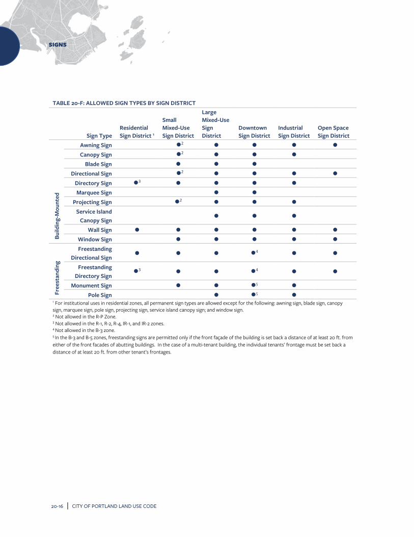
SIGNS
20-16 | CITY OF PORTLAND LAND USE CODE
TABLE 20-F: ALLOWED SIGN TYPES BY SIGN DISTRICT
Sign Type Residential Sign District 1
Small Mixed-Use Sign District
Large Mixed-Use Sign District
Downtown Sign District
Industrial Sign District
Open Space Sign District
Build
ing-
Mou
nted
Awning Sign 2 Canopy Sign 2
Blade Sign Directional Sign 2
Directory Sign 3 Marquee Sign
Projecting Sign 2 Service Island
Canopy Sign
Wall Sign Window Sign
Free
stan
ding
Freestanding Directional Sign
4
Freestanding Directory Sign
3 4
Monument Sign 5 Pole Sign 5
1 For institutional uses in residential zones, all permanent sign types are allowed except for the following: awning sign, blade sign, canopy sign, marquee sign, pole sign, projecting sign, service island canopy sign; and window sign. 2 Not allowed in the R-P Zone. 3 Not allowed in the R-1, R-2, R-4, IR-1, and IR-2 zones. 4 Not allowed in the B-3 zone. 5 In the B-3 and B-5 zones, freestanding signs are permitted only if the front façade of the building is set back a distance of at least 20 ft. from either of the front facades of abutting buildings. In the case of a multi-tenant building, the individual tenants’ frontage must be set back a distance of at least 20 ft. from other tenant’s frontages.

SIGNS
CITY OF PORTLAND LAND USE CODE | 20-17
TABLE 20-G: DIMENSIONAL STANDARDS FOR BUILDING-MOUNTED SIGNS BY SIGN DISTRICT
Sign District Total Area for All Signs (per Tenant or Façade) Number of Signs (max.)
Resi
dent
ial
Single-family lots 2 SF max. 1 per lot (either freestanding or building-mounted)
PRUDs, multi-family lots 10 SF max. 1 per street frontage
Institutional use in all residential zones
1.5 SF per linear foot of building façade where the sign is placed 150 SF max.
1 per street frontage, plus 2 additional
Smal
l Mix
ed-U
se
Single-tenant building
I-B zone: 1 SF per linear foot of building façade where the sign is placed; Max. 40 SF All other zones: 1.5 SF per linear foot of building façade where sign is placed; Max. 100 SF
1 per street frontage, plus 1 additional
Multi-tenant building 1.5 SF per linear foot of building façade where the sign is placed 150 SF max.
1 per tenant5,6, plus 1 additional for the building.
Larg
e M
ixed
-U
se
Single-tenant building
2 SF per linear foot of building façade where the sign is placed 200 SF max.1
1 per street frontage, plus 2 additional
Multi-tenant building 1.5 SF per linear foot of tenant façade where the sign is placed 150 SF max.
1 per tenant6, plus 1 additional for the building.
Dow
ntow
n
Single-tenant building 2 SF per linear foot of building façade where the sign is placed
1 per street frontage, plus 2 additional
Multi-tenant
building
Ground floor tenants
2 SF per linear foot of tenant frontage where the sign is placed
1 per tenant5, 6
Building ID and upper floor
tenants 5% of building wall area where sign is placed max.
1 per tenant, plus 2 additional for the building
Indu
stri
al &
Tr
ans.
Single-tenant building 2 SF per linear foot of building façade where sign is placed 250 SF max.
1 per street frontage, plus 2 additional
Multi-tenant building 2 SF per linear foot of tenant frontage where the sign is placed 200 SF max.
1 per tenant, plus 2 additional for the building
Ope
n Sp
ace Commercial signs/facility
signs2, 3 1 SF per linear foot of building façade where the sign is placed 20 SF max.4
1 per use (either freestanding or building-mounted)
Sign placement The total sign area for signs on single-tenant or multi-tenant buildings may be placed on any building elevation, provided that at least 1 sign must be placed above or associated with the building entry or tenant’s building entry, in the case of a multi-tenant building.
1 Where a building features two principal entry facades facing parallel streets, each entry façade shall be eligible for the full amount of signage relative to its frontage, notwithstanding the total area. 2 Standards do not apply to municipal stadiums with more than 6,000 seats. The standards for the Small Mixed-Use Sign District shall apply instead. 3 Building signs shall be visually related to the building on which they are located in terms of materials, color, scale, etc., as determined by the Building Authority. 4 Product trademarks limited to 5 percent of total sign area. 5 On the peninsula, each tenant may have two signs, provided that one sign is a blade sign and one sign is placed parallel to the building façade. 6 If a tenant faces additional street frontages, one additional sign is allowed per frontage for that tenant.

SIGNS
20-18 | CITY OF PORTLAND LAND USE CODE
TABLE 20-H: STANDARDS FOR AWNING SIGNS
Standard Requirements
Sign area (max.) 1 SF per linear foot of awning width
Mounting height 7 ft. min. from the bottom of the awning to the nearest grade or sidewalk 25 ft. max.
Sign placement Must be placed above the doors and windows of the ground floor of a building. Awnings shall not project above, below, or beyond the edges of the face of the building wall or architectural element. Sign width shall not be greater than 60% of the width of the awning face or valance on which it is displayed (if an awning is placed on multiple storefronts, each business is permitted signage no greater than 60% of the width of the storefront). May project into public right-of-way with permit approval.
Valance height (max.) 6 in.
Horizontal distance from back of curb (min.) 2 ft.
Illumination Illumination allowed under the awning.

SIGNS
CITY OF PORTLAND LAND USE CODE | 20-19
TABLE 20-I: STANDARDS FOR CANOPY SIGNS
Standard Requirements
Sign area (max.) 1 SF per linear foot of canopy width
Mounting height 8 ft. min. from the bottom of the sign to the nearest grade or sidewalk 20 ft. max.
Sign placement Must be placed above the doors and windows of the ground floor of a building. Sign width shall not be greater than 60% of the width of the canopy on which it is displayed (if a canopy is placed on multiple store fronts, each business is permitted signage no greater than 60% of the store width or tenant space).
May project into public right-of-way with permit approval.
Horizontal distance from back of curb
(min.) 2 ft.
Illumination Direct illumination or internal illumination

SIGNS
20-20 | CITY OF PORTLAND LAND USE CODE
TABLE 20-J: STANDARDS FOR BLADE SIGNS
Standard Requirements
Sign area (max.) 12 SF
Mounting height 8 ft. min. from the bottom of the sign to the nearest grade or sidewalk Must be mounted perpendicular to the building face or corner of the building.
Sign placement If mounted below the underside of a walkway or overhead structure, must not extend beyond the edge of the structure on which it is located. May project into public right-of-way with permit approval.
Illumination External illumination

SIGNS
CITY OF PORTLAND LAND USE CODE | 20-21
TABLE 20-K: STANDARDS FOR DIRECTIONAL SIGNS (BUILDING-MOUNTED)
Standard Requirements
Sign area (max.) 3 SF per sign face (excluded from the total allowed sign area for all building-mounted signs)
Mounting height 6 ft. max. from nearest grade
Number of signs (max.) 1 at each driveway, drive-through lane, or alley, not to exceed 3 signs per lot (excluded from the total number of allowed signs for all building-mounted signs)
Illumination Internal illumination

SIGNS
20-22 | CITY OF PORTLAND LAND USE CODE
TABLE 20-L: STANDARDS FOR DIRECTORY SIGNS (BUILDING-MOUNTED)
Standard Requirements
Sign area (max.) 1 SF per occupant of tenant space and 16 SF total max. (excluded from the total allowed sign area for all building-mounted signs)
Mounting height 8 ft. max. from nearest grade
Number of signs (max.) 1 per primary building entrance (excluded from the total number of allowed signs for all building-mounted signs)
Illumination External illumination or internal illumination

SIGNS
CITY OF PORTLAND LAND USE CODE | 20-23
TABLE 20-M: STANDARDS FOR MARQUEE SIGNS
Standard Requirements
Sign area (max.) 1 SF to 1 linear foot of marquee width
Mounting height 12 ft. min. from the bottom of the marquee to the nearest grade or sidewalk
Number of signs (max.) 1 per business
Sign placement May project into public right-of-way with permit approval.
Horizontal distance from back of curb (min.)
2 ft.
Illumination Direct illumination or internal illumination

SIGNS
20-24 | CITY OF PORTLAND LAND USE CODE
TABLE 20-N: STANDARDS FOR PROJECTING SIGNS
Standard Requirements
Sign area (max.) 24 SF
Mounting height 8 ft. min. from the bottom of the sign to the nearest grade or sidewalk.
Sign placement Only on the wall of a building. May project into public right-of-way with permit approval.
Number of signs (max.) 1 per business
Projection (max.) 4 ft. from the building wall to the outer edge of the sign
Illumination External illumination, direct illumination, neon, or internal illumination of individual letters or graphics only.

SIGNS
CITY OF PORTLAND LAND USE CODE | 20-25
TABLE 20-O: STANDARDS FOR SERVICE ISLAND CANOPY SIGNS
Standard Requirements
Sign area (max.) 20 SF
Number of signs (max.) 1 per canopy façade, not to exceed 2 signs total
Illumination Internal illumination

SIGNS
20-26 | CITY OF PORTLAND LAND USE CODE
TABLE 20-P: STANDARDS FOR WALL SIGNS
Standard Requirements
Sign area (max.) As provided in Table 20-G
Number of signs (max.) As provided in Table 20-G
Illumination External illumination, direct illumination, internal illumination, or neon
Special provisions Painted wall signs are allowed on any exterior building wall of an individual tenant space or building. The allowable area for painted wall signs shall be increased by 10% over the normal allowable sign dimensions for the zone.

SIGNS
CITY OF PORTLAND LAND USE CODE | 20-27
TABLE 20-Q: STANDARDS FOR WINDOW SIGNS
Standard Requirements
Sign area (max.)
Combined area of temporary and permanent window signs must not exceed 50% of the area of the window on which they are displayed. Painted window signs or perforated vinyl signs are included in this calculation. Excluded from the total allowed sign area for all building-mounted signs.
Sign placement Must be mounted or displayed on the interior of the window. Allowed on 1st and 2nd story windows only.
Illumination Neon or single- or two-color LED signs

SIGNS
20-28 | CITY OF PORTLAND LAND USE CODE
TABLE 20-R: DIMENSIONAL STANDARDS FOR FREESTANDING SIGNS BY SIGN DISTRICT Sign District Area (max.) Height (max.) Number of Signs
Resi
dent
ial
Single-family lots 2 SF 5 ft. 1 per lot (freestanding or building-mounted)
PRUDs, multi-family lots 15 SF 5 ft. 1 per major vehicular entrance Institut-
ional
Street frontage ≤ 100 ft. 15 SF 6 ft. 1 per frontage1, 2 Street frontage 100 – 250 ft. 25 SF 8 ft. 1 per frontage1, 2
Street frontage ≥ 250 ft. 50 SF 8 ft. 1 per frontage1, 2
Smal
l Mix
ed-U
se
Single-tenant building 32 SF B-1/B-1b, B-2b/B-2c zones: 16 ft. In all other zones: 8 ft.
1 per lot1 Multi-tenant building
< 1 acre lot 32 SF 1 – 2.5 acre lot 100 SF > 2.5 acre lot 140 SF
I-B Zone3 20 SF 10 ft. 1 per use OP zone
Center identification sign 50 SF 8 ft. 1 per major vehicular entrance
Tenant sign 15 SF 5 ft. 1 per tenant2
Larg
e M
ixed
-Use
Single-tenant
building
Street frontage ≤ 200 ft. 65 SF B-4 zone: 25 ft. In all other zones: 18 ft.
1 per lot1 Street frontage > 200 ft. 100 SF
Multi-tenant
building
< 1 acre lot 65 SF B-4 zone: 25 ft. In all other zones: 18 ft.
1 per lot1 1 - 2.5 acre lot 100 SF > 2.5 acre lot 140 SF
Downtown 16 SF 6 ft. 1 per frontage1
Indu
stri
al &
Tra
nspo
rtat
ion Single-tenant building 35 SF 10 ft. 1 per lot1
1 per lot1 Multi-tenant building 70 SF 15 ft.
AB zone
Single-tenant
building
Street frontage ≤ 200 ft.
32 SF 16 ft. 1 per lot1
Street frontage > 200 ft.
65 SF 16 ft. 1 per lot1
Multi-tenant
building
< 1 acre 32 SF 16 ft. 1 per lot1 1 - 2.5 acres 100 SF
≥ 2.5 acres 140 SF
Ope
n Sp
ace4 Park identification signs5 20 SF 5 ft. 1 per major vehicular entrance
All other signs5 16 SF6 8 ft. 1 per use (building-mounted or freestanding)
1 Lots with multiple street frontages are allowed one freestanding sign for each frontage, provided that the signs are not concurrently visible from the public right-of-way. 2 Where a lot contains more than one affiliated use or tenant, uses and tenants may be allocated space on a shared sign. Individual uses or tenants are not allowed to have individual freestanding signs. 3 Only allowed for marine-related uses serving vessel traffic. 4 Standards do not apply to municipal stadiums with more than 6,000 seats. The standards for the Small Mixed-Use Sign District shall apply instead. 5 All signs must be integrated into existing landscape features or visually related to the materials, colors, scale, etc. of existing buildings as determined by the Building Authority. 6 Product trademarks limited to 5% of total sign area.

SIGNS
CITY OF PORTLAND LAND USE CODE | 20-29
TABLE 20-S: STANDARDS FOR DIRECTIONAL SIGNS (FREESTANDING)
Standard Requirements
Sign area (max.) 3 SF per sign face (excluded from the total allowed sign area for all freestanding signs)
Height (max.) 6 ft. from nearest grade, except 4 ft. at driveway or drive-through lanes
Number of signs (max.) 1 at each driveway or drive-through lane, not to exceed 3 signs per lot (excluded from the total number of allowed signs for all freestanding signs)
Illumination Internal illumination

SIGNS
20-30 | CITY OF PORTLAND LAND USE CODE
TABLE 20-T: STANDARDS FOR DIRECTORY SIGNS (FREESTANDING)
Standard Requirements
Sign area (max.) 12 SF total 1 SF max. per occupant or tenant space (excluded from the total allowed sign area for all freestanding signs)
Height (max.) 6 ft. from nearest grade, except 4 ft. at driveway or drive-through lanes
Number of signs (max.) 1 per building (excluded from the total number of allowed signs for all freestanding signs)
Illumination External illumination or internal illumination
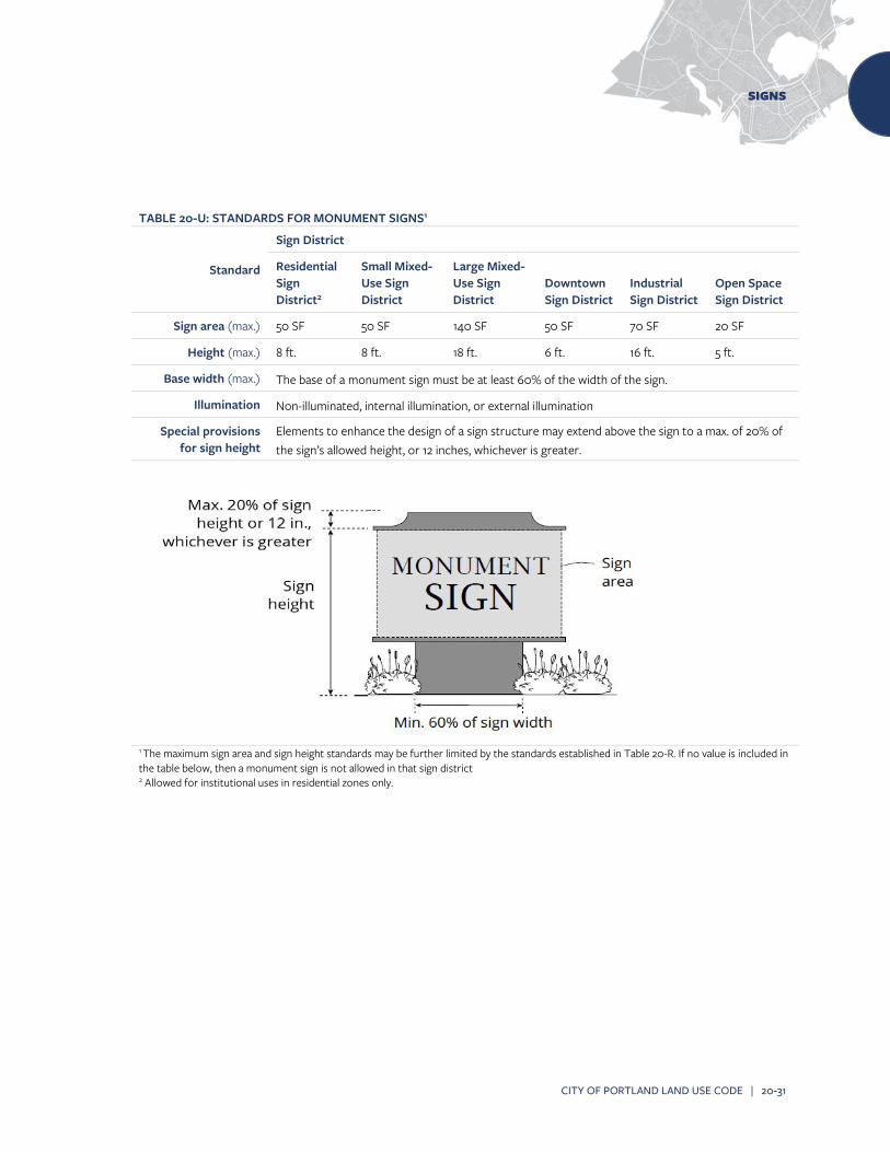
SIGNS
CITY OF PORTLAND LAND USE CODE | 20-31
TABLE 20-U: STANDARDS FOR MONUMENT SIGNS1
Standard
Sign District
Residential Sign District2
Small Mixed-Use Sign District
Large Mixed-Use Sign District
Downtown Sign District
Industrial Sign District
Open Space Sign District
Sign area (max.) 50 SF 50 SF 140 SF 50 SF 70 SF 20 SF
Height (max.) 8 ft. 8 ft. 18 ft. 6 ft. 16 ft. 5 ft.
Base width (max.) The base of a monument sign must be at least 60% of the width of the sign.
Illumination Non-illuminated, internal illumination, or external illumination
Special provisions for sign height
Elements to enhance the design of a sign structure may extend above the sign to a max. of 20% of the sign’s allowed height, or 12 inches, whichever is greater.
1 The maximum sign area and sign height standards may be further limited by the standards established in Table 20-R. If no value is included in the table below, then a monument sign is not allowed in that sign district
2 Allowed for institutional uses in residential zones only.

SIGNS
20-32 | CITY OF PORTLAND LAND USE CODE
TABLE 20-V: STANDARDS FOR POLE SIGNS1
Standard
Sign District
Residential Sign District
Small Mixed-Use Sign District
Large Mixed-Use Sign District
Downtown Sign District
Industrial Sign District
Open Space Sign District
Sign area (max.) Signs ≤ 8
ft. High
15 SF 24 SF 24 SF 24 SF 24 SF 20 SF
Height (max.) 5 ft. 8 ft. 8 ft. 6 ft. 8 ft. 8 ft.
Sign area (max.) Signs 8 -
25 ft. high
140 SF 140 SF
Height (max.) 25 ft. 16 ft.
Illumination Non-illuminated or internal illumination Signs ≤ 8 ft. in height may have external illumination
Sign placement Signs ≥ 8 ft. in height must have minimum 75 foot separation from other pole signs ≥ 8 ft. on the same side of the street.
Sign height Elements to enhance the design of a sign structure ≤ 8 ft. in height may extend above the sign to a max. of 20% of the sign’s allowed height, or 12 inches, whichever is greater.
1 The maximum sign area and sign height standards may be further limited by the standards established in Table 20-R.

SIGNS
CITY OF PORTLAND LAND USE CODE | 20-33
20.9 STANDARDS FOR TEMPORARY SIGNS 20.9.1 In general Temporary signs are allowed only in compliance with the provisions of this section. A. Information required for display. All
temporary signs are required to display the name and address of the entity placing the sign, and the date the sign was erected.
B. Not included in permanent sign allowances. Temporary signs are not counted toward the maximum total sign area established in Section 20.8.
C. General time, place, and manner restrictions. Unless specifically exempted by this section, temporary signs must be placed in compliance with Subsection 20.6.1. Temporary signs must
not be placed to create a hazard for pedestrian or vehicular traffic and must allow for a 4-foot wide sidewalk to comply with the Americans with Disabilities Act.
D. Any form of illumination, including flashing, blinking, or rotating lights; animation; reflective materials; and attachments such as balloons, ribbons, and loudspeakers are prohibited.
E. Temporary signs must be of sufficient weight and durability to withstand wind gusts, storms, and other exterior elements.
20.9.2 Additional standards for temporary signs All temporary signs shall comply with the standards of Tables 20-W and 20-X.
TABLE 20-W: TEMPORARY SIGN STANDARDS BY SIGN DISTRICT
Standard Requirement
Resi
dent
ial
Total area of all temporary signs at any one time (max.)
16 SF per lot.
Number of signs (max.) Unlimited except that the total sign area must not exceed 16 SF
Time limit (max.) None
Oth
er
Total area of all temporary signs at any one time (max.)
24 SF per tenant, with a total of max. 72 SF per lot (excludes the area of temporary window signs and permitted wall banner signs) Exception: In the Downtown Sign District and historic districts, max. 12 SF per tenant (excludes the area of temporary window signs and permitted wall banner signs)
Number of signs (max.)
1 wall banner per tenant in a multi-tenant building. All other temporary sign types unlimited, except that the total sign area of all temporary signs (excludes the area of temporary window signs and permitted wall banner signs) must not exceed the total square footage provided above. Exception: In multi-tenant shopping centers or offices, max. 2 temporary wall banner signs per 150 linear feet of property frontage, not to exceed 24 SF combined.
Time limit (max.) 60 days per temporary sign permit, and up to 180 days per calendar year.

SIGNS
20-34 | CITY OF PORTLAND LAND USE CODE
TABLE 20-X: STANDARDS FOR TEMPORARY SIGN TYPES
Temporary Sign Type1
Standard
Other Requirements Height Width (max.)
Area (max.)
A-frame or upright sign2
Min. 30 in. Max. 4 ft.
2 ft. 8 SF
Prohibited in residential zones. Must not be placed in public right-of-way except as permitted by the City. 3 If advertising a business, only permitted during regular business hours.
Wall banner
32 SF
Prohibited in residential zones. Must be mounted on a building wall or on T-posts or stakes installed ≤ 6” from a wall on which the wall banner will be hung. Mounting height (max.): 25 ft. to top of banner.

SIGNS
CITY OF PORTLAND LAND USE CODE | 20-35
TABLE 20-X (CONT.): STANDARDS FOR TEMPORARY SIGN TYPES
Temporary Sign Type1
Standard
Other Requirements Height (max.)
Width (max.)
Area (max.)
Window sign See End Note4
Mounting height (max.): Placed no higher than second story windows. Inside mounting required. Not included in the total sign area for all temporary signs.
Yard sign
(Type I) 4 ft. 2 ft. 3 SF Installation requirements: Installed securely in the ground.
Yard sign
(Type II) 6 ft. 2 ft. 4 SF Installation requirements: Installed securely in the ground.
Yard sign
(Type III) 6 ft. 8 ft. 32 SF Installation requirements: Installed securely in the ground.
1 Other temporary sign types may be allowed (e.g. fuel pump topper signs; wrap around waste receptacles) provided the max. area limitation for all temporary signs is not exceeded. 2 These signs may be used to identify businesses located down a wharf in the EWPZ and WCZ Zones that have no street frontage and where no other options for on-site permanent signage are available. 3 A min. 4-foot wide pedestrian walkway must be maintained at all times. 4 The area of temporary and permanent window signs combined (including signs constructed of perforated vinyl or painted on the window) must not exceed 50% of the area of the window on or within which they are displayed.

SIGNS
20-36 | CITY OF PORTLAND LAND USE CODE
20.10 NONCONFORMING SIGNS 20.10.1 Applicability A. Maintenance. Nonconforming signs may be
maintained, expanded upon, and/or reduced only in accordance with the provisions of this section.
B. Continuation. All lawfully nonconforming signs may be continued, subject to this section. 1. Lawfully nonconforming permanent
directional signs for existing nonconforming businesses that are established and operational in any residential zone may continue to be used subject to this section.
2. Lawfully nonconforming permanent signs for nonconforming uses established and operational in any residential zone may continue to be used subject to this section.
20.10.2 Removal or replacement of a nonconforming sign
Lawfully nonconforming signs must be made to conform or shall be removed if any of the following occurs, unless the improvements are required to achieve compliance with applicable federal, state, or local regulations, other than the provisions of this article, and the improvements do not require replacement of the nonconforming sign. In no event will the degree of nonconformity of any sign or type of signage on any lot be increased. A. Major site plan review. Major site plan review
is sought for any new structures or building additions on the site, except as provided in (E) below.
B. New building permit for rehabilitation. A building permit is sought for a rehabilitation of a building where the value of the rehabilitation exceeds 50% of the assessed value of the
building, or $100,000, whichever is less, provided that where rehabilitation is of a multi-tenant building, only the tenant or tenants whose building or area is being rehabilitated shall be required to come into conformance with this article.
C. New sign permit. An application is filed for a new sign permit in accordance with the following: 1. When an application is filed for a new
building-mounted sign, all building-mounted signs on the lot must come into compliance with all requirements of this article for building signs.
2. When an application is filed for a new freestanding sign, all freestanding signs on the lot must come into compliance with all requirements of this article for freestanding signs.
D. Modification of sign. A sign is modified in any way, except for routine maintenance or repair of sudden and accidental damage, or for a change in the message panel only, unless otherwise required to conform under this subsection. Repair of sudden and accidental damage will not include replacement of the entire sign, which is treated as a modification under this subsection. Letters on nonconforming signs designed for changeable messages may be changed without triggering the terms of this subsection as long as no other change is made to the sign. Replacement of an awning covering with substantially the same material and text is not considered a modification.
E. Signs on multi-tenant properties 1. In the case of nonconforming freestanding
shared signs for multi-tenant properties,

SIGNS
CITY OF PORTLAND LAND USE CODE | 20-37
signs may be added or modified to reflect a change in individual tenants without triggering the terms of this subsection, provided that the degree of nonconformity is not increased.
2. In the case of building signs on multi-tenant properties, this subsection shall apply only to the individual business tenant that is adding or modifying a sign or seeking major site plan review and shall not trigger the conformance requirement for other tenants’ building signs.
F. Abandoned or vacant site. Removal of a nonconforming sign, or replacement of a nonconforming sign with a conforming sign, is required when the use of the sign and/or the property on which the sign is located has been abandoned, ceased operations, become vacant, or been unoccupied for a period of 180 consecutive days or more, as long as the period of non-use is attributable at least in part to the property owner, tenant, or other person or entity in control of the use. For purposes of this section, rental payments or lease payments and taxes are not considered as a continued use. In the event this should occur, such conditions will be considered as evidence of abandonment, requiring removal of such sign by the owner of the property, his or her agent, or person having the beneficial use of the property, building, or structure upon which such sign or sign structure is erected within 30 days after written notification from the Planning Authority. If such sign(s) is (are) not removed within the 180-day period, enforcement action will be pursued consistent with Section 20.11.
20.10.3 Permanent directional signs in residential zones
A. A lawfully existing business located in a residential zone is allowed an off-premise sign in the public right-of-way if it meets the following requirements: 1. The business is not a home occupation. 2. The business is not located within 500 feet
of a major or minor arterial. 3. The off-premise sign will be no larger than
12 inches by 48 inches and complies with the requirements established in the MDOT/MUTCD Standard Sign Manual.
B. Such lawfully existing retail business may qualify for one two-sided or two one-sided off-premise signs that must be located within the public right-of-way of a major or minor arterial in a location determined safe by the City Traffic Engineer and upon the payment of an initial fee of $300, with an annual renewal fee of $30.
C. In the event the sign is damaged or destroyed, the replacement of the sign shall be the sole responsibility of the permittee. The permittee shall be required to obtain a permit for the replacement sign from the Planning Authority, after securing $400,000 insurance and naming the City of Portland as an additional insured.
20.10.4 Nonconforming signs in residential zones A. Lawfully-existing permanent signs for lawfully
existing nonconforming uses in any residential zone may continue to be used.
B. If an application is filed for new or replacement building-mounted sign(s) for a lawfully-existing nonconforming use located in a residential zone, the building-mounted sign(s) must either be the same size and number as the lawfully existing building-mounted sign(s), or must

SIGNS
20-38 | CITY OF PORTLAND LAND USE CODE
comply with the standards established for the Small Mixed-Use Sign District in Table 20-G, whichever is less. Sign types shall be limited to blade, directory, wall, and window signs. Illumination shall be limited to external illumination only.
C. If an application is filed for replacement freestanding sign(s) for a lawfully-existing nonconforming use located in a residential zone, the freestanding sign(s) must be the same size and number as the lawfully existing freestanding signs, or must comply with the standards established for the Small Mixed-Use Sign District in Table 20-R, whichever is less. No new freestanding signs for a nonconforming use in a residential zone shall be permitted. Illumination shall be limited to external illumination only.
20.11 ENFORCEMENT 20.11.1 Authority The requirements of this article shall be enforced by the Building Authority as stated in Article 1. The Building Authority has the authority to order the repair, maintenance, or removal of any sign or sign structure that has become dilapidated or represents a hazard to public health, safety, or welfare. 20.11.2 Violations A. It shall be unlawful for any person, firm, or
corporation to erect, construct, enlarge, alter, repair, display, maintain, or use a sign within the City contrary to, or in violation of, any provision of this article. Any work commenced without a sign permit, or beyond the authorized scope of a sign permit constitutes a violation of this article and is grounds for the Building Authority to issue a correction notice and/or to stop all
work on the sign until appropriate permits are obtained.
B. Permits issued for work commenced without a sign permit, or any work beyond the authorized scope of a sign permit shall be assessed double the required permit fees for the sign(s).
C. Failure to perform any act required by this article, failure to obtain any permit required, or the performance of any act prohibited by this article constitutes a violation and is subject to penalties as set forth in 30-A M.R.S. §4452.
D. Each day on which a violation exists will constitute a separate violation for purposes of this section.

PUBLIC ART PROGRAM
CITY OF PORTLAND LAND USE CODE | 21-1
21 PUBLIC ART PROGRAM 21.1 ESTABLISHMENT It shall henceforth be the policy of the City to provide on an annual basis regular funding for the preservation, restoration, and enhancement of its public art collection. This article and the funding contemplated are in recognition of the fact that only by instituting a steady stream of funding for this effort and standing by that commitment, will the City over time be able to fulfill its role as steward of its public art collection and help nurture and enrich thereby the quality of life in this city. 21.2 PURPOSE The purpose of this article is to promote the educational, cultural, economic, and general welfare of the City of Portland by providing the means to fund the acquisition and care of art works by the City of Portland, which shall be the City's public art collection. The Public Art Program seeks to: A. Care for and maintain the public art collection
of the City of Portland by documenting, preserving, restoring, and repairing the collection.
B. Commission or acquire works of public art, and to seek donations of art work for the City’s public art collection.
C. Provide curatorial expertise and project management for the care of Portland's public art collection.
D. Enhance and enrich the lives of the city's residents, visitors, and employees by incorporating the visual arts into public spaces.
E. Contribute to the city's civic pride and sense of identity.
F. Increase access to works of art for residents and visitors to the area.
G. Enhance Portland's growing reputation as a city which celebrates the arts.
H. Celebrate the multi-cultural and diverse character of Portland's communities with place-specific art.
I. Encourage collaboration between artists, landscape architects, urban planners, architects, engineers, and other designers.
21.3 DEFINITIONS Art work. For the purposes of the Public Art Program, art work shall include the following: A. Sculpture, statues, or monuments in any
material or combination of materials. B. Painting. C. Graphic arts, printmaking, and drawing. D. Photography. E. Crafts in clay, fiber and textiles, wood, metal,
plastics, glass, and other materials. F. Mixed media, any combination of forms or
media, including collage. G. Functional art such as street furniture, as
described in the Guidelines for the Public Art Ordinance.
H. Environmental art consisting of landforms and artistic landscape composition.
The following shall not be considered public art for the purposes of the Public Art Program: A. Reproductions by mechanical or other means
of original works of art, except for limited editions, controlled by the artist, of original prints, cast sculptures, photographs, or other works of art.
B. Decorative, ornamental, or functional elements which are designed by the building architect or consultants engaged by the architect which are

PUBLIC ART PROGRAM
21-2 | CITY OF PORTLAND LAND USE CODE
a traditional and typical element of architectural design.
C. Those elements generally considered to be conventional components of a landscape architectural design including, but not limited to, plant materials, pools, paths, benches, receptacles, fixtures, and planters except as allowed by (G) and (H) in the list of included art work above.
D. Art objects which are mass produced or of a standard design, such as playground sculpture or fountains, except pieces of historical significance to the city.
E. Directional or other functional elements, such as supergraphics, signage, color coding, and maps, except where sculptural pieces are used to define gateways in the city.
F. Electrical, water, or mechanical service for activation of the work.
G. Exhibitions and educational programs related to the work.
H. Performing arts. I. Art that displays slogans, logos, mascots, or
commercial advertising.
Public art collection. Art objects that are owned by the City of Portland which are permanently installed in public, accessible locations. Permanent public art must be located in a public place with public visibility and impact, and shall have a permanence at least comparable to associated capital projects. Public art guidelines. The regulations adopted by the committee and approved by the City Council which establish procedures to carry out the purpose of this article. The guidelines shall include but not be limited to criteria for selection of artists and art works, maintenance of a file of interested
artists, procedures for artistic competitions, and requirements for the maintenance of works of art. 21.4 FUNDING 21.4.1 Establishment of Public Art Fund The City shall establish a special revenue fund designated as the Public Art Fund in the City treasury from which expenditures may be made in accordance with this ordinance. The Public Art Fund shall contain a capital account to fund permanent public improvements in the form of the purchase, acquisition, or commission of new public art, or major restorations, and an operations and maintenance account. Authorized expenditures include, but are not limited to, associated site installation costs, such as lighting and landscaping, and costs associated with the commission, engineering, contract administration, unveiling, and dedication activities. Also authorized are expenditures associated with preservation, conservation, and repair of existing public art. Capital funds may come from any source, including the sale of general obligation bonds. The City’s capital improvement program shall contain an annual appropriation for the Public Art Fund calculated in accordance with Subsection 21.4.2. Funds for the operation and maintenance account may come from any source except bonds. 21.4.2 City-funded projects A percentage of the City's Capital Improvement Program (CIP) shall be calculated and appropriated annually to the Portland Public Art Fund. The annual appropriation shall be .5% of the total annual CIP. Nothing contained herein shall preclude funding the acquisition of art for municipal property in other ways.

PUBLIC ART PROGRAM
CITY OF PORTLAND LAND USE CODE | 21-3
21.5 ADMINISTRATION 21.5.1 Public Art Committee responsibilities The City Public Art Program shall be administered by the Public Art Committee whose members shall be appointed by the City Council, and shall have the following responsibilities: A. Develop an annual art plan for Portland which
shall be presented to the City Council for approval.
B. Establish such guidelines as are necessary to carry out the purpose of this article. The guidelines shall include but not be limited to criteria for selection of artists and art work, maintenance of a file of interested artists, review criteria for proposed gifts of art work to the City, procedures for artistic competitions, and requirements for the maintenance of art work. Any and all guidelines or changes to guidelines shall be placed on a City Council agenda as a communication. The guidelines shall take effect 45 days after the date of placement on the council agenda, unless the City Council takes official action disapproving the guidelines, in whole or in part, prior to the expiration of the 45-day period. If a part of a guideline is vetoed, the remainder shall continue in effect. Any guideline adopted, which is not required by the statutes of the state or by this article, may be waived by the chair upon good cause being shown.
C. Recommend to the City Council the expenditure of funds for the acquisition or commissioning of public art, for maintenance of public art, and for administration of this program.
D. Seek private donations of funds and/or works of art for the purposes of expanding the public
art collection or the maintenance of the collection.
E. Oversee the maintenance, care, and repair of the public art collection.
F. Review the appropriateness of proposed public art which is intended to fulfill all or part of the contribution required by this article.
G. Review potential gifts of art to the City on City property, and assist in the development process of such gifts, in accordance with the Guidelines for the Public Art Ordinance.
H. Recommend appropriate locations and accessibility to the public for permanent art, with suggestion as to the type of art which is appropriate.
I. Solicit advice from arts professionals, the business community, and from local residents on the appropriateness of proposed art.
J. Recommend revisions to policies and guidelines for the improved implementation of this program.
K. Ensure that the use of funds collected under this program will increase the amount of art in the city that is available to the public.
21.5.2 Public Art Committee structure A. The Public Art Committee shall be composed
of eleven voting members who are appointed by the City Council. The City Council shall appoint one of its members, the City Manager shall recommend a member, and Creative Portland shall recommend one of its members to serve on the Public Art Committee. The City Council shall appoint the remaining eight members who shall be volunteers and have interest and/or expertise in public art. Such experience may include, but shall not be limited to, education and experience as an architect, a

PUBLIC ART PROGRAM
21-4 | CITY OF PORTLAND LAND USE CODE
landscape architect, a professional curator, a professional artist, and/or an art educator. Persons appointed to the Public Art Committee must live or work in Portland and shall be appointed through the City's annual appointment process.
B. Each Public Art Committee member shall serve for a period of three years. The appointments shall be staggered so that three appointments terminate each year.
C. Whenever a vacancy shall occur, the vacancy shall be filled by the City Council.
D. The Public Art Committee shall adopt its own rules for the conduct of its business not inconsistent with the statutes of the state and this article. Any and all rules or changes to rules shall be placed on a City Council agenda as a communication. The rule or rules shall take effect 45 days after the date of placement on the council agenda, unless the City Council takes official action disapproving the rules, in whole or in part, prior to the expiration of the 45-day period.
E. The members of the Public Art Committee shall annually elect one of their members as a chair to preside at all meetings and hearings and to fulfill the customary functions of that office, and another of their members as vice-chair.

REGULATION OF EXPLOSIVES
CITY OF PORTLAND LAND USE CODE | 22-1
22 REGULATION OF EXPLOSIVES
22.1 PURPOSE The purpose of this article is to protect the public’s health, safety, and general welfare by regulating and controlling blasting operations within the city. 22.2 APPLICABILITY This article shall apply to all blasting operations related to construction and development of real estate within the city. The City of Portland Technical Manual is incorporated into this article by reference. Standards listed in the Technical Manual shall be additional to the provisions of this article. 22.3 REVIEW PROCESS 22.3.1 Permit Required No person may conduct blasting operations within the city without first obtaining a permit from the Fire Department, as required by the National Fire Protection Association 1 Fire Prevention Code, as adopted and amended in Chapter 10 of the City of Portland Code of Ordinances. Fees for this permit shall be as established by order of the City Council. 22.3.2 Application Requirements Prior to the issuance of a permit the following information shall be submitted to the City: A. A blasting plan shall be submitted by the
applicant to the Planning Authority for all projects where more than 300 cubic yards of material shall be removed. The blasting plan shall conform to the provisions of this article and of Section 3 of the City of Portland Technical Manual.
B. A blasting submittal shall be submitted to the Planning Authority where between 50 and 300 cubic yards of material shall be removed. The
blasting submittal shall conform to the provisions of this article and of Section 3 of the City of Portland Technical Manual.
C. A blasting application shall be submitted to the Planning Authority where less than 50 cubic yards of material shall be removed, or where utility trench work in the accepted public right of way, including City or Portland Water District infrastructure is proposed. Small blasts where less than 50 cubic yards of material shall be removed are not required to submit either a blasting plan or blasting submittal. Such projects must conform to the National Fire Protection Association Fire Prevention Code and applicants shall submit a monitoring report upon request. Information provided in the blasting application shall confirm that the proposed small blast conforms to all applicable provisions of this ordinance and of Section 3 of the City of Portland Technical Manual.
D. A blasting plan or blasting submittal may be required for any blasting operation at the discretion of the Planning Authority when it determines that conditions at or near the site of the blasting operations warrant the provision of a plan.
22.4 STORAGE AND HANDLING All explosives shall be stored and handled in accordance with the provisions of this code, the laws of the State of Maine, and the National Fire Protection Association 1 Fire Prevention Code. 22.5 ENFORCEMENT In the event that there are more than three documented violations of the blasting plan, blasting submittal, or blasting permit, or any other violation of this article, a stop work order may be issued on

REGULATION OF EXPLOSIVES
22-2 | CITY OF PORTLAND LAND USE CODE
all construction or development related to the permitted operation. The permittee shall then be required to submit a revised blasting plan to the Planning Authority for review and approval. Work shall not be allowed to continue until the revised blasting plan is approved. 22.6 PENALTIES In addition to the possibility of a stop work order in the event of a violation, the permittee shall be subject to the following penalties: 1st offense $500 2nd offense $1,000 Subsequent offenses $1,000 22.7 NOTICE REQUIREMENTS 22.7.1 Basic noticing requirements At least 10 days prior to the start of any blasting operation, notice shall be published in a newspaper of local publication and shall be mailed by first class mail to all property owners within the distance specified below of the perimeter of the blasting site: A. Small blast (trench blast or under 50 cubic
yards of rock removed). All property owners within 250 feet of the perimeter of the blasting site.
B. Medium blast (removal of 50-300 cubic yards of rock material). All property owners within 500 feet of the perimeter of the blasting site.
C. Large blast (removal of over 300 cubic yards of rock material). All property owners within 600 feet of the perimeter of the blasting site.
22.7.2 Content of notice Notice shall conform to the model notice contained in Section 3 of the City of Portland Technical Manual and shall include a description of the proposed blasting operations, estimated schedule
and duration of blasting operations, description of the blasting signals to be used during operations, the complaint protocol and the complete address, telephone numbers and email contact for the blasting contractor, the Planning Authority, and Fire Department where neighbors and property owners may request further information and notification. 22.7.3 Additional noticing requirements A. For medium blasts where 50-300 cubic yards of
rock material is to be removed, and large blasts where over 300 cubic yards of rock material is to be removed, additional notification requirements shall apply during construction, as detailed in Section 3 of the City of Portland Technical Manual.
B. If blasting operations are to occur within 250 feet of any structure, additional notification requirements shall apply, as detailed in Section 3 of the City of Portland Technical Manual, in order to prevent adverse public health and safety impacts due to blasting-related carbon monoxide migration.
22.8 HOURS OF BLASTING Blasting shall occur Monday through Friday, between the hours of 9 a.m. and 4 p.m., unless otherwise approved by the Planning Authority. Requests for extension of hours of blasting must be submitted by the applicant in writing. 22.9 WAIVERS Upon written request by the applicant, the Planning Authority, based on a positive recommendation by the Fire Department, may waive all or a portion of the blasting provisions of Section 3 of the City of Portland Technical Manual, provided that all waivers

REGULATION OF EXPLOSIVES
CITY OF PORTLAND LAND USE CODE | 22-3
are consistent with the purposes set forth in Section 22.1. 22.10 SUSPENSION OF BLASTING OPERATIONS If it is determined that blasting operations pose any risk to public health, safety, or general welfare, the Planning Authority or the Fire Chief or their designee shall have the authority to suspend the blasting permit at any time until they deem it safe for blasting operations to continue.
Copyright © 2022 FDOKUMEN