Ascension Parish Unified Land Development Code (LDC)
434
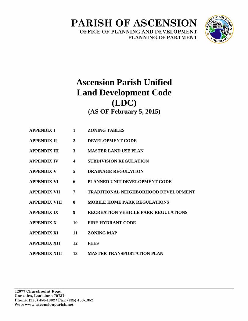
PARISH OF ASCENSION OFFICE OF PLANNING AND DEVELOPMENT PLANNING DEPARTMENT 42077 Churchpoint Road Gonzales, Louisiana 70737 Phone: (225) 450-1002 / Fax: (225) 450-1352 Web: www.ascensionparish.net Ascension Parish Unified Land Development Code (LDC) (AS OF February 5, 2015) APPENDIX I 1 ZONING TABLES APPENDIX II 2 DEVELOPMENT CODE APPENDIX III 3 MASTER LAND USE PLAN APPENDIX IV 4 SUBDIVISION REGULATION APPENDIX V 5 DRAINAGE REGULATION APPENDIX VI 6 PLANNED UNIT DEVELOPMENT CODE APPENDIX VII 7 TRADITIONAL NEIGHBORHOOD DEVELOPMENT APPENDIX VIII 8 MOBILE HOME PARK REGULATIONS APPENDIX IX 9 RECREATION VEHICLE PARK REGULATIONS APPENDIX X 10 FIRE HYDRANT CODE APPENDIX XI 11 ZONING MAP APPENDIX XII 12 FEES APPENDIX XIII 13 MASTER TRANSPORTATION PLAN
-
Upload
khangminh22 -
Category
Documents
-
view
2 -
download
0
Transcript of Ascension Parish Unified Land Development Code (LDC)
PARISH OF ASCENSION OFFICE OF PLANNING AND DEVELOPMENT
PLANNING DEPARTMENT
42077 Churchpoint Road
Gonzales, Louisiana 70737
Phone: (225) 450-1002 / Fax: (225) 450-1352
Web: www.ascensionparish.net
Ascension Parish Unified
Land Development Code
(LDC) (AS OF February 5, 2015)
APPENDIX I 1 ZONING TABLES
APPENDIX II 2 DEVELOPMENT CODE
APPENDIX III 3 MASTER LAND USE PLAN
APPENDIX IV 4 SUBDIVISION REGULATION
APPENDIX V 5 DRAINAGE REGULATION
APPENDIX VI 6 PLANNED UNIT DEVELOPMENT CODE
APPENDIX VII 7 TRADITIONAL NEIGHBORHOOD DEVELOPMENT
APPENDIX VIII 8 MOBILE HOME PARK REGULATIONS
APPENDIX IX 9 RECREATION VEHICLE PARK REGULATIONS
APPENDIX X 10 FIRE HYDRANT CODE
APPENDIX XI 11 ZONING MAP
APPENDIX XII 12 FEES
APPENDIX XIII 13 MASTER TRANSPORTATION PLAN

PARISH
OF
ASCENSION
OFFICE OF
PLANNING
AND
DEVELOPMENT
UNIFIED
LDC

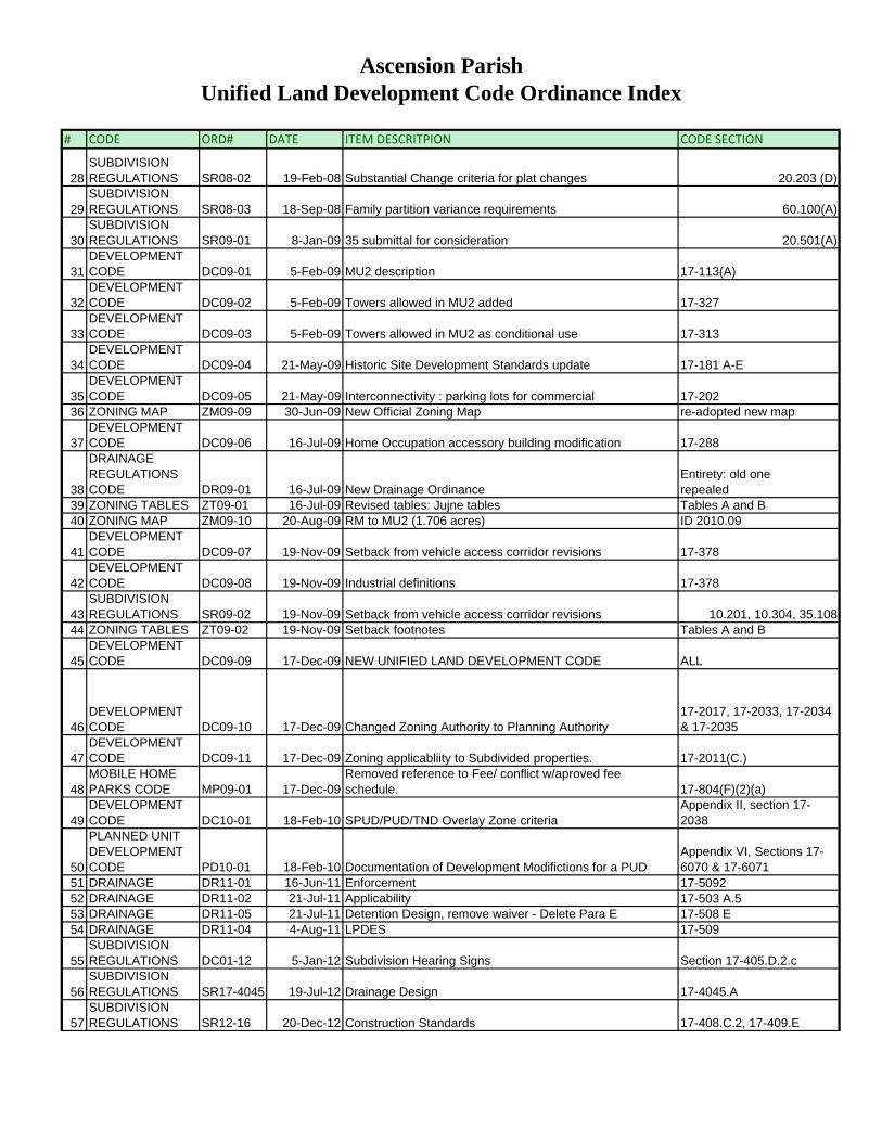
Ascension Parish Unified Land Development Code Ordinance Index
# CODE ORD# DATE ITEM DESCRITPION CODE SECTION
1MOBILE HOME PARKS CODE MP85-01 6-Jun-85 Creation of the Mobile Home Park Code
Chapter 12 of the Code of Ordinances
2MOBILE HOME PARKS CODE MP95-01 3-Aug-95 Revision
Chapter 12 of the Code of Ordinances
3MOBILE HOME PARKS CODE MP97-01 21-Aug-97 Revision
Chapter 12 of the Code of Ordinances
4LAND USE AND MASTER PLAN LU98-01 5-Feb-98 Adoption of Master Plan Not Found in Municode
5RECREATION VEHICLE CODE RV99-01 27-May-99 Creation of the Recreation Vehicle Code
Chapter 12, Article VI of the Code of Ordinances
6DEVELOPMENT CODE DC03-01 9-Jan-03 Adoption of Development Code / repealing all previous
Chapter 17, Section 100 and greater
7LAND USE AND MASTER PLAN LU03-01 13-Feb-03 Re-Adoption of new Master Plan Not Found in Municode
8DEVELOPMENT CODE DC03-02 21-Aug-03
Overlay zone: Flood hazard, historic site, and chemical emergency overlay zones. 17-111(a)
9DEVELOPMENT CODE DC03-03 21-Aug-03
Overlay zone: Flood hazard overlay zone and historic site overlay 17-123
10DEVELOPMENT CODE DC03-04 21-Aug-03 Waste Site overlay map 17-125
11DEVELOPMENT CODE DC03-05 21-Aug-03 Delete section 17-183 (moved to overlaysections) 17-183
12DEVELOPMENT CODE DC04-01 16-Dec-04 Board of Adjustments members from five to seven 17-365(a)
13DEVELOPMENT CODE DC05-01 21-Apr-05 Neigborhood Business Overlay Zones 17-29A, 17-84
14DEVELOPMENT CODE DC05-02 5-May-05 Historic Site : remove Property from boundary buffer 17-181
15
PLANNED UNIT DEVELOPMENT CODE PD05-01 1-Dec-05 Creation of the PUD / SPUD Code Not Found in Municode
16
TRADITIONAL NEIGHBORHOOD DEVELOPMENT CODE TD05-01 1-Dec-05 Creation of the TND Code Not Found in Municode
17 CODE DC06-01 16-Nov-06 Bed and Breakfast definition added 17-138
18SUBDIVISION REGULATIONS SR07-01 18-Jan-07 Latest Version of Subdivision Regulations
Chatper 21 of Code of Ordinances but Outdated
19SUBDIVISION REGULATIONS SR07-01.B 14-Mar-07 Curb and Gutte Cross Section Exhibit: by Planning
Chatper 21 of Code of Ordinances but Outdated
20DEVELOPMENT CODE DC07-01 15-Mar-07 nonconforming text added. 17-135(f)
21FIRE HYDRANT CODE FH07-01 17-May-07 Creation of fire hydrant Code
Chapter 6, Article X of the Code of Ordinances
22DEVELOPMENT CODE DC07-02 16-Aug-07 single family dwelling definition 17-378
23
DRAINAGE REGULATION CODE DR07-01 6-Sep-07 Creation of Drainage Code Not Found in Municode
24SUBDIVISION REGULATIONS SR07-02 4-Oct-07 T turn around detail criteria 34.205
25DEVELOPMENT CODE DC08-01 10-Jan-08 Publication requirement: 3 times, 10 days b/w 17-370(a)
26DEVELOPMENT CODE DC08-02 10-Jan-08
Publication for PUD/SPUDS/TND: 1 a week, 3 weeks, 15 days apart, 10 day certifeid mail notice to owners 17-370(d)
27SUBDIVISION REGULATIONS SR08-01 10-Jan-08 Street sign design criteria and requirements 31.107
Ascension Parish Unified Land Development Code Ordinance Index
# CODE ORD# DATE ITEM DESCRITPION CODE SECTION
28SUBDIVISION REGULATIONS SR08-02 19-Feb-08 Substantial Change criteria for plat changes 20.203 (D)
29SUBDIVISION REGULATIONS SR08-03 18-Sep-08 Family partition variance requirements 60.100(A)
30SUBDIVISION REGULATIONS SR09-01 8-Jan-09 35 submittal for consideration 20.501(A)
31DEVELOPMENT CODE DC09-01 5-Feb-09 MU2 description 17-113(A)
32DEVELOPMENT CODE DC09-02 5-Feb-09 Towers allowed in MU2 added 17-327
33DEVELOPMENT CODE DC09-03 5-Feb-09 Towers allowed in MU2 as conditional use 17-313
34DEVELOPMENT CODE DC09-04 21-May-09 Historic Site Development Standards update 17-181 A-E
35DEVELOPMENT CODE DC09-05 21-May-09 Interconnectivity : parking lots for commercial 17-202
36 ZONING MAP ZM09-09 30-Jun-09 New Official Zoning Map re-adopted new map
37DEVELOPMENT CODE DC09-06 16-Jul-09 Home Occupation accessory building modification 17-288
38
DRAINAGE REGULATIONS CODE DR09-01 16-Jul-09 New Drainage Ordinance
Entirety: old one repealed
39 ZONING TABLES ZT09-01 16-Jul-09 Revised tables: Jujne tables Tables A and B40 ZONING MAP ZM09-10 20-Aug-09 RM to MU2 (1.706 acres) ID 2010.09
41DEVELOPMENT CODE DC09-07 19-Nov-09 Setback from vehicle access corridor revisions 17-378
42DEVELOPMENT CODE DC09-08 19-Nov-09 Industrial definitions 17-378
43SUBDIVISION REGULATIONS SR09-02 19-Nov-09 Setback from vehicle access corridor revisions 10.201, 10.304, 35.108
44 ZONING TABLES ZT09-02 19-Nov-09 Setback footnotes Tables A and B
45DEVELOPMENT CODE DC09-09 17-Dec-09 NEW UNIFIED LAND DEVELOPMENT CODE ALL
46DEVELOPMENT CODE DC09-10 17-Dec-09 Changed Zoning Authority to Planning Authority
17-2017, 17-2033, 17-2034 & 17-2035
47DEVELOPMENT CODE DC09-11 17-Dec-09 Zoning applicabliity to Subdivided properties. 17-2011(C.)
48MOBILE HOME PARKS CODE MP09-01 17-Dec-09
Removed reference to Fee/ conflict w/aproved fee schedule. 17-804(F)(2)(a)
49DEVELOPMENT CODE DC10-01 18-Feb-10 SPUD/PUD/TND Overlay Zone criteria
Appendix II, section 17-2038
50
PLANNED UNIT DEVELOPMENT CODE PD10-01 18-Feb-10 Documentation of Development Modifictions for a PUD
Appendix VI, Sections 17-6070 & 17-6071
51 DRAINAGE DR11-01 16-Jun-11 Enforcement 17-509252 DRAINAGE DR11-02 21-Jul-11 Applicability 17-503 A.553 DRAINAGE DR11-05 21-Jul-11 Detention Design, remove waiver - Delete Para E 17-508 E54 DRAINAGE DR11-04 4-Aug-11 LPDES 17-509
55SUBDIVISION REGULATIONS DC01-12 5-Jan-12 Subdivision Hearing Signs Section 17-405.D.2.c
56SUBDIVISION REGULATIONS SR17-4045 19-Jul-12 Drainage Design 17-4045.A
57SUBDIVISION REGULATIONS SR12-16 20-Dec-12 Construction Standards 17-408.C.2, 17-409.E

Ascension Parish Unified Land Development Code Ordinance Index
# CODE ORD# DATE ITEM DESCRITPION CODE SECTION
58SUBDIVISION REGULATIONS SR12-11 19-Mar-13 Mortgage Verification
17-405.C, 17-4011.A & D, 17-4012.E, 17-4026.J
59SUBDIVISION REGULATIONS SR13-1 19-Mar-13 Servitude Revocation process Section 17-4050
60 FEES SR13-3 4-Apr-13 Revised Fees Appendix XII
61SUBDIVISION REGULATIONS SR13-2 4-Apr-13 Family Partition revisions Section 17-4026

PARISH OF ASCENSION OFFICE OF PLANNING AND DEVELOPMENT
PLANNING DEPARTMENT
42077 Churchpoint Road
Gonzales, Louisiana 70737
Phone: (225) 450-1002 / Fax: (225) 4501352
Web: www.ascensionparish.net
APPENDIX I
ZONING TABLES
ORDINANCE HISTORY
Ordinance# ZT09-01, adopted July 16, 2009
Ordinance# ZT09-02, adopted November 19, 2009
Ordinance# DC09-09, adopted December 17, 2009
Ordinance# ZT12-1, adopted May 21, 2012
Ordinance#DC12-07, adopted August 16, 2012
Ordinance#ZT13-08, adopted July 18, 2013
Ordinance #ZT13-12, adopted November 21, 2013
Ordinance #ZT14-8, adopted October 2, 2014

Revised Feb 2015 RMC Page 1
(Y = Permitted) TABLE A
(CA = Contract Agreement) PERMITTED USES BY DISTRICT
MU MU2 CC MH/
RV
RM R C LI MI HI A
Agricultural Uses
(Light)
Farming & Livestock related activities Y Y Y Y Y Y
Agricultural Uses
(Heavy)
Commercial Type Animal Facility Y Y Y
Residential Uses
Single family residential Y Y Y Y Y Y Y 1 Y1
Town houses Y Y Y
Multi-family residential, apartments CA CA
Mobile home parks CA
Mobile home subdivisions CA
RV Park CA
Recreational and
Institutional Uses
Airports Y
Camps Y Y
Cemeteries CA CA CA CA CA
Churches, clubs and fraternal
organizations CA CA CA
CA CA CA
Community buildings, police and fire
stations CA CA CA
CA CA CA CA CA CA CA
Educational facilities - public elementary
and high schools and private schools with
a curriculum similar to public
kindergartens, elementary and high
school
CA CA CA
CA CA CA
Education facilities – commercial schools CA CA CA CA
Medical facility (hospitals, nursing
homes) CA CA CA
CA CA CA CA CA CA
(1) Only on existing lots of record created prior to the adoption of this ordinance and on lots created by family partitions.

Revised Feb 2015 RMC Page 2
TABLE A
(Y = Permitted) PERMITTED USES BY DISTRICT
(CA = Contract Agreement)
(CU = Conditional Uses)
MU MU2 CC RM R C LI MI HI A
Recreational &
Institutional
Uses (cont.)
Medical and Dental Clinic CA CA CA CA CA CA CA CA CA CA
Indoor amusement and entertainment facilities
including, such as bowling alleys, gaming
devices, billiard parlors, movie theaters CA
CA
Outdoor amusement and entertainment
facilities CA
CA
Post offices CA CA CA CA CA CA
Public utilities including equipment and
supply storage Y
Y Y Y Y Y Y Y Y
Public utility stations and public services Y Y Y Y Y Y Y Y Y
Recreational facilities, public & Private CA CA CA CA CA
Transmission towers (2) CU CU CU CU CU CU CU Y CU
Commercial
Uses
Adult businesses Y
Animal hospital and veterinarian offices,
provided animals are kept inside, otherwise
see “Kennels”
Y Y Y
Auto and truck major repairs including
such services as repair, reconditioning,
painting, body and fender work,
upholstering and seat covering.
Y Y Y Y
(2) No conditional use on property owned by the Parish

Revised Feb 2015 RMC Page 3
(Y = Permitted) TABLE A
(CA = Contract Agreement) PERMITTED USES BY DISTRICT
MU MU2 CC RM R C LI MI HI A
Commercial
Uses (cont.)
Auto and truck sales, rental Y Y Y
Enclosed car wash Y Y Y Y
Auto service stations and car wash Y Y Y
Office Activity Y Y Y Y Y
Barber and beauty shops Y Y Y
Bars and lounges Y Y
Boat sales Y Y Y
Bed and breakfast Y Y Y
Daycare Y Y Y
Dry cleaning pick-up stations Y Y Y
Exterminating, fumigating, septic tank
pumping, furnace cleaning Y
Y Y
Florists, greenhouses Y Y Y
Funeral establishments Y Y Y
Funeral establishments/Crematorium Y Y
Kennels Y Y Y
Mini-warehouses Y Y Y Y
Minor Repair & Maintenance of Personal
Vehicles including such services as brake part
replacement, minor tune up, change of oil and
filter, repair of flat tire, lubrication and other
similar operations. No activities shall be
conducted outside a fully enclosed garage or
result in any vehicle being inoperable for a
period in excess of twenty-four (24) hours.
Y Y Y Y Y
Mobile home and trailer sales Y Y Y Y
Monument sales Y Y
Motels and hotels Y Y
Service & Goods Oriented shopping Y Y Y CA
Restaurants Y Y Y CA
Sales and service of commercial and industrial
supplies and equipment
Y Y Y Y Y
Sales and storage of construction materials Y Y Y Y Y

Revised Feb 2015 RMC Page 4
(Y = Permitted) TABLE A
(CA = Contract Agreement) PERMITTED USES BY DISTRICT
MU MU2 CC RM R C LI MI HI A
Commercial
Uses (Cont.)
Self service laundries Y Y
Signs, on-site use advertising Y Y Y Y Y Y Y Y Y Y
Signs, off-site signs including billboards,
panels and other advertising signs Y
Y
Y Y
Truck stops, including servicing and minor
repairs, but excluding truck terminals and
their storage warehouse
Y
Y Y
Industrial Uses
Light industrial Structures & Facilities Y Y Y Y
Dry cleaning plants Y Y Y Y
Printing Plants Y Y Y
Warehouses Y Y Y Y Y
Wholesale business and storage Y Y Y Y
Heavy industrial uses Y
Bulk material storage Y Y
Chemical plants Y
Concrete mixing Y Y
Rail terminals Y Y
Resource recovery plants Y
Unenclosed automobile or heavy
equipment storage
Y Y
Outdoor storage lots and yards Y Y
Wrecking and salvage yards Y Y

Revised Feb 2015 RMC Page 5
(Y = Permitted) TABLE A
(CA = Contract Agreement) PERMITTED USES BY DISTRICT
MU MU2 CC RM R C LI MI HI A
Industrial Uses
(Cont.)
Ponds or dirt pits Y Y Y Y Y Y
Recycling collection centers Y Y Y
Recycling operations centers Y Y
Truck terminals and storage yards Y Y
Revised Feb 2015 RMC Page 6
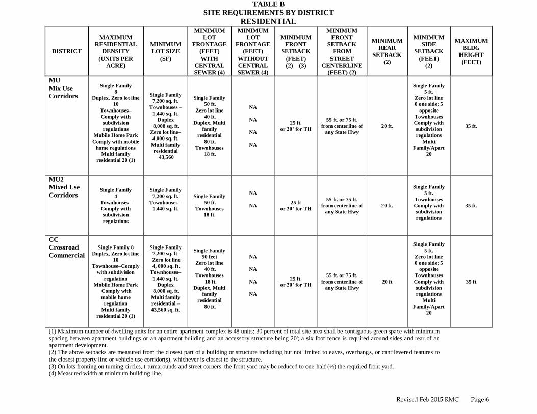
TABLE B
SITE REQUIREMENTS BY DISTRICT
RESIDENTIAL
DISTRICT
MAXIMUM
RESIDENTIAL
DENSITY
(UNITS PER
ACRE)
MINIMUM
LOT SIZE
(SF)
MINIMUM
LOT
FRONTAGE
(FEET)
WITH
CENTRAL
SEWER (4)
MINIMUM
LOT
FRONTAGE
(FEET)
WITHOUT
CENTRAL
SEWER (4)
MINIMUM
FRONT
SETBACK
(FEET)
(2) (3)
MINIMUM
FRONT
SETBACK
FROM
STREET
CENTERLINE
(FEET) (2)
MINIMUM
REAR
SETBACK
(2)
MINIMUM
SIDE
SETBACK
(FEET)
(2)
MAXIMUM
BLDG
HEIGHT
(FEET)
MU
Mix Use
Corridors
Single Family
8
Duplex, Zero lot line
10
Townhouses–
Comply with
subdivision
regulations
Mobile Home Park
Comply with mobile
home regulations
Multi family
residential 20 (1)
Single Family
7,200 sq. ft.
Townhouses –
1,440 sq. ft.
Duplex
8,000 sq. ft.
Zero lot line–
4,000 sq. ft.
Multi family
residential
43,560
Single Family
50 ft.
Zero lot line
40 ft.
Duplex, Multi
family
residential
80 ft.
Townhouses
18 ft.
NA
NA
NA
NA
25 ft.
or 20’ for TH
55 ft. or 75 ft.
from centerline of
any State Hwy
20 ft.
Single Family
5 ft.
Zero lot line
0 one side; 5
opposite
Townhouses
Comply with
subdivision
regulations
Multi
Family/Apart
20
35 ft.
MU2
Mixed Use
Corridors Single Family
4
Townhouses–
Comply with
subdivision
regulations
Single Family
7,200 sq. ft.
Townhouses –
1,440 sq. ft.
Single Family
50 ft.
Townhouses
18 ft.
NA
NA
25 ft
or 20’ for TH
55 ft. or 75 ft.
from centerline of
any State Hwy
20 ft.
Single Family
5 ft.
Townhouses
Comply with
subdivision
regulations
35 ft.
CC
Crossroad
Commercial
Single Family 8
Duplex, Zero lot line
10
Townhouse–Comply
with subdivision
regulation
Mobile Home Park
Comply with
mobile home
regulation
Multi family
residential 20 (1)
Single Family
7,200 sq. ft.
Zero lot line
4, 000 sq. ft.
Townhouses–
1,440 sq. ft.
Duplex
8,000 sq. ft.
Multi family
residential –
43,560 sq. ft.
Single Family
50 feet
Zero lot line
40 ft.
Townhouses
18 ft.
Duplex, Multi
family
residential
80 ft.
NA
NA
NA
NA
25 ft.
or 20’ for TH
55 ft. or 75 ft.
from centerline of
any State Hwy
20 ft
Single Family
5 ft.
Zero lot line
0 one side; 5
opposite
Townhouses
Comply with
subdivision
regulations
Multi
Family/Apart
20
35 ft
(1) Maximum number of dwelling units for an entire apartment complex is 48 units; 30 percent of total site area shall be contiguous green space with minimum spacing between apartment buildings or an apartment building and an accessory structure being 20'; a six foot fence is required around sides and rear of an apartment development. (2) The above setbacks are measured from the closest part of a building or structure including but not limited to eaves, overhangs, or cantilevered features to
the closest property line or vehicle use corridor(s), whichever is closest to the structure. (3) On lots fronting on turning circles, t-turnarounds and street corners, the front yard may be reduced to one-half (½) the required front yard. (4) Measured width at minimum building line.
Revised Feb 2015 RMC Page 7
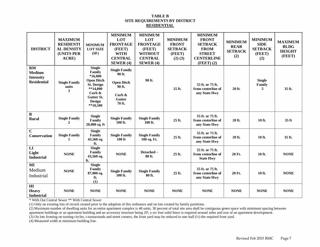
TABLE B
SITE REQUIREMENTS BY DISTRICT
RESIDENTIAL
DISTRICT
MAXIMUM
RESIDENTI
AL DENSITY
(UNITS PER
ACRE)
MINIMUM
LOT SIZE
(SF)
MINIMUM
LOT
FRONTAGE
(FEET)
WITH
CENTRAL
SEWER (4)
MINIMUM
LOT
FRONTAGE
(FEET)
WITHOUT
CENTRAL
SEWER (4)
MINIMUM
FRONT
SETBACK
(FEET)
(2) (3)
MINIMUM
FRONT
SETBACK
FROM
STREET
CENTERLINE
(FEET) (2)
MINIMUM
REAR
SETBACK
(2)
MINIMUM
SIDE
SETBACK
(FEET)
(2)
MAXIMUM
BLDG
HEIGHT
(FEET)
RM
Medium
Intensity
Residential Single Family
units
3
Single
Family
*16,000
Open Ditch
St. Design
**14,000
Curb &
Gutter St.
Design
**10,500
Single Family
90 ft.
Open Ditch
90 ft.
Curb &
Gutter
70 ft.
90 ft.
25 ft.
55 ft. or 75 ft.
from centerline of
any State Hwy
20 ft.
Single
Family
5
35 ft.
R
Rural
Single Family
2
Single
Family
20,000 sq. ft
Single Family
100 ft.
Single Family
100 ft. 25 ft.
55 ft. or 75 ft.
from centerline of
any State Hwy
20 ft. 10 ft. 35 ft
C
Conservation
Single Family
1
Single
Family
43,560 sq.
ft.
Single Family
100 ft
Single Family
100 sq. Ft. 25 ft.
55 ft. or 75 ft.
from centerline of
any State Hwy
20 ft. 10 ft. 35 ft.
LI
Light
Industrial NONE
Single
Family
43,560 sq.
ft.
NONE Detached –
80 ft. 25 ft.
55 ft. or 75 ft.
from centerline of
State Hwy
20 Ft. 10 ft. NONE
MI
Medium
Industrial NONE
Single
Family
87,000 sq.
ft.
(1)
Single Family
100 ft.
Single Family
80 ft. 25 ft.
55 ft. or 75 ft.
from centerline of
any State Hwy
20 Ft. 10 ft. NONE
HI
Heavy
Industrial
NONE NONE NONE NONE NONE NONE NONE NONE NONE
* With Out Central Sewer ** With Central Sewer (1) Only on existing lots of record created prior to the adoption of this ordinance and on lots created by family partitions. (2) Maximum number of dwelling units for an entire apartment complex is 48 units; 30 percent of total site area shall be contiguous green space with minimum spacing between apartment buildings or an apartment building and an accessory structure being 20'; a six foot solid fence is required around sides and rear of an apartment development. (3) On lots fronting on turning circles, t-turnarounds and street corners, the front yard may be reduced to one-half (½) the required front yard. (4) Measured width at minimum building line.

Revised Feb 2015 RMC Page 8
TABLE B
SITE REQUIREMENTS BY DISTRICT
COMMERCIAL
DISTRICT
MAXIMUM
FLOOR
AREA
(SQUARE
FEET)
MINIMUM
LOT SIZE
(SQUARE
FEET)
MINIMUM
LOT
FRONTAGE
(FEET)
MINIMUM
FRONT
SETBACK
FROM
PROPERTY
LINE (FEET)
MINIMUM
FRONT
SETBACK
FROM STREET
CENTERLINE
(FEET) (2)
MINIMUM
REAR
SETBACK
(FEET)
MINIMUM
SIDE
SETBACK
(FEET)
MAXIMUM
BLDG HEIGHT
(FEET)
MU
Mix Use
Corridors
NONE 16.000 80
(1) 25 55 15 10 35
MU2
Mixed Use
Corridors
NONE
(3) 16,000
80
(1) 25 55 15 10 35
CC
Crossroad
Commercial
10,000 16,000 80
(1) 25 55 15 10 35
RM
Medium
Intensity
Residential
NA NA NA NA NA NA NA NA
R
Rural NA NA NA NA NA NA NA NA
C
Conservation NA NA NA NA NA NA NA NA
LI
Light
Industrial NONE 10,000 100 25 55 15 10 35
MI
Medium
Industrial
NONE 10,000 100 25 55 15 10 35
HI
Heavy
Industrial
NONE NONE NONE NONE NONE NONE NONE NONE
(1) Measured width at minimum building line. (2) Property which has frontage on any state highway shall have a minimum front setback of 75' measured from the centerline of the highway. (3) 8500 Maximum floor area per building.

PARISH OF ASCENSION OFFICE OF PLANNING AND DEVELOPMENT
42077 Churchpoint Road
Gonzales, Louisiana 70737
Phone: (225) 450-1002 / Fax: (225) 450-1352
Web: www.ascensionparish.net
APPENDIX II
DEVELOPMENT CODE
Contents:
17-201. General Provisions of Development and zoning .....................................................5
17-2010. Zoning Districts ..................................................................................................... 13 17-2011. Map of Zoning and Overlay Guidelines ................................................................... 14
17-2012. Mixed Use Corridors (MU) and (MU2) ................................................................... 15 17-2013. Heavy Industrial (HI)............................................................................................... 16
17-2014. Crossroad Commercial District (CC) ....................................................................... 16 17-2015. Medium Intensity Residential District (RM) ............................................................ 16
17-2016. Medium Industrial (MI) ........................................................................................... 17 17-2017. Light Industrial (LI) ................................................................................................. 18
17-2018. Airport District (A) .................................................................................................. 21 17-2019. Rural District (R) ..................................................................................................... 21
17-2020. Conservation District (C) ......................................................................................... 21 17-2030. Overlay Zones ........................................................................................................ 23
17-2031. Flood Hazard Overlay Zone ..................................................................................... 24 17-2032. Designation of Waste Sites ...................................................................................... 24
17-2033. Historic Site Overlay Zone ...................................................................................... 25 17-2034. Scenic Rural Highways Overlay Zone ..................................................................... 29
17-2035. Neighborhood Business Overlay Zone ..................................................................... 30 17-2036. Airport Overlay Zone .............................................................................................. 35
17-2037. Chemical Emergency overlay zone - reserved .......................................................... 44 17-2038. Reserved.................................................................................................................. 44
17-2039. Industrial Designation overlay zone - reserved ......................................................... 44 17-2040. Specific Use Criteria .............................................................................................. 47
17-2041. Secondary Family Residences ................................................................................. 47 17-2042. Bed & Breakfast ...................................................................................................... 47
17-2043. Tall Structures ......................................................................................................... 47 17-2044. Commercial and Industrial Storage Standards .......................................................... 57
17-2045. Apartments .............................................................................................................. 58 17-2046. Manufactured Housing and Mobile Home Standards ............................................... 58
17-2047. Group Home Standards............................................................................................ 60 17-2048. Home Occupation Standards .................................................................................... 62
17-2049. Adult Business Standards ........................................................................................ 64 17-2050. Alcohol Beverage Business Standards ..................................................................... 66
17-2060. Drainage and Traffic ............................................................................................. 69

Appendix II: Development Code Page 2 of 130
17-2070. Development Standards ........................................................................................ 75 17-2071. Use Regulations....................................................................................................... 77
17-2072. Structure and Lot Regulations .................................................................................. 79 17-2073. Site Requirements.................................................................................................... 81
17-2080. Development Requirements .................................................................................. 85 17-2081. Off Street Parking Requirements ............................................................................. 85
17-2082. Landscaping for Off Street Parking .......................................................................... 87 17-2083. Commercial Property Landscaping Standards .......................................................... 88
17-2084. Bufferyard Requirements ......................................................................................... 88 17-2085. Street Access Standards ........................................................................................... 91
17-2086. Signs: On Premises Sign Standards .......................................................................... 91 17-2087. Signs: Off Premises Sign Standards - Reserved ....................................................... 94
17-2088. Lighting Standards .................................................................................................. 96 17-2089. Waste Discharge Standards...................................................................................... 96
17-2090. Administration and Enforcement ......................................................................... 97 17-20100. Definitions ........................................................................................................ 117

Appendix II: Development Code Page 3 of 130
Ordinance History
DC03-01, adopted new development Code 1/9/03 in entirety and repealing all previous versions.
Ordinance.# DC03-01, adopted January 9, 2003
Ordinance.# DC03-02, adopted August 21, 2003
Ordinance.# DC03-03, adopted August 21, 2003 Ordinance.# DC03-04, adopted August 21, 2003
Ordinance.# DC03-05, adopted August 21, 2003
Ordinance.# DC04-01, adopted December 16, 2004 Ordinance.# DC05-01, adopted April 21, 2005
Ordinance.# DC05-02, adopted May 5, 2005
Ordinance.# DC06-01, adopted November 16, 2006 Ordinance.# DC07-01, adopted March 15, 2007
Ordinance.# DC07-02, adopted August 16, 2007
Ordinance.# DC08-01, adopted January 10, 2008
Ordinance.# DC08-02, adopted January 10, 2008 Ordinance.# DC09-01, adopted February 5, 2009
Ordinance.# DC09-02, adopted February 5, 2009
Ordinance.# DC09-03, adopted February 5, 2009 Ordinance.# DC09-04, adopted May 21, 2009
Ordinance.# DC09-05, adopted May 21, 2009
Ordinance.# DC09-06, adopted July 16, 2009 Ordinance.# DC09-07, adopted November 19, 2009
Ordinance.# DC09-08, adopted November 19, 2009
Ordinance.# DC09-09, adopted December 17, 2009
Ordinance.# DC09-10, adopted December 17, 2009 Ordinance.# DC09-11, adopted December 17, 2009
Ordinance.# DC10-01, adopted February 18, 2010
Ordinance # DC12-05, adopted August 16, 2012 Ordinance # DC12-06, adopted August 16, 2012
Ordinance # DC12-07, adopted August 16, 2012
Ordinance # DC13-13, adopted November 21, 2013
Ordinance #DC13-15, adopted February 20, 2014 Ordinance #DC14-9, adopted October 2, 2014

Appendix II: Development Code Page 4 of 130
(This page left blank intentionally for code section expansion)
Appendix II: Development Code Page 5 of 130
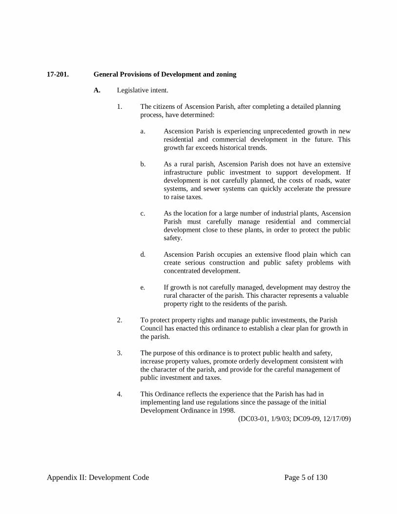
17-201. General Provisions of Development and zoning
A. Legislative intent.
1. The citizens of Ascension Parish, after completing a detailed planning
process, have determined:
a. Ascension Parish is experiencing unprecedented growth in new
residential and commercial development in the future. This
growth far exceeds historical trends.
b. As a rural parish, Ascension Parish does not have an extensive
infrastructure public investment to support development. If development is not carefully planned, the costs of roads, water
systems, and sewer systems can quickly accelerate the pressure
to raise taxes.
c. As the location for a large number of industrial plants, Ascension
Parish must carefully manage residential and commercial
development close to these plants, in order to protect the public safety.
d. Ascension Parish occupies an extensive flood plain which can create serious construction and public safety problems with
concentrated development.
e. If growth is not carefully managed, development may destroy the rural character of the parish. This character represents a valuable
property right to the residents of the parish.
2. To protect property rights and manage public investments, the Parish
Council has enacted this ordinance to establish a clear plan for growth in
the parish.
3. The purpose of this ordinance is to protect public health and safety,
increase property values, promote orderly development consistent with
the character of the parish, and provide for the careful management of public investment and taxes.
4. This Ordinance reflects the experience that the Parish has had in implementing land use regulations since the passage of the initial
Development Ordinance in 1998.
(DC03-01, 1/9/03; DC09-09, 12/17/09)

Appendix II: Development Code Page 6 of 130
B. Enactment.
1. Be it ordained by the Ascension Parish Council, pursuant to the authority
of the Home Rule Charter powers granted by Louisiana Constitution
Article 6, Section 5, wishes to exercise all its power allowed under the
police powers of the United States Constitution, the Louisiana Constitution, and Louisiana Revised Statute 33:1236, as amended.
(DC03-01, 1/9/03; DC09-09, 12/17/09)
C. Jurisdiction.
1. The provisions of this ordinance shall apply to the unincorporated areas
in Ascension Parish, Louisiana.
2. This ordinance shall be administered by the Ascension Parish Planning and Zoning Commission, established under Section 17-1: Ascension
Parish Planning and Zoning Commission -- Created.
3. This ordinance sets forth the requirements for a person to obtain a
development permit for the construction or major alteration of a building
or structure in the unincorporated areas of Ascension Parish. The requirements for development permits are set forth in Section 17-
2090(B): Development permits required. The ordinance also sets forth
additional requirements for obtaining a building permit for single family
structures. The requirements for building permits are set forth in the Ascension Parish Buildings and Building Regulations, Chapter 6 of the
Code of Ordinances of Ascension Parish.
4. This ordinance implements the Ascension Parish Master Plan and the
Ascension Parish Land Use Plan adopted by the Parish Council.
(DC03-01, 1/9/03; DC09-09, 12/17/09)
D. Commentary.
1. Throughout this ordinance, subsections prefaced “Commentary” are included. Each commentary represents an official statement of legislative
finding and purpose. Whenever a section or subsection of this ordinance
is deemed to require clarification, explanation of its intent, or further elaboration, that section is followed by a commentary. The commentaries
have been legislatively adopted together with the more formal text of the
ordinance. They are intended as a guide to the administration and
interpretation of the ordinance and shall be treated in the same manner as other aspects of legislative history.
(DC03-01, 1/9/03; DC09-09, 12/17/09)

Appendix II: Development Code Page 7 of 130
E. Interpretation.
1. An administrator, the Planning and Zoning Commission, or the courts
shall interpret this ordinance to promote the purposes set forth by the
Ascension Parish Council. Those called upon to interpret this ordinance
shall proceed as follows:
a. Determine the public purpose of the standard for which an
interpretation is required.
i Commentary: Before any zoning interpretation is made,
there must be an explicit identification of the purpose for which the initial regulation was imposed. Each zoning
regulation is intended to protect the interests of both
present and future neighbors and the general public.
Each standard is developed as a regulatory response to an identifiable negative impact or potential. A sound
interpretation of any standard in this ordinance cannot be
ensured without a careful analysis of the end to which the regulation is directed.
b. Determine the impact of the proposed interpretation.
i Commentary: It is not always possible to define
precisely the impacts of a proposed interpretation. Those
charged with interpreting this ordinance should determine impacts after evaluating the viewpoints of
adjacent land owners and, where appropriate, expert
opinion from parish employees or independent parties.
c. Determine that the proposed interpretation will ensure a just
balance between the rights of the landowner and all others who
will be affected by that person’s land use proposal.
i Commentary: This ordinance provides the Zoning
Official and the Planning Director with the responsibility for administering its provisions. Their decisions can be
appealed to the Planning and Zoning Commission and
the Zoning Board of Adjustments. Decisions of the Board are subject to judicial appeal.
(DC03-01, 1/9/03; DC09-09, 12/17/09)

Appendix II: Development Code Page 8 of 130
F. Findings of Fact.
1. The Ascension Parish Council finds that:
a. Industrial operations in the parish involve the manufacture and
transportation of chemicals. These operations pose a risk to public health and safety and should be adequately separated from
high density residential development.
b. Large portions of the parish exist within a flood hazard area.
Construction within this area must meet special building
standards in order to minimize the risk of loss from flooding.
c. The Parish is undergoing rapid growth and suburbanization. The
Parish has a limited infrastructure to support this growth.
Building new infrastructure should be geographically concentrated in order both to reduce the cost of this
infrastructure and to encourage development outside the flood
hazard area.
d. The Parish has a limited amount of land available for industrial
and business development. The Parish needs land use regulations to balance residential, commercial and industrial growth in order
to protect the long term tax base of the parish.
(DC03-01, 1/9/03; DC09-09, 12/17/09)
G. Guiding principles and policies.
1. To achieve the purposes of this ordinance as set forth in Section 17-
201(A): Legislative intent, the Planning and Zoning Commission shall
adopt the following set of integrated guiding principles and policies to
manage land development in Ascension Parish. These principles and
policies are set forth in the Ascension Parish Master Plan and the Ascension Parish Land Use Plan, adopted by the Parish Council.
a. Principle 1: Protect public safety and property. Protect the public safety and property values by providing adequate separation of
industrial, commercial, and residential uses.
i Commentary: The central challenge in Ascension Parish
is to protect public health and safety from five major
challenges: 1) periodic flooding; 2) the encroachment of
residential uses near chemical plants; 3) the separation of truck traffic on parish roads; 4) the growth of traffic on a
narrow, rural road system; and 5) the increase waste
water pollution from increased residential construction.
Appendix II: Development Code Page 9 of 130
b. Principle 2: Manage growth. Encourage growth only in areas of
the parish which can support it with adequate soils, drainage, and physical infrastructure.
i Commentary: The parish has limited development sites
available that are outside the 100 year flood plain. A large portion of the available land for future
development is near historic or industrial properties.
c. Principle 3: Preserve the rural character of the parish. Preserve
rural, conservation, and recreation areas from high intensity
residential and commercial development.
i Commentary: The rural character of the parish comes
from open space, trees, and historic sites. Residential
growth, while not incompatible with preserving rural character, can erode this character.
d. Principle 4: Encourage compact commercial centers. Encourage the development of compact commercial centers throughout the
parish and discourage “strip” commercial development along
highways.
i Commentary: Establishing neighborhood commercial
centers at crossroads will reduce traffic congestion on
narrow rural roads. This approach will also reduce “strip development” that tends to undercut the rural character
of the parish.
e. Principle 5: Keep the process simple and open. Streamline the
process of land use management and encourage continuous
public comment on development practices.
i Commentary: Maintaining an open, fair process is
critical to the success of this ordinance. Without public
confidence in a fair, impartial process, enforcement of these regulations will not be effective.

Appendix II: Development Code Page 10 of 130
f. Principle 6: Use flexible performance zones that focus on
controlling the intensity of development.
i Commentary. Instead of having a proliferation of single
use zones, the parish should expand the allowable uses
of the existing zones and add a few more flexible use zones. The Commission should focus on managing the
intensity and impact of development and not so much on
the use. This approach meets the needs of a rural parish and reduces the cost of administration.
g. Principle 7: Discourage subSection development within the 100 year flood plain.
i Commentary. SubSection development is occurring in
large areas of the parish that cannot support the intensity of this development. The allowable subSection
development should be largely restricted to the northern
part of the parish outside the 100 year flood plain.
h. Principle 8: Support subSection development where water and
sewer lines are likely to run.
i Commentary. Clustering subSection development near
water and sewer lines will reduce the overall cost of
water and sewer to the taxpayers of the parish.
i. Principle 9: Within a zone allowing subSection development, use
a flood plain overlay zone to restrict development within the 100 year flood plain.
i Commentary . This overlay zone will reduce drainage
problems from development by restricting the amount of fill that can be added within the flood plain.
j. Principle 10: Reduce the amount of commercial development to discourage strip commercial development along rural roads.
i Commentary. The 1998 parish zoning map encouraged commercial zones all along the highways. With the
exception of Airline Highway, most roads in the parish
cannot support major new commercial development. The
Commission should encourage commercial development around intersections, where traffic flow can be more
easily managed.

Appendix II: Development Code Page 11 of 130
k. Principle 11: Establish a truck route between the industrial plants
and Interstate-10.
i Commentary. Currently trucks are mixing with
residential traffic on parish roads. This problem will
only worsen as the parish grows. A truck route, with limited commercial and residential development, will
separate industrial from residential traffic. This step will
protect the public safety and provide an efficient corridor from the industrial plants to the Interstate.
l. Principle 12: Create high quality business development zones in the parish.
i Commentary. The 1998 Zoning Map did not provide a
site for locating high end office, research and technology development. This district should be located near the
current industrial zones and should be compatible with
surrounding residential development. The district should encourage high quality business development with
minimal environmental impacts. The Parish needs
additional business development to diversify the economy. In addition, expanding business development
will strengthen the tax base to handle the continued
growth of residential development.
(DC03-01, 1/9/03; DC09-09, 12/17/09)

Appendix II: Development Code Page 12 of 130
(This page left blank intentionally for code section expansion)

Appendix II: Development Code Page 13 of 130
17-2010. Zoning Districts
A. Establishment of zoning districts and overlay zones
1. Ascension Parish is hereby divided into districts and overlay zones.
These districts and zones are necessary to promote compatible uses
within districts, to implement the official Ascension Parish Land Use Plan, to serve the other purposes of this ordinance as detailed in Section
17-201(A): Legislative intent, and to implement the principles and
policies outlined in Section 17-201(G): Guiding principles and policies. (DC03-01, 1/9/03; DC09-09, 12/17/09)
B. Establishment of zoning districts
1. For the purpose of this ordinance, all land and water in the
unincorporated areas of Ascension Parish are divided into zoning districts as follows: The following sections specify the intent of the
zoning districts and overlay zones established by this ordinance. These
districts are as follows:
2. High intensity districts:
a. Mixed use corridors (MU) b. Mixed Use 2 corridors (MU2)
c. Heavy Industrial (HI)
(DC03-01, 1/9/03; DC09-09, 12/17/09)
d. Mobile Home Park / RV Park (MHRV) (DC03-01, 1/9/03; DC09-09, 12/17/09; DC14-9, 10/2/14)
3. Medium intensity districts:
a. Crossroad commercial (CC)
b. Medium Intensity residential (RM)
c. Medium Industrial (MI) d. Light Industrial (LI)
e. Airport District (A)
4. Low intensity districts:
a. Rural (R)
b. Conservation (C)

Appendix II: Development Code Page 14 of 130
5. Commentary: This ordinance creates districts which encourage mixed
uses within districts. The primary policy objectives in developing these zones are 1) to separate hazardous industrial uses from high
concentrations of residential development; 2) to concentrate traffic from
commercial and high intensity residential development around roads in
the parish which can more easily handle higher traffic volumes; 3) to protect the public safety by encouraging development which is
adequately served by roads, fire stations, and police stations, and 4) to
preserve property values based on the rural character of the parish by discouraging residential subsections in remote areas of the parish and the
commercial strip development which follows these developments.
(DC03-01, 1/9/03; DC09-09, 12/17/09; DC12-07, 8/16/12;)
17-2011. Map of Zoning and Overlay Guidelines
A. The boundaries of the various districts and overlay zones are shown on the Official Zoning Map of Ascension Parish, Louisiana. This map appears as
Appendix XI of this Unified Development Code, with an accompanying legend
that explains the map’s symbols. The zoning maps, including all notations, are part of this Ordinance.
B. The chairman of the Planning and Zoning Commission, the chairman of the Parish Council and the Parish President shall sign and date the zoning map.
C. Unless otherwise shown on the zoning map, the boundary lines of zoning
districts and overlay zones are lot lines, property lines, the center lines of streets or alleys or such lines extended, railroad right-of-way lines, the center lines of
creeks and streams or corporate limit lines as they existed at the time of the
enactment of this ordinance, or otherwise section lines, as they exist within the various townships and ranges. Boundary lines which do not coincide with these
landmarks shall be determined by using the scale of the zoning map. If a
boundary line traverses a parcel or tract of land and if a minimum of 51% of the
property is located within a particular district, then the entire parcel or tract would be considered as being zoned that particular district. If a parcel or tract of
land whose zoning is affected by this provision is subdivided, each individual
tract, parcel, or lot of land created by the subdivision of the original tract shall be governed by the zoning district in which the newly created tract, parcel or lot is
located.
(DC03-01, 1/9/03; DC09-09, 12/17/09; DC09-11, 12/17/09)

Appendix II: Development Code Page 15 of 130
17-2012. Mixed Use Corridors (MU) and (MU2)
A. Mixed Use (MU) 1. This district is characterized by the most intensive residential and
commercial development. These districts are located in areas where the
road system is most capable of supporting growth with a minimum risk
to the public safety. High density residential development should include apartment buildings and townhouses. Commercial development should
be concentrated or “clustered” at strategic sites in relation to population
centers, other commercial sites, and adequate roads.
2. Commentary: This district is designed to concentrate the most intensive
residential and commercial development along the major arteries of the parish. By encouraging concentrated, cluster development, the
Commission will minimize the infrastructure costs and manage public
safety risks most appropriately. In addition, commercial development
should use shared access to parking lots and shared parking lots in order to minimize traffic congestion and sprawl along the parish roadways.
While this district allows many varied uses, the district should develop
with adequate buffering, careful traffic planning, and appropriate lighting plans to minimize any nuisance between uses.
(DC03-01, 1/9/03; DC09-09, 12/17/09)
B. Mixed Use 2 (MU2)
1. The District is characterized by the allowance of limited commercial,
retail and service establishments in areas where the surrounding
neighborhood is predominantly residential and the character and operation of which are compatible with the character of the surrounding
area.
2. Commentary: This district is designed to allow for commercial, retail and
service establishments which are compatible and do not adversely impact
the surrounding residential neighborhoods.
(DC03-01, 1/9/03; DC09-01, 2/5/09; DC09-09, 12/17/09)

Appendix II: Development Code Page 16 of 130
17-2013. Heavy Industrial (HI)
A. Heavy Industrial is characterized as high-impact manufacturing, compounding, processing, treatment and other uses that by their very nature create a certain real
or potential nuisance and which are not compatible with nearby residential and
commercial developments. Among the uses anticipated in the Heavy Industrial
Zone are processing and storage, refineries, tank farms, foundries, primary metals and other enterprises whose raw materials, goods-in-process or finished
products could be characterized as toxic, noxious, hazardous, odiferous,
explosive, radioactive or otherwise potentially harmful to nearby neighbors if improperly handled. Heavy Industrial anticipates a requirement for the
development of extensive on-site and off-site transportation infrastructure such as
liquid and break-bulk river terminals, rail access and storage yards, tanker truck loading and unloading and other infrastructure. Limited retail sales are permitted
in Heavy Industrial zones.
(DC03-01, 1/9/03; DC09-09, 12/17/09; DC12-07, 8/16/12;)
B. Commentary: Industrial development will be concentrated in areas which are already providing a site for industry. This district is adequately served by
infrastructure. Concentrating industrial development in this district also
minimizes the public safety risks from production and transportation. In addition, concentrating truck traffic will reduce the maintenance costs on parish roads.
This zone incorporates all property set forth as industrial property in Section 17-
10, Industrial Areas. (DC03-01, 1/9/03; DC09-09, 12/17/09)
17-2014. Crossroad Commercial District (CC)
A. This district serves the commercial needs of the outlying residents in the parish.
The purpose of this district is to disperse commercial development opportunities
throughout the parish, while minimizing the adverse impact on traffic flows. (DC03-01, 1/9/03; DC09-09, 12/17/09)
B. Commentary. Most of the commercial development in the parish should be
focused on mixed use corridors, where the roads can handle traffic volumes. At the same time, residents in the outlying areas of the parish need convenience
retail of standalone stores or smaller neighborhood convenience centers. To
reduce congestion on rural roads and improve road access, these commercial buildings should be located at intersections.
(DC03-01, 1/9/03; DC09-09, 12/17/09)
17-2015. Medium Intensity Residential District (RM)
A. This district is designated for residential development, including multifamily
dwellings and subSections. This district exists largely outside the 100 year flood plain and in the northern part of the parish where planned water and sewer

Appendix II: Development Code Page 17 of 130
systems can support more intensive development. Commercial development in
this district should be limited and located at highway intersections. (DC03-01, 1/9/03; DC09-09, 12/17/09)
B. Commentary: This district is designed to be adjacent to high intensity mixed use
corridors, but commercial development should not be allowed to disrupt the residential character of this district. In addition to single family houses, town
houses, garden homes and apartment buildings are intended for this district.
(DC03-01, 1/9/03; DC09-09, 12/17/09)
17-2016. Medium Industrial (MI)
A. Medium Industrial is intended to accommodate heavier forms of fabrication,
assembly, processing and storage, and larger scale warehousing & distribution
that, by nature, may create an infrequent visual, audio or scent nuisance to nearby
residential and commercial developments. Medium Industrial anticipates that some components of finished products may be produced on site and assembled
into a final product. Retail sales are not permitted Medium Industrial Zones
excepting when they can be proven to be auxiliary to the process (for example, an outlet store for products manufactured or warehoused within the facility).
Medium Industrial anticipates a moderate to heavy volume of vehicular traffic.
While periodic movement and storage of rail cars is permitted in a Medium Industrial Zone, such activity should be limited in frequency so as to not present
a persistent obstacle to the free flow of traffic in the vicinity of the establishment.
Large scale warehousing & distribution centers are allowed in Medium Industrial
zones with the caveat that appropriate steps shall be taken to properly plan and develop internal roadways and connections to public streets that promotes the
free flow of traffic in the area.
(DC03-01, 1/9/03; DC09-09, 12/17/09; DC12-07, 8/16/12;)
B. Commentary: This district provides a public safety buffer between large-scale
residential and commercial development and industrial plants. These plants pose
a serious public health risk which must be carefully managed. Beginning in 1985, the chemical industry operating in Ascension Parish established the Community
Awareness Emergency Response, or CAER, Committee. The Ascension Parish
Chemical Industry’s CAER Committee has installed a 26-siren community alerting system, designed to be heard within an approximate radius of 2.5 miles
of each plant, in the area in which the plants are located. The system will provide
effective early warning for the community. The Medium Industrial District falls within this community alerting system and is designed to discourage high density
residential development within this warning zone.
(DC03-01, 1/9/03; DC09-09, 12/17/09 DC12-07, 8/16/12;)

Appendix II: Development Code Page 18 of 130
17-2017. Light Industrial (LI)
A. Light Industrial is intended to accommodate light manufacturing, assembly, fabrication, processing, small scale warehousing & distribution, repair facilities
and similar operations utilizing previously prepared materials. Light Industrial
operation should be operated in a clean and quiet manner in compatibility with
surrounding commercial and residential users. Generally, operations in Light Industrial zones should be contained wholly within a structure. Where it is
necessary to have exterior storage areas for raw materials, finished products,
goods-in-process, lay down yards, etc., these should be screened from view via vegetation or opaque fencing. Retail sales would be allowed in Light Industrial
zones where they are incidental to the operation.
(DC03-01, 1/9/03; DC09-09, 12/17/09; DC12/07, 8/16/12;)
B. Commentary: This district enables the parish to expand its economic base
without encroaching on residential development. By establishing high
development standards for this district, the parish reduces the impact of business development on surrounding residential development, while at the same time
encouraging investment in high income employment.
(DC03-01, 1/9/03; DC09-09, 12/17/09)
C. Light Industrial Development Standards
1. The development standards for the Light Industrial (LI) District include
the following:
a. Site plan review. Development within the Light Industrial district requires a site plan review by the Planning and
Development Staff to insure that the development meets the
development standards set forth in this Section. The site plan that shall include:
i Vicinity map;
ii Boundaries and dimensions of the property; iii Location of buildings and structures with existing and
proposed location and layout of off-street parking.
iv Loading and unloading areas and location, design and height of walls and fencing;
v Location of storage areas and refuse containers;
vi Location and size of signs; vii Landscaping plan;
viii Outdoor lighting plan;
ix Proposed architectural treatment of buildings;
x Location and size of all existing and proposed utilities; xi Site drainage;
xii Access to public streets;
xiii Interior circulation pattern, including truck circulation for loading and unloading;

Appendix II: Development Code Page 19 of 130
xiv Adjacent public streets and the latest available traffic
counts of those streets; xv Indications of adjoining uses.
b. Building Plan review and building standards: Development
within the Light Industrial district requires a building plan review by the Planning and Development Staff to insure that the
development meets the development standards set forth in this
Section. The building standards include:
i All buildings shall be designed by a certified architect or
engineer
ii All sides, elevations or facades shall be visually pleasing
and architecturally comparable with these standards.
c. The majority of exterior and externally visible opaque surfaces
shall be constructed of the following materials:
i Brick;
ii Architectural precast concrete panels;
iii Decorative concrete block; iv Cut stone;
v Wood; or
vi Other building materials that the Planning and
Development Staff determine will present a visual statement of a building structure’s strength, permanence
and attractiveness. The building materials used shall be
harmonious with the natural environment and with the general character of a high quality business park.
d. No loading dock shall face the street, unless the site
configuration is such that it is unavoidable. In that event, the Planning and Development Staff shall specifically review and
approve the location of the loading dock.
e. Ancillary structures shall be approved by the Planning and
Development Staff. Approval shall be granted only if:
i The ancillary building is essential to the principal use of
the building site
ii The structure of the ancillary building conforms to the architectural standards of other buildings on the site
iii The ancillary building is properly screened to minimize adverse visual impacts, if any

Appendix II: Development Code Page 20 of 130
iv Conform to the overall objectives of this Section, as
determined by the Planning and Development Staff. (DC03-01, 1/9/03; DC09-09, 12/17/09; DC09-10, 12/17/09; DC12-07, 8/16/12; DC13-15, 2/20/14)
f. Landscaping Plan review and landscaping standards. The
landscaping on the site shall follow a Landscaping Plan that has been reviewed and approved by the Planning and Development
Staff. The Landscaping Plan shall include the location, name,
size and quantity of plant materials. The plan shall show all ground cover and mulch areas; landscape and construction
materials; and construction details. The Planning and
Development Staff shall approve landscaping plans that substantially enhance the property value of the building site and
maintain the rural character of the parish. In making this
determination, the Planning and Development Staff shall
consider:
i The extent of landscaping, including the use of seeding,
sodding, raised planters, architectural decorative walls or fencing, earth berms, trees and shrubs, ground cover, and
lighting.
ii The use of trees and shrubs that enhance the rural
character of the parish.
iii The extent to which the landscaping plan represents a long term improvement to the rural character of the
parish.
(DC03-01, 1/9/03; DC09-09, 12/17/09; DC09-10, 12/17/09; DC12-07, 8/16/12; DC13-15, 2/20/14)
g. Failure to complete or maintain landscaping. All landscaping
shall be completed within 90 days following occupancy. The
owner of the building site shall be responsible for maintaining all landscaping approved in the original plan. If the owner does not
complete the approved landscaping plan within 90 days of
occupancy, the Planning and Development Staff may direct the Building Official to revoke the owner’s Certificate of
Occupancy. If the owner or the owner’s assigns do not maintain
the landscaping as set forth in the approved plan, the Parish of Ascension or its agent, at the direction of the Planning and
Development Staff, shall enter the site and conduct such
maintenance. The Parish of Ascension may seek full
reimbursement for these maintenance services. (DC03-01, 1/9/03; DC09-09, 12/17/09; DC09-10, 12/17/09; DC12-07, 8/16/12; DC13-15, 2/20/14)
Appendix II: Development Code Page 21 of 130
17-2018. Airport District (A)
A. The Airport District shall be comprised of the property which constitutes the
Louisiana Regional Airport, and more particularly described in an ordinance
passed by the Ascension Parish Council at a regular meeting on February 1,
2001. (DC03-01, 1/9/03; DC09-09, 12/17/09)
B. Commentary: The legal description of the Airport District is set forth in an ordinance passed by the Ascension Parish Council on February 1, 2001. This
legal description is incorporated into the Development Code by reference.
(DC03-01, 1/9/03; DC09-09, 12/17/09)
17-2019. Rural District (R)
A. This district is designated for low-density residential development in rural areas and small pockets of commercial development to service neighborhood needs.
The area is generally characterized by rural roads and a lack of utilities.
(DC03-01, 1/9/03; DC09-09, 12/17/09)
B. Commentary: This district should develop consistent with the rural character of
the parish. Commercial development should be low intensity carefully planned so as not to disrupt the rural character of the district. Careless commercial
development, “suburban sprawl”, represents both a nuisance to current
landowners and jeopardizes property values. In addition, haphazard subSection
development in the more rural parts of the parish will stretch the parish’s limited road, police and fire budgets. The parish cannot afford to service large
concentrations of residential development in this district.
(DC03-01, 1/9/03; DC09-09, 12/17/09)
17-2020. Conservation District (C)
A. This area is designated to conserve the major environmental assets of the parish.
The district is intended for single family residential development and limited
commercial development.
B. Commentary: This district includes the most rural parts of the parish. These areas
are not only environmentally fragile, they are not served by roads which can handle large traffic increases.
(DC03-01, 1/9/03; DC09-09, 12/17/09)

Appendix II: Development Code Page 22 of 130
17-2021. Mobile Home Park / RV Park District (MHRV)
A. This area is designated to provide for an area to develop Mobile Home and/or RV
Parks. The district is intended for high density, single family residential
development that is designed consistent with Appendix 8 and Appendix 9 of the
Unified Land Development Code. This district is intended to ensure a suitable living environment in Mobile Home and/or RV parks and to ensure the
compatibility of such developments with adjacent property.
B. Properties shall only be considered for this zoning designation if they are located
outside of the most up-to-date 100 year flood plain designation according to the
FEMA/FIRMS map and immediately adjacent to a piece of property that is already zoned MU, CC or MHRV.
C. Commentary: This district is designed to concentrate Mobile Home and RV
Parks where the Parish Council feels they are best suited to occur. Consideration should be given to available and future infrastructure in the immediate area,
adjacent land use, traffic and drainage concerns.
(DC14-9, 10/02/14)

Appendix II: Development Code Page 23 of 130
17-2030. Overlay Zones
A. Statement of purpose and intent for overlay zones. 1. Overlay zones handle particular development issues in the parish by
imposing a new set of regulations on a special area. These problems are
geographically localized and cannot be completely addressed by the
underlying district regulations. To provide flexibility and ease of administration to the Development Ordinance, the parish adopts the
following overlay zones to address these issues:
a. Flood hazard overlay zone, b. Designation of Waste Sites
c. Historic site overlay zone,
d. Scenic Rural Highways overlay zone e. Neighborhood Business overlay zone.
f. Chemical Emergency overlay zone,
g. Airport Overlay Zone
h. Industrial Designation overlay zone.
2. Commentary. With the flexibility of overlay zoning, the parish is able to
respond to special features of the land. (DC03-01, 1/9/03; DC03-03, 8/21/03; DC09-09, 12/17/09; DC12-06, 8/16/12)
B. Establishment of overlay zones
1. This Ordinance establishes the following Overlay Zones:
a. Flood hazard overlay zone,
b. Designation of Waste Sites c. Historic site overlay zone,
d. Scenic Rural Highways overlay zone
e. Neighborhood Business overlay zone. f. Chemical Emergency overlay zone,
g. Airport Overlay Zone
h. Industrial Designation overlay zone.
2. The overlay districts shall be superimposed on the other districts
established by this Ordinance.
3. The delineation of the overlay zones are set forth on the official zoning
map.
4. Commentary. Overlay zones lie on top of zoning districts. They impose
an additional level of land use control to handle specific development
issues within the parish.
(DC03-01, 1/9/03, DC03-02, 8/21/03; DC09-09, 12/17/09, DC12-06, 8/16/12)

Appendix II: Development Code Page 24 of 130
17-2031. Flood Hazard Overlay Zone
A. Flood Hazard Overlay 1. The Flood Hazard Overlay Zone protects public safety and property by
restricting residential development within the 100 year flood plain and by
keeping flood channels free of encroachment. Development in this zone
must also comply with the requirements of Chapter 9.5 of the Code of
Ordinances, Flood Damage Prevention.
2. The lands within the Flood Hazard Overlay Zone are subject to periodic inundation. These floods adversely affect the public health, safety and
general welfare of the parish. They can result in a loss of life and
property, health and safety hazards, disruption of commerce and governmental services. They also lead to extraordinary public
expenditures for flood protection and relief.
3. These flood losses are created by the cumulative effect of obstructions in floodplains which cause an increase in flood heights and velocities.
These losses are also increased by the development of buildings within
the Flood Hazard Overlay Zone that are inadequately elevated, flood-proofed or otherwise protected from flood damage.
4. Commentary. The purpose of flood plain zoning is to regulate land use within the flood plain so as to minimize or prevent the harm caused by
flood. The current development pattern shows that some subSections
have been developed recently within the 100 year flood plain. This
overlay zone is designed to protect the public safety and property rights by restricting intensive residential development in the flood plain (Zones
A, A1, A30, AH and AE). Construction within designated floodplain
should not be started until the applicant has provided an Elevation Certificate to the Building Official. By accepting an Elevation Certificate
and related information, the parish government is not making any
representation that a structure built in a flood plain is safe.
(DC03-01, 1/9/03; DC09-09, 12/17/09)
17-2032. Designation of Waste Sites
A. Waste sites as defined by the Louisiana Department of Environmental Quality or
the Environmental Protection Agency shall be designated on the Ascension Parish Zoning Map to demonstrate to the public their locations only. The
placement and identification on the map of these locations, is for informational

Appendix II: Development Code Page 25 of 130
purposes only, and is not a representation by the Parish of the degree of hazard
imposed by said site. (DC03-01, 1/9/03;DC03-04, 8/21/03; DC09-09, 12/17/09)
17-2033. Historic Site Overlay Zone
A. The purpose of the historic structure overlay zones is to protect certain historical sites from incompatible development. This zone protects irreplaceable historic
and economic assets in the parish. The Planning Commission should encourage
landowners with historic property to use this zone to preserve these structures. (DC03-01, 1/9/03; DC09-09, 12/17/09; DC09-10, 12/17/09)
B. Inclusion or Exclusion 1. Individual property owners can, via written request to the Zoning
Official, request that their property be designated on the Official
Ascension parish Zoning Map as a Historic Site.
a. The property will be evaluated by the Zoning Official to determine if the criteria has been met and the request shall be
placed before the Zoning Commission for recommendation to
the Parish Council. b. All advertising deadlines will need to be met.
2. Individual property owners can, via written request to the Zoning
Official, request that their property be removed from the Official Ascension Parish Zoning Map as a Historic Site.
a. The request shall be placed before the Zoning Commission for
recommendation to the Parish Council.
b. All advertising deadlines will need to be met. (DC03-01, 1/9/03; DC03-03, 8/21/03; DC09-09, 12/17/09; DC12-05, 8/16/12)
D. Development Standards
1. No industrial uses shall be allowed within the property boundary lines of
the historical site. Limited commercial uses shall be allowed on the
Historic Site to the extent that the commercial uses are compatible with the Historic Site, do not hinder the integrity of the site, and meet the
following criteria.
a. Historic Site shall be open to the general public a minimum of
240 days in each calendar year.
b. Uses shall be limited to the following:
i. General Retail (gift shop or other retail activity)
provided however, that the sale of gasoline or
other automotive services shall not be permitted; ii. Restaurant;
iii. Reception Hall;
iv. Meeting Hall or Conference Center;

Appendix II: Development Code Page 26 of 130
v. Hotel, Motel or Bed & Breakfast not exceeding
100 rooms; vi. Exhibit Hall;
vii. Museum;
viii. Chapel
ix. Spa (associated with Hotel, Motel or Bed & Breakfast)
c. Development Standards:
i. Floor to Area Ratio shall not exceed .35; ii. Parking:
a) For all general retail, meeting hall or
conference center, a minimum of 1 parking for every 250 square feet of
gross square footage shall be provided;
and,
b) For all restaurant, dining hall or area
designated as a dining area open to the
public, a minimum of 1 parking space for every 3.5 seats or occupancy and 1
space for any 150 square footage of
kitchen or other food preparation area In the event the same square footage serves
as meeting hall, conference center and
dining area, the more stringent of the
parking requirements shall apply.
c) Outdoor spaces used for similar uses
shall be included in establishing the
overall parking requirements for the Historic Site.
d) A minimum 1 and a maximum of 3 bus
parking spaces shall be included in the
overall parking requirements at the discretion of the Planning Commission.
e) Parking requirements are cumulative,
however, same square footage shall only be included in the calculations using the
most stringent requirement.
f) Parking area landscaping shall comply with Section 17-2082(A): (Landscape
Requirements.
g) A Parking Study prepared by a
Professional Engineer Licensed to
Appendix II: Development Code Page 27 of 130
practice in the State of Louisiana may be
used, subject to approval by the Planning Commission, to establish the
total required parking,
iii. Buffering;
iv. Landscaping;
d. A Site Plan shall be submitted and reviewed by the Planning
Commission.
2. Extending from the property boundary line outwards 250 feet, any use
permitted in the underlying zoning district shall be permitted in this section of the Historic Site Overlay Zone, except for those similar to
industrial, manufacturing and waste related activities, natural gas or fuel
related control, monitor, or distribution activities, mass storage, travel or
movement activities, similar activities as deemed in the discussion of the Planning Commission, except healthcare and medical facilities.
Buffering requirements as provided for herein shall be adhered to.
3. From 250 to 500 feet beyond the boundary lines, any use permitted in the
underlying zoning district shall be allowed, subject to the buffering
requirements provided herein.
4. This ordinance does not extend to buildings or land which fail to
conform to the uses set forth in this Chapter on the date of enactment of
this ordinance. The lawful use of any building or land existing as of the date of enactment of this ordinance may be continued, although such use
does not conform with the provisions of this ordinance, provided that:
a. No nonconforming use shall be extended to displace a
conforming use.
b. A building that contains a nonconforming use may not be reconstructed or structurally altered in excess of fifty percent
(50%) of the assessed value of the building prior to construction,
unless the building is changed to a conforming use approved by the Planning Commission.
c. A nonconforming land use maybe expanded by no more than 50% of the original nonconforming site.
d. Any nonconforming structure declared unsafe by an agent of the
Parish may be restored to a safe condition.
e. Once changed to a conforming use, no building or land shall be
permitted to revert to a nonconforming use.

Appendix II: Development Code Page 28 of 130
f. Whenever a building or land used in whole or in part for a
nonconforming use becomes and remains vacant for a continuous period of 180 days, or whenever the commercial
operations carried on in such a building or on such land have
been discontinued for a period of more than 180 days, the
subsequent use of the property must conform to the provisions of this ordinance.
g. An abandoned nonconforming use may be re-established within
90 days after the 180th day of the abandonment upon a showing
that the continuation of a conditional nonconforming use would not adversely affect the health, safety, or welfare of the public
and is in substantial compliance with existing or permitted uses
of adjacent properties.
h. This section shall apply to any nonconforming uses which may arise whenever the boundaries of a district are altered.
(DC03-01, 1/9/03;DC03-05, 8/21/03; DC05-02, 5/5/05; DC09-04, 5/21/09; DC09-09, 12/17/09;
DC09-10, 12/17/09, DC12-05, 8/16/12)
E. Pre-development Meeting
1. Any development proposed within the Historic Site Overlay Zone shall be reviewed at a pre-development meeting to be held before the Planning
Commission. The Applicant shall;
a. Submit a complete application together will all required
documents and other necessary information to clearly communicate and inform the Planning Commission all intentions
for development, including but not exclusively, architectural
schemes, landscaping, projected volume of business and any other relevant information that the Planning Commission may
request;
b. Attend a pre-hearing meeting with staff to review the application, submitted documents and proposal in detail.
Developer, owner or authorized agent shall provide any
additional documentation or support information as it may be deemed necessary by the Ascension Parish Development
Director.
c. Attend a public hearing before the Planning Commission. The
Planning Commission may approve, approve subject to
conditions of approval, deny or postpone the application, except
however, the Planning Commission may only postpone taking action on the subject application only one time for a period to be

Appendix II: Development Code Page 29 of 130
specified in its motion to postpone. Additional postponements
may only be granted at the applicant’s request.
2. Notice of the pre-development meeting shall be given to all adjacent
landowners via certified mail at least five days prior to the meeting. Said
meetings shall be held during regularly scheduled Planning Commission meetings, except for good cause shown, at which time a special meeting
shall be called subject to the same notice requirements.
3. The purpose of the pre-development meeting is to ensure compliance
with all applicable portions of the Ascension Parish Development and
Zoning codes: ensure uses within the Historic Site are compatible with the site and surrounding area; ensure the development is consistent with
the goals, objectives and policies of the Ascension Parish Codes and
purpose and intent of these provisions; and, place the public on notice of
any development in or near Historic Sites. By doing so, the Parish of Ascension protects the integrity of the sites and furthers the preservation
of these Historic Sites
(DC03-01, 1/9/03;DC03-05, 8/21/03; DC05-02, 5/5/05; DC09-04, 5/21/09; DC09-09, 12/17/09; DC09-10, 12/17/09)
F. Buffering Requirements
1. Uses allowed under this section within 500 feet of the property boundary
lines of the site shall provide a buffer between the use and the property
lines. Buffering shall consist of landscaping and/or fencing consistent with the architecture of the Historic Site. All buffering shall be subject to
approval by the Planning Commission.
(DC03-01, 1/9/03;DC03-05, 8/21/03; DC05-02, 5/5/05; DC09-04, 5/21/09; DC09-09, 12/17/09; DC09-10, 12/17/09)
G. Architectural Standards 1. Architecture shall be consistent with the style or period of the historical
site.
(DC03-01, 1/9/03;DC03-05, 8/21/03; DC05-02, 5/5/05; DC09-04, 5/21/09; DC09-09, 12/17/09)
H. Exclusions
1. Single family detached residential structures are excluded from the requirements of this overlay zone.
(DC09-09, 12/17/09)
17-2034. Scenic Rural Highways Overlay Zone
A. The purpose of this overlay zone is to protect the rural character of certain roads
in the parish.
(DC03-01, 1/9/03; DC09-09, 12/17/09)

Appendix II: Development Code Page 30 of 130
B. Commentary: The rural character of Ascension Parish enhances property values.
Based on citizen meetings, the Planning Commission learned that protecting the rural character of the parish ranks as a high priority among residential property
owners in the parish. In particular, residential property owners want to preserve
many of the large trees along certain highways in the parish. In addition, parish
residents want to restrict the proliferation of commercial signs along these highways. This overlay zone is designed to protect property values by
implementing restrictions on the cutting of large trees and the construction of
large signs. (DC03-01, 1/9/03; DC09-09, 12/17/09; DC09-10, 12/17/09)
17-2035. Neighborhood Business Overlay Zone
A. This overlay zone is designed to upgrade the existing business development
district along a road and to impose additional levels of land use control to handle
specific development issues within the Parish.
(DC03-01, 1/9/03; DC05-01, 4/21/05; DC09-09, 12/17/09, DC12-07, 8/16/12)
B. Underlying zone. The underlying zone for the Neighborhood Business Overlay
zone shall be the Light Industrial (LI) District. (DC03-01, 1/9/03; DC05-01, 4/21/05; DC09-09, 12/17/09; DC12-07, 8/16/12;)
C. Established Boundaries. The boundaries of the Overlay Zone shall be the areas shown on the official zoning map and the official legal description of any
Neighborhood Business Overlay Zone shall be contained in the records of the
Zoning Office.
(DC03-01, 1/9/03; DC05-01, 4/21/05; DC09-09, 12/17/09)
D. Permitted Uses: Permitted used of land or buildings, as hereinafter numerated,
shall be permitted in the Neighborhood Business Overlay Zone district only in accordance with conditions specified. Only those uses specifically listed
hereunder shall be considered permitted uses, and no building or lot shall be
devoted to any use other than a use permitted hereunder, with the exception of: a)
uses lawfully established prior to the effective date of this Ordinance. The following uses, itemized under "Zoning Table "A" constitutes the only uses
permitted in the Neighborhood Business Overlay zoning district.
1. All uses listed under Light Industrial (LI) District in Appendix I, Tables
A & B: Site Requirements by District with the exception of the
following: a. Process Plant (metals, chemicals, etc.)
b. Oil Refinery Facility
c. Gasoline Station, Automobile repair and service structures.
d. Rail Maintenance, Storage, or related activities. (DC03-01, 1/9/03; DC05-01, 4/21/05; DC09-09, 12/17/09; DC 12-07, 8/16/12;)

Appendix II: Development Code Page 31 of 130
E. Site and structure requirements
1. Architectural Standards
a. Property owners must follow the architectural standards as
outlined in the development code under the zoning guidelines of
Light Industrial.
2. Operations within an Enclosed Structure
a. All business, service, storage, and display of goods shall be conducted within completely enclosed structures, except for:
i Agricultural Uses
ii Off-Street Parking and Loading (DC03-01, 1/9/03; DC05-01, 4/21/05; DC09-09, 12/17/09; DC12-07, 8/16/12)
F. Commercial deliveries
1. The commercial delivery and shipment of products, merchandise or supplies in straight trucks or smaller vehicles shall be encouraged. All
vehicle maneuvers associated with parking and loading shall occur in the
off-street parking or loading area or structure. Public streets shall not be used to conduct any parking maneuver, including backing out onto the
street.
(DC03-01, 1/9/03; DC05-01, 4/21/05; DC09-09, 12/17/09)
G. Fencing, screening, and buffer yards
1. All fencing shall be constructed of quality materials. All fencing shall be
property braced and all posts shall be placed into the ground with concrete or placed at such a depth so as to insure the fence will be secure
and will not move. All fence bracing or ribbing shall be on the inside of
the fence unless otherwise approved by the Ascension Parish Planning Commission.
2. Fencing materials of construction shall be masonry, wood, vinyl, metal,
chain link, or wrought iron.
3. The side of the fence considered to be the face shall face abutting property.
4. No fence shall be erected on a comer lot that will impede the clear view
of an intersection by approaching traffic. 5. The purpose of fencing is to enclose unsightly structures. Height
restrictions of fencing shall be 6' minimum along the side and rear of the
property. If a fence is erected on a lot with a commercial structure the fence shall be constructed 25' from the centerline of road.
6. Intent:
a. New Construction of facility shall comply with Development
Code regulations, b. Existing fences are acceptable as is, however,
c. Reconstruction or repair of existing fences shall comply with
Development Code Regulations of being 25' from the center of the road.
Appendix II: Development Code Page 32 of 130
7. Fences or hedges/landscape materials shall be required to screen storage
areas and shall be of sufficient height to screen the storage from adjacent public right-of-ways and adjacent properties. If fencing is required and
exceeds 8 feet in height then landscape material shall be utilized to soften
the impact and add to the screening. Trees that will grow to a sufficient
height to screen storage from adjacent properties shall be utilized where the terrain is such that a screen exceeding ten feet in height is needed.
8. The Planning Commission may require additional buffer yards, screening or fencing between businesses and residential uses within the zone or
between the zone and other districts when a nuisance exists. The
additional standards may include the construction of opaque fencing, sound barriers, freestanding walls, or additional planning to reduce the
impact of nuisances on adjacent landowners. These nuisances may
include dust, noise, litter, lighting glare, and unsightly storage yards,
refuse disposal sites, parking lots, signs or buildings. (DC03-01, 1/9/03; DC05-01, 4/21/05; DC09-09, 12/17/09; DC09-10, 12/17/09)
H. Signage 1. All freestanding signs within the zone shall be monument signs.
Monument signs are signs that are supported by a base, or other supports,
having a combined width of greater than two feet and which are mounted on the ground.
2. Monument signs within the zone shall not exceed four feet in height and
twenty square feet of copy area.
(DC03-01, 1/9/03; DC05-01, 4/21/05; DC09-09, 12/17/09)
I. Nonconforming uses: Structures
1. All current residences and businesses located within the boundary of the Neighborhood Business District are exempt from complying with the
overlay district regulations:
a. When a residential use converts or is replaced with a business
type use. b. When an existing business is damaged, destroyed, repaired or
renovated to 50% or more of the market value of the structure.
(DC03-01, 1/9/03; DC05-01, 4/21/05; DC09-09, 12/17/09)
J. Maintenance of Signs and Fencing
1. All signs and fencing must be maintained and repaired in a reasonable fashion. Fencing and signs must remain free from visual blight, including
chipping, peeling, rusting and defective lighting. Any warped fence
boards shall be replaced as needed. The Parish of Ascension shall
provide notice of any maintenance violation. Such violations shall be corrected within 30 days of receipt of said notice. If the violation is not
corrected, the Parish of Ascension, through the Planning Department,
retains the right to correct the violation and bill the property owner for all applicable costs including but not limited to: lien rights, attorney fees,
Appendix II: Development Code Page 33 of 130
cost of repairs, interest at the maximum rate allowable by law, and all
other reasonable costs of collection. (DC03-01, 1/9/03; DC05-01, 4/21/05; DC09-09, 12/17/09)
K. Location of signage and fences
1. No signage or fencing shall be located in such a place whereby it restricts or obstructs traffic visibility. No identification signage will be
allowed within the right-of-way of a dedicated public street, nor in any
area not specifically approved by the Parish of Ascension Planning Commission. The Parish of Ascension Planning Commission will not
approve any portable signage.
(DC03-01, 1/9/03; DC05-01, 4/21/05; DC09-09, 12/17/09)
L. Site Plan Review Requirements
1. All uses subject to site plan review shall comply with the standards of
Light Industrial (LI) Site Plan Review. 2. Exceptions to Overlay District site plan review requirements. The
planning commission may approve exceptions to the Neighborhood
Business Overlay site plan review requirements upon finding that the use or development includes site amenities that address any adverse effects
of the exception of use or where the Planning Commission finds that
strict adherence to the requirements is impractical because of site location or conditions.
(DC03-01, 1/9/03; DC05-01, 4/21/05; DC09-09, 12/17/09; DC09-10, 12/17/09; DC12-07, 8/16/12)
M. Implementation 1. This ordinance will go into effect immediately following ratification by
the Parish of Ascension Council.
2. Businesses will have a maximum of 90 days from the date of ratification in order to meet the requirements specified within the ordinance.
(DC03-01, 1/9/03; DC05-01, 4/21/05; DC09-09, 12/17/09)

Appendix II: Development Code Page 34 of 130
(This page left blank intentionally for code section expansion)
Appendix II: Development Code Page 35 of 130
17-2036. Airport Overlay Zone
A. The purpose of this zone is to comply with regulations of the Federal Aviation
Administration.
(DC03-01, 1/9/03; DC09-09, 12/17/09)
B. Commentary: The Federal Aviation Administration imposes restrictions on
building densities and heights near airports. The purpose of this overlay zone is
to implement these restrictions. (DC03-01, 1/9/03; DC09-09, 12/17/09)
C. Airport Zones 1. In order to carry out the provisions of this Ordinance, there are hereby
created and established certain zones within the Airport District, which
include all of the land lying beneath the approach surfaces, transitional
surfaces, horizontal surfaces, and conical surfaces as they apply to Louisiana Regional Airport. Such zones are shown on Ascension Parish
Zoning map. An area located in more than one of the following zones is
considered to be only in the zone with the more restrictive height limitation. The various zones are hereby established and defined as
follows:
a. Utility Runway Visual Approach Zone. The inner edge of this
approach zone coincides with the width of the primary surface
and is 250 feet wide. The approach zone expands outward
uniformly to a width of 1,250 feet at a horizontal distance of 5,000 feet from the primary surface. Its centerline is the
continuation of the centerline of the runway.
b. Utility Runway Nonprecision Instrument Approach Zone. The
inner edge of this approach zone coincides with the width of the
primary surface and is 500 feet wide. The approach zone
expands outward uniformly to a width of 2,000 feet at a horizontal distance of 5,000 feet from the primary surface. Its
centerline is the continuation of the centerline of the runway.
c. Runway Larger than Utility Visual Approach Zone. The inner
edge of this approach zone coincides with the width of the
primary surface and is 500 feet wide. The approach zone expands outward uniformly to a width of 1.500 feet at a
horizontal distance of 5,000 feet from the primary surface. Its
centerline is the continuation of the centerline of the runway.

Appendix II: Development Code Page 36 of 130
d. Runway Larger than Utility with a Visibility Minimum Greater than 3/4 Mile Nonprecision Instrument Approach Zone. The
inner edge of this approach zone coincides with the width of the
primary surface and is 500 feet wide. The approach zone
expands outward uniformly to a width of 3,500 feet at a horizontal distance of 10,000 feet from the primary surface. Its
centerline is the continuation of the centerline of the runway.
e. Runway Larger than Utility with a Visibility Minimum as low as
3/4 Mile Nonprecision Instrument Approach Zone. The inner
edge of this approach zone coincides with the width of the primary surface and is 1,000 feet wide. The approach zone
expands outward uniformly to a width of 4,000 feet at a
horizontal distance of 10,000 feet from the primary surface. Its
centerline is the continuation of the centerline of the runway.
f. Precision Instrument Runway Approach Zone. The inner edge of
this approach zone coincides with the width of the primary surface and is 1,00 feet wide. The approach zone expands
outward uniformly to a width of 16,000 feet at a horizontal
distance of 50,000 feet from the primary surface. Its centerline is the continuation of the centerline of the runway.
g. Transitional Zones. The transitional zones are the areas beneath
the transitional surfaces.
h. Horizontal Zone. The horizontal zone is established by swinging
arcs of 5,000 feet radii for all runways designated utility or visual and 10,000 feet for all others from the center of each end
of the primary surface of each runway and connecting the
adjacent arcs by drawing lines tangent to those arcs. The
horizontal zone does not include the approach and transitional zones.
i. Conical Zone. The conical zone is established as the area that commences at the periphery of the horizontal zone and extends
outward there from a horizontal distance of 4,000 feet.
(DC03-01, 1/9/03; DC09-09, 12/17/09)
D. Airport Zone Height Limitations
1. Except as otherwise provided in this Section, no structure shall be
erected, altered, or maintained, and no tree shall be allowed to grow in any zone created by this Section to a height in excess of the applicable
height herein established for such zone. Such applicable height
limitations are hereby established for each of the zones in question as follows:

Appendix II: Development Code Page 37 of 130
a. Utility Runway Visual Approach Zone. Slopes twenty (20) feet
outward for each foot upward beginning at the end of and at the same elevation as the primary surface and extending to a
horizontal distance of 5,000 feet along the extended runway
centerline.
b. Utility Runway Nonprecision Instrument Approach Zone. Slopes
twenty (20) feet outward for each foot upward beginning at the
end of and at the same elevation as the primary surface and extending to a horizontal distance of 5,000 feet along the
extended runway centerline.
c. Runway Larger than Utility Visual Approach Zone. Slopes
twenty (20) feet outward for each foot upward beginning at the
end of and at the same elevation as the primary surface and
extending to a horizontal distance of 5,000 feet along the extended runway centerline.
d. Runway Larger than Utility with a Visibility Minimum Greater than 3/4 Mile Nonprecision Instrument Approach Zone. Slopes
thirty-four (34) feet outward for each foot upward beginning at
the end of and at the same elevation as the primary surface and extending to a horizontal distance of 10,000 feet along the
extended runway centerline.
e. Runway Larger than Utility with a Visibility Minimum as Low as 3/4 Mile Nonprecision Instrument Approach Zone. Slopes
thirty-four (34) feet outward for each foot upward beginning at
end of and at the same elevation as the primary surface and extending to a horizontal distance of 10,000 feet along the
extended runway centerline.
f. Precision Instrument Runway Approach Zone. Slopes fifty (50) feet outward for each foot upward beginning at end of and at the
same elevation as the primary surface and extending to a
horizontal distance of 10,000 feet along the extended runway centerline; thence slopes upward forty (40) feet horizontally for
each foot vertically to an additional horizontal distance of 40,000
feet along the extended runway centerline.

Appendix II: Development Code Page 38 of 130
g. Transitional Zones. Slope seven (7) feet outward for each foot
upward beginning at the sides of and at the same elevation as the primary surface and the approach surface, and extending to a
height of 150 feet above the airport elevation, which is 100 feet
above, mean sea level. In addition to the foregoing, there are
established height limits sloping seven (7) feet outward for each foot upward beginning at the sides of and the same elevation as
the approach surface, and extending to where they intersect the
conical surface. Where the precision instrument runway approach zones projects beyond the conical zone, there are
established height limits sloping seven (7) feet outward for each
foot upward beginning at the sides of and the same elevation as the approach surface, and extending a horizontal distance of
5,000 feet measured at 90 degree angles to the extended runway
centerline.
h. Horizontal Zone. Establish at 150 feet above the airport elevation
or at a height 250 feet above mean sea level.
i. Conical Zone. Slopes twenty (20) feet outward for each foot
upward beginning at the periphery of the horizontal zone and at
150 feet above the airport elevation and extending to a height of 350 feet above the airport elevation.
j. Excepted Height Limitations. Nothing in this Section shall be
construed as prohibiting the construction or maintenance of any structure, or growth of any tree to a height up to 50 feet above
the surface of the land.
(DC03-01, 1/9/03; DC09-09, 12/17/09)
E. Land Use Safety zones
1. In order to carry out the purpose of this Section, as set forth above and
also, in order to restrict those uses which may be hazardous to the operational safety of aircraft operating to and from the Louisiana
Regional Airport, and furthermore to limit population and building
density in the runway approach areas, thereby creating sufficient open space so as to protect life and property in case of an accident, there are
hereby created and established the following land use safety zones.
a. Safety Zone A: All land in that portion of the approach zones of
a runway, as defined in Section 17-2036(C): hereof, which
extends outward from the end of primary surface a distance
equal to two-thirds of the planned length of the runway. b. Safety Zone B: All land in that portion of the approach zones of
a runway, as defined in Section 17-2036(C): hereof, which
extends outward from Safety Zone A distance equal of one-third of the planned length of the runway.

Appendix II: Development Code Page 39 of 130
c. Safety Zone C: All that land which is enclosed within the
perimeter of the horizontal zone, as defined in Section 17-
2036(C): hereof, and which is not included in Zone A or Zone B.
2. Use restrictions.
a. Zone A: Subject at all times to the height restrictions set forth in
Section 17-2036(D): Airport Zone Height Limitations and to
the general restrictions contained in Section 17-2036(F):
General use restrictions, areas designated as Zone A shall
contain no buildings, temporary structures, aerial transmission
lines, or other similar above-ground land use structural hazards, and shall be restricted to those uses which will not create, attract,
or bring together an assembly of persons thereon. Permitted uses
may include, but are not limited to, such uses as agriculture
(seasonal crops), horticulture, animal husbandry, raising of livestock, wildlife habitat, light outdoor recreation
(nonspectator), cemeteries, and auto parking.
b. Zone B: Subject at all times to the height restrictions set forth in
Section 17-2036(D): Airport Zone Height Limitations and to
the general restrictions contained in Section 17-2036(F):
General use restrictions, areas designated as Zone B shall be
restricted in use as follows:
i Each use shall be on a site whose area shall not be less than three acres.
ii Each use shall not create, attract, or bring together a site population that would exceed 15 times that of the site
acreage.
iii Each site shall have no more than one building plot upon which any number of structures may be erected.
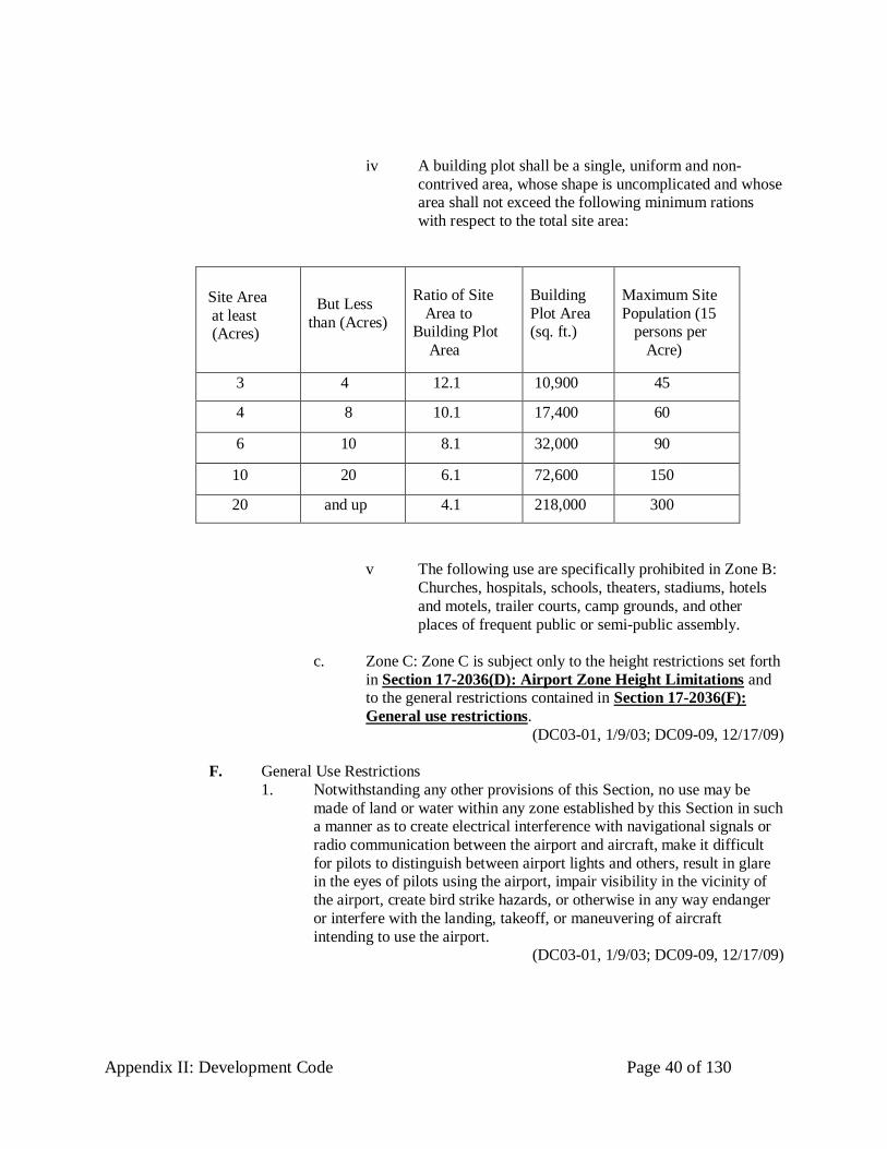
Appendix II: Development Code Page 40 of 130
iv A building plot shall be a single, uniform and non-
contrived area, whose shape is uncomplicated and whose area shall not exceed the following minimum rations
with respect to the total site area:
Site Area
at least (Acres)
But Less
than (Acres)
Ratio of Site
Area to Building Plot
Area
Building
Plot Area (sq. ft.)
Maximum Site
Population (15 persons per
Acre)
3 4 12.1 10,900 45
4 8 10.1 17,400 60
6 10 8.1 32,000 90
10 20 6.1 72,600 150
20 and up 4.1 218,000 300
v The following use are specifically prohibited in Zone B:
Churches, hospitals, schools, theaters, stadiums, hotels
and motels, trailer courts, camp grounds, and other
places of frequent public or semi-public assembly.
c. Zone C: Zone C is subject only to the height restrictions set forth
in Section 17-2036(D): Airport Zone Height Limitations and to the general restrictions contained in Section 17-2036(F):
General use restrictions.
(DC03-01, 1/9/03; DC09-09, 12/17/09)
F. General Use Restrictions
1. Notwithstanding any other provisions of this Section, no use may be
made of land or water within any zone established by this Section in such a manner as to create electrical interference with navigational signals or
radio communication between the airport and aircraft, make it difficult
for pilots to distinguish between airport lights and others, result in glare in the eyes of pilots using the airport, impair visibility in the vicinity of
the airport, create bird strike hazards, or otherwise in any way endanger
or interfere with the landing, takeoff, or maneuvering of aircraft
intending to use the airport. (DC03-01, 1/9/03; DC09-09, 12/17/09)

Appendix II: Development Code Page 41 of 130
G. Nonconforming Uses
1. Regulations Not Retroactive. The regulations prescribed in this Section shall not be construed to require the removal, lowering, or other change
or alteration of any structure or tree not conforming to the regulations as
February 1, 2001, the effective date of this Section, or otherwise interfere
with the continuance of a nonconforming use. Nothing contained herein shall require any change in the construction, alteration, intended use of
any structure, the construction or alteration of which was begun prior to
February 1, 2001, and is diligently prosecuted.
2. Marking and Lighting. Notwithstanding the preceding provision of this
Section, the owner of any existing nonconforming structure or tree is hereby required to permit the installation, operation, and maintenance
thereon of such markers and lights as shall be deemed necessary by the
Building Official to indicate to operators of aircraft in the vicinity of the
airport the presence of such airport obstruction. Such markers and lights shall be installed, operated, and maintained at the expense of the airport
owner.
(DC03-01, 1/9/03; DC09-09, 12/17/09) H. Permits
1. Future Uses. Except as specifically provided in (1), (2), and (3)
hereunder, no material change shall be made in the use of land, no structure shall be erected or otherwise established, and no tree shall be
planted in any zone hereby created unless a permit therefore shall have
been applied for and granted. Each application for a permit shall indicate
the purpose for which the permit is desired, with sufficient particularity to permit it to be determined whether the resulting use, structure, or tree
would conform to the regulations herein prescribed. If such
determination is in the affirmative, the permit shall be granted. No permit for a use inconsistent with the provisions of this Section shall be granted
unless a variance has been approved in accordance with Section 17-
2036(H)(10)(f): Variances relating to variances.
a. In the area lying within the limits of the horizontal zone and
conical zone, no permit shall be required for any tree or structure
less than seventy-five feet of vertical height above the ground, except when, because of terrain, land contour, or topographic
features, such tree or structure would extend above the height
limits prescribed for such zones.
b. In areas lying within the limits of the approach zones but at a
horizontal distance of not less than 4,200 feet from each end of
the runway, no permit shall be required for any tree or structure less that seventy-five feet of vertical height above the ground,
except when such tree or structure would extend above the
height limit prescribed for such approach zones.

Appendix II: Development Code Page 42 of 130
c. In the areas lying within the limits of the transition zones beyond
the perimeter of the horizontal zone, no permit shall be required for any tree or structure less than seventy-five feet of vertical
height above the ground, except when such tree or structure,
because of terrain, land contour, or topographic features, would
extend above the height limit prescribed for such transition zones. Nothing contained in any of the foregoing exceptions
shall be construed as permitting or intending to permit any
construction, or alteration of any structure, or growth of any tree in excess of any of the height limits established by this Section,
except as set forth in Section 17-2036(D): Airport Zone Height
Limitations.
d. Existing uses. No permit shall be granted that would allow the
establishment or creation of an obstruction or permit a
nonconforming use, structure, or tree to become a greater hazard to air navigation, than it was on the effective date of this
Ordinance or any amendments thereto or than it is when the
application for a permit is made. Except as indicated, all applications for such a permit shall be granted.
e. Nonconforming uses abandoned or destroyed. Whenever the Building Official determines that a nonconforming tree or
structure has been abandoned or more than 80 percent torn
down, physically deteriorated, or decayed, no permit shall be
granted that would allow such structure or tree to exceed the applicable height limit or otherwise deviate from the regulations
set forth in this Section.

Appendix II: Development Code Page 43 of 130
f. Variances. Any person desiring to erect or increase the height of
any structure, or permit the growth of any tree, or use property, not in accordance with the regulations prescribed in this Section,
may apply to the Board of Adjustment for a variance from such
regulations. The application for variance shall be accompanied
by a determination from the Federal Aviation Administration as to the effect of the proposal on the operation of air navigation
facilities and the safe, efficient use of navigable airspace. Such
variances shall be allowed where it is duly found that a literal application or enforcement of the regulations will result in
unnecessary hardship and relief granted, will not be contrary to
the public interest, will not create a hazard to air navigation, will do substantial justice, and will be in accordance with the spirit of
this Section. Additionally, no application for variance to the
requirements of this Section may be considered by the Board of
Adjustment unless a copy of the application has been furnished to the Airport Manager for advice as to the aeronautical effects
of the variance. If the Airport Manager does not respond to the
application within 15 days after receipt, the Board of Adjustment may Act on its own to grant or deny said application.
g. Obstruction Marking and Lighting - Any permit or variance granted may, if such actions is deemed advisable to effectuate
the purpose of this Section and be reasonable in the
circumstances, be so conditioned as to require the owner of the
structure or tree in question to install, operate, and maintain, at the owner's expense, such markings and lights as may be
necessary. If deemed proper by the Board of Adjustment, this
condition may be modified to require the owner to permit the Parish of Ascension, at its own expense, to install, operate and
maintain the necessary markings and lights.
(DC03-01, 1/9/03; DC09-09, 12/17/09)
I. Enforcement
1. It shall be the duty of the Zoning Official to administer and enforce the
regulations prescribed herein. Applications for permits and variance shall be made to the Zoning Official upon a form published for that purpose.
Applications required by this Ordinance to be submitted to the Zoning
Official shall be promptly considered and granted or denied. Application for action by the Board of Adjustment shall be forthwith transmitted by
the Zoning Official.
(DC03-01, 1/9/03; DC09-09, 12/17/09)
J. Appeals
1. Any person aggrieved, or any taxpayer affected by any decision of the Building Official, made in the administration of this Ordinance, may
appeal to the Board of Adjustments. All appeals to the Board of

Appendix II: Development Code Page 44 of 130
Adjustment shall be subject to the same rules as those outlined in Section
17-365 the Zoning Board of Adjustments duty and powers. (DC03-01, 1/9/03; DC09-09, 12/17/09)
K. Effective Date
1. The effective date for this Section shall be February 1, 2001.
2. Commentary: Sections 17-2036(A) to (K) were added to the
Development Code by the adoption of four ordinances by the Ascension Parish Council at a regular meeting on February 1, 2001.
(DC03-01, 1/9/03; DC09-09, 12/17/09)
17-2037. Chemical Emergency overlay zone - reserved
17-2038. Reserved
17-2039. Industrial Designation overlay zone - reserved
( DC09-09, 12/17/09)

Appendix II: Development Code Page 45 of 130
(This page left blank intentionally for code section expansion)

Appendix II: Development Code Page 46 of 130
(This page left blank intentionally for code section expansion)

Appendix II: Development Code Page 47 of 130
17-2040. Specific Use Criteria
(DC03-01, 1/9/03; DC09-09, 12/17/09) 17-2041. Secondary Family Residences
A. Secondary single family residences may be located on a single lot for immediate
family members of the owners. Immediate family members shall include the children, grandchildren, parents, and grandparents of the owner. Such secondary
occupancy shall not, however, exceed any density contemplated in a land use
district, with the exception of conservation districts where the density requirement shall be one secondary single family residence per one-half acre.
This relaxed density requirement in conservation districts shall only be allowed
for secondary single family residences as authorized by this provision. This provision, however, does not repeal any provision of the Ascension Parish
Regulations relating to family partitions.
(DC03-01, 1/9/03; DC09-09, 12/17/09)
17-2042. Bed & Breakfast
A. An overnight boarding establishment operated within one structure of no more
than ten (10) private bedrooms. Breakfast, including a continental breakfast, shall be served in the morning.
(DC03-01, 1/9/03; DC06-01, 11/16/06; DC09-09, 12/17/09)
17-2043. Tall Structures
A. Height restrictions on communication towers, spires, and water tanks.
1. Communication towers, spires, water tank may be built and used to a
greater height than the limit established in this section up to a limit of 250 feet, provided that, no such exceptions shall cover at any level more
than fifteen percent in area of the lot no exception may have an area at
the base greater than sixteen hundred squares feet no exception that shall be used for residential or commercial activities as defined in Appendix I,
Table A: Site Requirements by District.
2. With the exception of accessory structures. the Parish may execute a development agreement with a developer or property owner that
increases the height limitations of this section by up to twenty-five
percent (25%). (DC03-01, 1/9/03; DC09-09, 12/17/09)
B. Telecommunication Tower Standards 1. Telecommunication towers and antennas: general provision.
a. The Director shall have the authority to regulate the construction
and operation of telecommunication towers and antennas for the
public safety. (DC03-01, 1/9/03; DC09-09, 12/17/09)

Appendix II: Development Code Page 48 of 130
C. Location of telecommunications towers
1. Telecommunication Towers may be permitted in the following districts,
subject to the applicable minimum standards.
a. Industrial district
b. On property owned by the Parish, provided however, the Parish
shall authorize the publication and use of Parish property after the applicant executes a lease agreement acceptable to the Parish.
The Parish shall have no obligation whatsoever to execute such
lease even if the applicant can meet the criteria set forth herein.
2. Telecommunication towers may be permitted as a conditional use in the
following zoning districts, subject to the applicable minimum standards:
Mixed Use 2 Corridors (MU2); Mixed use corridors (MU); Crossroad commercial (CC); Medium intensity residential (RM); Transition district
(T); Business park (BP); Conservation (C); Rural (R), Industrial (IND)
and Airport (A) (DC03-01, 1/9/03; DC09-03, 2/5/09; DC09-09, 12/17/09)
D. Applications for new construction of telecommunication towers. 1. When seeking a building permit for a new tower location, the applicant
must provide the following information to the Director:
a. The location of all towers, buildings, or other structures which could serve as a platform for telecommunication antennas within
a two mile radius of the proposed tower site.
b. A full explanation outlining the reasons that the proposed
telecommunications antennas cannot be placed on the towers,
buildings, or structures listed. This explanation must be given on
each structure individually.
2. If the inability to secure a suitable lease arrangement prevents a
telecommunication antenna from being placed upon an otherwise suitable tower, building or structure, the points of disagreement,
including but not limited to proposed lease payments, must be provided
to the Director.
3. Priority Given to Co-location. Co-location of communications antennas
by more than one provider on existing or new telecommunication towers
shall take precedence over the construction of new single-use telecommunication towers.
(DC03-01, 1/9/03; DC09-09, 12/17/09)
Appendix II: Development Code Page 49 of 130
E. Minimum standards
1. Except where the terms of a development agreement modify these requirements, every telecommunications tower must meet the following
minimum standards.
a. Site Development Plan. Prior to the issuance of a building
permit, a site development plan including a horizontal and bird’s-eye view of proposed construction, which shall depict
items a-h shown below, shall be presented for approval to the
zoning official. Each application for a proposed Telecommunication Tower shall include all requirements for site
development plan approval pursuant to the Ascension Parish
Development Code. The Zoning Official may waive all or some of these provisions for stealth towers which are designed to
emulate existing structures already on the site, including but not
limited to light standards or power poles; or for co-location sites
with two or more carriers at the time of application. The site development plan shall include:
i type of structure (guyed tower, self-support, or
monopole)
ii height of the structure iii setback from the perimeter of the tower or monopole to
any residence or structure within a distance equal to
100% the height of the tower plus thirty (30) feet.
iv setbacks of the perimeter of tower from adjacent property lines
v vicinity map showing 500 ft. radius
vi location and configuration of all accessory buildings and/or external equipment cabinets
vii paving and curb cuts
viii fencing and proposed landscaping
ix Statement of engineer.
b. A statement shall be submitted, prepared by a professional
registered engineer licensed to practice in the State of Louisiana, which through rational engineering analysis certifies the tower's
compliance with applicable standards as set forth in the Building
Code, and any associated regulations; and describes the tower's capacity including an example of the number and type of
antennas it can accommodate. No tower shall be permitted to
exceed its loading capacity. For all towers attached to existing
structures, the statement shall include certification that the structures can support the load superimposed from the tower. All
towers shall have the capacity to permit multiple users; at a
minimum, monopole towers shall be able to accommodate two

Appendix II: Development Code Page 50 of 130
(2) users and at a minimum, self-support/lattice or guyed towers
shall be able to accommodate three (3) users.
i Said statement shall be presented to the Permit
Department before a permanent tower shall be issued.
The Engineer who stamps the construction plans shall be an independent registered Civil Engineer, not an
employee of the tower or communication company.
ii Additionally, upon completion a statement shall be
submitted by the Engineer stating that the structure was
built according to the plans.
c. Each application to allow construction of a Telecommunication
Tower shall include a statement that the construction and
placement of the tower:
i Is in compliance with Federal Aviation Administration
(FFA) regulations.
ii Is in compliance with the rules and regulations of other
federal or state agencies that may regulate telecommunication tower sitting, design and
construction.
iii Is in compliance with current radio frequency emissions standards of the Federal Communication Commission.
iv Will not unnecessarily interfere with public safety communications and the usual and customary
transmission or reception of radio and television service
enjoyed by adjacent residential and non-residential
properties. (DC03-01, 1/9/03; DC09-09, 12/17/09)
F. Lease and/or title to property
1. All sites shall have a lease and/or title with legal description tied by
metes and bounds to a government section corner. (DC03-01, 1/9/03; DC09-09, 12/17/09)
G. Height and setbacks
1. Elevations. All elevations shall be based on the Flood Insurance Rate Maps.
2. Height and setbacks. Height and setbacks and related location requirements shall be as follows:

Appendix II: Development Code Page 51 of 130
a. The height of a telecommunications tower shall not exceed two hundred and fifty (250) feet. Tower height shall be measured
from the ground to the highest point of the tower or any
antenna/lighting rod, whichever is higher.
b. Telecommunication Towers shall conform with the setbacks
established for the underlying zoning district.
c. Monopole, lattice or guyed Telecommunication Towers shall not
be located within seven hundred and fifty (750) feet of any
existing monopole, lattice or guyed telecommunication tower.
d. All buildings and other structures to be located on the same
property as a telecommunication tower shall conform with the
setbacks established for the underlying zoning district. (DC03-01, 1/9/03; DC09-09, 12/17/09)
H. Buffering 1. An eight (8) foot fence or wall as measured from the finished grade of
the site, shall be required around the base of any telecommunication
tower and around any necessary buildings or structures.
2. Landscaping consistent with the requirements of Section 17-2082(A):
Landscaping requirements of the Ascension Parish Development Code,
shall be installed around the entire perimeter of any fence or wall. Additional landscaping may be required around the perimeter of a fence
or wall and around any or all anchors or supports if deemed necessary to
buffer adjacent properties. The Parish may require landscaping in excess of the requirements of the Parish Code in order to enhance compatibility
with adjacent residential and non-residential land uses. Landscaping shall
be installed on the outside of the perimeter fence or wall.
3. Landscaping consistent with perimeter and on-site requirements shall be
installed around any accessory buildings or structures.
4. Equipment storage. Mobile or immobile equipment not used in direct
support of a tower facility shall not be stored or parked on the site of the
telecommunication tower, unless repairs to the tower are being made. (DC03-01, 1/9/03; DC09-09, 12/17/09)
I. Removal of abandoned or unused facilities.
1. The owner of a telecommunication tower which has been abandoned or is unused shall provide the Zoning Official with a copy of the notice to
the FCC of intent to cease operations. Within 90 days of the date of
ceasing operations, the obsolete tower and accessory structures shall be removed. Telecommunication Towers being utilized for other purposes,
including but not limited to light standards and power poles, may be

Appendix II: Development Code Page 52 of 130
exempt from this provision. The director of zoning may extend this time
period or waive this requirement if it is shown that the facility has not been abandoned.
(DC03-01, 1/9/03; DC09-09, 12/17/09)
J. Signs and advertising 1. The use of any portion of a tower for signs or advertising purposes,
including company name, banners, streamers, etc., shall be strictly
prohibited, except as required by any federal agency. This does not apply to an installation where an outdoor advertising sign is used as the base
foundation for an antenna installation.
(DC03-01, 1/9/03; DC09-09, 12/17/09)
K. Accessory building or structures
1. All accessory buildings or structures shall meet all building design
standards as listed in this Code, and in accordance with the provisions of the Southern Building Code and shall conform to FEMA requirement.
All accessory buildings or structures shall require a building permit
issued by the building department. (DC03-01, 1/9/03; DC09-09, 12/17/09)
L. Colors 1. Except where superseded by the requirements of other parish, state, or
federal regulatory agencies possessing jurisdiction over
Telecommunication Towers, Telecommunication Towers shall be
constructed of galvanized or unpainted metal or shall be painted in a neutral colors, designed to blend into the surrounding environment such
as gray.
(DC03-01, 1/9/03; DC09-09, 12/17/09)
M. Lighting
1. When lighting is required and is permitted by the FAA other federal or
state authority, it shall be of a dual mode type. (DC03-01, 1/9/03; DC09-09, 12/17/09)
N. Antennas on existing towers 1. Notwithstanding the above provisions of this ordinance, Antennas shall
be permitted to be placed on existing towers or structures with sufficient
loading capacity. A permit shall be obtained from the Permit Office prior to commencing construction. The permit application shall include a site
plan which depicts all proposed ancillary building and equipment
cabinets. The permit fee for placing antennas on existing towers or other
structures shall be five hundred dollars ($500.00). (DC03-01, 1/9/03; DC09-09, 12/17/09)
Appendix II: Development Code Page 53 of 130
O. Fees
1. Fees for communication tower construction shall be two thousand dollars ($2,000.00) per tower and shall be collected by the Permit Office. These
fees may be changed as deemed necessary.
(DC03-01, 1/9/03; DC09-09, 12/17/09)
P. Replacement of existing towers
1. Towers in existence as of June 1, 1999 may be replaced with a tower of
equal or less visual impact after approval by the Planning Director. However, if the proposed new tower would not be consistent with the
minimum standards under this section, replacement must be approved by
the Planning Commission. (DC03-01, 1/9/03; DC09-09, 12/17/09)
Q. Antennas not located on telecommunication towers
1. Antennas shall be permitted as follows:
2. Stealth rooftop or building mounted antennas may be permitted as an accessory use in the following zoning districts.
a. Mixed use 2 corridors (MU2) b. Mixed use corridor district (MU)
c. Transition district (T)
d. Crossroad commercial district (CC)
e. Business park district (BP) f. Rural district (R)
g. Industry district (IND)
h. Conservation district (C)
3. Stealth rooftop or building mounted antennas shall only be conditionally
permitted as a use in the following zoning districts subject to minimum
standards: Medium intensity residential district (RM).
4. Minimum standards. Building or rooftop antennas shall be subject to the
following minimum standards:
a. No commercial advertising shall be allowed on an antenna,
unless such antenna is actually located on an existing, approved sigh;
b. No signals, lights, or illumination shall be permitted on an
antenna, unless required by the Federal Aviation Administration; c. Any related unmanned equipment building shall not contain
more than 750 square feet of gross floor area or be more than
fourteen (14) feet in height; and

Appendix II: Development Code Page 54 of 130
d. If the equipment building is located on the roof of the building,
the area of the equipment building shall not occupy more than twenty five percent (25%) of the roof area.
e. Each application shall contain a drawing and description of the antenna including, but not limited to, colors and screening
devices. This shall be subject to administrative approval for
consistency with the definition of stealth facility. (DC03-01, 1/9/03; DC09-02, 2/5/09; DC09-09, 12/17/09)
R. Transfer of use
1. Approved telecommunications towers or antennas may be transferred to
successor and assigns of the approved party, subject to all of the
conditions which applied to initial approval of subject tower. (DC03-01, 1/9/03; DC09-09, 12/17/09)
S. Bond 1. Before any communication tower may be erected, the person so desiring
is required to post a bond in the amount of thirty thousand dollars
($30,000.00) to be maintained with the Parish, naming the Parish as oblige to insure that all public property will be repaired and/or returned
to its pre-construction state. The bond is to be held by the Parish until the
construction project is completed and the Department of Public Works
certifies that all public property has been repaired and restored to its former condition.
(DC03-01, 1/9/03; DC09-09, 12/17/09)
T. Conditional uses for telecommunication towers and antennas
1. Approval. The Zoning Commission shall have the authority to permit the
Conditional Use of land or structures as those uses relate to the location
of Telecommunication Towers and Antennas. However, if a formal appeal is lodged with the Zoning Board of Adjustment, the final decision
of any request to such approval or denial made by the Zoning
Commission shall rest with the Zoning Board of Adjustment.
2. Conditions
a. All regulations of the district in which a conditional use is
located shall apply to such uses, except where specific
differences in requirements of any section of these regulations
apply, or where requirements are specifically amended by the conditions under which the conditional use is granted.
b. Zoning Commission may attach such conditions to the conditional use as are necessary to assure continuous
conformance of all applicable standards and requirements.

Appendix II: Development Code Page 55 of 130
c. Failure to observe the conditions of the Commission, imposed pursuant to the issuance of the conditional use, shall be deemed
to be a violation of these regulations and may be grounds for
revocation of the conditional use.
d. The Zoning Commission may approve uses subject to the
regulations and to any additional requirements imposed in the
public interest to cover circumstances unique to the selected site, including a drainage analysis of the site by an independent
engineering firm.
3. General standards
a. The location and size of the use, the nature and intensity of the
operation involved in (or conducted in connection with) the use, the size of the site in relation to the use, and the location of the
site with respect to the streets giving access to the site shall be
such that the use will be in harmony with the land uses in the district in which it is located.
b. Time limit requirement for length of permit use.
c. Hours of operation for use, major buffering and/or landscaping
above the minimum parish requirements.
d. The location, nature and height of structures, walls and fences, and the nature and extent of landscaping on the site shall be such
that the use will not hinder or discourage the development and
use of adjacent land structures.
e. Parking areas shall be of adequate size for the particular use,
properly located and suitably screened from adjoining residential
uses, and the ingress and egress drives shall be laid out so as to achieve maximum safety.
f. Conditional Uses may be approved on lots of less than the minimum lot size in any zoning district, and the Zoning
Commission may require alternative standards for landscaping
and parking.
g. Conditional uses are not transferable. Once the use has ceased
activity, a new permit must be acquired to occupy the site or
reactivate the previous use. (DC03-01, 1/9/03; DC09-09, 12/17/09)

Appendix II: Development Code Page 56 of 130
U. General criteria
1. In deliberating on any application for a Conditional Use Permit, the
Zoning Commission shall not grant approval of any Conditional Use
Permit unless it makes findings based upon the evidence presented to it
that each case shall indicate the following:
2. The permit, if granted, will not cause any diminution or depreciation of
property values of any surrounding property or will not alter the essential character of the locality.
3. The permit, if granted, will tend to preserve and advance the property and general welfare of the neighborhood and community.
4. The granting of the Conditional Use Permit will not be detrimental to the
public welfare or seriously affect or be injurious to the other property or improvements in the neighborhood in which the property is located, in
that it will not impair an adequate supply of light and air, or increase
substantially the congestion in the public streets, create a traffic hazard, or permit inadequate parking, or increase the danger of fire, or
substantially affect or overburden existing drainage or sewerage systems
or endanger the public safety, nor cause serious annoyance or injury to occupants of adjoining premises by reason of emission of odors, fumes,
gases, dust, smoke, noise or vibration, light or glare or other nuisance.
(DC03-01, 1/9/03; DC09-09, 12/17/09)
V. Expiration
1. The petitioner shall have one (1) year to obtain the appropriate building permits or occupy the site from the date of approval of the Ascension
Parish Zoning Commission, unless otherwise stipulated by the Ascension
Parish Zoning Commission.
(DC03-01, 1/9/03; DC09-09, 12/17/09)
W. Procedures
1. Application. Any application verified by the owner of record or
authorized agent of said owner of the property involved shall be filed
with the Zoning Commission upon a form prescribed therefore, which shall contain, or be accompanied by, all required information.
2. Public hearings. Upon receipt of such verified application, the Zoning
Commission shall issue a notice of Public Hearing by posting the affected site in a conspicuous place at least ten (10) days prior to the
intended permit hearing. A record of pertinent information presented at
the public hearing shall be made and maintained by the Zoning Commission as part of their permanent record relative to the applicant.

Appendix II: Development Code Page 57 of 130
3. Determination. The Zoning Commission shall then make the findings
and the permit decision shall not become effective for ten (10) working days, during which time an appeal can be made in written form to the
Zoning Board of Adjustment. Should the next scheduled Zoning Board
of Adjustment meeting occur prior to the expiration of the appeal period,
the appeal must be filed in time for placement on the regularly scheduled agenda. The Zoning Board of Adjustment may sustain the conditional
use by majority vote or may overturn the decision of the Zoning
Commission by a vote of three-fifths (3/5ths). (DC03-01, 1/9/03; DC09-09, 12/17/09)
X. Fees
1. Any application submitted for conditional use shall be accompanied by a
fee of $35.
2. The application submitted by the owner of the property involved and
requesting an appeal of the decision of the Ascension parish Zoning
Commission shall be accompanied by a fee of $150.00.
3. Commentary: Sections 17-2043(B) to (X) were added to the
Development Code by two ordinances passed by the Ascension Parish Council at a regular meeting on January 20, 2000.
(DC03-01, 1/9/03; DC09-09, 12/17/09)
17-2044. Commercial and Industrial Storage Standards
A. All businesses shall store materials, supplies, merchandise or other similar
materials and equipment within a completely enclosed building or behind an adequate opaque fencing and bufferyards. See Section 17-2084: Bufferyard
requirements for a description of bufferyards. A ten-foot solid fence shall be
required around the perimeter of wrecking and salvage yards. In determining
appropriate bufferyard requirements for these uses, the zoning official shall weigh heavily the interests of adjacent property owners.
(DC03-01, 1/9/03; DC09-09, 12/17/09)
B. Commentary: Commercial and industrial storage yards can have a severe adverse
impact on the property values of adjacent property owners. The Council finds
that in the case of these businesses, a simple standard may both be adequate to provide this protection in all cases. As a consequence, the Council grants the
zoning official with broad discretion in determining the appropriate screening for
these storage facilities.
(DC03-01, 1/9/03; DC09-09, 12/17/09)

Appendix II: Development Code Page 58 of 130
17-2045. Apartments
A. Site Requirements for apartment complexes
1. The maximum number of dwelling units for an apartment building is 48 units per building.
2. Thirty percent of the total site area shall be contiguous green space with the minimum spacing between apartment buildings or an apartment
building and accessory buildings shall be twenty feet.
3. A six foot solid fence is required around the sides and rear of an apartment development.
4. Property which has frontage on a state highway shall have a minimum
setback of seventy-five feet, measured from the centerline of the
highway. (DC03-01, 1/9/03; DC09-09, 12/17/09)
17-2046. Manufactured Housing and Mobile Home Standards
A. The purpose of this Section is to provide minimum standards to safeguard public
health, property, and public welfare in Ascension Parish by establishing
standards for the placement of manufactured housing and mobile homes on individual lots or subSection development lots in the parish and distinguishing
between manufactured and mobile homes.
(DC03-01, 1/9/03; DC09-09, 12/17/09)
B. Location of manufactured housing
1. Establishment, location and use of manufactured housing as scattered site residences shall be permitted in any district permitting installation of a
single-family dwelling unit as set forth in Table B: Site Requirements
by District. Manufactured homes with no HUD Code seal are not permitted in any zoning district.
(DC03-01, 1/9/03; DC09-09, 12/17/09)
C. Standards for sitting manufactured housing

Appendix II: Development Code Page 59 of 130
1. To be eligible for sitting in the parish, manufactured housing must meet
the following requirements:
a. Permanent foundation systems shall be anchored.
b. Exterior material shall be material customarily used on site-built dwellings, such as board siding, plywood or presswood siding,
vinyl, stucco, brick, or non-reflective aluminum.
c. Roofing material shall be of wood, tile, composition shingles, or
other materials compatible with the conventionally built
residential structures in the neighborhood which shall be installed on a surface appropriately pitched for the materials
used.
d. Exterior covering material extending to the ground or to the top of the foundation shall be used. Skirting materials that harmonize
with the architectural style of the home shall be used.
2. Structural additions or alterations shall be subject to the same regulations
and requirements and procedures including building permit that must be
complied with to obtain such a permit for additions or alterations to a conventionally-built house.
3. Manufactured homes not conforming to the requirements of this section
shall not be permitted. (DC03-01, 1/9/03; DC09-09, 12/17/09)
D. Permitted placement of mobile homes 1. Class A and B mobile homes may be placed in any district permitting
installation of a single-family dwelling unit as set forth in Table B: Site
Requirements by District. Manufactured homes with no HUD Code
seal are not permitted in any zoning district.
2. Mobile homes with no Class A or B seal are not permitted in any zoning
district. Those which at the time of the adoption of this ordinance are located within the Parish are non-conforming uses, subject to the same
requirements and regulations as any other non-conforming use.
(DC03-01, 1/9/03; DC09-09, 12/17/09)
E. Existing units
1. Mobile homes legally located and existing in Ascension Parish at the
time this ordinance is passed may continue to be occupied. These mobile homes may be upgraded and replaced, regardless of the zoning district
they occupy, if the upgrading and replacement meets the requirements of
this ordinance. (DC03-01, 1/9/03; DC09-09, 12/17/09)
Appendix II: Development Code Page 60 of 130
F. Permits
1. Manufactured housing. Building permits for manufactured homes shall
be issued, providing that the other requirements for the zone are met, upon presentation of certification either by the United States Department
of Housing and Urban Development or Office of State Fire Marshal, that
the home has been constructed in accordance with the Manufactured Home Construction and Safety Standards Act. The Building Official
shall inspect the manufactured housing in accordance with Ascension
Parish building regulations.
2. Mobile homes. Building permits for Class A and Class B mobile homes
shall be issued where permitted upon receipt of certification that they are
Class A or B mobile homes and after compliance with all the other provisions of the zoning ordinance and subSection regulations. The
Building Official shall inspect the manufactured housing in accordance
with Ascension Parish building regulations. (DC03-01, 1/9/03; DC09-09, 12/17/09)
17-2047. Group Home Standards
A. This Section defines a process to inform the citizens of residential neighborhoods when group homes are established and operated within their boundaries. This
process supplements state licensing and regulatory procedures.
(DC03-01, 1/9/03; DC09-09, 12/17/09)
B. Pre-establishment operating plan
1. A group home shall provide an operating statement to Director no less than 90 days prior to the date on which it plans to commence operations.
“Commence operations” shall mean the first day during which it receives
a client for residence at the facility.
2. Operating Plan. The operating plan shall include, but is not limited to,
the following:
a. A complete description of the facilities, its clients, staff and
operating structure, its proposed operating conditions and the
terms and conditions of any state license required for its operation.

Appendix II: Development Code Page 61 of 130
b. A statement regarding how the proposed facility will be operated
to promote the purposes and guidelines of the parish-wide planning policies adopted by Ascension Parish.
c. A financial statement and staffing plan for the proposed facility,
including but not limited to the manner and method by which clients are referred to, accepted to and/or ordered to take up
residence at the facility.
d. The addresses of each funding, licensing or operating entity
involved in the operation.
e. Business license and fire inspection.
3. The Director shall review the statement for accuracy, completeness and
objectivity before releasing it to the public. An informational meeting shall be scheduled 20 days after the Director provides written notification
to persons residing within 300 feet of the facility of the availability of the
statement for review by the public. The informational meeting shall be held at the convenience of the neighborhood in a location convenient to
its residents.
4. Information Meeting. The Director shall conduct the informational meeting with a representative of the group home and the residents of the
neighborhood. The Director shall notify all landowners within 1,000 feet
of the proposed group home within 15 calendar days before the informational meeting. Notices of the meeting and an invitation to attend
it shall also be provided to all entities shown on the operating plan as
providing substantial contributions to the group home or licensing its
operations. The Director shall make every effort to encourage the funding and licensing representatives to attend.
5. Nothing in this process shall be interpreted to prohibit a group home from enjoying its primary permitted use rights.
(DC03-01, 1/9/03; DC09-09, 12/17/09)
C. Complaint procedures and facilitated meeting
1. In the event that the Parish received complaints of persons residing at
three or more residences located within 300 feet of the facility, the
Director shall schedule a public meeting under the notice procedures of the preceding section. The Director shall make every effort to encourage
the funding and licensing representatives to attend.
2. The meeting shall be conducted as a community service by the Parish to
facilitate the understanding of the community regarding the operations of

Appendix II: Development Code Page 62 of 130
the facility and to provide a convenient forum for members of the
neighborhood in which the group home is located to express their concerns regarding its maintenance, upkeep, or operations to the
appropriate operating, funding and licensing entities.
3. The Director’s role shall be to facilitate the sharing of information and
nothing herein shall be interpreted as authorization to block the entry of a properly licensed state facility into a neighborhood; provided, however,
that halfway houses are not permitted uses in any residential zone of the
Parish and these provisions are not a limitation of the Parish’s other zoning powers with regard to such halfway houses.
(DC03-01, 1/9/03; DC09-09, 12/17/09)
D. Neighborhood mediation 1. Operators of group homes and members of neighborhoods are
encouraged to utilize available dispute resolution in the event that
reasonable dialogue between neighbors and facilities cannot resolve the problems involved in the operation of the group home.
(DC03-01, 1/9/03; DC09-09, 12/17/09)
E. Civil enforcement procedure 1. Failure to file a pre-establishment plan as provided in this Section 17-
2047: Group Homes, shall be a civil violation subject to enforcement.
(DC03-01, 1/9/03; DC09-09, 12/17/09)
17-2048. Home Occupation Standards
A. A customary home occupation is a business or profession carried on by an
occupant of a dwelling as a secondary use which is clearly incidental to the main
residential use. A home occupation may be operated in any district within the parish. Any construction which occurs in connection with the conduct of a home
occupation, such as adding a home office on to a house, does not require a
development permit. To take advantage of these exemptions, a home occupation
shall comply with the following:
1. It shall be conducted by family members residing on the premises and a
maximum of two (2) additional employees on the premises at any one time.
2. It is conducted entirely within the principal building or related structures or accessory buildings and uses on the property out of sight of
neighboring properties.
3. It utilizes not more than (20) percent of the floor area of the principal building not to exceed 750 square feet, except for historic properties and
bed and breakfast establishments.

Appendix II: Development Code Page 63 of 130
4. It produces no alteration or change in the character or exterior appearance of the principal building from that of a dwelling.
5. It involves no sale or offering for sale any article not produced by
members of the family residing on the premises.
6. It shall contain no outside repair or storage.
7. It has no distribution center requiring bulk deliveries and local
dispensing.
8. It shall not be used for storage for more than one commercial vehicle
licensed as one ton or less in capacity per family residing on the
premises.
(DC03-01, 1/9/03; DC09-06, 7/16/09; DC09-09, 12/17/09)
B. The following occupations, subject to the requirements of the previous
subsection, are permitted as customary home occupations:
1. Barbershops and beauty shops operated by not more than two members
of the residence within no more than two chairs.
2. Artists, dressmakers, seamstresses, tailors, crafts, and interior decorators.
3. Professional offices for architects, accountants, lawyers, engineers, doctors or dentists, and surveyors.
4. Bed and breakfast uses where the facility has a residential appearance and adequate parking for guests is provided.
5. Teaching, musical instruction and day care limited to six pupils at a
given time.
6. Offices for record maintenance only for businesses, e.g., electricians,
plumbers, HVAC, and other contractors which perform their services at other locations.
7. Agents for manufacturers and sales persons for records and bookkeeping only. Orders may be made by telephone solicitation and certain
deliveries may be made at the dwelling.
8. Any similar use which the Zoning Official deems to be a home occupation by reason or acceptance as a home occupation in the
community.
(DC03-01, 1/9/03; DC09-06, 7/16/09; DC09-09, 12/17/09)

Appendix II: Development Code Page 64 of 130
17-2049. Adult Business Standards
A. Purpose. 1. It is the purpose of this Section to regulate sexually oriented businesses
in order to promote the health, safety, morals, and general welfare of the
citizens of the Parish, and to establish reasonable and uniform
regulations to prevent the deleterious secondary effects of sexually oriented businesses within the parish. The provisions of this Section have
neither the purpose nor effect of imposing a limitation or restriction on
the content or reasonable access to any communicative materials, including sexually oriented materials. Similarly, it is not the intent nor
effect of this ordinance to restrict or deny access by the distributors and
exhibitors of sexually oriented entertainment to their intended market. Neither is it the intent nor effect of this ordinance to condone or
legitimize the distribution of obscene material.
(DC03-01, 1/9/03; DC09-09, 12/17/09)
B. Findings.
1. Based on evidence of adverse secondary effects of adult uses presented
in hearings and reports made available to the Council, and on findings, interpretations, and narrowing constructions incorporated in the cases of
Pap’s A.M. v. City of Erie, 529 U.S. 277 (2000); City of Los Angeles v.
Alameda Books, Inc., 122 S. Ct. 1728 (2002); City of Renton v. Playtime Theatres, Inc., 475 U.S. 41 (1986); Young v. American Mini Theatres,
426 U.S. 50 (1976); Barnes v. Glen Theatre, Inc., 501 U.S. 560 (1991);
FW/PBS, Inc. v. City of Dallas, 493 U.S. 215 (1990); California v.
LaRue, 409 U.S. 109 (1972); Baby Dolls Topless Saloons, Inc. v. City of Dallas, 2002 U.S. App. LEXIS 12202 (5th Cir., June 20, 2002); LLEH,
Inc. v. Wichita County, 289 F.3d 358 (5th Cir 2002); Hang On, Inc. v.
City of Arlington, 65 F.3d 1248 (5th Cir. 1995); Woodall v. City of El Paso, 49 F.3d 1120 (5th Cir. 1995); J & B Entertainment, Inc. v. City of
Jackson, 152 F.3d 362 (5th Cir. 1998); SDJ, Inc. v. City of Houston, 837
F.2d 1268 (5th Cir. 1988); TK’s Video, Inc. v. Denton County, 24 F.3d
705 (5th Cir. 1994); Lagrange Trading Co. v. Nicolosi, 1991 U.S. Dist. LEXIS 3551 (E.D. La. 1991); Vonderhaar v. Parish of St. Tammany,
633 So. 2d 217 (La. Ct. App. 1993); Liberto v. Rapides Parish Police
Jury, 667 So. 2d 552 (La. Ct. App. 1990); City of Gretna v. Russland Enterprises, Inc. 564 So. 2d 367 (La. Ct. App. 1990); and other cases;
and on testi- mony to Congress in 136 Cong. Rec. S 8987; 135 Cong
Rec. S 14519; 135 Cong. Rec. S 5636; 134 Cong Rec. E3750; and reports of secondary effects occurring in and around sexually oriented
businesses, including, but not limited to, Phoenix, Arizona - 1984;
Minneapolis, Minnesota -1980; Houston, Texas - 1997; Indianapolis,
Indiana - 1984; Amarillo, Texas -1977; Garden Grove, California - 1991; Los Angeles, California - 1977; Whittier, California - 1978; Austin,
Texas -1986; Seattle, Washington - 1989; Oklahoma County, Oklahoma
- 1986; Cleveland, Ohio - 1977; and Dallas, Texas - 1997; St. Croix County, Wisconsin - 1993; Bellevue, Washington - 1998; Newport

Appendix II: Development Code Page 65 of 130
News, Virginia - 1996; New York Times Square study - 1994; Phoenix,
Arizona - 1995-98; and also findings of physical abuse from the paper entitled “Stripclubs According to Strippers: Exposing Workplace Sexual
Violence,” by Kelly Holsopple, Program Director, Freedom and Justice
Center for Prostitution Resources, Minneapolis, Minnesota and from
“Sexually Oriented Businesses: An Insider’s View,” by David Sherman, presented to the Michigan House Committee on Ethics and
Constitutional Law, Jan 12, 2000, and the Report of the Attorney
General’s Working Group On The Regulation Of Sexually Oriented Businesses, (June 6, 1989, State of Minnesota), the Council finds that
providing specific zoning standards for sexually oriented businesses is
necessary to advance the health, safety and welfare of the community. (DC03-01, 1/9/03; DC09-09, 12/17/09)
C. Classification.
1. Sexually oriented businesses shall be classified as follows:
a. Adult bookstores, adult novelty stores, adult video stores;
b. Adult cabarets; c. Adult motels;
d. Adult motion picture theaters;
e. Semi-nude model studios. (DC03-01, 1/9/03; DC09-09, 12/17/09)
D. Location Requirements
1. No sexually oriented business shall be located as follows:
a. Within three thousand feet of the property line of a private residential dwelling;
b. Within three thousand feet of the property line of any public
library;
c. Within three thousand feet of the property line of any church,
shrine, chapel, mortuary, or any other place used regularly for religious services;
d. Within three thousand feet of the property line of any school or day care center. “School” shall include only such public, private,
and church-sponsored schools as regularly teach the subjects
taught in the primary and secondary school of Louisiana;
e. Within three thousand feet of a regular stop where a school bus
for the transportation of children boards or discharges
passengers;

Appendix II: Development Code Page 66 of 130
f. Within the same building as another sexually oriented business;
or upon the same parcel as another sexually oriented business with at least three thousand (3,000) feet between them,
simultaneous existence of both businesses shall be allowed under
this section.
g. The distance restrictions apply in any and all directions from the
property line of the proposed adult business, as measured in a
straight line. This distance shall be verified by a plat showing distances furnished by the applicant. This plat shall accompany
and be made a part of the application for a development permit.
(DC03-01, 1/9/03; DC09-09, 12/17/09)
E. Effective Date
1. Section 17-2049 shall become effective on January 1, 2003. However,
sexually oriented businesses which were in existence as of the effective date of this Section shall be considered nonconforming uses and shall
continue to operate pursuant to the nonconforming uses section of this
Code.
2. Commentary: Sections 17-2049 were added to the Development Code by
the adoption of an ordinance by a regular meeting of the Ascension Parish Council on November 21, 2002.
(DC03-01, 1/9/03; DC09-09, 12/17/09)
17-2050. Alcohol Beverage Business Standards
A. Purpose. Commercial businesses serving alcohol pose potential public safety
problems. In issuing a development permit for these businesses, the Zoning
Commission may provide such terms and conditions in order to assure that development is compatible with existing or planned development on neighboring
property.
(DC03-01, 1/9/03; DC09-09, 12/17/09)
B. Conditions on alcoholic beverage sales. The terms and conditions may include,
but are not limited to, the following:
1. Frequency, duration or hours of operation;
2. Additional screening, setbacks, parking, landscaping, or site improvements;
3. Method or type of service, such as drive through, with meals only, or
package sales only; and
Appendix II: Development Code Page 67 of 130
4. Designated areas within a building or site where alcoholic beverages may
be sold. (DC03-01, 1/9/03; DC09-09, 12/17/09)
Author Note: Also cross reference Code of Ordinance Requirements: Adult Business

Appendix II: Development Code Page 68 of 130
(This page left blank intentionally for code section expansion)

Appendix II: Development Code Page 69 of 130
17-2060. Drainage and Traffic
A. Contracts required for drainage and traffic infrastructure
(DC03-01, 1/9/03; DC09-09, 12/17/09)
B. The purpose of this section is to encourage landowners and developers in Ascension Parish to provide adequate and reasonable drainage and traffic
infrastructure to support development.
(DC03-01, 1/9/03; DC09-09, 12/17/09)
C. The purpose of this section is to provide procedures and minimum requirements
for the execution of contracts between those persons having an equitable interest in property and the Parish of Ascension. The Parish Council hereby authorizes
the Zoning Commission to enter into said contracts on behalf of Ascension by
virtue of this ordinance. A contract providing for mitigation of drainage and
traffic impacts shall be required for all developments specified as requiring such contract in Appendix I, Table A: Site Requirements by District.
(DC03-01, 1/9/03; DC09-09, 12/17/09)
D. Commentary. New development in the parish imposes additional costs in roads,
schools, and public safety in general. To avoid undue hardship on the taxpayers
of Ascension Parish, these additional burdens imposed upon the Parish should be addressed prior to development taking place. Those developing the property
should take responsibility for the additional burdens by providing additional
infrastructure.
(DC03-01, 1/9/03; DC09-09, 12/17/09)
E. Applicability
1. This Section applies to all developments specified in Appendix I, Table
A: Site Requirements by District as requiring a contract for drainage
and traffic infrastructure improvements. This Section does not apply to
residential uses, other than multi-family residential uses, as those uses
already have similar requirements in place in order to acquire preliminary and final approval of plats.
2. Laws in effect. The allowed uses, densities and standards of the land subject to such contracts shall be those in effect at the time the contract is
executed by the parties.
3. Subsequent actions. A contract as contemplated herein between the
Parish and a party with an equitable interest in the property, shall not
prevent the Parish, in subsequent actions applicable to the property, from
adopting new ordinances, resolutions and regulations, except that any subsequent action by the Parish shall not prevent the development of the
property as agreed to by the parties in the contract.

Appendix II: Development Code Page 70 of 130
4. The parish may suspend the issuance of building permits for the project subject to the contract after a noticed public hearing before the Parish
Council if it finds in good faith that a clear and present emergency
requires the suspension.
5. In the event that state or federal laws or regulations enacted after the
contract has been entered into, prevent or preclude compliance with one
or more of the provisions of the development agreement, the offending provisions shall be modified or suspended as necessary to comply with
the new law or regulation. Any such action shall be taken by the Parish
Council after a noticed public hearing. (DC03-01, 1/9/03; DC09-09, 12/17/09)
F. Procedure
1. Any owner of real property, or developer of real property with the consent of the owner, who desires to develop the property for a use
designated under Appendix I, Table A: Site Requirements by District
as requiring a contractual relationship with the Parish, shall adhere to the following requirements:
a. The landowner, or developer with the owner's written consent (hereafter referred to as the "applicant") shall submit a request
for a preliminary meeting with the Planning Department prior to
negotiating a contract with the Ascension Parish Zoning
Commission.
b. Said meeting shall be attended by the Director of the Planning
Department or his designee, Zoning Official or his designee, Chairman of Planning and Zoning Commission or his designee,
the parish council member in whose district the development is
proposed, a representative or representatives of the Department
of Public Works with knowledge of drainage and traffic infrastructure needs of the Parish, the engineer from the
Department of Public Works responsible for overseeing such
projects as contemplated by the developer or landowner, the developer of the property, and his engineer. Failure of one or
more parties to attend the meeting shall not invalidate the same.
Those representatives of the Parish shall be referred to hereafter as the "review Panel".
c. Said preliminary meeting shall be held at a specific time and on a
specific date set by the Zoning Commission for such meetings. Requests for such meeting shall be submitted by the developer
with the landowner's written consent, or by the landowner, at
least 14 days prior to the next scheduled meeting.

Appendix II: Development Code Page 71 of 130
d. The request shall be made on forms provided by the Planning
Department and shall contain all information requested on said forms.
e. The Planning Department is authorized to receive, review and
process all applications for such meetings.
f. At said meeting, the developer, his engineer, and/or the
landowner shall present to the Parish representatives referred to in paragraph (2) above a conceptual plan of the development,
indicate all roads impacted directly by said development, show
all drainage to a publicly maintained ditch or waterway, verify the zoning district, show all uses anticipated for the land, and
indicate the maximum height and size of proposed buildings in
the development.
g. Immediately following the meeting, the Planning Department
may request additional information from the applicant. Any
additional information required should be submitted to the Planning Director prior to the next regular meeting held for the
purpose of preliminary review of developments requiring a
contractual agreement with the parish, unless an extension of time is granted by the Planning Director. The panel reviewing
such developments shall advise the applicant of the specific date
by which such additional information must be received. The
matter will only be place on the agenda of the next regularly scheduled meeting if it is timely received.
h. Upon satisfactory submission to the review panel of all information requested, the panel shall authorize the Planning
Director to negotiate a contract with the applicant to address all
pertinent infrastructure issues, under the terms and conditions set
forth by the panel. Terms and conditions may include drainage and/or traffic impact studies to be done according to guidelines
established by the Zoning Commission.
i. Said contract may require road improvements, right-of-way
agreements, drainage improvements, or any other conditions
deemed necessary for the protection of the drainage and traffic infrastructure of the Parish. This list is merely illustrative and is
not meant to be all inclusive. This contract must include;
i a legal description of the land subject to the contract
ii proposed duration of the contract
iii permitted uses of the land

Appendix II: Development Code Page 72 of 130
iv density and/or intensity of uses
v maximum height and size of proposed buildings
vi provisions, if any, for the dedication or reservation of
apportion of the land for public use or green space
vii procedures and required submissions for review of the
agreement by the Zoning Commission at least every three months, to establish that the applicant or his
successor in interest demonstrates good faith compliance
with the contract
viii provisions that require construction of any
improvements pursuant to the contract to commence
within a specified period of time and specifying a completion date unless extended by the Parish for good
cause.
ix restrictions on the assignability of the contract by the
applicant, and if assignable, provisions ensuring that the
successor in interest assumes the obligation under the contract provisions for any modification of the contract,
and
x any other terms and requirements the parties may deem necessary and proper, including requirements for
ensuring, to the satisfaction of the Parish, performance
of all provisions of the agreement in a timely manner by the applicant.
j. Upon the negotiation of a contract, the same shall be presented to
the Zoning Commission for approval and shall be presented in a public hearing to the Zoning Commission. Notice of said public
hearing shall be provided to adjacent property owners. The
Zoning Commission shall take one of the following actions upon closing of the public hearing:
i Accept the contract as submitted ii Accept the contract subject to specified conditions not
included in the contract as submitted
iii Reject the contract
k. If approved, the contract shall be signed by the Chairman of the
Zoning Commission on behalf of the Commission as a whole.
(DC03-01, 1/9/03; DC09-09, 12/17/09)

Appendix II: Development Code Page 73 of 130
G. Periodic Review
1. The Zoning Commission shall review the contract periodically to ensure compliance with it terms. Said review shall occur every three months, or
sooner if deemed necessary by the Zoning Commission.
a. Good Faith Compliance. As part of the review, the applicant or
successor in interest shall be required to demonstrate good faith compliance with the terms of the contract.
b. Termination or modification. If the Zoning Commission finds, on the basis of substantial evidence, that the applicant or his
successor in interest has not complied in good faith with the
terms and/or conditions of the contract, the Zoning Commission may take action to terminate or modify the contract.
c. Action to terminate or modify the contract may be initiated only
by the Zoning Commission.
d. No action to terminate or modify the contract shall be taken
without a noticed public hearing. (DC03-01, 1/9/03; DC09-09, 12/17/09)
H. Amendment or Cancellation of Contract
1. A contract under this Section may be amended or canceled, in whole or
in part, by mutual consent of the parties to the agreement or their
successors in interest, as set forth in this section.
a. Notice of intention to amend or cancel any portion of the contract must be published in the official journal of Ascension
Parish at least ten days prior to the public hearing before the
Zoning Commission.
b. The Zoning Commission shall conduct a public hearing to
address amendment or cancellation of any portion of the
contract. Notice of the hearing shall be mailed via certified mail to adjacent property owners.
c. Following the public hearing, the Zoning Commission may approve an amendment to the contract if it is consistent with the
Master Plan. The Zoning Commission must state reasons why
the contract must be modified to promote the public interest and welfare of the Parish and the reasons why proposed departures
form the Development Code regulations, if any, are in the public
interest.
(DC03-01, 1/9/03; DC09-09, 12/17/09)

Appendix II: Development Code Page 74 of 130
I. Recordation
1. The approved and executed contract, any approved and executed
amendments to the contract, and notice of any action taken to cancel all
or part of the contract shall be recorded with the Ascension Parish Clerk
of Court at the applicant's expense. (DC03-01, 1/9/03; DC09-09, 12/17/09)

Appendix II: Development Code Page 75 of 130
17-2070. Development Standards
A. The Ascension Parish development standards fall into four categories:
1. Use regulations. These regulations determine how land in the parish can be used. The intent is to separate incompatible activities in order to
protect public health, public safety, and property values. Use regulations
are also designed to focus the most intensive activity into areas of the parish that fall outside the 100 year flood plain and can be supported by
existing and planned public infrastructure.
2. Structure regulations. These regulations focus on the intensity of
development. Structure regulations are designed to balance the impact of
development with the available infrastructure. The intent is to insure that
development projects can be supported by surrounding public infrastructure and do not aggravate traffic and drainage problems in the
parish.
3. Site regulations. These regulations determine the character of
development on the site and the access of the site to the parish highway
system. The intent is to position structures on the site in such a way as to protect public health, public safety and. property values. They include
regulations for setbacks, minimum lot sizes and height restrictions.
4. Other regulations. These regulations are designed to meet specific policy goals, such as protecting the environment, protecting property values,
and promoting public health and safety. They include sign regulations,
parking regulations, landscaping regulations, adult business and alcohol-related business regulations.
(DC03-01, 1/9/03; DC09-09, 12/17/09)
B. To provide flexibility to land use regulation in the parish, this Chapter authorizes the Parish to enter into contract agreements designed to mitigate the impact of
development on the parish. Contract agreements may modify structure and other
regulations in the parish, but they may not alter use regulations. (DC03-01, 1/9/03; DC09-09, 12/17/09)
C. Commentary: Most conventional zoning ordinances establish districts with a single use. Unlike this traditional approach to zoning, this ordinance encourages
compatible mixed uses within districts. Use regulations are common to zoning
ordinances. Unfortunately, most ordinances follow confusing classification
schemes that overlap or leave large gaps. To address this problem, the parish is incorporating the Land Based Classification Standards (LCBS) developed by the
American Planning Association.
(DC03-01, 1/9/03; DC09-09, 12/17/09)

Appendix II: Development Code Page 76 of 130
D. This ordinance also regulates the intensity of development within each district.
To accomplish this goal, the parish again refers to the LCBS and focuses on the
types and size of structures that can be built within each district. In the case of residential uses, intensity is defined as residential units per acre. In terms of
commercial and industrial development, the intensity is defined by the floor area
of the project. These measures are easy to calculate. They are designed to promote high intensity development where it can be supported by existing and
planned road, water and sewer investments.
(DC03-01, 1/9/03; DC09-09, 12/17/09)
E. Finally, the Parish encourages contract agreements in order to accommodate
projects to the available infrastructure in the parish. A contract agreement is a binding contractual agreement between the building permit applicant and the
Parish. To learn more about contract agreements, refer to Section 17-2060
Impact Analysis and Contract Agreements. (DC03-01, 1/9/03; DC09-09, 12/17/09)
F. The following step-by-step guide provides an aid to property owners and
prospective developers. It sets forth the summary of a process to determine what
may or may not be permitted on a particular site, and, if permitted, the scale of
the project that may be allowed.
1. Step 1. Identify the zoning district in which the particular parcel is
located. Zoning districts are outlined in Section 17-2010 of this code and on the Official Zoning Map of Ascension Parish.
2. Step 2. Determine the general use categories for the proposed project by
looking at Appendix I, Table A: Permitted Uses by District. If the property owner cannot identify the appropriate activity category for the
project, contact the Planning Office for assistance.
3. Step 3. Determine the allowable scale of the project allowed by referring to Appendix I, Table B: Site Requirements by District. This table
outlines the restrictions on the size of development that is allowable.
4. Step 4: Determine the site requirements of the project by referring to
Appendix I, Table B: Site Requirements by District. These
restrictions govern the location of structures on the site.
5. Step 5. Determine if the project falls into an overlay zone, which may
impose additional requirements on development. Refer to Section 17-
2030, Development Standards for Overlay Zones.

Appendix II: Development Code Page 77 of 130
6. Step 6. Determine if any additional regulations apply to your project by
reviewing Section 17-2040, Specific Use Criteria & 17-2080, Development Requirements.
7. Step 7. Determine if a contract agreement is appropriate to the project.
The parish encourages a partnership with private developers through contract agreements. Developers must complete an impact analysis
before submitting a proposed contract agreement. Refer to Section 17-
2060 Contracts Required for Drainage and Traffic Infrastructure. (DC03-01, 1/9/03; DC09-09, 12/17/09)
17-2071. Use Regulations
A. Appendix I, Table A: Site Requirements by District, “Permitted Uses by
District” is incorporated by reference as part of this Chapter. For the purpose of
this Chapter, the term, “use” represents an observable characteristic of land based
on actual use. (DC03-01, 1/9/03; DC09-09, 12/17/09)
B. Commentary. Use regulations refer to the actual use of land based on its observable characteristics. It describes what actually takes place in physical or
observable terms, such as farming, shopping, manufacturing, vehicular
movement. An office activity, for example, refers only to the physical activity on the premises, which could apply equally to a law firm, a nonprofit institution, a
court house, a corporate office, or any other office use. Similarly, residential uses
in single-family dwellings, multifamily structures, manufactured houses, or any
other type of building, would all be classified as residential activity. (DC03-01, 1/9/03; DC09-09, 12/17/09)
C. These “use” regulations must be read by referring to Appendix I, Table A:
Permitted Uses by District and Section 17-2071: Use Requirements by
District and subsections. Section 17-2060 specifies the uses that may be
permitted if they are accompanied by an acceptable contract agreement.
(DC03-01, 1/9/03; DC09-09, 12/17/09)
D. Use permitted by right.
1. A use denoted by the letter “A” in Appendix I, Table A: Site
Requirements by District in any district is a use permitted by right,
provided that all other requirements of state law and this Chapter have
been met and provided that a development permit has been issued in accordance with Section 17-2090, Administration and Enforcement.
(DC03-01, 1/9/03; DC09-09, 12/17/09)

Appendix II: Development Code Page 78 of 130
E. Permitted Uses
1. Use Permitted under development agreements. a. A use denoted by the letter “CA” in Appendix I, Table A: Site
Requirements by District in any district is only permitted if the
property owner has a valid, executed contract agreement with the
Parish prior to obtaining a development permit.
b. Commentary: These uses involve large scale, complex projects
that often involve a phased build-out. These projects are of a scale that a contract agreement between the Parish and property
owners is required to assure each party that the parish and the
owner will provide the traffic and drainage improvements required for the development. Projects of this type can proceed
only if the parish executes a contract agreement that mitigates
adverse impacts from the development. See Section 17-2060:
Contracts Required for Drainage and Traffic Infrastructure. (DC03-01, 1/9/03; DC09-09, 12/17/09)
F. Prohibited Uses
1. If the use has no designation in Appendix I, Table A: Site
Requirements by District, it is prohibited within the district.
2. Commentary. The only way for a development project to proceed under this circumstance is for the property owner to seek a variance or
rezoning. Procedures for a variance are set forth in Section 17-2090(Q).
(DC03-01, 1/9/03; DC09-09, 12/17/09)
G. Nonconforming Uses
1. This ordinance does not extend to buildings or land which fail to
conform to the uses set forth in this Chapter on the date of enactment of this ordinance. The lawful use of any building or land existing as of the
date of enactment of this ordinance may be continued, although such use
does not conform with the provisions of this ordinance, provided that:
a. No nonconforming use shall be extended to displace a
conforming use.
b. A building that contains a nonconforming use may not be reconstructed or structurally altered in excess of fifty percent
(50%) of the assessed value of the building prior to construction,
unless the building is changed to a conforming use approved by the Zoning Commission.
c. A nonconforming land use maybe expanded by no more than
50% of the original nonconforming site.

Appendix II: Development Code Page 79 of 130
d. Any nonconforming structure declared unsafe by an agent of the
Parish may be restored to a safe condition.
e. Once changed to a conforming use, no building or land shall be
permitted to revert to a nonconforming use.
f. Whenever a building or land used in whole or in part for a
nonconforming use becomes and remains vacant for a
continuous period of 180 days, or whenever the nonconforming commercial operations carried on in such a building or on such
land have been discontinued for a period of more than 180 days,
subsequent use of the property must conform to the provisions of this ordinance.
g. An abandoned nonconforming use may be re-established within
90 days after the 180th day of the abandonment upon a showing that the continuation of a conditional onconforming use would
not adversely affect the health, safety, or welfare of the public
and is in substantial compliance with existing or permitted uses of adjacent properties.
h. This section shall apply to any nonconforming uses which may arise whenever the boundaries of a district are altered.
2. Commentary: The use regulations established by this ordinance are
designed to guide future development in the Parish. The ordinance groups compatible and related uses, and, through this approach, promotes
and protects the public health, safety and welfare. At the effective date of
this ordinance, uses which do not conform to this ordinance inevitably existed. The continuation of these uses frequently undercuts the
effectiveness of the ordinance. At the same time it would be unfair to
restrict these nonconforming uses heavily. The best course is to bring
about the gradual elimination of these nonconforming uses. This ordinance permits nonconforming uses to continue without any specific
time limits. However, the ordinance does discourage further investments
in these nonconforming uses and uses of a similar nature. Such investments would make these uses more, rather than less, permanent.
(DC03-01, 1/9/03;DC07-01, 3/15/07; DC09-09, 12/17/09)
17-2072. Structure and Lot Regulations
A. Appendix I, Table B: Site Requirements by District, is incorporated as part of
this Ordinance. Structure refers to the type of structure or building on the land.
(DC03-01, 1/9/03; DC09-09, 12/17/09)

Appendix II: Development Code Page 80 of 130
B. Commentary: Land-use terms embody a structural or building characteristic,
which indicates the utility of the space (in a building) or land (when there is no building). Land-use terms, such as single-family house, office building,
warehouse, hospital building, or highway, also describe structural characteristic.
Although many activities and functions are closely associated with certain
structures, it is not always so. Many buildings are often adapted for uses other than its original use. For instance, a single-family residential structure may be
used as an office. To sort out this confusion, this ordinance clearly separates use
regulation from structure regulation. (DC03-01, 1/9/03; DC09-09, 12/17/09)
C. Lot requirement 1. Every building erected, reconstructed, converted, moved, or structurally
altered shall be located on a lot of record, and no more than one main
building shall be located on one lot, unless otherwise provided for in this
ordinance. This restriction does not apply to apartment buildings. (DC03-01, 1/9/03; DC09-09, 12/17/09)
D. Structure requirement 1. No building or land shall be developed, built, used, moved, altered or
occupied unless the building or land conforms with the structure
requirements specified for the district in which it is located. This restriction shall not apply to property meeting the definition of Non-
conforming uses in Section 17-2071(G).
(DC03-01, 1/9/03; DC09-09, 12/17/09)
E. Structures permitted by right
1. A structure denoted by the letter “A” in Appendix I, Table B: Site
Requirements by District in any district is a structure permitted by right, provided that all other requirements of state law and this Ordinance
have been met and provided that a building permit has been issued in
accordance with Section 17-2090: Administration and Enforcement.
The intent is to allow the construction of structures that promote the development of each district.
(DC03-01, 1/9/03; DC09-09, 12/17/09)
F. Structures permitted under development agreements
1. A structure denoted by the letter “CA” in Appendix I, Table B: Site
Requirements by District in any district is only permitted if the building permit holder has a valid, executed contract agreement with the
Parish prior to obtaining a development permit. These development
projects are compatible with the character of a district, but they are likely
to have a significant impact on the available infrastructure or environment. The purpose of this designation is to provide flexibility for
the parish, by encouraging the development of these types of
developments, if the property owner or developer has executed a contract agreement to mitigate adverse impacts.

Appendix II: Development Code Page 81 of 130
2. Commentary: In certain circumstances, a property owner may enter into
a contract agreement with the Parish. Projects of this type can proceed only if the parish executes a contract agreement that mitigates adverse
impacts from the development. See Section 17-2060: Contracts Required
for Drainage and Traffic Infrastructure.
(DC03-01, 1/9/03; DC09-09, 12/17/09)
17-2073. Site Requirements
A. Overview of site requirements
1. Appendix I, Table B: Site Requirements by District: Site
Requirements by District is incorporated as part of this Ordinance. Site
development requirements govern the overall physical development of lots within each district.
2. Commentary. Site requirements describe “what is on the land” in general
physical terms. These requirements incorporate activity and structure requirements to describe the overall site development characteristics of
each district.
(DC03-01, 1/9/03; DC09-09, 12/17/09)
B. Site requirements
1. Site requirements fall into the following categories:
a. Height restrictions
b. Density restrictions
c. Minimum lot size restrictions d. Lot frontage restrictions
e. Setback restrictions
(DC03-01, 1/9/03; DC09-09, 12/17/09)
C. Purpose and intent: Height restrictions
1. The purpose of height restrictions is to control the density of
development within the parish and to keep buildings within the protective capability of parish fire equipment.
(DC03-01, 1/9/03; DC09-09, 12/17/09)
D. Purpose and intent: Density restrictions
1. The purpose of density restrictions is to supplement height restrictions in controlling the density of development in the parish. Managing
development density promotes public health and safety by insuring that
adequate infrastructure is in place to support development.

Appendix II: Development Code Page 82 of 130
2. Commentary: Height restrictions are one of the oldest forms of land use
control. Unfortunately, height restrictions alone are a limited tool in managing the density of development. Because the parish is growing
quickly, additional density controls are needed to balance development
with available infrastructure. Rather that use a more complicated
measure of density such as floor area ratio, the Parish uses a clear measure of density. In the case of residential development, density is
measured by dwellings per acre. In the case of commercial development,
density is measured by the gross square footage of the building.
3. The residential density and base site area are calculated using the
following steps.
a. Step 1. Determine the gross site area by an actual on site survey.
Do not include any land which is not contiguous to the parcel.
This includes any property which does not abut, adjoin, or share a common boundary with the rest of the development.
b. Step 2. Divide the proposed number of residential units by the gross site area. This equals the proposed residential density of
the parcel. The residential density must be lower than the
standards set forth in Appendix I, Table B: Site Requirements
by District Residential development standards.
4. Managing the size of commercial developments provides the parish with
the most direct way to manage the public safety problems created by
traffic congestion. To meet this objective, this ordinance relies on commercial density standards, calculated as maximum floor areas.
Because the goal is to manage traffic congestion, this standard includes
all buildings, existing and proposed, regardless of use, on a parcel. (DC03-01, 1/9/03; DC09-09, 12/17/09)
E. Purpose and intent: Minimum lot and lot frontage restrictions.
1. Minimum lot size and lot frontage restrictions are intended to enhance property values by requiring that structures within districts be built on
lots of uniform minimum size. Minimum lot size and lot frontage
restrictions also serve to promote the public health safety and welfare of the parish by controlling development density.
2. Commentary. Within each district, the Parish has established minimum lot sizes after consultation with citizens, property owners and developers.
These minimum lot sizes provide for a diversity of residential housing in
the parish, while preserving the rural character of the parish.
(DC03-01, 1/9/03; DC09-09, 12/17/09)

Appendix II: Development Code Page 83 of 130
F. Purpose and intent: Setback and yard requirements.
1. Setback and yard requirements provide another measure of density control and to manage the demand for public services. These restrictions
are also intended to provide flexibility in widening parish roads for the
installation of water and sewer lines.
(DC03-01, 1/9/03; DC09-09, 12/17/09)

Appendix II: Development Code Page 84 of 130
(This page left blank intentionally for code section expansion)

Appendix II: Development Code Page 85 of 130
17-2080. Development Requirements
A. Overview of other development requirements
B. The Parish has adopted the following other development requirements:
1. Off street parking requirements
2. Landscaping for off street parking 3. Commercial property landscaping standards
4. Bufferyard requirements
5. Street access standards 6. Commercial and industrial storage standards
7. On premises sign standards
8. Off premises sign standards 9. Lighting standards
10. Waste discharge standards
(DC03-01, 1/9/03; DC09-09, 12/17/09)
17-2081. Off Street Parking Requirements
A. In all districts, off street parking standards shall be applied at the time any building is erected, at the time any principal building is increased in floor area, or
before a building is converted from one type of use to another. These standards
include the minimum number of off street parking spaces required, the required number and dimensions of handicapped accessible parking spaces, and standards
for parking lot construction:
(DC03-01, 1/9/03; DC09-09, 12/17/09)
B. Minimum Off street Parking Spaces. The minimum number of off street parking
spaces for each type of structure shall be:
Single family residences 2 spaces
Apartment buildings, hotels, motels and
bed and breakfast establishments
One space for each bedroom
Retail and commercial buildings: 1 per 200 sf of GFA
Public assembly buildings, including
schools, auditoriums, theaters, churches,
funeral homes:
One space for each five seats of seating capacity.
Industrial buildings: One space for each employee on the largest shift
(DC03-01, 1/9/03; DC09-09, 12/17/09)
C. At its discretion the Commission may reduce these parking standards by twenty-
five percent (25%) to achieve the objectives of this ordinance. These standards
may also be modified by a development agreement. (DC03-01, 1/9/03; DC09-09, 12/17/09)

Appendix II: Development Code Page 86 of 130
D. Handicapped Access Parking Regulations. Regulations and dimensions for
handicapped parking spaces have been taken from the Americans with
Disabilities Act (Public Law 101-136). This act prohibits discrimination on the
basis of disability in places of public accommodations and commercial facilities.
(DC03-01, 1/9/03; DC09-09, 12/17/09)
E. Every parking lot serving a retail, commercial or industrial building shall have at
least 1 handicapped accessible parking space. For every twenty five spaces in
excess of twenty five spaces, the parking lot shall have an additional handicapped accessible space.
1. Accessible-parking spaces serving a particular building shall be located on the shortest accessible route of travel from adjacent parking to an
accessible entrance. In parking facilities that do not serve a particular
building, or buildings with multiple entrances, accessible parking shall
be located on the shortest the shortest practical distance from the entrance to the parking lot.
2. Accessible-parking spaces shall be at least one hundred twenty inches
wide. 3. Parking access aisles shall be part of an accessible route to the building
or parking lot entrance; two accessible spaces may share a common
access aisle. 4. Access aisles adjacent to accessible spaces shall be sixty inches wide
minimum. One in every eight-handicapped/accessible space, but not less
than one, shall be served by an access aisle ninety-five inches wide
minimum and shall be designated “van accessible.” 5. Signs: Handicapped accessible parking spaces shall be designated as
reserved by a sign showing the symbol of accessibility. Such signs shall
be located so they cannot be obscured by a vehicle parked in that space. (DC03-01, 1/9/03; DC09-09, 12/17/09)
F. The following standards shall apply for the design of parking lots:
1. To the extent possible, the required space for any number of separate
uses should be combined in one lot. All required parking for all uses
shall be either is on the same lot or within three hundred feet of the building (or open use area) it to serve. No required parking spaces may
be located across any major street from the use it is intended to serve.
2. Except for parcels of land devoted to one- and two- family residential
uses, all areas devoted to off street parking shall be so designed and be of
such size that no vehicle is required to back into a public street to obtain
access.
3. Each parking space shall be not less than two hundred square feet in area.
Except for single family residences, all parking spaces, aisles and connecting driveways shall be surfaced with permanent dust free paving.

Appendix II: Development Code Page 87 of 130
4. Each parking lot shall conform to the commercial sign standards set forth
in Section 17-2086, landscaping standards set forth in Section 17-2082, exterior lighting standards set forth in Section 17-2088, and street access
standards set forth in Section 17-2085.
5. The Commission shall encourage the construction of parking lots in the rear of buildings where possible, in order to conserve the green space
within the parish.
6. All commercial projects shall demonstrate their interconnectivity to other
commercial properties immediately adjacent. It is the intent to reduce
traffic on thoroughfares by providing alternate routes through commercial property.
a. Commentary: The design of parking lots will have a large impact
on traffic congestion in the parish. This problem will be especially acute along Airline Highway. To the extent possible,
developers should reduce the number of access points to parking
lots and should look for common parking solutions. (DC03-01, 1/9/03;DC09-05, 5/21/09; DC09-09, 12/17/09)
17-2082. Landscaping for Off Street Parking
A. Any property owner or developer who constructs off street parking for five or
more automobiles shall meet the following landscape requirements:
1. A minimum of twenty-five square feet area of landscaping materials shall be provided for each off street parking area. These landscape
materials shall be located within the paved portion of the parking lot or
within ten feet immediately adjacent to the paved portion of the parking lot.
2. In addition to landscaping materials, nonliving durable material, such as
brick, stone, or rocks may be added.
3. Large trees shall be provided in the parking area at a minimum average
density of one large tree for every ten parking spaces. A large tree attains a height at maturity of greater than thirty feet. Any existing tree with a
twelve-inch or greater caliper that is retained within the parking lot shall
be counted as two trees in meeting this requirement. A caliper is a measurement of the size of a tree equal to the diameter of its trunk
measured 4.5 feet above the natural grade.
4. Landscaped areas shall be evenly distributed to relieve the monotony of large paved areas but shall not interfere with the orderly circulation of
vehicular and pedestrian traffic.

Appendix II: Development Code Page 88 of 130
5. All landscaped areas shall be protected from vehicular encroachment by
concrete curbs, wheel stops, or other permanent barriers.
6. A reduction of two feet, measured from the concrete curb or other
permanent barrier, shall be allowed in the computation of the depth of
parking spaces contiguous to the perimeter landscaping strips or interior planting areas.
(DC03-01, 1/9/03; DC09-09, 12/17/09)
17-2083. Commercial Property Landscaping Standards
(DC03-01, 1/9/03; DC09-09, 12/17/09)
17-2084. Bufferyard Requirements
A. Bufferyard standards for commercial and industrial development.
a. A buffer yard is the outer portion of a lot extending to the
boundary line. Bufferyards are designed to use planting or fencing to reduce potential nuisances. These nuisances may
include dirt, noise, litter, lighting glare, and unsightly parking
lots, signs or buildings. (DC03-01, 1/9/03; DC09-09, 12/17/09)
B. Requirement. All owners property with commercial, recreational, instituational, and industrial uses shall maintain a bufferyard, if their property abuts a
residential use or non-commercial vacant land. If a land use is proposed adjacent
to vacant land, the bufferyard requirement may be reduced if the owner of the
vacant land agrees. (DC03-01, 1/9/03; DC09-09, 12/17/09)
C. Location. Bufferyards shall not be located on any portion of an existing or dedicated public or private street or right-of-way. The bufferyard shall be
continuous, except for bufferyard required for another building.
(DC03-01, 1/9/03; DC09-09, 12/17/09)
D. Standards.
1. Bufferyard requirements are stated in terms of the width of the bufferyard and the number of plants required per linear feet of
bufferyard. The buffer strip shall be a minimum of twenty feet wide.
2. The minimum landscaping materials shall include at least one large tree
for every sixty linear feet of the required buffer strip, or one small tree
for every thirty linear feet of the required buffer strip. A large tree attains
a height at maturity of greater than thirty feet. A small tree attains a height at maturity of less than thirty feet.

Appendix II: Development Code Page 89 of 130
3. The zoning official may require higher bufferyard standards under
Section 17-2044, Commercial and industrial storage standards, Section
17-2049, Adult business standards, and Section 17-2050, Alcoholic
beverage business standards, in order to protect adjacent landowners
from adverse impacts. The zoning official may require an opaque fence
in addition to landscaping to reduce impacts.
a. Commentary: The standards for bufferyards represent minimum
requirements. The goal is to eliminate, to the extent possible, the impacts of nonresidential uses on residential property owners in
the Parish. In the case of storage yards, alcoholic beverage sales,
and adult businesses, these impacts can be severe. Accordingly, the Parish provides wide discretion to the zoning official to
establish appropriate buffer yard standards for these businesses
prior to approving any building permits.
4. The zoning official may also waive some or all of the requirements for a
bufferyard and may permit an owner or developer to landscape an
existing right-ofway, if in the judgment of the zoning official, such landscaping will meet the objectives of this ordinance.
a. Commentary. The zoning official is also given authority to reduce the bufferyard requirements in appropriate circumstances.
In this case, the abutting property owners should be consulted
and agree to the reduction in requirements.
(DC03-01, 1/9/03; DC09-09, 12/17/09)
E. Maintenance. The owner of a bufferyard shall keep the bufferyard in good
condition, routinely pick up litter, and replace all dead vegetation. (DC03-01, 1/9/03; DC09-09, 12/17/09)

Appendix II: Development Code Page 90 of 130
(This page left blank intentionally for code section expansion)

Appendix II: Development Code Page 91 of 130
17-2085. Street Access Standards
(DC03-01, 1/9/03; DC09-09, 12/17/09)
A. Street access standards
1. In order to promote the safety of the motorist and pedestrian and to
minimize traffic congestion and conflict, the following regulations shall apply:
2. Vehicle access from properties to streets shall not be more than thirty-six feet wide.
3. No more than two points of vehicle access from a property to each abutting public street shall be permitted for each four hundred feet of lot
frontage. Lots with less than one hundred feet of frontage shall have no
more than one point of access to any one public street.
4. No point of access shall be allowed within thirty-five feet of the right-of-
way line of any street intersections.
(DC03-01, 1/9/03; DC09-09, 12/17/09)
B. No curbs on parish roads or rights-of-way shall be cut or altered for access without approval of the Zoning Official.
(DC03-01, 1/9/03; DC09-09, 12/17/09)
17-2086. Signs: On Premises Sign Standards
A. On site commercial sign standards.
1. Purpose: This section is intended to ensure that commercial signs in the
parish do not pose hazards to automobile, truck, or pedestrian traffic and do not constitute a visual blight which may reduce property values in the
parish. This section applies only to on site commercial signs. As used in
this section, an “on site sign” is a sign which advertises a business or
development located on the lot. This section does not apply to commercial signs which are erected off the site of a business or
residential development.
2. Commentary: This section is designed to regulate signs which are erected
on the premises of a commercial business or residential development.
This ordinance does not impose restrictions on billboards or off-site commercial signs.
3. This ordinance does not extend to signs, which fail to conform to the
provisions of this ordinance on the date of enactment. The lawful use of any sign existing as of the date of enactment of this ordinance may be
continued, although such use does not conform with the provisions of
this ordinance.

Appendix II: Development Code Page 92 of 130
4. General provisions: No person shall develop, install, locate or construct
any on sitesign on the site of a commercial, residential, recreational, institutional, or industrial use except as authorized in this section and
Section 17-2090(D): Sign permits required. The requirements of this
section shall not be varied or modified by a development permit granted
under Section 17-2090(B): Development permits required.
5. Any owner, authorized agent, or contractor who desires to construct,
install, enlarge or erect an on-site sign (other than for home occupations) must receive a sign permit issued under Section 17-2090(D). Site
drawings shall be submitted with the application for a sign permit. The
drawings shall show the size and location of the proposed sign and the location of all buildings, existing signs and boundary lines.
Measurements shall include the distance from property lines to improved
streets.
6. Regulations for on site signs.
a. Location of signs.
i No portion of any sign shall be located or installed in
such manner as to create a traffic hazard.
ii No portion of any sign or sign structure shall be located
within a distance of five (5) feet from the right-of-way
line or within twenty (20) feet of the edge of pavement or roadway surface of any public street or highway and
provided further that no portion of any sign shall project
or extend into or over any public right-of-way.
b. Maximum height. No portion of any sign or structure shall
exceed the following maximum heights:
i Free standing signs or sign structures shall not exceed a
height of twenty (20) feet, except along Airline Highway
(U.S. 61) where they shall not exceed a height of thirty (30) feet, and within five hundred feet of Interstate
Highway 10 where the height maximum limit for all
signs shall be sixty (60) feet above grade elevation or thirty-five (35) feet above the height of an elevated
roadway.
ii Signs mounted on or integrated into the facade of a building shall not extend above the top of the building
facade. Signs erected on a roof are not permitted.

Appendix II: Development Code Page 93 of 130
c. Permitted freestanding signs. Not more that one freestanding
sign structure shall be located on any parcel of land. However, parcels with more than one frontage on streets shall be permitted
one freestanding sign structure for each frontage. For the purpose
of this paragraph, a “free standing sign” means a sign which is
not attached to a building.
d. Amount of sign face.
i Subject to the provisions of paragraphs (B), and (C)
below, the total amount of sign face area visible from
any single point of view shall not exceed the average of the following two factors or a minimum of fifty (50)
square feet of sign, whichever is greater.
a) One square foot per fifty (50) square feet of gross floor area;
b) One square foot per two (2) linear feet of street frontage.
ii Home occupations shall be allowed one freestanding sign structure not to exceed two (2) square feet in area
visible from one direction.
iii SubSection sign structures shall be allowed one freestanding sign with sign face not to exceed ten (10)
feet in height and two hundred (200) square feet.
e. Portable signs.
i Portable signs may not be allowed for more than thirty
calendar days in any six-month period.
ii Upon notification by the zoning official that a portable
sign has been displayed for a period longer than the period allowed by this section, the sign owner or the
owner or lessee of the property shall remove the sign
within ten days.
iii If the sign is not taken down, the zoning official may
direct an agent of the parish to remove the sign at cost to
the sign owner, the owner of the property, or the lessee of the property. The parish may charge the sign owner,
the owner of the property, or the lessee of the property
for the removal and storage of the sign. After storing a portable sign for sixty days, the parish may dispose of
the sign.
Appendix II: Development Code Page 94 of 130
iv Portable signs shall not be allowed in the conservation district (C).
v As used in this section, a “portable sign” means a sign,
whether on its own trailer, wheels, or otherwise, designed to be movable and not attached to the ground, a
building, a structure or another sign.
f. Obsolete signs. Any sign which advertises a business or event no
longer in existence shall be removed within 30 days of the date
that the business ceased operation or the event was held. A business which ceases operations for a period of six months is no
longer in existence. Upon notification by the Zoning Official that
a sign is obsolete, the sign owner or the owner or lessee of the
property shall remove the sign within thirty days. If the sign is not taken down, the Zoning Official may direct an agent of the
parish to remove the sign at cost to the sign owner, the owner of
the property, or the lessee of the property.
g. Signs for adult businesses. An adult business may not use a
neon, flashing, or internally lighted sign with a face area of larger than six square feet. As used in this section,
i an internally lighted sign uses electricity, gas, or other
artificial light on the interior of the sign for illumination.
ii a flashing sign uses intermittent lights to attract
attention.
iii Commentary: The Parish Council finds that adult
businesses pose a serious threat to the public health and
safety, especially to children. See Section 17-2049,
Adult Business Standards.
h. Change in ownership. Upon change in ownership of a business, all signs shall be brought into compliance with this section.
(DC03-01, 1/9/03; DC09-09, 12/17/09)
17-2087. Signs: Off Premises Sign Standards
A. In the limited circumstance where an existing off-site advertising structure is
taken by an authorized government authority, whether such taking is
accomplished by agreement between the owner of the advertising structure and the authorized government authority or by judicial action, the owner of the taken
off-site advertising structure may, subject to the approval of the landowner,
locate a replacement off-site advertising structure:
1. On land that is zoned MI, HI, MU or CC; or

Appendix II: Development Code Page 95 of 130
2. On land that is zoned MU2 provided that:
a. The off-site advertising structure that was taken was located on
property that was zoned MU2 prior to the taking; or
b. The off-site advertising structure that was taken was located on
property immediately adjacent to property that is currently zoned
MU2 prior to the taking.
B. Subject to the exception outlined in section (C) below, in the limited
circumstance where a permitted off-site advertising structure is located onto property zoned MU2 as outlined in (A)(2) above, such off-site advertising
structure must conform to the following specifications:
1. Such structures may not exceed 40 feet at their highest point;
2. Such structures may not have more than two advertising faces. In such
instances, no more than one advertising face may project onto traffic in a given direction; and
3. Each individual advertising face or panel may not exceed 380 square feet in total advertising area.
4. The owner of an off-site advertising structure located on property zoned
MU2 as outlined in (A)(2) above may alter that structure provided that such alteration conforms with the specifications outlined in (B)(1)
through (B)(3) above. Such alteration shall not be construed as the
placement of a new, previously non-existing off-site advertising structure.
C. The criteria outlined in section (B) above do not apply when the off-site
advertising structure is being relocated on land adjacent to an Interstate Highway structure or right-of-way accommodating an Interstate Highway structure.
** Comment: This provision recognizes an exception to the use of land zoned as MU2
from that permitted and outlined at Appendix I, Table A: Permitted Uses by District.
This exception should not be construed to recognize that the placement of new, previously non-existing off-site advertising structures is a proper use of MU2 property.
Rather, this provision should be narrowly construed to address the permitted location of
off-site advertising structures on property zoned MU2 as a result of the taking of an
existing off-site advertising structure via expropriation or agreement.
** Comment: Furthermore, this provision should in no way limit the allowed use of MU,
CC, MI, or HI zoned property to accommodate new, previously non-existing off-site advertising structures.
(DC03-01, 1/9/03; DC09-09, 12/17/09; DC13-13, 11/21/13)

Appendix II: Development Code Page 96 of 130
17-2088. Lighting Standards
A. Exterior lighting standards 1. Purpose. The purpose of this section is to regulate the spillover of light
and glare on motorists, pedestrians, and adjacent land uses from a
commercial use light source. With respect to vehicles, the primary
purpose of this section is to protect public safety. In other cases, both the nuisance and hazard of careless lighting require regulation.
2. Standards. Any lighting used to illuminate an off street parking area, sign or other structure, should be arranged as to deflect light away from any
adjoining residential zone or from the public streets. Direct or reflected
glare, whether from floodlights or from high temperature processes such as combustion or welding, should not be directed into any adjoining
property. The source of lights should be hooded or controlled in some
manner so as not to light adjacent property. Bare incandescent light bulbs
should not be in view of adjacent property or an adjacent public right-of-way.
3. Commentary: This regulation represents the minimal standard for exterior lighting. The developer or property owner should evaluate the
following circumstances:
a. No cutoff luminaire. When the light source has no cutoff,
exterior lighting fixtures can produce unsightly glare which may
result in a safety hazard. (A cutoff is the point at which all light
emitted from a light is completely eliminated-cutoff- at a specific angle to the ground.)
b. Less than ninety-degree cutoff luminaire. These lights are preferable because the design of the fixture can ensure that the
light source is not visible off site.
(DC03-01, 1/9/03; DC09-09, 12/17/09)
17-2089. Waste Discharge Standards
A. Discharge and septic waste disposal standards.
1. In all districts, no discharge at any point into any private sewage disposal system, into the ground or into any stream, pond, lake, ditch, canal,
bayou, creek or river of any materials of such nature or temperature as
can contaminate any water supply, or otherwise create a harmful effect on ground or surface waters shall be allowed except in accordance with
the most restrictive of parish, state or federal health standards of
applicable stream pollution control standards.
(DC03-01, 1/9/03; DC09-09, 12/17/09)

Appendix II: Development Code Page 97 of 130
17-2090. Administration and Enforcement
A. This article sets forth the procedures required for obtaining development permits, certificates of occupancy, and sign permits. This article also specifies the
requirements for amendments, variances, administrative appeals, and
interpretations of this ordinance. This article does not apply to any property on
which an industrial complex is developed and which is zoned Industrial and is located within the Industrial Area designation as set forth in state laws and local
ordinances.
(DC03-01, 1/9/03; DC09-09, 12/17/09)
B. Development permits required
1. No development permitted by this ordinance, including accessory and temporary uses, may be established or changed; no structure shall be
erected, constructed, reconstructed, altered, razed, or removed; and no
building used, occupied, or altered with respect to its use after the
effective date of this ordinance until a development permit has been secured from the Zoning Official. Nothing in this ordinance shall relieve
any applicant of the additional responsibility of seeking any permit
required by any other applicable statute, ordinance, or regulation. (DC03-01, 1/9/03; DC09-09, 12/17/09)
C. Exemptions 1. Single family home used as a principal residence. In the case of the
construction of a single family house that will be used as a applicant’s
principal residence, a building permit shall constitute a development
permit.
2. Small projects. In the case of a development project on a single lot of
record with a total construction value of less than $20,000, a building permit shall constitute a development permit. Under this section, a
landowner may receive only one exemption for each lot of record every
three years.
(DC03-01, 1/9/03; DC09-09, 12/17/09)
D. Sign permits required
1. Unless specifically exempted by Section 17-2043(J), On site commercial sign standards, no sign shall be erected, altered, or relocated after the
effective date of this ordinance until a sign permit has been secured from
the zoning official. Sign permits shall be renewed prior to their expiration dates as specified below.
(DC03-01, 1/9/03; DC09-09, 12/17/09)

Appendix II: Development Code Page 98 of 130
E. Application requirements for development permits
1. All applications for development permits shall be made in writing by the
owner of the property for which it is sought on a form supplied by the
Planning Office and shall be filed with the Zoning Official. The
application shall include four copies of the following information.
a. The legal descriptions of the parcel(s) for which the permit is
sought.
b. A map (or maps) of the property showing (A) its boundaries; (B)
total acreage; (C) contours at one-foot intervals if more than two dwelling units or more than 5,000 square feet of commercial area
are involved; (D) location, width, and name of all existing or
previously platted street, railroad, and utility rights-of-way; (E)
the location of any existing sewers, water mains, culverts, and other underground facilities within and adjacent to the tract,
indicating pipe sizes, grades, manholes, and location.
c. A statement of the proposed use of each parcel,
d. A layout of the proposed development drawn to scale showing the location and exterior dimensions of all existing and proposed
buildings and uses in relation to parcel and street lines.
e. A site plan shall be required, as a precondition to the issuance of a development permit, in the following instances:
i The establishment of any land uses which will take direct access to a state road.
ii The development of any single land use consisting of ten
or more acres.
iii The development of any commercial, industrial,
recreational, or institutional use.
iv The development of any residential land use consisting
of more than two residential units.
f. The site plan shall include all information required by the Zoning
Official. This information shall include:
i Provisions planned for treatment and disposal of sewage
and industrial wastes, water supply, and storm drainage.

Appendix II: Development Code Page 99 of 130
ii The size and arrangement of all buildings used or
intended to be used for dwelling purposes, including the proposed density for residential or commercial
development.
iii The location, height, and composition material of all walls, fences, or other structures to be utilized in
providing the bufferyards required by this ordinance.
iv The location and dimension of all existing and proposed
vehicular drives, entrances, exits, traffic circulation
patterns, acceleration and deceleration lanes.
v The location and dimension of all existing and proposed
pedestrian entrances, exits, and walkways.
vi The location, size, arrangement and capacity of all areas
to be used for off-street parking and off-street loading
vii The location, size, height, composition material,
illumination, and orientation of all signs.
viii Plans and specifications of the proposed lighting.
ix Any other data deemed necessary by the planning
official to determine the compliance of the proposed development with the terms of this ordinance.
x If the application relates to property scheduled for phased development, the proposed layout of the total
projected development shall be indicated and each
phase’s projected scope and time period indicated to the
extent possible.
2. When a development permit is sought for a development which is a part
of a plat of a subSection which has received final plat approval, the plat, shall be submitted as a part of the application for the development
permit.
3. In the case of any development which is required to develop pursuant to
a plat of subSection, the development shall have received and properly
recorded a final approved plat before an application for a development
permit will be accepted for processing by the Zoning Official.
4. No application shall be accepted by the Zoning Official until it is
complete as described above, and until all fees established by Ascension Parish for processing an application have been paid in full.
(DC03-01, 1/9/03; DC09-09, 12/17/09)

Appendix II: Development Code Page 100 of 130
F. Application requirements for sign permits
1. All applications for sign permits shall be made in writing on a form
supplied by Ascension Parish and shall contain or have attached thereto the following information:
2. Name, address, and telephone number of applicant.
3. Location of building, structure, or lot to which or upon which the sign is
to be attached or erected.
4. Two blueprints, photocopies or ink drawings of the plans, specifications,
and method of construction and attachment (i.e., either to a building or in
the ground) of all proposed signs.
5. A certified copy of the development permit issued to the use(s) to which
the sign is related together with a complete copy of the application required for that zoning certificate. When a sign permit is sought for a
use which was existing at the effective date of this ordinance, the Zoning
Official shall specify the information required to show full compliance with the sign regulations of this ordinance, but in no event shall
information not required by this section or an application for a
development permit be required.
(DC03-01, 1/9/03; DC09-09, 12/17/09)
G. Procedures
1. Developments consisting of a single dwelling unit shall be reviewed for compliance with this ordinance, and within two days after the application
for a development permit has been accepted, the Building Official shall
inform the applicant whether the application has been granted.
a. In any case where the application is granted, the Building
Official shall issue a building permit. Before any structure to
which this certificate is applicable may be occupied or used for any purpose a certificate of occupancy must be obtained.
b. In any case where an application is denied, the building official shall state the specific reasons and shall cite the specific
chapters, articles, and sections of applicable ordinances upon
which denial is based.
Appendix II: Development Code Page 101 of 130
2. Development consisting of lots, uses, or structures other than described
in paragraph (a) shall be reviewed for compliance with this ordinance by the Zoning Official in as timely a manner as possible. The Zoning
Official shall inform the applicant whether the application has been
granted within 30 days after the application for a development permit has
been accepted by the Zoning Official and such permit has been issued.
3. If an application is denied, the zoning official shall state the specific
reasons and shall cite the specific chapters, articles, and sections of this ordinance upon which denial is based.
4. Applications for sign permits shall be reviewed for compliance with this ordinance, and within two days after acceptance of the application the
Zoning Official shall inform the applicant whether the permit has been
granted.
(DC03-01, 1/9/03; DC09-09, 12/17/09)
H. Site Plan review
1. The zoning official shall review all site plans subject to the procedures, standards, and limitations set forth in this section, and approve or
disapprove the proposed plan. No developer required to submit a site
plan for review shall be entitled to a development permit until the Zoning Official has approved the site plan.
2. Commentary: The site plan review process is designed to ensure that all
elements are reviewed for compatibility with the regulations and intent of this ordinance. A preliminary site plan, much like a preliminary or
tentative plat of subSection, is intended to serve as a working document
for the developer and the Parish of Ascension in the initial phases of the site plan review. It shall contain as much of the information required of
an application for a development permit as possible and, in any event,
shall provide sufficiently detailed information to allow an informed
decision concerning the overall accept ability of the proposed development.
3. Following review of the preliminary site plan, the Zoning Official shall consult with the developer and detail unacceptable and required, but
absent, elements. These comments shall be provided to the developer in
writing within twenty days of the site plan having been submitted to the Zoning Official.
4. A final site plan shall be submitted to the Zoning Official following the
procedure specified in this section. The site plan shall contain all of the information required by Section 17-2090(E) Application requirements
for development permits. The Zoning Official shall review the plan for
compliance with the provisions of this ordinance.

Appendix II: Development Code Page 102 of 130
5. In the event that the Zoning Official determines the final site plan is
unacceptable, written notice of this decision, including all reasons for it and instructions for making the items acceptable, shall be provided to the
developer within 30 days of the final site plan having been accepted by
the Zoning Official. While this ordinance specifies no precise time limits
within which the Director shall review and report on the elements of a final site plan, the Zoning Official shall conduct such a review and report
as expeditiously as possible on it. In no event shall the review of any
item of a plan exceed the time period imposed by this section for review of the entire plan.
(DC03-01, 1/9/03; DC09-09, 12/17/09)
I. Certificate of Occupancy
1. No structure shall be erected, constructed, reconstructed, extended, or
moved, and no land or building shall be occupied or used in whole or in
part for any use whatsoever after the effective date of this ordinance until the owner, tenants, contract purchaser, or authorized agent has been
issued a certificate of occupancy by the building official, indicating that
the building or use complies with all zoning requirements of this ordinance.
2. No certificate of occupancy shall be issued until the premises in question have been inspected and found by the building official to comply with
the requirements of this ordinance. No fee shall be charged for a
certificate of occupancy.
3. The issuance of a certificate of occupancy in no way relieves the
developer from compliance with all of the terms of this ordinance and all
other applicable regulations. (DC03-01, 1/9/03; DC09-09, 12/17/09)
J. Change of use
1. Change or alteration of the use of any building, structure, or land shall not be permitted until a development permit and a certificate of
occupancy are obtained pursuant to this article.
(DC03-01, 1/9/03; DC09-09, 12/17/09)
K. Planning and Zoning Commission: Duties and powers
1. The Planning and Zoning Commission shall have the following duties and powers:
2. Review and conduct oversight hearings on the performance of this
ordinance and recommend any amendments to the Parish Council;
3. Review the administrative duties and performance of the individuals
responsible for administering this ordinance, and advise the Parish Council on steps to improve the administration of this ordinance; and

Appendix II: Development Code Page 103 of 130
4. Review the Land Use Plan of Ascension Parish at least every three years
and recommend revisions of the Land Use Plan to the Parish Council. (DC03-01, 1/9/03; DC09-09, 12/17/09)
L. Zoning Official: Duties and Powers
1. The Zoning Official shall be appointed by the Ascension Parish President and shall have the following powers and responsibilities:
a. Process and issue all planning certificates required which identify buildable lots, flood zones and zoning districts.
b. Process all required development permit use applications for all permitted uses.
c. Receive applications for Development Code amendments and
forward same to the Zoning Commission for action.
d. Following refusal of a permit, receive applications for
interpretation and appeals and forward these to the Zoning Board of Adjustments for action.
e. Interpret provisions of this ordinance.
f. Record and file all applications for development permits with
accompanying plans and documents. All applications, plans, and
documents shall be a public record.
g. Revoke any development permit issued under a mistake of fact
or contrary to the law or provision of this ordinance.
2. If, by amendment to this ordinance, any zone boundary or any other
matter shown on the Official Zoning Map is changed by action of the
Ascension Parish Council, these changes shall be promptly indicated on the zoning map by the Zoning Official, together with the date of passage
of the amendment and sufficient written description to give a precise
understanding of the change. Every amendment to this ordinance shall be recorded in the Ascension Parish Clerk of Court's office. An up-to-date
copy of the Official Zoning Map, as amended from time to time, shall be
available for public inspection in the Planning Office during its regular business hours.
(DC03-01, 1/9/03; DC09-09, 12/17/09)

Appendix II: Development Code Page 104 of 130
M. Building Official: Duties and Powers
1. The Building Official, as appointed under Section 6-17 of the Code of
Ordinances of Ascension Parish, shall have the following powers and
responsibilities, in addition to the duties and responsibilities established under Chapter 6:
2. Receive and examine all applications for building permits.
3. Process all building permit applications for single family dwelling.
4. Issue building permits only where there is compliance with the
provisions of this ordinance.
5. Investigate complaints and conduct inspections and surveys to determine compliance or noncompliance with the terms of this ordinance.
6. Revoke, in writing, a building permit or approval issued contrary to this ordinance or based on a false statement or misrepresentation in the
application.
7. Stop, by written order, work being done contrary to the building permit
or to this ordinance. Such written order, posted on the premises involved,
shall not be removed except by order of the planning official. Removal
without such order shall constitute a violation of this ordinance.
8. Institute any appropriate action or proceedings to prevent unlawful
erection, construction, reconstruction, alteration, repair, conversion, maintenance, or use; restrain, correct, or abate such violation, so as to
prevent the occupancy or use of any building, structure, or land; or
prevent any illegal act, conduct, business, or use in or about such
premises. (DC03-01, 1/9/03; DC09-09, 12/17/09)
N. Duties of the Planning Director 1. In addition to other assigned duties, the Planning Director shall:
2. Oversee the work of the Zoning Official;
3. Review all proposed zoning amendments and prepare a report on them
for the Zoning Commission and the Ascension Parish Council. The
Planning Director may also fulfill the duties of the Zoning Official. (DC03-01, 1/9/03; DC09-09, 12/17/09)

Appendix II: Development Code Page 105 of 130
O. Zoning Board of Adjustment: Duties and Powers
1. The Zoning Board of Adjustment of the Parish of Ascension, Louisiana, is hereby established, and the following rules are set forth to govern its
composition and operation:
2. Membership. The Zoning Board of Adjustment (“the Board”) shall
consist of seven members appointed by the Ascension Parish Council. A
chairman shall be elected by the members
3. Board powers and duties. The Board shall have the following powers and
duties:
a. To hear and decide appeals when it is alleged that there is error
in any order, requirement, decision, or determination made by
the Zoning Official or Planning Director in the enforcement of this ordinance.
b. To authorize variances as set forth in Section 17-2090(Q)
4. Review of administrative orders. The Board may reverse, affirm, or
modify the decisions made by the Zoning Official or Planning Director
in the enforcement of this ordinance. The Board shall have all the powers of the officer from whom the appeal is taken. The concurring vote of a
majority of all the members of the Board shall be necessary to take
action under this section.
5. Appeals to the Board. Appeals to the Board may be taken by any person
aggrieved or by any officer, board, or agency of the parish affected by
any action of the Zoning Official or Planning Director under this ordinance. An appeal shall be made within 30 days of the action taken by
the Zoning Official or Planning Director. An appeal starts by filing a
notice with the Zoning Official and with the Board. This notice shall specify clearly the grounds of the appeal. The Zoning Official shall
transmit to the Board all the documents, plans, papers, or other materials
relating to the appeal.
6. Stay of work and proceedings on appeal. An appeal to the Board stays all
work on the premises unless the Zoning Official certifies to the Board
that a stay would cause imminent peril to life or property. In such case, proceedings or work shall not be stayed except by a restraining order,
which may be granted by the Board.
Appendix II: Development Code Page 106 of 130
7. Board; hearing of appeals. The Board shall fix a reasonable time for the
hearing of the appeal. Prior to the hearing, the Board shall give public
notice as specified in Section 17-2090(T) Public notice requirements,
and notify the parties in interest. At the hearing, any party may appear in person, by agent, or by attorney. Appellants will be required to submit
such fees as required in Section 17-2090(U).
8. Judicial review of decisions of the Board. Any person or persons, jointly
or severally, aggrieved by any decision of the Board, or any officer,
department, board, commission, the governing body, may apply to the circuit court in the judicial circuit where the Board is located for judicial
relief within 30 days after rendition of the decision by the Board. Review
in the circuit court shall be either by a trial de novo, which shall be
governed by the Louisiana Rules of Civil Procedure, or by petition for writ of certiorari, which shall be governed by the Louisiana Appellate
Rules. The election of remedies shall lie with the appellant.
(DC03-01, 1/9/03;DC04-01, 12/16/04; DC09-09, 12/17/09)
P. Interpretations
1. Purpose. The provisions of this section are intended to provide a simple and expeditious method for clarifying ambiguities in the text of this
ordinance, the zoning map which it incorporates, and the rules and
regulations adopted pursuant to it. It is also intended to provide a simple,
yet circumscribed, procedure for overcoming the inadvertent rigidities and limitations inherent in the promulgation of finite use lists in a world
characterized by infinite permutations of essential similar uses.
2. Authority. The Zoning Official may, subject to the procedures, standards,
and limitations set forth in this section, render interpretations of any
provision of this ordinance or any rule or regulation issued pursuant to it,
including interpretations of the various uses in any district not expressly mentioned in this ordinance.

Appendix II: Development Code Page 107 of 130
3. Procedure.
a. Written request for interpretation. Except as provided below, a
request for interpretation of any provision of this ordinance, the
zoning map, or any rule or regulation adopted pursuant to this
ordinance shall be submitted in writing to the Zoning Official. No fee shall be required in connection with a request. Each
request shall set forth the specific provisions to be interpreted,
the facts of the specific situation giving rise to the request for an interpretation, and the precise interpretation claimed by the
applicant to be correct. Before rendering any interpretation, the
Zoning Official shall review any additional facts and information which may be necessary to a meaningful interpretation of the
provision in question.
b. Application for use interpretation. Applications for a use interpretation shall be submitted to the Zoning Official on a form
supplied by the Planning Office. The application shall contain at
least the following information and documentation:
i The applicant’s name, address, and interest in the subject
property.
ii The owner’s name and address, if different from the
applicant's, and the owner’s signed consent to the filing
of the application.
iii The names and addresses of all professional consultants
advising the applicant with respect to the interpretation.
iv The street address and legal description of the subject
property.
v The zoning classification and present use of the subject
property.
vi A complete description of the proposed use.
vii The uses permitted by the present zoning classification which are most similar to the proposed use.
viii Documents, statements, and other evidence
demonstrating that the proposed use will comply with all use limitations established for the district in which it is
proposed to be located.

Appendix II: Development Code Page 108 of 130
ix Such other and further information or documentation as
the Zoning Official may deem necessary or appropriate to a full and proper consideration and disposition of the
particular application.
c. Action by Zoning Official. Within 30 days following the receipt by the official of a completed request or application for
interpretation, the Zoning Official shall mail a written copy of
interpretation to the applicant. The Zoning Official shall state the specific precedent, reasons, and analysis on which such
interpretation is based. The failure of the zoning official to
render an interpretation within such time, or such longer period of time as may be agreed to by the applicant, shall be deemed to
be a rejection of the applicant's proposed interpretation. The
Zoning Official shall keep a copy of each such interpretation on
file and shall make a copy of each such filed interpretation available for public inspection during reasonable hours.
d. Appeal. Appeals on interpretations rendered by the Zoning Official pursuant to this section may be taken to the Board as
provided in Section 17-2090(O).
4. Criteria. The following conditions shall govern the Zoning Official, and
the Board on appeals from the Zoning Official, in issuing use
interpretations:
a. No use interpretation shall allow the establishment of any use
which was previously considered and rejected by the Board on
an application for amendment.
b. No use interpretation shall permit a use listed as a permitted or
conditional use in any district in which such use is not so listed.
c. No use interpretation shall permit any use in any district unless
evidence shall be presented which demonstrates that it will
comply with each use limitation established for the particular district.
d. No use interpretation shall permit any use in a particular district unless such

Appendix II: Development Code Page 109 of 130
5. use is substantially similar to other uses permitted in such district and is
more similar to such other uses than to uses permitted or conditionally permitted in a less restrictive district.
a. Any use permitted pursuant to this section shall fully comply
with all requirements and standards imposed by this ordinance.
6. Effect of favorable use interpretation. A favorable use interpretation shall
authorize the preparation, filing, and processing of applications for any permits and approvals which may be required by the codes and
ordinances of the Parish of Ascension or other governmental agencies
having jurisdiction. These permits include development permits, building permits, and certificates of occupancy. No use interpretation finding a
particular use to be permitted in a specific district shall authorize this use
or the development, construction, reconstruction, alteration, or moving of
any building or structure.
7. Limitations on favorable use interpretations. No use interpretation
finding a particular use to be permitted in a district shall be valid for a period longer than one year from the date of issue.
8. A development permit incorporating a particular use interpretation shall not authorize any similar use for which a separate use interpretation has
not been issued.
9. A development permit incorporating a particular use interpretation shall automatically expire if the particular use for which it was issued shall,
for any reason, be discontinued for six consecutive months.
10. Annual report. The Zoning Official shall keep a record of each use
interpretation and shall make an annual report of all interpretations to the
Zoning Commission. The report shall include any recommendations that
this ordinance be amended to simplify its administration. (DC03-01, 1/9/03; DC09-09, 12/17/09)

Appendix II: Development Code Page 110 of 130
Q. Variances
1. Purpose. The purpose of this section is to empower the Zoning Board of Adjustment (“the Board”) to vary or adapt the strict application of any of
the requirements of this ordinance. A variance may be appropriate where,
by reason of extreme situations or conditions on a piece of property, the
strict application of any regulation enacted under this ordinance would result in unique, exceptional, and substantial hardship on the owner of
property.
2. Commentary: In general, the power to authorize a variance from the
terms of this ordinance shall be sparingly exercised. The standards
imposed by the ordinance have been carefully planned to allow the maximum possible freedom to develop without adverse impacts on
nearby land. It is the intent of the Parish Council that the variance be
used only to overcome some exceptional physical condition of a parcel
of land. This condition must create practical difficulty to the development of the parcel and prevents the owner from developing the
property as intended by this ordinance. Any variance granted shall be the
minimum adjustment necessary for the reasonable use of the land.
3. The use of development standards contained in this ordinance has, unlike
traditional zoning ordinances, authorized more mixing of land uses and considerably more flexibility in the planning of use location. As a
consequence, the variance opportunity supplied in this ordinance should
be used in a much more limited manner than the one provided in most
other conventional ordinances.
4. Traditionally, variance provisions are contained in a zoning ordinance to
allow relief from the “strict” application of a regulation (such as a
minimum yard width or building setback) which will result in an unnecessary hardship. The need for variances under traditional
ordinances arise from the existence of some unique circumstances or
physical condition of a particular parcel, usually related to its topography
or shape. They are not generally applicable to land or buildings in the neighborhood. Under a conventional ordinance an applicant must show
that the strict application of the ordinance would deprive the applicant of
the reasonable use of the land.
5. Application. After denial of a permit by the Zoning Official or without
denial, a property owner of land located in any district may apply to the Board for a variance using forms to be obtained from the Planning
Office.
6. Standards for variances. No variance in the strict application of the provisions of this ordinance shall be granted by the Board unless it finds
that the following requirements and standards are satisfied:
Appendix II: Development Code Page 111 of 130
a. The granting of the variance shall be in harmony with the
general purpose and intent of the regulations imposed by this ordinance for the district in which it is located and shall not be
injurious to the neighborhood or otherwise detrimental to the
public welfare.
b. The granting of the variance will not permit the establishment of
any use which is not permitted in the district.
c. There must be a showing of unique circumstances.
i Commentary: There must exist special circumstances or conditions, fully described in the findings, applicable to
the land or buildings for which the variance is sought,
which circumstances or conditions are peculiar to such
land or buildings and do not apply generally to land or buildings in the neighborhood, and which circumstances
or conditions are such that the strict application of the
provisions of this ordinance would deprive the applicant of the reasonable use of such land or building.
d. There must be a showing of unnecessary hardship.
7. Commentary: It is not sufficient proof of hardship to show that greater
profit would result if the variance were granted. Furthermore, the
hardship complained of cannot be self-created; nor can it be established on this basis by one who purchases with or without knowledge of the
restrictions; it must result from the application of this ordinance; it must
be suffered directly by the property in question, and evidence of variance granted under similar circumstances shall not be considered.
8. There must be a showing that a variance is necessary for the reasonable
use of the land or building and that the variance as granted by the board is the minimum variance that will accomplish this purpose.
9. There must be a showing that the proposed variance will not impair an adequate supply of light and air to adjacent property, substantially
increase the congestion in the public streets, increase the danger of fire,
endanger the public safety, or substantially diminish or impair property values within the adjacent neighborhood.
10. There must be a showing that the granting of the variance requested will
not confer on the applicant any special privilege that is denied by this ordinance to other lands, structures, or buildings in the same district. The
Board may prescribe any safeguard that it deems necessary to secure
substantially the objectives of the regulations or provisions to which the variance applies.

Appendix II: Development Code Page 112 of 130
11. Public hearing. Upon application, the Board, after giving notice as
required Section 17-2090(T), Public notice requirements, shall hold a public hearing. The Board shall consider and decide all proposed
variations taking into account the standards set forth above.
12. After the close of a public hearing and within 30 days, the Board shall render a written decision, setting forth the reasons for such decision,
which shall be accompanied by finding of facts specifying the reasons
for the Board’s decision. The Board’s decisions are final and binding on all parties pending judicial review, if necessary.
(DC03-01, 1/9/03; DC09-09, 12/17/09)
R. Amendments 1. Regulations, restrictions, boundaries and other provisions of this
ordinance may, from time to time, be amended, supplemented, changed
or repealed in the manner herein stated.
2. Amendments to the ordinance or to the zoning map may be initiated by:
d. The Ascension Parish Council.
e. The Ascension Parish Zoning Commission.
f. The verified petition of the owner or owners of the property
affected by such amendment to the zoning map; provided no
petition shall be filed by such owner or owners affecting
property which has been involved in a petition before the Zoning Commission within the preceding 12 month period.
3. All proposed amendments to this ordinance or to the zoning map shall be submitted to the Ascension Parish Zoning Commission on forms
provided by the Planning Director. The Planning Director shall place the
proposed amendment on the agenda of the Ascension Parish Zoning
Commission and shall take all steps necessary for the commission to hold a public hearing on the proposed amendment.
4. No recommendation for change or amendment shall be considered by the Zoning Commission until due notice has been given of a public hearing,
as set forth in Section 17-2090(T). Public notice requirements.
5. After the public hearing the Zoning Commission shall transmit a written
report of its findings and its recommendations to the Ascension Parish
Council within 45 days of the public hearing.
6. The Ascension Parish Council shall act upon the recommendation at the
first regular meeting following the receipt of the report from the Zoning
Commission.

Appendix II: Development Code Page 113 of 130
7. Should the Commission fail to make its report and recommendation
within the time limits prescribed, the Ascension Parish Council may take action upon the proposed change or amendment, based upon the facts
available to it.
8. No proposal for zoning change or amendment affecting particular property or properties shall contain conditions, limitations or
requirements not applicable to all other property in the district to which
the particular property is proposed to be rezoned. (DC03-01, 1/9/03; DC09-09, 12/17/09)
S. Form of Application 1. The verified petition of the owner for a change or amendment to the
zoning map shall include the legal description of the property involved
prepared by a Louisiana registered land surveyor and accompanied by a
map of the property at a scale of one inch equals 200 feet, or such other scale as may be required by the Planning Director.
(DC03-01, 1/9/03; DC09-09, 12/17/09)
T. Public notice requirements
1. In case of a proposed appeal under Section 17-2090(O) Zoning Board of
Adjustment (relating to appeals of decisions of the Zoning Official or Planning Director), a proposed variance under Section 17-2090(Q)
(relating to Variances), or a proposed amendment under Section 17-
2090(R) (relating to Amendments), the public shall be notified of the
required hearing as follows:
2. Newspaper publication: At least ten (10) days in advance of the hearing,
the Zoning Official shall provide notice of the time and place of the hearing which shall be published at least three (3) times in the official
journal of the parish, and at least ten (10) days shall lapse between the
first publication and the date of hearing.
3. Posting. In the case of a public hearing for a variance or a public hearing
on an amendment which affects one or more lots, the Zoning Official
shall post in a conspicuous place a sign. This sign shall notify the public of the time and place of the public hearing. The sign shall be posted at
least ten days in advance of the hearing.
4. Notification of abutting property owners. In the case of a public hearing
for a variance or a public hearing on an amendment which affects one or
more lots, the Zoning Official shall notify in writing by certified mail the
abutting property owners. The notice shall include the date and time for the hearing and a concise summary of the issues which will be explored
at the public hearing.

Appendix II: Development Code Page 114 of 130
5. If the governing authority thereafter proceeds to have an Ordinance
presented to amend the zoning of the property which includes the proposal of a PUD, SPUD, or TND. A public hearing shall be held by
said governing authority at which time parties of interest shall have an
opportunity to be heard. Notice of the time and place of that hearing shall be published once a week in three different weeks in the official journal
of the parish, and at least fifteen days shall elapse between the first
publication and the date of the hearing. In addition to notice by
publication, at least ten days prior to the hearing, a good faith attempt to notify the owner or owners of record of the properties to be zoned or
rezoned shall be made by sending an official notice by certified mail of
the time and place of the hearing and subject matter of the regulations and restrictions. Notwithstanding the foregoing, when more than ten
parcels are to be zoned or rezoned by enactment of a zoning ordinance,
the advertisement in the official journal required herein shall be considered adequate notice to the property owners.
(DC03-01, 1/9/03; DC08-01, 1/10/08; DC08-02 1/10/08; DC09-09, 12/17/09)
U. Fees and Charges 1. Fees as specified in the fee schedule as adopted by the Ascension Parish
Zoning Commission shall be paid to the Ascension Parish Governing
Authority for the following:
a. Applications for development permits:
b. Application for change or amendment to the zoning map.
c. Application for variance.
2. No permit or certificate shall be issued, and no inspection, public notice
or other action relative to zoning, petitions for changes in zoning, or
appeals shall be instituted until after such fees, costs and charges have been paid. When in accordance with the provisions of this section a fee is
paid and application is filed, there shall be no return of any funds,
regardless of the governing body’s determination in the matter involved.
(DC03-01, 1/9/03; DC09-09, 12/17/09)

Appendix II: Development Code Page 115 of 130
V. Validity
1. In the event any court of competent jurisdiction should hold that any article, section, clause or provisions of this ordinance to be invalid, this
holding shall not affect the validity of the development code as a whole
or any part thereof, other than the part so declared to be invalid.
(DC03-01, 1/9/03; DC09-09, 12/17/09)
W. Violations and penalties
1. Any person or persons, firms or corporations, violating the provisions of this ordinance or any part hereof, shall be fined not less than $50.00 nor
more than $500.00 or incarcerated in jail for a period not to exceed 30
days, or both, and each day that such violation continues shall constitute a separate offense.
(DC03-01, 1/9/03; DC09-09, 12/17/09)
X. Codification 1. It is the intention of the Parish Council of the Parish of Ascension,
Louisiana, that this ordinance amend the Code of Ordinances of the
Parish of Ascension, Louisiana, and be codified for inclusion. (DC03-01, 1/9/03; DC09-09, 12/17/09)
Y. Repeal of conflicting ordinances 1. All ordinances and parts of ordinances in conflict herewith are repealed
to the extent necessary to give this ordinance full force and effect.
(DC03-01, 1/9/03; DC09-09, 12/17/09)
Z. Effective Date 1. Except as provided in Section 17-2036(K) 180 (effective date for
development standards for airport overlay zone) and Section 17-2049(E)
(effective date for adult business standards), this development code shall
take effect on April 2, 2003.
(DC03-01, 1/9/03; DC09-09, 12/17/09)

Appendix II: Development Code Page 116 of 130
(This page left blank intentionally for code section expansion)

Appendix II: Development Code Page 117 of 130
17-20100. Definitions
Except as otherwise provided, all words used in this ordinance shall have their customary dictionary meaning. The present tense includes the future tense and the future tense includes the present tense. The
singular number includes the plural and the plural includes the singular. The word “shall” is always
mandatory.
Abutting: Having a common border with, or being separated from such common border by an alley or
easement.
Access: An entry to or exit from a property for use by a vehicle.
Accessory use: a use incidental to, subordinate to, and subservient to the main use of the property.
Acre: Forty-three thousand, five hundred sixty square feet.
Adult Bookstore, Adult Novelty Store or Adult Video Store: means a commercial establishment which has significant or substantial portion of its stock in trade or derives a significant or substantial portion of
its revenues or devotes a significant or substantial portion of its interior business or advertising, or
maintains a substantial portion of its sales or display space to the sale or rental, for any consideration, of any one or more of the following:
1. Books, magazines, periodicals or other printed matter, or photographs, films, motion pictures, video cassettes, compact discs, slides, or other
visual representations which are characterized by their emphasis or
description of “specified sexual activities” or “specified anatomical
areas”;
2. Instruments, devices, or paraphernalia which are designed for use or
marketed primarily for stimulation of human genital organs or for sadomasochistic use of themselves or others.
Adult Bookstore, Adult Novelty Store or Adult Video Store: shall also include a commercial
establishment which regularly maintains one or more “Adult Arcades”. “Adult Arcades” means any place to which the public is invited wherein coin operated or slug-operated or electronically, or mechanically
controlled still or motion picture machines, projectors, or other image-producing devices are regularly
maintained to show images to five or fewer patrons per machine at any one time, and where the images so displayed are distinguished or characterized by their emphasis upon matter exhibiting or describing
“specified sexual activities” or “specified anatomical areas”.
Adult Cabaret: means a nightclub, bar, juice bar, restaurant, bottle club, or similar commercial
establishment, whether or not alcoholic beverages are served, which regularly features persons who
appear semi-nude.

Appendix II: Development Code Page 118 of 130
Adult motel: means a motel, hotel, or similar commercial establishment which:
1. Offers public accommodations, for any consideration, and which
regularly provides patrons with closed circuit television transmissions,
films, motion pictures, video cassettes, slides, or other photographic reproductions which are characterized by their emphasis upon the
exhibition or description of “specified sexual activities” or “specified
anatomical areas” and which regularly advertises the availability of such materials by means of a sign visible from the public right-of-way, or by
means of any off-premises advertising, including, but not limited to,
newspapers, magazines, pamphlets or leaflets and
2. Offers a sleeping room for rent for a period of time less than ten (10)
hours.
Adult Motion Picture Theater: means any commercial establishment where films, motion pictures,
videocassettes. slides, or other photographic reproductions which are characterized by their emphasis
upon the exhibition or description of “specified sexual activities” or “specified anatomical areas” are regularly shown for any form of consideration.
Airport: property comprising Louisiana Regional Airport as recorded with the Official Clerk and Recorder for the Parish of Ascension, State of Louisiana on the effective date of this Ordinance.
Airport elevation: currently 14 feet above mean sea level and upon the runway being extended, is
projected to be 42 feet above mean sea level.
Alley: thoroughfare which is not more than thirty feet wide and which provides only a secondary access
to abutting property.
Antenna: transmitting and/or receiving device for personal wireless service that radiates or captures
electromagnetic waves, including directional antennas, such as panel and microwave dish antennas, and
omni-directional antennas, such as whips, excluding radar antennas, amateur radio antennas, and satellite earth stations.
Apartment: A dwelling unit contained in a building of more than three dwelling units. Each dwelling unit has an entrance to a hallway or balcony in common with at least one other dwelling unit.
Appeal: A means for obtaining review of a decision, determination, order, or failure to act under the terms of this ordinance.
Applicant: The owner of the subject property, developer or agent subject to a fully executed Agent's
Authorization Form submitted in its approved form to Ascension Parish Planning and Development Department.

Appendix II: Development Code Page 119 of 130
Approach Surface: A surface longitudinally centered on the extended runway centerline, extending
outward and upward from the end of the primary surface and at the same slope as the approach zone height limitation slope set forth in Section 17-2036(D). In plan the perimeter of the approach surface
coincides with the perimeter of the approach zone.
Approach, Transitional, Horizontal, and Conical Zones: These zones are set forth in Section 17-
2036(D): Airport zone height limitations.
Area of Shallow Flooding: A designated AO, AH, or VO Zone on a community’s rate map (FIRM) with a one (1) percent chance or greater annual chance of flooding to an average depth of one (1) to three (3)
feet where a clearly defined channel does not exist, where the path of flooding is unpredictable, and
where velocity flow may be evident. Such flooding is characterized by ponding or sheet flow.
Area of Special Flood Hazard: The land in the floodplain within a community subject to a one (1)
percent or greater chance of flooding in any given year. The area may be designated as Zone A on the
flood hazard boundary map (FHBM). After detailed ratemaking had been completed in preparation for publication of the (FIRM), Zone A usually is refined into Zones A, AE, AH, AO, A1-99, VO, VI-30, VE
or V.
Base Flood: The flood having a one (1) percent chance of being equaled or exceeded in any given year.
Base site area: A calculated area as specified in Section 17-2073(D)(3) Residential density and lot requirements.
Board of Adjustment: A board consisting of 5 members appointed by the Parish Council and as more
fully defined in Section 17-2090(O) of the Ascension Parish Development Code.
Bufferyard: A unit of land, together with a specified type and amount of planting and any fencing which
may be required between land uses to minimize conflicts between them.
Building: A structure built, maintained, or intended for use as a shelter or enclosure of persons, animals,
or property. The term includes any part of the structure. Where independent units with separate entrances
are divided by party walls, each unit is a building.
Building, accessory: A building which is (1) subordinate to and serves a principal structure or principal
use; (2) is subordinate in area, extent and purpose to the principal structure or use; (3) is located on the same lot as the principal structure or use; and (4) is customarily incidental to the principal structure or
use. Any portion of a principal building which is devoted to an accessory use is not an accessory building.
Building front: That exterior wall of a building which faces the front lot line of the lot.
Building line: A line on a lot parallel to lot lines and the adjacent vehicle use corridor(s), located a
sufficient distance there from to provide the minimum yards required by this ordinance. The building line delimits the area which buildings are permitted subject to all applicable provisions of this ordinance.
Building, principal: A building in which is conducted, or in which is intended to be conducted, the main and principal use of the lot on which it is located.

Appendix II: Development Code Page 120 of 130
Chainwall: The exterior foundation wall used to elevate a structure above grade and provide support for
the structure’s exterior walls and floor system. The chainwall extends around the periphery of the structure and shall not be construed to include such items as driveways, courtyards, and loading docks.
CLASS A Mobile Homes: include new mobile homes certified as meeting the most recent standards of
United States Department of Housing and Urban Development’s (HUD’s) Mobile Home Construction and Safety Standards codes and approved as meeting “acceptable similarity” appearance standards for
single family housing, as determined by the Building Official.
CLASS B Mobile Homes: include new mobile homes certified as meeting the most recent standards of
HUD’s Mobile Home Construction and Safety Standards code but not approved as meeting “acceptable
similarity” appearance standards for single family housing, as determined by the Building Official.
Conical Surface: A surface extending outward and upward from the periphery of the horizontal surface
at a slope of 20 to 1 for a horizontal distance of 4,000 feet.
Controlling Interest: means the power, directly or indirectly, to direct the operation, management or
policies of a business or entity, or to vote twenty percent (20%) of more of any class of voting securities
of a business. The ownership, control or power to vote twenty percent or more of any class of voting securities of a business shall be presumed, subject to rebuttal, to be the power to direct the management,
operation or policies of the business.
Density: A measure of the intensity of development. In this ordinance, density for residential
development is calculated in terms of units per acre. The calculation for residential density is set forth in
Section 17-2073(D)(3). Density for commercial development is calculated as the gross floor area for each
development project.
Developer: The legal or beneficial owner(s) of a lot or parcel of any land proposed for inclusion in a
development, including the holder of an option or contract to purchase.
Development: The Section of a parcel of land into two or more parcels; the construction, reconstruction,
conversion, structural alteration, relocation, or enlargement of any buildings; any use or change in use of
any buildings or land; or any extension of any use of land or any clearing, grading, or other movement of land.
Distinguished or Characterized by an Emphasis Upon: (relating to adult business) means the dominant or principal theme or object described by such a phrase. For instance, when the phrase refers to
films “which are distinguished or characterized by an emphasis upon the exhibition or description of
Specified Sexual Activities or Specified Anatomical Areas”, the films so described are those whose dominant or principal character and theme are the exhibition or description of “specified anatomical
areas” or “specified sexual activities”.
Drainage: The removal of surface water or groundwater from land by drains, grading, or other means. Drainage includes the control of runoff to minimize erosion and sedimentation during and after
development and includes the means necessary for water supply preservation or the prevention or
alleviation of flooding.
Dwelling: Any building or portion of a building which is designated or used for residential purposes.

Appendix II: Development Code Page 121 of 130
Easement: A property owner’s authorization for another person to use the property.
Employ, Employee, and Employment: describe and pertain to any person who performs any service on
the premises of a sexually oriented business, on a full time, part time, or contract basis, whether or not the
person is denominated as an employee, independent contractor, agent, or otherwise. Employee does not include a person exclusively on the premises for repair or maintenance of the premises or for the delivery
of goods to the premises.
Establish or Establishment: shall mean and include any of the following:
1. The opening and commencement of any sexually oriented business as a new business;
2. The conversion of an existing business, whether or not a sexually
oriented business, to any sexually oriented business; or
3. The addition of any sexually oriented business to any other existing
business.
Exterior storage: Outdoor storage of raw materials, equipment, products, or fuel.
Flood or flooding: is a general and temporary condition of partial or complete inundation of normally dry
land areas from the overflow of inland or tidal waters, or the unusual and rapid accumulation or runoff of
surface waters from any source.
Flood insurance rate map (FIRM): is an official map of a community, on which the Federal Emergency
Management Agency has delineated both the areas of special flood hazard. and the risk premium zones
applicable to the community.
Flood insurance study: The official report provided by the Federal Emergency Management
Agency. The report contains flood profiles and water surface elevation of the base flood, as well as the
flood boundary-floodway map.
Flood proofing: Any combination of structural and nonstructural additions, changes, or adjustments to
structures which reduce or eliminate flood damage to real estate or improved real property, water and sanitary facilities, structures and their contents.
Flood protection system: Those physical structural works for which funds have been authorized, appropriated and expended, and which have been constructed specifically to modify flooding in order to
reduce the extent of the areas within a community subject to a “special flood hazard” and the extent of the
depths of associated flooding. Such as system typically includes hurricane tidal barriers, dams, reservoirs,
levees or dikes. These specialized flood modifying works are those constructed in conformance with sound engineering standard.
Floodplain: is the area located in the 100-year flood plain as determined by the Department of Public Works.

Appendix II: Development Code Page 122 of 130
Floodplain or flood-prone area: is any land area susceptible to being inundated by water from any
source (see definition of “Flooding”).
Floodplain management: the operation of an overall program of corrective and preventive measures for
reducing flood damage, including but not limited to emergency preparedness plans, flood control works
and floodplain management regulations.
Floodplain management regulations: Zoning ordinances, subSection regulations, building codes, health
regulations, special purpose ordinances (such as a floodplain ordinance, grading ordinance and erosion control ordinance) and other applications of police power. The term describes such state or local
regulations, in any combination thereof, which provide standards for the purpose of flood damage
prevention and reduction.
Floodway (or protected floodway): The channel of a river or other watercourse and the adjacent land
areas that must be reserved in order to discharge the base flood without cumulatively increasing the water
surface elevation more than a designated height.
Floor area: The sum of the gross floor area for each of a building's stories measured from the exterior
limits of the faces of the structure. The floor area of the building includes the basement floor area. The floor area includes the attic only if it is habitable floor area.
Footprint: The area enclosed within the external walls or periphery of a structure. For elevated structures trailers, and mobile homes the footprint shall mean the vertical projection of the external walls to the
ground surface.
Group home: A dwelling, operated under state regulations, that provides room and board for more than 6 individuals who, as a result of age, illness, handicap or some specialized program, require personalized
services or supervised living arrangements in order to assure safety and comfort.
Guyed tower: a telecommunication tower that is supported, in whole or in part by guy wires and ground.
Habitable floor: Any floor usable for the following purposes, which includes working, sleeping, eating,
cooking or recreation, or a combination thereof. A floor used for storage purposes only is not a “habitable floor.”
Hazard to Air Navigation: An obstruction determined to have a substantial adverse effect on the safe and efficient utilization of the navigable airspace.
Hearing officer: shall mean the President of the Ascension Parish Council or a designee of the President.
Heavy Industrial: Intended to accommodate high-impact manufacturing, compounding, processing,
packaging, treatment and other industrial uses, including extractive and waste-related uses, that by their
nature create a nuisance, and which are not properly associated with or are compatible with nearby residential or commercial neighborhoods.

Appendix II: Development Code Page 123 of 130
Height: For the purpose of determining the height limits in all zones set forth in this Section and shown
on the zoning map, the datum shall be mean sea level elevation unless otherwise specified.
Height of structure: The vertical distance measured from the lowest ground elevation to the highest
point of the structure.
Highest adjacent grade: The highest natural elevation of the ground surface prior to construction next to
the proposed walls of a structure.
Historic Site: A Historic Site is defined as a district, structure, building or site which is listed on the
National Register of Historic Places and not classified as destroyed.
Historic Site Overlay Zone: A Historic Site Overlay Zone shall consist of the Historic Site along with
the immovable property to which it is attached, and extending outward from those property boundary
lines 500 feet.
Home occupation: A business profession, occupation, or trade conducted for gain or support and located
entirely within a residential building, or an accessory building, which use is accessory, incidental, and
secondary to the use of the building for dwelling purposes and does not change the essential residential character or appearance of the building.
Horizontal Surface: A horizontal plane 150 feet above the established airport elevation, the perimeter of which in plan coincides with the perimeter of the horizontal zone.
Industrial Facility: Any development within an Industrially zoned (I) piece of property that is classified
as a Heavy Industrial Use.
Junk yard: Any land or structure used for a salvaging operation, including but not limited to the storage
and sale of wastepaper, rags, scrap metal, and discarded materials and the collection, dismantling, storage, and salvage of two or more unlicensed, inoperative vehicles.
Larger than Utility Runway: A runway that is constructed for and intended to be used by propeller
driven aircraft of greater than 12,500 pounds maximum gross weight and jet powered aircraft.
Levee: A man-made structure, usually an earthen embankment, designed and constructed in accordance
with sound engineering practices to contain, control or divert the flow of water so as to provide protection from temporary flooding.
Levee system: A flood protection system which consists of a levee, or levees, and associated structures, such as closure and drainage devices, which are constructed and operated in accordance with sound
engineering practices.
Licensee: shall mean a person in whose name a license to operate a sexually oriented business has been issued, as well as the individual or individuals listed as an applicant on the application for a sexually
oriented business license. In the case of an “employee”, it shall mean the person in whose name the
sexually oriented business employee license has been issued.

Appendix II: Development Code Page 124 of 130
Light Industrial: Intended to accommodate light manufacturing, research and development,
warehousing, wholesale and processing uses. Light industrial is intended to encourage originality and flexibility in design to ensure that the development is properly related to its site and buffered to
surrounding land uses. Development should be operated in a relatively clean and quiet manner in
accordance with applicable noise ordinance regulations (Chapter 14, Article III of the Code of
Ordinances) and should not be obnoxious to nearby residential or commercial uses. Uses shall create little or no environmental or safety problems.
Lot: A parcel of land undivided by any street of (or) private road and occupied by, or designated to be developed for, one building or principal use and the accessory buildings or uses customarily incidental to
such building, use or development, including such open spaces and yards as are designed and arranged or
required by this ordinance for such building, use, or development.
Lot area: The area contained with (within) the boundary lines of a lot.
Lot frontage: Lot width measured at the street lot line. When a lot has more than one street of lot line, lot width shall be measured, and the minimum lot width required by this ordinance shall be provided, at each
such line.
Lot line: A line bounding a lot which divides one lot from another or from a street or any public or
private space.
Lot line, rear: That lot line which is parallel to and most distant from the front lot line of the lot; in the
case of an irregular, triangular, or gore-shaped lot, a line 20 feet in length, entirely within the lot, parallel
to and at the maximum possible distance from the front line, shall be considered to be the rear lot line. In
the case of lots which have frontage on more than one road or street, the rear lot line shall be opposite the lot line along which the lot takes access to a street.
Lot line, side: Any lot line other than a front or rear lot line.
Lot line, street: In the case of a lot abutting only one street, the street line separating such lot from such
street; in the case of a double-frontage lot, each street line separating such lot from a street shall be
considered to be the front lot line, except where the rear yard requirement is greater than the front yard requirement in which case one of two opposing yards shall be a rear yard.
Lot of record: Any validly recorded lot which at the time of its recordation complied with all applicable laws, ordinances, and regulations.
Lot width: The mean horizontal distance between the side lot lines measured at right angles to those side lot lines at the building line. Where there is only one side lot line, lot width shall be measured between
such lot line and the opposite lot line or future right-of-way line.
Lowest floor: The lowest floor of the lowest enclosed area (including basement). An unfinished or flood-resistant enclosure, usable solely for parking or vehicles, building access or storage in an area other than a
basement area is not considered a building's lowest floor; provided that such enclosure is not built so as to
render the structure in violation of the applicable non-elevation design requirement of Section 60.3 of the
National Flood Insurance Program regulations.
Appendix II: Development Code Page 125 of 130
Manufactured home: A structure transportable in one (1) or more sections, which is built on a
permanent chassis and is designed for use with or without a permanent foundation when connected to the required utilities. For floodplain management purposes, the term “manufactured home” also includes park
trailers, travel trailers and other similar vehicles placed on a site for greater than one-hundred eighty (180)
consecutive days. For insurance purposes, the term “manufactured home” does not include park trailers,
travel trailers and other similar vehicles.
Manufactured home: is defined as a single-family residential dwelling unit fabricated in an off-site
manufacturing facility for installation or assembly at the building site as a permanent structure with transport features removed, bearing a seal certifying that it is built in compliance with the Federal
Manufactured Housing Construction and Safety Standards. In addition, a manufactured home must meet
the Ascension Parish Building Regulations, Chapter 6 of the Ascension Parish Code of Ordinances.
Manufactured Home Construction and Safety Standards: mean the standards for the construction,
design, and performance of a manufactured home as set forth in the Code of Federal Regulations, Title 24, Part 3280, 3282, 3283, and 42 USC 5401, et seq. and as mandated in the United States of America
and as administered by the United States Department of Housing and Urban Development, commonly
referred to as the HUD Code.
Manufactured home park or subSection, Existing: A manufactured home park or subSection for which the construction of facilities for servicing the lots on which the manufactured homes are to be affixed
(including, at a minimum, the installation of utilities, the construction of streets, and either final site
grading or the pouring of concrete pads) is completed before the effective date of the floodplain
management regulations adopted by a community.
Manufactured home park or subSection, New: A manufactured home park or subSection for which the
construction of facilities for servicing the lots on which the manufactured homes are to be affixed (including at a minimum, the installation of utilities, the construction of streets, and either final site
grading or the pouring of concrete pads) is completed on or after the effective date of the Development
Code of 2002 is enacted by the Parish Council.
Manufactured home subSection: A subSection which is primarily used by manufactured homes or
which is designated as such.
Minimum floor elevation: The lowest elevation permissible for the construction, erection, or other
placement or any floor, including a basement floor.
Mobile home: is defined, as a structure manufactured which was not required to be constructed in
accordance with Manufactured Home Construction and Safety Standards, which is transportable in one or
more sections, which, in the traveling mode, is eight body feet or more in width and forty body feet or
more in length, or, when erected on site, is three hundred twenty or more square feet, and which is built on a permanent chassis and designed to be used as a dwelling, with or without a permanent foundation,
when connected to the required utilities, and includes the plumbing, heating, air-conditioning, and
electrical systems. The following shall not be included in this definition:

Appendix II: Development Code Page 126 of 130
1. Travel trailers, pickup coaches, motor homes, camping trailers or other
recreational vehicles.
2. Manufactured modular buildings, meeting the requirements of the
Ascension Parish adopted building codes.
Monopole tower: a telecommunication tower consisting of a single pole or spire self supported by a
permanent foundation constructed without guy wires and ground anchors.
Nonconforming Use: Any pre-existing structure, object of natural growth, or use of land which is
inconsistent with the provisions of this Section or an amendment thereto.
Nonprecision Instrument Runway: A runway having an existing instrument approach procedure
utilizing air navigation equipment, for which a straight-in nonprecision instrument approach procedure
has been approved or planned.
Nudity or State of Nudity: means the showing of the male or female genitals, pubic area, vulva, anus,
anal cleft or cleavage with less than fully opaque covering, or the showing of the female breast with less
than a fully opaque covering of any part of the nipple or areola.
Obstruction: Any structure, growth, or other object, including a mobile object, which exceeds a limiting
height set forth in Section 17-2036(D):, Airport Zone Height Limitations.
On site: Located on the lot in question, except in the context of on site detention, when the term means
within the boundaries of the development site as a whole.
Operate or Cause to Operate: shall mean to cause to function or to put or keep in a state of doing
business. “Operator” means any person on the premises of a sexually oriented business who is authorized
to exercise overall operational control of the Business or who causes to function or who puts or keeps in operation the business. A person may be found to be operating or causing to be operated a sexually
oriented business whether or not that person is an owner, part owner, or licensee of the business.
Owner: The person or persons having the right of legal title to, beneficial interest in, or a contractual right to purchase a lot or parcel of land.
Parcel: The area within the boundary lines of a development.
Person: shall mean individual, proprietorship, partnership, corporation, association, or other legal entity.
Person: An individual, firm, partnership, corporation, company, association, joint stock association or
government entity; including a trustee, a receiver, and assignee, or a similar representative of any of them.
Precision Instrument Runway: A runway having an existing instrument approach procedure utilizing an Instrument Landing System (ILS) or a Precision Approach Radar (PAR). It also means a runway for
which a precision approach system is planned and is so indicated on an approved airport layout plan or
any other planning document.

Appendix II: Development Code Page 127 of 130
Primary Surface: A surface longitudinally centered on a runway. When the runway has a specially
prepared hard surface, the primary surface extends 200 feet beyond each end of that runway. For military runways or when the runway has no specifically prepared hard surface, or planned hard surface, the
primary surface ends at each end of that runway. The width of the primary surface is set forth in Section
17-2036(C), Airport Zones. The elevation of any point on the primary surface is the same as the elevation
of the nearest point to the runway centerline.
Public improvement: Any improvement, facility, or service, together with customary improvements and
appurtenances thereto, necessary to provide for such public needs as: vehicular and pedestrian circulation systems, storm sewers, flood control improvements, water supply and distribution facilities, sanitary
sewage disposal and treatment, public utility, and energy services.
Regularly Features of Regularly Shown: means a consistent or substantial course of conduct, such that
the films or performances exhibited constitute a substantial portion of the films or performances offered
as part of the ongoing business of the sexually oriented business.
Restrictive, more (less): A regulation imposed by this ordinance is more (less) restrictive than another if
it prohibits or limits development to a greater (lesser) extent or by means of more (less) detailed
specifications.
Runway: A defined area on an airport prepared for landing and takeoff of aircraft along its length.
Self- support/lattice tower: a telecommunication tower that is constructed without guy wires and ground
anchors.
Semi-Nude or State of Semi-Nudity: shall mean the state of dress in which opaque clothing covers no more than the genitals, anus, anal cleft or cleavage, pubic area, vulva, and nipple and areola of the female
breast, as well as portions of the body covered by supporting straps or devices. This definition shall not
include any portion of the cleavage of the human female breast exhibited by a dress, blouse, skirt, leotard, bathing suit, or other wearing apparel, provided that the areola and nipple are not exposed in whole or in
part.
Semi-Nude Model Studio: means any place where a person, who regularly appears in a state of semi-nudity is provided for money or any form of consideration to be observed, sketched, drawn, painted,
sculptured, photographed, or similarly depicted by other persons. It is a defense to prosecution for any
violation of this Section that the person appearing in a state of semi-nudity or semi-nudity did so in a modeling class operated:
1. By a college, junior college, or university supported entirely or partly by taxation;
2. In a structure:
a. Which has no sign visible from the exterior of the structure and
no other advertising indicates that a semi-nude individual is
available for viewing; and

Appendix II: Development Code Page 128 of 130
b. Where in order to participate in a class a student must enroll at
least three days in advance of the class.
Sexually Oriented Entertainment Activity: means the sale, rental, or exhibition for any form of
consideration, of books, films, video cassettes, magazines, periodicals, or live performances which are
characterized by an emphasis on the exposure or display of specific sexual activity.
Single Family Dwelling: is a residence inhabited by a person or two (2) or more persons who are related
by blood, marriage or legal adoption, living together and occupying a single housekeeping unit with culinary facilities; or a residence not more than (4) persons (provided an owner lives on the premises)
living together by joint agreement and occupying a single housekeeping unit with single culinary facilities
on a non-profit, cost sharing basis.
Specified Anatomical Areas: shall mean human genitals, anus, cleft of the buttocks, or the female breast.
Specified Criminal Activity: means any of the following offenses:
1. La. R.S. 14:41-43.5 (rape and sexual battery offenses); La. R.S. 14:80-81.2 (sexual offenses affecting minors); La. R.S. 14:82-86 (offenses
relating to prostitution); La. R.S. 14:104-106.1 (offenses concerning
disorderly places and obscenity); La. R.S. 14:281-284 (operating places of prostitution, voyeurism); engaging in organized criminal activity
relating to sexually oriented business, specifically La. R.S. 14:230
(money laundering); La. R.S. 33:2845 (tax evasion); criminal contempt,
conspiracy or solicitation to commit any of the foregoing offenses in other jurisdictions that, if the acts would have constituted any of the
foregoing offenses if the acts had been committed in Louisiana; for
which:
a. less than two years have elapsed since the date of conviction or
the date of release from confinement imposed by the conviction,
whichever is the later date, if the conviction is a misdemeanor offense;
b. less than five years have elapsed since the date of conviction or the date of release from confinement for the conviction,
whichever is the later date, if the conviction is for a felony
offense; or
c. less than five years have elapsed since the date of the last
conviction or the date of release from confinement for the last
conviction, whichever is the later date, if the convictions are of two or more misdemeanor offenses or combination of
misdemeanor offenses occurring within any 24-month period.
2. The fact that a conviction is being appealed shall have no effect on the
disqualification of the applicant.

Appendix II: Development Code Page 129 of 130
Specified Sexual Activity: means any of the following:
1. sex acts, normal or perverted, including intercourse, oral copulation,
masturbation or sodomy;
2. excretory functions as a part of or in connection with any of the activities
describer in (1) above.
Stealth Building-Mounted Antenna: antennas which are mounted on an existing structure with or
without a mast and, which are painted to match the color of the exterior material of the structure and
placed so as not to obscure any significant architectural feature of the structure.
Stealth facility: any telecommunication facility which is designed to blend into the surrounding
environment.
Structure: An object, including a mobile object, constructed or installed by man, including but without
limitation, buildings, towers, cranes, smokestacks, earth formation, and overhead transmission lines.
SubSection: Any subSection or re-Section of a subSection, tract, parcel, or lot of land into two or more
parts by means of mapping, platting, conveyance, change of rearrangement of boundaries. All
subSections are also developments.
Telecommunications towers: a guyed, monopole or self support/lattice tower, constructed as a free-
standing or guyed structure, containing one or more antennas used in the provision of commercial
wireless services.
Transfer of Ownership or Control: of a sexually oriented business shall mean any of the following:
1. sale, lease, or sublease of the business;
2. The transfer of securities which constitute a controlling interest in the
business whether by sale, exchange or similar means; or
3. The establishment of a trust, gift, or similar legal device which transfers
the ownership or control of the business, except for the transfer by bequest or other operation of law upon the death of the person possessing
ownership or control.
Transitional Surfaces: These surfaces extend outward at 90 degree angles to the runway centerline and
the runway centerline extended at a slope of seven (7) feet horizontally for each foot vertically from the
sides of the primary and approach surfaces to where they intersect the horizontal and conical surfaces.
Transitional surfaces for those portions of the precision approach surfaces, which project through and beyond the limits of the conical surface, extend a distance of 5,000 feet measured horizontally from the
edge of the approach surface and at 90 degree angles to the extended runway centerline.
Tree: Any object of natural growth.

Appendix II: Development Code Page 130 of 130
Use: The purpose or activity for which land or any building thereon is designed, arranged, or intended, or
for which it is occupied or maintained.
Use, accessory: An accessory use in one which (1) is subordinate to and serves a principal structure or
principal use, (2) is subordinate in area, extent, and purpose to the principal structure or use served, (3) is
located on the same lot as the principal structure or use served except as otherwise expressly authorized by provisions of this ordinance, and (4) is customarily incidental to the principal structure or use.
Use, principal: The specific primary purpose for which land is used.
Use, temporary: A temporary use is one established for a fixed period of time with the intent to
discontinue such use upon the expiration of such time. Such uses do not involve the construction or alteration of any permanent structure.
Utility Runway: A runway that is constructed for and intended to be used by propeller driven aircraft of
12,500 pounds maximum gross weight and less.
Variance: Permission to depart from the literal requirements of this ordinance granted pursuant to Article
4, Administration and Enforcement,
Variance: Permission to depart from the literal requirements of this ordinance granted pursuant to Article
4, Administration and Enforcement,
Vehicle Use Corridor: An area of land designated for vehicular use not specific to the property on which it is
located. A vehicle use corridor may be a public or private servitude or right of way.
Viewing Room: shall mean the room, booth, or area where a patron of a sexually oriented business would
ordinarily be positioned while watching a film, videocassette, or other video production.
Visual Runway: A runway intended solely for the operation of aircraft using visual approach procedures.
Yard, front: A yard extending the full width of the front of a lot between the Vehicle Use Corridor and
the front building line.
Yard, rear: A yard extending the full width of the lot in the area between the rear lot line and the rear
building line.
Yard, side: A yard extending the full length of the lot in the area between a side lot line and a side
building line.
(DC03-01, 1/9/03; DC05-02, 5/5/05; DC07-02, 8/16/07; DC09-04, 5/21/09;DC09-07, 11/19/09;
DC09-08, 11/19/9; DC09-09, 12/17/09)

4207GonzPhonWeb:
7 Churchpoizales, Louisiane: (225) 450-: www.ascen
ORDINA17-301. 17-302. 17-303. 17-304. 17-305. 17-306. 17-307. 17-308. 17-309. 17-3010.17-3011.17-3012.17-3013.17-3014.17-3015.17-3016.17-3017.
nt Road ana 70737 -1002 / Fax: (2sionparish.n
ANCE HISTPurpose .Guiding PImplemenThe DeveComponeLand UseOfficial ZDevelopmDevelopm
. Drainage
. Roadway
. Water and
. Public Sa
. Recreatio
. Historic P
. Tourism D
. Economic
PAROFFI
225) 450-1352net
MAS
TORY ..........................Principles ...nting the Maelopment Chents of the M
e Map .........Zoning Map ment Code ..ment Agreem
Master Plany Master Pland Sewer Ma
afety and Emon Master PlaPreservation Developmenc Developm
ISH OCE OF PL
2
APPSTER PLAN
C
....................
....................
....................aster Plan .....hallenges FacMaster Plan............................................................
ments ...........n ..................n ..................ster ..............
mergency Prean ...................................
nt Plan .........ent Forecast
OF ALANNING
PLAN
PENDIX IIIN AND LAND
Contents:
................................................................................cing Ascensin ..............................................................................................................................................................eparedness ...............................................................t ...................
ASCEG AND DENNING D
D USE PLAN
....................
....................
....................
....................ion Parish .......................................................................................................................................................................................................................................................................
NSIOVELOPM
DEPARTM
N
....................
....................
....................
....................
....................
....................
....................
....................
....................
....................
....................
....................
....................
....................
....................
....................
....................
....................
ON MENT MENT
....................
....................
....................
....................
....................
....................
....................
....................
....................
....................
....................
....................
....................
....................
....................
....................
....................
....................
...... 2
...... 3
...... 4
...... 9
.... 10
.... 25
.... 25
.... 25
.... 29
.... 32
.... 33
.... 34
.... 36
.... 37
.... 37
.... 38
.... 38
.... 39

Appendix III: Land Use Master Plan Page 2 of 39
ORDINANCE HISTORY Ordinance# LU98-01, adopted February 5, 1998 Ordinance# LU03-01, adopted March 20, 2003 Ordinance# DC09-09, adopted December 17, 2009

Appendix III: Land Use Master Plan Page 3 of 39
17-301. Purpose
A. The Master Plan and Land Use Plan presents the recommendations of the Parish Planning Commission for the development of Ascension Parish from 2001 to 2003. The Master Plan applies to the unincorporated areas of Ascension Parish. The Ascension Parish Master Plan is written in accordance with Louisiana Revised Statute 33-106. This plan gives consideration, among other things, to the following factors:
1. The parish transportation system, including railroads, highways, streets,
bridges, and waterways; 2. The parish recreation system, including playgrounds, squares, parks, and
other public ways, grounds, and open spaces;
3. Public buildings, schools, and other public property;
4. Affordable housing and the planning of blighted areas; and
5. Public and private utilities for water, light, sanitation, communication, power, and transportation.
(LU98-01, 2/5/98; LU03-01, 3/20/03; DC09-09, 12/17/09)
B. The plan is intended to promote the health, safety, and welfare of the residents of Ascension Parish. It represents the cumulative recommendations of the residents of Ascension Parish, as interpreted by the Planning Commission.
(LU98-01, 2/5/98; LU03-01, 3/20/03; DC09-09, 12/17/09)
C. As the state statute recognizes, a master plan includes several components and that preparing a master plan is a process. This document provides an overview of the entire Master Plan for the Parish and incorporates by reference other plans and reports prepared for the Parish.' This Master Plan provides a framework to translate our vision of the future for Ascension Parish into action. The Master Plan is structured around guiding principles, plans, and action steps.
(LU98-01, 2/5/98; LU03-01, 3/20/03; DC09-09, 12/17/09)
D. The Commission also intends for this Master Plan to be easily read and understood by the citizens of the Parish. Most master plans are not. The common plan is hundreds of The Guiding Principles pages long with dense language, tables and charts. This plan takes a different course. This Master Plan is short. It aims to set out major principles and major development challenges. It then explains how the Parish will meet these challenges with a variety of different enactments, policies and programs. Following this Master Plan is critical for a number of reasons:

Appendix III: Land Use Master Plan Page 4 of 39
1. Industrial operations in the parish involve the manufacture and
transportation of chemicals. These operations pose a risk to public health and safety and should be adequately separated from high density residential development.
2. Large portions of the parish exist within a flood hazard area. Construction within this area must meet special building standards in order to minimize the risk of loss from flooding.
3. The Parish is undergoing rapid growth and suburbanization. The Parish has a limited infrastructure to support this growth. Building new infrastructure should be geographically concentrated in order both to reduce the cost of this infrastructure and to encourage development outside the flood hazard area.
4. The Parish has a limited amount of land available for industrial and business development. The Parish needs land use regulations to balance residential, commercial and industrial growth in order to protect the long term tax base of the parish.
(LU98-01, 2/5/98; LU03-01, 3/20/03; DC09-09, 12/17/09)
E. The Master Plan is formulated around a core set of guiding principles. (LU98-01, 2/5/98; LU03-01, 3/20/03; DC09-09, 12/17/09)
17-302. Guiding Principles
A. The guiding principles outline what the parish residents want the Master Plan to do. They reflect the broader concerns of the parish residents regarding how they want Ascension Parish to develop in the years ahead. The Master Plan focuses on seven guiding principles. These principles reflect community priorities for growth in Ascension Parish for the next five years.
1. Principle 1: Protect the public safety and property values by providing adequate separation of industrial, commercial, and residential uses. Public safety issues arise in four areas.
a. The first involves providing adequate buffer zones around industrial development. The petrochemical complex in the parish needs an adequate buffer with high density residential development. Without this separation, no amount of emergency preparation will protect the public safety from potential industrial accidents. In addition, industrial development in other parts of the parish threaten to encroach on residential areas and schools.

Appendix III: Land Use Master Plan Page 5 of 39
b. The second major public safety issue involves increasing traffic volumes on the parish roads. Ascension Parish operates with a largely rural road system. Roads and road beds are narrow. Higher traffic volumes on these roads increases the likelihood of serious accidents.
c. The third major public health and safety issue involves sewage disposal. In adequate waste water treatment systems create a serious public health risk in the parish. This risk increases with development.
d. The fourth major public health issue involves the risks posed by residential development near toxic waste sites.
e. 36 LRS 106 reads in part: "As the work of making the whole master plan progresses, a com mission may from time to time adopt and publish a part or parts thereof, any such part to cover one or more major sections or divisions of the parish or municipality, as the case may be, or one or more of the aforesaid or other functional matters to be included in the plan."
f. Incompatible development reduces adjacent property values. For example, a small lot, high density subdivision can depreciate a neighboring large lot residence. An auto junk yard or a nearby strip mall reduces the value of neighboring residential property. These conflicts appear frequently in the parish, and they threaten to become more serious with additional growth. Comprehensive land use management reduces the risks to property owners.
2. Principle 2: Manage growth. Encourage growth only in areas of the parish which can support it with adequate soils, drainage, and physical infrastructure.
a. Residential and commercial growth requires the infrastructure to support it. In many respects, Ascension Parish is not prepared for the growth which is occurring. Roads are clogged. The drainage systems can easily overload. Inadequate sewage disposal creates public health hazards. To help the Parish Council plan basic infrastructure investments, the Planning Commission will manage growth in the parish through land use regulation.
Appendix III: Land Use Master Plan Page 6 of 39
b. Managed growth encourages public and private development investment to follow the guiding principles of this Master Plan. Managed growth means that the decisions of the Planning Commission and the Parish Council will be made in concert with the land's natural carrying capacity, the parish1s ability to financially support development through the provision of infrastructure and related community services and facilities, and the desire of parish residents for additional growth and development.
c. New infrastructure and new public services will be planned in direct relationship to the ability of Ascension Parish to support this growth. Any new infrastructure or new public services deemed necessary during the Master Plan's projected time frame will be analyzed, studied and considered for the Parish's Infrastructure Capital Improvements Program.
d. Managing growth involves balancing individual property interests with the interests of neighbors and the other residents of the parish. Often there are several approaches to consider. In implementing the Master Plan and related plans, the Parish Council and the Planning Commission will minimize the adverse impacts on individual property owners
3. Principle 3: Preserve the rural character of the parish. Preserve rural, conservation, and recreation areas from high intensity residential and commercial development. In portions of the parish, residents feel strongly about preserving the rural character of the countryside. This principle means:
a. Preventing development on sensitive environmental and natural hazard areas which would endanger the environment.
b. Protecting productive agricultural land and other rural undeveloped areas of the parish for their economic and open space value, while encouraging the sensitive development of parcels more easily served by water and sewer.
c. Preserving significant natural features such as scenic vistas and open spaces.
d. Discouraging linear, "strip" commercial developments with frequent access points to the main street, large, unrelieved expanses of parking, and numerous detached, small buildings unrelated in architecture.

Appendix III: Land Use Master Plan Page 7 of 39
4. Principle 4: Encourage compact commercial centers. Encourage the development of compact commercial centers throughout the parish and discourage "strip" commercial development along highways. Strip commercial development creates additional traffic congestion, especially on two lane highways. By concentrating commercial development at intersections of two lane roads, traffic congestion will be minimized.
5. Principle 5: Keep the process simple and open. Streamline the process of land use management and encourage continuous public comment on development practices. Developing a zoning system that is "fundamentally fair" represents an important goal of the Master Plan. Based on public meetings, citizens worry deeply that any effort to manage land use and public infrastructure investments in the parish will be unfair. In order to guide the Master Plan and its implementation, the Master Plan sets forth the following fairness principles. A fair process:
a. Is timely;
b. Relies on open meetings for public information and comment;
c. Respects individual property rights;
d. Considers the cumulative impacts of development projects;
e. Applies due process in all administrative deliberations; and
f. Has an appeal process. (LU98-01, 2/5/98; LU03-01, 3/20/03; DC09-09, 12/17/09)
B. In addition to these principles adopted by ordinance in 1998, the Planning Commission is adopting the following principles, based on the development patterns in the Parish. These principles reflect the experience that the Commission has accumulated with managing growth in Ascension Parish.
1. Principle 6: Use flexible performance zones that focus on controlling the intensity of development. Instead of having a lot more single use zones, the parish should expand the allowable uses of the existing zones and add a few more flexible use zones. The Commission should focus on managing the intensity and impact of development and not so much on the use. This approach meets the needs of a rural parish and reduces the cost of administration. Ascension parish has a small planning staff. A complex set of single use zones will burden the staff and lead to more uneven results.

Appendix III: Land Use Master Plan Page 8 of 39
2. Principle 7: Discourage subdivision development within the 100 year flood plain. Subdivision development is occurring in large areas of the parish that cannot support the intensity of this development. The allowable subdivision development should be largely restricted to the northern part of the parish outside the 100 year flood plain.
3. Principle 8: Support subdivision development where water and sewer lines are likely to run. Clustering subdivision development near water and sewer lines will reduce the overall cost of water and sewer to the taxpayers of the parish.
4. Principle 9: Within a zone allowing subdivision development, use a flood plain overlay zone to restrict development within the 100 year flood plain. This overlay zone will reduce drainage problems from development by restricting the amount of fill that can be added within the flood plain.
5. Principle 10: Reduce the amount of commercial development to discourage strip commercial development along rural roads. The 1998 parish zoning map encouraged commercial zones all along the highways. With the exception of Airline Highway, most roads in the parish cannot support major new commercial development. The Commission should encourage commercial development around intersections, where traffic flow can be more easily managed.
6. Principle 11: Establish a truck route between the industrial plants and the interstate. Currently trucks are mixing with residential traffic on parish roads. This problem will only worsen as the parish grows. A truck route, with limited commercial and residential development, will separate industrial from residential traffic. This step will protect the public safety and provide an efficient corridor from the industrial plants to the Interstate.
7. Principle 12: Create an additional business development zone in the parish. The 1998 Zoning Map did not provide a site for locating high end office, research and technology development. This district should be located near the current industrial zones and should be compatible with surrounding residential development. The district should encourage high quality business development with minimal environmental impacts. The Parish needs additional business development to diversify the economy. In addition, expanding business development will strengthen the tax base to handle the continued growth of residential development.
(LU98-01, 2/5/98; LU03-01, 3/20/03; DC09-09, 12/17/09)

Appendix III: Land Use Master Plan Page 9 of 39
17-303. Implementing the Master Plan
A. This Master Plan represents a consistent set of policies which the parish will follow. The Parish Council, the Planning and Zoning Commission, and other government entities in the parish will implement the following sets of plans:
1. A zoning ordinance and zoning map to regulate land use and development density, which has been adopted by the Parish;
2. A plan for water and sewer, which has been completed by engineering firm GSA;
3. A plan for roadways and bridges, which is underdevelopment by the parish Engineer;
4. A plan for drainage, which has been adopted by the Parish; and
5. Specialized plans, such as economic development and historic preservation.
(LU98-01, 2/5/98; LU03-01, 3/20/03; DC09-09, 12/17/09)
B. Maps and technical reports
1. This plan includes maps and technical reports available from the Planning Commission. The Master Plan Technical Reports and Maps are presented in the Technical Appendix to the Master Plan. These supplemental documents are the basis of information used in the development of the plan.
(LU98-01, 2/5/98; LU03-01, 3/20/03; DC09-09, 12/17/09)
C. Citizen participation
1. The Ascension Parish Planning Commission began public discussion in the comprehensive planning process in July, 1996. Over ten public meetings were held. Since the adoption of the Master Plan in 1998, the Commission has continued with a series of public meeting to review and update this plan. A record of these meetings is available from the Planning Department.
(LU98-01, 2/5/98; LU03-01, 3/20/03; DC09-09, 12/17/09)

Appendix III: Land Use Master Plan Page 10 of 39
17-304. The Development Challenges Facing Ascension Parish
A. Overview
1. The development challenges facing Ascension Parish come down to one word: growth. In recent years, the parish has experienced an accelerated economic and population growth, especially in the northern part of the parish. Except for a four-year period from 1987 to 1990, the parish's population has steadily grown at rotes significantly higher than the state average. For example, over the period from 1969 to 1994 statewide population grew by 19.2 percent. The Ascension Parish population grew by about 75 percent.
2. Two factors contributed to this strong population growth. First, Ascension Parish has been creating jobs at a rapid pace over the last twenty-five years. Employment in Louisiana rose by 65 percent. Ascension Parish employment grew by 217 percent over the same period.
3. The key to Ascension Parish1s economic strength is an unusually large manufacturing sector in chemical processing. Over one-third of our residents1 income comes from manufacturing. Only two other parishes in the state with a significant manufacturing base exceed this percentage. The extensive petrochemical industry in the parish creates a need for careful emergency preparedness planning.
4. The urban-to-suburban shift has also contributed to Ascension Parish growth. Families have been moving from urban population centers to nearby bedroom communities.
5. Geographically, Ascension Parish is the most desirable area for future development between Baton Rouge and New Orleans. Ascension Parish will continue to expand as these two metropolitan areas experience more suburban growth. Typically, development occurs along highways, and Ascension Parish is no exception. Development of the parish has concentrated in the northern parts of the parish along Airline Highway, Burnside Avenue, and Interstate 10. Industrial development is focused along the Mississippi River.
6. Ascension Parish is prone to flooding. Nearly all the soils in Ascension Parish are either somewhat poorly drained or poorly drained. Extensive investments in drainage systems have reduced drainage problems. Continued residential and commercial development, however, creates

Appendix III: Land Use Master Plan Page 11 of 39
more extensive storm water runoff and a continuing need for drainage improvements.
7. Ascension Parish has a largely rural highway infrastructure which divides into three distinct layers. The north central and east central portions of the parish are laid out in the familiar rural American grid system. The main roads for three to five miles on either side of the Mississippi River and Bayou Lafourche, as well as parts of Bayou Manchak follow arpent, or long lot property lines originally surveyed by the French colonists. The highways which stretch between New Orleans and Baton Rouge, U.S. 61 (Airline Highway) and Interstate 10, form the third layer. The road system, aside from Interstate 10, has come under significant stress due to the growth in the parish.
8. With the exception of the municipal corporate limits of Donaldsonville, Gonzales, and Sorrento, very few residential subdivisions or rural areas of the parish have a collection and treatment system for waste water. The majority of the parish consists of septic tanks or individual home treatment system discharge to roadside ditches or canals. The soils in the parish, which mainly consist of clays, reduce the percolation of septic tank effluent. As a result, waste water often collects in ditches where algae and bacteria growth accelerates.
(LU98-01, 2/5/98; LU03-01, 3/20/03; DC09-09, 12/17/09)

Appendixx III: Land Us
B.
C.
se Master Plan
FIGURE 1.fifteen miletotal land aapproximatthe parish aacres is wes
How Much
1. AsctheBasnew
n
. Ascension Pes southeast orea is 192,000tely 77,000. Tand flows fromst of the Miss
h Growth?
cension Parise past five yeased on the 20w households
(L
Parish is in theof Baton Roug0 acres. The p
The Mississipm northwest tsissippi River
sh is among thars, 11,000 pe000 Census, ths. LU98-01, 2/5
e southeasternge. Donaldsonpopulation of
ppi River cuts to southeast. Ar (the "Westba
(LU98
he fastest groweople more pehat population
5/98; LU03-0
n part of Lounville is the Pf the Parish inacross the soAbout 18 perank").
8-01, 2/5/98;
wing parisheseople now livn increase tran
01, 3/20/03; D
Page 12
uisiana about Parish Seat. Tn 2000 was outhwestern prcent or 34,00
LU03-01, 3/2
s in the state. e in the parishnslates into 3
DC09-09, 12/1
of 39
The
part of 00
20/03)
In h. ,860
17/09)

Appendixx III: Land Us
D.
se Master Plan
FIGURE 2work outsirelatively m
n
2. Most of thede the parish.
modest. Popu
(L
e growth is c. The growth
ulation growt
LU98-01, 2/5
coming peoplin the parish
th, however,
5/98; LU03-0
le moving intemployment has not.
01, 3/20/03; D
Page 13
to the parishbase has been
DC09-09, 12/1
of 39
h who n
17/09)

Appendix
x III: Land Us
E.
se Master Plan
How much
1. Estusi
2. TAgro
n
land is being
timates of poing the follow
ABLE 1. Asceowth through
g consumed by
opulation growwing projecti
ension parishh the plannin
y growth?
wth vary, buions for plan
h will continung horizon of
ut the Planninning purpos
ue to experief this Master
Page 14
ng Commissies.
ence accelerar Plan.
of 39
ion is
ating

Appendix
x III: Land Usse Master Plan
3. TAgro
n
ABLE 2. Asceowth through
ension parishh the plannin
h will continung horizon of
ue to experief this Master
Page 15
ence accelerar Plan.
of 39
ating

Appendix
x III: Land Us
se Master Plan
4. TAfro
n
ABLE 3. Undom the 2000 C
(L
derlying assuCensus
LU98-01, 2/5
mption in th
5/98; LU03-0
he projection
01, 3/20/03; D
Page 16
s are derived
DC09-09, 12/1
of 39
d
17/09)

Appendix
x III: Land Us
F.
se Master Plan
Where is gr
1. Thof t
2. FIGuni
n
rowth happen
he majority othe parish.
GURE 3. 73%incorporated
(L
ning?
f the growth
% of the popd parts of the
LU98-01, 2/5
is occurring
ulation in Asparish., accor
5/98; LU03-0
g in the uninc
scension Parrding to the 2
01, 3/20/03; D
Page 17
corporated p
rish resides in2000 Census.
DC09-09, 12/1
of 39
parts
n the
17/09)

Appendix
x III: Land Us
G.
se Master Plan
FIGURE 4exceeds thefigured in.
n
4. The growthe incorporat
(L
h rate in the ed areas, eve
LU98-01, 2/5
unincorporaen after the e
5/98; LU03-0
ated parts ofeffects of ann
01, 3/20/03; D
Page 18
f the parish nexation are
DC09-09, 12/1
of 39
17/09)

Appendixx III: Land Us
H.
I.
se Master Plan
FIGURE 5.place in the
The challen
1. Duhasaccado
2. Inaaddaccsev
3. Resresthe
n
. Virtually alle unincorpora
(L
nges created b
uring the cours documentedcelerated deveoption and im
adequate drainditional develcelerating storvere.
sidential encridential devel
e parish. This
l of the populaated areas of th
LU98-01, 2/5
by rapid deve
se of draftingd the problemselopment. The
mplementation
nage. Despitelopment creatrm water runo
roachment onlopment is ensituation crea
ation growth the parish.
5/98; LU03-0
elopment
g this Master Ps that Ascensese problems
n of the Maste
e heavy investtes more impeoff, drainage
n industrial sitncroaching onates serious p
in the past fiv
01, 3/20/03; D
Plan, the Plansion Parish ens reinforce theer Plan.
tments in draiermeable surfproblems bec
tes. Without an the petrocheublic health r
Page 19
ve years has t
DC09-09, 12/1
nning Commincounters frome need for the
inage systemsfaces. With come increasi
adequate buffemical complerisks.
of 39
taken
17/09)
ission m
s,
ingly
fers, ex in

Appendixx III: Land Usse Master Plan
4. FIGtheTo estaexp
n
GURE 6. Rese parish. Thes
warn the pubablished a sysplained on the
idential devele industrial si
blic or chemicstem of warnie CAER web
lopment is enites involve hcal emergenciing sirens in tsite.
ncroaching onhazardous cheies, the CAERthe parish. Th
Page 20
n industrial sitemical procesR Committee his system is
of 39
tes in sing. has
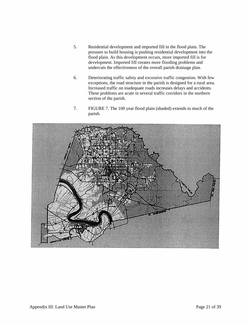
Appendixx III: Land Usse Master Plan
5. Resprefloodevund
6. DeexcIncThesec
7. FIGpar
n
sidential deveessure to buildod plain. As tvelopment. Imdercuts the ef
teriorating traceptions, the rcreased trafficese problems
ction of the pa
GURE 7. Therish.
elopment andd housing is pthis developmmported fill crffectiveness o
affic safety anroad structurec on inadequa
are acute in sarish.
e 100 year floo
d imported fillpushing residement occurs, mreates more fl
of the overall p
nd excessive te in the parishate roads increseveral traffic
od plain (shad
l in the flood ential developmore importedflooding problparish drainag
traffic congesh is designed eases delays ac corridors in
ded) extends
Page 21
plain. The pment into thd fill is for lems and ge plan.
stion. With fefor a rural areand accidentsthe northern
to much of th
of 39
e
ew ea. s.
he

Appendixx III: Land Usse Master Plan
8. Inaparnotpardev
9. Dasev
10. Resof tcon
11. A sPladevin t
12. A lparrur
13. FIGoutdevthe
n
adequate sewerishwide sewet have adequarticularly acutvelopment is h
mage to histoveral importan
sidential devetoxic waste sintrols to preve
shortage of afanning Commvelopment wathe parish.
loss of rural crticularly St. Aal character o
GURE 8. Subtside the 100 velopment (she 100 year floo
er systems. Ther service. Unate sewer systte in the northheaviest.
oric sites. Incont historic site
elopment nearites. Under cuent high dens
ffordable houmission heard as reducing th
character. ResAmant, expreof the parish.
bdivision deveflood plain inhown in shadeod plain.
he parish has ntil that systemtems to suppohern part of th
ompatible deves in the paris
ar toxic waste urrent land ussity residentia
using. In publicitizen conce
he opportuniti
sidents in the essed grave co
elopment bas n the Northerned rectangles)
recently undm is in place,ort growth. Thhe parish, wh
velopment is sh.
sites. The pase regulationsal construction
ic meetings, merns that accelies for young
rural areas ofoncerns about
absorbed mun part of the p) is increasing
Page 22
dertaken plans the parish do
hese problemsere residentia
encroaching
arish has a nums, there are non near these s
members of thlerated residents to s
f the parish, t the loss of th
uch of the landparish. Subdivgly encroachi
of 39
s for oes s are
al
on
mber o sites.
he
stay
he
d vision ing in

Appendix III: Land Use Master Plan Page 23 of 39
14. Increased demands for fire and police protection. The parish relies on volunteer fire departments. Several members of these departments have expressed concerns to the Commission about the impact of new development on fire and police protection.
(LU98-01, 2/5/98; LU03-01, 3/20/03; DC09-09, 12/17/09)
J. Strategies to meet these challenges
1. The Parish Council and the Planning Commission will follow three strategies to meet these challenges: gather solid information, enforce development standards, and manage infrastructure investments.
2. Collect and use accurate mapping information. The parish has undertaken an extensive program to implement a sophisticated geographic information system (GIS). This computer system provides flexible and responsive support for making decisions. It compiles, organizes and analyzes data on changes in the parish. Until facts are systematically sorted, it is difficult to identity and understand the challenges facing the parish. Maps presented in this plan are taken from the GIS system.
3. The GIS provides accurate and timely answers to critical questions concerning how land use is changing. It will provide information needed to analyze the social, economic, fiscal and environmental impact of these changes. In addition, the GIS will be able to compare these changes to historical trends and future projections.
4. Enforce development standards. Local governments impose building standards to protect the public health and safety from unsafe construction. In the same way, local governments impose development standards to protect the public from careless development. Land use regulations, such as zoning and subdivision regulations, provide quality control to development in the parish.
5. By setting minimum standards, land use controls will preserve property values throughout the parish. In isolated instances, development standards may depress the values of a particular building or property. Overall, however, development standards will increase the total real property values in the parish.
6. Manage infrastructure investments. Without careful planning, two problems can arise from careless infrastructure development. In the first instance, development can place too much pressure on available infrastructure. This situation increases the risk to public health and safety. We encounter problems such as too many cars on the road or open ditches carrying untreated sewage.

Appendix III: Land Use Master Plan Page 24 of 39
7. Building infrastructure carelessly causes other problems. Infrastructure is expensive, and the taxpayers of the parish must pay for it. Without careful planning, we can easily waste money. Building a large subdivision on an inadequate road costs parish taxpayers money. Eventually, the parish will be forced to improve the road. Studies have shown that communities that carefully plan their infrastructure investments pay 20% to 30% less in infrastructure to support the same number of people.
(LU98-01, 2/5/98; LU03-01, 3/20/03; DC09-09, 12/17/09)

Appendix III: Land Use Master Plan Page 25 of 39
17-305. Components of the Master Plan
A. As state law recognizes, a master plan includes a variety of different components. Different parish entities are responsible for planning. For example, the Department of Public Works is responsible for planning roads and bridges; the Recreation Department is responsible for parks and recreation; the Office of Emergency Preparedness is responsible for public safety.
(LU98-01, 2/5/98; LU03-01, 3/20/03; DC09-09, 12/17/09)
17-306. Land Use Map
A. The Commission focuses its future planning land use planning on a Land Use Map. A copy of the map is included in the Appendix. This Land Use Map reflects the policies set forth in this Master Plan. The Land Use Map also reflects the contributions that citizens have made to the process. Based on its public meetings, the Commission and its subcommittees have used the Land Use Map to discuss specific land use issues that concern the citizens of the parish. The Land Use Map reflects the sum total of these discussions that have occurred since 1997.
(LU98-01, 2/5/98; LU03-01, 3/20/03; DC09-09, 12/17/09)
17-307. Official Zoning Map
A. The land use plan for Ascension Parish is expressed in the Official Zoning Map. The map divides the parish into zones for development. The location of each zone takes into account the principles of this Master Plan.
(LU98-01, 2/5/98; LU03-01, 3/20/03; DC09-09, 12/17/09)
B. The primary policy objectives in developing these zones are:
1. to separate hazardous industrial uses from high concentrations of residential development;
2. to concentrate traffic from commercial and high intensity residential development around roads in the parish which can more easily handle higher traffic volumes;
3. to protect the public safety by encouraging development which is adequately served by roads, fire stations, and police stations, and
4. to preserve property values based on the rural character of the parish by discouraging residential subdivisions in remote areas of the parish and the commercial strip development which follows these developments.
(LU98-01, 2/5/98; LU03-01, 3/20/03; DC09-09, 12/17/09)

Appendix III: Land Use Master Plan Page 26 of 39
C. In addition, the land use plan in Ascension Parish uses overlay zones. Overlay zones lie on top of zoning districts. They impose an additional level of land use control to handle specific development problems within the parish. Overlay zones handle particular development problems in the parish by imposing a new set of regulations on a special area. These problems are geographically localized and cannot be completely addressed by the underlying district regulations. To provide flexibility and ease of administration to the Development Ordinance, the parish adopts the following overlay zones to address these issues: flood hazard overlay zone, waste site overlay zone, historic site overlay zone.
(LU98-01, 2/5/98; LU03-01, 3/20/03; DC09-09, 12/17/09)
D. The land use plan divides the parish into the following districts:
1. High intensity districts
a. Mixed use corridors
b. Industry
2. Medium intensity districts
a. Crossroad commercial
b. Medium intensity residential
c. Transition
d. Business park
3. Low intensity districts
a. Rural residential
b. Conservation (LU98-01, 2/5/98; LU03-01, 3/20/03; DC09-09, 12/17/09)
E. Mixed use corridors. This district is characterized by the most intensive residential and commercial development. These districts are located in areas where the road system is most capable of supporting growth with a minimum risk to the public safety. High density residential development should include apartment buildings and townhouses. Commercial development should be concentrated or "clustered" at strategic sites in relation to population centers, other commercial sites, and adequate roads.
(LU98-01, 2/5/98; LU03-01, 3/20/03; DC09-09, 12/17/09)

Appendix III: Land Use Master Plan Page 27 of 39
F. This district is designed to concentrate the most intensive residential and commercial development along the major arteries of the parish. By encouraging concentrated, cluster development, the Commission will minimize the infrastructure costs and manage public safety risks most appropriately. In addition, commercial development should use shared access to parking lots and shared parking lots in order to minimize traffic congestion and sprawl along the parish roadways. While this district allows many varied uses, the district should develop with adequate buffering, careful traffic planning, and appropriate lighting plans to minimize any nuisance between uses.
(LU98-01, 2/5/98; LU03-01, 3/20/03; DC09-09, 12/17/09)
G. Industrial district. This district is designed to accommodate industrial and warehouse development which is compatible with the economic development and environmental protection of the parish. Industrial development will be concentrated in areas which are already providing a site for industry. This district is adequately served by infrastructure. Concentrating industrial development in this district also minimizes the public safety risks from production and transportation. In addition, concentrating truck traffic will reduce the maintenance costs on parish roads.
(LU98-01, 2/5/98; LU03-01, 3/20/03; DC09-09, 12/17/09)
H. Crossroad commercial district. This district serves the commercial needs of the outlying residents in the parish. The purpose of this district is to disperse commercial development opportunities throughout the parish, while minimizing the adverse impact on traffic flows. Most of the commercial development in the parish should be focused on mixed use corridors, where the roads can handle traffic volumes. At the same time, residents in the outlying areas of the parish need convenience retail of stand alone stores or smaller neighborhood convenience centers. To reduce congestion on rural roads and improve road access, these commercial buildings should be located at intersections.
(LU98-01, 2/5/98; LU03-01, 3/20/03; DC09-09, 12/17/09)
I. Medium intensity residential district. This district is designated for residential development, including multi family dwellings and subdivisions. This district exists largely outside the 100 year flood plain and in the northern part of the parish where planned water and sewer systems can support more intensive development; Commercial development in this district should be limited and located at highway intersections.
(LU98-01, 2/5/98; LU03-01, 3/20/03; DC09-09, 12/17/09)
J. This district is designed to be adjacent to high intensity mixed use corridors, but commercial development should not be allowed to disrupt the residential character of this district. In addition to single family houses, town houses, garden homes and apartment buildings are intended for this district.
(LU98-01, 2/5/98; LU03-01, 3/20/03; DC09-09, 12/17/09)

Appendix III: Land Use Master Plan Page 28 of 39
K. Transition district. This district is designated for limited residential and commercial development. The district lies within the chemical emergency warning zone established by the chemical plants in the Parish.
(LU98-01, 2/5/98; LU03-01, 3/20/03; DC09-09, 12/17/09)
L. This district provides a public safety buffer between large-scale residential and commercial development and industrial plants. These plants pose a serious public health risk which must be carefully managed. Beginning in 1985, the chemical industry operating in Ascension Parish established the Community Awareness Emergency Response, or CAER, Committee. The Ascension Parish Chemical Industry's CAER Committee has installed a 26-siren community alerting system, designed to be heard within an approximate radius of 2.5 miles of each plant, in the area in which the plants are located. The system will provide effective early warning for the community. The Transition District falls within this community alerting system and is designed to discourage high density residential development within this warning zone.
(LU98-01, 2/5/98; LU03-01, 3/20/03; DC09-09, 12/17/09)
M. Business park district. This district is intended to provide for the future economic expansion of the parish with high quality office, research and distribution development. This district enables the parish to expand its economic base without encroaching on residential development. By establishing high development standards for this district, the parish reduces the impact of business development on surrounding residential development, while at the same time encouraging investment in high income employment.
(LU98-01, 2/5/98; LU03-01, 3/20/03; DC09-09, 12/17/09)
N. Low intensity residential district. This district is designated for low-density residential development in rural areas and small pockets of commercial development to service neighborhood needs. The area is generally characterized by rural roads and a lack of utilities. This district should develop consistent with the rural character of the parish. Commercial development should be low intensity carefully planned so as not to disrupt the rural character of the district. Careless commercial development, "suburban sprawl", represents both a nuisance to current landowners and jeopardizes property values. In addition, haphazard subdivision development in the more rural parts of the parish will stretch the parish's limited road, police and fire budgets. The parish cannot afford to service large concentrations of residential development in this district.
(LU98-01, 2/5/98; LU03-01, 3/20/03; DC09-09, 12/17/09)
O. Conservation district. This area is designated to conserve the major environmental assets of the parish. The district is intended for single family residential development and limited commercial development. This district includes the most rural parts of the parish. These areas are not only environmentally fragile, they are not served by roads which can handle large traffic increases.
(LU98-01, 2/5/98; LU03-01, 3/20/03; DC09-09, 12/17/09)
Appendix III: Land Use Master Plan Page 29 of 39
P. Flood hazard overlay zone. The purpose of flood plain overlay zone is to protect public safety and property by restricting residential development within the 100 year flood plain and keeping flood channels free of encroachment. Development in this zone must comply with the requirements of Chapter 9.5, Flood Damage Prevention of the Code of Ordinances.
(LU98-01, 2/5/98; LU03-01, 3/20/03; DC09-09, 12/17/09)
Q. The purpose of flood plain zoning is to regulate land use within the flood plain so as to minimize or prevent the harm caused by flood. The current development pattern shows that some subdivisions have been developed recently within the 100 year flood plain. This overlay zone is designed to protect the public safety and property rights by restricting intensive residential development in the flood plain.
(LU98-01, 2/5/98; LU03-01, 3/20/03; DC09-09, 12/17/09)
R. Waste site overlay zone. The purpose of the waste site overlay zone is to protect the public health and welfare from toxic waste sites that are located in the parish.
(LU98-01, 2/5/98; LU03-01, 3/20/03; DC09-09, 12/17/09)
S. Historic site overlay zone. The purpose of the historic structure overlay zones is to protect certain historical sites from incompatible development. This zone protects irreplaceable historic and economic assets in the parish. The Planning and Zoning Commission should encourage landowners with historic property to use this zone to preserve these structures.
(LU98-01, 2/5/98; LU03-01, 3/20/03; DC09-09, 12/17/09)
T. Chemical emergency overlay zone. The purpose of this zone is to notify and protect residents living within a 2.5 mile radius of existing chemical plants in the Parish. In addition, the overlay zone protects the public safety by lowering the density of residential development that is allowable within a 2.5 mile radius of each plant. The operators of chemical plants in Ascension Parish have established the Community Alert Emergency Response (CAER) committee. CAER has installed a 26 siren community alerting system, designed to be heard within 2.5 miles of each plant. This is the radius selected by CAER that could pose the greatest threat to people who are near the chemical plants in the event of a chemical emergency.
(LU98-01, 2/5/98; LU03-01, 3/20/03; DC09-09, 12/17/09)
17-308. Development Code
A. Ascension Parish implements the guiding principles of this Master Plan through its development code. Zoning regulations are enacted under the police power delegated by the state to the parish. The police power is the authority of government to enact regulations to protect the public health, safety, welfare and morals. The United States Supreme Court has called police power regulation "one of the most essential powers of government."
(LU98-01, 2/5/98; LU03-01, 3/20/03; DC09-09, 12/17/09)

Appendix III: Land Use Master Plan Page 30 of 39
B. Broad authority to regulate land uses is delegated to Ascension Parish through enabling legislation passed by the state legislature. This authority empowers the Parish Council to enact zoning regulations, create zoning districts, and adopt a master (or comprehensive) plan. This broad grant of authority carries with it the implied authority to choose the means necessary to accomplish the purposes of conserving the value of buildings and property and encouraging the most appropriate use of the land throughout the parish.
(LU98-01, 2/5/98; LU03-01, 3/20/03; DC09-09, 12/17/09)
C. Because of the importance of police power regulations and the doctrine of separation of powers, the courts have adopted rules of self-restraint when presented with a challenge to a police power regulation. These rules presume the constitutionality of the regulation, impose a heavy burden of proof on the challenger, resolve doubts in favor of the regulator, and, in most cases, result in a low level of judicial scrutiny.
(LU98-01, 2/5/98; LU03-01, 3/20/03; DC09-09, 12/17/09)
D. When presented with a challenge to a land use regulation, courts generally exercise judicial restraint. The regulation is presumed valid and the challenger bears a heavy burden of proof. However, where local regulations are set aside by the courts, their invalidation can be traced to several common errors:
1. The reasons for the regulations are not stated clearly;
2. No comprehensive plan has been adopted or it has not been kept up to date;
3. The plan has not been followed; or
4. The local action is not justified by clear evidence but rather is primarily a response to the opposition of neighbors.
(LU98-01, 2/5/98; LU03-01, 3/20/03; DC09-09, 12/17/09)
E. To avoid having parish zoning regulations set aside, the Parish has followed these guidelines in the implementation of its Development Code:
1. Keep the Master Plan up to date. The Planning Commission insures that land use regulations conform to the Master Plan. A zoning ordinance that is adopted specifically to further the guiding principles of this Master Plan will make a substantive connection to legitimate, clear public objectives and honor the legal demands of substantive due process. A substantive due process challenge to an Ascension Parish zoning ordinance would allege that the ordinance does not advance a legitimate public purpose.

Appendix III: Land Use Master Plan Page 31 of 39
2. Follow an open, fair process. The Parish Council is following a deliberate and understandable process of adopting and amending parish land use regulations. All citizens and affected parties will be provided effective advance notice and given an ample opportunity to be heard in a forum that is conducted fairly.
3. Procedural due process challenges will be brought if the Parish Council and the Planning Commission fail to follow a clear process or rushes to judgment on a land use decision. In these cases, the Planning Commission may violate the rights of involved parties to receive notice, be given an opportunity to be heard, or enjoy the benefits of a deliberate and thoughtful process on the part of the Planning Commission.
4. To the extend possible, treat all similarly situated properties equally. By following this rule, the parish's zoning regulations are not likely be found unconstitutionally discriminatory. The Planning Commission is careful to act consistently when imposing standards on landowners or interpreting the zoning code. This step is important to insure that the parish complies with equal protection standards. Equal protection claims assert that a land use classification or decision treats one parcel, or a few parcels of land, differently than similarly situated parcels with no apparent justification for being treated differently.
5. Apply standards uniformly. In drafting and applying local ordinances, such as subdivision regulations, the Planning Commission will specify the standards that applications must meet and apply them uniformly and carefully. This rule represents another important step in keeping the process of land use regulation open and fair.
6. Follow the guidance of legal counsel. The Planning Commission consults with legal counsel to insure that the actions they take and the conditions they impose are within their legal authority to act. This step will protects the parish against ultra vires claims. These claims would allege that the Planning Commission did not have the legal authority to take the challenged action. They would assert that the Commission acted beyond the scope of its delegated or implied authority and that its action, therefore, is invalid because it is an unauthorized action of government.
7. Engage property owners, developers and the community. The Parish Council and the Planning Commission will engage the community and affected parties in meaningful discussions regarding the adoption or application of land use regulations. This step reduces the tendency of affected parties to challenge decisions. The reliance on development agreements over impact fees, for example, encourages mutual benefit over arbitrary exactions.
(LU98-01, 2/5/98; LU03-01, 3/20/03; DC09-09, 12/17/09)

Appendix III: Land Use Master Plan Page 32 of 39
F. In interpreting the Code, the Parish should follow these guidelines:
1. Determine the public purpose of the standard for which an interpretation is required. Before any zoning interpretation is made, there must be an explicit identification of the purpose for which the initial regulation was imposed. Each zoning regulation is intended to protect the interests of both present and future neighbors and the general public. Each standard is developed as a regulatory response to an identifiable negative impact or potential. A sound interpretation of any standard in this ordinance cannot be ensured without a careful analysis of the end to which the regulation is directed.
2. Determine the impact of the proposed interpretation. It is not always possible to define precisely the impacts of a proposed interpretation. Those charged with interpreting the Code should determine impacts after evaluating the viewpoints of adjacent land owners and, where appropriate, expert opinion from parish employees or independent parties.
3. Determine an just balance. Fair land use regulation requires continuous balancing between the rights of the landowner and all others who will be affected by that person's land use proposal.
(LU98-01, 2/5/98; LU03-01, 3/20/03; DC09-09, 12/17/09)
17-309. Development Agreements
A. Development agreements encourage landowners and developers in Ascension Parish to provide adequate and reasonable infrastructure to support development. New development in the parish imposes additional costs in roads, schools, and public safety. To avoid undue hardship on existing parish taxpayers, these costs should be recovered as part of a development project. Development agreements provide a flexible mechanism for the Parish to negotiate with developers over the public costs of private development. Specifically,
1. A development agreement is a binding contract between the development permit applicant and the Parish of Ascension.
2. The purpose of a development agreement is to provide reasonable on and offsite improvements to promote the public health, safety and welfare of the citizens of Ascension Parish.
3. Development agreements shall be negotiated during the application process for a development permit.
(LU98-01, 2/5/98; LU03-01, 3/20/03; DC09-09, 12/17/09)

Appendix III: Land Use Master Plan Page 33 of 39
B. Development agreements can include one or more performance standards. Performance standards are additional and reasonable on and off-site improvements that an applicant may be required to provide after consultation with the director due to the unique characteristics of the applicant's site and proposed development plan. Performance standards represent an extension of existing site regulations that govern the applicant's property.
(LU98-01, 2/5/98; LU03-01, 3/20/03; DC09-09, 12/17/09)
C. Some examples of performance standards include, additional parking spaces and landscape and buffering requirements, additional drainage plans, additional investments in highway infrastructure to manage access to and from the development site, opaque screening, advanced sewerage disposal systems, and additional easements and servitudes.
(LU98-01, 2/5/98; LU03-01, 3/20/03; DC09-09, 12/17/09)
17-3010. Drainage Master Plan
A. In 1980, the Parish initiated a major drainage program for south and east Ascension Parish. That program has resulted in a dramatic reduction of flooding occurrences in the parish.
(LU98-01, 2/5/98; LU03-01, 3/20/03; DC09-09, 12/17/09)
B. Over the years, Ascension Parish development trends have resulted in increased pressures on the existing drainage systems of the parish. Presently the parish reacts to "drainage problems" as they appear. Fortunately, minimal flood damage has occurred to date. However, if development continues at or near its present rate, the future may not be as kind to Ascension Parish.
(LU98-01, 2/5/98; LU03-01, 3/20/03; DC09-09, 12/17/09)
C. Within the next three years, the parish will complete the Drainage Master Plan. This plan will include:
1. Survey of existing land use and stream conditions;
2. Survey of homes which have sustained previous flooding;
3. Survey of existing topography;
4. Collection of geotechnical information and vegetation types;
5. Hydraulic and hydrologic analysis (modeling) of existing drainage systems through various storm types;
6. Evaluation of alternative structural damage improvement projects, such as storm water detention;
7. Evaluation of storm water retention;

Appendix III: Land Use Master Plan Page 34 of 39
8. Evaluation of public works projects, such as channel enlargement, channel paving, pumping station, and levees;
9. Hydraulic and hydrologic analysis to evaluate the effects of alternative structural improvement projects, increased rainfall runoff of new developments, and various storm events;
10. Development of regulations and ordinances which would complement any structural improvements, such as flood-proofing, detention ordinances, flood-proofing requirements;
11. Estimate of the cost for the various elements of a drainage improvement program;
12. Evaluate compatibility with efforts of other federal, state, and local agencies within and adjacent to the parish;
13. Recommendation for drainage-related capital improvement projects, ordinances and regulations.
(LU98-01, 2/5/98; LU03-01, 3/20/03; DC09-09, 12/17/09)
D. The development of a Drainage Master Plan is one of several essential elements necessary for the orderly growth of Ascension Parish. A Drainage Master Plan will take one to two years to complete and will require updating periodically as development trends evolve and as new data becomes available. Without a Drainage Master Plan, the drainage impacts of new developments will be difficult to determine accurately and establishing priorities for parish drainage projects will be based on considerations other than clear criteria.
(LU98-01, 2/5/98; LU03-01, 3/20/03; DC09-09, 12/17/09)
17-3011. Roadway Master Plan
A. As Ascension Parish continues to grow, its existing infrastructure is being pushed to the limit. The most obvious indication of this problem is the increased traffic in the northern part of the parish. More new traffic signals are being installed, longer waits at intersections are experienced, entering and exiting from subdivision onto collector and arterial streets is more difficult, and development on narrow rural roads are causing unacceptable safety hazards. Adequate transportation does not exist currently and will continue to deteriorate as growth continues.
(LU98-01, 2/5/98; LU03-01, 3/20/03; DC09-09, 12/17/09)

Appendix III: Land Use Master Plan Page 35 of 39
B. The parish standard minimum roadway width is twenty feet. All newly constructed parish roadways are a minimum of twenty feet wide. However, many previously constructed parish roads are less than twenty feet wide. Of the approximately 360 miles of parish roadway, only 27 percent is greater than twenty feet wide. Approximately 26 percent of parish roads are less than 18 feet wide and should be considered substandard. Many large attractive tracts of land are accessed by one of these substandard roads.
(LU98-01, 2/5/98; LU03-01, 3/20/03; DC09-09, 12/17/09)
C. The actual width of a passenger vehicle is approximately 7 feet, and the width of a bus or truck is approximately 8.5 feet. For two trucks or buses to pass on a two-way roadway with at least twelve inches of clearance, the pavement needs to be a minimum of 18 feet wide. Anything less than 18 feet wide would require one of the two vehicles to pull onto the shoulder for the other to pass.
(LU98-01, 2/5/98; LU03-01, 3/20/03; DC09-09, 12/17/09)
D. As a practical matter, narrow roads with minimal traffic are treated as one-way roads. When opposing traffic meets on narrow roads, one vehicle slows and pulls over to the shoulder, and the other vehicle slows and passes. As traffic on a narrow road increases the frequency of opposite traffic encounters increases and will eventually increase to unacceptable levels.
(LU98-01, 2/5/98; LU03-01, 3/20/03; DC09-09, 12/17/09)
E. There are no published rules for acceptable traffic levels on substandard roads. However, no major subdivision should be allowed to be constructed such that ingress and egress would be from a roadway of less than 18 feet in width. Until a substandard (less than 18 feet wide) road is upgraded to a parish standard, only minor subdivisions and family partitions should be approved on that road.
(LU98-01, 2/5/98; LU03-01, 3/20/03; DC09-09, 12/17/09)
F. A Roadway Master Plan can help the parish to program its roadway improvements funds, better coordinate new developments, and evaluate their impacts on existing roadway infrastructure, identify future parish roadway needs to improve traffic flow, and improve public safety. A Roadway Master Plan will also enable the parish to pursue assistance from other agencies, such as the Federal Highway Administration. A Roadway Master Plan will include:
1. A major street plan which identifies existing collector and arterial streets, propose new collector and arterial streets, and propose upgrades to existing arterial and collector streets;
2. Evaluation of existing traffic characteristics, such as speed, travel time and delays, traffic volume, existing roadway capacities, and rates of accidents;
3. Evaluation of regulatory measures for drivers, vehicles, and pedestrians, speed controls, one way streets, and intersection controls;

Appendix III: Land Use Master Plan Page 36 of 39
4. Evaluation of traffic control devices such as traffic signals, pavement markings, and channelization devices;
5. Recommendations for minimum construction and geometric standards for local, collector, and arterial streets;
6. Recommendations for public relations and education; and
7. Recommendations for coordination between the Planning Commission and the Public Works Department for traffic and roadway improvements.
(LU98-01, 2/5/98; LU03-01, 3/20/03; DC09-09, 12/17/09)
G. The development of a Roadway Master Plan is one of several essential elements necessary for the orderly growth in Ascension Parish. A Roadway Master Plan will take one to two years to complete and will require updating periodically as development trends evolve and as new data and requirements become available. Without a Roadway Master Plan, traffic impacts of new developments will be difficult to determine accurately and creating priorities for street improvements will be based on inadequate information.
(LU98-01, 2/5/98; LU03-01, 3/20/03; DC09-09, 12/17/09)
17-3012. Water and Sewer Master
A. The parish has completed a water and sewer plan through a contract with Glenn Shaheen & Associates, Inc. (GSA)2 This plan outlines the alternatives for developing a Parish-owned water and sewer system throughout the parish. The plan recommends that implementation begin in the north central portion of the parish. The initial system development will serve as a core system from which service to the rest of the parish can be launched. The Master Plan incorporates this plan by reference.
B. As the plan notes, although the area of initial implementation covers only 24% of the land area of the parish, it will serve 60% of the population. This area is the most densely populated in the parish. This Master Plan encourages a continued concentration of residential construction in the north-central portion of the parish.
C. NOTE: 2. above in No. 1 reference: Glenn Shaheen & Associates, Inc, "Facility Plan for Parish-wide Water and Wastewater Facilities for the Parish of Ascension" (August 1998).
(LU98-01, 2/5/98; LU03-01, 3/20/03; DC09-09, 12/17/09)

Appendix III: Land Use Master Plan Page 37 of 39
17-3013. Public Safety and Emergency Preparedness
A. Public safety issues in Ascension Parish arise from the character and strength of the parish manufacturing plants. The great bulk of Ascension's manufacturing base is in the chemical industry. The chemical industry is located adjacent to the Mississippi River. Generally these are petrochemical plants which manufacture plastics, fertifizer, and other petroleum based derivatives. The Office of Emergency Preparedness has prepared emergency preparedness plans for the Parish in the event of a chemical emergency, and these plans are incorporated into the Master Plan by reference.
B. Because of the potential for industrial accidents, the Parish will continuously update its emergency preparedness plans. In addition, the Parish will adopt chemical emergency overlay zone. This zone will restrict high concentrations of residential development close to the petrochemical plants.
(LU98-01, 2/5/98; LU03-01, 3/20/03)
17-3014. Recreation Master Plan
A. The master plan completed in 1994 included a recreation plan for the parish. In addition to an inventory of current park sites, the plan included the results of a citizen poll on recreational activities. This plan needs to be updated. In addition, the plan should be expanded to include a capital projects plan. Once this plan has been updated, the Planning Commission will incorporate it into this Master Plan.

Appendix
17-3015.
17-3016.
x III: Land Us
B.
Histor
A.
Touris
A.
se Master Plan
FIGURE 9.additional r
ic Preservatio
Historic sitaddition to will use lanthese propespecifies th
sm Developm
The TourismAmong oth
n
. The parish hrecreational fa
(L
on
es in the parismaintaining a
nd use controlerties can alsohese sites is in
(L
ment Plan
m Commissioher factors, thi
has a number facilities.
LU98-01, 2/5
sh need protean inventory ls to protect tho be set forth included in theLU98-01, 2/5
on follows plais plan should
of recreation
5/98; LU03-0
ection from caof historic sithese sites. Thin an historic
e Appendix to5/98; LU03-0
an to attract td also:
n sites, but the
01, 3/20/03; D
areless nearbytes, the Plannhe steps requirc preservationo this Plan. 01, 3/20/03; D
tourists to Asc
Page 38
e parish needs
DC09-09, 12/1
y developmenning Commissred to protect
n plan. A map
DC09-09, 12/1
cension Paris
of 39
s
17/09)
nt. In sion t that
17/09)
h.

Appendix III: Land Use Master Plan Page 39 of 39
1. Clearly outline the infrastructure investments required to enhance Ascension Parish as a destination for tourists; and
2. Set forth any land use regulations which will support the tourist industry in Ascension Parish.
(LU98-01, 2/5/98; LU03-01, 3/20/03; DC09-09, 12/17/09)
17-3017. Economic Development Forecast
A. The Parish follows an economic development plan that:
1. Encourages expansion of existing compatible commercial and industrial enterprises;
2. Encourages diversification of the parish economy and employment base;
3. Encourages continued planning for industrial site development; and
4. Provides adequate land for commercial growth while minimizing the impact on traffic and residential neighborhoods.
(LU98-01, 2/5/98; LU03-01, 3/20/03; DC09-09, 12/17/09)
PARISH OF ASCENSION OFFICE OF PLANNING AND DEVELOPMENT
PLANNING DEPARTMENT
42077 Churchpoint Road
Gonzales, Louisiana 70737
Phone: (225) 450-1002 / Fax: (225)450-1352
Web: www.ascensionparish.net
APPENDIX IV
SUBDIVISION REGULATIONS
Contents:
17-401. Procedures, Process, and Checklist ........................................................................4
17-402. Classification of Subdivision Procedure .................................................................4 17-403. Fee Schedule ............................................................................................................4
17-404. Pre-Application Procedure......................................................................................4 17-405. Preliminary Plat Procedure ....................................................................................5
17-406. Plats and Data for Preliminary Approval ............................................................ 11 17-407. Consultation with Other Regulatory Agencies Procedure ................................... 12
17-408. Procedure for Construction .................................................................................. 13 17-409. Construction .......................................................................................................... 16
17-4010. Acceptance of Improvements for Construction .................................................... 18 17-4011. Approval of Final Plat Procedure ......................................................................... 19
17-4012. Plats and Data for Final Approval ........................................................................ 19 17-4020. Major Subdivision Design Guidelines ................................................................... 22
17-4021. Large Scale Development ...................................................................................... 29 17-4022. Townhouse Subdivision ......................................................................................... 29
17-4023. Campsite Subdivision ............................................................................................ 32 17-4024. Private Subdivision ................................................................................................ 32
17-4025. Condominium ........................................................................................................ 32 17-4026. Family Partition ..................................................................................................... 33
17-4030. Design Criteria....................................................................................................... 37 17-4031. Driveways............................................................................................................... 37
17-4032. Street Requirements .............................................................................................. 38 17-4033. Streets: Geometric Standards ............................................................................... 39
17-4034. Streets: Construction Standards ........................................................................... 40 17-4035. Alley Requirements ............................................................................................... 41
17-4036. Alleys: Geometric Standards ................................................................................ 42 17-4037. Servitudes: (Utilities and Drainage) Requirements .............................................. 42
17-4038. Servitudes: (Utility) Geometric Standards ........................................................... 43 17-4039. Block Requirements .............................................................................................. 44
17-4040. Blocks: Geometric Standards................................................................................ 44 17-4041. Lot Requirements .................................................................................................. 44
17-4042. Lots: Geometric Standards ................................................................................... 44 17-4044. Drainage Requirements ........................................................................................ 45
17-4045. Drainage: Design and Construction Criteria ....................................................... 46 17-4046. Sanitary Sewerage Requirements ......................................................................... 48

Appendix IV: Subdivision Regulations Page 2 of 57
17-4047. Utilities: Water ...................................................................................................... 48 17-4048. Utilities: Electrical and Telephone Service and Street Lighting .......................... 49
17-4049. Utilities Location.................................................................................................... 50 17-4090. Administration and Enforcement ......................................................................... 51
17-4091. Conditions .............................................................................................................. 51 17-4092. Appeal Procedure .................................................................................................. 51
17-4093. Variances ............................................................................................................... 52 17-4094. Fines and Enforcements ........................................................................................ 53
17-40100. Definitions .......................................................................................................... 54
REGULATION HISTORY
SR07-01, latest version of Subdivision Regulations, as of 1/18/07
SR07-01.B,ATTACHMENT: Planning Commission adopted Cross Section, on 3/14/07
ORDINANCE HISTORY
Ordinance No. SR07-02, adopted on 10/4/07 Ordinance No. SR08-01, adopted on 1/10/08
Ordinance No. SR08-02, adopted on 2/19/08
Ordinance No. SR08-03, adopted on 9/18/08 Ordinance No. SR09-01, adopted on 1/8/09
Ordinance No. SR09-02, adopted on 11/19/09
Ordinance No. DC09-09, adopted on 12/17/09
Ordinance No. DC01/12, adopted on 1/5/12 Ordinance No. DC12-02, adopted on 5/3/12
Ordinance No. DC12-03, adopted on 6/7/12
Ordinance No. DC12-04, adopted on 6/7/12 Ordinance No. SR12-10, adopted on 7/19/12
Ordinance No. SR17-4045, adopted on 7/19/12
Ordinance No. SR12-16, adopted on 12/20/12
Ordinance No. SR13-1, adopted on 3/13/13 Ordinance No. SR12-11, adopted on 3/19/13
Ordinance No. SR13-2, adopted on 4/4/13
Ordinance No. SR13-07, adopted on 8/1/13 Ordinance No. SR13-9, adopted on 10/3/13
Ordinance No. SR13-10, adopted on 11/7/13
Ordinance No. DR14-6, adopted on 10/02/14 Ordinance No. SR14-7, adopted on 11/6/14
Ordinance No. SR 14-11, adopted on 12/4/14
Ordinance No. SR14-13, adopted on 1/8/15
Ordinance No. SR 14-12, adopted on 2/5/15

Appendix IV: Subdivision Regulations Page 3 of 57
(This page left blank intentionally for code section expansion)

Appendix IV: Subdivision Regulations Page 4 of 57
17-401. Procedures, Process, and Checklist
17-402. Classification of Subdivision Procedure
A. Whenever any subdivision of land is proposed, excluding family partitions,
before any contract is made for the sale of any part thereof and before any permit for the erection of a structure in such proposed subdivision shall be granted, the
subdividing owner, or his authorized agent, shall apply and secure approval of
such proposed subdivision in accordance with the following procedure, which includes basically one (1) step for simple subdivisions with less than twenty lots
and three (3) steps for all other subdivisions.
1. Simple subdivisions with nine lots or less:
a. Sketch plat (optional);
b. Final subdivision plat submitted in electronic format and hard
copy.
2. All other subdivisions (Major or Minor):
a. Sketch plat (optional); b. Preliminary Plat submitted in electronic format and hard copy;
c. Construction drawings submitted in electronic format.
d. Final subdivision plat
(SR07-01, 1/18/07; DC09-09, 12/17/09)
17-403. Fee Schedule
A. The Planning Commission has the authority to determine fees for applications,
inspections and review. The schedule of fees, as amended from time to time,
henceforth, is attached to these subdivision regulations as Appendix XII. (SR07-01, 1/18/07; DC09-09, 12/17/09)
17-404. Pre-Application Procedure
A. Previous to the filing of an application for approval of the preliminary plat, the
sub-divider shall submit to the engineer review agency, the plans and data as
specified in Section 17-406(B) and Section 17-4020. This submittal is a pre-requisite to filing an application for approval of any preliminary plats submitted
to the Ascension Parish Planning and Zoning Commission. Informal discussion
between the engineer review agency and the sub-divider are encouraged to correct any noted deficiencies within the plat before submittal to the Ascension
Parish Planning and Zoning Commission for approval.

Appendix IV: Subdivision Regulations Page 5 of 57
(SR07-01, 1/18/07; DC09-09, 12/17/09; SR13-9, 10/3/13)
A. Within thirty (30) days, the engineer review agency shall inform the sub divider
that the plans and data as submitted or as modified, do or do not meet the objectives of the regulations. When the engineer review agency finds the plans
and data do not meet the objectives of these regulations, it shall express its
reasons in writing and annotated on the plan or sketch. Approval by the engineer
review agency does not render the preliminary plat as approved and all other requirements and procedures are still as set forth in the Ascension Parish
Subdivision Regulations must be fully complied with prior to granting approval.
(SR07-01, 1/18/07; DC09-09, 12/17/09)
17-405. Preliminary Plat Procedure
A. Upon the satisfactory conclusion of the pre-application procedure, if utilized by
the sub divider, then the sub divider shall prepare a preliminary plat and other
supplementary material as specified in section Section 17-406(B).
(SR07-01, 1/18/07; DC09-09, 12/17/09)
B. Ten (10) full scale prints, one (1) 11" x 17" reduced print of the preliminary plat,
one (1) 11" x 17" reduced print of the preliminary plat submitted in electronic form (.pdf file) or other acceptable format as approved by the Parish of
Ascension Technology Department, and specified supplementary material shall
be submitted to the secretary for the Planning and Zoning Commission at least thirty-five (35) days prior to a regularly scheduled Planning and Zoning
Commission meeting. The Engineering Review Agency and the Department of
Public Works shall review the preliminary plat within ten (10) days. Review and
inspection fees established by the Planning and Zoning Commission shall be submitted with the preliminary plat.
(SR07-01, 1/18/07; DC09-09, 12/17/09)
C. The Chairman of the Commission may act on behalf of the Commission in the
consideration of a simple subdivision which has nine lots or less where an
affidavit of mortgage declaration has been submitted and the property is not
encumbered by a mortgage. All other subdivisions shall be considered by the Planning Commission at the regular Planning Commission meeting. On these
subdivisions, the Planning Staff, Engineer Review Agency, and the Department
of Public Works shall provide written comments to the Planning Commission prior to the meeting. The Engineer Review Agency shall operate at the direction
of and under the control of the Planning Commission.
(SR07-01, 1/18/07; DC09-09, 12/17/09; SR12-11, 3/19/13)
D. The Planning & Zoning Commission shall hold public hearings on all major
subdivisions; the subdivision must be considered at the monthly planning
commission meeting:

Appendix IV: Subdivision Regulations Page 6 of 57
1. The sub divider must submit, in electronic format, a copy of the list
indicating the names of the adjacent property owners, addresses and lot and square numbers as shown in the parish assessor’s records, to the
parish planner and engineer review agency.
2. Public Notice requirements
a. Notice of the time and place of the public hearing shall be mailed by
certified mail to the owner/sub-divider and all adjacent property owners
as identified by the Ascension Parish Tax Assessors office at the time of
the submittal and at the applicants sole cost, by the Planning Commission staff.
b. The public hearing shall be advertised in the Ascension Parish
official journal. c. Prior to any hearing before the Planning Commission, the site must
be posted by the applicant with sign(s) that meet the following
requirements for public notice: i. Parcels of land 20 acres or greater in size shall place a sign
facing each public right-of-way it has frontage on as follows;
a) Sign(s) must be no more than 10 feet from the
access way and free of any physical obstruction that could obscure visibility of the sign.
b) Sign(s) must be no more than 1,200 feet apart per
frontage. c) Sign(s) must be placed on the subject property a
minimum of 10 calendar days prior to the scheduled
hearing date. d) Developer must deliver to the Planning and
Development staff, photos of installed sign(s) a
minimum of 10 days prior to the scheduled hearing
date. 1) Photo(s) of the installed sign(s) must include
the date and time digitally identified on the
photo(s). 2) Developer must include a graphic depiction
of the sign location(s).
ii. Developer shall install a sign(s) that meets the following
standards: a) Sign(s) must be a minimum of 24" x 30" in size and
must be a minimum height of 5' to the center line of the
sign b) Sign(s) must have a yellow background with black
letters.
c) Signs must be double faced and oriented perpendicular to the travel lane.
d) Sign(s) must state the following information:
1) Type of the proposed development or
subdivision 2) Public hearing date and time
3) Public hearing location

Appendix IV: Subdivision Regulations Page 7 of 57
4) Parish contact information
iii. Parcels of land smaller than 20 acres shall place one sign that meets the requirements of Section 17-405.D.2. The sign
must be posted at the mid-point along the thoroughfare it fronts,
provided, the location must not impede any existing ingress or
egress or other physical attribute of the parcel of land. In such cases, it should be placed as close as possible to the mid-point of
the frontage.
iv. Final Plats shall be excluded from these requirements. d. The sub-divider and/or his representative shall be present at the public
hearing to explain the proposal and answer questions.
(SR07-01, 1/18/07; DC09-09, 12/17/09; DC01-12, 1/5/12)
2. If the commission grants preliminary approval, five (5) prints of the
subdivision plan shall be submitted for signing by the planning staff.
3. Any changes made by the owner/subdivider subsequent to approval of
the preliminary plat shall be submitted in electronic format and reviewed
by the Planning Commission Chairman and his staff. If the change suggested by the owner/subdivider is to be of a substantial nature which
is defined below, then approval can only be granted by the Planning
Commission and then only after a public hearing is held for that purpose. If the suggested change is not substantial in nature, then approval will be
granted.
a. A change in the size of lots, amounting to an increase of ten (10) percent or more of the total number of lots from the previously
approved plat.
b. Re-design of the subdivision or any portion thereof which would change the street pattern or overall layout of the previously
approved plat.
c. Relocation or addition of any sewerage treatment facility.
d. Relocation or addition of any drainage facility, except as mandated by an agency with the legal authority to govern the
change.
e. A change in the amount of green space dedicated, amounting to reduction of ten (10) percent or more from the previously
approved plat.
(SR07-01, 1/18/07; SR08-02, 2/19/08; DC09-09, 12/17/09)
E. The Planning & Zoning Commission shall receive in hard copy and electronic
format the preliminary plat, supplemental material, comments from the Planning Staff, the Engineer Review Agency and the Department of Public Works for
review prior to its regular meetings. The Planning & Zoning Commission shall,
at its regular meetings, discuss the plat as to conformity with the subdivision regulations. The Planning & Zoning Commission shall express its approval or
disapproval and reasons therefore.
(SR07-01, 1/18/07; DC09-09, 12/17/09)

Appendix IV: Subdivision Regulations Page 8 of 57
F. All actions of the engineer review agency shall be submitted to the planning
commission by the engineer review agency at its regular meetings. The engineer review agency shall operate at the direction of and under the control of the
planning commission.
(SR07-01, 1/18/07; DC09-09, 12/17/09)
G. Approval of the preliminary plat shall not constitute approval of the final plat, but
the sub divider may direct his engineer to proceed with the construction plans.
(SR07-01, 1/18/07; DC09-09, 12/17/09)
H. If the subdivider does not submit the final plat and construction plans within six
(6) months, the Planning & Zoning Commission shall have the right to rescind approval of the preliminary plat. The Engineering Review Agency shall be
responsible for notifying the Planning Commission of any subdividers that fail to
submit construction plans within the six (6) month duration. Notification shall be
in the form of a status update report presented at a regularly scheduled Planning Commission meeting.
1. If no construction has begun within twenty-four (24) months following the acceptance of the preliminary plat by the Planning & Zoning
Commission, the owner, subdivider and/or developer shall resubmit all
plats and construction plans to the Planning Commission for review. If changes in the construction plans are warranted, then the construction
plans shall undergo review, and following approval by the Planning
Commission, the developer may commence construction. If no
construction activity takes place within twenty-four (24) months following the approval of the preliminary plat, no construction activity
may be undertaken and no lots or parcels of land may be sold,
transferred, or conveyed prior to approval of the Planning Commission, the preliminary plat being automatically rescinded. The Engineering
Review Agency shall be responsible for notifying the Planning
Commission of an subdividers that fail to begin construction within the
twenty-four (24) month duration. Notification shall be in the form of a status update report presented at a regularly scheduled Planning
Commission meeting.
2. If no permits are requested and utilized prior to the expiration date for a
Respective filing in a subdivision within five years following the
approval of the final plat of said filing, then said filing and development thereon, shall conform to the requirements as set forth in Ascension
Parish Subdivision regulations and Ascension Parish Development Code
applicable at the time the permits for development or building within the
filing sought. The Planning official shall be responsible for notifying the Planning Commission of any subdividers that fail to request permits
within the five (5) year duration. Notification shall be in the form of a
status update report presented at a regularly scheduled Planning Commission meeting.
(SR07-01, 1/18/07; DC09-09, 12/17/09)

Appendix IV: Subdivision Regulations Page 9 of 57
I. The Department of Public Works and the engineer review agency shall require a
sub divider to provide a drainage impact study and a traffic impact study for a proposed preliminary plan and to require a conclusion and plan that offsets any
adverse impact that the development may have on the drainage system or the
roads/traffic of the Parish of Ascension. The engineer review agency and
Department of Public Works must agree or disagree with the findings of the engineer, or sub divider, or person that submits the drainage plan, and/or traffic
study, and any discrepancies between the findings of the engineer, sub divider, or
person who submits the discrepancies between the findings of the agency and the Department of Public Works will be decided in favor of the engineer review
agency and the Department of Public Works at its discretion. The Department of
Public Works and engineer review agency may waive the requirement for a drainage impact study and/or a traffic impact study at its discretion..
(SR07-01, 1/18/07; DC09-09, 12/17/09)

Appendix IV: Subdivision Regulations Page 10 of 57
(This page left blank intentionally for code section expansion)

Appendix IV: Subdivision Regulations Page 11 of 57
17-406. Plats and Data for Preliminary Approval
A. The purpose of the preliminary plan is to show, geographically, all facts needed
to enable the Planning Commission, the Department of Public Works and other
parish agencies, to determine whether the proposed layout of the land in question is satisfactory from the standpoint of public interest and will meet the
requirements of these regulations. Changes may be necessary in the preliminary
plan before it can be finally approved. Approval of a preliminary plan does not
constitute the approval of a final plat.
B. The following information shall be included on the preliminary plat:
1. Title: The title under which the proposed subdivision is to be recorded;
the location of the property to be subdivided; the name of the owner or
owners and/or the sub divider; and the name of the engineer, surveyor or landscape architect, if any, who is platting the tract.
2. Boundary lines and existing improvements: Boundaries of the
subdivision location; width and names of streets adjoining the subdivision; section and township lines; indication of incorporated areas,
sewer districts, zoning districts, school districts and other legally
established districts; all water courses, drainage ditches, wooded areas, and other features within the area to be subdivided as well as the same
facts regarding adjacent property.
3. Adjoining property: The names of all adjoining subdivisions, the names, addresses and record owners of adjoining tracts of unsubdivided property
and all adjoining tracts of unsubdivided property and all adjoining lots
and streets adjacent to and touching the proposed subdivision. The names and addresses of record owners of adjoining properties to and
touching the proposed subdivision shall also be listed on a separate sheet
of paper submitted with the preliminary plan.
4. Features of proposed subdivision: The proposed location, names and
width of streets; layout, and approximate dimensions of lots; any other
necessary descriptions of lots, servitudes and easements; and location and dimensions of existing buildings, if any; and subdivider's front
building lines with setbacks.
5. Drainage ditches: Existing drainage ditches, drainage ditches from the
proposed subdivision to the ultimate major drainage ditch, canal or
waterway and a contour map where terrain might affect location of ditches.

Appendix IV: Subdivision Regulations Page 12 of 57
6. Streets: Statement of proposed street improvements, including contour
map where terrain might affect location of street.
7. Special use areas: Location and size of proposed parks, playgrounds,
church or school sites or other special uses of land to be considered for
dedication to public use.
8. North point, scale and date.
9. Vicinity map: A key or vicinity map at 2,000' scale for subdivisions of
more than twenty lots, or at 500' scale for subdivision or re-subdivisions
of less than twenty lots, showing existing streets, roads, drainage channels and buildings within 1,000' of the property being subdivided.
10. F.E.M.A. Flood Plane Delineation and Designation and Designation and
Inundation/100 year flood elevation.
11. Wetlands Determination.
12. General Subdivision Information as outlined in Section 17-406(A).
13. Location Map Information as outlined in Section 17-406(A).
14. Total acreage involved in the proposed subdivision and total remaining
adjacent owned by the developer and the location thereof.
15. All existing curves on public streets located within one-fourth (1/4) mile of the proposed subdivision entrances or a statement that no curves exist
on public streets within one-fourth (1/4) mile of the proposed subdivision
entrances.
C. The preliminary plat shall be legibly drawn on paper with minimum dimensions
of 11" X 17".
D. When required by the planning commission or Designated Engineering Review
Agency, the preliminary plat shall be accompanied by profiles showing existing
ground surface and proposed street grades, including extensions for a reasonable distance beyond the limits of the proposed subdivision grading, roadway and
sidewalk; preliminary plan of proposed sanitary and storm water sewers with
grades and sizes indicated. All elevations shall be based on a datum plane
approved by the Designated Engineering Review Agency. (SR07-01, 1/18/07; DC09-09, 12/17/09)
17-407. Consultation with Other Regulatory Agencies Procedure
A. The sub divider shall consult with the designated engineering review agency to
determine the standards and specifications that shall govern the proposed improvements. No construction work shall proceed until this agency has given
written approval of the plans.

Appendix IV: Subdivision Regulations Page 13 of 57
B. If no construction work is commenced within six (6) months of approval, the Engineering Review Agency and the Local Health Authority may cancel their
approval.
(SR07-01, 1/18/07; DC09-09, 12/17/09)
17-408. Procedure for Construction
A. Construction plans approved by the designated engineering review agency (See
Section 17-407(A) above).
B. Construct improvements.
1. Before construction begins, written notice shall be given to the Planning
& Zoning Commission, Department of Public Works and the
Engineering Review Agency.
2. When the development is ready for an intermediate inspection, written
request from the Developer's Engineer shall be given to the Planning & Zoning Commission, the Department of Public Works and the
Engineering Review Agency.
C. Acceptance of improvements and posting of maintenance bond.
1. When construction (public and private) is complete and in accordance
with the approved plans and specifications and complies with the provisions of these regulations, the Developer's Engineer shall certify
such and request, in writing, final approval and acceptance from the
Designated Engineering Review Agency. This request shall be given to the Planning & Zoning Commission and the Department of Public
Works.
(SR07-01, 1/18/07; DC09-09, 12/17/09)
2. Copies of all testing lab reports shall be submitted along with the written
request for final inspection. A final inspection will be scheduled upon
request when all significant construction activities are completed. All testing reports required on the Construction Certification Testing
Requirements checklist must be received a minimum of two weeks prior
to a Planning Commission meeting in order to be included on the agenda for that meeting. All testing reports required on the Construction
Certification Testing Requirements checklist must be reviewed, and
found to be in accordance with the approved construction specifications
by Chief Engineer or designee in order to receive an unconditional recommendation of approval from the Engineering Department.
(SR07-01, 1/18/07; DC09-09, 12/17/09; SR12-16, 12/20/12)
3. A final inspection is attended by the Engineering Review Agency
representative, Department of Public Works representative and the
Developer's Engineer.
4. The Engineering Review Agency will send a copy of the final inspection
Appendix IV: Subdivision Regulations Page 14 of 57
findings to the Developer/Engineer.
5. When the comments have been addressed and all items completed,
written request shall be given to the Planning & Zoning Commission,
Department of Public Works and the Engineering Review Agency that
the development is ready for final re-inspection.
6. Submit one (1) set of as-built construction drawings to the Department of
Public Works.
7. The Department of Public Works will send written notification to the
Developer/Engineer of final inspection approval along with a request for the Developer to post the required one (1) year maintenance bond.
8. The Developer/Engineer shall submit a written request to the
Engineering Review Agency for the one (1) year maintenance bond amount, which request shall include a cost estimate for the public
facilities constructed as part of the development. The cost of private
utilities does not have to be included in this cost estimate.
9. Upon receipt of the required one (1) year maintenance bond, the
Planning & Zoning Commission shall send written notification to the Department of Public Works of the one (1) year maintenance bond being
received. Bonds shall be furnished by companies listed in the U.S.
Department of Treasury Circular 570.
10. At the end of the one year period, thirty (30) days prior to the
maintenance bond expiration date, Department of Public Works shall initiate a final inspection to be performed by the Parish Engineer who
shall present a report to the Department of Public Works and the
Planning Commission listing recommendations concerning final
acceptance and release of the maintenance bond as stipulated in Section 50.202 of the Ascension Parish Subdivision Regulations. After this has
been completed, the Department of Public Works will submit to the
Ascension Parish Council a list of streets, with supporting documentation from the Parish Engineer to be taken into the Parish Maintenance
System.
D. Receive approval of final plat (See Section 17-4011).
E. Lots may be sold at this stage.
(SR07-01, 1/18/07; DC09-09, 12/17/09)

Appendix IV: Subdivision Regulations Page 15 of 57
(This page left blank intentionally for code section expansion)

Appendix IV: Subdivision Regulations Page 16 of 57
17-409. Construction
A. When approved construction plans, which shall include culvert drawings
showing locations, sizes and gages thereof, shall have been filed with the
planning commission, the sub divider, after notifying the chairman or his designated engineering review agency, in writing, and obtaining a construction
permit, may construct the required improvements.
B. Construction shall be reviewed and inspected by the Designated Engineering Review Agency and the Department of Public Works. The Designated
Engineering Review Agency and the Department of Public Works shall establish
detailed inspection requirements for each project.
C. Neither the Designated Engineering Review Agency nor the Development Permit
Officer shall accept any construction work which is in such condition as it will require needed and excessive maintenance by the public.
D. In lieu of immediate construction of improvements, the sub divider may provide
the commission with a performance surety bond securing to the government the satisfactory construction of the proposed improvements within a period of not
more than two (2) years from the date of such bond. The amount of the bond
shall be approved by the Designated Engineering Review Agency and the form of the bond shall be approved by the government's parish attorney. The bond shall
be subject to cancellation only upon written approval of the Designated
Engineering Review Agency. The bond shall be issued by a company listed with
the U.S. Treasury Circular 570.
E. Testing: The Designated Engineer Review Agency shall approve the testing
laboratory selected by the developer/contractor. The Designated Engineer Review Agency is to determine the extent of testing required by the
developer/contractor at his selected laboratory and may order testing as it deems
appropriate and necessary. The developer/contractor is to pay for these testing services.
(SR07-01, 1/18/07; DC09-09, 12/17/09)
1. The testing lab is responsible for providing installation reports
certifying that all subsurface piping is properly installed, with
appropriate bedding (material, depth, haunching), backfill, backfill
compaction and visual affirmation that all joints have been
correctly sealed. Reports shall clearly identify segments of piping
being reported on by referenced to construction stationing,
bracketing structures, or detailed description. Reports must

Appendix IV: Subdivision Regulations Page 17 of 57
account for all piping installations and must be submitted weekly
(at a minimum) while piping installation is in progress. When pipe
installation is complete a summary of the testing reports shall be
submitted showing the date of installation of each pipe, the depth
of the pipe and the date of compaction testing of the pipe bedding
and each layer of the trench backfill. (DC09-09, 12/17/09; SR13-07, 8/1/13;)
2. LaDOTD Specifications for Roads and Bridges, Part X, Section
1003 shall apply unless alternate specifications are submitted and
approved prior to permit issuance.
(SR07-01, 1/18/07; DC09-09, 12/17/09)
3. All piping will be backfilled and compacted in layers not
exceeding 1’. The testing results for piping which is 6”or larger
and is not in the right of way shall be submitted for the mid and top
lifts of the trench backfill and the pipe bedding for at least one
location between all structures/outfalls with at least 20’ of
separation. For pipe runs falling within the right of way, or under
improved surfaces, testing shall also occur and be submitted for
each 100’ feet of piping on the pipe bedding and on each layer of
backfill. All sanitary sewer service crossings must be tested and
results submitted. Compaction testing shall verify compliance with
LaDOTD Specifications for Roads and Bridges, Part VII, Section
701.08 unless alternate specifications are submitted and approved
prior to permit issuance. (DC09-09, 12/17/09; SR13-10, 11/10/13;)
4. Individual lot compaction.
i. For those portions of lots between the building setback lines and
lots with more than Twelve (12) inches of fill, control soil compaction during construction providing minimum percentage of
density as indicated hereinafter
ii. Adequate removal and/or disking of the existing grass and topsoil to be accomplished before placing fill material. In addition, before fill may
be placed all stumps, tree trunks and limbs shall be removed from
the fill site. After testing to determine the in-place natural density of
surrounding soils for the overall site, stump holes shall be filled and compacted to a density equal to the surrounding soil.
iii. Fill shall be placed and compacted in maximum 12-inch loose lifts. Each lift shall increase in density by three (3) percentage points above
natural density of surrounding soil, with a maximum required
density of 95 percent (Standard Proctor). The moisture content at the time of compaction should be within three (3) percent of the
optimum value as defined by ASTM D 698. The moisture content and
density of each lift should be maintained until the next lift is begun or
the final lift is complete. It is the Developer/Contractor’s

Appendix IV: Subdivision Regulations Page 18 of 57
responsibility to ensure that all lots are adequately graded for positive
drainage and do not pond or trap water, unless prior written approval has been provided by the Engineering Review Agency.
iv. If any tests result from the initial testing falls below the required density then additional testing locations equal to 25% of lots must be
tested for compaction. Subsequent testing locations will be chosen by a DPW subdivision inspector. If any result from the subsequent
testing falls below the required density then each individual lot shall be tested. A site plan indicating all test locations must be
submitted to the Parish Engineer.
5. The Parish Inspector must be notified 24 hours in advance of lime processing, soil cement processing and asphalt installation.
6. For any result from the concrete curbing break test that does not meet the required strength, the curb is to be demolished, re-graded, poured, and retested
to satisfy a required strength of 4000 psi.
7. The asphalt shall be certified to meet LaDOTD Specifications for
Roads and Bridges, Part V, unless alternate specifications are submitted
and approved prior to permit insurance.
(SR07-01, 1/18/07; DC09-09, 12/17/09; SR12-16, 12/20/12) F. Inspection: Inspection shall be required on all developments. The Designated
Review Agency or Department of Public Works shall designate inspection
personnel as necessary. The developer/contractor shall pay all fees established by the Planning Commission for resident inspection prior to the commencement
of any construction.
(SR07-01, 1/18/07; DC09-09, 12/17/09)
17-4010. Acceptance of Improvements for Construction
A. Upon the satisfactory completion of construction, the sub divider shall obtain written final approval and acceptance from the Department of Public Works. (See
Section 17-408).
B. For a period of twelve (12) months after acceptance of the work, the sub divider
shall keep all filled trenches, pipes, manholes, structures, paving, lights, etc.
constructed by him in good condition, making repairs to such defects in materials
or workmanship as may develop or be discovered. The sub divider shall file with the commission, a Maintenance Surety Bond furnished by companies listed in the
U.S. Department of Treasury Circular 570 or a cash bond (Cashier's Check or
Certified Check payable to the Parish of Ascension), securing to the government the satisfactory performance of this work for a period of one (1) year from the
date of such bond. The amount of the bond shall be ten (10) percent of the cost
of the improvements as approved by the Designated Engineering Review Agency. The form of the bond shall be approved by the local government's parish
attorney. The bond shall be subject to cancellation only upon written approval of
the Designated Engineering Review Agency.

Appendix IV: Subdivision Regulations Page 19 of 57
C. Submit one (1) complete set of “AS-BUILT” drawings on electronic media as
approved by the Technology Department and one (1) complete “Blue Line” set of full size (24" x 36") prints. This set shall include construction drawings showing
roadway sections, plan and profile sheets, all drainage structures and ditches,
sanitary sewer layout and “WYE” record. Above shall be submitted to the
Ascension Parish Department of Public Works, Engineering Section. (SR07-01, 1/18/07; DC09-09, 12/17/09)
17-4011. Approval of Final Plat Procedure
A. Application for approval of the final plat prepared by a registered land surveyor
shall be determined in writing to the Planning Commission at least thirty-five
(35) days prior to the time it is to be considered for major subdivisions.
(SR07-01, 1/18/07; DC09-09, 12/17/09; SR12-11, 3/19/13)
B. Simple subdivisions with less than nine lots where an affidavit of mortgage
declaration has been submitted and the property is not encumbered by a mortgage are considered for approval on a weekly basis and no prior notice or application
is essential but is recommended for expedited approval.
C. The final plat and construction plans shall be distributed to the:
1. Planning Commission Secretary - Ten (10) full scale prints; one (1) 11" x
17" reduced print of the signed final plat; and one 11" x 17" reduced
print in electronic format as acceptable and approved by the Parish of Ascension Technology Department.
(SR07-01, 1/18/07; DC09-09, 12/17/09)
D. The Commission Chairman will sign the final plat after approval by the Planning
Commission for minor and major subdivisions, and may himself approve and
sign the final plat for simple subdivisions with nine lots or less where an affidavit of mortgage declaration has been submitted and the property is not encumbered
by a mortgage. It shall be the responsibility of the Planning Commission to file
the plat so signed with the Parish Clerk of Court.
(SR07-01, 1/18/07; DC09-09, 12/17/09; SR12-11, 3/19/13)
E. All actions of the engineer review agency shall be submitted to the planning commission by the engineer review agency at its regular meetings. The engineer
review agency shall operate at the direction of and under the control of the
planning commission. (SR07-01, 1/18/07, SR09-01, 1/8/09; DC09-09, 12/17/09)
17-4012. Plats and Data for Final Approval
A. The final plat shall be legibly drawn and shall be a minimum dimension of 11" x
17" which can be legibly reproduced. Where necessary, the play may be on several sheets accompanied by an index sheet showing the entire subdivision.
For large subdivisions, the final plat may be submitted for approval progressively

Appendix IV: Subdivision Regulations Page 20 of 57
in contiguous sections satisfactory to the planning commission. The final plat
shall show the following:
1. Primary control points, approved by the Designated Engineering Review
Agency, or descriptions and "ties" to such control points, to which all
dimensions, angles, bearings, and similar data on the plat shall be referred.
2. Tract boundary lines, right-of-way lines of streets, servitudes, and other rights-of-way, and property lines of residential lots and other sites; with
accurate dimensions, bearings or angles, and radii, arcs, and central
angles of all curves.
3. Name and right-of-way width and bearing of each street or other right-
of-way.
4. Location, dimension, bearing and purpose of any servitude.
5. Number, letter, or combination thereof to identify each lot or site.
6. Purpose for which sites, other than residential lots, are dedicated or
reserved.
7. F.E.M.A. Flood Plane Delineation and Designation.
8. Location and description of permanent monuments shall be placed at all angle points on subdivision boundaries and street intersections.
9. Name of record owners of adjoining unplatted land.
10. Reference to recorded subdivision plats of adjoining platted land by
record name, date and number.
11. Certification by registered land surveyor certifying to accuracy of survey
and plat.
12. Copy of title showing that applicant is the land owner, if requested by the
Designated Review Engineering Agency.
13. Statement by owner dedicating streets, rights-of-way, and any sites for
public uses.
14. Title, scale, north arrow, and date.
15. Permanent Bench Mark required on all final subdivision plats.
B. A statement signed by the owner and sub divider to the effect that no person shall
provide or install a method of sewage disposal, except connection to an approved
sanitary system, until the method of sewage treatment and disposal has been approved by the local health authority.

Appendix IV: Subdivision Regulations Page 21 of 57
C. Restrictive covenants or trusteeships and their periods of existence to apply to
lots in the subdivision shall be signed by the owner or his agent and recorded in the office of the parish recorder, and references to such instrument shall be made
on the plat and a copy shall be furnished to the planning commission.
D. The approval and signature of the Planning Commission Chairman or his designated representative shall be shown on the final plat.
E. Such other certificates, affidavits, endorsements, or deductions as may be required by the planning commission in the enforcement of those regulations.
(SR07-01, 1/18/07; DC09-09, 12/17/09)
F. An Affidavit of Mortgage Declaration shall be filled out by the applicant,
notarized and submitted to the Parish when submitted for review.
(SR07-01, 1/18/07; DC09-09, 12/17/09; SR12-11, 3/19/13)

Appendix IV: Subdivision Regulations Page 22 of 57
17-4020. Major Subdivision Design Guidelines
A. Applicability
1. This section established design guidelines for Major Subdivision Development.
This section is not applicable for Simple Divisions, Family Partitions, Minor
Subdivisions, SPUDs/ PUDs or TND Developments.
2. Subdivisions created in light, medium or heavy industrial zoning districts are
exempt from these requirements.
(SR07-01, 1/18/07; DC09-09, 12/17/09; SR13-9, 10/3/13)
B. Housing Types
1. The lot frontages, percentage of total lots allowed, lot area, block lengths and
setbacks for the different housing types can be found in Appendix I of the Unified
Development Code – Table C.
(SR07-01, 1/18/07; DC09-09, 12/17/09; SR13-9, 10/3/13)
C. Net Developable Area
1. Total allowed units for a major subdivision are calculated by utilizing net density.
a. Net Density is calculated by subtracting out any of the following that are
not part of the recreation system from the Gross Site Area;
i. Any portion of pipeline servitudes / ROW’s that is not within a
developable lot, existing road right-of-ways, existing drainage servitudes
that are not mitigated through the development, non-mitigated wetlands
and existing water bodies that are not improved to comply with the
drainage ordinance.
2. No major subdivision will exceed a gross density allowed by the existing
underlying zoning.
(SR07-01, 1/18/07; DC09-09, 12/17/09; SR13-9, 10/3/13)
D. Lot Standards
1. Building / Setback Lines

Appendix IV: Subdivision Regulations Page 23 of 57
a. Building Line Setbacks shall be applied as identified and required in the Ascension
Parish Development Code (Appendix I.)
b. Side lot lines shall be substantially at right angles or radial to street lines.
c. Corner lots shall have extra width to permit appropriate building setback from, and
orientation to, both streets as per Table C.
d. Each lot in a subdivision shall have an appropriate frontage on a publicly maintained
street or road (See Section 17-4093), except as provided for under VARIANCES,
hereinafter.
e. Double frontage, and reverse frontage lots, should be avoided except where essential
to provide separation of residential development from traffic arteries or to overcome
specific disadvantages of topography and orientation.
2. Lot Width Standards
a. Table C defines the maximum allowed percentage of a single lot width within
a subdivision.
b. There must be a variation of at least 10’ in the lot size to qualify as a new lot
size
c. A Major Subdivision (up to 70 lots) must have at least 2 different lot widths;
anything greater must have at least 3 different lot widths.
(SR07-01, 1/18/07; DC09-09, 12/17/09; SR13-9, 10/3/13)
E. Block standards
1. Block lengths shall not exceed the standards as set in Table C.
2. In blocks over 900 feet in length the planning commission may require a pedestrian cross-
walk with a right-of-way not less than ten (10) feet in width to provide circulation, or access
to schools, playgrounds, shopping centers, transportation, or other community facilities.
3. In the case where lot widths are mixed, block lengths listed (Appendix I - Table C)
shall apply to the longer distance, if there are at least 20% of the larger lots located in
the block.
4. When a normal block arrangement is impossible or undesirable, there may be established one
(1) or more "places". Such a "place" may be in the form of a court, a street with a cul-de-sac,
t-turnaround, or other arrangement approved by the planning commission; provided,
however, that proper access shall be given to all lots from a dedicated street or court.

Appendix IV: Subdivision Regulations Page 24 of 57
5. A cul-de-sac, as described in Section 17-40100, or a t-turnaround, as provided for in Section
17-4032(K), shall be required at the end of dead-end streets which provide access to
subdivided lots, when the dead-end streets exceed two hundred fifty (250') feet, or a width of
two (2) lots in length.
(SR07-01, 1/18/07; DC09-09, 12/17/09; SR13-9, 10/3/13)
F. Major Subdivision located in Rural or Conservation Zoning
1. Major subdivisions in Rural or Conservation zoning must preserve a 200’ minimum
buffer along any perimeter where adjacent large lot residential exists or match the lot
size allowed in the underlying zoning category (1/2 Acre – Rural or 1 Acre –
Conservation.)
(SR07-01, 1/18/07; DC09-09, 12/17/09; SR13-9, 10/3/13)
G. Pedestrian System
1. A pedestrian system is required in all major subdivisions.
2. Each lot must have a pedestrian connection to all recreation amenities in the
subdivision within 50’of the lot, without crossing private property.
a. The pedestrian system shall be a 4’ concrete sidewalk, an asphalt trail or raised
wood boardwalk or any combination thereto.
i. If a sidewalk is to be constructed on a lot, it must be in place prior to the
certificate of occupancy being issued for that home.
b. A non-hard-surfaced trail may be used in the natural areas of the project if
constructed to the following specifications:
i. Trail shall be at least 5 feet wide;
ii. Grass shall be removed from the surface for the full length of the trail;
iii. 1”x 4” pressure treated wood rails shall be staked in place the entire length
of both sides of the trail; Where ends of 2 rails meet, at least 12” of 1”x 4”
material shall be used as an overlap on the outside of the trail for
additional support.
iv. 2 inches of #57 limestone shall be placed the entire length of the trail;
v. 2 inches of red rock (crushed red brick) shall be placed over the 57 stone
to the top of the 1”x 4” wood rails;

Appendix IV: Subdivision Regulations Page 25 of 57
vi. Fill shall be placed on the back side of the wood rails compacted, and
sloped from the top of the rail back to natural grade.
vii. Any variance from this described standard must be reviewed by the Parish
Engineer and approved by the Planning Commission.
(SR07-01, 1/18/07; DC09-09, 12/17/09; SR13-9, 10/3/13)
H. Park Requirements
1. 8 acres per thousand population generated by the new major subdivision (2.5 persons
per household) shall be provided as recreation / park space.
2. Recreation space shall be defined as active recreation play areas / parks, trails and
passive play areas.
3. Wetlands, wet and dry storm water ponds and lands that are periodically inundated
and un-useable are not acceptable parks unless there have been improvements made
to make them publicly accessible.
4. In no instance shall the amount of upland park space (Lands that are not wetlands or
stormwater ponds) provided be less than 50% of the required acreage.
5. Required park acreage may be split into multiple parks, however, no park shall be less
than .5 acres in size.
6. Park Standards
a. The minimum standards for a Stage 1 Park provided by a developer in a major
subdivision are:
i. Sidewalk / Walking trail that connects the park to the homes in the
subdivision
ii. A sign identifying this place as a private park and under the
ownership/maintenance of the HOA
iii. 12 Class A trees per acre minimum as listed in Section 17-4020.I.4
iv. 24 Ornamental trees per acre minimum
b. A developer may elect to increase their commitment to improve the park provided
beyond the minimum requirements (Stage 1). In this case the following standards
shall apply:
i. Stage 2

Appendix IV: Subdivision Regulations Page 26 of 57
1. Park shall include 5 Trash bins and 5 Benches throughout the Park
per 1,000 population served
2. All sidewalks, footpaths, trails within the park are to be lit
3. All requirements of Stage 1
ii. Stage 3
1. Park shall include one or more features to be described by the
developer to the Planning Commission.
2. Features may include fishing piers, Picnic Pavillions, Playgrounds,
playfield with backstop and or goals, Exer-fit courses etc.
3. All requirements of Stages 1 & 2
iii. Stage 4
1. Park shall include full park amenities features to be described by
the developer to the Planning Commission.
2. Amenities must include:
a. At least one of the following: Tennis, volleyball, basketball
or multi-use court
b. A pool sized commensurate with the total development
with a clubhouse.
3. All requirements of Stages 1, 2 & 3
c. Any increase in commitment by the developer to improve the stage of the public
park will result in a decrease in the required acreage.
i. Stage 2 = 20% reduction
ii. Stage 3 = 40% reduction
iii. Stage 4 = 70% reduction
7. Maintenance and upkeep will be the sole responsibility of the owner/developer and
ultimately the HOA.
a. The Final plat must include a note describing the park, the included amenities,
and the maintenance and upkeep responsibilities.

Appendix IV: Subdivision Regulations Page 27 of 57
8. If the project is only one filing, the park must be completed before the final plat is
approved. However, landscaping may be withheld until water service has been provided
to the park. If more than one filing, the park must be completed before final plat is
approved for the second filing.
9. Subdivisions where the average lot size for at least 70% of the lots is at least 1 acre are
exempt from the park requirements.
(SR07-01, 1/18/07; DC09-09, 12/17/09; SR13-9, 10/3/13)
I. Tree Requirements
1. Lot Trees
a. Each lot within the major subdivision shall have a minimum of 1 Class A tree as
listed below.
b. Tree shall be installed prior to the certificate of occupancy being issued for each
lot
2. Tree shall have a minimum 2.5” caliper (measured at approximately four and one half
[4 ½] feet high on the trunk of the tree) and be at least 8’ tall after planting.
3. Tree Preservation
a. Trees with a trunk diameter greater than listed below, that have been preserved,
may be counted towards the park tree planting requirement at a ratio of 2:1.
i. For every 1 inch of tree that is preserved within the upland area, you can
reduce the inches of trees that need to be planted by 2 inches.
ii. Scientific Name Common Name Minimum Size (dbh)
1. Quercus Alba White Oak 24
2. Quercus falcata Red Oak 36
3. Q. Pagodifolia Cherrybark Oak 36
4. Quercus lyrata Overcup Oak 24
5. Quercus michauxii Cow Oak 18
6. Quercus nuttallii NutallOak 24
7. Quercus phellos Willow Oak 24
8. Quercus shumardii Shumard Oak 24
9. Quercus virginiana Live Oak 18
10. Taxodium ascendends Pond Cypress 18

Appendix IV: Subdivision Regulations Page 28 of 57
11. Taxodium distichum Bald Cypress 18
12. Ulmus Americana American Elm 24
13. Ulmus alata Winged Elm 18
4. Trees from the following list are acceptable Class A species and shall be counted
towards the lot tree and park tree requirements:
a. Acer rubrum ‘drummondii’ Swamp Red Maple
b. Fraxinus pennsylvanica Green Ash
c. Ginko biloba Maidenhair Tree
d. Juniperus virginiana ‘canaertii’ Eastern Red Cedar
e. Liquidambar styraciflua American Sweet Gum
f. Liriodendron Tulipifera Tuliptree
g. Magnolia grandiflora Southern Magnolia
h. Nyssa aquatica Black Gum
i. Nyssa sylvatica Tupelo Gum
j. Quercus acustissima Sawtooth Oak
k. Quercus falcata var. pagodifolia Cherrybark Oak
l. Quercus glauca Blue Japanese Oak
m. Quercus lyrata Overcup Oak
n. Quercus michauxii Cow Oak
o. Quercus nuttallii Nuttall Oak
p. Quercus phellos Willow Oak
q. Quercus shumardii Shumard Oak
r. Quercus virginiana Live Oak
s. Taxodium distichum Bald Cypress
t. Tilia americana American Linden
u. Ulmus alata Winged Elm
v. Ulmus americana American Elm**
w. Ulmus crassifolia Cedar Elm
x. Ulmus parvifolia ‘drake’ Chinese Elm
**Dutch Elm Disease Resistant Variety
(SR07-01, 1/18/07; DC09-09, 12/17/09; SR13-9, 10/3/13)

Appendix IV: Subdivision Regulations Page 29 of 57
17-4021. Large Scale Development
A. The standards and requirements of these regulations may be modified by the
planning commission in the case of a plan and program for a new town, a
complete community, or a neighborhood unit, which in the judgment of the
planning commission provide adequate public spaces and improvements for circulation, recreation, light, air, and service needs of the tract when fully
developed and populated, and which also provide such covenants or other legal
provisions as will assure conformity to and achievement of the plan. (SR07-01, 1/18/07; DC09-09, 12/17/09)
17-4022. Townhouse Subdivision
A. Applicability
1. The following standards shall apply to all townhouse subdivisions in
mixed use, mixed use 2 and crossroads commercial zoning districts.
B. Lot standards
1. Lot width standards
a. Minimum lot width: 18 feet
b. Minimum lot area: 1,440 square feet
i. Area within private access servitude shall not count
towards minimum requirements.
2. Minimum living area: 750 square feet
a. Living area is defined as the area that is heated and cooled.
3. Minimum building setback requirements:
a. Front: 20
i. Front building line is to be measured from edge of access
servitude if property lines extend to centerline of roadway
b. Side: 0 feet required for at least one property line;
Ten feet for end units.
c. Side street: 15 feet
d. Rear: 20
C. Recreation Area Requirements
1. The location, layout and proposed type of open space shall conform to
the following:
a. A minimum of 200 square feet of recreation space per dwelling
unit is required for the entire development.
i. When the total required open space area is less than
3,000 square feet, the open space shall be one contiguous
outdoor site.
ii. If the total required area for open space is more than
3,000 square feet, the space may be divided into several
usable indoor or outdoor sites, provided at least one
outdoor area is at least 2,000 square feet, and all others at
least 500 square feet.

Appendix IV: Subdivision Regulations Page 30 of 57
iii. Minimum Width: 45 feet
b. The following shall not count toward required open space:
i. Areas with slopes greater than four percent that do not
have an enhanced accessibility system of ramps, stairs,
terraces, trails or other site improvements.
ii. Required landscaping (such as facade and perimeter).
iii. Sensitive area buffers without common access links
such as pedestrian trails.
iv. Driveways, parking areas, and other vehicular uses.
v. Existing servitudes.
c. Open space areas shall be centrally located near a majority of
units, accessible and usable to residents, and visible from
surrounding dwelling units.
i. Any increase in commitment by the developer to improve
the stage of the recreation space will result in a decrease in
the required area. See 17-4020 (H) for requirements for
reduction.
d. In developments greater than 50 units, open space area shall be
divided into several, smaller, usable areas located so as to be
convenient and accessible to each building.
e. A buffer with a minimum width of five feet shall separate the
open space from streets, parking areas, and driveways.
D. Parking Requirements
1. Guest parking shall be grouped in bays either adjacent to streets or in
the interior of blocks. Practicable methods of drainage shall be assured by
developers in connection with common parking facilities, and all such
facilities shall be improved to the same construction standards as the
adjacent street or alley.
2. Two parking spaces shall be provided per dwelling unit and must be on
the lot.
3. There shall be a minimum of one guest parking space for each two
units which may be provided in separate areas. This may be provided in
one of the following ways:
a. Parallel parking
i. Minimum width: nine feet; Minimum length: 22 feet
b. Off street parking areas
E. Access drives
1. Lots may front on private streets with access to a public street.
2. Public or private streets must be in accordance with 17-4034.
3. If a developer desires to construct a rear-loaded product, the unit must
face a public or private street and the alley shall be constructed to the
following standard:
i. Private alleys shall be at least six inch soil cement base with 1.5
inch asphaltic concrete wearing surface or better, a minimum of 22

Appendix IV: Subdivision Regulations Page 31 of 57
feet wide with adequate drainage and must be approved by
Engineering Review Agency.
F. Utility and Service
1. All exterior maintenance equipment, including HVAC equipment,
electrical equipment, storage tanks, satellite dishes, and garbage
dumpsters, shall be screened from off-site and on-site common area view
in an architecturally integrated manner.
2. Utility infrastructure shall be located in areas that are not highly
visible from the public.
G. Design and Architectural Detail
1. Not more than six continuous townhouses shall be built in a row with
the same or approximately the same front building line, and not more than
12 townhouses shall be contiguous.
2. The facades of dwelling units in a townhouse shall be varied by
changed front yards of not less than five feet and variation in materials or
design so that no more than six abutting units will have the same front
yard depth and the same or essentially the same architectural treatment of
facades and roof lines.
3. No portion of a townhouse or accessory structure in or related to one
group of contiguous townhouses shall be closer than 20 feet to any portion
of a townhouse or accessory structure related to another group or to any
building outside the townhouse area. Nor shall any structure be less than
15 feet from a public street right-of-way (corner lots).
4. There shall be a 25 foot buffer yard along the side and rear boundaries
of each townhouse development.
5. Each townhouse unit shall have its own lot yard space (or enclosed
courtyard area) of at least 400 square feet, reasonably secluded from view
of streets or from neighboring property. Such yards shall not be for off
street parking or for any accessory building. If enclosed, the 25 foot
buffer yard may count toward meeting the minimum requirement.
6. There shall be a six foot high wall or solid fence along the sides and
rear of the townhouse development when adjacent to existing single
family detached residential development.
7. The maximum height of a fence or wall in the front yard shall be three
feet
8. The maximum height of a fence or wall along rear or side yards shall
be six feet.
9. Fences and walls shall be constructed of wood, wrought iron, brick,
stone or other high-quality material. Chain-link fencing is prohibited.
H. Density Restrictions
1. The townhouse development area shall be at least 5000 square feet per
dwelling unit, including lots, common open space, yards and buffer areas
adequately landscaped including walkways and access drives.
Appendix IV: Subdivision Regulations Page 32 of 57
I. Design and Construction
1. The subdivision construction plans showing all streets, public or
private, private access drives, drainage, and location of utilities shall be
subject to review and approval by the Department of Public Works and the
Engineer Review Agency after approval of the preliminary subdivision
plan by the Planning Commission..
(SR07-01, 1/18/07; DC09-09, 12/17/09; SR14-11, 12/2/14)
17-4023. Campsite Subdivision
A. Individual hunting or fishing campsites that are inaccessible by public or private road for at least three (3) months out of the year shall, at the discretion of the
planning commission be excepted from these subdivision regulations. Nothing
herein shall, however, be construed to alleviate the campsite owner of the
necessity of obtaining a permit as provided for in these regulations nor for being subject to the provisions of Section 17-4094(D) hereinafter.
(SR07-01, 1/18/07; DC09-09, 12/17/09)
17-4024. Private Subdivision
A. The Commission may approve private subdivisions with gated or guard house entrances or entrance signs notifying the public of the private nature of the
subdivision and improvements which subdivisions meet all of the Ascension
Parish Subdivision Regulations. Streets in private subdivisions meeting all of the public street requirements of the subdivision regulations may remain private
streets rather than public streets with responsibility for maintenance and upkeep
of those streets being vested in the Developer and/or subdivision residents as spelled out in detail in the recorded subdivision restrictions as approved by the
planning and zoning commission which subdivision restrictions shall address the
following issues: 1) school buses; 2) emergency vehicles; 3) public utilities
access; and 4) street maintenance. The subdivision's restrictions shall be approved and filed prior to acceptance of the final plat.
(SR07-01, 1/18/07; DC09-09, 12/17/09)
17-4025. Condominium
A. Condominium developers shall be required to follow all procedures and
regulations contained herein for streets, alleys, servitudes, drainage, sanitary
sewerage, utilities, plats and data and construction as provided for subdivision that are not in conflict with the Louisiana Condominium Act contained at LSA-
R.S. 9:1121.107 et sequitur.
(SR07-01, 1/18/07; DC09-09, 12/17/09)

Appendix IV: Subdivision Regulations Page 33 of 57
17-4026. Family Partition
A. The Family Partition is a variance and is subject to the conditions set forth in
Section 17-4093 except as further defined herein.
(SR07-01, 1/18/07; DC09-09, 12/17/09; SR13-2, 4/4/13; SR14-7, 11/6/14)
B. Family partitions shall only be considered if the applicant has been the owner of
the property since January 1, 2015 or has owned the property for a minimum of 3
years. A bill of sale shall be provided by the applicant in the event of a discrepancy with parish records.
1. If the property limits have changed since January 1, 2015, certain
eligibility requirements shall apply: a. If property limits were changed by simple division which created
a hardship, the property is no longer eligible for a family
partition.
b. If property limits were changed by property exchange, the property is still eligible for a family partition.
c. If property limits were changed by family partition, still eligible
if: i Recipient from original Family Partition still owns and
resides on the lot and provides both proof of ownership
with a current tax bill and proof of occupancy with a current dated utility bill.
(SR14-7, 11/6/14)
C. It shall be the duty of the planning commission to review proposed hardship family partitions meeting the requirements of this section to insure that the
criteria are present within the definition of a family partition (The division or
subdivision of any lot, tract or parcel of land by act(s) of partition among co-heirs or donation consideration and/or other approved means from parent(s) to their
children or grandchildren or children of deceased children or children to their
parent(s) in hardship situations).
1. Any subdivision under this part containing more than eight (8) lots,
where the lots are smaller than one (1) acre, are required to have a
community sewer collection and treatment system. In this case, the applicant shall be required to secure a letter of no objection from the
Ascension Parish Health Unit for sewerage discharge and provide it to
the Planning Commission prior to their approval. This provision shall apply if any subsequent divisions of lands among family members
increases the number of lots to eight (8) lots or greater.
2. Under no circumstances shall the Owner of the parent tract, as defined on
January 1, 2015, receive more than one lot via the Family Partition process, within the limits of the original parent tract.
3. No property owner shall be allowed to donate property to the same
family member more than once through the family partition process, regardless of location.
(SR14-7, 11/6/14)
Appendix IV: Subdivision Regulations Page 34 of 57
D. The following procedures shall be followed for the hardship subdivision of
family property, each containing at least one-half (1/2) of an acre, regardless of zoning classification;
(SR07-01, 1/18/07; DC09-09, 12/17/09; SR13-2, 4/4/13; SR14-7, 11/6/14)
1. All provisions of the subdivision regulations shall be followed except the requirements under “Construction standards” for concrete, asphalt or
hard surface roads and streets, (17-4034), except the dead-end private
thirty (30') foot wide servitudes of access may be allowed where it is unlikely that they will ever become through streets as determined by the
Planning Commission.
2. No more than one (1) private servitude of access, of at least thirty (30')
feet in width, shall be allowed across a tract or lot as exists at the time
that approval is given by the Planning & Zoning Commission for the
access servitude. Even if said existing tract or lot is subsequently subdivided, no further access servitudes shall be allowed. In addition, no
private access servitude may be created that intersects with an existing
private access servitude.
a. When any private access servitude services three (3) or more
lots, the minimum construction standard for the private access servitude shall be:
i Within the private access servitude, a gravel or hard-
surfaced road shall be built at least twenty (20) feet in width, 4 inches thick, on a roadbed at least twenty-four
(24) feet in width with adequate drainage ditches on
either side. This road shall be constructed prior to the first building permit being issued for any lot being
served by this private servitude of access and shall
extend the full length of the servitude depicted on the
plat.
b. The following dedication note for a private access servitude
signed by the property owner must be placed on the re-subdivision plat which creates the access servitude:
i "The private access servitude shown here on is hereby dedicated as a means of access to Lot _______. No
trees, shrubs or other plants may be planted, nor shall
any building, fence, structure, or improvements be
constructed or installed within or over any private driveway servitude so as to prevent or unreasonably
interfere with the purpose for which the servitude is
granted. The Parish of Ascension has no responsibility for the maintenance of this private access servitude."
c. Predial Servitude Agreement: In situations where a newly created lot or lots are accessing an existing private servitude of
access, a Predial Servitude Agreement will need to be

Appendix IV: Subdivision Regulations Page 35 of 57
completed, signed by all existing lot owners of the servitude of
access and notarized prior to the final plat being signed. This document will be recorded when the final plat is recorded.
(SR07-01, 1/18/07; SR08-03, 9/18/08; DC09-09, 12/17/09; SR13-2, 4/4/13; SR14-7, 11/6/14)
3. The hardship family partition plat shall contain the signature of the sub divider and the name of each family member on each lot to be transferred
and said lot shall then be transferred by the sub divider only to that
family member. In addition, the plat and all conveyance documents for transfers pursuant to the plat shall contain the following language:
a. “The roads and streets shown on this plat are private and not public roads and streets and are to be developed and maintained
by the lot owners only. The Parish of Ascension shall not
maintain, upgrade or accept said roads into the public system
unless and until brought up to hard surface and all other standards by the lot owners or developer, according to the
subdivision regulations for the Parish of Ascension. The sub
divider and lot owners further are put on notice that school busses do not or are not required to travel down private roads
and it is the obligation of the lot owners to bring their children to
a public road for school bus pick up.”
4. Adjoining property: The names, addresses and record owners of
adjoining tracts of unsubdivided property and all adjoining lots and
streets adjacent to and touching the proposed subdivision shall be included on the plat. The names and addresses of record owners of
adjoining properties to and touching the proposed family partition shall
also be listed on a separate sheet of paper submitted with the plat. (SR07-01, 1/18/07; SR08-03, 9/18/08; DC09-09, 12/17/09; SR13-2, 4/4/13; SR14-7, 11/6/14)
E. An Affidavit of Mortgage Declaration shall be filled out by the applicant,
notarized and submitted to the Parish when submitted for review. (SR07-01, 1/18/07; DC09-09, 12/17/09; SR12-11, 3/19/13; SR14-7, 11/6/14)
F. The plat shall be approved by the planning commission but shall not be signed by
the planning commission chairman nor released for recordation until all
conveyance documents according to the plat have been recorded. Upon approval, the planning commission shall submit a copy of the minutes to the
developer showing such approval subject to the recordation of the transfer
documents and true copies being submitted to the planning commission. This
recordation must be done within one hundred and eighty (180) days of approval by the planning commission. True copies of the conveyance documents shall be
submitted to the planning commission at which time the plat shall be signed by
the planning commission chairman, or his designee, and be recorded by the Planning Department with the Clerk of Court.
G. The chairman of the planning commission shall sign hardship family partition plats if the planning commission finds that a genuine hardship exists and subject
to the regulations contained herein. If the criteria within the definition of family
Appendix IV: Subdivision Regulations Page 36 of 57
partition are not met for the subdivision in its entirety, then the applicant(s) shall
be advised of the appropriate subdivision requirements, where applicable.
H. Violations for the illegal development of family subdivisions or for the illegal
transfer of lot(s) or tract(s) shall carry the same penalties as provided in Section
17-4094 et seq. (SR07-01, 1/18/07; SR08-03, 9/18/08; DC09-09, 12/17/09; SR14-7, 11/6/14)

Appendix IV: Subdivision Regulations Page 37 of 57
(This page left blank intentionally for code section expansion)
17-4030. Design Criteria
17-4031. Driveways
A. A driveway, as defined in Section 17-40100, of at least twenty (20') feet in
width, may be allowed. (SR07-01, 1/18/07; DC09-09, 12/17/09)
Appendix IV: Subdivision Regulations Page 38 of 57
17-4032. Street Requirements
A. The Commission shall apply the following rules in evaluation of subdivision
applications:
1. Density Restrictions
a. No major or minor subdivision may be developed on any street which is less than 18’ in pavement width.
b. Any division of property of eight (8) or less of the parent tract is
exempt from this provision. (SR07-01, 1/18/07; DC09-09, 12/17/09; DC12-03 6/7/12)
B. The arrangement, character, extent, width, grade, and location of all streets shall conform to the "MAJOR STREET PLAN" and shall be considered in their
relation to existing and planned streets, to topographical conditions, to public
convenience and safety, and in their appropriate relation to the proposed uses of
the land to be served by such streets. (SR07-01, 1/18/07; DC09-09, 12/17/09)
C. Where such is not shown in the "MAJOR STREET PLAN", the arrangement of streets in a subdivision shall either:
1. Provide for the continuation or appropriate projection of existing streets in surrounding areas; or
2. Conform to a plan for the neighborhood approved or adopted by the
planning commission to meet a particular situation where topographical or other conditions make continuance or conformance to existing streets
impracticable.
(SR07-01, 1/18/07; DC09-09, 12/17/09)
D. Provision should be made for arterial streets at intervals of approximately one-
half (1/2) mile.
(SR07-01, 1/18/07; DC09-09, 12/17/09)
E. Subdivisions should have more than one exit street, preferably on different streets or in different directions. The street network should facilitate the separation of
local and through traffic.
(SR07-01, 1/18/07; DC09-09, 12/17/09)
F. Where a subdivision abuts or contains an existing or proposed major
thoroughfare, the planning commission may require:
1. Marginal access streets, reverse frontage with a non-access reservation
along the rear property line, deep lots with rear service alleys, or such other treatment as may be necessary for adequate protection of
residential properties and to afford separation of through and local
traffic, and

Appendix IV: Subdivision Regulations Page 39 of 57
2. The dedication of additional right-of-way, if the existing major or
secondary street has a width less than the minimum established herein. (SR07-01, 1/18/07; DC09-09, 12/17/09)
G. Reserve strips controlling access to streets shall be prohibited except where their
control is definitely placed with the parish under conditions approved by the planning commission.
(SR07-01, 1/18/07; DC09-09, 12/17/09)
H. Street signs and traffic control devices must be furnished and installed by the sub
divider according to state law and the recommendations of the parish governing
authority, and the planning commission. Public street signs shall be nine inch (9") .080 aluminum double faced "green" engineer grade blank with six inch (6")
upper/lower case white engineer grade letters and a half inch (½”) white border.
(SR07-01, 1/18/07; SR08-01, 1/10/08; DC09-09, 12/17/09)
I. Street signs for private lanes shall comply with the above ordinance. However
street signs for private streets may not be engineer green but must be blue and
approved by the Department of Public Works. (SR07-01, 1/18/07; SR08-01, 1/10/08; DC09-09, 12/17/09)
J. Design and construction shall be in accordance with L.D.O.T.D. Standard Specifications for Roads and Bridges (Latest Revision), and AASHTO
Geometric Design of Highways and Streets (Latest Revision), as amended.
(SR07-01, 1/18/07; DC09-09, 12/17/09)
K. Cul-de-sacs shall have minimum dimensions as follows:
1. Curb and Gutter Streets - Right-of-way radius of sixty-eight (68') feet with a curb and gutter pavement of twenty-four (24') feet from back to
back of curb and thirty-five (35') feet inside radius.
2. Open Ditch Streets - Right-of-way width of seventy-five (75') feet with a pavement width of twenty (20') feet and a thirty-five (35') foot inside
radius.
(SR07-01, 1/18/07; DC09-09, 12/17/09)
L. T-turnaround pavement shall be a minimum of 90' x 20' with 25' radii and within
a 110' x 40' right-of-way. (SR07-01, 1/18/07; SR07-02, 10/4/07; DC09-09, 12/17/09)
17-4033. Streets: Geometric Standards
A. All street and road right-of-ways shall conform to the widths designated on the
"MAJOR STREET PLAN" as adopted by the commission and on all subsequent amendments and additions thereto, but none shall be less than:
1. Freeways 300 Ft. 2. Arterial streets 150 Ft.
3. Collector streets 60 Ft.

Appendix IV: Subdivision Regulations Page 40 of 57
4. Local streets
a. - Curb and Gutter 50 Ft. b. - Swale ditches 60 Ft.
5. Marginal access streets 60 Ft.
6. Commercial-industrial streets 60 Ft.
7. Rural roads 80 Ft.
B. Street jogs with centerline offsets of less than one hundred twenty-five (125) feet
shall be prohibited.
C. A tangent, of at least one hundred (100) feet, shall be introduced between reverse
curves on arterial and collector streets.
D. When connecting street lines deflect from each other at any one point by more
than ten (10) degrees, they shall be connected by a curve with a radius adequate
to insure a sight distance of not less than;
1. Three hundred (300) feet for ARTERIAL
2. One hundred and eighty (180) feet for COLLECTORS 3. One hundred (100) feet for ALL OTHERS
4. except in special cases where the planning commission may require a
greater radius.
E. Streets shall be laid out so as to intersect as nearly as possible at right angles and
no street shall intersect any other street at less than seventy-five (75) degrees.
(SR07-01, 1/18/07; DC09-09, 12/17/09)
17-4034. Streets: Construction Standards
A. Each street designated by the Planning Commission as an arterial or
commercial-industrial street shall be constructed according to the following
minimum standards. 1. Complete curbing, guttering, subsurface storm drainage. Minimum
width shall be twenty-seven (27) feet from back of curb to back of curb.
The road shall be concrete no less than eight (8) inches. Curb shall be of concrete; or
2. Where the fall of the land along the proposed street alignment is less than three (3) feet in 1,500 feet a street twenty-four (24) feet wide, road bed at
least thirty (30) feet wide constructed of eight inches concrete pavement
on a right-of-way of at least sixty (60) feet with swale ditch slopes to be
three (3) to one (1) on each side may be built. In such instance, the surety bond required by section 50.202 shall secure to the government
the satisfactory performance of this work for a period of sixty (60)
months after the acceptance of the work.
B. Each street designated by the Planning Commission as a collector, local,
marginal access or rural street shall be constructed according to the following minimum standards.

Appendix IV: Subdivision Regulations Page 41 of 57
1. Complete curbing, guttering, and subsurface storm drainage. Minimum
width shall be twenty-seven (27') feet from back of curb to back of curb. The road shall be concrete no less than six (6") inches. Curb shall be of
concrete; or
2. Same standards as "A" above, but concrete no less than five (5") inches thick with an asphalt overlay of one and one-half (1 1/2") inches may be
used. Curb should be of concrete; or
3. Streets with subsurface drainage twenty-seven (27') feet wide with three
(3") inch asphaltic concrete wearing surface, on a minimum ten (10")
inch soil-cement base at least twenty-three (23") feet wide with concrete curb and gutters; or
4. Streets twenty (20') feet wide with three (3") asphaltic concrete wearing
surface on a minimum ten (10") inch soil cement base at least twenty-one (21') feet wide on a graded roadbed of at least twenty-eight (28') feet
wide with the swale ditch slopes to be at least three (3) to one (1) on each
side; or
5. Streets twenty (20') feet wide with six (6") inch concrete pavement on a
graded roadbed at least twenty-eight (28') feet wide with the swale ditch slopes to be three (3) to one (1) on each side.
C. The base grade of all streets shall be constructed to no lower than one (1) foot
below the FEMA base flood elevation.
D. Each thoroughfare designated by the planning commission as a rural road shall
be a minimum of twenty-four (24) feet wide with a two (2) inch asphaltic concrete wearing surface on a eight and one-half (8 1/2) inch soil cement base at
least twenty-five (25) feet wide. A graded roadbed at least forty (40) feet wide
shall have a swale ditch on each side with a slope of three (3) to one (1) on the
property line side. Approved pipes may be installed under driveways only.
E. Where boulevards are constructed - each line of a street designated as a local or collector street shall be no less than twenty-two (22) feet from back of curb to
back of curb, with a neutral ground of a least thirty (30) feet. Each lane of a
boulevard designated as an arterial street shall be no less than twenty-five and one half (25 1/2) feet from back of curb to back of curb, with a neutral ground of
no less than thirty (30) feet. Construction shall be commensurate with the traffic
designation assigned by the planning commission.
F. All construction shall be in accordance with the Louisiana Department of
Transportation and Development construction standards unless amended by these
regulations. (SR07-01, 1/18/07; DC09-09, 12/17/09)
17-4035. Alley Requirements

Appendix IV: Subdivision Regulations Page 42 of 57
A. Alleys shall be provided at the rear of all commercial and industrial lots, except
that the planning commission may waive this requirement where other definite and assured provision is made for service access, such as off-street loading,
unloading, and parking consistent with and adequate for the uses proposed.
(SR07-01, 1/18/07; DC09-09, 12/17/09)
17-4036. Alleys: Geometric Standards
A. Alley intersections and sharp changes in alignment shall be avoided, but when
necessary, corners shall be cut off sufficiently to permit safe vehicular
movement.
B. Dead end alleys shall be avoided where possible, but if unavoidable, shall be
provided with adequate turn-around facilities at the dead end, as determined by the planning commission.
C. The minimum width of alleys shall be twenty (20) feet. (SR07-01, 1/18/07; DC09-09, 12/17/09)
17-4037. Servitudes: (Utilities and Drainage) Requirements
A. Where alleys are not provided, a servitude shall be provided along the rear lot
line of each lot when necessary for poles, wires, conduits, drainage ditches, storm
and sanitary sewers, other utilities, and all proper public purposes.
B. Where it is necessary to install sanitary or storm sewers or drainage ditches along
side lot lines or across lots, a servitude sufficient for the construction and maintenance of the ditch or facility shall be dedicated. If construction of a ditch
is required by the planning commission, or the Ascension Parish Department of
Public Works, such construction shall be performed by the sub divider.
C. Where a subdivision is traversed by a water course, drainage way, channel, or stream, there shall be provided a storm water servitude or drainage right-of-way
conforming substantially with the lines of such water course, as will be adequate
for the purpose. Parallel streets, parkways, or recreational areas may be required in connection therewith. The developer shall arrange for maintenance of this
area with an approved public or private agency.
(SR07-01, 1/18/07; DC09-09, 12/17/09)
Appendix IV: Subdivision Regulations Page 43 of 57
(This page left blank intentionally for code section expansion)
17-4038. Servitudes: (Utility) Geometric Standards
A. The minimum servitude, on side or rear of lot shall be seven and one-half (7 1/2)
feet on each side of the property line, or a total of fifteen (15) feet. A minimum servitude for utility purposes along the front of each lot of twelve (12) feet shall
be created. Utilities shall be located within that servitude according to a typical
section adopted by the Planning Commission. (SR07-01, 1/18/07; DC09-09, 12/17/09; SR12-17, 2/7/13)

Appendix IV: Subdivision Regulations Page 44 of 57
17-4039. Block Requirements
A. The lengths, widths, and shapes of blocks shall be determined with due regard to:
1. Provision of adequate building sites suitable to the special needs of the type of use contemplated.
2. Zoning requirements as to lot sizes and dimensions.
3. Need for convenient access, circulation, control and safety of street
traffic.
4. Limitations and opportunities of topography.
(SR07-01, 1/18/07; DC09-09, 12/17/09)
17-4040. Blocks: Geometric Standards
A. A cul-de-sac, as described in Section 17-40100, or a t-turnaround, as provided for in Section 17-4032(L), shall be required at the end of dead-end streets which
provide access to subdivided lots, when the dead-end streets exceed two hundred
fifty (250') feet, or a width of two (2) lots in length. (SR07-01, 1/18/07; DC09-09, 12/17/09; SR13-9, 10/3/13)
17-4041. Lot Requirements
(SR07-01, 1/18/07; DC09-09, 12/17/09; SR09-02, 11/19/09; SR13-9, 10/3/13)
17-4042. Lots: Geometric Standards
A. In subdivisions or re-subdivisions, excluding family partitions, where a Louisiana
Department of Health and Hospital Regulations (DHHR) approved community sanitary sewage collection and treatment facility is installed or tied into, a
minimum frontage of eighty (80’) feet and a minimum area of twelve thousand
(12,000) square feet is required for all subdivisions having an open ditch design. In such subdivisions or re-subdivisions where a Louisiana Department of Health
(DHHR) approved community sanitary collection and treatment facility is
installed or tied into, a minimum frontage of seventy (70) feet and a minimum area of ten thousand (10,000) square feet is required for all developments having
curb and gutter design where drain water run off is conducted underground.
Zoning regulations when adopted, will take precedence over these minimum
requirements.
B. In areas not served by sanitary sewage and excluding family partitions, shall be a
minimum frontage of eighty (80) feet and a minimum area of fourteen thousand (14,000) square feet. Zoning regulations, when adopted, will take precedence
over these minimum requirements.
C. In determining the lot area, the area of the public street, servitude, roadway or
driveway shall not be considered.

Appendix IV: Subdivision Regulations Page 45 of 57
(SR07-01, 1/18/07; DC09-09, 12/17/09)
17-4043. Public Sites Required
(SR07-01, 1/18/07; DC09-09, 12/17/09; SR13-9, 10/3/13)
17-4044. Drainage Requirements
A. The sub divider shall plan all drainage for his project utilizing sound engineering design, and in accordance with the general drainage plan of the parish governing
authority, the Louisiana Department of Public Works and the U.S. Corp of
Engineers. Major subdivision plats shall show drainage from the subdivision to an acceptable existing drainage artery and, where necessary to reach the nearest
acceptable existing drainage artery, be accompanied by the necessary, parish
government authority approved, right-of-ways from adjoining downstream
property owners for drainage purposes to insure drainage to a ditch, stream, drain or drainage canal deemed adequate by the Department of Public Works.
B. No individual, partnership, or corporation shall deepen, widen, fill, reroute, or change the location of any existing ditch, stream, drain, or drainage canal used
for public drainage without first obtaining written permission from the Ascension
Parish Department of Public Works.
C. Whenever any stream or improved surface drainage course is located in an area
that is being subdivided, the sub divider shall dedicate an adequate right-of-way
along each side of the stream as determined by the Designated Engineering Review Agency.
D. Offsite drainage requirements shall be established by the Designated Engineering Review Agency. The sub divider shall be required to construct to the ultimate
finished width but only to a depth sufficient for his subdivision UNLESS THE
OFFSITE IMPROVEMENTS ARE IN OR NEAR THE CONSTRUCTION
STAGE. Sufficient right-of-way, however, must be dedicated for future enlargement.
E. When new drainage channels are constructed or existing drainage channels (originating within the subdivision) are substantially altered the sub divider shall
conform to requirements as spelled out by the Designated Engineering Review
Agency.
F. Storm drainage shall be located within the street right-of-way except where it is
located in servitudes to facilities outfall needs or for subdivision inter-
connections.
G. Design shall be in accordance with the L.D.O.T.D. Hydraulics Manual (Latest
Revision) as amended by these regulations.
H. In major subdivisions, a drainage ditch or swale shall be located at the rear of all
lots unless:
1. a natural ridge exists at the rear of lots; or

Appendix IV: Subdivision Regulations Page 46 of 57
2. a variance is granted by the Planning & Zoning Commission after recommendations by the Department of Public Works and the
engineering review agency that the drainage ditch or swale is not
necessary because it would not accomplish the purpose intended.
I. In minor subdivisions, a drainage ditch or swale shall be located at the rear of all
lots if recommended by the Department of Public Works and the engineering
review agency.
J. Subdivisions designed as “open-ditch”, excluding simple subdivisions and family
partitions (not curb & gutter), shall remain as “open-ditch” subdivisions in perpetuity. No “closing in” of frontages by using pipe and catch basins shall be
allowed. However, this regulation shall only apply to subdivisions receiving
preliminary approval on or after the effective date of this regulation.
K. Minimum elevation for development. All primary buildings in any subdivision
in FEMA Flood Zone A, or A1 – A00 shall be constructed with a minimum
elevation of one (1) foot above the base flood elevation. (SR07-01, 1/18/07; DC09-09, 12/17/09)
17-4045. Drainage: Design and Construction Criteria
A. All drainage design shall be based on calculations of a ten (10) year twenty-four
(24) hour rainfall as determined by Technical Paper 40 published by the National Weather Service (currently 8.5 inches).
(SR12-10, 7/19/12; DC09-09, 12/17/09)
B. The natural drainage within a subdivision shall be followed in as far as
economically feasible. Streets and lots shall be arranged so as to keep artificially
relocated drainage canals to a minimum.
C. Drainage pipe used shall meet the requirements of ASTM Designation C-76,
Class III reinforced concrete pipe with rubber gasket joints, and shall be sized
using Manning's roughness coefficient of 0.013 for design.
D. Open canals shall have side slopes of three (3) to one (1) if not lined with
concrete. Slope grades of one and one-half (1 1/2) to one (1) may be used as shown in drawings if concrete lining is utilized.
E. The following servitude criteria shall be required for each ditch, canal, sewer
collection line, and storm sewer: 1. Proposed swale ditches with a maximum depth of 1.5’ and with
maximum side slopes of 5H:1V require a minimum seven and one-half
(7.5') foot servitude on each side of the centerline of the swale. Existing ditches that meet this dimensional criteria will not be required to provide
additional servitude.

Appendix IV: Subdivision Regulations Page 47 of 57
2. Existing or Proposed ditches or canals with a top width less than twenty
(20') feet require a minimum of ten (10') foot servitude from the top bank on each side.
3. Existing or Proposed ditches or canals with a top width greater than
twenty (20') feet require a minimum fifteen (15) foot servitude from the top bank of each side.
4. Existing or Proposed ditches or canals with a top width greater than thirty (30') feet require a minimum twenty (20') foot servitude from the
top bank on each side.
5. Existing or Proposed ditches or canals with a top width in excess of forty
(40') feet require a minimum of twenty-five (25') foot servitude on both
sides.
(SR07-01, 1/18/07; DC09-09, 12/17/09; SR12-17, 2/7/13) 6. For subsurface drainage pipes smaller than 60” in diameter, a 7.5foot
drainage servitude is required on each side of the outer wall of the pipe.
7. For drainage pipes 60” in diameter and larger and box culverts wider
than 60”, the servitude width shall be a minimum of four times the
diameter of the pipe or width of the box culvert. (SR07-01, 1/18/07; DC09-09, 12/17/09; SR12-17, 2/7/13; DR14-06, 10/02/14)
8. For double runs of pipe or other special circumstances, the Drainage Department shall establish the width of servitude.
9. Stormwater ponds/lakes require a thirty (30’) foot servitude from the inlet to the outlet of the pond/lake.
(SR07-01, 1/18/07; DC09-09, 12/17/09; SR12-17, 2/7/13)
F. When a proposed ditch must discharge into a major unlined canal, the sub divider shall be required to enclose the ditch, under the access strip of the major canal),
in a metal pipe. The pipe shall extend four (4) feet into the canal beyond the side
slope, and shall discharge into a concrete flume that extends a minimum of five (5) feet into the bottom of the canal. Flume shall be constructed immediately
after conduit is installed.
G. Unless drainage channels are being dedicated or developed for recreational or other public or private open space use, the sub divider shall construct a five (5)
foot chain link fence along channels referred to in Section 17-4045(E).
H. The Designated Review Engineering Agency shall operate under the direction of
and be subject to the control of and follow regulations established by the parish
planning commission.
I. Hydraulic calculations shall be stamped by a Professional Engineer and
submitted with Construction Plans.
(SR07-01, 1/18/07; DC09-09, 12/17/09)

Appendix IV: Subdivision Regulations Page 48 of 57
J. Improvements on lots created along MAJOR drainage channels shall not
encroach on the drainage servitude or right-of-way. (SR07-01, 1/18/07; DC09-09, 12/17/09; SR12-17, 2/7/13)
17-4046. Sanitary Sewerage Requirements
A. All subdivision sewer lines, and treatment plant or treatment facilities shall have
the approval of the LOUISIANA DEPARTMENT OF HEALTH AND HOSPITAL REGULATIONS (DHHR) and the DESIGNATED REVIEW ENGINEERING
AGENCY.
(SR07-01, 1/18/07; DC09-09, 12/17/09)
B. Subdivisions developed in the vicinity of operating sewer systems or districts
shall tie-in to the system if it is adequate to handle the additional sewerage and
provide collection lines to the property line of each lot.
C. For subdivisions with more than 8 lots, where the lots are smaller in size than 1
acre, the developer shall provide for an approved sanitary sewage community collection and treatment system.
D. All Sanitary Sewer mains shall be tested in the following manner. 1. Low Pressure Air Test – Contractor shall test sanitary sewer mains with a
low-pressure air test as per industry standards.
2. Mandrel Test – A rigid “Go-No-Go” mandrel shall be run through the sewer mains to test for deflections.
3. Post-Construction Smoke Test – After all other utilities have been installed the contractor shall perform a smoke test of the sewer mains and
service lines to insure system integrity.
E. The Consulting Engineer and/or Testing laboratory shall certify (in writing) that these tests are conducted and passed. Any segments not passing these tests shall
be repaired and re-tested. Certifications shall be submitted to the Designated
Review Agency and/or the Department of Public Works upon completion of said test.
F. Any community sewage treatment facility shall be no closer than 100 feet to an existing residence. All community sewage treatment plant sites shall be enclosed
with a six (6) feet solid fence.
(SR07-01, 1/18/07; DC09-09, 12/17/09)
17-4047. Utilities: Water
A. If an approved water system is accessible, the sub divider must tie-in and provide water service to each lot.
B. If no water system is accessible, the sub divider shall:

Appendix IV: Subdivision Regulations Page 49 of 57
1. In subdivisions of less than twenty (20) lots, either (1) provide a system
serving each lot with an adequate supply of potable water; or (2) state on his final plat that purchasers of individual lots will be required to install
their own approved water wells.
2. In subdivisions of twenty (20) lots or more, install an approved system and service each lot with potable water for normal needs.
C. All water supplies and distribution systems must be approved by the LOCAL HEALTH AUTHORITY and the LOUISIANA DEPARTMENT OF HEALTH
AND HOSPITAL REGULATIONS (DHHR).
D. Water lines shall be located on the street right-of-way and placed on the opposite
side of the street from the sanitary sewer line except where a majority of lots to
be served are on one side of the street right-of-way, then, the water line may be
moved to the same side as the sewer line.
1. All newly constructed water distribution lines for either new water
systems or extensions to existing systems, will be designed and constructed in accordance with the criteria established by the Department
of Public Works in conjunction with the utility company providing water
service to subdivisions to provide adequate flow capacity and pressure required for fire protection in that area. The minimum pipe size
providing fire protection will be eight (8") inches. Fire hydrants with
cut-off valves at entrances to the subdivision and at intervals within the
subdivision so that no house is further than four hundred (400) feet from a fire hydrant shall be provided for by the developer.
2. The design and construction shall allow the system's performance to be consistent with generally accepted standards for fire defense and, thereby
allow favorable credit in accordance with established evaluation
procedures, as promulgated by the Insurance Service Office and/or
Property Insurance Association of Louisiana.
3. Materials and methods used to construct the systems will be of such
quality and standards as approved for fire defense by Underwriter's Laboratories, Inc. and/or The American Waterworks Association.
(SR07-01, 1/18/07; DC09-09, 12/17/09)
17-4048. Utilities: Electrical and Telephone Service and Street Lighting
A. Electrical and telephone facilities shall be located in servitudes. If underground
power and/or underground telephone facilities are used, they shall be placed on opposite sides of the servitude. (See Section17-4049 for specific location)
B. Street lights may be placed on either or both sides of the street right-of-way, or in the center of the median strip of a boulevard, as dictated by the illumination
design. (See Section Section17-4049 for specific location)
C. Street lights shall be provided by the developer for all major subdivisions.
(SR07-01, 1/18/07; DC09-09, 12/17/09)

Appendix IV: Subdivision Regulations Page 50 of 57
17-4049. Utilities Location
A. With the Designated Engineering Review Agency's recommendation, the
Planning & Zoning Commission shall have the authority to waive or alter
locational requirements where there is conflict or where sound engineering practice would be subverted.
(SR07-01, 1/18/07; DC09-09, 12/17/09)
17-4050. Servitude Revocation:
A. If a property owner desires that an existing utility, drainage or all-purpose servitude be relocated, reduced in size or eliminated completely, an application shall be
submitted to the Planning Commission for review and recommendation to the Parish
Council.
1. At the time of filing the application with the Planning Commission, the applicant shall submit to the office of Planning and Development a plat
showing the existing utility or drainage servitude and the proposed relocation
or re-shaping, if necessary, together with a written request giving the reasons supporting such revocation, re-shaping or relocation.
2. The applicant shall submit to the Office of Planning and Development a fee
to cover the cost of processing the application, together with all legal instruments, ordinances, etc., necessary to complete the revocation, re-
shaping or relocation. All of the legal instruments, ordinances, etc., must be
approved by the Parish Attorney, and the applicant shall supply such other
information as may be deemed necessary by the Parish Attorney or the Office of Planning and Development.
3. The applicant shall include with the application to the office of Planning and
Development, copies of the letter(s) of no objection to be included with the request to the Planning Commission and Parish Council.
B. The Office of Planning and Development shall review the application and the
letter(s) of no objection and determine to which of the following categories the servitude revocation, re-shaping or relocation applies:
1. Unused Servitude
a. If the Planning and Development Department determines that the servitude has not been used for a period of time equal to or greater
than 15 years, then the request is automatically approved by the
Planning Commission and shall be sent to the Parish Council for an introduction of an ordinance to revoke or relocate the servitude.
2. Unneeded Servitude
a. If the Planning and Development Department determines that the
servitude is not needed, by receipt of letters of no objection from all of the interested parties, then the request is automatically approved
by the Planning Commission, and shall be sent to the Parish Council
for an introduction of an ordinance to revoke or relocate the servitude.
3. Reduction in size or revision to applicant request
a. If the Planning and Development Department determines that the servitude is still needed, may be reduced in size or otherwise
different than what the applicant requested, by receipt of letters of no
Appendix IV: Subdivision Regulations Page 51 of 57
objection or letters of objection, then the request shall be submitted
to the Planning Commission for review and recommendation to the Parish Council.
i. If the Director of the Drainage Department issues a letter of
objection to the revocation, however, states in the letter that
a hold harmless agreement could be signed by the property owner, thereby allowing an existing encroachment to remain
until any drainage improvements need to be made, then that
agreement needs to be presented to the relevant Drainage Board for their approval. No further public hearings before
the Planning Commission or Parish Council are necessary.
C. In cases where the application falls into category 3 above, the Planning Commission
shall review the application, the letters of objection and/or no objection and hold a
public hearing. The Planning Commission shall make a recommendation to the
Parish Council on the application. 1. There shall be no advertising, adjacent property notification or property
posting requirements for a servitude revocation request to appear before the
Planning Commission.
D. The Office of Planning and Development shall send the recommendation from the
Planning Commission to the Parish Council for an Introduction of the Ordinance. (SR07-01, 1/18/07; DC09-09, 12/17/09; SR13-1, 3/19/13)
17-4090. Administration and Enforcement
17-4091. Conditions
A. In granting variances and modifications as provided for herein, the planning
commission may require such conditions as will, in its judgment, secure
substantially the objectives of the standards or requirements so varied or
modified. (SR07-01, 1/18/07; DC09-09, 12/17/09)
17-4092. Appeal Procedure
A. If the Planning Commission denies an application, the applicant may appeal the
decision of the Planning Commission to the Planning Commission Appeals Board by filing an application with the Planning Staff no later than 30 days after
the written decision of the Planning Commission.
B. At a minimum, the applicant must submit the following:
1. Application in the form established by the Planning Staff, signed and dated by the applicant or his legal representative;
2. Written statement detailing the basis for the appeal;
3. Supporting information that addresses and supports the applicant’s challenge to the Planning Commission’s denial;
4. Any additional information that the Planning Staff deems material to the
application for review by the Planning Commission Appeals Board; and, 5. Pay the established Appeal application fee.

Appendix IV: Subdivision Regulations Page 52 of 57
C. Public notice for an appeal to the Planning Commission Appeals Board shall be
in accordance with section 17-405.D.2. D. The Planning Commission Appeals Board shall review the record of the Planning
Commission public hearing; the written record of the application; and the
provisions of the Unified Land Development Code when rendering a decision on
the appeal. E. The Planning Commission Appeals Board shall consist of three (3) members
appointed by the Parish President and confirmed by the Ascension Parish
Council and whose duty it shall be to comply with and enforce these regulations. F. The appeals hearing must be heard within forty (40) days of lodging with the
secretary.
G. The determination of the Planning Commission Appeals Board shall be final. (SR07-01, 1/18/07; DC09-09, 12/17/09; SR14-12, 1/1/15; SR14-12, 2/5/14)
17-4093. Variances
A. Whenever a tract to be subdivided is of such unusual size or shape or is surrounded by such development or contains unusual conditions that the strict
application of the requirements contained in these regulations would result in real
difficulties and substantial hardships or injustices, such requirements may be varied or modified by the Commission.
B. Standards for variances. No variance in the strict application of provisions of this ordinance shall be granted by the Commission unless it finds that the following
requirements and standards are satisfied:
1. The granting of the variance shall be in harmony with the general purpose and intent of the regulations imposed by this ordinance for the
district in which it is located and shall not be injurious to the
neighborhood or otherwise detrimental to the public welfare.
2. The granting of the variance will not permit the establishment of any use
which is not permitted in the district.
3. There must be a showing of unique circumstances.
a. Commentary: There must exist special circumstances or conditions, fully described in the findings, applicable to the land
or buildings for which the variance is sought, which
circumstances or conditions are peculiar to such land or buildings and do not apply general to land or buildings in the
neighborhood, and which circumstances or conditions are such
that the strict application of the provisions of this ordinance
would deprive the applicant of the reasonable use of such land or building.
4. There must be a showing of unnecessary hardship.
a. Commentary: It is not sufficient proof of hardship to show that
greater profit would result if the variance were granted. Furthermore, the hardship complained of cannot be self-created;

Appendix IV: Subdivision Regulations Page 53 of 57
nor can it be established on this basis by one who purchases
with or without knowledge of the restrictions; it must result from the application of this ordinance; it must be suffered directly by
the property in question; and evidence of variance granted under
similar circumstances shall not be considered.
5. There must be a showing that a variance is necessary for the reasonable
use of land or building and that the variance as granted by the board is
the minimum variance that will accomplish this purpose.
6. There must be showing that the proposed variance will not impair an
adequate supply of light and air to adjacent property, substantially increase the congestion in the public streets, increase the danger of fire,
endanger the public safety, or substantially diminish or impair property
values within the adjacent neighborhoods.
C. There must be a showing that the granting of the variance requested will not
confer on the applicant any special privilege that is denied by this ordinance to
other lands, structures, or buildings in the same district. The Commission may prescribe any safeguard that it deems necessary to secure substantially that
objectives of the regulations or provisions to which the variance applies.
(SR07-01, 1/18/07; DC09-09, 12/17/09)
17-4094. Fines and Enforcements
A. Any person who violates any provision of the present subdivision regulations as revised herein shall, upon conviction by a court of competent jurisdiction, be
penalized by a fine of not less than $100.00 nor more than $500.00. Each sale,
residential lease, exchange or other disposition of any lot shall constitute a separate violation.
B. All fines and penalties shall be paid to the governing body of Ascension Parish,
Louisiana.
C. In addition to the fines and penalties herein above provided, the planning
commission of the Parish of Ascension shall have the power and authority to seek injunctive relief in any court of competent jurisdiction enjoining any person
who is violation of the present subdivision regulations, as revised herein, so as to:
1. Prevent the sale, residential lease, exchange or other disposition of any
lot in any subdivision not approved in accordance with the present
subdivision regulations as revised.
2. Prevent the installation of utility systems within any subdivision or
prevent utility service to any lot in any subdivision in violation of the
present subdivision regulations as revised.
3. Prevent issuance of buildings and flood permits to any lot in any
subdivision in violation of the present subdivision regulations as revised.

Appendix IV: Subdivision Regulations Page 54 of 57
4. Prevent Board of Health approval of any water/sewage improvements for
lot or parcel of land in any subdivision in violation of the present subdivision regulations as revised.
5. Prevent any lending institution from lending funds for the construction of
any improvements on any lot or parcel of land in any subdivision in violation of the present subdivision regulations as revised.
D. No utility company shall provide electric, gas or other utility services to any lot, nor shall any lending institution lend funds for the construction or improvements
on any lot, nor shall any building permit agency issue any building permits for
the construction of any improvements on any lot, tract or parcel of land, nor shall any attorney or notary pass a transfer of any lot, tract or parcel of land subdivided
after April 1, 1993, as evidenced by the public records without first being
presented with a plat of final approval from the engineer review agency or
planning commission of the lot, tract, or parcel of land on which utility services are to be provided, or improvements to be constructed. Any person who violates
any provision of the present subdivision regulations as revised shall, upon
conviction by a court of competent jurisdiction, be penalized by a fine of not less than $100 nor more than $500. All fines and penalties shall be paid to the
governing body of Ascension Parish.
(SR07-01, 1/18/07; DC09-09, 12/17/09)
17-4096. Re-submittal Procedure
A. If the Planning Commission denies an application, the applicant has the option of
appealing the decision as defined in section 17-4092 or re-submitting the application if the following conditions have been met;
1. At least 12 months have passed since the original hearing date;
Or 2. Changes have been made to the original application that address the
concerns stated in the Commission’s decision to deny the application.
(SR14-13, 1/1/15)
17-40100. Definitions
AASHTO: American Association of State Highway and Transportation Officials.
Alleys: are minor ways which are used primarily for vehicular service access to the back or side of
properties otherwise abutting on a street.
Arterial Streets: and highways are those which are used primarily for fast or heavy traffic. They are
generally several miles long and connect points of major traffic generation or through highways.
Collector Streets: are those which carry traffic from minor streets to the major system of arterial streets
and highways, including the principal entrance streets of a residential development and streets for
circulation within such a development.
Commercial-Industrial Streets: are collector or local streets constructed to serve primarily commercial
or industrial traffic.

Appendix IV: Subdivision Regulations Page 55 of 57
Condominium: The property regime under which portions of immovable property are subject to
individual ownership and the remainder thereof is owned in indivision by such unit owners. The definition of terms associated with condominiums as defined by LSA-R.S. 9:1121.103 are hereby
adopted, and as may be amended in the future, by reference thereto.
Cul-de-sacs: are local streets with only one outlet and having an appropriate terminal for the safe and convenient reversal of traffic movement.
Development Permit Officer: The person designated by the Planning Commission to enforce the subdivision regulations.
Driveway: A private way for a vehicle to travel from a public street or road to a single residence.
Family Partition: The division or subdivision of any lot tract or parcel of land by act(s) of partition
among co-heirs or donation, consideration and/or other approved means from parent(s) to their children or
grandchildren or children of deceased children or children to their parent(s) in hardship situations.
Freeways: are the highest type of roadway design and includes full control of access.
Garden Home Subdivision: One of the following:
1. A home located on a lot with minimum lot requirements (area and width) (townhouses or single-family attached dwellings) of 1,280 square feet
minimum 720 square feet for common element with minimum 560
square feet for unit of individual ownership), with a minimum
width of 16 Feet; minimum lot area per family being 1,280 square feet; or
2. A home located on a lot with minimum lot requirements (area and width) (zero lot line housing) of 3,500 square feet, with a minimum width of 30
Feet; minimum lot area per family being 3,500 square feet.
Initial drainage system or minor drainage system: includes street gutters, roadside drainage ditches, culverts, storm sewers, small open channels and any other feature to handle runoff from within the
subdivision being designed or from a relatively small area.
L.D.O.T.D.: Louisiana Department of Transportation and Development.
Local Streets: are those which are used primarily for access to the abutting properties but do not provide for through traffic.
Major Street Plan: is a plan delineating a system of streets adopted by the planning commission and
includes all subsequent revisions or extensions.
Major drainage system: consists of those many features such as natural channels, artificial channels and
large, long underground conduit outfalls which convey the storm water runoff from large or major areas. In any drainage design, major drainage is the cornerstone of an urban storm runoff system. The major
drainage system will function whether or not it has been planned and designed, and whether or not urban
development is wisely located in respect to it. Thus, the major drainage system must be given highest priority when considering design and improvements.

Appendix IV: Subdivision Regulations Page 56 of 57
Major subdivision: Any subdivision involving twenty or more lots.
Marginal Access Streets: are minor streets which are parallel to and adjacent to arterial streets and
highways; and which provide access to abutting properties and protection from through traffic.
Minor subdivision: Any subdivision involving less than twenty lots.
Parish Attorney: The District Attorney of the 23rd Judicial District or the attorney(s) so designated by
the District Attorney to furnish legal assistance in the administration of these regulations.
Parish Council: The governing body of Ascension Parish having the power to adopt and enforce
ordinances.
Parish Engineer or Designated Engineer Review Agency: The department designated by the Planning
Commission to furnish engineering assistance in the administration of these regulations.
Parish Health Unit: The agency designated by the State to administer health regulations in Ascension
Parish.
Planning Commission: The Planning Commission is an agency legally established by this government in
conformity with State Legislation with all the rights and responsibilities defined by this legislation.
Planning Staff: The staff consists of professional and non-professional personnel employed by the
Commission to carry out its directives pursuant to fulfilling the Planning Commission's responsibilities.
Staff functions may be conducted by private or public consultants at the discretion of the Commission.
Registered Land Surveyor: A land surveyor properly licensed and registered in the State of Louisiana.
Registered Professional Engineer: An Engineer properly licensed and registered in the State of Louisiana.
Right-of-Way: A strip of ground dedicated by the sub divider for public use, title to which shall rest in
the public for the purposes stated in the dedication.
Rural Roads: are roads constructed to serve primarily as access to farms or rural campsites
Servitudes: A strip reserved by the sub divider for public utilities, drainage, and other public purposes,
the title to which shall remain in the property owner, subject to the right of use designated in the
reservation of the servitude; or a strip of ground designated or intended to be used for access to building or other sites.
Simple Division
1. Any Subdivision fronting on an existing publicly dedicated street or streets, not involving any new street or road, or the extension of public facilities, or the creation of any public
improvements, and not adversely affecting the remainder of the parcel or adjoining properties,
and not a major conflict with any provisions or portion of the master plan, or these regulations. 2. The combination or recombination of lots, or portions of lots, previously created and recorded, if
the total number of lots is not increased and the resultant lots are equal to or exceed the standards
of this Ordinance; 3. The acquisition of strips of land for public easements, including the widening or opening of
streets or the location of utility right-of-way;

Appendix IV: Subdivision Regulations Page 57 of 57
4. An allocation of land in the settlement of an estate of a decedent or a court decree for the
distribution of property. 5. An adjustment of lot lines as shown on a recorded plat which does not reduce the area, frontage,
width, depth, or building setback lines of each building site below the minimum zoning
requirements, and does not change the original number of lots in any block of the recorded plat.
6. The exchange of land between owners of adjacent property provided that such exchange does not serve to reduce lot area or other dimensions below required minimums.
(DC12-04, 6/7/12)
Street: The term “street” shall be used herein to mean improved corridors designated for vehicle use.
Storm drainage system: as utilized in this ordinance, refers to the system of inlets, closed conduits, manholes, other appurtenances, and open channels which are designed to collect and convey storm water
runoff from and through an area.
Subdivision: One of the following: 1. The division of a lot, tract, or parcel of land into two or more lots, plots, sites, or other division
of land, for the purpose, whether immediate or future, of sale or lease, or of building
development; 2. The dedication, granting or constructing of a road, highway, street, alley, or servitude through
a tract of land regardless of area, unless expropriated by a public entity; or
3. The re-subdivision of land heretofore divided or plotted into lots, sites or parcels.
Vehicle Use Corridor: An area of land designated for vehicular use not specific to the property on which
it is located. A vehicle use corridor may be a public or private servitude or right of way.
(SR09-02, 11/19/09; SR07-01, 1/18/07; DC09-09, 12/17/09)


PARISH OF ASCENSION OFFICE OF PLANNING AND DEVELOPMENT
PLANNING DEPARTMENT
42077 Churchpoint Road
Gonzales, Louisiana 70737
Phone: (225) 450-1002 / Fax: (225) 450-1352
Web: www.ascensionparish.net
APPENDIX V
DRAINAGE
Contents:
17-501. Purpose and Intent: 3
17-502. Plan Approval: 3 17-503. Applicability: 3
17-504. Compliance with Federal and State Regulations: 4 17-505. Grade requirements for Structures and Roadways: 5
17-506. Protection of Existing Watersheds and Conveyance Systems: 6 17-507. Placement of fill below the Base Flood Elevation: 7
17-508. Storm Water Detention Design Requirements: 11 17-509. Erosion/Sediment Control and Bank Stability: 11
17-5010. Construction Standards: 12 17-5011. Servitude and Right of Way Requirements: 12
17-5012. Storm Water Conveyance Systems: 13 17-5013. Design Criteria: 13
17-5014. Drainage Servitudes: 14 17-5090. Administration and Enforcement 14
17-5091. Variances: 14 17-5092. Fines and Enforcements: 14
17-50100. Definitions 16

Appendix V: Drainage Regulations Page 2 of 17
ORDINANCE HISTORY
Ord. #DR07-01 adopted 9/6/07
Ord. #DR09-01, adopted 7/16/09
Ord. #DR09-09, adopted 12/17/09
Ord. #DR11-01, adopted 6/16/11
Ord. #DR11-02, adopted 7/21/11
Ord. #DR11-05, adopted 7/21/11
Ord. #DR11-04, adopted 8/4/11
Ord. #DR13-08, adopted 8/1/13
Ord. #DR13-11, adopted 12/5/13
Ord. #DR13-14, adopted 1/9/14
Ord. #DR14-01, adopted 4/23/14
Ord.#DR14-6, adopted 10/02/14

Appendix V: Drainage Regulations Page 3 of 17
17-501. Purpose and Intent:
A. The purpose of this Ordinance is to codify the requirements of new development
and redevelopment in Ascension Parish. The requirements of this Ordinance are
directed at reducing the potential for flood related damages caused by new development and redevelopment of property in Ascension Parish.
(Ord.# DR07-01, 9/6/07; DR09-01, 716/09; DC09-09, 12/17/09)
17-502. Plan Approval:
A. All applicable development and associated elements thereof, as defined herein,
and not specifically exempted by this ordinance, must be approved by the
Ascension Parish Office of Planning & Development, the Ascension Parish Department of Public Works, and/or the appropriate Drainage District, as
applicable.
(Ord.# DR07-01, 9/6/07; DR09-01, 716/09; DC09-09, 12/17/09)
17-503. Applicability:
A. This ordinance shall apply to any proposed development within the Parish. Development shall be defined as the division of a parcel of land into two or more
parcels with associated earthwork, the construction of a new major or minor
subdivision, multi-residential or commercial building or structure, the relocation
or enlargement of any commercial building or structure, the construction of parking surfaces for commercial developments or the clearing, grading, filling, or
movement of land. The following shall be exempt from the requirements of this
ordinance as described below:
1. Drainage, soil movement, leveling or cultivation activities performed in
conjunction with an agricultural operation. Agricultural operations
include land use for the production of crops, livestock, forestry, fisheries, horticulture, or any such plant or animal production for sale or resale, or
for private use, as long as the soil movement does not significantly alter
the existing drainage conditions from or adjacent to the site and does not violate the fill mitigation requirements described in Section 17-507.
2. This ordinance shall not apply to construction or uses of buildings, structures or land in industrial facilities provided the industrial facility is
located in Land Use Designation “I” of the Ascension Parish Planning
and Zoning Map. Industrial facilities will be required to comply with
drainage covenants established during the creation of an industrial subdivision as conditioned by the Planning & Zoning Commission.
3. Soil movement and grading, when confined to post-construction residential application of a single family dwelling for minor grading of
yards, driveways, patios, swimming pools or similar homeowner type

Appendix V: Drainage Regulations Page 4 of 17
site improvements as long as the soil movement does not significantly
alter the existing drainage conditions from or adjacent to the site and does not violate the fill mitigation requirements described in Section 17-
507.
4. The construction, improvement or relocation of accessory buildings such as carports, sheds, barns, pool houses, recreational vehicle storage sheds,
or other outbuildings constructed by a homeowner for his or her personal
use, and not for commercial or business purposes, as long as the activity does not significantly alter the existing drainage conditions from or
adjacent to the site and does not violate the fill mitigation requirements
described in Section 17-507.
5. The placement of spoil material on public lands when such spoil is
excavated for public projects by any Federal, State, or local
governmental entity. All State and Parish Erosion and Sedimentation requirements shall still apply.
(Ord.# DR07-01, 9/6/07; DR09-01, 716/09; DC09-09, 12/17/09; DR11-02, 7/21/11)
17-504. Compliance with Federal and State Regulations:
A. In addition to the requirements of this ordinance, the owner/developer of any property in Ascension Parish shall be responsible for adhering to all State and
Federal laws regulating grading, drainage, and flood control according to
established policy. Checklists of Federal and State permits required, and the
appropriate time required for submittal to the Parish are available from the Office of Planning & Development.
B. Permits shall be obtained from all appropriate Federal and State agencies having regulations and laws relative to grading, drainage and flood control, including but
not limited to the following:
1. U.S. Army Corps of Engineers and Coast Guard (USACE) (a) Jurisdictional Wetlands
(b) Navigable Streams
2. Federal Emergency Management Agency (FEMA) – Permits obtained
from Parish
(a) Construction of structures within flood zones (b) Encroachment on floodways
3. Louisiana Department of Environmental Quality (LDEQ)
(a) Storm water runoff – Louisiana Pollutant Discharge Elimination System (LPDES)
4. Louisiana Department of Transportation and Development (LaDOTD) (a) Project and driveway Permits
5. Pontchartrain Levee District (a) Construction on or adjacent to the Mississippi River levees

Appendix V: Drainage Regulations Page 5 of 17
(Ord.# DR07-01, 9/6/07; DR09-01, 716/09; DC09-09, 12/17/09)
17-505. Grade requirements for Structures and Roadways:
A. All proposed structures and roadways shall be constructed to the following
criteria:
1. All elevation information submitted to the Parish shall be referenced to
the official list of benchmarks as published by the Department of Public Works or the appropriate Gravity Drainage District. This datum must be
consistent with the benchmark datum referenced in the Flood Insurance
Rate Maps.
2. All references to flood zones and elevations shall be as determined by the
FEMA Flood Insurance Rate Maps (FIRM) for Ascension Parish, latest
revision. If the FIRM map does not provide a flood elevation for a particular area, the U.S. Army Corps of Engineers should be consulted
for an opinion regarding the most currently established flood elevation.
3. Record inundation shall be considered as the highest water surface
elevation recorded at or adjacent to the proposed development as defined
by the Department of Public Works or appropriate Drainage District on a project-by-project basis.
4. The lowest gutter elevation of all proposed public and private roadways
shall not be lower than any of the following criteria:
(a) One foot below the FEMA Base Flood Elevation (latest edition)
(b) Two (2) inches below the design water surface elevation for the
interior subsurface storm water conveyance system draining the
proposed roadway
(c) The ten year design event peak water surface elevation of any
storm water detention system receiving runoff from the proposed
roadway
(d) Record inundation
5. All structures shall be constructed a minimum of one foot above
each of the following criteria:
(a) FEMA Base Flood Elevation, or nearest adjacent FEMA Base
Flood Elevation (latest edition);
(b) Record inundation;
(c) Top elevation of nearest adjacent sanitary sewer manhole on
the sewer collection system servicing the proposed structure.
(d) Accessory buildings are not subject to items a-c in Section 17-
505A.5. However, accessory buildings are subject to FEMA

Appendix V: Drainage Regulations Page 6 of 17
regulations per Section 17-505A.6. Deviations to this policy
must be based on sound engineering judgment submitted by the
applicant and approved in writing by the Floodplain Administrator.
6. All structures proposed within a recognized FEMA flood zone shall be
constructed in accordance with Title 44 of the Federal Register, Part 60.
(Ord.# DR07-01, 9/6/07; DR09-01, 7/16/09; DC09-09, 12/17/09; SR13-08, 8/1/13)
17-506. Protection of Existing Watersheds and Conveyance Systems:
A. Drainage for proposed developments and redevelopments shall be designed to maintain the existing flow patterns established prior to proposed improvements at
the site. Impacts to existing water surface profiles shall be mitigated for all new
development or redevelopment of existing sites not specifically excluded as follows:
1. Redevelopment – Any proposed improvements to a commercial facility
that result in a net increase in changed surface of less than 17,500 square feet, or the replacement of less than 35,000 square feet of existing
impervious surface area. Any combination of new and replaced surface
area totaling more than 35,000 square feet does not qualify for this exemption.
2. Residential developments having lot sizes equal to or greater than one (1.0) acre and creating eight (8) lots or less.
3. Sites participating in the “pay in lieu of detention” program as detailed in
the Ascension Parish Drainage Impact Fee Policy. This option is only available in watersheds that have had a comprehensive drainage plan
engineered and constructed by the Parish.
(Ord.# DR07-01, 9/6/07; DR13-14, 1/09/14)
B. Storm water detention systems that limit the post developed peak flow rate to the
existing condition peak flow rate shall be required for all residential and commercial developments required to mitigate impacts to existing water surface
profiles except as otherwise allowed in Section 17-509.
C. The natural ridgelines and drainage boundaries for a site shall be established
prior to any development and the developed condition shall maintain the drainage
areas draining to each natural outfall as closely as possible. Exceptions will be considered in instances where modifications are necessary to consolidate
engineered storm system elements.
D. Where an existing storm water conveyance system traverses through a proposed development and accommodates off-site drainage areas, any alterations to the
existing system shall be made such that no increase in the existing water surface
profile will be caused by the development.

Appendix V: Drainage Regulations Page 7 of 17
(a) An existing condition water surface profile shall be modeled based upon the natural channel, culverts, bridges, and other
natural features through the property to be developed. Approved
methods of analysis and required supporting documentation for
existing condition modeling are outlined in the Ascension Parish Drainage Impact Study Policy document.
(b) A developed condition water surface profile shall be modeled based upon the proposed condition and shall account for all
existing features to remain, the new channel geometry, proposed
culverts or storm drain systems, and any fill placed within the over bank flow section in the existing channel sections.
Approved methods of analysis and required supporting
documentation for proposed condition modeling are outlined in
the Ascension Parish Drainage Impact Study Policy document.
(c) The water surface profile elevation at the upstream and
downstream property lines of the development during the peak runoff period for the sub-basin shall not be greater than the
existing condition water surface profile elevation at those points.
The Planning Director may allow for minimal increases in profile in cases where the development may be restricted from
making improvements to lower the water surface profile.
(d) For major streams as defined by the Department of Public Works or the appropriate Drainage District, the Office of Planning &
Development may require the analysis to be based upon a higher
storm frequency than the 10-year event, particularly when the difference between the 10-year and 100-year design water
surface is potentially greater than 18".
E. No individual, partnership, or corporation shall deepen, widen, fill, reroute, or change the location of any existing ditch, stream, drain, or drainage canal used
for public drainage of off-site upstream or downstream areas without first
obtaining a permit from the Ascension Parish Office of Planning & Development. The Office of Planning & Development will only issue said permit
after written authorization from the Department of Public Works or the
appropriate Drainage District. This provision does not apply to routine maintenance of existing drainage systems.
(Ord.# DR07-01, 9/6/07; DR09-01, 716/09; DC09-09, 12/17/09)
17-507. Placement of fill:
A. A proposed Certificate of Elevation shall be submitted for any structure to be
built or placed on any lot, prior to any permit being issued, which shall include, but not be limited to the following information:
1. Address
2. Contractor 3. Proposed Elevation

Appendix V: Drainage Regulations Page 8 of 17
4. Firm Panel Number
5. FIRM Zone base flood elevation or adjacent base flood elevation 6. Lowest natural ground for the property
7. Explanation for how the elevation of the proposed structure is going to be
achieved (fill, piers, chain-wall, etc.)
(Ord.# DR07-01, 9/6/07; DR09-01, 716/09; DC09-09, 12/17/09; DR13-11, 12/05/13)
B. For Individual Lots 1. On lots smaller than ½ acre (21,780 square feet)
(a) No more than 36” of fill shall be placed in order to elevate any
structure. (b) Fill shall be limited to the foundation of the structure(s) and shall
not extend more than 24” horizontally beyond the limits of the
foundation before it begins to slope.
(c) Side slope of fill under the structure(s) shall not be steeper than a 3’ horizontal to a 1’ vertical slope
(d) Fill shall not be placed closer than ten (10’) feet to any property
line in order to facilitate the collection and transportation of any increased runoff via side-yard or rear-yard swales if necessary
(e) Compaction tests shall be required when the footer of the
proposed structure does not extend at least 12” into undisturbed soil.
(i) Compaction test requirements
(I) There shall be 1 compaction test per 12” lift per
1,000 square feet of fill (II) The fill shall meet one of the following
standards:
1. 90% modified proctor 2. 95% standard proctor
(f) If the structure(s) must be elevated over 36”, then piers or a
chain-wall shall be utilized to make up the difference in elevation.
(i) The homeowner may choose to combine fill and piers or
a chain-wall to achieve the desired elevation, however,
in no instance shall the fill height be greater than 36” (Ord.# DR07-01, 9/6/07; DR09-01, 716/09; DC09-09, 12/17/09; DR13-11, 12/05/13)
2. On lots larger than ½ acre (21,780 square feet) (a) No more than 36” of fill shall be placed in order to elevate any
structure without additional consideration.
(b) Fill shall be limited to the foundation of the structure(s) and shall
not extend more than 24” horizontally beyond the limits of the
foundation before it begins to slope. (i) If more than 24” around the perimeter is desired, then
the applicant shall submit a set of drawings stamped and
sealed by a licensed engineer that depicts how the additional fill, greater than 24”, around the structure(s) is
mitigated through the use of storm water ponds and /or
swales.
(c) Side slope of fill under the structure(s) shall not be steeper than a 3’ horizontal to a 1’ vertical slope

Appendix V: Drainage Regulations Page 9 of 17
(d) Fill shall not be placed closer than ten (10’) feet to any property
line in order to facilitate the collection and transportation of any increased runoff via side-yard or rear-yard swales if necessary
(e) Compaction tests shall be required when the footer of the
proposed structure does not extend at least 12” into undisturbed
soil. (i) Compaction test requirements
(I) There shall be 1 compaction test per 12” lift per
1,000 square feet of fill (II) The fill shall meet one of the following
standards:
1. 90% modified proctor 2. 95% standard proctor
(f) If the structure(s) must be elevated over 36”, then the applicant
shall submit a set of drawings stamped and sealed by a licensed
engineer that depicts how the fill, greater than 36”, under the structure(s) is mitigated through the use of storm water ponds
and /or swales.
(i) The applicant may choose to combine fill and piers or a chain-wall to achieve the desired elevation.
(Ord.# DR07-01, 9/6/07; DR09-01, 716/09; DC09-09, 12/17/09; DR13-11, 12/05/13)
3. For residential lots where greater than 36” of fill is required, for a major or minor subdivision or for Commercial Development. (a) Any volume of fill placed below the Base Flood Elevation shall
be compensated for and balanced by a hydraulically equivalent
volume of excavation taken from below the Base Flood
Elevation:
(i) The determining criteria for land subject to this
requirement shall be all land below the Base Flood
elevation as determined by actual on-the-ground contours referenced to the official Parish benchmark
system, regardless of whether the FEMA Flood
Insurance Rate Maps (FIRM) depict the property in question to be in a recognized flood zone.
(ii) Where lakes are excavated, the volume of dirt removed below the normal water surface (pool elevation) of the
lake cannot be credited as compensating storage.
(iii) Compensating storage excavations must be constructed to drain freely towards the established drainage for the
area. Dead storage volume will not be credited towards
fill mitigation.
(iv) If the compensating storage is derived from an off-site
source that is not a part of the proposed development it
must be located in the same watershed as the proposed development and the base flood elevation at the off-site
source shall not be greater than one (1) foot higher than

Appendix V: Drainage Regulations Page 10 of 17
or one (1) foot lower than the base flood elevation of the
developed site.
(v) Excess storage credits may be created by a development
and utilized by another development if it meets the
criteria of Section 17-507(A)(4) If excess credits are created by a development, the Office of Planning &
Development shall issue a credit letter that may be
utilized by another project in the same watershed within five (5) years of the issuance of the letter.
(vi) Waivers to this Section due to a property owner’s inability to generate fill credits may be made on a case-
by-case basis by the Director of the Department of
Planning & Development and/or the appropriate Gravity
Drainage District. (Ord.# DR07-01, 9/6/07; DR09-01, 716/09; DC09-09, 12/17/09; DR13-11, 12/05/13)
4. If after construction, it is determined through an on-site investigation by a Parish Drainage Engineer that an adjacent property owner is experiencing an increase in off-site runoff due to the construction, then the property owner will be required by the Ascension Parish Engineering Department to construct a swale sufficient enough in size as stated by the Parish Drainage Engineer to collect and convey the runoff away from the impacted property.
(Ord.# DR07-01, 9/6/07; DR09-01, 716/09; DC09-09, 12/17/09; DR13-11, 12/05/13)
C. For a Minor or Major Subdivision 1. On tracts of land being utilized for a minor or major subdivision,
where a master storm water plan is to be designed and constructed, no more than 36” of fill may be placed in the areas where residential lots are to be placed. (a) This restriction does not apply to the roadway being built
to serve those lots. (b) Compaction tests shall be required in the areas where structures
are to be placed.
(i) Compaction test requirements
(I) There shall be 1 compaction test per 12” lift per 10% of the total number of lots in the proposed
subdivision
1. Refer to section 17-409.E.4
(Ord.# DR07-01, 9/6/07; DR09-01, 716/09; DC09-09, 12/17/09; DR13-11, 12/05/13)

Appendix V: Drainage Regulations Page 11 of 17
17-508. Storm Water Detention Design Requirements:
A. Commercial developments may be subject to a drainage impact fee in-lieu of, or
in addition to, detention as detailed in the Ascension Parish Drainage Impact Fee
Policy as set by the Ascension Parish Planning Commission.
B. The engineering design of detention facilities shall properly account for the
backwater condition of the receiving stream at the same time increment that the
detention system is discharging into the receiving stream. Detailed time of concentration calculations, illustrated flow path, type of flow, and all pertinent
parameters (Length, Slope, Manning’s n, etc.) as well as hydrographs (graphical
and tabular) shall be included in the Drainage Impact Study to demonstrate proper control of the peak discharge from the subject site.
C. The outfall for storm water detention facilities shall be gravity driven.
Mechanical systems, such as pumps, shall not be used for discharging flow from detention ponds.
D. In-Fill Development may request a special dispensation from the requirements of the detention requirements of this ordinance when the following conditions
apply:
1. The proposed development property encompasses less than 5 acres.
2. Drainage from the development does not enter a different zoning
classification within ¼ mile of the discharge point from the site.
3. 75% of the surrounding land, within a 500 foot offset of all property lines
of the subject property, is fully developed (>85% impervious).
(Ord.# DR07-01, 9/6/07; DR09-01, 716/09; DC09-09, 12/17/09; DR11-04, 8/4/11)
17-509. Erosion/Sediment Control and Bank Stability:
A. An Erosion/Sedimentation Control (ESC) Plan shall be developed by the
Engineer and submitted for approval to address potential sediment migration from the project site during construction activities. It will be the responsibility of
the Contractor to maintain drainage ditches and detention ponds and to provide
adequate bank stability and erosion protection until the site is fully stabilized. (Ord.# DR07-01, 9/6/07; DR09-01, 716/09; DC09-09, 12/17/09; DR11-05, 7/21/11)
B. As per LPDES requirements, a Storm Water Pollution Prevention Plan (SWPPP)
shall be developed for all sites that disturb greater than 1 acre. This plan will be submitted to the Engineering Department of Ascension Parish prior the beginning
of construction at the site. All of these sites will be covered under general
permit LAR100000 or LAR200000, please contact LDEQ for specific requirements for each permit. It will be the responsibility of the Contractor to
fulfill and maintain the requirements of the permit.

Appendix V: Drainage Regulations Page 12 of 17
C. The LPDES permit for small construction activities (LAR200000) requires a
Small Construction Activity Completion Report (SCACR)be submitted within sixty (60) days after completion of covered activities, a copy of this report shall
be submitted to the Parish at the same time. The LPDES permit for construction
activities larger than 5 acres (LAR100000) requires a Notice of Termination
(NOT) be submitted after the site has been finally stabilized, a copy of this NOT shall be submitted to the Parish at the same time.
D. The LPDES permits (LAR 100000 & LAR 200000) require inspection reports be
done on all construction projects that disturb greater than 1 acre at a frequency noted in the project SWPPP. These inspection reports shall be submitted to the
Ascension Parish Storm Water Department at the frequency noted in the project
SWPPP from the start of construction activities regulated under the LPDEA
permits until final stabilization.
E. The following shall be considered as maximum slopes that provide adequate
bank stability and erosion protection:
1. Major streams: Maximum slope shall be 3:1 (horizontal to vertical). If
the slopes are concrete lined, a slope of 1.5:1 may be utilized.
2. Storm Water detention ponds: Maximum side slope shall be 3:1 (horizontal to vertical) to a minimum of two feet below the normal pool
stage. Sides slopes more than two feet below the normal pool stage may
be established at slopes greater than 3:1 (up to a maximum 1.5:1) with written certification by a licensed Geotechnical Engineer stating that the
side slopes will be permanently stable at the design slope.
3. Open Ditches: Maximum slope shall be 3:1 (horizontal to vertical).
F. Where a ditch discharges into an outfall channel, the proposed ditch shall be
enclosed in a properly sized pipe approved by the Department of Public Works under the maintenance access strip of the outfall channel.
(Ord.# DR07-01, 9/6/07; DR09-01, 716/09; DC09-09, 12/17/09; DR11-05, 7/21/11; DR14-01, 4/23/14)
17-5010. Construction Standards:
A. All drainage and earthwork construction shall be constructed in accordance with the Ascension Parish Subdivision Regulations and Construction Specifications,
latest revision. All temporary culverts require a permit and written approval by
the Department of Public Works and/or appropriate Drainage District.
(Ord.# DR07-01, 9/6/07; DR09-01, 716/09; DC09-09, 12/17/09)
17-5011. Servitude and Right of Way Requirements:
Reserved for future expansion
(Ord.# DR07-01, 9/6/07; DR09-01, 716/09; DC09-09, 12/17/09; SR12-17, 2/7/13)

Appendix V: Drainage Regulations Page 13 of 17
17-5012. Storm Water Conveyance Systems:
A. The following criteria and requirements shall apply to all proposed storm water conveyance systems:
1. Open ditches: Existing open ditches may be utilized to convey offsite
water through a proposed development or to convey water from a subsurface collection system to its ultimate outfall or detention area. No
new open ditches shall be allowed within a proposed development.
2. Subsurface storm water systems shall be utilized to collect runoff from
proposed roadways and the front/rear of lots for conveyance to an outfall
ditch or detention pond. Swales used to direct stormwater to drainage inlets shall have side slopes not exceeding 5:1.
3. Subsurface systems installed to convey off-site water require proper
analysis be performed in accordance with Section 17-506 to ensure that no negative impact is caused to adjoining property owners.
4. For all new developments effluent from individual sanitary sewer treatment systems must ultimately outfall into an enclosed storm
drainage system if such storm drainage system abuts the subject site.
(Ord.# DR07-01, 9/6/07; DR09-01, 716/09; DC09-09, 12/17/09)
17-5013. Design Criteria:
A. Storm drainage design, unless otherwise noted, shall utilize at a minimum a ten
year 24-hour storm duration as determined by Technical Paper 40 published by the National Weather Service (Currently 8.5 inches over a 24-hour period).
B. Drainage Impact Studies shall be prepared in accordance with the latest revision of the Drainage Impact Study Policy, as established by the Ascension Parish
Planning Commission.
C. All drainage impact studies, construction plans, and final drainage calculations for residential subdivisions and commercial developments submitted to the
Office of Planning & Development shall be performed under the direction of and
sealed by a Professional Engineer licensed to practice Civil Engineering in the State of Louisiana. Exceptions will be considered by the Planning Director for
cases showing a clear reduction in total impervious area and no modifications to
existing drainage elements.
D. The Parish Floodplain Administrator may require a flood elevation certificate
from a Professional Land Surveyor or Professional Engineer for residential and
commercial structures at his/her discretion.
E. Interior subsurface stormwater system conveyance may be designed based upon
the five year storm event provided peak flows for the ten year event do not cause a design failure.
(Ord.# DR07-01, 9/6/07; DR09-01, 716/09; DC09-09, 12/17/09)

Appendix V: Drainage Regulations Page 14 of 17
17-5014. Drainage Servitudes:
A. Drainage servitudes are dedicated to the Parish for the exclusive purpose of
maintaining adequate storm water drainage. Any encroachment within such
servitudes that may inhibit this purpose presently, or in the future, as determined
by the Department of Public Works and/or the appropriate Drainage District is prohibited.
B. The removal of such encroachments shall be the responsibility of the landowner, and shall be accomplished no later than ten (10) days from the date of notice by
the Department of Public Works and/or the appropriate Drainage District.
C. The landowner shall be assessed a penalty of $100.00 per day thereafter until the
encroachment is removed and verified by the Department of Public Works and/or
the appropriate Drainage District.
D. When imminent flooding or damage from storm events are possible, as
determined by the Department of Public Works and/or the appropriate Drainage
District, Parish forces shall have the right to enter the property and remove the encroachment. The property owner shall be assessed all costs incurred in the
removal of the encroachment.
(Ord.# DR07-01, 9/6/07; DR09-01, 716/09; DC09-09, 12/17/09)
17-5090. Administration and Enforcement
17-5091. Variances:
A. Any request for deviation from the requirements and policies outlined within the Ascension Parish Drainage Ordinance must be made in writing by the applicant.
Written request shall include supporting documentation necessary to prove basis
warranting a variance. The request for a variance must be specific, and addressed to the attention of the Planning & Development Director. A variance
will be granted only upon the written approval of the appropriate Drainage
District Director, the Director of Public Works, and the Office of Planning &
Development. (Ord.# DR07-01, 9/6/07; DR09-01, 716/09; DC09-09, 12/17/09)
17-5092. Fines and Enforcements:
A. Any person who violates any element of a Parish required permit or Parish
regulations, or any supporting part thereof (e.g. Construction Plans, Drainage Impact
Study, Erosion/Sedimentation Control Plan) or federal and state regulations (see section 17-504) including violations to the SWPPP will be issued a written warning.
If the violation is not corrected in the time allotted by the written warning the
project will be issued a stop work order by the Engineering department or the
Department of Public Works. B. If the above violations are not corrected within the time allotted by the stop work
order (two working days minimum), all permits shall be rescinded by written notice
from the Parish. A stop work order does not alleviate responsibility for any

Appendix V: Drainage Regulations Page 15 of 17
violations and shall not indemnify the permit holder against additional enforcement
actions as allowed by local, state and federal laws. C. If the above violations are not corrected within five working days of the permits
being rescinded, the responsible party will be subject to fines, in addition to any
fines leveled by Federal and State regulators. The fine shall be $500.00 for each
violation. Each specific infraction shall constituted a separate violation. Each day the violation continues shall constitute a separate violation. Fines may be enforced
from the date of initial warning of violation(s).
D. All fines and penalties shall be paid to the governing body of Ascension Parish, Louisiana.
(Ord.# DR11-01, 6/16/11)

Appendix V: Drainage Regulations Page 16 of 17
17-50100. Definitions
A. Note: Unless specifically defined below, words or phrases used in this ordinance
shall be interpreted to give them the meaning they have in common usage and to give this ordinance the most reasonable application.
Backwater: Surface waters in a flooding condition where the source of the flooding is a downstream channel or stream
Base Flood Elevation (BFE): The flood elevation shown on the Flood Insurance Rate Map for Zones
AE, AH, A1-A30, AR, AR/A, AR/AE, AR/A1-A30, AR/AH, AR/AO, V1-V30, and VE that indicates the water surface elevation resulting from a flood that has a one percent chance of equaling or exceeding that
level in any given year
Channel: means any stream, swale, ditch, diversion, or watercourse that conveys stormwater runoff,
whether natural or manmade
Conveyance: Natural or man-made system accommodating flow of storm water
Detention System: All facilities, channels, basins, and areas, natural or artificial, which serve to store
storm water and release it at a controlled rate
Developed Condition: Means the fully developed or built out condition with respect to stormwater runoff
from a proposed development or residential site plan
Drainage Impact Study: A report prepared for a designated area supporting the design decisions made to
meet all requirements on drainage provisions, flood mitigation measures and performance monitoring
tasks which may be placed on, or located throughout such area. The Parish “Drainage Impact Study Policy” establishes the minimum submittal requirements for a Drainage Impact Study to initiate review
by the Office of Planning & Development as part of the permitting process.
Earthwork: The excavation and/or embankment of soil
Existing Condition: The pre-developed condition of the site with respect to hydrology and hydraulics. Credit will not be given for impervious surface area constructed in the previous 5-year period for a site
being redeveloped.
Flood Insurance Rate Map (FIRM): Official map for a community in which FEMA has delineated both the special hazard areas and the risk premium zones applicable to that community
Flood Zone: A geographical area where flooding reaches a certain height as shown on a Flood Hazard Boundary Map or a Flood Insurance Rate Map that reflects a severity or type of flooding in an area
Heavy Industrial: Intended to accommodate high-impact manufacturing, compounding, processing, packaging, treatment and other industrial uses, including extractive and waste-related uses, that by their
Appendix V: Drainage Regulations Page 17 of 17
nature create a nuisance, and which are not properly associated with or are compatible with nearby
residential or commercial neighborhoods.
Impervious Surface: Any surface where the infiltration of storm water into the earth has been reduced by
the works of man.
Industrial Facility: Any development within an Industrially zoned (I) piece of property that is classified
as a Heavy Industrial Use.
Light Industrial: Intended to accommodate light manufacturing, research and development,
warehousing, wholesale and processing uses. Light industrial is intended to encourage originality and
flexibility in design to ensure that the development is properly related to its site and buffered to surrounding land uses. Development should be operated in a relatively clean and quiet manner in
accordance with applicable noise ordinance regulations (Chapter 14, Article III of the Code of
Ordinances) and should not be obnoxious to nearby residential or commercial uses. Uses shall create
little or no environmental or safety problems.
Lowest Floor: The lowest floor of the lowest enclosed area (including a basement). An unfinished or
flood-resistant enclosure, used solely for parking of vehicles, building access, or storage in an area other than a basement area, is not considered a building's lowest floor provided that such enclosure is not built
so as to render the structure in violation of other requirements.
Lowest Gutter Elevation: The lowest elevation of the road at the gutter.
Peak Flow: The maximum volumetric rate of flow of water at any given point in a channel or conduit
resulting from a predetermined storm.
Storm Frequency: The average period of time during which a storm of a given duration and intensity can
be expected to be equaled or exceeded.
Base Flood Elevation: The anticipated height, in relation to the North American Vertical Datum
(NAVD) of 1988, or other datum where specified, of floodwaters of various magnitudes and frequencies
in the floodplains of coastal or riverine areas.
Peak Water Surface Elevation: The highest design water surface elevation for the design storm in a
detention pond or storm drainage system.
Watershed: The total land area above a given point on a waterway that contributes runoff water to the
flow at that point. (Ord.# DR07-01, 9/6/07; DR09-01, 716/09; DC09-09, 12/17/09)
42077 ChuGonzalesPhone: (2Web: www
17-601. 17-602. 17-604. 17-605. 17-606. 17-607. 17-608. 17-609. 17-6010.17-6011.17-6012.17-6013.17-6014.17-6070.17-6071.17-6072.17-6073.17-6080.17-6081.17-6082.17-6083.17-6084.17-6085.17-6090.17-6091.17-6092.17-6010017-6011017-60111
urchpoint Ro, Louisiana 7
225)450-1002 /w.ascensionp
General General CRelation tReview aPre-AppliConcept PFinal DevChanges t
. Maintaini
. Expiratio
. The Appr
. Filing and
. Rezoning
. Developm
. Code Mo
. Small Pla
. Additiona
. General
. Common
. Associati
. Landscap
. Environm
. Ownershi
. Administ
. Violation
. Appeal. ..0. Definit0. SPUDs1. Orange
PAROFFI
oad 70737 / Fax: (225) 4parish.net
PLANNE
Purpose: PrCharacter: ...to Zoning D
and Approvaication ConfPlan. ...........velopment Pto an Approving a Final Dn and Lapseroved Final Dd Distributio
g from “PUDment Standaodifications anned Unit Dal RegulationReview Cri Open Spaceon ..............
ping and Scremental Standip and Contrtration and
ns....................................tions ...........s and PUDs e Grove Plan
ISH OCE OF PL
50-1352
APPED UNIT DE
C
rocedures .......................istricts. .......
al Proceduresference. ...........................lan and Finaved Planned
Developmente of Final DeDevelopmenon of Final DD” District toards ............Permitted:
Developmentns for Phaseteria. ..........e Requireme....................eening Standards. ............rol. ...............Enforceme
....................
....................
.......................................
ntation PUD.
OF ALANNING
PLAN
PENDIX VIEVELOPME
Contents:
....................
....................
....................s: General. ...........................................al Plat. .........d Unit Develt Plan. .........
evelopment Pnt Plan. ........Developmento Prior Zonin.......................................t (SPUD) St
ed Developm....................ents. .................................dards. ..................................................
ent ...................................................................................................................
ASCEG AND DENNING D
NT (PUD) C
....................
....................
....................
....................
....................
....................
....................lopment. ..........................Plans. ..............................t Plan Final ng District. ..........................................tandards. ......
ments. ...........................................................................................................................................................................................................................................................
NSIOVELOPM
DEPARTM
CODE
....................
....................
....................
....................
....................
....................
....................
....................
....................
....................
....................Plat. ................................................................................................................................................................................................................................................................................................................................................................
ON MENT MENT
....................
....................
....................
....................
....................
....................
....................
....................
....................
....................
....................
....................
....................
....................
....................
....................
....................
....................
....................
....................
....................
....................
....................
....................
....................
....................
....................
....................
....................
...... 3
...... 3
...... 4
...... 4
...... 5
...... 6
...... 8
...... 9
.... 13
.... 14
.... 14
.... 14
.... 14
.... 17
.... 17
.... 23
.... 26
.... 27
.... 28
.... 29
.... 30
.... 30
.... 30
.... 33
.... 33
.... 33
.... 35
.... 40
.... 40

Appendix VI: PUD Page 2 of 40
ORDINANCE HISTORY Ord. #PD05-01, adopted December 1, 2005 Ord. #DC09-09, adopted December 17, 2009 Ord. #PD10-01, adopted February 18, 2010

Appendix VI: PUD Page 3 of 40
17-601. General Purpose: Procedures (Ord.# PD05-01, 12/1/05; DC09-09, 12/17/09)
17-602. General Character:
A. Purpose. It is the intent of this Section to, and the following objectives shall be
achieved, where applicable, through the Use of the Planned Unit Development process: 1. Encourage the Development of large tracts of land as planned
neighborhoods, communities and/or Developments. 2. Encourage flexible and creative concepts in site planning. 3. Preserve the natural amenities of the land by encouraging scenic and
open areas, and create a method for the permanent preservation of Common Open Space, natural vegetation, topographic and geological features, and environmentally appropriate features for the continued Use and enjoyment of the residents of the Development.
4. Accomplish a more desirable environment than would be possible through the strict application of minimum requirements of the current Development Code, and permit a maximum choice in the types of environment available to the public by allowing a Development that would not be possible under the strict application of the other sections of this ordinance.
5. Provide an efficient Use of land, which could result in smaller networks of utilities and Streets, and promote a creative approach to the Use of land and related physical facilities that result in better design and Development, with the inclusion of aesthetic amenities including an increased amount of landscaping.
6. Provide an environment of stable character compatible with surrounding area, and combine and coordinate architectural styles, Building forms, and Building relationships with a possible mixing of different urban Uses in an innovative design.
7. Provide an environment that encourages non-vehicular circulation. 8. Provide for the prevention and/or control of soil erosion, surface
Flooding, and the preservation of subsurface water. 9. Provide for more usable and suitably located recreation facilities,
schools, and other public and private facilities. 10. Create a method for the permanent preservation of architectural and/or
historic landmarks. 11. Promote a land Use which promotes the public health, safety and
welfare.
B. Within the planned area, a variety of land Use types should be designed, in an orderly relation to one another and to existing land Uses, and with due regard to comprehensive planning.

Appendix VI: PUD Page 4 of 40
C. Such Development may consist of conventionally subdivided Lots to be sold, unsubdivided single ownership, separate Condominium ownership of Structures, or other ownership methods and shall provide for Development by means of a Planned Unit Development plat which establishes the location and extent of the features of the Planned Unit Development in keeping with its purpose.
D. The unique and substantially different character of Planned Unit Developments require their administrative processing as a “special rezoning” in this ordinance. Planned Unit Developments are more complex and of a different character than other zoning classifications, requiring the establishment herein of specific and additional procedures, standards, requirements and exceptions to govern the recommendations of the Planning Commission and Zoning Commission and the action of the Parish Council.
E. Interpretation.
1. The Subdivision, Development and Use of land as an integral unit which may provide for single-family residential, multiple-family residential, educational, business, commercial, recreational, park and common open areas, is described as a Planned Unit Development.
2. In its establishment and authorization as a special zoning classification, the Planned Unit Development may be excepted from the provisions of the Subdivision and site plan regulations and of the zoning ordinance of Ascension Parish to the extent specified in this ordinance and in the final authorization of the Planned Unit Development as specified in an ordinance approved by the Parish Council.
(Ord.# PD05-01, 12/1/05; DC09-09, 12/17/09) 17-604. Relation to Zoning Districts. An approved Planned Unit Development shall be considered to be a separate zoning district in which the Development plan, as approved, establishes the restrictions and regulations according to which Development shall occur, and may depart from the normal procedures, standards, and other requirements of the other sections of the zoning ordinance and Subdivision regulations to the extent provided herein. Upon approval, the official zoning map will be changed to indicate the area as Planned Unit Development Concept (or “PUD CONCEPT”), or if final approval granted then as Planned Unit Development (or “PUD”). Every approval of a Planned Unit Development shall be considered an amendment to the zoning ordinance.
(Ord.# PD05-01, 12/1/05; DC09-09, 12/17/09) 17-605. Review and Approval Procedures: General.
The Planned Unit Development approval process shall consist of the following four (4) components:
A. Pre-Application Conference B. Recommendation of Concept Plan by the Commissions and approval of Parish
Council for the entire Planned Unit Development; C. Approval of a Final Development Plan, by the Planning Commission; and

Appendix VI: PUD Page 5 of 40
D. Approval of a Final Plat, by the Planning Commission. E. If the Planned Unit Development includes the division of property into Lots, the
Final Development Plan shall be approved concurrently with a preliminary plat. F. Subdivisions of property within a Planned Unit Development after Concept Plan
approval, but prior to Final Development Plan approval, shall meet the zoning requirements of the most Restrictive zoning district allowed for each designated Use for that portion of the Concept Plan. These Subdivisions shall require Planning Commission approval and will not allow Development or Building permit approval until a Final Development Plan is approved.
G. Where the Planned Unit Development is to be developed in phases, the Concept Plan that is presented for review and approval shall be the Concept Plan for the entire Planned Unit Development and shall identify the proposed phasing. Each phase of a Planned Unit Development shall have an individual Final Development Plan.
H. Independent Consultants may be retained by the Commissions and/or the Parish Council to seek assistance to properly review the Concept Plans and Final Development Plans. The reasonable cost of such review shall be reimbursed by the applicant. The applicant shall be advised of the estimated fees and costs and may withdraw their request from consideration at that time. All required fees must be paid regardless of whether the proposed plans are approved, amended, rejected or withdrawn.
(Ord.# PD05-01, 12/1/05; DC09-09, 12/17/09) 17-606. Pre-Application Conference.
A. The pre-application conference shall be held with the Zoning Official or the Zoning Official’s designee for the purpose of exchanging information, providing guidance to the applicant and determining the eligibility of the request for consideration as a Planned Unit Development.
B. A request for a pre-application conference shall be made to the Zoning Official. As part of the pre-application conference, the applicant shall submit five (5) copies of a conceptual plan, at least ten (10) days in advance of the pre-application conference, which shows the property location, boundaries, significant natural features, vehicular and pedestrian circulation, land Use(s) for the entire site, and a statement indicating financial responsibility sufficient to complete the Public Improvements shown on the conceptual plan.
C. The Zoning Official or the Zoning Official’s designee shall advise the applicant of the conformance of the Planned Unit Development concept with the intent and objectives of a Planned Unit Development, whether it appears to qualify under the minimum requirements of Section 17-602(A) and Section 17-6080, and whether the general concept appears to be substantially consistent with the Ascension Parish Master Plan and the Ascension Parish Land Use Plan. No formal action will be taken at a pre-application conference, nor will statements made at the pre-application conference be considered legally binding commitments.
(Ord.# PD05-01, 12/1/05; DC09-09, 12/17/09)

Appendix VI: PUD Page 6 of 40
17-607. Concept Plan. Following the pre-application conference, an applicant shall submit a completed application (Concept Plan) to the Zoning Official. When the Zoning Official determines the application to be complete, the application shall be sent to the Commissions for a public workshop session if deemed necessary by the Zoning Official, followed at a later date by a public hearing. The Concept Plan shall contain all information required in the Concept Plan Checklist.
A. Procedures for Planned Unit Development Concept Plan approval. All applications for Planned Unit Developments shall be processed in the following manner: 1. The Concept Plan shall follow the procedures for approval of planning
items before the Planning Commission and zoning cases before the Zoning Commission and the Parish Council which are not in conflict with this Code.
2. At least fourteen (14) days prior to review and determination by the Commissions, all Abutting property Owners shall be notified by regular mail of the Planned Unit Development and given an opportunity to submit written comments. Notice shall also be published in the Parish’s official journal at least ten (10) days prior to the review.
3. Following required public notice, the Commissions shall hold a public hearing on the proposed Planned Unit Development. Following the hearing, the Commissions shall review the Planned Unit Development request and Concept Plan and any comments submitted by any adjoining property Owners and shall make a recommendation to the Parish Council to approve, approve with conditions, or deny the Planned Unit Development rezoning request. In their recommendation to the Parish Council, the Commissions shall include the reasons for such recommendation.
B. Approval of Planned Unit Development Concept Plan. After receiving the recommendation of the Commissions, the Parish Council shall review the application, including the Concept Plan, the record of the Commissions proceedings and the recommendation, and shall approve, approve with conditions, or deny the application in accordance with the standards and purposes set forth in Section 17-602(A) and Section 17-6080. An approval with conditions shall not be considered final (and the rezoning is not final until such time) until the applicant submits a written acceptance of the conditions and all necessary revisions to the Concept Plan to the Parish Council. 1. If approved by the Parish Council, the Concept Plan and all other
information and material formally submitted with the application shall be adopted as an amendment to this Development Code and shall become the standards of Development for the Planned Unit Development. All future Development shall conform to the standards adopted for the Planned Unit Development regardless of changes in ownership.
2. Upon approval of the Concept Plan, the property shall be designated “PUD CONCEPT” on the official zoning map.
(Ord.# PD05-01, 12/1/05; DC09-09, 12/17/09)

Appendix VI: PUD Page 7 of 40
C. Development Agreement. All PUD concept zoning shall be subject to a Parish/Applicant Agreement prior to or contemporaneous with PUD concept approval. Prior to final approval, the applicant shall be required to enter into a Parish/Applicant Agreement with the Parish. This Agreement is designed and intended to reflect the agreement of the Parish and the applicant as to the phasing of construction to insure the timely and adequate provisions of public works facilities and public type improvements. This Parish/Applicant Agreement is also intended to insure balanced intensity of development to avoid overloading existing public facilities during the construction phase. This Parish/Applicant Agreement will be individually negotiated for each project, but should address the following issues:
1. Any agreement on cost sharing for the installation or over-sizing of major utility systems, lines or facilities.
2. Any agreement on cost sharing for the installation of interior or perimeter roadways, thoroughfares, or Street systems.
3. Any agreement as to a mandatory construction or dedication schedule for Common Open Space area or improvements, school site(s), landscaping or greenbelt Development or other comparable items to be dedicated or constructed for each Acre of property within the Planned Unit Development released for construction by Final Development Plan approval. This requirement is intended to allow the Parish to insure that pre-planned public type facilities, improvements or amenities are installed concurrently with other Development on the basis of a negotiated formula.
4. Any agreement as to the establishment of a maximum residential Density or commercial intensity of Use during the construction process. This requirement is intended to allow the Parish to establish a maximum Development intensity that cannot be exceeded while each phase of the project is being completed. Under this provision, the Parish may establish a maximum overall Density for each phase of the project to be applicable only during the construction phase of the Planned Unit Development. This restriction would require concurrent Development of lower Density or intensity of Use activities with higher Density or intensity of Use activities.
5. Any agreement by the applicant or Association to maintain all Common Open Space at no cost to the Parish.
(Ord.# PUD12-2, 1/19/13)

Appendix VI: PUD Page 8 of 40
17-608. Final Development Plan and Final Plat. A. Submittal. Within thirty-six (36) months of the Parish Council’s approval of the
Concept Plan, and except as permitted under Concept Plan approval, the applicant shall submit a Final Development Plan to the Zoning Official prior to commencing construction on property zoned “PUD CONCEPT”. The applicant may request an extension of up to twelve (12) additional months from the Parish Council if the Final Development Plan has not been approved. If the applicant fails to timely submit a Final Development Plan, then the Concept Plan (not the rezoning) shall be determined to be invalid. If the Planned Unit Development is to be developed in phases, the applicant must submit a Final Development Plan for the first phase within thirty-six (36) months of the Parish Council’s approval of the Concept Plan, and within consecutive twelve (12) month periods thereafter for each subsequent phase. If the applicant fails to timely submit a Final Development Plan, then the Concept Plan incorporating all phases not already approved as a Final Development Plan shall be determined to be invalid. The Final Development Plan shall contain all information required in the Final Development Plan Checklist.
B. Certification. The appropriate design professionals shall certify direct involvement in the preparation of the Final Development Plan (such as a Louisiana licensed arborist), but in all cases the Final Development Plan shall be certified by a: 1. Architect or civil engineer; and 2. Landscape architect.
C. Final Plat. A Final Plat shall be submitted with the Final Development Plan,
drawn in ink to a scale of one (1”) inch equals one hundred (100’) feet in one (1) or more sheets whose dimensions are twenty-four (24”) inches by thirty-six (36”) inches, and contain the information required by the Subdivision Ordinance under the Development Code. 1. The title of the Final Plat shall read “Final Plat of [Name of Planned Unit
Development], [Section, Township, and Range”]. 2. Where the Planned Unit Development is of unusual size or shape, the
Planning Commission may permit a variation in the scale or size of the Final Plat.
D. Landscape Plan. A suitable landscape plan is required for all Planned Unit Development Final Development Plans.
E. Substantial Compliance of Final Development Plan. The Final Development Plan shall be in substantial compliance with the Concept Plan. It is not intended that the Planned Unit Development so approved shall be inflexibly applied, but rather, the Planned Unit Development shall be in conformance with the Concept Plan subject to modification due to changed economic, social, market or demographic conditions. The burden shall be upon the applicant to show the Planning Commission good cause for Major Change (as defined below) between the Concept Plan and the Final Development Plan as submitted for final

Appendix VI: PUD Page 9 of 40
approval. If the Final Development Plan, as submitted, contains substantial variations from the Concept Plan, or Major Changes as defined in Section 17-609, the Planning Commission may, after a meeting with the applicant, within five (5) days of such meeting, advise the applicant in writing why said variations are not in the public interest, and deny the proposed variations. Nothing contained herein shall prohibit an applicant from requesting a change to an approved Planned Unit Development as set forth in Section 17-609.
F. Procedure for approval. The Final Development Plan and Final Plat shall follow the procedure for planning items going to the Planning Commission with a public hearing. Procedure for approval of a Final Development Plan and Final Plat for a Planned Unit Development shall be processed in the following manner: 1. The Engineering Review Agency shall review and approve the
construction plans for any Public Improvements shown on the Final Development Plan prior to any construction. Improvements may be completed or bonded for final approval in the same manner as required under the Subdivision Ordinance of the Development Code.
2. The Planning Commission shall issue a notice of public hearing by posting the affected site in a conspicuous place at least ten (10) days prior to the hearing date. A record of information and materials presented at the public hearing shall be kept and maintained by the Planning Commission as part of the applicant’s permanent record.
3. Following required public notice, the Planning Commission shall hold a public hearing on the proposed Final Development Plan and Final Plat. Following the hearing, the Planning Commission shall review the Final Development Plan and Final Plat request and any comments submitted by any adjoining property Owners and shall approve, approve with conditions, or deny the request.
4. Upon such approval and subsequent amendment of the Final Development Plan, construction may proceed for public and/or approved private roads, utility installations, Common Open Space, recreational facilities, governmental Structures, and similar Uses provided that a preliminary Subdivision plat has also been approved for the Development in accordance with the Development Code.
5. Any other proposed modifications, including yard Variances and/or setback waivers, affecting the Planned Unit Development’s legal description shall require a review and approval of the Planned Unit Development Final Development Plan and/or the Final Plat by the Commissions Staff. The burden shall be upon the applicant to demonstrate to the Planning Commission justification for any variation from the approved Final Development Plan.
6. Upon approval of a Final Development Plan and the Final Plat, the property shall be re-designated from “PUD CONCEPT” to “PUD” on the official zoning map.
(Ord.# PD05-01, 12/1/05; DC09-09, 12/17/09) 17-609. Changes to an Approved Planned Unit Development.

Appendix VI: PUD Page 10 of 40
A. Types of Changes. There are three (3) types of changes; Major Use Change,
Major Site Change and Minor Change. A Major Use Change and a Major Site Change are collectively referred to herein as a “Major Change”.
B. Major Use Change. A major Use change (“Major Use Change”) is one that will have significant impacts on the approved Uses within the Planned Unit Development, or on the site surrounding the Planned Unit Development. Major Use Changes include, but are not limited to:
1. An increase in the Development site area of more than five (5%) percent; 2. An increase in Density of any permitted land Use, including the number
of housing units, by more than five (5%) percent; 3. In residential areas, a change in the mix of Single-Dwelling and Multi-
Dwelling Structures by more than five (5%) percent; 4. An increase in the amount of land in nonresidential Uses by more than
five (5%) percent; 5. Involve any land Use not specified on the approved Concept Plan or the
list of permitted Uses; 6. Substantial and material reduction in the amenities proffered by the
applicant; and/or 7. Material changes in the permitted land Use authorized in the Planned
Unit Development which in the opinion of the Zoning Officer will have a material adverse change with the Planned Unit Development or on the site surrounding the Planned Unit Development.
C. Major Site Change. A major site change (“Major Site Change”) is a major change (other than a Major Use Change) that will have significant impact on the site and layout of the Development in the Planned Unit Development which is not a Major Use Change, or on the site surrounding the Planned Unit Development. Major Site Changes include, but are not limited to: 1. Changes that vary the individual Lot Area requirement as submitted in
the Concept Plan by more than ten (10) percent; 2. Changes in non-residential Floor Areas by more than five (5) percent of
the total Floor Area within a component of the Planned Unit Development;
3. Deleting or changing the purpose of Flood hazard Servitudes or Easements;
4. Changes to the vehicular system which result in a significant adverse change in the amount or location of Streets and shared driveways, common parking areas, circulation patterns, and Access to the Planned Unit Development;
5. Changes in the allocation of prescribed land Uses such that it would result in an increase in the number of vehicle trips generated in excess of ten (10) percent;
6. Changes which are material in the typical sections of Street design; 7. Changes in the designation of Streets between private and public; and/or

Appendix VI: PUD Page 11 of 40
8. Material changes in the approved overall layout of the site plan and/or matters related to onsite and/or offsite infrastructure requirements authorized in the Planned Unit Development which in the opinion of the Zoning Officer will have a material adverse change with the Planned Unit Development or on the site surrounding the Planned Unit Development.
D. Minor Change. A minor change (“Minor Change”) is a change that will not alter the basic design and character of the Planned Unit Development, nor any specified conditions imposed as part of the original approval. Minor changes include, but are not limited to: 1. Reduction of the size of any Building; 2. Movement of Buildings and/or Signs by no more than ten (10’) feet, but
in no event in required Buffers and/or setbacks; 3. Landscaping approved in the Final Development Plan that is replaced by
similar landscaping to an equal or greater extent; 4. Changes in non-residential floor plans, of up to five (5) percent of the
total Floor Area, which do not alter the character of the Use or increase the amount of required parking;
5. Internal rearrangement of a parking Lot that does not affect the number of parking spaces or alter Access locations or design;
6. Changes required or requested by the Parish and other State or Federal authorities in order to conform to other laws or regulations;
7. On balance, compared to the approved Planned Unit Development, the change will equally or better meet the purposes and approval criteria set forth in Section 17-602 & 17-6080. above in the opinion of the Zoning Official; and/or
8. Any adverse impacts caused by the change are mitigated to the satisfaction of the Zoning Official.
E. Review Procedures. Requests for changes to an approved Planned Unit Development are processed as follows: 1. Major Use Changes.
a. Application for Major Use Changes. The Owner(s) of record of the property shall file an application with the Zoning Official, upon a form prescribed therefore, which shall contain the reason for the classification of the change as a Major Use Change, as described in Section 17-609(B), and the resulting impacts from the Major Use Change on the Development.
b. Public Hearing. Upon receipt and verification of the completion of the application by the Zoning Official, the Zoning Official shall forward the application to the Commissions. The Commissions shall issue a notice of public hearing by posting the affected site in a conspicuous place at least ten (10) days prior to the hearing date. A record of information and materials

Appendix VI: PUD Page 12 of 40
presented at the public hearing shall be kept and maintained by the Commissions as part of the applicant’s permanent record.
c. Findings and Recommendations. The Commissions shall make their findings on the Major Use Change based on the information set forth in the application and the approval criteria set forth in Section 17-609(B), and submit recommendations to the Parish Council within fifteen (15) days from the hearing date. The Commissions shall forward a copy of their findings and recommendations to the applicant.
d. Adoption of Major Use Change. The Parish Council shall adopt or reject the proposed Major Use Change within fifteen (15) days from receipt of the recommendations from the Commissions. The Parish Council shall submit reasons for its decision to the applicant.
2. Major Site Changes. a. Application for Major Site Changes. The Owner(s) of record of
the property shall file an application with the Zoning Official, upon a form prescribed therefore, which shall contain the reason for the classification of the change as a Major Site Change, as described in Section 17-609(C)., and the resulting impacts from the Major Site Change on the Development.
b. Public Hearing. Upon receipt and verification of the completion of the application by the Zoning Official, the Zoning Official shall forward the application to the Planning Commission. The Planning Commission shall issue a notice of public hearing by posting the affected site in a conspicuous place at least ten (10) days prior to the hearing date. A record of information and materials presented at the public hearing shall be kept and maintained by the Planning Commission as part of the applicant’s permanent record.
c. Findings and Recommendations. The Planning Commission shall make its findings on the Major Site Change based on the information set forth in the application and the approval criteria set forth in Section 17-609(C). The Planning Commission shall forward a copy of its findings and recommendations to the applicant.
d. Appeal. The applicant may appeal the decision by the Planning Commission pursuant to Section 17-6092.
3. Minor Changes. a. Application. The Owner(s) of record of the property shall file an
application with the Zoning Official, upon a form prescribed therefore, which shall contain the reason for the classification of the change as a Minor Change, as described in Section 17-609(D), and the resulting immaterial impacts from the change on the Development, if any.
b. Findings and Recommendations. Upon receipt and verification of the completion of the application by the Zoning Official, the Zoning Official shall make its findings based on the information

Appendix VI: PUD Page 13 of 40
set forth in the application and the approval criteria set forth in Section 17-609(D), and notify the applicant of its decision. If the Zoning Official determines the change to be a Minor Change, the Zoning Official’s decision shall be final and no Appeal shall be available.
4. Appeal of Classification as Major Use Change or Major Site Change. If the Zoning Official determines the change to be a Major Use Change or a Major Site Change, the applicant may appeal the decision by the Zoning Official pursuant to Section 17-6097.
(Ord.# PD05-01, 12/1/05; DC09-09, 12/17/09) 17-6010. Maintaining a Final Development Plan.
A. Construction. Construction may take place only within such portion(s) of a Planned Unit Development for which a current Final Development Plan is in effect.
B. Development Schedule. The Development schedule shall contain the following
information: 1. The order of construction of the proposed stages delineated in the Final
Development Plan. 2. The proposed date for the beginning of construction of each stage. 3. The proposed date for the completion of construction of each stage. 4. The proposed schedule for the construction and improvement of common
area within each stage including any Accessory Buildings.
C. Enforcement of the Development Schedule. The construction and provision of all Common Open Spaces and public facilities and infrastructure which are shown on the Final Development Plan must proceed at no slower a rate than the construction of Dwelling units or other Structures of a commercial nature. The Planning Commission may, at any time, compare the actual Development accomplished with the approved Development schedule. If the Planning Commission finds that the rate of construction of Dwelling units or other commercial Structures is substantially greater than the rate at which Common Open Spaces and public facilities and infrastructure have been constructed and provided, then either or both of the following actions may be taken: 1. The Planning Commission shall cease to approve any additional Final
Development Plans for subsequent phases; and/or 2. The Building Official shall discontinue issuance of Building permits. 3. In any instance where the above actions are taken, the Planning
Commission shall gain assurance that the relationship between the construction of Dwellings or other Structures of a commercial nature and the provision of Common Open Spaces and public facilities and infrastructure are brought into adequate balance prior to the continuance of construction.

Appendix VI: PUD Page 14 of 40
D. Permits. No Building permit for a Structure other than a temporary contractor’s office or temporary storage Building shall be issued for a Lot or Parcel within an approved Planned Unit Development prior to a determination by the fire marshal or designee that adequate fire protection and Access for construction needs exists. No occupancy permit for a Structure other than a temporary contractor’s office or other approved temporary Building shall be issued for a Structure on a Lot or Parcel within an approved Planned Unit Development prior to final inspection and approval of all required improvements which will serve such Lot or Parcel to the satisfaction of the Director of the Department of Public Works and the Building Official.
(Ord.# PD05-01, 12/1/05; DC09-09, 12/17/09) 17-6011. Expiration and Lapse of Final Development Plans.
A. Final Development Plan approval shall expire three (3) years from the date of Planning Commission approval of a Final Development Plan. The applicant may request an extension from the Planning Commission for not more than one (1) year if the project is not complete after three (3) years. Nothing herein shall be construed to limit the time limitations for phased Developments as set forth in Section 17-608(A).
(Ord.# PD05-01, 12/1/05; DC09-09, 12/17/09) 17-6012. The Approved Final Development Plan.
A. Development restrictions and/or conditions, as required by the Commissions and/or the Parish Council, shall be recorded by the applicant with the Clerk of Court of Ascension Parish within fifteen (15) days of the date of the final approval of the Concept Plan and/or the Final Development Plan by the Commissions and/or Parish Council, as the case may be. Certified copies of these documents shall also be filed with the Office of the Commissions. The applicant shall record Development restrictions and other required documents, which pertain to a Subdivision within the approved Final Development Plan, with the Clerk of Court of Ascension Parish within fifteen (15) days of the signing of the Final Plat, as provided in this Section X17-6012.
(Ord.# PD05-01, 12/1/05; DC09-09, 12/17/09) 17-6013. Filing and Distribution of Final Development Plan Final Plat.
A. The applicant shall have a total of ten (10) black-line prints of the approved Final Plat to be disbursed as required by the Commissions Staff.
(Ord.# PD05-01, 12/1/05; DC09-09, 12/17/09) 17-6014. Rezoning from “PUD” District to Prior Zoning District.
The Zoning Official shall request that the Parish Council initiate the rezoning of the property back to the zoning district existing immediately preceding the “PUD CONCEPT” and/or “PUD” zoning within a Planned Unit Development, only as to that portion of the property which has not been developed, if:

Appendix VI: PUD Page 15 of 40
A. A Final Development Plan for a portion of the property is not approved within three (3) years after the effective date of the ordinance approving “PUD CONCEPT” for the property unless extended by the Parish Council for up to one (1) additional year; or B. An approved Final Development Plan expires as stipulated in the Final Development Plan.
(Ord.# PD05-01, 12/1/05; DC09-09, 12/17/09)

Appendix VI: PUD Page 16 of 40
(This page left blank intentionally for code expansion)

Appendix VI: PUD Page 17 of 40
17-6070. Development Standards 17-6071. Code Modifications Permitted:
A. All PUDs and SPUDs shall strictly adhere to all requirements throughout the Unified Land Development Code (LDC) unless the development standards for the proposed PUD or SPUD were specifically requested, approved, and adopted as part of the PUD special zoning district, the Concept Plan and Final Development Plan specifications. The PUD or SPUD shall include a detail list of all requested modifications to the LDC. At a minimum, the list of modifications to the standards for the PUD or SPUD must include the following:
1. A detail list of each requested and approved modification referencing the specific section, subsection, and paragraph of the code or regulation;
2. Statement of justification for each modification;
3. The new standard for the approved PUD or SPUD; and
4. A statement confirming compliance with all other applicable provisions of the development code and subdivision regulations. The Final Development Plan shall incorporate all approved modifications as adopted by the Parish Council.
(Ord.# PD05-01, 12/1/05; DC09-09, 12/17/09; PD10-01, 2/18/10)
B. The following table of Minimum Development Standards and review criteria shall apply to all Planned Unit Developments and shall constitute minimum Planned Unit Development requirements the Parish Council may allow.
(Ord.# PD05-01, 12/1/05; DC09-09, 12/17/09; PD10-01, 2/18/10)
[See table on following page]

Appendix VI: PUD Page 18 of 40
PLANNED UNIT DEVELOPMENT TABLE Minimum Development Standards
CONFORM TO DEVELOPMENT CODE
REQUIREMENTS
REQUIREMENTS TO BE DETERMINED BY
EACH APPROVED FINAL
DEVELOPMENT PLAN CONSISTENT
WITH CONCEPT PLAN
SPECIAL MINIMUM
REQUIREMENTS WHICH MAY NOT
BE WAIVED
MINIMUM SIZE
Twenty (20) acres.
PARKING
Development Code requirements unless shared parking is approved with the Final Development Plan.
SIGNS
X
SETBACK
REQUIREMENTS
X
MINIMUM LOT SIZE
X
MINIMUM LOT
WIDTH
X
HEIGHT OF BUILDINGS
Not more than one hundred fifty (150) percent of Abutting zoning districts. In addition, Buildings may also be increased in Height one (1) foot for each ten (10) feet
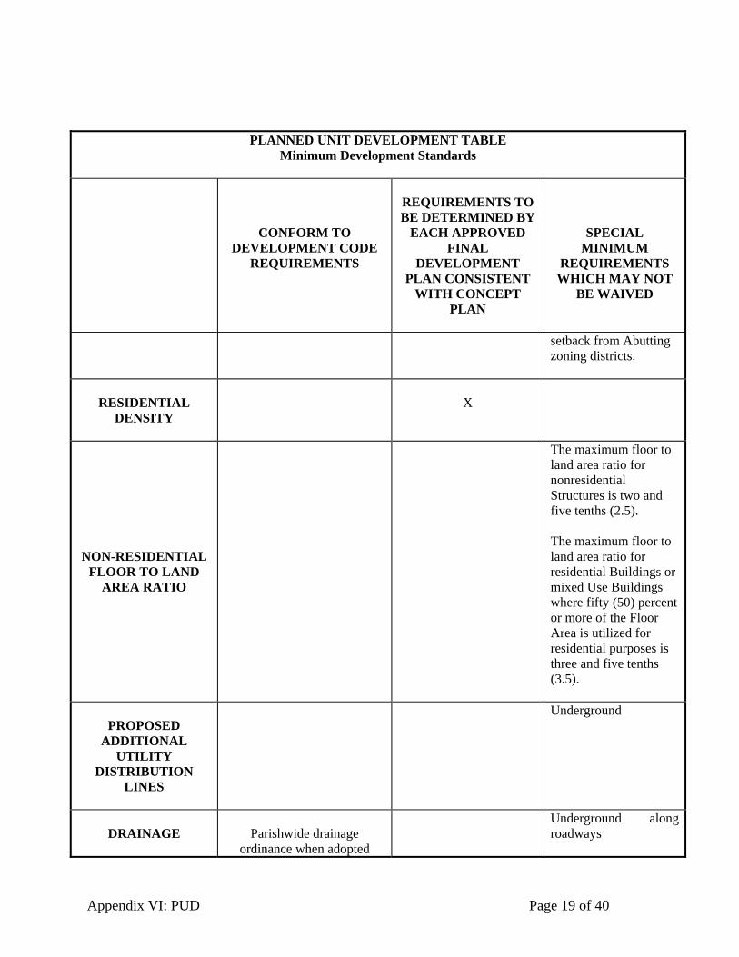
Appendix VI: PUD Page 19 of 40
PLANNED UNIT DEVELOPMENT TABLE Minimum Development Standards
CONFORM TO DEVELOPMENT CODE
REQUIREMENTS
REQUIREMENTS TO BE DETERMINED BY
EACH APPROVED FINAL
DEVELOPMENT PLAN CONSISTENT
WITH CONCEPT PLAN
SPECIAL MINIMUM
REQUIREMENTS WHICH MAY NOT
BE WAIVED
setback from Abutting zoning districts.
RESIDENTIAL
DENSITY
X
NON-RESIDENTIAL FLOOR TO LAND
AREA RATIO
The maximum floor to land area ratio for nonresidential Structures is two and five tenths (2.5). The maximum floor to land area ratio for residential Buildings or mixed Use Buildings where fifty (50) percent or more of the Floor Area is utilized for residential purposes is three and five tenths (3.5).
PROPOSED
ADDITIONAL UTILITY
DISTRIBUTION LINES
Underground
DRAINAGE
Parishwide drainage
ordinance when adopted
Underground along roadways

Appendix VI: PUD Page 20 of 40
PLANNED UNIT DEVELOPMENT TABLE Minimum Development Standards
CONFORM TO DEVELOPMENT CODE
REQUIREMENTS
REQUIREMENTS TO BE DETERMINED BY
EACH APPROVED FINAL
DEVELOPMENT PLAN CONSISTENT
WITH CONCEPT PLAN
SPECIAL MINIMUM
REQUIREMENTS WHICH MAY NOT
BE WAIVED
A Drainage study shall be required for Development of twenty (20) acres or more.
LANDSCAPING
A perimeter landscaped Buffer Yard shall also be required to screen off-Street parking areas and Building service areas from Abutting Streets and residential zoning and Uses.
PERMITTED USES
All zoning districts except industrial and adult businesses.
PUBLIC STREETS
Subdivision regulation requirements unless deviations in Street typical sections are granted with Concept Plan approval.
Subdivision regulation requirements unless

Appendix VI: PUD Page 21 of 40
PLANNED UNIT DEVELOPMENT TABLE Minimum Development Standards
CONFORM TO DEVELOPMENT CODE
REQUIREMENTS
REQUIREMENTS TO BE DETERMINED BY
EACH APPROVED FINAL
DEVELOPMENT PLAN CONSISTENT
WITH CONCEPT PLAN
SPECIAL MINIMUM
REQUIREMENTS WHICH MAY NOT
BE WAIVED
PRIVATE STREETS deviations in Street typical sections are granted with Concept Plan approval.
COMMON OPEN SPACE
Common Open Space is defined in Subsection III. B. A minimum of fifteen (15) percent of the gross site area contained within a Planned Unit Development of between twenty (20) and fifty (50) Acres, eighteen (18) percent of the gross site area contained within a Planned Unit Development over fifty (50) Acres and up to one hundred (100) Acres; and twenty (20) percent of the gross site area contained within a Planned Unit Development in excess of one hundred (100)

Appendix VI: PUD Page 22 of 40
PLANNED UNIT DEVELOPMENT TABLE Minimum Development Standards
CONFORM TO DEVELOPMENT CODE
REQUIREMENTS
REQUIREMENTS TO BE DETERMINED BY
EACH APPROVED FINAL
DEVELOPMENT PLAN CONSISTENT
WITH CONCEPT PLAN
SPECIAL MINIMUM
REQUIREMENTS WHICH MAY NOT
BE WAIVED
Acres shall be dedicated to and maintained as Common Open Space. No reduction in the minimum Common Open Space requirements shall be permitted.
(Ord.# PD05-01, 12/1/05; DC09-09, 12/17/09)
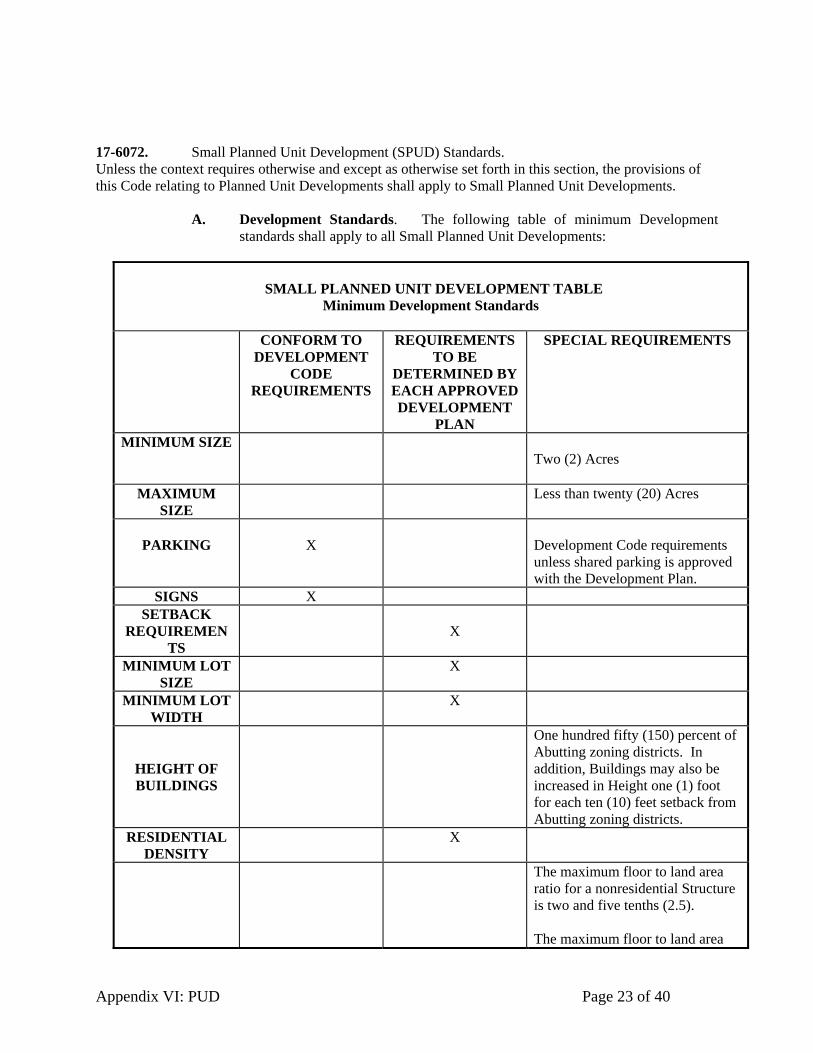
Appendix VI: PUD Page 23 of 40
17-6072. Small Planned Unit Development (SPUD) Standards. Unless the context requires otherwise and except as otherwise set forth in this section, the provisions of this Code relating to Planned Unit Developments shall apply to Small Planned Unit Developments.
A. Development Standards. The following table of minimum Development standards shall apply to all Small Planned Unit Developments:
SMALL PLANNED UNIT DEVELOPMENT TABLE Minimum Development Standards
CONFORM TO
DEVELOPMENT CODE
REQUIREMENTS
REQUIREMENTS TO BE
DETERMINED BY EACH APPROVED DEVELOPMENT
PLAN
SPECIAL REQUIREMENTS
MINIMUM SIZE Two (2) Acres
MAXIMUM SIZE
Less than twenty (20) Acres
PARKING
X
Development Code requirements unless shared parking is approved with the Development Plan.
SIGNS X SETBACK
REQUIREMENTS
X
MINIMUM LOT SIZE
X
MINIMUM LOT WIDTH
X
HEIGHT OF BUILDINGS
One hundred fifty (150) percent of Abutting zoning districts. In addition, Buildings may also be increased in Height one (1) foot for each ten (10) feet setback from Abutting zoning districts.
RESIDENTIAL DENSITY
X
The maximum floor to land area ratio for a nonresidential Structure is two and five tenths (2.5). The maximum floor to land area

Appendix VI: PUD Page 24 of 40
SMALL PLANNED UNIT DEVELOPMENT TABLE
Minimum Development Standards
CONFORM TO DEVELOPMENT
CODE REQUIREMENTS
REQUIREMENTS TO BE
DETERMINED BY EACH APPROVED DEVELOPMENT
PLAN
SPECIAL REQUIREMENTS
FLOOR TO
LAND AREA RATIO
ratio for residential Buildings or mixed Use Buildings where fifty (50) percent or more of the Floor Area is utilized for residential purposes is three and five tenth (3.5).
PROPOSED ADDITIONAL
UTILITY DISTRIBUTION
LINES
Underground
DRAINAGE
X
LANDSCAPING
A perimeter landscaped Buffer Yard shall also be required to screen off-Street parking areas and Building service areas from Abutting Streets and residential zoning and Uses.
PERMITTED
USES
Zoning districts except Industrial and Adult Entertainment Uses;
PUBLIC
STREETS
Deviations in Street typical sections as required by Subdivision Regulation requirements may be granted with Development Plan approval.
PRIVATE STREETS
Deviations in Street typical sections as required by Subdivision Regulation
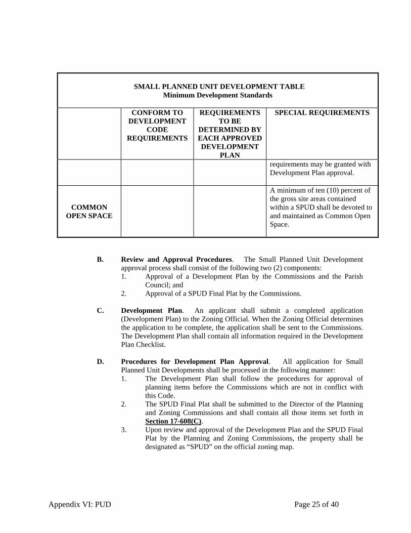
Appendix VI: PUD Page 25 of 40
SMALL PLANNED UNIT DEVELOPMENT TABLE
Minimum Development Standards
CONFORM TO DEVELOPMENT
CODE REQUIREMENTS
REQUIREMENTS TO BE
DETERMINED BY EACH APPROVED DEVELOPMENT
PLAN
SPECIAL REQUIREMENTS
requirements may be granted with Development Plan approval.
COMMON OPEN SPACE
A minimum of ten (10) percent of the gross site areas contained within a SPUD shall be devoted to and maintained as Common Open Space.
B. Review and Approval Procedures. The Small Planned Unit Development approval process shall consist of the following two (2) components: 1. Approval of a Development Plan by the Commissions and the Parish
Council; and 2. Approval of a SPUD Final Plat by the Commissions.
C. Development Plan. An applicant shall submit a completed application
(Development Plan) to the Zoning Official. When the Zoning Official determines the application to be complete, the application shall be sent to the Commissions. The Development Plan shall contain all information required in the Development Plan Checklist.
D. Procedures for Development Plan Approval. All application for Small Planned Unit Developments shall be processed in the following manner: 1. The Development Plan shall follow the procedures for approval of
planning items before the Commissions which are not in conflict with this Code.
2. The SPUD Final Plat shall be submitted to the Director of the Planning and Zoning Commissions and shall contain all those items set forth in Section 17-608(C).
3. Upon review and approval of the Development Plan and the SPUD Final Plat by the Planning and Zoning Commissions, the property shall be designated as “SPUD” on the official zoning map.

Appendix VI: PUD Page 26 of 40
E. Recordation of Development Restrictions, SPUD Final Plat, and Other Documents. The applicant shall record the SPUD Final Plat and any Development restrictions or conditions to the Development Plan by the Planning and Zoning Commissions with the Clerk of Court of Ascension Parish within fifteen (15) days of the date of approval of the Development Plan and the SPUD Final Plat by the Planning and Zoning Commissions.
(Ord.# PD05-01, 12/1/05; DC09-09, 12/17/09) 17-6073. Additional Regulations for Phased Developments.
A Planned Unit Development may be developed in phases or stages in accordance with the following requirements.
A. Boundaries. The boundaries of all proposed Planned Unit Development phases
shall be shown on the Concept Plan.
B. Data. All data required for the project, as a whole, shall be given for each phase shown on the Concept Plan.
C. Improvements. The phasing plan shall be consistent with the traffic circulation,
Drainage, Common Open Space, and utilities plans for the entire Planned Unit Development. Planned Unit Developments that are to be developed in phases or stages shall be required to provide Public Improvements, Common Open Space, and other amenities attributed to such phase at the same time as or before the construction of Principal Buildings and Structures associated with individual phases. The nature, type, and amount of Public Improvements, Common Open Space, and other project amenities provided during an individual phase of the project shall be commensurate with and proportionate to the overall Development of the phase.
(Ord.# PD05-01, 12/1/05; DC09-09, 12/17/09)

Appendix VI: PUD Page 27 of 40
17-6080. General Review Criteria. A. General. Approval and recommendation of the Commissions shall be
accompanied by a written report stating the reasons for approval of the application, and specific evidence and facts showing that the proposed Planned Unit Development will not adversely affect the immediate vicinity. The Commissions in their review of proposed Planned Unit Development plans shall consider, where applicable: 1. The relation between the proposed Development and surrounding Uses,
and the effect of the proposed Planned Unit Development plan upon comprehensive planning.
2. The adequacy of existing and proposed Streets, utilities, and other public services to serve the Development; and the location with respect to the interstate, major highways and major arterial Streets so as not to create adverse major shifts of traffic generation to intermediate collectors and/or minor Streets; and Access of every Dwelling unit or other Uses within the Planned Unit Development to a public and/or private Street via pedestrian ways, courts or other Access related Servitudes or Easements.
3. The character, design, and appropriateness of the proposed land Uses and their adequacy to encourage desirable living conditions, to provide separation and screening between Uses where desirable, to preserve the natural amenities of streams, wooded areas, and similar natural features where possible, to provide adequate, and to encourage, pedestrian circulation and Access to mass transit if available.
4. The proposed location, arrangement Density/intensity, and Height of land Uses shall be compatible to existing or proposed Dwellings within the vicinity of the Planned Unit Development or to the Development of the neighborhoods.
5. The suitability of the site for Development in the manner proposed without hazard to Persons or property adjacent to the site, the Use of Flood hazard areas if present for recreational areas, and no contribution to erosion or other soil related damage. Soil conditions, Drainage, vegetation cover and topography shall be maximally utilized to fit the intended design of the Development.
6. The requirement of Common Open Spaces within the Planned Unit Development and the devotion of the Development to active and passive recreational purposes.
7. The protection and preservation of any existing historic and archaeological features into the design of the Planned Unit Development.
8. The greater protection and preservation of environmentally sensitive and natural amenities areas within the Planned Unit Development, if any, including, but not limited to, wetlands, problem soils, streams, creeks, wooded areas, and areas containing protected species.
9. The internal compatibility of the land Uses within the plan. 10. The external compatibility of the arrangement of the land Uses within the
Planning Unit Development.

Appendix VI: PUD Page 28 of 40
11. The proposed Planned Unit Development is consistent with the spirit and intent of this PUD ordinance and represents an opportunity for improved or innovative Development for the community that could not be achieved through conventional zoning.
12. The promotion of the purposes set forth in Section17-602(A). 13. The proposed Uses within the Planned Unit Development will not
possess conditions or effects that would be injurious to the public health, safety, or welfare of the community.
(Ord.# PD05-01, 12/1/05; DC09-09, 12/17/09)
17-6081. Common Open Space Requirements. A. Subject to satisfaction of subsection “C” below, the following Uses may account
for Common Open Space with the stated limitations: 1. Parks, and other open greenbelt areas within in, whether publicly or
privately owned, which are readily accessible must account for not less than fifty (50%) percent of the Common Open Space.
2. Street Trees located within designated landscape common areas or landscape Servitude and located within a Street Right-of-Way may not exceed twenty-five (25) percent of the Common Open Space. However, Common Open Space within vehicle Use areas or any noncontiguous green area of less than one thousand (1000) square feet may not be included.
3. Lake and ponds, including storm water wet detention basins provided that they are designed so that they are designed so that a minimum of twenty (20%) percent of the Abutting shoreline is made accessible for the common Use of the Development, but in no event less than 300' feet of frontage.
4. Storm water dry detention basins of not less than one (1) Acre; but may not exceed twenty-five (25%) percent of the Common Open Space and must be designed to provide for acceptable maintenance and upkeep of the detention basin.
5. Golf courses may account for up to fifty (50) percent of the Common Open Space.
6. Wetlands. 7. Hard surface recreation areas such as recreational courts and pedestrian
plazas may account for up to twenty-five (25%) of the Common Open Space.
8. Servitudes with existing below ground utilities and/or facilities with a width of not less than 30’ feet.
9. Electrical transmission line Servitudes with a width of not less than 150’ feet.
10. School sites, excluding the area devoted to Buildings. 11. An existing Building or Buildings that have historical or cultural
significance may be located in a common area space; however, the enclosed Building area may not be included in the Common Open Space requirement.

Appendix VI: PUD Page 29 of 40
12. Common Open Space for the Use by the general public, if agreed to by the appropriate governmental authority, in each case in an amount to be determined by the Commissions.
B. Common Open Space shall not include: 1. Required
a. Yards which are not accessible for the common Use of the Development;
b. Parking areas, c. Drives, d. Utility with above ground improvements or road
Easements/Servitudes, 2. Structures (unless a part of the open space such as gazebos), 3. Drainage ditches or canals; and 4. Areas reserved for the exclusive Use and benefit of an individual tenant
or Owner.
C. Common Open Space shall be permanently set aside for the sole benefit, Use, and enjoyment of present and future occupants of the Planned Unit Development through covenant, deed restriction, open space Servitude, or similar legal instrument; or, if agreed to by governmental agency, the open space may be conveyed to a governmental agency for the Use of the general public.
D. The Commissions may consider a Planned Unit Development with a lesser amount of Common Open Space if it is clear that the proposed Planned Unit Development substantially provides for the intent of a Planned Unit Development. It is noted that Common Open Space is a very important element of a Planned Unit Development and reductions to the Common Open Space provision should be granted only as a result of specific, clearly documented reasons (i.e. the Planned Unit Development may be located on a relatively small site in an area where a respective 15% or 20% provision would detract from Building continuity or historic preservation efforts).
E. In the event land shown on a Final Development Plan (as hereinafter defined) as
Common Open Space is dedicated to the Parish, the Parish Council may, but shall not be required to, accept the open space provided: (x) such land is accessible to the residents of the Parish; (y) there is no cost of acquisition other than the costs incidental to the transfer of ownership; and (z) the Parish agrees to and has Access to maintain such lands.
(Ord.# PD05-01, 12/1/05; DC09-09, 12/17/09)
17-6082. Association The Common Open Space and associated facilities may be owned by an Association or maintenance association. The Association shall be formed and operated under the following provisions: A. The applicant shall provide the articles and bylaws of the Association and the
methods for maintaining the Common Open Space.

Appendix VI: PUD Page 30 of 40
B. The Association shall be organized by the applicant and shall be operated with a financial subsidy from the applicant before the sale of any Lots within the Planned Unit Development.
C. Membership in the Association is mandatory for all purchasers of property therein and their successors in title. The conditions and timing of transferring control of the Association from the applicant to the property Owners shall be identified.
D. The Association shall be responsible for maintenance of insurance and taxes on all Common Open Space, enforceable by liens placed on the Association by the Parish. The Association may place liens on the property of its members who fail to pay their Association dues in a timely manner, as provided in the Association bylaws. Shares shall be defined in the bylaws.
E. The Association shall, at all times, cause the property Owners to have Access to the Common Open Space within the Planned Unit Development.
F. The Association shall be able to adjust the assessments to meet changing needs. (Ord.# PD05-01, 12/1/05; DC09-09, 12/17/09)
17-6083. Landscaping and Screening Standards.
A. Overall composition and location of landscaping shall complement the scale of the Development and its surroundings. In general, larger, well-placed contiguous planting areas shall be preferred to smaller, disconnected areas.
B. A Street yard 1,000 square feet or less in size is not required to be landscaped. (Ord.# PD05-01, 12/1/05; DC09-09, 12/17/09)
17-6084. Environmental Standards.
A. All Uses in the Planned Unit Development shall conform to all applicable federal, state and local laws and regulations regarding the environment such as laws and regulations concerning noise, air quality, water quality, radiation, and radioactivity.
(Ord.# PD05-01, 12/1/05; DC09-09, 12/17/09) 17-6085. Ownership and Control.
All land included for purpose of Development within a Planned Unit Development shall be owned by or be under the control of the applicant for such zoning designation (including without limitation a purchase agreement, option agreement, and/or development agreement), whether that applicant be an individual, partnership, corporation (limited liability company, limited liability partnership, trust), or groups of individuals, partnerships, or corporations (limited liability company, limited liability partnerships and/or trusts). The applicant shall present proof of the unified control of the entire area within the Planned Unit Development and shall agree that if applicant proceeds with the Planned Unit Development applicant will: A. Do so in accordance with:
1. The Concept Plan of Development officially adopted for Planned Unit Developments;
2. Regulations existing when the amendment granting the Planned Unit Development was adopted; and

Appendix VI: PUD Page 31 of 40
3. Such other conditions or modifications as may be attached to the rezoning of the land to the Planned Unit Development.
B. Secure written consents and agreements satisfactory to the Commissions from all property Owners of record within the Planned Unit Development boundaries that have not joined in the Planned Unit Development application that there is no objection to including their property in the Planned Unit Development site plan and overall Planned Unit Development planning process.
(Ord.# PD05-01, 12/1/05; DC09-09, 12/17/09)

Appendix VI: PUD Page 32 of 40
(This page left blank intentionally for code expansion)
Appendix VI: PUD Page 33 of 40
17-6090. Administration and Enforcement
(Ord.# PD05-01, 12/1/05; DC09-09, 12/17/09)
17-6091. Violations. A. Any violation of the Concept Plan and/or Final Development Plan or any other phase or
plan adopted as part of the amendment to the Development Code shall constitute a violation of the Development Code. Any Person or legal entity violating any provision of this ordinance, or who shall violate or fail to comply with any order made hereunder; or who shall continue to work upon any Structure after having received written notice from the Zoning Official to cease work, shall be guilty of a misdemeanor and punishable by a fine not to exceed five hundred ($500) dollars per violation. Each day such violation shall be permitted to exist shall constitute a separate offense. Notice of violation shall be sufficient if directed to such Owner, the agent of the Owner, or the contractor and/or left at his known place of residence or place of business.
(Ord.# PD05-01, 12/1/05; DC09-09, 12/17/09) 17-6092. Appeal.
A. An applicant may appeal the findings and recommendations of the Commissions or Zoning Official, as applicable, by filing an objection in writing to the Parish Council within five (5) days of receipt of the Commissions’ or Zoning Official’s recommendations. The Parish Council shall grant or deny the Appeal, and the Council’s decision shall be final. If the Parish Council grants the Appeal, the Council shall submit a notice to the Commissions or Zoning Official stating reasons for its grant of the Appeal.
(Ord.# PD05-01, 12/1/05; DC09-09, 12/17/09)

Appendix VI: PUD Page 34 of 40
(This page left blank intentionally for code expansion)

Appendix VI: PUD Page 35 of 40
17-60100. Definitions Abutting: Having a common border with, or being separated from such common border by, an Alley or Easement. Access: An entry to or exit from a property. Accessory Building: A Building which is (1) subordinate to and serves a principal Structure or Principal Use; (2) is subordinate in area, extent and purpose to the principal Structure or Principal Use; (3) is located on the same Lot as the principal Structure or Principal Use; and (4) is customarily incidental to the principal Structure or Principal Use. Any portion of a Principal Building which is devoted to an Accessory Use is not an Accessory Building. Accessory Use: A Use which (1) is subordinate to and serves a principal Structure or Principal Use, (2) is subordinate in area, extent, and purpose to the principal Structure or Principal Use served, (3) is located on the same Lot as the principal Structure or Principal Use served except as otherwise expressly authorized by provisions of this ordinance, and (4) is customarily incidental to the principal Structure or Principal Use. Acre: Forty-three thousand five hundred sixty (43,560) square feet. Alley: A public or private way permanently reserved as a secondary means of Access to Abutting property. Appeal: A means for obtaining review of a decision, determination, order, or failure to act under the terms of this ordinance. Association, or Associations: The association or associations of all the Owners of property in the PUD charged with the ownership and maintenance of Common Open Space and associated facilities and operated pursuant to articles of incorporation and bylaws. Initially, the Developer shall maintain control of the Association until such time as seventy-five (75%) percent of Lots in the PUD have been sold, or as otherwise set forth in its Articles or Bylaws. A PUD may have a residential Association and a commercial Association. Buffer, or Buffer Yard: A unit of land, together with a specified type and amount of planting and any fencing which may be required between land Uses to minimize conflicts between them. Building: A Structure built, maintained, or intended for Use as a shelter or enclosure of Persons, animals, or property. The term includes any part of the Structure. Where independent units with separate entrances are divided by party walls, each unit is a Building. Building Line: A line on a Lot, generally parallel to a Lot Line or road Right-of-Way, located a sufficient distance there from to provide the minimum yards required by this ordinance. The Building Line delimits the area where Buildings are permitted subject to all applicable provisions of this ordinance. Commissions: The Planning Commission and the Zoning Commission, individually and collectively.

Appendix VI: PUD Page 36 of 40
Common Open Space: A Parcel or Parcels of land and/or an area of water within a Development that are held in some form of common ownership and designated, designed and intended for benefit, Use or enjoyment of the occupants of the Development. It may contain such complementary Structures and improvements as necessary and appropriate for the benefit and enjoyment of the occupants of such Development, including those Uses set forth in Section 17-6081. Concept Plan: The initial plan of Development for a PUD which an applicant/Developer submits to the Commissions containing all those items described in the Concept Plan Checklist, including written and graphic documents, which represents a conceptual plan of the proposed land Uses and their overall impact on the land and surrounding land for rezoning of the land to PUD Concept. Concept Plan Checklist: A list containing items which must be included in a Concept Plan submitted to the Commissions for PUD approval. Condominium: The property regime under which portions or units (whether horizontal or vertical) of immovable property are subject to individual ownership and the remainder thereof is owned in indivision by all unit Owners, in accordance with the Louisiana Condominium Act, LA R.S. 9:1121.101 et seq. Density: A measure of the intensity of Development. In this ordinance, Density for residential Development is calculated in terms of units per Acre. The calculation for residential Density is set forth in Section 17-2073(D) of the Development Code. Density for commercial Development is calculated as the gross Floor Area for each Development project. Developer: The legal or beneficial Owner(s) of a Lot or Parcel of any land proposed for inclusion in a Development, including the holder of an option or contract to purchase. Development: The division of a Parcel of land into two (2) or more Parcels; the construction, reconstruction, conversion, structural alteration, relocation, or enlargement of any Buildings or Structures; any Use or change in Use of any Buildings or land; or any extension of any Use of land or any clearing, grading, or other movement of land. Drainage: The removal of surface water or groundwater from land by drains, grading, or other means. Drainage includes the control of runoff to minimize erosion and sedimentation during and after Development and includes the means necessary for water supply preservation or the prevention or alleviation of Flooding. Dwelling: Any Building or portion of a Building which is designated or used for residential purposes. Dwelling, Multi- : A Building that contains more than one (1) living unit. Dwelling, Single-: A Building that contains only one (1) living unit, including attached Buildings in the case of Townhomes. Final Development Plan: The final plan of Development for a PUD which an applicant/Developer submits to the Commissions containing all those items described in the Final Development Plan Checklist, including written and graphic documents, for detailed plan review and Subdivision of land zoned PUD Concept.

Appendix VI: PUD Page 37 of 40
Final Development Plan Checklist: A list containing items which must be included in a Final Development Plan submitted to the Commissions for final PUD approval. Flood, or Flooding: A general and temporary condition of partial or complete inundation of normally dry land areas from the overflow of inland or tidal waters, or the unusual and rapid accumulation or runoff of surface waters from any source. Floor Area: The sum of the gross floor area for each of a Building’s or Structure’s Stories measured from the exterior limits of the faces of the Building or Structure. The Floor Areas of the Building include the basement Floor Area. The Floor Area includes the attic only if it is habitable Floor Area. Height: The vertical distance measured from the lowest ground elevation to the highest point of the Building or Structure. The Building Height may be prescribed as a maximum number of Stories or as a dimension from sidewalk grade to the eave. The Height limit shall not apply to chimneys. Lot: A Parcel of land undivided by any Street or private road and occupied by or intended for occupancy by, or designated to be developed for, one (1) Building or Principal Use and the Accessory Buildings or Uses customarily incidental to such Building, Use or Development, including such open spaces and yards as are designed and arranged or required by this ordinance for such Building Use or Development. Lot Area: The area contained within the boundary lines of a Lot. Lot Line: A line bounding a Lot which divides one (1) Lot from another or from a Street or any public or private space. Lot Width: The horizontal distance between Side Lot Lines measured at the front setback. Where there is only one Side Lot Line, Lot Width shall be measured between such Lot Line and the opposite Lot Line or future Right-of-Way line. Major Change: A change to an approved Planned Unit Development as set forth in Sections 17-609 A-C. Minor Change: A change to an approved Planned Unit Development as set forth in Section 17-609(D). Owner: The Person or Persons having the right of legal title to, beneficial interest in, or a contractual right to purchase a Lot or Parcel of land. Parcel: The area within the boundary lines of a Development. Parish Council, or Council: The governing body of Ascension Parish having the power to adopt and enforce ordinances. Person: An individual, firm, partnership, corporation, company, association, joint stock association or government entity; including a trustee, a receiver, and assignee, or a similar representative of any of them.

Appendix VI: PUD Page 38 of 40
Planned Unit Development, or PUD: The Subdivision, Development and Use of land as an integral unit, combining more than one (1) primary land Use which may provide for single-family residential, multiple-family residential, educational, business, commercial, retail, industrial, recreational, park and Common Open Space areas. Planning Commission: An agency legally established by the Parish Council in conformity with state legislation with all the rights and responsibilities defined by such legislation. Planning Staff, or Commissions Staff: Professional and non-professional personnel employed by the Commissions to carry out and fulfill the directives and responsibilities of the Commissions. Staff functions may be conducted by private or public consultants at the discretion of the Commissions. Principal Building: A Building in which the Principal Use of the Lot on which the Building is located is conducted or intended to be conducted. Principal Use: The specific primary purpose for which land is used. Public Improvement: Any improvement, facility, or service, together with customary improvements and appurtenances thereto, necessary to provide for such public needs as vehicular and pedestrian circulation systems, storm sewers, Flood control improvements, water supply and distribution facilities, sanitary sewage disposal and treatment, public utility, and energy services. Rear Lot Line: That Lot Line which is parallel to and most distant from the front Lot Line of the Lot; in the case of an irregular, triangular, or gore-shaped Lot, a line twenty (20) feet in length, entirely within the Lot, parallel to and at the maximum possible distance from the front line, shall be considered to be the Rear Lot Line. In the case of Lots which have frontage on more than one (1) road or Street, the Rear Lot Line shall be opposite the Lot Line along which the Lot takes Access to a Street. Restrictive, more (less): A regulation imposed by this ordinance is more (less) restrictive than another if it prohibits or limits Development to a greater (lesser) extent or by means of more (less) detailed specifications. Right-of-Way: A strip of ground dedicated by the Developer for public Use, title to which shall rest in the public for the purpose stated in the dedication. Servitude (Easement): A strip existing or to be reserved by the Developer for public utilities, Drainage and other public purposes, the title to which shall remain with the property Owner, subject to the right of Use designated in the reservation of servitude; or a strip of ground designated or intended to be used for Access to Buildings and other portions of property. Side Lot Line: Any Lot Line other than a front or Rear Lot Line. Sign: Any Structure, part thereof, or device attached thereto or painted or represented thereon, or any material or thing, illuminated or otherwise, which displays or includes any numeral, letter, word, model, pennant, streamer, banner, emblem, insignia, device, trademark or other representation used as, or in the nature of, an announcement, advertisement, direction or designation of any Person, firm, group, organization, place, commodity, product, service, business, profession, enterprise or industry which is located upon any land or on any Building.

Appendix VI: PUD Page 39 of 40
Story, or Stories: A space in a Building between the surface of any floor and the surface of the next floor above, or if there is no such floor above, then the space between such floor and the ceiling or roof above. Street: A strip of land, including the entire Right-of-Way, publicly or privately owned, serving as a means of slow vehicular travel, and furnishing Access to Abutting properties, which may also be used to provide space for sewers, public utilities, shade Trees, and sidewalks. A Street may be public or private. Structure: An object, including a mobile object, constructed or installed by man, including but without limitation, Buildings, towers, cranes, and overhead transmission lines. Subdivision: Any division, subdivision or re-division of a subdivision, tract, Parcel, or Lot of land into two (2) or more Lots, plots, sites, parts, or other division of land by means of mapping, platting, conveyance, or change of rearrangement of boundaries for the purpose of sale, lease or Development, whether immediate or future. All Subdivisions are also Developments. Townhome: Two (2) or more attached living units with common or party sidewalls between units, designated so that each unit may be sold independently as a Lot with its own yards and parking spaces. Tree: Any self-supporting perennial woody plant that is at least four (4) inches in diameter. Use: The purpose or activity for which land or any Building thereon is designed, arranged, or intended, or for which it is occupied or maintained. Variance: Permission to depart from the literal requirements of this ordinance granted by the Planning Commission. Zoning Commission: An agency legally established by the Parish Council in conformity with state legislation with all the rights and responsibilities defined by such legislation.
(Ord.# PD05-01, 12/1/05; DC09-09, 12/17/09)

Appendix VI: PUD Page 40 of 40
17-60110. SPUDs and PUDs 17-60111. Orange Grove Plantation PUD
A. Rezone from Conservation (C) to PUD Concept (PC) B. LEGAL DESCRIPTION OF THE PROPERTY CONTAINED WITHIN THE ORANGE
GROVE COMMUNITY DEVELOPMENT DISTRICT C. Three certain lots or parcels of land described as "LOT 5-A-1", "LOT 5-A-2" and "LOT
5A-3", together containing 134.724 acres, as shown on the map prepared by Ferris Engineering & Surveying, LLC dated October 17, 2006 entitled "Map Showing Subdivision of Lot 5-A Being a Portion of Orange Grove Plantation into Lots 5-A-1, 5-A-2 & 5-A-3", located in Section 9, Township 10 South, Range 3 East, Southeast Land District, Ascension Parish, Louisiana, for Renaissance Orange Grove, LLC, recorded October 20, 2006 as Instrument No. 00651540, official records of Ascension Parish, State of Louisiana, the outermost boundary of such combined tracts being more fully described as: Commence at the apparent lower 80 arpent corner of Orange Grove Plantation as shown on map referenced above, said point also being the POINT OF BEGINNING; Thence South 46° 02' 34" West a distance of 2,273.1 0 feet to a point and corner; Thence North 41 ° 09' 09" West a distance of 2,310.37 feet to a point and corner; Thence North 37° 04' 37" East a distance of 1,114.12 feet to a point and corner; Thence North 48° 35' 24" West a distance of 414.90 feet to the eastern right-of-way of Louisiana Highway 22 being a point and corner; Thence in a northerly direction along the eastern right-of-way of Louisiana Highway 22 North 37° 04' 37" East a distance of 208.60 feet to a point and corner; Thence continuing along said right-of-way North 42° 24' 37" East a distance of 125.60 feet to a point and corner; Thence leaving said right-of-way in an easterly direction South 52° 55' 23" East a distance of 402.04 feet to a point and corner; Thence North 37° 04' 37" East a distance of 570.17 feet to a point and corner; Thence North 52° 55' 23" West a distance of 108.71 feet to a point and corner; Thence North 37° 04' 37" East a distance of 190.10 feet to a point and corner; Thence North 52° 55' 23" West a distance of 287.27 feet to the eastern right-of-way of Louisiana Highway 22 being a point and corner; Thence in a northerly direction along the eastern right-of-way of Louisiana Highway 22 North 36° 59' 37" East a distance of 162.31 feet to a point and corner; Thence leaving said right-of-way in an easterly direction South 41 ° 09' 09" East a distance of 3.076.96 feet to the POINT OF BEGINNING.
(Ord.# PD08-01, 1/10/08)

4207GonzPhonWeb:
7 Churchpoizales, Louisiane: (225) 450-: www.ascen
17-701. 17-702. 17-703. 17-7020. 17-7021. 17-7022. 17-7023. 17-7024. 17-7025. 17-7030. 17-7031. 17-7032. 17-7033. 17-7034. 17-7035. 17-7036. 17-7040. 17-7041. 17-7042. 17-7043. 17-7044. 17-7045. 17-7046. 17-7047. 17-7048. 17-7049. 17-7050. 17-7051. 17-7052. 17-7053. 17-7054. 17-7055. 17-7056. 17-7057. 17-7058. 17-7080. 17-7081. 17-7090. 17-7091.
nt Road ana 70737 -1002 / Fax: (2sionparish.n
TRADI
Purpose/ Relation toOverview ProcedureApplicatioPre-ApplicGeneral ImSpecific ImConsolidaTND ProjChanges toMaintaininExpirationThe ApproFiling andRezoning TND DistAssociatioLand Use NeighborhDevelopmAdditionalStormwateLot and BlThoroughfParking reArchitectuGuidelinesGuidelinesGuidelinesLandscapiEnvironmeOther CodUnified CoAdditionalStreet DesTable 1: SAdministrFees. .......
PAROFFI
225) 450-1352net
ITIONAL N
General .......o Zoning Dist.....................es and Proce
on Procedure cation Confermplementationmplementatioted General Ijects Approvo an Approveng a Specific n and Lapse ooved Final De
d Distribution from "TND"
trict Design Ron ..................Allocations. .
hood Uses. ....ment Units. ....
l Common Oper Managemelock Standardfare Network
equirements. .ural Standardss for garages s for exterior s for lighting.ing and Screeental Standar
de and Ordinaontrol. ..........l Regulationssign Requiretreet Design Gration and E.....................
ISH OCE OF PL
2
APPNEIGHBORH
C
.....................tricts. .................................
ess .................and Approvarence. ............n Plan. ..........
on Plan and Fimplementatio
ved ................ed Specific ImImplementati
of Specific Imevelopment Pof Specific ImDistrict to Pr
Requirement....................................................................................pen Space Re
ent. ................ds. .................. .........................................s. ...................and Secondarsignage. ........ ....................ning Standardds. ................
ances Applica.....................
s for Phased Dements: .........Guidelines ...
Enforcement ......................
OF ALANNING
PLAN
PENDIX VIIHOOD DEVE
Contents:
......................
......................
......................
......................al Process; Ge............................................inal Plat. .......on Plan and S......................
mplementationion Plan. .......
mplementationPlan. ...............mplementatiorior Zoning Dts. ..........................................................................................................equirements. ...............................................................................................................ry Dwelling U............................................ds. .......................................ability. .................................Developments........................................................................................
ASCEG AND DENNING D
I ELOPMENT
.....................
.....................
.....................
.....................eneral. ..........................................................................
Specific ..............................n Plan. ...............................
n Plans. ..............................on Plan Final
District. .................................................................................................................................................................................................................................................Units. .........................................................................................................................................s. ......................................................................................................
NSIOVELOPM
DEPARTM
T (TND) COD
.....................
.....................
.....................
.....................
.....................
.....................
.....................
.....................
.....................
.....................
.....................
.....................
.....................
.....................Plat. .....................................................................................................................................................................................................................................................................................................................................................................................................................................................................................................................................
ON MENT MENT
DE
......................
......................
......................
......................
......................
......................
......................
......................
......................
......................
......................
......................
......................
......................
......................
......................
......................
......................
......................
......................
......................
......................
......................
......................
......................
......................
......................
......................
......................
......................
......................
......................
......................
......................
......................
......................
......................
......................
......................
....... 3
....... 4
....... 4
....... 7
....... 7
....... 8
....... 8
....... 9
..... 12
..... 13
..... 13
..... 19
..... 21
..... 21
..... 21
..... 22
..... 23
..... 23
..... 24
..... 24
..... 27
..... 28
..... 30
..... 30
..... 31
..... 34
..... 36
..... 38
..... 38
..... 38
..... 38
..... 40
..... 40
..... 40
..... 41
..... 43
..... 43
..... 45
..... 45

Appendix VII: TND Page 2 of 52
17-7092. Violations. ............................................................................................................................... 45 17-7093. Appeal. .................................................................................................................................... 45 17-70100. Definitions. ......................................................................................................................... 47
ORDINANCE HISTORY ORD. #TD05-01, adopted December 1, 2005 ORD. #DC09-09, adopted December 17, 2009

Appendix VII: TND Page 3 of 52
17-701. Purpose/ General
The purpose of a Traditional Neighborhood Development Zoning District ("TND District") is to encourage mixed-Use, compact Development and facilitate the efficient use of services. A TND District diversifies and integrates land Uses within close proximity to each other, and it provides for the daily recreational and shopping needs of the residents. A TND District is a sustainable, long-term community that provides economic opportunity and environmental and social equity for the residents. This ordinance's intent is to encourage its use by providing incentives, rather than prohibiting conventional Development. A Traditional Neighborhood Development:
A. Is designed for the human scale;
B. Provides a mix of Uses, including residential, commercial, civic, and open space Uses in close proximity to one another within the neighborhood;
C. Provides a variety of housing types, and sizes to accommodate households of all ages, sizes, and incomes;
D. Includes residences, shops, workplaces and civic Buildings interwoven within the neighborhood, all within close proximity;
E. Incorporates a system of relatively narrow, interconnected Streets, Roads, Drives, and other Thoroughfare Types with sidewalks and bikeways, that offer multiple routes for motorists, pedestrians, and bicyclists and provides for the connections of those Thoroughfare Types to existing and future Developments; Includes compatibility of Buildings and other improvements as determined by their arrangement, bulk, form, character and landscaping to establish a livable, harmonious and diverse environment;
F. Incorporates environmental features into the design;
G. Coordinates transportation systems with a hierarchy of appropriately designed facilities for pedestrians, bicycles, and vehicles;
H. Provides well-configured squares, plazas, greens, landscaped Streets, preserves, greenbelts and parks woven into the pattern of the neighborhood;
I. Incorporates architecture, landscape, lighting and signage standards integrated with the zoning provisions that respond to the unique character of the region; and
J. Provides an increased range of options than are allowed by conventional zoning. (Ord.#TD05-01, 12/1/05; DC09-09, 12/17/09)

Appendix VII: TND Page 4 of 52
17-702. Relation to Zoning Districts.
A. An approved Traditional Neighborhood Development shall be considered to be a separate zoning district in which the Development plan, as approved, establishes the restrictions and regulations according to which Development shall occur, and may depart from the normal procedures, standards, and other requirements of the other sections of the zoning ordinance and Subdivision regulations to the extent provided herein. Upon approval, the official zoning map will be changed to indicate the area as "TND CONCEPT, or if final approval granted then as "TND". Every approval of a Traditional Neighborhood Development shall be considered an amendment to the zoning ordinance.
(Ord.#TD05-01, 12/1/05; DC09-09, 12/17/09)
17-703. Overview
A. TND District consists of an area of not less than 50 contiguous Acres. In this Article, property is considered contiguous even if separated by a public roadway.
B. TND Types: TND District is divided into at least two types of areas, and each type of area has different land Use and site Development regulations. A TND District must have one Neighborhood Center Area (also sometimes referred to as Town Center or Village Center) and at least one Mixed Residential Area. A TND District may also have a Neighborhood Edge Area, Civic Spaces and Green Spaces.
C. Neighborhood Center Area: serves as the focal point of a TND District, containing retail, commercial, civic, and/or public services to meet the daily needs of community residents. A "Neighborhood Center" is pedestrian-oriented, and it is designed to encourage pedestrian movement. A square may be located in a Neighborhood Center Area. Retail and commercial Uses should generally be located adjacent to a square. The Neighborhood Center Uses include retail shops, restaurants, offices, banks, hotels, post office, governmental offices, churches, community centers, and attached residential Dwellings.
D. Mixed Residential Area: includes a variety of residential land Uses, including single-family residential, duplex, Townhome, and multi-family. Residential scale retail and commercial Uses are permitted within a Mixed Residential Area with strict architectural and land Use controls. Retail and commercial Uses in a Mixed Residential Area are required to blend into the residential character of the neighborhood. A Mixed Residential Area includes open spaces including small squares, pocket parks, community parks, and greenbelts. A Mixed Residential Area promotes pedestrian activity through well designed and varied streetscapes that also provide for the safe and efficient movement of vehicular traffic. Mixed Residential Area Uses include single-family homes, condominiums, Townhomes, apartments, offices, restaurants, neighborhood scale retail, and civic Uses. Mixed Residential areas often utilize Alleys.

Appendix VII: TND Page 5 of 52
E. Neighborhood Edge Area is the least dense portion of a TND District, with larger Lots and greater setbacks than the rest of the neighborhood. Alleys are not required, and direct vehicular Access to Streets is permitted. Only single family residential Dwellings are permitted. A Neighborhood Edge Area is appropriate along the perimeter of the neighborhood. A portion of a TND District that adjoins existing or platted conventional low Density housing must be designated as a Neighborhood Edge Area.
F. Large office, low-impact manufacturing Uses and industrial Uses that are not appropriate for a Neighborhood Center Area or a Mixed Residential Area but which serve the local residents may be located in a specified district.
G. Civic Uses that are oriented to the general public are permitted in a Neighborhood Center Area and a Mixed Residential Area. These Uses are essential components of the social and physical fabric of a TND District. Civic space shall be integrated in residential and commercial areas in the TND. TND's shall incorporate civic Common Open Spaces to be maintained by the municipality and/or private open spaces to be maintained by the community or landowners within the TND. Special attention should be paid to the location of government offices, libraries, museums, schools, churches, and other prominent public Buildings to create focal points and landmarks for the community. The locations of these major public civic Uses are designated on the Development Plan at the time of Commission approval of a particular Development.
H. Open space is a significant part of a TND District design. Formal and informal open spaces are required. These serve as areas for community gatherings, landmarks, and as organizing elements for the neighborhood. Open space includes squares, plazas, greens, preserves, parks, and greenbelts.
I. A TND District is designed to be pedestrian oriented. To accomplish this goal, pattern and design of the various Thoroughfare Types are used to reduce vehicle travel speeds and encourage pedestrian activity. An interconnected network of Streets, and other Thoroughfare Types, is required. Streets may be smaller than in conventional Development and more varied in size and form to control traffic and give character to the neighborhood.
J. Thoroughfares and utilities in TND Districts shall connect to existing Thoroughfares and utilities, or dead-end as stubs intended for connection to future Thoroughfares, unless otherwise prohibited by topography, environmental constraints or other considerations, as further described in Section 17-7048.
(Ord.#TD05-01, 12/1/05; DC09-09, 12/17/09)
Appendix VII: TND Page 6 of 52
(This page left blank intentionally for code expansion)

Appendix VII: TND Page 7 of 52
17-7020. Procedures and Process
17-7021. Application Procedure and Approval Process: General.
A. Prior to the issuance of any permits for Development within a TND District, the following three steps shall be completed according to the procedures outlined in this Section:
1. Pre-Application Conference;
2. Approval of a General Implementation Plan by the Commissions and the Council for the entire Traditional Neighborhood Development; and
3. Approval of a Specific Implementation Plan by the Planning Commission; and
4. Approval of a Final Plat by the Planning Commission.
B. If the Development includes the division of property into Lots, the Specific Implementation Plan shall be approved concurrently with a preliminary plat.
C. Subdivisions of property within a TND District after General Implementation Plan approval, but prior to Specific Implementation Plan approval, shall meet the zoning requirements of the most Restrictive zoning district allowed for each designated Use for that portion of the General Implementation Plan. These Subdivisions shall require Planning Commission approval and will not allow Development or Building permit approval until a Specific Implementation Plan is approved.
D. Where the Development is to be developed in phases, the General Implementation Plan that is presented for review and approval shall be the General Implementation Plan for the entire Development and shall identify the proposed phasing. Each phase of a Development shall have an individual Specific Implementation Plan.
E. Independent Consultants may be retained by the Commissions and/or the Council to seek assistance to properly review the General Implementation Plans and Specific Implementation Plans. The reasonable cost of such review shall be reimbursed by the applicant. The applicant shall be advised of the estimated fees and costs and may withdraw their request from consideration at that time. All required fees must be paid regardless of whether the proposed plans are approved, amended, rejected or withdrawn.
(Ord.#TD05-01, 12/1/05; DC09-09, 12/17/09)

Appendix VII: TND Page 8 of 52
17-7022. Pre-Application Conference.
A. The pre-Application conference shall be held with the Zoning Official or the Zoning Official's designee for the purpose of exchanging information, providing guidance to the applicant and determining the eligibility of the request for consideration as a Traditional Neighborhood Development.
B. A request for a pre-Application conference shall be made to the Zoning Official. As part of the pre-Application conference, the applicant shall submit five (5) copies of a conceptual plan, at least ten (10) days in advance of the pre-Application conference, which shows the property location, boundaries, significant natural features, Thoroughfare network (vehicular and pedestrian circulation), land Use(s) for the entire site, and a statement indicating financial responsibility sufficient to complete the Public Improvements shown on the conceptual plan.
C. The Zoning Official or the Zoning Official's designee shall advise the applicant of the conformance of the Traditional Neighborhood Development concept with the intent and objectives of a Traditional Neighborhood Development, whether it appears to qualify under the minimum requirements of this code, and whether the general concept appears to be substantially consistent with the Ascension Parish Master Plan and the Ascension Parish Land Use Plan. No formal action will be taken at a pre-Application conference, nor will statements made at the pre-Application conference be considered legally binding commitments.
(Ord.#TD05-01, 12/1/05; DC09-09, 12/17/09)
17-7023. General Implementation Plan.
A. Following the pre-Application conference, the applicant shall submit a completed Application (General Implementation Plan) to the Zoning Official. When the Zoning Official determines the Application to be complete, the Application shall be sent to the Commission for a public workshop session if deemed necessary by the Zoning Official, followed at a later date by a public hearing. The General Implementation Plan shall contain all information required in the General Implementation Plan Checklist, including architectural design guidelines as described in Section and subsections to 17-7040, 17-7080.
B. Procedures for General Implementation Plan approval. All Applications for Traditional Neighborhood Developments shall be processed in the following manner:
1. The General Implementation Plan shall follow the procedures for approval of planning items before the Planning Commission and zoning cases before the Zoning Commission and the Council which are not in conflict with this code.
2. At least fourteen (14) days prior to review and determination by the Commissions, all Abutting property Owners shall be notified by regular mail of the Traditional Neighborhood Development and given an

Appendix VII: TND Page 9 of 52
opportunity to submit written comments. Notice shall also be published in the Parish's official journal at least ten (10) days prior to the review.
3. Following required public notice, the Commissions shall hold a public hearing on the proposed Traditional Neighborhood Development. Following the hearing, the Commissions shall review Traditional Neighborhood Development request and General Implementation Plan and any comments submitted by any adjoining property Owners and shall make a recommendation to the Council to approve, approve with conditions, or deny the Traditional Neighborhood Development rezoning request. In its recommendation to the Council, the Commissions shall include the reasons for such recommendation.
C. Approval of a General Implementation Plan. After receiving the recommendation of the Commissions, the Council shall review the Application, including the General Implementation Plan, the record of the Commissions' proceedings and the recommendation, and shall approve, approve with conditions, or deny the Application in accordance with the standards and purposes set forth in this code. An approval with conditions shall not be considered final (and the rezoning is not final until such time) until the applicant submits a written acceptance of the conditions and all necessary revisions to the General Implementation Plan to the Council.
D. If approved by the Council, the General Implementation Plan and all other information and material formally submitted with the Application shall be adopted as an amendment to this Development Code and shall become the standards of Development for the Traditional Neighborhood Development. All future Development shall conform to the standards adopted for the Traditional Neighborhood Development regardless of changes in ownership.
E. Upon approval of the General Implementation Plan, the property shall be designated "TND CONCEPT' on the official zoning map.
(Ord.#TD05-01, 12/1/05; DC09-09, 12/17/09)
17-7024. Specific Implementation Plan and Final Plat.
A. Submittal. Within thirty-six (36) months of the Council's approval of the General Implementation Plan, and except as permitted under General Implementation Plan approval, the applicant shall submit a Specific Implementation Plan to the Zoning Official prior to commencing construction on property zoned "TND CONCEPT'. The applicant may request an extension of up to twelve (12) additional months from the Council if the Specific Implementation Plan has not been approved. If the applicant fails to submit a Specific Implementation Plan, then the General Implementation Plan (not the rezoning) shall be determined to be invalid. If the Traditional Neighborhood Development is to be developed in phases, the applicant must submit a Specific Implementation Plan for the first phase within thirty-six (36) months of the Council's approval of the General Implementation Plan, and within consecutive twelve (12) month periods thereafter for each subsequent phase. If the applicant fails to submit a Specific Implementation Plan, then the General Implementation

Appendix VII: TND Page 10 of 52
Plan incorporating all phases not already approved as a Specific Implementation Plan shall be determined to be invalid. The Specific Implementation Plan shall contain all information required in the Specific Implementation Plan Checklist.
B. Certification. The following design professionals shall certify direct involvement in the preparation of the Specific Implementation Plan. A Final Plat shall be certified by a:
1. Architect or civil engineer; and
2. Landscape architect.
C. Final Plat. A Final Plat shall be submitted with the Specific Implementation Plan, drawn in ink to a scale of one (1") inch equals one hundred (100') feet in one (1) or more sheets whose dimensions are twenty-four (24") inches by thirty-six (36") inches, and contain the information required by the Subdivision Ordinance under the Development Code.
1. The title of the Final Plat shall read "Final Plat of [Name of Traditional Neighborhood Development], [Section, Township, and Range"].
2. Where the Traditional Neighborhood Development is of unusual size or shape, the Commission may permit a variation in the scale or size of the Final Plat.
D. Landscape Plan. A Landscape Plan is required for all Traditional Neighborhood Development Specific Implementation Plans.
E. Substantial Compliance of Specific Implementation Plan.
1. The Specific Implementation Plan shall be in substantial compliance with the General Implementation Plan. It is not intended that the Traditional Neighborhood Development so . approved shall be inflexibly applied, but rather, the Traditional Neighborhood Development shall be in conformance with the General Implementation Plan subject to modification due to changed economic, social, market or demographic conditions. The burden shall be upon the applicant to show the Planning Commission good cause for Major Change (as defined below) between the General Implementation Plan and the Specific Implementation Plan as submitted for final approval. If the Specific Implementation Plan, as submitted, contains substantial variations from the General Implementation Plan, or Major Changes as defined in Section 17-7031, the Planning Commission may, after a meeting with the applicant, within five (5) days of such meeting, advise the applicant in writing why said variations are not in the public interest, and deny the proposed variations. Nothing contained herein shall prohibit an applicant from requesting a change to an approved Traditional Neighborhood Development as set forth in Section 17-7031.

Appendix VII: TND Page 11 of 52
F. Procedure for approval.
1. The Specific Implementation Plan and Final Plat shall follow the procedure for planning items going to the Planning Commission with a public hearing. Procedure for approval of a Specific Implementation Plan and Final Plat for a Traditional Neighborhood Development shall be processed in the following manner:
a. The Engineering Review Agency shall review and approve the construction plans for any Public Improvements shown on the Specific Implementation Plan prior to any construction. Improvements may be completed or bonded for final approval in the same manner as required under the Subdivision Ordinance of the Development Code.
b. The Planning Commission shall issue a notice of public hearing by posting the affected site in a conspicuous place at least ten (10) days prior to the hearing date. A record of information and materials presented at the public hearing shall be kept and maintained by the Commission as part of the applicant's permanent record.
c. Following required public notice, the Planning Commission shall hold a public hearing on the proposed Specific Implementation Plan and Final Plat. Following the hearing, the Planning Commission shall review the Specific Implementation Plan and Final Plat request and any comments submitted by any adjoining property Owners and shall approve, approve with conditions, or deny the request.
d. Upon such approval and subsequent amendment of the Specific Implementation Plan, construction may proceed for public and/or approved private Thoroughfares, utility installations, Common Open Space, recreational facilities, governmental Structures, and similar Uses provided that a preliminary Subdivision plat has also been approved for the Development in accordance with the Development Code.
e. Any other proposed modifications, including yard Variances and/or setback waivers, affecting the Traditional Neighborhood Development's legal description shall require a review and approval of the Traditional Neighborhood Development Specific Implementation Plan and/or the Final Plat by the Commissions staff. The burden shall be upon the applicant to demonstrate to the Planning Commission justification for any variation from the approved Specific Implementation Plan.

Appendix VII: TND Page 12 of 52
f. Upon approval of a Specific Implementation Plan and the Final Plat, the property shall be redesignated from "TND CONCEPT' to "TND" on the official zoning map. Once land is rezoned to "TND", the provisions of this ordinance are mandatory.
(Ord.#TD05-01, 12/1/05; DC09-09, 12/17/09)
17-7025. Consolidated General Implementation Plan and Specific
A. Implementation Plan. The applicant may file a General Implementation Plan, Specific Implementation Plan and Final Plat simultaneously with the Specific Implementation Plan conforming in all respects to the requirements of the General Implementation Plan.
(Ord.#TD05-01, 12/1/05; DC09-09, 12/17/09)

Appendix VII: TND Page 13 of 52
17-7030. TND Projects Approved
17-7031. Changes to an Approved Specific Implementation Plan.
A. Types of Changes. There are three (3) types of changes: Major Use Change, Major Site Change, and Minor Change. A Major Use Change and a Major Site Change are collectively referred to herein as a "Major Change".
B. Major Use Change. A major Use change ("Major Use Change") is one that will have significant impacts on the approved Uses within the Traditional Neighborhood Development, or on the site surrounding the Traditional Neighborhood Development. Major Use Changes include, but are not limited to:
1. An increase in the Development site area of more than five (5%) percent;
2. An increase in Density of any permitted land Use, including the number of housing units, by more than five (5%) percent;
3. In residential areas, a change in the mix of Single-Dwelling and Multi-Dwelling Structures by more than five (5%) percent;
4. An increase in the amount of land in nonresidential Uses by more than five (5%) percent;
5. Involve any land Use not specified on the approved General Implementation Plan or the list of permitted Uses;
6. Substantial and material reduction in the amenities proffered by the applicant; and/or
7. Material changes in the permitted land Use authorized in the Traditional Neighborhood Development which in the opinion of the Zoning Officer will have a material adverse change with the Traditional Neighborhood Development or on the site surrounding the Traditional Neighborhood Development.
C. Major Site Change. A major site change ("Major Site Change") is a major change (other than a Major Use Change) that will have significant impact on the site and layout of the Development in the Traditional Neighborhood Development which is not a Major Use Change, or on the site surrounding the Traditional Neighborhood Development. Major Site Changes include, but are not limited to:
1. Changes that vary the individual Lot Area requirement as submitted in the General Implementation Plan by more than ten (10) percent;
2. Changes in non-residential Floor Areas by more than five (5) percent of the total Floor Area within a component of the Traditional Neighborhood Development;

Appendix VII: TND Page 14 of 52
3. Deleting or changing the purpose of Flood hazard Servitudes or Easements;
4. Changes to the Thoroughfare network which result in a significant adverse change in the amount or location of Thoroughfares and shared Driveways, common parking areas, circulation patterns, and Access to the Traditional Neighborhood Development;
5. Changes in the allocation of prescribed land Uses such that it would result in an increase in the number of vehicle trips generated in excess of ten (10) percent;
6. Changes which are material in the typical sections of Thoroughfare design;
7. Changes in the designation of Thoroughfares between private and public; and/or
8. Material changes in the approved overall layout of the site plan and/or matters related to onsite and/or offsite infrastructure requirements authorized in the Traditional Neighborhood Development which in the opinion of the Zoning Officer will have a material adverse change with the Traditional Neighborhood Development or on the site surrounding the Traditional Neighborhood Development.
D. Minor Change. A minor change ("Minor Change") is a change that will not alter the basic design and character of the Traditional Neighborhood Development, nor any specified conditions imposed as part of the original approval. Minor changes include, but are not limited to:
1. Changes in location of the Neighborhood Center Area, a Mixed Residential Area, a Neighborhood Edge Area, a civic area, green area, Common Open Space or other designated areas, if the Commissions determine that (a) the basic layout of the TND District remains the same, and (b) the TND District functions as well as before the revision;
2. Changes in size of a Neighborhood Center Area, a Mixed Residential Area, a Neighborhood Edge Area, a civic area, green area, Common Open Space or other designated areas, if the size is increased or decreased by not more than ten (10%) percent, and the Commission determines that (a) the basic layout of the TND District remains the same, and (b) the district functions as well as before the revision;
3. Changes in the general location of a major civic Use, if the Commission determines that (a) the revised location is appropriate, and (b) the Thoroughfare network, the infrastructure, and the overall land Use mix are not adversely affected. The Commissions may not approve a revision that includes the addition of a major civic Use within 500 feet of an area that is part of a final plat in a Mixed Residential Area or Neighborhood Edge Area;

Appendix VII: TND Page 15 of 52
4. Changes in the location of a commercial Use in a Mixed Residential Area, if the Commissions determine that the revised location is appropriate;
5. Change in the layout of a Thoroughfare network, if the Commissions determine that (a) the basic layout remains the same, and (b) the revised layout functions as well as the previous layout;
6. Change in the location or size of a private open space, if the overall amount of private open space acreage does not decrease by more than ten (10%) percent, and the Commissions determine that the quality and functionality of the revised private open space is the same or better. The Commissions may not approve a revision that includes the deletion of a private open space within 500 feet of an area that is part of a final plat in a Mixed Residential Area or Neighborhood Edge Area;
7. Change in the location or size of a public open space, if the overall amount of public open space acreage does not decrease by more than ten (10%) percent, and the Commissions determine that the quality and functionality of the revised public open space is the same or better. The Commissions may not approve a revision that includes the deletion of a public open space within 500 feet of an area that is part of a final plat in a Mixed Residential Area or Neighborhood Edge Area;
8. Change in the location or description of a major private open space improvement, if the Commissions determine that the revised improvement is as beneficial to the residents as the previous improvement;
9. Change in a construction phasing plan for major private open space improvements if the change extends a deadline by not more than twenty-four (24) months;
10. Change in the location or type of a Drainage or water quality control, if the Commissions determine that (a) the basic layout of the TND District remains the same, and (b) the revised location or type of control functions as well as the previous location or type of control;
11. Change in the location of a 1OO-year floodplain, if the Commissions determine that the revision more accurately describes the location of the floodplain;
12. Change in the locations of major utility facilities and Easements, if the Commissions determine that the revised locations are more appropriate or functional;
13. Change in a preliminary architectural standard, if the Commissions determine that the revised standard is consistent with the architectural character of the TND District;
14. Reduction of the size of any Building;

Appendix VII: TND Page 16 of 52
15. Movement of Buildings and/or Signs by no more than ten (10') feet, but in no event in required Buffers and/or setbacks;
16. Landscaping approved in the Specific Implementation Plan that is replaced by similar landscaping to an equal or greater extent;
17. Changes in non-residential floor plans, of up to five (5%) percent of the total Floor Area, which do not alter the character of the Use or increase the amount of required parking;
18. Internal rearrangement of a parking Lot that does not affect the number of parking spaces or alter Access locations or design;
19. Changes required or requested by the Parish and other State or Federal authorities in order to conform to other laws or regulations;
20. On balance, compared to the approved Traditional Neighborhood Development, the change will equally or better meet the purposes and approval criteria set forth in Sections and Subsections of 17-7040 and 17-7080 in the opinion of the Zoning Official; and/or
21. Any adverse impacts caused by the change are mitigated to the satisfaction of the Zoning Official.
E. Permitted Uses. Any changes to the permitted Uses within the TND District must be approved by the Council.
F. Review Procedures. Requests for changes to an approved Traditional Neighborhood Development are processed as follows:
1. Major Use Changes.
a. Application for Major Use Changes. The Owner(s) of record of the property shall file an application with the Zoning Official, upon a form prescribed therefore, which shall contain the reason for the classification of the change as a Major Use Change, as described in Section 17-7031(B), and the resulting impacts from the Major Use Change on the Development.
b. Public Hearing. Upon receipt and verification of the completion of the application by the Zoning Official, the Zoning Official shall forward the application to the Commissions. The Commissions shall issue a notice of public hearing by posting the affected site in a conspicuous place at least ten (10) days prior to the hearing date. A record of information and materials presented at the public hearing shall be kept and maintained by the Commissions as part of the applicant's permanent record.

Appendix VII: TND Page 17 of 52
c. Findings and Recommendations. The Commissions shall make their findings on the Major Use Change based on the information set forth in the application and the approval criteria set forth in Section 17-7031(B), and submit recommendations to the Council within fifteen (15) days from the hearing date. The Commissions shall forward a copy of their findings and recommendations to the applicant.
d. Adoption of Major Use Change. The Council shall adopt or reject the proposed Major Use Change within fifteen (15) days from receipt of the recommendations from the Commissions. The Council shall submit reasons for its decision to the applicant.
2. Major Site Changes.
a. Application for Major Site Changes. The Owner(s) of record of the property shall file an application with the Zoning Official, upon a form prescribed therefore, which shall contain the reason for the classification of the change as a Major Site Change, as described in Section 17-7031(C), and the resulting impacts from the Major Site Change on the Development.
b. Public Hearing. Upon receipt and verification of the completion of the application by the Zoning Official, the Zoning Official shall forward the application to the Planning Commission. The Planning Commission shall issue a notice of public hearing by posting the affected site in a conspicuous place at least ten (10) days prior to the hearing date. A record of information and materials presented at the public hearing shall be kept and maintained by the Planning Commission as part of the applicant's permanent record.
c. Findings and Recommendations. The Planning Commission shall make its findings on the Major Site Change based on the information set forth in the application and the approval criteria set forth in Section 17-7031(C). The Planning Commission shall forward a copy of its findings and recommendations to the applicant.
d. Appeal. The applicant may appeal the decision by the Planning Commission pursuant to Section 17-7093.
3. Minor Changes.
a. Application. The Owner(s) of record of the property shall file an application with the Zoning Official, upon a form prescribed therefore, which shall contain the reason for the classification of the change as a Minor Change, as described in Section 17-7031(D), and the resulting immaterial impacts from the change on the Development, if any.

Appendix VII: TND Page 18 of 52
b. Findings and Recommendations. Upon receipt and verification of the completion of the application by the Zoning Official, the Zoning Official shall make its findings based on the information set forth in the application and the approval criteria set forth in Section 17-7031(D), and notify the applicant of its decision. If the Zoning Official determines the change to be a Minor Change, the Zoning Official's decision shall be final and no Appeal shall be available.
4. Appeal of Classification as Major Use Change or Major Site Change. If the Zoning Official determines the change to be a Major Use Change or a Major Site Change, the applicant may appeal the decision by the Zoning Official pursuant to Section 17-7093.
G. Subdivision of Land. If the TND District involves the Subdivision of land as defined in the Parish's Subdivision ordinance, the applicant shall submit all required land division documents in accordance with the requirements of the Subdivision ordinance. If there is a conflict between the design standards of the Subdivision ordinance and the design guidelines of this ordinance, the provisions of this ordinance shall apply. It being understood that the size and configuration of Lots within a TND District may otherwise be disallowed under the Parish's Subdivision regulations, but encouraged and permitted within a TND District.
(Ord.#TD05-01, 12/1/05; DC09-09, 12/17/09)

Appendix VII: TND Page 19 of 52
17-7032. Maintaining a Specific Implementation Plan.
A. Ownership and Maintenance of Public Space. Provision shall be made for the ownership and maintenance of public Thoroughfares, squares, parks, open space, and other public spaces in a TND District by dedication to the Parish and/or Association(s).
B. Construction may take place only within such portion(s) of a Traditional Neighborhood Development for which a current Specific Implementation Plan is in effect.
C. Development Agreement. All "TND" zoning granted on the basis of Specific Implementation Plan approval shall be subject to a Parish/Applicant Agreement prior to or contemporaneous with Final Plat approval. Prior to final approval, the applicant shall be required to enter into a Parish/Applicant Agreement with the Parish. This Agreement is designed and intended to reflect the agreement of the Parish and the applicant as to the phasing of construction to insure the timely and adequate provisions of public works facilities and public type improvements. This Parish/Applicant Agreement is also intended to insure balanced intensity of Development to avoid overloading existing public facilities during the construction phase. This Parish/Applicant Agreement will be individually negotiated for each project, but should address the following issues:
1. Any agreement on cost sharing for the installation or oversizing of major utility systems, lines or facilities.
2. Any agreement on cost sharing for the installation of interior or perimeter roadways or Thoroughfare network.
3. Any agreement as to a mandatory construction or dedication schedule for Common Open Space area or improvements, school site(s), landscaping or greenbelt Development or other comparable items to be dedicated or constructed for each Acre of property within the Traditional Neighborhood Development released for construction by Specific Implementation Plan approval. This requirement is intended to allow the Parish to insure that preplanned public type facilities, improvements or amenities are installed concurrently with other Development on the basis of a negotiated formula.

Appendix VII: TND Page 20 of 52
4. Any agreement as to the establishment of a maximum residential Density or commercial intensity of Use during the construction process. This requirement is intended to allow the Parish to establish a maximum Development intensity that cannot be exceeded while each phase of the project is being completed. Under this provision, the Parish may establish a maximum overall Density for each phase of the project to be applicable only during the construction phase of the Traditional Neighborhood Development. This restriction would require concurrent Development of lower Density or intensity of Use activities with higher Density or intensity of Use activities.
5. Any agreement by the applicant or Association to maintain all Common Open Space at no cost to the Parish.
D. Development Schedule. The Development schedule shall contain the following information:
1. The order of construction of the proposed stages delineated in the Specific Implementation Plan.
2. The proposed date for the beginning of construction of each stage.
3. The proposed date for the completion of construction of each stage.
4. The proposed schedule for the construction and improvement of common area within each stage including any Accessory Buildings.
E. Enforcement of the Development Schedule. The construction and provision of all Common Open Spaces and public facilities and infrastructure which are shown on the Specific Implementation Plan must proceed at no slower a rate than the construction of Dwelling units or other Structures of a commercial nature. The Planning Commission may, at any time, compare the actual Development accomplished with the approved Development schedule. If the Planning Commission finds that the rate of construction of Dwelling units or other commercial Structures is substantially greater than the rate at which Common Open Spaces and public facilities and infrastructure have been constructed and provided, then either or both of the following actions may be taken:
1. The Planning Commission shall cease to approve any additional Specific Implementation Plans for subsequent phases; and/or
2. The Building Official shall discontinue issuance of Building permits.
3. In any instance where the above actions are taken, the Planning Commission shall gain assurance that the relationship between the construction of Dwellings or other Structures of a commercial nature and the provision of Common Open Spaces and public facilities and infrastructure are brought into adequate balance prior to the continuance of construction.

Appendix VII: TND Page 21 of 52
F. Permits. No Building permit for a Structure other than a temporary contractor's office or temporary storage Building shall be issued for a Lot or Parcel within an approved Traditional Neighborhood Development prior to a determination by the fire marshal or designee that adequate fire protection and Access for construction needs exists. No occupancy permit for a Structure other than a temporary contractor's office or other approved temporary Building shall be issued for a Structure on a Lot or Parcel within an approved Traditional Neighborhood Development prior to final inspection and approval of all required improvements which will serve such Lot or Parcel to the satisfaction of the Director of the Department of Public Works and the Building Official.
(Ord.#TD05-01, 12/1/05; DC09-09, 12/17/09)
17-7033. Expiration and Lapse of Specific Implementation Plans.
A. Specific Implementation Plan approval shall expire three (3) years from the date of Planning Commission approval of a Specific Implementation Plan. The applicant may request an extension from the Planning Commission for not more than one (1) year if the project is not complete after three (3) years. Nothing herein shall be construed to limit the time limitations for phased Developments as set forth in Section 17-7058.
(Ord.#TD05-01, 12/1/05; DC09-09, 12/17/09)
17-7034. The Approved Final Development Plan.
A. Development restrictions and/or conditions, as required by the Commissions and/or the Council, shall be recorded by the applicant with the Clerk of Court of Ascension Parish within fifteen (15) days of the date of the final approval of the General Implementation Plan and/or the Specific Implementation Plan by the Commissions or Council, as the case may be. Certified copies of these documents shall also be filed with the Office of the Commissions. The applicant shall record Development restrictions and other required documents, which pertain to a Subdivision within the approved Specific Implementation Plan, with the Clerk of Court of Ascension Parish within fifteen (15) days of the signing of the Final Plat.
(Ord.#TD05-01, 12/1/05; DC09-09, 12/17/09)
17-7035. Filing and Distribution of Specific Implementation Plan Final Plat.
A. The applicant shall have a total of ten (10) blackline prints of the approved Final Plat to be disbursed as required by the Commissions staff.
(Ord.#TD05-01, 12/1/05; DC09-09, 12/17/09)

Appendix VII: TND Page 22 of 52
17-7036. Rezoning from "TND" District to Prior Zoning District.
A. The Zoning Official shall request that the Council initiate the rezoning of the property back to the zoning district existing immediately preceding the "TND CONCEPT' and/or "TND" zoning within a Traditional Neighborhood Development, only as to that portion of the property which has not been developed, if:
1. A Specific Implementation Plan for a portion of the property is not approved within three (3) years after the effective date of the ordinance approving "TND CONCEPT" for the property unless extended by the Council for up to one (1) additional year; or
2. An approved Specific Implementation Plan expires as stipulated in the Specific Implementation Plan.
(Ord.#TD05-01, 12/1/05; DC09-09, 12/17/09)

Appendix VII: TND Page 23 of 52
17-7040. TND District Design Requirements
17-7041. Association
A. Conditions, covenants, and restrictions for all the property within a TND District must be filed in the Parish records by the Owner before a Lot is sold and/or a Building permit is issued.
B. In addition to other terms and conditions acceptable to the applicant, the conditions, covenants, and restrictions must create one (1) or more property owners Associations with mandatory membership for each property Owner, governed by Articles of Incorporation and Bylaws, which shall:
1. be organized by the applicant and operated with a financial subsidy from the applicant before the sale of any Lots within the TND District;
2. provide for the conditions and timing of transferring control of the Association from the applicant to the property Owners;
3. be responsible for maintenance of insurance and taxes on all Common Open Space, enforceable by liens placed on the Association by the Parish, as provided in the Association Bylaws;
4. at all times, cause all Owners to have Access to the Common Open Space within the TND District;
5. establish architectural standards that are in conformity with the requirements of this ordinance which shall be subject to review and approval by the Board of Directors of the Association or the Architectural Control Committee, as described below;
6. create an Architectural Control Committee to review Development for compliance with the architectural standards, to issue certificates of approval, and to review and approve the Development's architect, designer, and/or other professionals contributing to the Development;
7. provide for the ownership, Development, management, and maintenance of private open space (except plazas owned by individual property Owners), community parking facilities, community meeting hall, and other common areas;
8. provide for a maintenance program for all property within the TND, including landscaping and Trees within the streetscape;
9. require the collection of assessments from members in an amount sufficient to pay for its functions; and
10. be effective for a term of not less than fifty (50) years. (Ord.#TD05-01, 12/1/05; DC09-09, 12/17/09)

Appendix VII: TND Page 24 of 52
17-7042. Land Use Allocations.
A. Each Lot within a TND District must be allocated particular permitted land Use categories. The identification of permitted land Uses within all or a portion of a TND District may be made by reference to other zoning districts available within the Parish. Areas which would permit the sale or consumption of alcohol must be approved for an alcohol license by the Alcohol and Beverage Board.
(Ord.#TD05-01, 12/1/05; DC09-09, 12/17/09)
17-7043. Neighborhood Uses.
A. In order to achieve the proximity necessary to make neighborhoods walkable, it is important to mix land Uses. A TND District should consist of a mix of residential Uses, a mixed Use area, and open space as provided below:
B. A mix of residential Uses of the following types can occur anywhere in the TND District, provided that single-family Dwellings shall account for at least fifty (50%) percent of the residential units in the TND. For infill Development, the mix of residential Uses may be satisfied by existing residential Uses adjacent to the TND District by including some and/or all of the following:
1. Single-family detached Dwellings, including manufactured homes;
2. Single-family attached Dwellings, including duplexes, Townhomes, row houses;
3. Multi-family Dwellings, including senior housing;
4. Secondary Dwelling Units ("granny flats");
5. "Special needs" housing, such as community living arrangements and assisted living facilities;
6. Residential units above commercial Uses, which shall be considered Multi-Family Units.
C. Mixed Use area, of commercial, residential, civic or institutional, and open space Uses as identified below. All residents should be within approximately 1/2 mile or a 15-minute walk from existing or proposed commercial, civic, and open space areas.

Appendix VII: TND Page 25 of 52
1. Commercial Uses may include the following:
a. Food services (including without limitation, neighborhood grocery stores; butcher shops; bakeries; restaurants (including the sale and consumption of alcohol), not including drive-throughs; cafes; coffee shops; neighborhood taverns, bars or pubs); delis, ice cream parlors, specialty foods, and/or outside dining patios and areas;
b. Retail Uses (including without limitation, retail sales, florists or nurseries; gas stations, hardware stores; stationery stores; book stores; galleries, studios and shops of artists and artisans, drug stores, apparel, antiques, furniture, music, pets, armers market, and toys);
c. Services (including without limitation, child care centers; music, dance or exercise studios; offices, including professional and medical offices; financial and banks; medical clinics, barber; laundromats; educational, hair salon; dry cleaning, health or fitness, dry cleaners, tailor shops, repair and service shops, and postal);
d. Accommodations (bed and breakfast establishments, small hotels or inns); and
e. Clubs and organizations, including fraternal organizations.
2. Residential Uses may include the following, for sale or rent:
a. Single-family attached Dwellings, including duplexes, Townhomes, row houses;
b. Multi-family Dwellings, including senior housing;
c. Residential units located on upper floors above commercial Uses or to the rear of storefronts;
d. Live-Work Units that combine a residence and the resident's workplace; and
e. "Special needs" housing, such as community living arrangements and assisted living facilities.
3. Civic or institutional Uses may include the following:
a. Municipal offices, fire stations, libraries, museums, Community meeting facilities, and post offices;
b. Places of worship;

Appendix VII: TND Page 26 of 52
c. Transit shelters;
d. Philanthropic institutions; and
e. Educational facilities.
4. Office which may include the following:
a) Art galleries and studios;
b) Banks;
c) Child care centers;
d) Clubs;
e) Offices; and
f) Medical clinics.
5. Open space Uses may include the following:
a. Central square;
b. Neighborhood parks;
c. Recreational facilities; and
d. Playgrounds.
D. Open space. Uses identified below should be incorporated in the TND District as appropriate. Large outdoor recreation areas should be located at the periphery of neighborhoods rather than central locations. Common Open Space is more particularly described in Section 17-7045 below.
1. Environmental corridors;
2. Protected natural areas;
3. Community parks;
4. Streams, ponds, and other water bodies; and
5. Stormwater detention/retention facilities.
(Ord.#TD05-01, 12/1/05; DC09-09, 12/17/09)
Appendix VII: TND Page 27 of 52
17-7044. Development Units.
A. The number of residential Dwelling units and the amount of nonresidential Development, excluding open spaces, shall be determined as follows, provided that single-family detached Dwellings shall account for at least fifty (50%) percent of the total number of residential units in the TND, and two-family units, Townhomes, and Multi-Family Units shall comprise less than fifty (50%) percent of the units:
B. In areas devoted to mixed residential Uses:
1. The number of single-family attached and detached units permitted shall be 5 - 8± Dwelling units per Net Acre;
2. The number of Multi-Family units shall be 8 - 40 Dwelling units per Net Acre.
3. Secondary Dwelling Units shall be permissible in addition to the number of Dwelling units authorized under this Section. However, the total number of Secondary Dwelling Units shall not be more than ten (10%) percent of the total number of Single-Family attached and detached units.
4. For each affordable housing unit provided under this Section, one (1) additional Dwelling unit shall be permitted, up to a maximum fifteen (15) percent increase in Dwelling units.
C. In mixed-Use areas:
1. The number of Single-Family and Multi-Family Dwelling units permitted shall be calculated the same as above plus an additional number of units not to exceed ten (10%) percent of the amount permitted above.
2. All Dwelling units constructed above commercial Uses shall be permissible in addition to the number of Dwelling units authorized under this Section. However, the total number of Dwelling units shall not be increased by more than 10 Dwelling units or ten (10%) percent, whichever is greater.
3. The total ground Floor Area of nonresidential Development Uses, including off-Street parking areas, shall not exceed twenty-five (25%) percent of the TND District.
(Ord.#TD05-01, 12/1/05; DC09-09, 12/17/09)

Appendix VII: TND Page 28 of 52
17-7045. Additional Common Open Space Requirements.
A. At least twenty (20%) percent of the gross acreage of the TND District must be open space. At least twenty-five (25%) percent of the Common Open Space must be dedicated to the public for parkland. Ninety (90%) percent of the Lots within the areas devoted to mixed residential uses shall be within a 1/2 mile or a 15-minute walk from Common Open Space.
B. The following Uses may account for Common Open Space with the stated limitations:
1. Parks and other open greenbelt areas which are readily accessible must account for not less than twenty-five (25%) percent of the Common Open Space.
2. Trees along Thoroughfare Types located within designated landscape common areas or landscape Servitude and located within a Street Right-of-Way may not exceed twentyfive (25) percent of the Common Open Space. There shall be one (1) Street Tree per forty (40') feet of frontage. However, Common Open Space within vehicle Use areas or any noncontiguous green area of less than one thousand (1000) square feet may not be included.
3. Lake and ponds, including storm water wet detention basins provided that they are designed so that a minimum of twenty (20%) percent of the Abutting shoreline is made accessible for the common Use of the Development, but in no event less than 300' feet of frontage.
4. Storm water dry detention basins of not less than one (1) Acre; but may not exceed twenty-five (25%) percent of the Common Open Space and must be designed to provide for acceptable maintenance and upkeep of the detention basin.
5. Golf courses may account for up to fifty (50) percent of the Common Open Space.
6. Wetlands with not less than fifty (50%) bottomland hardwood.
7. Hard surface recreation areas such as recreational courts and pedestrian plazas may account for up to twenty-five (25%) of the Common Open Space.
8. Servitudes with existing below ground utilities and/or facilities with a width of not less than 30' feet.
9. Electrical transmission line Servitudes with a width of not less than 150' feet.
10. School sites, excluding the area devoted to Buildings.

Appendix VII: TND Page 29 of 52
11. An existing Building or Buildings that have historical or cultural significance may be located in a common area space; however, the enclosed Building area may not be included in the Common Open Space requirement.
12. Common Open Space for the Use by the general public, if agreed to by the appropriate governmental authority, in each case in an amount to be determined by the Commissions.
C. Common Open Space shall not include:
1. Required
a. Yards which are not accessible for the common Use of the Development;
b. Parking areas;
c. Drives;
d. Utility with above ground improvements or Road Easements/Servitudes;
2. Structures (unless a part of the open space such as gazebos);
3. Drainage ditches or canals; and
4. Areas reserved for the exclusive Use and benefit of an individual tenant or Owner.
D. No more than twenty (20%) percent of the Common Open Space shall be devoted to paved areas and Structures such as courts or recreation Buildings. Parking Lots and on-street parking shall not be located within or along the side of a Street or Road bordering parks, greens and squares.
E. Common Open Space shall be permanently set aside for the sole benefit, Use, and enjoyment of present and future occupants of the Traditional Neighborhood Development through covenant, deed restriction, open space Servitude, or similar legal instrument; or, if agreed to by governmental agency, the open space may be conveyed to a governmental agency for the Use of the general public.
F. The Commissions may consider a Traditional Neighborhood Development with a lesser amount of Common Open Space if it is clear that the proposed Traditional Neighborhood Development substantially provides for the intent of a Traditional Neighborhood Development. It is noted that Common Open Space is a very important element of a Traditional Neighborhood Development and reductions to the Common Open Space provision should be granted only as a result of specific, clearly documented reasons (i.e. the Traditional Neighborhood Development may be located on a relatively small site in an area where a respective 15% or 20% provision would detract from Building continuity or historic preservation efforts).

Appendix VII: TND Page 30 of 52
G. In the event land shown on a Specific Implementation Plan (as hereinafter defined) as Common Open Space is dedicated to the Parish, the Council may, but shall not be required to, accept the open space provided: (x) such land is accessible to the residents of the Parish; (y) there is no cost of acquisition other than the costs incidental to the transfer of ownership; and (z) the Parish agrees to and has Access to maintain such lands.
H. Common Open Space shall be protected against Building Development and environmental damage by conveying to the municipality, parish, association, or land trust an open space Servitude restricting the area in perpetuity against any future Building and against the removal of soil, Trees and other natural features, except as the Commissions determine is consistent with conservation or recreational purposes.
(Ord.#TD05-01, 12/1/05; DC09-09, 12/17/09)
17-7046. Stormwater Management.
A. The design and Development of the TND District should minimize off-site stormwater runoff, promote on-site filtration, and minimize the discharge of pollutants to ground and surface water. Natural topography and existing land cover should be maintained/protected to the maximum extent practicable. New Development and redevelopment shall meet the following requirements:
B. Untreated, direct stormwater discharges to wetlands or surface waters are not allowed.
C. A Drainage analysis shall be submitted in conformance with the Parish's Subdivision regulations.
D. Erosion and sediment controls must be implemented.
E. Redevelopment stormwater management systems should improve existing conditions and meet standards to the extent practicable.
F. All treatment systems or BMPs must have operation and maintenance plans to ensure that systems function as designed.
(Ord.#TD05-01, 12/1/05; DC09-09, 12/17/09)
17-7047. Lot and Block Standards.
A. Block and Lot size diversity. Thoroughfare layouts should provide for perimeter Blocks that are generally in the range of 200-400 feet deep by 400-800 feet long. Block length shall not exceed 2000 feet in perimeter. The Commissions may approve block perimeters of more than 2000 feet if required because of existing topography. A block longer than 500 feet in length shall be traversed near the midpoint by a pedestrian Path. A variety of Lot sizes should be provided to facilitate housing diversity and choice and meet the projected requirements of people with different housing needs.

Appendix VII: TND Page 31 of 52
B. Lot Widths. Lot Widths should create a relatively symmetrical Street or Road cross section that reinforces the public space of the Street or Road as a simple, unified public space.
C. Building Setback, Front - Mixed Use Area. Structures in the mixed-Use area have no minimum setback. Commercial and civic or institutional Buildings should abut the sidewalks in the mixedUse area.
D. Building Setback, Front· Areas of Mixed Residential Uses. Single-family detached residences shall have a Building Setback in the front between zero (0) and twenty-five (25) feet. Single-family attached residences and multifamily residences shall have a Building Setback in the front between zero (0) and fifteen (15) feet.
E. Building Setback, Rear· Areas of Mixed Residential Uses. The Principal Building on Lots devoted to single-family detached residences shall be setback no less than thirty (30') feet from the rear Lot line.
F. Side Setbacks. Provision for zero (0) Lot-line single-family Dwellings should be made, provided that a reciprocal Access Easement is recorded for both Lots and Townhomes or other attached Dwellings, provided that all Dwellings have pedestrian Access to the rear yard through means other than the principal Structure.
(Ord.#TD05-01, 12/1/05; DC09-09, 12/17/09)
17-7048. Thoroughfare Network.
A. The circulation system shall allow for different modes of transportation.
B. The circulation system shall provide functional and visual links within the residential areas, mixed-Use area, and open space of the TND District and shall be connected to existing and proposed external Development. The circulation system shall provide adequate traffic capacity, provide connected pedestrian and bicycle routes, especially off-Street bicycle or multi-Use Paths or bicycle lanes on the Streets where required and ADA-approved crosswalks and sidewalks, control through traffic, provide adequate Transit Stops, limit Lot Access to Streets of lower traffic volumes, and promote safe and efficient mobility through the TND District.
C. The general requirements of Table 1 attached hereto shall apply, which may be modified by the Commissions.
D. Pedestrian Circulation. Convenient pedestrian circulation systems that minimize pedestrian-motor vehicle conflicts shall be provided continuously throughout the TND. Where feasible, any existing pedestrian routes through the site shall be preserved and enhanced. All Streets, except for Alleys, shall be bordered by sidewalks on both sides in accordance with the specifications listed in Table 1. The following provisions also apply:

Appendix VII: TND Page 32 of 52
a. Sidewalks in residential areas. Clear and well-lighted sidewalks, [three (3') to five (5')] feet in width, depending on projected pedestrian traffic, shall connect all Dwelling entrances to the adjacent public sidewalk. Sidewalks shall be provided along both sides of each Street in residential areas. For pedestrian safety, sidewalks shall be separated at least seven (7') feet from the curb.
b. Sidewalks in mixed-Use areas. Clear and well-lighted walkways shall connect Building entrances to the adjacent public sidewalk and to associated parking areas. Such walkways shall be a minimum of [five (5') feet] in width. Sidewalks shall be provided along both sides of each Thoroughfare Type located within a mixed-Use area. For pedestrian safety, sidewalks shall be separated at least seven (7') feet from the curb.
c. Disabled Accessibility. Sidewalks shall comply with the applicable requirements of the Americans with Disabilities Act.
d. Crosswalks. Intersections of sidewalks with Thoroughfares shall be designed with clearly defined edges. Crosswalks shall be well lit and clearly marked with contrasting paving materials at the edges or with striping.
E. Bicycle Circulation. Bicycle circulation shall be accommodated on Streets and/or on dedicated bicycle Paths. Where feasible, any existing bicycle routes through the site shall be preserved and enhanced. Facilities for bicycle travel may include off-Street bicycle Paths (generally shared with pedestrians and other non-motorized users) and separate, striped, four (4') foot bicycle lanes on Streets. If a bicycle lane is combined with a lane for parking, the combined width should be fourteen (14') feet.
F. Public Transit Access. Where public transit service is available or planned, convenient Access to Transit Stops shall be provided. Where transit shelters are provided, they shall be placed in highly visible locations that promote security through surveillance, and shall be well lighted.
G. Motor Vehicle Circulation. Motor vehicle circulation shall be designed to minimize conflicts with pedestrians and bicycles. Traffic calming features such as "Queuing Streets", curb extensions, traffic circles, and medians may be used to encourage slow traffic speeds.
H. The Thoroughfare network of the TND shall be connected to existing Thoroughfares, unless the Commissions and Council determine that topography, requirements of traffic circulation or other considerations make such connections impractical. In suburban areas, TND Streets should be laid out to allow extensions to future neighborhoods. Dead-end Streets are prohibited unless the Commissions and Council determine otherwise.

Appendix VII: TND Page 33 of 52
I. Design of Thoroughfares.
1. General.
a. Thoroughfares consist of moving lanes, parking lanes, curbs or swales, planters, Trees, Street lights and sidewalks.
b. Thoroughfare Types shall be designated in the Specific Implementation Plan.
c. Roads, Streets, and Commercial Streets may be modified to become avenues, Boulevards and Drives.
d. Thoroughfares passing from one (1) Use area to another shall change appropriately except those designated as a "connector" in the Specific Implementation Plan.
e. The exact locations of Trees and lights along Thoroughfares may be adjusted for specific conditions, such as Building entrances.
f. Thoroughfares that exist in or near a TND at the time of rezoning and are consistent with the intent of this ordinance may become an approved standard for use in that TND. An example of such a condition is commonly found in a nearby historic neighborhood.
g. If striped, on-street parallel parking spaces shall be striped collectively, not individually.
h. The full width of all Paths, Passages, rural lanes, lanes and Alleys shall be designated a utility Easement. Only in the absence of these Thoroughfare Types are utility Easements permitted elsewhere.
i. Traffic signals shall be timed on sixty (60) second I thirty (30) second intervals, with exceptions only for unorthodox intersections with an unusually high number of turning motions.
j. All Thoroughfares within a TND shall terminate at other Thoroughfares, forming a network. Cul-de-sacs shall be granted only when justified by site conditions.
2. Design of Thoroughfares in Commercial Areas.
a. All Lots shall enfront on a Thoroughfare, except that a maximum of twenty (20%) percent of Lots served by a real lane or Alley may enfront a Path or Passage.
b. Thoroughfares may intersect at non-orthogonal angles as acute as thirty (30) degrees.

Appendix VII: TND Page 34 of 52
3. Design of Thoroughfares in Civic Areas. Thoroughfares enfronting civic Buildings or civic spaces shall follow the standards of the underlying Use area.
(Ord.#TD05-01, 12/1/05; DC09-09, 12/17/09)
17-7049. Parking requirements.
A. Parking areas for shared or community Use should be encouraged. On-street parking shall count toward the parking requirements. Side and rear parking shall be allowed. In addition:
B. In the mixed-Use area, any parking Lot shall be located at the rear or side of a Building. If located at the side, screening shall be provided as specified in Section 17-7054.
C. A parking Lot or Garage may not be adjacent to or opposite a Street, or other Thoroughfare, intersection.
D. In the mixed-Use area, a commercial Use must provide one (1) parking space for every five hundred (500') feet of gross Building area.
E. Parking Lots or Garages must provide not less than one (1) bicycle parking space for every ten (10) motor vehicle parking spaces.
F. Adjacent on-street parking may apply toward the minimum parking requirements.
G. In the mixed residential areas, parking may be provided on-site. One (1) off-Street parking space with unrestricted ingress and egress shall be provided for each Secondary Dwelling Unit.
H. Multi-family Uses must provide one (1) parking space for every Dwelling unit and [0.5] parking space for each additional bedroom.
I. In residential areas, Garage doors which face the front of a Lot shall be placed twenty (20') feet beyond the setback of the principal Structure. However, the Commissions may modify this requirement for no more than twenty (20%) percent of the Dwelling units if warranted by topography or other environmental conditions.
J. In non-residential areas, parking Lots shall be located to the rear or side of Buildings. Side parking Lots shall account for no more than twenty-five (25%) percent of parking, and shall be screened from sidewalks by a combination of low walls or fences and landscaping.
K. In the case of commercial or office Uses which have shop or store fronts adjacent to sidewalks and Thoroughfares, parking along the Thoroughfare directly in front of the Lot shall count toward fulfilling the parking requirements.
L. The required number of spaces for commercial and office Uses may be further reduced by demonstrating the use of shared parking.

Appendix VII: TND Page 35 of 52
M. If a Developer desires additional customer parking for nonresidential Uses, it shall be provided on grassy, pervious surfaces (of reinforced/plastic grid, reinforced block or similar material) which are adequate to sustain parked vehicles.
N. Off-street parking shall be located in mid-block parking Lots located behind the Buildings.
O. Parking shall be accessed by Alley or Rear Lane, when available. However, there shall be no parking in an Alley or lane.
P. Parking shall be prohibited within thirty (30') feet of intersections to enable public service and emergency vehicles adequate turning radii, and in mid-block sections such that emergency vehicles can park and operate within 125 feet of all Buildings on the block.
Q. Required parking may be provided within a five (5) minute (onequarter mile) radius of the site which it serves.
R. The location of permitted parking along Thoroughfares should be coordinated to allow access to mail boxes.
S. One (1) bicycle rack space shall be provided for every ten (10) vehicular parking spaces.
T. Parking Lots greater than two (2) double loaded parking rows should be carefully arranged to minimize breaks between pedestrian destinations.
U. Shared Parking.
1. If an office Use and a retail sales and service Use share parking, the parking requirement for the retail sales and service Use may be reduced by twenty (20%) percent, provided that the reduction shall not exceed the minimum parking requirement for the office Use.
2. If a residential Use shares parking with a retail and service Use other than lodging Uses, eating and drinking establishments or entertainment Uses, the parking requirement for the residential Use may be reduced by thirty (30%) percent, provided that the reduction does not exceed the minimum parking requirement for the retail and service Use.
3. If an office and a residential Use share off-Street (or other Thoroughfare) parking, the parking requirement for the residential Use may be reduced by fifty (50%) percent, provided that the reduction shall not exceed the minimum parking requirement for the office Use.
(Ord.#TD05-01, 12/1/05; DC09-09, 12/17/09)

Appendix VII: TND Page 36 of 52
17-7050. Architectural Standards.
A. A variety of architectural features and Building materials is encouraged to give each Building or group of Buildings a distinct character. In order to achieve harmonious design throughout the TND District, architectural design guidelines for the residential, commercial, office and civic and institutional Uses shall be submitted to the Commissions and used in creating the Development by the Developer, as set forth in this code and in the General Implementation Plan Checklist.
B. Guidelines for Existing Structures
1. Existing Structures, if determined to be historic or architecturally significant, shall be protected from demolition or encroachment by incompatible Structures or landscape Development.
2. The U.S. Secretary of the Interior's Standards for Rehabilitation of Historic Properties shall be used as the criteria for renovating historic or architecturally significant Structures.
C. Guidelines for New Structures
1. Height. New Structures within a TND District shall be no more than three (3) Stories for single-family residential, or five (5) Stories for commercial, multi-family residential, or mixed Use.
2. Entries, Facades, Windows, Doors and Roofs.
a. The architectural features, materials, and the articulation of a facade of a Building shall be continued on all sides visible from a public Thoroughfare.
b. The front facade of the Principal Building on any Lot in a TND District shall face onto a public Thoroughfare.
c. The front facade shall not be oriented to face directly toward a parking Lot.
d. Porches, pent roofs, roof overhangs, hooded front doors or other similar architectural elements shall define the front entrance to all residences.
e. For commercial Buildings, a minimum of fifty (50%) percent of the front facade on the ground floor shall be glass (transparent), including window or door openings allowing views into and out of the interior.

Appendix VII: TND Page 37 of 52
f. New Structures on opposite sides of the same Thoroughfare should follow similar design guidelines. This provision shall not apply to Buildings bordering civic Uses.
g. Building and parking placement within the Neighborhood Center, or Town Center, should be arranged to create appropriately scaled continuous Building facades with as few non-pedestrian oriented breaks as possible.
h. Building wall materials may be combined on each facade only horizontally, with the heavier generally below the lighter.
i. Walls along Thoroughfares shall be made of brick, or block and stucco, or other material to match the fa(fade of the Principal Building.
j. Windows shall use clear glass panels.
k. All openings including porches, galleries, arcades and windows, with the exception of storefronts, shall be square or vertical in proportion.
l. Openings above the first Story shall not exceed fifty (50%) percent of the total Building wall area, with each fa(fade being calculated independently.
m. The facades on retail frontages shall be detailed as storefronts and glazed no less than fifty (50%) percent of the sidewalk-level Story.
n. Doors and windows that operate as sliders are prohibited along frontages.
o. Pitched roofs, if provided, shall be symmetrically sloped no less than 5:12, except that porches may be attached sheds with slopes no less than 2:12.
p. Flat roofs shall be enclosed by parapets a minimum of forty-two (42") inches high, or as required to conceal mechanical equipment to the satisfaction of the Developer, Board or Directors and Architectural Control Committee.
3. Dwelling units may be constructed above the ground floor in commercial and office Buildings.
4. Commercial and office Development within the TND shall have an architectural design compatible with the design of residential Buildings.
D. Utilities. All utilities shall be placed underground and/or shall run within Alley Easements within the TND.
(Ord.#TD05-01, 12/1/05; DC09-09, 12/17/09)

Appendix VII: TND Page 38 of 52
17-7051. Guidelines for garages and Secondary Dwelling Units.
A. Garages and Secondary Dwelling Units may be placed on a single-family detached residential Lot within the Principal Building or an Accessory Building provided that the Secondary Dwelling Unit shall not exceed 800 square feet. Garage doors shall have a minimum setback of twenty (20') feet.
(Ord.#TD05-01, 12/1/05; DC09-09, 12/17/09)
17-7052. Guidelines for exterior signage.
A. Comprehensive Sign guidelines are required for the entire TND District which establishes a uniform Sign theme. Such guidelines shall be submitted to the Board of Directors of the Architectural Control Committee, if any, for approval. Signs shall share a common style, as to size, shape, and material. In the mixed-Use area, all Signs shall be wall Signs or cantilever Signs; provided, however, that no billboards shall be allowed within the TND. Cantilever signs shall be mounted perpendicular to the Building face and shall not exceed [eight (8')] square feet.
(Ord.#TD05-01, 12/1/05; DC09-09, 12/17/09)
17-7053. Guidelines for lighting.
A. Lighting along Thoroughfares, including pedestrian scale lighting, shall be provided along all Thoroughfares. Generally more, smaller lights, as opposed to fewer, high-intensity lights, should be used. Lights shall be installed on both sides of Streets at intervals of no greater than seventy-five (75') feet apart. The lighting design shall meet the minimum standards developed by the Illumination Engineering Society.
B. Exterior lighting shall be directed downward in order to reduce glare onto adjacent properties.
(Ord.#TD05-01, 12/1/05; DC09-09, 12/17/09)
17-7054. Landscaping and Screening Standards.
A. Overall composition and location of landscaping shall complement the scale of the Development and its surroundings. In general, larger, well-placed contiguous planting areas shall be preferred to smaller, disconnected areas. Where screening is required by this ordinance, it shall be at least three (3') feet in height, unless otherwise specified. Required screening shall be at least fifty (50%) percent opaque throughout the year. Required screening shall be satisfied by one (1) or some combination of a decorative fence not less than fifty (50%) percent behind a continuous landscaped area, a masonry wall, or a hedge.
Appendix VII: TND Page 39 of 52
B. A yard 1,000 square feet or less in size is not required to be landscaped.
C. Trees Along Thoroughfares.
1. A minimum of one (1) deciduous canopy Tree per forty (40') feet of frontage, or fraction thereof, shall be required. Trees can be clustered and do not need to be evenly spaced, subject to further provisions as set forth herein.
2. Trees should preferably be located between the sidewalk and the curb, within the landscaped area of a Boulevard, or in Tree wells installed in pavement or concrete.
3. If placement of Trees within the right-of-way will interfere with utility lines, Trees may be planted within the front yard setback adjacent to the sidewalk.
4. Native shade Trees which grow to a minimum height of forty (40') feet at maturity shall be planted along all Streets at a maximum average spacing of thirty (30') feet on center.
5. Trees shall have a minimum caliper of two and one-half (2 ½") inches at the time of planting.
D. Parking area landscaping and screening.
1. All parking and loading areas fronting public Thoroughfares or sidewalks, and all parking and loading areas abutting residential districts or users, shall provide a landscaped area at least five (5') feet wide along the public Thoroughfare or sidewalk; screening at least three (3') feet in height and not less than fifty (50%) percent opaque; and one (1) Tree for each twenty-five (25') linear feet of parking Lot frontage.
2. Parking area interior landscaping. The corners of parking Lots, "islands", and all other areas not used for parking or vehicular circulation shall be landscaped. Vegetation may include turf grass, native grasses or other perennial flowering plants, vines, shrubs or trees. Such spaces may include architectural features such as benches, kiosks or bicycle parking.
3. For all parking Lots with more than six (6) spaces, the landscaped area shall be comprised of a minimum of twenty (20%) percent of the total parking Lot area.
4. In large parking Lots containing more than 200 parking spaces, an additional landscaped area of at least 200' square feet shall be provided for each twenty-five (25) parking spaces or fraction thereof, containing one (1) native shade Tree or canopy Tree. The remainder shall be covered with turf grass, native grasses or other perennial flowering plants, vines or shrubs.

Appendix VII: TND Page 40 of 52
E. Landscape materials that are used for screening shall be of a size that allows growth to the desired height and opacity within two (2) years.
(Ord.#TD05-01, 12/1/05; DC09-09, 12/17/09)
17-7055. Environmental Standards.
A. All Uses in the Traditional Neighborhood Development shall conform to all applicable federal, state and local laws and regulations regarding the environment such as laws and regulations concerning noise, air quality, water quality, radiation, and radioactivity.
(Ord.#TD05-01, 12/1/05; DC09-09, 12/17/09)
17-7056. Other Code and Ordinances Applicability.
A. The Ascension Parish Development Code and Subdivision Regulations ("Other Codes and Ordinances") for the Parish applies to a TND District unless:
1. this ordinance expressly provides otherwise; and
2. only as long as such Other Codes and Ordinances do not impede the accomplishment of the stated purpose of the TND District as described in this ordinance.
B. The requirements of this Article supersede any inconsistent provision of any Other Codes and Ordinances.
C. A TND District is a separate and distinct zoning district which shall allow the permitted Uses as provided in the General Implementation Plan, notwithstanding any other zoning classification provided in Other Codes and Ordinances.
(Ord.#TD05-01, 12/1/05; DC09-09, 12/17/09)
17-7057. Unified Control.
A. All land included in any TND District shall be under the complete, unified and legal control of the applicant, whether the applicant be an individual, partnership, limited liability company, corporation and/or other Person. Upon request by the Parish, the applicant shall furnish the Parish sufficient evidence to the satisfaction of the Parish that the applicant is in the complete, legal and unified control of the entire area of the proposed Traditional Neighborhood Development. Upon request by the Parish, the applicant shall provide the Parish all agreements, contracts, guarantees and other necessary documents and information that may be required by the Parish to assure the Parish that the Development project may be lawfully completed according to the plans sought to be approved.
(Ord.#TD05-01, 12/1/05; DC09-09, 12/17/09)
Appendix VII: TND Page 41 of 52
17-7058. Additional Regulations for Phased Developments.
A. A Traditional Neighborhood Development may be developed in phases or stages in accordance with the following requirements:
1. Boundaries. The boundaries of all proposed Traditional Neighborhood Development phases shall be shown on the General Implementation Plan.
2. Data. All data required for the project, as a whole, shall be given for each phase shown on the General Implementation Plan.
3. Improvements. The phasing plan shall be consistent with the traffic circulation, Drainage, Common Open Space, and utilities plans for the entire Traditional Neighborhood Development. Traditional Neighborhood Developments that are to be developed in phases or stages shall be required to provide Public Improvements, Common Open Space, and other amenities attributed to such phase at the same time as or before the construction of Principal Buildings and Structures associated with individual phases. The nature, type, and amount of Public Improvements, Common Open Space, and other project amenities provided during an individual phase of the project shall be commensurate with and proportionate to the overall Development of the phase.
(Ord.#TD05-01, 12/1/05; DC09-09, 12/17/09)

Appendix VII: TND Page 42 of 52
(This page left blank intentionally for code expansion)

Appendix VII: TND Page 43 of 52
17-7080. Street Design Requirements:
17-7081. Table 1: Street Design Guidelines
Table 1: Street Design Guidelines in a TND District
(Each subject to Modification by the Commissions)
Collector or
Avenue
Subcollector or
Drive
Local Street or
Road
Alley
Average Daily Trips
750 or more 750-1500 Less than 250 Not Applicable
Right-of-Way 76-88 feet 58-72 feet 35-50 feet 15-30 feet Auto Travel lanes Two or three 12
foot lanes Two 10 foot lanes Two 10 foot lanes,
or one 14 foot (Queuing) lane
Two 8 foot lanes for two-way
traffic, or one 12 foot lane for yield
traffic Bicycle lanes Two 6 foot lanes
combined with parking lanes
4 foot lanes with no parking, or 6
foot lanes combined with parking lanes
None None
Parking Both sides, 8 feet None, one, or both sides, 8 feet
None or one both side, 8 feet
None (Access to individual Drives & garages outside
Right-of-Way) Curb and Gutter Required Required Not Required Not Required Planting Strips Minimum 6 feet Minimum 6 feet Minimum 3 feet None
Sidewalks Both sides, 5 feet minimum
Both sides, 3 – 5 feet
Both sides, 3 – 5 feet
None
(Ord.#TD05-01, 12/1/05; DC09-09, 12/17/09)

Appendix VII: TND Page 44 of 52
(This page left blank intentionally for code expansion)

Appendix VII: TND Page 45 of 52
17-7090. Administration and Enforcement
17-7091. Fees.
A. The Council may, by resolution, establish fees for the administration of this ordinance.
(Ord.#TD05-01, 12/1/05; DC09-09, 12/17/09)
17-7092. Violations.
A. Any violation of the General Implementation Plan and/or Specific Implementation Plan or any other phase or plan adopted as part of the amendment to the Development Code shall constitute a violation of the Development Code. Any Person or legal entity violating any provision of this ordinance, or who shall violate or fail to comply with any order made hereunder; or who shall continue to work upon any Structure after having received written notice from the Zoning Official to cease work, shall be guilty of a misdemeanor and punishable by a fine not to exceed five hundred ($500) dollars per violation. Each day such violation shall be permitted to exist shall constitute a separate offense. Notice of violation shall be sufficient if directed to such Owner, the agent of the Owner, or the contractor and/or left at his known place of residence or place of business.
(Ord.#TD05-01, 12/1/05; DC09-09, 12/17/09)
17-7093. Appeal.
A. An applicant may appeal the findings and recommendations of the Commissions or Zoning Official, as applicable, by filing an objection in writing to the Council within five (5) days of receipt of the Commissions' or Zoning Official's recommendations. The Council shall grant or deny the Appeal, and the Council's decision shall be final. If the Council grants the Appeal, the Council shall submit a notice to the Commissions or Zoning Official stating reasons for its grant of the Appeal.
(Ord.#TD05-01, 12/1/05; DC09-09, 12/17/09)

Appendix VII: TND Page 46 of 52
(This page left blank intentionally for code expansion)

Appendix VII: TND Page 47 of 52
17-70100. Definitions.
The following definitions shall be observed and applied, except when the context clearly indicates otherwise. Words used in the present tense shall include the future tense. Words used in the singular form shall include the plural form. Words used in the plural form shall include the singular. The word "shall" is mandatory and the word "may" is permissive.
Abutting: Having a border with, or being separated from such common border by, an Alley or Easement.
Access: An entry to or exit from a property, Lot, Building, parking Lot, or other area within the TND.
Accessory Building: a Building which is (1) subordinate to and serves a principal Structure or Principal Use; (2) is subordinate in area, extent and purpose to the principal Structure or Principal Use; (3) is located on the same Lot as the principal Structure or Principal Use; and (4) is customarily incidental to the principal Structure or Principal Use. Any portion of a Principal Building which is devoted to an Accessory Use is not an Accessory Building.
Accessory Use: A Use which (1) is subordinate to and serves a principal Structure or Principal Use, (2) is subordinate in area, extent, and purpose to the principal Structure or Principal Use served, (3) is located on the same Lot as the principal Structure or Principal Use served except as otherwise expressly authorized by provisions of this ordinance, and (4) is customarily incidental to the principal Structure or Principal Use.
Acre: Forty-three thousand five hundred sixty (43,560) square feet.
Alley: a public or private way permanently reserved as a secondary means of Access to Abutting property.
Appeal: A means for obtaining review of a decision, determination, order, or failure to act under the terms of this ordinance.
Application: an application filed by a Developer/applicant for TND District zoning.
Association, or Associations: the association or associations of all the Owners of property in the TND charged with the ownership and maintenance of Common Open Space and associated facilities and operated pursuant to articles of incorporation and bylaws. Initially, the Developer shall maintain control of the Association until such time as two-thirds (213) of Lots in the TND have been sold, or as otherwise set forth in its Articles or Bylaws. A TND may have a residential Association and a commercial Association.
Block: a unit of land bounded by Thoroughfares or by a combination of Thoroughfare Types, public land, railroad rights-of-way, waterways, or any other barrier to the continuity of Development.
Boulevard: a major Thoroughfare for carrying a large volume of through traffic in the area, normally controlled by traffic Signs and signals with relatively few intersections and/or Drives.
Buffer, or Buffer Yard: a unit of land, together with a specified type and amount of planting and any fencing which may be required between land Uses to minimize conflicts between them.

Appendix VII: TND Page 48 of 52
Building: a Structure built, maintained, or intended for Use as a shelter or enclosure of Persons, animals, or property. The term includes any part of the Structure. Where independent units with separate entrances are divided by party walls, each unit is a Building.
Building Height, or Height: the vertical distance measured from the lowest ground elevation to the highest point of the Building or Structure. The Building Height may be prescribed as a maximum number of Stories or as a dimension from sidewalk grade to the eave. The Height limit shall not apply to chimneys.
Building Setback: the distance from the Street Right of Way line to the closest point of the foundation of a Building or projection thereof.
Collector: a Street designed to carry moderate volumes of traffic from local Streets to Boulevards or from Boulevard to Boulevard. Collectors are also referred to as Avenues.
Commercial Street: a very urban condition which comprises a Street with raised curbs drained by inlets. Wide sidewalks along both sides are separated from the Thoroughfare by small separate Tree wells. Trees along the Commercial Street consist of a single species aligned in a row or rows. Tree spacing may be irregular to stay clear of shop entrances. Commercial Streets have the highest pedestrian Use.
Commissions: the Planning Commission and the Zoning Commission, individually and collectively.
Common Open Space: a Parcel or Parcels of land and/or an area of water within a Development that are held in some form of common ownership and designated, designed and intended for benefit, use or enjoyment of the occupants of the Development. It may contain such complementary Structures and improvements as necessary and appropriate for the benefit and enjoyment of the occupants of such Development as set forth in Section 17-7045 herein, including those Uses set forth in the Development Code.
Council: the Ascension Parish Council.
Density: A measure of the intensity of Development. In this ordinance, Density for residential Development is calculated in terms of units per Acre. The calculation for residential Density is set forth in Section 17-2073(D) of the Development Code. Density for commercial Development is calculated as the gross Floor Area for each Development project.
Developer: - the legal or beneficial Owner(s) of a Lot or Parcel of any land proposed for inclusion in a Development, including the holder of an option or contract to purchase.
Development: the division of a Parcel of land into two (2) or more Parcels; the construction, reconstruction, conversion, structural alteration, relocation, or enlargement of any Buildings or Structures; any Use or change in Use of any Buildings or land; or any extension of any Use of land or any clearing, grading, or other movement of land.
Development Code: the Ascension Parish Development Code and Subdivision Regulations.
Drainage: the removal of surface water or groundwater from land by drains, grading, or other means. Drainage includes the control of runoff to minimize erosion and sedimentation during and after Development and includes the means necessary for water supply preservation or the prevention or alleviation of Flooding.

Appendix VII: TND Page 49 of 52
Drive or Driveway: a vehicular Access way within a Lot.
Dwelling: any Building or portion of a Building which is designated or used for residential purposes.
Dwelling, Multi- or Multi-Family: a Building that contains more than one (1 ) Dwelling unit.
Dwelling, Single- or Single-Family: a Building that contains only one (1) living unit, including attached Buildings in the case of Townhomes.
Flood, or Flooding: a general and temporary condition of partial or complete inundation of normally dry land areas from the overflow of inland or tidal waters, or the unusual and rapid accumulation or runoff of surface waters from any source.
Floor Area: the sum of the gross floor area for each of a Building's or Structure's Stories measured from the exterior limits of the faces of the Building or Structure. The Floor Areas of the building include the basement Floor Area. The Floor Area includes the attic only if it is habitable Floor Area.
General Implementation Plan: the initial plan of Development for a TND which an applicant/Developer submits to the Commissions containing all those items described in the General Implementation Plan Checklist, including written and graphic documents, which represents a conceptual plan of the proposed land Uses and their overall impact on the land and surrounding land for rezoning of the land to TND Concept.
General Implementation Plan Checklist: a list containing items which must be included in a General Implementation Plan submitted to the Commissions for TND approval.
Highway: a long-distance, speed-movement Thoroughfare designed for vehicle use, traversing open countryside. A Highway should be relatively free of intersections, Driveways and adjacent Buildings, otherwise it becomes strip Development which interferes with traffic flow and human comfort. Variants include freeways, expressways and parkways.
Live-Work Unit: those dwelling structures or units that combine a residence and a workplace, as permitted in this ordinance.
Lot: a Parcel of land undivided by any Street or private Road and occupied or intended for occupancy by, or designated to be developed for, one (1) Building or Principal Use and the Accessory Buildings or Accessory Uses customarily incidental to such Building, Use or Development, including such open spaces and yards as are designed and arranged or required by this ordinance for such Building Use or Development.
Lot Area: the area contained within the boundary lines of Lot.
Lot Line: a line bounding a Lot which divides one (1) Lot from another or from a Street or any public or private space.
Lot Width: the horizontal distance between Side Lot Lines measured at the front setback. Where there is only one Side Lot Line, Lot Width shall be measured between such Lot Line and the pposite Lot Line or future Right of Way line.
Major Change: a change to an approved Traditional Neighborhood Development as set forth in Section 17-7031.

Appendix VII: TND Page 50 of 52
Minor Change: a change to an approved Traditional Neighborhood Development as set forth in Section 17-7031.
Net Acre: an Acre of land excluding Street rights-of-way and other publicly dedicated improvements such as parks, open space, and stormwater detention and retention facilities.
Owner: The Person or Persons having the right of legal title to, beneficial interest in, or a contractual right to purchase a Lot or Parcel of land.
Parcel: The area within the boundary lines of a Development.
Parish: The Parish of Ascension, State of Louisiana.
Passage: a pedestrian connector passing between Buildings. Passages provide shortcuts through long blocks and connect rear parking areas with Street frontages. Passages may be roofed over and lined by shopfronts. Variants include Courts, a Passage that is wide enough to be landscaped, being the frontage for Buildings which are otherwise provided with vehicular Access only by Rear Alleys.
Path: a pedestrian way traversing a park or the countryside. Paths should connect directly with the sidewalk network at the urban edge.
Person: An individual, firm, partnership, corporation, company, association, joint stock association or government entity; including a trustee, a receiver, and assignee, or a similar representative of any of them.
Planning Commission: An agency legally established by the Council in conformity with state legislation with all the rights and responsibilities defined by such legislation.
Planning Staff or Commissions Staff: Professional and nonprofessional personnel employed by the Commissions to carry out and fulfill the directives and responsibilities of the Commissions. Staff functions may be conducted by private or public consultants at the discretion of the commissions.
Principal Building: a Building in which the Principal Use of the Lot on which the Building is located is conducted or intended to be conducted.
Principal Use: The specific primary purpose for which land is used.
Public Improvement: Any improvement, facility, or service, together with customary improvements and appurtenances thereto, necessary to provide for such public needs as vehicular and pedestrian circulation systems, storm sewers, Flood control improvements, water supply and distribution facilities, sanitary sewage disposal and treatment, public utility, and energy services.
Queuing: the Use of one travel lane on local Streets with parking, usually an intermittent parking pattern, on both sides.
Rear Alley: a narrow service Access way to the rear of more urban Buildings providing service areas, parking Access, and utility Easements. Alleys, as they are used by trucks and must accommodate dumpsters, should be paved from Building face to Building face, with drainage by inverted crown at the center. Buildings facing the Alley must have windows.
Rear Lane: a vehicular Access way located to the rear of a Lot providing Access to parking and outbuildings as well as Easements for utilities. Rear Lanes are paved as lightly as possible to Driveway
Appendix VII: TND Page 51 of 52
standards or with gravel. Rear Lanes should be as rural as possible in character. Buildings facing the Rear Lane must have windows. Posted speed should equal design speed.
Rear Lot Line: that Lot Line which is parallel to and most distant from the front Lot Line of the Lot; in the case of an irregular, triangular, or gore-shaped Lot, a line twenty (20) feet in length, entirely within the Lot, parallel to and at the maximum possible distance from the front line, shall be considered to be the Rear Lot Line. In the case of Lots which have frontage on more than one (1) Road or Street, the Rear Lot Line shall be opposite the Lot Line along which the Lot takes Access to a Street.
Restrictive, more (less): A regulation imposed by this ordinance is more (less) restrictive than another if it prohibits or limits Development to a greater (lesser) extent or by means of more (less) detailed specifications.
Right-of-Way: A strip of ground dedicated by the Developer for public Use, title to which shall rest in the public for the purpose stated in the dedication.
Road: a Thoroughfare with open swales drained by runoff percolation and an informal walking Path or bicycle trail along one (1) side. Trees along Roads consist of multiple species composed in clusters. Roads have low pedestrian use. Design speed can exceed the posted speed.
Rural Road: a Thoroughfare with open swales drained by runoff percolation and no separate pedestrian Path. Trees along Rural Roads consist of multiple species composed in clusters.
Secondary Dwelling Unit: an additional Dwelling unit located within the principal Dwelling on the Lot, in a freestanding Building or above a residential garage.
Servitude, or Easement: A strip existing or to be reserved by the Developer for public utilities, Drainage and other public purposes, the title to which shall remain with the property Owner, subject to the right of Use designated in the reservation of servitude; or a strip of ground designated or intended to be used for Access to Buildings and other portions of property.
Side Lot Line: any Lot Line other than a front or Rear Lot Line.
Sign: Any Structure, part thereof, or device attached thereto or painted or represented thereon, or any material or thing, illuminated or otherwise, which displays or includes any numeral, letter, word, model, pennant, streamer, banner, emblem, insignia, device, trademark or other representation used as, or in the nature of, an announcement, advertisement, direction or designation of any Person, firm, group, organization, place, commodity, product, service, business, profession, enterprise or industry which is located upon any land or on any Building.
Story, or Stories: a space in a Building between the surface of any floor and the surface of the next floor above, or if there is no such floor above, then the space between such floor and the ceiling or roof above.
Street: a strip of land, including the entire Right of Way, publicly or privately owned, serving as a means of slow vehicular travel, and furnishing Access to Abutting properties, which may also be used to provide space for sewers, public utilities, shade Trees, and sidewalks. A Street may be public or private.
Structure: An object, including a mobile object, constructed or installed by man, including but without limitation, Buildings, towers, cranes, and overhead transmission lines.

Appendix VII: TND Page 52 of 52
Subdivision: Any division, subdivision or re-division of a subdivision, tract, Parcel, or Lot of land into two (2) or more Lots, plots, sites, parts, or other division of land by means of mapping, platting, conveyance, or change of rearrangement of boundaries for the purpose of sale, lease or Development, whether immediate or future. All Subdivisions are also Developments.
Thoroughfare: A paved vehicular way with moving lanes and parking lanes accompanied by streetscapes at the sides, both within and outside of a public right-of-way, and including all of the Thoroughfare Types as set forth and described herein.
Thoroughfare Types: Boulevards, Roads, Rural Roads, Streets, Commercial Streets, Collectors, Driveways, Highways, Passages, Paths, Rear Alleys, and Rear Lanes.
Townhome: Two (2) or more attached living units with common or party sidewalls between units, designated so that each unit may be sold independently as a Lot with its own yards and parking spaces.
Traditional Neighborhood or Traditional Neighborhood Development: a compact, walkable, mixed-Use neighborhood where residential, commercial and civic Buildings are within close proximity to each other as contemplated under this ordinance.
Transit Stop: a location where passengers board and alight. Transit Stops can serve one or more routes and include various levels of amenities depending on the level of actual or anticipated riders. Amenities can include Transit Stop sign pole, benches, trash receptacles, shelters and lighting. Transit Stops can be placed within the public right-of-way or on private property depending on service needs and passenger comfort.
Tree: Any self-supporting perennial woody plant that is at least four (4) inches in diameter.
Urban Street: a typical urban condition which comprises a Street with raised curbs drained by inlets. A narrower, continuous planter separates wide sidewalks along both sides from the Thoroughfare. Trees along Urban Streets consist of a single species aligned in a row or rows.
Use: The purpose or activity for which land or any Building thereon is designed, arranged, or intended, or for which it is occupied or maintained.
Variance: Permission to depart from the literal requirements of this ordinance granted by the Council.
Zoning Commission: An agency legally established by the Council in conformity with state legislation with all the rights and responsibilities defined by such legislation.
(Ord.#TD05-01, 12/1/05; DC09-09, 12/17/09)

4207GonzPhonWeb:
7 Churchpoizales, Louisiane: (225) 450-: www.ascen
17-801. 17-802. 17-803. 17-804. 17-8040.17-8041.17-8042.17-8043.17-8044.17-8045.17-8046.17-8047.17-8048.17-8049.17-8050.17-8051.17-8052.17-8053.17-8054.17-8055.17-8056.17-8057.17-8058.17-8059.17-8060.17-8061.17-8062.17-8063.17-8064.17-8065.17-8066.17-8067.17-8068.17-8090.17-8091.17-8092.
nt Road ana 70737 -1002 / Fax: (2sionparish.n
ProcedurRules .....Mobile HApplicati
. Design S
. Mobile H
. Site Selec
. Site Drain
. Park Main
. Park Den
. Setbacks
. Mobile H
. Lot Stand
. Access an
. Parking o
. Servitude
. Lots Alon
. Flood Pla
. Individua
. Stabilizin
. Fire Prote
. Landscap
. Service B
. Accessory
. Fences ...
. Storage A
. Refuse D
. Insect and
. Mobile H
. Sewage D
. Mobile H
. Mobile H
. Responsib
. Administ
. Amendm
. Appeals .
PAROFFI
225) 450-1352net
MOB
res and Pro...................
Home Park Gon Procedurtandards ...
Home Park...ction Standanage Criteriantenance Sta
nsity ...............................
Home Lot Ardards ...........nd Interior Pof Vehicles .es ................ng Drainage ain Provisional Mobile Hong Devices oection .........ping .............Buildings .....y Structures ...................
Areas ...........isposal .......d Rodent Co
Home Park WDisposal SysHome Park EHome Park G
bilities of thtration and ents ...............................
ISH OCE OF PL
2
BILE HOME
C
cess.................................
General Provire and Appro........................................
ards ..............a ..................andards ...............................................rea....................................
Park Streets ..........................................Course .......
n ..................omes in Placor Piers, Grou............................................................and Buildin
....................
....................
....................ontrol ...........Water Systemstem .............
Electrical SysGas Systems .he Park Own
Enforceme........................................
OF ALANNING
PLAN
APPENDIX E PARK REG
Contents:
........................................isions ..........oval Process........................................................................................................................................................................................................................................................................................
ce .................und Anchors............................................................
ngs ...............................................................................................
m ......................................stems ...............................er or Operat
ent .......................................................
ASCEG AND DENNING D
VIIIGULATION
....................
....................
....................s ...............................................................................................................................................................................................................................................................................................................................s, and Diago................................................................................................................................................................................................................................................tor ............................................................................
NSIOVELOPM
DEPARTM
S
....................
....................
....................
....................
....................
....................
....................
....................
....................
....................
....................
....................
....................
....................
....................
....................
....................
....................
....................onal Ties. .....................................................................................................................................................................................................................................................................................................................................
ON MENT MENT
....................
....................
....................
....................
....................
....................
....................
....................
....................
....................
....................
....................
....................
....................
....................
....................
....................
....................
....................
....................
....................
....................
....................
....................
....................
....................
....................
....................
....................
....................
....................
....................
....................
....................
....................
....................
...... 3
...... 3
...... 3
...... 4
.... 19
.... 19
.... 19
.... 19
.... 19
.... 20
.... 20
.... 20
.... 21
.... 21
.... 22
.... 22
.... 23
.... 23
.... 25
.... 25
.... 26
.... 27
.... 27
.... 27
.... 27
.... 28
.... 28
.... 29
.... 29
.... 30
.... 31
.... 32
.... 33
.... 35
.... 35
.... 35

Appendix VIII: Mobile Home Park Regulations Page 2 of 42
17-8093. Separability Clause ..................................................................................................... 35 17-8094. Repeal of Conflicting Ordinances .............................................................................. 35 17-8095. Variances .................................................................................................................... 35 17-8096. Effective Date ............................................................................................................. 36 17-8097. Non-Conforming Uses and Structures ........................................................................ 37 17-8098. Supervision and Penalties ........................................................................................... 38 17-80100. Definitions .............................................................................................................. 41 ORDINANCE HISTORY Ordinance.# MP85-01, adopted 6/6/85 Ordinance.# MP95-01, adopted 8/3/95 Ordinance.# MP97-01, adopted 8/21/97 Ordinance.# DC09-09, adopted 12/17/09 Ordinance.# MP09-01, adopted 12/17/09

Appendix VIII: Mobile Home Park Regulations Page 3 of 42
17-801. Procedures and Process (Ord.# MP85-01, 6/6/85; DC09-09, 12/17/09)
17-802. Rules
A. The language set forth in the test of these standards should be interpreted in
accordance with the following rules of construction: 1. the singular number includes the plural and plural the singular;
2. the present tense includes the past and future tenses and the future the
present;
3. the word "shall" is mandatory, while the word "may" is permissive;
4. the masculine gender includes the feminine and the neuter; (Ord.# MP85-01, 6/6/85; DC09-09, 12/17/09)
17-803. Mobile Home Park General Provisions
A. TITLE: These regulations shall be known, cited and referred to as the Mobile Home Regulations of Ascension Parish, Louisiana, and may hereinafter be referred to simply as the "Regulations."
(Ord.# MP85-01, 6/6/85; DC09-09, 12/17/09) B. Authority: These Regulations are adopted in accordance with the provisions of
the Louisiana Revised Statutes of 1950, Title 33, as amended. (Ord.# MP85-01, 6/6/85; DC09-09, 12/17/09)
C. Purpose: These Regulations are adopted for the following purposes: To protect
and promote the health, safety, and general welfare of the parish; to prevent overcrowding and undue congestion of the population; to provide adequate and convenient open space for vehicular traffic and parking, utilities, access for emergency and service apparatus by;
1. Establishing minimum standards and requirements for the design,
construction and maintenance of mobile home parks and related utilities and facilities which are subject to the jurisdiction of these Regulations as hereinafter set forth.
2. Authorizing the licensing of owners and/or operators and inspection of
mobile home parks which are subject to this ordinance and by defining duties and responsibilities of owners and/or operators in making mobile home parks safe, sanitary, and fit for human habitation;
3. Specifying a period for compliance for all nonconforming mobile home
parks and by fixing penalties for violations. (Ord.# MP85-01, 6/6/85; DC09-09, 12/17/09)

Appendix VIII: Mobile Home Park Regulations Page 4 of 42
D. Jurisdiction: These Regulations shall govern mobile home parks, which are
operated as a business for the purpose of renting space or lots for mobile homes within Ascension Parish, excluding the municipal incorporated areas of the City of Donaldsonville, the City of Gonzales and the Town of Sorrento, as now and hereafter established.
(Ord.# MP85-01, 6/6/85; DC09-09, 12/17/09) E. Enforcement: It shall be unlawful for any person to construct, maintain or operate
any mobile home park within the area of Ascension Parish, Louisiana, as set forth in Paragraph D of this ordinance unless he holds a valid license issued by the Police Jury of Ascension Parish in the name of such person for the specific mobile home park. Before a license and building permit can be issued for the construction, alteration or extension of a mobile home park, comments and recommendations of all plans, construction drawings and other requested material shall be required for the Parish Engineer as directed by the Regulations herein.
A sworn statement shall be filed with the Secretary of the Ascension Parish Police Jury by the owner and/or developer of any mobile home park signifying the purpose of the development of the lots of said mobile home park to be either (1) for the sale of lots (2) for lease. rent or letting of said lots or "(3) a combination of sale and/or lease, rent or let of said lots. The Mobile Home Regulations adopted by this ordinance shall only apply to those mobile home parks which shall have for its purpose either (1) the lease, rent or letting of said lots or (2) a combination of sale and/or lease, rent or let of any lots in said mobile home park. The development of a mobile home park which shall have for its purpose the sale only of lots for use by mobile homes shall be governed by the Subdivision Regulations now in effect for the Parish of Ascension, Louisiana.
(Ord.# MP85-01, 6/6/85; DC09-09, 12/17/09) 17-804. Application Procedure and Approval Process
A. Application For A New License The licensing of mobile home parks within Ascension Parish, Louisiana, within the jurisdiction set forth in Section 17-803(D) herein above shall be the sole responsibility of the Secretary of the Police Jury upon authorization by the Police Jury of Ascension Parish at its regularly scheduled public meeting. Prior to the approval and issuance of a license and building permit for the construction, alteration, or extension of a mobile home park, the Office of the Secretary must receive from the Parish Engineer recommendations and comments on all plans, construction drawings and other required documents.
(Ord.# MP85-01, 6/6/85; DC09-09, 12/17/09)

Appendix VIII: Mobile Home Park Regulations Page 5 of 42
B. Location The site for a mobile home park or individual mobile home shall be subject to all applicable regulations of Ascension Parish, Louisiana.
(Ord.# MP85-01, 6/6/85; DC09-09, 12/17/09)
C. Application Procedure For A Mobile Home Park
1. Preapplication Consideration
Before the submittal of the preliminary plan, the applicant is encouraged to meet with the Parish Engineer or their authorized representative to unofficially review and discuss the application and the compliance of the proposed project to regulations, submittal procedures, fees, penalties, etc., contained herein. A Sketch Plan shall be submitted at this time and shall show the proposed layout of streets, lots, and other features, in relation to existing conditions.
2. Submittal Procedure for Preliminary Plat
a. The applicant shall submit to the Parish Engineer or its authorized representative two (2) copies of both the application for approval of mobile home parks and the Preliminary Plat a least thirty (30) calendar days prior to the Police Jury Meeting at which it is to be considered. After the Parish Engineer's decision on the Preliminary Plat is determined, the remaining copy shall be returned to the applicant with any comments from the Parish Engineer.

Appendix VIII: Mobile Home Park Regulations Page 6 of 42
b. Before the to the Planning Commission for review and approval, the developer and his consulting engineer must meet with the Parish Engineer, a representative of the Department of Public Works) the Chairman of the Planning Commission and the Commission staff for a pre-application meeting, providing the same information as specified in Section 17-406 of the Ascension Parish Subdivision Regulations. Prior to the issuance of a permit for a mobile home park, the site plan shall be subject to a public hearing held by the Planning Commission with the Planning Commission staff mailing notices by certified mail to the adjacent property owners. The site plan shall be reviewed by the Department of Public Works, the chief of the fire department responsible for providing fire protection services and the Parish Engineer prior to the Planning Commission Public Hearing. After approval of the site plan by the Planning Commission, the construction plans shall be reviewed and approved by the Department of Public Works and the Parish Engineer. With the submittal of the construction plans, the wetlands determination, delineation and permit shall also be submitted. Construction of the improvements shall be reviewed and inspected by the Parish Engineer and the Department of Public Works. (MP97-01)
c. The Parish Engineer shall mail notices to the owners of land
immediately adjoining the platted and. as their names and addresses appear on the preliminary plat. The notice shall state the time and place of the Ascension Parish Planning &. Zoning Commission meeting, at which the preliminary plat will be presented, not less than five (5) days before such date. (MP95-01)
d. The Ascension Parish Planning &. Zoning Commission shall
approve or disapprove the application for preliminary plat approval at the meeting at which it is considered or may take same under advisement until the next regularly scheduled meeting unless such time is extended by mutual consent of the Ascension Parish Planning &. Zoning Commission chairman, and the owner or developer of the mobile home park. If the Ascension 1Parish Planning &. Zoning Commission approves the plat as is, or subject to conditions, it shall so indicate this approval and the nature of any required conditions on the plat and in the Ascension Parish Planning &. Zoning Commission minutes. If it disapproves such plat, it shall furnish the applicant with a written statement Setting forth the reasons for disapproval and specifying with particularity the aspects in which the proposed plat fails to conform to these regulations; this process will likewise be entered into the Ascension Parish Planning &. Zoning Commission minutes. (MP95-01)

Appendix VIII: Mobile Home Park Regulations Page 7 of 42
e. Approval of the preliminary plat by the Ascension Parish Planning &. Zoning Commission shall constitute authorization to prepare and submit a final plat in compliance with these regulations and with all preliminary plat comments addressed. Approval of the preliminary plat shall not constitute an acceptance of the final plat. The Ascension Planning &. Zoning Commission may require additional changes as a result of further study of the preliminary plat in final form. (MP95-01)
f. The approval of the preliminary plat shall lapse within six (6) months from the date of such approval unless a final plat has been submitted and approved during this same six (6) month period or unless an extension of time is applied for and granted by the Ascension Parish Planning &. Zoning Commission. (MP95-01)
3. Preliminary Plat Requirements The Preliminary Plat shall meet the minimum standards and requirements set forth in these Regulations for mobile home parks Section and Sub-section of 17-8040 and shall give the following information:
a. A site plan at a scale of l" = 100 ft b. A location map, to scale, showing general location of the
proposed project, property boundaries, true north, and significant natural and manmade features of the site and immediate surroundings.

Appendixx VIII: Mobilee Home Park Regulations
Page 8 of 42

Appendixx VIII: Mobilee Home Park Regulations
Page 9
of 42
Appendix VIII: Mobile Home Park Regulations Page 10 of 42
c. The proposed project's name and location, the name(s) and addressees) of the owner or owners and the name of the designer of the plat who shall be a competent engineer, or land surveyor.
d. Date, approximate north point, and graphic scale as well as the
section, range, township, and total acreage.
e. The location of existing streets, buildings, water courses, culverts, and any public utility easements.
f. The location and dimensions of all proposed streets, sidewalks, alleys, easements, parks, and other open spaces.
g. Typical cross section of the proposed grading of roadways and
sidewalks and topographic conditions drawn to a scale of not less than one (1) inch equals one hundred (100) feet horizontal and one (1) inch equals twenty (20) feet vertical when required by the Police Jury.
h. The number, location, and site of all existing and proposed
mobile home spaces, including the location of minimum setback lines, buildings, utilities, and all other improvements. Typical plat plans for individual mobile homes at a scale of 1" = 10'.
i. Plans of proposed utility servitude layouts (sewer, water, and
electricity) showing feasible connections, where possible, to existing and proposed utility systems along with letter from utility companies stating availability of proposed utilities.
j. Contour intervals to sea level datum of not more than two (2)
feet when the slope is less than or equal to four (4) percent, and contour intervals of not more than five (5) feet when the slope is greater than four (4) percent. Show spot elevations of all breaks in grades along drainage channels or swales and at selected points not more than two hundred (200) feet apart in all directions for slopes less than two (2) percent. If any portion of the land being developed is below the elevation of the flood as designated on Flood Insurance Administration (F.I.A.) flood hazard boundary maps or flood insurance rate maps, the limits of such flood prone areas or zones shall be shown.
k. Drainage and grading plans.
l. The location, size and type (material) of automobile parking
spaces, screening, fencing, and landscaping existing or proposed for construction.

Appendix VIII: Mobile Home Park Regulations Page 11 of 42
m. Such further information as may be requested by the Parish Engineer or the Ascension Parish Planning &. Zoning Commission to enable them to determine that the proposed mobile home park will comply with legal requirements. (MP95-01)
4. Submittal Procedure for Final Plat
a. Within six (6) months after approval of the preliminary plat by the Ascension Parish Planning & Zoning Commission. the applicant shall submit 10 the Ascension Parish Planning &. Zoning Commission or its authorized representative. at least fourteen (14) calendar days prior to the meeting of the Ascension Parish Planning & &. Zoning Commission at which it Is 10 be considered: Two (2) copies of the Application for Approval of Mobile Home Parks; One (1) film or paper sepia and two (2) black line or blue line ammonia prints of the final plat; and all supporting data and materials required under ·Pinal Plat Requirements-, The final plat shall retain the design characteristics of the approved preliminary plat. shall address and comply with all comments cited by the Ascension Parish Planning & Zoning Commission in its review of the preliminary plat and shall conform 10 the requirements and standards as set forth in these regulations.
b. (b) In case application for approval of the final plat is made for
part or parts of an approved preliminary plat. The Ascension Parish Planning &. Zoning Commission may extend the time for other parts of the approved preliminary plat until dates beyond the foregoing six (6) mouth period,
c. The final plat will be thoroughly evaluated at the regular
Ascension Parish Planning &. Zoning Commission meeting for which the final plat is placed for consideration and which shall be not later than sixty (60) days from the dale the application for approval of the final plat was med with the Ascension Parish Planning &. Zoning Commission or its authorized representative. Whichever date is later. If said plat is said 10 be in conformity with the approved preliminary plat and other requirements of these regulations. The Ascension Parish Planning &. Zoning Commission shall approve or disapprove the final plat as submitted.

Appendix VIII: Mobile Home Park Regulations Page 12 of 42
d. Upon approval by the Ascension Parish Planning &. Zoning Commission and receipt of all remaining required documents. the Ascension Parish Planning & Zoning Commission or its authorized representative shall have the plat recorded in its final form as approved by the Ascension Parish Planning &. Zoning Commission in the conveyance records of Ascension Parish with the clerk of court and in the records of the Ascension Parish Planning &. Zoning Commission.
e. If the Ascension Parish Planning &. Zoning Commission
receives a recommendation by the Parish Engineer to disapprove the reviewed mobile home park it may. at its next regular meeting. Require the applicant 10 address and comply with the Parish Engineer's comments and recommendations.
f. Upon satisfactory compliance with these regulations. the
Ascension Parish Planning &. Zoning Commission may authorize issuance of a building permit and encourage application for a license 10 operate and maintain the proposed project. (MP95-01)

Appendix
x VIII: Mobilee Home Park
Regulations
Page 13 of 42

Appendix VIII: Mobile Home Park Regulations Page 14 of 42
5. Final Plat Requirements: Review of the Final Plat shall require the following information:
a. All requirements listed in Section 17-804(C)(3), Preliminary
Plat Requirements b. A letter from the Office of Health Services and Environmental
Quality, State of Louisiana, approving water and sewerage plans for the proposed project.
c. One (1) full set of construction drawings and specifications of
the proposed project for purposes of review and comment by the Parish Engineer.
d. Requested information. The applicant may submit all
information requested by the Ascension Parish Planning &. Zoning Commission u recorded in the preliminary plat comments. (MP95-01)
e. Certificates. The final certificate shall be on the final plat when
submitted:
i Owner's certificate; ii Surveyor's certificate;
iii Ascension Parish Planning &. Zoning Commission
certificate of approval.
The application for approval of the final plat shall not be deemed completed until all certificates, other than parish certificates, have been duly executed and placed on the final plat. (MP95-01)
f. Supporting documents. The final plat shall be complete plans, specification and cost estimates of the improvements to be installed, prepared by a registered professional engineer and based on the renditions of approval of the preliminary plans and specifications. Such plans and specifications shall be approved by the Ascension Parish Planning &. Zoning Commission or its authorized representative or other public officials having jurisdiction and shall be certified on the final plat. (MP95-01)
(Ord.# MP85-01, 6/6/85; MP95-01, 8/3/95; MP97-01, 8/21/97; DC09-09, 12/17/09)

Appendix VIII: Mobile Home Park Regulations Page 15 of 42
D. Prerequisite to issuance of license and building permit:
1. Prior to approval and issuance of a license by the Ascension Parish Planning &. Zoning Commission and a building or construction permit by the Ascension Parish Planning &. Zoning Commission for the construction, alteration or extension of a mobile home park, the Ascension Parish Planning &. Zoning Commission must receive from the Parish Engineer recommendations and comments on all plans, construction, drawings and other requirements.
2. A sworn statement shall be med with the Secretary of Je Ascension
Parish Planning &. Zoning Commission by the owner and/or developer of any mobile home park signifying the purpose of the development of the lots of said mobile home park to be either:
a. For the sale of lots; b. For lease, rent or letting of said lots; or
c. A combination of sale and/or lease, rent or let of said lots.
(Ord.# MP85-01, 6/6/85; MP95-01, 8/3/95; DC09-09, 12/17/09) E. Permits Required / Fees
1. It shall be unlawful for any individual to construct, alter or extend a mobile home park, including but not limited to buildings and utilities without a building permit issued by the Ascension Parish Building Official or his authorized representative. Such work shall be inspected and must comply with the codes and regulations of the parish and state. The building permit fee for each mobile home park shall be in accordance with a schedule published by the Ascension Parish Building Official.
(Ord.# MP85-01, 6/6/85; MP95-01, 8/3/95; DC09-09, 12/17/09)
F. Licenses
1. License Requirements a. It shall be unlawful for any person to operate a mobile home
park within Ascension Parish within the jurisdiction set forth in Paragraph 1.4 hereinabove unless he holds a valid license issued by the Secretary of the Ascension Parish Police Jury in the name of such person for the specific mobile home parks. No new license or renewal license shall be issued by the Police Jury until the mobile home park has been inspected by the Parish Engineer and found to be in compliance with health standards of Ascension Parish Health Unit, the Sanitary Code for the State of Louisiana as administered by the Office of Health Services and Environmental Quality, and all other applicable local and legal requirements.

Appendix VIII: Mobile Home Park Regulations Page 16 of 42
2. License Fees
a. For each license issued under the provisions of these regulations, there shall be paid to the Parish of Ascension, an annual fee as listed in the approved fee schedule for Ascension Parish. The Ascension Parish Planning &. Zoning Commission shall have authority to amend this fee and establish a schedule of fees. This schedule shall be present in the office of the Ascension parish Planning & Zoning Commission in Donaldsonville, Louisiana and Gonzales, Louisiana and may be altered or amended by the Ascension Parish Planning &. Zoning Commission by resolution. Until all applicable shall have been paid in full, no action can be taken on any application or appeal. (MP09-01)
3. New Licenses
a. Recommendations, Issuance. Any person making application for a new mobile home park shall first comply with the requirements of Sections and subsections of 17-803 and 17-8040 and receive the approval of the Ascension Parish Planning & Zoning Commission on all plans, construction drawings and other required documents. After the building permit has been issued, and after the construction, alteration, or extension of a mobile home park has been completed, and upon compliance with these regulations and the approval of the Ascension Parish Planning & Zoning Commission, the applicant will be issued a license. (MP95-01)
4. License Term and Renewal
a. A license for a mobile home park shall be valid for the calendar year in which it was issued. Such license shall be renewable annually upon request and after a satisfactory inspection in which the applicant's mobile home park is found to be in compliance with these Regulations. Each license renewal must be obtained by the owner and/or operator on or before January 31, of each year.

Appendix VIII: Mobile Home Park Regulations Page 17 of 42
5. Transferral of License
a. Every person holding a license to operate and maintain a mobile home park shall give notice in writing to the Ascension Parish Planning &. Zoning Commission no later than three (3) calendar days after having sold, transferred, given away or otherwise disposed o( interest in or control o( such mobile home park. Such notice shall include the name and address of the person succeeding to the ownership or control of such mobile home park. Upon application in writing (or transfer of the license, Ascension Parish will transfer the license which will remain valid until its expiration. (MP95-01)
6. Inspections
a. It shall be the duty of the Parish Engineer to make an inspection of each mobile home park to insure compliance with these Regulations prior to the issuance of any license.
7. License Revocation or Suspension
a. Revocation upon conviction. The Ascension Parish Planning &. Zoning Commission may revoke any license to maintain and operate a mobile home park; when the licensee bas been found guilty by the parish court or the 23rd Judicial ;District Court (or the parish violating any provision o( these regulations. After such conviction, the license may be reissued if the circumstances leading to conviction have been remedied and the park is being maintained and operated in full compliance with the law. (MP95-01)
b. Suspension or revocation after show-case hearing. When the
office of the secretary or its authorized representative determines that any person holding a license under these regulations has or may have violated any of the provisions of these regulations or any health regulation of the state, a written notice shall be served on such licensee. in person or by registered mail, specifying the violations and requiring correction within thirty (30) days; the licensee must appear before the Ascension Parish Planning &. Zoning Commission within ten (10) days after the expiration of this time and show cause why such license should not be suspended or revoked. At such time the chairman of the Ascension Parish Planning &. Zoning Commission and the appropriate health official (as applicable) and licensee will present such evidence as may be relevant to determine whether or not the violations specified have been committed and other pertinent facts. If, in the opinion of the Ascension Parish Planning & Zoning Commission, sufficient evidence is produced

Appendix VIII: Mobile Home Park Regulations Page 18 of 42
to establish that a violation of these regulations has been committed and still exists, then the Ascension Parish Planning &. Zoning Commission may revoke or suspend the subject's license. The owner and/or operator of any license revoked or suspended may appeal the decision of the Ascension Parish Planning &. Zoning Commission to a court of competent jurisdiction within ninety (90) days of date of such decision. It shall be unlawful for any person whose license has been revoked or suspended to operate the mobile home park in question after the date of such revocation or during the term of suspension until a new license is issued or until the terms for suspension have expired and deficiencies have been corrected. (MP95-01)
(Ord.# MP85-01, 6/6/85; MP95-01, 8/3/95; DC09-09, 12/17/09; MP09-01, 12/17/09)

Appendix VIII: Mobile Home Park Regulations Page 19 of 42
17-8040. Design Standards
(Ord.# MP85-01, 6/6/85; DC09-09, 12/17/09)
17-8041. Mobile Home Park
A. means two or more mobile homes located on the same tract of land occupying such space as required by the following regulations. These regulations apply to mobile homes which are inhabited by persons who are not related by blood, marriage or legal adoption. These regulations apply to mobile home parks in all districts or areas where permitted. No mobile home park shall be developed until the developer has secured approval of the Louisiana Department of Health and Hospitals on the method of sewage treatment and disposal and on the public water supply. All mobile home parks shall be built in accordance with the following minimum construction standards:
(Ord.# MP85-01, 6/6/85; MP97-01, 8/21/97; DC09-09, 12/17/09)
17-8042. Site Selection Standards
A. Individual trailer sites may be leased or rented but not subdivided or sold. (Ord.# MP85-01, 6/6/85; MP97-01, 8/21/97; DC09-09, 12/17/09)
B. No hazards to the property, to the health, or to the safety of the occupants shall be
created by soil condition, water level of the ground, or drainage and topography, no site shall be subjected to adverse and objectionable influences (i.e. smoke, odors, noise), no portion of any site shall be subject to sudden and/or unpredictable flooding, and erosion or subsidence shall not be used for any purpose that would expose any person or his property to hazards.
(Ord.# MP85-01, 6/6/85; DC09-09, 12/17/09) 17-8043. Site Drainage Criteria
A. The park shall be drained, graded and surfaced where necessary to facilitate
drainage and prevent earth movement, and shall be free from depressions in which water collects and stagnates.
(Ord.# MP85-01, 6/6/85; DC09-09, 12/17/09)
17-8044. Park Maintenance Standards
A. The park shall be maintained in a clean sanitary condition at all times. Grasses, weeds and other such vegetation which is not part of the ornamental landscape, shall not exceed a height of twelve (12) inches.
(Ord.# MP85-01, 6/6/85; DC09-09, 12/17/09)
B. Garbage hoppers with a minimum capacity of .5 cu. yards per family per week must be provided and must be enclosed with a 6 foot solid fence.
(Ord.# MP85-01, 6/6/85; MP97-01, 8/21/97; DC09-09, 12/17/09)

Appendix VIII: Mobile Home Park Regulations Page 20 of 42
17-8045. Park Density A. The mobile home park shall not have a gross density.
(Ord.# MP85-01, 6/6/85; DC09-09, 12/17/09)
B. A minimum site of 3 acres would be required, with a minimum frontage of 200 feet on a publicly maintained street.
(Ord.# MP85-01, 6/6/85; MP97-01, 8/21/97; DC09-09, 12/17/09)
C. Maximum density would be 7.5 trailer sites per acre. (Ord.# MP85-01, 6/6/85; MP97-01, 8/21/97; DC09-09, 12/17/09)
17-8046. Setbacks
A. Any mobile home park developed under these standards shall provide a 20 ft.
side and rear yard buffer. No mobile home shall be located closer than 25 feet from a public street right-of-way or 20 feet from the private access servitude for the mobile home park drive. No mobile home may be located closer than 20 feet to another mobile home within the park.
(Ord.# MP85-01, 6/6/85; MP97-01, 8/21/97; DC09-09, 12/17/09)
B. Mobile home accessory buildings shall be no closer than three feet from a mobile home or mobile home lot line. Fences shall not be located closer than five (5) feet to any mobile home or accessory building structure.
(Ord.# MP85-01, 6/6/85; DC09-09, 12/17/09)
C. No mobile home shall be parked in such a manner as to obstruct any roadway or walkway within the mobile home park.
(Ord.# MP85-01, 6/6/85; DC09-09, 12/17/09)
D. Unless the mobile home is situated on a mobile home space, it shall be unlawful to allow any mobile home to be occupied within the mobile home park.
(Ord.# MP85-01, 6/6/85; DC09-09, 12/17/09) 17-8047. Mobile Home Lot Area
A. Each minimum trailer lot or site shall be 40 feet in width and 145 feet in length.
The private drives can be included in the lot area of the individual trailer lots or sites.
(Ord.# MP85-01, 6/6/85; MP97-01, 8/21/97; DC09-09, 12/17/09)
B. The area of a mobile home lot occupied by a mobile home and accessory structures shall not exceed seventy-five (75) percent of the lot's total area.
(Ord.# MP85-01, 6/6/85; DC09-09, 12/17/09)

Appendix VIII: Mobile Home Park Regulations Page 21 of 42
C. Each trailer site shall have a 4 inch thick, 18 ft. by 24 ft. concrete parking pad to be measured from the edge of the pavement of the private drive at the front of the site.
(Ord.# MP85-01, 6/6/85; MP97-01, 8/21/97; DC09-09, 12/17/09)
17-8048. Lot Standards A. All lots shall front on a public street or park street having a width of at least forty
(40') feet. (Ord.# MP85-01, 6/6/85; MP95-01, 8/3/95; DC09-09, 12/17/09)
B. In an attempt to avoid pointed or very irregular lots, side lines of lots should be at
approximate right angles to straight streets and on radial lines on curved streets. (Ord.# MP85-01, 6/6/85; DC09-09, 12/17/09)
C. Lots of double frontage should not be platted, except that where desired along
major streets, lots may face on an interior street and back on such thoroughfare. (Ord.# MP85-01, 6/6/85; DC09-09, 12/17/09)
17-8049. Access and Interior Park Streets
A. Access of a safe and convenient nature shall be provided for pedestrian and
vehicular traffic as well as emergency and service vehicles at all times. All park streets within a mobile home park shall have a right of way of at least 50 feet.
(Ord.# MP85-01, 6/6/85; DC09-09, 12/17/09)
B. Vehicular park streets shall be clearly named and identified and all lots shall bear a number clearly visible.
(Ord.# MP85-01, 6/6/85; DC09-09, 12/17/09)
C. All streets shall comply with the roadway grades and design standards specified by the Ascension Parish Subdivision Regulations, with the exception that hard surface streets shall not be required, which regulations are adopted herein by reference thereto.
(Ord.# MP85-01, 6/6/85; MP95-01, 8/3/95; DC09-09, 12/17/09)
D. Access to each mobile home site shall be provided by 20 foot wide private drives located within private servitudes of access having a minimum width of 50 feet. All drives shall be constructed of 8.5 inches of soil cement base with 1.5 inches of asphaltic wearing surface. All drives shall be named and street signs and traffic control signs shall be provided.
(Ord.# MP85-01, 6/6/85; MP97-01, 8/21/97; DC09-09, 12/17/09)
E. Where only one drive is to be provided, each trailer park shall include an adequate circular turnaround at the rear of the property with a minimum inside radius of 30 feet for garbage trucks and other vehicles.
(Ord.# MP85-01, 6/6/85; MP97-01, 8/21/97; DC09-09, 12/17/09)

Appendix VIII: Mobile Home Park Regulations Page 22 of 42
F. The street layout of park streets shall discourage through traffic use. All dead end streets in mobile home parks shall have a cul-de-sac so as to provide a turn around approved by the Parish Engineer.
(Ord.# MP85-01, 6/6/85; DC09-09, 12/17/09)
G. Streets designed for the general use of the residents of the mobile home park shall be adequately lighted during darkness hours with a street lighting system of vapor lights spaced on light poles not more than 400 feet apart and at subdivision height as recommended by the Electric Public Utility providing the Electric Utility service for the mobile home park.
(Ord.# MP85-01, 6/6/85; DC09-09, 12/17/09)
H. All streets shall be named and accordingly marked. (Ord.# MP85-01, 6/6/85; DC09-09, 12/17/09)
I. Street lights shall be provided along the private drives within the mobile home
park, as dictated by the illumination design. (Ord.# MP85-01, 6/6/85; MP97-01, 8/21/97; DC09-09, 12/17/09)
17-8050. Parking of Vehicles
A. The design of mobile home parks shall include two automobile spaces per mobile
home lot as off-street parking. An adequate parking space surface of gravel or shell shall be required. (These spaces may be hard surfaced at the owner's option.)
(Ord.# MP85-01, 6/6/85; DC09-09, 12/17/09)
17-8051. Servitudes A. Servitudes across the front of lots or centered on rear or side lot lines shall be
provided for utilities where necessary. These servitudes shall be no less than ten (10) feet wide at ground level.
(Ord.# MP85-01, 6/6/85; DC09-09, 12/17/09)
B. Where servitudes intersect or sharp changes in alignment are necessary, corners shall be sufficiently cut off to permit equipment access.
(Ord.# MP85-01, 6/6/85; DC09-09, 12/17/09)
C. No permanent structures will be permitted within utility or drainage servitudes. (Ord.# MP85-01, 6/6/85; DC09-09, 12/17/09)
D. Any overhanging limbs, shrubbery, or vegetation of any kind may be removed
from within the servitude at the sale discretion of the maintenance personnel of the utilities installed above or in the servitude.
(Ord.# MP85-01, 6/6/85; DC09-09, 12/17/09)

Appendix VIII: Mobile Home Park Regulations Page 23 of 42
E. Every servitude shall terminate at both ends upon a street, alley, or another servitude, except dead end servitudes which will be permitted if not more than 150 feet in length and with no turns or bends.
(Ord.# MP85-01, 6/6/85; DC09-09, 12/17/09)
F. All servitudes and rights-of-way as required by the Department of Public Works and/or the Parish Engineer shall be dedicated
(Ord.# MP85-01, 6/6/85; MP97-01, 8/21/97; DC09-09, 12/17/09)
17-8052. Lots Along Drainage Course A. No lot created along a drainage channel shall encroach upon the drainage
servitude. All such servitudes shall be excluded from the lot area. (Ord.# MP85-01, 6/6/85; DC09-09, 12/17/09)
B. The proposed mobile home park shall comply with drainage requirements set
forth in the subdivision regulations for the parish, unless deemed by the Ascension Parish Planning & Zoning Commission not to be applicable.
(Ord.# MP85-01, 6/6/85; MP95-01, 8/3/95; DC09-09, 12/17/09) 17-8053. Flood Plain Provision
A. Any mobile home park or portion thereof which is located within the special
flood plain hazard area defined by the Federal Insurance Administration (FIA) shall be required to comply with the provisions of the Flood Insurance Act of 1968, the Flood Disaster Act of 1973 and all applicable FIA Regulations.
(Ord.# MP85-01, 6/6/85; DC09-09, 12/17/09)
B. The Ascension Parish Planning & Zoning Commission may attach conditions including, but not limited to the following for the approval of plans for areas subject to development hazards:
1. Construction and modification of sewage, water supply and drainage
facilities to meet the standards of this article and to promote the health, safety, and general welfare.
2. Requirements for construction of channel modification dikes, levees, and various other protective measures.
3. Installation of flood warning systems.
4. Imposition of operational controls enforceable by the Ascension Parish
Planning & Zoning Commission to restrict the types and design of uses. Such restrictions may include flood proofing of intended uses, subject to the individual approval of the parish engineer at the time such uses are constructed through:
a. Anchorage to resist flotation in lateral movement.

Appendix VIII: Mobile Home Park Regulations Page 24 of 42
b. Installation of watertight doors, bulkheads, and shutters, or
similar construction methods.
c. Reinforcement of walls to resist water pressures.
d. Use of paints, membranes, or mortars to reduce seepage of water through walls.
e. Addition of mass or weight to structures to resist flotation.
f. Installation of pumps to lower water levels in structures.
g. Construction of water supply and waste treatment systems so as
to prevent the entrance of flood waters.
h. Pumping facilities or comparable practices for subsurface drainage systems for buildings to relieve external foundation wall and basement flood pressures.
i. Construction to resist rupture or collapse caused by water
pressure of floating debris.
j. Installation of valves or controls on sanitary and storm drains
which will permit the drains to be closed to prevent backup of sewage and storm waters into buildings or structures. Gravity drainage basements may be eliminated by mechanical devices.
k. Location of all electrical equipment, circuits and installed electrical appliances in a manner which will assure they arc not subject to flooding and to provide protection from inundation by the regional flood.
l. Location of any structural storage facilities for chemicals,
explosives, buoyant materials, flammable liquids or other toxic materials, which could be hazardous to public health, safety and welfare in a manner which will assure that the facilities are situated at elevations above the height associated with the flood protection elevation or arc adequately flood-proofed to prevent flotation of storage containers, or damage to storage containers which could result in the escape of toxic materials into flood waters. (Ord.# MP85-01, 6/6/85; MP95-01, 8/3/95; DC09-09, 12/17/09)

Appendix VIII: Mobile Home Park Regulations Page 25 of 42
17-8054. Individual Mobile Homes in Place
A. To secure a mobile home against uplifting, sliding, over-turning, shifting or
uneven settling, mobile homes shall be installed on a mobile home stand which must provide a sound structural support.
(Ord.# MP85-01, 6/6/85; DC09-09, 12/17/09)
B. Whenever any mobile home shall be placed upon a permanent foundation or on foundation piers and the wheels have been removed, the unit shall be made to comply with all of the requirements, codes, ordinances, etc., for single-family dwellings.
(Ord.# MP85-01, 6/6/85; DC09-09, 12/17/09)
C. All mobile home stands shall have, as a minimum for support, eight (8) i8-inch
by 18-inch concrete pads four (4) inches in thickness for every five hundred (500) square feet of floor area; or two (2) four (4)-inch thick concrete runners; or one large concrete pad sufficient enough to provide adequate footing for all the mobile home's blockings or jacks.
(Ord.# MP85-01, 6/6/85; DC09-09, 12/17/09)
D. All owners of mobile units shall be required to place on all sides at the base of the unit a skirting or a rigid type material to prevent unauthorized access beneath the unit. Openable doors or access panels shall be installed as part of the skirting to permit convenience access to the water, gas, and sewer connections. This provision will be waived by the Ascension Parish Planning & Zoning Commission for an entire mobile home park when petition for waiver has been applied for by the owner or operator and at least tiny (50%) percent of the residents of said park have resided there for at least six (6) months prior to the petition.
(Ord.# MP85-01, 6/6/85; MP95-01, 8/3/95; DC09-09, 12/17/09)
E. All mobile homes shall be required to have on all sides at the base of the unit a skirting or a rigid type material
(Ord.# MP85-01, 6/6/85; MP97-01, 8/21/97; DC09-09, 12/17/09) 17-8055. Stabilizing Devices or Piers, Ground Anchors, and Diagonal Ties.
A. No mobile home shall be permanently attached to a foundation. Piers or
stabilizing devices may be used. Where specified by the manufacturer, they shall be installed according to his specifications.
(Ord.# MP85-01, 6/6/85; DC09-09, 12/17/09)
B. Ground anchors shall be installed at each mobile home stand when a mobile home is located thereon to permit tie-downs of mobile homes.
(Ord.# MP85-01, 6/6/85; DC09-09, 12/17/09)
Appendix VIII: Mobile Home Park Regulations Page 26 of 42
C. The capability of resistance of each ground anchor shall be an allowable working load exceeding or equal to 3,150 pounds applied in the direction of the tie-down. Each ground anchor shall also be capable of withstanding a fifty (50) percent overload without failure of either the anchoring equipment or the mobile home's attachment point.
(Ord.# MP85-01, 6/6/85; DC09-09, 12/17/09)
D. Ground anchors shall be resistant to weathering and deterioration at least equivalent to that provided by a coating of zinc on steel straping of not less than 0.30 ounces per square foot of surface coated.
(Ord.# MP85-01, 6/6/85; DC09-09, 12/17/09)
E. Unless the entire system of ground anchors is designed by a registered professional engineer or architect, ground anchors shall not be placed more than twelve (12) feet on centers beginning from the front line of the mobile home stand (congruent with the front wall of the mobile home). Not more than six (6) feet open-end spacing shall be provided at the rear line of the mobile home stand unless additional tie-downs are installed.
(Ord.# MP85-01, 6/6/85; DC09-09, 12/17/09)
F. When vertical ties consist of continuous straps, such ties shall be positioned at studs and rafters. Where a vertical tie and a diagonal tie are located at the same place, both ties may be connected to a single ground anchor, if the anchor used is capable of handling both loadings.
(Ord.# MP85-01, 6/6/85; DC09-09, 12/17/09)
G. Diagonal ties only are required on double-wide mobile homes. These shall be provided along the main frame and below the outer side walls.
(Ord.# MP85-01, 6/6/85; DC09-09, 12/17/09) 17-8056. Fire Protection
A. Each mobile home park's location and arrangement shall meet the approval of the
Chief of the Fire Department responsible for providing the necessary fire protection services.
(Ord.# MP85-01, 6/6/85; DC09-09, 12/17/09)
B. For fire protection purposes, access to a mobile home shall be such as to allow fire apparatus to approach within one-hundred (100) feet of each mobile home unit.
(Ord.# MP85-01, 6/6/85; DC09-09, 12/17/09)
C. Every mobile home park shall be equipped at all times with fire extinguishing equipment in good working order of such type, size and number, and so located within the park as prescribed by the local fire prevention authority, or to satisfy other applicable fire regulations.
(Ord.# MP85-01, 6/6/85; DC09-09, 12/17/09)

Appendix VIII: Mobile Home Park Regulations Page 27 of 42
17-8057. Landscaping
A. Trees shall be planted or existing within each mobile home park, in the manner,
type, size and location required by the Police Jury. Longitudinal spacing shall not exceed one-hundred (100) feet along access streets.
(Ord.# MP85-01, 6/6/85; DC09-09, 12/17/09)
B. Where mobile home parks are established, a recreational area shall be provided at a rate of 10 % of the overall park area, but shall' not be required to exceed one acre in size.
(Ord.# MP85-01, 6/6/85; MP97-01, 8/21/97; DC09-09, 12/17/09)
C. Each mobile home park shall be landscaped in accordance with a landscape plan approved by the Planning Commission staff. Trees are required to be planted along the interior access drives and within the recreational area. Landscaping is required across the front of the mobile home park. All plant material shall be labeled with the name and size of each plant indicated on the plan which has been drawn to scale.
(Ord.# MP85-01, 6/6/85; MP97-01, 8/21/97; DC09-09, 12/17/09)
17-8058. Service Buildings A. In the event a service building is constructed, it shall provide for emergency use
sanitary facilities for each sex. The building shall not be located further than two-hundred (200) feet from the furthest mobile home lot. The interior of the toilet buildings shall be kept clean, properly lighted and adequately ventilated. These facilities shall consist of no less than one flush type toilet and one lavatory; and for each toilet building for males, one urinal.
(Ord.# MP85-01, 6/6/85; DC09-09, 12/17/09)
17-8059. Accessory Structures and Buildings A. All mobile home accessory structures and buildings shall be designed and
constructed according to the applicable specifications of the Ascension Parish building, plumbing and electrical codes. As required, building permits shall be obtained and inspections by proper authorities shall be conducted.
(Ord.# MP85-01, 6/6/85; DC09-09, 12/17/09)
17-8060. Fences A. Fences shall be constructed of wood along the boundaries of the mobile home
park common with any adjoining property owner and shall be six (6) feet in height and shall be placed on and along the said common boundary property line so as not to create an encroachment upon the adjoining property owner's property. Said fences shall be properly maintained by the owner and/or operator of the mobile home park.
(Ord.# MP85-01, 6/6/85; DC09-09, 12/17/09)

Appendix VIII: Mobile Home Park Regulations Page 28 of 42
B. Where mobile home parks are established, a solid fence or wall at least 6 ft. high
shall be provided along all sides and rear property lines) around the sewage treatment plant and the garbage hoppers.
(Ord.# MP85-01, 6/6/85; MP97-01, 8/21/97; DC09-09, 12/17/09) 17-8061. Storage Areas
A. Outdoor storage area surfaced with gravel, shell, asphalt, concrete or similar such
substances for boat trailers, camping units, and horse trailers shall be provided for within the mobile home park in an amount equal to fifty (50) square feet per mobile home space.
(Ord.# MP85-01, 6/6/85; DC09-09, 12/17/09)
B. An outdoor storage area, either common or individual, for the personal use of mobile home occupants shall be provided in an amount equal to fifty (50) square feet per mobile home space. (Space beneath the mobile home unit shall not fulfill this requirement.)
(Ord.# MP85-01, 6/6/85; DC09-09, 12/17/09) 17-8062. Refuse Disposal
A. The storage, collection and disposal of household garbage or other refuse in the
mobile home park shall be conducted so as to create no health hazards, rodent harborage, insect breeding areas, accident or fire hazards or air pollution. The mobile home park shall comply with the applicable codes and regulations by the Office of the Ascension Parish Health Unit.
(Ord.# MP85-01, 6/6/85; DC09-09, 12/17/09)
B. All household garbage or refuse shall be stored in watertight, fly tight, rodent proof containers, at least one for each mobile home lot, and placed within five (5) feet of the curb of the fronting public street or park street. Where refuse service is not provided, the owner and/or operator of the park shall provide a depository within one hundred (100) feet of each mobile home lot and provide service for disposal of the household garbage or refuse.
(Ord.# MP85-01, 6/6/85; DC09-09, 12/17/09)
C. The mobile home park owner and/or operator shall provide, as part of the rental, that household garbage or refuse shall be routinely collected and removed from the premises not less than once weekly. All refuse shall be disposed of at lawful disposal sites in a manner complying with the Sanitary Code of the State of Louisiana.
(Ord.# MP85-01, 6/6/85; DC09-09, 12/17/09)

Appendix VIII: Mobile Home Park Regulations Page 29 of 42
17-8063. Insect and Rodent Control A. All grounds, buildings, and structures shall be maintained free of insect and
rodent harborage and infestation. Methods of extermination and other measures to control insects and rodents shall conform with the requirements of the Parish Health Authority and shall be the obligation of the mobile home park owner and/or operator.
(Ord.# MP85-01, 6/6/85; DC09-09, 12/17/09)
B. The growth of weeds, brush, and grass shall be controlled to prevent harborage of cheggers, ticks and other noxious insects. Parks shall be maintained so as to prevent the growth of ragweed, poison ivy, poison oak, poison sumac and other noxious weeds considered detrimental to health. Open areas shall be maintained free of heavy undergrowth of any type or description. This maintenance shall be the obligation of the mobile home park owners and/or operator.
(Ord.# MP85-01, 6/6/85; DC09-09, 12/17/09) 17-8064. Mobile Home Park Water System
A. All mobile homes, service buildings and other facilities shall be provided at all
times with an adequate supply of water, and shall be served by a water system designed, constructed, and protected in accordance with current health standards, codes and ordinances adopted and administered by the State of Louisiana and the Parish of Ascension.
(Ord.# MP85-01, 6/6/85; DC09-09, 12/17/09)
B. The water distribution system shall be so designed and maintained as to provide a pressure for normal operating conditions at each mobile home stand. Also, the system shall be capable of supplying up to fifty (50) mobile homes with a demand load of 100 gpm, one hundred (100) mobile homes with 180 gpm, and three-hundred (300) homes with 370 gpm for basic water supply needs. Greater design values may be required when the system is to provide fire protection.
(Ord.# MP85-01, 6/6/85; DC09-09, 12/17/09)
C. The inlet water pressure per mobile home stand shall be designed not to exceed eighty (80) pounds per square inch.
(Ord.# MP85-01, 6/6/85; DC09-09, 12/17/09)
D. The water piping system shall not be connected with questionable or non-potable
water supplies and shall be protected against the hazards of backflow or back siphonage.
(Ord.# MP85-01, 6/6/85; DC09-09, 12/17/09)

Appendix VIII: Mobile Home Park Regulations Page 30 of 42
E. Water service lines, including valves, riser pipes and connections shall be installed in compliance with Parish Engineer's requirement to waive compliance with this provision and the codes and regulations adopted by the State Fire Marshal for mobile home parks.
(Ord.# MP85-01, 6/6/85; DC09-09, 12/17/09)
F. Water-riser pipes shall extend at least four (4) inches above ground elevation. The pipe diameter shall be at least 3/4 inch. The riser shall terminate with two (2) threaded valve outlets which provide connections for mobile home piping and for a garden hose. Each mobile home shall be connected to the park water service outlet by a flexible connector, such as copper tubing, not less than 1/2 inch interior diameter.
(Ord.# MP85-01, 6/6/85; DC09-09, 12/17/09)
G. A shutoff valve shall be provided on the water-riser pipe on each mobile home lot. Where frost conditions occur, the shutoff valve shall be located below the frost line. Surface drainage shall be diverted from the location of the riser pipe.
(Ord.# MP85-01, 6/6/85; DC09-09, 12/17/09)
H. Underground stop and waste valves shall not be installed on any water service. (Ord.# MP85-01, 6/6/85; DC09-09, 12/17/09)
I. An adequate supply of hot water shall be provided at all times in service
buildings if constructed. (Ord.# MP85-01, 6/6/85; DC09-09, 12/17/09)
17-8065. Sewage Disposal System
A. Each trailer site shall be provided with a sanitary sewer connection and each
trailer park shall be provided with a collection and treatment system and a public water supply in compliance with the standards of the Louisiana Department of Health and Hospitals.
(Ord.# MP85-01, 6/6/85; MP97-01, 8/21/97; DC09-09, 12/17/09)
B. An adequate and safe sewage collection system shall be provided in all mobile home parks for conveying and disposing of all sewage. Wherever feasible, connection shall be made to the public system if one exists. All sewage disposal apparatus, including appurtenances thereto, shall be designed, constructed and maintained in compliance with applicable codes and regulations of the Parish of Ascension, Louisiana and the Office of Health Services and Environmental Quality (Ascension Parish Health Unit).
(Ord.# MP85-01, 6/6/85; DC09-09, 12/17/09)
C. Where the sewage collection lines of the mobile home park are not connected to a public sewer, all proposed sewage disposal facilities shall be approved by the Office of Health Services and Environmental Quality (Ascension Parish Health Unit) prior to construction.
(Ord.# MP85-01, 6/6/85; DC09-09, 12/17/09)

Appendix VIII: Mobile Home Park Regulations Page 31 of 42
D. All sewage collection lines shall be located in trenches of sufficient depth to be
free of breadage from traffic or other movements. Sewerage collection lines shall be at a grade which will insure a velocity of two feet per second when flowing full. The system shall be designed for a minimum flow of two-hundred (200) gallons per day per mobile home lot.
(Ord.# MP85-01, 6/6/85; DC09-09, 12/17/09)
E. The drain inlet shall not be smaller than the piping to which it is connected and shall be equipped with a water-tight cap or plug matching the drain inlet. The drain inlet shall not be less than three (3) inches inside diameter. Surface drainage shall be diverted away from the riser pipe. The rim of the riser pipe shall extend at least four inches above ground elevations.
(Ord.# MP85-01, 6/6/85; DC09-09, 12/17/09)
F. All materials used for sewer connections between a mobile home and the inlet shall be semi-rigid, approved pipe, corrosive-resistant, non-absorbent and durable. The inner surface shall be smooth.
(Ord.# MP85-01, 6/6/85; DC09-09, 12/17/09)
G. The Sewer Treatment Apparatus for a mobile home park which is not connected to a public system must comply with the following specific requirements in addition to the requirements set forth in Sections 17-8065(A) through (F) herein above. 1. The Sewer Treatment Facility or Apparatus shall be a Package Treatment
Plant of such specifications required by the State of Louisiana. Said facility shall be enclosed with a wood fence at least six (6) feet in height and shall provide for a gate for access to be secured by lock and key for entrance only by authorized personnel for maintenance.
2. The Sewer Treatment Facility or Apparatus may be a sewer treatment pond or cell facility of such specifications required by the State of Louisiana. The outer perimeters of the sewer treatment pond or cell facility shall not be located nearer than 200 feet from any mobile home park lot or from any boundary property line of adjoining property owners. The sewer treatment pond or cell facility shall be enclosed with a wood fence or storm wire fence at least six (6) feet in height and shall provide for a gate for access to be secured by lock and key for entrance only by authorized personnel for maintenance.
(Ord.# MP85-01, 6/6/85; DC09-09, 12/17/09) 17-8066. Mobile Home Park Electrical Systems
A. All electrical installations in mobile home parks shall be designed and
constructed according to applicable provisions of the Ascension Parish building and electrical code as amended and/or ordinances pertaining to such.
(Ord.# MP85-01, 6/6/85; DC09-09, 12/17/09)

Appendix VIII: Mobile Home Park Regulations Page 32 of 42
B. At least one electrical single-phase outlet supplying a minimum of 115/230 volts
shall be provided per mobile home lot. (Ord.# MP85-01, 6/6/85; DC09-09, 12/17/09)
C. All exposed noncurrent carrying metal parts of mobile homes and all other
equipment shall be grounded by means of an approved grounding conductor with branch circuit conductors or other approved methods of grounded metallic wiring. The neutral conductor shall not be used as an equipment ground.
(Ord.# MP85-01, 6/6/85; DC09-09, 12/17/09) 17-8067. Mobile Home Park Gas Systems
A. Gas equipment and installations within a mobile home park shall be designed and
constructed in accordance with the applicable codes adopted by the authority having jurisdiction. Where the State or other political subdivision does not assume jurisdiction, such installations shall be designed and constructed in accordance with the appropriate provisions of the Parish of Ascension, Louisiana, as amended.
(Ord.# MP85-01, 6/6/85; DC09-09, 12/17/09)
B. Each mobile home lot supplied with piped gas shall have an approved manual shutoff valve installed upstream of the gas outlet. The outlet shall be provided with an approved "quick-disconnect" device, which shall be designed to provide a positive seal on the supply side of the gas system to prevent the accidental discharge of gas when the outlet is disconnected or not in use.
(Ord.# MP85-01, 6/6/85; DC09-09, 12/17/09)
C. Piping shall be buried to a sufficient depth or covered in a manner so as to protect the piping system from physical damage. Piping shall not be installed underground beneath mobile homes with an enclosing foundation.
(Ord.# MP85-01, 6/6/85; DC09-09, 12/17/09)
D. Piping systems in mobile homes shall be tested for leakage by an authorized agent of the Parish of Ascension prior to approving connections to the existing gas system. Piping systems shall stand a pressure of at least six inches mercury or three PSI gage for a period of not less than ten (10) minutes without showing any drop in pressure. Pressure shall be measured with a mercury manometer or slope gage calibrated so as to read in increments of not greater than one-tenth (1/10) pound, or an equivalent device. The source of normal operating pressure shall be isolated before the pressure tests are made. Before a test is begun, the temperature of the ambient air and of the piping shall be approximately the same, and constant air temperature be maintained throughout the test. After all connections have been completed, the piping system shall be pressurized to not less than ten (10) inches nor more than fourteen (14) inches water column and the connections tested for leakage with soapy water or bubble solution.
(Ord.# MP85-01, 6/6/85; DC09-09, 12/17/09)

Appendix VIII: Mobile Home Park Regulations Page 33 of 42
17-8068. Responsibilities of the Park Owner or Operator A. The owner and/or operator of the mobile home park shall be responsible for the
supervision, operation, and maintenance of the park. The owner and/or operator designee shall be available or on call at all times in the event of an emergency. A copy of these Regulations shall be kept available by the park manager in the mobile home park office at all times for use as guidelines by the park occupants and the park manager.
(Ord.# MP85-01, 6/6/85; DC09-09, 12/17/09)
B. The owner or licensee shall be responsible for insuring that each mobile home within his mobile home park complies with the provisions of these Regulations.
(Ord.# MP85-01, 6/6/85; DC09-09, 12/17/09)
C. It shall be the duty of each licensee to keep a register containing a record of all mobile home owners and occupants located within the park. The register shall contain the following information:
1. The name and address of the owner of each mobile home;
2. The name and address of the occupant of each mobile home, if different
from the owner;
3. The make, model, year and current license number of each mobile home;
4. The state issuing such licenses; and
5. The date of arrival and of departure of each mobile home. (Ord.# MP85-01, 6/6/85; DC09-09, 12/17/09)
D. The mobile home park licensee shall keep the register available for inspection at
all times by law enforcement officers, public health officials, and other officials whose duties necessitate acquisition of the information contained in the register. The register record for each occupant registered shall not be destroyed for a period of one (1) year following the date of departure of the registrant from the mobile home park.
(Ord.# MP85-01, 6/6/85; DC09-09, 12/17/09)
E. The park management shall notify park occupants of all applicable provisions of these Regulations and inform them of their duties and responsibilities under these Regulations.
(Ord.# MP85-01, 6/6/85; DC09-09, 12/17/09)
F. The park management shall notify the health authority immediately of any suspected communicable or contagious disease within the park.
(Ord.# MP85-01, 6/6/85; DC09-09, 12/17/09)

Appendix VIII: Mobile Home Park Regulations Page 34 of 42
G. The mobile home park owner and/or operator shall furnish the Secretary of the Police Jury a copy of its current annual and complete register record at any time upon request, which request shall not be made more than twice in anyone calendar year and not be made more than once within anyone six (6) month period of any calendar year.
(Ord.# MP85-01, 6/6/85; DC09-09, 12/17/09)

Appendix VIII: Mobile Home Park Regulations Page 35 of 42
17-8090. Administration and Enforcement
(Ord.# MP85-01, 6/6/85; DC09-09, 12/17/09) 17-8091. Amendments
A. These Regulations may be amended by ordinance at any time by the Ascension
Parish Police Jury after notice and public hearing has been completed on such amendment.
(Ord.# MP85-01, 6/6/85; DC09-09, 12/17/09)
17-8092. Appeals A. In the event that application for new licensing of a mobile home park has been
disapproved by the Ascension Parish P1annlna &. Zoning Commission, the applicant may petition to the Parish Council (or a full public hearing upon said rejection at the next regular Parish Council meeting. After hearing arguments for and against the petition, the Parish Council, upon favorable vote of a majority of its members voting at such hearing, may approve the license application or take other action consistent with the provisions of this article.
(Ord.# MP85-01, 6/6/85; MP95-01, 8/3/95; DC09-09, 12/17/09) 17-8093. Separability Clause
A. If any part or provision of these Regulations or application thereof to any person
or circumstances is adjudged invalid by any court of competent jurisdiction, such judgment shall be confined in its operation to the part, provision, or application directly involved in all controversy in which such judgment shall have been rendered and shall not affect or impair the validity of the remainder of these Regulations or the application thereof to other persons or circumstances.
(Ord.# MP85-01, 6/6/85; DC09-09, 12/17/09)
17-8094. Repeal of Conflicting Ordinances A. All ordinances or parts of ordinances in conflict herewith are hereby repealed,
except any ordinances that impose more restricting regulations that are imposed herein.
(Ord.# MP85-01, 6/6/85; DC09-09, 12/17/09)
17-8095. Variances A. The Planning Commission shall have the authority to grant a variance of these
requirements for the development of a mobile home park, if, in the opinion of the Planning Commission, a departure can be made without destroying the intent of these regulations
(Ord.# MP85-01, 6/6/85; MP97-01, 8/21/97; DC09-09, 12/17/09)

Appendix VIII: Mobile Home Park Regulations Page 36 of 42
B. Where it can be shown by the owner or his designated representative that any provision(s) of these Regulations would cause any unnecessary hardship if strictly adhered to because of topographical or other conditions peculiar to the site, then a variance must be petitioned for in writing and submitted to the Police Jury. The petition shall state fully the petitioner's reasoning for the variance.
(Ord.# MP85-01, 6/6/85; DC09-09, 12/17/09)
C. The Ascension Parish Planning &. Zoning Commission will study the variance requested and all comments, and approve or disapprove the variance. If, in the opinion of the Ascension Parish Planning &. Zoning Commission, a departure, can be made without destroying the intent of these regulations, the requested variance shall be approved, unless the Ascension Parish Planning &. Zoning Commission finds that it would not be in the best interest and welfare of the Parish to approve the requested variance, and the reasons for the approval or disapproval shall be entered into the minutes of the meeting; with the party requesting the variance being informed of the decision in writing. If the' requested variance is disapproved, the reasons for disapproval shall be entered in the minutes of the meeting and the party requesting the variance shall be informed of such in writing.
(Ord.# MP85-01, 6/6/85; MP95-01, 8/3/95; DC09-09, 12/17/09)
D. In no case shall any variance, modification or waiver be more than a minimum easing of the requirements.
(Ord.# MP85-01, 6/6/85; DC09-09, 12/17/09)
E. One (1) appeal shall be available from any decision of the Ascension Parish Planning &. Zoning Commission in the granting of or the denial of a variance under the provisions of this section, which appeal shall be to the Ascension Parish Council, as provided for in Section 17-8092 in one point.
(Ord.# MP85-01, 6/6/85; MP95-01, 8/3/95; DC09-09, 12/17/09) 17-8096. Effective Date
A. This ordinance shall be in full force and effect ten (10) days after its Publication in the Official Journal of the Police Jury after adoption by the Police Jury of Ascension, Louisiana.
(Ord.# MP85-01, 6/6/85; DC09-09, 12/17/09)

Appendix VIII: Mobile Home Park Regulations Page 37 of 42
17-8097. Non-Conforming Uses and Structures
A. Noncomformance
1. Certain mobile home parks may be found in existence at the time of passage of these Regulations which are in conflict or incompatible with the requirements set forth herein. It is the intent of this ordinance that mobile home parks shall hereafter comply with the following minimum requirements to insure and protect the health, safety, and general welfare of the public.
(Ord.# MP85-01, 6/6/85; DC09-09, 12/17/09)
B. Mobile Home Parks
1. Within sixty (60) days of enactment of these regulations, mobile home parks existing in operation prior to the day of enactment shall have been inspected by the authorized personnel of the Ascension Parish Planning &. Zoning Commission or its designated representative, for a current permit issued by the office of health services and environmental quality (parish health unit) to operate and maintain said park. Within a reasonable time thereafter not to exceed sixty (60) days, an inspection by authorized representatives from the stale health services and environmental quality, as requested by Ascension Parish Planning & Zoning Commission, shall have been conducted of the park for compliance with the sanitary code of the state. Upon receipt of a letter from the office of health services and environmental quality indicating the park was in compliance with all codes and regulations, the owner may have filed an application to obtain a license, upon approval from the Ascension Parish Planning & Zoning Commission authorizing the owner to operate and maintain said mobile home park.
2. The owner or operator of a mobile home park shall have, within ninety
(90) days of enactment of these regulations, been required to prepare and present to the Ascension Parish Planning &. Zoning Commission a drawing of the park with the following information:
a. The location of each existing mobile home lot with construction
utilities;
b. The location of all rights-of-way, including private roads and streets;
c. Overall dimension of the park and each lot;
d. The location of main utility lines and hydrants;

Appendix VIII: Mobile Home Park Regulations Page 38 of 42
e. North arrow, graphic scale, .name and address of park and names of owners and operators and their addresses. (Ord.# MP85-01, 6/6/85; MP95-01, 8/3/95; DC09-09, 12/17/09)
C. Mobile Home Parks Constructed After Date
1. No mobile home park shall be altered, extended or constructed after the day of enactment of this ordinance without complying with the procedures and regulations of this ordinance. Failure to comply shall subject the owner to a penalty as defined herein.
(Ord.# MP85-01, 6/6/85; DC09-09, 12/17/09)
D. Special Regulations To Be Complied With By Existing Mobile Home Parks
1. Any and all mobile home parks in operation as such as of the effective date of these Regulations shall be requested to comply with the procedures of Paragraphs: Sections and Subsections to 17-804(E), 17-804(F), 17-8044, 17-8055,17-8056, 17-8062, 17-8063, 17-8064(A), 17-8065(B), 17-8065(C), 17-8068, and 17-8097 in order to obtain and maintain a license to operate a mobile home park facility as provided for by these Regulations.
(Ord.# MP85-01, 6/6/85; DC09-09, 12/17/09) 17-8098. Supervision and Penalties
A. Responsibility of Licensee
1. The person to whom a license for a mobile home park is issued shall at all times operate the park in compliance with these Regulations, and shall provide adequate supervision to maintain the mobile home park, its facilities and equipment in good repair and in a clean and sanitary condition at all times.
(Ord.# MP85-01, 6/6/85; DC09-09, 12/17/09)
B. Revocation of License
1. The Ascension Parish Police Jury may revoke any license to maintain and operate a mobile home park when the licensee has been found guilty by this Parish Court for the Parish of Ascension or the 23rd Judicial District Court for the Parish of Ascension of violating any provision of these Regulations. After such conviction, the license may be reissued if the circumstances leading to conviction have been remedied and the park is being maintained and operated in full compliance with the law.
(Ord.# MP85-01, 6/6/85; DC09-09, 12/17/09)

Appendix VIII: Mobile Home Park Regulations Page 39 of 42
C. Fines
1. Any person who violates any provision of these Regulations shall upon conviction by a court of competent jurisdiction be punished by a fine of not less than $50.00; nor more than $100.00; and each day's failure of compliance with any such provision shall constitute a separate violation. All fines and penalties shall be paid to the Police Jury of Ascension Parish, Louisiana.
(Ord.# MP85-01, 6/6/85; DC09-09, 12/17/09)
D. Utility Service - Requirement of Permit Issuance
1. Any Public Service Utility Company providing public utility service to any mobile home park who has not received a building permit as requested by these Regulations for the construction and development of said mobile home park shall be deemed in violation of this ordinance and shall be subject to the fines imposed by Section 17-8090 of this ordinance.
(Ord.# MP85-01, 6/6/85; DC09-09, 12/17/09)
E. Discontinuance of Utility Service - Lapse or Revocation of License
1. Any public service utility company providing electric service to any mobile home park whose owner or operator does not possess a valid license for the operation of said mobile home park shall discontinue said electric service to the customers of said mobile home park within ninety (90) days after request from the Ascension Parish Planning & Zoning Commission of notice in writing that the owner or operator of said mobile home park no longer holds a valid license required by these regulations. Upon receipt of said written notice from the Ascension Parish Planning &. Zoning Commission, the public service utility company shall promptly notify each customer of said mobile home park receiving electric service that said service shall be discontinued at the time required by this chapter and the reason for this discontinuance of electric utility service. Should the owner or operator receive a valid license issued by the Ascension Parish Planning & Zoning Commission within the said ninety-day period, the Ascension Parish Planning & Zoning Commission shall notify the public service utility company thereof, and thereafter, no interruption or discontinuance of electric service shall occur.
(Ord.# MP85-01, 6/6/85; MP95-01, 8/3/95; DC09-09, 12/17/09)

Appendix VIII: Mobile Home Park Regulations Page 40 of 42
(This page left blank intentionally for code expansion)

Appendix VIII: Mobile Home Park Regulations Page 41 of 42
17-80100. Definitions
Accessory Building: A detached subordinate structure, the use of which is clearly incidental and related to that of the principal structure (mobile home), and which is located on the same lot. Diagonal Tie: A tiedown intended to primarily resist horizontal forces, but which may also be used to resist vertical forces. Ground Anchor: Any device of the mobile home stand designed to transfer mobile home anchoring loads to the ground. Health Authority: The Louisiana State Office and Environmental Quality and the Ascension Parish Health Unit. Individual Mobile Home Site: A parcel of land which has been so designated and improved for the placement of one and only one mobile home for residential occupancy and any accessory buildings, structures, and equipment for the exclusive use of the occupants. License: A written document issued by the Police Jury or its authorized representative permitting the operation and maintenance of a mobile home park under these Regulations. Lot: A parcel of land occupied by one mobile home and the accessory buildings or used customarily incident to it including such open spaces as are arranged and designed to be used in connection with the mobile home. Mobile Home: A structure, transportable in one or more sections, which is eight (8) body feet or more in width and is thirty-two (32) body feet or more in length, and which is built on a permanent chassis and designed to be used as a dwelling with or without a permanent stand when connected to the required utilities. Also, a recreational vehicle when used as a permanent residence shall be included in the definition of a mobile home. Mobile Home Park: A parcel or tract of land under single ownership which is or has beep used and/or planned and/or improved for the placement thereon of ' mobile homes on individual mobile home lots and operated as a business for rental or lease of lots therein for the placement of mobile homes for dwelling purposes. Mobile Home Space or Lot: A parcel of land in a mobile home park or subdivision designated for the accommodation of one mobile home, its accessory buildings or structures and accessory equipment for the exclusive use of the occupants. Mobile Home Stand: That part of an individual mobile home space which has been planned and improved for placement of the mobile home and additions or attachments thereto. Mobile Home Subdivision: A residential subdivision designed exclusively for and occupied only by mobile homes in which the homes and land are owned by the occupants. Such a subdivision shall not be included in the definition of a Mobile Home Park and shall be regulated by the Ascension Parish Subdivision Regulations and not by this ordinance.

Appendix VIII: Mobile Home Park Regulations Page 42 of 42
Parish: The Parish of Ascension, State of Louisiana. Police Jury: Police Jury of the Parish of Ascension, State of Louisiana. Parish Engineer: The engineering firm or engineer appointed by the Police Jury as Parish Engineer. Permit: A written document issued by the health authority permitting the maintenance and operation of a mobile home park under the provisions of the Sanitary Code of the State of Louisiana. Person: An individual, firm, co-partnership, joint venture, association, social club, fraternal organization, corporation, estate, trust, business trust, receiver, syndicate, or any group or combination acting as a unit. Structure: That which is built or constructed an office or building of any piece or work artificially built up or composed of parts joined together in some definite manner. Tiedown: A strap, cable, or security device used to connect the mobile home to ground anchors.
(Ord.# MP85-01, 6/6/85; DC09-09, 12/17/09)

4207GonzPhonWeb:
7 Churchpoizales, Louisiane: (225) 450-: www.ascen
17-901. 17-902. 17-903. 17-904. 17-905. 17-906. 17-9040. 17-9090. 17-9091. ORDINAOrdinancOrdinanc
nt Road ana 70737 -1002 / Fax: (2sionparish.n
General IRecreationPre-ApplicSite Plan RPublic HeaApproval, Design StAdministrVariances
ANCE HISTOce #RV99-01ce #DC09-09
PAROFFI
225) 450-1352net
RECREA
nformation, nal Vehicle Pacation ...........Review .........aring ............construction
andards ......ration and E.....................
ORY , adopted M, adopted De
ISH OCE OF PL
2
APPATION VEHI
C
Procedures,arks ............................................................................., inspection .......................
Enforcement ......................
ay 27, 1999ecember 17, 2
OF ALANNING
PLAN
PENDIX IXICLE PARK
Contents:
and Process................................................................................................................................................................................
2009
ASCEG AND DENNING D
K REGULAT
s ...........................................................................................................................................................................................
NSIOVELOPM
DEPARTM
TIONS
.....................
.....................
.....................
.....................
.....................
.....................
.....................
.....................
.....................
ON MENT MENT
......................
......................
......................
......................
......................
......................
......................
......................
......................
....... 3
....... 3
....... 3
....... 3
....... 3
....... 3
....... 4
....... 5
....... 5

RV Parks: Appendix IX, Page 2 of 5
(This page left blank intentionally for code expansion)

RV Parks: Appendix IX, Page 3 of 5
17-901. General Information, Procedures, and Process
17-902. Recreational Vehicle Parks
A. RV parks are camp grounds for recreational vehicles. These parks are designed specifically to provide parking spaces with electricity, water, sanitation and health facilities required by campers, motor homes and travel trailers. These regulations apply to RV parks in all districts or areas where permitted. No recreational vehicle park shall be developed until the developer has received approval from the Louisiana Department of Health and Hospitals on the method of sewage treatment and on the public water supply.
(Ord.#RV99-01, 5/27/99; DC09-09, 12/17/09)
17-903. Pre-Application
A. Before the site plan is submitted to the Planning Commission for review and approval, the developer and his consulting engineer must meet with the Parish Engineer, a representative of the Department of Public Works, the Chairman of the Planning Commission and the Commission staff for a pre-application meeting, providing the same information as specified in Section 17-406 of the Ascension Parish Subdivision Regulations.
(Ord.#RV99-01, 5/27/99; DC09-09, 12/17/09)
17-904. Site Plan Review
A. The site plan shall be reviewed by the Department of Public Works, the chief of the fire department responsible for providing fire protection services and the Parish Engineer prior to the Planning Commission Public Hearing.
(Ord.#RV99-01, 5/27/99; DC09-09, 12/17/09)
17-905. Public Hearing
A. Prior to the issuance of a permit for a recreational vehicle park, the site plan shall be subject to a public hearing held by the Planning Commission with the Planning Commission staff mailing notices by certified mail to the adjacent property owners.
(Ord.#RV99-01, 5/27/99; DC09-09, 12/17/09)
17-906. Approval, construction, inspection
A. After approval of the site plan by the Planning Commission, the construction plans shall be reviewed and approved by the Department of Public Works and the Parish Engineer. With the submittal of the construction plans, the wetlands determination, delineation and permit shall also be submitted. Construction of the improvements shall be reviewed and inspected by the Parish Engineer and the Department of Public Works.
(Ord.#RV99-01, 5/27/99; DC09-09, 12/17/09)

RV Parks: Appendix IX, Page 4 of 5
17-9040. Design Standards
A. All recreational vehicle parks shall be constructed in accordance with the following minimum construction standards:
1. A minimum site area of 3 Acres is required, with a minimum frontage of 200 feet on a publicly maintained street having an 18 ft. minimum pavement width.
2. Maximum density is 18 RV sites per acre.
3. Individual RV sites may be leased or rented, but not subdivided or sold.
4. Access to each RV site shall be provided by 20 ft. wide private drives located within private servitudes of access having a minimum width of 50 ft. All drives shall be constructed of 8.5 inches of soil cement base with 1.5 inches of asphalt wearing surface. All drives shall be named and street signs and traffic control signs shall be provided.
5. Whenever a cul-de-sac is provided at the end of a drive, a minimum inside radius of 50 feet is required.
6. Each recreational vehicle site shall be a minimum size of 30 feet in width and 50 feet in length. The private drives cannot be included in the lot area of the individual RV sites or lots. \
7. Each RV site shall have a 9 ft. by 20 ft. concrete parking pad, 4 inches in thickness; the parking pad shall be measured from the edge of the pavement of the private drive.
8. Garbage hoppers with a minimum capacity of .5 cu. Yds. per family per week must be provided and must be enclosed with a 6 ft. solid fence.
9. Each recreational vehicle park shall be provided with a sewer collection and treatment system and a public water supply in compliance with the standards of the Louisiana Department of Health and Hospitals.
10. Where recreational vehicle parks are established, a solid fence or wall at least 6 ft. high shall be provided along all sides and rear property lines, around the sewage treatment plant and the garbage hoppers.

RV Parks: Appendix IX, Page 5 of 5
11. Yards: There shall be a 20 ft. side and rear yard buffer wherever a recreational vehicle park is developed. No RV shall be closer than 25 feet from a public street right-of-way or 20 feet from the private access servitude for the RV park drive. There shall be a minimum spacing of 10 ft. between recreational vehicles or between recreational vehicles and other structures.
12. Where recreational vehicle parks are established, a recreational area shall be provided at a rate of 10% of the gross park area.
13. Each recreational vehicle park shall be landscaped in accordance with a landscape plan approved by the Planning Commission Staff. Trees are required to be planted along the interior access drives and within the recreational area. Landscaping is required across the front of the park site. All plant material shall be labeled, with the name and size of each plant indicated on the plan which has been drawn to scale.
14. All servitudes and rights-of-way as required by the Department of Public Works shall be dedicated.
15. Street lights shall be provided along the private drives within the recreational vehicle park, as required by the illumination design.
(Ord.#RV99-01, 5/27/99; DC09-09, 12/17/09)
17-9090. Administration and Enforcement
17-9091. Variances
A. The Planning Commission shall have the authority to grant a variance of these requirements for the development of a recreational vehicle park, if, in the opinion of the Planning Commission, a departure can be made without destroying the intent of these regulations.
(Ord.#RV99-01, 5/27/99; DC09-09, 12/17/09)

42 Go Ph W
2077 Churchponzales, Louhone: (225) 4
Web: www.asc
17-1001. 17-1002. 17-1003. 17-1004. 17-1005. 17-1006. 17-1007. 17-1008. 17-1009. ORDINAOrdinancOrdinanc
point Road isiana 70737 50-1002 / Fax
censionparish
Purpose ...Fire HydraFire ProtecInstallationMarking oPlacementObstructioFire hydraTesting of
ANCE HISTOce# FH07-01ce# DC09-09
PAROFFI
x: (225) 450-13h.net
.....................ants Regulatioction and Pren: .................
of fire hydrantt of fire hydraon of fire hydrants out of serf fire hydrants
ORY , adopted Ma, adopted De
ISH OCE OF PL
352
APFIRE HY
C
.....................ons ...............vention: Gen.....................ts: .................ants: ..............rants: ............rvice: .............s: ...................
ay 17, 2007 ecember 17, 2
OF ALANNING
PPENDIX XYDRANT CO
Contents:
......................
......................eral Provision....................................................................................................................................
2009
ASCEG AND DE
ODE
.....................
.....................ns ...............................................................................................................................................
NSIOVELOPM
.....................
.....................
.....................
.....................
.....................
.....................
.....................
.....................
.....................
ON MENT
......................
......................
......................
......................
......................
......................
......................
......................
......................
....... 3
....... 3
....... 3
....... 3
....... 4
....... 5
....... 5
....... 5
....... 6

Appendix X: Fire Hydrant Regulations Page 2 of 6
(This page left blank intentionally for code expansion)

Appendix X: Fire Hydrant Regulations Page 3 of 6
17-1001. Purpose
To promulgate rules and regulations for the uniform installation of fire hydrants in the Parish of Ascension, and for the proper maintenance of such devices. BE IT ORDAINED that the following rules and regulations are hereby adopted for the uniform installation of fire hydrants in the Parish of Ascension and for the proper maintenance of such devices:
(Ord.# FH07-01, 5/17/07; DC09-09, 12/17/09)
17-1002. Fire Hydrants Regulations
A. It shall be unlawful to install, repair, or test fire hydrants, appurtenances, and water lines on either private or public property, except in strict conformity with the regulations of this article, the Fire Prevention Code of the Parish of Ascension and other local ordinances, rules, or regulations of the water authority serving that area, federal or state law, as amended.
(Ord.# FH07-01, 5/17/07; DC09-09, 12/17/09)
B. All fire hydrants, appurtenances and water lines shall be maintained in accordance to this article, rules and regulations of the water authority serving that area, as amended.
(Ord.# FH07-01, 5/17/07; DC09-09, 12/17/09)
17-1003. Fire Protection and Prevention: General Provisions
(Ord.# FH07-01, 5/17/07; DC09-09, 12/17/09)
17-1004. Installation:
A. All fire hydrants, public and private shall be constructed and installed in
accordance with specification provided by the local fire chief or his authorized representative. Prior to a development permit or building permit being issued, the applicant shall submit plans to the local fire chief for his approval for the placement and specifications for fire hydrants. Prior to the occupancy permit being issued the local fire chief shall examine the place and certify that the hydrants are installed in conformity with these regulations. The local building official shall be notified of the approval or disapproval by the fire chief or his designee. If adequate water service is not available, property owners are required to stub out where fire hydrants are to be placed and are to be responsible for paying to have fire hydrants installed at the time adequate water service is provided.
B. The property owners of all newly construction apartment complexes, townhouses, condominiums, multifamily dwellings, shopping centers, and other commercials or industrial buildings or portions thereof exceeding two thousand (2,000) square feet in building area shall install and maintain, at the owner=s expense, an adequate number of fire hydrants, the location and number of which shall be determined by the local fire chief or his authorized representative.
Appendix X: Fire Hydrant Regulations Page 4 of 6
C. When deemed necessary by the local fire chief or his authorized representative all fire hydrants shall be protected, if subject to mechanical or physical damage. The method of protection shall be approved by the local fire chief or his authorized representative. The means of protection shall be arranged in a manner which will not interfere with connection to or operation of the hydrant.
D. Fire hydrants along all roadways shall have two 4% inch N.S.T. pumper connections facing the street side. Fire hydrants located in parking lots or others alike shall have two 4 % inch N.S.T. pumper connections as determined by the local fire chief or his authorized representative.
E. Wherever the Fire Official determines that a hydrant is not readily visible to arriving fire companies because of curbside parking, features of terrain, construction, plantings, or other obstructions, the pavement shall be marked to indicate the location. This marking shall consist of the traffic lane nearest the hydrant. On paved streets, the blue reflector shall be affixed to the center of the travel lane nearest the hydrant.
F. Access for apparatus to all fire hydrants shall be an approved material capable of providing emergency vehicle access and support at all times. The access shall be a minimum of twenty (20) feet wide. All access shall be maintained in a passable condition at all times.
G. In addition, the installation of all fire hydrants shall be done in compliance with the following standards:
1. ANSI/American WaterWorks Association (AWWA) Standard 502-94 (or latest version) Standard for Dry Barrel Fire Hydrant.
2. ANSI/National Fire Prevention Association (NFPA) 14(03) Standard for the installation of Standpipe, private Hydrants, and Hose Systems, 2003 Edition.
3. ANSIINFPA 24 Standard for the installation of Private Fire Service Mains and Their Appurtenances.
4. ANSI/Standard 291-1995, Fire Flow Testing and Marking of Hydrants. (Ord.# FH07-01, 5/17/07; DC09-09, 12/17/09)
17-1005. Marking of fire hydrants:
A. Top of the hydrant (bonnet) and nozzle caps of fire hydrants shall be painted and maintained by the owner with a different color application to indicate the water main size. Such colors shall be approved and supplied by the respective fire chief servicing the area.
(Ord.# FH07-01, 5/17/07; DC09-09, 12/17/09)

Appendix X: Fire Hydrant Regulations Page 5 of 6
17-1006. Placement of fire hydrants:
A. The placement of all fire hydrants shall be approved by the local fire chief or his authorized representative.
B. Fire hydrants shall be spaced for commercial, industrial, or multifamily buildings so that all proposed and existing buildings will be no more than three hundred (300) feet measured along traveled ways from a fire hydrant by fire apparatus.
C. If a developer of a subdivision is required by the Ascension Parish Subdivision Regulations or the Ascension Parish Development Code or any other building or safety code to install fire hydrants, then fire hydrants shall be spaced for one-and-two family dwellings so that all proposed and existing buildings will be no more than five hundred (500) feet attached directly to the public water system measured along traveled ways from fire hydrant by fire apparatus.
D. A fire hydrant shall be provided within fifty (50) feet of a fire department connection for fire suppression systems.
E. Hydrants shall be located no closer than forty (40) feet from any building or structure.
(Ord.# FH07-01, 5/17/07; DC09-09, 12/17/09)
17-1007. Obstruction of fire hydrants:
A. No person shall place or keep a fence, growth, trash, or other material near a fire hydrant that would prevent such hydrant from being immediately discernible or in any other matter hinder the fire department from gaining immediate access to a fire hydrant.
(Ord.# FH07-01, 5/17/07; DC09-09, 12/17/09)
17-1008. Fire hydrants out of service:
A. Notification shall be made to the fire department prior to the disconnection and the interruption of protection due to test, repairs, alterations, or additions and upon completion of such work for uses other than fire protection.
(Ord.# FH07-01, 5/17/07; DC09-09, 12/17/09)
B. All hydrants placed out of service shall be marked by a method approved by the fire department.
(Ord.# FH07-01, 5/17/07; DC09-09, 12/17/09)
Appendix X: Fire Hydrant Regulations Page 6 of 6
17-1009. Testing of fire hydrants:
A. Upon completion of installation and/or repairs, fire hydrants shall be flushed in order to remove foreign materials and flow tested in accordance with the American Water Works Association Manual of Water Supply Practices (AWWA M17) and accepted by the local fire chief or his authorized representative.
(Ord.# FH07-01, 5/17/07; DC09-09, 12/17/09)
B. All private fire hydrants shall be flushed and flow tested biannually by the owners of said hydrant. Documentation of this activity shall be provided to the local fire department and the fire board.
(Ord.# FH07-01, 5/17/07; DC09-09, 12/17/09)
C. All flow test results shall be submitted to and kept on file by the local fire chief or his authorized representative.
(Ord.# FH07-01, 5/17/07; DC09-09, 12/17/09)

4207GonzPhonWeb:
7 Churchpoizales, Louisiane: (225) 450-: www.ascen
ORDINAZM09-09ZM09-10
nt Road ana 70737 -1002 / Fax: (2sionparish.n
ANCE HISTO9, adopted Ju0, adopted Au
PAROFFI
225) 450-1352net
ORY une 30, 2009 –ugust 20, 200
ISH OCE OF PL
2
APPZON
– New Offici09 – RM to M
OF ALANNING
PLAN
PENDIX XINING MAP
ial Map MU2
ASCEG AND DENNING D
NSIOVELOPM
DEPARTM
ON MENT MENT

PARISH OF ASCENSION OFFICE OF PLANNING AND DEVELOPMENT
42077 Churchpoint Road
Gonzales, Louisiana 70737
Phone: (225) 450-1002 / Fax: (225)450-1352
Web: www.ascensionparish.net
APPENDIX XII
FEES
Commission September 12, 2007 Appeal
Council April 2, 2009 Building Department
Commission October 10, 2007 Zoning Commission April, 13, 2005 Subdivision
History:
Subdivision Fees:
10/10/1996
11/12/2003
08/25/2004 04/13/2005
05/3/2012
04/04/2013 F14-14, adopted 1/8/15
F14-15,adopted 1/8/15

Appendix X, Page 2 of 2

42 Go Ph W
2077 Churchponzales, Louhone: (225) 4
Web: www.asc
CommissiCouncil
point Road isiana 70737 50-1002 / Fax
censionparish
ion
PAROFFI
x: (225) 450-13h.net
March 13, 2April 4, 20
ISH OCE OF PL
352
APPMAJOR
2013 13
OF ALANNING
PENDIX XIIIR STREET PL
ASCEG AND DE
I LAN
NSIOVELOPM
ON MENT

ASCENSION PARISH
MAJOR STREET PLAN

The Major Street Plan developed for Ascension Parish documents the existing transportation system; principle of Major Street or thoroughfare planning; existing and future planning variables; and Major Street Plan recommendations.
A Major Street or thoroughfare plan is one of the basic tools of orderly urban and rural development which guides the location and size of new roadways and facilities to meet projected growth. Louisiana State Law (RS33.140.23) recognizes the importance of major street planning and enables municipalities and other government entities to create a Major Street or Thoroughfare Plan and use it to support subdivision regulations and protect and acquire right-of-way for roadway purposes. The Major Street Plan is a means of assuring that basic infrastructure needs and right-of-way will be available when travel demands warrant new or widened roadways and facilities.
Purpose and Benefits of Thoroughfare Plan
Major Street or Thoroughfare planning is a process that can be used by municipalities and other governmental entities to provide for the development of an efficient and appropriate street system to meet existing and future travel needs. The primary purpose is to ensure the orderly and progressive development of the urban and rural street system to serve the mobility and access needs of the public. Major Street planning is interrelated with other components of the planning and development process. The Major Street Plan is a local government’s adopted general plan for guiding roadway and street system improvements, including the existing and planned extension of city streets and highways. Roadway improvements may or may not include medians, depending on the governing entity’s Major Street development policies and standards. The primary objective of the Major Street Plan is to ensure the reservation of adequate right-of-way on appropriate alignments and of sufficient width to allow the orderly and efficient expansion and improvement of the roadway system to serve existing and future transportation needs.
The benefits provided by effective thoroughfare planning are realized by achieving the
following objectives: • Reservation of adequate rights-of-way for future long-range transportation
improvements; • Making efficient use of available resources by designating and recognizing the
major streets that will likely require design of improvements; • Minimizing the amount of land required for street and highway purposes; • Identifying the functional role that each street should be designed to serve in
order to promote and maintain the stability of traffic and land use patterns; • Informing citizens of the streets that are intended to be developed as arterial
and collector streets, so that private land use decisions can anticipate which streets will become major traffic facilities in the future;
• Providing information on thoroughfare improvement needs which can be used to determine priorities and schedules in the city's capital improvement program and capital budget; and,
• Minimizing the negative impacts of street widening and construction on neighborhood areas and the overall community, by recognizing where future improvements may be needed and incorporating thoroughfare needs in the city's planning process.

Basic Definition of Street Types or Functional Classification of a Street Functional classification is the process by which streets and highways are grouped into classes, or systems, according to the character of traffic service that they are intended to provide. There are three highway functional classifications: arterial, collector, and local roads. All streets and highways are grouped into one of these classes, depending on the character of the traffic (i.e., local or long distance) and the degree of land access that they allow.
Functional System
Services Provided
Arterial Provides the highest level of service at the greatest speed for the longest uninterrupted distance, with
some degree of access control.
Collector Provides a less highly developed level of service at a lower speed for shorter distances by collecting traffic from local roads and connecting them with arterials.
Local Consists of all roads not defined as arterials or collectors; primarily provides access to land with little
or no through movement.

There is a basic relationship between functionally classified highway systems in serving traffic mobility and land access, as illustrated below. Arterials provide a high level of mobility and a greater degree of access control, while local facilities provide a high level of access to adjacent properties but a low level of mobility. Collector roadways provide a balance between mobility and land access.
Arterials • higher mobility
• low degree of access
Collectors • balance between mobility and access
Locals • lower mobility
• high degree of access
Freeways/Expressways - These facilities include interstate highways, freeways, expressways, parkways and loops, and provide for the rapid and efficient movement of large volumes of through traffic between regions and across the urban area. Direct access to abutting property is not an intended function of these facilities. Design characteristics support the function of traffic movement by providing multiple travel lanes, a high degree of access control, and few or no intersections at grade. Arterial Streets - Arterials primarily provide for traffic movement, with a secondary function being the provision of direct access to abutting property. Primary arterials typically serve as connections between major traffic generators and land use concentrations, and facilitate large volumes of through traffic traveling across the community. Because direct access to abutting property is a secondary function of arterial streets, access should be carefully managed to avoid adverse impacts on the movement and function intended for these facilities.

Collector Streets - Collector streets provide for a balance of the traffic movement and property access functions. Traffic movement is often internal to local areas and to connect residential neighborhoods, parks, churches, etc., with the arterial street system. As compared to arterial streets, collector streets accommodate lower traffic volumes over shorter distances and provide access to abutting property dependent upon the density and specific function of the road. Local Streets - Local streets function to provide access to abutting property and to collect and distribute traffic between parcels of land and to provide a connection collector or arterial streets. Access is the main role of a local street.
Roadway Design Standards
While street classification reflects the functions that roadways serve as part of the street and highway network, roadway design standards are related to traffic volume, design capacity, and level-of-service. Typical cross sections identify the recommended minimum dimensional criteria for right-of-way and pavement width and configurations for the number of travel lanes, median, sidewalks and on-street parking.
The following terms will be interchangeably throughout all of the roadway classifications:
− ROW (Right of Way): A right-of-way is a strip of land that is granted, through an
easement or other mechanism, for transportation purposes, such as for a street, trail, driveway, highway or rail line. The right-of-way is reserved for the purposes of maintenance or expansion of existing services with the right-of-way.
− Corridor Width: The reserve area on either side of a street, typically from the edge of the paved surface to the edge of the ROW. This area is commonly used for utility placement, drainage, green space, sidewalks and trails.
− Pavement Width: The actual width of the paved surface area of the roadway − Travel Lane Width: The width of the designated travel lanes on the pavement. Travel
lanes typically vary between 9’ and 12’ in width. − No of Travel Lanes: The actual number of striped or designated travel lanes. Number
of lanes will depend on the functional class of the roadway or travel demand. − Shoulder Width: The striped or designated area outside of the travel lane to the edge
of the pavement. The width of shoulders will vary and are typically not shown on arterial streets that have curb and gutter. Shoulders are used more in an open ditch street sections and are sometimes referred to as refuge or emergency areas for motorists.
− Shoulder Type: The actual type of surface of the shoulder. Depending on the functional class or use of roadway, the shoulder may be paved with gravel (aggregate) or have an actual asphalt surface.
− Median: A median is the portion of a roadway that separates opposing directions of traffic. Medians are highly desirable on arterials carrying four (4) or more lanes of traffic. The principle function of a median is to separate opposing traffic; provide storage for left-hand turning vehicles; provide storage for U-turning vehicles; provide for future lanes; and provide for an area to stop in case of emergency. Additional benefits are an area to provide green space, drainage and a refuge area for pedestrians. Medians can be a raised barrier of some type or a depressed area.

− Sidewalks: The paved area on both sides of the roadway within the ROW that is typically used by pedestrians and sometimes bicyclists. Sidewalks will vary in size from 4’ to in some cases 10’ in width depending on the intended function of the sidewalk.
The following terms are used to describe the land type or area that the street or
roadway is serving:
− Urban: Urban areas are usually classified according to the density of population and also upon the use of land. The term ‘urban’ refers to town and main city areas where development may have reached a quite significant stage. Typically the city core with high density residential and mixed commercial uses.
− Suburban: Suburban refers to areas which surround the urban area or the core of the city. These areas have a lower density and are considered as the ideal residential areas since they are close to the main part of the city which makes life convenient as well as far enough from the hustle and bustle and heavier traffic of the urban areas.
− Rural: The outlying areas surrounding the suburban areas. Much lower density; larger lots or tracts of land; less access to roads and utilities.
Recommended roadway cross section standards for each thoroughfare classification are
discussed in the following sections
Arterials (UA-2; SA-1 & SA-2; RA-1 & RA-2) - Arterials are streets and highways that provide a high degree of mobility, serve relatively high traffic volumes, have high operational speeds, and serve a significant portion of through travel or long-distance trips. These facilities generally serve high-volume travel corridors that connect major generators of traffic, but lower volume roadways that are continuous over long distances may also function as arterials, particularly in fringe and rural areas. The cross section of arterials may vary from multi-lane roadways with four or more lanes, down to two-lane roadways in developing fringe and rural areas where traffic volumes have not increased to the point that more travel lanes are needed. Functional classification is not dependent on the existing number of lanes, since the functional role served by a roadway typically remains constant over time, while the roadway's cross section is improved to accommodate increasing traffic volumes.
The following types of arterials are recommended for Ascension Parish:
UA-2 (Urban Arterial – 90’ ROW) Figure 1
ROW 90’ Corridor Width 20’ Pavement Width 48’ Travel Lane Width 12’ No. of Travel Lanes 4 Shoulder Width N/A Shoulder Type N/A Median 14’

Curb & Gutter Yes Speed Limit 45 Sidewalks 8’ Front Setback from Centerline
SA-1 (Suburban Arterial – 70’ ROW) Figure 2
ROW 70’ Corridor Width 34’ Pavement Width 24’ Travel Lane Width 12’ No. of Travel Lanes 2 Shoulder Width N/A Shoulder Type N/A Median None Curb & Gutter Yes Speed Limit 50 Sidewalks 8’ Front Setback from Centerline
SA-2 (Suburban Arterial – 70’ ROW) Figure 3
ROW 70’ Corridor Width 38’ Pavement Width 24’ Travel Lane Width 12’ No. of Travel Lanes 2 Shoulder Width 5’ Shoulder Type Paved Median None Curb & Gutter None Speed Limit 65 Sidewalks 8’ Front Setback from Centerline
RA-1 (Rural Arterial – 80’ ROW) Figure 4
ROW 80’ Corridor Width 48’ Pavement Width 24’ Travel Lane Width 12’ No. of Travel Lanes 2

Shoulder Width 8’ Shoulder Type Aggregate Median None Curb & Gutter None Speed Limit 50 Sidewalks 8’ Front Setback from Centerline
RA-2 (Rural Arterial – 90’ ROW) Figure 5
ROW 90’ Corridor Width 46’ Pavement Width 36’ Travel Lane Width 12’ No. of Travel Lanes 3 Shoulder Width 8’ Shoulder Type Paved Median Lane (CLTL) Curb & Gutter None Speed Limit 60 Sidewalks 8’ Front Setback from Centerline
Collectors (UC-1; SC-1 & SC-3; RC-1 & RC-2) - Collector streets are the connections between arterial and local streets which serve to collect traffic and distribute it to the arterial network. Collectors also serve to provide direct access to a wide variety of residential, commercial, and other land uses, and their design involves site-specific considerations. They provide direct service to neighborhoods and other local areas, and may border or traverse neighborhood boundaries.
Since collectors are used for short distance trips between local streets and arterials,
they should be continuous in the spaces between arterials. Collectors may also extend across arterials. Subdivision street layout plans should include collectors as well as local streets in order to provide efficient traffic access and circulation. Operating speeds for collectors are typically about 35 to 40 miles per hour but could be higher in rural or areas of low density. Collectors generally carry higher traffic volumes than local streets, they require a wider roadway cross section and possibly added lanes at intersections with arterials to provide adequate capacity for both through traffic and turning movements.
Collectors serve an important role in collecting and distributing traffic between arterials and local streets. Their identification is essential in planning and managing traffic ingress/egress and movement within residential neighborhoods as well as commercial and industrial areas.

UC-1 (Urban Collector – 80’ ROW) Figure 6
ROW 80’ Corridor Width 36’ Pavement Width 36’ Travel Lane Width 12’ No. of Travel Lanes 3 Shoulder Width N/A Shoulder Type N/A Median Lane (CLTL) Curb & Gutter Yes Speed Limit 40 Sidewalks 8’ Front Setback from Centerline
SC-1 (Suburban Collector – 58’ ROW) Figure 7
ROW 58’ Corridor Width 24’ Pavement Width 22’ Travel Lane Width 11’ No. of Travel Lanes 2 Shoulder Width N/A Shoulder Type N/A Median None Curb & Gutter Yes Speed Limit 40 Sidewalks 8’ Front Setback from Centerline
SC-3 (Suburban Collector – 58’ ROW) Figure 8
ROW 58’ Corridor Width 26’ Pavement Width 24’ Travel Lane Width 12’ No. of Travel Lanes 2 Shoulder Width 8’ Shoulder Type Paved Median None Curb & Gutter None Speed Limit 50 Sidewalks 8’ Front Setback from

Centerline
RC-1 (Rural Collector – 60’ ROW) Figure 9
ROW 60’ Corridor Width 26’ Pavement Width 22’ Travel Lane Width 11’ No. of Travel Lanes 2 Shoulder Width N/A Shoulder Type N/A Median None Curb & Gutter Yes Speed Limit 40 Sidewalks 8’ Front Setback from Centerline
RC-2 (Rural Collector – 60’ ROW) Figure 10
ROW 60’ Corridor Width 28’ Pavement Width 24’ Travel Lane Width 12’ No. of Travel Lanes 2 Shoulder Width 5’ Shoulder Type Mixed Median None Curb & Gutter None Speed Limit 50 Sidewalks 8’ Front Setback from Centerline
Local Streets - Local streets include all other streets and roads that are not included
in the higher classes. They include internal and access streets that allow direct access to residential and commercial properties. Direct access to abutting land is their primary role, for all traffic originates from or is destined to abutting land. On-street parking is generally permitted. Traffic volumes and speeds are lower typically 25 to 30 miles per hour and local streets typically comprise about a large percent of the total street system in urban areas.
The minimum cross section of a local street is also dependent upon the density of the adjacent development, which influences traffic volumes and the frequency of on-street parking. A minimum pavement width must allow safe passage of moving traffic in each direction, exclusive of other interferences, such as conventional on-street parking. Because the frequency of on-street parking varies with density of development, cross section standards also vary with development density. Narrower pavement widths are utilized in

single family residential areas, with wider local street pavement widths being utilized near higher density developments, such as apartments and townhouses.
Through traffic and excessive speeds should be discouraged on local streets by using appropriate geometric designs, traffic control devices, curvilinear alignments, and discontinuous streets. Local streets should be designed for low speed traffic with an emphasis on providing access.
UL-2 (Urban Local – 50’ ROW) Figure 11
ROW 50’ Corridor Width 16’ Pavement Width 22’ Travel Lane Width 11’ No. of Travel Lanes 2 Shoulder Width N/A Shoulder Type N/A Median None Curb & Gutter Yes Speed Limit 30 Sidewalks 8’ Front Setback from Centerline
RL-1 (Rural Local – 50’ ROW) Figure 12
ROW 58’ Corridor Width 22’ Pavement Width 20’ Travel Lane Width 10’ No. of Travel Lanes 2 Shoulder Width 2 Shoulder Type Aggregate Median None Curb & Gutter None Speed Limit 40 Sidewalks 8’ Front Setback from Centerline
RL-3 (Rural Local – 55’ ROW) Figure 13
ROW 55’ Corridor Width 25’ Pavement Width 22’ Travel Lane Width 11’

No. of Travel Lanes 2 Shoulder Width 5’ Shoulder Type Aggregate Median None Curb & Gutter None Speed Limit 50 Sidewalks 8’ Front Setback from Centerline
Corridor Preservation
Corridor preservation is the first action in the corridor management process. Corridor preservation techniques are important tools for local, state, and federal agencies to protect needed future right-of-way for proposed transportation facilities. AASHTO defines corridor preservation as a “concept utilizing the coordinated application of various measures to obtain control of or otherwise protect right-of-way for a planned transportation facility.
Corridor preservation techniques should be applied as early as possible after the transportation corridor is identified either along a new alignment, or along an existing facility to:
• prevent inconsistent development; • minimize or avoid environmental, social, and economic impacts; • reduce displacement; • prevent the foreclosure of desirable location options; • permit orderly project development; and, • reduce costs
Successful corridor preservation actions require cooperation and a working relationship
between numerous public agencies, private developers, and public interest groups. Agencies and groups which should be included in corridor preservation activities include the following:
• Federal: FHWA and Resource Agencies (EPA, Corps of Engineers, etc.); • State: DOTD, State Legislature, and, Resource Agencies; • Local: City Council, Mayors and Executives, Planning Commissions, City Planning
and Public Works Departments, Metropolitan Planning Organizations, Economic Development Offices;
• Private: Land Owners, Developers, Chamber of Commerce, and Bankers; and, • Citizens: Corridor Neighborhood and Civic Groups, Umbrella Public Interest Groups,
and Environmental Activists.
Establishing means of corridor preservation for the implementation of the Master Street Plan is important. Before a new facility is constructed, all sections throughout the route should have protected right-of-way to assure ultimate development of the entire facility Preservation techniques definitely ensure that right-of-way is, or will be, available for a transportation facility when needed. Preservation techniques include such measures as fee simple acquisition, landowner donations, and development easement acquisitions.
Access Management
Access Management is another important component of the corridor preservation. Access management is defined as the protecting of the capacity of existing transportation routes and systems by controlling access from adjacent properties. Access management techniques serve to limit and separate vehicle (and pedestrian) conflict points, reduce locations requiring vehicle deceleration, remove vehicle turning movements from through lanes, create intersection spacing that facilitate signal progression, and provide adequate on-site capacity to accommodate ingress and egress traffic movements.
Access management techniques are extremely important for managing congestion on existing transportation facilities. The implementation of access management can eliminate the need for expensive roadway widening or potential right-of-way acquisitions. In many cases, controlling access and tuning movements can have the same affect on capacity that can be obtained by widening a four-lane divided arterial to six lanes.
Also, safety will be increased and congestion reduced to a greater extent than by the roadway widening. Research has consistently shown that access management helps to reduce the rate and severity of traffic accidents and improves pedestrian and bicycle safety. From a land development perspective, access management assists in the orderly layout and use of land and helps to discourage poor subdivision and site design. Poorly designed entrances and exits to major developments not only present a traffic hazard, but also cause increased congestion which can create a negative image of the development. In addition, access management techniques such as reducing the number and frequency of driveways and median openings improve the appearance of major corridors. Scenic and environmental features can be increased, which improves the image of streetscapes and can attract additional economic development.
Access management relies on a variety of access control techniques to promote
efficient vehicular movements. These include the following:
• Limit number of conflict points; • Separate conflict points; • Limit deceleration; • Remove turning vehicles from through lanes; • Space major intersections to facilitate progressive travel speeds along arterials; • Provide adequate on-site storage to accommodate both ingress and egress
traffic.


PARISH OF ASCENSIONENGINEERING DEPARTMENT
TOMMY MARTINEZPARISH PRESIDENT
Ascension Parish Roadway Section
Urban Arterial90' ROW
UA-2
Airline Hwy
La H
wy
431
La Hwy 30
La Hwy 74
N B
urns
ide
Ave
La H
wy 7
0
La Hwy 42
S B
urns
ide
AveO
ld J
effe
rson
Hw
y
I-10
AIRLINE
HWY 30
HWY 42
HWY 22
HWY 75
HW
Y 43
1
HWY 1
HWY 74
HWY 405
BLUFF
RO
DD
Y
HWY 73
HW
Y 18
HWY 70HWY 943
HWY 621
ASHLAND
HW
Y 44
HWY 933
HW
Y 944
PERKINS
HW
Y 308
HWY 429
HWY 942
HWY 936
HWY 937
TENTH
HW
Y 31
40
HWY 931
HW
Y 44
HWY
22
HWY 621
HW
Y 70
ROW 90'Corridor Width 20'Pavement Width 48'Travel Lane Width 12'No. of Travel Lanes 4Shoulder Width N/AShoulder Type N/AMedian 14'Curb and Gutter YesSpeed Limit 45 mphSidewalks 8'Front Setback from centerline 65'ADTLevel of Service
Urban Arterial ‐ 90' ROW (UA‐2)
Miles = 72.33Airline Hwy 17.17E Hwy 30 1.21John LeBlanc Blvd 1.91La Hwy 22 0.43La Hwy 30 7.53LA HWY 30 1.99La Hwy 3089 2.70La Hwy 42 2.36La Hwy 431 9.63La Hwy 44 0.76La Hwy 70 3.19La Hwy 74 3.54Marcand St 0.05Marchand Dr 0.36Marchand St 0.25N Airline Hwy 1.44N Burnside Ave 6.20Oak Grove‐Port Vince 5.98Old Jefferson Hwy 2.22S Airline Hwy 0.41S Burnside Ave 3.01
UA‐2 Classified Roadways
rmiller
Typewritten Text
FIGURE 1

PARISH OF ASCENSIONENGINEERING DEPARTMENT
TOMMY MARTINEZPARISH PRESIDENT
Ascension Parish Roadway Section
Suburban Arterial70' ROW
SA-1
La Hwy 621
La Hwy 22
La H
wy
1 S
Perkins Rd
I-10
AIRLINE
HWY 30
HWY 42
HWY 22
HWY 75
HW
Y 43
1
HWY 1
HWY 74
HWY 405
BLUFF
RO
DD
Y
HWY 73
HW
Y 18
HWY
70
HWY 943
HWY 621
BUR
NS
IDE
ASHLAND
HW
Y 94
1
HW
Y 44
HWY 933
CORNERVIEW
HW
Y 308
HWY 429
HWY 942
HWY 936
HWY 937
TENTH
JOHN LE
BLANC
COONTRAP
HW
Y 31
40
HWY 3120
C BRAUD
HWY 931
HW
Y 70
HWY
22
HW
Y 44 ROW 70'
Corridor Width 34'Pavement Width 24'Travel Lane Width 12'No. of Travel Lanes 2Shoulder Width N/AShoulder Type N/AMedian NoneCurb and Gutter YesSpeed Limit 50 mphSidewalks 8'Front Setback from centerline 55'ADTLevel of Service
Suburban Arterial ‐ 70' ROW (SA‐1)
Miles = 15.58La Hwy 1 S 3.49La Hwy 22 2.96La Hwy 621 6.82Perkins Rd 2.31
SA‐1 Classified Roadways
rmiller
Typewritten Text
rmiller
Typewritten Text
FIGURE 2

PARISH OF ASCENSIONENGINEERING DEPARTMENT
TOMMY MARTINEZPARISH PRESIDENT
Ascension Parish Roadway Section
Suburban Arterial70' ROW
SA-2
I-10
AIRLINE
HWY 30
HWY 42
HWY 22
HWY 75
HW
Y 43
1
HWY 1
HWY 74
HWY 405
BLUFF
RO
DD
Y
HWY 73
HW
Y 18
HWY
70
HWY 943
HWY 621
BUR
NS
IDE
ASHLAND
HW
Y 94
1
HW
Y 44
HWY 933
HW
Y 944
WEBER CITY
CORNERVIEW
PERKINS
GERMANY
HW
Y 308
HWY 429
HWY 942
HWY 936
HWY 937
TENTH
JOHN LE
BLANC
COONTRAP
HW
Y 31
40
HWY 3120
C BRAUD
HWY 931
HW
Y 70
HWY
22
HW
Y 44 ROW 70'
Corridor Width 38'Pavement Width 24'Travel Lane Width 12'No. of Travel Lanes 2Shoulder Width 5'Shoulder Type PavedMedian NoneCurb and Gutter NoneSpeed Limit 65 mphSidewalks 8'Front Setback from centerline 55'ADTLevel of Service
Suburban Arterial ‐ 70' ROW (SA‐2)
Miles = 0.00None at this time 0.00
SA‐2 Classified Roadways
rmiller
Typewritten Text
FIGURE 3

PARISH OF ASCENSIONENGINEERING DEPARTMENT
TOMMY MARTINEZPARISH PRESIDENT
Ascension Parish Roadway Section
Rural Arterial80' ROW
RA-1
La Hwy 1 N
La Hw
y 70
W Tenth St
I-10
AIRLINE
HWY 30
HWY 42
HWY 22
HWY 75
HW
Y 43
1
HW
Y 1
HWY 74
HWY 405
BLUFF
RO
DD
Y
HWY 73
HW
Y 18
HWY
70
HWY 943
HWY 621
BUR
NS
IDE
ASHLAND
HW
Y 94
1
HW
Y 44
HWY 933
WEBER CITY
CORNERVIEW
PERKINS
GERMANY
HWY 429
HWY 942
HWY 936
HWY 937
JOHN LE
BLANC
COONTRAP
HW
Y 31
40
HWY 3120
C BRAUD
HWY 931
HWY
22
HW
Y 44
Crawford Leblanc Bl
Miles = 9.64Crawford Leblanc Bl 0.35La Hwy 1 N 5.52La Hwy 70 2.82W Tenth St 0.95
RA‐1 Classified Roadways
ROW 80'Corridor Width 48'Pavement Width 24'Travel Lane Width 12'No. of Travel Lanes 2Shoulder Width 8'Shoulder Type AggregateMedian NoneCurb and Gutter NoneSpeed Limit 50 mphSidewalks 8' Front Setback from centerline 60'ADT < 5,000Level of Service
Rural Arterial ‐ 80' ROW (RA‐1)
rmiller
Typewritten Text
FIGURE 4

PARISH OF ASCENSIONENGINEERING DEPARTMENT
TOMMY MARTINEZPARISH PRESIDENT
Ascension Parish Roadway Section
Rural Arterial90' ROW
RA-2
La H
wy
941
La Hwy 22
I-10
AIRLINE
HWY 30
HWY 42
HWY 22
HWY 75
HW
Y 43
1
HWY 1
HWY 74
HWY 405
BLUFF
RO
DD
Y
HWY 73
HW
Y 18
HWY
70
HWY 943
HWY 621
BUR
NS
IDE
ASHLAND
HW
Y 44
HWY 933
HW
Y 944
WEBER CITY
CORNERVIEW
PERKINS
GERMANY
HW
Y 308
HWY 942
HWY 936
HWY 937
TENTH
JOHN LE
BLANC
COONTRAP
HW
Y 31
40
HWY 3120
C BRAUD
HWY 931
HW
Y 70
HWY
22
HW
Y 44 ROW 90'
Corridor Width 46'Pavement Width 36'Travel Lane Width 12'No. of Travel Lanes 3Shoulder Width 8'Shoulder Type PavedMedian LaneCurb and Gutter NoneSpeed Limit 60 mphSidewalks 8' Front Setback from centerline 65'ADT > 5,000Level of Service
Rural Arterial ‐ 90' ROW (RA‐2)
Miles = 12.26La Hwy 22 7.40La Hwy 941 4.32Main St 0.51River Highlands Dr 0.04
RA‐2 Classified Roadways
rmiller
Typewritten Text
FIGURE 5

PARISH OF ASCENSIONENGINEERING DEPARTMENT
TOMMY MARTINEZPARISH PRESIDENT
Ascension Parish Roadway SectionUrban Collector
80' ROW
UC-1
I-10
AIRLINE
HWY 30
HWY 42
HWY 22
HWY 75
HW
Y 43
1
HWY 1
HWY 74
HWY 405
BLUFF
RO
DD
Y
HWY 73
HW
Y 18
HWY
70
HWY 943
HWY 621
BUR
NS
IDE
ASHLAND
HW
Y 94
1
HW
Y 44
HWY 933
HW
Y 944
WEBER CITY
CORNERVIEW
PERKINS
GERMANY
HW
Y 308
HWY 429
HWY 942
HWY 936
HWY 937
TENTH
JOHN LE
BLANC
COONTRAP
HW
Y 31
40
HWY 3120
C BRAUD
HWY 931
HW
Y 70
HWY
22
HW
Y 44 ROW 80'
Corridor Width 36'Pavement Width 36'Travel Lane Width 12'No. of Travel Lanes 2Shoulder Width N/AShoulder Type N/AMedian 12' LaneCurb and Gutter YesSpeed Limit 40Sidewalks 8'Front Setback from centerline 60'ADTLevel of Service
Urban Collector ‐ 80' ROW (UC‐1)
Miles = 9.01La Hwy 44 2.00Old Jefferson Hwy 7.01
UC‐1 Classified Roadways
rmiller
Typewritten Text
FIGURE 6

PARISH OF ASCENSIONENGINEERING DEPARTMENT
TOMMY MARTINEZPARISH PRESIDENT
Ascension Parish Roadway Section
Suburban Collector58' ROW
SC-1
La Hwy 931
Bra
ud R
d
Causey Rd
Old Jeffe
rson
Hwy
La H
wy
44
I-10
AIRLINE
HWY 30
HWY 42
HWY 22
HWY 75
HW
Y 43
1
HWY 1
HWY 74
HWY 405
BLUFF
RO
DD
YHW
Y 73
HW
Y 18
HWY
70
HWY 943
HWY 621
BUR
NS
IDE
ASHLAND
HW
Y 94
1
HW
Y 44
HWY 933
HW
Y 944
WEBER CITY
CORNERVIEW
PERKINS
HW
Y 308
HWY 429
HWY 942
HWY 936
HWY 937
TENTH
JOHN LE
BLANC
COONTRAP
HW
Y 31
40
HWY 3120
HWY 931
HW
Y 70
HW
Y 44
HWY
22
HWY 621
Ascen
sion Pari
sh H
wy 929
Merritt Evans Rd
Indu
stria
l Dr
ROW 58'Corridor Width 24'Pavement Width 22'Travel Lane Width 11'No. of Travel Lanes 2Shoulder Width N/AShoulder Type N/AMedian NoneCurb and Gutter YesSpeed Limit 40 mphSidewalks 8'Front Setback from centerline 49'ADTLevel of Service
Suburban Collector ‐ 58' ROW (SC‐1)
Miles = 13.08AP Hwy 929 3.39Braud Rd 2.01Causey Rd 1.02Industrial Dr 0.19La Hwy 44 0.86La Hwy 931 3.03Merritt Evans Rd 1.01Old Jefferson Hwy 1.56
SC‐1 Classified Roadways
rmiller
Typewritten Text
FIGURE 7

PARISH OF ASCENSIONENGINEERING DEPARTMENT
TOMMY MARTINEZPARISH PRESIDENT
Ascension Parish Roadway Section
Suburban Collector58' ROW
SC-3
La Hwy 74Black Bayou Rd
La H
wy 931
La H
wy
930
Bayou Narcisse Rd
I-10
AIRLINE
HWY 30
HWY 42
HWY 22
HWY 75
HW
Y 43
1
HWY 1
HWY 74
HWY 405
BLUFF
HWY 73
HW
Y 18
HWY
70
HWY 943
HWY 621
BUR
NS
IDE
ASHLAND
HW
Y 94
1
HW
Y 44
HWY 933
HW
Y 944
CORNERVIEW
PERKINS
HW
Y 308
HWY 429
HWY 942
HWY 936
GOLD PLACE
HWY 937
TENTH
JOHN LE
BLANC
HW
Y 31
40
HWY 3120
C BRAUD
HW
Y 70
HWY
22
HW
Y 44
ROW 58'Corridor Width 26'Pavement Width 24'Travel Lane Width 12'No. of Travel Lanes 2Shoulder Width 8'Shoulder Type PavedMedian NoneCurb and Gutter NoneSpeed Limit 50 mphSidewalks 8'Front Setback from centerline 49'ADTLevel of Service
Suburban Collector ‐ 58' ROW (SC‐3)
Miles = 14.84Bayou Narcisse Rd 2.53Black Bayou Rd 3.03Black Bayou Rd Ext 0.84Daigle Rd 0.97La Hwy 74 3.46La Hwy 930 1.75La Hwy 931 2.26
SC‐3 Classified Roadways
rmiller
Typewritten Text
FIGURE 8

PARISH OF ASCENSIONENGINEERING DEPARTMENT
TOMMY MARTINEZPARISH PRESIDENT
Ascension Parish Roadway SectionRural Collector
60' ROW
RC-1
La Hwy 22
I-10
AIRLINE
HWY 30
HWY 42
HWY 22
HWY 75
HW
Y 43
1
HWY 1
HWY 74
HWY 405
BLUFF
RO
DD
Y
HWY 73
HW
Y 18
HWY
70
HWY 943
HWY 621
BUR
NS
IDE
ASHLAND
HW
Y 94
1
HW
Y 44
HWY 933
HW
Y 944
WEBER CITY
CORNERVIEW
PERKINS
GERMANY
HW
Y 308
HWY 429
HWY 942
HWY 936
HWY 937
TENTH
JOHN LE
BLANC
COONTRAP
HW
Y 31
40
HWY 3120
C BRAUD
HWY 931
HW
Y 70
HWY
22
HW
Y 44 ROW 60'
Corridor Width 26'Pavement Width 22'Travel Lane Width 11'No. of Travel Lanes 2Shoulder Width N/AShoulder Type N/AMedian NoneCurb and Gutter YesSpeed Limit 40 mphSidewalks 8'Front Setback from centerline 50'ADTLevel of Service
Rural Collector ‐ 60' ROW (RC‐1)
Miles = 4.45La Hwy 22 4.45
RC‐1 Classified Roadways
rmiller
Typewritten Text
FIGURE 9

PARISH OF ASCENSIONENGINEERING DEPARTMENT
TOMMY MARTINEZPARISH PRESIDENT
Ascension Parish Roadway SectionRural Collector
60' ROW
RC-2
River Rd
La Hwy 4
05
Rod
dy R
d
Ashland Rd
La Hwy 933
Bec
o R
d
La Hwy 18 W
Cornerview Rd
Babin Rd
Norwood RdLa Hwy 18 E
Geo
rge
Lam
bert
Rd
La Hwy 937
La H
wy
308
S
La Hwy 936 S
I-10
AIRLINE
HWY 30
HWY 42
HWY 22
HWY 75
HW
Y 43
1
HWY 1
HWY 74
HWY 405
BLUFF
HWY 73
HWY
70
HWY 943
HWY 621
BUR
NS
IDE
HW
Y 94
1
HW
Y 44
PERKINS
HWY 942TENTH
HW
Y 31
40
C BRAUD
HWY 931
HWY
22
HW
Y 44
HW
Y 73
HW
Y 70
HW
Y 44
ROW 60'Corridor Width 28'Pavement Width 24'Travel Lane Width 12'No. of Travel Lanes 2Shoulder Width 5'Shoulder Type MixedMedian NoneCurb and Gutter NoneSpeed Limit 50 mphSidewalks 8'Front Setback from centerline 50'ADTLevel of Service
Rural Collector ‐ 60' ROW (RC‐2)
Miles = 85.60Ashland Rd 3.77Babin Rd 2.23Beco Rd 2.44Boudreaux Rd 1.11Churchpoint Rd 2.53Coontrap Rd 1.49Cornerview Rd 4.00George Lambert Rd 2.19Harry Savoy Rd 1.54Joe Sevario Rd 3.36La Hwy 18 0.27La Hwy 18 E 1.89La Hwy 18 W 3.99La Hwy 308 0.68La Hwy 308 S 1.55La Hwy 3120 1.02La Hwy 405 8.70La Hwy 429 1.81La Hwy 933 4.47La Hwy 936 E 1.49La Hwy 936 N 0.64La Hwy 936 S 1.13La Hwy 936 W 0.51La Hwy 937 1.74La Hwy 942 5.11Norwood Rd 2.08Parker Rd 1.78River Rd 12.04Roddy Rd 3.81Stringer Bridge Rd 4.03Weber City Rd 2.19
RC‐2 Classified Roadways
rmiller
Typewritten Text
FIGURE 10

PARISH OF ASCENSIONENGINEERING DEPARTMENT
TOMMY MARTINEZPARISH PRESIDENT
Ascension Parish Roadway Section
Urban Local50' ROW
UL-2
I-10
AIRLINE
HWY 30
HWY 42
HWY 22
HWY 75
HW
Y 43
1
HWY 1
HWY 74
HWY 405
BLUFF
RO
DD
Y
HWY 73
HW
Y 18
HWY
70
HWY 943
HWY 621
BUR
NS
IDE
ASHLAND
HW
Y 94
1
HW
Y 44
HWY 933
HW
Y 944
WEBER CITY
CORNERVIEW
PERKINS
GERMANY
HW
Y 308
HWY 429
HWY 942
HWY 936
HWY 937
TENTH
JOHN LE
BLANC
COONTRAP
HW
Y 31
40
HWY 3120
C BRAUD
HWY 931
HW
Y 70
HWY
22
HW
Y 44
ROW 50'Corridor Width 16'Pavement Width 22'Travel Lane Width 11'No. of Travel Lanes 2Shoulder Width N/AShoulder Type N/AMedian NoneCurb and Gutter YesSpeed Limit 30 mphSidewalks 8'Front Setback from centerline 45'ADTLevel of Service
Urban Local ‐ 50' ROW (UL‐2)
Miles = 14.50Abby James Rd 1.01Aikens Rd 0.51Bishop Woods Rd 1.01C Braud Rd 0.72Henry Rd 1.02J D Broussard Rd 0.51Josh Brown Rd 0.23K C Rd 1.02L Landry Rd 1.01Loosemoore Rd 1.02Post Office Rd 0.41S St Landry Ave 1.91Tiggy Duplessis Rd 1.03Tommy Moore Rd 0.60W Worthy St 2.00West Ln 0.50
UL‐2 Classified Roadways
rmiller
Typewritten Text
FIGURE 11

PARISH OF ASCENSIONENGINEERING DEPARTMENT
TOMMY MARTINEZPARISH PRESIDENT
Ascension Parish Roadway Section
Rural Local50' ROW
RL-1
Cannon Rd
Frank Noel Rd
I-10
AIRLINE
HWY 30
HWY 42
HWY 22
HWY 75
HW
Y 43
1
HWY 1
HWY 74
HWY 405
BLUFF
RO
DD
Y
HWY 73
HW
Y 18
HWY
70
HWY 943
HWY 621
BUR
NS
IDE
ASHLAND
HW
Y 94
1
HW
Y 44
HWY 933
HW
Y 944
CORNERVIEW
PERKINS
GERMANY
HW
Y 308
BLACK BAYOU
HWY 429
HWY 942
HWY 936
GOLD PLACE
HWY 937
TENTH
JOHN LE
BLANC
COONTRAP
HW
Y 31
40
HWY 3120
C BRAUD
HWY 931
HWY
22
HW
Y 70
HW
Y 44 ROW 50'
Corridor Width 22'Pavement Width 20'Travel Lane Width 10'No. of Travel Lanes 2Shoulder Width 2'Shoulder Type AggregateMedian NoneCurb and Gutter NoneSpeed Limit 40 mphSidewalks 8'Front Setback from centerline 45'ADT < 400Level of Service
Rural Local ‐ 50' ROW (RL‐1)
Miles = 12.49Cannon Rd 3.29Frank Noel Rd 2.07Lemanville Cutoff Rd 1.79Musco Ln 0.63O'Neal Rd 1.01Souveneir Rd 1.12Swamp Rd 1.22Swamp Rd E 0.48Swamp Rd N 0.17Swamp Rd S 0.39Swamp Rd W 0.31
RL‐1 Classified Roadways
Swamp
rmiller
Typewritten Text
FIGURE 12

PARISH OF ASCENSIONENGINEERING DEPARTMENT
TOMMY MARTINEZPARISH PRESIDENT
Ascension Parish Roadway Section
Rural Local55' ROW
RL-3
Bluff Rd
La Hwy 943 S
La Hwy 943 N
Gold Place Rd
Duplessis Rd
Geo
rge
Rou
yea
Rd
Moody Dixon Rd
I-10
AIRLINE
HWY 30
HWY 42
HWY 22
HWY 75
HW
Y 43
1
HWY 1
HWY 74
HWY 405
BLU
FF
RO
DD
Y
HWY 73
HW
Y 18
HWY
70HW
Y 94
3
HWY 621
BUR
NS
IDE
ASHLAND
HW
Y 94
1
HW
Y 44
HWY 933
CORNERVIEW
PERKINS
HW
Y 308
HWY 429
HWY 942
HWY 936
HWY 937
TENTH
JOHN LE
BLANC
HW
Y 31
40
HWY 3120
HW
Y 93
1
HW
Y 73
HWY
22
HW
Y 70
HW
Y 44
La Hw
y 944 W
La Hwy 944 W
Henderson B
ayou Rd
Che
ster
Die
z R
d
William Ficklin Rd
Den
ham
Rd
La Hwy 944 SLa Hwy 944 S
Ernest Floyd Rd S
Erne
st F
loyd
Rd
N
ROW 55'Corridor Width 25'Pavement Width 22'Travel Lane Width 11'No. of Travel Lanes 2Shoulder Width 5'Shoulder Type AggregateMedian NoneCurb and Gutter NoneSpeed Limit 50 mphSidewalks 8'Front Setback from centerline 48'ADT > 400Level of Service
Rural Local ‐ 55' ROW (RL‐3)
Miles = 29.37Bluff Rd 5.69Chester Diez Rd 0.97Denham Rd 0.65Duplessis Rd 1.65Ernest Floyd Rd N 0.50Ernest Floyd Rd S 0.91George Rouyea Rd 2.03Gold Place Rd 2.33Henderson Bayou Rd 1.57La Hwy 943 N 4.16La Hwy 943 S 3.66La Hwy 944 S 0.87La Hwy 944 W 1.68Moody Dixon Rd 1.68William Ficklin Rd 1.02
RL‐3 Classified Roadways
rmiller
Typewritten Text
FIGURE 13