Chapter 20: Physical Geography of Africa South of the Sahara
36
Unit Planning Guide 492A UNIT PACING CHART Unit 7 Chapter 20 Chapter 21 Chapter 22 Day 1 Unit Opener, Regional Atlas Chapter Opener, Section 1 Chapter Opener, Section 1 Chapter Opener, Section 1 Day 2 Regional Atlas Section 2 Section 2 Section 1, Why Geography Matters Day 3 Review, Chapter Assessment Section 3 Section 2 Day 4 Section 4 Case Study Day 5 Section 5, Connecting to the United States Review, Chapter Assessment Day 6 Review, Chapter Assessment Unit 7: Africa South of the Sahara The Origin of African Landforms This class activity encourages students to answer the question, “What type of landforms do you think you will find in this region?” before they look at a physical geography map of Africa. To begin, revisit the tectonic plate and plate movement concepts you previously studied. Have students form small groups to review a plate movement map and answer these questions: • What can you infer about Africa by study- ing tectonic plates? • What types of African landforms are caused by plate movement? • Why do you think those particular land- forms are located in Africa? Then have students brainstorm the land- forms and bodies of water in Africa, where they are located, and what types of tectonic plate movement formed them. Revisit global wind patterns, areas of high and low pressure, and the effects of ocean currents on climate. Have students compare the physical geog- raphy map and the maps of tectonic plate movement, wind patterns, and ocean currents to determine if their predictions were accu- rate. Then discuss the physical geography of Africa South of the Sahara, and correct any misunderstandings. Philip Rodriguez Earl Warren High School San Antonio, Texas
-
Upload
khangminh22 -
Category
Documents
-
view
3 -
download
0
Transcript of Chapter 20: Physical Geography of Africa South of the Sahara

Unit Planning Guide
492A
UNIT PACING CHART Unit 7 Chapter 20 Chapter 21 Chapter 22
Day 1 Unit Opener,Regional Atlas
Chapter Opener,Section 1
Chapter Opener,Section 1
Chapter Opener,Section 1
Day 2 Regional Atlas Section 2 Section 2 Section 1, Why Geography Matters
Day 3 Review, Chapter Assessment Section 3 Section 2
Day 4 Section 4 Case Study
Day 5 Section 5, Connecting to the United States
Review, Chapter Assessment
Day 6 Review, Chapter Assessment
Unit 7: Africa South of the SaharaThe Origin of African Landforms This class activity encourages students to answer the question, “What type of landforms do you think you will find in this region?” before they look at a physical geography map of Africa.
To begin, revisit the tectonic plate and plate movement concepts you previously studied. Have students form small groups to review a plate movement map and answer these questions:• What can you infer about Africa by study-
ing tectonic plates?
• What types of African landforms are caused by plate movement?
• Why do you think those particular land-forms are located in Africa?
Then have students brainstorm the land-forms and bodies of water in Africa, where they are located, and what types of tectonic plate movement formed them. Revisit global wind patterns, areas of high and low pressure, and the effects of ocean currents on climate.
Have students compare the physical geog-raphy map and the maps of tectonic plate movement, wind patterns, and ocean currents to determine if their predictions were accu-rate. Then discuss the physical geography of Africa South of the Sahara, and correct any misunderstandings.
Philip RodriguezEarl Warren High School
San Antonio, Texas
492A-492B_U7_IL_895263.indd 492A492A-492B_U7_IL_895263.indd 492A 1/11/10 11:16:01 AM1/11/10 11:16:01 AM

492B
Author NoteAuthor NoteDear Geography Teacher:
I have been to Africa recently, spending most of my
time in Zimbabwe and Botswana. In Botswana, the ani-
mal life in the Chobe Game Preserve was spectacular.
On a field excursion, we faced off with a bull elephant
at a distance of 10–15 feet (3–5 m) who could have
crushed us with one blow of his trunk. Fortunately, he was as interested in
us as we were him. My heart was pounding! We visited Victoria Falls, cer-
tainly the most powerful waterfall in the world. The noise of falling water
was deafening, you simply could not hear each other talk.
Regarding the physical landscape of Africa, “impressive” is not a
strong enough word. We saw vast plains filled with giant herds of zebras,
wildebeests, antelope, and buffalo. We flew over Kilimanjaro, Lake
Victoria, and the Great Rift Valley.
The physical geography of Africa seems as wonderful and spectacular
as always. The only signs of environmental problems we saw were the
forests that were being trampled and eaten by vast herds of elephants.
These animals have few natural enemies and are now being protected
from ivory poachers by the national government.
The human condition is a different story. The lack of proper medical
equipment and medicine has doomed a vast number of Africans to an
early death from HIV and AIDS. Diseases like malaria, as well as poverty,
violence between ethnic groups, and the general low level of public sani-
tation have all contributed to the low life expectancy for most countries in
Africa south of the Sahara. In contrast, the Africans I spoke to were quick
with a smile, proud of their families, relatively detached from modern
society, and able to survive on an annual income that would be a tiny frac-
tion of that of any Western country. Africa’s urban life is changing, with
international coffee houses and fast food restaurants dotting the main
streets, and traffic jams and air pollution in some big cities. Africa is
diverse, beautiful, intriguing, and definitely worthy of a visit.
Senior Author
492A-492B_U7_IL_895263.indd 492B492A-492B_U7_IL_895263.indd 492B 1/11/10 11:16:09 AM1/11/10 11:16:09 AM

INTRODUCTIONUNIT UNIT
Africa South of the Sahara
A busy market, Ghana
492 Unit 7
492-493_UO7_879995.indd 492 1/8/10 3:17:51 PM 492-493_UO7_879995.indd 493 1/8/10 3:18:17 PM
492
Why Study Africa South of the Sahara? Ask: What challenges do you think Africans south of the Sahara face? What have you heard in the news? (HIV/AIDS is an epidemic, killing millions of people. Ethnic fighting within countries has caused death and suffering to millions. Developing nations struggle to achieve economic growth under the burden of repaying debt, building
their infrastructure, gaining access to safe water supplies, growing enough food to feed their people, establishing governments that are accountable to their citizens, and develop-ing their natural resources without endanger-ing the environment.) Read former U.N. Secretary-General Kofi Annan’s quote: “Our continent, more than any other, suffers from the fact that the multilateral system is
not living up to its potential. The world will not enjoy development without security, nor security without development, and will not enjoy either without respect for human rights.” Discuss with students what they think Kofi Annan means and how Africa’s challenges might affect them if left unsolved. OL
What Makes Africa South of the Sahara A Region?
The three chapters of this unit introduce students to a region that covers most of the continent of Africa. The countries south of the Sahara share the following characteristics:• A location almost entirely in the
Tropics with a staggering vari-ety of landforms
• The world’s fastest growing and youngest population
• Challenges balancing environ-mental concerns and human needs
• A struggle to improve the qual-ity of life
• Political and economic difficulties caused in part by a colonial past
nationalgeographic.com/education This online
resource provides lesson plans, atlas updates, cartographic activities with interactive maps, an online map store, and geographic links.
Activity: Unit Launch
492-493_U7_UO_895263.indd 492492-493_U7_UO_895263.indd 492 1/11/10 11:21:16 AM1/11/10 11:21:16 AM

INTRODUCTIONUNIT
492-493_UO7_879995.indd 492 1/8/10 3:17:51 PM
AFRICA
SOUTH
OF TH
E SAH
ARA
What Makes This a Region? 494–497
Regional Atlas 498–507
Chapter 20: Physical Geography 508–521
Chapter 21: Cultural Geography 522–553
Chapter 22: The Region Today 554–575
To learn more about Africa South of the Sahara visit www.nationalgeographic.com/education.
Why It MattersAfrica south of the Sahara presents a rich mosaic of ethnic groups who speak hundreds of languages. Over the past 60 years, a number of countries in the region have gained independence. Today they are working toward greater political and economic unity. They are also strengthening their voice in global affairs through such international organizations as the United Nations.
493
492-493_UO7_879995.indd 493 1/8/10 3:18:17 PM
493
Visit events.glencoe.com to bring news and current events into your classroom. McGraw-Hill’s current events Web site features high-interest news stories with student-directed projects and activities.
Current Events Online
Visual Literacy Ghana, birthplace of for-mer U.N. Secretary-General Kofi Annan, is located in West Africa along the coast of the Atlantic Ocean. There, many women sell their wares, including shoes, gum, fried dough, ginger, salt, cocoa, cosmetics, and charcoal, among other things, at open-air markets such as the one shown above. In
Ghana, women make up about 60 to 85 per-cent of the wholesale and retail trading industries, working mostly in the informal sector. They endure long hours, transporta-tion difficulties, and can be subject to abuse and people demanding bribes. In Accra, an organization called Transaid seeks to improve opportunities and social conditions
for female market traders. They are currently working to implement a transportation cooperative so that women traders can get to and from the market with their goods safely and more efficiently. Many women also borrow money from a micro-finance bank such as Women’s World Bank Ghana to open or maintain small businesses.
More About the Photo
Introduce the RegionRelative Location and Mental Mapping Help stu-dents become familiar with the region and practice using relative location by playing a location game. Assign one or more coun-tries to each student. Instruct stu-dents to write clues about the location of the countries they were assigned (Example: This country is east of Gabon. It borders the Central African Republic. It is west and north of another country that has a similar name and has a coastline on the Atlantic Ocean. Answer: Congo). Have students read these clues, one at a time, until a classmate can identify the answer. OL
492-493_U7_UO_895263.indd 493492-493_U7_UO_895263.indd 493 1/11/10 11:21:26 AM1/11/10 11:21:26 AM

UNIT 7REGIONAL ATLAS
UNIT 7 WHAT MAKES THIS A REGION?
494 Unit 7
Africa South of the SaharaPHYSICAL GEOGRAPHY Africa south of the Sahara occupies the southern three-fourths of the continent of Africa. The area has a generally low elevation compared to other regions. Plateaus and low mountains tend to be found to the east and south. Some of these highlands end abruptly and plunge to low coastal plains that are very nar-row. More extensive lowland areas lie to the north and west.
Two deep cuts in the land run from north to south in the eastern part of the region. Called the Great Rift Valley and the Western Rift Valley, these deep depressions show the effect of two of Earth’s tectonic plates pulling apart. Volcanic mountains are found nearby, and many low areas of the rifts have filled with water, forming a chain of lakes.
1 MOUNTAINS The region has few mountain ranges, and they are neither very long nor very high. Several small ranges, like the Wemmershoek Mountains shown here, are found in southern Africa.
2 PLAINS AND PLATEAUS Seas of grass cover some of the lowland areas of Africa, like this part of the Masai Mara National Reserve in Kenya.
3 LAKES AND RIVERS The city of Djenné, Mali, sits along the banks of the Bani River, one of the tributaries of the Niger River, which winds through much of West Africa.
1
2
494-507_U7_RA_879995.indd 494 1/8/10 3:19:39 PM 494-507_U7_RA_879995.indd 495 1/8/10 3:20:20 PM
494
FocusThese features and activities may be used as an introduction to the unit or as teaching tools through-out the course of the unit.
What Makes This a Region?Visual Literacy Have students examine the photo of the city of Djenné (photo number 3) and read the corresponding caption. Then tell them that rivers such as the Niger are often broad and expand into huge river basins. Others, such as the Zambezi, are fast moving and have sharp drops over spectacular falls. Ask stu-dents to find and label all of the major rivers in the region on a map. Then, using a physical map that shows elevation, have them predict which rivers might be bet-ter suited for generating power, which would provide good trans-portation for boats, and how each river might affect the way people live or use its resources. BL
Activity: Human-Environment Interaction
Drawing Conclusions Many countries in Africa south of the Sahara are rich in nat-ural resources like gold, silver, copper, and diamonds. Direct students to the map on page 558 showing where these resources are located. As countries in the region struggle to achieve economic growth by
developing these resources, they also struggle to preserve the environment from damage caused by mining, gas flaring (burning off excess petroleum products from oil wells), disruption of wildlife habi-tats, and so on. Ask: What are some specific ways countries could benefit from devel-
oping their own natural resources? (build-ing roads and schools, improving health care, building better housing and more efficient fac-tories, increasing their ability to trade for goods they do not have) Ask: Which is more impor-tant, development or the environment? Why? (Answers will vary.) OL
494-507_U7_RA_895263.indd 494494-507_U7_RA_895263.indd 494 1/11/10 11:39:23 AM1/11/10 11:39:23 AM

UNIT 7REGIONAL ATLAS
494-507_U7_RA_879995.indd 494 1/8/10 3:19:39 PM
Unit 7 495
3
4 NATURAL RESOURCES Miners pan for gold in the Democratic Republic of the Congo. Africa is rich in precious gemstones, coal, and metals like gold, iron, and uranium.
4
AFRICA
SOUTH
OF TH
E SAH
ARA
C
494-507_U7_RA_879995.indd 495 1/8/10 3:20:20 PM
495
Did You Know?Did You Know?
TeachC Critical Thinking
Identifying Central Issues In addition to the resources men-tioned on this page, many African countries are rich in oil petroleum, and have struggled to make this resource benefit all of their citi-zens without creating negative environmental consequences. Ask: Which countries in the region have oil? (Senegal, Nigeria, Cameroon, Gabon, South Africa, Sudan, Chad, Central African Republic) Ask: How might a robust oil industry benefit citi-zens of African countries? (By boosting the economy, oil money might be available for health care, education, and infrastructure.) Have students research why developing these resources has not yet improved the lives of peo-ple who live in those countries. Students should report on their findings and suggest ways oil resources could benefit all people in a country. AL
• Tallest mountain Kilimanjaro, in Tanzania, is the highest point in Africa. On Tanzania’s borders are Lake Victoria, the second-largest freshwater lake in the world, and Lake Tanganyika, the world’s longest freshwater lake.
• Long river At more than 2,700 miles (4,344 km) long, the Congo River is one of the ten longest rivers in the world and the
second longest in Africa. The river ranges widely in width, from approximately one-half mile to approximately ten miles wide. The Congo, along with all of its tributaries, provides more than 9,000 miles (14,484 km) of navigable water throughout Central Africa.
• Continental coastline Africa is the world’s second-largest continent, but its coastline is one of the shortest in total
length at about 16,100 miles (25,905 km). This is due to the fact that the African continent has few gulfs, inlets, or bays.
• Area The region of Africa south of the Sahara occupies about 9.5 million square miles (24.6 million sq. km) of land. It is about three times the size of the contiguous United States.
494-507_U7_RA_895263.indd 495494-507_U7_RA_895263.indd 495 1/11/10 11:39:33 AM1/11/10 11:39:33 AM

UNIT 7REGIONAL ATLAS
UNIT 7 WHAT MAKES THIS A REGION?
REGIONAL TIME LINE
A.D. 16001500 B.C. A.D. 1 A.D. 1900A.D. 1300A.D. 1000
496 Unit 7
Africa South of the SaharaCULTURAL GEOGRAPHY Africa south of the Sahara is a region of great cultural diversity. The region is made up of several thousand different ethnic groups with different languages and religions. These cultural differences do not always follow national boundaries. Intermarriage between members of different groups has lessened group differences, but in some cases ethnic rivalries have remained strong.
1
500 B.C.–A.D. 8 AxumEmpire flourishes
A.D. 1652 Cape Town founded on southern tip of Africa
A.D. 1907 Mosque at Djenné built
1700–1500 B.C. Kush Empire flourishes A.D. 750–1240 Ghana trading
empire flourishesA.D. 1881 Scramble by European countries for African colonies begins
Glass goblet from the Axum Empire
R
S
494-507_U7_RA_879995.indd 496 1/8/10 3:20:25 PM 494-507_U7_RA_879995.indd 497 1/8/10 3:20:54 PM
496
S Skill PracticeVisual Literacy Ask: What does this photo tell us about life in cities like Lagos? (There appears to be a great deal of con-gestion, with both pedestrians and motorized traffic.) BL
R Reading StrategyReading a Time Line Ask: How many years did African empires rule the region before European colonialism? (about 3,300) About how many years were there between the begin-ning of colonialism and Ghana’s independence? (76) Have stu-dents calculate the percentage and ratio showing the time under colonialism to empire and to independence. OL
Background: People and Culture
AIDS in Africa Like many regions in the world, people in Africa south of the Sahara are being ravaged by the spread of HIV and AIDS. About two-thirds of all adults in the world with HIV/AIDS live in this region. Nearly 19 percent of adults in South Africa are living with HIV. About 19.6 percent of the adult population in Namibia, 24.1 per-
cent in Botswana, and 33 percent in Swaziland have HIV.
While the AIDS epidemic is most preva-lent in southern Africa, there are other parts of the region where the epidemic is being reversed. Kenya, Uganda, and Zimbabwe have recently shown a decline in adult cases.
In order to bring as many forces as pos-sible to bear against the disease, biomedi-cal practitioners have formed alliances with traditional healers. These collaborations have proved valuable as people living with HIV seek treatment and counseling from “western” medicine and healers familiar with local culture and customs.
494-507_U7_RA_895263.indd 496494-507_U7_RA_895263.indd 496 1/11/10 11:39:38 AM1/11/10 11:39:38 AM

UNIT 7REGIONAL ATLAS
494-507_U7_RA_879995.indd 496 1/8/10 3:20:25 PM
A.D. 1950 A.D. 1970 A.D. 1990 A.D. 2010
Unit 7 497
1 ECONOMY Most people in Africa south of the Sahara live by subsistence farming, but bustling cities like Lagos, Nigeria, are cen-ters of business and industry.
2 CULTURE EthiopianChristians march in a procession during a religious festival. Christianity was adopted in Ethiopia in the A.D. 300s.
3 PEOPLE There are a variety of ethnic groups in the countries of Africa south of the Sahara, including Uganda. In the past, many Africans identified with one ethnic group. Recently inter-marriage and immigration have contributed to increased ethnic diversity in parts of Africa.
A.D. 1994 Fall of apartheid in South Africa; Nelson Mandela elected president of South Africa
A.D. 2006 Islamic courts take control of Mogadishu, Somalia
A.D. 1984–85 Drought and civil war cause catastrophic famine in Ethiopia
A.D. 1994 Hutu militias kill more than 800,000 Tutsis and moderate Hutus in Rwanda
A.D. 1957 Ghana becomes the first nation south of the Sahara to gain its independence
A.D. 1948 Alan Paton publishes Cry, the Beloved Country
3
2
Nelson Mandela
A.D. 2008 Kenyans hold riots to protest alleged rigged elections
AFRICA
SOUTH
OF TH
E SAH
ARA
R C
494-507_U7_RA_879995.indd 497 1/8/10 3:20:54 PM
497
C Critical ThinkingAnalyzing Information Ask: What are the benefits of subsis-tence farming? (People can grow their own food. Food may be free from pesticides or may be healthier and less expensive.) What are the negative aspects? (limited variety, no other food if crop fails) OL
For additional practice on this skill, see the Skills Handbook.
R Reading StrategyIdentifying Ask: What does “subsistence” mean? Have stu-dents look up the dictionary defini-tion and write a definition in their own words, including an antonym and an example. ELL
Background: Historical Perspectives
The Scramble for Empire: Colonialism Beginning in the late 1800s, European countries began exploring and colonizing Africa, using military might to back up financial and political interests. Boundaries were drawn with little regard for ethnic groups or existing trading networks. Belgium’s King Leopold II wrote, “I do not want to miss a good chance of getting a slice of this magnificent African cake.”
At the 1884 Berlin Conference, European leaders met to divide the continent in much the same way. Often, boundaries were drawn as if the continent were a cake —even while the challenging interior geography sometimes prevented actual exploration of an area before it was claimed. As your students will read, the resulting boundaries have had a lasting effect on internal conflicts between ethnic
groups over issues ranging from religion and leadership to control of access to water and farmland. Colonialism often led to the establishment of single-crop export econo-mies in place of traditional farming and food production. This practice contributed to a legacy of dependency on fluctuating prices for crops, importing food, crippling debt repayment, and famine.
494-507_U7_RA_895263.indd 497494-507_U7_RA_895263.indd 497 1/11/10 11:39:45 AM1/11/10 11:39:45 AM

UNIT 7REGIONAL ATLAS
20°E20°W 0° 40°E 60°E
20°S
40°S
20°N
40°N
0° EQUATOR
TROPIC OF CAPRICORN
TROPIC OF CANCER
INDIANOCEAN
ATLANTIC OCEAN
ATLANTIC OCEAN
Mediterranean SeaRed
Sea
Gulf of Aden
Moz
ambi
que
Chan
ne
l
Gulf of Guinea
NORTH AFRICA
EUROPE
SOUTHWEST ASIA
Nile
R.
BlueN
ileR.
White
Nile
R.
Congo R.
LakeChad
OkavangoDelta
Yobe
R.
Lake Volta
LakeVictoria
LakeTurkana
LakeTana
LakeTanganyika
LakeKariba
LakeMalawi
Victoria Falls
Niger R.
Benue R.
Chari R.
Zambezi R.
Okavango
R.
LimpopoR.
Orange R.
Senegal R.
Kalahar i Deser t
B ié P la teau
Congo Bas in Serengeti Plain
Cape of Good Hope Cape Agulhas
ETHIOPIAN HIGHLANDS
NubianDesert
Darfur
Tibesti MountainsAır
El Djouf
S A H E L
S A H A R A
Namib
Desert
Ruwe
nzor
i
GreatRift Valley
Grea
t Rift
Valle
yGr
eat R
ift
Valle
y
Draken
sber
g
CapeVerde Islands
Bioko
Pemba I. Zanzibar I.
Réunion
Mauritius
AmiranteIs.
FarquharIs.Comoro
Is.
Mad
agas
car
PríncipeSão Tomé
Pagalu
Mt. Kenya 17,058 ft. (5,199 m)
Lake Assal –500 ft. (–152 m)
Kilimanjaro19,341 ft. (5,895 m)
Feet13,1006,5001,600
6500
MetersElevations
4,0002,000
500200
0
National boundary
Mountain peak
Lowest point
1,000 miles
1,000 kilometers
Lambert Azimuthal Equal-Area projection0
0
N
S
W E
498 Unit 7
UNIT 7 REGIONAL ATLAS
PHYSICAL Africa South of the Sahara
C
S
494-507_U7_RA_879995.indd 498 1/8/10 3:21:04 PM 494-507_U7_RA_879995.indd 499 1/8/10 3:21:19 PM
498
S Skill PracticeUsing Geography Skills Using the physical map of the region, locate the Congo, Nile, and Niger Rivers. Have students use clues about elevation to predict in which direction each river flows. (The Congo River flows northwest, west, then southwest; the Nile River flows north; the Niger River flows northeast then southeast.) BL
C Critical ThinkingPredicting Tell students that tectonic activity is responsible for a major landform in eastern Africa. The Great Rift Valley is the result of tension pulling apart two sides of the African plate. Ask students to predict what this area will look like after thousands of years. (This part of eastern Africa will split away from the rest of the continent.) OL
Tropical Regions As students have studied in Unit 3 on Latin America, the lands bounded by the Tropics display some fairly typical character-istics. In Africa south of the Sahara the tropical region contains rain forests, scrub and thorn for-ests, savannas, and semievergreen and mon-soonal forests. While temperature ranges in
these areas remain fairly constant throughout the year, there can be dramatic variations in rainfall. Typically in the rain forests, rain falls consistently over the course of a year. But in the savannas and monsoonal forests, there are defi-nite wet and dry seasons that can last as long as six months.
Background: Land and Climate
494-507_U7_RA_895263.indd 498494-507_U7_RA_895263.indd 498 1/11/10 11:39:48 AM1/11/10 11:39:48 AM

UNIT 7REGIONAL ATLAS
494-507_U7_RA_879995.indd 498 1/8/10 3:21:04 PM
Victoria Falls
Niagara Falls
Heig
ht (f
t./m
)
Width (ft./m)
400/121.9
350/106.7
300/91.4
250/76.2
200/61
150/45.7
100/30.5
50/15.2
019,685/6,00016,404/5,00013,123/4,0009,843/3,0006,562/2,0003,281/1,000
Comparing Waterfalls
Unit 7 499
Powerful WaterwaysThe region’s major rivers move quickly through rapids and waterfalls or
broaden into marshy inland deltas in lowland areas. As you study the maps and graphics on these pages, look for the geographical features that make the region unique. Then answer the questions below on a separate sheet of paper.
1. How might rapids, waterfalls, and marshes affect the way people can use the region’s rivers?
2. Compare Victoria Falls to Niagara Falls. Which has the greater potential to generate energy?
3. Would you expect the Niger River to have as many waterfalls as the Zambezi River? Why or why not?
AFRICA
SOU
TH O
F THE SA
HA
RA
D
494-507_U7_RA_879995.indd 499 1/8/10 3:21:19 PM
499
D Differentiated InstructionKinesthetic Ask: If you wanted to go on a trip where you could rock climb, scale a mountain, kayak, or even go white-water rafting, which countries would you visit? Tell students they may need to refer to the physical map on page 498. (Answers may include Tanzania, Kenya, Ethiopia) BL
• Tropical Africa Much of Africa lies within the Tropics, the area between the Tropic of Cancer and the Tropic of Capricorn. Africa has the largest tropical region of any continent in the world
• Chad The Tibesti Mountains cover an area of more than 50,000 square miles (129,500 km) and reach more than 11,000 feet (3,353 m) high, making northwestern Chad one of the world’s most rugged and inaccessible places.
• Zambia and Zimbabwe Although the Scottish explorer, David Livingstone, named Victoria Falls after Queen Victoria, its African name, Mosi-oa-Tunya, means “The Smoke that Thunders.”
• Tanzania This country includes the islands of Mafia, Pemba, and Zanzibar. It is slightly larger than twice the size of California.
Answers:1. They make them unusable
for transporting large quantities of goods, and people must portage their boats often to use them as transportation.
2. Victoria Falls
3. No. It flows mostly along flat land.
Did You Know?Did You Know?
494-507_U7_RA_895263.indd 499494-507_U7_RA_895263.indd 499 1/11/10 11:40:15 AM1/11/10 11:40:15 AM

UNIT 7REGIONAL ATLAS
20°E20°W 0° 40°E 60°E
20°S
40°S
20°N
40°N
0° EQUATOR
TROPIC OF CAPRICORN
TROPIC OF CANCER
ATLANTIC OCEAN
ATLANTIC OCEAN
INDIANOCEAN
Mediterranean SeaRed
Sea
Gulf of Aden
Moz
ambi
que
Chan
ne
l
NORTH AFRICA
EUROPE
SOUTHWEST ASIA
Nile
R.
BlueN
ileR.
W
hiteN
ileR.
Congo R.
LakeChad
LakeVictoria
Niger R.
Zambezi R.
OrangeR.
Senegal R.
Okavango
R.
RÉUNION(France)
CABINDA(Angola)
AddisAbaba
Djibouti
Mogadishu
MombasaDodoma Victoria
Nairobi
Dar es Salaam
Kampala
Kigali
Bujumbura
Mbuji-Mayi
Lubumbashi
KinshasaKananga
Kolwezi
Kisangani
Brazzaville
Bangui
Libreville
Yaoundé
DoualaMalabo
SãoTomé
N’Djamena
Abuja
Kano
Lagos
OgbomoshoIbadan
Porto-Novo
Bamako Niamey
Ouagadougou
Nouakchott
DakarBanjul
Praia
Conakry
Bissau
Freetown
MonroviaAbidjan
Yamoussoukro Accra
Lomé
Lusaka
Lilongwe
Harare
PortLouis
Antananarivo
MaputoTshwane (Pretoria)
Mbabane
Durban
Port Elizabeth Cape Town
Maseru
Gaborone
Johannesburg
Windhoek
Luanda
Moroni
KhartoumOmdurman
Asmara
Bloemfontein
DJIBOUTI
KENYA
SUDAN
ERITREA
SOMALIA
CENTRAL AFRICANREPUBLIC
REP.OF THECONGO
NIGERIA
CAMEROON
CÔTED’IVOIRE
SENEGAL
CAPEVERDE
GUINEA-BISSAU
GAMBIA
SIERRA LEONE
GUINEA
BURKINAFASO
LIBERIA
BENINTOGO
GHANA
SÃO TOMÉ & PRÍNCIPEEQUATORIAL GUINEA
EQUATORIAL GUINEA GABON DEMOCRATICREPUBLIC
OF THE CONGO
ANGOLA
BOTSWANANAMIBIA
MALAWIZAMBIA
ZIMBABWE
SWAZILAND
LESOTHOSOUTHAFRICA
MAURITIUS
COMOROS
MADAGASCAR
UGANDA
RWANDA
BURUNDITANZANIA
ETHIOPIA
CHADNIGER
MAURITANIA
MALI
SEYC
HEL
LES
MO
ZAM
BIQUENational capital
Major city
1,000 miles
1,000 kilometers
Lambert Azimuthal Equal-Area projection0
0
N
S
W E
500 Unit 7
UNIT 7 REGIONAL ATLAS
POLITICAL Africa South of the Sahara
CS
494-507_U7_RA_879995.indd 500 1/8/10 3:22:28 PM 494-507_U7_RA_879995.indd 501 1/8/10 3:22:39 PM
500
C Critical ThinkingMaking Generalizations Have students look at the political map of the region. Ask: What seems to be the relationship between the location of small countries compared to large ones? (Small countries tend to be on the coast in West Africa.) Why do you think this is? (These might have been the first explored by colo-nists. Geography may have made it easier to explore them and draw boundaries.) OL
For additional practice on this skill, see the Skills Handbook.
S Skill PracticeUsing Geography Skills Ask: How many countries in the region can you label on a map from memory? Have students label a blank political map by using a word bank or by filling in a num-ber of major countries. BL
Working Together: New Partnership for Africa’s Development (NEPAD) Tell students that NEPAD is an organization of African leaders, supported by the United Nations, who have created a framework for addressing underdevelopment and poverty. The framework includes regional
cooperation and integration, ensuring peace and security, improving infrastruc-ture, diversifying exports, increasing trade and foreign investment, improving health and education, and protecting the environ-ment. NEPAD’s primary objectives are to eradicate poverty; to place African coun-
tries, both individually and collectively, on a path of sustainable growth and develop-ment; to halt the marginalization of Africa in the globalization process and enhance its full and beneficial integration into the global economy; and to accelerate the empowerment of women.
Background: Current Issues
494-507_U7_RA_895263.indd 500494-507_U7_RA_895263.indd 500 1/11/10 11:40:58 AM1/11/10 11:40:58 AM

UNIT 7REGIONAL ATLAS
494-507_U7_RA_879995.indd 500 1/8/10 3:22:28 PM
Unit 7 501
Colonial LegacyIn the late 1800s, much of Africa was colonized by European powers. As
you study the maps and graphics on these pages, look for political features that make the region unique. Then answer the questions below on a sepa-rate sheet of paper.
1. What patterns of colonial rule do you see? How many countries were colonized by the French?
2. When did most countries in the region gain independence? How stable would you expect governments in the region to be? Why?
3. How many countries are landlocked? How might that characteristic affect their economies?
COLONIZATION Africa South of the Sahara
1960
1979
1975
18471961
1956
19601960
1960
1960
19561960
1956
1960
19621951
1922
1960
19621962
1962
1960 19601960
1975
1990
1964 1964
1975
1966
19101968
1960
1976
1980
1960
19681961
1963
1993
1977
1960
1968
1975
1957
19581974
1966
1965
1960
19601960
1975
NeverColonized
SOUTHWESTASIA
N
S
W E
1,000 miles
1,000 kilometers
Lambert Azimuthal Equal-Area projection 0
0
DATES OF INDEPENDENCE
AFRICA
SOU
TH O
F THE SA
HA
RA
R
494-507_U7_RA_879995.indd 501 1/8/10 3:22:39 PM
501
R Reading StrategiesSequencing Information Tell students to use the information provided in the “Dates of Inde-pendence” map to create a time line of African countries organized by the date they achieved their independence. Remind students that they will have to refer to a political map of Africa in order to assign the correct country names to their time lines. BL ELL
Answers:1. The French colonized
much of West and North Africa. The British and the French went the furthest inland. The Belgians colo-nized along the Congo. Germany, Portugal, and Italy mainly colonized the coasts. Six countries were colonized by the French.
2. after 1958; not very sta-ble—they have only been around for about a half century
3. Fifteen; trade is more diffi-cult because they don’t have ready access to inter-national trade routes.
• 1960 Zulu Chief Albert John Lutuli of South Africa was the first African to win the Nobel Peace Prize. He was recog-nized for his leadership and his struggle against apartheid.
• 1984 Anglican Archbishop Desmond Tutu, a leader in the anti-apartheid movement in South Africa, won the Nobel Peace Prize. His goal is the estab-lishment of “a democratic and just soci-ety without racial divisions.”
• 1993 Nelson Mandela and F.W. de Klerk, were co-winners of the Nobel Peace Prize. Mandela had been imprisoned from 1962 to 1990 for his anti-apartheid leadership, but was later elected South Africa’s first black president. F.W. de Klerk was the former South African president who worked with Mandela to end apartheid.
• 2001 Kofi Annan and the U.N. received a joint award—the Nobel Peace Prize—for their work for a better organized and more peaceful world.
• 2004 Wangari Maathai of Kenya won the Nobel Peace Prize for her work as an environmental activist. Her movement resulted in Kenyan women planting more than 30 million trees to combat deforestation.
Did You Know?Did You Know?
494-507_U7_RA_895263.indd 501494-507_U7_RA_895263.indd 501 1/11/10 11:41:38 AM1/11/10 11:41:38 AM

UNIT 7REGIONAL ATLAS
UNIT 7 REGIONAL ATLAS
502 Unit 7
Growing Crisis in the LandThough famous for its tropical rain forests, the region has many areas
with dry climates and poor soils. As you study the maps and graphics on these pages, look for environmental features that make the region unique. Then answer the questions below on a separate sheet of paper.
1. What type of vegetation dominates the northern portion of the region?
2. Which parts of Africa south of the Sahara are most vulnerable to desertification?
3. Compare the two maps. What relationship can you see between vegetation and risk of desertification?
VEGETATION: Africa South of the Sahara
INDIANOCEAN
ATLANTIC OCEAN SOUTHWEST
ASIA NORTH AFRICA
Vulnerability
Other Regions
Very high
High
Moderate
Low
Dry
Humid
1,000 miles
1,000 kilometers
Lambert Azimuthal Equal-Area projection0
0
N
S
W E
DESERTIFICATIONS
494-507_U7_RA_879995.indd 502 1/8/10 3:23:45 PM 494-507_U7_RA_879995.indd 503 1/8/10 3:24:13 PM
502
S Skill PracticeReading a Map Have students study the vegetation map and the desertification map. Ask: Which countries should be invited to a conference to discuss concerns about desertification? (countries in the Sahel—Sudan, Chad, Niger, and Mali) Which countries should be invited to discuss preserving the rain forest? (Answers may include Nigeria, Benin, Cameroon, Ghana, and other countries that have a tropi-cal rain forest climate.) OL
What Life is Like Without Safe Water Approximately 102 of every 1,000 babies born in Mali die before their first birthday, in part due to diseases like diarrhea and cholera which are often caused by contaminated drinking water. In many countries, villagers must walk several miles each day to reach wells and then carry water back to their homes. Lack of clean water
kills approximately 4,500 children around the world each day. Organizations like USAID work with local leaders in Africa to find ways to pro-vide and store clean water. For more informa-tion visit www.usaid.gov and look up World Water Day.
Background: People and Culture
Answers:1. desert
2. areas along the Sahara, the Sahel, the Ethiopian Highlands, and the Kalahari Desert
3. Areas bordering desert are most at risk for desertification.
494-507_U7_RA_895263.indd 502494-507_U7_RA_895263.indd 502 1/11/10 11:41:55 AM1/11/10 11:41:55 AM

UNIT 7REGIONAL ATLAS
494-507_U7_RA_879995.indd 502 1/8/10 3:23:45 PM
Country,Capital, & Area
Population& Density
LifeExpectancyat Birth
GDPPer Capita*
% Urban Literacy Rate(%)
Years ofCompulsoryEducation
Phone Lines/ Cell Phones (per 1,000 people)
InternetUsers(per 1,000 people)
Flag &Language
Luanda17,100,00036 per sq. mi.14 per sq. km
46 yrs. $8,800 57 67.4 6 6/69 11
Portuguese
Porto-Novo
8,900,000208 per sq. mi.80 per sq. km
56 yrs. $1,500 41 34.7 6 9/89 50
French
Gaborone
2,000,0009 per sq. mi.4 per sq. km
49 yrs. $13,900 60 81.2 10 75/466 34English,
Setswana
Ouagadougou
15,800,000149 per sq. mi.58 per sq. km
57 yrs. $1,200 16 21.8 11 7/43 5
French
Bujumbura8,300,000837 per sq. mi.323 per sq. km
49 yrs. $400 10 59.3 6 4/20 5
Kirundi, French
Yaoundé
18,900,000104 per sq. mi.40 per sq. km
52 yrs. $2,300 57 67.9 6 6/138 15
English, French
Praia
500,000321 per sq. mi.124 per sq. km
71 yrs. $3,800 59 76.6 6 141/161 49
Portuguese
Bangui
4,500,00019 per sq. mi.7 per sq. km
45 yrs. $700 38 48.6 10 2/25 3
French
N‘Djamena
10,300,00021 per sq. mi.8 per sq. km
47 yrs. $1,600 27 25.7 6 1/22 4
French, Arabic
Moroni700,000811 per sq. mi.313 per sq. km
64 yrs. $1,100 28 56.5 8 28/27 33
Arabic, French
ANGOLA
BENIN
BOTSWANA
BURKINA FASO
BURUNDI
CAMEROON
CAPE VERDE
CENTRAL AFRICAN REPUBLIC
CHAD
COMOROS
COUNTRY PROFILES Africa South of the Sahara
Unit 7 503
481,353 sq. mi.1,246,700 sq. km
42,711 sq. mi.110,622 sq. km
218,816 sq. mi.566,730 sq. km
105,715 sq. mi.273,800 sq. km
9,915 sq. mi.25,680 sq. km
182,514 sq. mi.472,710 sq. km
1,557 sq. mi.4,033 sq. km
240,535 sq. mi.622,984 sq. km
486,179 sq. mi.1,259,200 sq. km
863 sq. mi.2,235 sq. km
*The CIA calculates per capita GDP in terms of purchasing power parity. This formula allows us to compare the figures among different countries. Note: Countries and flags are not drawn to scale.Sources: Central Intelligence Agency, World Factbook, 2009; Population Reference Bureau, World Population Data Sheet, 2009; UNESCO Institute for Statistics; United Nations, Human Development Report, 2007/2008.
AFRICA
SOU
TH O
F THE SA
HA
RA
S
494-507_U7_RA_879995.indd 503 1/8/10 3:24:13 PM
503
S Skill PracticeReading a Chart Have stu-dents study the Country Profiles charts on pages 503–507. Ask: Which country is the most densely populated? (Mauritius at 1,658 people per square mile (640 per sq. km)) Which is the next most densely populated coun-try? (Rwanda at 1,039 people per square mile (410 per sq. km)) Have students compare data on life expectancy, literacy rate, and per capita GDP in these two countries. (Students should answer that the two countries vary greatly. Rwanda has a lower life expectancy and a lower per capita GDP than Mauritius. Rwanda also has a lower literacy rate.) Ask students to for-mulate theories about why the rates are so different. OL
Crisis in the Land: Water Stress Water stress occurs when the demand for water exceeds the available amount. Effects include contamination, poor sanitation and health problems, insufficient water for crops and livestock, and inadequate reserves. Water stress is caused by poorly maintained infrastructure, drought, and conflicts over
storage and distribution. These conflicts can result from corrupt governments and the residual effects of national boundaries that do not coincide with water supplies. More economically developed countries such as Egypt and South Africa have a dispropor-tionate number of dams for water storage compared to other countries, particularly
those in the Sahel. Students who wish to can research what steps could be taken to make sure that everyone in the region has access to enough water. For more informa-tion visit the Council on Foreign Relations Web site http://www.cfr.org
Background: Managing Water Resources
494-507_U7_RA_895263.indd 503494-507_U7_RA_895263.indd 503 1/11/10 11:42:10 AM1/11/10 11:42:10 AM

UNIT 7REGIONAL ATLAS
Country,Capital, & Area
Population& Density
LifeExpectancyat Birth
GDPPer Capita*
% Urban Literacy Rate(%)
Years ofCompulsoryEducation
Phone Lines/ Cell Phones (per 1,000 people)
InternetUsers(per 1,000 people)
Flag &Language
Kinshasa
68,700,00078 per sq. mi.30 per sq. km
53 yrs. $300 33 67.2 8 NA/48 2
French
Brazzaville
3,700,00028 per sq. mi.11 per sq. km
53 yrs. $3,900 60 83.8 10 4/123 13
French
Yamoussoukro
21,400,000174 per sq. mi.67 per sq. km
52 yrs. $1,700 48 48.7 10 14/121 11
French
Djibouti
900,000101 per sq. mi.39 per sq. km
55 yrs. $3,700 87 67.9 10 14/56 13
French, Arabic
Malabo700,00064 per sq. mi.25 per sq. km
59 yrs. $37,200 39 87.0 5 20/192 14
Spanish, French
Asmara
5,100,000131 per sq. mi.50 per sq. km
58 yrs. $700 21 58.6 8 9/9 16
Afar
Addis Ababa
82,800,000214 per sq. mi.83 per sq. km
53 yrs. $800 16 42.7 6 9/6 2
Amharic
Libreville1,500,00015 per sq. mi.6 per sq. km
59 yrs. $14,200 84 63.2 11 28/470 48
French
1,600,000414 per sq. mi.160 per sq. km
55 yrs. $1,300 54 40.1 6 29/163 33
English
23,800,000271 per sq. mi.105 per sq. km
59 yrs. $1,500 48 57.9 9 15/129 18
English
Conakry
10,100,000106 per sq. mi.41 per sq. km
56 yrs. $1,100 33 29.5 6 3/20 5
French
Banjul
Accra
CONGO, DEMOCRATIC REPUBLIC OF THE
CONGO, REPUBLIC OF THE
CÔTE D’IVOIRE
DJIBOUTI
EQUATORIAL GUINEA
ERITREA
ETHIOPIA
GABON
GAMBIA
GHANA
GUINEA
504 Unit 7
UNIT 7 REGIONAL ATLAS
875,312 sq. mi.2,267,048 sq. km
131,854 sq. mi.341,500 sq. km
122,782 sq. mi.318,003 sq. km
8,949 sq. mi.23,180 sq. km
10,831 sq. mi.28,051 sq. km
38,996 sq. mi.101,000 sq. km
386,102 sq. mi.1,000,000 sq. km
99,846 sq. mi.257,667 sq. km
3,861 sq. mi.10,000 sq. km
87,851 sq. mi.227,533 sq. km
94,872 sq. mi.245,717 sq. km
*The CIA calculates per capita GDP in terms of purchasing power parity. This formula allows us to compare the figures among different countries. Note: Countries and flags are not drawn to scale.
R
494-507_U7_RA_879995.indd 504 1/8/10 3:24:18 PM 494-507_U7_RA_879995.indd 505 1/8/10 3:24:24 PM
504
R Reading StrategyReading a Chart Have stu-dents study the Country Profile charts on pages 503–507. Ask: Which three countries are the most urbanized? (Djbouti 87 per-cent, Gabon 84 percent, Botswana 60 percent) Ask: Which countries have the lowest life expectancy? (Lesotho, Zimbabwe, Mozambique/Zambia) What might account for these low numbers? (AIDS, poor drinking water, few doctors, and so on) What is the average life expectancy for all of the coun-tries in the region? (53.5 years) How does this compare to the average life expectancy in the United States? (The average life expectancy in the United States is 78 years. On average, people in the United States live 24.5 years longer than people in Africa south of the Sahara.) OL
Drawing Conclusions Ask students to explain the correlation between life expectancy in the region and factors that might cause it. For example, have students choose two factors they think might be essential and explain the basis of their theory. Then, have students test their theory using at least five examples from
the Country Profiles chart. Ask: Do the exam-ples support your theory? Are there other sta-tistics on the chart that might better account for life expectancy? Ask students to brainstorm other factors that are not shown on the chart which might have an impact on life expectancy in a country. AL
Activity: Using the Country Profiles
494-507_U7_RA_895263.indd 504494-507_U7_RA_895263.indd 504 1/11/10 11:42:16 AM1/11/10 11:42:16 AM

UNIT 7REGIONAL ATLAS
494-507_U7_RA_879995.indd 504 1/8/10 3:24:18 PM
Country,Capital, & Area
Population& Density
LifeExpectancyat Birth
GDPPer Capita*
% Urban Literacy Rate(%)
Years ofCompulsoryEducation
Phone Lines/ Cell Phones (per 1,000 people)
InternetUsers(per 1,000 people)
Flag &Language
Bissau
1,600,000147 per sq. mi.57 per sq. km
46 yrs. $600 30 42.4 6 7/42 20
Portuguese
Nairobi
39,100,000178 per sq. mi.69 per sq. km
54 yrs. $1,600 19 85.1 8 8/135 32English,Kiswahili
Maseru2,100,000179 per sq. mi.69 per sq. km
40 yrs. $1,500 24 84.8 7 27/137 24Sesotho,English
Monrovia
4,000,000108 per sq. mi.42 per sq. km
56 yrs. $500 58 57.5 6 NA/49 NA
English
Antananarivo
19,500,00087 per sq. mi.34 per sq. km
59 yrs. $1,000 30 68.9 5 4/27 5French,
Malagasy
Lilongwe
14,200,000391 per sq. mi.151 per sq. km
46 yrs. $800 17 62.7 8 8/33 4
Chichewa
Bamako
13,000,00028 per sq. mi.11 per sq. km
48 yrs. $1,200 31 46.4 9 6/64 4
French
Nouakchott
3,300,0008 per sq. mi.3 per sq. km
57 yrs. $2,100 40 51.2 9 13/243 7
Arabic
Port Louis 1,300,0001,658 per sq. mi.640 per sq. km
72 yrs. $12,800 42 84.4 9 289/574 146
Creole, French
Comparing Lands: The region of Africa south of the Sahara is about three times the size of the contiguous United States.
306,800,00087 per sq. mi.33 per sq. km
78 yrs. $47,800 79 99.0 12 606/680 630English
GUINEA-BISSAU
KENYA
LESOTHO
LIBERIA
MADAGASCAR
MALAWI
MALI
MAURITANIA
MAURITIUS
Unit 7 505
10,857 sq. mi.28,120 sq. km
219,746 sq. mi.569,140 sq. km
11,720 sq. mi.30,355 sq. km
37,189 sq. mi.96,320 sq. km
224,534 sq. mi.581,540 sq. km
36,324 sq. mi.94,080 sq. km
471,118 sq. mi.1,220,190 sq. km
397,955 sq. mi.1,030,700 sq. km
784 sq. mi.2,030 sq. km
Sources: Central Intelligence Agency, World Factbook, 2009; Population Reference Bureau, World Population Data Sheet, 2009; UNESCO Institute for Statistics; United Nations, Human Development Report, 2007/2008.
AFRICA
SOU
TH O
F THE SA
HA
RA
R
C
494-507_U7_RA_879995.indd 505 1/8/10 3:24:24 PM
505
R Reading StrategyReading a Chart Ask: which two countries have the highest number of cell phones? (Seychelles, South Africa) Which countries have the least number of cell phones? (Chad, Central African Republic, and Niger) BL
C Critical ThinkingDrawing Conclusions Ask: Which country’s flag and lan-guage are most similar to the United States? (Liberia) What rea-sons might account for this? Have students research the history of Liberia to discover the connection. (Liberia was founded in 1822 as a colony by free African Americans who wanted to return to Africa. The original Constitution was modeled after the United States. The capital, Monrovia, was named after President Monroe.) OL
For additional practice on this skill, see the Skills Handbook.
Analyzing Information Ask students to use the Country Profiles to determine whether there is a relationship among liter-acy, years of compulsory education, and income. Have students find the three coun-tries with the highest and lowest GDP per capita income. Ask: Is there a correlation between income and years of education? If so, why? If not, why not? Have students
find the three countries with the highest and lowest years of compulsory education. Ask: Is there a correlation between years spent in school and literacy rates? Have students theorize about any relationships they find, using additional countries if needed. For example, are some countries more effective at teaching their students to become literate than others? What factors
might account for this? Students may be encouraged to do additional research into specific countries to find more answers. For example, is there a difference in how teach-ers are trained or how schools are funded? Have students report their findings in an oral presentation. AL
Activity: Using the Country Profiles
494-507_U7_RA_895263.indd 505494-507_U7_RA_895263.indd 505 1/11/10 11:42:20 AM1/11/10 11:42:20 AM

UNIT 7REGIONAL ATLAS
Country,Capital, & Area
Population& Density
LifeExpectancyat Birth
GDPPer Capita*
% Urban Literacy Rate(%)
Years ofCompulsoryEducation
Phone Lines/ Cell Phones (per 1,000 people)
InternetUsers(per 1,000 people)
Flag &Language
Maputo
22,000,00072 per sq. mi.28 per sq. km
43 yrs. $900 29 47.8 7 4/62 7
Portuguese
Windhoek
2,200,0007 per sq. mi.3 per sq. km
59 yrs. $6,300 35 85.0 10 64/244 37
English
Niamey
15,300,00031 per sq. mi.12 per sq. km
53 yrs. $700 17 28.7 6 2/21 2
French
Abuja
152,600,000434 per sq. mi.168 per sq. km
47 yrs. $2,300 47 68.0 9 9/141 38
English
Kigali9,900,0001,039 per sq. mi.410 per sq. km
48 yrs. $1,000 18 70.4 6 3/32 6Kinyarwanda,
English, French
São Tomé
200,000538 per sq. mi.207 per sq. km
65 yrs. $1,300 58 84.9 6 46/77 131
Portuguese
Dakar
12,500,000168 per sq. mi.65 per sq. km
55 yrs. $1,600 41 39.3 6 23/148 46
French
Victoria100,000568 per sq. mi.220 per sq. km
73 yrs. $19,800 53 91.8 10 253/675 249
Creole, English
5,700,000206 per sq. mi.80 per sq. km
48 yrs. $700 37 35.1 6 NA/22 2
English
9,100,00038 per sq. mi.15 per sq. km
50 yrs. $600 37 37.8 8 12/61 11
Somali
Freetown
Mogadishu
MOZAMBIQUE
NAMIBIA
NIGER
NIGERIA
RWANDA
SÃO TOMÉ AND PRÍNCIPE
SENEGAL
SEYCHELLES
SIERRA LEONE
SOMALIA
COUNTRY PROFILES Africa South of the Sahara
506 Unit 7
UNIT 7 REGIONAL ATLAS
303,623 sq. mi.786,380 sq. km
317,874 sq. mi.823,290 sq. km
489,075 sq. mi.1,266,700 sq. km
351,649 sq. mi.910,768 sq. km
9,524 sq. mi.24,668 sq. km
372 sq. mi.964 sq. km
74,336 sq. mi.192,530 sq. km
176 sq. mi.455 sq. km
27,653 sq. mi.71,620 sq. km
242,216 sq. mi.627,337 sq. km
*The CIA calculates per capita GDP in terms of purchasing power parity. This formula allows us to compare the figures among different countries. Note: Countries and flags are not drawn to scale.
C
494-507_U7_RA_879995.indd 506 1/8/10 3:24:29 PM 494-507_U7_RA_879995.indd 507 1/8/10 3:24:34 PM
506
C Critical ThinkingMaking Inferences Ask: Is it important to know how many people in a country have Internet access or use cell phones? What kind of information can we learn about a country by having this data? (Answers will vary, but stu-dents should note that this statistic points to a level of development approaching that of the West.) OL
For additional practice on this skill, see the Skills Handbook.
Analyzing Information The informa-tion on the Country Profile charts was col-lected from the CIA World Fact Book, an Internet site with extensive data on every country in the world. Have students look at the chart and create five questions about things they believe they still need to know
about a country before they can more fully understand what life is like for the people who live there. Ask students to choose five countries they would like to investigate in greater detail. Then, have students use the Internet to locate the CIA World Fact book. After reviewing the country profiles on the
site, have students select three additional categories of data provided in the World Fact book that should be included in the Country Profile chart. Ask students to report on their decisions and explain their reasons. AL
Activity: Using the Country Profiles
494-507_U7_RA_895263.indd 506494-507_U7_RA_895263.indd 506 1/11/10 11:42:22 AM1/11/10 11:42:22 AM
UNIT 7REGIONAL ATLAS
494-507_U7_RA_879995.indd 506 1/8/10 3:24:29 PM
Country,Capital, & Area
Population& Density
LifeExpectancyat Birth
GDPPer Capita*
% Urban Literacy Rate(%)
Years ofCompulsoryEducation
Phone Lines/ Cell Phones (per 1,000 people)
InternetUsers(per 1,000 people)
Flag &Language
CapeTown
Bloemfontein
Tshwane (Pretoria) 50,700,000
108 per sq. mi.42 per sq. km
52 yrs. $10,100 59 86.4 9 101/724 109Afrikaans,
English, Zulu
Khartoum
42,300,00046 per sq. mi.18 per sq. km
58 yrs. $2,200 38 61.1 8 18/50 77
Arabic
Mbabane1,200,000181 per sq. mi.70 per sq. km
46 yrs. $5,100 24 81.6 7 31/177 32
English, siSwati
Dar es Salaam
Dodoma
43,700,000128 per sq. mi.49 per sq. km
54 yrs. $1,300 25 69.4 7 4/52 9Kiswahili,English
Lomé
6,600,000314 per sq. mi.121 per sq. km
61 yrs. $900 40 60.9 10 10/72 49
French
Kampala
30,700,000403 per sq. mi.156 per sq. km
50 yrs. $1,300 13 66.8 7 3/53 17
English
Lusaka
12,600,00044 per sq. mi.17 per sq. km
43 yrs. $1,500 37 80.6 7 8/81 20
English
Harare12,500,00084 per sq. mi.32 per sq. km
41 yrs. $200 37 90.7 7 25/54 77
English
Comparing Lands: The region of Africa south of the Sahara is about three times the size of the contiguous United States.
306,800,00087 per sq. mi.33 per sq. km
78 yrs. $47,800 79 99.0 12 606/680 630English
Unit 7 507
Sources: Central Intelligence Agency, World Factbook, 2009; Population Reference Bureau, World Population Data Sheet, 2009; UNESCO Institute for Statistics; United Nations, Human Development Report, 2007/2008.
468,909 sq. mi.1,214,470 sq. km
917,378 sq. mi.2,376,000 sq. km
6,642 sq. mi.17,204 sq. km
342,009 sq. mi.885,800 sq. km
20,998 sq. mi.54,385 sq. km
76,101 sq. mi.197,100 sq. km
287,027 sq. mi.743,398 sq. km
149,362 sq. mi.386,847 sq. km
AFRICA
SOU
TH O
F THE SA
HA
RA
SOUTH AFRICA
SUDAN
SWAZILAND
TANZANIA
TOGO
UGANDA
ZAMBIA
ZIMBABWE
C
494-507_U7_RA_879995.indd 507 1/8/10 3:24:34 PM
507
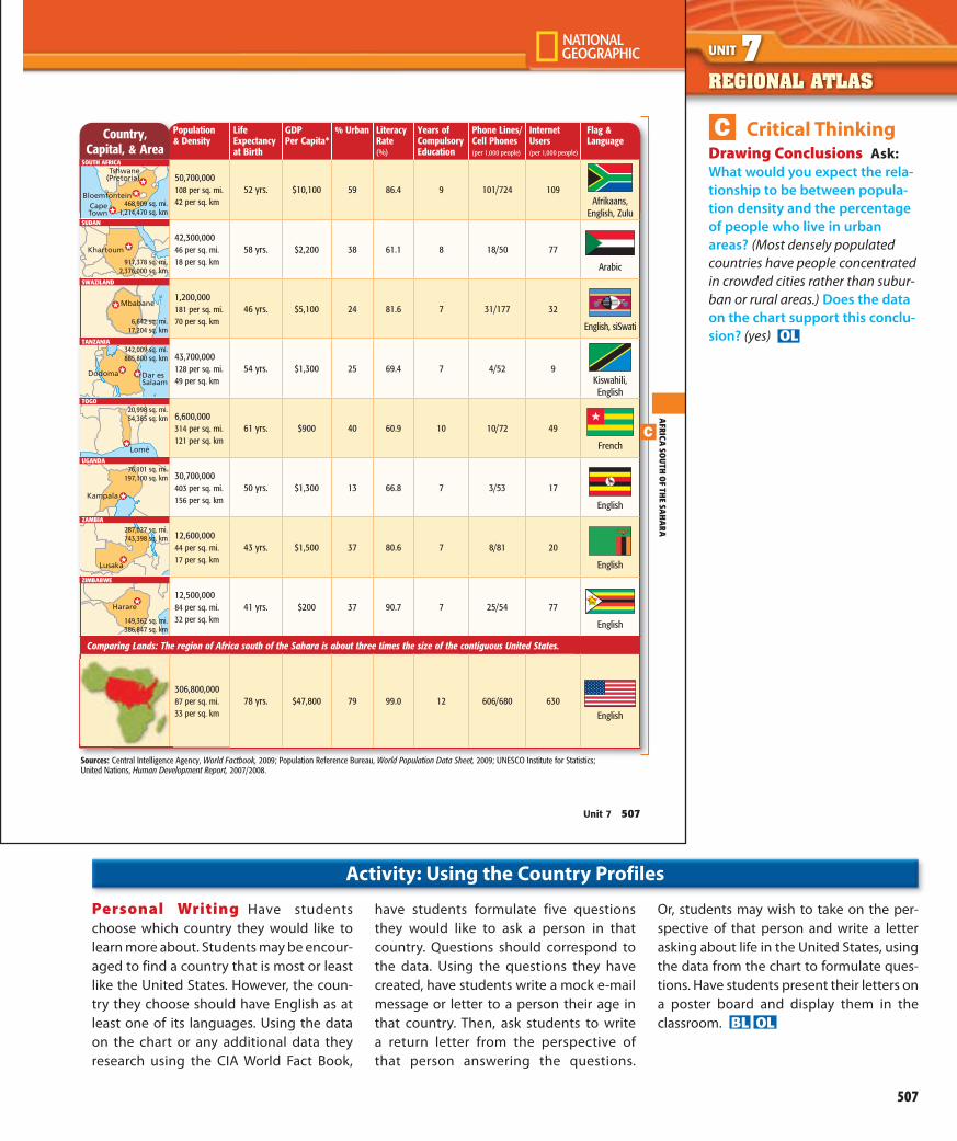
C Critical ThinkingDrawing Conclusions Ask: What would you expect the rela-tionship to be between popula-tion density and the percentage of people who live in urban areas? (Most densely populated countries have people concentrated in crowded cities rather than subur-ban or rural areas.) Does the data on the chart support this conclu-sion? (yes) OL
Personal Writing Have students choose which country they would like to learn more about. Students may be encour-aged to find a country that is most or least like the United States. However, the coun-try they choose should have English as at least one of its languages. Using the data on the chart or any additional data they research using the CIA World Fact Book,
have students formulate five questions they would like to ask a person in that country. Questions should correspond to the data. Using the questions they have created, have students write a mock e-mail message or letter to a person their age in that country. Then, ask students to write a return letter from the perspective of that person answering the questions.
Or, students may wish to take on the per-spective of that person and write a letter asking about life in the United States, using the data from the chart to formulate ques-tions. Have students present their letters on a poster board and display them in the classroom. BL OL
Activity: Using the Country Profiles
494-507_U7_RA_895263.indd 507494-507_U7_RA_895263.indd 507 1/11/10 11:42:26 AM1/11/10 11:42:26 AM

Chapter Planning Guide
508A
Levels Resources Chapter Opener
Section 1
Section2
Chapter AssessBL OL AL ELL
FOCUSBL Daily Focus Skills Transparencies 20-1 20-2
TEACHBL ELL Guided Reading Activity, URB* p. 21 p. 22
BL ELL Vocabulary Activity, URB* p. 14
BL OL AL ELL Reinforcing Skills Activity, URB p. 17
OL Enrichment Activity, URB p. 19
AL Real-Life Applications and Problem Solving Activity, URB p. 3
BL ELL Reading Essentials and Note-Taking Guide* pp. 145–147
pp. 148–150
BL OL AL ELL National Geographic World Atlas* ✓ ✓ ✓
BL OL AL ELL Map Overlay Transparencies, Strategies, and Activities 7-5 7-2,7-3
BL OL AL ELL National Geographic World Desk Map ✓ ✓ ✓ ✓
BL OL AL ELL Writer’s Guidebook for Social Studies ✓ ✓ ✓ ✓
OL AL World History Primary Source Documents Library ✓ ✓ ✓ ✓
National Geographic World Regions Video Program ✓ ✓ ✓ ✓
BookLink for Social Studies ✓ ✓ ✓ ✓
StudentWorks™ Plus ✓ ✓ ✓ ✓
BL OL AL ELL Section Spotlight Video Program ✓ ✓
BL OL AL ELL World Music: A Cultural Legacy ✓ ✓ ✓ ✓
BL OL AL ELL High School Writing Process Transparencies ✓ ✓ ✓ ✓
✓ Chapter- or unit-based activities applicable to all sections in this chapter. *Also available in Spanish
BL Below Level OL On Level
AL Above Level ELL English Language Learners
Print Material Transparency CD-ROM or DVD
Key to Teaching ResourcesKey to Ability Levels
508A-508D_CH20_CPG_895263 508A508A-508D_CH20_CPG_895263 508A 1/28/10 12:44:46 PM1/28/10 12:44:46 PM

508B
Plus
All-In-One Planner and Resource Center
• Interactive Lesson Planner • Interactive Teacher Edition • Fully editable blackline masters • Section Spotlight Videos Launch• Differentiated Lesson Plans
• Printable reports of daily assignments
• Standards Tracking System
Levels Resources Chapter Opener
Section 1
Section2
Chapter AssessBL OL AL ELL
TEACH (continued)
TeacherResources
High School Character Education ✓ ✓ ✓ ✓
Inclusion for the High School Social Studies Classroom Strategies and Activities ✓ ✓ ✓ ✓
High School Reading in the Content Area Strategies and Activities ✓ ✓ ✓ ✓
Success with English Learners ✓ ✓ ✓ ✓
Differentiated Instruction for the Geography Classroom ✓ ✓ ✓ ✓
Literacy Strategies in Social Studies ✓ ✓ ✓ ✓
Standards-Based Instruction ✓ ✓ ✓ ✓
Presentation Plus! with MindJogger CheckPoint ✓ ✓ ✓ ✓
TeacherWorks™ Plus ✓ ✓ ✓ ✓
National Geographic Focus on Geography Literacy Teacher Guide ✓ ✓ ✓ ✓
ASSESSBL OL AL ELL Section Quizzes and Chapter Tests p. 243 p. 244 p. 245
BL OL AL ELL Authentic Assessment With Rubrics p. 50
BL OL AL ELL ExamView Assessment Suite 20-1 20-2 Ch. 20
CLOSEBL ELL Reteaching Activity, URB p. 15
BL OL ELL Dinah Zike’s Reading and Study Guide Foldables p. 62
Graphic Organizer Transparencies, Strategies, and Activities pp. 55–56
✓ Chapter- or unit-based activities applicable to all sections in this chapter. *Also available in Spanish
508A-508D_CH20_CPG_895263 508B508A-508D_CH20_CPG_895263 508B 1/28/10 12:44:51 PM1/28/10 12:44:51 PM

Chapter Integrating Technology
508C
Visit glencoe.com and enter code WGC2630C20T for Chapter 20 resources.
You can easily launch a wide range of digital products from your computer’s desktop with the McGraw-Hill widget.
Student Teacher ParentWorld Geography and Cultures Online Learning Center (Web Site)
• Section Audio ● ● ●
• Spanish Chapter Audio Summaries ● ● ●
• Section Spotlight Videos ● ● ●
• StudentWorks™ Plus Online ● ● ●
• Multilingual Glossary ● ● ●
• Study-to-Go ● ● ●
• Chapter Overviews ● ● ●
• Self-Check Quizzes ● ● ●
• Student Web Activities ● ● ●
• ePuzzles and Games ● ● ●
• Vocabulary eFlashcards ● ● ●
• In-Motion Animations ● ● ●
• Study Central™ ● ● ●
• Nations of the World Atlas ● ● ●
• Glencoe Graphing Tool ● ● ●
• btw — Current Events Web Site ● ● ●
• Web Activity Lesson Plans ●
• Vocabulary PuzzleMaker ●
• Beyond the Textbook ● ● ●
Geography ONLINE
What Glencoe products improve students’ vocabulary?Vocabulary eFlashcards, ePuzzles and Games, and Vocabulary PuzzleMaker all build students’ vocabulary and help students understand key words and concepts from the textbook.
How can these products help my students?Vocabulary eFlashcards help students review and test their recall of content vocabulary, academic vocabulary, and people, places, and events for each chapter. ePuzzles and Games help students study the key facts, concepts, and vocabulary introduced in each chapter. The Vocabulary PuzzleMaker lets you create word searches, crosswords, and jumbles that students can use to practice vocabulary.
Visit glencoe.com and enter a student QuickPass™ code to go directly to student resources for the chapter. For Vocabulary PuzzleMaker, enter a teacher code to go to teacher resources.
Using Glencoe’s
Vocabulary Tools Teach With Technology
508A-508D_CH20_CPG_895263 508C508A-508D_CH20_CPG_895263 508C 1/28/10 12:44:55 PM1/28/10 12:44:55 PM

Additional Resources
508D
• Timed Readings Plus in Social Studies helps stu-dents increase their reading rate and fluency while maintaining comprehension. The 400-word passages are similar to those found on state and national assessments.
• Reading in the Content Area: Social Studies concentrates on six essential reading skills that help students better comprehend what they read. The book includes 75 high-interest nonfiction passages written at increasing levels of difficulty.
• Reading Social Studies includes strategic reading instruction and vocabulary support in Social Studies content for both ELLs and native speakers of English.
• Content Vocabulary Workout (Grades 6-8) acceler-ates reading comprehension through focused vocabu-lary development. Social Studies content vocabulary comes from the glossaries of Glencoe’s Middle School Social Studies texts. www.jamestowneducation.com
The following videotape programs are available from Glencoe as supplements to Chapter 20:
• Seven Wonders of the Ancient World (ISBN 0-76-700401-9)
To order, call Glencoe at 1-800-334-7344. To find class-room resources to accompany many of these videos, check the following pages:
A&E Television: www.aetv.com
The History Channel: www.historychannel.com
Use this database to search more than 30,000 titles to create a customized reading list for your students.
• Reading lists can be organized by students’ reading level, author, genre, theme, or area of interest.
• The database provides Degrees of Reading Power™ (DRP) and Lexile™ readability scores for all selections.
• A brief summary of each selection is included.
Leveled reading suggestions for this chapter:
For students at a Grade 7 reading level:• A Walk Through A Rainforest: Life in the Ituri Forest
of Zaire, by David and Mark Jenike
For students at a Grade 8 reading level:• African Journey, by John Chisson
For students at a Grade 9 reading level:• Ghana: A Study of an Economically Developing Country,
by Steve Brace
For students at a Grade 10 reading level:• The World of Power and Energy, by Frank Ross
ReadingList Generator
CD-ROM
Index to National Geographic Magazine:
The following articles relate to this chapter:• “Curse of the Black Gold,” by Tom O’Neill, February 2007.
• “Lost in the Sahel,” by Paul Salopek, April 2008.
• “Forest Elephants,” by Don Belt, September 2008.
National Geographic Society Products To order the following, call National Geographic at 1-800-368-2728
• National Geographic Atlas of the World (Book).
Access National Geographic’s new dynamic MapMachine Web site and other geography resources at:
www.nationalgeographic.com
www.nationalgeographic.com/maps
508A-508D_CH20_CPG_895263 508D508A-508D_CH20_CPG_895263 508D 1/28/10 12:44:59 PM1/28/10 12:44:59 PM

INTRODUCTIONCHAPTER CHAPTER
508 Unit 7
PHYSICAL GEOGRAPHY OF
Africa South of the Sahara
A hungry elephant strips bark from an acacia tree in the Great Rift Valley, Tanzania.
Physical processes shape Earth’s surface. Africa south of the Sahara is a region of dramatic landforms and great natural resources. A study of its physical geography will explain some of the processes that have shaped and continue to shape the diverse landscapes, climates, and vegetation of the region.
Essential Essential QuestionsQuestions
Section 1: The LandWhat kinds of physical processes have shaped the African landscape?
Section 2: Climate and VegetationWhat factors influence climate in Africa south of the Sahara?
Geography ONLINE
Visit glencoe.com and enter code WGC9952C20 for Chapter 20 resources.
508-514_C20_S1_879995.indd 508 1/8/10 3:38:30 PM 508-514_C20_S1_879995.indd 509 1/8/10 3:38:55 PM
508
FocusMore About the Photo Visual Literacy The Great Rift Valley is home to a diverse array of elephants, giraffes, zebra, wildebeest, rhinos, and other endangered species. Animals and humans compete for limited land and resources. One chal-lenge facing the area around the Great Rift Valley is balancing the needs of a growing population with the need to preserve species that face extinction due to poaching and loss of natural habitat.
TeachAs you begin teaching
this chapter, read the Big Idea out loud to students. Explain that the Big Idea is a broad, or high-level, concept that will help them under-stand what they are about to learn. Use the Essential Question for each section to help students focus on the Big Idea.
Section 1The Land Essential Essential Question Question What kinds of physical processes have shaped the African land-scape? (plate tectonics including plate move-ment and volcanic eruptions) Point out that in Section 1 students will learn about the physi-cal features and mineral resources of Africa south of the Sahara. OL
508-519_CH20_895263 508508-519_CH20_895263 508 1/28/10 12:42:14 PM1/28/10 12:42:14 PM

INTRODUCTIONCHAPTER
Essential Questions
508-514_C20_S1_879995.indd 508 1/8/10 3:38:30 PM
AFRICA
SOUTH
OF TH
E SAH
ARA
Chapter 20 509
Comparing Information Use a Three-Tab Book to make a Venn diagram for comparing two major river basins in Africa south of the Sahara.
Reading and Writing As you read the chapter, gather information about the Niger and Zambezi Rivers, includ-ing location, length, direction of flow, and uses. In the appropriate place in your Foldable, note what is unique to each river and what they have in common.
508-514_C20_S1_879995.indd 509 1/8/10 3:38:55 PM
509
Previewing the RegionIf you have not already done so, engage students in the Regional Atlas and Country Profiles activi-ties to help them become familiar with the general content of the region.
Dinah Zike’sFoldables
Purpose Students will use this Foldable to collect information about and then compare two major river basins in Africa south of the Sahara. The com-pleted Foldable will help them prepare for assessment.
Section 2Climate and Vegetation Essential Essential Question Question What factors influence climate in Africa south of the Sahara? (loca-tion, elevation, proximity to water or desert, wind currents) Tell students that in Section 2 they will learn how elevation and a tropical location influence both climate and vegetation in the region. OL
Geography ONLINE
Visit glencoe.com and enter code WGC2630C20T
for Chapter 20 resources.
508-519_CH20_895263 509508-519_CH20_895263 509 1/28/10 12:42:29 PM1/28/10 12:42:29 PM

CHAPTER Section 1 SECTION 1 The LandAfrica south of the Sahara is known for its extraor-dinary physical geography. As science writer David Quammen describes, “Africa isn’t really a place; it’s a million places.” Flying low in a small aircraft, Quammen describes a place in Niger’s Aïr mountain region known as Arakao, where the winds bring mountains and desert together.
Voices Around the World“Looking eastward toward the open desert, we see an amazing spectacle: dunes, towering dunes, piled up along the massif ’s eastern face, like a herd of khaki dinosaurs stopped by a giant stone wall. Set in stark opposition to the dark peaks of Aïr, these are mountains of a much different sort — granular, graceful, silky textured, shaded gently in tones of tan and pale salmon, erected and sculpted into pyramid peaks and razor-edge ridges, swaybacks and rippling slopes, by the winds that have blown them in, grain by grain, across 150 flat miles from northeastern Niger.”
— David Quammen, “Tracing the Human
Footprint,” National Geographic,
September 2005
Guide to ReadingEssential Essential QuestionQuestionWhat kinds of physical processes have shaped the African landscape?
Content Vocabulary
Academic Vocabulary• region (p. 512)• network (p. 513)
Places to Locate• Great Rift Valley (p. 511)• Lake Tanganyika (p. 511)• Ruwenzori Mountains (p. 512)• Drakensberg Range (p. 512)• Lake Victoria (p. 512)• Niger River (p. 513)• Zambezi River (p. 513)• Victoria Falls (p. 513)• Congo River (p. 513)
Reading StrategyOrganizing As you read about this region’s physical landscape, use a web diagram like the one below to note the many uses of Lake Volta.
• rift valley (p. 511)
• fault (p. 511)• escarpment
(p. 512)
• cataract (p. 512)• desertification
(p. 512)• delta (p. 513)• estuary (p. 513)
Lake Volta
A Fulani mother and child in Niger
510 Unit 7
sectionaudio
spotlightvideo
508-514_C20_S1_879995.indd 510 1/8/10 3:39:18 PM
MAIN Idea
508-514_C20_S1_879995.indd 511 1/8/10 3:39:30 PM
FocusDaily Focus Transparency 20.1
Guide to ReadingAnswers to Graphic:
Lake Volta
hydroelectric power fishing
irrigation
Resource Manager
Teacher Edition• Note Taking, p. 513• Summarizing, p. 514
Additional Resources• Guided Reading 20-1,
URB, p. 21• RENTG, pp. 145–147
Teacher Edition• Determining Cause and
Effect, p. 511• Making Inferences,
pp. 512, 513
Additional Resources• Quizzes and Tests, p. 243
Teacher Edition• Visual/Spatial, p. 511• English Learners, p. 512
Additional Resources• Diff. Instr. for the Geo.
Classroom, pp. 77–79• Foldables, p. 62
Teacher Edition• Persuasive Writing,
p. 512
Additional Resources• Graphic Organizer
Trans., pp. 55–56• Enrichment Act.,
URB p. 17
Teacher Edition• Reading a Graph, p. 514
Additional Resources• Daily Focus Skills Trans.
20-1• Map Overlay Trans. 7, 7-5
Reading Strategies
Critical Thinking
Differentiated InstructionR C D W SWriting
SupportSkill Practice
To generate student interest and provide a springboard for class discussion, access the Chapter 20, Section 1 video at glencoe.com.
508-519_CH20_895263 510508-519_CH20_895263 510 1/28/10 12:42:33 PM1/28/10 12:42:33 PM

Section 1CHAPTER
Essential Question
508-514_C20_S1_879995.indd 510 1/8/10 3:39:18 PM
African plate
Lithosphere
Magma
Uplift
20 million years ago–Rising magma forces the crust upward, causing fractures in the rigid crust of the African plate.
400 miles
400 kilometers
mbert Azimuthal ual-Area projection
N
S
W E
INDIANOCEAN
Gulf of AdenRed
Sea Wh
iteN
ileR
.
LakeMalawi
Lake Tanganyika
LakeVictoria
Kilimanjaro
Mt. Kenya
Great Rift Valley GreatRift
Valley
Fault lines
Directionof plate movement
Riftvalley
Magma
African plateAfrican plate
15 million years ago–As the crust is pulled apart, large slabs of rock sink, creating a rift valley.
Lake Tanganyika
African plate African plate
10 million years ago–Further spreading generates a narrow seaor lake. Today Lake Tanganyika is still affected by tectonic activity.
The Great Rift Valley
AFRICA
SOUTH
OF TH
E SAH
ARA
Chapter 20 511
LandformsMAIN MAIN IdeaIdea Africa south of the Sahara is a region
of step-like plateaus, rising to mountains and slashed in the east by a rift valley, which was formed by shifting tectonic plates.
GEOGRAPHY AND YOU What animals and land-scapes do you associate with Africa south of the Sahara? Read to learn about the astounding variety of physical features in the region.
Africa south of the Sahara is an immense region covering about 9.5 million square miles (24.6 million sq. km). As the physical map on page 498 of the Regional Atlas shows, the region is bounded on the north by the Sahara and extends to the sea in all other directions.
The Great Rift ValleyAn amazing natural wonder known as the
Great Rift Valley stretches from Syria in Southwest Asia to Mozambique (moh•zahm•BEEK) in the southeastern part of Africa. A rift valley is a large
depression in the Earth’s surface formed by shift-ing tectonic plates. Millions of years ago, plate movements created the system of faults, or frac-tures in the Earth’s crust, within which the Great Rift Valley lies. Volcanic eruptions as well as earthquakes helped create the valley’s striking landscape, and they continue to shape it today.
In East Africa, the Great Rift Valley forms two branches, with volcanic mountains rising at its edges and deep lakes that run parallel to its length. The main volcanic cones, among them Kilimanjaro, are located along the eastern branch. Lake Tanganyika, one of the deepest and longest fresh-water lakes in the world, lies on the western branch. To the south is Lake Malawi, a mountain-rimmed lake that looks much like a fjord. Like the glacier-cut valleys of seawater in northern Europe, Lake Malawi lies well below the land surrounding it. It is also very deep: its bottom drops to more than 2,300 feet (700 m) at its deepest point.
1. Movement What caused large fractures in the Earth’s crust, creating rift valleys?
2. Location Which major lakes are located in the Great Rift Valley?
Use StudentWorks™ Plus or glencoe.com.
C
D
C
508-514_C20_S1_879995.indd 511 1/8/10 3:39:30 PM
511
TeachD Differentiated
InstructionVisual/Spatial Instruct stu-dents to draw or sketch the formation of the Great Rift Valley as it is described in the text. BL
C Critical ThinkingDetermining Cause and Effect Ask: Why do you think two of the lakes in the Great Rift Valley are so deep? (They are the result of faults and dramatic plate movement.) OL
For additional practice on this skill, see the Skills Handbook.
Answers1. rising magma combined
with the crust being pulled apart
2. Lake Victoria, Lake Tanganyika, Lake Malawi
Answers1. rising magma combined
with the crust being pulled apart
2. Lake Victoria, Lake Tanganyika, Lake Malawi
Hands-On Chapter Project
Step 1
Taking A Trip Through Africa
Step 1: Making a Travel Map Pairs of students will plan a road trip in the region to find answers to the Essential Question using specific examples.
Essential Question Do physical features affect climate in Africa south of the Sahara?
Directions Write the Essential Question on the board, and tell pairs of students to use the physical map of Africa south of the
Sahara on page 498 of the Regional Atlas to plan a road trip. Students should include a variety of physical features and other places of interest. You may wish to add criteria such as the number of miles traveled or places visited. Give each pair an outline map on which students will mark their route. Then tell them to label the sites and to number them in the order in which they will visit them. Afterwards, they should read the text and do research to learn about each
location. All research should lead toward an answer to the Essential Question. Each pair should write and include pictures of sites and physical features whenever possible.
Summarizing Allow time for pairs to share what they have learned about the Essential Question while preparing for the trip. Pairs should use the information about climate in Section 2 to decide what to pack for the trip. OL
(The Chapter Project continues on page 516.)
508-519_CH20_895263 511508-519_CH20_895263 511 1/28/10 12:42:42 PM1/28/10 12:42:42 PM

CHAPTER Section 1
512 Unit 7
Mountains and PlateausAfrica south of the Sahara is a series of plateaus
that rise in elevation from the coast inland and from west to east. Ranging in elevation from 500 feet (152 m) in the west to 8,000 feet (2,438 m) or more in the east, the plateaus are outcroppings of the solid rock that makes up most of the con-tinent. The edges of the plateaus are marked by escarpments — steep, often jagged cliffs. Most are located less than 20 miles (32 km) from the coast. Rivers crossing the plateaus plunge down the escarpments in cataracts, or waterfalls.
Most African mountains dot the Eastern Highlands, an area that stretches from Ethiopia almost to the Cape of Good Hope. These high-land areas include the Ethiopian Highlands as well as volcanic summits, such as Kilimanjaro and Mount Kenya. West of the Eastern High-lands, the Ruwenzori Mountains divide Uganda and the Democratic Republic of the Congo. Covered with snow and cloaked in clouds, they are also called the “Mountains of the Moon.” Moist air from the Indian Ocean creates the clouds that wrap around the Ruwenzoris.
Farther south is the Drakensberg Range in South Africa and Lesotho. These mountains rise to more than 11,000 feet (3,353 m) and form part of the escarpment along the southern edge of the continent.
Place Where are most of Africa’s mountains located?
Water SystemsMAIN MAIN IdeaIdea Landforms and physical processes
have influenced the region’s water systems, which include deep lakes, spectacular waterfalls, and great rivers.
GEOGRAPHY AND YOU In what ways have land-forms affected the Mississippi River in the United States? Read to learn how the land has influenced the water systems in Africa south of the Sahara.
The land has influenced the region’s water sys-tems in important ways. Lakes and rivers are located in huge basins formed millions of years ago by the uplifting of the land. The great rivers of Africa originate high in the plateaus and even-tually make their way to the sea. Escarpments and ridges break the rivers’ paths to the ocean with rapids and cataracts. The broken landscape makes it impossible to navigate most of the region’s rivers from mouth to source.
Land of LakesAs the map on page 513 shows, most of the
region’s lakes, including Lakes Tanganyika and Malawi, are near the Great Rift Valley. Lake Victoria, the largest lake in Africa, is located between the eastern and western branches of the Great Rift. It is the world’s second-largest fresh-water lake, after Lake Superior in North America. Lake Victoria is the source of the White Nile River. Despite its large size, Lake Victoria is comparatively shallow with a depth of only 270 feet (82 m).
Lake Chad, outside the Great Rift Valley in west-central Africa, is threatened with extinction. Although fed by three large streams, landlocked Lake Chad is shrinking. Droughts in the 1970s completely dried up the northern portion of the lake, and the water level continues to be shallow even during years when rainfall is normal. Because of the climate, much of the lake’s water evapo-rates. It also seeps into the ground. Other factors contributing to the shrinkage of Lake Chad include global warming, irrigation, and desertifi-cation. Desertification occurs when long periods of drought and land use destroy the vegetation. The land is left dry and barren, unable to sup-port life. As Lake Chad shrinks, the desert expands on the dry lake bottom.
A road hugs the coastal escarpment near Cape Town, South Africa.
Regions What type of landform dominates most of Africa?
D
C
W
508-514_C20_S1_879995.indd 512 1/8/10 3:39:35 PM 508-514_C20_S1_879995.indd 513 1/8/10 3:39:37 PM
512
D Differentiated InstructionEnglish Learners Instruct students to create an illustrated dictionary definition of escarp-ment and cataract. ELL BL
C Critical ThinkingMaking Inferences Ask students to explain why the Ruwenzori Mountains are called “Mountains of the Moon” by peo-ple living near them. (Answers will vary but may include theories about snow and cloud cover shining in the moonlight.) OL
For additional practice on this skill, see the Skills Handbook.
W Writing SupportPersuasive Writing Direct students to write letters to a hypo-thetical committee studying the evaporation of Lake Chad. Students should select a point of view, either “Save Lake Chad,” or seeing this as a natural development. OL
Caption Answer:plateaus
Answer: the Eastern Highlands
Additional Support
Predicting Consequences Ask:According to your textbook, what is happening to Lake Chad? (It is shrinking.) How is the problem defined? (The lake is threatened with extinction.) What are four main causes of this problem? (drought, global warming, irrigation, desertification) What economic benefits do people gain from using a lake for irrigation? (grow-ing crops, watering animals) Point out that
the way people use a water source for economic activity can also take away that very source of economic activity in the future. Ask: What other kinds of eco-nomic activities are causing the lake to shrink? (global warming due to burning fossil fuels in factories and to operating trucks, cars, and airplanes; desertification) Explain how desertification is partially the result of overgrazing animals. Cutting
down trees for fuel and lumber also contributes. Ask: How are these exam-ples of economic activity? What are the long-term economic effects of the loss of Lake Chad? How does this contribute to the spread of desertification? Ask stu-dents to brainstorm solutions to the problem so that both short and long term economic needs can be met. AL
Activity: Economics Connection
508-519_CH20_895263 512508-519_CH20_895263 512 1/28/10 12:42:46 PM1/28/10 12:42:46 PM

Section 1CHAPTER
MAIN Idea
508-514_C20_S1_879995.indd 512 1/8/10 3:39:35 PM
RedSea
MediterraneanSea
Gulf of Guinea
ATLANTIC OCEAN
INDIAN OCEAN
20°N
20°S
0°
20°E20°W 0° 40°E
TROPIC OF CAPRICORN
TROPIC OF CANCER
EQUATOR
NORTH AFRICA SOUTHWESTASIA
Niger R.
NileR.
Zambezi
R.
Limpopo R.
OrangeR.
Congo
R.
Senegal R.
Blue Nile R.
WhiteNile
R.
LakeVictoria
LakeTanganyika
LakeChad
LakeVolta
Niger Delta
1,000 miles
1,000 kilometers
0
0
Lambert Azimuthal Equal-Area projection
N
S
W E
Major hydroelectricdam
Chapter 20 513
A Human-Made LakeLake Volta in West Africa ranks among the
largest human-made lakes in the world. The lake was created in the 1960s by damming the Volta River south of Ajena, Ghana. The new lake flooded more than 700 villages, forcing more than 70,000 people to find new homes.
Although the dam was originally built to pro-vide hydroelectric power to an aluminum plant, the people of Ghana today benefit from the lake in many ways. It supplies irrigation for farming in the plains below the dam and is well stocked with fish. The hydroelectric plant now also generates electricity used throughout Ghana.
River BasinsThe Niger (NY•juhr) River is known by many
names along its course, but all of them have roughly the same meaning — “great river.” The Niger is the main artery in western Africa, extend-ing about 2,600 miles (4,183 km) in length. Originating in the highlands of Guinea, the river forms a great arc. It flows northeast and then curves southeast to the Nigerian coast. In addi-tion to being important to agriculture, the Niger River is a major means of transportation.
This great river does not flow as one well-defined stream into the Atlantic Ocean. At Aboh in southern Nigeria, the Niger splits into a vast inland delta, a triangular section of land formed by sand and silt carried downriver. The Niger Delta stretches 150 miles (241 km) north to south and extends to a width of about 200 miles (322 km) along the Gulf of Guinea.
The Zambezi River of south-central Africa also meets the ocean in a delta. The Zambezi flows 2,200 miles (3,540 km) from its source near the Zambia-Angola border in the west to the Indian Ocean in the east, where it fans out in a delta that is 37 miles (60 km) wide. The Zambezi’s course to the sea is interrupted in many places by waterfalls. At Victoria Falls, on the border of Zambia and Zimbabwe, the Zambezi plummets a sheer 355 feet (108 m).
Unlike most African rivers, the Congo River reaches the sea through a deep estuary(EHS•chuh•wehr•ee), or passage where fresh-water meets seawater. The Congo’s estuary is 7 miles (10 km) wide, and ships can navigate the deep water. The remaining 2,700 miles (4,344 km) of the Congo form a large network of navigable
waterways for smaller boats. Some parts of the river, however, have rapids and waterfalls that pre-sent serious obstacles to traffic. The river plunges almost 900 feet (274 m) in numerous cataracts not far from where it meets the Atlantic Ocean.
Regions Which lake is the largest in Africa?
1. Location Which part of the region has the largest concentration of hydroelectric dams?
2. Place Compare this map to the physical map on page 498. Why do northern and southern areas of the region have few rivers?
Water Systems in Africa South of the Sahara
Use StudentWorks™ Plus or glencoe.com.
Geography ONLINE
Student Web Activity Visit glencoe.com, select the
click on Student Web Activities—Chapter 20 for an activ-ity about the Great Rift Valley.
C
R World Geography and Cultures Web site, and
508-514_C20_S1_879995.indd 513 1/8/10 3:39:37 PM
513
C Critical ThinkingMaking Inferences Ask students to consider why all indigenous names for the Niger River mean “great river.” Which aspects make it “great”? OL
For additional practice on this skill, see the Skills Handbook.
R Reading StrategyNote Taking Instruct students to list characteristics of the Congo River described in the text. BL
Answer: Lake Victoria
Geography ONLINE
Objectives and answers to the Student Web Activity can be found at glencoe.com under the Web Activity Lesson Plan for this program.
Answers1. East Africa
2. They are deserts.
Answers1. East Africa
2. They are deserts.
Differentiated Instruction
Differentiated Instruction Strategies
BL Ask students to report on the loca-
tions of the incorrect answers that do not pertain to the region.
AL Ask students to write new quiz
questions for both the correct and incorrect answers in the worksheet.
ELL Ask students to write six new sen-
tences based on the answer choices in the worksheet.
Objective: Use the worksheet and the student text to create game show-style quiz questions.
Focus: Determine if the incorrect answers can be used to cre-ate a new question about Africa south of the Sahara.
Teach: Help students find information in the student text that would allow them to create new quiz questions.
Assess: Evaluate student questions for accuracy. Close: Allow the class to participate in a game show-style
quiz.
Creating Quiz Questions Name Date Class
The Land
Africa south of the Sahara is bounded on three sides by the sea, but the
forms its northern border. (Sahara/Andes)
The elevation of this region increases in a series of that rise from west
to east. (mountains/plateaus)
Waterfalls tumble over steep along the coast. (escarpments/rivers)
Shifting tectonic plates have created earth fractures and led to the formation of the Great
. (Sahara/Rift Valley)
Along the faults that created these fractures lie many . (rivers/volcanoes)
The source of the White Nile River is . (Lake Lucerne/Lake Victoria)
In southern Nigeria the Niger River forms a vast inland , which gives the
area rich soil. (plain/delta)
The largest navigable waterway in the region is the River. (Congo/Niger)
As Lake Chad shrinks claims more and more surrounding land.
(salination/desertification)
The countries of Nigeria, Gabon, and Congo have abundant reserves.
(coal/oil)
South Africa produces about one-half the world’s . (gold/pearls)
Major diamond deposits are found in South Africa and Botswana and in the
basin. (Nile River/Congo River)
Both difficult terrain and lack of have limited this region’s use of
hydroelectric power. (labor/financial support)
Guided Reading, URB, p. 21
508-519_CH20_895263 513508-519_CH20_895263 513 1/28/10 12:42:52 PM1/28/10 12:42:52 PM

CHAPTER Section 1
Vocabulary 1. Explain the significance of: rift valley, fault, escarpment,
cataract, desertification, delta, estuary.
Main Ideas 2. Describe the general pattern of Africa’s landforms—including
plateaus and mountains—as you move from west to east across the continent.
3. Which mineral resources are among the region’s most abun-dant natural resources? Where are large deposits of these resources located?
4. Which renewable resources are important to the region? 5. Use a chart like the one below to identify and describe the
ways in which landforms and physical processes have influ-enced the region’s water systems.
Critical Thinking 6. Answering the EssentialEssential QuestionQuestion What physical pro-
cesses formed the Great Rift Valley? 7. Comparing and Contrasting How is the Congo River’s course
to the sea different from that of most other African rivers? 8. Summarizing Information Why is much of the region’s
hydroelectric power potential unused? 9. Analyzing Visuals Study the physical map on page 498 of the
Regional Atlas. What do most of the countries with elevations of less than 1,000 feet (300 m) have in common?
Writing About Geography 10. Descriptive Writing Think about the physical features of
Africa south of the Sahara. Write a paragraph describing how specific landforms affect the course of the region’s great rivers.
SECTION 1 REVIEW
Natural ResourcesMAIN MAIN IdeaIdea Mineral resources and water are among
the region’s most abundant natural resources.
GEOGRAPHY AND YOU Where are mineral depos-its located in the United States? Read to find out where mineral and water resources are located in Africa south of the Sahara.
The wealth of natural resources is not distrib-uted evenly among the region’s countries. Mineral resources are abundant throughout the region. Nigeria, Angola, Gabon, Congo, and Cameroon have some oil reserves. Of worldwide oil reserves in 2009, about 5 percent were located in Africa south of the Sahara.
The economic activity map on page 558 shows that deposits of metals, including copper, iron ore, manganese, and zinc, are mined in the region. South Africa has about half the world’s gold. Uranium, usually found with gold, is also abun-dant there. South Africa, Botswana, and the Congo River basin hold major diamond deposits.
Water is an abundant resource in parts of the region. For example, areas in West Africa near the Equator receive abundant rainfall. However,
African vs. U.S. Crude Oil Reserves
Barr
els
(in b
illio
ns)
Nigeria Angola Gabon Congo(Brazzaville)
Cameroon UnitedStates
4035302520151050
Source: Energy Information Association, U.S. Department of Energy.
Geography ONLINE
Study Central™ To review this section, go to glencoe.com and click on Study Central.
514 Unit 7
Landforms Physical Processes
Lakes
Waterfalls
Rivers
controlling water for practical uses, such as irri-gation and hydroelectric power, is difficult because rainfall is irregular and unpredictable. These challenges, combined with a lack of fin-ancial support, result in unused hydroelectric power potential in parts of the region.
Solar power is another renewable energy source that has been harnessed in the region. Rural electrification programs, which involve installing small-scale solar power systems, con-tinue to expand in some parts of the region.
Regions What are the region’s most important natural resources?
S
R
508-514_C20_S1_879995.indd 514 1/8/10 3:39:41 PM
Essential Question
515-519_C20_S2_879995.indd 515 1/8/10 3:40:23 PM
514
Section 1 Review
R Reading StrategySummarizing Instruct students to list all the reasons why hydro-electric power is hard to produce in the region. BL
S Skill PracticeReading a Graph Ask: Will the oil reserves of the other countries in the chart equal those of Nigeria? (No; the combined reserves would be about 35 billion barrels.) OL
Answer: oil, copper, iron ore, manganese, zinc, gold, uranium, and diamonds
AssessGeography ONLINE
Study Central™ provides sum-maries, interactive games, and online graphic organizers to help students review content.
CloseSpeculating Discuss with stu-dents how the physical features of the region could be used for eco-nomic development of the region.
Answers
1. Definitions for the vocabulary terms are found in the section and the Glossary.
2. Africa is made up a series of plateaus that rise higher as one moves from west to east. The mountains of the region are found in the eastern half of Africa.
3. copper, iron ore, manganese, zinc, gold and diamonds; South Africa
4. water and solar power
5. Lakes: depressions fed by streams and rivers; pulling apart of the rift valley. Waterfalls: escarpments and ridges; uplift-ing of land. Rivers: high in plateaus making its way to the sea; uplifting of land.
6. shifting and spreading tectonic plates 7. It reaches the sea through a deep estuary
where oceangoing ships are able to navigate. Most other African rivers are not navigable by large ships.
8. Rainfall is irregular and unpredictable and there is a lack of financial support.
9. river basins 10. Paragraphs will vary but should include
that the great rivers originate high in the plateaus and make their way to the sea. Escarpments and ridges break the rivers’ paths to the ocean with rapids and cataracts.
508-519_CH20_895263 514508-519_CH20_895263 514 1/28/10 12:42:57 PM1/28/10 12:42:57 PM

Section 2CHAPTER
Essential Question
MAIN Idea
508-514_C20_S1_879995.indd 514 1/8/10 3:39:41 PM
SECTION 2
Chapter 20 515
Climate and VegetationIn many places in Africa south of the Sahara, water is such a precious resource that rain and life are one and the same. Rain helps determine climate, and thus vegetation, in every part of the region. In the spring, when the vegetation of Tanzania’s plains has been fed by rain, a great migration occurs on the Serengeti Plain.
Voices Around the World“From the top of Shifting Sands dune in the Serengeti Plain of Africa a million mammals are in motion. Wildebeests. Zebras. Gazelles. The plain is black with them. It is wildebeest calving season, and many of those giant bearded ante-lope have newborns trailing them. . . . From a distance the movement seems a serene and constant march toward the southeast, where recent rains have made pastures greener.”
— Rick Gore, “The Rise of Mammals,” National Geographic, April 2003
Blue wildebeest on the Serengeti Plain, Tanzania
Guide to ReadingEssentialEssential QuestionQuestionWhat factors influence climate in Africa south of the Sahara?
Content Vocabulary• leach (p. 516)• savanna (p. 517)• harmattan (p. 517)
Academic Vocabulary• maximum (p. 516)• undergone (p. 517)• recover (p. 517)
Places to Locate• Serengeti Plain (p. 517)• Sahel (p. 517)• Namib Desert (p. 518)• Kalahari Desert (p. 518)
Reading StrategyOrganizing As you read about the landscape of Africa south of the Sahara, complete a graphic orga-nizer like the one below by describ-ing each geographical area.
sectionaudio
spotlightvideo
Area Description
Serengeti Plain
Sahel
Namib Desert
Kalahari Desert
515-519_C20_S2_879995.indd 515 1/8/10 3:40:23 PM
FocusDaily Focus Transparency 20.2
Reading StrategyAnswers to Graphic:
Area Description
Serengeti Plain
one of world’s largest savanna plains; animals, trees, grasses
Sahelband of dry steppe from Senegal to Sudan; pastures of low-grow-ing grasses, shrubs, acacia trees
Namib Desert
along the Atlantic Coast of Namibia; rocks, dunes, sparse desert plants
Kalahari Desert
eastern Namibia, most of Botswana, and part of South Africa; sand swept with few features
Resource Manager
Teacher Edition• Questioning, p. 516
Additional Resources• Guided Reading 20-2,
URB, p. 22• RENTG, pp. 148–150• Vocab. Act., URB p. 14
Teacher Edition• Making Infer., p. 518
Additional Resources• Real-Life Applications,
URB p. 3• Quizzes and Tests, p. 244
Teacher Edition• Below Grade Level,
p. 516
Additional Resources• Reteaching Act., URB,
p. 15
Teacher Edition• Descriptive Writing,
p. 517
Additional Resources• Authentic Assess.,
p. 50
Teacher Edition• Reading a Table, p. 517
Additional Resources• Daily Focus Skills Trans.
20-2• Reinforcing Skills Act.,
URB, p. 17• Map Overlay Trans., 7,
7-2, 7-3
Reading Strategies
Critical Thinking
Differentiated InstructionR C D W SWriting
SupportSkill Practice
To generate student interest and provide a springboard for class discussion, access the Chapter 20, Section 2 video at glencoe.com.
508-519_CH20_895263 515508-519_CH20_895263 515 1/28/10 12:43:07 PM1/28/10 12:43:07 PM

CHAPTER Section 2
RedSea
ATLANTIC OCEAN
INDIAN OCEAN
20°N
20°S
0°
20°E
20°W
0° 40°E 60°E
TROPIC OF CAPRICORN
TROPIC OF CANCER
EQUATOR
NORTH AFRICA SOUTHWEST
ASIA
Ben
gu
elaC
urren
t
1,000 miles
1,000 kilometers
0
0
Lambert Azimuthal Equal-Area projection
N
S
W E
516 Unit 7
Tropical ClimatesMAINMAIN IdeaIdea The region’s location in the Tropics near
the Equator influences its climate and vegetation.
GEOGRAPHY AND YOU Do you live in a region where warm climates dominate? Read to learn about the types of vegetation found in the tropical climate regions of Africa south of the Sahara.
In addition to rainfall, other factors such as ocean currents, prevailing wind patterns, ele-vation, and latitude often cause great variations in climate and vegetation. The climate map of Africa below shows those effects since much of the region lies in the Tropics and has tropical climate and vegetation areas.
Tropical WetWarm temperatures prevail in the tropical wet
climate zone, located near the Equator. More than 60 inches (150 cm) of rainfall per year soak
the dense forests. Rainfall amounts vary season-ally, but the tropical rain forests do not experi-ence a truly dry season. Daily, rain falls on an amazing number and variety of life- forms.
Shrubs, ferns, and mosses grow together at the lowest level of the rain forest, which rises 6 to 10 feet (2 to 3 m). A layer of trees and palms reaching as high as 60 feet (18 m) tops this undergrowth. Arching over all is a canopy of leafy trees with a maximum height of 150 feet (46 m). Orchids, ferns, and mosses grow among the branches of the canopy, and woody vines link the trees in a tangle.
Soils in the tropical rain forest biome are typi-cally not very fertile because heavy rains leach, or dissolve and carry away, nutrients from the soil.
Africa South of the Sahara: Climate Regions
1. Location Where are moderate climate regions in Africa south of the Sahara located?
2. Regions Describe the sequence of climate regions as one moves north and south of the Equator in Africa.
Use StudentWorks™ Plus or glencoe.com.
R
D
515-519_C20_S2_879995.indd 516 1/8/10 3:40:34 PM
MAIN Idea
515-519_C20_S2_879995.indd 517 1/8/10 3:40:39 PM
516
Hands-On Chapter Project
Step 2
TeachR Reading Strategy
Questioning Instruct students to turn each factor that affects climate into a question. For example, “How high is the elevation?” or “What is the latitude?” in order to identify and comprehend the influence of these factors on climate. AL
D Differentiated InstructionBelow Grade Level Ask students to make a pictograph showing the levels of the rain forest and the plants that inhabit each level. BL
Taking a Trip Through Africa
Step 2: Preparing for the Trip Pairs of students continue planning for the trip through Africa they began planning in Section 1.
Directions Write the Essential Question on the board. Then tell students to look for information in the section text and com-pare their maps with the map of climate
regions in Africa south of the Sahara to determine what they need to pack for their trip. Students should also look for informa-tion about vegetation and animal life that will help them answer the Essential Question later in the chapter. Have each pair record their findings and decisions. They should also make a key for their map and color the relevant areas.
Putting It Together Ask volunteers to explain what they are going to pack and why. Next, have each pair share what they have learned about the Essential Question while preparing for their trip. OL (Chapter Project continues on the Visual Summary page.)
Answers1. South Africa
2. Around the Equator is a tropical climate, as one moves north or south it gradually becomes steppe and then desert. Farther south it becomes Mediterranean in the south-west, and marine west coast and then humid subtropical along the southeast coast.
508-519_CH20_895263 516508-519_CH20_895263 516 1/28/10 12:43:14 PM1/28/10 12:43:14 PM

Section 2CHAPTER
MAIN Idea
515-519_C20_S2_879995.indd 516 1/8/10 3:40:34 PM
AFRICA
SOUTH
OF TH
E SAH
ARA
Chapter 20 517
Nonetheless, various crops are still grown. Bananas, pineapples, cocoa, tea, coffee, and cot-ton are grown as cash crops on large plantations. As farmers clear more land to grow these crops, the rain forest is seriously threatened. Commercial loggers also diminish the rain forest.
Tropical DryTropical grassland with scattered trees — known
as savanna — covers almost half of Africa. Rainfall is seasonal in this tropical dry climate zone, with alternating wet and dry seasons. In the wettest areas, which are closest to the Equator, six months of almost daily rain is fol-lowed by a six-month dry season. Average annual rainfall is about 35 to 45 inches (90 to 115 cm).
Dueling winds affect the tropical dry climate of western Africa. Hot, dry air streams in from the Sahara on a northeast trade wind known as a harmattan. Although dusty, a harmattan is welcome in the summer because it dries up mois-ture left by heavy summer rains. Around the same time of year, cool, humid air blows in from the southwest. Tornadoes sometimes form when a harmattan and the southwest winds collide.
Trees are the main features of the landscape in some parts of the savanna biome, while tall grasses cover other areas. In general, the soils — like those of the tropical savanna in other regions — are not very fertile. On the Serengeti Plain, one of the world’s largest savanna plains, millions of animals such as zebras, gazelles, hye-nas, lions, giraffes, and cheetahs roam.
Location How does a harmattan affect the tropical dry climate of western Africa?
Dry ClimatesMAINMAIN IdeaIdea The dry climates of Africa south of the
Sahara are located in the north and the south.
GEOGRAPHY AND YOU Which regions of the United States have dry climates? Read to identify the problems causing areas of desert to increase in Africa south of the Sahara.
Away from the Equator, tropical climates fade into semiarid steppe areas, which finally give way to the driest climate region of all — desert.
SteppeSeparating the tropical dry savanna from the
deserts of Africa is semiarid steppe. The table below shows how the steppe is a transition zone between the tropical dry savanna and the desert. In the south, this transition zone extends to the southern tip of the continent. The northern steppe is called the Sahel — literally, “shore” or “edge” in Arabic. This band of dry land extends from Senegal to Sudan.
The Sahel has pastures of low-growing grasses, shrubs, and acacia trees. On average, 4 to 8 inches (10 to 20 cm) of rain falls annually, mostly in June, July, and August. The rest of the year is very dry.
DesertificationOver the past 50 years, the Sahel has undergone
much desertification. Some scientists claim that this is caused mainly by climate change that brings long periods of extreme dryness and water shortages. Lands managed well during drought periods can usually recover once rains return. Other scientists, however, believe that human
land use and animal activities also contrib-ute to desertification.
People strip trees for firewood and clear land for farming, while livestock over-graze the short grasses. As a result, the land is depleted, and topsoil is further eroded, reducing both the land’s produc-tivity and its ability to recover from drought. By 2000, all African coun-tries joined the United Nations Convention to Combat Desertification, committed to enacting laws protecting the environment and promoting sustainable development.
The Steppe as Transition Zone
AverageTemperature
AverageNumber
of Days with Precipitation
HighestTemperature
EverRecorded
LowestTemperature
EverRecorded
Tropical dry:Bangui, Central African Republic
79°F26°C
97 108°F42°C
46°F8°C
Steppe:Abéché, Chad
85°F29°C
32 120°F49°C
48°F9°C
Desert:Agadez, Niger
84°F28°C
17 122°F50°C
30°F–1°C
Source: www.weatherbase.com
S
W
515-519_C20_S2_879995.indd 517 1/8/10 3:40:39 PM
517517
Differentiated Instruction
S Skill PracticeReading a Table Ask students to study “The Steppe as Transition Zone” table on this page Ask: What is the most dramatic differ-ence between steppe and desert climate regions? (Steppe climate regions have nearly twice the num-ber of days with precipitation.) BL
W Writing SupportDescriptive Writing Ask stu-dents to think about specific aspects of the Sahara and the steppe climate of the Sahel. In a sentence, have students describe why sahel, which means “shore” in Arabic, is an appropriate term for this region. Ask: What other English words could be used to describe the Sahel? (Answers may include border, coast, and strand.) OL
Answer: It dries up moisture left by heavy summer rains. At times, it collides with winds from the southwest to form tornadoes.
Copy
right
© G
lenco
e/M
cGra
w-Hi
ll, a
divi
sion
of T
he M
cGra
w-Hi
ll Co
mpa
nies
, Inc
.
Dry Climates
Semiarid steppe separates tropical dry savanna from the deserts of Africa. This transition zone extends to the southern tip of the continent in the south. The northern steppe is called the Sahel—literally, “shore” or “edge” in Arabic—and extends from Senegal to Sudan. The Sahel has pastures of low-growing grasses, shrubs, and acacia trees. On average, 4 to 8 inches (10 to 20 cm) of rain falls in summer, and the rest of the year is very dry.
The Sahel has undergone desertification over the past 50 years. Some scientists believe this is caused by climate change that brings long periods of extreme dryness and water shortages. Well-managed lands can usually recover once the rains return. Other scientists believe that human land use and animal activities contribute to desertification. People strip trees for firewood and clear land for farming, and livestock overgraze the short grasses. The land is depleted, and topsoil is further eroded.
There is a desert climate in isolated parts of southern Africa. Hot, dry weather prevails in much of Kenya and Somalia to the east. Rocks and dunes, along with sparse desert plants, charac-terize the Namibia Desert, along the Atlantic coast of Namibia. The Kalahari Desert lies in eastern Namibia, most of Botswana, and part of South Africa. The Kalahari is mostly sand, but parts support plants, including grasses and trees, and some animals. Very little rain falls, and daily temperatures can vary from 120ºF (49ºC) during the day to 50ºF (10ºC) at night, with colder tem-peratures in winter.
Midlatitude climates include marine and humid subtropical climates in the southern coastal areas, and a Mediterranean climate around Cape Town.
The highland areas in East Africa have moderate climates with comfortable temperatures and adequate rainfall for farm-ing. Temperatures are lower, snow may fall at high elevations, and vegetation can seem almost lush.
Vertical climate zones exist in the highland areas. Temperatures decrease as elevation increases. Rainfall varies. Lower elevations support woodlands and agriculture, while only grasses and some shrubs grow in higher elevations.
Read the section, then answer the question:
Where can each of these climates be found in Africa south of the Sahara?
Steppe
Desert
Mediterranean
Vertical
145_150_RENTG_CH20_878389.indd 149 4/3/07 11:28:28 AM
Name Date Class
harmattan
Victoria
cataract
savanna
escarpment
Sahel
Where does the Great Rift Valley begin and end?
What are two forces that formed the Great Rift Valley?
What are two physical features of the Great Rift Valley?
grassland with some trees
hot, dry northeast trade wind
band of dry land bordering the Sahara
steep slope or cliff
Africa’s largest lake
high waterfall
Plate Tectonics and Mountain Ranges
Ask students to identify the major mountain ranges in the world and investigate the different ways plate tectonics formed those ranges (subduction, etc.) Have the students present their findings in an oral report to the class using visuals.
Describing Landforms
Desalination
Identifying Physical Features
Create a Time Line
Ask students to research the tools that geographers and scientists have used over the centuries to create maps, measure changes in climate, and determine the earth’s position in the solar system. Use the students’ information to create a classroom time line showing the progress of geographers’ tools.
Describing LandformsDescribing Landforms
DesalinationDesalination
Identifying Physical FeaturesIdentifying Physical Features
Copyright © Glencoe/M
cGraw-Hill Companies, a division of The M
cGraw-Hill Companies, Inc.
Name Date Class
dissolve, carry away
towering waterfall
passage where freshwater from a river meets seawater
steep, jagged slope or cliff
volcanic mountains rise on its edges, deep lakes parallel its length
section of land formed by sand and silt from a river
fracture in the Earth’s crust
tropical grassland with scattered trees
arable land becomes desert
Leveled Activities
BL Reading Essentials/Note-Taking Guide, p. 149
OL Reteaching Activity, URB, p. 15
AL Differentiated Instruction, p. 6
ELL Vocabulary Activity, URB, p. 14
508-519_CH20_895263 517508-519_CH20_895263 517 1/28/10 12:43:18 PM1/28/10 12:43:18 PM

CHAPTER Section 2
Vocabulary 1. Explain the significance of: leach, savanna, harmattan.
Main Ideas 2. How does its location near the Equator influence climate in
Africa south of the Sahara? 3. Describe the dry climate regions in Africa south of the Sahara.
Where in the region are they located? 4. Use a graphic organizer like the one below to explain the fac-
tors that contribute to desertification in the Sahel.
Critical Thinking 5. Answering the EssentialEssential QuestionQuestion Describe how cli-
mate changes as you move away from the Equator. 6. Identifying Cause and Effect In what ways are people affect-
ing Africa’s tropical rain forests? 7. Analyzing Visuals Study the climate map on page 516. Which
areas of the region are characterized by highland climates? What physical features correspond to these areas?
Writing About Geography 8. Expository Writing Think about how rainfall affects Africa
south of the Sahara. Write a paragraph explaining how precipitation defines climate and vegetation.
SECTION 2 REVIEW
518 Unit 7
DesertIsolated parts of southern Africa swelter in a
desert climate. In the east, hot, dry weather pre-vails in much of Kenya and Somalia. Along the Atlantic coast of Namibia, rocks and dunes along with sparse desert plants characterize the Namib Desert. Joining the Namib, the Kalahari Desertoccupies eastern Namibia, most of Botswana, and part of South Africa. A sand-swept expanse with few other features, most of the Kalahari is very dry, but parts of it do support some animals and a variety of plants, including grasses and trees. In general, little rain falls in the desert, and average monthly temperatures are extremely high. Daily temperatures in the Kalahari vary greatly, however, ranging from 120°F (49°C) dur-ing the day to 50°F (10°C) at night. Winter in the Kalahari brings even colder temperatures:
‘‘It is winter in the Kalahari and bone-achingly cold when the cocks begin to crow a few minutes before four. As I emerge from my tent, “dawn’s heart,” as Bushmen traditionally call Jupiter, is burning brightly on the horizon. The water in my billycan is frozen solid.’’—Peter Godwin, “Bushmen,” National Geographic
Online Extra, January 2000
Geography ONLINE
Study Central™ To review this section, go to glencoe.com and click on Study Central.
Midlatitude ClimatesAlthough less extensive than the tropical and
dry climate regions, midlatitude climates also exist in Africa south of the Sahara. As the climate map on page 516 shows, the southern coastal areas of South Africa are characterized by marine and humid subtropical climates. The area around Cape Town experiences a Mediterranean climate.
The highland areas in East Africa enjoy mod-erate climates with comfortable temperatures and adequate rainfall for farming. Temperatures are somewhat lower, snow is not uncommon at high elevations, and vegetation abounds. The highland areas can seem almost lush with the green of farm crops and protected forests.
However, as in Latin America, vertical climate zones exist in highland areas. As elevation above sea level increases, temperatures decrease. Rainfall also varies. These changes in temperature and rainfall cause vegetation belts. For example, lower elevations support woodlands and agriculture, while higher elevations can support only grasses and some shrubs.
Location What kind of natural vegetation grows in the northern steppe climate region?
Desertification
C
515-519_C20_S2_879995.indd 518 1/8/10 3:40:41 PM 515-519_C20_S2_879995.indd 519 1/8/10 3:40:59 PM
518
Section 2 Review
C Critical ThinkingMaking Inferences The primary source describes a winter dawn in the Kalahari. Ask: What is the warmest possible tempera-ture it could have been? (32˚F [0˚C] because Godwin’s water is frozen) During which months of the year would this experience have happened? (June, July, or August are the winter months in the Southern Hemisphere.) OL
Answer: low-growing grasses, shrubs, and acacia trees
AssessGeography ONLINE
Study Central™ provides sum-maries, interactive games, and online graphic organizers to help students review content.
CloseSummarizing Have students list and describe the various climates of the region.
1. Definitions for the vocabulary terms are found in the section and the Glossary.
2. Much of Africa has either a tropical or a dry climate due to its location near the Equator. Only a small area of southern Africa has midlatitude climates.
3. They are hot and dry with some vegetation adapted to the arid climate. They are
located in the north of the region and the south of the region.
4. stripping trees for firewood, clearing land for farming, overgrazing, and drought
5. Tropical climates occur on or near the Equator. As one moves away from the Equator, these climates transition into dry climates.
6. clearing land to grow crops and logging 7. Ethiopia, eastern Africa, South Africa, and
central Madagascar; mountains and high plateaus
8. Paragraphs should discuss differences in rainfall in tropical wet, tropical dry, steppe, and dry climates.
Answers
508-519_CH20_895263 518508-519_CH20_895263 518 1/28/10 12:43:23 PM1/28/10 12:43:23 PM

VISUAL SUMMARY
Essential Question
515-519_C20_S2_879995.indd 518 1/8/10 3:40:41 PM
AFRICA
SOUTH
OF TH
E SAH
ARA
Chapter 20 519
Study anywhere, anytime by downloading quizzes and flashcards to your PDA from glencoe.com.CHAPTER VISUAL SUMMARY
A NIGER RIVER• Main artery in western Africa; a major means of
transportation for people in the area• Splits into a large delta in southern Nigeria• Flows through tropical and dry climate regions
20
C GREAT RIFT VALLEY• Formed by the shifting of tectonic plates• Stretches from Syria in Southwest Asia to Mozambique
in the southeastern part of Africa• Lakes Tanganyika, Malawi, and Victoria located in or
near Great Rift Valley
B EASTERN HIGHLANDS AND MOUNTAINS• Stretch from Ethiopia almost to the Cape of Good Hope• Include Ethiopian Highlands as well as volcanic summits
of Kilimanjaro and Mount Kenya• Ruwenzori Mountains are located in Uganda and the
Democratic Republic of the Congo• Drakensberg Range in South Africa
F DESERTS• Namib Desert located along coast in
southern Africa; Kalahari Desert located in interior of southern Africa
• Hot weather with little rainfall• Deserts support some plant, animal,
and human life
H DIAMONDS AND GOLD• Major diamond deposits found in South Africa,
Botswana, and Congo River basin• About half the world’s gold deposits in South Africa
G ESCARPMENTS• Edges of African plateaus marked by
steep, jagged slopes or cliffs• Most escarpments located close to coast• Rivers flowing across plateaus plunge
down escarpments in waterfalls
E CONGO RIVER• Forms largest network of navigable
waterways on the continent• Reaches the sea through a deep
estuary, which is easily navigated by oceangoing ships
• Flows through rain forests in tropical wet climate region
D LAKE VOLTA• Among the largest human-made
lakes in the world• Powers hydroelectric plant that
generates electricity used throughout Ghana
• Important for crop irrigation
A
E
D
H
F
C
G
B
515-519_C20_S2_879995.indd 519 1/8/10 3:40:59 PM
519
Hands-On Chapter ProjectStep 3: Wrap-Up
Taking Notes Challenge stu-dents to add at least two other facts under each topic in the Visual Summary. This will help them dem-onstrate what they have learned from reading the chapter. For exam-ple, under the Congo River, stu-dents could add that it drops 900 feet (274 m) as it approaches the Atlantic Ocean. Use this as a review activity with partners or as a game challenging students to find addi-tional facts to complete their notes. OL
Did You Know?Victoria Falls, considered the larg-est waterfall in the world, is also recognized as one of the seven natural wonders of the world. Slicing the border of Zambia and Zimbabwe, its powerful curtain of water dives 355 feet (108 m) into the Zambezi Gorge at a rate of 546 million cubic meters of water per minute. The falls have been described as ‘Mosi-oa-Tunya’ or ‘the Smoke that Thunders.’ Unlike Niagara Falls in North America, nobody has willingly attempted to ride down Victoria Falls in a barrel.
Taking a Trip Through AfricaStep 3: Take the Trip Students will syn-thesize what they have learned in Steps 1 and 2.
Directions Write the Essential Question on the board. Ask a student to underline the most important words in the question. Next, have students name important char-
acteristics of the region’s environment, and list them on the board. Place ideas that relate to the same category, such as climate or landforms, in a column. Then, ask stu-dents to name the category to which each type of fact belongs.
Putting It Together Continue the pro-cess by having students explain how the environment affects the ways Africans live
and work. List them on the board. Be sure that students link each effect with the environment. Finally, have each student write a paragraph answering the Essential Question. For extra credit, challenge stu-dents to re-write the Essential Question in another way, or to create a new but related Essential Question for another trip through Africa. OL
508-519_CH20_895263 519508-519_CH20_895263 519 1/28/10 12:43:31 PM1/28/10 12:43:31 PM

CHAPTER 20 ASSESSMENT
CHAPTER 20
Try to eliminate one choice as being impossible. For example, if one choice has nothing to do with Africa south of the Sahara, you know that it cannot be correct.
520 Unit 7
TEST TAKING TIP
Reviewing VocabularyDirections: Choose the word or words that best complete the sentence.
1. A(n) is a huge crack in the Earth’s surface formed by shifting tectonic plates.
A cataract
B delta
C estuary
D rift valley
2. African rivers tumble over the escarpments near the coast in .
A estuaries
B cataracts
C deltas
D rift valleys
3. In a tropical rain forest, heavy rains the soil by dissolving and carrying away nutrients.
A dam
B blow
C leach
D desertify
4. Tropical grassland with scattered trees is called .
A savanna
B prairie
C steppe
D tundra
Reviewing Main IdeasDirections: Choose the best answers to complete the sentences or to answer the following questions.
Section 1 (pp. 510–514)
5. The escarpments near Africa’s coasts mark the edge of .
A mountains
B rift valleys
C plateaus
D volcanoes
6. An African lake that is threatened with extinction from evaporation, global warming, irrigation, and desertifi cation is .
A Lake Malawi
B Lake Victoria
C Lake Tanganyika
D Lake Chad
Section 2 (pp. 515–518)
7. Much of Africa south of the Sahara lies in the .
A Tropics
B middle latitudes
C high latitudes
D polar regions
8. What is the main environmental challenge in the Sahel?
A Rainfall is increasing, leading to serious fl ooding.
B Hurricanes are becoming more numerous and stronger.
C There is an increase in the number of tornadoes.
D The area has undergone much desertification.
STANDARDIZED TEST PRACTICE
GO ON
520-521_C20_STP_879995.indd 520 1/8/10 3:42:22 PM
BiG Idea
520-521_C20_STP_879995.indd 521 1/8/10 3:42:27 PM
520
Answers, Analyses, and TipsReviewing Vocabulary1. D Choices A, B, and C have to do with rivers or water. The word rift, which means “crevasse” or “fault,” is a hint that can be associ-ated with the crevasse or crack that shifting tectonic plates can leave in the Earth’s surface.
2. B Students should carefully consider the meanings of the choices and can find the answer through the process of elimination. An estuary is where freshwater meets salt water, a delta is land formed by deposits of alluvial soil at the mouth of a river, and rift val-leys are huge cracks in the Earth formed by shifting tectonic plates.
3. C Once again, careful reading will eliminate the wrong choices. A dam blocks water. Blow refers to wind. To desertify something means to make it very dry with lit-tle vegetation. The question refers to a tropical rain forest, which is wet with much vegetation.
4. A This question may cause con-fusion because two of the answers are related and all four imply simi-lar landscapes. Tundra can be eliminated since it is found in mountainous and arctic/subarctic regions; prairie can be eliminated because it is not found in tropical climates. Steppe is a transition zone.
Reviewing Main Ideas5. C Most of Africa is made up of flat, expan-sive areas of solid rock called plateaus that extend from the coast inland. The edges of the plateaus form dramatic cliffs called escarpments.
6. D Of the lakes mentioned, Lake Chad is the only one affected by climate. Students may also associate that Lake Victoria and Lake Tanganyika are two of the world’s most active and largest lakes, and are far from extinction.
7. A Of all the choices, only the Tropics are in the low latitudes. Polar regions lie at high latitudes.
8. D Tornadoes occur on the savanna, and the Sahel is located in the northern steppe, which receives little rainfall. There is no mention of hurricanes in the chapter text. Students should recall that one of the important topics of the section was desertification of the Sahel.
520-521_CH20_STP_895263 520520-521_CH20_STP_895263 520 1/28/10 1:13:07 PM1/28/10 1:13:07 PM

CHAPTER 20 ASSESSMENT
520-521_C20_STP_879995.indd 520 1/8/10 3:42:22 PM
Chapter 20 521
ASSESSMENT
Geography ONLINE
For additional test practice, use Self-Check Quizzes—Chapter 20 on glencoe.com.
Need Extra Help?
Critical ThinkingDirections: Choose the best answers to complete the sentences or to answer the following questions.
9. What impact did the landforms of Africa have on explorers from Europe?
A It was easy to follow the major rivers far inland.
B Cataracts and a steep escarpment discouraged explora-tion away from the coast.
C Explorers could easily follow the rift valleys to penetrate the interior.
D Great mountain ranges blocked explorers from many parts of Africa.
Base your answer to question 10 on the map and on your knowledge of Chapter 20.
10. In which part of Africa are there major deposits of oil?
A southern Africa
B northern Africa
C eastern Africa
D western Africa
Document-Based QuestionsDirections: Analyze the document and answer the short-answer questions that follow the document.
David Livingstone was a Scottish missionary and explorer in Africa. Here is his description of the Kalahari Desert.
The quantity of grass which grows on this remarkable region is astonishing . . . It usually rises in tufts with bare spaces between, or the intervals are occupied by creeping plants, which, having their roots buried far beneath the soil, feel little the effects of the scorching sun. The number of these which have tuberous roots is very great; and their structure is intended to supply nutriment and moisture, when, during the long droughts, they can be obtained nowhere else. . . . The natives strike the ground on the circumference of the circle with stones, till, by hearing a difference of sound, they know the water-bearing tuber to be beneath. They then dig down a foot or so, and fi nd it.
—David Livingstone, Missionary Travels and Researches in South Africa
11. How have plants adapted to the heat and dryness of the desert?
12. Describe how the native people of the region fi nd water.
Extended Response13. Describe what factors have contributed to the desertifi cation
of Africa south of the Sahara. What is being done to combat this problem?
14. Exploring the BiG BiG IdeaIdeaDescribe the role that shifting tectonic plates have played in the formation of landforms in Africa south of the Sahara. What types of landforms have been created by these forces?
If you missed questions. . . 1 2 3 4 5 6 7 8 9 10 11 12 13 14Go to page. . . 511 512 516 517 512 512 516 517 513 521 521 521 517–518 511–512
Africa South of the Sahara: Natural Resources
STOP
520-521_C20_STP_879995.indd 521 1/8/10 3:42:27 PM
521
Have students refer to the pages listed if they miss any of the questions.
Need Extra Help?
Geography ONLINE
Have students visit the Web site at glencoe.com to review Chapter 20 and take the Self-Check Quiz.
Critical Thinking9. B Answer A can be eliminated since escarp-ments and cataracts made river travel difficult. Though D could be true, some mountains were part of the escarpments. Though C is pos-sible, the rift valleys were located on the east side of the continent and did not penetrate deep into the interior.
10. D Students should read the map to see that the coast of western Africa has a cluster of oil derrick symbols.
Document-Based Questions11. According to Livingstone, plants adapted to the heat and dryness of the desert by devel-oping deep root systems.
12. Livingstone describes how people strike the ground in a circle until they can detect, through different sounds, where roots are found. The native people dig up the roots because they contain water.
Extended Response13. Answers will vary but should include human factors such as overgrazing, deforestation, drought, and erosion. Laws have been enacted to protect the envi-ronment and promote sustainable development.
14. Answers will vary but should include rift valleys, mountains, volcanoes, lakes, and cataracts.
520-521_CH20_STP_895263 521520-521_CH20_STP_895263 521 1/28/10 1:13:09 PM1/28/10 1:13:09 PM