
Chapter 1. Introduction - JICA
247
Preparatory Survey for North East Road Network Connectivity Draft Final Report 2 Improvement Project (National Highway 208 and 127B) NH208 Tripura 1-1 Chapter 1. Introduction 1.1 Background of the Project In India, roads, along with railways, have become a dominant means of domestic transport catering to 85.2% of passenger transport and 62.9% of freights transport. Due to the rise in population and economic growth, the number of registered cars has increased at an annual rate of 11 1 % since 2001, with the number expected to exceed 250 million by 2020. As a result of such increase in the rate of private vehicle ownership, improvement of passenger and cargo transportation efficiency is one of the major issues in India. In order to resolve this issue, Ministry of Road Transport and Highways (MoRTH) implemented a strategy called the “National Highway Development Project” in 2001 to start road maintenance of areas which included Delhi at the center, Mumbai in the west, Kolkata in the east and Chennai in the southeast - the so called “Golden Rectangular”. As of 2015, the construction of the originally planned road section of 7,522km in length was completed, while improvement of the main highway has been in progress. Though the number of registered vehicles is increasing in the Northeast (annual increase of 10 % as per Basic Statistics of North East Region, North East Council, 2015), much like mainland India, the maintenance of road conditions is lagging behind. In the Northeast states, only 28.5% of the roads are paved (while the national average is 63.4%), only 53% of the national highways have more than two lanes (the national average is 77.9%) and several areas have no slope protection, including disaster prevention and implementation of drainage facilities. Such poor road conditions bring about hindrance to reliable logistics and cause delay in economic development of these states. The GDP per capita (2017-2018) in the Northeast area was 105,044 Indian Rupees (IR) in Tripura, 74,204 IR in Assam, and 81,098 IR in Meghalaya , which is low compared to the national average of 114,958 IR, and indicative of the wide gap between the Northeast and the mainland. The Northeast is rich in produce and resources such as coal which makes industries such as mining and high-value added agriculture product of fruit and flowers promising for the regional and economic development of the region. However, due to poor infrastructure and connectivity, such resources take time to go to the market. In order to benefit from these resources and encouraging investment, improving road connectivity becomes essential. In this Project “Improvement on Road connectivity in Northeast Region (NH208, NH 127B)” one of the target roads, National Highway 208 (NH208), crosses Tripura state and leads to Chittagong, the second largest city in Bangladesh as well as largest port city in Bangladesh. This road should become a pathway for improved international distribution network. Within the northeast area, India exports agricultural products such as bamboo trees and fruits, as well as mining resources such as marbles to Bangladesh. On the other hand, India imports construction materials such as processed stones, brick, tiles, and cements from Bangladesh. Currently, the connectivity between those two states is via Agartala to Acura custom clearance, however, if the route via Sabroom opens, India to Chittagong becomes the new distribution channel which shortens the access. Moreover, the corridor section (between Ramgarh (the border in Bangladesh) and Baraiyarhat) that connects from Sabroom, has several related projects that can create synergy on connectivity and regional development with this Project, such as support on repairmen of bridges through ”Cross-border Road Network Maintenance Project” or “Matarbari Port Development Maintenance Project” which is planned to maintain the national highway(connecting Chittagong and national highway 1, between Chakaria and Matarbari)that leads to Matarbari area where industrial clusters are promoted. The experience of the past 4 projects“Improvement of Road 1 Motor Vehicles, Statistical Year Book India 2017
-
Upload
khangminh22 -
Category
Documents
-
view
0 -
download
0
Transcript of Chapter 1. Introduction - JICA

Preparatory Survey for North East Road Network Connectivity Draft Final Report 2 Improvement Project (National Highway 208 and 127B) NH208 Tripura
1-1
Chapter 1. Introduction
1.1 Background of the Project
In India, roads, along with railways, have become a dominant means of domestic transport catering to 85.2% of passenger transport and 62.9% of freights transport. Due to the rise in population and economic growth, the number of registered cars has increased at an annual rate of 111% since 2001, with the number expected to exceed 250 million by 2020. As a result of such increase in the rate of private vehicle ownership, improvement of passenger and cargo transportation efficiency is one of the major issues in India. In order to resolve this issue, Ministry of Road Transport and Highways (MoRTH) implemented a strategy called the “National Highway Development Project” in 2001 to start road maintenance of areas which included Delhi at the center, Mumbai in the west, Kolkata in the east and Chennai in the southeast - the so called “Golden Rectangular”. As of 2015, the construction of the originally planned road section of 7,522km in length was completed, while improvement of the main highway has been in progress. Though the number of registered vehicles is increasing in the Northeast (annual increase of 10 % as per Basic Statistics of North East Region, North East Council, 2015), much like mainland India, the maintenance of road conditions is lagging behind. In the Northeast states, only 28.5% of the roads are paved (while the national average is 63.4%), only 53% of the national highways have more than two lanes (the national average is 77.9%) and several areas have no slope protection, including disaster prevention and implementation of drainage facilities. Such poor road conditions bring about hindrance to reliable logistics and cause delay in economic development of these states. The GDP per capita (2017-2018) in the Northeast area was 105,044 Indian Rupees (IR) in Tripura, 74,204 IR in Assam, and 81,098 IR in Meghalaya , which is low compared to the national average of 114,958 IR, and indicative of the wide gap between the Northeast and the mainland. The Northeast is rich in produce and resources such as coal which makes industries such as mining and high-value added agriculture product of fruit and flowers promising for the regional and economic development of the region. However, due to poor infrastructure and connectivity, such resources take time to go to the market. In order to benefit from these resources and encouraging investment, improving road connectivity becomes essential. In this Project “Improvement on Road connectivity in Northeast Region (NH208, NH 127B)” one of the target roads, National Highway 208 (NH208), crosses Tripura state and leads to Chittagong, the second largest city in Bangladesh as well as largest port city in Bangladesh. This road should become a pathway for improved international distribution network. Within the northeast area, India exports agricultural products such as bamboo trees and fruits, as well as mining resources such as marbles to Bangladesh. On the other hand, India imports construction materials such as processed stones, brick, tiles, and cements from Bangladesh. Currently, the connectivity between those two states is via Agartala to Acura custom clearance, however, if the route via Sabroom opens, India to Chittagong becomes the new distribution channel which shortens the access. Moreover, the corridor section (between Ramgarh (the border in Bangladesh) and Baraiyarhat) that connects from Sabroom, has several related projects that can create synergy on connectivity and regional development with this Project, such as support on repairmen of bridges through ”Cross-border Road Network Maintenance Project” or “Matarbari Port Development Maintenance Project” which is planned to maintain the national highway(connecting Chittagong and national highway 1, between Chakaria and Matarbari)that leads to Matarbari area where industrial clusters are promoted. The experience of the past 4 projects“Improvement of Road
1 Motor Vehicles, Statistical Year Book India 2017
Preparatory Survey for North East Road Network Connectivity Draft Final Report 2 Improvement Project (National Highway 208 and 127B) NH208 Tripura
1-2
Connectivity in Northeast India (phase 1~4)” are highly relevant to this Project, and we should provide continuous support and contribution in the Northeast region. Improving the international network and system leads to improvement of connectivity between inner and outer northeast area and enhances movement of people and products which influences economic property and stability of the region, in line with wide open India-Pacific vision. The objective of this Project is in line with the Three Year Action Agenda: 2017 April ~2020 March that the Government of India (GOI) announced for the country’s future development, focusing on connectivity between northeast and the other regions. Given this background, the Government of India has requested the Japanese Government to implement the Project as Phase 6 in order to establish and improve NH208 (state of Tripura). Therefore, based on this request by the Government of India, the aim of this Survey is to collect relevant information on the purpose, overview, cost, implementation method, management, and environmental and social considerations of this Project, and to collect data for formulation of sector-loan Project.
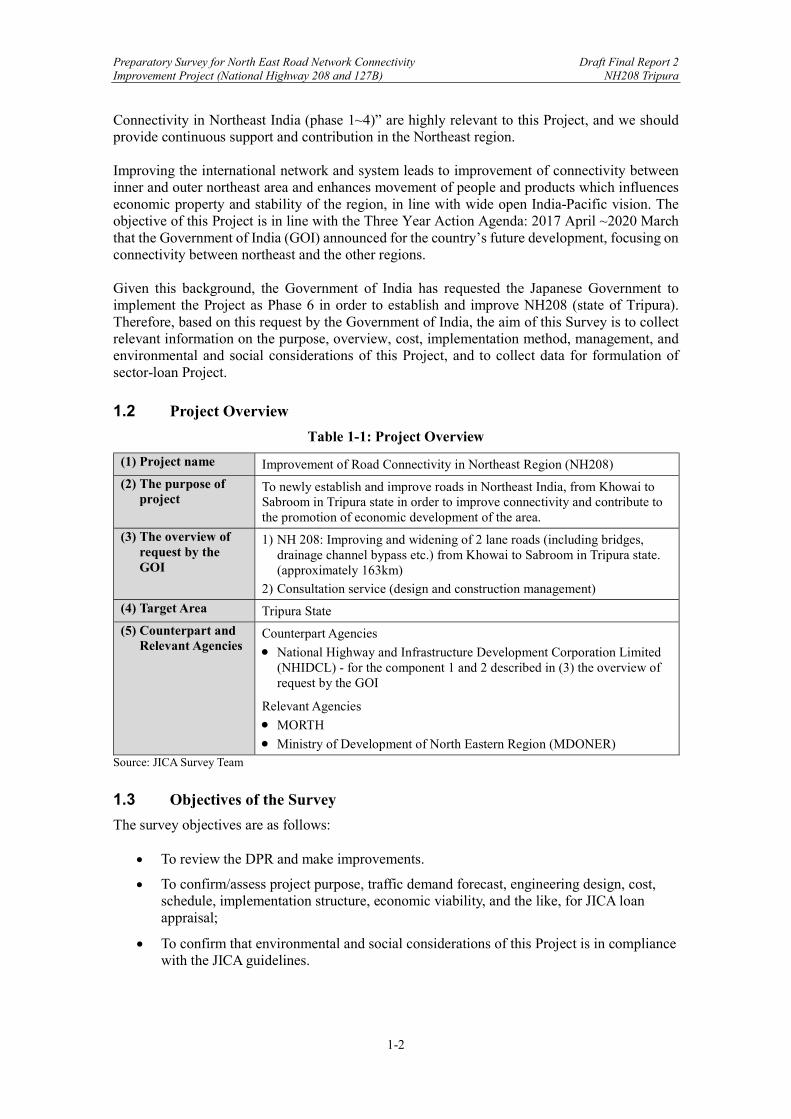
1.2 Project Overview
Table 1-1: Project Overview
(1) Project name Improvement of Road Connectivity in Northeast Region (NH208)
(2) The purpose of project
To newly establish and improve roads in Northeast India, from Khowai to Sabroom in Tripura state in order to improve connectivity and contribute to the promotion of economic development of the area.
(3) The overview of request by the GOI
1) NH 208: Improving and widening of 2 lane roads (including bridges, drainage channel bypass etc.) from Khowai to Sabroom in Tripura state. (approximately 163km)
2) Consultation service (design and construction management)
(4) Target Area Tripura State
(5) Counterpart and Relevant Agencies
Counterpart Agencies
National Highway and Infrastructure Development Corporation Limited (NHIDCL) - for the component 1 and 2 described in (3) the overview of request by the GOI
Relevant Agencies
MORTH
Ministry of Development of North Eastern Region (MDONER) Source: JICA Survey Team
1.3 Objectives of the Survey
The survey objectives are as follows:
To review the DPR and make improvements.
To confirm/assess project purpose, traffic demand forecast, engineering design, cost, schedule, implementation structure, economic viability, and the like, for JICA loan appraisal;
To confirm that environmental and social considerations of this Project is in compliance with the JICA guidelines.
Preparatory Survey for North East Road Network Connectivity Draft Final Report 2 Improvement Project (National Highway 208 and 127B) NH208 Tripura
1-3
Chapter 1. Introduction ...................................................................................................... 1-1
1.1 Background of the Project ........................................................................................ 1-1
1.2 Project Overview ...................................................................................................... 1-2
1.3 Objectives of the Survey .......................................................................................... 1-2
Figure なし Table 1-1: Project Overview ...................................................................................................... 1-2

Preparatory Survey for North East Road Network Connectivity Draft Final Report 2 Improvement Project (National Highway 208 and 127B) NH208 Tripura
2-1
Chapter 2. Present Conditions of the Survey Areas
2.1 Present Status of Highway Network in the Survey Areas
2.1.1 National Highway Network in North-Eastern States
National Highway in India is expanding rapidly. The total length of all the National Highways is 132,499 km2, and 13,640.5km is in the North-East Region covering 8 States; Arunachal Pradesh, Assam, Manipur, Meghalaya, Mizoram, Nagaland, Sikkim, and Tripura. Majority of these existing highways are 2-lane roads (one lane in each direction) and developed and maintained by the State Public Works Department (PWD). Highways are expanded to four or more lanes as more traffic flow is expected through the towns. The following figure shows the National Highway Network in the North Eastern Region. Regarding territory and borders, it does not represent the official opinion as JICA Survey Team.
Source: Ministry of Development of North Eastern Region, modified by JICA Survey Team.
Figure 2-1: National Highway Network in the North Eastern Region
The following table shows the total length of National Highway by city in the North Eastern Region.
2 Ministry of Road Transport and Highways (2019)
Preparatory Survey for North East Road Network Connectivity Draft Final Report 2 Improvement Project (National Highway 208 and 127B) NH208 Tripura
2-2
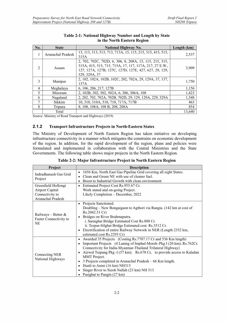
Table 2-1: National Highway Number and Length by State in the North Eastern Region
No. State National Highway No. Length (km)
1 Arunachal Pradesh 13, 113, 313, 513, 713, 713A, 15, 115, 215, 315, 415, 515, 315A
2,537
2 Assam
2, 702, 702C, 702D, 6, 306, 8, 208A, 15, 115, 215, 315, 315A, 415, 515, 715, 715A, 17, 117, 117A, 217, 27 E.W., 127, 127A, 127B, 127C, 127D, 127E, 427, 627, 29, 129, 329, 329A, 37
3,909
3 Manipur 2, 102, 102A, 102B, 102C, 202, 702A, 29, 129A, 37, 137, 137A
1,750
4 Meghalaya 6, 106, 206, 217, 127B 1,156 5 Mizoram 2, 102B, 302, 502, 502A, 6, 306, 306A, 108 1,423 6 Nagaland 2, 202, 702, 702A, 702B, 702D, 29, 129, 129A, 229, 329A 1,548 7 Sikkim 10, 310, 310A, 510, 710, 717A, 717B 463 8 Tripura 8, 108, 108A, 108 B, 208, 208A 854 Total 13,640
Source: Ministry of Road Transport and Highways (2019)
2.1.2 Transport Infrastructure Projects in North-Eastern States
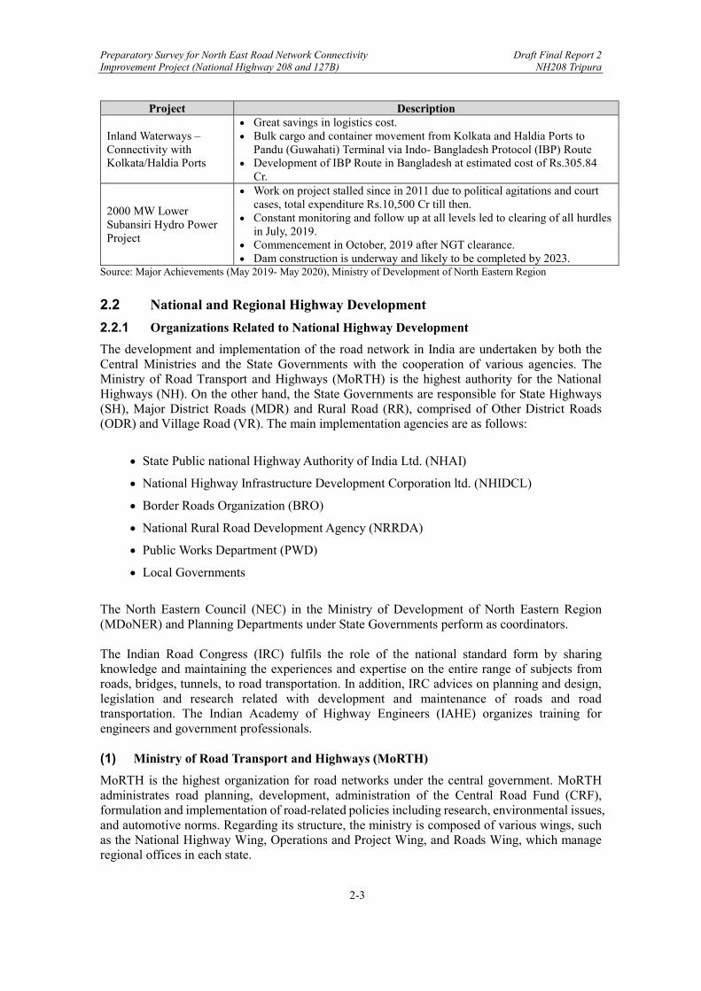
The Ministry of Development of North Eastern Region has taken initiative on developing infrastructure connectivity in a manner which mitigates the constrains on economic development of the region. In addition, for the rapid development of the region, plans and policies were formulated and implemented in collaboration with the Central Ministries and the State Governments. The following table shows major projects in the North Eastern Region.
Table 2-2: Major Infrastructure Project in North Eastern Region
Project Description
Indradhanush Gas Grid Project
1656 Km. North East Gas Pipeline Grid covering all eight States. Clean and Green NE with use of cleaner fuel. Boost to Industrial Growth with clean environment
Greenfield Hollongi Airport Capital Connectivity to Arunachal Pradesh
Estimated Project Cost Rs.955.67 Cr. Work stated and on-going Project. Likely Completion – December, 2022
Railways – Better & Faster Connectivity to NE
Projects Sanctioned. Doubling – New Bongaigaon to Agthori via Rangia. (142 km at cost of Rs.2042.51 Cr)
Bridges on River Brahmaputra. i. Saraighat Bridge Estimated Cost Rs.888 Cr. ii. Tezpur-Silghat Bridge Estimated cost. Rs.3512 Cr.
Electrification of entire Railway Network in NER (Length 2352 km, estimated cost Rs.2293 Cr)
Connecting NER National Highways
Awarded 35 Projects (Costing Rs.7707.17 Cr and 536 Km length) Important Projects (4 Laning of Imphal-Moreh–Pkg I (20 km); Rs.762Cr.
Connectivity for India-Myanmar-Thailand Trilateral Highway) Aizwal Tuipang Pkg -l (57 km); Rs.678 Cr, to provide access to Kaladan
MMT Project. 3 Projects completed in Arunachal Pradesh – 66 Km length. Hunli to Anini (16 km) NH313 Singer River to Sizoh Nallah (23 km) NH 513 Pasighat to Pangin (27 km)
Preparatory Survey for North East Road Network Connectivity Draft Final Report 2 Improvement Project (National Highway 208 and 127B) NH208 Tripura
2-3
Project Description
Inland Waterways – Connectivity with Kolkata/Haldia Ports
Great savings in logistics cost. Bulk cargo and container movement from Kolkata and Haldia Ports to
Pandu (Guwahati) Terminal via Indo- Bangladesh Protocol (IBP) Route Development of IBP Route in Bangladesh at estimated cost of Rs.305.84
Cr.
2000 MW Lower Subansiri Hydro Power Project
Work on project stalled since in 2011 due to political agitations and court cases, total expenditure Rs.10,500 Cr till then.
Constant monitoring and follow up at all levels led to clearing of all hurdles in July, 2019.
Commencement in October, 2019 after NGT clearance. Dam construction is underway and likely to be completed by 2023.
Source: Major Achievements (May 2019- May 2020), Ministry of Development of North Eastern Region
2.2 National and Regional Highway Development
2.2.1 Organizations Related to National Highway Development
The development and implementation of the road network in India are undertaken by both the Central Ministries and the State Governments with the cooperation of various agencies. The Ministry of Road Transport and Highways (MoRTH) is the highest authority for the National Highways (NH). On the other hand, the State Governments are responsible for State Highways (SH), Major District Roads (MDR) and Rural Road (RR), comprised of Other District Roads (ODR) and Village Road (VR). The main implementation agencies are as follows:
State Public national Highway Authority of India Ltd. (NHAI)
National Highway Infrastructure Development Corporation ltd. (NHIDCL)
Border Roads Organization (BRO)
National Rural Road Development Agency (NRRDA)
Public Works Department (PWD)
Local Governments
The North Eastern Council (NEC) in the Ministry of Development of North Eastern Region (MDoNER) and Planning Departments under State Governments perform as coordinators. The Indian Road Congress (IRC) fulfils the role of the national standard form by sharing knowledge and maintaining the experiences and expertise on the entire range of subjects from roads, bridges, tunnels, to road transportation. In addition, IRC advices on planning and design, legislation and research related with development and maintenance of roads and road transportation. The Indian Academy of Highway Engineers (IAHE) organizes training for engineers and government professionals. (1) Ministry of Road Transport and Highways (MoRTH)
MoRTH is the highest organization for road networks under the central government. MoRTH administrates road planning, development, administration of the Central Road Fund (CRF), formulation and implementation of road-related policies including research, environmental issues, and automotive norms. Regarding its structure, the ministry is composed of various wings, such as the National Highway Wing, Operations and Project Wing, and Roads Wing, which manage regional offices in each state.
Preparatory Survey for North East Road Network Connectivity Draft Final Report 2 Improvement Project (National Highway 208 and 127B) NH208 Tripura
2-4
(2) National Highways Authority of India Ltd. (NHAI)
National Highways Authority of India was established by an act of the Parliament, NHAI Act, 1988 “An Act to provide for the constitution of an Authority for the development, maintenance and management of national highways and for matter connected therewith or incidental thereto”, and became operational in 1995, under the administrative control of MoRTH. NHAI is authorized to implement National Highways Development Project (NHDP), India’s largest ever Highways Project in a phased manner. It has been entrusted with NHDP, which along with other minor projects, has vested in it 50,329 km of National Highways for development, maintenance, and management. (3) National Highway Infrastructure Development Corporation Ltd. (NHIDCL)
NHIDCL is a company fully owned by MoRTH. The NHIDCL undertakes surveys, designs, building, operation, maintenance and upgrading of National Highways and roads with strategic importance, including border roads that share international boundaries with neighboring countries. The operation was initiated from 1st January 2015. (4) Border Roads Organization (BRO)
The Border Roads Organization (BRO) is a road construction executive force, integral to and in support of the army. It began operations in May 1960. The BRO is entrusted with the task of construction and maintenance of roads in the border areas for defense purpose. The roads in the border areas are developed and maintained through funds provided by MoRTH through the Border Roads Development Board (BRDB). In addition to the roads in the border areas, BRO also conducts works entrusted by other ministries and departments. (5) Ministry of Rural Development (MRD)
MRD is the nodal ministry to manage most of the development and welfare activities in the rural areas, including infrastructure, that cover Other District Roads (ODR) and Village Roads (VR). MRD set up the National Rural Roads Development Agency (NRRDA) to provide operational and management support to the Rural Road development plan programmes; namely, Pradhan Mantri Gram Sadak Yojana (PMGSY), the Prime Minister's Rural Roads Scheme. (6) Public Works Department (PWD)
PWD was originally set up by the military in the middle of 1800 under British Rule. Currently, 36 PWDs are assigned under state governments in India and are responsible for construction and maintenance of public infrastructures such as government building, roads, bridges, public transport, drinking water systems and much more. Especially, the principal function of PWD on roads is to develop and manage the state road infrastructure for providing connectivity and efficient transportation. It undertakes construction and maintenance of roads, bridges, culverts in the state.
2.2.2 Development Programs for National Highways
(1) Special Accelerated Road Development Programme for the North-East (SARDP-NE)
Ministry of Road Transport and Highways has formulated SARDP-NE for enhancing road facilities in the North-East region. Objective of the scheme are upgradation of National Highways connecting State Capitals with 2 or 4 lane roads. Providing connectivity to backward and remote areas of North East region to boost socio-economic development, improving roads of strategic importance in border areas and improving connectivity to neighbouring countries. The scope of the programme has been enlarged from time to time since September 2005.

Preparatory Survey for North East Road Network Connectivity Draft Final Report 2 Improvement Project (National Highway 208 and 127B) NH208 Tripura
2-5
The SARDP-NE programme has been divided into 3 parts: Phase-A, Arunachal Pradesh Package of Roads and Highways (Arunachal Package), and Phase-B. The details of approvals are as follow:
Table 2-3: Details of NARDP-NE
Source: Ministry of Development of North Eastern Region (MDoNER, March 2012) SARDP-NE stagnated for a long time due to the security situation and the lack of implementation capability of executing agencies. In addition, the difficult terrain and delayed land acquisition fell behind the progress. The Modi administration has placed importance on road development in the North-Eastern region and NHIDCL was newly set up under MoRTH in February 2014 to expedite the works. The figure below shows major road development programs in North East Regions.
Length (km)Estimated cost (Rs in
crore)Length (km)
Estimated cost (Rs in
crore)Length (km)
Estimated cost (Rs in
crore)Length (km)
Estimated cost (Rs in
crore)
Phase-A 3,213 12,821 886 8,948 - - 4,099 21,769
Arunachal Package
2,319 11,703 - - - - 2,319 11,703
Phase-B - - - - 3,723 64 3,723 64
Total 5,532 24,524 886 8,948 3,723 64 10,141 33,536
Approval for execution Approved 'in-principle'Approved for DPR
preparationTotal Approved
Phase

Preparatory Survey for North East Road Network Connectivity Draft Final Report 2 Improvement Project (National Highway 208 and 127B) NH208 Tripura
2-6
Source: Ministry of Development of North Eastern Region (MDoNER)
Figure 2-2: Major Road Development Programs in North East Region

Preparatory Survey for North East Road Network Connectivity Draft Final Report 2 Improvement Project (National Highway 208 and 127B) NH208 Tripura
2-7
(2) National Highway Development Project (NHDP)
The National Highways Development Project (NHDP) has been implemented for the purpose of upgrading, rehabilitating, and widening major highways in India to a higher standard. The project is managed by the National Highway Authorities of India (NHAI) under MoRTH. The NHDP planned a total of 49,260 km of works and constructions of roads and highways to enhance national economic development. The project consists of 7 Phases which were initially planned to be completed in late 2015, but was re-scheduled to finish in early 2018. Subsequently, the unfinished parts of NHDP Project were taken over under a larger Bharatmala Project under the Ministry of Road Transport and Highways. The following table shows the priorities of different Phases of NHDP.
Table 2-4: Priority of Different Phases of NHDP
Source: The Secretariat for the Committee on Infrastructure
Preparatory Survey for North East Road Network Connectivity Draft Final Report 2 Improvement Project (National Highway 208 and 127B) NH208 Tripura
2-8
(3) Bharatmala Project
In 2015, Bharatmala Pariyojana (Project), a new umbrella program for the highway sector was established after NHDP reached a certain level of maturity. In order to implement efficiently and effectively, it was necessary to redefine road development and have a macro approach while planning expansion of the national highway network. Therefore, Bharatmala Pariyojana has focused on the new initiatives like development of Border and International connectivity roads, Costal and port connectivity roads, improving efficiency of National Corridors, Economic Corridors, and others. In addition, it has enabled to upgrade the optimizing efficiency of freight and passenger movements across the country by bridging critical infrastructure gaps. The total investment was Rs 535,000 Crore (US$75 billion) for 83,677 km of the new highway constructions. The features of Bharatmala Pariyojana are as follows:
Improvement in efficiency of existing corridors through development of Multimodal Logistic Parks and elimination of choke point.
Enhance focus on improving connectivity in North East and leveraging synergies with Inland Waterways.
Emphasis on use of technology and scientific planning for Project Preparation and Asset Monitoring.
Delegation of powers to expedite project delivery. Phase-1 to completely by 2022.
Improvement connectivity in the North East.
The total length of 34,800 km including 24,800 of new highways and another 10,000km currently under-construction remaining incomplete under NHDP will be constructed in Phase-1 and completed by the end of 2022 as per the initial plan. In addition, the total length of 48,877 km highways will be constructed under Phase-2. After completing Phase-1 of Bharatmala, state road networks will be developed in Phase-2 to comprehensively restructure National Highway Development Project and ensure the National Highway Grid of desirable length. Under Bharatmala Pariyojana, the total road length of about 5,301km in North Eastern Region have been approved for improvement. Out of this, 3,246km road length has been approved for development of Economic Corridors in the North East3. The road network under Bharatmala Project is shown in Figure 2-3. The schemes and estimate costs of Phase-1 is shown in Table 2-5. As of now, Phase-1 is in under construction.
Table 2-5: Schemes and Estimate Cost of Bharatmala Project Phase-1
Sr. No. Scheme Phase-1
Length (km) Cost
(Rs. Crore) 1 Economic Corridors 9,000 120,000 2 Inter-corridor and feeder routes 6,000 80,000 3 National Corridors Efficiency Program 5,000 100,000 4 Border and International connectivity roads 2,000 25,000 5 Coastal and Port connectivity roads 2,000 20,000 6 Expressways 800 40,000
Sub-total 24,800 385,000 7 Ongoing Projects, including NHDP 10,000 150,000
Total 34,800 535,000 Source: Ministry of Road Transport and Highways
3 Source: Ministry of Development of North-East Region

Preparatory Survey for North East Road Network Connectivity Draft Final Report 2 Improvement Project (National Highway 208 and 127B) NH208 Tripura
2-9
Source: Ministry of Road Transport and Highways
Figure 2-3: Road Network under Bharatmala Project
2.2.3 On-going and Planned Road Projects Related to the Survey Roads by International Cooperation
Currently, there are several ongoing and planned road projects in the North-Eastern region funded by international aid agencies. (1) North East Road Network Connectivity Improvement Project by JICA
One of the achievements in Joint Statement on Japan and India Vision 2025 issued in 2015 was that ODA loans were provided for the improvement of road network connectivity in north-eastern states of India. Under these circumstances, the Government of India requested loan assistance to the Government of Japan for the improvement of existing roads, rehabilitation of bridges, and construction of a new bridge. All are National Highways and NHIDCL was considered as the implementing agency. JICA conducted the Preparatory Study for Road Network Improvement in the North-Eastern States and selected priority road sections for Japanese ODA assistance. The descriptions are shown in the below table.
Preparatory Survey for North East Road Network Connectivity Draft Final Report 2 Improvement Project (National Highway 208 and 127B) NH208 Tripura
2-10
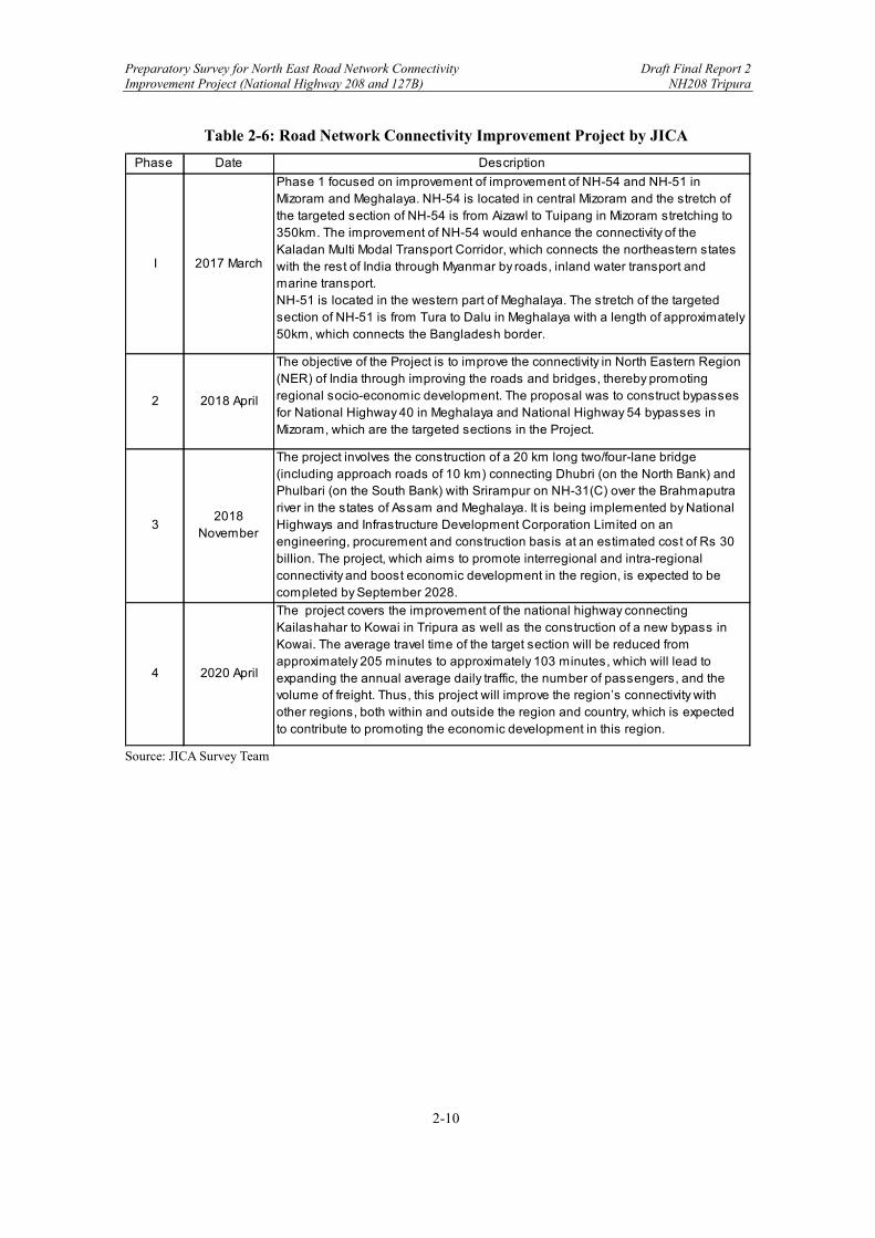
Table 2-6: Road Network Connectivity Improvement Project by JICA
Source: JICA Survey Team
Phase Date Description
I 2017 March
Phase 1 focused on improvement of improvement of NH-54 and NH-51 in Mizoram and Meghalaya. NH-54 is located in central Mizoram and the stretch of the targeted section of NH-54 is from Aizawl to Tuipang in Mizoram stretching to 350km. The improvement of NH-54 would enhance the connectivity of the Kaladan Multi Modal Transport Corridor, which connects the northeastern states with the rest of India through Myanmar by roads, inland water transport and marine transport.NH-51 is located in the western part of Meghalaya. The stretch of the targeted section of NH-51 is from Tura to Dalu in Meghalaya with a length of approximately 50km, which connects the Bangladesh border.
2 2018 April
The objective of the Project is to improve the connectivity in North Eastern Region (NER) of India through improving the roads and bridges, thereby promoting regional socio-economic development. The proposal was to construct bypasses for National Highway 40 in Meghalaya and National Highway 54 bypasses in Mizoram, which are the targeted sections in the Project.
32018
November
The project involves the construction of a 20 km long two/four-lane bridge (including approach roads of 10 km) connecting Dhubri (on the North Bank) and Phulbari (on the South Bank) with Srirampur on NH-31(C) over the Brahmaputra river in the states of Assam and Meghalaya. It is being implemented by National Highways and Infrastructure Development Corporation Limited on an engineering, procurement and construction basis at an estimated cost of Rs 30 billion. The project, which aims to promote interregional and intra-regional connectivity and boost economic development in the region, is expected to be completed by September 2028.
4 2020 April
The project covers the improvement of the national highway connecting Kailashahar to Kowai in Tripura as well as the construction of a new bypass in Kowai. The average travel time of the target section will be reduced from approximately 205 minutes to approximately 103 minutes, which will lead to expanding the annual average daily traffic, the number of passengers, and the volume of freight. Thus, this project will improve the region’s connectivity with other regions, both within and outside the region and country, which is expected to contribute to promoting the economic development in this region.
Preparatory Survey for North East Road Network Connectivity Draft Final Report 2 Improvement Project (National Highway 208 and 127B) NH208 Tripura
2-11
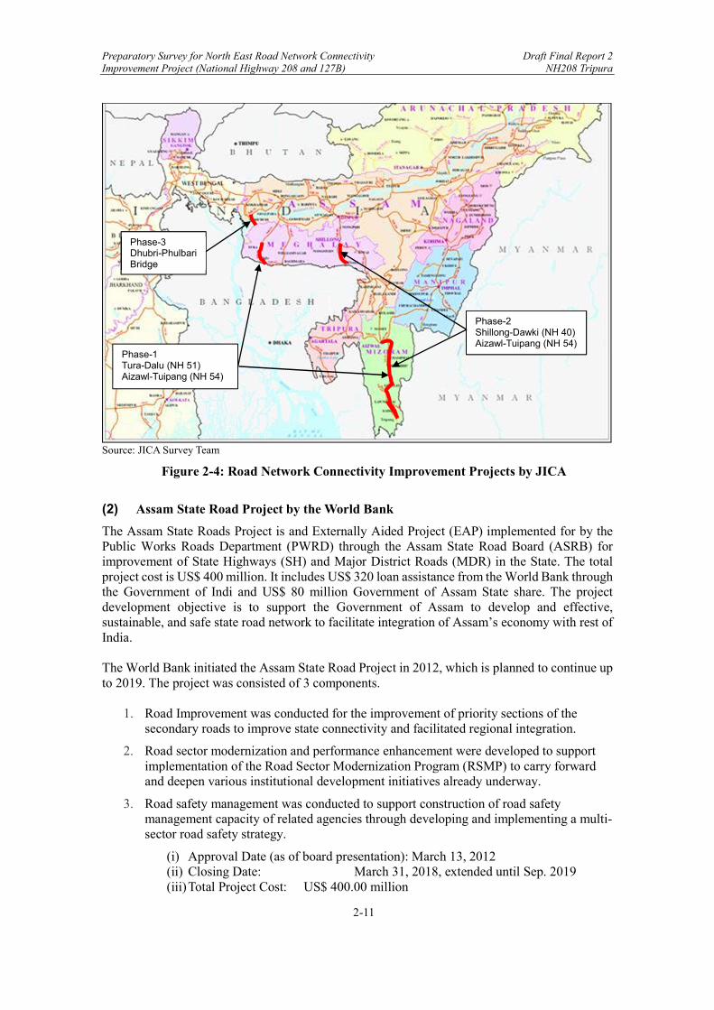
Source: JICA Survey Team
Figure 2-4: Road Network Connectivity Improvement Projects by JICA
(2) Assam State Road Project by the World Bank
The Assam State Roads Project is and Externally Aided Project (EAP) implemented for by the Public Works Roads Department (PWRD) through the Assam State Road Board (ASRB) for improvement of State Highways (SH) and Major District Roads (MDR) in the State. The total project cost is US$ 400 million. It includes US$ 320 loan assistance from the World Bank through the Government of Indi and US$ 80 million Government of Assam State share. The project development objective is to support the Government of Assam to develop and effective, sustainable, and safe state road network to facilitate integration of Assam’s economy with rest of India. The World Bank initiated the Assam State Road Project in 2012, which is planned to continue up to 2019. The project was consisted of 3 components.
1. Road Improvement was conducted for the improvement of priority sections of the secondary roads to improve state connectivity and facilitated regional integration.
2. Road sector modernization and performance enhancement were developed to support implementation of the Road Sector Modernization Program (RSMP) to carry forward and deepen various institutional development initiatives already underway.
3. Road safety management was conducted to support construction of road safety management capacity of related agencies through developing and implementing a multi-sector road safety strategy.
(i) Approval Date (as of board presentation): March 13, 2012 (ii) Closing Date: March 31, 2018, extended until Sep. 2019 (iii) Total Project Cost: US$ 400.00 million
Phase-3 Dhubri-Phulbari Bridge
Phase-1 Tura-Dalu (NH 51) Aizawl-Tuipang (NH 54)
Phase-2 Shillong-Dawki (NH 40) Aizawl-Tuipang (NH 54)
Preparatory Survey for North East Road Network Connectivity Draft Final Report 2 Improvement Project (National Highway 208 and 127B) NH208 Tripura
2-12
The implementation agency is PWD and 22 packages for improvement and upgradation work, 42 packages for rehabilitation work, and 5 packages for innovative and standardised bridge were sanctioned. (3) North- Eastern States Roads Investment Program (NESRIP) by ADB
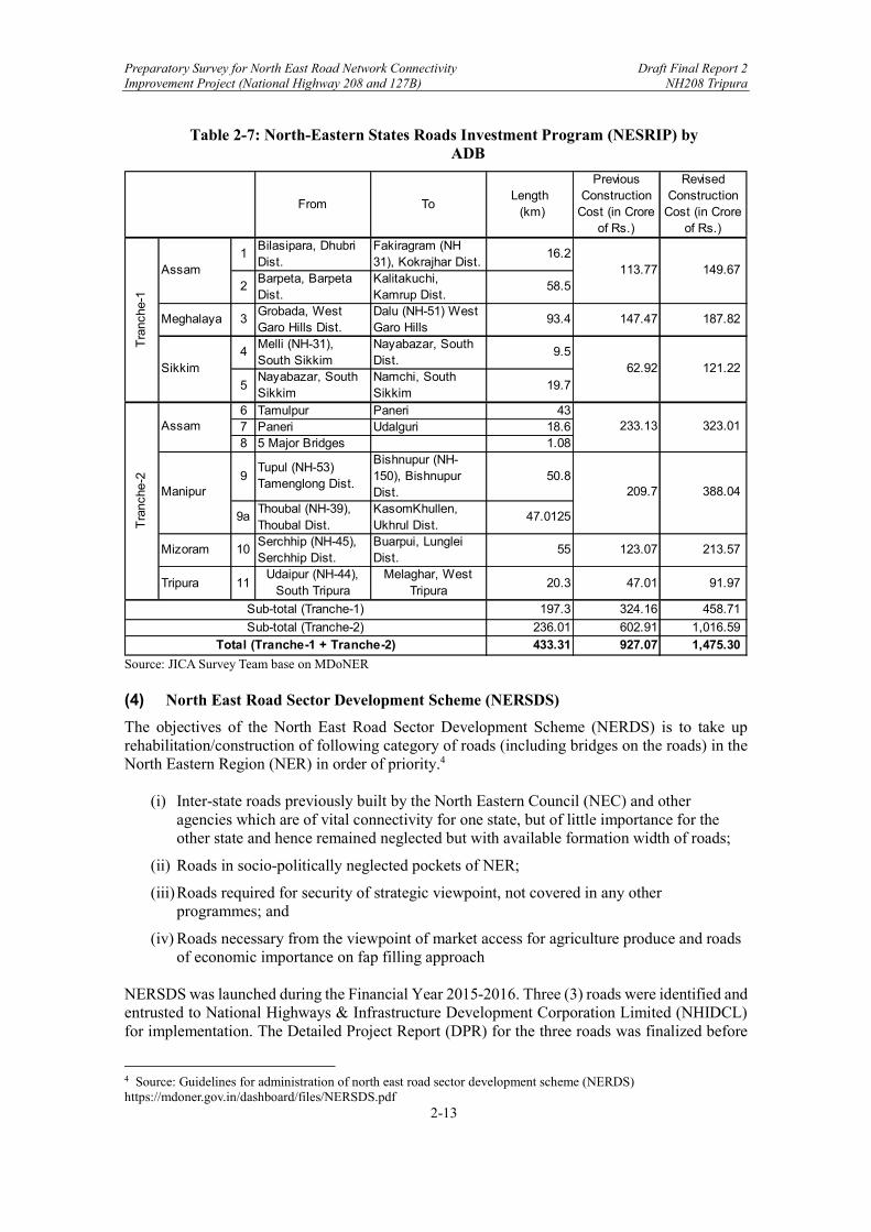
The Government of India has received a loan from the Asian Development Bank (ADB) to finance the cost of implementing the North Eastern States Road Investment Project (NESRIP). NESRIP is a 100% centrally sponsored scheme implemented over a period of 5 years at a revised cost of Rs. 2144.56 crore from the earlier approved cost of Rs. 1353.83 crore for construction/upgradation improvement of 433.7 km long State roads in the North Eastern States of Assam, Manipur, Meghalaya, Mizoram, Sikkim and Tripura along with extension of project period up to August 2022. ADB is providing loan assistance of US$ 200 million in two tranches. The road survey in the North-Eastern region was conducted in October 2005, which showed that approximately 70 percent roads were poor condition. Then, Detailed Project Report was conducted and submitted in 2008. The Scheme, NESRIP was approved by Cabinet Committee on Economic Affairs (CCEA) in May 2011 to be executed within 5 years. The main objectives of NESRIP are as follows and the loan details are shown in the table below.
Increase access within the NER states; aims to improve about 430 km of priority road sections in the six states (vis. Assam, Manipur, Meghalaya, Mizoram, Sikkim and Tripura) in the North Eastern Region (NER) of India.
Increase access between the NER states and the rest of India and other countries.
Provide capacity building support to improve management and institutional strengthening.
Improve road management systems.
Improve road safety
Improve environmental and social impact assessments and management practices
Preparatory Survey for North East Road Network Connectivity Draft Final Report 2 Improvement Project (National Highway 208 and 127B) NH208 Tripura
2-13
Table 2-7: North-Eastern States Roads Investment Program (NESRIP) by ADB
Source: JICA Survey Team base on MDoNER (4) North East Road Sector Development Scheme (NERSDS)
The objectives of the North East Road Sector Development Scheme (NERDS) is to take up rehabilitation/construction of following category of roads (including bridges on the roads) in the North Eastern Region (NER) in order of priority.4
(i) Inter-state roads previously built by the North Eastern Council (NEC) and other agencies which are of vital connectivity for one state, but of little importance for the other state and hence remained neglected but with available formation width of roads;
(ii) Roads in socio-politically neglected pockets of NER;
(iii) Roads required for security of strategic viewpoint, not covered in any other programmes; and
(iv) Roads necessary from the viewpoint of market access for agriculture produce and roads of economic importance on fap filling approach
NERSDS was launched during the Financial Year 2015-2016. Three (3) roads were identified and entrusted to National Highways & Infrastructure Development Corporation Limited (NHIDCL) for implementation. The Detailed Project Report (DPR) for the three roads was finalized before
4 Source: Guidelines for administration of north east road sector development scheme (NERDS) https://mdoner.gov.in/dashboard/files/NERSDS.pdf
From ToLength (km)
Previous Construction
Cost (in Crore of Rs.)
Revised Construction
Cost (in Crore of Rs.)
1Bilasipara, Dhubri Dist.
Fakiragram (NH 31), Kokrajhar Dist.
16.2
2Barpeta, Barpeta Dist.
Kalitakuchi, Kamrup Dist.
58.5
Meghalaya 3Grobada, West Garo Hills Dist.
Dalu (NH-51) West Garo Hills
93.4 147.47 187.82
4Melli (NH-31), South Sikkim
Nayabazar, South Dist.
9.5
5Nayabazar, South Sikkim
Namchi, South Sikkim
19.7
6 Tamulpur Paneri 437 Paneri Udalguri 18.68 5 Major Bridges 1.08
9Tupul (NH-53) Tamenglong Dist.
Bishnupur (NH-150), Bishnupur Dist.
50.8
9aThoubal (NH-39), Thoubal Dist.
KasomKhullen, Ukhrul Dist.
47.0125
Mizoram 10Serchhip (NH-45), Serchhip Dist.
Buarpui, Lunglei Dist.
55 123.07 213.57
Tripura 11Udaipur (NH-44),
South TripuraMelaghar, West
Tripura20.3 47.01 91.97
197.3 324.16 458.71
236.01 602.91 1,016.59
433.31 927.07 1,475.30
209.7 388.04
Sub-total (Tranche-1)
Sub-total (Tranche-2)
Total (Tranche-1 + Tranche-2)
113.77 149.67
62.92 121.22
233.13 323.01
Assam
Sikkim
Assam
Manipur
Tra
nche
-2T
ranc
he-1

Preparatory Survey for North East Road Network Connectivity Draft Final Report 2 Improvement Project (National Highway 208 and 127B) NH208 Tripura
2-14
taking up the work. The works have since been awarded and are at stages of implementation. The scheme has already been taken up for extension beyond March, 2017 till March, 2020.
Preparatory Survey for North East Road Network Connectivity Draft Final Report 2 Improvement Project (National Highway 208 and 127B) NH208 Tripura
2-15
2.2.4 Other Related Project
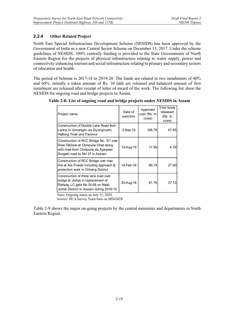
North East Special Infrastructure Development Scheme (NESIDS) has been approved by the Government of India as a new Central Sector Scheme on December 15, 2017. Under the scheme guidelines of NESIDS, 100% centrally funding is provided to the State Governments of North Eastern Region for the projects of physical infrastructure relating to water supply, power and connectivity enhancing tourism and social infrastructure relating to primary and secondary sectors of education and health. The period of Scheme is 2017-18 to 2019-20. The funds are related in two instalments of 40% and 60%, initially a token amount of Rs. 10 lakh are released and balanced amount of first instalment are released after receipt of letter of award of the work. The following list show the NESIDS for ongoing road and bridge projects in Assam.
Table 2-8: List of ongoing road and bridge projects under NESIDS in Assam
Note: Ongoing status on July 31, 2020 Source: JICA Survey Team base on MDoNER
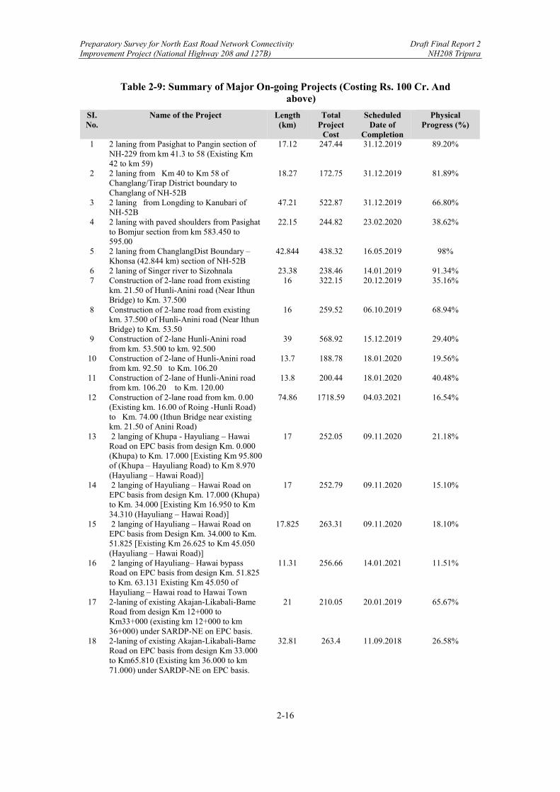
Table 2-9 shows the major on-going projects by the central ministries and departments in North Eastern Region.
Project nameDate of
sanction
Approved cost (Rs. In
crore)
Total funds released (Rs. In crore)
Construction of Double Lane Road from Lanka to Umrangso via Diyungmukh, Haflong Tinali and Panimur
3-Sep-19 188.79 67.65
Construction of RCC Bridge No. 3/1 over River Dikhow at Chiripuria Ghat along with road from Chiripuria via Ajanpeer Dorgarh road to NH 37 in Assam
14-Aug-19 17.99 6.76
Construction of RCC Bridge over river Aie at Aie Powali including approach & protection work in Chirang District
14-Feb-19 69.74 27.90
Construction of three lane road over bridge at Jorhat in replacement of Railway LC gate No St-58 on Naali, Jorhat District in Assam during 2018-19
30-Aug-18 67.76 27.10
Preparatory Survey for North East Road Network Connectivity Draft Final Report 2 Improvement Project (National Highway 208 and 127B) NH208 Tripura
2-16
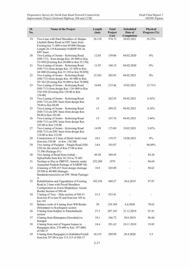
Table 2-9: Summary of Major On-going Projects (Costing Rs. 100 Cr. And above)
SI. No.
Name of the Project Length (km)
Total Project
Cost
Scheduled Date of
Completion
Physical Progress (%)
1 2 laning from Pasighat to Pangin section of NH-229 from km 41.3 to 58 (Existing Km 42 to km 59)
17.12 247.44 31.12.2019 89.20%
2 2 laning from Km 40 to Km 58 of Changlang/Tirap District boundary to Changlang of NH-52B
18.27 172.75 31.12.2019 81.89%
3 2 laning from Longding to Kanubari of NH-52B
47.21 522.87 31.12.2019 66.80%
4 2 laning with paved shoulders from Pasighat to Bomjur section from km 583.450 to 595.00
22.15 244.82 23.02.2020 38.62%
5 2 laning from ChanglangDist Boundary – Khonsa (42.844 km) section of NH-52B
42.844 438.32 16.05.2019 98%
6 2 laning of Singer river to Sizohnala 23.38 238.46 14.01.2019 91.34% 7 Construction of 2-lane road from existing
km. 21.50 of Hunli-Anini road (Near Ithun Bridge) to Km. 37.500
16 322.15 20.12.2019 35.16%
8 Construction of 2-lane road from existing km. 37.500 of Hunli-Anini road (Near Ithun Bridge) to Km. 53.50
16 259.52 06.10.2019 68.94%
9 Construction of 2-lane Hunli-Anini road from km. 53.500 to km. 92.500
39 568.92 15.12.2019 29.40%
10 Construction of 2-lane of Hunli-Anini road from km. 92.50 to Km. 106.20
13.7 188.78 18.01.2020 19.56%
11 Construction of 2-lane of Hunli-Anini road from km. 106.20 to Km. 120.00
13.8 200.44 18.01.2020 40.48%
12 Construction of 2-lane road from km. 0.00 (Existing km. 16.00 of Roing -Hunli Road) to Km. 74.00 (Ithun Bridge near existing km. 21.50 of Anini Road)
74.86 1718.59 04.03.2021 16.54%
13 2 langing of Khupa - Hayuliang – Hawai Road on EPC basis from design Km. 0.000 (Khupa) to Km. 17.000 [Existing Km 95.800 of (Khupa – Hayuliang Road) to Km 8.970 (Hayuliang – Hawai Road)]
17 252.05 09.11.2020 21.18%
14 2 langing of Hayuliang – Hawai Road on EPC basis from design Km. 17.000 (Khupa) to Km. 34.000 [Existing Km 16.950 to Km 34.310 (Hayuliang – Hawai Road)]
17 252.79 09.11.2020 15.10%
15 2 langing of Hayuliang – Hawai Road on EPC basis from Design Km. 34.000 to Km. 51.825 [Existing Km 26.625 to Km 45.050 (Hayuliang – Hawai Road)]
17.825 263.31 09.11.2020 18.10%
16 2 langing of Hayuliang– Hawai bypass Road on EPC basis from design Km. 51.825 to Km. 63.131 Existing Km 45.050 of Hayuliang – Hawai road to Hawai Town
11.31 256.66 14.01.2021 11.51%
17 2-laning of existing Akajan-Likabali-Bame Road from design Km 12+000 to Km33+000 (existing km 12+000 to km 36+000) under SARDP-NE on EPC basis.
21 210.05 20.01.2019 65.67%
18 2-laning of existing Akajan-Likabali-Bame Road on EPC basis from design Km 33.000 to Km65.810 (Existing km 36.000 to km 71.000) under SARDP-NE on EPC basis.
32.81 263.4 11.09.2018 26.58%
Preparatory Survey for North East Road Network Connectivity Draft Final Report 2 Improvement Project (National Highway 208 and 127B) NH208 Tripura
2-17
SI. No.
Name of the Project Length (km)
Total Project
Cost
Scheduled Date of
Completion
Physical Progress (%)
19 Two-Lane with Hard Shoulders of Akajan-Likabali-Bame Road on EPC basis from Existing km 71.000 to km 99.000 (Design Length-26.118 Km)under SARDP-NE on EPC basis
26.118 374.73 20.03.2021 18.33%
20 Two-Laning of Joram – Koloriang Road (NH-713) from design Km. 20+000 to Km. 32+050 [Existing Km 20.000 to Km 35.150]
12.05 159.06 04.02.2020 0%
21 Two-Laning of Joram – Koloriang Road (NH-713) from design Km. 32+050 to Km. 44+000 [Existing Km 35.150 to Km 50.050]
11.95 160.15 04.02.2020 0%
22 Two-Laning of Joram – Koloriang Road (NH-713) from design Km. 44+000 to Km. 59+363 [Existing Km 50.000 to Km 70.000]
15.363 202.03 04.02.2021 0%
23 Two-Laning of Joram – Koloriang Road (NH-713) from design Km. 138+000 to Km. 154+036 [Existing Km 138.00 to Km 158.00]
16.04 215.46 19.02.2021 13.71%
24 Two-Laning of Joram – Koloriang Road (NH-713) on EPC basis from design Km. 70.00 to Km 88.00
18 262.43 04.02.2021 6.42%
25 Two-Laning of Joram – Koloriang Road (NH-713) on EPC basis from design Km. 88.00 to Km 103.00
15 209.52 04.02.2021 8.34%
26 Two-Laning of Joram – Koloriang Road (NH-713) on EPC basis from design Km. 103.00 to Km 118.00
15 187.76 04.02.2021 2.44%
27 Two-Laning of Joram – Koloriang Road (NH-713) on EPC basis from design Km. 118.00 to Km 132.00
14.99 175.89 19.02.2021 3.42%
28 Construction of 2-lane of Hunli-Anini road from km.120.00 to Km. 130.300
10.3 139.37 14.06.2021 0%
29 Two laning of Pasighat – Pangin Road (NH-229) for the stretch of Km 57.00 to Km 71.596 (Package-IV)
14.6 103.87 - 96.09%
30 Two laning of Road from Gobuk –SijhonNalla from Km 26.210 to 75.485
49.28 389.45 - 84.28
31 Nechipu to Hoj on DBFOT, Annuity under Arunachal Pradesh Package of SARDP-NE.
252.209 1979 - 96.69
32 4-lanning of NH-415 from design chainage 29/500 to 40/400 (Itanagar-Bandardewasection) on EPC Mode Package-A
10.9 243.89 - 50.62
33 Rehabilitation and Upgradation of Existing Road to 2-lane with Paved Shoulders Configuration in Jowai-Meghalaya/ Assam Border Section of NH-44
102.256 468.27 30.6.2019 97.87
34 2 laning of Tura – Dalu section of NH-51 from km 85 to km 95 and from km 105 to km 145
51.5 553.41 - -
35 Balance work of 4 laning from WB Border (Srirampur) to Kochugaon section
30 129.189 4.4.2020 78.62
36 4 laning from Kaljhar to Patacharkuchi section
27.3 207.165 31.12.2019 91.91
37 4 laning from Khanapara (Guwahati) to Sonapur
19.1 166.72 30.6.2019 96.84
38 4 laning from end of Nagaon bypass to Rangagara (Km. 278.600 to Km. 297.000) of NH-37
18.4 291.62 18.11.2019 19.85
39 4 laning from Rangagara to KaliabhorTiniali from km 297.00 to km 315.315 of NH-37
18.315 289.99 20.4.2020 5.5
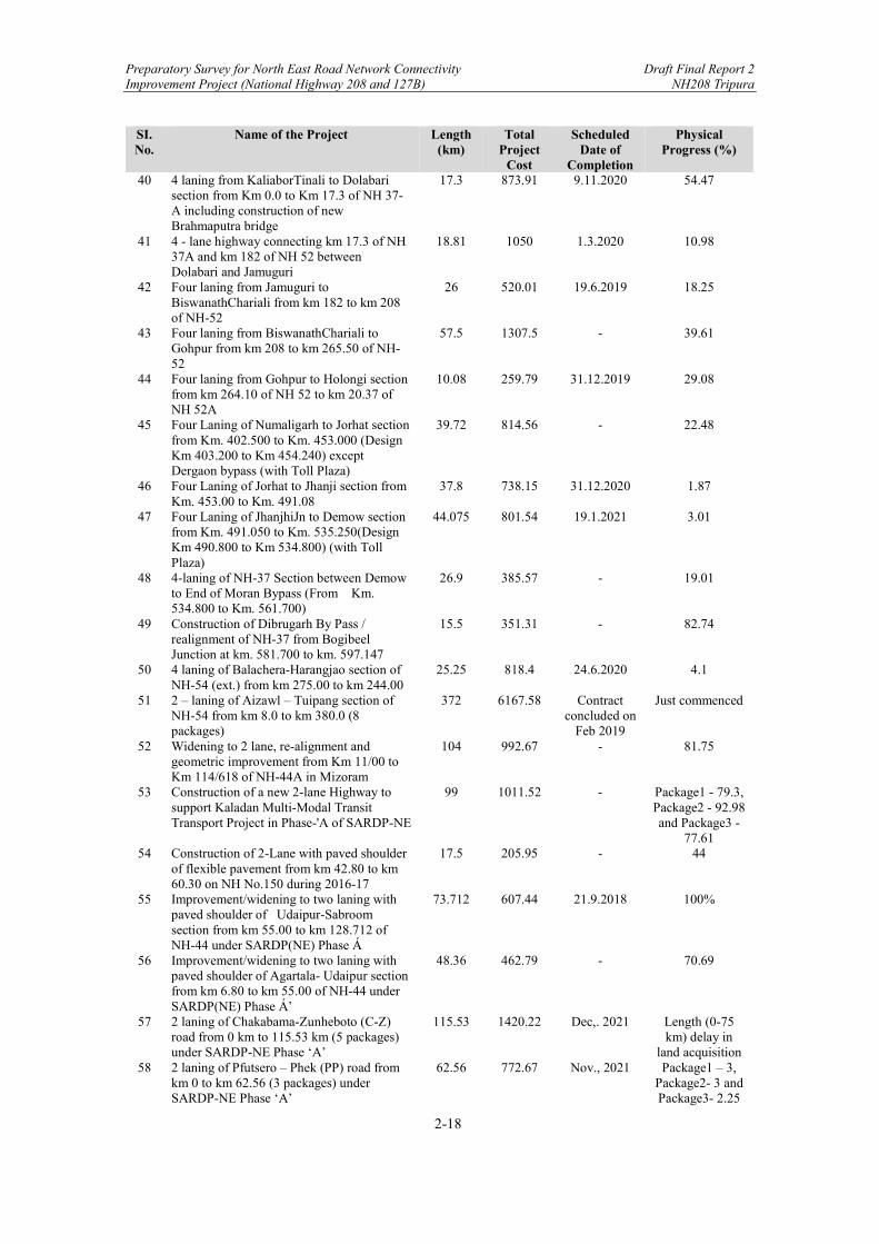
Preparatory Survey for North East Road Network Connectivity Draft Final Report 2 Improvement Project (National Highway 208 and 127B) NH208 Tripura
2-18
SI. No.
Name of the Project Length (km)
Total Project
Cost
Scheduled Date of
Completion
Physical Progress (%)
40 4 laning from KaliaborTinali to Dolabari section from Km 0.0 to Km 17.3 of NH 37-A including construction of new Brahmaputra bridge
17.3 873.91 9.11.2020 54.47
41 4 - lane highway connecting km 17.3 of NH 37A and km 182 of NH 52 between Dolabari and Jamuguri
18.81 1050 1.3.2020 10.98
42 Four laning from Jamuguri to BiswanathChariali from km 182 to km 208 of NH-52
26 520.01 19.6.2019 18.25
43 Four laning from BiswanathChariali to Gohpur from km 208 to km 265.50 of NH-52
57.5 1307.5 - 39.61
44 Four laning from Gohpur to Holongi section from km 264.10 of NH 52 to km 20.37 of NH 52A
10.08 259.79 31.12.2019 29.08
45 Four Laning of Numaligarh to Jorhat section from Km. 402.500 to Km. 453.000 (Design Km 403.200 to Km 454.240) except Dergaon bypass (with Toll Plaza)
39.72 814.56 - 22.48
46 Four Laning of Jorhat to Jhanji section from Km. 453.00 to Km. 491.08
37.8 738.15 31.12.2020 1.87
47 Four Laning of JhanjhiJn to Demow section from Km. 491.050 to Km. 535.250(Design Km 490.800 to Km 534.800) (with Toll Plaza)
44.075 801.54 19.1.2021 3.01
48 4-laning of NH-37 Section between Demow to End of Moran Bypass (From Km. 534.800 to Km. 561.700)
26.9 385.57 - 19.01
49 Construction of Dibrugarh By Pass / realignment of NH-37 from Bogibeel Junction at km. 581.700 to km. 597.147
15.5 351.31 - 82.74
50 4 laning of Balachera-Harangjao section of NH-54 (ext.) from km 275.00 to km 244.00
25.25 818.4 24.6.2020 4.1
51 2 – laning of Aizawl – Tuipang section of NH-54 from km 8.0 to km 380.0 (8 packages)
372 6167.58 Contract concluded on
Feb 2019
Just commenced
52 Widening to 2 lane, re-alignment and geometric improvement from Km 11/00 to Km 114/618 of NH-44A in Mizoram
104 992.67 - 81.75
53 Construction of a new 2-lane Highway to support Kaladan Multi-Modal Transit Transport Project in Phase-'A of SARDP-NE
99 1011.52 - Package1 - 79.3, Package2 - 92.98 and Package3 -
77.61 54 Construction of 2-Lane with paved shoulder
of flexible pavement from km 42.80 to km 60.30 on NH No.150 during 2016-17
17.5 205.95 - 44
55 Improvement/widening to two laning with paved shoulder of Udaipur-Sabroom section from km 55.00 to km 128.712 of NH-44 under SARDP(NE) Phase Á
73.712 607.44 21.9.2018 100%
56 Improvement/widening to two laning with paved shoulder of Agartala- Udaipur section from km 6.80 to km 55.00 of NH-44 under SARDP(NE) Phase Á’
48.36 462.79 - 70.69
57 2 laning of Chakabama-Zunheboto (C-Z) road from 0 km to 115.53 km (5 packages) under SARDP-NE Phase ‘A’
115.53 1420.22 Dec,. 2021 Length (0-75 km) delay in
land acquisition 58 2 laning of Pfutsero – Phek (PP) road from
km 0 to km 62.56 (3 packages) under SARDP-NE Phase ‘A’
62.56 772.67 Nov., 2021 Package1 – 3, Package2- 3 and Package3- 2.25
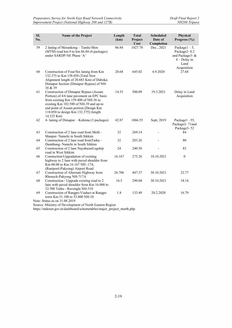
Preparatory Survey for North East Road Network Connectivity Draft Final Report 2 Improvement Project (National Highway 208 and 127B) NH208 Tripura
2-19
SI. No.
Name of the Project Length (km)
Total Project
Cost
Scheduled Date of
Completion
Physical Progress (%)
59 2 laning of Merankong – Tamlu-Mon (MTM) road km 0 to km 86.84 (4 packages) under SARDP-NE Phase ‘A’
86.84 1027.78 Dec., 2021 Package1 – 5, Package2- 0.2
and Package3- & 4 – Delay in
Land Acquisition
60 Construction of Four/Six laning from Km 132.375 to Km 158.058 (Total New Alignment length of 20.683 Km) of Daboka- Dimapur Section (Dimapur Bypass) of NH-36 & 39
20.68 645.02 4.9.2020 27.68
61 Construction of Dimapur Bypass (Assam Portion) of 4/6 lane pavement on EPC basis from existing Km 159.400 of NH-36 to existing Km 102.500 of NH-39 and up-to end point of Assam portion [Design Km 118.050 to design Km 132.375] (length 14.325 Km)
14.33 500.09 19.3.2021 Delay in Land Acquisition
62 4- laning of Dimapur – Kohima (3 packages) 42.87 1066.55 Sept, 2019 Package1 –55, Package2- 71and
Package3- 52 63 Construction of 2 lane road from Melli -
Manpur- Namchi in South Sikkim 32 269.14 - 84
64 Construction of 2 lane road fromTarku - Damthang- Namchi in South Sikkim
32 203.26 - 80
65 Construction of 2 lane NayabazarLegship road in West Sikkim
24 240.58 - 83
66 Constuction/Upgradation of existing highway to 2 lane with paved shoulder from Km 00.00 to Km 16.167 NH -17A. (Ranipool-Pakyong) Airport Road
16.167 275.26 10.10.2021 0
67 Construction of Alternate Highway from Rhenock-Pakyong NH-717A
26.706 447.37 30.10.2021 22.77
68 Construction / Upgrade existing road to 2 lane with paved shoulder from Km 16.000 to 32.500 Tarku - Ravongla NH-510
16.5 290.04 30.10.2021 18.14
69 Construction of Rangpo-Viaduct at Rangpo town Km 51.100 to 53.800 NH-10
1.8 133.49 20.2.2020 16.79
Note: Status as on 31.08.2019 Source: Ministry of Development of North Eastern Region https://mdoner.gov.in/dashboard/schemetables/major_project_morth.php

Preparatory Survey for North East Road Network Connectivity Draft Final Report 2 Improvement Project (National Highway 208 and 127B) NH208 Tripura
2-20
2.3 Socio-Economic Conditions
2.3.1 Overview of Survey Areas
The three states covered under this Survey are Assam, Meghalaya, and Tripura. These Survey areas are in the North-Eastern region of India, connected to the mainland with only a narrow strip of land known as the “Chicken’s neck”. Assam, Meghalaya, and Tripura make up three of the popular “Seven Sister” States of India. Within the North-Eastern region, Assam, Meghalaya, and Tripura are three of the most populated states making up around 84% of the total population while covering approximately 44% of the total North-Eastern region as shown in Table 2-10.
Table 2-10: Population and Area of “Seven Sister” States
North Eastern States Population
(Census 2011) Population (% share)
Area (Sq. km)
Area (% share)
Arunachal Pradesh 1,382,611 3.07% 83,743 32.83% Assam 31,169,272 69.30% 78,438 30.75%
Manipur 2,721,756 6.59% 22,327 8.79% Meghalaya 2,964,001 6.05% 22,429 8.75% Mizoram 1,091,014 2.43% 21,081 8.26% Nagaland 1,980,602 4.40% 16,579 6.50% Tripura 3,671,032 8.16% 10,486 4.11% TOTAL 44,980,288 100% 255,083 100%
Source: Ministry of Development of North Eastern Region In terms of geographical location, Assam, Meghalaya, and Tripura are of significant importance as these states share borders with Bangladesh, together making up around 40% of the total Indo-Bangladesh border. Among the three, Assam also plays an integral role as the sole gateway connecting North-Eastern India to Mainland India. Thus, NH127B (Srirampur-Dhubri, Assam and Fakirganj-Tura, Meghalaya), which aims to establish a more efficient connection between Assam and Meghalaya, along with NH208 (Khowai-Sabroom), which would pave way to better connect Bangladesh’s biggest port (Chittagong Port) with rest of the North-Eastern region, hold considerable promise for future development of the region. The main districts within Assam, Meghalaya, and Tripura directly linked to the Survey Corridors are briefly summarised in Table 2-11 and shown in Figure 2-5.

Preparatory Survey for North East Road Network Connectivity Draft Final Report 2 Improvement Project (National Highway 208 and 127B) NH208 Tripura
2-21
Table 2-11: Districts Directly Linked to the Survey Corridors
Survey Areas Main
Districts Description
Srirampur-Dhubri , Assam1
Dhubri
The Dhubri District shares intra-state borders with Goalpara and Bogaigaon districts in the east, Kokrajhar district in the north, and South Salmara-Mankachar district in the south. All these districts are part of the Lower Assam Division which has inter-state connections with West Bengal in the west and Meghalaya in the South across the mighty Brahmaputra River. Dubri also shares international borders with Bangladesh in the west. The Dhubri District has a population of almost 2 million and covers an area of 2,176 sq. km. It has one of the highest population densities within Assam with 896 persons per sq. km.
Kokrajhar
The Kokrajhar District is to the north of Dhubri and has the Chirang District to its east. It shares an inter-state border with West Bengal in the west and an international border of around 88 kms with Bhutan in the north. Kokrajhar covers an area of 3,169 sq. km within Assam and hosts a population of under 1 million.
Fakirganj-Tura, Meghalaya2
West Garo Hills
West Garo Hills is located in the western part of the Meghalaya state. It shares intra-state boundaries with East Garo Hills in the east and South Garo Hills in the south-east. West Garo Hills borders the Goalpara district of Assam in the north and north-east and also shares an international border with Bangladesh in the south. West Garo Hills spans across 3,677 sq. km and hosts a population of approx. 471,000.
Teliamura-Sabroom, Tripura3
West Tripura (Khowai &
Gomati)
Khowai and Gomati are located on the eastern stretch of the West Tripura District. Khowai is to the north of Gomati and Gomati is connected to South Tripura to its south. The Khowai district shares a border with Bangladesh to its north. Gomati has an area of 1522.8 sq. km. with a population of around 441,500. Khowai is comparatively smaller with an area of 1377.28 sq. km. with a population of approx. 327,600.
South Tripura
South Tripura is the southern-most tip of the Tripura State. To its north is the West Tripura District and to its south, it shares an international border with Bangladesh. South Tripura covers an area of around 1514 sq. km and has a population of approx. 453,000.
Note: Demographic data as per 2011 Census. Source: Official websites of: 1Government of Assam, 2 West Garo Hills, State of Meghalaya, 3 South Tripura District, Gomati District, and Khowai District.

Preparatory Survey for North East Road Network Connectivity Draft Final Report 2 Improvement Project (National Highway 208 and 127B) NH208 Tripura
2-22
Source: JICA Survey Team
Figure 2-5: Survey Corridor Districts in North-Eastern India
The following sections of this chapter will elaborate on the geographical and socio-economic conditions of Tripura.
2.3.2 Geographical Conditions of Tripura
(1) Physiography
Tripura is the smallest of the “Seven Sister” States with an area of 10,486 Sq. Km. making up 4.11% of the North-Eastern Region. Nonetheless, the Tripura State holds a lot of potential as it shares 856 km of its border with Bangladesh and is the state closest to Bangladesh’s biggest port district of Chittagong. South Tripura, which is to the very south of Tripura, has an area of 1,514.322 Sq. Km. while Khowai and Gomati districts in West Tripura cover an area of 1,377.28 Sq. Km. and 1,522.8 Sq. Km., respectively. Approx. 43% of the area is forest area in Khowai, 74% is forest area in Gowati, and 79% is forest area in South Tripura.
The three Survey Corridor districts are surrounded by Baramura, Debtamura, and Atharamura hill ranges. The Khowai River and Gomati River are the main water sources for Khowai and Gomati districts, respectively. In the South Tripura district, Muhuri and Feni rivers can be found which also flow down into Bangladesh. (2) Climate
Much like Assam and Meghalaya, the Survey Corridor districts in Tripura are also impacted by the South-West monsoon season starting from May and continuing into September. The average annual rainfall is estimated to be around 2,000 mm. While it is very humid during the monsoon and summer, winter tends to be rather dry. The maximum temperature during summer/monsoon season is around 35° Celsius while it dips down to approx.7° Celsius during the winters.
Preparatory Survey for North East Road Network Connectivity Draft Final Report 2 Improvement Project (National Highway 208 and 127B) NH208 Tripura
2-23
2.3.3 Socio-Economic Conditions
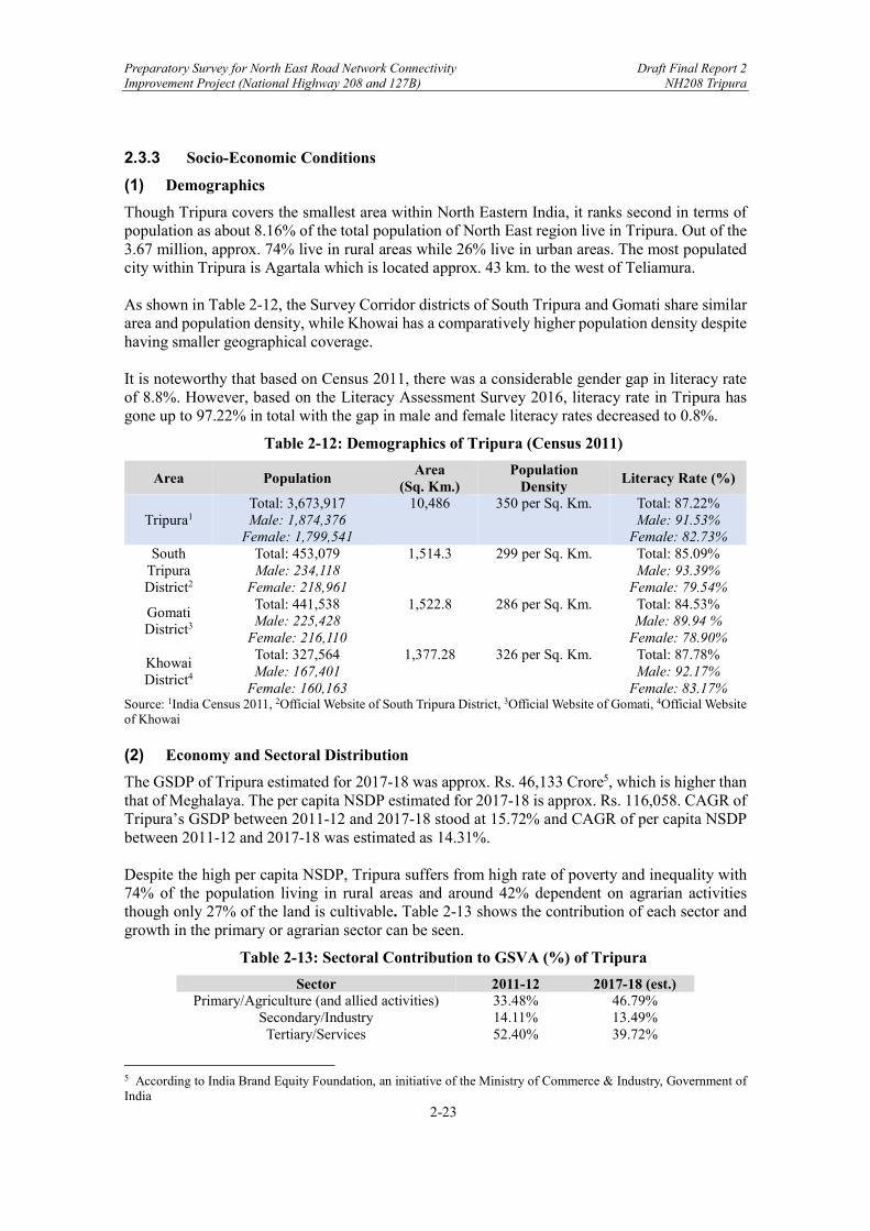
(1) Demographics
Though Tripura covers the smallest area within North Eastern India, it ranks second in terms of population as about 8.16% of the total population of North East region live in Tripura. Out of the 3.67 million, approx. 74% live in rural areas while 26% live in urban areas. The most populated city within Tripura is Agartala which is located approx. 43 km. to the west of Teliamura. As shown in Table 2-12, the Survey Corridor districts of South Tripura and Gomati share similar area and population density, while Khowai has a comparatively higher population density despite having smaller geographical coverage. It is noteworthy that based on Census 2011, there was a considerable gender gap in literacy rate of 8.8%. However, based on the Literacy Assessment Survey 2016, literacy rate in Tripura has gone up to 97.22% in total with the gap in male and female literacy rates decreased to 0.8%.
Table 2-12: Demographics of Tripura (Census 2011)
Area Population Area
(Sq. Km.) Population
Density Literacy Rate (%)
Tripura1 Total: 3,673,917 Male: 1,874,376
Female: 1,799,541
10,486 350 per Sq. Km. Total: 87.22% Male: 91.53%
Female: 82.73% South
Tripura District2
Total: 453,079 Male: 234,118
Female: 218,961
1,514.3 299 per Sq. Km. Total: 85.09% Male: 93.39%
Female: 79.54%
Gomati District3
Total: 441,538 Male: 225,428
Female: 216,110
1,522.8 286 per Sq. Km. Total: 84.53% Male: 89.94 %
Female: 78.90%
Khowai District4
Total: 327,564 Male: 167,401
Female: 160,163
1,377.28 326 per Sq. Km. Total: 87.78% Male: 92.17%
Female: 83.17% Source: 1India Census 2011, 2Official Website of South Tripura District, 3Official Website of Gomati, 4Official Website of Khowai (2) Economy and Sectoral Distribution
The GSDP of Tripura estimated for 2017-18 was approx. Rs. 46,133 Crore5, which is higher than that of Meghalaya. The per capita NSDP estimated for 2017-18 is approx. Rs. 116,058. CAGR of Tripura’s GSDP between 2011-12 and 2017-18 stood at 15.72% and CAGR of per capita NSDP between 2011-12 and 2017-18 was estimated as 14.31%. Despite the high per capita NSDP, Tripura suffers from high rate of poverty and inequality with 74% of the population living in rural areas and around 42% dependent on agrarian activities though only 27% of the land is cultivable. Table 2-13 shows the contribution of each sector and growth in the primary or agrarian sector can be seen.
Table 2-13: Sectoral Contribution to GSVA (%) of Tripura
Sector 2011-12 2017-18 (est.) Primary/Agriculture (and allied activities) 33.48% 46.79%
Secondary/Industry 14.11% 13.49% Tertiary/Services 52.40% 39.72%
5 According to India Brand Equity Foundation, an initiative of the Ministry of Commerce & Industry, Government of India

Preparatory Survey for North East Road Network Connectivity Draft Final Report 2 Improvement Project (National Highway 208 and 127B) NH208 Tripura
2-24
Source: India Brand Equity Foundation
2.4 Industrial Development
2.4.1 Overview
Industrial development and investment initiatives and schemes within Northeast India, such as North Eastern Region Vision 2020 and Tripura Industrial Investment Promotion Incentives Scheme (2017), recognize and emphasize the importance of harnessing the potentials of agricultural and agriculture-allied activities within the North Eastern states of India. Furthermore, provided that the region is rich in natural resources such as minerals, herbal plants, and natural gas, industrial development also largely depends on effective utilization of these resources. Some of the “thrust” sectors where investments are directed to drive industrial growth include:
Agro-food processing and horticulture-based industries Herbal plants and forestry related industries, particularly Bamboo and Rubber Handloom textile industries, particularly silk Mineral based industries Hospitality and Tourism industries IT related services
2.4.2 Current Status of Existing Industries and Industrial Development in Tripura
Tripura, much like Assam and Meghalaya, is primarily known for its horticulture and agricultural produce. It is an agrarian state with the livelihood of much of its population dependent on agricultural and allied activities, though only 27% of its land is cultivable. Within North East India, Tripura is particularly known for its surplus production of agro-foods such as rice, fruits, and vegetables. In terms of forestry, Tripura ranks as the second largest producer of natural rubber in India. It also has vast reserves of mineral resources with surplus natural gas supply which could potentially cater to the need of all sister states of North East India. However, despite the state’s potential, Tripura’s geographical disposition has long impacted its industrial development and economic growth due to: (i) isolation from the rest of the North Eastern India and Mainland India, (ii) vast forest coverage and mountainous geography, (iii) poor transport infrastructure, and (iv) long international border shared with Bangladesh but with unregulated or inadequate trade border mechanism. Nonetheless, in recent years, there has been increased investment for industrial development going into South Tripura and West Tripura, in particular, Sabroom (on the Survey Corridor) and Agartala, the capital of Tripura, which is approx. 43 km. away from Teliamura on the Survey Corridor NH208. One of the most important recent developments in Tripura is the introduction of plans to set up Tripura’s first Special Economic Zone (SEZ) in Sabroom, South Tripura. This initiative is led by Tripura Industrial Development Corporation (TIDC) under the Government of Tripura. It is expected that agro-food processing industries, bamboo and rubber industries, and textile industries will be established within this SEZ unit for promotion of export given Sabroom’s proximity to Chittagong port in Bangladesh. Moreover, under the Smart Cities Mission by the Government of India, Agartala was selected as one of the 100 cities in India where the urban renewal and retrofitting program would be implemented. Under this initiative the Agartala Smart City Special Purpose Vehicle (SPV) was created and the SPV has received funding from ADB to carry out Area Based Development
Preparatory Survey for North East Road Network Connectivity Draft Final Report 2 Improvement Project (National Highway 208 and 127B) NH208 Tripura
2-25
Project and PAN City Project which focus on urban development and recreation of commercial, trade, and logistics hubs and skill development centers, implementation of smart network and rapid transit system, etc. Some industrial areas in close proximity to the Survey Corridor in West Tripura and South Tripura are:
Bodhjungnagar Industrial Area – The area is located at Bodhjungnagar in West Tripura (40 km from Teliamura) and covers 535.73 acres. The complex covers growth centre, food park, rubber park, and export promotional industrial park. R. K. Nagar Industrial Area – This complex covers an area of 226.16 acres and is located adjacent to the Bodhjungnagar Industrial Area. It is run by TIDC. The complex comprise a textile park, an oil corporation, and also a bamboo park which was developed by TIDC. Dhukli Industrial Area – This complex is spread across 45.77 acres of land and is located at Dhukli which is around 60 km to the west of Teliamura along the Survey Corridor. TIDC has been undertaking a project for upgrading the infrastructure at Dhukli. Industrial Estates under TIDC – Out of the 5 industrial estates currently under TIDC, 3 are to the west of the Survey Corridor. These are A.D Nagar and Badharghat near Agartala and Dhajanagar in Udaipur. Integrated Infrastructure Development Centres (IIDCS) – Under the Cluster Development Programme (CDP) of MSMEs, there are 4 IIDCs being set up out of which two are in the South Tripura District in Belonia and Sabroom.
These industrial parks and development centers are not fully operational yet. However, once functional capacity is maximized, they can drive promotion of agriculture and horticulture (mainly paddy and fruit cultivation and bamboo and rubber plantation), sericulture, fisheries, handloom, and related manufacturing and services which are the predominant sectors of South Tripura and West Tripura.
2.4.3 Impact of Survey Corridor on Future Industrial Development
(1) Regional Impact
While there are regional as well as state level initiatives and policies to boost industrial development, one of the main bottlenecks for hindered industrial growth and expansion in Tripura has been the lack of inter-regional and inter-state connectivity to overcome its innate characteristic of geographical isolation. Isolation from the rest of India and lack of adequate intra-state connectivity generate several supply-side issues which include limited access marketing links, high costs associated with transportation of goods, inability to produce and deliver large orders in time, and operational inefficiency and raw produce wastages due to lack of access to processing units or required resources for production. National Highway 8 (NH-8), locally known as “Assam Road”, is the main road connecting Tripura to the other North Eastern states, primarily Assam. Despite NH-8 being recognized as the sole lifeline for Tripura, the road itself is single-lane and in very poor condition. Just recently,

Preparatory Survey for North East Road Network Connectivity Draft Final Report 2 Improvement Project (National Highway 208 and 127B) NH208 Tripura
2-26
there have been reports of disruption in connectivity due to poor road maintenance resulting in trucks getting trapped in giant potholes, hour-long traffic congestions, and even risk of collapse. 6 7 Limited road connectivity has not only led to unrealized industrial and economic potential but also wasted goods and resources. Despite Tripura’s comparatively limited arable land, the state has seen considerable growth in yield of agricultural produce with surplus production of paddy (rice), fruits, and vegetables compared to other states within North Eastern India.8 However, such surplus agro-food products are often wasted due to inaccessibility to processing units, manufacturing units, and/or markets. For instance, just last year, it was reported that the state government of Tripura spent over Rs. 600 crores on rice import though there was surplus of paddy (rice) locally.9 The surplus paddy got wasted as a result of limited access to processing units and lack of post-harvest skills of farmers leading to low quality rice production. Similarly, another study identifies the supply of fruits and vegetables far exceeds the produced amounts in Tripura, leaving behind marketable surplus which is currently being wasted. 10 Considering the reliance on agricultural or agriculture allied activities by majority of the population living in Tripura, value addition to surplus agro-food produce through better access to processing and manufacturing units would create employment opportunities and enhance industrial potential. With the industrial parks and development centers being actively set up in Tripura, the missing link for acceleration of industrial development is regional and state level road connectivity to such facilities which the NH-208 under this Project will provide. Moreover, NH208 would provide an alternative route to the existing NH-8 and help promote efficient transportation of surplus agro-food products from Tripura to neighboring North Eastern states like Assam where demand of such goods are more than what can be supplied within the state. (2) Impact on International Trade
Another significant way NH-208 would promote industrial development is by facilitating foreign trade with Bangladesh. Tripura is in a geographical advantageous position as it shares the longest border with Bangladesh (856 km in length) after West Bengal. It is worth noting that bilateral trade between North Eastern India and Bangladesh has long existed and Tripura has been recognized as a strategic gateway between Bangladesh and the North Eastern region. Furthermore, under the Look East Policy, Tripura is in a highly advantageous geographical disposition to act as the land bridge between Bangladesh and other ASEAN countries.
6 http://tripurainfoways.com/news-details/TN/124788/assam-agartala-road-at-telimura-turns-risky-after-bricks-were-theft-from-the-national-highway-anytime-connectivity-may-collapse.html 7 https://www.barakbulletin.com/en_US/horrible-condition-of-assam-tripura-nh8-locals-share-grief-mla-blames-covid-for-delay-in-construction/ 8 Roy, A. et al.. “Food Security in North-East Region of India – A State-wise Analysis.” Agricultural Economics Research Review, vol. 28, 2015, pp. 259-266. 9 https://indianexpress.com/article/north-east-india/tripura/lack-of-milling-facility-forces-paddy-surplus-tripura-to-spend-crores-on-rice-imports-5773444/ 10 Majumder, S.H. “Exploring Agri Business Potential in Tripura through Fruits and Vegetable Production.” Economic Affairs, vol. 63, no.1, 2018, pp. 137-140.
Preparatory Survey for North East Road Network Connectivity Draft Final Report 2 Improvement Project (National Highway 208 and 127B) NH208 Tripura
2-27
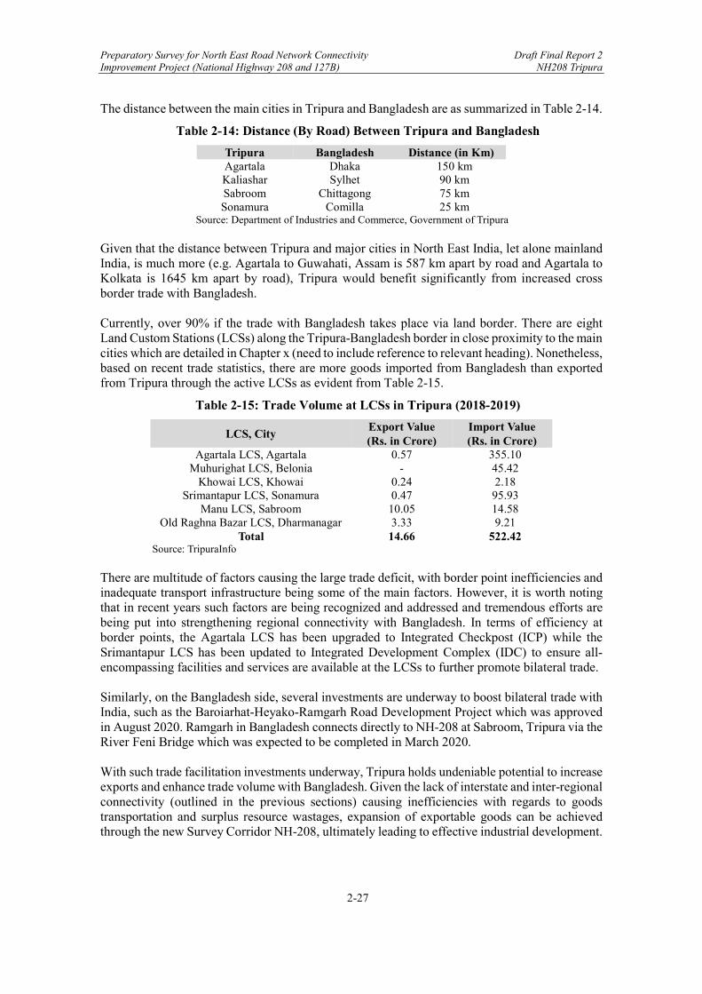
The distance between the main cities in Tripura and Bangladesh are as summarized in Table 2-14.
Table 2-14: Distance (By Road) Between Tripura and Bangladesh
Tripura Bangladesh Distance (in Km) Agartala Dhaka 150 km Kaliashar Sylhet 90 km Sabroom Chittagong 75 km Sonamura Comilla 25 km
Source: Department of Industries and Commerce, Government of Tripura Given that the distance between Tripura and major cities in North East India, let alone mainland India, is much more (e.g. Agartala to Guwahati, Assam is 587 km apart by road and Agartala to Kolkata is 1645 km apart by road), Tripura would benefit significantly from increased cross border trade with Bangladesh. Currently, over 90% if the trade with Bangladesh takes place via land border. There are eight Land Custom Stations (LCSs) along the Tripura-Bangladesh border in close proximity to the main cities which are detailed in Chapter x (need to include reference to relevant heading). Nonetheless, based on recent trade statistics, there are more goods imported from Bangladesh than exported from Tripura through the active LCSs as evident from Table 2-15.
Table 2-15: Trade Volume at LCSs in Tripura (2018-2019)
LCS, City Export Value (Rs. in Crore)
Import Value (Rs. in Crore)
Agartala LCS, Agartala 0.57 355.10 Muhurighat LCS, Belonia - 45.42
Khowai LCS, Khowai 0.24 2.18 Srimantapur LCS, Sonamura 0.47 95.93
Manu LCS, Sabroom 10.05 14.58 Old Raghna Bazar LCS, Dharmanagar 3.33 9.21
Total 14.66 522.42 Source: TripuraInfo
There are multitude of factors causing the large trade deficit, with border point inefficiencies and inadequate transport infrastructure being some of the main factors. However, it is worth noting that in recent years such factors are being recognized and addressed and tremendous efforts are being put into strengthening regional connectivity with Bangladesh. In terms of efficiency at border points, the Agartala LCS has been upgraded to Integrated Checkpost (ICP) while the Srimantapur LCS has been updated to Integrated Development Complex (IDC) to ensure all-encompassing facilities and services are available at the LCSs to further promote bilateral trade. Similarly, on the Bangladesh side, several investments are underway to boost bilateral trade with India, such as the Baroiarhat-Heyako-Ramgarh Road Development Project which was approved in August 2020. Ramgarh in Bangladesh connects directly to NH-208 at Sabroom, Tripura via the River Feni Bridge which was expected to be completed in March 2020. With such trade facilitation investments underway, Tripura holds undeniable potential to increase exports and enhance trade volume with Bangladesh. Given the lack of interstate and inter-regional connectivity (outlined in the previous sections) causing inefficiencies with regards to goods transportation and surplus resource wastages, expansion of exportable goods can be achieved through the new Survey Corridor NH-208, ultimately leading to effective industrial development.
Preparatory Survey for North East Road Network Connectivity Draft Final Report 2 Improvement Project (National Highway 208 and 127B) NH208 Tripura
2-28
2.5 Cross-Border Logistics Issues/Barriers, Developments, and Recommended Next Steps
2.5.1 Subject Area
The Preparatory Survey for the North East Road Network Connectivity Improvement Project (National Highways 208 and 127B) is covering three highways: (i) NH 208, Khowai-Sabroom, Tripura; (ii) NH 127B, Srirampur-Dhubri, Assam; and (iii) NH 127B, Fakirganji-Tura, Meghalaya. It is (i) in Tripura State that is the subject of this feasibility study. Of all of these highways, cross-border logistics is most relevant regarding this road because of the potential importance of the connection between India and Bangladesh through the Sabroom (India)-Ramgarh (Bangladesh) border crossing. Since this corridor has not been open for cross-border movements to/from Bangladesh due to a lack of trade and transport facilitation arrangements, cargo from the corridor (as well as Bhutan and Nepal) has had to go through the Chicken’s Neck,11 all the way to Kolkata (or other mainland India ports), 1,700+ km away.
2.5.2 Analysis of the Current Situation (Issues/Barriers) and Recent Developments
Analysis of the current situation and recent developments – hard and soft – related to cross-border logistics barriers in the subject area (which have suppressed regional trade) include the following: (i) There are transport infrastructure barriers (i.e., a need for a crossing over the Feni
River and improved road access to Chattogram port), although these are being addressed. A new, 150 m-long extradosed12 road bridge is being constructed over the Feni River at Sabroom in southern Tripura, India (and Ramgarh, Bangladesh, in Khagrachhari in the Chittagong Hill Tracts), connecting the two countries, at a cost of USD 13 million equivalent, with completion in 2020 or early 2021. In addition, on the Bangladeshi side, four-laning of a 38 km approach road is ongoing between Ramgarh-Baroiarhat, which will link with the Dhaka-Chattogram Highway.13
(ii) Inadequate border facilities are another issue/barrier. At Sabroom there is currently
only a land customs station (LCS), which offers rudimentary immigration and customs facilities.14 To address this constraint, an integrated check post (ICP), sanctioned in March 2020, will be constructed by the Land Ports Authority of India (LPAI), Ministry of Home Affairs (MHA), at Sabroom, at a cost of INR 365 crore (USD 48 million equivalent). It will be a full-fledged logistics hub (similar to the one opened at Akhaura in November 2013), offering a one-stop solution, with warehouses, container transshipment facilities, parking, and airport-like immigration facilities. There are plans to address a similar constraint on the Bangladesh side by developing a land port at Ramgarh, with support from the World Bank’s Bangladesh Regional Connectivity
11 The Chicken’s Neck is a narrow stretch of land of about 22 km width, located in West Bengal and connecting India’s North East with the rest of India, with Nepal and Bangladesh lying on either side of the corridor. 12 An extradosed bridge uses a structure that is a cross between a girder bridge and a cable-stayed bridge. 13 Developments related to cross-border transport between Tripura and Bangladesh by other modes include: (i) extension of the broad-gauge National Frontier Railway Line to Sabroom, via Dharmanagar-Agartala-Sabroom, in October 2019 (the Governments of India and Bangladesh have agreed to extend this line to Chattogram Port, but there is no specific timetable for this work); and (ii) inclusion of the Sonamura-Daudkandi route along Tripura’s Gomti [or Gumi or Gomati] River (a tributary of the Ganges River) in the Indo-Bangladesh Protocol on Inland Water Transit and Trade, in May 2020. 14 Joyeeta Bhattacharjee, “Integrated Check-Posts on the India-Bangladesh Border: A Field Survey and Brief Analysis”, ORF Special Report No. 96, Observer Research Foundation, August 2019, p. 8 [“not a single LCS between India and Bangladesh offers services that are comparable to the international standard”] [downloadable from https://www.orfonline.org/research/integrated-check-posts-on-the-india-bangladesh-border-a-field-survey-and-brief-analysis-54559/]. Additional LCS along the Tripura-Bangladesh border include Muhurighat, Belonia, Khowai, Srimantapur, Sonamura, Manu, Old Raghna Bazar, and Dharmanaga.

Preparatory Survey for North East Road Network Connectivity Draft Final Report 2 Improvement Project (National Highway 208 and 127B) NH208 Tripura
2-29
Project 1, although there have been land acquisition issues; in any case, the inefficiencies of a traditional two-stop border post would remain.15
(iii) Restrictions on cross-border transport remain (e.g., transshipment is required at the
border between India and Bangladesh),16 although there are signed and planned international agreements to address these constraints.
(a) Following a 6 June 2015 bilateral memorandum of understanding, on 25
October 2018, the Ministry of Shipping, Road Transport and Highways, India, and the Ministry of Shipping, Bangladesh signed an agreement to allow the transport of goods between Chattogram (Chittagong)17 Port (and Mongla Port) and India. Chattogram Port is about 72 km from Sabroom. Later developments have included (a) signing of standard operating procedure(s) outlining how goods are to be moved, along which routes, and over what time period, on 5 October 2019; (b) commencement of transshipment after trial runs in January 2020; and (c) offering by the Chittagong Port Authority to India of space for cargo handling on a priority basis (although not dedicated space) and priority cargo handling, in 2020.18 However, agreement still needs to be
15 In addition, Tripura State planned to develop two Integrated Development Complexes (IDCs, including customs,
immigration, banking with currency exchange, warehousing, and public utility services) at Manughat in Unakoti and Muhurighat, about 70-80 km east of Khowai, the northern point of the subject road section in Tripura. Although funds were sanctioned (approved) by the Ministry of Commerce, India, work was stopped in the first quarter of 2019 when Border Guards Bangladesh did not grant permission for the project. Debra Deb, “Tripura: Work Halted for Setting up Integrated Development Complex Despite Funds”, Indian Express, 1 March 2019. 16 Other nonphysical barriers to transport between India and Bangladesh include a lack of standardization of
documents and implementation of modern customs procedures. Exporters are required to prepare separate
documents on each side of the border resulting in errors in transposition. Additional barriers problems
include a lack of through bills of lading, the nonavailability of electronic data interchange systems, and
different weekend holidays between the two countries. SAARC Secretariat, Report of the SAARC Multimodal Transport Study (SRMTS), Version 2.0, September 2019, p. 41. 17 Chattogram is the new official name for what was called Chittagong; the new name is closer to the Bangla
pronunciation. However, the old name is used for certain proper nouns such as the Chittagong Port Authority
and the Chittagong Hill Tracts. 18 See, e.g., (i) “Transshipment Deal; Chattogram Port to Provide Priority Services for India”, Business Standard, 10 January 2020 [downloadable from https://tbsnews.net/economy/trade/transshipment-deal-
chattogram-port-provide-priority-services-india]; and (ii) Rejaul Karim Byron and Porimol Palma, “India’s
Transit Thru Bangladesh: Reaping Benefit Is a Challenge”, The Daily Star, 29 November 2019 [routes via
Agaratala (Tripura), Dawki (Meghalaya), Sutarkandi (Assam), and Srimantpur (Tripura), in both directions,
were agreed] [downloadable from https://www.thedailystar.net/frontpage/india-bangladesh-trasit-route-
challenge-reap-benefit-1833220]. Expected cargo to North East India includes construction material, iron
and steel, fertilizer, consumer goods, petroleum products, and cement; expected cargo from the North East
to various parts of India through Chattogram Port include grains, fruits, organic products, tea, fish, and jute.
Ministry of Shipping, India, “Shri Masukh Mandavia Says Conclusion of SOP [standard operating
procedure(s)] with Bangladesh for Chattogram and Mongla Ports a Win-Win Situation for Both Countries”,
7 October 2019. The Indian Council for Agricultural Research (ICAR) in association with the Tripura state
government has been working with farmers to grow such crops and develop animal husbandry and fishing
through Chattogram Port. R.N. Bhaskar, “Agartala on Its Way to Becoming a Major Hub for Trade and
Commerce”, Money Control, 19 February 2019.

Preparatory Survey for North East Road Network Connectivity Draft Final Report 2 Improvement Project (National Highway 208 and 127B) NH208 Tripura
2-30
reached on the administrative fees charged by Bangladesh under this arrangement,19 and in the longer term Chattogram Port will require significant efficiency and capacity improvements if it is to serve this increased traffic.20
(b) The Bangladesh-Bhutan-India-Nepal (BBIN) and Bay of Bengal Initiative
for Multi-Sectoral Technical and Economic Cooperation (BIMSTEC)21 Motor Vehicles Agreements (MVAs) for the Regulation of Passenger, Personal and Cargo Vehicular Traffic are proceeding toward implementation. Under these agreements, approved vehicles would be permitted to enter member states under certain terms and conditions that would reduce transport costs and promote the development of transit and multimodal transport facilities that will increase connectivity and interregional trade (e.g., multiple entry visas would be issued to crew members, octroi or local taxes would not be levied unless they are also charged vehicles from the host country, temporary admission of vehicles would be permitted free of customs duties, international road signs and signals would be provided, transport operators would be permitted to open business branches and bank accounts in the neighboring member states). The BBIN MVA was signed by the four states in June 2015 and subsequently ratified by three of the states, although Bhutan has not yet been able to proceed with ratification due to environmental concerns by stakeholders; in the interim, with Bhutan’s consent, Bangladesh, India, and Nepal are proceeding toward implementation, having discussed a draft enabling memorandum of understanding and passenger and cargo protocols, in February 2020. The BIMSTEC MVA is still under negotiation, with some states hesitant to move forward. The following box presents the structure of the BBIN MVA.22
19 Neither transit charges nor customs duties are applicable to goods in transit, as per the General Agreement on Tariffs
and Trade (GATT). However, “administrative operational fees and other charges prescribed by the inter-government committee for transit of goods” may be charged. The Ministry of Shipping, Bangladesh, proposed charges of BDT 192,25 per ton of goods using its ports, BDT 34 per ton for ship landing charges, and the Ministry of Road Transport and Bridges, Bangladesh, has proposed a charge of BDT 2.10 per ton-km for use of roads within Bangladesh. In December 2019, the Ministry of Shipping, India, stated that: “On the quantum of administrative fees to be charged by Bangladesh for movement of India’s transit cargo from the NER (North East Region) through Chattogram and Mongla Ports, Bangladesh agreed to review its proposal as the proposed high charges would be unfruitful for the industry to adopt the shorter route.” “No Fees Finalized as Ports Readied for Indian Cargo Transshipment, Hellenic Shipping News, 16 January 2020 [downloadable from https://www.hellenicshippingnews.com/no-fees-finalized-as-ports-readied-for-indian-cargo-transshipment/]; see also (i) Shakhawat Hossain, “India to Use Bangladesh Seaports without Transit, Customs Fees”, New Age, 9 December 2019; and (ii) Rejaul Karim Byron and Porimol Palma, “India’s Transit Thru Bangladesh: Reaping Benefit is a Challenge”, The Daily Star, 29 November 2019. 20 A World Bank study measuring the competitiveness of South Asian ports found that containers spent an
average of 17 days in Chattogram Port in 2012, compared to 3-4 days at comparable ports and less than one
day at the most efficient container terminals.
https://www.worldbank.org/en/news/feature/2019/06/26/can-south-asia-unstrangle-the-chicken-neck
[“Can South Asia Unstrangle the Chicken’s Neck”]. 21 The BIMSTEC Member States are Bangladesh, Bhutan, India, Myanmar, Nepal, Thailand, and Sri Lanka. 22 Pritam Banerjee, Bangladesh-Bhutan-India-Nepal Motor Vehicles Agreement: Unlocking the Potential for Vibrant Regional Road Freight Connectivity, CUTS [Consumer Unity and Trust Society] International,
July 2015, offered a number of suggestions for improving the BBIN MVA, e.g., independent and periodic
authorization of trucks, removal of the requirement for journey-wise permits for authorized trucks driven by
authorized drivers, provision of flexibility for changing drivers at the border. Other issues include the lack of
mutual recognition of cargo insurance and limitation of use of the agreement for containerized cargo (a
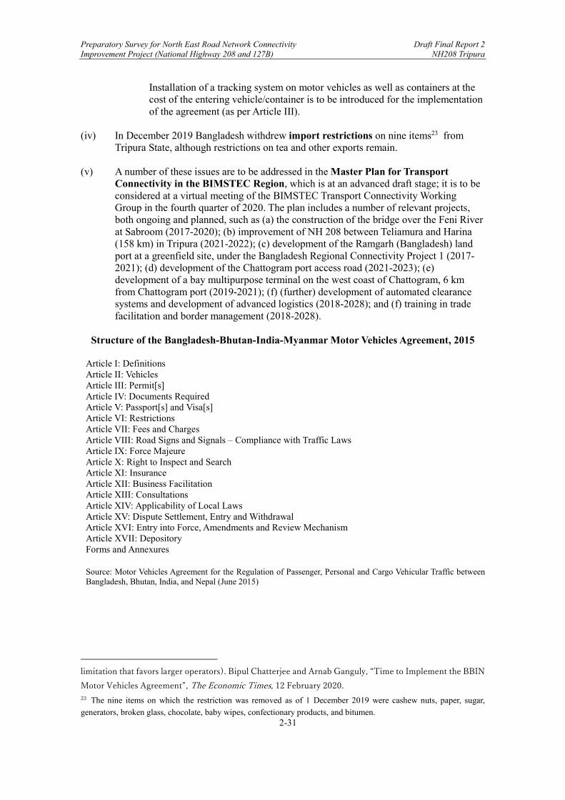
Preparatory Survey for North East Road Network Connectivity Draft Final Report 2 Improvement Project (National Highway 208 and 127B) NH208 Tripura
2-31
Installation of a tracking system on motor vehicles as well as containers at the cost of the entering vehicle/container is to be introduced for the implementation of the agreement (as per Article III).
(iv) In December 2019 Bangladesh withdrew import restrictions on nine items23 from
Tripura State, although restrictions on tea and other exports remain. (v) A number of these issues are to be addressed in the Master Plan for Transport
Connectivity in the BIMSTEC Region, which is at an advanced draft stage; it is to be considered at a virtual meeting of the BIMSTEC Transport Connectivity Working Group in the fourth quarter of 2020. The plan includes a number of relevant projects, both ongoing and planned, such as (a) the construction of the bridge over the Feni River at Sabroom (2017-2020); (b) improvement of NH 208 between Teliamura and Harina (158 km) in Tripura (2021-2022); (c) development of the Ramgarh (Bangladesh) land port at a greenfield site, under the Bangladesh Regional Connectivity Project 1 (2017-2021); (d) development of the Chattogram port access road (2021-2023); (e) development of a bay multipurpose terminal on the west coast of Chattogram, 6 km from Chattogram port (2019-2021); (f) (further) development of automated clearance systems and development of advanced logistics (2018-2028); and (f) training in trade facilitation and border management (2018-2028).
Structure of the Bangladesh-Bhutan-India-Myanmar Motor Vehicles Agreement, 2015
Article I: Definitions Article II: Vehicles Article III: Permit[s] Article IV: Documents Required Article V: Passport[s] and Visa[s] Article VI: Restrictions Article VII: Fees and Charges Article VIII: Road Signs and Signals – Compliance with Traffic Laws Article IX: Force Majeure Article X: Right to Inspect and Search Article XI: Insurance Article XII: Business Facilitation Article XIII: Consultations Article XIV: Applicability of Local Laws Article XV: Dispute Settlement, Entry and Withdrawal Article XVI: Entry into Force, Amendments and Review Mechanism Article XVII: Depository Forms and Annexures Source: Motor Vehicles Agreement for the Regulation of Passenger, Personal and Cargo Vehicular Traffic between Bangladesh, Bhutan, India, and Nepal (June 2015)
limitation that favors larger operators). Bipul Chatterjee and Arnab Ganguly, “Time to Implement the BBIN
Motor Vehicles Agreement”, The Economic Times, 12 February 2020. 23 The nine items on which the restriction was removed as of 1 December 2019 were cashew nuts, paper, sugar,
generators, broken glass, chocolate, baby wipes, confectionary products, and bitumen.
Preparatory Survey for North East Road Network Connectivity Draft Final Report 2 Improvement Project (National Highway 208 and 127B) NH208 Tripura
2-32
2.5.3 Recommended Next Steps
Recommended next steps include the following: (i) The Sabroom ICP should be completed, and as proposed by the World Bank,24 a “co-
location border post” (which would be the first of its kind in South Asia) may be considered between Sabroom and Ramgarh (Bangladesh), similar to one-stop border posts (OSBPs) supported by JICA in Africa.25 In the meantime, LPAI and the Bangladesh Land Port Authority can pursue traditional two-stop border posts by developing new ICPs / land ports along this strategic Northeast-Southwest corridor.
(ii) The agreement to allow the transport of goods between Chattogram (Chittagong)
Port and India should be implemented, to include the Sabroom/Ramgarh-Chattogram route, with reasonable administrative charges and ideally dedicated space for cargo handling provided for India in Chattogram Port, in 2020.
(iii) The BBIN MVA should be implemented by Bangladesh and India (as well as Nepal),
by 2021;26 this would address most of the nonphysical barriers to transport between/among the countries. Electronic cargo tracking systems should be installed, as per Article III of the MVA.
(iv) A free trade agreement should be developed between India and Bangladesh, perhaps
similar to the India-Sri Lanka Free Trade Agreement,27 to increase bilateral trade along land routes in North East India. At a minimum, Bangladesh should permit the import of additional items from Tripura (e.g., tea from Tripura’s 54 large tea gardens).
(v) The relevant projects from the BIMSTEC Transport Connectivity Master Plan
should be implemented following their planned timescales.
Chapter 2. Present Conditions of the Survey Areas ............................................................ 1
2.1 Present Status of Highway Network in the Survey Areas ........................................... 1
2.1.1 National Highway Network in North-Eastern States .......................................... 1 2.1.2 Transport Infrastructure Projects in North-Eastern States ................................... 2
2.2 National and Regional Highway Development ........................................................... 3
2.2.1 Organizations Related to National Highway Development ................................ 3 2.2.2 Development Programs for National Highways .................................................. 4
24 World Bank, Project Appraisal Report on a Proposed Credit on a Proposed Credit in the Amount of SDR 110.8 Million (US$ 150.0 Million Equivalent) to the People's Republic of Bangladesh for a Bangladesh Regional Connectivity Project 1, 13 March 2017, pp. 6, 17, and 28 [“If Bangladesh and India succeed in implementing a co‐location border post management model, this would be a ground‐breaking step forward for regional collaboration efforts”]. 25 Japan International Cooperation Agency, One-Stop Border Post Sourcebook, 2nd Edition, May 2016 [prepared by PADECO]. 26 In October 2019, H.E. Sheik Hasina, Prime Minister, Bangladesh, called for early operationalization of the BBIN MVA, even without Bhutan’s participation. “Bangladesh PM calls for Operationalizing BBIN Motor Vehicle Agreement with India and Nepal”, DD News, 27 October 2019. While a meeting held on 8 February 2020 negotiated an MOU for implementation, and follow-on action was called for by May 2020 [https://www.outlookindia.com/newsscroll/bbin-nations-deliberate-on-mou-for-implementation-of-motor-vehicle-agreement/1729563], there does not seem to have been additional action as of January 2021. 27 See, e.g., Bikash Singh, “Initiate a Bilateral Trade Agreement with Bangladesh in Line with the Indo-Sri Lankan FTA: Assam Industry Minister”, The Economic Times, 12 September 2019.

Preparatory Survey for North East Road Network Connectivity Draft Final Report 2 Improvement Project (National Highway 208 and 127B) NH208 Tripura
2-33
2.2.3 On-going and Planned Road Projects Related to the Survey Roads by International Cooperation .................................................................................... 9
2.2.4 Other Related Project ........................................................................................ 15 2.3 Socio-Economic Conditions ...................................................................................... 20
2.3.1 Overview of Survey Areas ................................................................................ 20 2.3.2 Geographical Conditions of Tripura .................................................................. 22 2.3.3 Socio-Economic Conditions .............................................................................. 23
2.4 Industrial Development ............................................................................................. 24
2.4.1 Overview ........................................................................................................... 24 2.4.2 Current Status of Existing Industries and Industrial Development in
Tripura ............................................................................................................... 24 2.4.3 Impact of Survey Corridor on Future Industrial Development ......................... 25
2.5 Cross-Border Logistics Issues/Barriers, Developments, and Recommended Next Steps ................................................................................................................. 28
2.5.1 Subject Area ...................................................................................................... 28 2.5.2 Analysis of the Current Situation (Issues/Barriers) and Recent
Developments .................................................................................................... 28 2.5.3 Recommended Next Steps................................................................................. 32
Figure 2-1: National Highway Network in the North Eastern Region ................................ 1
Figure 2-2: Major Road Development Programs in North East Region ............................. 6
Figure 2-3: Road Network under Bharatmala Project ......................................................... 9
Figure 2-4: Road Network Connectivity Improvement Projects by JICA ......................... 11
Figure 2-5: Survey Corridor Districts in North-Eastern India ........................................... 22
Table 2-1: National Highway Number and Length by State in the North Eastern Region . 2
Table 2-2: Major Infrastructure Project in North Eastern Region ....................................... 2
Table 2-3: Details of NARDP-NE ....................................................................................... 5
Table 2-4: Priority of Different Phases of NHDP................................................................ 7
Table 2-5: Schemes and Estimate Cost of Bharatmala Project Phase-1 .............................. 8
Table 2-6: Road Network Connectivity Improvement Project by JICA ........................... 10
Table 2-7: North-Eastern States Roads Investment Program (NESRIP) by ADB............. 13
Table 2-8: List of ongoing road and bridge projects under NESIDS in Assam ................. 15
Table 2-9: Summary of Major On-going Projects (Costing Rs. 100 Cr. And above) ........ 16
Table 2-10: Population and Area of “Seven Sister” States ................................................ 20
Table 2-11: Districts Directly Linked to the Survey Corridors ......................................... 21
Table 2-12: Demographics of Tripura (Census 2011) ....................................................... 23
Table 2-13: Sectoral Contribution to GSVA (%) of Tripura .............................................. 23
Table 2-14: Distance (By Road) Between Tripura and Bangladesh .................................. 27
Table 2-15: Trade Volume at LCSs in Tripura (2018-2019) .............................................. 27
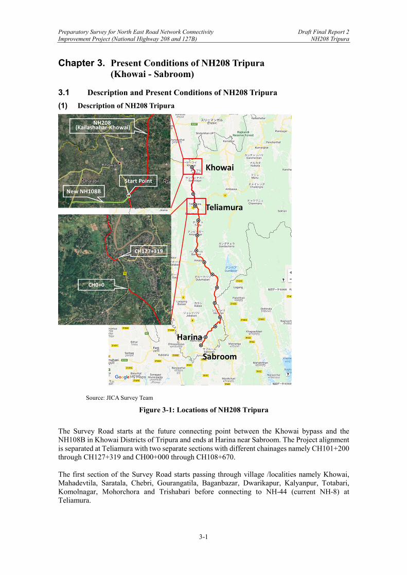
Preparatory Survey for North East Road Network Connectivity Draft Final Report 2 Improvement Project (National Highway 208 and 127B) NH208 Tripura
3-1
Chapter 3. Present Conditions of NH208 Tripura (Khowai - Sabroom)
3.1 Description and Present Conditions of NH208 Tripura
(1) Description of NH208 Tripura
Source: JICA Survey Team
Figure 3-1: Locations of NH208 Tripura
The Survey Road starts at the future connecting point between the Khowai bypass and the NH108B in Khowai Districts of Tripura and ends at Harina near Sabroom. The Project alignment is separated at Teliamura with two separate sections with different chainages namely CH101+200 through CH127+319 and CH00+000 through CH108+670. The first section of the Survey Road starts passing through village /localities namely Khowai, Mahadevtila, Saratala, Chebri, Gourangatila, Baganbazar, Dwarikapur, Kalyanpur, Totabari, Komolnagar, Mohorchora and Trishabari before connecting to NH-44 (current NH-8) at Teliamura.

Preparatory Survey for North East Road Network Connectivity Draft Final Report 2 Improvement Project (National Highway 208 and 127B) NH208 Tripura
3-2
Then the second section restarts from Ompi chowmuhani (T-Junction with NH-08 at Teliamura) passes through Twidu, Sonacherra, Amarpur, Nutan Bazar, Karbook, Ailmara, Khedacherri, Ropaichari and ends at Harina (T-Junction with NH-08). Sabroom is 8.1 km away from Harina junction. To avoid congestion in Teliamura, a bypass of 1.3 km is proposed that starts at NH-08 (1.24 km from Khowai chowmuhani, towards Agartala) and merges at the existing CH2+580 of the Teliamura – Sabroom section. The Survey Road runs parallel to the international border (India – Bangladesh) for some portion of its length. The existing road is mostly single lane with poor riding quality. The total length is 26.119 km between Khowai and Teliamura and 108.670 km between Teliamura and Sabroom. (2) Present Condition of NH208 Tripura
The existing road alignment is very poor and shall be improved to comply with IRC design standards. The improvement work of two-lane with paved shoulder shall be within the existing right of way as much as possible avoiding land acquisition, except for locations having inadequate width and where provisions of short alignment corrections and, improvement of intersections are considered necessary and practicable. Seven bypasses are proposed of total length 22.600km length, namely Teliamura, Twidu, Ompi Nagar, Amarpur, Nutan Bazar, Jatan Bari, and Karbook. The present condition of the survey road is indicated in figures from Figure 3-2 through Figure 3-7.
Source: JICA Survey Team
Figure 3-2: Locations of Site Photos (CH101+200 - CH108+670)
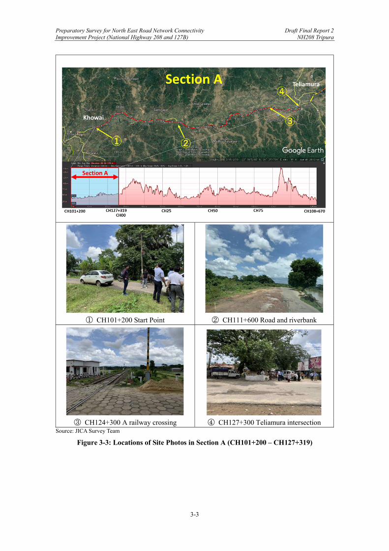
Preparatory Survey for North East Road Network Connectivity Draft Final Report 2 Improvement Project (National Highway 208 and 127B) NH208 Tripura
3-3
① CH101+200 Start Point ② CH111+600 Road and riverbank
③ CH124+300 A railway crossing ④ CH127+300 Teliamura intersection
Source: JICA Survey Team
Figure 3-3: Locations of Site Photos in Section A (CH101+200 – CH127+319)
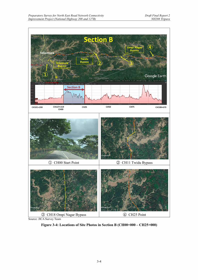
Preparatory Survey for North East Road Network Connectivity Draft Final Report 2 Improvement Project (National Highway 208 and 127B) NH208 Tripura
3-4
① CH00 Start Point ② CH11 Twidu Bypass
③ CH18 Ompi Nagar Bypass ④ CH25 Point
Source: JICA Survey Team
Figure 3-4: Locations of Site Photos in Section B (CH00+000 – CH25+000)
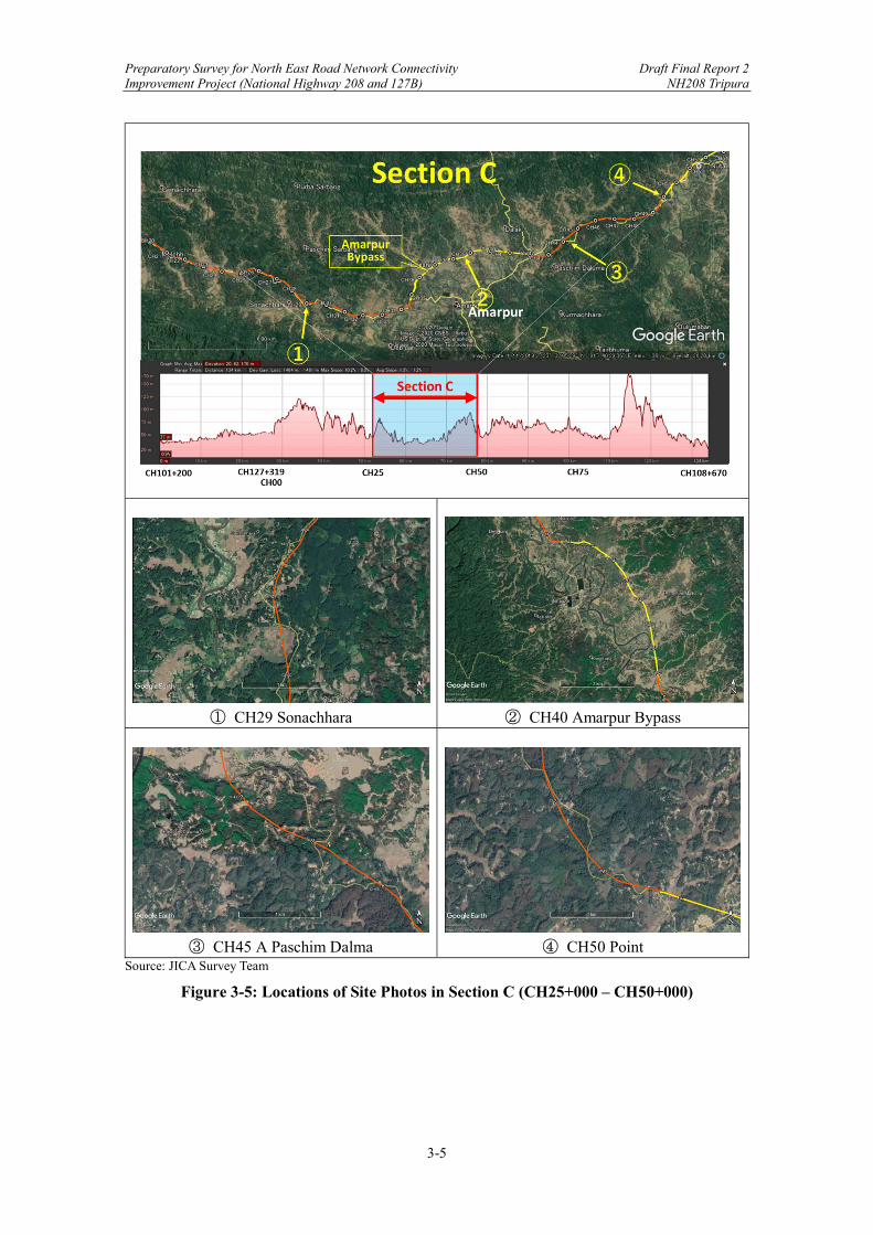
Preparatory Survey for North East Road Network Connectivity Draft Final Report 2 Improvement Project (National Highway 208 and 127B) NH208 Tripura
3-5
① CH29 Sonachhara ② CH40 Amarpur Bypass
③ CH45 A Paschim Dalma ④ CH50 Point
Source: JICA Survey Team
Figure 3-5: Locations of Site Photos in Section C (CH25+000 – CH50+000)
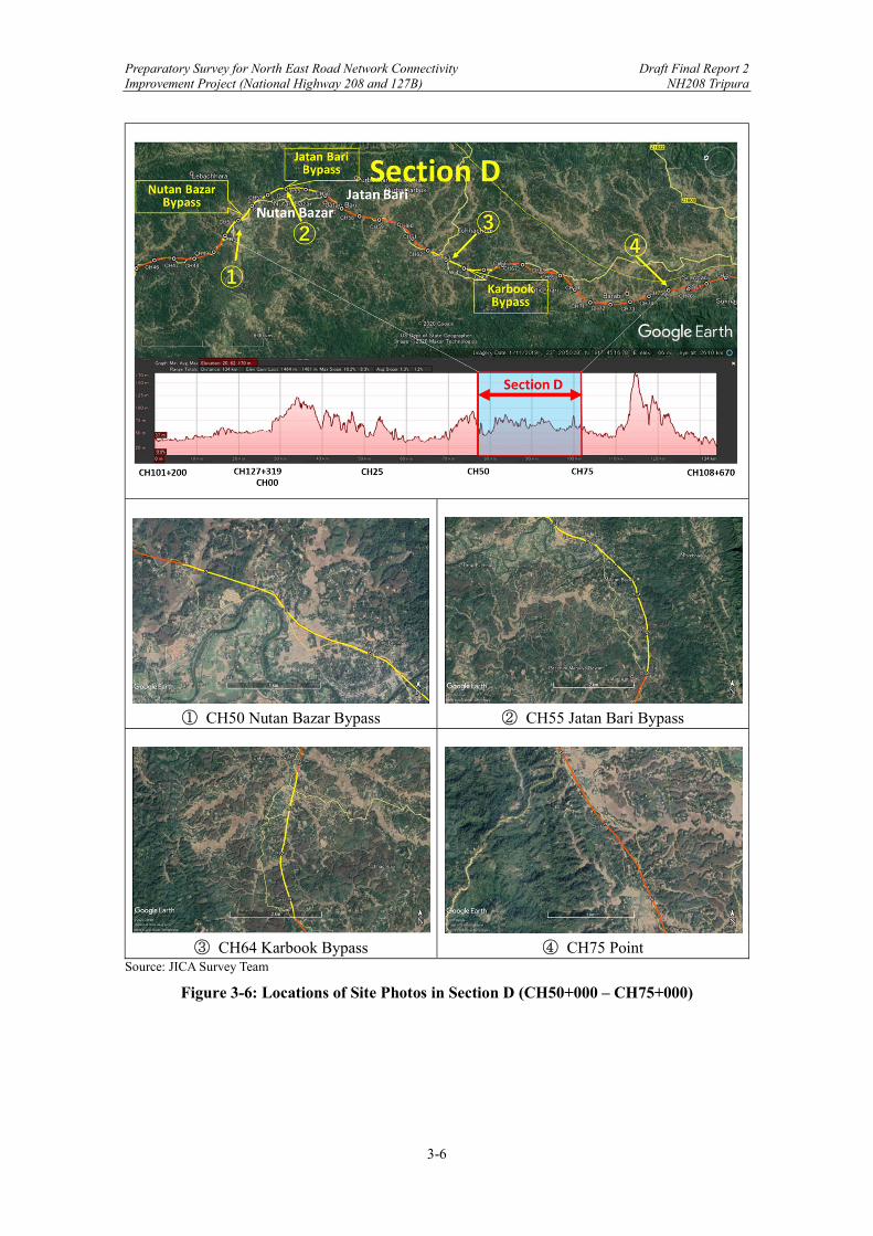
Preparatory Survey for North East Road Network Connectivity Draft Final Report 2 Improvement Project (National Highway 208 and 127B) NH208 Tripura
3-6
① CH50 Nutan Bazar Bypass ② CH55 Jatan Bari Bypass
③ CH64 Karbook Bypass ④ CH75 Point
Source: JICA Survey Team
Figure 3-6: Locations of Site Photos in Section D (CH50+000 – CH75+000)
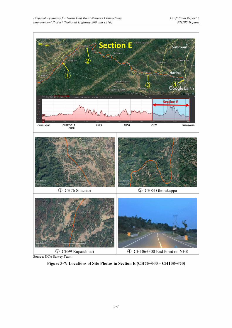
Preparatory Survey for North East Road Network Connectivity Draft Final Report 2 Improvement Project (National Highway 208 and 127B) NH208 Tripura
3-7
① CH76 Silachari ② CH83 Ghorakappa
③ CH99 Rupaichhari ④ CH106+300 End Point on NH8
Source: JICA Survey Team
Figure 3-7: Locations of Site Photos in Section E (CH75+000 – CH108+670)

Preparatory Survey for North East Road Network Connectivity Draft Final Report 2 Improvement Project (National Highway 208 and 127B) NH208 Tripura
3-8
3.2 Major Issues of NH208 Tripura
3.2.1 Terrain Along Highway Alignment
IRCSP73-201828, Clause 2.9.1 states that the geometric design shall conform to IRC7329 except as otherwise indicated in this Manual. Demarcation of terrain classification for the Survey Road should be indicated clearly because the terrain classifications govern all the geometric design of the highways. As per IRC73-1980, Clause 4.1 “the geometric design of a highway is influenced significantly by terrain conditions. Economy dictates choice of different standards for different types of terrain. Terrain is classified by the general slope of the country across the highway alignment for which the criteria given in the Table below should be followed. While classifying a terrain, short, isolated stretches of varying terrain should not be taken into consideration.”
Table 3-1: Terrain Classification as per IRC73-1980
Source: JICA Survey Team As indicated in the figure below (the enlarged area), the steepest section of the cross slope of the country across the Survey Road is 30% and the section between CH83 –CH95 should be classified as Mountainous. The sections of different terrains for the Survey Road should be demarcated as presented in the figure below.
28 IRCSP73-2018 Manual of Specifications and Standards for Two Laning of Highways with Paved Shoulder (Second Revision) 29 IRC73-1980 Geometric Design Standards for Rural (nonurban) Highways

Preparatory Survey for North East Road Network Connectivity Draft Final Report 2 Improvement Project (National Highway 208 and 127B) NH208 Tripura
3-9
Source: JICA Survey Team
Figure 3-8: Terrain Classification of NH208 Tripura
Source: JICA Survey Team
Figure 3-9: Design Terrain Classification of NH208 Tripura
Preparatory Survey for North East Road Network Connectivity Draft Final Report 2 Improvement Project (National Highway 208 and 127B) NH208 Tripura
3-10
3.2.2 Existing ROW and Work on Existing Road
(1) Existing ROW
DPR states that there is no marking of existing ROW on the ground along the Survey Road, and the details of existing ROW are not available with PWD. However, as per visual inspection and inquiry through local people, it is found that the available land is only 6-15m. The proposed ROW has been considered 30-45m for the entire road stretch and details are presented in DPR. (2) Work on Existing Road
As per MORTH-2013 Specifications for Road and Bridge Works 5th Revision30, Clause 305.4.3, where the embankment is to be placed over an existing road surface, the work shall be carried out as indicated below:
i) If the existing road surface is of granular type and lies within 1 m of the new formation levels, it shall be scarified to a depth of 50 mm, or as directed, so as to provide ample bond between the old and new material ensuring that at least 500 mm portion below the top of new sub-grade level is compacted to the desired density.
ii) If the existing road surface is of bituminous type or cement concrete and lies within 1 m of the new formation level, the bituminous or cement concrete layer shall be removed completely.
iii) If the level difference between the existing road surface and the new formation level is more than 1 m, the existing surface shall be roughened after ensuring that the minimum thickness of 500 mm of sub-grade is available.
3.2.3 Difficult Conditions for Widening
The road construction and social activities are an integral part of road network development. Improving and expanding the roadway network while keeping road traffic is critical to economic development as well as the quality of life and these activities create work zones in the network. The road work zones are areas of conflict between normal operating traffic, construction workers, road building machineries and construction traffic. Therefore, planning an efficient and effective Work Zone Traffic Management (WTMP) is crucial for successful operations. IRCSP55-2014 sets out the guidelines for planning WTMP which includes: a) provide safety for road users and workers, b) minimized hindrance or delay to road users, c) provide clear and positive guidance to road users, d) ensure roadside safety maintenance, e) ensure that planners and decision makers have the necessary knowledge, and f) provide good public relations. As indicated in Figure 3-10, planning effective lighting devices, clear message signs, and proper protection barriers for working zones helps to enhance the effectiveness of WTMP by providing proper warnings.
30 MORTH-2013 Specifications for Road and Bridge Works 5th Revision

Preparatory Survey for North East Road Network Connectivity Draft Final Report 2 Improvement Project (National Highway 208 and 127B) NH208 Tripura
3-11
Source: IRCSP55-2014
Figure 3-10: Types of Warning Devices in IRCSP55
3.2.4 Pavement Conditions
The DPR Consultant conducted the pavement condition survey on every 500m of the pavement edge either on the right- or left- hand side. In the survey, the thicknesses of bitumen layer and brick soiling were measured, and the average thicknesses of bitumen layer and brick soiling were 40mm and 215mm, respectively. Furthermore, the conditions of pavement surfaces including shoulders were evaluated as as along with the riding quality. The survey results are outlined in the Appendix. The existing carriageway consists of the bitumen layer and brick soling of sub-base. The width of bitumen layer is 3.5m - 7.5m, though at a few stretches consist of the width of 12.1m and 9.0m. The earthen shoulders of 1.0m - 1.5m on both sides are provided. The existing condition of the pavement has been poor with the existing cracking, raveling, potholes, rutting and patching. During the pavement condition survey, cracking and raveling were detected at each chainage, and the surface areas were affected by 30-60% and 30-40%, respectively. Potholes were also observed, and these defected and distressed conditions make riding quality poor.
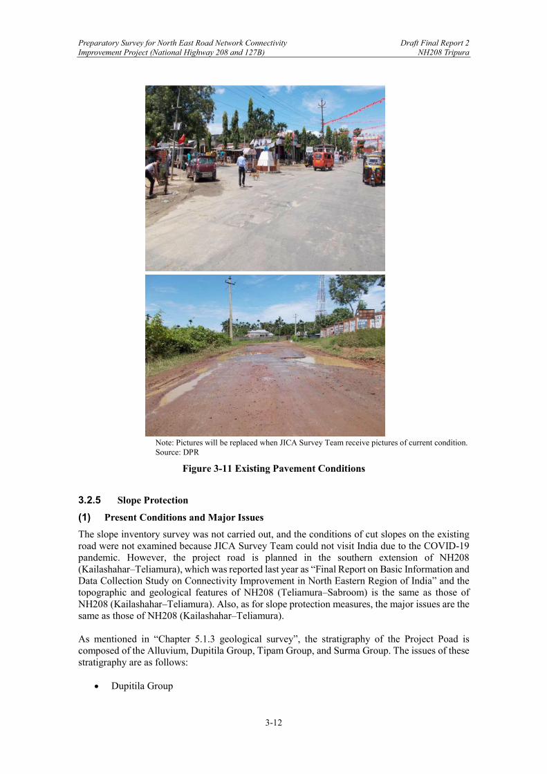
Preparatory Survey for North East Road Network Connectivity Draft Final Report 2 Improvement Project (National Highway 208 and 127B) NH208 Tripura
3-12
Note: Pictures will be replaced when JICA Survey Team receive pictures of current condition. Source: DPR
Figure 3-11 Existing Pavement Conditions
3.2.5 Slope Protection
(1) Present Conditions and Major Issues
The slope inventory survey was not carried out, and the conditions of cut slopes on the existing road were not examined because JICA Survey Team could not visit India due to the COVID-19 pandemic. However, the project road is planned in the southern extension of NH208 (Kailashahar‒Teliamura), which was reported last year as “Final Report on Basic Information and Data Collection Study on Connectivity Improvement in North Eastern Region of India” and the topographic and geological features of NH208 (Teliamura‒Sabroom) is the same as those of NH208 (Kailashahar‒Teliamura). Also, as for slope protection measures, the major issues are the same as those of NH208 (Kailashahar‒Teliamura). As mentioned in “Chapter 5.1.3 geological survey”, the stratigraphy of the Project Poad is composed of the Alluvium, Dupitila Group, Tipam Group, and Surma Group. The issues of these stratigraphy are as follows:
Dupitila Group
Preparatory Survey for North East Road Network Connectivity Draft Final Report 2 Improvement Project (National Highway 208 and 127B) NH208 Tripura
3-13
The Dupitila Group is distributed in the valley bottom plain intermittently, and the upper parts of their surfaces show almost the same altitude. This feature is similar to the surface of eroded fluvial terrace.
The Dupitila Group consists of unconsolidated sand, silt, and gravel. Even an exposed vertical cut slope looks to be stable. However, the slope surface is eroded by surface water flow.
Tipam Group
The topography of the Tipam Group consists of a gently undulating plain, which is called “Rolling”.
The Tipam Group consists of weakly consolidated sandstone and siltstone. The cut slopes along the existing road are stable even with gradient of 0.5H : 1V. However, there are many slopes where the topsoil has collapsed at the top of the slope and on the shoulder. Cut slopes of sandstone are eroded by surface water flow, and eroded sand is deposited at the toe of the relevant cut slope. The countermeasures against topsoil collapse and surface erosion are necessary for the slope protection of the Project Poad.
Surma Group
The Surma Group is distributed in the hilly and mountainous terrains. The Group mainly consists of alternation of siltstone and shale and is as hard as soft rock. The feature of this layer looks like a massive rock because the bedding planes with several centimeter intervals are hard to separate, and few joints are developed. The bedding planes are sometimes inclined with 30° to 60°.
While the layer of the Surma Group itself is impermeable, the topsoil on the top of the cut slope is an unconsolidated and high permeable layer. Therefore, the topsoil is easy to fall down during heavy rain due to rising up of ground water level in the topsoil. A lot of topsoil collapses are observed in the hilly and mountainous terrain where the Surma Group is distributed.
Although the Surma Group seems to be stable, the weathered layers are collapsed together with topsoil on the cut slopes where there is a dip slope structure. The cut slopes with dip slope structure have long-term stability problem.
(2) Recommended Solutions
“IRC:SP:48-1998 Hill Road Manual” proposes the gradients of cut slopes for rock types. The cut slope gradients of the Project Poad should be proposed based on rock types of this Manual. The cut slopes composed of the Dupitila Group and Tipam Group are stable, and hydroseeding is applicable for slope protection measures. However, the cut slopes composed of the Surma Group with dip slope structure have a problem with long-term stability. It is necessary to detect whether cut slopes have dip slope structure or not. In the case of high cut slopes with dip slope structure, it is necessary to consider application of internal slope reinforcing methods for slope protection. In the hilly terrains where the Surma Group is distributed, landslide study is necessary. The slope inventory survey on site is impossible due to the COVID-19 pandemic so that JICA Survey Team applied an analysis method using highest precision satellite data (DEM: purchased) with high resolution of 0.5 m. Whether landslides exist or not is estimated by the study of landslide topography on the satellite data. If there are some areas where landslides are suspected, the contour maps and cross sections will be prepared from satellite data and landslide prevention measures will be proposed.
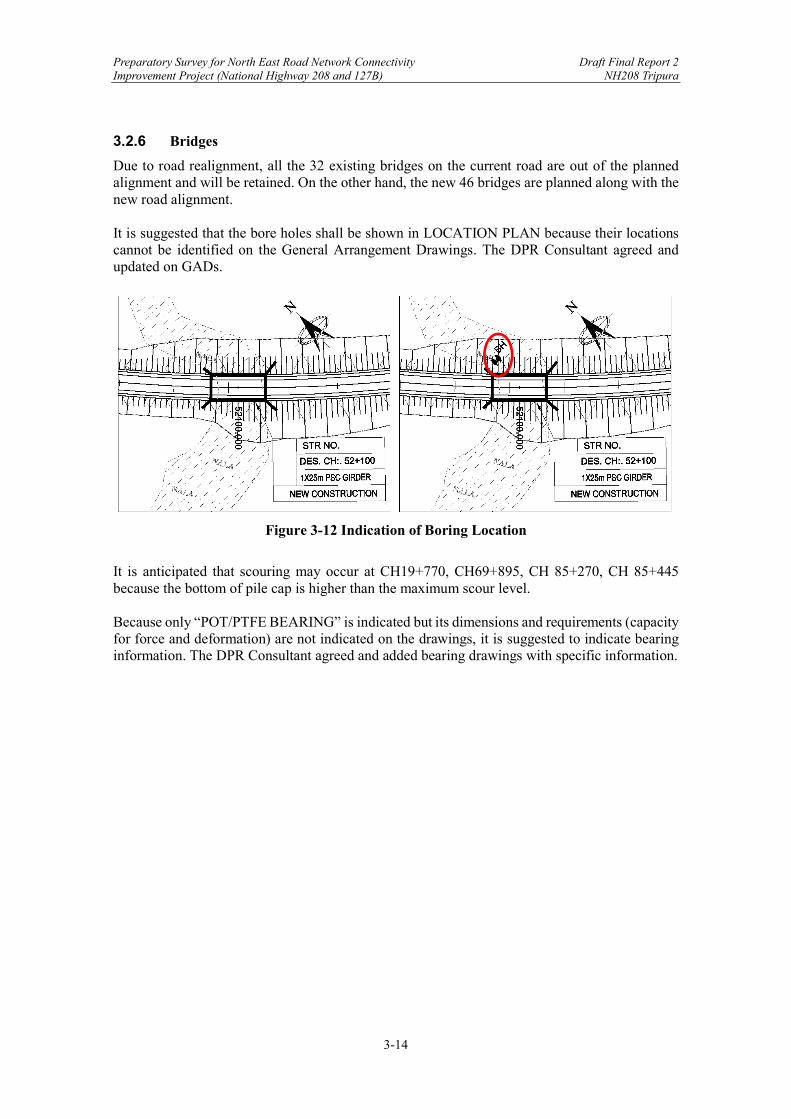
Preparatory Survey for North East Road Network Connectivity Draft Final Report 2 Improvement Project (National Highway 208 and 127B) NH208 Tripura
3-14
3.2.6 Bridges
Due to road realignment, all the 32 existing bridges on the current road are out of the planned alignment and will be retained. On the other hand, the new 46 bridges are planned along with the new road alignment. It is suggested that the bore holes shall be shown in LOCATION PLAN because their locations cannot be identified on the General Arrangement Drawings. The DPR Consultant agreed and updated on GADs.
Figure 3-12 Indication of Boring Location
It is anticipated that scouring may occur at CH19+770, CH69+895, CH 85+270, CH 85+445 because the bottom of pile cap is higher than the maximum scour level. Because only “POT/PTFE BEARING” is indicated but its dimensions and requirements (capacity for force and deformation) are not indicated on the drawings, it is suggested to indicate bearing information. The DPR Consultant agreed and added bearing drawings with specific information.
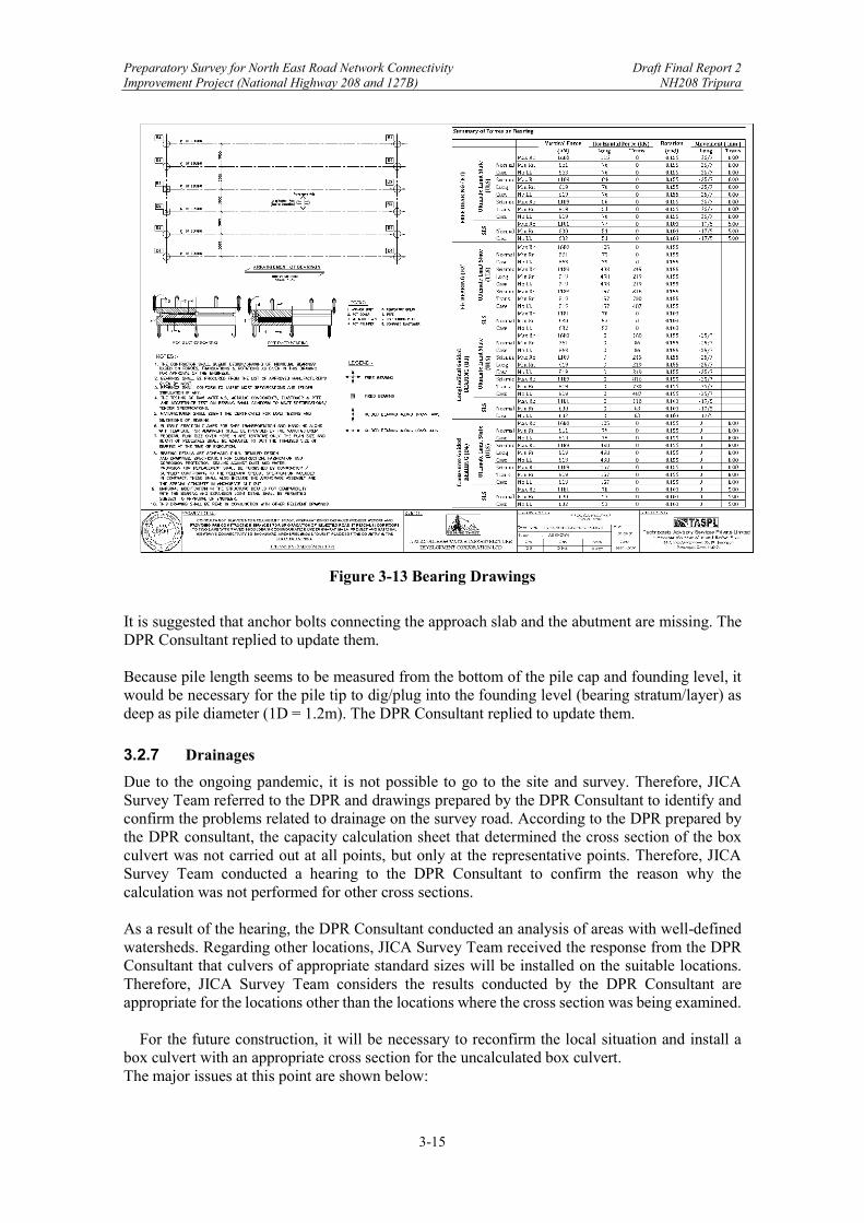
Preparatory Survey for North East Road Network Connectivity Draft Final Report 2 Improvement Project (National Highway 208 and 127B) NH208 Tripura
3-15
Figure 3-13 Bearing Drawings
It is suggested that anchor bolts connecting the approach slab and the abutment are missing. The DPR Consultant replied to update them. Because pile length seems to be measured from the bottom of the pile cap and founding level, it would be necessary for the pile tip to dig/plug into the founding level (bearing stratum/layer) as deep as pile diameter (1D = 1.2m). The DPR Consultant replied to update them.
3.2.7 Drainages
Due to the ongoing pandemic, it is not possible to go to the site and survey. Therefore, JICA Survey Team referred to the DPR and drawings prepared by the DPR Consultant to identify and confirm the problems related to drainage on the survey road. According to the DPR prepared by the DPR consultant, the capacity calculation sheet that determined the cross section of the box culvert was not carried out at all points, but only at the representative points. Therefore, JICA Survey Team conducted a hearing to the DPR Consultant to confirm the reason why the calculation was not performed for other cross sections.
As a result of the hearing, the DPR Consultant conducted an analysis of areas with well-defined watersheds. Regarding other locations, JICA Survey Team received the response from the DPR Consultant that culvers of appropriate standard sizes will be installed on the suitable locations. Therefore, JICA Survey Team considers the results conducted by the DPR Consultant are appropriate for the locations other than the locations where the cross section was being examined.
For the future construction, it will be necessary to reconfirm the local situation and install a box culvert with an appropriate cross section for the uncalculated box culvert. The major issues at this point are shown below:

Preparatory Survey for North East Road Network Connectivity Draft Final Report 2 Improvement Project (National Highway 208 and 127B) NH208 Tripura
3-16
(1) Major issues of DPR
A) Type of Culvert NH208 has been renovated or redesigned for all cross drainage channels as the road width
increases as the road improves. The existing crossing channel culverts used slab culverts, pipe culverts, and box culverts, but due to the improvement of this road, they were all changed to box culverts. Considering workability, it is necessary to consider the adoption of precast pipe culverts and box culverts. In the design of the DPR, due to this road improvement, many box culvert shapes have been adopted. Currently, there is no basis for determining the size because the flow rate calculation sheet is not available yet. JICA Survey Team requested the DPR Consultant to obtain flow rate calculation sheet. If it’s available, JICA Survey Team will review the results. If it is not available, JICA Survey Team will conduct a hearing to local consultants to confirm the rationale.
B) Box culvert cross-section dimensions According to the DPR, many box culverts will be rebuilt and newly installed due to the road improvement, and box culverts with appropriate flow capacity will be installed. The flow calculation of the box culvert is only for the representative location, and there is no basis for determining the size of the box culvert in other locations. JICA Survey Team confirmed that the box culvert capacity statement at the representative location was valid, but capacity statements for other locations were not available. Therefore, JICA Survey Team interviewed the DPR consultant about the matter. As a result of the hearing, the DPR consultant replied that other parts would be installed with the capacity of the existing crossing channel or more (standard size).
C) Installation location of new waterway The NH208 Tripura Line is a route that passes through flat areas and mountainous areas. The mountain route is planned to be constructed with a new route instead of the existing road alignment. Therefore, many box culverts will be newly installed. The rationale for the location was not clarified in the final DPR. Therefore, regarding the location of the new box culvert, JICA Survey Team will conduct a hearing with a DPR consultant and confirm the grounds.
(2) Recommended solutions
A) Type of Culvert Normally, the selection of culvert format is decided by comprehensively considering the characteristics of the normal area (construction efficiency, economic efficiency, ease of acquisition). In the DPR, the crossing channel format is the box culvert format. When JICA Survey Team interviewed the DPR Consultant, the reply was that this area uses a box culvert that has a larger cross section and has a flow capacity than a pipe culvert because it is an area with a lot of rainfall. It is difficult to obtain precast products, and it is difficult to adopt pipe culverts. Therefore, the validity of adopting the box culvert type is high. At the time of construction, it is better to check the local situation and consider the adoption of the culvert type that is most suitable for the site. B) Box culvert cross-section dimensions JICA Survey Team obtained typical box culvert capacity statements from the DPR Consultant. However, the capacity statements were not available for other box culverts. JICA Survey Team conducted interviews to the DPR Consultant and confirmed the concept of design. As a result of the review and hearing, it was confirmed that the capacity statement of the box culvert at the representative location is appropriate. Regarding other places, JICA Survey Team received the response from the DPR Consultant that standard size culverts with the same cross section as the existing ones will be installed. When the road construction starts, it is necessary to check the local situation and adopt the optimum culvert format.
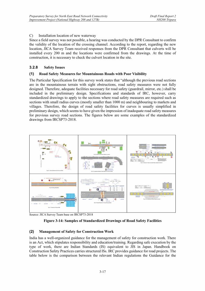
Preparatory Survey for North East Road Network Connectivity Draft Final Report 2 Improvement Project (National Highway 208 and 127B) NH208 Tripura
3-17
C) Installation location of new waterway Since a field survey was not possible, a hearing was conducted by the DPR Consultant to confirm the validity of the location of the crossing channel. According to the report, regarding the new location, JICA Survey Team received responses from the DPR Consultant that culverts will be installed every 200 m and the locations were confirmed from the drawings. At the time of construction, it is necessary to check the culvert location in the site.
3.2.8 Safety Issues
(1) Road Safety Measures for Mountainous Roads with Poor Visibility
The Particular Specification for this survey work states that “although the previous road sections are in the mountainous terrain with sight obstructions, road safety measures were not fully designed. Therefore, adequate facilities necessary for road safety (guardrail, mirror, etc.) shall be included in the preliminary design. Specifications and standards of IRC, however, carry standardized drawings to apply to the sections where road safety measures are required such as sections with small radius curves (mostly smaller than 1000 m) and neighbouring to markets and villages. Therefore, the design of road safety facilities for curves is usually simplified in preliminary design, which seems to have given the impression of inadequate road safety measures for previous survey road sections. The figures below are some examples of the standardized drawings from IRCSP73-2018.
Source: JICA Survey Team base on IRCSP73-2018
Figure 3-14: Samples of Standardized Drawings of Road Safety Facilities
(2) Management of Safety for Construction Work
India has a well-organized guidance for the management of safety for construction work. There is an Act, which stipulates responsibility and education/training. Regarding safe execution by the type of work, there are Indian Standards (IS) equivalent to JIS in Japan. Handbook on Construction Safety Practices carries structured ISs. IRC provides guidance for road projects. The table below is the comparison between the relevant Indian regulations the Guidance for the
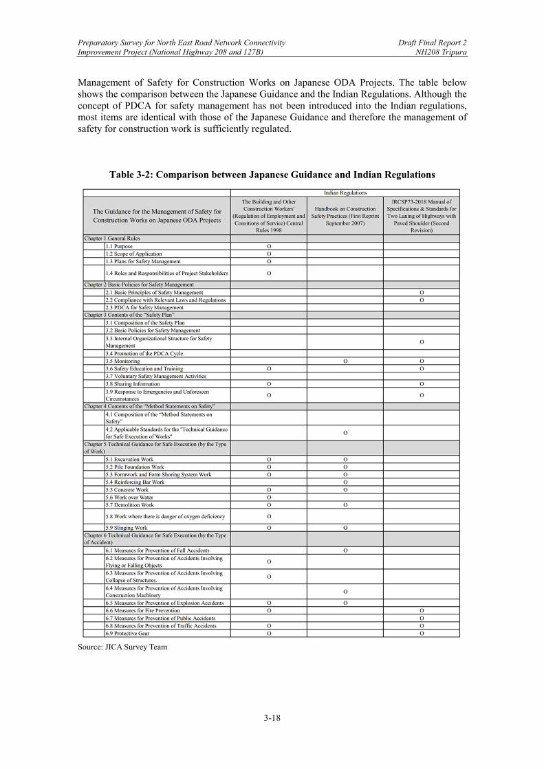
Preparatory Survey for North East Road Network Connectivity Draft Final Report 2 Improvement Project (National Highway 208 and 127B) NH208 Tripura
3-18
Management of Safety for Construction Works on Japanese ODA Projects. The table below shows the comparison between the Japanese Guidance and the Indian Regulations. Although the concept of PDCA for safety management has not been introduced into the Indian regulations, most items are identical with those of the Japanese Guidance and therefore the management of safety for construction work is sufficiently regulated.
Table 3-2: Comparison between Japanese Guidance and Indian Regulations
Source: JICA Survey Team

Preparatory Survey for North East Road Network Connectivity Draft Final Report 2 Improvement Project (National Highway 208 and 127B) NH208 Tripura
3-19
Chapter 3. Present Conditions of NH208 Tripura (Khowai - Sabroom) ........................ 1
3.1 Description and Present Conditions of NH208 Tripura .............................................. 1 3.2 Major Issues of NH208 Tripura .................................................................................. 8
3.2.1 Terrain Along Highway Alignment ..................................................................... 8 3.2.2 Existing ROW and Work on Existing Road ...................................................... 10 3.2.3 Difficult Conditions for Widening .................................................................... 10 3.2.4 Pavement Conditions ......................................................................................... 11 3.2.5 Slope Protection ................................................................................................ 12 3.2.6 Bridges .............................................................................................................. 14 3.2.7 Drainages ........................................................................................................... 15 3.2.8 Safety Issues ...................................................................................................... 17
Figure 3-1: Locations of NH208 Tripura ...................................................................................... 1 Figure 3-2: Locations of Site Photos (CH101+200 - CH108+670) .............................................. 2 Figure 3-3: Locations of Site Photos in Section A (CH101+200 – CH127+319) ......................... 3 Figure 3-4: Locations of Site Photos in Section B (CH00+000 – CH25+000) ............................. 4 Figure 3-5: Locations of Site Photos in Section C (CH25+000 – CH50+000) ............................. 5 Figure 3-6: Locations of Site Photos in Section D (CH50+000 – CH75+000) ............................. 6 Figure 3-7: Locations of Site Photos in Section E (CH75+000 – CH108+670) ........................... 7 Figure 3-8: Terrain Classification of NH208 Tripura .................................................................... 9 Figure 3-9: Design Terrain Classification of NH208 Tripura........................................................ 9 Figure 3-10: Types of Warning Devices in IRCSP55 ................................................................... 11 Figure 3-11 Existing Pavement Conditions ................................................................................. 12 Figure 3-12 Indication of Boring Location ................................................................................. 14 Figure 3-13 Bearing Drawings .................................................................................................... 15 Figure 3-12: Samples of Standardized Drawings of Road Safety Facilities ............................... 17 Table 3-1: Terrain Classification as per IRC73-1980 .................................................................... 8 Table 3-2: Comparison between Japanese Guidance and Indian Regulations ............................ 18
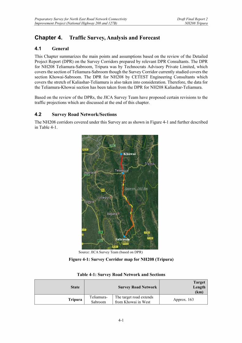
Preparatory Survey for North East Road Network Connectivity Draft Final Report 2 Improvement Project (National Highway 208 and 127B) NH208 Tripura
4-1
Chapter 4. Traffic Survey, Analysis and Forecast
4.1 General
This Chapter summarizes the main points and assumptions based on the review of the Detailed Project Report (DPR) on the Survey Corridors prepared by relevant DPR Consultants. The DPR for NH208 Teliamura-Sabroom, Tripura was by Technocrats Advisory Private Limited, which covers the section of Teliamura-Sabroom though the Survey Corridor currently studied covers the section Khowai-Sabroom. The DPR for NH208 by CETEST Engineering Consultants which covers the stretch of Kaliashar-Teliamura is also taken into consideration. Therefore, the data for the Teliamura-Khowai section has been taken from the DPR for NH208 Kaliashar-Teliamura.
Based on the review of the DPRs, the JICA Survey Team have proposed certain revisions to the traffic projections which are discussed at the end of this chapter.
4.2 Survey Road Network/Sections
The NH208 corridors covered under this Survey are as shown in Figure 4-1 and further described in Table 4-1.
Source: JICA Survey Team (based on DPR)
Figure 4-1: Survey Corridor map for NH208 (Tripura)
Table 4-1: Survey Road Network and Sections
State Survey Road Network Target Length
(km)
Tripura Teliamura-Sabroom
The target road extends from Khowai in West
Approx. 163

Preparatory Survey for North East Road Network Connectivity Draft Final Report 2 Improvement Project (National Highway 208 and 127B) NH208 Tripura
4-2
Tripura to Sabroom in South Tripura.
Source: JICA Survey Team After the improvement of NH208, it is anticipated by the JICA Survey Team that the Survey Corridor will receive not only diverted traffic from existing, alternative routes but also new cross-border traffic. This new traffic is expected as a result of establishment of Tripura’s first Special Economic Zone in Sabroom (announced in 2019) and also because the Survey Corridor is considered as one of the planned freight transportation routes under the World Bank’s Bangladesh Regional Connectivity Project 1 (expected completion in 2023) that connects Sabroom with Chittagong Port as shown in Figure 4-2.
Source: Project Appraisal Document for World Bank’s Bangladesh Regional Connectivity Project 1
Figure 4-2: Trade Routes under World Bank’s Bangladesh Regional Connectivity Project 1
4.3 Traffic Survey
For the Survey Corridors, primary surveys were carried out by DPR Consultants through manual counting to analyze the characteristics and volume of existing traffic, travel pattern of each vehicle on the Survey Corridors, influential zones, and other data essential for projection of future traffic. The types of surveys conducted along the chainage shown in Figure 4-3 were:
Classified Traffic Volume Count Survey Origin-Destination Survey Turning Movement Survey Axle Load Survey

Preparatory Survey for North East Road Network Connectivity Draft Final Report 2 Improvement Project (National Highway 208 and 127B) NH208 Tripura
4-3
Source: JICA Survey Team
Figure 4-3: Chainage along the Survey Corridors
Reconnaissance survey was undertaken to identify homogenous sections along the Survey Corridors and appropriate locations for these primary surveys. Table 4-2 summarize the details of the surveys undertaken at designated locations on the Survey Corridors in Tripura.
Table 4-2: Traffic Surveys at NH208, Tripura
Type of Survey Location Survey Dates Survey
Duration
Classified Traffic Volume Count
Survey
Ch. 117+500 (Trishabari) * [For reference only]
2015 (date not available)
24 Hours x 7 days
Km 42.300 14/02/2017 (Tue) to 20/02/2017 (Mon)
Km 88.000 Km 132.800
Origin-Destination (O-D) Survey
Not Conducted
Turning Movement Survey
Ch. 85+500 3-legged junction at Khowai*
2015 12 Hours x
1 day Km 0.00 at Teliamura 16/02/2017 (Thu)
8 Hours x 1 day
Km 88.000 at Amarpur 17/02/2017 (Fri) Km 132.800 at Ailmara 18/02/2017 (Sat)
Km 42.300 at Harina 18/02/2017 (Sat) Axle Load Survey Not Conducted
Source: DPR by Technocrats Advisory Services and *CETEST Engineering Consultants
NH208 Tripura

Preparatory Survey for North East Road Network Connectivity Draft Final Report 2 Improvement Project (National Highway 208 and 127B) NH208 Tripura
4-4
Based on the above survey results, this Chapter discusses the following analysis and calculations undertaken by the DPR Consultants:
Average Daily Traffic (ADT) - calculated by DPR Consultants taking simple average of the 7-day traffic data collected through Classified Traffic Volume Count Survey.
Daily Traffic Variations, Hourly Traffic Variations, and Peak Hour Factor (PHF) - analyzed to understand temporal variations.
Annual Average Daily Traffic (AADT) - calculated after applying Average Seasonal Correction Factor (ASCF) based on petrol and diesel sales figures of the regions’ gas stations. AADT also took into consideration the potential diverted traffic from existing alternate route.
Passenger Car Unit (PCU) - converted from heterogenous traffic to comparable traffic data based on IRC:64-1990. PCU used for this calculation are shown in Table 4-3.
Table 4-3: PCU Factors
Vehicle Type PCU Factor Two Wheeler 0.50 Car/Jeep/ Van/Taxi/ Auto 1.00
Bus Mini 1.50 Standard 3.00
LCV 1.50
Truck 2-Axle 3.00 3 -Axle 3.00 Multi-Axle 4.50
Agricultural Tractor
With Trailer 4.50 Without Trailer 1.50
Cycle 0.50 Cycle Rickshaw 2.00 Hand Cart 3.00
Animal Drawn Vehicle Assam: 8.00 (Bullock Cart), 4.00
(Horse); Meghalaya: 6.00 Tripura: 4.00
Others (only for NH208 Tripura) 3.00 Source: DPR
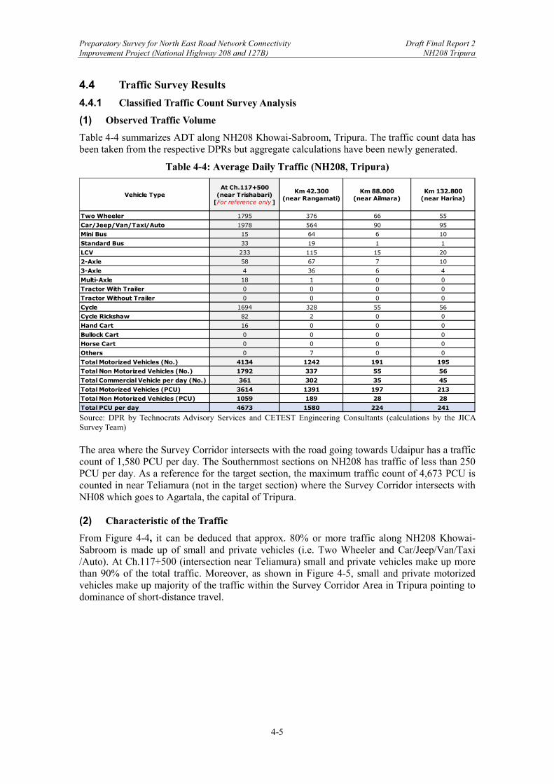
Preparatory Survey for North East Road Network Connectivity Draft Final Report 2 Improvement Project (National Highway 208 and 127B) NH208 Tripura
4-5
4.4 Traffic Survey Results
4.4.1 Classified Traffic Count Survey Analysis
(1) Observed Traffic Volume
Table 4-4 summarizes ADT along NH208 Khowai-Sabroom, Tripura. The traffic count data has been taken from the respective DPRs but aggregate calculations have been newly generated.
Table 4-4: Average Daily Traffic (NH208, Tripura)
Source: DPR by Technocrats Advisory Services and CETEST Engineering Consultants (calculations by the JICA Survey Team) The area where the Survey Corridor intersects with the road going towards Udaipur has a traffic count of 1,580 PCU per day. The Southernmost sections on NH208 has traffic of less than 250 PCU per day. As a reference for the target section, the maximum traffic count of 4,673 PCU is counted in near Teliamura (not in the target section) where the Survey Corridor intersects with NH08 which goes to Agartala, the capital of Tripura. (2) Characteristic of the Traffic
From Figure 4-4, it can be deduced that approx. 80% or more traffic along NH208 Khowai-Sabroom is made up of small and private vehicles (i.e. Two Wheeler and Car/Jeep/Van/Taxi /Auto). At Ch.117+500 (intersection near Teliamura) small and private vehicles make up more than 90% of the total traffic. Moreover, as shown in Figure 4-5, small and private motorized vehicles make up majority of the traffic within the Survey Corridor Area in Tripura pointing to dominance of short-distance travel.
Two Wheeler 1795 376 66 55
Car/Jeep/Van/Taxi/Auto 1978 564 90 95
Mini Bus 15 64 6 10
Standard Bus 33 19 1 1
LCV 233 115 15 20
2-Axle 58 67 7 10
3-Axle 4 36 6 4
Multi-Axle 18 1 0 0
Tractor With Trailer 0 0 0 0
Tractor Without Trailer 0 0 0 0
Cycle 1694 328 55 56
Cycle Rickshaw 82 2 0 0
Hand Cart 16 0 0 0
Bullock Cart 0 0 0 0
Horse Cart 0 0 0 0
Others 0 7 0 0
Total Motorized Vehicles (No.) 4134 1242 191 195
Total Non Motorized Vehicles (No.) 1792 337 55 56
Total Commercial Vehicle per day (No.) 361 302 35 45
Total Motorized Vehicles (PCU) 3614 1391 197 213
Total Non Motorized Vehicles (PCU) 1059 189 28 28
Total PCU per day 4673 1580 224 241
Vehicle TypeKm 42.300
(near Rangamati)Km 132.800
(near Harina)Km 88.000
(near Ailmara)
At Ch.117+500 (near Trishabari)
[For reference only]
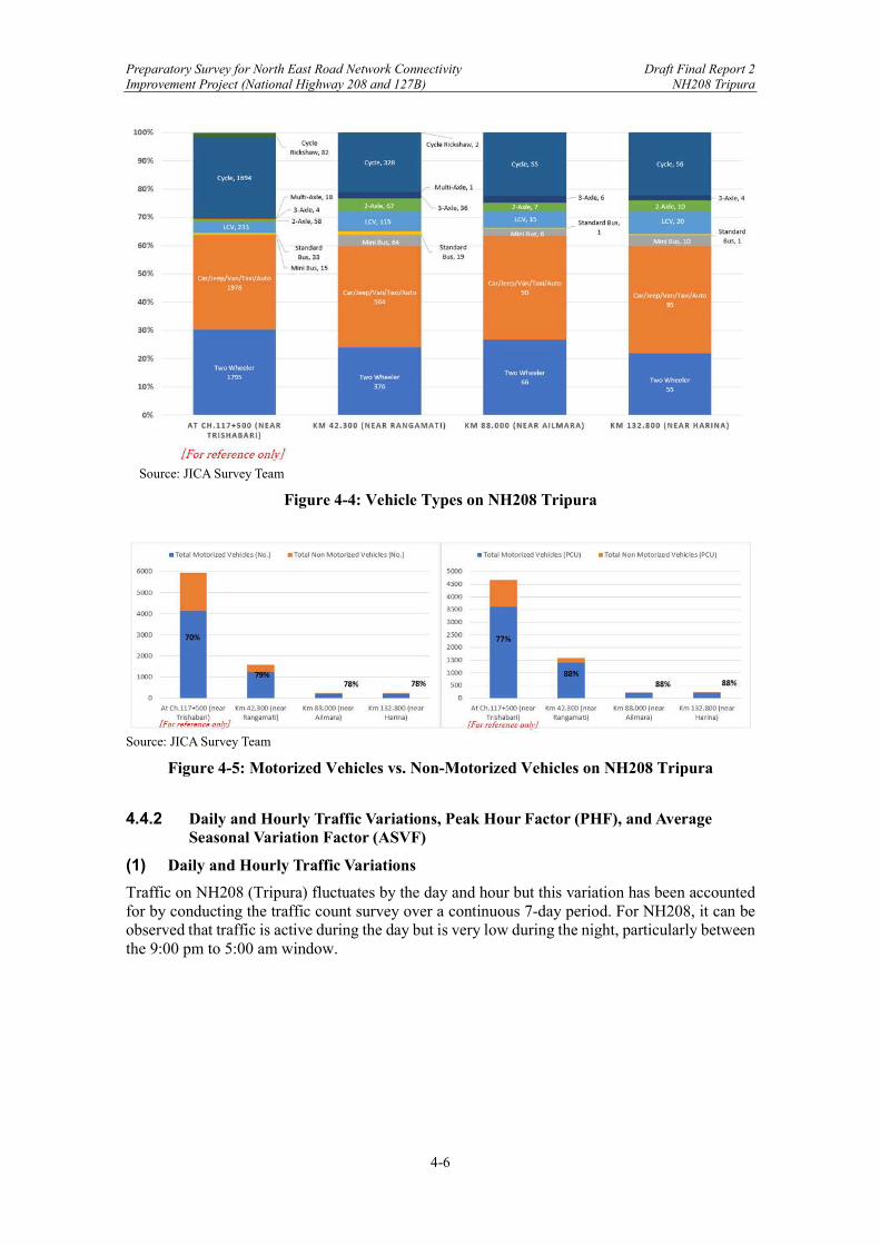
Preparatory Survey for North East Road Network Connectivity Draft Final Report 2 Improvement Project (National Highway 208 and 127B) NH208 Tripura
4-6
Source: JICA Survey Team
Figure 4-4: Vehicle Types on NH208 Tripura
Source: JICA Survey Team
Figure 4-5: Motorized Vehicles vs. Non-Motorized Vehicles on NH208 Tripura
4.4.2 Daily and Hourly Traffic Variations, Peak Hour Factor (PHF), and Average Seasonal Variation Factor (ASVF)
(1) Daily and Hourly Traffic Variations
Traffic on NH208 (Tripura) fluctuates by the day and hour but this variation has been accounted for by conducting the traffic count survey over a continuous 7-day period. For NH208, it can be observed that traffic is active during the day but is very low during the night, particularly between the 9:00 pm to 5:00 am window.
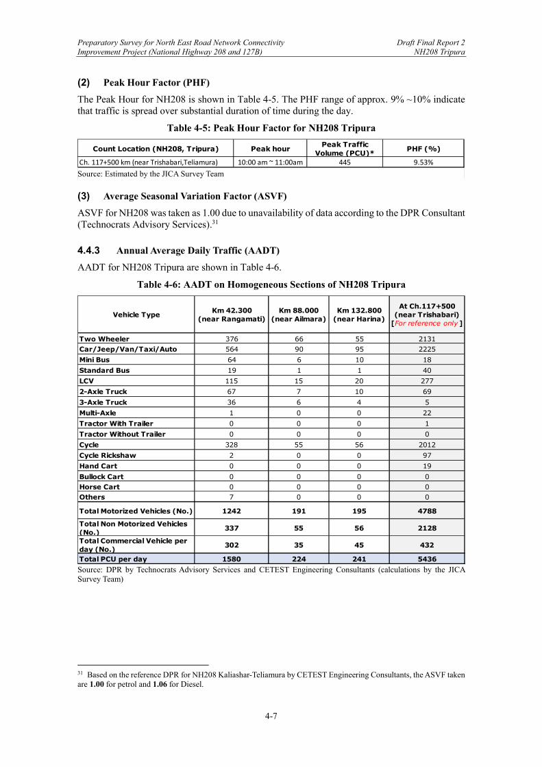
Preparatory Survey for North East Road Network Connectivity Draft Final Report 2 Improvement Project (National Highway 208 and 127B) NH208 Tripura
4-7
(2) Peak Hour Factor (PHF)
The Peak Hour for NH208 is shown in Table 4-5. The PHF range of approx. 9% ~10% indicate that traffic is spread over substantial duration of time during the day.
Table 4-5: Peak Hour Factor for NH208 Tripura
Source: Estimated by the JICA Survey Team (3) Average Seasonal Variation Factor (ASVF)
ASVF for NH208 was taken as 1.00 due to unavailability of data according to the DPR Consultant (Technocrats Advisory Services).31
4.4.3 Annual Average Daily Traffic (AADT)
AADT for NH208 Tripura are shown in Table 4-6.
Table 4-6: AADT on Homogeneous Sections of NH208 Tripura
Source: DPR by Technocrats Advisory Services and CETEST Engineering Consultants (calculations by the JICA Survey Team)
31 Based on the reference DPR for NH208 Kaliashar-Teliamura by CETEST Engineering Consultants, the ASVF taken are 1.00 for petrol and 1.06 for Diesel.
Count Location (NH208, Tripura) Peak hourPeak Traffic
Volume (PCU)*PHF (%)
Ch. 117+500 km (near Trishabari,Teliamura) 10:00 am ~ 11:00am 445 9.53%
Two Wheeler 376 66 55 2131Car/Jeep/Van/Taxi/Auto 564 90 95 2225
Mini Bus 64 6 10 18
Standard Bus 19 1 1 40
LCV 115 15 20 277
2-Axle Truck 67 7 10 69
3-Axle Truck 36 6 4 5
Multi-Axle 1 0 0 22
Tractor With Trailer 0 0 0 1
Tractor Without Trailer 0 0 0 0
Cycle 328 55 56 2012
Cycle Rickshaw 2 0 0 97
Hand Cart 0 0 0 19
Bullock Cart 0 0 0 0Horse Cart 0 0 0 0Others 7 0 0 0
Total Motorized Vehicles (No.) 1242 191 195 4788
Total Non Motorized Vehicles (No.)
337 55 56 2128
Total Commercial Vehicle per day (No.)
302 35 45 432
Total PCU per day 1580 224 241 5436
Km 42.300 (near Rangamati)
At Ch.117+500 (near Trishabari)
[For reference only ]
Km 88.000 (near Ailmara)
Km 132.800 (near Harina)
Vehicle Type

Preparatory Survey for North East Road Network Connectivity Draft Final Report 2 Improvement Project (National Highway 208 and 127B) NH208 Tripura
4-8
4.5 Traffic Projection Methodology
4.5.1 Existing Traffic Data
Existing traffic data available for NH208 Khowai-Sabroom is as follows:
NH208 Khowai-Teliamura from 2015 by CETEST Engineering Consultants NH208 Teliamura-Sabroom from February 2017 by the Technocrats Advisory Services
Due to the ongoing global pandemic, the JICA Survey Team is unable to collect more recent traffic data, and for now, traffic analysis is reviewed based on latest data collected by DPR Consultants.
4.5.2 Homogeneous Sections
Four homogenous sections were identified for NH208 Khowai-Sabroom:
Homogeneous Section I: Km. 85+500 to Km 118+000 Homogeneous Section II: Km. 0.00 to Km 45.00 (Teliamura-Amarpur section) Homogeneous Section III: Km. 45.00 to Km 88.00 (Amarpur-Ailmara section) Homogeneous Section IV: Km. 88.00 to Km 133.00 (Ailmara-Harina section)
Homogeneous Section I is taken from the DPR by CETEST Engineering Consultants while Homogeneous Sections II-IV are taken from the DPR by Technocrats Advisory Services.
4.5.3 Consideration/ Assumptions by DPR Consultants
(1) Diverted Traffic based on O-D Survey Analysis
O-D Survey was not carried out by the DPR Consultant Technocrats Advisory Services for the NH208 Teliamura-Sabroom section as there is limited commercial traffic as well as lack of any major traffic along the corridor. However, an induced traffic of 15% was assumed for this road section after its completion. For NH208 Khowai-Teliamura section the DPR Consultant CETEST Engineering Consultants assume that traffic can be expected to be diverted from NH08 (old NH44) to avoid going through the existing hilly terrain routes (shown in Figure 4-6). The percentage and number of vehicles expected to be diverted from NH08 to NH208 is shown in Table 4-7.
Table 4-7: Diverted Traffic on NH208 Tripura
Source: CETEST Engineering Consultants
Car/Jeep/Van/Taxi/Auto 0% 0Bus 86% 62-Axle Truck 82% 1063-Axle Truck 88% 50Multi-Axle 83% 83LCV 69% 11
Probable diverted trafficNH-08 -> NH208
(%)
Probable diverted trafficNH-08 -> NH208
(No.)Vehicle Type

Preparatory Survey for North East Road Network Connectivity Draft Final Report 2 Improvement Project (National Highway 208 and 127B) NH208 Tripura
4-9
Source: JICA Survey Team
Figure 4-6: NH208 and Existing Alternate Routes
A growth rate of 5% for all vehicles were taken for all motorized vehicles for NH208 Teliamura-Sabroom section while 5% was taken for all motorized and non-motorized vehicles for NH208 Khowai-Teliamura section.
Preparatory Survey for North East Road Network Connectivity Draft Final Report 2 Improvement Project (National Highway 208 and 127B) NH208 Tripura
4-10
4.6 Traffic Projection in DPR
Based on the above traffic growth rates and expected diversion, the traffic projections for each homogeneous section along the Survey Corridor estimated by the respective DPR Consultant are shown below in Table 4-8.
Table 4-8: Traffic Projections by DPR Consultant for NH208 Tripura
Note: Figures in red are estimated by the JICA Survey Team as projection for the section was only up to 2033. Source: DPR by Technocrats Advisory Services and CETEST Engineering Consultants (compiled by JICA Survey Team)
4.7 Revisions by the JICA Survey Team
4.7.1 Revision of Traffic Growth Assumptions
The JICA Survey Team has used the aforementioned AADT as base figures to generate revised projections for future traffic. The base year for NH208 Tripura is taken as 2017. For NH208 Khowai-Teliamura section for which the base year in DPR was 2015, estimated 2017 figures have been considered (exclusive of any traffic diversion). In general, a traffic growth rate of 5% for all sections of NH208 has been taken for traffic projections given that it was assessed as reasonable in the JICA NH208 DPR Review Report from February 2020. Moreover, 2025 is taken as the estimate year of road opening of NH208, therefore, traffic for this year has been increased to include diverted traffic from alternative routes. Diverted traffic for NH208 Khowai-Teliamura section has been increased based on the percentages provided by the DPR Consultant as shown in Table 4-7. For the remaining NH208 Teliamura-Sabroom section, traffic is estimated to increase by 15% after road opening.
4.7.2 Revised Traffic Growth Rates
Traffic growth rates used by the JICA Survey Team for revised traffic projections has been kept the same as per the DPR at 5% across all motorized and non-motorized vehicles.
4.7.3 Revised Traffic Projections
Table 4-9 shows the traffic projections estimated by the JICA Survey Team for NH208 Tripura. The projection takes 2017 as base figures and is estimated until 2045. As mention, diverted traffic from existing routes passing through hilly terrain (shown in Figure 4-6) is expected to get diverted to the improved NH208 after its expected opening in 2025.
Total Traffic (No.)
Total Traffic (PCU)
Total Traffic (No.)
Total Traffic (PCU)
Total Traffic (No.)
Total Traffic (PCU)
Total Traffic (No.)
Total Traffic (PCU)
Base Year 2017* 8272 8313 1579 1583 246 224 251 241Road Opening 2020* 9576 9624 2124 2162 328 299 340 334
2025 12221 12283 2709 2750 414 368 433 4232030 15598 15676 3453 3500 521 451 550 5322035 19908 20007 4404 4457 659 559 697 6662040 25408 25535 5613 5673 835 696 892 854
* 2015 is base year for Ch.117+500 (near Trishabari) as per projections by CETEST Engineering Consultants and 2015 figures are inclusive of diverted traffic.
Year
NH208 Tripura(DPR by Technocrats Advisory Services and CETEST Engineering Consultants)
At Ch.117+500 (near Trishabari)
Km 132.800 (near Harina)
Km 42.300 (near Rangamati)
Km 88.000 (near Ailmara)
Preparatory Survey for North East Road Network Connectivity Draft Final Report 2 Improvement Project (National Highway 208 and 127B) NH208 Tripura
4-11
Therefore, traffic for 2025 has been increased by 15% for NH208 Teliamura-Sabroom and by the respective diversion percentages for NH Khowai-Teliamura. Based on the traffic forecast, the road section NH208 Khowai-Sabroom is expected to receive a comparatively higher level of traffic. However, based on the estimated traffic, the highway could maintain a LOS “B” until 2045 (based on design service volume of 30000 PCU/day for 2-lane).
Table 4-9: Revised Traffic Forecasts for NH208 Tripura
Source: JICA Survey Team
4.8 Further Revision of Traffic Projection
4.8.1 Justification for Further Revision
Traffic growth rate of 5% for NH208 has been assessed as reasonable in the JICA NH208 DPR Review Report from February 2020. However, the traffic diversion ratio for the projection could be revised if a broader scope is considered. According to the World Bank Bangladesh Regional Connectivity Project 1 (expected completion in 2023), NH208 is considered as one of the planned freight transportation routes (as shown in Figure 4-2). The connection of Sabroom with Chittagong Port, makes the route the shortest link of India NE region to the sea port, which will play an extremely important role in the regional and international logistics network and have a huge impact on the future traffic. Moreover, there are other socio-economic factors that could bring additional traffic to NH208. The Special Economic Zone in Sabroom, the Smart City planned for Agartala, as well as the development of India-Bangladesh Trade Agreement and the associated tax preference policy are anticipated to significantly increase trade and traffic between India and Bangladesh and Myanmar, and boost economy and generate new traffic which could be incorporated in the traffic projection. Theoretically, there are three types of traffic growth: Normal traffic. Normal traffic growth is based on historical trends of vehicle growth rates in relation to economic growth rates, and on the economic growth outlook for future years. Diverted traffic. Diverted traffic has been estimated for all project roads based on an analysis of existing travel demand on competing corridor sections. The diverted volume is estimated based on the regional and national multi-model transport network configuration, current traffic volume and socio-economic situation, as well as the potential changes brought by new hard/soft infrastructure to the network. Generated traffic. The magnitude of generated traffic depends on the estimated level of benefits accrued to the project by the improvement of road infrastructure. It considers the broader impact of transport infrastructure on the economy development and the extra created traffic flow.
Total Traffic (No.)
Total Traffic (PCU)
Total Traffic (No.)
Total Traffic (PCU)
Total Traffic (No.)
Total Traffic (PCU)
Total Traffic (No.)
Total Traffic (PCU)
Base Year 2017 7615 5963 1579 1587 246 224 251 2412020 8815 6903 1828 1837 285 259 291 278
Road Opening 2025 11507 9686 2683 2696 418 381 426 4092030 14686 12362 3424 3441 533 486 544 5222035 18743 15777 4370 4392 681 620 695 6662040 23922 20136 5577 5606 869 791 887 8502045 30531 25700 7118 7154 1109 1010 1132 1084
Year
NH208 TripuraAt Ch.117+500
(near Trishabari)Km 88.000
(near Ailmara)Km 132.800
(near Harina)Km 42.300
(near Rangamati)
Preparatory Survey for North East Road Network Connectivity Draft Final Report 2 Improvement Project (National Highway 208 and 127B) NH208 Tripura
4-12
DPR has considered the normal traffic growth based on traffic survey data and socio-economic data. Using the elasticity approach, DPR proposed the 5% annual traffic growth rate for the entire route. In addition to that, JICA revision considered the traffic diversion from alternative National Highway routes (mainly NH 8) in a limited scope and estimated a 15% diversion at the time of road opening. However, the broader scope traffic diversion and the generated traffic are missing in the previous analysis. Therefore, this traffic revision will focus on the diverted traffic from a broader scope and the generated traffic brought by the trade policy. In the following part of this section, firstly the respective impact of these factors on the traffic projection are analyzed. Then, the traffic growth rate in terms of vehicle types, route sections, and year ranges are summarized, based on which, the traffic projection is revised as the conclusion of the traffic analysis.
4.8.2 Diverted Traffic – Tripura State Level
The following map (Figure 4-7) shows the strategic role of NH208 for Tripura State when it is connected with Chittagong Port after opening. The red route above Sabroom is the NH208, while the section below is the freight transportation route that connects to Chittagong Port. The green dotted route is the current freight transportation route for commodities from Chittagong to Tripura State. The main existing Land Customs Stations (LCSs) are marked by the light blue circle, and the dark blue circle is the planned Sabroom LCS.

Preparatory Survey for North East Road Network Connectivity Draft Final Report 2 Improvement Project (National Highway 208 and 127B) NH208 Tripura
4-13
Source: JICA Survey Team
Figure 4-7: Strategic Role of NH208 for Tripura State
The introduction of Tripura’s trade across the Bangladesh Border is necessary to understand the strategic role of NH208. There are eight Land Custom Stations (LCSs) as shown below in Figure 4-8, namely:1) Agartala LCS, 2) Muhurighat LCS (Belonia), 3) Khowai LCS, 4) Srimantapur LCS (Sonamura), 5) Manughat LCS (Kamalpur), 6) Old Raghna Bazar LCS (Dharmanagar), 7) Dhalaighat LCS (Kailashahar), 8) Anandapara LCS (Sabroom). Out of these, Dhalaighat LCS (Kailashahar) and Anandapara LCS (Sabroom) have no trade at present.

Preparatory Survey for North East Road Network Connectivity Draft Final Report 2 Improvement Project (National Highway 208 and 127B) NH208 Tripura
4-14
Source: JICA Survey Team
Figure 4-8: LCSs in Tripura
In term of the trade values, since the year 2006 -2007 when the border trade was launched in six LCSs, the trading value between Tripura and Bangladesh have increased from Rs. 49.56 Crores to Rs. 537.08 Crores in 12 years by the 2018-2019.32 Import values account for more than 90% of the trading values, and the main commodity imported are Variety fish/Hilsa/Dry fish, and Food items/Drinks, as shown in Table 4-10.
Table 4-10: Composition of Commodity-wise Imports (2018-19)
Source: JICA Survey Team
The rapid development of trade across the Bangladesh Border demonstrates the increase of demand from Tripura State, especially on the imported commodities from the sea side. Therefore, the role of the connection with Chittagong Port is essential for the State. NH208 will be the shortest route for the inner part of the State, and Sabroom LCS is expected to be the most important gateway in the future among the current LCSs in Tripura, considering its proximity to the port. Part of the trade volume of Tripura will be diverted to Sabroom LCS after its opening. To estimate the diversion from existing LCSs to Sabroom LCS, the total trade volume of all LCSs and the portion of Sabroom LCS is needed. Each LCS has its own service area, or hinterland. For regions 32 JICA, Basic Information and Data Collection Study on Connectivity Improvement in North Eastern Region of India, Volume II, February, 2020

Preparatory Survey for North East Road Network Connectivity Draft Final Report 2 Improvement Project (National Highway 208 and 127B) NH208 Tripura
4-15
near the exiting LCSs, such as Agartala City, the existing LCSs still remain as the good choice when the Sabroom LCS is in place, and the green dotted route will be the route for freight transportation for such regions as it is now. However, for the potential hinterland of Sabroom which is basically the inner part of the State as shown in blue color in Figure 4-7, NH208 would be the route for freight transportation from Chittagong Port. It is assumed that the demand of imported commodities is proportional to the population size. Therefore, by aggregating the population of the hinterland area of Sabroom LCS and comparing it with the total State population, the diverted portion for Sabroom LCS can be obtained. According to the State Statistics Department, the population of Tripura State is 3.7 million in 2015 and is estimated to be 4 million in 2020. The population of the hinterland area is estimated based on an open source data on the spatial distribution of population that developed by Columbia University.33 Based on this online tool, the population of the Sabroom Hinterland is around 1.0 million, roughly 25% of the total population of the State. Therefore, a 25% of the total trade volume and freight transportation of all existing LCSs would be diverted to Sabroom LCS after the opening.
Source: JICA Survey Team
Figure 4-9: Population Estimation for Sabroom LCS Hinterland
It is worth noting that while the freight travelling north to the inner part of the hinterland, the freight will be discharged along the way, and the freight being transported further is assumed to be proportional with the hinterland area left - more accurately, the population of the remaining hinterland area. There are four survey sections for NH208 route: Km 132.800 (near Harina), Km 88.000 (near Ailmara), Km 42.300 (near Rangamati), and Ch.117+500 (near Trishabari), from south to north. Using the same method of population estimation and relating that to the diverted freight volume, there will be additional 25% of total freight transportation of all existing LCSs to the section of Km 132.800 (near Harina and Sabroom), 15% to the section of Km 88.000 (near Ailmara), and 5% to the section of Km 42.300 (near Rangamati). There will be no diverted traffic for Ch.117+500 (near Trishabari) as it is out of the Sabroom LCS hinterland and will be using the exiting LCS for freight transportation.
33 Lind for the open source data on the spatial distribution of population:
https://sedac.ciesin.columbia.edu/mapping/popest/gpw-v4/
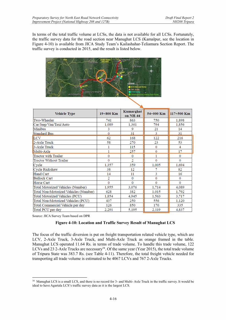
Preparatory Survey for North East Road Network Connectivity Draft Final Report 2 Improvement Project (National Highway 208 and 127B) NH208 Tripura
4-16
In terms of the total traffic volume at LCSs, the data is not available for all LCSs. Fortunately, the traffic survey data for the road section near Manughat LCS (Kamalpur, see the location in Figure 4-10) is available from JICA Study Team’s Kailashahar-Teliamura Section Report. The traffic survey is conducted in 2015, and the result is listed below.
Source: JICA Survey Team based on DPR
Figure 4-10: Location and Traffic Survey Result of Manughat LCS
The focus of the traffic diversion is put on freight transportation related vehicle type, which are LCV, 2-Axle Truck, 3-Axle Truck, and Multi-Axle Truck as orange framed in the table. Manughat LCS operated 11.64 Rs. in terms of trade volume. To handle this trade volume, 122 LCVs and 23 2-Axle Trucks are necessary34. Of the same year (Year 2015), the total trade volume of Tripura State was 383.7 Rs. (see Table 4-11). Therefore, the total freight vehicle needed for transporting all trade volume is estimated to be 4067 LCVs and 767 2-Axle Trucks.
34 Manughat LCS is a small LCS, and there is no record for 3- and Multi- Axle Truck in the traffic survey. It would be ideal to have Agartala LCS’s traffic survey data as it is the largest LCS.

Preparatory Survey for North East Road Network Connectivity Draft Final Report 2 Improvement Project (National Highway 208 and 127B) NH208 Tripura
4-17
Table 4-11: Trade Volume of LCSs in Tripura (2014-19)
(unit: Rs. in cr.)
Source: JICA Survey Team based on DPR
Once the equation between quantity of freight vehicles and trade volume is established, 25% diversion can be translated into the absolute quantity of diverted freight traffic that can be added to the Sabroom traffic projection. As discussed earlier in 4.3, the traffic survey for NH208 section is conducted in 2017. In 2017, the total trade volume is 390.8 Rs. (see Table 4-11), which is equivalent to a freight traffic of 4142 LCVs and 781 2-Axle Trucks. 25% of that is diverted to Sabroom LCS, which is the section of Km 132.800 (near Harina), so the diverted traffic volume is 1035 LCVs and 195 2-Axle Trucks. Compared to the diverted traffic volume to the 2017 traffic survey result (Table 4-6), the increase is significant. Under such a hypothetical traffic diversion in 2017, the traffic of LCVs increases from 20 to 1035 and 2-Axle Truck increased from 10 to 195, corresponding to a traffic growth of 5175% and 1950%, respectively. With all else being equal, this traffic increase rate should be the same till the year 2025 when the LCS is open. Following the same method, the diverted traffic is calculated for other sections, and the result is summarized in Table 4-12.
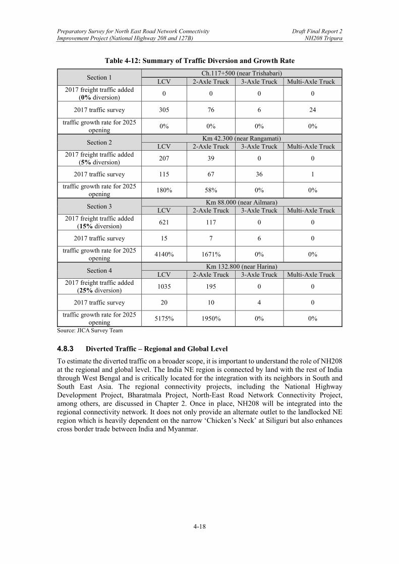
Preparatory Survey for North East Road Network Connectivity Draft Final Report 2 Improvement Project (National Highway 208 and 127B) NH208 Tripura
4-18
Table 4-12: Summary of Traffic Diversion and Growth Rate
Section 1 Ch.117+500 (near Trishabari)
LCV 2-Axle Truck 3-Axle Truck Multi-Axle Truck 2017 freight traffic added
(0% diversion) 0 0 0 0
2017 traffic survey 305 76 6 24
traffic growth rate for 2025 opening
0% 0% 0% 0%
Section 2 Km 42.300 (near Rangamati)
LCV 2-Axle Truck 3-Axle Truck Multi-Axle Truck 2017 freight traffic added
(5% diversion) 207 39 0 0
2017 traffic survey 115 67 36 1
traffic growth rate for 2025 opening
180% 58% 0% 0%
Section 3 Km 88.000 (near Ailmara)
LCV 2-Axle Truck 3-Axle Truck Multi-Axle Truck 2017 freight traffic added
(15% diversion) 621 117 0 0
2017 traffic survey 15 7 6 0
traffic growth rate for 2025 opening
4140% 1671% 0% 0%
Section 4 Km 132.800 (near Harina)
LCV 2-Axle Truck 3-Axle Truck Multi-Axle Truck 2017 freight traffic added
(25% diversion) 1035 195 0 0
2017 traffic survey 20 10 4 0
traffic growth rate for 2025 opening
5175% 1950% 0% 0%
Source: JICA Survey Team
4.8.3 Diverted Traffic – Regional and Global Level
To estimate the diverted traffic on a broader scope, it is important to understand the role of NH208 at the regional and global level. The India NE region is connected by land with the rest of India through West Bengal and is critically located for the integration with its neighbors in South and South East Asia. The regional connectivity projects, including the National Highway Development Project, Bharatmala Project, North-East Road Network Connectivity Project, among others, are discussed in Chapter 2. Once in place, NH208 will be integrated into the regional connectivity network. It does not only provide an alternate outlet to the landlocked NE region which is heavily dependent on the narrow ‘Chicken’s Neck’ at Siliguri but also enhances cross border trade between India and Myanmar.

Preparatory Survey for North East Road Network Connectivity Draft Final Report 2 Improvement Project (National Highway 208 and 127B) NH208 Tripura
4-19
Source: JICA Survey Team
Figure 4-11: NE Regional Connectivity Network
As shown in Figure 4-11, NH208 (the red route) joins the East-West Economic Corridor (the orange route) at Silchar. The corridor runs through the NE region, connecting the mainland of India to the west, and extending to the east where it merges with the India-Myanmar-Thailand Trilateral Highway at Moreh City, the largest Indo-Myanmar LCS for now. In 2008, the Govt. of India and the Govt. of Myanmar reached an Agreement to facilitate the cross border trade between the two countries, and to develop the transport route to the India NE region through Myanmar, after the initial effort made by India failed in persuading Bangladesh to offer transport and transit rights to the NE region, including the access to Chittagong Port. Under the Agreement, the Kaladan Multimodal Transport Project, a multimodal transit route (Figure 4-11), was implemented.
Table 4-13: Components of Kaladan Multimodal Transit Transport Project
Source: Ministry of Development of North Eastern Region
The Kaladan Multi-Modal Transport Project is designed to link Kolkata and Sittwe in Myanmar by sea (539 km) – link Sittwe to Paletwa jetty by Kaladan river (158 km) – road link Palewa to Indo-Myanmar border (110 km) – road link Indo-Myanmar border to Lawangtlai in Mizoram (100 km) – continuing further to Dabaka in Assam (850 km long NH-54) and rest of India’s road network35 (Table 4-13). Once completed, this project will reduce the travel distance from Kolkata to Sittwee by approximately 1328 km and will reduce the need to transport goods through the narrow Chicken's Neck for the NE region.
35 Data Collection Survey on National Logistics in the Republic of the Union of Myanmar, JICA, 2018

Preparatory Survey for North East Road Network Connectivity Draft Final Report 2 Improvement Project (National Highway 208 and 127B) NH208 Tripura
4-20
However, with the construction of NH208, especially the establishment of linkage with Chittagong Port, it is obvious that the alternative red route in Figure 4-11, which is also a multi-modal transit route including a waterway component from Kolkata to Chittagong and a land way component (mainly the NH208), has an advantage over the Kaladan route in terms of distance traveled.36 For the same Origin-Destination of Kolkata and Silchar, the distance can be 200 km shorter. Therefore, it is safe to assume a notable traffic diversion from the Kaladan route to the red route, or NH208. Taking a broader view, the hinterland of the envisaged route is even larger. The landlocked inner NE region and the vast north part of Myanmar (colored in bule in Figure 4-11) can be the benefited area of the route, as it is the shortest link to the seaport for this region. The main commodities transported for this region are construction materials such as coal, stone, sands, aggregate, cement, etc., as well as the daily necessities of fresh and dry fish, PVC items, cotton, oil, and so on. These commodities heavily rely on the supply from the mainland and the sea area. Therefore, the freight transportation demand will be high if the route is open.37
At the global level, NH208 and the connection with Chittagong Port is a key mode for international logistics network. The NE region and the surrounding regions are the “hinge” of the Indian Ocean and the Pacific Ocean, as described by the Japanese Initiatives of Free and Open Indo-Pacific (FOIP).38
36 The advantage also includes the road condition. It is reported that the road link from Palewa to Indo-Myanmar border is with issues of floods, landslides, road blockages, and local unrest. These issues affected the freight transportation. The planed NH208 will be a better choice in terms of improved road condition. (source: JICA Myanmar Report, 2018) 37 Another justification for the traffic demand is the low trade volume between Indo-Myanmar. Most cross-border trade in India’s NE region is conducted through the Moreh LCS. Yet, trade at this LCS has represented less than 1% of India’s total trade with Myanmar in the last decade. This is in contrast with border trading activities on the China–Myanmar and Thailand–Myanmar borders. According to Myanmar’s Department of Border Trade, border trade with the China surpassed $7.8 billion in the four years to FY2011, while border trade with India reached only about $66 million. Border trade with Thailand surpassed $1.5 billion during the same period and border trade with Bangladesh was more than $117 million. There is the huge potential of trade development between Indo-Myanmar, and as a result the freight transportation would increase a lot. 38 Ministry of Foreign Affairs of Japan, https://www.mofa.go.jp/files/000430632.pdf.
Box 4-1 Importance of Seaport Linkage to Landlocked Area: Case of Nepal Nepal is a landlocked country in South Asia. Over the past decade and a half in particular, Nepal has invested in the main corridor linking it to the Kolkata port complex in India. In the late 1990s, with support from the World Bank, major border crossing points with connection to Kolkata was constructed as the largest trans-loading mode for Nepal’s international trade. The connection now (as of 2014) handles more than 60% of Nepal’s containerized third-country trade traffic. This case shows the importance of seaport linkage to landlocked area. NH208 will play a vital role for the landlocked inner NE region and the vast north part of Myanmar. Source: Improving Trade and Transport for Landlocked Developing Countries, World Bank, 2014 (https://www.tralac.org/images/docs/6592/improving-trade-and-transport-for-ldcs report.pdf)
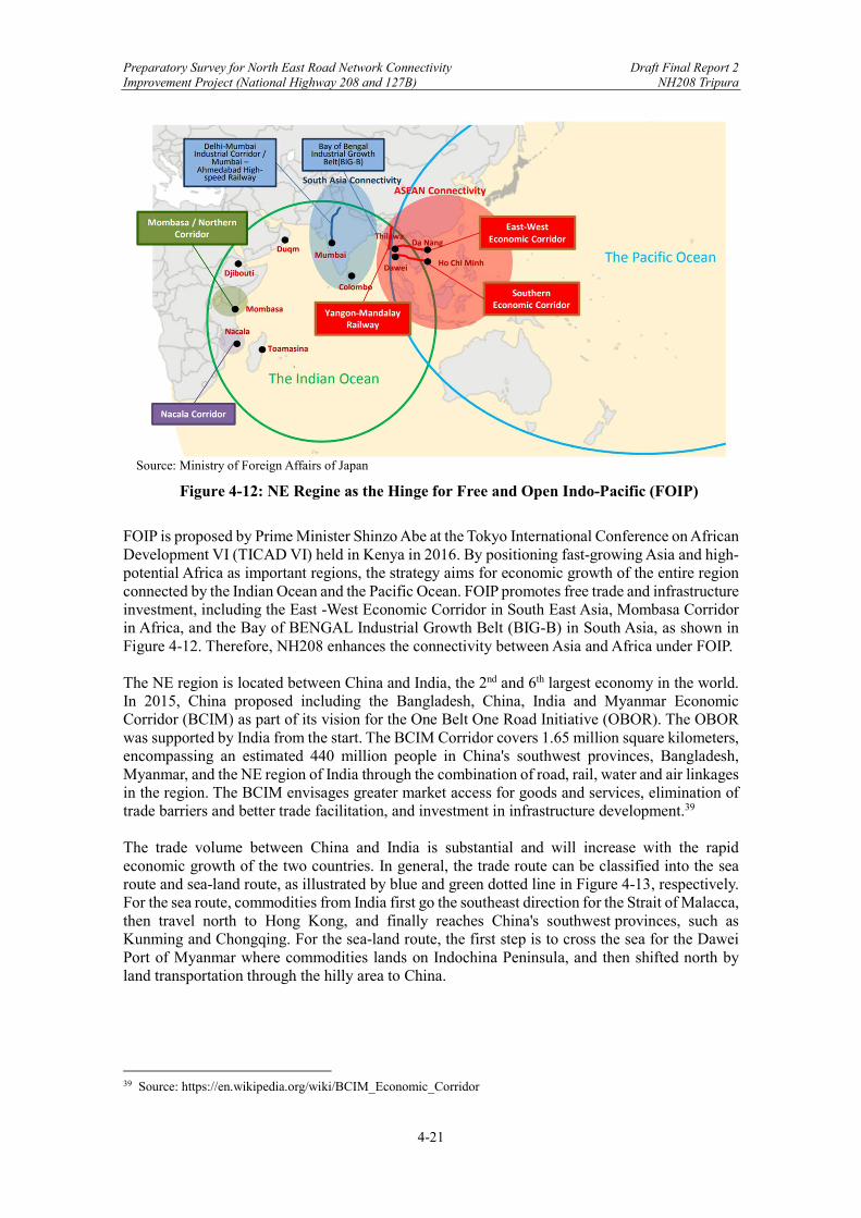
Preparatory Survey for North East Road Network Connectivity Draft Final Report 2 Improvement Project (National Highway 208 and 127B) NH208 Tripura
4-21
Source: Ministry of Foreign Affairs of Japan
Figure 4-12: NE Regine as the Hinge for Free and Open Indo-Pacific (FOIP)
FOIP is proposed by Prime Minister Shinzo Abe at the Tokyo International Conference on African Development VI (TICAD VI) held in Kenya in 2016. By positioning fast-growing Asia and high-potential Africa as important regions, the strategy aims for economic growth of the entire region connected by the Indian Ocean and the Pacific Ocean. FOIP promotes free trade and infrastructure investment, including the East -West Economic Corridor in South East Asia, Mombasa Corridor in Africa, and the Bay of BENGAL Industrial Growth Belt (BIG-B) in South Asia, as shown in Figure 4-12. Therefore, NH208 enhances the connectivity between Asia and Africa under FOIP. The NE region is located between China and India, the 2nd and 6th largest economy in the world. In 2015, China proposed including the Bangladesh, China, India and Myanmar Economic Corridor (BCIM) as part of its vision for the One Belt One Road Initiative (OBOR). The OBOR was supported by India from the start. The BCIM Corridor covers 1.65 million square kilometers, encompassing an estimated 440 million people in China's southwest provinces, Bangladesh, Myanmar, and the NE region of India through the combination of road, rail, water and air linkages in the region. The BCIM envisages greater market access for goods and services, elimination of trade barriers and better trade facilitation, and investment in infrastructure development.39 The trade volume between China and India is substantial and will increase with the rapid economic growth of the two countries. In general, the trade route can be classified into the sea route and sea-land route, as illustrated by blue and green dotted line in Figure 4-13, respectively. For the sea route, commodities from India first go the southeast direction for the Strait of Malacca, then travel north to Hong Kong, and finally reaches China's southwest provinces, such as Kunming and Chongqing. For the sea-land route, the first step is to cross the sea for the Dawei Port of Myanmar where commodities lands on Indochina Peninsula, and then shifted north by land transportation through the hilly area to China.
39 Source: https://en.wikipedia.org/wiki/BCIM_Economic_Corridor

Preparatory Survey for North East Road Network Connectivity Draft Final Report 2 Improvement Project (National Highway 208 and 127B) NH208 Tripura
4-22
Source: JICA Survey Team
Figure 4-13: China-India Trade Route
With the opening of NH208, a much shorter sea-land route for Indo-China trade can be expected. NH208 connects the Chittagong Port with the BCIM Corridor. Commodities from India can be transported to Chittagong Port first (the red route), go through NH208 and take the advantage of the BCIM Corridor to China. The distance saved will be substantial compared to the blue and green route. Therefore, the traffic diversion from global logistics network can be expected in the future. At the current state, it is difficult to estimate the potential traffic diversion after the road opening. All the broader scope connectivity projects, including the Kaladan Multi-Modal Transport Project at the regional level and the BCIM Corridor or OBOR at the global level, are in progress. The lack of actual traffic data, and the complexity of logistics network at the broader scope make the estimation impossible though a significant traffic diversion can be justified. In this report, it is conservatively estimated that the traffic diversion will create a 10% annual increase of the freight traffic on all sections of NH208 route when opened. Considering the broad scope and large volume of international trade, the diversion may take years before stabilization. Therefore, a five-year period (2026-2030) is set for this 10% annual increase.
4.8.4 Generated Traffic – Indo-Bangladesh Trade Agreement
Up to now, the traffic projection has considered the traffic diversion from the improvement of hard transport infrastructure projects. However, from the transport economics perspective, the rational travel choice is made based on the generalized cost, which consists of the road toll, time cost, and other costs such as service fee at Customs. This section will focus on the “soft infrastructure” of Indo-Bangladesh Trade Agreement, to investigate how the traffic projection is affected by the associated cross-border time reduce and procedure fee reduce under the Trade Agreement.
Preparatory Survey for North East Road Network Connectivity Draft Final Report 2 Improvement Project (National Highway 208 and 127B) NH208 Tripura
4-23
As introduced in Chapter 2, the restrictions on Indo-Bangladesh cross border trade remains though effort are being made. In October 2018, the Ministry of Shipping, Road Transport and Highways, India, and the Ministry of Shipping, Bangladesh signed an Agreement to allow the transport of goods between Chittagong Port and India. Following that, some negotiations were held in 2019 and early 2020, but the Agreement is still not fully reached. Interested reader could go to Chapter 2 for details. In general, the main points covered by Indo-Bangladesh Trade Agreement are:
Standardization of customs operation procedures and fees, removal of restrictions for a free trade environment.
Designated trade route and goods loading space, including the infrastructure development of NH208 route, the Feni River Bridge, the Ramgarh-Chittagong route in Bangladesh territory, and Sabroom LCS and SEZ (SEZ will be discussed in next section).
Motor Vehicles Agreements (MVAs) for free vehicle entry (such as Bangladesh-Bhutan-India-Myanmar Motor Vehicles Agreement in 2015) without the requirement for transshipment of goods from one country's truck to another at the border.
These points are extremely important and are in line with the World Bank’s Guideline on the development of well-functioning domestic and international logistics (see Box 4-2). If fully achieved, the Trade Agreement will smoothen border procedures, lower the cross-border cost, and save trade time significantly.
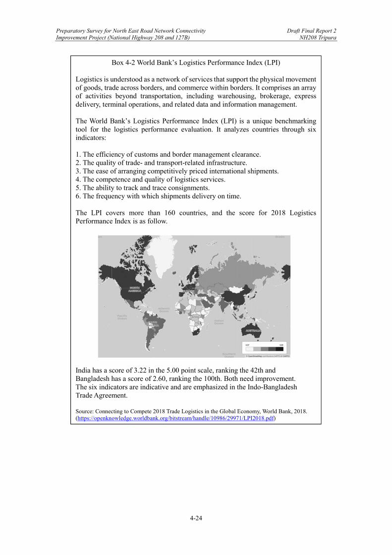
Preparatory Survey for North East Road Network Connectivity Draft Final Report 2 Improvement Project (National Highway 208 and 127B) NH208 Tripura
4-24
Box 4-2 World Bank’s Logistics Performance Index (LPI) Logistics is understood as a network of services that support the physical movement of goods, trade across borders, and commerce within borders. It comprises an array of activities beyond transportation, including warehousing, brokerage, express delivery, terminal operations, and related data and information management. The World Bank’s Logistics Performance Index (LPI) is a unique benchmarking tool for the logistics performance evaluation. It analyzes countries through six indicators: 1. The efficiency of customs and border management clearance. 2. The quality of trade- and transport-related infrastructure. 3. The ease of arranging competitively priced international shipments. 4. The competence and quality of logistics services. 5. The ability to track and trace consignments. 6. The frequency with which shipments delivery on time. The LPI covers more than 160 countries, and the score for 2018 Logistics Performance Index is as follow.
India has a score of 3.22 in the 5.00 point scale, ranking the 42th and Bangladesh has a score of 2.60, ranking the 100th. Both need improvement. The six indicators are indicative and are emphasized in the Indo-Bangladesh Trade Agreement. Source: Connecting to Compete 2018 Trade Logistics in the Global Economy, World Bank, 2018. (https://openknowledge.worldbank.org/bitstream/handle/10986/29971/LPI2018.pdf)
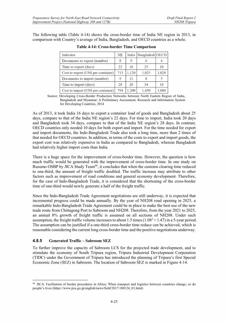
Preparatory Survey for North East Road Network Connectivity Draft Final Report 2 Improvement Project (National Highway 208 and 127B) NH208 Tripura
4-25
The following table (Table 4-14) shows the cross-border time of India NE region in 2013, in comparison with Country’s average of India, Bangladesh, and OECD countries as a whole.
Table 4-14: Cross-border Time Comparison
Source: Developing Cross-Border Production Networks between North Eastern Region of India,
Bangladesh and Myanmar: A Preliminary Assessment, Research and Information System for Developing Countries, 2014
As of 2013, it took India 16 days to export a container load of goods and Bangladesh about 25 days, compare to that of the India NE region’s 22 days. For time to import, India took 20 days and Bangladesh took 34 days, compare to that of the India NE region’s 28 days. In contrast, OECD countries only needed 10 days for both export and import. For the time needed for export and import documents, the Indo-Bangladesh Trade also took a long time, more than 2 times of that needed for OECD countries. In addition, in terms of the costs to export and import goods, the export cost was relatively expensive in India as compared to Bangladesh, whereas Bangladesh had relatively higher import costs than India. There is a huge space for the improvement of cross-border time. However, the question is how much traffic would be generated with the improvement of cross-border time. In one study on Rusumo OSBP by JICA Study Team40, it concludes that when the customs clearing time reduced to one-third, the amount of freight traffic doubled. The traffic increase may attribute to other factors such as improvement of road conditions and general economy development. Therefore, for the case of Indo-Bangladesh Trade, it is considered that the shortening of the cross-border time of one-third would newly generate a half of the freight traffic. Since the Indo-Bangladesh Trade Agreement negotiations are still underway, it is expected that incremental progress could be made annually. By the year of NH208 road opening in 2025, a remarkable Indo-Bangladesh Trade Agreement could be in place to make the best use of the new trade route from Chittagong Port to Sabroom and NH208. Therefore, from the year 2021 to 2025, an annual 8% growth of freight traffic is assumed on all sections of NH208. Under such assumption, the freight traffic volume increases to about 1.5 times (1.085 = 1.47) in a 5-year period. The assumption can be justified if a one-third cross-border time reduce can be achieved, which is reasonable considering the current long cross-border time and the positive negotiations underway.
4.8.5 Generated Traffic – Sabroom SEZ
To further improve the capacity of Sabroom LCS for the projected trade development, and to stimulate the economy of South Tripura region, Tripura Industrial Development Corporation (TIDC) under the Government of Tripura has introduced the planning of Tripura’s first Special Economic Zone (SEZ) in Sabroom. The location of Sabroom SEZ is marked in Figure 4-14.
40 JICA: Facilitation of border procedures in Africa: When transport and logistics between countries change, so do people’s lives (https://www.jica.go.jp/english/news/field/2017/180124_01.html)
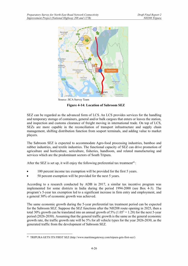
Preparatory Survey for North East Road Network Connectivity Draft Final Report 2 Improvement Project (National Highway 208 and 127B) NH208 Tripura
4-26
Source: JICA Survey Team
Figure 4-14: Location of Sabroom SEZ
SEZ can be regarded as the advanced form of LCS. An LCS provides services for the handling and temporary storage of containers, general and/or bulk cargoes that enters or leaves the station, and inspection and customs clearance of freight moving in international trade. On top of LCS, SEZs are more capable in the reconciliation of transport infrastructure and supply chain management, shifting distribution function from seaport terminals, and adding value to market players. The Sabroom SEZ is expected to accommodate Agro-food processing industries, bamboo and rubber industries, and textile industries. The functional capacity of SEZ can drive promotion of agriculture and horticulture, sericulture, fisheries, handloom, and related manufacturing and services which are the predominant sectors of South Tripura. After the SEZ is set up, it will enjoy the following preferential tax treatment41: 100 percent income tax exemption will be provided for the first 5 years. 50 percent exemption will be provided for the next 5 years. According to a research conducted by ADB in 2017, a similar tax incentive program was implemented for some districts in India during the period 1994-2000 (see Box 4-3). The program’s 5-year tax exemption led to a significant increase in firm entry and employment, and a general 30% of economic growth was achieved. The same economic growth during the 5-year preferential tax treatment period can be expected for the Sabroom SEZ. Suppose the SEZ functions after the NH208 route opening in 2025, then a total 30% growth can be translated into an annual growth of 5% (1.055 = 1.28) for the next 5-year period (2026-2030). Assuming that the general traffic growth is the same as the general economic growth rate, the traffic growth rate will be 5% for all vehicle types for the year 2026-2030, as the generated traffic from the development of Sabroom SEZ.
41 TRIPURA GETS ITS FIRST SEZ (http://www.maritimegateway.com/tripura-gets-first-sez/)
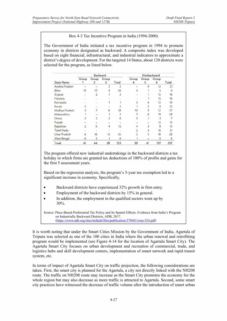
Preparatory Survey for North East Road Network Connectivity Draft Final Report 2 Improvement Project (National Highway 208 and 127B) NH208 Tripura
4-27
It is worth noting that under the Smart Cities Mission by the Government of India, Agartala of Tripura was selected as one of the 100 cities in India where the urban renewal and retrofitting program would be implemented (see Figure 4-14 for the location of Agartala Smart City). The Agartala Smart City focuses on urban development and recreation of commercial, trade, and logistics hubs and skill development centers, implementation of smart network and rapid transit system, etc. In terms of impact of Agartala Smart City on traffic projection, the following considerations are taken. First, the smart city is planned for the Agartala, a city not directly linked with the NH208 route. The traffic on NH208 route may increase as the Smart City promotes the economy for the whole region but may also decrease as more traffic is attracted to Agartala. Second, some smart city practices have witnessed the decrease of traffic volume after the introduction of smart urban
Box 4-3 Tax Incentive Program in India (1994-2000) The Government of India initiated a tax incentive program in 1994 to promote economy in districts designated as backward. A composite index was developed based on eight financial, infrastructural, and industrial indicators to approximate a district’s degree of development. For the targeted 14 States, about 120 districts were selected for the program, as listed below.
The program offered new industrial undertakings in the backward districts a tax holiday in which firms are granted tax deductions of 100% of profits and gains for the first 5 assessment years. Based on the regression analysis, the program’s 5-year tax exemption led to a significant increase in economy. Specifically, Backward districts have experienced 32% growth in firm entry. Employment of the backward districts by 15% in general. In addition, the employment in the qualified sectors went up by
30%. Source: Place-Based Preferential Tax Policy and Its Spatial Effects: Evidence from India’s Program
on Industrially Backward Districts, ADB, 2017. (https://www.adb.org/sites/default/files/publication/379681/ewp-524.pdf)

Preparatory Survey for North East Road Network Connectivity Draft Final Report 2 Improvement Project (National Highway 208 and 127B) NH208 Tripura
4-28
traffic. Therefore, the impact of Smart City on traffic is not clear at current stage and thus not considered in this projection
4.8.6 Final Traffic Projection
Based on DPR’s traffic projection and JICA’s revision, this sub-section considered the traffic diversion and generation on a broader scope. The traffic growth rate, in terms of vehicle types, NH208 sections, and year ranges are summarized in Table 4-15. Based on the traffic growth rate, the traffic projection for each route section is revised, and the result is listed in Table 4-16, Table 4-17, Table 4-18, and Table 4-19. Finally, a summary of the final traffic projection is provided in Table 4-20.
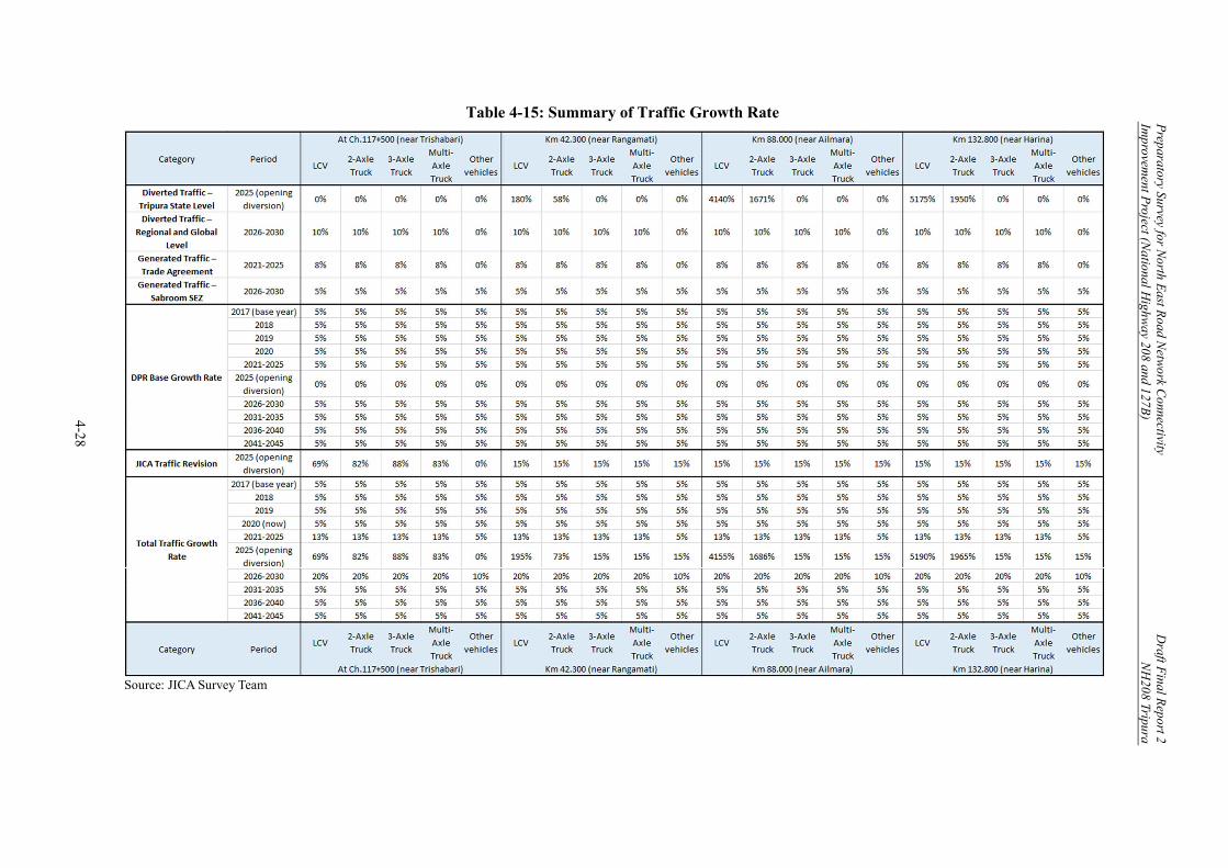
Preparatory Survey for N
orth East R
oad Netw
ork Connectivity
Draft F
inal Report 2
Improvem
ent Project (N
ational Highw
ay 208 and 127B)
NH
208 Tripura
4-28
Table 4-15: Summary of Traffic Growth Rate
Source: JICA Survey Team
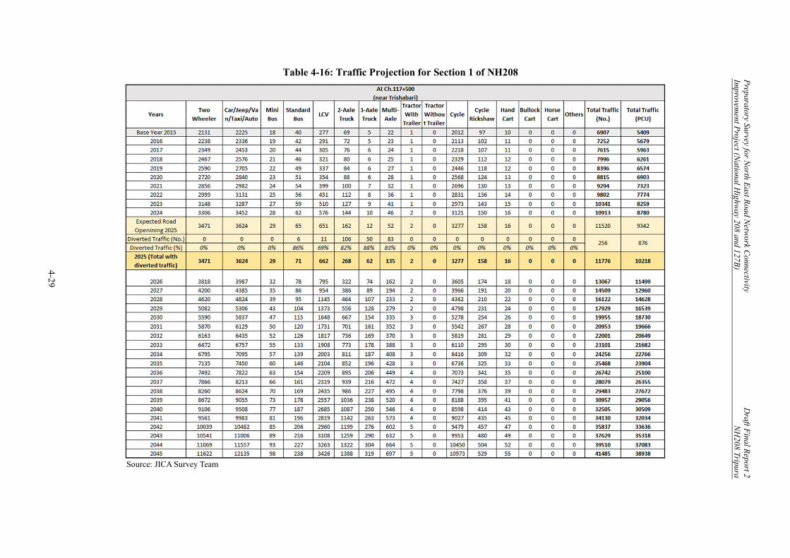
Preparatory Survey for N
orth East R
oad Netw
ork Connectivity
Draft F
inal Report 2
Improvem
ent Project (N
ational Highw
ay 208 and 127B)
NH
208 Tripura
4-29
Table 4-16: Traffic Projection for Section 1 of NH208
Source: JICA Survey Team

Preparatory Survey for N
orth East R
oad Netw
ork Connectivity
Draft F
inal Report 2
Improvem
ent Project (N
ational Highw
ay 208 and 127B)
NH
208 Tripura
4-30
Table 4-17: Traffic Projection for Section 2 of NH208
Source: JICA Survey Team
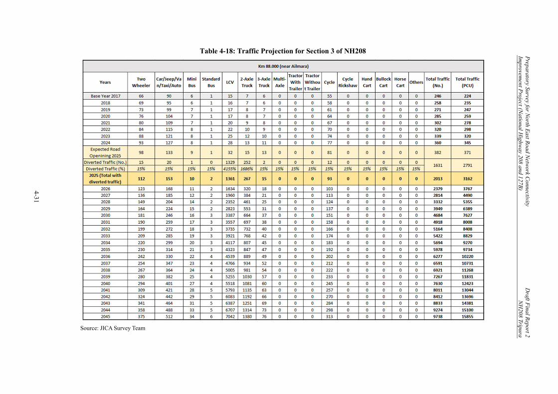
Preparatory Survey for N
orth East R
oad Netw
ork Connectivity
Draft F
inal Report 2
Improvem
ent Project (N
ational Highw
ay 208 and 127B)
NH
208 Tripura
4-31
Table 4-18: Traffic Projection for Section 3 of NH208
Source: JICA Survey Team

Preparatory Survey for N
orth East R
oad Netw
ork Connectivity
Draft F
inal Report 2
Improvem
ent Project (N
ational Highw
ay 208 and 127B)
NH
208 Tripura
4-32
Table 4-19: Traffic Projection for Section 4 of NH208
Source: JICA Survey Team

Preparatory Survey for N
orth East R
oad Netw
ork Connectivity
Draft F
inal Report 2
Improvem
ent Project (N
ational Highw
ay 208 and 127B)
NH
208 Tripura
4-33
Table 4-20: Summary of Final Traffic Projection
Source: JICA Survey Team

Preparatory Survey for North East Road Network Connectivity Draft Final Report 2 Improvement Project (National Highway 208 and 127B) NH208 Tripura
4-34
Chapter 4. Traffic Survey, Analysis and Forecast ............................................................... 1
4.1 General ........................................................................................................................ 1 4.2 Survey Road Network/Sections .................................................................................. 1 4.3 Traffic Survey .............................................................................................................. 2 4.4 Traffic Survey Results ................................................................................................. 5
4.4.1 Classified Traffic Count Survey Analysis ........................................................... 5 4.4.2 Daily and Hourly Traffic Variations, Peak Hour Factor (PHF), and
Average Seasonal Variation Factor (ASVF) ........................................................ 6 4.4.3 Annual Average Daily Traffic (AADT) ............................................................... 7
4.5 Traffic Projection Methodology .................................................................................. 8 4.5.1 Existing Traffic Data ........................................................................................... 8 4.5.2 Homogeneous Sections ....................................................................................... 8 4.5.3 Consideration/ Assumptions by DPR Consultants .............................................. 8
4.6 Traffic Projection in DPR .......................................................................................... 10 4.7 Revisions by the JICA Survey Team ......................................................................... 10
4.7.1 Revision of Traffic Growth Assumptions .......................................................... 10 4.7.2 Revised Traffic Growth Rates ........................................................................... 10 4.7.3 Revised Traffic Projections ............................................................................... 10
4.8 Further Revision of Traffic Projection ...................................................................... 11 4.8.1 Justification for Further Revision ...................................................................... 11 4.8.2 Diverted Traffic – Tripura State Level .............................................................. 12 4.8.3 Diverted Traffic – Regional and Global Level .................................................. 18 4.8.4 Generated Traffic – Indo-Bangladesh Trade Agreement ................................... 22 4.8.5 Generated Traffic – Sabroom SEZ .................................................................... 25 4.8.6 Final Traffic Projection ..................................................................................... 29
Figure 4-1: Survey Corridor map for NH208 (Tripura) ................................................................ 1 Figure 4-2: Trade Routes under World Bank’s Bangladesh Regional Connectivity Project 1 ...... 2 Figure 4-3: Chainage along the Survey Corridors......................................................................... 3 Figure 4-4: Vehicle Types on NH208 Tripura ............................................................................... 6 Figure 4-5: Motorized Vehicles vs. Non-Motorized Vehicles on NH208 Tripura ......................... 6 Figure 4-6: NH208 and Existing Alternate Routes ....................................................................... 9 Figure 4-7: Strategic Role of NH208 for Tripura State ............................................................... 13 Figure 4-8: LCSs in Tripura ........................................................................................................ 14 Figure 4-9: Population Estimation for Sabroom LCS Hinterland ............................................... 15 Figure 4-10: Location and Traffic Survey Result of Manughat LCS .......................................... 16 Figure 4-11: NE Regional Connectivity Network ....................................................................... 19 Figure 4-12: NE Regine as the Hinge for Free and Open Indo-Pacific (FOIP) .......................... 21 Figure 4-13: China-India Trade Route ........................................................................................ 22 Figure 4-14: Location of Sabroom SEZ ...................................................................................... 26 Table 4-1: Survey Road Network and Sections ............................................................................. 1 Table 4-2: Traffic Surveys at NH208, Tripura............................................................................... 3 Table 4-3: PCU Factors ................................................................................................................. 4 Table 4-4: Average Daily Traffic (NH208, Tripura) ...................................................................... 5 Table 4-5: Peak Hour Factor for NH208 Tripura .......................................................................... 7 Table 4-6: AADT on Homogeneous Sections of NH208 Tripura ................................................. 7 Table 4-7: Diverted Traffic on NH208 Tripura ............................................................................. 8
Preparatory Survey for North East Road Network Connectivity Draft Final Report 2 Improvement Project (National Highway 208 and 127B) NH208 Tripura
4-35
Table 4-8: Traffic Projections by DPR Consultant for NH208 Tripura ....................................... 10 Table 4-9: Revised Traffic Forecasts for NH208 Tripura ............................................................. 11 Table 4-10: Composition of Commodity-wise Imports (2018-19) .............................................. 14 Table 4-11: Trade Volume of LCSs in Tripura (2014-19) ........................................................... 17 Table 4-12: Summary of Traffic Diversion and Growth Rate ..................................................... 18 Table 4-13: Components of Kaladan Multimodal Transit Transport Project .............................. 19 Table 4-14: Cross-border Time Comparison ............................................................................... 25 Table 4-15: Summary of Traffic Growth Rate ............................................................................ 28 Table 4-16: Traffic Projection for Section 1 of NH208 ............................................................... 29 Table 4-17: Traffic Projection for Section 2 of NH208 ............................................................... 30 Table 4-18: Traffic Projection for Section 3 of NH208 ............................................................... 31 Table 4-19: Traffic Projection for Section 4 of NH208 ............................................................... 32 Table 4-20: Summary of Final Traffic Projection ....................................................................... 33
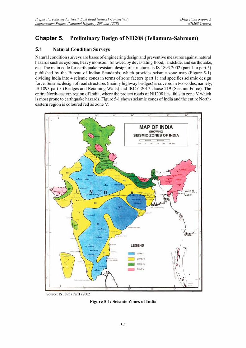
Preparatory Survey for North East Road Network Connectivity Draft Final Report 2 Improvement Project (National Highway 208 and 127B) NH208 Tripura
5-1
Chapter 5. Preliminary Design of NH208 (Teliamura-Sabroom)
5.1 Natural Condition Surveys
Natural condition surveys are bases of engineering design and preventive measures against natural hazards such as cyclone, heavy monsoon followed by devastating flood, landslide, and earthquake, etc. The main code for earthquake resistant design of structures is IS 1893 2002 (part 1 to part 5) published by the Bureau of Indian Standards, which provides seismic zone map (Figure 5-1) dividing India into 4 seismic zones in terms of zone factors (part 1) and specifies seismic design force. Seismic design of road structures (mainly highway bridges) is covered in two codes, namely, IS 1893 part 3 (Bridges and Retaining Walls) and IRC 6-2017 clause 219 (Seismic Force). The entire North-eastern region of India, where the project roads of NH208 lies, falls in zone V which is most prone to earthquake hazards. Figure 5-1 shows seismic zones of India and the entire North-eastern region is coloured red as zone V:
Source: IS 1893 (Part1) 2002
Figure 5-1: Seismic Zones of India
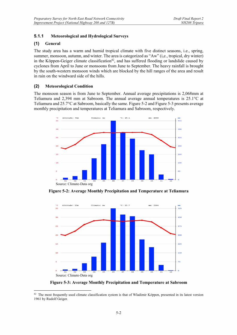
Preparatory Survey for North East Road Network Connectivity Draft Final Report 2 Improvement Project (National Highway 208 and 127B) NH208 Tripura
5-2
5.1.1 Meteorological and Hydrological Surveys
(1) General
The study area has a warm and humid tropical climate with five distinct seasons, i.e., spring, summer, monsoon, autumn, and winter. The area is categorized as “Aw” (i,e., tropical, dry winter) in the Köppen-Geiger climate classification42, and has suffered flooding or landslide caused by cyclones from April to June or monsoons from June to September. The heavy rainfall is brought by the south-western monsoon winds which are blocked by the hill ranges of the area and result in rain on the windward side of the hills. (2) Meteorological Condition
The monsoon season is from June to September. Annual average precipitations is 2,068mm at Teliamura and 2,394 mm at Sabroom. The annual average annual temperatures is 25.1°C at Teliamura and 25.7°C at Sabroom, basically the same. Figure 5-2 and Figure 5-3 presents average monthly precipitation and temperatures at Teliamura and Sabroom, respectively.
Source: Climate-Data org
Figure 5-2: Average Monthly Precipitation and Temperature at Teliamura
Source: Climate-Data org
Figure 5-3: Average Monthly Precipitation and Temperature at Sabroom
42 The most frequently used climate classification system is that of Wladimir Köppen, presented in its latest version 1961 by Rudolf Geiger.

Preparatory Survey for North East Road Network Connectivity Draft Final Report 2 Improvement Project (National Highway 208 and 127B) NH208 Tripura
5-3
(3) Hydrological Survey
Pursuant to IRC SP-13-2004 and IRC SP-42-2014, a hydrological survey was conducted to obtain hydraulic design data for bridges and drainage facilities during floods. The flooding parameters were studied with topographic maps. The necessary parameters for each drainage facility are (i) the catchment area, (ii) tributary length, and (iii) differences in elevation along the road. Calculation of the flood discharge volume, is described in Section 5.3.6 Drainage Design. Figure 5-4 presents an example of catchment area, of which full data is provided in Appendix C-1.
Source: DPR by TASPL Engineering Consultants
Figure 5-4: An Example of Catchment Area
Bridge Chainage (Km) 12+900 Catchment Area 32.70 Sq. Km Length of Stream 13Km
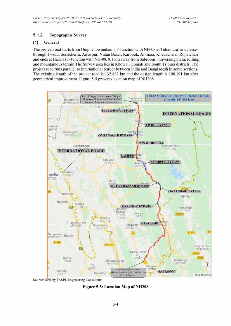
Preparatory Survey for North East Road Network Connectivity Draft Final Report 2 Improvement Project (National Highway 208 and 127B) NH208 Tripura
5-4
5.1.2 Topographic Survey
(1) General
The project road starts from Ompi chowmuhani (T-Junction with NH-08 at Teliamura) and passes through Twidu, Sonacherra, Amarpur, Nutan Bazar, Karbook, Ailmara, Khedacherri, Ropaichari and ends at Harina (T-Junction with NH-08, 8.1 km away from Sabroom), traversing plain, rolling, and mountainous terrain The Survey area lies in Khowai, Gomati and South Tripura districts. The project road runs parallel to international border between India and Bangladesh in some sections. The existing length of the project road is 132.882 km and the design length is 108.191 km after geometrical improvement. Figure 5-5 presents location map of NH208.
Source: DPR by TASPL Engineering Consultants
Figure 5-5: Location Map of NH208
Preparatory Survey for North East Road Network Connectivity Draft Final Report 2 Improvement Project (National Highway 208 and 127B) NH208 Tripura
5-5
(2) Review of the DPR Survey
The JICA Survey Team has not yet conducted a site survey due to COVID-19-related travel constraints. However, topographic survey data including computer-aided design (CAD) files from the DPR consultant were received and reviewed by the Team. Through the survey, longitudinal sections along the road alignment at 25 m intervals and cross-sections at 50 m intervals were obtained. The plan covers all permanent features near the alignment, the existing roads, foot tracks, cart tracks, wells, shops, houses /buildings, temples, community structures, retaining structures, cross drainage structures, utility services, etc. The survey was conducted using total stations and Global Positioning System (GPS). Control points and benchmarks were fixed and tied to GTS (Great Trigonometrical Survey) benchmark established by Survey of India to verify the accuracy of the survey. Results of the road geometric design based on the survey are presented as Table 5-1 Horizontal Alignment Report and Table 5-2 Vertical Alignment Report. The full reports are provided in Appendix A-1 and A-2.
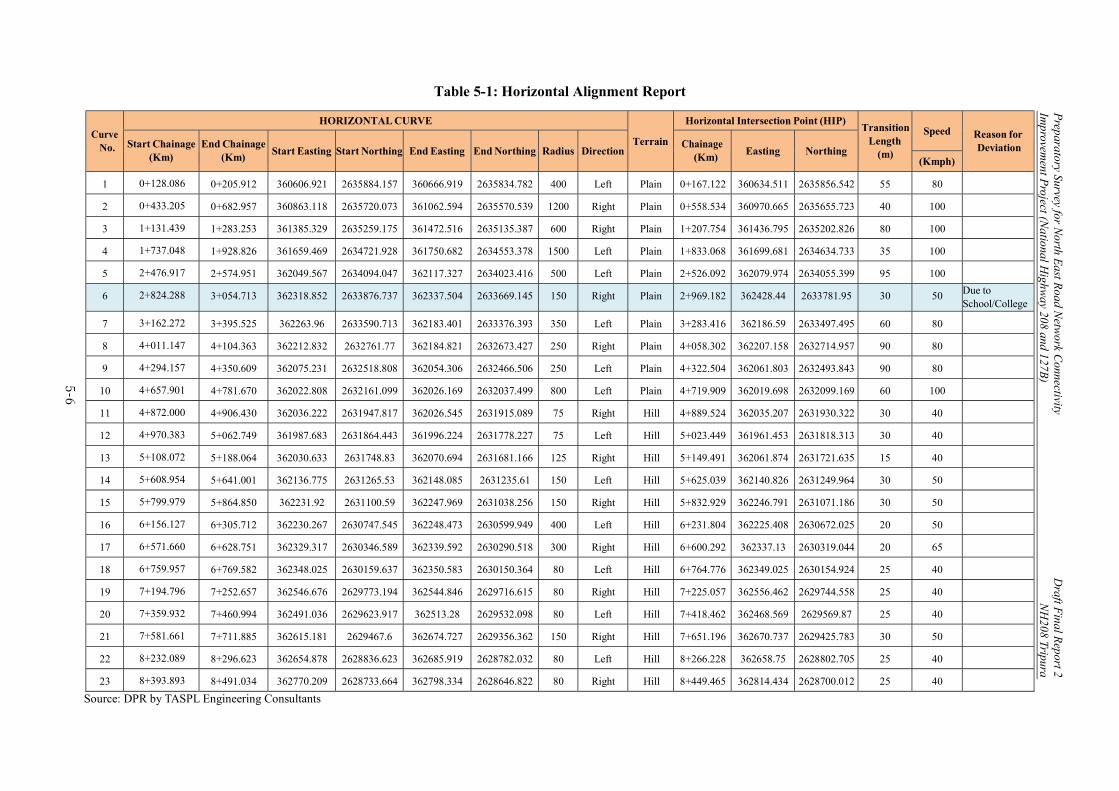
Preparatory Survey for N
orth East R
oad Netw
ork Connectivity
Draft F
inal Report 2
Improvem
ent Project (N
ational Highw
ay 208 and 127B)
NH
208 Tripura
5-6
Table 5-1: Horizontal Alignment Report
Curve No.
HORIZONTAL CURVE
Terrain
Horizontal Intersection Point (HIP) Transition
Length (m)
Speed Reason for Deviation Start Chainage
(Km) End Chainage
(Km) Start Easting Start Northing End Easting End Northing Radius Direction
Chainage (Km)
Easting Northing (Kmph)
1 0+128.086 0+205.912 360606.921 2635884.157 360666.919 2635834.782 400 Left Plain 0+167.122 360634.511 2635856.542 55 80
2 0+433.205 0+682.957 360863.118 2635720.073 361062.594 2635570.539 1200 Right Plain 0+558.534 360970.665 2635655.723 40 100
3 1+131.439 1+283.253 361385.329 2635259.175 361472.516 2635135.387 600 Right Plain 1+207.754 361436.795 2635202.826 80 100
4 1+737.048 1+928.826 361659.469 2634721.928 361750.682 2634553.378 1500 Left Plain 1+833.068 361699.681 2634634.733 35 100
5 2+476.917 2+574.951 362049.567 2634094.047 362117.327 2634023.416 500 Left Plain 2+526.092 362079.974 2634055.399 95 100
6 2+824.288 3+054.713 362318.852 2633876.737 362337.504 2633669.145 150 Right Plain 2+969.182 362428.44 2633781.95 30 50 Due to School/College
7 3+162.272 3+395.525 362263.96 2633590.713 362183.401 2633376.393 350 Left Plain 3+283.416 362186.59 2633497.495 60 80
8 4+011.147 4+104.363 362212.832 2632761.77 362184.821 2632673.427 250 Right Plain 4+058.302 362207.158 2632714.957 90 80
9 4+294.157 4+350.609 362075.231 2632518.808 362054.306 2632466.506 250 Left Plain 4+322.504 362061.803 2632493.843 90 80
10 4+657.901 4+781.670 362022.808 2632161.099 362026.169 2632037.499 800 Left Plain 4+719.909 362019.698 2632099.169 60 100
11 4+872.000 4+906.430 362036.222 2631947.817 362026.545 2631915.089 75 Right Hill 4+889.524 362035.207 2631930.322 30 40
12 4+970.383 5+062.749 361987.683 2631864.443 361996.224 2631778.227 75 Left Hill 5+023.449 361961.453 2631818.313 30 40
13 5+108.072 5+188.064 362030.633 2631748.83 362070.694 2631681.166 125 Right Hill 5+149.491 362061.874 2631721.635 15 40
14 5+608.954 5+641.001 362136.775 2631265.53 362148.085 2631235.61 150 Left Hill 5+625.039 362140.826 2631249.964 30 50
15 5+799.979 5+864.850 362231.92 2631100.59 362247.969 2631038.256 150 Right Hill 5+832.929 362246.791 2631071.186 30 50
16 6+156.127 6+305.712 362230.267 2630747.545 362248.473 2630599.949 400 Left Hill 6+231.804 362225.408 2630672.025 20 50
17 6+571.660 6+628.751 362329.317 2630346.589 362339.592 2630290.518 300 Right Hill 6+600.292 362337.13 2630319.044 20 65
18 6+759.957 6+769.582 362348.025 2630159.637 362350.583 2630150.364 80 Left Hill 6+764.776 362349.025 2630154.924 25 40
19 7+194.796 7+252.657 362546.676 2629773.194 362544.846 2629716.615 80 Right Hill 7+225.057 362556.462 2629744.558 25 40
20 7+359.932 7+460.994 362491.036 2629623.917 362513.28 2629532.098 80 Left Hill 7+418.462 362468.569 2629569.87 25 40
21 7+581.661 7+711.885 362615.181 2629467.6 362674.727 2629356.362 150 Right Hill 7+651.196 362670.737 2629425.783 30 50
22 8+232.089 8+296.623 362654.878 2628836.623 362685.919 2628782.032 80 Left Hill 8+266.228 362658.75 2628802.705 25 40
23 8+393.893 8+491.034 362770.209 2628733.664 362798.334 2628646.822 80 Right Hill 8+449.465 362814.434 2628700.012 25 40
Source: DPR by TASPL Engineering Consultants
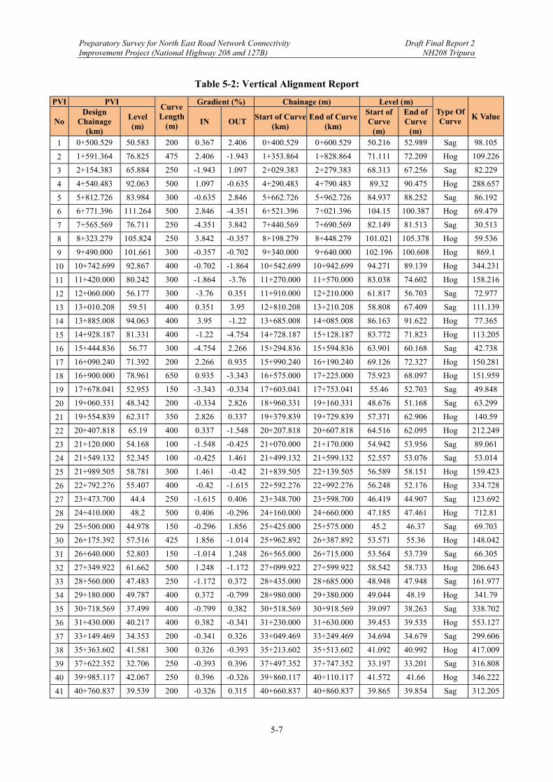
Preparatory Survey for North East Road Network Connectivity Draft Final Report 2 Improvement Project (National Highway 208 and 127B) NH208 Tripura
5-7
Table 5-2: Vertical Alignment Report
PVI PVI Curve Length
(m)
Gradient (%) Chainage (m) Level (m) Type Of Curve
K Value No
Design Chainage
(km)
Level (m)
IN OUT Start of Curve
(km) End of Curve
(km)
Start of Curve
(m)
End of Curve
(m)
1 0+500.529 50.583 200 0.367 2.406 0+400.529 0+600.529 50.216 52.989 Sag 98.105
2 1+591.364 76.825 475 2.406 ‐1.943 1+353.864 1+828.864 71.111 72.209 Hog 109.226
3 2+154.383 65.884 250 ‐1.943 1.097 2+029.383 2+279.383 68.313 67.256 Sag 82.229
4 4+540.483 92.063 500 1.097 ‐0.635 4+290.483 4+790.483 89.32 90.475 Hog 288.657
5 5+812.726 83.984 300 ‐0.635 2.846 5+662.726 5+962.726 84.937 88.252 Sag 86.192
6 6+771.396 111.264 500 2.846 ‐4.351 6+521.396 7+021.396 104.15 100.387 Hog 69.479
7 7+565.569 76.711 250 ‐4.351 3.842 7+440.569 7+690.569 82.149 81.513 Sag 30.513
8 8+323.279 105.824 250 3.842 ‐0.357 8+198.279 8+448.279 101.021 105.378 Hog 59.536
9 9+490.000 101.661 300 ‐0.357 ‐0.702 9+340.000 9+640.000 102.196 100.608 Hog 869.1
10 10+742.699 92.867 400 ‐0.702 ‐1.864 10+542.699 10+942.699 94.271 89.139 Hog 344.231
11 11+420.000 80.242 300 ‐1.864 ‐3.76 11+270.000 11+570.000 83.038 74.602 Hog 158.216
12 12+060.000 56.177 300 ‐3.76 0.351 11+910.000 12+210.000 61.817 56.703 Sag 72.977
13 13+010.208 59.51 400 0.351 3.95 12+810.208 13+210.208 58.808 67.409 Sag 111.139
14 13+885.008 94.063 400 3.95 ‐1.22 13+685.008 14+085.008 86.163 91.622 Hog 77.365
15 14+928.187 81.331 400 ‐1.22 ‐4.754 14+728.187 15+128.187 83.772 71.823 Hog 113.205
16 15+444.836 56.77 300 ‐4.754 2.266 15+294.836 15+594.836 63.901 60.168 Sag 42.738
17 16+090.240 71.392 200 2.266 0.935 15+990.240 16+190.240 69.126 72.327 Hog 150.281
18 16+900.000 78.961 650 0.935 ‐3.343 16+575.000 17+225.000 75.923 68.097 Hog 151.959
19 17+678.041 52.953 150 ‐3.343 ‐0.334 17+603.041 17+753.041 55.46 52.703 Sag 49.848
20 19+060.331 48.342 200 ‐0.334 2.826 18+960.331 19+160.331 48.676 51.168 Sag 63.299
21 19+554.839 62.317 350 2.826 0.337 19+379.839 19+729.839 57.371 62.906 Hog 140.59
22 20+407.818 65.19 400 0.337 ‐1.548 20+207.818 20+607.818 64.516 62.095 Hog 212.249
23 21+120.000 54.168 100 ‐1.548 ‐0.425 21+070.000 21+170.000 54.942 53.956 Sag 89.061
24 21+549.132 52.345 100 ‐0.425 1.461 21+499.132 21+599.132 52.557 53.076 Sag 53.014
25 21+989.505 58.781 300 1.461 ‐0.42 21+839.505 22+139.505 56.589 58.151 Hog 159.423
26 22+792.276 55.407 400 ‐0.42 ‐1.615 22+592.276 22+992.276 56.248 52.176 Hog 334.728
27 23+473.700 44.4 250 ‐1.615 0.406 23+348.700 23+598.700 46.419 44.907 Sag 123.692
28 24+410.000 48.2 500 0.406 ‐0.296 24+160.000 24+660.000 47.185 47.461 Hog 712.81
29 25+500.000 44.978 150 ‐0.296 1.856 25+425.000 25+575.000 45.2 46.37 Sag 69.703
30 26+175.392 57.516 425 1.856 ‐1.014 25+962.892 26+387.892 53.571 55.36 Hog 148.042
31 26+640.000 52.803 150 ‐1.014 1.248 26+565.000 26+715.000 53.564 53.739 Sag 66.305
32 27+349.922 61.662 500 1.248 ‐1.172 27+099.922 27+599.922 58.542 58.733 Hog 206.643
33 28+560.000 47.483 250 ‐1.172 0.372 28+435.000 28+685.000 48.948 47.948 Sag 161.977
34 29+180.000 49.787 400 0.372 ‐0.799 28+980.000 29+380.000 49.044 48.19 Hog 341.79
35 30+718.569 37.499 400 ‐0.799 0.382 30+518.569 30+918.569 39.097 38.263 Sag 338.702
36 31+430.000 40.217 400 0.382 ‐0.341 31+230.000 31+630.000 39.453 39.535 Hog 553.127
37 33+149.469 34.353 200 ‐0.341 0.326 33+049.469 33+249.469 34.694 34.679 Sag 299.606
38 35+363.602 41.581 300 0.326 ‐0.393 35+213.602 35+513.602 41.092 40.992 Hog 417.009
39 37+622.352 32.706 250 ‐0.393 0.396 37+497.352 37+747.352 33.197 33.201 Sag 316.808
40 39+985.117 42.067 250 0.396 ‐0.326 39+860.117 40+110.117 41.572 41.66 Hog 346.222
41 40+760.837 39.539 200 ‐0.326 0.315 40+660.837 40+860.837 39.865 39.854 Sag 312.205
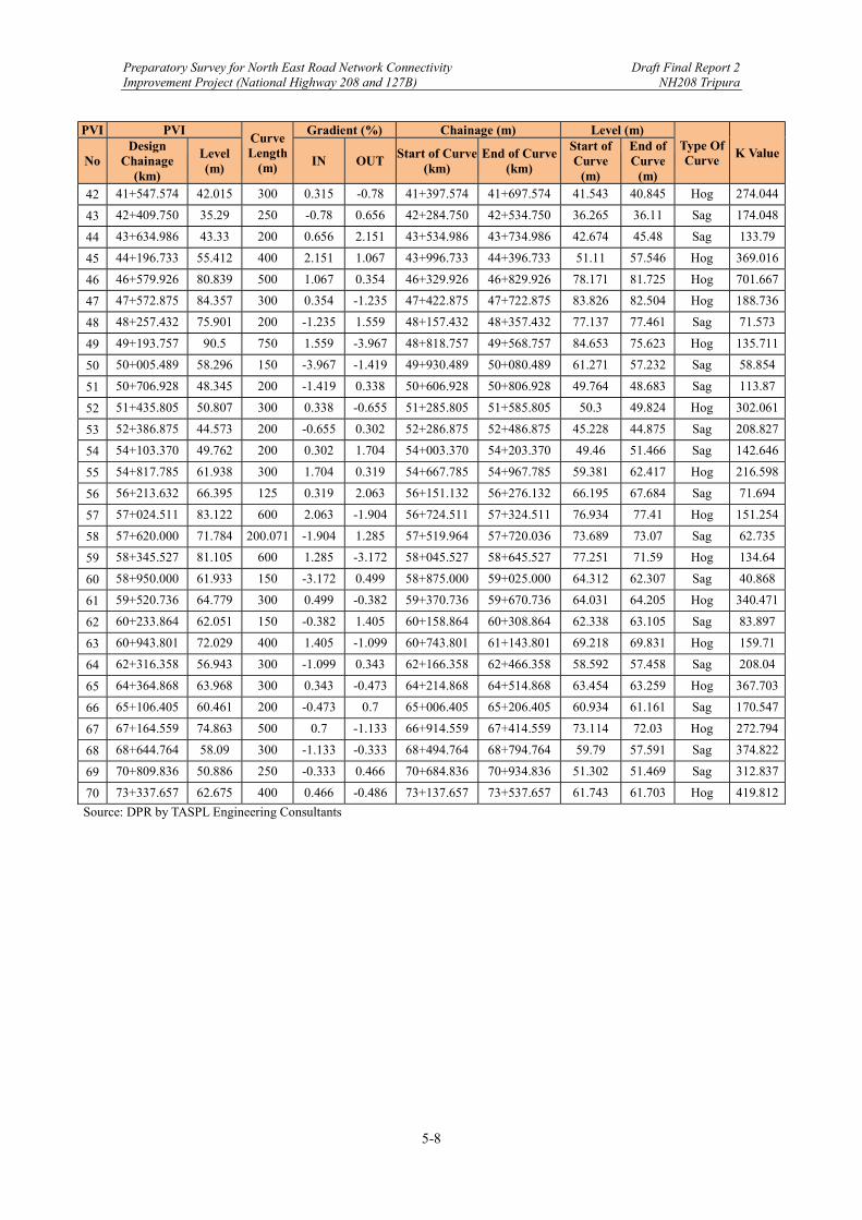
Preparatory Survey for North East Road Network Connectivity Draft Final Report 2 Improvement Project (National Highway 208 and 127B) NH208 Tripura
5-8
PVI PVI Curve Length
(m)
Gradient (%) Chainage (m) Level (m) Type Of Curve
K Value No
Design Chainage
(km)
Level (m)
IN OUT Start of Curve
(km) End of Curve
(km)
Start of Curve
(m)
End of Curve
(m)
42 41+547.574 42.015 300 0.315 ‐0.78 41+397.574 41+697.574 41.543 40.845 Hog 274.044
43 42+409.750 35.29 250 ‐0.78 0.656 42+284.750 42+534.750 36.265 36.11 Sag 174.048
44 43+634.986 43.33 200 0.656 2.151 43+534.986 43+734.986 42.674 45.48 Sag 133.79
45 44+196.733 55.412 400 2.151 1.067 43+996.733 44+396.733 51.11 57.546 Hog 369.016
46 46+579.926 80.839 500 1.067 0.354 46+329.926 46+829.926 78.171 81.725 Hog 701.667
47 47+572.875 84.357 300 0.354 ‐1.235 47+422.875 47+722.875 83.826 82.504 Hog 188.736
48 48+257.432 75.901 200 ‐1.235 1.559 48+157.432 48+357.432 77.137 77.461 Sag 71.573
49 49+193.757 90.5 750 1.559 ‐3.967 48+818.757 49+568.757 84.653 75.623 Hog 135.711
50 50+005.489 58.296 150 ‐3.967 ‐1.419 49+930.489 50+080.489 61.271 57.232 Sag 58.854
51 50+706.928 48.345 200 ‐1.419 0.338 50+606.928 50+806.928 49.764 48.683 Sag 113.87
52 51+435.805 50.807 300 0.338 ‐0.655 51+285.805 51+585.805 50.3 49.824 Hog 302.061
53 52+386.875 44.573 200 ‐0.655 0.302 52+286.875 52+486.875 45.228 44.875 Sag 208.827
54 54+103.370 49.762 200 0.302 1.704 54+003.370 54+203.370 49.46 51.466 Sag 142.646
55 54+817.785 61.938 300 1.704 0.319 54+667.785 54+967.785 59.381 62.417 Hog 216.598
56 56+213.632 66.395 125 0.319 2.063 56+151.132 56+276.132 66.195 67.684 Sag 71.694
57 57+024.511 83.122 600 2.063 ‐1.904 56+724.511 57+324.511 76.934 77.41 Hog 151.254
58 57+620.000 71.784 200.071 ‐1.904 1.285 57+519.964 57+720.036 73.689 73.07 Sag 62.735
59 58+345.527 81.105 600 1.285 ‐3.172 58+045.527 58+645.527 77.251 71.59 Hog 134.64
60 58+950.000 61.933 150 ‐3.172 0.499 58+875.000 59+025.000 64.312 62.307 Sag 40.868
61 59+520.736 64.779 300 0.499 ‐0.382 59+370.736 59+670.736 64.031 64.205 Hog 340.471
62 60+233.864 62.051 150 ‐0.382 1.405 60+158.864 60+308.864 62.338 63.105 Sag 83.897
63 60+943.801 72.029 400 1.405 ‐1.099 60+743.801 61+143.801 69.218 69.831 Hog 159.71
64 62+316.358 56.943 300 ‐1.099 0.343 62+166.358 62+466.358 58.592 57.458 Sag 208.04
65 64+364.868 63.968 300 0.343 ‐0.473 64+214.868 64+514.868 63.454 63.259 Hog 367.703
66 65+106.405 60.461 200 ‐0.473 0.7 65+006.405 65+206.405 60.934 61.161 Sag 170.547
67 67+164.559 74.863 500 0.7 ‐1.133 66+914.559 67+414.559 73.114 72.03 Hog 272.794
68 68+644.764 58.09 300 ‐1.133 ‐0.333 68+494.764 68+794.764 59.79 57.591 Sag 374.822
69 70+809.836 50.886 250 ‐0.333 0.466 70+684.836 70+934.836 51.302 51.469 Sag 312.837
70 73+337.657 62.675 400 0.466 ‐0.486 73+137.657 73+537.657 61.743 61.703 Hog 419.812
Source: DPR by TASPL Engineering Consultants

Preparatory Survey for North East Road Network Connectivity Draft Final Report 2 Improvement Project (National Highway 208 and 127B) NH208 Tripura
5-9
5.1.3 Geological Survey
(1) Tectonics of the Tripura Hills
As shown in Figure 5-6, the Tripura Hill, where the Project Road passes through, is geologically called “Chittagong-Tripura Fold Belt (CTFB)”. It is the geomorphic characteristics of the CTFB that north-south elongated hills (mountains) and valley bottom plains appear repeatedly. The geological structures agree with geomorphology of the CTFB. Hills and valley bottom plains show anticlinal and synclinal structures, respectively. The altitude of hills is higher in the east side and the stratigraphy is older in the east side than those in the west side. The cross section which traverses the CTFB with E-W direction is shown in Figure 5-7. The Tripura Hill is located just above the mega-thrust that demarcates the boundary between the Indian and Burman plates. The CTFB represents a differential topography which has been formed on the Burma plate. The Burman plate is compressed with E-W direction, and as a result, the CTFB has been created. The mega-thrust migrates to the western foreland from the eastern hinterland. It is thought that the present megathrust is located on the western margin of the Tripura Hill or in the plain of Bangladesh (DF shown in Figure 5-6).
Source: Morino, M., A. S. M. M. Kamal, S. H. Akhter, Md. Z. Rahman, R. Md. Ekram Ali, A. Talukder, Md. M. H.
Khan, J. Matsuo, and F. Kaneko, 2014, A paleo-seismological study of the Dauki fault at Jaflong, Sylhet, Bangladesh: historical seismic events and an attempted rupture segmentation model. Journal of Asia Earth Sciences, 91, 218-226.
Note: A rectangle represents the location of geological map shown in Figure 5-7. DF: Deformation Front.
Figure 5-6: A Shaded-Relief Map and Active Fault Map in North-East India and Bangladesh
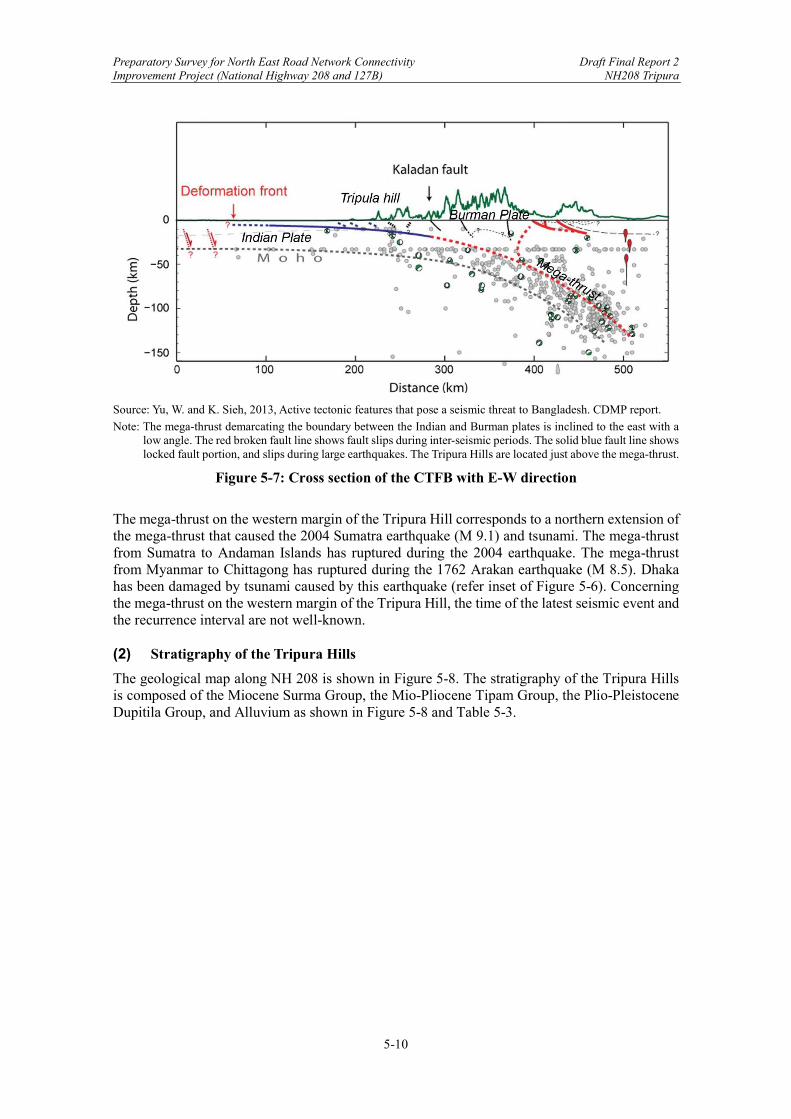
Preparatory Survey for North East Road Network Connectivity Draft Final Report 2 Improvement Project (National Highway 208 and 127B) NH208 Tripura
5-10
Source: Yu, W. and K. Sieh, 2013, Active tectonic features that pose a seismic threat to Bangladesh. CDMP report.
Note: The mega-thrust demarcating the boundary between the Indian and Burman plates is inclined to the east with a low angle. The red broken fault line shows fault slips during inter-seismic periods. The solid blue fault line shows locked fault portion, and slips during large earthquakes. The Tripura Hills are located just above the mega-thrust.
Figure 5-7: Cross section of the CTFB with E-W direction
The mega-thrust on the western margin of the Tripura Hill corresponds to a northern extension of the mega-thrust that caused the 2004 Sumatra earthquake (M 9.1) and tsunami. The mega-thrust from Sumatra to Andaman Islands has ruptured during the 2004 earthquake. The mega-thrust from Myanmar to Chittagong has ruptured during the 1762 Arakan earthquake (M 8.5). Dhaka has been damaged by tsunami caused by this earthquake (refer inset of Figure 5-6). Concerning the mega-thrust on the western margin of the Tripura Hill, the time of the latest seismic event and the recurrence interval are not well-known. (2) Stratigraphy of the Tripura Hills
The geological map along NH 208 is shown in Figure 5-8. The stratigraphy of the Tripura Hills is composed of the Miocene Surma Group, the Mio-Pliocene Tipam Group, the Plio-Pleistocene Dupitila Group, and Alluvium as shown in Figure 5-8 and Table 5-3.

Preparatory Survey for North East Road Network Connectivity Draft Final Report 2 Improvement Project (National Highway 208 and 127B) NH208 Tripura
5-11
Source: Gupta, 2011, District Resource Maps of West Tripura, Dhalai, and South Tripura.
Note: A black solid line shows the project road of NH 208.
Figure 5-8: Geological map along NH 208
Preparatory Survey for North East Road Network Connectivity Draft Final Report 2 Improvement Project (National Highway 208 and 127B) NH208 Tripura
5-12
Table 5-3: Stratigraphy of the Tripura Hill
Source: JICA Survey Team
The Surma Group is the marine sedimentary rocks in the Miocene age, and subdivided into the Bhuban and the Bokabil Formation. The Bhuban Formation consists of alternation of siltstone and shale with several centimeter intervals. The bedding plane of the Bhuban Formation is hard to separate despite its layered structure. The Bokabil Formation consists of a similar stratigraphy to the Bhuban Formation, and interbeds sandstone frequently. The degree of consolidation of these formations are regarded as soft rocks. The Tipam Group, which consists of sandstone and siltstone with cross lamina, is marine and delta deposits in Miocene to Pliocene age. The layers are weakly consolidated. The Dupitila Group, which consists of sand, silt, and clay interbedding gravel with cross lamina, is fluvial deposits in Pliocene to Pleistocene age. The layers are unconsolidated. The alluvium, which consists of sand, silt, and clay, is valley bottom plain deposits between hills. (3) Geological Structure
These stratigraphy exhibits the geological structure called “Growth strata”. As shown in Figure 5-9, younger layers were deposited together with the growth of the folding of older layers, so younger layers overlying older layers are folded as well. The inclination of the bedding plane of older layers is steeper than that of younger layers. The boundary of them shows angular unconformity. The angular unconformity between the Dupitila and Tipam Group is clearly recognized in the seismic reflection profile shown in Figure 5-9, which was performed in the plain of Bangladesh.
LithologyDegree of
consolidation
Holocene
BokabilFormation
Shale, Siltstone,Sandstone
BhubanFormation
Alternation ofSiltstone and Shale
Soft rocks
Pliocene
Miocene
Sand, Silt, Clay
Sand, Silt, Clay,Gravel
Sandstone, Siltstone
Unconsolidated
Unconsolidated
Weakly consolidated
Age Group/Formation
SurmaGroup
Dupitila Group
Tipam Group
Alluvium
PleistoceneQuaternary
Tertiary
Preparatory Survey for North East Road Network Connectivity Draft Final Report 2 Improvement Project (National Highway 208 and 127B) NH208 Tripura
5-13
Source: Sikder, A. M. and M. M. Alam, 2003, 2-D modelling of the anticlinal structures and structural development of
the eastern fold belt of the Bengal Basin, Bangladesh. Sedimentary Geology, 155, 209-226.
Figure 5-9: Example of “Growth Strata” After the Seismic Reflection Survey
5.1.4 Road Inventory Survey
(1) Background of the Survey
The JICA Survey Team has not yet conducted a site survey due to COVID-19 travel constraints, and therefore at this time the Team relied on the study in the DPR, which has been referred to in this Draft Final Report. (2) Overview of the Road Inventory Survey
Detailed road inventory surveys have been carried out at the project area to collect details of road and pavement features along the existing road sections. The inventory data includes:
i) Terrain (flat, rolling, mountainous) as per IRC SP 19 2001 guidelines; ii) Land-use (agricultural, commercial, forest, residential etc.);
iii) Carriageway width, surfacing type; iv) Shoulder surfacing type and width; v) Sub-grade / local soil type (textural classification);
vi) Horizontal curve; vertical curve; vii) Road intersection type and details, at every occurrence;
viii) Retaining structures and details, at every occurrence; ix) Location of water bodies (lakes and ponds); x) Height of embankment or depth of cut;
xi) Land width i.e. ROW; xii) Culverts, bridges and other structures (type, size, span arrangement and location);
xiii) Roadside arboriculture; xiv) Existing utility services on either side within ROW; xv) General drainage conditions;
xvi) Design speed of existing road; xvii) Inventory of all road side facilities for the public including educational, health,
communication facilities and road user-based facilities such as tea shops, vehicle service shops etc.
Preparatory Survey for North East Road Network Connectivity Draft Final Report 2 Improvement Project (National Highway 208 and 127B) NH208 Tripura
5-14
Based on the above inventory of the existing road structures and conditions, it is identified:
Which existing structures are to be abandoned, upgraded, or retained, in accordance with the latest design standards and loading requirements of the traffic;
where new structures are to be required. In addition to the road inventory, various inventories, details and soil data are presented as below:
i) Road Inventory Extracted road inventory data is presented in Table 5-4, while the full data is provided in Appendix B-1 Road Inventory.
ii) Pavement Condition
A pavement condition survey was carried out to identify pavement distress (e.g., cracking, raveling, potholing, patching, rutting) along the existing road section. Extracted pavement condition data is presented in Table 5-5 while the full data is provided in Appendix B-2 Pavement Condition.
iii) Culvert Inventory
Extracted culvert inventory and condition data is presented in Table 5-6, while the full data is provided in Appendix B-3 Culvert Inventory.
iv) Bridge Inventory
Bridge inventory is presented in Table 5-7.
v) Soil Investigation Report for Bridge Foundation Extracted boring log is presented in Table 5-8, while the full soil investigation report for bridge foundation is provided in Appendix G-1.
vi) Junction Inventory
Extracted junction inventory is presented in Table 5-9, while the full junction inventory is provided in Appendix B-4.
vii) Temple Details
Temple details are presented in Table 5-10.
viii) School Details School details are presented in Table 5-11.
ix) Pond Details
Pond details are presented in Table 5-12.

Preparatory Survey for North East Road Network Connectivity Draft Final Report 2 Improvement Project (National Highway 208 and 127B) NH208 Tripura
5-15
Table 5-4: Extracted Road Inventory
Source: DPR by TASPL Engineering Consultants
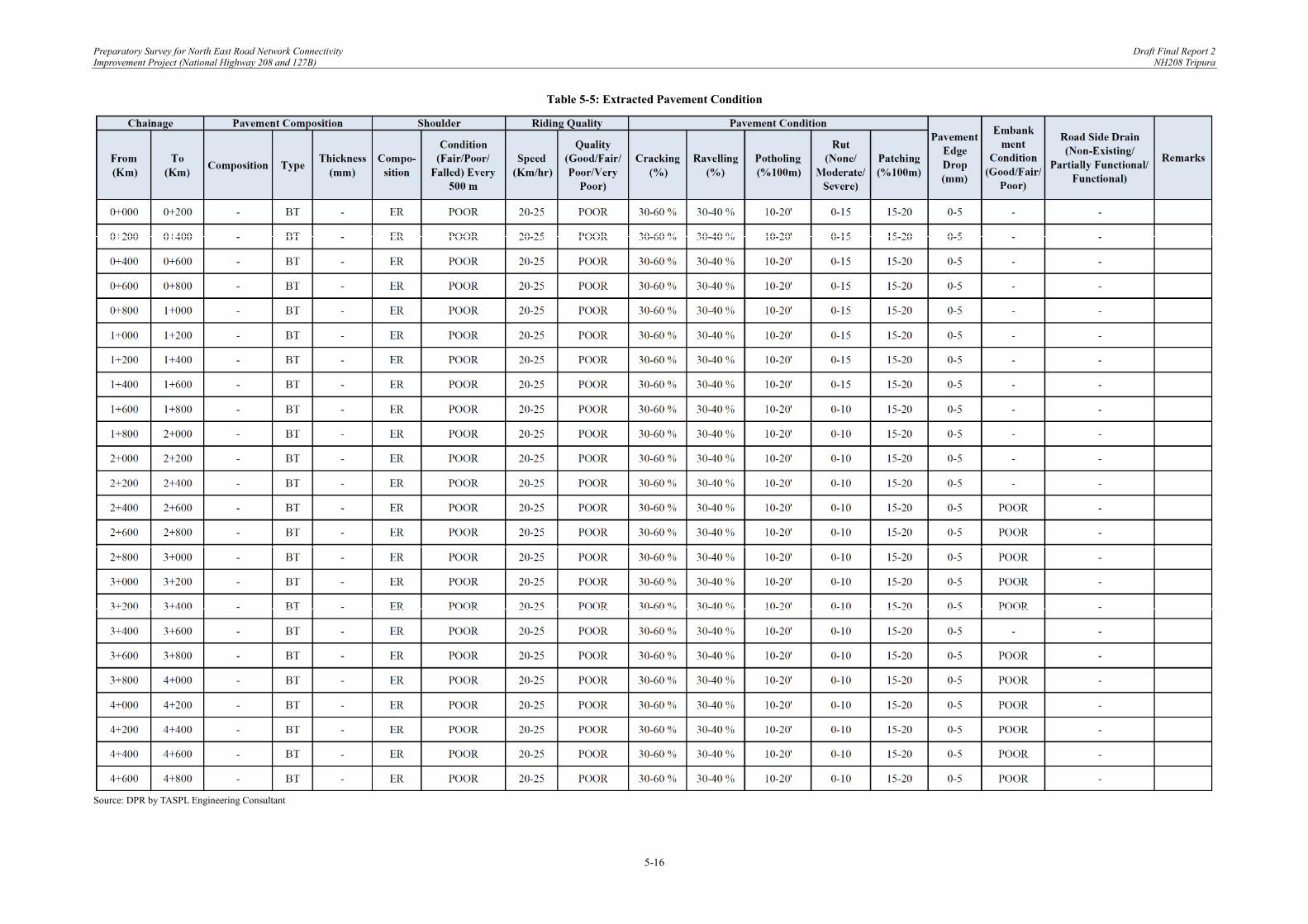
Preparatory Survey for North East Road Network Connectivity Draft Final Report 2 Improvement Project (National Highway 208 and 127B) NH208 Tripura
5-16
Table 5-5: Extracted Pavement Condition
Source: DPR by TASPL Engineering Consultant
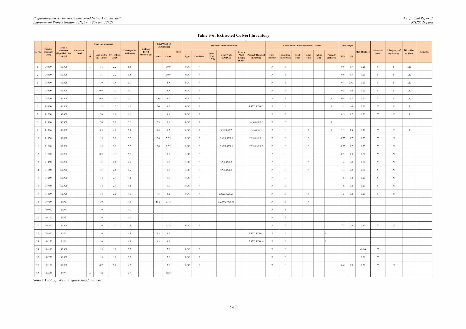
Preparatory Survey for North East Road Network Connectivity Draft Final Report 2 Improvement Project (National Highway 208 and 127B) NH208 Tripura
5-17
Table 5-6: Extracted Culvert Inventory
Source: DPR by TASPL Engineering Consultant

Preparatory Survey for North East Road Network Connectivity Draft Final Report 2 Improvement Project (National Highway 208 and 127B) NH208 Tripura
5-18
Table 5-7: Bridge Inventory
Source: DPR by TASPL Engineering Consultants
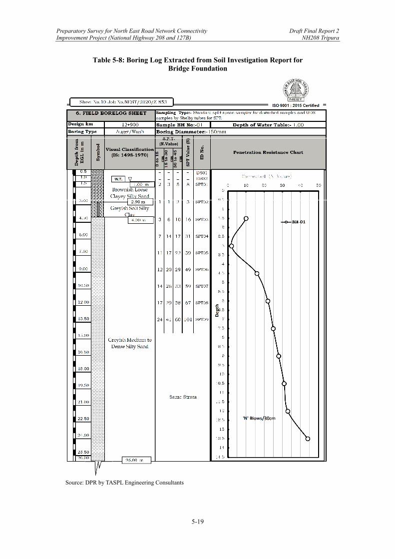
Preparatory Survey for North East Road Network Connectivity Draft Final Report 2 Improvement Project (National Highway 208 and 127B) NH208 Tripura
5-19
Table 5-8: Boring Log Extracted from Soil Investigation Report for Bridge Foundation
Source: DPR by TASPL Engineering Consultants
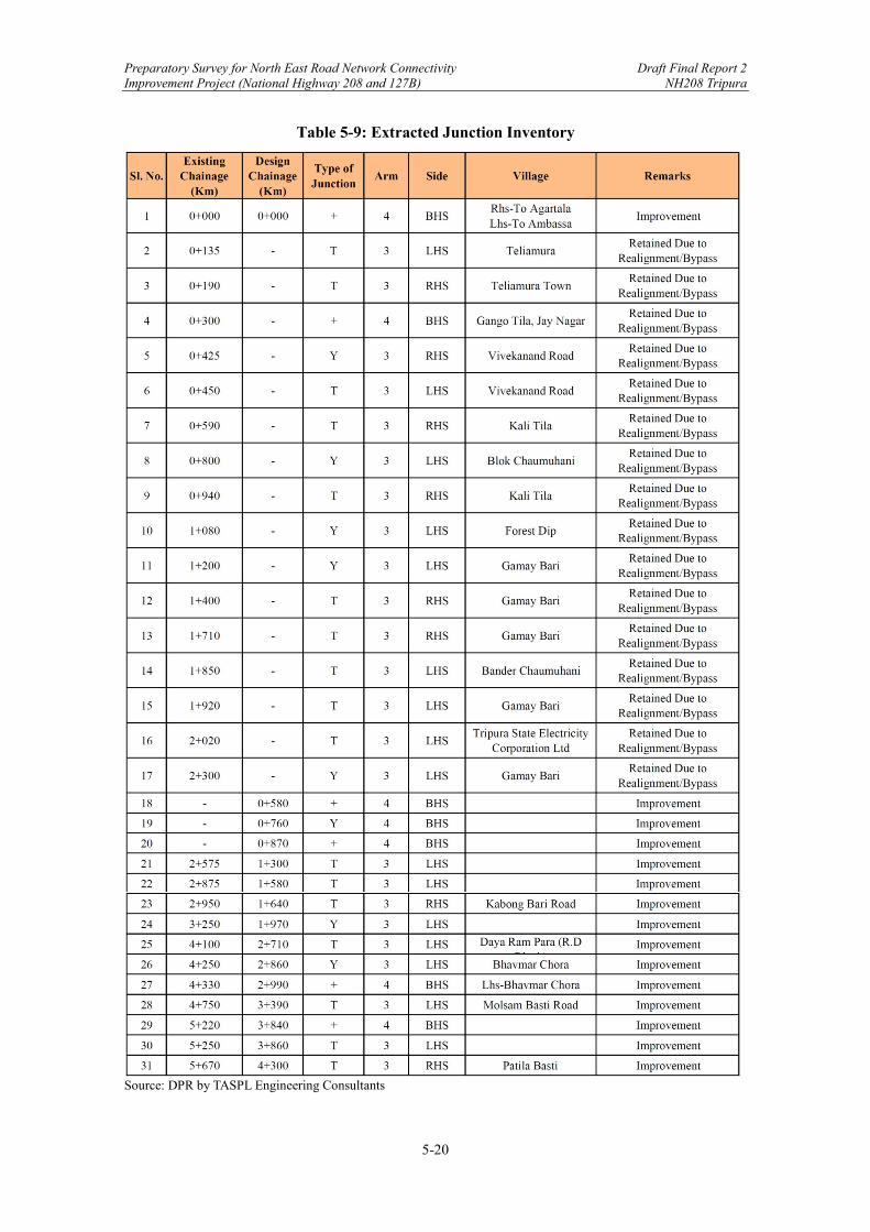
Preparatory Survey for North East Road Network Connectivity Draft Final Report 2 Improvement Project (National Highway 208 and 127B) NH208 Tripura
5-20
Table 5-9: Extracted Junction Inventory
Source: DPR by TASPL Engineering Consultants
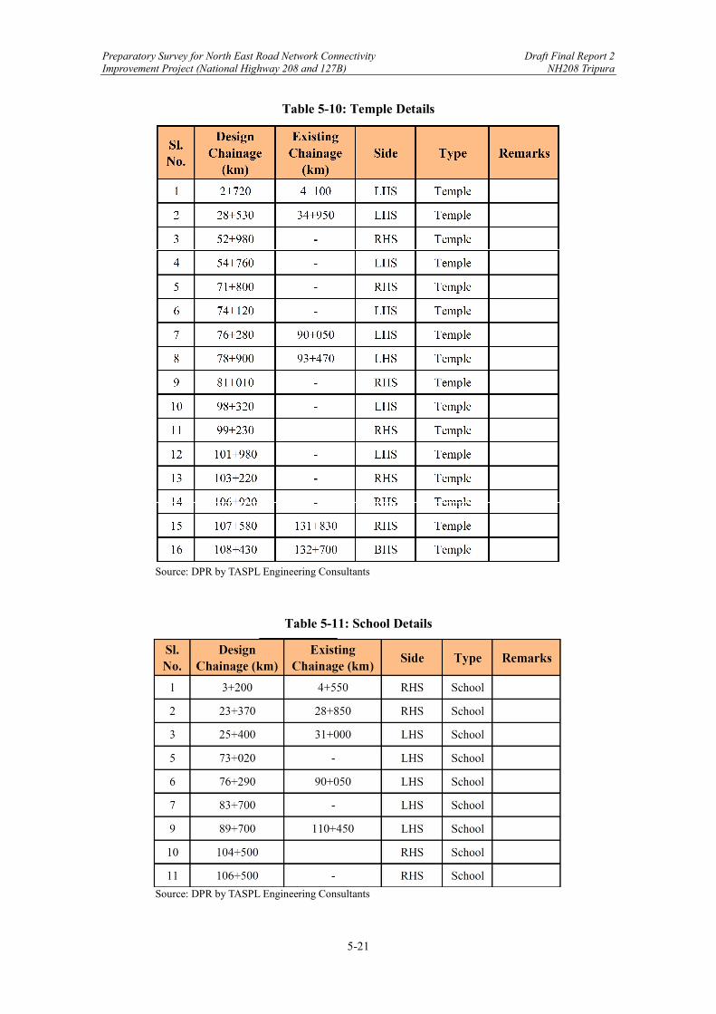
Preparatory Survey for North East Road Network Connectivity Draft Final Report 2 Improvement Project (National Highway 208 and 127B) NH208 Tripura
5-21
Table 5-10: Temple Details
Source: DPR by TASPL Engineering Consultants
Table 5-11: School Details
Source: DPR by TASPL Engineering Consultants
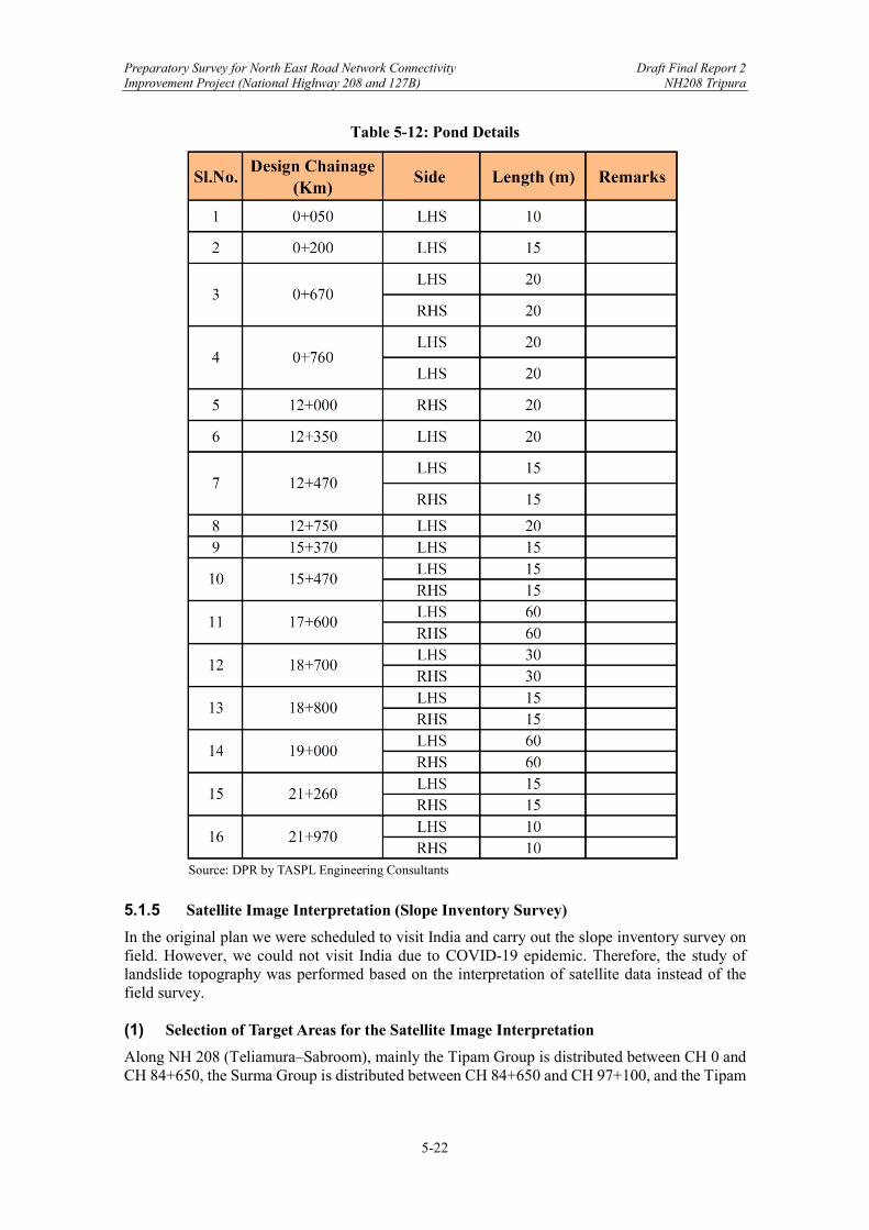
Preparatory Survey for North East Road Network Connectivity Draft Final Report 2 Improvement Project (National Highway 208 and 127B) NH208 Tripura
5-22
Table 5-12: Pond Details
Source: DPR by TASPL Engineering Consultants
5.1.5 Satellite Image Interpretation (Slope Inventory Survey)
In the original plan we were scheduled to visit India and carry out the slope inventory survey on field. However, we could not visit India due to COVID-19 epidemic. Therefore, the study of landslide topography was performed based on the interpretation of satellite data instead of the field survey. (1) Selection of Target Areas for the Satellite Image Interpretation
Along NH 208 (Teliamura‒Sabroom), mainly the Tipam Group is distributed between CH 0 and CH 84+650, the Surma Group is distributed between CH 84+650 and CH 97+100, and the Tipam
Preparatory Survey for North East Road Network Connectivity Draft Final Report 2 Improvement Project (National Highway 208 and 127B) NH208 Tripura
5-23
and Dupitila Group are distributed between CH 97+100 and CH 108+179 (the end of the project road). According to the final report of NH208 (Kailashahar‒Teliamura), which was reported last year, the cut slopes composed of the Tipam and Dupitila Group are stable with the gradient of 0.5H : 1V, while topsoil collapses are often recognized. However, the Surma Group, which is distributed on the hilly and mountainous terrains, is soft rocks composed of alternation of siltstone and shale. The cut slopes with dip slope structure have long-term stability problem. In addition, landslide topographies could be found around the Project Road. Therefore, the hilly terrain, where the Surma Group is distributed, was selected as target area of the satellite data interpretation. (2) Satellite Data and Images
We purchased the following satellite data and images from Remote Sensing Technology Centre of Japan (RESTEC).
1) Highest precision DTM in 0.5 m resolution
2) Highest quality ortho-rectified image Digital Terrain Model (DTM), a kind of Digital Elevation Model (DEM), represents the bare ground surface without any objects including vegetation and buildings. Aerial photographs and satellite photographs are originally taken with distorted configurations by central projection. They are geometrically corrected by ortho-graphic projection, and called ortho-rectified images. Above data and images are produced with the combination of Jaxa‒ALOS and DigitalGlobe WorldView of the United States. The satellite data and images in the hilly terrain between CH 82+000 and CH 100+000 are purchased. (3) Method for Analysis
Satellite images for which interpretation of landslide topographies were made, were carried out with the following procedures.
1) make a shaded-relief image possible to express 3D for bird’s-eye view similar to aerial photograph,
2) shift the point of view, and then make up the next shaded-relief image under the condition that two images overlap 60%,
3) paste an ortho image on the shaded-relief images, and
4) observe landslide topographies by the pair of images for stereo-view.
(4) Results of Interpretation
20 pairs of satellite images possible to express in 3D were developed between CH 82+000 and CH 100+000, and landslide topographies were observed. As a result, detailed studies were performed in the target areas of 1 to 8. The locations of target areas 1 to 8 are shown in Figure 5-10. The background shaded-relief map was made up from satellite data (DTM). On the shaded-relief map, the altitude of the hill is highest

Preparatory Survey for North East Road Network Connectivity Draft Final Report 2 Improvement Project (National Highway 208 and 127B) NH208 Tripura
5-24
between CH 87+000 and 88+000. Because the topographic features coincide with the geological structure on the Tripura Hills, as hills and valley bottom plains show anticline and syncline, respectively, the anticlinal axis with NNW‒SSE direction is inferred to pass around this section. Therefore, the layers incline towards the east in the eastern area of the anticline, and the layers incline towards the west in the western area of the anticline. The topography, geology, and issues for slope protection are summarized in Table 5-13 and Table 5-14. Landslides A and B are inferred in the target areas 5 and 6, respectively.
Source: JICA Survey Team
Figure 5-10: Target Areas for Slope Protection

Preparatory Survey for North East Road Network Connectivity Draft Final Report 2 Improvement Project (National Highway 208 and 127B) NH208 Tripura
5-25
Table 5-13: Topography and Geology, and Issues of Target Areas (1)
Source: JICA Survey Team
From To
1 84650 84800 150
The project road is located at theeastern wing of the anticline withNNW-SSE direction. The beddingplanes incline to the east. The hillside cut slope shows dip slopestructure. The layers could bestrongly weathered because Targetarea 1 is located near unconformitybetween Surma G. and Tipam G.
SurmaGroup
The cut slope showsdip slope structure,though the height ofcut slope is not sohigh.
2 84850 84950 100 dittoSurmaGroup
Ditto
3 85300 86100 800
The project road is planned to passon the east side slope of the valley.The bedding shows opposite dipslope structure, so natural slopes arerelatively steep. In the west sideslope of the valley, the beddingshows dip slope structure, so naturalslopes are gentle and severallandslides are recognized.
SurmaGroup
Hill side slopes aresteep because ofopposite dip slopestructure. The cutslopes are higherthan 40 m in height.
4 89000 89300 300Several landslides are reconizedaround the project road.
SurmaGroup
There are lessproblems becauselandslides aredistributed awayfrom the projectroad.
5(A)
89800 90500 700
The west side slope of the NNW-SSE trending long ridge representsabnormal topography that there areno ridges and streams. The east sideslope of the ridge represents normaltopography where branched ridgesand streams are developed. Shallowlanslides or large collapses of A-1 toA-5 are inferred on west side slopewhere bedding shows dip slopestructure and landslide massess slideon the bedding plane. Gully erosionsare recognized on the landslide masssurfaces.
SurmaGroup
The project road isplanned to crosslandslides or gothrough besidelandslides.Landslides are likelyto become instableby the roadconstruction.
TargetArea
(Landslide)
ChainageTopography and Geology
Strati-graphy
IssuesLength
(m)
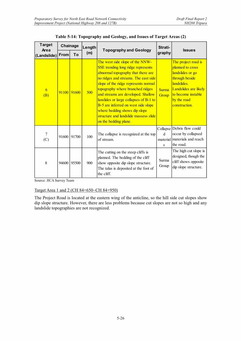
Preparatory Survey for North East Road Network Connectivity Draft Final Report 2 Improvement Project (National Highway 208 and 127B) NH208 Tripura
5-26
Table 5-14: Topography and Geology, and Issues of Target Areas (2)
Source: JICA Survey Team Target Area 1 and 2 (CH 84+650~CH 84+950)
The Project Road is located at the eastern wing of the anticline, so the hill side cut slopes show dip slope structure. However, there are less problems because cut slopes are not so high and any landslide topographies are not recognized.
From To
6(B)
91100 91600 500
The west side slope of the NNW-SSE trending long ridge representsabnormal topography that there areno ridges and streams. The east sideslope of the ridge represents normaltopography where branched ridgesand streams are developed. Shallowlanslides or large collapses of B-1 toB-5 are inferred on west side slopewhere bedding shows dip slopestructure and landslide massess slideon the bedding plane.
SurmaGroup
The project road isplanned to crosslandslides or gothrough besidelandslides.Landslides are likelyto become instableby the roadconstruction.
7(C)
91600 91700 100The collapse is recognized at the topof stream.
Collapsed
materials
Debris flow couldoccur by collapsedmaterials and reachthe road.
8 94600 95500 900
The cutting on the steep cliffs isplanned. The bedding of the cliffshow opposite dip slope structure.The talus is deposited at the foot ofthe cliff.
SurmaGroup
The high cut slope isdesigned, though thecliff shows oppositedip slope structure.
TargetArea
(Landslide)
Chainage Length(m)
Topography and GeologyStrati-graphy
Issues
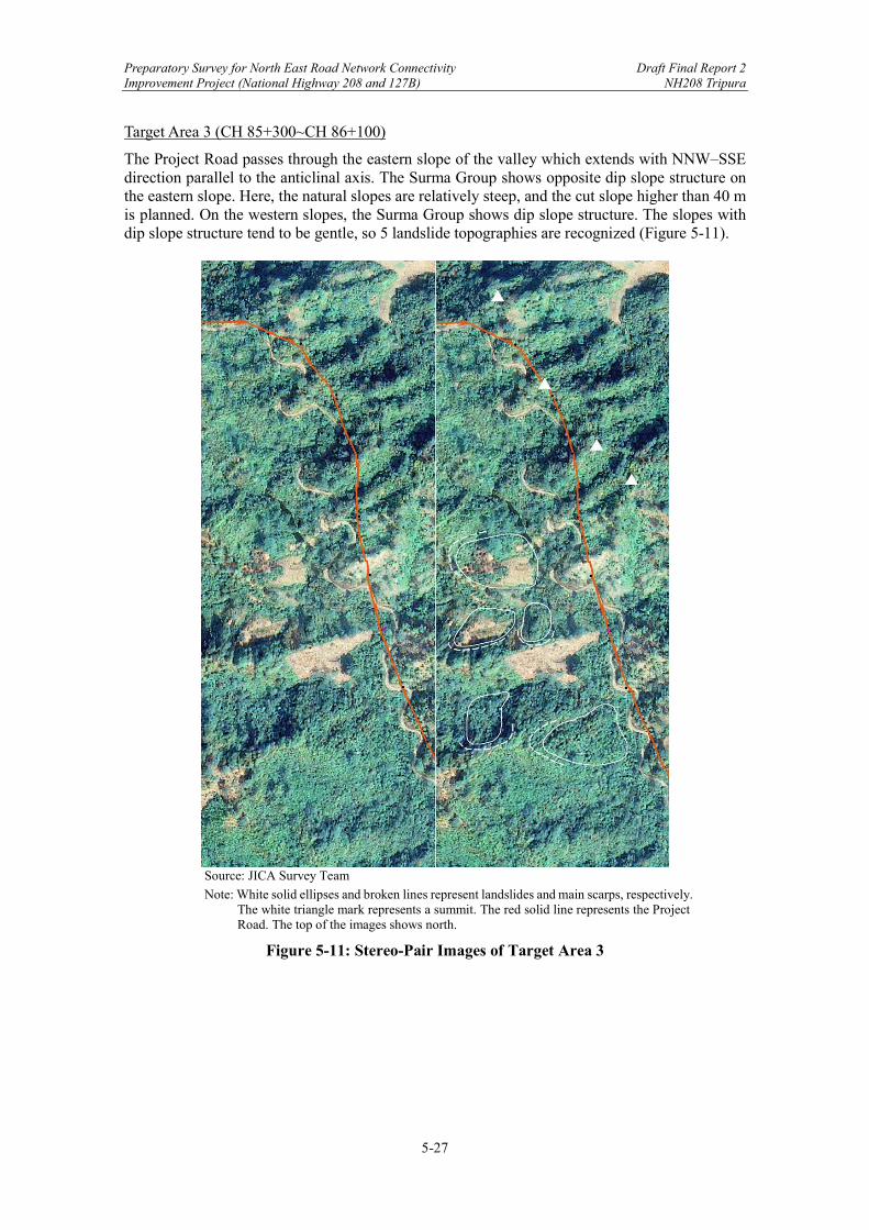
Preparatory Survey for North East Road Network Connectivity Draft Final Report 2 Improvement Project (National Highway 208 and 127B) NH208 Tripura
5-27
Target Area 3 (CH 85+300~CH 86+100)
The Project Road passes through the eastern slope of the valley which extends with NNW‒SSE direction parallel to the anticlinal axis. The Surma Group shows opposite dip slope structure on the eastern slope. Here, the natural slopes are relatively steep, and the cut slope higher than 40 m is planned. On the western slopes, the Surma Group shows dip slope structure. The slopes with dip slope structure tend to be gentle, so 5 landslide topographies are recognized (Figure 5-11).
Source: JICA Survey Team
Note: White solid ellipses and broken lines represent landslides and main scarps, respectively. The white triangle mark represents a summit. The red solid line represents the Project Road. The top of the images shows north.
Figure 5-11: Stereo-Pair Images of Target Area 3

Preparatory Survey for North East Road Network Connectivity Draft Final Report 2 Improvement Project (National Highway 208 and 127B) NH208 Tripura
5-28
Target Area 4 (CH 89+000~CH 89+300)
The west-facing slopes show dip slope structure because this area is located at the western wing of the anticline. Several landslides are inferred around the project road. However, there are less problems because landslides are away from the project road (Figure 5-12).
Source: JICA Survey Team
Note: White solid ellipses and broken lines represent landslides and main scarps, respectively. The red solid line represents the Project Road. The top of the image shows north.
Figure 5-12: Stereo-Pair Images of Target Area 4

Preparatory Survey for North East Road Network Connectivity Draft Final Report 2 Improvement Project (National Highway 208 and 127B) NH208 Tripura
5-29
Target Area 5 (CH 89+800~CH 90+500)
As shown in Figure 5-13, the western slope of ridge 1 to 2 shows an abnormal topography that there are no ridges and streams. The eastern slope shows a normal topography that branched ridges and streams develop. The western slope shows a geologically dip slope structure, and it is inferred that layers slid on the bedding plane and shallow landslides A-1 to A-5 have been formed. The slope just below the ridge is relatively steep, and its lower slope is gentle. The relatively steep slope and gentle slope are inferred to be a main scarp and a landslide mass, respectively. Gully erosions are observed on the landslide surfaces (Figure 5-14, Figure 5-15). The contour map and cross sections, which were made from satellite data, are shown in Figure 5-16 and Figure 5-17, respectively. Cross section A-4 exhibits a most typical landslide topography. The inclination of a main scarp is parallel to the bedding planes. It is inferred that the upper part of the slope has slid on the bedding plane, and the landslide has been formed. The abnormal slope with no ridges and streams is indicative of such landslide mechanism. In cross sections of A-1, A-4, and A-5, embankments are planned on the upperpart of landslides.
Source: JICA Survey Team
Note: White solid ellipses and broken lines represent landslide and main scarp, respectively. Yellow broken lines and blue broken line represent ridges and streams, respectively. The red line represents the Project Road. The top of the image shows north.
Figure 5-13: Satellite Image of Target Area 5
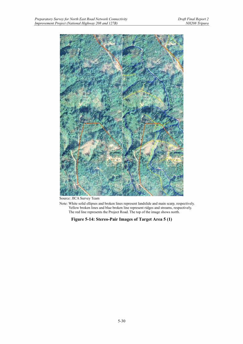
Preparatory Survey for North East Road Network Connectivity Draft Final Report 2 Improvement Project (National Highway 208 and 127B) NH208 Tripura
5-30
Source: JICA Survey Team
Note: White solid ellipses and broken lines represent landslide and main scarp, respectively. Yellow broken lines and blue broken line represent ridges and streams, respectively. The red line represents the Project Road. The top of the image shows north.
Figure 5-14: Stereo-Pair Images of Target Area 5 (1)
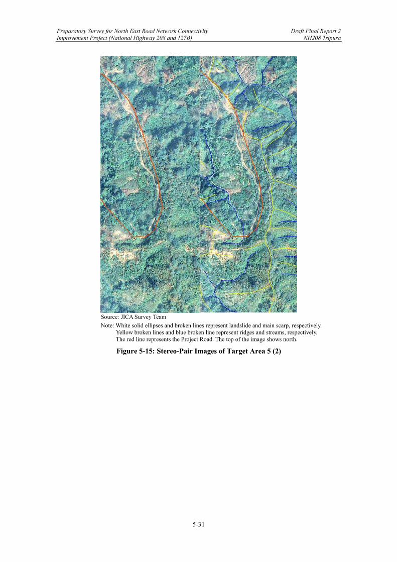
Preparatory Survey for North East Road Network Connectivity Draft Final Report 2 Improvement Project (National Highway 208 and 127B) NH208 Tripura
5-31
Source: JICA Survey Team
Note: White solid ellipses and broken lines represent landslide and main scarp, respectively. Yellow broken lines and blue broken line represent ridges and streams, respectively. The red line represents the Project Road. The top of the image shows north.
Figure 5-15: Stereo-Pair Images of Target Area 5 (2)
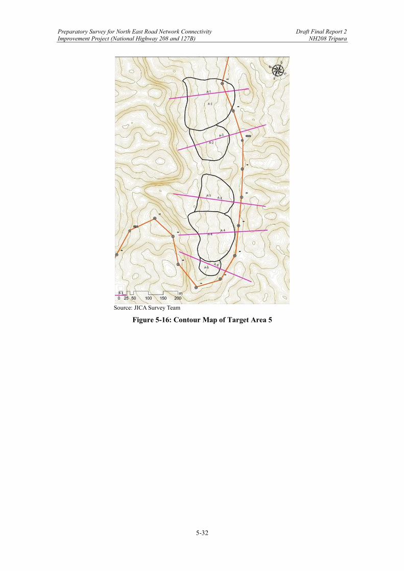
Preparatory Survey for North East Road Network Connectivity Draft Final Report 2 Improvement Project (National Highway 208 and 127B) NH208 Tripura
5-32
Source: JICA Survey Team
Figure 5-16: Contour Map of Target Area 5

Preparatory Survey for North East Road Network Connectivity Draft Final Report 2 Improvement Project (National Highway 208 and 127B) NH208 Tripura
5-33
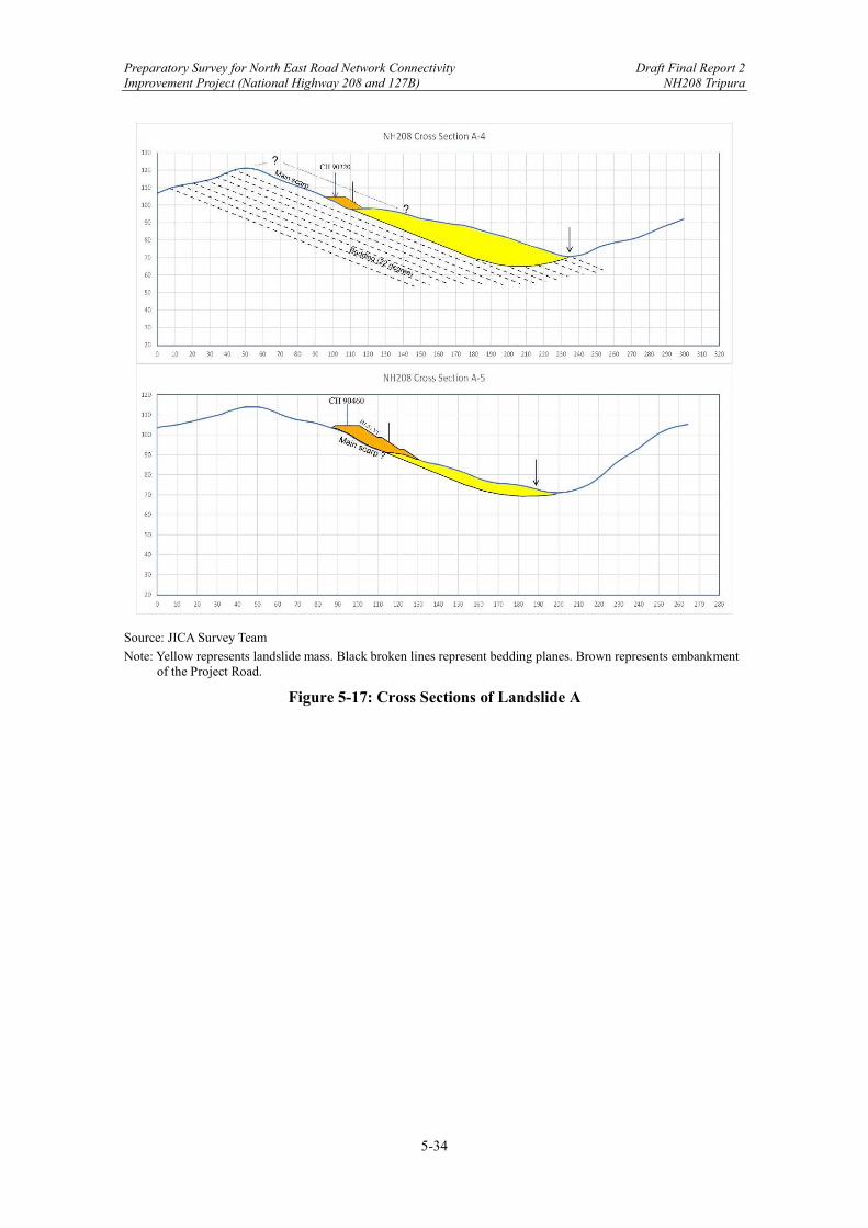
Preparatory Survey for North East Road Network Connectivity Draft Final Report 2 Improvement Project (National Highway 208 and 127B) NH208 Tripura
5-34
Source: JICA Survey Team
Note: Yellow represents landslide mass. Black broken lines represent bedding planes. Brown represents embankment of the Project Road.
Figure 5-17: Cross Sections of Landslide A
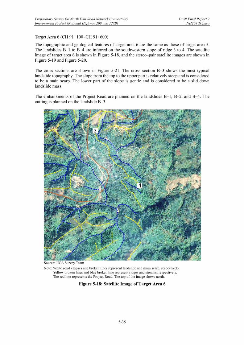
Preparatory Survey for North East Road Network Connectivity Draft Final Report 2 Improvement Project (National Highway 208 and 127B) NH208 Tripura
5-35
Target Area 6 (CH 91+100~CH 91+600)
The topographic and geological features of target area 6 are the same as those of target area 5. The landslides B‒1 to B‒4 are inferred on the southwestern slope of ridge 3 to 4. The satellite image of target area 6 is shown in Figure 5-18, and the stereo‒pair satellite images are shown in Figure 5-19 and Figure 5-20. The cross sections are shown in Figure 5-21. The cross section B‒3 shows the most typical landslide topography. The slope from the top to the upper part is relatively steep and is considered to be a main scarp. The lower part of the slope is gentle and is considered to be a slid down landslide mass. The embankments of the Project Road are planned on the landslides B‒1, B‒2, and B‒4. The cutting is planned on the landslide B‒3.
Source: JICA Survey Team
Note: White solid ellipses and broken lines represent landslide and main scarp, respectively. Yellow broken lines and blue broken line represent ridges and streams, respectively. The red line represents the Project Road. The top of the image shows north.
Figure 5-18: Satellite Image of Target Area 6

Preparatory Survey for North East Road Network Connectivity Draft Final Report 2 Improvement Project (National Highway 208 and 127B) NH208 Tripura
5-36
Source: JICA Survey Team
Note: White solid ellipses and broken lines represent landslide and main scarp, respectively. Yellow broken lines and blue broken line represent ridges and streams, respectively. The red line represents the Project Road. The top of the image shows north.
Figure 5-19: Stereo-Pair Images of Target Area 6 (1)
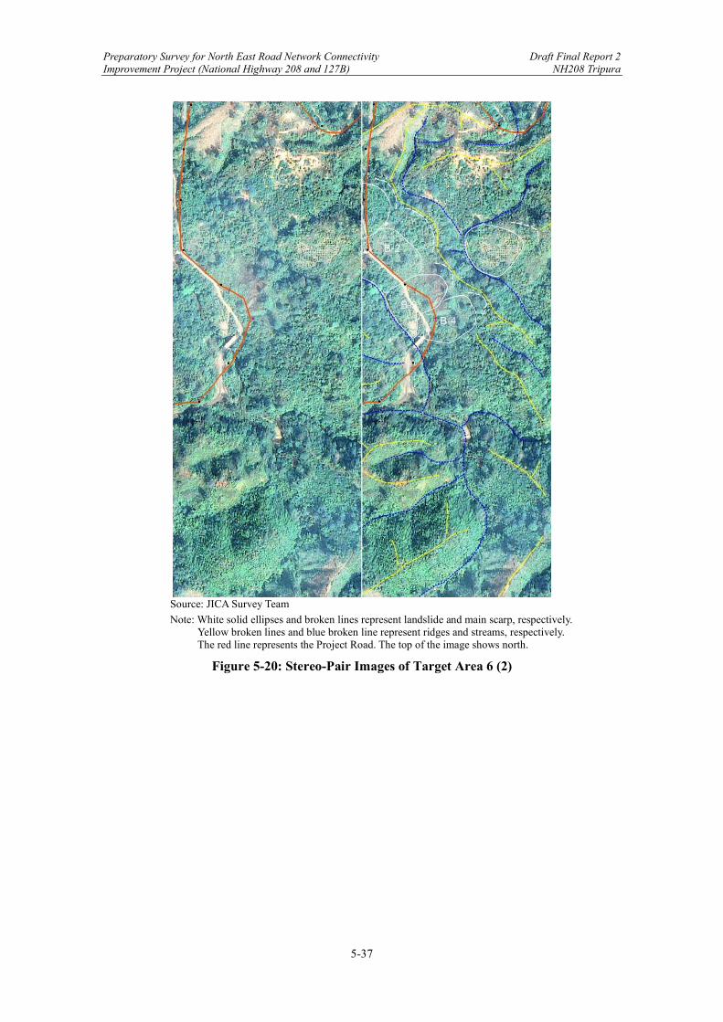
Preparatory Survey for North East Road Network Connectivity Draft Final Report 2 Improvement Project (National Highway 208 and 127B) NH208 Tripura
5-37
Source: JICA Survey Team
Note: White solid ellipses and broken lines represent landslide and main scarp, respectively. Yellow broken lines and blue broken line represent ridges and streams, respectively. The red line represents the Project Road. The top of the image shows north.
Figure 5-20: Stereo-Pair Images of Target Area 6 (2)

Preparatory Survey for North East Road Network Connectivity Draft Final Report 2 Improvement Project (National Highway 208 and 127B) NH208 Tripura
5-38
Source: JICA Survey Team
Figure 5-21: Contour Map of Target Area 6
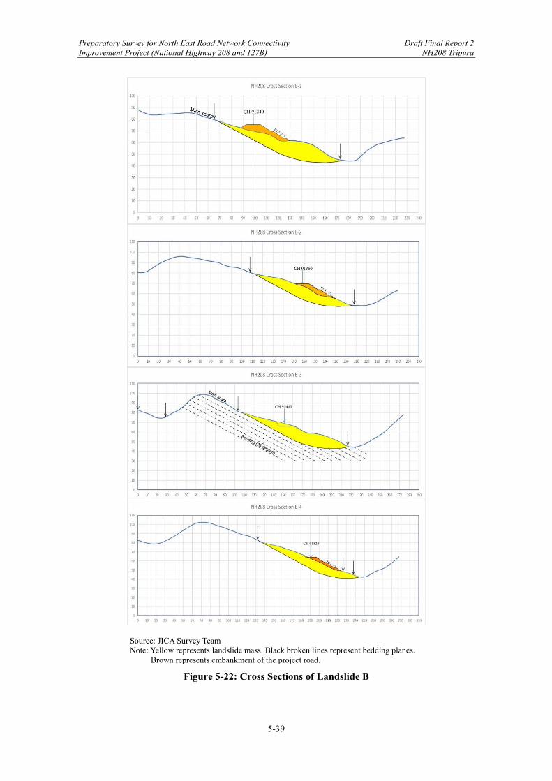
Preparatory Survey for North East Road Network Connectivity Draft Final Report 2 Improvement Project (National Highway 208 and 127B) NH208 Tripura
5-39
Source: JICA Survey Team Note: Yellow represents landslide mass. Black broken lines represent bedding planes.
Brown represents embankment of the project road.
Figure 5-22: Cross Sections of Landslide B

Preparatory Survey for North East Road Network Connectivity Draft Final Report 2 Improvement Project (National Highway 208 and 127B) NH208 Tripura
5-40
Target Area 7 (CH 91+600~CH 91+700)
The head of the stream is collapsed on the opposite side slope of landslide B‒3 and B‒4 (“C” in Figure 5-18). The collapsed earth and soil could reach the Project Road if the collapsed part (earth and soil) changes to debris flow during the heavy rain, though the quantity and condition of the part are unknown from the satellite image. Target Area 8 (CH 94+600~CH 95+500)
Cutting works are planned on the steep cliff. Though cut slopes are high, there are less problems of cut slope stability because the layers of cut slope show opposite dip slope structure.
Source: JICA Survey Team Note: The yellow broken line and red solid line represent ridge and the Project Road, respectively.
Triangles represent talus.
Figure 5-23: Stereo-Pair Images of Target Area 8

Preparatory Survey for North East Road Network Connectivity Draft Final Report 2 Improvement Project (National Highway 208 and 127B) NH208 Tripura
5-41
5.2 Review of DPR
5.2.1 Road Geometric Design
(1) Background of DPR
National Highways and Infrastructure Development Corporation (NHIDCL) proposed the feasibility study, preparation of DPR & providing pre-construction services for up -gradation of selected road stretches /corridors to two lane with paved shoulder NH configuration under BHARATMALA Project and National Highways connectivity to Backward areas /Religious /Tourist places of the country in the state of Tripura. Under this scheme, the consultancy work is awarded to M/s. Technocrats Advisory Services Pvt. Ltd. in association with Vaishnavi Infratech Services Pvt. Ltd. for preparation of Detailed Project Report of Teliamura - Sabroom section (NH-208). JICA Survey Team (JST) conducted an initial review on Detailed Project Report (DPR) titled “Consultancy services for feasibility study, preparation of DPR & providing pre-construction services for up-gradation of selected road stretches /corridors to Two lane with paved shoulder NH configuration under BHARATMALA Project and National Highways connectivity to Backward areas /Religious /Tourist places of the country in the state of Tripura. Section III: Teliamura - Sabroom Section.” It is decided that this project includes the section between Khowai and Teliamura, which has been excluded from the previous phase (Phase III). Thus, the section name of Khowai - Sabroom is used for this project. (2) Questionnaire on Road Geometric Design of DPR
JST prepared a questionnaire based on the initial review and sent it to the DPR consultant and conducted a web meeting to exchange opinions. The questionnaire is indicated below.
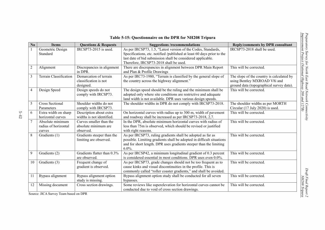
Preparatory Survey for N
orth East R
oad Netw
ork Connectivity
Draft F
inal Report 2
Improvem
ent Project (N
ational Highw
ay 208 and 127B)
NH
208 Tripura
5-42
Table 5-15: Questionnaire on the DPR for NH208 Tripura
No Items Questions & Requests Suggestions /recommendations Reply/comments by DPR consultant 1 Geometric Design
Standard IRCSP73-2015 is used. As per IRCSP73, 1.5, “Latest version of the Codes, Standards,
Specifications, etc. notified /published at least 60 days prior to the last date of bid submission shall be considered applicable. Therefore, IRCSP73-2018 shall be used.
IRCSP73-2018 shall be used.
2 Alignment Discrepancies in alignment in DPR.
There are discrepancies in alignment between DPR Main Report and Plan & Profile Drawings
This will be corrected.
3 Terrain Classification Demarcation of terrain classification is not designed.
As per IRC73-1980, “Terrain is classified by the general slope of the country across the highway alignment.”
The slope of the country is calculated by using Bentley MXROAD V8i and ground data (topographical survey data).
4 Design Speed Design speeds do not comply with IRCSP73.
The design speed should be the ruling and the minimum shall be adopted only where site conditions are restrictive and adequate land width is not available. DPR uses various design speeds.
This will be corrected.
5 Cross Sectional Parameters
Shoulder widths do not comply with IRCSP73.
The shoulder widths in DPR do not comply with IRCSP73-2018. The shoulder widths as per MORTH Circular (17 July 2020) is used.
6 Extra width on sharp horizontal curves
Description about extra widths is not identified.
On horizontal curves with radius up to 300 m, width of pavement and roadway shall be increased as per IRCSP73-2018, 2,7.
This will be corrected.
7 Absolute minimum radius of horizontal curves
Curves smaller than the absolute minimum are observed.
In the DPR, absolute minimum horizontal curves with radius of less than 75m is observed, which should be revised or justified with right reasons.
This will be corrected.
8 Gradients (1) Gradients steeper than the limiting are observed.
As per IRCSP73, ruling gradients shall be adopted as far as possible. Limiting gradients shall be adopted in difficult situations and for short length. DPR uses gradients steeper than the limiting 6.0%.
This will be corrected.
9 Gradients (2) Gradients flatter than 0.3% are observed.
As per IRCSP42, a minimum longitudinal gradient of 0.3 percent is considered essential in most conditions. DPR uses even 0.0%.
This will be corrected.
10 Gradients (3) Frequent change of gradient is observed.
As per IRCSP73, grade changes should not be too frequent as to cause kinks and visual discontinuities in the profile. This is commonly called “roller coaster gradients,” and shall be avoided.
This will be corrected.
11 Bypass alignment Bypass alignment option study is missing.
Bypass alignment option study shall be conducted for all seven bypasses.
This will be corrected.
12 Missing document Cross section drawings. Some reviews like superelevation for horizontal curves cannot be conducted due to void of cross section drawings.
This will be corrected.
Source: JICA Survey Team based on DPR
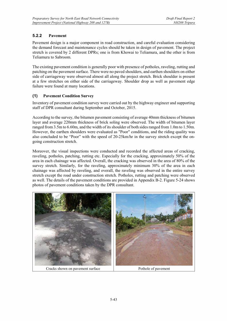
Preparatory Survey for North East Road Network Connectivity Draft Final Report 2 Improvement Project (National Highway 208 and 127B) NH208 Tripura
5-43
5.2.2 Pavement
Pavement design is a major component in road construction, and careful evaluation considering the demand forecast and maintenance cycles should be taken in design of pavement. The project stretch is covered by 2 different DPRs; one is from Khowai to Teliamura, and the other is from Teliamura to Sabroom. The existing pavement condition is generally poor with presence of potholes, raveling, rutting and patching on the pavement surface. There were no paved shoulders, and earthen shoulders on either side of carriageway were observed almost all along the project stretch. Brick shoulder is present at a few stretches on either side of the carriageway. Shoulder drop as well as pavement edge failure were found at many locations. (1) Pavement Condition Survey
Inventory of pavement condition survey were carried out by the highway engineer and supporting staff of DPR consultant during September and October, 2015. According to the survey, the bitumen pavement consisting of average 40mm thickness of bitumen layer and average 220mm thickness of brick soling were observed. The width of bitumen layer ranged from 3.5m to 6.60m, and the width of its shoulder of both sides ranged from 1.0m to 1.50m. However, the earthen shoulders were evaluated as "Poor" conditions, and the riding quality was also concluded to be “Poor” with the speed of 20-25km/hr in the survey stretch except the on-going construction stretch. Moreover, the visual inspections were conducted and recorded the affected areas of cracking, raveling, potholes, patching, rutting etc. Especially for the cracking, approximately 50% of the area in each chainage was affected. Overall, the cracking was observed in the area of 80% of the survey stretch. Similarly, for the raveling, approximately minimum 30% of the area in each chainage was affected by raveling, and overall, the raveling was observed in the entire survey stretch except the road under construction stretch. Potholes, rutting and patching were observed as well. The details of the pavement conditions are provided in Appendix B-2. Figure 5-24 shows photos of pavement conditions taken by the DPR consultant.
Cracks shown on pavement surface Pothole of pavement

Preparatory Survey for North East Road Network Connectivity Draft Final Report 2 Improvement Project (National Highway 208 and 127B) NH208 Tripura
5-44
Raveling on pavement surface Patching on pavement surface
Source: DPR
Figure 5-24: Pavement Conditions
(2) Sub-grade Investigation, Field and Laboratory Test Results
Field and laboratory tests were conducted on the collected soil samples from the trial pits and associated the pavement composition. Procedures for investigations, sampling and testing of soils and other construction materials are in accordance with MoRTH Specifications, wherever applicable, to determine their suitability. For the survey stretch from Khowai to Teliamura, trial pits of size 1m x 1m x 1m(depth) were dug at the pavement shoulder surface at 0.5km interval, extending through the pavement layers down to the sub-grade level to assess the visual classification of soil, field density, field moisture content, Atterberg limits, existing pavement composition, and available CBR. The layer compositions of the existing pavement are shown in Table 5-16, and the laboratory test results are shown in Table 5-17. The average bituminous surface was 55mm. California Bearing Ratio (CBR) tests were carried out on the pit samples in the laboratory as per standard procedures. At optimum moisture content (OMC) soil samples were compacted at three different energy levels corresponding to 10 blows, 35 blows, and 65 blows as per IS 2720 Part 8. These compacted unsoaked samples collected from selected locations were also tested. Soaked CBR values at 97% MDD is shown in Table 5-18. The fluctuation of the available CBR was from 3.12 to 21.30, and the average was 6.74. On the other hand, the survey stretch from Teliamura to Sabroom, the DPR stated that the subgrade investigation by collecting soil samples was carried out, but the survey results were not attached in the DPR. Related survey was conducted; for instance, geotechnical investigations were carried out in DPR after the bridge proposals were finalized. During the feasibility study, the pavement compositions of thicknesses of bitumen layer and brick soling of the existing embankment were recorded every 500m of either Right or left-hand side. However, this was only for the pavement crust composition survey of the depth up to around 250mm, not for sub-grade investigations. The existing pavement compositions of the crust are shown in Appendix B-5. In terms of sub-grade investigation, during the feasibility study and DPR period, the samples from the total 14 locations including borrow areas were exclusively obtained for sub-grade investigations by laboratory tests. The laboratory test results are shown in Table 5-19 and Table 5-20.

Preparatory Survey for N
orth East R
oad Netw
ork Connectivity
Draft F
inal Report 2
Improvem
ent Project (N
ational Highw
ay 208 and 127B)
NH
208 Tripura
5-45
Table 5-16: Layer Compositions
Source: JICA Survey Team based on DPR
Bituminous Surface
WBM BFS BES PMC WBM BFS BS
Brick Bats
Brick Flat
Soling
Brick Edge Soling
Premix Carpet
Brick Bats
Brick Flat
Soling
Brick Soling
Yellowish Brown,
Silty Sand with mica
Yellowish Brown, Clayey
Sandy Silt
Brownish Grey, Silty Clay with
Sand Mixture
Brownish Grey,
Silty Clay
Reddish Grey,
Clayey Sandy Silt
Reddish Grey,
Silty Sand wirh mica
Yellow Grey,
Clayey Silty
Sand with mica
Reddish Brown, Clayey Silt with Sand
Mixture
Yellowish Brown, Clayey
Silty Sand with
mica
Yellowish Grey, Silty
Sand with mica
Reddish Brown, Clayey
Silty Sand
Brownish Grey,
Clay with Sand
Mixture
Reddish Grey,
Clayey Silty Sand
Yellowish Brown,
Silty Sand with mica
Brownish Grey,
Clayey Silty
Sand with mica
Brownish Grey,
Silty Clay with
Sand Mixture
Brownish Grey,
Silty Clay /Clayey Silt with Sand
Mixture
Browish Grey,
Clayey Silt with Sand
Mixture
206 103+000 LHS 40 280 680 1,000
207 103+500 RHS 100 240 660 1,000
208 104+000 LHS 40 200 75 685 1,000
209 104+500 RHS 80 150 75 695 1,000
210 105+000 LHS 60 200 75 685 1,020
211 105+400 RHS 70 260 670 1,000
212 106+000 LHS 30 130 125 715 1,000
213 106+500 RHS 60 200 740 1,000
214 107+000 LHS 70 140 20 80 75 615 1,000
215 107+500 RHS 80 200 720 1,000
216 108+000 LHS 20 200 780 1,000
217 108+400 RHS 30 300 670 1,000
218 109+000 LHS 40 200 760 1,000
219 109+500 RHS 40 150 810 1,000
220 110+000 LHS 60 250 690 1,000
221 110+500 RHS 60 200 740 1,000
222 111+000 LHS 60 200 740 1,000
223 111+500 RHS 60 300 640 1,000
224 112+000 LHS 60 200 740 1,000
225 112+500 RHS 40 350 610 1,000
226 112+900 LHS 60 150 790 1,000
227 113+500 RHS 50 200 750 1,000
228 114+000 LHS 30 300 670 1,000
229 114+500 RHS 40 100 860 1,000
230 115+000 LHS 40 200 200 560 1,000
231 115+500 RHS 60 150 790 1,000
232 116+000 LHS 80 150 100 670 1,000
233 116+500 RHS 60 180 760 1,000
234 117+000 LHS 50 250 670 970
235 117+500 RHS 90 150 100 660 1,000
236 118+000 LHS 70 280 650 1,000
237 118+500 RHS 60 350 590 1,000
Average 55.9
SideChainageTP No.
Total Depth digged (mm)
Layer-1 Subgrade
Layer (mm)
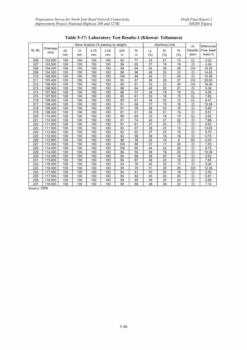
Preparatory Survey for North East Road Network Connectivity Draft Final Report 2 Improvement Project (National Highway 208 and 127B) NH208 Tripura
5-46
Table 5-17: Laboratory Test Results-1 (Khowai- Teliamura)
Source: DPR
20 mm
10 mm
4.75 mm
2.00 mm
425 m
75 m
LL (%)
PL (%)
PI (%)
206 103.000 100 100 100 100 93 77 33 21 12 CL 2.22207 103.500 100 100 100 100 99 95 37 18 19 CI 4.36208 104.000 100 100 100 100 99 94 54 26 28 CH 16.35209 104.500 100 100 100 100 99 96 48 25 23 CI 14.45210 105.000 100 100 100 100 100 94 45 21 24 CI 10.36211 105.400 100 100 100 100 95 87 56 29 27 CH 20.00212 106.000 100 100 100 100 95 81 53 23 30 CH 18.36213 106.500 100 100 100 100 88 64 46 25 21 CI 9.36214 107.000 100 100 100 100 86 57 34 18 16 CL 0.00215 107.500 100 100 100 100 85 61 33 18 15 CL 7.85216 108.000 100 100 100 100 95 81 34 22 12 CL 8.47217 108.400 100 100 100 100 91 68 37 19 18 CI 10.38218 109.000 100 100 100 100 87 59 38 22 16 CI 6.69219 109.500 100 100 100 100 87 61 36 21 15 CI 8.57220 110.000 100 100 100 100 89 69 33 18 15 CL 6.58221 110.500 100 100 100 100 91 74 43 21 22 CI 7.88222 111.000 100 100 100 100 91 61 37 20 17 CI 9.52223 111.500 100 100 100 100 93 67 38 23 15 CI 10.65224 112.000 100 100 100 100 92 62 37 22 15 CI 8.75225 112.500 100 100 100 100 92 58 36 18 18 CI 9.75226 112.900 100 100 100 100 88 38 24 16 8 SC 0.00227 113.500 100 100 100 100 100 86 37 17 20 CI 7.55228 114.000 100 100 100 100 100 90 44 22 22 CI 8.75229 114.500 100 100 100 100 86 55 38 18 20 CI 10.36230 115.000 100 100 100 100 94 86 36 20 16 CI 0.00231 115.600 100 100 100 100 94 87 38 22 16 CI 7.65232 116.000 100 100 100 100 93 76 42 25 17 CI 9.36233 116.500 100 100 100 100 95 79 51 26 25 CH 12.36234 117.000 100 100 100 100 94 81 43 24 19 CI 0.00235 117.500 100 100 100 100 95 82 45 20 25 CI 6.87236 118.000 100 100 100 100 99 93 49 25 24 CI 5.68237 118.500 100 100 100 100 99 88 48 26 22 CI 7.14
Differential Free Swell
Index %
Sieve Analysis (% passing by weight) Atterberg Limit I.S. Classific
ationSL No.
Chainage (km)
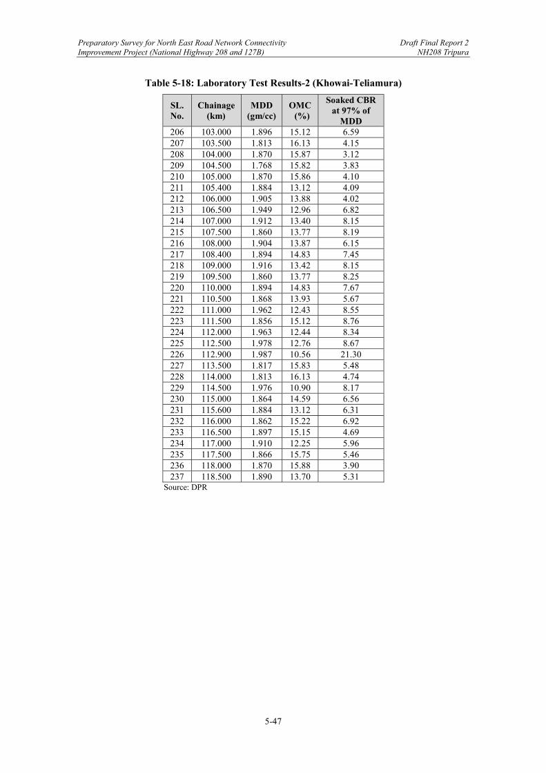
Preparatory Survey for North East Road Network Connectivity Draft Final Report 2 Improvement Project (National Highway 208 and 127B) NH208 Tripura
5-47
Table 5-18: Laboratory Test Results-2 (Khowai-Teliamura)
SL. No.
Chainage (km)
MDD (gm/cc)
OMC (%)
Soaked CBR at 97% of
MDD 206 103.000 1.896 15.12 6.59 207 103.500 1.813 16.13 4.15 208 104.000 1.870 15.87 3.12 209 104.500 1.768 15.82 3.83 210 105.000 1.870 15.86 4.10 211 105.400 1.884 13.12 4.09 212 106.000 1.905 13.88 4.02 213 106.500 1.949 12.96 6.82 214 107.000 1.912 13.40 8.15 215 107.500 1.860 13.77 8.19 216 108.000 1.904 13.87 6.15 217 108.400 1.894 14.83 7.45 218 109.000 1.916 13.42 8.15 219 109.500 1.860 13.77 8.25 220 110.000 1.894 14.83 7.67 221 110.500 1.868 13.93 5.67 222 111.000 1.962 12.43 8.55 223 111.500 1.856 15.12 8.76 224 112.000 1.963 12.44 8.34 225 112.500 1.978 12.76 8.67 226 112.900 1.987 10.56 21.30 227 113.500 1.817 15.83 5.48 228 114.000 1.813 16.13 4.74 229 114.500 1.976 10.90 8.17 230 115.000 1.864 14.59 6.56 231 115.600 1.884 13.12 6.31 232 116.000 1.862 15.22 6.92 233 116.500 1.897 15.15 4.69 234 117.000 1.910 12.25 5.96 235 117.500 1.866 15.75 5.46 236 118.000 1.870 15.88 3.90 237 118.500 1.890 13.70 5.31
Source: DPR

Preparatory Survey for North East Road Network Connectivity Draft Final Report 2 Improvement Project (National Highway 208 and 127B) NH208 Tripura
5-48
Table 5-19: Laboratory Test Results-1
SI. No. Chainage No.
(Km) MDD (g/cc)
OMC (%)
Unsoaked CBR (%)
Soaked CBR (%)
Swelling Index (%)
1 10 1.756 15.71 15.43 7.54 3.86 2 20 1.878 11.55 18.86 8.14 2.65 3 30 1.782 15.26 16.50 7.86 3.79 4 55 1.794 14.78 17.43 7.98 3.79 5 65 1.802 13.92 18.58 8.04 2.98 6 75 1.816 14.11 18.61 8.11 2.78 7 95 1.823 13.75 17.93 7.96 2.71 8 105 1.787 15.78 16.76 7.89 3.73 9 115 1.796 14.74 17.36 7.85 3.81
10 Borrow Area
near Km 44.00 1.778 15.55 17.26 8.43 3.77
11 Borrow Area
near Km 82.00 1.800 13.76 17.78 8.21 3.02
Source: DPR
Table 5-20: Laboratory Test Results-2
Source: DPR
Chainage No. (Km)
Soil Classification
Insitu Dry Density (g/cc)
Insitu Moisture
(%)
Sand (%)
Silt (%)
Clay (%)
Liquid Limit (%)
Plastic Limit (%)
Plasticity Indix (%)
MDD (g/cc)
OMC (%)
Unsoaked CBR (%)
Soaked CBR (%)
Swelling Index (%)
7+000 CL 1.14 14.15 39 41 20 26 18 8 1.84 14.9 21.5 12.43 3.914+000 CL 1.13 18.15 37 23 40 29 19 10 1.808 15.6 19.71 10.28 4.120+500 SM 1.27 12.33 77 13 10 19 16 3 1.82 16.9 21.85 11.71 1.8

Preparatory Survey for North East Road Network Connectivity Draft Final Report 2 Improvement Project (National Highway 208 and 127B) NH208 Tripura
5-49
(3) Design of New Flexible Pavement
The pavement design for the road was conducted based on cumulative number of standard axles and the CBR of the subgrade. The composition of pavement has been recommended keeping in view the construction and maintenance costs. The Survey stretch was designed 2-lane with paved shoulder configuration; generally, such as 14m (i.e. 7.0m carriageway + 2x1.5m paved shoulder + 2x2.0m earthen shoulder. Therefore, in the DPRs, IRC SP73 43 was adopted. As it was mentioned earlier, the Project stretch was covered by 2 different DPRs. For the Survey stretch from Khowai to Teliamura, the DPR consultant adopted IRC 37-201244 for the design of flexible pavements in accordance with IRC SP 73-2015. As per the Clause 5.4.1 of IRC SP 73-2015, The flexible pavement shall be designed for a minimum design period of 15 years, subjected to the condition that design traffic shall not be less than 20 msa. In the Section 10 of IRC 37-2012, five different combinations of traffic and materials properties have been considered for which pavement composition have been supported with illustration to compare the proposed design thickness in the design catalogue with that given by IITPAVE, the pavement analysis software. The DPR consultant proposed the combination of granular base and granular subbase, and 20 msa of Design Traffic and 8% of design CBR were applied to the pavement thickness design. Therefore, Plate 6 of IRC 37-2012 was selected and shown as follows.
Source: IRC 37-2012
Figure 5-25: Catalogue for Pavement Thickness as per IRC 37-2012 (Plate 6)
In the Survey stretch, reconstruction of existing pavement is recommended due to the poor pavement surface of extensive cracking, raveling, rutting, potholes etc., besides, the proposed cutting and filling of vertical profile. Hence, a new pavement thickness of BC=40mm, DBM=85mm, WMM (in two layer)=250mm and GSB=200mm are proposed on existing portion
43 IRC SP73: Manual of Specifications and Standards for Two Laning of Highways with Paved Shoulder 44 IRC 37-2012: Guidelines for the Design of Flexible Pavements

Preparatory Survey for North East Road Network Connectivity Draft Final Report 2 Improvement Project (National Highway 208 and 127B) NH208 Tripura
5-50
after removal of existing pavement layer up to a required depth based on the profile design with exposed pavement layer treated as subgrade course after compaction. Besides the new pavement design, the overlay design was conducted. The rebound deflections were measured using Benkelman Beam Deflection (BBD) method as per IRC 81-1997. The calculation of characteristic deflections which will be required for overlay design of the existing pavement was conducted in the DPR; however, JICA Survey Team has not received the result from the DPR consultant. On the other hand, for the Survey stretch from Teliamura to Sabroom, the DPR consultant adopted IRC 37-2018 for the design of flexible pavements in accordance with IRC SP 73-2018. As per the Clause 5.4.1 of IRC SP 73-2018, the flexible pavement shall be designed for a minimum design period of 15 years, subject to the condition that design traffic shall not be less than 20 msa. In the Section 12 of IRC 37-2018, six categories of pavements have been given. The DPR consultant proposed the combination of bituminous surface course with Cement Treated Sub Base (CTSB), Cement Treated Base (CTB) and Stress Absorbing Membrane Interlayer (SAMI). For the layers of CTBS and CTB, Jhama Brick Base (JBB) and Jhama Brick Sub Base (JBSB) were proposed, respectively. In addition, 20 msa of Design Traffic and 8% of design CBR were applied to the pavement thickness design. Therefore, Plate 20 of IRC 37-2018 was selected and shown as follows.
Source: IRC 37-2018
Figure 5-26: Catalogue for Pavement Thickness as per IRC 37-2018 (Plate 20)
The existing pavement is composite of 20-40mm thickness of bituminous layer over brick work. Since the entire length is proposed as new pavement, the Benkelman Beam Deflection (BBD) survey was not conducted in the DPR. The following table shows the comparison of the pavement composition.
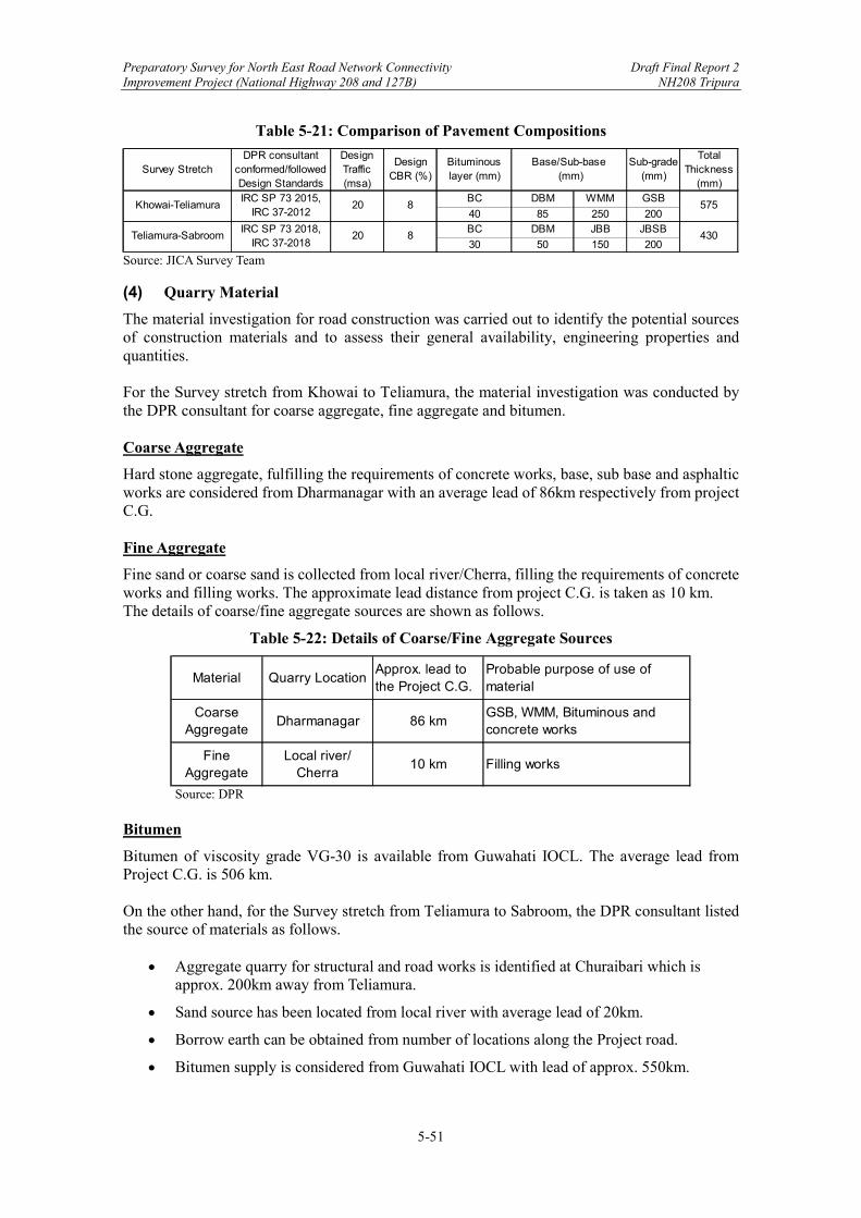
Preparatory Survey for North East Road Network Connectivity Draft Final Report 2 Improvement Project (National Highway 208 and 127B) NH208 Tripura
5-51
Table 5-21: Comparison of Pavement Compositions
Source: JICA Survey Team
(4) Quarry Material
The material investigation for road construction was carried out to identify the potential sources of construction materials and to assess their general availability, engineering properties and quantities. For the Survey stretch from Khowai to Teliamura, the material investigation was conducted by the DPR consultant for coarse aggregate, fine aggregate and bitumen. Coarse Aggregate
Hard stone aggregate, fulfilling the requirements of concrete works, base, sub base and asphaltic works are considered from Dharmanagar with an average lead of 86km respectively from project C.G. Fine Aggregate
Fine sand or coarse sand is collected from local river/Cherra, filling the requirements of concrete works and filling works. The approximate lead distance from project C.G. is taken as 10 km. The details of coarse/fine aggregate sources are shown as follows.
Table 5-22: Details of Coarse/Fine Aggregate Sources
Source: DPR
Bitumen
Bitumen of viscosity grade VG-30 is available from Guwahati IOCL. The average lead from Project C.G. is 506 km. On the other hand, for the Survey stretch from Teliamura to Sabroom, the DPR consultant listed the source of materials as follows.
Aggregate quarry for structural and road works is identified at Churaibari which is approx. 200km away from Teliamura.
Sand source has been located from local river with average lead of 20km.
Borrow earth can be obtained from number of locations along the Project road.
Bitumen supply is considered from Guwahati IOCL with lead of approx. 550km.
Survey StretchDPR consultant
conformed/followed Design Standards
Design Traffic (msa)
Design CBR (%)
Bituminous layer (mm)
Sub-grade (mm)
Total Thickness
(mm)BC DBM WMM GSB
40 85 250 200BC DBM JBB JBSB
30 50 150 200
575
430
Base/Sub-base (mm)
IRC SP 73 2015,IRC 37-2012
IRC SP 73 2018,IRC 37-2018
Khowai-Teliamura 20 8
Teliamura-Sabroom 20 8
Material Quarry LocationApprox. lead to the Project C.G.
Probable purpose of use of material
Coarse Aggregate
Dharmanagar 86 kmGSB, WMM, Bituminous and concrete works
Fine Aggregate
Local river/ Cherra
10 km Filling works
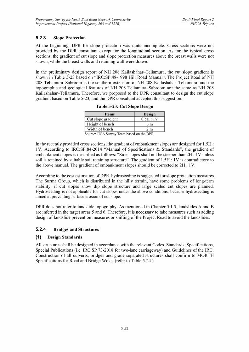
Preparatory Survey for North East Road Network Connectivity Draft Final Report 2 Improvement Project (National Highway 208 and 127B) NH208 Tripura
5-52
5.2.3 Slope Protection
At the beginning, DPR for slope protection was quite incomplete. Cross sections were not provided by the DPR consultant except for the longitudinal section. As for the typical cross sections, the gradient of cut slope and slope protection measures above the breast walls were not shown, while the breast walls and retaining wall were drawn. In the preliminary design report of NH 208 Kailashahar‒Teliamura, the cut slope gradient is shown in Table 5-23 based on “IRC:SP:48-1998 Hill Road Manual”. The Project Road of NH 208 Teliamura‒Sabroom is the southern extension of NH 208 Kailashahar‒Teliamura, and the topographic and geological features of NH 208 Teliamura‒Sabroom are the same as NH 208 Kailashahar‒Teliamura. Therefore, we proposed to the DPR consultant to design the cut slope gradient based on Table 5-23, and the DPR consultant accepted this suggestion.
Table 5-23: Cut Slope Design
Items Design Cut slope gradient 0.5H : 1V Height of bench 6 m Width of bench 2 m
Source: JICA Survey Team based on the DPR In the recently provided cross sections, the gradient of embankment slopes are designed for 1.5H : 1V. According to IRC:SP:84-2014 “Manual of Specifications & Standards”, the gradient of embankment slopes is described as follows: “Side slopes shall not be steeper than 2H : 1V unless soil is retained by suitable soil retaining structure”. The gradient of 1.5H : 1V is contradictory to the above manual. The gradient of embankment slopes should be corrected to 2H : 1V. According to the cost estimation of DPR, hydroseeding is suggested for slope protection measures. The Surma Group, which is distributed in the hilly terrain, have some problems of long-term stability, if cut slopes show dip slope structure and large scaled cut slopes are planned. Hydroseeding is not applicable for cut slopes under the above conditions, because hydroseeding is aimed at preventing surface erosion of cut slope. DPR does not refer to landslide topography. As mentioned in Chapter 5.1.5, landslides A and B are inferred in the target areas 5 and 6. Therefore, it is necessary to take measures such as adding design of landslide prevention measures or shifting of the Project Road to avoid the landslides.
5.2.4 Bridges and Structures
(1) Design Standards
All structures shall be designed in accordance with the relevant Codes, Standards, Specifications, Special Publications (i.e. IRC SP 73-2018 for two-lane carriageway) and Guidelines of the IRC. Construction of all culverts, bridges and grade separated structures shall confirm to MORTH Specifications for Road and Bridge Woks. (refer to Table 5-24.)
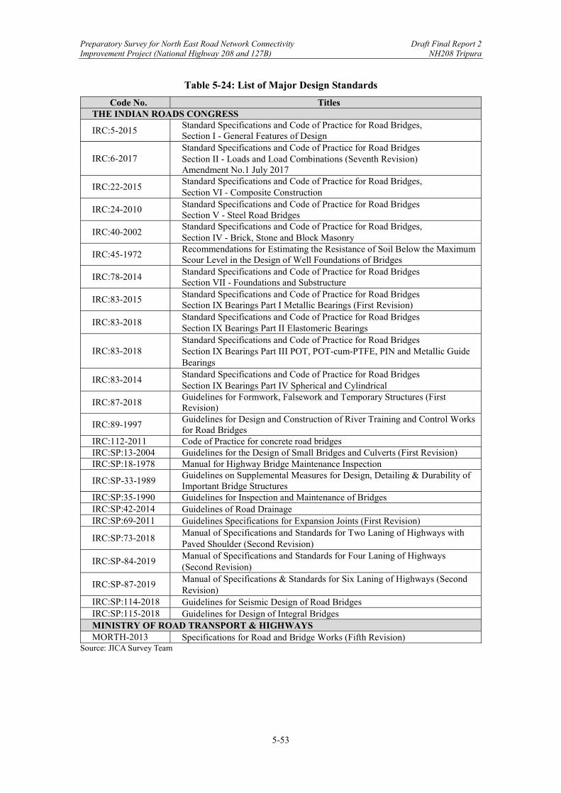
Preparatory Survey for North East Road Network Connectivity Draft Final Report 2 Improvement Project (National Highway 208 and 127B) NH208 Tripura
5-53
Table 5-24: List of Major Design Standards
Code No. Titles THE INDIAN ROADS CONGRESS
IRC:5-2015 Standard Specifications and Code of Practice for Road Bridges, Section I - General Features of Design
IRC:6-2017 Standard Specifications and Code of Practice for Road Bridges Section II - Loads and Load Combinations (Seventh Revision) Amendment No.1 July 2017
IRC:22-2015 Standard Specifications and Code of Practice for Road Bridges, Section VI - Composite Construction
IRC:24-2010 Standard Specifications and Code of Practice for Road Bridges Section V - Steel Road Bridges
IRC:40-2002 Standard Specifications and Code of Practice for Road Bridges, Section IV - Brick, Stone and Block Masonry
IRC:45-1972 Recommendations for Estimating the Resistance of Soil Below the Maximum Scour Level in the Design of Well Foundations of Bridges
IRC:78-2014 Standard Specifications and Code of Practice for Road Bridges Section VII - Foundations and Substructure
IRC:83-2015 Standard Specifications and Code of Practice for Road Bridges Section IX Bearings Part I Metallic Bearings (First Revision)
IRC:83-2018 Standard Specifications and Code of Practice for Road Bridges Section IX Bearings Part II Elastomeric Bearings
IRC:83-2018 Standard Specifications and Code of Practice for Road Bridges Section IX Bearings Part III POT, POT-cum-PTFE, PIN and Metallic Guide Bearings
IRC:83-2014 Standard Specifications and Code of Practice for Road Bridges Section IX Bearings Part IV Spherical and Cylindrical
IRC:87-2018 Guidelines for Formwork, Falsework and Temporary Structures (First Revision)
IRC:89-1997 Guidelines for Design and Construction of River Training and Control Works for Road Bridges
IRC:112-2011 Code of Practice for concrete road bridges IRC:SP:13-2004 Guidelines for the Design of Small Bridges and Culverts (First Revision) IRC:SP:18-1978 Manual for Highway Bridge Maintenance Inspection
IRC:SP-33-1989 Guidelines on Supplemental Measures for Design, Detailing & Durability of Important Bridge Structures
IRC:SP:35-1990 Guidelines for Inspection and Maintenance of Bridges IRC:SP:42-2014 Guidelines of Road Drainage IRC:SP:69-2011 Guidelines Specifications for Expansion Joints (First Revision)
IRC:SP:73-2018 Manual of Specifications and Standards for Two Laning of Highways with Paved Shoulder (Second Revision)
IRC:SP-84-2019 Manual of Specifications and Standards for Four Laning of Highways (Second Revision)
IRC:SP-87-2019 Manual of Specifications & Standards for Six Laning of Highways (Second Revision)
IRC:SP:114-2018 Guidelines for Seismic Design of Road Bridges IRC:SP:115-2018 Guidelines for Design of Integral Bridges MINISTRY OF ROAD TRANSPORT & HIGHWAYS MORTH-2013 Specifications for Road and Bridge Works (Fifth Revision)
Source: JICA Survey Team
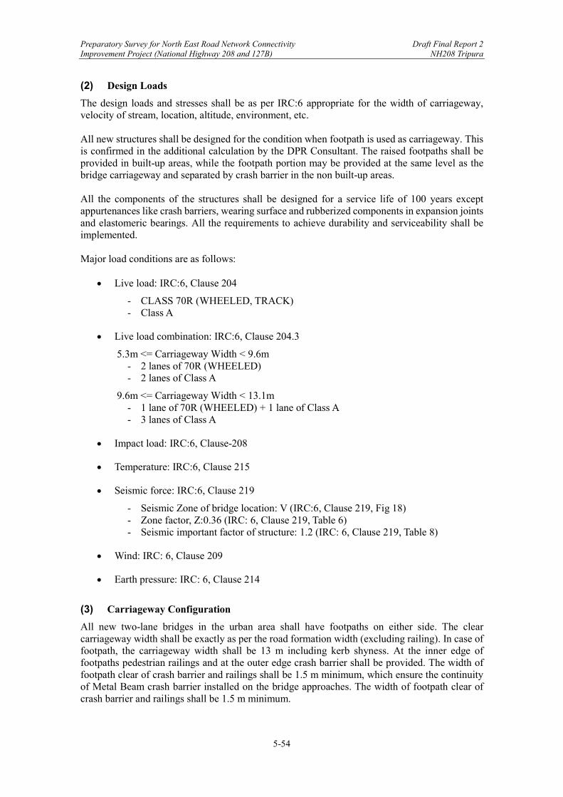
Preparatory Survey for North East Road Network Connectivity Draft Final Report 2 Improvement Project (National Highway 208 and 127B) NH208 Tripura
5-54
(2) Design Loads
The design loads and stresses shall be as per IRC:6 appropriate for the width of carriageway, velocity of stream, location, altitude, environment, etc. All new structures shall be designed for the condition when footpath is used as carriageway. This is confirmed in the additional calculation by the DPR Consultant. The raised footpaths shall be provided in built-up areas, while the footpath portion may be provided at the same level as the bridge carriageway and separated by crash barrier in the non built-up areas. All the components of the structures shall be designed for a service life of 100 years except appurtenances like crash barriers, wearing surface and rubberized components in expansion joints and elastomeric bearings. All the requirements to achieve durability and serviceability shall be implemented. Major load conditions are as follows:
Live load: IRC:6, Clause 204
- CLASS 70R (WHEELED, TRACK) - Class A
Live load combination: IRC:6, Clause 204.3
5.3m <= Carriageway Width < 9.6m - 2 lanes of 70R (WHEELED) - 2 lanes of Class A
9.6m <= Carriageway Width < 13.1m - 1 lane of 70R (WHEELED) + 1 lane of Class A - 3 lanes of Class A
Impact load: IRC:6, Clause-208
Temperature: IRC:6, Clause 215
Seismic force: IRC:6, Clause 219
- Seismic Zone of bridge location: V (IRC:6, Clause 219, Fig 18) - Zone factor, Z:0.36 (IRC: 6, Clause 219, Table 6) - Seismic important factor of structure: 1.2 (IRC: 6, Clause 219, Table 8)
Wind: IRC: 6, Clause 209
Earth pressure: IRC: 6, Clause 214
(3) Carriageway Configuration
All new two-lane bridges in the urban area shall have footpaths on either side. The clear carriageway width shall be exactly as per the road formation width (excluding railing). In case of footpath, the carriageway width shall be 13 m including kerb shyness. At the inner edge of footpaths pedestrian railings and at the outer edge crash barrier shall be provided. The width of footpath clear of crash barrier and railings shall be 1.5 m minimum, which ensure the continuity of Metal Beam crash barrier installed on the bridge approaches. The width of footpath clear of crash barrier and railings shall be 1.5 m minimum.
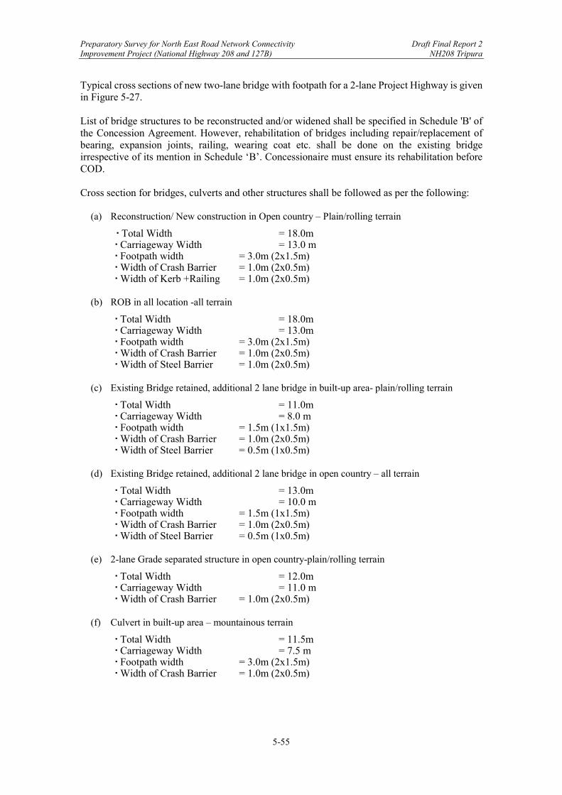
Preparatory Survey for North East Road Network Connectivity Draft Final Report 2 Improvement Project (National Highway 208 and 127B) NH208 Tripura
5-55
Typical cross sections of new two-lane bridge with footpath for a 2-lane Project Highway is given in Figure 5-27. List of bridge structures to be reconstructed and/or widened shall be specified in Schedule 'B' of the Concession Agreement. However, rehabilitation of bridges including repair/replacement of bearing, expansion joints, railing, wearing coat etc. shall be done on the existing bridge irrespective of its mention in Schedule ‘B’. Concessionaire must ensure its rehabilitation before COD.
Cross section for bridges, culverts and other structures shall be followed as per the following:
(a) Reconstruction/ New construction in Open country – Plain/rolling terrain
‧ Total Width = 18.0m ‧ Carriageway Width = 13.0 m ‧ Footpath width = 3.0m (2x1.5m) ‧ Width of Crash Barrier = 1.0m (2x0.5m) ‧ Width of Kerb +Railing = 1.0m (2x0.5m)
(b) ROB in all location -all terrain
‧ Total Width = 18.0m ‧ Carriageway Width = 13.0m ‧ Footpath width = 3.0m (2x1.5m) ‧ Width of Crash Barrier = 1.0m (2x0.5m) ‧ Width of Steel Barrier = 1.0m (2x0.5m)
(c) Existing Bridge retained, additional 2 lane bridge in built-up area- plain/rolling terrain
‧ Total Width = 11.0m ‧ Carriageway Width = 8.0 m ‧ Footpath width = 1.5m (1x1.5m) ‧ Width of Crash Barrier = 1.0m (2x0.5m) ‧ Width of Steel Barrier = 0.5m (1x0.5m)
(d) Existing Bridge retained, additional 2 lane bridge in open country – all terrain
‧ Total Width = 13.0m ‧ Carriageway Width = 10.0 m ‧ Footpath width = 1.5m (1x1.5m) ‧ Width of Crash Barrier = 1.0m (2x0.5m) ‧ Width of Steel Barrier = 0.5m (1x0.5m)
(e) 2-lane Grade separated structure in open country-plain/rolling terrain
‧ Total Width = 12.0m ‧ Carriageway Width = 11.0 m ‧ Width of Crash Barrier = 1.0m (2x0.5m)
(f) Culvert in built-up area – mountainous terrain
‧ Total Width = 11.5m ‧ Carriageway Width = 7.5 m ‧ Footpath width = 3.0m (2x1.5m) ‧ Width of Crash Barrier = 1.0m (2x0.5m)
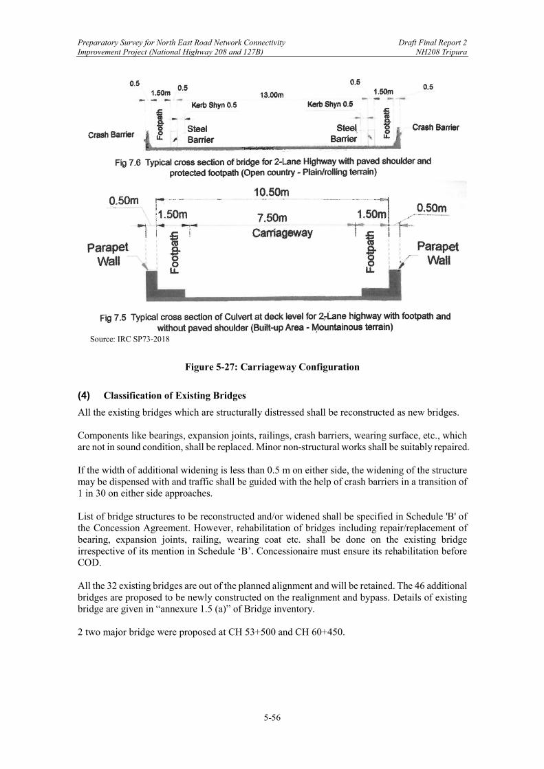
Preparatory Survey for North East Road Network Connectivity Draft Final Report 2 Improvement Project (National Highway 208 and 127B) NH208 Tripura
5-56
Source: IRC SP73-2018
Figure 5-27: Carriageway Configuration
(4) Classification of Existing Bridges
All the existing bridges which are structurally distressed shall be reconstructed as new bridges. Components like bearings, expansion joints, railings, crash barriers, wearing surface, etc., which are not in sound condition, shall be replaced. Minor non-structural works shall be suitably repaired. If the width of additional widening is less than 0.5 m on either side, the widening of the structure may be dispensed with and traffic shall be guided with the help of crash barriers in a transition of 1 in 30 on either side approaches. List of bridge structures to be reconstructed and/or widened shall be specified in Schedule 'B' of the Concession Agreement. However, rehabilitation of bridges including repair/replacement of bearing, expansion joints, railing, wearing coat etc. shall be done on the existing bridge irrespective of its mention in Schedule ‘B’. Concessionaire must ensure its rehabilitation before COD. All the 32 existing bridges are out of the planned alignment and will be retained. The 46 additional bridges are proposed to be newly constructed on the realignment and bypass. Details of existing bridge are given in “annexure 1.5 (a)” of Bridge inventory. 2 two major bridge were proposed at CH 53+500 and CH 60+450.
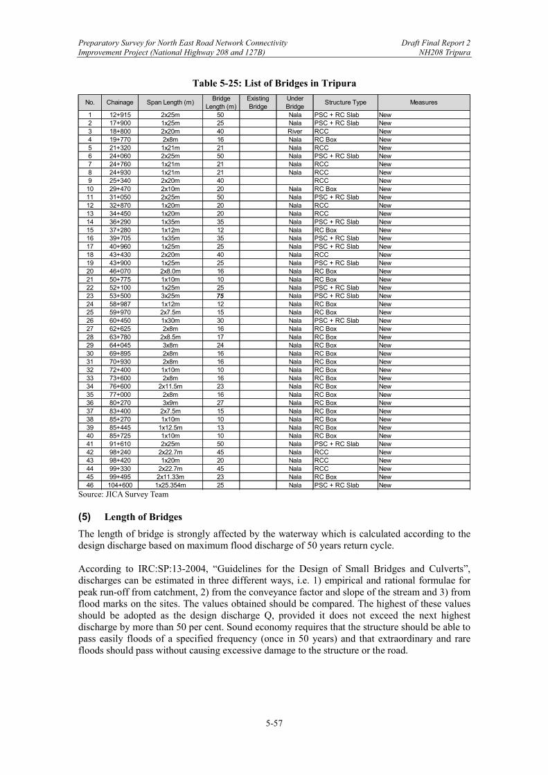
Preparatory Survey for North East Road Network Connectivity Draft Final Report 2 Improvement Project (National Highway 208 and 127B) NH208 Tripura
5-57
Table 5-25: List of Bridges in Tripura
Source: JICA Survey Team (5) Length of Bridges
The length of bridge is strongly affected by the waterway which is calculated according to the design discharge based on maximum flood discharge of 50 years return cycle. According to IRC:SP:13-2004, “Guidelines for the Design of Small Bridges and Culverts”, discharges can be estimated in three different ways, i.e. 1) empirical and rational formulae for peak run-off from catchment, 2) from the conveyance factor and slope of the stream and 3) from flood marks on the sites. The values obtained should be compared. The highest of these values should be adopted as the design discharge Q, provided it does not exceed the next highest discharge by more than 50 per cent. Sound economy requires that the structure should be able to pass easily floods of a specified frequency (once in 50 years) and that extraordinary and rare floods should pass without causing excessive damage to the structure or the road.
1 12+915 2x25m 50 Nala PSC + RC Slab New2 17+900 1x25m 25 Nala PSC + RC Slab New3 18+800 2x20m 40 River RCC New4 19+770 2x8m 16 Nala RC Box New5 21+320 1x21m 21 Nala RCC New6 24+060 2x25m 50 Nala PSC + RC Slab New7 24+760 1x21m 21 Nala RCC New8 24+930 1x21m 21 Nala RCC New9 25+340 2x20m 40 RCC New10 29+470 2x10m 20 Nala RC Box New11 31+050 2x25m 50 Nala PSC + RC Slab New12 32+870 1x20m 20 Nala RCC New13 34+450 1x20m 20 Nala RCC New14 36+290 1x35m 35 Nala PSC + RC Slab New15 37+280 1x12m 12 Nala RC Box New16 39+705 1x35m 35 Nala PSC + RC Slab New17 40+960 1x25m 25 Nala PSC + RC Slab New18 43+430 2x20m 40 Nala RCC New19 43+900 1x25m 25 Nala PSC + RC Slab New20 46+070 2x8.0m 16 Nala RC Box New21 50+775 1x10m 10 Nala RC Box New22 52+100 1x25m 25 Nala PSC + RC Slab New23 53+500 3x25m 75 Nala PSC + RC Slab New24 58+987 1x12m 12 Nala RC Box New25 59+970 2x7.5m 15 Nala RC Box New26 60+450 1x30m 30 Nala PSC + RC Slab New27 62+625 2x8m 16 Nala RC Box New28 63+780 2x8.5m 17 Nala RC Box New29 64+045 3x8m 24 Nala RC Box New30 69+895 2x8m 16 Nala RC Box New31 70+930 2x8m 16 Nala RC Box New32 72+400 1x10m 10 Nala RC Box New33 73+600 2x8m 16 Nala RC Box New34 76+600 2x11.5m 23 Nala RC Box New35 77+000 2x8m 16 Nala RC Box New36 80+270 3x9m 27 Nala RC Box New37 83+400 2x7.5m 15 Nala RC Box New38 85+270 1x10m 10 Nala RC Box New39 85+445 1x12.5m 13 Nala RC Box New40 85+725 1x10m 10 Nala RC Box New41 91+610 2x25m 50 Nala PSC + RC Slab New42 98+240 2x22.7m 45 Nala RCC New43 98+420 1x20m 20 Nala RCC New44 99+330 2x22.7m 45 Nala RCC New45 99+495 2x11.33m 23 Nala RC Box New46 104+600 1x25.354m 25 Nala PSC + RC Slab New
MeasuresNo. Chainage Structure TypeSpan Length (m)Bridge
Length (m)ExistingBridge
UnderBridge

Preparatory Survey for North East Road Network Connectivity Draft Final Report 2 Improvement Project (National Highway 208 and 127B) NH208 Tripura
5-58
If the required linear waterway (L) is less than the economical span length, it has to be provided in one single span. When L is more than the economical span length (S), the number of spans (N) required is tentatively found from the following relation: L = NS Since N must be a whole number (preferably odd) S has to be modified suitably. In doing so, it is permissible to adopt varying span lengths in one structure to keep as close as possible to the requirements of economy and to cause the least obstructions to the flow.
Table 5-26: Bridge Length in Tripura
Source: JICA Survey Team
Discharge Regime width Bridge Length(cu.m) (m) (m)
1 12+915 316.35 85.374 502 17+900 156.72 60.091 253 18+800 231.64 73.054 404 19+770 32.96 27.558 165 21+320 109.28 50.178 216 24+060 193.90 66.839 507 24+760 70.49 40.299 218 24+930 83.79 43.938 219 25+340 125.83 53.843 4010 29+470 56.01 35.923 2011 31+050 319.40 85.784 5012 32+870 104.97 49.179 2013 34+450 59.16 36.919 2014 36+290 212.39 69.953 3515 37+280 31.47 26.927 1216 39+705 227.35 72.375 3517 40+960 121.28 52.860 2518 43+430 275.94 79.735 4019 43+900 140.60 56.916 2520 46+070 36.19 28.876 1621 50+775 36.19 28.877 1022 52+100 74.65 41.472 2523 53+500 744.71 130.989 7524 58+987 41.43 30.894 1225 59+970 37.00 29.196 1526 60+450 195.44 67.103 3027 62+625 42.49 31.289 1628 63+780 35.68 28.673 1729 64+045 61.83 37.744 2430 69+895 31.15 26.790 1631 70+930 58.64 36.758 1632 72+400 27.85 25.330 1033 73+600 65.77 38.926 1634 76+600 37.17 29.266 2335 77+000 55.85 35.870 1636 80+270 95.95 47.017 2737 83+400 28.49 25.622 1538 85+270 13.31 17.509 1039 85+445 19.30 21.087 1340 85+725 15.04 18.616 1041 91+610 202.56 68.315 5042 98+240 52.54 34.792 4543 98+420 61.08 37.512 2044 99+330 65.04 38.711 4545 99+495 50.45 34.094 2346 104+600 59.36 36.981 25
No. Chainage

Preparatory Survey for North East Road Network Connectivity Draft Final Report 2 Improvement Project (National Highway 208 and 127B) NH208 Tripura
5-59
(6) Vertical Clearance
The vertical clearance at underpass shall not be less than the values given in the table.
Table 5-27: Vertical Clearance for Underpass
Type Clearance (m) 1) Vehicular Underpass (VUP) 5.5 2) Light Vehicular Underpass (LVUP) 4.0 3) Smaller Vehicular Underpass (SVUP) 4.0
Source: IRC SP 73-2018 & SP 84-2019, 2.10 The vertical clearance is determined by calculating minimum clearance from the river as shown below.
Table 5-28: Span and Vertical Clearance as per IRC: SP13-2004
Discharge in cu.m/sec Minimum vertical clearance in mm
Upto 0.30 150 Above 0.3 and upto 3 450 Above 3 and upto 30 600
Above 30 and upto 300 900 Above 300 and upto 3000 1200
Above 3000 1500 Source: IRC: SP13-2004, Table 12.1
Above said calculation results and summarize them in Table 5-29. All bridges satisfied the required clearance. Minimum vertical clearance corresponding to discharge (m3 / sec) is mentioned in Table 5-28, and actual vertical clearance is mentioned in 6th row in Table 5-29.
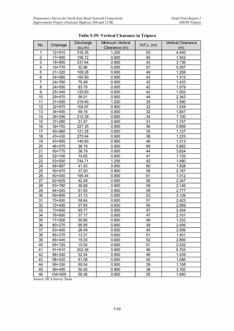
Preparatory Survey for North East Road Network Connectivity Draft Final Report 2 Improvement Project (National Highway 208 and 127B) NH208 Tripura
5-60
Table 5-29: Vertical Clearance in Tripura
Source: JICA Survey Team
1 12+915 316.35 1.200 53 4.4402 17+900 156.72 0.900 45 1.5423 18+800 231.64 0.900 43 3.1364 19+770 32.96 0.900 57 5.0875 21+320 109.28 0.900 49 1.2086 24+060 193.90 0.900 43 1.3127 24+760 70.49 0.900 42 1.4338 24+930 83.79 0.900 42 1.0799 25+340 125.83 0.900 42 1.05210 29+470 56.01 0.900 44 2.34211 31+050 319.40 1.200 35 1.59012 32+870 104.97 0.900 32 1.03413 34+450 59.16 0.900 32 1.84714 36+290 212.39 0.900 34 1.10015 37+280 31.47 0.900 31 1.74716 39+705 227.35 0.900 36 0.89917 40+960 121.28 0.900 35 1.12718 43+430 275.94 0.900 38 1.22319 43+900 140.60 0.900 46 1.31320 46+070 36.19 0.900 69 5.66221 50+775 36.19 0.900 44 3.82422 52+100 74.65 0.900 41 1.13223 53+500 744.71 1.200 42 1.49024 58+987 41.43 0.900 60 1.92825 59+970 37.00 0.900 59 2.16726 60+450 195.44 0.900 61 1.01227 62+625 42.49 0.900 56 2.34728 63+780 35.68 0.900 59 2.14629 64+045 61.83 0.900 59 2.77730 69+895 31.15 0.900 53 3.12631 70+930 58.64 0.900 51 2.42332 72+400 27.85 0.600 55 2.06933 73+600 65.77 0.900 57 2.45434 76+600 37.17 0.900 47 2.10135 77+000 55.85 0.900 49 1.23236 80+270 95.95 0.900 39 2.45637 83+400 28.49 0.600 45 2.05638 85+270 13.31 0.600 51 1.45139 85+445 19.30 0.600 52 2.80640 85+725 15.04 0.600 51 2.43241 91+610 202.56 0.900 46 6.70242 98+240 52.54 0.900 46 1.43943 98+420 61.08 0.900 45 1.04644 99+330 65.04 0.900 39 1.15845 99+495 50.45 0.900 38 3.18246 104+600 59.36 0.900 25 1.840
Minimum VerticalClearance (m)
H.F.L. (m)No. ChainageVertical Clearance
(m)Discharge
(cu.m)
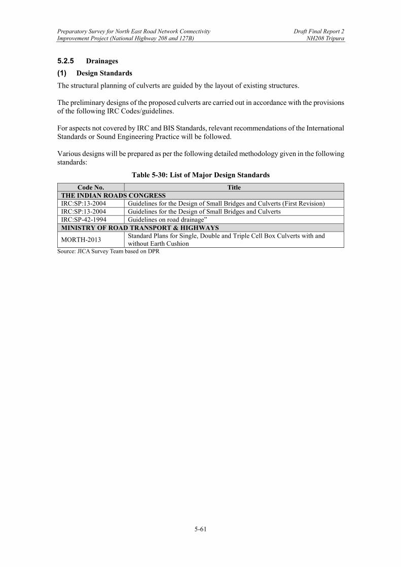
Preparatory Survey for North East Road Network Connectivity Draft Final Report 2 Improvement Project (National Highway 208 and 127B) NH208 Tripura
5-61
5.2.5 Drainages
(1) Design Standards
The structural planning of culverts are guided by the layout of existing structures. The preliminary designs of the proposed culverts are carried out in accordance with the provisions of the following IRC Codes/guidelines. For aspects not covered by IRC and BIS Standards, relevant recommendations of the International Standards or Sound Engineering Practice will be followed. Various designs will be prepared as per the following detailed methodology given in the following standards:
Table 5-30: List of Major Design Standards
Code No. Title THE INDIAN ROADS CONGRESS IRC:SP:13-2004 Guidelines for the Design of Small Bridges and Culverts (First Revision) IRC:SP:13-2004 Guidelines for the Design of Small Bridges and Culverts IRC:SP-42-1994 Guidelines on road drainage” MINISTRY OF ROAD TRANSPORT & HIGHWAYS
MORTH-2013 Standard Plans for Single, Double and Triple Cell Box Culverts with and without Earth Cushion
Source: JICA Survey Team based on DPR

Preparatory Survey for North East Road Network Connectivity Draft Final Report 2 Improvement Project (National Highway 208 and 127B) NH208 Tripura
5-62
(2) Classification of Existing Culvert
There are 232 numbers of existing culverts (162 HP culverts, 51 nos slab culvert & 19 nos Box Bridges) along the Survey Road.
Table 5-31: List of Existing Culvert Type
NH280 (Khowai-Sabroom)
EXISTING Culvert 232 PIPE Culvert 162 Slab Culvert 51 Box Culvert 19
Source: JICA Survey Team based on DPR The list of culverts confirmed by the field survey is shown below.
Table 5-32: List of Existing Culvert in Tripura (1)
Sl No.
Survey Chainage
(km)
Design Chainage
(km)
Type of Existing
Structure
Span of Existing
Structure (M) 1 21.170 21.175 Pipe 2× 1.2 2 21.245 21.250 Pipe 1× 1.2 3 21.315 21.318 Pipe 1× 1.2 4 21.549 21.554 Pipe 1× 0.6 5 21.715 21.720 Pipe 1× 1.2 6 24.861 24.290 Pipe 2× 1.0 7 25.354 24.783 Pipe 2× 0.9 8 26.451 25.835 Box 1× 1.5 9 26.764 26.147 Pipe 2× 1.0 10 27.195 26.569 Pipe 2× 1.0 11 27.357 26.730 Pipe 2× 0.75 12 27.663 26.976 Pipe 1× 1.0 13 27.818 27.132 Pipe 2× 1.2 14 27.878 27.192 Pipe 1× 0.9 15 27.965 27.279 Pipe 1× 1.0 16 28.151 27.465 Pipe 1× 1.5
Source: JICA Survey Team based on DPR

Preparatory Survey for North East Road Network Connectivity Draft Final Report 2 Improvement Project (National Highway 208 and 127B) NH208 Tripura
5-63
Table 5-33: List of Existing Culvert in Tripura (2)
Sl
No. Survey
Chainage (km)
Design Chainage
(km)
Type of Existing
Structure
Span of Existing
Structure (M) 17 28.232 27.546 Pipe 1× 1.0 18 28.279 27.593 Pipe 1× 1.5 19 28.347 27.658 Pipe 1× 0.75 20 28.415 27.727 Pipe 1× 0.75 21 28.466 27.779 Pipe 1× .9 22 28.543 27.856 Pipe 1× 0.6 23 28.620 27.932 Pipe 1× 1.5 24 28.723 28.037 Pipe 1× 1.2 25 28.813 28.127 Pipe 1× 1.0 26 28.938 28.251 Pipe 1× 0.75 27 28.998 28.311 Pipe 1× 1.2 28 29.056 28.368 Pipe 1× 0.3 29 29.155 28.468 Pipe 1× 0.6 30 29.210 28.521 Pipe 1× 0.9 31 29.284 28.597 Slab 1× 5.0 32 29.372 28.685 Pipe 1× 0.9 33 30.514 29.716 Pipe 1× 1.0 34 30.794 29.997 Pipe 2× 0.9 35 31.973 31.126 Pipe 1× 0.9 36 32.415 31.520 Pipe 1× 0.9 37 32.700 31.809 Pipe 1× 1.2 38 33.013 32.067 Pipe 1× 0.6 39 33.458 32.549 Slab 1× 2.6 40 33.976 33.045 Pipe 1× 1.0 41 34.496 33.391 Pipe 2× 0.9 42 35.195 34.053 Pipe 1× 0.9 43 34.432 34.430 slab 1× 0.9 44 36.000 34.694 Pipe 1× 1.0 45 36.482 35.080 Box 1× 1.0 46 36.608 35.590 Pipe 2× 0.9 47 37.346 35.948 Pipe 1× 1.2 48 38.235 36.775 Pipe 49 39.097 37.721 Pipe 1× 1.0 50 39.254 37.870 Pipe 1× 0.9 51 39.532 38.139 Pipe 1× 1.2 52 39.950 38.553 Pipe 2× 0.9 53 40.075 38.675 Pipe 1× 1.0 54 40.379 38.975 Pipe 2× 0.9 55 40.435 39.030 Pipe 1× 1.0 56 40.495 39.086 Pipe 2× 0.9 57 40.642 39.228 Pipe 2× 1.0 58 40.703 39.297 Pipe 1× 1.0 59 40.788 39.381 Pipe 3× 0.9 60 41.068 39.610 Pipe 2× 1.0 61 41.401 39.895 Pipe 1× 0.9 62 41.575 40.075 Pipe 2× 0.9 63 41.704 40.203 Slab 1× 1.2 64 42.711 41.158 Pipe 1× 1.2
Source: JICA Survey Team based on DPR
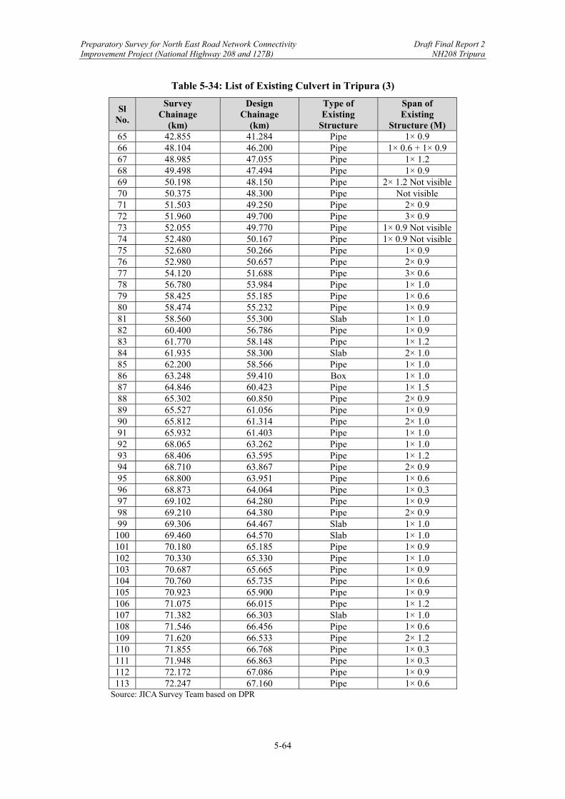
Preparatory Survey for North East Road Network Connectivity Draft Final Report 2 Improvement Project (National Highway 208 and 127B) NH208 Tripura
5-64
Table 5-34: List of Existing Culvert in Tripura (3)
Sl No.
Survey Chainage
(km)
Design Chainage
(km)
Type of Existing
Structure
Span of Existing
Structure (M) 65 42.855 41.284 Pipe 1× 0.9 66 48.104 46.200 Pipe 1× 0.6 + 1× 0.9 67 48.985 47.055 Pipe 1× 1.2 68 49.498 47.494 Pipe 1× 0.9 69 50.198 48.150 Pipe 2× 1.2 Not visible 70 50.375 48.300 Pipe Not visible 71 51.503 49.250 Pipe 2× 0.9 72 51.960 49.700 Pipe 3× 0.9 73 52.055 49.770 Pipe 1× 0.9 Not visible 74 52.480 50.167 Pipe 1× 0.9 Not visible 75 52.680 50.266 Pipe 1× 0.9 76 52.980 50.657 Pipe 2× 0.9 77 54.120 51.688 Pipe 3× 0.6 78 56.780 53.984 Pipe 1× 1.0 79 58.425 55.185 Pipe 1× 0.6 80 58.474 55.232 Pipe 1× 0.9 81 58.560 55.300 Slab 1× 1.0 82 60.400 56.786 Pipe 1× 0.9 83 61.770 58.148 Pipe 1× 1.2 84 61.935 58.300 Slab 2× 1.0 85 62.200 58.566 Pipe 1× 1.0 86 63.248 59.410 Box 1× 1.0 87 64.846 60.423 Pipe 1× 1.5 88 65.302 60.850 Pipe 2× 0.9 89 65.527 61.056 Pipe 1× 0.9 90 65.812 61.314 Pipe 2× 1.0 91 65.932 61.403 Pipe 1× 1.0 92 68.065 63.262 Pipe 1× 1.0 93 68.406 63.595 Pipe 1× 1.2 94 68.710 63.867 Pipe 2× 0.9 95 68.800 63.951 Pipe 1× 0.6 96 68.873 64.064 Pipe 1× 0.3 97 69.102 64.280 Pipe 1× 0.9 98 69.210 64.380 Pipe 2× 0.9 99 69.306 64.467 Slab 1× 1.0
100 69.460 64.570 Slab 1× 1.0 101 70.180 65.185 Pipe 1× 0.9 102 70.330 65.330 Pipe 1× 1.0 103 70.687 65.665 Pipe 1× 0.9 104 70.760 65.735 Pipe 1× 0.6 105 70.923 65.900 Pipe 1× 0.9 106 71.075 66.015 Pipe 1× 1.2 107 71.382 66.303 Slab 1× 1.0 108 71.546 66.456 Pipe 1× 0.6 109 71.620 66.533 Pipe 2× 1.2 110 71.855 66.768 Pipe 1× 0.3 111 71.948 66.863 Pipe 1× 0.3 112 72.172 67.086 Pipe 1× 0.9 113 72.247 67.160 Pipe 1× 0.6
Source: JICA Survey Team based on DPR
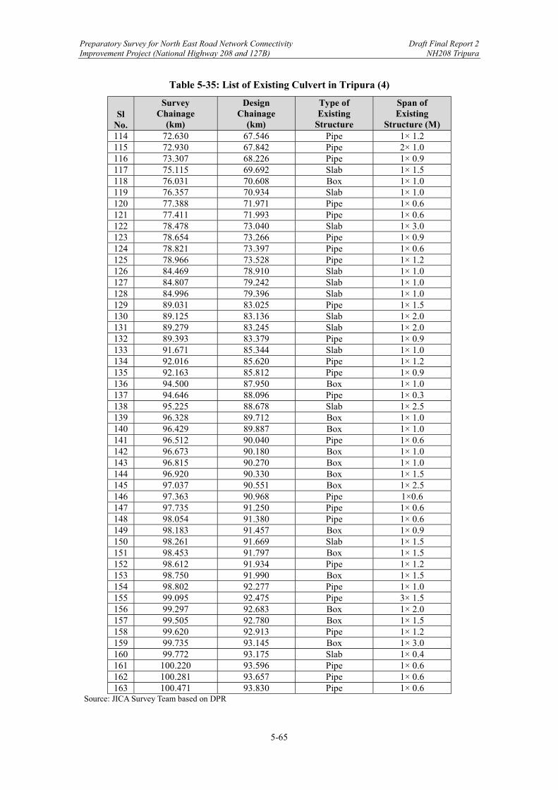
Preparatory Survey for North East Road Network Connectivity Draft Final Report 2 Improvement Project (National Highway 208 and 127B) NH208 Tripura
5-65
Table 5-35: List of Existing Culvert in Tripura (4)
Sl
No.
Survey Chainage
(km)
Design Chainage
(km)
Type of Existing
Structure
Span of Existing
Structure (M) 114 72.630 67.546 Pipe 1× 1.2 115 72.930 67.842 Pipe 2× 1.0 116 73.307 68.226 Pipe 1× 0.9 117 75.115 69.692 Slab 1× 1.5 118 76.031 70.608 Box 1× 1.0 119 76.357 70.934 Slab 1× 1.0 120 77.388 71.971 Pipe 1× 0.6 121 77.411 71.993 Pipe 1× 0.6 122 78.478 73.040 Slab 1× 3.0 123 78.654 73.266 Pipe 1× 0.9 124 78.821 73.397 Pipe 1× 0.6 125 78.966 73.528 Pipe 1× 1.2 126 84.469 78.910 Slab 1× 1.0 127 84.807 79.242 Slab 1× 1.0 128 84.996 79.396 Slab 1× 1.0 129 89.031 83.025 Pipe 1× 1.5 130 89.125 83.136 Slab 1× 2.0 131 89.279 83.245 Slab 1× 2.0 132 89.393 83.379 Pipe 1× 0.9 133 91.671 85.344 Slab 1× 1.0 134 92.016 85.620 Pipe 1× 1.2 135 92.163 85.812 Pipe 1× 0.9 136 94.500 87.950 Box 1× 1.0 137 94.646 88.096 Pipe 1× 0.3 138 95.225 88.678 Slab 1× 2.5 139 96.328 89.712 Box 1× 1.0 140 96.429 89.887 Box 1× 1.0 141 96.512 90.040 Pipe 1× 0.6 142 96.673 90.180 Box 1× 1.0 143 96.815 90.270 Box 1× 1.0 144 96.920 90.330 Box 1× 1.5 145 97.037 90.551 Box 1× 2.5 146 97.363 90.968 Pipe 1×0.6 147 97.735 91.250 Pipe 1× 0.6 148 98.054 91.380 Pipe 1× 0.6 149 98.183 91.457 Box 1× 0.9 150 98.261 91.669 Slab 1× 1.5 151 98.453 91.797 Box 1× 1.5 152 98.612 91.934 Pipe 1× 1.2 153 98.750 91.990 Box 1× 1.5 154 98.802 92.277 Pipe 1× 1.0 155 99.095 92.475 Pipe 3× 1.5 156 99.297 92.683 Box 1× 2.0 157 99.505 92.780 Box 1× 1.5 158 99.620 92.913 Pipe 1× 1.2 159 99.735 93.145 Box 1× 3.0 160 99.772 93.175 Slab 1× 0.4 161 100.220 93.596 Pipe 1× 0.6 162 100.281 93.657 Pipe 1× 0.6 163 100.471 93.830 Pipe 1× 0.6
Source: JICA Survey Team based on DPR
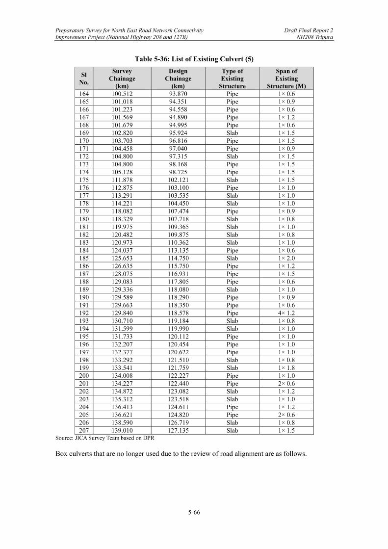
Preparatory Survey for North East Road Network Connectivity Draft Final Report 2 Improvement Project (National Highway 208 and 127B) NH208 Tripura
5-66
Table 5-36: List of Existing Culvert (5)
Sl No.
Survey Chainage
(km)
Design Chainage
(km)
Type of Existing
Structure
Span of Existing
Structure (M) 164 100.512 93.870 Pipe 1× 0.6 165 101.018 94.351 Pipe 1× 0.9 166 101.223 94.558 Pipe 1× 0.6 167 101.569 94.890 Pipe 1× 1.2 168 101.679 94.995 Pipe 1× 0.6 169 102.820 95.924 Slab 1× 1.5 170 103.703 96.816 Pipe 1× 1.5 171 104.458 97.040 Pipe 1× 0.9 172 104.800 97.315 Slab 1× 1.5 173 104.800 98.168 Pipe 1× 1.5 174 105.128 98.725 Pipe 1× 1.5 175 111.878 102.121 Slab 1× 1.5 176 112.875 103.100 Pipe 1× 1.0 177 113.291 103.535 Slab 1× 1.0 178 114.221 104.450 Slab 1× 1.0 179 118.082 107.474 Pipe 1× 0.9 180 118.329 107.718 Slab 1× 0.8 181 119.975 109.365 Slab 1× 1.0 182 120.482 109.875 Slab 1× 0.8 183 120.973 110.362 Slab 1× 1.0 184 124.037 113.135 Pipe 1× 0.6 185 125.653 114.750 Slab 1× 2.0 186 126.635 115.750 Pipe 1× 1.2 187 128.075 116.931 Pipe 1× 1.5 188 129.083 117.805 Pipe 1× 0.6 189 129.336 118.080 Slab 1× 1.0 190 129.589 118.290 Pipe 1× 0.9 191 129.663 118.350 Pipe 1× 0.6 192 129.840 118.578 Pipe 4× 1.2 193 130.710 119.184 Slab 1× 0.8 194 131.599 119.990 Slab 1× 1.0 195 131.733 120.112 Pipe 1× 1.0 196 132.207 120.454 Pipe 1× 1.0 197 132.377 120.622 Pipe 1× 1.0 198 133.292 121.510 Slab 1× 0.8 199 133.541 121.759 Slab 1× 1.8 200 134.008 122.227 Pipe 1× 1.0 201 134.227 122.440 Pipe 2× 0.6 202 134.872 123.082 Slab 1× 1.2 203 135.312 123.518 Slab 1× 1.0 204 136.413 124.611 Pipe 1× 1.2 205 136.621 124.820 Pipe 2× 0.6 206 138.590 126.719 Slab 1× 0.8 207 139.010 127.135 Slab 1× 1.5
Source: JICA Survey Team based on DPR Box culverts that are no longer used due to the review of road alignment are as follows.
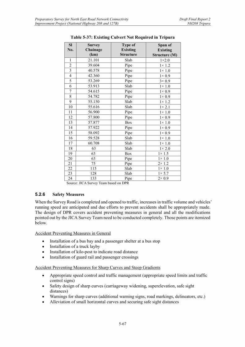
Preparatory Survey for North East Road Network Connectivity Draft Final Report 2 Improvement Project (National Highway 208 and 127B) NH208 Tripura
5-67
Table 5-37: Existing Culvert Not Required in Tripura
Sl No.
Survey Chainage
(km)
Type of Existing
Structure
Span of Existing
Structure (M) 1 21.101 Slab 1×2.0 2 39.604 Pipe 1× 1.2 3 40.578 Pipe 1× 1.0 4 42.360 Pipe 1× 0.9 5 53.269 Pipe 3× 0.9 6 53.913 Slab 1× 1.0 7 54.615 Pipe 1× 0.9 8 54.782 Pipe 1× 0.9 9 55.150 Slab 1× 1.2 10 55.616 Slab 1× 2.1 11 56.900 Pipe 1× 1.0 12 57.800 Pipe 1× 0.9 13 57.877 Box 1× 1.0 14 57.922 Pipe 1× 0.9 15 58.092 Pipe 1× 0.9 16 59.528 Slab 1× 1.0 17 60.708 Slab 1× 1.0 18 63 Slab 1× 2.0 19 63 Box 1× 1.5 20 63 Pipe 1× 1.0 21 75 Pipe 2× 1.2 22 115 Slab 1× 1.0 23 128 Slab 1× 5.7 24 133 Pipe 2× 0.9
Source: JICA Survey Team based on DPR
5.2.6 Safety Measures
When the Survey Road is completed and opened to traffic, increases in traffic volume and vehicles’ running speed are anticipated and due efforts to prevent accidents shall be appropriately made. The design of DPR covers accident preventing measures in general and all the modifications pointed out by the JICA Survey Team need to be conducted completely. Those points are itemized below. Accident Preventing Measures in General
Installation of a bus bay and a passenger shelter at a bus stop Installation of a truck layby Installation of kilo-post to indicate road distance Installation of guard rail and passenger crossings
Accident Preventing Measures for Sharp Curves and Steep Gradients
Appropriate speed control and traffic management (appropriate speed limits and traffic control signs)
Safety design of sharp curves (carriageway widening, superelevation, safe sight distances)
Warnings for sharp curves (additional warning signs, road markings, delineators, etc.) Alleviation of small horizontal curves and securing safe sight distances
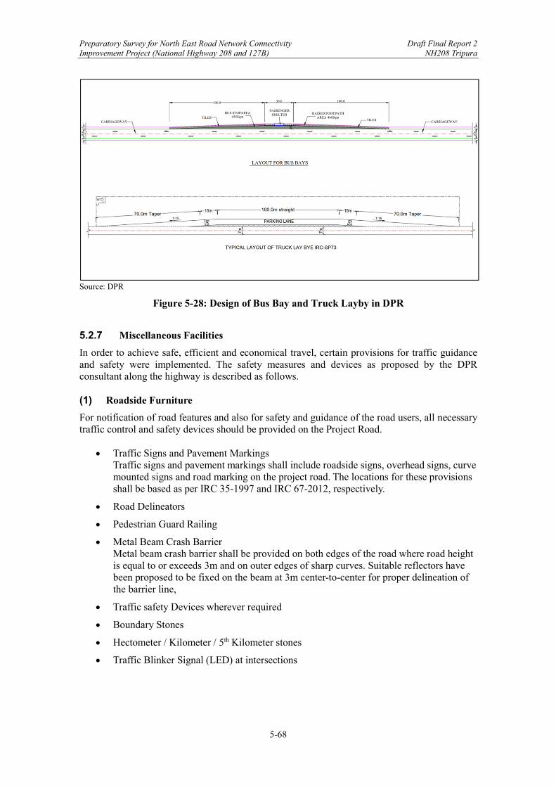
Preparatory Survey for North East Road Network Connectivity Draft Final Report 2 Improvement Project (National Highway 208 and 127B) NH208 Tripura
5-68
Source: DPR
Figure 5-28: Design of Bus Bay and Truck Layby in DPR
5.2.7 Miscellaneous Facilities
In order to achieve safe, efficient and economical travel, certain provisions for traffic guidance and safety were implemented. The safety measures and devices as proposed by the DPR consultant along the highway is described as follows. (1) Roadside Furniture
For notification of road features and also for safety and guidance of the road users, all necessary traffic control and safety devices should be provided on the Project Road.
Traffic Signs and Pavement Markings Traffic signs and pavement markings shall include roadside signs, overhead signs, curve mounted signs and road marking on the project road. The locations for these provisions shall be based as per IRC 35-1997 and IRC 67-2012, respectively.
Road Delineators
Pedestrian Guard Railing
Metal Beam Crash Barrier Metal beam crash barrier shall be provided on both edges of the road where road height is equal to or exceeds 3m and on outer edges of sharp curves. Suitable reflectors have been proposed to be fixed on the beam at 3m center-to-center for proper delineation of the barrier line,
Traffic safety Devices wherever required
Boundary Stones
Hectometer / Kilometer / 5th Kilometer stones
Traffic Blinker Signal (LED) at intersections

Preparatory Survey for North East Road Network Connectivity Draft Final Report 2 Improvement Project (National Highway 208 and 127B) NH208 Tripura
5-69
(2) Street Lighting
Adequate lighting should be provided for bus bays and truck lay bays.
Street Lighting will also be provided for highway alignment passing through potentially hazardous locations such as built-up area, junctions and rotaries.
(3) Landscape and Tree Plantation
Landscaping of the highway should be done at suitable locations. The purpose of landscaping is conservation of existing natural or manmade features.
Landscaping will address the issue of drainage to ensure minimum disturbance to the natural drainage and at the same time ensure protection of natural surfaces from erosion.
Proper landscaping will be provided for highway alignment to fit-in with surroundings for pleasing appearance, reducing headlight glare and adverse environmental effects such as air pollution, noise pollution and visual instruction.
Landscaping will include stabilization of embankment by pitching and/or turfing / plantation. The treatment of embankment slopes along the highway will be as per recommendations of IRC 56-1974, depending upon soil type involved. Planting of shrubs, hedges and trees on medians and sides for highways of reducing glare effect, reducing visual intrusion, noise pollution and air pollution.
Trees, their spacing and arrangement in different situations will be as per IRC 21-1979 and IRC SP 66-1976.
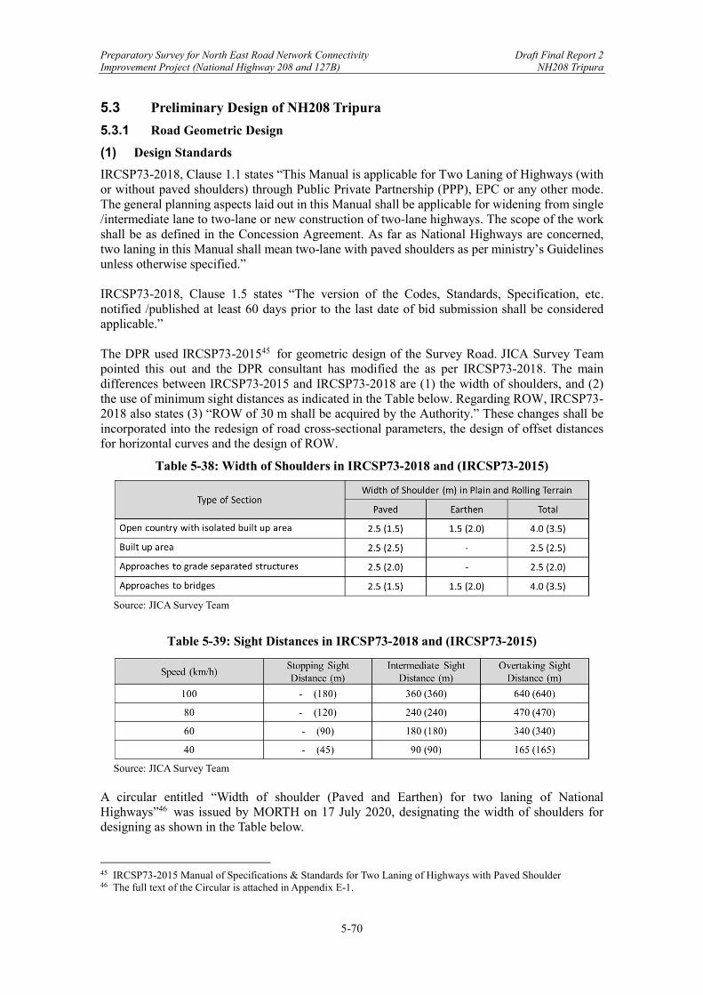
Preparatory Survey for North East Road Network Connectivity Draft Final Report 2 Improvement Project (National Highway 208 and 127B) NH208 Tripura
5-70
5.3 Preliminary Design of NH208 Tripura
5.3.1 Road Geometric Design
(1) Design Standards
IRCSP73-2018, Clause 1.1 states “This Manual is applicable for Two Laning of Highways (with or without paved shoulders) through Public Private Partnership (PPP), EPC or any other mode. The general planning aspects laid out in this Manual shall be applicable for widening from single /intermediate lane to two-lane or new construction of two-lane highways. The scope of the work shall be as defined in the Concession Agreement. As far as National Highways are concerned, two laning in this Manual shall mean two-lane with paved shoulders as per ministry’s Guidelines unless otherwise specified.” IRCSP73-2018, Clause 1.5 states “The version of the Codes, Standards, Specification, etc. notified /published at least 60 days prior to the last date of bid submission shall be considered applicable.” The DPR used IRCSP73-201545 for geometric design of the Survey Road. JICA Survey Team pointed this out and the DPR consultant has modified the as per IRCSP73-2018. The main differences between IRCSP73-2015 and IRCSP73-2018 are (1) the width of shoulders, and (2) the use of minimum sight distances as indicated in the Table below. Regarding ROW, IRCSP73-2018 also states (3) “ROW of 30 m shall be acquired by the Authority.” These changes shall be incorporated into the redesign of road cross-sectional parameters, the design of offset distances for horizontal curves and the design of ROW.
Table 5-38: Width of Shoulders in IRCSP73-2018 and (IRCSP73-2015)
Source: JICA Survey Team
Table 5-39: Sight Distances in IRCSP73-2018 and (IRCSP73-2015)
Source: JICA Survey Team
A circular entitled “Width of shoulder (Paved and Earthen) for two laning of National Highways”46 was issued by MORTH on 17 July 2020, designating the width of shoulders for designing as shown in the Table below.
45 IRCSP73-2015 Manual of Specifications & Standards for Two Laning of Highways with Paved Shoulder 46 The full text of the Circular is attached in Appendix E-1.

Preparatory Survey for North East Road Network Connectivity Draft Final Report 2 Improvement Project (National Highway 208 and 127B) NH208 Tripura
5-71
Table 5-40: Width of Shoulders as per MORTH Circular (17 July 2020)
Source: JICA Survey Team
(2) Road Alignment
JICA Survey Team (JST) has pointed out the discrepancy in the alignment between the Location Map and Plan & Profile in Detailed Project Report (DPR) as indicated in the Figure below.
Source: JICA Survey Team
Figure 5-29: Discrepancies in Alignment of NH208 Tripura in DPR
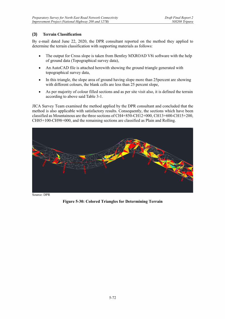
Preparatory Survey for North East Road Network Connectivity Draft Final Report 2 Improvement Project (National Highway 208 and 127B) NH208 Tripura
5-72
(3) Terrain Classification
By e-mail dated June 22, 2020, the DPR consultant reported on the method they applied to determine the terrain classification with supporting materials as follows:
The output for Cross slope is taken from Bentley MXROAD V8i software with the help of ground data (Topographical survey data),
An AutoCAD file is attached herewith showing the ground triangle generated with topographical survey data,
In this triangle, the slope area of ground having slope more than 25percent are showing with different colours, the blank cells are less than 25 percent slope,
As per majority of colour filled sections and as per site visit also, it is defined the terrain according to above said Table 3-1.
JICA Survey Team examined the method applied by the DPR consultant and concluded that the method is also applicable with satisfactory results. Consequently, the sections which have been classified as Mountainous are the three sections of CH4+850-CH12+000, CH13+600-CH15+200, CH85+100-CH98+000, and the remaining sections are classified as Plain and Rolling.
Source: DPR
Figure 5-30: Colored Triangles for Determining Terrain
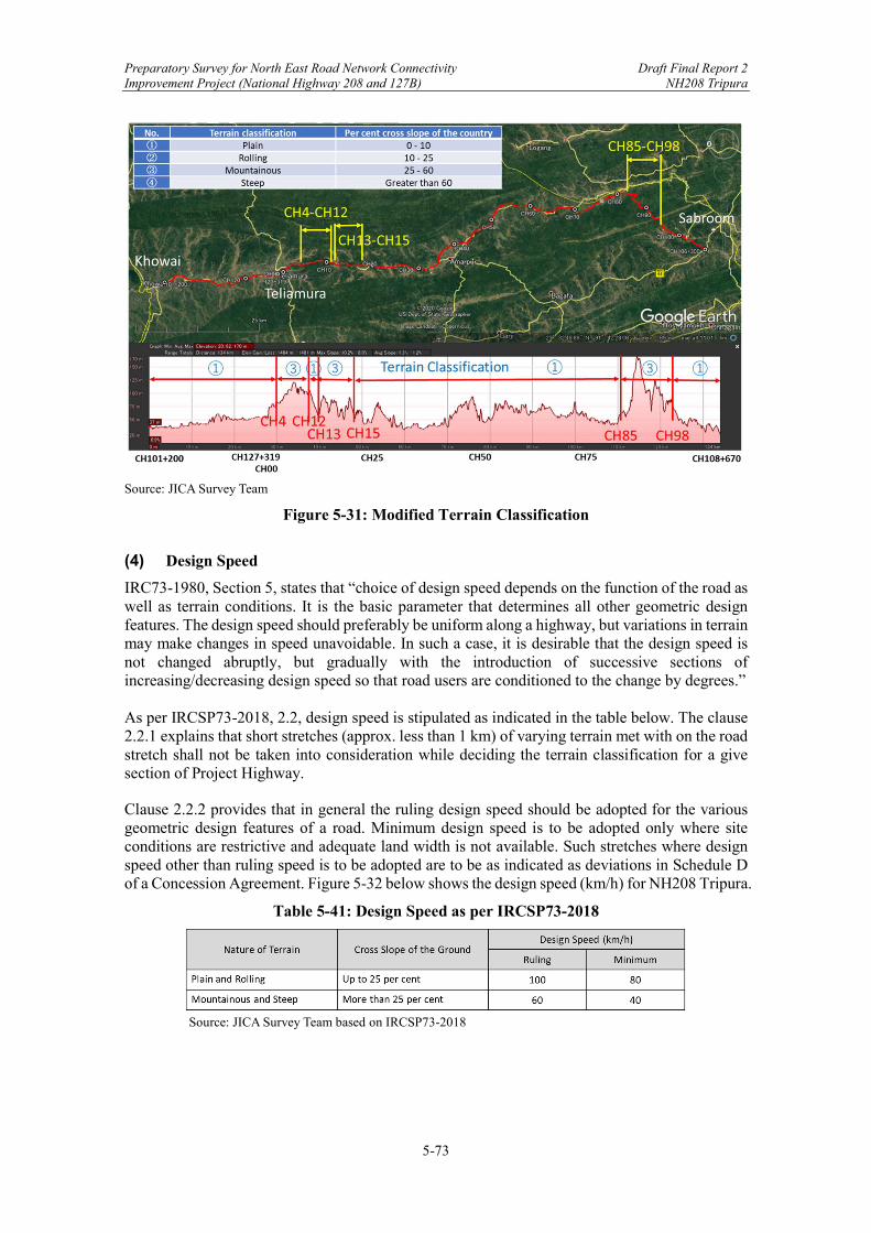
Preparatory Survey for North East Road Network Connectivity Draft Final Report 2 Improvement Project (National Highway 208 and 127B) NH208 Tripura
5-73
Source: JICA Survey Team
Figure 5-31: Modified Terrain Classification
(4) Design Speed
IRC73-1980, Section 5, states that “choice of design speed depends on the function of the road as well as terrain conditions. It is the basic parameter that determines all other geometric design features. The design speed should preferably be uniform along a highway, but variations in terrain may make changes in speed unavoidable. In such a case, it is desirable that the design speed is not changed abruptly, but gradually with the introduction of successive sections of increasing/decreasing design speed so that road users are conditioned to the change by degrees.” As per IRCSP73-2018, 2.2, design speed is stipulated as indicated in the table below. The clause 2.2.1 explains that short stretches (approx. less than 1 km) of varying terrain met with on the road stretch shall not be taken into consideration while deciding the terrain classification for a give section of Project Highway.
Clause 2.2.2 provides that in general the ruling design speed should be adopted for the various geometric design features of a road. Minimum design speed is to be adopted only where site conditions are restrictive and adequate land width is not available. Such stretches where design speed other than ruling speed is to be adopted are to be as indicated as deviations in Schedule D of a Concession Agreement. Figure 5-32 below shows the design speed (km/h) for NH208 Tripura.
Table 5-41: Design Speed as per IRCSP73-2018
Source: JICA Survey Team based on IRCSP73-2018

Preparatory Survey for North East Road Network Connectivity Draft Final Report 2 Improvement Project (National Highway 208 and 127B) NH208 Tripura
5-74
Source: JICA Survey Team
Figure 5-32: Design Speed (km/h) for NH208 Tripura
The table below is an excerpt from the DPR for the section of CH00+128 through CH09+380. The design speed should be the ruling 100 km/h and the minimum 80 km/h shall be adopted only where site conditions are restrictive and adequate land width is not available. Such stretches where design speed other than ruling speed is to be adopted shall be indicated as deviation in Schedule ‘D’ of the Concession Agreement. IRC73-1980 states “The design speed should preferably uniform along a highway”. Whereas DPR uses various design speed like 50, 65, 40, etc. in its horizontal alignment design submitted on 30th September 2020.
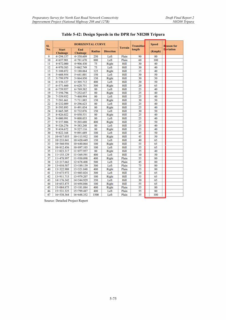
Preparatory Survey for North East Road Network Connectivity Draft Final Report 2 Improvement Project (National Highway 208 and 127B) NH208 Tripura
5-75
Table 5-42: Design Speeds in the DPR for NH208 Tripura
Source: Detailed Project Report
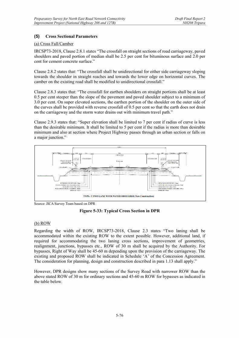
Preparatory Survey for North East Road Network Connectivity Draft Final Report 2 Improvement Project (National Highway 208 and 127B) NH208 Tripura
5-76
(5) Cross Sectional Parameters
(a) Cross Fall/Camber
IRCSP73-2018, Clause 2.8.1 states “The crossfall on straight sections of road carriageway, paved shoulders and paved portion of median shall be 2.5 per cent for bituminous surface and 2.0 per cent for cement concrete surface.” Clause 2.8.2 states that: “The crossfall shall be unidirectional for either side carriageway sloping towards the shoulder in straight reaches and towards the lower edge on horizontal curves. The camber on the existing road shall be modified to unidirectional crossfall.” Clause 2.8.3 states that: “The crossfall for earthen shoulders on straight portions shall be at least 0.5 per cent steeper than the slope of the pavement and paved shoulder subject to a minimum of 3.0 per cent. On super elevated sections, the earthen portion of the shoulder on the outer side of the curves shall be provided with reverse crossfall of 0.5 per cent so that the earth does not drain on the carriageway and the storm water drains out with minimum travel path.”
Clause 2.9.3 states that: “Super elevation shall be limited to 7 per cent if radius of curve is less than the desirable minimum. It shall be limited to 5 per cent if the radius is more than desirable minimum and also at section where Project Highway passes through an urban section or falls on a major junction.”
Source: JICA Survey Team based on DPR
Figure 5-33: Typical Cross Section in DPR
(b) ROW
Regarding the width of ROW, IRCSP73-2018, Clause 2.3 states “Two laning shall be accommodated within the existing ROW to the extent possible. However, additional land, if required for accommodating the two laning cross sections, improvement of geometries, realignment, junctions, bypasses etc., ROW of 30 m shall be acquired by the Authority. For bypasses, Right of Way shall be 45-60 m depending upon the provision of the carriageway. The existing and proposed ROW shall be indicated in Schedule ‘A’ of the Concession Agreement. The consideration for planning, design and construction described in para 1.13 shall apply.” However, DPR designs show many sections of the Survey Road with narrower ROW than the above stated ROW of 30 m for ordinary sections and 45-60 m ROW for bypasses as indicated in the table below.

Preparatory Survey for North East Road Network Connectivity Draft Final Report 2 Improvement Project (National Highway 208 and 127B) NH208 Tripura
5-77
At the web-conference held on 20 October 2020, the DPR consultant stated that the ROW width was decided as per discussion with the General Manager of NHIDCL during joint site visit in 2019.
Table 5-43: ROW Designed in DPR
Source: JICA Survey Team based on DPR
(c) Extra Width of Pavement and Roadway
IRC38-1988,47 Clause 6.1.1, states that extra widening is necessary: … when vehicles negotiate a curve, the rear wheels generally do not follow the same track as that of the front wheels. When the curve is not superelevated, the rear wheels track inside the front wheels. On superelevated curves, the relative position of the wheel tracks depends upon the speed and consequently upon the amount of friction developed for equilibrium. The greater the speed, the rear wheels assume a position farther out. So, with excessive speeds the rear wheels may track outside the front wheels. Therefore, widening of the pavement is necessary to provide for this change in the overall track width required for travel at various speeds. IRCSP73-2018, Clause 2.7 states “The width of roadway shall be the sum of the width of carriageway and shoulders in case of 2-lane. On horizontal curves with radius up to 300 m, width of pavement and roadway shall be increased as per the table below.”
Table 5-44: Extra Width of Pavement and Roadway in Each Carriageway
Source: JICA Survey Team (based on IRCSP84-2014)
47 IRC38-1988, Guidelines for [the] Design of Horizontal Curves for Highways and Design Tables.
Preparatory Survey for North East Road Network Connectivity Draft Final Report 2 Improvement Project (National Highway 208 and 127B) NH208 Tripura
5-78
(6) Horizontal Alignment
IRC73-1980 and Chapter 9, provides general guidelines for designing horizontal alignments. Important aspects are summarized in the following text. (a) Consistent Application of Design Elements
Uniformity of design standards is one of the essential requirements of a road alignment. In each section there must be consistent application of a design element to avoid unexpected situations for the drivers. For example, a short sharp curve in an otherwise good alignment is bound to act as an accident-prone spot if the designer is not vigilant. (b) Flowing Line of the Horizontal Alignment
Generally, the horizontal alignment should be fluent and blend well with the surrounding topography. A flowing line that conforms to natural contours is aesthetically preferable to one with long tangents slashing through the terrain. (c) Length of Tangent Sections
Tangent sections exceeding 3 km in length should be avoided as much as possible. As a general rule, sharp curves should not be introduced at the end of long tangents since these can be extremely hazardous. Short curves give the appearance of kinks, particularly for small deflection angles, and should be avoided. (d) Avoidance of Broken-Back Curves
Curves in the same direction separated by short tangents, known as broken-back curves, should be avoided as far as possible in the interest of aesthetics and safety, and replaced by a single curve. If this is not feasible, a tangent length corresponding to 10 seconds’ travel time must be at least be ensured between the two curves. (e) Radii of Horizontal Curves
IRCSP84-2014, Clause 2.9.4, states that: “The desirable minimum and absolute minimum radii of horizontal curves for various classes of terrain are given in the table below [see Table 5-45 and Figure 5-34 of this report]. The radius of horizontal curves for various terrain conditions shall not be less than the desirable values given in the table except for sections as indicated in Schedule ‘D’. For such sections, [the] radius shall not be less than the absolute minimum.” In response to the comment by JICA Survey Team, the DPR consultant wrote “Agreed. It would be included in Schedule D.” (f) Absolute Minimum Radius
IRC73-1980, Clause 9.4.2, describes the use of minimum radius as follows: “On new roads, horizontal curves should be designed to have the largest practicable radius, generally more than the values corresponding to the ruling design speed. However, absolute minimum values based on minimum design speed might be resorted to if economics of construction or the site conditions so dictate.” Table 5-45 and Figure 5-34 of this report present the absolute minimum radius by type of terrain.
Table 5-45: Minimum Radii of Horizontal Curves as per IRCSP73-2018
Source: JICA Survey Team based on IRCSP73-2018
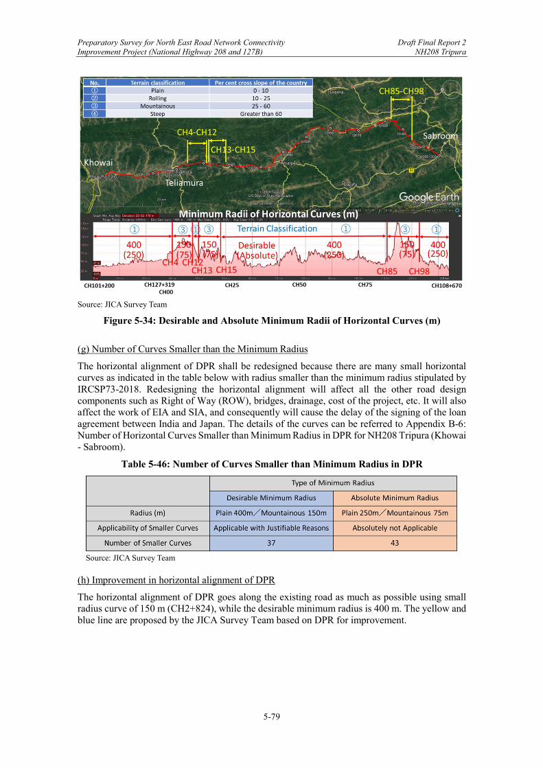
Preparatory Survey for North East Road Network Connectivity Draft Final Report 2 Improvement Project (National Highway 208 and 127B) NH208 Tripura
5-79
Source: JICA Survey Team
Figure 5-34: Desirable and Absolute Minimum Radii of Horizontal Curves (m)
(g) Number of Curves Smaller than the Minimum Radius
The horizontal alignment of DPR shall be redesigned because there are many small horizontal curves as indicated in the table below with radius smaller than the minimum radius stipulated by IRCSP73-2018. Redesigning the horizontal alignment will affect all the other road design components such as Right of Way (ROW), bridges, drainage, cost of the project, etc. It will also affect the work of EIA and SIA, and consequently will cause the delay of the signing of the loan agreement between India and Japan. The details of the curves can be referred to Appendix B-6: Number of Horizontal Curves Smaller than Minimum Radius in DPR for NH208 Tripura (Khowai - Sabroom).
Table 5-46: Number of Curves Smaller than Minimum Radius in DPR
Source: JICA Survey Team
(h) Improvement in horizontal alignment of DPR
The horizontal alignment of DPR goes along the existing road as much as possible using small radius curve of 150 m (CH2+824), while the desirable minimum radius is 400 m. The yellow and blue line are proposed by the JICA Survey Team based on DPR for improvement.
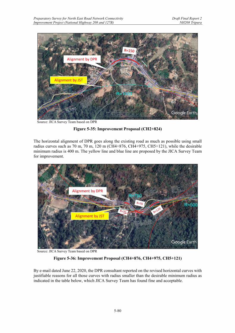
Preparatory Survey for North East Road Network Connectivity Draft Final Report 2 Improvement Project (National Highway 208 and 127B) NH208 Tripura
5-80
Source: JICA Survey Team based on DPR
Figure 5-35: Improvement Proposal (CH2+824)
The horizontal alignment of DPR goes along the existing road as much as possible using small radius curves such as 70 m, 70 m, 120 m (CH4+876, CH4+975, CH5+121), while the desirable minimum radius is 400 m. The yellow line and blue line are proposed by the JICA Survey Team for improvement.
Source: JICA Survey Team based on DPR
Figure 5-36: Improvement Proposal (CH4+876, CH4+975, CH5+121)
By e-mail dated June 22, 2020, the DPR consultant reported on the revised horizontal curves with justifiable reasons for all those curves with radius smaller than the desirable minimum radius as indicated in the table below, which JICA Survey Team has found fine and acceptable.
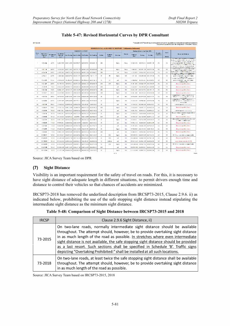
Preparatory Survey for North East Road Network Connectivity Draft Final Report 2 Improvement Project (National Highway 208 and 127B) NH208 Tripura
5-81
Table 5-47: Revised Horizontal Curves by DPR Consultant
Source: JICA Survey Team based on DPR (7) Sight Distance
Visibility is an important requirement for the safety of travel on roads. For this, it is necessary to have sight distance of adequate length in different situations, to permit drivers enough time and distance to control their vehicles so that chances of accidents are minimized. IRCSP73-2018 has removed the underlined description from IRCSP73-2015, Clause 2.9.6. ii) as indicated below, prohibiting the use of the safe stopping sight distance instead stipulating the intermediate sight distance as the minimum sight distance.
Table 5-48: Comparison of Sight Distance between IRCSP73-2015 and 2018
Source: JICA Survey Team based on IRCSP73-2015, 2018
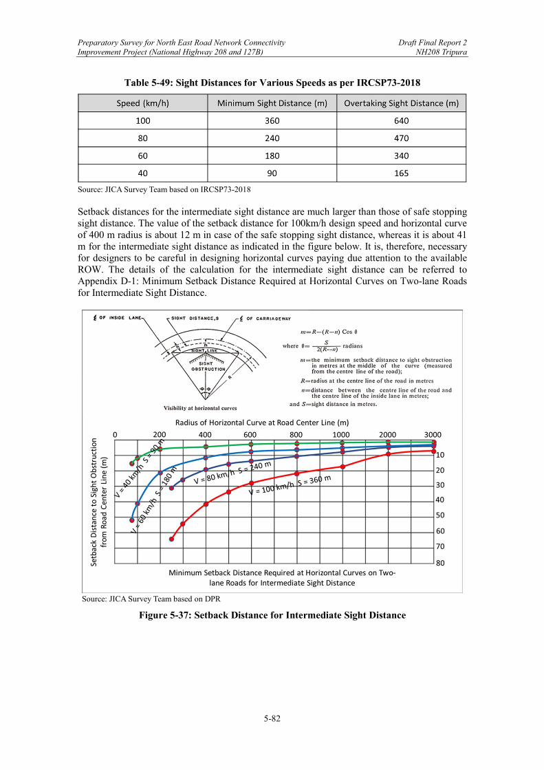
Preparatory Survey for North East Road Network Connectivity Draft Final Report 2 Improvement Project (National Highway 208 and 127B) NH208 Tripura
5-82
Table 5-49: Sight Distances for Various Speeds as per IRCSP73-2018
Source: JICA Survey Team based on IRCSP73-2018 Setback distances for the intermediate sight distance are much larger than those of safe stopping sight distance. The value of the setback distance for 100km/h design speed and horizontal curve of 400 m radius is about 12 m in case of the safe stopping sight distance, whereas it is about 41 m for the intermediate sight distance as indicated in the figure below. It is, therefore, necessary for designers to be careful in designing horizontal curves paying due attention to the available ROW. The details of the calculation for the intermediate sight distance can be referred to Appendix D-1: Minimum Setback Distance Required at Horizontal Curves on Two-lane Roads for Intermediate Sight Distance.
Source: JICA Survey Team based on DPR
Figure 5-37: Setback Distance for Intermediate Sight Distance
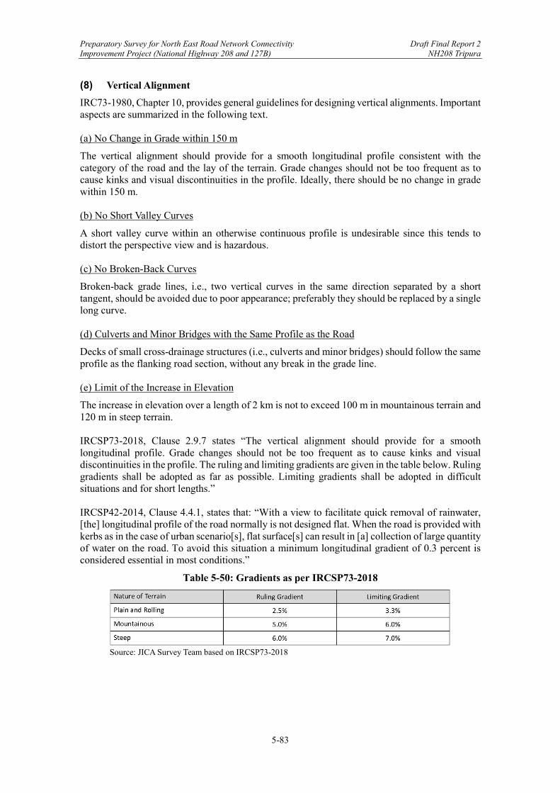
Preparatory Survey for North East Road Network Connectivity Draft Final Report 2 Improvement Project (National Highway 208 and 127B) NH208 Tripura
5-83
(8) Vertical Alignment
IRC73-1980, Chapter 10, provides general guidelines for designing vertical alignments. Important aspects are summarized in the following text. (a) No Change in Grade within 150 m
The vertical alignment should provide for a smooth longitudinal profile consistent with the category of the road and the lay of the terrain. Grade changes should not be too frequent as to cause kinks and visual discontinuities in the profile. Ideally, there should be no change in grade within 150 m. (b) No Short Valley Curves
A short valley curve within an otherwise continuous profile is undesirable since this tends to distort the perspective view and is hazardous. (c) No Broken-Back Curves
Broken-back grade lines, i.e., two vertical curves in the same direction separated by a short tangent, should be avoided due to poor appearance; preferably they should be replaced by a single long curve. (d) Culverts and Minor Bridges with the Same Profile as the Road
Decks of small cross-drainage structures (i.e., culverts and minor bridges) should follow the same profile as the flanking road section, without any break in the grade line. (e) Limit of the Increase in Elevation
The increase in elevation over a length of 2 km is not to exceed 100 m in mountainous terrain and 120 m in steep terrain. IRCSP73-2018, Clause 2.9.7 states “The vertical alignment should provide for a smooth longitudinal profile. Grade changes should not be too frequent as to cause kinks and visual discontinuities in the profile. The ruling and limiting gradients are given in the table below. Ruling gradients shall be adopted as far as possible. Limiting gradients shall be adopted in difficult situations and for short lengths.” IRCSP42-2014, Clause 4.4.1, states that: “With a view to facilitate quick removal of rainwater, [the] longitudinal profile of the road normally is not designed flat. When the road is provided with kerbs as in the case of urban scenario[s], flat surface[s] can result in [a] collection of large quantity of water on the road. To avoid this situation a minimum longitudinal gradient of 0.3 percent is considered essential in most conditions.”
Table 5-50: Gradients as per IRCSP73-2018
Source: JICA Survey Team based on IRCSP73-2018
Preparatory Survey for North East Road Network Connectivity Draft Final Report 2 Improvement Project (National Highway 208 and 127B) NH208 Tripura
5-84
Source: JICA Survey Team
Figure 5-38: Ruling and Limiting Gradients (%)
The following points are observed on the vertical alignment design in the DPR. All these three points pointed out by JICA Survey Team were removed in the revised drawings as shown in the table below, submitted by the DPR consultant on September 30, 2020.
① Longitudinal gradient of less than 0.3% is observed. ② Longitudinal gradient of more than Limiting Gradient of 6% is observed. ③ Frequent change of gradients is observed.
Preparatory Survey for North East Road Network Connectivity Draft Final Report 2 Improvement Project (National Highway 208 and 127B) NH208 Tripura
5-85
Table 5-51: Gradients use in DPR
Source: JICA Survey Team based on DPR
5.3.2 Intersection Design
Intersections and junctions have been classified as either “major” or “minor” based on functional and locational importance. All major and minor junctions and intersections were reviewed and analyzed by the DPR consultant, with respect to vehicular movements and vehicular turning movements based on traffic study for providing appropriate grade for cross and turning traffic. (1) Khowai – Teliamura
There are 4 proposed major at-grade intersections from Khowai to Teliamura along the Project stretch. The terrain conditions for 4 major intersections are mostly flat and the design speed of 80 km/h or 100 km/h is applied.
Preparatory Survey for North East Road Network Connectivity Draft Final Report 2 Improvement Project (National Highway 208 and 127B) NH208 Tripura
5-86
Table 5-52: Details of Proposed Major Intersection
Source: JICA Survey Team based on DPR On the other hand, 34 minor at-grade intersections from Khowai to Teliamura along the Project stretch were proposed by the DPR consultant.
Table 5-53: Details of Proposed Minor Intersection
Source: JICA Survey Team based on DPR
SI. NoExisting
Chainage (km)
Design Chainage
(km)Side Type Remarks
5 103+220 96+120 Right 3 leggedJunction is provided at the start pointof Bypass at khowai
6 111+150 101+110 Right 3 leggedJunction is provided at the end point ofBypass at khowai
7 117+800 106+970 Right 3 legged Road leads to Ramchandra Ghat Market8 139+425 127+319 Right 3 legged Road leads to Agartala
SI. NoExisting
Chainage (km)
Design Chainage
(km)Side Type Remarks
51 111+390 101+400 Left 3 legged Road leads to Kalabagan52 111+810 101+820 Right 3 legged Road leads to Madhya Sonatala53 112+870 102+880 Left 3 legged Road leads to Uttar Sonatala54 113+110 103+120 Right 3 legged Road leads to Basutos55 114+185 104+180 Left 3 legged Road leads to Kamalpur56 115+305 105+295 Left 3 legged Road leads to Sachindranagar57 116+345 106+300 Left 3 legged Road leads to Ramchandra Ghat Market58 119+875 109+030 Right 3 legged Road leads to Khas Kalyanpur59 120+300 109+450 Left 3 legged Road leads to Pandab Para60 120+960 110+120 Right 3 legged Road leads to Kamartilla61 121+025 110+170 Left 3 legged Road leads to Village62 122+800 111+660 Left 3 legged Road leads to Village63 123+435 112+310 Left 3 legged Road leads to Kacha Tiilla64 125+640 114+500 Right 3 legged Road leads to Kunjaban
65 126+485 115+345 Both 4 leggedRoad leads to Sabang in right and Police Station in left
66 127+025 115+700 Left 3 legged Road leads to Kaltanpur Bazar Colony67 127+300 115+930 Left 3 legged Road leads to Village68 128+115 116+710 Left 3 legged Road leads to Village69 128+270 116+870 Left 3 legged Road leads to Village70 128+850 117+360 Right 3 legged Road leads to Gujakha Village71 129+100 117+600 Left 3 legged Road leads to Village72 129+920 118+380 Left 3 legged Road leads to Village73 130+520 118+750 Left 3 legged Road leads to Village74 130+700 118+940 Right 3 legged Road leads to Debta Bari75 131+115 119+350 Left 3 legged Road leads to Kamalnagar76 131+250 119+430 Left 3 legged Road leads to Kamalnagar77 132+125 120+135 Right 3 legged Road leads to Village78 132+525 120+540 Right 3 legged Road leads to Maragong Para79 133+330 121+320 Right 3 legged Road leads to Bishnu Master Para School Road80 133+750 121+730 Left 3 legged Road lead to Uttar Maharani81 135+445 123+420 Right 3 legged Road lead to Duski82 136+760 124+725 Right 3 legged Road lead to Trishabari83 138+295 126+185 Right 3 legged Road lead to Hadrai
84 138+890 126+785 Both 4 leggedRoad lead to Road leads to Sheabre in right and Karailong in left
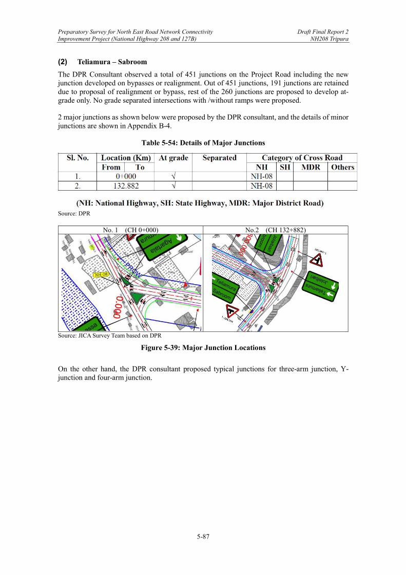
Preparatory Survey for North East Road Network Connectivity Draft Final Report 2 Improvement Project (National Highway 208 and 127B) NH208 Tripura
5-87
(2) Teliamura – Sabroom
The DPR Consultant observed a total of 451 junctions on the Project Road including the new junction developed on bypasses or realignment. Out of 451 junctions, 191 junctions are retained due to proposal of realignment or bypass, rest of the 260 junctions are proposed to develop at-grade only. No grade separated intersections with /without ramps were proposed.
2 major junctions as shown below were proposed by the DPR consultant, and the details of minor junctions are shown in Appendix B-4.
Table 5-54: Details of Major Junctions
Source: DPR
No. 1 (CH 0+000) No.2 (CH 132+882)
Source: JICA Survey Team based on DPR
Figure 5-39: Major Junction Locations
On the other hand, the DPR consultant proposed typical junctions for three-arm junction, Y-junction and four-arm junction.
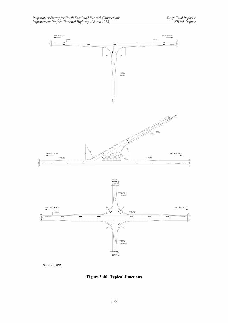
Preparatory Survey for North East Road Network Connectivity Draft Final Report 2 Improvement Project (National Highway 208 and 127B) NH208 Tripura
5-88
Source: DPR
Figure 5-40: Typical Junctions

Preparatory Survey for North East Road Network Connectivity Draft Final Report 2 Improvement Project (National Highway 208 and 127B) NH208 Tripura
5-89
(3) Basic Design of Intersections
In the design of an intersection, the primary considerations are safety and smooth and efficient flow of traffic. It should be based on the knowledge of what a driver will do rather than what he should do. All the intersection movements should be obvious to the drivers, even if he is a stranger to the area. Therefore, intersections must be designed and operated with simplicity and uniformity. Sub-clause 3.2.1 of IRC SP 73-2018, the intersection control shall be of ‘Stop Control’ unless specified otherwise. This will mean that traffic on the minor road must stop prior to entering the major road. Where roads of equal importance intersect, priority will be given to the traffic on the right. Moreover, the sight distance to be adopted shall be at least twice the safe stopping sight distance. Design standards of intersections shall be as per IRC SP 41. Design speed shall generally be taken as 40 percent of approach speed in built up areas and 60 percent in open areas. The traffic volume for the design of intersection and its distribution, at peak hours shall be assessed. Semi-trailer combination for the design vehicle shall be used in the design of intersections. The number of lanes to be provided at the intersection shall be governed by peak hour traffic volume in each direction of travel and shall be determined based on the projected traffic for the year in which further capacity augmentation is considered. On the other hand, the radii of intersection curves are considered depending on the turning characteristics of design vehicles, their numbers, and the speed at which vehicles enter or exit intersection area. Sub-clause 4.4.2 of IRC 41-1994 states that selection of appropriate curve radii, influences the vehicle speed at various points. The speed should be such that the vehicle should either be able to stop before the conflict point or accelerate to suitable speed to merge with traffic flow. The following table shows the relationship of inner curve radii for a larger range of design speeds.
Table 5-55: Design Speed & Minimum Radii
Source: IRC 41-1994
Sub-clause 4.8.2 of IRC 41-1994 states that an acceleration lane should be designed so that vehicle tuning left from the minor road may join the traffic flow on the major road at approximately the same speed as that of the nearside lane traffic in the major road. Acceleration lanes also improve capacity by enabling the use of short traffic gaps and by providing storage space for traffic waiting to merge when large traffic gaps occur.
Design Speedkm/hr
Minimum inner radii (m)
18.5 1815 2320 2730 3240 3750 4175 50100 57125 62150 64
Straight -
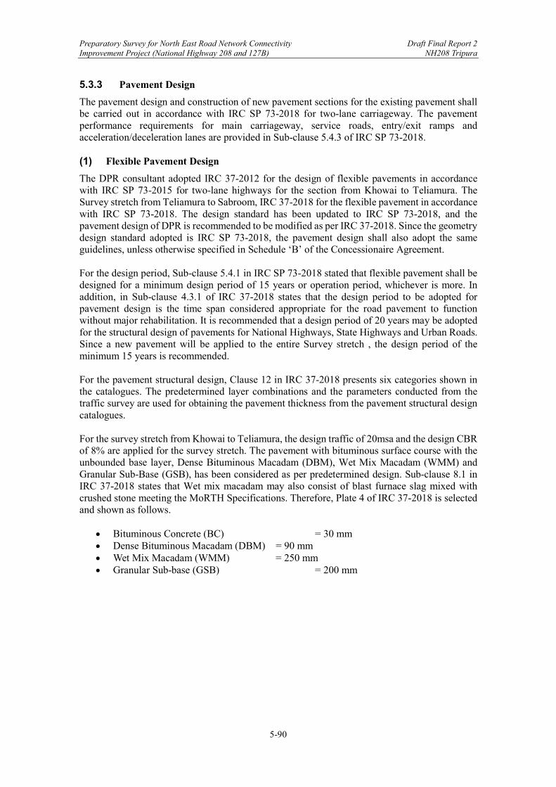
Preparatory Survey for North East Road Network Connectivity Draft Final Report 2 Improvement Project (National Highway 208 and 127B) NH208 Tripura
5-90
5.3.3 Pavement Design
The pavement design and construction of new pavement sections for the existing pavement shall be carried out in accordance with IRC SP 73-2018 for two-lane carriageway. The pavement performance requirements for main carriageway, service roads, entry/exit ramps and acceleration/deceleration lanes are provided in Sub-clause 5.4.3 of IRC SP 73-2018. (1) Flexible Pavement Design
The DPR consultant adopted IRC 37-2012 for the design of flexible pavements in accordance with IRC SP 73-2015 for two-lane highways for the section from Khowai to Teliamura. The Survey stretch from Teliamura to Sabroom, IRC 37-2018 for the flexible pavement in accordance with IRC SP 73-2018. The design standard has been updated to IRC SP 73-2018, and the pavement design of DPR is recommended to be modified as per IRC 37-2018. Since the geometry design standard adopted is IRC SP 73-2018, the pavement design shall also adopt the same guidelines, unless otherwise specified in Schedule ‘B’ of the Concessionaire Agreement. For the design period, Sub-clause 5.4.1 in IRC SP 73-2018 stated that flexible pavement shall be designed for a minimum design period of 15 years or operation period, whichever is more. In addition, in Sub-clause 4.3.1 of IRC 37-2018 states that the design period to be adopted for pavement design is the time span considered appropriate for the road pavement to function without major rehabilitation. It is recommended that a design period of 20 years may be adopted for the structural design of pavements for National Highways, State Highways and Urban Roads. Since a new pavement will be applied to the entire Survey stretch , the design period of the minimum 15 years is recommended. For the pavement structural design, Clause 12 in IRC 37-2018 presents six categories shown in the catalogues. The predetermined layer combinations and the parameters conducted from the traffic survey are used for obtaining the pavement thickness from the pavement structural design catalogues. For the survey stretch from Khowai to Teliamura, the design traffic of 20msa and the design CBR of 8% are applied for the survey stretch. The pavement with bituminous surface course with the unbounded base layer, Dense Bituminous Macadam (DBM), Wet Mix Macadam (WMM) and Granular Sub-Base (GSB), has been considered as per predetermined design. Sub-clause 8.1 in IRC 37-2018 states that Wet mix macadam may also consist of blast furnace slag mixed with crushed stone meeting the MoRTH Specifications. Therefore, Plate 4 of IRC 37-2018 is selected and shown as follows.
Bituminous Concrete (BC) = 30 mm Dense Bituminous Macadam (DBM) = 90 mm Wet Mix Macadam (WMM) = 250 mm Granular Sub-base (GSB) = 200 mm
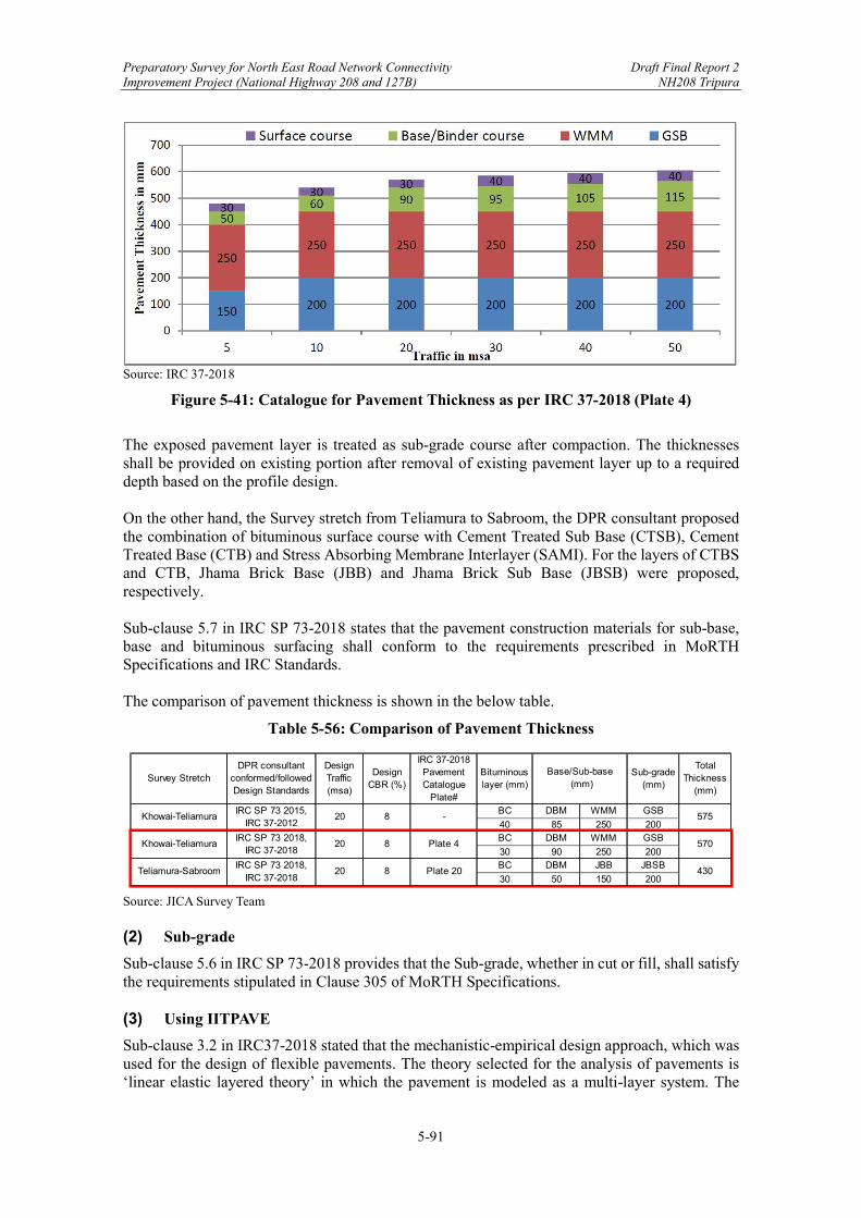
Preparatory Survey for North East Road Network Connectivity Draft Final Report 2 Improvement Project (National Highway 208 and 127B) NH208 Tripura
5-91
Source: IRC 37-2018
Figure 5-41: Catalogue for Pavement Thickness as per IRC 37-2018 (Plate 4)
The exposed pavement layer is treated as sub-grade course after compaction. The thicknesses shall be provided on existing portion after removal of existing pavement layer up to a required depth based on the profile design. On the other hand, the Survey stretch from Teliamura to Sabroom, the DPR consultant proposed the combination of bituminous surface course with Cement Treated Sub Base (CTSB), Cement Treated Base (CTB) and Stress Absorbing Membrane Interlayer (SAMI). For the layers of CTBS and CTB, Jhama Brick Base (JBB) and Jhama Brick Sub Base (JBSB) were proposed, respectively. Sub-clause 5.7 in IRC SP 73-2018 states that the pavement construction materials for sub-base, base and bituminous surfacing shall conform to the requirements prescribed in MoRTH Specifications and IRC Standards. The comparison of pavement thickness is shown in the below table.
Table 5-56: Comparison of Pavement Thickness
Source: JICA Survey Team (2) Sub-grade
Sub-clause 5.6 in IRC SP 73-2018 provides that the Sub-grade, whether in cut or fill, shall satisfy the requirements stipulated in Clause 305 of MoRTH Specifications. (3) Using IITPAVE
Sub-clause 3.2 in IRC37-2018 stated that the mechanistic-empirical design approach, which was used for the design of flexible pavements. The theory selected for the analysis of pavements is ‘linear elastic layered theory’ in which the pavement is modeled as a multi-layer system. The
Survey StretchDPR consultant
conformed/followed Design Standards
Design Traffic (msa)
Design CBR (%)
IRC 37-2018Pavement Catalogue
Plate#
Bituminous layer (mm)
Sub-grade (mm)
Total Thickness
(mm)
BC DBM WMM GSB
40 85 250 200BC DBM WMM GSB
30 90 250 200BC DBM JBB JBSB
30 50 150 200430Teliamura-Sabroom
IRC SP 73 2018,IRC 37-2018
20 8 Plate 20
575
Khowai-TeliamuraIRC SP 73 2018,
IRC 37-201820 8 Plate 4 570
Base/Sub-base (mm)
Khowai-TeliamuraIRC SP 73 2015,
IRC 37-201220 8 -
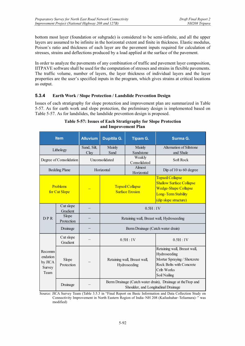
Preparatory Survey for North East Road Network Connectivity Draft Final Report 2 Improvement Project (National Highway 208 and 127B) NH208 Tripura
5-92
bottom most layer (foundation or subgrade) is considered to be semi-infinite, and all the upper layers are assumed to be infinite in the horizontal extent and finite in thickness. Elastic modulus, Poison’s ratio and thickness of each layer are the pavement inputs required for calculation of stresses, strains and deflections produced by a load applied at the surface of the pavement. In order to analyze the pavements of any combination of traffic and pavement layer composition, IITPAVE software shall be used for the computation of stresses and strains in flexible pavements. The traffic volume, number of layers, the layer thickness of individual layers and the layer properties are the user’s specified inputs in the program, which gives strains at critical locations as output.
5.3.4 Earth Work / Slope Protection / Landslide Prevention Design
Issues of each stratigraphy for slope protection and improvement plan are summarized in Table 5-57. As for earth work and slope protection, the preliminary design is implemented based on Table 5-57. As for landslides, the landslide prevention design is proposed.
Table 5-57: Issues of Each Stratigraphy for Slope Protection and Improvement Plan
Source: JICA Survey Team (Table 3.5.3 in “Final Report on Basic Information and Data Collection Study on
Connectivity Improvement in North Eastern Region of India‒NH 208 (Kailashahar‒Teliamura)‒” was modified)
Alluvium Dupitila G. Tipam G. Surma G.
Sand, Silt,Clay
MainlySand
MainlySandstone
Alternation of Siltstoneand Shale
WeaklyConsolidated
Soft Rock
AlmostHorizontal
Dip of 10 to 60 degree
−
Topsoil CollapseShallow Surface CollapseWedge-Shape Collapse
Long‒Term Stability
(dip slope structure)
Cut slopeGradient
−
SlopeProtection
−
Drainage −
Cut slopeGradient
− 0.5H : 1V
SlopeProtection
−
Retaining wall, Breast wall,HydroseedingMortar Spraying / ShotcreteRock Bolts with ConcreteCrib WorksSoil Nailing
Drainage −
Item
Unconsolidated
Horizontal
Lithology
Degree of Consolidation
Bedding Plane
Problemsfor Cut Slope
Topsoil CollapseSurface Erosion
Retaining wall, Breast wall,Hydroseeding
D P R
Berm Drainage (Catch water drain)
Recommendationby JICASurveyTeam
Berm Drainage (Catch water drain), Drainage at theTtop andShoulder, and Longitudinal Drainage
0.5H : 1V
Retaining wall, Breast wall, Hydroseeding
0.5H : 1V
Preparatory Survey for North East Road Network Connectivity Draft Final Report 2 Improvement Project (National Highway 208 and 127B) NH208 Tripura
5-93
(1) Earth Work
The Dupitila Group, which is distributed in the valley bottom plain like fluvial terraces, is unconsolidated deposits. The Tipam Group, which is distributed in the undulating plain called “Rolling”, is weakly consolidated deposits. It is possible to excavate these deposits directly with bulldozer. The Surma Group is composed of soft rocks. It is possible to excavate this rock with bulldozer and ripper. (2) Slope Protection
As shown in Table 5-57, DPR suggests uniformly retaining wall, breast wall, and hydroseeding through the entire Project Road. The gradient of cut slope is 0.5H : 1V for every stratigraphy. Berm drainage (catch water drain) is suggested for drainage plan. Retaining wall and breast wall suggested in the DPR are appropriate. The critical problem is whether hydroseeding is applicable or not through the entire Project Road. Hydroseeding is applicable for slope protection on the cut slopes where the Dupitila Group and Tipam group are distributed because bedding planes of these layers are almost horizontal, and existing cut slopes are stable. On the cut slopes where the Tipam group is distributed, the height of cut slope is sometimes more than 20 m at the center of the Project Road. However, the cut slopes will not become so large-scaled like cutting work on the steep slopes, because “Rolling” shows undulating topography and the top is almost flat. It is difficult to apply hydroseeding to the cut slopes composed of the Surma Group, because the Surma Group is an impermeable layer and topsoil is a high permeable layer. Vegetation is easy to slide during heavy rain. As for the Surma Group, vegetation is not an ideal method for slope protection due to the properties of soft rocks. Instead of hydroseeding, mortar/concrete spraying is desirable for slope protection measures. As for the large-scaled cut slopes with dip slope structure, the internal reinforcing methods of soil nailing with mortar/concrete spraying and/or rock bolts with concrete crib works are desirable, because the gradient of 0.5H : 1V is not stable. However, the cost of mortar/concrete spraying is approximately ten times more expensive compared with that of hydroseeding in Tripura State. Therefore, it is not practical to adopt mortar/concrete spraying for all the cut slopes considering its cost. In the final report of NH 208 (Kailashahar‒Teliamura), the internal reinforcing methods are applied to the slopes, satisfying the following criteria; 1) the maximum height of cut slope is more than 18 m (equal to 3 steps) and 2) cut slope with dip slope structure. On this Project Road, as mentioned in Chapter 5.1.5 “Satellite Image Interpretation”, cut slopes in the target areas 1, 2, 5, and 6 show dip slope structure. However, cut slopes in the target areas 1 and 2 are not so high. In the target areas 5 and 6, landslides A and B are inferred, and it is recommended to shift the Project Road away from landslides, as mentioned later. Therefore, in the present design, there are no cut slopes where the internal reinforcing methods are recommended. Accompanying the shift of the Project Road in the target areas 5 and 6, some cut slopes may meet the above criteria 1) and 2), and large-scaled cut slopes with dip slope structure may appear. If so, it is recommended to apply the internal reinforcing measures. There are a lot of topsoil collapses in the existing road of NH 208 (Kailashahar‒Teliamura). The slope protection measures of topsoil collapses are a critical issue through the entire Project Road. It is desirable to plan not only berm drainage but also drainage at the top and shoulder together with the longitudinal drainage in order to drain smoothly surface water flowing into cut slope from adjacent natural slopes (Table 5-57).
Preparatory Survey for North East Road Network Connectivity Draft Final Report 2 Improvement Project (National Highway 208 and 127B) NH208 Tripura
5-94
(3) Landslide Prevention Design
• Landslide Distribution The topographic survey was performed by the stereo-view of satellite images in the hilly area of the Project Road. As a result, several landslides were found around the Project Road. Among these the Project Road crosses or goes through alongside landslides in target area 5 (CH89800 to CH90500) and target area 6 (CH91100 to CH91600) (Figure 5-13, Figure 5-16, Figure 5-18 and Figure 5-21 in Chapter 5.1.5 Satellite Image Interpretation).
• Current DPR Design
Landslides of A-1 to A-5 are inferred in target area 5. Embankments are planned on the heads of landslides of A-1, A-4, and A-5 (Figure 5-17). Landslides of B-1 to B-4 are inferred in target area 6. Embankments are planned on the middle part of landslides of B-1, B-2, and B-4, and cutting is planned on the middle part of landslide of B-3 (Figure 5-22). Embankments will trigger the instability of these landslides once the embankment started. The whole road structure on the landslides might become instable by building up of embankments and heavy rains during road construction or future maintenance period even if the landslides are stable at present.
• Realignment of the Project Road in Target Area 5 and 6
The secure and reliable countermeasure for landslide prevention is a change of the alignment in target area 5 and 6. JICA Survey Team strongly recommended DPR consultant to realign the Project Road (“JICA Line” in Figure 5-42). Against this recommendation DPR consultant suggested “Revised Line”. However, JICA Survey Team recommended the reconsideration of the realignment because this line still goes through two landslides. DPR consultant agreed with this suggestion and submitted another line of “Revised Line 2” (Figure 5-42). JICA Survey Team approved this line. Although it might need additional time and cost for topographic survey and design, it is worth redesigning if we consider more costs for landslide prevention measures and possible landslide disasters after opening traffic.
• Landslide Prevention Measures for Reference
If the current Project Road design is adopted, the landslide prevention design such as pile works or anchor works and the installation works are necessary. There will be additional costs for temporary road as well as longer project period required. Steel pipe pile works for landslide prevention measures were roughly designed as shown in Figure 5-43, Figure 5-44, Figure 5-45, Figure 5-46 and Table 5-58. If the landslide mass is 18m thick, and the required preventive force to be provided by the pile is 1,000 kN/m, it is necessary to install a steel pipe with diameter of φ500 mm, thickness of t=25 mm, and length of L=27.0 m at intervals of 2.0 m. The unit price of a pile is about 36,350 USD (Table 5-58). 193 steel pipe piles and 182 steel pipe piles are necessary in the target area 5 and 6, respectively (Figure 5-43 and Figure 5-45). The total number is 375 piles, and the rough cost estimation for pile works reaches 13.6 million USD (1,500 million JPY).
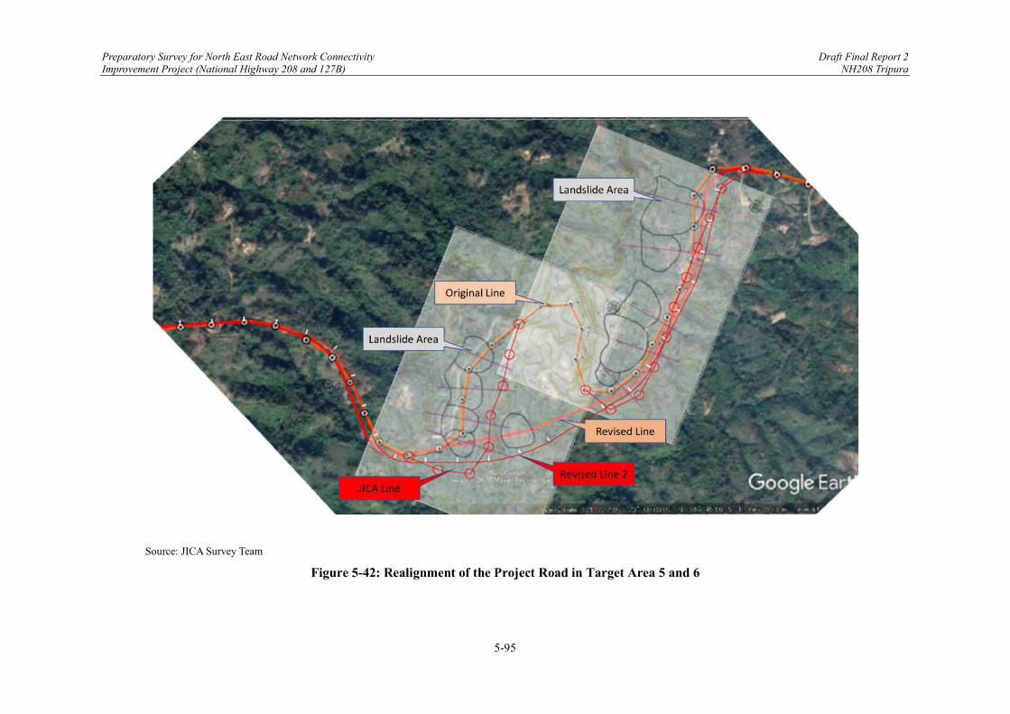
Preparatory Survey for North East Road Network Connectivity Draft Final Report 2 Improvement Project (National Highway 208 and 127B) NH208 Tripura
5-95
Source: JICA Survey Team
Figure 5-42: Realignment of the Project Road in Target Area 5 and 6

Preparatory Survey for North East Road Network Connectivity Draft Final Report 2 Improvement Project (National Highway 208 and 127B) NH208 Tripura
5-96
Source: JICA Survey Team
Figure 5-43: Layout of Pile Works in Target Area 5
Source: JICA Survey Team
Figure 5-44: Cross-Sectional Layout of Pile on Landslide A-4

Preparatory Survey for North East Road Network Connectivity Draft Final Report 2 Improvement Project (National Highway 208 and 127B) NH208 Tripura
5-97
Source: JICA Survey Team
Figure 5-45: Layout of Pile Works in Target Area 6
Source: JICA Survey Team
Figure 5-46: Cross-Sectional Layout of Pile on Landslide B-3
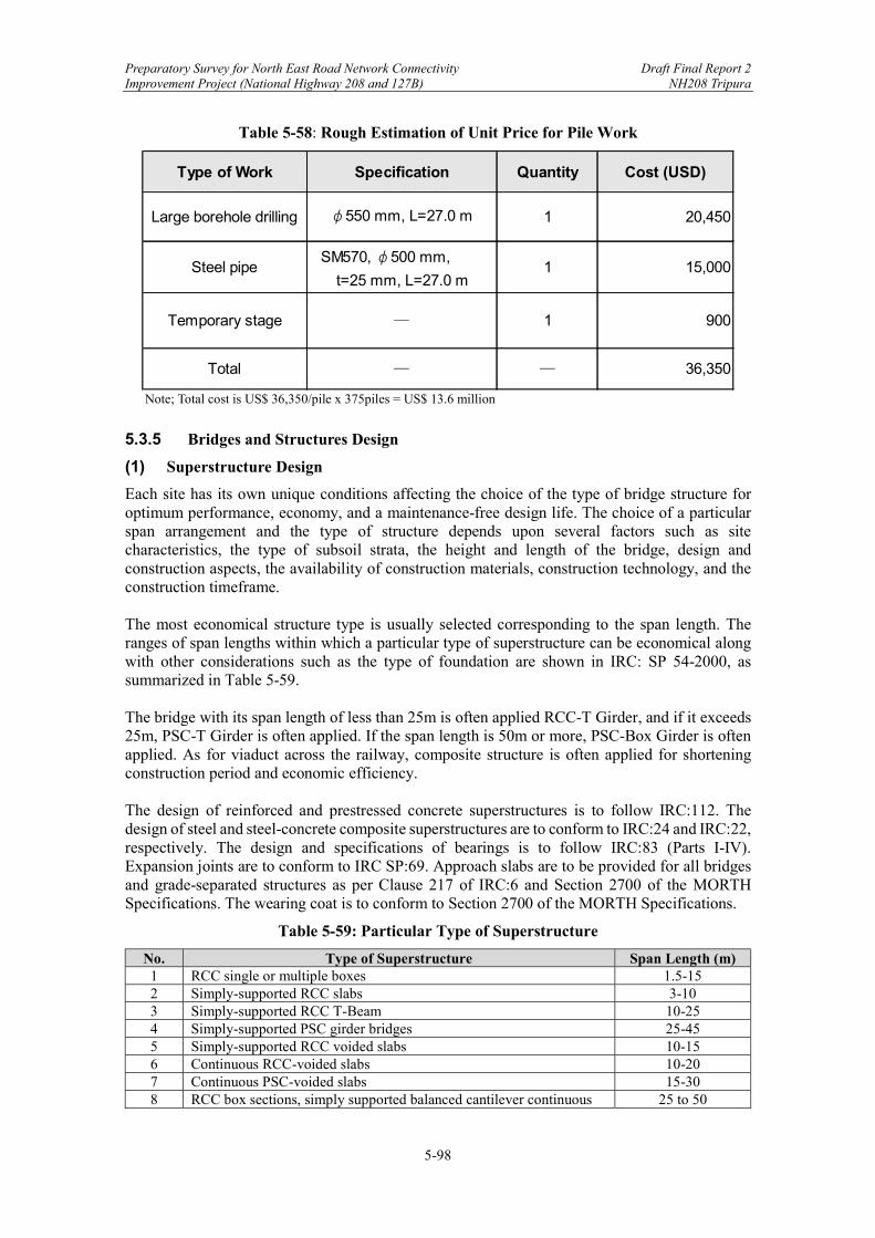
Preparatory Survey for North East Road Network Connectivity Draft Final Report 2 Improvement Project (National Highway 208 and 127B) NH208 Tripura
5-98
Table 5-58: Rough Estimation of Unit Price for Pile Work
Note; Total cost is US$ 36,350/pile x 375piles = US$ 13.6 million
5.3.5 Bridges and Structures Design
(1) Superstructure Design
Each site has its own unique conditions affecting the choice of the type of bridge structure for optimum performance, economy, and a maintenance-free design life. The choice of a particular span arrangement and the type of structure depends upon several factors such as site characteristics, the type of subsoil strata, the height and length of the bridge, design and construction aspects, the availability of construction materials, construction technology, and the construction timeframe. The most economical structure type is usually selected corresponding to the span length. The ranges of span lengths within which a particular type of superstructure can be economical along with other considerations such as the type of foundation are shown in IRC: SP 54-2000, as summarized in Table 5-59. The bridge with its span length of less than 25m is often applied RCC-T Girder, and if it exceeds 25m, PSC-T Girder is often applied. If the span length is 50m or more, PSC-Box Girder is often applied. As for viaduct across the railway, composite structure is often applied for shortening construction period and economic efficiency. The design of reinforced and prestressed concrete superstructures is to follow IRC:112. The design of steel and steel-concrete composite superstructures are to conform to IRC:24 and IRC:22, respectively. The design and specifications of bearings is to follow IRC:83 (Parts I-IV). Expansion joints are to conform to IRC SP:69. Approach slabs are to be provided for all bridges and grade-separated structures as per Clause 217 of IRC:6 and Section 2700 of the MORTH Specifications. The wearing coat is to conform to Section 2700 of the MORTH Specifications.
Table 5-59: Particular Type of Superstructure
No. Type of Superstructure Span Length (m) 1 RCC single or multiple boxes 1.5-15 2 Simply-supported RCC slabs 3-10 3 Simply-supported RCC T-Beam 10-25 4 Simply-supported PSC girder bridges 25-45 5 Simply-supported RCC voided slabs 10-15 6 Continuous RCC-voided slabs 10-20 7 Continuous PSC-voided slabs 15-30 8 RCC box sections, simply supported balanced cantilever continuous 25 to 50
Type of Work Specification Quantity Cost (USD)
Large borehole drilling φ550 mm, L=27.0 m 1 20,450
Steel pipeSM570, φ500 mm,
t=25 mm, L=27.0 m1 15,000
Temporary stage ̶ 1 900
Total ̶ ̶ 36,350

Preparatory Survey for North East Road Network Connectivity Draft Final Report 2 Improvement Project (National Highway 208 and 127B) NH208 Tripura
5-99
9 PSC box sections, simply supported balanced cantilever 35 to 75 10 PSC cantilever construction/continuous 75 to 150 11 Cable-stayed bridges 200 to 500 12 Suspension bridges 500 onwards
Abbreviations: PSC = Pre-Stressed Concrete, RCC = Reinforced Cement Concrete Source: Indian Road Congress: SP 54-2000 However, when an economical span arrangement and type of structure is decided upon, it has to be ensured that the required infrastructural facilities, design and construction capabilities, specialized materials, and other requirements are available. The type and span arrangement should provide for maximum riding comfort and involve minimum inspection and maintenance during the service life of the structure. A continuous superstructure with fewer bearings and expansion joints if not unsuitable otherwise should be preferred over simply supported spans. An integral concept is preferred for small bridges and culverts in which the substructures and superstructure are made without joints (i.e., a monolithic structure). All bearings are to be easily accessible for inspection, maintenance, and replacement. Suitable permanent arrangements are to be made for inspection of bearings from the bridge deck. The drawings of bearings are to include the layout plan showing the exact location on top of the pier and abutment cap and the type of bearings (i.e., fixed/free/rotational) at each location along with notes for proper installation. The bearings should cater for movement in both longitudinal and lateral directions. For aesthetics, attention should be focused on producing a clean, simple, well-proportioned structural form. In most cases, achieving the desired visual quality may add little to the overall cost of the structure. Aesthetic considerations should play an important role even in minor bridges since bridge parapets are the among the most visible parts and should harmonize with the surroundings. (2) Dimensions of Superstructures in Tripura
The JICA Survey Team reviewed Drawings Part-B: Structural Drawings and summarized the structural dimensions as shown in Table 5-60. The engineering, procurement, and construction (EPC) contractor is to be considered at the construction stage with the approval of the Authority Engineer. The following issues are to be considered:
The fabrication yard and transport route need to be considered for PSC-T and RCC-T girders.
Detailed arrangements need to be considered for attaching pipes (e.g., water pipes, electric cables) on bridges.
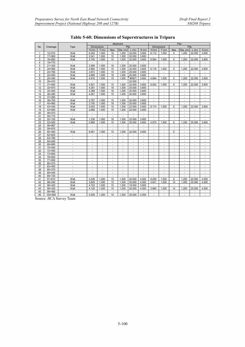
Preparatory Survey for North East Road Network Connectivity Draft Final Report 2 Improvement Project (National Highway 208 and 127B) NH208 Tripura
5-100
Table 5-60: Dimensions of Superstructures in Tripura
Source: JICA Survey Team
H (m) T (m) Nos. Dia. (m) L (m) S (m) H (m) T (m) Nos. Dia. (m) L (m) S (m)1 12+915 Wall 8.302 1.000 18 1.200 22.000 3.600 8.112 1.000 6 1.200 22.000 3.6002 17+900 Wall 2.541 1.000 15 1.200 22.000 3.600 - - - - - -3 18+800 Wall 3.745 1.000 15 1.200 22.000 3.600 6.564 1.000 6 1.200 22.000 3.6004 19+770 - - - - - - - - - - - - -5 21+320 Wall 3.589 1.000 18 1.200 20.000 3.600 - - - - - -6 24+060 Wall 4.684 1.000 15 1.200 22.000 3.600 6.118 1.000 6 1.200 22.000 3.6007 24+760 Wall 3.872 1.000 15 1.200 20.000 3.600 - - - - - -8 24+930 Wall 2.669 1.000 18 1.200 20.000 3.600 - - - - - -9 25+340 Wall 4.916 1.000 15 1.200 #REF! 3.600 4.894 1.000 6 1.200 22.000 3.60010 29+470 - - - - - 22.000 - - - - - - -11 31+050 Wall 4.921 1.000 15 1.200 22.000 3.600 8.002 1.000 6 1.200 22.000 3.60012 32+870 Wall 4.281 1.000 18 1.200 20.000 3.600 - - - - - -13 34+450 Wall 4.389 1.000 18 1.200 20.000 3.600 - - - - - -14 36+290 Wall 4.281 1.000 15 1.200 20.000 3.600 - - - - - -15 37+280 - - - - - - - - - - - - -16 39+705 Wall 2.787 1.000 15 1.200 20.000 3.600 - - - - - -17 40+960 Wall 2.705 1.000 18 1.200 20.000 3.600 - - - - - -18 43+430 Wall 5.053 1.000 15 1.200 22.000 3.600 8.174 1.000 6 1.200 22.000 3.60019 43+900 Wall 2.869 1.000 15 1.200 20.000 3.600 - - - - - -20 46+070 - - - - - - - - - - - - -21 50+775 - - - - - - - - - - - - -22 52+100 Wall 1.236 1.000 18 1.200 22.000 3.600 - - - - - -23 53+500 Wall 0.969 1.000 15 1.200 25.000 3.600 4.975 1.000 6 1.200 25.000 3.60024 58+987 - - - - - - - - - - - - -25 59+970 - - - - - - - - - - - - -26 60+450 Wall 6.061 1.000 15 1.200 22.000 3.600 - - 6 - - -27 62+625 - - - - - - - - - - - - -28 63+780 - - - - - - - - - - - - -29 64+045 - - - - - - - - - - - - -30 69+895 - - - - - - - - - - - - -31 70+930 - - - - - - - - - - - - -32 72+400 - - - - - - - - - - - - -33 73+600 - - - - - - - - - - - - -34 76+600 - - - - - - - - - - - - -35 77+000 - - - - - - - - - - - - -36 80+270 - - - - - - - - - - - - -37 83+400 - - - - - - - - - - - - -38 85+270 - - - - - - - - - - - - -39 85+445 - - - - - - - - - - - - -40 85+725 - - - - - - - - - - - - -41 91+610 Wall 3.336 1.200 15 1.200 20.000 4.000 8.259 1.000 6 1.200 20.000 4.00042 98+240 Wall 3.629 1.200 15 1.200 20.000 4.000 4.641 1.000 14 1.200 20.000 4.00043 98+420 Wall 4.702 1.000 15 1.200 18.000 3.600 - - - - - -44 99+330 Wall 4.125 1.200 15 1.200 20.000 4.000 3.660 1.000 14 1.200 20.000 4.00045 99+495 - - - - - - - - - - - - -46 104+600 Wall 5.509 1.200 15 1.200 20.000 4.000 - - - - - -
No. Chainage TypeAbutment Pier
Dimensions Pile Dimensions Pile
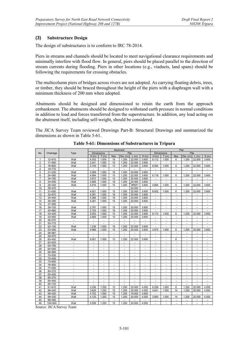
Preparatory Survey for North East Road Network Connectivity Draft Final Report 2 Improvement Project (National Highway 208 and 127B) NH208 Tripura
5-101
(3) Substructure Design
The design of substructures is to conform to IRC 78-2014. Piers in streams and channels should be located to meet navigational clearance requirements and minimally interfere with flood flow. In general, piers should be placed parallel to the direction of stream currents during flooding. Piers in other locations (e.g., viaducts, land spans) should be following the requirements for crossing obstacles. The multicolumn piers of bridges across rivers are not adopted. As carrying floating debris, trees, or timber, they should be braced throughout the height of the piers with a diaphragm wall with a minimum thickness of 200 mm when adopted. Abutments should be designed and dimensioned to retain the earth from the approach embankment. The abutments should be designed to withstand earth pressure in normal conditions in addition to load and forces transferred from the superstructure. In addition, any load acting on the abutment itself, including self-weight, should be considered. The JICA Survey Team reviewed Drawings Part-B: Structural Drawings and summarized the dimensions as shown in Table 5-61.
Table 5-61: Dimensions of Substructures in Tripura
Source: JICA Survey Team
H (m) T (m) Nos. Dia. (m) L (m) S (m) H (m) T (m) Nos. Dia. (m) L (m) S (m)1 12+915 Wall 8.302 1.000 18 1.200 22.000 3.600 8.112 1.000 6 1.200 22.000 3.6002 17+900 Wall 2.541 1.000 15 1.200 22.000 3.600 - - - - - -3 18+800 Wall 3.745 1.000 15 1.200 22.000 3.600 6.564 1.000 6 1.200 22.000 3.6004 19+770 - - - - - - - - - - - - -5 21+320 Wall 3.589 1.000 18 1.200 20.000 3.600 - - - - - -6 24+060 Wall 4.684 1.000 15 1.200 22.000 3.600 6.118 1.000 6 1.200 22.000 3.6007 24+760 Wall 3.872 1.000 15 1.200 20.000 3.600 - - - - - -8 24+930 Wall 2.669 1.000 18 1.200 20.000 3.600 - - - - - -9 25+340 Wall 4.916 1.000 15 1.200 #REF! 3.600 4.894 1.000 6 1.200 22.000 3.60010 29+470 - - - - - 22.000 - - - - - - -11 31+050 Wall 4.921 1.000 15 1.200 22.000 3.600 8.002 1.000 6 1.200 22.000 3.60012 32+870 Wall 4.281 1.000 18 1.200 20.000 3.600 - - - - - -13 34+450 Wall 4.389 1.000 18 1.200 20.000 3.600 - - - - - -14 36+290 Wall 4.281 1.000 15 1.200 20.000 3.600 - - - - - -15 37+280 - - - - - - - - - - - - -16 39+705 Wall 2.787 1.000 15 1.200 20.000 3.600 - - - - - -17 40+960 Wall 2.705 1.000 18 1.200 20.000 3.600 - - - - - -18 43+430 Wall 5.053 1.000 15 1.200 22.000 3.600 8.174 1.000 6 1.200 22.000 3.60019 43+900 Wall 2.869 1.000 15 1.200 20.000 3.600 - - - - - -20 46+070 - - - - - - - - - - - - -21 50+775 - - - - - - - - - - - - -22 52+100 Wall 1.236 1.000 18 1.200 22.000 3.600 - - - - - -23 53+500 Wall 0.969 1.000 15 1.200 25.000 3.600 4.975 1.000 6 1.200 25.000 3.60024 58+987 - - - - - - - - - - - - -25 59+970 - - - - - - - - - - - - -26 60+450 Wall 6.061 1.000 15 1.200 22.000 3.600 - - 6 - - -27 62+625 - - - - - - - - - - - - -28 63+780 - - - - - - - - - - - - -29 64+045 - - - - - - - - - - - - -30 69+895 - - - - - - - - - - - - -31 70+930 - - - - - - - - - - - - -32 72+400 - - - - - - - - - - - - -33 73+600 - - - - - - - - - - - - -34 76+600 - - - - - - - - - - - - -35 77+000 - - - - - - - - - - - - -36 80+270 - - - - - - - - - - - - -37 83+400 - - - - - - - - - - - - -38 85+270 - - - - - - - - - - - - -39 85+445 - - - - - - - - - - - - -40 85+725 - - - - - - - - - - - - -41 91+610 Wall 3.336 1.200 15 1.200 20.000 4.000 8.259 1.000 6 1.200 20.000 4.00042 98+240 Wall 3.629 1.200 15 1.200 20.000 4.000 4.641 1.000 14 1.200 20.000 4.00043 98+420 Wall 4.702 1.000 15 1.200 18.000 3.600 - - - - - -44 99+330 Wall 4.125 1.200 15 1.200 20.000 4.000 3.660 1.000 14 1.200 20.000 4.00045 99+495 - - - - - - - - - - - - -46 104+600 Wall 5.509 1.200 15 1.200 20.000 4.000 - - - - - -
No. Chainage TypeAbutment Pier
Dimensions Pile Dimensions Pile
Preparatory Survey for North East Road Network Connectivity Draft Final Report 2 Improvement Project (National Highway 208 and 127B) NH208 Tripura
5-102
(4) Soil Conditions and Foundation Types
The design of foundations is to conform to IRC 78-2014. The design of open foundations is to conform to IRC 78-2014 (or IRC SP13-2004 in the case of small bridges and culverts). The design of pile foundations is to follow IRC 78-2014, while the design of well foundations is to follow IRC:78-2014. The embedment of foundations in soil is to be based on assessment of the anticipated scour. Foundations may be taken down to a comparatively shallow depth below the bed surface provided good bearing stratum is available and the foundation is protected against scour. The minimum depth of open foundations requires the soil stratum to have adequate bearing capacity but is to not be less than 2.0 m below the scour level. The rock stratum with ultimate crushing strength of 12.5 MPa (megapascals) or N value of 50 or more requires about 0.6 m into rock, and with 2.5 MPa or N value 10 does 1.5 m. Well foundations supporting the superstructure located in deep water channels are properly selected in the shapes, sizes, and types with considerations of the size of the abutment and pier to be accommodated, the need to affect streamline flow, the possibility of using pneumatic sinking, the anticipated depth of the foundation, and the nature of strata to be penetrated. Pile foundations transmit the load of a structure to subsurface strata by the resistance developed from the bearing at the toe, or the skin friction along the surface, or both. The piles may be required to carry uplift and lateral loads in addition to direct vertical load. The JICA Survey Team reviewed Drawings Part-B: Structural Drawings and summarized the dimensions as shown in Table 5-62.

Preparatory Survey for North East Road Network Connectivity Draft Final Report 2 Improvement Project (National Highway 208 and 127B) NH208 Tripura
5-103
Table 5-62: Soil and Foundation
Source: JICA Survey Team
1 12+915 50.713 8 1 Cast-in-Situ Pile2 17+900 41.895 11 1 Cast-in-Situ Pile3 18+800 40.729 29 1 Cast-in-Situ Pile4 19+770 53.827 32 1 -5 21+320 44.356 6 1 Cast-in-Situ Pile6 24+060 36.490 2 1 Cast-in-Situ Pile7 24+760 37.521 5 1 Cast-in-Situ Pile8 24+930 37.924 2 1 Cast-in-Situ Pile9 25+340 35.901 2 1 Cast-in-Situ Pile10 29+470 40.891 4 1 -11 31+050 36.490 4 1 Cast-in-Situ Pile12 32+870 26.378 5 1 Cast-in-Situ Pile13 34+450 27.061 6 1 Cast-in-Situ Pile14 36+290 30.903 5 1 Cast-in-Situ Pile15 37+280 28.354 4 1 -16 39+705 32.932 4 1 Cast-in-Situ Pile17 40+960 31.767 5 1 Cast-in-Situ Pile18 43+430 28.554 3 1 Cast-in-Situ Pile19 43+900 42.031 6 1 Cast-in-Situ Pile20 46+070 66.083 3 1 -21 50+775 40.838 6 1 -22 52+100 38.777 2 1 Cast-in-Situ Pile23 53+500 40.532 6 1 Cast-in-Situ Pile24 58+987 55.970 6 1 -25 59+970 54.413 6 1 -26 60+450 54.061 7 1 Cast-in-Situ Pile27 62+625 51.904 10 1 -28 63+780 54.650 9 1 -29 64+045 55.495 12 1 -30 69+895 46.966 14 1 -31 70+930 45.459 12 1 -32 72+400 52.055 6 1 -33 73+600 53.076 5 1 -34 76+600 43.741 6 1 -35 77+000 45.209 6 1 -36 80+270 33.871 4 1 -37 83+400 33.871 5 1 -38 85+270 40.266 4 1 -39 85+445 48.550 6 1 -40 85+725 44.645 6 1 -41 91+610 42.029 9 1 Cast-in-Situ Pile42 98+240 42.126 5 1 Cast-in-Situ Pile43 98+420 40.299 9 1 Cast-in-Situ Pile44 99+330 35.265 10 1 Cast-in-Situ Pile45 99+495 32.641 10 1 -46 104+600 19.878 8 1 Cast-in-Situ Pile
SPT N-valueat bottom of
pile cap
Number ofboring surveys
Type of foundationNo. ChainageFormation height atbottom of pile cap
(TYP.)
Preparatory Survey for North East Road Network Connectivity Draft Final Report 2 Improvement Project (National Highway 208 and 127B) NH208 Tripura
5-104
It is pointed out that bottoms of pile caps are higher than maximum scour level in most bridges. The DPR Consultant explained that the protection works are provided at all abutment locations and that piles have been designed for the additional cantilever/overhang length. (5) Scouring
The depth of foundation depends on the maximum recorded quantum of water or flood discharge that passes through the river or the channel over which the bridge is proposed and as such the design discharge is important not only for economic considerations but also for safety and stability considerations. Therefore, the design discharge, which might be the recorded discharge during the past 50-100 years, is to be ascertained carefully. There are various methods for the estimation of flood discharges, as listed below:
1) The Catchment-Runoff Method from rainfall and other characteristics of the catchment using empirical formulae or by the Rational Method;
2) A method based on the hydraulic characteristics of the stream (e.g., conveyance factors, slope of the stream);
3) A method based on recorded flood discharges near the bridge site. Scour depth must be considered in the design of pile foundation. Also, the lateral and vertical load capacity of piles has been calculated with due consideration of probable scour and pile overhang. The JICA Survey Team reviewed the DPR and summarized the scour depth calculation results in Table 5-63. The formula in the hydraulic calculation comply with the Catchment-Runoff Method in confirmation of flood records and IRC SP 13-2004.
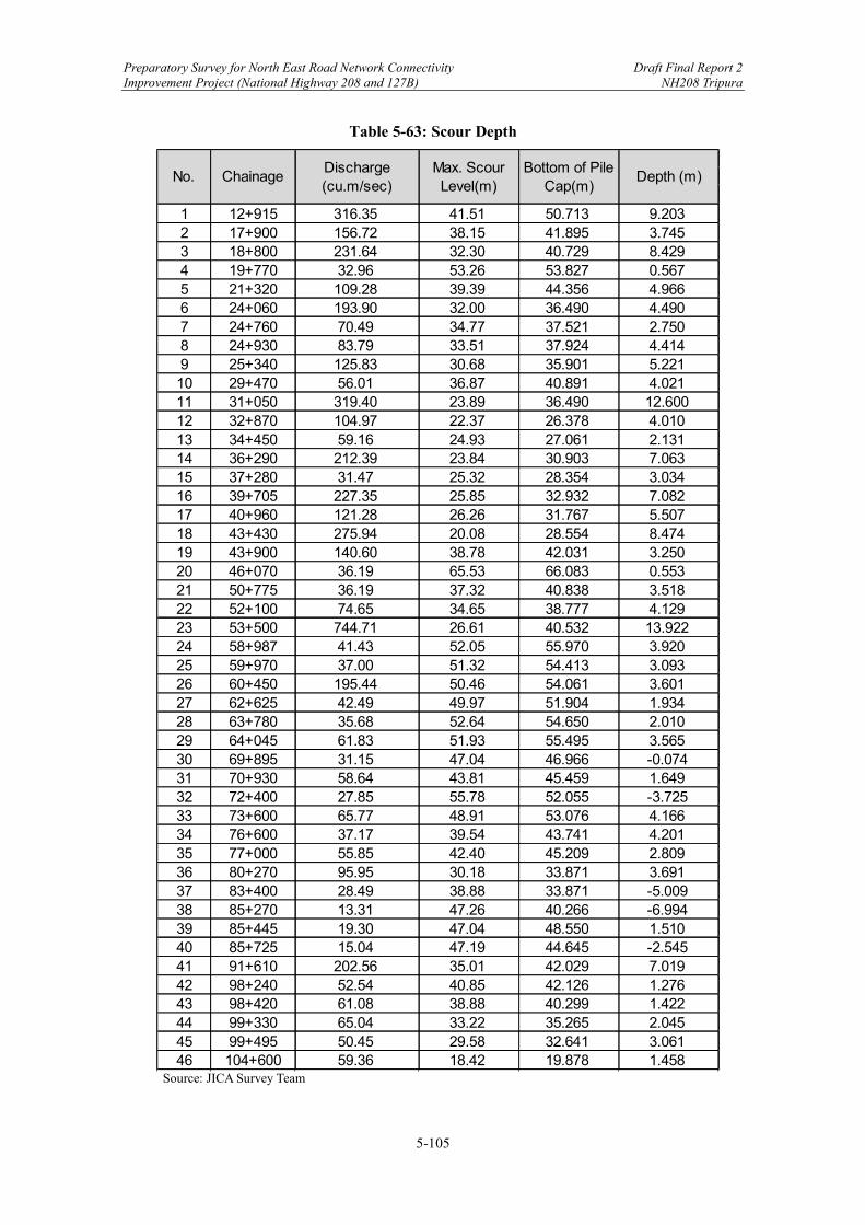
Preparatory Survey for North East Road Network Connectivity Draft Final Report 2 Improvement Project (National Highway 208 and 127B) NH208 Tripura
5-105
Table 5-63: Scour Depth
Source: JICA Survey Team
1 12+915 316.35 41.51 50.713 9.2032 17+900 156.72 38.15 41.895 3.7453 18+800 231.64 32.30 40.729 8.4294 19+770 32.96 53.26 53.827 0.5675 21+320 109.28 39.39 44.356 4.9666 24+060 193.90 32.00 36.490 4.4907 24+760 70.49 34.77 37.521 2.7508 24+930 83.79 33.51 37.924 4.4149 25+340 125.83 30.68 35.901 5.22110 29+470 56.01 36.87 40.891 4.02111 31+050 319.40 23.89 36.490 12.60012 32+870 104.97 22.37 26.378 4.01013 34+450 59.16 24.93 27.061 2.13114 36+290 212.39 23.84 30.903 7.06315 37+280 31.47 25.32 28.354 3.03416 39+705 227.35 25.85 32.932 7.08217 40+960 121.28 26.26 31.767 5.50718 43+430 275.94 20.08 28.554 8.47419 43+900 140.60 38.78 42.031 3.25020 46+070 36.19 65.53 66.083 0.55321 50+775 36.19 37.32 40.838 3.51822 52+100 74.65 34.65 38.777 4.12923 53+500 744.71 26.61 40.532 13.92224 58+987 41.43 52.05 55.970 3.92025 59+970 37.00 51.32 54.413 3.09326 60+450 195.44 50.46 54.061 3.60127 62+625 42.49 49.97 51.904 1.93428 63+780 35.68 52.64 54.650 2.01029 64+045 61.83 51.93 55.495 3.56530 69+895 31.15 47.04 46.966 -0.07431 70+930 58.64 43.81 45.459 1.64932 72+400 27.85 55.78 52.055 -3.72533 73+600 65.77 48.91 53.076 4.16634 76+600 37.17 39.54 43.741 4.20135 77+000 55.85 42.40 45.209 2.80936 80+270 95.95 30.18 33.871 3.69137 83+400 28.49 38.88 33.871 -5.00938 85+270 13.31 47.26 40.266 -6.99439 85+445 19.30 47.04 48.550 1.51040 85+725 15.04 47.19 44.645 -2.54541 91+610 202.56 35.01 42.029 7.01942 98+240 52.54 40.85 42.126 1.27643 98+420 61.08 38.88 40.299 1.42244 99+330 65.04 33.22 35.265 2.04545 99+495 50.45 29.58 32.641 3.06146 104+600 59.36 18.42 19.878 1.458
No. ChainageDischarge(cu.m/sec)
Max. ScourLevel(m)
Bottom of PileCap(m)
Depth (m)
Preparatory Survey for North East Road Network Connectivity Draft Final Report 2 Improvement Project (National Highway 208 and 127B) NH208 Tripura
5-106
(6) Protection Works
River training and protection works are to be provided wherever required to ensure the safety of bridges and their approaches. The design of various types of river training and protection works is to be in accordance with IRC 89-1997. Also, the construction of river training works is to conform to MORTH Specifications. Protection works for the major bridges will be provided following the methods for existing bridges. IRC:89-1997 presents details for the protection works, as follows. By the time of preparing the Draft Final Report, the JICA Survey Team would like to list the protection works, as shown in Table 5-64.
Return walls of required length will be provided in all bridges and culverts to stop the spilling of earth into the waterway.
Flooring will be provided over both sides of the pile cap of bridges to guard against deterioration of the foundation.
Peripheral cut-off walls around base raft of culverts and boulder apron on both upstream and downstream sides will be provided to reduce the scouring.
The perimeter cut-off walls will also increase the effective depth of foundation in addition to their protective function.
By the time of preparing the Draft Final Report, the JICA Survey Team would like to list the protection works, as shown in Table 5-64.

Preparatory Survey for North East Road Network Connectivity Draft Final Report 2 Improvement Project (National Highway 208 and 127B) NH208 Tripura
5-107
Table 5-64: Protection Works
Source: JICA Survey Team
1 12+915 W11000 X Stone Pitching (1:1.5) -2 17+900 W3500 X Stone Pitching (1:1.5) -3 18+800 W4200 X Stone Pitching (1:1.5) -4 19+770 W12200 X Floor/Flexible Apron 25005 21+320 W3500 X Stone Pitching (1:1.5) -6 24+060 W5500 X Stone Pitching (1:1.5) -7 24+760 W3500 X Stone Pitching (1:1.5) -8 24+930 W3500 X Stone Pitching (1:1.5) -9 25+340 W5900 X Stone Pitching (1:1.5) -10 29+470 W5900 X Floor/Flexible Apron 250011 31+050 W6100 X Stone Pitching (1:1.5) -12 32+870 W3500 X Stone Pitching (1:1.5) -13 34+450 W3500 X Stone Pitching (1:1.5) -14 36+290 W6300 X Stone Pitching (1:1.5) -15 37+280 W6500 X Floor/Flexible Apron 250016 39+705 W4000 X Stone Pitching (1:1.5) -17 40+960 W3500 X Stone Pitching (1:1.5) -18 43+430 W6100 X Stone Pitching (1:1.5) -19 43+900 W3500 X Stone Pitching (1:1.5) -20 46+070 W12300 X Floor/Flexible Apron 250021 50+775 W9600 X Floor/Flexible Apron 250022 52+100 W3500 X Stone Pitching (1:1.5) -23 53+500 W3850 X - -24 58+987 W7400 X Floor/Flexible Apron 250025 59+970 W7300 X Floor/Flexible Apron 250026 60+450 W6100 X Stone Pitching (1:1.5) -27 62+625 W8400 X Floor/Flexible Apron 250028 63+780 W9300 X Floor/Flexible Apron 250029 64+045 W9000 X Floor/Flexible Apron 250030 69+895 W12200 X Floor/Flexible Apron 250031 70+930 W8800 X Floor/Flexible Apron 250032 72+400 W7000 X Floor/Flexible Apron 250033 73+600 W7000 X Floor/Flexible Apron 250034 76+600 W7800 X Floor/Flexible Apron 250035 77+000 W5800 X Floor/Flexible Apron 250036 80+270 W8200 X Floor/Flexible Apron 250037 83+400 W7000 X Floor/Flexible Apron 250038 85+270 W8500 X Floor/Flexible Apron 250039 85+445 W7000 X Floor/Flexible Apron 250040 85+725 W13000 X Floor/Flexible Apron 250041 91+610 W3100 X Stone Pitching (1:1.5) -42 98+240 W2800 X Stone Pitching (1:1.5) -43 98+420 W3500 X Stone Pitching (1:1.5) -44 99+330 W3600 X Stone Pitching (1:1.5) -45 99+495 W8200 X Floor/Flexible Apron 250046 104+600 W6300 X Stone Pitching (1:1.5) -
No. Chainage Return wall Flooring Curtain wall

Preparatory Survey for North East Road Network Connectivity Draft Final Report 2 Improvement Project (National Highway 208 and 127B) NH208 Tripura
5-108
5.3.6 Drainage Design
The JICA Survey Team reviewed and confirmed the DPR and drawings conducted by the DPR Consultant. The shapes of the box culverts shown in the drawings were determined from the capacity calculation of the crossing channel carried out using a typical part as a model. Based on the calculation, the cross drainage design of NH208 adopts the box culvert type. (1) Cross Drain
There are 232 nos of existing culverts (162 HP culverts, 51 nos slab culvert & 19 nos Box Bridges) along the Survey road. Among them 207 nos of existing culverts are proposed to be reconstructed by Box Bridge & the remaining 25 nos of culverts are omitted due to through cutting and realignment of the Survey road. Additional 34 nos of Box Bridge are proposed in the proposed alignment.

Preparatory Survey for North East Road Network Connectivity Draft Final Report 2 Improvement Project (National Highway 208 and 127B) NH208 Tripura
5-109
Reconstruction Cross Drains
Table 5-65: Proposed Reconstruction Cross Drains (1)
Sl No.
Survey Chainage
(km)
Design Chainage
(km)
Type of Existing
Structure
Span of Existing
Structure (M)
Proposed Box Size (m x m)
1 21.170 21.175 Pipe 2 × 1.200 2.0×2.0× (Single Cell)
2 21.245 21.250 Pipe 1 × 1.200 2.0×2.0× (Single Cell)
3 21.315 21.318 Pipe 1 × 1.200 2.0×3.0× (Single Cell)
4 21.549 21.554 Pipe 1 × 0.600 2.0×3.0× (Single Cell)
5 21.715 21.720 Pipe 1 × 1.200 2.0×3.0× (Single Cell)
6 24.861 24.290 Pipe 2 × 1.000 3.0 × 4.0× (Single Cell)
7 25.354 24.783 Pipe 2 × 0.900 2.0×2.0× (Single Cell)
8 26.451 25.835 Box 1 × 1.500 2.0×2.0× (Single Cell)
9 26.764 26.147 Pipe 2 × 1.000 2.0×3.0× (Single Cell)
10 27.195 26.569 Pipe 2 × 1.000 3.0 × 4.0× (Single Cell)
11 27.357 26.730 Pipe 2 × 0.750 2.0×3.0× (Single Cell)
12 27.663 26.976 Pipe 1 × 1.000 2.0×2.0× (Single Cell)
13 27.818 27.132 Pipe 2 × 1.200 2.0×3.0× (Single Cell)
14 27.878 27.192 Pipe 1 × 0.900 2.0×3.0× (Single Cell)
15 27.965 27.279 Pipe 1 × 1.000 2.0×3.0× (Single Cell)
16 28.151 27.465 Pipe 1 × 1.500 2.0×2.0× (Single Cell)
17 28.232 27.546 Pipe 1 × 1.000 2.0×3.0× (Single Cell)
18 28.279 27.593 Pipe 1 × 1.500 2.0×2.0× (Single Cell)
19 28.347 27.658 Pipe 1 × 0.750 2.0×2.0× (Single Cell)
20 28.415 27.727 Pipe 1 × 0.750 2.0×2.0× (Single Cell)
21 28.466 27.779 Pipe 1 × .900 2.0×3.0× (Single Cell)
22 28.543 27.856 Pipe 1 × 0.600 2.0×3.0× (Single Cell)
23 28.620 27.932 Pipe 1 × 1.500 2.0×2.0× (Single Cell)
24 28.723 28.037 Pipe 1 × 1.200 2.0×2.0× (Single Cell)
25 28.813 28.127 Pipe 1 × 1.000 2.0×2.0× (Single Cell) 26 28.938 28.251 Pipe 1 × 0.750 2.0×2.0× (Single Cell)
27 28.998 28.311 Pipe 1 × 1.200 2.0×2.0× (Single Cell)
28 29.056 28.368 Pipe 1 × 0.300 2.0×2.0× (Single Cell) Source: JICA Survey Team based on DPR
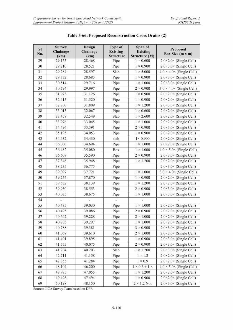
Preparatory Survey for North East Road Network Connectivity Draft Final Report 2 Improvement Project (National Highway 208 and 127B) NH208 Tripura
5-110
Table 5-66: Proposed Reconstruction Cross Drains (2)
Sl No.
Survey Chainage
(km)
Design Chainage
(km)
Type of Existing
Structure
Span of Existing
Structure (M)
Proposed Box Size (m x m)
29 29.155 28.468 Pipe 1 × 0.600 2.0×2.0× (Single Cell)
30 29.210 28.521 Pipe 1 × 0.900 2.0×3.0× (Single Cell)
31 29.284 28.597 Slab 1 × 5.000 4.0 × 4.0× (Single Cell)
32 29.372 28.685 Pipe 1 × 0.900 2.0×3.0× (Single Cell)
33 30.514 29.716 Pipe 1 × 1.000 2.0×3.0× (Single Cell)
34 30.794 29.997 Pipe 2 × 0.900 3.0 × 4.0× (Single Cell)
35 31.973 31.126 Pipe 1 × 0.900 2.0×2.0× (Single Cell)
36 32.415 31.520 Pipe 1 × 0.900 2.0×2.0× (Single Cell)
37 32.700 31.809 Pipe 1 × 1.200 2.0×3.0× (Single Cell)
38 33.013 32.067 Pipe 1 × 0.600 2.0×2.0× (Single Cell)
39 33.458 32.549 Slab 1 × 2.600 2.0×2.0× (Single Cell)
40 33.976 33.045 Pipe 1 × 1.000 2.0×2.0× (Single Cell)
41 34.496 33.391 Pipe 2 × 0.900 2.0×3.0× (Single Cell)
42 35.195 34.053 Pipe 1 × 0.900 2.0×2.0× (Single Cell)
43 34.432 34.430 slab 1× 0.900 2.0×2.0× (Single Cell)
44 36.000 34.694 Pipe 1 × 1.000 2.0×2.0× (Single Cell)
45 36.482 35.080 Box 1 × 1.000 4.0 × 5.0× (Single Cell)
46 36.608 35.590 Pipe 2 × 0.900 2.0×3.0× (Single Cell)
47 37.346 35.948 Pipe 1 × 1.200 2.0×2.0× (Single Cell)
48 38.235 36.775 Pipe 2.0×3.0× (Single Cell)
49 39.097 37.721 Pipe 1 × 1.000 3.0 × 4.0× (Single Cell)
50 39.254 37.870 Pipe 1 × 0.900 2.0×2.0× (Single Cell)
51 39.532 38.139 Pipe 1 × 1.200 2.0×2.0× (Single Cell)
52 39.950 38.553 Pipe 2 × 0.900 2.0×3.0× (Single Cell)
53 40.075 38.675 Pipe 1 × 1.000 2.0×3.0× (Single Cell)
54 - - - - -
55 40.435 39.030 Pipe 1 × 1.000 2.0×2.0× (Single Cell)
56 40.495 39.086 Pipe 2 × 0.900 2.0×2.0× (Single Cell)
57 40.642 39.228 Pipe 2 × 1.000 2.0×2.0× (Single Cell)
58 40.703 39.297 Pipe 1 × 1.000 2.0×2.0× (Single Cell)
59 40.788 39.381 Pipe 3 × 0.900 2.0×3.0× (Single Cell)
60 41.068 39.610 Pipe 2 × 1.000 2.0×2.0× (Single Cell)
61 41.401 39.895 Pipe 1 × 0.900 2.0×3.0× (Single Cell)
62 41.575 40.075 Pipe 2 × 0.900 2.0×3.0× (Single Cell)
63 41.704 40.203 Slab 1 × 1.200 2.0×3.0× (Single Cell)
64 42.711 41.158 Pipe 1 × 1.2 2.0×2.0× (Single Cell)
65 42.855 41.284 Pipe 1 × 0.9 2.0×2.0× (Single Cell)
66 48.104 46.200 Pipe 1 × 0.6 + 1 × 0.9
4.0 × 5.0× (Single Cell)
67 48.985 47.055 Pipe 1 × 1.200 2.0×2.0× (Single Cell)
68 49.498 47.494 Pipe 1 × 0.900 2.0×2.0× (Single Cell)
69 50.198 48.150 Pipe 2 × 1.2 Not visible
2.0×3.0× (Single Cell) Source: JICA Survey Team based on DPR

Preparatory Survey for North East Road Network Connectivity Draft Final Report 2 Improvement Project (National Highway 208 and 127B) NH208 Tripura
5-111
Table 5-67: Proposed Reconstruction Cross Drains (3)
Sl No.
Survey Chainage
(km)
Design Chainage
(km)
Type of Existing
Structure
Span of Existing
Structure (M)
Proposed Box Size (m x m)
70 50.375 48.300 Pipe Not visible 2.0×3.0× (Single Cell)
71 51.503 49.250 Pipe 2 × 0.9 4.0 × 5.0× (Single Cell)
72 51.960 49.700 Pipe 3 × 0.9 3.0 × 4.0× (Single Cell)
73 52.055 49.770 Pipe 1× 0.9 Not visible
4.0 × 5.0× (Single Cell)
74 52.480 50.167 Pipe 1× 0.9 Not visible
2.0×2.0× (Single Cell)
75 52.680 50.266 Pipe 1 × 0.9 2.0×2.0× (Single Cell)
76 52.980 50.657 Pipe 2 × 0.9 2.0×3.0× (Single Cell)
77 54.120 51.688 Pipe 3 × 0.600 4.0 × 5.0× (Single Cell)
78 56.780 53.984 Pipe 1 × 1.000 3.0 × 4.0× (Single Cell)
79 58.425 55.185 Pipe 1 × 0.6 2.0×2.0× (Single Cell)
80 58.474 55.232 Pipe 1 × 0.900 3.0 × 4.0× (Single Cell)
81 58.560 55.300 Slab 1 × 1.00 4.0 × 5.0× (Single Cell)
82 60.400 56.786 Pipe 1 × 0.9 3.0 × 4.0× (Single Cell)
83 61.770 58.148 Pipe 1 × 1.200 2.0×2.0× (Single Cell)
84 61.935 58.300 Slab 2 × 1.000 2.0×2.0× (Single Cell)
85 62.200 58.566 Pipe 1 × 1.000 2.0×3.0× (Single Cell)
86 63.248 59.410 Box 1 × 1.000 2.0×2.0× (Single Cell)
87 64.846 60.423 Pipe 1 × 1.500 2.0×3.0× (Single Cell)
88 65.302 60.850 Pipe 2 × 0.900 4.0 × 5.0× (Single Cell)
89 65.527 61.056 Pipe 1 × 0.900 4.0 × 5.0× (Single Cell)
90 65.812 61.314 Pipe 2 × 1.000 3.0 × 4.0× (Single Cell)
91 65.932 61.403 Pipe 1 × 1.000 3.0 × 4.0× (Single Cell)
92 68.065 63.262 Pipe 1 × 1.000 3.0 × 4.0× (Single Cell)
93 68.406 63.595 Pipe 1 × 1.200 2.0×2.0× (Single Cell)
94 68.710 63.867 Pipe 2 × 0.900 2.0×3.0× (Single Cell)
95 68.800 63.951 Pipe 1 × 0.600 2.0×2.0× (Single Cell)
96 68.873 64.064 Pipe 1 × 0.300 2.0×3.0× (Single Cell)
97 69.102 64.280 Pipe 1 × 0.900 2.0×3.0× (Single Cell)
98 69.210 64.380 Pipe 2 × 0.900 2.0×2.0× (Single Cell)
99 69.306 64.467 Slab 1 × 1.000 2.0×2.0× (Single Cell)
100 69.460 64.570 Slab 1 × 1.000 2.0×3.0× (Single Cell)
101 70.180 65.185 Pipe 1 × 0.900 2.0×2.0× (Single Cell)
102 70.330 65.330 Pipe 1 × 1.000 2.0×2.0× (Single Cell)
103 70.687 65.665 Pipe 1 × 0.900 2.0×2.0× (Single Cell)
104 70.760 65.735 Pipe 1 × 0.600 2.0×2.0× (Single Cell)
105 70.923 65.900 Pipe 1 × 0.900 3.0 × 4.0× (Single Cell)
106 71.075 66.015 Pipe 1 × 1.200 2.0×2.0× (Single Cell)
107 71.382 66.303 Slab 1 × 1.000 2.0×2.0× (Single Cell)
108 71.546 66.456 Pipe 1 × 0.600 2.0×2.0× (Single Cell) Source: JICA Survey Team based on DPR
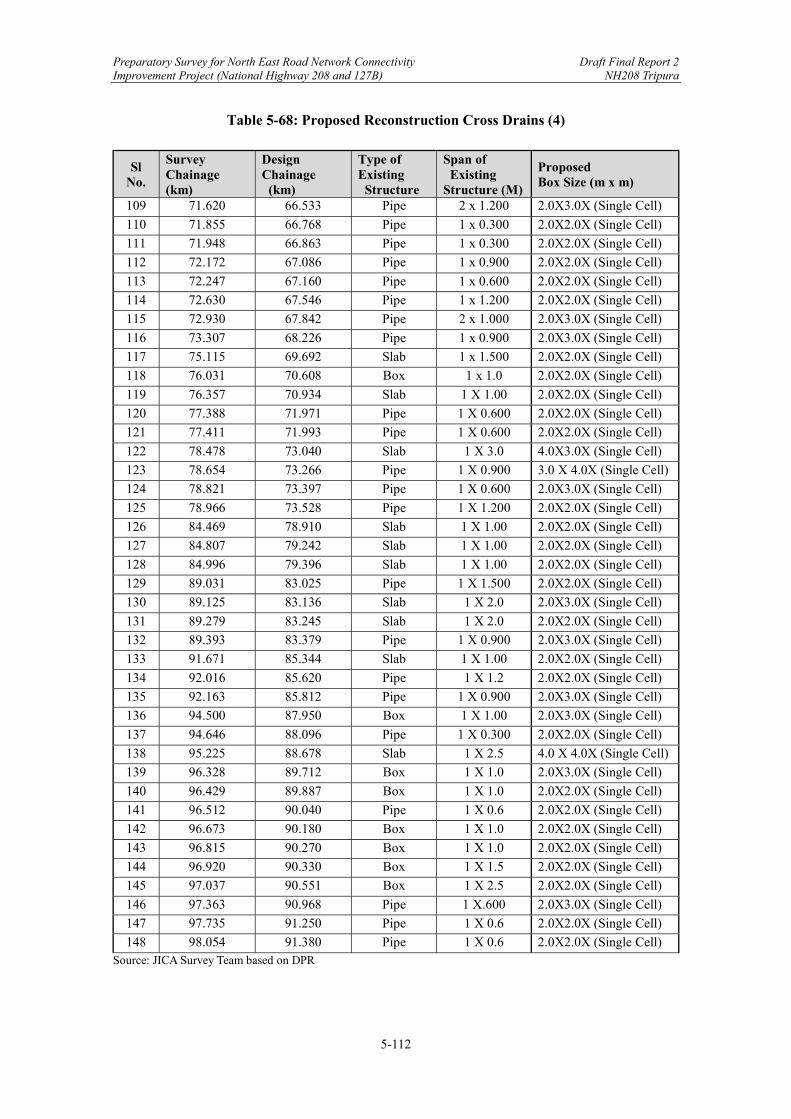
Preparatory Survey for North East Road Network Connectivity Draft Final Report 2 Improvement Project (National Highway 208 and 127B) NH208 Tripura
5-112
Table 5-68: Proposed Reconstruction Cross Drains (4)
Sl No.
Survey Chainage (km)
Design Chainage (km)
Type of Existing Structure
Span of Existing Structure (M)
Proposed Box Size (m x m)
109 71.620 66.533 Pipe 2 x 1.200 2.0X3.0X (Single Cell)
110 71.855 66.768 Pipe 1 x 0.300 2.0X2.0X (Single Cell)
111 71.948 66.863 Pipe 1 x 0.300 2.0X2.0X (Single Cell)
112 72.172 67.086 Pipe 1 x 0.900 2.0X2.0X (Single Cell)
113 72.247 67.160 Pipe 1 x 0.600 2.0X2.0X (Single Cell)
114 72.630 67.546 Pipe 1 x 1.200 2.0X2.0X (Single Cell)
115 72.930 67.842 Pipe 2 x 1.000 2.0X3.0X (Single Cell)
116 73.307 68.226 Pipe 1 x 0.900 2.0X3.0X (Single Cell)
117 75.115 69.692 Slab 1 x 1.500 2.0X2.0X (Single Cell)
118 76.031 70.608 Box 1 x 1.0 2.0X2.0X (Single Cell)
119 76.357 70.934 Slab 1 X 1.00 2.0X2.0X (Single Cell)
120 77.388 71.971 Pipe 1 X 0.600 2.0X2.0X (Single Cell)
121 77.411 71.993 Pipe 1 X 0.600 2.0X2.0X (Single Cell)
122 78.478 73.040 Slab 1 X 3.0 4.0X3.0X (Single Cell)
123 78.654 73.266 Pipe 1 X 0.900 3.0 X 4.0X (Single Cell)
124 78.821 73.397 Pipe 1 X 0.600 2.0X3.0X (Single Cell)
125 78.966 73.528 Pipe 1 X 1.200 2.0X2.0X (Single Cell)
126 84.469 78.910 Slab 1 X 1.00 2.0X2.0X (Single Cell)
127 84.807 79.242 Slab 1 X 1.00 2.0X2.0X (Single Cell)
128 84.996 79.396 Slab 1 X 1.00 2.0X2.0X (Single Cell)
129 89.031 83.025 Pipe 1 X 1.500 2.0X2.0X (Single Cell)
130 89.125 83.136 Slab 1 X 2.0 2.0X3.0X (Single Cell)
131 89.279 83.245 Slab 1 X 2.0 2.0X2.0X (Single Cell)
132 89.393 83.379 Pipe 1 X 0.900 2.0X3.0X (Single Cell)
133 91.671 85.344 Slab 1 X 1.00 2.0X2.0X (Single Cell)
134 92.016 85.620 Pipe 1 X 1.2 2.0X2.0X (Single Cell)
135 92.163 85.812 Pipe 1 X 0.900 2.0X3.0X (Single Cell)
136 94.500 87.950 Box 1 X 1.00 2.0X3.0X (Single Cell)
137 94.646 88.096 Pipe 1 X 0.300 2.0X2.0X (Single Cell)
138 95.225 88.678 Slab 1 X 2.5 4.0 X 4.0X (Single Cell)
139 96.328 89.712 Box 1 X 1.0 2.0X3.0X (Single Cell)
140 96.429 89.887 Box 1 X 1.0 2.0X2.0X (Single Cell)
141 96.512 90.040 Pipe 1 X 0.6 2.0X2.0X (Single Cell)
142 96.673 90.180 Box 1 X 1.0 2.0X2.0X (Single Cell)
143 96.815 90.270 Box 1 X 1.0 2.0X2.0X (Single Cell)
144 96.920 90.330 Box 1 X 1.5 2.0X2.0X (Single Cell)
145 97.037 90.551 Box 1 X 2.5 2.0X2.0X (Single Cell)
146 97.363 90.968 Pipe 1 X.600 2.0X3.0X (Single Cell)
147 97.735 91.250 Pipe 1 X 0.6 2.0X2.0X (Single Cell)
148 98.054 91.380 Pipe 1 X 0.6 2.0X2.0X (Single Cell) Source: JICA Survey Team based on DPR

Preparatory Survey for North East Road Network Connectivity Draft Final Report 2 Improvement Project (National Highway 208 and 127B) NH208 Tripura
5-113
Table 5-69: Proposed Reconstruction Cross Drains (5)
Sl No.
Survey Chainage
(km)
Design Chainage
(km)
Type of Existing
Structure
Span of Existing
Structure (M)
Proposed Box Size (m x m)
148 98.054 91.380 Pipe 1 X 0.6 2.0X2.0X (Single Cell)
149 98.183 91.457 Box 1 X 0.9 2.0X2.0X (Single Cell)
150 98.261 91.669 Slab 1 X 1.5 2.0X2.0X (Single Cell)
151 98.453 91.797 Box 1 X 1.5 2.0X2.0X (Single Cell)
152 98.612 91.934 Pipe 1 X 1.2 2.0X3.0X (Single Cell)
153 98.750 91.990 Box 1 X 1.5 2.0X3.0X (Single Cell)
154 98.802 92.277 Pipe 1 X 1.0 3.0 X 4.0X (Single Cell)
155 99.095 92.475 Pipe 3 X 1.5 4.0X3.0X (Single Cell)
156 99.297 92.683 Box 1 X 2.0 2.0X3.0X (Single Cell)
157 99.505 92.780 Box 1 X 1.5 2.0X3.0X (Single Cell)
158 99.620 92.913 Pipe 1 X 1.2 2.0X2.0X (Single Cell)
159 99.735 93.145 Box 1 X 3.0 4.0 X 5.0X (Single Cell)
160 99.772 93.175 Slab 1 X 0.4 2.0X2.0X (Single Cell)
161 100.220 93.596 Pipe 1 X 0.6 2.0X2.0X (Single Cell)
162 100.281 93.657 Pipe 1 X 0.6 2.0X2.0X (Single Cell)
163 100.471 93.830 Pipe 1 X 0.6 2.0X3.0X (Single Cell)
164 100.512 93.870 Pipe 1 X 0.6 2.0X3.0X (Single Cell)
165 101.018 94.351 Pipe 1 X 0.9 2.0X2.0X (Single Cell)
166 101.223 94.558 Pipe 1 X 0.6 2.0X2.0X (Single Cell)
167 101.569 94.890 Pipe 1 X 1.2 2.0X2.0X (Single Cell)
168 101.679 94.995 Pipe 1 X 0.6 2.0X2.0X (Single Cell)
169 102.820 95.924 Slab 1 X 1.5 2.0X2.0X (Single Cell)
170 103.703 96.816 Pipe 1 X 1.5 4.0 X 5.0X (Single Cell)
171 104.458 97.040 Pipe 1 X 0.9 3.0 X 4.0X (Single Cell)
172 104.800 97.315 Slab 1 X 1.5 4.0 X 5.0X (Single Cell)
173 104.800 98.168 Pipe 1 X 1.5 2.0X2.0X (Single Cell)
174 105.128 98.725 Pipe 1 X 1.5 2.0X2.0X (Single Cell)
175 111.878 102.121 Slab 1 X 1.5 2.0X3.0X (Single Cell)
176 112.875 103.100 Pipe 1 X 1.0 2.0X2.0X (Single Cell)
177 113.291 103.535 Slab 1 X 1.0 3.0 X 4.0X (Single Cell)
178 114.221 104.450 Slab 1 X 1.0 3.0 X 4.0X (Single Cell)
179 118.082 107.474 Pipe 1 X 0.9 2.0X3.0X (Single Cell)
180 118.329 107.718 Slab 1 X 0.8 2.0X3.0X (Single Cell)
181 119.975 109.365 Slab 1 X 1.0 2.0X3.0X (Single Cell)
182 120.482 109.875 Slab 1 X 0.8 2.0X2.0X (Single Cell)
183 120.973 110.362 Slab 1 X 1.0 2.0X2.0X (Single Cell)
184 124.037 113.135 Pipe 1 X 0.600 2.0X2.0X (Single Cell)
185 125.653 114.750 Slab 1 X 2.0 2.0X3.0X (Single Cell)
186 126.635 115.750 Pipe 1 X 1.200 4.0 X 5.0X (Single Cell)
187 128.075 116.931 Pipe 1 X 1.5 2.0X3.0X (Single Cell)
188 129.083 117.805 Pipe 1 X 0.600 2.0X3.0X (Single Cell) Source: JICA Survey Team based on DPR

Preparatory Survey for North East Road Network Connectivity Draft Final Report 2 Improvement Project (National Highway 208 and 127B) NH208 Tripura
5-114
Table 5-70: Proposed Reconstruction Cross Drains (6)
Sl No.
Survey Chainage
(km)
Design Chainage
(km)
Type of Existing
Structure
Span of Existing
Structure (M)
Proposed Box Size (m x m)
187 128.075 116.931 Pipe 1 X 1.5 2.0X3.0X (Single Cell)
188 129.083 117.805 Pipe 1 X 0.600 2.0X3.0X (Single Cell)
189 129.336 118.080 Slab 1 X 1.000 4.0 X 5.0X (Single Cell)
190 129.589 118.290 Pipe 1 X 0.900 4.0 X 5.0X (Single Cell)
191 129.663 118.350 Pipe 1 X 0.600 4.0 X 5.0X (Single Cell)
192 129.840 118.578 Pipe 4 X 1.200 4.0 X 5.0X (Single Cell)
193 130.710 119.184 Slab 1 X 0.800 2.0X2.0X (Single Cell)
194 131.599 119.990 Slab 1 X 1.000 3.0 X 4.0X (Single Cell)
195 131.733 120.112 Pipe 1 X 1.000 2.0X2.0X (Single Cell)
196 132.207 120.454 Pipe 1 X 1.000 2.0X3.0X (Single Cell)
197 132.377 120.622 Pipe 1 X 1.000 2.0X2.0X (Single Cell)
198 133.292 121.510 Slab 1 X 0.800 2.0X3.0X (Single Cell)
199 133.541 121.759 Slab 1 X 1.8 2.0X2.0X (Single Cell)
200 134.008 122.227 Pipe 1 X 1.0 2.0X2.0X (Single Cell)
201 134.227 122.440 Pipe 2 X 0.6 2.0X2.0X (Single Cell)
202 134.872 123.082 Slab 1 X 1.2 3.0 X 4.0X (Single Cell)
203 135.312 123.518 Slab 1 X 1.0 2.0X2.0X (Single Cell)
204 136.413 124.611 Pipe 1 X 1.2 3.0 X 4.0X (Single Cell With EC) 205 136.621 124.820 Pipe 2 X 0.600 2.0X3.0X (Single Cell)
206 138.590 126.719 Slab 1 X 0.8 2.0X2.0X (Single Cell)
207 139.010 127.135 Slab 1 X 1.5 3.0 X 4.0X (Single Cell) Source: JICA Survey Team based on DPR New Construction Cross Drains
Table 5-71: Proposed New Construction Cross Drains (1)
No Design Chainage
(km)
Proposed Box Size (m x m)
1 0+280 1×2×3 2 0+560 1×2×3 3 0+770 1×2×2 4 0+980 1×3×4 5 1+010 1×4×5 6 1+260 1×2×3 7 1+600 1×2×2 8 1+900 1×3×4 9 2+400 1×2×2 10 2+700 1×2×2 11 2+950 1×2×2
Source: JICA Survey Team based on DPR

Preparatory Survey for North East Road Network Connectivity Draft Final Report 2 Improvement Project (National Highway 208 and 127B) NH208 Tripura
5-115
Table 5-72: Proposed New Construction Cross Drains (2)
No Design Chainage
(km)
Proposed Box Size (m x m)
12 3+250 1×2×2 13 3+500 1×2×2 14 3+750 1×2×2 15 3+970 1×2×2 16 4+200 1×2×2 17 4+450 1×2×2 18 4+700 1×4×5 19 4+950 1×4×5 20 5+150 1×2×2 21 5+350 1×2×2 22 5+600 1×2×2 23 5+800 1×2×2 24 6+100 1×2×2 25 6+400 1×2×2 26 6+650 1×2×2 27 6+900 1×2×2 28 7+150 1×4×5 29 7+600 1×2×2 30 7+800 1×2×2 31 8+030 1×2×2 32 8+280 1×4×5 33 8+800 1×2×2 34 8+900 1×4×5 35 9+200 1×2×2 36 9+450 1×2×2 37 9+700 1×4×5 38 9+950 1×2×2 39 10+200 1×2×2 40 10+580 1×2×2 41 10+780 1×2×2 42 10+900 1×2×2 43 11+200 1×2×2 44 11+520 1×4×5 45 11+650 1×4×5 46 11+900 1×2×2 47 12+200 1×2×2 48 12+750 1×2×2 49 12+980 1×4×5 50 13+250 1×2×2 51 13+500 1×2×2
Source: JICA Survey Team based on DPR
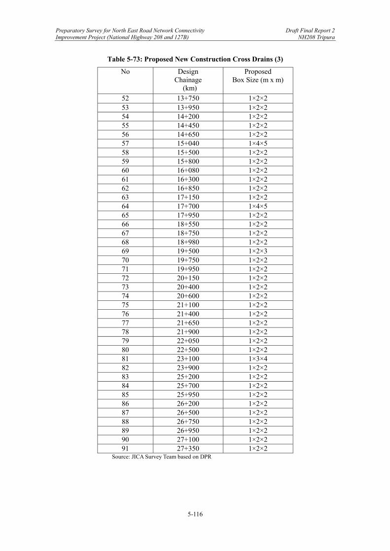
Preparatory Survey for North East Road Network Connectivity Draft Final Report 2 Improvement Project (National Highway 208 and 127B) NH208 Tripura
5-116
Table 5-73: Proposed New Construction Cross Drains (3)
No Design Chainage
(km)
Proposed Box Size (m x m)
52 13+750 1×2×2 53 13+950 1×2×2 54 14+200 1×2×2 55 14+450 1×2×2 56 14+650 1×2×2 57 15+040 1×4×5 58 15+500 1×2×2 59 15+800 1×2×2 60 16+080 1×2×2 61 16+300 1×2×2 62 16+850 1×2×2 63 17+150 1×2×2 64 17+700 1×4×5 65 17+950 1×2×2 66 18+550 1×2×2 67 18+750 1×2×2 68 18+980 1×2×2 69 19+500 1×2×3 70 19+750 1×2×2 71 19+950 1×2×2 72 20+150 1×2×2 73 20+400 1×2×2 74 20+600 1×2×2 75 21+100 1×2×2 76 21+400 1×2×2 77 21+650 1×2×2 78 21+900 1×2×2 79 22+050 1×2×2 80 22+500 1×2×2 81 23+100 1×3×4 82 23+900 1×2×2 83 25+200 1×2×2 84 25+700 1×2×2 85 25+950 1×2×2 86 26+200 1×2×2 87 26+500 1×2×2 88 26+750 1×2×2 89 26+950 1×2×2 90 27+100 1×2×2 91 27+350 1×2×2
Source: JICA Survey Team based on DPR

Preparatory Survey for North East Road Network Connectivity Draft Final Report 2 Improvement Project (National Highway 208 and 127B) NH208 Tripura
5-117
Table 5-74: Proposed New Construction Cross Drains (4)
No Design Chainage
(km)
Proposed Box Size (m x m)
92 27+650 1×2×3 93 27+950 1×2×2 94 28+250 1×2×3 95 28+500 1×2×2 96 28+750 1×2×2 97 28+930 1×4×5 98 29+080 1×2×2 99 29+370 1×2×3 100 29+700 1×4×5 101 29+950 1×2×2 102 30+150 1×2×2 103 30+650 1×3×4 104 30+950 1×3×4 105 31+200 1×2×2 106 31+500 1×2×2 107 31+950 1×2×2 108 32+450 1×4×5 109 33+350 1×3×4 110 33+650 1×4×5 111 34+050 1×4×5 112 34+350 1×3×4 113 34+650 1×2×2 114 34+900 1×2×2 115 35+150 1×2×2 116 35+400 1×2×2 117 35+900 1×4×5 118 36+100 1×4×5 119 36+350 1×3×4 120 36+800 1×4×5 121 36+850 1×4×5 122 37+050 1×4×5 123 37+300 1×4×5 124 37+560 1×3×4 125 37+780 1×3×4 126 38+050 1×2×2 127 38+350 1×2×2 128 38+600 1×2×2 129 38+850 1×2×2 130 39+250 1×2×2
Source: JICA Survey Team based on DPR
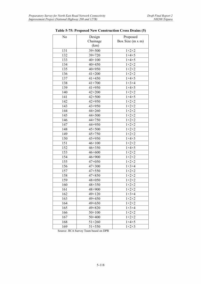
Preparatory Survey for North East Road Network Connectivity Draft Final Report 2 Improvement Project (National Highway 208 and 127B) NH208 Tripura
5-118
Table 5-75: Proposed New Construction Cross Drains (5)
No Design Chainage
(km)
Proposed Box Size (m x m)
131 39+500 1×2×2 132 39+720 1×4×5 133 40+100 1×4×5 134 40+450 1×2×2 135 40+950 1×2×2 136 41+200 1×2×2 137 41+450 1×4×5 138 41+700 1×3×4 139 41+950 1×4×5 140 42+200 1×2×2 141 42+500 1×4×5 142 42+950 1×2×2 143 43+950 1×2×2 144 44+260 1×2×2 145 44+500 1×2×2 146 44+750 1×2×2 147 44+950 1×2×2 148 45+500 1×2×2 149 45+750 1×2×2 150 45+950 1×4×5 151 46+100 1×2×2 152 46+350 1×4×5 153 46+600 1×2×2 154 46+900 1×2×2 155 47+050 1×2×2 156 47+300 1×3×4 157 47+550 1×2×2 158 47+850 1×2×2 159 48+050 1×2×2 160 48+350 1×2×2 161 48+900 1×2×2 162 49+120 1×3×4 163 49+450 1×2×2 164 49+650 1×2×2 165 49+820 1×3×4 166 50+100 1×2×2 167 50+400 1×2×2 168 51+260 1×4×5 169 51+550 1×2×3
Source: JICA Survey Team based on DPR
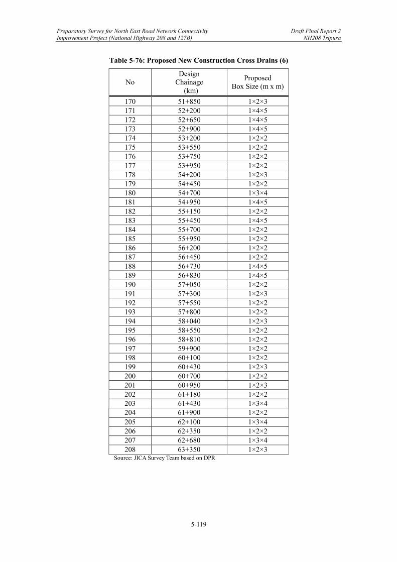
Preparatory Survey for North East Road Network Connectivity Draft Final Report 2 Improvement Project (National Highway 208 and 127B) NH208 Tripura
5-119
Table 5-76: Proposed New Construction Cross Drains (6)
No Design
Chainage (km)
Proposed Box Size (m x m)
170 51+850 1×2×3 171 52+200 1×4×5 172 52+650 1×4×5 173 52+900 1×4×5 174 53+200 1×2×2 175 53+550 1×2×2 176 53+750 1×2×2 177 53+950 1×2×2 178 54+200 1×2×3 179 54+450 1×2×2 180 54+700 1×3×4 181 54+950 1×4×5 182 55+150 1×2×2 183 55+450 1×4×5 184 55+700 1×2×2 185 55+950 1×2×2 186 56+200 1×2×2 187 56+450 1×2×2 188 56+730 1×4×5 189 56+830 1×4×5 190 57+050 1×2×2 191 57+300 1×2×3 192 57+550 1×2×2 193 57+800 1×2×2 194 58+040 1×2×3 195 58+550 1×2×2 196 58+810 1×2×2 197 59+900 1×2×2 198 60+100 1×2×2 199 60+430 1×2×3 200 60+700 1×2×2 201 60+950 1×2×3 202 61+180 1×2×2 203 61+430 1×3×4 204 61+900 1×2×2 205 62+100 1×3×4 206 62+350 1×2×2 207 62+680 1×3×4 208 63+350 1×2×3
Source: JICA Survey Team based on DPR
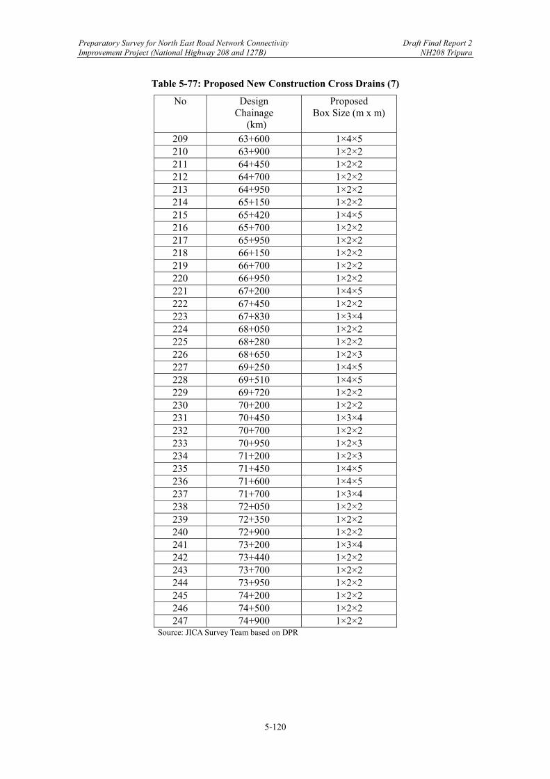
Preparatory Survey for North East Road Network Connectivity Draft Final Report 2 Improvement Project (National Highway 208 and 127B) NH208 Tripura
5-120
Table 5-77: Proposed New Construction Cross Drains (7)
No Design Chainage
(km)
Proposed Box Size (m x m)
209 63+600 1×4×5 210 63+900 1×2×2 211 64+450 1×2×2 212 64+700 1×2×2 213 64+950 1×2×2 214 65+150 1×2×2 215 65+420 1×4×5 216 65+700 1×2×2 217 65+950 1×2×2 218 66+150 1×2×2 219 66+700 1×2×2 220 66+950 1×2×2 221 67+200 1×4×5 222 67+450 1×2×2 223 67+830 1×3×4 224 68+050 1×2×2 225 68+280 1×2×2 226 68+650 1×2×3 227 69+250 1×4×5 228 69+510 1×4×5 229 69+720 1×2×2 230 70+200 1×2×2 231 70+450 1×3×4 232 70+700 1×2×2 233 70+950 1×2×3 234 71+200 1×2×3 235 71+450 1×4×5 236 71+600 1×4×5 237 71+700 1×3×4 238 72+050 1×2×2 239 72+350 1×2×2 240 72+900 1×2×2 241 73+200 1×3×4 242 73+440 1×2×2 243 73+700 1×2×2 244 73+950 1×2×2 245 74+200 1×2×2 246 74+500 1×2×2 247 74+900 1×2×2
Source: JICA Survey Team based on DPR

Preparatory Survey for North East Road Network Connectivity Draft Final Report 2 Improvement Project (National Highway 208 and 127B) NH208 Tripura
5-121
Table 5-78: Proposed New Construction Cross Drains (8)
No Design Chainage
(km)
Proposed Box Size (m x m)
248 75+250 1×2×3 249 75+590 1×2×3 250 75+900 1×3×4 251 76+350 1×2×2 252 76+600 1×3×4 253 76+800 1×2×3 254 77+050 1×2×3 255 77+300 1×2×2 256 77+550 1×2×2 257 77+800 1×2×2 258 78+020 1×2×3 259 78+350 1×2×2 260 78+650 1×2×2 261 78+770 1×2×2 262 79+050 1×2×2 263 79+650 1×2×3 264 79+900 1×2×2 265 80+150 1×2×2 266 80+650 1×2×2 267 80+900 1×3×4 268 81+150 1×2×2 269 81+300 1×2×3 270 81+550 1×2×2 271 81+800 1×2×2 272 83+100 1×2×2 273 83+350 1×2×2 274 83+600 1×2×2 275 83+850 1×2×2 276 84+100 1×4×5 277 85+600 1×2×2 278 85+950 1×2×2 279 86+400 1×2×2 280 86+700 1×2×2 281 86+950 1×4×5 282 87+200 1×4×5 283 87+600 1×3×4 284 88+410 1×2×3 285 88+900 1×2×2 286 89+250 1×2×2
Source: JICA Survey Team based on DPR

Preparatory Survey for North East Road Network Connectivity Draft Final Report 2 Improvement Project (National Highway 208 and 127B) NH208 Tripura
5-122
Table 5-79: Proposed New Construction Cross Drains (9)
No Design Chainage
(km)
Proposed Box Size (m x m)
287 89+600 1×2×2 288 89+900 1×2×2 289 90+300 1×2×2 290 90+700 1×2×2 291 91+000 1×2×2 292 91+250 1×2×2 293 91+550 1×2×2 294 91+800 1×2×2 295 92+250 1×2×2 296 92+500 1×2×2 297 92+800 1×4×5 298 93+000 1×2×2 299 93+500 1×2×2 300 93+800 1×2×2 301 94+000 1×2×2 302 94+250 1×4×5 303 94+600 1×2×3 304 94+900 1×2×2 305 95+200 1×2×2 306 95+550 1×2×2 307 95+750 1×2×2 308 95+950 1×2×2 309 96+250 1×4×5 310 97+000 1×2×2 311 97+250 1×2×2 312 97+940 1×2×2 313 98+040 1×2×3 314 98+200 1×2×2 315 98+450 1×2×2 316 98+650 1×3×4 317 99+000 1×2×2 318 99+300 1×2×2 319 99+650 1×2×2 320 99+950 1×2×2 321 100+200 1×4×5 322 100;450 1×4×5 323 100+700 1×2×2 324 100+950 1×4×5 325 101+200 1×2×2
Source: JICA Survey Team based on DPR

Preparatory Survey for North East Road Network Connectivity Draft Final Report 2 Improvement Project (National Highway 208 and 127B) NH208 Tripura
5-123
Table 5-80: Proposed New Construction Cross Drains (10)
No Design Chainage
(km)
Proposed Box Size (m x m)
326 101+500 1×3×4 327 101+700 1×4×5 328 101+950 1×2×2 329 102+200 1×2×2 330 102+450 1×2×2 331 102+880 1×2×2 332 103+200 1×2×2 333 103+450 1×2×2 334 103+700 1×2×2 335 103+980 1×2×2 336 104+250 1×2×3 337 104+750 1×2×2 338 104+950 1×4×5 339 105+200 1×2×2 340 105+450 1×2×2 341 105+700 1×2×2 342 105+900 1×3×4
Source: JICA Survey Team based on DPR (2) Drainage Work
According to the DPR, the following types of road drainage will be installed. Since the DPR has not been completed, the JICA Survey Team will carry out a recheck in the future and propose an optimal road drainage system. The road drainage used on this line is shown below.
Footpath cum cover drain of 2.0m width has been proposed in built up area. Cover drain of 1.0m width has been proposed in ROB approaches for service road Brick Masonry drain has been proposed on hill side Catch water drain has been proposed on hill side for proper drainage purpose.
Details are given bellow.
Table 5-81: Drainage Work
No Type of drainage Length(m)
1 2.0m width RCC Cover drain 12,800
2 1.0m Width RCC Cover Drain for Service Road 2,500
3 Brick Masonry Drain 41,133
4 Catch Water Drain 21,525 Source: JICA Survey Team based on DPR
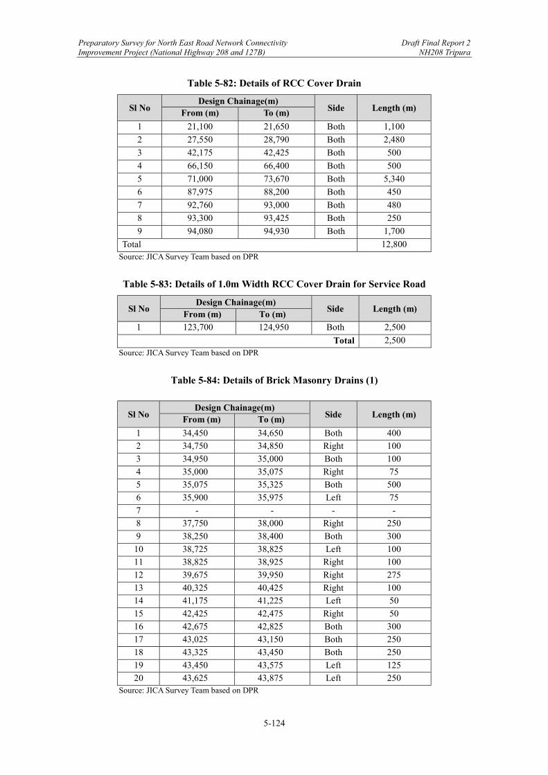
Preparatory Survey for North East Road Network Connectivity Draft Final Report 2 Improvement Project (National Highway 208 and 127B) NH208 Tripura
5-124
Table 5-82: Details of RCC Cover Drain
Sl No Design Chainage(m)
Side Length (m) From (m) To (m)
1 21,100 21,650 Both 1,100
2 27,550 28,790 Both 2,480
3 42,175 42,425 Both 500
4 66,150 66,400 Both 500
5 71,000 73,670 Both 5,340
6 87,975 88,200 Both 450
7 92,760 93,000 Both 480
8 93,300 93,425 Both 250
9 94,080 94,930 Both 1,700
Total 12,800 Source: JICA Survey Team based on DPR
Table 5-83: Details of 1.0m Width RCC Cover Drain for Service Road
Sl No Design Chainage(m)
Side Length (m) From (m) To (m)
1 123,700 124,950 Both 2,500
Total 2,500 Source: JICA Survey Team based on DPR
Table 5-84: Details of Brick Masonry Drains (1)
Sl No Design Chainage(m)
Side Length (m) From (m) To (m)
1 34,450 34,650 Both 400
2 34,750 34,850 Right 100
3 34,950 35,000 Both 100
4 35,000 35,075 Right 75
5 35,075 35,325 Both 500
6 35,900 35,975 Left 75
7 - - - -
8 37,750 38,000 Right 250
9 38,250 38,400 Both 300
10 38,725 38,825 Left 100
11 38,825 38,925 Right 100
12 39,675 39,950 Right 275
13 40,325 40,425 Right 100
14 41,175 41,225 Left 50
15 42,425 42,475 Right 50
16 42,675 42,825 Both 300
17 43,025 43,150 Both 250
18 43,325 43,450 Both 250
19 43,450 43,575 Left 125
20 43,625 43,875 Left 250 Source: JICA Survey Team based on DPR

Preparatory Survey for North East Road Network Connectivity Draft Final Report 2 Improvement Project (National Highway 208 and 127B) NH208 Tripura
5-125
Table 5-85: Details of Brick Masonry Drains (2)
Sl No Design Chainage(m)
Side Length (m) From (m) To (m)
21 43,975 44,000 Both 50
22 44,425 44,475 Right 50
23 45,325 45,500 Both 350
24 45,575 45,800 Both 450
25 46,600 46,875 Both 550
26 46,875 47,000 Left 125
27 47,000 47,200 Both 400
28 47,250 47,450 Right 200
29 47,450 47,550 Both 200
30 47,550 47,650 Right 100
31 47,650 47,700 Left 50
32 47,750 47,800 Left 50
33 47,900 47,950 Right 50
34 47,950 48,100 Both 300
35 48,150 48,350 Left 200
36 48,400 48,450 Both 100
37 48,450 48,550 Right 100
38 48,650 48,700 Both 100
39 49,050 49,200 Both 300
40 49,250 49,650 Both 800
41 49,700 49,800 Both 200
42 49,900 50,700 Both 1600
43 50,750 50,850 Right 100
44 50,850 50,900 Left 50
45 50,900 50,950 Both 100
46 50,950 51,000 Right 50
47 51,000 51,600 Both 1200
48 51,700 51,750 Right 50
49 51,750 51,900 Both 300
50 51,900 51,950 Right 50
51 52,150 52,350 Right 200
52 52,350 52,450 Both 200
53 52,450 52,500 Left 50
54 52,500 52,600 Left 100
55 52,600 52,650 Right 50
56 52,700 53,150 Left 450
57 53,150 53,250 Right 100
58 53,250 53,300 Both 100
59 53,300 53,350 Right 50
60 53,350 53,450 Both 200
61 53,450 53,600 Left 150
62 53,600 53,900 Both 600 Source: JICA Survey Team based on DPR

Preparatory Survey for North East Road Network Connectivity Draft Final Report 2 Improvement Project (National Highway 208 and 127B) NH208 Tripura
5-126
Table 5-86: Details of Brick Masonry Drains (3)
Sl No Design Chainage(m)
Side Length (m) From (m) To (m)
63 53,900 53,950 Right 50
64 55,550 55,800 Right 250
65 55,900 56,300 Both 800
66 56,300 56,350 Right 50
67 56,350 56,650 Both 600
68 56,650 56,700 Right 50
69 56,700 57,550 Both 1700
70 57,550 57,950 Left 400
71 57,950 58,000 Right 50
72 58,000 58,250 Both 500
73 58,300 58,750 Both 900
74 59,350 59,550 Left 200
75 59,600 59,650 Both 100
76 59,650 59,850 Left 200
77 60,000 60,100 Left 100
78 60,300 60,350 Left 50
79 60,350 60,450 Both 200
80 60,500 60,550 Left 50
81 60,550 60,650 Right 100
82 60,650 60,750 Both 200
83 61,000 61,250 Left 250
84 61,250 61,300 Left 50
85 61,300 61,350 Both 100
86 61,350 61,450 Left 100
87 61,450 61,550 Both 200
88 61,700 61,800 Both 200
89 61,800 61,850 Left 50
90 62,150 62,950 Both 1600
91 62,950 63,050 Left 100
92 63,050 63,450 Left 400
93 63,450 63,700 Both 500
94 75,890 76,060 Both 340
95 76,060 76,190 Both 260
96 76,460 76,625 Both 330
97 76,775 77,075 Both 600
98 77,125 77,260 Both 270
99 77,370 77,410 Right 40
100 77,410 77,480 Both 140
101 77,480 77,515 Left 35 Source: JICA Survey Team based on DPR

Preparatory Survey for North East Road Network Connectivity Draft Final Report 2 Improvement Project (National Highway 208 and 127B) NH208 Tripura
5-127
Table 5-87: Details of Brick Masonry Drains (4)
Sl No Design Chainage(m)
Side Length (m) From (m) To (m)
102 77,515 77,585 Right 70
103 77,690 77,732 Right 42
104 77,732 77,760 Both 56
105 77,760 77,815 Left 55
106 77,910 77,960 Left 50
107 77,960 78,010 Both 100
108 78,010 78,110 Left 100
109 78,110 78,210 Both 200
110 78,210 78,260 Left 50
111 78,260 78,410 Both 300
112 78,575 78,710 Both 270
113 78,710 78,860 Right 150
114 78,860 78,910 Left 50
115 78,910 78,960 Right 50
116 78,960 79,010 Right 50
117 79,010 79,060 Right 50
118 79,060 79,210 Both 300
119 79,210 79,260 Both 100
120 79,310 79,410 Both 200
121 79,610 79,790 Both 360
122 79,790 79,860 Right 70
123 79,860 80,110 Right 250
124 80,110 80,410 Both 600
125 80,560 80,610 Left 50
126 81,010 81,210 Both 400
127 81,210 81,260 Right 50
128 81,260 81,510 Both 500
129 81,510 81,560 Right 50
130 81,560 81,610 Left 50
131 81,610 81,690 Both 160
132 8,1690 81,740 Left 50
133 81,740 81,960 Both 440
134 82,010 82,110 Right 100
135 82,110 82,440 Both 660
136 82,460 82,580 Both 240
137 82,910 82,960 Both 100
138 83,110 83,160 Both 100
139 83,160 83,210 Right 50
140 83,210 83,260 Left 50
141 83,260 83,360 Right 100
142 83,360 83,570 Left 210
143 83,610 83,660 Left 50 Source: JICA Survey Team based on DPR

Preparatory Survey for North East Road Network Connectivity Draft Final Report 2 Improvement Project (National Highway 208 and 127B) NH208 Tripura
5-128
Table 5-88: Details of Brick Masonry Drains (5)
Sl No Design Chainage(m)
Side Length (m) From (m) To (m)
144 83,660 83,710 Both 100
145 84,050 84,160 Both 220
146 84,635 84,730 Both 190
147 84,910 85,060 Both 300
148 85,140 85,235 Both 190
149 85,235 85,285 Left 50
150 85,390 85,495 Both 210
151 85,495 85,660 Right 165
152 85,710 86,035 Both 650
153 86,360 86,655 Both 590
154 86,760 86,885 Both 250
155 87,260 87,565 Both 610
156 87,610 87,710 Both 200
157 88,335 88,410 Right 75
158 88,410 88,460 Both 100
159 88,715 88,915 Both 400
160 89,275 89,660 Both 770
161 89,760 89,815 Both 110
162 89,815 90,010 Right 195
163 90,335 90,435 Left 100
164 90,610 90,685 Both 150
165 90,685 90,760 Right 75
166 90,760 90,830 Both 140
167 90,830 90,935 Right 105
168 91,060 91,170 Both 220
169 91,935 92,060 Right 125
170 93,175 93,300 Both 250
171 93,425 93,580 Both 310
172 93,580 93,680 Left 100
173 93,680 93,860 Both 360
174 93,980 94,080 Right 100
175 94,930 94,980 Both 100
Total= 41133 Source: JICA Survey Team based on DPR
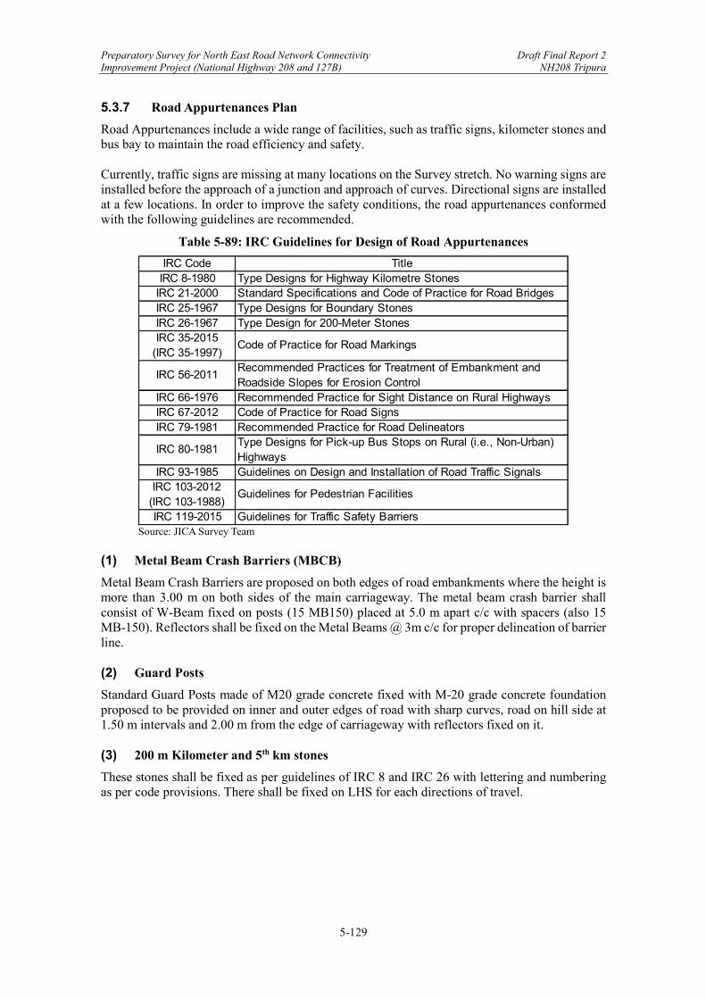
Preparatory Survey for North East Road Network Connectivity Draft Final Report 2 Improvement Project (National Highway 208 and 127B) NH208 Tripura
5-129
5.3.7 Road Appurtenances Plan
Road Appurtenances include a wide range of facilities, such as traffic signs, kilometer stones and bus bay to maintain the road efficiency and safety. Currently, traffic signs are missing at many locations on the Survey stretch. No warning signs are installed before the approach of a junction and approach of curves. Directional signs are installed at a few locations. In order to improve the safety conditions, the road appurtenances conformed with the following guidelines are recommended.
Table 5-89: IRC Guidelines for Design of Road Appurtenances
Source: JICA Survey Team
(1) Metal Beam Crash Barriers (MBCB)
Metal Beam Crash Barriers are proposed on both edges of road embankments where the height is more than 3.00 m on both sides of the main carriageway. The metal beam crash barrier shall consist of W-Beam fixed on posts (15 MB150) placed at 5.0 m apart c/c with spacers (also 15 MB-150). Reflectors shall be fixed on the Metal Beams @ 3m c/c for proper delineation of barrier line. (2) Guard Posts
Standard Guard Posts made of M20 grade concrete fixed with M-20 grade concrete foundation proposed to be provided on inner and outer edges of road with sharp curves, road on hill side at 1.50 m intervals and 2.00 m from the edge of carriageway with reflectors fixed on it. (3) 200 m Kilometer and 5th km stones
These stones shall be fixed as per guidelines of IRC 8 and IRC 26 with lettering and numbering as per code provisions. There shall be fixed on LHS for each directions of travel.
IRC Code TitleIRC 8-1980 Type Designs for Highway Kilometre Stones
IRC 21-2000 Standard Specifications and Code of Practice for Road BridgesIRC 25-1967 Type Designs for Boundary StonesIRC 26-1967 Type Design for 200-Meter StonesIRC 35-2015
(IRC 35-1997)Code of Practice for Road Markings
IRC 56-2011Recommended Practices for Treatment of Embankment and Roadside Slopes for Erosion Control
IRC 66-1976 Recommended Practice for Sight Distance on Rural HighwaysIRC 67-2012 Code of Practice for Road SignsIRC 79-1981 Recommended Practice for Road Delineators
IRC 80-1981Type Designs for Pick-up Bus Stops on Rural (i.e., Non-Urban) Highways
IRC 93-1985 Guidelines on Design and Installation of Road Traffic SignalsIRC 103-2012
(IRC 103-1988)Guidelines for Pedestrian Facilities
IRC 119-2015 Guidelines for Traffic Safety Barriers

Preparatory Survey for North East Road Network Connectivity Draft Final Report 2 Improvement Project (National Highway 208 and 127B) NH208 Tripura
5-130
(4) Delineators
Delineators are provided for visual assistance to drivers to follow and negotiate the alignment of road ahead and provide warning about hazards, particularly at night. Various types in use are:
Clustered Red Reflectors on triangular nodes as object markers are provided at the edge of median and directional islands.
Circular red reflector on face / top of islands and medians.
Circular white Reflectors on Guard Posts.
(5) Boundary Stones
Road boundary stones shall be fixed on both sides of the road to demarcate the boundary of new ROW. They shall be fixed with proper founding concrete and dowel bars to guard against tempering. (6) Traffic Signals
All at grade junctions in built up areas shall be provided with traffic signals. There shall be provided as per safety manual. (7) Lighting System
All road stretch passing through built up are shall be provided with lighting system erected on poles with adequate height and 30 m c/c, such that it shall provide uniform illumination of 40 lux minimum at all places. (8) Landscaping and Arboriculture
The environment along the proposed corridor shall be enhanced using various techniques of soft landscapes, principally though plantation of various types of shade and ornamental trees along with shrubs. Landscaping strategy has been developed to enhance the visual quality of the Survey stretch. Tree plantations have manifold benefits. They may help in reducing the air pollution levels, especially Suspended Particulate Matter (SPM) in the surrounding area. A marginal decrease of 3 to 4 dB (A) in noise levels may also be expected due to the plantation used for landscaping. Tree plantation is proposed along the Survey stretch at 10-15 m c/c on both side parallel to the road. Set back distance of trees in different situation shall be as per IRC SP 21 and IRC 66. The nearest edge of tree trunk shall be at 2.00 m minimum from road edge or carb edge. The scheme of landscaping shall be part of overall Environmental Mitigation Plan (EMP). The planting shall be such that it does not obstruct the visibility of traffic from any side and shall be pleasing in appearance.
5.3.8 Preliminary Study of Bypass Routes
The Project route consists of sparsely built-up and open portions. IRCSP73-2018, Clause 2.1, iii) states “Where there is constraint of existing ROW width or difficulty in acquiring land along the existing alignment in built up areas, the Authority may decide for construction of a bypass. The alignment of the bypass shall be given in Schedule ‘B’ and placed eccentrically with respect of the ROW to facilitate proper widening to four lanes in future.” In view of minimizing social impacts and land acquisition, seven bypasses have been proposed. Various alternative alignments were considered for the finalization of various bypasses and the

Preparatory Survey for North East Road Network Connectivity Draft Final Report 2 Improvement Project (National Highway 208 and 127B) NH208 Tripura
5-131
most suitable option were finalised based on less damaging impact on existing built-up structures, deviation from settlement areas, and the most economical project cost among the others.
Table 5-90: Bypass Locations and Length
Source: JICA Survey Team base on DPR
(1) Criteria for Comparing Alternative Alignment Options for Bypasses
The following criteria are used for selecting the preferred alignment.
Design Speed: The proposed alignment should maintain design speed between 80-100 kmph.
Riding Comfort: The proposed alignment is such that passengers of the vehicle feel comfort while traveling through the proposed Road.
Land Acquisition: Minimum land to be acquired with maximum avoidance of involuntary resettlement. Try to acquire Govt. land as much as possible and minimum acquisition of existing structures has been used for fixation of proposed alignment.
Social Impact & Severance: The proposed alignment has minimized effect upon the existing structures which minimizes the resettlement and rehabilitation impact of that locality.
Cost Effectiveness: The Project cost consisting of Civil construction Cost, LA & R&R, Utility Shifting cost of the proposed alignment has been kept minimal.
Safety: The proposed alignment has been prepared in such a way that it requires minimum safety hazards along its entire length.
Environment: The proposed alignment requires the least lost forest land and expected pollution.

Preparatory Survey for North East Road Network Connectivity Draft Final Report 2 Improvement Project (National Highway 208 and 127B) NH208 Tripura
5-132
(2) Alternative Alignment Option Study for Teliamura Bypass
Source: JICA Survey Team base on DPR
Figure 5-47: Alignment Options for Teliamura Bypass
Alignment Option 3 is the best because a) the shortest length and the least area of land acquisition, b) utilizing the widened section of road from A to B, c) the least number of trees to be cut, and d) the least number of affected structures, and e) the least number of affected families.
Table 5-91: Comparison of Alignment Options
Source: JICA Survey Team base on DPR

Preparatory Survey for North East Road Network Connectivity Draft Final Report 2 Improvement Project (National Highway 208 and 127B) NH208 Tripura
5-133
(3) Alternative Alignment Option Study for Twidu Bypass
Source: JICA Survey Team base on DPR
Figure 5-48: Alignment Options for Twidu Bypass
Alignment Option 3 is the best because a) the least area of forest lands and number of trees to be cut, b) the least number of affected structures, c) the least number of affected families, and e) the least number of required box culverts.
Table 5-92: Comparison of Alignment Options
Source: JICA Survey Team base on DPR
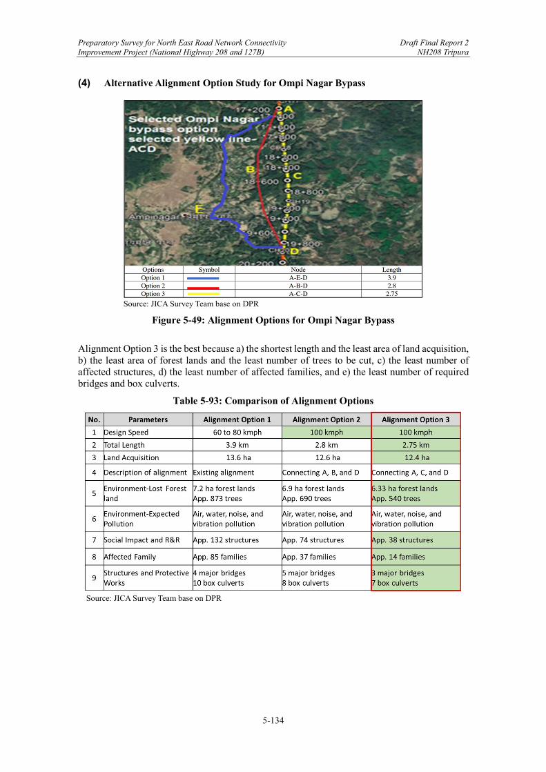
Preparatory Survey for North East Road Network Connectivity Draft Final Report 2 Improvement Project (National Highway 208 and 127B) NH208 Tripura
5-134
(4) Alternative Alignment Option Study for Ompi Nagar Bypass
Source: JICA Survey Team base on DPR
Figure 5-49: Alignment Options for Ompi Nagar Bypass
Alignment Option 3 is the best because a) the shortest length and the least area of land acquisition, b) the least area of forest lands and the least number of trees to be cut, c) the least number of affected structures, d) the least number of affected families, and e) the least number of required bridges and box culverts.
Table 5-93: Comparison of Alignment Options
Source: JICA Survey Team base on DPR
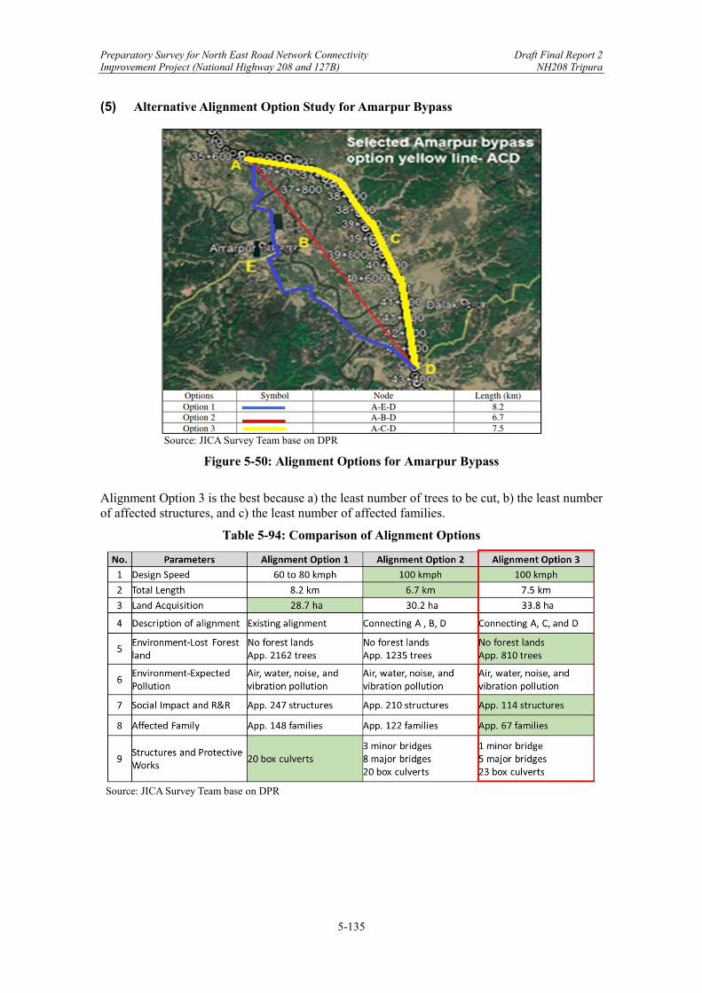
Preparatory Survey for North East Road Network Connectivity Draft Final Report 2 Improvement Project (National Highway 208 and 127B) NH208 Tripura
5-135
(5) Alternative Alignment Option Study for Amarpur Bypass
Source: JICA Survey Team base on DPR
Figure 5-50: Alignment Options for Amarpur Bypass
Alignment Option 3 is the best because a) the least number of trees to be cut, b) the least number of affected structures, and c) the least number of affected families.
Table 5-94: Comparison of Alignment Options
Source: JICA Survey Team base on DPR
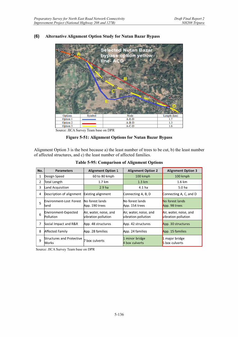
Preparatory Survey for North East Road Network Connectivity Draft Final Report 2 Improvement Project (National Highway 208 and 127B) NH208 Tripura
5-136
(6) Alternative Alignment Option Study for Nutan Bazar Bypass
Source: JICA Survey Team base on DPR
Figure 5-51: Alignment Options for Nutan Bazar Bypass
Alignment Option 3 is the best because a) the least number of trees to be cut, b) the least number of affected structures, and c) the least number of affected families.
Table 5-95: Comparison of Alignment Options
Source: JICA Survey Team base on DPR

Preparatory Survey for North East Road Network Connectivity Draft Final Report 2 Improvement Project (National Highway 208 and 127B) NH208 Tripura
5-137
(7) Alternative Alignment Option Study for Jatanbari Bypass
Source: JICA Survey Team base on DPR
Figure 5-52: Alignment Options for Jatanbari Bypass
Alignment Option 3 is the best because a) the least number of trees to be cut, b) the least number of affected structures, and c) the least number of affected families.
Table 5-96: Comparison of Alignment Options
Source: JICA Survey Team base on DPR
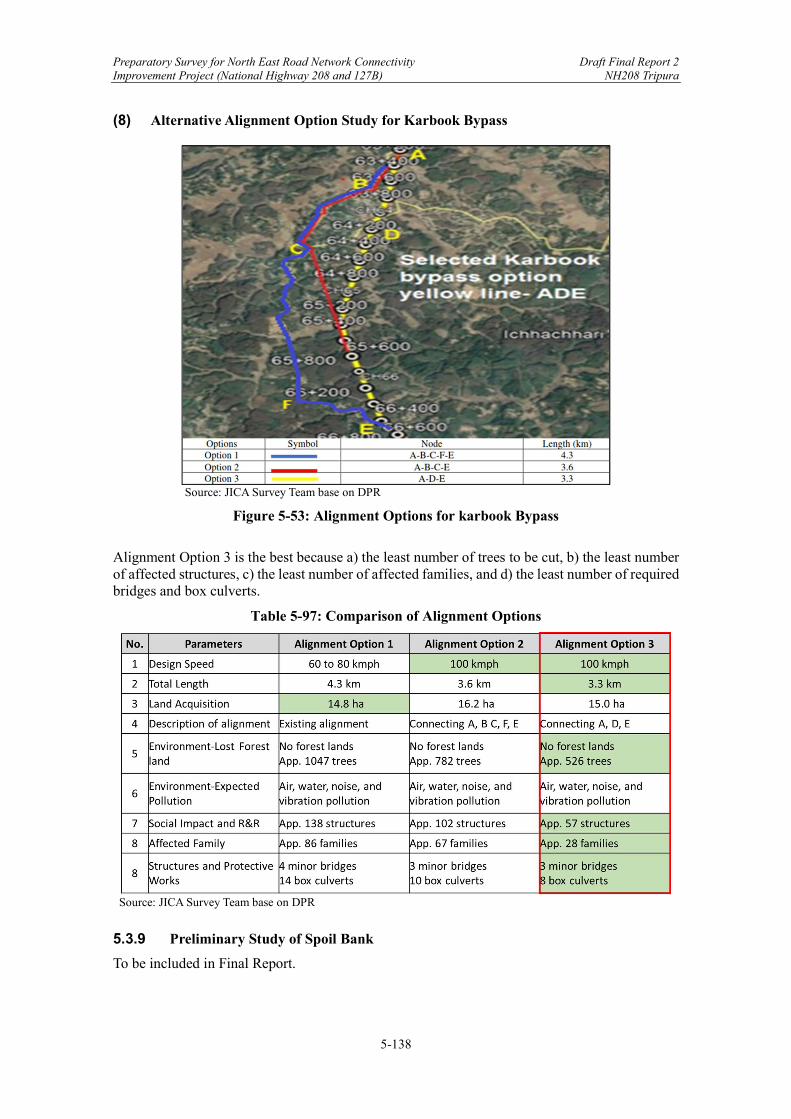
Preparatory Survey for North East Road Network Connectivity Draft Final Report 2 Improvement Project (National Highway 208 and 127B) NH208 Tripura
5-138
(8) Alternative Alignment Option Study for Karbook Bypass
Source: JICA Survey Team base on DPR
Figure 5-53: Alignment Options for karbook Bypass
Alignment Option 3 is the best because a) the least number of trees to be cut, b) the least number of affected structures, c) the least number of affected families, and d) the least number of required bridges and box culverts.
Table 5-97: Comparison of Alignment Options
Source: JICA Survey Team base on DPR
5.3.9 Preliminary Study of Spoil Bank
To be included in Final Report.
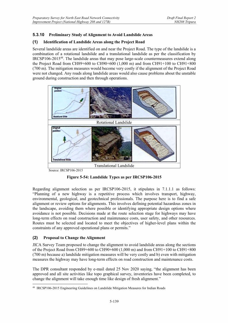
Preparatory Survey for North East Road Network Connectivity Draft Final Report 2 Improvement Project (National Highway 208 and 127B) NH208 Tripura
5-139
5.3.10 Preliminary Study of Alignment to Avoid Landslide Areas
(1) Identification of Landslide Areas along the Project Road
Several landslide areas are identified on and near the Project Road. The type of the landslide is a combination of a rotational landslide and a translational landslide as per the classification by IRCSP106-201548. The landslide areas that may pose large-scale countermeasures extend along the Project Road from CH89+600 to CH90+600 (1,000 m) and from CH91+100 to CH91+800 (700 m). The mitigation measures would become very costly if the alignment of the Project Road were not changed. Any roads along landslide areas would also cause problems about the unstable ground during construction and then through operations.
Rotational Landslide
Translational Landslide
Source: IRCSP106-2015
Figure 5-54: Landslide Types as per IRCSP106-2015
Regarding alignment selection as per IRCSP106-2015, it stipulates in 7.1.1.1 as follows: “Planning of a new highway is a repetitive process which involves transport, highway, environmental, geological, and geotechnical professionals. The purpose here is to find a safe alignment or review options for alignments. This involves defining potential hazardous zones in the landscape, avoiding them where possible or identifying appropriate design options where avoidance is not possible. Decisions made at the route selection stage for highways may have long-term effects on road construction and maintenance costs, user safety, and other resources. Routes must be selected and located to meet the objectives of higher-level plans within the constraints of any approved operational plans or permits.” (2) Proposal to Change the Alignment
JICA Survey Team proposed to change the alignment to avoid landslide areas along the sections of the Project Road from CH89+600 to CH90+600 (1,000 m) and from CH91+100 to CH91+800 (700 m) because a) landslide mitigation measures will be very costly and b) even with mitigation measures the highway may have long-term effects on road construction and maintenance costs. The DPR consultant responded by e-mail dated 25 Nov 2020 saying, “the alignment has been approved and all site activities like topo graphical survey, inventories have been completed, to change the alignment will take enough time like design of fresh alignment.” 48 IRCSP106-2015 Engineering Guidelines on Landslide Mitigation Measures for Indian Roads
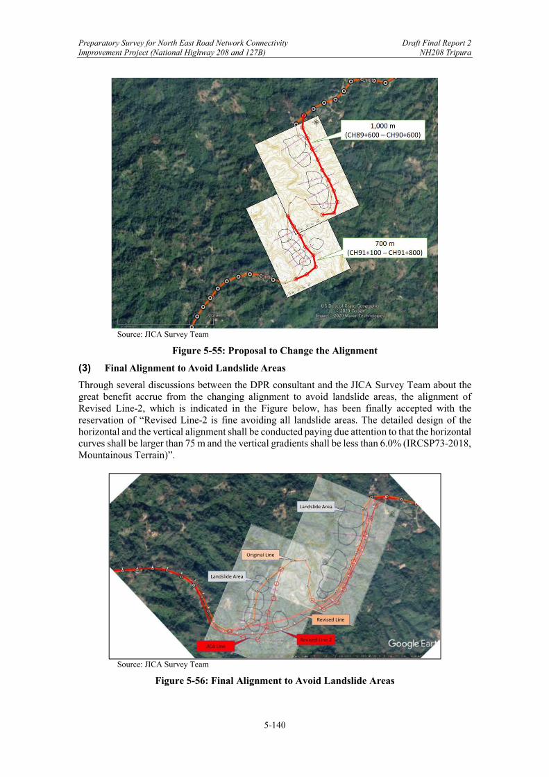
Preparatory Survey for North East Road Network Connectivity Draft Final Report 2 Improvement Project (National Highway 208 and 127B) NH208 Tripura
5-140
Source: JICA Survey Team
Figure 5-55: Proposal to Change the Alignment
(3) Final Alignment to Avoid Landslide Areas
Through several discussions between the DPR consultant and the JICA Survey Team about the great benefit accrue from the changing alignment to avoid landslide areas, the alignment of Revised Line-2, which is indicated in the Figure below, has been finally accepted with the reservation of “Revised Line-2 is fine avoiding all landslide areas. The detailed design of the horizontal and the vertical alignment shall be conducted paying due attention to that the horizontal curves shall be larger than 75 m and the vertical gradients shall be less than 6.0% (IRCSP73-2018, Mountainous Terrain)”.
Source: JICA Survey Team
Figure 5-56: Final Alignment to Avoid Landslide Areas
Preparatory Survey for North East Road Network Connectivity Draft Final Report 2 Improvement Project (National Highway 208 and 127B) NH208 Tripura
5-141
Chapter 5. Preliminary Design of NH208 (Teliamura-Sabroom) ....................................... 1
5.1 Natural Condition Surveys .......................................................................................... 1 5.1.1 Meteorological and Hydrological Surveys .......................................................... 2 5.1.2 Topographic Survey ............................................................................................ 4 5.1.3 Geological Survey ............................................................................................... 9 5.1.4 Road Inventory Survey ...................................................................................... 13 5.1.5 Satellite Image Interpretation (Slope Inventory Survey) ................................... 22
5.2 Review of DPR.......................................................................................................... 41 5.2.1 Road Geometric Design .................................................................................... 41 5.2.2 Pavement ........................................................................................................... 43 5.2.3 Slope Protection ................................................................................................ 52 5.2.4 Bridges and Structures....................................................................................... 52 5.2.5 Drainages ........................................................................................................... 61 5.2.6 Safety Measures ................................................................................................ 67 5.2.7 Miscellaneous Facilities .................................................................................... 68
5.3 Preliminary Design of NH208 Tripura ...................................................................... 70 5.3.1 Road Geometric Design .................................................................................... 70 5.3.2 Intersection Design ............................................................................................ 85 5.3.3 Pavement Design ............................................................................................... 90 5.3.4 Earth Work / Slope Protection / Landslide Prevention Design .......................... 92 5.3.5 Bridges and Structures Design .......................................................................... 98 5.3.6 Drainage Design .............................................................................................. 108 5.3.7 Road Appurtenances Plan ................................................................................ 129 5.3.8 Preliminary Study of Bypass Routes ............................................................... 130 5.3.9 Preliminary Study of Spoil Bank ..................................................................... 138 5.3.10 Preliminary Study of Alignment to Avoid Landslide Areas ............................ 139
Figure 5-1: Seismic Zones of India ............................................................................................... 1 Figure 5-2: Average Monthly Precipitation and Temperature at Teliamura .................................. 2 Figure 5-3: Average Monthly Precipitation and Temperature at Sabroom .................................... 2 Figure 5-4: An Example of Catchment Area ................................................................................. 3 Figure 5-5: Location Map of NH208 ............................................................................................ 4 Figure 5-6: A Shaded-Relief Map and Active Fault Map in North-East India and Bangladesh .... 9 Figure 5-7: Cross section of the CTFB with E-W direction ........................................................ 10 Figure 5-8: Geological map along NH 208 .................................................................................. 11 Figure 5-9: Example of “Growth Strata” After the Seismic Reflection Survey .......................... 13 Figure 5-10: Target Areas for Slope Protection ........................................................................... 24 Figure 5-11: Stereo-Pair Images of Target Area 3 ....................................................................... 27 Figure 5-12: Stereo-Pair Images of Target Area 4 ....................................................................... 28 Figure 5-13: Satellite Image of Target Area 5 ............................................................................. 29 Figure 5-14: Stereo-Pair Images of Target Area 5 (1) ................................................................. 30 Figure 5-15: Stereo-Pair Images of Target Area 5 (2) ................................................................. 31 Figure 5-16: Contour Map of Target Area 5 ................................................................................ 32 Figure 5-17: Cross Sections of Landslide A ................................................................................ 34 Figure 5-18: Satellite Image of Target Area 6 ............................................................................. 35 Figure 5-19: Stereo-Pair Images of Target Area 6 (1) ................................................................. 36 Figure 5-20: Stereo-Pair Images of Target Area 6 (2) ................................................................. 37 Figure 5-21: Contour Map of Target Area 6 ................................................................................ 38

Preparatory Survey for North East Road Network Connectivity Draft Final Report 2 Improvement Project (National Highway 208 and 127B) NH208 Tripura
5-142
Figure 5-22: Cross Sections of Landslide B ................................................................................ 39 Figure 5-23: Stereo-Pair Images of Target Area 8 ....................................................................... 40 Figure 5-24: Pavement Conditions .............................................................................................. 44 Figure 5-25: Catalogue for Pavement Thickness as per IRC 37-2012 (Plate 6) ......................... 49 Figure 5-26: Catalogue for Pavement Thickness as per IRC 37-2018 (Plate 20) ....................... 50 Figure 5-27: Carriageway Configuration .................................................................................... 56 Figure 5-28: Design of Bus Bay and Truck Layby in DPR ......................................................... 68 Figure 5-29: Discrepancies in Alignment of NH208 Tripura in DPR ......................................... 71 Figure 5-30: Colored Triangles for Determining Terrain ............................................................ 72 Figure 5-31: Modified Terrain Classification .............................................................................. 73 Figure 5-32: Design Speed (km/h) for NH208 Tripura ............................................................... 74 Figure 5-33: Typical Cross Section in DPR ................................................................................ 76 Figure 5-34: Desirable and Absolute Minimum Radii of Horizontal Curves (m) ....................... 79 Figure 5-35: Improvement Proposal (CH2+824) ........................................................................ 80 Figure 5-36: Improvement Proposal (CH4+876, CH4+975, CH5+121) ..................................... 80 Figure 5-37: Setback Distance for Intermediate Sight Distance ................................................. 82 Figure 5-38: Ruling and Limiting Gradients (%) ........................................................................ 84 Figure 5-39: Major Junction Locations ....................................................................................... 87 Figure 5-40: Typical Junctions .................................................................................................... 88 Figure 5-41: Catalogue for Pavement Thickness as per IRC 37-2018 (Plate 4) ......................... 91 Figure 5-42: Realignment of the Project Road in Target Area 5 and 6 ....................................... 95 Figure 5-43: Layout of Pile Works in Target Area 5 ................................................................... 96 Figure 5-44: Cross-Sectional Layout of Pile on Landslide A-4 .................................................. 96 Figure 5-45: Layout of Pile Works in Target Area 6 ................................................................... 97 Figure 5-46: Cross-Sectional Layout of Pile on Landslide B-3 .................................................. 97 Figure 5-47: Alignment Options for Teliamura Bypass ............................................................ 132 Figure 5-48: Alignment Options for Twidu Bypass .................................................................. 133 Figure 5-49: Alignment Options for Ompi Nagar Bypass......................................................... 134 Figure 5-50: Alignment Options for Amarpur Bypass .............................................................. 135 Figure 5-51: Alignment Options for Nutan Bazar Bypass ........................................................ 136 Figure 5-52: Alignment Options for Jatanbari Bypass .............................................................. 137 Figure 5-53: Alignment Options for karbook Bypass ............................................................... 138 Figure 5-54: Landslide Types as per IRCSP106-2015 .............................................................. 139 Figure 5-55: Proposal to Change the Alignment ....................................................................... 140 Figure 5-56: Final Alignment to Avoid Landslide Areas ........................................................... 140 Table 5-1: Horizontal Alignment Report ....................................................................................... 6 Table 5-2: Vertical Alignment Report............................................................................................ 7 Table 5-3: Stratigraphy of the Tripura Hill .................................................................................. 12 Table 5-4: Extracted Road Inventory .......................................................................................... 15 Table 5-5: Extracted Pavement Condition ................................................................................... 16 Table 5-6: Extracted Culvert Inventory ....................................................................................... 17 Table 5-7: Bridge Inventory ........................................................................................................ 18 Table 5-8: Boring Log Extracted from Soil Investigation Report for Bridge Foundation .......... 19 Table 5-9: Extracted Junction Inventory ..................................................................................... 20 Table 5-10: Temple Details ......................................................................................................... 21 Table 5-11: School Details .......................................................................................................... 21 Table 5-12: Pond Details ............................................................................................................. 22 Table 5-13: Topography and Geology, and Issues of Target Areas (1) ........................................ 25 Table 5-14: Topography and Geology, and Issues of Target Areas (2) ........................................ 26 Table 5-15: Questionnaire on the DPR for NH208 Tripura ........................................................ 42 Table 5-16: Layer Compositions ................................................................................................. 45 Table 5-17: Laboratory Test Results-1 (Khowai- Teliamura) ...................................................... 46
Preparatory Survey for North East Road Network Connectivity Draft Final Report 2 Improvement Project (National Highway 208 and 127B) NH208 Tripura
5-143
Table 5-18: Laboratory Test Results-2 (Khowai-Teliamura)....................................................... 47 Table 5-19: Laboratory Test Results-1 ........................................................................................ 48 Table 5-20: Laboratory Test Results-2 ........................................................................................ 48 Table 5-21: Comparison of Pavement Compositions .................................................................. 51 Table 5-22: Details of Coarse/Fine Aggregate Sources ............................................................... 51 Table 5-23: Cut Slope Design ..................................................................................................... 52 Table 5-24: List of Major Design Standards ............................................................................... 53 Table 5-25: List of Bridges in Tripura ......................................................................................... 57 Table 5-26: Bridge Length in Tripura .......................................................................................... 58 Table 5-27: Vertical Clearance for Underpass ............................................................................. 59 Table 5-28: Span and Vertical Clearance as per IRC: SP13-2004 ............................................... 59 Table 5-29: Vertical Clearance in Tripura ................................................................................... 60 Table 5-30: List of Major Design Standards ............................................................................... 61 Table 5-31: List of Existing Culvert Type ................................................................................... 62 Table 5-32: List of Existing Culvert in Tripura (1) ..................................................................... 62 Table 5-33: List of Existing Culvert in Tripura (2) ..................................................................... 63 Table 5-34: List of Existing Culvert in Tripura (3) ..................................................................... 64 Table 5-35: List of Existing Culvert in Tripura (4) ..................................................................... 65 Table 5-36: List of Existing Culvert (5) ...................................................................................... 66 Table 5-37: Existing Culvert Not Required in Tripura ................................................................ 67 Table 5-38: Width of Shoulders in IRCSP73-2018 and (IRCSP73-2015) .................................. 70 Table 5-39: Sight Distances in IRCSP73-2018 and (IRCSP73-2015) ........................................ 70 Table 5-40: Width of Shoulders as per MORTH Circular (17 July 2020) ................................... 71 Table 5-41: Design Speed as per IRCSP73-2018 ........................................................................ 73 Table 5-42: Design Speeds in the DPR for NH208 Tripura ........................................................ 75 Table 5-43: ROW Designed in DPR ........................................................................................... 77 Table 5-44: Extra Width of Pavement and Roadway in Each Carriageway ................................ 77 Table 5-45: Minimum Radii of Horizontal Curves as per IRCSP73-2018 .................................. 78 Table 5-46: Number of Curves Smaller than Minimum Radius in DPR ..................................... 79 Table 5-47: Revised Horizontal Curves by DPR Consultant ...................................................... 81 Table 5-48: Comparison of Sight Distance between IRCSP73-2015 and 2018 .......................... 81 Table 5-49: Sight Distances for Various Speeds as per IRCSP73-2018 ...................................... 82 Table 5-50: Gradients as per IRCSP73-2018 .............................................................................. 83 Table 5-51: Gradients use in DPR ............................................................................................... 85 Table 5-52: Details of Proposed Major Intersection.................................................................... 86 Table 5-53: Details of Proposed Minor Intersection ................................................................... 86 Table 5-54: Details of Major Junctions ....................................................................................... 87 Table 5-55: Design Speed & Minimum Radii ............................................................................. 89 Table 5-56: Comparison of Pavement Thickness ........................................................................ 91 Table 5-57: Issues of Each Stratigraphy for Slope Protection and Improvement Plan ............... 92 Table 5-58: Rough Estimation of Unit Price for Pile Work......................................................... 98 Table 5-59: Particular Type of Superstructure ............................................................................. 98 Table 5-60: Dimensions of Superstructures in Tripura .............................................................. 100 Table 5-61: Dimensions of Substructures in Tripura ................................................................. 101 Table 5-62: Soil and Foundation ............................................................................................... 103 Table 5-63: Scour Depth............................................................................................................ 105 Table 5-64: Protection Works .................................................................................................... 107 Table 5-65: Proposed Reconstruction Cross Drains (1) ............................................................ 109 Table 5-66: Proposed Reconstruction Cross Drains (2) ............................................................. 110 Table 5-67: Proposed Reconstruction Cross Drains (3) ............................................................. 111 Table 5-68: Proposed Reconstruction Cross Drains (4) ............................................................. 112 Table 5-69: Proposed Reconstruction Cross Drains (5) ............................................................. 113 Table 5-70: Proposed Reconstruction Cross Drains (6) ............................................................. 114
Preparatory Survey for North East Road Network Connectivity Draft Final Report 2 Improvement Project (National Highway 208 and 127B) NH208 Tripura
5-144
Table 5-71: Proposed New Construction Cross Drains (1) ........................................................ 114 Table 5-72: Proposed New Construction Cross Drains (2) ........................................................ 115 Table 5-73: Proposed New Construction Cross Drains (3) ........................................................ 116 Table 5-74: Proposed New Construction Cross Drains (4) ........................................................ 117 Table 5-75: Proposed New Construction Cross Drains (5) ........................................................ 118 Table 5-76: Proposed New Construction Cross Drains (6) ........................................................ 119 Table 5-77: Proposed New Construction Cross Drains (7) ....................................................... 120 Table 5-78: Proposed New Construction Cross Drains (8) ....................................................... 121 Table 5-79: Proposed New Construction Cross Drains (9) ....................................................... 122 Table 5-80: Proposed New Construction Cross Drains (10) ..................................................... 123 Table 5-81: Drainage Work ....................................................................................................... 123 Table 5-82: Details of RCC Cover Drain .................................................................................. 124 Table 5-83: Details of 1.0m Width RCC Cover Drain for Service Road .................................. 124 Table 5-84: Details of Brick Masonry Drains (1) ...................................................................... 124 Table 5-85: Details of Brick Masonry Drains (2) ...................................................................... 125 Table 5-86: Details of Brick Masonry Drains (3) ...................................................................... 126 Table 5-87: Details of Brick Masonry Drains (4) .................................................................... 127 Table 5-88: Details of Brick Masonry Drains (5) ...................................................................... 128 Table 5-89: IRC Guidelines for Design of Road Appurtenances .............................................. 129 Table 5-90: Bypass Locations and Length ................................................................................ 131 Table 5-91: Comparison of Alignment Options ........................................................................ 132 Table 5-92: Comparison of Alignment Options ........................................................................ 133 Table 5-93: Comparison of Alignment Options ........................................................................ 134 Table 5-94: Comparison of Alignment Options ........................................................................ 135 Table 5-95: Comparison of Alignment Options ........................................................................ 136 Table 5-96: Comparison of Alignment Options ........................................................................ 137 Table 5-97: Comparison of Alignment Options ........................................................................ 138
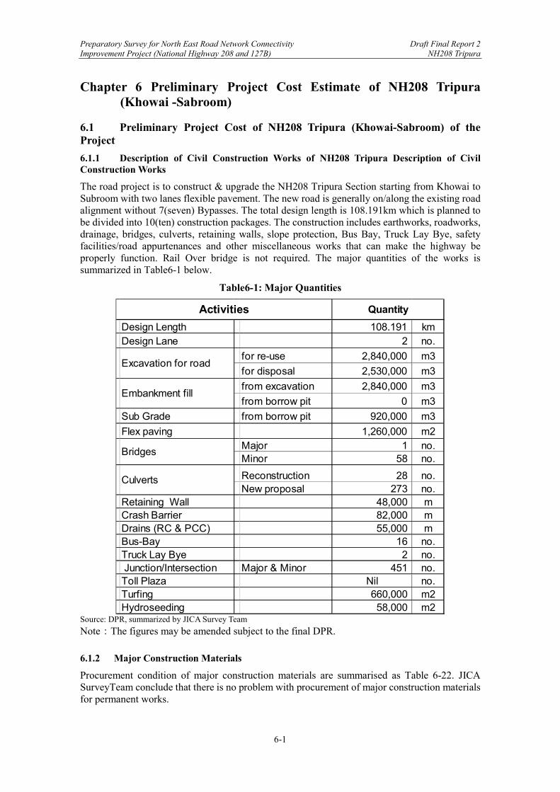
Preparatory Survey for North East Road Network Connectivity Draft Final Report 2 Improvement Project (National Highway 208 and 127B) NH208 Tripura
6-1
Chapter 6 Preliminary Project Cost Estimate of NH208 Tripura (Khowai -Sabroom)
6.1 Preliminary Project Cost of NH208 Tripura (Khowai-Sabroom) of the Project
6.1.1 Description of Civil Construction Works of NH208 Tripura Description of Civil Construction Works
The road project is to construct & upgrade the NH208 Tripura Section starting from Khowai to Subroom with two lanes flexible pavement. The new road is generally on/along the existing road alignment without 7(seven) Bypasses. The total design length is 108.191km which is planned to be divided into 10(ten) construction packages. The construction includes earthworks, roadworks, drainage, bridges, culverts, retaining walls, slope protection, Bus Bay, Truck Lay Bye, safety facilities/road appurtenances and other miscellaneous works that can make the highway be properly function. Rail Over bridge is not required. The major quantities of the works is summarized in Table6-1 below.
Table6-1: Major Quantities
Source: DPR, summarized by JICA Survey Team
Note:The figures may be amended subject to the final DPR.
6.1.2 Major Construction Materials
Procurement condition of major construction materials are summarised as Table 6-22. JICA SurveyTeam conclude that there is no problem with procurement of major construction materials for permanent works.
Design Length 108.191 kmDesign Lane 2 no.
for re-use 2,840,000 m3
for disposal 2,530,000 m3
from excavation 2,840,000 m3
from borrow pit 0 m3
Sub Grade from borrow pit 920,000 m3
Flex paving 1,260,000 m2Major 1 no.Minor 58 no.
Reconstruction 28 no.New proposal 273 no.
Retaining Wall 48,000 mCrash Barrier 82,000 mDrains (RC & PCC) 55,000 mBus-Bay 16 no.Truck Lay Bye 2 no. Junction/Intersection Major & Minor 451 no.Toll Plaza Nil no.Turfing 660,000 m2
Hydroseeding 58,000 m2
Activities Quantity
Excavation for road
Embankment fill
Bridges
Culverts
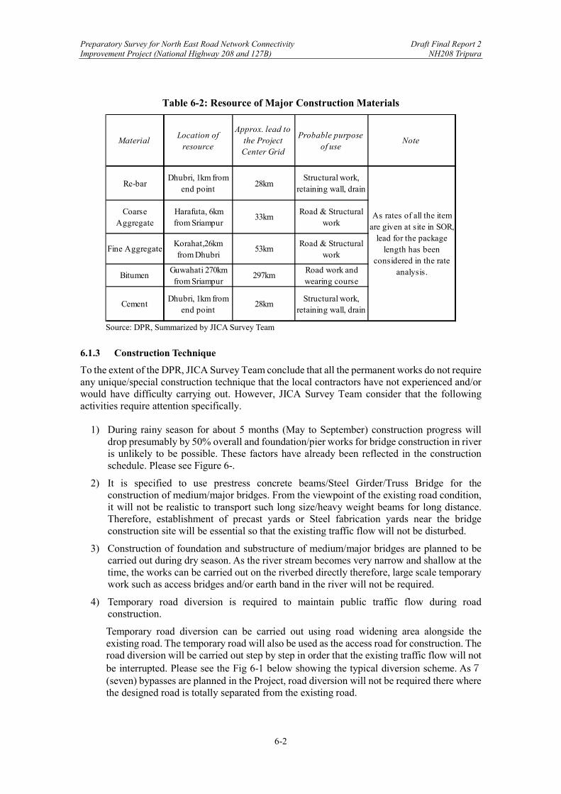
Preparatory Survey for North East Road Network Connectivity Draft Final Report 2 Improvement Project (National Highway 208 and 127B) NH208 Tripura
6-2
Table 6-2: Resource of Major Construction Materials
Source: DPR, Summarized by JICA Survey Team
6.1.3 Construction Technique
To the extent of the DPR, JICA Survey Team conclude that all the permanent works do not require any unique/special construction technique that the local contractors have not experienced and/or would have difficulty carrying out. However, JICA Survey Team consider that the following activities require attention specifically.
1) During rainy season for about 5 months (May to September) construction progress will drop presumably by 50% overall and foundation/pier works for bridge construction in river is unlikely to be possible. These factors have already been reflected in the construction schedule. Please see Figure 6-.
2) It is specified to use prestress concrete beams/Steel Girder/Truss Bridge for the construction of medium/major bridges. From the viewpoint of the existing road condition, it will not be realistic to transport such long size/heavy weight beams for long distance. Therefore, establishment of precast yards or Steel fabrication yards near the bridge construction site will be essential so that the existing traffic flow will not be disturbed.
3) Construction of foundation and substructure of medium/major bridges are planned to be carried out during dry season. As the river stream becomes very narrow and shallow at the time, the works can be carried out on the riverbed directly therefore, large scale temporary work such as access bridges and/or earth band in the river will not be required.
4) Temporary road diversion is required to maintain public traffic flow during road construction.
Temporary road diversion can be carried out using road widening area alongside the existing road. The temporary road will also be used as the access road for construction. The road diversion will be carried out step by step in order that the existing traffic flow will not be interrupted. Please see the Fig 6-1 below showing the typical diversion scheme. As7(seven) bypasses are planned in the Project, road diversion will not be required there where the designed road is totally separated from the existing road.
MaterialLocation of
resource
Approx. lead to the Project Center Grid
Probable purpose of use
Note
Re-barDhubri, 1km from
end point28km
Structural work, retaining wall, drain
Coarse Aggregate
Harafuta, 6km from Sriampur
33kmRoad & Structural
work
Fine AggregateKorahat,26km from Dhubri
53kmRoad & Structural
work
BitumenGuwahati 270km from Sriampur
297kmRoad work and wearing course
CementDhubri, 1km from
end point28km
Structural work, retaining wall, drain
As rates of all the item are given at site in SOR,
lead for the package length has been
considered in the rate analysis.
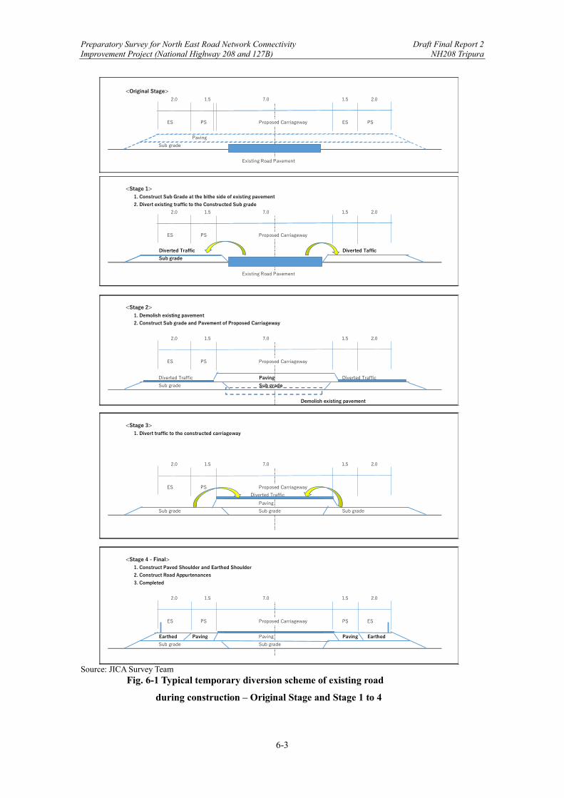
Preparatory Survey for North East Road Network Connectivity Draft Final Report 2 Improvement Project (National Highway 208 and 127B) NH208 Tripura
6-3
Source: JICA Survey Team Fig. 6-1 Typical temporary diversion scheme of existing road
during construction – Original Stage and Stage 1 to 4
<Original Stage>
ES PS Proposed Carriageway ES PS
Paving
Sub grade
Existing Road Pavement
2.0 1.5 7.0 1.5 2.0
<Stage 1>1. Construct Sub Grade at the bithe side of existing pavement
2. Divert existing traffic to the Constructed Sub grade
ES PS Proposed Carriageway
Diverted Traffic Diverted Taffic
Sub grade
Existing Road Pavement
<Stage 2>1. Demolish existing pavement
2. Construct Sub grade and Pavement of Proposed Carriageway
ES PS Proposed Carriageway
Diverted Traffic Paving Diverted Traffic
Sub grade Sub grade
Demolish existing pavement
<Stage 3>1. Divert traffic to the constructed carriageway
ES PS Proposed Carriageway
Diverted Traffic
Paving
Sub grade Sub grade Sub grade
<Stage 4 - Final>1. Construct Paved Shoulder and Earthed Shoulder
2. Construct Road Appurtenances
3. Completed
ES PS Proposed Carriageway PS ES
Earthed Paving Paving Paving Earthed
Sub grade Sub grade
2.0 1.5 7.0 1.5 2.0
1.5 2.0
2.0
2.0 1.5 7.0 1.5 2.0
2.0 1.5 7.0 1.5
2.0 1.5 7.0

Preparatory Survey for North East Road Network Connectivity Draft Final Report 2 Improvement Project (National Highway 208 and 127B) NH208 Tripura
6-4
6.1.4 Construction Safety
Prior to the commencement of the construction, EPC Contractor is required to submit the proposed methodology to be adopted for executing the Works which includes Safety Plan giving details of measures for ensuring safety complying with the Applicable Laws and Good Industry Practice. The Safety Plan is required to be prepared with reference to ’The Guidance for the Management of Safety for Construction Works in Japanese ODA Projects (September 2014)’ published by JICA. It is essential that the above ODA Safety Guidance is included in the Bidding Documents as reference document. JST consider that in addition to the description of safety plan in general, specific safety plan in detail including hazards assessment should be provided for the following works. 1) Major Bridge (work at height and lifting appliance) 2) Traffic Management including temporary traffic diversion (public safety) 3) Slope work (work at height) The Authority’s Engineer reviews the Safety Plan to ensure that the Plans complies with the Applicable Laws and Good Industrial Practice, and also the ODA Safety Guidance is taken consideration and give consent to the Safety Plan upon confirmation of those requirements. The EPC Contractor is obliged to implement the Works in accordance with the approved methodology and Safety Plan. The Authority’s Engineer and his/her staff will visit the sites for the observation of the safety condition during construction to ensure that the Contractor is implementing the works on the line of the Safety Plan. The Authority’s Engineer will take prompt action to the Contractor to rectify the situation when any deviation from the plan and/or dangerous situation is found. The Authoritys Engineer will in collaboration with the Contractor establish Project Emergency Communication Network among the Employer, the Engineer’s Supervision Team, the Contractor and any other Safety related agencies like as fire station, police station, hospital and so on in order to take prompt action against any emergency occurrences.
6.1.5 Earth Work Quantity Balance-Cutting & Filling
Cut and fill balance within the project area may have significant impact on not only cost and construction period but also the required numbers of construction plant that will affect public traffic and planning of temporary access road. Table 6-3 shows Cut &fill balance of each Package and total.As a whole 4,900,000 m3 soil is required to be excavated and 3,200,000m3 can be re-used. 1,700,000m3 is subject to disposal however, the volume is well shared by 10 packages and earth work volume is not so much in view of individual Package. JICA Survey Team concludes that the design is well prepare with the point of view of earth work balance and there is no significant affect to the construction schedule. <Note: Coloured portion may be reviewed subject to the final DPR>

Preparatory Survey for North East Road Network Connectivity Draft Final Report 2 Improvement Project (National Highway 208 and 127B) NH208 Tripura
6-5
Table 6-3 Soil balance of 5 Packages -NH208 Tripura
Source: DPR, summarized by JICA Survey Team
6.1.6 Construction Schedule of NH208 Tripura
NHIDCL expects 2 years (24 months) as construction period for each package (completed parallelly) with 5 years of maintenance period including defect liability period. As construction schedule is not provided in the DPR, JST prepared a preliminary construction schedule to study the feasibility of 24 months of construction period. The schedule is prepared based on 10 Packages with the following considerations (Table 6-4).
Table 6-4: Basic Consideration for Planning the Construction Schedule
Works Duration/ Consideration Topographical survey 3months Detail design 6months Earth Work (Critical pass) 800m3/day/team.
Supposed transportation distance =3km, round trip=6km, one hr./trip including loading and unloading. 8hrs./one hour/ trip=8times/day 18t lorry (7.5m3) [email protected]@8times/day=900m3/day, Apply 800m3 considering loss time. 400m3 during rainy season (operation rate 50%) Employ two nos. of 1.5m3 class excavator(70m3/hr) is enough for excavation and loading.
Subgrade 500m3/day/team, 250m3 during rainy season (output is totally depending on the number of compaction rollers, appropriate no of roller to be arranged)
Protective work (Retaining Wall) Early stage of earth work (appropriate number of teams to be arranged not to disturb the earth work progress
Drainage work Follow the progress of earth work (appropriate number of teams to be arranged no to disturb the progress of earth work
Box culvert Follow the progress of earth work (appropriate number of teams to be arranged not to disturb earth work
(A) (B) (C )=(A)-(B)
Start End Cut (m3) Fill (m3) Balance (m3)
P-1 0+000 11+400 11.400 417,000 177,000 240,000 Disposal
p-2 11+400 22+000 10.600 954,000 227,000 727,000 Disposal
p-3 22+000 33+800 11.800 563,000 245,000 318,000 Disposal
p-4 33+800 45+000 11.200 201,000 439,000 ▲ 238,000 Borrow
p-5 45+000 57+200 12.200 691,000 297,000 394,000 Disposal
p-6 57+200 68+000 10.800 196,000 513,000 ▲ 317,000 Borrow
p-7 68+000 79+000 11.000 167,000 426,000 ▲ 259,000 Borrow
p-8 79+000 90+000 11.000 650,000 252,000 398,000 Disposal
p-9 90+000 101+200 11.200 918,000 307,000 611,000 Disposal
p-10 101+200 108+670 7.470 126,000 264,000 ▲ 138,000 Borrow
Total 0+000 108+670 108.670 4,883,000 3,146,000 1,737,000 Disposal
Note
CH Length(km)
Package

Preparatory Survey for North East Road Network Connectivity Draft Final Report 2 Improvement Project (National Highway 208 and 127B) NH208 Tripura
6-6
Paving 2,000m2/day/team (1,000m2 during rainy season) not critical) can be commence earlier date than in construction schedule.
Major bridge a) Temporary works 3months, no work during rainy season b) Foundation, Pier 6months, no work during rainy season
Foundation (2nos same time): 2nos/7days@20 =70days, say 2.5month Pier (4nos same time): re-bar (10days) + formwork(10days) + concrete(days)=21days@5=105days, say 3.5month Total. 2.5month+3.5 month= 6.0month no work during rainy season
c) Superstructure 6months exclude precast production. Precast beams can be produced during the period of above a) and b). Installation of Precast beam 3days/span+ formwork 10 days/span + re-bar& concrete 10days/span=23days @6 span=138days=4.6month, add miscellaneous works 1.4 month= 6month, duration can be reduced by construction from both side (as contingency plan)
Minor bridge 1no/5months/team, 0.5no/5months/team during rainy season
Road apparatus After paving (not critical) Road Facility (Bus bay/ Track Lay Bye) Follow earth work (not critical) Slope protection (Turfing/Hydroseeding) Follow earth work (not critical)
Source: JICA Survey Team
Source: JICA Survey Team
Figure 6-2: Preliminary Construction Schedule for NH208 Tripura
Design Length:
Construction period:
Maintenance period:
Nos. of Construction Package
1 2 3 4 5 6 7 8 9 10 11 12 1 2 3 4 5 6 7 8 9 10 11 12
1 2 3 4 5 6 7 8 9 10 11 12 13 14 15 16 17 18 19 20 21 22 23 24 25 -- 84
1. Survey & Soil Investigation Ls 1 1x10
2. Mobilization and preliminary works Ls 1 1x10
3. Detailed design Ls 1 1x10
4. Site clearance & Earth works 5,370,000 m3 3x10
5. Sub Grade 920,000 m3 1x10
6. Protection Works Ls 1 2x10
7. Drainage Works Ls 1 2x10
8. Pavement Works 1,260,000 m2 1x10
9. Road apparatus works Ls 1 1x10
10. Associated structures Ls 1 1x10
11. Minor Bridges Nos 45 3x10
12. Major Bridges Nos 1 1
a) Temporary Works
b) Bridge Substructure
c) Superstructure
13. Defect liability period
Rainy season. subject to the actual commencement date
108.191
5 Yearsmaintenance
periodWorks Activities Unit Qty.
WorkTeams
2 years
5 years
Year 1 Year 2
10 Packages
Preparatory Survey for North East Road Network Connectivity Draft Final Report 2 Improvement Project (National Highway 208 and 127B) NH208 Tripura
6-7
As show on the schedule (Figure 6-2), JICA SurveyTeam consider that construction period for 24 months of NH208 (Tripura) is feasible.
6.1.7 Condition of Cost Estimates and Reference Documents
Project estimate has been prepared as per PWD National Highway- Schedule of Rates (SOR) Tripura (2020). Cost adjustment for escalation is therefore not required. Quantities are measured from the final DPR drawings section by section and type by type. Priced B.O.Q is made accordingly. The cost summary has been prepared in line of the Office Memorandum on 9th March 2019 (No. Secy/RTH/Circular/005) issued by Ministry of Road Transport & Highway for Calculation of Cost-estimates and provision for Contingencies/Centages. GST (12%) is included in each SOR rates as prescribed in the above Circular. <Note: Colored portion may be reviewed subject to the final DPR.>
6.1.8 Preliminary Item
Preliminary items are not separately provided in BOQ such as Contractor’s indirect cost & profit however, as stated in the Preface of Schedule of Rates 15 % for contractor’s profit and overheads is included in each rate which covers the following costs.
(1) Site accommodation, setting up plant, access road, water supply, electricity, and general site arrangements.
(2) Site office infrastructure
(3) Expenditure on:
a) Corporate office of the Contractor. b) Site supervision by the contractor. c) Preparation of ‘as built’ drawings.
(4) Mobilization/demobilization of resources.
(5) Labour camps with minimum amenities, required as per labour laws.
(6) Light vehicles for site supervision including administrative and managerial requirements.
(7) Minor Tool & Plants (T&P) including needle vibrators required for concrete work.
(8) Survey instrument and the task of setting out of works including verification of line and dimensions.
(9) Watch and ward.
(10) Arrangement for traffic and traffic management during construction.
(11) Expenditure on safeguarding environment during construction.
(12) Sundries
(13) Financing expenditure of the contractor.
(14) Work insurance/compensation.
(15) Sales/Turnover tax assuming
6.1.9 Temporary Works
Cost for temporary works relating to work directly are included in each rate. For example, temporary shoring and bracing are included in the rate of excavation.

Preparatory Survey for North East Road Network Connectivity Draft Final Report 2 Improvement Project (National Highway 208 and 127B) NH208 Tripura
6-8
The JICA Survey team concluded that no cost adjustment is required for preliminaries and they are not separately provided in BOQ.
6.1.10 Total Project Cost of NH208 Tripura
Priced B.O.Q is not prepared for each individual package in DPR. After confirmation with the DPR Consultant total project cost is as presented in Table 6-5 below. JST conclude that no cost adjustment is required to the cost indicated in Table 6-5. <Note: Colored portion will be review subject to the final DPR>

Preparatory Survey for North East Road Network Connectivity Draft Final Report 2 Improvement Project (National Highway 208 and 127B) NH208 Tripura
6-9
Table 6-5: Project Cost Summary
<note: The underneath is subject to final DPR> Cost summary Table
Source: DPR, Summarized by JICA Survey Team
6.1.11 Department Costs
The following Cost are considered as the Department Cost and are excluded from the JICA assistance therefore, cost for these activities are not included in the Project Cost summary.
Table 6-6: Department Cost
Department Cost Table
Source: DPR, Summarized by JICA Survey Team
6.1.12 Study on Adequacy of the Estimates
For the consideration of adequacy of cost estimates, JST prepared the following table comparing the unit rate per km of this project with previous Study for NH208 (Kamplar - Kowai) 2019.

Preparatory Survey for North East Road Network Connectivity Draft Final Report 2 Improvement Project (National Highway 208 and 127B) NH208 Tripura
6-10
Table 6-7A
: Unit Cost/km Comparison with Other Project
Source: DPR & JICA Survey Team
Table 0-7B: Analysis of Unit Cost/km difference with Other Project
Source:DPR & JICA Survey Team
Source: DPR & JICA Survey Team A

Preparatory Survey for North East Road Network Connectivity Draft Final Report 2 Improvement Project (National Highway 208 and 127B) NH208 Tripura
6-11
Table 0-8: Analysis of Unit Cost/km difference with Other Project
Source:DPR & JICA Survey Team

Preparatory Survey for North East Road Network Connectivity Draft Final Report 2 Improvement Project (National Highway 208 and 127B) NH208 Tripura
6-12
Chapter 6 Preliminary Project Cost Estimate of NH208 Tripura (Khowai -Sabroom) ........ 1
6.1 Preliminary Project Cost of NH208 Tripura (Khowai-Sabroom) of the Project ......... 1
6.1.1 Description of Civil Construction Works of NH208 Tripura Description of Civil Construction Works ................................................................................ 1
6.1.2 Major Construction Materials ............................................................................. 1 6.1.3 Construction Technique ....................................................................................... 2 6.1.4 Construction Safety ............................................................................................. 4 6.1.5 Earth Work Quantity Balance-Cutting & Filling .................................................... 4 6.1.6 Construction Schedule of NH208 Tripura ........................................................... 5 6.1.7 Condition of Cost Estimates and Reference Documents ..................................... 7 6.1.8 Preliminary Item .................................................................................................. 7 6.1.9 Temporary Works ................................................................................................ 7 6.1.10 Total Project Cost of NH208 Tripura .................................................................. 8 6.1.11 Department Costs ................................................................................................ 9
6.1.12 Study on Adequacy of the Estimates ..................................................................... 9
Figure 6-1: Construction Schedule ................................................................................................ 6 Table 6-1: Major Quantities .......................................................................................................... 1 Table 6-2: Resource of Major Construction Materials .................................................................. 2 Table 6-3: Basic Consideration for Planning the Construction Schedule ..................................... 5 Table 6-4: Project Cost Summary ................................................................................................. 9 Table 6-5: Department Cost .......................................................................................................... 9 Table 6-6: Unit Cost/km Comparison with Other Project ........................................................... 10 Table 6-7: Analysis of Unit Cost/km difference with Other Project ........................................... 10