Buried Beneath The River City - CORE
555
W&M ScholarWorks W&M ScholarWorks Dissertations, Theses, and Masters Projects Theses, Dissertations, & Master Projects Summer 2018 Buried Beneath The River City: Investigating An Archaeological Buried Beneath The River City: Investigating An Archaeological Landscape and its Community Value in Richmond, Virginia Landscape and its Community Value in Richmond, Virginia Ellen Luisa Chapman College of William and Mary - Arts & Sciences, [email protected] Follow this and additional works at: https://scholarworks.wm.edu/etd Part of the History of Art, Architecture, and Archaeology Commons Recommended Citation Recommended Citation Chapman, Ellen Luisa, "Buried Beneath The River City: Investigating An Archaeological Landscape and its Community Value in Richmond, Virginia" (2018). Dissertations, Theses, and Masters Projects. Paper 1530192695. http://dx.doi.org/10.21220/s2-hhvc-2574 This Dissertation is brought to you for free and open access by the Theses, Dissertations, & Master Projects at W&M ScholarWorks. It has been accepted for inclusion in Dissertations, Theses, and Masters Projects by an authorized administrator of W&M ScholarWorks. For more information, please contact [email protected].
-
Upload
khangminh22 -
Category
Documents
-
view
0 -
download
0
Transcript of Buried Beneath The River City - CORE

W&M ScholarWorks W&M ScholarWorks
Dissertations, Theses, and Masters Projects Theses, Dissertations, & Master Projects
Summer 2018
Buried Beneath The River City: Investigating An Archaeological Buried Beneath The River City: Investigating An Archaeological
Landscape and its Community Value in Richmond, Virginia Landscape and its Community Value in Richmond, Virginia
Ellen Luisa Chapman College of William and Mary - Arts & Sciences, [email protected]
Follow this and additional works at: https://scholarworks.wm.edu/etd
Part of the History of Art, Architecture, and Archaeology Commons
Recommended Citation Recommended Citation Chapman, Ellen Luisa, "Buried Beneath The River City: Investigating An Archaeological Landscape and its Community Value in Richmond, Virginia" (2018). Dissertations, Theses, and Masters Projects. Paper 1530192695. http://dx.doi.org/10.21220/s2-hhvc-2574
This Dissertation is brought to you for free and open access by the Theses, Dissertations, & Master Projects at W&M ScholarWorks. It has been accepted for inclusion in Dissertations, Theses, and Masters Projects by an authorized administrator of W&M ScholarWorks. For more information, please contact [email protected].

Buried Beneath the River City: Investigating an Archaeological Landscape and its
Community Value in Richmond, Virginia
Ellen L. Chapman
Richmond, Virginia
MSc, Durham University, 2010
BA, Washington Univ. in St. Louis, 2005
A Dissertation presented to the Graduate Faculty of The College of William &
Mary in Candidacy for the Degree of
Doctor of Philosophy
Department of Anthropology
College of William & Mary
May 2018

© Copyright by Ellen L. Chapman 2018

APPROVAL PAGE
This Dissertation is submitted in partial fulfillment of the requirements for the degree of
Doctor of Philosophy
Ellen L. Chapman
Approved by the Committee, May 2018
Committee Chair Associate Professor Neil Norman, Anthropology
College of William & Mary
Professor Martin Gallivan, Anthropology
College of William & Mary
Assistant Professor Michelle Lelièvre, Anthropology
College of William & Mary
Athletic Association Professor in the Humanities Professor Scott Nelson, History
University of Georgia

COMPLIANCE PAGE
Research approved by
Protection of Human Subjects Committee (PHSC)
Protocol number(s): PHSC-2015-07-01-10370-nlnorman
PHSC-2016-06-21-11280-elchapman01
Date(s) of approval: 2015-08-01 through 2016-08-01
2016-08-01 through 2017-08-01

ABSTRACT
Richmond, Virginia, located along the fall line of the James River, was an
important political boundary during prehistory; was established as an English
colonial town in 1737; and was a center of the interstate slave trade and the
capitol of the Confederacy during the nineteenth century. Although Richmond
holds a prominent place in the narrative of American and Virginia history, the
city’s archaeological resources have received incredibly little attention or
preservation advocacy. However, in the wake of a 2013 proposal to construct a
baseball stadium in the heart of the city’s slave trading district, archaeological
sensitivity and vulnerability became a political force that shaped conversations
around the economic development proposal and contributed to its defeat. This
dissertation employs archival research and archaeological ethnography to study
the variable development of Richmond’s archaeological value as the outcome of
significant racial politics, historic and present inequities, trends in academic and
commercial archaeology, and an imperfect system of archaeological
stewardship. This work also employs spatial sensitivity analysis and studies of
archaeological policy to examine how the city’s newly emerging awareness of
archaeology might improve investigation and interpretation of this significant
urban archaeological resource. This research builds upon several bodies of
scholarship: the study of urban heritage management and municipal
archaeology; the concept of archaeological ethnography; and anthropological
studies into how value should be defined and identified. It concludes that
Richmond’s archaeological remains attract attention and perceived importance in
part through their proximity and relation to other political and moral debates
within the city, but that in some cases political interests ensnare archaeological
meaning or inhibit interest in certain archaeological subjects. This analysis
illuminates how archaeological materiality and the history of Richmond’s
preservation movements has created an interest in using archaeological
investigations as a tool for restorative justice to create a more equitable historic
record. Additionally, it studies the complexity of improving American urban
archaeological stewardship within a municipal system closely connected with city
power structures.

i
TABLE OF CONTENTS
Acknowledgements ..............................................................................................iv
Dedication ............................................................................................................vi
List of Tables ....................................................................................................... vii
List of Figures ..................................................................................................... viii
1 Investigating the Many Facets of Archaeological Value in American Cities .. 1
1.1 Introduction: The Genesis of this Research ............................................. 1
1.2 Theorizing Value and Defining Landscape in Richmond’s Archaeology .. 4
1.3 Cities and Archaeology: A Description of the Problem ............................ 9
1.4 Urban Heritage Management and Municipal Archaeology .................... 11
1.5 Urban Anthropology and Archaeological Ethnography .......................... 20
1.6 Introducing the Richmond Context ........................................................ 24
1.7 Format of Study and Dissertation .......................................................... 31
2 An Archaeological and Historical Context of Richmond, Virginia ................. 33
2.1 Pre-Clovis (Pre-15,000 B.P) .................................................................. 34
2.2 Paleoindian (15,000 – 10,000 BP) ......................................................... 35
2.3 Archaic (10,000 - 4200 BP) ................................................................... 37
2.4 Woodland (3200 – 400 BP) ................................................................... 42
2.5 Settlement to Society (1607-1750) ........................................................ 51
2.6 Colony to Nation (1751-1789) ............................................................... 55
2.7 Early National Period (1790-1829) ........................................................ 57
2.8 Antebellum Period (1830-1860) ............................................................. 64
2.9 Civil War (1861-1865)............................................................................ 68
2.10 Reconstruction and Growth (1866-1916) ........................................... 74
2.11 World War I, World War II, and the New Dominion (1917 to the
present) .............................................................................................. 80
2.12 Struggles to Characterize Richmond’s History ................................... 87

ii
3 Richmond’s Archaeology: A Partial History ................................................. 94
3.1 Archival Methods and Approaches ........................................................ 95
3.2 Early Archaeological Exploration in Richmond (circa 1876 to 1963) ..... 99
3.3 The Rise of Cultural Resource Management (1963-1977) .................. 105
3.4 Archaeology and Business in the New Richmond (1977-1989) ........... 116
3.5 The Lost Decade: 1990-1999 .............................................................. 130
3.6 A Broadening Conversation (2000-2017) ............................................ 162
3.7 Trends in Archaeological Investigation ................................................ 185
4 Investigating the Value of Richmond’s Archaeology .................................. 188
4.1 Archaeological Ethnography Positioning and Methods ....................... 191
4.2 The Use Value of Richmond’s Archaeology: Its Functional and Moral
Value...................................................................................................... 204
4.3 Materiality, Neutrality, and the Historical Record: The Value of
Archaeology as a Tool to Address Suppressed or Hidden Histories ...... 215
4.4 Economic Characterizations of Archaeological Material and Spaces .. 230
5 Archaeology’s Political Valence and Understandings of Archaeological ........
Value ......................................................................................................... 239
6 Searching for “The Archaeology of Us”: Exploring Richmond’s Landscape of
Archaeological Potential ............................................................................ 306
6.1 Theoretical Review of Archaeological Predictive Modeling and Sensitivity
Analysis ............................................................................................... 308
6.2 Spatial Analysis Methods .................................................................... 328
6.3 Archaeological Sensitivity Assessment of Richmond .......................... 343
6.4 Mapping Community Value onto Archaeological Resources and
Assessing Sensitivity of Culturally-Significant Richmond Landscapes 352
6.5 Examining the Tension Between Archaeological Potential,
Archaeological Results, and Perceptions of Archaeological Loss ....... 359
6.6 Potential for Future Expansion to Archaeological Sensitivity Assessment
in Richmond ........................................................................................ 366
7 Designing a Framework for Improving Archaeological Stewardship for
Richmond .................................................................................................. 369

iii
7.1 Recommendations for Richmond’s Archaeology ................................. 372
8 Community Amenity; Municipal Program; Political Football; or Process of
Restorative Justice?: Examining Value and Interpreting the Political Position
of Urban Archaeology in Richmond and Beyond ....................................... 405
8.1 Archaeological Values, Ideology and Political Economy in Richmond 411
8.2 Cost and the Precariousness of Municipal Archaeology Programs ..... 420
8.3 City Politics, Race, and Urban Archaeology in the U.S. ...................... 423
8.4 Municipal, Community, and Academic Approaches to Engaging New
Audiences in Urban Archaeology: Approaches to Archaeological ............
Practice ............................................................................................... 438
9 Epilogue .................................................................................................... 442
10 Bibliography ............................................................................................ 445
11 Appendices ............................................................................................. 479
11.1 Legislation Impacting Richmond’s Archaeology ............................... 480
11.2 Timeline of Richmond’s Archaeology ............................................... 486
11.3 Recorded Archaeological Sites in Richmond (as of 2018) ............... 490
11.4 Interview Questions and Guidelines for Semi-Structured Interviews 499
11.5 Text of Informed Consent Form ....................................................... 500
11.6 Text of Informed Consent Script ....................................................... 502
11.7 Prehistoric Sensitivity Model Methods .............................................. 504
11.8 Archaeological Preservation Assessment Model Methods ............... 514
11.9 Planning Unit Descriptions of Richmond Units Within the Richmond
Metropolitan Area Archaeological Survey ........................................ 522
11.10 Links to Digital Products on Richmond’s Archaeology ..................... 534
11.11 Table of Contemporary Urban Archaeology Programs .................... 535

iv
ACKNOWLEDGEMENTS
Acknowledgements Dissertations never come into being under the efforts of just one person, and this
one is no different. I’d like to first thank my advisor, Neil Norman, especially for
some critical interventions he made when I was wondering about my graduate
career. Without that I’m pretty confident this research would not have started, or
at least wouldn’t have ended up in this form. I’d also like to thank the other
members of my committee, Martin Gallivan, Michelle Lelièvre, and Scott Nelson,
for their significant contributions to my research design, dissertation, and general
approach, and for their encouraging and timely feedback.
Secondly, I’d like to thank Kim Allen, Terry Brock, Derek Miller, the other
members and contributors to the RVA Archaeology group, and the 31 people
who were kind enough to provide their time to be interviewed. This could not
have been created without their ideas, trust, generosity of time and expertise,
and participation. Knowing that this research was in service to something made it
much easier to keep motivated. I’d like to particularly mention Bridg Allen, who
we lost this year and who had such dedication for the city and its history.
Many people were extremely generous with their time to discuss these topics,
respond to myriad emails, and sometimes to review sections of my dissertation.
Dan Mouer, Robin Ryder, Lyle Browning, Ana Edwards, David Herring, Kim
Chen, David Dutton, Al Dobbins, Gregg Kimball, Matt Laird, Mark Wittkofski, Taft
Kiser, Florence Breedlove, Lillie Estes, Bill Bjork, Brian and Erin Palmer, Free
Egunfemi, and many other people contributed to shaping my ideas about the
place of archaeology within Richmond’s wider landscape. Conversations with
Michael Blakey and Autumn Barrett at the Institute for Historical Biology,
especially centered around the Remembering Slavery, Resistance, and Freedom
Project they led, contributed to my early interest in Richmond and indelibly
shaped my thinking about the politics of archaeology in the city. Jennifer
Saunders helped tremendously by transcribing many of my interviews. Jolene
Smith, Dee DeRoche, Lauren Leake, and Jolene Wilson Green at the
Department of Historic Resources; Cassandra Ferrell and Gregg Kimball at the
Library of Virginia; Justin Madron and Rob Nelson at the University of Richmond
Digital Scholarship Lab; and Ruth Trocolli at the D.C. Historic Preservation Office
all generously shared their time and expertise and archival materials.
This research was funded through grants and scholarships from the College of
William & Mary (the Department of Anthropology; the Office of Community
Engagement; and the Office of Graduate Studies and Research); the
Archeological Society of Virginia Speiden Scholarship; and the Council of Virginia
Archaeologists Summer Research Grant. I was also supported by the
Department of Anthropology Douglas N. Morton Fellowship for part of my time on

v
stipend and benefited from the opportunity to study at Colonial Williamsburg as
the recipient of an Andrew W. Mellon Curatorial Internship.
I’m very grateful to Marion and Greg Werkheiser, Lexi Cleveland, and the rest of
the Cultural Heritage Partners team. They were nothing but supportive of my
dissertation work and provided immeasurable enthusiasm, innumerable cups of
coffee, trips to Whisk, and cans of fizzy water. Thanks to them I had the
opportunity to write much of this dissertation in the 1787 Adam Craig House,
overlooking the parking lots of the Seabrooks tobacco warehouse, slave auction
sites in Shockoe Bottom, and the Richmond African Burial Ground and which
was a prominent African-American Art Center in the 1930s and 40s. After falling
in love with Richmond five years ago through this neighborhood, it feels like
coming full circle to have been able to labor in this space.
Many graduate colleagues have been such sources of companionship, support,
and ideas. At William & Mary Ashley Atkins, Alix Martin, Sarah Byrd, Patrick
Johnson, Stephanie Hasselbacher, Derek Miller, Libby Cook, and Charde Reid
(who I mostly knew through D.C. HPO and at conferences, and I am so happy to
have as a colleague now): all of them were such great helps at various points,
and I learned a lot from you all. Becky Gilmour from my days at Durham was
incredibly patient and helpful with the final formatting and has provided a lot of
support as we worked our way through our doctoral programs.
So many people helped offer support, encouragement, sanity, and comfort while
I was researching and writing. My parents, Martin Chapman and Madeleine
Watkins, my sisters Alice and Emma, especially. Elliott Jones, who was my
partner for so much of this and whose companionship and support influenced the
trajectory of so much of my life. My cousin Sophie’s chats on Facebook
messenger at odd times of the night ;). Brenden Magill, who talked me through
so many of the common dissertation crises and would cook me dinner and set
me up at his kitchen table to write. Heidi Quant, whose visits and calls have
meant so much to me. Jamie Jackson and Jourdan James, who made me get
out occasionally and enjoy myself and hatched fun schemes. Elizabeth Monroe,
Beth Bell, Charles Monnich, with whom I spent many enjoyable dinners and
board games. Stephanie, Jamie, and Henry Berryhill, who welcome me into their
home so often and provide a respite and a sense of second family. Natalie Siler,
who knows me better than most people and would often reach out right when I
needed it. Family and friends tend to be so critical for finishing a project like this
and often get less of people as they do so, and I am so grateful for all the ways in
which I was held up by all of you.
No one else is responsible for any of this work’s shortcomings, but all helped to
enable its creation.

vi
Dedication
This Ph.D. is dedicated to those who are working towards a better Richmond and to my grandfather Jim Watkins, whose enthusiasm for the pyramids was so
infectious.

vii
LIST OF TABLES List of Tables
1. Table 1 - Archives Consulted 96
2. Table 2 - Current Urban Archaeology Programs and Organizations
(partially based on Deur and Butler 2016) 413
3. Table 3 - Transformation Values of Richmond Soil Types 505
4. Table 4 - Transformation Values Assigned to Distance from Water Source
508
5. Table 5 - Transformation Values Assigned to Site Slope 510
6. Table 6 - Types of Data for Archaeological Site Preservation in Richmond
515
7. Table 7 - Prehistoric Predictive Model Transformation Values Assigned to
VGIN Land Use Data 517

viii
LIST OF FIGURES
List of Figures
1. Figure 1 - Location Map of Richmond, Virginia 25
2. Figure 2 – Theodore de Bry c.1588 engraving 'The brovvyllinge of their
fishe ouer the flame' (Courtesy of the John Carter Brown Library at Brown
University) 45
3. Figure 3 - Image of Salvage Excavation at Shockoe Slip (44HE0077) on
file at VDHR 49
4. Figure 4 - View of "Rocketts" on James River below Richmond, 1865
(Matthew Brady; National Archives NAID 529957) 53
5. Figure 5 - The James River and Kanawha Canal, Richmond, Virginia,
1865. Harper's Weekly, sketched by J.R. Hamilton. (Library of Congress)
57
6. Figure 6 - Latrobe's [1796] Ground Plan of the Penitentiary (Courtesy of
the Library of Virginia) 60
7. Figure 7 -Portrait of Gilbert Hunt, blacksmith and hero of the Richmond
Theatre fire (Photographer unknown; image courtesy of Virginia Memory)
62
8. Figure 8 - "Richmond, from the hill above the waterworks" (1834);
engraved by W.J. Bennett from a painting by G. Cooke; Published by
Lewis P. Clover (New York) (Courtesy of the Library of Congress) 63
9. Figure 9 - "Slaves Waiting for Sale, Richmond, Virginia" by Eyre Crowe
(1861). Heinz Family Collection. Reprinted in McElroy 1990. 66
10. Figure 10 - Cropped detail of an Alexander Gardner photograph of the
Tredegar Iron Works in Richmond, Va., taken after the fall of Richmond in
April 1865, focusing on the iron work structures (Courtesy of the Library of
Congress). 68
11. Figure 11 - "Ruins in Richmond" Damage to Richmond, Virginia from the
American Civil War by Andrew Russell (1865). (Courtesy of the Library of
Congress) 73
12. Figure 12 - An illustration in Frank Leslie's Illustrated Newspaper shows
the freedman's school that operated from a former ward building at
Chimborazo Hospital (Courtesy of the Library of Congress) 75
13. Figure 13 - Postcard view of "Theatrical District, Broad Street, Richmond,
Virginia" 8th & Broad Streets, Richmond, Virginia, 1923 (Courtesy of VCU
Cabell Library) 77

ix
14. Figure 14 - Map Showing Territorial Growth of Richmond, Department of
Public Works, 1923. (Courtesy of the Library of Virginia) 82
15. Figure 15 - An image of the flooded eastern entrance to the Church Hill
Tunnel (Public domain, by Wikipedia user Jkmscott) 86
16. Figure 16 - Field map of Virginia State Penitentiary burial excavation (Map
on file at Virginia Department of Historic Resource) 137
17. Figure 17 - Photo from Maury Street titled "Femur Looking North-
northeast" taken by unknown person on May 23, 1991 (Photo on file at the
Virginia Department of Historic Resources) 146
18. Figure 18 - Richmond's Archaeological Investigations By Decade 186
19. Figure 19 - Plan of Community Memorial Park Plan, including
commemorative materials for Gabriel and the Burial Ground (6 & 7),
interpretation of the Devil's Half-Acre (3), and the footprints of slave trade
buildings (12) (Krupczynski and Page 2017) 250
20. Figure 20 - City of Alexandria Archaeological Resource Map (City of
Alexandria Website) 316
21. Figure 21 - RMAAS Planning Units used to divide Richmond (green),
Henrico County (blue) and Chesterfield County (orange) 319
22. Figure 22 - RMAAS Archaeological Sensitivity Assessment (1985) 321
23. Figure 23 - Current Site Density in Metropolitan Richmond by sites per
square km. (Smith and Chapman 2016) 322
24. Figure 24 - Density of Predicted Archaeological Loss in Metropolitan
Richmond since 1985 (darker areas correspond with greater land use
change relative to site discovery rates) (Smith and Chapman 2016) 324
25. Figure 25 - Byrd map of 1742 showing early lot owners, the town plan, and
environmental features (Courtesy of the Library of Virginia) 332
26. Figure 26 - The 1781 Simcoe Map, illustrating buildings in Richmond,
Manchester, and Rockett's, but representational with very skewed
perspective (Courtesy of the Norman B. Leventhal Map Center at the
Boston Public Library) 333
27. Figure 27 - Map of Richard Adams' Estate, undated (1809/1810).
(Courtesy of the Library of Virginia). 334
28. Figure 28 – Detail from Richmond, Surveyed Under the Direction of N.
Michler (Library of Congress) 336
29. Figure 29 - Map of a part of the city of Richmond showing the burnt
Districts (1865). (Courtesy of the Library of Congress). 337
30. Figure 30 - Prehistoric Archaeological Sensitivity Model (classified using
Geometric Interval) 344

x
31. Figure 31 - Prehistoric Sensitivity Model with Richmond Archaeological
Sites 346
32. Figure 32 - Historic Archaeological Sensitivity Model 348
33. Figure 33 - Historic Archaeological Sensitivity Model with Richmond
Recorded Archaeological Sites 349
34. Figure 34 - Archaeological Preservation Assessment Model (classified
using Geometric Interval) 350
35. Figure 35 - Spatial Distribution of Ethnographic Comments on
Archaeological Sensitivity 353
36. Figure 36 - Land Ownership in the City of Richmond Based on City Parcel
Data 374
37. Figure 37 - Coloring Page Illustration Created of the Turning Basin
Salvage Excavation for the DiggingRVA Public Education Event
(Illustration by Oliver Mueller-Heubach) 400
38. Figure 38 - Richmond Soil Data by Soil Class 508
39. Figure 39 - Linear Distance from Water (in feet) for Richmond City 509
40. Figure 40 - Richmond Slope Raster Used to Assess Prehistoric Site
Creation 511
41. Figure 41 - Design of Prehistoric Sensitivity Model in ArcGIS 512
42. Figure 42 - Resolution Comparison Between the National Land Cover
Database (left) and Virginia Land Cover Dataset (right) 517
43. Figure 43 - Site Preservation Model in ArcGIS 520

1
1 Investigating the Many Facets of Archaeological Value in
American Cities
1.1 Introduction: The Genesis of this Research
This dissertation emerged from the 2013-2015 controversy in Richmond,
Virginia over whether to build a baseball stadium in the oldest neighborhood of
the city. Shockoe Bottom, a name believed to have derived from the Algonquian
name for a creek in the area, was the site of the city’s original town plan, the
nexus of the city’s bustling interstate slave trade, and the heart of the tobacco
trade that had helped define Richmond since its eighteenth-century inception.
Over the course of the first six months of this debate, there was an awakening of
the city’s engagement with archaeological questions; in the tense and
confrontational public meetings about the proposal, archaeologists and
advocates began to ask questions that had not been often directed at city staff:
Isn’t this just more paving over of black history by white economic interests? Why
are we building a stadium instead interpreting the historic area? Wouldn’t a
restored historic neighborhood be better for economic development than a
stadium? If our tax money is being used for this project, why is it being used to
destroy an archaeologically sensitive area? Do you have an archaeological plan?
Wouldn’t this project be eligible for Section 106 consultation, since part of the
land parcel was sold to the city from the Federal Transportation Agency? The
questions were both outraged and specific; informed and pointed; disbelieving
and weary. It was clear that for some these debates were just the latest battle in

2
an old struggle, while others could not believe that this project was conceived in
a city as historically significant as Richmond.
This was a major point of entry for me into these questions and this city,
as a graduate student at the time struggling to articulate why I was doing what I
was doing, and whether this sort of academic work was ever going to be useful to
enough people to make it worthwhile1. Through one such informative and
energetic public forum about archaeology in the city, I found myself helping to
form a community archaeology group, RVA Archaeology, to coalesce
archaeological viewpoints about the stadium project and to make the public
statements about archaeological risk that many commercial archaeologists were
unwilling or unable to make. This process was complex and nuanced; the history
of Shockoe Bottom itself has complexity enough to write ten more dissertations,
and the modern politics of heritage in Richmond similarly. At the same time, I
realized when I started delving into the archaeological knowledge of the city
through this advocacy, that this was one element of a larger series of questions:
Why, in a city like Richmond whose identity is wrapped in historic interpretation,
was the archaeological record so fertile yet so hidden? What resources make up
1 This question of anthropology and archaeology’s responsibilities to local communities, particularly descendant communities, was substantially shaped by my initial graduate work performed at the Institute for Historical Biology under the guidance of Dr. Michael Blakey. Blakey’s theorization of the ethical client model has stressed the investigation of research questions developed in collaboration with descendant communities and has emphasized the potential of research to either reproduce ideologies of inequality or to challenge them (LaRoche and Blakey 1997). My participation in the Remembering Slavery, Resistance, and Freedom Project to investigate the meaning of the Sesquicentennial of Emancipation in Virginia provided me with early context regarding the perspectives and challenges of heritage and memory in the city. In addition, I first learned aspects of the Richmond archaeological stewardship story, particularly the East Marshall Street Well Project whose community engagement he helped to design, from him in early conversations about the work.

3
Richmond’s archaeology, and how should we understand Richmond’s
archaeological potential and archaeological loss? More broadly, what is it about
archaeology that engaged citizens and groups tend to value? How do city politics
affect perceptions of archaeology’s value? How does the story in Richmond
reflect the condition and challenges of urban archaeology nationwide, and what
elements of the Richmond situation have grown out of Richmond’s particularly
ambivalent relationship with its history?
This dissertation seeks to address these questions. It grew out of a desire
for public engagement with the city’s archaeological resources, public
contribution to the research questions and themes addressed in the city, and as
an act of advocacy to raise awareness about this problem of urban heritage
unrecognized and neglected. It studies the variable development of
archaeological value as the outcome of significant racial politics, historic and
present inequities, trends in academic and commercial archaeology, and an
imperfect system of archaeological stewardship. This study also has a practical
focus designed to describe the particular history and spatial landscape of
Richmond’s archaeological investigations, and how these resources might best
be preserved and allowed to contribute more towards Richmonders’
understandings of their city. In addition, however, it examines the power
archaeology has to affect how people understand history; explores the politically
and racially-fraught subject of American urban archaeology generally;
interrogates how we assign and display our values towards historical and
archaeological remains; and puts some of the trends in Richmond into context

4
with nationwide cultural resource law, heritage management approaches,
municipal archaeology programs, and preservation planning. It concludes that in
Richmond, the materiality of archaeology; the history of archaeological and
historical analysis on the city; and the political life of archaeological and historical
significance have created a narrative that embraces archaeology as a potential
tool for restorative justice in the city. It also examines how power dynamics and
political disagreements paralyze historical interpretation of the city’s
archaeological remains or inhibit truly collaborative community interpretation
programs. Through combining spatial and ethnographic understandings of the
city’s archaeological potential and loss, it explores areas of the city that might be
most effective for fruitful, publicly-engaged research, and studies how
presumptions of archaeological loss sometimes subdue interest in potentially-
significant areas.
1.2 Theorizing Value and Defining Landscape in Richmond’s Archaeology
Because of its multiple methods, this dissertation project takes both a
spatial landscape perspective and an ethnographic perspective on
archaeological value when analyzing and interpreting Richmond’s archaeological
resources and their community value. This uses an expansive definition of
Richmond’s archaeological landscape: it is “the backdrop against which
archaeological remains are plotted” (A. B. Knapp and Ashmore 1999, 1); and
also the subjective impressions of that landscape and its potential (Chapter 6). It
is the known prehistoric and historical record of the city and history of how this

5
landscape has been investigated and understood by various scholars, and also
factors that have inhibited this understanding (Chapter 3). It is the economic,
social, racial, and political landscape that influences how archaeological remains
are perceived and valued by various constituencies (Chapters 4 and 5). It is also
the landscape of possibility that exists for these resources to be better managed,
investigated, and interpreted in the future (Chapter 7).
Richmond’s potential and recognized archaeological resources are placed
within the context of the city as an archaeological landscape, recognizing that
especially in urban contexts, archaeological deposits exist as a continuous layer
or potential rather than as discrete sites. While the core of this dissertation
focuses on broadly examining the city’s archaeological resources, this work has
been undertaken with the ultimate goal of allowing a wide variety of stakeholders,
including those frequently excluded from the process of determining historical
significance, to better access the city’s archaeological resources and to
contribute to deciding how these resources should be used and preserved. In
order to ensure that this analysis remains connected to community goals and
values, I employ archaeological ethnography, discussed further in Section 1.5, to
examine how archaeological value is defined and which groups consider
archaeology to have value. Additionally, I examine narratives about
archaeological sensitivity and consider the uncertain nature of value with relation
to archaeological potential at a given site – when a location is known to be of
“archaeological risk” or “high sensitivity,” but has not yet been investigated, how
do different individuals and groups interpret this as valuable?

6
A major focus of this research is the way in which political affiliations and
the legacy and current reality of race relations in Richmond influence how and
when groups find archaeology valuable. The concept of ‘value’ has been
explored anthropologically and archaeologically in a variety of ways combining
financial and moral, tangible and intangible, but with few exceptions these
studies have defied synthesis or unification (Kluckhohn 1951; B. Little, Mathers,
and Darvill 2005; Darvill 1995; Eiss and Pedersen 2002; Graeber 2001). Among
theories more explicitly associated with the value of archaeological resources
and cultural heritage, scholars define value in a combination of material and
more symbolic terms (for greater detail see Chapter 4). Of particular use to this
analysis are the conclusions made by Kathryn Samuels regarding the creation
and demonstration of values in heritage. Samuels traces a genealogy of
archaeological theories of value and describes them as distinguishing between
archaeological resource management (with an intradisciplinary focus on resource
significance) and heritage, which derives its significance from meaning in the
present. She avoids making this distinction, and instead uses Mauss’ theory of
the gift and Annette Weiner’s concept of ‘inalienable objects’, to argue that these
objects’ value derives from their social histories and the amount of effort used to
halt their circulation (Samuels 2008, 75–81). Samuels’ concept of value is heavily
based on that of David Graeber and Nancy Munn, who describe value being
created substantially through the investment of actions (Graeber 2001, 47–53;
Munn 1986). With reference to archaeological heritage, Samuels concludes that
this means value is created through actions related to the management and

7
development of heritage and through archaeological practice. Furthermore, she
asserts that by studying the trajectory of archaeological heritage we can gain an
understanding of different regimes of value acting upon that archaeological
heritage, since “archaeological studies on ‘the past of the past’ have explored
how the unique properties of material can form certain modes of tradition,
memory and the failure of memory” (Samuels 2008, 84).
While these concepts produce a good framework for explaining
archeological worth in cross-cultural anthropological context, they are
substantially based on work in Melanesia and other small-scale societies
(Samuels 2008, 80). There is not much considerations of contested value in a
modern nation-state, and little acknowledgement that most individuals, including
preservationists, understand archaeological value in relative terms – in relation to
economic development, essential goods and services, etc. (but for an exception
see Glassow 1985). Therefore, this ethnographic work employs theories of
values to explore how the value of archaeological resources is defined across
power hierarchies in the city, and whether participants in Richmond perceive
conflicts between archaeological value and other systems of value. In the next
section, I will discuss how the form of this dissertation will provide conclusions
regarding Richmond’s archaeological landscape and how the value of this
landscape is expressed, contested, and in some cases unrecognized within the
city.
As I will argue in this dissertation, the development of archaeological value
is the product of a complex combination of local fortune, unshakable national

8
trends, and the persistent investment of actions (or the inhibition of actions)
through actions and projects over many decades. There are many factors that
distinguish Richmond from other cities – the pervasive Lost Cause mythology
that valorizes the Southern Confederate past; the influence of the state’s political
and business communities; and the particular legacy of Virginia Commonwealth
University as both a vehicle of and barrier to archaeological investigations in the
city. I conclude that in Richmond, archaeology as a discipline has value currently
in part because archaeological materiality is seen as a way of countering a
history of preservation neglect related to non-dominant historical narratives,
particularly the legacy of the slave trade and histories of African-American
resistance. I also illustrate how Graeberian concepts of value-making as the
investment of actions, when applied to Richmond’s archaeology, do not tell a
particularly positive narrative about how a variety of institutions and stakeholders
have valued archaeological remains at various points during its archaeological
history. Examining this history through a lens of race, politics, and political
economy illustrates the restrictions that these actions operate within, particularly
the contribution of recent city political and preservation history to current tensions
regarding archaeological interpretation. My spatial and policy analysis argues
that despite a substantial history of archaeological loss and disinvestment,
Richmond retains considerable areas of archaeological sensitivity, several of
which could be powerful sites of community archaeology research, interpretation,
and memorialization.

9
This study has broader implications for American urban archaeology and
for examinations of the development of value, particularly with reference to how
the histories of race relations and contemporary race relations in American cities
continue to influence how archaeological materials are interpreted and the extent
to which they are seen as valuable. It raises questions regarding the tensions
that develop when municipal archaeology initiatives coordinated by dominant city
power structures attempt to create community-engaged projects. It also provides
an examination of the potential of archaeology for restorative justice initiatives
and explores how emphasizing these narratives may increase the resonance of
community archaeology projects among often under-engaged groups.
1.3 Cities and Archaeology: A Description of the Problem
In the United States, archaeological research in urban environments is
most commonly conducted to comply with Section 106 of the 1966 National
Historic Preservation Act or the National Environmental Policy Act. In addition,
several state laws and local ordinances also require archaeological mitigation as
part of certain types of construction projects in many jurisdictions. Federal and
state governments have a complex architecture of archaeological departments,
historic preservation offices, and legislation dedicated to ensuring that shared
cultural patrimony will not be unilaterally destroyed by government projects.
However, these safeguards have very finite and limited scope; as Appendix 10.1
indicates, most of the regulations governing archaeological stewardship in
Richmond are particular to state or federal projects, while city mechanisms are

10
few and poorly applied. The goal underlying these structures is for governments
to be good stewards of the cultural resources of their citizens, but a lack of
effective public engagement and research interpretation frequently leads to poor
public awareness of archaeological and historical sites. Particularly with
reference to urban contexts, this absence marks an unmet promise to American
citizens and an investment of taxpayer resources with uncertain and unclear
benefits. Twinned with a political environment that prioritizes individual property
rights and deregulation, the largely unheralded nature of compliance
archaeological management and research also threatens existing cultural
resources protections. This research combines archival analysis, sensitivity
assessment using Geographic Information Systems (GIS), and archaeological
ethnography to explore the archaeological potential of the city of Richmond,
Virginia, and what places hold the most value for the city’s community members,
archaeologists, state and municipal government, and historical organizations.
By reviewing previously recorded sites, surveys, historical maps and
narratives, oral histories, field reports, and media stories, this research has
developed a first longitudinal examination of archaeological investigation in the
city. More critically, however, this dissertation addresses the under-considered
problem shared by all American cities and many other municipalities: to what end
are we collecting and recording federally-mandated archaeological information,
and in what ways is it developing or failing to develop any relevance to local
communities and other stakeholders?

11
1.4 Urban Heritage Management and Municipal Archaeology
This dissertation builds upon several important bodies of scholarship: the
study of urban heritage management and municipal archaeology; the concept of
archaeological ethnography; and anthropological studies into how value should
be defined and identified. Early urban archaeology in the 1930s-1950s centered
on the recovery and restoration of important buildings, such as forts and
buildings associated with the Revolution and early Republic, to develop their
public interpretation (Rothschild and Wall 2014, 23). After the environmental and
preservation movements of the 1960s, the passage of the National
Environmental Policy Act and National Historic Preservation Acts required
archaeology in cases where the excavation was not driven by concern over
specific resources but a requirement to assess whether important resources
existed in a place endangered by a development. As I will discuss in Chapter 3.3
and 3.4, however, this requirement was unevenly applied during the first several
decades after the 1966 passage of the National Historic Preservation Act. Well
into the 1970s and 1980s, urban archaeology scholarship focused substantially
on convincing Americans, and often even other archaeologists, that there was
some archaeology left to study in urban spaces (Salwen 1978). Despite the
progress made on that front, this is still a common misconception to be
addressed when discussing archaeological sensitivity and preservation in cities.
Some early urban studies were predominantly methodological, focusing on the
challenges of archaeology in urban areas where excavations were expensive,
specialized tools and approaches were needed, and interactions with the public
12
were more common and unpredictable (B. Powell 1962). From its origins, some
early scholars recognized the intimate relationship between urban archaeology
and the politics and planning of the city; Powell attributed much of the rise of
urban archaeology to increased emphasis on preserving historic sites and the
urban renewal and city planning being carried out at the time, and noted that
tactful handling of the public was one of the essential elements necessary for a
project’s success (B. Powell 1962, 581–82). This approach recognized the
political volatility of urban work, but implied that political factions and concerned
communities were something to be managed rather than stakeholders to be
consulted. Other early urban archaeologists examined the concept of urban
archaeology and described the discipline as either “archaeology in the city,” the
study of any archaeological remains that happened to be located within a city,
and the “archaeology of the city,” the systematic study of city development (Foley
1967; Ingersoll 1971; Salwen 1973). This continues to be a relevant distinction,
with some urban archaeology studies (Cressey and Stephens 1982a; Cressey
1978; Cantwell and Wall 2003) focusing on city evolution and expansion, while
others providing more emphasis on the prehistory or early settlement of future
urban landscapes (Staski 1982). In many ways this distinction derives from the
archaeological resources themselves or the way in which certain resources are
emphasized by the city itself – while in Alexandria the key story is the city itself,
the program in Phoenix arose because of the critical Hohokam sites in the area,
which have resulted in the excavation of 35 Hohokam sites and included the
disinterment and repatriation of 2200 burials in the last twenty years (Bostwick

13
2017, 294). Other early urban archaeology studies in the U.S. followed a
quantitative approach that examined the unique challenges of urban contexts
and the specialized skills and approaches needed for their pursuit (Staski 1982;
Staski 1987). What many of these early archaeologists shared was an
understanding that urban archaeology bloomed from public interest and that the
archaeology of a city had the potential to shift the experience of people in the
city. Staski underlined the uniquely “specific and powerfully influencing material
setting of cities,” due to their especial relevance to the study of urban ethnic
enclaves, high potential for public significance, and emerging legal requirements
for their mitigation during federal construction projects (Staski 1982, 127–32).
During the 1980s and 1990s, several archaeologists developed municipal
archaeology ordinances or programs within cities; those in Phoenix, Arizona
(1985); Alexandria, Virginia (1992); and St Augustine, Florida (1987) are
particularly well-known because they succeeded and persisted while several
others were eventually shuttered. Most of these municipal programs were
successful and long-lived in part because of their involvement and
embeddedness within city communities; Carl Halbirt of St. Augustine has
described a layered approach to public engagement that includes passive types
of involvement with a broader base of community members but active and
generative ‘owning’ and ‘leading’ levels of community-driven projects when
specific groups have a committed interest (Halbirt and Miller 2017).
These early city archaeologists, especially Pamela Cressey, also
developed considerable scholarship on how North American city archaeology

14
could be managed and interpreted. During the 1980s, the emphasis on a “core-
periphery” model greatly influenced the Alexandria focus on studying the urban
landscape of Alexandria as it grew (Cressey and Stephens 1982b; Cressey
1978; Stephens and Cressey 1981). The core-periphery approach developed
from the study of ancient city-states, and focused on understanding these
regions as urban power centers surrounded by more marginal or subordinate
outlying communities (Wallerstein 1974; Champion 1995; Rowlands 1998).
Within Alexandria, this approach emphasized the city writ large as the site, with
individual neighborhoods, ethnic enclaves, rural related industries, and other
components considered in relation to the urban historic core of the city, the city’s
center of power, population, and wealth (Cressey and Stephens 1982b, 48–51).
Cressey similarly emphasized the critical role the public plays in determining how
the significance of urban archaeological deposits should be assessed, arguing
for a role in local values in the process (Henry and Cressey 1989). Cressey and
her Alexandria colleagues Fran Bromberg, Steven Shephard, and others, have
studied Alexandria from within the city’s governmental structures since the late
1970s, and have published much more than other archaeologists engaged in
compliance review have managed to. At the same time, much of their research is
either particularist site examination or reflections on the city archaeology program
itself: the need for engaged volunteers and the significance of having
archaeology in the city planning code being especially common topics. The
program has had successes of considerable power: the creation of the
Contrabands and Freedmen Cemetery Memorial and the African-American

15
Heritage Park especially. The very applied and city-tied qualities of this work,
however, have made it less anthropologically-engaged – and less critical – than
other approaches.
On the other hand, work by Shannon Dawdy in New Orleans has explicitly
considered the archaeology of the city, and in the city, from a vantage point
embedded in the academy and anthropological thought. In Building the Devil’s
Empire: French Colonial New Orleans, Dawdy uses an archival study of New
Orleans’ founding and early years to explore the concept of ‘rogue colonialism’
and the interplay between colonial government bureaucracies, capitalist
ventures, and the extra-legal activities of pirates, con-men, and mercenaries
(Dawdy 2009, 237–42). Her Patina: A Profane Archaeology, builds on years
spent excavating in New Orleans on academic, state, and federal projects from
contexts including anything from field schools to emergency mitigation through
FEMA after Hurricane Katrina. Dawdy mixes archival research, recollections of
her archaeological practice, ethnographic interviews, and examinations of
contemporary discourse about the material past in the city to examine the
“patina” symbolizing both New Orleans’ relationship with its distant past and how
it has chosen to engage with the physical signs of Katrina’s destruction (Dawdy
2016).
The very unevenness in terms of city archaeological protections, political
dynamics, and the frequent unpredictability of archaeological discoveries has
meant that even as municipal archaeological programs have been developed in
some cities, major sites have still been hastily and poorly handled in others or in

16
city neighborhoods lacking protections. Undoubtedly the most prominent
example of this is the New York African Burial Ground, excavated in 1991 in
advance of construction for the Ted Weiss Federal Building of the United States
General Services Administration in New York City. After a year of poor project
management by the original cultural resource management company, a coalition
of concerned citizens, municipal staffers, the New York City Landmarks
Commission, New York State Senator David Patterson, and others developed a
city task force dedicated to the question of how the site should be handled
(LaRoche and Blakey 1997, 85–87; LaRoche 2011) . After several Congressional
hearings and public debate regarding the matter, black anthropologist Michael
Blakey, then at Howard University, was selected to lead a predominantly-black
team of researchers that developed research questions in collaboration with the
activist community and interpreted the remains and providing African Diaspora
and biocultural frameworks to interpret them (Blakey 2010, 62). This site remains
a model for community-led scholarship.
A series of archaeologists between the 1980s and today have set out to
make particular studies of certain cities: Rebecca Yamin in Philadelphia and New
York, Nan Rothschild, Joan Geismar, and Diana diZerega Wall in New York,
Kathleen Deegan and Carl Halbirt in St. Augustine, Todd Bostwick in Phoenix,
Joe Bagley in Boston, and Shannon Dawdy in New Orleans, among many others
(Yamin 2000; Yamin 2008; Rothschild and Wall 2014; Janowitz and Dallal 2013;
Dawdy 2009; Dawdy 2016; Deagan and Koch 1983; Cantwell and Wall 2003).
However, in many cities, including Richmond, information on urban

17
archaeological resources remains trapped in gray literature. In writing their 2015
book The Archaeology of American Cities, authors Nan Rothschild and Diana
diZerega Wall called upon colleagues to help by combing through State Historic
Preservation Offices (SHPOs) for essential sources that still only exist in
unpublished compliance report format. While this approach was effective for
cities where current researchers or scholars responded to the call, it meant that
the urban archaeology of many places was left out entirely, and the research was
skewed towards places with active programs. For the state of Virginia, the only
cities whose archaeological resources contributed to the book are Alexandria and
Williamsburg (Rothschild and Wall 2014, 231).
Today, almost 70 different municipalities across the country have
enshrined archaeological protections, which can include historical commissions;
archaeological ordinances; predictive models; staff archaeologists; survey
programs; special statuses for protected areas; and partnerships with federal
agencies or tribes (Deur and Butler 2016). In recent years the connection
between urban archaeology, heritage management, and city planning has been
more explicitly investigated. A critical addition to the consideration of urban
municipal archaeological studies has been Douglas Appler’s work at the
intersections of municipal archaeology and urban planning. Appler’s dissertation
examines the municipal archaeology programs in Phoenix, Alexandria, and St.
Augustine, investigating their origins, structure, challenges, and assets through
archival research and interviews (Appler 2011). Appler has investigated the
community value provided by city archaeology programs, noting that

18
archaeological resources and information can be a very effective base around
which to develop community assets and amenities (Appler 2012b). He has also
emphasized the ways in which municipal archaeology programs must be
engaged with citizens’ sense of place and local government structures if they are
to be successful (Appler 2012a; Appler 2013a). A recent edited volume
(Baugher, Appler, and Moss 2017b) investigated this question in theory and in
several cities in the Americas, Britain, and the British Commonwealth. The
editors recognize the deep importance of connecting local archaeology better
within local government systems, writing “Improving and expanding the
relationship between archaeology and local government represents one of the
next great challenges facing archaeology. Not only does local government have
access to powerful legal tools and policy mechanisms that can offer protection for
archaeological sites, but because local government exists at the grassroots level,
it is also often closer to people who have deep knowledge about the community
itself, about its values, and about the local meaning of the sites most in need of
protection” (Baugher, Appler, and Moss 2017a, 2). Many of these articles make
similar arguments and connections – that archaeological resources can be
critical for a city’s sense of identity, that archaeologists must emerge from their
academic and cultural resource management bubbles to engage with local
politicians and community groups, and that archaeological resources can
become lynchpins and seeds for innovative urban design when these types of
collaborations occur (Appler 2017; Baugher, Appler, and Moss 2017a). They also
seem to define the local government as inherently “grassroots” and ascribe local

19
government with an equitable benevolence in terms of their priorities, an
assumption that seems worth interrogating and questioning.
Exhortations for greater archaeological engagement within municipal
archaeology contexts sometimes underplay the significance of race, power
imbalances, and the use of historic preservation as a tool for gentrification or
political gamesmanship. These investigations emphasize the importance of
locating archaeological programs and requirements within municipal structures
without much acknowledgement that such official city power structures can in
some cases be indifferent (or opposed to) communities within the city that place
significant value upon certain archaeological sites. These works on municipal
projects do not much problematize the political capital provided to city officials
and politicians through the spectacle and public relations implications of
archaeological site investigations. There is not much explicit consideration of the
decisions inherent in some of these municipal projects: that to recognize and
highlight some city histories valued by some groups often creates the alienation
of others. Richmond’s archaeology, especially its last twenty years, cannot be
considered outside of a context that recognizes these challenges and
understands the deeply unequal way historical research has been divided along
racial lines. It is for this reason that urban anthropological methods, and
archaeological ethnography, have also been an important element of this study.

20
1.5 Urban Anthropology and Archaeological Ethnography
American cities, where over 80% of its population now lives, are deeply
neglected by anthropologists in contrast to remote communities in far-flung parts
of the world (US Census Bureau 2010). Additionally, when city populations and
issues are examined by anthropologists, the topics and groups of people
selected for these studies tend to still emphasize the other within urban
ethnography: the groups studied might be the most disenfranchised of the urban
poor, reside in public housing, are involved in drug or sex trades, or are
portrayed as pathologized in some other manner (e.g. Bourgois and Schonberg
2009; McRoberts 2003; Duneier 1992; Liebow 1967; Klinenberg 2002;
Venkatesh 2006; Goffman 2015; Lewis-Kraus 2016; Fennell 2015). Stephen
Gregory’s 1998 ethnography Black Corona: Race and the Politics of Place in an
Urban Community critiqued the myopic focus of ethnographic analysis on poverty
and pathology of black urban life:
“Narratives of black urban life in the mass media and scholarly
research have tended to focus on poverty and its impact on the
culture and social organization of the black poor. In pursuing this
line of inquiry…history, political organization, work and leisure,
and other everyday dimensions of urban life that de rigeur have
guided and informed the research of social scientists working
elsewhere face from view within the epistemological frontiers of
the black inner city” (S. Gregory 1998, 5).
There are exceptions of course, like Shannon Dawdy’s aforementioned
Patina that studies post-Katrina New Orleans and how the hurricane shaped and
represents New Orleansians’ relationship with their past (Dawdy 2016). However,
Black Corona is a remarkable and useful study in part because the subject

21
matter – urban black middle-class activism associated with crime and
gentrification during public government meetings, social gatherings, and
neighborhood life – mirrors in certain ways the context I examine in this story of
Richmond’s archaeological resources and the public life they have lived since
2013. Although still focused on starkly-poor urban communities, Catherine
Fennell’s ethnographic work uses a similar combination of ethnographic
observations, public meetings and public relations campaigns, and policy
assessments in her work on Chicago’s Near West Side. Fennell examines how
shifts from public housing projects to a multi-income mixed use neighborhood
shifted the sensory landscape and power dynamics, exploring who takes
responsibility for Chicago’s urban poor and how these shifts contributed to the
development of “sympathies” towards them (Fennell 2015, 2–15).
Ethnographic and oral history analyses of the meanings of the Richmond
past for various groups has been addressed by several researchers and
disciplines, from semiotics (Walker 2009), rhetoric (Cynthia Fields, in prep),
cultural anthropology (Barrett 2014), journalism (S. C. Davis 1988), and historic
preservation groups focused on preserving recollections of elderly residents
(Historic Richmond Foundation 1982; VCU Libraries Digital Collections 2012).
Walker examined the difference in symbolism and use of underground historical
spaces including Hollywood Cemetery, the Richmond African Burial Ground, the
Church Hill tunnel, and Lumpkin’s Jail, pointing out that the treatment of
Richmond’s buried past allows the city to “use the underground as a metaphor,
as a way to talk about justice, as a means to wipe away Otherness. The buried

22
past can be used strategically to unsettle accepted hierarchies” (Walker 2009:
433). Barrett compared the meanings and uses of Richmond’s African Burial
Ground with those that developed in Rio de Janeiro around the Cemitério dos
Pretos Novos, emphasizing that at both sites activists invested in the historical
narratives sought to participate in reclaiming the meaning of these sites and
recognizing the importance of black resistance in both histories. Fields studied
commemorations of the Sesquicentennial in Richmond, Appomattox, and
elsewhere to interrogate the competing narratives of memorialization around the
Civil War in Virginia.
The value of ethnographic information has long been recognized within
anthropological archaeology, albeit in many cases predominantly as a way of
extracting specialized knowledge or expertise from an indigenous population in
order to better understand the meaning and function of archaeological artifacts
(e.g. Binford 1987; Jacknis 1996; Kramer 1979). A more recent theoretical
framework for understanding the importance of ethnographic approaches in
archaeological research is archaeological ethnography (Castaneda and
Matthews 2008; Hamilakis 2011; Castaneda 2008), which emphasizes contexts
in which the ethnographer seeks both information about the archaeological past
and about the contemporary meaning of this past from their collaborators.
Important characteristics of archaeological ethnography for this project include
consideration for how the material (or ‘sensuous’ as per Hamilakis and
Anagnostopoulos) nature of archaeological objects affects the interlocutors, that
it emphasizes the production of a multi-temporal and multi-sited ‘total’

23
ethnography, and its focus on producing politically-sensitive scholarship that is
aware of hierarchies of power associated with the project (Kus 1997; Kus 1995).
Archaeological ethnography embraces the study of contemporary ideas about
the past and heritage disputes that arise over archaeological materials. While
substantive ethnographic scholarship is in no way new to archaeology,
archaeological ethnography includes an explicit consideration of power, political
economy, and positionality (as Hamilakis puts it, “who sponsors you, and why do
they pay for all this?”) in a way that understands that these issues are
fundamental to how archaeology now operates in the world rather than an
inconvenient distraction or complication (Hamilakis 2011, 403–7).
Archaeological ethnography is well-suited to the Richmond context for
several of these characteristics: as this dissertation will examine, archaeological
resources are highly politically-laden in Richmond, and many diverse groups –
with very different relationships to official and unofficial power structures – lay
claim to them. Ethnographic observations based on both the processes active in
public meetings and official city decisions, and personal conversations by some
of those engaged in the political discourse around archaeology, are critical for
teasing apart the politics and value of Richmond’s archaeological resources.
Within an archaeological ethnographic framework, I have sought in this project to
explicitly examine how various communities engage with Richmond’s
archaeological resources; how this engagement is informed by the other political
positions that they express; how archaeology is altered by and intersects with
official and unofficial power centers in Richmond; and how ethnographic data can

24
inform our understanding of Richmond’s archaeological history and its spatial
sensitivity (Chapters 4 and 5). Because of the inherently subjective nature of this
type of investigation, this approach will also include an explicit recognition of how
my own positionality (especially race, academic background, recent arrival in
Richmond, gender, and profession as an archaeologist) influences the way I see
the city and its resources, who I have access to, and what topics people feel
inclined to bring up with me (Section 4.1). Additionally, on a more pragmatic
level, the history of Richmond’s archaeology is basically unwriteable without the
action of interviewing and the use of less formalized social knowledge than is
common in archaeological research. So many reports and projects remain
unfinished that grasping the histories of archaeological resources here is out of
reach without a myriad of conversations with former field archaeologists,
curators, state review and compliance experts, and the many scholars and
community members who have taken ownership of parts of this history over the
years. Beyond that, however, collecting ethnographic observations and
anthropologically-grounded reflections (on how archaeological materials
contribute to the city’s narratives about race; powerful institutions; and respect for
burial grounds and sites of conscience) are used in this research to interpret the
position of archaeological topics within a web of wider tensions and concerns.
1.6 Introducing the Richmond Context
The environs of the city of Richmond have been a significant and long-term
locus for human habitation, likely since at least the Paleoindian period (15,000–

25
10,000 BC). Geographically, Richmond is located in the Virginia Coastal Plain in
the watershed of the Chesapeake Bay, at its intersection with the Piedmont
physiographic province at the falls of the James River (Figure 1). The east side of
the city is on the Atlantic Coastal Plain, whereas the western section is on the
Piedmont Plateau. Along this boundary, the oldest sediments in the region,
Precambrian Petersburg Granite from the Piedmont Plateau, is exposed by the
river erosion and along the bluffs (P. Thomas and Harper 2009, 1–3). According
to the Natural Resource Conservation Service (NRCS), the majority of Richmond
soils are comprised of the Urban land complex soil types, with 0 to 4 percent
slopes. Subsoils on Richmond hilltops are generally ancient formations like
Bacon's Castle and Yorktown, as well as underlying Miocene clay marl (Mullin
Figure 1 - Location Map of Richmond, Virginia

26
and Rupnik 2004). The temperature in the City of Richmond varies between an
average daily summer high of 89 degrees Fahrenheit (31.7 degrees Celsius) and
the average daily winter low of 29 degrees Fahrenheit (-1.7 degrees Celsius).
Colonial contact occurred early in the seventeenth century in the region,
when John Smith sailed up the James River in 1607 and came ashore where the
river became unnavigable. Probably relieved to be far from the humid, bug-
infested Jamestown, Smith is recorded has having described the Algonquian
village of Powhatan thusly: “No place we knew so strong, so pleasant and
delightful in Virginia for which we called it Non-such” (Potterfield 2009). At that
point, the Fall Line of the James River had been an important boundary for
centuries between the Powhatan chiefdom and the Monacan lands to the west.
Once the town was settled in the 1730s, by British colonists and their enslaved
laborers of African descent, Richmond expanded as a critical trade and industrial
location, especially for tobacco, milled wheat flour, and ironworking. The pre-
Richmond site of Warwick, now partially or mostly destroyed by a City of
Richmond Port Deepwater Terminal, was founded because it was the furthest
west along the James River that some ships (250-ton ones according to a
reference in a letter by Thomas Jefferson) could easily pass (Jefferson 1801, 8).
Richmond was partially sacked during the Revolutionary War by Benedict
Arnold but expanded rapidly during the earliest decades of the New Republic as
the Virginia capitol was moved to Richmond. During this period, the city’s
importance to regional and national trade routes grew, as Richmond became the
dominant trading center for a burgeoning inter-state trade in enslaved people

27
sold from Virginia plantations to the cotton plantations of the Deep South. Post-
Civil War, Richmond became the epicenter of a fractious and incomplete
Reconstruction, the reassertion of Lost Cause mythology with the rise of Jim
Crow legislated inequality, and a battleground over massive resistance and the
Civil Rights movement. As with most American urban centers, this struggle was
heightened by the considerable successes carved out by Richmond’s black
community, most notably in the prominent Jackson Ward neighborhood.
Although Richmond holds a prominent place in the narrative of American
and Virginia history, the city’s archaeological resources have received incredibly
little attention or preservation advocacy. In many chapters throughout the city’s
history, the most effective advocates have come from fields far outside
archaeology, such as psychology, interior design, or architecture. A mid-size city,
comparable to Buffalo or Louisville, Richmond’s current narratives seem to
emphasize that it is under-recognized on the national stage but has a rising
amount of (often coded as white) millennial cachet, is a unique and enjoyable
place to live, and has many entrenched structural problems that some emphasize
as legacies of an invalorous past rather than representing current tensions. It has
a small-town feel, as most conversations will meander in short order to questions
regarding where each interlocutor grew up, what high schools they attended, and
which neighborhoods they’ve lived in. These conversations carry with them the
unspoken premise that people whose parents, grandparents, and perhaps great-
grandparents didn’t grow up in Richmond, then they are not “from Richmond.”
Traditionally, the city has been seen as a conservative place where the Civil War

28
continues to be enshrined in local significance, where business interests
(particularly the power of Virginia energy, tobacco, and increasingly residential
and commercial development) are placed first, and where state politics casts a
long shadow.
While these factors continue to be in the mix, Richmond is swept by the
same tides as most other American cities. In the last decade Richmond has seen
substantial immigration of rural Virginians and folks hailing from other cities
further afield. At the same time, it has been affected by the recession of 2006-
2008 and subsequent halting recovery; during the 2008-2010 economic crisis the
city of Richmond had a slight net outward migration rate, whereas the
surrounding counties of Chesterfield and Henrico enjoyed net inward-migration
and somewhat higher average wages (Bruner 2010). However, since that time
Richmond has led Virginia cities in its population growth, increasing in population
by over 9% in a six year period, and topping the net migration rate among
Virginia cities according to U.S. Census estimates (Greater Richmond
Partnership 2017; N. Oliver 2018). This has driven considerable construction and
renovation in the housing industry, especially in the historic urban core
neighborhoods popular with well-heeled millennials, such as Shockoe Bottom,
Church Hill, Jackson Ward, and Scott’s Addition. A significant factor in the
financial model for these renovations is the federal and state historic
rehabilitation tax credit, which offers developers tax abatement in exchange for
renovating historic structures according to historical standards established by the
state historic preservation office, the Virginia Department of Historic Resources.

29
Richmond has the largest number of these developments in the state, which
have preserved the city’s historic fabric for new uses even as they has
contributed to gentrification and neighborhood transition (Kutner 2017).
Another major contemporary demographic shift altering Richmond’s local
outlook and political climate is the end of legal voter disenfranchisement and the
emergence of a majority black2 voting population in the city. Despite the best
efforts of the white city leadership of the 1960s and 1970s to maintain a white
voting majority through selective annexation, Richmond has regularly elected a
majority black city government since 1977 (Moomaw 2015). The gerrymandering
of city district lines and annexation tactics resulted in a seven year period during
which the city was enjoined by a federal court from holding elevations, a General
Assembly ban on annexation in Virginia cities, and a voting population that is
substantially racially polarized (B. Campbell 2011; Moeser and Rutledge 1982).
The recent demographics and politics of the city has influenced the conditions of
Richmond’s archaeology in several direct and incidental ways. When they rose to
power in 1977, black politicians in the city swiftly began to advance the
preservation and interpretation of local sites with particular significance to the
history of African-descended people in Richmond. Henry Marsh (the first black
2 As I discuss further in Chapter 5, I try to use naming conventions that reflect what interviewees, community members, and groups have told me they wanted and how they commonly identified themselves. When I asked their personal self-identification, most individuals said African-American. However, when speaking more broadly and casually in public events most people discussed city political issues along a black/white divide and identified white history vs black history. In addition, some individuals shared an opposition to pre-suffrage (and especially pre-Emancipation) African-descended people from being identified as “Americans” of any sort, because they were being denied the basic rights of citizenship. I therefore use a mixture of black (to identify an ethnicity’s political and often historical race affiliation) and African-American to identify specific ethnic self-identifiers and populations post-Emancipation.

30
mayor of Richmond and subsequently a long-serving state delegate) and others
advocated for the home of Maggie Walker to be designated as a National Historic
Landmark to preserve and interpret the history of Richmond’s Jackson Ward
neighborhood, the thriving center of black capitalism in the early twentieth
century. The Maggie Walker National Historic Site was only the fifth national park
unit dedicated to an African-American figure nationwide when it was created in
1978, and was created in the face of significant National Park Service resistance
by some within the agency (Weber and Sultana 2013). The transfer of this land to
the National Park Service and its subsequent transition to operating museum and
visitor’s center has been the cause of the only archaeological research so far
pursued in Jackson Ward, and led to the excavation of several front yards along
Quality Row, a particularly upscale part of the neighborhood (Gigante,
unpublished blog written for RVA Archaeology). In 1998, city councilman Sa’ad
El-Amin patroned a resolution creating the Richmond Slave Trail Commission
devoted to the creation of a historic walking trail to commemorate and
acknowledge the city’s involvement in the slave trade. The history of this
commission is one of the most contentious and divisive issues affecting
representation and interpretation of the city’s history and will be discussed in
much greater detail later. In terms of the visibility and public value placed on
archaeology, however, the commission’s relationship with the sites of Lumpkin’s
Jail and the African Burial Ground has resulted in a sea change in consideration
of archaeology by many subgroups of city residents. The history of Richmond’s
archaeology seems driven by a few key factors: the actions and motives of a few

31
well-positioned or persistent individuals; actions and perceptions regarding a few
key institutions, particularly VCU and the city (or city bodies like the Slave Trail
Commission); and shifting attitudes regarding how history should be explored
and what history is meaningful or relevant.
1.7 Format of Study and Dissertation
This dissertation conducts its examination of Richmond’s archaeology from
several vantage points and with several methodological tools. This first
introductory chapter has introduced the problems with which this scholarship
grapples and provided my theoretical foundation for this research. Chapter 2 will
introduce some of the broad patterns of Richmond’s history with an emphasis on
topics that have become archaeologically relevant or define ways in which
Richmond is widely historically significant. Chapter 3 provides a chronological
archival review of how Richmond’s archaeological resources have been
uncovered, lost, struggled over, and regulated. In Chapters 4 and 5, I explore the
narratives around archaeological value and archaeological politics, as derived
from my archaeological ethnographic approaches and participation in the RVA
Archaeology community archaeology organization. Chapter 6 provides the
results of my spatial and geographic sensitivity analysis into Richmond’s
archaeological potential. Responding to the priorities, challenges, and
opportunities identified by my spatial and ethnographic analyses, Chapter 7
provides my perspective on what various stakeholders could and should do to
respond to the condition of Richmond’s archaeological resources and the needs

32
and interests of the city’s communities. Finally, in Chapter 8, I use my exploration
of Richmond to tackle broader themes of the value and politics of American
urban archaeology and place this city into national context. Following the main
chapters are a Bibliography and a series of Appendices. Within these
Appendices are a series of resources useful for further study into the topic,
including some digital tools I created during my research and writing.

33
2 An Archaeological and Historical Context of Richmond, Virginia
Although there are several substantial academic archaeological research
projects nearby Richmond (e.g. Curles Neck, Jordan’s Journey), archaeological
study of the city has overwhelmingly been through either volunteer survey
projects led by the Archeological Society of Virginia; salvage projects, and
cultural resource management. Chapter 3 will describe this scholarship and how
it has developed in detail. Understanding of the Richmond past has been more
substantially driven by historical scholarship (e.g. Kimball 2000; Sidbury 1997;
Tyler-McGraw 1994; Chesson 1981; Ezekiel and Lichtenstein 1917; Nelson
2006). It is impossible in a dissertation such as this, where the topic is so broad,
to do justice to the history of Richmond and the substantial scholarship that
underpins our understanding of it. However, this literature review aims to
characterize the broad trends and events critical to understanding the Richmond
landscape through time. To align this dissertation with studies in cultural resource
management and statewide archaeological scholarship, this history is organized
within the stages required in the standard Guidelines for Conducting Cultural
Resource Survey in Virginia, a 2001 VDHR publication used as the standard for
cultural resource management in the Commonwealth (Virginia Department of
Historic Resources 2001). Virginia prehistory is generally subdivided into three
major periods: Paleoindian, Archaic, and Woodland, which are characterized by
subsistence patterns, material culture types, and settlement organization. This
summary diverges from the stages established by the Virginia Department of

34
Historic Resources slightly with the inclusion of the Pre-Clovis period, for which
there is increasing evidence.
2.1 Pre-Clovis (Pre-15,000 B.P)
Although a controversial theory for decades, archaeological scholarship is
gradually coalescing in agreement that native Americans were present in North
America prior to the end of the Pleistocene (Pitblado 2011; Prasciunas 2011).
Nationally sites with the best claims to Pre-Clovis occupation are the Topper Site
(South Carolina), Meadowcroft (Pennsylvania), Cactus Hill (Virginia) and others
in Texas and Missouri (Snow 2015, 44). Excavations at Virginia’s Cactus Hill site
45 miles south of Richmond have found native artifacts in a strata dated to
15,000 years ago (McAvoy and McAvoy 1997; Johnson 2012). Similarly, the
Saltville site in southwest Virginia has been the subject of several decades of
investigation and appears to contain modified animal bone tools, chert flakes,
and simple hand axes in layers dating to at least 14,500 BP (Goodyear 2005).
Given that Pre-Clovis sites appear to lack a characteristic toolset like the
Paleoindian fluted point, it is possible that a substantial number of Pre-Clovis
sites have been mischaracterized and overlooked (Klein and Proper 2016).
There are currently no identified Pre-Clovis sites in the Richmond area, nor in
adjacent Chesterfield and Henrico Counties. Since Pre-Clovis site identification
requires stratified deposits, undisturbed organic materials for C-14 dating, and
characteristic assemblages, urban contexts are especially challenging for their
identification. Due to their limited signature, Pre-Clovis sites are challenging to

35
identify reliably, but some of the approaches discussed in the Paleoindian section
below may also assist in identifying Pre-Clovis sites, especially in stratified
deposits along the James River floodplain.
2.2 Paleoindian (15,000 – 10,000 BP)
During the Paleoindian stage in Virginia, the climate was still heavily
influenced by the receding Ice Age at the end of the Pleistocene geological
epoch. Populations during this period were very low and tended to be nomadic,
following animal herds and moving to pursue other resources on which their
hunter-gatherer subsistence was based. Major Paleoindian sites in Virginia
include the Williamson site in Dinwiddie, and an unnamed site in Hanover
County. Henrico County immediately north of Richmond has been the site of
numerous recovered Paleoindian points (Turner 1989, 80). Artifacts that are
diagnostic for Paleoindian sites are stone lanceolate spear or dart points, often
thinned with a distinctive channel flake. Types of Paleoindian points include most
famously Clovis and Folsom projectile points, but also Hardaway-Dalton and
Hardaway Side-Notched styles (Barber and Barfield 1989). High quality lithic
material, such as jasper, chert, and crystalline quartz, also distinguishes early
lithics from those of later stages, and tools such as end scrapers and gravers are
also found in higher proportions in these assemblages. Evidence related to
Paleoindian subsistence in Virginia, but interpretations based substantially on
discoveries outside the state suggests that the earliest Virginians depended on
the consumption of large terrestrial game, such as mastodon, giant beaver, musk

36
ox, stag moose, ground sloth, mammoths, and horses (Boyd 1989, 147–50; Boyd
2012). This is supported by elements of Paleoindian site distribution and the
emphasis on large spear projectile types necessary for taking down large game.
Within Richmond, there is one identified site with a recorded Paleoindian
occupation: 44HE0579, the island of Belle Isle. The published reports on this site
focuses on investigations of the island’s POW camp for enlisted Union soldiers
during the Civil War and the history of a “The Stone Building” (likely an oil house)
on the island, and the VDHR site record does not provide any further details on
its ostensible use during the Paleoindian period (Browning 1995). It is likely that
Belle Isle would have been used whenever it was first discovered – it’s quite
possible that under lower sea level conditions, that the landmass was part of the
southern coastline of the James River, and the gradual slope away from the
granite bedrock that makes up the island would have made the area a sought-
after fishing spot. It is not, however, clear that diagnostic Paleoindian artifacts
have been recovered at the site confirming this.
One major challenge to identifying Paleoindian occupation and activity
sites is that urban contexts are particularly unfriendly to identifying such sites,
and research projects specifically seeking out these sites are uncommon in
urban areas. Evidence from elsewhere in Virginia illustrates that substantial
Paleoindian sites are most likely to be found around large interior wetlands in
proximity to high-quality lithic sources, which are present in some areas south of
the James River (Dent 1995, 135–39; McAvoy 1992). Additionally, the high

37
concentration of Paleoindian sites in Henrico County also suggests that the
James River was a powerful attractant for these ancient peoples.
Given the ephemeral and deeply-buried nature of Paleoindian resources
in this area, the absence of archaeological research specifically investigating
Paleoindian resources in this area may be a major reason such sites are seldom
located. In eastern Virginia and Maryland, geomorphological analysis at four sites
have identified late Pleistocene loess deposits, particularly the Paw Paw Loess,
which overlay paleosols (deeply buried soil horizons). Such paleosols have
contained Paleoindian lithic artifacts such as quartzite anvils and hammerstones,
bifacial lanceolate projectile points, and quartzite and chert bipolar and
polyhedral cores (Lowery et al. 2010). Work pioneered by the District of
Columbia HPO has illustrated that geoarchaeological testing in urban areas with
such loessial deposits can provide risk assessments regarding the likelihood of
encountering Paleoindian remains, which can guide regulatory requirements for
archaeological work in compliance with Section 106.
2.3 Archaic (10,000 - 4200 BP)
The Archaic period is marked by the transition to the modern Holocene
climatic era. The stage is divided into Early (10,000–8500 BC), Middle (8500–
5000 BC), and Late (5000–3000 BC) Archaic sub-periods, which delineate a
series of responses to shifting environmental resources but also a progressively
more diverse lithics toolkit and the development of more substantial and
repeatedly-used base camp sites. Like the prehistoric periods preceding it, the

38
Archaic Period’s human habitation is characterized by transhumance among
small bands of people, but with greater levels of specialization and more
specialized resource procurement. Settlements were likely based in base camps
for some parts of the year and split off during other periods when particular types
of subsistence were practiced and resource allocation worked differently. A large
survey of the Naval Weapons Station in Tidewater Virginia found that in that
area, sites dating to before 1000BC were often found further away from the York
River and tidal creeks (Gallivan 2016, 74; Underwood, Blanton, and Cline 2003).
However, within the (extremely opportunistically excavated) Richmond context,
most identified Archaic sites are within a few hundred feet of the modern river
bank.
While many Archaic material culture signatures are more similar over
large areas of the Mid-Atlantic region than they become in later stages,
Sassaman has cautioned against having a monolithic understanding of the
Archaic in eastern North America, pointing out that interaction networks and
differences in ritual, social structure, and economics can be seen from the
Archaic material record (Sassaman 2010). Background histories of the Archaic
Period within cultural resource management, however, generally fail to center
human behaviors and cultural practice, focusing instead on the diagnostic lithic
shapes that will help verify that an Archaic site has been found (and thus have
implications for CRM projects). This period in human habitation is still fairly murky
especially within Virginia – the current State Archaeologist has noted that Virginia
is “almost completely devoid of archaeofauna and/or ethnobotanical data”

39
required to make judgments about the subsistence approaches of Archaic
peoples, and that most of the characterizations about the Virginian Archaic are
based on surrounding regions (Barber 2003).
During the Early Archaic, Virginia underwent significant environmental
change. The Chesapeake estuary was beginning to form, and the climate
became warmer and drier (Dent 1995, 147). This is thought to have shifted
hunting approaches away from a focus on large cold-weather mammals (elk,
caribou, moose) towards smaller prey. Accordingly, the lithic technology during
this time shifted from large fluted points to corner and side-notched points, as
Paleoindian spears were replaced with spears with smaller spearheads that were
likely being propelled with the assistance of atl-atls (Klein and Proper 2016). The
Early Archaic is also the first period that ground stone artifacts, such as celts and
atl-atl weights, are seen in the archaeological record. Analysis of Archaic site
distribution state-wide suggests that, although site density around Richmond is
low, that Early Archaic sites did generally cluster along the fall line separating the
Piedmont and the Inner Coastal Plain (Barber 2003, 126–27). Currently, there
are no archaeological sites within the Richmond city limits with diagnostic
artifacts supporting an Early Archaic designation – although Belle Isle is also
listed as having an Early Archaic occupation, it has a similar lack of concrete
evidence for this as it does for the Paleoindian one.
The Middle Archaic may have been shepherded in by a milder
environmental change that covered the state in an oak-mixed deciduous forest
vegetation, perhaps with an increased seasonal variation and a slight warming of

40
the climate due to the Atlantic Episode (Tolley 2003, 134–35; contra Custer
1990). New projectile points in this period include a variety of stemmed point
forms, which point to shifts in hunting and technological toolkits. In the state
archaeological site database, we see an increase in the number of recorded sites
associated starting with the Middle Archaic. This is the case for the Richmond
region, and is likely the result of larger Middle Archaic populations, the intensity
of survey in the area, and number of diagnostic artifacts for this period (Tolley
2003, 134-135-143).
It was possibly during the Middle or Late Archaic that the Falls of the
James River gained its liminal and significant identity in prehistory as a boundary
zone between the Coastal Plain tribes to the east and the Piedmont interior
groups, which persisted until the contact period (Hantman 1990). The Cactus Hill
site (44SX0202), located about 45 miles south of Richmond, has a significant
Middle Archaic occupation, as it seems to have been an important lithic quarrying
and reducing site. Typologies of the Middle Archaic points found at the site
suggest the site was especially intensively used in association with Morrow
Mountain artifacts (Tolley 2003, 139).
There are two sites, 44HE0057 and 44HE0678, within Richmond with a
Middle Archaic period component. Both were located just north of the James
River within a few hundred feet of the modern river’s edge and both were
diagnostically assessed by the presence of Morrow Mountain points. The former
is a temporary camp site in the Fulton neighborhood, whereas the latter was less

41
clear in terms of occupation type given the site’s discovery after extensive
disturbance.
By the Late Archaic, the total population in Virginia is estimated to have
been in the tens of thousands (Virginia Department of Historic Resources 2017).
Hunting and gathering practices became intensified, and populations settled
along floodplain regions. After 2000BC, soapstone started being used to carve
out cooking pots created and vessels, illustrating a change food processing
practices that would eventually lead to the development of ceramic technology
(Luckenbach, Holland, and Allen 1975; Klein 1997). Some scholars have noted
that the Chesapeake especially exhibits transient increases in social complexity
that start in the Late Archaic Period and occur discontinuously until contact
(Gallivan 2011, 286; Custer 1994).
Currently identified within Richmond city there are three sites (44CF0004;
44CF0608, and 44HE1079) with Late Archaic period occupations listed at VDHR,
all described as camps, some with additional trash scatter components. Site
44CF0004, first identified by Howard MacCord in 1983, is located along the
eastern edge of the Rattlesnake Creek approximately a mile south of the James
River. Site 44CF0608, identified by shovel test pit survey in 2001 by Thunderbird
Archaeology, is located within one hundred feet of the south bank of the James
River, between two small creek drainages. Site 44HE1079, discovered in 2007
during a CRM excavation, is located around a thousand feet east of the northern
bank of the James River in the floodplain of the Gillie’s Creek drainage. Although
the archaeological work here was limited to shovel testing, the site was identified

42
as potentially eligible for the National Register and was described as a large,
recurrent basecamp active from the Late Archaic through Late Woodland
periods, with fire-cracked rock, ceramics, and a variety of lithic tools (including a
Late Archaic Savannah River Stemmed projectile point) recovered. In addition,
the Maury Street site (44CF0123) has only Woodland components listed in the
DHR database currently but investigations into the site have supported evidence
of Archaic use as well. This site is located along a floodplain south of the James
River in eastern border of the city and unlike most Virginia Archaic sites, is in a
highly stratified riverine context. It was likely a tool manufacturing site during the
Archaic, but considerable deposits of fire-cracked rock suggest that it may have
been a fishing camp and fish smoking and processing site during the Woodland.
The Maury Street site was recorded in 1979, and underwent some limited
investigation then by Stephen Perlman at Virginia Commonwealth University,
before it was investigated in a data recovery as part of the Army Corps of
Engineers Floodwall project in 1990 (see Chapter 3.5.2). As a result of the
challenges experienced by this project, the potential value of this site for
research into native habitation in central Virginia has been substantially limited.
2.4 Woodland (3200 – 400 BP)
The Woodland period, like the Archaic, is subdivided into Early (3000 to
2550 BP, Middle (2550 to 1250 BP), and Late (1250 BP to 1607 AD) periods. It is
characterized by the development of ceramic production technologies, the
development of sedentary village life, and the emergence of state-level political

43
organization, particularly among the Coastal Virginia Indians. At the falls zone,
Richmond sits along a deeply-uneven scholarly divide between the Virginia
Tidewater, which has been the subject of extensive archaeological and historical
analyses of late prehistory and native-colonial contact interactions, and the
Piedmont interior, which was much less documented by European arrivals, has
been the subject of much less historical and archaeological investigation, and
likely had a lower population density during this period. While Richmond is at the
boundary of these two interaction spheres, our understanding of the Richmond
landscape has more in common, with its limited extent, to the Piedmont context
than to the Tidewater one. While this is partially a problem of documentation (and
early settlement in Richmond potentially disturbing much of the surficial native
sites), the position of the Falls as a boundary zone across the entire region
seems to have deeply influenced the patterns of native landscape use in the
area. In her Masters thesis, Jessica Taylor described the extent of the Fall Line
geopolitical boundary thus: “There are some indications in the archaeological
record that on the eve of the colonial era the fill line was prehistorically marked
by twenty-five to fifty kilometers of unoccupied land,” citing Mouer (Taylor 2009,
5). Longtime Richmond archaeologist Dan Mouer has suggested that these
boundary zones were maintained through centuries of skirmishes and warfare
over control of the Falls, possibly spurred on by differences in language and
culture, competition over resources, and Powhatan military expansion (Mouer
1983b). Similarly, Helen Rountree has characterized the political relationships
between the Monacans and Powhatan chiefdoms as “usually hostile” (Rountree

44
1993). Just east of the southern tip of the Richmond municipal boundary,
investigations at the Redwood Field Site (44HE0497) have indicated that
settlement along the interior near Richmond peaked in the Middle and Late
Archaic Periods, declined in the Early Woodland, and increased again during the
Middle Woodland (Bowden, Bradley ASV QB 2001 56(1). Keith Egloff has
suggested that archaeological ceramic evidence suggests this divide may extend
back to around 200 AD, but soapstone sourcing analysis by Luckenbach and
colleagues argued that this geopolitical divide can be seen as far back as the
Late Archaic or Early Woodland (Gallivan 2003, 128; Egloff 1985; Luckenbach,
Holland, and Allen 1975). Therefore, this section will focus on introducing the
specific context at the falls in Richmond, while referencing Tidewater and
Piedmont scholarship as they can be tied in with habitation along the James
River. However, given the lack of sustained scholarly focus on the James River
Falls Zone, many of these details should be understood to be tentative and in
need of further examination.
During the Early Woodland, the Virginia population grew, and sedentary
lifeways developed. Subsistence practices among Coastal Indians can best be
described as estuarine foragers in the Early and Middle Woodland periods, with
substantial exploitation of oyster and development of substantial shell midden
deposits further east than Richmond. The first ceramics in the area were crafted,
with the earliest ceramic types in Central Virginia being Marcey Creek and
Croaker Landing ware (Egloff and Potter 1982).

45
The Middle Woodland is characterized by an increased population size
again, increased exploitation of marine and riverine resources, and larger sites,
especially at transition zones containing a mixture of freshwater and saltwater
resources (Turner 1992). Recent scholarship by Martin Gallivan (2016, 70–78)
has explored ways in which aggregations of hunter-gatherer and forager-fisher
Coastal Indians interacted amongst themselves at large estuarine settlements
around shell middens, or at interior camps along tributaries of the James and
York Rivers. These gatherings and meetings encouraged cultural exchange and
influences on ceramic styles, as well as the arrival and development of an
Algonquian speech community especially at sites involved with shellfish
harvesting and foraging, and during the fishing runs of anadromous fish. During
Figure 2 – Theodore de Bry c.1588 engraving 'The brovvyllinge of their fishe ouer the flame' (Courtesy of the John Carter Brown Library at Brown University)

46
exploration of the Carolina Outer Banks and the Chesapeake Bay, Thomas
Hariot and John White described native practices and culture, including a
depiction of native peoples smoking fish to preserve them along the river’s edge
(Figure 2).
The Maury Street site and site 44HE1079 are likely examples of similar
patterns of settlement behavior, and possibly the most western extent of this type
of large riverine processing site at the western border of the Virginian Coastal
Plain. Like in the Chesapeake sites described by Gallivan, Maury Street contains
examples of Mockley and Varina ceramics – an unusual inclusion for a site so far
to the interior. Egloff’s 2011 ceramic study of these materials has overall
assessed that the ceramic cultural affiliations visible in the Maury Street
collection suggest a greater interior Piedmont interaction than Coastal, but also
notes that Richmond is the only place along the Virginia Fall Zone where these
types of Tidewater influences are seen (Egloff 2011).
The Late Woodland period (divided by some scholars into the Late
Woodland I (AD 900-1200); Late Woodland II (1200-1500); and Protohistoric
periods (1500-1607)) was a time of intense upheaval and transformation in
eastern Virginia, especially in the Tidewater. These shifts were characterized an
increasing reliance on agriculture; larger village sites; increasing social
complexity and inequality; and a shift from open interaction networks to ones that
were localized and geographically identifiable (Turner 1992; Gallivan 2003, 152–
54). An analysis of 22 sites in the James River Valley in the Middle and Late
Woodland periods has indicated that there was a steady increase in sedentism in
47
large floodplain sites between 500BC and 1500 AD (Gallivan 2002). In the years
before the British arrived at Jamestown, this social change crystallized into the
Powhatan chiefdom, which united many tribes in the Lower Tidewater into a
loose confederacy built of allied tribes with territories made up of networks of
seasonal camps and semi-permanent villages (Phelps 1983). West of Richmond,
interior Siouan peoples along the Rappahannock and James Rivers are not
nearly as well-documented or frequently archaeologically investigated as the
Powhatan landscape, but evidence suggests a similar coalescence of Monacan
identity around the year 1000AD, illustrated by the beginning of the burial mound
tradition and similar settlement changes as are seen in the Tidewater (Gold
2004, 20; Hantman, Gold, and Dunham 2004; Gallivan 2003, 34). Similarly,
Hantman has defined certain areas of Central Virginia, in earlier periods
inhabited by the Lewish Creek Mount culture and Dan River cultures, to have a
specifically Monacan archaeological signature during the last four hundred years
of the Late Woodland (Hantman 2006, 110).
The crops most critical for native Chesapeake subsistence during the Late
Woodland were maize, beans, and squash, which in the Tidewater were
cultivated in garden plots along terraces. Archaeological evidence for such
cultivation in the Chesapeake has historically been limited, but radiocarbon
analysis by McKnight and Gallivan has illustrated that corn horticulture was a
relatively recent development at the time tribes first encountered European
colonists. Their radiocarbon analysis suggests that plant domestication first
appears west of the Blue Ridge, then spreads to the Piedmont, before finally

48
arriving on the Coastal Plain around 1100AD (Gallivan 2016, 132–33). Stable
isotope analysis of carbon and nitrogen stable isotope analysis of skeletal
populations in Virginia and North Carolina has suggested that Piedmont Indians,
especially in the north, had the largest dietary range and were the least reliant on
maize. Coastal Indians seem to have relied most substantially on maize (around
50% of their diet) and marine resources. Both groups appear less dependent on
corn than the furthest interior Ridge and Valley groups, where maize comprised
50-75% of the diet (Trimble and Macko 1994; Trimble 1996; Gold 2004, 87–89;
Masur 2013, 76–78). Population increases among Coastal Indians and climatic
fluctuations between 800 and 1000AD may have been the driving factors that led
to the development of maize agriculture among the coastal Algonquian tribes
(Gallivan 2003).
During these shifts in subsistence and lifeways, Virginia Indian groups
made changes to the designs and forms of their ceramics. Around 200AD,
coastal ceramics become largely shell-tempered whereas lithic and sand-
tempered ceramics were found in the interior. By the terminal Late Woodland,
ceramic traditions had become more tightly geographically bound, differentiating
the lower river drainages from upper ones, and between the drainages (of the
James, Rappahannock, York, and Potomac Rivers) themselves (Gallivan 2003,
34–35). These shifts likely represent greater sedentism and greater emphasis on
external symbols of social differentiation. In cases where ware types are seen for
long time ranges, like the Townsend ware in the Coastal Plain between 950 and

49
1600AD, their distinctive styles make it possible to considerably seriate these
designs (Egloff and Potter 1982).
Richmond currently has 16 sites defined as Woodland period, and an
additional 32 sites listed as Prehistoric/Unknown, many of which are likely
associated with the Woodland period. Most of these sites are defined by previous
researchers as camp sites, especially temporary camp sites, with significant
numbers also of trash scatter and lithic quarrying sites. The Falls was the
easternmost area along the Lower Peninsula where granite bedrock was
available, and the landscape’s use during prehistory reflects the importance of
this resource. One of the most significant of the Woodland sites within the city
limits is likely to have been 44HE0077, a site located on the bluff north of the
James River in the neighborhood now known as Shockoe Slip just west of the
Shockoe Creek drainage (see Figure 3). This site was discovered in 1977 during
the excavation of the Richmond Metropolitan Authority’s Downtown Expressway.
Although the site is recorded simply as a collection of four graves, with
Figure 3 - Image of Salvage Excavation at Shockoe Slip (44HE0077) on file at VDHR

50
associated Archaic and Woodland period points and ceramic fragments, it is
likely that this was simply the one identifiable element of a much larger village
site destroyed in the expressway construction.
At contact, there were a few known Indian settlements in the Richmond
area, but perhaps far fewer than we could expect given the desirability of the
land. The substantial village of Powhatan, often stated as the birthplace of the
werowance Powhatan, was located barely east of the modern city boundary at
what is now Tree Hill Farm in eastern Henrico. A smaller Powhatan planting
village appears to have been located to the southeast in Fulton Bottom (Potter
1993). The village later occupied by Smith’s English settlers and named
Nonesuch was perhaps this planting village, or perhaps another settlement in
Shockoe Bottom or Shockoe Slip proper, further west past the beginning of the
Falls. Based on historiography into the accounts of early English settlers, it
appears that Powhatan allies of the English were extremely reluctant to cross the
fall line of the James toward the Piedmont interior during the years around the
first colonial encounters, due to previously-discussed hostile tribal relations with
the Siouan Monacan tribe in the Virginia interior. In fact, these uneasy relations
may have induced the Powhatan Confederacy to develop their initially cordial
relations with the Jamestown colonists, whose European copper was a
convenient replacement for an important symbolic material only otherwise
obtainable through trade with the Monacans (Hantman 1990, 685–86).

51
2.5 Settlement to Society (1607-1750)
The year after Jamestown was founded by English colonists led by John
Smith, he and Christopher Newport conducted explorations up the James River,
identified the falls of the James River, and met with Chief Powhatan at the village
of Powhatan. They quickly negotiated ownership of a small native village in the
area, which John Smith renamed Nonesuch Place. Poor relations, including a
partial mutiny against John Smith, resulted within a year, and the subsequent
injury of Smith and his return to England likely ended early settlement at the falls
of the James (Dabney 1990). Thus began the Contact period in the Richmond
area, often described as those early decades of tentative native-European
engagement between 1607 and 1646.
Another early settlement in the area included the British defensive outpost
of Fort Charles, which was initially located north of the James River following the
end of the Second Powhatan War in 1645. It was only active for a short period of
time before being dismantled and relocated to a more fertile area south of the
James. Around a decade later, a group of Indians referred to as the
Rockahecrean settled at the falls north of the James (Dabney 1990). This
settlement resulted in the Battle of Bloody Run, in which a combined force of a
colonial militia and allied Indians unsuccessfully attempted to dislodge the
Rockahecrean from the area. Historical evidence for this battle is somewhat
muddled but suggests that it may have occurred somewhere near the
intersection of Marshall and 31st Streets. The Rockahecrean appear to have
voluntarily relocated to the west several years later (Manarin and Dowdey 1984).

52
The first land grants given out in this area were granted to Thomas
Stegge, an Englishman who received 1800 acres, established a trading post in
the vicinity of the fall line, and constructed routes into the interior of the state.
Much of the land remained undeveloped, and passed to his nephew, William
Byrd I, and later Byrd’s son William Byrd II. A warehouse belonging to Stegge
and the Byrds was located somewhere at the fall line.
Between 1675 and 1676, the region was rocked by Bacon’s Rebellion, in
which Nathaniel Bacon Jr. (of Curles Neck Plantation, a short distance east along
the James River) rebelled against Governor Berkeley’s authority and against
peaceful relations with several Indian tribes in Maryland and Virginia. The
rebellion and conflict was widespread; while most of it was located east of
Richmond, the trading post of Bacon’s Quarter owned by Bacon is located
somewhere in the north of the city of Richmond, and was the site where Bacon’s
allegiances changed against the Indian tribes when a native raid resulted in the
death of one of his overseers (Rice 2012; Rice 2014; Wiseman and Oberg 2005).
Subsequently, Bacon conducted a devastating assault against the
Susquehannock and the Occaneechi on the Roanoke River without approval of
Governor Berkeley of Virginia. Bacon eventually conducted open rebellion

53
against the House of Burgesses and the Governor, taking Jamestown several
times before taking ill and dying suddenly.
The most considerable of these early settlements at the Falls along the
James River emerged in 1730, when Robert Rocketts established a ferry landing
at the intersection of Gillie’s Creek and the James River. Rocketts Landing (see
Figure 4 for an image of the town after the Fall of Richmond) quickly developed
as Richmond’s port, as well as a center of industry and trade (Ward and Greer
1977). This town was partially excavated in advance of a Virginia Department of
Transportation road expansion in the early 1990s, and Mouer has described the
community of Rocketts thus:
Figure 4 - View of "Rocketts" on James River below Richmond, 1865 (Matthew Brady; National Archives NAID 529957)

54
“Chroniclers speak clearly about the heterogenous character of
Rocketts in this period: Cherokee Indians on trading missions,
foreign sailors in the street markets and taverns, Germans,
Jews, Irish, Scots and newly-immigrated English all formed
important elements in the community. Women like Susanna
Lewis and Sarah Lester were freed to some extent from the
heavy-handed patrimony of plantation culture. Less visible in the
documents, but certainly a substantial presence at the time, was
a large community of free African Americans... [there were] many
free blacks and an even larger community of hired-out slaves
living under minimal white supervision. These slaves were
typically hired out to merchants and artisans at the port, sought
their own housing, and otherwise lived as free men and women,
paying a percentage of wages to their owners. In this period the
cosmopolitan character of Rocketts, and much of Richmond for
that matter, separated the city from the mainstream of Virginia
culture that had developed around plantation patriarchy.” (Mouer
1992, 79).
To the west, the town of Richmond was first developed under William Byrd
II, who had surveyor James Mayo develop a town grid consisting of urban lots
closer to the river with a few “urban plantation” lots to the north. The city grid was
laid out in 1737, and in 1742 received town status due to the number of settlers,
which according to the act of incorporation had bought most of the lots laid out as
Richmond from Byrd and had built improvements on them (Reps 1972, 269).
This initial plan represents, intentionally or unintentionally, Byrd’s desire for a
proper British town: the original plan contains the regular geometric shape, lot
types, and use of commons areas to demarcate city from rural land that was then
in vogue in eighteenth-century British town planning (Cook 2017, 31). Tobacco
economy was a major impetus for the creation of the town; whether due to its
location on the Falls or political dealing, Virginia had recently passed an act of
legislation requiring a major tobacco quality inspection warehouse to be

55
established at Shockoe (Cook 2017, 28–29).The town developed slowly and
experienced its next major expansion in 1768, when a large land grant west of
Shockoe Creek was sold off in a lottery to pay the gambling debts of Byrd II’s
son, William Byrd III. At the same time, a second land sale south of the river led
in 1769 to the founding of Manchester, a separate town closely connected with
Richmond that was not incorporated into the Richmond city limits until 1914
(Reps 1972, 269). After Richmond was founded, the political center of Henrico
County slowly shifted from Varina to Richmond and the town’s importance to
political leadership and the tobacco trade expanded (Manarin and Dowdey
1984).
2.6 Colony to Nation (1751-1789)
During the late colonial period, Richmond continued to be somewhat
peripheral to the Virginia power center, and grew somewhat haphazardly as later
annexations softened the original rigid rectangular town shape (Cook 2017, 58).
It was nonetheless a very vibrant port and market town, bustling with river trade
and sale. During the 1770s, Indian traders often worked along the Richmond
waterfront or frequented the marketplace, and in the 1780s the Shawnees and
Catawbas are recorded as having visited Richmond for goods from public stores
(Mouer 1996, 175). In 1779, the state capital was relocated from Williamsburg to
Richmond, leading to considerable expansion. While Benedict Arnold burned
sections of Rocketts Landing during the Revolutionary War, much of the town
was unaffected and it grew tremendously after the war. Settlements on the

56
outskirts, now incorporated within the city limits, did not fare as well. The town of
Warwick, then a significant upper James seaport with a substantial state military
depot surrounding it, was also burned by Arnold. However, unlike Rocketts
Landing Warwick was never rebuilt and 1781 represents the end of the town’s
occupation (Woodson 1968). The colonial town of Westham, established in 1751
at the point of the falls’ upper navigability, housed a foundry that was important
for the colonists during the Revolutionary War until neutralized by a British raid
(Hendricks 2006). South of the river, a port town called Manchester was laid out
in 1769, by William Byrd III.
As the revolution raged, the General Assembly passed an act relocating
Virginia’s capitol to Richmond, with specific instructions regarding public
buildings that were to be erected, including a Capitol for both houses of the
General Assembly, a Hall of Justice for the courts, two buildings for the
Governor, a public jail, and a public market (Reps 1972, 269). Despite these
grand proclamations, and the substantially larger city post-Byrd lottery, the British
Simcoe’s map from 1781 when the city was invaded shows only occasional
houses on the lots, with almost all the buildings on the east side of Shockoe
Creek. Virginia’s General Assembly met in tobacco warehouses in Shockoe, one
which was the subject of archaeological investigations in 2004 before the
construction of a proposed religious freedom museum (Reps 1972, 271;
McDonald 2004). This act also shifted the layout of Richmond, as a road scheme
that previously gave no thought to the area’s extensive and challenging
topography were supplemented by those that gave a somewhat less harrowing

57
path up the hills that surrounded Shockoe Valley. Thomas Jefferson,
corresponding part of the time from Paris, contributed heavily to the city layout
and design of the Capitol (Reps 1972, 271–75).
2.7 Early National Period (1790-1829) After the Revolution Richmond’s centers of tobacco trading and industry,
Shockoe Bottom and Rocketts Landing, continued to gain prominence and
develop as the explicit design of Richmond as a seat of governance was brought
to fruition. The plan to develop the James River and Kanawha Canal (seen in
Figure 5 in the 1860s), to make the falls navigable and to connect the James with
the Kanawha River in western Virginia, gained traction and increased the
centrality of Richmond to state and national commerce (Dabney 1990). Between
1790 and 1830, the city annexed several land parcels to the west and north of
Figure 5 - The James River and Kanawha Canal, Richmond, Virginia, 1865. Harper's Weekly, sketched by J.R. Hamilton. (Library of Congress)

58
the 1769 expansion from the Byrd lottery, and the city’s population increased
from 3,700 to 16,000 (Gibson 1998). The relocation of the Virginia capitol drove
extensive building in the city, introducing new building styles and innovation
(Cook 2017, 69). The river also became an important driver of industrial power
and transport during this period. Between 1730 and 1830, the river was dammed
up with flimsy timber and granite block contraptions, which often failed but helped
to divert water towards wheels and turbines that dotted the river (Potterfield
2009).
In 1800, there was a substantial attempted rebellion by Gabriel, a
blacksmith enslaved by Henrico plantation owner Thomas Prosser. Gabriel,
along with his co-conspirators from adjacent plantations in then-Henrico County
(including enslaved men living on land belonging to the Gregory, Mosby,
Sheppard, Owen, Allen, Storrs, and Wilkinson families) planned to kill certain
plantation owners and march on Richmond, where fellow conspirators had a plan
to capture arms and munitions from the capitol, armory, and powder magazine
(Nicholls 2012, 15-17-58). According to some versions of the story, the plan was
inspired by the Haitian Revolution and sought to take Virginia Governor James
Monroe hostage and force him to abolish slavery in the state (Egerton 1993, 50–
65; Nicholls 2012, 16–29). Ultimately the rebellion was thwarted by inclement
weather and the confession by a couple of the involved enslaved men. Over
several weeks after the event in late August 1800, Gabriel and around 40 other
enslaved conspirators were hunted down. Twenty-five of the male conspirators,
including Gabriel, were executed at the “usual time and place,” most likely the

59
public gallows just north of Broad Street adjacent to the then-called “Burial
Ground for Negroes” marked on the Richard Adams map of Richmond (Schwarz
2012, 151–53).
This event was seminal for Virginia and other Southern planters’ fears
over slave resurrections and resulted in an increase of transportation sentences
for enslaved convicted criminals from Virginia to southern states. However,
scholarship and analysis of the incident was sluggish before the 1990s, as the
importance of this event (and the considerable ingenuity and planning it required)
was considerably forgotten and suppressed by white historians. A novel based
on the event by Harlem Renaissance author Arna Bontemps was written in 1936,
but academic analysis of the event by white historians was rare until the 1990s
(Sidbury 1997; Nicholls 2012; Schwarz 2012; Bontemps 1936). More recently in
Richmond, particularly due to attention raised to the topic by Ana Edwards and
other members of the Virginia Defenders for Freedom, Justice, and Equality,
areas with potential association to the events of the rebellion (like the African
Burial Ground where members of the rebellion may have been executed or
interred) have become the focal points of events dedicated to commemorating
and grieving Richmond’s challenging racial history (Edwards and Wilayto 2015;
A. R. Barrett 2014).
Also in 1800, a penitentiary, designed by Benjamin Latrobe (who more
famously designed the U.S. Capitol and the White House in Washington D.C.)
was opened on the outskirts of Richmond between Byrd, Spring, Belvidere, and
First Streets. Constructed according to emerging ideas in Europe regarding silent

60
penitence and reflection as a route to rehabilitation, the Virginia Penitentiary was
the first in the United States and anticipated the rise of institutional confinement
and penitentiary theory by almost three decades. The institution was built for
considerable solitary confinement, with separate men’s and women’s areas,
exercise courts, baths, workshops, and rooms for staff to observe inmates
(Figure 6).
However, the construction method of cells and overcrowding meant that in
practice prisoners had ample opportunity to socialize with each other and prison
Figure 6 - Latrobe's [1796] Ground Plan of the Penitentiary (Courtesy of the Library of Virginia)

61
staff were often not able to observe them. Efforts to make the prison financially
sustainable were slightly more successful, and from early on considerable labor
in the form of shoe and nail production was raising thousands of dollars for the
penitentiary. This emphasis on designing incarceration in order to develop
offenders into productive members of the labor force became a model for later
penal institutions across Virginia (Keve 1986). Besides the penitentiary, there
were few Richmond institutional organizations until after the Civil War, a common
characteristic of Southern states while the more densely-populated northern
states saw more considerable changes during the Jackson Reform Era. The
Richmond Male Orphan Society (1846) was one notable exception.

62
Another major event in the Early National Period was the Richmond
Theater fire, in which theatergoers attending a benefit on December 26, 1811
were trapped inside when a lit chandelier caught the scenery on fire. Seventy-six
people, overwhelmingly members of Richmond’s upper classes, perished in the
blaze – including Virginia’s sitting governor, George William Smith. The event
was commemorated by a substantial church erected on the spot, Monumental
Church, which also contains a crypt for most of the fire’s victims (Baker 2012). A
freed black blacksmith, Gilbert Hunt, gained significant fame for his heroism in
saving people during the blaze – as he did similarly in an earlier Richmond
penitentiary fire during his time working there as a blacksmith (P. Barrett 1859).
Figure 7 -Portrait of Gilbert Hunt, blacksmith and hero of the Richmond Theatre fire (Photographer unknown; image courtesy of Virginia Memory)

63
This event precipitated considerable introspection on the part of prominent
Richmonders seeking to find a reason for a tragedy so dramatic it must have
been a sign of God’s displeasure, and resulted in attempts to crack down on the
extensive interracial sex trade operating at that point in the city (Rothman 2003).
The Early National Period (Figure 8 shows the town from the west at this
time) was a time when Richmond’s institutions became formalized and the city as
a seat of state government matured. There was also significant industrial
intensification, especially in wheat processing, foundries, tobacco processing,
and cotton goods production. Between 1800 and 1840, the number of enslaved
people in Richmond increased from 2293 to 7509, driven substantially by the use
of enslaved, hired-out workers in industries such as the tobacco warehouses and
Figure 8 - "Richmond, from the hill above the waterworks" (1834); engraved by W.J. Bennett from a painting by G. Cooke; Published by Lewis P. Clover (New York) (Courtesy of the Library of Congress)

64
Tredegar Iron Works (Takagi 2000, 17–18). Richmond’s overall population grew
by one-third between 1850 and 1860, and these gains were particularly northern
workers, European immigrants, and hired-out slaves (Tyler-McGraw 1994, 104–
5).
2.8 Antebellum Period (1830-1860) By 1830, Richmond had a population of just over 16,000 and was well-
positioned as one of the few Southern cities with a substantial industrial base;
over the next three decades the population increased to almost 38,000. Although
considerable, this size increase was dwarfed by that in other American cities, and
Richmond slipped from the 13th to the 25th largest U.S. city during the same
period (Gibson 1998). Tobacco and grain sales were major components of the
city’s economy, despite a moderate decline in their importance to the American
economy in favor of the Deep South product, cotton. In Richmond the flour
milling operations, which in earlier periods were performed at a variety of small
local mills, were centralized in the massive Haxall and Gallego flour mills – the
largest and most technologically advanced in the world (Rood 2010, 175). By
1850, U.S. wheat flour imports provided over 90% of Brazilian flour commodities,
almost all of it coming from Richmond or Baltimore (Rood 2014). The Haxall mill
was trenched in the 1990s during the Richmond floodwall excavations, but as will
be discussed in Section 3.5, this work was left incomplete and is highly
inaccessible as a result. The demand for flour in the Richmond area was so
intense that it resulted in the rise of a wheat monoculture; farms especially west
of Richmond along canal and rail lines became so focused on wheat production

65
that some areas began importing other foodstuffs from other regions (Rood 2014,
37). This economy was also the basis for the increasingly-important fertilizer
trade; ships carrying flour south to Brazil returned packed with South American
bat guano, which became the first largescale agricultural fertilizer. First imported
into the U.S. during the 1840s, guano fertilizers became one of Richmond’s most
substantial industries by 1885, along with flour; drugs and patent medicines; iron-
working, tobacco; and leather goods (Reizenstein 1897, 404–8). The greatest of
these, however, continued to be tobacco, which employed over 6,000 individuals
in that year and was responsible for over $8 million in annual sales (Wood 1886,
11–13).
Between 1840 and 1860 the city’s industrial base and its slave system,
inextricably entwined, grew and matured (Takagi 2000, 71). In addition to the
expansion of the flour market, Richmond during this period also developed
another robust trade to the south: the sale of enslaved men, women, and children
from the Virginia and Maryland plantations to the brutal cotton plantations of the
Deep South, where enslaved populations had such high death rates their
populations were not sustained by natural increase. In 1832, Thomas Roderick
Dew (a prominent pro-slavery Virginian and future President of the College of
William & Mary) commented on enslaved people as though they were another
major Virginia crop: “Virginia is in fact a negro raising state, she produces
enough for her own supply and six thousand for sale” (Dew 2016). Richmond’s
industrial strength was made possible on the back of the urban rented-out slave

66
market, which, similar to Baltimore, provided a flexible low-cost labor option and
artificially depressed wages for free black and white workers (Rockman 2010). At
Tredegar Iron Works, the use of enslaved workers in skilled positions led to a
strike in 1847 (Kimball 2000, 167–74). In 1853, Charles Dickens and Eyre Crowe
visited Richmond slave auction sites, and the latter drew sketches he later used
to paint scenes of enslaved people waiting for the auction and loaded onto the
trains for passage south (see Figure 9, McElroy 1990).
Throughout Richmond, many businesses and industries were underpinned
by slavery, but the material signature of the trade was most visible in Shockoe
Bottom. Wall Street, now largely buried under the I-95 Franklin Street offramp,
was ground zero for this trade in humans because of its proximity to city hotels
and other necessary amenities (Laird 2010, 8–9). The densest area of the city
Figure 9 - "Slaves Waiting for Sale, Richmond, Virginia" by Eyre Crowe (1861). Heinz Family Collection. Reprinted in McElroy 1990.

67
slave trade was located in Shockoe Bottom between Cary, Broad, Fourteenth,
and Seventeenth Streets, in an area of the city that was bustling but nonetheless
relatively separated from the more genteel finance and state government
functions (Chen and Collins 2007; Gudmestad 2003).
As the business of slavery became a greater and greater influence on
Richmond’s financial situation and the landscape of commerce in Shockoe
Bottom, so too were concepts of urban contagion and propriety shifting how and
where populations lived in the city. During the eighteenth and early nineteenth
century, Rocketts Landing had a certain international port mélange feel: “At
Rocketts, whites, free blacks and mulattoes, along with slaves who experienced
little oversight, recent European immigrants, and Cherokee and other Virginia
Indians commingled, living and laboring together, as sailing ships heading to and
from world ports docked and exchanged goods” (Gottlieb 2005, 39; Mouer 1992).
By the 1850s, however, this loose social distinction became suspicious and the
area was targeted by a gang of white men calling themselves the “Rocketts
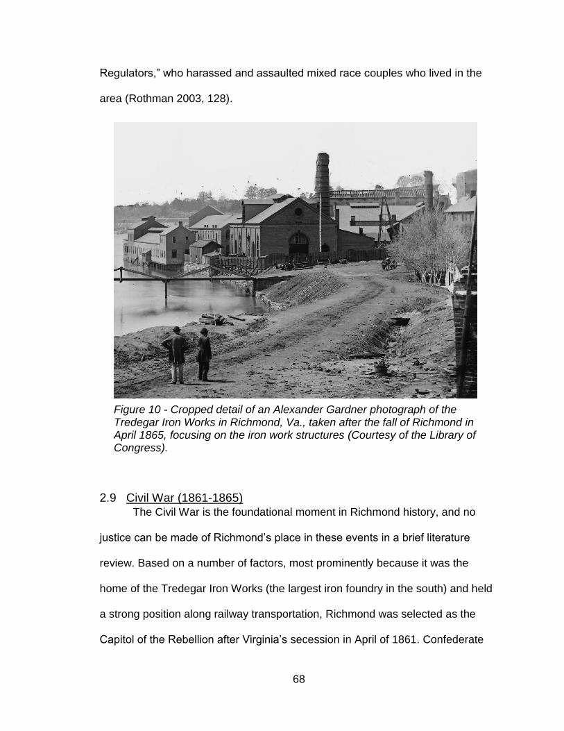
68
Regulators,” who harassed and assaulted mixed race couples who lived in the
area (Rothman 2003, 128).
2.9 Civil War (1861-1865) The Civil War is the foundational moment in Richmond history, and no
justice can be made of Richmond’s place in these events in a brief literature
review. Based on a number of factors, most prominently because it was the
home of the Tredegar Iron Works (the largest iron foundry in the south) and held
a strong position along railway transportation, Richmond was selected as the
Capitol of the Rebellion after Virginia’s secession in April of 1861. Confederate
Figure 10 - Cropped detail of an Alexander Gardner photograph of the Tredegar Iron Works in Richmond, Va., taken after the fall of Richmond in April 1865, focusing on the iron work structures (Courtesy of the Library of Congress).

69
reliance on Tredegar, the only foundry capable of producing sufficient
Confederate munitions (see Figure 10 for an April 1865 view), ensured that
fighting between Washington D.C. and Richmond remained fierce throughout the
war, and the city was only abandoned to Union occupation in the conflict’s very
last months.
Between 1861 and 1865 the city was transformed; the tobacco
warehouses of Shockoe Bottom and Shockoe Slip became used for storage of
Confederate food and equipment supplies. Across the city, homes, warehouses,
factories, and public buildings were transformed into more than twenty hospitals.
Defensive star forts and fortifications were constructed in a circular series of
defenses around the city. The city’s geography made it very complicated to
attack; swampy areas by the river made it hard to approach, and the five rail lines
servicing the area made troop movements unpredictable (W. G. Thomas 2011,
93–96). The city jail and Customs House were soon overflowing with prisoners of
war, leading to the creation of Libby Prison in a former supply and grocery
warehouse for Union officers; an isolated and poorly-sheltered tent prison for
enlisted men on Belle Isle; and another warehouse prison coined Castle Thunder
(Zombeck 2014; Furgurson 1996, 120–58). As the war got underway finding
secure places for all the captured Union men was a struggle, and National Park
Service Interpreter Mike Gorman has identified 25 buildings where prisoners
were incarcerated within the city (Gorman 2017).
During investigations carried out in 1996, Lyle Browning found that along
the northeast edge of Belle Isle the double-ditch enclosure of Belle Isle was still

70
intact when exposed by mechanical test trenches (Browning 1996). These
ditches had apparently still been visible at least ten years after the war in
historical photographs, and happily the ensuing water, steam, and electrical
power production on the island had occurred at points far enough removed from
the prison site that they were still preserved. Based on the information from this
work, Richmond Parks and Recreation restored versions of these prison banks,
which remain visible and somewhat-interpreted today along with a more recent
metal tent-outline providing insights into the size and type of tents the prisoners
may have occupied. Limited archaeological investigations have also been carried
out at the housing for free and enslaved workers at Tredegar Iron Works nearby.
By far, the largest hospital in Richmond (or the Confederacy, or the world)
during the Civil War was located on Chimborazo Plateau, located overlooking the
James River northeast of the city. Land on Chimborazo Hill was initially used by
the Confederate government as a military camp at least by July of 1861, and had
been described as an artillery placement as early as May of that year. By
October, an extensive description in the Richmond Enquirer describes the
hospital’s 109 buildings, which were initially built as a military camp capable of
housing up to 10,000 soldiers. Over the course of the war, Chimborazo had an
impressively low mortality rate (7-10% according to reports) and its impact on the
city was considerable. Despite the efficacy of its medical treatment generally, the
volume of soldiers brought to Chimborazo meant that approximately 6,500-6000
soldiers died there over the course of the war, most of them buried at the
Oakwood Cemetery to the north of the hospital (Green 2004, 81–82).

71
Archaeological investigations at Chimborazo have been large monitoring,
salvage of incidental disruptions by the City of Richmond, and responses to sites
exposed by erosion (Mullin and Rupnik 2004). However, testing performed by
myself and the 2016 Urban Archaeology Corps, a National Park Service youth
program, has shown that intact deposits dating to Reconstruction are present at
the site, and that the area remains archaeologically sensitive (Chapman 2017).
Wartime industry outside Tredegar was also intense. At the furthest
upstream extent of the navigable James, just down the hill from Chimborazo, was
the Confederate Navy Yard. Located both sides of the river even with Lock 1 of
the James River and Kanawha Canal, the Navy Yard was where boats were
constructed and from which the James River Squadron was based. On Brown’s
Island, Richmond working-class women and girls worked to produce cartridges
and munitions for the Army of Northern Virginia, and in 1863 at least forty five of
them died in a calamitous explosion at one of the laboratories (Whittenburg
2012).
Between 1861 and 1863, Richmond’s population doubled, causing
extreme overcrowding and resulting in intermittent conflicts and famines over the
course of the war (McPherson 1988, 617). The most substantial civil unrest of the
war, the Richmond Bread Riots on April 2, 1863, began when a group of
predominantly-white women of various social stations marched in the streets
after receiving inadequate responses from Virginia governor John Fletcher
regarding their concerns over lack of food for the civilian population (Chesson
1984).

72
Richmond’s position in the war was defensible until April 2nd, when Robert
E. Lee’s army at Petersburg suffered a crushing defeat. In response, the
Confederate government under Jefferson Davis made the decision to evacuate
the government along the Richmond and Danville Railroad. At 11pm on April 3rd,
Davis left on the last train to Danville, leaving behind a small skeleton of
Confederate troops under Richard Ewell (Furgurson 1996, 324–29). In the power
vacuum that resulted, desperately hungry Richmond citizens came into the
streets to drink liquor running from casks ordered smashed by City Council;
officials opened commissary warehouses to allow them access to remaining
Confederate provisions. Ewell’s forces ordered controlled burns of railroad
bridges and of storage buildings on Cary Street and Eighth and Byrd Street, to
destroy goods the Confederacy did not want in Union hands (Furgurson 1996,
328). Perhaps escaped from these controlled fires, or from blazes set by looters,
the city caught alight, starting near the river’s edge but eventually extending as
far north as the Capitol. The explosion of the armory, still packed with a good
deal of Confederate munitions, did not help matters.
On April 4th, 1865, the Union Army moved into Richmond to find areas of
the city’s downtown and military installations ablaze. The city then entered a
period of extended occupation by the Union. The specific spatial distribution of
the blaze was captured by a map by Charles Ludwig that was published in the
Richmond Whig a few days after the fire (see Figure 29). The Mayo Bridge, the
Richmond & Petersburg Railroad, and the Richmond & Danville Railroad bridges
were all destroyed in the conflagration, as was most of the industrial riverfront

73
(most of Tredegar Iron Works survived partially due to the efforts of the workers
there). The fire spread in part because of a lack of fire-fighters present in the city
and willing to battle the blaze during the unrest. This fire was a critical factor in
the development of the city’s downtown and modern financial district area, and
(as will be reviewed later) has some significant implications for archaeological
preservation in the city. Over 900 buildings were lost in the fire, including all of
the city’s saloons and banks, two railroad depots, 90% of the business district,
and 40% of the food suppliers (Hoffman 2004, 4). New buildings of cast iron,
concrete, and steel construction rebuilt the city’s skyline to a modern late-
nineteenth century style, and factories and commercial buildings went up swiftly
over the next three decades in those areas (Potterfield 2009).
Figure 11 - "Ruins in Richmond" Damage to Richmond, Virginia from the American Civil War by Andrew Russell (1865). (Courtesy of the Library of Congress)

74
2.10 Reconstruction and Growth (1866-1916) From the departure of the Confederate Army until 1870, the city of
Richmond was held under martial law during Reconstruction. The immediate and
long term need for relief was profound in a city that had been struggling with food
insecurity throughout the war, and the movement of people through the city in the
months and years following the Confederate defeat was massive. Ex-
Confederate prisoners decamped to Chimborazo Hospital to get their ration and
transportation tickets before departing to their hometowns (Duggan 1965, 46).
The Union Army provided food rations to the desperate, but recently freed men
and women of color were required to have work passes and gainful employment,
and freedmen found without were sent to Chimborazo in the early days after the
war’s end. The rubble of the evacuation fire, which had claimed twenty blocks of
prime city real estate including important industrial and financial buildings and

75
considerable state and local records, was almost immediately cleared to allow
rebuilding (Tyler-McGraw 1994, 164–65).
A major logistical challenge in the years after the war was where freed
people lived in Richmond, what they ate, and how they supported themselves. In
the days and weeks after Richmond fell, newly-freed men and women from the
surrounding area flocked to freedman’s camps on Brook Road, at the former
Chimborazo Hospital, and in the city’s West End. By 1866, Chimborazo remained
a common location for some of the many destitute freed men, women, and
families, and military and civil police were tasked with keeping order. Other sites
around the city also became permanent black communities. Zion Town, located
just outside the west city boundary, west of the University of Richmond campus,
Figure 12 - An illustration in Frank Leslie's Illustrated Newspaper shows the freedman's school that operated from a former ward building at Chimborazo Hospital (Courtesy of the Library of Congress)

76
had been a site where freed people gathered in the months and years after the
war and later established a permanent neighborhood (E. Brown and Kimball
1995, 304). But not all stayed – hundreds of thousands of black Virginians left the
Commonwealth between 1865 and 1877, in reaction to the controlling economic
conditions that led to a stevedore’s strike in 1867 and a strike on the Richmond
and Danville Railroad in (Du Bois 2017, 480–81; Rachleff 1989, 42–43). For
those that did, the regulations under Union control were onerous and limited the
reality of black freedom – especially that of black men. While in some cases free
black Richmonders had enjoyed a degree of status in the antebellum era,
Reconstruction laws and bureaucracy limited their ability to start and run
businesses and their free movement, although the initial years of Reconstruction

77
also provided unparalleled opportunity to seek political power (Latimore 2005, 1–
10).
In 1880 a major change to the city was the transition away from the use of
the canal system for navigating freight around the river falls. The purchase of the
canal company by the C&O Railroad resulted in the filling-in of the Turning Basin
of the James River and Kanawha Canal between Canal, Cary, Eight, and
Eleventh Streets, the use of canal towpaths as new railroad beds, and the
gradual abandonment and filling in of sections of the canal (W. E. Trout, Moore,
and Rawls 1995, 44). The arrival of the electric streetcar in Richmond – the
earliest fully electric streetcar in the world – also transformed the region (Figure
13). With this form of reliable public transportation in 1888, an early streetcar
suburbia developed with new neighborhoods like Battery Park, Barton Heights,
Figure 13 - Postcard view of "Theatrical District, Broad Street, Richmond, Virginia" 8th & Broad Streets, Richmond, Virginia, 1923 (Courtesy of VCU Cabell Library)

78
Westhampton, Highland Park, Bellevue, Forest Park, and Ginter Park within easy
commute of the city (Kollatz 2004). Through annexations in 1906, 1914, and
1946, many of these neighborhoods were annexed into the city (Potterfield
2009). Richmond annexed additional land including the separate city of
Manchester south of the river in 1914.
Black Richmonders made early gains in electoral politics immediately after
the war. Lindsay Lewis and Joseph Cox were elected as two of the five
Richmond representatives to the constitutional convention, and advocated for
policies supported by their communities like an end to miscegenation laws,
investment in public schools, and disenfranchisement for Confederate veterans
(Rachleff 1989, 46). Increasingly common too, in the years after Emancipation,
were racially-motivated attacks on the Chimborazo free black community,
religious centers like the Second Baptist Church, and groups planning
Emancipation Day celebrations planned annually around the April 4th
Emancipation anniversary (Rachleff 1989, 40–41). Segregation within the city,
already very spatialized starting in the 1850s, also increased with
Reconstruction. By 1923, the city’s black population was substantially restricted
to the area north of Broad St, including the neighborhoods of Carver and Jackson
Ward (Hoffman 2004, 98–99).
Between 1870 and World War I, there were considerable industrial
changes to the city’s economy. The tobacco industry, which had employed
mostly enslaved men prior to Emancipation, shifted to employing a greater
number of African-American women in the tobacco processing and cigarette

79
rolling factories of the New South (Kerr-Ritchie 1999, 19). Jobs were highly
segregated by race and gender in the city, with white men occupying most of the
salaried jobs (i.e. salesman, agents, bookkeepers, clerks); white women
occupying most of the box making factory jobs and the better-paid cigarette
rolling positions; black men employed considerably as laborers; and black
women employed mostly in laundry, domestic service, and as laborers (Gerteis
2007, 80–81).Richmond also developed an extensive financial services sector
led by firms like Davenport and Company. In 1873, a Richmond Stock Exchange
was formed by some of these financial institutions, which enabled companies
more ready access to investor capital (Davenport and Company 2014, 9–12). In
1913, the Federal Reserve Bank system was established, and after an intense
competition in part won by Richmond’s central importance to many Southern
businessmen, Richmond was chosen as the location of one of the nation’s
Federal Reserve Banks (Gerena 2007, 2–3). This was a major win for Richmond,
and resulted in a effervescence in the money, investment banks, and financial
talent within the city (Tyler-McGraw 1994, 240).
Major themes in Richmond history between 1866 and 1917 were the
rebuilding of the city (considerably funded through Northern investment); the rise
of the modern sanitation; efforts to organize a multiracial working class labor
movement by a national organization called the Knights of Labor; the dedication
of the Lee Monument and the beginnings of the Lost Cause veneration of the
Civil War; the rise of wealthy black neighborhoods and economies like that of
Jackson Ward; and continuing efforts to disenfranchise and marginalize the

80
developing black communities (Tyler-McGraw 1994, 205–17; Kollatz 2008;
Alexander 2002; Hoffman 2004). While early efforts to develop an interracial
labor movement were intentionally disrupted and unions were segregated,
Richmond also saw more interracial labor movement collaboration than any other
city in the nation, particularly by coalitions of the Knights of Labor (Gerteis 2007,
78; Rachleff 1981). While Richmond was prioritizing improvements to sanitation
in the city, like has been identified nationally neighborhoods comprised of black
or poor white residents were deeply neglected by planned improvements. As a
result, endemic typhoid among poor neighborhoods caused Richmond to have
one of the highest mortality rates of any U.S. city (Hoffman 2004, 95–105).
Similarly, unwanted necessary city improvements like a trash incinerator were
planned for neighborhoods like Jackson Ward, and in 1901 Jackson Ward was
divided and split between the remaining five districts, deeply undercutting black
political progress (Randolph 2003, 104–5).
2.11 World War I, World War II, and the New Dominion (1917 to the
present) As a somewhat arbitrary cutoff, and in recognition of the explosion in the
creation of urban maps post-1900, this dissertation focuses on Richmond’s pre-
1900 history. However, there are a few major sites already identified in the VDHR
archaeological database that date to this period, and a few city events/trends
from its twentieth-century history that hold considerable archaeological promise.
This section on post-1916 history focuses on Richmond’s historical trends most

81
important for understanding the condition of the city’s archaeology and how it
intersects with twentieth-century city politics.
Starting in roughly 1916, the Great Migration, the early twentieth-century
relocation of African-Americans from the south to northern cities and to industrial
centers like Appalachian coal fields, considerably shaped the city’s makeup
(Trotter 1991; Wilkerson 2010). Its cumulative population effects are not yet fully
clear in Richmond, although some existing research suggests the proportion of
Richmond’s population that was African-American declined 1910-1945 and
began substantially increasing after World War II (Lombard 2015). While many
Richmond families and individuals did migrate north, so too did rural southern
African-Americans move into the city for jobs as domestics and factory workers
as they did in Norfolk and other major southern cities (E. Lewis 1991). This
population shift, in addition to those caused by the white flight of the 1950s-
1960s and the current in-migration to the city, have contributed to a wide range of
sentiments and associations between how the city’s population, whether white,
black, or another identification, relate to the city’s history and the extent to which
they consider it personal.
Between 1917 to 1970, Richmond annexed 13 parcels of land, an
increase in area of over 47%, to its modern extent of 62.5 square miles (Figure
14). The impulse behind these land annexations was increasingly racialized, the
result of ongoing efforts to increase Richmond’s white voting populations as
white city residents relocated in considerable numbers to county suburbs (Hayter
2014; Moeser and Rutledge 1982). The intent of the last of these annexations, in

82
1970, was so egregious that the annexation was challenged in federal court,
ending in 1975 when the U.S. Supreme Court upheld the land annexation but
mandated that Richmond implement a district election system that immediately
resulted in a majority-black city government (Moeser and Rutledge 1982; Hayter
2014). Virginia’s General Assembly placed a moratorium on Richmond’s
annexation and eventually made permanent changes to state law, heavily limiting
the ability of cities to annex county land without county approval (Silver 1984;
Spicer 1982, 822–25). Richmond and all other Virginia cities became landlocked,
an unusual situation in other states, and this geographic fact has limited the
growth of industry within Virginia cities and exacerbated the city population
collapse of the 1970s and 1980s. This situation with land annexation is relevant
Figure 14 - Map Showing Territorial Growth of Richmond, Department of Public Works, 1923. (Courtesy of the Library of Virginia)

83
to the current study in a few major ways. First, it created a majority black city
government, which set the stage for the last forty years of tumultuous city politics
and adjusted the city’s attitude towards historical resources, especially those
associated with non-white Richmonders, immediately (see Chapter 3.4 for more
detail). Second, the pressure to raise the city’s tax base through attracting
industry, migration of high-income residents into the city, or raising the income of
city residents is directly spoken of when discussing the challenges of city
finances and what should be invested in. Third, the city borrowed heavily in the
waning years of white political control, resulting in a city that has struggled to
adequately fund its public schools, encourage economic development, maintain
city roads and public spaces, rehabilitate its combined sewer overflow (which
continues to flush raw sewage into the James River during heavy rains), and
sufficiently staff city departments. Many of these priorities and needs, as well as
the legacy of mistrust in a municipal government that fought so hard to
disenfranchise black voters, continue to influence the city conversation around
topics of money and where to spend it.
Planning trends such as the development of the interstate highway
system, urban renewal, and economic development efforts also damaged
Richmond’s archaeological record substantially. In the late 1940s to 1960s,
urban renewal was a series of national initiatives aimed at reducing urban blight
in city cores, demolish deteriorated buildings, and encourage a return of (white)
suburban residents to city centers. In many cases, the impacts, and often intent,
of urban renewal was the displacement of urban black communities (M.
84
Anderson 1964; Avila and Rose 2009). As Christopher Silver has observed, after
World War II “unrestrained growth constituted the shared goal of public policy
throughout the urban South, engendered, in large measure, by lingering feelings
of inferiority” (Silver 1983, 33). Bit by bit, projects to build Interstate 95 (1958),
the city Coliseum (1971), and the Convention Center (1986) carved up Jackson
Ward, the upscale black residential and commercial district home to national
black leaders such as Maggie Lena Walker.
The construction of the Richmond-Petersburg Turnpike (later part of I-95)
was planned and implemented between 1946 and 1958, and has been described
by Christopher Silver as an especially contentious political struggle (Silver 1984,
196). The road was constructed through the city’s downtown, including areas of
Carver, Jackson Ward, Shockoe Bottom, and Manchester. I-95 would have led to
the destruction of the 1887 Sixth Mount Zion Baptist Church, but prolonged
protest eventually moved the highway just barely around the building, which was
the home of an African-American congregation dating to 1867 and founded by
the famous enslaved preacher Jasper Johns (Rogers 2011; Potterfield and Ross
1979). Regardless of this small victory, Silver has estimated that 10% of
Richmond’s black community was displaced and moved by the highway
construction. The highway went directly through Wall Street, the historic locus of
the city’s slave trade, and also likely considerably overlaid the Burying Ground for
Negroes that has been the topic of so much recent discussion in the city (see
Chapter 3.6). Similar to the Turnpike, the Richmond Metropolitan Expressway
(State Route 195), a toll road completed in 1976 by the Richmond Metropolitan
85
Authority, also substantially disturbed archaeological resources – in this case,
sensitive resources along the James River, along with sections of Randolph,
Byrd Park, Oregon Hill, and Gambles Hill neighborhoods (Potterfield 2009).
Like over 500 other American cities, Richmond hired comprehensive
planner Harland Bartholomew to design the city’s 1946 Master Plan. This plan
observed that “the Negro population has located in districts which are among the
most accessible in the city to downtown business, which is to be expected since
these districts are old and depreciated and were among the first to be deserted
by the expanding population” (Commission 1946). This plan served as the basis
for racialized urban clearing projects, especially focused on neighborhoods like
Fulton (the new neighborhood name for Rocketts Landing), Randolph, Carver,
and Jackson Ward. As described by Scott Davis, urban renewal in Fulton was
couched as community improvement but pitted homeowners against tenants in
the town and failed to plan adequately for how to retain the community fabric as
residents were relocated (S. C. Davis 1988, 73–75). The land clearing in Fulton
destroyed hundreds of houses in the area and likely significantly disturbed much
of the material record of Rocketts Landing, although a study by Virginia
Commonwealth University in 1992 illustrated that substantial elements of the port
town survived the largescale clearing process (Mouer 1992). The damage to
black community cohesion and historic fabric caused by twentieth-century
histories of planning and construction continues to be a thread in conversations

86
about city development initiatives and the city’s historical legacy, as will be
discussed in Chapter 5.
In terms of the archaeological legacy of the twentieth century, the city’s
known archaeological record contains five sites associated exclusively with the
twentieth century, and an additional 22 sites with twentieth-century components.
These sites include farmsteads, railroads, cemeteries, factories, seats of
government like the State Capitol Building, commercial establishments,
dwellings, Chimborazo hospital, the Virginia State Penitentiary, and riverine
industrial components like dams and canals. A site with considerable local lore
and meaning associated with it is the Church Hill Tunnel, a tunnel for the C&O
Railroad under Church Hill and Chimborazo that was begun in the 1870s (Figure
15). Dug through a blue marl clay that shrank and swelled with changes in
rainfall, the tunnel construction led to the deaths of several workmen during initial
Figure 15 - An image of the flooded eastern entrance to the Church Hill Tunnel (Public domain, by Wikipedia user Jkmscott)

87
construction and was the site of a dramatic collapse when being rehabilitated in
1925, trapping the bodies of several workers inside. The existence of the tunnel
has continued to be a safety hazard, as it travels under the neighborhoods of
Union Hill, Church Hill, and Chimborazo and has caused several collapses there.
Efforts by a public-private partnership to pump out the flooded tunnel for
assessment were abandoned with much acrimony in 2006, when it turned out
that no feasibility studies regarding the safety of this work had been conducted
(Walker 2009). Archaeologically, although the site is highly sensitive for human
remains and local interest, its logistical complications and ethical questions
surrounding the value of excavating mean that it is unlikely to be investigated.
2.12 Struggles to Characterize Richmond’s History
The politics of public memory remains a hotly-contested, perhaps the
hotly-contested, issue in the city. While demands to remove statues have in parts
of the country emerged as a response to the domestic terrorist attack on
Charleston’s Emanuel African Methodist Episcopal Church (and later, after the
one at the 2017 Unite the Right rally in Charlottesville), in Richmond debates
over the extensive materiality of the Lost Cause mythology have been ongoing
since at least the 1970s. Former black Richmond City Councilman Chuck
Richardson recalled that when the city council obtained a black majority, white
political leaders pressed him and other black council members over whether they

88
were going to remove the statues.3 The siting of the Arthur Ashe statue on
Monument Avenue alongside Confederate generals has aroused many strong
opinions, and most recently in 2017 a debate over the scale and location of a
memorial to Maggie Walker drew praise and a variety of objections (N. Oliver
2016). In a February 2017 public forum on race and mythmaking, African-
American University of Richmond professor of modern U.S. history Julian Hayter
commented wryly that “Every time we start talking about the monuments, it’s like
throwing Miracle Gro on the city’s character flaws” (Libby 2017). A few short
months later he was even more embroiled in the topic, having been nominated to
the Richmond Monument Avenue Commission alongside Gregg Kimball from the
Library of Virginia, Christy Coleman from the American Civil War Center,
historian and former President of the University of Richmond Ed Ayers, historian
Lauranett Lee, and several politicians and city officials as the national
conversation around removing Confederate statuary has gained steam (N. Oliver
2017).
The debate over Confederate iconography and memory in Richmond is
large enough for myriad dissertations, academic projects, and books. But even
before the terrorist attack at the Charleston reinvigorated debates over whether
to alter Confederate statues, attitudes towards history and public interpretation in
Richmond have always orbited back to the question of whether the city’s past is
wrapped more in glory or in shame, who to recognize as heroes and who as
villains, and who is empowered to tell history of the city. Recounting and
3 Comments by Chuck Richardson at the Virginia Defenders’ meeting with the Monument Avenue Commission on March 29, 2018.

89
characterizing the city’s history has been recognized as an explicitly political act,
and discomfort with this fact has depressed and warped scholarship on the city
going back more than half a century.
It is perhaps for this reason that there is also a lively series of alt-
academics, journalists, neighborhood historians, and independent scholars who
have developed expertise within some aspect of the city’s history but do not have
the backing of substantial research institutions. These include members of the
Oregon Hill Neighborhood Association, who have a strong history of bringing
historical significance to light, perhaps especially when particularly sensitive sites
and buildings are threatened by expansions by Virginia Commonwealth
University and other entities (Pool 2014). Similarly, Jeffrey Ruggles, formerly of
the Virginia Historical Society, has written several white papers on the origins of
the “Shockoe Bottom” and “Shockoe Slip” neighborhood names, the African
Burial Ground, the Lumpkin’s Jail site, and on the significance of Seaboard’s
Warehouse as a potential archaeological investigation site (Ruggles 2010;
Ruggles 2009). The well-recognized study on urban renewal in Fulton, The World
of Patience Gromes: Making and Unmaking a Black Community, was written by a
man worked at the time in Fulton as a community worker while conscientiously
objecting to the Vietnam War, and wrote the book during his journalism career
(S. C. Davis 1988).
Several works focus on the pattern of underrepresentation of certain
elements of Richmond’s past. Veronica Davis wrote a book summarizing the
historic black cemeteries in Richmond, years before these efforts were

90
undertaken among the academic community (V. Davis 2000). Elvatrice Parker
Belsches, a documentary filmmaker and writer, researched Richmond’s black
history and write the Richmond, Virginia book in the Black America Series in
2002, just as focus on Richmond’s slave trade history was heating up (Belsches
2004). Selden Richardson’s Built By Blacks chronicles the black craftsmen and
architects whose marks are so indelible on the city’s material record, as was
funded by the Alliance to Conserve Old Richmond Neighborhoods (Richardson
2008). Ana Edwards, a social justice organizer and founder of the Virginia
Defenders for Freedom, Justice, and Equality, and has a background in fine arts
and non-profit management, has published several pieces on the importance of
the Shockoe Bottom neighborhood, on the African Burial Ground, and on the
story of Gabriel (Edwards and Wilayto 2015; Edwards 2016). Ben Campbell, a
member of Richmond’s Slave Trail Commission and ecumenical minister, wrote
Richmond’s Unhealed History, which focuses on the darker side of the city’s past
and provides a moral charge for Richmond to fully reckon with this past in order
to improve the city’s spiritual health and racial relations (B. Campbell 2011). Free
Egunfemi, a black historical activist, has dedicated herself over the last several
years to #UntoldRVA, a tactical urbanism project dedicated to creating portals
across the city that provide often black-centered historical interpretations and lift
up stories that are often not widely known in the city (Willis 2017; Richmond Free
Press 2016; National Public Radio 2016).
Similarly, historic preservation topics in the city are covered extensively by
local personalities and experts but are somewhat less likely to be discussed in

91
the academic literature. T. Tyler Potterfield, a longtime Richmond city planner,
wrote a landscape history of the city that defines many ways in which the city has
grown and reshaped itself since the contact period (Potterfield 2009). Journalist,
magazine writer, and actor Harry Kollatz continues to be one of the most frequent
writers on archaeological and historical topics in the city, and has produced
several pieces about previous archaeological discoveries and their post-
excavation lives (Kollatz 2014; Kollatz 2013; Kollatz 2004; Kollatz 2008). Local
architect Gibson Worsham and his son Richard maintain a regular blog, Urban
Scale Richmond, that reviews the history of the city’s development in both
overview and hyper-spatial, hyper-local extents (Worsham and Worsham 2017).
I would take two major points from this trend. The first is that Richmond
history is vital and relevant to local people to such an extent that many of them,
whatever their professional background or careers are, are compelled to bring
stories and analysis to light, often in their own leisure time. The second is that
history is contentious enough here for populations and individuals to get so
frustrated by the exclusion of certain types of history within the halls of academia
that they take matters into their own hands. This second point is supported by the
evident fact that at times when historical interpretations are most successful, it
has often taken the intersession of other significant state actors or independent
financial sources – even in the present or recent past. Christy Coleman, CEO of
the American Civil War Center, recounted the challenges to the commemoration
of the 150th anniversary of the Civil War:
“It was clear from those early meetings that the state wanted a
deeper narrative--so much so, much of its stated goals mirrored
92
the [ACWC]’s mission and approach. But Richmond itself was at
a standstill about the event despite the fact that half of the War’s
major battles and three quarters of its casualties occurred
between Richmond and Washington. Community funders and
corporations were leery about supporting Civil War history
initiatives, labeling them too controversial. It seemed a hopeless
endeavor despite the fact that the city and regional tourism
entities knew there would be a spike in visitation around the
event…A number of cultural and academic leaders came
together—first informally—to discuss how Richmond could seize
the moment” (Coleman 2017, emphasis mine).
Similar pushback has happened repeatedly, notably in the 1990s when
the Museum of the Confederacy produced an exhibit on the lives of the enslaved
(E. D. Campbell, Rice, and Faust 1991). The institutional memory about Civil War
history blacklashes is long, and these incidents frequently come up in
conversations about the type of historical retellings needed in the city and why
history in Richmond is a risky business.
This is not to downplay the important and meaningful works of scholarship
that deal with Richmond subjects. Edward Ayers has woven Richmond history of
the Civil War, Reconstruction, and beyond into his significant studies of
southernness and the southern interpretations of history. Critically he was also a
major architect of The Future of Richmond’s Past program that emerged from the
state push to commemorate the Sesquicentennial as the anniversary of
Emancipation as well as the fall of Richmond (Ayers 1992; Ayers 2003; Ayers
2005; Kunkle 2010). Scott Nelson’s research on convict leasing from the Virginia
Penitentiary, Gregg Kimball’s work on the social history of antebellum Richmond,
and Michael Chesson’s study of Reconstruction in the city are all rigorous
investigations of the city’s difficult nineteenth century history (Chesson 1981;

93
Kimball 2000; Nelson 2006). Recent scholarship has explored Richmond’s
twentieth-century voter suppression (Hayter 2014); the craftsmen and design of
the city Capitol and Penitentiary (Cook 2017); and historical memory and
interpretation in the city (K. Levin 2017). Currently VCU professor Ryan Smith is
writing a book on Richmond’s historic cemeteries (R. Smith 2018); and Kristen
Green is studying the story of Mary Lumpkin (Virginia Humanities 2018).
Scholars like Phillip Schwartz (Gabriel’s Rebellion), Scott Davis (urban renewal)
and John Moeser and Christopher Silver (twentieth-century annexation and
planning) have been publishing on uncomfortable aspects of the city’s racial
history since the 1980s, but it has largely been in the last ten years that these
sorts of analyses have been taken as useful critiques rather than embarrassing
attacks. Richmond’s historical scholarship continues to unfold and appears to be
in a fruitful period, but the discomfort, lack of consensus, and alienation visible in
most public meetings about historical topics in the city also has interesting ripples
in the patterns of academic and popular scholarship on the city. Additionally, this
feeling of historical importance but historical disjuncture has contributed to a
narrative, discussed in Chapter 5, that Richmond’s history has been so hidden
that archaeological investigations are essential to uncover it.

94
3 Richmond’s Archaeology: A Partial History
As discussed in Chapter 1, urban archaeological spaces are often in the
situation where their disturbance is assumed and their potential needs to be
proved over and over again. Even, or possibly especially, when speaking to
professionals at the start of this project, I often heard sentiments like “It’s too bad
no archaeological work has been done in Richmond,” or “the 1970s, that’s when
we really needed to get something going, but now there’s nothing left” or, “yeah,
they did a dig, but they didn’t really find anything.” It became clear early on during
my research that there were exciting projects that had the potential to rewrite the
history of Richmond or add context that historical documents alone would
struggle to do. At the same time, many of these potentially significant discoveries
were unpublished, incomplete, or under-recognized. While the research held in
cultural resource management gray literature is often pointed to as understudied
and siloed in SHPOs across the country, several major projects in Richmond had
not even made it that far.
The processes that determine the archaeological fate of cities are in turn
national and local, individual and shared, unanticipated and predictable. In the
histories of most successful municipal archaeology programs it is clear that most
such programs live or die on the efforts of just a dedicated few, and even then,
success requires a few lucky breaks. The story of shuttered urban archaeology
programs like Baltimore demonstrates the fragility of these endeavors, which

95
have very different histories and structures depending on the context in which
they developed (Appler 2013b).
This chapter traces the development and progress of the archaeological
study of Richmond and provides insights into archaeological projects whose
potential to inform about the city has been strangled by the unfinished, and
sometimes suppressed, nature of the work. It investigates how and why these
ideas about the irrelevance of Richmond’s archaeological record remain despite
a clear history of meaningful and surprising insights provided by archaeological
study. Finally, it investigates how legal requirements for archaeological research,
such as Section 106 of the National Historic Preservation Act, Virginia state laws
on human remains and archaeology on state land, and other regulatory
frameworks, have alternately succeeded and failed at requiring consideration for
archaeological sensitivity in balance with other priorities.
3.1 Archival Methods and Approaches
This project conducted a review of previously recorded sites, survey data,
newspaper and magazine articles, cultural resource management reports, oral
histories, informal conversations by phone and email, and academic literature in
order to develop an understanding of the forces and trends that have influenced
the city’s archaeological resources. Archaeological sites and collections relating
to Richmond were identified through databases, archives, site and survey
reports, field notes, and interviews. This information was compiled into spatial
data using ArcGIS in order to identify landscape and spatial patterns, perform

96
analysis of the impacts of municipal development and preservation trends on site
identification, and to develop archaeological sensitivity maps created using a
predictive model for the area. This analysis compared site identification,
excavation type, date, and other attributes in different neighborhoods and regions
within the city. Spatial organization of this information allowed archaeological site
identification to be compared with other city, state, and federal processes, such
as the Planning Department’s Old and Historic Districts zoning, historic districts
on the National Register of Historic Places, and oversight by federal agencies
(for federal land and floodplains, for example).
Materials for this project are curated at a variety of facilities around
Richmond and the state. The majority of previously-recorded sites have some
documentation available at the Virginia Department of Historic Resources, which
serves as the state’s SHPO and is responsible for maintaining a substantial
volume of archaeological collections and documentation. V-CRIS is the
organization’s spatial database of architectural and archaeological resources
across the state, and the DHR also has native ArcGIS data for sites and
architectural elements in the area.
Table 1 - Archives Consulted
Archive Name Materials Consulted
Virginia Department of Historic Resources
V-CRIS site database; GIS materials and datasets; digitized and undigitized site photos; digitized and undigitized project reports; field notes; project files; memos; inventories and collections associated with Floodwall, Virginia State Penitentiary; and various other sites; electronic communications; website materials
National Park Service Memos and notes associated with Chimborazo Park and Maggie Walker Historic Site

97
Data collection for this project began by assembling all site records,
survey reports, and reports of archaeological investigations submitted to DHR for
all Richmond sites; many reports were digitally scanned because they had been
previously accessible only as paper copies. Other sources of information,
including federal and state agencies, cultural resource management companies,
museums and libraries, and volunteer and non-profit organizations were
consulted and are provided in the table above. Using online databases, card
Virginia Historical Society
Maps
Library of Congress Digital images and illustrations
Library of Virginia Maps; materials in general collection
The Valentine Reviewed Archaeology folder in archive
The American Civil War Museum at Historic Tredegar
Notes associated with Raber excavation
Virginia Commonwealth University Cabell Library
Maps; digital collections of maps and illustrations; Special Collections materials associated with ACORN and the Slave Trail Commission
Virginia Commonwealth University Storage Facility
Examined artifacts and paperwork from VCU-Archaeological Research Center
Archaeological Society of Virginia
Reviewed all ASV Quarterly Bulletin; reviewed Society archive at Kittiewan Plantation
Council for Virginia Archaeologists
Reviewed old organizational notes and memos in the Ted Reinhardt collection at William & Mary Special Collections
Virginia Canals and Navigation Society
Reviewed archive in Madison Heights, VA; published atlases and materials
Historic Richmond Foundation
Reviewed archive at office; publications on Canalwalk financial and architectural planning
Richmond Times-Dispatch
Archive of news stories and images
Richmond Free Press Archive of news stories and images
Style Weekly Archive of news stories and images
Virginia Defender Archive of news stories and images

98
catalogues, secondary source citations, and assistance from archivists and
curators, I have examined these collections for old accounts of archaeological
discoveries, city and regional maps, papers, maps, and archaeological
collections relevant to the history and archaeology of the city.
Federal and state agencies have also frequently overseen archaeological
projects in Virginia and have been searched for records and communications
about planned construction projects, reports on critical collections. I have had
many conversations with VDHR staff over the last several years about individual
sites and projects of note and have reviewed their archive of field notes,
database of archaeological collections, and recorded weekly reports of the
Regional Archaeologist in charge of the Richmond region for the state.
Additionally, collections of regional volunteer and professional organizations are
available through the Library of Virginia and Kittiewan Plantation, and have been
assessed for documents associated with survey and data recovery projects
under the auspices of the Archeological Society of Virginia and the Virginia
Canals and Navigation Society, in order to better understand the impact of their
archaeological preservation advocacy. The available archive of the Quarterly
Bulletin of the Archeological Society of Virginia and the newsletter of the Council
of Virginia Archaeologists were very useful for gaining details not recorded in
published reports and in developing an understanding for broad patterns in
Richmond’s archaeological investigation.
As per Hill (1993, 58–63) I have analyzed qualitative archival information
by dividing it into three general categories of information: a) spatiotemporal

99
chronologies (timelines and maps displaying what was excavated, where, by
whom, and for what client); b) networks and cohorts (understanding the
structures and groups performing archaeology over time in the city); and c)
backstage perspectives and processes (critically examining the archives for
information that might be excluded or written with a particular slant – particularly
useful for assessing documents related to federal projects eligible for Section 106
in which it may not have been implemented, for example).
3.2 Early Archaeological Exploration in Richmond (circa 1876 to 1963)
As with many archaeological histories, the history of archaeology in
Richmond begins in the late nineteenth-century antiquarian tradition. The
Valentine family, beginning with Mann Satterwhite Valentine, had amassed
considerable wealth through the success of a restorative health tonic (Valentine’s
Meat Juice), and Mann Satterwhite Valentine instigated a generational interest in
collecting ancient objects. The family did not perform archaeological
investigations in Richmond, but they were very interested in prehistoric mound-
building cultures and paid a collector, A.J. Osborne, to obtain a number of
skeletons, funerary objects, and statuary from southern Virginia and North
Carolina (“Mann Satterwhite Valentine,” n.d.). Based on NAGPRA records of the
human remains inventory, these remains were mostly Cherokee in cultural
affiliation and were associated with the Pisgah or Qualla phases, if their
provenience was established (Davis 1998).

100
However, the archaeological interests of the Valentine family soured
around 1885, when it transpired that a substantial number of figurines they had
collected were hoaxes perpetrated by the Appalachian farmers in the Mount
Pisgah region (Daura and Perkinson 1950). Beginning in 1898, much of their
archaeological collection – minus the fakes – was available to Richmond
residents able to visit the Valentine Museum4. In the 1930s, under financial
pressure, the Valentine transferred much of its collections relating to the history
of the state to the Virginia Historical Society and became refocused on the
history of Richmond itself. While the Valentine continues to own archaeological
collections, they have been the focus of relatively little research or interpretation,
and most of them are antiquarian collections from outside the city.
At roughly the same time the Valentines were beginning their collection,
the circa-1619 Falling Creek Ironworks south of the James became subject to its
first antiquarian investigations in 1876. Interested in the site’s history as one of
the oldest colonial ironworks, R.A. Brock investigated the creek where the site
was believed to have been and identified pieces of furnace cinder and a mining
site known as Iron Bottom (R. Brock 1885). Almost fifty years later, in 1925, the
site was investigated again by then landowner Roger C. Bensley. He identified
considerable evidence for the site including the furnace’s original foundations
and walls, a charcoal pit, undisturbed sediment deposits, and pieces of furnace
slag (Linebaugh and Blanton 1995; T. G. Gregory 1957, 20–21). Just outside the
4 The organization has gone through several name changes, from the Valentine Museum, to the Valentine Richmond History Center, to simply “the Valentine,” largely as a result of Director Bill Martin’s desire to move the entity’s image and approach away from that of a museum institution.

101
city’s modern boundary in Chesterfield County, this site would eventually become
an undeveloped park owned by the county and has had myriad investigations
and interpretive recommendations made for it over the years5.
During the 1930s, many archaeological projects across the nation were
coordinated through the labor projects of the New Deal, most prominently the
Works Progress Administration, but also through the Civil Works Administration,
the National Parks Service, and many other groups (Lyon 1996). One prominent
figure involved with this process in Richmond was J.C. “Pinky” Harrington, whose
colonial pipe chronology remains essential for site dating (Harrington 1951;
McMillan 2010). In a rare investigation of a historical archaeological site by New
Deal archaeologists, relief workers from the CCC were supervised by Harrington
in early investigations at Jamestown. As an archaeologist for the National Parks
Service, Harrington lived and worked in Richmond for many years, but does not
seem to have taken a particular interest in city resources or projects (G. Miller
1998).
Also during this period, the Archeological Society of Virginia (ASV) was
founded in 1940 and in 1942 began publishing their Quarterly Bulletin, a journal
describing archaeological research being carried out across the state. From 1942
to 1963, research in the Quarterly Bulletin (QB) is one of the only most
accessible sources on what types of events and research was happening in
5 Due in part to the site’s early antiquarian investigations, salvage by amateur archaeologists, early historical scholarship, and the multiple periods of metalworking at the site there is considerable debate over whether the site is best described as a furnace, foundry, or forge. Lyle Browning has argued that the site active until the massacre in 1622 was a furnace, and that it was later superceded by a forge run by Archibald Cary 1750-1781.

102
Virginia archaeology, since the state database of recorded sites was not created
until the 1960s. The early decades of research published in the QB reflects the
organization’s focus on collecting prehistoric artifacts. Virginia Indians were in the
1940s in an active battle against their demographic elimination through the 1924
Racial Purity Act, but early articles in the QB were full of nostalgia for Indian
topics and frequently implied that Indians (or at least “real Indian culture”) had
long since vanished from the state (J. D. Smith 2002). The first volume of the QB
shows a combination of mysticism and paternalism present within the interest
ASV members took in their study of native remains:
“In subsequent bulletins we hope to disclose something of the
arrival of the Indian people in this section; we hope to rediscover
much of their racial, tribal and communal customs and ways of
life -- important facts regarding a native culture, long undisturbed
by invading elements, but now dead. Perhaps it was a
melancholy necessity that this culture should die. It could not
survive in conflict with the relentless tide of colonization and
agricultural and industrial development that swept across the
continent. Those who helped to destroy it, despised it because
they did not take the time to understand it. They had mighty
tasks to perform; they were building a new nation. But now in
retrospect that culture assumes a different shape -- a form of
great historical significance. Old hatreds are buried and the
fragments and relics and the dim echoes of American aboriginal
life clothe the Indian again in the vestments of his ancient
dignity” (J. T. Robertson 1942, 1)
A review of articles in the QB shows that archaeological study in Virginia
mirrors that of many other areas of the country. Archaeology was predominantly
restricted to prehistory; historical archaeology at the time was in a nascent stage,
and although early investigations by Jimmy Knight and Ivor Noel Hume at
Colonial Williamsburg (E. Williams 2000; Hume 1964; Greenspan 1992; Samford

103
1999) were a mere 50 miles away, historical archaeology at the time was
generally limited to reconstruction and study projects on sites with a central role
in the founding of the United States (J. L. Cotter, Roberts, and Parrington 1992;
Fowler, Wilcox, and S 2003; Tomlan 1998). Meetings of the society frequently
met in Richmond to present research and show artifacts around, and the
organization was generally Richmond-focused to the extent that membership in
1947 was more expensive for those in the city and therefore presumably able to
be more active.
Although archaeological work in the city was limited, there are some
references in these early years of discoveries that illustrate Richmond’s native
archaeological potential and a fairly active process of archaeological surveying in
the region. David I. Bushnell, a researcher from the Smithsonian Bureau of
American Ethnology, surveyed an area from the falls at Richmond to Wingina in
Nelson County but these results are not present in the Quarterly Bulletin and it’s
possible he may not have submitted the site survey sheets (Manson 1947)6. A
site survey for the state in 1941 reported in the same volume identified one site in
the Richmond Quadrangle area, although what this site is was not reported (F.
Miller 1947). That same year, J.H. Denniston reported finding an “Algonkian type
pot just outside the city limits” along the C&O tracks northeast of Richmond “just
south of where Laburnum Avenue would, if extended eastward, cross the
railroad” (Denniston 1947). Found after a ground fire, many of the component
6 It’s possible some materials in the Bushnell collection of the Harvard University Peabody Museum may provide a synthesis of his research into native site distribution along the James River (Bushnell, n.d.).

104
pottery sherds were oddly found on the surface of the area. Otherwise, during the
1940s-1963 the majority of ASV articles were about sites in other regions of the
state, or early chronologies of lithic artifacts with no items recorded as being from
the Richmond area (though some of them may have been, as some collectors
did not specifically geographically identify their material). Research done nearest
to the city seems to be at the Powhatan site of Kiskiak in 1958 by Ben McCary
and Cotter’s work on Jamestown for the National Park Service (J. Cotter 1955).
One article by Randolph Owen advocates combing over construction sites in
order to hopefully find prehistoric remains in backdirt piles, and claimed to have
discovered 47 native sites in this manner -- eight by walking the construction of
the Richmond-Petersburg Turnpike in Richmond (Owen 1960). No
archaeological sites were registered with the state prior to 1963, and sites
discovered in this way often do not appear to have been added to later records,
so their exact locations are unknown.
Despite the organization’s emphasis on the seemingly-lost Virginia native,
there were also occasional studies of contemporary Virginia tribes, especially the
Pamunkey and Mattaponi tribes whose reservations are located only a few miles
east of Richmond. There are also a few examples of the more pseudoscience,
mystical analyses about mysterious mound-builders, or odd faces carved into
stones. The oddest Richmond example recounts a dried skin of allegedly-Indian
hieroglyphics recounting the first encounters between European settlers and
natives in the Tidewater/Richmond vicinity (F. H. Stewart 1949). By and large,
the 1940s to 1960s in archaeology of Central Virginia were a time of limited

105
investigation in the Richmond area, but the themes of antiquarian collectors,
construction salvage, and the emphasis on native artifacts are common for this
period nationwide.
3.3 The Rise of Cultural Resource Management (1963-1977)
A sea change came to archaeology in Virginia, and American archaeology
generally, during the 1960s with the rise of state and federal regulations
supportive of archaeological conservation. Cantwell and Wall (2003) have argued
that this emphasis on conserving the nation’s past emerged during the 1960s
because broader cultural anxieties and foments resulted in a reassessment and
longing for more material connection to the nation’s past. Inspired by the activism
of many Virginia preservationists, including Lady Bird Johnson, the National
Historic Preservation Act was passed in 1966 and required that federal agencies
take into account the impact of their projects on historic properties. Originally this
protection only applied to properties that were already on the National Register of
Historic Places, but regardless this legislation created a federal mandate for
archaeological mitigation of many projects.
Virginia was in many ways at the vanguard of American preservation
during the late nineteenth and early twentieth centuries, and growing state
interest in preserving sites was not, as it was in other states, purely reactionary to
the National Historic Preservation Act. In 1965 before the Act was passed, the
Virginia Advisory Legislative Council convened a study commission to decide
what role government should play in safeguarding historically-sensitive sites (J.

106
Mark Wittkofski 1988). There was also a growing understanding of the threat
posed by indiscriminate metal detectorists; an article in the Fredericksburg
Lance-Star in 1969 quoted Chief Ranger Don Jackson as saying “Our philosophy
is these relics underground are a historic resource and to be properly used have
to be dug archaeologically so as to tell the story they are capable of telling”
(Mason 1969).
Virginia was similarly atypical in that it had a State Archaeologist position
prior to the creation of the state historic preservation office system. In 1963
Howard MacCord, a retired U.S. Army Corps Colonel with a passion for
archaeology, convinced the State Library to create a State Archaeologist position
and to hire him for the position (Blake 2009). MacCord started a variety of
statewide surveys to identify archaeological sites in need of preservation, and
eventually also implemented the Smithsonian trinomial system of archaeological
site numbering and inventorying. Further federal changes came in 1966 with the
passage of the National Historic Preservation Act, which required federal
agencies to consider how their projects threated historical and cultural resources
and led to the creation of the first statewide registers of historic sites (T. F. King
2008). Over the next several decades, administration of the state’s historic sites
shifted multiple times and archaeological site management developed. The
Virginia Historic Landmarks Commission, later the Virginia Historic Landmarks
Board and subsequently folded in to the independent Virginia Department of
Historic Resources, was formed and began recording sites on the Virginia
Landmarks Register (J. Mark Wittkofski 1988). In the late 1970s, federal funding

107
provided to the VHLC allowed Virginia archaeologists to establish regional
preservation offices, one of which was started in Richmond by L. Daniel Mouer
and became the Virginia Commonwealth University Archaeological Research
Center7. This began the process of more systematic surveying and recording for
the state, although the eligibility requirements for archaeological sites show clear
limitations to the types of sites that were considered worth preserving: guidance
provided by the VHLC stated that “In order for a site to qualify as an
archaeological site, it shall be an area from which it is reasonable to expect that
artifacts, materials, and other specimens may be found which give insight to an
understanding of aboriginal man or Colonial and early historic and architecture of
the State or nation,” emphasizing the prehistoric and colonial Virginia value of
archaeology statewide. During the first two decades of the Register, while some
sites that were added to the Virginia Landmarks Register are now understood to
have archaeological significance (and were likely then as well), none of the
Richmond sites on the state register were nominated with their archaeological
significance as a supporting element of their nomination (Loth 1986, 359–94).
An examination of Richmond site records in this database shows that
relatively few sites, 10 out of the current total of the 159 located within the
Richmond city limits, were identified during the 1960s, and only four
archaeological reports submitted to VDHR were written in the 1960s and 1970s.
The vast majority of the sites that were identified were identified by Howard
MacCord, along with members of the Archeological Society of Virginia with which
77 Personal communication, L. Daniel Mouer, 11-19-2017.

108
he worked closely. Site identification projects progressed in short order to
excavations. Excavations at the early colonial forge site of Falling Creek
Ironworks, located along the modern border between Richmond and Chesterfield
County, continued in this period (Browning 2007).
Under MacCord’s leadership, the ASV predominantly came together as a
group in response to mailed letters of invitation to contribute to specific projects,
and excavated large sites in great part directed by MacCord’s personal interests.
Additionally, starting in around 1973, Bill Trout’s interest in the historic remnants
of historic Virginia waterways and industrial sites first started appearing in the
ASV Quarterly Bulletin, in which he specifically references an interest in the
Richmond Tidewater lock and Tuckahoe river drainage (W. E. I. Trout 1979).
Other preservation organizations within Richmond also took initial steps
towards contributing to archaeological investigation of the city. The Valentine
Museum, now no longer focused as closely on archaeology but with an intense
interest in the history of the city, occasionally contributed to archaeological
research or influenced investigations. In 1974, Alain Outlaw performed a test
excavation on the site of the Richmond Glass Manufacturing Company
(44HE0236), “following the extensive historical research by James E. Gergat of
the Valentine Museum” (Virginia Historic Landmarks Commission 1983).
Preservation organizations such as the Valentine Museum and the Association
for the Preservation of Virginia Antiquities became further involved with
archaeological investigations in the city during the 1980s and 1990s, but various
factors led to neither organization taking on archaeology as a core component of

109
their education and research. In the mid-1970s, lecturers at Virginia
Commonwealth University are referenced as taking students on archaeological
investigations, including Merle Kerby and Errett Callahan, an experimental
archaeologist and lithic specialist who did extensive research into projectile point
use and created many of the lithic replicas at the Pamunkey Indian Museum and
Cultural Center (Kerby 1974; Callahan 1976).
As a result of the professionalization of archaeology in the wake of the
NHPA and increasing collegial relationships due to the regional preservation
office network, the Council of Virginia Archaeologists was formed in 1975 to
foster awareness of Virginia archaeology, publish information on archaeological
resources, facilitate interaction between professional and avocational
archaeologists, and independently advise the Virginia Historic Landmarks
Commission and the Virginia Research Center for Archaeology (later the Virginia
Department of Historic Resources) (Council of Virginia Archaeologists 2017).
While at times the emerging industry was accompanied by increasing
professionalization and a discomfort between avocationalists and commercial
archaeologists, COVA was also instrumental in the establishment of the ASV
Certificate Program for training avocational archaeologists. After 1981, when a
budgetary error eliminated funding for the regional preservation offices across
the state, COVA also became particularly active politically in relation to
archaeological stewardship8. Unlike the ASV, membership in COVA required
demonstrated expertise in archaeological research through education and
8 Personal communication, L. Daniel Mouer, November 19, 2017, also visible through a review of COVA newsletters.

110
publishing. Starting briefly in the 1970s and later in 1985, COVA published a
regular newsletter where archaeological programs provided updates on their
research and the organization discussed political and topical developments
associated with archaeology in the state.
3.3.1 The Impact of Howard MacCord
“I am now working for the Virginia State Library as an
archeologist, and my first concern is to salvage the sites which
are threatened with destruction by construction of highways and
dams. My work will be to find the sites, sample them, and if they
are important, to arrange for more complete excavations, I will
from time to time call on members in an area to assist me in all
phases of this work. I am confident that I can count on your
whole-hearted support, and I know that together, we can
contribute much to deciphering some of the riddles in Virginia
archeology. In the meantime, I wish you Good Hunting and much
success” (MacCord 1963).
Howard MacCord casts a long shadow over the archaeology of Virginia
from the 1960s to his death in 2009. He was also unparalleled, at least in the
Central Virginia area, for his political involvement and advocacy for archaeology.
For several generations of Virginia archaeologists, Howard MacCord was often
their first supervisor in archaeological research through the salvage projects he
conducted all over the state. MacCord is not an uncontroversial figure – he is
often described as having a narrow sense of what sorts of sites were
archaeologically significant; of destroying sites through over-active data recovery
and limited field recording; and of having limited field skills. However, through
charisma and drive he was able to coordinate projects between politicians in the
General Assembly, academic archaeologists, and the avocational community. He

111
also had a pragmatic approach to archaeological investigation and a clear vision
regarding the challenges facing archaeological resources in Virginia, including
urban ones.
When he became State Archaeologist in 1963, MacCord began surveying
areas he considered to be particularly sensitive across the state. One of the
areas where he surveyed was Belle Isle, which according to him "failed to reveal
any indications of significant [prehistoric] occupation" (Browning 1983). However,
these surveying expeditions were often not written up, and subsequent
archaeologists have often found sites in areas he listed with negative results.
MacCord also participated in an early example of public archaeology in
the city. In 1973, Howard MacCord led salvage excavations at the Deshazo site
in King George County, and enlisted the assistance of 35 students from the
Richmond Math and Science Center and some scouts from Fredericksburg. The
use of these volunteers allowed the site, a considerable Archaic and Woodland
settlement, to be partially recorded while providing Richmond-area students with
an exposure to archaeological excavation they wouldn’t otherwise have received
(MacCord 1997).
MacCord recognized early on the impact urban shifts were starting to have
on archaeological resources in urban contexts and the inability of existing
preservation organizations to speak to archaeological risk and significance. In a
1976 Quarterly Bulletin article, MacCord wrote,
“In recent years major efforts have been directed toward
rejuvenating the older, run-down parts of some of our larger
cities. Since these areas are usually the originally settled part of

112
the cities, they almost always contain standing structures of
historic or architectural importance, or they contain buried sites
of still earlier buildings and activity areas. In many cases, the
waterfront areas of a city also yield evidence of prehistoric Indian
habitations. Such urban renewal work has been done extensively
in Norfolk, Hampton, Richmond, Alexandria, Staunton, and
Roanoke. In Hampton, a last-minute effort was made, using
Federal funds, to rescue some archeological data (sort of as an
afterthought) in part of the area affected. This was a small step in
the right direction. The city of Alexandria for several years
employed a part-time archeologist, who recovered much
important data. That city is currently seeking to hire a fulltime
historic archeologist, and this step is highly commendable. The
other cities mentioned, however, have made no effort to study or
evaluate the historic and archeological evidence that they were
destroying. Similarly, other cities and towns along our waterways
have ignored the historic potential of their older areas for many
years. Recently there has been a movement, largely sparked by
concerned individuals, to preserve and study historic sites and
districts in Petersburg, Tappahannock, Fredericksburg,
Dumfries, Occoquan, Falls Church, Leesburg, Winchester,
Lexington, Lynchburg, and Abington. Much more needs to be
done, though, in these communities, as well as in others. This is
not meant to criticize such groups as Historic Richmond
Foundation, the Association for the Preservation of Petersburg
Antiquities, Historic Fredericksburg, Inc., and others. They are
trying hard to do what needs to be done, but they all deserve
greater governmental, as well as private, support” (emphasis
mine) (MacCord 1976, 96–98).
In the same issue, MacCord used the tenth anniversary of the passage of
the National Historic Preservation Act to envision a model for Virginia’s
archaeological study moving forward, including important research topics, survey
areas, and public archaeology projects. Many of his recommendations –
increasing awareness and recording of sites; monitoring construction; improving
archaeological education of K-12 students; creating space in a state museum for
archaeological exhibits; outreach about the importance of archaeological
resources to state political legislators – are similar to those that would be

113
recommended today to promote archaeological stewardship (see Chapter 0).
However, regardless of MacCord’s ability to speak to legislators and coordinate
salvage excavations with members of the ASV, he does not appear to have
implemented solutions to many of the problems he identified in urban
archaeology in the commonwealth. With regards to Richmond, MacCord’s
greatest significance was in the excavations of Falling Creek just outside the city
limits south of the river, and in the impact he had on archaeology statewide.
3.3.2 Warwick excavation and early public archaeology outreach
The late 1960s also provided an example of early work involving
Richmond’s youth in excavating archaeological sites and contributing to
archaeological understanding. In the summer of 1968, Edward (“Ned”) Heite with
the Virginia Landmarks Commission conducted an archaeological investigation in
Warwick town (44CF0008), a 1746 town ferry town in Chesterfield County where
the Deepwater Terminal was about to be constructed (Woodson 1968). Funded
by the APVA and assisted by the City, this salvage project used young, likely
predominantly black men from the Neighborhood Youth Corps (a federal urban
jobs creation program) for additional assistance needed at the site.
Excavations at Warwick revealed at least three colonial house foundations,
and found artifacts like colonial earthenware, glass, iron, pipe stems, bricks, and
English flint nodules. Heite characterized the site as the best-documented
Virginia military institutions during the Revolutionary War, including references to
the decisions made to liquidate public property of the town after it was burned by

114
the British in 1781 (Heite 1970, 2). The completed report he wrote on the town
appears to have been a historical analysis prior to completion of the fieldwork, as
it does not summarize field results. Artifacts from the project, however, are
curated at VDHR and some have been subject to conservation.
The contributions of the Neighborhood Jobs Corps are interesting
because of the example they provide of early archaeological education to young
urban men, and a different mechanism to archaeological fieldwork than ASV
participation. However, records at VDHR suggests that Heite generally had a
distrustful opinion of the youth corps, with Heite commenting on May 17, 1968 in
a letter to the city department overseeing the program that, “Since the plan calls
for using youngsters from your summer program, I want a forceful adult male
supervisor on the scene at all times” (Heite 1968a). Subsequent correspondence
in July indicates that the program met with qualified success, as Heite reports in
another letter that, “The Neighborhood Youth Corps boys have done nicely.
About half of them are motivated, and about half of them proved to be
troublemakers. Mr. Childrey has been weeding them out…Delays have been
caused by discipline problems, our failure to procure the additional supervisor,
and the sheer mass of material recovered” (Heite 1968b).
In the wake of the Warwick excavation, there were calls by Heite and the
Association to Preserve Virginia Antiquities to consider developing the area as a
historical park. The City Manager Alan Kiepper, however, was firm in his
response: “It is my understanding that Warwick Town is simply one of my small
communities that grew up along the James and that it has no particular historical

115
significance. We may place an appropriate landmark there, if desired, but it is our
intention to offer property in that vicinity to industry” (Woodson 1968). Instead,
the land was offered to the Old Dominion Iron and Steel Company, which had
been moved from Belle Isle to create another historical city park.
This disinterest is an example of a theme that reoccurs several times in
the Richmond context – first, the idea (more common in the earlier periods) that
sites should be associated with a ‘particular historical significance,’ perhaps the
Civil or Revolutionary Wars, or a president or other notable. Understanding of
early non-Richmond occupations of this landscape is actually very limited – a
more modern and expanded excavation on some of the site such as Falling
Creek Ironworks, Warwick, or a search for Fort Charles would actually
significantly develop understanding of the area’s colonial landscape. However, in
the contemporary assessment of historical worth, a small trading outpost that had
merely been torched during the Revolutionary War was not worth adjusting the
industrial plans for the site. This episode is also a good example of the city of
Richmond prioritizing industrial uses on city-owned property. However, it also
indicates the important role of archaeological and historical advocates in
requesting and pressing for urban spaces that reflected the historical significance
of archaeological discoveries in the city, and that an emphasis on business and
industry did not wholesale raze Richmond’s archaeological landscape from
visibility. An optimistic view of the Neighborhood Youth Corps would be that it
was an early example of community engagement on an archaeological project;
more cynically, the program also provided an excellent source of free manual

116
labor. It’s also a small window into the racial and class issues that existed in
archaeology as everywhere else in the 1960s, and likely contributed to the
exclusion of some groups from entering the field.
3.4 Archaeology and Business in the New Richmond (1977-1989)
During the 1970s and 1980s, archaeological investigations in Richmond
continued to be influenced by federal decisions related to the National Historic
Preservation Act (NHPA). During the 1960s and early 1970s, the onus was on
the community to identify if federal projects might impact a site on the National
Register – and communities were responsible for adding sites to the Register if
they were not already listed. However, a 1976 amendment to Section 106 of the
Act required agencies to assess the eligibility of sites threated by their projects
for the Act and to consider their effects even when sites were not yet listed on the
National Register. This new requirement placed greater responsibilities on
federal agencies to survey, inventory, and assess the National Register eligibility
of any site potentially affected by one of their undertakings, and it resulted in
considerable increases to the total number of archaeological survey projects
performed under this legislation. Between 1971 and 1991, the new industry of
cultural resource management grew nationally at rates averaging 18-20%
annually as federal projects required environmental impact assessment before
construction (Dore 2018). Initially, many of the companies producing this type of
archaeological work were created by academic archaeologists or were
associated with university academic departments, which can be seen in the

117
Richmond area in the success of the Virginia Commonwealth University’s
Archaeological Research Center and the William & Mary Center for
Archaeological Research. Of the 15 sites identified during the 1970s, most were
identified by cultural resource management archaeologists, especially
archaeologists at the Virginia Commonwealth University Archaeological
Research Center. The number of archaeological sites identified between 1980
and 1989, 81 sites, was twice as much as for any other decade of the site
register. While CRM projects accounted for a considerable amount of this
increase, avocational and volunteering archaeologists were responsible for even
more of these sites being recorded. River surveys by the Archeological Society of
Virginia and the American Canals Society, which were predominantly on
waterways and industrial sites, accounted for a large number of these site
records being produced. Lyle Browning – who was the VDOT archaeologist
1980-1988, coordinated survey and investigations in associated with the ASV
and Virginia Canals and Navigation Society, and also had a commercial firm
Browning & Associates (1980-present) – was a significant contributor to site
recording as well9. The significant number of sites recorded by avocational
groups may partially account for the small number of archaeological reports
relative to sites identified, with only 19 reports submitted between 1980 and
1989, predominantly towards the later part of the decade.
While archaeology was transitioning towards a more structured practice
with a limited federal mandate and supported by federal and state funding, in
9 Personal communication, Lyle Browning, 11-19-2017.

118
Richmond there were significant limitations in how much protection
archaeological sites received even on projects that should have been eligible for
data recovery under Section 106 of NHPA. The construction of the RMA
Downtown Expressway in 1977 resulted in the discovery of four Woodland-period
burials and associated grave goods, but unfortunately faculty at the VCU
Department of Anthropology were given only a few days to remove the burials
and the larger project does not appear to have progressed through the Section
106 process (Bustard 1974; Lazarus 1984). During the 1970s especially,
attitudes towards archaeology appear to have been fairly guarded or negative
even, and not much effort appears to have been made to prevent looting. In
1977, a “button factory” was uncovered during the construction of the Shockoe
Retention Basin. While archaeologists and Museum of the Confederacy
employees received some limited access to the site, relic collectors appear to
have had very successful access to the site and the items recovered by VCU-
ARC employees to assess the area were mainly limited to their discards
(Saunders 1977). Overall, archaeology in Richmond during this period was highly
influenced by early efforts in preservation planning and some salvage projects of
considerable importance.
3.4.1 The archaeological study of Richmond becomes more systematic
and defined
During this period, several institutions began to identify Richmond’s
archaeological resources as valuable and to start investigating potential

119
important sites and themes from this perspective. Prominent among these was
the Virginia Commonwealth University Department of Anthropology, which was
created when the school was founded in 1968 and where early anthropologists
were adjunct professors. In the late 1970s, L. Daniel Mouer, who was completing
his dissertation on York River materials, set up a regional office of the Virginia
Research Center for Archaeology at VCU, his old department. The VCU
Archaeological Research Center was established through a state grant and with
the boost of a multi-year sewer line cultural resource management contract with
Henrico County10. The VCU Archaeological Research Center became the
archaeological research organization most focused on the city of Richmond
through any period of time, although it performed many of its projects in other
areas of Central Virginia and beyond. A 1981 issue of the ASV’s Quarterly
Bulletin describes several research interests of the scholars at the VCU-ARC,
which appears heavily influenced by the then-popular historical ecology
movement. Mouer began investigating Powhatan/Monacan encounters at the
Falls of the James River, and discussed the concept of the falls as a buffer zone
characterized by political conflict (Mouer 1981; Mouer 1983a). More closely
aligned with the cultural ecology movement, Stephen Perlman examined lithic
utilization along the James River and compared data on settlement and
subsistence to the !Kung bushman through a behavioral ecology model (Perlman
1981). On the whole, the VCU-ARC illustrates an early model of a contract
archaeology office whose cultural resource management was engaged with the
10 L. Daniel Mouer, personal communication, 11-17-2017.

120
same philosophical developments as was contemporary academic anthropology.
However, the VCU Department of Anthropology also had frequent early
challenges with funding and staff turnover, which Mouer acknowledged in 1984
had led to several project reports being left incomplete (Mouer 1984). One
example of this was the excavation of four Woodland burials in Shockoe Slip
during construction for the RMA Expressway. Salvaged over a few days after
bulldozers had disturbed an estimated 95% of the site, the site appears to have
included at least four inhumations and a considerable amount of midden
material, and represents one of the only examples of a considerable village
habitation site so far investigated within the Richmond city limits (Bustard 1974;
Lazarus 1984). Assessed as being associated with a Piedmont interior native
group due to the ceramics, lithic points, and apparently cultivation of Pepo (a
type of squash). Mouer assessed that the site “appears to offer good evidence
for dominion over the falls of the James by a Piedmont group at this time” and
that most of the identified ceramics were Albemarle Fabric Impressed dating to
the 10th century AD. He went on to state that the “floral and faunal preservation at
the site is the best known from the inner Coastal Plain. The primary economic
activity was clearly the harvest of anadromous fish, but domestic plants and
remains of avian and terrestrial faunal elements argue, along with the burials,
against a simple seasonal fishing camp function. The group which controlled this
site probably controlled the entire falls zone, one of the most productive fishing
loci in central Virginia” (Mouer 1984, 98–100). This excavation also recognized a
colonial stratum at the site and a burn layer associated with the 1865 Evacuation

121
fire, one of the only times that has been specifically identified during
archaeological analysis. Thirty years after this investigation, the human bones at
VCU are under analysis by VCU biological anthropologist Amy Verelli and there
are some conversations about the final disposition of these remains to comply
with NAGPRA11. However, there has still been no publication of a field report,
and given the disruption that occurred at the VCU Archaeological Research
Center in the years around its closure by the university, it is unclear what remains
of the field notes and associated materials from this project.
The VCU-ARC collaborated closely with the state historic preservation
office, then the Virginia Research Center for Archaeology, and Mouer was the
regional preservation archaeologist in addition to his VCU position (University
1981). The VCU-ARC worked on projects all over central Virginia, but one of their
major Richmond endeavors was the Richmond Metropolitan Archaeological Area
Survey. Over their approximately twenty years of operation, not only was the
ARC responsible for excavating many of the significant projects in the city and
wider region, but the center also provided an education in archaeological
methods and practice to a variety of undergraduate and graduate students in the
region. Before its closure in 1998 (discussed in Section 3.5.4), the VCU-ARC
continued to struggle with issues of funding and staffing, although according to
employees L. Daniel Mouer and Rob Ryder, the unit was profitable during most
of its existence.
11 Personal communication, Bernard Means, 2015.

122
Another organization that began to explore Richmond’s archaeological
period during this time was the William Byrd chapter of the Association for the
Preservation of Virginia Antiquities, which was founded in 1935 by Mary Winfield
Scott and other prominent society women of the early twentieth century. This
APVA chapter for a period of time in the 1980s became especially focused
developed an interest in city archaeology, especially that associated with the
canal/waterfront and particular historical figures who loomed large in city history.
In 1986-1987, they funded an investigation at the Virginia Manufactory of Arms,
the armory that had caught fire in the Evacuation Fire and contributed to much of
the destruction in the city’s downtown (Fisher 1988).
3.4.2 Efforts towards proactive preservation planning
A major trend of the 1980s was an effort to implement largescale
preservation planning, both in Richmond specifically and state-wide. This was
due to both local and national recognition that the intensity of development and
growth was having irreversible impacts on historic resources through
urbanization, urban renewal, transportation infrastructure, and numerous other
development pressures. During the mid-1980s, investment in industrial space
rentals and transportation infrastructure projects were increasing 20% and 130%
respectively some years (J. Mark Wittkofski 1988, 3). While Reagan-era
opposition to federal spending was already shrinking federal historic preservation
funding through the Historic Preservation Fund (HPF), matching grants from the
HPF and SHPOs funded a variety of projects, including comprehensive planning

123
projects dubbed the Resource Protection Planning Process (RP3). The Virginia
Division of Historic Landmarks funded the Richmond Metropolitan Area
Archaeological Survey (RMAAS), a city-wide archaeological assessment
produced in 1984-1985 by the VCU-ARC that will be investigated further in
Chapter 6 (Gleach 1988; Mouer, Johnson, and Gleach 1985a; Mouer, Johnson,
and Gleach 1985b). Another Richmond-area historic preservation planning effort
was a Historic Preservation Plan for South Richmond, although this project was
exclusively focused on historic architecture (Indyke, Turner, and Warren 1983).
RMAAS was a project that lasted almost a year, considerable in scope,
and included sensitivity analysis based on historic maps and environmental data,
archaeological survey, and a review of archival data. The data from this project
were very helpful for developing a baseline from 1985 to assess the city’s
archaeological resources as they were then, and are used extensively in the
spatial analysis of Chapter 6. The project clearly understood the embedded
nature of city archaeology, explicitly emphasized the importance of reaching out
to local planners and developers, and was made up of two volumes, one of which
was written in an accessible style intended for non-archaeologists. Two hundred
copies of the first volume of the report were printed for distribution to local
planners, archaeologists, and developers. The study authors also recognized the
unsustainability of the manner in which city archaeological resources had
heretofore been rescued and researched:
“The Richmond metropolitan area, with its combination of
important archaeological resources and its explosive rate of
growth, is an area ideally suited to preservation planning. The

124
Richmond Metropolitan Area Archaeological Survey has
produced a powerful tool for use in the planning process. What is
now needed is funding and the organization to perform and/or
oversee the planning process. This will not be accomplished by
the continued allocation of small amounts of money for further
survey or salvage work; an active statewide program of cultural
resource management is necessary” (Gleach 1988, 62).
However, the legacy of the RMAAS project is also somewhat limited. The
City of Richmond Planning Department does indeed have a copy of the RMAAS
report, but few people know of it and fewer still have read any of it.
Conversations with city planning staff suggest that the report has been of little or
no influence on what city planners or developers understand about the city’s
archaeological sensitivity.
The comprehensive planning approach underlying this project was losing
steam at the same time this project was produced, perhaps due to a hostile
political climate for federal spending or a lack of effective federal advocacy for
historic resources (J. Smith and Chapman 2016; Papazian 1992; Scarpino 1992).
While the Department of Historic Resources did eventually assign Regional
Archaeologist positions responsible for different areas of the state, one of the
advances heralded by Gleach’s review of the Survey, these positions still
covered broad areas of the state and there was no guarantee that the regional
position for the area including Richmond and the Tidewater was staffed by
someone with an interest in Richmond, or urban archaeology generally, or even
had a specialty in historical archaeology. Meanwhile, the aim of having proactive
historic preservation planning within Richmond was stymied, both from a lack of

125
city roles that included review of the city’s cultural resources, and from widely-
observed city resistance to being seen is anti-business or overly regulatory.
3.4.3 Maggie Walker House and the impact of a black city government
majority
The political shift from having a majority white voting population in the city
to having a majority black voting population had a considerable and enduring
impact on how Richmond’s historical sites were approached. In 1978, city council
flipped from being majority white to majority black after a decade-long campaign
by the Richmond Crusade for Voters (Hayter 2017, 165–77). Henry Marsh
became the city’s first black mayor. While on its face this seems unrelated to
archaeology, the shift in the racial politics of the city had immediate implications
for what history was considered worthy of preserving, and transformed the
political landscape in ways that continue to have impacts on archaeological
projects and conversations today.
The same year, a feasibility study for a National Park Service site in
Jackson Ward including Maggie Walker’s house on Leigh Street was conducted,
and was accompanied by supportive letters from Marsh and several other black
politicians (The Afro-American Institute for Historic Preservation and Community
Development 1978). The Maggie L. Walker National Historic site became one of
the first historic NPS house sites in the country to be associated with a prominent
black figure. While initially this development was more associated with historic
preservation than with archaeology, the investigations performed on the Quality

126
Row section of East Leigh Street in advance of improvements planned for the
site are the only existing excavations in Jackson Ward. Given the current climate
of interest in the archaeology associated with other early twentieth-century black
leaders such as Phyllis Wheatley, W.E.B. DuBois, and Malcolm X, investigations
into one of the wealthiest black neighborhoods of the early twentieth century
might be an important future project for the city (Agbe-Davies 2010; Agbe-Davies
2011; Paynter, Hautaniemi, and Muller 1994; Marcelo 2016).
3.4.4 Avocational archaeologists and industrial archaeology expands
Despite increasing professionalization within archaeology, the 1970s and
1980s were still a time when considerable amounts of salvage archaeology were
being performed to save major sites threatened by development not covered
under the NHPA. According to a 1986 report on the state of Virginia archaeology,
over 80% of COVA members rated salvage/rescue archaeology the most
pressing area of concern for the organization in 1986, along with professional
ethics and human burials. During the 1980s, the Virginia Division of Historic
Landmarks even had a staff position of Salvage Archaeologist whose
responsibility it was to coordinate salvage operations (Division of Historic
Landmarks 1986, 17–21). The report also identified the corridor between
Richmond and Virginia Beach to be the most in need of salvage excavation due
to the considerable amount of development occurring there. Most commonly,
these salvage projects were initiated by a private development whose
construction did not include a federal hook (i.e. a federal connection that

127
obligated federal historic preservation review), and often they had an association
with the waterfront. The creation of the Virginia Canals & Navigation Society in
1977 by Bill Trout and his subsequent surveys of archaeological sites along the
banks of the James River with Lyle Browning and members of the Archeological
Society of Virginia led to several of these types of investigations.
By far, the most influential of the salvage investigations of Richmond’s
archaeology occurred between 1983 and 1985 in downtown Richmond. The
construction project for the James Center buildings in the heart of the financial
district was directly over the blocks between Cary, Canal, Eighth, and Eleventh
Streets, just where the Great Turning Basin of the James River and Kanawha
Canal had been. Two members of the Virginia Canals & Navigation Society,
entomologist Bill Trout and classical musician Jimmy Moore, believed the
investigation would likely impact the basin and any boats that had sunk there.
Over days and weeks, they heard of artifacts like anchors and wine bottles
coming out of the backdirt piles, and they contacted Lyle Browning, who was
then the state archaeologist for VDOT (Kollatz 2014). Browning organized the
excavation and contacted the press. The ensuing excavation uncovered over
sixty boats, including two iron hulled packet boats. An East Carolina University
research report based on some of the boat information recovered found that the
construction style of the eighteenth-century James River ‘bateaux’ was unknown
outside of this Richmond excavation (Terrell 1991, 45–69). Less analysis,
however, was made of the food remains and cooking utensils which were found
in association with the boats and represented the lifeways of the skilled and often

128
enslaved James River bateaumen who used the shallow-draught boats to
transport tobacco hogheads and other cargo up and down the James River.
Once the press was involved, there was a considerable amount of visitation and
attention paid to the site, but ultimately the political climate of the age was not
receptive to using this astonishing discovery as a rationale for creating more
extensive archaeological review. Browning recalled, “we had 2,000 people a day
looking at us in those canal boats you know, in the summertime when we first did
it. And it was finally successful, and I tried to use that as a bully pulpit. And it
went nowhere. The city basically said: we have social programs we can't fund.
We can't do this, we can't do that, how in the heck can we justify doing
archeology? And so I was like okay, that's the way it is, so we'll continue doing
our you know, volunteer stuff.”12
Ultimately, this excavation lives on in several ways in the city: as a
nostalgic tale of derring do on the part of the excavators, who did their analysis in
the weeks allotted to them by the property owner over the summers of 1983,
1984, and 1985; the material remains of the few ships hulls that were recovered
– many of which are in dire need of restoration and conservation funding, and are
dotted around the city and beyond in various storage facilities; in the popular
interpretive event of the James River Batteau Festival, an annual pilgrimage by
homemade batteaux down the James from Lynchburg to Maiden’s Landing near
Richmond; and in a collection of artifacts and materials housed at the under-
development Virginia Canal Museum in Madison Heights, VA (Renner 1998;
12 Interview with Lyle Browning, November 9, 2015.

129
Steenburgh 2016). Other than the Terrell report, however, much of the materials,
records, maps, and details of the investigation remain in private hands and the
field report has not been published, a common challenge for salvage
archaeology projects. There is commitment from members of the VC&NS and the
ASV to retain and preserve the information, but funding, institutional support, and
academic partnerships have not so far emerged.
Another remarkable waterfront recovery project occurred in the city in
1989, when a fortuitous dredging of an intact section of the James River and
Kanawha Canal just upstream of the Great Ship Lock brought out a variety of
collectors and relic hunters aware of the historical import and likelihood of finding
artifacts in the canal bottom. During excavations of the bottom, an item believed
to be an Archimedes Screw Pump from the construction of the canal was
located. Members of the Virginia Canals and Navigation Society (VC&NS), led by
Lyle Browning, used a fiberglass tank donated by FedEx for their ongoing canal
boat work. Staff at the Valentine Museum agreed to help extract the screw pump,
which they planned to store until funds could be raised for its conservation (Galer
1989). The episode developed into a moment of high drama and fiasco for many
of those involved, including Gregg Kimball and Greg Galer, then of the Valentine,
and Lyle Browning from the ASV and VC&NS. Galer recalled ending up on the
phone with a general at the Pentagon, who agreed to send a Chinook helicopter
to help move the almost forty-foot artifact into the tank13. Unfortunately, the
waterlogged wood was too much for the fiberglass container, which cracked as
13 Personal communication. September 7, 2017.

130
soon as the pump was placed into it. Several Richmond area archaeologists
mentioned this event with a mixture of relish and chagrin; as rousing of a story as
it was, the screw pump remains in dry storage and has never received the
conservation treatment it richly deserves. The Valentine Riverside project, an
ambitious industrial history center that was intended to house many of these
types of massive projects, was forced to close in 1995 when museum visitation
proved unable to successfully support the debt the project had taken on (Kollatz
2012).
3.5 The Lost Decade: 1990-1999
Perhaps more than any other period in Richmond’s history, the decade
1990-1999 was dominated by substantial projects left unfinished or suppressed,
important research projects disbanded, and archaeological opportunities
squandered. The reverberations of this period have, at least in part, contributed
to the relative lack of academic archaeological research on the city and have
figured into the decision by several prominent researchers to shelve research or
redirect their interests away from Richmond topics. In several cases, substantial
institutions who funded cultural resource management projects mandated under
state or federal regulations did not ensure that these projects were successfully
completed. In some instances, particularly the episode involving human remains
excavated from a well associated with the Medical College of Virginia, these
projects fell victim to political struggles regarding state regulations associated
with developments and intentional avoidance of sensitive historical topics. In
131
other cases, the reasons for the projects’ failure or incompletion may have more
to do with the tenuous financial position of archaeological mitigation projects,
personal life trajectories, or challenges to confident archaeological interpretation.
This is not to say that no effective and successful research happened
during this decade. The early 1990s was also a time when processes for
managing the state’s archaeological data and following the mandate of the
National Historic Preservation Act were becoming clearer, and during which
cultural resource management of routine projects was becoming more
systematized. At least nineteen cultural resource reports were submitted to
VDHR during this period for the city, covering such central city historic sites as
Rocketts Landing, the James River and Kanawha Canal, Belle Isle, and several
canal boats (all funded through CRM excavations); Tredegar Iron Works, Falls
Plantation, and the Confederate Navy Yard (funded by museums and non-profit
organizations); and the street where Maggie Walker lived (produced during
National Park Service renovations at the site). A river survey produced for the
Richmond Riverfront Development Corporation found considerable levels of
preservation, including sunken ships, docks, and the remaining Archimedes
screw, intact along the northern side of the James by Rocketts Landing and the
first lock of the James River and Kanawha Canal (Rodgers 1996). Compared
with the 1980s, archaeological site identification dropped in the city to 30 new
sites identified over the decade. According to Lyle Browning, this was due to
changes in the flexibility of site recording processes at VDHR, which began
rejecting site record submissions that did not conform precisely to the state

132
format and resulted in a decrease in archaeological sites recorded by avocational
archaeologists14. Similar to the 1980s, archaeological survey work and review
leading to the identification of Richmond sites was driven largely in the 1990s by
VCU-ARC, the ASV, Bill Trout, and Lyle Browning.
In 1991, the DHR in conjunction with VCA-ARC, the APVA, COVA, NPS,
and the ASV hosted nearly 900 historical archaeologists from the Society for
Historical Archaeology and the International Conference on Underwater
archaeologists. Former staff member Mark Wittkofski recalled: “With all of this
interest in Richmond [from the conference] it is surprising that the city did not
realize the value of historical archaeology and establish their own city
archaeologist. It may have been their belief that with the DHR situated in
Richmond, all matters of archaeology would be handled by that agency.
However, the State Archaeologist was more interested in policy and planning
rather than developing a robust program of archaeological research. Therefore,
an opportunity for seizing the momentum from this gathering of archaeologists in
the River City was squandered”15.
In 1993, the William Byrd chapter of the APVA continued their interest in
Richmond’s archaeological potential when they funded a VCU-ARC investigation
to find Byrd’s original Richmond house and to investigate the Confederate Navy
Yard (Mouer and Kiser CF-174). This however seems to be the end of their
participation in city archaeological investigations. By the mid-1990s, the
statewide Association for the Preservation of Virginia Antiquities was focused on
14 Personal communication, 2-18-2018. 15 Personal communication, 1-28-2018.

133
raising money for the 2007 400th anniversary of the founding of Jamestown, their
central archaeological site 16. More focused on Richmond and with little appetite
for the fundraising that was apparently anticipated by the parent organization,
this chapter of the APVA chose to recombine with the Historic Richmond
Foundation, a mostly-architecture focused historic properties non-profit that had
been established by associates of APVA members in order to restore and save
historic Richmond properties like the Adam Craig House and sections of Church
Hill. Although this maintained the organization’s Richmond emphasis, the Historic
Richmond Foundation has not involved itself in archaeological projects since this
merger and appears to have refocused its efforts on architectural renovation and
reuse.
The Rocketts Landing investigation, produced in 1991-1992, stands apart
as an extremely successful and detailed investigation of an important site in the
city. Prompted by the VDOT expansion of an intersection between Main Street
and Williamsburg Avenue, the report details data recovery investigations on an
original half-acre lot, where a cobble surface, drains, a cistern, and several
hearths and foundations were uncovered. The resulting analysis by Mouer et al
sheds light on the eighteenth and early nineteenth century of Rocketts using
documentary sources, archaeological features and objects, and a deep use of
anthropological theory that was then especially uncommon in cultural resource
management reports (Mouer 1992). Through this integrated analysis Mouer
portrays a bustling independent port characterized by less ostentation than the
16 Cyane Crump, personal communication, September 21, 2017.

134
Virginia planter classes; social cohesion maintained through a system of mutual
debts; and greater racial integration than existed after the Revolution (Mouer
1992, 326–31). The Rocketts report, written accessibly and with a rich
documentary history, is a fascinating early example of academic cultural
resource management that employs the anthropological training of the staff to
create a product more layered than has become typical in today’s era of
boilerplate reports and greater systemization.
Despite an expansion in archaeological work and some important projects
during the 1990s, the substantial legacy of this decade is the lost opportunity
represented by particular events and unfinished projects. What is additionally
problematic and concerning is how unfinished they remain over two decades
later. The Virginia State Penitentiary, the Richmond Floodwall excavations, and
the East Marshall Street Well Site are each some of the most significant
archaeological resources in the city. The rest of this section examines these
projects, and the disbanding of the VCU-ARC, the most active academic
archaeological research nexus Richmond has had so far.
3.5.1 Excavations at the Virginia State Penitentiary
Richmond’s Virginia State Penitentiary, constructed in 1799-1800 just
northwest of Tredegar Iron Works at Belvidere and Spring St, was the first
penitentiary constructed in the United States and was an active carceral
institution until it was closed in 1990. In the early 1990s, Ethyl Corporation
bought land that held the defunct prison and planned to use the land as their new

135
corporate headquarters. Because of the institution’s state ownership and the
planned demolition of the buildings, the project was required to mitigate the site’s
historic resources under regulations governing Demolition of State-Owned
Buildings (§ 2.2-2402 Code of Virginia) (Resources 2017). The site’s historical
significance related not only to its significance to the America history of
incarceration, but also to Benjamin Latrobe, the designer of the original
penitentiary, which was destroyed in 1928. Latrobe later designed the (much
better designed and well-received) U.S. Capitol Building and the White House in
the District of Columbia. As a result, testing and recovery at the site in 1991-
1992, led by D. Katharine Beidleman, focused on relocating the 1800
penitentiary’s characteristic horseshoe shape, solitary confinement cells, and
workshop areas.
Initial fieldwork, described in a partial field report by Ed Otter, was
predominantly testing done in the Courtyard area to the south (Otter 1992). This
work identified the men and women’s baths, both southern entrances, and
identified several differences between the plan and the way in which the prison
was eventually constructed. In the north, a more substantial excavation exposed
the top of the horseshoe area of the prison, including several solitary
confinement cells, parts of workshops, and a series of drains and sewers. During
these investigations a variety of artifacts, particularly architectural debris and
ceramics, was recovered.
In January 1992 after examination of the site’s architecture was complete,
construction in an area outside the original penitentiary walls disturbed comingled

136
human remains, and Katharine Beidleman obtained a burial permit from VDHR.
The burial permit, a requirement for excavating human remains which detailed
the conditions and goals of the excavation, had just been implemented by VDHR.
This discovery developed into a massive excavation that included over a hundred
burial features in an area with no recorded historic cemetery. While initially the
burials appeared to be comingled reinterments of disturbed graves, as the work
progressed it became clear that some areas of the site contained undisturbed
single interments. All in all, over 100 individuals were located in these single and
multiple interment features. According to Katharine Beidleman’s dissertation
proposal on file with site paperwork at the VDHR, the cemetery is provisionally
dated to 1874-1895, based on the chronology of site development and diagnostic
artifacts (Beidleman, n.d.). She also hypothesized that the site might, at least in
part, represent burials reinterred at the penitentiary from the black portion of the
Shockoe Hill Cemetery that had been disturbed during the construction of the 7th
St & Franklin Street Viaduct. Douglas Owsley and Katherine Bruwelheide (nee
Sandness) from the Smithsonian Institution’s Division of Physical Anthropology,
were contacted about the unusual Richmond discovery, and shortly after the
investigation the remains were relocated to the museum in D.C. for curation and
analysis.
The site defied easy analysis or conclusions, in part due to the confusion
over what the remains represented, the poor condition of the bones themselves,
the challenging nature of the penitentiary story, and the considerable size of the
project for the associated contract. While initial collections of human remains

137
found by excavators were in several disarticulated mass inhumations, further
delineation of the site revealed that individual coffin burials were present in
relatively orderly rows (see Figure 16 image of field map with disturbed
inhumations in green; single inhumations in blue; and double-stacked
inhumations in red and blue). Beidleman and Owsley requested an extension for
the burial permit, but many of its conditions (especially the required interim and
final reports) were never met. Unfortunately, while the researchers at the
Smithsonian analyzed much of the skeletal material, a field report was never
completed for the archaeological project and the bioarchaeological analysis was
never completed either. While Beidleman had initially planned to complete her
dissertation on the site at Catholic University specifically on the interpretation of
Figure 16 - Field map of Virginia State Penitentiary burial excavation (Map on file at Virginia Department of Historic Resource)

138
the penitentiary site, this did not come to fruition and Beidleman became busy
with other employment at the Valentine Museum and the University of Richmond.
Katharine Beidleman passed away in 2013 after enduring several years of ill-
health17. A fire at her apartment (shared with her husband, Tim Thompson from
the U.S. Army Corps of Engineers) damaged some of the penitentiary
paperwork, which remained in her possession until it was donated to DHR after
her death. Its extensive paper record includes maps of burials, feature records
and drawings, and overview maps assembled after the excavation. It includes
few to no photographs that include any sort of context information – most of the
photographs presently in the collection were obtained from visiting scholars
based at the Smithsonian.
In 2015, a working group was held at DHR by myself, Curator Dee
DeRoche, Kari Bruwelheide from the Smithsonian, and several former crew
chiefs on the project (Ann Marie Turnage, John Mullen, Joe Sites, and Mark
Wittkofski). I also acquired some historic maps of the site from the Library of
Virginia through funding from the Council of Virginia Archaeologists in 2015 to
help determine where the site map is in relation to the modern landscape. That
summer, RVA Archaeology interns Ellen Heberling and Abby Gigante and myself
inventoried the artifacts from all phases of the penitentiary, including the burial
goods in the VDHR type collection, which had likely not been subject to
comprehensive inventory previously.
17 Internal VDHR emails provided by Dee DeRoche.

139
Ultimately, the project of rehabilitating this site will require the
interpretation of the burial features, analysis of the late nineteenth-century grave
goods, and integration of these analyses with the bioarchaeological evidence to
produce a synthetic interpretation. The most likely interpretation of the site is that
they do represent a post-Civil War penal population. The bioarchaeological
significance of the collection, though heavily mediated by the fragmentary nature
of the skeletons, does suggest an institutional demographic profile. Most of the
skeletons (85% of the single burials) are male, and when ancestry could be
assessed, black individuals outweighed whites by two thirds. There are a small
number of children, one child under 6 months of age who may have been born in
the prison, and several between the ages of 11 and 15 (Sandness and Owsley,
n.d., 5–6). These individuals may well have been incarcerated at the prison after
being accused under the Black Codes which criminalized various types of black
behavior in the decades after Emancipation (Jordan 1995, 160–72; Sandness
and Owsley, n.d.). The penitentiary was known to be a particularly awful place,
with early twentieth-century prison historian (and General Secretary of the New
York Prison Association) Orlando Lewis describing it thus:
“The Virginia Penitentiary seems to have had little influence
upon other States. Indeed, it had little to suggest, save that
which should be avoided. Its architecture was faulty. No other
prison built upon its design. It was not self-supporting. It made no
feature of reformation. It could not successfully conduct a silent
system, because of the construction of the prison. Its death rate
was abnormal. Its solitary cells and dungeons were places of
horror. It maintained no chaplain nor Sunday School. Its Sabbath
chapel was at best intermittent. Its location was unsanitary. In
comparison with Auburn, Wethersfield, or the Eastern

140
Penitentiary, it presented by a sorry figure for the State prison of
the leading State of the South” (O. F. Lewis 1922, 216).
One of the queries left to determine about the Penitentiary site is why a
prison cemetery, not described in any records found so far, with such a poor
record of prisoner treatment, should have prisoners buried with the type of grave
goods found in association with the human remains. These have included the
fragments of numerous rings, buttons, coins, a glass faceted jewel, copper
eyelets from shoes, kaolin pipes, and other items. The collection also contains a
considerable amount of coffin wood recovered, although there was little evidence
of decorative coffin hardware. They are surprisingly fine for a historic prison
population, and the evidence suggests that most of the individuals were buried
wearing clothes instead of shrouding. In comparison, comparable late
nineteenth-century prison and mental hospital populations typically show very
little burial goods interred with the deceased, and an abundance of shroud pins
indicates that many were interred in simple shrouds instead of taking their
clothes to the grave. One of the burial items, an 1865 coin with a hole punched
through it has been tantalizingly interpreted as an Emancipation trophy by DHR
staff examining the collection. Historian Scott Nelson, who had the collection
described to him by Beidleman in 2005, felt some of the items like quartered
coins and rings made from vulcanized rubber sounded very much like prisoner-
made goods (Nelson 2006, 37–38). In her dissertation proposal, Beidleman
proposed to investigate potential West African and carceral spiritual practices
that she felt were visible in the collection in the form of inclusion of certain
artifacts, such as glass bottles, spirit bundle, homemade mourning jewelry, in the

141
coffins (Beidleman, n.d.). The tension between the material goods and the prison
context and the considerable documentary evidence about prison operations
makes this collection a fascinating and important collection for future work in the
city, and one that may yet be rehabilitated.
Ultimately, despite the work’s association with state regulations and under
an agreement with the Department of Historic Resources, a report still has not
been completed on a site that may well represent the disinterred human remains
of inmates who died in the convict leasing system. This collection represents one
of the largest skeletal collections of human remains from Virginia, and one of the
few populations from a prison community in the American south. Additionally, it
represents one in a series of collections that represents a serious moral
quandary for those curating the collection: despite the passage of almost twenty
years since NAGPRA was enacted, there is no similar legislation that affords
African-Americans or other marginalized communities the ability to decide what
should happen to the skeletal remains that represent their ancestors (Dunnavant
2016). Although the Penitentiary collection has not so far aroused the same level
of community sentiment as have the remains from the East Marshall Street Well
(a difference that will be discussed in Section 5.1.2), the ethical question remains
the same.
3.5.2 Floodwall excavations
The largest collection associated with Richmond’s archaeological
resources is the one created during work between 1984 and 1994 associated

142
with the construction of the U.S. Army Corps James River Basin project,
commonly known as the Richmond Floodwall. Consisting of a combination of
concrete retaining walls with closure locations, earthen levees, and several
ponding areas, the floodwalls extend north and south along the James River for a
total of 3.28 miles. The project design including archaeological mitigation is
covered by a Memorandum of Agreement and a General Design Memorandum
submitted to Congress on February 29, 1984, which included processes for
historic preservation needs, an environmental impact statement, and plans for
mitigation and implementation (Engineers 1984). In the end, twelve
archaeological sites were investigated, eleven through trenching and other
Phase II archaeological investigative approaches and one (44HE0123)
underwent data recovery. The resulting collection has been described by former
DHR curator Keith Egloff thus:
“Outside of Alexandria, the Richmond Floodwall Project represents the best collection of 19th century urban artifacts curated anywhere in Virginia. Also, one Woodland Native American site, 44CF0123, with strata and features was tested. 44CF0123 is the only site of its kind overlooking the Falls of Richmond that was ever tested. This site has potential to provide unparalleled information on Native American occupation at the falls of the James River” (Egloff, n.d., 1).
Rather than hiring an external CRM firm to manage the project, the Army
Corps hired a single archaeologist, Tim Thompson, who was later hired in their
Norfolk office as an archaeologist, to manage field crew from other companies
like Gray & Pape18. The most recognized and sensitive site, the Maury Street
18 Conversation with Ethel Eaton 11-16-2017.

143
Late Archaic and Woodland processing site (44CF0123), did employ a more
extensive William & Mary Center for Archaeological Research crew, but Tim
Thompson was still the principal investigator and held sole responsibility for
completing all of the associated site records, reports, and publications
Archaeological mitigation on the project began sometime prior to the
publication of a General Design Memorandum in 1984 (Engineers 1984). Starting
in 1989, archaeological progress and updates were shared in part via a
newsletter called Richmond Floodwall News, which was published quarterly until
at least 1992 (e.g. Thompson 1989a; Thompson 1989b; Thompson 1990;
Thompson 1992a). From these bulletins, it appears that the majority of the
archaeological fieldwork for the project occurred during this time. The publication
stressed the importance of the project for the city’s archaeological record:
“The recovery of archaeological material will be an important
part of the construction of the Richmond Flood Wall…Jim
Melchor, Chief of the Environmental Analysis Branch at the
Norfolk District, describes the project as a test trench through
Richmond. It will be an excellent opportunity to identify and
evaluate sites in the oldest parts of Richmond and Manchester.
Since the area that will actually be disturbed is a fairly narrow
line in most places, sites that are identified during the project will
allow for future research at sites that might not otherwise have
been discovered. The archaeological and historical work is being
carried out under the terms of a Memorandum of Agreement
between the Norfolk District, the Virginia Division of Historic
Landmarks, and the Advisory Council on Historic Preservation in
Washington…The results of the Floodwall archaeology will not
only insure that the project is completed consistently with the
appropriate laws and regulations, it will also provide a collection
of materials and data to illuminate the historic of Richmond for
the benefit of the citizens of the City and visitors for many years
to come” (Thompson 1989: 1-2).

144
Key elements of the Floodwall’s archaeological investigations as
described by the Richmond Floodwall News were the data recovery at the Maury
Street site in 1989 (Thompson 1989a; Thompson 1989b), the data recovery of a
meat canning or similar food processing warehouse on 14th St and Byrd
(Thompson 1991), the discovery of a post-in-ground warehouse at 14th and Main
Street, and the partial excavation of a canal boat from below the CSV viaduct
(Thompson 1992b). The brief updates discuss finding evidence for a variety of
elements of the historic city, including the 1865 burn layer and the original bed of
Shockoe Creek, and especially highlights the quality and volume of the artifacts
from the collection, which were developed into extensive type collections and
were used to highlight the city’s archaeology in displays at City Hall, the
Floodwall offices, and other locations.
Scans of VDHR slides from the Floodwall projects (scanned by Derek
Miller as part of a University of Richmond lab course about the Maury Street site)
illustrates a few tantalizing glimpses into the project, some items of concern, and
a certain level of lack of focus. One photo from May 23, 1991, illustrates a human
femur that appears to have been located from the Maury Street Site (44HE0123),
potentially during testing or monitoring (Figure 17). None of the individuals I’ve
spoken to regarding their work on the Floodwall project, including several staff
members from the William & Mary Center for Archaeological Research who
assisted with the Maury Street data recovery, recalled locating human remains
during field work. No one at VDHR has reported knowing that human remains are
present in the 400+ boxes of partially-inventoried materials in the Floodwall

145
collection, so it is unclear where these remains might be and whether there are
any more. Currently the site is only recorded as a prehistoric site, so it is possible
these remains would be Native American and therefore subject to NAGPRA.
However there are a considerable number of historic features in the images and
no faunal remains generally appear to have been located in the site collection, so
it’s also possible there was poor taphonomic conditions for bone preservation
and the femur dates to a later historic context.19 Much of the rest of the photos
appear to show events of areas being monitored, or buildings being torn down,
views of the river, or unrelated events (a replica of the Golden Hinde passing
down the river, or images of a house in the snow from 1996). There’s no scale or
north arrow in the images, most of which suggest little work was being done on
the project to expose or test items like foundations, chimney bases, and other
historic fabric and features found during construction. This corresponds concerns
over the quality and thoroughness of project methods shared by several
respondents from various different contexts (who all asked to remain
anonymous). It seems likely be that part of the reason this project has not so far
been successfully mediated is due to concerns and fears over the reliability or
completeness of some of its data.
19 Derek Miller, whose Spring 2018 class is currently analyzing the 44HE0123 collection, observed to me in a personal communication on March 14, 2018 that he has found no faunal remains.

146
Unfortunately, the public attention garnered by the Floodwall
investigations included a fixation on the potential value of certain artifact classes,
especially whole bottles and rare Confederate glass insulators. Examination of
Richmond Floodwall archival material at the VDHR reveals that artifacts were
stolen from several sites and facilities. In 1990 before the right-of-way was
transferred to the City of Richmond from a railroad, “massive theft and
vandalism” occurred on the site, and the railroad declined to assist with
meaningful protection of the area (Thompson 1993). Circa 1990, the project
uncovered a cache of previously-rare Confederate glass insulators, which were
then worth hundreds of dollars each. Prominent artifact dealers from California
and Chicago descended on the city, hired a backhoe, and conducted illegal night
work to uncover large quantities of artifacts. In August of 1993, a break-in
Figure 17 - Photo from Maury Street titled "Femur Looking North-northeast" taken by unknown person on May 23, 1991 (Photo on file at the Virginia Department of Historic Resources)

147
occurred on the federal facility housing floodwall artifacts, and several glass
bottles were reported stolen to the Richmond police (Thompson 1994). In
response to an inquiry regarding artifact theft on Army Corps sites from Army
Corps Operations Chief John Elmore, Thompson described these incidents
damningly. He characterized the project lapses in security as “directly caused by
the construction of the Richmond Local Flood Protection” and asserted that they
“could be considered violations of Section 106 of the National Historic
Preservation Act…The lack of clear regulatory guidance for dealing with this
situation, and the reluctance of some parties to act aggressively in the beginning
insured that these problems would persist” (Thompson 1993, 3). The reluctance
he pointed to was from a combination of sources: the railroad which had
ownership of the land; the city, which was the new landowner and did not make
these sorts of thefts a priority; and the Army Corps itself, which he alleged
mirrored the city in the way in which they saw site looting as a minor issue
compared with Richmond’s contemporary violent crime problem.
It is unclear why the site report was never completed following the
fieldwork. Tim Thompson remained employed by the U.S. Army Corps until his
retirement in 2008, and may well have been busy on other Army Corps
regulatory projects. He was described as working at VDHR on the site materials
after his retirement, still interested in the collection, but was already in poor
health by that point and passed away in 2009 (E. Robertson 2009). While
Thompson stressed the Memorandum of Agreement and the agreement between
various federal and state agencies regarding the archaeological work, this early

148
MOA was fatally flawed in that it included no ‘duration clause’ – that is, no date
by which the MOA conditions could be assessed to have not been met. Members
of VDHR staff have sent letters regarding this collection to new District Engineers
as they are hired, but so far senior management at the U.S. Army Corps has
shown very little interest in rehabilitating the orphaned collection20. Additionally,
copies of the MOA appear to have been lost both at the VDHR archive and at the
Norfolk Corps offices21. There have been efforts by VDHR over the years to fund
investigations into the collections using Threatened Sites funding, but these
projects have not been completed and the collection needs rehabilitation and
reanalysis that is likely beyond the scope of Threatened Sites funding (which
averages only $50,000 a year statewide) alone22. The current status of project
remains in limbo; over 400 boxes of artifacts (ordered into material type by which
have received little to no review or analysis) are curated at DHR. This includes
an embarrassment of urban archaeology riches including 23 boxes of leather
items, mainly shoes, and several hundred boxes of historic ceramics and glass.
There are also an additional 30 boxes of photographs, paperwork, historic maps
and photos, and fieldnotes, which will be essential for rehabilitating the collection.
The U.S. Army Corps responsibility to this project has been acknowledged
in conversation by Norfolk Archaeologist John Haynes and the Chief of the
Curation and Archives Analysis Branch, Michael C. “Sonny” Trimble, but it
remains to be seen what the mechanism would be for rehabilitating such a
20 Conversation with Ethel Eaton, 11-16-2017. 21 Personal communication with Dee DeRoche, 11-16-2017 and John Haynes, 11-19-2017. 22 Email conversation with Mike Barber, 12-7-2016.

149
substantial effort involving at least eleven different sites. According to a reference
in the Richmond Floodwall News and deeds of gift curated at VDHR, ownership
of the artifacts was transferred to the VDHR from the city and railroad company
that owned the floodwall land in September 1989 (Thompson 1989b; Tarmac-
Lone Star Inc 1989; City of Richmond 1989). The Veteran’s Curation Project, a
U.S. Army Corps initiative to assist returning and disabled veterans in re-
integration, would be a good partner – but the currently-unclear ownership of
artifacts and need for substantial review by urban historical archaeology
specialists may make this project too complex for VCP alone. Ultimately, the
Floodwall appears to have fallen victim to a common theme in cultural resource
management projects: after the completion of construction on federal projects, it
is challenging to find either the political will or the effective incentive or
disciplinary action to compel permit applicants to finish complex research
publications.
3.5.3 Medical College of Virginia Well episode
By far, the archaeological project that has rightly elicited the most outrage
in the city is over the excavation of autopsied human remains discarded as
medical waste from a brick-lined well on the VCU campus. The well was
discovered during the construction of the Kontos Medical Sciences Building in
downtown Richmond in 1994, and set off a flurry of panicked activity that was
investigated deeply by Tina Griego’s article in the Richmond Magazine in 2015
(Griego 2015). After the site’s discovery, VCU archaeologists were given mere

150
days to excavate the material, were pressured into excavating the well using
construction equipment, and university administrators refused to proceed with the
typical procedure of applying for a burial permit from the Virginia Historic
Landmarks Commission (Griego 2015). The bones showed evidence of
dissection and autopsy cuts, and were sent to the Smithsonian where they were
identified as predominantly African-American (Owsley and Bruwelheide 2012).
The episode points to the ineffectuality of the Virginia Historic Landmarks
Commission (now VDHR) at the time, which was charged with protecting the
state’s sensitive archaeological and historical data and had recently enacted a
burial permit process that mandated anyone moving human burials had to
request a permit before the remains were exhumed. However, due to an earlier
court ruling related to archaeological discovery at the College of William & Mary
Virginia Institute of Marine Science, the VCU legal team at the time concluded
that they were not obligated to comply with requests for oversight from VDHR.
While archaeologists from the state argued that no extant historic resources
legislation had standing with reference to disarticulated and clearly discarded
medical remnants, several archaeologists and members of the Smithsonian team
felt VCU had broken laws including the Violation of the Sepulcher statute (Griego
2015).
Many academics, scholars, and community members react to the MCV
well situation with horror. In one characteristic quote, Christy Coleman, the Black
female CEO of the American Civil War Center at Historic Tredegar, described the
situation as “horrific. And no grand surprise, but it’s a horrific thing. If nothing

151
else, it just brings to light another level of disgrace and trauma imposed upon
black people.”23 This sense of horror was mirrored by the archaeologists most
directly involved in the mitigation of the site, though white scholars and
professionals were in general more remote and detached in how they discussed
the implications of the site. As Dan Mouer commented, “At the time I was
disgusted, because people when the information started coming out and it
became obvious that it was mainly African-American, I mean, I heard educated
people say ‘well, that’s not important. That’s just nineteenth century. That doesn’t
count.”24 In the end, the archaeologists were pressured to remove sections of the
well (down to construction grade, where the remaining remains were capped
inside) using heavy equipment, remove the remains very quickly, and according
to several sources were pressured into not completing the site’s report. They did
the work under a sense of foreboding about the remains’ historic treatment and
how their actions were perpetuating that disrespect, and with a sense that their
actions that weekend would determine whether VCU allowed the Center to
continue to operate, or whether it would be shut down. Rob Ryder, then Director
of the Center, recalled, “[The remains] were partially exposed…At some point
[then VCU President Eugene] Trani actually showed up and stood well above us
because this was down pretty deep and said, “Do you know who I am? You’re
going to be done with this, aren’t you?” We were 100 percent grant funded…So
we didn’t have tenure, not one of us.”25 Several people interviewed who were
23 Interview with Christy Coleman, December 11, 2015. 24 Interview with Dan Mouer, October 27, 2015. 25 Interview with Rob Ryder, November 24, 2015.

152
members of the project noticed a chilling in relations of VCU administration to the
Archaeological Research Center after this investigation, especially when the
remains were sent to the Smithsonian physical anthropologist Douglas Owsley
instead of being boxed and forgotten. Within four years the center was ordered
closed by senior administration officials (Stroh 1998). The remains remained at
the Smithsonian, where no site report or skeletal analysis was completed for
almost two decades, until public pressure focused on the site. Further
examination of documentary evidence regarding disputes over the well discovery
and associated closure of the VCU Archaeological Research Center is currently
stymied by the condition of the University Archives collection of the Trani
administration’s tenure at VCU, which is currently in early stages of processing
and is not open for research. According to Jodi Koste at the VCU Tompkins-
McCaw Library, the collection does contain a few memos regarding efforts by
other senior administrators, particularly the Vice President for Health Sciences, to
further research the collection. These memos, as far as Koste has seen, stop a
few years after the excavation26.
Understandably, this site has been the focus of considerable community
anger, particularly in light of a documentary, Until the Well Runs Dry, produced
by VCU Psychology Professor Shawn Utsey about the situation in 2011. As a
result of community activism, the VCU President’s Office in 2014 initiated a
community-engaged commemoration process, called The East Marshall Street
Well Project (Griego 2015; VCU 2017). This project, recommended by a steering
26 Personal communication with Jodi Koste, March 1 2018.

153
committee that included William & Mary Department of Anthropology professor
Michael Blakey and Sacred Ground Historical Reclamation Project Chair Ana
Edwards as well as a variety of VCU faculty and staff, sought to reckon with the
university’s disrespect and desecration of these bodies both in the nineteenth
century and after the remains were rediscovered in 1994 (T. Smith 2015). The
project was especially active throughout 2015 and 2016, and created a
representative family descendant group charged with determining the future
reburial process, directions for future research, and appropriate ways for VCU to
mitigate their actions in relation to this site (Kapsidelis 2016). Prior to this
resurgence of interest, the remains were left at the Smithsonian for two decades
and no bioarchaeological report was completed for them. The final report from
the East Marshall Street Well Project, providing guidance regarding plans to
rebury the remains and resolve VCU’s ethical responsibilities in the matter, has
not yet been released.
3.5.4 The disbanding of the VCU Archaeological Research Center
In 1998-1999, the VCU Archaeological Research Center was ordered
closed and all its artifacts and paperwork was moved out of its previous home on
West Broad Street. At the time, administrators at VCU pointed to the recent
unprofitability of the Center, which had started losing money in recent years as
larger engineering companies began competing more aggressively for cultural
resource management contracts (Stroh 1998). However, many familiar with the
center and its work, especially its former director L. Daniel Mouer and staff

154
members, consider the closure to be a highly political act based also on the
history the Center had built up of investigating aspects of the VCU expansion that
were unpopular with President Eugene Trani and other senior administrators.
One major element of this was the controversy of the MCV well discovery
described above, but there were also other elements associated with VCU’s
wider approach to growth into other Richmond communities.
In the 1980s and 1990s, VCU was receiving increasing pushback from
their expansion, especially into Carver, the Fan, and Oregon Hill. In Oregon Hill
the Oregon Hill Neighborhood Association had developed an extensive interest in
local history and published reports regarding local history that was being
endangered by VCU development (e.g. Pool 1995). In 1994, the VCU-ARC
performed a Phase I investigation at the MCVAA Alumni House that found
deposits with “excellent integrity and discrete stratigraphic relationships;”
recommended NRHP inclusion of the building; and recommended further data
recovery at the site, which does not seem to have been performed (Mouer, Kiser,
and Boxley 1994). Around the same time, a similar type of project occurred with
the Pleasants (also known as the Parsons) House in Oregon Hill, which Mouer
blamed for deteriorating relations with VCU administration. He recalled:
“[They picked] the house up and moved it across the street and
when they did that part of the agreement that they made with the
DHR was that I would be there to monitor the movement and to
check the remains of the house foundation to see if there was
anything left. And of course they moved it and there was an
underground cellar, a small cellar like half the size of this room
filled in. Immediately the Oregon Hill amateur historians who
would do anything to try to keep anything VCU...were pointing
out…that the Pleasants family, they were Quakers and they were

155
very active in the abolitionist cause… So there's always this idea
that the underground railroad, there were hidey-holes
somewhere. There were secret cellars where people were
hidden. That is possible. When I got in to try to research that and
make some recommendations, the answer that I found was that
nobody's ever really found or identified hiding holes or secret
cellars and things like that, that were used for the underground
railroad. It doesn't mean they weren't there but there was no
hard evidence for it anywhere…My simple request that I
submitted into VCU to the president's office and to DHR was that
they should do a section through the cellar and we get some
idea of its size and shape and date it and so forth but the
president got my recommendations and somehow, I don't know
what the causation might have been, the contractors came out
on the following Sunday night and bulldozed the site away. And
then I was called to the president's office and told I was not to
show my report to anybody. I wasn't to turn it into DHR. I wasn't
to let those people from Oregon Hill see it, etc. Of course, that's
bullshit. I have to do it. I mean my professional responsibilities
and personal ethics wouldn't allow me to keep it secret. I've been
pretty certain that that was the last straw that finally led to VCU
being happy to kick us out of our space.”27
The destruction of this potential Underground Railroad site was interpreted
by community groups as yet another indication that VCU held little regard for the
shared interest of its surrounding communities. A white neighborhood advocate
and member of the Oregon Hill Neighborhood Association Charles Pool asserted
of the Pleasants House, "I believe it is the only archaeological site in the whole
country that relates to the Underground Railroad. We don't know what will
happen to [its hidden basement] now paved over" (Toivonen 2017). He also
associated the lack of regard for the house and another associated with a
prominent abolitionist with Richmond’s general inability to grapple with
antebellum histories that didn’t uphold the glory of those days: “"It was taboo to
27 Interview with Dan Mouer, October 27, 2015.

156
call yourself an abolitionist. Anti-slavery work has gone unheralded in Virginia. It's
taken 100 years to objectively discuss slavery in Richmond” (Toivonen 2017).
Other archaeologists and preservationists corroborated this interpretation of
VCU’s approach. Former VDHR State Archaeologist Catherine Slusser
commented “They have done an awful lot of destruction of city history over the
years…history is valuable to be dusted off and flown like a flag sometimes but
not necessarily to invest in.”28
In February of 1998, Mouer received an email saying that the center was
to be closed and he had to find another location for the center’s curated artifacts,
equipment, reports, and paperwork (Stroh 1998). The university put pressure on
the center for months to find another archive for the material or it would be
destroyed, but eventually relocated the artifacts to a VCU surplus storage facility
in Shockoe Bottom, where the materials were housed along with bulk rolls of
paper towels, old chairs from the School of Dentistry, and cleaning equipment
(Heberling 2017). The move happened quickly, without opportunity to save a
variety of digital files that were increasingly part of the center’s archaeological
record. One Richmond archaeologist I spoke with recalled pulling documents out
of a dumpster as the move was happening; another recalled that a VCU
anthropology faculty member later disposed of additional materials taking up
space in her office; another asserted that VCU administrators had computers
destroyed before their files could be organized and stored in a responsible
manner.
28 Interview with Catherine Slusser, November 16, 2018.

157
In 2004, Hurricane Gaston extensively flooded Shockoe Bottom including
the storage facility, and boxes of artifacts and materials were inundated. Staff at
VDHR assisted with the collection by cleaning the resulting mold from field maps
and rehousing the collection using Threatened Sites funds29. While some VCU
project field notes were saved and curated at VDHR after the hurricane salvage,
it is unclear the extent to which original field materials were lost in this process.
None of the archaeologists or former archaeologists I spoke with had any
recollection of VCU investing financially in rehabilitating this collection, and barely
any curation work has been performed on the collection since Gaston. One
researcher who helps to manage the collection currently said that most of the
grants available for collection rehabilitation require matching funds, which they
did not expect would be on offer from the university. The collections currently
remain in a non-climate-controlled space, inaccessible to researchers, with an
outdated inventory. The human remains from one collection, the 1977
Expressway salvage excavation, have been placed under climate control and
initially assessed by bioanthropologist Amy Verrelli at VCU, but there appears to
have been little recent movement on these remains despite the fact that, as
human remains curated by a state institution, they likely fall under NAGPRA
regulations. While the closure of the VCU-ARC contributed to the several
decades of suppression of the MCV well project remains, it is not yet clear
whether the increased publicity of the East Marshall Street Well Project has any
29 Interview with Jolene Smith, November 17, 2018.

158
chance of encouraging the new generation of VCU senior leadership to invest in
addressing the legacy of these events.
3.5.5 Urban renewal leads to new structures regulating archaeology in
Richmond
There was one positive step for the city in the 1990s – growing city
awareness, both within city government and among its citizenry, about legal
obligations towards historical resource mitigation on federal projects in the city.
Starting in mid-1970s, urban renewal was used extensively in Richmond to clear
large neighborhoods of old, generally poorly-maintained, homes. This process
was devastating to many poor communities, especially communities of color, and
eventually disrupted close-knit communities in Randolph, Union Hill, Fulton, and
Carver (S. C. Davis 1988). Nineteen conservation areas were established,
including in Carver and Fulton. HUD funding, Community Development Block
Grants, were used, and the 1974 Housing and Community Development Act
required that any funded projects must assess and mitigate their impacts on any
historic resources eligible for the National Register. Although HUD delegated this
responsibility to the City, it doesn’t appear that the City understood this, or it
chose not to comply. In 1988 demolitions in the Carver neighborhood began, and
within months a group of over sixty plaintiffs from Richmond neighborhoods filed
a lawsuit against the City, HUD, VDHR, and various other defendants30. City
30 Staton vs US Department of Housing & Urban Development; City of Richmond. Unpublished United States Court of Appeals Decision for the Fourth Circuit Court. No. 90-2377. Accessed at City of Richmond Department of Planning Archives September 12, 2017.

159
Principal Planner Kimberly Chen was at this point a part-time intern at the city,
and described the mood in the Planning Department as panicked when the
lawsuit was filed. Because unlike most others in the department Chen was aware
of the basics of Section 106 requirements (although the HUD legislation actually
required cultural resources review under NEPA), she found herself promoted
within a day to a Senior Planner position, where she communicated with VDHR,
the President’s Advisory Council on Historic Preservation, Richmond
Redevelopment and Housing Authority, and city attorneys over the quandary31.
Although the lawsuit was eventually thrown out, the legal jeopardy
resulted in the city developing a Programmatic Agreement for the Carver
neighborhood that provided a required structure for how archaeological
resources should be assessed and mitigated for City projects that used HUD
funding. This original PA, approved in 1993, only required archaeological
assessment “if a program is deemed necessary” and stipulated that the extent of
archaeological assessment would be commensurate with the proportion of
federal funding used in the project area32. There’s no indication that
archaeological resources were ever assessed under this program.
However, this initial Carver PA was eventually, after city compliance was
assessed by VDHR, used to develop a city-wide PA for projects using this type of
block funding from HUD. This document covers assessment and required
mitigation of archaeological resources in greater detail. The quantity of
31 Personal communication. September 12, 2017. 32 Programmatic Agreement: City of Richmond Carver Conservation and Redevelopment Program. January 27, 1993. Accessed at City of Richmond Department of Planning Archives September 12, 2017.

160
archaeological resources assessed by this document, however, is currently
limited by the terms of the agreement, which was established in 1994 and
revised in 2004. Sites must be an acre in area before archaeological resources
must be assessed, and the current version of it requires archaeological mitigation
for larger areas for which the city and/or VDHR determines there is a likely
impact, but does not provide guidance regarding how they might come to those
conclusions or the types of testing that are required if there is a potential impact
(Advisory Council on Historic Preservation 2004). According to Principle Planner
Kim Chen, the programmatic agreement has only resulted in archaeological
testing being performed over the last four years, with the Armstrong High School
renovations and Dutton+Associates excavations at 19th St and Grace in Shockoe
Bottom being some exceptions.
Recent efforts are underway to revise the PA, however, which is due for
renewal in the summer of 2018. The new approach would remove the 1-acre
minimum area requirement for sensitive areas in the city, provide a list of
protected activities where archaeological review would not be required, and
divide the city into three sensitivity levels that could be further modified later and
used as a basis to expand archaeological sensitivity within the Planning
Department (Chapman 2017a). This allows for considerable improvement in city
archaeological management, but the fact that the PA was designed to exempt
archaeological projects smaller than an acre has already undoubtedly destroyed
sensitive archaeological sites.

161
Ultimately, the 1990s were a challenging time for Richmond’s
archaeological resources, and they point to some of the ways in which
archaeology has often struggled locally and nationally as a discipline. Timely
publication of archaeological reports is a requirement of most major
archaeological organizations’ ethical codes, but is something archaeologists
have struggled with especially in salvage scenarios and from work dating to the
1970s-1990s (R. Thomas 1991). Environmental requirements have been
implemented inconsistently, often by agencies and jurisdictions with poor
understanding of legal requirements. Enforcement of these regulations has often
depended on concerned citizenry knowledgeable enough to know what types of
projects require consultation under Section 106 of NHPA or NEPA review and
who have the bandwidth to mount a legal challenge if project proponents are
resistant. Universities often struggle with acknowledging the destruction of
historic fabric that accompanies their urban expansions, and with accepting the
ignoble aspects of their institution’s history. Remains of African-American
descent continue to be poorly treated and unacknowledged by major U.S.
institutions. The 2016-2017 controversy at the University of Georgia is a recent
example, where the university was criticized for performing little community
outreach after 105 African-American burials were disinterred from an enslaved
burial ground on campus (Shearer 2017). Projects performed by small consulting
companies or individual consultants, as was the Virginia State Penitentiary, can
end up unfinished if the project directors leave the industry or disband.

162
While it is less common for compliance archaeology projects like the
Richmond Floodwall Project to be left completely unfinished when performed
under a Memorandum of Agreement, the Floodwall was by far the only Army
Corps project to require this type of amelioration. The Corps’ Veteran’s Curation
Project and its large laboratory center in St Louis, Missouri, was created to
handle the agency’s extensive collection, which dated from before the Section
106 requirements to the 1980s (Casselberry 2012; K. Oliver 2014). While
archaeological reviews began to be made more consistent during the 1990s, the
loss of the VCU-ARC was a considerable blow, and one that led the city’s
archaeological resources to lack an overall champion (at least one from within
the discipline) for much of the next two decades.
3.6 A Broadening Conversation (2000-2017)
Between 2000 and 2017, there has been an effervescence in how much
the city’s archaeology is discussed. This emerges generally out of two major
trends: The Lumpkin’s Jail excavation initiated by the city’s Slave Trail
Commission and a grassroots activism response to some of the particularly
egregious examples where sensitive archaeological and historical sites have
been threatened or neglected. Cultural resource management has continued to
be active within Richmond, but these projects have generally been more routine
and less substantial than in previous decades. They are also less likely to cause
media attention or controversy compared with other types of archaeology or

163
archaeology-adjacent topics, potentially due to the increasing professionalization
and commercialization of the industry.
In some ways, however, cultural resource management in this period has
been more productive than in previous decades. Between 2000 and 2009, 22
new archaeological sites were discovered, and 2 new sites have been so far
recorded since 2010. However, where these two decades especially distinguish
themselves is the high number of reports completed – there are 32 (mostly
cultural resource management) reports on file at VDHR written between 2000
and 2009, and 11 so far that have been submitted between 2010 and 2017.
These reports, however, are primarily associated with road expansion projects in
Chesterfield and southern Richmond and the development of the Bus Rapid
Transit line in Richmond. Dovetail Cultural Resources Group and Thunderbird
Archaeology (now incorporated within Wetlands Studies and Solutions) have
been the major contributors to new site identifications during this period.
Additionally, Dutton+Associates, the archaeological consulting firm at the heart of
the baseball stadium conversation, has done considerable archaeological
reviews of city projects and has identified new sites during reviews of HUD and
other projects in the city. Many of the projects in the city outside of the Lumpkin’s
Jail project, however, have been fairly small reviews and new discoveries have
not been as substantial as in previous decades.
Ultimately, however, a few specific topics have garnered most of the
archaeological attention in the city, several of which are associated with a
political debate in which one or more communities are asserting that some

164
combination of the City of Richmond administration, the Slave Trail Commission
specifically, or Virginia Commonwealth University has been damaging or
neglecting areas of archaeological importance. The first is Lumpkin’s Jail, a well-
known excavation that transformed understanding of the city’s archaeological
sensitivity through significant media coverage and opportunities to interact
personally with the site. The second is the site of the first burial ground for
enslaved Africans in the city, now known as the Richmond African Burial Ground.
The others are the Shockoe Bottom baseball stadium debate and the VCU East
Marshall Street Well Project. These projects involve many of the same players
and similar battles, and each has been influenced by entrenched political
positions that have been developing since the 1990s and earlier. However, rather
than relating to new excavations or known archaeological products, they relate to
understandings of archaeological potential or addressing previous inequities in
how archaeological and historic sites were studied in the city’s past.
3.6.1 Richmond African Burial Ground
The creation of an official city commission to study the influence of the
slave trade on Richmond is one way in which the majority black city council and
shifting perceptions of city history have influenced the ways in which its
archaeological record is now investigated. The major two ways the Slave Trail
Commission has influenced Richmond’s archaeological record and interpretation
has been through two very different, though adjacent, archaeological sites: the
Lumpkin’s Jail slave jail, termed the Devil’s Half-Acre, and the former “Burying
Ground for Negroes,” renamed as Richmond’s African Burial Ground when it was

165
discovered. The Slave Trail Commission was established in 1998 after activism
by City Councilmember Saad El-Amin, and came out of an experiential “Night
Walk Along the Slave Trail” organized by the Elegba Folklore Society and
ongoing racial reconciliation work of Hope in the Cities (El-Amin 1998). While
established as a vehicle for telling uncomfortable historical stories, the trail was
always also linked with economic development and tourism programs within the
city and staffing for the project is provided through the city’s Department of
Economic Development, which includes project engineering and management
rather than the Department of Planning and Development Review, which is
associated with most of the city’s review of historic sites (City of Richmond 2017).
The Commission does include a representative from the Department of Parks,
Recreation, and Community Facilities, and the James River Parks System
contains an abundance of historic sites, but the department does not currently
have a position dedicated to historic stewardship.
The main focus of the commission initially was the importance of the
Ancarrow’s Landing site in Manchester, along the south bank of the James, as a
dock where slave ships would land. The initial resolution referred to a memorial
constructed in 1994 “to honor those Africans who died on slave ships and those
who landed here as slaves and helped to build the City and the nation” (El-Amin
1998). At the time, the slave trade that the Slave Trail Commission thought it was
commemorating was that from Africa or at least the West Indies, rather than the
interstate slave trade where ships were most likely depositing enslaved people
who had been born and spent their lives on Tidewater plantations. This point, the

166
confusion around the basic facts of the Richmond slave trade history, is often
used in Richmond as an illustration of the intentional negligence of mainstream
white historians; of the illegitimacy of the knowledge of the Slave Trail
Commission; or simply of how thoroughly Richmond’s slave history was wiped
from the narrative and public consciousness between 1865 and the present.
While tensions between the city political establishment running the Slave
Trail Commission and Richmond historical activists pre-dated this issue, the lack
of faith between the Commission and activists like Ana Edwards and Phil Wilayto
became especially intense during the rediscovery of and activism to reclaim the
Richmond African Burial Ground, the oldest recorded cemetery in the city for
enslaved people. The cemetery was identified in the 1990s when Elizabeth Cann
Kambourian, an avocational historian, reviewed the 1810 Young map of
Richmond and saw reference to the “Burial Ground for Negroes” located between
Shockoe Creek and 15th Street north of Broad Street in the northwest corner of
Shockoe Bottom. Although Kambourian investigated the site over that decade
and shared her research, she received little interest in the implications of what
she had found until she presented at the Black History Museum and Cultural
Center and the Defenders for Freedom, Justice, and Equality began to cite her
research (A. R. Barrett 2014, 72–73). Edwards had moved to the city in the
1980s, and formed the Virginia Defenders for Freedom, Justice, and Equality
along with many other activists in 2002; this organization was initially created to
work on social justice, education, and anti-incarceration projects, but Edwards’
growing interest in the Richmond African Burial Ground space after learning of its

167
existence in the early 2000s led to the creation of the Sacred Ground Historical
Reclamation Project, an action group within the Defenders devoted to
rehabilitating the area as a memorial space (A. R. Barrett 2014, 73).
The implications of black graves under an active parking lot began to be
contested in the early 2000s, when a Juneteenth celebration began ending the
Trail of Enslaved Africans history walk at the burial ground site and in 2003 Ana
Edwards began an annual Gabriel Forum and began the process to erect a
historical marker (A. R. Barrett 2014, 82–90). This was followed by several years
of escalating activist actions, chronicled in Shawn Utsey’s Meet Me in the Bottom
documentary filmed in 2009 and released in 2010 (Utsey 2010) and in Autumn
Barrett’s doctoral dissertation (A. R. Barrett 2014, 90–110). Utsey, a native of
New York City who had lived near the New York African Burial Ground during its
discovery and had worked at Howard University at the same time Michael Blakey
was analyzing the skeletal remains from the Burial Ground there, first became
aware of Richmond’s unusual relationship to these archaeological sites from Ana
Edwards33. Since Utsey had an interest in local issues and community concerns
and felt somewhat responsible for VCU’s actions towards Richmond sites, he
was engaged by Edwards’ description of a local grassroots movement to oppose
the continued use of the Richmond African Burial Ground as a parking lot. Utsey
already had an interest in documentary film, and quickly realized the potency of
this topic. His documentary, Meet Me in the Bottom, was released in 2009 and
33 Interview on December 15, 2015.

168
followed the known history of the site and activist efforts to reclaim it (Cooksey
2009).
In response to the growing controversy, the Department of Historic
Resources was asked in 2008 to produce a report defining the geographic extent
of the burial ground and provide an archaeological assessment. Produced June
25th, the report by Regional Archaeologist Chris Stevenson defined the Burial
Ground extremely narrowly on the map, by geo-referencing the map over the
modern city and drawing a tight square around where the title “Burial Ground for
Negroes” appeared on the landscape. This area was located just west of
Shockoe Creek in what had been established in 1737 as the city’s Commons, a
largely undefined section of the city available for common use and with few
defined boundaries. This narrow delineation of the cemetery’s location
characterized the location of the burial ground as extending into the VCU parking
lot space by 50 feet, and suggested the burial ground was likely deep enough to
be undisturbed by subsequent parking lot alterations. The report did advise an
archaeologist monitor construction if major underground work was planned, but
did not provide any historical recommendations regarding the appropriateness of
parking cars over what was now known to be an enslaved burial ground, or any
expert recommendations on how to ascertain the accurate boundaries of the site
(Chris Stevenson 2008).
This report was poorly received, according to many archaeologists in the
community and to activists opposed to continued use of the site as a parking lot.
It was suggested by many interviewed for this project that the report’s limited

169
scope and atypical cartographic analysis served primarily as political cover to
allow continuation of VCU’s use of the space for parking. In the fall after this
report was released, Michael Blakey, Director of the College of William & Mary
Institute for Historical Biology, and Grace Turner, a PhD candidate in the
Department of Anthropology, authored a review of the original DHR report
(Blakey and Turner 2008). Blakey recalled reviewing the DHR report and having
concerns about its thoroughness: “Dr. Stevenson, the archeologist…had not
recommended archaeology be done in his report. And in fact, the report ignored
this customary procedure as a possibility. So my criticism was that they hadn’t
done their job and had instead readily and easily directed the community to a
very small plot that while it would be part of the cemetery, based on what they’d
written, [was unlikely] to be all of what was left. But most importantly, they had
never tested it and so that was, to me, cheap.”34 While the Institute report
concurred with the DHR report that its documentary evidence confirmed the
location of an enslaved burial ground in Shockoe Bottom, it challenged the
concept of using a map label extent as a geographic boundary for the cemetery.
The report noted that historic map labels often denoted much broader areas than
the label itself and that Shockoe Creek and historic 15th Street, or historic
property lines delineated on a map from 1817, were more likely east-west
boundaries of the site (Blakey and Turner 2008, 1–2).
Blakey sent Chris Stevenson a letter to DHR along with a copy of the
report on September 20, 2008, and contacted the Slave Trail Commission about
34 Interview with Michael Blakey, December 16, 2015.

170
attending their September meeting and providing a presentation (Blakey 2008).
He also presented the Institute findings at a Defenders meeting and was in
conversation with members of the Slave Trail Commission to present his findings
to the Commission directly. However, after several attempts to find the time and
date of the meeting, Blakey was told the meeting “would not happen or could not
happen” and the meeting was held without him or his conclusions35. This pattern
of behavior by the Slave Trail Commission – of changing meeting times or
locations, disengagement with interested and relevant scholars, and
unpredictability – was mentioned to me frequently by a variety of interested
members of the public, and was also acknowledged in private by some
Commission members. Ana Edwards also spoke publicly about a lack of
transparency in the Slave Trail Commission’s process dating back to 2008 if not
before (A. R. Barrett 2014, 92).
Nor was Blakey the only archaeologist to express concern over the
cartographic methods employed in the VDHR report. Another archaeologist who
had worked for DHR during the period noted “I read that report and I thought that
it was a way overreach, you know, with the map label argument, that makes no
sense to me as an archaeologist. None at all…it just doesn't compute and there
likely was some saving face done at that point because nobody wanted to throw
a staff person under the bus, I don't know, but that was no good.36” Another
defended the approach Stevenson’s report took, but focused on the challenges
of writing reports that are intended for a lay public audience and the fact that the
35 Interview with Michael Blakey, December 16, 2015. 36 Interview with anonymous individual, December 2015.

171
complete extent of the burial ground was unknowable without physical testing.
Some, however, were uncomfortable and even hostile about the type of political
attention the debate had focused on DHR. The discomfort of one archaeologist at
DHR at the time had clear racial overtones: “The activism was very
uncomfortable. It was reminiscent of Black Panther Party…Everybody was
dressed extremely, expressing cultural identity at the extreme, through clothing,
through makeup, through adornment and then just through posture and
aggressiveness, aggressive posturing and that kind of stuff. And nobody was
happy. In those types of situations everybody’s uncomfortable, especially if the
finger’s pointed at you for negligence or insensitivity or whatever.37” This
respondent expressed considerable suspicion and discomfort that Shawn Utsey
had arrived at VDHR with a video camera, possibly without notice, when filming
Meet Me in the Bottom. Their demeanor and language also revealed a great deal
of discomfort in the sensitivity that this publicity created regarding this topic, and
seemed to feel Utsey’s activist perspective in wanting to reveal the process of
government historic preservation regulation in the creation of the Burial Ground
report was somewhat problematic. They were also the only one of my
interviewees to appear defensive or suspicious of my own motives in examining
these questions about archaeology in the city more generally.
Ultimately, there was a process between 2008 and 2011 by which
escalating activist tactics – culminating in the arrest of four protesters who
chained themselves to the parking lot gates – provided the political pressure that
37 Interview with anonymous individual, December 10, 2015.

172
resulted in the cessation of parking on the site by August 28, 2008 and the
inclusion of the Burial Ground as a site along the Slave Trail in May of 2011. The
Slave Trail Commission was largely publicly silent regarding the site and the role
of VCU in the controversy. However, the working group selected to decide on the
disposition of the site was entirely made up of members of the city government,
including the Slave Trail Commission, and a representative from DHR. During
this period, the city was extensively analyzed by William & Mary anthropologist
Autumn Barrett, who worked at the Institute for Historical Biology at the time and
participated in the action to close the parking lot (A. R. Barrett 2014, 82–110).
Additionally, the legal struggle and the challenge of finding adequate legal
grounds to defend African-American cemeteries was extensively analyzed by
Mai-Linh K. Hong (Hong 2013).
The Slave Trail Commission, while it started as an organization devoted to
activism and exposing uncomfortable truths, appears to have become hidebound
and isolated around this point in a way that has deeply eroded public trust and
continues to have implications for public engagement processes associated with
the Lumpkin’s Jail / Devil’s Half-Acre site. The Commission was criticized in 2012
for a lack of transparency and having commissioners who served perpetually on
expired terms by the original founder of the Commission, Saad El-Amin, who
challenged them in court (El-Amin 2012). They introduced, then withdrew after
considerable criticism, legislation that would have provided commission members
with unlimited term lengths (Newbille 2011). In the last several years there have
been wider complaints about the commissioners’ expired terms and that no new

173
members were being nominated to the commission (M. P. Williams 2012a; M. P.
Williams 2012b). Concerns intensified when an alleged non-profit, the National
Slavery Museum Foundation, was founded by Delegate McQuinn and the
Commission appeared to be gearing up to privatize its workings, a move that
would allow the commission to operate with much less public scrutiny (Mosby
and Tatnall 2015; Free 2017). The non-profit was shuttered sometime in 2016
due to non-filing of IRS documentation needed to maintain non-profit status
(Guidestar 2017). Calls have repeatedly come for a more open process for
selecting commissioners, an effort that the Richmond city council members
appear to be resisting because of Delegate McQuinn’s high local popularity and
her mentoring relationship with many city politicians.
Also wrapped up with adjacent political controversies over the construction
of a nearby baseball stadium, and ongoing political efforts to design a new
commemorative building on Lumpkin’s Jail, the burial ground is the
archaeological space most meaningful and significant to many groups. The
Sacred Ground Historical Reclamation Project of the Virginia Defenders is one of
these. The African Ancestral Chamber38, a black organization with a focus on
ancestor ceremonies, put up a substantial obelisk marker on the burial ground in
October 2017 (African Ancestral Chamber 2017). The Elegba Folklore Society, a
cultural and spiritual organization, hosts events year-round across the city and
was an early group providing tours of the Trail of Enslaved Africans. The
common narrative is that the city underinvests in the burial ground because the
38 Sometimes spelt Afrikan Ancestral Chamber

174
site is not as politically useful to the Slave Trail Commission or simply that they
are entrenched in an ongoing series of disputes with other community groups.
Some archaeologists appear to be skeptical about the burial ground’s actual
archaeological sensitivity, whether due to expected disturbance or continued
doubts about the burial ground’s actual location. Research ongoing at the point of
writing by Matt Laird and Bryan Clark Green on behalf of Preservation Virginia
has found a new plat map in Henrico County records that suggests the burial
ground was located further west than it is currently commemorated and mapped,
under Interstate-95. However, Laird and many other archaeologists have pointed
out the significance of the site as a memorial and sacred space, and have
espoused developing the site as a commemorative space even if it does not lie
directly on the burial ground39.
3.6.2 Lumpkin’s Jail
Initially tested in April of 2006, the Lumpkin’s Jail site was the cause of a
sea change in Richmond’s archaeology. It was the first archaeological excavation
to be partially funded by the City, along with assistance from DHR and the
Virginia General Assembly. Located in Shockoe Bottom just east of the now-
underground Shockoe Creek, Lumpkin’s jail was part of a large complex,
including a house, hotel, kitchen, and slave jail, owned by one of the most
notorious slave jailers in Richmond. The site featured famously as the jail where
Anthony Burns was held in solitary confinement for several months while
39 Personal communication, Matt Laird, November 20, 2017.

175
awaiting trial under the Fugitive Slave Act. Despite concerns that the jail might
have been obliterated by a later ironworks on the site, the final days of testing
found an intact cobblestone surface that was later expanded between August
and December 2008 for a data recovery (Laird 2010; Laird 2006). Although
hampered by the high-water table of the historic Shockoe Creek route, the data
recovery found that the cobblestones had made up a large yard in the back of
Lumpkin’s property, and also located a retaining wall, the kitchen foundation, and
the foundation of the jail. A variety of artifacts, including faunal remains,
household ceramics, and a partial carved bone ring, were recovered. This
excavation had left indelible impressions on many I interviewed and met
throughout the last three years, and was often residents’ first memory of an
archaeological investigation in the city.
Additionally, the site and its association with the Slave Trail Commission
promoted a narrative that archaeological discoveries might be an economic
driver for future city developments. This may have originated from the Slave Trail
Commission or the city’s Department of Economic and Community Development,
which held the Slave Trail Commission, but this concept has spread widely
throughout people with other groups, including people whose main interest in the
story of Richmond slavery is as racial justice and truth-telling. This perceived
economic value of archaeological sites will be discussed further in Chapter 4.
Finally, the excavation at Lumpkin’s Jail provided a sense within city leadership
that archaeological projects could also provide a political win – as VDHR
archaeologist Joanna Wilson Green commented, “It was a terrific moment. It was

176
a great photo opp for a lot of people, and that opened the door to actual
discussion, not just lip service. And that took us further, I think, than anything
else has.”40 After the excavation was complete, however, the Lumpkin’s site has
had a more checkered political legacy. Since the excavation in 2010, the City of
Richmond has initiated two public processes to plan a commemorative and
educational memorial on the site, both of which have been marred by allegations
of non-transparency and clashes with the public over the scale of the project.
Related to the nearby burial ground site and the political struggle to stop baseball
proposals from being made on Shockoe Bottom’s sacred ground, these political
processes will be discussed further in Chapter 5.
3.6.3 Shockoe Bottom: Archaeological Sensitivity and Baseball
Proposals
By the point at which I arrived in Richmond, the driver of much of the
public awareness and debate about archaeology in the city was the city’s 2013
proposal to relocate the Richmond Flying Squirrels AA baseball stadium from the
Diamond on Boulevard to a new downtown stadium. In the fall of 2013, the
Dwight Jones mayoral administration announced the proposal for an urban
stadium covering around 8 acres of Shockoe Bottom (B. Brown 2013). The idea
of a baseball stadium in Shockoe Bottom had already been proposed multiple
times before over the last several decades, and the debate increased in urgency
when the Braves moved out of the city in 2008 due to gridlock over the question
40 Interview with Joanna Wilson Green, November, 2015.

177
of financing and location for the new stadium they wanted (Reiss and Martz
2008). From earlier debates in 2009 and 2012, there was already considerable
resistance to the idea of a baseball stadium in Shockoe on historical, financing,
and other grounds (M. P. Williams 2008; Herring 2009; Nyfeler 2009; Woody
2012). At the beginning of January, Ana Edwards and the Sacred Ground
Historical Reclamation Project unveiled a proposed alternative to the stadium
plan – a historic memorial park concept with some development proposed in the
baseball stadium plan, so that the planned baseball stadium would not disrespect
the site’s somber meaning or overshadow the potential interpretive focus on the
area’s slave trading roots (Moomaw 2014a).
While concern over the neighborhood appropriateness of a large stadium
in the last remaining pocket of the city’s slave trading district in the oldest section
of the city had previously been in the mix of opposition, in 2014 archaeology
came to have a much greater part of the conversation than it had previously. This
was due, in large part, to two factors: a) the Lumpkin’s Jail and African Burial
Ground controversies had raised awareness of buried sites in the Bottom, and b)
specific people in Richmond in 2014 seen as subject matter experts who were
willing to speak publicly about the potential archaeological destruction that a
large baseball stadium development could create.
Cultural anthropologist Kim Allen, a Richmond native who had received
her doctorate in anthropology from the University of Chapel Hill, was in the city
when the plan was announced and recalled Delores McQuinn making a
statement regarding historic sensitivity. “She made a statement that appeared in

178
the paper that said something like, ‘we can continue with the development of the
site of the baseball stadium and in the process, if we uncover something of some
significance, we’ll stop the construction process and conduct some archeology’…
And I just was appalled because my knowledge told me that that’s not how you
do archeology. You don’t do it in the middle of construction. And I felt that she
was bamboozling folks because on one hand you’re saying we’re going to do
archeology if we find something, but [on the other you are] knowing that that’s not
how it’s done.”41
Another local academic with concerns about the archaeological potential
of Shockoe Bottom was Terry Brock, then a PhD candidate from Michigan State
University who wrote a blog focused on public archaeology. His December 6th
blog, titled Below the Bottom: Historical Significance, Archaeology, and Public
Engagement at Shockoe Bottom, provided an excellent summary of why
archaeological remains were expected in the area planned for the new
development, why archaeology might not be legally mandated even for this very
significant part of the city, and recommendations on how to do good public
archaeology if the city considered taking that approach (T. Brock 2014). Brock
also appeared at public meetings in January and February in which he asked
members of city staff, including Chief Administrator Byron Marshall, whether the
project was using any federal resources that would result in the project requiring
mitigation under Section 106 of the National Historic Preservation Act (Moomaw
2014b). Many people read and shared this blog, and the news media picked it up
41 Personal communication, December 2017.

179
so that several pieces ran in the Richmond Times-Dispatch and Style Weekly
regarding whether the city was evading its Section 106 responsibilities by shifting
the project plan off a piece of city land that had previously been sold to the city by
the Federal Transit Administration (N. Oliver 2014; Moomaw 2014d).
In the wake of these emerging archaeological concerns, Kim Allen, who
had previously worked for local politicians like Delegate Henry Marsh, worked
with former Delegate Viola Baskerville and other historical experts and local
politicians to develop a March 2014 symposium that would discuss the
archaeological and historical importance of Shockoe, define the risks of a large
city project like this with no mandated archaeology, and introduce the audience
to the Alexandria archaeological program (Allen et al. 2014). This symposium
introduced the history of Shockoe Bottom; regulations surrounding Section 106 of
the National Historic Preservation Act; Alexandria’s urban archaeology program;
initial hypotheses regarding the archaeological sensitivity of Shockoe Bottom;
and the importance of public engagement with the archaeological process in
Shockoe Bottom. As the meeting drew to a close, Allen emphasized the
importance of organizing and maintaining this momentum and asked for those
interested who were assembled to join with her and create a new archaeological
organization dedicated to focusing on this issue. As one of the attendees, I
agreed to assist Brock and Allen with the formation of the group and we started
then to plan additional meetings at the Black History Museum and Cultural
Center on Clay Street. Our goal was a community-directed group which would
act as a unified voice to provide perspectives on archaeological topics within the

180
city, at the time especially related to providing archaeological expertise on
aspects of the RevitalizeRVA projects germane to the archaeological sensitivity
in Shockoe Bottom. During early meetings we agreed on a mission statement
(“To advance the protection and interpretation of archaeological resources in
Richmond through discovery, education, advocacy, research and public
engagement”), developed content for an early website (Allen 2014),
disseminated news about the baseball stadium debate, and solicited commentary
from members of the public and local archaeologists.
Between March and May 2014 there was an active process of providing
commentary on the city’s planned archaeological review on April 14th; soliciting
input from local and state archaeologists, which we then submitted to the City
Council on April 25th; press conference announcing the group’s formation and a
series of questions to address the city’s planned archaeological investigations in
the Bottom on May 22nd; and a statement expressing concerns over the feasibility
of the planned excavation of seven urban acres in four months on May 27th, the
date the Dutton+Associates results were unveiled at the City Council’s Informal
Session.
Many other groups were also coming forward to express similar concerns.
The National Trust for Historic Preservation sent several letters beginning in
January 2014 requesting meetings and the possibility of consultation and
stakeholder engagement with the city. Groups including the Defenders,
Preservation Virginia, the African Ancestral Chamber, the National Trust for
Historic Preservation, the RVA Archaeology group, members of the First

181
Unitarian-Universalist Church, and several other organizations came together as
an advocacy coalition to speak about how the stadium idea undermined
community desires for the area and that the archaeological mitigation plan was
insufficient in time and imprecise on budget. The President’s Advisory Council on
Historic Preservation wrote a letter of concern recommending that the city use its
HUD programmatic agreement to cover the historic preservation and
engagement concerns present regarding the site, noting that “the City should
consider whether a separate and discrete Section 106 consultation is necessary
to involve stakeholders concerned about the redevelopment of a unique location
that includes significant archaeological sites important to the history of
Richmond” (Vaughn 2014).
In the end, due to concerns over the appropriateness of the project for the
historic neighborhood and broader project aspects that led to low overall city
popularity, the baseball stadium idea was scrapped. In its wake have come new
recommendations and possibilities, including a city-endorsed excavation on the
Seabrook’s warehouse lot and a proposed (and then withdrawn) archaeological
commission idea. City stewardship of archaeological resources is no longer the
purview of one or two individuals, but a concern with which multiple groups are
engaging. The potential implications for these projects and their impacts will be
discussed further in Chapter 7, where I discuss proposals to help develop better,
more inclusive archaeological stewardship in the city.

182
3.6.4 East Marshall Street Well Project
Only a year or so after the Shockoe Bottom stadium debate was at its
height, VCU reached the public stage of the East Marshall Street Well Project, an
initiative from new VCU President Michael Rao’s office that responded to the
unacceptable situation laid bare in Utsey’s documentary Until the Well Runs Dry:
Medicine and the Exploitation of Black Bodies (Cooksey 2009; Utsey 2011; VCU
2017). During his research and conversations with many in the community when
filming his first documentary Meet Me in the Bottom, Utsey became aware of the
pervasive rumors surrounding Richmond’s black burial grounds with the theft of
black bodies for medical practice, and sometimes stories of outright murder of
black Richmonders for dissection practice. These stories brought him to the topic
of Chris Baker, a black man who worked for the precursor of the VCU Medical
School, the Medical College of Virginia, acquiring bodies for them by using his
connections in Richmond’s African American community and knowledge of
where fresh bodies were interred (Koste 2012). Utsey’s documentary raised
awareness of the archaeological human remains (which, given the lack of
completed report, lack of burial permit, and the closure of the VCU
Archaeological Research Center, were unknown to many archaeologists as well
as the public) to community groups invested in Richmond’s African Burial Ground
and also the current VCU administration.
Eager to avoid a repeat of the protests that had accompanied the
Richmond African Burial Ground debate, VCU in November 2014 began public
consultation about what to do with the remains with a somber, spiritual meeting

183
to open the conversation regarding whether the remains should be reburied,
whether the site should be subject to further study, and how VCU should address
the community anger and pain over the original graverobbing and the coverup in
the 1990s (Richmond Times-Dispatch 2014). In contrast to previous debates
over sensitive historical topics in the city, rather than being excluded from
conversations, Ana Edwards and Michael Blakey were active on the Planning
Committee and helped direct the project’s objectives. The public stakeholder
meetings, held in May of 2015 to majority-black audiences, informed the public
about ways the remains were treated in the past; how the remains might be
researched today; and solicited public input on their desires for the decision-
making process and the question of reburial of remains. The group submitted a
draft report in June of 2016, but the final conclusion of the project is as yet
undetermined (Kapsidelis 2016). The sentiments and values expressed through
the East Marshall Street Well Project will be further explored in Chapter 5.
Overall, one of the defining characteristics of the 2000-2015 period is the
extent to which, when archaeological sites have been made meaningful to the
public, the individuals responsible have not been archaeologists themselves. In a
great measure, this is the result of the impacts of the sins of the 1990s come
home to roost: in the case of the Floodwall, the East Marshall Street Well site,
and the disbanding of the VCU-ARC, especially. The archaeological sites most
critical in this period have been the Richmond’s African Burial Ground, the East
Marshall Street Well site, and Lumpkin’s Jail. Apart from Lumpkin’s Jail, a
project that was spearheaded through the City’s Slave Trail Commission, these

184
two sites were highlighted to the public through the documentary films of
Professor Shawn Utsey, who himself had been greatly influenced by Ana
Edwards’ activism work. Other influential proponents of archaeology include
David Herring, who serves on the Slave Trail Commission but also founded the
Alliance to Conserve Old Richmond Neighborhoods, and expressed his
skepticism about baseball development in the Bottom at least back to 2009
(Herring 2009). Members of the news media (especially Harry Kollatz, Michael
Paul Williams, Chris Dovi, Catherine Komp, and Tina Griego) have also taken an
interest in archaeological concerns and steered them into a more public and
political conversation than archaeology has often held in Richmond.
At the same time, trends related to the Slave Trail Commission indicate
that hardened battle lines over historic preservation projects and larger debates
over how the city sees itself and balances its priorities have become fierce. On
the one hand, this divide has hamstrung an effort to develop a substantial
interpretive center or museum on the site of Lumpkin’s Jail, one of the city’s most
significant archaeological sites. On the other, this conversation also seeks to
wrestle control over how the city is planned and who controls the historical
narrative from entities within City government that sometimes appear ahistorical
and overly governed by developer interests.

185
3.7 Trends in Archaeological Investigation
As has been discussed, based on data available from the VDHR most of
Richmond’s archaeological sites were identified and recorded between the 1960s
and 1980s, while the majority of the published reports date from the 1990s to the
present (see Figure 18)42. Despite presumptions to the contrary, archaeological
investigations in the city have uncovered meaningful and nationally-significant
remains even as studies have been hampered by a highly pro-development and
pro-business sensibility in the city; the city has lacked a sustained urban
archaeological institution during much of its archaeological investigations; and
42 It is likely that Richmond’s investigations did not drop precipitously in the 2000s and 2010s, but that instead that these investigations during these decades were not as closely tallied by VDHR once site records became mainly digital.

186
sites associated with challenging racial narratives have been comparatively
neglected.
Another theme clear already in the sections on archaeology during the
1990s and later is the influence of powerful institutions on archaeological
mitigation and stories of archaeological loss. These narratives of loss are messy,
subjective, and commonly reveal the raconteur’s alliances and perspective. Most
archaeologists speak disparagingly of the influence of political power on the
opportunity cultural resource management archaeologists have to fully
investigate the sites for which they are responsible. Some archaeologists and
community members question why the Virginia Department of Historic Resources
has not been more able to require a minimum quality of work (and sometimes not
Figure 18 - Richmond's Archaeological Investigations By Decade

187
even that), why there are so many incomplete projects with substantial research
institutions, companies, federal agencies, or municipalities responsible for them,
and why projects of particular community resonance are not always prioritized by
VDHR. Community members question what the treatment of archaeological sites
represents in terms of the recognition of the humanity of the people represented
by these sites and sometimes human remains – especially if the site is
associated with Richmond’s African-American inhabitants. While this section has
been written as factually and carefully as possible, the question of this truth is
often quite messy and highly positional. Issues of community perspectives on the
value of archaeology, archaeology’s politically-embedded nature, and the political
economy of investigations into Richmond’s past are further discussed in
Chapters 4, 5, and 8. In order to address the question of the city’s landscape of
current archaeological potential in light of this history of development, loss, and
continued potential, Chapter 6 produces a spatial analysis based on patterns of
previous archaeological recovery; a particular examination of how the Richmond
landscape has been used over time; data concerning development and site
conditions in the city; and general patterns of historic and prehistoric site
formation.

188
4 Investigating the Value of Richmond’s Archaeology
One important question to grapple with to understand Richmond’s
archaeology is what value it has: the moral and intellectual significance placed
upon it for various stakeholder groups and communities, and on a more
functional and economic level, what potential financial or psychological value
archaeological remains have or could come to have in the city. In approaching
understandings of value, this research recognizes that there are a variety of
formulations of archaeological value and the benefits of archaeology, discussed
previously in Chapter 1.2. This research was especially grounded in Tim Darvill
and David Graeber’s concepts of value. Darvill approaches archaeological value
explicitly, dividing the ways in which people recognize archaeological remains as
valuable into distinct categories: use value; option value; and existence value.
Both use value and option value emphasize in some way how archaeology has
value because it can be used (and sometimes, especially in the context of
destructive exploration, “used up”) to effectuate various material and moral
purposes. Use value focuses on the capacity of archaeological resources to be
useful in the present, for purposes such as research, inspiring creative
endeavors, educating, supporting recreation and tourism, enhancing social
solidarity, legitimating political or social positions, or financial gain (Darvill 1994,
56–57). Option value emphasizes the need to preserve resources in the present
in order to bequeath this value to future generations, and is aligned with small ‘c’
conservative values of selflessness and traditionalism (Darvill 1994, 57–58). In

189
contrast, Darvill characterizes existence value as closely relating to a desire for
social stability or preserving cultural identity. In later work, he broadens his
conceptualization of what makes archaeological resources valuable to include
interaction with political and social shifts such as the rise of the conservation
movement, the memorialization of twentieth-century wars, and better integration
with indigenous interests (Darvill 2005, 29–32). Existence value characterizes
archaeological remains and spaces as containing value regardless of whether
they are ever used or seen, either by the use of archaeological or historical site
as an anchor of cultural identity or because of the sense of satisfaction and
contentment from certain resources and spaces being maintained in a pristine
state (Darvill 1994, 59). As will be discussed, the predominant views of the value
of Richmond’s archaeological resources focus on use value, although patterns of
place-making and the significance of sacred, burial, and slavery sites also draw
extensively on existence value themes.
Graeber’s work on value is more broadly aimed anthropologically at
understanding value as a practice-based assessment of how value is determined
and expressed, and has been applied in a heritage context by Kathryn Samuels
(Graeber 2001; Samuels 2008, 82). His argument that the value of inalienable
objects is the sum of “efforts people have made to maintain, protect, and
preserve them” has clear implications for how Richmond’s archaeology has been
investigated (or not), curated (or not), and supported politically (or not). Samuels
has pointed out that archaeological value is located in three interconnected
practices: in assessing the value or significance of archaeological findings; as a

190
means to reconstructing past societies or past events; and as a means by which
we examine how and why certain types of histories and archaeological studies
are created (Samuels 2008, 71–72). An investment of action is often a
combination of investments in time, power, access, mental space, often money,
and general wellbeing in order to accomplish any one of Samuels’ practices of
values. It is important, therefore, to interrogate the types of actions being
reviewed and the barriers to action throughout this type of analysis as a means to
understanding the types of values that might be being expressed or advanced.
This distinction between action and inaction in these situations helps
identify the underlying ideologies that have indelibly shaped the preservation
landscape. In some cases, the intensity with which archaeological topics
resonate with the communities in Richmond is less visible through overt
statements than through their ability or inability to compel actions and attendance
at events or meetings; through assessing which archaeological sites have time
and study devoted to them and which do not; or examining what institutions say
about their commitments to archaeology versus what practical steps they take.
What inspires who to show up, to contribute time and energy, and to publicize?
Community activists and RVA Archaeology members convey the value of various
archaeological topics through those that generate potent activity and action
(especially those in Shockoe Bottom) and topics that receive lip service or
expressions of support but for which there is little appetite for direct action or
attendance (such as less political topics highlighted by RVA Archaeology events
like archaeological sites in on Belle Isle, on rivers and canals, or artifacts from

191
the Virginia Governor’s Mansion). Public meetings, RVA Archaeology events,
public and private advocacy, and educational opportunities also have the
potential to create value, through broadening awareness of resources and
through providing a model for the investment of time and energy into their
protection. City politicians and officials convey meaning through topics on which
they demand action and those they don’t, or actions they endorse in theory (like
an archaeological commission resolution they proposed or the archaeological
excavation at Seabrook’s warehouse they passed) but do not pass or do not
progress on if they do pass. Organizations, similarly, signal their commitment to
various topics and issues by the extent to which they engage, take stands,
comment on, and fund projects. As former Clinton advisor Paul Begala said in
2011, a “budget is a profoundly moral document” (Sargent 2011). Examining
situations where public statement is belied by actions can be an illustrative tool
when particular ideologies – like business power centers, which cast a long
shadow but often speak behind closed doors; or unspoken racial inequalities –
influence actions in the city.
4.1 Archaeological Ethnography Positioning and Methods
Castañeda has recognized the emic perspective that arises from
archaeological ethnography, noting that archaeologists who conduct ethnography
“are ‘insiders’ not simply due to their training and knowledge as archaeologists,
but (typically) as participants in the archaeological research that is being
investigated” (Castaneda 2008, 36). My case is somewhat different, as I have

192
engaged with several types of groups through conducting this fieldwork, not
predominantly archaeologists, and my archaeological ethnography does not
relate to ongoing archaeological fieldwork. Given the importance of describing
one’s positionality with reference to ethnographic conclusions, I will begin this
discussion of methods by unpacking some of my characteristics and associations
that alter how I see the communities and perspectives I have attempted to
capture here.
I approach the topic of Richmond’s archaeology from a few key positions. I
am a white, college-educated cisgendered woman, and my background is fairly
middle class. I grew up in Charlottesville and Cheshire, England, and I have been
fascinated by archaeology since I was three or four years old (a common point of
entry for the white individuals I’ve interviewed and spoken with, but considerably
less so for black interviewees). Although this is no longer the case in Richmond,
my social group throughout childhood and early adulthood was overwhelmingly
white, diverse in terms of economic background and nationality and
sexuality/gender identity but not in terms of race. Because of the English echo in
my accent, Americans assume I’m foreign even though I spent most of life and
almost all of my childhood in central Virginia. My accent does not fool the British,
and as a result I’m familiar with being called foreign and assumed to be from
elsewhere regardless of where I am and how much at home I feel there.
Having moved to Richmond in early 2014, I’m part of a significant
millennial43 demographic moving to the city in increasing numbers over the past
43 Though I’m quick to tell people I’m one of those less-hapless older millennials.

193
ten years to explore the city’s vibrant food, arts, and culture scenes. Richmond is
the only place I’ve moved to simply because I’ve wanted to, and most of my
friends and colleagues know me as an enthusiastic advocate for the city even as
I recognize some of its darker sides. I’ve worked for a variety of historical
institutions and I have friends and colleagues at many such places in Richmond,
including museums, universities, cultural resource management companies, and
the state historic preservation office (VDHR). Not unrelatedly, I have a
considerable amount of sympathy for people working in those contexts under
difficult conditions, even as these institutions on the whole sometimes replicate
processes of power and bureaucracies full of inefficiencies that I find problematic.
I don’t have a substantial history of direct action and activism, although in
my time in Richmond I have gotten more so and have participated in rallies and
public events related to gay marriage, Black Lives Matter, undocumented
immigrant rights, and actions opposing the baseball stadium. I learned about the
Shockoe Bottom stadium proposal through Michael Blakey and Autumn Barrett at
the Institute for Historical Biology, and I thought it was a poor idea on both moral
and logistical grounds before the conversation about archaeology emerged. I
believe that this is the case for many of the people I’ve discussed the baseball
stadium with – the misuse of a historic neighborhood and a space with such a
challenging and profane history is what drives the anger and emotion in the
conversation, but it is often twinned with more pragmatic and material concerns
associated with the city’s debt burden or the traffic pattern. My process of
becoming involved in the question of the baseball stadium and helping to found

194
RVA Archaeology was a new type of involvement for me, an experience of being
swept along after getting a request for participation, from Kim Allen and Terry
Brock, but also from the clear need and energy that existed when I showed up
the symposium on Shockoe Bottom history that initiated the group’s founding.
Being the only co-founder of RVA Archaeology still active within the group has
certainly shaped my perspective of what individuals with historical and
archaeological interests I have met; how I see the role of RVA Archaeology
within the broader baseball stadium struggle; and the extent to which I see
optimism and possibility in the group’s future. This is especially the case coming
into 2018, when the group has been active as an occasional participant in
archaeology education within the city generally (and on the whole much less
active in 2017 and 2016 than previously) for longer than it was primarily a
political advocacy group. There’s an extent to which I fear overstating the impact
of the group and its possibilities, and know that while most of my interview data
was collected in 2015, the group since then has had a diminished profile.
The position as one of the few archaeologists who has actively engaged
city politicians and public officials about its archaeological resources and policy
approaches to archaeological stewardship means, as I investigate questions of
archaeological value, I am also influencing or impacting these questions as well –
though likely more slowly than I’d like. Additionally, through my conversations
with interlocutors in formal interviews and casual settings, I have discussed
aspects of the city’s archaeological record, especially less-known projects like
the Floodwall and Penitentiary, which have been so far less recognized by local

195
communities and less resonant in terms of regimes of value. As a result, though I
examine most of these questions as an observer, I am also an active participant
and my work has the potential to be value-creating as well as value-identifying. In
general, much of my work for the first several years of this project was focused
on listening and hearing and exploring as I developed the inductive research
format that this study takes, so I interjected my perspective less often. As it has
progressed and some of my ideas have developed, my approach in public events
and private conversation is more active and oriented towards advocacy.
As can be seen from some of the topics I draw out about the city’s
archaeological significance, when I first got interested in studying Richmond it
was primarily for bioarchaeological analysis, potentially of the Penitentiary
remains or even on the East Marshall Street well collection. I have a Masters
degree in Palaeopathology from Durham University and my initial studies in
graduate school were aimed at better understanding the inequalities of past
populations through skeletal analysis of characteristics like metabolic stress,
nonspecific infection, and musculoskeletal indicators. I have a longstanding
interest in studying the health of marginalized groups of people, especially
institutionalized populations. While I was concerned about the increasing
frequency with which archaeological human remains are reburied due to
community concerns (see Chapman 2012), experiences working on the
Remembering Slavery, Resistance, and Freedom Project established by Dr.
Michael Blakey and in other contexts have led me to believe that archaeology
risks its integrity as a discipline if it continues to prioritize intellectual discovery

196
over descendant community concerns and participation. The shift in my
dissertation research away from bioarchaeological studies was partly initiated by
my realization that it is increasingly hard to do significant, ethical research on
human remains – and, when people do manage to complete graduate studies in
this topic, that there are far fewer jobs than people who want to do them.
I feel strongly about the importance of collections reuse and concerns with
some of the overarching challenges faced by archaeology – the lack of
digitization and accessibility in the discipline; the curations crisis; and the paucity
of research conducted on the gray literature of cultural resource management
that now constitutes almost 99% of the archaeological work conducted inside the
United States. I also see the limitations of this research, and have observed
amongst friends and colleagues the disconnection that can result from months
and years spent in the field on various projects, projects passed off to other team
members to write up, reports written by supervisors with little background or
interest in a specific area, and the disjuncture of working in a client services
industry where few of the clients care about the service product.
Since I began this project I have taken on a position in which I am part of
the management team of the American Cultural Resources Association, a trade
association that represents the interests of cultural resource management
archaeologists on Capitol Hill and elsewhere. This has given me insights into
how the industry has developed, especially among the larger companies, and it
has undoubtedly shaped the research I am aware of and the perspectives I
understand. Like many academics and unlike many activists, I am generally most

197
comfortable interpreting things with a fairly dispassionate (this is not to say
unbiased, just emotionally unengaged) eye. I value and understand the emotions
of anger and passion and sorrow that emanate from many archaeological topics,
but in many cases find it harder to tap into many of these emotions than the
people I’m interviewing, likely because I am much less personally invested and
these issues are newer to me than to many Richmonders.
In order to explore questions of what archaeological resources or subjects
were most meaningful to Richmond communities, I developed a multi-method
ethnographic approach. First, I participated in events directly or tangentially
related to history and archaeology in the city, including Juneteenth celebrations,
presentations at area museums and other institutions, protests, tours, city
planning meetings, archaeology public events, civic association events, and
meetings of City Council; the Defenders for Freedom, Justice, and Equality; the
Richmond Slave Trail Commission; the Archeological Society of Virginia; the
East Marshall Street Well Project; and the RVA Archaeology community group.
In some cases, these events were co-organized or led by myself, in other cases I
was an attendee. Through this participant-observation, I developed an
understanding of the individuals and groups who show up during events related
to archaeology and history in the city, what common narratives and issues are,
and how city historical topics are perceived and spoken about in different
settings.
Next and concurrently, I identified a list of around 60 individuals who might
act as community hinges, gatekeepers, or leaders of different perspectives within

198
the city related to archaeology. I selected interviewees from people who regularly
attended these meetings; people whom I knew had expertise or had examined
some element of the city’s history; people who were highly active in projects or
activism related to Richmond’s archaeological spaces; and I asked each person I
interviewed to provide me with recommendations for who should be included. I
conducted 31 semi-structured interviews and several additional topic-focused
follow-up interviews, including academic and other professional archaeologists,
avocational archaeologists, interested community members, activists, city
officials, and associated museum and historical professionals. During these
interviews, I asked some identical questions of each interviewee, including some
semi-quantitative questions to assess their stated feelings on the importance of
archaeology, history, and burial grounds in the city (see Appendix 0). In addition,
I asked questions that probed the unique participation of each individual with city
issues that intersect archaeology, their feelings on local institutions that interact
with archaeology, or their past with the city. Interviews ranged from 45 minutes to
over three hours, and were conducted in a location of the interviewee’s choice,
which included their homes, a conference room in my apartment building, their
work offices, coffeeshops and restaurants, and outside in sites and spaces
associated with the topic. Interviewees were not financially compensated for their
interview, but in some cases I did purchase food or drinks at mealtimes when it
seemed appropriate.
The demographics of my interviewees varied depending on the community
or cohort they were selected from, with the majority of the archaeologists and

199
museum professionals interviewed being white (and somewhat more men than
women) and the group of interested non-specialist community members being
more evenly split in terms of ancestry and containing a slightly higher number of
women than men. I did not ask questions about social class or finances, but
could glean some sense of this through the contexts in which I met individuals,
including at their homes often, and personal details they shared. The majority of
the archaeologists and museum professionals were fairly senior and therefore
appeared fairly comfortable financially, and generally had high social capital. The
community members and avocational archaeologists I met had a more varied
economic background – some seemed comfortably middle class and lived in
middle or upper-class neighborhoods of Richmond and Henrico, but several
members of the Defenders lived in public housing or received other
governmental assistance. Some folks had fairly high social recognition, career
responsibilities, and social capital, but lived strained lives financially. Overall,
approximately 70% of my interviewees could be classed as white, while the
remaining 30% could be classed as people of color (POC). Among POC
interviewees, the majority were of African descent, several of whom also
recognized themselves to have native ancestry. The ages of interviewees ranged
from 33 to over 80. Interviewees were not specifically asked about their gender
identity or sexuality, but 40% present as female and 60% present as male. While
the majority of interviewees presented socially as heterosexual, at least two were
part of the LBGT community in some way. I did not formally interview any
developers or politicians as a part of this project, which is a shortcoming;

200
however I had several conversations with several City Council members and
Slave Trail Commission members over the course of several years, spoke
informally to individuals involved with rest estate or development, and attended
or watched city council meetings relevant to historic and archaeological topics at
which developers also spoke. While I tend to identify participants by a
combination of professional/activist affiliation; their age; their own self-described
ethnic affiliation; and socioeconomic information when assessable, people are
more complicated than this and are members of many overlapping groups and
allegiances. While race is often one of the fundamental lenses I use for analysis
here, class and educational opportunity infiltrate the anti-racist activism of these
groups differently based on individual circumstances44. However, since I
conducted this research as in-depth conversations with a group of only 31
people, in many cases these other subgroups and communities are harder to
tease out with any certainty, and I use these few demographic markers to
compare broad patterns as I see them.
Interviewees were not randomly selected from the Richmond populace,
and their investment in Richmond history and archaeology reflects this. In initial
questions, I asked respondent a series of semi-quantitative questions: On a scale
of 1 to 5, with 1 being never and 5 being daily, how often do you think about
archaeology? On a scale of 1 to 5, with 1 being never and 5 being daily, how
often do you think about archaeology? On a scale of 1 to 5, with 1 being
44 I was once unexpectedly treated to a discourse on Ayn Rand’s Atlas Shrugged in the living room of a middle-class black activist (previously arrested as part of an anti-racist action) who decried the concept that people would steal things they didn’t have from others, and said she used to carry a gun and was willing to shoot to kill to protect her property.

201
completely unimportant and 5 being essential, how important do you think it is to
understand Richmond history? On a scale of 1 to 5, with 1 being completely
unimportant and 5 being essential, how important do you think it is to use
archaeological research to understand Richmond history? On a scale of 1 to 5,
with 1 being completely unimportant and 5 being essential, how important are
burial grounds, cemeteries, and graves to you?
Interviews were initially recorded with a microphone and a Marantz
PDM661 digital recorder. However, this equipment was bulky, conspicuous, and
inconvenient. I later purchased an Olympus WS-822 Digital Recorder, which had
a much smaller profile and was both more convenient for me and appeared to
cause less shyness or discomfort for the people being interviewed. The
questions used when interviewing were on a piece of paper on which I also made
occasional notes on the conversation. Demographic information, including age,
sex, ethnicity, and how long they had lived in Richmond, was also collected at
the start of the interview. Participants were provided with a written copy of the
informed consent agreement, and it was read out loud to them in accordance
with the Institutional Review Board protocols PHSC-2015-07-01-10370 and
PHSC-2016-06-21-11280, which governed the project from 2015-08-01 to 2016-
08-01 and 2016-08-01 to 2017-08-01, respectively. They selected whether they
wanted to provide consent in a written or oral form, and all but one interviewee
provided written consent.
I also attended public engagement and educational meetings, protest
events, city government meetings, private events (including to plan political

202
actions or advocacy around the Shockoe Bottom baseball stadium debate), had
informal conversations with many additional stakeholders, led RVA Archaeology
meetings, and spoke with people via email, text message, phone, and social
media. In a few cases, I used online surveys to ask subsets of the Richmond
population questions regarding what they wanted to see from the RVA
Archaeology group, or what their thoughts on Richmond’s archaeology were. As I
attended meetings, I wrote up notes describing the individuals who were at
events, the crowd demographic makeup and energy, notable events, and
connections with similar events. If it was not practical to write about an event at
the moment it happened, I would try to summarize it to myself as soon as
possible afterwards. The information I gathered and the impressions I formed
throughout 2015, 2016, and parts of 2017 forms the basis of this analysis of how
archaeological value is recognized and characterized in Richmond during this
seminal time for the understanding of archaeological subjects and interpretations
in the city.
In the final year of dissertation analysis and writing, I had all my writings
transcribed by either a colleague whose name was added to my Institutional
Review Board protocol or by a professional transcription service that offered a
signed confidentiality agreement as part of its package. I typed up all event notes
and data-entered demographic data and answers to semi-quantitative questions
into a spreadsheet where I compared answers by race, gender, and age. Using
the Microsoft Word comments feature, I reviewed all of the notes and interviews
and annotated them with themes that I understood the participants to be

203
speaking on or representing. This list of categories and points represented the
beliefs and concerns that I observed in the events and quotes I was able to
collect. I then extracted the most relevant and illustrative quotes and used them
to craft my ethnographic narrative. Individuals were identified or not based on
their stated wishes on the consent form they signed. Individuals speaking at
public events were generally identified if I knew them. If individuals had
requested review of their statements before publication, I then sent out the quote
and its context within the document to the interviewee for their revision.
Requested revisions to quotes were overwhelmingly people adjusting their
comments for clarity and grammar and did not change the meaning of their initial
statements. The creation of this ethnographic data within a wider study means
that there are several elements of the trends within the information that people
shared with me that could not be included within this initial publication, so I
selected the material most germane to the overall thrust of this research and
hope to address other themes in future research.
One of the reasons that so much ethnography on this subject could be
done “in public” between 2014 and 2017 is considerable number of individual
public meetings and engagement processes linked with archaeological resources
occurring at this time. In November 2014 – May 2016, the East Marshall Street
Well Project held an opening ceremony, public consultations, and formed a
Family Representative Council that studied the ways in which VCU should
address remains from the MCV well site. In 2015, Lord Cultural Resources
shepherded Richmond Speaks About Lumpkins, the initial planning process for

204
an amorphous development to be associated with the Devil’s Half-Acre site.
Starting in October 2016, SmithGroupJJR, the museum development consultant
tasked with creating a concept design for the Lumpkins project, has been holding
additional public meetings regarding the site as part of designing the site
Statement of Purpose and Visitor Experience plan. At the time of this writing, the
SmithGroupJJR process is still ongoing and the city’s master planning process,
Richmond 300, is beginning. The Master Planning process is well understood by
anti-stadium activists and historic preservationists as an aspirational document
expressing the city’s hope for its future, and the venue through which its long-
term plans are made. It is likely this master planning effort will include
considerably more conversation about archaeological remains in the city,
particularly in the Shockoe Bottom area, than previous iterations have done. In
short, though the specific Shockoe Bottom stadium debate came to a close
almost two years ago at this point, ripples of that period continue to expand
outward, through the persistence of many people, to bring up issues of
archaeological potential and interpretation in the city.
4.2 The Use Value of Richmond’s Archaeology: Its Functional and Moral
Value
Through examining direct statements and patterns of community and
organizational engagement, this section explores how contemporary
Richmonders identify the value of the city’s archaeology predominantly in terms
of archaeology’s capacity to serve as a tool for various endeavors. As a whole,

205
archaeology in Richmond has a strong stated value among many of its citizens
especially for what Tim Darvill termed use value, or a utilitarian approach to why
something is valuable. Archaeology in Richmond has value because it can be
employed to accomplish a task: the goals for this task could be as disparate as
bringing in tourism dollars; contributing to racial justice; providing otherwise
inaccessible historical facts; and educating young people. The extent to which
these functions and values are understood and expressed is also tangled with
the power and politics that affect citywide patterns of action and inaction, and this
section also describes how these factors have affected archaeological
stewardship.
Across the board, white residents and people of color, archaeologists and
non-archaeologists, those I interviewed showed a strong interest in the type of
municipal archaeology characterized by Appler as the city-site model: that in
which the entire city is considered as a site and its research focus is developed
to bring attention to under-told stories and topics. The answers to semi-
quantitative questions about importance demonstrated considerable interest
among most of the (non-random) group of stakeholders I interviewed, although in
some cases I was surprised by the intensity of the positive response and
wondered if perhaps people were telling me that archaeology was very important
to them because they felt it was very important to me. Out of the 27 respondents
who answered the question on how often they thought about archaeology (with 1
being almost never and 5 being daily), respondent averages were at least a 3 or
higher. The average was highest for white women (4.5) and white men (4.0) and

206
somewhat lower for male (3.75) and female (3.25) POC. This generally tracks
along occupational lines as white women and men interviewed were most likely
to be archaeology or historic preservation professionals, whereas POCs
interviewed were a more diverse mix of preservation professionals and local
activists. Among constituencies with variation in socioeconomic status, there did
not appear to be any trends in how people of different financial means or
educational attainment answered.
Appler recognizes the potentially-significant benefit of municipal
archaeology when he writes, “If a city's archaeologists are given the freedom to
develop a research program that is based on the city as a whole, rather than on
just a handful of already identified historic sites, the contributions of ethnic or
social groups that are less visible in the historical record may be allowed to come
to the forefront. This can have very real consequences in terms of how the city's
history is portrayed and understood, and it can directly influence who may
develop an interest in the city's past” (Appler 2017, 186).
What Richmonders say about how and whether archaeology has value
depends greatly on their background and in which contexts they have interacted
with city archaeology. There are also many disparate spheres where
understandings of archaeological value are expressed. The following table
summarizes some of the areas in which archaeological remains were perceived
to have use value, and how this value was expressed during interviews, public
and private events, and discussions in the city:

207
Sphere of Potential Value
Traits and features listed by respondents when asked about why archaeology has value
Discipline of archaeology
Public engagement with archaeology; public delight and enthusiasm about the discipline; demonstrates the potential for intact sites and knowledge;
Education and knowledge
Untold history, under-documented people and events, educating the youth, discovering canal boat construction styles, testing historical data, archaeology allows for more layered understanding, about a wide variety of people; understanding historical roots of modern problems (carceral system), specific family/neighborhood history; alternatives to Confederate narrative; addressing historical mistakes (compared with Colonial Williamsburg using the wrong paint colors in Williamsburg), stories of families and communities; iterative research (research can change as our historical and political ideas change); proving the enormity of the slave trade; examining history in a spatial way; urban slavery; slave trade; connecting families with their genealogy
Morality Racial justice, reconciliation, healing, identifying and addressing historical crimes or inequities, allowing people in the city to decide what history is important to them; exposing who benefitted from slavery;
Politics / Civic life City identity and pride; physical place in which to study and highlight social issues, city PR, acknowledgement of city’s involvement in slave trade; regional identity; develop a rich heritage; contributing facts to our political values
Psychology Demonstrating to young people that their ancestors were great, increased consciousness, source of ingenuity, power of material remains; increase openness and tolerance; increase pride and self-esteem
Race relations Equalizing representation of black and white history; reconciliation; abating racial tensions;
Financial (private monetary value)
Resale value of artifacts
Economics (public monetary value)
Tourism driver; sustains community structures
While understandings of archaeological value had been building over
several iterations of baseball stadium proposals and processes of activism

208
surrounding the Richmond African Burial Ground, community narratives of
archaeological value burst fairly quickly onto the scene in December 2013 to
March 2014, due in large part to the question of what was lost (the loss of the
option value) if an 8-acre section of Shockoe Bottom was subjected to
development for a proposed downtown stadium. A major instigator to this was
the blogpost written by Terry Brock that December, which reviewed the area from
the perspective of an archeological review and provided details about the
particular ways in which the city could lose archaeological knowledge if
reasonable procedures were not followed (T. Brock 2014). Concurrently, Kim
Allen, a cultural anthropologist who had previously worked in Virginia politics on
Henry Marsh’s Senate campaign and had been President of the Richmond
NAACP, organized a day-long symposium that educated the 80+ attendees on
Shockoe Bottom history; Section 106 regulations; Alexandria’s urban
archaeology program; and approaches to public archaeology practice (Allen et al.
2014). In the leadup and aftermath of this symposium were considerable public
meetings, held to inform the public about the planned development, that were
disrupted by displeased stakeholders and where numerous concerns about the
archaeological destructiveness of the project were brought up.
At the symposium, titled Before It’s Too Late: An Educational Symposium
on the Archaeology and History of Shockoe Bottom, attendees including myself
agreed to help form a community group devoted to protecting the area’s
archaeological potential. Between fifteen and thirty people regularly attended the
RVA Archaeology Saturday meetings organized by Brock, Allen, and myself, and

209
participants were also showing up regularly to city council meetings, press
conferences, city meetings, and fora. Meetings were held at the Black History
Museum and Cultural Center due to Allen’s connections with their staff, and were
devoted to developing how to couch the message of archaeological sensitivity;
plan out the organization’s aims and events; and solicit local archaeologist
comment on the stadium plan. The week of the symposium, potentially in
reaction to it, the city announced a plan for an archaeological review of the
proposed development. Over March, April, and May conversation in the city was
dominated by the baseball stadium pros and cons and the question of whether
the archaeological plan (which budgeted a mere 4 months for archaeological
investigation of 8 urban acres) was sufficient in its methodology and oversight.
The City Council informal session and subsequent meeting on May 27, 2014
when the archaeological assessment results were presented by David Dutton,
were well attended and the council meeting included a protest action that
reached capacity in the council chambers.
The way in which Brock, Allen, and I and the other RVA Archaeology
members began providing archaeological context and requesting actions in
regard to city archaeological resources had a role in creating the value of
archaeology, as well as identifying or advocating for it. Allen, who was the most
experienced with Richmond city politics, designed the symposium as a way of
illustrating to interested community members various tools that might be used –
including the Section 106 process discussed by Roger Kirchens from the VDHR
and a municipal archaeology program, described by Pam Cressey (Allen et al.

210
2014). Additionally, historians and writers like Harry Kollatz and Phillip Schwartz
painted a picture of the types of practices that occurred in the Bottom and the
types of information and stories that might be lost without greater archaeological
stewardship. The crowd at the symposium was considerably people interested in
the Shockoe Bottom topic because they were interested in history, concerned
about the baseball stadium project, or (most commonly) both. It is likely that our
process of raising awareness of archaeology at this critical political moment
enhanced the perception of archaeological resources as a political tool, even
after the group stressed in public statements that archaeological work could
happen in advance of developments without necessarily preventing them. This
perception of archaeological sensitivity as a political tool and of engaged
archaeologists as anti-development was widespread among both pro- and anti-
stadium groups. Shortly after the stadium debate subsided, I was contacted by a
local progressive activist interested in gaining assistance with historic district
nominations in the western half of the state, in the hope that more National
Register nominations in those areas could bolster opposition to the controversial
Mountain Valley Pipeline project.45 Repeatedly in that and other situations,
projects have been discussed with me and recommended to me because of their
perceptions of what I might support or oppose politically, in addition to my
expertise or scholarly interests.
As will be discussed further in Chapter 5, the variable momentum around
archaeological topics can be seen in the shifts to group participation over the
45 Personal communication, November 10, 2015.

211
next six months, as the city administration became bogged down by stadium
criticism and the plan was eventually withdrawn. By comparison, later meetings
lacked the same sense of urgency once the baseball stadium project resolution
was withdrawn and it was clear the project had stalled indefinitely. Although
some members in the group continued to find time-sensitive matters related to
the vulnerability of the city’s archaeology – such as the planned Stone Brewing
development in an area of Rocketts Landing thought to be sensitive – there was
not the same sense of immediate urgency or the momentum of large numbers of
committed members. The loss of urgency was also expressed by us as
organizers of the group – during the political process it felt vital to ensure that 8
acres of Shockoe Bottom wasn’t subjected to a poorly-financed and rushed
excavation performed without independent review. After this process died down,
life – which include two dissertations, job searches, moves, and family needs for
the three of us – intervened, and gradually Brock and Allen reduced their
involvement. Most RVA Archaeology events going forward were collaborations or
public engagement events, although we also coordinated an SHA panel at the
2016 Washington D.C. conference to draw new academic attention to the city’s
archaeology and bring presentations by longtime archaeologists of the city and
more recent community voices (Browning 2016; Mouer 2016; Terrell 2016; Laird
2016; Edwards 2016; Allen and Brock 2016; J. Smith and Chapman 2016;
Chapman 2016).
The reduction in the politicization of the group saw an immediate change
in the makeup of the attendees at group events, which became considerably

212
more white, either historic preservation professionals or longtime avocationalists,
and, to a lesser extent, more predominantly male. The reasons for this are
complex, and I would hesitate to assert clarity about all the reasons archaeology
derives much of its power from the Bottom. Firstly, because this debate and this
movement against the baseball stadium development, which had been the route
most RVA Archaeology members had taken towards involvement with
archaeology, had been exhausting for many people. After the biweekly
attendance at City Council meetings, RevitalizeRVA press conferences and
informational meetings, public educational sessions, RVA Archaeology meetings,
and a variety of other town forums, people were tired. Next, there is an extent to
which the mixed-race group aligned with progressive politics had a different
relationship towards archaeological material than did the predominantly but not
exclusively white heritage professionals I talked to. Those who were engaged
with activism around the baseball stadium and burial ground were more likely to
have learned about and become invested in the discipline of archaeology as
adults, often only in the last decade or so. Certain sites and considerably
developed their understanding of archaeology, predominantly Lumpkin’s Jail and
the New York African Burial Ground, much more than the classical and Egyptian
archaeology white heritage professionals and archaeologists were more likely to
mention. Media coverage of the New York African Burial Ground, reinforced by
lectures and presentations by Blakey in Richmond subsequently, was an entry
point for many black heritage professionals and advocates in their understanding
of the importance of archaeology as a discipline. Several non-white RVA

213
Archaeology advocates when speaking about the importance of Shockoe
Bottom, in addition to emphasizing the importance of understanding the history of
enslavement, had stories that related Shockoe to their family history or their
youth. While the baseball stadium struggle, introduction of archaeology-related
ordinances to city council, and involvement of regional and national heritage
organizations in the question of how to manage Shockoe Bottom’s archaeology
has expanded understanding of archaeology’s value within Richmond, these
factors continue to influence the differential resonance, activity, and participation
associated with some topics versus others in the city.
Archaeology’s various values, as listed above, are inextricably entangled
with the political weight of past fights and the potency archaeology has to inform
about the past sings and inequities of the city. In many instances the reason why
(or if) a person believes archaeology is valuable suggests their political
engagement with archaeology, which then anticipates (or sometimes conflicts
with) their political stances on topics associated with urban planning decisions in
Richmond. Within archaeological narratives, especially the left-leaning
academics and local activists who expressed the most interest in Richmond sites
like the African Burial Ground, Lumpkin’s Jail, East Marshall Street Well, and the
East End Cemetery, it is clear that archaeology’s potential to create moral
change through justice and reconciliation is powerful (and is discussed further in
Chapter 5.1.2). The aspects of this political value – how it resonates around
issues of materiality and respect for human remains; how it seeks redress for
historic silences; how the potential of archaeology to point towards modern moral

214
change can cause some, especially conservative-leaning stakeholders, to trust
the discipline less; and how it is central to some communities’ perception of the
relevance of archaeology – will be discussed in the next section and in Chapter
6.
One striking aspect of the political potential and moral value ascribed to
archaeology is the disjuncture between the power that many individuals
expressed in their interviews about the power and potential of archaeological
research versus the cynicism and lack of faith they had in city government.
Archaeological research was discussed wistfully as a potential panacea to
challenging political topics, while invested stakeholders were also variably cynical
about the likelihood that this would come to pass. After the stadium debate, there
was widespread acknowledgement that public engagement processes like
Richmond Speaks and the SmithGroupJJR meetings were fraught, stuck, and
contentious. Participants were worried about losing the moment: city officials and
project management because they feared losing funding or political support, and
activists because they feared the imminent loss of Shockoe land due to
development and believed mishandling of the Devil’s Half-Acre/Lumpkin’s Jail
development would create a product lacking in power and effectiveness. This
distrust predated the current mayor Levar Stoney, and even the previous mayor
Dwight Jones who had been widely vilified by opponents of the Shockoe Bottom
stadium, but was at its core a concern over the functionality and motives of
government in the city more broadly. The people I’ve met and interviewed and
talked with over the last two years are considerably unified in their narrative of

215
Richmond as a city (both as a government and as a place) that was getting in its
own way, that was unable to bridge the divides within itself enough to make
progress on the city’s most pressing issues (particularly schools, finances,
transportation, and amenities to bring in visitors and skilled residents). Among
many (especially non-archaeologists), the materiality and evidentiary qualities of
archaeological investigation were key to a concept that archaeology could undo
decades of mis-education and political strife. The rest of this chapter unpacks the
values and politics of Richmond’s archaeology through several themes: how the
material qualities of archaeology influences ways in which it is seen as valuable;
how concepts of economics and city finances reveals details about archaeology’s
perceived costs and value; and how the overarching issues of archaeology’s
political valence associated with human remains, the history of the slave trade,
and other issues of social and economic justice has directed understandings of
archaeology’s use and value.
4.3 Materiality, Neutrality, and the Historical Record: The Value of
Archaeology as a Tool to Address Suppressed or Hidden Histories
The racial politics, current areas of archaeological interest, and the nature
of archaeology’s materiality interact in Richmond in a way that appears to
increase the value that archaeological resources are presumed to have. This is
partially because archaeology does have a particular character as a form of
speech produced by remains that are historically voiceless. While many
document types provide insights into marginalized grounds in various time

216
periods and contexts, archaeological evidence can be a more direct form since
creating archaeological remains does not require literacy or financial means or
social dominance to the same extent that authoring historical documents has
done. Archaeology can put the lie to written histories: through uncovering
inconvenient foundations and roads and food remains and liquor bottles, it can
reveal patterns like heavy on-the-job drinking; health disparities associated with
inequality. It can show that people didn’t do what they claimed to have done in
their written documents, and can reveal behaviors that people would prefer their
neighbors not know but produce a persistent material trace (e.g. Veit and Schopp
1999; Hartnett and Dawdy 2013). Among many in Richmond, archaeology’s
value was couched in these terms, or in even more black and white narratives of
archaeology as proof, which I found a bit embarrassing knowing the messiness
of archaeological interpretation.
To a great extent in Richmond, archaeological research was seen as a
forensic discipline, as an approach that provided a necessary check on the
document-driven historians who were in many cases portrayed as shaping the
historical record due to their bias. Many people mentioned shows like CSI or
NCIS when they discussed the importance and potential of archaeological
remains. When talking about the potential for losing sites or deposits, one black
activist in her sixties commented, “That’s the part that makes me sad. We would
never know – we will only know what historians so far have told us, and at this
point in time the stories that I’ve heard so far are not so true…or how about, they
leave out a lot. They leave out a lot of information that’s very valuable.” Similarly,

217
Ana Edwards with the Defenders for Freedom, Justice, and Equality defined their
approach thusly: “Coming at it from a perspective of black community’s history in
the city of Richmond, is that because we’re missing so many sides to the
narratives of Richmond’s history, that we need the archaeology to present us
with artifacts that prove that black people were here and lived lives at the same
time as other people’s lives were lived, that they were interwoven in these
histories. The most resonance I feel, in that regard, from all that I talk about in
relation to the Memorial Park is when I draw the relationship between Gabriel’s
life and that of Patrick Henry” (emphasis mine). These observations parallel
those of Autumn Barrett, whose 2014 William & Mary dissertation research also
identified a concept of archaeological material as potential “evidence” or “truth”
as one aspect of what some Richmond residents perceive as the value of
archaeological research, which is as a positivist and forensic revealing of
inequalities in the city. Barrett found that activists involved in the struggle to
reclaim the African Burial Ground, while divided over the topic of whether to
perform archaeological investigations on the sacred site, perceived the
importance of a more candid appraisal of history could have today, particularly in
terms of encouraging Richmond’s black youth to see themselves as descendants
of people who actively resisted enslavement (Barrett 2014). This character of the
importance of archaeology has been recognized by other archaeologists working
in urban contexts – as Anna Agbe-Davies has recognized, “Archaeology is
valuable to the people I work with not only, or even primarily, because it tells us
something new about the past. Rather, archaeology points official attention to

218
silenced stories, it provides necessary analyses of the contemporary
environment, it makes connections between the past and the present visible and
concrete” (Agbe-Davies 2010, 173).
This powerful materiality was seen as especially useful in its ability to
oppose old-fashioned, pro-Confederate, and white dominant narratives about city
history. There was widespread awareness of how dominant power centers had
suppressed an honest study of city history among many of the people I have met
and spoken with. One retired white resident commented to me, “Delores
McQuinn has said at a couple of meetings I’ve been at where she was sort of
leading, she says ‘I travel all over the world, all over the country, and I go out and
I visit, and it’s all very good. When I’m in the plane and I get to Richmond
airspace, I have this feeling that a cloud has descended upon me’…I absolutely
agree with her about my experience in Richmond before 1990. And I still, there
are still time when I’m in rooms where it’s like, ‘Oh, here it comes, we’ve got old
Richmond rearing its head’.”46 This sense of a dominant and controlling city
history is likely something that black communities have been aware of and
resisted against since Reconstruction if not before. Local newsman and
powerhouse John Mitchell Jr., editor of the Richmond Planet, offered up
alternatives to this dominant narrative through his reporting and editorials from
the Reconstruction period to World War I, and was especially critical about
silences around lynchings and the real impetus for the installation of Lost Cause
monuments to the Confederacy (Alexander 2002, 41–45,). On the event of the
46 Interview 1027. De-anonymize when confirmed.

219
Robert E. Lee statue unveiling in May 31, 1890, Mitchell commented “The South
may revere the memory of its chieftains. It takes the wrong steps in so doing, and
proceeds to go too far in every similar celebration. It serves to retard its progress
in the country and forges heavier chains with which to be bound” (Mitchell 1890,
1). For white communities less likely to have read the black press with great
regularity, it is likely that some of this awareness developed during the Civil
Rights struggle. Elements of this narrative are well-encapsulated in Richmond’s
Unhealed History by Ben Campbell, whose parents were active in the civil rights
movement (B. Campbell 2011).
The material elements of archaeology’s evidence become valuable
because they are seen as undeniable – like a videorecording of a crime, or
physical evidence. The power of the cobblestones uncovered in the jail yard of
the Devil’s Half-Acre, or the bones filmed in Utsey’s documentary Until the Well
Runs Dry, make the white lies or the sins of omission around slavery visible. In
2008 when the Phase II excavation of Lumpkin’s Jail was performed, the
cobblestones and foundations of the jail complex were exposed and dozens of
community members, officials, archaeologists, and city and state politicians
filtered by over the course of the fieldwork. The visceral feeling of seeing the
emergence of the very cobbles where jailed enslaved people used to walk was
powerful, and in events related to the site both politicians and Richmond
residents commented on the emotion created by this potent materiality. Many
community members I spoke to referenced early experiences of the power of
archaeology due to assisting with artifact washing at the site, site visits, or just

220
happening to hear about what had been found and being surprised that parts of
Richmond’s material evidence of slave jails still survived. This was seen too in
the media coverage around the New York African Burial Ground, which exposed
the reality of northern slavery (which professional historians well understood) to
the public in a region where the public education system had not provided
enough emphasis to the subject (Dunlap 1991).
To some extent, the faith in archaeology’s neutrality and ability to
forensically uncover the truths of the past can be compared with perceptions
about historians and preservationists, who were commonly characterized as
being biased; examining sources that excluded critical information; or of not
being interested in the past associated with non-white or non-dominant groups. A
significant portion of this is likely to be the influence of Lost Cause Confederate
nostalgia and the association of Southern preservation with the preservation of
valorized Southerners. However, there are also specific preservation battles
associated with the 1970s and later that have also influenced these
developments. Most of these came up in conversations with white
preservationists and related to the Church Hill neighborhood, where it was almost
impossible to get a bank loan into the 1990s because of the legacy of redlining.
White preservation-minded families began moving into Church Hill, and
attempted to create a historic district (which comes with considerable restrictions
on renovations and house exteriors) in an attempt to stabilize and enhance area
property values:
“People were financing renovations on credit cards and then the
banks were more than happy to refinance the credit card debt

221
and roll it into a mortgage but they would not give you a loan and
it didn't matter what color you were...so you had these people
who had invested a lot of money and they wanted some property
value protection. So, they…started getting politically active, tried
to get a historic district expansion in North Church Hill. It became
very ugly. It became very politicized, very racial, and it actually
did pass the City Council but it was so ugly. The political
machine, the Henry Marsh political machine, I mean it divided
everybody. It divided whites and blacks and the whole thing was
just so ugly that they got the NAACP involved. There was a big
march across the MLK Bridge the night of the vote. It would have
been on national news or it would have spread. If social media
had been around at the time, it would have spread like wildfire
across the country it was so awful.”47
By contrast, archaeological preservation advocacy did not have much of a
publicized history in the city, and the high-profile emergence of the Lumpkin’s Jail
excavation and the Medical College of Virginia well remains cases especially
have led many in the city to regard archaeology as a discipline that inherently
has relevance for racial justice. Archaeology was described by many individuals
and in many contexts as a discipline with an unusual power to address racial
wounds in the city. Because the majority of my interviews were held in the fall
and winter of 2015-2016, just after the baseball stadium debate and in the lead
up to meetings on what should be constructed on the site of Lumpkin’s Jail, this
sentiment was largely associated with these archaeological sites and topics. One
retired white activist, who belonged to a prominent Richmond family whose roots
went back many generations, commented, “I think that archaeology is our ticket
to reconciliation. Archaeology can rescue this city from its racial tension. And
that's because the black history is underground, most of it, and white history is
47 Interview with anonymous individual, November 2015.

222
above ground. Of course, it was built by blacks but they don't get any credit for
it.”48 In this passage he obliquely referenced Selden Richardson’s Built by
Blacks, a book funded by ACORN that reviewed the city’s standing architecture
and explicitly identified the contributions of the city’s black, often enslaved,
population in designing and constructing some of the city’s most important
spaces (Richardson 2008). Archaeology is seen as essential for racial justice and
healing in the city because the undeniable aspects of its evidence will provide
more insights into black history, will help to level the playing field, will be healing
because it will create a larger record of black history. All this is believed despite
the fact that archaeology is a much whiter discipline even than history is, and
despite archaeology’s long history (and in some cases continued practice) of
suppressing and misinterpreting non-white narratives (Patterson 1999; Gosden
2006; Epperson 2004; Blakey 2001).
Some in the Richmond stadium orbit were more aware of the realities of
the discipline and the need for iterative archaeological work as trends and
focuses shift. Ana Edwards emphasized the importance of its option value, of
making archaeology available to future scholars as skills and interest advance:
“Periodically new archaeology needs to happen. There may have been
archaeology done in the 1920s, and there may have been some done in the
1960s. Periodically it needs to be done, or re-done, because we interpret the
information differently, we have different kind of experts, and I think that it's
48 Interview with anonymous individual, November 2015.

223
important to bring out, because the archaeology has served different people's
purposes along the way.”
In the Richmond context, most community members I talked to expressed
less suspicion about the potential motives of (predominantly) white
archaeologists than they did for other types of interests, in significant contrast to
attitudes of Indigenous groups in other contexts. RVA Archaeology community
members expressed a frequent interest in engaging and training youth in
archaeological methods, including and especially black youth in city schools, but
this was expressed without any overt or implied suggestion that archaeology as a
discipline needed to work on this aspect. Most non-heritage professionals I talked
with expressed surprise at my characterization of archaeology as overwhelmingly
white if and when it came up.
Occasionally, predominantly in the professional archaeologists and
historians who had worked closely with archaeological research in the past, there
was an ambivalence about the explanatory value of archaeology – or at least, an
acknowledgement that archaeological discovery was far from guaranteed. Bill
Martin, the Director of The Valentine, commented that he thought archival
research prior to excavation was generally more important: “It’s all the research.
It’s all the work that goes in, that informs archaeology, that is actually in many
ways more valuable than the work itself.” Similarly, archaeologists, especially
from the Virginia Department of Historic Resources, sometimes expressed some
frustration or concern that the lofty goals of public archaeology are not generally
fulfilled: Jolene Smith, Archaeological Data Manager for the state, discussed the

224
gulf between what archaeologists aspire to in publicly-engaged work and how the
reality often unfolds: “In our utopian vision, all archaeologists are creating really
amazing interpretations of all these great places and the public is paying
attention to them. I mean, I don't know. I feel like that's kind of going down a
speculative path…But I'm trying to think of whether there a city where the lay
public has in some broad sense come away with a general understanding of the
material record that’s had a positive, systemic impact? Is this just me being
cynical? I don't know.”
A tension that emerged in the narratives and conversations about
Richmond’s archaeology is that the strong focus on the slave trade history in
Shockoe Bottom – a topic that was immensely relevant when I began this study
in mid-2014 and remains the dominant focus in 2017 – sometimes created a
concern that other stories were being lost. Nominally, even those for whom
Richmond’s interstate slave trade was their largest focus there was considerable
interest in the stories of Native inhabitants of the land pre- and post-urbanization,
ethnic enclaves in the city, early Reconstruction black communities, the stories of
the non-elites, and other narratives that many felt were missing or had been
concealed. This was most intense among white Richmonders and people
engaged professionally in archaeology or history, but rang true for many people
whose exposure to archaeological research and topics had been limited before
getting interested through events run by the Elegba Folklore Society or through
learning about the Lumpkin’s Jail site. One white historian remarked on the
misfortune of the narrative becoming narrowed to solely the city’s slave trade

225
history, and laid some of the responsibility for that reduction at the feet of the
Defenders and other Shockoe Bottom activists:
Respondent: There's not just a simple interpretation of [Richmond history]. Back to archaeology, there are so many layers and so many nuances that I think when you draw those hard lines and I think that's what the Defenders have done that you lose some of that shading and that's what concerns me right now about what may or may not happen in the Bottom. Because they've drawn this really hard line in the sand, we may lose out on understanding the full breadth of the history of Shockoe Bottom. They've not made room for it because those voices, they're not acceptable. And they have publicly said those voices are not acceptable. We only want to hear from this set of voices (this likely references statements by the Defenders that decisions about Shockoe Bottom should be black-led). Me: What voices do you see as not being as acceptable? Respondent: As I said earlier it was one of the first and earliest and largest Jewish settlement in the country. Me: The identity of Shockoe Bottom gets reduced? Respondent: It's going to be reduced to this one thing. It was the center of slavery. Well, yeah, it was that. It was home to a great many diverse people and before that it was home to a people that we completely wiped off the planet. It was an industrial center and it was a commercial center and it was a residential center. And I'm afraid that what is going to happen is that understanding the importance of Shockoe Bottom is going to get reduced to this one thing. And I think it needs to be balanced because the converse of it is that we've done a great job until recently of completely ignoring the connection to the slave trade as part of the history of Shockoe Bottom and that wasn't right either.”
Several other white historians, historic architects, and archaeologists also
expressed this unease about the dominance of the slave trade narrative in the
city. Bill Martin, Director of The Valentine, pushed back generally against the
concept that Richmond’s history was a mostly-negative narrative. After

226
acknowledging the centrality of the topic of slavery, he continued “…but is our
history 90% dark? That discounts these amazing families, the amazing lives and
families and part of that is we don’t talk about the central role of family.
Because… everything that we do is really centered around what we believe
about ourselves, and what we believe about ourselves is rooted, whether we are
humanists or not, is based on a set of values that is mired in the muck of our
family. Of the fate of those who’ve come before us. So whether we’re Muslim,
Christian, or Jewish, there’s sets of big ideas.” Among people of color whom I
interviewed, I did not get the same sense of concern about undeserved negativity
regarding the city’s history, but there was an enthusiasm about learning more
about other archaeological subjects – especially the Native stories. There was a
parallel that was drawn, implicitly and sometimes explicitly, between the way
enslaved and native history had been hidden from the Richmond landscape and
narrative.
Dr. Shawn Utsey, the black African-American Studies and Psychology
Professor whose documentaries so vividly publicized archaeological tragedies in
the city, defined his feelings of outrage upon first seeing the VCU-ARC
collections in the VCU storage facility and suggested that Richmond’s avoidance
of its slave trade history had precipitated other types of historical suppression:
“But Richmond was significant because of its role in the slave
trade. The archaeology that is available in that context makes
Richmond like no place in the world. But because of the nature
of that, people won’t touch it. Even Native American
archaeological interests are abundant here. When I went to the
warehouse in the bottom to get the remains for the African Burial
Ground, I saw boxes and boxes of Native American stuff. I mean

227
literally arrowheads and other kind of artifacts that they had
gotten from other digs in the area. In fact, they probably still have
it there because there was an archaeologist center that had been
very active. When they shut them down, they boxed everything
up. That should be illegal too. How do you just like box stuff up
because you were defunded and now it’s like you’ve thrown
history away? You’ve thrown information away. It seems
criminal. It seems like you’ve disrupted the stories that people
should be connected to”.49
While many people I spoke with from many walks of life embraced the
potential of history and archaeology to reveal suppressed histories, for some I
spoke with this made scholarly results less trustworthy rather than more.
Unsurprisingly, the majority of people I heard expressing this view were white
men, predominantly older, and predominantly from avocational history
organizations. In a response to a question I asked about whether Richmond
understood its Revolutionary War history well enough, a respondent from the
Revolutionary War Roundtable commented that: “Apparently the teaching of
Revolutionary history has declined in our public schools along the same way that
teaching all other American history has declined. The schools teach political
correctness very well but kids no longer seem to know anything about the history
of their country. Teaching history can require reading and thinking, which takes
away precious time from tweeting and playing with smartphones in general. The
people who run public education promote their own political agenda and want to
turn young people into ‘useful idiots’ who will one day think and vote the way they
do.”
49 Interview with Shawn Utsey, December 15, 2015.

228
At this point in the city, recognizing Shockoe Bottom as the most
archaeologically sensitive area of the city has become a mainstream view that is
shared by a variety of different people with a variety of political perspectives and
viewpoints. A belief in the area’s significance, or even an interest in studying the
history of the enslaved and enslaved labor in Richmond, is no longer (if it ever
was) always aligned with a political viewpoint that recognized the modern
implications of this exploitation; was anti-racist; or even that was non-racist. In an
interview with an anonymous ASV member, he mentioned wanting to see
Lumpkin’s Jail excavated, but also wanted to see a broader archaeological push
in the Bottom because of the extent of the slave trade and its influence there
(much as the Defenders do, but with very different implications):
Respondent: Well, I have a very good friend who was a very
senior vice president [at Davenport and Company, a Richmond
insurance company], and he – if he isn’t antebellum, I will eat
your hat. If you could snap your fingers, he would go back –
poof! – in a minute. In. A. Minute. He spends a lot of time at the
Confederate Museum and so forth. I know him very, very well,
and I had heard some things, and I always question, “How in the
world can a company, an insurance company, a financial
company start in the middle of a war and survive? That doesn’t
make sense. There’s got to be something else going on.” And
this is what happened: they owned slaves, they dealt in slaves,
and they rented them out, which is what is so interesting about
this…There were not enough cabinetmakers, carpenters,
whatever you want to call them who worked in wood, there were
not enough of those people here in colonial Virginia to do all that
work. Who did it, right? The slaves did it. Very few of them were,
in fact, free slaves – they were owned by somebody and rented
out. So, to me, when we start talking about the jail, well, you
know … the whole thing of the slave jail, it was terrible and so
forth, let’s face it. But the thing is, people could go there and rent
somebody. For a day, or whatever. And go downtown, some of
the street corners right now today, tomorrow morning at 8

229
o’clock, and see how many black men are standing on the corner
waiting to go to work.
Me: Do you think that there’s a connection there?
Respondent: I think it’s just a long, long spread of people being
employed that way over the years. These people, they work one
day at a time. And it’s one of the – I use the term “fallacy,” if you
will – of the Negro culture, if you will, that, when they get a
payday, they go and they spend almost all the money that they
have. Because they get things that they want? How many people
on welfare today have cell phones, and they can’t buy food? And
it’s not just the black culture, but the Latinos are the same way.
People who have nothing, when they do get something, they, as
Grandmother used to say, burns a hole in your hand, or burns a
hole in your pocket. Anyway, I think that we need to explore the
entire Shockoe Bottom area, if you will, relative to what these
people that, again – who were the people working at the
shipyards? They weren’t all white technicians. They were – you
know, who cut the timbers and so forth, this type of thing? Who
[held] the logs and all these things? And it all ties in. And it’s the
same things with – how were these plantation owners so
successful? Why were they so wealthy?
Me: What is it you think is so important about knowing the
answers to those questions?
Respondent: To prove that the … that the … I’m trying to
differentiate between black people and slaves, that people of
African culture weren’t exploited as much as they lead you to
believe, because especially when you think about indentured
servants, how many Caucasian people came from Great Britain
who were indentured servants? Hundreds of them, thousands,
and they lived poor. They absolutely lived poor.
This respondent understood the history of what went on in the Bottom, and the
particular dynamics of urban slavery, fairly well. However, when asked to grapple
with the implications of this system he pivoted to common defensive tropes of
white supremacy: a focus on the early history of white indentured servitude and
the concept that non-whites needed the structure of enslavement due to their
inherent nature.

230
4.4 Economic Characterizations of Archaeological Material and Spaces
The economic value and economic cost of archaeology is also a topic
where archaeology is relatively prioritized, assessed, and in some cases limited.
Richmond is well-known among its citizens as a place with substantial financial
challenges, both now and over much of the twentieth century. Its school buildings
– stately historic buildings with one of the oldest average construction dates in
the nation – have been under-maintained and currently need a daunting $800
million in infrastructural improvements (Mattingly 2017). Despite fairly high per-
student expenditures in city public schools, the schools are in perpetual need for
greater financial investment because around 40% of Richmond children live
below the crushingly-low poverty line, and the proportion of children living in
poverty in Richmond public schools is substantially higher (Kleiner and Demaria
2016). For more than 30 years, Richmond has invested money in overhauling its
combined sewer-storm water drainage system, which during heavy rains illegally
releases untreated sewage into the James River and towards the Chesapeake
Bay (Zullo 2017). This combined drainage system was common in historic cities,
and Richmond still faces a bill of $750 million to completely separate its sewage
system from storm water drainage, having invested around $900 million on the
project already (Howson 2015a). The city also has a fairly high debt burden, and
a financial audit by the State Auditor in 2017 described the city as indicating
severe financial stress according to an analysis of the city’s revenue, debts,
assets, liabilities, and savings (Lazarus 2017b).

231
In some cases, this concern over the city’s financial health has influenced
what people are willing or interested in doing with city archaeological remains.
Lyle Browning recalled about the canal boat excavation, “we had 2,000 people a
day looking at us in those canal boats you know, in the summertime when we
first did it. And it was finally successful, and I tried to use that as a bully pulpit.
And it went nowhere. The city basically said: we have social programs we can't
fund. We can't do this, we can't do that, how in the heck can we justify doing
archeology? And so, I was like okay, that's the way it is, so we'll continue doing
our you know, volunteer stuff.”50 Commonly, this focus on the city’s core
economic struggles has been twinned by what observers see as a short-sighted
focus on the enrichment of a few private businesses over the long-term economic
interests of the whole city as well as over cultural patrimony. Former ACORN co-
founder David Herring commented, “Richmond has always been a town that has
been run by developers…So we are a town that is the tail wagging the dog as
opposed the city taking control of itself and its own identity and saying this is
what's best based on economic impact studies and tourism studies and all sorts
of studies that could be helpful to see how all that could benefit us.”51
During interviews I asked a series of questions about what respondents
were worried about losing if archaeological research was not done before areas
were disturbed and how they felt about the fairness of using city funds to pay for
archaeological research. These questions aimed at understanding value by
understanding cost, both of performing expensive archaeological research and of
50 Interview with Lyle Browning, November 9, 2015. 51 Interview with David Herring, November 2015.

232
losing this information if the work was not performed. The majority of my
interviewees believed that some public funds should be spent on archaeology,
but generally thought holistically about how archaeology should be ranked with
other priorities. One common sentiment was that the city government spends so
much on so many things (often wastefully or misallocating resources) that
funding archaeology is a comparatively good value. Another sentiment was that
the function of government was not essentially to run a profit or generate money,
but it was to raise the quality of live in the municipality. One quote that sums up
the approach of many progressives to this question was Gregg Kimball, Director
of Public Services and Outreach at the Library of Virginia and a white historian
who now co-chairs the Monuments Commission: “There's the constant drumbeat
that we should operate like a business, which is ridiculous, because we are not a
business. Government is not a business. Government exists to make citizens
lives richer and better, and richer and better doesn't necessarily mean a bottom
line. There are certainly core things like education. But, certainly if we can spend
$8 million on a Redskins training camp that gets used what, a month of the year,
I think we can probably afford to do some other things, and who's to say those
things couldn't coexist?” This closely mirrored (down to the boondoggles
mentioned) the comments of a black activist who worked on reclaiming the
Richmond African Burial Ground: “I think they should spend funds. Well, like right
now, and it’s funny like you just said that because the paper was talking about
the bicycle race [the 2015 UCI World Road Cycling Championships that the city
had spent millions preparing for]...but anything [then-Richmond mayor Dwight]

233
Jones do, to me, I don’t know what kind of business person he is because the
Redskin’s Training Camp, the training center, anything Jones do, he just give
away the whole city. He just give away the keys to the city so he might as well
give some keys away to us for archeology. That's how I feel about it.”52
Others, particularly those who had been in the city for more than twenty
years, were more circumspect about the city government’s ability to bankroll
archaeological or historical research. Bill Bjork, a white avocational archaeologist
who had been a Richmond City Schools principal before his retirement, spoke
about the difficulty of justifying the expense of archaeology when the school
administrators don’t have books or chairs, and also commented on the
hierarchical distribution of funding if it did come: “When you say well we've got
$10 million to spend on archaeology, where will it go? It will go to archaeology
business types, okay. It won't go to the volunteers, or to the guys digging holes,
but it will go to people who promote archaeology and firms that make their living
doing that, and that’s fine-”53 but he put himself in the shoes of school principals
who would have a problem seeing that happening if Richmond students continue
to have inadequate school facilities. A retired black Unitarian-Universalist
congregant, who had been active in the more recent Shockoe stadium debate,
placed her support of a Devil’s Half-Acre development as predicated on its
economic feasibility. “I’m not really married to the park idea. I just want
responsible development that’s thinking about the past, and whether it’s – for me,
it’s more a public art kind of thing. The park costs less than anything else you can
52 Interview with anonymous individual, November 2015. 53 Interview with anonymous individual, December 2015.

234
build, and the people who are putting this forward don’t have any money behind
them.”54
This clear concern with the financial feasibility of long-term plans
undertaken by the city was threaded through the comments of most of the people
I spoke with about any planned development in Shockoe Bottom. Though it
would be tempting to characterize the Richmond situation as “big business,
development types” against “socialist, abstract value of history types,” most of
the activists or protesters who had been most strongly in opposition to the
RevitalizeRVA development plan spoke strongly in favor of projects in the Bottom
having an economic development component. Their primary concern was what
the development would be and who it would benefit. Folks they did not want to
see benefit from the development included Louis Salomonsky, a developer
widely perceived to have misused historic tax credits, who had a history of
historically-inappropriate projects, and who (few people would let me forget)
spent time in prison for bribing a City Councilor in 2003 (Walters 2003). Other city
developers were also seen with some suspicion, and opposition to the baseball
stadium in the press in 2013-2015 and earlier also substantially focused on the
fact that nationwide, these baseball stadium construction projects enrich the
developers at the cost of the funders – which in this case would have been the
City of Richmond taking on an additional $80 million dollars of public debt onto
an already perilous municipal debt burden (Bell and Wight 2008). Folks many of
the stadium opponents would have wanted to see benefit from a Shockoe Bottom
54 Interview with anonymous individuals, December 2015.

235
development included people telling local history, the historical Shockoe Bottom
and Church Hill community (traditionally majority black and lower income), black-
owned businesses that might have received a portion of the construction proffers,
local public school children, and the city government itself (if that translated into
more funding for projects related to community uplift, school improvements, and
amenities).
Additionally, it is clear that perceptions of the cost of archaeology is what
weighs most heavily in the minds of some other stakeholders, especially when
their community concerns relate more to getting basic services and support to
combat the city’s more pressing issues like educational, health, or policing
needs. Delores McQuinn, displeased at the question I asked of panel members
at a May 2014 Richmond Square forum on a potential slavery museum, listed the
cost of the excavations at Lumpkin’s Jail as a reason archaeology should not be
planned for as a requirement for all history museum plans. At the same event,
Juan Braxton linked historical understandings with the need for economic
development and expressed frustration with both the opposition to development
he perceived among preservationists and the inadequacy of the city’s historical
knowledge:
“I’m a business owner of a couple of businesses down in
Shockoe Bottom. And I think that all business leaders are faced
with the burden, whether you want it or not, of being a leader in
your community. And being a black businessman, it’s kind of
hard when we’re not taught our history, right here in Richmond.
And it’s rather embarrassing when we have to come to meetings,
and we find out more about our history in opposition to growing
our city. And we keep hearing the word “collaboration” tonight,
which I’m glad that we’re hearing, because at some point, history

236
and development have to learn to work together. Because just
like black history isn’t taught in our schools, neither is economic
development. And we have a lot of history, and we want it to be
told. But how’s it going to get paid for? I think if anybody’s heard
me speak at City Hall about the ballpark, I’m not a baseball fan.
But if playing baseball will enlighten me, my son and now my
grandson on the history of our people that took place in our city,
where we’re building our businesses, then play ball. You know.
Play ball. Because economic development and history at some
point have to come together” (RTD 2014).
Braxton’s frustration here – “we find out more about our history in
opposition to growing our city” – echoes some of the racial tensions between
preservationists and members of the Richmond establishment politicians
discussed in the previous section and in the next chapter. It is representative of a
periodic sense that preservation groups, especially predominantly white ones,
will show up to stymie a project that might advance black communities while not
sufficiently advocating for black preservation interests. This sense was recently
explicit in the debate over the Maggie Walker statue in 2017, when on the cusp
of the statue’s completion a conservation protest arose in opposition to cutting
down an old live oak and closing park of historic Brook Road to create the
statue’s plaza (N. Oliver 2016).
However, even as an incomplete and facile measure of value, the
potential of the city’s archaeological resources and historical places is clearly a
hope and a goal expressed, not only by the City’s entrenched and defensive
Economic Development program, but also by progressive and independent
activists who most want to see sites of slavery publicized and revealed. There is
a strong underlying message that the city’s archaeology relates directly to
histories of exploitation: of native groups, of the working class, and most

237
especially of enslaved and segregated black laborers. Fundamentally this
exploitation has an economic character and a financial legacy. While Shockoe
activists and community participants strongly condemned the use of the slave
trading district land for the profit of faceless, white-owned entities (the Richmond
Squirrels, Hyatt, developers, etc.), they also see any economic development
projects in the city as having a responsibility towards small business incubators,
entrepreneurial training, community grants, and other tools to encourage black
business development.
There are many shades of Maggie L. Walker’s strain of black
advancement through capitalism, with her multi-pronged focus on standing up to
injustice, self-reliance, and community uplift, in the economic arguments swirling
around archaeological and historical sites that are of particularly intense focus
today. The calls come to pay local community thinkers as consultants for their
contributions to the design of Shockoe Bottom, to hire firms with more than a
token black representative, to ensure that when companies profit from city
investments those firms are commonly black-owned firms, and to recognize and
provide reparations for the enslavement and free labor that constructed so much
of the city.
These arguments are especially interesting to see emerging from groups
led in large part by the Virginia Defenders for Freedom, Justice, and Equality,
whose politics are embedded in Graeberian anarchism and The Occupy
Movement. This growing request for economic equity has contributed to the fact
that some aspects of the city’s archaeology are seen in explicitly economic terms

238
due to its perceived value as interpretive material for museum development.
However, this economic value of historic preservation and archaeology has also
sprung from the movement’s embrace of heritage tourism as a means of
providing a sustainable tourism alternative to baseball visitation. Ultimately,
questions of archaeological economic value in the city do not seem to center on
removing the financial assessment from the equation entirely but in ensuring that
the financial costs and benefits are considered in a way that represents activists’
feelings of deserving and undeserving groups in the city. Clearly, archaeology’s
value to contemporary Richmond is inextricable from its political meanings. The
next chapter will continue the consideration of the value of Richmond’s
archaeology, with a focus on its political meanings and values.

239
5 Archaeology’s Political Valence and Understandings of
Archaeological Value
To some extent, the archaeological values systems identified by previous
theorists like Darvill seem to downplay the importance of archaeology as a
political tool when they describe how value in archaeological resources can be
characterized. Similarly, municipal archaeology scholarship often portrays city
governments as being grassroots or representing the will of the people in a fairly
uncomplicated way. Graeber, on the other hand, recognizes the political life that
academic work leads, and he understands the existential tension of academics
like himself who choose to carry out their scholarly work in service to a cause
with strong political valence:
“Apparently, it seems difficult within the discipline to conceive of
a fellow scholar as both a theorist and activist at the same time,
leading to the rather confusing situation (at least it was confusing
for me) where my deployment of even quite arcane elements of
value theory to political questions, or even to develop them in
mass-circulation venues like Harpers (e.g., Graeber 2005a,
2007a) sparked much more interest and debate among a
broader public than any of my scholarly essays on similar topics
(2005b, 2005c, 2006, 2011) did within the academy” (Graeber
2013).
This theorist/activist discomfort, specifically within anthropology, is represented in
certain ways by the Richmond situation. Academic archaeologists have not been
so active in the past several decades, and most of the recent work has either
been federally-mandated or come out of a city initiative (Lumpkin’s Jail). The
ways in which archaeological professionals, political figures, and various
community constituencies value archaeological research can be quite different

240
and therefore these stakeholders react to various projects and potentials in very
distinct ways.
This section explores the intersection of archaeological value with political
goals; with powerful city institutions; with representations of humanity; and with
the moral imperatives of truth and reconciliation. It explores the role that
archaeologists play in replicating or undermining this value, and the
awkwardness that often emerges when archaeologists are asked to be active
participants in political debates or to comment on topics that move beyond
archaeological questions to those of politics, morality, or urban planning.
5.1.1 Shockoe Bottom: Historical Memory, Urban Planning, and the
Value of Place
“It is important to recognize that for the people who live in a community that has an archaeological site, that site is something that may be encountered on a regular basis, long after the excavation itself has concluded. The site is part of their daily experience. As such, for local residents, the importance of the excavation may be dwarfed by the importance of how the site and its information are subsequently treated. How do the residents of the surrounding areas use the information gathered through archaeology, and how do they use the site itself? More to the point for this particular research, in what ways and to what effect do archaeological sites cross the boundary into the realm of community amenities, such as public parks, trails, memorial spaces or local museums?” (Appler 2011, 19, emphasis mine)
The neighborhood of Shockoe Bottom resonates deeply in a way that is
impossible to reduce to a single site or issue. There are several characteristics of

241
the neighborhood that I believe contribute to this emphasis: its intimate
connection with the slave trade, urban slavery, and human remains; its
multivalent significance; and its chronological age and association as the original
site of the town of Richmond. It was the part of the city first laid out as the town of
Richmond in 1737, and in much of the public eye chronological age and historical
significance are unduly entwined. Shockoe’s early German and Jewish residents;
its history of Civil War warehouses, hospitals, and prisons; its close connection
with the canal and the river; the buildings with tentative associations with Edgar
Allen Poe; the newly discovered histories of free and enslaved black tenements;
all of these resources are valuable to some Richmond communities, and the
diversity of these histories increases the chance of a particular resource sparking
broad multi-constituent resonance. The association of Shockoe Bottom with the
slave trade and the dependent industries has been covered previously (see
Sections 3.6.3). However, Shockoe Bottom is also a black space because of the
majority-black commercial bustle of the twentieth-century 17th Street market, for
the considerable density of black-owned clubs and restaurants in Shockoe as
compared with elsewhere in the city, and its proximity to majority-black
neighborhoods of Fulton and North Church Hill in the city’s East End. The
gentrification and condoization of Shockoe Bottom is of concern to progressive
and anti-racist activists, but is not yet complete and the area has a significance
that it would likely not have if it was like black heritage sites are in Alexandria,
considerably surrounded by million-dollar condo buildings and picture-perfect
colonial restorations where occupants are overwhelmingly white. Other activists

242
and interested community members saw archaeological potential in Shockoe
Bottom and Fulton with a very personal and familial connection. Kim Allen
commented:
“…What’s of interest and what’s so unexplored, and so
undocumented, and so out of awareness is the African American
presence in the city and the surrounding areas. So there all kinds
of places that can be explored, archeology that would excite
people because they probably have personal ties to those
places. And they’re hungry for knowledge of what their history is,
and what life was like for their family members, and why. Like I’m
curious about like the move from Hanover to the city. What was
that like? I understand that…there were these sort of highways
or pathways that many of us took to come into the city. So many
of us, I think, from where my people were from in Hanover,
settled in Sugar Bottom near Fulton Hill. And so there are these
communities that were built and that have been bulldozed now,
but what was life like for people who lived there and what can the
archeological record tell us about that, about my family? People
want to know about my family. So, I think that’s an opportunity to
bring people into archeology who would not normally, who
wouldn’t otherwise be interested in archeology, when it’s very
personal.”55
In some situations, several of these sentiments regarding Shockoe Bottom
are expressed by people in one breath. A black female friend in her 60s
recounted her experience working at the hat factory in Shockoe as a young
woman and commented to me “I want to know about the slaves that were
brought here, the freed and enslaved, and I would like to know about the other
ethnic groups that were also part of the group of Richmond, that I’ve found out
recently…like the Jews, and the Germans. And the Native Indians, you can’t
leave that off, because I have strong bloodlines. My grandmother’s mother was
55 Interview with Kim Allen, December 18, 2017.

243
an Indian…Shockoe Bottom is gonna be my topic for Richmond, because so
much happened there, and we don’t know a whole lot, so if we don’t get to have
an archaeology dig, or other sites excavated, then we’re not going to know a lot
of the story.”56 This individual is someone who became attached to the area and
RVA Archaeology through activism related to the burial ground, stadium, and
now the memorial park concept, but her interest is not limited to these politically-
active archaeological topics and the experience has broadened her hopes for
archaeological work to be done city-wide.
One aspect of how the materiality of place develops the value of
archaeological remains in Richmond is through commemorative, mourning, and
political events that occur in spaces valuable for what they hold archaeologically.
In Shockoe Bottom, recognition of the space’s challenging history occurs in
tandem with both officially-sanctioned and unofficial historical tours that
encourage attendees to understand city history on the sites where it happened.
This started with the work of Elvatrice Parker Belsches, a black public historian
who wrote the Richmond book for the Black American series and researched the
city’s black history before there was academic scholarship or media coverage on
the topic (Belsches 2004). The pan-African spiritual and cultural organization
Elegba Folklore Society has expanded this focus through regular tours of the
Trail of Enslaved Africans (their name for the city Slave Trail). In these events,
participants retrace steps taken by coffles of transported slaves from the dock at
Ancarrow’s Landing across Mayo’s Bridge to the Shockoe market area dense
56 Interview with anonymous individual, November 16, 2015.

244
with auction houses and jails (Willis 2016). This direct experiencing of the city’s
history is closely linked with the way in which communities in Richmond,
especially progressive ones seeking greater engagement with the archaeology of
slavery, advocate for particular types of public interpretation and urban
placemaking at archaeological sites. It also echoes other examples of the
physical retracing of lost or invisible landscapes often associated with indigenous
histories or a history particularly disturbed by the disjuncture of colonialism.
These include the District Six museum, a South African museum dedicated to a
neighborhood displaced and buildings razed to the ground when it was declared
a white group area in 1966 (Rassool 2007). Because so much of the place being
commemorated no longer exists, the museum exists as a launching place for
commemorative walks and parades that retrace the path of the earlier street grid
and place. A staff member from this museum, Bonita Bennett, spoke in
Richmond at the April 14-15th Healing History Conference, and several Shockoe
Bottom activists with whom I spoke at the conference saw this as a good model
for a way to reconnect Shockoe with its slave trade sites and fabric.
In Shockoe, the placement of memorial, scholarly, and protest events at
site like the Richmond African Burial Ground began during the years of activism
aimed at pressuring the city to reclaim the space from use as a parking lot and
has continued now that the site is a stop along the official Slave Trail and has
(semi) regular city landscaping and maintenance. These events focus on
Shockoe Bottom as a place where ancestors were buried and as a critical site to
discuss the resistance of Richmond’s enslaved community through the Burial

245
Ground’s association with the rebellion leader Gabriel. They include a pan-
African celebration spearheaded by the African Ancestral Chamber called
Ancestor Day, which focuses on generations who fought for civil rights; endured
and resisted slavery and Jim Crow; perished in the Middle Passage; and those
who lived their lives in Africa. A 2016 Ancestor Day celebration linked the African
Burial Ground with the desecration of black bones at MCV, and included a
procession to the pavilion outside the school’s Egyptian building where libations
were poured for the individuals whose remains were used for autopsy practice in
a building nearby. The Defenders’ October Gabriel Forum is timed to
memorialize the execution date of Gabriel and several other rebellion leaders,
and uses the Richmond African Burial Ground due to its status as one of several
sites where Gabriel might have been executed and interred. Free Egunfemi leads
the #untoldrva historical interpretation project, which has put up QR codes
including at the Burial Ground that link with audio content describing historical
information that Egunfemi feels is currently missing from the dominant historical
narratives. Many of these groups came together in April 3-4th 2015 for the 150th
anniversary of Emancipation in Richmond, where events included processions
and events intended to highlight self-determination, resistance, suffering, and
liberation in the Bottom (Howson 2015b).
Each of these groups underlines the importance of the story of Gabriel
and the Richmond slave rebellion. This connection with Gabriel, which Ana
Edwards has championed for over a decade, brings together the importance of

246
narratives of resistance, community self-determination, and the potential of
archaeological and anthropological investigations as one element of this work:
In Richmond we tell the story of Gabriel to school-aged children
so they do not learn that “no one” fought back against slavery;
and because they are taught that they can’t “really” change
anything. We tell it to adults because THEY need to understand
that resistance was a daily occurrence; that men, women and
children fought back in thousands of small ways. We are in the
middle of the reclamation of the oldest municipal burial ground in
Richmond for free and enslaved Black people because of its
broad historical significance to the history of Richmond, because
of the knowledge to be gained through archaeological,
anthropological and sociology investigations, and because of the
need for Richmond to engage a process of self-determination as
modeled by Black New Yorkers for the NY African Burial Ground
(Edwards 2008).
The recent community alternative to the baseball stadium, the Memorial
Park idea advanced by the Sacred Ground Historical Reclamation Project, is a
project of memorialization and urban placemaking that seeks to create an urban
park that references the historical route of the original Shockoe Creek;
commemorates the sacred space of the Richmond African Burial Ground;
creates an evolving place for public art; and connects Broad Street, the Main
Street train shed, and the 17th Street market space (Figure 19). In each of these
examples, the power of the space emerges from its status as a site where history
occurred; where bodies were buried; where miseries were endured. The
materiality of these spaces is explicitly referenced in remarks and offerings in
spiritual ceremonies.
The 2015 Defenders version of this plan repeatedly stressed that the black
community should be the primary voice in deciding on the park’s final approach.

247
It recommended that a Center for Truth and Reconciliation should be part of this
plan, in order for the Memorial Park to have a redemptive element as well as
economic and cultural impacts (Virginia Defenders 2015). The impact of
sustained activism in support of the Memorial Park has led the narrative of the
importance of better understanding Shockoe Bottom’s history to be espoused by
a larger group of constituents in a way that simultaneously broadens the interest
in the area and challenges the Defenders’ characterization of Shockoe Bottom as
a space where the black descendant community’s voice should be primary
(Virginia Defenders 2015). The University of Massachusetts’ Center for Design
Engagement design plan for the Memorial Park cites Bob Deans, the white
author of The River Where America Began: A Journey Along the James:
“It is holy ground, not only to the descendants of those who are
buried there, but to every American everywhere. Black, white,
Latino or otherwise, we all stand on those shallow and unmarked
graves. The people laid to rest there laid the cornerstones of this
country with their bare hands. We prosper on the foundations
they laid. Our freedom rests, in no small part, on the freedom
they were denied.
We owe them a debt we can never repay. We can, though,
remember. We must choose to do so.
If we can’t tell that story in Richmond, the seat of so much of the
history we share, we betray the debt we owe to our forebears
and devalue the inheritance we leave to our children. This is an
essential part of our national journey, our struggle to be free”
(Bob Deans in Krupcznski and Page 2017, iv).
To some extent, the focus of Shockoe Bottom as a community space, a potential
community amenity, has begun a process of equalizing how Shockoe Bottom is

248
apportioned, of diluting and negating the Defenders’ long-term message that
black voices in Richmond should be primary to deciding Shockoe’s future.
The Memorial Park Plan concept seeks to develop a proactive
development recommendation for the Bottom in the wake of the baseball
stadium’s defeat. Because of the ongoing work by the Defenders and others, the
2013-2015 stadium proposal was accompanied by more considerable advocacy
from state and nationwide preservation organizations than had previous
iterations. As discussed in Section 3.6.3, Preservation Virginia, the National Trust
for Historic Preservation, and the Advisory Council on Historic Preservation all
expressed concern about the project. Preservation Virginia and especially the
National Trust for Historic Preservation have emphasized the implications of the
project for the ongoing character of the neighborhood and the importance of
genuine community engagement. In 2016, the National Trust for Historic
Preservation and the Defenders convened additional meetings in conjunction
with the University of Massachusetts Center for Design Engagement, aimed at
further developing the specifics of the Memorial Park proposal (Russell 2016).
The resulting plan includes a recreation of the Shockoe Creek; digital
interpretations and light projects for images and interpretation of public history;
and a sacred reflective space on the African Burial Ground (Figure 19). It
includes plans for archaeological investigations and outreach within a suite of
progressive education and urban planning initiatives:
We propose making investment in education a central component of what happens next in Shockoe Bottom…

249
we propose that the major institutions – VUU, Virginia Commonwealth University, and the University of Richmond – collaborate to create a Center for Building Arts and Sustainable Development in the Seaboard Building, a place where young people, and recently incarcerated individuals, can learn the varied vocations of architecture, historic preservation, archaeology, public history, and sustainable agriculture so that they can continue the work of preserving, interpreting, and adaptively reusing Richmond’s rich history, and building a sustainable city (Krupcznski and Page 2017, 21).
Due to community discussion of this plan and repeated political advocacy
efforts by the Defenders and others, during the 2016 Richmond mayoral election,
all of the major candidates went on record supporting the plan in concept
(Lazarus 2016b).

250
The presumption of archaeological integrity in the Bottom, the resulting
use of these spaces for spiritual events, and the community advocacy to develop
urban planning processes to preserve and commemorate it has been a challenge
for many archaeologists. This is especially the case from a cultural resource
management where archaeological work resolutely does not prescribe a specific
development result – and where archaeologists continue to struggle to make
sure their industry does not fall victim to anti-regulation narratives that cite
Figure 19 - Plan of Community Memorial Park Plan, including commemorative materials for Gabriel and the Burial Ground (6 & 7), interpretation of the Devil's Half-Acre (3), and the footprints of slave trade buildings (12) (Krupczynski and Page 2017)

251
archaeological research as a reason projects are derailed. Claiming
archaeological importance as a reason why projects must not be done, or must
be done differently, is an approach many archaeologists find risky. At the same
time, though, it is clear that the general unwillingness of archaeologists to take
positions on public planning projects like the Memorial Park has in many ways
limited the types of engagement and trust that are possible with archaeologists
and the Richmond community. For many groups, caring about the history of
Shockoe Bottom requires caring about its material future, its landscape within
urban planning, and especially with their moral position that archaeological
human remains should not be relocated and their presence should demand the
consecration of the site as a recognized place of mourning. While most
archaeologists in CRM and government regulation recognize the moral aspects
of sites of burial, many have also participated in cemetery relocation projects or
are generally unwilling to make public statements that relate to community
morality rather than archaeological specifics.
As Appler has pointed out, what is critical in Shockoe Bottom’s
archaeological value is not only what discoveries might be made in advance of a
construction project, but also whether such discoveries would be allowed to have
durable impact on the landscape, whether they would lend extend their
materiality to becoming permanent sites of slave trade memorialization, and
whether the archaeology could be brought to bear on the question of what the
correct urban planning decisions might be for such an area. This is an awkward
and uncomfortable place for archaeologists to find themselves. In 2014 when

252
RVA Archaeology was formed, the initial core group was careful to state that
regardless of whether the baseball stadium was built eventually, the project
should include an initial archaeological review. Our statement at a press
conference, held at 18th and Grace Streets on May 27th, 2014 in the lead up to
the city council decision, included an emphasis that the stadium proposal
“represents a critical opportunity for the city of Richmond to truly engage with its
archaeological resources in a meaningful way.” While some in the group’s
leadership were initially sanguine about the possibility of the stadium being built,
others (including myself) opposed it for reasons that included the project’s
implications for archaeological resources but also related closely to other moral
and logistical priorities: whether the project was a good financial decision for the
city; whether the stadium represented an effort to hide a challenging history
under rampant commercialism; what the plan would do to the historical
appropriateness of the Shockoe downtown; what the traffic implications would be
when a game hosting 5,000 attendees let out on a Friday night in the already
crowded Bottom.
Like other archaeologists, the leadership of RVA Archaeology sometimes
struggled with this question of what types of endorsements best fit our original
intent, how to be willing to engage with politically-sensitive topics but still keep
our focus on the city’s archaeology, and how to engage in a way that allows us to
raise awareness of archaeological resources across political and community
divisions. This has especially been the case in terms of the Shockoe Bottom

253
Memorial Park proposal57. By clearly endorsing an urban planning position that
precluded the creation of a baseball stadium even after the completion of
adequate archaeological mitigation, we would be perpetuating a false and
damaging narrative that archaeology is fundamentally incongruous with
development. This was a concern Brock, Allen, and I were cognizant of as we
first established the group, and which seemed like it had the potential to
undermine our goals of improving archaeological stewardship in a city like
Richmond where these types of business interests have always held so much
sway. Many archaeologists now take positions on moral issues related to
archaeological situations. Still, with a plan like this created intentionally outside
the dominant power structures of the city (and therefore city repositories of
information and expertise), it was easy to be uncertain about what the long-term
impact of this park would be if it came to fruition and what impact an explicit
endorsement of it would mean for archaeologists’ ability to create coalitions
around broader archaeological stewardship concerns in the city in the future.
So far, the Shockoe Bottom Memorial Park plan’s prospects are uncertain.
Current Richmond mayor Levar Stoney endorsed the memorial park plan during
a candidate forum in 2016, but despite outreach by the Defenders he has not
advanced or said anything regarding the plan publicly since taking office. In the
57 Ultimately, RVA Archaeology has not endorsed the park proposal in part because the group currently does not have the community-led, organized decision-making meetings that would make such an endorsement meaningful, and because we wanted to retain our advocacy focus on the issues we felt we were most qualified to address. Endorsing the park proposal relates much more to understandings of urban planning, economic development, and placemaking than our expertise, although once the plan was workshopped by the University of Massachusetts Amherst Center for Design Engagement with considerable input and community discussion this has been less critical.

254
months before this dissertation was finalized, the Rose Center for Public
Leadership fellowship meeting was held, and initial recommendations to the city
echoed many of the themes and specifics from the plan. Particularly, the group
recommended a cohesive area plan, an emphasis on truth and reconciliation,
and implementation of empowered community engagement processes that might
be expected to incorporate community priorities like black economic
empowerment (see Epilogue). A new light rail transportation plan created on the
federal level created additional uncertainty in 2017, when they proposed
constructing two large parking lot structures in part of the potential Memorial Park
footprint (Lazarus 2017c). There has not generally been much intrinsic
momentum towards the park from within city government, and there is almost
certainly some against it, and some against it also on the state level. But having
a proactive alternative to a stadium (endorsed by groups like Preservation
Virginia and the National Trust for Historic Preservation) is important for driving
inspiration and proactive movement in addition to negative reaction and
intractability. However, figures from within city government are recommending a
more comprehensive plan for Shockoe; consultants at SmithGroupJJR are
advocating that the city create an Area Plan with public input; and Edwards’
proposal for an exclusively-archaeological Old & Historic District for that area of
the Bottom has received support thus far from the Commission of Architectural
Review. The needle has moved away from ignoring the Memorial Park proposal
as a fringe idea not worthy of addressing and with sustained activist work the
memorial park plan may become mainstream – though what happens to the
255
park’s explicitly political orientation if it does so is perhaps anticipated by the high
extent of control exhibited by the city thus far in its urban planning.
5.1.2 “Perfect Knowledge of This Offensive Place”: Burial Grounds, Sites
of Conscience, and Restorative Justice
“I think that archaeology is our ticket to reconciliation.
Archaeology can rescue this city from its racial tension. And
that's because the black history is underground, most of it, and
white history is above ground. Of course, it was built by blacks
but they don't get any credit for it.”58
The conversations regarding Shockoe Bottom slave trading sites, the
African Burial Ground, and the Medical College of Virginia Well, are where the
intensity of community belief in archaeology’s value is most intense in Richmond.
There is some element of this that represents common trends and themes
associated with how the general American public relates to archaeology; in a
2000 SAA poll, 18% of respondents thought of bones or digging up bones as
soon as archaeology was mentioned (Ramos and Duganne 2000). However, the
recognition of archaeology’s value for these types of sites are more vital and
urgent here than simple, slightly-macabre, curiosity.
This section explores some reflections and attitudes towards
archaeological human remains and burial places in the city, where several recent
high-profile projects have developed out of grassroots community activism and
an attempt by individuals and organizations to secure basic respect, recognition,
and restoration of burial grounds and human remains long known about but
unmemorialized. The influence of a few academics – most prominently Dr.
58 Interview with anonymous white man, 60s, December 2015.

256
Michael Blakey’s work on the New York African Burial Ground and Shawn
Utsey’s exposé documentaries – has influenced these responses. Also essential
for understanding the debates and narratives around these sites is a wider
understanding of how race, historic preservation, and major city institutions have
become perceived in the city’s political and social spheres over the past forty
years – in some cases, it is the actions or inaction of particular groups in the city
which combines with the unique significance of human burial places and bones
to create flashpoints around city burial places.
This emphasis on sites of trauma or neglect of the humanity of a group of
people is part of a larger conversation about “sites of conscience” and the
underlying restorative justice concepts of truth and reconciliation. The
International Coalition of Sites of Conscience, founded in 1999 and granted non-
profit status in 2006, unifies over 200 museums, historic sites, and ‘memory
initiatives’ in 55 countries that relate to genocide; slavery and human trafficking;
incarceration; massacres; or other forms of inhumane treatment (Guidestar 2018;
International Coalition of Sites of Conscience 2018). This movement and
organization grew out of New York’s Tenement Museum and from a desire to
develop a network for sites that sought relevance in issues of contemporary
human rights, while telling historical narratives that were unusually painful,
charged, or messy (Sevcenko 2010). A place designated to be a site of
conscience comes with an assertion that human actions on the site were so
horrific, so indefensible, that they must become part of our moral memory in
order to avoid similar occurrences. To further this learning, the organization also

257
funds restorative justice and truth and reconciliation processes to enable healing
for the group or groups involved in the traumatic history. Since its development,
these concepts have entered into the political advocacy language around sites
that defy more conventional patriotic or uplifting narratives to encourage
investment in preservation. Calls to action for the neighborhood by the
Defenders, the National Trust for Historic Preservation, and Preservation Virginia
have used this description of Shockoe as a ‘site of conscience’ to spur interest
and action for the site since the 2013 baseball stadium concept emerged (i.e.
Nieweg and Leggs 2015). Ana Edwards reached out to the International Coalition
for Sites of Conscience and gained a membership in the organization for the site
of Shockoe Bottom in 2015.
The focus on archaeology as an important element within truth and
reconciliation may be one reason why most individuals engaged with the value of
archaeology appear to consider burial spaces such an essential element of
archaeological investigation in the city despite having a fairly detached approach
to burial grounds personally. In my semi-quantitative interview question about
cemeteries and burial grounds, I was surprised at the number of people who
differentiated between their personal and professional views on cemeteries. To a
certain extent I would have expected this among white heritage professionals,
even in the South where religious observance among the highly-educated is
higher than in other areas of the country, but I found that this sentiment was also
considerably present among black academics and black community members.
This included some individuals who used the Richmond African Burial Ground for

258
spiritual or religious observations such as libation ceremonies; connecting with
the ancestors; or mourning events for Gabriel.
As discussed in Section 3.6, the Richmond African Burial Ground became
the focus of community activism opposing the site’s use by VCU as a parking lot
during the mid-2000s. Since the asphalt was removed, the site has become the
focus of several community ceremonies, such as Ancestor Day, Emancipation
Day, and a ceremony recognizing the life and death of Gabriel, the leader of a
slave rebellion put to death on the site in 1800. Attitudes towards the burial
ground vary somewhat between the predominantly white historians and
archaeologists I interviewed and the black and white community activists. While
community members were likely to emphasize the need for greater city
investment in the site, some white historic professionals seem less convinced by
the site’s significance, believing that the area ceded to the city vastly exceeded
the actual burial ground site, that many of the burials were under I-95 or
destroyed by river erosion, or that the bodies are not likely to have survived given
taphonomic conditions.
Another project in which archaeological remains commonly gain particular
community traction when used to rehabilitate past wrongs is the East Marshall
Street Well Project. Introduced in Section 3.5.3, this community engagement
project has involved a series of public meetings that have introduced participants
to the historical facts associated with the bones and their removal; provided
choices and context regarding what further research could be done; and gained
feedback on how the process for choosing the disposition of the remains should

259
be determined. In the wake of Utsey’s Until the Well Runs Dry documentary, this
had become essential; and VCU addressed this issue proactively in contrast to
their handling of the contentious Burial Ground debate. The convened planning
committee and consultants included Shawn Utsey, Michael Blakey and Ana
Edwards, frequent critics of VCU actions during the burial ground process. In
contrast to the city consultant processes, where there appears to be a
predetermined outcome and little room for flexibility, community members
generally have an upbeat perspective on how the East Marshall Street Well
Project operates. One participant pointed out to me as evidence for their genuine
intentions the fact that the consultant group, Justice & Sustainability Associates,
had pushed the Family Representative Council to request more concessions
from VCU on a particular topic. One member commented, “I just think the people
who are on the Family Representative Council, I think we're going to do our due
diligence. And it don’t really matter from our perspective what VCU wants and
what VCU don't want, because they ain’t driving the ship. It's a partnership. So I
think it's incumbent on the people around the table to really stay engaged from
that perspective.”59 This process as of this writing is still ongoing, although the
Council’s draft recommendations have been released and include the
construction of a permanent memorial and annual memorial events; reburial of
the remains; investigation of the remains that remain interred below the Kontos
building; DNA and microbial analysis on the remains; and a permanent role for
the FRC in reviewing and selecting proposals for these endeavors. The report
59 Interview with anonymous individual, December 30, 2015.

260
suggests that the autopsied remains be reburied in Richmond African Burial
Ground, or alternately at Evergreen Cemetery (Family Representative Council
2016, 6). There are some limits to the extent of this thoroughness, however; one
topic of urgent interest among attendees of the initial public listening sessions
was a full accounting and analysis of who within VCU’s administration was
responsible for the hasty removal of remains and the curtailed archaeological
analysis; the recommendations of the FRC group do not reflect this. One
possible reason is a lack of interest in this line of research by the present
university administration. However additionally, the collection representing
Eugene Trani’s tenure at VCU includes several hundreds of boxes of materials,
had been haphazardly stored in a basement for many years with minimal
organization, and is still being processed. There is currently no finding aid, and
the process of redacting sensitive information like social security numbers and
other confidential materials is still ongoing.60
In some cases, the potential for archaeology to develop this deep
community resonance with relation to truth and reconciliation still remains to be
explored. Another unfinished archaeological project discussed in Chapter 3.5
involves the human remains recovered from the site of the former state
penitentiary overlooking the banks of the James River. Similar to the East
Marshall Street well remains, the human bones represented mainly African-
American Richmonders who were involved in a harmful historical system (convict
leasing during life, as opposed to medical dissection practice after death).
60 Personal communication with Jodi Koste, 3-1-2018.

261
Similarly, the remains have been sent to the Smithsonian and no report has been
completed for the remains. Unlike the well, there has been no documentary
made about the Penitentiary, and although academic and a children’s book were
written by Scott Nelson not many community members seemed familiar with
them (Nelson 2006; Nelson and Aronson 2007). In contrast with the burial ground
or the well, the penitentiary remains do not seem to have as much resonance of
urgency or outrage, despite being in similar situations. In some cases community
members, especially those active in historic preservation professional circles,
had heard of this site prior to my conversations with them. For many, however,
my inquiries were the first time this site had become known to them.
In interviews, some participants felt the Penitentiary skeletons should have
similar disposition to bones from the East Marshall Street well, but this was
expressed with a great deal less outrage than feelings regarding the African
Burial Ground or the East Marshall Street well. One respondent suggested that
perhaps there was less sympathy for people believed to be criminals, but for
others the status of the East Marshall Street Well as an inherently unjust and
illicit situation from the beginning made the situations distinct. One middle class
black activist said, “Well, the Penitentiary remains make sense to me. That’s
where you live or die, if you were a prisoner or if you worked there. The well
remains were stolen people.” Ana Edwards noted lack of sympathy for prisoners,
and partially blamed the disconnect or the challenge of burial sites and sites of
conscience for the bureaucratic cultural resource management process: “There is
less sympathy for prisoners. People who died in prison, oh well. That’s just the

262
end of their story. And I also think that most of the time these remains are
encountered as a result of some other process that had nothing to do with it. So
the people who are doing the discovering, the people who are tasked with
fulfillment of whatever destiny those remains are going to have in order that the
project proceed, it’s a small group of people. They’re not going to document it –
and even if it’s not willful, it’s just “Oh, this is my responsibility, I have to do this
right” – they’re not suddenly getting “Aha! Community issue! I’m going to take this
out into the world”. The recognition that prisoners inherently got less sympathy,
or that in some way the prison burials were where they should have been, was
odd to me – in part, the Defenders group that many interviewees were part of
originated as a political group opposing the prison-industrial complex. But even
as interviewees recognized that the penitentiary was another historic wrong
perpetrated against black bodies, these remains have not yet received the type
of urgency as had other cases in the city.
Established during eras of segregation and a substantial lack of
investment into black communities, Richmond’s black cemeteries are another
space in which community groups are responding to the historical treatment of
African American bodies and burial spaces. East End and Evergreen
Cemeteries, continuous historic black cemeteries along the northeast border of
the city, have been the subject of restoration and cleanup efforts over the last
decade or so. The final resting places of many of the most prominent black
Richmonders of the Jim Crow era, including Maggie Walker, John Mitchell Jr,
and Rosa Bowser, these cemeteries have long been located on private land and

263
their managing associations are now elderly and overwhelmed with the task. The
cemeteries are a combination of English ivy, headstones, birdsong, old tires,
plastic flower offerings, and sometimes used condoms from sex workers and
teenagers who have been using the area for assignations. Veronica Davis, a
black community historian, originated work to rehabilitate and tend to the
cemeteries in the late 1990s, and wrote a book summarizing some of the history
of Richmond’s often neglected black cemeteries (V. Davis 2000). Since the mid-
2000s, retiree John Shuck has been organizing volunteers several times a week
to come out and clear the cemetery, taking loppers, and sometimes chainsaws,
to the brush to clear the several thousand graves dotted over the undulating
plateau on which the cemetery sits. On one morning at East End Cemetery, I
struck up a conversation with an older white man, likely in his 60s, about his work
at the cemetery. It turned out he had travelled from Massachusetts when he
heard about the cemetery project on the news. He’d been staying in an RV and
worked at the cemetery for several months. The man described how he’d been
sitting at home before he’d travelled down, watching a lot of TV, not sure what to
do that would feel productive in his new retirement. His work at the cemetery felt
meaningful and gave him a sense of contribution and significance. The
investments of time and activity at the cemetery are considerable – Shuck has
recorded that 1,711 volunteer visits happened in 2016, and over 2000 in 2017
(Shuck 2017). Shuck, unlike Davis, is white.
The political and legal situation around these cemeteries has gotten much
more fraught since the summer of 2016, when the Virginia Outdoors Foundation

264
offered a $400,000 grant to purchase and restore Evergreen Cemetery and
Delegate McQuinn began legislative efforts to provide $40,000 annual for the
upkeep and maintenance of Evergreen and East End Cemeteries (Lazarus
2017a; E. Robinson 2016). A white-staffed non-profit, Enrichmond Foundation,
received the VOF grant and has taken ownership of Evergreen Cemetery, and
cemetery volunteers have begun to complain that they are now treated like
passive sources of labor instead of active stakeholders and collaborators. The
Friends of East End Cemetery group held a public meeting and airing of
grievances in June 2017, to challenge the anemic inclusion of volunteers and to
request greater volunteer engagement in the process (Harrison 2017; M. P.
Williams 2017). Recent engagements by Enrichmond have asked broader and
more passive publics (e.g. anyone who receives their advertising) what they’d
like to see in this burial space, placed deep in Richmond’s impoverished East
End: a café? Historic tours? Recreation? Fitness? Walking trails? Many
associated with the process fear that the infusion of money into the cemetery
cleanup efforts have laid the groundwork for a development land grab. However,
large numbers of volunteers continue to visit the site and contribute their time
and efforts.
Particularly within the context of the last ten years, perceptions regarding
archaeology in Richmond have been heavily influenced by opinions and values
related to human skeletons, burial places, and sacred or profane sites associated
with suffering. With reference to the value of archaeological human remains and
burial places in Richmond, the sense of need to rehabilitate desecrated spaces

265
and neglected African-American burial spaces is a powerful impetus for activities
and advocacy in Richmond. This modern concern with rehabilitating these
spaces of burial and interment, however, has been made necessary by a
centuries and decades-long neglect of African-American burial spaces that is
only now being addressed. The extent of the investment of considerable
community time and protest to lobby city officials and execute activist actions to
get to this point is also concerning. In some cases, the wider archaeological
community has taken awhile to respond to growing community concerns
regarding perceptions of disrespect towards the people and communities
represented by these remains. One strong motivating force for active community
members has been reclaiming and acknowledging the humanity of the enslaved
and free Africans represented by these remains. Additionally, however, human
remains also appear important to many as a barometer of how and whether
powerful city institutions value black lives.
Within Richmond’s racially-charged history around preservation and social
justice, there is extensive entanglement with other political struggles and
perceptions of the city’s landscape of power. During conversations regarding
what has gone wrong at the burial ground, and what was objectionable about
bones being removed from the well in the 1990s, one constant is outrage
regarding what is often characterized as intentional institutional silences in the
city. Examples have included VCU’s expansion into the historical black Carver
neighborhood, or the VCU relocation of Pleasants’ Quaker abolitionist house
without thorough archaeological review (discussed in the next section). Similarly,

266
city organizations like the Slave Trail Commission or the city parks department
are the target of criticism regarding the standard of care employed for some
black cemeteries like Barton Heights, a city-owned black cemetery that until
recent years was almost entirely untended. As Gregg Kimball from the Library of
Virginia put it, “It’s interesting that the nexus is never quite made between [the
fact that the Penitentiary human remains went to the Smithsonian and the work
was never finished] and the way we treat black cemeteries in Richmond. Which
is appalling.” Many black activists and scholars pointed to their own VCU ties as
a reason why they felt they had to speak up about the African Burial Ground and
well remains issues, because in some sense they would have felt complicit in the
decisions made by VCU if they stood by silently. Though the boogieman shifts
from one situation to another, it is clear that when institutions are involved in a
potential cover up or moral culpability, debates regarding human burial grounds
and remains become charged by the city’s wider political landscape.
This use of human remains as a bellwether for social respect and for a
voice in community decision making can be seen historically – in 1810, a freed
black man called Christopher McPherson petitioned the city to replace the burial
ground, which was reaching capacity and suffered several incursions from
Shockoe Creek. His letter read in part, “Notwithstanding they had perfect
knowledge of the situation of this offensive place, the rulers of the city had taken
up out of her grave, last spring, a woman, a poor widow, the second day after
she was buried, in her own bona fide ground on an eminence, and carried down
to this mock of a grave yard” (McPherson 1855). The burial grounds and

267
skeletons of Richmond have long been a beacon to the much greater social
inequalities underlying them, and is one reason why these spaces have in recent
decades become such battlegrounds. Another reason has been the work of
Michael Blakey on the New York African Burial Ground, which is well understood
in Richmond activist circles due in some cases due the heavy publicity of the
project in the 1990s and given his more recent presentations and participations in
the city recently through the Remembering Slavery, Resistance, and Freedom
Project, the East Marshall Street Well Project, and meetings with the Defenders.
A considerable amount of the activism surrounding Shockoe Bottom and
the East Marshall Street Well is wrapped up with the concept of sacred sites, or
of sites of conscience. Ana Edwards in 2015 nominated Shockoe Bottom to the
position as an International Site of Conscience, emphasizing the inherent nature
of this space as one associated with slave jails, the African Burial Ground, and
the gallows where conspirators from Gabriel’s rebellion may have been executed
(Nieweg and Leggs 2015). As with the Lorraine Motel where Martin Luther King
Jr. was assassinated, or the Slave House (Maison des Esclaves) in Senegal, or
the Japanese Internment Camp at Manzanar, this status as a site of conscience
positions a visit to Shockoe Bottom as providing exposure to truths, histories, and
artifacts that can be seen nowhere else, as part of a political and moral act to
recommit oneself to opposing the racism and objectification that enabled the
slave trade’s activity in Shockoe and across the world. It also conjures up the
need for interracial dialogue and healing, efforts that are offered through the
International Coalition of Sites of Conscience group and that several local

268
Richmond groups. This focus is evident in activists’ language around Shockoe
Bottom, which to a considerable extent has been adopted (in words at least) by
the city in its press releases and public statements. Jim Armstrong, a longtime
activist with the Unitarian-Universalist Church and the Defenders, stated to the
Rose Center presentation in 2018: “Fundamentally, this is a moral issue, and we
need to say that out loud every time we talk about what’s going to happen in
Shockoe Bottom…This is a movement to accountability, maybe some
reparations, moving towards reconciliation. And so we need to keep in mind, that
this has to do with our souls as much as it has to do with our city” (M. P. Williams
2018). Additionally, though the focus on Shockoe Bottom as a sacred site has
been common prior to the re-emergence of the baseball stadium proposal in
2013, Kim Allen recalled that until this point archaeology did not have this
particular association. She commented, “The African American opposition to the
stadium [in 2013] was primarily around it being a sacred site and our ancestors –
‘we should honor the site because of that history’. It wasn’t ‘we should protect the
site because of the archeological significance of it that is perhaps related to our
ancestors or to the history of slavery’. So, this archeology argument I thought
was an additional point of opposition to develop.”61
This moral imperative, twinned with the emphasis placed on the materiality
of archaeology, leads there to be a disjuncture, divided along lines of political
access, regarding whether community members emphasize the truth-finding
aspect of restorative justice or the reconciliation site more. Many progressive
61 Personal communication with Kim Allen, December 2017.

269
activists stress archaeology’s potential to produce forensic, i.e. criminal, analysis
of the past. Shockoe Bottom is the site of historical crimes, and archaeology
might be a method to enumerating those crimes. Other groups, particularly the
Slave Trail Commission, city politicians and their allies, and Hope in the Cities,
emphasize the need for reconciliation. These approaches appear to prioritize
preserving parts of Shockoe Bottom as a symbolic resting place and place of
commemoration, like a battlefield or massacre site.
These different treatments, both with a high degree of moral reverence,
have much different implications for future archaeological analysis in the area.
According to the former philosophy, the focus should be on to understand the
slave trade better through archaeological investigations, to seek for “smoking
guns” or simply for deposits that provide additional social history detail to the
neighborhood, and emphasis is placed upon creating developments and park
spaces in ways that allow for periodic archaeological research. This is what the
Sacred Ground Memorial Park plan calls for repeatedly, and in cases like the
East Marshall Street Well Project when the ‘damage’ (the excavation of the
bones) is already done, there is a clear hunger on the part of the engaged
community for more information on historic topics and the ways in which
historical truths have been suppressed. This also might have reverberations in
terms of the shifting of perceptions of archaeology’s value for activists: if there is
a considerable excavation in the Bottom that creates great insights into post-
Emancipation commercial establishments, or Richmond’s colonial period, or
Native occupation, will this blunt their interest? Likely, because it speaks to the

270
significance of the neighborhood, it will be another reason why it must be treated
with the utmost care, but it might shift further archaeological investigations down
the priority list of investments in the historical site.
On the other hand, Shockoe Bottom might end up treated more like a
cemetery or battlefield, where excavations are taken off the table in the interests
of not disturbing human remains at rest – a preference also expressed especially
in the context of the African Burial Ground. In this case, archaeological remains
retain value, but a sort of “existence value,” where material remains charge a
place that is of religious or moral significance but where their potential for
information is less fully realized. This perspective, with an emphasis on racial
healing and recovery, is key to the perspective of the city’s Slave Trail
Commission. Racial reconciliation and healing group Hope in the Cities (now a
program office within an international racial healing organization, Initiatives for
Change), was one of the sponsors of the inaugural Night Walk along the Slave
Trail. Since the first resolution creating it, at one member of the commission has
filled by staff at Hope in the Cities (currently Sylvester “Tee” Turner). Members of
this group, including Turner, have been facilitators and organizers of some of the
public meetings held in the city over the last several years like the Richmond
Speaks process to develop the Lumpkin’s Jail site. Their relations with the more
radical Virginia Defenders are testy; in many cases, representatives from Hope in
the Cities are present to advocate for the city’s talking points while Virginia
Defenders and their allies disrupt and challenge the proceedings.

271
There is not only a philosophical tension between these factions, both of
which appear to believe in the transformative power of Shockoe Bottom’s slave
trade sites, there is also a clear power differential. Activist groups who see
Richmond as a place where the crime of the slave trade is not yet adequately
exposed have few resources and few reasons to feel that they are most
empowered by collaborating more constructively with organizations that seem to
pay them lip service while having political associations with powerful city groups.
Hope in the Cities staff and city officials appear to be more motivated by the
opportunity to reconcile and move forward in a way that inspires a physical
construction project that will cement the site’s status and its (and their) legacy.
Individuals who emphasize the need to expose historical crimes repeatedly make
the point in public meetings that in order to arrive at reconciliation, one must first
uncover the truth. Those who emphasize reconciliation and moving forward
argue that what Richmond needs now is to achieve reconciliation through unity
and coming together for a common goal (a heritage destination associated with
Lumpkin’s Jail, which has considerable political and status implications for those
advocating for it). The next section will describe further how this power dynamic,
and several others in the city, has affected how Richmond communities interact
with the city’s archaeology and how they interpret the histories of these
resources.
5.1.3 Intersections of Archaeology with Institutions and Public Relations
Optics
“Archaeology at this point in our history… will draw more people
into the history that we think is important, that we think is
important for people to value, so I want to leapfrog from there to

272
say, gubernatorial elections or presidential elections, or mayoral
elections. At a certain point in all of those processes, the rhetoric
speaks to our values, our national values. And if you want people
to participate, they have to feel that they’re vested in it in terms
of their values and their beliefs...I can’t imagine that having
national values that are fully capable of carrying the burden of
their inconsistencies is something that wouldn't engage more
people in the process, to make it do what it said it intended to do.
At this precise moment in history, as we’re doing all this work,
people are polarizing.” (Ana Edwards, Chair of the Sacred
Ground Historical Reclamation Project, Virginia Defenders).
In March 2017 during the audience question and answer session of a
public event discussing the East Marshall Street Well Project, a white working-
class woman stood up in one of the front rows and turned to face the audience,
made up predominantly of first and second-year VCU medical students
transplanted from other places and from largely privileged backgrounds.
Somewhat nervously, but also clearly urgently wanting to convey to these
students how she understood her city, she stated “As a waitress, a hair stylist,
and a cook in your community, VCU has eaten up so much of what I love about
this city. Part of VCU is trauma.” This theme has echoed over and over again
since I first started coming to Richmond, in both public events and private
conversation. Lack of care for archaeological remains, the poor treatment of
particular sites and projects, and the resistance to certain types of archaeological
investigations and topics: all of these patterns are seen explicitly and inextricably
as part of larger conversations that must be considered and accounted for as
Richmond worked to decide on other topics, such as what should happen to the
MCV well remains or how the construction of the Devil’s Half-Acre site should

273
proceed. Archaeology is seen explicitly in Richmond as a topic and a venue that
is both highly politically active and that reflects how existing power structures
have reproduced inequality and imbalances in education around certain historical
topics. Particular city institutions are singled out repeatedly in these
conversations: VCU and the city government especially.
One element of this political activity is that archaeology can have great
value as a spectacle, which is related to the archaeology’s materiality as
discussed in Chapter 4.3. The impetus for the Lumpkin’s Jail excavation came
from preservation groups interested in opening a conversation around
Richmond’s slave history - the Alliance to Conserve Old Richmond
Neighborhoods is often cited as the origin of this idea, which is ascribed as being
initially proposed by David Herring (Walker 2009). It has now been taken on by
city and state political leaders - the October 10th, 2016 meeting kicking off the
SmithGroupJJR Lumpkin’s Jail engagement process was a fascinating study in
political credit-sharing and positioning. The ACORN group no longer exists and
was not mentioned by the participants in the ceremony, which included
Richmond mayor Dwight Jones, Delegate Delores McQuinn, Congressman
Bobby Scott, Governor Terry McAuliffe, former Governor Bob McDonnell, several
city officials, and representatives from the companies selected for the winning
project bid. Instead, Jeanne Welliver credited Matt Laird repeatedly for his
archaeological work (perhaps in response to the fact that neither he nor his firm
were selected as the winning bid on the cultural resources project, and were not
mentioned in the written materials about the event despite the use of images

274
from the excavation). Delegate McQuinn made special point to thank outgoing
mayor Dwight Jones, a graduate of Virginia Union University which developed
from the site’s postbellum school, for his contributions. This event, part optimistic
prelude to a ribbon-cutting and part opportunity to show moral leadership, was
clearly one that politicians were eager to participate in and share credit for.
Former Governor Bob McDonnell, who had only recently had his conviction for
corruption overturned by the U.S. Supreme Court, spoke passionately and with
some of the greatest detail about the horrors of the site and the need for
substantive commemoration. The desire on the politicians’ part to deliver a
positive public relations story did not go untested; the speeches were repeatedly
interrupted by Black Power activists protesting the prison industrial complex; the
poor Richmond school conditions; and heckling politicians for their views on
those and related issues.
Archaeology also spent considerable time as a political football in the
midst of the debate over the Shockoe Bottom baseball stadium proposal. This
culminated in the Informal City Council meeting on May 27, 2014, during which
David Dutton provided the results of his long-anticipated Phase IA (desk-based
assessment) study into the 8 acres included within the mayor’s proposal for
RevitalizeRVA. The council meeting had been well-advertised by stadium
supporters and detractors ahead of time, and the chambers were more than half-
full at the time Dutton began speaking after a summary by the Community
Criminal Justice Board into incarceration alternatives for low-level city offenders.
Dutton reviewed the area and highlighted several themes for which he found this

275
area significant: the slave trade; ethnic/cultural heritage; commercial
development; and railroad history. There were a few particular surprises that
afternoon. First, the number of slave trading sites Dutton had found in the area
was considerably higher than anyone, including he, had anticipated. Second,
Dutton had found evidence of significant free and enslaved black habitation on
the interior of several blocks both north and south of Broad Street, suggesting
that archaeological research in this area would have significant potential to
provide insights into the lives lived by urban “rented out” enslaved and free
Richmonders of color in the nineteenth century. Third, Dutton was unequivocal in
his assertion that the area was archaeologically sensitive, despite concerns from
members of the public that as a city consultant hired for a project with no federal
requirement to perform archaeology, he would be pressured into diminishing the
significance of his findings.
The members of city council spent 45 minutes after the presentation
discussing the results and questioning Dutton about various aspects of the
project and next steps, as this was the final push to secure allies before the
formal City Council meeting during which the Resolution supporting the
RevitalizeRVA development was up for its first vote. Council members were
especially concerned with making sure the project contained considerable
opportunity for public participation, drilling down on the project’s expected
timeline, examining why Dutton did not anticipate finding burials given the
churches present in the area, and examining questions of cost, which Dutton
explained was undetermined until the treatment plan was completed. In addition,

276
however, the question and answer session also included some back and forth
pointed questions between Kathy Graziano and Michelle Mosby (on record as
supporting the stadium) and Parker Agelasto and Charles Samuels (on record as
opposed), regarding the importance of the stadium to archaeology. While
Agelasto stressed the importance of the historic space and giving it the
examination it deserved, Mosby and Graziano asserted that the stadium was
good for archaeology because without it, private development might occur
without any investigations.
By the end of the session and the beginning of the formal City Council
meeting, the chamber’s seats were full and its aisles were overflowing with
people who had attended to support and oppose the stadium idea. Members of
the Defenders, Preservation Virginia, the Partnership for Smarter Growth, the
National Trust, the Black Panther Party, the Nation of Gods and Earths, and
many other groups were present and gave comment on the stadium idea. The
chamber was full of signs: “No Stadium in Shockoe Bottom,” or others in
opposition, or people in support waving LovingRVA signs (another name for the
development) or “I Support Shockoe Stadium”.
In the end, there was no vote. It became clear to the administration during
the recess before the meeting that the resolution lacked the votes to pass, and
the resolution was withdrawn to avoid it failing. There were subsequent proposals
floated around the idea for a baseball stadium, but in the end the administration
lacked the coordination to answer basic questions of the councilors (often not
related to archaeology, but flood control, traffic, finances, and other logistics) for

277
them to have the confidence to support the plan. In June the National Trust for
Historic Preservation National Trust listed Shockoe Bottom as one of its Most
Endangered Places, an extension of a similar listing Preservation Virginia had
announced before the resolution was withdrawn. A preservation coalition
including the Defenders for Freedom, Justice, and Equality; the Partnership for
Smarter Growth; Preservation Virginia; the National Trust for Historic
Preservation; and other organizations formed to advocate for a more community-
engaged process that emphasized community economic development and
appropriate development within a historic district that in 2016 was named an
International Site of Conscience due to outreach by Ana Edwards. The stadium
proposal had many issues with it, and many of the city councilpeople seemed
supportive of a publicly-engaged archaeological process in the Bottom. The city
administration’s general rush for a quick development and lack of substantive
answers on meaty questions – the appropriateness of the timeline and cost of the
archaeology; the traffic control; how to purchase the parcels under private
ownership; the details of the financing – was a major factor in the failure of the
proposal. However, without the extent of public scrutiny from the many groups at
play, it is possible that city politicians would not have pressed the administration
for specifics in the way that they did.
It became evident in this process that there were a variety of different
factors that limited the types of feedback on the archaeological plan that were
being provided by archaeologists in the region. The first was that some groups
were disinclined to provide comment due to the highly politicized nature of the

278
debate. A member of the local Archeological Society of Virginia chapter
commented to me that “the ASV isn’t political,” when explaining that he’d provide
his own feedback on the idea to be incorporated into RVA Archaeology
comments, but the ASV was unlikely to make a public statement itself. A senior
manager at an archaeological firm, when asked for comment, expressed that
they were not able to because in some cases they collaborated with the
consultant, Dutton+Associates, who had been lately selected by the city to serve
as their archaeological contractor. Archaeologists whose work focused
elsewhere or who did not consider themselves to be archaeologists of Richmond
did not feel they had the expertise or perspective to comment. Activists
commonly expressed frustration at individuals and historical organizations with
expertise (including the Historic Richmond Foundation; The Valentine; the
American Civil War Museum; and others) who privately expressed concerns
about the project but were unwilling to take public stands. Those involved in the
struggle for Shockoe Bottom questioned whether this might be because these
entities feared losing out on city grants for non-profits, or the philanthropy from
significant political players like Dominion, which provided $20 million in grants to
historic preservation organizations in Virginia in 2014 and is a major non-profit
donor source for most topics. There is limited verifiability to some of these claims;
it is not clear, for example, whether Dominion was privately campaigning in
support of the baseball stadium project, although the company headquarters its
corporate offices in Richmond and has in other cases made public and private
stands on city developments (Kruszewski 2017). But it is a demonstration of how

279
the Shockoe Bottom baseball stadium debate entered a contentious political
arena with previous well-defined battle lines that immediately influenced the
dynamic between players. It is also understandable that non-profits and
museums would be cautious around engaging too readily with activists with
limited political power, as the city administration, Venture Richmond, and other
significant contributors to non-profit initiatives lined up behind supporting the
stadium plan.
Twinned with the political hopes to use archaeological sites as a political
“win” is an evident frustration with an increasingly resistant public at meetings
and events associated with the political efforts in question. There is an intractable
divide in Richmond currently, between political and city actors frustrated that
progress is being held up by community members and activist groups who want
to change the Devil’s Half-Acre development into a broader question, and the
activists and community members themselves who perceive (not without
evidence) that the result of this process has been preordained for almost a
decade. Plans for the Lumpkin’s Jail site to be the focal point of a Slave Trail
Commission physical project had an early genesis; at a public engagement
meeting by SmithGroupJJR, “Tee” Turner made sure to provide a genealogy of
the Slave Trail Commission ideas and work on Lumpkin’s Jail, similar to prior
retellings of efforts and sacrifices made by Delores McQuinn and others. His
timeline listed 2011 as the time when the idea of a museum or pavilion concept
first had funding committed, so the ideas around that concept were circulating

280
before that – without, it must be said, any particular community driver for that
being the type of project that was desirable there.
The goal with these retellings of the project’s history seems to be to
provide evidence of the extensive work on the part of certain politicians –
especially Delores McQuinn, former Richmond mayor Dwight Jones, and
members of the STC generally – to bring this project to fruition. In some events
this is accompanied by a clear undercurrent of anger or defensiveness, visible on
the face of Delores McQuinn as she described the amount of volunteer time
spent by the STC over the years at a Richmond Speaks public engagement
session in 2016, when motives or efforts are questioned. These politicians have
also received attention related to the apparent campaign support some have
received from developers associated with the Shockoe Bottom stadium, and so
at these events there are frequent aspersions cast about backroom dealing and
political pressure towards a specific outcome, even when the topic is ostensibly
unrelated to the stadium project, there are concerns it will re-emerge or that
plans are associated with another development (Moomaw 2014e). It is clear that
the questioning of STC motives and intent is deeply personally uncomfortable
and outrageous for certain members of the STC, some of whom hide it better
than others. This resentful tone is well-captured through conversations with many
others who have attended and participated in these meetings. One longtime
black Richmond resident commented after one of the Richmond Speaks
meetings: “[T]hey had decided years ago that they wanted a museum, and I said
– she [McQuinn] got so pissed off at me! ‘We haven’t made any decisions!’ [as if

281
McQuinn was shouting] She’s talking the same game [she] was talking three
years ago, last year, and…they swear they don’t have any agenda in this. ‘We
want to hear what you think.’ No, you don’t! And they planted their people at each
table who sort of directed the conversations [at the meeting], so the tables didn’t
allow that. But you know, not to come up with a comprehensive plan for that
whole area, rather than just Lumpkin’s Jail, is just insane.”62 Frequently this
sense of dissatisfaction led to a disengagement in the whole process – the
individuals and groups present at public engagement meetings in the fall of 2017
are different constituencies than those who were active three years ago. One
older white activist commented on his disillusionment: “Well, you know
archaeologists have to be neutral so I understand that. I'm not blaming him for
anything. But the others didn't like it one bit. Remember they said they were
going to answer everybody's question but you had to write them on a slip of
paper and put them in the basket. I submitted three and they didn't answer any of
them. It reminds me of the Shockoe Stadium meetings where they called them
community meetings but no one was allowed to talk. The mayor had his cronies
get up and give pitches and then the meeting was over. No questions were
answered. I had about enough of that. I went to probably six or seven of those at
the time trying to get a chance to say something. In no case was I ever allowed
to speak.”63
When challenged about the pre-ordained appearance of these
conversations, the political response is that current objectives are hamstrung by
62 Interview 1027 with anonymous individuals, December 2015. 63 Interview 1013 with anonymous individual, December 2015.

282
the funding and project restrictions – either that of the General Assembly funding
requirements, or the SmithGroupJJR contract based on a city RFP. This ignores,
however, how city politicians had complete or near complete discretion in
requesting the General Assembly funding, in writing the RFP, and in determining
the remit of all of these related projects – they have considerable ability to adjust
these processes if there was enough political will. The inevitability of these
project limitations is challenged often at meetings, such as the SmithGroupJJR
engagement meeting at the Redskins Training Camp center in 2017, when
Defenders co-founder Phil Wilayto delivered a blistering and detailed account of
what money was limited by state edict and what city money was available to
alternative projects (like their Shockoe Bottom Memorial Park concept) should
the city politicians broaden their considerations. Rather than being responsive to
community concerns, it is evident that the city has adjusted public engagement to
avoid shifting the basic parameters of the project that political leaders see as a
legacy-maker.
The reasons for this seemingly self-defeating rigidity are complicated to
tease out. Several community members who have spent decades in the city and
seeing the way city politics work point to the challenges McQuinn and other
politicians have experienced as black, and in some cases female, politicians in a
city like Richmond. The political control is characterized by several people, black
and white, as a characteristic that has allowed McQuinn and others to be
effective in an environment like the Virginia General Assembly where until the
2017 wave election the legislature has been majority conservative Republican.

283
Since McQuinn was elected in to the General Assembly in 2009, she has
patroned or co-patroned many bills important to those in her district, and she has
gotten them passed. Observers also point to her omnipresence at community
events and issues important to her constituents in the 70th District. This activity
and effort on issues of basic community survival – voting rights for ex-felons;
reducing gun violence; public education – is undeniable. My sense is that several
city politicians, as well as McQuinn herself, have been doing this type of work for
so long that they look askance at a group that questions their motives, especially
a group of generally middle-class city activists, with higher levels of social capital,
calling out for an 8-acre memorial park instead of a development with high tax
generation potential. In addition, it seems likely that many politicians question the
extent to which the Virginia Defenders, a comparably small group in the city,
really represents “the Black community” it seeks to speak for. Most Defenders
events are at least half white, many individuals identify with the Democratic
Socialists or with the progressive edge of the Democratic party if they align
themselves with a party at all. While certain members of the Defenders are more
moderate politically and reliably support the Democratic establishment tickets,
even these individuals do not represent typical demographics. Very few
Defenders members seem to attend the Baptist megachurches and
congregations that hold considerable political power in the city (and at one of
which former Richmond mayor Dwight Jones served as pastor). The Defenders
approach has often been to hammer on an issue consistently and in publicly-
enough ways that it pressured politicians to take a stand regardless of their own

284
desired priorities for political capital. But many, including black members of the
press, remain on the fence. In a 2016 article for the Richmond Free Press, the
city’s black newspaper, Jeremy Lazarus wrote skeptically of the idea that such a
park plan represented a genuine public hunger for memorialization on the site:
“Nor is there much evidence of interest in Richmond’s slavery
connection. For example, few people come to Richmond to walk
the slave trail between the Lumpkin’s Jail site and the old
Manchester docks in South Side where enslaved people
awaiting sale were loaded and unloaded.
Nonetheless, a coalition of activist groups continue to criticize
Mayor Jones for not including more land around Lumpkin’s Jail
to create an expanded slavery memorial park along with a
museum. So far, city leaders have ignored the proposal, seeking
to limit the area so that other nearby city-owned property could
remain open for possible tax-generating developments such as
stores and apartments” (Lazarus 2016a).
Beyond this however, there are many in the Richmond activist community
and outside observers who see this process of restricting commemoration of
Richmond’s slave trade history to a single site as an intentional practice of
minimizing black history and putting it in its “place.” While in many cases this
trajectory is visibly controlled substantially by black politicians, the political
establishment is characterized as acting for a white power base: white
developers who own much of the Bottom like David White or Louis Salomonsky;
white-owned companies like Dominion Energy or Altria; or white Richmond-area
philanthropists. Phil Wilayto and other Virginia Defender authors argues these
points consistently, and point to the ways in which developer interests still drive
decisions in the city: “And that’s how Richmond works. The rich 1 percent work
with the Marsh-Jones political machine to make sure the 1 percent makes its

285
money and stays on top. The politicians get a little prestige and patronage. And
the rest of us get neglected at best and abused at worse” (Wilayto 2014, 7).
Michael Blakey drew a direct parallel between the Richmond situation and the
one in New York as the debate over New York’s African Burial Ground raged:
“We saw it in New York, it’s all very interesting as the racism of white people
becomes exposed, becomes clearer because it’s white people doing it. But if
they can get a black person to do it, the claims, the charges of racism are
subdued and they can put their hands on it, the white folks in the equation, put
their hands on it more firmly and with less clear opposition. And so Richmond is
full of this kind of black legislative accommodation to what white people want and
that means the story that white people want told. So the story is critical to the
legitimacy of their privilege”.
Several historians and history activists who invest themselves in this history
see McQuinn and others as taking control of the Lumpkin’s Jail site to burnish
their political legacy despite a shaky understanding of the actual history of the
site. The fact that the Richmond Slave Trail Commission initially portrayed
Richmond as a major site in the international slave trade rather than the later
interstate trade is often used as evidence that the group’s understanding of
historical processes is poor. Some point to a considerable lack of participation in
STC endeavors on the part of the considerable population of Richmond
historians as an indication of this; there are no academic or professional
historians on the commission currently, and the STC has been accused of
showing a lack of responsible citation or acknowledgement of the historical work
286
they do use. During the 2013-2015 debate over the baseball stadium proposal, a
map of the locations of slave trading sites in the Bottom initially created by white
avocational historian Elizabeth Cann Kambourian was used to argue that the
baseball stadium would not disrupt slave trading sites; she protested and pointed
out that the work was used unattributed, unrequested, and that the map
represented old information that did not represent her current thinking (Moomaw
2014c). At the ACORN archives at VCU, correspondence between ACORN
member Jennie Knapp and Gregg Kimball at the Library of Virginia reveals that
the map was initially taken and used by the Slave Trail Commission without
attribution by 2003 if not before, and that this dispute seems to have stopped
Kambourian’s participation in research-sharing with the Commission (J. Knapp
2003).
Nor were these sorts of aspersions limited to concerns on the part of white
historians. Kim Allen recalled her early efforts to get involved with the
Commission when she was President of the Richmond NAACP: “I attempted to
find out when meetings were being held. And when I did find out, I would go and
then there would not be a meeting held. And I got very frustrated with the lack of
information about meetings, and when decisions would be made, and what was
being considered, and all of that. I found the whole effort very frustrating.”64 At
the first Richmond Speaks meeting in September 2015, community history
activist Free Egunfemi stood up and pointed out Delegate McQuinn’s necklace of
Venetian glass beads and suggested that McQuinn thought the beads were
64 Personal communication with Kim Allen, December 2017.

287
African and connected with her roots, when they were actually beads that
Europeans used to trade for slaves along the West African coast; that she was
wearing blood beads because she didn’t know the history65. These interactions
have become deeply personal, wounding, and in some cases humiliating for the
politicians whose events have been disrupted and called out. At the same time,
members of the Defenders, activists at the Unitarian-Universalist Church, and
other preservation advocates who attend these meetings commonly express
frustration at being treated like less than partners or collaborators; being
deliberately excluded from public meetings or the engagement process; and
being ignored66.
While Lumpkin’s Jail was a powerful site that led many to archaeology who
hadn’t previously been interested in the discipline, the site’s economic and
political history led many in activist circles to be guarded regarding the meaning
of the site. This was especially in contrast to what many understood as a
corresponding neglect of the Burial Ground, which was seen as a space that city
officials had taken control of but didn’t have ownership of or an advantageous
public relations plan for. Rev. Monica Esparza, Founder of the African Ancestral
Chamber and a black city resident commented:
“So the Burial Ground is more historic [i.e. earlier
chronologically], yet it doesn’t get that attention or respect, and
so we go back again to why is Lumpkin’s Jail getting all the
attention? Now, I’ll share with you that I do not – I am not a
proponent of archaeology at grave sites. How do I think
Lumpkin’s should be used? I really think what they did over there
was just enough. I would not want to see a big structure over
65 Event field notes. 66 Various field notes, 2014-2016.

288
there…I’m just saying, the scale. So in terms of an opportunity to
teach about archaeology… I could see how Lumpkin’s might be
an opportunity to do that. So if both could happen, I would be
happy, but I’m not seeing that.”67
VCU Professor Utsey also saw the treatment of the burial ground explicitly in
terms of power and city officials, and worried about the potential cooption of the
Burial Ground as a political football:
“Utsey: Well, I am optimistic that something will happen, and that
something will happen that will at least acknowledge and be a
step, whether it’s just symbolic or not, in the right direction. I’m
concerned about the political grab that particular interest groups
are making to position themselves to parlay this into something
else for PR.
Me: What do you see those interest groups as being?
Utsey: The city, the state. Without saying names, the city, the
state, politicians who like to put themselves at the forefront when
it’s been resolved. When it’s being fought, they are on the side of
who they perceive to be the foregone winner, the powerful, all
right. The burial ground, those folks who were there for photo
ops were against the community. They were fighting against the
grass roots movement. When they saw the winner was not who
they thought it would be, they switched sides and presented the
story as if they had delivered this up. They’re doing it again. But
be that as it may, I’m not really interested in credit, so let them
have the credit, as long as the things get done” (emphasis
mine).68
Because of the lack of community faith between the community groups
who care most about the African Burial Ground and the Slave Trail Commission
which now directs the site’s future, the interest and enthusiasm related to
Lumpkin’s Jail has waned and many observers are cynical that a genuine telling
of history is possible there. Michael Blakey observed that:
67 Interview with Monica Esparza, November 16, 2015. 68 Interview with Shawn Utsey, December 15, 2015.

289
“Lumpkin’s is completely under control of, as far as I can tell, in
the interest of the Slave Trail Commission and DHR. The Burial
Ground, though they tried to get it under their control, is made
out to be a diminutive phenomenon it never was. I think the
Commission tried to kill it by neglect once they were given
authority over the Burial Ground by the Governor in the transfer
of property from the State to the City. What is the Lumpkin story
they were planning to tell? Was Mrs. Lumpkin like Pocahontas?
...perhaps she is one of these people caught between, in my
mind, humanity and bloodshed. But seeking to have hers…and
obviously corrupted by slavery as Lumpkin was. How you tell
that story is the important thing. And I have not been impressed
by either the willingness to critique white supremacy or the
technical competence in the hands of those who would control
this.”69
This speaks to one of the key challenges not often explicitly discussed among
proponents of municipal archaeology: the dilemma created when engagement
with city politics integrates archaeological investigations within structures of
politics and power that, historically and presently, disenfranchise certain groups.
Because archaeological sites that have educated the Richmond population and
drawn attention and funding are so embedded in complex power relationships,
archaeology in the city falls victim to debates that are at once needed;
compelling; and paralyzing. While the Slave Trail Commission has overseen
some of the initial public engagement, the Richmond Speaks and
SmithGroupJJR processes have been led by professional consultant groups,
initially Lord Cultural Resources and later SmithGroupJJR subcontractors. They
are paid to facilitate a conversation on behalf of a client (the city) whose
willingness for open conversation is very limited. While they might recommend
approaches like reaching out to the National Trust or Defenders, or broadening
69 Interview with Michael Blakey, December 16, 2015.

290
their scope to include a concept plan of Shockoe that would demonstrate the
city’s willingness to consider the Memorial Park concept (as sometimes they
have), ultimately their actions reflect a truism of consulting: “Whoever pays the
consultant gets pretty much what they want to hear” (Blackman 2017). There is a
definite neoliberal bent within the city’s investment of its activities and its focus;
while there is some discussion of the historical legacies of poverty and a
recently-established Office of Community Wealth-building, the empowerment of
this organization is minimal compared with the focus on city-run economic
development initiatives and subsidizing private businesses like Stone Brewing
and the Richmond Flying Squirrels baseball team.
The consequences of this artificially-restricted conversation are clear, first
in the frustration evident in public meetings and later in the anemic attendance at
subsequent events and the increasing proportion of attendees who have not
previously been engaged in the process, who are less informed and more pliable
to the games of process that are being played. A comparison of two
SmithGroupJJR meetings is instructive here. The first public meeting in March
2017 was held at Virginia Union University; the historically-black university that
was founded in the small jail building leased out by Mary Lumpkin only a few
years after the end of the Civil War. Almost every speaker at the meeting
expressed their strong desire for a different type of conversation, one that
considered an expansion of the project beyond the Lumpkin’s Jail site footprint.
The building was at capacity, with organizers estimating that over 175 people
were in attendance. The crowd, which was around half white and half black,

291
included three city council members; at least five members of the Slave Trail
Commission; representatives from Preservation Virginia and the National Trust
for Historic Preservation; and many of the people who had advocated against the
stadium independently or in association with the Defenders, Unitarian
Universalist Church, and RVA Archaeology. Many in the room had been following
the plans for the Lumpkin’s Jail site for 5-10 years, and several used the
Richmond African Burial Ground site for some commemorative or spiritual
events. Attendees were passionate, informed, and expressed skepticism about
the process, particularly the overwhelmingly white makeup of the SmithGroupJJR
team. Several expressed dismay over the jovial tone taken by moderator Robert
“Sully” Sullivan, or pointed out the inaccuracy and offensiveness of certain
questions in a history quiz given to the audience70. Many too, including Free
Egunfemi, criticized even the name of the project: while archaeologists and city
officials knew the site as Lumpkin’s Jail, many invested in the history of the site
preferred “Devil’s Half-Acre,” the name given to the jail by contemporary free and
enslaved black Richmonders. Local news picked up on this strength of unified
critique, with an article from Richmond Magazine reading in part:
“Breedlove said she attended school in Richmond and never
learned about what went on in Shockoe Bottom. ‘No one wants
to accept that this was ugly. Now is the time. Shockoe Bottom
was a terrible place.’
70 One question, “What country did slaves come from?” included non-country answers such as Africa and the Caribbean. Another asked if Lumpkin’s Jail was “punishment for miscreant slaves.” Generally, language during this meeting showed no understanding of the sensitivities of the Richmond audience, much of which prefers the term ‘enslaved’ to ‘slave,’ ‘Devil’s Half-Acre’ to ‘Lumpkin’s Jail,’ and ‘Trail of Enslaved Africans’ to ‘Slave Trail’ to emphasize the humanity of the enslaved people trafficked through the Bottom.

292
Right before Breedlove spoke, UntoldRVA historian Free
Egunfemi criticized the city, its Slave Trail Commission and the
SmithGroupJJR for not including and compensating local
historians for their knowledge, mentioning the consulting fees
that the city is paying to groups from outside Richmond. ‘The
trust is gone. …The city needs to work with the grassroots
organizations and get the story right.’
Waite Rawls, a Church Hill resident who was the director of the
Museum of the Confederacy and now is president of the
American Civil War Center Foundation, said that the city and the
planners need to work on protecting more land and sites related
to the trade of the enslaved in the Bottom beyond the Lumpkin’s
Jail Site from the onset. ‘I think you’ve gotten the scope wrong.’
Petersburg resident Pamela Bingham, a descendant of slave
rebellion leader Gabriel from Henrico County's Prosser
Plantation, emphasized that this project is far bigger than
Richmond.
‘We are all watching Richmond,’ she said, adding that this
project cannot just be about the jail. She wanted oral history to
be incorporated and equitable participation. ‘I don’t mean
tokenism. I mean inclusion.’” (Winiecki 2017).
The meeting was clearly somewhat bruising to the organizers – white City Project
Manager Jeannie Welliver and other participants, ostensibly there to answer
questions on the project, sat on the stage in silence as attendee after attendee
stood to assert that the project could not simply progress as a development on
Lumpkin’s Jail with no responsiveness to community concerns. It was, however,
a moment of divergence for the city. Had there been any city appetite for messy
true engagement, had the city exhibited any flexibility on the project scope and
approach, the audience and the passion could have been retained.
Instead, some initial overtures by SmithGroupJJR to revise the project
scope were rejected internally by the city. In the aftermath of this meeting,
SmithGroupJJR and its subcontractors conducted some smaller focus groups,

293
and advocated for producing an area plan of the neighborhood that would
consider a larger Memorial Park space, but were limited in what they were
empowered to change given resistance at the city level. The name of the project
became “Lumpkin’s Jail/Devil’s Half-Acre,” but other concerns brought up during
this meeting, overwhelmingly about process and scope, do not appear to have
been substantively addressed. Later meetings were held in locations, like the
Redskins Training Camp or the University of Richmond campus, that had
negative associations with many city critics or were considerably less accessible.
They certainly were not, as Virginia Union University was, a black-centering
space.
A later meeting in October to discuss the Visitor Experience Plan for the
Devil’s Half-Acre site showed the impact of this lack of project response
(conveyed by a subsequent unedifying meeting) to community concerns. Barely
40 people showed up for this event, which was held at 9am on a Saturday
morning at the Plant Zero art building in Manchester, south of the river.
Attendees were more considerably either history professionals attending at least
partially to observe, such as myself, or they were newcomers to the topic. Most
were white. A black spoken word poet named Harold Green was flown in from
Chicago to provide gravitas and an emotional punch to the event, which also
kicked off and culminated with performances led by Elegba Folklore Society and
the Ingramettes, a local Richmond gospel singing family (S. King 2017). Green
read the first-hand account of Anthony Burns’ experience at the jail (which had
been commonly used at earlier meetings by archaeologist Matt Laird to convey

294
the emotion of the site) haltingly, stumbling over the words while reading them off
his phone and speaking about the story afterwards as if he was hearing it for the
first time. It was a stilted and unconvincing moment that largely went unnoted
because of the lack of reference for many in the audience. After almost two years
of hearing the frustrations of people within Richmond asking why money for this
type of performance or expert consultation was not more available for citizens of
Richmond, the emptiness of this event was telling. At my table were exclusively
white retirees, new to the area, for whom Richmond’s participation in the slave
trade was a new concept. They were excited about the possibilities of the project,
moved by the performances, and felt it was overdue, but lacked the deep
expertise and the critical eye of those long-term Richmond activists and so were
easily confined within the assigned activity of the day: listing the emotions we
hoped the event would evoke as part of assisting the team with passively with
elements expected somehow to contribute to designing a visitor experience.
Most of the historic professionals, like me, appeared slightly quizzical along the
edges of the goings on and seemed to be there as spectators more than
participants. After having spent several years going to these sorts of meetings,
often while feeling that I did not have enough authentic investment in the impact
of the proceedings to warrant my speaking at many of them, I left this meeting in
an exhausted rage. There was no life to it, no depth to many of the ideas, not
much of the city talent that one would want contributing to these types of
decisions; yet, it seemed like perhaps that was the hope from some of the city
officials, to have a credulous group of novices who were enthused and easily

295
bounded. Subsequently the consulting group has had to extend the deadline to
comment on its plans because engagement in the project has dropped
precipitously, so now the process continues to roll along but absent the genuine
and expert participation with which it began.
5.1.4 The Action and Inaction of Archaeologists with Reference to
Richmond’s Archaeology
Perhaps one of the most basic takeaways of this research in terms of
archaeological stewardship is how much Richmond’s archaeology has suffered
from the lack of an independent, academic or museum-based, archaeologist
focused on the city over the last two decades. The primary organizations within
Richmond with professional obligations towards its archaeological record are the
Virginia state historic preservation office, VDHR, and VCU. The great
preponderance of Richmond’s curated collections is at one of these repositories,
and additionally VDHR is where the most comprehensive archive of Richmond
archaeological site paperwork and investigations can be found. Within the
context of unfinished archaeological site reports, incomplete curation, and a void
in archaeologists willing and able to speak about the archaeological potential of
the city it is useful to examine what has occurred and not occurred with
Richmond’s archaeology through a lens that considers the landscape of
investment of actions towards it; institutional capacity; and political power and
standing.
VDHR is a small independent agency with a Director, currently Julie
Langan, appointed by the governor. It manages all statewide review of
296
compliance with the National Historic Preservation Act, so its staff and two
boards review National Register of Historic Places nominations for Virginia,
approve all state highway markers, reviews Section 106 compliance reports for
historic architecture and archaeology, contribute to and sign off on programmatic
agreements and memorandums of agreement relating to federally-mandated
archaeology, and curate the bulk of Virginia’s archaeological collections (as of
this writing 8500 boxes of artifacts, likely approaching almost 2 million total
artifacts). Over the past twenty years, while it has fared much better than other
SHPOs nationwide, VDHR has seen its budget dwindle regularly. It has a single
fulltime curator and conservator to manage these processes, down from the early
2000s when there was a fulltime curator and assistant curator. Rehousing,
inventory, and assessment tasks are performed predominantly by department
volunteers and by occasional short-term employees as funds arise.
Since the 1990s (a decade I use because of the considerable contribution
of this decade to archaeological woes in Richmond), VDHR has had occasional
rehabilitative projects associated with Richmond materials. The agency offers
Threatened Sites funding, generally a modest $50,000 annually, for projects in
immediate need of assistance. Often these funds are directed at emergency
salvage fieldwork, but they have also been offered for curation and rehabilitation
projects. In the aftermath of the VCU-ARC closure and Hurricane Gaston’s
damage to the collection, considerable work was done by VDHR staff using
Threatened Sites funding to rebag the artifacts and to clean and de-mold notes
and maps (Section 3.5.4). Threatened Sites funding was won by Bob Clark and
297
Eric Voight to perform work on the Maury Street site remains from the Floodwall
project, but the project didn’t get off the ground and the money reverted back to
the fund71. After Katharine Beidleman passed away in 2013 VDHR received
several boxes of materials and paperwork from her affairs, and the agency
previously conserved vulnerable penitentiary artifacts and developed the
collection into a type collection. The agency was also happy to assist with the
collaborative archive sharing and working group meeting I coordinated in 2015 in
order to rehabilitate the collection and work towards completing a site report.
In terms of capacity, the VDHR situation is fairly stark. Two fulltime
employees do not represent adequate staffing for the curation and conservation
of the commonwealth’s artifacts. For periods of time during this research,
including when national attention was being drawn to the archaeological risk
posed by the baseball stadium proposal, there was no dedicated Regional
Archaeologist for the Eastern region with a focus on the resources in Richmond,
the Tidewater, and the Eastern Shore. This would have been the staff member to
communicate with the city of Richmond about its plan to construct the baseball
stadium and the impact that project might have had on the city’s Certified Local
Government status. The effect of staffing can to a certain extent be seen in the
types of information that are available or not at the archive. The field notes
associated with Virginia sites curated at VDHR did not have a complete inventory
until 2017. Several of the boxes provided from Beidleman’s estate relevant to the
penitentiary were in an office for several years before being incorporated into the
71 Personal communication with Michael Barber, 12-7-2016.

298
general collection. Additionally, overlying all of this are the challenges in at least
2015-2017 related to the state’s contentious relationship with Northrup
Grummond, a defense contractor with an exclusive contract to manage the
Virginia Information Technologies Agency, which served as the state filing
system; state electronic storage; and hardware (Martz 2017). Over the course of
this time, VDHR staff at times have been unable to save documents due to low
storage space, discussed putting all digital report files into “cold digital storage”
that would take days or weeks to access, and have had repeated reformatting of
their computers erasing and slowing their work. VDHR works on a variety of
projects, and many staff are punching above their weight class, but the realities
of staff time and money create substantial limits on their capacity.
Perhaps associated with the agency’s position within state government, its
political precariousness, or its low capacity, VDHR in some instances shows a
reluctance to engage substantively with questions of race and power that have
direct implications for their work, and should be familiar to many individual staff
members with backgrounds in history and anthropology. This is especially the
case in terms of the underrepresentation of certain community voices when it
comes to decisions made within VDHR. One example of this can be seen in
recent developments with the Penitentiary human remains, which have remained
at the Smithsonian since 1991 and had been owned by VDHR. In 2015, around
the time of the archive sharing, the Smithsonian Department of Physical
Anthropology was coming to the conclusion that the remains were in need of
assistance – plastic bags from the 1990s were weak and fading, and needed to

299
be replaced. The Smithsonian agreed to use internal repository funding to
complete this work, but in exchange they requested a transfer of the remains
from Ethyl Corporation, which owned the land where the project was conducted,
to the Smithsonian. In 2015, VDHR provided advice on this process when they
received the same deed of gift transfer from Ethyl Corporation for the other
artifacts that were part of excavations on the site. Furthermore, partially as a
response to storage space but potentially also associated with privacy concerns,
VDHR only maintains communications, paper management documents, and
similar project files for a mandated seven years. While field documentation is
perpetually stored, the loss of this management material seriously inhibits any
effort to investigation questions of financial management of projects; certain
project decisions; communications between VDHR and the parties; and various
other pertinent details for examining issues of money, motivations, or political
power.
Although the Penitentiary remains have not yet attained the community
resonance as have those from the East Marshall Street well, I think it’s likely that
adequate publication and public interpretation of the site in Richmond will lead
naturally to a concern over why these remains should be in the perpetual care
and control of the staff at the Smithsonian’s Department of Physical
Anthropology, which has a fractious relationship with some anthropologists and
Native American groups due to the Division Head Douglas Owsley’s
longstanding resistance to repatriation and reburial and his participation in the
Kennewick Man lawsuit (D. H. Thomas 2001, xxiii). While I mentioned the likely

300
community concerns to some staff members around that time – and pointed out
the parallels between the penitentiary human remains and those of the East
Marshall Street well – there was no appetite on the part of the VDHR staff I
spoke with for a broader conversation about their process of repository decision-
making and the aspects of power surrounding the indefinite curation of the bones
and burial goods of predominantly African-American prisoners72.
In general, decisions around collections at VDHR generally appear to be
driven by legal and regulatory concerns; staff are hesitant to do any type of
intervention on a collection whose owners are unknown or unresponsive, which
is the case for many VDHR collections. While some individual staff members
certainly have an interest in publicly-engaged archaeology, and staff participates
frequently in public archaeology events, there does not seem to be a model
currently within the agency regarding how and whether to engage public reaction
in individual cases that have the potential to cause concern. On the other hand,
engagement with artifacts associated with human remains and enslavement can
sometimes be limited due to a concern around politically or emotionally-sensitive
sites. The culmination of these processes and the limited capacity of the agency
is that relative to specific topics that loom large in Richmond’s archaeology –
human remains; slavery; incarceration – inaction is much safer than action and
there is considerable bureaucratic inertia that must be battled with before the
work can progress.
72 At least, not enough appetite to war with the practical concerns of getting funding to adequately rehouse the collection.

301
Virginia Commonwealth University has a similar history of limited staffing
and staff interest producing an anemic stewardship of Richmond’s archaeological
remains. The VCU’s administration’s decision to close the VCU-ARC in 1994 was
closely followed by a decision to disband their Department of Anthropology and
individual professors were folded into the School of World Studies. There are
currently two archaeologists in the department. Bernard Means has an interest in
urban archaeology from his work on guidelines for urban archaeological work in
Washington D.C., but currently is kept occupied through his leadership of the
Virtual Curation Laboratory, which focuses on the 3D scanning and printing of
archaeological and historical objects for public engagement (Means 2015;
Historic Preservation Division 1998). The other is Christopher Stevenson, who
formerly worked at VDHR and whose primary research interests are related to
archaeological science, especially forms of absolute dating (CMM Stevenson and
Gurnick 2016).
Over twenty years has passed since the disbanding of the VCU-ARC and
the relocation of the archaeological collections to the Shockoe Bottom storage
warehouse. Following a reorganization by VCU storage warehouse staff in
sometime prior to 2014 without notifying the World Studies Department, the VCU
inventory of box locations has been inaccurate and out-of-date, but the collection
has not been reinventoried despite the fact that it amounts to under 1000 boxes
and the inventory is unlikely to take more than a few days of work. The work that
has been done on the collection has been through Barbara Heath and her
colleagues at the University of Tennessee, related to her interest in the Curles

302
Neck plantation site excavated along the James southeast of Richmond (Heath,
Freeman, and Schweickart 2018). While the work of the East Marshall Street
Well Project has theoretically demonstrated the VCU commitment to addressing
the issue with those particular human remains, this process does not seem to
have generated a broader conversation about whether VCU’s poor curation
practices with reference to the rest of the VCU-ARC collection should be
adjusted. The VCU-ARC collections are nominally under Stevenson’s purview,
but it is unclear how much has been invested in the collection’s rehabilitation
since he arrived five or more years ago. There are additional potential NAGPRA
compliance requirements represented by the collection, specifically the human
remains and burial goods from the Shockoe Slip burials excavated during the
RMA Expressway in the 1970s. VCU biological anthropologist Amy Verrelli has
been assessing the remains for its NAGPRA eligibility (which may be much more
likely to move forward since the recognition of the Pamunkey and six other
Virginia tribes in 2017 and 2018), but repeated attempts to reach out to ascertain
the status of this process were unsuccessful. Utsey referenced this lack of
university support and follow-through related to VCU’s stewardship of certain
types of historical resources, especially those associated with non-white and
non-dominant populations:
“Utsey: We own, and we own a bunch of other stuff, right. The
first African Baptist Church…It’s a VCU office building. How
insulting is that? Somebody is sitting up there with their feet on
the desk, right, in the first African Baptist Church. It’s an office
building. It’s like the parking lot in my mind. It’s the next step up
from a parking lot. How to desecrate a sacred space, a parking
lot or office building.

303
Me: Yes, there are not many churches in Richmond that are now
offices.
Utsey: That's what I’m saying, right? Would you have Pastor
Perry’s Church as an office building? No. Let’s see, but if I bring
it up, here he goes again, like something is wrong with me for
seeing that. But that’s an example of the work that needs to be
done.”73
Utsey connected this lack of concern with some of VCU’s earlier actions with
reference to historic buildings like the Parson’s house damaged by their expansion:
“Dan Mouer. He told me that when they moved that house, when
they picked it up off the foundation, they discovered a cellar,
right, an unusual cellar that had been dug. It was obviously a
place where people were hidden. He is convinced it was a stop
on the underground railroad given the Quaker history with that,
you know what I’m saying?
But what did VCU do? They put a parking lot on top of it. Did
they investigate? No. Did they know about it? Yes, he told me.
They put a parking lot over it and just moved on.
What kind of silliness is that, and Trani is a historian, but he
understands that some history is not really that important. You
can call it what you want to call it. I know what the word is but
he’s deciding, like he did with the well, with the remains, right,
and that's even more egregious. You can’t say he was a
construction worker and he didn’t grasp the importance of
history. He’s a historian. He made a conscious decision that
some history is just not that important, right?” (emphasis mine).74
Another preservationist noted the resistance to preserving the house even
despite in the face of a considerable and multiracial outcry, prominently involving
the Oregon Hill Neighborhood Association, surrounding it:
“You can't really excavate the underground railroad so they didn't
come up with some kind of smoking gun but [VCU-ARC] did say
well, historically this is a very significant find and archaeologically
73 Interview with Shawn Utsey, December 15, 2015. 74 Interview with Shawn Utsey, December 15, 2015.

304
it's very sensitive. He tried so hard not to cave into the pressure
but again you had a lot more backing of a wider group of people
because you had the Quaker influence and the Quakers were
not African-American. You had a larger group of people who
were saying that this was an important structure. Even though
they only moved it across the street really, you're talking about a
brick building. So it wasn't an inexpensive transport across the
street.”75
Similarly, Richmond’s archaeological fabric has also been diminished by
the inaction of archaeologists and archaeological programs far-flung from the
city. By and large, the U.S. Army Corps has not experienced anywhere near the
amount of public condemnation for the unfinished Floodwall project as VCU and
the City have received for issues surrounding the East Marshall Street Well and
the Burial Ground. However, from an archaeological perspective, the loss of the
Floodwall information is as great of a loss for research into the city, both in the
choices of what areas to excavate and how during the late 1980s, and in the lack
of completion the project has seen since then. However, the collection is (much
as the East Marshall Street Well remains once were) mainly known about by a
few regional archaeologists, curators, and Corps employees. Similarly, the
Virginia State Penitentiary remains have not yet galvanized the public, although
as a project taken on by a small archaeological consultant under state law,
without occurring under the auspices of a federal agency, there is less of a
windmill to tilt at.
This research has shown the extent to which, if community members felt
strongly about a particular issue adjacent to archaeological resources, it fell
75 Interview with anonymous individual, November 2015.

305
within a void of archaeological responsibilities or was attached to topics with
enough political sensitivity that many professionals avoided it. Given the
professional and commercial marginality of the lives of many archaeologists it is
perhaps unsurprising that some cities, even with the potential significance of
Richmond, lack an empowered group of archaeologists with the time, resources,
and security to address archaeological topics that develop public relevance. The
challenges of the Penitentiary site and many others across the country speaks to
the importance of institutional commitment as a preventative to these types of
orphaned collections events – which are common everywhere, but especially
when not backed by institutional support (Voss 2012; K. Oliver 2014). Even so, it
is useful to consider and examine to what extent archaeology in Richmond,
especially over the last twenty years, has represented public interests, and how
the discipline could recommit itself to this type of work in future.

306
6 Searching for “The Archaeology of Us”: Exploring Richmond’s
Landscape of Archaeological Potential
“The entire City of Richmond is an archaeological site…Most of
the archaeological excavations we have read about in National
Geographic and other popular sources are of sites that exist
elsewhere. They include not only the estrangement of their
antiquity, but the foreigness of cultural distance as well. In many
cases, they are sites studied by members of "our" culture
studying the ways of life of someone else. To excavate our own
back yard seems to go against the grain. Isn't Richmond's
history, after all, "our" history. Isn't it all a little too close to home
to be fascinating? Don't we already know our own history? One
pundit has dubbed historical archaeology "the archaeology of
'us'." On the other hand, it has also become a contemporary
truism that the interpretation of other peoples' lives - whether by
historians or anthropologists or art critics or journalists or political
scientists - involves the appropriation of their realities. In
studying other worlds, we make them our own; we create
meaning by attributing it to others. The "archaeology of us" is, if
not a dangerous concept at least a delicate and ambiguous one”
(Mouer 1992, 1–2).
Most cities are palimpsests of overlapping geographies; interlocking and
overlaying, these different landscapes of materials and meaning complement or
overshadow or destroy or hide each other. Richmond is no less like this than any
other place: The first small groups of people following animal herds and exploring
the banks of the James River are almost entirely shrouded and invisible; the
smells and cacophony of the Richmond nineteenth and twentieth-century
industrial waterfront much less so. Some of these landscapes are now most
evident as landscapes of absence, of stories initially only told orally, as in
Elvatrice Parker Belsches’ walks through the Church Hill and Shockoe Bottom

307
neighborhoods. She was revealing the landscape’s history of slavery that many
were hungry for but that was not readily seen – these buildings were slave
quarters; the auctions were here; these were the rumors about medical students
snatching black children from the Viaduct neighborhoods to enact horrifying
experiments on them. Her later book emphasizing the African-American
materiality of Richmond, and Selden Richardson’s on black contributions to
Richmond’s architecture, did not come until the 2000s (Belsches 2004;
Richardson 2008). The landscape of the potential baseball stadium site in
Shockoe Bottom is described as desolate or vacant due to its predominance of
parking lots; this too is a feature of its landscape, of its position within a 100-year
floodplain that tempers developer enthusiasm in an otherwise hot market.
Advocacy groups like Preservation Virginia and The National Trust for Historic
Preservation have pushed back against the presumption of parking lot as a
space of absence, pointing out that parking lots can bode well for site
preservation and that such spaces can be reclaimed into sacred use: “While
today the eight-block site seems little more than parking lots and vacant land, to
those who value its underlying heritage and cultural meaning it is sacred space,
irrevocably associated with the resistance and resilience of enslaved people in
the face of generations of human rights abuses” (Nieweg and Leggs 2015).
Some parts of Richmond are more visible, more understood, or more loudly
celebrated than others, but most have important archaeological discoveries
either extant or yet to be found, and this chapter seeks to assess the city’s
archaeological sensitivity and likely preservation potential spatially. In a

308
landscape where archaeological risk and sensitivity is poorly understood yet
politically active as tools, this investigation explores the question, what makes up
Richmond’s archaeological landscape and where is it undefined or under threat?
This could be done in a variety of ways – given the ethnographic analysis present
in the previous two chapters, one way would have been to focus on examining
topics that seem to generate the most current enthusiasm such as the slave
trade; native occupation; Reconstruction-era sites; and similar themes. I have
resisted doing that, however, given the lack of current research into the broader
question of the city’s archaeological sensitivity. The analysis in this chapter seeks
to assess Richmond’s archaeological sensitivity generally while pointing at
directions for future research expanding upon areas of particular contemporary
interest.
6.1 Theoretical Review of Archaeological Predictive Modeling and
Sensitivity Analysis
Using geospatial data and predictive assessment is important to a full
understanding of Richmond’s archaeological potential, especially since
prehistoric native resources are more likely to be overlooked using traditional
urban background research, survey, and site testing methods used in urban
contexts, and very little of Richmond has been systematically surveyed. This
research identifies areas in need of archaeological survey, provides an
assessment of archaeological sensitivity and preservation potential, and
identifies sites and regions with the best potential for future archaeological

309
research. It does not, however, have extensive predictive power over where sites
must be or an ironclad rule regarding which areas must be predicted.
Archaeological research is always an inexact science, but in addition, this
particular research site cannot rigorously be tested or ground-truthed at this
point.
Using methods initially described in Judge and Sebastian (1988) and
refined by Wheatley and Gillings (2002) and Merher and Wescott (2006),
predictive modeling generally analyzes a variety of spatial factors, including
proximity to waterways, agricultural potential, topography, past settlement
distribution, viewshed characteristics, natural resources, and accessibility, with
reference to their predictive potential. Models like these can be either deductive
(theory-driven, which selects data types based solely on the conceptual
likelihood that they would have adjusted choices about landscape use in the
past) or inductive (data-driven, which selects model variables based on how well
they explain previously-recorded sites in the region) (Verhagen 2007). This
inductive/deductive comparison is also made by other researchers using the
terms correlative (based on existing archaeological site data and deriving rules
from their distribution) versus cognitive (in which a model uses logic to consider
which qualities might make archaeological site presence more or less likely, and
develops a model thusly) (T. Whitley 2003). Models can attempt to explain the
overall likelihood of archaeological site location in a particular spot, or they can
focus on a particular time period, site type, or other subgroup (e.g. Clarkson and
Bellas 2014).

310
For the Richmond area, the promise of predictive modeling is its potential
for identifying which areas of the city have the highest potential for Native
American sites of various site types, tribal affiliation, and purpose. This is
necessary because testing and survey in urban archaeological context focuses
on historical documents and land tenure research, thereby excluding the study of
prehistoric and Contact Period resources (Rothschild and Wall 2014, 30–35).
Commonly, when public conversations around archaeological sensitivity do
happen, they only mention the likelihood of locating native resources in the
vaguest of senses; additionally, many forms of mitigation common in urban areas
(like construction monitoring) can be poor methods for identifying native sites,
while optimal site identification methods for native sites (like shovel testing) are
often incompatible with urban areas that have been subject to intensive filling and
grading. There is a clear need for some sort of predictive assessment of native
resources here, and modelling or sensitivity analyses is one way of
accomplishing this. In addition, the act of georeferencing historic maps and
making their locations available in a geospatial manner, a requirement for
predictive modelling, has the additional effect of making spatial understandings of
historical development on a particular parcel more comprehensible and
accessible to entities within cities that need to quickly review cities. Even if a
predictive model is not as essential for understanding parcel history and historic
archaeology sensitivity, creating GIS layers that underlie a model do effectively
raise awareness about historic potential.

311
However, predictive modeling also receives increasing critique among
some archaeologists; it is seen as environmental determinism that characterizes
native use of the landscape as reducible to mere factors like slope; soil quality;
and distance to water. Researchers examining predictive modeling within
archaeology have also critiqued many archaeological studies for creating
hypothetical models for high, medium, and low sensitivity without having a means
of testing and revising their assumptions, or that indiscriminate use of GIS “may
result in the slick, but repetitious, confirmation of otherwise obvious relationships”
(Gaffney, Stančič, and Watson 1995, 211). Due to the technical ability required
and academic critiques, “the development of predictive modeling has veered
away from mainstream archaeological thought and theory and has now become
a largely self-contained activity—enjoying reasonable success as a tool for CRM,
but not commanding much respect from academic scholars. This has largely
resulted from the desire to use predictive models as tools for minimizing field
effort rather than for explaining the differential spatial patterning of archaeological
sites. Although the debate is far from conclusive regarding the benefits of
predictive modeling in the world of heritage management, it is clear that many
current applications in CRM are often simplistic and intended by non-
archaeologist land managers to be cost-saving rather than explanatory”
(Verhagen and Whitley 2012).
Some recent scholarship seeks to move predictive modeling beyond
environmental determinism by including sociocultural factors like landscape
accessibility (determined through path density maps) and visibility or viewsheds

312
(Verhagen et al. 2012; T. G. Whitley et al. 2010). Responding to critiques, some
predictive models have included the use of systematic survey data from part of
the modeling data in order to test the model’s efficacy, thereby creating a model
that is created inductively and tested deductively (e.g. Kvamme 1992; Warren
and Asch 2003). In some cases, this type of analysis shows a model to be a
more effective predictor of site location than chance and where models are
significant predictors of located sites (e.g. Warren and Asch 2003) while in other
cases it can show that models are less successful. In another approach,
archaeological site location is used as a data point in inductive models, predicting
archaeological sites based on whether they are nearby existing archaeological
sites; this makes little sense in many areas where excavation has been
opportunistic and development-driven, but especially in cities.
Classical predictive modeling is in general especially challenging to
perform in cities. Soil surveys (often produced by federal agencies focused on
assessing agricultural potential) are harder to accurately perform in cities due to
extensive impervious coverage and substantial historic earthmoving. As a result,
a considerable proportion of urban areas end up classed as “Urban land” or soil
classes that designate disturbed or mixed soil (Udorthents), which do not provide
a detailed sense of the quality of the soil during prehistoric times (P. Thomas and
Harper 2009). Data from systematic shovel test pit survey, in Virginia the most
effective method of identifying new subterranean archaeological sites, is
generally less-comprehensively collected in cities; where projects require survey,
there tend to be large areas where no shovel test pits are feasible and these

313
reviews rely much more extensively on literature reviews, testing previously-
identified sites, and requesting trench testing in particularly high-probability
areas. For example, extensive cultural resources survey was performed by
Dovetail Cultural Resource Group in advance of the Bus Rapid Transit
improvements currently under construction in Richmond, but due to extensive
coverage by development and under busy streets, generally the assessment
recommended monitoring for particularly sensitive areas and limited shovel test
pit areas in particularly sensitive areas that included open ground, as with the
area stretching between Pear Street in eastern Shockoe Bottom to the Rocketts
Landing area (Peckler, Roberts, and Barile 2010, 88). Another limiting factor us
the extensive land changes that have occurred since prehistoric and historic
times. Waterways are likely to have been channelized, moved, dammed up, or
otherwise shifted, so spatial information on streams and contour lines indicating
drainages tell us less about the historic or prehistoric environment, even in the
absence of broader shifts like sea level changes or environmental transitions.
While the limitations of predictive modeling as a concept must be
understood, and unanticipated sites must always be expected, there is
nonetheless a strong need and impetus for archaeological sensitivity analysis in
a municipal context. Because of this, the creation of predictive models in cities
began in the late 1970s and 1980s, often associated with developing municipal
archaeology programs and the push towards preservation planning, but also as a
means of studying popular topics like the spatial distribution of socioeconomic
status (Spencer-Wood and Riley 1981; Cressey 1979). The Richmond

314
Metropolitan Area Archaeological Survey, an important element of this research,
is another such example. These types of studies are often better termed a
sensitivity analysis than a predictive model, but there is considerable confusion
and overlap in use of these terms.
6.1.1 Previous Investigations in Virginia Urban Predictive Modeling and
Sensitivity Analysis
An increasing proportion of city and county municipal data is now held in
the GIS databases of local planning departments, and geospatial data is a major
organizing principle for city decision-making. Many cities with substantive
archaeological preservation programs, like Alexandria, Virginia; Vancouver,
Washington; Kansas City, Missouri; Aurora Colorado; and eleven other
municipalities currently use predictive modeling to create spatial archaeological
sensitivity zones within their city GIS data, which allow preservation planning
decisions regarding archaeological sensitivity but do not reveal specific
archaeological site locations (Deur and Butler 2016, 193–94).
Municipal sensitivity models are of two basic types: either they involve the
creation of broad archaeological zones based on the archaeological sensitivity of
neighborhoods and regions (i.e. Alexandria; St. Augustine) or they create a
product that more resembles a predictive model, in which raster data is combined
to give a variable sensitivity for each pixel on a given map, and sensitivity can
change substantially in a small area (i.e. the archaeological probability model
map for Camas, Washington, as seen in Duer and Butler 2016: 197). Prehistoric
resources require the analysis of continuous environmental data in order to

315
identify areas (generally discontinuous) of the highest concern; in contrast, a
historic model can, at its most basic level, be the footprint of city historic maps
that illustrate fairly well where the city has developed from over time.
The RMAAS survey (Section 3.4.2) used an environmental variable and
historic resource analysis to create an underlying predictive model, but then
narrowed this model down and placed sensitive areas in Richmond within four
zones of archaeological sensitivity. While some historic resources are predictable
within regional or zonal boundaries because they follow city annexations and
grids, native resources are much less so. In the typical predictive model for
prehistoric sites, assessed high potential tend to be irregular shapes along rivers
and streams, ridgelines, and soils patterns associated with underlying geology,
with perhaps some additional irregularities created by incorporating known
protohistoric sites into the model. The results of these types of analysis cannot
be easily distilled into prehistoric archaeological districts. However, analysis
leaves out considerable data if only contiguous zones are created.
Regionally, Alexandria and Fauquier County are the only two Virginia
municipalities to have a recent comprehensive predictive model held in their
planning departments (Deur and Butler 2016). Alexandria’s sensitivity model
(Figure 20) divides the city into Archaeological Resource Areas and identifies
whether the area has general high sensitivity for historic resources (blue); the
potential for high sensitivity for historic resources only on specific parcels (green);
or areas that are excluded from Archaeological Resource Areas due to presumed

316
low sensitivity (white). Additionally, Spotsylvania County funded an
archaeological sensitivity analysis for both prehistoric and historic sites in 2007
(Monroe et al. 2007). The city of Fredericksburg in 2017 began the process of
contracting with a provider of sensitivity modeling, which would be produced in
association with the archaeological working group they established in 2013 and
their recent advances towards an archaeological ordinance (Jett 2017;
Fredericksburg 2017). While the Alexandria predictive model is more of a
sensitivity zone assessment, the Fauquier model was based on factors like soil
type, elevation, proximity to water, and previously-identified prehistoric site
locations to create a true model with greater sensitivity variability within a small
area (McCoy and Klein 2017; Wheatcraft and Williamson 2016).
Figure 20 - City of Alexandria Archaeological Resource Map (City of Alexandria Website)

317
6.1.1.1 Methods, Conclusions, and Further Investigations Based
on the 1985 Richmond Metropolitan Area Archaeological
Survey
The most substantial previous research in this area are the sensitivity
areas and data collected in 1985 as part of the Richmond Metropolitan
Archaeological Area Survey (RMAAS), which was introduced in Section 3.4.2.
Conducted by Daniel Mouer and Rob Ryder of the VCU-Archaeological
Research Center, RMAAS continues to be the most considerable analysis of the
city’s archaeological sensitivity to date, and included analysis of environmental
data; historical documents; and identification of potential or unknown sites whose
locations might be able to be determined based on historic analysis. RMAAS
produced limited field survey on poorly understood areas, resulting in greater
understanding of archaeological site distribution along the James and
Appomattox river frontages and Piedmont upload and stream valley tracts
(Mouer, Johnson, and Gleach 1985b, 4). Additionally RMAAS produced an
analysis of Richmond’s known archaeological sites and their levels of previous
destruction and vulnerability; this analysis concluded that sites identified in
Richmond by 1985, 9% had already been destroyed; 3% were of unknown
status; 26% were actively threatened by development; 42% were unprotected;
2% were completely secure from development; and the remaining 8% were
likely candidates for private or public protection (Mouer, Johnson, and Gleach
1985b, 73). Its analysis provides a detailed bookmark of the best understanding
of the city’s archaeological sensitivity circa 1985, which can be reviewed in
Appendix 0.

318
RMAAS provides a division of the city’s area into planning units that have
been reused for the current research in order to allow for direct comparisons. The
RMAAS zones that make up the Richmond study area (excluding the
Chesterfield and Henrico sections of the study) include North Richmond, Main
St.-Fulton, Downtown, Richmond Waterfront, Belvidere, West End, Church Hill,
Manchester, Cherokee, the Fan, Stratford Hills, and Southside (Figure 21). They
use a combination of modern geopolitical boundaries (highways and city
boundary lines) and historic or environmental ones (the river; streams; ridges;
historic roads) to delineate separate regions within the city in order to perform
spatial analysis.

319
RMAAS also created a historic and prehistoric predictive model for the city
based on soil and environmental data and historic documentary evidence, and
conducted limited fieldwork to refine the model. Using a database they created
call the GRID Data Set, RMAAS divided Richmond into 2000-foot squares that
aligned with municipal planning makes and the soils maps for Henrico and
Chesterfield County, and used them to code data on landscape variables in the
absence of spatial processing software (Mouer, Johnson, and Gleach 1985b,
33). Using their SOILS Data Set, researchers collated information from the Soil
Conservation Service, and included data on up to 4 soil types in the GRID data
being used to develop the model. Sensitivity assessments of Levels 1-4 were
Figure 21 - RMAAS Planning Units used to divide Richmond (green), Henrico County (blue) and Chesterfield County (orange)

320
developed by assessing likely site density based on environmental and historical
factors, as well as more subjective interpretations about potential site
significance based on the authors’ expertise in the area. During predictive
modeling analysis, Mouer and his coauthors concluded that sites likely exist
along upland areas more commonly than they have been found, but that
otherwise using a control sample based on survey data, the RMAAS predictive
model matches very well with observed site location patterns (Mouer, Johnson,
and Gleach 1985b, 49–50).
The preservation planning process represented by the Richmond
Metropolitan Area Archaeological Survey (RMAAS) produced an output that was
similar in many ways to the Alexandria resource areas map. While RMAAS was
not produced in coordination with an archaeological ordinance, as many similar
sensitivity analyses are now, the report described four levels of archaeological
sensitivity across the city that could have been used by planners and officials (if
they were aware of it or cared). The majority of the study area (including
Richmond, Henrico County, and parts of Chesterfield County) was designated
Level 1, where sites of moderate significance are probably present but there is
no reason to expect exceptional quality resources. In Level 2, important
resources eligible for the National Register are likely, and should be mitigated. In
Level 3, the authors considered that development was likely to disturb sites of
exceptional significance and with sites important to the study of major research
themes. Level 4 was restricted to only areas where “unique sites of national or
international significance [are] known or expected to have exceptional integrity

321
and value for research and interpretation” (Mouer, Johnson, and Gleach 1985b,
75–76). Figure 22 shows the assigned archaeological sensitivity zones
designated by RMAAS in Richmond, which only contained Sensitivity Levels 2
and 4 (areas with no designation are assumed to be Level 1). These sensitivity
areas include regions still considered to be archaeologically sensitive, such as
the Shockoe Bottom neighborhood, the areas of the city affected by the
Evacuation Fire, and several areas along the James River. Large sections of the
Figure 22 - RMAAS Archaeological Sensitivity Assessment (1985)

322
city outside of the historic city footprint, especially Southside south of the river,
appear considerably excluded in this model.
For a 2016 Society for Historical Archaeology annual conference paper,
Jolene Smith (VDHR Archaeological Data Manager) and myself collected land
use data for all the RMAAS planning units, including ones that covered all of
Henrico County north of Richmond and much of Chesterfield County south of the
city. Using the Spatial Analysis ArcMap tool, we compared 1992 and 2011 land
use data to develop a extent of change in land use between land cover types we
considered indicative of low (Open Water; Deciduous Forest; Evergreen Forest;
Shrub/Scrub; Woody Wetlands; Emergent Herbaceous Wetlands); medium
(Developed, Open Space; Developed, Low Intensity); and high (Developed, High
Figure 23 - Current Site Density in Metropolitan Richmond by sites per square km. (Smith and Chapman 2016)

323
Intensity; Barren Ground) levels of archaeological disturbance (J. Smith and
Chapman 2016).
This research illustrated that for most of the Richmond planning units, land
use type had not changed much since 1992, that the majority of the city with a
high potential for archaeological data loss is not substantially changed in its land
use since 1992. In contrast, rural areas of Chesterfield County have been subject
to extensive levels of development intensity increase (Figure 24). This is in line
with other land use research, which suggests that urban growth has been fairly
low since 2006, although this may in part be a result of the 2008 recession (J. R.
Anderson et al. 2017, 352). Although this suggests that rates of archaeological
loss in Richmond may be slower than they were at earlier points of its past,
especially during the expansion and infrastructure projects of the 1960s and
1970s, examining land use change may underrepresent urban impacts in some
ways. Particularly, studies of this type lack a means of identifying types of
archaeological losses where a large development without a basement is replaced
by a large building with a basement which requires extensive subterranean
excavation.

324
Examination of the sites identified since 1985 and overall site density in
these planning units also illustrated (Figure 23) that overall metropolitan
Richmond recorded site density was highest within the historic city core and in a
few areas of Henrico and Chesterfield where site recording was made more likely
by substantial CRM or academic research projects (J. Smith and Chapman
2016).
Virginia municipalities can receive complimentary archaeological site data
from V-CRIS if they have earned Certified Local Government status, which
Figure 24 - Density of Predicted Archaeological Loss in Metropolitan Richmond since 1985 (darker areas correspond with greater land use change relative to site discovery rates) (Smith and Chapman 2016)

325
requires the creation of a historic district ordinance (not necessarily
archaeological) and a review board like the Commission of Architectural Review.
However, in practice CLG status does not guarantee any level of archaeological
expertise in a municipality, and location data of recorded archaeological sites is a
poor proxy for archaeological sensitivity. Sensitivity assessment zones in a
municipal GIS is an essential element for any comprehensive city-wide
archaeological planning, whether that is tied to an ordinance requiring
archaeological work for certain projects, historic commission review, consultation
with groups of stakeholders, or city incentive systems (Deur and Butler 2016).
Some municipalities have invested in predictive modeling or sensitivity
analyses as part of CLG funding or through partnership with non-profits (Appler
and Rumbach 2016). One benefit of the CLG program in Virginia is that it
provides matching funds for municipalities interested in architectural or
archaeological survey; preservation planning; or interpretation projects (Virginia
Department of Historic Resources 2018). These funds are variable but in 2000-
2014 they averaged over $10,000 per project with a maximum award (matched)
of almost $24,00076. This type of investment can be easily justified through the
potential it has to reduce city planning staff time on project reviews in areas (like
Alexandria) which have archaeological ordinance requirements to fulfill.
The sensitivity zone approach is also taken in St Augustine, where their
Comprehensive Plan and archaeological ordinance require archaeological
mitigation within certain zones in order for Planning and Building permits to be
76 Based on CLG grant history excel sheet provided by Pam Schenian of VDHR on May 22, 2014.

326
received (Halbirt and Miller 2017, 302–5) These types of spatial assessments are
useful to limit archaeological protections to areas where they are most
necessary, but the production of these types of data can also be useful to explain
archaeological review decisions to stakeholders who do not have a strong
understanding of the discipline. The approach taken also varies based on
whether the resources in need of protecting are more proportionally historic (as in
Alexandria) or prehistoric. A prehistoric predictive model for Fauquier County was
recently produced in part to explain to developers why some of their projects
were required to undergo archaeological survey under the county’s ordinance,
while other projects did not (McCoy and Klein 2017).
Assessments of archaeological sensitivity used in the Virginia region have
commonly examined where prehistoric sites are located with reference to slope,
elevation, landcover, distance from water, position within drainages, soil quality,
and other factors. They have commonly found that a small number of variables
explained most of the variation in site location; especially significant appear to be
soil quality of Class I or II soils according to the land capability analysis; slope
(greater than 13% slope at a location greatly diminishes the likelihood of a site
located on it); and distance to water (this may be of more significant impact on
any habitation, settlement, or camp type of site and be less of a factor for
resource extraction or some sacred sites) (McCoy and Klein 2017). Nor are
environmental variables less critical for site location in historic contexts; Lukezic
examined eighteenth-century Tidewater sites and found that soil quality was the

327
factor most strongly associated with site location, followed by drinking water and
public road access (Lukezic 1990, 15).
Ultimately, while the limitations of predictive modeling are well-taken, and
proponents need to be more guarded in the promises they make of their research
(especially when there is no ground-truthing), municipalities make decisions
increasingly based on geospatial data and avoiding this area means
archaeological expertise and current conclusions are inaccessible for the
employees making decisions that affect archaeological resources and their
potential for interpretation. They do this, not only to reduce fieldwork or reduce
cost, but also to convey information on archaeological sensitivity to city staff and
permit applicants who do not understand the discipline well. Lacking an explicit
analysis of archaeological sensitivity because it would be imperfect will also
increase the perception amongst non-archaeologists that the work is
unprofessional; politically-driven; or inherently disruptive. This chapter will
discuss the methods, results, and interpretation of two archaeological sensitivity
assessments created for Richmond, one for prehistoric resources and one for
historic resources, as well as an archaeological preservation assessment used in
both models that focuses on elements likely to contribute to the preservation of
sites. This is understood to be an initial first step – hopefully the beginning of a
process that will incrementally contribute to the digitization of cartographic and
archival data on Richmond’s historic fabric, and identify and refine approaches of
analyzing environmental data to provide inferences about areas sensitive for
native sites.

328
6.2 Spatial Analysis Methods This study uses spatial data to model archaeological sensitivity of the city
in three basic ways. First it employs a model of specific predictive environmental
data to create a Richmond Prehistoric Sensitivity Map. Second, it uses historical
maps and documents to create a Richmond Historic Sensitivity Map. Finally, it
examines elements associated with a likelihood of archaeological site
preservation to append both the prehistoric and historic models with information
regarding likely preservation in particular areas. This allows for any location
within the city to be examined and assessed swiftly regarding the area’s historic
archaeological sensitivity, prehistoric archaeological sensitivity, and likelihood
that deposits are to survive, without creating a model that obscures differences in
the extents of these three measures of archaeological sensitivity.
This separation allows the development of specific types of data that apply
variably to prehistoric sites and ways of predicting them versus historic sites and
how they can be predicted. Additionally, recognizing that as Mouer has said, “the
entire City of Richmond is an archaeological site,” the archaeological
preservation assessment employs elements like urban land use data and soil
deposition patterns to predict the likelihood of site preservation and burial of deep
stratigraphy in areas that may or may not be identified as archaeologically
sensitive. The study recognizes that, even in deeply disturbed urban contexts
comprised of buildings with deep basements; utility projects; and substantial
adjustments to urban topography starting especially in the 1850s in Richmond, it
is hard to discount with a 100% probability the likelihood of archaeological

329
deposits in a given area. This is especially the case for a city-wide survey such
as this, which cannot review historic photographs or construction plans.
However, for a large unit of analysis like a city, land use and similar data can be
useful to compare one city to another, one area of the city from others, or to
study change over time.
This work does not directly use RMAAS data given the challenges to
converting it into digital data and the modern existence of higher-resolution forms
of information, but it does use a similar approach and references the RMAAS
conclusion. Based on trends in predictive modeling and the extensive work done
already in the RMAAS report, this research creates a Prehistoric and Historic
Sensitivity Map using “predictive model” style raster analysis, which creates
rasters based on factors that differentially represent the likelihood of prehistoric
and historic site creation. This research predominantly uses the Model Builder,
Spatial Analysis, Reclassify, and Weighted Sum tools in ArcMap to create a
distribution map of areas most likely to contain material of interest. Because all
information is converted into raster (image) format and this analysis is only as
high resolution as the lowest resolution data type, the resolution of these models
is approximately 30 meters, because the land cover has a cell size of 30.
6.2.1 Prehistoric Sensitivity Map Methods
While some predictive models are highly complex and use a large number
of variables in assessing site location, this sensitivity assessment uses evidence
from earlier predictive models in the Virginia and Mid-Atlantic regions, which
suggests that a small number of variables (predominantly slope, distance from

330
water, and soil classification) are responsible for the majority of variability in site
location. Therefore, this methodology uses the Model Builder, Spatial Analyst,
Reclassify, and Weighted Sums tools in ESRI ArcMap products to create a
model that weighs these three factors evenly in assessing the likelihood of a
prehistoric site being located on a given spot within the Richmond city limits. In
order to perform this type of analysis, datasets illustrating these types of data all
have to be in raster dataset form, so that the model can average between the
weights of the three different variables at each given point in the city. For the
prehistoric sensitivity analysis, slope; distance from water, and soil class
(suitability for agriculture) were used following previous Virginia prehistoric
predictive models that have illustrated that these three variables comprise the
preponderance of variability in prehistoric archaeological site location. Further
information on the methods used in the creation of this model is provided in
Appendix 11.7.
6.2.2 Historic Sensitivity Map Methods
Given the archaeological richness of Richmond’s historic periods, as well
as the considerable spatial evidence regarding some periods of the city’s historic
record, the analysis of historical sensitivity was not carried out along the same
lines of environmental data analysis as was the prehistoric model. Instead, a
study of how the city had developed over time, through archival study of historic
maps, was produced. This was used to create relative sensitivity blocks, similar
to the approach used in Alexandria or in the RMAAS report, that are most likely
to have historic sites represented within them.

331
6.2.2.1 Examining Richmond’s Development Through City Maps
Richmond has over three hundred historic maps in the Library of Virginia
card catalog, and additional maps of parts of the city are located at the Library of
Congress, Virginia Historical Society, other archives, and private collections
(Library of Virginia 2017). In order to select geospatial data I reviewed the map
catalogs at these three collections (the Library of Congress I reviewed only their
online collections) and the David Rumsey Map Collection of the David Rumsey
Map Center at the Stanford University Library (this archive has its collections
considerably online). A full list of the historic maps I have reviewed or recorded
from these collections is available in Appendix 11.3. I was fortunate to receive
high resolution scans, georeferenced maps, or digitized data from the following
archives and individuals: VCU Special Collections (Beers Atlas); University of
Richmond Digital Scholarship Lab (Beers and Ellyson); Christopher Parr (Beers;
Michler); Henrico County (Civil war earthwork shapefiles); and Lyle Browning
(Civil war earthwork shapefiles). Based on this review and initial georeferencing
efforts with several maps, I selected a limited number of historic maps on which
to base my historic data for Richmond. For this analysis, I prioritized maps with
high fidelity (the easiest in their time period to georeference with any degree of
satisfaction); the level of detail regarding buildings and sites within the city; and
the size of the map extent. This generally prioritizes maps created for city
government purposes over smaller, more detailed maps like land deed or plat
maps; circuit court documents associated with criminal cases; or corporate maps,

332
though all of these types of maps can be extremely useful for detailed analysis of
a single parcel or neighborhood (see Section 6.3.3 for further discussion of this).
The earliest cartographic portrayal of the town of Richmond is a series of
maps based on a survey James Mayo performed for William Byrd, whose
extensive land grant required him to plan and establish a town. The initial version
of the plan in 1737 laid out a street grid along the James River east of Shockoe
Creek; one in 1742 for added outlines of major established buildings like the jail,
courthouse, and tobacco warehouse, and original lot owners (Figure 25). Another
map in 1768 of the area to the west of the current town provided parcel owner
information after Byrd’s son, William Byrd III, sold off much of the land to pay
creditors. The next map of town development, though not generally made with a
high degree of cartographic accuracy, is the 1781 Simcoe map drawn during the
Figure 25 - Byrd map of 1742 showing early lot owners, the town plan, and environmental features (Courtesy of the Library of Virginia)

333
Revolutionary War by Lieutenant Allans of the Queens Rangers, which illustrates
roads in and out of the city, warehouses, and battle lines (Figure 26).
The Plan of the Division of Richard Adams’ Estate, likely drawn in 1809, is
notable because of its extensive quantity of named buildings, lot owner names,
and delineation of city greenspace (Figure 27). The manuscript map of Richmond
by Richard Young in 1809/1810, the first Richmond city planner, was extensively
conserved in 2017 and includes some of the earliest map depictions of the
Rocketts Landing neighborhood, as well as representing early habitation in
Figure 26 - The 1781 Simcoe Map, illustrating buildings in Richmond, Manchester, and Rockett's, but representational with very skewed perspective (Courtesy of the Norman B. Leventhal Map Center at the Boston Public Library)

334
Manchester, the canal turning basin, and including 27 significant buildings such
as courthouses, banks, taverns, religious locations, theaters, and locations
associated with punishment in the city (Courtois 2017).
Micajah Bates, Richmond’s next city planner, produced a substantially
detailed map in 1835 which includes similar layout to the Young map but with
slightly more identified city buildings. Similarly, the 1848 Plan of Richmond,
Henrico County, Manchester, and Springhill, Virginia created by Charles S.
Morgan, which includes areas of Springhill, Henrico, and Manchester now
incorporated within the city of Richmond, includes color coded buildings and a list
of notable places whose specific locations were recorded. Maps became more
Figure 27 - Map of Richard Adams' Estate, undated (1809/1810). (Courtesy of the Library of Virginia).

335
commonly produced in the 1830s and later, specialized to meet the requirements
of an increasing array of tasks and needs.
Richmond experienced annexations and expansions in 1892, 1906, 1910,
and 1914, and the 1914 Map Showing the Territorial Growth of Richmond
displays how the city added territory in this period. An updated version of this
map produced by the City Engineer’s office shows the city’s growth over time
(see Figure 14 in Chapter 2). The Ellyson map, published in 1856, was made
available to subscribers of the City Directory and was one of the city’s first atlas-
style maps. Containing almost 100 named buildings including government
facilities, hotels, industries, houses of worship, rail lines, and entertainment
centers, Ellyson’s depiction of the city does not provide the same level of detail
into lot owners as did previous maps, instead focusing on public services.
During the Civil War, both Union and Confederate troops were regularly
stymied by a lack of understanding of the terrain, oftentimes even in their own
territories (Muntz 1963, 90–91). The prosecution of the war was a major incentive
to produce more and finer resolution topographic and coastal survey maps, both
during the war’s campaigns and after it concluded. For the Richmond region, one
of the most significant maps from the Civil War is the Michler/Michie map (based
on 1865 survey data, completed in 1867) which shows the region in very fine
topographical resolution and including the many earthworks and other defensive
positions established around the city by the Confederates.

336
Another is the Map of a part of the city of Richmond showing the burnt
districts, by William Ira Smith. This latter map, shown in Figure 29, illustrates the
areas in the city affected by the extensive fires that spread the night before Union
troops captured the city.
Post-war, a considerable number of atlas maps of the city were published,
the most notable of which is the 1876 Beers Atlas and the Baist Atlas of 1889.
Around this time Sanborn Fire Insurance maps, produced by a private company
to assist with controlling the spread of fire for customers of private fire insurance,
Figure 28 – Detail from Richmond, Surveyed Under the Direction of N. Michler (Library of Congress)

337
were first created for Richmond. These maps are especially useful because they
record in great detail the construction materials of houses, the specific locations
of outbuildings on lots, and are highly detailed. Especially for neighborhoods that
were well-established or older at the time of their creation, these maps provide
considerable information reaching back into the nineteenth century. However,
they also provide a high volume of detail to be georeferenced and digitized, and
have not been used extensively here.
6.2.2.2 Selection of Historic Data to Predict Historic Archaeological
Sensitivity
In assessing such a considerable area, and in a city with such
considerable map, directory, and other archival data, a balance must be struck
Figure 29 - Map of a part of the city of Richmond showing the burnt Districts (1865). (Courtesy of the Library of Congress).

338
between creating a sensitivity map that is adequately detailed and one that is
simple enough to use. In reviewing comparable historic sensitivity maps made of
Virginian and Mid-Atlantic cities, I have concluded that overall archaeological
sensitivity should for the purposes of clarity be distinct from any thematic
sensitivity assessments that could (and should) also be made. As a result, this
historic sensitivity analysis focuses on the examination of the city’s evolution over
time, particularly focused on the eighteenth and early to mid-nineteenth
centuries. Here I have employed the city habitation boundaries in outline form
from the Byrd (1742); Young (1809/1810); and Michler maps (1865) to provide a
sense of the expansion of early Richmond. In addition, I have created a “High
Potential” file into which I digitized potential site boundaries related to eighteenth
and early nineteenth-century toll houses and other rural resources
(predominantly from the Wood maps of then-Henrico and Chesterfield Counties);
historic cemeteries; Civil War fortifications; industrial and native resources at the
river; and any additional resources mentioned in spatial assessments of the city’s
archaeological sensitivity (e.g. W. E. Trout, Moore, and Rawls 1995; W. E. I.
Trout 1979; Dutton, Friedberg, and Taylor 2014; Mouer, Johnson, and Gleach
1985b). Maps were coded in color based on their chronological age, allowing the
map to illustrate where the most complex and layered historical urban deposits
are likely to be situated in the city.
6.2.3 Archaeological Preservation Analysis Methods
Because one element of archaeological sensitivity and value relates to
resource scarcity, geographic estimations of archaeological loss are also a lens

339
through which to understand the city’s landscape and its meaning. This approach
was also present in the RMAAS report, which provided estimates regarding the
proportions of city sites that were destroyed, threatened by development or other
damage, and which were relatively secure. There is considerable archaeological
sensitivity associated with the Richmond evacuation fire, although this fire has
only occasionally been identified under controlled archaeological excavation (as
during the salvage excavation of burials at Shockoe Slip). Anecdotal stories from
the 1970s and 1980s (see Chapter 4.4) clearly illustrate the extent to which
cached deposits are likely there, as does the volume of material recovered from
the Floodwall excavation.
Other researchers have similarly provided insights or predictions related to
the likelihood of site preservation, especially associated with areas like Shockoe
Bottom where the history is dense but much more archaeological material is
known to exist than there are archaeological sites recorded for. According to one
of the few underwater investigations, “Much of the Richmond Dock area of the
old James River and Kanawha Canal Co. [at Shockoe and Rocketts Landing]
remains as it was constructed in the 1840s and 1850s” and ship slips crenulating
the north bank between the canal and Dock Street appear to be intact (Rodgers
1996). Rodgers found that within the mud at the bottom of the Kanawha Canal
there was some stratigraphic integrity and considerable depth, with modern
artifacts in top 18 inches of canal muck, then late nineteenth century to 4 feet,
then a surface at 10-12 feet with oldest materials and boats. These discoveries
suggest that despite annual dredging in the 1970s and subsequent dredging

340
events as needed that may limit preservation in some areas of the river, other
areas adjacent to the James River and Kanawha Canal are likely to be highly
archaeologically sensitive (Riggan 2013; Richmond Times-Dispatch 2016).
According to an excel inventory table curated at VDHR related to the Floodwall
project (associated with Maury St field specimens), during the project wooden
eighteenth and nineteenth-century water pipes were recovered at 25th and Main
Streets (these were also anecdotally noted under the original market at 17th
Street during the market’s development during the 1970s).
In addition to reported evidence specific to Richmond’s observed and
likely archaeological preservation, there are also approaches to spatial analysis
that can identify areas where archaeological sites are most and least likely to be
preserved. These types of data especially relate to the extent of past
development and the likelihood of preserved buried stratigraphy. On the
development side, land cover or use data is generally underused within spatial
archaeological analysis, but it is a dataset with particular use for cities that was
recognized by some early urban archaeologists. Edward Staski was likely the
first to discuss the use of urban land use data in reference to urban archaeology
(Staski 1982, 103–4). Staski examined land use types (single-family dwellings,
multi-family dwellings, mobile dwellings, commercial, industrial, schools,
recreation, churches, cemeteries, street, remnant parcels, and other various
types) in reference to their distribution across cities, likely degree of preservation,
and accessibility to archaeologists (in terms of both excavation cost and the
difficulty of acquiring permissions for projects). Generally, his national-scale

341
research of over 100 American cities assessed in 1982 that around a third of
urban land was occupied by single family dwellings, which he assessed as
having excellent preservation odds, low cost of excavation, and variable
permission difficulties (Staski 1982, 103–7).
In addition to land use and development, a series of other factors related
to soil deposition and alteration may affect whether archaeological deposits are
likely to exist on a site. In terms of intact soil stratigraphy and burial deposits, this
can relate to soil deposition episodes and erosion processes. This sensitivity can
be specific to a particular type of age of resource, as with the Paleolithic loess
soil overlaying Paleoindian deposits in parts of the Mid-Atlantic. When combined
with a systemic series of soil coring, understanding of these stratigraphic patterns
can refine models for urban sensitivity in a more practical manner than can other
testing methods, such as shovel test pit survey. Examining these types of
processes can alternately emphasize the influence of human activity in eroding
or burying sites. As part of its project review, the D.C. Historic Preservation Office
requests that project proponents perform cut-and-fill analysis, in which the area’s
modern topography is compared with the earliest city maps containing contour
information from 1880. Contour shapefiles are converted into raster image format
files, which can then be subtracted from one another using Raster Math to
provide a net number of feet the area has been cut (decreased in elevation) or
filled (had its elevation increased) due to land transformation processes of
development on the site (Dahlgren, n.d.). While assessments of this type are not
feasible on the scale of an entire city, there are several variables that correspond

342
with soil deposition and therefore the likelihood of preserved and buried deposits
in the city. Within Richmond, several of the sites where considerable preservation
has been identified (like Maury Street, various canal boat deposits, and
Lumpkin’s Jail) have been located adjacent to depositional rivers and creeks or
within manmade bodies of water. Another aspect to site preservation particular to
Richmond is the influence of the Evacuation Fire. While fire was an iterative
destructive process in most if not all eighteenth and nineteenth-century cities, a
single fire as widespread and producing such extensive fill is fairly unusual. So
too is the spatial specificity with which this fire can be understood: because the
owner of the Richmond Whig newspaper walked the city in the days after the fire
and published a map shortly thereafter, there is geographic information regarding
the fire that is much harder to compile from first-hand accounts alone (W. I. Smith
1865).
This archaeological preservation assessment will focus on the use of three
types of data (land use; floodplain data; and Evacuation Fire extent) to develop a
working prediction of the likelihood that prehistoric or historic sites on a given
location are likely to be preserved. This study seeks to provide a sensitivity
analysis for both prehistoric and historic resources in Richmond, building on the
work of RMAAS and taking into account the advances in modeling technology,
archaeological discoveries, and data collection since the 1980s. Greater detail
regarding the methods used to produce the predictive model are presented in
Appendix 11.8.

343
6.3 Archaeological Sensitivity Assessment of Richmond
This section examines each of the three models created to review
Richmond’s current archaeological potential, describes the analysis performed
and provides the interpretations and implications of these models.
6.3.1 Prehistoric Archaeological Sensitivity Model Analysis and Results
Illustrated in Figure 30, the model of likely prehistoric archaeological
sensitivity created as a result of this research identifies that many areas of
Richmond, especially along the river and in the Southside, have qualities that are
conducive to the creation of native sites. Comparison between the model results
and the raster data associated with slope, soils, and distance from water
underlying them shows that the area south of the river may have higher predicted
potential for native sites in many areas due to the greater amount of detailed soil
classification in that area relative to the more urbanized north half of the city.
However, the higher number of streams south of the river was likely also a
stronger contributor, as considerable areas in Northside appear to have had poor
water access according to modern stream data (see Figure 39 in Appendix).

344
North of the James River, areas of high sensitivity are to a considerable
degree present along the bluffs in either city parks (including Belle Isle; the
James River Part System generally; Byrd Park; Chimborazo; Bryan Park and
others) or in private subdivisions such as Windsor Farms, the Carillon
neighborhood, and Oregon Hill. Anecdotally, the significance of Bryan Park was
supported by an ethnographic participant who reported that some community
Figure 30 - Prehistoric Archaeological Sensitivity Model (classified using Geometric Interval)

345
members from the area have collected numerous arrowheads in that park over
the years, including fairly recently77.
An area of particular sensitivity is also Hollywood Cemetery, which while
preserved from largescale development has had regular interments over the
decades which might have had the opportunity to identify artifacts or unusual
features. Generally, it appears that much of the prehistoric archaeological
sensitivity north of the river is present in mature subdivisions with relatively low
degrees of largescale new development projects that might damage sites – with
the exception of Oregon Hill, which has been the focus of extensive infill and
dense urban condo projects in recent years (Spiers 2017).
Additionally, this model illustrates that considerable areas in Southside,
largely residential and not having been subject to much intensive archaeological
surveying before, might very well have high potential for native sites. Just south
of the James, some similar mature subdivisions and open low-density areas have
high sensitivity similar to areas north – Willow Lawn Country Club (or areas that
have not been graded by the development of its golf course) appears to be fairly
sensitive, as do areas along the edge of Forest Hill Park and particularly its
surrounding neighborhoods. However, this sensitive area extends further from
77 Interview with anonymous individual, November 2015.

346
the river along Reedy Creek to Midlothian Turnpike. Additional high sensitivity
areas focus on Broad Rock Creek along Hull Street, Jefferson Davis Highway,
and Belt Boulevard. This area, while it contains subdivisions, is more industrial
and has more varied usage. In addition, however, this area of Southside is lower
income and while the neighborhoods here are not as attractive for new apartment
developments (as are common throughout much of the city core north of the
river), the cost of land means that large warehouse, industrial, or other projects
are more likely to be located on the Southside over the next several decades.
Figure 31 - Prehistoric Sensitivity Model with Richmond Archaeological Sites

347
Additionally, as Manchester continues to gentrify and projects there become
more profitable, it is likely that neighborhoods adjacent to Manchester will see
similar development pressures. As can be seen in Figure 31, very few
archaeological sites have been identified in Southside, and less archaeological
survey means there are fewer opportunities to raise awareness if properties with
particular potential become slated for development. In comparing this model with
the RMAAS assessment in 1985, there is considerable overlap in areas of the
city listed as high sensitivity, with the exception of Southside, which apart from a
Civil War star fort is bare from high sensitivity areas in their model. Their area
summaries (reprinted in their entirety in Appendix 11.9) indicate that this absence
was due to what they saw as the area’s low likelihood of preservation:
“In the southeastern portion of the unit prehistoric sites are likely
to be found in the drainage of Broad Rock Creek and the smaller
tributaries to Falling Creek. Civil War trenches are also found
along Broad Rock Creek. The Broad Rock area was developed
in Colonial times, and modern Broad Rock Road follows a
Colonial road. Development has been so intensive in this area,
however, that remaining sites are unlikely to have much integrity.
The southwestern portion of the unit comprises part of the
headwaters of the Pocoshock drainage, and has a high potential
for the occurrence of sites from the earlier prehistoric periods, as
well as from the late 18th century on. This area, however, is
developing at an extremely fast pace. Construction over the past
10 years has probably led to the loss of most of the important
archeological sites in the area” (Mouer, Johnson, and Gleach
1985a, 100–102).
6.3.2 Historic Archaeological Sensitivity Model
The results of the Historic Sensitivity Model can be seen in Figure 32. As is
common for historic sensitivity models, this is a better archaeological sensitivity

348
assessment for the historic urban core of the city rather than for rural resources.
Because large sections of the riverbank were settled early, this model predicts
similarly to the other two models that areas along the river have a high likelihood
for historic sites to have been created. Beyond sites located within the Byrd,
Young, or Michler maps, Civil War earthworks and forts and historic properties
that have been conserved over time (often because they were recognized as
unique historic properties) are also represented in this map, although due to
Figure 32 - Historic Archaeological Sensitivity Model

349
uncertainty regarding where exactly some of these resources are on the modern
landscape, such sites have a buffer around them. Currently this model greatly
favors the city north of the James, with only a small section of Manchester
(though it too was settled very early) having the highest historic significance
south of the river.
Despite its sparseness, however, this map continues to be a reasonable
predictor of previously-recorded archaeological sites in the city (Figure 33).
Figure 33 - Historic Archaeological Sensitivity Model with Richmond Recorded Archaeological Sites

350
Additionally, due to the historic city core’s relatively bounded nature, areas like
the Byrd map outline and the Young map extent are potentially boundaries that
could be used to develop new city processes and ways of distinguishing certain
neighborhoods of high sensitivity from others. Like the prehistoric model, this
sensitivity assessment supports the centrality of Richmond’s riverfront to the
preservation of its archaeological fabric.
6.3.3 Archaeological Preservation Assessment Model
Figure 34 - Archaeological Preservation Assessment Model (classified using Geometric Interval)

351
As with the prehistoric site sensitivity model, a discussion of the methods
used to generate this model of archaeological site preservation (an analysis
including land cover data; areas affected by the Evacuation Fire; and areas
associated with floodplains) is presented in Appendix 11.8. The results of the
model itself is presented in Figure 34. Generally, what this model illustrates is the
extent to which there are areas of considerable floodplain adjacent to and
alongside both areas with great antiquity and potential to provide evidence for the
early colonial period and beyond, and areas with otherwise limited likelihood of
preserving archaeological site due to the extent of their previous development.
Another key takeaway is the apparent sensitivity of areas of the south side at the
meander in the James River along the east of the city – this is the origin point for
the city’s Slave Trail walk and much of it that was not disturbed by the Floodwall
is undeveloped parkland. There is considerable potential for buried sites in this
region associated with the area’s use as a dock; mariners and other temporary
occupants associated with the dockyard; the Confederate Navy Yard period; and
for additional native sites analogous to Maury Street, subsistence and food-
processing sites associated with riverine resources.
The model also illustrates that while the north side of the river certainly
has had more extensive and intense urban development, there is also
considerable development that has occurred to the south. However, in areas
identified of the most interest in the prehistoric sensitivity model, development on
the Southside is more inconsistent than north of the river, with areas with a low
chance of site preservation directly abutting areas that appear to have a very

352
high potential for site preservation. Additionally, though disturbance and
development intensity are both extensive in the city’s downtown, areas within the
burned area should be closely examined for signs of buried deposits. Finally, the
model also seems to suggest that more attention should be paid to
neighborhoods in the west of the city, such as Bon Air, Williams Island, the
University of Richmond campus, and similar West End locations. These areas
had regions of moderate to high likelihood for native sites, but have not been so
far subject to much archaeological surveying analysis, and appear according to
this model to have a high degree of preservation potential.
6.4 Mapping Community Value onto Archaeological Resources and
Assessing Sensitivity of Culturally-Significant Richmond Landscapes
While much of this chapter has focused on the frustratingly-opaque
question of how and where Richmond is most archaeologically sensitive, some of
the questions I ask and conversations I was part of during my time studying the
city’s engagement with archaeology showed some very concrete patterns around
where archaeological sensitivity was perceived and which areas’ resources were
of greatest concern. As one element of my ethnographic analysis into
Richmond’s archaeological value (discussed further in Chapters 5 and 6), I asked
interviewees about which parts of the city they saw as archaeologically sensitive
and what topics they most wanted to see excavated. This information was tagged
as geographically relevant, and then collated into a GIS layer using a shapefile of
each ethnographic reference to an areas archaeological sensitivity. I then used
Feature to Point and Kernel Density tools to transform these general

353
ethnographic references into a heatmap that mapped my 31 interviewees’
perspectives on Richmond’s archaeological sensitivity.
The results of these ethnographic perspectives on archaeological
sensitivity are presented in Figure 35. A few major trends are evident here. First,
there is a major focus on Shockoe Bottom and understanding the history of the
slave trade, as much of this research supports and which has been specifically
drawn out by the Dutton+Associates report regarding the RevitalizeRVA
development. So too are several non-Shockoe locations: the colonial town of
Westham and Reconstruction-era freedman’s camps such as the ones known to
be north of Broad Street near Chamberlayne were brought up by several
interviewees. Members of the Revolutionary War roundtable emphasized areas
like Westham, the riverfront, and many sites in Shockoe (along Main Street, the
Figure 35 - Spatial Distribution of Ethnographic Comments on Archaeological Sensitivity

354
17th Street market, Henrico Courthouse). Other geographic areas mentioned
include both the north and south sides of the James River; Rocketts Landing;
Forest Hill Park on the city’s Southside; the Confederate Navy Yard and other
river sites; Belle Isle; downtown areas affected by the Evacuation fire and the
filling of the Turning Basin (the McGwire-Woods building, First Freedom Center);
Belle Isle; neighborhoods like Church Hill known for the activity of privy diggers;
sites along the Slave Trail like Ancarrow’s Landing; and archaeological sites that
had particular meaning to specific interviewees like Falling Creek Ironworks.
Though not often mentioned in a spatial format, the possibility of archaeologically
investigating areas associated with Gabriel’s rebellion and his life was also
brought up repeatedly.
Overall, the ethnographic map overlaps considerably onto assessments of
archaeological sensitivity presented in this chapter. Likely because this group
was self-selecting and selected by me for their archaeological interest and
commitment, there is a great deal of expertise and interest that underlies these
perspectives of archaeological importance. The map also underscores the
primacy of Shockoe Bottom in the understanding of the city’s archaeological
sensitivity, even among people who were not particularly interested in the
neighborhood themselves. This was the same for professional archaeologists as
it was for community activists whose commitment to archaeology had emerged
out of the baseball stadium controversy, although professional archaeologists
were likely to mention Shockoe Bottom as a given and them discuss in greater
detail places of archaeological sensitivity that had not received the same degree

355
of recent advocacy. Perhaps due to the particular interest in African-American
history shared by many of the respondents, and likely also current trends in
historical and archaeological scholarship, topics and themes emphasizing
slavery; Emancipation; and the post-Reconstruction lives of Richmond’s black
citizens were of especial focus in these conversations. While native resources
and other historic archaeology were also mentioned, the most specificity and
emphasis emerged around themes associated with documenting the black
presence, endurance, and resistance in Richmond.
There is much left to be done in Richmond in terms of thematic analysis of
archaeological sensitivity, specifically focused on some of the areas of
archaeological interest identified by the ethnographic analysis in this study.
Shockoe Bottom’s sensitivity, especially the burial ground, develops some of its
value through the story of Gabriel and his planned rebellion, which has been
assessed for its spatial extent by community historian Elizabeth Cann
Kambourian (Kambourian 2004) and by a chapter in Nicholl’s study of the
rebellion (Nicholls 2012, 151–55). The evidence for a rebellion, particularly one
that consisted mostly of planning and then retribution for its instigators, is not the
type of event very likely to leave an archaeological signature, and this is a topic
around which Richmond could have a revealing and generally useful
conversation around the types of information archaeology is likely to provide and
those it is not. However, spaces like the Penitentiary, where Gabriel and other
rebels were housed before their trials, already have collected archaeological
material which could be interpreted in light of the people it would have housed

356
and the experience of Gabriel and others imprisoned there. Similarly, sites in
then northern Henrico County (now at Richmond’s Bryan Park or just north of the
city boundary) are integral to the planning of the rebellion78, particularly the
Brookfield plantation where Gabriel was enslaved and the ones neighboring it
(Nicholls 2012, 14–16). Studies of these spaces are more likely to provide social
histories of plantations of this sort and in this region, rather than a “smoking gun”
which might be expected of archaeology’s products currently, but it would likely
be a study of great interest to Richmonders because of its close association with
that gripping narrative.
Much of what is being understood and examined about the city’s
archaeology currently, including this research, emerges first and foremost from
the narratives about archaeological potential and loss and the way in which that
potential has entered political discussions. Shockoe Bottom’s archaeology is
currently both laden with potential and still poorly understood. Sixteen
archaeological sites are currently recorded in the neighborhood, with some
assessed only in salvage or brief investigations. These include sites associated
with canal locks or river industry of the eighteenth and nineteenth centuries; the
slave trading sites of Lumpkin’s Jail and Cedar & Broad (the latter of which was
the focus of data recovery by Browning & Associates but has not had a report
finished for it); several privies and dwellings associated with domestic occupation
and small commercial enterprises (one conducted in the basement of the Poe
78 Nicholls has described the rebellion as “both more and less than a Henrico County plot,” where most of the awareness and contribution to the effort was focused on Brookfid Plantation where Gabriel’s enslaver Thomas Prosser lived, but also extended to northern Chesterfield and even Petersburg, while gaining less contribution in eastern Henrico (Nicholls 2012, 151–52).

357
Museum); the Richmond African Burial Ground (which has been the subject of
much documentary analysis and a small coring project) and a number of
warehouses and industrial sites. Several of the latter were investigated as part of
the Floodwall excavation; these sites similar to others investigated as part of this
project have not been analyzed or interpreted and as a result do relatively little to
contribute to understandings of the area. Compared to other areas of Richmond
there is a fairly high density of identified sites within Shockoe Bottom, but many
of these sites have been quickly identified, salvaged, and little information has so
far been gleaned from them.
Based on the sensitivity assessments introduced here, Shockoe Bottom
displays a moderate likelihood of native sites (grading to high sensitivity closer to
Church Hill on higher ground); and the highest level of historic sensitivity in the
city. Based on floodplain shape, the preservation likelihood of Shockoe Bottom
grades from low to high from the east to the west. This mirrors predictions of
archaeologists with local experience like Lumpkin’s Jail Principle Investigator
Matt Laird, who noted that “people like to try to generalize the experience that we
had at Lumpkins to all of Shockoe Bottom, and assuming that it's going to be
similar everywhere. I'm not convinced that that's really the case. Not that there's
been a lot of work done, but just with [what] Lyle Browning had done [at Cedar
and Broad]...Much different condition, So I think we were in a unique little micro-
environment right there, but it's probably not representative of the whole
district.”79 Additionally, there are some unusual potentials for archaeological
79 Interview with Matt Laird, December 2, 2015.

358
preservation given the twin preserving factors of fire and submersion in the area.
Jamestown archaeologist David Givens recalled searching for artifacts in the
canal bed in the then-rough area of 16th Street by Bottom’s Up Pizza, finding
sherds of Westervald seventeenth-century ceramics in the uncovered sediments
before a driver began shooting at them out of their car80.
Shockoe contains almost all the different extents of site preservation level,
from very likely to very unlikely, and given the area’s intensive and variable
development such preservation is likely to vary considerable even within a block.
Recent investigations by Dutton+Associates at 20th and Grace Streets supports
this proposition, indicating substantial privy and cellar features present intact
even on sites with prior buildings and grading to develop a modern parking lot. It
has tremendous archaeological potential, but the preservation of this material is
likely to be uneven and unpredictable across the neighborhood, with intact sites
generally most likely to be preserved along the western edge of the
neighborhood where they have been preserved by soil deposition associated
with Shockoe Creek, as was Lumpkin’s Jail, or on lots where any construction
disturbance is more likely to be shallow or include protective fill episodes. Many
of the most promising areas of the neighborhood, the slave trade epicenter along
15th Street; the areas of Shockoe Slip affected by the Evacuation Fire along 14th
and Dock; the areas along the river’s edge where considerable canal and river
materials are present, have a high likelihood for deeply buried deposits that are
likely to have survived previous construction on them, but are also in areas
80 Interview with David Givens, December 2015.

359
where destruction may be complete in one half of a block and minimal in the
other. There is no shortcut to determining archaeological preservation in these
areas; while Phase I assessments might be able to make some predictions
regarding the impacts of previous construction episodes, archaeological testing is
even more critical here than it is typically for understanding what this area may
contain.
6.5 Examining the Tension Between Archaeological Potential,
Archaeological Results, and Perceptions of Archaeological Loss
What does the ethnographic and sensitivity analyses tell us regarding
Richmond’s archaeological potential and loss? At a May 14, 2016 RVA
Archaeology meeting, longtime Richmond archaeologist Lyle Browning told the
story of searching for the last surviving Civil War star fort. Upon finding it
referenced on an old topo map, he drove down into Southside to the Maury
neighborhood, only to discover that the remaining half had been developed into a
cement factory a few weeks before. Accounts like this one of archaeological
looting, archaeological deposits found and destroyed during construction, and
salvage projects that were done hastily and remain incomplete, are narratives
that greatly influence community perspectives of archaeological loss. A memo
from NPS historian Bob Krick describes how in the 1990s, Civil War era artifacts
associated with the Chimborazo Hospital site were left exposed in the backdirt
piles from extensive city grading performed on Chimborazo Park directly adjacent
from the National Park Service property (which would have been protected from

360
activities like this, or at least would have been likely subject to archaeological
review and monitoring). Krick wrote, “The city, as far as anyone here knows,
entirely ignored archaeological considerations…No doubt other shards—
probably numbering in the hundreds—are lost forever in this earth-moving” (Krick
1995).
There are also occasional narratives regarding intentional archaeological
looting that has doubtless influenced archaeological preservation. Richmond has
had strong relic hunting traditions since the earliest days of the Archaeological
Society of Virginia, and “privy diggers,” archaeological looters, have been
reported especially in the Church Hill neighborhood since the 1970s if not before.
The avid pothunting community has contributed both to the understanding of
Richmond ceramics traditions (a variety participated in the DuVal kiln excavation
on the backdirt piles of the Farm Fresh grocery store construction on Main Street
in Shockoe Bottom) and to the looting of several sites, including the Parr pottery
(Monroe et al. 2010; E. Powell 2002). Since at least the 1970s, financially-
motivated archaeological looting and theft have occurred in many places
including on construction sites on 14th Street, the Parr pottery, and the
Richmond floodwall project – in that case, rising to the level of repeated break ins
at a federal facility.
The Richmond Floodwall project, which produced trenches along the north
side of the James River and Kanawha Canal where the fire was most intense, is
a source of evidence both of the profound preservation potential of the Richmond
Evacuation Fire and the looting precipitated by the investigation itself. These

361
stories provide evidence especially of cached Confederate materials, located
likely in warehouses that burned in Shockoe Slip and Shockoe Bottom. There is
considerable anecdotal evidence from construction projects in the area that
remains from the fire were preserved, at least until the 1970s and 1980s, and
that construction workers in the city understood the potential of the area. Often
found online in comments about artifacts now for sale, these stories suggest
considerable potential for the preservation of organic remains in the area while
they also illustrate this pattern of collecting for personal ownership or resale. One
advertisement for a sample of “Confederate tobacco” for sale for almost $200
states:
Some of you will be familiar with the recovery of artifacts and
some will remember when John Duggan, Jr. and two other men
found a cache of green tobacco beneath the Confederate
Commissary Warehouse in downtown Richmond back in 1977.
Included is the tobacco sample which is in Duggan's original
plastic box along with the accompanying card from Little Johns
Collectibles. I will list the text of John's card, which accompanies
the tobacco, for you will not easily read it from the photos.
Confederate Civil War Tobacco. The tobacco was excavated at
the site of the Commissary Office & Storekeeper for the
Confederate Government during the Civil War which lasted from
1861-1865. It was then burnt & totally destroyed in the
Evacuation Fire of Richmond, April 1, 1865. This tobacco was
excavated by me during a construction job at 14th & Dock Street
Richmond, Virginia, Sept. of 1977. This is the same spot where
the warehouse stood. It was uncovered by machine app. 3 ft.
underground. All air was cut off, which kept it in very sound
shape. When the tobacco was first excavated it was green in
color & had a strong odor. After contact with the air, it turned
dark brown & all odor left.81
81 Item MS1063: Confederate Tobacco Excavated in Richmond, Virginia in 1977! Tobacciana. Sgt Riker's Civil War Trading Post. Accessed February 27, 2015. http://sgtriker.com/tobacciana.htm (this item has since been sold).

362
Similarly, eBay user anticipation1 advertised a Confederate “I” (infantry)
and “A” (artillery) buttons in March 2015, and described the button as having
been located on a parking lot construction project near the 17th Street Market in
Shockoe Bottom. The seller described that several years ago it had been easy
for him to do metal-detecting and find artifacts during his lunch break while
surveying for the City of Richmond, but that in recent years doing such collecting
had become less easy82. Similarly, the story of the Confederate glass telegraph
insulators cache also speaks to the high preservation and the enthusiastic use of
this area as a collecting site. In 1990, in the midst of the Richmond Floodwall
construction, a possibly-unrelated trench near the historic site of Mayo’s
Warehouse exposed a deposit of glass threadless insulators. These artifacts,
clearly identifiable as Confederate and of which very few intact examples
previously survived, were at the time worth hundreds of dollars apiece. The
discovery brought collectors from as far away as Chicago and Ohio for several
days of artifact collecting, until a serious injury on the construction site led the city
to shut the project site. RVA Archaeology member Jeff Ruggles, who owned a
restaurant in the Bottom during that time, recalled the collector spending hours in
his restaurant purchasing the insulators from diggers for $50 each, planning to
resell them for a much higher price.83
Even more common than these recorded events of demonstrated or
presumed archaeological loss are the times that left no trace, a private
82 ‘Dug Confederate Coat Lined "A" Artillery Civil War Button, CS #102’ eBay Auction post. Accessed March 25, 2015. User: anticipation1. And ‘Dug Confederate Lined "I" Button Found In Downtown Richmond, Virginia’ eBay Auction post. Accessed March 26, 2015. User: anticipation1. 83 Personal communication, December 14, 2017.

363
development where construction equipment carved through a prehistoric site
likely without anyone realizing, or a team found the remains of privies, took a few
of the best bottles, and carried on with the workday. In the course of doing this
research I’ve heard many of these stories second, third, or fourth-hand, without
enough locational details for them to have been used for much and without
documentation that might allow them to be investigated further.
Events and decisions in the city since its founding, and especially in the
last several decades, have had distinct impacts on the city’s archaeological fabric
in ways that are hard to identify because the nature of the disturbance is such
that there is often no record of what might have been destroyed. It is this opaque,
irreplaceable, immeasurable element of archaeological potential that both makes
it fascinating to people as a potential vehicle for discovery and that makes it
easier for those disinterested in these resources to discount their existence. This
opaqueness is given vague shape by forms of analysis like predictive modeling,
but there is no data set that represents the existence of archaeological remains
directly and both highly probable and highly doubtful assessments of
archaeological sensitivity can be belied by field investigations. In the examples of
some of these narratives of loss, predictive modeling might illustrate as promising
places where Lyle believes star forts to be destroyed. The Chimborazo Park area
shows up as very high likelihood for native and historic sites on the model (and it
still is promising for discoveries in other areas or beneath the graded level), but it
is hard to incorporate narratives regarding a landscape’s construction past into
these types of sensitivity maps. Going forward as these maps are assessed and

364
refined and hopefully used as the basis for policy, it is important to reflect and re-
consider the challenge that modeling and the nature of archaeological sensitivity
creates in this situation: on the one hand, greater archaeological planning data
and greater archaeological information within city systems may have the
capability to revolutionize how archaeological remains are treated and
discovered in the city. On the other, this type of work also requires a maddening
process of managing expectations around accuracy and allowing space for the
unpredictable. In terms of layers of scale, modeling like this is inherently more
effective for characterizing large regions than it is at being an accurate prediction
on any one specific site. As a result, selecting the venue and implication for this
type of research is fraught and requires frequent reassessment.
The nature of archaeological uncertainty and the need to physically test
for archaeological potential are currently not well-understood in the city, or is
presumed to be poor, even among groups that are generally archaeology
advocates. Narratives of archaeological loss were often listed as rationales,
including by archaeology advocates, why excavations shouldn’t be attempted in
a particular area. In the summer of 2016, I served as the Project Archaeologist
for the Urban Archaeology Corps, an outreach and education program in which
local high school students receive a paid internship to learn about archaeology
and to develop and interpretive project. Our field site was Chimborazo Park,
where most of the staff were fairly pessimistic about finding archaeological
remains, due to a sense that utility work and city or National Park Service
disturbance was likely to have destroyed any evidence. However, while the

365
excavation was small-scale due to the emphasis on training, one of our test units
included a thick midden layer of faunal remains, which we interpreted as relating
to the Reconstruction-era Freedman’s camp that occupied the site for several
decades after the war (Chapman 2017b). Coring done on the site indicated that a
substantial clay cap was filled over the hospital site around the time the NPS
constructed a weather station on the plateau. It is entirely possible and likely that
remains of the hospital and the Freedman’s Camp occupations remain, both on
the plateau and on the embankment to its south where midden deposits were
observed in slope landslides after a storm (Mullin and Rupnik 2004). What we did
find, although intact, mostly failed to counter these limited archaeological hopes
because it did not relate to the hospital (which most staff were most excited
about); did not include a substantial feature or visual element; and was not
exposed to a greater extent.
Similar narratives about archaeological loss seem to dominate
conversations regarding the areas of the city burned by the Evacuation Fire,
given the area’s substantial urban density; the 17th Street market, due to the
market’s remodeling in the 1970s; Tredegar Iron Works, because archaeological
work was done there in the 1970s archaeology is presumed to “have been done
already”; the Civil War earthworks north of Broad Street, because of the aborted
excavation publicized during Redskins Training Camp construction (Dovi 2014).
None of these doubts are necessarily incorrect; a recent walk along the current
17th Street Market redevelopment suggests that it’s unlikely that much remains
after this development. But the presumption of loss in circumstances where

366
construction is known to have occurred, while it spurs on action in regard to new
construction projects that threaten potential resources, also deadens momentum
to investigate sites that have been interpreted with this narrative. Public outreach
and advocacy efforts to emphasize how urban archaeology retains potential
despite disturbance, or providing examples from places where archaeological
remains were located despite extensive urban development, may be needed to
encourage fewer presumptions being made about the relative archaeological
potential of various parts of the city.
6.6 Potential for Future Expansion to Archaeological Sensitivity
Assessment in Richmond
This analysis serves as an initial assessment of archaeological sensitivity
in Richmond, and there are numerous areas (such as the HUD programmatic
agreement, the master planning process, and future integration with the
Commission on Architectural Review) where this type of initial sensitivity
assessment can be useful. However, this is an initial study aimed at serving as a
jumping off point and subject of discussion – most critically, with the stakeholders
for whom Richmond’s archaeology has developed value and who have
advocated on behalf of its archaeological resources. There are a number of
additional research directions that should be considered if a more substantial
project was undertaken by the city, and ways in which the current state of
Richmond historical archives limit this analysis. This section will discuss some
potential directions for further research to build upon this analysis.

367
While historical maps are increasingly available in georeferenced overlay
forms for even non-specialists to explore and use (i.e. materials from the David
Rumsey Historical Map Collection are largely georeferenced and comparable
using their LUNA Browser), there are certain sources and forms of data that are
not (Cartography Associates 2018). City directory data (first created in 1819 but
only available intermittently until the 1850s) are currently only rarely available in
digital form (A. V. Williams 1913). As directories include occupations and also
sometimes address data, greater digitization and spatialization of these datasets
will create better understanding of the spatial distribution of people, ethnic
groups, commercial establishments, and domestic servants, and might provide
better evidence with which to identify yards and houses associated with
prominent Richmonders or sites associated with compelling city histories. Early
plat maps of the city, largely housed at the Library of Virginia, are almost wholly
undigitized or georeferenced despite the fact that, as they date to beginning in
late eighteenth century, they provide spatial context that is not available in other
sources. Similarly, the T. Crawford Redd & Bros collection of surveys and plat
maps from Richmond, Henrico, Chesterfield, and other Virginia localities between
1796 and 1952, is located in off-site storage at the Library of Virginia and has
been subjected to very little organization or research, and none are available in
digital form.
Some types of detail would additionally require that map data be digitized
into individual shapefiles in order to provide additional data, such as regarding
building construction and materials. Richmond Sanborn maps (first produced in

368
1886, but expanded in 1892 and 1905) identify brick versus wood versus stone
construction and include many outbuildings and minor elements not noted on
atlas-style city maps (Library of Virginia 2017). Another form of advanced
analysis might include georeferencing the slope lines on the US Coastal and
Geodetic Survey of Richmond, which includes some of the earliest contour
information for the Richmond area. The D.C. Historic Preservation Office uses
that city’s 1888 US Coastal and Geodetic Survey map in order to perform cut and
fill analysis, where late nineteenth-century contour patterns are compared with
contemporary elevation data to identify areas of “cut” (reduced elevation) and
“filled” (increased elevation) areas that provide context to the likely
archaeological sensitivity of a given parcel and insights into types of investigation
that might prove more fruitful (Bradley 2014; Dahlgren and Knight-Iske, n.d.).
Many of these forms of analysis are currently only performed on small lots
where a particular project is planned and for understandable reasons:
commercial CRM project needs tend to be closely spatially bounded; spatial
analysis is much more processing-intensive for large geographic areas;
georeferencing is most accurate when done within a limited area. Information
loses fidelity as it attempts to predict and explain archaeological sensitivity or
historical information over a larger area.

369
7 Designing a Framework for Improving Archaeological Stewardship
for Richmond
In the wake of the 2014 baseball stadium debate Richmond’s historical
and archaeological discourse is powerful and vital, especially in a city of its size.
In March of 2017, I attended Tapping at the Well, a VCU panel discussion
regarding the nineteenth-century graverobbing of Richmond cemeteries for
medical practice. The week before, I watched as a packed audience spoke up as
one voice and asked the City of Richmond to consider a larger scope for their
planned construction of a museum or historical commemoration at the Devil’s
Half-Acre (aka Lumpkin’s Jail in Shockoe Bottom). That intervening weekend, a
group of almost 200 people coordinated by Delegate Delores McQuinn assisted
the East End Cemetery Clean Up and Restoration Project with their work to
return East and Evergreen Cemeteries to the contemplative places of rest they
once were. There was also a contentious first meeting related to the National
Historic Preservation Act requirements for the Union Presbyterian Seminary
project on the Westwood Tract in Ginter Park, which was initially conceived of as
a federally-funded project but was reorganized after strongly-opposed residents
made it clear they would use the Section 106 process to challenge the
construction (Truong 2017). The discomfort of many with the prospect of HUD-
funded high-density housing being erected in their backyard had clear racial
overtones. The week after that, University of Richmond Downtown opened an
exhibit dedicated to understanding the city’s archaeological sites and artifacts,
inspired by RVA Archaeology advocacy efforts and spearheaded by my

370
colleague Derek Miller. The next day, the Civil War, Emancipation Day, and
Reconstruction were commemorated at the American Civil War Museum’s April
8th event at Tredegar Iron Works. This is the demonstration of history’s value,
and archaeology’s value, to the city: the persistent and repeated investment of
actions over time to maintain, to challenge, to enliven, to make politically active,
and to craft.
Richmond is a city where history is live, relevant, and always under
discussion; certain elements of its history are a political third rail, not to be
touched if it can be avoided. An idealistic perspective on this shyly suggests the
potential we have in this moment, to create lasting spaces of value where
archaeological sites and artifacts could allow new generations of Richmonders
learn the importance and layered meaning of the place they now inhabit. The
take of boosterism and promotion would focus on its creation of civic pride, that
archaeological excavations and stories amplify the sense of living in authentic
space that increasingly convinces Richmond residents (though often this term is
more eagerly directed towards white, millennial, professionals with ample
discretionary income and no public services-burdening children) to stay local and
bright new talent to call Richmond their home. The neoliberal economic argument
would reduce the value of this energy and this participation to its economic
ripples, which for archaeological remains is hard to quantify84. Progressive and
84 Data on historic buildings and rehabilitation tax credits reliably shows that these investments regularly pay out $4 for every $1 they cost; a recent Baker-Tilly report conducted for Preservation Virginia identified almost $4 billion dollars generated in Virginia by historic tax credits, much of it in Richmond (Crump, Kostelny, and Clark 2017). However, the tangible impact of performing archaeology at historic sites as a proportion of the site’s overall draw and revenue is hard to quantify; the Preservation Virginia 2017 heritage tourism economic impact report did not even use archaeological sites as a variable, and only studied Virginia sites (Jamestown; Monticello;

371
anti-racist activists seem to see archaeology as an essential investigative method
for revealing long suppressed histories but also as a powerful anti-development
tool in their lop-sided struggle against Richmond’s moneyed and political power
centers. Avocationalists and attendees strongly value archaeology for its
entertainment and occupational value, the venue for repetitive but enjoyable work
that leaves space for historical raconteurs and the thrill of occasional discovery.
Mainstream black political leaders promote the development of substantial
museum and city commemorative projects when they are supported by
Economic and Community Development; however, they are highly cognizant of
the cost of archaeological research itself and several seem to be unwilling to
engage with a community-led process where the specific outcome isn’t
guaranteed and where they fear the loss of their own legacy and control over the
result. VCU appears to be shifting in its response to their archaeological
controversies after years of suppressing mention of them. Their recent response
to the debate over the East Marshall Street remains shows these situations to be
simultaneously risk and opportunity; as conversation over universities’
entrenched legacy of and complicity in slavery has grown, participating in these
acknowledgements of institutional wrongdoing can position them as socially-
engaged and modern (Wilder 2014). This chapter will explore the landscape of
potential for Richmond’s archaeology, processes and approaches that, based on
this study, might improve archaeological stewardship while focusing efforts on
projects with the greatest community resonance.
Colonial Williamsburg; and Montpelier) for which archaeology is a draw but not the only one (Accordino et al. 2017).

372
7.1 Recommendations for Richmond’s Archaeology
So what should the city do, with this patchwork quilt of complex and
politically-fraught needs, in relation to its other concerns and priorities? How can
Richmond most effectively use its contested tax dollars to safeguard an
archaeology of renewed interest to a diverse constituency? In my view there are
a variety of practical policy shifts that could more effectively address the pressing
historic preservation challenges related to archaeology as the city moves forward
in this exciting time. Some of these policies are simply geared towards how to
best coordinate talent, planning, financial resources, and institutional support
across existing projects. Others cover recommendations for funding and/or
development of the start of a municipal management process for the city’s
archaeological and historical legacy. Some of these needs require very little in
terms of financial investment, but more in terms of commitment to training staff, a
willingness to bend egos in pursuit of common causes, and contributions of
expertise and facilitation on the part of other major city institutions.
7.1.1 Municipal Archaeological Management
One key element that many different individuals agreed with is the need
for the City of Richmond to provide better guidance regarding how its
archaeological resources could be better mitigated when disturbed by
development. Appendix 11.1 reviews the regulations presenting (as of 2018)

373
operating in Richmond’s archaeology on the federal, state, and municipal level.
As is generally the case nationally, federal regulations provide the greatest and
more intensive archaeological requirements – but only when projects are
deemed to be a ‘federal undertaking,’ that is, a project that the federal
government condones by virtue of providing funding, needed land, or a required
permit. Examples of sites excavated under federal regulations like the National
Historic Preservation Act; National Environmental Policy Act; or Section 4(f) of
the Transportation Act in Richmond include the investigations performed at the
John Marshall Courthouse and the never-completed Floodwall Project. Since the

374
1980s when the Floodwall archaeology was performed federal cultural resource
management has changed quite a bit and such huge blunders have become less
likely; however, because most of this work occurs as a “consultation process”
rather than archaeological requirements, these projects can sometimes be less
stringently done if there are few invested and informed consulting parties.
Especially due to Richmond’s status as the state capitol, there is also a
considerable quantity of state-owned land and state funding that results in
Figure 36 - Land Ownership in the City of Richmond Based on City Parcel Data

375
archaeological mitigation under the laws of the Commonwealth (see land
ownership distribution in Figure 36 and legislation summary in Appendix 11.1).
The land ownership includes the parcels of land that make up the James River, a
considerable archaeological resource in the city. Several of the state-instigated
projects in the city have less sufficient histories; the Virginia State Penitentiary
(1991) is an old example of a state project (mandated because the state was
selling the land holding the former penitentiary) where major elements were not
sufficiently documented or completed. However, so too is the investigation of the
Civil War earthworks prior to the construction of the Redskins Training Facility
north of Broad Street, which was curtailed suddenly in a manner alleged to have
been associated with the exertion of political control to fast-track the
development project (Dovi 2014; Zullo 2013).
Finally, we come to city protections, or lack thereof. Currently the city has
no guidelines on municipal or private development and archaeology, even when
the projects are substantial, well-funded, and occur in the most archaeologically
sensitive parts of the city. Figure 36 illustrates some key land ownership patterns
in the city, with better-protected state and federal land covering only a small
proportion of the city’s 62 acres. By contrast, the city itself owns considerable
land, particularly in the high sensitivity areas along the waterfront and in terms of
city open space. The areas without ownership information represent the extent of
private domestic or commercial ownership, which is only rarely compelled to
perform cultural resource work by state or federal requirements.

376
The one city process overseeing archaeological mitigation is the
Programmatic Agreement (whose creation was discussed in Section 3.5.5), that
governs how the city mitigates historic preservation impacts caused by
Community Block Development Grant-funded projects. In practice, this
agreement had not resulted in archaeological review of a project until the last five
years, likely due to developer avoidance of the requirement through smaller
project boundaries. The city Old and Historic Districts system, which creates
zones for particular architectural and cultural preservation, could theoretically
apply to archaeological remains. A reference in the Guidebook for City Old &
Historic Districts defines one of its responsibilities as being to “investigate and
recommend districts, buildings, structures, and sites of historic, architectural or
cultural importance,” and the guidebook lists Standards for Rehabilitation created
by the Secretary of the Interior followed by the city, which include Standard 8:
“Significant archaeological resources affected by a project shall be protected and
preserved. If such resources must be disturbed, mitigation measures shall be
undertaken” (Sadler et al. 1999, 9; 108). Despite this, however, it does not
appear that sensitive archaeological deposits in the city have every been
preserved or managed through the Commission of Architectural Review, which
manages the Old & Historic District program. While Ana Edwards submitted a
proposal for a solely archaeological district (no standing buildings were part of
the nomination) to cover parts of Shockoe Bottom threatened by the baseball
stadium in April 2017, the project has been on hold with the advent of the Rose
fellowship process and so far it is not clear whether this approach will be

377
accepted. Regardless, a broader route is needed to expand the Old & Historic
District program so that archaeological remains across the city could be
considered in the planning process – but this type of process should be begun
carefully through coalition building initially.
There is some evidence to suggest that developers would welcome the
increased reliability and predictability created by a cite guidance reviewing
archaeological requirements. Waite Rawls commented on a developer friend’s
perspective: “He says to me, ‘Wade, here's what drives me nuts on what the
rules are. If you write the rules, I can decide to do a project following the rules or
not…Because if I know what the rules are, I can sit down and crunch the
numbers and say, 'This project will work or it will not work.' But, if there's
ambiguity, that creates risk that I don't know about. I have to make something
pay extra to overcome taking the risk.’”85 This desire for predictability, especially
in terms of development construction schedules, was also mentioned to RVA
Archaeology members by staff of Alexandria’s municipal archaeology program
during a group trip to visit the city in 2014.
Most successful urban archaeology programs (most relevantly Alexandria)
do not begin with an effort to mandate archaeology on all private development
within the city – there needs to be infrastructure for what’s needed in given zones
and parcels within the city, developer and public buy-in, and a stable and
sustainable friends group for community supporters. While an archaeological
ordinance has developed into a strong protector of archaeological resources in
85 Interview with Waite Rawles, December 14, 2015.

378
St. Augustine and Alexandria – and have provided considerable predictability for
city developers – in Richmond it is wise to focus on building city support for
archaeological resources before attempting that sort of legislation (Appler 2012a;
Appler 2011). However, there are five initial commitments, three of them without
an up-front cost to the city, that could be made to increase the city’s
archaeological stewardship in the short term as more comprehensive solutions
are found:
• Making an internal city commitment to increasing public transparency and
engagement, both with the public and between city departments, around
issues of broad interest related to archaeological topics and projects.86
• Making large city development deals involving favorable loans, tax
breaks, and other business incentives (such as the one Stone Brewing
received in 2016), contingent on an archaeological mitigation plan in
areas of highest archaeological potential
• Committing to implementing archaeological mitigation, beginning with a
Phase IA assessment but continuing to testing and data recovery if
warranted, on projects on city land or using city funds, such as the
proposed Shockoe Bottom baseball stadium; the Kanawha Plaza park
reconstruction; and the upcoming Coliseum overhaul
• Including archaeological resources and archaeological sensitivity as an
element in the City’s Master Plan, the city programmatic agreement with
HUD, and any other types of area planning for neighborhoods like
86 With the 2018 Rose Center for Public Leadership process (discussed in the final chapter), this effort may finally be underway.

379
Shockoe Bottom (the HUD programmatic agreement revision is currently
underway and will include some element of archaeological sensitivity
differentiation)
• Hiring a city historian or archaeologist to coordinate between city, state,
federal, and private institutions on matters that have an impact on the
city’s historical and archaeological sites
As shown in Chapter 6, both prehistoric and historic archaeological
sensitivity in the city appears particularly high along sections of the riverfront, of
which a substantial portion is the James River Park System and other city-owned
park and Department of Public Works land. Developing the city’s own policies
and standards for archaeological remains could have a clear impact on some
very sensitive city resources. In addition, since much of this land is preserved for
recreation and natural resources, work to develop better archaeological
stewardship for these areas is predominantly a question of developing guidelines
for park maintenance and renovation rather than dealing with complex
development plans.
Another important step, however, would be to examine city-funded or
supported economic development plans and corporate partnerships to ensure
that such plans are in the city’s long-term interest, and that these interests
consider an explicit consideration of the potential of an area for heritage tourism.
Especially for city-financed and enabled projects, the destruction of potential
archaeological sites with no study or review seems like a self-inflicted wound to
future potential of heritage tourism, community amenities, and public education

380
opportunities. Why not provide city support, financing, debt, and special
considerations to companies willing to be good stewards of the city they are
investing in? Why not have a city commitment to understanding its full
archaeological potential and historic sensitivity, so that the city staff can educate
out of town businesses on the impact their developments could have?
Similarly, it’s clear from the Shockoe Bottom situation that costly city
projects can be stymied, with a measurable and considerable impact on city
resources and staff time, when the city attempts to ignore archaeological
resources in the city’s oldest neighborhood. As is discussed further in Chapters
5, there are several recommendations currently on the table regarding how
Shockoe Bottom’s archaeology is going to be generally examined, excavated,
interpreted and/or commemorated. Considerable effort from a variety of entities
has gone in recent years into producing 3D models of the neighborhood;
performing an archaeological Phase I type assessment of the baseball stadium
footprint; and studying the burial ground and the evidence for its extent.
Ultimately with any type of archaeology, there comes a time when ground
truthing and systematic investigation are needed to test the accuracy and
completeness of any prediction we can make regarding the archaeological
record. As Chapter 6 has shown, Shockoe Bottom displays a moderate likelihood
of prehistoric sites; the highest level of historic sensitivity in the city; and
preservation likelihood that grades from low to high from the east to the west.
The city has already passed a resolution in support of excavating at Seabrook’s
warehouse; such an investigation would be an excellent first step in examining

381
the Bottom’s archaeological potential. The city has received offers of assistance
in the form of technical expertise and fundraising, but has so far lagged on
moving forward. More broadly, committing to archaeological mitigation of city
projects (especially in the Bottom), is essential to stop the trend where the City of
Richmond itself has been responsible for considerable archaeological damage.
This should be standard city practice for projects conducted in areas of the
highest archaeological sensitivity.
Including archaeological resources as a component of the city’s master
plan was an approach suggested by several stakeholders, and would also be a
critical step in improving city processes around archaeological resources. The
strains between the Economic and Community Development and the Planning
Department, discussed elsewhere, unfortunately sometimes dilute the effect of
the Master Plan. However, just as a budget is a moral document, a master plan
is fundamentally an aspirational document based on reflection and the city’s best
expertise. During the Shockoe Bottom stadium controversy, citizens were able to
effectively point to the recommended future land use categories in the 2001
Richmond Master plan and to the details of the 2011 Shockoe Economic
Revitalization Strategy report, which called for the development of Shockoe into a
historic and cultural “gateway” into Richmond. This is especially critical for the
areas of highest archaeological sensitivity where development is likely or
uncertain, and areas that are currently poorly understood archaeologically. As
demonstrated in Chapter 6, primary among these areas are Shockoe Bottom;
Manchester; downtown areas affected by the Evacuation Fire; Bryan Park; and

382
areas of prehistoric sensitivity in Southside like Maury; South Richmond; Clopton;
and Deerbourne.
Including archaeological resources in the city master plan would raise
awareness within and outside the Planning Department about archaeological
resources; it would raise the question of archaeological resources during the
public development of the plan; it would ensure that understandings of
archaeological sensitivity enter the city’s GIS database and is available to raise
the city’s own awareness about archaeological risk; and it would reflect an
acknowledgement on the part of the city that such resources are worthy of being
noted. Although archaeological site locations must be kept secure, the city is
theoretically already entitled to access to V-CRIS (Virginia Cultural Resources
Information System), the database that maintains the site boundaries and site
records of the Commonwealth’s architectural and archaeological resources.
Explicitly considering archaeology in terms of city growth and planning also
facilitates the sort of collaborations that the city aspires to in its promotion of the
Devil’s Half Acre site. It’s certainly true that the Shockoe Bottom Devil’s Half-Acre
or adjacent land could eventually hold regular archaeological investigations, in
the model of nearby Jamestown, Montpelier, Monticello, and Colonial
Williamsburg, that would drive tourism and help educate our children and the
city’s young scholars. This is also likely true of many areas along the James
River Park System, which is comprised substantially of undeveloped land along
the archaeologically-sensitive James River, and which in 2016 already received
the most visitors of any Richmond attraction at 1.4 million visitors (Shivy and

383
Suen 2017). Despite the attention focused on Shockoe Bottom, the potential of
the Park System, which has never been formally surveyed, is largely
unrecognized in the public eye. Considering city archaeological resources
comprehensively will allow city projects involving archaeology to have a good
sense of the larger context of the city’s resources, rather than following winds of
public opinion that only has intermittent focus on the city’s archaeological
resources.
7.1.2 City Coordination of Broader Efforts
There are also some considerable ways where city commitment,
coordination, and interest could bring value or archaeological expertise into the
city, without shouldering the whole financial burden, and this is one of the critical
reasons why having a single dedicated staff member with expertise could
theoretically more than pay for their salary in new historical projects contributed
towards the city.
One major avenue would be Certified Local Government grants, which are
disbursed through SHPOs to qualified municipalities who have made a
commitment to their historical resources. The CLG program gives Richmond
access to the GIS layers that provide information on where archaeological sites
are in the city, which could help with city planning. The specific grants available
provide money for architectural surveys, archaeological surveys, and historic
preservation planning projects. The funds are matching grants, so the city would
have to put some investment in as well. During the 1980s, CLG funding was
384
used around 60% of the time to fund historic design guidelines, historic
preservation ordinances, and other technical guidance for municipalities87. During
the 1990s, this program has been used predominantly for National Register
nominations of historic districts; design guidelines; or archeological or
architectural survey. Since 2000, the funds have most frequently funded historic
district nominations and cultural resource survey of various times. Between 1998
and 2008, Richmond received over $113,000 from these funds for projects
associated with historic districts, but has never applied for these funds for
archaeological survey or historic district recording projects. In recent years, there
hasn’t been a staff member managing the program. Additionally, according to
Pam Schenian at VDHR, “Richmond has given up on applying for CLG grants,
because their procurement process is too onerous to get large projects
completed within the grant period or worth the while to pursue small projects.”88
CLG grant funding periods begin on June 15th and last for a year; the longest
extension allowed by the program is until the end of September. General
procurement improvements, therefore, might develop new possibilities for historic
preservation project seed funding.
Despite the complexity of applying for and receiving funds, assistance
through CLG status could be useful in variety of ways: for example, it could also
be used to give city preservation planners money to attend useful conferences
and educational opportunities (Virginia Department of Historic Resources 2018).
These grants could help the city decide what to focus on in terms of a historical
87 CLG grant funding history provided by VDHR staff member Pam Schenian on May 22, 2014. 88 Pam Schenian, personal communication, May 30, 2014.

385
plan and could help fund its development. In terms of attractive CLG projects, an
initial survey of the James River Park System and Bryan Park could be a
valuable use of resources because it could be used to not only survey one of the
most archaeologically sensitive areas of the city, but also provide additional
funding for improving historic and archaeological interpretation at the single
largest site in the city in terms of visitation (Shivy and Suen 2017). Additionally,
focus on Bryan Park could be used to develop a research design that would
include both prehistoric research objectives and those associated with eighteenth
and nineteenth-century plantations and the life of Gabriel, a combination that
would likely have great community resonance in a location with fewer challenges
generally associated with urban excavations. While CLG funds would not pay for
a largescale excavation, they could provide much of the initial starter funds to
addressing the current paucity of understanding regarding what archaeological
resources the city currently has on its property.
Another potential project that could be managed by a city archaeologist or
historian would be applications to national grants, such as the National Park
Service Underrepresented Community Grants89. These grants are relatively
modest ($500,000 nationwide in FY2016, with individual applications between
$15,000 and $50,000). However, they fund nominations and amendments to the
National Register of Historic Places or the National Historic Landmark program,
and would be good seed funding for projects that investigate known
89 Assuming they survive an ongoing review by the Trump administration to restrict Department of Interior grant programs towards those that represents his administration’s political orientation (Eilperin 2018).

386
archaeological sites associated with underrepresented communities. These
should prominently include identified in Shockoe Bottom associated with the
slave trade; additional investigation at the African Burial Ground or other historic
African-American cemeteries; freedman sites at Chimborazo Park, north of Broad
Street, and Zion Town; Reconstruction-era communities across the city; and sites
in Jackson Ward or other significant twentieth-century sites. Depending on
available research and future projects, it could also include investigations
associated with early Richmond LGBT history, gender, the eighteenth and
nineteenth-century Jewish community, and many other topics that are currently
entirely silent in Richmond’s archaeological record. Transportation grants, federal
funds managed through VDOT, are primarily fund interpretive projects to
enhance transportation projects. Between 1992 and 2016, such funding has
spent $75 million on historic preservation. Previous uses in the region include the
Virginia Capitol Trail, which is liberally decorated with historic highway markers
and now stretches through Richmond to Williamsburg and Jamestown,
connecting the three Virginia capitols (Virginia Department of Transportation
2018). These grants can be very substantial with a maximum award of
$1,000,000 and a moderate local match of 20% which can include in-kind
donations. The results of these grants provide public amenities that bring
archaeological and historical stories into neighborhoods and spaces under
common use, which has considerable heritage tourism economic implications.
The specifics of these types of grants programs are always shifting, and the
current political uncertainty affects programs like these, especially aimed at

387
resources for underrepresented communities. However, regardless of the
specifics of potential opportunities that should be investigated, regardless of
which efforts are pursued, having a city employee who can be easily contacted
when staff has a question, can coordinate projects that require contributions from
multiple groups, and can pursue external opportunities is likely to pay dividends
in terms of new resources for historic projects in the city.
A major responsibility of a city archaeologist or historian would be a
systematic inventory of the archaeological and historic material culture owned
and managed by the City of Richmond. Currently, the city finds itself not
uncommonly in situations with ambiguous historical needs that its current staff
does not well fit. Because the Lumpkin’s Jail site excavations were funded by
several entities, including JRIA, the Slave Trail Commission, and DHR, for a
considerable amount of time artifacts from Lumpkins Jail were retained by the
city in the Office of Community and Economic Development, inaccessible to
academic researchers and being managed by staff with no background in
archaeological curation or conservation. Historic material also curated by the City
of Richmond includes items excavated and removed from city paving and
construction projects over the years, currently residing in an open-air lot
managed by the City Engineer. Materials include cobblestones, granite canal
blocks, and numerous other types of historic fabric that has limited or uncertain
provenance, but nonetheless might be the source of discoveries and
clarifications regarding the materiality of Richmond’s past. These items are in
some cases reused in later construction projects, like James Center Park, that

388
are thematically or physically adjacent to the source of the artifacts. The last
major collection a city historian or archaeologist might investigate is the
archaeological artifacts curated at VDHR that were recovered from the city,
especially associated with the excavation of the floodwall. This collection was
deeded to VDHR in 1989, but part of the reason the collection has seen little
work in the almost forty years since their excavation relates to considerable
uncertainty about their ownership and who holds responsibility towards them.
Another major requirement of any city archaeologist would be the engagement
and representation of a variety of different constituencies, many of which have a
troubled history with each other, with the city, and both. The crafting of narrative
that would be needed with this position is perhaps stronger in Richmond than in
other similar cities, partially due to the lack over the last 20 years or so of an
outspoken representative of the city’s archaeology. There remains considerable
resistance to archaeological work that includes both historical and political
conservatism among some of the city’s wealthiest and most powerful citizens,
and on the part of industries (like developers, realtors, and other power brokers
in the city) who perceive this work sheerly as an inconvenience. Much as these
groups were courted in Alexandria and other places successfully, this type of
placement and definition of Richmond’s archaeological goals walk a fine line
between excluding these interests and being labelled reactionary or
unreasonable, and accommodating them and losing the interpretive power of
certain archaeological interests.

389
If plans for a slavery museum, memorial park, or historic site come to
fruition in Richmond, there will be subsequent investigations and subsequent
artifact collections, as well as important exhibits that are needed. There needs to
be someone with expertise coordinating this for the city, as it will become even
more critical that communications between the Department of Historic Resources
and the city are effective and that the city develop strong partnerships or create
the capacity to safely curate any potential artifacts. Cataloging future details
regarding where material is from, how it was recovered, and potential resources
it might be associated with could be useful for analyzing where good preservation
exists in the city, improving interpretation of the fabric when it is reused, and
providing guidance on preservation and conservation if needed.
A final area where city coordination is needed to wrap up old projects and
complete obligations to the city is in certain archaeological projects, most
critically the Virginia State Penitentiary, the Floodwall collection, and the VCU-
ARC collections, where major national institutions have not provided Richmond’s
archaeological remains with the care that they deserve. In at least one case, this
was in breach of Section 106 of NHPA by a federal agency. Many of these
projects (especially the Virginia State Penitentiary project) are also highly socially
meaningful and would resonate in a different way if elevated now versus the
discomfort and confusion that permeated the site’s discovery. These materials
also promise some cross-pollination and enrichment for several area institutions
– especially the American Civil War Center; the Valentine, Black History Museum
and Cultural Center, and the Virginia Historical Society, or developments still

390
under construction at the Main Street Train Shed and the surrounding Shockoe
Bottom neighborhood.
Currently, well over 400 boxes of the Floodwall collection artifacts (which
former VDHR Curator Keith Egloff has called the largest nineteenth-century
collection of urban artifacts in Virginia outside Alexandria) sit at VDHR with no
artifact catalog complete, with no site reports complete, and with no way to
examine artifacts in confidence knowing what site the objects came from. The
collection includes at least nine boxes of leather shoes and numerous other
examples of Civil War and late nineteenth-century artifact glass and ceramic
types, with extremely high levels of preservation. They are the types of artifacts –
immediately recognizable, mostly-intact, with potential associations with the
Confederate warehouses in the ebbing days of the Civil War – that have great
potential to be exciting and relevant to people today. The General Design
Memorandum associated with the project (Engineers 1984, 405) states that the
Maury Street site should be mitigated, the project area surveyed for additional
archaeological sites, and that as other sites were encountered, would require
mitigations plans (which necessarily includes documentation and publication of
field reports and lab analysis). The actual Memorandum of Agreement, discussed
in Chapter 3.5.2, has been lost by the VDHR and the Norfolk District of the U.S.
Army Corps, but the ACHP likely has another copy of it in Washington D.C..
Historic documents suggest that ownership of the artifacts was transferred from
the City of Richmond to VDHR during the 1980s, so Corps of Engineers owned
the artifacts outright, this project would have been done in the last several years

391
as the Corps backlog has been tackled. However, clearly an endeavor as long
and complicated as this needs a champion. This project is not ultimately the city’s
responsibility, but it is clear that the other associated agencies have (and
perhaps will continue to) struggled to make headway on such a large and
complex project.
At Virginia Commonwealth University, there is a legacy of abandonment
with regard to archaeological materials associated with significant sites across
northern and central Virginia, which is an impact on the city’s patrimony that VCU
bears some moral responsibility for. These artifacts need stabilization and
assessment, particularly of whether enough paperwork and photographs remain
to adequately represent the field findings. Current staff tasks with supervising the
archive either do not have the available time or the inclination to devote to the
collection, but it is also unclear whether any individuals from VDHR, the City, or
local groups have made a strong case to VCU about why and how they should
invest in the collection’s rehabilitation. Given the arrival a few years ago of
current VCU President Rao, and his stewardship of the East Marshall Street Well
Project, such an effort might bear some fruit.
While city administration might look askance at the potential for another
staff member, it is clear from the way that archaeology now resonates with both
positive heritage tourism goals and ominous political implications that having a
staff member with this expertise might pay dividends in terms of being able to
predict and plan for archaeological discoveries, integrate interpretation of city

392
history and archaeology into ongoing projects, and coordinate related projects in
multiple entities inside and beyond branches of city government.
7.1.3 Public Investment in Richmond’s Archaeology
“As the field of archaeology grew and became more scientific in its approach, knowledge became more specialized and greater levels of training were required to appreciate the significance of the information coming out of the ground. This allowed archaeologists to apply the most modern techniques to questions about the past, but it did, by necessity, limit the degree to which most non-professionals could be present in the vanguard of archaeological theory and practice. It did not, however, diminish the interest of the public in the idea of archaeological exploration. This constantly evolving relationship between those who have made the practice of archaeology their career and life pursuit, and those who enter the field avocationally, searching for a way to bring more of the past into their personal present, remains one of the major unexplored themes to be understood in approaching the history of American archaeology.” (Appler 2011, 31)
One very common refrain from members of the RVA Archaeology group,
ASV members, public attendees at events, and participants in public meetings, is
that people don’t just want to hear about archaeology, they want to feel
themselves “doing” it, and this often specifically meant fieldwork (especially to
ASV members looking for hours to put towards their certification training). This
may be part of the appeal of the East End Cemetery Clean Up and Restoration
Project, the feeling of peeling back the vines and viewing a headstone for the first
time in possibly several decades, that may have influenced the gentleman from
Massachusetts to travel down on a whim. The active role is something that
people prize, and that feels more substantial than being “talked at.” All of this is

393
unsurprising and has been seen in many other archaeology contexts (e.g.
Jameson 2014; B. Little 2002; Appler 2013a). Building this feeling of investment
in action is something prized by a variety of public history and public archaeology
contexts now, as well as being a large part of the recent trends in “crowd-
sourced” knowledge. Sarah Parcak’s National Geographic GlobalXplorer project
invites volunteers to train to recognize evidence of looting on Peruvian satellite
photos (Killgrove 2017). Closer to Richmond, James Madison’s Montpelier has
been using a website to use volunteers to transcribe their glass artifact catalogue
(T. Brock 2018). Several colleagues within Virginia are using crowd-sourced
volunteer efforts to educate the public and obtain additional assistance for under-
funded or under-staffed projects (Moore and Means 2017). Public activity, like
washing artifacts or assisting on excavations, has also been mentioned in terms
of the Devil’s Half-Acre site once/if those foundations are exposed again as part
of the city’s redevelopment plan – and members of the public, including some of
the community members who joined RVA Archaeology when it started,
remember fondly their experiences volunteering at the Lumpkin’s Jail dig under
James River Institute for Archaeology. A focus on digital tools to make
information about Richmond’s archaeology accessible was part of Kim Allen’s
approach from the genesis of the organization, when she developed a website to
collate products from the original Shockoe Bottom symposium and ensuing press
coverage (Allen et al. 2014). Subsequent efforts towards greater public access to
the city’s archaeology include digital products by Jolene Smith, RVA Archaeology
interns Ellen Heberling and Abby Gigante, and myself aimed towards creating

394
public-facing archaeological data like Richmond archaeological site information;
maps regarding sensitivity and loss; and histories of archaeological investigation
in the city (see Appendix 11.10 J. Smith and Chapman 2016; Heberling 2017;
Chapman 2015).
There is a great deal of fruitful projects that could be undertaken, but also
some challenges to establishing such projects in Richmond, valuable as it might
be long term. Logistically, many of the projects that are in the most need of
sustained, public effort – the Virginia State Penitentiary archive, the Floodwall
projects – need a great deal of professional work done on them first. Their
archives are problematic, or incomplete, in a way that currently defies a large
public engagement project, even though these projects would (especially the
Floodwall archive) have likely be a great source of hands-on projects on the
archaeology of the city. There is currently no formal way of coordinating with a
CRM company performing commercial work in the city to contribute an
archaeological volunteer element to their work – although this is something that
would be empowered by a stronger archaeological presence in the city or
especially a city archaeologist/historian. More philosophically, activists who have
attended Devil’s Half-Acre or Richmond Speaks community consultation
meetings have been clear about their discomfort with such public processes
using local knowledge and expertise as the raw materials for consultation reports
and projects that pay consultant companies (see Section 5.1.3). Similarly, the
volunteer economy within archaeology has also come under increasing scrutiny
among academics and professionals, both as a possible devaluing of

395
professional archaeology and heritage workers and as a form of exploitation for
those trying to break into paid work in the field. Conversations (such as on the
hashtag #freearchaeology on Twitter) emphasize that forms of archaeological
free labor might provide great advantages to specific projects, but that they
undermine the archaeological job market and exacerbate economic instability for
workers in the discipline (Hardy 2013). With reference to those Richmonders who
have expressed the greatest amount of frustration with the concept of providing
their historical and community expertise for free (and the additional slight of
having it ignored outright when it conflicts with city goals for development in the
Bottom), it is possible that the greatest source of frustration is with professionals
in the field being asked to contribute expertise pro bono for a project that is
clearly commercial. But there is additionally a powerful racial element, which
sees the payment of citizens for mental labor (their ideas and expertise) as a
form of reparations or necessary rebalancing. As RVA Archaeology works to stay
relevant and stay approachable for the considerable non-white member base it
started with, recognizing the racial politics of payment and work, and the various
ways in which populations might respond to different types of invitations for
volunteer projects, is wise. One good nearby model is James Madison’s
Montpelier, whose Expedition programs include scholarships for African-
American students on the logic that some may be descendants of the plantation’s
enslaved labor force (Church 2017). This is a good step, but is mostly within
reach of well-established programs with strong funding sources, and it still does
not rise to the level of paying descendant or under-represented populations for

396
their labor – although others, such as Ashley Atkins (Spivey) in her dissertation
work on the Pamunkey ceramic production, have paid descendant populations to
assist with archaeological excavation and artifact processing (Spivey 2017).
While the desire for volunteer archaeological work and learning
opportunities is of importance to some, it is far from the only public need existing
within Richmond. Richmond’s archaeological publics appear primed for action,
but also on the cusp of falling back into a type of “Richmond never gets it right,
we’re so provincial” malaise. In this, the repetitive feel of the public consultation
projects is a major culprit, as is the entrenched political battle over the eventual
style of development in Shockoe Bottom. The city must be encouraged, by local
scholars, academics, and public intellectuals, to cede in a substantial and
material way to the requests for structured and planned, appropriate
development in the Bottom. It is clear that the population most invested in the
future of the area, especially of the African Burial Ground, will not sit idly by and
accept a museum or pavilion adjacent to a sodden, forgotten burial ground. It is
also clear that a city government which has owned the burial ground for 7 years
without changing its zoning in the city’s official GIS to be a cemetery is a
government whose commitment to the realities of the site is suspect.
This work is being written at a time when there are considerable shifts on
the horizon for the city, and for Shockoe Bottom most specifically. The National
Trust in December 2017 announced their African-American Cultural Heritage
Action Fund, which seeks to raise $25 million to fund historic preservation work
on African American sites, and which highlighted Richmond’s Shockoe Bottom in

397
its news coverage (Rao 2017). Mayor Stoney (who took office in 2017, was not
the instigator of the baseball stadium, and is largely untainted by its association)
was accepted in 2017 for a mayoral Urban Land Institute Rose Land Use Fellow
due to considerable national interest in the potential historical redevelopment of
this space (National League of Cities 2017). The initial public meeting of this
project in February 2018 was substantive; the participation in assessing the
problems and potential solutions in Shockoe Bottom was refreshing in the way in
which the proposal seems to take seriously concepts of area planning; memorial
park space; and equitable economic development (M. P. Williams 2018). The
master planning process is beginning, area plans for the city are underway, and
highspeed rail threatens to add yet another potential project of a series of
commuter parking lots on part of the area planned as memorial park according to
the community proposals (E. Stewart 2017; M. Robinson 2017). This is a lot to
juggle for even the most functional city government with the best community
relations. But paramount to the success of all of these endeavors in Richmond is
the need for the city to respond to clear and consistent public feedback over
several years in relation to Shockoe Bottom: for the city to use a combination of
the Rose fellowship; the SmithGroupJJR process; high-speed rail consultation;
and interested national organizations to truly and collaboratively explore the
feasibility of a connected city green space development in the neighborhood.
This type of project is important because it would be ambitious, optimally it would
link the African Burial Ground, Devil’s Half Acre site, Main Street train shed
development, and land parcels in Shockoe Bottom to the adjacent

398
neighborhoods and to common pedestrian and public transportation routes. In its
best form it would create a place that would examine and interpret the incredible
archaeological sensitivity of Shockoe and study the meaning of its slave trading;
industry; ethnic communities; and commercial eighteenth-century and
nineteenth-century sites. Without addressing the current challenge of
consultation exhaustion and mistrust, much of the community-engaged aspects
of these types of work will find it challenging to create much authentic traction.
7.1.4 Driving Interpretation and Educational Opportunities around
Richmond’s Archaeology
“Today, a footbridge connects Oregon Hill Park along the
mainland to Belle Isle, now known as the James River Park,
which contains jogging and walking paths and an environmental
education center. The city apparently is still somewhat sensitive
about the accusations of the past—a large historical display map
just east of the footbridge explains the history of nearby Brown
Island but fails to expound on the history of Belle Isle and the
part it played in the city’s history” (Speer 1997, 301).
While there is more signage interpreting the James River Park System
than there was in 1997, little archaeological survey or professional archaeological
input seems to have gone into existing signage. In addition to the city needs in
terms of surveying and analysis, there is enormous potential for archaeological
advocacy and educational outreach in Richmond. The RVA Archaeology efforts
over the last two years in terms of outreach have included arranging Lyle
Browning to contribute to a “sensory history tour” of Belle Isle; hosting a Day of
Archaeology at the Science Museum; assisting Derek Miller and his students to
produce an exhibit for URichmond Downtown (UncoveRVA) that reviewed

399
Richmond’s archaeological potential and some of the challenges to effective
archaeological investigation; and hosting periodic speakers. Members of the
ground have independently attended meetings and events related to city history
and asked questions about how the archaeological story would be protected if it
wasn’t already being addressed.
Future actions the group can take going forward include more of these
types of educational opportunities, including ways of stewarding the group
towards Richmond communities that are less well-represented in archaeological
organizations typically. In speaking with Kim Allen, she has recommended
attending events like Juneteenth, which have a strong sense of place, history,
and bring a considerable black audience. Allen emphasized meeting people
where they are; considering ways to interpret and present archaeology that do
not require a particular effort to engage with archaeology but rather are occurring
in the vicinity with other types of recreation and gatherings. She also suggested
that these types of meetings might discuss a range of archaeology and history,

400
so as to interest groups who disengaged from the Shockoe Bottom conversations
because of the tenor and duration of those public debates90.
Another element that might contribute to interpretation and investment in
the city’s archaeology is publication of resources and materials on archaeological
sites in the city. Boston City Archaeologist Joe Bagley published A History of
Boston in 50 Artifacts, a book written for lay audiences that opens up unique
objects found through the municipal archaeology program to city residents and
fans (Bagley 2016). Publication on the salvage project at the Turning Basin or the
Virginia State Penitentiary, as publications by Scott Nelson has shown, could be
both scholarly significant and popular with general audiences, including children
90 Personal communication, December 17, 2017.
Figure 37 - Coloring Page Illustration Created of the Turning Basin Salvage Excavation for the DiggingRVA Public Education Event (Illustration by Oliver Mueller-Heubach)

401
(Nelson 2006; Nelson and Aronson 2007). During an Archaeology Day, Diggin’
RVA, at the Science Museum in October 2016, University of Richmond professor
Elizabeth Baughan and her class worked with RVA Archaeology to promote
interest in archaeology through hands-on activities for all ages, including the
creation of coloring pages using photographs from Richmond artifacts and
excavations (see Figure 37). For a significant amount of time, information about
Richmond’s archaeology has been predominantly available through pieces in
local media recounting the often irregular processes of their recovery more than
the details of archaeological interpretations (e.g. Griego 2015; Kollatz 2014;
Utsey 2011; Utsey 2010). More formats of publicly-accessible scholarship and
secondary source material are deeply needed.
Open access and self-directed ways of presenting information are
increasingly popular as forms of engagement, especially among digital
humanities and digital scholarship. As part of a conference paper studying the
collections crisis within Richmond, I developed an open-access database that
made publicly accessible for the first time the names and available data of all the
archaeological sites in the city, many of the archaeological repositories, and
much of the cultural resource management data presently collated (Chapman
2017c). As part of our work examining the RMAAS archaeological planning
report, Jolene Smith and I created maps in the website Carto, which creates
publicly-available and browsable maps accessible to those without complex and
expensive GIS software (J. Smith and Chapman 2016). Further work of this type
might include taking the georeferenced historic maps prepared for the spatial

402
analysis in Chapter 6 and making it available through formats such as Carto or
ESRI ArcMap Online. Such a project would be especially resonant and
meaningful for the Shockoe Bottom neighborhood, as hopefully public planning
processes are in the process of coalescing around the Rose Fellowship public
process. Eventually such approaches might also include developing an app that
would allow the public to investigate archaeological and historical sites across
the city, or to engage more spatially and directly with particular neighborhoods or
sites. Additionally, within urban environments where sites are often mitigated in
advance of a construction project that eliminates the site, or where a site is often
under tens of feet of fill, it is fairly straightforward to select sites for emphasis that
are not vulnerable to looting or damage.
7.1.5 Political Advocacy to Improve Cultural Resource Management
Outcomes
Some challenges associated with Richmond’s archaeology require state
or federal level approaches, or are better addressed through raising expectations
for disciplines and industries than by fighting the tide locally. One example of this
is the need for greater recourse on the part of state historic preservation offices,
like Virginia Department of Historic Resources, when a permit is granted and
archaeological work is performed but the final report is not completed, or not
completed in a timely fashion. Unfinished archaeological reports represent a
considerable loss of archaeological knowledge and ends up amounting to the
destruction of archaeological sites. This is especially the case when field
directors pass away before such reports can be completed, which has

403
unfortunately been the case for several important Richmond projects. Currently
however there are several ways in which RVA Archaeology and other interested
community members might effectively lobby for greater stewardship of
archaeological materials:
• Advocate for someone with archaeological experience to serve on the
Committee for Architectural review, which approves some developments
with impacts to historic buildings and districts in the city.
• Advocate for the creation of a Historical Commission within the city tasked
with designing a proactive approach to historic and archaeological
preservation in the city and enhancing connections across city projects.
• Request redress from local and federal institutions whose projects remain
incomplete or unaddressed in the city. VCU should properly rehabilitate its
archaeological collections, the U.S. Army Corps of Engineers should
complete the project reports associated with the Floodwall, and the
Smithsonian Institution should complete and publish its report into the
human remains recovered from the Virginia State Penitentiary. Proper
conservation, curation, publication, and public interpretation of
archaeological artifacts is required by most national archaeological ethics
standards, and state universities and federal organizations should meet
these standards.
• Seek out sources of funding and institutional support within and beyond
the Richmond community for this important work – ultimately, Richmond’s

404
archaeology needs an intellectual “home” and administrative support,
either within the city, a local non-profit, or a university.
These types of political advocacy are most effective when coming from longtime
city residents like many RVA Archaeology members, and suits well the type of
political advocacy around archaeological stewardship that the group was created
for. A key factor here is whether the process can center Shockoe Bottom in a
way that does not create undue political controversy but does generate additional
impetus to membership, which has become considerably less active (and
represented more by the professional world of history and archaeology) over the
last year or two).
Ultimately, there must be political, municipal, academic, and public
solutions for improving Richmond’s archaeological stewardship, because there
are political, municipal, academic, and public reasons for it ending up in this
current situation. While several of these solutions require initiative and will more
than they require financial investments, the question of whether the city,
academic institutions, federal agencies, and the state dedicate adequate funds
and focus to this question will undoubtedly determine much of the fate of these
resources. Community education, engagement, and interpretation will create the
context and empowerment most likely to develop greater public pressure so that
these institutions invest in the future of Richmond’s archaeology.

405
8 Community Amenity; Municipal Program; Political Football; or
Process of Restorative Justice? Examining Value and Interpreting
the Political Position of Urban Archaeology in Richmond and
Beyond
This research has explored Richmond’s fraught political landscape around
archaeological sites and interpretation; its landscape of research potential; the
particular emphasis of restorative justice practice for archaeology’s community
value; and its checkered history regarding how city, state, and federal institutions
have engaged with Richmond’s archaeological landscape. As is demonstrated in
the study of how archaeological remains develop political resonance and value in
Chapter 5, Richmond’s archaeological remains attract attention and perceived
importance in part through their proximity and relation to other political and moral
debates within the city. Key to this is a hope that archaeological remains might
reveal types of histories that have a long time been excluded by a lack of actions
invested in their value: a lack of research performed, a lack of buildings
preserved, a lack of statues built, a lack of books written; a lack of inclusion in the
curriculum, and a lack of discussion and acknowledgement regarding the
centrality of slavery in Richmond’s past. This has led to an unusually committed
and informed community that argues passionately that archaeology is needed for
restorative justice that will examine and uncover the past of the less-recognized,
so that the modern city can move through some of its intractable racial tensions
and divides. At the same time, it seems likely that if efforts towards better
archaeological stewardship do not continue to emphasize topics of particular
community contention, such as Shockoe Bottom, that the archaeological

406
advocacy community will likely recede to the more traditional archaeological
constituency of predominantly white preservationists.
Quite often, archaeologists – especially those in cultural resource
management – have been loath to ally themselves with political struggles both
because doing so is a risky prospect for the health of their business, and
because in some cases they doubt whether these political engagements
represent a community’s authentic interest in the past. Instead, like the RVA
Archaeology group did in its originating months, archaeological companies
present themselves as neutral about proposed developments, arguing for the
proper and legally-mandated archaeological mitigation required by legislation like
NHPA, NEPA, or state or municipal regulations.
This politicization, in which most industries find themselves, makes the
question of perceived community value extremely hard to tease out. To what
extent does archaeology matter once the TV cameras have been packed away
and the proposed development is quashed? What proportion of the advocates for
archaeology during a public debate continue to advocate for archaeological
resources when doing so is no longer as practical to their other concerns and
priorities? To what extent is a local politician’s indifference to archaeological
review due to a need for greater education and advocacy aimed at public
officials, and to what extent is it about their support of a specific project or
specific developer who opposes discussion of archaeology as a city resource
with value? Within the discipline, do (and should) urban archaeologists choose
projects predominantly based on archaeological sensitivity and their personal

407
research interests, and to what extent do they gravitate towards political lightning
rods?
Ultimately, archaeology has an allure for the public that few disciplines do:
as discussed in Chapter 4, it is seen as an endeavor with considerable value as
an educational tool; source of entertainment; or investigative methodology for
suppressed histories, and through these aspects it gains power as a potential
tool for racial reconciliation. This is easier said than done. Richmond currently is
gripped in a debate over whether to remove its Confederates statues, most
prominently on Monument Avenue. Even with an array of historical facts
available about the cause of the war and the impulses that led to the monuments’
construction, there is no clear movement towards healing but rather a
conflagration so intense that one of the Monument Avenue Commissioners
confessed to me that their child had asked them to start carrying a gun.
At the same time, an archaeological research program could do much, as
many in the city have pointed out, to even the scales of history. Areas in Shockoe
Bottom whose architectural associations with enslavement have long been torn
down could still be investigated, and archaeological foundations or artifacts or
information could lead to similar moments of emplacement and power as do the
many other markers across the city that speak plainly that “history happened
here.” Some of the proposals, such as exposing the waterlogged foundations of
Lumpkin’s Jail similar to Jamestown’s Archaearium, would demonstrate the
proximity that Richmond has to this history to individuals and groups for whom a
parking lot and a story are less compelling. A cornerstone of this piece would be

408
aspects of public archaeology when done well: educational opportunities for
public school students, the creation of a site that can host school trips and
events, and a center where research is possible by people of all ages and
backgrounds. The record-breaking opening season of the National Museum of
African-American Culture, with its months of sold-out tickets, illustrates the very
real hunger that people have to experience these types of historical narratives.
The history of Richmond’s archaeological study in Chapter 3 has
illustrated the extent to which, while archaeology now has political meaning and
value within the city, this has only recently become the case. Any push to create
urban archaeology outreach within the city has old collections to grapple with, in
a way that both stymies interpretation of the city’s archaeology currently and
holds potential for volunteer or publicly-oriented archaeological analysis and
curation projects under archaeological supervision. However, to do so also
requires investments or money, time, and space on the part of local institutions,
which has not (as reviewed in Chapter 5) previously been forthcoming.
The spatial analysis in Chapter 6 shows that, while archaeological
disturbance in the city has been considerable, there are many areas across the
city that are likely to be powerful in their archaeological investigative and
interpretive potential. Creating such an overall sensitivity assessment helps to
illustrate archaeological risk and reward on a citywide scale and to identify areas
that remain under-emphasized. Sites like Bryan Park, with its associations with
Gabriel and the native landscape, or Southside, where native sites seem likely
and where a considerable proportion of the citizens are low-income, are fertile

409
options for an engaged community archaeology project. Despite the many
critiques of predictive modeling, the chapter discusses the importance of
producing spatial sensitivity assessments for use by city planning in order to
identify areas for archaeological projects that might have particular public
resonance or to identify future situations, like the Shockoe baseball stadium
proposal, where city development plans might endanger pockets of city land with
considerable archaeological sensitivity. Additionally, it illustrates how
ethnographic perceptions of value regarding the city’s archaeological landscape
maps onto contemporary spatial analyses of archaeological potential in the city.
Given the siloization of information related to the city’s archaeology, and
the untimely loss of some research centers and individuals significant to its
history, this work has sought to draw these disparate sources together and to
provide some practical approaches to how the city could move forward.
Presented in Chapter 6, these recommendations are significantly politically-
embedded and require substantial cooperation between city, state, and federal
departments and agencies; local universities and museums; and community
participants. These are to a considerable extent the collation of
recommendations from people who have studied the city for far longer than I
have – suggestions about archaeological management draw on ideas
recommended by individuals like Howard MacCord, Kim Chen, or Daniel Mouer
in their assessments of archaeological preservation planning in the 1970s to
today (MacCord 1976; Mouer, Johnson, and Gleach 1985a). In others they have
been recommended by stakeholders, VHDR staff members, members of the

410
Council of Virginia Archaeology, and advocates or archaeologists from other
urban programs in my conversations with them. Critiques of the entrenchment of
the Slave Trail Commission have been previously advanced by Michael Paul
Williams, Ana Edwards, Free Egunfemi, and many others in the press and in
private (M. P. Williams 2012a; Free 2017). They are presented, though, at a
particular time in the city’s understanding of archaeological value, which might
increase the impact these suggestions are allowed to have.
Taken as a whole, this research has illustrated the power of multimethod
approaches to urban archaeology. Without a layering of the historical, the spatial,
the ethnographic, and the policy assessments, urban archaeological
examinations can lack either a full context or a way forward. With this type of
assessment, this research examines the history of Richmond’s archaeology while
also providing context and opportunities that have been previously hidden –
including, specifically, the potential of sites like Bryan Park or the Virginia State
Penitentiary as potential future foci for community attention and investment.
Additionally, this research has illustrated the complexity of political situations
around archaeological interpretation in cities, and suggests that advocates of
municipal archaeology should consider questions of race, power, and political
economy when engaging with these structures. This final chapter will discuss
several major themes of this research within a broader urban archaeological
framework and explore its wider implications. It examines the Richmond context
and asks: what is generalizable from this city’s history of archaeological
investigation and loss; its politically-embedded perceptions of archaeological

411
value; and its emerging contentious efforts to create archaeological interpretive
sites of significance for residents and visitors? It reviews common approaches to
urban archaeology management and research; political ideologies and power in
relationship to urban archaeology stewardship; the impact of race in urban
archaeology; and the political economy of municipal archaeology programs.
8.1 Archaeological Values, Ideology and Political Economy in Richmond
“When residents attach sentiments to buildings and neighborhoods, it engenders community resistance to demolition and structural change. To the extent that these threatened changes often displace established residents, saving buildings is a way to preserve structures of habitus, community networks, and some hard-won economic stability. Buildings and places do not simply shelter societies; they mortar them together. The historic preservation movement in New Orleans has at times buffered the center of the city not only from physical change but from some of the crasser promises of liberal capitalism. This potential for the landscape to assist in utopian resistance was fully recognized and mobilized by bohemian preservationists in the early twentieth century and is recognized today by many of the young artists and CIY hipsters now immigrating to the post-disaster city…As seen in the cases of public housing and Isiah’s grandmother’s house, the ability to mobilize historic preservation in New Orleans in order to resist social displacement remains unequal” (Dawdy 2016).
Nationally there are a few different models for how public archaeological
projects are developed in cities, and some of these models respond to issues
created by the political realities of city archaeology. There is the municipal model,
where urban archaeology projects occur under city auspices as with the Devil’s
Half-Acre/Lumpkin’s Jail in Richmond. There are 69 local governments who
maintain municipal archaeological protections, according to research in 2016,
and many of these organize volunteer opportunities, public excavations, events,

412
publications, or similar products aimed at engaging their communities (Deur and
Butler 2016). There are CRM or unexpected salvage projects which, for various
reasons, develop community valence or controversy, or include
uncharacteristically robust public components. These include the New York
African Burial Ground after considerable intersession by stakeholders, but more
recent projects include the AECOM Digging I-95 Project in Philadelphia (AECOM
2017). Academic research and engagement projects in general have greater
flexibility and autonomy, and important work in cities include Agbe-Davies’
excavations at the at the Phyllis Wheatley Home for Girls and the Bronzeville
Cultural Garden (Agbe-Davies 2010; Agbe-Davies 2011) and Paul Mullins’
investigations into the archaeology of an African-American twentieth-century
Indianapolis neighborhood disrupted by the expansion of Indiana University
(Mullins 2011; Mullins 2003) demonstrate this greater opportunity for
engagement. There are publicly-oriented projects designed by non-profit
organizations like D.C.’s Archaeology in the City, the Florida Public Archaeology
Network (FPAN), Unearthing Detroit, and other groups that often partner with
academic or municipal programs. The Yarrow Mamout Archaeology Project, a
collaboration between Mia Carey (University of Florida) and the D.C. HPO to
excavate the home of a formerly-enslaved eighteenth-century African Muslim
resident, is one such example (H. Smith 2015; Montgomery 2016; Sheir 2015).
Similarly, FPAN, a project of the University of West Florida that was created by
the Florida legislature, works across Florida and has several cemetery data

413
recording projects in Florida cities among their varied outreach activities (Lees
2017; Lees, Scott-Ireton, and Miller 2015).
Currently (as of 2017) ongoing urban archaeology programs have been
summarized in Table 2. While the approaches for creating engaging public
projects are often very similar between these different programs, the political
economic implications of these various approaches are very distinct in terms of
clients, legal requirements, funding sources, longevity, stability, and other factors.
Table 2 - Current Urban Archaeology Programs and Organizations (partially based on Deur and Butler 2016)
Name City State Type
Parks and Recreation City Archaeology Office
Phoenix Arizona Municipal
n/a Scottsdale Arizona Municipal (Survey, ordinance, historic commission)
n/a Tucson Arizona Municipal (Survey, ordinance, historic commission)
n/a Pismo Beach California Municipal (Staff archaeologist)
San Diego Archaeological Center San Diego California Municipal
n/a San Francisco California Municipal (Survey, ordinance, historic commission, staff archaeologist)
n/a Aurora Colorado Municipal (Survey, predictive model, historic commission)
n/a Boulder Colorado Municipal (Survey, historic commission)
n/a Durango Colorado Municipal (Survey, ordinance, historic commission)
n/a Ledyard Connecticut Municipal (Survey, ordinance, historic commission)
Archaeology in the Community Washington D.C. Community
D.C. Historic Preservation Office Washington D.C. Municipal
n/a Fort Walton Beach
Florida Municipal (Survey, ordinance, historic commission)
n/a Hollywood Florida Municipal (Survey, ordinance, historic commission)
n/a Jacksonville Florida Municipal (Survey, ordinance, historic commission)
n/a Sarasota Florida Municipal (Survey, ordinance, historic commission)
City of St. Augustine Archaeology Program St. Augustine Florida Municipal
n/a St. Augustine Florida Municipal (Survey, ordinance, historic commission, staff archaeologist)
n/a St. Petersburg Florida Municipal (Survey, ordinance, historic commission)

414
n/a Boise Idaho Municipal (Archaeologist on historic commission)
n/a Wichita Kansas Municipal (Survey, ordinance, staff archaeologist, historic commission)
n/a Annapolis Maryland Municipal (Survey, ordinance, special status for sensitive area, historic commission)
n/a Baltimore Maryland Municipal (Survey, ordinance, historic commission, staff archaeologist)
n/a Frederick Maryland Municipal (Survey, ordinance, historic commission)
n/a St. Mary's City Maryland Municipal (Survey, ordinance, staff archaeologist, historic commission)
n/a Barnstable Massachusetts Municipal (Survey, predictive model, historic commission)
City Archaeology Program Boston Massachusetts Municipal
n/a Brewster Massachusetts Municipal (Survey, predictive model, historic commission)
n/a Chilmark Massachusetts Municipal (Survey, predictive model, historic commission)
n/a Falmouth Massachusetts Municipal (Survey, predictive model, historic commission)
n/a Marion Massachusetts Municipal (Survey, predictive model, historic commission)
n/a Medford Massachusetts Municipal (Survey, predictive model, historic commission)
n/a Middleborough Massachusetts Municipal (Survey, predictive model, historic commission)
n/a Salem Massachusetts Municipal (Survey, predictive model, historic commission)
n/a Wayland Massachusetts Municipal (Survey, predictive model, historic commission)
n/a Ann Arbor Michigan Municipal (Survey, ordinance, historic commission)
Unearthing Detroit Detroit Michigan Academic & Community
n/a Pascagoula Mississippi Municipal (Archaeologist on historic commission)
n/a Kansas City Missouri Municipal (Survey, predictive model, ordinance, historic commission)
n/a Virginia City Nevada Municipal (Survey, ordinance, staff archaeologist)
n/a Evesham (Township)
New Jersey Municipal (Survey, ordinance, historic commission)
n/a Hopewell (Township)
New Jersey Municipal (Survey, ordinance, historic commission)
n/a Albequerque New Mexico Municipal (Survey, ordinance, historic commission, staff archaeologist)
n/a Santa Fe New Mexico Municipal (Survey, ordinance, historic commission)
Professional Archaeologists of New York City
New York New York Advocacy
Landmarks Preservation Commission Archaeology Department
New York New York Municipal (Survey, ordinance, historic commission, staff archaeologists)
n/a Albany Oregon
Municipal (Survey, ordinance, predictive model, historic commission, THPO partnership (Grand Ronde))
n/a Hood River Oregon
Municipal (Survey, ordinance, special status for sensitive area, historic commission, federal–local partnership)

415
n/a Portland Oregon
Municipal (Survey, ordinance, archaeologist on historic commission, special status for sensitive area)
Philadelphia Archaeological Forum Philadelphia Pennsylvania Advocacy
Historic Charleston Foundation Archaeology Program
Charleston South Carolina Non-profit Community
n/a Deadwood South Dakota Municipal (Survey, ordinance, special status for sensitive area)
Yates Community Archaeology Project Houston Texas Academic & Community
City of San Antonio's Office of Historic Preservation
San Antonio Texas Municipal
Alexandria Archaeology Alexandria Virginia Municipal (Survey, ordinance, predictive model, historic commission, archaeologist)
n/a Bainbridge Washington
Municipal (Survey, ordinance, THPO partnership (Suquamish), historic commission)
n/a Bremerton Washington Municipal (Survey, ordinance, THPO partnership (Suquamish))
n/a Camas Washington Municipal (Survey, predictive model, ordinance)
n/a Port Angeles Washington Municipal (Survey, ordinance, staff archaeologist (under contract with private firm))
n/a Poulsbo Washington
Municipal (Survey, ordinance, THPO partnership (Suquamish), historic commission)
n/a Vancouver Washington Municipal (Survey, predictive model, ordinance, historic commission)
Municipal archaeological programs are often established by people who care
immensely about archaeology’s potential to reveal and publicize suppressed
histories; as Appler has noted regarding the Alexandria program, “planners such
as Davidoff and Krumholz worked to politicize the planning process, seeking to
introduce disempowered voices and to decentralize the government’s decision
making process…Cressey, Alexandria Archaeology and the AAC engaged in
work that had a similar effect, in that their work helped to demonstrate the
historical presence of multiple groups within the community, and it drew attention
to the need for interpreting that history along with the city’s better known
historical themes. The activities of the AAC also created opportunities for local

416
community members to speak out about sites that they felt were important”
(Appler 2011, 109). At the same time, they operate within city structures of power
and financial priorities, and these complications can either hinder their
continuation or limit the types of stories they effectively and powerfully retell.
Community nonprofit organizations can be important independent voices,
but as seen by the ACORN organization in Richmond, can be somewhat
precarious if sources of funding dry up. In some cases, the creation of such
grounds occurs around municipal archaeology programs, in order to create a
political arm more able to speak on behalf of the resources when doing so is
inconvenient to the aims of public officials. There are friends groups, like the
Friends of Alexandria Archaeology, which provides a non-profit arm within which
to advocate for city resources with some degree of separation from the city
government. Appler has argued that the existence of such a group is one of the
major elements needed for the success of municipal archaeology programs,
because, in addition to developing community outreach and providing a volunteer
basis, these groups provide political support (Appler 2011, 4).The Professional
Archaeologists of New York City, Inc. (the excellent acronym PANYC), is another
such group, whose explicit purpose is “not to excavate archaeological sites but to
promote cooperation and communication among the City's professional
archaeologists and to advise and educate public agencies and the general public
on matters relating to the archaeology of the City” (Neighborhood Preservation
Center 2017). PANYC has been involved to some degree on a variety of efforts
that required political action to shift the direction of public projects that affected

417
archaeology, including the Stadt Huys building, African Burial Ground, Ellis
Island, and the Atlantic Terminal site (PANYC 2015; Neighborhood Preservation
Center 2017). They additionally put out a regular newsletter 1981-2011 and
advocate to city officials regarding the potential impact of legislation on
archaeology (Britt 2016). Philadelphia’s Archaeological Forum serves a similar
function. In some cases, groups like these provide other benefits, as does the
Friends of Boston Archaeology (FOBA) which is currently pursuing nonprofit
status in order to have greater flexibility for fundraising than government
employees do (Bagley 2017, 275).
The undercurrent of much of what has happened to Richmond’s
archaeology revolves around power, money, and image. Had VCU’s push
towards territorial expansion not slammed up against the archaeology of the
Marshall Street well or the Parson’s house, perhaps the university would have
retained its archaeological unit which now could contribute significantly to study
and interpretation in the city. Had the Slave Trail Commission not become so
closely aligned with the city political establishment and its development
proposals, perhaps there would be more openness to creating a commemorative
space that truly represents the voice of interested Richmonders. If VDHR had
stronger enforcement power and more robust staffing, perhaps the 400+ boxes of
Floodwall artifacts would have been analyzed, written up, and usable for coloring
in city history. Perhaps the Penitentiary site report would have gotten finished.
Perhaps we’d be having a conversation about what the bones of those men and
women, incarcerated largely under the Black Codes, can tell us and whether they

418
should be silently curated in Washington D.C. or if they, too, should be part of an
overdue reckoning.
Historic preservation activism is often influenced, supported, or curtailed
by a particular issue’s relationship to political leverage and power. For some
people (including some Richmond anti-stadium activists) what is most valuable
about archaeology in an urban American context is its use as a political tool in a
struggle that is largely about other issues – anger over the city’s repression of its
slave trade-related history, lack of trust that city government will competently pull
off a complex development, urban planning objections to downtown stadium
construction, suspicions of corruption on the park of local developers, to name
just a few. While archaeology might align somewhat with their values (particularly
progressives who couch archaeology primarily in terms of its ability to reveal
hidden or unwritten histories), the environment of immediacy and threat around
the votes required to sustain the stadium plan possibility led to enthusiastic
endorsement of archaeological significance in the Bottom that has not been
sustained in the months and years since the failure of that vote. In this context,
maintaining a Graeberian focus in which values are expressed as actions or
inactions, rather in explicit rhetoric, is useful in revealing how ae archaeology is
perceived as meaningful or is used in political disputes. More considerable and
comparative work on this topic – how cities engage with the advocates for history
and archaeology in their midst; how advocates become effective; and the tools
they use to assess municipal commitment and true collaboration, would be useful
as a future direction.

419
This is also a space in which the implications of the anthropological lens
vary on whether a given researcher emphasizes systems of power, or whether
they perform more of a symbolic anthropological investigation of participants’
actions and voices in order to make their interlocutors more understood. As I
discussed in Chapter 5, part of the political struggle between anti-stadium
activists and city officials in terms may lie in the power they draw from Shockoe
as a site of conscience. Many members of the Slave Trail Commission and city
government undoubtedly do genuinely care about Shockoe Bottom receiving
recognition in terms of its slave trade history. It is not simply a wish for political
legacy that has driven politicians like Delegate Delores McQuinn to their
participation (and in many cases, determined participation beyond term limits or
guidelines) in this process over the last 15 years. There is clearly an investment
of actions and activities there, and a difference in whether individuals and
organizations believe Shockoe Bottom’s crimes need to be the focus of exposure
or attention in order to recognize a site of conscience, or whether they focus the
importance of the site on a consecration and a use of the space for reflection,
mourning, and moving forward.
At the same time, the divide between ways of recognizing Shockoe
Bottom as a site of conscience is one with considerable political pressure and
accommodation wrapped within it. For a city or state politician, an emphasis on
Shockoe Bottom as the site of a crime, as a place where truths need to be
uncovered, is a landmine. Many powerful companies (and therefore funders of
political campaigns), including Davenport and Company, including McGwire

420
Woods, including the railroads and the tobacco industry, have their roots in the
use of slave labor and slave sales in Richmond (Trammell 2012; Chen and
Collins 2007). Having an interest in “forensic” approaches to history, which at the
milder end might include archaeological investigations and at its pointed includes
assessing how institutions, groups, and individuals built their wealth through the
system of slavery (e.g. Baptist 2014; Battle 2001; Wilder 2014; Trammell 2012),
begins to edge the city more firmly into a consideration of slavery reparations
conversations. So, while I do think that there are genuine interests in recognizing
the city’s slave trade history and interests in Shockoe Bottom as a site of
conscience on both sides, I am leery of placing these two groups on even footing
with an interpretation that divorces this conversation from its dynamic of political
power.
8.2 Cost and the Precariousness of Municipal Archaeology Programs
The question of whether cities are willing and able to pay for basic
archaeological review, and how they fund or justify this expenditure, is one of the
most critical issues in the continued health of these programs, and it directly
affects their political position and lack of independence. This is important
because, notwithstanding the issues I’ve discussed regarding the political
entanglement of municipal archaeology, a project embedded within city planning
and review is one of the only ways that sensitive archaeological sites without a
federal requirement end up regularly excavated in cities. City programs, having
started in a variety of ways, have different types, sources, and extents of funding.
The D.C. Historic Preservation Office benefits from the District having a unique

421
political position as a city outside a state; it receives financial support from
federal Historic Preservation Fund like the network of state historic preservation
offices do. In Phoenix, the City Archaeologist has existed since the 1920s,
charged with developing and overseeing the city’s museum and park associated
with the Hohokam site of Pueblo Grande, and is funded through the Parks &
Recreation Department (Bostwick 2017). In Alexandria, funding began through
the Smithsonian for several years before eventually being permanently
incorporated into the city (Appler 2011, 102–9).
Often, as with SHPOs, changes to their limited funding can close
programs or limit their effectiveness. Financing of city departments and closure of
non-profit or city run museums can end or limit archaeological programs. The
City Archaeology Program in Boston, which has employed a historical
archaeologist since 1983, has not received project funding beyond one
archaeologist’s salary from City Council since 2011, so all their projects are
volunteer-staffed except for the City Archaeologist (Bagley 2017, 271–72).
Bagley writes that “fundamentally, the lack of defined jurisdiction and enabling
legislation makes the City Archaeologist position and the program vulnerable”
(Bagley 2017, 272). The Baltimore Center for Urban Archaeology was shuttered
in 1997 when the Baltimore City Life Museums, which had struggled due to an
expansion and lower than projected visitor numbers (not dissimilar to the
Valentine Riverside project in Richmond), were shut down. Many of the factors in
the demise of not only urban archaeology in Baltimore, but also several important
museums, ring true in the current environment also: “Lack of support from

422
Baltimore City—both government and the public—is cited as a cause. One
symptom of what is going on in Baltimore—and the nation, for that matter—was
the opening of a new Hard Rock Cafe in the historic Power Plant. The
government, private investors, and the public can't seem to do enough for large,
glitzy, headline-grabbing attractions while more sedate sites go unnoticed…Many
people, including city planners and business consortiums, have concluded that
Baltimore has more museums than it can support. But meanwhile the mayor's
office continues to champion new museums clustered around the Inner Harbor,
such as a new African-American History Museum and Port Discovery--new
museums that often duplicate missions of existing (and struggling) institutions”
(White 1997).
Ultimately, even in cities with considerable resources, and in
circumstances where associated topics are non-controversial, archaeological
programs are likely one of the first types of programs considered for cuts or
reductions when budgets are tight. It is therefore the case that any archaeology
embedded within cities, like the interpretation planned for the Devil’s Half-Acre
site in Richmond, is entwined not only with political personalities and motives, but
also with an understanding that requests or relationships associated with one
particular project might have funding or political decision-making implications for
other city projects. Financial precariousness and some degree of political
dependency is one tradeoff that municipal projects have in exchange for
participating in city policy development and influencing archaeological

423
investigations in large categories of city land instead of on a project-by-project
basis.
8.3 City Politics, Race, and Urban Archaeology in the U.S.
“Over the past 20 years working as an archaeological
conservator, researcher, collaborator, or cultural heritage
specialist, I have witnessed hard won battles focused on
archaeology and preservation that transcend singular emphasis
on African American history. Such overarching sites held deep
significance for the activist public that saved the resources from
destruction. It gives me great pause to think that such compelling
archaeological and now national resources were not deemed
worthy of exploration based on their historical and archaeological
merit at the time they were discovered. The African American
public first had to define meaning and significance and then had
to fight relentlessly for inclusion to sustain the vision. As a result,
I now understand the necessity of activism and protest—the
process of protest…How well do you understand the people you
serve? Among the New York public not associated with
governmental agencies or archaeological firms, an elderly
population was at the foreground of the movement, mainly
retired black females available during the daytime hours for
important scheduled oversight meetings. This was the population
that sustained the fight. Recognizing their cultural legacy and
heritage in a way that younger generations often fail to
appreciate, these elder stakeholders saw or see themselves as
placeholders until the next generation moves into position to take
up the battle.” (LaRoche 2011, 630–31).
This dissertation has examined how Richmond’s history of archaeological
and historic preservation stewardship is deeply entwined with its history of racial
inequality. A major outcome of this is that among some community members,
historical resources are seen as valuable especially with reference to truth and
reconciliation processes that are part of a restorative justice that seeks to tell a
more complete story about the city’s past and its role in the interstate slave trade.

424
The connection between archaeology and restorative justice has been
recognized in other contexts such as African descendant communities in the
Dutch Caribbean and among First Nations peoples in Ontario, Canada, and has
been associated with attempts to reckon with the silences surrounding colonial
histories through regulatory processes that are the modern-day descendants of
colonizing powers (Chip Colwell-Chanthaphonh 2007; Haviser 2015; Graeme
and Mandawe 2017).
Modern-day inequities, the extremes of income inequality, and the visible
monuments or reminders of the colonial histories that created them, are perhaps
some of the reasons why archaeology in urban spaces is such an especially
charged act. However, so too are the unseen actions being taken on a daily
basis by preservationists and archaeologists, who, as LaRoche has pointed out
in the quote above, too often have inactive and silent in the face of situations that
threatened critical scholarly and community heritage. Choosing to lay low when
archaeology is dragged into the public sphere is not a neutral tack; staying out of
sticky political topics is a privilege, and is only an option for groups of people
whose history is already recognized as valuable and treated with respect.
Archaeologists nationwide have made this point in certain spheres – though not
often in the developing literature on municipal archaeology programs that
emphasizes the advantages of city governments for archaeological ordinance
creation and enforcement; representation of local priorities in governmental
archaeology work; and collaborative research between municipal archaeologists
and their publics (Appler 2017, 187–92). However, as LaRoche points out, the

425
archaeological value and significance of historic remains associated with African
Americans is one that repeatedly must be proven, protested, enacted, and
enforced – over and over again – in a way that indicts the discipline as a whole.
Archaeologists generally, but especially urban archaeologists, must
recognize that there is no apolitical course to take in most urban projects, there is
simply the question of which political groups one engages with and which one
does not. As Chris Gosden has argued, “Post-colonial archaeology is political
archaeology, so that, for instance, when engaging in questions of land rights,
archaeologists are not disinterestedly investigating the topic, but attempting to
use archaeological material and reasoning to help a group assert their claim to
land. Post-colonial archaeology takes positions contrary to archaeology as
science, asserting local claims and situations over global topics, trends, and
conclusions” (Gosden 2012, 252). It is in this context that the VDHR decisions
related to the location and extent of the Richmond African Burial Ground must be
seen. Despite the efforts of local historian Elizabeth Kambourian to discuss her
research on the existence and location of the burial ground, this information did
not resonate and was not permitted to have public policy implications until years
of political activism and disruption on the part of explicitly political groups like the
Defenders for Freedom, Justice, and Equality. In some cases, however, I would
argue contra Gosden that post-colonial archaeology that is politically active is not
essentially ascientific or less scientific than archaeology that sees itself as
apolitical or objective – when the VDHR did intercede and create a report on the
extent of the African Burial Ground, its report used methods that have been

426
critiqued including by its own staff, failed to illuminate ways in which scientific
archaeology could examine the question of the burial ground’s extent, and
generally showed a curious lack of inquiry. In the situation where archaeological
research might have elucidated a community’s “claim to the land,” the state
archaeological office played up the limitations of archaeological science and
failed to bring all the tools at their disposal to bear on the topic.
However, this challenge with the political meaning and utility of
archaeology also occurred in the realm of archaeological advocacy, as when
research coordinated through Preservation Virginia, an anti-stadium and pro-
memorial park group, ended up discovering new evidence that the Richmond
African Burial Ground may after all have been on land now completely covered
by Interstate-95. The materiality of archaeology can be inconvenient in multiple
directions, and as perceptions of the discipline might be affected by
archaeological conclusions in one political debate or another, archaeologists
must continue to thread the needle between what publics hope to find;
archaeological materials and interpretations; and archaeologists’ own political
affiliations and opinions.
While some situations in Richmond represent a potential struggle between
scientific and moral or spiritual claims to remains (the East Marshall Street Well
Project’s plan to rebury remains being one example where at least anti-
repatriation physical anthropologists might make this argument), the recent
debates over archaeology within the city have been much more related to a
sense that archaeology should be used to expose historic crimes and silences in

427
the city. In the Richmond context, many city constituents are requesting that the
expertise of archaeology be marshalled to explore and assess their own histories
and stories, rather than having certain histories relegated to the focus of activists
and avocational scholars. As archaeology is asserted to have this type of
evidentiary power, there can be disjuncture and discomfort when the story
revealed through archaeological work is ambiguous, produces negative results,
or contradicts the proponent’s politics.
Urban archaeology is a colossal task – no one single person or group
could possibly have the space and opportunity to comment in an educated
fashion on all debates going on in the region. Similarly, every SHPO nationwide
is pressed between a variety of pressures: substantial budget cuts, increasing
numbers of projects for compliance review, arcane and sometimes fantastical
public inquiries, political pressures from lawmakers, developers, and other
groups. It is easy to understand how specific projects may fall through the cracks,
but the underfunding of historic preservation can also be seen as an intentional
tack taken to limit the effectiveness and stability of these types of institutions.
More twenty years after the New York African Burial Ground was
discovered, the appropriate treatment of sensitive urban archaeological sites
(even those containing human remains), is still not guaranteed. During 2017, a
dramatic example of this occurred in Philadelphia, where developer PMC
Property Group disturbed large quantities of eighteenth-century human remains
from the (white) First Baptist Church cemetery on Arch Street. The remains were
initially discovered in February 2017, and initially the city departments like the

428
Philadelphia Orphan’s Court, Department of Licenses and Inspections, and
Pennsylvania Historical and Museum Commission declined to involve
themselves and claimed they lacked jurisdiction, a claim that was disputed by a
former city attorney (Salisbury 2017d; Gordon 2017). Instead, the skeletons were
excavated by volunteers and museum staff from the Mutter Museum, who were
initially given less than a week for their removal and planned to finance the
interment of the remains using crowdfunding (Salisbury 2017a; Vadala 2017).
Additional articulated remains were discovered, but PMC Property Group initially
claimed otherwise until members of their construction workforce shared images
of the bones with the media (Salisbury 2017b). While this project was eventually
granted a hearing by the Orphan’s Court and received orders on proceeding with
a better archaeological plan, this modicum of oversight has only emerged in the
wake of considerable outrage and media coverage and it remains unclear what
archaeologists are overseeing the work and what oversight authority they have.
In the meantime, 12 skeletons stored in properties owned by the developer have
been lost (Salisbury 2017c).
The Philadelphia Archaeological Forum (PAF), which has documented 85
instances of human bones being disturbed at 52 separate burial grounds in
Philadelphia, is now dedicating some of its education efforts to providing a
database of Philadelphia’s 117 historic burial grounds (Chernick 2017). However,
PAF and their President Doug Mooney are also using the press associated with
the situation to point out the larger issue, that Philadelphia like many other cities
has no municipal protections for important archaeological resources and that this

429
type of issue could potentially reoccur (Chernick 2017). Other cities have had
similar surprises – like the French colonial discoveries found along the St. Louis
waterfront in 2014 (R. Campbell and Meyer 2015) and the cemeteries uncovered
during the construction of La Plaza de Cultura y Artes, Metro, and Playa Vista
developments in Los Angeles (Los Angeles Times 2014; Ciolek-Torello et al.
2013); Examining race as an aspect of urban politics and scholarship is essential
here to understand how archaeological precariousness overlaps with its
promising materiality and a series of city communities that are in some cases just
beginning to be able to influence how their story is recorded and understood. It is
instructive to look at who writes the histories of urban archaeology, and
especially how urban and municipal archaeology projects intersect with race.
While there is no comprehensive data on all archaeologists employed in
municipal contexts, American municipal archaeologists appear to come
overwhelmingly from a white ethnic background, which is congruent with
archaeology as a considerably white discipline. City governments, on the other
hand, are more varied. Richmond’s city government is majority black, as is
Washington D.C.’s. Overall, municipal employees in the 100 largest metro areas
have increasingly begun to resemble the communities they represent (T. Gardner
2010). While representative city government does not necessarily loosen the grip
of moneyed interests on large scale city planning decisions, it can be critical to
establish political support for projects like the Richmond Slave Trail and the
Maggie Walker Historic Site that broaden city historic and archaeological stories.
Additionally, factors including a city’s racial diversity; racial inequality; and

430
contemporary patterns of racial representation in city politics can influence how
archaeology is understood and comparatively valued. In any city, elected and
hired city employees deal with the minutiae of managing an aging and financially
stressed metropolis: maintaining the sewers; fixing the potholes (to great
acclaim); finding health services for children living in poverty; debt management;
police and fire departments; the carceral system; public transit; utilities; and a
myriad of other priorities. While city budgets generally contain a combination of
critical and more trivial funding priorities, a white archaeologist requesting
funding for an excavation in a city with considerable challenges of infrastructure
and inequality has the potential to project a particular sort of poor optics or
cluelessness.
Racial discrepancies regarding who studies archaeology and who stays in
the field to rise to a position in municipal or public archaeology continues to have
an indelible impact on the types of projects and interpretations pursued in the
field. As a result, there are numerous white archaeologists interpreting non-white
historic city sites and projects for audiences of a variety of backgrounds. Carol
McDavid has analyzed her work at the Yates Community Archaeology Project
and Heritage Society using critical race theory, exploring ways in which differing
cultural norms have resulted in uneven access to information on the project, and
how her position of white privilege may increase her ability to engage
constructively with white volunteer docents over how to expand an honest
interpretation of enslavement (McDavid 2007; McDavid 1997). However, it’s
more common for archaeologists whose main research interest isn’t race to leave

431
race out of the factors they discuss with reference to their studies, and municipal
archaeologists are not unique in this.
Non-white archaeologists are more common in academic or community
urban projects outside cultural resource management and governmental
institutions. Alexandra Jones, a historical archaeologist, started the outreach
organization Archaeology in the Community (AITC) in 2009 as she was
completing her doctoral work at Berkeley. The D.C.-based organization uses
archaeology as a vehicle to exposing marginalized African-American youth from
poor DC communities to science and education. Jones uses an intersectional
framework in order to design classroom and place-based educational techniques
that engage students in a STEM discipline and to disrupt the structural
discriminatory processes that contribute to poor science education among these
communities (Jones and Carrington 2017).
In some cases, archaeologists in municipal or CRM contexts have not
adequately recognized the legitimacy of the interest of city communities in having
archaeological work performed to a particular standard or with sufficient
outreach. In Richmond, the East Marshall Street Well Project deals with a historic
example of this inadequacy, though not one that received much overt community
criticism at the time due to how the story was suppressed. Nationally, the most
well-recognized example of this process is the New York African Burial Ground,
where a Congressional task force was required to move the excavation and
analysis away from a rushed process with no community input and into the hands
of a research team more informed in African American practices and history

432
(LaRoche and Blakey 1997, 85). It was not however, merely the inadequate
training of archaeologists that was at issue here – it was the lack of investment
permitted by government institutions that designed and approved the Section 106
process for the project. As described by LaRoche and Blakey, “in the end, power
was also wrested from the government by individual elderly African Americans,
who understood, through life experience, the false hope of rhetoric and the
emptiness of promises…By July 1992, after a constant barrage of petitions,
angry rhetoric and community dissension, congressional hearings, professional
meetings, lobbying, and political action, leadership and control of the entire
project was eventually awarded to more sympathetic institutions with greater
experience and which were better developed for research of this kind” (LaRoche
and Blakey 1997, 85–86). Contentions and public debates regarding how sites
are excavated and what aspects of sites are highlighted have similarly occurred
at the Liberty Bell site in Philadelphia, where several African-American and
activist historian groups came together to object to the manner in which slavery
was being excluded from the National Park Service interpretation emphasis at
the site and to shift the planned emphasis of the project (Rothschild and Wall
2014, 179–84).
This pattern of persistence and considerable skepticism to the words of
city politicians has a strong parallel with the approach of Virginia Defenders and
Unitarian-Universalist activists invested in Shockoe Bottom, who listen for
concrete steps within the political rhetoric and are quick to drum up a sense of
urgency and press contact if they feel processes are moving slowly out of

433
political obstructionism. It is partially this informed skepticism and political
wrestling which now contributes to the minefield of Shockoe in political discourse,
but without this intense political activism, it’s likely the downtown baseball
stadium construction would have been completed and a wider heritage planning
initiative suppressed.
Another aspect of race and urban archaeology is the uneven emphasis on
the archaeological remains of different communities of color. If black urban
archaeological topics have historically been understudied, native urban
archaeology of the historic period is even more so (though the field of indigenous
archaeology is combatting this legacy). And while popular imaginings often
conflate black with urban, they are likely to erase native people from urban
spaces; as Coll Thrush has argued, “Urban Indigenous people and communities
are perhaps the most “unexpected” of “Indians” (Thrush 2017b, 110). Historical
analyses have examined how Indigenous communities flocked to cities in the
United States, Canada, New Zealand, and Australia in twentieth-century
migrations (i.e. Danziger 1991; LaGrand 2002), or have interpreted urban native
spaces in the West (i.e. Edmonds 2010), but these studies are less common in
the south and east. Within historical archaeology, studies of urban native groups
have begun to examine these histories (Rubertone 2016) but are still most
common with reference to research focusing on ethnogenesis, ethnic identity,
and identifying ethnicity in the archaeological record (McGuire 1982; Deagan and
Koch 1983; Voss 2008). From Virginia’s early ethnographies (F. G. Speck 1928;
F. Speck 1925) to recent advances in collaborative archaeology and historical

434
anthropology (Strickland and King 2016; Spivey 2017; Woodard 2016), research
on Virginia native communities often focuses on communities in rural areas or on
reservations rather than the communities that developed in cities.
Within Richmond, over 20% of the recorded archaeological sites are
classified as prehistoric. Historic native sites are harder to identify, as the ethnic
identifier column within the V-CRIS database is uncommonly filled out and ethnic
affiliation is often not easily discerned for urban cultural resource management
projects. Dan Mouer’s work on Rocketts Landing describes how, “in the 1770s
Indians frequented the marketplace and waterfront in Richmond, and in the
1780s Catawbas and Shawnees came to Richmond to draw supplies from the
public stores” but that native communities become less visible by the nineteenth
century, which he associates with the particular erasure of Virginia Indians into
classifications of white or black during the hardening racial categories of the
Antebellum Period (Mouer 1996, 175–79). Pamunkey tribal member and current
William & Mary American Indian Resource Center Liaison Ashley Atkins Spivey
has (in not-yet published research) observed considerable documentary
evidence regarding the Pamunkey tribal members who lived in Fulton Bottom,
attended Fulton Colored School (if they did not attend the western Indian
boarding schools, which many did), and established bustling fish and grocery
businesses in Shockoe Bottom during the nineteenth and twentieth centuries.91
However, interpretations and studies like this are impossible without a strong
grasp of historic native histories – in this case, Pamunkey and Mattaponi-
91 Personal communication, 2016.

435
associated family names and genealogical patterns that allow the identification of
native businesses and families in contemporary advertisements and directories.
The importance of indigenous perspectives in research is well-made by a host of
native and non-native scholars (Watkins 2001; Watkins 2005; Atalay 2012; C
Colwell-Chanthaphonh 2012; B. J. Little and Zimmerman 2010), including with
specific reference to historical urban landscapes (e.g. Thrush 2017a). However,
many American cities do not have someone studying them, particularly not
someone integrated into city structures, who is versed in local indigenous
histories or methodologies. Within Richmond, even preservationists who had
spent a considerable amount of their careers studying the history of the city were
surprised at Atkins’ insights regarding the nineteenth and twentieth-century
histories of trade and commercial enterprises in Shockoe Bottom and Fulton
associated with Virginia native communities. Even for people whose careers are
dedicated to examining and challenging received wisdom regarding Richmond’s
history, the character of city landscapes and the extent of Virginia’s native
erasure means that the narratives of native persistence within Richmond comes
as a surprise. And despite a history within central Virginia of forcible
displacement and physical violence towards Indian tribes, the current narratives
of archaeological potential do not speak in a detailed manner about what a
greater understanding of prehistoric and historic native life could contribute
towards Richmond’s moral and political discourse.
Themes of racial identity, city politics, and the variable recognition of
history replicate and swirl about in urban contexts, where most participants are

436
members of multiple overlapping groups and have a variety of allegiances and
potential priorities or interests in various sites. Douglass et al discuss this in
reference to West Bluffs, a project excavating multiple native and historic sites in
advance of the Playa Vista development in Western Los Angeles, and which I
worked on during my first years in CRM. They describe the political situation as
being complex with anti-development politics, native concerns over the
desecration of burial sites, and environmental concerns:
Opposition to the West Bluffs project stems from three separate, but related, groups: local neighbors, environmental groups, and Native Americans. Many local residents oppose the development in part because the property has been enjoyed as open space for decades and therefore view it as a public easement. In addition, neighbors are concerned about potential increased noise and traffic. Environmental groups, including the Sierra Club and a number of local groups, oppose the project because the property contained one of the last remaining upland habitats connected to the adjacent Ballona wetlands. Finally, many Gabrielino/Tongva [the local state-recognized tribe] oppose the development in part because of the environmental issues but more importantly due to the destruction of the three archaeological sites on the property, each of which contained human remains. Gabrielino/Tongva tribal members view interments as final resting places for their ancestors that should not be destroyed or removed. They believe that it is ethically and spiritually wrong to destroy things that were divinely created. Individuals representing local residents, environmentalists, and Native Americans came together to protest the development at West Bluffs during the summer of 2003. Throughout fieldwork, much of the protesting against the archaeological work was based on the premise that the burials were being desecrated. Some local Native Americans were actively involved with these protests. Other Gabrielino/Tongva members, however, questioned the commitment of local residents and environmental groups to this stance because it was unclear if the commitment was sincere or simply an opportunity to draw attention against the development.

437
The loose coalition and affiliations that were responsible for defeating the
baseball stadium included similar wary racial politics. For once on the side of
preservationists, the more progressive and racial equity-oriented activists in the
Shockoe debate sometimes suggested that whiter, more wealthy community
organizations (such as the Church Hill Association) were latching onto black
history as a convenient opposition tactic for a stadium they opposed more on
grounds of traffic, appropriate massing of the historic Downtown, and a distrust of
city-led development schemes. The temporary nature of this unity can be seen in
after Shockoe Bottom’s reprieve, when the drive to protect “the view that named
Richmond” on Libby Hill from a considerable condo development and the fight to
prevent Dominion from constructing a massive power line across the James
River just downstream from Jamestown became immediate priorities for many
(majority white) preservation organizations and activists. This fight did not appear
to resonate as much with individuals who were members of the Virginia
Defenders or other groups focused on the African Burial Ground, who felt that the
baseball stadium would come back unless additional steps were taken. Rather
than focusing on other historic preservation risks, these individuals and groups
were more likely to contribute towards the Defenders public planning process to
develop an alternative to the baseball stadium proposal which would allow them
to move beyond “no stadium” and towards a proactive recommendation for the
area they could promote during subsequent political hurdles. While the Shockoe
stadium opponents were repeatedly characterized in the press by detractors as
NIMBYists (a charge perhaps more fairly leveled at some of the involved

438
neighborhood associations and preservation interests), the denouement of the
warring downtown development proposals and the Memorial Park charrettes
speaks to Appler’s point that “for local residents, the importance of the
excavation may be dwarfed by the importance of how the site and its information
are subsequently treated.” Pertinently, he asks, “how do the residents of the
surrounding areas use the information gathered through archaeology, and how
do they use the site itself? More to the point for this particular research, in what
ways and to what effect do archaeological sites cross the boundary into the
realm of community amenities, such as public parks, trails, memorial spaces or
local museums?” (Appler 2011, 19). In the Richmond context and more broadly,
key to retaining and stoking ideas of archaeology as a community value appears
to be a willingness to wade into policy and urban planning discussions that many
archaeologists find themselves unprepared for. In many cases, these urban
planning or policy discussions occur within a triangulation of racially-divided
politics and relative and varied city financial priorities.
8.4 Municipal, Community, and Academic Approaches to Engaging New
Audiences in Urban Archaeology: Approaches to Archaeological
Practice
Approaches that emphasize collaboration with local communities;
descendant-led research; using ethnographic data to contextualize
archaeological projects; and canvassing local groups regarding their relationship
to archaeological resources are happily on the rise and becoming fairly standard
within anthropological archaeology (e.g. Blakey 1998; Gallivan, Moretti-

439
Langholtz, and Woodard 2011; Spivey 2017; McGill 2010; C Colwell-
Chanthaphonh 2012; McDavid 2002). The materiality that archaeology
possesses that makes it particularly resonant for efforts in restorative justice, the
way that creating refuse and physical remains is a common element of human
life, is also part of what makes archaeology attractive to the public more broadly.
Considerable numbers of people, whether employed fulltime in other fields or
retired, perform the work for free as a form of entertainment, social activity,
diversion, or hobby. But why are people willing to spend hours of their life every
week pulling ivy off gravestones; sorting pottery sherds; working outside under
extreme field conditions; and performing library archival research or map
analysis? Is archaeology unique in this, or is it exactly like every other arcane or
bizarre past-time to which people devote their discretionary time? The
coordinators of volunteer programs are in many cases aware of the need to craft
their tasks and programs around the motivations of their specific group. Unlike
many similar hobbies like designing model train environments; building in
Minecraft; or knitting a scarf, doing archaeological lab and fieldwork is not
especially a creative endeavor. It is however an endeavor of discovery, with the
pride and internal satisfaction that goes along with that. Judging by the bars
during every archaeological conference, it is a pastime that lends itself to the
telling of stories related to one’s past bravery, endurance, or foolishness. It is in
many cases a socially-embedded pastime that allows for conviviality and human
connection.

440
Finally, I think archaeological work derives some of its value from being an
investment of labor into a topic one finds intellectually or morally important.
Archaeology and historic preservation are aligned with many overlapping moral
positions: conservation of building fabric; the aesthetics of the traditional, the
ruined, the gently deteriorating, and the substantial; understanding of historical
facts and trends; knowledge of one’s environment in the present and past; the
skill of examining a small fragment or relic of something and being able to
interpret fully what it signifies; and finally, all of the moral values I’ve discussed
earlier in Chapter 4. Spending hours rebagging a collection or doing field survey
is labor conducted in the service of these overarching moral values, then
provides a sense of purpose and contentment that is distinct from that derived
from sheer easy entertainment. The man who got into his RV and drove down to
Richmond from Boston when he saw news coverage of the East End Cemetery
Clean Up and Removal Project encapsulates this; for many people (especially
when their immediate critical needs are addressed), life requires a periodic
struggle with existential dread and a fear of aimlessness. Work on an
archaeological project larger than themselves, especially when their broader
moral framework prioritizes the types of values that archaeology is associated
with, can provide many with a buffer or distraction from these fears.
Throughout the activity of the RVA Archaeology group, our leadership was
asked several times to set up practical activities, most commonly excavations of
some sort of other, but also lab work or similar practice. It was clear that to some
constituencies – particularly potentially among avocational members who had

441
come to the group through the Archeological Society of Virginia -- political activity
and outreach was not considered as much real archaeology. For many,
archaeology is digging and the practice of excavation, with its camaraderie,
messiness, struggles with the weather, etc. The job of advocacy is just talk;
moreover, it does not have the same feel of recreation as much archaeology (at
least when performed contentedly under optimal field conditions) can have. This
also explains some of the tension operating when groups focused on history or
archaeology for entertainment and a sense of purpose collides with an
interpretation on the meaning and virtue of this pursuit that does not match their
own.
In Richmond, it seems that since 2014 aspects of the city’s archaeology are
valued and recognized (by some city officials and community members anyhow)
in a way they have not been previously – at least in word; the deeds are still yet
to be determined. The future of archaeology in Richmond depends somewhat
upon whether these values persist, how they are prioritized among other
community values, whether the needs of the city’s archaeology continue to be
brought up in political conversations, and on the political landscape around
archaeology and how it shifts.

442
9 Epilogue
In the wake of the August 2017 Charlottesville neo-Nazi rally, the National
Trust for Historic Preservation announced a new African American Cultural
Heritage Action Fund, a fund with a goal of $25 million whose purpose is to
counter the persistent underinvestment in African-American historic sites. Brent
Leggs, director of the fund, channeled many of the same restorative justice ideals
of Shockoe Bottom advocates in a subsequent interview, noting that
“Preservation was now at the forefront of a national conversation where history,
culture, and public spaces collided, forcing our nation to confront the unfinished
business of race, emancipation, and inequality…we believe that historic
preservation is a form of social justice” (Afro 2018). The Trust used imagery and
the narrative from Shockoe Bottom prominently in its national press regarding the
fund; as it turned out, they had not alerted or collaborated with city officials
regarding the announcement, who gave the fund a somewhat frosty reception in
private conversations.
On February 8, 2018, more than fifty people crowded into the upstairs of
the restored Main Street Station.92 We were there to hear the conclusions of the
Rose Center for Public Leadership’s initial listening sessions held to assist the
92 The station restoration was one of the city administration’s proud accomplishments in the wake of the baseball stadium’s defeat, and was funded with $90 million of transportation grants. While the city was not responsible for nearly as much of the financing for this project as it would have for the baseball stadium, upkeep of the space is expected to cost $3.65 million on annually and raises the total the city spends on maintaining event spaces to over $11 million annually (N. Oliver 2017a). Political grousing about the wisdom of this project and the question of whether this and similar economic development projects ever truly pay off in the city are still ongoing.

443
city with the question of development in Shockoe Bottom from the perspectives
of urban planning, historic preservation, design, financing, and development. This
program, spearheaded by the Urban Land Institute, uses national experts to
provide assistant to a city mayor and his team on a pressing, promising, and
challenging city problem. As part of this initial assessment, the team had just
undergone two days of interviewing stakeholders in the city and a frantic night of
developing their conclusions until past 1am. The resulting presentation took
many ideas from the critiques of groups like the Virginia Defenders and their
collaborative Sacred Ground Memorial Park proposal:
• They recommended a new Office for Equity and Inclusion in order to
ensure that populations with greatest needs benefit substantially from
any Shockoe Bottom plan
• They advocated for the creation of community engagement policies
and pointed out the difference between passive outreach and
engagement that responds to community feedback
• They observed the need for a larger process in the Shockoe
neighborhood and for a more holistic effort spearheaded by one
overarching project manager
• They recognized the centrality of race and the need for a “truth and
reconciliation” type approach to projects in the Bottom
• They argued that in the meantime before a final plan is assessed, the
city should pass an “archaeological do-no-harm policy” for the

444
Shockoe neighborhood so that important resources are not lost while
the city finds its feet on process and next steps.
After the presentation, my colleague and friend Derek Miller, who had
been at many of the Shockoe Bottom public consultation meetings over the last
two years, turned to me and asked in disbelief: “Was it always so obvious that
someone could come here for a week and figure it out?” The next meeting of the
group is scheduled for May 2018. As of this writing, there has been no political
movement on such a “do-no-harm” policy.
With the late arrival of these promising but untested processes to the
scene, this dissertation ends on an ellipsis, with the story still unspooling. Moving
forward, I hope to use some of the analysis and perspectives collected here to
provide recommendations on city policy proposals; to provide public comment on
proposals that might affect historic resources; and work on a variety of the
proposals listed in Chapter 7. I also hope to encourage more extensive academic
and public work on city archaeological resources, especially those in continuing
need of rehabilitation and analysis. Most of all, I hope to build on understandings
of how archaeological resources have developed value in Richmond in order to
work on publicly-accessible projects related to community archaeological
priorities and to raise awareness for less-understood resources in this fascinating
city.

445
10 Bibliography
Accordino, John, Faicp Fabrizio Fasulo, Justin Sarafin, Lisa Bergstrom, Michelle Portier, and L Douglas Wilder. 2017. “The Economic Impact of Heritage Tourism in Virginia. Report Prepared for Preservation Virginia by the Center for Urban and Regional Analysis and the L. Douglas Wilder School of Government and Public Affairs at Virginia Commonwealth University.” Richmond, VA.
Advisory Council on Historic Preservation. 2004. “Programmatic Agreement for Specified U.S. Department of Housing and Urban Development Programs Administered by the City of Richmond, Virginia.” Richmond, VA.
AECOM. 2017. “The I95 Report.” 2017. Accessed December 23. http://diggingi95.com/.
African Ancestral Chamber, The. 2017. “Unveiling of Tekhen Monument.” African Ancestral Chamber Website. http://africanancestralchamber.blogspot.com/2017/10/unveiling-of-tekhen-monument.html.
Afro, The. 2018. “The Fight to Preserve African-American Historic Sites.” Special to the Afro, March 22. http://afro.com/fight-preserve-african-american-historic-sites/.
Agbe-Davies, Anna. 2010. “Archaeology as a Tool to Illuminate and Support Community Struggles in the Black Metropolis of the Twentieth and Twenty-First Centuries.” Public Archaeology 9 (4).
———. 2011. “Inside/Outside, Upside Down: Including Archaeologists in Communities.” Archaeologies 7 (3): 574–95.
Alexander, Ann Field. 2002. Race Man : The Rise and Fall of The “fighting editor,” John Mitchell, Jr. Charlottesville, VA: University of Virginia Press.
Allen, Kimberly. 2014. “RVAArchaeology Website.” http://richmondarchaeology.webs.com/.
Allen, Kimberly, and Terry Brock. 2016. “Archaeology and the Changing Discourse of Archaeology in Richmond.” In Digging the River City: Richmond’s Archaeology Past Present and Future, edited by Derek Miller, Terry Brock, and Ellen Chapman. Washington D.C.: Society for Historical Archaeology Annual Conference. January 2016.
Allen, Kimberly, Terry Brock, Raymond Tademy, Viola Baskerville, and W. Neal Holmes. 2014. “Symposium Proceedings of ‘Before It’s Too Late’: An Educational Symposium on the Archaeology and History of Shockoe Bottom.” Richmond, Virginia.
Anderson, James R, Ernest E Hardy, John T Roach, and Richard E Witmer. 2017. “A Land Use And Land Cover Classification System For Use With Remote Sensor Data.” Accessed December 20. https://landcover.usgs.gov/pdf/anderson.pdf.
Anderson, Martin. 1964. The Federal Bulldozer. A Critical Analysis of Urban Renewal, 1949-1962. Massachusetts institute of technology.

446
Appler, Douglas. 2011. “Understanding the Community Benefits of Municipal Archaeology Programs.” Dissertation Submitted to the Graduate School at Cornell University.
———. 2012a. “Making the Community Archaeology/Local Government Connection.” In Society for Historical Archaeology. Baltimore, MD.
———. 2012b. “Municipal Archaeology Programs and the Creation of Community Amenities.” The Public Historian 34 (3): 40–67.
———. 2013a. “Public Archaeology and Sense of Place in Alexandria, Virginia.” Social Justice in Diverse Suburbs, 172–84.
———. 2013b. “Tracing the Roots of Municipal Archaeology in St Augustine, Florida: The Story of How ‘The Oldest City’ Connected Archaeology, Local Government, and the Public.” Public Archaeology 12 (1): 7–26.
———. 2017. “Toward a Theory of Municipal Archaeology: Why Local Government Should Become Public Archaeology’s New Best Friend.” In Urban Archaeology, Municipal Government and Local Planning, 183–201. Cham: Springer International Publishing.
Appler, Douglas, and Andrew Rumbach. 2016. “Building Community Resilience Through Historic Preservation.” Journal of the American Planning Association.
Atalay, S. 2012. Community-Based Archaeology: Research With, By, and For Indigenous and Local Communities. Berkeley: University of California Press.
Avila, Eric, and Mark H. Rose. 2009. “Race, Culture, Politics, and Urban Renewal.” Journal of Urban History 35 (3): 335–47.
Ayers, Edward L. 1992. The Promise of the New South: Life after Reconstruction. Oxford: Oxford University Press.
———. 2003. In the Presence of Mine Enemies: War in the Heart of America, 1859-1863. W.W. Norton.
———. 2005. What Caused the Civil War? : Reflections on the South and Southern History. New York: Norton.
Bagley, Joe. 2016. A History of Boston in 50 Artifacts. Hanover, NH: University Press of New England.
———. 2017. “Digging the Hub: The Evolution of the Boston City Archaeology Program.” In Urban Archaeology, Municipal Government and Local Planning, 257–76. Cham: Springer International Publishing. doi:10.1007/978-3-319-55490-7_13.
Baker, Meredith Henne. 2012. The Richmond Theater Fire : Early America’s First Great Disaster. LSU Press.
Baptist, Edward. 2014. The Half Has Never Been Told: Slavery and the Making of American Capitalism. doi:40023995367.
Barber, Michael B. 2003. “A Review of Early Archaic Research in Virginia: A Re-Synthesis a Decade Later.” Archeological Society of Virginia Quarterly Bulletin 58 (3): 121–34.
Barber, Michael B., and Eugene B. Barfield. 1989. “Paleoindian Chronology for Virginia.” In Paleoindian Research in Virginia: A Synthesis, edited by J.M. Wittkofski and T.R. Reinhart, 53–70. Richmond, Virginia: The Dietz Press.
Barrett, Autumn RD. 2014. “Honoring the Ancestors: Historical Reclamation and

447
Self-Determined Identities in Richmond and Rio de Janeiro.” Dissertation Submitted to the Department of Anthropology at the College of William & Mary.
Barrett, Phillip. 1859. Gilbert Hunt, the City Blacksmith. Richmond, VA: James Woodhouse. http://docsouth.unc.edu/neh/barrett/summary.html.
Battle, WL. 2001. “Valuable Possessions: Wealth, Prestige, and Social Mobility in the Colonial Chesapeake.” Thesis submitted to the Department of History at the College of William and Mary.
Baugher, Sherene, Douglas R. Appler, and William Moss. 2017a. “Introduction: Thinking Globally and Acting Locally—Exploring the Relationships Between Community, Archaeological Heritage, and Local Government.” In Urban Archaeology, Municipal Government and Local Planning, 1–13. Cham: Springer International Publishing.
———. 2017b. Urban Archaeology, Municipal Government and Local Planning: Preserving Heritage within the Commonwealth of Nations and the United States.
Beidleman, D. Katharine. n.d. “Dissertation Proposal: The Virginia State Penitentiary Cemetery.” Unpublished manuscript in Virginia State Penitentiary boxes at the Virginia Department of Historic Resources.
Bell, Randolph, and Jean Wight. 2008. “Ballpark Would Dig a Financial Black Hole in Shockoe Bottom.” Richmond Times-Dispatch, December 28.
Belsches, Elvatrice Parker. 2004. Richmond, Virginia. Mount Pleasant, SC: Arcadia Publishing.
Binford, Lewis R. 1987. “Data, Relativism and Archaeological Science.” Man 22 (3): 391.
Blackman, Stacy. 2017. “Consulting and the Management Myth: More Conversation with Matthew Stewart.” CBS News. Accessed December 12. https://www.cbsnews.com/news/consulting-and-the-management-myth-more-conversation-with-matthew-stewart/.
Blake, Jerrell Jr. 2009. “Interview - Howard A MacCord, Sr.” Quarterly Bulletin of the Archeological Society of Virginia 64 (1): 1–6.
Blakey, Michael L. 1998. “The New York African Burial Ground Project: An Examination of Enslaved Lives, A Construction of Ancestral Ties.” Transforming Anthropology 7 (1): 53–58.
———. 2001. “Bioarchaeology of the African Diaspora in the Americas: Its Origins and Scope.” Annual Review of Anthropology 30. Annual Reviews: 387–422.
———. 2008. “Letter to Christopher Stevenson.” ———. 2010. “African Burial Ground Project: Paradigm for Cooperation?”
Museum International 62 (1–2): 61–68. Blakey, Michael L., and Grace Turner. 2008. “Institute for Historical Biology (IHB)
Review of the Virginia Department of Historic Resources (DHR) Validation and Assessment Report on the Burial Ground for Negroes, Richmond, Virginia by C. M. Stephenson, 25 June 2008.” Williamsburg, VA. http://www.wm.edu/as/anthropology/research/ihb/ihbreports/DHR_Report.pdf.

448
Bois, WEB Du. 2017. Black Reconstruction in America: An Essay toward a History of the Part Which Black Folk Played in the Attempt to Reconstruct Democracy in America, 1860-1880. New York: Routledge.
Bontemps, Arna. 1936. Black Thunder. New York: MacMillan. Bostwick, Todd W. 2017. “Phoenix Rising: The Development of a Municipal
Archaeology Program in Arizona, USA.” In Urban Archaeology, Municipal Government and Local Planning, 277–97. Cham, SZ: Springer International Publishing.
Bourgois, Philippe I., and Jeff Schonberg. 2009. Righteous Dopefiend. Oakland, CA: University of California Press.
Boyd, C Clifford. 1989. “Paleoindian Paleoecology and Subsistence in Virginia.” In Paleoindian Research in Virginia: A Synthesis, edited by J. Mark Wittkofski and Theodore R. Reinhart, Special Pu. Virginia Foundation for the Humanities.
———. 2012. “Palaeoindian Period (16,000-8,000 BC).” Encyclopedia Virginia. Virginia Foundation for the Humanities. http://www.encyclopediavirginia.org/Paleoindian_Period.
Bradley, Kevin. 2014. “The Archaeological Potential of a Burned Capital.” War of 1812 Archaeology Blog. http://warof1812archaeology.blogspot.com/2014/06/the-archaeological-potential-of-burned.html.
Britt, Kelly. 2016. “Re: Amend Intro 775-A The Landmarks Timeline Bill.” http://1h0ani22bqjx9rwiu3w2now1.wpengine.netdna-cdn.com/wp-content/uploads/2016/06/6.21.2016-PANYC-letter-to-Mayor-regarding-775a-final.pdf.
Brock, R. 1885. “Early Iron Manufacture in Virginia.” Proceedings of the United States National Museum 8 (489): 77–80.
Brock, Terry. 2014. “Below the Bottom: Historical Significance, Archaeology, and Public Engagement at Shockoe Bottom.” http://terrypbrock.com/2013/12/below-the-bottom-historical-significance-archaeology-and-public-engagement-at-shockoe-bottom/.
———. 2018. “MicroPasts · Project: Montpelier Faunal Cataloging Transcription.” https://crowdsourced.micropasts.org/project/montpelierFaunal/.
Brown, AG. 1997. Alluvial Geoarchaeology. Floodplain Archaeology and Environmental Change. Cambridge, UK: Cambridge University Press.
Brown, Bob. 2013. “Today’s Top Opinion: First Pitch.” Richmond Times-Dispatch, November 12.
Brown, E, and G Kimball. 1995. “Mapping the Terrain of Black Richmond.” Journal of Urban History 21 (3): 296–346.
Browning, Lyle. 1983. “Phase I Archaeological Reconnaissance Survey, Robert E Lee Bridge, U.S. Rt 1, City of Richmond, Virginia.”
———. 1995. “Belle Isle ‘Prison Camp’ Site 44HE579 Archaeological Investigation.” Vol. 23113. Richmond, Virginia.
———. 1996. “The Search for the Belle Isle Civil War POW Camp.” Archaeological Society of Virginia Annual Conference in Ashland, VA.
———. 2007. “Falling Creek Ironworks: Past, Geophysics, and Future. Report

449
Submitted to the Virginia Department of Historic Resources.” Richmond, Virginia.
———. 2016. “Archaeology in the Waters of the Falls Zone.” In Digging the River City: Richmond’s Archaeology Past Present and Future, edited by Derek Miller, Terry Brock, and Ellen Chapman. Washington D.C.: Society for Historical Archaeology Annual Conference. January 2016.
Bruner, Jon. 2010. “Map: Where Americans Are Moving.” Forbes. https://www.forbes.com/2010/06/04/migration-moving-wealthy-interactive-counties-map.html.
Bushnell, David. n.d. “Indian Occupancy between the James and Rivanna Rivers in Virginia.” Boston, MA.
Bustard, C.A. 1974. “Expressway Dig Boosts VCU Program.” Richmond Times-Dispatch, October 3.
Callahan, Errett. 1976. “Experimental Archaeology: Unlocking the Doors of Time.” Archeological Society of Virginia Quarterly Bulletin 30 (3): 154–58.
Campbell, B. 2011. Richmond’s Unhealed History. Richmond, Virginia: Brandylane Publishers, Inc.
Campbell, Edward D, Kym S. Rice, and Drew Gilpin. Faust. 1991. Before Freedom Came: African-American Life in the Antebellum South: To Accompany an Exhibition Organized by the Museum of the Confederacy. Exhibition held at the Museum of the Confederacy from July to December 1991, the McKissick Museum of the University of South Carolina from January to March 1992, and the National Afro-American Museum and Cultural Center, Wilberforce, Ohio, from April to J: The Museum.
Campbell, Rachel, and Michael Meyer. 2015. “Excavating St. Louis: French Colonial and Urban Archaeology.” In Society for American Archaeology 80th Annual Meeting. San Francisco, CA.
Cantwell, Anne-Marie E., and Diana diZerega Wall. 2003. Unearthing Gotham: The Archaeology of New York City. New Haven: Yale University Press.
Carter, Lane. 2011. “Lesson 8 : How to Create a Distance from a Water Layer Background.” Colorado State University. http://ibis.colostate.edu/webcontent/ws/coloradoview/tutorialsdownloads/dist_water.pdf.
Cartography Associates. 2018. “David Rumsey Map Collection.” https://www.davidrumsey.com/view/luna.
Casselberry, D. 2012. “The Veterans Curation Program.” SAAarchaeological Record 12 (1): 11–14.
Castaneda, Quetzil E. 2008. “The ‘Ethnographic Turn’ in Archaeology.” In Ethnographic Archaeologies: Reflections on Stakeholders and Archaeological Practice, edited by Quetzil E. Castaneda and Christopher N. Matthews. Lanham, MD: Altamira Press.
Castaneda, Quetzil E., and Christopher N. Matthews. 2008. Ethnographic Archaeologies: Reflections on Stakeholders and Archaeological Practices. Lanham, MD: AltaMira Press.
Champion, T. 1995. Centre and Periphery: Comparative Studies in Archaeology. London: Routledge.

450
Chapman, Ellen. 2015. “RVA Archaeology Website.” http://rvaarchaeology.org/about/.
———. 2016. “‘They Had Perfect Knowledge of…This Offensive Place’: Burial Grounds and Archaeological Human Remains in Richmond’s Public Discourse.” In Digging the River City: Richmond Archaeology Past, Present, and Future, edited by Derek Miller, Terry Brock, and Ellen Chapman. Washington D.C.: Society for Historical Archaeology Annual Conference. January 2016.
———. 2017a. “Archaeological Sensitivity and Urban Planning in Richmond, Virginia.” In Paper Presented at the Archeological Society of Virginia Annual Conference. Natural Bridge, Virginia: October 29.
———. 2017b. “Archaeological Survey and Testing at Chimborazo Park (44HE0997), Richmond, Virginia, for Richmond National Battlefield Park.” Richmond, VA.
———. 2017c. “Hidden Things Brought to Light: Richmond Archaeological Collections and the Importance of Curation as Research.” Society for Historical Archaeology Annual Conference in Forth Worth, TX.
Chen, Kimberly, and Hannah Collins. 2007. The Slave Trade as a Commercial Enterprise in Richmond, Virginia, MPS #127-6196. Richmond, VA: National Register of Historic Places Multiple Property Documentation Form, Virginia Department of Historic Resources.
Chernick, Karen. 2017. “Philadelphia Plans for Future Density Require Dealing With Historic Sites.” Next City, October 25. https://nextcity.org/daily/entry/philadelphia-plans-for-future-density-require-dealing-with-historic-sites.
Chesson, MB. 1981. Richmond After the War, 1865-1890. Richmond, VA: Virginia State Library.
———. 1984. “Harlots or Heroines? A New Look at the Richmond Bread Riot.” The Virginia Magazine of History and Biography 92 (2): 131–75.
Church, Abby. 2017. “Montpelier Restores Humanity through Excavation | News | Breezejmu.org.” The Breeze, July. http://www.breezejmu.org/news/montpelier-restores-humanity-through-excavation/article_10aebd4a-671b-11e7-bb85-e392ad80f42e.html.
Ciolek-Torello, Richard, Jeffrey A. Homburg, Seetha N. Reddy, John G. Douglass, and Donn R. Grenda. 2013. “Living in the Ballona Wetlands of the Southern California Coast: Paleoenvironmental Reconstruction and Human Settlement.” Journal of Wetland Archaeology 13 (1): 1–28.
City of Richmond, The. 1989. “Collections Donation Agreement.” Richmond, VA. Deed of gift on file at the Virginia Department of Historic Resources.
———. 2017. “Richmond City Council Slave Trail Commission.” http://www.richmondgov.com/content/CommissionSlaveTrail/index.aspx.
Clarkson, Chris, and Angelo Bellas. 2014. “Mapping Stone: Using GIS Spatial Modelling to Predict Lithic Source Zones.” Journal of Archaeological Science 46 (June): 324–33.
Coleman, Christy. 2017. “Among the Ruins: Creating and Interpreting the American Civil War in Richmond.” In Interpreting the Civil War at Museums

451
and Historic Sites, edited by Kevin M. Levin, Rowman & L, 1–13. Lanham, MD.
Colwell-Chanthaphonh, C. 2012. “Archaeology and Indigenous Collaboration.” In Archaeological Theory Today, edited by Ian Hodder, 267–91. Cambridge, UK: Polity Press.
Colwell-Chanthaphonh, Chip. 2007. “History, Justice, and Reconciliation.” In Archaeology as a Tool of Civic Engagement, edited by BJ Little and PA Shackel. Lanham, MD: Rowman & Littlefield.
Commission, Richmond City Planning. 1946. “A Master Plan for the Physical Development of the City.”
Cook, Elizabeth. 2017. “The City at the Falls: Building Culture in Richmond, Virginia, 1730-1860.” Dissertation Submitted to the Department of History at the College of William & Mary.
Cooksey, Jack. 2009. “Telling the Whole Story.” Richmond Magazine, November. http://richmondmagazine.com/news/telling-the-whole-story-11-23-2009/.
Cotter, John. 1955. “Archaeological Progress at James City, on Jamestown Island.” Quarterly Bulletin of the Archeological Society of Virginia 10 (1): 2–7.
Cotter, John L., Daniel G. Roberts, and Michael. Parrington. 1992. The Buried Past : An Archaeological History of Philadelphia. Philadelphia: University of Pennsylvania Press.
Council of Virginia Archaeologists, The. 2017. “Council of Virginia Archaeologists Website.” http://cova-inc.org/.
Courtois, Leslie. 2017. “Conservation of Richard Young’s Manuscript Maps of Richmond.” In The Alan M. and Nathalie P. Voorhees Lecture on the History of Cartography. Richmond, VA: The Frye-Jefferson Map Society at the Library of Virginia.
Cressey, Pamela J. 1978. “The City as a Site: The Alexandria Model for Urban Archaeology.” Paper Presented at the Annual Meeting of the Historic Sites Conference, Old Salem, NC.
———. 1979. “The Alexandria Urban Archaeology Project: An Integrative Model for Systematic Study, Conservation, and Crisis.” Presented at the Society For Historical Archaeology Annual Conference, Nashville, TN.
Cressey, Pamela J., and JF Stephens. 1982a. “The Core-Periphery Relationship and the Archaeological Record in Alexandria, Virginia.” In Archaeology of Urban America: The Search for Pattern and Process, edited by RS Dickens, 41–59. New York: Academic Press.
Cressey, Pamela J., and John F. Stephens. 1982b. “The City-Site Approach to Urban Archaeology.” In Archaeology of Urban America: The Search for Pattern and Process, edited by Roy Dickens, 41–59. New York: Academic Press.
Crump, Cyane, Elizabeth Kostelny, and Andrew Clark. 2017. “Something’s Missing from the Tax Reform Package ... Historic Tax Credits.” Richmond Times-Dispatch, November 18.
Custer, Jay F. 1990. “Early and Middle Archaic Cultures of Virginia: Culture Change and Continuity.” In Early and Middle Archaic Research in Virginia: A Synthesis, edited by T.R. Reinhart and M.E.N. Hodges, 1–60. Richmond,

452
VA: Special Publication of the Archeological Society of Virginia. ———. 1994. “Current Archaeological Research in the Middle Atlantic Region of
the Eastern United States.” Journal of Archaeological Research 2 (4): 329–60.
Dabney, Virginius. 1990. Richmond: The Story of a City. Revised ed. Charlottesville, VA: University of Virginia Press.
Dahlgren, N. n.d. “DC SHPO - Landform Analysis for Archaeology Report.” Washington D.C. Historic Preservation Office, Report on file.
Dahlgren, N, and G Knight-Iske. n.d. “Landform Analysis for Archaeology Report.” Washington D.C. DC Historic Preservation Office.
Danziger, Edmund Jefferson. 1991. Survival and Regeneration: Detroit’s American Indian Community. Great Lakes Books. Detroit: Wayne State University Press.
Darvill, Timothy. 1994. “Value Systems and the Archaeological Resource.” International Journal of Heritage Studies 1 (1): 52–64.
———. 1995. “Value Systems in Archaeology.” In Managing Archaeology, edited by Malcolm Cooper, Antony Firth, John Carman, and David Wheatley, 41–50. London: Routledge.
———. 2005. “‘Sorted for Ease and Whiz’?: Approaching Value and Importance in Archaeological Resource Management.” In Heritage of Value, Archaeology of Renown, edited by C Mathers, T Darvill, and BJ Little, 21–42. Gainesville: University Press of Florida.
Daura, Louise Blair, and Pat Perkinson. 1950. “Puzzle for a Museum...Hoax or Treasure Trove.” Unknown Magazine Article Clipping in Archaeology Folder at Valentine Archive.
Davenport and Company. 2014. “Davenport and Company: Building Wealth and Earning Trust for 150 Years.” Historic Report Published by Davenport and Company.
Davis. 1998. “An Abbreviated NAGPRA Inventory of the North Carolina Archaeological Collection.” Chapel Hill, NC.
Davis, Scott C. 1988. The World of Patience Gromes : Making and Unmaking a Black Community. Lexington, KY: University Press of Kentucky.
Davis, Veronica. 2000. Here I Lay My Burdens Down: A History of the Black Cemeteries of Richmond, Virginia. Petersburg, VA: Dietz Press.
Dawdy, Shannon Lee. 2009. Building the Devil’s Empire: French Colonial New Orleans. Chicago: University of Chicago Press.
———. 2016. Patina: A Profane Archaeology. Chicago: University of Chicago Press.
Deagan, Kathleen A., and Joan K. Koch. 1983. Spanish St. Augustine: The Archaeology of a Colonial Creole Community. New York: Academic Press.
Denniston, JH. 1947. “An Indian Pot.” Quarterly Bulletin of the Archeological Society of Virginia 2 (2): 4–5.
Dent, Richard J. Jr. 1995. Chesapeake Prehistory: Old Traditions, New Directions. New York: Plenum Press.
Deur, Douglas, and Virginia L. Butler. 2016. “Incorporating Archaeology Into Local Government Historic Preservation and Planning: A Review of Current

453
Practice.” Journal of the American Planning Association 82 (2): 189–203. Dew, Charles B. 2016. The Making of a Racist: A Southerner Reflects on Family,
History, and the Slave Trade. Charlottesville, VA: University of Virginia Press.
DiBiase, David, and John Dutton. 2017. “18. Case Study: Image Classification for the National Land Cover Dataset.” https://www.e-education.psu.edu/natureofgeoinfo/node/1892.
Division of Historic Landmarks. 1986. “Draft Staff Paper on Archaeology.” Submitted to Virginia Historic Landmarks Board on December 1, 1986. Paper located in the Theodore Reinhart Collections at Swem Library Special Collections, Williamsburg, VA.
Dore, Christopher. 2018. Business Challenges for the 21st Century: The Next 40 Years of Private Heritage Management. London: Routledge.
Dovi, Chris. 2014. “Building on History.” Richmond Magazine, January. http://richmondmagazine.com/news/building-on-history-01-02-2014.
Duneier, Mitchell. 1992. Slim’s Table: Race, Respectability, and Masculinity. Chicago: University of Chicago Press.
Dunlap, David W. 1991. “Dig Unearths Early Black Burial Ground.” New York Times, October 9.
Dunnavant, Justin. 2016. “African Americans and NAGPRA: The Call for an African American Graves Protection and Repatriation Act.” Paper Presented at the Society for Historical Archaeology Annual Conference in Washington, D.C.
Dutton, David, Dara Friedberg, and Robert J Taylor. 2014. “Cultural Context and Thematic Study for the Proposed Revitalize RVA Project. Review Draft. Prepared for Greeley and Hanson by Dutton+Associates. Submitted to the City of Richmond. May 2014.” Richmond, Virginia.
Edmonds, Penelope. 2010. Urbanizing Frontiers: Indigenous Peoples and Settlers in 19th-Century Pacific Rim Cities. Vancouver: UBC Press.
Edwards, Ana. 2008. “Gabriel’s Rebellion: Resistance in an Age of Rhetoric.” A Presentation in the Panel Discussion “Resistance and Abolition” for the Slave Routes Conference “Resistance, Abolition & Creative Progress.” October 9-11, 2008.
———. 2016. “Reclaiming the Landscapes of Black History in Shockoe Bottom 1695 > 1865 > 2015.” In Digging the River City: Richmond Archaeology Past, Present, and Future, edited by Derek Miller, Terry Brock, and Ellen Chapman. Washington D.C.: Society for Historical Archaeology Annual Conference. January 2016.
Edwards, Ana, and Phil Wilayto. 2015. “The Significance of Richmond’s Shockoe Bottom: Why It’s the Wrong Place for a Baseball Stadium.” African Diaspora Archaeology Newsletter 15 (1): 5–17.
Egerton, Douglas R. 1993. Gabriel’s Rebellion: The Virginia Slave Conspiracies of 1800 and 1802. Chapel Hill, NC: University of North Carolina Press.
Egloff, Keith. n.d. “Richmond Floodwall Project Organization Threatened Sites Project. Unpublished Proposal Curated with Richmond Floodwall Materials at the Virginia Department of Historic Resources.”

454
———. 1985. “Spheres of Cultural Interaction across the Coastal Plain of Virginia in the Woodland Period.” In Structure and Process in Southeastern Archaeology, edited by R Dickens and H.T. Ward. Birmingham: University of Alabama Press.
———. 2011. “44CF0123 Ceramic Type Discussion. Unpublished Report Submitted to the Virginia Department of Historic Resources.”
Egloff, Keith, and Stephen Potter. 1982. “Indian Ceramics from Coastal Plain Virginia.” Archaeology of Eastern North America 10: 95–117.
Eilperin, Juliet. 2018. “Interior Puts Grants Worth Hundreds of Millions of Dollars through Political Review.” The Washington Post, January 8.
Eiss, Paul K, and David Pedersen. 2002. “Introduction: Values of Value.” Cultural Anthropology 17 (3): 283–90.
El-Amin, Saad. 1998. A Resolution Concerning the Historical Significance of the Manchester Docks, the Slave Trail, and Lumpkin’s Jail. Resolution 98-R 102-107.
———. 2012. “The Richmond Slave Trail Commission: A Self-Inflicted Wound. Position Paper Released by Author.”
Engineers, United States Army Corps of. 1984. James River Basin, Phase I General Design Memorandum, Richmond, Virginia. Richmond, Virginia.
Epperson, Terrence W. 2004. “Critical Race Theory and the Archaeology of the African Diaspora.” Historical Archaeology 38 (1): 101–8.
ESRI. 2018. “Data Classification Methods.” ArcGIS Pro Help. http://pro.arcgis.com/en/pro-app/help/mapping/layer-properties/data-classification-methods.htm.
Ezekiel, Herbert T., and Gaston Lichtenstein. 1917. The History of the Jews of Richmond from 1769 to 1917. Richmond, Virginia: Privately published.
Family Representative Council, The. 2016. “Draft Recommendations for Research, Memorialization, and Interment of the East Marshall Street Well Ancestral Remains.” Richmond, VA. http://emsw.vcu.edu/wp-content/uploads/sites/5206/2016/06/Current-EMSW-FRC-Report_Summary.pdf.
Fennell, Catherine. 2015. Last Project Standing: Civics and Sympathy in Post-Welfare Chicago. Minneapolis: University of Minnesota Press.
Fisher, H. Garrison. 1988. “The Archaeological Investigation of the Virginia Manufactory of Arms. Prepared for the Association for the Preservation of Virginia Antiquities, William Byrd Branch. Courtesy Copy Filed at the Virginia Department of Historic Resources, Report HE-266.”
Foley, VP. 1967. “Pre-1800 Historic Sites—urban.” Historical Archaeology 1 (1): 43–44.
Fowler, Don D., David R. Wilcox, and Gordon R. Willey S. 2003. Philadelphia and the Development of Americanist Archaeology. Tuscaloosa, Alabama: University of Alabama Press.
Fredericksburg, City of. 2017. “Request for Proposal (RFP) #CoF18-0113: Archaeological Assessment and Predictive Model. City Purchasing Office.” Fredericksburg, Virginia.
Free, Maat. 2017. “KUJICHAGULIA: That Time When the Law Really Was on

455
Our Side.” RVA News. Accessed November 21. https://rvanews.com/features/kujichagulia-that-time-when-the-law-really-was-on-our-side/130294.
Furgurson, Ernest B. 1996. Ashes of Glory: Richmond at War. New York: A.A. Knopf.
Gaffney, V, Z Stančič, and H Watson. 1995. “The Impact of GIS on Archaeology: A Personal Perspective.” In Archaeology and Geographical Information Systems: A European Perspective, edited by G Lock and Z Stančič. London: Taylor & Francis.
Galer, Greg. 1989. “Valentine Museum Leads Rescue of Rare 19th-C Pump.” Society for Industrial Archaeology Newsletter 18 (3): 1.
Gallivan, Martin. 2002. “Measuring Sedentariness and Settlement Population: Accumulations Research in the Middle Atlantic Region.” American Antiquity 67 (3): 535–57.
———. 2003. James River Chiefdoms: The Rise of Social Inequality in the Chesapeake. Lincoln, NE: University of Nebraska Press.
———. 2011. “The Archaeology of Native Societies in the Chesapeake: New Investigations and Interpretations.” Journal of Archaeological Research 19: 281–325.
———. 2016. The Powhatan Landscape: An Archaeological History of the Powhatan Chesapeake. Gainesville: University Press of Florida.
Gallivan, Martin, Danielle Moretti-Langholtz, and Buck Woodard. 2011. “Collaborative Archaeology and Strategic Essentialism: Native Empowerment in Tidewater Virginia.” Historical Archaeology 45 (1). Springer International Publishing: 10–23.
Gardner, G D, and J Donahue. 1985. “The Little Platte Drainage, Missouri: A Model for Locating Temporal Surfaces in a Fluvial Environment.” In Archaeological Sediments in Context, edited by JK Stein and WR Farrand, 69–89. Orono, ME: University of Maine Center for the Study of Early Man.
Gardner, Todd. 2010. “The Racial and Ethnic Composition of Local Government Employees in Large Metro Areas, 1960-2010.” Washington D.C. Center for Economic Studies. U.S. Census Bureau.
Gerena, Charles. 2007. “A Division of Power.” Federal Reserve Winter. https://www.richmondfed.org/-/media/richmondfedorg/publications/research/econ_focus/2007/winter/pdf/federal_reserve.pdf.
Gerteis, Joseph. 2007. Class and the Color Line: Interracial Class Coalition in the Knights of Labor and the Populist Movement. Raleigh, NC: Duke University Press.
Gibson, Campbell. 1998. “Population of the 100 Largest Cities and Other Urban Places In The United States: 1790 to 1990.” Working Paper Number: POP-WP027. https://www.census.gov/library/working-papers/1998/demo/POP-twps0027.html#exp.
Gleach, Frederic W. 1988. “The Richmond Metropolitan Area Archaeological Survey: Prospects for Planning in a Southeastern City.” In Archaeological Survey in Virginia: Towards Preservation Planning, Survey Rep, 53–80.

456
Richmond, VA: Department of Conservation and Historic Resources, Division of Historic Landmarks.
Goffman, Alice. 2015. On the Run: Fugitive Life in an American City. New York: Picador.
Gold, Debra L. 2004. The Bioarchaeology of Virginia Burial Mounds. Tuscaloosa, Alabama: University of Alabama Press.
Goodyear, AC. 2005. “Evidence of Pre-Clovis Sites in the Eastern United States.” In Paleoamerican Origins: Beyond Clovis, 103–12. College Station, TX: Center for the Study of the First Americans.
Gordon, Elana. 2017. “Unearthing Stories Hidden in the Bones of a Forgotten Burial Ground.” WHYY The Pulse, April 24. https://whyy.org/segments/unearthing-stories-hidden-in-the-bones-of-a-forgotten-burial-ground/.
Gorman, Mike. 2017. “Civil War Richmond: Prisons.” Accessed September 30. http://www.civilwarrichmond.com/prisons.
Gosden, Chris. 2006. “Race and Racism in Archaeology: Introduction.” World Archaeology 38 (1): 1–7.
———. 2012. “Post-Colonial Archaeology.” In Archaeological Theory Today, edited by Ian Hodder, Second edi, 251–66. Cambridge, MA: Polity Press.
Gottlieb, Matt. 2005. “The Lost World of Rocketts Landing.” Notes on Virginia, Virginia Department of Historic Resources 49: 37–42.
Graeber, David. 2013. “It Is Value That Brings Universes into Being.” HAU: Journal of Ethnographic Theory 3 (2). University of Chicago Press: 219–43.
Graeber, David. 2001. Toward an Anthropological Theory of Value: The False Coin of Our Own Dreams. New York: Palgrave.
Graeme, Cindy Smithers, and Erik Mandawe. 2017. “Indigenous Geographies: Research as Reconciliation.” International Indigenous Policy Journal, Suppl. Reconciling Research: Perspectives on Research Involving Indigenous Peoples-Part 1 8 (2): Article 2.
Greater Richmond Partnership. 2017. “Census: Migration Propels Richmond City Population Growth.” http://www.grpva.com/newsroom/news/census-migration-propels-richmond-city-population-growth/.
Green, Carol Cranmer. 2004. Chimborazo: The Confederacy’s Largest Hospital. Knoxville: University of Tennessee Press.
Greenspan, Anders. 1992. “A Shrine to the American Faith: Americanism and the Restoration of Colonial Williamsburg, 1926-1960.” Dissertation submitted to Indiana University.
Gregory, Steven. 1998. Black Corona : Race and the Politics of Place in an Urban Community. Trenton, NJ: Princeton University Press.
Gregory, Thurlow Gates. 1957. Iron of America Was Made First in Virginia. Richmond, VA: Report on file, Virginia Historical Society.
Griego, Tina. 2015. “Into the Light.” Richmond Magazine, September. http://richmondmagazine.com/news/features/into-the-light/.
Gudmestad, Robert H. 2003. A Troublesome Commerce : The Transformation of the Interstate Slave Trade. Baton Rouge, LA: Louisiana State University Press.

457
Guidestar. 2017. “National Slavery Museum Foundation.” Accessed November 21. https://www.guidestar.org/profile/45-2569316.
———. 2018. “International Coalition of Sites of Conscience.” https://www.guidestar.org/profile/20-4874389.
Halbirt, Carl D., and Sarah E. Miller. 2017. “Municipal Archaeology Policies as a Vector in Public Outreach Programs: Digging Up Dirt for the Masses in St. Augustine, Florida.” In Urban Archaeology, Municipal Government and Local Planning, 299–319. Cham, SZ: Springer International Publishing.
Hamilakis, Yannis. 2011. “Archaeological Ethnography: A Multitemporal Meeting Ground for Archaeology and Anthropology.” Annual Review of Anthropology 40 (1): 399–414.
Hantman, JL. 1990. “Between Powhatan and Quirank: Reconstructing Monacan Culture and History in the Context of Jamestown.” American Anthropologist 92 (3): 676–90.
———. 2006. “Monacan Archaeology of the Virginia Interior, A.D. 1400-1700.” In Societies in Eclipse: Archaeology of the Eastern Woodland Indians, A.D. 1400-1700, 107–23. Tuscaloosa, Alabama: University of Alabama Press.
Hantman, JL, DL Gold, and GH Dunham. 2004. “Of Parsimony and Archaeological Histories: A Response to Comment by Boyd.” American Antiquity.
Hardy, Sam. 2013. “Free Archaeology: Volunteering, Training and Crowdfunding | (Un)free Archaeology.” (Un)Free Archaeology: Unpaid Labour, Precarious Lives in the Cultural Heritage Industry. https://unfreearchaeology.wordpress.com/2013/04/02/free-archaeology-volunteering-training-crowdfunding/.
Harrington, JC. 1951. “Tobacco Pipes from Jamestown.” Quarterly Bulletin of the Archaeological Society of Virginia 5 (4): 2–8.
Harrison, Don. 2017. “Evergreen and East End Cemeteries Are the Focus of a Community Meeting.” Richmond Magazine, June.
Hartnett, Alexandra, and Shannon Lee Dawdy. 2013. “The Archaeology of Illegal and Illicit Economies.” Annual Review of Anthropology 42: 37–51.
Haviser, Jay B. 2015. “Truth and Reconciliation: Transforming Public Archaeology with African Descendant Voices in the Dutch Caribbean.” Journal of African Diaspora Archaeology and Heritage 4 (3): 243–59.
Hayter, Julian Maxwell. 2014. “From Intent to Effect: Richmond, Virginia, and the Protracted Struggle for Voting Rights, 1965-1977.” Journal of Policy History 26 (4): 534–67.
———. 2017. The Dream Is Lost: Voting Rights and the Politics of Race in Richmond, Virginia. Lexington, KY: University Press of Kentucky.
Heath, Barbara J., Mark A. Freeman, and Eric G. Schweickart. 2018. “Integration and Accessibility: Making Legacy Collections Useful for Current Comparative Research Using Curles Neck (44HE388) as a Case Study. In Review.” In New Life for Old Collections. Lincoln, NE: University of Nebraska Press.
Heberling, Ellen. 2017. “Uncovering a Lost Archive: The Story of VCU’s Unknown Archaeological Collection - RVA Archaeology.” RVA Archaeology Blog, November 18. http://rvaarchaeology.org/uncovering-lost-archive-story-vcus-

458
unknown-archaeological-collection/. Heite, Edward. 1968a. “Letter to A. How Todd.” On File at the Virginia
Department of Historic Resources Curation Lab, May 17. ———. 1968b. “Letter to Robert S. Hopson, Director of Richmond Public Works.”
On File at the Virginia Department of Historic Resources Curation Lab, July 16.
———. 1970. “A History of Warwick Town. Report CF-003 on File at the Virginia Department of Historic Resources.” Richmond, VA.
Hendricks, Christopher E. 2006. The Backcountry Towns of Colonial Virginia. Knoxville: University of Tennessee Press.
Henry, Susan, and Pamela J. Cressey. 1989. “Archaeological Significance in Cities: Developing Contexts and Criteria for Decision-Making. Alexandria Archaeology Publications, No. 21.” Alexandria, Virginia.
Herring, David. 2009. “People Understand History Is Foremost.” Richmond Times-Dispatch, April 18.
Hill, MR. 1993. Archival Strategies and Techniques. Qualitativ. Newbury Park: SAGE Publications.
Historic Preservation Division, D.C. Department of Consumer and Regulatory Affairs. 1998. “Guidelines for Archaeological Investigations in the District of Columbia.” Washington D.C.
Historic Richmond Foundation, The. 1982. “Church Hill [Richmond] Oral History Collection - The Civil Rights History Project: Survey of Collections and Repositories (The American Folklife Center, Library of Congress).” https://www.loc.gov/folklife/civilrights/survey/view_collection.php?coll_id=905.
Hoffman, Steven J. 2004. Race, Class and Power in the Building of Richmond, 1870-1920. Jefferson, North Carolina: McFarland & Co.
Hong, Mai-Linh K. 2013. “‘Get Your Asphalt Off My Ancestors!’: Reclaiming Richmond’s African Burial Ground.” Law, Culture and the Humanities 13 (1): 81–103.
Howson, Susan. 2015a. “Coming down the Pipe: RVA Water and Sewage Infrastructure.” RVA News. https://rvanews.com/news/coming-down-the-pipe-rva-water-and-sewage-infrastructure/122799.
———. 2015b. “Fall of Richmond Commemoration & Emancipation Day Event Guide.” RVANews. https://rvanews.com/news/fall-of-richmond-commemoration-event-guide/123746.
Hume, Ivor Noel. 1964. “The Present State of Archaeology in Colonial Williamsburg. Unpublished Colonial Williamsburg Foundation Report.” Williamsburg, VA.
Indyke, Scott, Miriam Turner, and Shannon Warren. 1983. “South Richmond: Historic Preservation Plan. Report CF-230 on File at the Virginia Department of Historic Resources.”
Ingersoll, DW. 1971. “Problems of Urban Historical Archaeology.” Man in the Northeast 2: 66–67.
International Coalition of Sites of Conscience. 2018. “About Us – Sites of Conscience.” http://www.sitesofconscience.org/en/who-we-are/about-us/.

459
Jacknis, Ira. 1996. “The Ethnographic Object and the Object of Ethnology in the Early Career of Franz Boas.” In Volksgeist as Method and Ethic: Essays on Boasian Ethnography and the German Anthropological Tradition, edited by George W. Stocking. Madison, WI: University of Wisconsin Press.
Jameson, John H. 2014. “Toward Multivocality in Public Archaeology: Public Empowerment Through Collaboration.” In Between the Devil and the Deep: Meeting Challenges in the Public Interpretation of Maritime Cultural Heritage, edited by Della A. Scott-Ireton, 3–10. New York: Springer.
Janowitz, Meta F., and Diane. Dallal. 2013. Tales of Gotham, Historical Archaeology, Ethnohistory and Microhistory of New York City. New York: Springer.
Jefferson, Thomas. 1801. Notes on the State of Virginia. Eighth Ame. Boston: Thomas & Andrews.
Jett, Cathy. 2017. “Fredericksburg Hires First Historic Resources Planner.” The Free Lance-Star, March 17.
Johnson, Michael F. 2012. “Cactus Hill Archaeological Site Clovis and Pre-Clovis Culture.” Encyclopedia Virginia.
Jones, Alexandra, and Leah Carrington. 2017. “Archaeology’s Role in Changing a Generation of Youth: Exploring Education and Intersectionality.” Society for American Archaeology Annual Conference in Fort Worth, TX.
Jordan, Ervin L. 1995. Black Confederates and Afro-Yankees in Civil War Virginia. Charlottesville, VA: University Press of Virginia.
Judge, James, and Lynne Sebastian. 1988. Quantifying the Present and Predicting the Past: Theory, Method, and Application of Archaeological Predictive Modeling. Denver, Colorado: U.S. Department of the Interior and the Bureau of Land Management.
Kambourian, Elizabeth Cann. 2004. “Significant Sites Pertaining to the Gabriel Slave Conspiracy of 1800.” Richmond, VA. Prepared for the Virginia Historical Society Summer Institute on Slavery.
Kapsidelis, Karin. 2016. “Draft Report Suggests Ways to Honor ‘Ancestral Remains’ from MCV Well.” Richmond Times-Dispatch, June 7.
Kerby, M.D. 1974. “Prehistoric Agriculture in North America.” Quarterly Bulletin of the Archeological Society of Virginia 29 (1): 6.
Kerr-Ritchie, Jeffrey R. 1999. Freedpeople in the Tobacco South: Virginia, 1860-1900. Chapel Hill, NC: University of North Carolina Press.
Keve, PW. 1986. The History of Corrections in Virginia. Charlottesville, VA: University of Virginia Press.
Killgrove, Kristina. 2017. “Space Archaeologist Funds Citizen Science Platform With $1M TED Prize.” Forbes Magazine, January. https://www.forbes.com/sites/kristinakillgrove/2017/01/30/space-archaeologist-funds-citizen-science-platform-with-1m-ted-prize/#22d1dc583bed.
Kimball, GD. 2000. American City, Southern Place: A Cultural History of Antebellum Richmond. Athens, Georgia: University of Georgia Press.
King, Sarah. 2017. “‘A Place for Discovery, Acknowledgment, Healing.’” Richmond Magazine, October.

460
http://richmondmagazine.com/news/news/experiencing-the-devil-s-half-acre/.
King, Thomas F. 2008. Cultural Resource Laws & Practice. Lanham, MD: AltaMira Press.
Klein, Michael J. 1997. “The Transition from Soapstone Bowls to Marcey Creek Ceramics in the Middle Atlantic Region: Vessel Technology, Ethnographic Data, and Regional Exchange.” Archaeology of Eastern North America 25: 143–58.
Klein, Michael J., and Earl Proper. 2016. “Phase I Archaeological Survey of the East Riverfront Road Project, Richmond, Virginia. Report on File at the Virginia Department of Historic Resources.” Fredericksburg, Virginia.
Kleiner, Sarah, and Katie Demaria. 2016. “Richmond’s 39 Percent Child Poverty Rate Is More than Twice that of All Virginia, according to Study.” Richmond Times-Dispatch, June 20. http://www.richmond.com/news/virginia/richmond-s-percent-child-poverty-rate-is-more-than-twice/article_81ddabbe-f84d-5ef0-aa35-d7a2aed3a19d.html.
Klinenberg, Eric. 2002. Heat Wave: A Social Autopsy of Disaster in Chicago. Chicago: University of Chicago Press.
Kluckhohn, C. 1951. “Values and Value-Orientations in the Theory of Action: An Exploration in Definition and Classification.” In Towards a General Theory of Action, edited by T Parsons and E Schils, 356–384. Cambridge, MA: Harvard University Press.
Knapp, A. Bernard, and Wendy Ashmore. 1999. “Archaeological Landscapes: Constructed, Conceptualized, Ideational.” In Archaeological Landscapes. Malden, MA: Blackwell Publishers.
Knapp, Jennie. 2003. “Email Titled ‘slave Traders’. and Slave Trail Commission Records Donated by Melinda Skinner at VCU Special Collections.” Richmond, VA.
Kollatz, Harry E. 2004. “Richmond’s Moving First.” Richmond Magazine, May 4. ———. 2008. Richmond in Ragtime: Socialists, Suffragists, Sex, & Murder.
Charleston, SC: The History Press. ———. 2012. “Valentine 2.1.” Richmond Magazine, June. ———. 2013. “The Winfree Cottage: A Legacy Saved - but for What?” Richmond
Magazine, April. ———. 2014. “Mud Brothers.” Richmond Magazine.
http://www.richmondmagazine.com/articles/great-turning-basin-richmond-history.
Koste, Jodi L. 2012. “Artifacts and Commingled Skeletal Remains from a Well on the Medical College of Virginia Campus: Anatomical and Surgical Training in Nineteenth- Century Richmond.” Paper 2. Richmond, Virginia.
Kramer, Carol. 1979. Ethnoarchaeology: Implications of Ethnography for Archaeology. New York: Columbia University Press.
Krick, Robert. 1995. “Pottery and Miscellaneous Finds on Chimbzo. Hill.” Richmond, VA. National Park Service, Richmond National Battlefield Park Files. Memo on file.
Krupcznski, Joseph, and Max Page. 2017. “A Community Proposal for Shockoe

461
Bottom Memorial Park.” Amherst, MA. University of Massachusetts Amherst Center for Design Engagement.
Kruszewski, Jackie. 2017. “Dominion’s Chief Executive Wants to Redevelop the Richmond Coliseum.” Style Weekly, July 3.
Kunkle, Fredrick. 2010. “In Richmond, a Civil War Expert Seeks to Emancipate History’s Narrative.” Washington Post, November 7.
Kus, Susan. 1995. “Sensuous Human Activity and the State: Towards an Archaeology of Bread and Circuses.” In Domination and Resistance., edited by Daniel Miller, Michael Rowlands, and Chris Tilley, 3:140–54. London: Routledge.
———. 1997. “Archaeologist as Anthropologist: Much Ado about Something after All?” Journal of Archaeological Method and Theory 4 (3/4): 199–213.
Kutner, Brad. 2017. “Virginians Worry About Fate of Much-Used Tax Credit.” Courthouse News, November 27. https://www.courthousenews.com/virginians-worry-about-fate-of-much-used-tax-credit/.
Kvamme, KL. 1992. “A Predictive Site Location Model on the High Plains: An Example with an Independent Test.” Plains Anthropologist 37 (138): 19–40.
LaGrand, James B. 2002. Indian Metropolis: Native Americans in Chicago, 1945-75. Urbana: University of Illinois Press.
Laird, Matthew R. 2006. “Preliminary Archaeological Investigation of the Lumpkin’s Jail Site (44HE1053), Richmond, Virginia. Prepared for the City of Richmond. Report HE-211 Submitted to Virginia Department of Historic Resources.” Williamsburg, VA.
———. 2010. “Unearthing the Devil ’s Half Acre: Archaeological Data Recovery Investigation of the Lumpkin’s Slave Jail Site Volume II: Artifact Inventory. James River Institute for Archaeology, Inc.” Richmond, Virginia.
———. 2016. “Archaeology and Public Memory at the Lumpkin’s Slave Jail Site.” In Digging the River City: Richmond’s Archaeology Past Present and Future. Washington D.C.: Society for Historical Archaeology Annual Conference. January 2016.
LaRoche, Cheryl Janifer. 2011. “Archaeology, the Activist Community, and the Redistribution of Power in New York City.” Archaeologies 7 (3): 619–34.
LaRoche, Cheryl Janifer, and Michael L. Blakey. 1997. “Seizing Intellectual Power: The Dialogue at the New York African Burial Ground.” Historical Archaeology 31 (3): 84–106.
Latimore, Carey H. 2005. “Always a Minority: Richmond Area Free Blacks in the Civil War Era. Dissertation Submitted to the Department of History at Emory University.” Emory University.
Lazarus, Jeremy. 1984. “Archaeologists Come in Wake of Backhoe in Shockoe Slip.” Richmond Times-Dispatch, April 22.
———. 2016a. “Announcement Expected Monday on New Shockoe Bottom Slavery Museum.” Richmond Free Press, October 13.
———. 2016b. “Several Candidates Support Larger Park Plan.” Richmond Free Press, October 13.
———. 2017a. “Righting Grave Wrongs.” Richmond Free Press, February 24.

462
———. 2017b. “State Auditor: City May Be on Brink of Financial Distress.” Richmond Free Press, September 1.
———. 2017c. “Opponents Fear Main Street Station Plans Will Run over Slave Memorial.” Richmond Free Press, December 1. http://richmondfreepress.com/news/2017/dec/01/opponents-fear-main-street-station-plans-will-run-/.
Lees, William B. 2017. “Florida Public Archaeology Network Annual Report FY 2013-2014.” Accessed December 24. http://fpan.us/documents/annualreports/FPANAnnualReportFY20132014.pdf.
Lees, William B., Della A. Scott-Ireton, and Sarah E. Miller. 2015. “Lessons Learned Along the Way: The Florida Public Archaeology Network after Ten Years.” Public Archaeology 14 (2): 92–114.
Levin, Kevin. 2017. Interpreting the Civil War at Museums and Historic Sites. Lanham, MD: Rowman & Littlefield.
Lewis-Kraus, Gideon. 2016. “The Trials of Alice Goffman.” The New York Times Magazine, January 12.
Lewis, Earl. 1991. “Expectations, Economic Opportunities, and Life in the Industrial Age: Black Migration to Norfolk, Virginia, 1910-1945.” In The Great Migration in Historical Perspective: New Dimensions of Race, Class, and Gender, edited by Joe William Trotter, 22–45. Bloomington, IN: Indiana University Press.
Lewis, Orlando F. 1922. The Development of American Prisons and Prison Customs, 1776-1845: With Special Reference to Early Institutions in the State of New York. Albany, NY: The Prison Association of New York.
Libby, Kelley. 2017. “Discussions Explore Race and History in the Capital of the Confederacy.” WVFT Public Radio Webpage. http://wvtf.org/post/discussions-explore-race-and-history-capital-confederacy.
Library of Virginia, The. 2017. “Richmond: Evolution of a City as Shown Through Maps at the Library of Virginia.” Accessed December 17. https://www.lva.virginia.gov/public/guides/RichmondEvolution.pdf.
Liebow, Elliot. 1967. Tally’s Corner: A Study of Negro Streetcorner Men. Boston: Little, Brown, and Company.
Linebaugh, Donald, and Dennis Blanton. 1995. “Archaeological Investigations of Site 44CF7, Falling Creek Ironworks, and Vicinity, Chesterfield County, Virginia. Virginia Department of Historic Resources, Survey and Planning Report Series No. 4.”
Little, Barbara J., and Larry J. Zimmerman. 2010. “In the Public Interest: Creating a More Activist, Civically-Engaged Archaeology.” In Voices in American Archaeology, edited by Wendy Ashmore, Dorothy Lippert, and Barbara Mills, 131–59. Washington D.C.: Society for American Archaeology.
Little, BJ. 2002. Public Benefits of Archaeology. Gainesville: University Press of Florida.
Little, BJ, C Mathers, and Timothy Darvill. 2005. Heritage of Value, Archaeology of Renown: Reshaping Archaeological Assessment and Significance.

463
Gainesville: University Press of Florida. Lombard, Hamilton. 2015. “Richmond’s Quiet Transformation.” StatChat: Blog
from the Demographics Research Group at UVa. http://statchatva.org/2015/04/07/richmonds-quiet-transformation/.
Los Angeles Times, The Editorial B. 2014. “Project near Olvera Street Should Be Cautious with L.A.’s History.” LA Times, November 30.
Loth, Calder. 1986. The Virginia Landmarks Register. Edited by Calder Loth. Third Edit. Charlottesville, VA: University of Virginia Press.
Lowery, Darrin L., Michael A. O’Neal, John S. Wah, Daniel P. Wagner, and Dennis J. Stanford. 2010. “Late Pleistocene Upland Stratigraphy of the Western Delmarva Peninsula, USA.” Quaternary Science Reviews 29 (11): 1472–80.
Luckenbach, Alvin H., C.G. Holland, and Ralph. O. Allen. 1975. “Soapstone Artifacts: Tracing Prehistoric Trade Patterns in Virginia.” Science 187 (4171): 57–58.
Lukezic, Craig. 1990. “Soils and Settlement Location in 18th Century Colonial Tidewater Virginia.” Historical Archaeology 24 (1): 1–17.
Lyon, Edwin A. 1996. A New Deal for Southeastern Archaeology. Tuscaloosa, Alabama: University of Alabama Press.
MacCord, Howard. 1963. “President’s Message.” Quarterly Bulletin of the Archeological Society of Virginia 17 (3): 34–36.
———. 1976. “The Future of Virginia’s Past.” Quarterly Bulletin of the Archeological Society of Virginia 31 (2): 93–98.
———. 1997. “The Deshazo Site, King George County, Virginia: The 1973 Excavation.” Quarterly Bulletin of the Archeological Society of Virginia 52 (1–22).
Manarin, L.H., and C. Dowdey. 1984. The History of Henrico County. Charlottesville, VA: University of Virginia Press.
“Mann Satterwhite Valentine.” n.d. Encyclopedia of Virginia Biography. Manson, Carl P. 1947. “Progress of Site Surveys.” Quarterly Bulletin of the
Archeological Society of Virginia 1 (4): 6–11. Marcelo, Philip. 2016. “Dig at Malcolm X Home Turns up Evidence of 1700s
Settlement (Update).” Phys.Org, April 20. https://phys.org/news/2016-04-malcolm-home-evidence-1700s-settlement.html.
Martz, Michael. 2017. “Virginia Seeks Court Relief from Potential ‘Catastrophic’ Email Shutdown by Northrop Grumman.” Richmond Times-Dispatch, September 21.
Mason, Jim. 1969. “Destructive Relic Hunters Prowl Civil War Battlefields.” The Richmond News Leader, August 21.
Masur, Laura E. 2013. “Virginia Indians, NAGPRA, and Cultural Affiliation: Revisiting Identifies and Boundaries in the Chesapeake. Thesis Submitted to the Department of Anthropology at the College of William & Mary.”
Mattingly, Justin. 2017. “Richmond School Board Approves $224.8 Million, Five-Year Facilities Plan without Public Input.” Richmond Times-Dispatch, December 4.
McAvoy, Joseph M. 1992. Nottoway River Survey Part I: Clovis Settlement

464
Patterns. Special Pu. Richmond, Virginia: Archeological Society of Virginia. McAvoy, Joseph M., and Lynn D. McAvoy. 1997. Archaeological Investigations of
Site 44SX202, Cactus Hill, Sussex County, Virginia. Richmond, Virginia. McCoy, Curtis, and Mike Klein. 2017. “Prehistoric Archaeological Predictive
Model of Fauquier County, Virginia.” Archeological Society of Virginia Annual Meeting. Natural Bridge, Virginia.
McDavid, Carol. 1997. “Descendants, Decisions, and Power: The Public Interpretation of the Archaeology of the Levi Jordan Plantation.” Historical Archaeology 31 (3): 114–31.
———. 2002. “Archaeologies That Hurt; Descendants That Matter: A Pragmatic Approach to Collaboration in the Public Interpretation of African-American Archaeology.” World Archaeology 34 (2): 303–14.
———. 2007. “Beyond Strategy and Good Intentions: Archaeology, Race and White Privilege.” In Archaeology as a Tool of Civic Engagement, 67–88. Lanham, MD: Altamira Press.
McDonald, Brad. 2004. “Phase I Archaeological Investigation Survey at the Proposed First Freedom Center, City of Richmond, Virginia. Report on File at the Virginia Department of Historic Resources.” Richmond, VA.
McElroy, Guy C. 1990. Facing History: The Black Image in American Art, 1710-1940. San Francisco: Bedford Arts.
McGill, Dru. 2010. “The Public’s Archaeology: Utilizing Ethnographic Methods to Link Public Education with Accountability in Archaeological Practice.” Archaeologies 6 (3): 468–84.
McGuire, Randall H. 1982. “The Study of Ethnicity in Historical Archaeology.” Journal of Anthropological Archaeology 1 (2). Academic Press: 159–78.
McMillan, Lauren. 2010. “Put This in Your Pipe and Smoke It: An Evaluation of Tobacco Pipe Stem Dating Methods.” Thesis submitted to East Carolina University Department of Anthropology.
McPherson, JM. 1988. Battle Cry of Freedom: The Civil War Era. Oxford, UK: Oxford University Press.
McRoberts, Omar. 2003. Streets of Glory: Church and Community in a Black Urban Neighborhood. Chicago: University of Chicago Press.
Means, BK. 2015. “Promoting a More Interactive Public Archaeology: Archaeological Visualization and Reflexivity through Virtual Artifact Curation.” Advances in Archaeological Practice 3 (3): 235–48.
Mehrer, Mark W, and Konnie L Wescott. 2006. GIS and Archaeological Site Location Modeling. Boca Raton: Taylor & Francis.
Miller, Frank. 1947. “Note by Mr. Frank Miller.” Quarterly Bulletin of the Archeological Society of Virginia 1 (4): 11.
Miller, George. 1998. “J.C. Harrington, 1901-1998.” Historical Archaeology 32 (4): 1–7.
Mitchell, John Jr. 1890. “The Lee Monument Unveiling.” Richmond Planet, May 31.
Moeser, John V., and Dennis M. Rutledge. 1982. The Politics of Annexation: Oligarchic Power in a Southern City. Cambridge, MA: Schenkman Pub. Co.,.
Monroe, Elizabeth, Courtney Birkett, Stephanie Sapp, and Oliver Mueller-

465
Heubach. 2007. “A Wealth of Hidden Resources: An Archaeological Assessment of Spotsylvania County, Virginia. Report Submitted to the Virginia Department of Historic Resources and County of Spotsylvania Planning Department.” Williamsburg, VA.
Monroe, Elizabeth, David W. Lewes, Joe B. Jones, and Michael D. Glascock. 2010. “Preliminary Archaeological Assessment of a Waster Pit Associated with the Parr Pottery Works (44HE0806), City of Richmond, Virginia. Report Prepared for the Virginia Department of Historic Resources by the William and Mary Center for Archaeological Resear.” Richmond, Virginia.
Montgomery, David. 2016. “Yarrow Mamout, a Freed Muslim Slave, Takes His Place among Presidents and Generals at National Portrait Gallery.” Washington Post, August 11.
Moomaw, Graham. 2014a. “Critics Offer a Different Plan.” Richmond Times-Dispatch, January 1.
———. 2014b. “Ballpark Plan Gets Mixed Reception.” Richmond Times-Dispatch, January 10.
———. 2014c. “Creator of Shockoe Slavery Map Blasts City over Use | Sports | Richmond.com.” Richmond Times-Dispatch, January 29.
———. 2014d. “Ballpark Plan Linked with Historic Review.” Richmond Times-Dispatch, April 3.
———. 2014e. “Baseball Supporters Backed McQuinn.” Richmond Times-Dispatch, September 29.
———. 2015. “‘A Turbulent Time’: Richmond Remembers Historic 1977 Council Election - Richmond Times-Dispatch: City Of Richmond News.” Richmond Times-Dispatch, February 3.
Mosby, Michelle, and Rick Tatnall. 2015. “Fwd: The Richmond Slave Trail Comission Is an Illegal Body. Emails Published on RVA News.” http://media.rvanews.com/wp-content/uploads/2015/10/Mosby-Tatnall-Email-Chain.pdf.
Mouer, L. Daniel. 1981. “Powhatan and Monacan Regional Settlement Hierarchies: A Model of Relationship Between Social and Environmental Structure.” Quarterly Bulletin of the Archeological Society of Virginia 36 (1&2): 1–21.
———. 1983a. “A Review of the Archeology and Ethnohistory of the Monacans.” In Piedmont Archaeology, edited by J. Mark Wittkofski and Lyle Browning. Richmond, VA: Archeological Society of Virginia Special Publication No. 10.
———. 1983b. “DMZ or Deer Park? Buffer Zones as Boundary Systems.” Unpublished, Copy on File, Anthropology Department. Richmond, Virginia.
———. 1984. “A Review of VCU Archaeology.” Quarterly Bulletin of the Archeological Society of Virginia 39 (2): 98–103.
———. 1992. “Rocketts: The Archaeology of the Rocketts Number 1 Site (441 HE 671), Lot 203 in the City of Richmond. Report on File at the Virginia Department of Historic Resources.” Richmond, Virginia.
———. 1996. Digging Sites and Telling Stories: Essays in Interpretive Historical Archaeology. Edited by CE Orser. Unpublished manuscript prepared for Studies in Global Historical Archaeology.

466
———. 2016. “The Trouble in River City (It’s Not Pool!).” In Digging the River City: Richmond’s Archaeology Past Present and Future, edited by Derek Miller, Terry Brock, and Ellen Chapman. Washington D.C.: Society for Historical Archaeology Annual Conference. January 2016.
Mouer, L. Daniel, William C. Johnson, and Frederic W. Gleach. 1985a. “Richmond Metropolitan Area Archaeological Survey. Volume One. Archaeological Sites of the Richmond Metropolitan Area: A Guide to Planning and Management.” Richmond, Virginia.
———. 1985b. “Richmond Metropolitan Area Archaeological Survey. Volume Two. Technical Report.” Richmond, Virginia.
Mouer, L. Daniel, R. Taft Kiser, and Stephen T. Boxley. 1994. “Archaeology in Court End: A Phase I Archaeological Study at the MCVAA Alumni House. Repared for Virginia Commonwealth University Facilities Planning. Report HE-107 Submitted to the Virginia Department of Historic Resources.” Richmond, VA.
Mullin, John, and Megan Rupnik. 2004. “Archaeological Assessment Chimborazo Park Storm Damage. Report Submitted to the Virginia Department of Historic Resources.” Richmond, Virginia.
Mullins, PR. 2003. “Engagement and the Color Line: Race, Renewal, and Public Archaeology in the Urban Midwest.” Urban Anthropology and Studies of Cultural Systems and World Economic Development 32 (2): 205–29.
———. 2011. “Practicing Anthropology and the Politics of Engagement: 2010 Year in Review.” American Anthropologist 113 (2): 235–45.
Muntz, Philip. 1963. “Union Mapping in the American Civil War.” Imago Mundi 17: 90–94.
National League of Cities, The. 2017. “Mayors of Columbus, Richmond, Salt Lake City and Tucson Selected as 2018 Class of Daniel Rose Land Use Fellows.” Cision PR Newswire, October 20. https://www.prnewswire.com/news-releases/mayors-of-columbus-richmond-salt-lake-city-and-tucson-selected-as-2018-class-of-daniel-rose-land-use-fellows-300540611.html.
National Public Radio. 2016. “Historian Goes Underground To Shed Light On Richmond’s Role In Slave Trade : NPR.” http://www.npr.org/2016/12/28/507253486/historian-goes-underground-to-shed-light-on-richmonds-role-in-slave-trade.
Neighborhood Preservation Center, The. 2017. “SPOTLIGHT: Professional Archaeologists of New York City, Inc. (PANYC).” Accessed December 19. http://neighborhoodpreservationcenter.org/content/spotlight-professional-archaeologists-new-york-city-panyc.
Nelson, Scott Reynolds. 2006. Steel Drivin’ Man: John Henry: The Untold Story of an American Legend. Oxford, UK: Oxford University Press.
Nelson, Scott Reynolds., and Marc. Aronson. 2007. Ain’t Nothing but a Man: My Quest to Find the Real John Henry. Washington D.C.: National Geographic Children’s Books.
Newbille, Cynthia. 2011. “Request to Withdraw Legislation.” Richmond, VA. http://eservices.ci.richmond.va.us/applications/clerkstracking/getPDF.asp?N

467
O=2011-207. Nicholls, Michael L. 2012. Whispers of Rebellion Narrating Gabriel’s Conspiracy.
Charlottesville, VA: University of Virginia Press. Nieweg, Robert, and Brent Leggs. 2015. “Historic Places as Sites of Conscience:
Shockoe Bottom’s Potential to Change Society.” HuffPost, January. https://www.huffingtonpost.com/national-trust-for-historic-preservation/historic-places-as-sites-of-conscience_b_6509754.html.
Nyfeler. 2009. “Baseball Stadium Isn’t the Greatest Use for Historic Shockoe.” Richmond Times-Dispatch, April 12.
Oliver, KDV. 2014. “At the Intersection of Orphaned Collections and Civic Engagement.” Journal of Northwest Anthropology 48 (2): 203–12.
Oliver, Ned. 2014. “City Shifts Ballpark Development to Avoid Historic Review.” Style Weekly, May.
———. 2016. “City Braces for Large Turnout at Maggie Walker Statue Meeting.” Richmond Times-Dispatch, January 10.
———. 2017. “Mayor Stoney: Richmond’s Confederate Monuments Can Stay, but ‘Whole Story’ Must Be Told.” Richmond Times-Dispatch, June 22.
———. 2018. “Richmond, 3 Neighboring Counties Top 1 Million Population for the First Time, according to Latest Census Estimates.” Richmond Times-Dispatch, March 22.
Otter, Ed. 1992. “Archaeological Field Report for the Wonderous and Unique Virginia State Penitentiary Constructed in 1797 Based on a Design Prepared by Benjamin Latrobe, Architect of the Nation’s Capitol. Prepared for Ethyl Corporation. Report on File at the Virginia Depa.”
Owen, Randolph M. 1960. “Free Excavations for the Amateur Archeologist.” Quarterly Bulletin of the Archeological Society of Virginia 15 (2): 16–17.
PANYC. 2015. “Shovels, Trowels, and More: Celebrating 35 Years of Professional Archaeologists of New York City (PANYC).” http://artsinitiative.columbia.edu/events/shovels-trowels-and-more-celebrating-35-years-professional-archaeologists-new-york-city-panyc.
Papazian, Lyssa Djuna. 1992. “Getting a Seat at the Table: A Role for the State Historic Preservation Plan.” University of Pennsylvania Masters Thesis.
Patterson, TC. 1999. “The Political Economy of Archaeology in the United States.” Annual Review of Anthropology.
Paynter, Robert, Susan Hautaniemi, and Nancy Muller. 1994. “The Landscapes of the W.E.B. DuBois Boyhood Homesite: An Angenda for an Archaeology of the Color Line.” In Race, edited by Steven Gregory and Roger Sanjek, 285–318. New Brunswick, New Jersey: Rutgers University Press.
Peckler, Danae, Tom Roberts, and Kerri Barile. 2010. “Cultural Resource Survey of the Broad Street Bus Rapid Transit System Project, City of Richmond and Henrico County, Virginia. Volume V: Area I & Archaeological Reconaissance.”
Perlman, Stephen. 1981. “Hunter-Gatherer Social Systems and the James River Middle Archaic Lithic Utilization.” Quarterly Bulletin of the Archeological Society of Virginia 36 (1&2): 22–28.
Phelps, David S. 1983. “Archaeology of the North Carolina Coast and Coastal

468
Plain: Problems and Hypotheses.” In The Prehistory of North Carolina, edited by M.A. Mathis and J.J. Crow, 1–52. Raleigh, NC: North Carolina Division of Archive and History.
Pitblado, BL. 2011. “A Tale of Two Migrations: Reconciling Recent Biological and Archaeological Evidence for the Pleistocene Peopling of the Americas.” Journal of Archaeological Research 19 (4): 327–375.
Pool, Charles. 1995. “A History of the Jacob House.” Richmond, VA. http://www.oregonhill.net/a-history-of-the-jacob-house/.
———. 2014. “Historical Documentation of the Site of Venture Richmond’s Proposed Amphitheater.” Richmond, Virginia.
Potter, Stephen R. 1993. Commoners, Tribute, and Chiefs: The Development of Algonquian Culture in the Potomac Valley. Charlottesville, VA: University of Virginia Press.
Potterfield, T. Tyler, and Benjamin Ross. 1979. “National Register of Historic Places Inventory/Nomination: Sixth Mount Zion Baptist Church.” Richmond, VA.
Potterfield, T.Tyler. 2009. Nonesuch Place: A History of the Richmond Landscape. Charleston, SC: The History Press.
Powell, BB. 1962. “Problems of Urban Archaeology.” American Antiquity 27 (4): 580–83.
Powell, Eric. 2002. “DuVal Pottery Destroyed.” Archaeology Online New (March 18): 1–2. https://archive.archaeology.org/online/news/duval.html.
Prasciunas, MM. 2011. “Mapping Clovis: Projectile Points, Behavior, and Bias.” American Antiquity 76 (1): 107–26.
Rachleff, Peter J. 1981. “Black, White, and Gray: Working-Class Activism in Richmond, Virginia, 1865-1890.”
———. 1989. Black Labor in Richmond, 1865-1890. Urbana: University of Illinois Press.
Randolph, Lewis A. 2003. Rights for a Season: The Politics of Race, Class, and Gender in Richmond, Virginia. Knoxville: University of Tennessee Press.
Rao, Sameer. 2017. “National Trust Launches Initiative to Preserve Black History Sites.” ColorLines, November 15. https://www.colorlines.com/articles/national-trust-launches-initiative-preserve-black-history-sites.
Rassool, Ciraj. 2007. “Chapter 8: Memory and the Politics of History in the District Six Museum.” In Desire Lines: Space, Memory and Identity in the Post-Apartheid City, edited by Noeleen Murray, Nick Shepherd, and Martin Hall, 113–28. London: Routledge.
Reiss, David, and Michael Martz. 2008. “Braves Strike out . . . for New Home in Ga.” Richmond Times-Dispatch, January 16.
Reizenstein, Milton. 1897. The Economic History of the Baltimore and Ohio Railroad 1827-1853. Baltimore: John Hopkins Press.
Renner, Craig J. 1998. “History Afloat - Virginia’s Batteaux Festival.” The World & I, 13 (6): 186.
Reps, John William. 1972. Tidewater Towns : City Planning in Colonial Virginia and Maryland. Colonial Williamsburg Foundation; distributed by the
469
University Press of Virginia, Charlottesville. Resources, Virginia Department of Historic. 2017. “State and Federal Laws &
Regulations.” https://www.dhr.virginia.gov/review/orcLawsRegs.html. Rice, James D. 2012. Tales from a Revolution: Bacon’s Rebellion and the
Transformation of Early America. Oxford, UK: Oxford University Press. ———. 2014. “Bacon’s Rebellion in Indian Country.” Journal of American History
101 (3). Oxford University Press: 726–50. Richardson, S. 2008. Built by Blacks: African American Architecture and
Neighborhoods in Richmond. Richmond, Virginia: The Alliance to Conserve Old Richmond Neighborhoods.
Richmond Free Press. 2016. “Personality: Free F. Egunfemi,” November 24. http://richmondfreepress.com/news/2016/nov/24/personality-free-f-egunfemi/.
Richmond Times-Dispatch. 2014. “Well Project Committee Plans Open House.” Richmond Times-Dispatch, November 17.
———. 2016. “Throwback Richmond: Archive Pictures from the Times-Dispatch in July.” Richmond Times-Dispatch. http://www.richmond.com/from-the-archives/throwback-richmond-archive-pictures-from-the-times-dispatch-in-july/collection_a708bf27-2575-55e9-8c1f-c6337ee17101.html#10.
Riggan, Phil. 2013. “City Dredging Around Brown’s Island.” Richmond Times-Dispatch, February 19.
Robertson, Ellen. 2009. “Timothy Thompson ‘Liked Bringing People Together.’” Richmond Times-Dispatch, May 28.
Robertson, James Taylor. 1942. “Foreward.” Quarterly Bulletin of the Archeological Society of Virginia 1 (1): 1.
Robinson, Elliott. 2016. “Foundation Approves $400,000 Grant for Historically African-American Cemeteries | City of Richmond | Richmond.com.” Richmond Times-Dispatch, June 30.
Robinson, Mark. 2017. “Shockoe Bottom or the Boulevard? Richmonders Weigh in on High Speed Rail Expansion.” Richmond Times-Dispatch, October 10.
Rockman, Seth. 2010. Scraping By: Wage Labor, Slavery, and Survival in Early Baltimore. Baltimore, MD: Johns Hopkins University Press.
Rodgers, Bradley A. 1996. “The 1996 Richmond Ship Dock Archaeological Survey.” Richmond, VA. Report prepared for the Richmond Riverfront Development Corporation by the Maritime Studies Program of East Carolina University. Courtesy copy HE-252 submitted to the Virginia Department of Historic Resources.
Rogers, Michael. 2011. “Remembering the Controversy of the Richmond-Petersburg Turnpike: Politics, Rhetoric and Visions of Progress.” University of Richmond Undergraduate Thesis Submitted to the Interdisciplinary Studies Program.
Rood, Daniel. 2010. “Plantation Technocrats: A Social History of Knowledge in the Slaveholding Atlantic World, 1830-1865.” Dissertation Submitted to the History Department at the University of California Irvine.
———. 2014. “Bogs of Death: Slavery, the Brazilian Flour Trade, and the Mystery of the Vanishing Millpond in Antebellum Virginia.” The Journal of

470
American History 101 (1): 19–43. Rothman, Joshua D. 2003. Notorious in the Neighborhood: Sex and Families
across the Color Line in Virginia, 1787-1861. Chapel Hill: University of North Carolina Press.
Rothschild, Nan, and Diana diZerega Wall. 2014. The Archaeology of American Cities. Gainesville: University Press of Florida.
Rountree, Helen C. 1993. Powhatan Foreign Relations, 1500-1722. Charlottesville, VA: University Press of Virginia.
Rowlands, Michael. 1998. “Centre and Periphery: A Review of a Concept.” In Social Transformations in Archaeology: Global and Local Perspectives, edited by Kristian Kristiansen and Michael Rowlands, 214–35. New York: Routledge.
RTD. 2014. “The 51st Public Square: Building Our Heritage.” Richmond Times-Dispatch, May 23. http://www.richmond.com/opinion/our-opinion/the-st-public-square-building-our-heritage/article_fa3be355-5967-5321-b8a6-2f48e2a73cd8.html.
Rubertone, Patricia. 2016. “Archaeological Histories of Urban Indians and Why They Matter.” In Society for American Archaeology 81st Annual Meeting, Orlando, FL.
Ruggles, Jeffrey. 2009. “The Burial Ground: An Early African-American Site in Richmond.” Richmond, VA. Unpublished report. https://www.scribd.com/document/42051809/Burial-Ground-Ruggles-12-09.
———. 2010. “A Possible Origin for ‘Shockoe.’” Richmond, VA. Unpublished report. https://www.scribd.com/doc/36421679/Ruggles-Origin-for-Shockoe-8-10.
Russell, Malik. 2016. “Groups Unite for Slavery Memorial in Shockoe Bottom.” Richmond Free Press, June 3.
Sadler, Mary Harding, Jennifer Wimmer, Matthew Elmes, Bryan Clark Green, David Johannas, John W. Pearsall, Lisa Wood, and Joseph Yates. 1999. “Old & Historic Districts of Richmond, Virgina: Handbook and Design Review Guidelines.” Richmond, Virginia. The Commission of Architectural Review.
Salisbury, Stephan. 2017a. “Construction Site Unearths Centuries-Old Coffins in Philadelphia.” Pittsburgh Post-Gazette, March 10.
———. 2017b. “More Bones Reported at Arch Street Site; City Declines to Halt Construction.” The Philadelphia Inquirer, June 28.
———. 2017c. “Bones from Arch Street Excavation Disappear.” The Philadelphia Inquirer, July 27. http://www.philly.com/philly/news/bones-disappear-from-arch-street-excavation-20170727.html.
———. 2017d. “City Judge Asserts Authority over Arch Street Bones.” The Philadelphia Inquirer, August 16.
Salwen, Bert. 1973. “Archaeology in Megalopolis.” In Research and Theory in Current Archaeology, edited by C Redman, 151–63. New York: Wiley.
———. 1978. “Archaeology in Megalopolis: Updated Assessment.” Journal of Field Archaeology 5 (4): 453–59.
Samford, By Patricia M. 1999. “Archaeological Investigations at the Brush-Everard Site Williamsburg, Virginia.” Research Publications. Williamsburg,

471
VA. Samuels, KL. 2008. “Value and Significance in Archaeology.” Archaeological
Dialogues 15 (1): 71–97. Sandness, Karin L., and Douglas W. Owsley. n.d. “Progress Report #3 on
Skeletal Remains from the Richmond Penitentiary Site (44HE778).” Washington D.C.
Sargent, Greg. 2011. “Paul Begala on the Real Lesson of Clinton Wars: ‘The Budget Is a Profoundly Moral Document.’” The Washington Post, April 12.
Sassaman, K E. 2010. The Eastern Archaic, Historicized. Lanham, MD: Altamira Press.
Saunders, John. 1977. “A Civil War Find in Downtown Richmond.” Richmond, VA. Report HE-062 Submitted to the Virginia Department of Historic Resources.
Scarpino, PV. 1992. “Planning for Preservation: A Look at the Federal-State Historic Preservation Program, 1966-1986.” The Public Historian 14 (2): 49–66.
Schwarz, Philip J. 2012. Gabriel’s Conspiracy : A Documentary History. Charlottesville, VA: University of Virginia Press.
Sevcenko, Liz. 2010. “Sites of Conscience: New Approaches to Conflicted Memory.” Museum International 62 (1–2): 20–25.
Shearer, Lee. 2017. “Question for UGA Administration after Slavery Conversation: What Next?” Athens Banner-Herald, March 25. http://onlineathens.com/local-news/2017-03-25/question-uga-administration-after-slavery-conversation-what-next.
Sheir, Rebecca. 2015. “Uncovering The Tale Of Yarrow Mamout, Former Slave, Muslim Man About Town | WAMU.” WAMU Metro Connection, July 24. https://wamu.org/story/15/07/24/who_was_yarrow_mamout_dc_archaeologists_uncover_tale_of_prominent_former_slave/.
Shivy, Victoria A, and I-Shian Suen. 2017. “Economic Impact of the James River Park System.” Richmond, VA. Report by the Wilder School of Government and Public Affairs. http://jamesriverpark.org/documents/JRPS-Economic-Impact-Study-4-17.pdf.
Shuck, John. 2017. “Volunteer Visits.” East End Cemetery Blog. https://eastendcemetery.wordpress.com/2017/11/05/volunteer-visits/.
Sidbury, James. 1997. Ploughshares into Swords: Race, Rebellion, and Identity in Gabriel’s Virginia, 1730-1810. Cambridge, UK: Cambridge University Press.
Silver, Christopher. 1983. “The Ordeal of City Planning in Postwar Richmond, Virginia.” Journal of Urban History 10 (1): 33–60.
———. 1984. Twentieth-Century Richmond : Planning, Politics, and Race. Knoxville: University of Tennessee Press.
Smith, Harrison. 2015. “D.C. Archaeologist Digs for the Truth - The Washington Post.”
Smith, J. Douglas. 2002. “The Campaign for Racial Purity and the Erosion of Paternalism in Virginia, 1922-1930: ‘Nominally White, Biologically Mixed, and Legally Negro.’” The Journal of Southern History 68 (1): 65–106.

472
Smith, Jolene, and Ellen Chapman. 2016. “Scratching the Surface: Using GIS to Understand Richmond Archaeology.” In Digging the River City: Richmond’s Archaeology Past Present and Future, edited by Derek Miller, Terry Brock, and Ellen Chapman. Washington D.C.: Society for Historical Archaeology Annual Conference. January 2016.
Smith, Ryan. 2018. “Death and Rebirth in a Southern City: Richmond’s Historic Cemeteries.” Richmond Cemeteries Website. https://www.richmondcemeteries.org/book/.
Smith, Tammie. 2015. “Human Bones Found in a Well at VCU Reveal the Mixed Legacy of Race and Medical Progress.” Richmond Times-Dispatch, February 14.
Smith, William Ira. 1865. “Map of a Part of the City of Richmond Showing the Burnt Districts.” Library of Congress, Washington, D.C. 20540 USA. https://www.loc.gov/item/99448330/.
Snow, Dean R. 2015. Archaeology of Native North America. New York: Routledge.
Speck, FG. 1925. “The Rappahannock Indians of Virginia.” Museum of the American Indian Heye Foundation Notes and Monographs 5 (3).
Speck, Frank G. 1928. Chapters on the Ethnology of the Powhatan Tribes of Virginia. Indian Notes and Monographs, Vol. 1, No. 5. Vol. 5. New York: Museum of the American Indian, Heye Foundation.
Speer, Lonnie R. 1997. Portals to Hell: Military Prisons of the Civil War. Mechanicsville, PA: Stackpole Books.
Spencer-Wood, S, and Richard Riley. 1981. “The Development of an Urban Socio-Economic Model for Archaeological Testing.” Northeast Historical Archaeology 10: 40–50.
Spicer, RE. 1982. “Annexation in Virginia: The 1979 Amendments Usher in a New Era in City-County Relations.” University of Richmond Law Review 17 (4): 819–43.
Spiers, Jonathan. 2017. “A Decade Later, New Phase of Oregon Hill Overlook in the Works.” Richmond BizSense, January 3. https://richmondbizsense.com/2017/01/03/a-decade-later-new-phase-of-oregon-hill-overlook-in-the-works/.
Spivey, Ashley Atkins. 2017. Knowing the River, Working the Land, and Digging for Clay: Pamunkey Indian Subsistence Practices and the Market Economy 1800-1900. Williamsburg, VA. Dissertation submitted to the College of William & Mary Department of Anthropology.
Stafford, C. Russell. 2004. “Modeling Soil-Geomorphic Associations and Archaic Stratigraphic Sequences in the Lower Ohio River Valley.” Journal of Archaeological Science 31 (8): 1053–67. http://www.sciencedirect.com/science/article/pii/S0305440304000093.
Staski, Edward. 1982. “Advances in Urban Archaeology.” Advances in Archaeological Method and Theory 5: 97–149.
———. 1987. “Living in Cities: Current Research in Urban Archaeology.” Society for Historical Archaeology Series No. 5 (Special volume).
Steenburgh, Nicole. 2016. “New Canal Museum to Host Open House Sunday |

473
Community | Newsadvance.com.” Amherst New Era-Progress, November 30. http://www.newsadvance.com/new_era_progress/lifestyles/new-canal-museum-to-host-open-house-sunday/article_dabeb871-a14a-596e-8982-01b60ba1f267.html.
Stephens, JF, and PJ Cressey. 1981. “Geographical Methods in Urban Preservation Planning.”
Stevenson, Chris. 2008. “Validation and Assessment Report on the Burial Ground for Negroes.” Richmond, VA. Unpublished report from the Virginia Department of Historic Resources.
Stevenson, CMM, and Mary Gurnick. 2016. “Structural Collapse in Kaolinite, Montmorillonite and Illite Clay and Its Role in the Ceramic Rehydroxylation Dating of Low-Fired Earthenware.” Journal of Archaeological Science 69: 54–63.
Stewart, Erica. 2017. “National Trust Urges High Speed Rail in Shockoe Bottom Proceed with Utmost Caution.” National Trust for Historic Preservation Website. https://savingplaces.org/places/shockoe-bottom/updates/national-trust-urges-high-speed-rail-in-shockoe-bottom-proceed-with-utmost-caution#.WlhafainGCg.
Stewart, Frank H. 1949. “An Algonkian-White Contact Record of 1607?” Quarterly Bulletin of the Archeological Society of Virginia 3 (4): 3–6.
Strickland, Scott, and Julia A. King. 2016. “Defining the Rappahannock Indigenous Cultural Landscape.” St. Mary’s City, MD. Report of the National Park Service Chesapeake Bay Office.
Stroh, Mark. 1998. “Thirty Years of Artifacts Are in Danger of Extinction as VCU Cuts out Its Archaeology Program.” Style Weekly. https://www.styleweekly.com/richmond/thirty-years-of-artifacts-are-in-danger-of-extinction-as-vcu-cuts-out-its-archaeology-program/Content?oid=1390012.
Takagi, Midori. 2000. Rearing Wolves to Our Own Destruction: Slavery in Richmond Virginia, 1782–1865. Charlottesville: University of Virginia Press.
Tarmac-Lone Star Inc. 1989. “Collections Donation Agreement.” Richmond, VA. Deed of gift on file at the Virginia Department of Historic Resources.
Taylor, Jessica. 2009. “I Declare War on Typology: Breaking the Silence of Borderland Peoples through Case Study Archaeology at the Fall Zone.” Masters thesis submitted to the Department of Anthropology at the College of William & Mary.
Terrell, Bruce. 1991. “The James River Bateau: Tobacco Transport in Upland Virginia 1745-1840. ECU Research Report 7.” Greenville, NC.
———. 2016. “A Maritime Context for Richmond and Environs; Assessment and Recommendations for Future Study.” In Digging the River City: Richmond’s Archaeology Past Present and Future. Washington D.C.: Society for Historical Archaeology Annual Conference. January 2016.
The Afro-American Institute for Historic Preservation and Community Development. 1978. “Maggie L. Walker National Historic Landmark Restoration and Utilization Feasibility Study.” Richmond, VA. submitted to the Virginia Department of Historic Resources.

474
Thomas, David H. 2001. Skull Wars Kennewick Man, Archaeology, and the Battle for Native American Identity. New York: Basic Books.
Thomas, Pamela, and John David Harper. 2009. “Soil Survey of City of Richmond, Virginia.” Richmond, VA.
Thomas, Roger. 1991. “Drowning in Data? - Publication and Rescue Archaeology in the 1990s.” Antiquity 65 (249). Cambridge University Press: 822–28.
Thomas, William G. 2011. The Iron Way: Railroads, the Civil War, and the Making of Modern America. New Haven: Yale University Press.
Thompson, Tim. 1989a. “Archaeology Update.” Richmond Floodwall News 1 (2). ———. 1989b. “Archaeology Update.” Richmond Floodwall News 1 (3). ———. 1990. “Archaeology Update.” Richmond Floodwall News 2 (1). ———. 1991. “Archaeology Update.” Richmond Floodwall News 3 (2). ———. 1992a. “Archaeology Update.” Richmond Floodwall News 4 (4). ———. 1992b. “Archaeology Update.” Richmond Floodwall News 4 (3). ———. 1993. “Request for Information on Thefts of Archaeological Resources at
the Richmond Local Flood Protection Project.” ———. 1994. “Bottles Stolen during the Federal Facility Break in on 8/11/93.”
Richmond, VA. Thrush, Coll. 2017a. Native Seattle: Histories from the Crossing-over Place.
Seattle: University of Washington Press. ———. 2017b. “Placing the City: Crafting Urban Indigenous Histories.” In
Sources and Methods in Indigenous Studies, edited by Chris Anderson and Jean O’Brien, 110–18. New York: Routledge.
Toivonen, John. 2017. “The Home of a 19th-Century Abolitionist Soon Will Get New Life in Oregon Hill.” Style Weekly. Accessed September 15. https://www.styleweekly.com/richmond/the-home-of-a-19th-century-abolitionist-soon-will-get-new-life-in-oregon-hill/Content?oid=1390267.
Tolley, George A. 2003. “A Review of the Middle Archaic Period in Virginia.” Archeological Society of Virginia Quarterly Bulletin 58 (3): 135–47.
Tomlan, MA. 1998. “Preservation of What, for Whom?: A Critical Look at Historical Significance.” Historical Archaeology 34 (4): 154–55.
Trammell, Jack. 2012. The Richmond Slave Trade: The Economic Backbone of the Old Dominion. Charleston, SC: History Press.
Trimble, Carmen. 1996. “Palaeodiet in Virginia and North Carolina as Determined by Stable Isotope Analysis of Skeletal Remains.” Masters thesis submitted to the Department of Environmental Sciences at the University of Virginia.
Trimble, Carmen C, and Stephen A Macko. 1994. “Isotopic Analysis of Human Teeth and Bones.” In Paspahegh Archaeology: Data Recovery Investigations of Site 44JC308 at the Governor’s Land at Two Rivers, James City County, Virginia, edited by Mary Ellen Hodges and Charles T Hodges, 295–303. Williamsburg, VA: James River Institute for Archaeology.
Trotter, Joe William. 1991. “Race, Class, and Industrial Change: Black Migration to Southern West Virginia, 1915-1932.” In The Great Migration in Historical Perspective: New Dimensions of Race, Class, and Gender, 46–67. Bloomington, IN: Indiana University Press.

475
Trout, William E III. 1979. “Opportunities for Canal Archaeology in Virginia.” Quarterly Bulletin of the Archeological Society of Virginia 27 (3): 141–50.
Trout, William E, James Moore, and George Rawls. 1995. Falls of the James Atlas: Historic Canal and River Sites on the Falls of the James. Second edi. Virginia Canals and Navigation Society.
Truong, Debbie. 2017. “North Richmond Residents Give HUD Earful over Planned Ginter Park Development.” Richmond Times-Dispatch, March 6.
Turner, E. Randolph. 1976. “An Archaeological and Ethnohistorical Study on the Evolution of Rank Societies in the Virginia Coastal Plain.” Dissertation submitted to the Department of Anthropology at Pennsylvania State University.
———. 1989. “Paleoindian Settlement Patterns and Population Distribution in Virginia.” In Paleoindian Research in Virginia: A Synthesis, edited by J. Mark Wittkofski and Theodore R. Reinhart, 71–94. Richmond, Virginia: The Dietz Press.
———. 1992. “The Virginia Coastal Plain During the Late Woodland Period.” In Middle and Late Woodland Research in Virginia: A Synthesis, edited by T.R. Reinhart and M.E. Hodges, Special Pu, 97–136. Richmond, Virginia: Dietz Press.
Tyler-McGraw, M. 1994. At the Falls: Richmond, Virginia and Its People. Chapel Hill: University of North Carolina Press.
Underwood, JR, DB Blanton, and WJ Cline. 2003. “Systematic Archaeological Survey of 6,000 Acres, Naval Weapons Station, Yorktown, Virginia.” Report on file at William & Mary Center for Archaeological Research.
University, Virginia Commonwealth. 1981. “Archaeological Digs.” Research In Action.
US Census Bureau, The. 2010. “2010 Census Urban and Rural Classification and Urban Area Criteria.” Published September 1, 2012. Accessed January 8, 2018. https://www.census.gov/geo/reference/ua/urban-rural-2010.html.
Utsey, Shawn. 2010. Meet Me in the Bottom : The Struggle to Reclaim Richmond’s African Burial Ground. DVD video. Burn Baby Burn Productions.
———. 2011. “Until the Well Runs Dry: Medicine and the Exploitation of Black Bodies.” Burn Baby Burn Productions. United States of America.
Vadala, Nick. 2017. “Mütter Institute Begins Crowdfunding to Analyze, Reinter Historic Human Remains Found in Old City.” The Philadelphia Inquirer, March 30.
Vaughn, Charlene Dwin. 2014. “Propsed Revitalize RVA Plan, City of Richmond, Virginia.” Advisory Council on Historic Preservation. Letter written April 7, 2014, to Richmond CAO Byron Marshall.
VCU. 2017. “Virginia Commonwealth University East Marshall Street Well Project.” Accessed November 18. http://emsw.vcu.edu/.
VCU Libraries Digital Collections. 2012. “Historic Fulton Oral History Project.” http://dig.library.vcu.edu/cdm/search/collection/ful.
Veit, Richard, and Paul W Schopp. 1999. “Northeast Historical Archaeology Who’ S Been Drinking on the Railroad? Archaeological Excavations at the Central Railroad of New Jersey’ S Lakehurst Shops.” Northeast Historical

476
Archaeology 28 (28). Venkatesh, Sudhir Alladi. 2006. Off the Books: The Underground Economy of the
Urban Poor. Cambridge, MA: Harvard University Press. Verhagen, Philip, Laure Nuninger, François-Pierre Tourneux, Frédérique
Bertoncello, and Karen Jeneson. 2012. “Introducing the Human Factor in Predictive Modelling: A Work in Progress.” In Proceedings of the 40th Conference in Computer Applications and Quantitative Methods in Archaeology, 379–88. Southampton, UK.
Verhagen, Philip, and Thomas G. Whitley. 2012. “Integrating Archaeological Theory and Predictive Modeling: A Live Report from the Scene.” Journal of Archaeological Method and Theory 19 (1). Springer US: 49–100.
Virginia Defenders, The. 2015. “A Community Proposal for Shockoe Bottom: Historic Place Sacred Ground Site of Conscience.” Richmond, VA. . https://drive.google.com/file/d/0B7R6niR8W-yfeUtTc0wwdjh4b2M/view.
Virginia Department of Historic Resources. 2017. “First People: The Early Indians of Virginia: Late Archaic 2,500-1,200 B.C.” Accessed October 2. http://www.dhr.virginia.gov/arch_net/timeline/late_archaic.htm.
———. 2001. “Guidelines for Conducting Cultural Resource Survey.” Richmond, Virginia.
Virginia Department of Historic Resources, The. 2018. “Certified Local Government Program in Virginia.” http://dhr.virginia.gov/clg/clg.htm.
Virginia Department of Transportation, The. 2018. “Virginia Capital Trail FAQ.” http://www.virginiadot.org/projects/newcaptrail_faq.asp.
Virginia Historic Landmarks Commission. 1983. Bibliography of Archaeological and Related Research Reports. Yorktown, VA: Virginia Historic Landmark Commission’s Research Center for Archaeology.
Virginia Humanities. 2018. “Uncovering a Slave Narrative.” Virginia Humanities Webpage. https://www.virginiahumanities.org/events/uncovering-a-slave-narrative/.
Voss, Barbara L. 2008. The Archaeology of Ethnogenesis: Race and Sexuality in Colonial San Francisco. Oakland, CA: University of California Press.
———. 2012. “Curation as Research. A Case Study in Orphaned and Underreported Archaeological Collections.” Archaeological Dialogues 19 (2): 145–69. doi:10.1017/S1380203812000219.
Walker, Katherine. 2009. “Buried in the Unremissive Ground: Reading Richmond’s Subterranean Signs.” Social Semiotics 19 (4). Taylor & Francis Group: 427–38.
Wallerstein, I. 1974. “The Modern World-System: Capitalist Agriculture and the Origins of the European World-Economy in the Sixteenth Centenary.”
Walters, Brandon. 2003. “Building a Reputation.” Style Weekly, October. https://www.styleweekly.com/richmond/building-a-reputation/Content?oid=1383632.
Ward, Harry M., and Harold E. Jr. Greer. 1977. Richmond During the Revolution 1775-1783. Charlottesville, Virginia: University of Virginia Press.
Warren, RE, and DL Asch. 2003. “A Predictive Model of Archaeological Site Location in the Eastern Prairie Peninsula.” In Practical Applications of GIS

477
for Archaeologists: A Predictive Modelling Toolkit, edited by Konnie L Wescott and R. Joe Brandon. London: Taylor & Francis.
Watkins, Joe. 2001. Indigenous Archaeology, American Indian Values and Scientific Practice. Lanham, MD: Altamira Press.
———. 2005. “Through Wary Eyes: Indigenous Perspectives on Archaeology.” Annu. Rev. Anthropol. 34 (1): 429–49.
Weber, Joe, and Selima Sultana. 2013. “The Civil Rights Movement and the Future of the National Park System in a Racially Diverse America.” Tourism Geographies 15 (3): 444–69.
Wheatcraft, Wendy, and Maureen Williamson. 2016. “Fauqiuer County Architectural Review Board Meeting Minutes.” Warrenton, VA. http://www.fauquiercounty.gov/Home/ShowDocument?id=11194.
Wheatley, David, and M Gillings. 2002. Spatial Technology and Archaeology: The Archaeological Applications of GIS. London: Taylor & Francis.
White, Matthew A. 1997. “What Went Wrong in Baltimore.” Curator: The Museum Journal 40 (3): 168–73.
Whitley, T. G., G. Moore, G. Goel, and D. Jackson. 2010. “Beyond the Marsh: Settlement Choice, Perception and Spatial Decision-Making on the Georgia Coastal Plain.” In Making History Interactive. Computer Applications and Quantitative Methods in Archaeology (CAA). Proceedings of the 37th International Conference, Williamsburg, Virginia, United States of America, March 22-26, 2009, edited by B. Frischer, J. Webb Crawford, and D. Koller.
Whitley, TG. 2003. “Causality and Cross-Purposes in Archaeological Predictive Modeling.” In Computer Applications in Archaeology Conference Vienna, Austria, April 8-12, 2003. Vienna, Austria.
Whittenburg, J. P. 2012. “Teaching Civil War Mobilization with Historic Sites.” OAH Magazine of History 26 (2): 43–47.
Wilayto, Phil. 2014. “Special Defender Report: Who Runs Richmond - How They Do It.” Virginia Defender, The.
Wilder, Craig Steven. 2014. Ebony & Ivy: Race, Slavery, and the Troubled History of America’s Universities. New York: Bloomsburg Press.
Wilkerson, Isabel. 2010. The Warmth of Other Suns: The Epic Story of America’s Great Migration. New York: Random House.
Williams, A.V. 1913. The Development and Growth of City Directories. Cincinnati, OH: The Williams Directory Co.
Williams, Emily. 2000. “Sixty-Five Years of History: Archaeological Conservation at Colonial Williamsburg.” North American Archaeologist 21 (2): 107–13.
Williams, Michael Paul. 2008. “Developers of Bottom Project Walk Fine Line.” Richmond Times-Dispatch, October 28.
———. 2012a. “Slave Trail Panel Needs Spirit of Inclusion.” Richmond Times-Dispatch, February 21.
———. 2012b. “Richmond Trail Committees Should Have Communicated.” Richmond Times-Dispatch, September 11.
———. 2017. “Williams: Restoration of Black Cemeteries Can’t Be Exclusive.” Richmond Times-Dispatch, June 26.
———. 2018. “Williams: In Shockoe Bottom, Richmond Must Tell the Truth about

478
the Past to Thrive in the Future.” Richmond Times-Dispatch, February 12. Willis, Samantha. 2016. “A Liberation Celebration.” Richmond Magazine, June. ———. 2017. “Recap: #UnmaskingRVA Part II - Richmondmagazine.com.”
Richmond Magazine, January. http://richmondmagazine.com/news/recap-unmaskingrva-part-II/.
Winiecki, Susan. 2017. “‘Get the Story Right.’” Richmond Magazine, March. http://richmondmagazine.com/news/news/time-for-truth-telling/.
Wiseman, Samuel., and Michael Leroy. Oberg. 2005. Samuel Wiseman’s Book of Record: The Official Account of Bacon’s Rebellion in Virginia. Lanham, MD: Lexington Books.
Wittkofski, J. Mark. 1988. “The Virginia Division of Historic Landmarks Survey and Planning Subgrant Program: An Archaeological Overview.” In Archaeological Survey in Virginia: Towards Preservation Planning, 1–31. Richmond, VA: Department of Conservation and Historic Resources, Division of Historic Landmarks.
Wood, James. 1886. The Industries of Richmond. Richmond, VA: Metropolitan Publishing Co.
Woodard, Buck. 2016. “Indian Land Sales and Allotment in Antebellum Virginia: Trustees, Tribal Agency, and the Nottoway Reservation.” American Nineteenth Century History 17 (2): 161–80.
Woodson, James N. 1968. “Old Warwick Town Is Explored by Team.” Richmond Times-Dispatch, July 24.
Woody, Paul. 2012. “Woody: Stadium in Shockoe Bottom? No.” Richmond Times-Dispatch, August 8.
Worsham, Gibson, and Richard Worsham. 2017. “Urban Scale Richmond.” Accessed October 8. http://urbanscalerichmondvirginia.blogspot.com/.
Yamin, Rebecca. 2000. Tales of Five Points: Working-Class Life in Nineteenth-Century New York. New York: U.S. General Services Administration.
———. 2008. Digging in the City of Brotherly Love: Stories from Philadelphia Archaeology. New Haven: Yale University Press.
Zombeck, Angela M. 2014. “Libby Prison.” Encyclopedia Virginia. Virginia Foundation for the Humanities. https://www.encyclopediavirginia.org/Libby_Prison.
Zullo, Robert. 2013. “Redskins Training Camp Site Work to Begin This Week.” Richmond Times-Dispatch, January 9.
———. 2017. “From Sewer to Scenic: $120 Million in Waste Treatment Plant Upgrades Have Made the James, Chesapeake Bay Healthier.” Richmond Times-Dispatch, May 5.

479
11 Appendices

480
11.1 Legislation Impacting Richmond’s Archaeology
Richmond’s archaeological resources are currently only well-protected in
instances where they are impacted by federal undertakings, projects involving
federal land, money, or permitting approvals. However, some resources are
protected to varying extents by federal, state, and city municipal legislation and
codes, as well as by guidelines overseeing state and city bodies. Below is a list
of legislation and guidance impacting treatment or investigation of archaeological
resources in the City of Richmond:
11.1.1 City of Richmond
Agreements with Federal Agencies:
The Programmatic Agreement between the City of Richmond and Housing and
Urban Development: Requires archaeological mitigation for projects using
Community Block Development Grants (which are administered through the city)
in order to construct housing. The city is responsible for overseeing this process,
which currently only kicks in when the cumulative area of the project is in excess
of 1 acre (Advisory Council on Historic Preservation 2004). There are plans to
revise this programmatic agreement to include zones of archaeological sensitivity
that in some cases mandate archaeological mitigation for much smaller projects.
Old & Historic District Guidelines:
These guidelines, established by the Commission of Architectural Review,
generally review the requirements for property owners in areas designated as
city Old & Historic Districts. These districts must be approved by a majority of
land owners when they are established and recognize unique architectural and
historic elements of city neighborhoods. Most of these guidelines cover the
conservation of the districts’ character through compatible new development and
exterior repairs or renovations. In addition, these guidelines have adopted The
Secretary of the Interior’s Standards for Rehabilitation and Guidelines for
Rehabilitating Historic Buildings. Included in these guidelines is the requirement
that “Significant archaeological resources affected by a project shall be protected
and preserved. If such resources must be disturbed, mitigation measures shall
be undertaken” (Sadler et al. 1999, 5). There is currently no archaeologist
serving on the CAR, nor anyone with archaeological training within the city
planning department overseeing the implementation of this requirement. There is
also no indication that this standard has ever resulted in a property owner being
required to provide archaeological mitigation in Richmond.

481
City Council Resolutions and Ordinances:
The City Council has passed several archaeological resolutions (a formal
expression of the opinion or will of City Council) and ordinances (a rule, law or
statute adopted by City Council) related to archaeology over the years. This
section lists these pieces of legislation thematically, and in rough chronological
order.
Slave Trail Commission: Starting in 1998, the city passed several resolutions
establishing the Slave Trail Commission and establishing a “Night Walk Along
the Slave Trail” annual event on the last Saturday of June (City Resolution No.
94-R91-101), and modifying elements of how the Commission functioned and
how many members it contained (Resolution No. 98-R102-107; Resolution No.
2003-R155-141; Resolution No. 2004-R125). These relate to archaeological
resources because the formation of this commission was tied to the site of
Lumpkin’s Jail from its inception and later led to the city decision to excavate
there.
Lumpkin’s Jail Excavation: The process of performing excavations on Lumpkin’s
Jail was referenced in several pieces of city legislation, especially processes to
accept monies from other state and local institutions. Resolution No. 2004-R196-
197 directed the City Manager and other entities to explore how the site could be
used by the Slave Trail Commission, while Ordinances No. 2005-121-71 and No.
2006-183-175 approved acceptance of funds from the Virginia Department of
Historic Resources and the Alliance to Conserve Old Richmond Neighborhoods
to finance the archaeological work.
Baseball Stadium Proposal: In early 2014 the City Council passed Resolution
2014-R029-33 expressing their support for continued negotiations associated
with the Revitalize RVA development project, initially described as having a
Slavery and Freedom Heritage Site. However after substantial public discussion
and outcry over a variety of logistical, financial, historical, and moral issues, a
subsequent resolution expressing support for the plan (No. 2013-R255) was
withdrawn before a planned vote.
Archaeological Commission: In the midst of the baseball stadium debate after the
initial defeat of the mayor’s plan, Councilor Ellen Robertson proposed Ordinance
No. 2014-208. RVA Archaeology members worked with the Councilor to offer
suggestions on how the ordinance might be adjusted, but there was initial
resistance on the part of city employee to staff yet another commission, as well
as a lack of sustained public support in the wake of the stadium’s defeat. This
commission was later withdrawn, and is not in effect.

482
Seabrook Tobacco Warehouse: After the baseball stadium question had died
down, Councilors Parker Agelasto, Charles Samuels, Reva Trammell proposed a
resolution supporting archaeological research on the former site of the Seabrook
Tobacco Warehouse, a site that had been noted by the Dutton+Associates
archaeological review of the Revitalization plan. Resolution 2015-R026-35
passed and interested community members including myself and other RVA
Archaeology members have conducted outreach to several city councilors since
2015, but no archaeological research has yet been conducted on this site.
Shockoe Bottom Historic Site: As the debate over what type of historic memorial,
museum, or activity space might be constructed in the Bottom and how much it
should extend, Richmond’s City Council has passed several pieces of legislation
and opinion regarding the site. In 2014, Resolution No. 2013-R278-2014-117
was adopted and requests the Chief Administrative Officer pursue the
designation of Lumpkin’s Jail, the Richmond African Burial Ground, and the
Slave Trail as a National Historic Landmark and to pursue UNESCO World
Heritage Site status.
11.1.2 Commonwealth of Virginia
Virginia Antiquities Act (1977, amended 1991): In Chapter 23 of the state code,
this legislation prohibits any disturbance of archaeological sites on state-owned
land unless as part of an archaeological excavation with a permit approved by
the Virginia Department of Historic Resources. Additionally it requires anyone
removing human remains from a grave anywhere in the state to have a burial
removal permit from VDHR. Finally, it makes the Director of VDHR responsible
for surveying and protecting state-controlled land for significant sites; establishing
a state-wide public archaeology program; designate a State Archaeologist; and
encourage private owners of important archaeological sites to cooperate with the
state so the site can be preserved.
Virginia Environmental Impacts Report Act (§ 10.1-1188 Code of Virginia, 1973):
All state projects larger than $500,000 go through an environmental impact
assessment and agencies, including the Department of Historic Resources, are
invited to submit comments regarding the project. VDHR submits comments
regarding a project’s potential to cause damage to historic properties or
archaeological sites. This process is similar to that of the National Environmental
Protection Act, and projects that require NEPA review are excluded. Mitigation
measures might then be required.
Demolition of State-Owned Buildings (§ 2.2-2402 Code of Virginia):
Before a building is removed from state-owned property, the Governor must
approve the decision and this decision is based on recommendations from the

483
Department of Historic Resources and other agencies. In the case of the Virginia
State Penitentiary excavation, this legislation resulted in the mitigation of
archaeological resources on the property and the discovery of the unknown
prison cemetery.
Sale or Lease of Surplus State Property (§ 2.2-1156 Code of Virginia):
Similarly, before lease or sale of state-owned land, the Secretary of Natural
Resources will solicit comments from VDHR regarding potential impacts to
historic resources and may recommend mitigation to offset them.
The Appropriations Act (Biennial Budget Bill):
Before significant alterations, remodeling, or repairs of state-owned landmarks
listed on the Virginia Landmarks Register, heads of the relevant agency will
provide plans for review by DHR and may involve mitigation or project
adjustment.
Cave Protection Act (§ 10.1-1000 Code of Virginia)
This legislation protects all geological, biological, and historic features in caves
from vandalism, regardless of the ownership of the cave. Research in caves with
the potential to impact these resources requires a permit from the Department of
Conservation and Recreation, and a concurrence from VDHR is required before
it is issued.
Underwater Archaeology Permits (§ 10.1-2214 Code of Virginia)
Exploration or research of any underwater historic properties owned by the state
must go through a permit process to approve the research, and VDHR is
involved in this permit process.
11.1.3 United States
Antiquities Act (1906): The legislation obliges federal agencies to manage public
lands and the sites of outstanding historic, scientific, and cultural significance on
them. It also empowers the President to declare existing federal land as National
Monuments, which are designated to protect the sites of greatest national
importance. Archaeological political advocacy was a major element in the
passage of this legislation. Richmond itself has no National Monuments, but this
legislation is the underpinning of much of the precedent for the federal
government to provide archaeological stewardship for resources under its
control.
National Historic Preservation Act (1966): More than any other single piece of
legislation, this act established our national preservation program. Specific to

484
Richmond, Section 106 of NHPA mandates community consultation and
mitigation if federal undertakings (projects using federal land; money; or
permitting) in the city impact archaeological or historical resources. It is the
reason why the Programmatic Agreement for HUD projects exists. It is the
enabling legislation for archaeological mitigation of projects like the Floodwall
excavations, excavations before construction of the John Marshall Federal
Courthouse, and most other cultural resource management excavations in the
city. Many Richmond city projects, like the construction of the Pulse Bus Rapid
Transit currently under construction, use federal grants and funding and are
therefore subject to environmental and historic review and compliance. NHPA
also established our system of state historic preservation offices, such as the
Virginia Department of Historic Resources. Section 110 of NHPA mandates that
federal agencies survey and inventory historic and archaeological resources on
their property; although some surveys have taken place under this section, the
vast majority of federal land nationwide has never been archaeologically
surveyed due to lack of financial appropriations for these types of studies.
Section 4(f) of the Department of Transportation Act (1966): When the federal
transportation agencies plan a project, they must try to avoid publicly-owned
parks, recreation areas, natural refuges, public or private historic properties, and
similar areas unless there is no prudent alternative. In that case, they must
minimize harm through mitigation strategies. This is similar to projects requiring
archaeological mitigation through NHPA, but whereas NHPA is a consultation
process, Section 4(f) is a substantive law, meaning that approval of a project
route is not permitted if a prudent alternative is found to be available.
National Environmental Policy Act (1970): Created in response to the growing
environmental concerns of the 1960s, NEPA similar to NHPA requires an
assessment of any undertaking that involves federal land, permits, or funding.
Pertinent to historic and archaeological resources, NEPA requires the production
of an environmental impact statement used to assess and describe the
environmental and historic impacts of a project. Commonly after an EIS is issued,
the federal agency deciding on the federal approval (providing land, funding, or a
permit) will often require the mitigation of these effects before issuing the
decision that allows the project to proceed.
Archaeological Resources Protection Act (1979): Due to the lack of enforcement
power in the Antiquities Act, this legislation was passed in order to allow
prosecution of crimes involving archaeological looting. This act makes it possible
for prosecutions to be made for federal crimes involving archaeological artifacts,
such as if someone damages or steals archaeological resources on federal land
or transports illegally-obtained artifacts inter-state.

485
Native American Graves and Repatriation Act (1990): This legislation requires
federal agencies and institutions that are federally-funded to study their historic
collections for Native American funerary items, sacred objects, human remains,
and items of cultural patrimony, and to make efforts to return these items and
remains to the descendants best associated with their source tribe. Because of
broad federal support of museums, non-profits, and universities, this legislation
has had broad effect on museum collections. The act also created procedures to
follow when graves are unexpectedly discovered on federal or tribal lands, and
makes it a criminal offense to sell or traffic items covered by the act. This
legislation has resulted in the return of tens of thousands of skeletons to the
designated tribe, but many institutions are not yet in compliance. There are not
many known collections of human remains from Richmond associated with the
requirements of this legislation, but as far as this research suggests, VCU has
not yet complied with NAGPRA regarding the human remains excavated by VCU
from Shockoe Slip in the 1970s. Additionally, due to the lack of complete
investigation of some native sites like the Maury Street Floodwall excavation, it is
possible that additional collections from Richmond should be assessed for their
potential as cultural patrimony or sacred sites.

486
11.2 Timeline of Richmond’s Archaeology 1876 – Antiquarian investigations of Falling Creek Ironworks by R.A. Brock 1940 – Archaeological Society of Virginia founded. 1963 - Howard MacCord Becomes the first State Archaeologist, at Library of Virginia 1966 – National Historic Preservation Act is passed 1968 – Investigations at Warwick by Ed Heite and Neighborhood Youth Corps (APVA) 1975 – Council of Virginia Archaeologists formed 1976 – National Historic Preservation Act amended to include sites eligible for as well as already listed on the National Register 1978 – Maggie Walker National Historic Site created within National Park Service due to interventions of first majority black Richmond City Council 1983 – August 8; Bill Trout and Jimmy Moore visit the James Center project and start canal boat excavations 1983 – 1985 – canal boats excavated during three summers, found ~100 boats, rescued pieces of 6 boats 1984 – 1994 – Construction of the Richmond Floodwall results in U.S. Army Corps of Engineers archaeological mitigation of eleven sites across the city 1986 – First James River Batteau Festival based in part of canal boat excavations is launched on May 31 1986-1987 – Excavation at the Virginia Manufactory of Arms (APVA) 1988 – first Paul DiPasquale sculpture of a boatman erected on Brown’s Island 1989 – Archimedes Screw Pump discovered when the James River & Kanawha Canal section by Great Ship Lock was drained, is extracted from the canal by Gregg Kimball, Greg Galer, Lyle Browning, and a Chinook helicopter. Unfortunately, the screw pump breaks through the fiberglass container intended to hold it stable in propylene glycol, and the end of the Valentine Riverfront museum shortly thereafter means the screwn pump is not properly conserved. (Society for Industrial Archaeology newsletter, conversations with Galer, Kimball, and Browning).

487
1989-1992: The bulk of mitigation for the Richmond Floodwall project is conducted, Confederate glass insulators are found in a trench excavated as part of this work causing many artifact collectors to descend on Shockoe Bottom. 1991-1992 – Investigations at Rockett’s Landing by VCU Archaeological Research Center 1991-1992 – Virginia State Penitentiary investigations uncover penitentiary foundations and associated skeletons 1992 – Elizabeth Cann Kambourian heard an account of Gabriel’s rebellion, looks for and finds the burial ground on the Young map 1994 – April 26; Discovery of East Marshall Street Well during construction of the Kontos Medical Science building on the Medical College of Virginia campus 1994 – June 18; Unveiling of monument commemorating the slave trade at Ancarrow’s Landing 1995 – City grading exposes archaeological remains at Chimborazo Park 1998 - Slave Trail Founded by City Resolution No. 94-R91-101, which also established a “Night Walk Along the Slave Trail” annual event on the last Saturday of June 2006 – April; Funded by the Slave Trail Commission and the Alliance to Conserve Old Richmond Neighborhoods, the first archaeological testing occurs at the Lumpkin’s Jail site 2007 – VCU hires Draper Aden to do soil coring of area immediately north of Broad Street at burial ground to examine the area’s stratigraphy 2008 – June 25 – Chris Stevenson produces DHR Report Burial Ground for Negroes, Richmond, Virginia: Validation and Assessment. VCU fences off the 50 x 110-foot area identified by DHR while repaving and continuing to use the rest of the lot for parking 2008 – August 28; Agreement between State, City, and VCU to remove VCU parking from Shockoe Bottom and memorialize the former Richmond Burial Ground for Negroes (now referred to as Richmond’s African Burial Ground) 2008 – September 20; IHB Institute for Historical Biology releases Review of the DHR Validation and Assessment Report

488
2008 – Data recovery performed at Lumpkin’s Jail by JRIA between August and December 2009 – Jeff Ruggles published report on Richmond’s African Burial Ground 2010 – April; Governor Bob McDonnell reinstates “Confederate History Month” are received considerable political flak 2010 – Sa’ad El-Amin filed two lawsuits to close the parking lot at the Richmond African Burial Ground. Both are dismissed, one for lack of standing (i.e. no provable descendant, and one for not meeting the requirements for mandamus) 2011 – Governor Bob McDonnell made state funds available for the Richmond African Burial Ground to be transferred to the City of Richmond 2011 – November; Publication of Richmond’s Unhealed History 2011 – Until the Well Runs Dry documentary about the East Marshall Street Well remains is released (Griego) 2011 – VCU asks Smithsonian for a limited report from Owsley (Griego 2015) 2012 – East Marshall Street Well Smithsonian report released (griego) 2013 – Publication of Hong article about Richmond African Burial Ground legal situation 2013 – December 6; Publication of Terry Brock’s blogpost (post) 2014 – March 27; Mayor Unveils his Archaeological and Historical Process for Shockoe Bottom Baseball Stadium Project Site 2014 – March 29; Before it’s Too Late: An Educational Symposium on the Archaeology and History of Shockoe Bottom is held regarding the potential impacts of the baseball stadium on Shockoe’s archaeological resources 2014 – May 27; David Dutton Assessment Results presented to City Council in Informal Session, Mayor pulls resolution about RevitalizeRVA when it is clear the resolution will not pass 2014 – October 13; Archaeological Commission Ordinance No. 2014-208 Introduced by Ellen Robertson 2014 – November 19; opening ceremony for East Marshall Street Well Project community engagement meeting

489
2015 – April 28; City Council votes unanimously to support an archaeological investigation at Seabrook’s Warehouse in Shockoe Bottom Archaeological Commission Ordinance Withdrawn by Ellen Robertson 2015 – April-May; East Marshall Street Well Public Meetings 2016 – March 24; City releases RFP for archaeological consulting and other tasks associated with Lumpkin’s Jail development 2017 – March - October; SmithGroupJJR Richmond Speaks Engagement Process Public Meetings held 2018 – February 8; Rose Fellowship Initial Presentation

490
11.3 Recorded Archaeological Sites in Richmond (as of 2018)
DHR ID Resource Name Site Type Type & Period
44CF0004 null Camp Camp; Late Archaic, Middle
Woodland
44CF0005 null Unknown Unknown; Woodland
44CF0007 Falling Creek
Ironworks
Factory Factory; 17th Century: 1st
quarter
44CF0008 Town of Warwick Village Village; 17th, 18th, 19th
century
44CF0009 Sloan's Hill Top
Site
Unknown Unknown;
Prehistoric/Unknown
44CF0013 null Unknown Unknown;
Prehistoric/Unknown
44CF0015 E.G. Bowles Farm Unknown Unknown;
Prehistoric/Unknown
44CF0016 null Unknown Unknown; Archaic
44CF0023 null Unknown Unknown; Woodland
44CF0031 Stony Point Other Other; Prehistoric/Unknown
44CF0032 null Other Other; Prehistoric/Unknown
44CF0033 null Other Other; Unknown
44CF0034 null Other Other; Prehistoric/Unknown
44CF0035 null Other Other; Prehistoric/Unknown
44CF0039 Boys James River
site
Unknown Unknown; Woodland
44CF0040 Buck Hill Unknown Unknown;
Prehistoric/Unknown
44CF0123 Maury Street Site Unknown Unknown; 19th Century,
Woodland
44CF0140 null Unknown Unknown; Unknown
44CF0141 Ampthill
Mills/Chesterfield
Forge
Dwelling,
single, Mill,
Other
Dwelling/mill;18th Century;
prehistoric
44CF0148 null Unknown Unknown; Woodland
44CF0149 null Unknown Unknown;
Prehistoric/Unknown
44CF0185 null Camp,
temporary
Camp, temporary;
Prehistoric/Unknown

491
44CF0186 null Camp,
temporary
Camp, temporary;
Prehistoric/Unknown
44CF0187 null Camp,
temporary
Camp, temporary;
Prehistoric/Unknown
44CF0188 null Camp,
temporary
Camp, temporary;
Prehistoric/Unknown
44CF0212 Plantation One Camp,
temporary
Camp, temporary; Unknown
44CF0310 null Railroad
bed
Railroad bed; 19th Century:
2nd half
44CF0311 null Camp Camp; Woodland
44CF0312 null Mill Mill; 19th Century: 2nd half
44CF0313 null Camp Camp; Prehistoric/Unknown
44CF0314 null Camp Camp; Prehistoric/Unknown
44CF0342 null Camp, base Camp, base; Woodland
44CF0411 null Dwelling,
single, Well
Dwelling, single, Well; 18th
Century, 19th Century
44CF0412 null Earthworks Earthworks; 19th Century:
3rd quarter
44CF0413 null Unknown Unknown;
Prehistoric/Unknown
44CF0461 null Unknown Unknown; 18th Century: 2nd
half, 19th Century
44CF0497 null Railroad Railroad; 20th Century: 1st
half, Woodland
44CF0514 null Dam Dam; 19th Century: 1st
quarter
44CF0515 null Quarry,
building
stone
Quarry, building stone; 18th
Century: 4th quarter
44CF0516 null Dam Dam; Prehistoric/Unknown
44CF0517 null Canal, Mill Canal, Mill; 19th Century:
2nd/3rd quarter
44CF0518 null Canal, Mill Canal, Mill; 19th Century:
2nd/3rd quarter
44CF0519 null Canal,
Canal lock,
Mill
Canal, Canal lock, Mill;
Unknown
44CF0520 R&P RR Tunnel
Site
Railroad Railroad; 19th Century: 2nd
quarter

492
44CF0521 null Mill,
raceway
Mill, raceway; 18th Century:
2nd quarter
44CF0522 null Quarry Quarry; 19th Century: 2nd
half
44CF0523 null Dam, Mill Dam, Mill; 19th Century: 1st
quarter
44CF0524 null Dam, Mill Dam, Mill; Unknown
44CF0525 null Dam, Mill Dam, Mill; 19th Century: 1st
quarter
44CF0526 null Dam Dam; 19th Century: 1st
quarter
44CF0560 <Null> Unknown Unknown; Unknown
44CF0602 Stony Point 1 Camp,
temporary
Camp, temporary;
Prehistoric/Unknown
44CF0603 Stony Point 2 Camp,
temporary
Camp, temporary;
Prehistoric/Unknown
44CF0604 Stony Point 3 Trash
scatter
Trash scatter; 18th Century:
2nd/3rd quarter
44CF0605 Stony Point 4 Camp,
temporary,
Trash
scatter
Camp, temporary, Trash
scatter; 19th Century,
Prehistoric/Unknown
44CF0606 Stony Point 5 Camp,
temporary
Camp, temporary;
Prehistoric/Unknown
44CF0607 Stony Point 6 Camp,
temporary
Camp, temporary;
Prehistoric/Unknown
44CF0608 Stony Point 7 Camp,
temporary,
Trash
scatter
Camp, temporary, Trash
scatter; 20th Century, Late
Archaic
44CF0722 <Null> Unknown Unknown; Unknown
44CF0723 <Null> Unknown Unknown; Unknown
44CF0724 <Null> Unknown Unknown; Unknown
44CF0725 <Null> Unknown Unknown; Unknown
44CF0726 <Null> Unknown Unknown; Unknown
44CF0733 First Ironworks
Site
Unknown Unknown; Unknown
44CF0734 <Null> Unknown Unknown; Unknown
44HE0030 null Unknown Unknown;
Prehistoric/Unknown

493
44HE0031 null Unknown Unknown;
Prehistoric/Unknown
44HE0057 null Camp,
temporary
Camp, temporary; Middle
Archaic
44HE0058 null Camp,
temporary,
Dwelling,
multiple
Camp, temporary, Dwelling,
multiple; 19th Century: 3rd
quarter, 20th Century,
Woodland
44HE0077 null Grave/burial Grave/burial; Woodland
44HE0078 null Well Well; Historic/Unknown
44HE0082 null Dwelling,
single
Dwelling, single; 19th
Century
44HE0083 Museum of the
Confederacy
Trash pit Trash pit; 19th Century
44HE0085 null Other Other; 19th Century: 3rd
quarter
44HE0172 null Camp Camp; Woodland
44HE0236 null Other Other; 19th Century: 2nd half
44HE0238 null Well Well; Historic/Unknown
44HE0306 null Trash pit Trash pit; 19th Century, 20th
Century, Woodland
44HE0357 null Privy Privy; 18th Century, 19th
Century
44HE0362 null Camp,
Other
Camp, Other; 19th Century,
Prehistoric/Unknown
44HE0373 null Other Other; 19th Century: 1st half
44HE0407 null Canal lock Canal lock; Historic/Unknown
44HE0408 Joseph Bryan
Park/ Rosewood
Site
Unknown Unknown; Historic/Unknown
44HE0411 null Canal lock Canal lock; Historic/Unknown
44HE0426 null Other Other; Historic/Unknown
44HE0433 Toll House,
Williamsburg Road
Site
Other Other; Historic/Unknown
44HE0435 null Canal lock Canal lock; Historic/Unknown
44HE0438 Tredegar Iron
Works
Ironworks Ironworks; Historic/Unknown
44HE0466 James River &
Kanawha Canal
Freight Boats
Other Other; 19th Century

494
44HE0469 null Armory Armory; 19th Century: 1st
half, 19th Century: 3rd
quarter
44HE0528 null Mill Mill; 19th Century
44HE0529 null Bridge Bridge; 19th Century
44HE0530 null Bridge Bridge; 19th Century
44HE0531 null Bridge Bridge; 19th Century
44HE0532 null Canal lock Canal lock; 19th Century
44HE0533 null Other Other; 19th Century
44HE0558 Westham Furnace Iron furnace Iron furnace; 18th Century:
2nd half
44HE0561 null Well Well; 19th Century
44HE0578 null Canal Canal; 19th Century
44HE0579 Belle Isle Dwelling,
single,
Ironworks,
Prison
Dwelling, single, Ironworks,
Prison; Prehistoric/Unknown
44HE0590 null Trash pit Trash pit; 18th Century: 2nd
half, 19th Century: 1st
quarter
44HE0591 null Trash pit Trash pit; 19th Century: 2nd
half, 20th Century: 1st
quarter
44HE0592 null Kiln, pottery Kiln, pottery;
Historic/Unknown
44HE0593 null Trash pit Trash pit; 19th Century: 1st
half
44HE0655 null Unknown Unknown; 19th Century,
Prehistoric/Unknown
44HE0657 null Tobacco
warehouse
Tobacco warehouse;
Prehistoric/Unknown
44HE0671 null Unknown Unknown; 18th Century, 19th
Century
44HE0673 null Unknown Unknown; 19th Century,
Prehistoric/Unknown
44HE0678 null Unknown Unknown; Middle Archaic,
Woodland
44HE0684 null Lithic quarry Lithic quarry;
Prehistoric/Unknown

495
44HE0685 null Dwelling,
single
Dwelling, single; 18th
Century: 4th quarter, 19th
Century, 20th Century
44HE0688 null Garden Garden; 19th Century
44HE0709 null Hospital,
Poor house
Hospital, Poor house; 19th
Century
44HE0722 null Dwelling,
single
Dwelling, single; 18th
Century: 2nd half, 19th
Century, 20th Century
44HE0723 null Trash pit Trash pit; 19th Century
44HE0725 Archimedes Screw
Pump
Canal,
Wharf
Canal, Wharf; 20th Century
44HE0726 null Dwelling,
multiple
Dwelling, multiple; 19th
Century: 2nd half
44HE0774 null Railroad Railroad; 19th Century, 20th
Century
44HE0778 null Prison Prison; 18th Century: 4th
quarter, 19th Century, 20th
Century
44HE0779 Barton Heights
Cemeteries
Cemetery Cemetery; 19th Century: 2nd
half
44HE0806 Parr Pottery
Works
Kiln, pottery Kiln, pottery; 19th Century
44HE0814 <Null> Hospital,
Other
Hospital, Other; 19th
Century: 2nd quarter
44HE0816 null Dwelling,
single
Dwelling, single;
Historic/Unknown
44HE0817 null Camp,
temporary
Camp, temporary;
Prehistoric/Unknown
44HE0818 null Dwelling,
multiple
Dwelling, multiple; 18th
Century: 3rd quarter, 19th
Century, 20th Century: 1st
quarter
44HE0820 Alumni House Dwelling,
single
Dwelling, single; 19th
Century, 20th Century: 1st
half
44HE0827 null Unknown Unknown; Historic/Unknown
44HE0828 null Dam Dam; 19th Century, 20th
Century
44HE0836 null Canal Canal; 18th Century: 4th
quarter

496
44HE0837 null Canal Canal; 18th Century: 4th
quarter, 19th Century
44HE0838 null Canal Canal; 18th Century: 4th
quarter
44HE0839 null Canal,
Warehouse
Canal, Warehouse; 19th
Century: 1st half
44HE0840 null Bridge Bridge; 19th Century: 4th
quarter
44HE0841 null Canal Canal; Historic/Unknown
44HE0842 null Canal Canal; 19th Century: 1st
quarter
44HE0843 null Mill Mill; 19th Century: 1st
quarter
44HE0844 null Quarry Quarry; 18th Century: 4th
quarter
44HE0845 null Ironworks Ironworks; 19th Century: 2nd
half
44HE0846 null Dam Dam; 19th Century: 1st half
44HE0847 null Railroad
bridge
Railroad bridge; 19th
Century: 2nd quarter
44HE0848 R&P RR James
River Bridge
Railroad
bridge
Railroad bridge; 19th
Century: 2nd quarter
44HE0849 null Dam Dam; 19th Century: 2nd half
44HE0850 null Dam Dam; 19th Century
44HE0851 null Railroad
bridge
Railroad bridge; 19th
Century: 3rd quarter
44HE0852 null Bridge Bridge; Unknown
44HE0853 null Bridge Bridge; 18th Century: 4th
quarter
44HE0854 null Other Other; 18th Century
44HE0855 null Mill Mill; 19th Century: 1st
quarter
44HE0862 null Dwelling,
single
Dwelling, single; 19th
Century
44HE0951 Governor's
Mansion
Dwelling,
single
Dwelling, single; 19th
century: 1st quarter, 19th
Century: 2nd quarter
44HE0962 J. Sergeant
Reynolds
Other Other; 20th Century
44HE0973 State Capital
Building
Statehouse Statehouse; 18th Centruy:
4th quarter, 19th Century,
20th Century

497
44HE0976 null Statehouse,
Store
Statehouse, Store; 19th
Century, 20th Century: 1st
quarter
44HE0996 East Broad Street
Commercial
District
Hotel,
Store,
Theater
Hotel, Store, Theater; 19th
Century, 20th Century
44HE0997 Chimborazo Park Hospital,
Park, Trash
pit
Hospital, Park, Trash pit;
19th Century, 20th Century
44HE1051 <Null> Dwelling,
single
Dwelling, single; 20th
Century
44HE1053 Lumpkin's Jail Factory,
Jail,
Warehouse
Factory, Jail, Warehouse;
19th Century: 2nd half, 19th
Century: 2nd quarter, 20th
Century: 1st half
44HE1079 <Null> Camp Camp; 19th Century, Late
Archaic, Woodland
44HE1080 <Null> Dwelling,
single
Dwelling, single; 19th
Century
44HE1081 <Null> Camp Camp; Prehistoric/Unknown
44HE1082 <Null> Trash
scatter
Trash scatter; 19th Century:
2nd half
44HE1089 Burial Ground for
Negroes
Cemetery Cemetery; 18th Century; 2nd
half
44HE1090 Haxall Mills Mill Mill; 19th Century
44HE1091 Mayos Warehouse Warehouse Warehouse; 19th Century
44HE1092 Middle Basin Warehouse Warehouse; 19th Century
44HE1093 Talbots Site Warehouse Warehouse; 19th Century
44HE1094 Commisary
Warehouse Site
Warehouse Warehouse; 19th Century
44HE1095 Hawes Warehouse Warehouse; 19th Century
44HE1096 Libby Prison Prison Prison; 19th Century
44HE1097 Main Street
Station 1
Unknown Unknown; 19th Century
44HE1098 Main Street
Station 2
Unknown Unknown; 19th Century
44HE1099 Marshall Street
Site
Unknown Unknown; 19th Century
44HE1162 American
Manufacturing and
Fixture Company
Factory Factory; 19th Century

498
44HE1185 <Null> Other Other; Antebellum Period,
Civil War, Early National
Period

499
11.4 Interview Questions and Guidelines for Semi-Structured Interviews Introduction Interview Number:___________________________ • Date, time, conditions of interview_________________________________ • What’s your name (if comfortable) or pseudonym?____________________ • How do you define your ethnicity? ________________________________ • How old are you (roughly, if comfortable?)_________________________ • How long have you lived in Richmond?____________________________ • On a scale of 1 to 5, with 1 being never and 5 being daily, how often do you think about archaeology? 1 2 3 4 5 • What have been some of your experiences that have most significantly impacted your feelings and opinions about archaeology generally? Archaeology and Value • On a scale of 1 to 5, with 1 being completely unimportant and 5 being essential, how important do you think it is to understand Richmond history? 1 2 3 4 5 • On a scale of 1 to 5, with 1 being completely unimportant and 5 being essential, how important do you think it is to use archaeological research to understand Richmond history? 1 2 3 4 5 • What types of subjects do you think archaeology could be most important for exploring in Richmond? • What questions do you have about Richmond history that you think archaeology could help answer? What do you think would be lost, or at risk, if buried artifacts and sites were lost without being studied? Is there a particular time period, type of site, group of people, or historical event that might be the most important for Richmond to study using archaeology? • Why did you get interested in the topic of Richmond’s archaeology, and how did you come to be involved with the topic generally and with RVA Archaeology (if they are)? • What do you think would be different to you if discoveries made by archaeological research in the city were more accessible? How, if at all, do you imagine the city would be different if more archaeological research got public attention? • Should we use public funds for archaeology in Richmond? Who’s responsible for caring for the city archaeology, in your view? Do you see government employees or politicians as knowledgeable of archaeological information and importance? Should the city protect archaeological resources? Are there specific resources you think should be protected?

500
• How do you think decisions about city (or state, or federal) money and archaeology should be made? How do you feel about the city spending money to excavate Lumpkin’s Jail and memorialize it, given all the other financial needs? Human Remains • On a scale of 1 to 5, with 1 being completely unimportant and 5 being essential, how important are burial grounds, cemeteries, and graves to you? 1 2 3 4 5 • Are you familiar with any places in the city where human bones were found outside of a modern cemetery, maybe found in an archaeological dig? Describe your experiences with the site if you’ve had any. How do these sites make you feel? • Have you participated in any of the meetings of the East Marshall Street Well Projects? What has been your experience so far if so? • What to you (if anything) is the importance of archaeological sites that include human skeletons? Should we (and how should we) treat them differently than other sites? Who should decide whether and how remains should be reburied? Geographic/Spatial Concepts of Archaeology • What archaeological excavations and sites in the city have become known to you and how did you become aware of them? Do they resonate with you as important or interesting places? Why or why not? • Where (particular sites, locations, or neighborhoods) in the city do you feel is most archaeologically important? Why? • Where in the city do you feel has received the most archaeological attention? Is this attention warranted? Concluding Questions • Is there anything else you’d like to mention about archaeology and Richmond that we haven’t covered yet? • Who do you think would be an important person for me to discuss these topics with? Could you help me make contact with them?
11.5 Text of Informed Consent Form
Informed Consent Form: Hidden Under the River City: Ethnographic
Perspectives on Archaeological Value in Richmond, Virginia
Thank you for being willing to participate in this dissertation research project. The
project will collect information regarding what people know about archaeology in
Richmond, what archaeological sites are most important to them, and what they
hope to learn from future archaeology. This ethnographic project is supervised by
faculty in the Department of Anthropology at the College of William & Mary and

501
has been approved by the Human Subjects Committee. This research began on
(August 1, 2015) and will continue until (August 1, 2016).
You were selected for this interview because of your familiarity with or interest in
the subject matter. The format of your participation today will be an open-ended
interview, most likely lasting between 30 and 60 minutes depending on time
constraints. Any information obtained in this study is confidential and will not be
disclosed without your consent. Although it is unlikely that there is any personal
risk or discomfort associated with the topics planned for discussion, you are free
to discontinue your participation at any time.
If you are comfortable with it, this conversation will be audio or videotaped so that
I accurately understand your views. I will retain this recording for academic
research, and you may request a digital copy of this recording. Once this doctoral
research is complete, you may request a summary of the research findings. Ten
years after this doctoral research is complete, these original recordings will be
destroyed.
I am aware that I may report dissatisfactions with any aspect of this study to Dr.
Ray McCoy, Chair of the Protection of Human Subjects Committee, 757-221-
2783 or [email protected]. If you have any questions about this project please
contact Ellen Chapman, a doctoral candidate in the Department of Anthropology
at The College of William and Mary ([email protected] or 434-327-
6663; P.O. Box 8795 Williamsburg, VA 23187-8795).
If you are willing to participate, please make your selection below, sign both
copies of the form, and provide one copy to the researcher. The other copy is
yours to keep for your reference.
I □ would □ would not like my statements today to be anonymized in publications
resulting from this research.
I have read the information provided above and have decided to participate. I
understand that I may withdraw at any time after signing this form, should I
choose to discontinue participation in this study.
Name:_______________________ Signature:___________________________
Date:________________________
THIS PROJECT WAS APPROVED BY THE COLLEGE OF WILLIAM AND
MARY PROTECTION OF HUMAN SUBJECTS COMMITTEE (Phone 757-221-
3966) ON 2015-08-01 AND EXPIRES ON 2016-08-01.

502
11.6 Text of Informed Consent Script
Hidden Under the River City: Ethnographic Perspectives on Archaeological Value
in Richmond, Virginia
Informed Consent Script
Principal Investigators: Ellen Chapman (Doctoral candidate) and Neil Norman
(Faculty Advisor)
The College of William and Mary
Anthropology and American Studies
P.O. Box 8795, Williamsburg, Virginia, 23187-8795, USA
Tel: 773 324 0187 Email: [email protected]
I am graduate student in the Department of Anthropology at the College of
William and Mary. I live in Richmond and am doing a research project to examine
what archaeological sites are present here and how various people in the city
relate to archaeology. The information you provide will help me identify
archaeologically-important areas of the city and to understand how you think
archaeology is most important. This information will be used when I write my
dissertation and other publications. Additionally, it may be used in grants that will
fund more research into the city’s archaeology.
Before we begin, I would like to take a minute to explain why I am inviting you to
participate and what I will be doing with the information you provide to me.
Please stop me at any time if you have any questions. After I’ve told you a bit
more about my project, you can decide whether or not you would like to
participate. I will ask you a few general questions about archaeological projects
you may have been involved with, archaeological knowledge you may have, and
your views on where in the city might be most important to perform
archaeological investigations. If you agree to it, I will record our conversation with
an audio or video recorder to make sure that I remember accurately all the
information you provide. If you are uncomfortable being recorded, then I will take
hand-written notes. I will use the knowledge you share to write published articles
and presentations about what archaeology is most important to different
communities in Richmond.
If we record our conversation, I can provide you with an audio or video recording.
I will retain a copy of the recordings for my academic use. Unless you request
that you would like your name to be used in notes, transcriptions or academic
publications and presentations, I will use a pseudonym. Participation in our
discussion should take no more than two hours. Participation is on a purely
voluntary basis. This project poses no foreseeable risks. The original media on
which these recordings were made will be destroyed within ten years of the
publication of this dissertation research. The benefits of participation include

503
helping to produce research on the archaeological importance of Richmond that
will be available to future generations of community members and interested
researchers.
If you would prefer not to discuss your experiences and knowledge with me I
would be happy to accept written comments that I would be able to use in my
research.
If at any time and for any reason, you would prefer not to answer any questions,
please feel free not to. If at any time you would like to stop participating, please
tell me. We can take a break, stop and continue at a later date, or stop
altogether. You will not be penalized in any way for deciding to stop participation
at any time.
If you have questions, you are free to ask them now. If you have questions later,
you may contact me on my cell phone (434 327 6663), via email
([email protected]) or at my mailing address. I will also provide this
information to you in writing in case you have questions later.
Ellen Chapman
Department of Anthropology
College of William & Mary
P.O. Box 8795
Williamsburg, Virginia
23187-8795, USA
If you have any questions about your rights as a participant in this research, you
can contact:
Protection for Human Subjects Committee (PHSC)
Professor Ray McCoy, Chair
College of William and Mary
Telephone: (757-221-2783)
THIS PROJECT WAS APPROVED BY THE COLLEGE OF WILLIAM AND
MARY PROTECTION OF HUMAN SUBJECTS COMMITTEE (Phone 757-221-
3966) ON 2015-08-01 AND EXPIRES ON 2016-08-01.

504
11.7 Prehistoric Sensitivity Model Methods
Although this survey builds on RMAAS work and conclusions, because of
the low resolution (2000-foot intervals) used in the RMAAS study, this research
does not directly align itself with their approach. It does, however, have several
similarities. For the environmental data, this research uses assessments of the
Agricultural Capability Class (ACC) of soil as assessed by the National Soil
Conservation Service. ACC takes into account a variety of soil characteristics,
such as erosion potential, water retention, and drainage, to identify high quality
soils for agriculture. While Class I soils were thought to be the best for aboriginal
farming at the time RMAAS was produced, more recent research by Stephen
Potter has suggested that Class II soils are even better under drought conditions,
so both Class I and Class II soils should be considered advantageous for
cultivation (Mouer, Johnson, and Gleach 1985b, 42; McCoy and Klein 2017;
Turner 1976).
The USDA's Natural Resources Conservation Service Soil Survey
Geographic Database (SSURGO) includes data on soil capability for agricultural
production (Land Capability Class) in spatial form. Class I soils are capable of
producing crops without restriction, but Classes II, III, and IV are also capable of
producing crops under increasingly intensive management. For the Richmond
city limits, this data is available within the city public GIS package from a soil
survey conducted in 1999 (P. Thomas and Harper 2009). This study examines
LCC and ranks the soil classes based on their desireability for agricultural use,
weighting Classes II (there was no Class I soil identified in the city) as being

505
positive for site creation and the other classes progressively less so. In some
cases, soils of the same underlying type were assigned to an increasing class
number as their slope increased, so to an extent this variable is slightly
dependent on slope (the next variable considered). The weights used for each
soil class can be seen in Table 3. The soil data was transformed into a raster
Table 3 - Transformation Values of Richmond Soil Types
Soil ID (Class)93
Soil Types Included Transformation Value
2 Dogue loam Dunbar fine sandy loam Durham-Bourne complex Faceville fine sandy loam (slope 2-6 %) Faceville fine sandy loam (slope 6-12 %) Faceville fine sandy loam (slope 12-20 %) Faceville-Gritney complex (slope 2-6 %) Faceville-Gritney complex (slope 6-12 %) Abell sandy loam Kempsville very fine sandy loam (clayey substr) Kempsville-Bourne complex Masada fine sandy loam (slope 2-6 %) Masada gravelly fine sandy loam (slope 2-6 %) Masada gravelly fine sandy loam (slope 2-6 %) Norfolk fine sandy loam Appling gravelly sandy loam Slagle fine sandy loam Tetotum loam, clayey substratum Turbeville fine sandy loam (slope 2-6 %) Turbeville gravelly fine sandy loam (slope 2-6 %) Appling sandy loam (slope 2-6 %) Varina fine sandy loam
10
93 This value is generally analogous to Land Capability Class I-VII. Class VIII was not present in Richmond, so here Class 8 refers to disturbed soil classes called Udorthents (which are not assigned a LCC) classified by extensive disturbance, and described in the 2009 soil survey as being “formed when soils were disturbed by land-leveling, excavation, or filling. They consist of loamy and clayey soil material and varying amounts of rock fragments. Depth to hard bedrock varies from a few inches to more than 5 feet…Generally, they are along highways, rail yards and tracks, and other areas that have been excavated or filled” (P. Thomas and Harper 2009, 184). Similarly, “urban land” is given a class here of 9 (not present on the LCC scale). Urban land is described in the survey as “of areas of roads, commercial buildings, industries, schools, churches, parking lots, streets, and shopping centers” and therefore this classification does not tell us much about the prehistoric agricultural productivity of this soil class or the likelihood of preservation, though some disturbance is likely.

506
Atlee very fine sandy loam Bourne fine sandy loam (slope 2-6 %)
3 Chewacla loam Colfax fine sandy loam Colfax sandy loam Edgehill very gravelly fine sandy loam (slope2-6%) Grover fine sandy loam (slope 6-12 %) Grover-Wateree complex Masada fine sandy loam (slope 6-12 %) Masada gravelly fine sandy loam (slope 6-12 %) Orangeburg-Faceville complex (slope 6-12 %) Toccoa fine sandy loam Turbeville fine sandy loam (slope 6-12 %) Turbeville gravelly fine sandy loam (slope 6-12 %) Appling sandy loam (slope 6-12 %) Appling-Wedowee complex (slope 6-12 %) Augusta fine sandy loam Bourne fine sandy loam (slope 6-12 %) Cecil fine sandy loam (slope 6-12 %)
8
4 Edgehill very gravelly fine sandy loam (slope6-12%) Grover fine sandy loam (slope 12-20 %) Pouncey fine sandy loam Riverview silt loam Roanoke silt loam Roanoke-Chewacla complex Tomotley loam Appling sandy loam (slope 12-20 %) Wateree sandy loam (slope 4-12 %) Worsham fine sandy loam Appling-Wedowee complex (slope 12-20 %) Chastain loam
6
5 Not present in Richmond --
6 Edgehill very gravelly fine sandy loam (sl.12-20%) Grover fine sandy loam (slope 20-35 %)
3
7 Edgehill very gravelly fine sandy loam (sl.20-40%) Johnston mucky loam Nawney silt loam Wateree sandy loam (slope 12-20 %) Wateree-Appling complex Wateree-Appling-Rock outcrop complex Wedowee gravelly fine sandy loam
3

507
8 Udorthents, loamy, borrow pits Udorthents-Dumps complex, pits
1
9 Urban land (not classified) 4
0 Water 5
representing these values, which can be seen in Figure 38. Class
numbers correspond with Soil ID, and more green values correspond with areas
more compatible with prehistoric sites while more brown values are less so.
Slope value at a particular spot also impacts the likelihood of prehistoric
site creation, particularly for villages, agricultural production, and camp sites
(specialist sites associated with behaviors like quarrying, ritual/sacred
importance, or transient lithic production are likely less so).

508
In addition to soil quality, a major influence on site location, especially
prehistorically, tends to be distance from water. Distance from water is typically
calculated using polyline datasets for streams, which is then transformed into a
raster dataset coded based on each pixel’s distance from a given stream using a
Geographic Transformation within the Model Builder ArcMap tool. Following
recommendations from the Natural Resource Ecology Laboratory, this research
used polygon stream shapefiles from the City of Richmond GIS to create a raster
divided by distance from water (Carter 2011).
Table 4 - Transformation Values Assigned to Distance from Water Source
Figure 38 - Richmond Soil Data by Soil Class

509
Distance from Water Source
Transformation Value
0 – 500 feet94 9
500 – 1000 feet 10
1000 – 1500 feet 9
1500 – 2000 feet 8
2000 – 2500 feet 7
2500 – 3000 feet 6
3000 – 3500 feet 5
3500 – 4000 feet 4
4000 – 4500 feet 3
4500 – 5000 feet 2
5000+ feet (more than a mile) 1
Distance to water was divided into ten weighted categories as seen in
Table 4, which produced a raster as shown in Figure 39. In addition, slope was
94 Includes areas underwater and subject to common flooding, hence its slightly lower assigned transformation value.
Figure 39 - Linear Distance from Water (in feet) for Richmond City

510
also used as a significant variable and was extracted from a Digital Elevation
Model raster file from the City of Richmond GIS. I then used the Spatial Analyst
Surface Analysis tool to calculate from the raster the % slope across its
coverage. Given previous predictive model analysis illustrating that slope %
greater than 6% was associated with a lower potential for sites (McCoy and Klein
2017), I then reclassified this raster using transformation values that reflected the
lower likelihood of prehistoric occupation as slope % increased (Table 5). The
map of Richmond in terms of its slope is displayed in Figure 40.
Table 5 - Transformation Values Assigned to Site Slope
% Slope Transformation Value
0-5 7
5-10 6
10-15 5
15-20 4
20-25 3
25-30 2
30+ 1

511
The weighted categories were then transformed into these transformation
values, which were then summed in the Model Builder using the Weighted Sum
tool (see the model workflow in Figure 41). The results of this process are a
single raster that provides an assessment of relative likely prehistoric site
creation for an area defined by the City of Richmond boundary. These results are
presented and discussed in Section 6.3.1.
Figure 40 - Richmond Slope Raster Used to Assess Prehistoric Site Creation

512
After combining data on land slope, distance from water, and soil quality
in the ArcGIS Model Builder (see Figure 41), the model returned a raster file
containing values between 3 and 27. The maximum score a file could have had
was a 27 [a weighted sum of 1(10 for the most optimal slope type) + 1 (10 for the
most optimal soil type) + 1 (7 for the most optimal slope value)]. The fact that the
model returned values spanning between 3 and 27 indicates that there are areas
in Richmond with the absolute lowest possible score for likely prehistoric
archaeological sensitivity (3), and that there are also areas in Richmond that
score the maximum on all three variables, where each variable is optimal.
The results of this type of analysis are symbolized graphically, which can be
done by choosing manual categories of values or by using analysis within
ArcGIS. One format is Natural Jenks, which is a statistical distribution that divides
color categories for model symbolization based on natural breaks in the data. A
map of Richmond’s prehistoric archaeological sensitivity classified based on
Natural Jenks was initially used. However, this form of classification places the
Figure 41 - Design of Prehistoric Sensitivity Model in ArcGIS

513
vast majority of the city into the High Sensitivity Category, making it much less
useful for discerning particularly promising site locations. Another method is
Geometric Interval, which is generally more effective for continuous data and
focuses on creating classes of even sizes (ESRI 2018). Using this classification
system, we see that there are a few discrete areas where prehistoric site
sensitivity (solely in terms of creation, not site preservation) is highest. As a
result, the Geometric Interval model was thought to be a better assessment of
comparative archaeological preservation for prehistoric sites across the city, and
has been used in the analysis and interpretation section in Chapter 6.

514
11.8 Archaeological Preservation Assessment Model Methods
Similar to the previous Prehistoric Sensitivity Map, this research used the
ArcMap Model Builder tool to create raster files containing information on
variables relevant to archaeological sensitivity and preservation, then
differentially weight the impact of these variables on the presence of intact
archaeological deposits. A summary of the variables used to predict
archaeological sensitivity can be seen in Table 6.
In some cases, variables have relevance both for site creation potential and site
preservation potential: Areas burned in 1865 during the Evacuation Fire are likely
to have Civil War era sites created there because of the damage caused by the
fire to buildings and structures, which then are less likely to have been reused.
Those areas are also more likely to have sites preserved95, due to the fire
preserving unusual materials and the fact that the leveling of this area with
building rubble during postbellum building efforts effectively capped sites.
Similarly, presence within a floodplain was selected as a variable primarily
because areas in frequent flood are likely to experience more soil deposition
episodes, develop a more complex stratigraphy, and be areas of rapid soil
development. This preserves older sites and makes it less likely that construction
would destroy areas of archaeological sensitivity. At the same time, floodplain
boundaries are linked with elevation above sea level and distance to rivers and
95 The burned area now comprises much of the city’s financial district and there are considerable buildings in that area with deep basements and other elements incompatible with site preservation; however, the situation can change even within a city block. The Turning Basin discovery in the 1980s and the discoveries from the Floodwall excavation illustrate the extent of preservation possible in this area.

515
streams, and these factors are some of the most critical in terms of prehistoric
sites (and historic sites in some instances). While large village sites are unlikely
to be found within floodplains, this is a common area for particular types of
subsistence and processing sites as found in the location of the Maury Street site
(44CF0123). In practice, it’s often hard to separate variables cleanly into a site
existence versus site preservation variable.
Table 6 - Types of Data for Archaeological Site Preservation in Richmond
Resource Name Type of Preservation Predicted
Virginia Land Cover Dataset
Site preservation or destruction subsequent to modern or extant city development
Area burned during the Civil War Evacuation Fire
Civil War foundations; potentially earlier sites preserved under fill cap
Areas within 100-year or 500-year floodplain
Sites along James River and its tributaries
There are a few choices to be made in terms of types of land cover data to
include in the analysis. Land cover data of the U.S. and its territories records
types of vegetation or manmade cover and information environmental zones
present at a given location, and is created by the federal government for a range
of functions. Now created through analysis of satellite imagery in the visible,
near-infrared, mid-infrared, and thermal infrared bands of satellite imagery, land
use datasets were first created in the 1970s using aerial imagery analysis
(DiBiase and Dutton 2017). Land use data provides a window into whether land
is under agricultural use; whether its surface is considered impervious for
calculations of water runoff; and whether it is under residential, commercial, or
industrial development. It also provides a way of examining changes in land use

516
on a regional and national scale. Major urban land studies include the National
Land Cover Database (NLCD), which was first published in 1992 and has
published updates for 2001; 2006; 2011; and is published by the U.S. Geological
Survey. USGS uses the Anderson Land Cover Classification System to ensure
that land use data is comparable from one year to another, although
comparisons between 1992 and 2011 require an adjusted dataset due to slight
shifts in how the data is presented (J. R. Anderson et al. 2017). Consisting of
continuous raster (image file data made up of pixels) data with a 30-meter
resolution, the NLCD is created intended for large comparative and modeling
studies. For this study, metropolitan Richmond area land use data from the 1992,
2001, and 2011 NLCD provides a twenty-year window into changes of land use,
creating a useful proxy of developmental change over time and the relative
likelihood of archaeological preservation. A 2017 dataset from the Virginia
Geographic Information Network (VGIN) called the Virginia Land Cover Dataset,
however, provides similar data with 1-meter resolution (see Figure 42).
Unfortunately, the VGIN dataset appears to subsume Developed Open Space
and Development of Low, Medium, and High Intensity into a single “Impervious

517
Extracted” category, preventing distinction between areas that might be paved
versus areas with substantial subterranean developments. However, the
increase in resolution of the data makes the change worthwhile. Additionally,
much of the “Developed Open Space” in Richmond appears to have been
reclassified as “Turfgrass” and so is still identifiable distinct from ground that
appears to have buildings or parking lots on it and therefore have likely more
disruption to sites.
Table 7 - Prehistoric Predictive Model Transformation Values Assigned to VGIN Land Use Data
Class ID Class Name Acres in Richmond Transformation V.
11 Open Water96 1485 6
21 Impervious Extracted 1581 4
96 Descriptions of events in the James River, including gravel quarries dating to the 19th century, suggests that some areas of Open Water may have experienced considerable archaeological disturbance. Some areas listed as “Open Water”, like Byrd Lake, are manmade and therefore have low potential for archaeological sites older than their construction. However, due to the overall low level of ground-moving activities taking place in rivers, for this study open water is classed as low disturbance.
Figure 42 - Resolution Comparison Between the National Land Cover Database (left) and Virginia Land Cover Dataset (right)

518
22 Impervious Local Dataset 14412 4
31 Barren 274 1
41 Forest 2936 10
42 Tree 7420 10
51 Shrub/Scrub 242 9
61 Harvested/Disturbed 0 --
71 Turfgrass97 10823 7
81 Pasture 11 9
82 Cropland 6 8
91 NWI/Other98 783 8
Land cover data is an analog for the type of development that has
happened on an area, and therefore the likelihood of archaeological sites
remaining in a given spot. It is therefore somewhat of an indirect measurement; if
land is a beautiful park built by doing extensive grading and soil removal, it will
appear promising for archaeology but actually be a site of substantial
archaeological disturbance. If a massive apartment building is constructed on top
of an area it will appear unlikely an archaeological site has survived, even if (as
occurred in Richmond recently with the construction of the McGwire Woods
building downtown) a building foundation is elevated in some way to avoid
interactions with the historical fabric or for other reasons.
However, land cover does provide a means of predicting archaeological
preservation, especially when performed on a large area or used comparatively.
This analysis uses land cover as a proxy for archaeological site disturbance.
Because land cover can never (or rarely) either ensure or eliminate the chance
for archaeological site preservation, land cover values should vary in the middle
97 In Richmond this appears to be open green space, like residential lawns or parks with no trees. 98 National Wetlands Inventory. In Richmond this “NWI/Other” category appears to include wetlands along the river and riverside parkland but also fairly random parcels of scrub or areas vegetated by weeds.

519
of the scale rather than assuring site preservation is assured (value of 100) or
prevented (value of 0) – say between 25 and 75. One exception may be barren
land, which commonly in Richmond refers to rock quarries. These areas have
verifiably 0% chance of containing an intact archaeological site, and therefore
should be graded as a 10 or possibly 5 (the pixels are not precise in any area for
us to want to identify an area as being completely devoid of possibility, and
according to land cover descriptions “Barren Land” can include up to 15%
vegetation). Table 7 provides a summary of the archaeological site preservation
values I have assigned to categories of the 2014 land cover data, alongside their
description and the number of acres present in Richmond.
Another variable included here is the city floodplain data for 100-year and
500-year floodplains. As discussed above, both the Lumpkin’s Jail site, where jail
deposits were found at least 14 feet below modern ground surface, and the
Maury Street site, which was observed to have complex and deep stratigraphy,
are located within a 100-year floodplain according to floodplain data created by
FEMA and curated by the City of Richmond. Floodplain location can have
variable impacts on site preservation, especially given channel migration and
erosion (G. D. Gardner and Donahue 1985; Stafford 2004; A. Brown 1997), and
the variable course of Shockoe Creek has been historically documented in
several historic maps. However, it is clear that in many cases floodplain areas
can also preserve sites due to the considerable soil deposition in some of these
areas, which can ensure sites are buried deep enough that typical urban
disturbance does not impact them. Therefore, for the purposes of this analysis

520
areas within the 100-Year Floodplain will be assigned a Transformation Value of
10, while areas within the 500-Year Floodplain will receive a Transformation
Value of 5. Areas not within floodplains were given a value of 1, as were rivers
and streams themselves in this analysis (in many cases, erosion and dredging
are as likely to disturb sites as to preserve them). Finally, the areas represented
by the Richmond Evacuation fire were also digitized and rasterized, to identify
which areas might have enhanced preservation due to rubble infill or
carbonization of delicate organic materials. Areas within the burned areas are
provided with a transformation value of 10, while areas outside the burned area
are given a transformation value of 1. The architecture of the model is illustrated
in Figure 43.
As with the Prehistoric Sensitivity model, options regarding which type of
classification should be employed for the output raster greatly impacts the
appearance of archaeological preservation potential throughout the city.
Figure 43 - Site Preservation Model in ArcGIS

521
Classification into five categories using Natural Jenks, as with the prehistoric
model, resulted in a product where the preponderance of the city was considered
to be of medium levels of archaeological preservation. On the other hand,
classification using the Geometric Interval option more heavily weighted
preservation likelihood to either low or high potential, and led to a more even
distribution across categories, and was the classification option selected for the
model used in the analysis in Chapter 6.

522
11.9 Planning Unit Descriptions of Richmond Units Within the Richmond
Metropolitan Area Archaeological Survey
Richmond Planning Units (reprinted from Mouer, Johnson, and Gleach 1985a,
79–102)
1. North Richmond
2. Main St.-Fulton
3. Downtown
4. Richmond Waterfront
5. Belvidere
6. West End
7. Church Hill
8, Manchester
9. Cherokee
10. Fan
12. Stratford Hills
13. Southside
1. North Richmond
Bounded by the city line on the east, on the north and west, and Broad Street on
the south. North Richmond is an area currently comprised of high and medium
density residential areas, some industrial areas, and considerable commercial
development. The prospects for intact archeological sites predating the Civil war
are slight in many parts of the unit. Historically significant neighborhoods and
structures include numerous Victorian and early 20th century areas, such as
Highland Park and Ginter Park. The oldest historically important neighborhood
which still has integrity as such is Carver, a mid to late 19th century residential
neighborhood containing numerous houses dating to the late Ante-Bellum and
the early Post-Bellum eras. Most of these houses have considerable middens,
outbuilding sites, wells, privies and other archeological features of interest.
There are undoubtedly individual sites of interest just north of the Interstate in
what was once part of the Jackson Ward neighborhood. Here are found a
number Federal period houses, mostly in various stages of decay. The yards of
these and later Ante-Bellum houses are of archeological interest. Efforts should
be made to save and stabilize the remaining early structures here. The Victorian
neighborhoods may also contain sites of archeological interest. The vicinity of
Ginter Park and Bryan Park are notable for sites of springs and recreational
facilities of this period, Highland Park retains considerable integrity and “feel” of a
middle class neighborhood of the turn of the century.
The heavily industrialized section just north of Broad Street contains remains of a
number of important late 19th and early 20th century industries. These are
almost certainly of considerable importance to the study of Richmond's industrial

523
archeology. City directories list numerous breweries and other industries in this
area, and many of the standing structures and railroad facilities date to the
immediate Post-Bellum period. Northside developed as one of Richmond's first
suburbs during the mid-18th century. Brook Road is a Colonial road which was
replaced by a 19th century turnpike. There is a likelihood that various 18th
century sites may be relatively undisturbed in the older yards and parks of
Northside. Isolated Colonial features no doubt exist, but it seems unlikely that
much remains of complete farmstead sites within the city limits, The city has
acquired property just beyond the city line in Henrico county, however, for use as
a botanical garden. Eighteenth century domestic sites of considerable
importance are found there.
Prehistoric Native American sites in the unit have been, for the most part,
extensively impacted or destroyed by 200 years of Euro-American occupation.
Some sites, possibly containing reasonable integrity and structure, have been
located in Bryan Park, however. It is also possible that larger, older
developments with considerable open space (such as Westbrook) may have
sites of this period with intact structure.
2. Main St.-Fulton
Bounded by the James River, Shockoe Bottom, the city line and the hills of east
Richmond.
This unit is among the oldest and most historical sections of the city.
Archeological evidence indicates that people have settled here for thousands of
years, especially along the James River. The Powhatan lived here in 1607 and
sold their town to the Jamestown settlers. Captain John Smith built his fort called
Nonesuch nearby if not within this district. It is possible that various other
fortifications of the early 17th century were placed here as well.
Gillies Creek - Stoney Run empties into the James River here. Today the stream
is mostly in a concrete channel. In the 17th century it was called "Bloody Run”
from a battle which took place between the Indians and the Colonists here. There
is debate, however, whether this was the 1654 battle in which Totopotomoy and
Edward ill of Shirley were killed by Piedmont Indians or a battle in which Francis
Eppes was killed leading a raid against the Chickahominies during Bacon's
Rebellion in 1676.
Either Gillies or Almond Creek is the "pretty creek” referred to in an early 17th
century description of the village of Powhatan. This village sat on a hill a short
distance below the Falls of the James River 99.
99 The exact location of Powhatan is widely debated. One observer who travelled up the river in 1608 with Christopher Newport described the village as being 1/2 mile below the Falls, while another gave the distance as 3 miles. The village contained 12 houses and, according to symbols on a Spanish spy map of the period, may have been surrounded by a stockade. The descriptions of the period state clearly that the village stood on a high hill, with a pretty creek running at its base, and that there was a large expanse of gardens between the hill and the river, Historians and archeologists have differed in assigning this location to Chimborazo, Fulton, Libbie, Marion or

524
The oldest standing structure in the RMAAS project is in this unit; that being the
Ege House, or "Old Stone House, on East Main Street. The house was probably
constructed in the 1720's. Artifacts excavated from the crawlspace and collected
in the yard confirm occupation to the second quarter of the 18th century, and
probably earlier. This is the original site of Richmond. Lots were occupied here,
and on adjacent Church Hill, before they were elsewhere in town. There are
some lots along Main Street which appear to have relatively undisturbed layers
beneath yards and parking lots. It is quite possible that 17th and 18th century
sites of some significance may be found along here.
Towards the edge of Richmond, in the rail yards and tank farms, lie the remains
of Mayo's Powhatan Seat plantation. This once highly important seat of one of
Richmond's leading Colonial/Federal families is now totally destroyed. A
longshore sandbar below the mouth of Shockoe Creek was known during the
17th century as Chappel Island. as a small chapel was erected there early in that
century. In the 18th century this was the location of the “Sandy Bar Fishery”.
Remains of all Colonial sites on the bar may have been destroyed in recently by
construction of the Shockoe Retention Basin.
The sandbar is now separated from the mainland by a section of the Tidewater
Connection of the James River and Kanawha Canal, built in the early 19th
century. The "Great Shiplock", or lower lock of the connection, is maintained by
the city as a park. The lock and a cantilever trestle are of great industrial
archeological significance. The eastern tip of the bar is relatively undisturbed
alluvium which may contain deeply buried early Colonial and/or prehistoric sites.
Fulton Bottom is currently being developed. The turn of the century tenement
houses which once dominated the area have been cleared away. While
bulldozers have been very active here, there are indications of undisturbed
prehistoric sites in the flood deposits along Gillies Creek. Colonial sites may be
present in the Bottom, but no survey has been done to date. Fulton Bottom is
also the location of Richmond's 18th century port, called Rocketts. Little is visible
above ground from the Rocketts settlement save a late 18th century house
standing empty along Williamsburg Road 100. It is possible that archeological
remains of the port settlement may be found here, in spite of widespread
subsequent construction.
A new building is currently under construction on the site of a 19th century
pottery kiln and glasshouse at the sharp bend in U.S, Rt. 5 near the edge of
Richmond. Just east of this location is a series of early industrial sites, including
the Yuengling Brewery (187OUs), as well as the site of Libby Prison (Civil War).
Tree Hill. Yet another possibility is that the village sat on a much lower hill - now leveled - at the present location of the Fulton train yard. This was the location of Col. John Mayo's plantation named "Powhatan Seat." 100 The structure, known as the Woodward House, was recently saved from destruction by the Historic Richmond Foundation. The land around the house along Williamsburg Road probably contains important archaeological deposits.
525
No land modification should be undertaken along Main Street or between Main
Street and the James River without professional archeological advice.
This unit contains "tobacco row”, Richmond's impressive turn-of-the-century
industrial landscape. In addition, there are the remains of the Fulton Gas Works,
Richmond's 2nd major gas works, and a continual reminder that Richmond was
one of the first cities in the world to be heated and lighted by gas.
3. Downtown
Bounded on the north by Interstate 95, on the south by the Downtown
Expressway, on the east by Shockoe Bottom (14th St.) and west by Belvidere St.
This unit was the heart of Richmond's commercial, industrial and governmental
facilities during the Federal and Ante-Bellum periods. In addition, it contains one
of Richmond's most important Ante-Bellum neighborhoods, Jackson Ward, part
of which is included in a National Historical District. The late 19th century
industrial-commercial center along Cary Street is included in the Shockoe Slip
National Historical District.
Archeologists discovered the remains of an extensive Indian village on Shockoe
Slip hill during construction of the RMA Downtown Expressway in 1974, attesting
to the use of this area by Native American groups as early as A.D. 900, The area
was within the territory of the Powhatan in 1607, and a Powhite Indian settlement
was located at the mouth of Shockoe Creek in the 1650’s, The area was known
as Shockoes or Shaccoes throughout the 17th and early 18th centuries and was
incorporated into the rather extensive holdings of William Byrd I in the late
1600's. William Byrd II operated a mill and a tobacco warehouse here during the
second quarter of the 18th century, These businesses, along with the land, were
passed to William Byrd III, who subdivided the area into townlots and sold them
at lottery in the 1760's.
Shockoes and the adjacent section of town across Shockoe Creek retained the
characteristics of a rather wild frontier town until after the Revolutionary War.
With the establishment of the new capitol here in 1780, Richmond began to take
on a more “civilized” demeanor. with the completion of the James River and
Kanawha Canal around Richmond and its extension well into the Piedmont in the
early 19th century, the city became the thriving “mart” foreseen by William Byrd II
when he and Col, John Mayo laid out the town in the 1733.
A vigorous milling, manufacturing and transportation-based urban economy
enabled Richmond to become the most industrialized city of the south during the
Ante-Bellum period. Richmond served as the capitol of the Confederacy, and
most of the Confederate governmental buildings were located in this planning
unit, A devastating fire, set upon the fall of Richmond to Union troops in 1865,
destroyed most of the downtown district.
Some of the finest Federal and Ante-Bellum buildings in Richmond are to be
found in this unit, but only a few are likely to have value as archeological sites,
The Jackson Ward district is currently undergoing renovation. This means that

526
many early houses and houseyards will be subject to modifications which could
destroy or damage important archeological remains, such as trash pits, privies,
wells, builders' trenches, outbuilding sites and basement floors, Modification of
yards in Jackson Ward should only be undertaken with archeological advice.
The Medical College of Virginia (MCV) area contains a number of architecturally
and historically significant structures, including the Wickham house, the Egyptian
Building, Monumental Church, the Confederate White House and the John
Marshall House. Care should be taken in any restoration or land modification
around such structures, so as to not disturb intact archeological resources. The
same warning should be applied to the Capitol grounds.
The area between Main and Canal Streets, from 10th Street to Shockoe Bottom
is currently undergoing rapid development. Most ground disturbance in this
section of town can be expected to destroy extremely important industrial and
commercial sites relating to the late 18th and early 19th century economic heart
of the city. Recent construction of James River Plaza has destroyed valuable
remains of the old Main St. spice market, the Canal turning basin, and Colonial
and early 19th century houses, foundries, etc., which once stood around the
basin. Current construction will destroy the substantial subterranean remains of
the mid-19th century Gallego Mill, once one of the largest water-powered grist
mills in the world.
Proposed plans for construction in Shockoe Slip will destroy what remains of the
Shockoe Slip Indian site (most of which was bulldozed away in 1974 to make
room for the RMA Downtown Expressway). In addition, the remains of the 18th
century tobacco warehouse will be destroyed.
The corner of Main and 14th streets contains the remains of the original
Richmond state house, used by the legislature during the Revolution. In the
opposite block once stood Byrd’s 18th-19th century tobacco warehouse and a
Colonial tavern; remains of both were destroyed in 1984 to build a parking deck.
As downtown Richmond continues to grow at a phenomenal pace, sites will
continue to be destroyed at a phenomenal pace. Very serious consideration
should be given to including archeological survey or evaluation in any
construction project in this area, particularly in those zones noted on the maps as
especially sensitive.
4. Downtown Waterfront
This unit is comprised of waterfront areas from Canal Street to the river, on the
north side of the James, and the waterfront zone of Manchester on the south side
of the river. In addition, the islands at the base of the Falls - most notably Mayo’s
Island and Belle Isle - are included.
Much of the unit is characterized by abandoned industrial sites, many of which
are of significant value to industrial archeology. Also in this planning unit are
located well-preserved remains of the James River and Kanawha Canal which
was once Richmond's lifeline. This unit contains a number of resources which are

527
relatively unique in the area. Belle Isle was seat to colonial industry, and to a
notorious Confederate prison camp. Islands and low grounds, even when
covered with asphalt and debris from industrial sites of the 19th and 20th
centuries, may contain significant buried prehistoric and early Colonial sites as a
result of the frequent flooding of this area by the James River. One unique site is
that of the Richmond Arsenal, used during the
War of 1812 and the Civil War. The site has good integrity and is of great
archeological value.
Efforts by a private individual to preserve, interpret and open for adaptive re-use
the Tredegar Iron Works, major supplier of iron to the Confederate army and
navy, have illustrated the value of industrial archeology to a city such as
Richmond. Similarly, reconstruction and interpretation of a canal lock and the
Haxall Mill flume by Reynolds Metals stands as a model of corporate
responsibility towards the city's heritage.
Much of the Southside waterfront is heavily impacted by 20th century industry and
railyards. However, the Manchester Canal is largely intact, and the possibilities of
deeply buried, stratified prehistoric sites of great importance should not be
overlooked. Late 19th century industrial sites of considerable importance are also
to be found here.
5. Belvidere
This unit is named for the major street which bounds it on the east, and
ultimately, for the mansion constructed by William Byrd II, and later rebuilt in this
area by his son, William Byrd III. The unit is bounded on the north by the RMA,
on the west by the Powhite Parkway, and on the south by the James River.
This was the location not only of Byrd's Belvidere, a fine “second” plantation seat
of the Westover clan, but also of a number of other imposing 18th century
suburban residences, Belvidere passed to Daniel Hylton who subsequently built
"Windsor* further to the west. Insufficient historical research has been completed
to allow the authors to write with authority on the 18th and early 19th century use
of this area. One of the dominant features of the 19th century landscape of the
unit is Hollywood Cemetery.
Late 19th century and early 20th century residential development characterizes
much of the area today. Of these, Oregon Hill is a valuable example of a
neighborhood with considerable cultural continuity throughout the century,
Oregon Hill is home to many residents who originally moved here from
Appalachia. It is not presently known whether the remains of the Belvidere
mansion are sufficiently intact to warrant archaeological study.
The Belvidere unit contains numerous open areas, due to the numbers of
cemeteries and parks found here. While the cemeteries have undoubtedly
severely impacted sites, Maymont and Byrd Parks probably contain a rich
assemblage of archeological sites, particularly from the earlier prehistoric

528
periods, In addition, remains of the James River and Kanawha Canal in this area
are listed in the National Register of Historic Places. The old pump house in Byrd
Park is a fine visual reminder of Richmond in an earlier era.
6. West End
Bounded on the east by the Boulevard and the Powhite parkway, north by Broad
Street Road, on the west by the city line, and on the south by the James River.
The West End contains the main routes into the Piedmont used during the
Colonial period. Broad Street Road, Grove Avenue, Three Chopt Road, and Cary
Street Road/River Road all follow Colonial roads, These, in turn, probably
followed still older Indian trails. Along these roads were once found farmsteads,
taverns and churches of the Colonial and Ante- Bellum periods. The oldest
standing structures in the unit were moved to their present locations in Windsor
Farms during the present century. These include the Cary home seat, Ampthill;
William Randolph III's seat, Wilton; as well as two ancient homes imported from
Englandt Virginia House (“The Priory”) and Agecroft Hall.
There are a few Ante-Bellum homes among the 20th century residences along
Three Chopt Road and Grove Avenue. The yards of these may be of
archeological significance. Reports of Colonial features are heard periodically,
but, by and large, the area has been too intensively impacted for significant
archeological remains to be common, Windsor Farms, where the density of late
19th and 20th century disturbance is somewhat lower, probably contains sites of
interest. If there are extant remains of Daniel Hylton's home, Windsor, they could
be of some importance. Hylton was a prominent son of a prominent central
Virginia family, He was a friend of Jefferson, and his home was a center of
activity during the Revolution.
There are some Civil War earthworks in this neighborhood as well. These have
been disturbed in recent years by neighborhood children who use them as dirt
bike trails. Care should be taken to preserve these remnants of Richmond's
defensive circle. One area within this unit where archeological sites are likely to
be preserved is in the vicinity of the campus of the University of Richmond.
However, there has been no archeological survey in this area. Yet another area
in which sites occur is on Williams Island. Here are the remains of a major gun
foundry that was important during the Civil War. It is also likely that significant
prehistoric Native American sites are located on the island as well, probably
sealed and deeply buried and sealed below flood-deposited silt. The possibility of
buried sites is high anywhere along the floodplain of the James River.
7. Church Hill
Encompassing Church, Chimborazo, Libbie and Fulton Hills, this unit is bounded
by the city line on the east, by Route 33 on the west and north, and by the bases
of these hills on the south and southeast.

529
Many believe Church Hill to be the location of the Indian town of Powhatan101.
The area now known as Powhatan Playground contains a Colonial house site, as
well as remains from earlier, prehistoric, Native American occupation. The strip
along Gillies Creek - Stoney Run has some areas of floodplain which are likely to
contain buried prehistoric sites.
The planning units of Church Hill and Main Street-Fulton comprise the site of the
original occupation of Richmond. A few scattered residences stood on the hills in
the first half of the 18th century, St. John's Church, one of the main churches of
Henrico Parish, was built in the years just preceding the Revolution. The number
of houses grew rapidly during the first half of the 19th century, and Church Hill
now boasts Richmond's largest complement of Federal and Ante-Bellum
dwellings. Many of these contain important archeological remains in their yards,
and a number of abandoned lots contain Colonial and early 19th century sites. A
complete survey of the Church Hill Old and Historic District is strongly advocated.
During the Civil War, the largest hospital in the world at the time was operated on
Chimborazo Hill. The site of the hospital is well preserved, and of great
significance.
One part of this unit (Venable St.-Mosby area) is undergoing urban
redevelopment in some places. Here are found a number of important Ante-
Bellum and Federal houses and sites. When originally constructed, these were,
for the most part, suburban homes. Following the Civil War this neighborhood
began to assume a more urban character, and late 19th century and early 20th
century townhouses are now prominent in the landscape. Early houses, and
yards containing sites related to early houses, are likely to be of considerable
archeological significance.
8. Manchester
Bounded on the north by the waterfront, on the east by the James River, on the
west by Jefferson Davis Highway, and on the south by the city line.
The Manchester unit contains a long strip of low alluvial terraces adjacent to the
river, and a series of higher terraces rising to a long ridge of Piedmont rocks.
These terrace ridges are cut by spring and stream valleys, creating a landscape
well suited to prehistoric Native American occupation of all periods. The ridges
overlooking the river contain numerous early prehistoric sites, mostly disturbed
by historic developments. There are areas, however, in the older residential
sections of Manchester, in which prehistoric sites of some importance probably
retain some integrity.
Along the lowgrounds there were probably numerous extremely important
stratified prehistoric and early Colonial sites. Most, or all, of these have been
destroyed by the construction and expansion of the Richmond sewage treatment
101 See footnote 99.

530
plant and settling basins and, to a lesser extent, by sand quarrying. Recent
testing along Maury Street near the Interstate 95 ramp has demonstrated that
deep, stratified sites of high importance are still to be found on these alluvial
terraces, however, and it is strongly recommended that no major land
modification take place along these lowgrounds without archeological testing.
Deep, undisturbed sites buried by successive floods of the James River are
extremely important for developing a prehistoric cultural chronology for this area,
and these lowgrounds at Manchester provide the most likely spot for such sites in
all of Tidewater Virginia.
In addition, the earliest major settlement of the Fall Line zone was in this
planning unit. In the mid-17th century, Thomas Stegge was granted much of this
land for his Falls Plantation. From his home and other facilities here, he ran a
major farming, milling and Indian trading operation which he passed to his
nephew, William Byrd I. Byrd increased the size and scope of the Falls
Plantation, becoming one of the wealthiest men in 17th century Virginia, By the
turn of the 18th century, the Falls had passed to William Byrd II.
The Byrds ran granite quarries and mills at the Falls, traces of which may still be
found near Interstate 95 and Maury Street. Mid-17th century property plats of the
Falls Plantation indicate the locations of the two earliest houses near Goode
Creek.
William Byrd II had planned for the development of a town at what was then
called Rocky Ridge as early as the 1730's. In 1767, William Byrd III laid out and
sold town lots in Manchester by lottery. By this time, Manchester had established
fisheries, tobacco warehouses and mills. By the end of the century, Manchester
was a terminus for the transhipment of Piedmont farm products, as well as coal
from the Midlothian pits. By the mid-19th century, Manchester was a thriving
industrial and commercial center, During the Civil War it was the location of the
Confederate Navy Yard.
Many of the older neighborhoods of Manchester have disappeared; numerous
empty lots in the heart of the old city contain archeological sites which may be of
importance. Ante-Bellum buildings are few in this unit, but there are some early
industrial facilities in the heart of town which are of interest. The Manchester
Canal has not received the attention that it deserves. The canal is moderately
well preserved in many places, as are mill races and flumes run off the canal.
Besides providing power for industry in late 18th and 19th century Manchester,
the Canal provided for the transport of coal, wheat and tobacco to port facilities
below the Falls of the James River.
Very little is known concerning archeological sites in this unit. The historic
background of the area suggests that numerous highly important sites could be
extant here. However, late 19th century and 20th century industrialization has
been very intensive in this unit, especially along the river, and many sites have
undoubtedly been destroyed. This fact, however, elevates those possible
remaining sites to a stature of greater significance.

531
9. Cherokee
Bounded on the south and east by Rt. 147, on the north by the James River, and
on the west by the city line. This rapidly developing area contains extensive open
land and, therefore, has considerable potential for archeological sites with good
integrity. The area is characterized by steep rocky bluffs overlooking the James
River and by a narrow band of low-lying floodplain. The terraces are cut by
numerous springs. Some development occurred through this area in the form of
farmsteads in the mid-18th century and as “suburbs” of Manchester by the turn of
the 19th century, Mid-19th century maps indicate that this unit was still an area
exhibiting low density development with scattered home sites and an occasional
mill,
Perhaps the most important archeological remains to be found in this unit are
prehistoric Native American campsites of all periods. These may be found
throughout the area, but especially near bluff edges and on lower terraces
overlooking the river.
10. Fan
Bounded on the north by Broad Street, on the east by Belvidere Street, on the
south by the Downtown Expressway, and on the west by Boulevard.
This urban residential area is best known for its turn of the century townhouse
neighborhoods, and for Monument Avenue, with its memorials to Confederate
heroes, Prehistoric remains have been found throughout the Fan, but in all cases
these have been highly disturbed, The area was thinly settled in the late 18th and
early 19th centuries. Sites from this period, if. they exist at all, are most likely to
be found along Grove Avenue, Lower Grace Street was the location of Richmond
College in the late 19th and early 20th centuries. Today the Fan is home to
Virginia Commonwealth University. The density of 20th century development in
the Fan makes it highly unlikely that significant archeological sites remain to be
found here.
12. Stratford Hills
Bounded on the north by James River, on the east by the Powhite Parkway, on
the south by Forest Hill Ave., and on the west by Rt. 147. This unit contains
suburban neighborhoods which date primarily to the 20th century. The historical
context of the unit is similar to that of the Cherokee unit, above. Nineteenth
century maps do indicate somewhat higher density of settlement in this area,
however. The likelihood of prehistoric Native American occupation is good here,
particularly along James River and Rattlesnake Creek. The latter has been
moderately to severely impacted by development, but the likelihood of

532
archeological sites along the Creek remains high, Some Native American sites
are known to exist along the banks of the James. The extensive lowgrounds at
Willow Oaks Country Club is believed to be the location of a Powhite Indian
settlement in the third quarter of the 17th century. This area has been impacted
by golf course construction. Should remains of this Powhite settlement be found,
however, they would be counted as among the most significant in the RMAAS
study area. The Willow Oaks golf course and adjacent lands of the James River
park should be intensively surveyed. The remainder of the unit has been
impacted to the extent that important sites are considered unlikely.
13. Southside
Bounded on the north by Forest Hill Ave, Powhite Parkway and James River; on
the east by Jefferson Davis Highway, on the south by the city line, and on the
west by Chippenham Parkway.
This very large, very complex planning unit is characterized by high density
residential and commercial development and continuing rapid growth. Due to the
long development period of the area throughout the last 200 years, growth has
been patchy, leading to areas of very high density development often bordered
by woodlands or older low-density areas. One also finds 19th century farmsteads
nestled uncomfortably amidst mid-20th century houselots. Due to the size of the
unit, a complete discussion of historical context cannot be presented here.
However, the unit reflects the general context of the study area as a whole.
The northeastern portion of the unit contains 19th century and turn of the 20th
century urban development, particularly along Bainbridge Street and Midlothian
Turnpike (Virginia's first paved road!). The Semmes Avenue-Forest Hill area
developed around the turn of this century, Forest Hill Park contains sites dating
to a variety of earlier prehistoric periods, as well as late 18th - early 19th century
sites, and the unique remains of an extensive Victorian suburban park and early
20th century amusement park.
Riverside Drive and James River Park contain some prehistoric sites of
importance, as well as remains of 19th century mills, early granite quarries, etc.
The northwestern part of the unit is drained by Powhite Creek. Numerous open
areas, woodlands and swamplands along the creek are prime areas for important
prehistoric sites. Recent developments such as Beaufont Hills have had an
impact on archeological resources in this area. Very rapid development is
occurring all along Midlothian Turnpike and Hull Street, both of which were
settled in the 19th century and which probably follow closely the tracks of older
Colonial roads. In the southeastern portion of the unit prehistoric sites are likely
to be found in the drainage of Broad Rock Creek and the smaller tributaries to
Falling Creek. Civil War trenches are also found along Broad Rock Creek. The
Broad Rock area was developed in Colonial times, and modern Broad Rock
Road follows a Colonial road. Development has been so intensive in this area,

533
however, that remaining sites are unlikely to have much integrity. The
southwestern portion of the unit comprises part of the headwaters of the
Pocoshock drainage, and has a high potential for the occurrence of sites from the
earlier prehistoric periods, as well as from the late 18th century on. This area,
however, is developing at an extremely fast pace. Construction over the past 10
years has probably led to the loss of most of the important archeological sites in
the area.
In summary, Southside is continuing to develop at a tremendous rate, New
construction is replacing older neighborhoods, farmsteads, and stretches of
forests in which prehistoric sites have lain undisturbed for thousands of years. An
area as large and diverse as this is certain to contain important archeological
remains, but those with good integrity are, at this point, equally likely to be few
and far between.

534
11.10 Links to Digital Products on Richmond’s Archaeology
Digital Database of Richmond’s Archaeological Collections, Sites, Survey
Reports, and Projects is available at: https://airtable.com/shrjV2jmtHKAUWYeX
Analysis of Richmond Metropolitan Area Archaeological Survey
Development Intensity in Richmond, 2011, by RMAAS Unit:
https://diggingellen.carto.com/viz/d19f78c0-7f3a-11e5-85b9-
0e5db1731f59/public_map
Spatial Density of Archaeological Sites in Metropolitan Richmond, 2015:
https://diggingellen.carto.com/viz/873435c4-7f3e-11e5-b098-
0ea31932ec1d/public_map
Loss of Undeveloped Land in Richmond, 1992-2011:
https://diggingellen.carto.com/viz/dae57764-7c05-11e5-aec9-
0ef7f98ade21/public_map

535
11.11 Table of Contemporary Urban Archaeology Programs
Name City State Type
Parks and Recreation City
Archaeology Office
Phoenix Arizona Municipal
n/a Scottsdale Arizona Municipal (Survey, ordinance, historic
commission)
n/a Tucson Arizona Municipal (Survey, ordinance, historic
commission)
n/a Pismo Beach California Municipal (Staff archaeologist)
San Diego Archaeological Center San Diego California Municipal
n/a San Francisco California Municipal (Survey, ordinance, historic
commission, staff archaeologist)
n/a Aurora Colorado Municipal (Survey, predictive model, historic
commission)
n/a Boulder Colorado Municipal (Survey, historic commission)
n/a Durango Colorado Municipal (Survey, ordinance, historic
commission)
n/a Ledyard Connecticut Municipal (Survey, ordinance, historic
commission)
Archaeology in the Community Washington D.C. Community
D.C. Historic Preservation Office Washington D.C. Municipal
n/a Fort Walton
Beach
Florida Municipal (Survey, ordinance, historic
commission)
n/a Hollywood Florida Municipal (Survey, ordinance, historic
commission)

536
n/a Jacksonville Florida Municipal (Survey, ordinance, historic
commission)
n/a Sarasota Florida Municipal (Survey, ordinance, historic
commission)
City of St. Augustine Archaeology
Program
St. Augustine Florida Municipal
n/a St. Augustine Florida Municipal (Survey, ordinance, historic
commission, staff archaeologist)
n/a St. Petersburg Florida Municipal (Survey, ordinance, historic
commission)
n/a Boise Idaho Municipal (Archaeologist on historic
commission)
n/a Chicago Illinois
n/a Wichita Kansas Municipal (Survey, ordinance, staff
archaeologist, historic commission)
n/a Annapolis Maryland Municipal (Survey, ordinance, special status
for sensitive area, historic commission)
n/a Baltimore Maryland Municipal (Survey, ordinance, historic
commission, staff archaeologist)
n/a Frederick Maryland Municipal (Survey, ordinance, historic
commission)
n/a St. Mary's City Maryland Municipal (Survey, ordinance, staff
archaeologist, historic commission)
n/a Barnstable Massachusetts Municipal (Survey, predictive model, historic
commission)
City Archaeology Program Boston Massachusetts Municipal

537
n/a Brewster Massachusetts Municipal (Survey, predictive model, historic
commission)
n/a Chilmark Massachusetts Municipal (Survey, predictive model, historic
commission)
n/a Falmouth Massachusetts Municipal (Survey, predictive model, historic
commission)
n/a Marion Massachusetts Municipal (Survey, predictive model, historic
commission)
n/a Medford Massachusetts Municipal (Survey, predictive model, historic
commission)
n/a Middleborough Massachusetts Municipal (Survey, predictive model, historic
commission)
n/a Salem Massachusetts Municipal (Survey, predictive model, historic
commission)
n/a Wayland Massachusetts Municipal (Survey, predictive model, historic
commission)
n/a Ann Arbor Michigan Municipal (Survey, ordinance, historic
commission)
Unearthing Detroit Detroit Michigan Academic & Community
n/a Pascagoula Mississippi Municipal (Archaeologist on historic
commission)
n/a Kansas City Missouri Municipal (Survey, predictive model,
ordinance, historic commission)
n/a Virginia City Nevada Municipal (Survey, ordinance, staff
archaeologist)
n/a Evesham
(Township)
New Jersey Municipal (Survey, ordinance, historic
commission)

538
n/a Hopewell
(Township)
New Jersey Municipal (Survey, ordinance, historic
commission)
n/a Albequerque New Mexico Municipal (Survey, ordinance, historic
commission, staff archaeologist)
n/a Santa Fe New Mexico Municipal (Survey, ordinance, historic
commission)
Professional Archaeologists of New
York City
New York New York Advocacy
Landmarks Preservation
Commission Archaeology
Department
New York New York Municipal (Survey, ordinance, historic
commission, staff archaeologists)
n/a Albany Oregon Municipal (Survey, ordinance, predictive
model, historic commission, THPO
partnership (Grand Ronde))
n/a Hood River Oregon Municipal (Survey, ordinance, special status
for sensitive area, historic commission,
federal–local partnership)
n/a Portland Oregon Municipal (Survey, ordinance, archaeologist
on historic commission, special status for
sensitive area)
Philadelphia Archaeological Forum Philadelphia Pennsylvania Advocacy
Historic Charleston Foundation
Archaeology Program
Charleston South Carolina Non-profit Community
n/a Deadwood South Dakota Municipal (Survey, ordinance, special status
for sensitive area)
Yates Community Archaeology
Project
Houston Texas Academic & Community

539
City of San Antonio's Office of
Historic Preservation
San Antonio Texas Municipal
Alexandria Archaeology Alexandria Virginia Municipal (Survey, ordinance, predictive
model, historic commission, archaeologist)
n/a Bainbridge Washington Municipal (Survey, ordinance, THPO
partnership (Suquamish), historic
commission)
n/a Bremerton Washington Municipal (Survey, ordinance, THPO
partnership (Suquamish))
n/a Camas Washington Municipal (Survey, predictive model,
ordinance)
n/a Port Angeles Washington Municipal (Survey, ordinance, staff
archaeologist (under contract with private
firm))
n/a Poulsbo Washington Municipal (Survey, ordinance, THPO
partnership (Suquamish), historic
commission)
n/a Vancouver Washington Municipal (Survey, predictive model,
ordinance, historic commission)