Rethinking Avian Response to Tamarix on the Lower Colorado River: A Threshold Hypothesis
Upload
khangminh22Category
view
1download
0
KD
THE COLORADO RIVER
HISTORYSEVEN-STATES COMPACT
AND
FUTURE DEVELOPMENT
WA
CENTER AoFllCJ,UF?C,IV ejJES
DEC
1990
a F CALlpnnrvlA
ByWALTER GORDON CLARK
WATER RESOURCESCENTER i,,nCHIVES
MR
OF CALIFORNIA
[Qu
THE COLORAI:>O RIVERINDEX
i
Location, Discovery and History . .River Characteristics and Formations .Geographical Changes Caused by the Deposit of River
Detritus
.Development of the Imperial Valley
.Appropriation of Waters
.The Colorado River Compact
.Distribution of Water to the States in the Respective BasinsArizona and the Compact
.Present and Ultimate Irrigation Demand in the Upper BasinPresent and Ultimate Irrigation Demand in the Lower BasinReduced Demand After Cultivation .
.Available Damsites in the Lower Basin .The Boulder Canyon Damsite
.Rockfill Type of Dam .Damsites Above Boulder Canyon .
.Dams Below Boulder Canyon
.Balancing Reservoir
.Summer Season Power for Irrigation
.Equitable Distribution of Cost
.Federal Ownership of Water
.Federal Ownership of Power .
.Federal Power Commission Control
.Present and Future Demands for Power
.

A Section of the Grand Canyon from the RimShowing Extensive Erosion.

The Colorado River
T HE drainage basin of the Colorado River lies between longitude 105 ° 30'west and 116 ° west and latitude 30°40' north and 43°30' north, inWyoming, Colorado, Utah, Nevada, New Mexico, California, Arizona,and the extreme northern part of Mexico, meeting tidewater in the Gulf
of California at 32'15' north latitude .The distance from the northernmost tributary in Wyoming to the south-
ernmost tributary in Mexico is nine hundred miles ; and from its mosteasterly tributary in Colorado to its most westerly tributary in Nevada is fivehundred and fifty .
Its source of greatest elevation is in Colorado at Chiefs Head, on thewesterly slope of the Rocky Mountains at 1 .3, 5 79 feet .
Its most northerly tributary is the Green River which rises in Wyoming ;the most westerly the Muddy, a small tributary of the Virgin flowing out ofthe southern part of Nevada on the easterly slope of the Muddy Mountains .
The most easterly tributaries are the headwaters of the Grand, whichflows west from Colorado, and by its junction with the Green in Utah, abovethe northerly end of the Grand Canyon, forms the main stream of the Colo-rado.
The most southerly tributary is the San Pedro which rises in Mexicoand flows north into the Gila, which in turn flows westward through Arizonaand joins the Colorado near the southern boundary of that state .
The river channel is the boundary line between northwestern Arizonaand southeastern Nevada, and between western Arizona and eastern California .
HISTORYThe Colorado River was discovered by the Spaniards in 1540, the second
year after they entered Arizona. Hernando de Alarco co-operating with F. V.de Coronado, explored with ships the Gulf' of California and sailed up thelower river ; Melchior Diaz, marching along the shores of the gulf likewisereached the river ; and Captain Garcia Lopez de Cardenas, marching fromZuni, reached the Grand Canyon, but could not descend its walls . In 1604Juan de Onata crossed Arizona from New Mexico and descended the SantaMaria, Bill Williams and Colorado to the Gulf . The name Colorado was firstapplied to the present Colorado Chiquito (Little Colorado), and probablyabout 1630 to the Colorado of today.
Parties of the Mexican Boundary Commission Survey reached the riverat points near the Gila and to the southward in the years 1849, 1854 and1855 . The latitude and longitude of the junction of the Gila and the Colo-
C51

I
rado was, for the first time determined by Lieutenant Whipple of the Topo-graphical Engineers ; and that part of the boundary from this locality to apoint on the river twenty miles to the southward was determined, as also thelatitude of the latter by the zenith telescope, by Lieutenant Michler, of theCorps of Topographical Engineers, in 1854 .
The expedition of Lieutenant Ives, which took the field in 185 7, was themost important expedition fitted out up to that time for the direct and posi-tive exploration and examination of the river from its mouth toward its source .
The work was in many respects most admirably done ; and although hefailed to reach the highest point to which navigation could be directed in caseof a commercial necessity, still, for the first time, he developed an under-standing of the geographical position, topographical accessories, and the hydro-graphic peculiarities of nearly six hundred miles of this hitherto almostunknown great river .
The source of the Grand River, one of the main tributaries, was discov-ered by Lieutenant Pike in his expedition of 1805 and 1806 ; that of theGreen River (the main fork or continuation of the Colorado proper), by Cap-tain Bonneville in his explorations of the years 1832 and 1833 .*
The early pioneers in 1860-65 started a settlement at the junction ofCallville Wash with the river, and brought supplies up the river to this pointin boats and canoes on tow lines, using Indians as motive power . From Call-ville the supplies were moved by pack train and wagon into Utah as far northas Salt Lake City .
*James White, formerly a resident of Kenosha, Wis ., left Fort Dodge,April 13, 1867, and with a party under Captain Baker, made a prospectingtour of the San Juan region . Captain Baker was killed in a side canyon of theGreen River, August 24th, and White, accompanied by one Henry Strole, com-menced the descent of the river on a rude raft, exploring the junction of theGreen and Grand and the mouths of the San Juan and Little Colorado .Strole was washed overboard and drowned on the fourth day . White thenlashed himself to the raft and continued on the perilous journey, securing, bythe barter of his arms to Indians, enough mesquit bread to sustain life until hereached Callville on the Colorado, September 8th, 1867 .
So far as is known he is the first white man who passed through the wallof any part of the Grand Canyon .
Major John W. Powell in 1867 commenced a series of expeditions to theRocky Mountains and the Canyons of the Green and Colorado Rivers, dur-ing the course of which (1869) he made a daring boat journey of three monthsthrough the Grand Canyon, that part of the river channel not having previ-ously been explored. On account of high water he was compelled to leave theriver at Kanab Creek . In these travels he gathered much valuable informationon the geology, and he also made a special study of the Indians and their lan-guages . His able work led to the establishment under the United States Gov-
•
U. S. Geographical Surveys West of 100th Meridian .
[ 6 j
I
ernment of the geographical and geological survey of the Rocky Mountainregion with which he was occupied from 1 .870-1879 .
*In the reconnaissance of 1869, Capt . Geo. M . Wheeler reached, withparties under his charge, the Colorado at the mouth of the Virgin, and trav-eled along its northern and western banks as far to the south as EldoradoCanyon. In 1871 a regular boat party was organized by men selected fromthe expedition of 1869, and the ascent of the river made from Camp Mohavethrough the Black, Boulder, Iceberg, Virgin Canyons, and the transit of a por-tion of the Grand Canyon, making a total distance of two hundred and fivemiles, along which two hundred and twenty-five rapids and falls were noted .In 1872 the river was traversed along its northern banks from the foot of theGrand Canyon to the mouth of the Virgin by Captain Wheeler and party .The river was approached by parties of the expedition of that year in the heartof the Grand Canyon at the mouth of the Paria and at the crossing of the"Fathers ." (El Vado de los Padres .
In 1873 the river was crossed at the mouth of the Paria by a party underLieutenant Hoxie. In 1875 and 1876 Lieutenant Bergland, of the expedi-tions of those years, approached the river, making certain topographic andhydrographic examinations and surveys at points at and between CampMohave and Fort Yuma .
RIVER CHARACTERISTICS AND FORMATIONSThe river from its source, at an elevation of 13,579 feet to sea level at
the Gulf of California about one hundred miles south of Yuma, Arizona, iseighteen hundred miles in length .
It is probable that Lake Bonneville, which at one time occupied a portionof Utah, Nevada and Idaho, found its first outlet through a northwesterlycourse to the Columbia River. Later the easterly portion of this vast body ofwater was probably drained by the Colorado River as it cut the ColoradoCanyon.
The high Uintah Range, in Utah, separated the drainage basin of theColorado from the great westerly basin, and Great Salt Lake in Utah and thedry lakes of Utah and Nevada are the remaining evidence of that portion ofLake Bonneville which was denied an outlet to the sea .
Due to the sharp gradient, the river has transported a vast amount ofdetritus and it is evident that the channel has been closed at intervals by flowsof lava which have caused the stream to deposit its burden and formed greatplateaus of sedimentaries .
In the course of time the river cut new channels, which are evidenced bythe vast canyons cut through the sedimentaries, part of which at least have beendeposited by the river itself .
The formation from the junction with the Virgin north and east is largelysedimentaries ; shale, sandstone (red, white and yellow) and natural concreteor pudding stone . Some limestone and occasional intrusions of volcanic
U. S . Geographical Surveys West of 100th Meridian.
1 7]

A Resting Place for SedimentariesThe Eroded Material is now in the Imperial
Valley and the Delta of the River .

rock are found between the westerly end of the Grand Canyon and the junctionof the Green and the Grand Rivers, but the river does not find a granite bed ofany considerable length until it leaves the Grand Canyon .
West of the Grand Canyon it has cut through an extensive area of granitewhich reaches its maximum elevation at Boulder Canyon . Here the river flowsbetween almost vertical walls of syenite or hornblend granite more than athousand feet high .
After leaving the granite walls of Boulder Canyon the formation forabout twenty-five miles, to Black Canyon, is again sedimentary-largely pud-ding stone or natural concrete of recent origin-lying in benches which formthe sidewalls of two extensive washes (Callville Wash and Las Vegas Wash)to the north of the river channel .
Below this open country the river again enters a series of canyons cutthrough volcanic rock of comparatively recent origin . These are the Black,Pyramid and Mohave Canyons. From the foot of Pyramid Canyon to Mo-have Canyon, a distance of fifty to sixty miles, the formation is sedimentaryand the country flat and open . At Mohave Canyon, fifteen miles south of thetown of Needles, California, the river has cut a canyon through a dike of schist,quartzite, and limestone .
From the south end of Mohave Canyon the river flows, with but fewexceptions, between banks of gravel and cemented material deposited in recenttimes by the river ; and the lower one hundred and fifty miles is a continuousdelta much of which has been deposited since the arrival of the white man .
Here the windblown sands have at times filled the channel during periodsof low water and forced the river to find a new channel during the next periodof flood.
The fine sediment deposited by the river in the lower delta is lighter thanthe blown sand, it is practically free of binding material and, when wet, has solittle supporting power that stones will at times sink into it at the rate of tenfeet per hour . This silt is practically the only material available on the deltawith which to build protective dikes, and it is one of the reasons why a breakmeans disaster .
At present the silt delivered by the Colorado River to the delta is 100,000acre feet per year, or an area of 100 acres covered 1,000 feet deep annually .This in terms of cubic yards means that 161,334,000 cubic yards,-an amountequal to two-thirds of the total material (2-40,000,000 cubic yards) excavatedby the Americans in the construction of the Panama Canal,-is carried to itsdelta by the Colorado River each year .
GEOGRAPHICAL CHANGES CAUSED BY THE DEPOSITOF RIVER DETRITUS
At some time in the past the San Diego Mountains along the westerncoast and the San Bernardino Mountains to the eastward, partially enclosed adeep tidal basin connected with the ocean through what is now the Gulf ofCalifornia . At that time the delta of the Colorado spread its fan westward into
C9]

the southern end of this valley, depositing the heavier detritus along the courseof the stream while the lighter material settled in the north end of the basin,now the Imperial Valley .
The formation of this delta in a southwesterly direction finally con-structed a barrier to an elevation above high tide, closing the northerly end ofthe basin from access to tidewater and shifting the course of the river to theeastward until it finally flowed almost due south into the present Gulf ofCalifornia .
The upper part of this valley, (Imperial Valley) cut off from its supplyof water,-both the Colorado River and the tide,-and located in an exceed-ingly arid basin, gradually lost its water by evaporation, and left a valley thefloor of which is two hundred and seventy-eight feet below sea level .
Floods each year formed a channel to the Gulf, then as they subsided thesilt settled into the channel and the succeeding year's flood was forced to finda new path to tidewater .
The tidal variation at the extreme north end of the Gulf of California isfrom twelve to twenty-five feet, depending upon the season, and the river deltaat this point is limited by the high mesas to the east and to the west so it hasbeen unable to spread out as have the deltas of the Mississippi and the Nile .These facts, in conjunction with the immense burden of silt delivered annuallyby the river, has rapidly built up a high delta .
DEVELOPMENT OF THE IMPERIAL VALLEYWith the advent of modern irrigation engineering, dams were constructed
in the Colorado River channel and canals were excavated through the riverdetritus and blown sand hills, to convey water to the irrigable lands ; much ofthe area lying below sea level .
A ridge of high ground between the Imperial Valley and the Coloradomade it possible to locate a diversion dam on the river north of the Mexicanboundary line, but the same high ground made it advisable from an economicangle to construct the irrigation canal southwesterly across the boundary lineinto Mexico around the high land, then northwesterly back across the bound-ary-line into California, to the distributing canals around the Imperial basin .
A private corporation was organized for the purpose of constructing thedam and irrigation system to provide water for the Imperial Valley lands inCalifornia .
This company acquired from the owners of the Mexican lands a right ofway for the canal through Mexican territory and in exchange therefor gave acontract under which they agreed to supply water from the canal for the irriga-tion of lands in. Mexico at a specified rate per acre per year .
Under these conditions a large area in Mexico and five hundred thousandacres in the Imperial Valley in California have been brought under cultivation.Here men and women of vision have by hard work won a battle with thedesert, established homes, and converted this sunbaked lake bottom intogardens.

The original irrigation company failed and to insure a continuous supplyof water it became necessary for the Imperial Valley land owners to organize' acompany to take over and maintain the water system. The Mexican landowners did not join in this mutualization plan but continued to purchase waterunder the terms of the original contract .
The encroachment of agricultural development on the natural delta of theriver restricted the spread of its waters and concentrated the deposition of silt .This and the sand blown from the mesas to the east of the river forced theriver out of its old channel into a much longer course to the north and westand made necessary the construction of a series of dikes to prevent the waterfrom flooding both the Mexican and the American lands, and to safeguardagainst the possibility of the waters of the river, which at that point flow at anelevation of eighty feet above sea level, breaking through into the ImperialValley lying two hundred feet below sea level .
During each flood season the accumulation of silt in the channels reducedtheir,capacity and increased the flood menace . The farmers met this by addingto the height of the existing embankments and constructing additional levees toconfine the stream within definite limits . This meant that the river and thefarmers had entered into a continuous contest ; for the annual deposit of siltmade it necessary to raise the levees a corresponding amount before each suc-ceeding flood .
To protect the American lands it was necessary that these levees and dikes, paid for by the American farmers,-be constructed on the Mexican side of
the boundary line .In 1905 the river broke through the controlling embankments on the
Mexican side of the boundary and flowed into the lowest part of the ImperialValley, the Salton Sea in California . The uncontrolled stream rapidly cut achannel from the Salton Basin through the soft alluvial soil toward the riverchannel . This cut, fifty or sixty feet in depth, rapidly assumed alarmingdimensions and threatened to form a new channel for the river, diverting itscourse from the Gulf of California into the Imperial Valley .
It was only after herculean efforts, in which the resources of the SouthernPacific Railway were called into service by President Roosevelt, that the breakwas finally closed and the Imperial Valley, with its fifty thousand people andhalf million acres of highly developed farms, was saved from permanentinundation .
Since this break still greater efforts have been put forward by the residentsof the valley to maintain an adequate system of levees and compel the floodwaters to continue to flow into the Gulf of California .
This task is now a difficult one and it is easy to foresee that the time isnot far distant when, if present methods are continued, the river will becomethe master, will again flow uncontrolled into the Imperial Basin and make alake of this now fertile valley with railways, cities, farms and improvements,valued at more than five hundred millions of dollars .
The construction of a dam and reservoir with sufficient capacity to regu-II J

late the flow of the river and provide storage for the silt is the only permanentassurance of safety .
APPROPRIATION OF WATERSWhile considering the needs of the people of the Lower Colorado, it has
been necessary to take into consideration the requirements of the people of theupper river and its tributaries .
In the eastern part of the United States, where the rainfall is sufficientto produce crops without irrigation, ownership of water in the streams is heldunder the rule of riparian rights of the abutting property owners .
In the western states where it is necessary to utilize the flow of the streamsfor irrigation, the right to the waters of the streams is acquired by those whofirst put them to beneficial use, known as the rule of right of prior appropria-tion .
This right of acquisition by appropriating the water and making use ofit, whether for mining or agricultural . purposes, has been confirmed by thecourts and is now generally recognized as the law throughout the arid stateswest of the Rocky Mountains .
Under the decisions rendered waters appropriated and put to beneficial useon one part of a stream may not at a later date be depleted by appropriationsmade above .
Due to the operation of this prior rights doctrine residents on the upperriver and its tributaries have opposed developments on the Lower Coloradowhich would acquire and put to use waters which might at a later date be re-quired for irrigation or domestic purposes on the upper river or on streamstributary to the Colorado.
THE COLORADO RIVER COMPACTIn recognition of the possibility of conflict between the states and to avoid
possible litigation, the Congress of the United States on August 19th, 1921,invited each of the seven states interested in the waters of the Colorado Riverto appoint a representative to confer and if possible-
"to provide for the equitable division and apportionment of the use of the watersof the Colorado River system ; to establish the relative importance of different ben-eficial uses of water ; to promote interstate comity ; to remove causes of present andfuture controversies ; and to secure the expeditious agricultural and industrial de-velopment of the Colorado River basin, the storage of its waters and the protec-tion of life and property from floods ."The Hon. Herbert Hoover, Secretary of Commerce, was appointed by the
President to act as Chairman of this Commission, which was designated as theColorado River Commission .
Each of the states interested responded by appointing a representative,and after a number of conferences the Commission met in Santa Fe, New Mex-ico, on November 24th, 1922, all of the members of the Commission beingpresent, the Hon. Herbert Hoover, presiding.
It was at that time thought to be impracticable to attempt to bring allof the states into agreement on the question of the actual division of water as
E 122

between the states. It was also recognized that the deep gorge (the GrandCanyon) through which the Colorado River flows between the southernboundary of Utah and the Arizona-Nevada boundary line, divided the terri-tory tributary to the Colorado River into two natural basins, and the Com-mission agreed to allocate the waters to these basins which were designated asthe Upper Basin and the Lower Basin .
The Upper Basin to comprise :-"those parts of the States of Arizona, Colorado, New Mexico, Utah and Wyom-ing within and from which waters naturally drain into the Colorado River sys-tem above Lee Ferry, and also all parts of said States located without the drainagearea of the Colorado River system which are now or shall hereafter be benefi-cially served by waters diverted from the system above Lee Ferry ."The Lower Basin to comprise :-"those parts of the States of Arizona, California, Nevada, New Mexico andUtah within and from which waters naturally drain into the Colorado RiverSystem below Lee Ferry, and also all parts of said States located without thedrainage area of the Colorado River System which are now or shall hereafter bebeneficially served by waters diverted from the System below Lee Ferry ."The dividing line between the upper and the lower basins was determined
upon by agreement at Lee Ferry, one mile below the mouth of Paria River innorthern Arizona, a short distance above the entrance to the Grand Canyon .This division was recognized in the compact which was drawn, and the terri-tory thereafter was referred to as the Upper Basin and the Lower Basin .
After due deliberation the representatives agreed :"Article 3 (a) There is hereby apportioned from the Colorado River system inperpetuity to the Upper Basin and to the Lower Basin respectively, the exclusivebeneficial consumptive use of 7,500,000 acre feet of water per annum, whichshall include all water necessary for the supply of any rights which may nowexist."This appropriated 15,000,000 acre feet of water per annum but the dis-
charge records over a period of twenty-two years show that the average annualdischarge of the river was in excess of 16,000,000 acre feet, so an additionalparagraph was added :
" (b) In addition to the apportionment in paragraph (a) the lower basin is here-by given the right to increase its beneficial consumptive use of such waters by1,000,000 acre feet per annum ."This in effect gave to the upper basin 7,500,000 acre feet of water per
annum, and to the lower basin 8,500,000 acre feet of water per annum . Thesame discharge records show, however, that occasionally the total discharge ofthe river is not sufficient to satisfy the specific apportionments, so this was cov-ered by a paragraph providing that :
" (d) The States of the upper division (basin) will not cause the flow of the riverat Lee Ferry to be depleted below an aggregate of 75,000,000 acre feet for anyperiod of ten consecutive years reckoned in continuing progressive series begin-ning the first day of October next succeeding the ratification of this compact ."This paragraph is important as it clearly gives to the upper basin the right
to the water flowing in the stream up to 7,500,000 acre feet annually, pro-C13]

vided 75,000;000 acre feet is allowed to pass to the lower basin during anyconsecutive period of ten years .
This puts the lower basin states on notice that they must provide storageto accumulate this water for beneficial use ..
The natural discharge of the river at Boulder Canyon has exceeded 27,-000,000 acre feet and has dropped as low as 11,000,000 acre feet per year .So, if a series of flood years should be followed by a series of very dry years itwould be possible for the upper basin to claim credit under the terms of thisparagraph for the floods which had passed down the river and then to use theentire flow if it did not exceed 7,500,000 acre feet during the following years .Under these conditions the upper basin would still deliver the 75,000,000acre feet over the ten'-year period .
It is clear that the lower basin to put to beneficial use the water allocatedto it must store the flood water for use during periods of drouth . The com-pact, uses the term "beneficial consumptive use" in connection with the appor-tionment of the 7,500,000 acre feet to the . upper basin and the 8,500,000 acrefeet to the lower basin, but does not _refer specifically to water lost by evap-oration .
.Under the 'provision that 75.,000,000 acre feet shall be allowed to pass tothe lower basin during any period . of ten consecutive years, the loss by evapo-ration in the upper basin must, if necessary, to assure delivery of this amount, becharged against the water . allocated to the, upper basin .
It is clearly the intent that the water . lost by evaporation below Lee Ferryis chargeable against the allocation to the lower basin for it is included in the75,000,000 acre feet to be delivered to the lower basin over the ten-year period .
It is only equitable to assume that all losses by evaporation from reser-voirs in the upper basin are chargeable to that allocation, for there are a greatnumber of favorable sites in the upper basin for impounding reservoirs and ifall of these are utilized, without , restriction,, the total evaporated therefromwould be -so great that it might interfere with the delivery of the amount allo-cated to the - lower basin.
The compact further charges the lower basin with the duty of storingwater for its own consumption by stating in Article 8 :
"Present perfected rights to the beneficial use of waters of the Colorado River sys-tem are unimpaired by this compact . Whenever storage capacity of 5,000,000acre feet shall have been provided on the main Colorado River within or for thebenefit of the Lower Basin, then claims of such , rights, if any, by appropriatorsor users of waters in the Lower Basin against appropriators or users of waters in,the Upper, Basin shall attach to and be satisfied from water that may be storednot in conflict with Article 3 ."
DISTRIBUTION OF WATER TO THE STATES IN THERESPECTIVE BASINS
The compact allocates the water to the two basins but leaves to the statesthe'distribution of the water among the states comprising the basins .
The waters allocated to the upper basin must be equitably apportioned['4 J

to the states in the upper basin under agreements to be entered into betweenthose states .
The states comprising the lower basin to distribute in the same mannerthe water allocated to the lower basin .
Prior to the signing of the Compact a water controversy in the upperbasin between Colorado and Wyoming had been settled by a Federal Courtdecision ; and a threatened controversy between Colorado and New Mexicoover the division of the waters of the San Juan River was settled by agreementbetween these states .
There still exists the possibility of controversy over the distribution ofwater between Colorado and Utah, and Wyoming and Utah . But after theadoption of the compact if these controversies arise they will be limited to thequestion of participation in the water allocated to the upper basin under theterms of the compact .
In the lower basin Arizona occupies a central position geographically .Waters from New Mexico, Utah and Nevada enter the Colorado within or onthe boundaries of the State of Arizona .
The waters of the Little Colorado and the Gila Rivers rise in New Mex-ico but flow into and can be used advantageously in Arizona. The waters ofthe Virgin rise in Utah and flow into Arizona where an area of bottom landcan be irrigated from this stream .
One small stream, the Muddy River, rises in Nevada and flows into theVirgin which in turn flows into the Colorado below the point where the riverbecomes the boundary between Nevada and Arizona .
California makes no contribution to the waters of the Colorado but thestream forms her western boundary, and on account of the low lying landswithin her borders can use advantageously the greater part of the water allocatedto the lower basin .
The states of the lower basin have not up to the present (May, 1924)entered into any agreements distributing the waters allocated to this basin, butafter the compact is ratified if any controversy should arise over the distri-bution of waters to these states it will be limited to the lower basin by thecompact .
The courts of western states have in most cases held that waters divertedfrom a stream must not be delivered into another watershed but must beused within the watershed of the stream system from which it was taken .Exceptions have been made when the water was required for domestic purposesor when it could be shown that the water would be of little or no value with-in its own watershed and could be put to beneficial use by diverting it to an-other watershed .
. The Colorado River Compact contains no provision intended to limit orcontrol diversions from the waters allocated to either basin, so it is possible forColorado to divert to the Mississippi watershed the water required for domesticpurposes in the vicinity of Denver, and for Utah to continue to divert to theSalt Lake basin the waters diverted to the Strawberry Valley irrigation project .
CI5J

The framers of the compact recognized, however, that on account ofphysical conditions the upper basin states could not divert any great quantityof water out of the Colorado watershed and that the return flow from a highpercentage of the water allocated to this basin would always pass on to thelower basin.
In the lower basin most of the water allocated must be diverted from thewatershed before it can be put to beneficial consumptive use . In Nevada a lim-ited area in the valley of the Muddy and a small area on the Colorado knownas Cottonwood Valley, is all of the irrigable land within the Colorado water-shed in that state. But, if the City of Los Angeles should construct an aqueductfrom Boulder dam in a direct line to Los Angeles, it would enable Nevada toparticipate and bring under cultivation 60,000 acres outside of the Coloradowatershed. The waters diverted to Los Angeles and vicinity for domestic pur-poses will be taken away from the Colorado watershed, and all waters divertedto the Imperial Valley will be delivered into the Salton Sea drainage area .
Arizona will be able to use a small part of the waters of the Little Colo-rado and all of the waters of the Gila before they reach the Colorado ; and theMohave Valley and the Yuma Valley in Arizona can be irrigated from theColorado : all of these are within the Colorado drainage basin . But the totalconsumptive use within that state will be small as compared with the amountwhich will be diverted to California .
Due to the rapidly increasing population in the southwest the agriculturalareas in the lower basin can be rapidly brought under cultivation, while thedevelopment of irrigation projects which will use the waters of the ColoradoRiver and its tributaries in the upper basin will progress slowly and, in allprobability, will not utilize all of the waters allocated to that basin until nearto the end of the present century .
The Colorado River Compact will, however, when ratified, definitely es-tablish the right of the people of the upper basin states to the use of the watersapportioned to the upper basin without regard to time of appropriation bythe individual user and will protect these states against any appropriationsmade by residents in the lower basin states in excess of the amount allocatedby the compact to the lower basin .
THE COMPACT AND POWERThe Colorado River Compact dealt entirely with the division of the
waters of the river between the upper basin and the lower basin, the only ref-erence to power being
"Subject to the provisions of this compact, water of the Colorado River systemmay be impounded and used for the generation of electrical power, but such im-pounding and use shall be subservient to the use and consumption of such waterfor agricultural and domestic purposes and shall not interfere with or prevent usefor such dominant purposes ."No consideration was given to the allocation of electric power which
could or might be developed, even though the power so developed was usedexclusively for pumping water for irrigation .
C i6 .7

i
ARIZONA AND THE COMPACTThe Colorado River Compact was signed by the representatives of each
of the several states and by the Chairman, to become effective when ratified bythe legislatures of the several states and by the Congress of the United States ;and as signed it was promptly ratified by tne legislatures of all the states exceptArizona .
In the State of Arizona the question of ratification came up just prior toa state election and was made a campaign issue . One political party opposedit on the ground that the lower basin should receive a greater percentage of thetotal flow of the river and that a definite allocation of water should be givento Arizona .
After the election, the newly elected governor opposed the ratification ofthe compact and it failed in the Arizona legislature by one vote . Since thattime Arizona has made continuous efforts to demonstrate that the state couldput to beneficial use one-half of the flow discharged from the upper basin, butengineering investigations have demonstrated that due to the elevation of mostof the lands in the state it would be exceedingly expensive and not financiallyfeasible to lift the waters of the river to a sufficient height to irrigate an areawhich would utilize the amount of water asked for .PRESENT AND ULTIMATE IRRIGATION DEMAND IN THE
UPPER BASINAt present (1924) the upper basin is using 2,800,000 acre feet of water,
including the diversion to the Salt Lake Basin .The survey made by the Reclamation . Service shows
that eventually4,073,000 acreswill be cultivated and will require
1 .5 acre feet
of water per acre per annum, or a total of 6,110,000 acre feetTo this must be added .
440,000 acre feet
which will be the total eventually divertedin the vicinity of Denver to the Mississippiwatershed, and in Utah to the Great SaltLake Basin, making a total of6,550,000 acre feetout of the 7,500,000 acre feet
apportioned to the upper basin, leaving .
950,000 acre feetto supply reservoir evaporation losses and still keep within the allocation .
Tests indicate that the probable loss by evaporation from the surface of areservoir at the elevation of the upper basin is four feet per year . At this ratethe 950,000 acre feet available will supply the loss from 237,000 acres ofreservoir surface, or 371 square miles .
To develop all of the possible power on the upper river between LeeFerry power site at an elevation of 3,110 feet, and the Kremling power site at
CI7J

7,500 feet without loss of head, will require seventeen to twenty dams andpower plants under average heads of 220 to 250 feet .
The location and capacity of the principal storage reservoirs will be deter-mined by the demands of agriculture, but it is probable that under propersupervision the water available under the allocation will be ample to supplyall irrigation demands and evaporation losses and that a surplus within theallocation will continue to flow to the lower basin .
PRESENT AND ULTIMATE IRRIGATION DEMANDS IN THELOWER l3ASIN
It is evident under the terms of the compact that the lower basin mustdepend upon stored water to carry through a period when the demands of theupper basin deplete the stream below the required annual flow .
At present the lower basin is using 3,900,000, acre feet of water annually .*(This includes 780,000 acre feet used in Mexico.)
The survey made by the Reclamation Ser-vice shows that eventually2,020,000 acreswill be cultivated *(this includes 800,000acres in Mexico) and will require4 . 1 acre feetof water per acre per annum, or a total of 8,282,000 acre feetAvailable records show that the probableannual average flow at Boulder Canyon,after subtracting the allocation to the upperbasin, will be11,420,000 acre feetleaving 3,138,000 acre feetto supply all losses .
Experience has shown that drouths over the Colorado River watershedoccasionally run in three-year cycles, so it is necessary to consider evaporationlosses from the reservoirs over these periods . It is also necessary to give con-sideration to spillway losses due to insufficient reservoir capacity . These con-ditions must balance against each other .
If the surface area of the reservoir is too great, the evaporation losses willexceed the gain, but if the capacity is too small, the spillway losses becomeexcessive .
The ideal reservoir would be one of great capacity and small surface area,similar to a bottle, but the nearest approach to this is a reservoir with sides asnear to the perpendicular as possible . For a given storage capacity this wouldgive a deep reservoir, so the water would be warmed to a less degree, and if thereservoir is located in a canyon the surface is to some extent protected from the
* The agreement under which the Imperial Valley irrigation canal was constructed through Mexican territory provided thatthe Mexican land owners were entitled to receive water from the Colorado up to one-half of the minimum natural flow ofthe river at the international boundary .
The compact does not, however, recognize this agreement but provides that "If, as a matter of international comity, theUnited States of America shall hereafter recognize in the United States of Mexico any right to the use of any waters of theColorado River System, such waters shall be supplied first from the waters which are surplus over and above the aggregate of thequantities " allocated to the two basins and that any allocation to Mexico in excess of this surplus . "shall be equallyborne by the Upper Basin and the Lower Basin ."
1 18 1
wind and the evaporation is less than it would be if the same quantity of waterwas stored in a broad flat reservoir on the desert subject to the unrestricted actionof sun and wind.
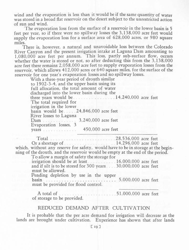
The evaporation loss from the surface of a reservoir in the lower basin is 5feet per year, so if there were no spillway losses the 3,138,000 acre feet wouldsupply the evaporation loss for a surface area of 628,000 acres, or 980 squaremiles .
There is, however, a natural and unavoidable loss between the ColoradoRiver Canyon and the present irrigation intake at Laguna Dam amounting to1,080,000 acre feet per annum . This loss, partly sub-surface flow, occurswhether the water is stored or not, so after deducting this from the 3,138,000acre feet there remains 2,058,000 acre feet to supply evaporation losses from thereservoir, which allows 412,000 acres or 640 square miles, for the surface of thereservoir for one year's evaporation losses and no spillway losses .
With a three-year period of drouth similarto 1902-3-4, and the upper basin using itsfull allocation, the total amount of waterdischarged into the lower basin during thethree years would be14, 240, 000 acre feetThe total required forirrigation in the lowerbasin would be24,846,000 acre feetRiver losses to LagunaDam3,240,000 acre feet
which, without any reserve for safety, would have to be in storage at the begin-ning of the drouth, and the reservoir would be empty at the end of the period .
To allow a margin of safety the storage forirrigation should be at least16,000,000 acre feetand if silt is to be stored for 300 years . . . . 30,000,000 acre feetmust be allowed .Pending depletion by use in the upperbasin 5,000,000 acre feetmust be provided for flood control .
A total of51, 000, 000 acre feetof storage to be provided .
REDUCED DEMAND AFTER CULTIVATIONIt is probable that the per acre demand for irrigation will decrease as the
lands are brought under cultivation . Experience has shown that after lands1 '9 J
losses, 3Evaporationyears450,000 acre feet
Total.28,536,000 acre feet
Or a shortage of . . 14,296,000 acre feet

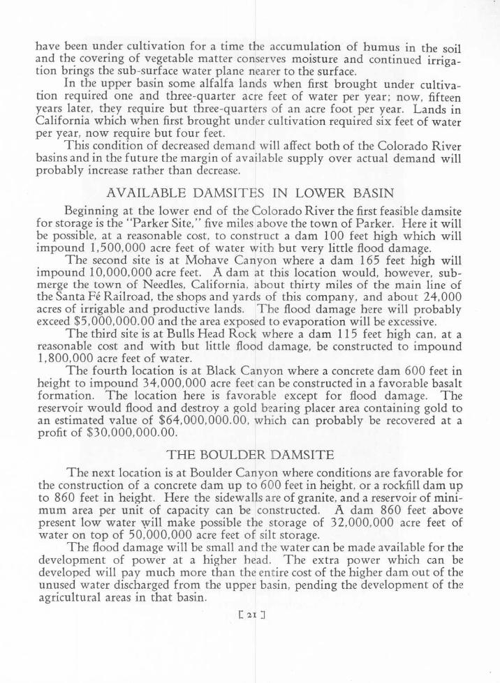
BETWEEN THE GRANITE WALLS OF BOULDER CANYON .
At this Point the Large Amount of Rock ofGood Quality Available Without RehandlingMakes Possible the Construction of a Rock Fill
Dam.
have been under cultivation for a time the accumulation of humus in the soiland the covering of vegetable matter conserves moisture and continued irriga-tion brings the sub-surface water plane nearer to the surface .
In the upper basin some alfalfa lands when first brought under cultiva-tion required one and three-quarter acre feet of water per year ; now, fifteenyears later, they require but three-quarters of an acre foot per year . Lands inCalifornia which when first brought under cultivation required six feet of waterper year, now require but four feet .
This condition of decreased demand will affect both of the Colorado Riverbasins and in the future the margin of available supply over actual demand willprobably increase rather than decrease .
AVAILABLE DAMSITES IN LOWER BASINBeginning at the lower end of the Colorado River the first feasible damsite
for storage is the "Parker Site," five miles above the town of Parker . Here it willbe possible, at a reasonable cost, to construct a dam 100 feet high which willimpound 1,500,000 acre feet of water with but very little flood damage .
The second site is at Mohave Canyon where a dam 165 feet high willimpound 10,000,000 acre feet . A dam at this location would, however, sub-merge the town of Needles, California, about thirty miles of the main line ofthe Santa Fe Railroad, the shops and yards of this company, and about 24,000acres of irrigable and productive lands . The flood damage here will probablyexceed $5,000,000 .00 and the area exposed to evaporation will be excessive .
The third site is at Bulls Head Rock where a dam 115 feet high can, at areasonable cost and with but little flood damage, be constructed to impound1,800,000 acre feet of water .
The fourth location is at Black Canyon where a concrete dam 600 feet inheight to impound 34,000,000 acre feet cart be constructed in a favorable basaltformation. The location here is favorable except for flood damage . Thereservoir would flood and destroy a gold bearing placer area containing gold toan estimated value of $64,000,000 .00, which can probably be recovered at aprofit of $30,000,000 .00 .
THE BOULDER DAMSITEThe next location is at Boulder Canyon where conditions are favorable for
the construction of a concrete dam up to 600 feet in height, or a rockfill dam upto 860 feet in height . Here the sidewalls are of granite, and a reservoir of mini-mum area per unit of capacity can be constructed. A dam 860 feet abovepresent low water will make possible the storage of 32,000,000 acre feet ofwater on top of 50,000,000 acre feet of silt storage .
The flood damage will be small and the water can be made available for thedevelopment of power at a higher head . The extra power which can bedeveloped will pay much more than the entire cost of the higher dam out of theunused water discharged from the upper basin, pending the development of theagricultural areas in that basin .
2I

Aeroplane View
Complete flood control can be secured and the maximum of power can begenerated near to the market . An economic balance can be secured betweenspillway loss, evaporation loss, power generated and flood damage cost .
The Boulder Canyon damsite has been carefully studied, surveyed anddrilled to bedrock . The large volume of granite of good quality available at thispoint makes possible the construction of a rockfill type of dam at a high safetyfactor up to a height of 860 feet above present low water .
The comparative cost of storage, the evaporation loss, the spillway loss,and the power generating capacity for three heights of dams at this location areshown in the following comparison .
Silt storage, acre feet .
Storage for power and irrigation, acrefeet
Total storage, acre feetCost per acre foot of storageAverage annual evaporation before
full depletion in the upper basin . . .Average annual spillway loss before
full depletion in the upper basin .
Total losses before depletion . .Average annual evaporation after full
depletion in the upper basinAverage annual spillway loss after full
depletion in the upper basin
Total losses after depletion . .Power installed(H. P .)
Note : Heights of dams given above present low water .1 acre foot is the amount of water that will cover 1 acre to a depth of 1
foot .1 second foot equals a flow of 1 cubic foot per second .1 second foot for one year is equal to 724 acre feet .1,000,000 acre feet is equal to 1,380 second feet for a period of one year .
ROCKFILL TYPE OF DAMThe rockfill type of dam which can be economically constructed here on
account of the quality and quantity of material available without rehandling,would be excessively expensive at any other location on the lower river .
1 23 ]
1600 ft . Dam5,000,00050 years
22,400,00032,400,000
$1 .17
588,000
1,149,000
715 ft . Dam18,000,000
180 years
28,300,00041,300,000
$0.84
840,000
467,000
860 ft . Dam48,000,000480 years
29,400,00082,400,000
$0 .66
1,136,000
112,000
1,737,000 1,307,000 1,248,000
587,000 797,000 1,137,000
513,000 72,000 57,000
1,100,000 869,000 1,194,000890, 000 1,100, 000 1,370,000550,000 830,000 1,050,00085,000 115,000 215,000
390,000 630,000 880,000$69 .00 $52.00 $51 .00
Firm power before depletion .
44
Additional power for irrigationFirm power after depletion .
44
Cost of dam per firm H . P. . .

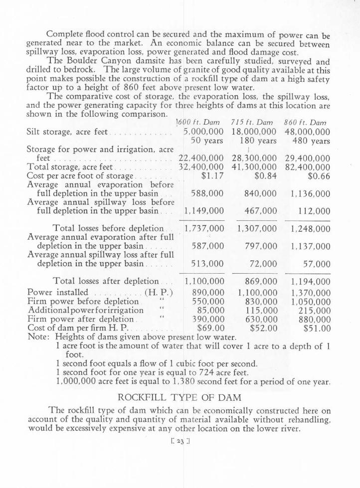
The Damsite in Boulder Canyon LookingDownstream

The foundation of a rockfill type of clam can be extended as its height israised ; , so it will be possible without excessive preliminary cost, to construct arockfill dam at Boulder Canyon to a part of its ultimate height and at a later dateincrease the capacity and the head available for power by adding to the height ofthe dam.
For a concrete or a masonry dam it is necessary at the beginning to designand construct the foundation to the full dimension which will be required whenthe dam is completed to its ultimate height, so the preliminary saving on partialconstruction for these dams would be much less than for a rockfill .
DAMSITES ABOVE BOULDER CANYONThe damsites above Boulder Canyon at Spencer Canyon, Diamond Creek
and Bridge Canyon, are not so favorable for reservoirs of large capacity, and ifconsolidated with the Boulder location under one high dam will not only pro-vide the required storage but will consolidate the generation of power econom-ically at a point very much nearer to the market for the power generated .
At Glen Canyon and at Cataract Canyon, both in the upper basin (aboveLee Ferry) possible sites for large reservoirs have been examined . These loca-tions are in soft sedimentary formations and due to this are not, from a con-struction point of view, so satisfactory as the Boulder Canyon location. Thecontrol of the irrigation demand in the lower basin would be remote, and thetransmission distance to the present power market unnecessarily long .
DAMS BELOW BOULDER CANYONAfter the installation of a dam in Boulder Canyon it will be feasible to
construct a dam 75 feet high at a point called the Portals, near the lower end ofBlack Canyon immediately above Giant Wash . This will not interfere with therecovery of gold in the gravel deposits between Boulder Canyon and Black Can-yon, and without exposing any great area of water to evaporation, will permit
£ 251
the regulated flow of the river between the Boulder power house and the BullsHead reservoir to be utilized in the development of an additional 100, 000 horsepower.
A dam 115 feet high can be constructed at Bulls Head Rock which willback the water up to the Portals power house location, and utilize the regu-lated flow of the river in the development of an additional 150,000 horse power .Below Bulls Head Rock the extensive area of river bottom agricultural land canthen be irrigatedd from the Bulls Head reservoir .
Leaving the Mohave Canyon damsite undeveloped will make possible theirrigation of 27,000 acres of river bottom land and avoid flooding the town ofNeedles, and the Santa Fe Railroad .
BALANCING RESERVOIRAfter the full development and utilization of the water allocated to the
upper basin it will be advisable to provide a balancing reservoir to balancebetween the maximum demand for power in the winter and the maximumdemand for water for irrigation in the summer . This balancing reservoir canbest be provided at the Parker location, where a dam 100 feet high can beeconomically constructed, and, will with the Bulls Head reservoir, impound asufficient quantity of water to enable the power plant at Boulder Canyon tooperate at full demand during the winter and still conserve the water for irriga-tion during the summer months .
SUMMER SEASON POWER FOR IRRIGATIONThe summer season power which can be generated at Boulder is of great
importance to Southern Nevada, Arizona, and Southern California whereextensive areas are underlain with water at a depth of from thirty to eighty feetbelow the surface . The stored water at Boulder will provide power at a lowcost for pumping from these subterranean sources and will bring a large area offertile land under cultivation .
EQUITABLE DISTRIBUTION OF COSTThe development of the Lower Colorado River is an economic problem in
which the demands of the water users are paramount . The primary necessityfor the development is the urgently needed protection from floods and the pos-sible inundation and permanent destruction of the cities and homes in theImperial Valley .
The development of power is incidental but it can be made to eventuallypay the cost of the entire development . To be equitable, however, the cost ofthe dam should be pro-rated to the power and the lands for which the water isprovided.
To make the flood protection complete the silt should be retained in thereservoirs . This will relieve the lands now under cultivation from a large partof the very considerable sum expended. annually for the removal of silt from
E 26 1

I
canals and ditches . It, therefore, appears but equitable that these lands shouldbear some portion of the cost of the dam, at least to the extent of a part of theirannual saving. This can be covered by a small charge per acre or per acre footpaid annually to the Federal Government or the state for the water delivered .
The lands which will be brought under cultivation through the construc-tion of the dam and storage of water will appreciate in value . It is only just,therefore, that a portion of this appreciation should be applied to the cost of thedam and be paid as an annual charge for the stored water as delivered .
Clear water free of silt, as required by the Los Angeles water district, canbe taken from the Boulder Canyon reservoir at an elevation which, insofar asaltitude is concerned, would make possible the delivery of water to Los Angelesby gravity. This water should be paid for at a rate which will represent itsproper participation in the investment in the dam and control works .
The power generated and used for lighting, railway and industrial pur-poses, should be sold at a rate which will enable it to pay all of the operatingcharges, interest, amortization and taxes on the power installation and trans-mission lines, and an equitable part of the interest and all of the amortization ofthe cost of the dam . .
The extra power generated during the irrigation season and available forpumping for irrigation should be relieved of all water charge. The rate to thefarmer should be as low ass possible, based on the investment in the generatingand transmission equipment only. His operating charges will even then behigher than the water charge to the farmer who receives gravity water.
FEDERAL OWNERSHIP OF WATERThe Colorado River flows through a number of states so it, and all of its
branches-should be considered as an interstate stream . The breaking of a damlocated within one state might prove disastrous to agricultural and powerdevelopments located in a state further down the stream. The water evaporatedfrom reservoirs of excessive area in the upper basin might deplete the flow of thelower river below the minimum to which the lower basin is justly entitled .These conditions indicate the necessity for Federal control .
Part of the responsibility for the silt originating in the upper basin shouldbe assumed by the upper basin and reasonable silt storage capacity should beprovided in each reservoir constructed . This capacity, and the silt storage in thelower basin reservoirs will meet the silt problem for a number of centuries .
The water will be used for domestic purposes by the people in the lowerbasin . Therefore, the upper stream should be protected against contaminationand if proper legislation is enacted now, before cities are developed along thestreams, it will be possible to assure potable water to those in the lower basinwho must depend upon this stream for their domestic supply .
All impounding dams, lands under the reservoirs, and the shore lines ofthe streams and reservoirs, should be transferred to the jurisdiction of the Fed-eral Government.
The Reclamation Service should control the flow and distribution of the1271

I
water for domestic and agricultural purposes, and the Federal Power Commis-sion should assure the safety of all structures erected for the purpose of impound-ing waters .
Water, being an element of common necessity more or less equally used byall, essential to the maintenance of life, subject to contamination and destructiveof life and property when not properly controlled, should be held firmly in thecontrol of the Federal Government and administered for the benefit of allwithout discrimination .
FEDERAL OWNERSHIP OF POWERElectric power, unlike water, is not a universal necessity . It is not equally
used by all. Many citizens use little or none . There are available substitutes incompetition both for light and for power .
Its principal use is as a profit earning commodity ; the profits earned bymany manufacturers being dependent upon their ability to secure a supply ofelectric power at a low cost .
If the power is supplied by the Federal Government at a rate below costthen the non-using taxpayer will be indirectly paying the profit of the manu-facturer who makes his profit out of the use of power . If it were supplied by aprivate corporation the other users of electric power would be paying the profitof this manufacturer .
The transmission and distribution of water is as old as civilization, butthe generation and transmission of electric power is a new industry . Its con-tinued development is dependent very largely upon the incentive promotedthrough competition . Covering this industry with governmental control andpolitical preferment instead of competitive selection would stifle the industry .
If the Federal Government undertook the installation of equipment for thegeneration of power on the Colorado River it would of necessity have to dis-tribute this power to states in which state public service commissions fix the rates .The rates fixed by the state commissions would have to be equitable to the com-peting private power corporations then in business within the states .
It is hardly to be expected that such rates would just balance the Govern-ment's cost . If the installation had been. excessively expensive, as frequentlyoccurs under government administration, then a rate which would be profitableto a private corporation might be unprofitable to the Government, and throughtaxation, burdensome to the non-user of :power . If the reverse happened to bethe case, and the Government generating plant, on account of its size, freedomfrom taxes, or other conditions, was able to produce power at a lower cost thanthe private corporation, then the rate fixed by the state commission would earn aprofit accruing to the non-user of power . Either case would be inequitable .
A fair consideration of all the facts indicates that the generation and dis-tribution of electric power is a specialized industry which can best be handledunder private ownership with public or governmental supervision over rates .
FEDERAL POWER COMMISSION CONTROLThe power generated on the Colorado River should be allocated to the sev-
C 28 :1
eral states by the Federal Power Commission . The Federal Water Power Act,under which the Commission derives its authority, is, however, deficient in thatit does not specifically authorize the Commission to allocate power to statesinterested in interstate streams .
The act provides that the Commission may exercise jurisdiction over theinvestment, or at least the question as to whether, or not, the investment pro-posed is adequate for the purpose . But the commission is not empowered todetermine rates. This is left to the public service commissions of the states .
If the Federal Power Commission allocated power to a state without theauthority to control the rate the state public service commission could fix a ratewhich would be confiscatory ; or the rates for power to adjoining states, if left tothe commissions of the several states, might be so at variance as to be entirelyinequitable .
This situation would not arise if the Federal Power Commission and thestate commissions could at all times agree . But the more certain way would beto amend the Federal Water Power Act and empower the Federal Power Com-mission to fix rates and allocate power to the states at interest in all streams un-der the jurisdiction of the Federal Power Commission .
PRESENT AND FUTURE DEMAND FOR POWERThe Colorado River from its sources to the Mexican boundary line has
sufficient flow and fall, if fully regulated and utilized, to develop between sixand seven million horse power .
At present within transmission distance of the Lower Colorado River fuelis being used to generate about 250,000 horse power, requiring approximately8,000,000 barrels, or 400,000,000 gallons . of oil per year. This is equivalentto a continuous discharge of the full capacity of a pipe 17 / inches in diameterat the rate of one foot per second, or an 8-inch pipe discharging at the rate of fivefeet per second .
If a pipe line was discharging this stream of oil into the ocean it would beregarded as a waste which would not be tolerated . Yet this would be but theequivalent of the present actual waste on the Colorado River and, in additionthereto, the farmers are suffering a heavy annual loss due to floods and are pay-ing the cost of maintaining levees and of removing the accumulating silt fromthe irrigation canals and laterals .
The Colorado River below Boulder Canyon can, under full development,generate 1,225,000 horse power without wasting any of the water required forirrigation . The present rate of increase in demand for electric power withintransmission distance is approximately 90,000 horse power per year, and therapidly increasing population indicates that for a number of years this rate willbe maintained .
But other water powers are in course of development and the present mar-ket for power in this territory, with the probable unsatisfied increase in demandup to the completion of the necessary dam and control works, will not warranta first installation of more than 500,000 horse power. This generating capa-
129]

city will not justify the investment which is needed for a dam to meet therequirements of irrigation, and if the entire interest, amortization and mainte-nance charge of such a dam is charged against the revenue derived from this firstpower installation, the rate charged for power will have to be high enough topay it, and will preclude the possibility of establishing a low rate until thedemand for power permits the distribution of this charge over a much greateroutput.
If a corporation owning undeveloped water powers in 'California con-trolled the Colorado River development it could turn this situation to its ownadvantage. The necessary high rate would permit the development of its otherwater powers at unit costs in excess of the ultimate unit cost of the ColoradoRiver development. The California demand could be supplied from thesesources at rates justified by the investment . The Colorado River power marketwould then be limited to the demand outside of California, and the final devel-opment of the Colorado would be deferred until the increased demand justifiedthe already established high rates .
Anticipating the increase in demand for power some of the generating com-panies now serving the southwestern territory with hydro-electric power haveacquired the water power rights on the important streams in California withintransmission distance of the markets . The projects which could be developed ata low cost per horse power were developed first, and it is now necessary forthem to develop the more expensive projects at costs which (according to pub-lished figures) in many instances will exceed the cost per horse power of the com-pleted Lower Colorado River development .
If the future demands for power are for a time supplied from the Colo-rado, the investment of these companies in some of their undeveloped waterpowers will have to be carried as an expense until the demand exceeds the sup-ply available from the Colorado and the price advances enough to justify thedevelopment of their more expensive projects .
It would no doubt be to the advantage of these companies to defer the de-velopment of the Colorado until they had developed all of their own projects .The state public service commissions would then be under the necessity of main-taining rates high enough to give them a fair return on their total investmenteven if power from the Colorado could be delivered at a lower cost .
Such a plan would not, however, be to the best interests of the people ofthe states of the southwest . It would not encourage the development of miningand other industries and would delay the reclamation of thousands of acres ofland in Arizona, Nevada and California, which can be irrigated by pumping ifpower is made available at a moderate cost .
Duplication of investment should be avoided and existing transmissionand distributing companies should be protected against destructive competition,given a fair return on their investment, and compensation . for the risk taken bytheir investors in the development of the industry . This, however, should notbe permitted to delay the development of power on the Colorado River .
The corporation installing and operating the power development in con-[ 3co J

nection with the proposed lower basin reservoir should be independent of anyexisting power distributing corporation . The company should be a generatingcompany delivering the power only to political divisions, distributing compa-nies, and railways . Seasonal or irrigation power should be delivered to mutualassociations, communities or groups, organized for the purpose of acquiringpower and distributing it to their memberships for irrigation purposes .
The generating company should not be or become a competitor of anyusing or distributing company or association ; and the requirements of states,counties and municipalities, should be given. preference over those of privatedistributing corporations .
The rates at which the power is sold by the generating company should befixed by the Federal Power Board, or by agreement between the Federal PowerBoard and the state boards at interest. The interest charge on the cost of thedam should be borne by the Government, or the states, or the lands benefited,until the demand for power is sufficient to enable the power company to assumethis charge without increasing the rate charged for power . The amortization ofthe cost of the dam can be deferred until it can be assumed and paid by the powercompany .
This plan would deliver the power at a. uniform rate into the jurisdictionof the several states for distribution at the rates there fixed by the state boards .It would avoid duplication of investment and automatically limit future devel-opments to projects which could deliver power at a cost as low as the rates estab-lished for Colorado River power .
The principal market for power in the lower basin is in Southern Cali-fornia and Southern Arizona, so it will be advantageous to serve this marketfrom a development as far south on the river channel as the local conditionsand the demands of agriculture will permit .
The firm power available throughout the year, which under these condi-tions cart be generated at Boulder, the Portals, and Bulls Head Rock, will begenerated much nearer to the market for power than would be possible withdevelopments above Boulder Canyon .
From Boulder Canyon to Los Angeles (the principal market), the distanceis 250 miles ; to San Diego approximately 300 miles ; to Yuma, Arizona, 250miles ; the mining districts in southeastern Arizona, 250 to 300 miles ; and theprincipal mining district in Nevada, 250 miles .
The principal market for power in the upper basin is in Utah in thevicinity of Salt Lake City, so this market can best be served from one of thefavorable locations in the upper basin .
Copyright © 2022 FDOKUMEN