Boundaries and Context
120
-
Upload
independent -
Category
Documents
-
view
1 -
download
0
Transcript of Boundaries and Context

East Main Street Corridor Plan
Written By:
Senait Brown Meghna Dutta
Zachary Kennedy SriPallavi Nadimpalli
In Collaboration With:
The University of Illinois, Department of Urban & Regional Planning
The University of Illinois Extension, Knox County Unit The City of Galesburg

Table of Contents Executive Summary
Acknowledgements
List of Tables and Figures
Chapter 1: Introduction ............................................................................................................ 1-1
1.1 Boundaries and Context .................................................................................................. 1-1
1.2 Purpose of the Plan .......................................................................................................... 1-2
1.3 Goals and Objectives ....................................................................................................... 1-2
Chapter 2: Existing Site Conditions ........................................................................................ 2-1
2.1 Existing Zoning .................................................................................................................. 2-1
2.2 Existing Conditions Survey ................................................................................................ 2-4
2.2.1 Existing Conditions Survey: Land Use ....................................................................... 2-4
2.2.2 Existing Conditions Survey: Aesthetic Quality ........................................................... 2-8
2.2.3 Existing Conditions Survey: Design Elements.......................................................... 2-10
2.2.4 Existing Conditions Survey: General Indicators and Transportation Related
Elements ............................................................................................................................. 2-12
2.2.5 Existing Conditions Survey: General Comments ...................................................... 2-12
Chapter 3: Planning Considerations ....................................................................................... 3-1
3.1 Previous and Current Galesburg Plan Considerations ....................................................... 3-1
The East Main Street Corridor Study (1998) ....................................................................... 3-1
City of Galesburg/Knox County Comprehensive Plan (1999) ............................................. 3-3
Massie & Massie Downtown Strategic Plan (2009)............................................................. 3-6
3.2 Case Studies Summary ....................................................................................................... 3-8

Chapter 4: Planning Process .................................................................................................... 4-1
4.1 Steering Committee ............................................................................................................ 4-1
4.2 Public Input Opportunities ................................................................................................. 4-2
4.2.1 East Main Street Corridor SWOT and Visual Preference Charrette ........................... 4-2
4.2.2 Open House at Hy-Vee ................................................................................................ 4-5
4.2.3 Informal Interviews ..................................................................................................... 4-5
4.2.4 Online Survey .............................................................................................................. 4-6
4.3 Results and Analysis of Public Input ................................................................................. 4-6
4.3.1 East Main Street Corridor SWOT and Visual Preference Charrette & Hy-Vee Open House Results ....................................................................................................................... 4-6
4.3.2 Informal Interview Results ........................................................................................ 4-12
Chapter 5: Plan Recommendations ......................................................................................... 5-1
5.1 Vision and Guiding Principles ........................................................................................... 5-1
5.2 Plan Recommendations ...................................................................................................... 5-1
5.2.1 General Recommendations from SWOT..................................................................... 5-1
5.2.2 Functional and Aesthetic Improvement Recommendations ........................................ 5-3
5.2.3 Economic Improvement Recommendations ................................................................ 5-5
5.2.4 Special Study Area: Interstate 74 Interchange ............................................................ 5-7
5.2.5 Special Study Area: BNSF Railroad Tracks at Sumner Street .................................... 5-8
Chapter 6: Implementation Plan ............................................................................................. 6-1
Appendix A - Supplementary Existing Conditions Materials .................................................. A-1
A1: Existing Conditions Survey Form .................................................................................... A-1
A2: Existing Conditions Survey Detailed Results .................................................................. A-2
Appendix B - Supplementary Planning Consideration Materials .............................................B-1
B1: Case Studies .......................................................................................................................B-1
B1.1 Case Study I - Great Streets Initiative: South Grand Blvd., St. Louis Mo ..................B-1
B1.2 Case Study II - Charlottesville’s Downtown Pedestrian Mall: Main Street, Charlottesville, VA ...............................................................................................................B-6

B1.3 Case Study III - 2006 Downtown Plan, City of Champaign, Illinois ........................B-12
B1.4 Case Study IV - Great Streets: 7th and Georgia Avenue Framework Plan,
Washington D.C .................................................................................................................B-17
Appendix C - Supplementary Public Participation Materials ..................................................C-1
C1: East Main Street Corridor SWOT and Visual Preference Charrette Advertising Materials ...................................................................................................................................C-1
C2: East Main Street Galesburg SWOT and Visual Preference Charrette –
SWOT Data ..............................................................................................................................C-6
C3: Visual Preference Survey Results ...................................................................................C-12
C4: Online Survey ..................................................................................................................C-19

Executive Summary
The focus of this study is a section of East Main Street that is bounded by Interstate 74 to the East and the BNSF railroad tracks near Sumner Street to the West. Due to the two Interstate 74 exits onto East Main Street, the corridor is often the first impression that visitors have of Galesburg. The corridor features many commercial businesses as well as single family homes. The structures and lots in the corridor range in their condition from well landscaped and maintained homes to abandoned commercial properties. The corridor has seen some improvements over the years. The area has been the subject of urban renewal efforts between late 1970s and 1990s. During this time, blighted structures were removed, and abandoned lots were purchased. In the past decade the corridor has seen significant commercial development and redevelopment as several new establishments have opened. While progress in the corridor has been made, there are still opportunities to improve. Purpose and Goals The purpose of this plan is to understand the existing conditions in the corridor, and generate recommendations for economic development as well as functional and aesthetic improvements to the corridor. The goals for the project relate to each of these purposes as well as ensuring significant public participation in the planning process, in order to arrive at implementable recommendations. Existing Conditions The existing conditions of the corridor are analyzed through current zoning, proposed zoning and a block-by-block survey conducted on 10/27/2008. The corridor contains two TIF districts- TIF II lies to the eastern end of the corridor, off the I-74 exit. The zoning in TIF II is primarily B-2 (Commercial), and the land uses are a mix of commercial and residential. The TIF IV district covers the rest of the corridor. This area’s zoning is a mix between R-1B (Single Family) and B-1 (Neighborhood Commercial) on the eastern end, and R-2 (Two Family) and B-2 (Commercial) towards the western end. The actual land uses in this section of the corridor reflect the zoning and are a mix of residential and commercial.

The existing conditions survey looked into particular aspects such as Land Use, Aesthetic Quality, Urban Design Elements and Transportation. Following the zoning, The East Main Street corridor predominantly consists of Low Density housing (Single and Two Family). Commercial structures compose 30 percent of the built environment along the corridor, a number that may increase in future. In terms of Land Use distribution, residential uses are more concentrated in the central section and commercial uses are at the two ends. In total, 5 large vacant/ abandoned lots were identified. A majority of these are in the eastern half of the corridor, and those in the TIF II district are likely to be developed in the near future (eg: Vacant lot next to Taco Bell has shown significant interest from private developers). Aesthetically, the overall score for the corridor was positive, though there were disparities between commercial and residential land uses. Commercial uses score low in terms of their aesthetic quality, while residential lots, especially those on the north side, score higher in their aesthetic rating. About half of the structures along the corridor are of wood construction. In terms of Urban Design elements such as sidewalks, lighting, crosswalks, signage, street furniture etc. the corridor has an average score. Lack of maintenance and a narrow right of way were observed as major issues for the entire corridor. The eastern portion of the corridor was found to be serviced by public transit, though the absence of an underpass at the BNSF railroad crossing diverts the services towards the East South Street underpass. Previous and Current Planning Efforts As part of our study we also analyzed the previous and current planning efforts made by the City of Galesburg, in addition to four case studies in the U.S. where similar projects have been undertaken. The East Main Street Corridor study of 1998 was conducted by the City of Galesburg with guidance from the Planning Commission. This was conducted at a time when the corridor was predominantly residential and new commercial developments had started at the East end of the corridor near the I-74 exit. The 1998 plan evaluated previous plans, addressed the existing public utility facilities and investigated several options of making aesthetic improvements to the corridor. The major outcome was the proposal for a B-4 Restricted Commercial overlay zone within the previously implemented B-2 commercial district. In 1999 the City of Galesburg and Knox County with the help of a steering committee, updated the previous Comprehensive Plan. They conducted background research and developed detailed land use, transportation and special area plans. With the input gathered from the public, necessary changes were made. After the approval, the Comprehensive Plan was published. The plan proposed goals, objectives and recommendations for some key elements like the general character, historic preservation, economic development etc. The overall mission was to preserve the character of Galesburg, protect the environment, and create avenues for the expansion of business and commercial districts. Massie & Massie’s Downtown Strategic Plan was created to improve the design aesthetics, address parking issues, promote the utilization of unoccupied store spaces, and identify economic development opportunities. Massie and Massie coordinated with the Downtown Strategic

Planning Team, the Galesburg Downtown Council, as well as the City of Galesburg. Together they created and administered a community survey regarding the future of the Downtown Galesburg area with the purpose of formulating objectives and recommendations for the plan. The plan has been finalized and was approved in January of 2009. Case Studies Four case studies were conducted in order to better understand the conditions before arriving at a proposal, the process undertaken to suggest improvements, and the final proposal and resulting action/ current status. Each case study was distinctly different and they put forth different perspectives and approaches for addressing a corridor redevelopment plan. The examples that we studied were:
• Great Streets initiative- South Grand Blvd, St. Louis, MO: Public participation process and surrounding land uses.
• Charlottesville’s Downtown Pedestrian Mall: Main Street, Charlottesville, VA: Integration of design elements to form a cohesive image for the Downtown Mall.
• 2006 Downtown Plan, City of Champaign, IL: Scale of project, Use of Tax Increment Financing for aesthetic and economic revitalization.
• Great Streets- 7th and Georgia Avenue Framework Plan, Washington D.C.: Mix of land uses.
Public Participation A critical element of our planning process was the public input process. An open and collaborative approach was pursued in order to involve stakeholders, residents, City officials, visitors and economic business leaders in the planning of the East Main Street Corridor Plan. The public has been involved in the development of this from the earliest stages and at each decisive step. Through informal interviews, the East Main Street Corridor Plan Steering Committee, East Main Street Corridor community charrette and open house as well as on-line community survey, and public education materials/notifications participants/residents have both shared comments and ideas, as well as received information. Through informal interviews, common themes to the residents’ concerns became apparent. Issues such as lack of green space on East Main Street, concern over the preservation of older homes, and discontent over the lack of sidewalk accessibility became regular topics of discussion. The East Main Street Corridor Plan Steering Committee, comprising of various active stakeholders in the Galesburg community, offered comments and new direction to the formation of the plan at every step. They accepted proposals, inspired and implemented public outreach, and provided guidance for each recommendation of the corridor plan. Public participation included a number of opportunities, an important one being the Community Charrette. This charrette included a Visual Preference Survey and a SWOT (Strengths, Weaknesses, Opportunities, and Threats) Analysis. The Open House was conducted out of the
Hy-Vee Grocery store on East Main Street, giving residents an opportunity to take part in the visual survey and provide input. The Visual Preference Survey was instrumental in helping to identify the preference of design concepts. While still advocating for accessible infrastructure upgrades and a fresh unique style, residents took more to the preservation of historic homes and buildings, desire for more greenspace as well as the upkeep and maintenance of properties. The SWOT analysis reinforced that the City’s strength lay in the historic structures of Galesburg, its access to Interstate 74 and its visitor’s center. This analysis also proved that some weaknesses of the East Main Street area revolved around poorly maintained properties, narrow and inaccessible sidewalks and outdated street design. Opportunities deemed possible in the corridor were new and aesthetically pleasing design, the potential new underpass at the Railroad crossing, and the transition between East Main Street and the Downtown Galesburg corridors. The threats were listed as lack of maintenance, cost to the residents and lack of plan implementation. Lastly, an On-line Community Survey was launched at the wrapping up of this plan in order to facilitate continued feedback and idea exchange to the City of Galesburg and the East Main Street Corridor Steering Committee from the residents. Recommendations and Implementation The public participation opportunities provided valuable feedback on the concerns, expectations, and priorities of the community. The different public input opportunities and case study research aided in devising the basic guiding principles for our recommendations. The plan recommendations have been presented into 3 broad categories- general, functional and aesthetic, and economic. Two special area studies- the BNSF railway crossing at Main Street and Seminary Street and the I-74 Interchange have been selected and discussed in detail. Some of the plan recommendations were derived out of the SWOT analysis General Recommendations from SWOT
• Regular maintenance and negotiated design elements on private property as a part of the redevelopment incentive agreement.
• Long term and short term goals must be set according to available funds • Regular updates to the corridor plan should be carried out to incorporate the changes
made and focus on future course of action. Aesthetic improvements are high on the community’s agenda, especially the I-74 entrance since it forms the first impression of the City to any visitor. Functional and aesthetic improvements have been suggested based on the existing condition and visual preference surveys conducted. Functional
• The first objective is to align the utility poles to create a clear space of 4-5 feet for easy passage of pedestrians. A long term objective could be to use Eminent Domain to purchase land, when a parcel in the corridor is redeveloped in the corridor, to expand the right of way and install ADA compliant standards should be considered.

• Incorporate 2 bike lanes on either side of East Main Street. Create sufficient space to incorporate a green buffer between the road and the adjacent land use, to make it safer for the pedestrians. Also, conduct a traffic study to determine if a three lane road would relatively slow down the vehicular movement. The green space could be a turf of a width ranging from 4- 6 feet in between the road and the sidewalk. Consensus should be built within the community for the proposed measures.
• Provision of additional transit services along the corridor should be considered. • Provision of a green buffer is also essential to create homogeneity among the varying
land uses along the corridor. • To enforce codes for the maintenance of landscape elements on the private property
adjoining the main street. • Regular maintenance of the pavements, and green areas along the corridor. Ensuring
snow removal for mobility along the corridor. Aesthetic *Aesthetic improvements are high on the community’s agenda, especially the I-74 entrance since it forms the first impression of the city to any visitor.
• Construction of the railroad underpass at Sumner Street Railroad Crossing • Provisions for proper signage and regular maintenance and upkeep are other issues that
should be considered by the authorities. • Bury Utility Lines: While the budget considerations of burying the utility lines could be a
limitation, the initiative would benefit the aesthetic and economic revitalization of the corridor and the city overall and should be considered in the long term proposals for the city.
• Landscaping and alternate transportation provisions such as bike paths along the corridor are other incremental initiatives that would lead to aesthetic and functional improvements.
Economic Improvement Recommendations *Economic improvement recommendations are based on a redevelopment incentive policy which follows the pay-as-you-go approach. The highlights of the redevelopment policy include:
• City assistance is an incentive for the private developer and also an empowerment tool for the city to regulate private development. The idea is to reimburse additional revenue (sales, property, hotel/motel, or food and beverage taxes) that redevelopment may generate for a negotiated number of years. A similar approach has been taken for TIF designation, but the proposed policy adds a layer of aesthetic requirements to an incentive seeking development. The priority of the proposed program would be in relation to the parcels that are strategically located along the heavily traveled corridor.
• The proposal requires private investment to be at least half of the total costs, though additional assistance may be provided conditionally, subject to Council approval.
• Encourage private investment around East Main Street Corridor gateway by increasing the aesthetic appeal

Special Study Area: Interstate 74 Interchange
• Create an entryway statement at the I-74 gateway that will promote the history, social capital and spirit of Galesburg through historic signage, promotion of the visitor center and landscaping
• Explore potential for streetscape/landscape features to improve corridor entrance • Provide a transition onto East Main Street Corridor by continuing lighting and awning
designs trends from Downtown Galesburg • Create a more attractive and accommodating environment for pedestrians through
improved sidewalk infrastructure and pedestrian safety measures • Generate buffering between surrounding residential neighborhoods and gateway activity
through developing landscaped greenspace along the East Main Street Corridor Special Study Area: BNSF Railroad Tracks at Sumner Street
• Construction of an underpass at the Sumner Street Railroad Crossing Example: Landscape Architecture Project
The complimentary relationship between the economic, functional and aesthetic improvements should be identified and incorporated, along with continued public input during the preparation and administering of the plan. While the implementation of the plan may be determined with the available funds, the preparation of an overall plan for the corridor at the outset is vital to achieve the unified vision. City initiative should be in terms of regular maintenance and also negotiating design elements on private property as a part of the redevelopment incentive agreement. Long term and short term goals must be set according to available funds. Since the TIF 2 currently has sufficient funds, the eastern part of the corridor is more likely to be improved initially. Regular updates to the corridor plan should be carried out to incorporate the changes made and focus on future course of action. The complimentary relationship between the economic, functional and aesthetic improvements should be identified and incorporated, along with continued public input during the preparation and administering of the plan.

Acknowledgements:
East Main Street Corridor Plan Steering Committee: Steve Aspey, Chair, Galesburg Planning Commission
Bob Bondi, Bondi Building Corporation
Diane Bruening, Director of Tourism, Galesburg
Area Convention and Tourism Bureau
Jay Bullis, Bullis & Sundberg LLC Insurance
Services
Wayne Carl, City Engineer, City of Galesburg Public
Works Department
David Christensen, Chief of Police, City of
Galesburg Police Department
Sal Garza, Illinois Department of Commerce and
Economic Opportunity
Steve Gerstenberger, President, Galesburg
Downtown Council
Lyle Johnson, Board Member, Knox County Board
Bob Maus, President, Galesburg Chamber of
Commerce
Roy Parkin, Director of Community Development,
City of Galesburg Community Development
Department
David Rasmussen, Store Manager, Main Street Hy-
Vee
Chuck Ross, Realtor, Mel Foster Co.
Gary Smith, Mayor, City of Galesburg
Dane Bragg, City Manager, City of Galesburg
Bill Kendall, Councilman, City of Galesburg
City of Galesburg Mayor: The Honorable Gary C. Smith City Council: Ken Goad, 1st Ward
Bill Kendall, 2nd Ward
Russell Fleming, 3rd Ward
Lomac Payton, 4th Ward
Karen Lafferty, 5th Ward
Wayne Allen, 6th Ward
Mike Lummis, 7th Ward
City Manager: Dane Bragg City Planning and Development: Roy Parkin, Director of Community Development
Steve Gugliotta, Associate Planner
Julie Main, Associate Planner
Larry Cox, Director of Public Works
University of Illinois Extension (Knox County): Kathie Brown, Extension Specialist, Community and Economic Development Technical Assistant, Illinois ResourceNet Carrie McKillip, Unit Educator, Community and Economic Development Kari Houle, Unit Educator Horticulture, University of Illinois Extension Knox County

List of Tables and Figures Chapter 1: Introduction - Chapter 2: Existing Conditions Figure 2-1: East Main Street Corridor Aerial View Table 2-1: City of Galesburg Zoning Districts Figure 2-2: East Main Street Corridor Current Zoning Figure 2-3: City of Galesburg TIF District IV Figure 2-4: City of Galesburg Future Land Use Plan Figure 2-5: East Main Street Corridor Existing Residential Land Use Figure 2-6: East Main Street Corridor Existing Commercial Land Use Figure 2-7: East Main Street Corridor Existing Location of Vacant Parcels Figure 2-8: East Main Street Corridor Rating of Aesthetic Quality Figure 2-9: East Main Street Corridor Rating of Design Elements Figure 2-10: Deteriorated Sidewalk Figure 2-11: Leaning Utility Pole Figure 2-12: Overgrown Yards Figure 2-13: Bus Routes Servicing the Corridor Chapter 3: Planning Considerations Table 3-1: East Main Street Corridor Study (1998) Aesthetic and Land Use Controls Chapter 4: Planning Process Table 4-1: Steering Committee Members Figure 4-1: SWOT Voting Sheets Figure 4-2: Voting Frequency for Strengths Figure 4-3: Voting Frequency for Weaknesses Figure 4-4: Voting Frequency for Opportunities Figure 4-5: Voting Frequency for Threats Figure 4-6: Voting Frequency for all SWOT Components Table 4-2: Overall Visual Preference Rankings Table 4-3: General Comments from Informal Interviews Chapter 5: Plan Recommendations Figure 5-1: Suggested lane changes along East Main Street Figure 5-2: I- 74 crossing proposed plan Figure 5-3: Cars Stopped at BNSF Crossing on East Main Street Figure 5-4: Proposed Plan and Section Figure 5-5: Existing (L) and Proposed (R) Railroad Crossing scenarios

1-1
Chapter 1: Introduction
1.1 Boundaries and Context The focus of this plan is the East Main Street corridor. The East Main Street corridor extends along East Main Street from Interstate 74 on the East to the Burlington Northern Santa Fe (BNSF) railroad tracks at Sumner Street to the West. The road itself is five lanes wide, with two west bound lanes, two east bound lanes and a center turn lane. A portion of the road between Interstate 74 and the east property line of Taco Bell, as well as between Grand Avenue to the railroad tracks is controlled by Illinois Department of Transportation (I-DOT) with the remaining portion under the control of the City of Galesburg. The land uses bordering the North and South sides of East Main Street are mixed between single family homes, multi-family homes and commercial properties. The eastern border of the study area is close to the East border of the City of Galesburg. This is the location of Interstate 74, and East Main Street features both on and off ramps which connect to the interstate. This makes East Main Street one of the main entrances and exits to the City, with others being North Seminary Street and North Henderson Street via Highway 34. The western border of the corridor, which is bounded by the BNSF railroad tracks, is a transitional area to the edge of the central downtown of the City. The street currently features an at-grade crossing at these tracks. There are plans to consider the creation of an underpass to accommodate superior traffic flow, and this concept is also explored in this plan. Today the East Main Street corridor has mainly commercial and residential land uses. The businesses along the corridor include many fast food retail establishments, gas stations, and a Hy-Vee grocery store. Most, but not all of the commercial structures in the corridor are in at least good condition. There are however some buildings which are in a poor state of repair. Much like the commercial buildings, the condition of the homes along the corridor varies greatly. The street features mostly older single-family homes, some of which are excellent from both a historical architectural integrity as well as physical condition stand point. However, there are quite a few homes which are not in good condition. It is important to note that the corridor has already seen many improvements over the years. From the late 1970s to the 1990s the area underwent an urban renewal program. Particularly areas of the corridor near the interstate, were cleaned up and cleared of blighted structures. The center turn lane was also added during this time period, which improved transportation conditions. TIF II was established and the increment that was captured was used to improve the far east portion of the corridor. In the past seven or eight years the corridor has seen the arrival of new commercial establishments and redevelopment activity. The Family Dollar Store, a Mc Donald’s, and the redevelopment of a site that was an old gas station into a Walgreens are a few examples of the recent development in the corridor. Despite the progress that has been made, there are still plenty of opportunities for improvements in the corridor.

1-2
1.2 Purpose of the East Main Street Corridor Plan There are three main purposes of this plan:
1. Study and understand the existing conditions within the corridor including the physical attributes as well as local knowledge.
2. Generate recommendations for the economic development/redevelopment of the corridor.
3. Generate recommendations for the functional and aesthetic improvement of the corridor.
With these purposes in mind, there are general goals, as well as goals associated with each purpose. 1.3 Plan Goals General Goals:
1. To allow the public to have significant input in the process. 2. To maximize implementability of the recommendations that are made.
Goals of the existing conditions study:
3. To understand the land uses in the corridor including residential, commercial, industrial, lodging, cultural/entertainment, and parks and open space.
4. To understand the general aesthetic character of the corridor. 5. To understand the current transportation conditions in the corridor.
Goals for functional and aesthetic improvements:
6. To identify potential improvements in the transportation conditions in the corridor. 7. To identify potential improvements in the land uses in the corridor. 8. To identify potential improvements to the infrastructure in the corridor. 9. To identify potential improvements to the aesthetics in the corridor.
Goals for the economic development recommendations
10. To identify a potential economic development incentive program that encourages increased commercial activity in the corridor.

2-1
Chapter 2: Existing Site Conditions
Understanding the existing site conditions is vital before making recommendations for improvements in the corridor. This chapter has two sections. The first section discusses the existing land use zoning controls. The second section of the chapter features the results of a block by block existing conditions survey.
Figure 2-1: East Main Street Corridor Aerial View

2-2
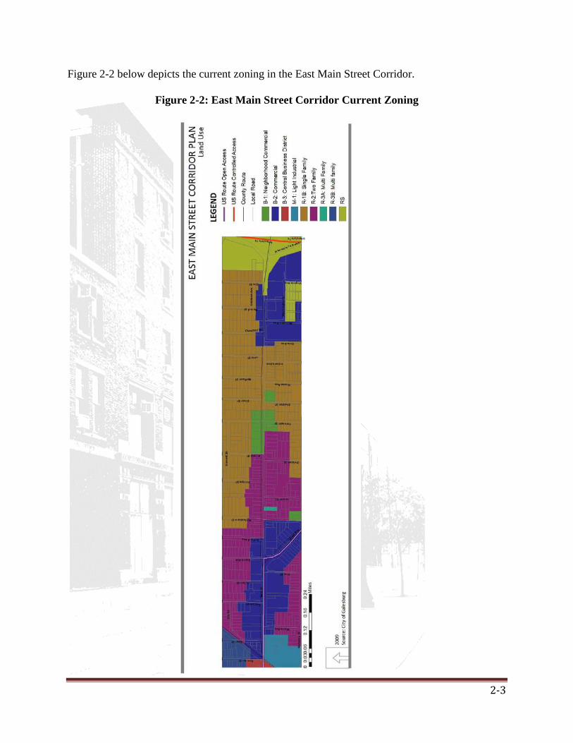
2.1 Existing Zoning The City is divided into three (3) general zoning classifications:
• R class—residential • B class—commercial • M class—industrial
The corridor has a mix of districts, with more industrial and commercial districts in the western half that abuts the railroad and part of the corridor adjacent to I 74 at the east end of the corridor. The central stretch is currently a mix of single family and two family residential districts. The zoning districts present in the corridor and their requirements are described in Table 2-1.
Table 2-1: City of Galesburg Zoning Districts
District highlighted in green are present in the corridor.
2-3
Figure 2-2 below depicts the current zoning in the East Main Street Corridor.
Figure 2-2: East Main Street Corridor Current Zoning

2-4
Figure 2-3: City of Galesburg TIF District IV
The corridor is also included in the TIF districts (II and IV) as part of the city’s redevelopment plans. The yellow line in Figure 2-3 below depicts the boundary of areas included in TIF district IV. The future land use plan is shown below in Figure 2-4.
Figure 2-4: City of Galesburg Future Land Use Plan

2-5
2.2 Existing Conditions Survey A survey of the existing conditions was carried out for every block on either side of the corridor on October 25, 2008 (for survey form refer to Appendix A, page A-1). The survey includes both quantitative and qualitative analysis of the corridor and looks into the land uses, aesthetics of particular structures (materials, maintenance, quality) and landscaping features such as street furniture, pavement and crosswalks etc. The blocks were also photo documented in order to have a visual record for the survey. The results and the methodology for arriving at them is presented below. There is a degree of error which must be assumed, considering the subjective nature of arriving at a score for qualitative measures. 2.2.1 Existing Conditions Survey: Land Use Methodology
• Residential: Single Family and Multi Family
: The total number of parcels in each land use category; which includes Residential, Commercial, Institutional, Vacant lots and other land uses, were counted. Apart from this, the general characteristic of each land use type was also identified. The major classifications are:
• Commercial: Restaurant, Retail, Grocery, Service and Other Observations
: East Main Street corridor predominantly consists of Low Density (Single and Two Family) Housing which composes sixty-five percent of the built environment. Out of the total built structures, thirty percent are commercial, of which about a quarter is service oriented businesses and about one-third are restaurants. In total, five parcels with vacant lots or buildings were identified.
The distribution of the variety of multiple land uses mirrors the zoning code for the area. Residential use (shown in Figure 2-5) is most concentrated in the central section of the corridor while commercial use (shown in Figure 2-6) is concentrated at the two ends. The westernmost segment on the southern side has a light industrial use. Please see figures 2-5 and 2-6 on the following pages.
.

2-6
Figu
re 2
-5: E
ast M
ain
Stre
et C
orri
dor
Exi
stin
g R
esid
entia
l Lan
d U
se

2-7
Figu
re 2
-6: E
ast M
ain
Stre
et C
orri
dor
Exi
stin
g C
omm
erci
al L
and
Use

2-8
Figu
re 2
-7: E
ast M
ain
Stre
et C
orri
dor
Exi
stin
g L
ocat
ion
of V
acan
t Par
cels
Certain parcels on the blocks are currently vacant and others contain vacant buildings. These are either abandoned businesses or residences. Most of the vacant parcels are on the eastern segment of the corridor.

2-9
2.2.2 Existing Conditions Survey: Aesthetic Quality Methodology:
There were two broad categories within this section; they are the Type of construction, and overall aesthetic quality. The most predominant type of construction used in each block was identified. The major classifications were: Wood, Masonry, Brick and Mixed type of construction.
The rating of aesthetic quality is based on qualitative observation. Elements contributing to overall aesthetic quality were identified, and all the positive elements, like well maintained front yards and presence of green spaces, were given a +1 and all the negative elements, like excessive trash, abandoned buildings, were given a -1 score. The overall aesthetic quality was computed based on the sum of all the qualities identified in each block. An average score was then calculated for each block. Observations:
Wood is the most prominent type of construction (roughly fifty percent), although the typology ranged from historic construction to relatively newer buildings. The overall assessment of the aesthetic quality for the corridor yields a positive result. Zones that score low on the aesthetic value coincide with the zones containing the vacant parcels. These areas are primarily commercial in terms of their land use. Residences in the northeast section of the corridor are well maintained, while those central on the south side of the street do not score as high in aesthetic quality.
Please see figure 2-8 on the following page.

2-10
Figu
re 2
-8: E
ast M
ain
Stre
et C
orri
dor
Rat
ing
of A
esth
etic
Qua
lity

2-11
2.2.3 Existing Conditions Survey: Design Elements Methodology: The urban design elements like the crosswalks, sidewalks, signage, benches, etc, were ranked according to their condition- 1 for Good, 2 for Average and 3 for Poor or non-existent. The total of all elements was computed to arrive at the average for each section. Observation:
On the whole, the design elements in the corridor have an average score. Based on the survey observation, in most sections, pedestrian sidewalks were partially obstructed or in deteriorated condition, with vegetation extending over the path. The electric utility posts were not aligned and some were found to be placed right in the center of the sidewalk. Lack of maintenance was observed as a major issue for the entire corridor.
Figure 2-9: Deteriorated Sidewalk Figure 2-10: Leaning Utility Pole Figure 2-11: Overgrown Yards
Please see figure 2-12 on the following page.

2-12
Figu
re 2
-12:
Eas
t Mai
n St
reet
Cor
rido
r R
atin
g of
Des
ign
Ele
men
ts

2-13
2.2.4 Existing Conditions Survey: General Indicators and Transportation Related Elements
The last section of the survey dealt with identifying the general indicators and transportation related elements. The general indicators comprised of identifying the presence of billboards, street signs, presence of liquor stores, fast food restaurants, industrial facilities, churches and general stores. The transportation section consisted of identifying the presence of driveways, parking lots, parking areas and bus stops. The actual number of each element present in each section was counted.
Indicators: The entire corridor has several billboards and street signs. Four stores that sell liquor were identified. In contrast, there was one general store for the entire area.
Transportation: All the residences have driveways, although the driveways and parking lots were not as well maintained as in the commercial areas.
Figure 2-13: Bus Routes Servicing the Corridor
There is bus service that travels along the eastern portion of the corridor. Parts of the corridor are serviced by 1 BLUE and 2 GREEN routes, with additional areas beyond the interstate serviced by the dial-a-service facility. Buses do not travel down the western portion of the corridor, instead they turn away from the corridor and make use of the underpass at East South Street. Figure 2-13 shows the bus service in the corridor and surrounding area. 2.2.5 Existing Conditions Survey: General Comments
In addition to the above analysis, we have identified additional qualities that define the aesthetic quality of each block.
Some sections had building stock with significant historical character along with older vegetation in comparison to the rest of the corridor.
On a general note, the sidewalks were not ergonomic for wheelchairs, pets or for an average adult, due to their narrow width and the electric utility poles which obstruct pedestrian travel.

2-14
The areas near the railway intersection have high levels of noise and sound pollution.
Detailed tables from the Existing Conditions Survey can be found in Appendix A starting on page A-2.

3-1
Chapter 3: Plan Considerations
This plan was developed with consideration to previous and current planning efforts. Specifically the goals, findings and recommendations of the City of Galesburg/Knox County 1999 Comprehensive Plan, The East Main Street Corridor Study (1998), and the draft of the Downtown Strategic Plan. Additionally, four planning efforts in other U.S. cities were reviewed in an effort to aid in a best practices approach to the development of this plan. 3.1 Previous and Current Galesburg Plan Considerations The East Main Street Corridor Study (1998) This study was conducted by Galesburg City staff with guidance from the Plan Commission. The study consisted of five mini reports: Existing Land Use and Past Studies of the Area, Existing Public Utilities, Aesthetics and Land Use Controls, Proposed Zoning Districts, and Proposed Zoning Map. Existing Land Use and Past Studies - This section of the study discussed the predominance of residential land uses in the corridor, but mentioned the proposed development of several new commercial establishments. At the time of the study the Holiday Inn Express was new, and Hy-Vee, Taco Bell and the Convenience Store were proposed additions to the corridor. The report identifies four distinct areas within the corridor, distinguished by the land uses in each. The next section of the 1998 study explores past planning studies relevant to the area. The 1967 Comprehensive Plan recommended that the East Main Street Area remain residential, with commercial development concentrated in the downtown area. In 1975 a study of the corridor was conducted and it culminated in the creation of the 1976 East Main Street Zoning Proposal. The major recommendations of that proposal was change most areas zoned R to R-1B, other areas zoned R were to be rezoned R-3A multi-family, finally it called for the creation of a B-1 neighborhood commercial zone in the vicinity of Main Street and Michigan Avenue. The latter recommendation was made to promote the development of commercial nodes as opposed to strips as had occurred on Henderson Street. The 1998 study then discusses the TIF district that was created in 1986 for the East portion of the corridor. The report mentions that in the general land use plan of the 1986 TIF the areas near the intersection of East Main Street and Interstate 74 were reserved for commercial and office development, citing that these type of uses could benefit from the close proximity to the interstate. The 1998 study stated that the recent development of the Holiday Inn Express and the Hy-Vee would generate some significant increment which could be used to develop the surrounding area. This section of the study concludes by stating that “the proper management of land use is an important part of developing this area into an attractive gateway to the City of Galesburg…” Several zoning maps from the aforementioned plans were included at the end of this section.

3-2
Existing Public Utilities – This section of the study discussed the utilities that were available to serve development in the East Main Street Corridor. There are sections about sanitary sewers, storm sewers, street surfaces and curb conditions, water, overhead utilities. Maps that display the location or condition of each of these types of utilities appear at the end of that section. Aesthetics and Land Use Controls – This section of the study explores several options for improving the aesthetic quality of the East Main Street Corridor. The report states that the aesthetic and land-use controls presented were the result of public input that was gathered at a public hearing during a Planning Commission meeting. The controls that are discussed and the accompanying recommendations are summarized in Table 3-1.
Table 3-1: East Main Street Corridor Study (1998) Aesthetic and Land Use Controls Concept Discussion and Recommendation
Sign Control Signs were regulated by a sign chapter in the Galesburg Municipal Code. Recommended: • Reduction in the height and size of signs, or the requirement of further setbacks
from property lines for on premise signs. Landscaping The only two landscape related regulations in place at the time (Municipal Code Sec.
31-227 and Sec. 31-162.1) required a fence or a shrub to be put in place wherever an O or B district adjoined an R district. The purpose was to shield a less intensive land use from a more intensive one and not for beautification. Recommended: • Consideration of requirements for the planting of a certain number of trees per
square feet of lot space. • Consideration of requiring a certain amount of land on commercial lots remain open
for the purpose of landscaping, and then require a certain amount of shrubs and or flowering plants be maintained. Credit could also be given towards the landscape requirement for the conservation of trees existing on lots planned for development.
Parking Lot Design Standards
At the time of writing the City of Galesburg had no parking lot regulations that controlled aesthetics, screening or buffering. Recommended: • A requirement of a specific ratio of trees to number of parked cars or a requirement
that states that no parked cars shall be further than a certain distance from a tree. • A requirement to place all parking lots at the side or rear of a commercial building • The lights that are required for safety in parking lots can be required to not shine on
adjacent properties. Screening and
Buffering Discussed aforementioned regulation designed to shield less intensive residential land uses from more intensive uses. Recommended: • Placement of berms and trees at the perimeter of parking lots to shield street traffic
from the headlights of parked cars and create a more attractive look from the street. Placing Utilities
Underground Does not recommend the placing of the power utilities underground because it would be expensive and reduce the level of service for customers in the corridor.
Architectural Controls
Discussed the citizens desire to have regulation of metal buildings in the area, and suggested that this might be accomplished without requiring an Architectural Review process for every proposal.
Permitted Uses (Land Uses)
Mentioned that Galesburg already employs zoning to control land uses. Says that land uses will be further discussed in the next section of the study.
Access Controls (Curb Cuts)
Discussed the various ways the number and location of curb cuts are determined, including minimum distances between curb cuts, determining the number based on the speed limit of the adjoining street, or through individual negotiation between the developer and the municipality. The City of Galesburg employed the latter method.

3-3
Proposed Districts – This section of the study presents the new zoning districts that were proposed as a result of the study itself. The stated intent of the new districts was “..to provide controls which help to assure compatibility and minimize the adverse affects [sic] of uncontrollable strip development.” The first new district was the replacement of the B-1 Neighborhood Commercial District in the corridor with the more restrictive B-4 Restricted Commercial District. This new district would regulate landscaping and buffering, signs, lot size and placement of utilities. The second new proposed zoning district was the Restricted Commercial Overlay Zone which would place similar restrictions over all commercial zones in the designated area. Proposed Zoning Map- The study concludes with a map depicting the proposed new zoning layout for the corridor. The B-4 Restricted Commercial District was ultimately adopted into the zoning code by the City. However, to date, no parcels or areas have been rezoned to B-4. City of Galesburg/Knox County 1999 Comprehensive Plan In the mid 1990’s Leadership Galesburg was formed and through their meetings they concluded that the City of Galesburg and Knox County needed to update their comprehensive plan. Teska Associates Inc., Illinois was selected to assist the City of Galesburg. Development of the plan began towards the end of 1997 with the formation of the comprehensive plan steering committee, comprised of representatives of Galesburg, Knox County, and local citizens. The planning process included five phases:
1. Background research and investigation. 2. Development of detailed land use, transportation, and special area plans. 3. Public presentation and review of the plan. 4. Revision and Approval 5. Publication.
The goals and objectives of the comprehensive plan are important to consider when formulating recommendations for the East Main Street Corridor. The key elements of the comprehensive plan are listed below.
Key elements stated in the 1999 comprehensive plan:
The City will strive to: Mission Statement:
• Preserve its small town characteristics. • Continue the goals of our forefathers who founded the City on the importance of religion,
education and strong work ethic. • Preserve its unique characteristics • Respect the environment • Capitalize on outstanding rail and highway access. • Encourage the expansion of industrial and commercial business • Foster a safe community
3-4
• Respect ethnic diversity and various points of view.
Function, growth and General Character:
Goal:
Maintain the City of Galesburg as the primary, retail trade, service, recreation, employment, cultural, governmental center of the county.
• Encourage planned growth in all segments of Galesburg’s economy through a proactive development policy.
Objectives:
• Enhance entrance corridors to create a sense of identity and arrival into Galesburg. • Encourage residential development where urban services already exist. • Permit growth of newly annexed land in logical phases to assure effective provision
of services to minimize the burden on City finances. • Seek Intergovernmental agreements with growth communities in Knox County which
will have an impact on the future City of Galesburg. • Strengthen the identity of Galesburg through civic design features and land use
practices. • Encourage rehabilitation of existing historic buildings. • Establish a high standard of excellence for the design, including landscaping,
construction and maintenance, of all public right-of-way, parks and open spaces, and municipal buildings.
• Encourage that all private development reflect reasonable standards of visual quality and compatibility.
• Require the underground burial of electrical and telephone lines in all new development and wherever else possible.
Natural Resources and Historic Resources
Goal:
The preservation of the City’s cultural heritage and scenic character.
• Restrict development in the flood plain to protect natural drainage ways and scenic areas.
Objectives:
• Maintain adequate storm water capacities of drainage, flood plains, and waterways, including surface detention requirements.
• Promote cultural activities which showcase Galesburg’s unique attractions and local, friendly, hometown atmosphere and strengthen community and historical awareness.
• Identify opportunities for bringing educationally related and cultural activities to the community.
• Respect, protect and maintain existing cultural and architectural landmarks of historic significance, including their environs and approach routes.
3-5
• Encourage the donations of properties, development rights or easements to appropriate public organizations dedicated to establishing open space, recreation and preserving historic landmarks.
• Respect, protect and maintain a healthy spiritual environment and a freedom for religious growth and expression.
Economic Development:
Goal: A strong base of industry and commerce which provides a broad range of job opportunities and a healthy tax base.
• Diversify the industrial base of the City, including expansion or development of a new industrial business park area.
Objectives:
• Coordinate economic development in Galesburg and Knox County to ensure that business retention, recruitment and development activities are effective and efficient.
• Provide for a balance of industrial and office uses to provide a greater diversity in employment opportunities.
• Identify key development projects which will act as a catalyst in the expansion and redevelopment of the City.
• Build on success of the Seminary Street redevelopment to continue to revitalize downtown Galesburg through the attraction of service and specialty shops and introduction of additional housing opportunities.
• Build on existing tourism attractions and encourage new attractions. • Maintain Galesburg’s role as a major regional medical center.
Residential areas and housing:
Goal: Residential development which is stable and provides a decent, safe and sanitary living environment to ensure quality of life for all members of the community present and future.
• Maintain Galesburg as an affordable community. Objectives:
• Provide for balanced residential growth at all income levels. • Respect the neighborhood concept. • Promote the dispersal of low income housing throughout the community. • Strengthen existing housing and property maintenance codes. • Strengthen buffer requirements for commercial and industrial uses which border
residential areas. • Encourage “in- fill” development in existing neighborhoods. • Establish a rehabilitation and neighborhood conservation program for established
neighborhoods.

3-6
Recreation and open spaces:
Goal: Maintain a healthful relationship between natural and physical environments of the City.
• Provide a system of pedestrian trails, walkways, and bikeways which encourages safe circulation within the developed portions of the City.
Objectives:
• Implement recommendations in the Galesburg park master plan, including enhancement of existing park and recreational facilities.
• Promote the use of school play fields as neighborhood parks.
The recommendations made for the East Main Street Corridor:
The East Main Street Corridor as defined in this plan consists of two distinct areas in the comprehensive plan: The Eastern Gateway District and the Eastern Transitional District. The comprehensive plan’s recommendation for these two areas appears below.
1. Eastern Gateway District:
The far east end of Main Street is the Eastern Gateway which serves as a major entrance into the community as residents and visitor exit Interstate 74 and enter Galesburg. The recommendation was to shift focus from residential to a more highway oriented commercial land use.
On completion of the East Main Street corridor survey pertaining to land use and zoning issues, The Galesburg Plan Commission and Community Development Department had recommended to create two new zoning districts.
A new B-4, Restricted Commercial District- to provide better regulation of landscaping, buffering, signs and other site design issues where commercial uses are planned within an otherwise residential neighborhood.
A Restricted Commercial Overlay Zone -to place similar restrictions over all existing commercial zones in the designated area.
2. Eastern transitional District:
This area includes a mixture of land uses including single and multi-family residential, commercial and institutional uses.
Recommendation was to extend the Restricted Commercial Overlay Zone within Eastern transitional District to suggest commercial use on the future Land Use Plan.
Massie & Massie Downtown Strategic Plan (2009)
This plan was created to improve the design aesthetics, address parking issues, promote the utilization of unoccupied store spaces, and identify economic development opportunities. The objectives of the plan are essentially six:
Plan Objectives

3-7
1. Preservation of historic structures and retention and enhancement of existing businesses, institutions, residences and public spaces. 2. Identification of locations and opportunities for new development that will supplement and enhance the existing downtown mix of uses. 3. Routing and facilities for transportation to optimize accessibility and clarity for residents, visitors, businesses and services. 4. Guidelines for physical improvements to make the downtown more cohesive, while providing ways to create identities for areas within the downtown. 5. Evaluation of existing development tools including programs, codes, grants, bonding ability, incentives, etc. 6. Project phasing, ranking and implementation based on private and public interests, funding availability and necessary sequences of work. Survey In November, 2007 Massie and Massie coordinated with the Downtown Strategic Planning Team, the Galesburg Downtown Council as well as the City of Galesburg created and administered a community survey in regards to the future of the Downtown Galesburg area with the purpose of formulating objectives and recommendations for the plan. The retail preference survey was administered in three ways: as a direct mailing, an open house survey and an on-line survey. Results of these surveys helped to formulate the plan which will shape the design, amenities and future development plans for Downtown Galesburg. Direct Mailing Survey The purpose of this survey was to identify the types of businesses that Galesburg residents, visitors and stakeholders would like to see in the downtown area. Results from the retail preference survey seemed to conclude that the respondents wanted businesses that provided good pay and benefits to its workers, stores that specialized in clothing retail and some retail businesses that catered to a more youthful population (i.e. Gap, Forever 21). The results also showed that residents wanted more cultural diversity in downtown shops and wanted to avoid chain stores and big box development whenever possible. Getting quality sit down restaurants was a central theme that presented itself many times. When asked the types of store that should be located downtown, respondents frequently identified Best Buy, Lane Bryant, TJ Maxx/Marshals, Payless and Gordmans. Open House Survey During an open house participants were allowed to take a survey addressing some of the same ideas as the direct mailing survey, as well as addressing current issues and concerns about the downtown area. Residents identified the appearance and landscaping of the downtown as a major issue as well as the preference for more consistent design standards. Many people seemed to point out that there was a problem with a lack of useful businesses being opened downtown and expressed a desire for more local businesses such as bookstores, hotels and gyms. The creation of bike lanes and more pedestrian friendly public open space appeared numerous times in responses as well. The idea of having apartments and/or new housing to attract outsiders to move into Galesburg was also amongst the most frequent responses at the open house.
3-8
The Downtown Strategic Plan has been finalized, and was adopted in January of 2009.
On-line Survey The on-line survey focused on business preference for the downtown area as well as current usage. Over half of the respondents specified wanting retail shopping downtown. Three fourths of the respondents identified having more food and restaurants choices as being a major draw for them. Almost all of the participants named the preservation of the historic character of buildings as their main concern during the revitalization process. Some other repeated interests included garage parking, increasing entertainment and the possibility of a hotel downtown.
3.2 Case Studies Summary Selected corridor/ downtown improvement plans were studied in relation to the East Main Street corridor project. The cases that were conducted and their related features to this plan are:
• Great Streets initiative- South Grand Blvd, St. Louis, MO: Public participation process and surrounding land uses.
• Charlottesville’s Downtown Pedestrian Mall: Main Street, Charlottesville, VA: Integration of design elements to form a cohesive image for the Downtown Mall.
• 2006 Downtown Plan, City of Champaign, IL: Scale of project, Use of Tax Increment Financing for aesthetic and economic revitalization.
• Great Streets- 7th and Georgia Avenue Framework Plan, Washington D.C.: Mix of land uses.
Each case was analyzed in the following steps: The conditions before proposal, the process undertaken to suggest improvements, and the final proposal and resulting action/ current status. Each selected case has a different focus of study which relates to the goals that the East Main Street Corridor plan aims for. While the South Grand blvd. and the Charlottesville’s Downtown plan focused on pedestrianization of the public space, the Champaign plan highlights the use of economic incentives to attract businesses in order to revitalize an area. The Washington D.C. example, though of a much larger scale (a total stretch of 5 miles), underscores the importance of an integrated approach in tying different land uses together. Each of these examples also presents a different approach to revitalization. While the St. Louis and Charlottesville proposals and approaches are incremental with selection of design elements and business locations, the Champaign plan required an integrated planning approach with TIF designation and other economic methods. The Washington project was design intensive and focused on transportation aspects along the corridor in terms of pedestrian/bicycle, transit, and vehicular modes. The current stage of each plan also differs. While the downtown Champaign and Charlottesville plans are at a later stage of implementation, the St. Louis and Washington DC plans are at the proposal stage. The public participation element was crucial to this plan and the methods of public input were studied in each example. Public input was a vital element in each of the case studies and included identification of stakeholders, stakeholder interviews, interaction with steering committee, design

3-9
element surveys, market analysis, SWOT analysis, design charrettes, open houses, public review and implementation scheme. The public input elements of this plan drew from each of these examples. While some examples suggested different urban design elements, others created alternative scenarios for their street segments. Different alternatives were prepared in the process of arriving at the best solution for each street. Issues such as investment, maintenance and the context of each City/town were given importance in deciding the urban design elements for each alternative. Each alternative and resulting vision was analyzed taking public input into account at each stage. On an average, there were approximately three alternatives from which the final proposal was selected. The recommendations from each of these studies can be categorized into functional, economic and aesthetic. These range from selection of appropriate design elements (street furniture, paving materials, landscaping features etc) to having more pedestrian friendly businesses like restaurants along the street frontage. Easy accessibility by all modes of transportation was the goal for each proposal and issues like parking(on street or lot locations) were linked to traffic speed and the goal of making each street pedestrian friendly. For the detailed case study of each project, refer to Appendix B, page B-1.

4-1
Chapter 4: Planning Process
4.1 Steering Committee To provide direction to this project, the East Main Street Corridor Plan Steering Committee, which consists of several local stakeholders, was formed in 2007. The members of the committee and the organizations they represent are listed in Table 4-1 below.
Table 4-1: Steering Committee Members Last Name First Name Title Organization Aspey Steve Chair Galesburg Plan Commission Bondi Bob President Bondi Building Corporation Bragg Dane City Manager City of Galesburg Bruening Diane Director of Tourism Galesburg Area Convention and Tourism Bureau Bullis Jay Co-Owner Bullis & Sundberg LLC Insurance Services Carl Wayne City Engineer City of Galesburg Public Works Department Christensen David Chief of Police City of Galesburg Police Department
Cox Larry Director of Public Works City of Galesburg Public Works Department
Fitch Bill Realtor Bill Fitch Realtor, GRI Garza Sal Illinois Department of Commerce and Economic Opportunity Gerstenberger Steve President Galesburg Downtown Council Jacobson Cary Principal Steele Elementary School Johnson Lyle Board Member Knox County Board Kendall Bill Councilman City of Galesburg King Julie Executive Director National Railroad Hall of Fame Matson Jay Seminary Street Commercial District Maus Bob President Galesburg Chamber of Commerce
Parkin Roy Director of Community Development City of Galesburg Community Development Department
Rasmussen David Store Manager Main Street Hy-Vee Reichel Martin Hope Cemetery Association Ross Chuck Realtor Mel Foster Co. Schwartzman Peter Professor Knox College Smith Gary Mayor City of Galesburg Swanson Scott Galesburg Historical Society
On May 30, 2008 four University of Illinois students were introduced to the group and facilitated the Steering Committee’s meetings, and acted in a staff capacity for this planning effort. The Steering Committee in conjunction with the students pursued a number of activities including designing and employing instruments with which to collect public input. The benefits and reasons for stakeholder involvement in the form of the East Main Street Corridor Steering Committee included: • Citizens increasingly desire to be involved in decisions that affect their community. • People with different areas of expertise contributed ideas, resulting in a well thought out plan with better solutions. • Fellow residents tend to support programs that have stakeholder involvement.
4-2
• Involving “citizen experts” helps facilitate communication. • Working together provides the opportunity to understand other people’s concerns and issues. • Stakeholder support builds program momentum and keeps the project moving forward. • Stakeholder comments were voiced early in the process, which provided immediate direction from residents who will be affected by the plan. 4.2 Public Input Opportunities The basic purpose of the public participation efforts was to provide for significant opportunities through which Galesburg citizens, public officials, and stakeholder groups could participate, in meaningful and effective ways, in developing the East Main Street Corridor Plan. This plan was developed based upon the understanding that citizens and local groups are the source of tremendous creativity, and that their creativity and input would help to produce better planning decisions. The public participation efforts recognized every citizen's right to participate in the process of making local government decisions. Because the decisions represented by East Main Street’s Corridor Plan will help define what East Main Street will look like for many years to come, public participation in the development of the plan is critical. Significant financial, as well as time and energy investments were needed to complete this planning effort which consisted not only of the Steering Committee, but a Charrette, Open House, On-line Survey, and informal interviews. Given these investments, broad and active public participation was considered an essential strategy for developing the East Main Street Corridor Plan. A copy of the materials used to advertise the project and gather public input is available in Appendix C starting on page C-1
Objectives of the Public Participation Efforts:
1. Recognizing that there are many levels of public participation, to provide for an effective mix of participation opportunities that include public information, public education, public input, public interaction and public partnership. 2. Recognizing that not everyone participates in the same way or at the same time, to include a mix of participation strategies that provides for a broad and diverse set of participation opportunities that considers the diversity of Galesburg. Every effort was made to schedule public participation activities at times and locations that are most convenient for citizens. 3. To build public support for, and ultimately ownership of, the East Main Street Corridor Plan. 4.2.1 The East Main Street Corridor SWOT and Visual Preference Charrette On September 9, 2008 the public was invited to participate in the East Main Street Corridor SWOT and Visual Preference Charrette. This event took place at the Oaks Senior Center in Galesburg. The event was advertised by posting flyers at strategic locations throughout Galesburg, through an ad in the local newspaper, an ad in the Galesburg Chamber of Commerce newsletter, and over 500 direct mailings to property owners along the corridor as well as other key groups. These advertising materials are available in Appendix A. In total around 70

4-3
Galesburg residents participated in the event. The following text describes the format of the charrette: Charrette Agenda
1. Registration 2. Power Point Presentation Introducing the Project and the Charrette Process 3. Break Out Session 1 – SWOT Analysis 4. Voting for the Most Important Elements 5. Visual Preference Survey 6. Closing Comments
1. Registration
Each participant signed in and was given a numbered card. The number on the card was the participant’s group number for the break out session. Group sizes were capped at ten. There were a total of seven groups. Participants helped themselves to refreshments and found seats in the main seating area.
2. Power Point Presentation Introducing the Project and Charrette Process The four University of Illinois students gave a presentation orienting the participants to the project. This power point presentation was a modification of a presentation prepared by a former Knox County Unit Extension intern who worked on this project. The first element of the presentation was an introduction to the concept of corridor planning, as well as a definition of the geographical boundaries of the plan. This was followed by a discussion of the purpose and goals of this project. The next part of the presentation introduced the idea of a Strengths, Weaknesses, Opportunities and Threats Analysis (SWOT). Following the introduction of the SWOT framework, the presentation discussed elements which could be important to consider when conducting a SWOT analysis on the East Main Street Corridor. These elements included: Urban Design, Sustainability, Land Use Planning, Historic Preservation, Transportation, Parks and Open Space, and Economic Development. The participants were then told about the purpose of visual preference component of the charrette. The presentation was concluded after telling the participants where their group would meet, and letting them know that the facilitators would give them further instructions.
3. Break-Out Session – SWOT Analysis
The purpose of the break out session was to allow community members to discuss the strengths, weakness, opportunities and threats that are present in the East Main Street Corridor. Each group was led by two facilitators. One facilitator led the discussion, while the other facilitator recorded the participants’ ideas.

4-4
The session began with everyone in the group introducing themselves. The facilitators reiterated the concept of SWOT analysis by explaining that: Strengths are positive items or conditions which exist in the corridor. Opportunities are positive items or conditions which do not currently exist in the corridor, but there is a possibility that they could in the future. Weaknesses are negative items or conditions which exist in the corridor. Threats are negative items or conditions which do not currently exist in the corridor, but there is a possibility that they could in the future.
After defining SWOT the facilitators opened up the discussion to the group members. Each group had two easels with giant post-it pads. The pads were used by the facilitator responsible for recording ideas. The group members offered their input regarding the strengths, weaknesses, opportunities, and threats. Each of the SWOT elements were recorded on their own post-it page. Some elements required more than one page, as the participants had numerous ideas. The session concluded with the main facilitator explaining the voting process to the participants. The recorder took the post-its to the main area and taped them to the walls.
4. Voting for the Most Important Elements
A. The participants were given a total of 20 stickers. Each participant was given five stickers of four different colors:
Green stickers were used to vote for strengths. Blue stickers were used to vote for opportunities. Yellow stickers were used to vote for weaknesses. Red stickers were used to vote for threats. Each participant reviewed all the ideas that each of the groups came up with. They then used their stickers to cast five votes in each of the four SWOT categories for what they felt were the most important items. If the participant felt that one particular item was of extreme importance they could put as many of the five stickers on that item as they like (i.e. they could place one sticker on five items, or five stickers on one item, or any other combination totaling five).

4-5
Figure 4-1: SWOT Voting Sheets
4. Visual Preference Survey
After the voting for the SWOT elements concluded, the facilitators distributed a booklet that was aimed at gathering data about the participant’s preference for certain urban design elements. The first section of the booklet contained examples of urban design elements that are already in place in other cities. Each page included four examples of one specific urban design element. These elements will include: Landscaping, Street and Sidewalk Layout, Street and Sidewalk Materials, Lighting, Street Furniture, and Signage. The second section of the booklet included a few renderings of cross sections of a street. The participants were asked to rank their preference for how the street should be laid out.
The booklets had boxes in which the participants placed numbers, with lower numbers indicating a stronger preference than higher numbers. The participants ranked each of the elements in the booklet in this manner. Facilitators were available to answer any questions that the participants may have had and collected the booklets.
5. Closing Comments
The four University of Illinois students made some closing comments thanking the participants for their input, and discussing the next steps in the project.
4.2.2 Open House at Hy-Vee On Saturday, September 20 2008, between 12:00 PM- 4:00 PM, the students from the University of Illinois set up a table at the Hy-Vee store located in the East Main Street Corridor. This location and time were chosen because Hy-Vee is a popular store in the corridor, and a great number of customers visit the store on a weekend afternoon. The objective was to gather input from the people regarding the East Main Street corridor redevelopment, specifically targeting those individuals who could not attend the charrette conducted at the Oaks senior center. The

4-6
students distributed information sheets and the same booklets that were used for the visual preference element of the East Main Street Corridor SWOT and Visual Preference Charrette. In total sixteen Galesburg residents filled out and returned booklets. 4.2.3 Informal Interviews Ten informal interviews were conducted for historical research purposes with current as well as former Galesburg and surrounding area residents. Participants were identified using the snowball sampling method and random selection. These informal interviews were intended to solicit a general understanding of each of the resident’s views on subjects such as: the future of the East Main Street Corridor; the role that community should play in the design process; and on how the steering committee should focus its efforts. Interviews were conducted both over the phone and in person over a 5 month period between May 30 and Oct 30, 2008. The content of these interviews is summarized in section 4.3.2. 4.2.4 Online Survey An online survey is currently under development to obtain additional public input. The online survey is composed of 5 basic sections.
• The first section pertains to the individual’s frequency & purpose of visiting or traveling to/through the East Main Street Corridor.
• The second section deals with the different modes of travel that may be used. The questions are in different sections for bike and car modes while the pedestrian section is common for all. The questions pertain to the issues faced and the suggested improvements in the specific context of each mode of travel.
• The third section pertains to prioritizing the different steps to improving the corridor economically, functionally and aesthetically.
• The fourth section has a number of open ended questions in general about the corridor and Galesburg.
• The final section compiles the demographic information of the respondent. Overall, the purpose of the survey is to know where, how often and for what purpose people travel through the corridor. Discussing the different modes of travel helps in understanding what specific issues are and what improvements are required. Prioritizing these suggested improvements through the responses helps in an informed implementation strategy. Refer to Appendix C, section C4 for details of the survey, including the survey questions. 4.3 Results and Analysis of Public Input The following sections discuss the results of the public input opportunities, including the SWOT analysis, the visual preference survey, and the informal interviews. The online survey is still being conducted at the time of writing, and the results will be available at a later date.

4-7
STRENGTHS
0
10
20
30
40
50
60
70
Accessibility
Aesthetic
s
Housing
Land
Use/D
evelopment
Public
spaces/
Amenities
Socio-C
ultual A
spects
Transp
ortatio
n
Categories
Freq
uenc
y
4.3.1 East Main Street Corridor SWOT and Visual Preference Charrette & Hy Vee Open House Results The results from the East Main Street Corridor SWOT and Visual Preference Charrette and from the Hy-Vee Open House are discussed below. Detailed SWOT results, including a table displaying all of the ideas discussed at the charrette, and the vote counts are available in Appendix C, Section C2.
SWOT Analysis Results
The SWOT (Strengths, Weaknesses, Opportunities, Threats) Analysis, provided the planning team with valuable input regarding the community’s perception of itself and its future aspirations. The different points that the participants outlined are organized into broad categories to facilitate analysis and provide a direction for future policy/program implementation. Strengths are defined as positive items or conditions which currently exist in the corridor.
Figure 4-2: Voting Frequency for Strengths
The result from the analysis reveals that the community prides itself in its socio-cultural aspects, considering these its most valuable strengths. These include its diverse group of people in terms of origin and age, along with the cultural amenities like business ambience, neighborhood watch programs and the visitors’ center. The community considers its transportation utilities as another strength that can be built upon for future development. The convenient access from I-74, good road conditions and adequate parking facilities at corridor businesses and along side streets provide the opportunity for initializing and accommodating future plans. Other public and private amenities which include grocery stores, educational institutions and open green public spaces are also mentioned as strengths for the community. The mix and

4-8
WEAKNESSES
0
10
20
30
40
50
60
70
80
90
Aesthetic
s
Funding
Land
Use/D
evelopment
Maintenance
Socio-C
ultual A
spects
Transp
ortatio
n
Categories
Frq
uenc
y
quality of residential development along the East Main Street Corridor also rate high amongst the strengths while very few aesthetic aspects were voted for. Weaknesses are defined as negative items or conditions which currently exist in the corridor.
Figure 4-3: Voting Frequency for Weaknesses
The community considers aesthetic issues as the biggest weaknesses in the corridor. Specifically, abandoned sites and structures lead to reduced investment and therefore a lack of upkeep. Other examples of aesthetic issues were the I-74 fencing which does not create an inviting entrance to the city, and neglect of private yard upkeep. Overhead power lines and lack of signage were also considered aesthetic weaknesses for future development. Maintenance issues which are also related to aesthetics, as well as the way the corridor functions, also received a high number of votes. The maintenance issues that were identified include items which require government action or enforcement such as upkeep and landscaping of the I-74 entrance, sidewalk repairs, snow clearance at private buildings and property maintenance. Land use and development was also an area where the community felt the corridor had weaknesses. Issues that were raised related to existing land-use regulations which do not include mixed-use areas and have also resulted in an irregular pattern of development. The lack of action on the rail road crossing is also viewed as a weakness. This issue received a large number of votes amongst transportation issues.
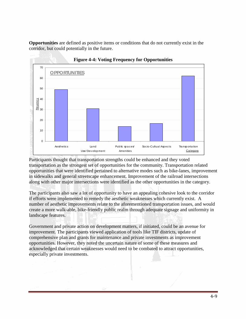
4-9
OPPORTUNITIES
0
10
20
30
40
50
60
70
Aesthetics LandUse/Dev elopment
Public spaces/Amenities
Socio-Cultual Aspects TransportationCategory
Freu
ency
Opportunities are defined as positive items or conditions that do not currently exist in the corridor, but could potentially in the future.
Figure 4-4: Voting Frequency for Opportunities
Participants thought that transportation strengths could be enhanced and they voted transportation as the strongest set of opportunities for the community. Transportation related opportunities that were identified pertained to alternative modes such as bike-lanes, improvement in sidewalks and general streetscape enhancement. Improvement of the railroad intersections along with other major intersections were identified as the other opportunities in the category. The participants also saw a lot of opportunity to have an appealing cohesive look to the corridor if efforts were implemented to remedy the aesthetic weaknesses which currently exist. A number of aesthetic improvements relate to the aforementioned transportation issues, and would create a more walk-able, bike-friendly public realm through adequate signage and uniformity in landscape features. Government and private action on development matters, if initiated, could be an avenue for improvement. The participants viewed application of tools like TIF districts, update of comprehensive plan and grants for maintenance and private investments as improvement opportunities. However, they noted the uncertain nature of some of these measures and acknowledged that certain weaknesses would need to be combated to attract opportunities, especially private investments.

4-10
THREATS
0
10
20
30
40
50
60
70
80
Land Use/Dev elopment Maintenance Socio-Cultual Aspects TransportationCategory
Freq
uenc
y
Threats are defined as negative items or conditions that do not currently exist in the corridor, but could potentially in the future.
Figure 4-5: Voting Frequency for Threats
A lot of the weaknesses identified by participants were interrelated and could be placed in multiple categories. The participants identified socio-cultural aspects as the greatest strength of the corridor; conversely, they viewed potential negative changes in socio-cultural aspects as the most significant threat. Out of town property owners and businesses and their lack of interest in maintaining their respective properties’ were causes of a number of issues in the corridor, as well as a threat to make conditions worse. Lack of funding and pro-active government action were considered both weaknesses and threats by the people. Abandonment of properties leading to vandalism and creating unsafe environments were identified as serious threats by the participants. Lack of maintenance was perceived as contributing to not only a poor aesthetic environment but also a social one. While fewer funds for certain improvements to the railroad and sewer systems were one challenge for the authorities, the lack of strict regulation contributed to disregard by private property owners too. If these trends continued, the people were wary of sustained development. While some groups identified the railroad crossing as an asset, others perceived it as a threat since it divides the city into portions. Others took the middle road, highlighting the potential for the railroad to become an opportunity but at the same time pointing to the lack of funds to cash-in on the opportunity by building an underpass. Overall, the exercise showed the community’s concern with aesthetic, development, socio-cultural and transportation related issues. Maintenance issues ranked high in the weaknesses of the City. Figure 4-6 shows all the SWOT components by their broad categorization.

4-11
SWOT Analysis Results
0
20
40
60
80
100120
140
160
180
200
Accessi
bility
Aesthet
ics
Housing
Land Use/
Develop
ment
Public s
paces/
Ameni
ties
Socio-C
ultual
Aspects
Transpo
rtatio
n
Mainten
ance
Funding
Category
Freq
uenc
y
ThreatsOpportunitiesWeaknessesStrengths
Figure 4-6: Voting Frequency for all SWOT Components
Visual Preference Results
Design Elements
The visual preference survey was conducted on September 9, 2008, as a component of the East Main Street Corridor SWOT and Visual Preference Charrette. The surveys were also handed out at the Open House on September 20, 2008 at the Hy-Vee Store on East Main Street in Galesburg. The participants were asked to rank their preferences of various design elements that they think would be best suited for the corridor redevelopment. In order to measure the preferences of the participants, the choices in the survey were broadly classified. However, these categorizes were not labeled, in order to prevent people from making choices based on the categorizations. The four broad categories are:
A. Standard or Basic design: Where the functionality is the most important factor. B. Traditional/ Ornamental/ Ornate Design: The common aspect of this category is the
materials used for the design; which are brick or wood. In some design elements, it is the ornate characteristics that stand out.
C. Modern Design: This category contains elements which are modernistic in their appeal. These could be pure geometric forms or the usage of contemporary materials.
D. Innovative Design: This category is little more flexible as it varies depending on each design element. However, the primary factor of consideration was the use of either innovative technology or design.

4-12
These four broad categories convey an overall impression of visual preference priorities of the participants. The design elements which were presented to the participants can be found in Appendix C on page C-12.
Table 4-2: Overall Visual Preference Rankings Urban Design Element
Standard/ Basic / functional Design
Ornamental/ Traditional Design
Modern Design
Innovative Design.
A. Planters 4 2 3 1 B. Street Lighting 1 2 3 4 C. Cross Walks 4 1 3 2 D. Side Walks 1 2 4 3 E. Signage- small 4 1 3 4 F. Signage- Big 2 1 3 4 G. Landscape Elements
1 2 4 3
H. Benches 1 2 3 4 I. Bike Racks 4 3 1 2 J. Trash Cans 1 3 2 4 K. Water Fountains 1 3 4 2 L. Drinking Fountains
1 2 3 4
TOTAL 25 24 36 37 Note: 1 is the highest preference
It is evident that both functionality and traditional/vernacular looking designs are the main guiding principles for the choice of the design. Designs that appeared loud or contrasting to the existing environment have been rejected. A lot of comments emphasize the need for a wheelchair, baby and senior citizen friendly design. At the same time, there have been some comments which emphasize the need of something unique but which are also ergonomic at the same time. The last section of the survey dealt with design of the pavements and walkways, which would define the building- street relationship, and also the design of the vacant spaces in between buildings. The preference was to have sidewalks at the same level as the entrances to businesses in order to meet ADA standards. There is however, a marginal difference in the choice of design for the vacant spaces between buildings.
These were some of the general comments or ideas/requirements for the redevelopment of the East Main Street Corridor
General comments:
4-13
1. “The abundant, deteriorated houses should be torn down” 2. “Make city more pedestrian and bicycle friendly” 3. “Focus on downtown core retail, suburbs are dead-should go, simple but elegant,
inexpensive enough.” 4. “Between buildings and above areas, a pet walk area with dog poop bags are required,
street signs needed at South Street and Seminary Street Underpass.”
Errors in data gathering:
• The survey conducted at the charrette allowed interaction among participants, hence there is a possibility that there was a common consensus among the group before making a selection.
• The participants of the charrette were mainly senior citizens, hence this could be another reason for the selection of more traditional/or basic design elements, that would best suit their age group.
• As the survey consisted of several pages, some participants accidentally skipped over one or two sections, creating gaps in the data gathering process.
• A lot of participants had difficulty comprehending the last section of the survey, which emphasized design of building- street relationships and design of vacant spaces in between buildings. Hence, most of these surveys had a general comment on their need/ requirement and in some of the surveys, all preferences were ranked equally.
• In the survey, some of the participants have selected their most preferred choice instead of ranking them. In order to overcome this error, we have ranked ‘5’ for all the blank spaces left behind.
4.3.2 Informal Interview Results Feedback from the interviewees varied in the form of stories, concerns and expectations. Below are some examples of this feedback.
Table 4-3: General Comments from Informal Interviews Sex Status Comments
F Student Resident -Main St. area needs more open/green space -Business should be more diverse and capitalize on social capital -Feels colleges and attractions promote entrance into downtown Galesburg through Seminary Street.
M Former Resident, grew up in Galesburg
-Remembers restrictions for African-Americans towards the end of segregation
F Life Long Resident since 1930's
-Recalls rise and fall of Main Street and different types of businesses that used to be located there
M Life Long Resident since 1960's
-Main Street needs more entertainment spots
F Long Time Resident since 1970's
-Houses are historic and need to be improved and maintained

4-14
M Former Resident, lived in Galesburg from 1970-1990's
-Major issue for housing is the lack of income for upkeep since the Maytag closing
M Long Time Resident since 1960's
-Streets and sidewalks have had significant improvement -Need more workforce development/businesses on Main Street overall.
F Former Resident, grew up in Galesburg
Admires the revamped design of the downtown area especially Cherry and Seminary Street
F & M Former Residents; just moved back into town
-Very concerned on amount of money Galesburg is actually prepared to spend on E. Main St. -Concerned about negative elements open public spaces could attract

5-1
Chapter 5: Plan Recommendations
5.1 Vision and Guiding Principles The public should continue to be provided opportunities to influence the way the corridor
is developed. The corridor should continue to be both a thriving commercial area, as well as a pleasant
place to live. The corridor should be safe and inviting. The corridor should give a positive first impression of Galesburg to visitors from outside
the area. The corridor should accommodate multiple modes of transportation, not just automobiles.
With these principles in mind the recommendations that follow are intended to meet the goals of this plan. 5.2 Plan Recommendations The plan recommendations are based on the case studies, steering committee input, and public input. These improvements recommendations are categorized into general, functional, aesthetic and economic goals, policies and specific actions. 5.2.1 General Recommendations from SWOT Goals:
• To identify potential improvements in the transportation conditions in the corridor. • To identify potential improvements in the land uses in the corridor. • To identify potential improvements to the infrastructure in the corridor. • To identify potential improvements to the aesthetics in the corridor
The public input from the East Main Street SWOT and Visual Preference Charrette provides a logical basis for formulating recommendations to improve the corridor. Considering the Strengths specified in Table C-1 of the SWOT analysis data appearing in Appendix C, preservation of older homes, access and investment in the Galesburg Visitors Center, Neighborhood Watch efforts, proximity to Interstate 74 and the current 5 lane street width on East Main Street are seen by residents as some of the top assets existing in this corridor. Taking these strengths as well as others mentioned by residents into consideration yields the following general recommendations: Policies:
1. Establish well designed gateway entrance to Galesburg off of I-74 2. Promote preservation of older homes with historic integrity. 3. Ensure that future design guidelines for Visitor’s Center show aesthetic and architectural
compatibility with surrounding corridor design. 4. Continue efforts to foster and encourage Neighborhood Watch Groups in surrounding
area. Increase public awareness of these groups.

5-2
Specific Actions: I. Implement Neighborhood Conservation Plans in the residential areas along East Main
Street. II. Create an East Main Street Newsletter encourage neighborhood groups and participation
in the upcoming phases of the East Main Street Corridor Plan. Considering the Weaknesses specified in Table C-2 of the SWOT analysis data, narrow sidewalks, year round maintenance and accessibility of sidewalks, abandoned and/or unmaintained properties, and uninviting design around the I-74 entrance are seen by residents as some of the top weaknesses currently existing in this corridor. Taking these weaknesses as well as the others mentioned by residents into consideration yields the following general recommendations: Policies:
1. Preserve and maintain affordable housing. 2. Discourage intensification of land uses on sites that would alter the historic and
essentially residential character of the site. Explore ways for providing resources and funding opportunities for home improvement and home rent-to-own plans. Create a public outreach and awareness campaign.
Specific Actions:
I. City of Galesburg should work with target property owners along East Main Street and offer maintenance resources and/or attain unwanted or unkempt properties
Considering the Opportunities specified in Table C-3 of the SWOT analysis data, an inviting, pedestrian friendly, comprehensive design plan including transition into downtown, promotion of green space, as well as the creation of an underpass at the railroad crossing are seen by residents as some of the biggest opportunities in the corridor. Taking into account these opportunities and other considerations yields following general recommendations: Policies:
1. Study the feasibility of on or off street bike lanes/paths. 2. Include development of green space or park space into urban design objectives. 3. Construct an inviting and safe underpass at the railroad crossing at Sumner Street. 4. Create visually pleasing signage around I-74 gateway entrance and throughout East Main
Street Corridor as a whole. 5. Partially obscure or soften visibility of parking lots from Main street through the
construction of landscaped berms. 6. Plant suitable, easily maintained vegetation along East Main Street.
Specific Actions:
I. Construct an underpass at the Sumner Street Railroad crossing. II. Conduct a traffic capacity analysis prior to any lane size changes. Future traffic volume
considerations must be performed before any action can be taken.
Considering the Threats specified in Table C-4 of the SWOT analysis data, lack of property maintenance, cost of implementation of plan recommendations, lack of action to implement the

5-3
corridor plan, retention of narrow sidewalks and out of town property owners are seen by residents as some of the biggest threats to the improvement of the East Main Street Corridor. Taking these concepts into consideration, we are able to derive the following general recommendations. Policies:
1. Continue to increase public awareness and participation in the planning process for the East Main Street Corridor through public education and engagement.
2. Promote fiscally feasible design and revitalization efforts in the East Main Street Corridor plan to minimize the costs to the City and its residents.
Specific Actions:
I. Continue well publicized Town Hall Meetings in regards to each Phase of the East Main Street Corridor Plan.
5.2.2 Functional and Aesthetic Improvements recommendations:
Pedestrian and vehicular safety:
From the existing condition survey, it is evident that the corridor is in need of substantial infrastructure improvement to ensure pedestrian and vehicular safety along the corridor. The highest priority should be to expand the existing pedestrian walkway to meet the ADA standards. The utility poles are precariously leaning over the road and the pavement, which could be a potential hazard for both the pedestrians and the vehicles. Apart from these, the sidewalks are interrupted by the overgrown vegetation from the neighboring residences. Goal:
• To ensure that the sidewalk is well maintained and complies with the ADA standards. • To ensure the utility poles are aligned and corrected to prevent any hazards.
Policies:
1. The first objective is to align the utility poles to create a clear space of 4-5 feet for easy passage of pedestrians. A long term objective could be to use Eminent Domain to purchase land, when a parcel in the corridor is redeveloped in the corridor, to expand the right of way and install ADA compliant standards should be considered.
2. Incorporate 2 bike lanes on either side of East Main Street. Create sufficient space to incorporate a green buffer between the road and the adjacent land use, to make it safer for the pedestrians. Also, conduct a traffic study to determine if a three lane road would relatively slow down the vehicular movement. The green space could be a turf of a width ranging from 4- 6 feet in between the road and the sidewalk. Consensus should be built within the community for the proposed measures.
3. Provision of additional transit services along the corridor should be considered. 4. Provision of a green buffer is also essential to create homogeneity among the varying
land uses along the corridor. 5. To enforce codes for the maintenance of landscape elements on the private property
adjoining the main street.

5-4
6. Regular maintenance of the pavements, and green areas along the corridor. Ensuring snow removal for mobility along the corridor.
Specific Actions:
I. Bury all utility lines II. Create space for the addition of two bike lanes along East Main Street
III. Create stricter guidelines for code enforcement
Figure 5-1: Possible Lane Changes Along East Main: Before- 5 Lane (L); After- 3 Lane(R)
Aesthetic improvement aspects:
Goal: • Propose a unified design theme along the corridor that is compatible with the varying
land uses both within the corridor and the downtown while representing the character of Galesburg.
• Improves the aesthetic quality and creates a visually pleasing experience for all users. • To incorporate the ideas gathered from the public input from the visual preference
survey. Policies:
1. Provisions for proper signage and regular maintenance and upkeep are other issues that should be considered by the authorities.
2. Landscaping and alternate transportation provisions such as bike paths along the corridors are other incremental initiatives that would lead to aesthetic and functional improvements.
Specific Actions:
I. Planters: To design innovative planters to bring in pockets of green spaces within the corridor. This could be incorporated within the turf or the medians.
II. Street Lighting: To design street lighting that are made in a similar or the same design theme as the ones incorporated in the downtown area to create continuity between the two sections.

5-5
III. Crosswalks: The crosswalks need to be highlighted to be visible and distinct. Innovative designs can be painted to create demarcate the crossings.
IV. Sidewalks: The sidewalks need to be improved to allow a smooth access way and expanded if funds become available. The functionality and maintenance of the sidewalks is of primary concern. Easy access by wheelchair and for the elderly should be considered when the choice of material is made.
V. Access: Entrance to businesses should not be elevated from the sidewalks to allow easy access for wheelchairs. Whenever possible parking lots for businesses should be placed on the side or rear of the building, with access to parking from the side street. This will help to make the corridor more pedestrian friendly and lively.
VI. Signage (Large and small): Signage should have clarity and preferably include light ornamental design that corresponds with the lighting fixtures along the corridor.
VII. Landscaping elements: At strategic spots, especially the medians, landscape elements, like statues of famous people (of Galesburg) or elements that mirror the design of the street lighting and other features can be incorporated.
VIII. Benches: The seating areas that are ergonomic for all age groups can be located within larger pockets of green spaces.
IX. Trash cans: Locate trash cans along the along the sidewalks. The trash cans could also bear an emblem or logo that maintains the theme of the lighting fixtures and add onto the aesthetic value.
5.2.3 Economic Improvement Recommendations Goal:
• To identify a potential economic development incentive program that encourages increased commercial activity in the corridor.
Policies:
Creation of a Redevelopment Incentive Policy
The redevelopment policy should focus on entire East Main Street corridor, and not be devised for individual properties. Since a number of parcels aligned along the corridor are zoned for commercial use, and a number of vacant parcels are also commercial, a redevelopment incentive policy that focuses on attracting commerce and at the same time maintains the characteristics of the residential zones should be considered.
The idea proposed is to be prepared with a set of criteria for redevelopment incentives when the opportunity arises, such as a developer interested in a new project or an existing owner expanding. It must be understood that the policy has to be applicable to any and all redevelopment along the corridor that meets the policy criteria. A clear policy that defines the included parcels, development guidelines and incentives would allow delays due to lack of policy formulation or negotiation to be avoided, which in itself is an added incentive for private developers.
City assistance would be an incentive for the private developer(s) and also an empowerment tool for the City to regulate private development. Our proposed strategy does not follow the cash-up front technique but is more of a pay-as-you-go strategy in which the extra revenue generated by the particular project is reimbursed to the private property owner. It

5-6
borrows from the concept of Tax Increment Financing, which is currently applied to the corridor, but adds design constraints and other aesthetic considerations to arrive at a uniform characteristic for the 2 mile- stretch. Specific Actions:
• Incentive: Reimbursement of new or increased city revenues generated by the project,
only if those revenues materialize. The incentive could include property, hotel, sales and/or food and beverage taxes for a specified number of years.
• Process: Projects seeking assistance under this program must be presented to the City
Council which will determine the level of assistance to make available and has the flexibility to reject any request for assistance. If council supports an incentive on a specific project, staff will draft an agreement with the developer and bring it to City Council for approval. Projects would need to be approved as Planned Developments to ensure that they are completed in conformance with the design approved by Council.
• Proposed Site Guidelines: The project should meet the following site guidelines to be
eligible for an incentive- o Strategic Location:
o
The site must be located in the East Main Street corridor zone as defined by the City Plans. It should have high visibility along the heavily traveled corridor. Significant Size:
o
Site area (for expansion proposals- total area) should be at least 2 acres. This guideline would ensure that the development has sufficient economic influence on the city revenues. Development Opportunity: Opportunity to reuse and/or expand previously used property
The site must meet one of the following-
Opportunity to reverse negative impact on neighboring properties Opportunity to assemble multiple properties into one project.
o Site Development Challenges: Environmental Concerns
The site must meet one of the following-
Economic Obsolescence (external factors detract from a property’s value) Functional Obsolescence (defects in a structure detract from its value)
• Proposed Project Guidelines: The project must also meet the following five guidelines to be eligible for incentive:
o Should be consistent with the overall plan for the City. o Project consists of demolition and new construction or substantial improvements
to the public portion of an existing building. Private investment must be at least 50% of the overall costs, unless conditionally approved for higher share of assistance, subject to Council approval. Façade improvements alone do not qualify.
o Substantial aesthetic improvements to the property: The development must be high quality, subject to Council Review.
o New or increased City revenues created in terms of property, hotel-motel, food & beverage and/or sales taxes.

5-7
o Redevelopment is not likely to occur without City assistance. The City Council would have the right to waive any proposed re-development project under this policy. Conditional permit for higher percentage of City’s assistance could be qualified as need of developer, additional improvements, significant importance in terms of the corridor’s economy and aesthetic quality. 5.2.4 Special Study Area: Interstate 74 Interchange
The two Galesburg Interstate74 exits serve as gateway onto the East Main Street Corridor. East Main Street can usually be expected to carry the largest numbers of vehicles that enter and leave the City of Galesburg on a daily basis. This gateway is a prime opportunity for the City to give individuals a positive first impression as they enter Galesburg and to provide a pleasant reminder of the community as they depart.
Introduction
Goals:
Current Conditions The first I-74 exit, exit 42-B leads straight onto East Main Street while the second exit, exit 42-A, immediately leads onto East Main Street and under an overpass for the Interstate itself. At first glance, Holiday Inn, abundant vacant space, a gas station, a fenced highway and a ‘Welcome to Galesburg’ sign come into view. The visitor’s center appears on the right as the first commercial establishment while other businesses fade into the backdrop. The transition from the exit ramps to commercial structures and then onto the residential space is abrupt, and leaves little chance for the visitor to immediately comprehend the flavor of Galesburg. The City is in need of a captivating entryway which is representative of the community and the spirit of the people. There is a need to ensure a smooth transition from the entry of the City and the diverse land uses of the rest of the corridor.
• Create an entryway statement at the I-74 gateway entrance that will promote the history,
social capital and spirit of Galesburg • Explore potential for streetscape/landscape features to improve corridor entrance • Provide transition onto East Main Street Corridor for visitor and tourists • Create a more attractive and accommodating environment for pedestrians • Generate buffering between surrounding residential neighborhoods and gateway activity • Encourage private investment around East Main Street Corridor gateway by increasing
the aesthetic appeal Specific Actions:
Concept 1: Decorative Fencing
Description: This concept will use decorative walls or fencing and creative signage as the main focus of gateway improvements. Decorative walls or fencing will be designed to be compatible with the style and materials of the overall East Main Street Corridor project. A landscaped entry

5-8
statement with signage welcoming visitors to Galesburg is a main feature of this concept as well. Landscaping and street trees will be used in combination with the decorative walls on both sides street. Landscaped medians will be placed depending on where they can be accommodated within the right-of-way. The medians would be placed where left turns are not required or appropriate. Long expanses of decorated walls or fences can be complimented with accents to prevent monotony.
Concept 2: Fountainscape
mini-courtyards using a fountain as the central focus. This design can be used in conjunction with or without landscaping proposed in Concept 1 as the decorative walls or fencing can also be a buffer between the pedestrian accessible sitting area around the fountain and the street. The fountainscape concept can also contribute to the transition of the1-74 entrance into a gateway. These mini-courtyards include brick walkways around the fountain as well as public seating (benches etc.). Aesthetically compatible signage can be used with this idea to further distinguish the entrance to the East Main Street Corridor. It should be noted that the significant maintenance and weatherization requirements of this concept should be carefully considered.
Description: This concept involves using the right and left side of the road as heavy landscaped
5.2.5 Special Study Area: BNSF Railroad tracks at Sumner Street Introduction:The BNSF Railway tracks cross East Main Street at grade near Sumner Street. This crossing has major transportation implications, as East Main Street is an arterial road and provides a connection to downtown Galesburg. The participants in the East Main Street SWOT and Visual Preference Charrette voted a grade separation at this intersection as the number one opportunity for the corridor.
According to the Galesburg, Illinois Quiet Zone Feasibility Study (Draft), this section of track is part of the Mendota-Subdivision, and carries more than 70 trains per day. When a train passes the crossing cars must either wait or seek an alternative route. Figure 5-3 shows an aerial view of cars on East Main Street waiting the crossing as a train passes. As a result of the lack of an underpass, some cars utilize a side street and then turn on East South Street to make use of an underpass when there is a train blocking East Main Street. This situation is less than ideal since the side streets used to reach South Street are not arterials, and do not have the same traffic capacity as East Main Street.
Current Conditions:
The Transportation Plan section of the City of Galesburg/Knox County Comprehensive Plan (1999) states that a separation of grades at the two BNSF Railway crossings, including the one on East Main Street, are the two most important improvements that could be made to Main Street in the long range major street plan. The rail service section of the Transportation Plan again mentions that the City’s extensive railway network necessitates numerous roadway crossings. Further, it mentions that grade separated crossings are preferable because of their traffic flow implications, but their high cost limits the number that can be constructed.
Goals:
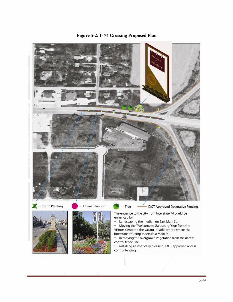
5-9
Figure 5-2: I- 74 Crossing Proposed Plan
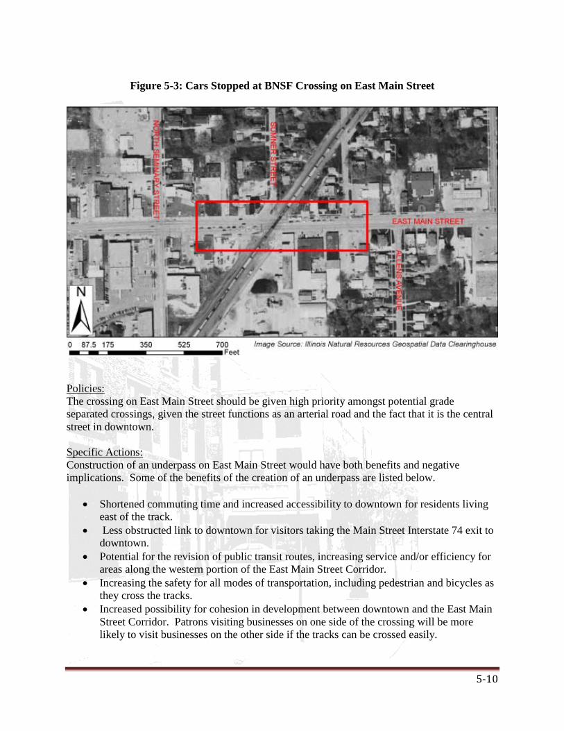
5-10
Figure 5-3: Cars Stopped at BNSF Crossing on East Main Street
The crossing on East Main Street should be given high priority amongst potential grade separated crossings, given the street functions as an arterial road and the fact that it is the central street in downtown.
Policies:
Construction of an underpass on East Main Street would have both benefits and negative implications. Some of the benefits of the creation of an underpass are listed below.
Specific Actions:
• Shortened commuting time and increased accessibility to downtown for residents living
east of the track. • Less obstructed link to downtown for visitors taking the Main Street Interstate 74 exit to
downtown. • Potential for the revision of public transit routes, increasing service and/or efficiency for
areas along the western portion of the East Main Street Corridor. • Increasing the safety for all modes of transportation, including pedestrian and bicycles as
they cross the tracks. • Increased possibility for cohesion in development between downtown and the East Main
Street Corridor. Patrons visiting businesses on one side of the crossing will be more likely to visit businesses on the other side if the tracks can be crossed easily.

5-11
TRAIN GROUND
Some of the conflicts and negative implications are listed below.
• The construction of the underpass could create drainage issues. • Properties and business adjacent to the crossing will likely have to be purchased due to
access issues. • High costs associated with the construction and maintenance of the underpass. • Traffic flow on Main Street will be disrupted during the construction period.
Overall the potential transportation and development benefits that could be realized with the construction of the underpass make it worthy of consideration. Figure 5- 4 and 5-5 on the following page show a rendering of what the area might look like after an underpass is constructed.
Figure 5-4: Proposed Plan and Section

5-12
Figure 5-5: Existing (L) and Proposed (R) Railroad Crossing scenarios

6-1
Chapter 6: Implementation Plan
The functional, aesthetic and economic recommendations each need to be implemented with consideration to each other for effective execution of the project proposal. There is a need for devising a clear strategy, for both government and private initiatives. An overall plan for the entire corridor would help in achieving a unified vision to then allocate tasks and phases of development along the stretch. It is recognized that some of the recommendations may be limited due to available resources. For example, the burying of utility poles is one such initiative requiring considerable investment. However, current financial constraints should not be in the way of planning for these and the expensive measures should be included in the overall plan for the corridor. Consensus should be arrived at to initiate improvements. To illustrate, arriving at a community consensus for the reduction of number of traffic lanes for better pedestrian and alternative transportation modes and aesthetic improvements would allow for a greater room for planning intervention. The project has demonstrated the importance of public participation in generation of consensus and the community should be kept actively involved in the plan-making process. The process of downtown revitalization is also an example that can be learned from and would help in planning the improvements for the corridor. The complimentary relationship between aesthetic, functional and economic improvements should be recognized. There are a number of financing tools that the City may utilize for economic improvements along the corridor. However, it is crucial to align these improvements with functional and aesthetic improvement measures to make the process self-sustaining and profitable for the entire community. Whether economic development or incentives lead to aesthetic improvements or vice- versa may depend on a project-to-project basis, but the plan should concentrate on all aspects. Current zoning along the corridor gives it the characteristic mix of commercial and single and two family residential. For this reason, rezoning would not be an effective means to alter the corridor. However, implementing an overlay zone which puts additional considerations for aesthetic reasons should be considered. The overlay zone would be concerning signage, landscaping, visual and noise buffering (via setbacks, landscaping and other applicable techniques) and other architectural controls aligning with the overall vision that the corridor plan. Aesthetic improvement along the corridor should begin with government initiatives for better maintenance and upkeep of the corridor infrastructure. This would act as an additional incentive for private investors, along with the redevelopment incentive offered. The two end points or special areas, namely the I-74 exit and the railroad crossing, are crucial to the overall development of the corridor. Improvement of these two would create a better entry into the corridor and allow free movement of traffic. The I-74 exit lies in the TIF II district and the railroad crossing lies in the TIF IV district. Since TIF II has been in effect longer than TIF IV and has captured more increment, there is a higher probability of the interstate exit and entry to the corridor being improved earlier. Additional parcels that lie in the TIF II district would be developed along with these aesthetic improvements

6-2
which would include landscaping, I-74 fencing (the issue was important according to the SWOT), and new signage. Pedestrian features should be incorporated into the new development, while recognizing that the traffic speed in this zone would be higher since it comes right off the interstate. Acquiring the property to build the railway underpass would allow for a free flow of traffic along the corridor. This would also encourage layout of bike paths, and additional bus services along the corridor, increasing the traffic on the corridor and further encouraging private commercial and business interests. With the two end points being improved, other improvements along the corridor would follow, such as landscaping, improved signage and lighting. TIF IV district would collect funds to further encourage the private investment and other improvements in due time. There is sufficient private interest in the properties in the TIF districts to encourage future development, particularly the plot next to Taco Bell lying in the TIF II district. On the site across from Hy-Vee, at the intersection of Chestnut and Main, commercial interest is foreseeable. TIF II funds allow redevelopment of vacant lots and a majority of anticipated projects along this area are hotels, motels and restaurants. Any redevelopment of parcels in the corridor should occur in a way that will allow for the possible inclusion of bike lanes and proper pedestrian walkways. Additional design, landscaping and maintenance requirements could also be included. Periodic update of the plan to reflect initiatives that will be implemented and growth in other areas should be monitored to analyze the progress towards the goals set.
Appendices
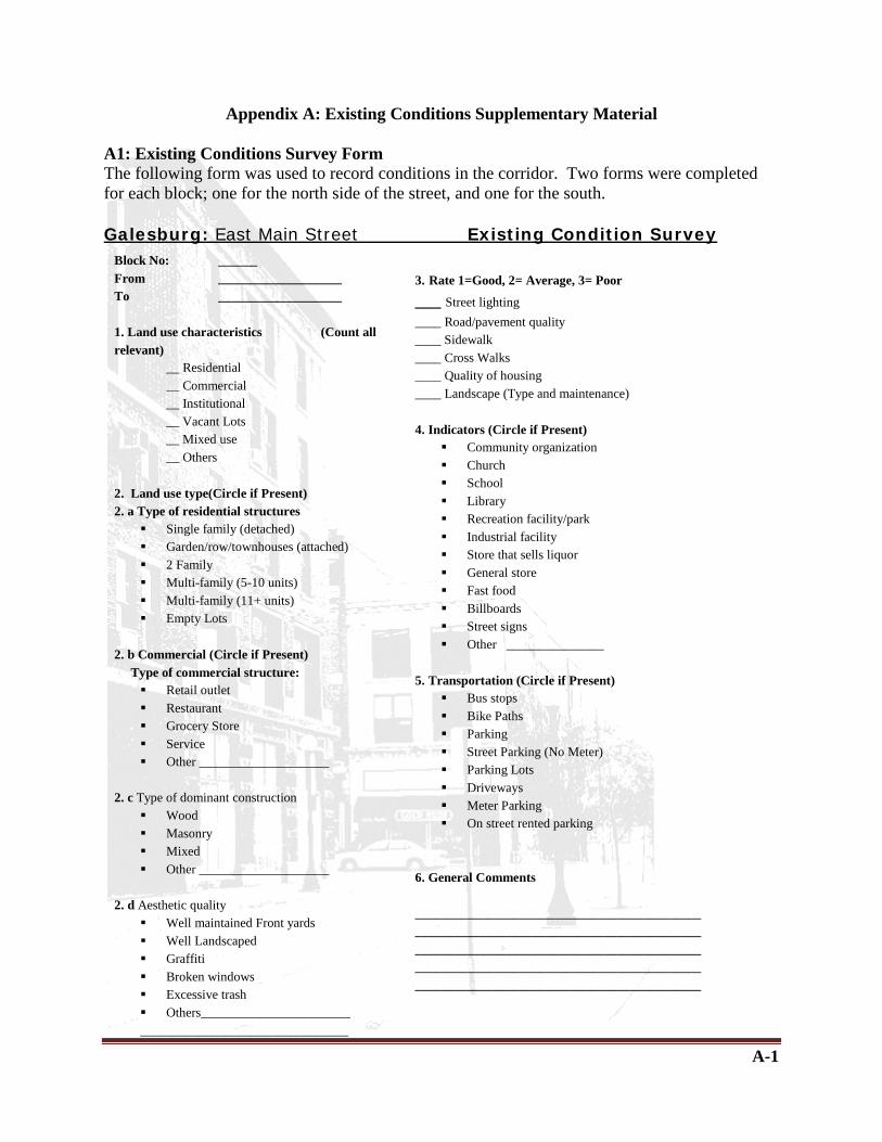
A-1
Appendix A: Existing Conditions Supplementary Material A1: Existing Conditions Survey Form The following form was used to record conditions in the corridor. Two forms were completed for each block; one for the north side of the street, and one for the south.
Galesburg: East Main Street Existing Condition Survey
Block No: ______ From ___________________ To ___________________ 1. Land use characteristics (Count all relevant)
__ Residential __ Commercial __ Institutional __ Vacant Lots __ Mixed use __ Others
2. Land use type(Circle if Present) 2. a Type of residential structures
Single family (detached) Garden/row/townhouses (attached) 2 Family Multi-family (5-10 units) Multi-family (11+ units) Empty Lots
2. b Commercial (Circle if Present) Type of commercial structure:
Retail outlet Restaurant Grocery Store Service Other ____________________
2. c Type of dominant construction Wood Masonry Mixed Other ____________________
2. d Aesthetic quality
Well maintained Front yards Well Landscaped Graffiti Broken windows Excessive trash Others_______________________ ________________________________
3. Rate 1=Good, 2= Average, 3= Poor ___ Street lighting ____ Road/pavement quality ____ Sidewalk ____ Cross Walks ____ Quality of housing ____ Landscape (Type and maintenance) 4. Indicators (Circle if Present)
Community organization Church School Library Recreation facility/park Industrial facility Store that sells liquor General store Fast food Billboards Street signs Other _______________
5. Transportation (Circle if Present)
Bus stops Bike Paths Parking Street Parking (No Meter) Parking Lots Driveways Meter Parking On street rented parking
6. General Comments ________________________________________________________________________________________________________________________________________________________________________________ ____________________________________________

A-2
Table A-1 Existing Conditions Survey: Land Use Characteristics Tally
Block Land Use Charactersistics
No: Dir From To
Residential Commerical Institutional Vacant
Lots Other Mixed
Use
Total (count)
Single Family (tally)
Tow
nhouses (tally)
Multi Fam
ily (tally)
Total (C
ount)
Retail (tally)
Restaurant (tally)
Grocery (tally)
Service (tally)
Other (count) (count) (count) (tally)
1 N I-74 Walnut 1 2 1 1 1 1 S I-74 Michigan 4 1 1 1 1
2 N Walnut Chestnut 0 1 1 1
2 S Michigan Indiana 4 3 1 1 1
3 N Chestnut Lake 3 1 0
3 S Indiana Illinois 4 1 0 1
4 N Lake Madison 6 1 0
4 S Illinois Sheldon 1 1 1 1
5 N Madison Silver 6 1 0
5 S Sheldon Farnham 3 1 1 1
6 N Silver Farnham 2 1 1 1
6 S Farnham Division 8 1
7 N Farnham Arnold 3 1 1 1 1
7 S Division Locust 8 1
8 N Arnold Phillips 6 1 0
8 S Locust Whitesboro 3 1 1
9 N Phillips Whitesboro 9 1
9 S Whitesboro Grand/Blaine 2 1 3 1 1 1
10 N Whitesboro Duffield 5 1
10 S Blaine/Grand Pine 1
11 N Duffield Blaine 1 1 1 1
11 S Pine Allen 4 1 3 1
12 N Blaine Fulton 2 1 1
12 S Allen Sumner 1 1 4 1 1
13 N Fulton Lincoln 3 1 1 1
14 N Lincoln Pearl 1 1 1 3 1 2
15 N Pearl Railway Intersection 1 1 1 1 1
TOTAL 79 16 1 2 34 2 10 3 8 11 1 5 1 1

A-3
Table A-2 Existing Conditions Survey: Aesthetic Quality and Design Elements Tally
Block Type of Construction Aesthetic Quality
Design Elements
No:
Dir
From
To
Wood
Masonry
Mixed
Brick
1=Good 2=Avg 3=Poor
(tally) (tally) (tally) (tally) 1 N I-74 Walnut 0 1.33 1 S I-74 Michigan 1 -1 1.66 2 N Walnut Chestnut 1 -2 2 2 S Michigan Indiana 1 -1 2 3 N Chestnut Lake 1 -1 2.66 3 S Indiana Illinois 1 2 1.33 4 N Lake Madison 1 1 1.66 4 S Illinois Sheldon 1 1 2 1.6 5 N Madison Silver 1 1 2 5 S Sheldon Farnham 1 1 2 1.16 6 N Silver Farnham 1 2 2.16 6 S Farnham Division 1 -3 -1.66 7 N Farnham Arnold 1 0 2.6 7 S Division Locust 1 0 1.8 8 N Arnold Phillips 1 1 2.4 8 S Locust Whitesboro 1 1 0 2 9 N Phillips Whitesboro 1 1 3 2.16 9 S Whitesboro Grand/Blaine 1 1 1.66 10 N Whitesboro Duffield 1 2 2 10 S Blaine/Grand Pine 0 1.6 11 N Duffield Blaine 1 1 2 1.66 11 S Pine Allen 1 0 2 12 N Blaine Fulton 1 3 2.25 12 S Allen Sumner 1 -1 2.6 13 N Fulton Lincoln 1 0 2.6 14 N Lincoln Pearl 1 0 2 15 N Pearl Railway Intersection 1 -3 2.6
TOTAL 14 7 5 4 10 2= Avg.

A-4
Table A-3 Existing Conditions Survey: Neighborhood Indicators Tally Block Indicators
No:
Dir
From
To
Billboard Street signs
store (liquor)
Fast Food
Industrial Facility
Church General Store
(count) (count) (count) (count) (count) (count) (count) 1 N I-74 Walnut 1 1 1 S I-74 Michigan 1 1 2 N Walnut Chestnut 1 2 S Michigan Indiana 1 1 1 1 3 N Chestnut Lake 3 S Indiana Illinois 1 4 N Lake Madison 1 4 S Illinois Sheldon 1 5 N Madison Silver 5 S Sheldon Farnham 1 1 1 6 N Silver Farnham 1 6 S Farnham Division 1 7 N Farnham Arnold 1 1 7 S Division Locust 1 8 N Arnold Phillips 8 S Locust Whitesboro 1 1 9 N Phillips Whitesboro 9 S Whitesboro Grand/Blaine 1 10 N Whitesboro Duffield 10 S Blaine/Grand Pine 1 11 N Duffield Blaine 1 2 11 S Pine Allen 1 1 12 N Blaine Fulton 1 1 1 12 S Allen Sumner 1 1 13 N Fulton Lincoln 1 14 N Lincoln Pearl 1 15 N Pearl Railway
Intersection 1
TOTAL 12 15 3 4 1 1 1

A-5
Table A-4 Existing Conditions Survey: Transportation Elements Tally
Block Transportation No: Dir From To Parking
Lots Driveways Parking Bus Stops
(count) (count) (count) (count) 1 N I-74 Walnut 1 1 S I-74 Michigan 1 1 2 N Walnut Chestnut 1 2 S Michigan Indiana 1 3 N Chestnut Lake 3 S Indiana Illinois 1 4 N Lake Madison 1 4 S Illinois Sheldon 1 5 N Madison Silver 1 5 S Sheldon Farnham 1 1 6 N Silver Farnham 1 1 6 S Farnham Division 1 7 N Farnham Arnold 1 7 S Division Locust 1 8 N Arnold Phillips 1 8 S Locust Whitesboro 1 1 9 N Phillips Whitesboro 1 9 S Whitesboro Grand/Blaine 1 1 10 N Whitesboro Duffield 1 1 10 S Blaine/Grand Pine 11 N Duffield Blaine 1 11 S Pine Allen 1 1 12 N Blaine Fulton 2 12 S Allen Sumner 1 1 13 N Fulton Lincoln 1 14 N Lincoln Pearl 1 15 N Pearl Railway
Intersection 1 1
TOTAL 13 17 2 3
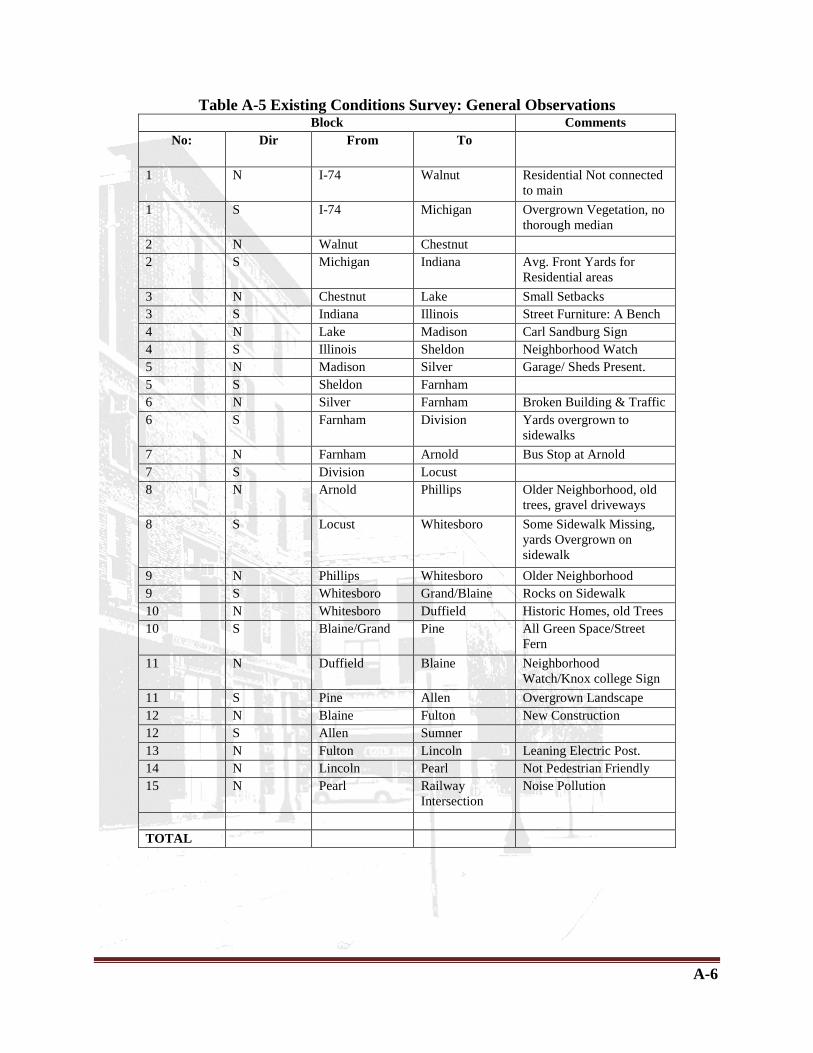
A-6
Table A-5 Existing Conditions Survey: General Observations Block Comments
No: Dir From To
1 N I-74 Walnut Residential Not connected to main
1 S I-74 Michigan Overgrown Vegetation, no thorough median
2 N Walnut Chestnut 2 S Michigan Indiana Avg. Front Yards for
Residential areas 3 N Chestnut Lake Small Setbacks 3 S Indiana Illinois Street Furniture: A Bench 4 N Lake Madison Carl Sandburg Sign 4 S Illinois Sheldon Neighborhood Watch 5 N Madison Silver Garage/ Sheds Present. 5 S Sheldon Farnham 6 N Silver Farnham Broken Building & Traffic 6 S Farnham Division Yards overgrown to
sidewalks 7 N Farnham Arnold Bus Stop at Arnold 7 S Division Locust 8 N Arnold Phillips Older Neighborhood, old
trees, gravel driveways 8 S Locust Whitesboro Some Sidewalk Missing,
yards Overgrown on sidewalk
9 N Phillips Whitesboro Older Neighborhood 9 S Whitesboro Grand/Blaine Rocks on Sidewalk 10 N Whitesboro Duffield Historic Homes, old Trees 10 S Blaine/Grand Pine All Green Space/Street
Fern 11 N Duffield Blaine Neighborhood
Watch/Knox college Sign 11 S Pine Allen Overgrown Landscape 12 N Blaine Fulton New Construction 12 S Allen Sumner 13 N Fulton Lincoln Leaning Electric Post. 14 N Lincoln Pearl Not Pedestrian Friendly 15 N Pearl Railway
Intersection Noise Pollution
TOTAL

B-1
Appendix B: Supplementary Planning Consideration Materials B1: Case Studies The following case studies were conducted to help formulate an approach to creating this plan. B1.1 Case Study I
The Great streets initiative in St. Louis, MO is a project designed to revitalize four streets as an example for the entire City. The South Grand Boulevard example is the stretch between Arsenal Street and McDonald Avenue- a span of 7 blocks that has restaurants and other businesses flanking either sides of it. The South Grand Boulevard narrows from a 6-lane to a 4-lane road along this stretch. The surrounding interior streets have residential land use. This project is related to the East Main corridor both in terms of the surrounding land-use and the process undertaken to arrive at design proposal(s) since it involved considerable public participation. We hope to study and learn from not only the various design elements used and scenarios proposed but also the method employed to arrive at the same. • EXISTING CONDITIONS
Great Streets Initiative: South Grand Blvd., St. Louis MO
Fig I: Street view of existing S. Grand Blvd. Since the Grand Boulevard narrows down from 6 lanes to 4 lanes beyond Arsenal St., the traffic speed and count in the stretch is high. However, at the same time, existence of a number of restaurants, grocery stores and other businesses attract a number of pedestrians to this street. The presence of Tower Grove Park at the intersection of South Grand Boulevard and Arsenal also bring a lot of crowd, especially during the evenings and weekends.

B-2
Fig II: Aerial view of the transition from 6-lane to 4-lane at the intersection of S. Grand Blvd. and Arsenal St. • PROCESS
Through observations, research and collaboration, certain key issues were identified. These were
• High Vehicular Traffic Speeds • Wide Pedestrian Crossing Distances • Lack of Sufficient Pedestrian Lighting • Insufficient Parking Supply • Aging Infrastructure • Unattractive Street
Having identified a variety of problem elements along the corridor, the project team worked with local stakeholders to select the elements of highest priority. The numerous problem elements identified were packaged into five basic elements for potential future improvement (not in order of priority):
• Pedestrian Environment • Motorist Environment • Parking • Street Upkeep • Place-making
The Great streets initiative then conducted a 4-hour design workshop for 20 South Grand Boulevard business, commercial property owner and residential stakeholders. The workshop’s purpose was to:
• Present a menu of possible design ideas and improvements; • Learn about the stakeholders’ desires for the corridor; • Discover the stakeholders’ preferences for various parking, pedestrian,
motorist, street upkeep and place-making improvements.

B-3
Tier Preference Exercise
- After listening to a presentation by members of a consulting team, attendees were asked to prioritize their preferences for the “basic”, “plus” and “major” enhancement tiers. The exercise brought forward the primary concerns of the different stakeholders and proved to be conclusive. The ‘Pedestrian’ element was the most preferred “Plus” tier while the ‘Parking’ element was the most preferred “Major” tier. The ‘Street Upkeep’ element, dealing with issues of maintenance and lighting was the most preferred “Major” tier. The ‘Place-making’ element was the most preferred “Plus” tier.
This was followed by a second preference exercise, in which the attendees were instructed to indicate the top three elements for future action. The results showed that the stakeholders wanted to concentrate on pedestrian, parking and street upkeep elements. When asked to not consider parking, 55% of the participants wanted to concentrate on the pedestrian element, followed by 38% who wanted to concentrate on the street upkeep element.
Fig III: Result of the tier preference exercise
• DESIGN PROPOSALS Having identified the three most important elements to be addressed as part of any solution along South Grand in the future, the project team developed a range of choices to achieve the aspirations of the project. The three key elements offered a set of “givens” for the concept development were:
• The pedestrian realm must be enhanced and, where possible, expanded. • Aging infrastructure (sidewalks, trees, lighting, site furnishings, etc.) must be
repaired and enhanced. • The parking supply should not be reduced in any significant manner.
There were a certain number of constraints that each proposal had to adhere to. Working within the existing right-of-way, the spectrum of improvements was limited to the existing street and pedestrian realm. Given the desire to minimize impact to parking supply presented a tight urban setting to enhance the pedestrian environment. The three alternate scenarios that were developed had certain underlying common design elements. These included- traffic calming, improved lighting with better pedestrian scale lighting, street upkeep and establishment of a district landmark.

B-4
Concept I: 4-Lane Basic enhancement- typical block plan
NOTE: This image represents a typical block, which is a composite of street and block conditions found throughout the Study Area.
Figure IV: Concept 1 Block Plan Key Features
• Pedestrian – curb bulb-outs at intersections; crosswalks at every block; signal timing adjusted to encourage lower travel speeds and to provide pedestrian intervals.
• Parking – existing parking configuration on South Grand Boulevard is maintained. • Infrastructure – reconstruction of sidewalks and tree wells; textured pavement and pavers
at key locations; pedestrian scale white lighting; enhanced landscaping.
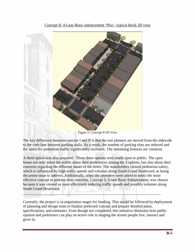
B-5
Concept II: 4-Lane Basic enhancement ‘Plus’- typical block 3D view
Figure V: Concept II 3D View
The key difference between concept I and II is that the tree planters are moved from the sidewalk to the curb lane between parking stalls. As a result, the number of parking slots are reduced and the space for pedestrian traffic significantly increases. The remaining features are common. A third option was also prepared. These three options were made open to public. The open house not only asked the public about their preferences among the 3 options, but also about their concerns regarding the different issues of the street. The stakeholders viewed pedestrian safety, which is influenced by high traffic speeds and volumes along South Grand Boulevard, as being the prime issue to address. Additionally, when the attendees were asked to select the most effective concept to address their concerns, Concept 3, 3-lane Basic Enhancement, was chosen because it was viewed as most effectively reducing traffic speeds and possibly volumes along South Grand Boulevard. ________________________________________________________________________ Currently, the project is in negotiation stages for funding. This would be followed by deployment of planning and design team to finalize preferred concept and prepare detailed plans, specifications, and estimates. Even though not completed, this initiative illustrates how public opinion and preference can play an active role in shaping the streets people live, interact and grow in.

B-6
B1.2 Case Study II
This case study explores the Downtown Mall’s role in Charlottesville, takes stock of existing conditions, and provides guidance for the future of their downtown. Additionally, the City used paving, planting and furniture placement in order to create a cohesive and unified design quality to the Main Street and surrounding Mall shops. They also successfully used side streets located along Main Street as secondary entrances.
Charlottesville’s Downtown Pedestrian Mall: Main Street, Charlottesville, VA
This project is related to the East Main corridor in terms of possibly using side streets as secondary entrances to the Main Street, using cohesive design elements to create a distinct downtown and shopping district and in terms of the public process which included coordination between the City’s steering committee, Mall merchants, and residents. We hope to study and learn from not only the various design elements used but also the method employed to arrive at plan which represents the community well. • EXISTING CONDITIONS I. Side Streets-Along Market and Water Streets, there is little to no indication of the Mall’s presence, making it difficult for newcomers and visitors to even locate the Mall. The streets themselves vary greatly: there is no consistent design, paving or planting approach on the streets. While several buildings along the streets need repairs, many of them are very attractive, with quality brickwork, windows and detailing.
Concept 1. Street Use Plan (First Street to Third Street)

B-7
II. Design Elements- The last implementation plan in the 1970’s, the Halprin project was very successful. It focused on Paving: brick paving, with accented paving at the intersections, fixed elements: trees and lighting fixtures, movable elements: rearrange able black furnishings and meanders. While the Halprin design has stood the test of time, individual elements are showing wear. Trees are sick, paving is cracking and shifting, furniture is wearing out. Small elements such as these contribute to the success of an environment. The Mall today needs a plan to address the issues of aging, to make it more visible and accessible, to anchor it in the City, and to reach out beyond its current boundaries. Weaknesses in this area included lack of public seating and availability of parking; vacant buildings; overabundance of newspaper boxes; lack of nighttime activity beyond bars.
P lan & Process: Side Streets- The new plan recommends extending the presence of the Mall to Market and Water Streets, creating a Downtown Mall District, through a consistent design and palette of paving and furniture. Over time, the side streets should all be renovated to a similar appearance. Key recommendations include: 1. Maintaining a clearly marked drive lane for deliveries, services, and emergency access on all side streets. The perception should be that the street is fully pedestrian. 2. Limit times of service access. Services should be limited to early morning hours so that the streets function as fully pedestrian during the day. 3. Limit parking on the side streets to one loading and one accessible space. Increased pedestrian activity on the side streets will provide more areas for cafes, vendors, and intermittent activities. 4. Maintain drive alley in between side streets. This will increase safety by eliminating vehicles turning around and/ or backing up.
Figure 1. Existing Design Elements (First Street to Fifth Street)

B-8
Plan & Process: Design Elements- The new plan recommends new bricking, newly planted trees and tree gates, bike racks, benches and a unified street vendor design. These ideas shown below can be manipulated in order to contribute to the final vision for the East Main Street Corridor in Galesburg, IL. • New Bricking-The Charlottesville plan includes replacing brick paving for using 4”x8” bricks instead of 4”x12” existing bricks and marking the fire lane in the paving with clearly legible polished red granite pavers to avoid being overly intrusive visually. (See Concepts II and III)
Concept II: Replacing Brick Paving Concept III: Marking the Fire Lane • Tree Gates- Though the previous plan called for Tree Gates to be placed in the ground, trees became mature and required more space. The new plan calls for enlarging openings to accommodate mature tree trunks and adding gravel mulch to reduce the risk of pedestrians tripping in the space between the tree and the opening. (See Concepts IV and V)
Concept IV: Replacing Brick Paving Concept V: Marking the Fire Lane

B-9
• Bike Racks and Benches- (Bikes) The new plan also proposes installation of sixty-six large number of bicycle racks at strategic locations on many of the side streets, at the points where the pedestrian zone begins-See Concept VI. (Benches) The Main Street area already has 20 of the 150 original movable benches places throughout the area to promote conversation. The new plan seeks to continue this idea with a cluster of 5-10 seats in seven locations, coordinated with café leases to increase responsibility. These contribute to a total of 70 seats - See Concept VII.
Concept VI: Bike Racks Concept VII: Improved Benches
• Newspaper Boxes and Trash Cans- (Newspaper Boxes) proposes that vending boxes be located on the side street corners, adjacent to the Mall. The space for the boxes should be clearly defined and take advantage of the blank wall spaces in many of these locations-See Concept VIII. (Trash Cans) The new plan also proposes replacing trash cans with new cans that have an ergonomic design with incorporated ashtray-See Concept IX.
Concept VIII: Newspaper Boxes Concept IX: Trash Cans
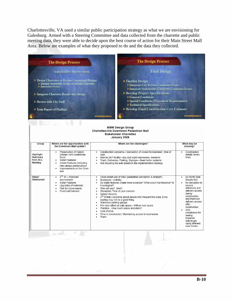
B-10
Charlottesville, VA used a similar public participation strategy as what we are envisioning for Galesburg. Armed with a Steering Committee and data collected from the charrette and public meeting data, they were able to decide upon the best course of action for their Main Street Mall Area. Below are examples of what they proposed to do and the data they collected.

B-11
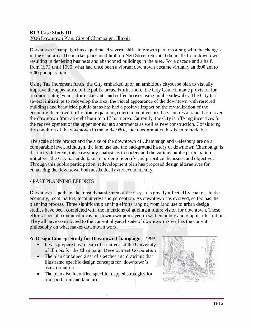
B-12
B1.3 Case Study III
Using Tax Increment funds, the City embarked upon an ambitious cityscape plan to visually improve the appearance of the public areas. Furthermore, the City Council made provision for outdoor seating venues for restaurants and coffee houses using public sidewalks. The City took several initiatives to redevelop the area; the visual appearance of the downtown with restored buildings and beautified public areas has had a positive impact on the revitalization of the economy. Increased traffic from expanding entertainment venues-bars and restaurants-has moved the downtown from an eight hour to a 17 hour area. Currently, the City is offering incentives for the redevelopment of the upper stories into apartments as well as new construction. Considering the condition of the downtown in the mid-1980s, the transformation has been remarkable.
2006 Downtown Plan, City of Champaign, Illinois Downtown Champaign has experienced several shifts in growth patterns along with the changes in the economy. The market place mall built on Neil Street relocated the malls from downtown resulting in depleting business and abandoned buildings in the area. For a decade and a half, from 1975 until 1990, what had once been a vibrant downtown became virtually an 8:00 am to 5:00 pm operation.
The scale of the project and the size of the downtown of Champaign and Galesburg are on a comparable level. Although, the land use and the background history of downtown Champaign is distinctly different, this case study analysis is to understand the various public participation initiatives the City has undertaken in order to identify and prioritize the issues and objectives. Through this public participation, redevelopment plan has proposed design alternatives for enhancing the downtown both aesthetically and economically. • PAST PLANNING EFFORTS Downtown is perhaps the most dynamic area of the City. It is greatly affected by changes in the economy, local market, local interest and perception. As downtown has evolved, so too has the planning process. Three significant planning efforts ranging from land use to urban design studies have been completed with the intentions of guiding a future vision for downtown. These efforts have all contained ideas for downtown portrayed in written policy and graphic illustration. They all have contributed to the current physical state of downtown as well as the current philosophy on what makes downtown work. A. Design Concept Study for Downtown Champaign - 1969
• It was prepared by a team of architects at the University of Illinois for the Champaign Development Corporation
• The plan contained a set of sketches and drawings that illustrated specific design concepts for downtown’s transformation.
• The plan also identified specific mapped strategies for transportation and land use.

B-13
B. Tax Increment Financing District - 1986 • The TIF plan adopted for downtown called for City participation in site assembly for new development, construction of public improvements and assistance for building rehabilitation. • The TIF has been used primarily to fund improvements to public infrastructure and to incentivize the improvement of a blighted building stock. C. Downtown Area Comprehensive Development Plan 1992 • The 1992 Downtown Comprehensive Development Plan established a process for increasing interest in new investment downtown. • This Plan was broken into two primary categories: a. Capital Improvement Projects and b. Marketing and Organizational Tasks

B-14
• PROCESS Market Analysis The market analysis concluded that there would be an increase in demand for residential units and office space in downtown over the next 15 years. This market analysis also concluded that there would be demand for a hotel/motel and conference facilities. These studies have served as the foundation for the 2006 Champaign Downtown Plan. Public Participation • Steering Committee (14 meetings) Issues and Forces Early in the planning process, Steering Committee members undertook an exercise to document downtown’s strengths, weaknesses, opportunities and threats. The top responses to that exercise are displayed below.
• Stakeholder Interviews -Social Service Organizations -Realtors -Redevelopment Incentive Program Participants -Building Owners -Property Owners Trends and Assumptions During a series of stakeholder interviews and analysis, Planning staff and steering committee members explored a number of developing trends currently impacting the downtown, and assumptions about potential issues that could influence the progress of downtown.

B-15
• Public Open Houses (3) • Scenario Workshop (1) On February 17, 2005, the City of Champaign hosted a public workshop that engaged people in a discussion on possible scenarios for downtown’s future. Five different scenarios were presented as a general indication of how downtown could evolve over the next ten years. Two of the scenarios were intentionally melodramatic stories. One creates a utopian vision of downtown while the second represented the worst case scenario for downtown. The remaining three scenarios reflected more realistic descriptions of possible futures for downtown. The Scenario Workshop participants held group discussions about the likelihood of these scenarios, how they as individuals might fit into them and how they might respond to the described changes in downtown. While the intent of the exercise was not to pick any one scenario as “preferred”, groups listed many aspects of each scenario that they liked and disliked. The following vision statement best describes the scenario which was considered as an ideal one: “Downtown Champaign will be a vibrant, walkable downtown, built on its urban character, connected to surrounding neighborhoods, and easily accessible as a regional destination.”
• Plan Commission (2) • City Council Study Sessions (2)
B-16
• DESIGN PROPOSALS Once the main issues have been identified and the objectives have been prioritized through the public participation process, the design elements for various aspects were proposed for redevelopment. These aspects or issues of focus are: Urban design and development Objective: to “preserve and build on downtown’s urban character” and to create a positive pedestrian experience. Transportation Objective: to “Create a downtown that provides balanced accessibility by all modes of transportation and connectivity to surrounding neighborhoods.” Market Demand and Land use Objective: to “Establish a mix of uses that contribute to a vibrant downtown.” Organization Objective:” Market Downtown to attract people from a regional area.” For each category, the redevelopment plan summarizes the issues at hand and also closely examines the challenges faced which would shape the guiding principles and strategies for implementation. Downtown Champaign has now completely transformed into a pedestrian friendly space, where people can experience the new flavor and experience it has been enriched with. The essence of this case study is to understand the community engagement process which has helped revitalize an almost forgotten space. Source: http://www.ci.champaign.il.us/business/page.php?pn=plandocs

B-17
B1.4 Case Study IV Great Streets: 7th and Georgia Avenue Framework Plan, Washington D.C Great Streets is a multi-agency program that strategically uses public investments to improve local quality of life and to attract private investment to communities. The corridors that are identified as the first phase of the Great Streets Program are not only vital to the community development of local neighborhoods, but are also key to enhancing the District’s diversity and prosperity. Georgia Avenue and 7th Street is a growing corridor with expanding residential populations. This, in turn, increases demand for quality retail and transportation infrastructure, particularly for public transit, in the neighborhoods along the corridor. The framework for Great Streets transportation improvement emphasizes enhancing and distinguishing the central retail nodes from intervening predominantly residential, institutional, or open space segments. Streetscape improvements such as public art, signage, and the design of open spaces that draw on adjoining neighborhood characteristics as a design inspiration will convey the history and culture of the corridor and enhance the retail experience. This case study, due to the presence of mixed land use over a stretch of 5 miles, presents an interesting situation, as in the case of Galesburg. The various alternatives proposed, provide a great insight into understanding the translation of principles into design alternatives. Context The predominance of under-performing, repetitive retail facilities and parking lots along the street in conjunction with its indistinct streetscape has led to a monotonous character, which gives little by way of identity to the various neighborhoods that fall along its path. While the corridor does still have strong institutional anchors, it is not the pre-eminent commercial and cultural resource that it once was.
Program Goals 1. Improve the quality of life in neighborhoods along the corridors, including public safety, physical appearance, and personal opportunity; 2. Support local demand for goods and services through economic development; 3. Expand mobility choices and improve safety and efficiency of all modes of travel; and 4. Attract private investment through the demonstration of a public commitment to Great Streets communities.
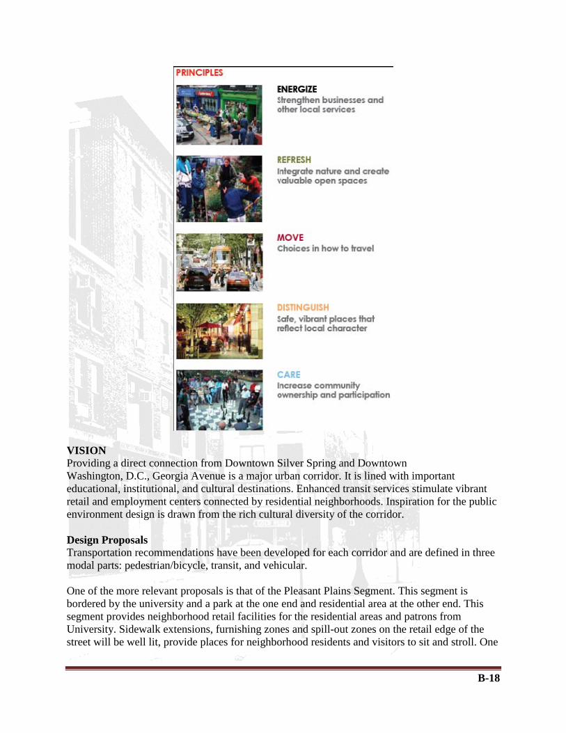
B-18
VISION Providing a direct connection from Downtown Silver Spring and Downtown Washington, D.C., Georgia Avenue is a major urban corridor. It is lined with important educational, institutional, and cultural destinations. Enhanced transit services stimulate vibrant retail and employment centers connected by residential neighborhoods. Inspiration for the public environment design is drawn from the rich cultural diversity of the corridor. Design Proposals Transportation recommendations have been developed for each corridor and are defined in three modal parts: pedestrian/bicycle, transit, and vehicular. One of the more relevant proposals is that of the Pleasant Plains Segment. This segment is bordered by the university and a park at the one end and residential area at the other end. This segment provides neighborhood retail facilities for the residential areas and patrons from University. Sidewalk extensions, furnishing zones and spill-out zones on the retail edge of the street will be well lit, provide places for neighborhood residents and visitors to sit and stroll. One

B-19
of the edges will have a wide planting strip with thick tree canopies. Street sign attachments, insets in the sidewalk clear zone, and way-finding signage that highlight neighborhood names and destinations provide visual clues to orient people. Before:
After:
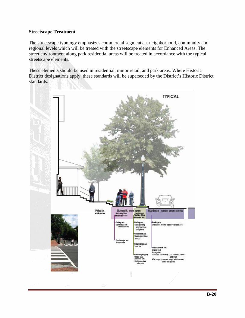
B-20
Streetscape Treatment The streetscape typology emphasizes commercial segments at neighborhood, community and regional levels which will be treated with the streetscape elements for Enhanced Areas. The street environment along park residential areas will be treated in accordance with the typical streetscape elements. These elements should be used in residential, minor retail, and park areas. Where Historic District designations apply, these standards will be superseded by the District’s Historic District standards.

B-21
Source: Great Streets DC 7th and Georgia Framework Plan Government of District of Columbia District Department of Transportation
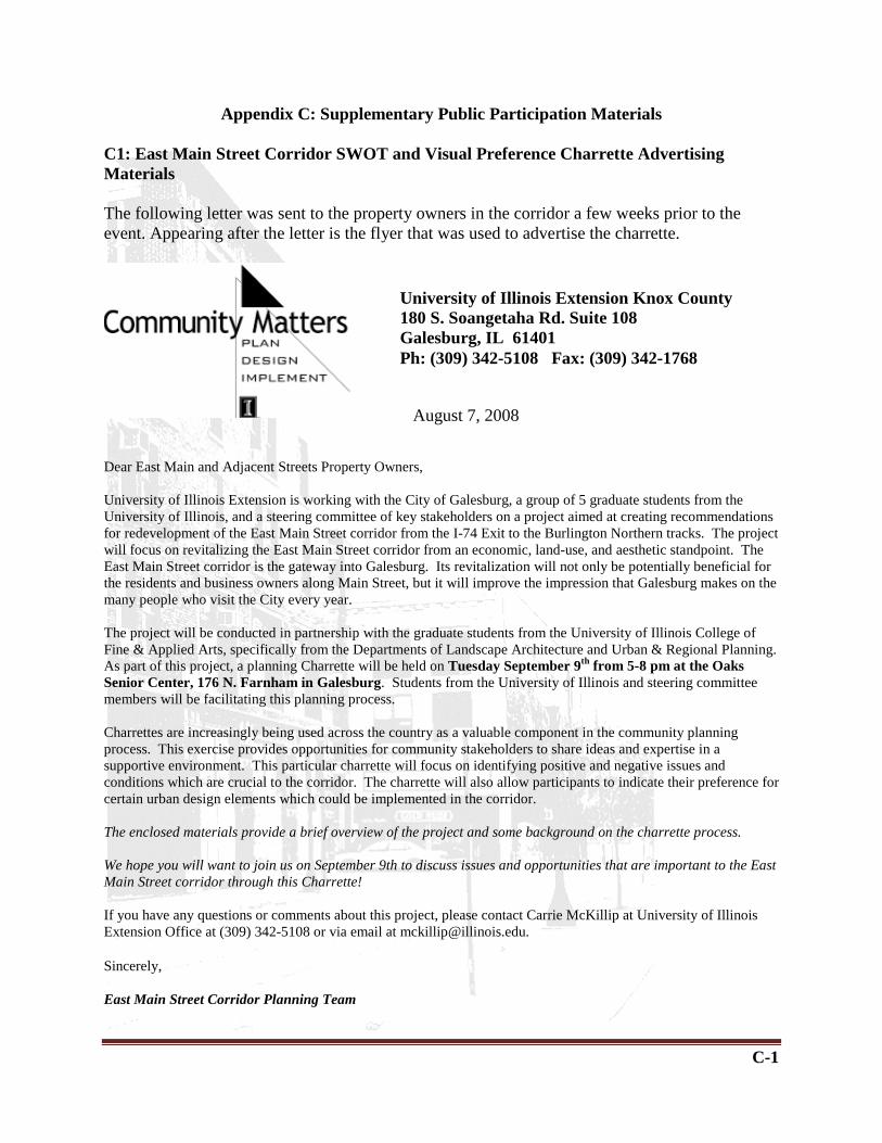
C-1
Appendix C: Supplementary Public Participation Materials C1: East Main Street Corridor SWOT and Visual Preference Charrette Advertising Materials The following letter was sent to the property owners in the corridor a few weeks prior to the event. Appearing after the letter is the flyer that was used to advertise the charrette.
Dear East Main and Adjacent Streets Property Owners, University of Illinois Extension is working with the City of Galesburg, a group of 5 graduate students from the University of Illinois, and a steering committee of key stakeholders on a project aimed at creating recommendations for redevelopment of the East Main Street corridor from the I-74 Exit to the Burlington Northern tracks. The project will focus on revitalizing the East Main Street corridor from an economic, land-use, and aesthetic standpoint. The East Main Street corridor is the gateway into Galesburg. Its revitalization will not only be potentially beneficial for the residents and business owners along Main Street, but it will improve the impression that Galesburg makes on the many people who visit the City every year. The project will be conducted in partnership with the graduate students from the University of Illinois College of Fine & Applied Arts, specifically from the Departments of Landscape Architecture and Urban & Regional Planning. As part of this project, a planning Charrette will be held on Tuesday September 9th from 5-8 pm at the Oaks Senior Center, 176 N. Farnham in Galesburg. Students from the University of Illinois and steering committee members will be facilitating this planning process. Charrettes are increasingly being used across the country as a valuable component in the community planning process. This exercise provides opportunities for community stakeholders to share ideas and expertise in a supportive environment. This particular charrette will focus on identifying positive and negative issues and conditions which are crucial to the corridor. The charrette will also allow participants to indicate their preference for certain urban design elements which could be implemented in the corridor. The enclosed materials provide a brief overview of the project and some background on the charrette process. We hope you will want to join us on September 9th to discuss issues and opportunities that are important to the East Main Street corridor through this Charrette! If you have any questions or comments about this project, please contact Carrie McKillip at University of Illinois Extension Office at (309) 342-5108 or via email at [email protected]. Sincerely, East Main Street Corridor Planning Team
University of Illinois Extension Knox County 180 S. Soangetaha Rd. Suite 108 Galesburg, IL 61401 Ph: (309) 342-5108 Fax: (309) 342-1768
August 7, 2008

C-2
Attachment: East Main Street Corridor Plan and Charrette The East Main Street corridor, which extends along Main Street from I-74 to the Burlington Northern Rail Road tracks at Sumner Street, is the focus of a new project involving graduate students from the University of Illinois Departments of Urban & Regional Planning and Landscape Architecture in collaboration with The University of Illinois Galesburg Extension Office, the City of Galesburg, and a group of local stakeholders. The focus of the project will be to create a plan for aesthetic, functional and economic improvements to the East Main Street Corridor. As part of the process it is crucial that the citizens of the City are given an outlet to provide their input into the plan. As one of the means of encouraging the public to shape this plan, all residents are invited to participate in a charrette that will be aimed at analyzing the existing conditions of the corridor, as well as providing feedback about possible aesthetic improvements. Why the East Main Street Corridor? The East Main Street Corridor is located directly off of I-74 as you enter Galesburg. Due to its location, it is often the first interaction with the City that visitors have when they come to experience the rich cultural and historical experiences that the City has to offer. An inviting entrance into the City will be especially beneficial, as the new National Railway Museum becomes another popular attraction drawing visitors from all over. Further, the East Main Street corridor can build off of the numerous improvements that have been made to the downtown, further enhancing Galesburg’s status as a great place to live. What is a charrette? A charrette is a workshop that brings individuals together to share and discuss their ideas and concerns about a particular subject with others. It often involves breaking into small groups to create several discussions, recording the ideas that are put forth, and then reconvening to share the ideas that each group came up with. Talking out issues in this manner can expose people to viewpoints they may have not previously considered. What will happen at this charrette? At the charrette for the East Main Street Corridor the students from the University of Illinois will introduce the project and discuss a few basic concepts with the whole group that will help stimulate conversation about the corridor. The participants will then break into smaller ten person groups and discuss the positive and negative elements and conditions which currently exist in the corridor. The groups will then reconvene, and the participants will be given the opportunity to discover the ideas presented in the other groups, after which each individual will vote on the ideas that they feel are of the most importance. After voting has concluded, the participants will go back to their small groups at which time they will be given a booklet of materials to review. The first section of the booklet will contain several examples of different
C-3
urban design elements that are found in other cities, and the participants will vote for the examples that they prefer. The second section of the booklet will contain some sketches of the East Main Street Corridor itself featuring a variety of design improvements. The participants will also indicate which of these designs that they prefer. How will the input gathered from the charrette be used? All of the data gathered from the charrette will be compiled and included in the final plan. The issues raised participants will help shape the final recommendations that are made. The visual preferences of the charrette participants will be translated into one of the design scenarios that are included in the final plan. How else can I get involved in this project? There will be an online survey which will also be used to gather resident’s ideas about the corridor. If you have specific questions, ideas or comments about this project you can contact Carrie McKillip at University of Illinois Extension Office at (309) 342-5108.

C-4
This flyer was posted at strategic locations to advertise for the charrette.

C-5
The following insert was placed in the Galesburg Chamber of Commerce Newsletter to advertise the charrette

C-6
C2: East Main Street Galesburg SWOT and Visual Preference Charrette - SWOT Data The following tables display all of the ideas that the charrette participants discussed and the votes for each of these items.
Table C-1: Strengths SWOT component Comments Frequency
Group # Broad Categories
Strength Easy Access to Downtown Area 7 1 Accessibility Strength Close Proximity of the Fire Department 4 6 Accessibility Strength Post Office 0 1 Accessibility Strength Stores that open until Late 0 2 Accessibility Strength Railroad Access 0 3 Accessibility Strength Mature Trees 3 1 Aesthetics Strength Clean 0 1 Aesthetics Strength Good Business Appearances 0 4 Aesthetics Strength Environmental Inspection for Homes 0 4 Aesthetics Strength Older Homes 12 1 Housing Strength Occupied housing/ Neighborhood Feel 2 1 Housing Strength Residential 1 5,3 Housing Strength TIF 8 4 Land Use/Development Strength Availability of spaces for future Development 2 1,2 Land Use/Development Strength New Development 0 5 Land Use/Development Strength Mixed Land use: Residential and Business 0 1 Land Use/Development Strength Not many Pot-holes 0 2 Maintenance Strength Demolition of Vacant Buildings 0 3 Maintenance Strength Diversity of new stores/business 6 6,4,1 Public spaces/ Amenities Strength Hyvee Store/Grocery Store 5 1,2 Public spaces/ Amenities Strength Kiwanis Park 5 1,6 Public spaces/ Amenities Strength Lodging Facilities/ Hotels 3 6,3 Public spaces/ Amenities Strength Knox College 2 1 Public spaces/ Amenities Strength Railraod Museum 2 3 Public spaces/ Amenities Strength Walgreens 1 1,2 Public spaces/ Amenities Strength Green Spaces between Street & Homes 1 6 Public spaces/ Amenities Strength Turnberry Apartments 0 1 Public spaces/ Amenities Strength Restaurants and Gas stations @ I-74 0 5,1,2,3 Public spaces/ Amenities
Strength Wide range of commercial use in close proximity 0 5 Public spaces/ Amenities
Strength Café in the Park 0 3 Public spaces/ Amenities Strength Visitors Center/Welcome center 35 5,1,6,4,2 Socio-Cultual Aspects Strength Neighborhood Watch 22 1 Socio-Cultual Aspects Strength Great People 3 4,2,3 Socio-Cultual Aspects

C-7
Strength Friendly Business 1 1 Socio-Cultual Aspects Strength Ethinic Diversity 0 1 Socio-Cultual Aspects Strength Children Friendly 0 3 Socio-Cultual Aspects Strength Proximity to I-74 27 1,6,4,2,3 Transportation Strength E. Main Street Lane width(5 lane) 17 5,6,3,6 Transportation Strength Truck Traffic/ Heavy Traffic 4 6,1,2 Transportation Strength Paved and well Lit roads 3 1,3 Transportation Strength Busy Farnham Street Intersection 3 2 Transportation Strength Road is new 1 6 Transportation Strength Minimal Traffic 0 5 Transportation Strength Center Turning Lane 0 3 Transportation Strength Adequate Parking 0 3 Transportation
Table C-2: Weaknesses
SWOT component Comments Frequency
Group # Broad Categories
Weakness Downtown employees taking prime parking spaces 0 3 Accessibility
Weakness Poor access from West End of town 0 7 Accessibility Weakness Visual Appeal of Property 1 4 Aesthetic Weakness Aesthetic condition 0 4 Aesthetic Weakness Water Plants 0 4 Aesthetic Weakness I 74 Fencing- Not inviting 15 4,5,7 Aesthetics Weakness Lack of Signage 11 7,5 Aesthetics Weakness Overhead power lines 10 2,5,7 Aesthetics Weakness Poor Landscaping of Interstate 3 4 Aesthetics Weakness Lack of Yard maintenance 1 5 Aesthetics Weakness Funding 8 6,3,1 Funding Weakness Abandoned buildings/ areas 43 6,3,5,1,7 Land Use/ Development Weakness Loss of Business 6 2 Land Use/ Development Weakness Empty gas station @ Soangetaha 6 2 Land Use/ Development Weakness Mix of land uses 1 5 Land Use/ Development Weakness Irregular pattern of development 1 1 Land Use/ Development Weakness Rail Road Crossing 0 5, 6 Land Use/ Development Weakness Comprehensive plan update 0 6 Land Use/ Development Weakness Lack of Easements 0 4 Land Use/ Development Weakness No mixed used spaces 0 2 Land Use/ Development Weakness Inability to attract new business 0 1 Land Use/ Development Weakness Disrepair of Property 18 6,5 Maintenance Weakness Snow on Sidewalks 12 2,3,7 Maintenance Weakness Trash/ Litter 5 3,5,1 Maintenance Weakness Poor Water Drainange 4 6 Maintenance

C-8
Weakness Upkeep of Homes 4 3 Maintenance Weakness Lack of Commercial upkeep ordinances 4 1 Maintenance Weakness Maintenance of bridge by IDOT 2 6 Maintenance Weakness Weeds on Sidewalks 1 4 Maintenance Weakness Poor Rental Inspections 1 1 Maintenance Weakness Concrete lamp posts in need of repair 0 4 Maintenance Weakness Old Sewer Systems 0 2 Maintenance Weakness Poor Communication 3 1 Socio-Cultual Aspects Weakness Brain Drain 2 3 Socio-Cultual Aspects Weakness Out of Town Landlords 1 3 Socio-Cultual Aspects Weakness Loss of Personal Property 0 6 Socio-Cultual Aspects Weakness Elderly Property Issues 0 6 Socio-Cultual Aspects Weakness Narrow sidewalks; very close to street 11 7 Transportation Weakness Poles on Sidewalk 6 4,2 Transportation Weakness Lack of views when coming off the interstate 6 2 Transportation Weakness Noise from passing trains 5 1 Transportation
Weakness Lack of Alley access for deliveries- delivery trucks block traffic 2 2 Transportation
Weakness Main & Farnham intersection- lack of signage for left-turn 2 5 Transportation
Weakness I 74 Entrance 0 6 Transportation Weakness Motel Access 0 6 Transportation Weakness Access to N. Elm St 0 6 Transportation Weakness Truck Traffic 0 6 Transportation Weakness Ownership of Grand & Main intersection by State 0 Transportation
Table C-3: Opportunites
SWOT component Comments Frequency
Group #
Broad Categories
Opportunities Better Transit Access 1 7 Accessibility Opportunities Safety Alarms 0 3 Accessibility
Opportunities Pull downtown (seminary st) motif/ appearance down E. Main 11 2, 4 Aesthetic
Opportunities Landscaping Through Entire Corridor 10 5, 4 Aesthetic
Opportunities Eye Catching From Interstate Rail Road Car or something that says Galesburg 8 2 Aesthetic
Opportunities Historical Markers/ signs in front of homes 4 7 Aesthetic Opportunities "Gateway" Image 4 4 Aesthetic Opportunities Benches 3 5, 7 Aesthetic Opportunities Public Artwork 1 5, 7 Aesthetic Opportunities Decorative Pedestrian Lights with RR Theme 1 5 Aesthetic Opportunities Improve existing bldg/ Uniformity throughout City 0 1 Aesthetic Opportunities Brick Streets 0 1 Aesthetic
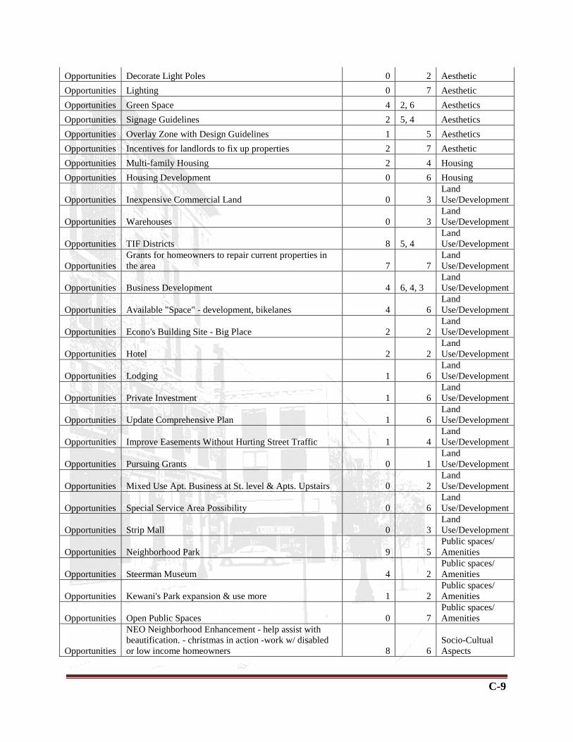
C-9
Opportunities Decorate Light Poles 0 2 Aesthetic Opportunities Lighting 0 7 Aesthetic Opportunities Green Space 4 2, 6 Aesthetics Opportunities Signage Guidelines 2 5, 4 Aesthetics Opportunities Overlay Zone with Design Guidelines 1 5 Aesthetics Opportunities Incentives for landlords to fix up properties 2 7 Aesthetic Opportunities Multi-family Housing 2 4 Housing Opportunities Housing Development 0 6 Housing
Opportunities Inexpensive Commercial Land 0 3 Land Use/Development
Opportunities Warehouses 0 3 Land Use/Development
Opportunities TIF Districts 8 5, 4 Land Use/Development
Opportunities Grants for homeowners to repair current properties in the area 7 7
Land Use/Development
Opportunities Business Development 4 6, 4, 3 Land Use/Development
Opportunities Available "Space" - development, bikelanes 4 6 Land Use/Development
Opportunities Econo's Building Site - Big Place 2 2 Land Use/Development
Opportunities Hotel 2 2 Land Use/Development
Opportunities Lodging 1 6 Land Use/Development
Opportunities Private Investment 1 6 Land Use/Development
Opportunities Update Comprehensive Plan 1 6 Land Use/Development
Opportunities Improve Easements Without Hurting Street Traffic 1 4 Land Use/Development
Opportunities Pursuing Grants 0 1 Land Use/Development
Opportunities Mixed Use Apt. Business at St. level & Apts. Upstairs 0 2 Land Use/Development
Opportunities Special Service Area Possibility 0 6 Land Use/Development
Opportunities Strip Mall 0 3 Land Use/Development
Opportunities Neighborhood Park 9 5 Public spaces/ Amenities
Opportunities Steerman Museum 4 2 Public spaces/ Amenities
Opportunities Kewani's Park expansion & use more 1 2 Public spaces/ Amenities
Opportunities Open Public Spaces 0 7 Public spaces/ Amenities
Opportunities
NEO Neighborhood Enhancement - help assist with beautification. - christmas in action -work w/ disabled or low income homeowners 8 6
Socio-Cultual Aspects

C-10
Opportunities Promote History 4 1 Socio-Cultual Aspects
Opportunities American Flags Flying - Patriotism 3 2 Socio-Cultual Aspects
Opportunities Open to change 2 1 Socio-Cultual Aspects
Opportunities Underpass 21 5, 6, 3 Transporation Opportunities Bike Lanes 8 7, 3 Transportation Opportunities Tie in Railroad 7 1 Transportation Opportunities Improve Access to Visitor Center 6 5 Transportation
Opportunities Extended Bus Services to Area - Improve Public Transportation 4 6 Transportation
Opportunities Fix Railroad crossing - ease of use 3 6 Transportation Opportunities Trolleys instead of trains 1 1 Transportation Opportunities Grand & Main St. Enhancement 1 6 Transportation Opportunities Wider Sidewalk 1 3 Transportation Opportunities Expansion Wider Streets 0 1 Transportation Opportunities Truck Traffic 0 6 Transportation Opportunities Improve Appearance of Controlled Access to I-74 10 4 Transportation
Table C-4: Threats SWOT component Comments Frequency
Group # Common Issue
Threat Access to Welcome/Visitors Center 7 2 Accessibility Threat Motel Access 1 Accessibility Threat Lighting 3 7 Aesthetics Threat Bury electrical lines 1 2 Aesthetics Threat Strip Malls 8 7 Land Use/Development Threat Mixed use-Commerical v Residential 5 7 Land Use/Development Threat Poor planning leading to loss of historical bldgs. 4 7 Land Use/Development Threat Development in other areas (ie Seminary Street) 2 1 Land Use/Development Threat Abandoned buildings 2 Land Use/Development Threat Abandoned buildings 2 6 Land Use/Development Threat Comp. Plan needs update 2 6 Land Use/Development
Threat New Commercial could reduce EAV of residential 1 5 Land Use/Development
Threat Strip Mall 1 4 Land Use/Development Threat Ability to fill empty space 1 6 Land Use/Development Threat Control of types of development 0 5 Land Use/Development Threat Business interfering with residential 0 7 Land Use/Development Threat Continuing with Vision 0 6 Land Use/Development Threat Follow Comp. Plan 0 6 Land Use/Development Threat Isolated property deterioration 22 4 Maintenance Threat Continued lack of maintenance of property 19 5 Maintenance Threat Sewer System too old 5 2 Maintenance Threat Deterioration of Grand to RR tracks 4 4 Maintenance Threat Decline of property 4 6 Maintenance

C-11
Threat Not maintaining residential/inconsistency 2 4 Maintenance Threat Disrepair of Property 1 Maintenance Threat Disrepair of Property 1 6 Maintenance Threat Vandalism 1 3 Maintenance
Threat New Parks could create loitering, undesired people 2 5
Public spaces/ Amenities
Threat Out of Town property owners 13 1 Socio-Cultual Aspects Threat Cost of Changes 10 2 Socio-Cultual Aspects Threat Doing Nothing 10 4 Socio-Cultual Aspects Threat Funding available/ $$$ 10 6 Socio-Cultual Aspects
Threat Lack of Enthusiasm/Cooperation for Development 9 1 Socio-Cultual Aspects
Threat Failure to make timely decisions 5 1 Socio-Cultual Aspects
Threat "Downtown Cartel" same people controlling development 4 2 Socio-Cultual Aspects
Threat City Council unwilling to fund 4 6 Socio-Cultual Aspects Threat Taxes 3 1 Socio-Cultual Aspects Threat Lack of Funds 2 1 Socio-Cultual Aspects Threat Lack of Proactive Stance for Improving City 1 6 Socio-Cultual Aspects Threat Funding 1 Socio-Cultual Aspects Threat Funding 1 6 Socio-Cultual Aspects
Threat Elderly Property Issues(taxes, repair, maintenance) 0 6 Socio-Cultual Aspects
Threat Sidewalks to close to the Road 16 5 Transportation Threat Increase of train traffic and noise 5 7 Transportation Threat Rail Road Crossing 1 Transportation Threat Motel Access 1 6 Transportation Threat Rail Road Crossing 1 6 Transportation
Threat Ownership of Grand & Main intersection by State 1 6 Transportation
Threat Truck Traffic 0 6 Transportation

C-12
C3: Visual Preference Survey ResultsThe visual preference survey elements that the participants were asked to rank, and their rankings are depicted below.

C-13

C-14

C-15

C-16C-16

C-17

C-18
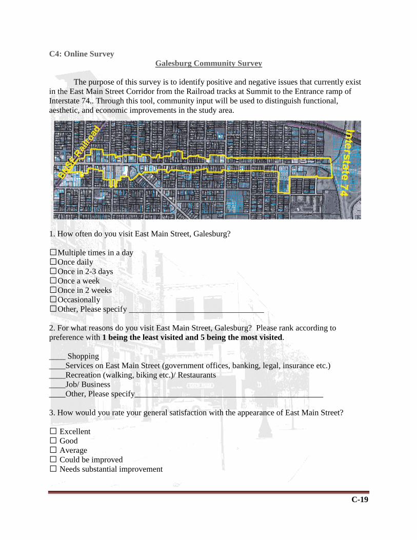
C-19
C4: Online Survey
1. How often do you visit East Main Street, Galesburg? Multiple times in a day Once daily Once in 2-3 days Once a week Once in 2 weeks Occasionally Other, Please specify _________________________________ 2. For what reasons do you visit East Main Street, Galesburg? Please rank according to preference with 1 being the least visited and 5 being the most visited. ____ Shopping ____Services on East Main Street (government offices, banking, legal, insurance etc.) ____Recreation (walking, biking etc.)/ Restaurants ____Job/ Business ____Other, Please specify______________________________________________ 3. How would you rate your general satisfaction with the appearance of East Main Street? Excellent Good Average Could be improved Needs substantial improvement
Galesburg Community Survey
The purpose of this survey is to identify positive and negative issues that currently exist in the East Main Street Corridor from the Railroad tracks at Summit to the Entrance ramp of Interstate 74.. Through this tool, community input will be used to distinguish functional, aesthetic, and economic improvements in the study area.

C-20C
4. On a scale of 1 to 5, with 1 being very satisfied and 5 being very dissatisfied, please circle your level of satisfaction concerning community services and existing infrastructure along East Main Street.
a. Street Condition .......................................1 .................2 ....................3 .................. 4...................... 5........................ 6b. Sidewalk Condition..................................1 .................2 ....................3 .................. 4...................... 5........................ 6c. Traffic Condition .....................................1 .................2 ....................3 .................. 4...................... 5........................ 6d. Maintenance of infrastructure ..................1 .................2 ....................3 .................. 4...................... 5........................ 6e. Community services (grocery stores) ......1 .................2 ....................3 .................. 4...................... 5........................ 6f. Level of vehicular noise...........................1 .................2 ....................3 .................. 4...................... 5........................ 6g. Public Transit...........................................1 .................2 ....................3 .................. 4...................... 5........................ 6h. Appearance of residential buildings.........1 .................2 ....................3 .................. 4...................... 5........................ 6i. Appearance of commercial buildings ......1 .................2 ....................3 .................. 4...................... 5........................ 6j. Open/ Green spaces .................................1 .................2 ....................3 .................. 4...................... 5........................ 6k. Pedestrian access .....................................1 .................2 ....................3 .................. 4...................... 5........................ 6
5. What mode of transportation do you use to travel to/from or via Main Street? Please select all that apply.
� Bike Proceed to Q#.5.1� Drive/ CarpoolProceed to Q#5.5� Public Transit Proceed to Q#6� Walk Proceed to Q#6� Other, Please specify____________________________________Proceed to Q#6
5.1. Do you use your bicycle as your primary mode of transportation?� Yes� No
5.2. How often do you use your bicycle on Main Street?� Every trip to Main Street� Often; once in 2-3 trips to Main Street� Occasionally; depends on weather and other conditions� Other; Please specify______________________________
a. Street Condition .......................................1 .................2 ....................3 .................. 4...................... 5........................ 66b. Sidewalk Condition..................................1 .................2 ....................3 .................. 4...................... 5........................ 66c. Traffic Condition .....................................1 .................2 ....................3 .................. 4...................... 5........................ 66d. Maintenance of infrastructure ..................1 .................2 ....................3 .................. 4...................... 5........................ 66e. Community services (grocery stores) ......1 .................2 ....................3 .................. 4...................... 5........................ 66f. Level of vehicular noise...........................1 .................2 ....................3 .................. 4...................... 5........................ 66g. Public Transit...........................................1 .................2 ....................3 .................. 4...................... 5........................ 66h. Appearance of residential buildings.........1 .................2 ....................3 .................. 4...................... 5........................ 66i. Appearance of commercial buildings ......1 .................2 ....................3 .................. 4...................... 5........................ 66j. Open/ Green spaces .................................1 .................2 ....................3 .................. 4...................... 5........................ 66k. Pedestrian access .....................................1 .................2 ....................3 .................. 4...................... 5........................ 66
Very Satisfied Satisfied Indifferent Dissatisfied Very Dissatisfied Don’t Know
Mode(s) of Travel section- Bike

C-21C
5.3. Do you consider East Main Street ‘bike-friendly’?� Yes- extremely bike friendly� Partially- could use improvement� No- needs substantial improvement
5.4. What improvements could be made to the street to better servebikers such as you? Please answer below.
________________________________________________________________________________________________________________________________________________________________________________________________________________________________________________________________________________________________________________________________________________________________________
If you use other modes of transportation on East Main Street, please proceed to the relevant section. Or, please proceed to Question 6.
5.5. How often do you drive your car on Main Street?� Every trip to Main Street� Often; once in 2-3 trips to Main Street� Occasionally; depends on weather and other conditions� Other; Please specify______________________________
5.6. For what purpose do you visit the area by your vehicle? Please check all that apply.� Work� Shop� Dine� Entertainment� Attend religious service� Other; Please specify___________________________________
5.7. How would you describe the traffic situation on Main Street?� Good � Average; Could use improvement� Poor; Needs substantial improvement
Mode(s) of Travel section- Car

C-22
5.8. How would you describe the parking situation on the side streets off of East Main Street?� Good � Average; Could use improvement� Poor; Needs substantial improvement
5.9. During what time is the traffic and parking situation the worst?� All the time� Travel to/from work hours (6-9am & 3-6pm)� Lunch Time (12:00 noon)� Evenings (After 7pm)� Weekends� Other; Please specify____________________________________
5.10. What improvements could be made to the street use to improvedriving? Answer below.
____________________________________________________________________________________________________________________________________________________________________________________________________________________________________________________________________________________________________________
6. Do you consider East Main Street pedestrian friendly? � Yes- extremely pedestrian friendly� Partially- could use improvement� No- needs substantial improvement
7. What improvements could be made to East Main Street use to be more pedestrian friendly? Please check all that apply
� Better transit services for easier connectivity� Defined, tree-lined pedestrian paths� Landmarks/ planters/ Other street furniture elements� Outdoor seating/ restaurants� Other; Please specify_______________________________________________
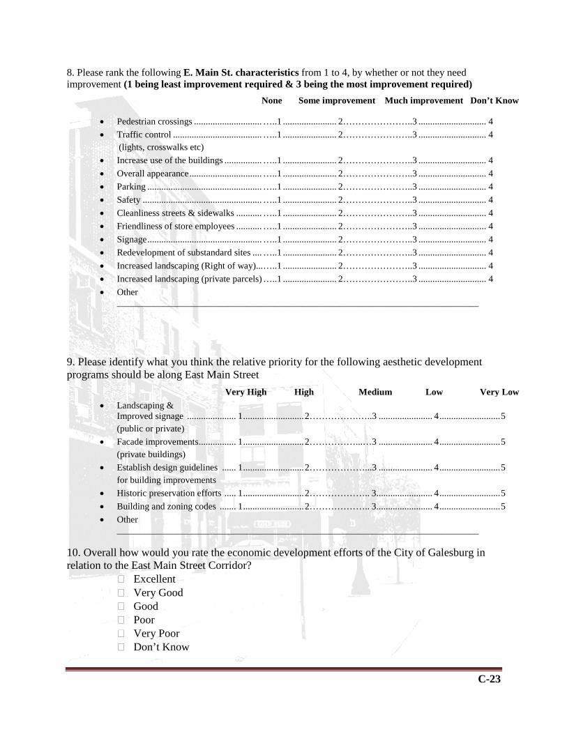
C-23
8. Please rank the following E. Main St. characteristics from 1 to 4, by whether or not they need improvement (1 being least improvement required & 3 being the most improvement required)
• Pedestrian crossings ............................. …..1 ....................... 2…………………..3 ............................. 4 • Traffic control ...................................... …..1 ....................... 2…………………..3 ............................. 4 (lights, crosswalks etc) • Increase use of the buildings ................ …..1 ....................... 2…………………..3 ............................. 4 • Overall appearance ............................... …..1 ....................... 2…………………..3 ............................. 4 • Parking ................................................. …..1 ....................... 2…………………..3 ............................. 4 • Safety ................................................... …..1 ....................... 2…………………..3 ............................. 4 • Cleanliness streets & sidewalks ........... …..1 ....................... 2…………………..3 ............................. 4 • Friendliness of store employees ........... …..1 ....................... 2…………………..3 ............................. 4 • Signage ................................................. …..1 ....................... 2…………………..3 ............................. 4 • Redevelopment of substandard sites .... …..1 ....................... 2…………………..3 ............................. 4 • Increased landscaping (Right of way)... …..1 ....................... 2…………………..3 ............................. 4 • Increased landscaping (private parcels) …..1 ....................... 2…………………..3 ............................. 4 • Other
______________________________________________________________________________
9. Please identify what you think the relative priority for the following aesthetic development programs should be along East Main Street
• Landscaping &
Improved signage ..................... 1 .......................... 2…………….…..3 ....................... 4 .......................... 5 (public or private)
• Facade improvements ................ 1 .......................... 2……………...…3 ....................... 4 .......................... 5 (private buildings)
• Establish design guidelines ...... 1 .......................... 2………………...3 ....................... 4 .......................... 5 for building improvements
• Historic preservation efforts ..... 1 .......................... 2……………….. 3 ........................ 4 .......................... 5 • Building and zoning codes ....... 1 .......................... 2……………….. 3 ........................ 4 .......................... 5 • Other
______________________________________________________________________________ 10. Overall how would you rate the economic development efforts of the City of Galesburg in relation to the East Main Street Corridor?
� Excellent � Very Good � Good � Poor � Very Poor � Don’t Know
None Some improvement Much improvement Don’t Know
Very High High Medium Low Very Low

C-24
11. Please identify what you think the relative priority for the following economic development programs should be along East Main Street.
a. Supporting existing businesses ........ 1 .......................... 2…………………3 ...................... 4 .......................... 5 b. New businesses development .......... 1 .......................... 2 …………………3 ..................... 4 .......................... 5 c. New residential development ........... 1 .......................... 2…………………3 ...................... 4 .......................... 5
12. What types of new businesses would you like to see located along East Main Street? We are especially interested in businesses that you would be very likely to support.
__________________________________________________________________________________________________________________________________________ __________________________________________________________________________________________________________________________________________
13. What is the most interesting aspect of the East Main Street Corridor??
____________________________________________________________________________________________________________________________________________________________________________________________________________________________________________________________________________________
14. What are the most threatening issues for the East Main Street Corridor??
__________________________________________________________________________________________________________________________________________ __________________________________________________________________________________________________________________________________________
15. Please indicate your gender. This information will help us compile demographic profiles for the City.
� Male � Female
16. What is your age? ________ years 17. How long have you been a resident/frequent visitor of the Galesburg area? ______ Years 18. Do you own or rent your residence? Own Rent
Very High High Medium Low Very Low
C-25
19. Please indicate the nearest intersection for your residence? This information will help us compile profiles for neighborhoods in the City and will not be used to contact you for any reason.
__________________________________________________________________________________________________________________________________________ __________________________________________________________________________________________________________________________________________
20. Do you have internet access?
� Yes � Occasionally � No
21. Please add any additional comments or suggestions.
__________________________________________________________________________________________________________________________________________ __________________________________________________________________________________________________________________________________________
Thank you for completing the survey. Results will be posted on the City of Galesburg website at the completion of the study. For questions or more information please contact:
U of I Extension (Knox County) 180 S Soangetaha Rd, Ste 108
Galesburg, IL 61401-5595 Phone: 309-342-5108 FAX: 309-342-1768