Beach dynamics of Colachel open coast, Kanyakumari District (Sw India)
15
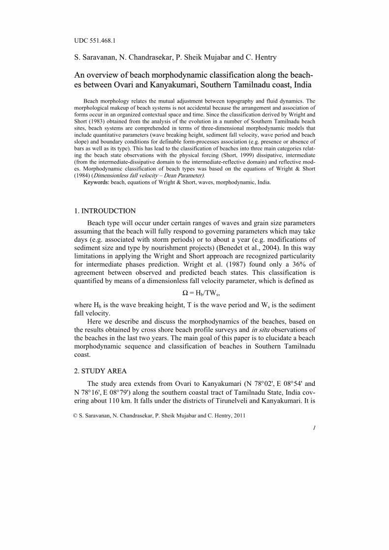
1 © S. Saravanan, N. Chandrasekar, P. Sheik Mujabar and C. Hentry, 2011 UDC 551.468.1 S. Saravanan, N. Chandrasekar, P. Sheik Mujabar and C. Hentry An overview of beach morphodynamic classification along the beach- es between Ovari and Kanyakumari, Southern Tamilnadu coast, India Beach morphology relates the mutual adjustment between topography and fluid dynamics. The morphological makeup of beach systems is not accidental because the arrangement and association of forms occur in an organized contextual space and time. Since the classification derived by Wright and Short (1983) obtained from the analysis of the evolution in a number of Southern Tamilnadu beach sites, beach systems are comprehended in terms of three-dimensional morphodynamic models that include quantitative parameters (wave breaking height, sediment fall velocity, wave period and beach slope) and boundary conditions for definable form-processes association (e.g. presence or absence of bars as well as its type). This has lead to the classification of beaches into three main categories relat- ing the beach state observations with the physical forcing (Short, 1999) dissipative, intermediate (from the intermediate-dissipative domain to the intermediate-reflective domain) and reflective mod- es. Morphodynamic classification of beach types was based on the equations of Wright & Short (1984) (Dimensionless fall velocity – Dean Parameter). Keywords: beach, equations of Wright & Short, waves, morphodynamic, India. 1. INTROUDCTION Beach type will occur under certain ranges of waves and grain size parameters assuming that the beach will fully respond to governing parameters which may take days (e.g. associated with storm periods) or to about a year (e.g. modifications of sediment size and type by nourishment projects) (Benedet et al., 2004). In this way limitations in applying the Wright and Short approach are recognized particularity for intermediate phases prediction. Wright et al. (1987) found only a 36% of agreement between observed and predicted beach states. This classification is quantified by means of a dimensionless fall velocity parameter, which is defined as Ω = H b /TW s , where H b is the wave breaking height, T is the wave period and W s is the sediment fall velocity. Here we describe and discuss the morphodynamics of the beaches, based on the results obtained by cross shore beach profile surveys and in situ observations of the beaches in the last two years. The main goal of this paper is to elucidate a beach morphodynamic sequence and classification of beaches in Southern Tamilnadu coast. 2. STUDY AREA The study area extends from Ovari to Kanyakumari (N 78°02', E 08°54' and N 78°16', E 08°79') along the southern coastal tract of Tamilnadu State, India cov- ering about 110 km. It falls under the districts of Tirunelveli and Kanyakumari. It is
-
Upload
classicloomdata -
Category
Documents
-
view
0 -
download
0
Transcript of Beach dynamics of Colachel open coast, Kanyakumari District (Sw India)
1
© S. Saravanan, N. Chandrasekar, P. Sheik Mujabar and C. Hentry, 2011
UDC 551.468.1 S. Saravanan, N. Chandrasekar, P. Sheik Mujabar and C. Hentry An overview of beach morphodynamic classification along the beach-es between Ovari and Kanyakumari, Southern Tamilnadu coast, India
Beach morphology relates the mutual adjustment between topography and fluid dynamics. The
morphological makeup of beach systems is not accidental because the arrangement and association of forms occur in an organized contextual space and time. Since the classification derived by Wright and Short (1983) obtained from the analysis of the evolution in a number of Southern Tamilnadu beach sites, beach systems are comprehended in terms of three-dimensional morphodynamic models that include quantitative parameters (wave breaking height, sediment fall velocity, wave period and beach slope) and boundary conditions for definable form-processes association (e.g. presence or absence of bars as well as its type). This has lead to the classification of beaches into three main categories relat-ing the beach state observations with the physical forcing (Short, 1999) dissipative, intermediate (from the intermediate-dissipative domain to the intermediate-reflective domain) and reflective mod-es. Morphodynamic classification of beach types was based on the equations of Wright & Short (1984) (Dimensionless fall velocity – Dean Parameter).
Keywords: beach, equations of Wright & Short, waves, morphodynamic, India.
1. INTROUDCTION
Beach type will occur under certain ranges of waves and grain size parameters assuming that the beach will fully respond to governing parameters which may take days (e.g. associated with storm periods) or to about a year (e.g. modifications of sediment size and type by nourishment projects) (Benedet et al., 2004). In this way limitations in applying the Wright and Short approach are recognized particularity for intermediate phases prediction. Wright et al. (1987) found only a 36% of agreement between observed and predicted beach states. This classification is quantified by means of a dimensionless fall velocity parameter, which is defined as
Ω = Hb/TWs,
where Hb is the wave breaking height, T is the wave period and Ws is the sediment fall velocity.
Here we describe and discuss the morphodynamics of the beaches, based on the results obtained by cross shore beach profile surveys and in situ observations of the beaches in the last two years. The main goal of this paper is to elucidate a beach morphodynamic sequence and classification of beaches in Southern Tamilnadu coast. 2. STUDY AREA
The study area extends from Ovari to Kanyakumari (N 78°02', E 08°54' and N 78°16', E 08°79') along the southern coastal tract of Tamilnadu State, India cov-ering about 110 km. It falls under the districts of Tirunelveli and Kanyakumari. It is
2
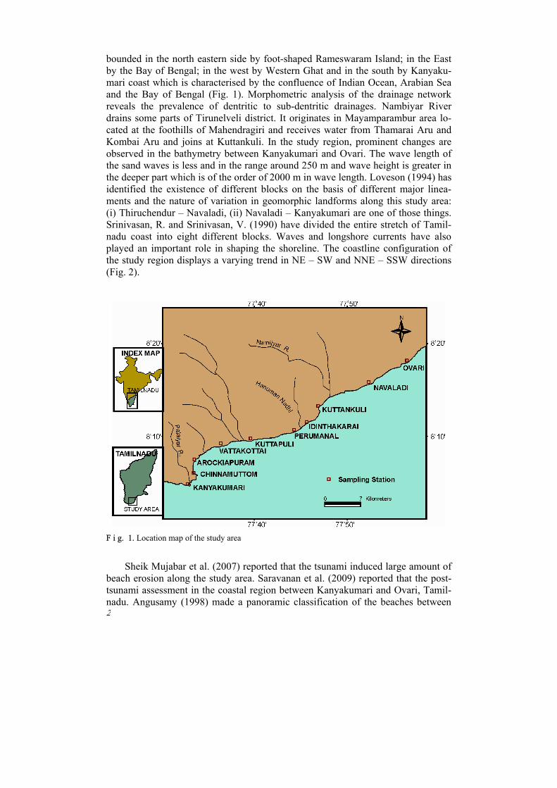
bounded in the north eastern side by foot-shaped Rameswaram Island; in the East by the Bay of Bengal; in the west by Western Ghat and in the south by Kanyaku-mari coast which is characterised by the confluence of Indian Ocean, Arabian Sea and the Bay of Bengal (Fig. 1). Morphometric analysis of the drainage network reveals the prevalence of dentritic to sub-dentritic drainages. Nambiyar River drains some parts of Tirunelveli district. It originates in Mayamparambur area lo-cated at the foothills of Mahendragiri and receives water from Thamarai Aru and Kombai Aru and joins at Kuttankuli. In the study region, prominent changes are observed in the bathymetry between Kanyakumari and Ovari. The wave length of the sand waves is less and in the range around 250 m and wave height is greater in the deeper part which is of the order of 2000 m in wave length. Loveson (1994) has identified the existence of different blocks on the basis of different major linea-ments and the nature of variation in geomorphic landforms along this study area: (i) Thiruchendur – Navaladi, (ii) Navaladi – Kanyakumari are one of those things. Srinivasan, R. and Srinivasan, V. (1990) have divided the entire stretch of Tamil-nadu coast into eight different blocks. Waves and longshore currents have also played an important role in shaping the shoreline. The coastline configuration of the study region displays a varying trend in NE – SW and NNE – SSW directions (Fig. 2).
F i g. 1. Location map of the study area
Sheik Mujabar et al. (2007) reported that the tsunami induced large amount of beach erosion along the study area. Saravanan et al. (2009) reported that the post-tsunami assessment in the coastal region between Kanyakumari and Ovari, Tamil-nadu. Angusamy (1998) made a panoramic classification of the beaches between

3
Mandapam and Kanyakumari, Tamilnadu based upon the beach composition, beach gradient and beach configuration. Chandrasekar et al. (2001) proposed that unsystematic garnet sand mining affected the beach morphology especially the lit-toral zone along the coast between Periyathalai and Navaladi, Tamilnadu.
F i g. 2. Coastline configuration along the coast 3. DATA AND METHODS 3.1. Sediment characterization
A total of 122 sand samples were collected at 10 sandy beaches. Samples were taken at several cross-shore elevations in transects perpendicular to the shore at locations with different morphological features (e.g. beach face, surf domain, troughs or bars). Samples were rinsed with fresh water, dried 24 hours in the oven at 90°C and divided into sub-samples for sieving and settling analysis. Dry sieve analysis was performed using a series of sieves ranging in mesh size from 0.063 mm to 4.76 mm. Grain size distributions were determined using the GRADISTAT package.
For each fraction a textural analysis was performed. We have found a good agreement with the sediment velocity values predicted by Gibbs equation although using D50 sieve size and empirical sand density rather than quartz.
3.2. Classification of beaches
Beaches can be divided into various types on the basis of (i) their composition, (ii) their gradient and (iii) their configuration. Along the study area, beaches are both sandy and rocky in nature. Some are of mixed type. On the strength of the na-ture of rocks exposed along the beaches, the rocky beaches can be further grouped into beaches made up of (i) coralline rocks, (ii) crystalline rocks, (iii) hard calcare-ous sandstone and (iv) calcrete. Discontinuous exposure of crystalline rocks of khondalitic-charnockitic nature is abutting the beach segment of Ovari – Kanya-kumari. This crystalline shoreline is protected by sandy permeable beaches of vary-ing width between 30 to 100 m. The monsoonal wave climate sometimes strips off the sandy beaches, exposing the cliff face to wave attack and erosion. As a result, erosive features like kettle holes, sea caves and wave cut platforms are well devel-oped in this crystalline shoreline. The extension of these rock exposures into off-shore is also observed in certain beaches. 4. MORPHODYNAMIC STATE

4
Morphodynamic states of reflective, dissipative and intermediate beaches of the study area are assessed on the basis of energy regimes, gradient of the beaches, beach width, backshore width, wave type, coast exposure and morphological fea-tures in the nearshore zone. 4.1. Beach morphodynamic condition
The morphodynamic state of the beaches along the Southern Tamilnadu coast is shown in Fig. 3. A highly complex interaction between natural beach conditions such as the forcing waves, currents and winds; and the effect of man modify the beach morphology. Improved comprehension of the processes producing erosion and accretion has been the goal of many oceanographers and marine geoscientists. However, the relation between cause and effect is often ambiguous. Beach profile analysis assist us to understand and quantify the discrepancy in sediment level that are undergoing continuous changes in response to the environment process vari-ables such as wind, waves, tides etc. Major changes in sand volume on the beach tend to be systematic and can be related to the character of wave motion, tidal cy-cles and currents (Sastry et al., 1979). The beach profile survey also facilitates us to decipher the longshore and cross-shore sediment movement.
F i g. 3. Morphodynamic state of the beaches along the Southern Tamilnadu coast 4.2. Morphodynamic classification

5
Morphodynamic classification of beach types was based on the equations of Wright & Short, 1984 (Dimensionless fall velocity – Dean Parameter). For equa-tion Ws = 0.06 was considered for a medium grain size of 0.45 mm in Table 1.
T a b l e 1
Standard limit values for morphodynamic beach types and breaker type
Breaker type (Battjes, 1974)
Spilling ξb < 0.4 Plunging 0.4 < ξb < 2.0 Surging ξb > 2
Beach type (Wright & Short, 1984)
Reflective Ω < 1
Intermediate 1 < Ω < 6
Dissipative Ω > 6
4.3. Beach profile
Beach profile survey has been carried out using graduated poles and measuring tape as described by Lafond and Prasada Rao (1954) and Emery (1961). Beach pro-filing was carried out every month before the full moon day at the time of lowtide to beyond the low water level as far as wading depth. Beach morphology was monitored monthly for 24 months and seasonally from April 2005 to March 2007 at 10 locations selected in the study area. Altogether 876 surface samples were col-lected from dune (if present), backshore (berm), hightide zone (high water line), midtide zone and lowtide zone (low water line).
F i g. 4. Monthly (a) and seasonal (b) variations in beach profile (some selected areas; X-axis – dis-tance from the reference point (in m), Y-axis – elevation point (in m); PM – Pre Monsoon, M – Mon-soon, POM – Post Monsoon)

6
From the data collected during these surveys, the monthly and seasonal beach profile variations are graphically represented to appreciate the variability in beach profile configuration (Fig. 4, a, b). From these data, changes in the volume of sediments are calculated using a computer package to scrutinize the temporal varia-tion. The study area is characterized by short term features such as transverse bars as well as long term features such as protuberances due to the presence of those offshore Islands and submerged sand shoals. 5. WAVE REFRACTION
A study of wave refraction along the beaches between Ovari and Kanyakumari has been made to investigate the changes that occur in the wave characteristics near the coast as deep-water waves of different periods approach the coast from various directions (Fig. 5, a – e). In the present area of investigation, the wave climate is characterized by the southwest monsoon (June – September), northeast monsoon (October – January) and non-monsoon periods (February – May). The predominant wave directions prevailing in the study region are referred in the wave atlas (Chan-dramohan et al., 1990) as SE during SW monsoon and NW during the NE mon-soon. As the study area shows a trend of EW – NS orientation, the waves are ap-proaching the coast predominantly from SE 45° during SW monsoon, NW 20° dur-ing northeast monsoon. Since the orientation of the shoreline long the study area is in general NS – EW direction, the waves approaching the coast between N 110° and N 135° are of greatest significance in conjunction with littoral processes.
F i g. 5. Wave refraction diagram of the study area (see also p. 63 and 64)

7
F i g. 5. Continuation

8
F i g. 5. Ending
Refraction diagrams have therefore been prepared for wave periods of 8 and 10 seconds approaching from N 110° and N 135° by following the Tarangam Pro-gramme. This programme was developed in the National Institute of Oceanogra-phy, Goa, on the basis of finite amplitude wave theory for computing the wave transformation factors (Chandramohan, 1988). The naval hydrographic chart (1973) was used to assess the water depth at a point for drawing bathymetric con-tours.

9
The wave refraction pattern for SE for the periods of 6, 8 and 10 sec are shown in Fig. 5, a – e. The wave energy condition prevailing along the study area in dif-ferent wave direction for different periods is given in Table 2. In the pattern of 10 sec the wave convergence is noticed at Thiruchendur, Manappad, Periyathalai and Vattakottai. An overview of refraction patterns of three wave periods reveals that wave energy is more pronounced and concentrated in wave period of 10 sec than the other two periods. It is also inferred that wave period of 10 sec plays a predominant role in the shaping of various landforms of depositional and erosional nature and in the redistribution of sediments.
T a b l e 2
Wave energy conditions prevailing along the study area
Station
SE NW SSW 6S 8S 10S 8S 10S 8S
OVR I C C I I I NAV I I I I I I KUT I C C I I I IDI I D D D D D
PERU I I I I I I KUP I I C I I I VAT I I I I I I ARO D C C I I D CHI I C C C D D KAN I I I I I I
I – Inept Condition, D – Divergence, C – Convergence N o t e. Here and in Tables 3 – 5: OVR – Ovari, NAV – Navaladi, KUT – Kuttankuli, IDI – Identhakarai, PERU – Perumanal, KUP – Kuttapuli, VAT – Vattakottai, ARO – Arokiapuram, CHI – Chinnamuttom, KAN – Kanyakumari.
Rajamanickam et al. (1986), Veerayya and Pankajashan et al. (1988) and Gu-
jar (1996) have indicated from their studies along west coast of India that the pre-dominant direction of waves in the area are from SW, WSW, W and WNW with periods ranging from 6 to 10 sec. Anbarasu (1994), Chandrasekar (1992), Angusa-my et al. (1998), Chandrasekar et al. (2001) have discussed about the wave refrac-tion pattern and its role in the redistribution of sediments along the east coast of India.
The overall pattern of wave refraction of the study area of SE direction dis-plays strong convergence in number of beaches and the same may be ascribed to the prevalence of high energy conditions unlike the other two directions. It leads to the inference that sediment transportation and their degree of sorting are likely to be more intensive in south west monsoon period. The change of wave energy from convergence to divergence in a particular beach in different period has been attri-buted to the change in the quantum of sediment movement from one period to the other (Hanamgond, 1993).
The nature of cliffed coastline from Kuttankuli to Vattakottai with high order of erosion indicates a zone of high energy environment. This inference is also sup-ported by strong convergent zones.
10
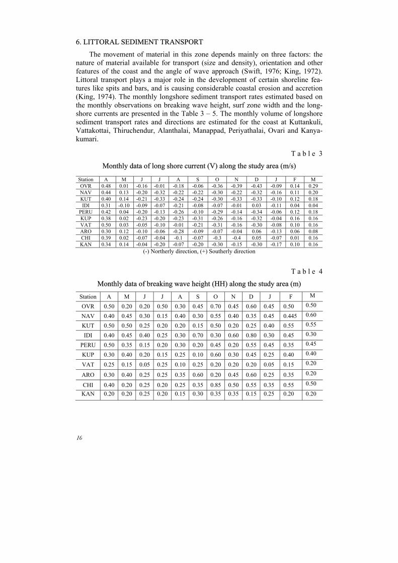
6. LITTORAL SEDIMENT TRANSPORT
The movement of material in this zone depends mainly on three factors: the nature of material available for transport (size and density), orientation and other features of the coast and the angle of wave approach (Swift, 1976; King, 1972). Littoral transport plays a major role in the development of certain shoreline fea-tures like spits and bars, and is causing considerable coastal erosion and accretion (King, 1974). The monthly longshore sediment transport rates estimated based on the monthly observations on breaking wave height, surf zone width and the long-shore currents are presented in the Table 3 – 5. The monthly volume of longshore sediment transport rates and directions are estimated for the coast at Kuttankuli, Vattakottai, Thiruchendur, Alanthalai, Manappad, Periyathalai, Ovari and Kanya-kumari.
T a b l e 3
Monthly data of long shore current (V) along the study area (m/s)
Station A M J J A S O N D J F M OVR 0.48 0.01 -0.16 -0.01 -0.18 -0.06 -0.36 -0.39 -0.43 -0.09 0.14 0.29 NAV 0.44 0.13 -0.20 -0.32 -0.22 -0.22 -0.30 -0.22 -0.32 -0.16 0.11 0.20 KUT 0.40 0.14 -0.21 -0.33 -0.24 -0.24 -0.30 -0.33 -0.33 -0.10 0.12 0.18 IDI 0.31 -0.10 -0.09 -0.07 -0.21 -0.08 -0.07 -0.01 0.03 -0.11 0.04 0.04
PERU 0.42 0.04 -0.20 -0.13 -0.26 -0.10 -0.29 -0.14 -0.34 -0.06 0.12 0.18 KUP 0.38 0.02 -0.23 -0.20 -0.23 -0.31 -0.26 -0.16 -0.32 -0.04 0.16 0.16 VAT 0.50 0.03 -0.05 -0.10 -0.01 -0.21 -0.31 -0.16 -0.30 -0.08 0.10 0.16 ARO 0.30 0.12 -0.10 -0.06 -0.28 -0.09 -0.07 -0.04 0.06 -0.13 0.06 0.08 CHI 0.39 0.02 -0.07 -0.04 -0.1 -0.07 -0.3 -0.4 0.05 -0.07 0.01 0.16 KAN 0.34 0.14 -0.04 -0.20 -0.07 -0.20 -0.30 -0.15 -0.30 -0.17 0.10 0.16
(-) Northerly direction, (+) Southerly direction
T a b l e 4
Monthly data of breaking wave height (HH) along the study area (m)
Station A M J J A S O N D J F M
OVR 0.50 0.20 0.20 0.50 0.30 0.45 0.70 0.45 0.60 0.45 0.50 0.50
NAV 0.40 0.45 0.30 0.15 0.40 0.30 0.55 0.40 0.35 0.45 0.445 0.60
KUT 0.50 0.50 0.25 0.20 0.20 0.15 0.50 0.20 0.25 0.40 0.55 0.55
IDI 0.40 0.45 0.40 0.25 0.30 0.70 0.30 0.60 0.80 0.30 0.45 0.30
PERU 0.50 0.35 0.15 0.20 0.30 0.20 0.45 0.20 0.55 0.45 0.35 0.45
KUP 0.30 0.40 0.20 0.15 0.25 0.10 0.60 0.30 0.45 0.25 0.40 0.40
VAT 0.25 0.15 0.05 0.25 0.10 0.25 0.20 0.20 0.20 0.05 0.15 0.20
ARO 0.30 0.40 0.25 0.25 0.35 0.60 0.20 0.45 0.60 0.25 0.35 0.20
CHI 0.40 0.20 0.25 0.20 0.25 0.35 0.85 0.50 0.55 0.35 0.55 0.50
KAN 0.20 0.20 0.25 0.20 0.15 0.30 0.35 0.35 0.15 0.25 0.20 0.20
11
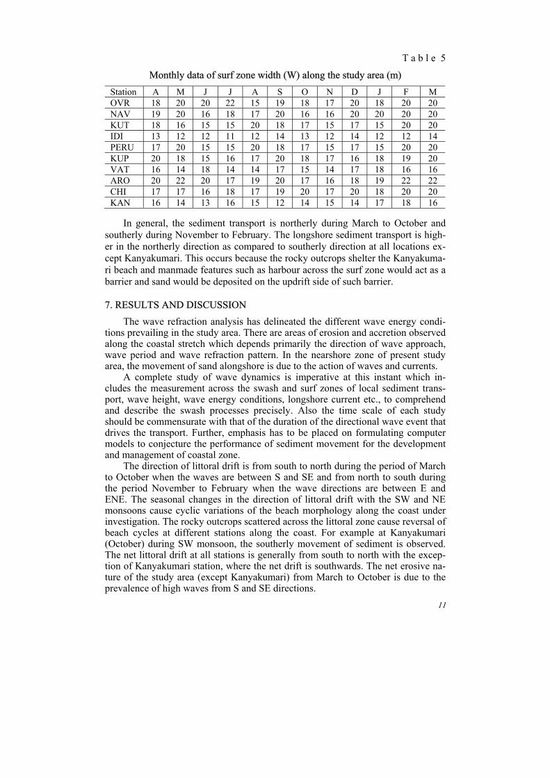
T a b l e 5
Monthly data of surf zone width (W) along the study area (m)
Station A M J J A S O N D J F M OVR 18 20 20 22 15 19 18 17 20 18 20 20 NAV 19 20 16 18 17 20 16 16 20 20 20 20 KUT 18 16 15 15 20 18 17 15 17 15 20 20 IDI 13 12 12 11 12 14 13 12 14 12 12 14 PERU 17 20 15 15 20 18 17 15 17 15 20 20 KUP 20 18 15 16 17 20 18 17 16 18 19 20 VAT 16 14 18 14 14 17 15 14 17 18 16 16 ARO 20 22 20 17 19 20 17 16 18 19 22 22 CHI 17 17 16 18 17 19 20 17 20 18 20 20 KAN 16 14 13 16 15 12 14 15 14 17 18 16
In general, the sediment transport is northerly during March to October and
southerly during November to February. The longshore sediment transport is high-er in the northerly direction as compared to southerly direction at all locations ex-cept Kanyakumari. This occurs because the rocky outcrops shelter the Kanyakuma-ri beach and manmade features such as harbour across the surf zone would act as a barrier and sand would be deposited on the updrift side of such barrier.
7. RESULTS AND DISCUSSION
The wave refraction analysis has delineated the different wave energy condi-tions prevailing in the study area. There are areas of erosion and accretion observed along the coastal stretch which depends primarily the direction of wave approach, wave period and wave refraction pattern. In the nearshore zone of present study area, the movement of sand alongshore is due to the action of waves and currents.
A complete study of wave dynamics is imperative at this instant which in-cludes the measurement across the swash and surf zones of local sediment trans-port, wave height, wave energy conditions, longshore current etc., to comprehend and describe the swash processes precisely. Also the time scale of each study should be commensurate with that of the duration of the directional wave event that drives the transport. Further, emphasis has to be placed on formulating computer models to conjecture the performance of sediment movement for the development and management of coastal zone.
The direction of littoral drift is from south to north during the period of March to October when the waves are between S and SE and from north to south during the period November to February when the wave directions are between E and ENE. The seasonal changes in the direction of littoral drift with the SW and NE monsoons cause cyclic variations of the beach morphology along the coast under investigation. The rocky outcrops scattered across the littoral zone cause reversal of beach cycles at different stations along the coast. For example at Kanyakumari (October) during SW monsoon, the southerly movement of sediment is observed. The net littoral drift at all stations is generally from south to north with the excep-tion of Kanyakumari station, where the net drift is southwards. The net erosive na-ture of the study area (except Kanyakumari) from March to October is due to the prevalence of high waves from S and SE directions.

12
Morphodynamic states of reflective, dissipative and intermediate beaches of the study area (Table 6) are assessed on the basis of energy regimes, gradient of the beaches, beach width, backshore width, wave type, coast exposure and morpho-logical features in the nearshore zone.
T a b l e 6
Beach morphodynamic classification along the beaches between Ovari and Kanyakumari
I. Breaker type (Battjes, 1974)
Locations
Spilling ξb < 0.4
Plunging 0.4 < ξb < 2.0
Surging ξb > 2
Kuttapuli, Vijayapathi, Arokiapuram
and Vattakottai
Kuttankuli, Chinnamuttom and Kanyakumari
Ovari and Perumanal
II. Beach type (Wright & Short, 1984)
Locations
Reflective Ω < 1
Intermediate 1 < Ω < 6
Dissipative Ω > 6
Kuttapuli, Vijayapathi, Arokiapuram
and Vattakottai
Kuttankuli, Chinnamuttom and Kanyakumari
Ovari and Perumanal
Dissipative beaches. The high wave energy condition with low gradient beach
slope has surf scaling parameter. They have higher rate of dune and backshore re-cession. Dissipative beaches in the study area are composed of fine to medium sand and hence the mobility of the beaches is greatly enhanced than the higher energy conditions of the reflective beaches. Due to the repeated oscillations of high wave energy condition in the dissipative beaches, scarping of the beach profiles occur. Beaches falling under this category are Ovari and Perumanal.
Reflective beaches. Low modal wave heights and steep gradients of the beach have resulted in low surf scaling parameter. However, if the wave height increases seasonally, the beaches in these environments would be severely affected by the erosional processes. The same is attested by the present study during the northeast monsoon and the erosion sensitive concave beach profiles dominate over convex profiles. The mobility of the beaches is hindered by the coarseness of the sedi-ments, low energy condition and steep beach gradients. Beaches like Kuttapuli, Vijayapathi, Arokiapuram and Vattakottai fall under this category.
Intermediate beaches. Intermediate domains exhibit the characters of both re-flective and dissipative beaches. Moderate gradient and abundant supply of sedi-ments are seen more with dominant alongshore movement than with onshore-offshore movement. Broad backshore width is noticed in the intermediate state of beaches in Perumanal and Vijayapathi coast. Flat and moderate beach gradient with strong rip current and well developed cusps that disappear as the reflective shore-line conditions dominate over the intermediate state are perceptible in the zeta form bay between Kuttapuli and Arokiapuram. The gradients of the beaches which are gentle with low energy conditions are seen in Ovari coast. Along with other modes of beach cuttings, rip currents developed in this coast caused the continual erosion. Along the study area such as Kuttankuli, Chinnamuttom and Kanyakumari belong to this category.
13
8. CONCLUSION
The morphodynamic behaviour of the beaches has been identified in the beaches between Ovari and Kanyakumari area. The different morphologies of ap-pearance on the beaches show that the morphodynamic behaviour also has a direct influence on the wave refraction, with the mechanical processes of wave. The mor-phodynamic behaviour of the beaches is presented as a determinant factor which should be incorporated into the coastal recovery, in order to estimate the time of recovery of the sandy beaches and the effectiveness of the clearing methods in the most precise way. However, within the proposed model, and from the existing data, it is not possible to determine the time scale of these processes, nor the influence that the possible contributions of wave from the continental shelf would have on this natural process of sediment regeneration.
Clearly, regardless of the wave-climate strength, the nearshore zone of the coast is constantly modified, which requires the use of observation and interpreta-tion tools with high acquisition frequencies. The complementary data provided will enable the precise determination of the energy and temporal scales to which the coastal dynamics are sensitive (for instance, the wave-action duration involving morphological changes in the intertidal domain). Also, they will allow more pre-cise calculations of the sand-transport rate due to littoral drift. Finally, with the aim of simulating coastline morphodynamics, it will be necessary to better define the wave-height threshold beyond which the ridge morphology is modified. To con-clude this paper, we must note that cross-shore morphodynamics need to be studied in order to complete the analysis of the morphodynamics of coast. In addition, the interaction between the systems must be intensively investigated.
ACKNOWLEDGEMENT
The authors are thankful to Dr. Bhoop Singh, Director, NRDMS, Department of Science and Technology, New Delhi for his kind help in preparing the manu-script. The authors are thankful to Department of Science and Technology, New Delhi for providing the financial assistance under NRDMS Scheme (ES/11/526/2000). REFERENCES
Angusamy, N. (1995). A study on beach placers between Mandapam and Kanyakumari. Un-publ. Ph. D. thesis, Bharathidasan University, Tiruchirapalli. 186 p.
Angusamy, N., Udayaganesan, P. and Rajamanickam, G.V. (1998). Wave refraction pattern and its role in the redistribution of sediment along southern coast of Tamilnadu, India. Ind. J. Mar. Sci., 27. P. 173 – 178.
Anbarasu, K. (1994). Geomorphology of the northern Tamilnadu Coast using remote sensing techniques. Unpubl. Ph.D. thesis, Bharathidasan University, Tiruchirapalli. 184 p.
Benedet, L., Finkl, C.W. and Klein, A.H.F. (2004). Morphodynamic Classification of Beaches on the Atlantic coast of Florida: Geographical Variability of Beach Types, Beach Safety and Coastal Hazards. J. Coast. Res. Special Issue, 39 (Proc. 8th Intl. Coastal Symposium). 7 p.
Bruno, R.O., Dean, R.G. and Gable, C.G. (1980). Longshore transport evaluations at a de-tached breakwater. Proc. 17th Intl. Conf. on Coast. Eng., ASCE. P. 1453 – 1475.

14
Chandramohan, P. (1988). Longshore sediment transport model with particular reference to the Indian Coast. Unpubl. Ph.D. thesis, IIT, Madras. 210 p.
Chandramohan, P., Sanil Kumar, V. and Anand, M. (1990). Wave atlas for the Indian Coast. Ocea. Engg. Div., NIO, Goa. 312 p.
Chandrasekar, N. (1992). Placer mineral exploration along the central Tamilnadu coast. Un-publ. Ph. D. thesis, Madurai Kamaraj University, Madurai. 293 p.
Chandrasekar, N., Anil Cherian, Rajamanickam, M. and Rajamanickam, G.V. (2001). Influ-ence of garnet sand mining on beach sediment dynamics between Periyathalai and Navaladi Coast, Tamilnadu. J. Ind. Assn. Sed., 21(1). P. 223 – 233.
Emery, K.O. (1961). A simple method of measuring beach profiles. Limn. and Ocean. Vol. 6. 90 p.
Gujar, A.R. (1996). Heavy Mineral Placers in the Nearshore Areas of South Konkan Maha-rashtra: Their Nature, Distribution, Origin and Economic Evaluation. Unpubl. Ph.D. thesis, Tamil University, Thanjavur, 234 p.
Hanamgond, P.T. (1993). Morphological and sedimentological studies within Kavada bay and belekeri bay beaches, Uttara Kannada district, Karnatak, West coast, India. Unpubl. Ph.D. thesis, Karnatak University, Dharward, India. 265 p.
King, C.A.M. (1974). Introduction to Marine Geology and Geomorphology. Engl. Long. Soc. and Edn. Arn. Lond. 309 p.
King, C.A.M. (1972). Beaches and Coasts. 2nd Edition. St. Martins Press, New York. 310 p.
Klein, A.H.F., Menezes, J.T. (2001). Beach morphodynamics and profile sequence for head-land bay coast. J. Coast. Res., 17(4). P. 812 – 835.
Lafond, E.C. and Rao, R.P. (1954). Beach Erosion Cycles near Waltair on the Bay of Bengal. Andhra University Memoirs in Oceanography. P. 63 – 77.
Lippmann, T.C., Holman, R.A. (1990). The spatial and temporal variability of sand bar mor-phology. J. Geophys. Res., 95(C7). P. 11575 – 11590.
Loveson, V.J. (1994). Geological and Geomorphological investigations related to sea level variation and heavy mineral accumulation along the Southern Tamilnadu Beaches, India. Un-publ. Ph.D. thesis, Madurai Kamaraj University, Madurai. 223 p.
Naval Hydrographic Chart (1973). Published at the Naval Hydrographic Office, Dehradun.
Rajamanickam, G.V., Vethamony, P. and Gujar, A.R. (1986). Effect of waves in the redistri-bution of sediments along the Konkan Coast. Proc. Natl. Acad. Sci., 95(2). P. 237 – 244.
Saravanan, S., Chandrasekar, N., Hentry, C., Loveson Immanuel, J., Rajamanickam, M. and Sivasubramanian, P. (2009). Post-tsunami assessment in the coastal region between Kanya-kumari and Ovari, Tamilnadu. Earthscience frontiers. Vol. 16, No. 6. P. 129 – 137.
Sastry, A.V.R., Swamy, A.S.R., Prasada Rao, N.V.N.O. and Vasudev, K. (1979). Beach con-figuration studies along Viskhapatnam – Bhimunipatnam coast, Mahasagar. Bull. Natl. Inst. Ocean. Vol. 12, No. 1. P. 1 – 10.
Sheik Mujabar, P., Chandrasekar, N., Saravanan, S. and Loveson Immanuel, J. (2007). Impact of 26 December 2004 Tsunami in Beach Morphology and Sediment Volume along the Coast between Ovari and Kanyakumari, South India. Shore and Beach, 75(2). P. 1 – 8.
Short, A.D. (1999). Beach Morphodynamics. Wiley and Sons, London. 392 p.
Sonu, C.J., van Beek, J.L. (1971). Systematic beach changes on the Outer Banks, North Caro-lina. J. Geol., 79. P. 416 – 425.
Sonu, C.J., James, W.R. (1973). A Markov model for beach profile changes. J. Geophys. Res., 78. P. 1462 – 1471.

15
Srinivasan, R. and Srinivasan, V. (1990). Coastal geomorphology of Tamilnadu – Based on landsat imagery (without field check). Natl. Sem. on sea level variations and its impact on coastal environment. Proc. Vol. P. 303 – 312.
Swift, D.J.P. (1976). Coastal sedimentation. In: Marine sediment transport and envi-ronmental management. Stanley, D.J. and Swift, D.J.P. (Eds.). John Wiley & Sons, New York. P. 255 –310.
Veerayya, M. and Pankajakshan, T. (1988). Variability in wave refraction and resultant rear-shore current patterns: Exposed versus sheltered beaches along North Karnataka, west coast of India. Ind. J. Mar. Sci., 17 (2). P. 102 – 110.
Wright, L.D., Nielsen, P., Short, A.D. and Green, M.O. (1982). Morphodynamics of a Macro-tidal Beach. Mar. Geol. Vol. 50. P. 97 – 128.
Wright, L.D. and Short, A.D. (1984). Morphodynamic Variability of Surf Zones and Beaches: a Synthesis. Mar. Geol. Vol. 56. P. 93 – 118.
Center for GeoTechnology, Manuscript received 14.12.09 Manonmaniam Sundaranar University, Revised 28.01.10 Tirunelveli-627 012, Tamilnadu, India E-mail: [email protected] АННОТАЦИЯ Морфология берега отражает взаимное влияние топографии и динамики жид-кости. При этом морфологическое строение береговых систем не является случайным, а опре-деляется распределением и пространственно-временным взаимодействием береговых форм. Начиная с классификации, предложенной Райтом и Шортом (1983), основанной на анализе эволюции нескольких участков пляжа Южного берега Тамилнаду, пляжные системы рассмат-риваются в рамках трехмерных морфодинамических моделей, включающих количественные характеристики (высоту обрушения волн, скорость образования осадков, волновой период и уклон пляжа) и граничные условия для определенных взаимосвязей береговой динамики (т. е. наличие или отсутствие баров и их тип). Это привело к подразделению пляжей на три основ-ные категории в соответствии с их поведением по отношению к внешним силам (Шорт, 1999) – рассеивающие, промежуточные (от промежуточно-рассеивающих до промежуточно-отражающих вариантов) и отражающие. Морфодинамическая классификация типов пляжей основана на уравнениях Райта и Шорта, 1984 (безразмерная скорость осадкообразования – параметр Дина).
Ключевые слова: пляж, уравнения Райта и Шорта, волны, морфодинамика, Индия. АНОТАЦІЯ Морфологія берега відображає взаємний вплив топографії і динаміки рідини. При цьому морфологічна будова берегових систем не є випадковою, а визначається розподілом і просторово-часовою взаємодією берегових форм. Починаючи з класифікації, запропонованої Райтом и Шортом (1983), заснованої на аналізі еволюції декількох ділянок пляжу Південного берега Тамілнаду, пляжні системи розглядаються в рамках тривимірних морфодинамічних моделей, які включають кількісні характеристики (висоту обвалення хвиль, швидкість утво-рення опадів, хвильовий період та ухил пляжу) і граничні умови для певних взаємозв'язків берегової динаміки (тобто наявність або відсутність барів і їх тип). Це призвело до підрозділу пляжів на три основні категорії відповідно до їхньої поведінки відносно фізичних сил (Шорт, 1999) – розсіюючі, проміжні (від проміжно-розсіюючих до проміжно-відбиваючих варіантів) і відбиваючі. Морфодинамічна класифікація типів пляжів заснована на рівнянні Райта и Шорта, 1984 (безрозмірна швидкість осадоутворювання – параметр Діна).
Ключові слова: пляж, рівняння Райта и Шорта , хвилi, морфодинаміка, Індія.