BASELINE SCREENING REPORT
129
www.interreg-danube.eu/approved-projects/ister BASELINE SCREENING REPORT Work Package Title T1 Activity No. and Title A 1.11- Deliverable D.T 1.1.3-BASELINE SCREENING REPORT Deliverable Responsible ZRS BISTRA PTUJ Main Authors & Partner Acronyms ZRS BISTRA PTUJ Co-Authors & Partner Acronyms MNIT, URBANSOFIA, all partners Reviewed by: Name and Partner Acronyms Status Version: 2 Revised draft (RV) Final (F) Length pages December, 2020
-
Upload
khangminh22 -
Category
Documents
-
view
3 -
download
0
Transcript of BASELINE SCREENING REPORT
www.interreg-danube.eu/approved-projects/ister
BASELINE SCREENING REPORT
Work Package Title T1
Activity No. and Title A 1.11-
Deliverable D.T 1.1.3-BASELINE SCREENING REPORT
Deliverable Responsible ZRS BISTRA PTUJ
Main Authors & Partner Acronyms ZRS BISTRA PTUJ
Co-Authors & Partner Acronyms MNIT, URBANSOFIA, all partners
Reviewed by: Name and Partner Acronyms
Status Version: 2
Revised draft (RV)
Final (F)
Length pages
December, 2020
www.interreg-danube.eu/approved-projects/ister
Table of contents
1. The ISTER project. ........................................................................................................................... 3
Partnership .......................................................................................................................................... 5
2. ISTER Terminology and definitions ................................................................................................ 7
3. The Baseline screening ................................................................................................................. 11
Why the ISTER project ....................................................................................................................... 11
Key facts ............................................................................................................................................ 12
4. The challenge ................................................................................................................................ 14
A key challenge of preserving the Roman heritage with a focus on land use and space issues ... 18
5. The most important “ingredients” of preservation of heritage ..................................................... 20
Defining heritage preservation ......................................................................................................... 20
Key “ingredients” of heritage preservation ...................................................................................... 21
Cultural (roman) routes in the context of heritage preservation ..................................................... 23
6. Key issues- to build upon already existing inventories and seeking for capitalisation
opportunities ........................................................................................................................................ 24
EU strategies ...................................................................................................................................... 24
Internationa conventions .................................................................................................................. 25
National laws ..................................................................................................................................... 26
SLOVENIA ....................................................................................................................................... 26
GERMANY ...................................................................................................................................... 27
ROMANIA....................................................................................................................................... 30
HUNGARY ...................................................................................................................................... 35
AUSTRIA ......................................................................................................................................... 39
BOSNIA AND HERZEGOVINA .......................................................................................................... 41
SERBIA ........................................................................................................................................... 46
EU projects -capitalizing the results ................................................................................................. 47
National projects- best practice. ....................................................................................................... 49
GERMANY ...................................................................................................................................... 49
SLOVENIA ....................................................................................................................................... 52
ROMANIA....................................................................................................................................... 55
BOSNIA .............................................................................................................................................. 56
FESTIVALS .......................................................................................................................................... 58
BOLGARIA ...................................................................................................................................... 58
ROMANIA....................................................................................................................................... 58
SLOVENIA ....................................................................................................................................... 61
Research papers ................................................................................................................................ 63
www.interreg-danube.eu/approved-projects/ister
7. Preliminary profile of ISTER partner citie and their Roman roads ............................................. 71
SLOVENIA ........................................................................................................................................... 71
ROMANIA .......................................................................................................................................... 76
HUNGARY .......................................................................................................................................... 99
AUSTRIA ........................................................................................................................................... 109
GERMANY ........................................................................................................................................ 110
BOSNIA AND HERZEGOVINA............................................................................................................ 112
SERBIA ............................................................................................................................................. 114
BOLGARIA ........................................................................................................................................ 115
8. ISTER partner cities and their other Roman heritage-add as a annexes 1 to the Baseline study.
125
9. Conclusions and the focus of project ISTER and other deliverables ......................................... 126
www.interreg-danube.eu/approved-projects/ister
1. The ISTER project.
The present baseline study was prepared in the ISTER project frame, with the full title ConnectIng hiSTorical Danube rEgions Roman routes. This EU co-funded project started in July 2020 and addresses innovative approaches to the concept of heritage preservation, presentation, and valorisation regarding town planning and tourism development. The project is co-financed within the Interreg Danube Transnational Programme.
The ISTER project's overall objective is to rediscover and revive the ancient network of roads and settlements developed by the Romans, along with the Danube Region and design eco-cultural routes out of it. The project intends to use territorial-embedded Roman archaeological values to promote regional development and sustainable growth of crossed regions. The main objective leverages on the following three key pillars: • Multi-level Awareness: increased recognition towards the historical evidence of the ancient network of Roman roads and settlements as a driver for eco-cultural corridors design; • Connectivity: Connecting Roman material and immaterial heritage with local and regional productive sectors as proactive backbones of regional development; •Collaboration: promoting shared practices in archaeology, architecture and planning, culture, traditions to create a common interpretation of Roman routes and settlements network for supporting a Roman-led cultural identity at Danube Region level. Eventually, ISTER lays the foundation for a thematic eco-cultural route based on Roman heritage with a narrative function, by reviving ancient heritage assets for revealing the new connected Danube Region through the interference of material and immaterial Roman heritage. As such, the main objective lies in the ancient Roman network of roads and settlements rediscovery and revival through experimentation with contemporary planning approaches and new storytelling methods. ISTER main result resides in a transnational framework for long-term cooperation of multi-level DR’s actors as a prerequisite for promoting sustainable use of Roman heritage, specifically the network of Roman routes and settlements. ISTER proposes a substantial change in strengthening the image, visibility and identity of the newly designed eco-cultural corridor of DR’s Roman routes and settlements network (mainly as pedestrian, bicycle or pilgrim route), to profile the DR as recognizable and competitive thematic touristic destination (led by the transnational territorial value of the Roman Routes heritage and itineraries). Specifically, the project will contribute to DTP result indicator by: • Aligning policy and regulatory framework at three levels: policy integration (horizontally, vertically and territorially), policy design and policy communication (diffusion to a wider group of stakeholders) and increasing multi-level actors’ capabilities and skills (targeting civil servants, practitioners, entrepreneurs) to support inter-institutional dialogue in the realm of Roman heritage protection and valorisation. • Advancing ISTER findings to local authorities and policy-makers in charge of cultural heritage, which in return should put ISTER recommendations into regional tourism policies and territorial development plans (including the limits of Roman routes as protected areas in the urban regulatory plan of the localities), based on the GIS-based Atlas recommendations.
www.interreg-danube.eu/approved-projects/ister
• Building a common and shared narrative around the former name of Danube River (Ister) and reviving the immaterial heritage of Roman routes and settlements network at DR level, resulting: 1 GIS-based territorial Atlas, 1 Interactive digital tool, 1 common branding strategy for the eco-cultural Roman Route promotion (both physically and mentally).
Specific Objectives of the project
⮚ Extending the current knowledge framework through a shared and documented database of the Roman network of Routes and Settlements along DR.
ISTER aims at building a common understanding of the territorial value of the Roman Route showcasing the eco-cultural corridor as a driver for sustainable development of local communities. Therefore, a well-documented database of the Roman network of Routes and Settlements along DR will foster the cross-country cooperation and shared understanding of the current issues and territorial challenges related to the different evolution and transformation of the Roman Routes and Settlements heritage along DR. Through the shared database, the project builds a common language and framework to tackle the identified challenges across different DR countries, generating more impactful results.
⮚ Design new tools for enhancing physical and non-physical accessibility, visibility and valorisation of Roman routes and settlements network
ISTER aims at increasing the (physical and non-physical) accessibility, interpretation, visibility/ promotion of the Roman routes through the integration of advanced digital tools and smart technologies (i.e. GIS-based visualisation for the Atlas of Roman roads and settlements network - identifying and marking the routes with specific information boards, Interactive tool with QR-code based wayfinder application for Roman heritage in the Danube Region). Through the use of digital and contemporary tools, ISTER will increase awareness and foster the preservation of physical archaeological assets through digitalization collections, connecting them in open networks and making them more widely available to citizens and the general public in DR.
⮚ Building capacities of DR multi-level stakeholders and articulating the regulatory framework conditions through policy integration measures
ISTER aims at reinforcing Roman heritage-driven regional attractiveness by following a place-based approach that brings out skills and capabilities of local actors, through a participatory approach, capturing the interest of local related-productive sectors (i.e. agriculture/ agri-food, tourism, gastronomy, arts & crafts, traditional manufacturing, festivals, etc). By interlinking Roman historical physical remnants (Routes as well as settlements, forts, watchtowers, amphitheatres) with multiple layers of “contemporary” heritage (local and regional heritage specifics of involved partners), ISTER promote a common identity based on hidden and unexplored values at Danube Region level. Furthermore, the project aims at strengthening the policy and regulatory framework conditions of sustainable use of Roman Routes heritage in Danube Region, promoting these assets as drivers for the development of cities and regions, based on the logic of policy integration and articulation in current local practices. ISTER proposes to set up a Multi-Layered Stakeholders Group in each territorial/ thematic area in order to ensure the understanding of the strategies, policies and instruments importance connected to protection and valorisation of Roman heritage (specifically the network of Roman routes and settlements).
www.interreg-danube.eu/approved-projects/ister
Partnership
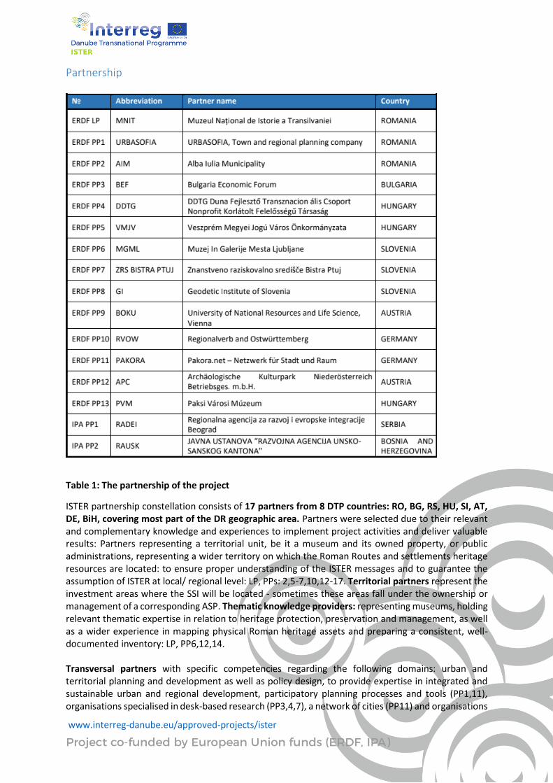
Table 1: The partnership of the project
ISTER partnership constellation consists of 17 partners from 8 DTP countries: RO, BG, RS, HU, SI, AT, DE, BiH, covering most part of the DR geographic area. Partners were selected due to their relevant and complementary knowledge and experiences to implement project activities and deliver valuable results: Partners representing a territorial unit, be it a museum and its owned property, or public administrations, representing a wider territory on which the Roman Routes and settlements heritage resources are located: to ensure proper understanding of the ISTER messages and to guarantee the assumption of ISTER at local/ regional level: LP, PPs: 2,5-7,10,12-17. Territorial partners represent the investment areas where the SSI will be located - sometimes these areas fall under the ownership or management of a corresponding ASP. Thematic knowledge providers: representing museums, holding relevant thematic expertise in relation to heritage protection, preservation and management, as well as a wider experience in mapping physical Roman heritage assets and preparing a consistent, well-documented inventory: LP, PP6,12,14. Transversal partners with specific competencies regarding the following domains: urban and territorial planning and development as well as policy design, to provide expertise in integrated and sustainable urban and regional development, participatory planning processes and tools (PP1,11), organisations specialised in desk-based research (PP3,4,7), a network of cities (PP11) and organisations
www.interreg-danube.eu/approved-projects/ister
with specific knowledge in communication and dissemination (PP3,4). Technical partners with specific knowledge in ICT tools and GIS applications: to provide up-to-date technological solutions/ services for facilitating a coherent transnational approach: PP8,9. A set of ASPs well embedded in relevant transnational networks and holing similar experiences: for sharing practices and transferring knowledge purposes.
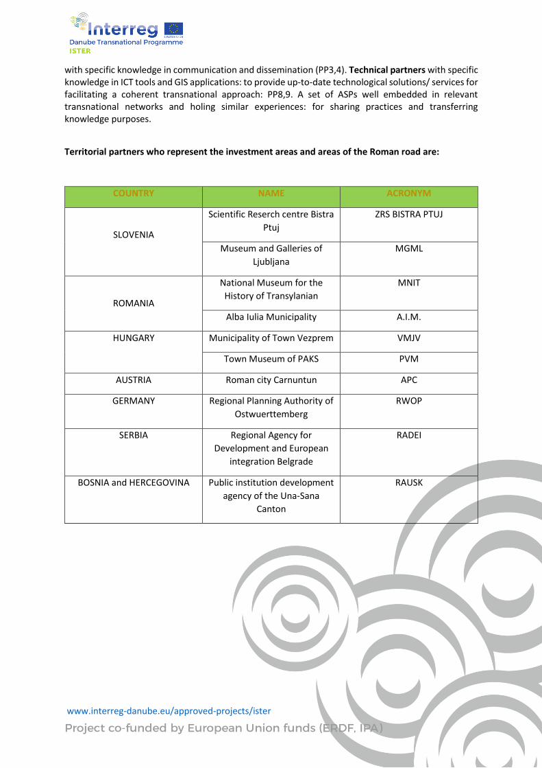
Territorial partners who represent the investment areas and areas of the Roman road are:
COUNTRY NAME ACRONYM
SLOVENIA
Scientific Reserch centre Bistra
Ptuj
ZRS BISTRA PTUJ
Museum and Galleries of
Ljubljana
MGML
ROMANIA
National Museum for the
History of Transylanian
MNIT
Alba Iulia Municipality A.I.M.
HUNGARY Municipality of Town Vezprem VMJV
Town Museum of PAKS PVM
AUSTRIA Roman city Carnuntun APC
GERMANY Regional Planning Authority of
Ostwuerttemberg
RWOP
SERBIA Regional Agency for
Development and European
integration Belgrade
RADEI
BOSNIA and HERCEGOVINA Public institution development
agency of the Una-Sana
Canton
RAUSK
www.interreg-danube.eu/approved-projects/ister
2. ISTER Terminology and definitions
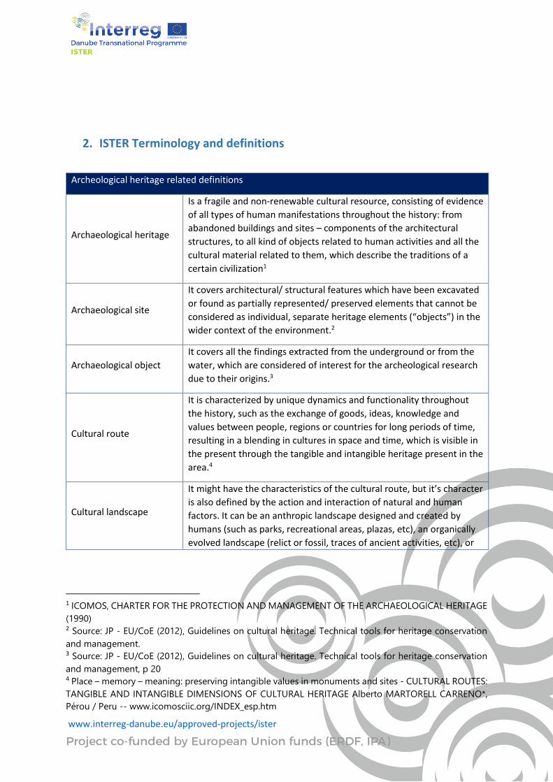
Archeological heritage related definitions
Archaeological heritage
Is a fragile and non-renewable cultural resource, consisting of evidence
of all types of human manifestations throughout the history: from
abandoned buildings and sites – components of the architectural
structures, to all kind of objects related to human activities and all the
cultural material related to them, which describe the traditions of a
certain civilization1
Archaeological site
It covers architectural/ structural features which have been excavated
or found as partially represented/ preserved elements that cannot be
considered as individual, separate heritage elements (“objects”) in the
wider context of the environment.2
Archaeological object
It covers all the findings extracted from the underground or from the
water, which are considered of interest for the archeological research
due to their origins.3
Cultural route
It is characterized by unique dynamics and functionality throughout
the history, such as the exchange of goods, ideas, knowledge and
values between people, regions or countries for long periods of time,
resulting in a blending in cultures in space and time, which is visible in
the present through the tangible and intangible heritage present in the
area.4
Cultural landscape
It might have the characteristics of the cultural route, but it’s character
is also defined by the action and interaction of natural and human
factors. It can be an anthropic landscape designed and created by
humans (such as parks, recreational areas, plazas, etc), an organically
evolved landscape (relict or fossil, traces of ancient activities, etc), or
1 ICOMOS, CHARTER FOR THE PROTECTION AND MANAGEMENT OF THE ARCHAEOLOGICAL HERITAGE
(1990) 2 Source: JP - EU/CoE (2012), Guidelines on cultural heritage. Technical tools for heritage conservation
and management. 3 Source: JP - EU/CoE (2012), Guidelines on cultural heritage. Technical tools for heritage conservation
and management, p 20 4 Place – memory – meaning: preserving intangible values in monuments and sites - CULTURAL ROUTES:
TANGIBLE AND INTANGIBLE DIMENSIONS OF CULTURAL HERITAGE Alberto MARTORELL CARRENO*,
Pérou / Peru -- www.icomosciic.org/INDEX_esp.htm
www.interreg-danube.eu/approved-projects/ister
an associative cultural landscape that is connected to
spiritual/cultural/natural elements.5
Tangible heritage
It consists of all the movable and immovable cultural heritage assets.
In the first category are included objects such as paintings, sculptures,
coins, or manuscripts, while the second consists of monuments,
archaeological sites, abandoned structures and others, but also
underwater cultural heritage such as shipwrecks, underwater ruins
and cities6
Intangible heritage
Comprises all the immaterial cultural goods considered valuable and
specific for a certain geographic area/
country/nation/civilization/period. It is defined also as ‘Spiritual
cultural elements’ and comprises specific practices, representations,
expressions, knowledge and skills, together with the instruments,
artefacts and cultural spaces that supports them.7
Architectural
conservation area
Can be a rural or urban area and the surrounding open spaces, which
possesses a distinctive historical, archaeological, artistic, social,
economic or technical value.8
Archaeological fieldwork
It’s a complex process which includes a baseline research through non-
destructive actions, excavations, processing and analysing the desk
and onsite research findings, interpretation and publication of the
results, and the distribution of the documentary/material to a long-
term storage facility (museums, archives, etc).9
Archaeological
excavation
It is an invasive method of onsite research which involves either
digging the ground, or excavating its surface, which has the aim of
discovering structures or objects of an archaeological character.10
Reconnaissance and field
mapping or survey
It is a non-destructive technique which has the aim of discovering new
archaeological sites/structures, provide their precise spatial
coordinates, provide accurate and complex descriptions of the visible
parts of the objects and identify their links with anthropogenic
changes in the surrounding environment and collect surface evidence
5 JP - EU/CoE (2012), Guidelines on cultural heritage. Technical tools for heritage conservation and
management, p 19 6 UNESCO – Definition of the Cultural Heritage (www.unesco.org) 7 JP - EU/CoE (2012), Guidelines on cultural heritage. Technical tools for heritage conservation and
management, p 19 8 JP - EU/CoE (2012), Guidelines on cultural heritage. Technical tools for heritage conservation and
management, p 19 9 JP - EU/CoE (2012), Guidelines on cultural heritage. Technical tools for heritage conservation and
management, p 31 10 JP - EU/CoE (2012), Guidelines on cultural heritage. Technical tools for heritage conservation and
management, p 31
www.interreg-danube.eu/approved-projects/ister
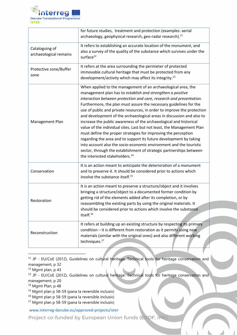
for future studies, treatment and protection (examples: aerial
archaeology, geophysical research, geo-radar research).11
Cataloguing of
archaeological remains
It refers to establishing an accurate location of the monument, and
also a survey of the quality of the substance which survives under the
surface12
Protective zone/Buffer
zone
It refers at the area surrounding the perimeter of protected
immovable cultural heritage that must be protected from any
development/activity which may affect its integrity.13
Management Plan
When applied to the management of an archaeological area, the
management plan has to establish and strengthen a positive
interaction between protection and care, research and presentation.
Furthermore, the plan must assure the necessary guidelines for the
use of public and private resources, in order to improve the protection
and development of the archaeological areas in discussion and also to
increase the public awareness of the archaeological and historical
value of the individual sites. Last but not least, the Management Plan
must define the proper strategies for improving the perception
regarding the area and to support its future development by taking
into account also the socio-economic environment and the touristic
sector, through the establishment of strategic partnerships between
the interested stakeholders.14
Conservation
It is an action meant to anticipate the deterioration of a monument
and to preserve it. It should be considered prior to actions which
involve the substance itself.15
Restoration
It is an action meant to preserve a structure/object and it involves
bringing a structure/object to a documented former condition by
getting rid of the elements added after its completion, or by
reassembling the existing parts by using the original materials. It
should be considered prior to actions which involve the substance
itself.16
Reconstruction
It refers at building up an existing structure by respecting its primary
condition – it is different from restoration as it permits using new
materials (similar with the original ones) and also different working
techniques.17
11 JP - EU/CoE (2012), Guidelines on cultural heritage. Technical tools for heritage conservation and
management, p 32 12 Mgmt plan, p 43 13 JP - EU/CoE (2012), Guidelines on cultural heritage. Technical tools for heritage conservation and
management, p 20 14 Mgmt Plan, p 48 15 Mgmt plan p 58-59 (pana la reversible inclusiv) 16 Mgmt plan p 58-59 (pana la reversible inclusiv) 17 Mgmt plan p 58-59 (pana la reversible inclusiv)
www.interreg-danube.eu/approved-projects/ister
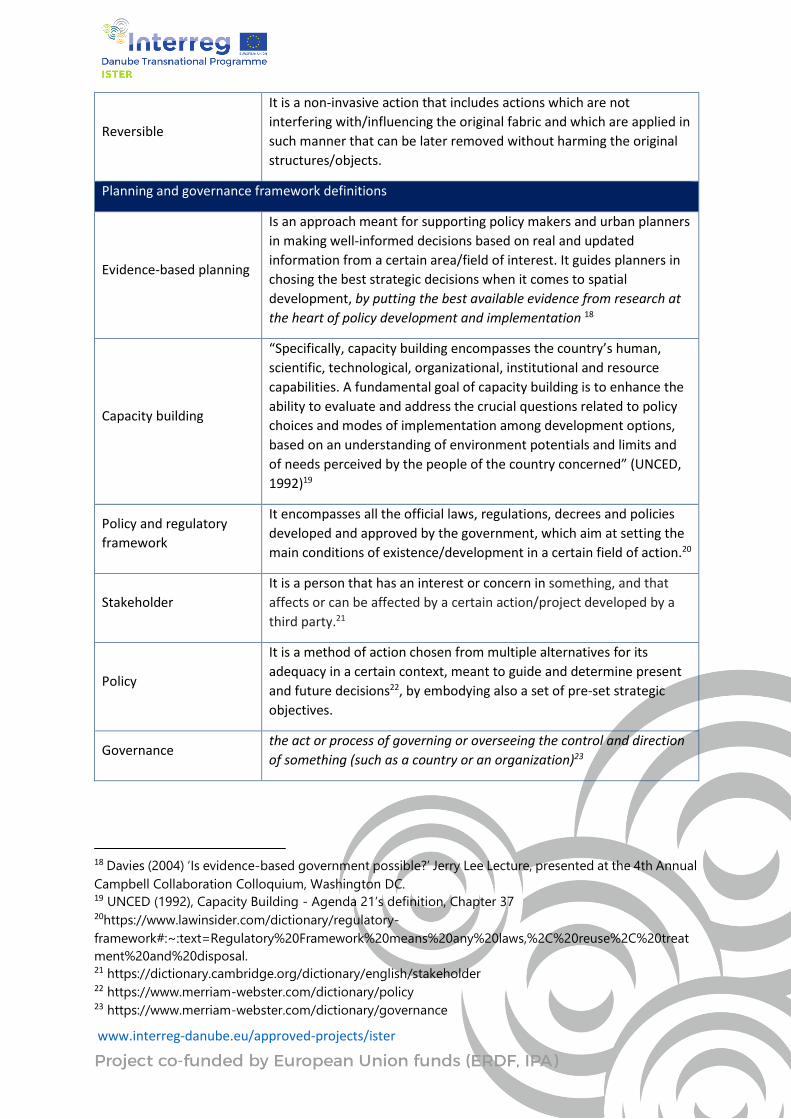
Reversible
It is a non-invasive action that includes actions which are not
interfering with/influencing the original fabric and which are applied in
such manner that can be later removed without harming the original
structures/objects.
Planning and governance framework definitions
Evidence-based planning
Is an approach meant for supporting policy makers and urban planners
in making well-informed decisions based on real and updated
information from a certain area/field of interest. It guides planners in
chosing the best strategic decisions when it comes to spatial
development, by putting the best available evidence from research at
the heart of policy development and implementation 18
Capacity building
“Specifically, capacity building encompasses the country’s human,
scientific, technological, organizational, institutional and resource
capabilities. A fundamental goal of capacity building is to enhance the
ability to evaluate and address the crucial questions related to policy
choices and modes of implementation among development options,
based on an understanding of environment potentials and limits and
of needs perceived by the people of the country concerned” (UNCED,
1992)19
Policy and regulatory
framework
It encompasses all the official laws, regulations, decrees and policies
developed and approved by the government, which aim at setting the
main conditions of existence/development in a certain field of action.20
Stakeholder
It is a person that has an interest or concern in something, and that
affects or can be affected by a certain action/project developed by a
third party.21
Policy
It is a method of action chosen from multiple alternatives for its
adequacy in a certain context, meant to guide and determine present
and future decisions22, by embodying also a set of pre-set strategic
objectives.
Governance the act or process of governing or overseeing the control and direction
of something (such as a country or an organization)23
18 Davies (2004) ‘Is evidence-based government possible?’ Jerry Lee Lecture, presented at the 4th Annual
Campbell Collaboration Colloquium, Washington DC. 19 UNCED (1992), Capacity Building - Agenda 21’s definition, Chapter 37 20https://www.lawinsider.com/dictionary/regulatory-
framework#:~:text=Regulatory%20Framework%20means%20any%20laws,%2C%20reuse%2C%20treat
ment%20and%20disposal. 21 https://dictionary.cambridge.org/dictionary/english/stakeholder 22 https://www.merriam-webster.com/dictionary/policy 23 https://www.merriam-webster.com/dictionary/governance
www.interreg-danube.eu/approved-projects/ister
Multi-layered
stakeholder group
(MLSG)
It is a group formed by representatives of different organisations,
chosen for their unique capacities, which have an interest or concern
in something and which are brought together in order to facilitate
cooperation and exchange for a certain cause. 24
3. The Baseline screening
A baseline assessment is a study conducted at the beginning of a project or a programme to analyze
the current situation. It gives a picture of the situation before the inception of the programme/project,
and results can then be compared with a follow-up assessment towards the end of the programme, in
order to understand the effects that the programme has had on the target group.
The current document – designated as «State-of-the-art» – was produced by the Lead partner, work
package leader T1 and in close cooperation with the Partners to provide a starting point where
partners can build their foundations for future development phases of the project. The main goal is to
give key actors an understanding of the state of play in other cities areas and know better the situation
and local challenges of each of the participating cities. It provides a starting point of the network and
what challenges should be addressed by the network.
Cultural heritage is a shared resource and a common good. Like other such goods, it can be vulnerable
to over-exploitation and under-funding, which can result in neglect, decay and, in some cases, oblivion.
Looking after our heritage is, therefore, our common responsibility. While heritage protection is
primarily a matter for national, regional and local authorities, the European Union has a role to play in
line with the EU Treaties and in respect of the principle of subsidiarity. (EC COM(2014) 477).
It has recognized economic benefits and the impact of cultural heritage as an economic factor capable
of creating jobs, catalyse technical innovation, and a useful tool for regional development. We have
also highlighted the social benefits that promote sustainability and provide social cohesion and
improve the quality of life of citizens.
Why the ISTER project
ISTER project firstly addresses the challenge of Roman heritage discontinuity, which reflects both in a
territorial dimension related to a low level of investment and connection between heritage resources
and local/ regional productive sectors, as well as in visualisation and attractiveness dimensions
regarding the promotion and awareness-raising on the importance of heritage resources as drivers for
regional development (economic development).
When thinking on economic development in cities, cultural heritage ( as Roman heritage) always plays
an important role in any city strategy, particularly in historical towns where cultural heritage's
valorisation remains one of the best tools to promote social and economic development. However,
24(20) (PDF) Why Multi-Stakeholder Groups Succeed and Fail. Available from:
https://www.researchgate.net/publication/228304164_Why_Multi-Stakeholder_Groups_Succeed_and_Fail [accessed Nov 16 2020].
www.interreg-danube.eu/approved-projects/ister
several factors such as lack of funding, lack of management expertise, etc, are preventing these cities
to fully exploit its potential, limiting the capacity to valorise these important assets.
Stepping further the isolated/ detached Roman settlements heritage, ISTER tackles the territorial
dimension of the Roman Routes, as a contiguous transnational element that passes DR states’ borders
and provides a relevant scale for exchange and joint development. Therefore, ISTER’s main objective
focuses on rediscovering and revitalizing the ancient Roman Roads Network along the DR as a key
driver in promoting territorial development based on sustainable use of cultural and natural heritage
(specifically, Roman routes). ISTER promotes this Roman roads and settlements network as a catalyst
for touristic development, as well as an opportunity for territorial competitiveness and sustainable
growth of Danube crossed-regions.
Cities are facing, in a context of crisis and institutional reorganization of local government, different
challenges linked to the revitalization of cultural heritage through innovative actions, which are able
to provide operational tools and tracking systems, encourage alliances between stakeholders,
promote employment and entrepreneurship in the creative sectors, experiment with innovative
public procurement initiatives and attract new funding and governance models.
Key facts
Argument for why the partnership deals with tangible and intangible heritage with a focus on Roman
heritage and settlements connected through the Roman Routes:
⮚ Power of tangible and intangible heritage for local economic development
In addition to preserving and creating cultural value, preservation/valorization of Roman Heritage
contribute to local economic development through job creation and revenue generation related to the
visitor economy. More long-term benefits can arise from partnerships between museums, local
entrepreneurs, businesses and higher education and research institutions that support the
dissemination of new technologies and the creation of new products. Potential impacts include:
▪ New jobs and revenues through increased local attractiveness for tourists, talent and
firms.
▪ Dissemination of new technologies, the creation of new goods and services and
support for creativity.
To increase impact partnership can:
o Integrate cultural heritage/museums/parks in the local tourism development strategy.
o Link cultural heritage and the business community to develop new goods and services.
o Cooperation with the hospitality industry and local cultural institutions to reach out to diverse
audiences and attract new visitors
o Engagaging with firms as well as research and education institutions to promote innovation.
Urban development and efforts to improve the accessibility of museums, parks, (e.g. transport, urban
signage, and parking lots) can reinforce these economic impacts. Local governments can also increase
the visibility of cultural heritage locally and internationally. With respect to tourism, local governments
could foster cooperation with local tourist offices, lodging, food and beverage and transportation
www.interreg-danube.eu/approved-projects/ister
services. Local government could also coordinate all local cultural institutions so as to offer an
integrated supply that is more attractive to diverse audiences. Local governments could help pool
some of the costs, mainly those related to backoffice activity. Collaboration with other museums may
also prove to be an important step.
⮚ Integrate Roman routes and settlements in the local tourism development strategy
The promotion of coltural heritage on the international tourism market requires knowledge,
investment and capacity that is often too expensive for museums to manage themselves. Local
governments can help by involving museums in national and international fairs and networks. Local
governments can also facilitate coordination between the activities of museums and other cultural
institutions to create an attractive offer.
To increase impact partnerhip can:
o Promote cultural heritage of Roman routes and settlements locally, nationally and
internationally by funding information and advertising support and by organising the
participation of museums in international fairs.
o Promote coordination between tourist offices, hotels, restaurants and museums to offer an
integrated supply of services.
o Promote sustainable tourism principles, by, for example, making tourism accessible to all (e.g.
low-income groups, people with mobility difficulties).
o Support partnerships with universities, science parks and researchers.
o Help museums to make their collections better known to local producers (including
agricultural), artisans, craftsmen, designers, SMEs and entrepreneurs.
⮚ Build on the role of preservation/valorization of Roman Heritage for urban regeneration
and community development
Museums, archeological parks, exhibition spaces of cultural heritage are places that contribute to both
the physical and social design of many cities. Their renovation or construction can stimulate urban
regeneration and bring new life into areas losing their social dynamism and traditional economic base.
This place scan appear to be places where social capital can be built between people of different
communities when many traditional meeting places are disappearing. Potential outcomes could be:
o International branding and increased territorial attractiveness.
o Economic diversification, new jobs and revenues through the development of cultural and
creative quarters.
o Better quality of life.
o Higher level of social capital.
Element of the contribution of example: museums, archeological parks, exhibition spaces of cultural
heritage to local development is their impact on urban regeneration, the emergence of vibrant
cultural and creative quarters and the creation of new bridges between and within communities. The
cultural force of the city and its built environment plays a significant role in shaping people’s sense of
identity. In this context, museums are not just places where collections are exhibited. They symbolise
shared heritage and identity as well as a sense of the past, present and future around which a
community is organised. The relative permanence of buildings and land, means they are not only
sources of memory and reflection but also of contest over the control and meaning of space itself.
www.interreg-danube.eu/approved-projects/ister
Museums can therefore be considered a kind of public art serving many goals: animating public
debates, creating connections and giving meaning to new places.
⮚ Catalyse culturally aware and creative societies
Museums have mainly been created to increase cultural awareness and education. With time, this
objective has become more complex to encompass training and life-long learning, not only for native-
born populations but also for immigrants and other marginalised communities. A museum’s mission is
to promote reflection and self-awareness by providing audiences opportunities to learn more about
their environment and themselves through museum collections. They can change the way people think
about many past and contemporary issues and can challenge misperceptions and rigid modes of
thinking. By displaying an inventory of past creativity, museums help promote an understanding of
why and how things have been created. In that very sense, they may promote a broader culture of
creativity.
Potential outcomes include:
⮚ Knowledge development and upskilling.
⮚ Increased levels of self-confidence.
⮚ More culturally aware and open communities.
⮚ Diffusion of creativity
To increase impact, partnership can:
o Recognise the role of cultural heritage in education and training of young people as well as
adults.
o Work with museums to build resources and capacities to take a broader approach to the
visitor experience.
o Support a balance between meeting the needs of local audiences and tourists.
The relationship between local government and museums for education is generally very well
recognised and is now being extended to include adult training and life-long learning. It is very
important for local government to acknowledge that the collections and archives of museums
constitute useful resources for these purposes.
Cultural heritage is readily included in numerous public (e.g., local, regional and national level)
development strategies as a significant asset in contemporary sustainable development. This is a
great opportunity for many territorial units and a significant chance for implementing diverse
projects linked with conservation, restoration and adaptation of heritage sites or preservation and
presentation of immaterial heritage.
4. The challenge
The challenge of cities/museums (in the Danube Region but also elsewhere) within
preservation/valorization or Roman heritage (specifically Roman Routes network).
If it is not connected with social values, economic activity, and international connections, and if it is
not appropriately managed, cultural heritage hardly constitutes an advantage for an area’s
development. In contrast, when the management systematically combines the key factors,
www.interreg-danube.eu/approved-projects/ister
preservation/valorization of cultural heritage can represent an important (economic, social,
environmental, etc.) development potential.
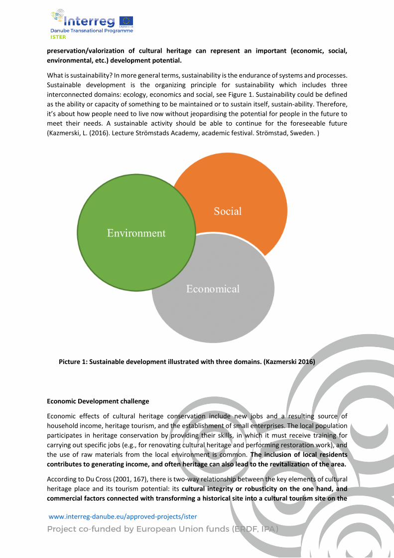
What is sustainability? In more general terms, sustainability is the endurance of systems and processes.
Sustainable development is the organizing principle for sustainability which includes three
interconnected domains: ecology, economics and social, see Figure 1. Sustainability could be defined
as the ability or capacity of something to be maintained or to sustain itself, sustain-ability. Therefore,
it’s about how people need to live now without jeopardising the potential for people in the future to
meet their needs. A sustainable activity should be able to continue for the foreseeable future
(Kazmerski, L. (2016). Lecture Strömstads Academy, academic festival. Strömstad, Sweden. )
Picture 1: Sustainable development illustrated with three domains. (Kazmerski 2016)
Economic Development challenge
Economic effects of cultural heritage conservation include new jobs and a resulting source of
household income, heritage tourism, and the establishment of small enterprises. The local population
participates in heritage conservation by providing their skills, in which it must receive training for
carrying out specific jobs (e.g., for renovating cultural heritage and performing restoration work), and
the use of raw materials from the local environment is common. The inclusion of local residents
contributes to generating income, and often heritage can also lead to the revitalization of the area.
According to Du Cross (2001, 167), there is two-way relationship between the key elements of cultural
heritage place and its tourism potential: its cultural integrity or robusticity on the one hand, and
commercial factors connected with transforming a historical site into a cultural tourism site on the
www.interreg-danube.eu/approved-projects/ister
other. The main goal of planning for sustainable cultural heritage tourism is to identify cultural heritage
sites (Example: roman routes)and their potentials for tourism development, and to manage them to
ensure sustainability, through whichn tourism can also contribute to heritage conservation.
Museums generate revenues from exhibitions and also through branding and merchandising activities.
In most cases, museum activities foster links with other players in creative industries as well as other
sectors in the rest of the economy. Indeed, many economic impact assessment studies demonstrate
that museums contribute to job creation, generate GDP, and bring substantial tax revenues for their
communities.
Finally, in the age of the knowledge economy, museums can encourage local economic development
by supporting creative economic activities such as design and innovation. Such activities can benefit
local and international enterprises and entrepreneurs. For local governments, museums become not
only one of many actors in local development, but a driver of change.
The cooperation of local community representatives, conservationists, tourism operators, property
owners, policymakers, those preparing national development plans, and site managers is necessary in
order to achieve a sustainable tourism industry and enhance the protection of heritage resources
for future generations (International Cultural Tourism Charter 1999; Goluža & Erhartič 2014).
In terms of economic and social development of a region, cultural heritage is no longer considered as
a financial burden and only a “moral obligation” of the society, but it is rather seen as a possible driving
force for regional development and economic growth, providing opportunities for innovations,
entrepreneurship and sustainable development. Tourism, as one of the main sectors of economic and
regional development, is increasingly using cultural and natural heritage as its key factors for
attractiveness of a destination; many tourists choose their travel destination because of the heritage
it offers. According to the report of the European Council from 2014, 27% of EU travellers indicate that
cultural heritage is a key factor in choosing a travel destination. In 2013, 52% of EU citizens visited at
least one historical monument or site and 37% a museum or gallery in their respective countries, while
19% visited a historical monument or site in another EU country.( European Commission, Towards an
integrated approach to cultural heritage for Europe, COM(2014).
Thus, cultural heritage plays a significant role in a tourism industry, creating jobs and strongly
contributing to the development of cities and regions. Particularly regional economies which are
facing difficult times can strongly benefit from their cultural heritage as a contributor to regional
development, creating new jobs and attracting visitors, thus contributing to both economic and social
aspects of their development.
Social Development challenge
Cultural heritage enhances the identity of a place and is therefore even more important during the
time of globalization. The historical value and identity play a much greater role in its conservation than
the physical renovation of structures because the local tourism stakeholders, the production of
publications, and the organization of activities (e.g., exhibitions, fairs, and musical events) connected
with cultural heritage help promote the place (Cultural Heritage … 2007). In the time of globalization,
stronger local identity is an advantage to society. In this context, the following thought is very
informative: “If we all are to build a good global village, we need first to know well the village we are
coming from” (Sarbib 2000, cited in Cultural Heritage … 2001). It emphasizes the importance of an
individual’s identity that is shaped in a family environment or home town.
www.interreg-danube.eu/approved-projects/ister
Museums also play a crucial role in addressing contemporary societal issues. They tackle diverse and challenging areas such as globalisation, migration, polarisation, inequality, populism, gender equality, ageing societies, decolonisation and climate change. They are platforms where restorative justice, intercultural and intergenerational dialogue, and cultural diplomacy principles can be applied. Among the social development potentials of cultural heritage, its educational role is also important. For example, using old skills can significantly contribute to raising the awareness of sustainable living in a specific region, and understanding past achievements, especially technical achievements that have been preserved as can stimulate the development of new expertise.
Environmental Development challenge
Environmental development potential mainly refers to traditional practices (intangible heritage)
connected with the cultural landscape (immovable heritage), such as (1) the conservation of
ecosystems (e.g., mowing daffodil meadows), (2) maintaining the complexity and stability of
ecosystems (e.g., sustainable management that contributes to the conservation of cultural
landscapes), (3) supporting local organic food production (e.g., markets with locally produced food,
social entrepreneurship in the countryside), (4) erosion prevention (e.g., sustainable forest
management), and so on (Ledinek Lozej, Šmid Hribar, & Bole 2012).
Environmental aspects are important also in urban cultural heritage sites, where proper environmental
infrastructure is of crucial importance for the maintenance of buildings and the provision of basic
infrastructure for living.
Therefore, implementation of environmental planning solutions to cultural heritage sites could
foster urban renewal that makes protected buildings suitable for contemporary living standards.
Last but not least, cultural heritage can have a significant role in sustainable development, by using a
sustainable approach in the regeneration of heritage sites and energy-efficient re-adaptation of
heritage buildings, promoting sustainable tourism, bringing culture and environment together,
contributing to the sustainable development of cities and regions all over Europe and worldwide.
(CULTURAL HERITAGE AND SUSTAINABILITY-Practical Guide- KEEP ON is an INTERREG Europe project)
Sources:
1. International Cultural Tourism Charter 1999; Goluža & Erhartič 2014
2. Kazmerski, L. (2016). Lecture Strömstads Academy, academic festival. Strömstad, Sweden
3. European Commission, Towards an integrated approach to cultural heritage for Europe, COM(2014)
4. Sarbib 2000, cited in Cultural Heritage … 2001
5. Ledinek Lozej, Šmid Hribar, & Bole 2012
6. CULTURAL HERITAGE AND SUSTAINABILITY-Practical Guide- KEEP ON is an INTERREG Europe project
www.interreg-danube.eu/approved-projects/ister
A key challenge of preserving the Roman heritage with a focus on land use and space
issues
Roman heritage sites face many challenges today in the era of accelerating globalization like
uncontrolled urban development (urban sprawl) due to demographic growth of the cities as well as
environmental problems like fluctuation of river courses leading to frequent floods. The roman sites
are located outside or inside the localities, some Roman fortifications being today 90% covered by the
construction of the modern city, by constructing new roads or affected by intensive agricultural works
and deforestations. However, there are also sites without traces of late interventions, restored or
under restoration, or pastures. Through urbanization, people tend to ignore their history and traditions
seeking adequate services and a better lifestyle leading to the disappearance of existing urban fabric
that creates an undefined urban pattern.
These major challenges identified as hindrance to effective preservation of cultural heritage are caused
by poor physical planning and protection mechanisms, inadequate development control and
enforcement, and an ineffective preservation city policy. Regarding these issues, a number of
principles and recommendations tackled in the Venice Charter (1964) can improve the preservation
and sustainable development of roman heritage:
(1) The implementation of effective planning and legislative tools, policies, strategies and practices
to sustainably manage settings requires consistency and continuity in application, whilist reflecting
the local or cultural context in which they function. Tools to manage settings include specific legislative
measures, professional training, development of comprehensive conservation and management plans
or systems and use of adequate heritage impact assessment methods.
(2) Legislation, regulation and guidelines for the protection, conservation and management of
heritage structures, sites and areas should provide for the establishment of a protection or buffer zone
around them that reflects and conserve the significance and distinctive character of their setting.
The buffer zone represents a zone intended to protect the sites from negative influences like urban
development pressure. The importance of the environment for the object must be properly recognized
to be able to define a suitable perimeter as well as required protective measures for the buffer zone.
In controlling the transition between the heightened protection of the roman Heritage site and the
surrounding territories, a buffer zone may set limits to protect views, settings, land uses, and other
aspects, but may also positively encourage developments that would be beneficial to the site and
community.
(3) Planning instruments should include provisions to effectively control the impact of incremental or
rapid change on settings. Significant skylines, sight lines and adequate distance between any new
public or private development and heritage structures, sites and area are key aspects to assess in the
prevention of inappropriate visual and spatial encroachements or land use in significant settings.
(4) Heritage impact assesments should be required for all new development impacting on the significance of heritage sructures, sites and areas and on their settings. Development within the setting of heritage structures, sites and areas should positively interpret and contribute to its significance and distinctive character.
www.interreg-danube.eu/approved-projects/ister
Sources: 1. International Charter for the conservation and restoration of monuments and sites (The Venice
Charter 1964) - Adopted by ICOMOS in 1965
2. World Heritage and Buffer Zones papers – International Expert Meetings on World Heritage and
Buffer Zones , Davos, Switzerland 11-14 March 2008
3. The impact of urban sprawl on the heritage areas through the urban fabric of cities – Authors: A. El
Menchawy, S. S. Aly & M. A. Hakim
4. Impacts of Common Urban Development Factors on Cultural Conservation in World Heritage Cities:
An Indicators-Based Analysis, Authors: Paloma Guzman , Ana R. Pereira Roders and Bernard
Colenbrander
5. http://limesromania.ro/ro/articole/situri-arheologice/
www.interreg-danube.eu/approved-projects/ister
5. The most important “ingredients” of preservation of heritage
Defining heritage preservation
The best definition of heritage preservation (or conservation) is given by the International Council of
Monuments and Sites (ICOMOS), a global non-governmental organization that brings together a
network of experts which join their efforts for protecting the cultural heritage around the world.
ICOMOS provides a complex definition, subsequently taken in various forms in other official
documents, which explains the concept as ‘all the efforts designed to understand cultural heritage,
know its history and meaning, ensure its material safeguard and, as required, its presentation,
restoration and enhancement’, while also ensuring its accessibility to present and future
generations’. 25 ICOMOS also emphasizes on the importance of maintaining the cultural significance
and value of a place/object through conservation by considering equally important all of the main
components of preservation: study, protection, development, administration, maintenance and
interpretation of Cultural Heritage assets.
In order to maintain and valorize the cultural significance of a place, autor x26 explains that is
important to achieve a proper understanding of this significance, and proposes a set of steps to be
followed in this regard:
• First of all, assessing to what extent the heritage value of a certain place is vulnerable to
change;
• Secondly, to act properly and impose the necessary constraints in order to maintain and
reinforce the value;
• Assure a balance between conservation measures, when conflicts occur between different
conservation actions;
• Put the authenticity of the place at the core of all actions, and get rid of the elements which
are not reflecting and embodying the heritage value of an area/object (and vice versa).
Heritage preservation is also a process which requires a complex management of changes to a
valuable place/object: while balancing between maintaining its cultural significance and value, it
should also focus on embracing occasions for revealing and adapting it to multiple socio-economic,
cultural and physical changes, and also to keep it alive and present in people’s lives. According to the
Venice Charter27, heritage preservation should be facilitated by making it useful for social purposes,
without affecting the physical state, but focusing instead on changes in function. The same vision is
shared by the World Heritage Convention, which launches a call for all natural and cultural heritage
resources to seek for a function in the community, while also militating for the fact that countries
should have dedicated policies for integrating the CH in people’s lives 28. In this regard, heritage
preservation is also about ‘recognizing the potential for beneficial change to significant places, to
reveal and reinforce value’. In this context, beneficial changes refer to those which enhance and
25
http://ip51.icomos.org/~fleblanc/documents/terminology/doc_terminology_e.html 26
Conservation principles. Policies and guidance for the sustainable management of the historic environment, p 15
27 Venice Charter, art. 5, p 4
28 Convention concerning the protection of the world cultural and natural heritage
www.interreg-danube.eu/approved-projects/ister
bring added value to a place, while also generating the need to preserve the existing value, thus
fulfilling the aspirations of each generation to enrich the historic environment.
Contemporary understandings of cultural heritage preservation
Starting with the second half of the 20th century, the understanding of heritage preservation has
extended from an activity focused on singular monuments, to preserving wider contexts, which
enlarged also the expertise required for proper intervention, thus enhancing the multi-disciplinary
approach in the field29. The so-called approach Integrated Conservation was first defined in the
Amsterdam Declaration on the European Architectural Heritage (1975), and it remained a key
concept in the following official documents concerning the Cultural Heritage, such as Granada
Convention (1985), Valetta Convention (1992) and Florence Convention (2000). Thus, Integrated
Conservation leverages on interdisciplinarity as a fundamental approach in both onsite and
normative initiatives, and is focused on building networks of experts from various fields related to
Cultural Heritage, as well as on applying and further developing practical tools for enhancing the
interdisciplinary communication. 30
Furthermore, Integrated Conservation is taking into account a set of challenges posed by wider
contexts, which are closely linked to three main components:
• the social component, focusing on the relationship between the heritage and societies, and
seeing cultural heritage as an asset for promoting diversity, empowering heritage
communities and participatory governance.
• the economic and territorial development component, focusing on the relationship between
CH and spatial development, as well as local economy, aiming at strengthening the
contribution of CH to sustainable development based on local resources, tourism and
employment.
• the knowledge and education component, focusing on the relationship between heritage
and shared knowledge, including research, awareness raising and training.31.
Key “ingredients” of heritage preservation
Heritage preservation is a complex process, and its complexity is given on one hand by the
particularities of heritage assets, and on the other by the peculiarity of the socio-economic and
spatial contexts they are part of. The ICOMOS Charter for the analysis, conservation and structural
restoration of Architectural Heritage proposes an interesting comparison between heritage
preservation and medicine32, as both fields require a special attention to the research of the subject
and of the wider context, a very carefully chosen diagnosis and remedial measures, followed by
meticulous interventions and a close monitoring of the ‘subject’s’ evolution – associated in medicine
with anamnesis, diagnosis, therapy and controls. An additional step for a successful preservation
process is given by the Venice Charter (art. 2), which highlights the need for bringing together
29 ICOMOS Charter – Principles for the analysis, conservation and structural restoration of architectural heritage (2003)
30 Guidelines on cultural heritage – technical tools for heritage conservation and management/61
31 An integrated approach to cultural heritage (The Council of Europe’s Technical Co-operation and Consultancy Programme)
32 ICOMOS CHARTER- PRINCIPLES FOR THE ANALYSIS, CONSERVATION AND STRUCTURAL RESTORATION OF ARCHITECTURAL
HERITAGE (2003)
www.interreg-danube.eu/approved-projects/ister
essential inputs from all sciences and techniques which can bring added value to the study and
protection of Cultural Heritage.
Apart from the ‘technical methodology’ to be taken into consideration in a successful preservation
process, an additional set of Conservation principles was provided by Historic England, principles
which launch a call to a shift in the mindset regarding heritage protection:
1. The historic environment is a shared resource – the cultural heritage represents a particular
and dynamic collection of human activity evidence throughout history, reflecting the existence
and overlapping of various traditions, beliefs and knowledge; thus, the historic environment
brings value, identity and purpose to the world we live in, and should be considered a precious
socio-cultural and economic asset, which should be further shaped and sustained by people,
in order to perpetuate the organic evolution which shaped our current heritage.
2. Everyone should be able to participate in sustaining the historic environment – people should
learn about cultural heritage, in order to become aware of its value and its importance for
present and future generations, and should also be involved in the decision-making process,
as they are the end users of the cultural assets. Thus, knowledge providers (such as museums,
researchers, municipalities) have a crucial role in providing access to knowledge, in
encouraging people to participate and in helping them defining the value to be attached to
places.
3. Understanding the significance of places is vital – in this regard, it is important that all the
actors involved in the preservation process have a good understanding of the past and present
processes and interactions that contributed to the current condition, value and significance of
a certain area/object. Thus, it is important to start this process by providing answers to
questions such as: who values this place and for what reason? How does this value relate to
the physical assets? What makes a place valuable in comparison with other places with similar
characteristics? By answering these questions, one can take informed decisions regarding the
further protection and valorisation of the cultural heritage assets.
4. Significant places should be managed to sustain their values – the works on the cultural
heritage should overcome natural and anthropic disasters, but in the same time should respect
and reinforce the heritage values of a certain area, thus assuring that the benefits outweigh
the harms. Furthermore, the interventions should assure that the places will be valued in the
present, but also in the future by the next generations.
5. Decisions about change must be reasonable, transparent and consistent – decisions about
change should be made by making use of public policies and a continuous process of
stakeholder engagement, that should lead to informed and justified decisions and should also
minimize the conflicts between several actors interested in a certain area. Decisions should be
taken by seeking for the less harmful choices for the cultural heritage assets, while also
pleasing the interested parties. Yes, one must keep in mind to make the best decisions in order
to have a minimum impact on the significance and value of a certain area after solving the
conflicts between stakeholders.
6. Documenting and learning from decisions is essential – it is very important to have a clear
evidence of the decisions taken in the past and the rationale behind them, in order to have a
good understanding of how the significance and value of a place has been altered (if the case)
and to take informed decisions in the future.

www.interreg-danube.eu/approved-projects/ister
Cultural (roman) routes in the context of heritage preservation
A particular component of the cultural heritage, the Cultural Routes (CR) represent ‘irreplaceable
narrative keys’ that have the role of creating synergies between people and natural and cultural
heritage assets. Cultural routes are also enriching the contributions of peoples to future generations
by representing a proof of chore values such as solidarity, sharing, tolerance, multicultural integration
and peace. As the Council of Europe also emphasises, the Cultural Routes are meaningful not only
because of their inner value, but also due to their capacity to enhance intercultural dialogues and
cooperation, representing a proof of reciprocal cultural influences. In what concerns their socio-
economic, cultural and territorial impact, CR can enhance the sustainable development of their
surrounding territories, contributing to the conservation policies related to the territory, but it also
contributes to the cultural integrity of the surroundings and the harmonization of initiatives for a
certain area. 33In what concerns the preservation of the Cultural Routes, the ICOMOS Charter on
Cultural Routes provides a clear and comprehensive methodology for developing suitable Strategic
Plans for CR conservation. According to ICOMOS, the process starts with a clear understanding of the
CR significance, a basic principle associated with the CR management which allows for a good cross-
coordination between activities (research, protection, dissemination, cooperation) and between
instruments (such as policies for protection, sustainable development and use, tourism, etc). A second
step would be the identification of route as a whole and on separate sections (sometimes spread over
multiple geographical territories), together with the identification of the complementary assets which
comprise it. Considering the fact that usually the route extends national boundaries, national research
teams should be set in key points along the route. After the desk and onsite research follows the
development of a Strategic Plan for Conservation, comprising measures, tools and legal instruments
for the protection, use, management and promotion of the Cultural Route. Special attention should be
given to measures and tools for raising the awareness and interest of both public and private bodies.
Furthermore, the Strategic Plan should propose new instruments for assessment (of the integrity and
authenticity of the CR as a whole or its components), protection and evaluation and risks management.
Protection and promotion of Cultural Routes should also include the tourism infrastructure, as CR could
have a great impact on the socio-economic and territorial development of a certain area, thus
contributing to the tourism sector. Thereby, the strategic plans for conservation should take it into
consideration and make sure that it provides sufficient measures and rules for assuring a sustainable
and beneficial interaction with the touristic sector, without affecting the meaning and integrity of the
existing historical values. Last but not least, a key step for assuring the coherence of the whole process
is to obtain funding in key stages, in order to allow a balanced and coordinated progress of the
research, preservation and use of the Cultural Routes.
The Roman Routes represent an asset with an outstanding cultural value, as they are a proof of the
most impressive empire history have known, fact highlighted also by the fragments of roads and
settlements present all around Europe and in other parts of the globe. Yet, little attention was
dedicated to the links and stories which can revived by bringing together the separate fragments which
could act as connectors of punctual spots holding a rich history, and could form Cultural Routes around
Europe and beyond. ISTER project states that capitalising Roman Routes means both investing in
singular landmarks, but also in making the Route accessible and attractive for residents and tourists,
while assuring its preservation. The project follows the ‘key ingredients’ for cultural routes
33 Cultural Routes between East and West: a network for cooperation between Mediteranean cities
www.interreg-danube.eu/approved-projects/ister
preservation and proposes an integrated approach which aims to tackle the territorial fragmentation
and discontinuity of Roman Routes across Danube Region, the low level of visibility and accessibility
(physical and non-physical) and the lack of integration into the local/regional development context, by
developing new tools for integrating the Roman Routes into wider tourist routes and within the local
productive sector.
6. Key issues- to build upon already existing inventories and
seeking for capitalisation opportunities
EU strategies
The main European strategy concerning cultural heritage is the so-called Recommendation of the Committee of Ministers to member States on the European Cultural Heritage Strategy for the 21st century or short “Strategy 21” (1) that was adopted in 2017. It tackles the topics of protecting and promoting cultural heritage in general and not specifically archaeological heritage or even more precisely archaeological parks. It does, however, give some general recommendations in use and management of cultural heritage. Strategy 21 has three main components that are linked to a series of challenges (strategic goals) and recommendations on how to address the challenges and achieve the goals. For the analysis of strategic challenges, a special analysis tool was used – SWOT analysis – a tool that inspects internal strengths and weaknesses and external opportunities and threats of the studied entities and helps to establish the direction and scope of the strategy. Strategy 21 recommends an inclusive approach when dealing with cultural heritage – all stakeholders, from government institutions, local authorities and tourism workers to NGOs, volunteers and civil society. It encourages protection and promotion of heritage, mobility of professionals, promotion of modern (digital), and traditional skills needed in the cultural sector and aims to reinforce national and international cooperation on cultural heritage. In regards to archaeological heritage or archaeological parks specifically, Strategy 21 does not give any direct recommendations, except to follow the accepted conventions and agendas when making strategies. Following the year 2018, the European Year of Cultural Heritage, the European Commission proposed a European Framework for Action on cultural heritage. The document aims to build-up the momentum of the very successful European Year of Cultural Heritage and further reinforce the connection to our common heritage. It proposes around 60 actions that are divided in 5 main themes:
● Cultural heritage for an inclusive Europe: participation and access for all ● Cultural heritage for a sustainable Europe: smart solutions for a cohesive and sustainable
future. ● Cultural heritage for a resilient Europe: safeguarding endangered heritage ● Cultural heritage for an innovative Europe: mobilising knowledge and research ● Cultural heritage for stronger global partnerships: reinforcing international cooperation
Its agenda is therefore very similar to Strategy 21’s methodology and also similarly broad – it does not stress specifically strategies concerning archaeological heritage or archaeological parks. Equally broad is the New European Agenda for Culture (2), adopted in 2018 and defining cultural heritage policies' priorities in the years 2019 – 2024. It focuses, similarly as the above-mentioned strategies, on social, economic and external dimensions. It does not reference archaeological heritage or archaeological parks specifically.
www.interreg-danube.eu/approved-projects/ister
Source:
1. https://op.europa.eu/en/publication-detail/-/publication/5a9c3144-80f1-11e9-9f05-01aa75ed71a1
2. https://ec.europa.eu/culture/document/new-european-agenda-culture-swd2018-267-final
Internationa conventions
The Convention Concerning the Protection of the World Cultural and Natural Heritage (1972) is the
mother of all heritage protection conventions in terms of ethical meaning, linking outstanding heritage
properties to the whole humanity, but also in terms of modernity, because of its holistic view of
heritage encompassing cultura heritage and nature, cultural landscapes and mixed properties. The
“World Heritage Convention” was edited in 1972 by the United Nations Educational, Scientific and
Cultural Organization (UNESCO) and was signed by 194 countries all over the world. All the countries
included in the ISTER project signed the “World Heritage Convention”; between the first signing
countries are Bulgaria and former Yugoslavia in 1974. Between the pilot areas of the ISTER project
only the LIMES-border-roadlike (Regionalverband Ostwürttemberg ) are also a UNESCO site, and the
Alba Iulia Fortress is on the Romanian UNESCO Tentative Lists. Principles and aspects of the “World
Heritage Convention” are nevertheless important also for the other sites. Beside the preservation of
properties with outstanding universal value, the convention requires from state parties to protect the
cultural and natural heritage within regional planning programmes and to foresee staff and services at
their sites, to undertake scientific and technical conservation research and adopt measures, which give
this heritage a function in the day-to-day life of the community.
Another document directly related to the “World Heritage Convention” and concerning also essential
aspects of the ISTER project is the Vienna Memorandum on “World Heritage and Contemporary
Architecture – Managing the Historic Urban Landscape” , dated to 2005. The memorandum refers to
historic cities already inscribed or proposed for inscription on the UNESCO World Heritage List and
larger cities that have World Heritage monuments and sites within their urban territories. The future
of historic urban landscape calls for mutual understanding between policy makers, urban planners, city
developers, architects, conservationists, property owners, investors and concerned citizens, working
together to preserve the urban heritage while considering the modernization and development of
society in a culturally and historic sensitive manner, strengthening identity and social cohesion. The
historic urban landscape refers to ensembles of any group of buildings, structures and open spaces, in
their natural and ecological context, including archaeological and palaeontological sites, constituting
human settlements in an urban environment over a relevant period of time, the cohesion and value of
which are recognized from the archaeological, architectural, prehistoric, historic, scientific, aesthetic,
socio-cultural or ecological point of view. This landscape has shaped modern society and has great
value for our understanding of how we live today. The historic urban landscape is embedded with
current and past social expressions and developments that are place-based. It is composed of
character-defining elements that include land uses and patterns, spatial organization, visual
relationships, topography and soils, vegetation, and all elements of the technical infrastructure,
including small-scale objects and details of construction.

www.interreg-danube.eu/approved-projects/ister
Source:https://whc.unesco.org/en/convention/
National laws
SLOVENIA
The main law in the concerning field in Slovenia is the Cultural Heritage Protection Act from 2008 with subsequent changes (1). In Article 3 we can find precise definitions related to:
"2. "archaeological finds" are moveable archaeological remains, which had been under the ground or under water at least 100 years. Archaeological finds are also weapons, ammunition and other military equipment, military vehicles and vessels, or parts thereof, that were under ground or under water for at least 50 years;
3. "archaeological remains" are all things, and any traces of human activity from previous periods on the surface, in the soil and water, the conservation and the study of which contribute to discovering the historical development of mankind and its relation with the natural environment, for which the main source of information are archaeological research or discovery and for which it can be assumed that they were under ground or under water for at least 100 years and that they have characteristics of heritage. Archaeological remains are also things related to cemeteries, as defined under the regulations on war graves, and to war, together with the archaeological and natural context, which were under ground or under water for at least 50 years. Professionally identified and registered archaeological remains become heritage;
4. "archaeological site" is the original place of deposition and discovery of archaeological remains. Professionally identified and registered archaeological sites become heritage (hereinafter: registered archaeological sites).«
However, there is no official definition for archaeological parks.
The establishment of protection is defined in Articles 12-13: the Institute for the Protection of Cultural
Heritage of Slovenia »shall draw up a proposal for the proclamation of a monument at its own
discretion or upon some other initiative. If the Institute rejects the initiative for proclamation,
it must notify the petitioner of its decision and the reasons for it. The Institute must notify the
owners of the heritage to be proclaimed a monument of the drawing up of a proclamation
proposal, and must provide them with the opportunity to express their opinion thereon.
Protection is established through different procedures and with different gradations:
a) registered cultural heritage is acknowledged by the entry in the Register of immovable cultural
heritage,
b) monuments of local importance are acknowledged by proclamation act of the municipality,
c) monuments of national importance are acknowledged by proclamation act of the government.
As per Article 29 conservation plans need to be prepared in special circumstances of renovation of a
monument. Mandatory contents of the conservation plan are defined by the concerning Rules on
Conservation Plans.
In accordance with Article 28, 29 and 31 permissions must be obtained from the Institute for the
Protection of Cultural Heritage of Slovenia for: interventions on a monument; interventions in the area
www.interreg-danube.eu/approved-projects/ister
of influence (buffer zone) of the monument, if this obligation is determined by the act of proclamation
of the monument; interventions within protected heritage areas; interventions within registered
immovable heritage or within the spatial planning unit, if this obligation is determined by a spatial act;
for the research on a monument, which is not an archaeological remains. Prior to the issuance of the
permission, conditions of the Institute for the Protection of Cultural Heritage of Slovenia must be
obtained, whereby the applicant must provide appropriate documentation. To carry out research into
archaeological remains and to remove heritage a special permission has to be required from the
Ministry for Culture.
All movable archaeological finds from the earth surface, from soil or water in the territory of the
Republic of Slovenia are owned by the State (Article 6). Conditions for use, compensations, provision
of accessibility and managers are explained in Articles 36, 38, 39, 54 and 59. Heritage should be
handled in such a way as to ensure the highest possible conservation of its cultural values and social
significance for the future. Therefore each owner must act with a monument as a "good master",
protecting the monument in proportion to his abilities. The owner of the monument is entitled to
compensation if the conditions for the economic exploitation of the monument are worsed due to the
protection regime.
For certain monuments, the proclamation act determines the obligation of public accessibility of the
monument (Article 13). But, according to Article 54, monuments must be accessible to the public in
proportion to the capacities of the owner.
Source: http://www.pisrs.si/Pis.web/pregledPredpisa?id=ZAKO4144
GERMANY
In Germany there are no "regions", but federal states where legal policies in matters of protection of
cultural heritage in general and Roman archeological heritage in particular take place. Therefore
"regional" must be understood as "state level of policy".
Due to the federal structure the responsibility for culture and cultural heritage is not on national but
on regional level, which means that respective laws are developed and executed on the level of 16
Bundesländer or federated states. There is only one law available which has binding authority to all
federated states, that is the Act on the Protection of Cultural Property (Kulturgutschutzgesetz des
Bundes) from 2016, related to movable cultural property. The law focuses on import regulations,
duties of care, return mechanisms, nationally valuable cultural property, national cultural property and
export regulations. The law defines the conditions for interventions in cases of import, duties of care,
return mechanisms, nationally valuable cultural property, national cultural property and export
regulations. The law also defines archaeological artefacts, the ownership and the responsible
authorities.
Source: http://www.gesetze-im-internet.de/kgsg/
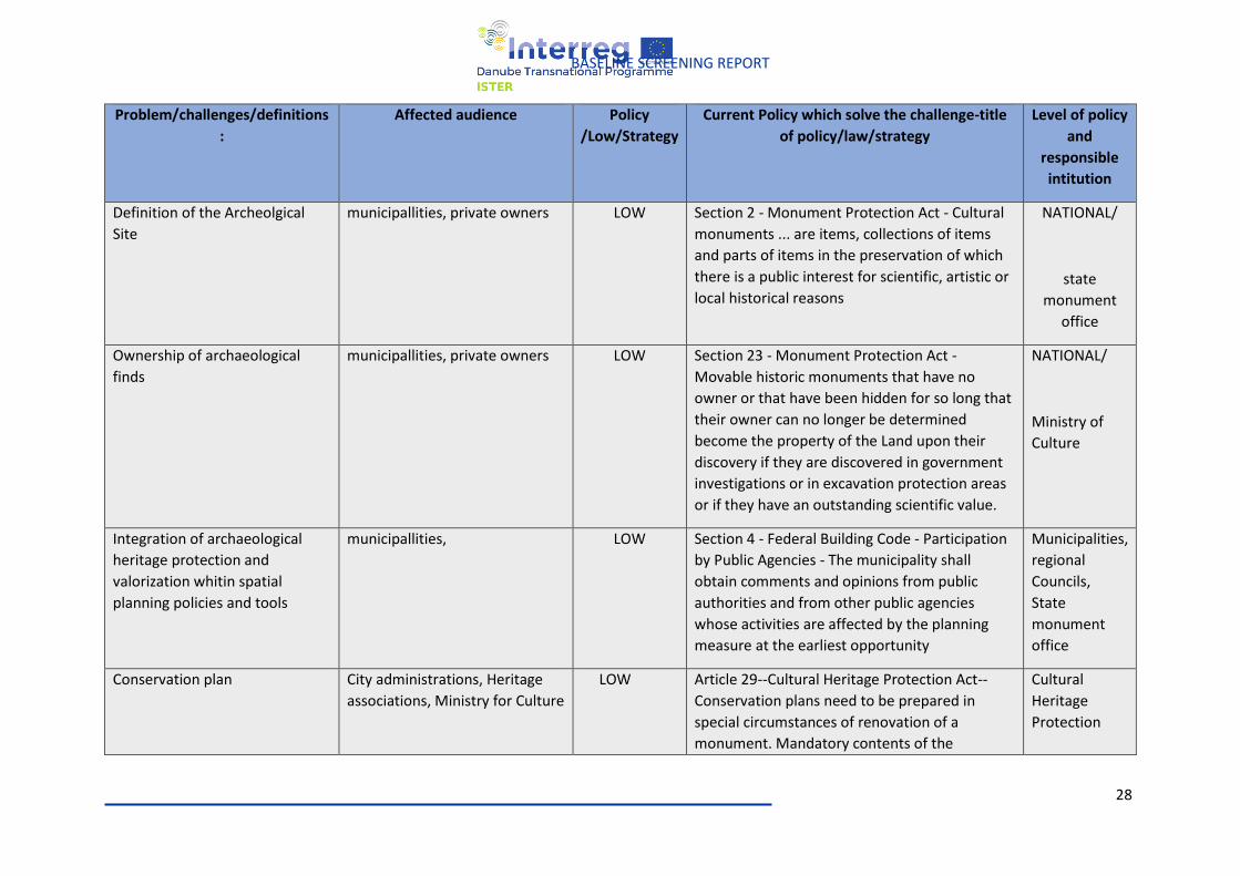
28
BASELINE SCREENING REPORT
Problem/challenges/definitions
:
Affected audience Policy
/Low/Strategy
Current Policy which solve the challenge-title
of policy/law/strategy
Level of policy
and
responsible
intitution
Definition of the Archeolgical
Site
municipallities, private owners LOW Section 2 - Monument Protection Act - Cultural
monuments ... are items, collections of items
and parts of items in the preservation of which
there is a public interest for scientific, artistic or
local historical reasons
NATIONAL/
state
monument
office
Ownership of archaeological
finds
municipallities, private owners LOW Section 23 - Monument Protection Act -
Movable historic monuments that have no
owner or that have been hidden for so long that
their owner can no longer be determined
become the property of the Land upon their
discovery if they are discovered in government
investigations or in excavation protection areas
or if they have an outstanding scientific value.
NATIONAL/
Ministry of
Culture
Integration of archaeological
heritage protection and
valorization whitin spatial
planning policies and tools
municipallities,
LOW Section 4 - Federal Building Code - Participation
by Public Agencies - The municipality shall
obtain comments and opinions from public
authorities and from other public agencies
whose activities are affected by the planning
measure at the earliest opportunity
Municipalities,
regional
Councils,
State
monument
office
Conservation plan City administrations, Heritage
associations, Ministry for Culture
LOW Article 29--Cultural Heritage Protection Act--
Conservation plans need to be prepared in
special circumstances of renovation of a
monument. Mandatory contents of the
Cultural
Heritage
Protection
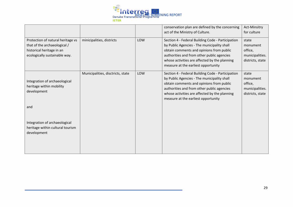
29
BASELINE SCREENING REPORT
conservation plan are defined by the concerning
act of the Ministry of Culture.
Act-Minsitry
for culture
Protection of natural heritage vs
that of the archaeological /
historical heritage in an
ecologically sustainable way.
minicipalities, districts LOW Section 4 - Federal Building Code - Participation
by Public Agencies - The municipality shall
obtain comments and opinions from public
authorities and from other public agencies
whose activities are affected by the planning
measure at the earliest opportunity
state
monument
office,
municipalities.
districts, state
Integration of archaeological
heritage within mobility
development
and
Integration of archaeological
heritage within cultural tourism
development
Municipalities, disctricts, state LOW Section 4 - Federal Building Code - Participation
by Public Agencies - The municipality shall
obtain comments and opinions from public
authorities and from other public agencies
whose activities are affected by the planning
measure at the earliest opportunity
state
monument
office,
municipalities.
districts, state
30
BASELINE SCREENING REPORT
ROMANIA
The Government Ordinance 43/2000 on the protection of the archaeological heritage and the
declaration of archaeological sites as areas of national interest and the Law 422/2001 on the protection
of historical monuments are the principles legislative acts in Romania affecting issues concerning ISTER
project.
An archaeological site is declared an area of national interest means the area of priority archaeological
interest established on the territory comprising archaeological sites whose scientific research,
protection and enhancement are of exceptional importance for national history and culture, through
material evidence, movable or immovable property that is or is proposed to be part of the category
Treasure of the movable national cultural heritage or, as the case may be, of the category of historical
monuments in the World Heritage List (OG 43/2000, Article).
Historical monuments are classified as follows (Law 422/2001, Article 8 (1) letters a and b): XY
● in group A - historical monuments of national and universal value;
● in group B - historical monuments representative for the local cultural heritage.
Source: http://legislatie.just.ro/Public/DetaliiDocument/20778
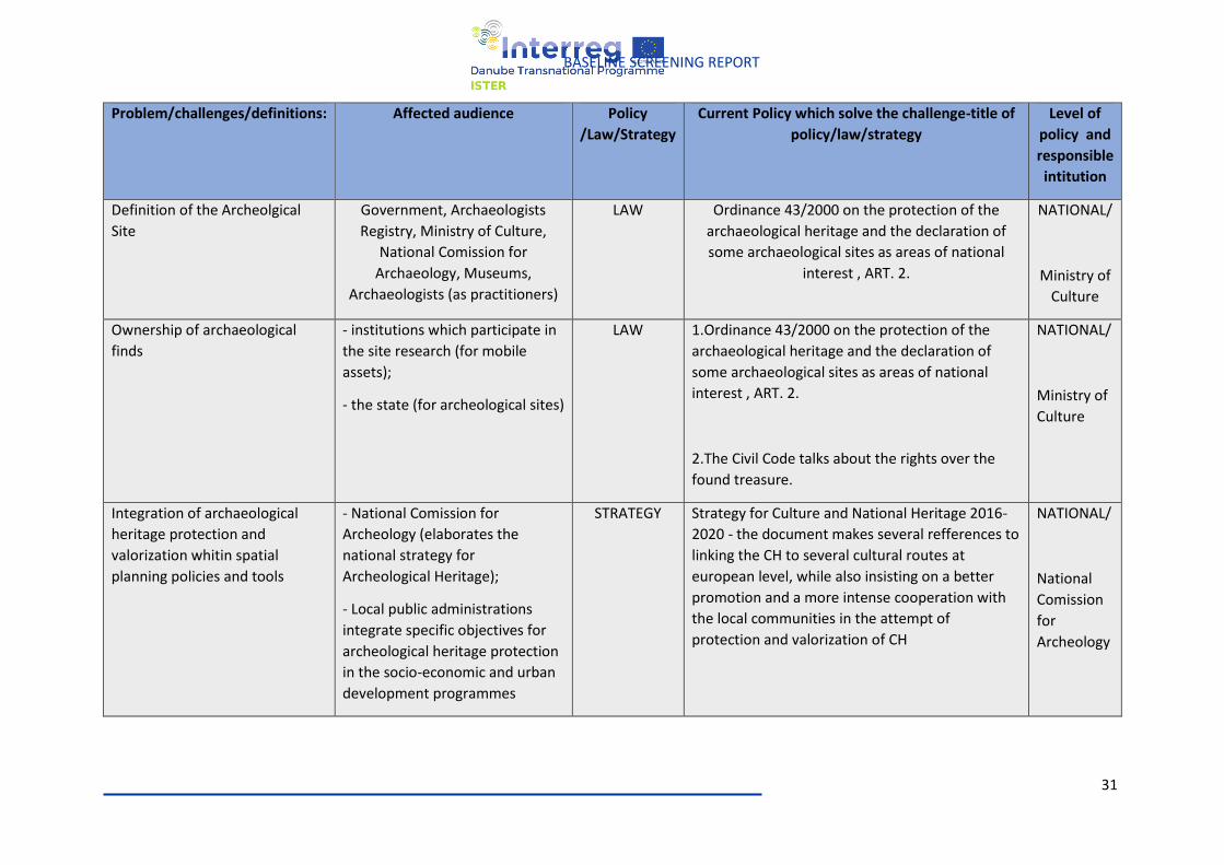
31
BASELINE SCREENING REPORT
Problem/challenges/definitions: Affected audience Policy
/Law/Strategy
Current Policy which solve the challenge-title of
policy/law/strategy
Level of
policy and
responsible
intitution
Definition of the Archeolgical
Site
Government, Archaeologists
Registry, Ministry of Culture,
National Comission for
Archaeology, Museums,
Archaeologists (as practitioners)
LAW Ordinance 43/2000 on the protection of the
archaeological heritage and the declaration of
some archaeological sites as areas of national
interest , ART. 2.
NATIONAL/
Ministry of
Culture
Ownership of archaeological
finds
- institutions which participate in
the site research (for mobile
assets);
- the state (for archeological sites)
LAW 1.Ordinance 43/2000 on the protection of the
archaeological heritage and the declaration of
some archaeological sites as areas of national
interest , ART. 2.
2.The Civil Code talks about the rights over the
found treasure.
NATIONAL/
Ministry of
Culture
Integration of archaeological
heritage protection and
valorization whitin spatial
planning policies and tools
- National Comission for
Archeology (elaborates the
national strategy for
Archeological Heritage);
- Local public administrations
integrate specific objectives for
archeological heritage protection
in the socio-economic and urban
development programmes
STRATEGY Strategy for Culture and National Heritage 2016-
2020 - the document makes several refferences to
linking the CH to several cultural routes at
european level, while also insisting on a better
promotion and a more intense cooperation with
the local communities in the attempt of
protection and valorization of CH
NATIONAL/
National
Comission
for
Archeology
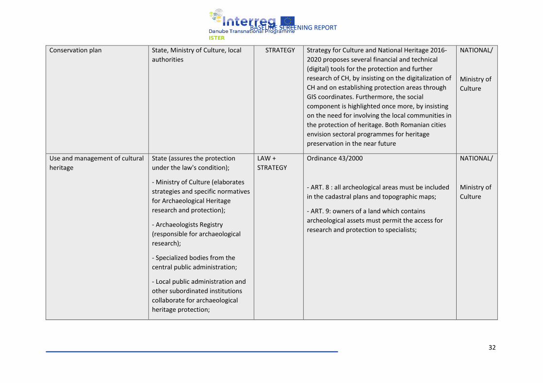
32
BASELINE SCREENING REPORT
Conservation plan State, Ministry of Culture, local
authorities
STRATEGY Strategy for Culture and National Heritage 2016-
2020 proposes several financial and technical
(digital) tools for the protection and further
research of CH, by insisting on the digitalization of
CH and on establishing protection areas through
GIS coordinates. Furthermore, the social
component is highlighted once more, by insisting
on the need for involving the local communities in
the protection of heritage. Both Romanian cities
envision sectoral programmes for heritage
preservation in the near future
NATIONAL/
Ministry of
Culture
Use and management of cultural
heritage
State (assures the protection
under the law's condition);
- Ministry of Culture (elaborates
strategies and specific normatives
for Archaeological Heritage
research and protection);
- Archaeologists Registry
(responsible for archaeological
research);
- Specialized bodies from the
central public administration;
- Local public administration and
other subordinated institutions
collaborate for archaeological
heritage protection;
LAW +
STRATEGY
Ordinance 43/2000
- ART. 8 : all archeological areas must be included
in the cadastral plans and topographic maps;
- ART. 9: owners of a land which contains
archeological assets must permit the access for
research and protection to specialists;
NATIONAL/
Ministry of
Culture
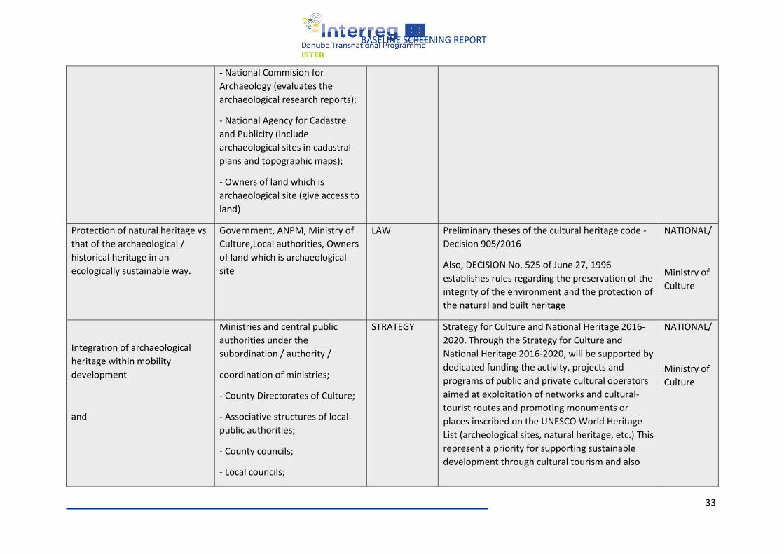
33
BASELINE SCREENING REPORT
- National Commision for
Archaeology (evaluates the
archaeological research reports);
- National Agency for Cadastre
and Publicity (include
archaeological sites in cadastral
plans and topographic maps);
- Owners of land which is
archaeological site (give access to
land)
Protection of natural heritage vs
that of the archaeological /
historical heritage in an
ecologically sustainable way.
Government, ANPM, Ministry of
Culture,Local authorities, Owners
of land which is archaeological
site
LAW Preliminary theses of the cultural heritage code -
Decision 905/2016
Also, DECISION No. 525 of June 27, 1996
establishes rules regarding the preservation of the
integrity of the environment and the protection of
the natural and built heritage
NATIONAL/
Ministry of
Culture
Integration of archaeological
heritage within mobility
development
and
Ministries and central public
authorities under the
subordination / authority /
coordination of ministries;
- County Directorates of Culture;
- Associative structures of local
public authorities;
- County councils;
- Local councils;
STRATEGY Strategy for Culture and National Heritage 2016-
2020. Through the Strategy for Culture and
National Heritage 2016-2020, will be supported by
dedicated funding the activity, projects and
programs of public and private cultural operators
aimed at exploitation of networks and cultural-
tourist routes and promoting monuments or
places inscribed on the UNESCO World Heritage
List (archeological sites, natural heritage, etc.) This
represent a priority for supporting sustainable
development through cultural tourism and also
NATIONAL/
Ministry of
Culture
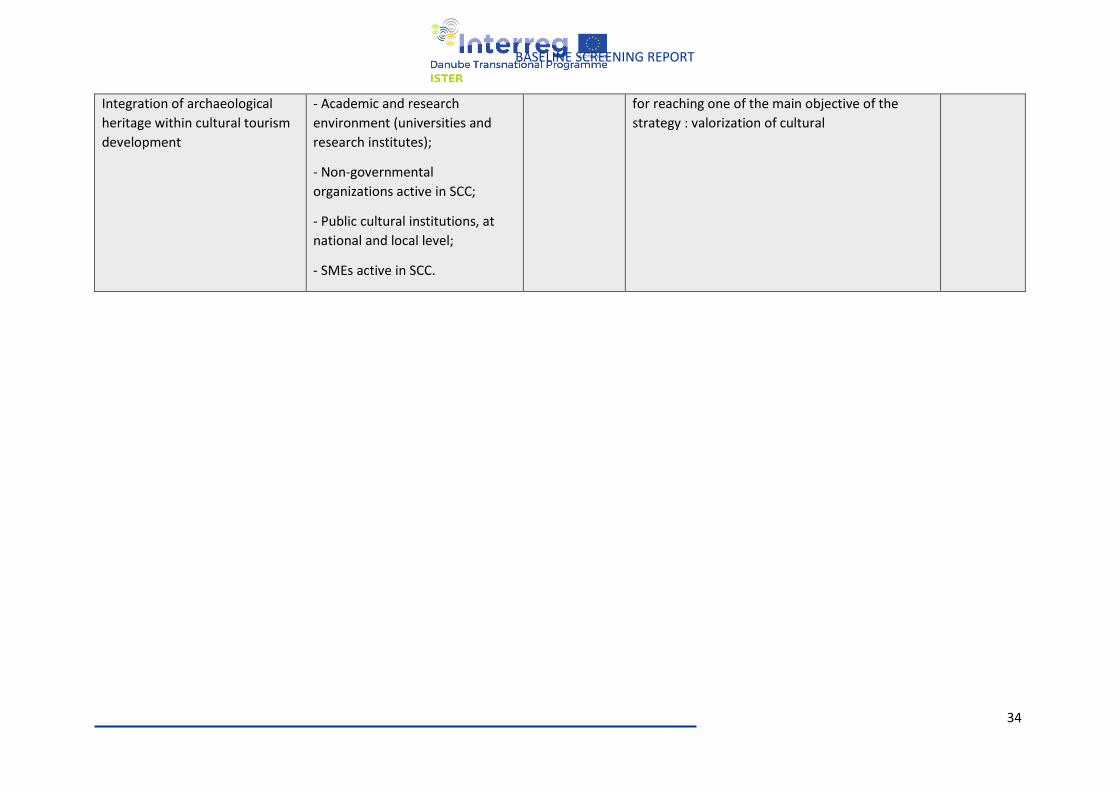
34
BASELINE SCREENING REPORT
Integration of archaeological
heritage within cultural tourism
development
- Academic and research
environment (universities and
research institutes);
- Non-governmental
organizations active in SCC;
- Public cultural institutions, at
national and local level;
- SMEs active in SCC.
for reaching one of the main objective of the
strategy : valorization of cultural
35
BASELINE SCREENING REPORT
HUNGARY
In Hungary there are two major regulative documents for the protection of cultural heritage as basis:
• Act LXIV. 2001 - Act on the Protection of Cultural Heritage (Act)
• 68/2018 (IV.9) Governmental Decree on Rules for the Protection of Cultural Heritage (Decree)
In the Act the, Ministry Responsible for Cultural Issues (recently Ministry of Human Resources/State
Secretariat for Culture), based on the Decree it is the Prime Ministry that exercises the rights
concerning cultural heritage trough Governmental Offices. Heritage protection activities in Hungary
are carried out in a centralized system. Legislation and regulation is a state task, covers the entire
country and is enforced locally through the Departments of Construction and Heritage Protection of
the County Government Offices.
Source:
https://www.eui.eu/Projects/InternationalArtHeritageLaw/Documents/NationalLegislation/Hungary/
lxiv2001hunorof.pdf
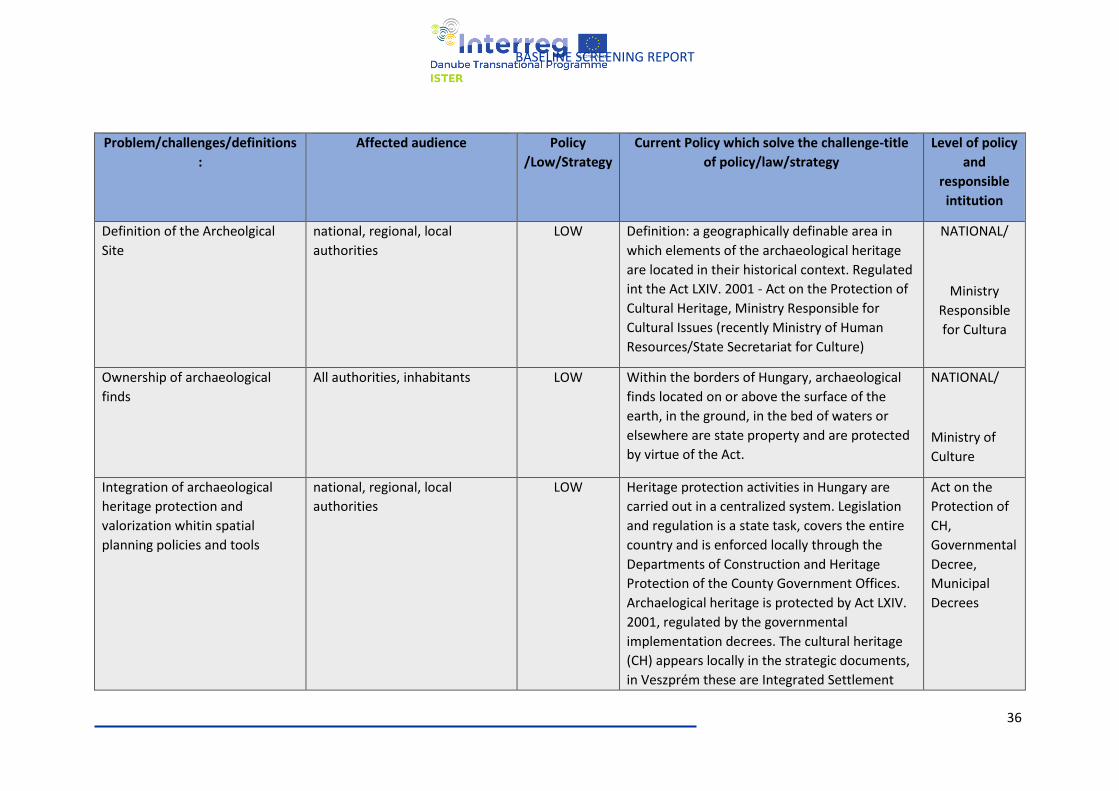
36
BASELINE SCREENING REPORT
Problem/challenges/definitions
:
Affected audience Policy
/Low/Strategy
Current Policy which solve the challenge-title
of policy/law/strategy
Level of policy
and
responsible
intitution
Definition of the Archeolgical
Site
national, regional, local
authorities
LOW Definition: a geographically definable area in
which elements of the archaeological heritage
are located in their historical context. Regulated
int the Act LXIV. 2001 - Act on the Protection of
Cultural Heritage, Ministry Responsible for
Cultural Issues (recently Ministry of Human
Resources/State Secretariat for Culture)
NATIONAL/
Ministry
Responsible
for Cultura
Ownership of archaeological
finds
All authorities, inhabitants
LOW Within the borders of Hungary, archaeological
finds located on or above the surface of the
earth, in the ground, in the bed of waters or
elsewhere are state property and are protected
by virtue of the Act.
NATIONAL/
Ministry of
Culture
Integration of archaeological
heritage protection and
valorization whitin spatial
planning policies and tools
national, regional, local
authorities
LOW Heritage protection activities in Hungary are
carried out in a centralized system. Legislation
and regulation is a state task, covers the entire
country and is enforced locally through the
Departments of Construction and Heritage
Protection of the County Government Offices.
Archaelogical heritage is protected by Act LXIV.
2001, regulated by the governmental
implementation decrees. The cultural heritage
(CH) appears locally in the strategic documents,
in Veszprém these are Integrated Settlement
Act on the
Protection of
CH,
Governmental
Decree,
Municipal
Decrees
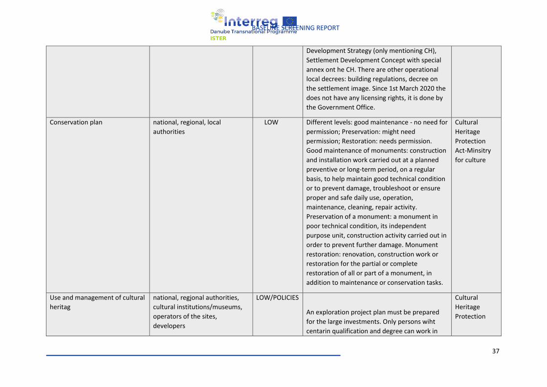
37
BASELINE SCREENING REPORT
Development Strategy (only mentioning CH),
Settlement Development Concept with special
annex ont he CH. There are other operational
local decrees: building regulations, decree on
the settlement image. Since 1st March 2020 the
does not have any licensing rights, it is done by
the Government Office.
Conservation plan national, regional, local
authorities
LOW Different levels: good maintenance - no need for
permission; Preservation: might need
permission; Restoration: needs permission.
Good maintenance of monuments: construction
and installation work carried out at a planned
preventive or long-term period, on a regular
basis, to help maintain good technical condition
or to prevent damage, troubleshoot or ensure
proper and safe daily use, operation,
maintenance, cleaning, repair activity.
Preservation of a monument: a monument in
poor technical condition, its independent
purpose unit, construction activity carried out in
order to prevent further damage. Monument
restoration: renovation, construction work or
restoration for the partial or complete
restoration of all or part of a monument, in
addition to maintenance or conservation tasks.
Cultural
Heritage
Protection
Act-Minsitry
for culture
Use and management of cultural
heritag
national, regjonal authorities,
cultural institutions/museums,
operators of the sites,
developers
LOW/POLICIES
An exploration project plan must be prepared
for the large investments. Only persons wiht
centarin qualification and degree can work in
Cultural
Heritage
Protection
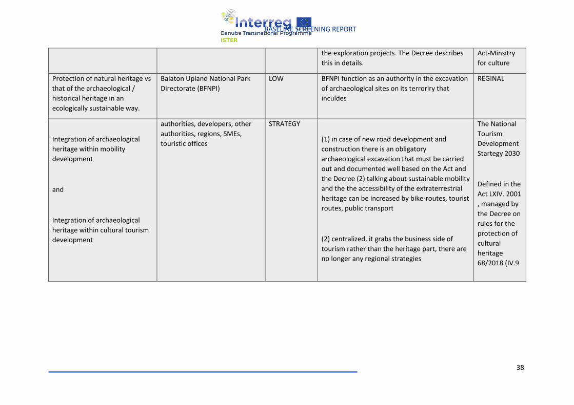
38
BASELINE SCREENING REPORT
the exploration projects. The Decree describes
this in details.
Act-Minsitry
for culture
Protection of natural heritage vs
that of the archaeological /
historical heritage in an
ecologically sustainable way.
Balaton Upland National Park
Directorate (BFNPI)
LOW BFNPI function as an authority in the excavation
of archaeological sites on its terroriry that
inculdes
REGINAL
Integration of archaeological
heritage within mobility
development
and
Integration of archaeological
heritage within cultural tourism
development
authorities, developers, other
authorities, regions, SMEs,
touristic offices
STRATEGY
(1) in case of new road development and
construction there is an obligatory
archaeological excavation that must be carried
out and documented well based on the Act and
the Decree (2) talking about sustainable mobility
and the the accessibility of the extraterrestrial
heritage can be increased by bike-routes, tourist
routes, public transport
(2) centralized, it grabs the business side of
tourism rather than the heritage part, there are
no longer any regional strategies
The National
Tourism
Development
Startegy 2030
Defined in the
Act LXIV. 2001
, managed by
the Decree on
rules for the
protection of
cultural
heritage
68/2018 (IV.9
39
BASELINE SCREENING REPORT
AUSTRIA
The main legal reference for cultural heritage protection in Austria is the Federal Act on the Protection
of Monuments Due to Their Historic, Artistic or Other Cultural Significance or Monument Protection
Act. The original version of the act is from 1923 and was object of several changes until the last one in
2020.
The act does not offer any definitions related to archaeological site. According to "the law § 1. (1) the
provisions of this Federal Act apply to man-made immovable and movable objects (including remains
and traces of creative human intervention and artificially constructed or moulded ground formations)
of historic, artistic or other cultural significance (“monuments”), if, due to this significance, their
preservation is in the public interest. This significance may be due to the objects per se, but may also
arise due to their relationship to, or location in relation to, other objects.
In § 1 (2), preservation is defined as being in the public interest if, from a supraregional or, for the time
being, only a regional (local) point of view, the monument is a cultural good, the loss of which would
amount to an impairment of the stock of Austrian cultural goods as a whole with respect to quality as
well as sufficient abundance, diversity and distribution. Furthermore, it is fundamental whether (and
to what extent) the preservation of the monument would enable historic documentation.
Without making direct reference to this, the Federal Monument Protection Act states that
investigations (including excavations) are carried out by organs of local authorities, including their
museums, collections or other scientific institutions and after approval by the Federal Monument
Office."
Source:
https://bda.gv.at/fileadmin/Medien/bda.gv.at/SERVICE_RECHT_DOWNLOAD/Monument_Protection
_Art.pdf
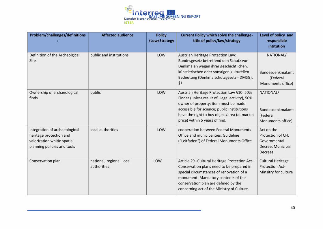
40
BASELINE SCREENING REPORT
Problem/challenges/definitions
:
Affected audience Policy
/Low/Strategy
Current Policy which solve the challenge-
title of policy/law/strategy
Level of policy and
responsible
intitution
Definition of the Archeolgical
Site
public and institutions LOW Austrian Heritage Protection Law:
Bundesgesetz betreffend den Schutz von
Denkmalen wegen ihrer geschichtlichen,
künstlerischen oder sonstigen kulturellen
Bedeutung (Denkmalschutzgesetz - DMSG);
§1
NATIONAL/
Bundesdenkmalamt
(Federal
Monuments office)
Ownership of archaeological
finds
public
LOW Austrian Heritage Protection Law §10: 50%
Finder (unless result of illegal activity), 50%
owner of property; item must be made
accessible for science; public institutions
have the right to buy object/area (at market
price) within 5 years of find.
NATIONAL/
Bundesdenkmalamt
(Federal
Monuments office)
Integration of archaeological
heritage protection and
valorization whitin spatial
planning policies and tools
local authorities LOW cooperation between Federal Monuments
Office and municipalities, Guideline
("Leitfaden") of Federal Monuments Office
Act on the
Protection of CH,
Governmental
Decree, Municipal
Decrees
Conservation plan national, regional, local
authorities
LOW Article 29--Cultural Heritage Protection Act--
Conservation plans need to be prepared in
special circumstances of renovation of a
monument. Mandatory contents of the
conservation plan are defined by the
concerning act of the Ministry of Culture.
Cultural Heritage
Protection Act-
Minsitry for culture
41
BASELINE SCREENING REPORT
BOSNIA AND HERZEGOVINA
The main act for cultural heritage conservation in Bosnia and Herzegovina is the Zakon o provedbi
odluka Komisije/Povjerenstva za zaštitu nacionalnih spomenika uspostavljene prema Aneksu 8. Općeg
okvirnog sporazuma za mir u Bosni i Hercegovini from 2002 with several subsequent changes.
The act regulating building activities outside national monuments is the Zakon o odobravanju građenja
van granica nacionalnih spomenika odnosno van privremenih granica i provođenju mjera zaštite from
2008.
Source:
http://kons.gov.ba/data/Novi%20dokumenti/Zakoni/Zakon_FBiH_prov_odluka_Komisije_BOS_integr
alna.pdf
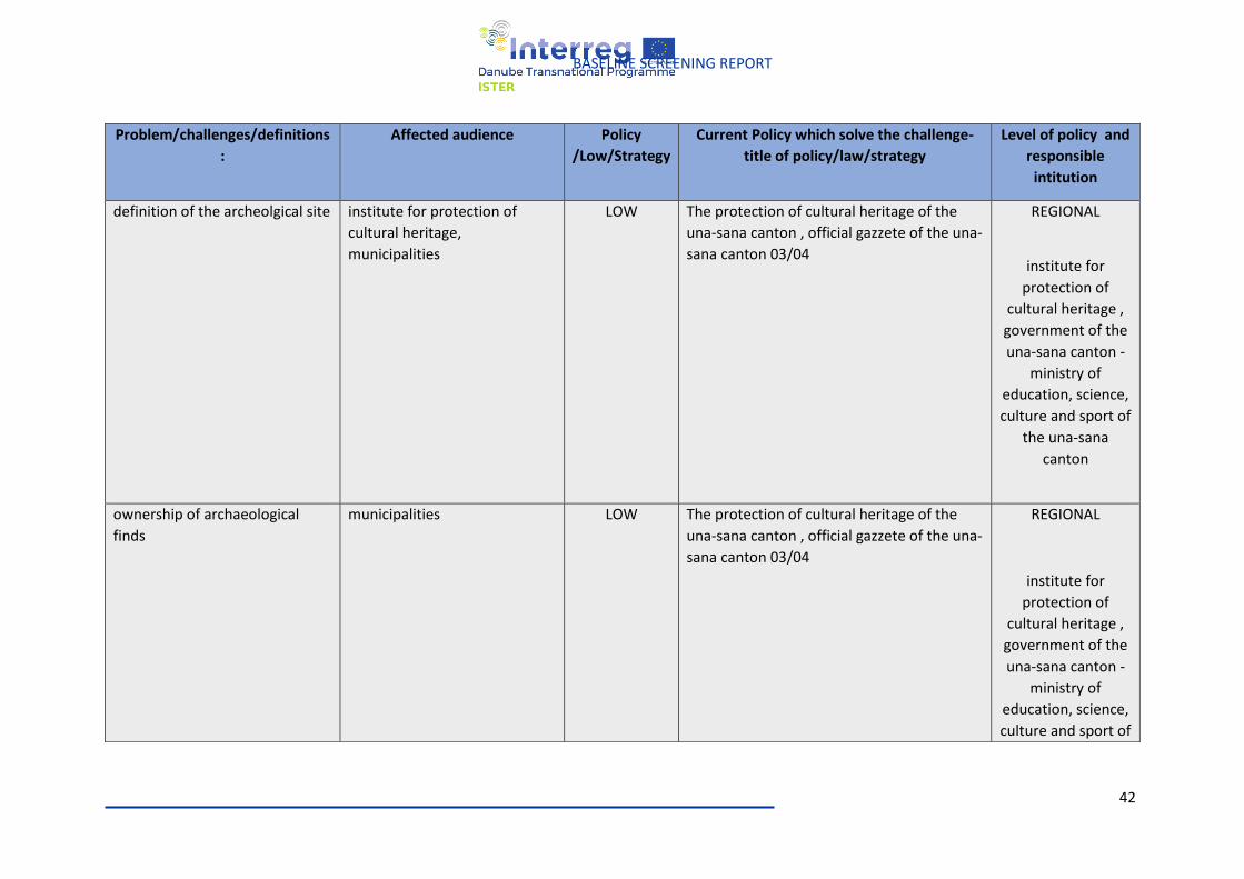
42
BASELINE SCREENING REPORT
Problem/challenges/definitions
:
Affected audience Policy
/Low/Strategy
Current Policy which solve the challenge-
title of policy/law/strategy
Level of policy and
responsible
intitution
definition of the archeolgical site
institute for protection of
cultural heritage,
municipalities
LOW The protection of cultural heritage of the
una-sana canton , official gazzete of the una-
sana canton 03/04
REGIONAL
institute for
protection of
cultural heritage ,
government of the
una-sana canton -
ministry of
education, science,
culture and sport of
the una-sana
canton
ownership of archaeological
finds
municipalities LOW The protection of cultural heritage of the
una-sana canton , official gazzete of the una-
sana canton 03/04
REGIONAL
institute for
protection of
cultural heritage ,
government of the
una-sana canton -
ministry of
education, science,
culture and sport of
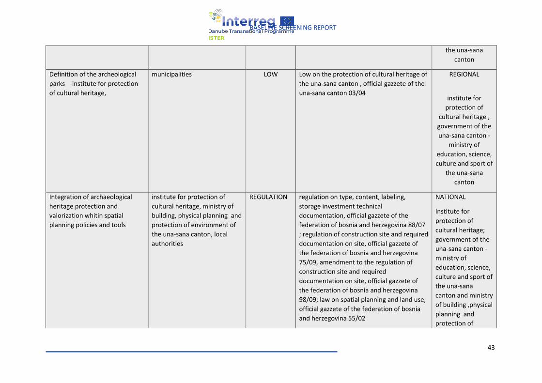
43
BASELINE SCREENING REPORT
the una-sana
canton
Definition of the archeological
parks institute for protection
of cultural heritage,
municipalities LOW Low on the protection of cultural heritage of
the una-sana canton , official gazzete of the
una-sana canton 03/04
REGIONAL
institute for
protection of
cultural heritage ,
government of the
una-sana canton -
ministry of
education, science,
culture and sport of
the una-sana
canton
Integration of archaeological
heritage protection and
valorization whitin spatial
planning policies and tools
institute for protection of
cultural heritage, ministry of
building, physical planning and
protection of environment of
the una-sana canton, local
authorities
REGULATION regulation on type, content, labeling,
storage investment technical
documentation, official gazzete of the
federation of bosnia and herzegovina 88/07
; regulation of construction site and required
documentation on site, official gazzete of
the federation of bosnia and herzegovina
75/09, amendment to the regulation of
construction site and required
documentation on site, official gazzete of
the federation of bosnia and herzegovina
98/09; law on spatial planning and land use,
official gazzete of the federation of bosnia
and herzegovina 55/02
NATIONAL
institute for
protection of
cultural heritage;
government of the
una-sana canton -
ministry of
education, science,
culture and sport of
the una-sana
canton and ministry
of building ,physical
planning and
protection of
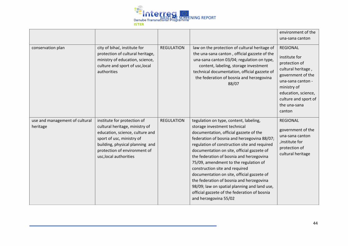
44
BASELINE SCREENING REPORT
environment of the
una-sana canton
conservation plan city of bihać, institute for
protection of cultural heritage,
ministry of education, science,
culture and sport of usc,local
authorities
REGULATION law on the protection of cultural heritage of
the una-sana canton , official gazzete of the
una-sana canton 03/04; regulation on type,
content, labeling, storage investment
technical documentation, official gazzete of
the federation of bosnia and herzegovina
88/07
REGIONAL
institute for
protection of
cultural heritage ,
government of the
una-sana canton -
ministry of
education, science,
culture and sport of
the una-sana
canton
use and management of cultural
heritage
institute for protection of
cultural heritage, ministry of
education, science, culture and
sport of usc, ministry of
building, physical planning and
protection of environment of
usc,local authorities
REGULATION tegulation on type, content, labeling,
storage investment technical
documentation, official gazzete of the
federation of bosnia and herzegovina 88/07;
regulation of construction site and required
documentation on site, official gazzete of
the federation of bosnia and herzegovina
75/09, amendment to the regulation of
construction site and required
documentation on site, official gazzete of
the federation of bosnia and herzegovina
98/09; law on spatial planning and land use,
official gazzete of the federation of bosnia
and herzegovina 55/02
REGIONAL
government of the
una-sana canton
,institute for
protection of
cultural heritage
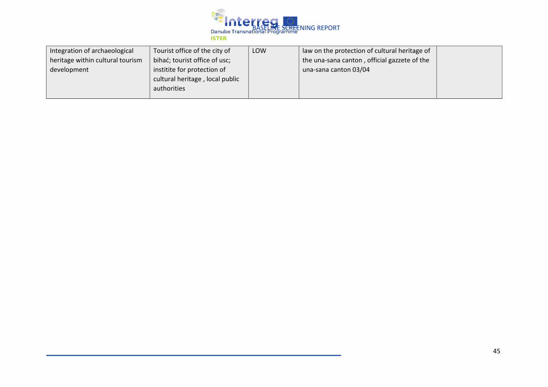
45
BASELINE SCREENING REPORT
Integration of archaeological
heritage within cultural tourism
development
Tourist office of the city of
bihać; tourist office of usc;
institite for protection of
cultural heritage , local public
authorities
LOW law on the protection of cultural heritage of
the una-sana canton , official gazzete of the
una-sana canton 03/04
46
BASELINE SCREENING REPORT
SERBIA
The main regulations in this field are in Serbia:
● Zakon o kulturi (in force from 2009, with subsequent modifications), ● Zakon o kulturnim dobrima (in force from 1994, with later changes), ● Nacrt Zakona o delatnosti zastite nepokretnih kulturnih dobara (proposal), ● Стратегију развоја културе Републике Србије од 2020. до 2029 (proposal)
Source: https://www.kultura.gov.rs/tekst/43/zakoni-i-uredbe.php.
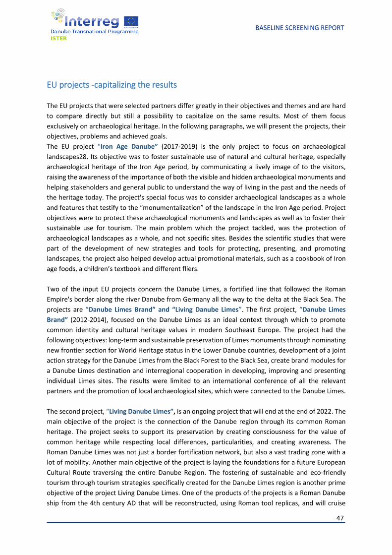
47
BASELINE SCREENING REPORT
EU projects -capitalizing the results
The EU projects that were selected partners differ greatly in their objectives and themes and are hard
to compare directly but still a possibility to capitalize on the same results. Most of them focus
exclusively on archaeological heritage. In the following paragraphs, we will present the projects, their
objectives, problems and achieved goals.
The EU project “Iron Age Danube” (2017-2019) is the only project to focus on archaeological
landscapes28. Its objective was to foster sustainable use of natural and cultural heritage, especially
archaeological heritage of the Iron Age period, by communicating a lively image of to the visitors,
raising the awareness of the importance of both the visible and hidden archaeological monuments and
helping stakeholders and general public to understand the way of living in the past and the needs of
the heritage today. The project's special focus was to consider archaeological landscapes as a whole
and features that testify to the “monumentalization” of the landscape in the Iron Age period. Project
objectives were to protect these archaeological monuments and landscapes as well as to foster their
sustainable use for tourism. The main problem which the project tackled, was the protection of
archaeological landscapes as a whole, and not specific sites. Besides the scientific studies that were
part of the development of new strategies and tools for protecting, presenting, and promoting
landscapes, the project also helped develop actual promotional materials, such as a cookbook of Iron
age foods, a children’s textbook and different fliers.
Two of the input EU projects concern the Danube Limes, a fortified line that followed the Roman
Empire's border along the river Danube from Germany all the way to the delta at the Black Sea. The
projects are “Danube Limes Brand” and “Living Danube Limes”. The first project, “Danube Limes
Brand” (2012-2014), focused on the Danube Limes as an ideal context through which to promote
common identity and cultural heritage values in modern Southeast Europe. The project had the
following objectives: long-term and sustainable preservation of Limes monuments through nominating
new frontier section for World Heritage status in the Lower Danube countries, development of a joint
action strategy for the Danube Limes from the Black Forest to the Black Sea, create brand modules for
a Danube Limes destination and interregional cooperation in developing, improving and presenting
individual Limes sites. The results were limited to an international conference of all the relevant
partners and the promotion of local archaeological sites, which were connected to the Danube Limes.
The second project, “Living Danube Limes”, is an ongoing project that will end at the end of 2022. The
main objective of the project is the connection of the Danube region through its common Roman
heritage. The project seeks to support its preservation by creating consciousness for the value of
common heritage while respecting local differences, particularities, and creating awareness. The
Roman Danube Limes was not just a border fortification network, but also a vast trading zone with a
lot of mobility. Another main objective of the project is laying the foundations for a future European
Cultural Route traversing the entire Danube Region. The fostering of sustainable and eco-friendly
tourism through tourism strategies specifically created for the Danube Limes region is another prime
objective of the project Living Danube Limes. One of the products of the projects is a Roman Danube
ship from the 4th century AD that will be reconstructed, using Roman tool replicas, and will cruise
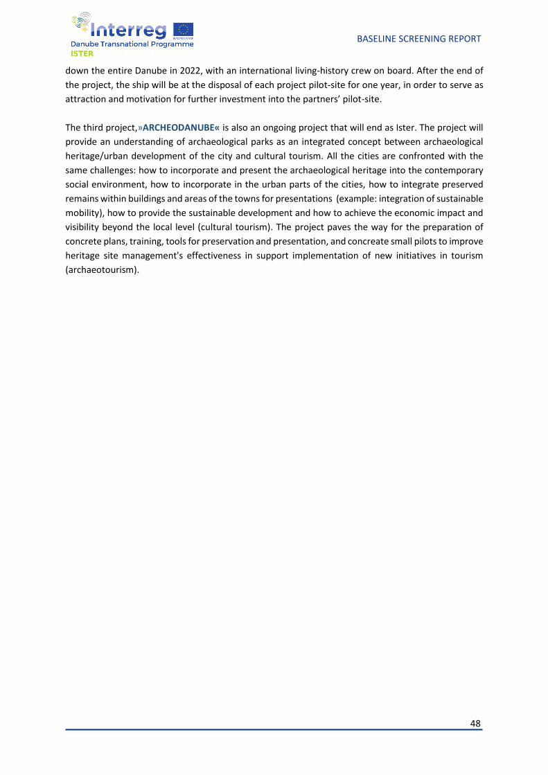
48
BASELINE SCREENING REPORT
down the entire Danube in 2022, with an international living-history crew on board. After the end of
the project, the ship will be at the disposal of each project pilot-site for one year, in order to serve as
attraction and motivation for further investment into the partners’ pilot-site.
The third project,»ARCHEODANUBE« is also an ongoing project that will end as Ister. The project will
provide an understanding of archaeological parks as an integrated concept between archaeological
heritage/urban development of the city and cultural tourism. All the cities are confronted with the
same challenges: how to incorporate and present the archaeological heritage into the contemporary
social environment, how to incorporate in the urban parts of the cities, how to integrate preserved
remains within buildings and areas of the towns for presentations (example: integration of sustainable
mobility), how to provide the sustainable development and how to achieve the economic impact and
visibility beyond the local level (cultural tourism). The project paves the way for the preparation of
concrete plans, training, tools for preservation and presentation, and concreate small pilots to improve
heritage site management's effectiveness in support implementation of new initiatives in tourism
(archaeotourism).
49
BASELINE SCREENING REPORT
National projects- best practice.
In the following paragraphs, we will present the best practice as some national projects.
GERMANY
Archeological park of trooper castell and the LIMES Museum in Aalen
As long as the border of the Roman Empire (LIMES) crossed the northern part of the current territory
of Ostwuerttemberg, the town Aalen had been the most important military - and respectively civil -
settlement; appr. 1000 Roman soldiers of Ala II Flavia milliaria armee lived in Aalen in 200 A.D. It was
abandoned though in appr. 259/260 A.D. as the territory of the province Raetia was conquered by
barbarians from the north. First excavations on the territory of the former castell were conducted at
the end of 19th century, in 1894 by Mr. Steimle during the 5-week-long expedition. Further excavations
followed. After the World War II, in 1950s the town Aalen had intentions to build up living houses on
and araund the area of the then Roman castell. Those plans were rejected though in the course of
resistence that was put up by local historians. The preservation goals had been enforced and the LIMES
museum was opened on 5. June 1964. Numerous excavations in the 1970s brought much knowledge
and many important findings; the number of museum visitors rose constantly. That is why the first
50
BASELINE SCREENING REPORT
extention was needed and followed in 1979-81. As the development on the cultural and archeological
institution went ahead, additional staff was hired and pedagogical conpetences were aquired in 1980s.
During 1999-2000 the second extension of the LIMES museum was conducted. Over the course of
2000s there were two main development lines on the area of the museum. Firstly, the application for
classification as a UNESCO World heritage site was filing; secondly, - partly in connection with first
point - the arceological park was remarkably improved, for instance by reconstruction of a trooper
shack. After the classification of the Roman Empire´s border LIMES as the UNESCO World heritage site
in 2005, the establishment of a centralised information point followed in 2008. In 2016 the museum
was closed again; the constant exposition of findings had to be completely redesigned and
reconeptualised. On 24. May 2019 the re-opening took place, so nowadays the LIMES museum and
the surrounding archeological park are the center of cultural, historical and archeological heritage of
the Roman Empire in Ostwuerttemberg.
MORE: https://www.limesmuseum.de/limesmuseum.52501.52497.htm
LIMES-Dalkinger Gate (as a part of Rainau archeological park)
Among the ancient Roman objects along the Limes, remains of which have survived thus far, the former
Limes Gate near Dalkingen is of particular importance. On the outer border of the Roman Empire -
probably in connection with a victorious campaign by Emperor Caracalla against the Alemanni - a
remarkable, 12-meter-high Roman triumphal arch with a large bronze imperial statue was created in
213 and 214 A.D. It is the only gate system that has been proven by findings along the over 500 km
long Upper Germanic-Rhaetian Limes. The remnants of the Dalkinger Gate were undercovered in
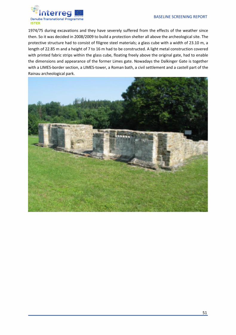
51
BASELINE SCREENING REPORT
1974/75 during excavations and they have severely suffered from the effects of the weather since
then. So it was decided in 2008/2009 to build a protection shelter all above the archeological site. The
protective structure had to consist of filigree steel materials; a glass cube with a width of 23.10 m, a
length of 22.85 m and a height of 7 to 16 m had to be constructed. A light metal construction covered
with printed fabric strips within the glass cube, floating freely above the original gate, had to enable
the dimensions and appearance of the former Limes gate. Nowadays the Dalkinger Gate is together
with a LIMES-border section, a LIMES-tower, a Roman bath, a civil settlement and a castell part of the
Rainau archeological park.
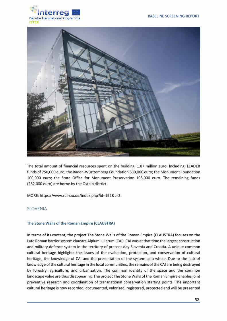
52
BASELINE SCREENING REPORT
The total amount of financial resources spent on the building: 1.87 million euro. Including: LEADER
funds of 750,000 euro; the Baden-Württemberg Foundation 630,000 euro; the Monument Foundation
100,000 euro; the State Office for Monument Preservation 108,000 euro. The remaining funds
(282.000 euro) are borne by the Ostalb district.
MORE: https://www.rainau.de/index.php?id=192&L=2
SLOVENIA
The Stone Walls of the Roman Empire (CLAUSTRA)
In terms of its content, the project The Stone Walls of the Roman Empire (CLAUSTRA) focuses on the
Late Roman barrier system claustra Alpium Iuliarum (CAI). CAI was at that time the largest construction
and military defence system in the territory of present-day Slovenia and Croatia. A unique common
cultural heritage highlights the issues of the evaluation, protection, and conservation of cultural
heritage, the knowledge of CAI and the presentation of the system as a whole. Due to the lack of
knowledge of the cultural heritage in the local communities, the remains of the CAI are being destroyed
by forestry, agriculture, and urbanization. The common identity of the space and the common
landscape value are thus disappearing. The project The Stone Walls of the Roman Empire enables joint
preventive research and coordination of transnational conservation starting points. The important
cultural heritage is now recorded, documented, valorised, registered, protected and will be presented
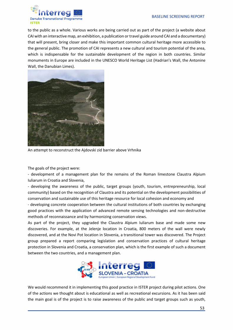
53
BASELINE SCREENING REPORT
to the public as a whole. Various works are being carried out as part of the project (a website about
CAI with an interactive map, an exhibition, a publication or travel guide around CAI and a documentary)
that will present, bring closer and make this important common cultural heritage more accessible to
the general public. The promotion of CAI represents a new cultural and tourism potential of the area,
which is indispensable for the sustainable development of the region in both countries. Similar
monuments in Europe are included in the UNESCO World Heritage List (Hadrian’s Wall, the Antonine
Wall, the Danubian Limes).
An attempt to reconstruct the Ajdovski zid barrier above Vrhnika
The goals of the project were:
- development of a management plan for the remains of the Roman limestone Claustra Alpium
Iuliarum in Croatia and Slovenia,
- developing the awareness of the public, target groups (youth, tourism, entrepreneurship, local
community) based on the recognition of Claustra and its potential on the development possibilities of
conservation and sustainable use of this heritage resource for local cohesion and economy and
- developing concrete cooperation between the cultural institutions of both countries by exchanging
good practices with the application of advanced remote sensing technologies and non-destructive
methods of reconnaissance and by harmonizing conservation views.
As part of the project, they upgraded the Claustra Alpium Iuliarum base and made some new
discoveries. For example, at the Jelenje location in Croatia, 800 meters of the wall were newly
discovered, and at the Novi Pot location in Slovenia, a transitional tower was discovered. The Project
group prepared a report comparing legislation and conservation practices of cultural heritage
protection in Slovenia and Croatia, a conservation plan, which is the first example of such a document
between the two countries, and a management plan.
We would recommend it in implementing this good practice in ISTER project during pilot actions. One
of the actions we thought about is educational as well as recreational excursions. As it has been said
the main goal is of the project is to raise awareness of the public and target groups such as youth,
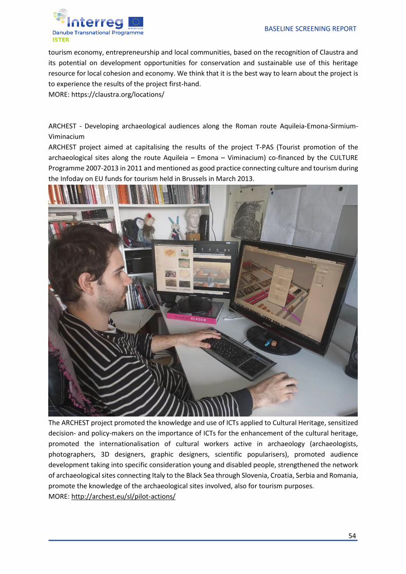
54
BASELINE SCREENING REPORT
tourism economy, entrepreneurship and local communities, based on the recognition of Claustra and
its potential on development opportunities for conservation and sustainable use of this heritage
resource for local cohesion and economy. We think that it is the best way to learn about the project is
to experience the results of the project first-hand.
MORE: https://claustra.org/locations/
ARCHEST - Developing archaeological audiences along the Roman route Aquileia-Emona-Sirmium-
Viminacium
ARCHEST project aimed at capitalising the results of the project T-PAS (Tourist promotion of the
archaeological sites along the route Aquileia – Emona – Viminacium) co-financed by the CULTURE
Programme 2007-2013 in 2011 and mentioned as good practice connecting culture and tourism during
the Infoday on EU funds for tourism held in Brussels in March 2013.
The ARCHEST project promoted the knowledge and use of ICTs applied to Cultural Heritage, sensitized
decision- and policy-makers on the importance of ICTs for the enhancement of the cultural heritage,
promoted the internationalisation of cultural workers active in archaeology (archaeologists,
photographers, 3D designers, graphic designers, scientific popularisers), promoted audience
development taking into specific consideration young and disabled people, strengthened the network
of archaeological sites connecting Italy to the Black Sea through Slovenia, Croatia, Serbia and Romania,
promote the knowledge of the archaeological sites involved, also for tourism purposes.
MORE: http://archest.eu/sl/pilot-actions/
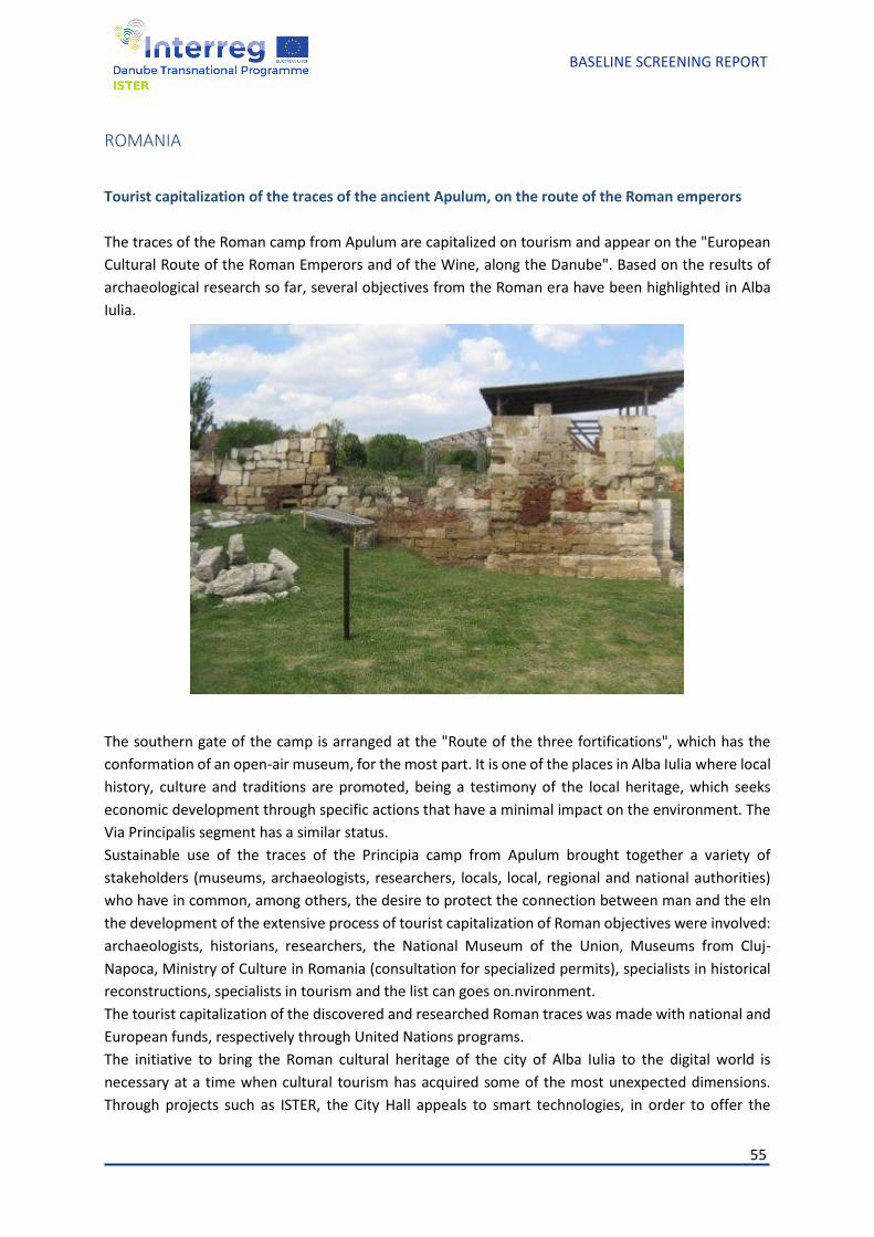
55
BASELINE SCREENING REPORT
ROMANIA
Tourist capitalization of the traces of the ancient Apulum, on the route of the Roman emperors
The traces of the Roman camp from Apulum are capitalized on tourism and appear on the "European
Cultural Route of the Roman Emperors and of the Wine, along the Danube". Based on the results of
archaeological research so far, several objectives from the Roman era have been highlighted in Alba
Iulia.
The southern gate of the camp is arranged at the "Route of the three fortifications", which has the
conformation of an open-air museum, for the most part. It is one of the places in Alba Iulia where local
history, culture and traditions are promoted, being a testimony of the local heritage, which seeks
economic development through specific actions that have a minimal impact on the environment. The
Via Principalis segment has a similar status.
Sustainable use of the traces of the Principia camp from Apulum brought together a variety of
stakeholders (museums, archaeologists, researchers, locals, local, regional and national authorities)
who have in common, among others, the desire to protect the connection between man and the eIn
the development of the extensive process of tourist capitalization of Roman objectives were involved:
archaeologists, historians, researchers, the National Museum of the Union, Museums from Cluj-
Napoca, Ministry of Culture in Romania (consultation for specialized permits), specialists in historical
reconstructions, specialists in tourism and the list can goes on.nvironment.
The tourist capitalization of the discovered and researched Roman traces was made with national and
European funds, respectively through United Nations programs.
The initiative to bring the Roman cultural heritage of the city of Alba Iulia to the digital world is
necessary at a time when cultural tourism has acquired some of the most unexpected dimensions.
Through projects such as ISTER, the City Hall appeals to smart technologies, in order to offer the
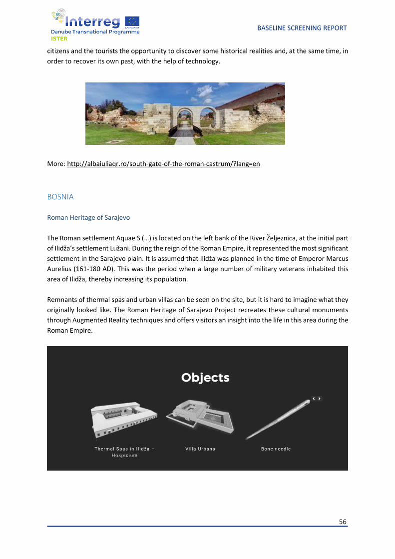
56
BASELINE SCREENING REPORT
citizens and the tourists the opportunity to discover some historical realities and, at the same time, in
order to recover its own past, with the help of technology.
More: http://albaiuliaqr.ro/south-gate-of-the-roman-castrum/?lang=en
BOSNIA
Roman Heritage of Sarajevo
The Roman settlement Aquae S (…) is located on the left bank of the River Željeznica, at the initial part
of Ilidža’s settlement Lužani. During the reign of the Roman Empire, it represented the most significant
settlement in the Sarajevo plain. It is assumed that Ilidža was planned in the time of Emperor Marcus
Aurelius (161-180 AD). This was the period when a large number of military veterans inhabited this
area of Ilidža, thereby increasing its population.
Remnants of thermal spas and urban villas can be seen on the site, but it is hard to imagine what they
originally looked like. The Roman Heritage of Sarajevo Project recreates these cultural monuments
through Augmented Reality techniques and offers visitors an insight into the life in this area during the
Roman Empire.
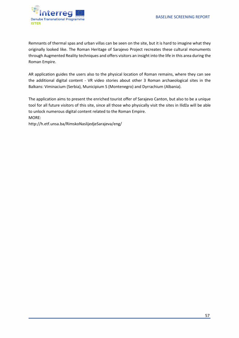
57
BASELINE SCREENING REPORT
Remnants of thermal spas and urban villas can be seen on the site, but it is hard to imagine what they
originally looked like. The Roman Heritage of Sarajevo Project recreates these cultural monuments
through Augmented Reality techniques and offers visitors an insight into the life in this area during the
Roman Empire.
AR application guides the users also to the physical location of Roman remains, where they can see
the additional digital content - VR video stories about other 3 Roman archaeological sites in the
Balkans: Viminacium (Serbia), Municipium S (Montenegro) and Dyrrachium (Albania).
The application aims to present the enriched tourist offer of Sarajevo Canton, but also to be a unique
tool for all future visitors of this site, since all those who physically visit the sites in Ilidža will be able
to unlock numerous digital content related to the Roman Empire.
MORE:
http://h.etf.unsa.ba/RimskoNaslijedjeSarajeva/eng/
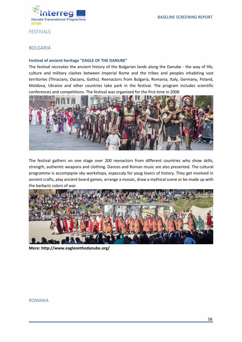
58
BASELINE SCREENING REPORT
FESTIVALS
BOLGARIA
Festival of ancient heritage "EAGLE OF THE DANUBE"
The festival recreates the ancient history of the Bulgarian lands along the Danube - the way of life,
culture and military clashes between Imperial Rome and the tribes and peoples inhabiting vast
territories (Thracians, Dacians, Goths). Reenactors from Bulgaria, Romania, Italy, Germany, Poland,
Moldova, Ukraine and other countries take park in the festival. The program includes scientific
conferences and competitions. The festival was organized for the first time in 2008
The festival gathers on one stage over 200 reenactors from different countries who show skills,
strength, authentic weapons and clothing. Dances and Roman music are also presented. The cultural
programme is accompqnie sby workshops, especcaly for youg lovers of history. They get involved in
ancient crafts, play ancient board games, arrange a mosaic, draw a mythical scene or be made up with
the barbaric colors of war.
More: http://www.eagleonthedanube.org/
ROMANIA
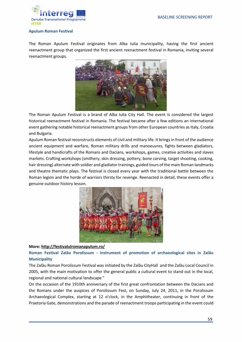
59
BASELINE SCREENING REPORT
Apulum Roman Festival
The Roman Apulum Festival originates from Alba Iulia municipality, having the first ancient
reenactment group that organized the first ancient reenactment festival in Romania, inviting several
reenactment groups.
The Roman Apulum Festival is a brand of Alba Iulia City Hall. The event is considered the largest
historical reenactment festival in Romania. The festival became after a few editions an international
event gathering notable historical reenactment groups from other European countries as Italy, Croatia
and Bulgaria.
Apulum Roman festival reconstructs elements of civil and military life. It brings in front of the audience
ancient equipment and warfare, Roman military drills and manoeuvres, fights between gladiators,
lifestyle and handicrafts of the Romans and Dacians, workshops, games, creative activities and slaves
markets. Crafting workshops (smithery, skin dressing, pottery, bone carving, target shooting, cooking,
hair dressing) alternate with soldier and gladiator trainings, guided tours of the main Roman landmarks
and theatre thematic plays. The festival is closed every year with the traditional battle between the
Roman legion and the horde of warriors thirsty for revenge. Reenacted in detail, these events offer a
genuine outdoor history lesson.
More: http://festivalulromanapulum.ro/
Roman Festival Zalău Porolissum - instrument of promotion of archaeological sites in Zalău
Municipality
The Zalău Roman Porolissum Festival was initiated by the Zalău CityHall and the Zalău Local Council in
2005, with the main motivation to offer the general public a cultural event to stand out in the local,
regional and national cultural landscape "
On the occasion of the 1910th anniversary of the first great confrontation between the Dacians and
the Romans under the auspices of Porolissum Fest, on Sunday, July 24, 2011, in the Porolissum
Archaeological Complex, starting at 12 o'clock, in the Amphitheater, continuing in front of the
Praetoria Gate, demonstrations and the parade of reenactment troops participating in the event could
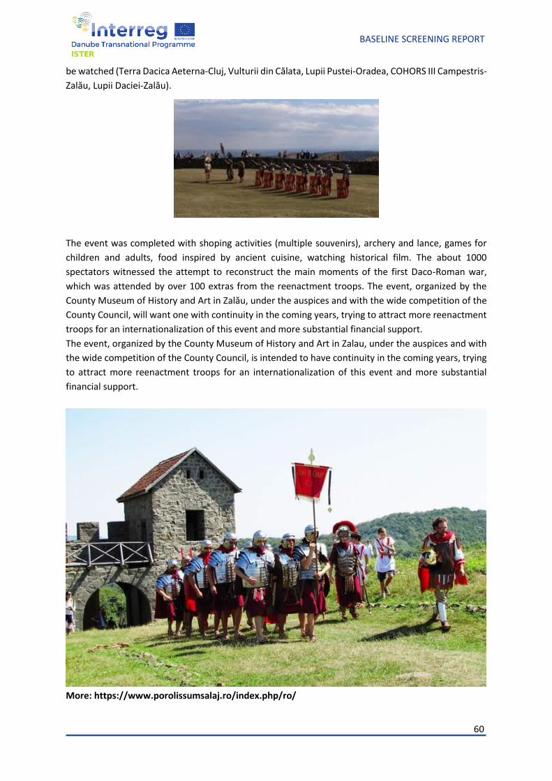
60
BASELINE SCREENING REPORT
be watched (Terra Dacica Aeterna-Cluj, Vulturii din Călata, Lupii Pustei-Oradea, COHORS III Campestris-
Zalău, Lupii Daciei-Zalău).
The event was completed with shoping activities (multiple souvenirs), archery and lance, games for
children and adults, food inspired by ancient cuisine, watching historical film. The about 1000
spectators witnessed the attempt to reconstruct the main moments of the first Daco-Roman war,
which was attended by over 100 extras from the reenactment troops. The event, organized by the
County Museum of History and Art in Zalău, under the auspices and with the wide competition of the
County Council, will want one with continuity in the coming years, trying to attract more reenactment
troops for an internationalization of this event and more substantial financial support.
The event, organized by the County Museum of History and Art in Zalau, under the auspices and with
the wide competition of the County Council, is intended to have continuity in the coming years, trying
to attract more reenactment troops for an internationalization of this event and more substantial
financial support.
More: https://www.porolissumsalaj.ro/index.php/ro/
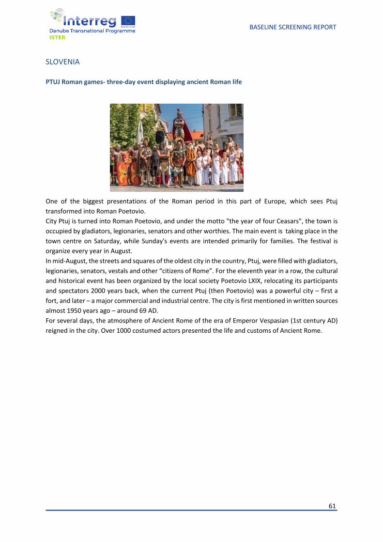
61
BASELINE SCREENING REPORT
SLOVENIA
PTUJ Roman games- three-day event displaying ancient Roman life
One of the biggest presentations of the Roman period in this part of Europe, which sees Ptuj
transformed into Roman Poetovio.
City Ptuj is turned into Roman Poetovio, and under the motto "the year of four Ceasars", the town is
occupied by gladiators, legionaries, senators and other worthies. The main event is taking place in the
town centre on Saturday, while Sunday's events are intended primarily for families. The festival is
organize every year in August.
In mid-August, the streets and squares of the oldest city in the country, Ptuj, were filled with gladiators,
legionaries, senators, vestals and other “citizens of Rome”. For the eleventh year in a row, the cultural
and historical event has been organized by the local society Poetovio LXIX, relocating its participants
and spectators 2000 years back, when the current Ptuj (then Poetovio) was a powerful city – first a
fort, and later – a major commercial and industrial centre. The city is first mentioned in written sources
almost 1950 years ago – around 69 AD.
For several days, the atmosphere of Ancient Rome of the era of Emperor Vespasian (1st century AD)
reigned in the city. Over 1000 costumed actors presented the life and customs of Ancient Rome.
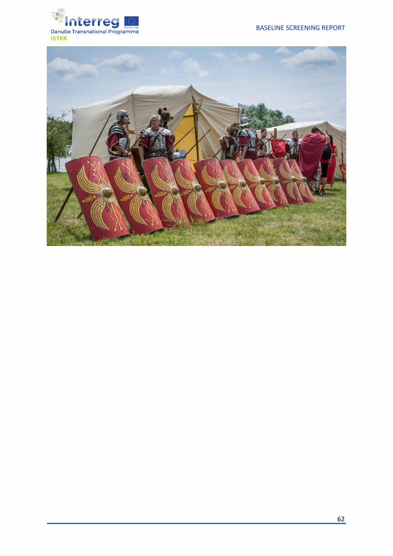
62
BASELINE SCREENING REPORT
63
BASELINE SCREENING REPORT
Research papers
The research of the Roman roads in Dacia starts first of all from the ancient sources, of which
the most important are the Tabula Peutingeriana, Ptolemy’s Geography and the Ravenna
Cosmography.
Tabula Peutingeriana, an itinerarium pictum, is not a map in itself, so it only provides the
information needed for a traveler to make a trip in good conditions; in fact, it presents realities from
the early times of the province, Trajan-Hadrian, for which reason part of the roads or some of the
settlements are not recorded. On this itinerary are marked for the province of Dacia 3 sections of road,
Lederata - Tibiscum; Dierna - Tibiscum - Sarmizegetusa - Apulum - Potaissa - Napoca - Porolissum,
Drobeta - Romula - Arutela - Caput Stenarum - Apulum, measuring a total of 1070km (723 millia
passuum) and 48 localities (Tivisco appears twice).
Ptolemy's Geography does not provide very clear data. The work was written at the end of the
2nd century AD, problematic in terms of dating the information it provides, at least for Dacia.34
However, several sections of roads north of the Danube can be reconstructed from here: Drobeta -
Ulpia Traiana Sarmizegetusa - Sarmizegetusa Regia; Taliatae - Dierna –Tibiscum; Viminacium - Zeugma
- Arcidava - Aizizis - Tibiscum; Tibiscum - Ulpia Traiana Sarmizegetusa - Hidata - Germisara - Apulum -
Marcodava - Salinae - Potaissa - Napoca - Porolissum; Drobeta - Amutrium - Olt.
The Cosmography of the anonymous geographer from Ravenna is a work from the 7th century
AD, and the information it provides refers to the 2nd-3rd centuries AD, when the province of Dacia was
still part of the empire. The province of Dacia is incorrectly called Moesia, and the localities that appear
here are largely the same as those identified in the Tabula Peutingeriana, even if in a corrupt form.
Regarding the roads, those mentioned by the geographer are: Porolissum - Apulum - Romula; Apulum
- Sarmizegetusa - Acmonia; Drobeta - Ad Mediam - Tibiscum; Tibiscum - Lederata, together with the
settlements between them.
Trajan's column is also an ancient source worth considering when discussing Roman roads, but
we must not forget its more or less propagandistic character, so a detached analysis is needed. None
of the characteristics of the Column should be exaggerated, not the topography presented, nor its
historical value; most likely it presents the events in chronological and geographical order, but certainly
very briefly. The column shows the construction of roads as the troops advanced in the territory of
34 Tocilescu 1880; Pârvan 1982; Vulpe 1964, 233-246; Bogdan Cătăniciu 1990, 223-234.
64
BASELINE SCREENING REPORT
Dacia, which provides valuable information, at least related to the Romans' approach to travel routes,
which were practically the first constructions made in a new territory.
Medieval documents, often property deeds, but also works by foreign travellers or scholars,
recall some "stony roads" or "dry roads", which, in an age when all new roads were earthen, can only
indicate to the old Roman roads with stone superstructure, which were still visible and in use.
Among the modern sources it is worth mentioning here the Austrian maps, which have the
merit of including road sections that no longer appear on contemporary maps, such as the Potaissa -
Napoca road section near Gheorgheni, or to provide information on roads that cannot still be seen
today or they are no longer easily accessible due to the modification of the land, the deterioration or
which are simply no longer used.
According to F. Fodorean, we can identify 5 stages when we discuss the evolution of research
on Roman roads in Dacia: during the 16th and 19th centuries appears the first information about road
networks, then from the mid-19th century and until the ‘30s and mid-‘30s a series of roads or sections
of roads are rediscovered. From now until the middle of the 20th century a series of syntheses began
to be written, but with a very general character and only in the ‘70s did systematic research begin, a
great merit having D. Tudor as a pioneer, especially for Oltenia, in southern Dacia. After 1975 and until
today, the research has become more systematic and more on point, focusing not only on field
research, but also on modern methods of approaching them.35 We mention here that archaeology is
often combined with other sciences, and in the case of road research we must mention topography,
cartography, geology, geomorphology, aerial photography, LiDAR, resistivity, GPR, seismometry,
magnetometry, biology, palynology, all of them necessary when the land is covered by vegetation or
affected by agricultural works.
The most important road in Dacia is the one built by Trajan and finished not long after the
conquest of Dacia. It starts from Lederata, Banatska Palanka on the left bank of the Danube and
reaches the northernmost point of the province, Porolissum. The first section of this road, Lederata -
Tibiscum, appears on the Tabula Peutingeriana divided into 7 segments, with a total of 23 Roman
miles; these segments are: Lederata - Apus fl(umen), Apus fl(umen) - Arcidava, Arcidava - Centum Putei,
Centum Putei - Berzobis, Berzobis - Aizis, Aizis - Caput Bubali, Caput Bubali - Tibiscum. This stretch of
road also appears in the Ravenna Cosmography, but with corrupt names: Tiviscum, Gubali, Zizis etc. In
the modern era this stretch of road is still visible, being described by scholars such as Francesco
Griselini and Luigi Ferdinando Marsigli. Even if not entirely, where it is kept, one can see either the
35 Fodorean 2006, 103.
65
BASELINE SCREENING REPORT
river stone substructure or, sometimes, even the upper pavement. Due to this situation it could be
reconstructed quite easily, both in what concerns the route and the construction technique.36 Also
modern sources, the Austrian maps indicate, as well, certain sections of this road, such as the one
between the localities of Fârliug (Aizis) and Jupa (Tibiscum). Due to all these sources, it was possible to
detect the fact that the distance of the road is, in fact, 125km, not 107.93km, as it would result from
the 23 miles mentioned on the Tabula Peutingeriana. Important points on the route are the fortof the
cohors I Vindelicorum and the vicus from Vărădia-Pustă, the fort from Centum Putei built by the
vexillations of the 4th Flavia Felix legion, the Berzobis fort (the headquarters of the 4th Flavia Felix
legion under Trajan), which indicates that this section also functioned as a limes road.37
The next section of the imperial road, from west to east, then south to northis that of Tibiscum
- Ulpia Traiana Sarmizegetusa - Apulum. On the Tabula Peutingeriana there are 9 localities between
Tibiscum and Apulum: Tivisco, Agnavie (Zăvoi), Ponte Augusti (Margo), Sarmategte (Sarmizegetusa),
Ad Aquas (Călan), Petris, Germizera, Blandiana, Apula, the 8 segments totalling 90 Roman miles. The
localities of Tibiscum, Ulpia Traiana Sarmizegetusa, Hidata (Călan), Germisara and Apulum are
mentioned by Ptolemy, and the geographer from Ravenna mentions Burticum (probably identified east
of Valea Cugirului, on the border of Vinţul de Jos, at “Lunca Fermei”)38, Blandiana (identified as the
locality Cârna, Alba county, which was later renamed with its old Roman name)39, Germigera, Petris,
Aquas, Sarmazege, Augmonia and Augusti. Valuable information could also be extracted from Austrian
maps, where various segments of this road are indicated. From contemporary historiography, the most
important contribution belongs to M. Macrea40, who identifies the exact route of the road on this
section, which turns out to be in fact 150km long, not 133km as indicated by the 90 Roman miles on
the Tabula Peutingeriana. Among the important points on this section we mention a statio at Pons
Augusti, Bucova as an important marble extraction centre, the settlements of Aquae (Călan), Micia and
Germisara, as well as the villa rustica from Hobița, near Ulpia Traiana Sarmizegetusa; on the
Sarmizegetusa - Ostrov section, the Roman road is still functional and is preserved on a width of 8-
8.60m.41 A milestone pillar was also discovered at Micia, erected sometime between 251-253.42
According to the Tabula Peutingeriana, from Apulum (Alba Iulia) the road then passes through
Brucla (Aiud) and reaches Salinae (Războieni-Cetate), totaling 24 Roman miles, when in reality the
distance from Alba Iulia to Războieni is approx. 50km, not 35. Contemporary historians interested in
36 Răuţ, Bozu, Petrovszky 1997, 135-159. 37 Fodorean 2006, 229-232. 38 Popa 2011, 390. 39 Popa 2011, 389. 40 Macrea 1969, 149-158. 41 Fodorean 2006, 241-245 42 Piso 2011, 315-317.
66
BASELINE SCREENING REPORT
this stretch of road were, again, M. Macrea43, but also V. Christescu44 and E. Panaitescu.45 Points worth
mentioning on the route are Miceşti, where a construction with and apse section and a water pipe
were discovered, as well as numerous inscriptions, the civil settlement and mansio from Şard, the
Roman settlement from Ampoiţa, the stone quarry and the fortlet at Ighiu, as well as the fort of ala I
Batavorum from Războieni-Cetate.46
For the section Salinae - Potaissa, the distance recorded by Tabula, of 12 millia passuum,
corresponds to that on the field, of 18km. The Austrian maps were also helpful this time, since one
such source mentions the Roman road between the localities of Turda and Călăraşi, then between
Călăraşi and Războieni-Cetate, indicating exactly the route. The identification on the terrain was
possible due to contemporary researchers, starting with Iudita Winkler, who, looking for a Roman
bridge over the Arieș, identified a Roman road structure with ceramic fragments and gravel.47 The most
important point with Roman discoveries on the route, apart from the Potaissa fort and town and the
Războieni-Cetate fort, is the necropolis of Potaissa, identified south of the industrial district of Turda,
as well as the Roman rural settlement from Poiana-Izvorul Lişca, near the same municipality, as well
as a possible villa rustica in Călăraşi, in the point called “Bogat”.48
The next sector, Potaissa - Napoca, is also mentioned on the Tabula Peutingeriana as
measuring a distance of 24 Roman miles, which is not far from the actual distance of 31km. Austrian
military maps mention it again between Cluj-Napoca and Aiton. The most important and well-known
points on the route are, first of all, Napoca and Potaissa with all that they include, followed by the
milestone from Aiton. Discovered in 1758, the milliarium is lost today and preserved only in a drawing
rediscovered by Iudita Winkler, so we do not benefit from an accurate and detailed description of it.
An essential piece of information that comes to us from its inscription is that in 108 the road between
Napoca and Potaissa was completed49; also in Aiton a rural settlement and a mansio were discovered.50
Other rural settlements were also discovered at Copăceni and Ceanu Mic.51
The last sector of this imperial road is between Napoca and Porolissum, the northernmost
point of the province. On the Tabula Peutingeriana, the settlements from Optatiana (Sutoru), Largiana
(Românaşi) and Cersie (correctly Certiae, identified at Romita) are mentioned between the two points.
43 Macrea 1969, 152 44 Christescu 1937, 107-108. 45 Panaitescu 1936, 12. 46 Fodorean 2006, 246-249. 47 Fodorean 2006, 155. 48 Fodorean 2006, 155-162. 49 CIL III 1627. 50 Fodorean 2015, 217–232. 51 Fodorean 2006, 120-133.
67
BASELINE SCREENING REPORT
In the Cosmography, a settlement called Macedonica appears between Napoca and Optatiana,
probably a mistake. On the Austrian maps as well this stretch of road is very well laid out. Among the
contemporary authors who studied the Roman road on this sector we mention V. Christescu52, who
describes the route of the road between Apulum and Porolissum, as well as Panaitescu and Macrea,
who only briefly mention this route.53 Among the important points on the route we mention the
Roman settlement from Suceagu, the villa rustica from Viştea (com. Gârbău), a possible Roman
settlement in Gârbau (com. Turea), the Roman settlement from Şardu (com. Sânpaul), the Roman
settlement at Dragu (Sălaj county), the Sutoru fort (“Gura Căpuşului” point, Sălaj county), the Buciumi
fort, the Românaşi fort, the Romita fort, the forts and the settlement from Porolissum, as well as the
villa rustica and the milestone of Mera.54 The latter, discovered in 1932, provides valuable and
necessary information for the study of the imperial road. It was half destroyed by the plough so that
only the left half of the inscription can be seen and read. Based on a completion of this inscription,
Daicoviciu dates it to 164-166, under the emperors Lucius Verus and Marcus Aurelius; the lower part
of the inscription has been interpreted as a restoration of the road, probably during the time of
Caracalla.55 A short segment of a road has been recently discovered, between the modern villages of
Nădășelu and Șardu, proving that up from this area the Roman road is not parallel with the modern
road heading Moigrad (Porolissum), but winding up towards north-west.
As can be seen above, the imperial road from Lederata to Porolissum was the most important
road in the province, which has enjoyed special attention since antiquity, when itineraries and works
dedicated to aspects of the Roman Empire do not hesitate to mention it, even if sometimes in
erroneous forms. This is not surprising, given that the integration of a new province in the empire was
dependent on access roads, primarily for the militaries, but also for trade and, ultimately, as a means
of communication. As can be seen from the brief presentation related to the sources, the Roman roads
are sometimes still visible at the time the Austrian maps were drawn up, i.e. the second half of the 19th
century, but only on certain sections, which in some cases are no longer visible today, so their
deterioration in the last hundred years is worrying. It should not be understood from here that the
imperial road is the only one that has been researched or that deserves to be valorised, but only that
this was the main traffic route in the province. Other projects also meant to use modern methods
combined with archaeology were those based on aerial photography, initiated primarily by Ioana
Oltean56 in the late ‘90s and early 2000s and focused on the Mureş Valley area. Another project, based
52 Christescu 1937, 107-108. 53 Panaitescu 1938, 12; Macrea 1969, 152. 54 Fodorean 2006, 134-147. 55 Daicoviciu 1928-1932, pp. 48-53. 56 Oltean, Hanson 2001, 123–134; Hanson, Oltean, 2003, 101–117; Oltean 2007.
68
BASELINE SCREENING REPORT
on the same research method, was initiated by Eötvös Loránd University in Budapest together with
the Mureş County Museum in 2009 and resulted in several studies.57 The eastern border of Dacia was
also researched through aerial photographs, and the results of this research can also be found in a
study58; equally fruitful were the researches in south-eastern Transylvania.59 The Banaterra (or
BANATerra) project, carried out between 2006-2010, was meant to be a way to promote the history
of Banat, and so 300 archaeological sites were identified.60 In this context, the ISTER project is not only
useful, but also necessary, aiming not only to valorise the Roman routes in the Danube provinces, but
first of all to protect them.
References
• Berecki, Czajlik, Soós 2012 = Berecki S., Czajlik Z., Soós Z. (eds.), Historical landscapes. Aerial
Photographs of Transylvanian rchaeological Sites and Monuments /Történelmi látképek.
Erdélyi régészeti lelőhelyek és műemlékek légifelvételei / Panorame istorice. Situri arheologice
şi monumente istorice din Transilvania în fotografii aeriene, Catalogi Mvsei Marisiensis, Seria
Archaeologica, I, Budapest–Târgu Mureş, 2012.
• Berecki, Czajlik, Rupnik 2013 = Berecki S., Czajlik Z., Rupnik L., Aerial Archaeological Prospection
on the Middle Course of the Mureş River and the Adjacent Areas in Apulum, 50, 2013, pp. 87-
109.
• Berecki, Czajlik, Rupnik 2014 = Berecki S., Czajlik Z., Rupnik L., Aerial Geoarchaeological Survey
in the Valleys of the Mureş and Arieş Rivers (2009-2013) in Dissertationes Archaeologicae, Ser.
3. No. 2, Budapest, 2014, pp. 459-483.
• Bogdan cătăniciu 1990 = Bogdan Cătaniciu Ioana, Ptolémée et la province Dacia in Dacia N.S.,
34, 1990, pp. 223-234.
• Christescu 1937 = Christescu V., Istoria militară a Daciei romane, Bucureşti, 1937, pp.104-114.
• Czajlik, Berecki, Rupnik, Sztáncsuj 2011 = Czajlik Z., Berecki S., Rupnik L., Sztáncsuj S. J.,
Preliminary Report on the Aerial Archaeological Survey in Transylvania (2009–2010) in Marisia,
31, 2011, pp. 7–17.
• Daicoviciu 1928-1932 = Daicoviciu C., Un nou miliarium în Dacia in AISC I-II 1928-1932, pp. 48-
53.
• Fodorean 2006= Fodorean Fl., Drumurile în Dacia romană, Cluj-Napoca 2006.
57 Oberländer-Târnoveanu 2010, 389–412; Czajlik, Berecki, Rupnik, Sztáncsuj 2011, 7–17; Berecki, Czajlik,
2012; Berecki, Czajlik, Rupnik, 2013, 87-109; Berecki, Czajlik, Rupnik 2014, 459-483. 58 Pánczél, Szabó, Visy 2011, 173–180. 59 Sófalvi 2013, 339–366; Sófalvi 2013a, 89–93, Plate 16. 60 https://istoriabanatului.wordpress.com/tag/banaterra/ accesat 06.02.2021;
https://www.gandaculdecolorado.com/proiectul-banaterra-enciclopedia-banatului/ accesat 06.02.2021.
69
BASELINE SCREENING REPORT
• Fodorean 2015 = Fodorean Fl., „A Potaissa Napocae MP X”. Trajan’s Imperial Road and the
mansio From Aiton (Cluj County) in Acta Archaeologica Academiae Scientiarum Hungaricae,
66, 2015, pp. 217–232.
• Hanson, Oltean 2003 = Hanson W. S., Oltean Ioana. A., The Identification of Roman Buildings
From the Air: Recent Discoveries in Western Transylvania in Archaeological Prospection 10,
2003, pp. 101–117.
• Macrea 1969 = M. Macrea, Viaţa în Dacia romană, Bucureşti, 1969, pp.149-158.
• Oberländer-Târnoveanu 2010 = Oberländer-Târnoveanu I., Proiecte de arheologie aeriană în
România in Angvstia, 14, 2010, pp. 389–412.
• Oltean, Hanson 2001 = Oltean Ioana. A., Hanson, W. S., Military vici in Roman Dacia: an aerial
perspective in ActaMN 38/1, 2001, pp. 123–134.
• Oltean 2007 = Oltean Ioana. A., Dacia. Landscape, Colonization and Romanization, London–
New York–Routledge, 2007.
• Panaitescu 1936 = Panaitescu E., Provincia şi imperiul. Extras din volumul omagial pentru fraţii
Alexandru şi Ion I. Lapedatu, Bucureşti, 1936, pp. 3-14.
• Panaitescu 1938 = Panaitescu E., Le grandi strade romane in Romania, in col. Quaderni
del1’Impero. Le grandi strade del mondo romano, X, Roma, 1938.
• Pánczél, Szabó, Visy 2011 = Pánczél, Sz. P., Szabó, M., Visy, Zs., Dacia Superior keleti határának
régészeti kutatása / Archaeological research on the Eastern frontier of Dacia Superior in Visy,
Zs., Szabó, M., Priskin, A., Lóki, R. (eds), A Danube Limes program régészeti kutatásai 2008–
2011 között / The Danube Limes project archaeological research between 2008–2011, Pécs,
2011, pp. 173–180.
• Pârvan 1982 = Pârvan V., Getica. O protoistorie a Daciei, Bucureşti, 1982.
• Piso 2011 = Piso I., Note sur cinq bornes milliaires de Dacie in Piso I., Rusu-Bolindeţ Viorica,
Varga Rada, Mustaţă Silvia, Beu-Dachin Eugenia, Ruscu Ligia (eds.), Scripta Classica. Radu
Ardevan sexagenarii dedicata, Cluj-Napoca, 2011, pp. 311-320.
• Popa 2011 = Popa C. I., Valea Cugirului din Preistorie până in zorii Epocii Moderne. Monumenta
Historica et Archaeologica, Cluj-Napoca , 2011.
• Răuţ, Bozu, Petrovszky 1997 = Răuţ O., Bozu O., Petrovszky R., Drumurile romane în Banat, in
Banatica, 4, 1997, pp. 135-159.
• Sófalvi 2013 = Sófalvi A., The border- and self-defence of Szeklers from the Medieval Age till the
Age of Principality. Castles and other defence objects in the settlement history of Udvarhelyszék
in Dissertationes Archaeologicae Ser. 3. No. 1, 339–366;
70
BASELINE SCREENING REPORT
• Sófalvi 2013a = Sófalvi A., Ramparts in the Görgényi, Hargita and Persányi Mountains in Czajlik,
Z., Bödőcs, A. (eds.), Aerial Archaeology and Remote Sensing from the Baltic to the Adriatic.
Selected Papers of the Annual Conference of the Aerial Archaeology Research Group, 13th–
15th September, 2012, Budapest, Hungary, Budapest, 2013, pp. 89–93.
• Tocilescu 1880 = Tocilescu Gr., Dacia inainte de romani, Bucureşti, 1880.
• Vulpe 1964 = Vulpe Al., Ptolemy and the Ancient Geography of Moldavia, in Studii Clasice, 6,
1964, pp. 233-246.
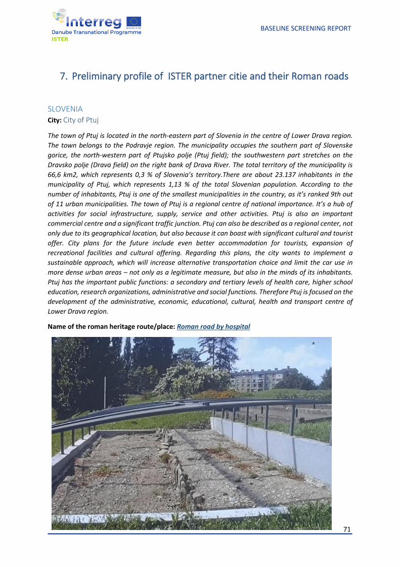
71
BASELINE SCREENING REPORT
7. Preliminary profile of ISTER partner citie and their Roman roads
SLOVENIA City: City of Ptuj
The town of Ptuj is located in the north-eastern part of Slovenia in the centre of Lower Drava region.
The town belongs to the Podravje region. The municipality occupies the southern part of Slovenske
gorice, the north-western part of Ptujsko polje (Ptuj field); the southwestern part stretches on the
Dravsko polje (Drava field) on the right bank of Drava River. The total territory of the municipality is
66,6 km2, which represents 0,3 % of Slovenia’s territory.There are about 23.137 inhabitants in the
municipality of Ptuj, which represents 1,13 % of the total Slovenian population. According to the
number of inhabitants, Ptuj is one of the smallest municipalities in the country, as it’s ranked 9th out
of 11 urban municipalities. The town of Ptuj is a regional centre of national importance. It’s a hub of
activities for social infrastructure, supply, service and other activities. Ptuj is also an important
commercial centre and a significant traffic junction. Ptuj can also be described as a regional center, not
only due to its geographical location, but also because it can boast with significant cultural and tourist
offer. City plans for the future include even better accommodation for tourists, expansion of
recreational facilities and cultural offering. Regarding this plans, the city wants to implement a
sustainable approach, which will increase alternative transportation choice and limit the car use in
more dense urban areas – not only as a legitimate measure, but also in the minds of its inhabitants.
Ptuj has the important public functions: a secondary and tertiary levels of health care, higher school
education, research organizations, administrative and social functions. Therefore Ptuj is focused on the
development of the administrative, economic, educational, cultural, health and transport centre of
Lower Drava region.
Name of the roman heritage route/place: Roman road by hospital
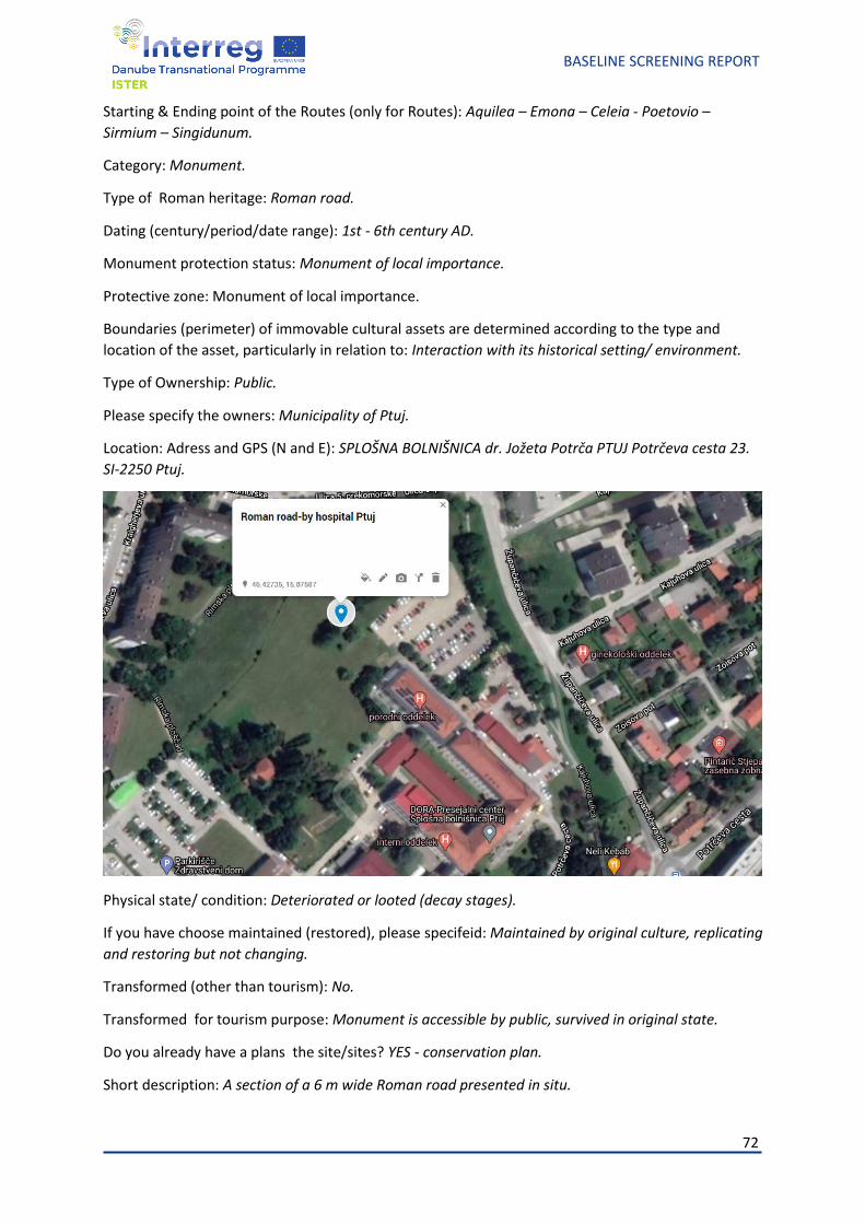
72
BASELINE SCREENING REPORT
Starting & Ending point of the Routes (only for Routes): Aquilea – Emona – Celeia - Poetovio –
Sirmium – Singidunum.
Category: Monument.
Type of Roman heritage: Roman road.
Dating (century/period/date range): 1st - 6th century AD.
Monument protection status: Monument of local importance.
Protective zone: Monument of local importance.
Boundaries (perimeter) of immovable cultural assets are determined according to the type and
location of the asset, particularly in relation to: Interaction with its historical setting/ environment.
Type of Ownership: Public.
Please specify the owners: Municipality of Ptuj.
Location: Adress and GPS (N and E): SPLOŠNA BOLNIŠNICA dr. Jožeta Potrča PTUJ Potrčeva cesta 23.
SI-2250 Ptuj.
Physical state/ condition: Deteriorated or looted (decay stages).
If you have choose maintained (restored), please specifeid: Maintained by original culture, replicating
and restoring but not changing.
Transformed (other than tourism): No.
Transformed for tourism purpose: Monument is accessible by public, survived in original state.
Do you already have a plans the site/sites? YES - conservation plan.
Short description: A section of a 6 m wide Roman road presented in situ.
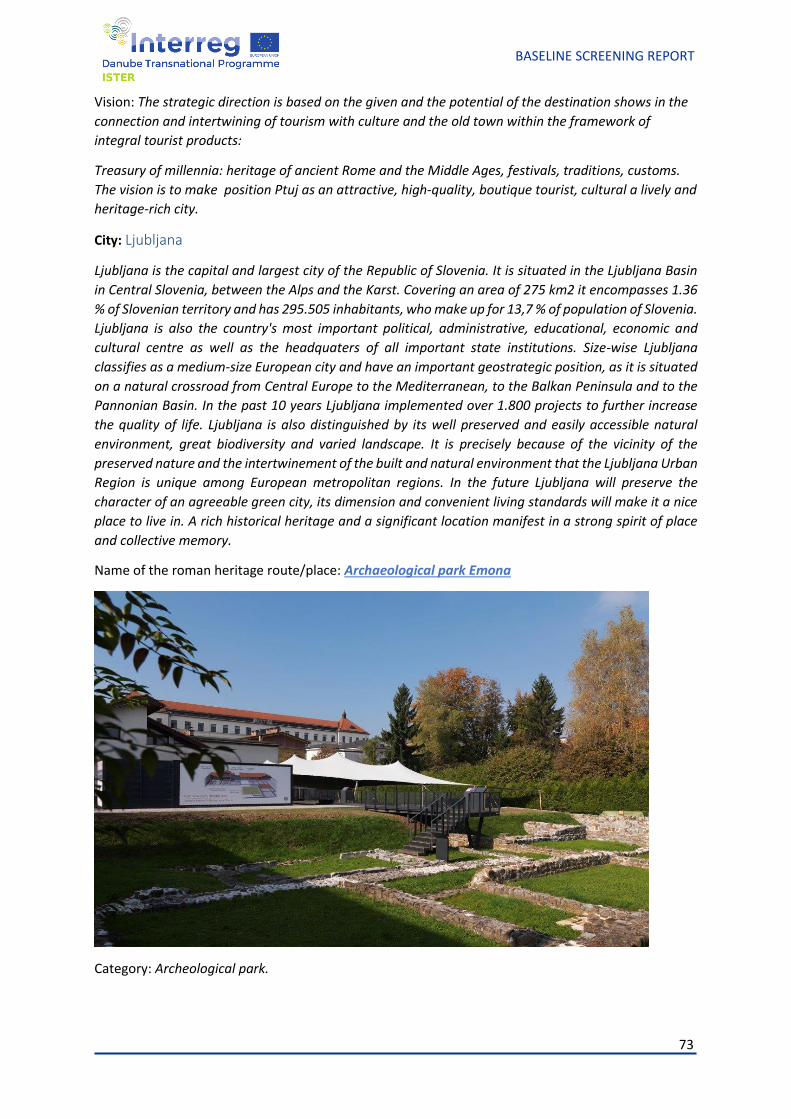
73
BASELINE SCREENING REPORT
Vision: The strategic direction is based on the given and the potential of the destination shows in the
connection and intertwining of tourism with culture and the old town within the framework of
integral tourist products:
Treasury of millennia: heritage of ancient Rome and the Middle Ages, festivals, traditions, customs.
The vision is to make position Ptuj as an attractive, high-quality, boutique tourist, cultural a lively and
heritage-rich city.
City: Ljubljana
Ljubljana is the capital and largest city of the Republic of Slovenia. It is situated in the Ljubljana Basin
in Central Slovenia, between the Alps and the Karst. Covering an area of 275 km2 it encompasses 1.36
% of Slovenian territory and has 295.505 inhabitants, who make up for 13,7 % of population of Slovenia.
Ljubljana is also the country's most important political, administrative, educational, economic and
cultural centre as well as the headquaters of all important state institutions. Size-wise Ljubljana
classifies as a medium-size European city and have an important geostrategic position, as it is situated
on a natural crossroad from Central Europe to the Mediterranean, to the Balkan Peninsula and to the
Pannonian Basin. In the past 10 years Ljubljana implemented over 1.800 projects to further increase
the quality of life. Ljubljana is also distinguished by its well preserved and easily accessible natural
environment, great biodiversity and varied landscape. It is precisely because of the vicinity of the
preserved nature and the intertwinement of the built and natural environment that the Ljubljana Urban
Region is unique among European metropolitan regions. In the future Ljubljana will preserve the
character of an agreeable green city, its dimension and convenient living standards will make it a nice
place to live in. A rich historical heritage and a significant location manifest in a strong spirit of place
and collective memory.
Name of the roman heritage route/place: Archaeological park Emona
Category: Archeological park.
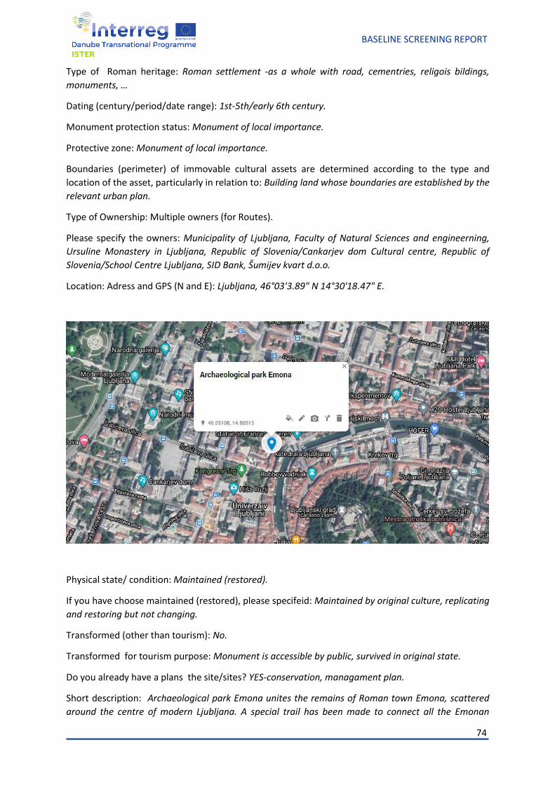
74
BASELINE SCREENING REPORT
Type of Roman heritage: Roman settlement -as a whole with road, cementries, religois bildings,
monuments, …
Dating (century/period/date range): 1st-5th/early 6th century.
Monument protection status: Monument of local importance.
Protective zone: Monument of local importance.
Boundaries (perimeter) of immovable cultural assets are determined according to the type and
location of the asset, particularly in relation to: Building land whose boundaries are established by the
relevant urban plan.
Type of Ownership: Multiple owners (for Routes).
Please specify the owners: Municipality of Ljubljana, Faculty of Natural Sciences and engineerning,
Ursuline Monastery in Ljubljana, Republic of Slovenia/Cankarjev dom Cultural centre, Republic of
Slovenia/School Centre Ljubljana, SID Bank, Šumijev kvart d.o.o.
Location: Adress and GPS (N and E): Ljubljana, 46°03'3.89" N 14°30'18.47" E.
Physical state/ condition: Maintained (restored).
If you have choose maintained (restored), please specifeid: Maintained by original culture, replicating
and restoring but not changing.
Transformed (other than tourism): No.
Transformed for tourism purpose: Monument is accessible by public, survived in original state.
Do you already have a plans the site/sites? YES-conservation, managament plan.
Short description: Archaeological park Emona unites the remains of Roman town Emona, scattered
around the centre of modern Ljubljana. A special trail has been made to connect all the Emonan
75
BASELINE SCREENING REPORT
locations in Ljubljana, thus forming an urban Archeological park Emona that takes you back to times
when Romans were inhabiting the city from the 1st to the 6th century. Former decumanus and cardo
are today's Rimska and Slovenska streets, where a large new presentation in the opposite of the
Uršulinke church reveals the findings of the latest excavations on the Congress Square (Kongresni trg).
The Roman forum is stressed with the building design of Ferant garden by the architect Edvard
Ravnikar, and seen in the floor pavement of Jakopič Gallery. A copy of the Roman statue Emonec stands
at the west side of Congress Square. An attentive walker can find Roman spolia built in different
buildings, from the Cathedral to the Ljubljana Castle. The finds of Roman insula underground are
presented in different pavements such as that in front of the Cankarjev dom Culture and Congress
Centre.
Vision: Ljubljana's vision is to offer comprehensive insight into how life was structured in Roman times,
afterall the city itself builds its identity on respect for its entire histroy because it is only on this
foundation that we can improve development and a direction that guarantees a quality life for our
citizens and visitors of all generation. We want to establish appealing presentations and programs
about Roman Heritage for educational purposes and for individual exploration as well. The goals are
to integrate Roman Routes Network into touristic routes and trails and also to incrase inquiry for those
types of programs from local and foreign visitors.
76
BASELINE SCREENING REPORT
ROMANIA AIM
City: Alba Iulia
Alba Iulia Municipality is a medium sized city, a county capital, located in the heart of the historical region of Transylvania, Romania, known as "the other capital of Romania", a symbolic capital for national unity (unification of Romania was declared here 100 year ago). Alba Iulia municipality owes its historical importance, largely to its geographical position, being located at the crossing or intersection of important roads, which provided the connection with surrounding areas, areas rich in precious metal deposits and other riches of the basement, areas with famous vineyards, etc. Thus, traffic arteries from Transylvania met in the area of Alba Iulia. Also, those traffic arteries communicated with important economic centers, which boosted the demographic, urban and economic development of the area of Alba Iulia. This rich history has left Alba-Iulia with a high range historical heritage, among which the Alba Carolina Citadel stands as the jewel. In 2012, the citadel Alba Carolina was nominated to be “One of the 7 Wonders of Romania”. It is also worth mentioning that Alba Iulia is the first city in Romania to be referred to in the World Heritage UNESCO Magazine. Over the last years, the municipality, with the support of the European Union (ERDF), has made large investments (around 70 million euros) for the rehabilitation and valorization of what is nowadays the historical centre of the city, and the motor of local economy. Alba Iulia Municipality is a local public authority which provides a democratic local government of the city of Alba Iulia. Among its activities and objectives we mention: • to ensure the provision of public services for the inhabitants of the municipality in a sustainable manner respecting the equality of chances; • to promote social and economic development; • to promote a safe and healthy environment; • to encourage the involvement of citizens and of nongovernmental organizations in the matters of local government; • to make sure the citizens of the muncipality benefit from good living conditions; In its modern history, Alba Iulia has been a provincial town, enjoying limited economic opportunities. It maintains a range of traditional industries (including a predominant porcelain industry, the largest from Romania, and other activities related to food processing, textile manufacturing or metalworking). Tourism has been the most relevant sector for the local economy. The municipality develops a constant endeavour to enhance the city’s touristic potential. In addition to the aforementioned rehabilitation, several events and leisure activities are meant to emphasize the potential of the city’s historic and tourism heritage such as: the daily “Changing the Guard” ceremony of the Citadel or the ”Treasure of the Citadel” competition. It also has a year-long calendar of events, including music and theaters, a Museum Night, etc.
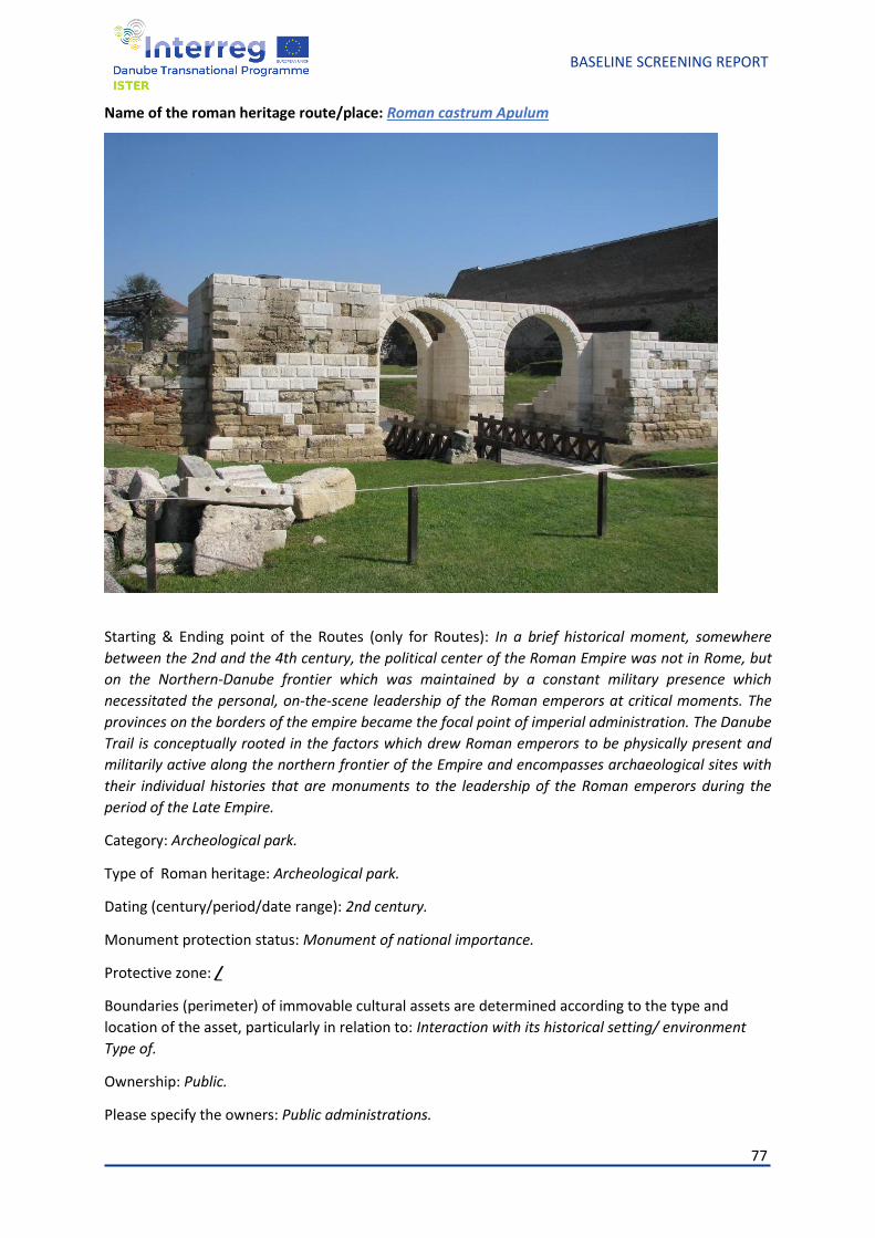
77
BASELINE SCREENING REPORT
Name of the roman heritage route/place: Roman castrum Apulum
Starting & Ending point of the Routes (only for Routes): In a brief historical moment, somewhere
between the 2nd and the 4th century, the political center of the Roman Empire was not in Rome, but
on the Northern-Danube frontier which was maintained by a constant military presence which
necessitated the personal, on-the-scene leadership of the Roman emperors at critical moments. The
provinces on the borders of the empire became the focal point of imperial administration. The Danube
Trail is conceptually rooted in the factors which drew Roman emperors to be physically present and
militarily active along the northern frontier of the Empire and encompasses archaeological sites with
their individual histories that are monuments to the leadership of the Roman emperors during the
period of the Late Empire.
Category: Archeological park.
Type of Roman heritage: Archeological park.
Dating (century/period/date range): 2nd century.
Monument protection status: Monument of national importance.
Protective zone: /
Boundaries (perimeter) of immovable cultural assets are determined according to the type and
location of the asset, particularly in relation to: Interaction with its historical setting/ environment
Type of.
Ownership: Public.
Please specify the owners: Public administrations.
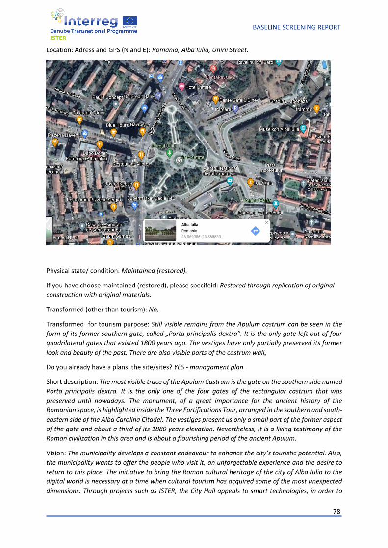
78
BASELINE SCREENING REPORT
Location: Adress and GPS (N and E): Romania, Alba Iulia, Unirii Street.
Physical state/ condition: Maintained (restored).
If you have choose maintained (restored), please specifeid: Restored through replication of original
construction with original materials.
Transformed (other than tourism): No.
Transformed for tourism purpose: Still visible remains from the Apulum castrum can be seen in the
form of its former southern gate, called „Porta principalis dextra”. It is the only gate left out of four
quadrilateral gates that existed 1800 years ago. The vestiges have only partially preserved its former
look and beauty of the past. There are also visible parts of the castrum wall.
Do you already have a plans the site/sites? YES - managament plan.
Short description: The most visible trace of the Apulum Castrum is the gate on the southern side named
Porta principalis dextra. It is the only one of the four gates of the rectangular castrum that was
preserved until nowadays. The monument, of a great importance for the ancient history of the
Romanian space, is highlighted inside the Three Fortifications Tour, arranged in the southern and south-
eastern side of the Alba Carolina Citadel. The vestiges present us only a small part of the former aspect
of the gate and about a third of its 1880 years elevation. Nevertheless, it is a living testimony of the
Roman civilization in this area and is about a flourishing period of the ancient Apulum.
Vision: The municipality develops a constant endeavour to enhance the city’s touristic potential. Also,
the municipality wants to offer the people who visit it, an unforgettable experience and the desire to
return to this place. The initiative to bring the Roman cultural heritage of the city of Alba Iulia to the
digital world is necessary at a time when cultural tourism has acquired some of the most unexpected
dimensions. Through projects such as ISTER, the City Hall appeals to smart technologies, in order to
79
BASELINE SCREENING REPORT
offer the citizens and the tourists the opportunity to discover some historical realities and, at the same
time, in order to recover its own past, with the help of technology.
MNIT
Region: The North-West Region of Romania – Northern Transylvania
The North-West Region of Romania – Northern Transylvania, is one of the eight Regions of development
in Romania and it is geographically and strategically placed in Europe, effervescently involved in the
industries of the future and deeply rooted to its history and nature.
The Cluj county is one of the biggest, out of six, in the North-West Region, with a surface of 6,674 square
kilometers and a number of 730.878 inhabitants. Its residency, the city of Cluj-Napoca, has an area of
179,5 square kilometers, and 324,960 inhabitants, as of 2019.
From the economical point of view, the city activates in several sectors, the main one being IT, especially
on outsourcing, being followed by civil engineering and construction, performance and arts,
agriculture, tourism, wood and metal industry. (in no particular reason)
The city of Cluj-Napoca is renowed for a number of different reasons such as: being centered arround
the community and planning everything in order for the citizens to benefit from the best services
available. At the same time, the city is known for promoting not only local industries but to also invest
in the development of diverse fields ( from culture to arts, from the transport infrastructure to the
health system). Simultaneously, Cluj-Napoca is also recognized for the significant number of students
that it accommodates, making it known as the best University Center, in the Northern region of the
country.
A honorable mention added to this would be, that in Cluj-Napoca can be found the National Museum
of Transylvanian History, one of the most important museums in the country, that dates back to the
XIX century. The museum is home to more than few collections, such as : Art and Etnography;
Prehistoric, Clasical and Medieval Archaeology; Romanian History; as well as a Collection that includes
pieces and historical elements from the Transylvania Region.
The National Museum is involved in the LIMES national program, which is a multianual research and
development program, that aims to create a data-base, with all the heritage elements and objects that
were a key factor in determining the border of the Roman Empire, in order for them to be added to tne
UNESCO List of Intangible Cultural Heritage.
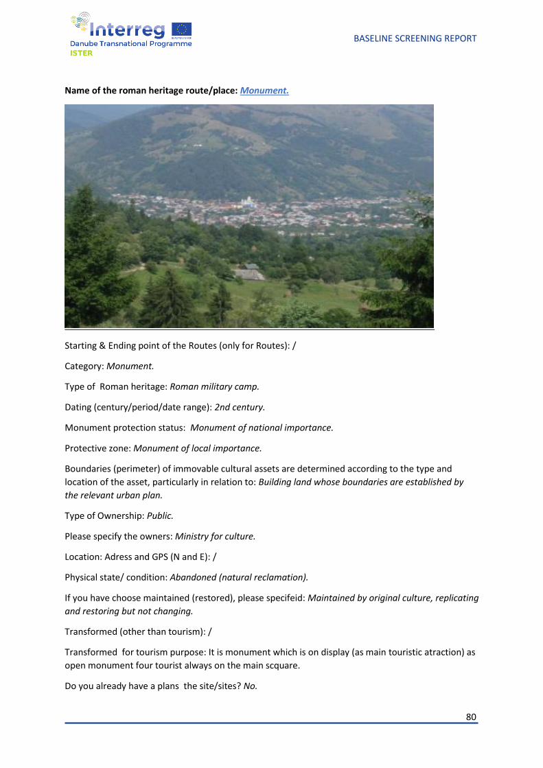
80
BASELINE SCREENING REPORT
Name of the roman heritage route/place: Monument.
Starting & Ending point of the Routes (only for Routes): /
Category: Monument.
Type of Roman heritage: Roman military camp.
Dating (century/period/date range): 2nd century.
Monument protection status: Monument of national importance.
Protective zone: Monument of local importance.
Boundaries (perimeter) of immovable cultural assets are determined according to the type and
location of the asset, particularly in relation to: Building land whose boundaries are established by
the relevant urban plan.
Type of Ownership: Public.
Please specify the owners: Ministry for culture.
Location: Adress and GPS (N and E): /
Physical state/ condition: Abandoned (natural reclamation).
If you have choose maintained (restored), please specifeid: Maintained by original culture, replicating
and restoring but not changing.
Transformed (other than tourism): /
Transformed for tourism purpose: It is monument which is on display (as main touristic atraction) as
open monument four tourist always on the main scquare.
Do you already have a plans the site/sites? No.
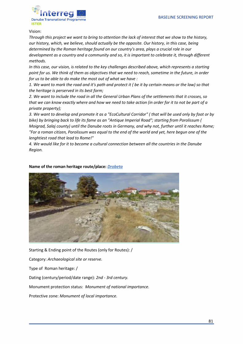
81
BASELINE SCREENING REPORT
Vision:
Through this project we want to bring to attention the lack of interest that we show to the history,
our history, which, we believe, should actually be the opposite. Our history, in this case, being
determined by the Roman heritage found on our country's area, plays a crucial role in our
development as a country and a community and so, it is important to celebrate it, through different
methods.
In this case, our vision, is related to the key challenges described above, which represents a starting
point for us. We think of them as objectives that we need to reach, sometime in the future, in order
for us to be able to do make the most out of what we have :
1. We want to mark the road and it's path and protect it ( be it by certain means or the law) so that
the heritage is perserved in its best form;
2. We want to include the road in all the General Urban Plans of the settlements that it crosses, so
that we can know exactly where and how we need to take action (in order for it to not be part of a
private property);
3. We want to develop and promote it as a "EcoCultural Corridor" ( that will be used only by foot or by
bike) by bringing back to life its fame as an "Antique Imperial Road"; starting from Porolissum (
Moigrad, Salaj county) until the Danube roots in Germany, and why not, further until it reaches Rome;
"For a roman citizen, Porolissum was equal to the end of the world and yet, here begun one of the
lenghtiest road that lead to Rome!"
4. We would like for it to become a cultural connection between all the countries in the Danube
Region.
Name of the roman heritage route/place: Drobeta
Starting & Ending point of the Routes (only for Routes): /
Category: Archaeological site or reserve.
Type of Roman heritage: /
Dating (century/period/date range): 2nd - 3rd century.
Monument protection status: Monument of national importance.
Protective zone: Monument of local importance.
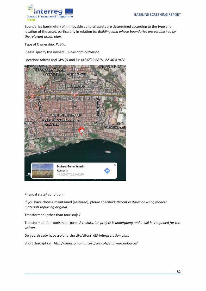
82
BASELINE SCREENING REPORT
Boundaries (perimeter) of immovable cultural assets are determined according to the type and
location of the asset, particularly in relation to: Building land whose boundaries are established by
the relevant urban plan.
Type of Ownership: Public.
Please specify the owners: Public administration.
Location: Adress and GPS (N and E): 44°37'29.68"N; 22°40'4.94"E
Physical state/ condition:
If you have choose maintained (restored), please specifeid: Recent restoration using modern
materials replacing original.
Transformed (other than tourism): /
Transformed for tourism purpose: A restoration project is undergoing and it will be reopened for the
visitors.
Do you already have a plans the site/sites? YES-interpretation plan.
Short description: http://limesromania.ro/ro/articole/situri-arheologice/
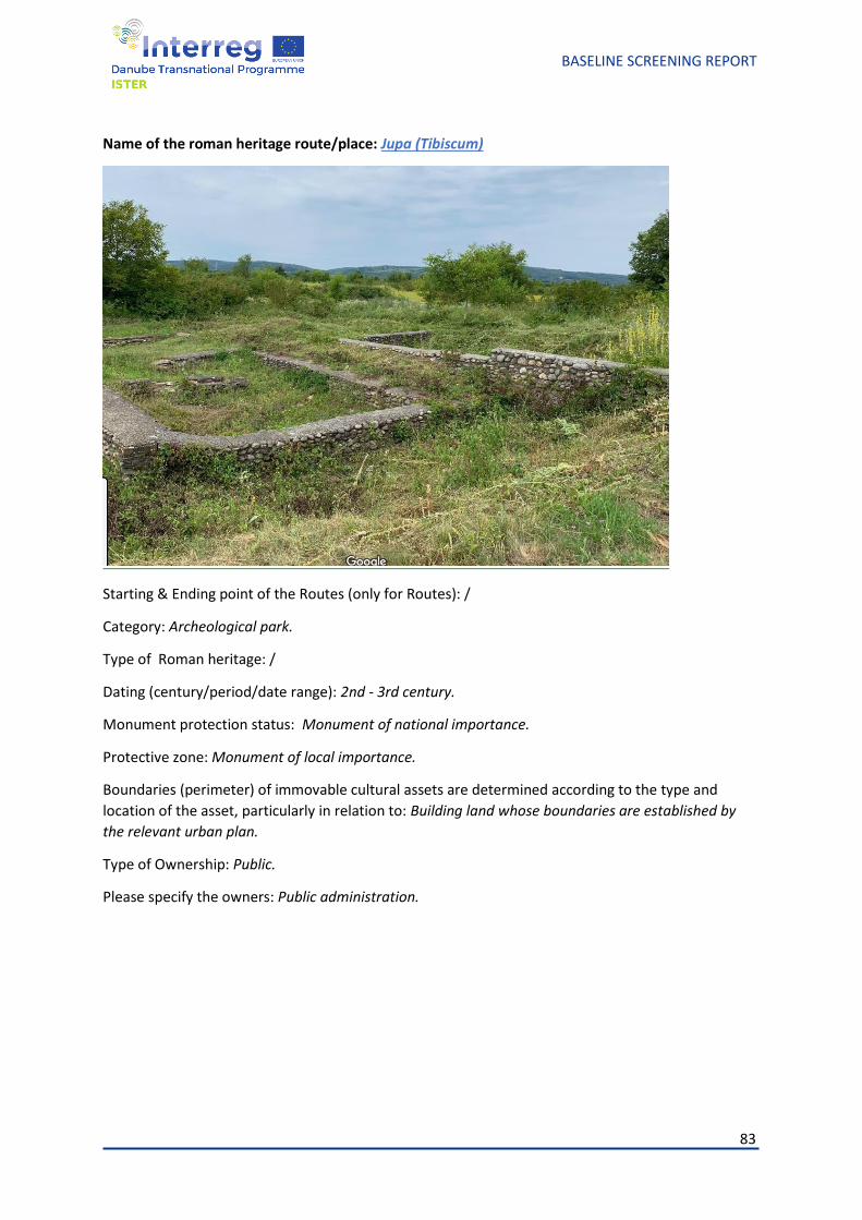
83
BASELINE SCREENING REPORT
Name of the roman heritage route/place: Jupa (Tibiscum)
Starting & Ending point of the Routes (only for Routes): /
Category: Archeological park.
Type of Roman heritage: /
Dating (century/period/date range): 2nd - 3rd century.
Monument protection status: Monument of national importance.
Protective zone: Monument of local importance.
Boundaries (perimeter) of immovable cultural assets are determined according to the type and
location of the asset, particularly in relation to: Building land whose boundaries are established by
the relevant urban plan.
Type of Ownership: Public.
Please specify the owners: Public administration.
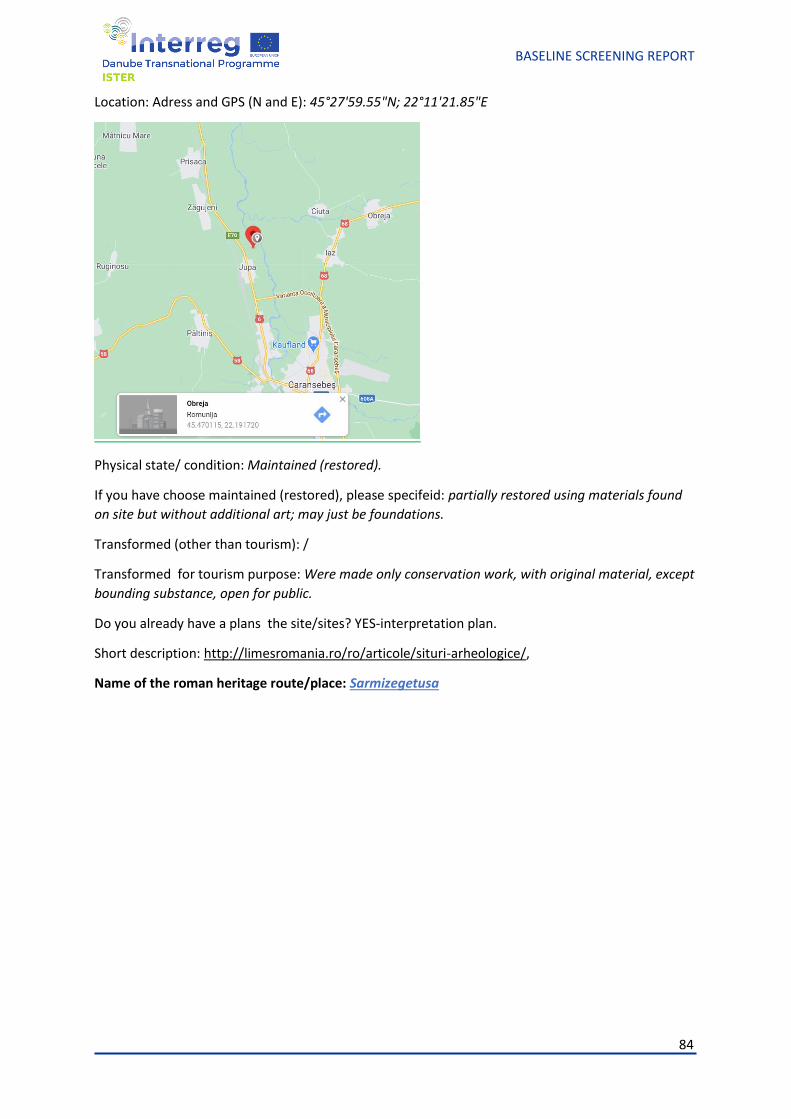
84
BASELINE SCREENING REPORT
Location: Adress and GPS (N and E): 45°27'59.55"N; 22°11'21.85"E
Physical state/ condition: Maintained (restored).
If you have choose maintained (restored), please specifeid: partially restored using materials found
on site but without additional art; may just be foundations.
Transformed (other than tourism): /
Transformed for tourism purpose: Were made only conservation work, with original material, except
bounding substance, open for public.
Do you already have a plans the site/sites? YES-interpretation plan.
Short description: http://limesromania.ro/ro/articole/situri-arheologice/,
Name of the roman heritage route/place: Sarmizegetusa
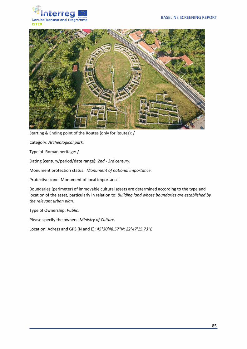
85
BASELINE SCREENING REPORT
Starting & Ending point of the Routes (only for Routes): /
Category: Archeological park.
Type of Roman heritage: /
Dating (century/period/date range): 2nd - 3rd century.
Monument protection status: Monument of national importance.
Protective zone: Monument of local importance
Boundaries (perimeter) of immovable cultural assets are determined according to the type and
location of the asset, particularly in relation to: Building land whose boundaries are established by
the relevant urban plan.
Type of Ownership: Public.
Please specify the owners: Ministry of Culture.
Location: Adress and GPS (N and E): 45°30'48.57"N; 22°47'15.73"E
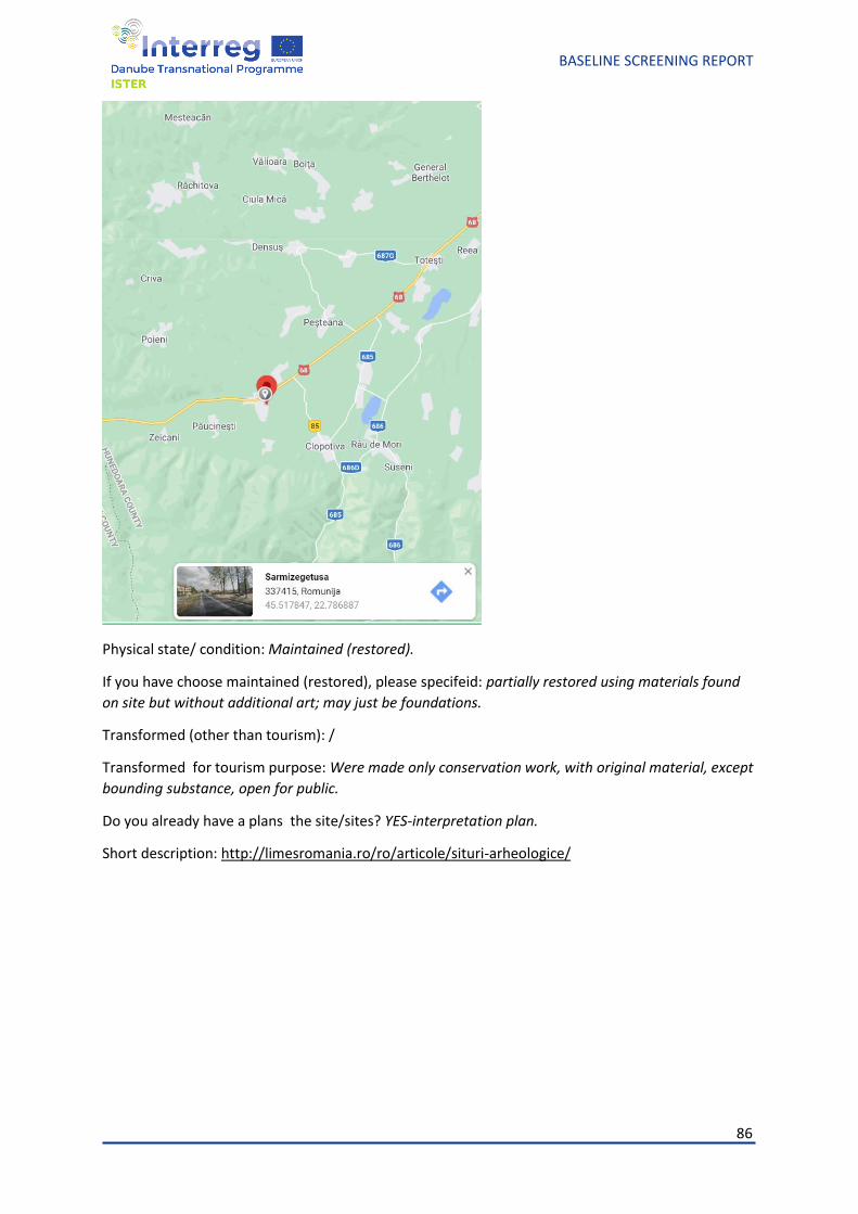
86
BASELINE SCREENING REPORT
Physical state/ condition: Maintained (restored).
If you have choose maintained (restored), please specifeid: partially restored using materials found
on site but without additional art; may just be foundations.
Transformed (other than tourism): /
Transformed for tourism purpose: Were made only conservation work, with original material, except
bounding substance, open for public.
Do you already have a plans the site/sites? YES-interpretation plan.
Short description: http://limesromania.ro/ro/articole/situri-arheologice/
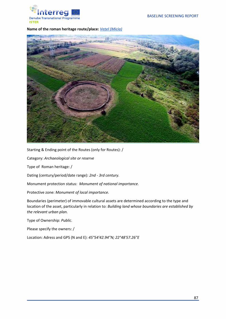
87
BASELINE SCREENING REPORT
Name of the roman heritage route/place: Vețel (Micia)
Starting & Ending point of the Routes (only for Routes): /
Category: Archaeological site or reserve
Type of Roman heritage: /
Dating (century/period/date range): 2nd - 3rd century.
Monument protection status: Monument of national importance.
Protective zone: Monument of local importance.
Boundaries (perimeter) of immovable cultural assets are determined according to the type and
location of the asset, particularly in relation to: Building land whose boundaries are established by
the relevant urban plan.
Type of Ownership: Public.
Please specify the owners: /
Location: Adress and GPS (N and E): 45°54'42.94"N; 22°48'57.26"E
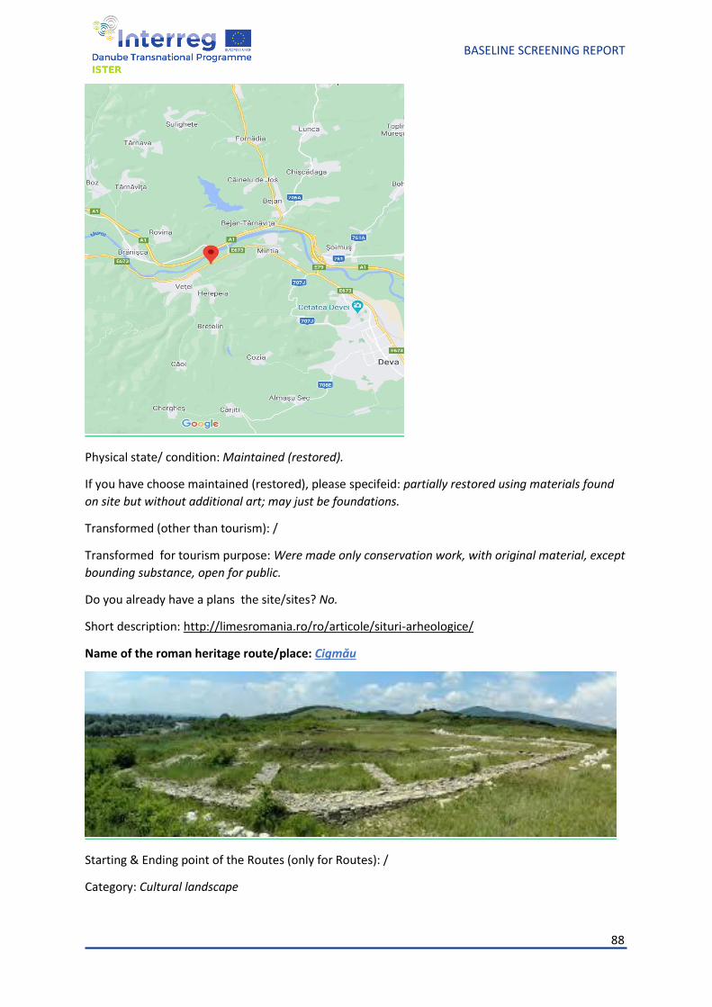
88
BASELINE SCREENING REPORT
Physical state/ condition: Maintained (restored).
If you have choose maintained (restored), please specifeid: partially restored using materials found
on site but without additional art; may just be foundations.
Transformed (other than tourism): /
Transformed for tourism purpose: Were made only conservation work, with original material, except
bounding substance, open for public.
Do you already have a plans the site/sites? No.
Short description: http://limesromania.ro/ro/articole/situri-arheologice/
Name of the roman heritage route/place: Cigmău
Starting & Ending point of the Routes (only for Routes): /
Category: Cultural landscape
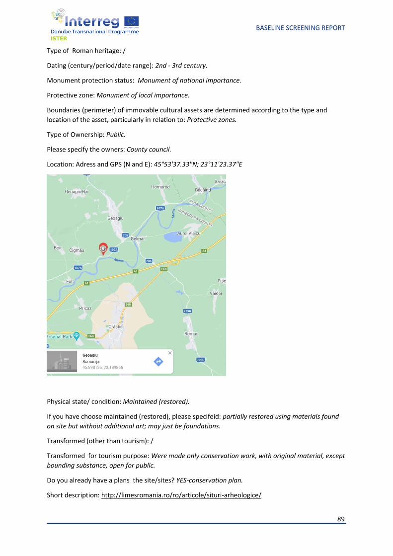
89
BASELINE SCREENING REPORT
Type of Roman heritage: /
Dating (century/period/date range): 2nd - 3rd century.
Monument protection status: Monument of national importance.
Protective zone: Monument of local importance.
Boundaries (perimeter) of immovable cultural assets are determined according to the type and
location of the asset, particularly in relation to: Protective zones.
Type of Ownership: Public.
Please specify the owners: County council.
Location: Adress and GPS (N and E): 45°53'37.33"N; 23°11'23.37"E
Physical state/ condition: Maintained (restored).
If you have choose maintained (restored), please specifeid: partially restored using materials found
on site but without additional art; may just be foundations.
Transformed (other than tourism): /
Transformed for tourism purpose: Were made only conservation work, with original material, except
bounding substance, open for public.
Do you already have a plans the site/sites? YES-conservation plan.
Short description: http://limesromania.ro/ro/articole/situri-arheologice/
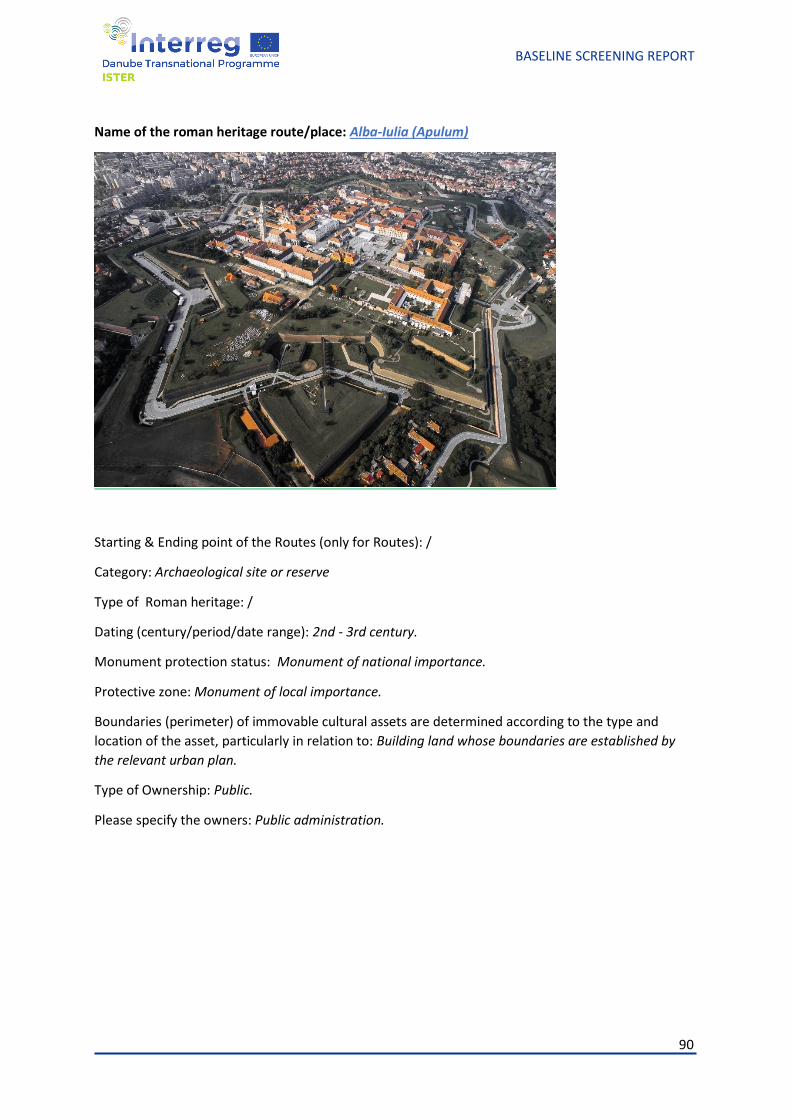
90
BASELINE SCREENING REPORT
Name of the roman heritage route/place: Alba-Iulia (Apulum)
Starting & Ending point of the Routes (only for Routes): /
Category: Archaeological site or reserve
Type of Roman heritage: /
Dating (century/period/date range): 2nd - 3rd century.
Monument protection status: Monument of national importance.
Protective zone: Monument of local importance.
Boundaries (perimeter) of immovable cultural assets are determined according to the type and
location of the asset, particularly in relation to: Building land whose boundaries are established by
the relevant urban plan.
Type of Ownership: Public.
Please specify the owners: Public administration.
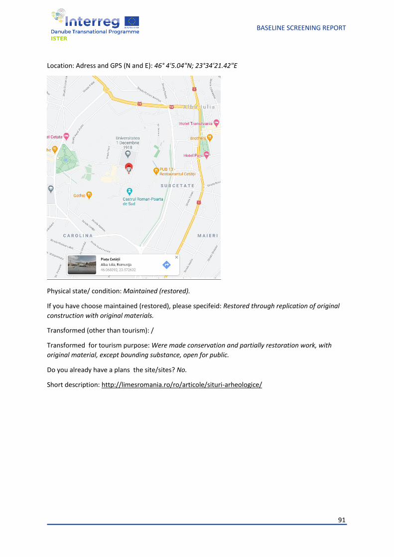
91
BASELINE SCREENING REPORT
Location: Adress and GPS (N and E): 46° 4'5.04"N; 23°34'21.42"E
Physical state/ condition: Maintained (restored).
If you have choose maintained (restored), please specifeid: Restored through replication of original
construction with original materials.
Transformed (other than tourism): /
Transformed for tourism purpose: Were made conservation and partially restoration work, with
original material, except bounding substance, open for public.
Do you already have a plans the site/sites? No.
Short description: http://limesromania.ro/ro/articole/situri-arheologice/
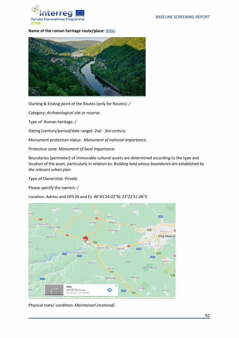
92
BASELINE SCREENING REPORT
Name of the roman heritage route/place: Gilău
Starting & Ending point of the Routes (only for Routes): /
Category: Archaeological site or reserve.
Type of Roman heritage: /
Dating (century/period/date range): 2nd - 3rd century.
Monument protection status: Monument of national importance.
Protective zone: Monument of local importance.
Boundaries (perimeter) of immovable cultural assets are determined according to the type and
location of the asset, particularly in relation to: Building land whose boundaries are established by
the relevant urban plan.
Type of Ownership: Private.
Please specify the owners: /
Location: Adress and GPS (N and E): 46°45'24.02"N; 23°22'51.06"E
Physical state/ condition: Maintained (restored).
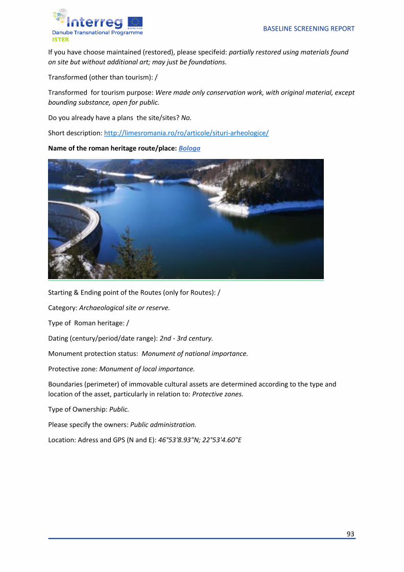
93
BASELINE SCREENING REPORT
If you have choose maintained (restored), please specifeid: partially restored using materials found
on site but without additional art; may just be foundations.
Transformed (other than tourism): /
Transformed for tourism purpose: Were made only conservation work, with original material, except
bounding substance, open for public.
Do you already have a plans the site/sites? No.
Short description: http://limesromania.ro/ro/articole/situri-arheologice/
Name of the roman heritage route/place: Bologa
Starting & Ending point of the Routes (only for Routes): /
Category: Archaeological site or reserve.
Type of Roman heritage: /
Dating (century/period/date range): 2nd - 3rd century.
Monument protection status: Monument of national importance.
Protective zone: Monument of local importance.
Boundaries (perimeter) of immovable cultural assets are determined according to the type and
location of the asset, particularly in relation to: Protective zones.
Type of Ownership: Public.
Please specify the owners: Public administration.
Location: Adress and GPS (N and E): 46°53'8.93"N; 22°53'4.60"E
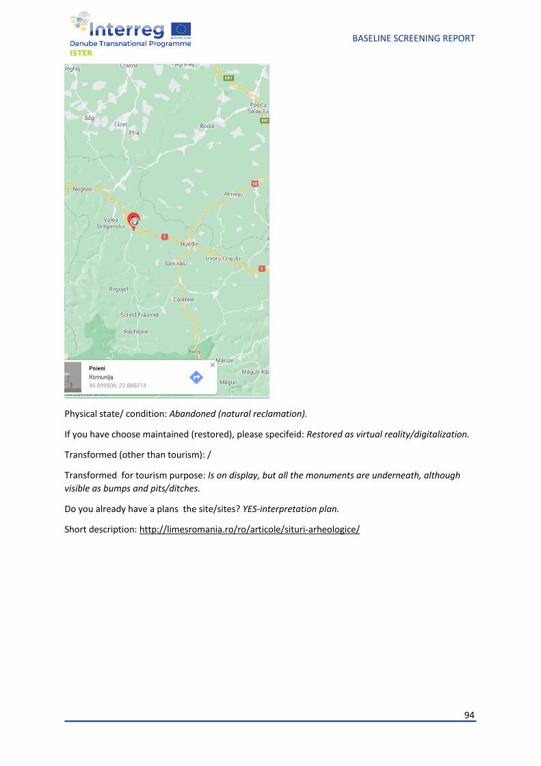
94
BASELINE SCREENING REPORT
Physical state/ condition: Abandoned (natural reclamation).
If you have choose maintained (restored), please specifeid: Restored as virtual reality/digitalization.
Transformed (other than tourism): /
Transformed for tourism purpose: Is on display, but all the monuments are underneath, although
visible as bumps and pits/ditches.
Do you already have a plans the site/sites? YES-interpretation plan.
Short description: http://limesromania.ro/ro/articole/situri-arheologice/
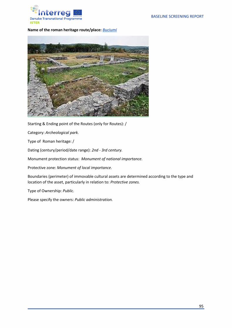
95
BASELINE SCREENING REPORT
Name of the roman heritage route/place: Buciumi
Starting & Ending point of the Routes (only for Routes): /
Category: Archeological park.
Type of Roman heritage: /
Dating (century/period/date range): 2nd - 3rd century.
Monument protection status: Monument of national importance.
Protective zone: Monument of local importance.
Boundaries (perimeter) of immovable cultural assets are determined according to the type and
location of the asset, particularly in relation to: Protective zones.
Type of Ownership: Public.
Please specify the owners: Public administration.
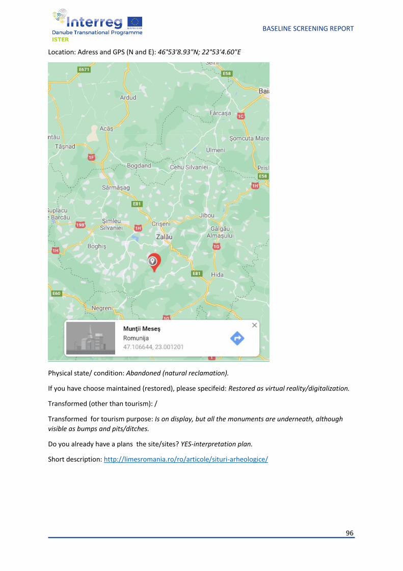
96
BASELINE SCREENING REPORT
Location: Adress and GPS (N and E): 46°53'8.93"N; 22°53'4.60"E
Physical state/ condition: Abandoned (natural reclamation).
If you have choose maintained (restored), please specifeid: Restored as virtual reality/digitalization.
Transformed (other than tourism): /
Transformed for tourism purpose: Is on display, but all the monuments are underneath, although
visible as bumps and pits/ditches.
Do you already have a plans the site/sites? YES-interpretation plan.
Short description: http://limesromania.ro/ro/articole/situri-arheologice/

97
BASELINE SCREENING REPORT
Name of the roman heritage route/place: Moigrad (Porolissum)
Starting & Ending point of the Routes (only for Routes): /
Category: Archeological park.
Type of Roman heritage: /
Dating (century/period/date range): 2nd - 3rd century.
Monument protection status: Monument of national importance.
Protective zone: Monument of local importance.
Boundaries (perimeter) of immovable cultural assets are determined according to the type and
location of the asset, particularly in relation to: Building land whose boundaries are established by
the relevant urban plan.
Type of Ownership: Public.
Please specify the owners: County council.
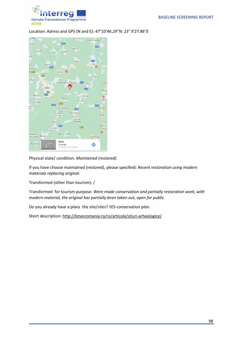
98
BASELINE SCREENING REPORT
Location: Adress and GPS (N and E): 47°10'46.29"N; 23° 9'27.86"E
Physical state/ condition: Maintained (restored).
If you have choose maintained (restored), please specifeid: Recent restoration using modern
materials replacing original.
Transformed (other than tourism): /
Transformed for tourism purpose: Were made conservation and partially restoration work, with
modern material, the original has partially been taken out, open for public.
Do you already have a plans the site/sites? YES-conservation plan.
Short description: http://limesromania.ro/ro/articole/situri-arheologice/
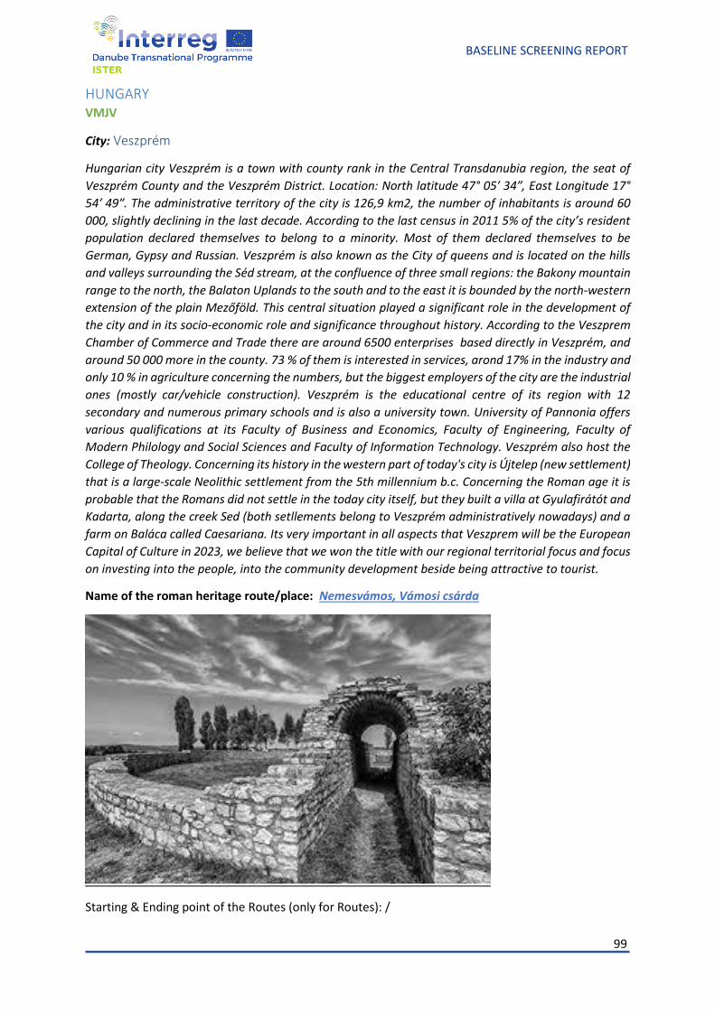
99
BASELINE SCREENING REPORT
HUNGARY VMJV
City: Veszprém
Hungarian city Veszprém is a town with county rank in the Central Transdanubia region, the seat of
Veszprém County and the Veszprém District. Location: North latitude 47° 05′ 34″, East Longitude 17°
54′ 49″. The administrative territory of the city is 126,9 km2, the number of inhabitants is around 60
000, slightly declining in the last decade. According to the last census in 2011 5% of the city’s resident
population declared themselves to belong to a minority. Most of them declared themselves to be
German, Gypsy and Russian. Veszprém is also known as the City of queens and is located on the hills
and valleys surrounding the Séd stream, at the confluence of three small regions: the Bakony mountain
range to the north, the Balaton Uplands to the south and to the east it is bounded by the north-western
extension of the plain Mezőföld. This central situation played a significant role in the development of
the city and in its socio-economic role and significance throughout history. According to the Veszprem
Chamber of Commerce and Trade there are around 6500 enterprises based directly in Veszprém, and
around 50 000 more in the county. 73 % of them is interested in services, arond 17% in the industry and
only 10 % in agriculture concerning the numbers, but the biggest employers of the city are the industrial
ones (mostly car/vehicle construction). Veszprém is the educational centre of its region with 12
secondary and numerous primary schools and is also a university town. University of Pannonia offers
various qualifications at its Faculty of Business and Economics, Faculty of Engineering, Faculty of
Modern Philology and Social Sciences and Faculty of Information Technology. Veszprém also host the
College of Theology. Concerning its history in the western part of today's city is Újtelep (new settlement)
that is a large-scale Neolithic settlement from the 5th millennium b.c. Concerning the Roman age it is
probable that the Romans did not settle in the today city itself, but they built a villa at Gyulafirátót and
Kadarta, along the creek Sed (both setllements belong to Veszprém administratively nowadays) and a
farm on Baláca called Caesariana. Its very important in all aspects that Veszprem will be the European
Capital of Culture in 2023, we believe that we won the title with our regional territorial focus and focus
on investing into the people, into the community development beside being attractive to tourist.
Name of the roman heritage route/place: Nemesvámos, Vámosi csárda
Starting & Ending point of the Routes (only for Routes): /
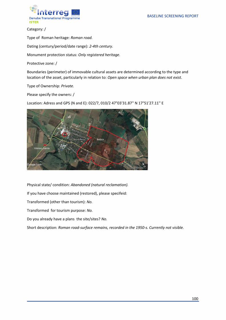
100
BASELINE SCREENING REPORT
Category: /
Type of Roman heritage: Roman road.
Dating (century/period/date range): 2-4th century.
Monument protection status: Only registered heritage.
Protective zone: /
Boundaries (perimeter) of immovable cultural assets are determined according to the type and
location of the asset, particularly in relation to: Open space when urban plan does not exist.
Type of Ownership: Private.
Please specify the owners: /
Location: Adress and GPS (N and E): 022/7, 010/2 47°03'31.87'' N 17°51'27.11'' E
Physical state/ condition: Abandoned (natural reclamation).
If you have choose maintained (restored), please specifeid:
Transformed (other than tourism): No.
Transformed for tourism purpose: No.
Do you already have a plans the site/sites? No.
Short description: Roman road-surface remains, recorded in the 1950-s. Currently not visible.
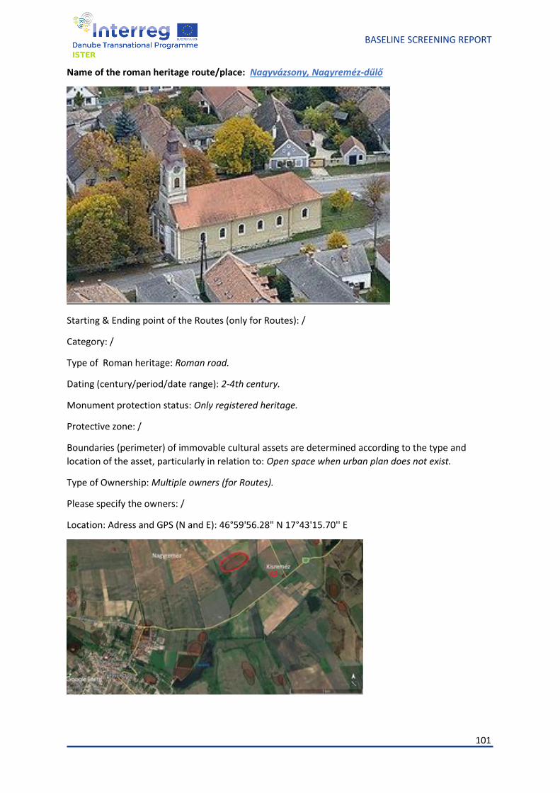
101
BASELINE SCREENING REPORT
Name of the roman heritage route/place: Nagyvázsony, Nagyreméz-dűlő
Starting & Ending point of the Routes (only for Routes): /
Category: /
Type of Roman heritage: Roman road.
Dating (century/period/date range): 2-4th century.
Monument protection status: Only registered heritage.
Protective zone: /
Boundaries (perimeter) of immovable cultural assets are determined according to the type and
location of the asset, particularly in relation to: Open space when urban plan does not exist.
Type of Ownership: Multiple owners (for Routes).
Please specify the owners: /
Location: Adress and GPS (N and E): 46°59'56.28" N 17°43'15.70'' E
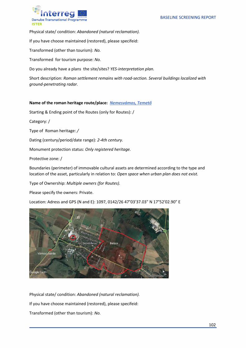
102
BASELINE SCREENING REPORT
Physical state/ condition: Abandoned (natural reclamation).
If you have choose maintained (restored), please specifeid:
Transformed (other than tourism): No.
Transformed for tourism purpose: No.
Do you already have a plans the site/sites? YES-interpretation plan.
Short description: Roman settlement remains with road-section. Several buildings localized with
ground-penetrating radar.
Name of the roman heritage route/place: Nemesvámos, Temető
Starting & Ending point of the Routes (only for Routes): /
Category: /
Type of Roman heritage: /
Dating (century/period/date range): 2-4th century.
Monument protection status: Only registered heritage.
Protective zone: /
Boundaries (perimeter) of immovable cultural assets are determined according to the type and
location of the asset, particularly in relation to: Open space when urban plan does not exist.
Type of Ownership: Multiple owners (for Routes).
Please specify the owners: Private.
Location: Adress and GPS (N and E): 1097, 0142/26 47°03'37.03" N 17°52'02.90" E
Physical state/ condition: Abandoned (natural reclamation).
If you have choose maintained (restored), please specifeid:
Transformed (other than tourism): No.
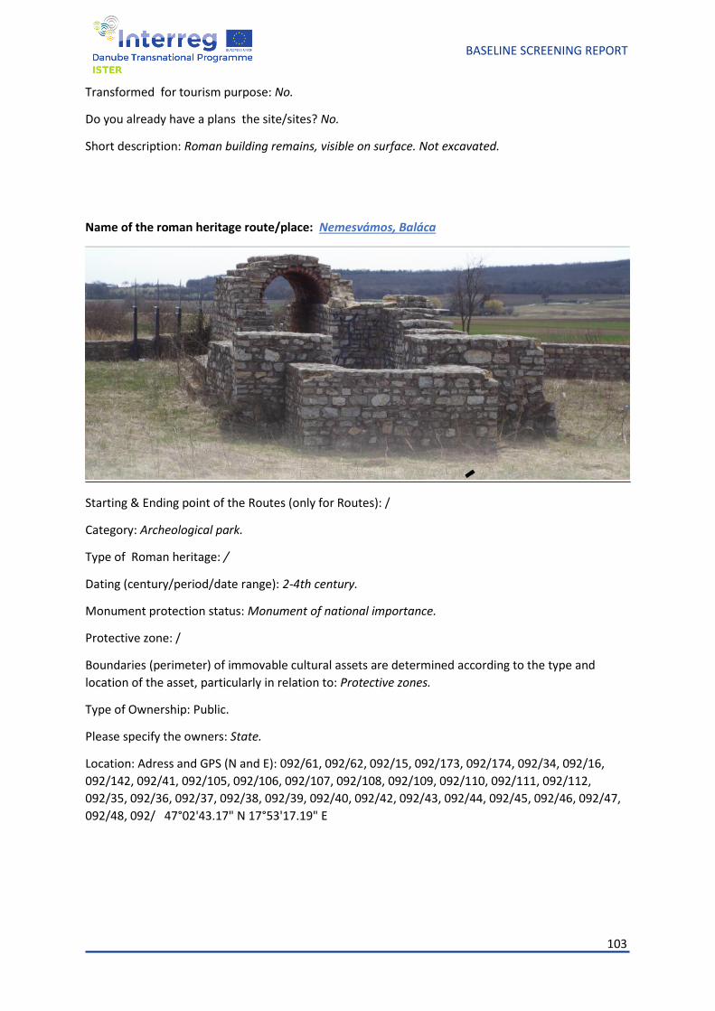
103
BASELINE SCREENING REPORT
Transformed for tourism purpose: No.
Do you already have a plans the site/sites? No.
Short description: Roman building remains, visible on surface. Not excavated.
Name of the roman heritage route/place: Nemesvámos, Baláca
Starting & Ending point of the Routes (only for Routes): /
Category: Archeological park.
Type of Roman heritage: /
Dating (century/period/date range): 2-4th century.
Monument protection status: Monument of national importance.
Protective zone: /
Boundaries (perimeter) of immovable cultural assets are determined according to the type and
location of the asset, particularly in relation to: Protective zones.
Type of Ownership: Public.
Please specify the owners: State.
Location: Adress and GPS (N and E): 092/61, 092/62, 092/15, 092/173, 092/174, 092/34, 092/16,
092/142, 092/41, 092/105, 092/106, 092/107, 092/108, 092/109, 092/110, 092/111, 092/112,
092/35, 092/36, 092/37, 092/38, 092/39, 092/40, 092/42, 092/43, 092/44, 092/45, 092/46, 092/47,
092/48, 092/ 47°02'43.17" N 17°53'17.19" E
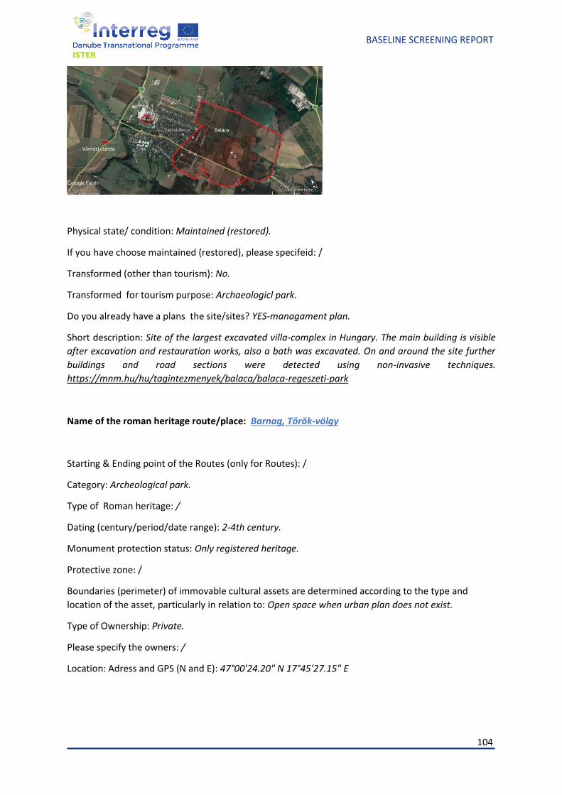
104
BASELINE SCREENING REPORT
Physical state/ condition: Maintained (restored).
If you have choose maintained (restored), please specifeid: /
Transformed (other than tourism): No.
Transformed for tourism purpose: Archaeologicl park.
Do you already have a plans the site/sites? YES-managament plan.
Short description: Site of the largest excavated villa-complex in Hungary. The main building is visible
after excavation and restauration works, also a bath was excavated. On and around the site further
buildings and road sections were detected using non-invasive techniques.
https://mnm.hu/hu/tagintezmenyek/balaca/balaca-regeszeti-park
Name of the roman heritage route/place: Barnag, Török-völgy
Starting & Ending point of the Routes (only for Routes): /
Category: Archeological park.
Type of Roman heritage: /
Dating (century/period/date range): 2-4th century.
Monument protection status: Only registered heritage.
Protective zone: /
Boundaries (perimeter) of immovable cultural assets are determined according to the type and
location of the asset, particularly in relation to: Open space when urban plan does not exist.
Type of Ownership: Private.
Please specify the owners: /
Location: Adress and GPS (N and E): 47°00'24.20" N 17°45'27.15" E
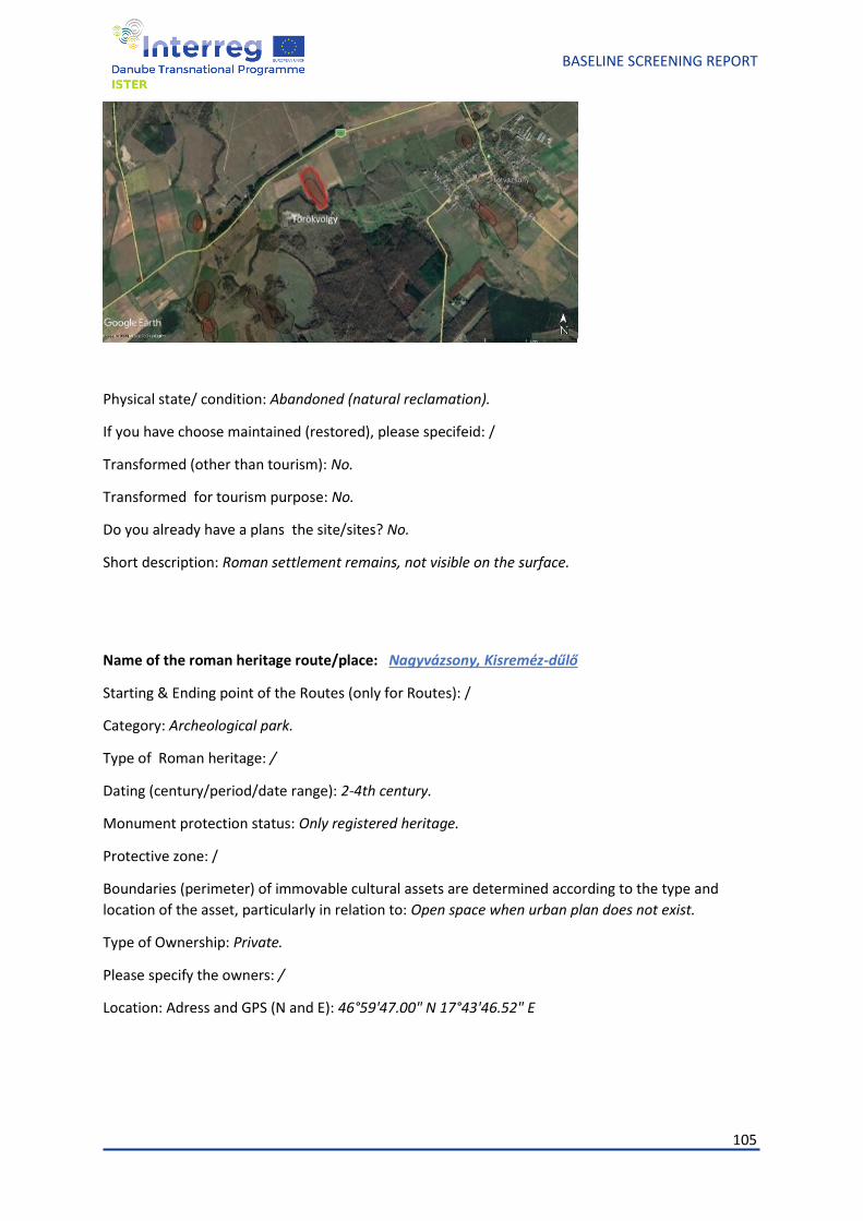
105
BASELINE SCREENING REPORT
Physical state/ condition: Abandoned (natural reclamation).
If you have choose maintained (restored), please specifeid: /
Transformed (other than tourism): No.
Transformed for tourism purpose: No.
Do you already have a plans the site/sites? No.
Short description: Roman settlement remains, not visible on the surface.
Name of the roman heritage route/place: Nagyvázsony, Kisreméz-dűlő
Starting & Ending point of the Routes (only for Routes): /
Category: Archeological park.
Type of Roman heritage: /
Dating (century/period/date range): 2-4th century.
Monument protection status: Only registered heritage.
Protective zone: /
Boundaries (perimeter) of immovable cultural assets are determined according to the type and
location of the asset, particularly in relation to: Open space when urban plan does not exist.
Type of Ownership: Private.
Please specify the owners: /
Location: Adress and GPS (N and E): 46°59'47.00" N 17°43'46.52" E
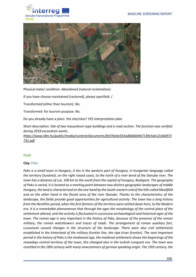
106
BASELINE SCREENING REPORT
Physical state/ condition: Abandoned (natural reclamation).
If you have choose maintained (restored), please specifeid: /
Transformed (other than tourism): No.
Transformed for tourism purpose: No.
Do you already have a plans the site/sites? YES-interpretation plan.
Short description: Site of two mausoleum-type buildings and a road section. The function was verified
during 2018 excavation works.
https://www.ldm.hu/public/media/content/documents/fe07be6c053ad666b0467139e5de12c664f73
731.pdf
PUM
City: Paks
Paks is a small town in Hungary, it lies in the western part of Hungary, in hungarian language called
the territory Dunántúl, on the right raised coast, to the north of a river bend of the Danube river. The
town has a distance of cca. 100 km to the south from the capital of Hungary, Budapest. The geography
of Paks is varied, it is located as a meeting point between two distinct geographic landscapes of middle
Hungary, the land is characterised on the one hand by the South-eastern end of the hills called Mezőföld
and on the other hand in the fluvial area of the river Danube. Thanks to the characteristics of the
landscape, the fields provide good opportunities for agricultural activity. The town has a long history
from the Neolithic period, when the first farmers of the territory were settled down here, to the Modern
era. It is a remarkable phenomenon that through the ages the morphology of the central place of the
settlement altered, and the activity is fluctuated in successive archaeological and historical ages of the
town. The roman age is very important in the history of Paks, because of the presence of the roman
military, the roman watchtowers and traces of roads. The arrangement of roman auxiliary fort,
Lussonium caused changes in the structure of the landscape. There were also civil settlements
established in the hinterland of the military frontier line, the ripa (river frontier). The next important
period in the history of Paks is the medieaval age, the medieval settlement shows the beginnings of the
nowadays central territory of the town, this changed also in the turkish conquest era. The town was
resettled in the 18th century with many newcommers of german speaking origin. The 19th century, the
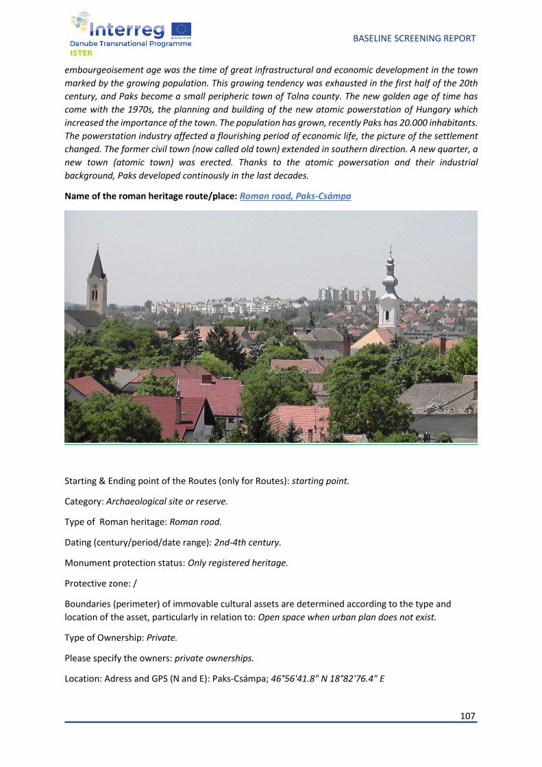
107
BASELINE SCREENING REPORT
embourgeoisement age was the time of great infrastructural and economic development in the town
marked by the growing population. This growing tendency was exhausted in the first half of the 20th
century, and Paks become a small peripheric town of Tolna county. The new golden age of time has
come with the 1970s, the planning and building of the new atomic powerstation of Hungary which
increased the importance of the town. The population has grown, recently Paks has 20.000 inhabitants.
The powerstation industry affected a flourishing period of economic life, the picture of the settlement
changed. The former civil town (now called old town) extended in southern direction. A new quarter, a
new town (atomic town) was erected. Thanks to the atomic powersation and their industrial
background, Paks developed continously in the last decades.
Name of the roman heritage route/place: Roman road, Paks-Csámpa
Starting & Ending point of the Routes (only for Routes): starting point.
Category: Archaeological site or reserve.
Type of Roman heritage: Roman road.
Dating (century/period/date range): 2nd-4th century.
Monument protection status: Only registered heritage.
Protective zone: /
Boundaries (perimeter) of immovable cultural assets are determined according to the type and
location of the asset, particularly in relation to: Open space when urban plan does not exist.
Type of Ownership: Private.
Please specify the owners: private ownerships.
Location: Adress and GPS (N and E): Paks-Csámpa; 46°56'41.8" N 18°82'76.4" E
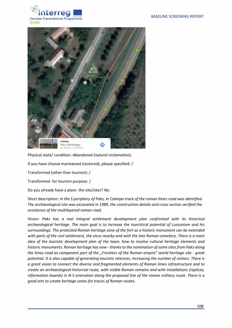
108
BASELINE SCREENING REPORT
Physical state/ condition: Abandoned (natural reclamation).
If you have choose maintained (restored), please specifeid: /
Transformed (other than tourism): /
Transformed for tourism purpose: /
Do you already have a plans the site/sites? No.
Short description: In the S periphery of Paks, in Csámpa track of the roman limes road was identified.
The archaeological site was excavated in 1989, the construction details and cross section verified the
exsistence of the multilayered roman road.
Vision: Paks has a real integral settlement development plan confronted with its historical
archaeological heritage. The main goal is to increase the touristical potential of Lussonium and his
surroundings. The protected Roman heritage zone of the fort as a historic monument can be extended
with parts of the civil settlement, the vicus nearby and with the late Roman cemetery. There is a main
idea of the touristic development plan of the town: how to involve cultural heritage elements and
historic monuments. Roman heritage has now - thanks to the nomination of some sites from Paks along
the limes road as component part of the „Frontiers of the Roman empire” world heritage site - great
potential. It is also capable of generating touristic interests, increasing the number of visitors. There is
a great vision to connect the diverse and fragmented elements of Roman limes infrastructure and to
create an archaeological-historcial route, with visible Roman remains and with installations (replicas,
information boards) in N-S orienation along the proposed line of the roman military route. There is a
good aim to create heritage zones for traces of Roman routes.
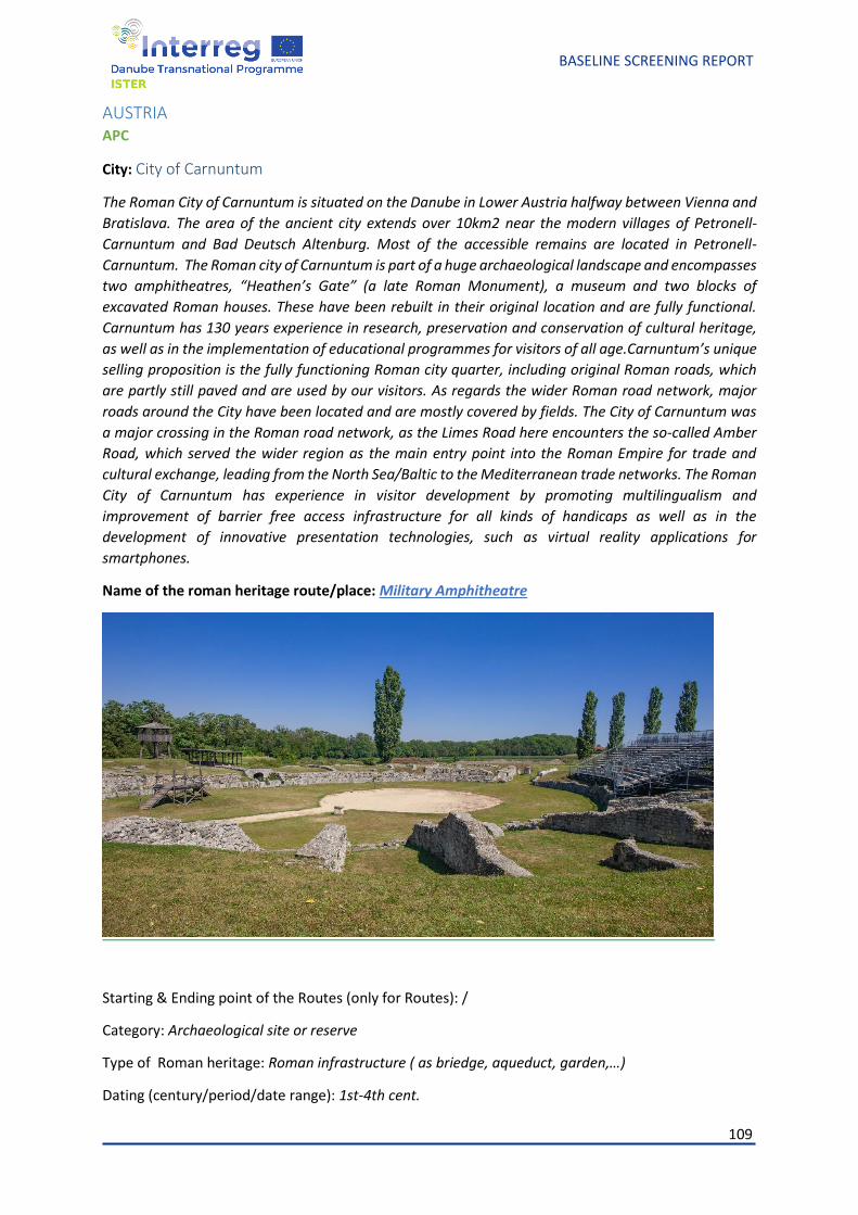
109
BASELINE SCREENING REPORT
AUSTRIA APC
City: City of Carnuntum
The Roman City of Carnuntum is situated on the Danube in Lower Austria halfway between Vienna and
Bratislava. The area of the ancient city extends over 10km2 near the modern villages of Petronell-
Carnuntum and Bad Deutsch Altenburg. Most of the accessible remains are located in Petronell-
Carnuntum. The Roman city of Carnuntum is part of a huge archaeological landscape and encompasses
two amphitheatres, “Heathen’s Gate” (a late Roman Monument), a museum and two blocks of
excavated Roman houses. These have been rebuilt in their original location and are fully functional.
Carnuntum has 130 years experience in research, preservation and conservation of cultural heritage,
as well as in the implementation of educational programmes for visitors of all age.Carnuntum’s unique
selling proposition is the fully functioning Roman city quarter, including original Roman roads, which
are partly still paved and are used by our visitors. As regards the wider Roman road network, major
roads around the City have been located and are mostly covered by fields. The City of Carnuntum was
a major crossing in the Roman road network, as the Limes Road here encounters the so-called Amber
Road, which served the wider region as the main entry point into the Roman Empire for trade and
cultural exchange, leading from the North Sea/Baltic to the Mediterranean trade networks. The Roman
City of Carnuntum has experience in visitor development by promoting multilingualism and
improvement of barrier free access infrastructure for all kinds of handicaps as well as in the
development of innovative presentation technologies, such as virtual reality applications for
smartphones.
Name of the roman heritage route/place: Military Amphitheatre
Starting & Ending point of the Routes (only for Routes): /
Category: Archaeological site or reserve
Type of Roman heritage: Roman infrastructure ( as briedge, aqueduct, garden,…)
Dating (century/period/date range): 1st-4th cent.
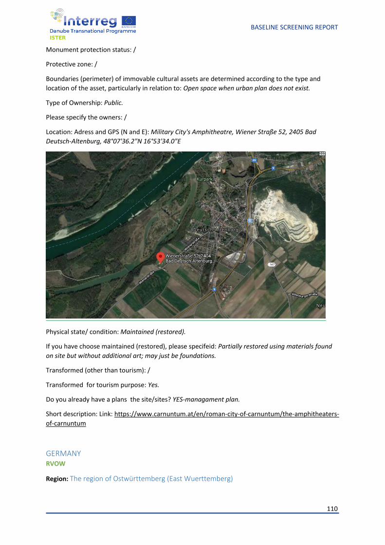
110
BASELINE SCREENING REPORT
Monument protection status: /
Protective zone: /
Boundaries (perimeter) of immovable cultural assets are determined according to the type and
location of the asset, particularly in relation to: Open space when urban plan does not exist.
Type of Ownership: Public.
Please specify the owners: /
Location: Adress and GPS (N and E): Military City's Amphitheatre, Wiener Straße 52, 2405 Bad
Deutsch-Altenburg, 48°07'36.2"N 16°53'34.0"E
Physical state/ condition: Maintained (restored).
If you have choose maintained (restored), please specifeid: Partially restored using materials found
on site but without additional art; may just be foundations.
Transformed (other than tourism): /
Transformed for tourism purpose: Yes.
Do you already have a plans the site/sites? YES-managament plan.
Short description: Link: https://www.carnuntum.at/en/roman-city-of-carnuntum/the-amphitheaters-
of-carnuntum
GERMANY RVOW
Region: The region of Ostwürttemberg (East Wuerttemberg)
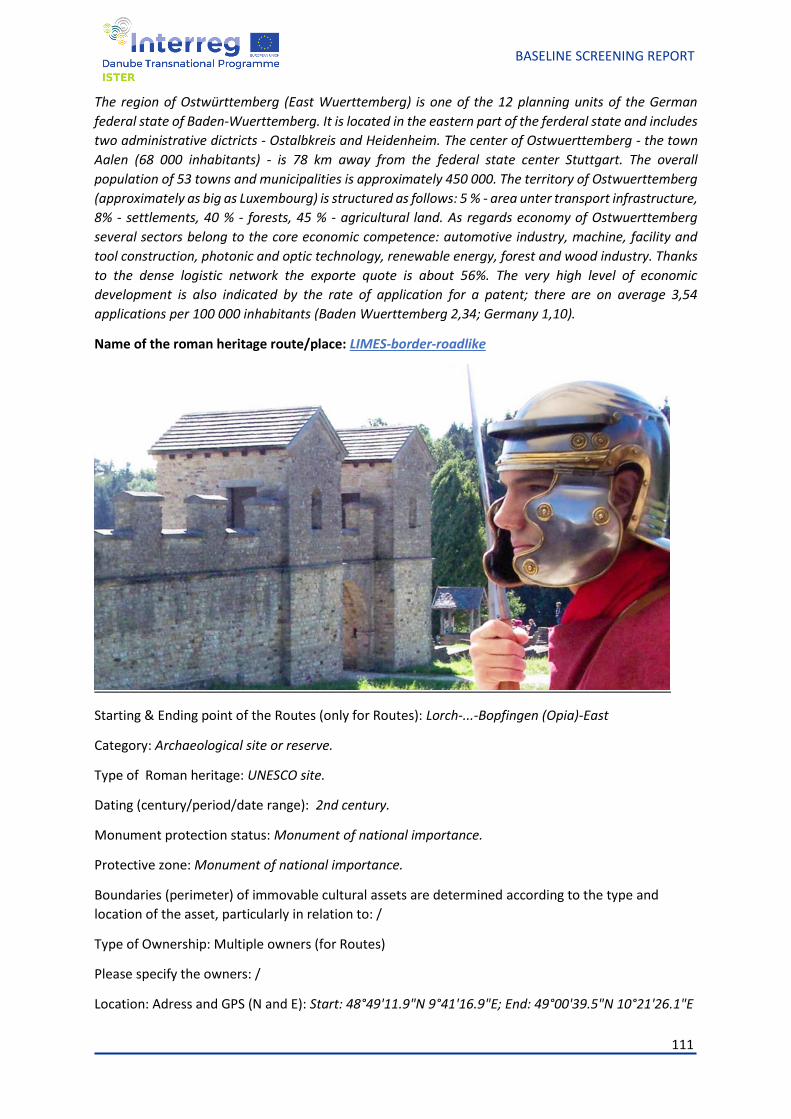
111
BASELINE SCREENING REPORT
The region of Ostwürttemberg (East Wuerttemberg) is one of the 12 planning units of the German
federal state of Baden-Wuerttemberg. It is located in the eastern part of the ferderal state and includes
two administrative dictricts - Ostalbkreis and Heidenheim. The center of Ostwuerttemberg - the town
Aalen (68 000 inhabitants) - is 78 km away from the federal state center Stuttgart. The overall
population of 53 towns and municipalities is approximately 450 000. The territory of Ostwuerttemberg
(approximately as big as Luxembourg) is structured as follows: 5 % - area unter transport infrastructure,
8% - settlements, 40 % - forests, 45 % - agricultural land. As regards economy of Ostwuerttemberg
several sectors belong to the core economic competence: automotive industry, machine, facility and
tool construction, photonic and optic technology, renewable energy, forest and wood industry. Thanks
to the dense logistic network the exporte quote is about 56%. The very high level of economic
development is also indicated by the rate of application for a patent; there are on average 3,54
applications per 100 000 inhabitants (Baden Wuerttemberg 2,34; Germany 1,10).
Name of the roman heritage route/place: LIMES-border-roadlike
Starting & Ending point of the Routes (only for Routes): Lorch-...-Bopfingen (Opia)-East
Category: Archaeological site or reserve.
Type of Roman heritage: UNESCO site.
Dating (century/period/date range): 2nd century.
Monument protection status: Monument of national importance.
Protective zone: Monument of national importance.
Boundaries (perimeter) of immovable cultural assets are determined according to the type and
location of the asset, particularly in relation to: /
Type of Ownership: Multiple owners (for Routes)
Please specify the owners: /
Location: Adress and GPS (N and E): Start: 48°49'11.9"N 9°41'16.9"E; End: 49°00'39.5"N 10°21'26.1"E
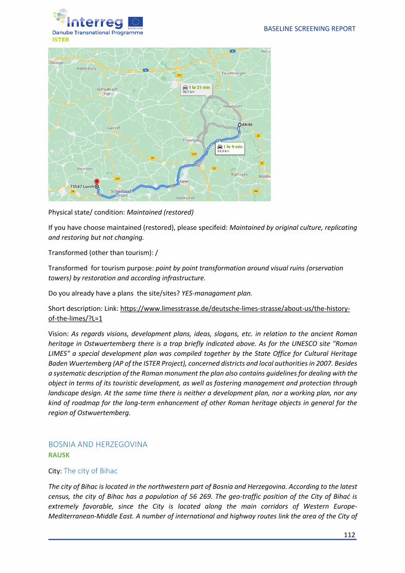
112
BASELINE SCREENING REPORT
Physical state/ condition: Maintained (restored)
If you have choose maintained (restored), please specifeid: Maintained by original culture, replicating
and restoring but not changing.
Transformed (other than tourism): /
Transformed for tourism purpose: point by point transformation around visual ruins (orservation
towers) by restoration and according infrastructure.
Do you already have a plans the site/sites? YES-managament plan.
Short description: Link: https://www.limesstrasse.de/deutsche-limes-strasse/about-us/the-history-
of-the-limes/?L=1
Vision: As regards visions, development plans, ideas, slogans, etc. in relation to the ancient Roman
heritage in Ostwuertemberg there is a trap briefly indicated above. As for the UNESCO site "Roman
LIMES" a special development plan was compiled together by the State Office for Cultural Heritage
Baden Wuertemberg (AP of the ISTER Project), concerned districts and local authorities in 2007. Besides
a systematic description of the Roman monument the plan also contains guidelines for dealing with the
object in terms of its touristic development, as well as fostering management and protection through
landscape design. At the same time there is neither a development plan, nor a working plan, nor any
kind of roadmap for the long-term enhancement of other Roman heritage objects in general for the
region of Ostwuertemberg.
BOSNIA AND HERZEGOVINA RAUSK
City: The city of Bihac
The city of Bihac is located in the northwestern part of Bosnia and Herzegovina. According to the latest
census, the city of Bihac has a population of 56 269. The geo-traffic position of the City of Bihać is
extremely favorable, since the City is located along the main corridors of Western Europe-
Mediterranean-Middle East. A number of international and highway routes link the area of the City of
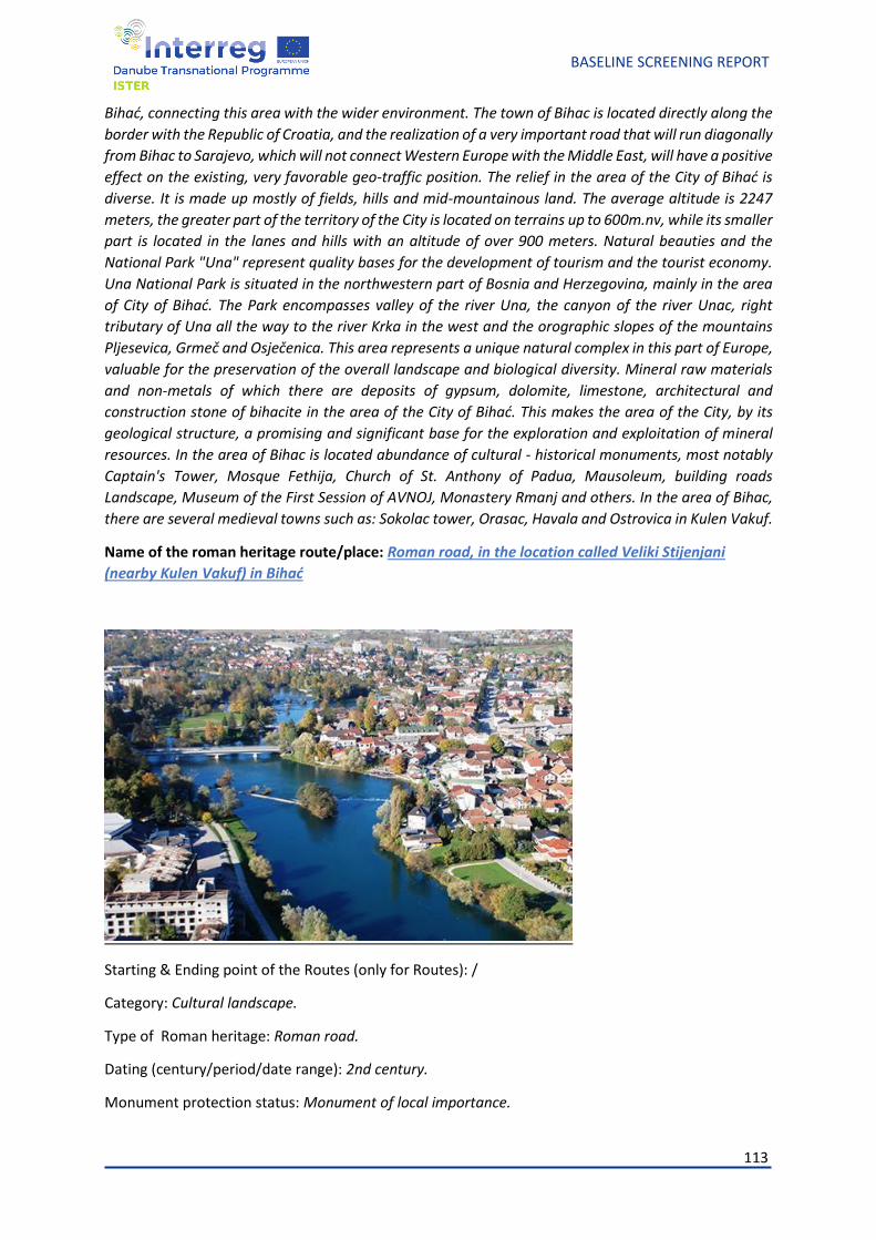
113
BASELINE SCREENING REPORT
Bihać, connecting this area with the wider environment. The town of Bihac is located directly along the
border with the Republic of Croatia, and the realization of a very important road that will run diagonally
from Bihac to Sarajevo, which will not connect Western Europe with the Middle East, will have a positive
effect on the existing, very favorable geo-traffic position. The relief in the area of the City of Bihać is
diverse. It is made up mostly of fields, hills and mid-mountainous land. The average altitude is 2247
meters, the greater part of the territory of the City is located on terrains up to 600m.nv, while its smaller
part is located in the lanes and hills with an altitude of over 900 meters. Natural beauties and the
National Park "Una" represent quality bases for the development of tourism and the tourist economy.
Una National Park is situated in the northwestern part of Bosnia and Herzegovina, mainly in the area
of City of Bihać. The Park encompasses valley of the river Una, the canyon of the river Unac, right
tributary of Una all the way to the river Krka in the west and the orographic slopes of the mountains
Pljesevica, Grmeč and Osječenica. This area represents a unique natural complex in this part of Europe,
valuable for the preservation of the overall landscape and biological diversity. Mineral raw materials
and non-metals of which there are deposits of gypsum, dolomite, limestone, architectural and
construction stone of bihacite in the area of the City of Bihać. This makes the area of the City, by its
geological structure, a promising and significant base for the exploration and exploitation of mineral
resources. In the area of Bihac is located abundance of cultural - historical monuments, most notably
Captain's Tower, Mosque Fethija, Church of St. Anthony of Padua, Mausoleum, building roads
Landscape, Museum of the First Session of AVNOJ, Monastery Rmanj and others. In the area of Bihac,
there are several medieval towns such as: Sokolac tower, Orasac, Havala and Ostrovica in Kulen Vakuf.
Name of the roman heritage route/place: Roman road, in the location called Veliki Stijenjani
(nearby Kulen Vakuf) in Bihać
Starting & Ending point of the Routes (only for Routes): /
Category: Cultural landscape.
Type of Roman heritage: Roman road.
Dating (century/period/date range): 2nd century.
Monument protection status: Monument of local importance.
114
BASELINE SCREENING REPORT
Protective zone: Monument of local importance
Boundaries (perimeter) of immovable cultural assets are determined according to the type and
location of the asset, particularly in relation to: Open space when urban plan does not exist.
Type of Ownership: Public.
Please specify the owners: City of Bihać.
Location: Adress and GPS (N and E): near village Kulen Vakuf, 77000 Bihać ; 44°56′66.67″N
16°13′33.33″E
Physical state/ condition: Abandoned (natural reclamation)
If you have choose maintained (restored), please specifeid: /
Transformed (other than tourism): /
Transformed for tourism purpose: /
Do you already have a plans the site/sites? YES-managament plan.
Short description: In the location called Veliki Stijenjani (nearby Kulen Vakuf) in Bihać is a Roman road
covered by soil that should be excavated. There are small signs from the Roman times along that road,
which indicates that cobblestone road is underneath the layer of soil. Since this area was ruled by
Romans , this investment is needed to enrich database on Roman heritage, which is not that big yet
and which will show our diverse historical and cultural heritage in Bosnia and Herzegovina . It would
also attract more visitors and tourists interested in history to come and visit Una-Sana Canton.
Vision: The transnational investment in all the intervention areas will consist of placing roman ispired
milestones along the Ancient Roman road, aimed at increasing the visibility of the remaining Roman
routes heritage (especially in the unexcavated areas) and to contribute to the transnational branding
for the entire Danube Region , as the roman milestones will be recurrent elements along the route. The
investment will be under the ownership of the project partner, as funded under the ISTER project,
located on the property of the Museum of differently owned property. Each investment site will have a
clear signage showing the investment funding, as well as the name of the owner. After transnational
investment is done it will become a part of the network of Roman routes and settlements across Danube
Region. That will attract visitors and tourists interested in history to come and visit Una-Sana Canton
and we hope that e the number of people visiting the Roman heritage and learning about it will increase
and in that way provide durability of results.
SERBIA RADEJ
City:
Name of the roman heritage route/place:
PICTURE
Starting & Ending point of the Routes (only for Routes):
Category:
Type of Roman heritage:
115
BASELINE SCREENING REPORT
Dating (century/period/date range):
Monument protection status:
Protective zone:
Boundaries (perimeter) of immovable cultural assets are determined according to the type and
location of the asset, particularly in relation to:
Type of Ownership:
Please specify the owners:
Location: Adress and GPS (N and E):
Physical state/ condition:
If you have choose maintained (restored), please specifeid:
Transformed (other than tourism):
Transformed for tourism purpose:
Do you already have a plans the site/sites?
Short description:
Vision: /
BOLGARIA BEF
City: Town of Vidin, Bolgaria
The organization of the road system of Southeast Europe in ancient times was done by the Romans. It
was the roads that glorified Rome and remained the longest used facilities even after the decline of the
empire. They not only contributed to the development of trade, but also accelerated the cultural and
technological exchange between the peoples living within the empire. One of the most important roads,
pasing through Bulgaria, is the Low Danubian Road. The Roman road was built during the reign of
Emperor Trajan in the 1st century on the right side of the Lower Danube (the Bulgarian side) along the
Danube Limes.It connected statations, castles and fortresses to the Danube Delta. Roman military
camps (castles), small garrisons and observation towers were built on both sides of the Danube. In
addition, civilian settlements are being built, mostly for veterans and former legionnaires. The road
passes through Vidin Region, 27 km from the town of Vidin and 2 km from Archar village. Vidin is a port
town on the southern bank of the Danube in north-western Bulgaria. It is close to the borders with
Romania and Serbia, and is also the administrative centre of Vidin Region. Vidin emerged at the place
of an old Celtic settlement known as Dunonia. The settlement evolved into a Roman fortified town
called Bononia. The town grew into one of the important centres of the province of Upper Moesia,
encompassing the territory of modern north-western Bulgaria and eastern Serbia. The historical
museum is one of the oldest scientific and cultural institutions in Vidin. It is an important socially
significant center for finding, keeping and processing historical heritage. The beginning of the museum
work in Vidin dated from 1910 when the Archeological association was founded. The place of the Vidin
museum in national museum network is approved by its success in creating new exhibitions and
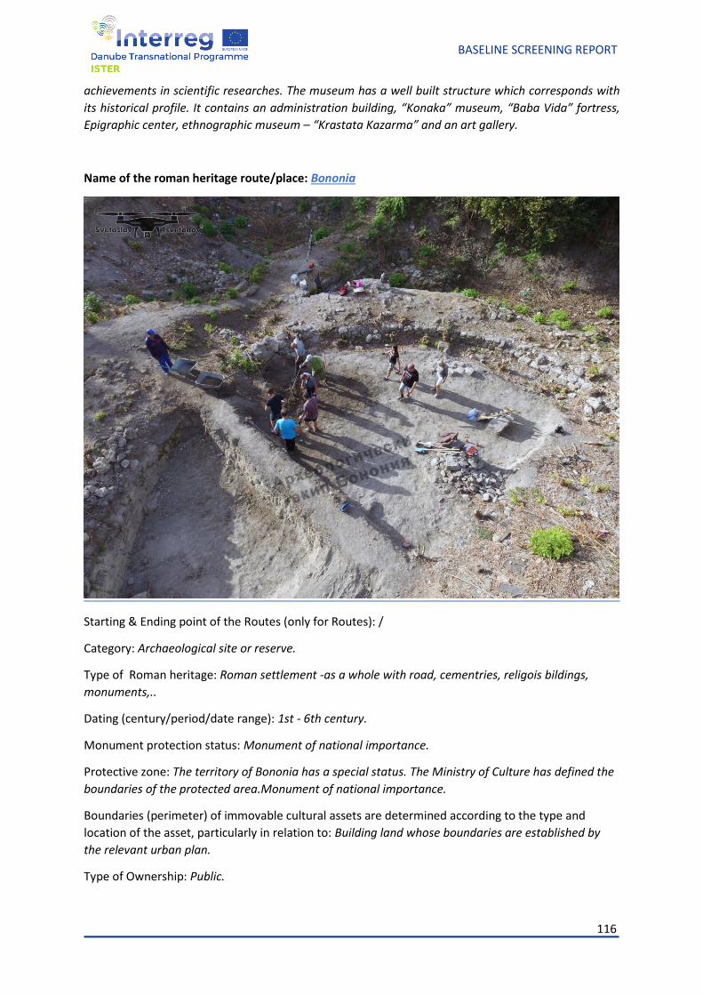
116
BASELINE SCREENING REPORT
achievements in scientific researches. The museum has a well built structure which corresponds with
its historical profile. It contains an administration building, “Konaka” museum, “Baba Vida” fortress,
Epigraphic center, ethnographic museum – “Krastata Kazarma” and an art gallery.
Name of the roman heritage route/place: Bononia
Starting & Ending point of the Routes (only for Routes): /
Category: Archaeological site or reserve.
Type of Roman heritage: Roman settlement -as a whole with road, cementries, religois bildings,
monuments,..
Dating (century/period/date range): 1st - 6th century.
Monument protection status: Monument of national importance.
Protective zone: The territory of Bononia has a special status. The Ministry of Culture has defined the
boundaries of the protected area.Monument of national importance.
Boundaries (perimeter) of immovable cultural assets are determined according to the type and
location of the asset, particularly in relation to: Building land whose boundaries are established by
the relevant urban plan.
Type of Ownership: Public.
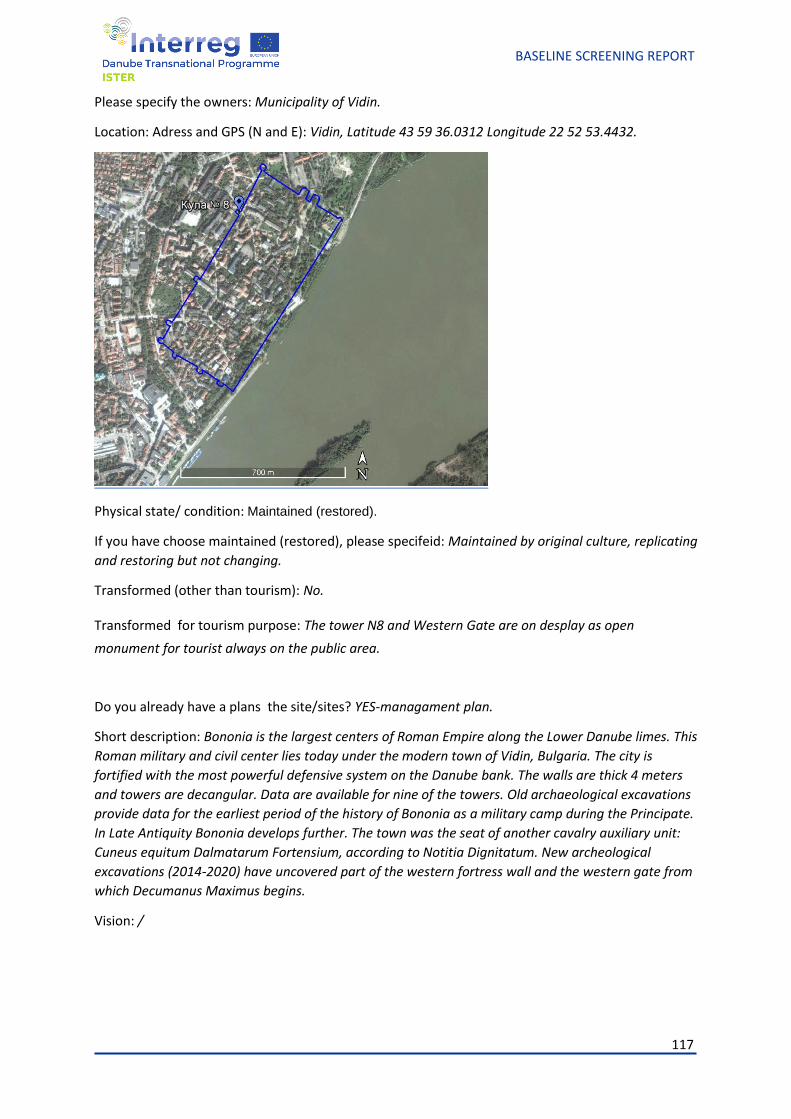
117
BASELINE SCREENING REPORT
Please specify the owners: Municipality of Vidin.
Location: Adress and GPS (N and E): Vidin, Latitude 43 59 36.0312 Longitude 22 52 53.4432.
Physical state/ condition: Maintained (restored).
If you have choose maintained (restored), please specifeid: Maintained by original culture, replicating
and restoring but not changing.
Transformed (other than tourism): No.
Transformed for tourism purpose: The tower N8 and Western Gate are on desplay as open
monument for tourist always on the public area.
Do you already have a plans the site/sites? YES-managament plan.
Short description: Bononia is the largest centers of Roman Empire along the Lower Danube limes. This
Roman military and civil center lies today under the modern town of Vidin, Bulgaria. The city is
fortified with the most powerful defensive system on the Danube bank. The walls are thick 4 meters
and towers are decangular. Data are available for nine of the towers. Old archaeological excavations
provide data for the earliest period of the history of Bononia as a military camp during the Principate.
In Late Antiquity Bononia develops further. The town was the seat of another cavalry auxiliary unit:
Cuneus equitum Dalmatarum Fortensium, according to Notitia Dignitatum. New archeological
excavations (2014-2020) have uncovered part of the western fortress wall and the western gate from
which Decumanus Maximus begins.
Vision: /
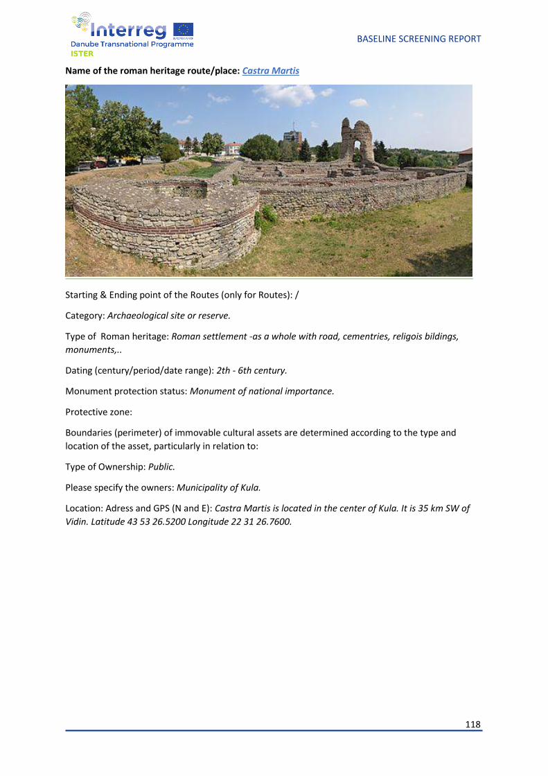
118
BASELINE SCREENING REPORT
Name of the roman heritage route/place: Castra Martis
Starting & Ending point of the Routes (only for Routes): /
Category: Archaeological site or reserve.
Type of Roman heritage: Roman settlement -as a whole with road, cementries, religois bildings,
monuments,..
Dating (century/period/date range): 2th - 6th century.
Monument protection status: Monument of national importance.
Protective zone:
Boundaries (perimeter) of immovable cultural assets are determined according to the type and
location of the asset, particularly in relation to:
Type of Ownership: Public.
Please specify the owners: Municipality of Kula.
Location: Adress and GPS (N and E): Castra Martis is located in the center of Kula. It is 35 km SW of
Vidin. Latitude 43 53 26.5200 Longitude 22 31 26.7600.
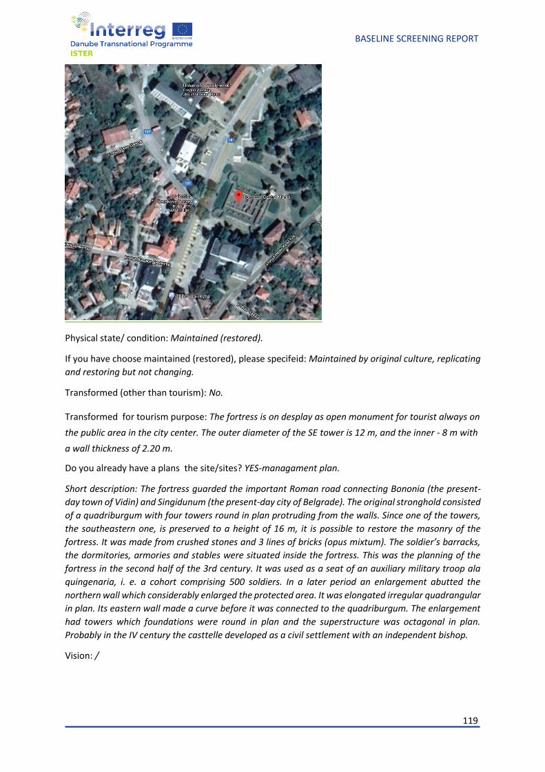
119
BASELINE SCREENING REPORT
Physical state/ condition: Maintained (restored).
If you have choose maintained (restored), please specifeid: Maintained by original culture, replicating
and restoring but not changing.
Transformed (other than tourism): No.
Transformed for tourism purpose: The fortress is on desplay as open monument for tourist always on
the public area in the city center. The outer diameter of the SE tower is 12 m, and the inner - 8 m with
a wall thickness of 2.20 m.
Do you already have a plans the site/sites? YES-managament plan.
Short description: The fortress guarded the important Roman road connecting Bononia (the present-
day town of Vidin) and Singidunum (the present-day city of Belgrade). The original stronghold consisted
of a quadriburgum with four towers round in plan protruding from the walls. Since one of the towers,
the southeastern one, is preserved to a height of 16 m, it is possible to restore the masonry of the
fortress. It was made from crushed stones and 3 lines of bricks (opus mixtum). The soldier’s barracks,
the dormitories, armories and stables were situated inside the fortress. This was the planning of the
fortress in the second half of the 3rd century. It was used as a seat of an auxiliary military troop ala
quingenaria, i. e. a cohort comprising 500 soldiers. In a later period an enlargement abutted the
northern wall which considerably enlarged the protected area. It was elongated irregular quadrangular
in plan. Its eastern wall made a curve before it was connected to the quadriburgum. The enlargement
had towers which foundations were round in plan and the superstructure was octagonal in plan.
Probably in the IV century the casttelle developed as a civil settlement with an independent bishop.
Vision: /
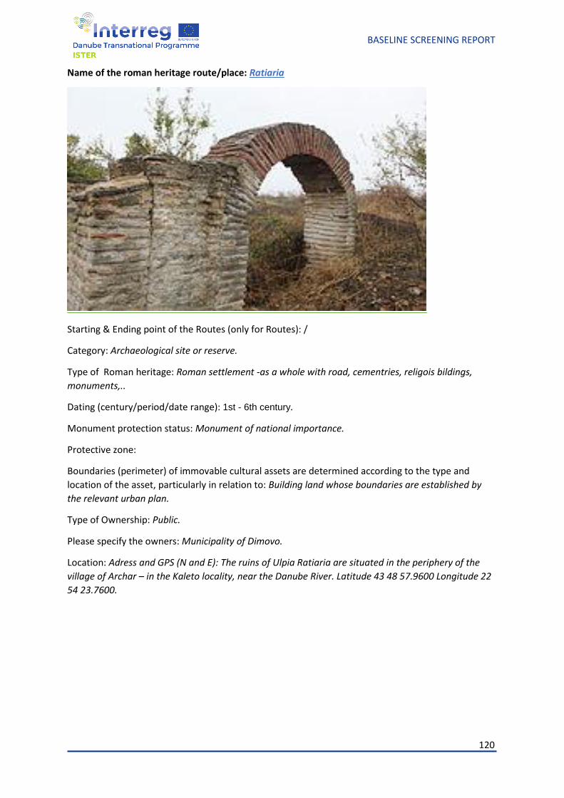
120
BASELINE SCREENING REPORT
Name of the roman heritage route/place: Ratiaria
Starting & Ending point of the Routes (only for Routes): /
Category: Archaeological site or reserve.
Type of Roman heritage: Roman settlement -as a whole with road, cementries, religois bildings,
monuments,..
Dating (century/period/date range): 1st - 6th century.
Monument protection status: Monument of national importance.
Protective zone:
Boundaries (perimeter) of immovable cultural assets are determined according to the type and
location of the asset, particularly in relation to: Building land whose boundaries are established by
the relevant urban plan.
Type of Ownership: Public.
Please specify the owners: Municipality of Dimovo.
Location: Adress and GPS (N and E): The ruins of Ulpia Ratiaria are situated in the periphery of the
village of Archar – in the Kaleto locality, near the Danube River. Latitude 43 48 57.9600 Longitude 22
54 23.7600.
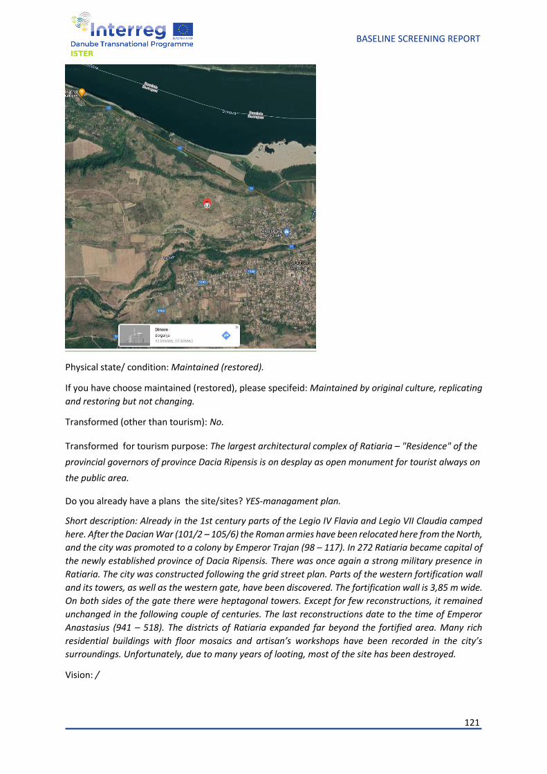
121
BASELINE SCREENING REPORT
Physical state/ condition: Maintained (restored).
If you have choose maintained (restored), please specifeid: Maintained by original culture, replicating
and restoring but not changing.
Transformed (other than tourism): No.
Transformed for tourism purpose: The largest architectural complex of Ratiaria – "Residence" of the
provincial governors of province Dacia Ripensis is on desplay as open monument for tourist always on
the public area.
Do you already have a plans the site/sites? YES-managament plan.
Short description: Already in the 1st century parts of the Legio IV Flavia and Legio VII Claudia camped
here. After the Dacian War (101/2 – 105/6) the Roman armies have been relocated here from the North,
and the city was promoted to a colony by Emperor Trajan (98 – 117). In 272 Ratiaria became capital of
the newly established province of Dacia Ripensis. There was once again a strong military presence in
Ratiaria. The city was constructed following the grid street plan. Parts of the western fortification wall
and its towers, as well as the western gate, have been discovered. The fortification wall is 3,85 m wide.
On both sides of the gate there were heptagonal towers. Except for few reconstructions, it remained
unchanged in the following couple of centuries. The last reconstructions date to the time of Emperor
Anastasius (941 – 518). The districts of Ratiaria expanded far beyond the fortified area. Many rich
residential buildings with floor mosaics and artisan’s workshops have been recorded in the city’s
surroundings. Unfortunately, due to many years of looting, most of the site has been destroyed.
Vision: /
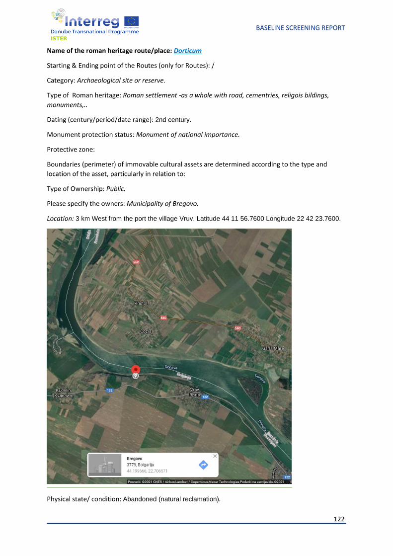
122
BASELINE SCREENING REPORT
Name of the roman heritage route/place: Dorticum
Starting & Ending point of the Routes (only for Routes): /
Category: Archaeological site or reserve.
Type of Roman heritage: Roman settlement -as a whole with road, cementries, religois bildings,
monuments,..
Dating (century/period/date range): 2nd century.
Monument protection status: Monument of national importance.
Protective zone:
Boundaries (perimeter) of immovable cultural assets are determined according to the type and
location of the asset, particularly in relation to:
Type of Ownership: Public.
Please specify the owners: Municipality of Bregovo.
Location: 3 km West from the port the village Vruv. Latitude 44 11 56.7600 Longitude 22 42 23.7600.
Physical state/ condition: Abandoned (natural reclamation).
123
BASELINE SCREENING REPORT
If you have choose maintained (restored), please specifeid: /
Transformed (other than tourism): No.
Transformed for tourism purpose: No.
Do you already have a plans the site/sites? No.
Short description: The most early written sources is Geographia and Intinerarum Antonini Augusti. The
Castellum has a rectangular shape. The length is 140-160 m, a width - 50-60 m. Remains of two shafts
and a ditch have been exavated. The castellum arises of the remains of old Tracian village and was in
use across Roman and Early Bizantine ages.
Vision: /
Name of the roman heritage route/place: Roman Frontier Watch Tower near Vidin
Starting & Ending point of the Routes (only for Routes): /
Category: Archaeological site or reserve.
Type of Roman heritage:
Dating (century/period/date range): Late 3rd or early 4th century.
Monument protection status: /
Protective zone:
Boundaries (perimeter) of immovable cultural assets are determined according to the type and
location of the asset, particularly in relation to: /
Type of Ownership: Public.
Please specify the owners: /
Location: The object is 800 m South from vollage of Pokrayna, nesr Vidin, and 2.3 km North from
Danube river.
Physical state/ condition: Abandoned (natural reclamation).
If you have choose maintained (restored), please specifeid: /
Transformed (other than tourism): No.
Transformed for tourism purpose: No.
Do you already have a plans the site/sites? No.
Short description: It occupies area over 50 x 50 m. The excavatios brought to light the remains of s solid
wooden construction. The small finds date the tower back to the late 3rd or early 4th century AD. It is
also possible that a similar tower existed thereq dated back to the period preceding and the period
contempordry to the Dacian wars.
Vision: /
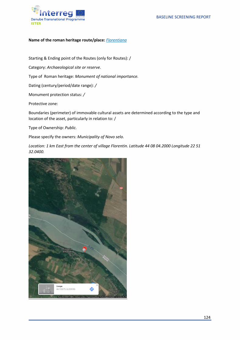
124
BASELINE SCREENING REPORT
Name of the roman heritage route/place: Florentiana
Starting & Ending point of the Routes (only for Routes): /
Category: Archaeological site or reserve.
Type of Roman heritage: Monument of national importance.
Dating (century/period/date range): /
Monument protection status: /
Protective zone:
Boundaries (perimeter) of immovable cultural assets are determined according to the type and
location of the asset, particularly in relation to: /
Type of Ownership: Public.
Please specify the owners: Municipality of Novo selo.
Location: 1 km East from the center of village Florentin. Latitude 44 08 04.2000 Longitude 22 51
32.0400.
125
BASELINE SCREENING REPORT
Physical state/ condition: /
If you have choose maintained (restored), please specifeid: /
Transformed (other than tourism): No.
Transformed for tourism purpose: No.
Do you already have a plans the site/sites? No.
Short description: The castellum is located on the terrace of Danube river. The only one written sourse
is Procopius text "On Buildings".
Vision: /
8. ISTER partner cities and their other Roman heritage-add as a
annexes 1 to the Baseline study.
126
BASELINE SCREENING REPORT
9. Conclusions and the focus of project ISTER and other
deliverables
The ISTER project's overall objective is to rediscover and revive the ancient network of roads and
settlements developed by the Romans, along with the Danube Region and design eco-cultural
routes out of it
The project firstly addresses the challenge of Roman heritage discontinuity, which reflects both in a
territorial dimension related to a low level of investment and connection between heritage resources
and local/ regional productive sectors, as well as in visualisation and attractiveness dimensions
regarding the promotion and awareness-raising on the importance of heritage resources as drivers
for regional development (economic development).
Roman heritage sites face many challenges today in the era of accelerating globalization like
uncontrolled urban development (urban sprawl) due to demographic growth of the cities as well as
environmental problems like fluctuation of river courses leading to frequent floods. The roman sites
are located outside or inside the localities, some Roman fortifications being today 90% covered by
the construction of the modern city, by constructing new roads or affected by intensive agricultural
works and deforestations. However, there are also sites without traces of late interventions, restored
or under restoration, or pastures. Through urbanization, people tend to ignore their history and
traditions seeking adequate services and a better lifestyle leading to the disappearance of existing
urban fabric that creates an undefined urban pattern
A particular component of the cultural heritage, the Cultural Routes (CR), represents ‘irreplaceable
narrative keys’ that create synergies between people and natural and cultural heritage assets.
Cultural routes are also enriching the contributions of peoples to future generations by representing
a proof of chore values such as solidarity, sharing, tolerance, multicultural integration and peace
Stepping further the isolated/ detached Roman settlements heritage, ISTER tackles the territorial
dimension of the Roman Routes, as a contiguous transnational element that passes DR states’
borders and provides a relevant scale for exchange and joint development.
Key challenges which will be tacke in the project base on the baseline research:
1. Low level of visibility and territorial integration of heritage assets into the local/regional development; 2. Valorising Roman unexplored Heritage and making it more visible and accessible to the public; 3. Low level of awareness and visibility of the Roman Routes, on a local and national level; 4. Investments being made but no noticeable improvement of the area was seen, being it economical or as an impact on tourism; 5. Disagreement between the archaeologist and other specialists, based on the interventions that were made on the ruins.
127
BASELINE SCREENING REPORT
Therefore, ISTER’s main objective focuses on rediscovering and revitalizing the ancient Roman Roads
Network along the DR as a key driver in promoting territorial development based on sustainable use
of cultural and natural heritage (specifically, Roman routes). ISTER promotes this Roman roads and
settlements network as a catalyst for touristic development, as well as an opportunity for
territorial competitiveness and sustainable growth of Danube crossed-regions

128
BASELINE SCREENING REPORT