Bars and troughs dynamic and evolution trend of La Cinta beach (San Teodoro OT)-NE Sardinia, Rend
7
Rend. Online Soc. Geol. It., Vol. 17 (2011), pp. 17-23, 5 figs., (DOI 10.3301/ROL.2011.13) © Società Geologica Italiana, Roma 2011 Bars/troughs dynamics and evolution trend of the La Cinta beach (San Teodoro OT) - NE Sardinia T. BATZELLA (*), (**), N. PUSCEDDU (*), (**), C. KALB (*), F. FERRARO (*), A. IBBA (*) & S. DE MURO (*) ____________________ (*) Università degli Studi di Cagliari, OCEANS - Dipartimento di Scienze della Terra Via Trentino 51, 09127 Cagliari. E-mail: [email protected] (**) Fellowship grants to young researchers funded by the Sar- dinian Regional government, Project co-fund PO Sardegna FSE 2007- 2013 L.R. 7/2007 RIASSUNTO Dinamica della zona a barre e truogoli e trend evolutivo della spiaggia di La Cinta (San Teodoro OT) – NE Sardegna Questo lavoro descrive le dinamiche e il trend evolutivo della spiaggia di La Cinta (San Teodoro – OT). La spiaggia è lunga circa 4 km ed è composta da sabbia fine quarzosa, il retro spiaggia è carat- terizzato da un ben sviluppato cordone dunare e dallo stagno di San Teodoro. Lo studio ha avuto inizio a seguito dell’evento alluvionale del 24 settembre 2009 che ha causato l’apertura di 25 varchi nel cordone dunare. Sono state studiate le caratteristiche sedimentarie e idrodinami- che della spiaggia. Le variazioni a breve termine sono state monitor- ate periodicamente a partire da alcuni giorni dopo l’evento alluvio- nale, con l’ausilio di modelli digitali topografico-batimetrici derivanti dai dati raccolti in 4 diversi rilievi; i modelli idrodinamici e di moto ondoso sono stati creati attraverso l’utilizzo del software DELFT 3D. I risultati ottenuti dai modelli (direzione del raggio d’onda, distribuzi- one delle correnti di fondo, struttura e dinamica della surf zone) hanno permesso di visualizzare le risposte della spiaggia agli eventi meteomarini forzanti da NE, E, SE (con venti di intensità di 18m/s e 10m/s). I dati raccolti dimostrano l’alta resilienza di questa spiaggia, che ha recuperato il suo assetto pre-alluvionale in un breve periodo. PAROLE CHIAVE: dinamiche di spiaggia, Sardegna Nord- orientale, sedimentologia, modelli di moto ondoso e idrodinamica. ABSTRACT This work describes the dynamics and evolution trend in La Cinta beach located in San Teodoro, it is 4km long and composed of fine quartz rich sand, backed by well-developed dune ridge and San Teodoro’s lagoon. The study began a few days after the flood on the 24th of September 09, which caused the breach of 25 openings on dry-beach. Sedimentary and hydrodynamic characteristics were studied. Short-term variations have been periodically monitored since the flo- od and tested using topo-bathymetric digital models, derived from data acquired in 4 different field surveys. Models of wave motion and hydrodynamics were created using Delft3D software. The re- sults obtained from these models (wave ray direction, deep current distribution, structure and surfzone dynamics) allowed to visualize the response of beach to wind/waves stress, forced from NE, E, SE (wind intensity 18m/s, 10m/s). Data acquired demonstrate the hight resilence of this beach, with tendency to re-establishment of steady state with short relaxation times. KEY WORDS: beach dynamics, NE Sardinia, sedimentology, wave and hydrodynamic modelling. INTRODUCTION The aim of this work is to describe the morpho- sedimentary dynamics and the progressive trend of the microtidal wave dominated beach La Cinta, San Teodoro (Fig. 1). The study began immediately after the flood of 24th September 2009, which modified the beach radically (Fig. 3b). The post-flood, morpho-sedimentary response of the beach was studied and monitored by measuring the sedimentary dynamics, the topographical-bathymetrical variations and the level of resilience. MATERIALS AND METHODS The field research followed the standard methods defined by the project INTERREG IIIA – “Gestion intègrèe de l’Environnement à haute Risqué d’Erosion” GERER. (DE MURO & DE FALCO, 2010). A geodetic network was created starting from the point IGM95 ETRF2000 n. 182704 (in Murta Maria). Measurements were taken from the backshore using DGPS (Thales ProMark3) and simultaneously from the submerged beach, using the dual system DGPS/Echo- sounder (DGPS Omnistar 8300HP/Reson Navisound 215; Reson PDS 2000 navigation software). For two years after the event, the short-term variations of the backshore width, the shoreline position, the submerged beach slope and the position of the bars and troughs were measured. A total of 68 samples were collected between the backshore (dune base, dry beach, beach face) and the submerged beach (-1 m, -5 m, -10 m), on several land-sea transepts (Fig. 2b). The hydrodynamics of the shoreface was obtained from the field measurements, which dataset were analyzed by using mathematical models generated with the DELFT 3D software. GEOGRAPHICAL AND GEOLOGICAL SETTING La Cinta beach extends for 4 km and is situated between the two headlands Punta di L’Aldia and Padula di
Transcript of Bars and troughs dynamic and evolution trend of La Cinta beach (San Teodoro OT)-NE Sardinia, Rend

Rend. Online Soc. Geol. It., Vol. 17 (2011), pp. 17-23, 5 fi gs., (DOI 10.3301/ROL.2011.13)© Società Geologica Italiana, Roma 2011
Bars/troughs dynamics and evolution trend of the La Cinta beach(San Teodoro OT) - NE Sardinia
T. BATZELLA (*), (**), N. PUSCEDDU (*), (**), C. KALB (*), F. FERRARO (*), A. IBBA (*) & S. DE MURO (*)
____________________(*) Università degli Studi di Cagliari, OCEANS - Dipartimento di
Scienze della Terra Via Trentino 51, 09127 Cagliari.E-mail: [email protected]
(**) Fellowship grants to young researchers funded by the Sar-dinian Regional government, Project co-fund PO Sardegna FSE 2007-2013 L.R. 7/2007
RIASSUNTO
Dinamica della zona a barre e truogoli e trend evolutivo della spiaggia di La Cinta (San Teodoro OT) – NE Sardegna
Questo lavoro descrive le dinamiche e il trend evolutivo della spiaggia di La Cinta (San Teodoro – OT). La spiaggia è lunga circa 4 km ed è composta da sabbia fi ne quarzosa, il retro spiaggia è carat-terizzato da un ben sviluppato cordone dunare e dallo stagno di San Teodoro. Lo studio ha avuto inizio a seguito dell’evento alluvionale del 24 settembre 2009 che ha causato l’apertura di 25 varchi nel cordone dunare.
Sono state studiate le caratteristiche sedimentarie e idrodinami-che della spiaggia. Le variazioni a breve termine sono state monitor-ate periodicamente a partire da alcuni giorni dopo l’evento alluvio-nale, con l’ausilio di modelli digitali topografi co-batimetrici derivanti dai dati raccolti in 4 diversi rilievi; i modelli idrodinamici e di moto ondoso sono stati creati attraverso l’utilizzo del software DELFT 3D. I risultati ottenuti dai modelli (direzione del raggio d’onda, distribuzi-one delle correnti di fondo, struttura e dinamica della surf zone) hanno permesso di visualizzare le risposte della spiaggia agli eventi meteomarini forzanti da NE, E, SE (con venti di intensità di 18m/s e 10m/s). I dati raccolti dimostrano l’alta resilienza di questa spiaggia, che ha recuperato il suo assetto pre-alluvionale in un breve periodo.
PAROLE CHIAVE: dinamiche di spiaggia, Sardegna Nord-orientale, sedimentologia, modelli di moto ondoso e idrodinamica.
ABSTRACT
This work describes the dynamics and evolution trend in La Cinta beach located in San Teodoro, it is 4km long and composed of fi ne quartz rich sand, backed by well-developed dune ridge and San Teodoro’s lagoon. The study began a few days after the fl ood on the 24th of September 09, which caused the breach of 25 openings on dry-beach.
Sedimentary and hydrodynamic characteristics were studied. Short-term variations have been periodically monitored since the fl o-od and tested using topo-bathymetric digital models, derived from data acquired in 4 different fi eld surveys. Models of wave motion and hydrodynamics were created using Delft3D software. The re-sults obtained from these models (wave ray direction, deep current distribution, structure and surfzone dynamics) allowed to visualize the response of beach to wind/waves stress, forced from NE, E, SE (wind intensity 18m/s, 10m/s). Data acquired demonstrate the hight
resilence of this beach, with tendency to re-establishment of steady state with short relaxation times.
KEY WORDS: beach dynamics, NE Sardinia, sedimentology, wave and hydrodynamic modelling.
INTRODUCTION
The aim of this work is to describe the morpho-sedimentary dynamics and the progressive trend of the microtidal wave dominated beach La Cinta, San Teodoro (Fig. 1). The study began immediately after the fl ood of 24th September 2009, which modifi ed the beach radically (Fig. 3b). The post-fl ood, morpho-sedimentary response of the beach was studied and monitored by measuring the sedimentary dynamics, the topographical-bathymetrical variations and the level of resilience.
MATERIALS AND METHODS
The fi eld research followed the standard methods defi ned by the project INTERREG IIIA – “Gestion intègrèe de l’Environnement à haute Risqué d’Erosion” GERER. (DE MURO & DE FALCO, 2010).
A geodetic network was created starting from the point IGM95 ETRF2000 n. 182704 (in Murta Maria). Measurements were taken from the backshore using DGPS (Thales ProMark3) and simultaneously from the submerged beach, using the dual system DGPS/Echo-sounder (DGPS Omnistar 8300HP/Reson Navisound 215; Reson PDS 2000 navigation software).
For two years after the event, the short-term variations of the backshore width, the shoreline position, the submerged beach slope and the position of the bars and troughs were measured. A total of 68 samples were collected between the backshore (dune base, dry beach, beach face) and the submerged beach (-1 m, -5 m, -10 m), on several land-sea transepts (Fig. 2b). The hydrodynamics of the shoreface was obtained from the fi eld measurements, which dataset were analyzed by using mathematical models generated with the DELFT 3D software.
GEOGRAPHICAL AND GEOLOGICAL SETTING
La Cinta beach extends for 4 km and is situated between the two headlands Punta di L’Aldia and Padula di

T. BATZELLA ET ALII18
Lu Rattale (Fig. 1), in the Tavolara– Punta Coda Cavallo Protected Marine Area, in the “Natura 2000 Network”. The beach is characterized by a large dune area which delimits and controls the structure of San Teodoro lagoon, the largest paralic zone along this coastline. The lagoon extends for approximately 2.2 km2 and Rio San Teodoro (Fig. 1) is the basin’s main river.
Fig. 1 - Aerial photograph of the La Cinta beach and regional geographic setting.
– Localizzazione geografi ca e immagine aerea della spiaggia di La Cinta.
From a geological point of view, the San Teodoro area is characterized by lithologies belonging to the Hercynian basement (metamorphic migmatitic complex of medium-high grade and Hercynian granitic intrusive complex); alluvial, colluvial, eolian and littoral deposits from the Pleistocene and Holocene Epochs lie on this basement (Fig. 2a).
BARS/TROUGHS DYNAMICS AND EVOLUTION TREND OF THE LA CINTA BEACH (SAN TEODORO OT) 19
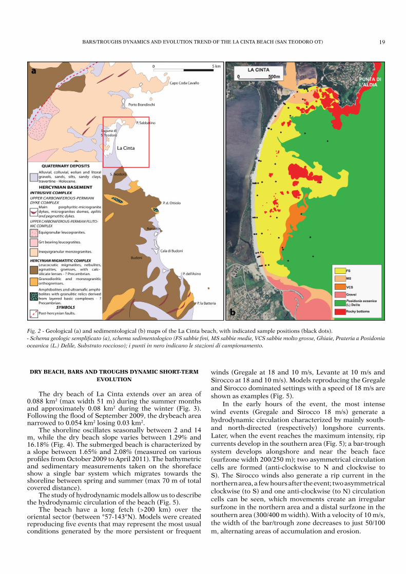
winds (Gregale at 18 and 10 m/s, Levante at 10 m/s and Sirocco at 18 and 10 m/s). Models reproducing the Gregale and Sirocco dominated settings with a speed of 18 m/s are shown as examples (Fig. 5).
In the early hours of the event, the most intense wind events (Gregale and Sirocco 18 m/s) generate a hydrodynamic circulation characterized by mainly south- and north-directed (respectively) longshore currents. Later, when the event reaches the maximum intensity, rip currents develop in the southern area (Fig. 5); a bar-trough system develops alongshore and near the beach face (surfzone width 200/250 m); two asymmetrical circulation cells are formed (anti-clockwise to N and clockwise to S). The Sirocco winds also generate a rip current in the northern area, a few hours after the event; two asymmetrical clockwise (to S) and one anti-clockwise (to N) circulation cells can be seen, which movements create an irregular surfzone in the northern area and a distal surfzone in the southern area (300/400 m width). With a velocity of 10 m/s, the width of the bar/trough zone decreases to just 50/100
m, alternating areas of accumulation and erosion.
Fig. 2 - Geological (a) and sedimentological (b) maps of the La Cinta beach, with indicated sample positions (black dots).
- Schema geologic semplifi cato (a), schema sedimentologico (FS sabbie fi ni, MS sabbie medie, VCS sabbie molto grosse, Ghiaie, Prateria a Posidonia
oceanica (L.) Delile, Substrato roccioso); i punti in nero indicano le stazioni di campionamento.
DRY BEACH, BARS AND TROUGHS DYNAMIC SHORT-TERM
EVOLUTION
The dry beach of La Cinta extends over an area of 0.088 km2 (max width 51 m) during the summer months and approximately 0.08 km2 during the winter (Fig. 3). Following the fl ood of September 2009, the drybeach area narrowed to 0.054 km2 losing 0.03 km2.
The shoreline oscillates seasonally between 2 and 14 m, while the dry beach slope varies between 1.29% and 16.18% (Fig. 4). The submerged beach is characterized by a slope between 1.65% and 2.08% (measured on various profi les from October 2009 to April 2011). The bathymetric and sedimentary measurements taken on the shoreface show a single bar system which migrates towards the shoreline between spring and summer (max 70 m of total covered distance).
The study of hydrodynamic models allow us to describe the hydrodynamic circulation of the beach (Fig. 5).
The beach have a long fetch (>200 km) over the oriental sector (between °57-143°N). Models were created reproducing fi ve events that may represent the most usual conditions generated by the more persistent or frequent

T. BATZELLA ET ALII20
Fig. 3 - (A) Survey lines and shore lines; (B) SPOT 5 satellite view 2009; (C) aerial view of breaches formed through the dry beach (October,
2009).
– (A) Transetti di monitoraggio stagionale e line di riva relative ai rilievi di ottobre 2009, giugno, novembre e aprile 2010. (B) Immagine tratta dallo
SPOT 5 (2009) che evidenzia i varchi creati dall’esondazione della Laguna a seguito dell’alluvione. (C) Particolare dei varchi sul cordone dunare.

BARS/TROUGHS DYNAMICS AND EVOLUTION TREND OF THE LA CINTA BEACH (SAN TEODORO OT) 21
Fig. 4 - Dry beach and shoreface profi les acquired between October 2009 and April 2011.
- Misura delle pendenze della spiaggia emersa e sommersa su tre transetti campione misurati tra Ottobre 2009 e Aprile 2011.
RESULTS
The dry beach and bar/trough zone dynamics were analyzed (Fig. 4) by using data directly acquired in the studied area (bathymetry, sedimentology) and by comparing the mathematical models created using the DELFT 3D.
The Gregale and Sirocco are the winds that generate the widest surfzone. At La Cinta beach the variation is between 200/250 m (18 m/s from Gregale) and 300/400 m (18 m/s from Sirocco) in width.
The currents created by the above-mentioned winds cause mainly longshore transportation in the early hours of the meteo-marine event.
After two hours, rip currents are generated in-shore and off-shore responding to the creation of asymmetrical, clockwise and anti-clockwise circulation cells, locally controlled by rocky outcrops.
Rip currents are formed and develop in the southern sector in case of Gregale-dominated, and in the northern sector in case of Sirocco-dominated scenarios. The slope of the submerged beach varies from 1.75% to 2.08% during the spring, and from 1.65% and 2.06% during the autumn.
The signifi cant regression recorded in 2009 survey was linked to the effects of the lagoon overfl owing, which caused the breach of 25 openings across the dry-beach (25-30 m wide and 1-4 m deep – Fig. 3b – 3c) and destroyed the fi sh farming jettys. The sedimentological, topographical-
bathymetrical data and the hydrodynamic models showed the transportation mechanisms, which contributed to the closing up of the breaches (DE MURO et alii, 2010, BATZELLA et alii, 2011). The acquired data demonstrate the high resilience of this beach, with a tendency to re-establishment the steady state after short relaxation times. It should be noted that the municipality of San Teodoro carried out dragging and restoration of the lagoon mouth during March 2011. The dragged sand was used to artifi cially restore the beach area marked in red (Fig. 3) with the aim to bring back the 2009 shoreline profi le.
In conclusion, the beach studied shows a homeostatic behavior characteristics typical of balanced systems, in fact after the occurrence of a strong fl ood event, the system restores a profi le very similar to their initial conditions, highlighting an elevated resilience occurring during a short-time period of two-year.
ACKNOWLEDGEMENTS
This study is part of two Fellowship grants to Young Researchers Project co-fund PO Sardinia FSE 2007-2013 L.R. 7/2007. The research is also supported by the projects “RIsposta e Adattamento dei sistemi costieri della Sardegna alle variazioni climatiche globali“ R.I.A.S. and Agreement with the OT Province “ Studi e ricerche fi nalizzati alla tutela delle coste - Atlante delle

T. BATZELLA ET ALII22
Fig. 5 - Mathematical models generated by the DELF 3D software.
- Immagini relative agli eventi di Grecale (22° N -18 m/s) e Scirocco (160° N – 18 m/s) generati dal software DELFT 3D con l’utilizzo dei dati
sedimentologici e topografi co-batimetrici rilevati e delle statistiche di vento (direzione e intensità)

BARS/TROUGHS DYNAMICS AND EVOLUTION TREND OF THE LA CINTA BEACH (SAN TEODORO OT) 23
coste della provincia di Olbia-Tempio”.The authors would like to thank Dr. Nicola Louise
Baptist for revising the English text and the Marina di Porto Ottiolu for the logistic help.
REFERENCES
BATZELLA T., PUSCEDDU N., KALB C., IBBA A., FERRARO F. & DE MURO S. (2011) - Bars and troughs dynamic and short-term evolution of two beaches on NE Sardina: La Cinta (San Teodoro, OT) and Budoni (OT). Abstracts, 28th IAS Meeting of Sedimentology
2011, Zaragoza, Spain, 145CARMIGNANI L., OGGIANO G., PERTUSATI P.C., BARCA S., CONTI P.,
SALVATORI I., ELTRUDIS A., FUNEDDA A., PASCI S., (2001) – Carta Geologica della Sardegna, scala 1:200.000.
DE MURO S. & DE FALCO G. (A cura di) (2010) – Manuale per la gestione delle spiagge - Studi, indagini ed esperienze sulle spiagge sarde e corse - University press – Scienze Costiere e Marine, CUEC. ISBN 978-88-8467-629-0, 1-364 (in press).
DE MURO S., PUSCEDDU N., BATZELLA T., IBBA A., FERRARO F., E KALB C. (2010) - Evolution trend of La Cinta beach (San Teodoro) after the fl ooding on 24th September 2009 – Abstract book, Geosed 2010 Torino (Italy), 19th-25th September 2010, 25-26.
Manoscritto ricevuto il 12 Agosto 2011; accettato il 29 Agosto 2011; responsabilità editoriale di Daniela Ruberti e Marco Vigliotti