Meta-Analysis of Drainage Versus No Drainage After Laparoscopic Cholecystectomy

Introduction
Extensive prior research work has been devoted tounderstanding relationship between drainage basinlithology and geochemistry of the drainage systemdeposits. Whether the stream or overbank sedimentswere in focus of investigation, attention was mostly gi-ven to assessment of the geochemical background anddetection of anomalous values which may reflect thepossible mineralization in a survey area (e.g. Rose et al.1970; Bonham-Carter et al. 1987), as well as to quanti-tative modelling of the geochemical variability, dilutioneffects, and sediment provenance (e.g. Jenson andTrautwein 1984; Hawkes 1976; Bonham-Carter andGoodfellow 1984; Carranza and Hale 1997; Moon 1999;Bottrill et al. 1999; Arribas et al. 2000; Rantitsch 2000).Multiple regression analysis is frequently utilized as aparticularly useful mathematical tool relating the par-ticular chemical element to the source terrain lithology.
This choice undoubtedly relies on general agreementthat compositional (chemical or mineral) and otherproperties of alluvial deposits are inseparably relatedwith the drainage basin evolution through the delicateprocess–response relationship and feedback mechanismsin alluvial systems (e.g. Johnsson 1993; Weltje et al.1998; Brunsden 2001; Harvey 2002). In all the abovecases, however, regression models invariably exploit theareal proportions of distinctive lithology outcropping ina catchment basin, usually in the sense of independentvariables. This concept simply disregards the fact that allparts of the drainage basin do not supply its valley andchannel floors with products of weathering and erosionuniformly in space and time. Many parameters interactin scaling the contribution of driving and resisting forcesin drainage basin systems, which causes the sedimentyield to depend not only on the physiographic propertiesof the rocks but also on the character of the processesof denudation. These, in turn, operate on different
Zoran Peh
Slobodan Miko
Marta Mileusnic
Areal versus linear evaluation of relationshipbetween drainage basin lithology and geo-chemistry of stream and overbank sedimentsin low-order mountainous drainage basins
Received: 15 February 2005Accepted: 28 November 2005Published online: 4 January 2006� Springer-Verlag 2006
Abstract The comparison of twomultiple regression models is basedon the assumption that geochemicalcomposition of the drainage basinalluvial sediments is derived pri-marily from the underlying bedrocklithology. The parent material isintegrated with both stream sedi-ment and overbank sediment geo-chemistry via the two essentiallydifferent approaches as regards thedrainage basin geomorphologicaldata: (1) as the relative area ofinfluence representing a portion ofthe catchment basin occupied by aspecific rock type and (2) as the rel-ative ‘‘line’’ of influence representinga narrow zone of the underlying
bedrock traversed by the perennialstreams which form the activestream network. The model com-parison is established on the good-ness-of-fit test for both experimentaldesigns and for the same set of data.Both experiments converge on thelinear approach as the more appro-priate model in evaluating the lith-ologic influence on the analysedsample media in small mountainouswatersheds.
Keywords Drainage basin processes ÆAlluvial sediments Æ Multipleregression analysis ÆZumberak Æ Croatia
Environ Geol (2006) 49: 1102–1115DOI 10.1007/s00254-005-0153-5 ORIGINAL ARTICLE
Z. Peh (&) Æ S. MikoInstitute of Geology, Sachsova 2,P.O. Box 268 10000 Zagreb, CroatiaE-mail: [email protected].: +385-1-6160753Fax: +385-1-6144718
M. MileusnicFaculty of Mining, Geology and PetroleumEngineering, University of Zagreb,Pierottijeva 6,10000 Zagreb, Croatia

temporal and spatial scales with regard to slopes andchannel-reach areas. In the case of perennial uplandstreams the stream channels become directly ‘‘coupled’’with adjacent slopes in the sense that material trans-ported from the slopes is efficiently evacuated furtherdownstream (Church 2002). Thus the erosion pattern,triggered by the vigorous upstream incision, turns thefoot slopes into the zone of greatest activity and prime-order sensibility to change (Brunsden 2001). On theother side, slope areas that lie higher up the hillside, inthe vicinity of the divide, rarely experience energeticgeomorphologic events which together with mitigatingeffects of dense slope and riparian vegetation mayeffectively reduce the amount of regolith reaching thechannel (Owens et al. 1999). Therefore the erodedmaterial, which is transported in various forms of streamchannel load and deposited downstream as stream oroverbank (floodplain) sediment, seldom evenly reflectsthe lithologic characteristics from both drainage basinsubsystems either in chemical or mineral composition.Moreover, wider valleys with alluvium infill in down-stream reaches of a channel usually serve as a bufferzone, decreasing considerably their susceptibility todisturbance from the slope processes (Montgomery andBuffington 1997).
Fitting geomorphological variables into the regressionmodel is essential in order to find a faithful lithologic
expression in the stream and overbank sediment geo-chemistry, especially in view of interfluvial areas thatoccupy a vastly greater portion of the catchment area.Areal approach concerned with relative proportions ofdistinctive lithology in a drainage basin takes into ac-count inappropriately large portions of the entirecatchment characterized by very slow denudation pro-cesses. These, in turn, provide the valley floors with rel-atively small quantities of wasted material over a shorttime interval (geomorphological steady time). In thatcase, accumulation of the sediment load in channels ap-pears to be quite out of phase with erosion and trans-portation processes on far reached upper slopes in thevicinity of watershed, where almost no erosion occurs.We favour the linear approach instead, which takes intoaccount only the narrow zone of distinctive lithologyalong the active stream reaches, expecting a closer rela-tionship between the drainage basin deposits and adja-cent channel floor or bank lithology. Thus, the aim andscope of this work is to compare the two approaches bythe use of the multiple regression model in order toquantify impact of differing lithologies on the content ofa selected set of elements. This is accomplished on thebasis of the goodness-of-fit test applied to the two dif-ferent experimental designs and to the same set of datacontaining the chemical content of stream and overbanksediment samples.
Fig. 1 Shaded-relief image showing location of the study area
1103

Description of the study area
The study area occupies a greater portion of theZumberak region lying in the westward part of Croatia(on the Slovenian border), near the capital, Zagreb.Generally, it is a mountainous system between the riversof Sava, Kupa and Krka consisting of the Zumberak andSamobor Mts. (Fig. 1). The landscape combines manycharacteristics from the two distinct topographic andgeologic provinces, namely Dinaric carbonate terrainwith relatively sparse, undeveloped drainage networkand numerous karstic phenomena on the one side andPannonian highly dissected, mostly non-carbonateterrain on the other. Geologically, Zumberak belongs tothe southwest peripheral part of the Pannonian BasinSystem (Pavelic 2001; Prelogovic et al. 1998) representinga complex terrain with differing tectonic and lithologicsettings. The greatest portion of the study area, lying tothe west (ZumberakMt.), is an uplifted terrain composedpredominantly of carbonate rocks of the Lower Triassicto Upper Cretaceous age. In contrast, eastern portions(Samobor Mt.) are much more tectonically deformedand lithologically diverse, consisting predominantly ofPermian clastics as the oldest rocks in the area. Adiversity of carbonate and siliciclastic facies com-bines together in a fractured mosaic of blocks of differentages, which is for the purpose of this work reducedto a very simplified and parsimonious sketch-map(Fig. 2).
The current mountainous appearance of the Zu-mberak area originated from intense faulting and upliftduring neotectonic phase, particularly since the end ofthe Upper Pliocene (Prelogovic et al. 1998).
Drainage network
Dendritic and centrifugal types of drainage pattern arecharacteristic for the investigated mountainous land-scape. Their origin is primarily tectonic owing to verticalfaults and vigorous uplift during the Pliocene–Pleisto-cene (Prelogovic 1969). As a rule, alluvium-filled valleyscontaining the streams of the fifth- and, more rarely, thesixth-order run along the peripheral mountain faces.Exceptions are the two sixth-order valleys in the centralpart of the Zumberak morphostructure, Bregana andKupcina, capturing majority of the fifth- and lower-or-der intermontane streams (axial streams), which alsocontain depositional flood planes. On the contrary, thefourth-order streams are rarely aggraded due to theirhigh-gradient channels.
The channel-reach processes
The majority of sampled streams in the study areadeveloped a certain type of alluvial channel morphol-ogy. Bedrock channel substrate is found only as an
Fig. 2 Lithologic sketch-mapof the study area (compiledfrom the geological maps afterPlenicar et al. 1969, Sikic et al.1978, and Bukovac et al. 1983):(1) PLQ Plio-Quaternary andQuaternary unconsolidatedsiliciclastic sediments; (2) TCLTertiary clastic sedimentaryrocks; (3) FLS Cretaceousflysch-like series; (4) PCLUpper Palaeozoic–Triassicclastic sedimentary rocks;(5) LIM Limestones, predomi-nantly Jurassic; (6) DOLDolomites, predominantlyMiddle and Upper Triassic;(7) Fault
1104

exceptional case, in so far as the drainage basins offourth- or higher order are concerned. This is of greatimportance because the delicate relationship betweenerosion, transport and deposition of the weatheredmaterial from the slopes depends on the interactionbetween channel and slope processes. The processes inchannels and on adjacent slopes in the Zumberak areaare strongly coupled in the streams with steep channelgradients cut in bedrock (mostly third order or lower).Since interfluvial distances are often considerablyreduced by a progressively branching valley network(often with colluvial substrates where streams arepresent) in the upper reaches of a drainage basinvertical incision and upslope debris flow operate morein unison. The mixing of wasted material from bothenvironments may be so effective as to smooth theimpact of linear and areal aspects of lithology oncompositional variables of the channel sediment. Thisis not the case downstream, where due to the valleywidening and progressively lower gradients the sedi-ment supply from the valley sides can be effectivelycut off. As a result, the processes along the streamchannel exert much greater impact on the bed loadcomposition so that the linear basin aspects figure asthe more suitable geomorphological variable inassessing the influence of bedrock lithology on geo-chemistry or mineralogy of the load. The channelreaches in the investigated area can be classified intothree groups according to their morphology (afterMontgomery and Buffington 1997): the plane-bed and,more rarely, step-pool and intermediate channel-reachmorphologies prevail in the Zumberak interior, whilethe pool-riffle morphology is predominantly periph-eral, particularly in the Kupa catchment area (Fig. 3a–d). Their gradients vary from <0.015 to 0.03 m/m(measured from the sampling sites upstream), whichrepresent typical values for majority of mountaindrainage basins (Tuckfield 1980; Montgomery andBuffington 1997). However, intricate relationship be-tween the bank erosion and character of bed loadmust be treated with caution, mainly in the peripheral,mostly sand-bed streams on the southern slopes ofthe Samobor Mt. which occasionally experience bankfailures, especially under high discharge events (Pehand Miko 2001).
Dry valleys
The function of dry valleys (abandoned streams) in theupper reaches of valley segments should also be dis-cussed to clarify the influence of geomorphologicalvariables in low-order mountainous drainage basins inthe area. In the present time the majority of third- orlower-order valleys occupying the upper portions oflarger drainage basins in the Zumberak area is
streamless (Fig. 3e). Due to the absence of activestreams upland, low-order drainage basin systems areeffectively decoupled and buffered at least at the hills-lope–channel scale (Harvey 2001). Transient flows ofvery low runoff intensity can appear only duringoccasional storms or prolonged precipitation. Clearly,the low-order branches of the recent drainage networkdevoid of stream channels must have been incised ordeepened as a result of greatly increased runoff inten-sity (or decreased vegetation cover) some time in thepast when climatic conditions and subsequent hydro-logical cycle were different (e.g. Gregory and Walling1973; Ollier 1981; Tucker and Slingerland 1997; Bonnetet al. 2001), while coupling with other factors such aslocal and regional uplift may indicate their polygeneticorigin (Hart 1986). Although connection between theclimate change and basin response as it is nowunderstood is not linear because climate conditionshave experienced many fluctuations during the Holo-cene and thus should be geographically circumscribed(Blum and Tornqvist 2000), various palaeoclimaticreconstructions speak in favour of the early- to mid-Holocene humidity followed by the late-Holocenechange to arid conditions, particularly towards thesouthern European regions (e.g. Harrison and Diger-feldt 1991; Davis et al. 2003). After initial rapidexpansion of the drainage network at the end of thePleistocene ice age (the Younger Dryas—Holocenetransition) caused by the strong increase in the amountof annual precipitation and subsequent raise of thewater table, drier conditions prevailed towards thepresent causing the active stream network to contractto its present-day limits. Thus, dry valleys presuppose adiscrepancy between the more restricted extents of thepresent stream pattern with regard to the valley patternwhich it partly occupies (Gregory and Walling 1973).This difference has a major impact on effective cut-offof the higher parts of the mountain drainage basinsfrom the rest of the basin area containing the activestream network with respect to modern geomorpho-logic processes. Some earlier investigations in theadjacent region (Hrvatsko Zagorje, Fig. 1) have shownthat hillslope–channel coupling can be associated withactive stream network only (stream density), while thetotal valley network (drainage density) is related to adifferent subsystem of a drainage basin system as awhole (Peh 1997). The processes of erosion, transportand deposition operate efficiently only in the valleyswith perennial streams while intermittent streams, anddry valleys in particular, contribute little to the recentbasin change. Consequently, the compositional schemeof weathered, transported and deposited load sampledat the basin outlets is more in concordance with recentconditions along the stream channels and their activetributaries than with those in interfluvial areas occu-pied by relic fluvial landforms.
1105

Fig. 3 Most frequent types of the fourth- and fifth-order alluvialchannel-reach morphology in the Zumberak area. a Intermediatebedrock—alluvium channel-reach morphology with distinctivefeatures of cascade and plane-bed alluvial channel types (samplingpoint 350). Dolomites. b Typical plane-bed alluvial channelmorphology characteristic for the intermontane drainage basinsin the west central parts of Zumberak (sampling point 338).
Dolomites. c Typical step-pool alluvial channel characteristic forthe most of the intermontane drainage basins in the east centralpart of Zumberak (Bregana, sampling point 276). Dolomites. dPool-riffle channel morphology on the southwest periphery ofZumberak (sampling point 341). Sands and marls. e Dry valley inthe higher altitudes of the east part of the Zumberak area(Samobor Mt.)
1106

Sampling
Field investigations covered the area of about 600 km2
with 46 fourth- and fifth-order mountain drainagebasins raging in size from 0.65 to 26.00 km2 (Fig. 4). Inmajority of basins, both stream and overbank sedimentswere obtainable for sampling that was ‘‘coupled’’ oneach site wherever possible. Both media were regularlycollected from the same spot within a few meters dis-tance except in cases where valley or channel fill wereabsent. For the six fourth-order drainage basins theoverbank sediment sample was unavailable (cases 4, 7,220, 350, 365 and 367; Fig. 4). In one drainage basin offifth order the stream sediment was not collected (case191). The former case was due to the absence of allu-vium in high-gradient valleys, while in the latter thesediment load was present but not sampled because ofthe obvious household contamination in the vicinity of
the sampling site. Sometimes the fine-grained, silt-claycontent of the bed similar to that of the adjacent banksarouse suspicion about its clear origin and possibleconfusion between sample media, but earlier investiga-tions have shown that this is rarely the case (Peh andMiko 2001). Reducing the number of sampled drainagebasins to 42 in total (with both types of sediments col-lected), the sampling density of one sample per 15 km2
was established over the entire area.The sample sites were selected at the basin outlets,
sufficiently upstream from the confluence with higher (orthe same order) streams in order to avoid sampling thesediment that may result from mixing of material fromthe two channels during the flood flow. Active streamsediment, which represents the composite of the recentlydeposited bed load material, was collected from severalspots (ordinarily 5–10 as recommended by Salminenet al. 1998) over a short channel stretch upstream of the
Fig. 4 Sample map showing the distribution of fourth- and fifth-order drainage basins in the study area
1107

selected site. Simultaneously, a single overbank sedimentsample was taken from approximately the same point atthe exposed area of either bank of a channel. The latteris a composite material collected from the bank sectionranging in height from 25 cm beneath the surface downto the water level (usually 0.5–2 m thick). The topmosthorizon was avoided because of possible anthropogenicdisturbance and pedogenesis (Ottesen et al. 1989). Inboth cases, a quantity of about 3 kg of sediment wascollected to supply enough representative material forsieving and analysis.
Sample preparation
Collected samples were air-dried (at <40�C) forapproximately 3 months. After drying, the samples weredisaggregated in a porcelain mortar, homogenized andfinally dry-sieved through stainless steel screens to thefraction of <125 lm. This fraction was preferred be-cause the highest concentration of most elements, espe-cially trace elements, occurs in the fine-grained, usuallyfrom 63 to 125 lm size fraction (e.g. Rhoads and Cahill1999). Also, some studies show that the <125 lm sizefraction can contribute to more than 95% of the parti-cles in most samples (Swennen et al. 1998).
Analytical methods
Analytical work was performed at the ACME AnalyticalLaboratories in Vancouver (Canada). Samples weresubject to multi-acid digestion ICP analysis and geo-chemical Hg analysis by flameless AA. A total of 36elements were thus analysed with Au, Be, Bi, Mo, U andW having concentrations invariably, and Ag, Sb, Sn andCd mostly under the detection limit so that all these (tenin total) were omitted at the outset from further con-siderations.
Regression analysis
Regression analysis is one of the most often utilizedstatistical techniques in multivariate as well as bivariateanalysis for assessing the relationship between variablesin a data set. In multivariate solutions a multiple linearregression is used to define the simultaneous relationshipbetween one dependent (or response) variable Y againsta number (N) of independent (or predictor) variablesX1)N. The technique is designed to find the ‘‘best-fit’’straight line via the least squares estimation in whichdeviations of the dependent variable from the line areminimized. The problem presented here on which theanalysis is most frequently centred is to assess thecontribution of predictor variables to the overall
regression model. In other words, it may be useful tofind that portion of the total variance in response vari-able which can be explained by a set of predictor vari-ables. This value is usually termed the ‘‘goodness-of-fit’’,or a multiple coefficient of determination (R2), which is,in fact, the multiple correlation coefficient of a particularvariable squared. In the actual case, the content of eachanalysed element represents a particular dependentvariable in a regression model, while the lithologicinfluences, expressed either in the form of areal or linearproportions of a specific rock unit within a drainagebasin, are represented by a set of independent variables.
Variables
An assemblage of 26 elements consisting of 8 major and18 minor and trace elements were selected as dependentvariables in the regression analysis. In order to obtainthe best possible fit to the model a number of thesevariables must have been submitted to the transforma-tion procedure. As a rule, most geochemical and envi-ronmental data do not follow normal (nor lognormal)distribution (Matschullat et al. 2000; Reimann and Fil-zmoser 2000), which is the result of complex non-lineardynamics, feedbacks and thresholds within a systemrepresented by the particular set of variables (e.g. Hug-get 1998; Phillips 1996, 1999; Peh and Miko 2003).Positively skewed frequency distributions were observedamong most of minor and trace elements in both streamsediment and overbank sediment data sets. Accordingly,the conventional normalization procedure using log-transformations was carried out to stabilize their vari-ance, which included Cu, Pb, Zn, Ni, Co, Mn, As, Th,Sr, Ba and Hg. The same procedure was also applied tosome major elements, such as Ti, Mg and P.
Six rock types dominating the terrain lithology werespecified as independent variables in the regressionanalysis (Fig. 2). These are: (1) clastic sedimentary rocksof the Tertiary period (mostly Neogene): TCL; (2) clasticsedimentary rocks of Upper Paleozoic–Triassic: PCL;(3) Cretaceous flysch-like series: FLS; (4) limestones(dominantly Jurassic): LIM; (5) dolomites (dominantlyMiddle and Upper Triassic): DOL; (6) Plio-Quaternaryand Quaternary sediments: PLQ. The above scheme mayseem grossly oversimplified, but it serves its purpose tothe extent to which the great variety of clastic and car-bonate facies is expected to contribute to the overallgeochemical composition of the sample media. Thesimultaneous use of variables belonging to the samerealm of sedimentary rock types, namely dolomites andlimestones, is necessary if one has in mind their stronglycontrasted weathering patterns. Crushed and miloni-tized dolomite rocks represent a typical ‘‘clastic factory’’(Hovius and Leeder 1998) supplying the valley floorswith abundant sediment flux, while limestones resist
1108

physical weathering with much more potency. These sixvariables are given the form of the relative proportionsof each rock unit within a drainage basin, yet, becausecalculated on different background, they formulate thetwo experimental designs employed in this work. Thefirst approach is well known and utilizes the percentageof the area in the drainage basin occupied by distinctivelithology, while the second is more specific and takesinto account its linear proportions along the perennialstreams. In the latter case all blue streamlines have beenscanned from the available topographic map scale1:25,000.
Defined as above, the lithologic variables can be re-garded as a compositional data set whose statisticaltreatment may be met with difficulties because of the so-called constant sum constraint. The nature of data (zerovalues in a number of cases due to the absence of somerock types) ruled out the most frequent way of solvingthe problem using the log-ratios (e.g. Aitchison 1986) sothat initial matrix ill-condition was amended optionally,by dropping out the surplus or ‘‘unnecessary’’ variablefrom the closed data set. The lithologic variable sub-tracted from the original six-variable data set is repre-sented by the youngest rock unit, the Plio-Pleistoceneand Quaternary unconsolidated deposits of variouskinds (mostly of freshwater, fluvial lake origin), which
are the reworked older material of very heterogeneouscomposition, occupying large portions of the peripheralsoutheastern drainage basins. Therefore, the supposedlysmall variance (effected by mixing) contained in the sixthvariable was easily sacrificed in order to solve the com-positional data problem. The remaining five lithologicvariables are considered sufficient to faithfully reflect thebedrock lithology responsible for geochemical behaviourof the examined sample media.
Results and discussion
The results of regression analysis are described sepa-rately for each of the two experimental designs anddisplayed in Table. 1 and 2. The columns in tables rep-resent the values of coefficient of determination R2 andbeta coefficients (b) for independent variables. Tabu-lated data show great difference between the values of R2
ranging from 11% for strontium (areal) to 73% formagnesium (areal), both in stream and overbank sedi-ments. Better insight can be gained by categorizing theR2 values into a number of groups as in the case ofcorrelation coefficients: (1) <0.3 (no correlation); (2)0.3–0.5 (low correlation); (3) 0.5–0.7 (moderate corre-lation); and (4) >0.7 (high correlation). A degree to
Table 1 Summarized results of two experimental designs for stream sediment data
El Linear Areal
R2 TCL PCL FLS LIM DOL R2 TCL PCL FLS LIM DOL
Fe 0.50 ) 0.44 )Ca 0.54 + 0.51 +Mg 0.67 + 0.73 + +Ti 0.24 0.26 ) )Al 0.49 ) ) 0.43 )Na 0.52 ) ) 0.42 )K 0.45 ) 0.41P 0.14 0.20 +Cu 0.37 + 0.30 +Pb 0.63 + 0.63 +Zn 0.45 + 0.47 +Ni 0.64 ) 0.41Co 0.55 ) 0.48 )Mn 0.47 0.45As 0.24 + 0.23 +Th 0.36 ) ) ) ) 0.40 ) ) )Sr 0.13 0.11V 0.50 ) ) ) 0.41 ) )La 0.35 ) ) 0.36 )Cr 0.53 0.46 +Ba 0.52 + 0.61 +Zr 0.59 ) ) 0.58 ) )Y 0.26 ) ) ) 0.26 )Nb 0.42 ) ) 0.41 )Sc 0.53 ) ) ) 0.50 ) )Hg 0.31 + 0.43 +
El element, R2 goodness-of-fit, TCL clastic sedimentary rocks of the Tertiary period, PCL clastic sedimentary rocks of Upper Paleozoic–Triassic, FLS Cretaceous flysch-like series, LIM limestones, DOL dolomites
1109
which the elements are explained by predictor variablesif the two approaches, namely linear and areal, arecompared can be traced more easily this way. Of all 26elements reported in this work only for P and Ti amongmajor, and As, Sr, Y and Nb among trace elements, theR2 values are less than 0.3 implying that more than 70%of their variance are not accounted for by the averagedifferences between lithologic units. Their lithologicorigins are better reflected in overbank sediments com-bined with linear proportions of the parent lithologies,particularly in the case of Ti. Here, it must be observedthat regression designs were narrowed to the variationsin geochemical content due to average differences ingeological background only. Other possibly contributingfactors, such as scavenging by Fe–Mn oxyhydroxides,influence of pH, or anthropogenic impact, were notmeasured and thus not considered in this work. As forthe chemical control, forcing Fe and Mn into regressionequation as independent variables (simultaneously withrock units) in order to account for variation amongchemical elements, particularly trace metals, would notbe analytically justified due to their relatively high con-tent in the non-carbonate parent lithology. Also, similarinvestigations demonstrated only minor chemical con-trol of Fe–Mn oxyhydroxides in low-order catchment
basins, compared to lithology (e.g. Carranza and Hale1997).
The relationship between linear and areal approachesis quite clear from the regression results summarized asthe tabulated values of R2 (Table 3; Figs. 5, 6). Thegreater portion of the examined elements falls within
Table 2 Summarized results of two experimental designs for overbank sediment data
El Linear Areal
R2 TCL PCL FLS LIM DOL R2 TCL PCL FLS LIM DOL
Fe 0.67 + 0.62 +Ca 0.56 + 0.45 +Mg 0.69 0.72Ti 0.56 ) 0.45 )Al 0.47 ) 0.37Na 0.47 ) 0.37 )K 0.48 0.43 +P 0.22 + 0.16 +Cu 0.55 + + + 0.53 +Pb 0.54 + 0.59 +Zn 0.48 + + 0.42 +Ni 0.59 + 0.42Co 0.70 + + 0.64 + + +Mn 0.46 + + 0.38 + +As 0.46 + 0.38 +Th 0.42 ) 0.39 )Sr 0.21 0.17V 0.45 ) 0.34La 0.40 ) 0.31 )Cr 0.62 + 0.47Ba 0.55 + 0.53 +Zr 0.57 ) 0.48Y 0.21 0.16Nb 0.39 ) 0.24Sc 0.51 ) 0.40Hg 0.52 + 0.62 +
El element, R2 goodness-of-fit, TCL clastic sedimentary rocks of the Tertiary period, PCL clastic sedimentary rocks of Upper Paleozoic–Triassic, FLS Cretaceous flysch-like series, LIM limestones, DOL dolomites
Table 3 Tabulated values of goodness-of-fit (R2) for both regres-sion models
R2 Linear Areal
Stream sediments<0.3 Ti, P, As, Sr, Y Ti, P, As, Sr, Y0.3–0.5 Al, K, Cu, Zn,
Mn, Th, La,Nb, Hg
Fe, Al, Na, K, Cu, Zn, Ni,Co, Mn, Th, V,La, Cr, Nb, Hg
0.5–0.7 Fe, Ca, Mg, Na, Pb,Ni, Co, V, Cr, Ba, Zr, Sc
Ca, Pb, Ba, Zr, Sc
>0.7 –– MgOverbank sediments
<0.3 P, Sr, Y P, Sr, Y, Nb0.3–0.5 Al, Na, K, Zn,
Mn, As, Th, V, La, NbCa, Ti, Al, Na, K, Zn,Ni, Mn, As, Th, V, La,Cr, Zr, Sc
0.5–0.7 Fe, Ca, Mg, Ti, Cu, Pb,Ni, Cr, Ba, Zr, Sc, Hg
Fe, Cu, Pb, Co, Ba, Hg
>0.7 Co Mg
1110
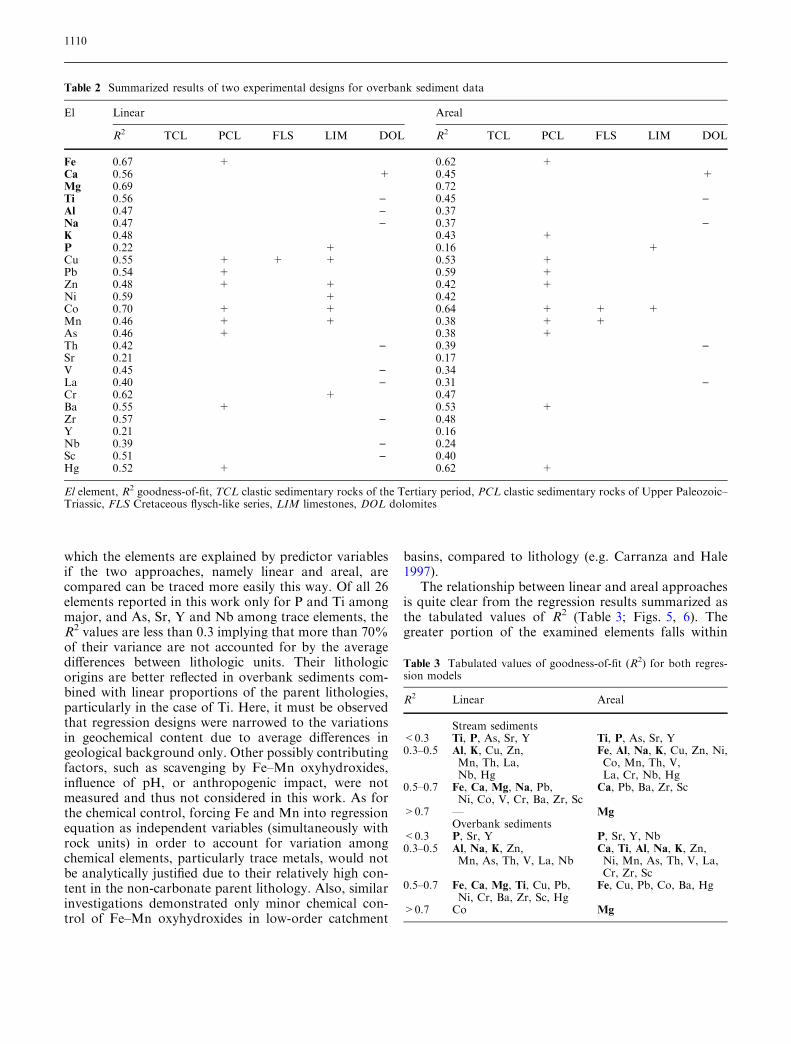
two categories, either of low (0.3–0.5) or moderate (0.5–0.7) explicatory potential, regardless of the experimentaldesign. However, variation in geochemical content isclearly better explained by the use of linear instead ofareal approach, since a number of elements switch theirgroup opting for the ‘‘linear’’ when their R2 values arecross-compared. This is particularly characteristic of Caand Ti concerning major, and Cr, Zr, Sc and Ni con-cerning trace elements. Explicative potentials of Nb andCo are also considerably increased while Mg remainsfirmly associated with areally defined bedrock lithologyassuming the constant supply of dolomite debris, spa-tially unconstrained due to its distinctive weatheringpattern. Dominance of linearly over areally definedlithologic signature in the sample media is even more
apparent if the R2 values for the two experimental de-signs are represented as their difference that may be ei-ther positive or negative (R2 linear ) R2 areal).Figures 5 and 6 speak in favour of linear design, which isconsiderable in the case of overbank sediments sinceonly Mg, Pb and Hg appear at variance with the generalscheme. The overbank sediment is, as expected, morecontrasting background to discriminate between the tworegression models. This arises mainly from the fact thatoverbank sediments, produced during the major floodevents which affect the whole stream network upstreamof the sampling site, are characterized by much morewidespread origin and thus represent a large number ofsediment sources that have been active at different times(Ottesen et al. 1989; Bølviken et al. 2004).
Fig. 5 Linear versus areal pro-portions of lithologic influencein stream sediments expressedas R2 difference (R2 linear ) R2
areal): a major elements; b traceelements
1111

Relationship to source lithology
Impact of parent lithology as a source of various ele-ments in alluvial media can be deduced from regressioncoefficients (b) given in Table. 1 and 2. Only the sign ofsignificant b values is highlighted in correspondinglithologic columns denoting increased or decreased shareof the predictor variables (rock units) in the regressionmodel (element content).
A number of minor and trace elements derive theirorigin from the clastic sedimentary rocks of the UpperPaleozoic to Lower- and Middle Triassic age (PCL). Theb coefficients for this rock unit are always positive, sig-nalling that trace metals such as Fe, Cu, Pb, Zn, Co, Cr,Mn, As, Hg and also Ba are hosted in these rocks mostlyin the sulphide-rich layers or veins in the fine-grained
sandstones. This mineralization is prominent in thecentral parts of the Samobor Mt. (Rudarska Gradna,sample point 43) usually in the form of small-scale sid-erite–haematite–sulphide ore bodies with chalcopyrite,cinnabarite and galena–barite paragenesis (Sinkovec1971; Siftar 1989). It can be traced regularly in bothalluvial media and in both regression models.
The b coefficients are not necessarily positive whenother rock types are considered. This is especially char-acteristic for dolomite bedrock with which most ele-ments, except Ca and Mg, are negatively associated.Negative values are characteristic of elements whosecontent is generally at odds with present lithology, suchas Fe, Ti, Al, Na, V, La, Zr, Nb and Sc in DOL, Th inthe FLS if statistically significant, as well as Al, Na, Th,V, Zr, Nb and Sc in the TCL. Thorium is negatively
Fig. 6 Linear versus areal pro-portions of lithologic influencein overbank sediments ex-pressed as R2 difference (R2
linear ) R2 areal): a major ele-ments; b trace elements
1112

correlated with all bedrock types where the b coefficientsare statistically significant, though its lithologic origin isaccounted for by 42% at the most. Statistically signifi-cant b values require careful consideration whereverlithologic controls poorly explain the variations in geo-chemical data, as in the case of phosphorus. Barely 22%of its variation is explained by lithological control shownby significant positive correlation with limestones (inoverbank sediments) and Tertiary clastites (in streamsediments). In contrast, the highest portion of explainedvariance for Mg (over 70%) of all examined elements isat odds with non-significant regression coefficients (inoverbank sediments) in both experimental designs. Bothcases indicate weak lithologic controls suggesting, withregard to magnesium, that the sediment influx with Mg-containing minerals derives in equal proportions fromall rock types, not only dolomite (see Table. 1 and 2).On the other hand, in stream sediments Mg is positivelyrelated to dolomites and limestones (where these occurinterbedded with dolomites as carbonate rocks of sec-ondary importance) which can be ascribed to the selec-tive power of low-order streams precipitating thesuspended load not far from the eroded reaches of thechannel and valley sides.
Characteristic association of the trace elementgroup (including Cu, Zn, Ni, Co, Cr and Mn) with thelimestone bedrock (Table 2) gives rise to a long-dis-puted problem of the sediment supply from theweathering-limited ‘‘hard’’ rocks, particularly in car-bonate terrains (Durn et al. 1999; Miko et al. 1999). Incontrast to the ‘‘soft’’ rocks (including dolomites),which are readily decomposed, implying that the soilformation is not required for erosion (Leeder et al.1998), limestones predispose some kind of influx ofweathered material from different geochemical sur-roundings. In the steep, small intramontane drainagebasins typical of the Zumberak area the regolithdeveloped on limestones is probably allochtonoussuggesting that associated trace elements must be re-lated to a different rock unit. However, such relation-ship is not observed in the stream sediment data(Table 1) implying that the finer silt-clay topsoilmaterial with the bulk of the trace element content iseasily dispersed in suspension and deposited as theoverbank sediment downstream. The linear approach isagain stressed as a suitable, geochemically contrastingregression model, pointing to the channel reach as theprimary receptacle for the drainage basin forms andprocesses.
As seen from the regression results the Cretaceous(FLS) and Tertiary siliciclastic rocks (TCL) can be easilydisregarded as the source repository for most of theexamined elements. This is especially characteristic ofthe former where almost all b coefficients are non-sig-nificant, while the latter exhibit negative correlationswith a number of elements. Most of them, Al and Na
including, are negatively regressed. The fact that theelement content in stream sediments varies in a negativerelationship with FLS and TCL lithologies in bothexperimental designs can be explained by a differentscenario in which the high-energy, low-order streamsrunning through the unconsolidated and highly erodibleTertiary siliciclastic rocks easily wash away the fine-grained particles containing clay minerals. None of theexamined elements in overbank sediments is significantlyassociated with these rocks, which may be indicative oftheir depositional history—to a degree the Tertiaryclastic rocks represent the older reworked material therecent alluvium derives from the Tertiary clastics (orboth) recycled and mixed within the area where the latteroccupy wider expanses of the Zumberak region (low-lands on its southeastern periphery). Furthermore, non-significant b values characterizing majority of indepen-dent variables in both regression models may beunderstood as a lack of response the geochemical com-position of alluvial sediments exhibit concerning climaticor physiographic controls on sediment production dur-ing the late Holocene.
Conclusions
The two regression models were examined assuming aclose relationship between geochemical composition ofalluvial sediments and average composition of the bed-rock lithology and the soil mantle in low-order moun-tainous drainage basins. Integration of drainage basinlithology with both stream sediment and overbank sed-iment geochemical data suits was carried out using twodistinctive approaches: (1) the zone of influence occu-pying the whole basin area upstream and upslope fromthe sampling site and (2) the ‘‘line’’ of influence repre-senting a narrow zone along the perennial streams of theactive stream network upstream and upslope from thesampling site. The two experiments propose the ‘‘linear’’approach as a model providing better backgroundfor evaluating lithologic controls on geochemistry ofthe analysed sample media (88 vs. 62% of examinedelements). This is explained by strong erosive andtransporting power of the water running through thewell-defined channel network which is characteristic ofthe Zumberak heartland. A number of dry valleys inupper basin reaches also contribute to the process, astheir geomorphologically inactive floors considerablyreduce the available area required for continuous sedi-ment supply and transport of weathered material downto the lower parts occupied by perennial and intermit-tent streams.
Important results of regression analysis relatinggeochemical composition of the drainage basin alluvialproducts to the source terrain lithology can be brieflysummarized as follows:
1113
• Low goodness-of-fit values for elements like P and Srindicate that their lithologic origins are effectivelyscreened by other factors not accounted for by theregression models.
• Mg is, as the best-fitted element, steadily associated tothe areally defined bedrock lithology (tectonicallypredisposed weathering pattern).
• Trace elements (Cu, Pb, Zn, As, Hg, Ba) derive theirorigin from the Palaeozoic and Lower Triassic silici-clastic rocks (PCL) as indicated by statistically sig-nificant positive b values.
• A bulk of elements does not display significant asso-ciations with specific lithologic variables such as the(Cretaceous) FLS and LIM.
• Negative element associations are typical for DOLand TCL.
• Affinity of a group of trace elements—Cu, Zn, Ni, Co,Mn and Cr—for limestones indicates their allochtho-nous relation to bedrock.
The regression results acquired in this study indicatethat the geochemical signature of drainage basin
sediments primarily signals the basin parent lithologybut patterns of compositional variations are not easy toassess as these depend on a variety of processes. Al-though the better fit of ‘‘linear’’ model highlights thechannel processes as a primary factor responsible forcompositional adjustments of alluvial sediments, agreater number of basin predictor variables are neededto clarify the specific geochemical behaviour of analysedelements. Generally, overbank sediments act as a betterreceiver of multivariate geochemical supply signals fromthe study area. This would focus the similar studies ofthe small-scale provenance analysis of alluvia to moredetailed bedrock lithology and other variables includedwhich will encapsulate all relevant local–regional geo-morphological and other earth-surface processesresponsible for its geochemical composition.
Acknowledgments This study was funded by the Ministry of Sci-ence, Education and Sport, Republic of Croatia, Project #0181006—the basic Geochemical Map of Croatia. Their support isgreatly appreciated.
References
Aitchison J (1986) The statistical analysis ofcompositional data. Chapman & Hall,London
Arribas J, Critelli D, Le Petra E, Tortosa A(2000) Composition of modern streamand sand derived from a mixture ofsedimentary and metamorphic sourcerocks (Henares River, Central Spain).Sediment Geol 133:27–48
Blum MD, Tornqvist TE (2000) Fluvialresponses to climate and sea-levelchange: a review and look forward.Sedimentology 47(Suppl 1):2–48
Bølviken B, Bogen J, Jartun M, LangedalM, Ottesen RT, Volden T (2004)Overbank sediments: a natural bedblending sampling medium for large-scale geochemical mapping. Chemo-metrics Intell Lab Syst 74:183–199
Bonham-Carter GF, Goodfellow WD(1984) Autocorrelation structure ofstream-sediment geochemical data:interpretation of Zn and Pb anomalies,Nahanni River area, Yukon-NorthwestTerritories, Canada. In: Verly G et al(eds) Geostatistics for natural resourcescharacterization, pt. 2. Reidel, Dordr-echt, pp 817–829
Bonham-Carter GF, Rogers PJ, EllwoodDJ (1987) Catchment basin analysisapplied to surficial geochemical data,Cobequid Highlands, Nova Scotia. JGeochem Explor 29:259–278
Bonnet S, Besnard M, Van Den DriesscheJ (2001) Drainage network expansionof the Salagou drainage basin (S.France): an example of relief responseto recent climate change? Terra Nova13:214–219
Bottrill LJ, Walling DE, Leeks GJ (1999)Geochemical characteristics of over-bank deposits and their potential fordetermining suspended sediment prov-enance; an example from the River Se-vern, UK. In: Marriott SB, AlexanderJ (eds) Floodplains: interdisciplinaryapproaches. Geological Society SpecialPublications 163. Geological Society,London, pp 241–257
Brunsden D (2001) A critical assessment ofthe sensitivity concept in geomorphol-ogy. Catena 42:99–123
Bukovac J, Susnjar M, Poljak M, CakaloM (1983) Geology of Crnomelj sheet.Basic geological map of Yugoslavia,1:100000. Institute of Geology Zagreband Geoloski Zavod Ljubljana, Beo-grad (Federal Institute of Geology) (inCroatian; English summary)
Carranza EJM, Hale M (1997) A catchmentbasin approach to the analysis ofreconnaissance geochemical-geologicaldata from Albay Province, Philippines.J Geochem Explor 60:157–171
Church M (2002) Geomorphic thresholdsin riverine landscapes. Freshw Biol47:541–557
Davis BAS, Brewer S, Stevenson AC, GuiotJ, Data Contributors (2003) The tem-perature of Europe during the Holocenereconstructed from pollen data. Qua-ternary Res Rev 22:1701–1716
Durn G, Ottner F, Slovenec D (1999)Mineralogical and geochemical indica-tors of the polygenetic nature of terrarossa in Istria, Croatia. Geoderma91:125–150
Gregory KJ, Walling DE (1973) Drainagebasin form and process. Edward Ar-nold, London
Harrison SP, Digerfeldt G (1991) Europeanlakes as palaeohydrological and palae-oclimatic indicators. Quaternary SciRev 1:233–248
Hart MG (1986) Geomorphology pure andapplied. George Allen and Unwin,London
Harvey AM (2001) Coupling betweenhillslopes and channels in upland fluvialsystems: implications for landscapesensitivity, illustrated from the HowgillFells, northwest England. Catena42:225–250
Harvey AM (2002) Effective timescales ofcoupling within fluvial systems. Geo-morphology 44:175–201
Hawkes HE (1976) The downstream dilu-tion of stream sediment anomalies. JGeochem Explor 6:345–358
Hovius N, Leeder M (1998) Clastic sedi-ment supply to basins. Basin Res 10:1–5
1114
Hugget RJ (1998) Soil chronosequences,soil development, and soil evolution: acritical review. Catena 32:155–172
Jenson SK, Trautwein CM (1984) Defini-tion of multivariate geochemical asso-ciations with polymetallic mineraloccurrences using a spatially dependentclustering technique and rasterizedstream sediment data—an Alaskanexample. Abstracts with program. InSymp. Assoc. Explor. Geochem., RenoNev., 25–28 March 1984
Johnsson MJ (1993) The system controllingthe composition of clastic sediments. In:Johnsson MJ, Basu A (eds) Processescontrolling the composition of clasticsediments. GSA Spec Paper 284, pp 1–19
Leeder MR, Harris T, Kirkby MJ (1998)Sediment supply and climate change:implications for basin stratigraphy. Ba-sin Res 10:7–18
Matschullat J, Ottenstein R, Reimann C(2000) Geochemical background—canwe calculate it? Environ Geol 39(9):990–1000
Miko S, Durn G, Prohic E (1999) Evalua-tion of terra rossa geochemical baselinesfrom Croatian karst regions. J Geo-chem Explor 66:183–197
Montgomery DR, Buffington JM (1997)Channel-reach morphology in moun-tain drainage basins. GSA Bull109:596–611
Moon JC (1999) Towards a quantitativemodel of downstream dilution of pointsource geochemical anomalies. J Geo-chem Explor 65:111–132
Ollier CD (1981) Tectonics and landforms.Longman, London
Ottesen RT, Bogen J, Bølviken B, Volden T(1989) Overbank sediment: a represen-tative sample medium for regional geo-chemical mapping. J Geochem Explor60:257–277
Owens PN, Walling DE, Leeks GJL (1999)Use of floodplain sediment cores toinvestigate recent historical changes inoverbank sedimentation rates and sedi-ment sources in the catchment of theRiver Ouse, Yorkshire, UK. Catena36:21–47
Pavelic D (2001) Tectonostratigraphicmodel for the North Croatian andNorth Bosnian sector of the MiocenePannonian Basin System. Basin Res12:359–376
Peh Z (1997) Frequency distribution curvesas an indicator of evolutionary trends ingeomorphological systems: a case studyfrom the northwest part of HrvatskoZagorje (Croatia). Geol Croat 50/1:79–88
Peh Z, Miko S (2001) Geochemical com-parison of stream and overbank sedi-ments: a case study from Zumberakregion, Croatia. Geol Croat 54/1:119–130
Peh Z, Miko S (2003) Geochemical back-ground in Istrian soils. Nat Croat12(4):195–232
Phillips JD (1996) Deterministic complex-ity, explanation and predictability ingeomorphic systems. In: Thorn CE,Rhoades B (eds) The scientific nature ofgeomorphology: Proceedings of the27th Binghamton symposium in geo-morphology. Wiley, Chichester, pp315–335
Phillips JD (1999) Earth surface systems:complexity, order, and scale. Blackwell,Malden
Plenicar M, Premru U, Herak M (1969)Geology of Novo Mesto sheet. Basicgeological map of Yugoslavia,1:100000. Geoloski zavod Ljubljana,Beograd (Federal Institute of Geology)(in Croatian; English summary)
Prelogovic E (1969) Neotectonic move-ments in the area of Orlica, Samoborand Medvednica Mts. (in Croatian;English summary) Geoloski Vjesnik23:151–161
Prelogovic E, Saftic B, Kuk V, Velic J,Dragas M, Lucic D (1998) Tectonicactivity in the Croatian part of thePannonian basin. Tectonophysics297:283–293
Rantitsch G (2000) Application of fuzzyclusters to quantify lithologic back-ground concentrations in stream-sedi-ment geochemistry. J Geochem Explor71:73–82
Reimann C, Filzmoser P (2000) Normaland lognormal data distribution ingeochemistry: death of a myth. Conse-quences for the statistical treatment ofgeochemical and environmental data.Environ Geol 39(9):1001–1014
Rhoads BL, Cahill RA (1999) Geomor-phological assessment of sediment con-tamination in an urban stream system.Appl Geochem 14:459–483
Rose AW, Dahlberg EC, Keith ML (1970)A multiple regression technique foradjusting background values in streamsediment geochemistry. Econ Geol65:156–165
Salminen R, Tarvainen T, Demetriades A,Duris M, Fordyce FM, GregorauskieneV, Kahelin H, Kivisilla J, Klaver G,Klin H, Larson JO, Lis J, Locutura J,Marsina K, Mjartanova H, Mouvet C,O’Connor P, Odor L, Ottonello G,Paukola T, Plant JA, Reimann C,Schermann O, Siewers U, Steenfelt A,van der Sluys J, de Vivo B, Wiliams L(1998) FOREGS geochemical mappingfield manual. Geological Survey ofFinland, Guide 47
Siftar D (1989) The age of evaporates andthe origin of sulfate at Rude near Za-greb (in Croatian; English summary).Geoloski Vjesnik 42:59–64
Sikic K, Basch O, Simunic A (1978) Geol-ogy of Zagreb sheet. Basic geologicalmap of Yugoslavia, 1:100000. Institutof Geology Zagreb, Beograd (FederalInstitute of Geology) (in Croatian;English summary)
Sinkovec B (1971) Geology of the iron andcopper ore deposit at Rude near Sam-obor (in Croatian; English summary).Geoloski Vjesnik 24:165–181
Swennen R, van der Sluys J, Hindell R,Brusselmans A (1998) Geochemistry ofoverbank and high-order stream sedi-ments in Belgium and Luxembourg: away to assess environmental pollution.J Geochem Explor 62:67–79
Tucker GE, Slingerland R (1997) Drainagebasin responses to climate change. Wa-ter Resour Res 33:2031–2047
Tuckfield CG (1980) Stream channel sta-bility and forest drainage in the NewForest, Hampshire. Earth Surf Pro-cesses Landforms 5:317–329
Weltje GJ, Meijer XD, de Boer PL (1998)Stratigraphic inversion of siliciclasticbasin fills: a note on the distinction be-tween supply signals resulting fromtectonic and climatic forcing. Basin Res10:129–153
1115
Copyright © 2022 FDOKUMEN