Archaeological Overview Assessment of the Squamish Forest ...
248
Archaeological Overview Assessment of the Squamish Forest District TECHNICAL REPORT Submitted to: The Ministry of Forests, Squamish Forest District and Archaeology Branch, Ministry of Small Business, Tourism and Culture (pennits 1997-85, 1997-112, 1997-119) In-SHUCK-chIN' Quat' qua Li}'wat Nation Musqueam Band Sto:lo Nation Canada Squamish Nation (pennit 1996-12) Tseil-Waututh First Nation by: Millennia Research Ltd. #204-10114 McDonald Park Road, North Saanich, B.C. V8L 5X8 Telephone: (250) 656-0450 Fax: (250) 656-0453 July 30, 1997
-
Upload
khangminh22 -
Category
Documents
-
view
3 -
download
0
Transcript of Archaeological Overview Assessment of the Squamish Forest ...

Archaeological Overview Assessment ofthe Squamish Forest District
TECHNICAL REPORT
Submitted to:
The Ministry of Forests, Squamish Forest District
and
Archaeology Branch, Ministry ofSmall Business, Tourism and Culture(pennits 1997-85, 1997-112, 1997-119)
In-SHUCK-chIN'Quat'quaLi}'wat Nation
Musqueam BandSto:lo Nation Canada
Squamish Nation(pennit 1996-12)
Tseil-Waututh First Nation
by:
Millennia Research Ltd.#204-10114 McDonald Park Road,
North Saanich, B.C. V8L 5X8Telephone: (250) 656-0450
Fax: (250) 656-0453
July 30, 1997

SupervisorDirector
Report Authors
First Nations Liaison
GIS Modelling
Trail Research
Editing
Field Crew
Project Credits
Morley EldridgeTanja Hoffmann
Tanja HoffmannMorley EldridgeRob VincentJennifer LindbergTina ChristensenDavid O'ReganAlexMaas
Tanja HoffmannD'AnnOwens
Steve LipscombSean WhitfordTimberline Forest Inventory ConsultantsLtdMorley Eldridge
RobDiazTad MacIlwraithMeredith BogleTraditions Consulting Services Inc.
Morley EldridgeTanja HoffmannRod IstaceKat RobertsPeter DadyAlexMaasTanja Hoffmann, David O'Regan, TinaChristensen, Kat Roberts and Peter DadyMillennia ResearchAmelia, Alan Jr, Des, John Sam, JohnJames, Charles, Deb Morice DePoli, DougHudson and all other participants from InSHUCK-chJohnnie Abraham, Elmer Dan, JohnnyJones, and Sue Montgomery for Lil 'watNaitonRudy Riemer for Squamish Nation
Final ReportMillennia Research 2
Squamish Forest District ADAJuly 3D, 1997

Acknowledgements
A project of this size and scope involves the time and commitment ofa great manypeople. First and foremost we must thank Diane Reed of the Squamish Forest District,Ministry ofForests for her dedication to this project and the patience she exhibited at allstages ofthe AOA.
We must also thank those First Nations who welcomed Tanja to their territories andtreated me with so much respect and kindness. We wish to thank Johnny Jones of theLiI'wat Nation for his friendship, guidance and understanding and Elmer Dan and JohnnieAbraham for their in-field expertise and patience. In addition we would like toacknowledge the guidance and support we received from Lyle Leo, Grace Prasad, SueMontgomery, and the Lil'wat Forestry office staffduring my time in the Lil'wat community.Sara Brown and Shannon Squire are also deserving of thanks for their warm hospitalityduring Tanja's trips to the Pemberton area.
Heather Myles of Sto:lo Nation Canada has provided valuable comments andsuggestions throughout the course of the last year. Thank you Heather!
We must also thank Tony Moody, Randal Louis and the Squamish Nation for theirunderstanding and patience. Thanks is extended to Rudy Reimer for his excellent fieldwork. In addition, Arnoud Stryd, at meetings with the Squamish Nation, provided muchappreciated guidance regarding the application ofthe archaeological potential model in theSquamish Nation territory.
Leona Sparrow ofthe Musqueam graciously provided her comments andsuggestions for the project.
The staff at the In-SHUCK-chlN'Quat'qua welcomed Tanja into their midst anddeserve special thanks. In particular, Collete Hogue, treaty analyst for In-SHUCKchlN'Quat'qua and Doug Hudson, anthropologist, gave oftheir time and expertise whichhas been greatly appreciated. Thanks must also go to the people ofSkookumchuck andBaptiste Smith for welcoming our crew. Dez, John Sam, John James, Amelia, Allan Jr., andall the other participants deserve special thanks for provding us with a great deal ofhelp inthe field.
Special thanks must go to Steve Lipscomb and Sean Whitford at Timberline for theirpatience and guidance throughout this project. We credit much of the success of thisproject to their hard work and dedication.
Doug Glaum at the Archaeology Branch provided a great deal of much neededadvice and throughout the course of this project has exhibited patience and fortitude in theface ofmy never-ending stream of questions. Thank you Doug.
Trail research for the Squamish AOA was done by Rob Diaz and Tad MacIlwraithof Traditions Consulting Services Inc. with the assistance ofMeredith Bogle. Thanks isextended to them for their assistance and hard work. In addition John Spittle ofNorth
Final ReportMillennia Research 3
Squamish Forest District ADAJuly 30, 1997

Vancouver spent an afternoon ofhis time discussing trails with me and provided some veryinteresting information for the AOA. Thank you Mr. Spittle.
Finally, I (Tanja) must thank the staff at Millennia Research for putting up with myoccasionally incoherent rumblings and surplus energy. Morley Eldridge provided overallguidance, support and technical expertise for the project; thank you Morley! Appreciationand thanks must be extended to the members ofMillennia staff who contributed to thisreport, they include: D'Ann Owens, David O'Regan, Kat Roberts, Tina Christensen,Jennifer Lindberg, Peter Dady and Rob Vmcent. In addition, special thanks goes to RodIstace and Alex Maas for their editing assistance and to Donna Eckert for keeping all ofourlives in order.
Final ReportMillennia Research 4
Squamish Forest District AOAJuly 30, J997

Management Summary
In January of 1996 Millennia Research was contracted to conduct an ArchaeologicalOverview Assessment (AOA) of the Squamish Forest District (Archaeology Branch Permits1997-085, 1997-112, 1997-119; Squamish Nation Permit 1996-12). In conjunction withTimberline Forestry Consultants, Millennia produced a model and a series of I :20,000 scalepotential maps which delineate areas of archaeological potential within the boundaries of theSquamish Forest District.
The model used to produce the potential polygons for each site type (habitation,rock art, sub-alpine camp and culturally modified tree [CMT]) was based upon sets ofvariables which were determined to be consistent for a particular site type (i.e. habitationsites are likely to be located close to water on a relatively flat piece ofland etc.). Allvariables for each site-type model were loaded into the GIS and, using TRIM data,topographic and elevation information, the GIS produced maps which detail polygons ofhigh and moderate potential. Low potential areas are considered to be all those notdifferentiated as moderate or high.
Following the application of the original model, base-line data in the form ofrecorded (at the Archaeology Branch) and known (to the First Nations) sites were used totest the model. Initial analysis revealed that a majority ofthe recorded and known siteswere not being caught in archaeological potential polygons. Consequently, model variableparameters were adjusted and reapplied in order to ensure that the majority of known siteswere caught and also to increase the chance that similar, unrecorded sites would be caught.
In-field testing of the model revealed that the GIS generated potential maps closelypredicted the landscape and delineate areas of archaeological potential. However, the fieldtests provided some data upon which refinements for individual models were made.Particularly it was shown that the slope from TRIM maps was too generalized for the RockArt Model and therefore this model was abandoned.
The Squamish AOA has resulted in a series ofmaps which delineate areas ofarchaeological potential. The final maps are labelled as high, medium or low potential.
It is recommended that all areas identified as high potential for archaeological sitesbe subject to an AlA and areas ofmoderate potential a RECCE. Although not required, itis strongly recommended that RECCEs be conducted under an Archaeology Branch permitso as to maintain a standard methodological approach and quality results. Minimummethodological requirements for both AlAs and RECCEs are presented in therecommendations section of this report.
Areas defined as high or moderate potential for CMTs only can be subjected to anCMT Inventory as opposed to an AlA or RECCE. CMT inventories can be conducted byforestry personnel and/or First Nations individuals trained in CMT identification andrecording.
Final ReportMillennia Research 5
Squamish Forest District AOAJuly 30, 1997

Table of Contents
PROJECT CREDITS 2
ACKNOWLEDGEMENTS 3
MANAGEMENT SUMMARY 5
TABLE OF CONTENTS 7
LIST OF FIGURES 10
LIST OF TABLES 10
INTRODUCTION 12
RELEVANT LEGISLATION 14
Information Conjidentiality 14PROJECT TEAM 16REPORT FORMAT 18TERMINOLOOY 19STUDY OBJECTIVES AND LIMITATIONS 19
Predictive Modeling in Cultural Resource Management 19THE PREsENT STUDY 22
DISCUSSIONS WITII mE FIRST NATIONS 23
ARCHAEOLOOICALCONSULTATION 23COMMON THEMES 23
PROPOSED PROJECT 25
PROPOSED DEVELOPMENTS AND POTENTIAL IMPACTS TO ARCHAEOLOOICAL SITES 25Logging 25Access Roads 26Ancillary Developments 26Reforestation 27
NATURAL FACTORS LEADING TO THE DEGRADATION OR DESTRUCTION OF ARCHAEOLOOICAL SITES 27Avalanching 27Landslides 27Contemporary andAncient Glacial Action 27Flooding and Spring Run-ofJ. 28
STUDY AREA 29
lNTRoDUCTlON 29PREsENT BIOPHYSICAL CONTEXT 29
Biogeoclimatic Zones 30PALAEOGEOGRAPHy 32
Palaeoclimate and Palaeoecology: Models 33Effects ofPalaeoenvironmental Change on the Archaeological Record 34Modem Alterations to the Environment 35
•SQUAMISH AOA MEmODOLOGY 39
MODELLING METHODOLOGy 39
PREDICTIVE MODELLING 39
DEFINmONS OF HIGH, MEDIUM AND Low POTENTIAL 40
Final ReportMillennia Research 7
Squamish Forest DistrictAOAJUly 30, 1997

GIS Layers and Coverage 40Dataset 1 41Site Types andModels 43Dataset11.. 45Anecdotal Information Layer 45
FIELD WORK METHODOLOGy 46
DOCUMENTARY RESEARCH RESULTS 49
ETHNOGRAPHICLITERATURE REVIEW 49Linguistic and Cultural Classifications 49Central Coast Salish , 52Squamish 52Mainland (Upriver and Downriver) Halq ·emylem 63General Halq'emylem Ethnographic Description 64Interior Salish 76Liluet 76The Lower Lillooet (Liluet) 77
PREVIOUS ARCHAEOLOGY IN mE STUDY AREA ._...•.•.•..•..•.....•.....•.....•....•......_....•.•..•..•..•.••••.85
REGIONAL CULTURAL SEQUENCES••_ 85
CoASTAL CuLTURAL HISTORY 85Old Cordilleran (ca. 9000 - 5500 B.P.) 86Charles Phase (ca. 5500 - 3500 B.P.} 86Locamo Beach Phase (ca. 3500 - 2500 B.P.) 88Marpole Culture Type (ca. 2500-1000 B.P.} 90Strait ofGeorgia Culture Type (ca. 1000 - 200 B.P.) 92
SUMMARY OF COASTAL CuLTURE HISTORY 93INTERIOR CuLTURE HISTORY 94
Early Period (ca. 12,000-7000 BP} 94The Middle Period (ca. 7000 to 3500 BP) 95The Late Period (ca. 3500 to 200 BP) 96Shuswap Horizon (ca. 3500-2400 BP) 97Plateau Horizon (2400-1200 BP) 97Kamloops Horizon (1200-200 BP} 98
SUMMARY OF INTERIOR CuLTURE HISTORY 98
PREVIOUS ARCHAEOLOGICAL INVESTIGATIONS 101
COASTALZONE 101
Howe SoundArea 102Cheakamus River Valley 103Squamish River Valley 104Mamquam River '" 105Soo River 105Harrison Lake 106
INTERIOR ZONE 106
Lillooet Loke 106Lillooet River Valley 107Melvin Creek Valley 108Ure Creek 108Pemberton Valley 109Echo Lake 110Gates River 110Kelly Lake to Cheekye 110
Final ReportMillennia Research 8
Squamish Forest District AOAJuly 30. 1997
Darcy-Birken Area IIISummary 112
ARCHAEOLOGICAL CORRELATES 113
MARmMEZONE(MZ).....•...•....•.••.......................•••..•.•..•....•..................•..•....•.•..•....•.............•.........•........ 114
Siruciures (MZ) 114Resource Acquisition Sites (MZ) 114
VALLEYBOTIOMZONE .•....................•.•...............................•................................................................... 115
Coastal Valley Bottom Zone (CVB) 116Siruciures (CVB) 116Burials (CVB) , 117Resource Acquisition Sites (CVB) 118Interior Valley Bottom Zone (lVB) 119Siruciures (lVB) 119Burials (1VB) 120Resource Acquisition Sites (1VB) 120Trails (1VB) 120RockArt (lVB) 121
MONTANE 121
Coastal Montane Zone 121Siruciures (CM) 121Resource Acquisition Sites (CM) 122Trails (CM) 122Interior Montane Zone 122Siruciures (lM) 122Resource Acquisition Sites (1M), 122Trails (1M) l 123
SUBALPINE ; 123
Coastal Subalpine Zone 123Siruciures (CS) 124Resource Acquisition Sites (CS) 124Trails (CS) 124Interior Subalpine Zone (1S) 124Siruciures (1S) 125Resource Acquisition Sites (1S) 125Trails (1S) 126
ALPINE 126
Coastal Alpine Zone (CA) 126Siructures (CA) 126Resource Acquisition Sites (CA) 126Trails (CA) 127Interior Alpine Zone (lA) 127Siruciures (lA) 127Resource Acquisition Sites (lA) 127Trails (lA) 128
SUMMARY OF ARCHAEOLOGICAL CoRRELATES 129
ARCHAEOLOGICAL CORRELATES AND MODELDEVELOPMENT 130
MODELLING RESULTS 132
REsULTS OF THE COMPARISON OF SITE LocATION ACCURACY BETWEEN ORIGINAL SITE FORMS, CIllN AND
ARCHAEOLOGY BRANCH PLoTS 133
PREUMINARYBASELINEDATA TEST OF THE MODELS 136
FIELD-WORK RESULTS 138
Final ReportMillennia Research 9
Squamish Forest DistrictADAJuly 30, 1997

Fieldwork in In-SHUCK-ch Traditional Territory 138Potential RatingAssessment 0/In-SHUCK-ch Traditional Territory Survey Areas 139Fieldwark in LiI'wat Nation Territory 143Potential Rating Assessment 0/LiI'wat Traditional Territory Survey Areas 143Fieldwork in Squamish Traditional Territory 148Potential Rating Assessment o/Squamish Traditional Territory Survey Areas 148
FIELDWORK AsSESSMENT SUMMARY 152
PoTENTIALRATING ACCURACY 153
EVALUATION AND DISCUSSION•••••••••••••••••••••••••••" " •••••••••••••••••••••••.-••.-••••••••••••.-•••" •••••••••••••••• 156
RECOMMENDATIONS 158
OVERAlLMANAGEMENT RECOMMENDATIONS FOR THE SQUAMISH AOA 158
MANAGEMENT OmONS 158
LEVELS OFFI.rruRE WORK 159
Recommendations/orfUture model refinement: In-house 160Recommendations/orfUture model refinement: Extemal 160
MINIMUM STANDARDS FOR ARCHAEOLOGICAL IMPACT AsSESSMENTS (AlA) AND RECONNAISSANCE (RECCE)I61
REFERENCES CITED 164
APPENDIX 1: LE'ITER OF INTRODUCTION TO TIlE FIRST NATIONS 175
APPENDIX 2: TIlE HERITAGE CONSERVATION ACT 176
APPENDIX 3: GLOSSARY OF TERMS 177
APPENDIX 4: ARCHAEOLOGY BRANCH GUIDELINES FOR ARCHAEOLOGICALOVERVIEW ASSESSMENTS 178
APPENDIX 5:TRAIL ROUTES WITIIIN TIlE SQUAMISH FOREST ~ 179
APPENDIX 6: MAPS OF SURVEY TRANSECTS AND POTENTIAL POLYGONS ASSESSEDDURING FIELD WORK IN IN-SHUCK-CH. LIL'WAT AND SQUAMlSH TRADmONALTERRITORIES. .- 180
List of FiguresFigure 1. The Squamish Forest District. 13Figure 2. Biogeaclimatic zones within the Squamish Forest District. 36Figure 3. Geological time scale relating to the Pacific Northwest (from Valentine et al. 1978:20). __ 38Figure 4. Illustration o/Coast Salish Plank house from H. Stewart (1984:64). 70Figure 5. Illustration o/typical Interior Salish pithouse taken from B.C. Heritage Series (n.d.), Vol III:
Interior Salish, pp.20. 82
Final ReportMillennia Research 10
Squomish Forest District AOAJuly 30, 1997

List of TablesTable 1. Culturally Modified Tree (CMT) Model 44Table 2. Habitation Model 44Table 3. Rock Art Model 44Table 4. Sub-Alpine Camp Model 45Table 5. Linguistic Divisions ofFirst Nations in the Squamish Forest District. (From Thompson and
Kincade 1990). 51Table 6: Current Culture History Models for the GulfofGeorgia andInterior Plateau culture areas. _ 100Table 7. Archaeological site types recorded within the Squamish Forest District. 132Table 8: Archaeological Site Discrepancies 135Table 9. Potential polygon assessmentfor In-SHUCK-ch Traditional Territory 140Table 10. Sites revisited or recorded and potential ratings in In-SHUCK-ch Traditional Territory__ 142Table 11. Potential polygon ratingsfor Lil'wat Traditional Territory 144Table 12. Sites revisited or recorded andpotential ratings in LiI'wat Traditional Territory 147Table 13. Potential polygon ratingsfor Squamish Traditional Territory· 149Table 14. Sites revisited or recorded and potential ratings in Squamish Traditional Territory 152Table 15. Number and Type ofHigh andModerate Potential Polygons Assessed during fieldwork by
ff~it~mThmwry IBTable 16. Potential Polygon Rating Alterations based on Fieldwork 155
Final ReportMillennia Research 11
Squamish Forest District AOAJuly 30, 1997

INTRODUCTION
In January of 1996, The Ministry ofForests (Squamish Forest District) contracted
Millennia Research to conduct an Archaeological Overview Assessment (AOA) ofthe
Squamish Forest District. Millennia Research subcontracted Timberline Forestry
Consultants to provide their GIS expertise. Summaries ofethnographic sources,
archaeological research, historical records, and resource localities in the Squamish Forest
District were commissioned as part ofthe project. These and other data were analyzed and
used to create a predictive model. A GIS system was used to apply the model and produce
archaeological potential maps at a 1:20,000 scale.
The Squamish Forest District is located in south-western British Columbia (see
Figure 1) and encompasses portions offive First Nations territories. Discussions were
initiated with the Musqueam Nation, the Lil'wat Nation (Mount Currie Band), the
Squamish Nation, the Tsleil-Waututh Nation (Burrard Band), the In-SHUCK-chIN'Quatqua
Treaty Task Group, and the Sto:lo Nation at the commencement of this project. Meetings
were held with all but the Tsleil-Waututh Nation.
The purpose ofthe archaeological overview is to predict site potential within the
Forest District to determine where further archaeological work is required so that
archaeological interests might be taken into account in the Forest District planning process.
Archaeological predictive modelling is a means offocusing limited archaeological
management resources on locations that are believed to have the greatest potential for
cultural and archaeological significance.
A large part of the Squamish Forest District has never been examined by
archaeologists for archaeological/heritage values, and it was therefore necessary to base
some ofthe present predictions on data collected from similar environmental contexts
elsewhere in the vicinity. A broad range of information sources were consulted, including
published and unpublished archaeological, ethnographic, historical, archival, geological,
geomorphological, biophysical, and palaeoenvironmental literature. In addition, the First
Nations whose territories encompass portions of the Forest District provided guidance and
information which assisted with the research and modelling process. Although predictive
modelling can assist in the planning process by attempting to focus archaeological efforts it
is no substitute for strict inventory and should not be used as such.
Final ReportMillennia Research 12
Squamish Forest District AOAJuly 30, 1997

Vancouver
[stand
Figure 1. - .- - ---: -~;~restDistrict.The Squamls
K al ReportIn . R searchMillenma e 13
t District AOASquamish Fares July 30, 1997

Relevant Legislation
According to the British Columbia Forest Practices Code Act (1994) and the
Ministry ofSmall Business, Tourism and Culture andMinistry ofForests Protocol
Agreement on the Management ofCultural Heritage Resources (1997), cultural heritage
resources are recognized as integral components ofProvincial lands. The Protocol
Agreement states that "cultural heritage resources will be managed so that their inherent
values are protected, maintained, or enhanced according to the principles ofintegrated
resource management" (Section 3.3). These statements comply with, and are subject to the
Heritage Conservation Act (1994), section 6, which states:
• Archaeological sites within the province ofBritish Columbia, whether on privateor public lands, are protected by the Heritage Conservation Act (the Act);
• It is against the law to damage, desecrate or alter an archaeological site inBritish Columbia unless under a permit issued by the Archaeology Branch;
• Sites which date prior to 1846 are automatically protected under the Act.; and;• Certain sites such as burials and rock art are protected regardless ofage.
Penalties under the Act• Individuals who knowingly or unknowingly disturb an archaeological site are in
contravention ofthe Act and are subject "to a fine of not more than $50,000 orto imprisonment for a term ofnot more than 2 years or to both. (the Act Section31(3)(a) 1995:47).
• Corporations who knowingly or unknowingly disturb an archaeological site aresubject to a fine of not more than $1,OOO,OOO"(theAct Section 31(3)(a),(b)1995:47).
• Furthermore, the Act (section 31.(4) 1995: 47) states that "ifa corporationcommits an offence under this Act, an employee, officer, director or agent ofthe corporation who authorized, permitted or acquiesced in the offence alsocommits the offence and is liable [to the penalties outlined above]".
The Archaeology Branch, which is part of the B.C. Ministry of Small Business, Tourismand Culture is responsible for administering the Act. The Archaeology Branch is located inVictoria, B.C. and should be contacted for further information regarding the Act. A copy ofthe Act is included in Appendix 2 ofthis report. The Act is also included in the BritishColumbia Archaeological Impact Assessment Guidelines copies ofwhich are available fromthe Branch upon request
Information Confidentiality
When gathering cultural heritage information for an archaeological overview
assessment, several confidentiality issues must be addressed. Knowledge concerning the
location and nature ofcultural heritage sites is considered very sensitive and many First
Final ReportMillennia Research 14
Squamish Forest DistrictAOAJuly 30, 1997

Nations groups are reluctant to release it. However, because a successful AOA depends
largely on the amount ofdetailed information we are able to access, consultation with First
Nations is essential. Due to the reluctance on the part ofFirst Nations to release culturally
sensitive information, confidentiality clauses must be established so that any information theFirst Nations are willing to provide is not indiscriminately disseminated. In an effort toprovide some information confidentiality, known and recorded (at the Archaeology Branch)
site locations along with other types of traditional use information have been plotted on a
map layer available for 'view-only' purposes at the Ministry ofForests office.
While it is necessary for licencees and other developers to know the general location
ofarchaeological sites in development areas so that they may avoid impact to those sites,
they do not need to know site details. The district manager will have a copy ofsite
locations (identified by Borden number) plotted on 1:20,000 map sheets so that developersmight be apprised ofthe presence ofarchaeological sites in their development areas. Ifdevelopers wish to obtain more details concerning site type and use they will have to make
an information request through the Archaeology Branch or, in the case of known but
unrecorded (at the Branch) sites, with the appropriate First Nation(s).
This type ofconfidentiality clause is supported by section 3.0.3 ofthe Heritage
Conservation Act (Appendix 2) which states that confidentiality regarding cultural heritage
can be respected:
3.0.
(3) Despite tbe Freedom of Information and Protection ofPrivacy Act, tbe minister may refuse
to disclose information in tbe Provincial beritage register an otber information in tbe administration of this
Act or tbe Museum Act ifany of tbe following apply:
(a) disclosure oftbe information could, in Ibe opinion oflbe minister, result in damage to or
interfere witb tbe conservation ofa heritage site or beritage object.
(b) disclosure oftbe information would violate an agreement made under section 3.1;
(c) anthropological information that is of traditional social, spiritoal or otber cultural importance to
a living community
Final ReportMillennia Research 15
Squamish Forest District AOAJuly 30, 1997

(i) was obtained under conditions 'of confidentiality, or
(ii) is confidential at tbe request of representatives of tbe community wbose beritage
is represented by the information.
(4) The inspection of information in the Provincial heritage register is subject to reasonable
conditions the minister may impose and, without limiting the generality of the foregoing, the minister may
require payment ofa prescribed fee to inspect the information (emphasis added).
Furthermore, the Act states that:
3.3 If, with respect to any matter affecting the conservation ofa heritage site or heritage object
referred to in section 6(2), there is a conflict between this Act and any other Act, this Act prevails.
For more information regarding these and other aspects of the Heritage
Conservation Act please contact the Archaeology Branch, Ministry ofSmall Business and
Tourism.
Project Team
Millennia Research
Millennia Research is a finn specializing in archaeological and ethnographic
consulting. Formed in 1984, the finn has provided professional expertise to First Nations,
private forest and oil sector companies, Federal and Provincial government ministries andsmaller companies and developers. Some ofour areas ofexpertise include: archaeological
overview assessments; archaeological impact assessments; culturally modified tree research;
waterlogged "wet site" research; GIS applications; tradition use site inventories;
archaeological impact assessments, and management oflarge-scale archaeological
inventories.
Millennia Research currently has 14 professional employees and support staff. We
maintain Revenue Canada accounts, Worker's Compensation coverage, and extensiveliability insurance.
Timberline Forest Inventory Consultants Ltd.
Timberline Forest Inventory Consultants Ltd is a Canadian based forestry
consulting finn specializing in forest resource inventory. The company commenced
Final ReportMillennia Research 16
Squamish Forest DistrictAOAJuly 30, 1997

operation in 1971 with the initial emphasis on providing high quality timber cruising data for
valuation and planning purposes. The need to assist forestry clients in improving their
T.F.L. inventory data bases was recognized in the late 1970's and the firm began major re
inventory projects for a number of interior B.C. T.F.L. holders.
Extensive capabilities to process and analyze forest inventory data were developed
during the 1980's, including a major commitment to Unix based work station technology
which is now an industry standard. Service bureau functionality in terms ofcruise
compilation, log profile prediction, and timber supply analysis, was established during this
period.
A significant expansion occurred in 1985 with the acquisition ofTimberline's
mapping affiliate Aero Geometries Ltd., which is a major supplier ofdigital and
conventional map products to the forestry, mining, and engineering industries and to a
variety ofgovernment agencies. Aero Geometries is now the second largest supplier of
digital base maps to the B.C. Ministry ofLands, Parks and Environment under the TRI.M.Project.
The introduction ofworkstation based ArclInfo GIS capability was initiated in 1987
and a long term commitment was made to support and develop applications within this
environment. The mapping division has experienced tremendous growth over the last 6
years as the demand for GIS services has increased. Since 1987, the number ofGIS
workstations (ArclInfo software operating on SunSPARC stations) has increased to 15,
with network connections to the other workgroups within the company. Timberline has
extensive practical experience with database design, digital mapping, and data analysis
gained over the past ten years in short and long-term projects.
Increasing levels of responsibility from clients in north central B.C. and Alberta
culminated in the establishment of offices in Prince George and Edmonton in 1982 and 1990
respectively. These offices maintain a full complement of staff and equipment to support
their local client base.
An ever increasing demand for mapping, growth and yield, and resource analysis
expertise led to the acquisition ofadditional analysis staffand the opening ofthe Victoria
office in February 1993.
Timberline currently employs a staffof approximately 100 computer professionals,
foresters, forestry technicians, geographies, and photogrammetrists.
Final ReportMillennia Research 17
Squamish Forest District AOAJuly 30, 1997

Report Format
The following document constitutes the technical report as required by the terms of
reference for the Squamish Forest District ADA. This report is intended to provide a
detailed technical and background summary for the Squamish ADA. Attempts have been
made to ensure that this report is as clear and understandable as possible, however a shorter
report has been prepared which summarizes this larger, technical document in lay terms and
should be consulted ifa briefoverview ofthe project is required.
Proceeding this introduction, a summary ofstudy objectives and limitations arepresented followed by a description ofmeetings and discussions held with each ofthe First
Nations whose territories encompass portions ofthe Squamish Forest District. The Study
Area section presents a biophysical, paleogeographical and paleoenvironmental summary of
the Forest District. This section is intended to provide a physical context for model
building.
The Ethnographic Background section is a summary ofavailable literature
concerning the lifeways ofthe First Nations within the Forest District. Descriptions ofFirstNations Iifeways are arranged by linguistic division as that is how they are organized in the
literature. It should be noted that the ethnographic section is simply a summary ofliterature
and does not necessarily reflect the manner in which contemporary First Nations peoples
would describe their ancestor's Iifeways and history.
The History ofArchaeological Research in the Study Area section provides a brief
description ofthe cultural sequences archaeologists have compiled over the last several
decades. These cultural sequences represent archaeological interpretations ofpopulationshifts and culture change for the province. Following the culture history section is a
description ofprevious archaeological work summarized by drainage area. The next or,
Archaeological Correlates section is intended to correlate the environmental, ethnographic
and archaeological information with geographic region. The correlates section is vital to
model building as it provides the background upon which site location predictions can be
made.
The Modelling Methodology section outlines the manner in which the predictive
model was developed and implemented. This section contains the technical descriptions of
the GIS along with an overview ofthe different layers developed for the ADA. In addition,
the methodology used for the field testing ofthe model is presented.
Final ReportMillennia Research 18
Squamish Farest District AOAJuly 30, 1997

The Evaluation and Discussion portion ofthe report is intended to provide a
summary ofthe results of the ADA and a discussion ofthose results.
Finally, the Recommendations section provides recommendations for furtherarchaeological studies, justification for that work and guidelines for in-field testing ofthemodel.
Terminology
This technical report is intended to provide a detailed summary of all the information
used to formulate and apply the archaeological potential model for the Squamish ADA.
Many ofthe following sections contain terms which are specific to particular fields ofstudysuch as geomorphology, biology and archaeology. While we have made every attempt to
ensure that the following report is readable, it is occasionally necessary to include technical
. terms, the definitions ofwhich may not be widely known. Such technical terms are included
in the Glossary included in Appendix 3 ofthis report. The shorter summary report which
accompanies this technical report is written in lay terms and should be consulted if one is
interested in gaining a broad rather than detailed understanding ofthe project.
Study Objectives and Limitations
The primary objectives of an ADA are to:
• summarize available information regarding site types and distribution within agiven study area
• develop a predictive model based on the known information; and finally;• using the predictive model, delineate areas ofarchaeological potential so that
archaeological resource management can be incorporated into forestry planningprocesses.
The ADA process is a relatively new one and as such has a number oflimitations.These limitations are outlined and discussed in detail below.
Predictive Modeling in Cultural Resource Management
The concept of"predictive modelling" has been hotly debated in the archaeological
community for a number ofyears, and many published papers discuss the merits and
limitations ofits application (DeBloois 1985; Kobler 1985; Mierendorfet a1. n.d.). Much of
the controversy seems to stem from different interpretations ofwhat a predictive model is,
and what it can (and cannot) do. Predictive modelling does not necessarily imply the
Final ReportMillennia Research 19
Squamish Forest District AOAJuly 30, 1997

use of so-called "objective" statistical techniques to determine where archaeological
sites will be found. In the simplest sense, a predictive model can entail observing patterns
ofknown archaeological sites across the landscape, and using that information to intuitivelysuggest where other sites will be found. Years ofarchaeological survey have provided afairly substantial body ofinformation on site locations in some parts of the province (at least
in certain environmental zones), and some site distribution patterns can be identified. This
information, together with knowledge shared by First Nations people and others,
ethnographic documents, historical accounts and other data, can provide a good general
understanding ofwhat types ofarchaeological sites are likely to exist in a given area, where
they may be found, and why they are there.
The sophistication ofa predictive model is dependent on the quantity and quality of
available data. For most parts of the province, we do not know enough about site
distributions to successfully employ complex statistical models. However, simple non
mathematical modelling often can be effective for identifYing particularly sensitive areas,
allowing further investigation prior to land-altering development. Subsequent sampling and
in-field "ground truthing" is required to test the hypotheses used to create the model, and to
provide both positive and negative data that can help to refine it. This is particularly true
for forested environments, where site visibility, poor preservation oforganic materials, and
a limited body ofdetailed archaeological and ethnographic data are constraining factors.
In summary, site location modelling is a means offocusing limited archaeological
management resources on locations that are believed to have the greatest cultural and
archaeological significance. Modelling can be an effective resource management tool, and
can help to ensure the protection ofmany archaeological sites. It is not, however, a
substitution for field survey. Models predict the potential for sites to be present in a
given area, but field investigations are required to actually locate and record the sites.
No model can account for the locations of all sites or even all site types, because to do sorequires not only an understanding ofthe complex cultural activities that produce the sites,
but also detailed knowledge of post-depositional processes that affect site preservation, the
various site location methodologies used by different archaeologists, and different
interpretations ofexisting site distribution data (Kohler 1985). Some archaeological sites
will be missed by any sampling method, and some ofthem may be destroyed by
development. This limitation is inherent in modelling and overview assessments, and it
cannot be avoided without complete survey ofall potential development zones - a goalthat would, at this time, be impossible to achieve.
Final ReportMillennia Research 20
Squamish Forest District AOAJuly 30, 1997

Some other limitations of this study and similar overview assessments are listed
below, but others could be added.
1. Many ofthe inferences made about pre-contact aboriginal sites are based upon
ethnographic documents that were produced by non-aboriginal ethnographerswith a somewhat limited understanding ofindigenous cultures;
2. Both the documentary and l!1"chaeological records represent only a fraction of
the cultural systems they seek to describe and explain;
3. The time allowed for this study is insufficient to permit an exhaustive review of
the literature or adequate First Nations consultation. This is a common problem
with cultural resource management work and, while it is understandable in
practical terms, it nevertheless limits the completeness ofthe product. Acomplete heritage overview assessment requires many months, or years, of
research and consultation;
4. Archaeological overview assessments are preliminary studies which are subject
to review and revision;
5. Many ofthe data that are valuable for predicting archaeological site potential
(e.g., detailed palaeoenvironmental syntheses, fish habitat data, and terrainmaps) do not exist for large areas of the province and therefore are not available
for modelling purposes;
6. There is no standard method for archaeological modelling in British Columbia,
and several consulting firms are operating under similar, but somewhat variable
research designs. The consequences in terms ofcompatibility ofdata are yet to
be determined, and;
7. Definitions and boundaries ofwhat constitutes 'meaningful consultation' are notclearly outlined at the outset ofmany AOA projects. Consequently, the type of
consultation required for an archaeological project is overshadowed by First
Nations concerns regarding wider issues such as information confidentiality,
aboriginal rights, and MoFlFirst Nations relations - issues which we, as
archaeologists are not prepared, nor able to, deal with. Much ofthe initial
discussion time for the present project was centred around establishing a
relationship within which consultation could occur. An outline ofwhat
Final ReportMillennia Research 21
Squamish Forest DistrictAOAJuly 30, 1997

Millennia Research considers to be stages ofarchaeologica11y oriented
consultation is presented in the 'First Nations Discussion' section ofthis report.
The Present Study
With the above methodological limitations in mind, this study uses available lines of
evidence to predict, as accurately as possible, which areas ofthe Squamish Forest District
are most likely to contain archaeological concerns, so that more detailed investigations can
be focused on those areas prior to development.
The research design aimed to evaluate the Forest District in terms ofthe probability
that archaeological sites would be present, preserved, and could be located in the field. The
assessment was focused on archaeological sites, (Le., places with physical evidence of
human occupation or use), and it did not include a traditional land use component although
. the data from traditional land use studies undertaken in previous years was accessed.
Many aboriginal activities did not leave physical evidence oftheir occurrence, and
much ofthe material culture that was left behind has not been preserved. Therefore, the
material evidence that we may find in the archaeological record provides only a glimpse of
the true nature ofpast cultural systems. A detailed ethnoarchaeologica1/traditionalland use
study could contribute greatly to our understanding ofpre-contact occupation and use of
the study area.
Final ReportMillennia Research 22
Squamish Forest District AOAJuly 30, 1997

DISCUSSIONS WITH THE FIRST NATIONS
The following section outlines the manner in which First Nations were contacted
and also includes a summary of some ofthe common themes which emerged during those
meetings.
ArchaeologicalConsuUaUon
As discussions with the First Nations continue, it has become apparent thatconflicting views regarding the definition ofconsultation exist. Although it is not possible
for Millennia Research to define consultation in a comprehensive sense, we feel it is
necessary to outline the process we envisioned for the Squamish AOA. To clarifY: the
consultation process during the Squamish AOA was guided by the following processes of
introduction, discussion and collaboration.
1. Introduction - First Nations with interests in the Squamish Forest District werecontacted by Millennia research via phone and letter on April 29, 1996. The letter (seeAppendix One) outlined the AOA as proposed by Millennia Research and included acompany profile, a list of references and a request to meet with representatives oftheFirst Nations to discuss the project further. Following this letter, phone calls were madein an attempt to organize meetings with the First Nations.
2. Discussion - Throughout the last several months meetings have been held with all butone ofthe First Nations whose territories encompass portions of the Forest District.These meetings constituted a face-to-face introduction to the project. Discussion atthese meetings has centred around project objectives, limitations, expectations andprocedures.
3. CoUaboration - For the Squamish AOA, consultation in an archaeological senserequires discussions centred around specific cultural heritage in a given territory.
Common Themes
During the course ofdiscussions with First Nations for the Squamish AOA several
common themes emerged. It should be noted that the majority ofconsultation time was
spent in only three (LiI'wat, In-SHUCK-ch and Squamish) of the six First Nations with
interests in the Squamish Forest District. Tseil-watulth First Nation did not respond to ourphone calls or requests for meetings nor did they comment on drafts of this report. One
meeting was held with Leona Sparrow ofthe Museqeam Nation and one with Heather
Myles at Sto:lo Nation Canada.
Final ReportMillennia Research 23
Squamish Forest DistrictAOAJuly 30, 1997

The following is a list of common concerns which were brought up at various
meetings with the First Nations whose territories encompass portions ofthe Squamish
Forest District. 1
• ADAs are too site speeific and require that archaeological sites be separatedfrom other kinds ofcultural land uses. First Nations representatives stated thatADAs should be conducted in conjunction with, or following Traditional UseStudies.
• ADAs should be contracted out to First Nations who would then subcontract archaeologists for the necessary technical support. There was someconcern that a great deal of money was being given to archaeologists when thearchaeological sites they are studying and attempting to locate are under thetraditional jurisdiction of the First Nations. First Nations representativesexpressed their desire to chose, or at the very least, recommend an archaeologistto work in their territory.
• ADAs do not provide enough time or funding for field testing of potentialmodels and maps.
• Potential models are built on a very general basis and do not take intoaccount culturally specific land-use practices for the different First Nationswhose territories encompass portions ofthe Forest District.
• Many First Nations representatives expressed their frustration regarding thereferral process for ADAs and other MoF management procedures. Theserepresentatives stated that since many First Nations do not, at this time, have thefinancial and staffing resources available to deal with the Forestry and otherindustry referrals, they do not feel able to fully participate in resourcemanagement in their traditional territories.
• The level of consultation by archaeologists in First Nations communities isinadequate. Many of the First Nations representatives stated that an establishedrelationship between the archaeologists and the communities they are workingwith was essential ifan ADA was to have any credibility or acceptance amongFirst Nations peoples.
1 It should be noted that the proceeding summary has been compiled by the author and as such should not betaken as representative ofall the concerns each First Nation has about the Squamish AOA or the AOAprocess in general.
Final ReportMjlJennia Research 24
Squamish Forest District ADAJuly 30, 1997

PROPOSED PROJECT
The Squamish Forest District has requested the following Archaeological
Overview Assessment so that they can address archaeological concerns in their planningand management processes. Development aspects which may impact archaeological
resources are discussed below as are the potential impacts those developments may have
on the physical condition ofvarious kinds ofarchaeological sites.
Proposed Developments and Potential Impacts to Archaeological Sites
Mackie and Eldridge (1992:82-85) present a good summary ofpotential land
altering impacts associated with timber harvesting and related development activities.
Relevant sections oftheir discussion are repeated below. Also discussed below are some
natural factors which can lead to the destruction ofarchaeological sites. It should be
noted however, that the ADA commissioned by the Squamish Forest District is intended
to assist with land-use management planning ofall types within the mandate and physical
boundaries ofthe Forest District, not just harvesting and associated silvicultural activities.
Logging
Different logging methods can create varying levels ofdisturbance to
archaeological sites, although logging itselfis often less destructive than associated,
developments such as road building, landing construction and even silviculture. Since all
logging methods will destroy culturally modified trees, this discussion is most pertinent
with regard to buried or surficial archaeological deposits and features.
Hand falling has little effect on archaeological deposits, and it may indeed be less
destructive than windfalls, which can tum up sediments containing cultural deposits.Heavy equipment used in mechanical falling, in contrast, may severely impact the ground
and any archaeological sites or features lying on or near the surface.
Yarding techniques have more potential for impact than falling techniques,
depending on topographic and weather considerations. Helicopter logging is by far the
least harmful to archaeological sites, but this method is not always feasible.
Standard high-lead yarding may reduce the potential for damage to archaeological
sites by lifting logs at least partially clear of the ground. The use ofa carriage to increase
clearance is beneficial, and a high-lead system is generally preferable to a low-lead.
Final ReportMillennia Research 25
Squamish Forest DistrictAOAJuly 30. 1997

However, the use ofheavy equipment at landing areas associated with this yarding
technique can significantly disturb any archaeological sites present. Grapple yarding can
add an additional source of surficial disturbance through the use ofa backspar to traverseareas without roads.
Skidders can cause severe ground disturbance, and even horse skidding can cause
some surficial damage to archaeological sites. However, this problem - and those
associated with many other yarding techniques - can be mitigated by restricting
operations in archaeologically-sensitive areas to winter, when the ground is frozen and
preferably covered with snow.
Access Roads
Logging roads, particularly mainlines, pose one ofthe most serious threats to
archaeological sites because they often cover large areas, and they tend to follow subdued
terrain which was generally favoured for past human use. Road building produces severe
disturbance to the ground, and can completely destroy archaeological sites very quickly.
Eldridge (1989) also showed that road locations tend to correspond more closely with
CMT locations than a random sample from nearby areas. This suggests that ease of
access may have been an important factor in aboriginal logging and forest harvesting - an
inference that has been supported by recent studies conducted by Millennia Research(Bailey 1996).
Mackie and Eldridge (1992) also point out that a potential indirect adverse effect
ofroad construction is increased public access to archaeological sites. Site vandalism is a
serious concern in many regions ofBritish Columbia, and it is an issue ofgreat importance
to many First Nations.
Ancillary Developments
Associated land-altering developments, such as log landings and sorting grounds
can impact archaeological sites through terrain levelling and heavy equipment traffic. In
addition, landing sites tend to correspond with flat or more subdued terrain, which has a
higher potential for archaeological sites.
Final ReportMillennia Research 26
Squamish Forest District AOAJuly 30, 1997

Reforestation
Reforestation techniques may be second only to road construction in their potential
to damage archaeological deposits. Slash piling using bulldozers and skidders can severely
disturb the ground, as does stump removal. Scarification has obvious negative
implications for archaeological sites, as it is specifically designed to disturb the groundsurface. Tree planting, thinning and pruning, in contrast, should have relatively little effect
on archaeological sites.
Natural Factors Leading to the Degradation or Destruction ofArchaeological SUes
Avalanching
Archaeological sites in high alpine areas may be partially or completely destroyedby avalanches; however it may be possible that some artifacts would be located at the
bases ofavalanche chutes.
Landslides
Landslides are likely to effect sites in steep areas where terrain stability is variable
or unstable. Landslides of particular note include talus slopes, especially those consisting
ofuniform cobbles and smaller stones rather than big boulders. The talus slopes
consisting ofuniform cobbles have been found to contain burials. Talus slopes are likely
to destroy archaeological sites, and any archaeological materials remaining after being
covered by a talus slope will be virtually undetectable until disturbed. Some landslides,
especially those composed ofa matrix ofmuddy or silty deposits, can create anaerobic
environments highly conducive for organic preservation. The Ozette site in Washington is
an excellent example. Four plank houses in a village at Ozette were suddenly and
completely covered by a mudslide approximately 500 years B.P., and a great number of
organic artifacts including basketry, rope, and wooden tools were preserved andexcavated by archaeologists between 1970 and 1981 (Wessen 1990:412).
Contemporary and Ancient Glacial Action
Glacial Action is common in zones immediately surrounding the perimeters of
contemporary glaciers. Advance and retreat of glaciers results in a scouring oflandscape
which will virtually destroy any archaeological sites. Although contemporary glacial
action is important to consider, especially in the Squamish Forest District where high
Final ReportMillennia Research 27
Squamish Forest District ADAJuly 30, 1997

mountains are abundant, ancient Glacio-fluvial action will have cause the degradation and
undoubtedly, the loss of some very old archaeological sites.
Throughout the last several millennia there have been episodes ofwide-spread
glaciation and deglaciation. Scientists theorize that a drop in mean temperature caused
glaciers to form over much ofNorth America and forced people to live in areas where
there was no ice (the Northwest Coast in particular). As the ice retreated, people were
able to live in a wider variety ofenvironments. However, as the huge ice sheets melted,
the run-off created massive lakes and many rivers. People would have lived along these
water bodies in order to hunt and gather food and other resources. Thus it is likely that
really old sites will be found on ancient lake and river terraces dating back to the period of
deglaciation. Although people would have lived along lake shores and river banks, the
swiftly melting glaciers would have caused new water bodies to form and old ones to
change course. This change in water volume and route is called galcio-f1uvial action
(meaning glacier river). It is likely that many sites left behind by people camping along
lakes and rivers would have been washed away or buried in successive layers ofriverine
deposits.
Flooding and Spring Run-ofT
Flooding and spring run-off are major causes ofarchaeological site destruction and
degradation. High seasonal run-off from swiftly melting mountain snowpack can cause
stream bank erosion, landslides and floods. Any archaeological sites located near seasonal
stream beds, major rivers, streams, and flood plains are subject to water erosion.
Final ReportMillennia Research 28
Squamish Forest DistrictAOAJuly 30, /997

STUDY AREA
Introduction
The following section is intended to provide both a biophysical and biogeoclimatic
summary ofthe Squamish Forest District. The province ofB.C. is divided into areas of
homogenous macro-climate areas called biogeoclimatic zones. Each zone has a particular
series ofclimatic conditions which facilitate the growth and establishment ofcertain plant,
animal and insect species. There are five such zones included in the Squamish ForestDistrict and each are summarized below (see Figure 2).
Biogeoclimatic zone classifications are very important to archaeological predictive
modelling because they assist archaeologists in predicting where people in the past may
have lived or travelled in pursuit ofcertain types offaunal or floral resources.
Paleogeographical descriptions focus on the terrain and changes over time in the
general topography and landscape of an area. For archaeologists, knowledge of
paleogeographical information is essential as changes in terrain and sea level not only
affected where people could live they also determine, to a large extent, where sites will orwill not be preserved.
The Squamish Forest District encompasses a broad geographic area with a number
ofdistinct biophysical zones (Krajina 1969). The following is a briefdescription ofthe
biophysical context as it pertains to the distnbution of resources, as well as the location
and preservation ofarchaeological and heritage features in the study area.
Present Biophysical Context
The Squamish Forest District (Figure 1), is located in the southwest comer ofthe
province, and straddles the coastal and interior zones ofBritish Columbia. The southern
boundary ofthe Forest District is at the entrance ofHowe Sound and the head ofIndian
Arm. The District skirts the north end ofPitt River and its tributaries but dips southeast
to include the north end ofHarrison Lake. The Forest District's eastern extent runs
parallel to the Lillooet Valley, encompasses Duffy Lake, and the western end ofAndersonLake. Birkenhead Lake Park, the Cascade Range and Monmouth Mountain make up the
northern bounds ofthe Forest District. The western limit juts west to include Clendenning
Creek, Elaho River and its tributaries, and cuts through the Garibaldi HigWands south to
Howe Sound.
Final ReportMillennia Research 29
Squamish Forest District AOAJuly 30, 1997

The Squamish Forest District is located within the generalized boundaries of theCoast Mountain physiographic region (Valentine et al. 1978). The terrain ofthe CoastMountains is generally steep and rugged, the result ofintrusive igneous rocks and
mountain glaciation (Valentine et al.1978). Within the mountain ranges, thick driftdeposits are restricted to the margins ofmajor valleys, floors and adjacent hillsides. On
most slopes there are extensive bedrock outcrops and accumulations ofrubbly colluvium.
Floodplains, and in some valleys, river terraces, are situated in the central part ofvalley
floors. Relatively gentle mountain slopes may have a thin till mantle. Avalanching is the
dominant geomorphic process operating today on the steep slopes at the intermediate and
high elevations. Nivation, solifluction and other periglacial processes are locally importantin the alpine areas ofthe district. Neoglacial moraines occur adjacent to the existing
glacier that feeds the tributaries of the Lillooet River, and in alpine areas near Pemberton(Valentine et al. 1978).
Biogeoclimatic Zones
Topography and soil landscape is combined with characteristic vegetation and
animal data to form general biogeoclimatic classifications. Each forested zone correlatesto a broadly homogenous macro-climate and is characterized and usually named by one or
more dominant tree species. Each zone can be broken down into subzones made up of
several floral and faunal communities. The following discussion is limited to the broader
characteristics ofzones and subzones within the study area.
Fourteen biogeoclimatic zones have been identified in British Columbia (Meidinger
and Pojar 1991), five ofwhich are represented in the Squamish Forest District. These
zones include: Coastal Western Hemlock (CWH), Mountain Hemlock (MH), AlpineTundra (AT) Engelmann Spruce-Subalpine Fir (ESSF) and Interior Douglas-fir (IDF)(Figure 2).
The forests of the Coastal Western Hemlock zone (CWH) are dominated by
western hemlock (Tsuga heterophylla) and Pacific silver or amabilis fir (Abies amabilis).
Other tree species that are commonly found in this biogeoclimatic zone include Douglas
fir (Pseudotsuga menziesii), western red-cedar (Thuja plicata), and Sitka spruce (Picea
sitchensis). Stands ofDouglas-fir are found in dry areas, while western red-cedar and
spruce are found in moist areas, especially in floodplains.
Final ReportMillennia Research 30
Squamish Forest DistrictAOAJuly 30, 1997

The CWH zone has great diversity and abundance ofanimal habitat (Meidinger
and Pojar 1991). Black-tailed Deer, Black Bear, Grizzly Bear and Grey Wolf are the most
common large mammals. The marine environment, and rocky outcrops provide nestinghabitat and protection for many species ofcolony-nesting marine birds. Howe Sound andlow tidal islets are haul-out areas for many seal species. Mountain Goat occupy rugged
aspects of the alpine areas.
Many large and small rivers cross this zone with large and small riparian areas. A
great majority ofthe streams are used for spawning by salmon. These fish provide food
for the two bear species, Otter, Mink:, Merganser, Common Goldeneye and Bald Eagle
and many species ofgulls. Wetlands are occupied by many amphibians (salamanders,
frogs and toads), as well as Garter snakes and water-birds.
Within the Squamish Forest District, the Englemann Spruce-Subalpine Fir
(ESSF) zone lies north ofLillooet River. The zone lies below the Alpine Tundra Zone in
the eastern side ofthe Coast Mountains. The ESSF occurs predominately in mountainous
terrain which is often steep and rugged. The zone has a relatively cold, moist, and snowy
continental climate. Englemann spruce and subalpine fir are the dominant climax tree
species. Lodgepole pine is a widespread seral species after fire, and it frequently
dominates in the driest regions ofthe zone. Amabilis fir is also present in areas adjacent tothe coast mountains. Subalpine meadows contain a large variety of herbaceous species
including valerian and helebore.
Ungulates such as moose, mountain goat, caribou and mule deer are found
throughout the zone while the Rocky Mountain elk and Bighorn sheep, White-tailed deer
and Stone sheep are more restricted. The ESSF is favoured Grizzly bear habitat. Riparian
areas are not as productive as in other zones although some ducks and amphibians arefound in swift flowing water.
The Interior Douglas-fir (IDF) zone is located in the lower to mid-elevations of
southern valleys and in the interior plateau region ofthe Province. An 'arm' of the IDF
extends to Lillooet Lake from the north-east. In this zone Douglas-fir dominates the
forests, but lodgepole pine (Pinus contorta) is also common, being an important post-fire
successional species. Other vegetation found in the forest understory ofthis zone includes
soapberry (Shepherdia canadensis), bearberry (Arctostaphylos uva-ursi), and grasses such
as bluegrass (Calamagrostis rubescens). As a result ofthe topographic variety and great
diversity ofoverstory vegetation. The IDF zone has a wide range of habitat niches for
Final ReportMillennia Research 31
Squamish Forest District AOAJuly 30, 1997

many species ofwildlife. Douglas-fir forests serve as winter range for many ungulates,
and there is a diverse complement ofbirds and small mammals in the southern parts ofthe
zone.
The grasslands support a different group ofwildlife species. Mountain sheep, muleand White-tailed deer graze these areas in spring, and these habitats are often selected by
moose and deer as calving areas. Common at lower elevations are badger, mice and
snakes. Duck species breed in the lakes and ponds of the lower elevation grasslands.
Marshes and larger lakes such as Lilloet Lake are important staging and·breeding grounds
for a great variety ofwater-birds.
The Mountain Hemlock (MH) and Alpine Tundra (AT) biogeoclimatic zones
are found at higher elevations along the coast and in the Coast Mountain Range. The
Mountain Hemlock zone is composed offorests ofmountain hemlock (Tsuga
. mertensiana) and amabilis fir, with varying amounts ofyellow-cedar (Chamaecyparis
nootkatensis). At higher elevations where snow cover remains into the growing season,
parkland vegetation regimes, consisting of sedges and mountain heather, are
comrilonplace. These zones support fewer wildlife species. Large marmnal use of these
zones is typically restricted to subalpine parklands, or avalanche tracks and south-facing
rock outcrops. The oldgrowth forests of the Mountain Hemlock zone provide habitat for
birds that eat bark- or wood-boring insects, conifer seeds or other birds and smallmarmnals. There are likely no reptiles and only a few amphibians in this zone.
The Alpine Tundra biogeoclimatic zone is found in severe mountain climate
conditions which prohibit tree growth. AT vegetation consists ofdwarf shrub species, and
a variety ofherbs, mosses and lichens.
Palaeogeography
The present-day topography ofthe study area has been formed and altered through
epochs ofgeological processes. This section will concentrate on the Late Pleistocene (ca
100,000 y.a. - 10,000 y.a.) and Holocene (ca 10,000 y.a. - present) processes which are
believed to coincide with human habitation ofthe area. Biotic variability within this region
is the result offluctuating climatic conditions, influenced by the region's physiography
(Hebda 1995:56).
The coastal portion ofthe study area is situated in the Inner Coast Zone ofthe
mainland and is characterized by steep-walled channels or fjords. At the peak ofthe Lake
Final ReportMillennia Research 32
Squamish Forest DistrictAOAJuly 30, 1997

Wisconsin, the area was covered by as much as 2 km ofglacial ice. Isolated glacial ice
sheets persisted in this region until between ca. 11,000 to 10,000 BP (Clague et aI.1982:600).
The Lillooet Valley is part ofa major geological trough in which the present
physiography was created in the Tertiary and Quaternary Epochs. During this timenumerous drainages and glacial ice sheets cut through both the Coastal Mountain and
Cascade Ranges, and deposited vast amounts of sediment into both the low-lying troughs
and the sea.
Initial deglaciation (ca. 13,000 BP) resulted in a rise in mean sea-level to about
200 m higher than present. During glaciation, glacial ice sheets receded northwest up the
Strait ofGeorgia and to the east. Isostatic rebound following the glacial retreat caused
the re-emergence ofsubmerged coastal lowlands (Clague et al. 1982:600) so that by ca.8000 years ago sea-levels were 12 metres lower than present. Sea-levels stabilized at that
level from ca. 8400 to 7300 BP. Approximately 7000 to 7500 year ago a marine
transgression resulted in a rise ofrelative sea level causing land aggradation until 5500
5000 BP when sea-levels were slightly lower than present. Investigations suggest that
sea-levels did not rise above modem levels during the late Holocene (Clague et aI.1982:603).
Palaeoclimate and Palaeoecology: Models
Since the 1940's there has been increasing research on climate during the
Holocene. Much ofthis research has involved palaeoenvironmental reconstructions.
Early work in this area was conducted by Hansen (1947), which resulted in a model for
both climatic and vegetational change over time. It was first determined through
Heusser's research that substantial climatic changes occurred over the course ofthe
Holocene.
Subsequent work by Heusser (1960) resulted in the development ofa
palaeoclimatic sequence based upon radiocarbon dates from both coastal and adjacentareas within British Columbia. The Holocene was determined by Heusser, and later by
Mathewes (1985), as a period which can be sub-divided into four distinct intervals. The
earliest is the Late-Glacial, a phase characterized by a cooler and drier climate than is
currently present in the region (Heusser 1960, Mathewes 1985). This interval was
suggested by Mathewes (1985) to occur prior to 12,000 BP (Before Present). This Late
Final ReportMillennia Research 33
Squamish Forest District AOAJuly 30, 1997

Glacial was succeeded by the Early Post-Glacial an interval characterized by a cool and
moist climate, however one which was considerably warmer than the Late-Glacial stage.
The Early Post-Glacial lasted for approximately two thousand years (between
12,000 and 10,500 BP) (Mathewes 1985) and was followed by an interval referred to as
the Hypsithermal. The Hypsithermal interval spanned the mid-Holocene however,
Heusser did not provide precise dates nor did he indicate whether the period was relatively
drier or wetter than the Early-Post glacial (Hebda 1995). Mathewes (1985) refers to the
period which extends from approximately 10,000 BP to 7,000 BP as the "xerothermic",
and notes that the climate was both warmer and drier than it is today. Analysis ofpollen
data from this interval has indicated an increase in Douglas-fir pollen, which, in tum,
indicates climatic warming.
Climatic warming began at approximately 10,000 BP, peaking by ca. 7500 to
6,500 BP (Heusser 1960, Mathewes 1985). Based on evidence for the expansion of
certain tree species, forest encroachment and rising lake levels, it was determined that theclimate became cooler and moister after 7000 BP (Mathewes 1985) during the Late Post
glacial, a phase characterized by a cooler and moister climates. Changes to both forest
dominants and peatland are noted within the palaeogeological record during this phase,
modem climatic conditions seem to have developed by about 4500-3000 BP.
Effects of Palaeoenvironmental Change on the Archaeological Record
Changes in palaeoenvironments and palaeolandscapes have important implicationsfor the way we look for and interpret archaeological sites. Models ofaboriginal seasonal
rounds and land-use based strictly on modern, well established ecosystems may not applyto the early Holocene.
The climatic fluctuations characteristic of much ofthe Holocene likely influenced
the availability and abundance ofboth terrestrial and aquatic resources. This, in tum,
would have influenced timing and nature of seasonal food and technological pursuit (cf.
Fladmark 1975). For example, traditionally-important tree species such as cedar became
established in parts ofthe study area only after 6000 BP. This should be reflected
archaeologica1ly by changes in material culture, site types, and site locations after this
date. Similarly, the tree line would have been much lower at the time ofdeglaciation
(ca.ll,500 years ago) and probably during various subsequent cool climatic episodes.
Final ReportMillennia Research 34
Squamish Forest District AOAJuly 30, 1997

During these intervals, the rich root and animal resources of the subalpine would also have
occurred at these lower elevations.
Catastrophic events such as floods, landslides, volcanic eruptions and earthquakes
also win have affected human land use patterns and the archaeological record. Natural
disasters may have made certain preferred localities uninhabitable, while destroying earlier
archaeological sites.
Sea-level fluctuations caused swift shoreline changes. As those people inhabiting
the coastal zone would have relied heavily upon the sea, and thus settled near it, sea-level
movement would result in the frequent movement ofcamps causing limited periods of
occupation. This constant relocation suggests that the density of cultural materials prior
to ca. 8400 BP would be very low and thus difficult to locate. As sea levels stabilized,
people were more likely to return to live at the same places, thus site density on well
established terraces would be high. Such stabilization occurred from ca. 8400 - 7400
years ago. At this time sea levels were higher than present, so one would expect to find
archaeological sites dating back to this period on terraces or ancient beach ridges which
may be substantial distances back from the modem shoreline.
A second era of sea level stabilization began approximately 5000 years ago and
continues to the present day thus, one would expect to encounter sites along the modem
shoreline as well.
Clearly, it is important to have a general understanding ofthe relationship between
past environments and cultural land use in order to confidently predict the locations of
archaeological sites. Thus the influence of changing climatic conditions on forest margin
migrations and associated economically-important plant and animal resources was
considered when rating archaeological site potential, as was the influence ofchanging sea
levels and geomorphological processes on site location, density and preservation.
Modem Alterations to the Environment
Though paleogeomorphological and paleoclimatic changes must be considered .
when attempting to predict where archaeological sites might be found or preserved,
modem alterations to the environment which might effect site location and preservation
must also be considered.
Final ReportMillennia Research 35
Squamish Forest DistrictADAJuly 30, 1997

~< - j Alpine TundraII.:.,
I Interior Douglns Fir
I Coaslal Western Hemlock
I Subalpine Engelmann SpruceSubalpine Fir
I Mounlllin Hemlock
------------1
o~ ...,O.
.b.
Biogeoclimatic zones within the Squamish Forest District.Figure 2.
Final ReportMillennia Research 36
Squamish Forest District AOAJuly 30, 1997

Throughout the Squamish Forest District, both the topography and vegetation
have been impacted and altered by human (largely industrial) activities following Euro
Canadian settlement of the area in the early nineteenth century (Sneed and Smith 1977a,
I977b). Some ofthese activities include:
• the systematic exploitation of natural resources;• the flooding ofvalleys for hydroelectric projects; _• the establishment ofa farming industry with land clearance, tillage, and
domestic herds;• the construction ofrailways and modem transportation systems;
• increasing population and urbanization in the Pemberton and Squamish Valleys.
Unfortunately these impacts to the natural environment will also effect the integrity
ofcultural deposits. Those areas that have been seriously disturbed or flooded will havevery little evidence left ofhuman occupation prior to the historic era. Consequently thoseareas which likely had high site density are now considered low potential as most sites
which existed in the area have been destroyed by modern developments (eg. downtown
Squamish).
Final ReportMillennia Research 37
Squamish Forest District ADAJuly 30. 1997

-.,..,.........f.llllIIlI..,..-,
+I
YEARSbefore 1978 ERAIlogarlt_
sc...,50
10().
500
1.000
PERlODond EPOCH
HOLOCENElllfCENTl
>
EVENTS IN BRITISH
ill Ii ~:II
COLUMIlIA
-Ai....... I..., • ..~:.t.
I,
a:
c1 '.:
It -"Ii......tIUIIl ..
It-............,....., ,
: (.lill -..............aetiwitr
£wr:".:::'...," i..v__
.
50,000
100.000Cl
OLYMPIA INnllLACIATION
- - - -- ---- --- - - -- -- - '- '- ,-'-'-rulSlOCl/j£~- - - - - - - !!;A:!.A!!!"i- - - - - - -...: ...... - - ,-
. ..~
. ' ', .. , ..•
500,000-
1 MILUON ___J
Figure 3. Geological time scale relating to the Pacific Northwest (from Valentine etal. 1978:20).
Final ReportMillennia Research 38
Squamish Forest DistrictAOAJuly 30, 1997

SQUAMISH AOA METHODOLOGY
Currently, no standard methodological approach exits for conducting an
archaeological overview assessment in the Province ofBritish Columbia and, given the
size and variability of the province, such standardization may not be feasible. However,the Archaeology Branch, Ministry ofSmall Business, Tourism and Culture has provided a
basic set ofGuidelines for archaeological overview assessments which Millennia has
attempted to adhere to during the Squamish ADA (see Appendix 4). The following
section details the methodology developed for the Squamish ADA and includes a
description of potential zones, a detailed summary ofhow the model was developed and
applied, a list of the map-base products, and finally a description ofhow the potential
maps should be applied to development plans.
MODELUNG METHODOLOGY
. The following section outlines the steps Millennia Research and Timberline Forest
Inventory Consultants took to produce the final model used in potential mapping. The
criteria for Datasets I and II are described in detail below.
Predictive Modelling
Millennia Research and our associates have used two different methods for
previous potential maps; judgmental hand-drafted polygons, and GIS modelling using
logistic regression. For the first method, data was compiled from many sources andtransferred by hand onto 1:50,000 hard copy topographic maps. Following that step,
polygons were judgementally created along with a database ofassociated variables and
expected site types. Finally, the hand-drawn polygons were digitized from the 1:50,000
hard copies and the final product was plotted from the GIS.
The second method involved using GIS to score variables (such as slope and
distance to shorelines) in a raster-based model of small cells. A set ofknown site
locations and known non-site locations was exported to a statistical package forcomparing variables and creating a logistic regression model. The model was then applied
to the GIS to create a probability surface, which was then ranked into high-to-Iow classes.
Plotted colour maps with site potential shown in graduated colours constituted the final
product. Like the method employed for the Squamish ADA, a separate predictive model
Final ReportMillennia Research 39
Squamish Forest DistrictADAJuly 30, 1997

was necessary for each site type. Although this method has the potential to create
sophisticated and powerful models, all too often it was limited by software bugs and data
translation problems.
For the present study, we used a simpler method of creating GIS models than
logistic regression. We created simple models that mimicked our judgmental methods of
hand-drawing polygons. Consequently, each predicted site type, or group of related or
co-occurring site types, needed its own model.
Definitions of High, Medium and Low Potential
For the purposes ofthe Squamish Archaeological Overview Assessment, models
were developed in an attempt to indicate where archaeological sites are most likely (IllGH
POTENTIAL), moderately likely (MODERATE POTENTIAL), and least likely (LOW
POTENTIAL) to occur. High potential areas are expected to yield a higher number of
sites than moderate potential areas while low potential areas are expected to yield the least
number ofsites overall. It must be noted that a "low" potential rating does not mean
that such areas contain no archaeological sites, nor that aboriginal people never or
even seldom used these lands. Low ratings are assigned to areas where a variety of
factors suggest that material remains of past human activities (archaeological sites)
will seldom have been preserved.
It should also be noted that these three potential ratings should be considered
relative but not based on site density as density varies both spatially and temporally; high
potential should not be confused with high density as some ofwhat may have been
considered the highest density areas now have the lowest potential (e.g. downtown
Vancouver).
GIS Layers and Coverage
For the final report we will be producing maps using the TRIM 1:20,000 mapping
base. Some 73 1:20,000 BCGS map sheets cover the Squamish Forest District. As both
TRIM and forest inventory mapping exists for the entire district, we used data from both
in our model.
Final ReportMillennia Research 40
Squamish Forest District AOAJuly 30, J997

Modelling inputs and their sources consisted of:
• base hydrological features which were used for buffering and calculatingproximities from known and potential site locations to potable water, and
major water features;
• TRIM Digital Elevation Model which were used to calculate slope, aspect,
and elevation;
• MDF forest inventory data were used to determine the presence ofold
growth forest, subalpine parkland, and swamp;
• Biogeoc1imatic data refined the sub-alpine parkland designation; and;
• Terrain mapping (as available) was used for determining areas wherearchaeological sites are unlikely to be preserved (avalanche tracks, debris
flows, active channelling, etc) and where they may be more likely to have
been preserved (fluvial fans, eskers, etc).
A scale of 1:20,000 will be the presentation scale for the final hard copy versions
ofthe maps. The second phase ofthe GIS potion ofthis ADA involved further refinement
of the model for specific areas by incorporating field work results.
Datasets I and II are presented in ArcInfo export data format for the final product.All work will be done within ArcInfo, minimising data conversion problems.
Dataset I
Dataset I, as outlined in the terms ofreference for the Squarnish ADA contract,
consists ofarchaeological potential polygons with linked attributes. These polygons were
generated using the models described below.
For Dataset I' we used a simple method ofdetermining archaeological potential
polygon boundaries. Potential models were based on observations ofarchaeological site
and environmental correlations; certain types of sites are normally associated with certain
environmental zones therefore site location predictions were based upon correlations
between known archaeological sites and environmental zones (see Archaeological
Correlates section - this report).
Final ReportMillennia Research 41
Squamish Forest DistrictAOAJuly 30, 1997

For example, the habitation site model is as follows:
<300/0** 100 <IOOOm lllGH<30% 100 <IOOOm lllGH<30% 100-300 <looOm MOD<300/0 1000 <looOm MOD<5% 1000 NULL*
<30% 0-100 <1000 lllGH
"Flood plain areas with an area greater than 50 hectares and. slope ofl... that 5% within. 1000 metre buffer ofmajor rivers (>2Om wide) will be classified as NULL.··<30%=<16-
The first, or SLOPE, column refers to the terrain ofthe land. Those areas with a
slope ofless than 10% (6°) are considered to be relatively level while those areas with a
slope of30% (17°) are considered gently sloped. Terrain with a slope of60% (32°) or
more is considered difficult to climb while slope of 1000/0 (45°) is too steep to climb.
The second and third, or OCEANILAKE BUFFER and RIVER BUFFER columns
refer to an area from the edge ofa body ofwater to 100m (or other distance) from any
point on shore. The ELEVATION column refers to areas which are located a given
distance above sea level (in this case it is less than 1000 metres). Finally, CLASS refers to
the rating a given area will receive if it meets all the criteria in the row as read from left to
right. For example if there is a piece ofland which is relatively flat (SLOPE = <30%),
located less than 100m from a body ofwater (OCEANILAKE or RIVER BUFFER
= 100m), is situated at an elevation ofless than 1000 metres above sea level
(ELEVATION = <100Om) that area will be identified as lllGH potential. Conversely, if
an area is. relatively flat but is located only within looOm ofa river at an elevation ofless
than 1000m below sea level, it will be considered of moderate potential. The other models
are designed to be read the same way though they contain variables specific to each site
type.
It should be noted that the modelling process is, by necessity, extremely flexible.
The models Millennia has developed will be applied to the information loaded into the GIS
and areas where sites are most likely (HIGH POTENTIAL) and moderately likely
(MODERATE POTENTIAL) to occur will be plotted. Ifadditional knowledge
contributed by the First Nations contradicted the potential maps, the First Nations
Final ReportMillennia Research 42
Squamish Forest District ADAJuly 30, J997

knowledge was considered paramount and the model or potential map adjusted
accordingly. Low potential areas are considered to be all the remaining areas not plotted
as high or moderate.
In addition, areas which are identified by First Nations as being significant but arenot "caught" in the GIS modelling process were digitized separately as high potential andassociated with a file which will indicate whether further infurmation is available and, if so,
how it may be accessed.
Site Types and Models
For the Squamish AOA we have come up with four models. It proved to be of
great advantage to restrict the number ofmodels to a bare minimum, given the costs ofproducing each model and map and the resulting complexity if many models were
portrayed simultaneously. With the four models developed we attempted to predict the
locales ofthe following site types (see Table I, Table 2, Table 3, Table 4):
Habitation sites - these can range from small camp-sites to large villages.
Culturally Modified Trees (CMTs) - CMTs are defined as trees which exhibit
scarring from bark stripping, plank removal, or other aboriginal logging activities.
CMTs can occur in clusters or singly and are often associated with trails and othersite types.
Sub-Alpine camps - these sites can vary in size though they are often small and
difficult to locate as they tend to represent temporary habitation. These sites likely
occur in association with traditional use sites, particularly plant harvesting areas.
Rock Art sites - these sites include both petroglyphs (figures, symbols or shapes
pecked or grooved into the rock) and pictographs (rock paintings).
Final ReportMillennia Research 43
Squamish Forest DistrictAOAJuly 30, 1997

Table 1. Culturally Modified Tree (CMT) Model
PI PaPI Pa
CW,CYCWCy
>140>140>140>140
N/AN/A
0-300300-1000
* Fe-F..... Cover PI-Lodgepole pinePa-Whi1ebarl< pine cW-Westem Red Cedar
CY""Ycllow Cedar
Table 2. Habitation Model
<30% 100 <1000 mGH<30% 100 <1000 mGH<30% 100-300 <1000 MOD<30% 100-1000 <1000 MOD
<5 1000 NULL*
• Flood plain areas with an area greater than 50 ba. and a continuous slope of less than 5% within a 1000 metrebuffer of major rivers (>20 metres wide) will be classified as NULL.
Table 3. Rock Art Model
>70%
Final ReportMillennia Research 44
Squamish Forest District AOAJuly 30, 1997

Table 4. Sub-Alpine Camp Model
<10% mGH<10010 ESSF 30 mGH<10010 ESSF 30-100 MOD<10% MHwh 30 mGH<10% MHwh 30-100 MOD<10% PI 30 >1000 mGH<10% PI 30-100 >1000 MOD<10% ALPINE 30 <1500 mGH
FOREST<10% ALPINE 30-100 <1500 MOD
FOREST• LakeslRiversiStreamslSwamps
Datasetn
Millennia Research used the Canadian Heritage Infonnation Network (CHIN)
database ofarchaeological sites to obtain a subset of the sites within the study area.
CHIN data was extracted and translated into dBase fonnat. The locational infonnation of
this database, transferred to NAD83 was compared to the Archaeology Branch GIS
database ofsite locations digitised from their 1:50,000 inventory maps. Locations which
differed substantially in the two databases were corrected with reference to the original
site fonns. Detailed results from the comparison ofthe various archaeological sitelocational data set are presented in the "Modelling Results" section ofthis report. This
corrected subset was used to create the 'Dataset II', and to aid in polygon definition and
potential rating. Dataset II results will be printed out on the anecdotal information layer
described below.
Anecdotal Information Layer
Anecdotal infonnation gathered from documentary research and First Nation
consultation was digitized as a separate layer, as requested in the Tenns ofReference.
This layer includes trail routes, known but unrecorded sites (i.e. not recorded at the
Archaeology Branch), place names which indicate some type of resource use (fishing
stations, hunting camps etc.), and other areas where activities likely to result in
archaeological remains are reported ethnographically.
Final ReportMillennia Research 45
Squamish Forest District AOAJuly 30, 1997

The ancedotal information layer also includes archaeological sites recorded aspoints, arches (lines) and polygons. All sites in this coverage have been checked against
the original site forms and their placement corrected as necessary. As noted in the
information confidentiality discussion in this report, the anecdotal layer will be printed out
for 'view-only' purposes and will have no site specific information printed on the hard
copy map. Sites recorded at the Archaeology Branch will be plotted on the hard-copy
map and indicated by a Borden number. Known but unrecorded (at the Archaeology
Branch) sites will also be plotted and each separate site indicated by a number.
Field work Methodology
The primary objectives ofthe field work for the overview assessment were to:
1. Assess the ability ofthe GIS based computer modelling to predict thelandscape and assign appropriate potential ratings;
2. Conduct preliminary ground truthing survey ofthe archaeological potentialzones delineated on potential maps produced for the Squamish Forest Districtand;
3. Collect field data in order to refine predictive models to better reflectarchaeological resource distributions as indicated by field work results.
The archaeological survey attempted to sample different potential zones within a
range ofbiogeoclimatic and topographical areas including sub-alpine, lake shore, and
major river valleys. To narrow the scope ofthe fieldwork, two to three 1:20,000
potential-map sheets were chosen for each ofthe three First Nations traditional territories
to be surveyed. These sheets were selected in consultation with the First Nationsinvolved.
Crews consisted ofa Millennia Research staffmember and one or more individuals
from the First Nations. Millennia staffwere responsible for observing the general nature
ofthe landscape and comparing it to the potential maps. Particular attention was given to
low potential areas where micro-topographic features such as small terraces might be
located.
When possible, survey focused on harvested areas and access roads located within
low or moderate potential zones. Crews stopped and examined sections ofroad cut banks
at regular intervals (every 1.5 km) as they proceeded to harvested areas. At each 1.5 km
interval, while the road cuts were being examined for cultural remains, Millennia crew
members were responsible for observing the general nature ofthe landscape and
Final ReportMillennia Research 46
Squamish Forest District AOAJuly 30, 1997

comparing it to the potential maps. At this time, the crew chief made an assessment as to
how accurately the potential map judged the archaeological potential of the immediatelandscape. Ifthe crew chiefwished to suggest a change to the GIS based assessment,
notes describing the landscape and justification for such a change (based on the existing
model variables) were required. Notes regarding the results ofeach interval survey were
kept and the area surveyed tied in to a mapped feature. If cultural remains were noted
eroding from cut-banks between 1.5 km stop points, the crew stopped, recorded those
materials and tied them into mapped features for future reference and reporting.
Crews proceeded to predetermined cut blocks to conduct further survey. Using
compass and hipchain, at least one traverse was conducted along a selected harvest area
boundary. Where possible this traverse extended from one comer ofthe cut area and
along the edge ofthe block for at least 100 metres. During this traverse, one person
navigated and the remaining crew members meandered near the traverse line looking for
surface exposures ofarchaeological materials. Archaeological remains located on the
surface were described and their general location tied in to the traverse. Depending upon
the harvesting technique, the crew looked for evidence ofculturally modified trees(CMTs) in stumps and felled tree sections. Ifthe block had been recently harvested (no
later than 6 months previously), the crew was to survey the road within the block
boundaries by either walking or driving the road, stopping every 250 metres and
meandering at least 10 metres offeach side of the road into the harvested areas
themselves.
At least one traverse was conducted from the periphery of harvested areas into
forested zones in order to search for undisturbed cultural deposits and CMTs. This
traverse followed a compass bearing perpendicular to a harvested area boundary for aminimum of 100m, a change ofbearing for a minimum of 100m, and a final bearing change
back to the edge ofthe harvested area. All traverse starts and routes were tied-in to cut
block boundaries. During this traverse, one person ran the compass line and navigated,
while the remaining crew members meandered near the traverse line examining trees and
areas judged to have potential for cultural remains. Shovel tests were judgementally
placed in areas outside harvest area boundaries where apparently undisturbed soils were
present. All traverses were tied into mapped features.
Within forested areas, surface exposures were examined for archaeological
materials, including structural remains, lithic scatters, rock art sites, and historic refuse.
Areas judged to possess moderate to high archaeological potential (which may not be
Final ReportMillennia Research 47
Squamish Forest District AOAJuly 30, 1997

identified as such on the potential map) were to be tested for subsurface deposits. Shovel
tests measuring no more than 5Ox50 cm were placed in these areas and the matricestrowelled through or screened through 1/4 inch mesh. Shovel tests which were located inintact cultural deposits were to be excavated in 10cm levels. Notes regarding the content
ofeach shovel test were kept. All shovel tests were mapped in relation to traverse lines.
In areas ofsurvey where there are no, or scarce logging activities (sub-alpine
zone), crews were to focus on areas identified as moderate potential and/or the areas
included in the "purple" buffer zone around major sources ofwater such as high alpine
lakes. Since no previously surveyed datums were likely to exist and access to these areas
was to be by helicopter, crews were to record their general position using a GPS or by
triangulation onto the 1:20,000 potential map. In the sub-alpine areas crews were tosurvey at least 200m along a lake shore and run at least one transect perpendicular to the
lake shore or along a feeder creek for at least 150m. Shovel tests were to be placed
judgmental in areas deemed to have potential for sub-surface deposits.
Several areas were chosen for survey by the First Nations. Some ofthese areas fall
within the high potential zones of the Squamish AOA model. Survey methodology for
these areas was to mirror that described above for the sub-alpine areas. In areas where
there are no lakes or water features one member ofthe crew established one or more
angled traverse(s) ofat least 100m from a mapped feature while the remaining crew
members meandered near the line.
Where culturally modified trees (CMT) were located they were recorded according
to Level 2 standards.
When archaeological remains were found, sufficient testing was carried out to
determine the nature and approximate boundaries of the site. A brief analysis ofcultural
material found was to be carried out in the field. Formed artifacts were to be drawn to
scale and photographed. All cultural material was reburied at the site.
British Columbia Site Inventory Forms will be completed for each site recorded,
and site maps were drafted prior to submission to the Squamish Forest District and the
First Nations.
Final ReportMillennia Research 48
Squamish Forest DistrictAOAJuly 30, 1997

DOCUMENTARY RESEARCH RESULTS
The following section presents a summary ofthe results ofdocumentary research
and includes a description ofethnographic information, archaeological correlates, andprevious archaeology for the cultural and linguistic areas within the Squamish Forest
District.. Information gathered during the documentary research stage ofthis study has
been used in the development and application ofthe model set out in this report.
Ethnographic Uterature Review
The study area encompasses all or part of the traditional territories ofa number of
Coast Salish and Interior Salish First Nations. The ethnographic discussion below
concentrates on those First Nations whose traditional territories comprise portions oftheSquamish Forest District. The purpose of this discussion is to review ethnographic
data on subsistence economies, seasonal rounds, settlement patterns, and structure
types, as they relate to archaeological site distribution patterns and does not
represent a comprehensive summary of the cultures discussed herein. The summary
which follows relies heavily on ethnographic work dating from the mid-twentieth century,
supplemented by accounts oflate eighteenth century explorers and early nineteenth
century fur-traders. Thus, this discussion is written primarily in the past tense, since much
of it refers to cultural practices as they were recorded at or shortly after contact. Many ofthese traditional practices continue to be integral to the present day cultures of the FirstNations discussed here.
Linguistic and Cultural Classifications
Efforts by anthropologists to classify the First Nations ofBritish Columbia began
as early as the 1840's. Past approaches have focused primarily on observed similarities of
culture type and language (see Suttles 1990b:5-13). The current anthropological
classifications ofthe First Nations groups in British Columbia are based on linguisticrelationships. First Nations who speak languages considered to be remotely related are
grouped into broad categories called Phyla. Each Phylum is divided further into Families
which are groups oflanguages considered to be genetically related. Branches are sub
divisions ofFamilies while Dialects are considered "different although mutually
intelligible versions ofa single language" (Thompson and Kincade 1990:30). There are
five First Nations whose territories encompass portions ofthe Squamish Forest District.
Linguistically, those First Nations are grouped as indicated in Table 5 below.
Final ReportMillennia Research 49
Squamish Forest District AOAJuly 30. 1997

Larger linguistic groups tend to share common cultural traits, resulting in similar
phy~cal manifestations ofthose traits in the form ofarchaeological evidence (sites). Thus,
the following ethnographic review discusses the overall subsistence economies, settlement
patterns, structure and other feature types typical ofall groups within the Family and/or
Dialect divisions. This ethnographic review focuses on those First Nations whoseterritories encompass portions ofthe Squamish Forest District, however it should berecognized that the large linguistically based Salish Phylum within which those groups fall
include other First Nations not discussed here.
Final ReportMillennia Research 50
Squamish Forest DistrictAOAJuly 30, 1997

Table 5. Linguistic Divisions of First Nations in the Squamish Forest District.(From Thompson and Kincade 1990).
Salishan
CentIa1 Coast Salish
S uamish
S uarnish Nation
Hal 'em lem
Upriver
Hal 'em lem
Sto:lo Nation Canada
Downriver
Hal 'em lem
Mus ueam Band
Tseil-Waututh First Nation
Interior Salish
Liluet
U Liluet
Liluet (Lower
Lillooet
Lil'wat First Nation (Mt. Currie
Band
In-8HUCK-cbl N'Quatqua
includes the Dou las Band
2 Please note that although linguistic and cultural groupings tend to overlap, the linguistic divisionsoutline above do not necessarily represent the First Nations interpretations of their own cultural relations.
Final ReportMillennia Research 51
Squamish Forest District AOAJuly 30. 1997

Central Coast Salish
The Central Coast Salish occupied a diverse ecological environment which
included a broad array ofanimal and vegetal food resources. In describing the variability
within Central Coast Salish territories, Suttles (1987:47) wrote:
The environmental setting ofNative culture was characterized by four significantfeatures: 1) variety of types of food, including sprouts, roots, berries, shellfish,fishes, waterfowl, land and sea mammals; 2) local variation in the occurrence ofthese types due to irregular shorelines, broken topography, difference betweenfresh and salt water, local differences in temperature and precipitation; 3)seasonal variation in vegetal foods and anadromous fishes; 4) fluctuations fromyear to year in part due to the regular cycles of different populations of fish, inpart due to less predictable changes, as in weather.
Material culture and settlement patterns within the Central Coast Salish land use
area may vary to reflect the factors outlined above. In addition, it must be emphasized
that the success ofresource exploitation depended on the complex relationship which
existed between resource variability; food-gathering and storage techniques; and the socialsystem which provided the organization and motivation for subsistence activities and
exchange protocols (Suttles 1987).
Squamish
The Squamish are both a linguistically and culturally distinct group. Squamish is a
homogeneous language that was spoken by the First Nations living in the vicinity ofHowe
Sound and its drainages (Suttles 1990). The earliest written account ofthe Squamish is by
Captain Vancouver and dates to the late 18th Century (Vancouver 1798 cited in Hill-Tout
1978:29). The primary ethnographic sources for the Squamish include: Barnett (1955),
Bouchard and Turner (1976), Hill-Tout (1978), Kennedy and Bouchard (1976a, 1976b),
Matthews (1955), and Suttles (1990b).
Squamish Traditional Territory
The traditional territory ofthe Squamish people includes the southern portion of
the Elaho River Valley, the Squamish River drainages (with the possible exception oftheUpper Cheakamus, which may have been Llluet territory), the whole ofHowe Sound, and
Burrard Inlet (Barnett 1955). It has been argued that the area around Burrard Inlet was
not occupied by Squamish speakers until the time ofwhite settlement in Vancouver about
the mid 1800's (Duff 1952:27; Hill-Tout 1978:28). According to Hill-Tout (whose
informants were Musqueam) the early inhabitants ofBurrard Inlet, False Creek and
Final ReportMillennia Research 52
Squamish Forest DistrictAOAJuly 30, 1997

English Bay were not Squamish, but were related to the Fraser River groups, and were
likely Halq'emylem speakers (Hi11-Tout 1978:29).
Squamish Subsistence Economies and Seasonal Rounds
Fish and Beach Resources
Fish, particularly salmon, likely constituted the majority of fresh food in spring and
summer, and stored food during the winter. The origins and the regularity of salmon runsare wel1 documented in Squamish oral tradition. Behaviour regarding the proper
treatment and taboos associated with salmon resources is also wel1 documented. Four
species ofsalmon: spring, coho, pink and churn, frequented the waters in Squamish
territory. Sockeye salmon, found in large numbers in the Fraser River, were very rarely
seen in the rivers and streams used by Squamish peoples (Kennedy and Bouchard
1976a:9).
The first run ofspring salmon, in early July, was generally not exploited because it
coincided with high water levels. Kennedy and Bouchard (1976a) note that by mid-July,
spring salmon were available in the Squamish River, the Capilano River(Xwemelch 'etsten), Seymour Creek (Ch 'ich 'elxwikw), Lynn Creek (Xa7elcha) and the
numerous other coastal streams ofHowe Sound and Burrard Inlet with the exception of
McCay Creek (Tl'alhma7elkw). In late August coho were available in Schoonover
Creek, Smalutsin, Ch 'ekchkekts (a smal1 stream up the Squamish), and a stream in Lion's
Bay (P 'ap 'k). In addition, coho could be found until late March in a small lake along the
Cheakamus River near what is now the Cheakamus Station ofthe B.C. Railway. The last
species to spawn was the chum or 'dog' salmon, which entered fresh water during
October or November. Around Brackendale, at a place called Siyich 'em (meaning 'ful1'),
it was said that the river was so ful1 of chum it was possible to cross on their backs
(Kennedy and Bouchard I976a).
The best salmon-fishing sites on the Squamish River, that is, those places where
water conditions were suitable for dip-netting were owned by individuals, and such sites
could be used by others if the run was sufficient. Ownership was recognized by common
consent, but all streams entering the Squamish were considered communal property
(Kennedy and Bouchard 1976a:73). An account by Kennedy and Bouchard (1976a) states
that Edward Joseph owned a place called Ktin, "pool in river", situated on the west bank
Final ReportMillennia Research 53
Squamish Forest District AOAJuly 30, 1997

ofthe Squamish River, just below Upeniwa. Another site, Kw 'ich 'tenam near McNab
creek and Woodfibre is cited as "fish cutting place".
Many species of trout were also available in local waters and were heavily utilized
by the Squamish. Cut-throat trout were plentiful near the mouths ofthe tributaries ofthe
Squamish and Cheakamus Rivers during October. Steelhead trout spawned in numerous
creeks including Seymour and Lynn Creeks, and the Capitano and Cheakamus Rivers but
were said to avoid McKay Creek. Steelhead were especially plentiful in a large pool in the
Squamish River near Sp 'ep 'a7k, (the Tantalus) and also spawned in West Bay,
(Smelakw 'a), a small bay in West Vancouver east ofSandy Cove. Dolly Varden werecaught amidst the log jams in the Squamish River. Rainbow trout were also taken; this
species had specific taboos and associations with power due to their ochre-like colouring.
(Kennedy and Bouchard 1976a).
Among the largest ofthe fish species utilized by the Squamish was sturgeon.
These were taken in the waters near Point Grey (Elksen), and English Bay (Iyelshen). The
people established temporary settlements at False Creek (Senakw) during the summer
months from which they could access these fishing grounds. All parts ofthe fish wereutilized including the spinal cord, which was eaten raw.
The smaller fish species which were economically important to the Squamish
included herring, eulachon and smelt. Herring spawned during March in Horseshoe Bay
(Ch 'amy), and Shannon Bay (Kwtsa7stsutsin), as well as Coal Harbour and other small
well-sheltered bays around Howe Sound and Burrard Inlet (Kennedy and Bouchard
1976a). Herring were caught with a long rake which was drawn through schools of small
fish from the side ofa canoe. Eulachon were also obtained in early spring, between lateApril and the end ofMay (Duff 1952:70; Suttles 1955:21,23). Eulachon taken in the
Squamish River and the Fraser River were an important source offresh food but were not
utilized as a source ofoil (Barnett 1955:31). Smelt were taken during the summer near
Point Grey. Jericho Beach, Iyalmexw and English Bay are recorded as spawning areas
(Kennedy and Bouchard 1976a:27).
A variety of "cod fish" were utilized, including Pacific tom-cod which was found in
abundance in Burrard Inlet. Perch were available in all the local waters of the Squamish;
some species were available year round in the shallow waters ofBurrard Inlet and Howe
Sound (Kennedy and Bouchard 1976a). Rockfish were also occasionally taken. Red cod,
("red snapper") were plentiful in Alberta Bay (Kelatsten). During January and February,
Final ReportMillennia Research 54
Squamish Forest District AOAJuly 30, 1997

lingcod deposit eggs around Anvil Island, (Lhaxwem) and Defence Island. Three species
of sole were plentiful in the shallow water around False Creek, Capilano, the mouth of
Seymour Creek and at the head ofIndian Arm (Se/ilwetulh).
Those species not commonly utilized included shark which was known but not
taken by the Squamish. Dog fish were not economically important until non-Native
industries were developed for the extraction ofliver oil. This is also true ofskate, which
was sold to merchants in Vancouver, but was not normally caught by the Squamish.
Trout, and salmon that were still in salt water, were caught with a stinging nettle
or kelp line fitted with a small bone hook. Two hooks were used, a small bone gorge
hook and a composite hook (Kennedy and Bouchard 1976a:42). Hook and line fishing
was used for mooching (stationary fishing) and for trolling. Salmon, steelhead, trout, cod
and possibly sturgeon were procured with a two pronged harpoon. The spear used to
procure trout and cod was similar to the salmon harpoon but lacked the detachable head
common to the harpoon. After the introduction ofiron, gaffhooks were used to catch all
types of salmon, trout and sturgeon.
Dip-nets were owned by those groups claiming fishing sites. Dip-nets facilitated
the catching oflarge numbers of salmon and were either round or triangular in shape. The
smaller triangular net was used to take eulachon or smelt at K'i)lQ¥lnaych near the mouth
ofthe Squamish River (Kennedy and Bouchard 1976a:56). Set-nets and drift-nets, were
used to catch salmon and steelhead on the Squamish River, after their non-Native
introduction. Drift-nets were introduced in areas where currents were too strong for the
use oftraditional methods. Kennedy and Bouchard (1976a) name three places where
drift-nets were used extensively; below Upeniwa, below Pukwayusem, and at Kwela7en
about four or five miles upriver from the mouth. The set net was more effectively in deep
"back eddy" pools on the downriver side ofa point ofland. Drift- or set-nets do not
appear to have been used on the Cheakamus River (Kennedy and Bouchard 1976a).
All species offish could be cut into steaks and boiled when desired for immediate
consumption. Rocks were heated in a fire and were removed with hardwood thongs, and
placed in another container that was filled with water. The fish was added to the boiling
water, cooler rocks were replaced with red-hot ones to maintain the boil. Cedar root
baskets, kerfed wood boxes, or a wooden troughs were all used for boiling.
Final ReportMillennia Research 55
Squamish Forest DistrictAOAJuly 30, 1997

Salmon and trout were barbecued or roasted. Barbecuing sticks were single or
forked about four or five feet in length, and made ofred-cedar or vine-maple. The
barbecuing sticks were then placed around the fire at angles that would best facilitate even
cooking. Split sticks were used for larger sized fish. Cedar spreaders were slattedhorizontally through the fish and a split stick. Salmon backbones were barbecued by pilingthem horizontally in the split stick. For barbecuing the heads ofchurn, coho or spring
salmon, the heads were lanced on single sticks, halved and piled in split sticks similar to
the backbones, or 'butterflied' and plaCed between the split sticks (Kennedy and Bouchard
1976a:82). Smaller fish were cleaned and skewered on a single barbecuing stick. Very
small fish such as herring, eulachons and smelts could be barbecued by piecing the body of
several fish with a single barbecue stick. Salmon were also roasted on green wood grills
directly above a fire.
Mammal Resources
Both elk and deer were important food resources. However, deer was likely the
most frequently hunted land mammal species. Major deer hunting grounds were found
throughout the Squamish River Valley, on Anvil, Bowen, Keats and Gambier Islands and
at White Beach on the mainland. Deer meat could be smoke-dried for winter storage but
most was eaten fresh. The meat was either boiled, cooked in an earth oven or on a spitover a fire. Fat was rendered for a varietY ofuses, and marrow was eaten as a delicacy.
Deer hide was processed for clothing, sinew for thread, and antler for tools, game pieces,etc. (Hill-Tout 1978; Barnett 1955).
Mountain goat hunting took place in late fall and early winter, before the rutting
season. P 'uyam and Kiyaya7kep on the Squamish River were noted for their abundance
ofmountain goats. McNab Creek near Woodfibre and Deeks Creek in Howe Sound are
also recorded as goat hunting areas (Kennedy and Bouchard 1976b). Notably Tswilx, a
mountain range up the Squamish River valley, although named after a goat-hunter, wasnot frequented for this purpose.
Mountain goat meat could be boiled, eaten fresh, or smoke-dried in the same
manner as deer meat. Goat fat was rendered in the same way as black bear tallow and
used for the same purposes. Spoons were made ofgoat hom; the hom was soaked in
water, split and shaped (Hill-Tout 1978). Goat hunting was considered difficult, due in
part to the mountainous terrain inhabited by this species, and the skins, wool, hom and
products made from them were highly valued.
Final ReportMillennia Research 56
Squamish Forest District AOAJuly 30, 1997

Black bear meat was eaten fresh by the Squamish but was not stored. Bear fat was
rendered and made into cakes to be eaten later as a condiment, used in the hair, or with
paint as a cosmetic and as protection against the cold. The hides were made into blankets.
Grizzly bears were both feared and respected and rarely hunted in pre-contact times.
Small mammals such as hare was snared or shot, and the flesh boiled and eaten.
Muskrats were economically important to the Squamish only after the arrival of
Europeans, after which they were trapped for their pelts. Species not hunted for food
included: wolf, mink, otter, skunk, cougar, bobcat and lynx (Kennedy and Bouchard
I976b).
Domesticated dogs were in use among the Coast Salish peoples. They were
important in hunting and their hair was used in the manufacture ofblankets in conjunctionwith mountain goat wool. Ethnographic sources describe a 'wool dog' which had ceased
to exist as a distinct breed by the mid-19th Century. A description ofthese dogs has beenprovided by Suttles (1990:461): "a small to medium-sized Pomeranian-like, non-barking
animal, generally white, with a thick, compact coat that was shorn with a knife in thespring".
Bird Resources
A total of twenty birds species were utilized by the Squamish, a number ofthesewere sought only for their feathers. Among the species used for food were red throated
loons, geese, grebes and ducks. Many were taken only in the winter. Point Atkinson,
Skiwitsut, is named as place plentiful in surf scooters. Ducks were taken here during
December through March. Grouse were hunted in the spring around Horseshoe Bay, and
at St'k'iil in West Vancouver. Blue grouse formed a large percentage ofthe fowl eaten by
Squamish people. Ruffed grouse was available in open forests during the spring. Gulls
were eaten as were their eggs. The little 'Seagull Islands' at the upper end ofHoweSound were named areas for gathering gull eggs.
Birds were often hunted at night from canoes, where a small fire was used to
attract them close enough to spear. The duck spear is described as a long pole, ten to
twenty feet in length, with a hafted trident end made ofhard wood and later replaced by
iron (Kennedy and Bouchard 1976b). Boas also recorded a specific arrow type useq for
shooting birds. Informants to Kennedy and Bouchard (1976b) did not recall this arrow in
particular, but agreed that detachable arrows were used for shooting birds. The Squarnish
Final ReportMillennia Research 57
Squamish Forest District AOAJuly 30. 1997

apparently did not use nets over the water or on land to trap birds (Kennedy and Bouchard
1976b:105). However, ambushes were staged where vegetation formed canopies or
natural nets over sloughs and small lakes as the vegetation impeded the birds' escape.
Blue herons were eaten only during times offood scarcity. Sandhill cranes were
rare and were not utilized. Eagles were not hunted but their feathers were prized bydancers. The bald eagle also figures prominently in Squamish mythology. Common loons
were associated with medicine and figure prominently in Squamish mythology, they were
not trapped or hunted. Neither owls or ravens were used as sources offood. Owls were
associated with the spirits of the dead and the raven, prominent as a trickster figure in
Native mythology, was often associated with "news".
Plant Resources
The Squamish had access to a variety ofplant foods including berries and fruits,
edible greens, tree cambium, and roots. The most important fruits and berries were the
red elderberries, sala1 berries, blueberries, wild crab-apples, salmonberries, and trailing
blackberries. Utilized wild greens included: horsetail, lady fern, fireweed, blackcap, cow
parsnip and arrow-grass. Edible roots included: skunk cabbage, blue camas, chocolate
lily, bracken fern, licorice fern, wild carrot, arrow-head and wild onion. Red alder was the
only type oftree cambium eaten. Several berry species were eaten fresh, as were berry
shoots, bush stems, leaf stalks, and cambium. Many plant foods had to be cooked prior to
consumption or in preparation for winter storage. Plant foods prepared for winter were
dried in cakes (berries) or were cooked and stored under water (elderberries). Turner
notes that family or villages did not have exclusive "ownership" ofplant food-gathering or
root-digging grounds; these areas were accessible to all the Squamish people (in Bouchard
and Turner 1976:132). Plants for medicinal purposes were administered as infusion teas,
applied externally as salves or taken in the sweathouse or steambath.
Yew wood was gathered for its resiliency, and strength. It was used to make
wedges, bows harpoon heads and spear shafts (Bouchard and Turner 1976:38).
Oceanspray wood (ironwood) was used for digging sticks, arrows and needles. Paddles,
spindle whorls and bark beaters were made ofbroad-leafed maple wood. Douglas-fir was
used for canoe poles, harpoon shafts, and gaff-hook and dip net handles. Binding,
wrapping and basketry was often done with bark strips ofwestern birch and bitter cherry.
The stem fibres of stinging nettle were twisted into twine; leaves ofthe cattail were made
into mats; and the down ofthe fireweed plant was woven into blankets.
Final ReportMillennia Research 58
Squamish Forest DistrictAOAJuly 30. 1997

Squamish Settlement Patterns
Traditional Squamish settlement patterns included four main residential groups
which fluctuated seasonally. These groups consisted ofthe family, household, local
group, and winter village. The family, which occupied one section ofthe large winter
house, is recognized as the smallest economic and social unit and is described in many
texts as a "nuclear family"; however this make-up was likely more flexible than that term
implies. The household consisted of several kin-related groups that co-operated botheconomically and socially. Within a household, those individuals that claimed descent
from a notable ancestor possessed ascribed status. High status individuals had rights to
resources, names, and ceremonial activities and regalia. The household ofan established
kin group and several dependent households made up the local group, which has also been
identified in the literature as "clan" and "sept". During the summer, the household would
disperse to various fishing, gathering, or hunting sites, many ofwhich were controlled or
owned by families. A winter village contained a number of these local groups in one
location.
There were a number ofSquamish winter villages lining the rivers at the head of
Howe Sound. Villages were concentrated along the Squamish River from its mouth
(stamas), farther north (xexeos, kcte', sie:tcam) to Brackendale (peokwitcan) and to the
junction ofthe Cheakamus and Squamish Rivers (takta :qmai). Barnett (1955) was
informed ofa village on the Cheakamus (tciakmic) three miles north ofthe confluence.
Above the confluence on the Squamish were six villages the northern most ofwhich was
puyam at IR #7. During the summer months the three northern villages were located atJericho Beach, inside False Creek Bay, and around the area now occupied by the Granville
Street Bridge (Barnett 1955). Other summer camps were at Capilano Creek near North
Vancouver, at English Bay, and at Port Moody. The winter village at the head ofHowe
Sound (stamas) remained populated during the summer and was a common resort for
many 'houses' in the spring when eulachon were running (Barnett 1955:31).
An incomplete list of 93 Squamish villages and place names is also provided by
Hill-Tout (1978:30-31). Hill-Tout's research indicates that the most extensive settlementswere along the Squamish River and lined the banks to thirty miles north ofits mouth.
Each village or okwumuq contained fifty to several hundred people.
Final ReportMillennia Research 59
Squamish Forest DistrictAOAJuly 30, 1997

Squamish Structure Types
Plank Houses
Squamish houses were large (20 x 7 m), plank shed-roofed dwellings used
throughout the year. The floors of the house were levelled but not excavated as were
houses in more northern regions. Although accounts are variable, Hill-Tout (1978:32)
was informed that houses were known to have carved totems and houseposts. Barnett
(1955) described a house in which the vertical binding poles were carved where they
projected above the eaves. Barnett (1955) also described houses with tunnels leading to
adjoining subterranean rooms. These presumably were for defensive retreat. Two
unornamented, rectangular doors were located at the front and rear of the house at
opposite comers; family areas, each with a fire, were partitioned offfor privacy. The
houses were generally oriented so that the front of the house faced the water.
Sweat structures
Sweat lodges were normally small, wood framed structures and were commonly
located near a stream or other body ofwater. A hearth used to heat the stones, was
situated outside the lodge. Red hot stones were carried from the hearth and placed in a
depression in the centre of the lodge. Water was poured over the stones to create steam.
Sweat lodges were used for ceremonial cleansing as well as for curing minor ailments.
Female Puberty, Menstrual Huts
With the onset ofmenses girls were secluded in one section ofthe plank house.
Partitions were set up around her bed platform, she was to see no one other than an
attendant. The seclusion lasted four to sixteen days.
Squamish - Other Feature Types
Roasting and Storage Pits
Outdoor roasting pits were used by the Squamish for cooking and preliminary
processing including drying ofsome meat and fish. These pits varied in size depending
upon the quantity oHood to be processed. While generally circular, some roasting pits
were more trough-like in shape. Roasting was also frequently done inside the house(Matthews 1955).
Final ReportMillennia Research 60
Squamish Forest DistrictADAJuly 30, 1997

Fishing Structures and Features
Fish Wein: these features, both with and without traps, were built in streams andacross rivers to catch salmon, trout and sturgeon. The term for the Cheakamus River,Ch 'ya/gnish, is derived from chi 'yak, "fish-weir" and is translated as "fish weir place".
One informant to Kennedy and Bouchard (1976a) stated that though weirs were used on
the Cheakamus, they were not used on the Squamish River. Barnett (1955) contains brief
information on a fish dam. He described it as built of stone straight across a stream, with
the upstream face slanting so that the current pressed against it. It would appear that
weirs were not built on the dams.
Rock Corrals: after salmon were dip-netted or harpooned, they were thrown into
rock corrals built in shallow, calm water near the fishing site. The salmon were left in the
corral for two days to allow their flesh to soften in preparation for processing (Kennedy
and Bouchard I976a).
Fish Pounds: these were wooden structures constructed of stakes driven into
shallow waters where tidal action aided in the capture of larger fish species. One in
particular was located near what is now Granville Island. This location was alluded to in
Barnett (1955) and was associated with Squamish and Musqueam fishers.
Drying Racks: these were structures built for the purpose ofdrying fish for
winter storage. They consisted ofa framework ofpoles to which a number ofparallel
poles were suspended to hold the fish. The roofwas made from cedar planks or layers of
brush. Drying racks are normally associated with fishing sites and processing stations.
Smoke Houses: these structures were typically cedar shed-roofed buildings (Duff1952:50) built for smoke drying food for storage. Commonly however, smoking was
done inside the residential houses (Kennedy and Bouchard 1976a; Matthews 1955).
Storage Houses: dried salmon were placed in storehouses (Duff 1952:67). These
structures were made of planks, usually measuring about 1.5 m by 2.4 m. Storage houses
were commonly placed in the branches oflarge trees, and were accessed by notched pole
ladders. Having above-ground storage kept the contents dry and kept pests from spoiling
the goods. Families owned storage structures, typically located downriver from fishingsites, and often left fish there throughout the winter.
Final ReportMillennia Research 6/
Squamish Forest District AOAJuly 30. /997

Hunting Features
Little information is available regarding hunting features. Birds and somemammals were stalked using blinds along shores or known animal trails. However, the
specific locations ofthese areas are unknown. Dead fall traps and snares were recalled by
some informants, but not in any detail regarding construction (Kennedy and Bouchard
1976b).
Forest Product Harvesting
Western red cedar was the most important tree species in the Squamish economy.
Many other plants were employed on a limited basis for their wood, fibrous barks or
stems, and as dyes or paints. However, western red cedar wood and fibre was used for
almost everything else including: canoes, house-boards, shakes, eating utensils, and fire
drills. The Coast Salish canoe type used for saltwater fishing and hunting was the style
most commonly used by the Musqueam. A version ofthis type was used by the Squamish.
Yellow cedar was occasionally used for bows and paddles and the inner bark was used for
weaving (Bouchard and Turner 1976). Cedar bark fibre (from yellow and western red)
was used for tinder and for making canoe bailers, clothing, blankets and mats. Cedar
twigs or withes were made into rope, the roots for basketry, and the boughs for bedding
and collecting herring spawn. White or silver fir boughs were used on the floor ofthe
sweathouse and for medicinal steambaths. Balsam fir sap, white pine, western hemlock,
and Sitka spruce were used for medicinal purposes (Bouchard and Turner 1976). Douglas
-fir was used for fuel, harpoons, and nets (Bouchard and Turner 1976:35).
Sacred Sites and Burials
Squamish burial practices usually involved the use ofsquare burial boxes (Barnett1955:217). The box was taken to a designated place, commonly on a nearby island and
occasionally set upon logs or planks to raise it offthe ground. More often it was elevated
on a low scaffold and a shed was built over it. The Squamish were also known to do the
same with extended bodies without boxes (Barnett 1955:217).
Final ReportMillennia Research 62
Squamish Forest Dis!rictAOAJuly 30. 1997

Mainland (Upriver and Downriver) Halq'emylem
The following is a description of settlement patterns, subsistence strategies and
feature types typical ofMainland Halq'emylem groups. The Mainland Halq'emyleminclude among others the Sto:lo Nation Canada member Bands, and the Musqueam and
Tseil-wat-ulth (Burrard) First Nations. For organizational purposes, the following
description centres on a summary ofthose traits found throughout the Mainland
Halq'emylem linguistic area and includes in that general discussion specific information
regarding First Nations within the Upper Halq'emylem (the Sto:lo) and the Downriver
Halq'emylem (the Musqueam and Burrard) linguistic areas.
Downriver Halq'emylem
A number ofhistoric and ethnographic sources describe the Downriver and
Upriver Halq'emylem groups along the Lower Fraser River. The earliest account of the
Mainland Halq'emylem is the 1808 journal of Simon Fraser (Lamb 1960) in which he
described their Iifeways and material culture. Later 19th-century accounts ofthese people
are found in the records offur traders, notably Work (Elliot 1912), and MacMillan and
McDonald (1827-1830). Relevant documents from the mid-19th century include Wilson
(1866) and Brown (1873-1876). Early ethnographic records ofthe Mainland
Halq'emylem include the works ofBoas (1894) and Hill-Tout (1978). Recent
ethnographies of the St6:lo were written by Duff(1952); and Suttles (1955, 1990a, b).
The Downriver Halq'emylem are Coast Salish groups found from Burrard Inlet
inland to the source of the Pitt Lake tributaries to the confluence of the Stave and Fraser
Rivers, near Fort Langley (Suttles 1990b:455). The Downriver Halq'emylem consisted of
the Musqueam, the Tsawwassen, the Tsleil-Waututh, the Saleelwat, the Coquitlam, the
Nickomekl, the Kwantlen, and the Katzie. Ofthese groups, the Tsleil-Waututh (Burrard)
people and the Musqueam have traditional lands within the Squamish Forest District.
Tsleil-Waututh Nation fBurrard) Territory
Ethnographic and contemporary sources indicate that Tseil-Waututh traditional
territory includes the eastern shores ofHowe Sound, to Garibaldi Lake, east to Pitt River
and south near Port Moody. The whole ofBurrard Inlet, Indian Arm, Indian and Seymour
Rivers and their tributaries, are the major water ways within Tseil-Waututh traditional
territory.
Final ReportMillennia Research 63
Squamish Forest District AOAJuly 30, 1997

Very little ethnographic infonnation deals specifically with the Tseil-Waututh
Band. It is inferred that Burrard subsistence economies, seasonal rounds, settlement
patterns, and structure types are similar to other Halq'emylem groups ofthe Fraser River.
Musgueam Territory
The Musquearn traditional territory includes all ofouter Burrard Inlet, the north
half ofinner Burrard Inlet to Port Moody, east ofIndian Arm and its feeder streams to
Meslilloet Creek, west to Howe Sound north ofAnvil Island.
Barnett (1955) was infonned ofthree villages on the southern shore ofPoint Grey.
Steveston, Coquitlarn, Capilano Creek, Port Moody and Indian Arm were said to be the
camping places for the Musqueam.
Upriver Halq'emylem
The Sto:lo First Nations
Upriver Halq'emylem is spoken by those who lived above the Stave River. These
groups have been known ethnographically as the Upper Sto:lo (Duff 1952) which
translates as "people ofthe river". The Fraser Delta and Lower Fraser Valley were
inhabited by Coast Salish peoples who spoke dialects ofthe Halq'emylem (Halkomelem)language (Mohs 1994; Suttles 1990b).
General Halq'emylem Ethnographic Description
Halq'emylem Subsistence Economies and Seasonal Rounds
The traditional subsistence economies ofthe Mainland (includes both Upriver and
Downriver) Halq'emylem have been described in detail by Duff(1952:62-74) and Suttles
(1955:21-27, 1990b:444-445). Other sources on Halq'emylem natural resource
procurement strategies are found in Areas Consulting Archaeologists Ltd. (1995: 10-15),
Hanson (1973:53-57) and Mason (1993:20-26).
Fish Resources
The most important and abundant fish resources ofthe Halq'emylem were the five
salmon species: Chinook or spring salmon, sockeye, coho, pink, and chum or dog salmon.
The larger Chinook salmon could be harvested from spring break-up until the end of
October, with the main spawning run lasting from mid-July to late September. Sockeye
Final ReportMillennia Research 64
Squamish Forest DistrictAOAJuly 30, 1997

began spawning in mid-June, peaked in August, and dropped offby late September. Pink
salmon were caught in August, chum from mid-September to December, and coho during
the fall and winter months (Duff 1952; Alexander in Rousseau et a/. 1994:18).
These species differed in their spawning migratory patterns and feeding habits.Chinook salmon were available in the Fraser River and the larger spawning streams, and
several groups (Wells 1987:133) travelled there to fish. Salmon ofsome species ran in
nearly every tributary river and stream; while in smaller streams only one or two salmon
species are seasonally abundant for a short duration (Suttles 1990b:24-25). Traditionally
most of the Chinook salmon caught in the peak spawning runs were dried for storage,
while sockeye was commonly processed for oil (Duff 1952:62; Hanson 1973:37).
Kokanee, a landlocked sockeye salmon, were found in several lakes but seem tohave been largely ignored as a food source by the St6:lo (Wells 1987:133). Other speciesthat were commonly eaten include cutthroat trout and Dolly Varden char which spawn in
May and June. Trout and steelhead were caught with harpoons, line and fishhook, nets,
and weirs. In the spring hazel brush weirs (kw 'et '(xwel) were built in small streams to
catch trout (Duff 1952:70; Wells 1987:107).
Mammal Resources
Hunting was an essential subsistence activity, though it was considered secondaryto fishing. Both large and small game mammals were hunted and trapped for food, furs
and hides, and other by-products. Ungulates provided several products other than meat,including babiche, hide for clothing and shelter, and bone and antler for tools and
ornamentation (Alexander in Rousseau et a/. 1994: 15). Mule or blacktail deer were
seasonally available in the forested and parkland zones along drainages and lakes
(Alexander in Rousseau et af. 1994:15; Duff 1952:70). Deer were commonly hunted
either by individuals or small co-operative groups in the winter and early spring months.
Elk or wapiti were also hunted. At higher elevations in the open rocky terrain ofthe
Coastal Mountains, or at lower elevations near water sources in the summer months,
mountain goats were killed for meat, fur, and horns. The American black bear was killed
for meat and fur, and occasionally the grizzly was hunted for its hide (Wells 1987:62).
Small to medium-sized mammals that were hunted for food and other materials
include snowshoe hare, the hoary or whistling marmot, the yellow-bellied marmot, the
mountain beaver, and beaver. These species were hunted throughout the year on a casual
Final ReportMillennia Research 65
Squamish Forest District AOAJuly 30, 1997

encounter basis. After the establishment ofthe fur trade, the beaver was systematically
exploited for pelts. Other mammals that were hunted for non-food purposes such as skin
or hides, include cougar, bobcat, lynx, wolf, wolverine, coyote, martin (Maries
americana), ermine, mink, fisher, muskrat, porcupine, and racoon (Duff 1952:71; Cowan
and Guiget 1973).
Both large and small mammals were hunted with the bow and arrow, thrusting
spears, harpoons and clubs. Snares and pitfa11 or deadfall traps were placed along knowngame trails and habitats to catch game mammals. Drives were employed to hunt deer,
which could be either driven into lakes or netted.
Bird Resources
Several bird species were also hunted, including Canada geese and ducks which
were present in large numbers during the spring and fall migrations. In May, waterfowl
provided an important food resource at a time when large game mammals were stiU
relatively scarce and lean from the winter, and when stored winter food stocks weredepleted. Other bird species that were killed for food include cranes, robins, bluejays, and
crows (Duff 1952:72). Grouse were hunted throughout the year. Birds were usually
killed with bow and arrow, snares, or nets. Although Duff(1952) indicates what species
were utilized by the Sto:lo he does not indicate where these species were found.
Plant Resources
A number of plant species were seasonally or continuously exploited by the Katzie
and the St6:lo groups for food, medicine, clothing, building materials and other objects,
and for ceremonial purposes. Duff(1952:73) notes that the most important root plant was
the bracken fern, and two species of"wild potato" - camas and Wapato. Camas was
obtained from downriver, either from the Katzie or the Musqueam. Other root plants
exploited were wild onions, wild carrot, tiger lily, and spring sunflower. The roots of
these plants were dug out by women with digging implements made ofwood, bone, or
horn, and cooked before being stored. Bracken fern and wild potatoes were boiled or
roasted in hot ashes, while bulbs could be eaten raw (Duff 1952).
Edible wild fruits consisted ofa number ofberry plants. Huckleberry species that
were traditionally picked include blue huckleberry, grey huckleberry, and red huckleberry.
Other berries used as food resources included: salmonberry, thimbleberry, wild blackberry,
blackcap, salaI, juneberry, elderberry, and Oregon grape. These berries were picked
Final ReportMillennia Research 66
Squamish Forest District AOAJuly 30, 1997

during the summer months, and were either consumed fresh or processed for storage.
Some berries, such as juneberries, elderberries, and Oregon grapes were dried or crushed
and dried. Saskatoons and soapberry were obtained through trade with the Nlaka'pamux(ethonographically known as the 'Thompson Indians') (Duff 1952:74). Pacific crab
apples, common throughout the area, were collected in the late fall and eaten fresh or
traded to the Nlaka'pamux.
Plant shoots, nuts, and lichens were also eaten by the Sto:lo. The shoots of
salmonberry and thimbleberry, and the stalks ofcow-parsnip were collected in the springmonths and eaten raw. Hazelnuts were collected in September and stored to ripen. These
were eaten without further processing. Beard moss (actually a lichen) was collected from
trees in the higher elevations, and was boiled and made into "moss bread" (Duff 1952:74).
Several tree species were known to have been exploited by the Mainland
Halq'emylem (Suttles 1990a:24). The most important tree species in the Lower Fraser
River was the western red-cedar. Cedar wood was used for planks, house posts, beams,
carved monuments, canoes, boxes, and a number of ceremonial implements. Cedar bark,
roots, and boughs were also collected. Other important tree species which were utilized
include western hemlock, Douglas-fir, yellow-cedar or cypress, red alder, and yew.
This summary ofthe ethnographic Mainland Halq'emylem subsistence economies
clearly indicates that these people made use ofa broad range ofnatural resources
throughout their territories. These patterns of resource utilization are dependent upon the
seasonality, location, and density of the resources themselves, and archaeological site
locations are expected to correspond with many ofthese activity areas.
Halq'emylem - Trade
River travel among the St6:lo and other neighbouring ethnic groups was facilitated
by the use ofthree canoe types, powered either by paddles, poles, or cedar-bark sails
(Duff 1952:51-53). Intra-St6:lo trade was characterized by the exchange ofrare or
needed items; goods from the coast were exchanged for items from the interior. With
other downriver St6:lo groups the Tait exchanged dried salmon for wild potatoes, clams,
cranberries, and sealskins. The St6:lo exchanged cedar canoes, dried salmon, reed mats,
dentalium and abalone shells, cedar root baskets, and goat wool blankets with the
Nlaka'pamux for, among other things, dried saskatoon berries and Indian hemp
(Apocynum cannabium, used to make nets).
Final ReportMillennia Research 67
Squamish Forest DistrictAOAJuly 30, 1997

Halq'emylem Settlement Patterns
Site types and their associated structures and features would generally reflect the
aggregation-dispersal pattern based on seasonal subsistence economies as well as the
calendar ofimportant social and ceremonial events. The semi-sedentary Halq'emylem
settlement system revolved around large permanent winter villages, which housed the
seasonal aggregation ofseveral households and their dependants. Winter villages were
commonly occupied between the months ofJanuary and March (Hill Tout 1978:118).
They were typically situated in protected locations on the Fraser River and its major
tributaries (Alexander in Rousseau et al. 1994). The main winter ceremonies, such as thespirit dance, and other inter-group social events were conducted in these large village
sites.
In the spring, residents dispersed to exploit seasonally available resources.
Generally, the house posts and beams were left at the village site, while the planks were
taken to the spring and summer camp sites. Winter villages may have been frequently
revisited throughout the year to store goods, and they may have been permanent
residences for the elderly, the very young and the infirm.
Resource procurement sites (i.e., fishing locations, kill sites, wood-working
stations, plant gathering areas, quarries, etc.) were established wherever specific resources
were obtained, and they could be either near or distant from villages or basecamps. The
summer months were characterized by the aggregation ofpeople at favourable fishing
locations along the Fraser and its tributaries. Not much is known about the nature of
Halq'emylem, and in particular St6:lo, summer dwellings but there are some suggestions
that plank houses or temporary mat structures were used (Duff 1952:50; Wells 1987:35).
Mason (1993:21) infers that the type ofdwelling used depended on the location ofthe
resource procurement sites and the duration of site occupation. Fall months were
characterized by the dispersal ofgroups to extract various resources; autumn sites were
similar to those used in the summer. At fishing grounds it is presumed that plank houses
and temporary mat lodges were built, while mat lodges were used at hunting and gathering
camps (Mason 1993:22). Similarly, sacred sites are also found throughout the landscape;
their locations varied according to their purpose (see Mohs 1994).
Final ReportMillennia Research 68
Squamish Forest District AOAJuly 30, /997

Halq'emylem Structure Types
Plank Longbouses
The Coast Salish peoples along the Fraser River lived in above-ground rectangular
cedar plank structures known as longhouses (lalem), which featured a permanent
framework of posts and beams that was covered by removable planking on the walls and
shed roof (Duff 1952:47-49; Suttles 1990b:462) (see Figure 4). They were generally built
parallel to a river bank or lake shore with the roof sloping to the rear. The house posts
were often decorated with carved and painted images. Decorated house fronts were
observed on the lower Fraser River by Simon Fraser at the tum ofthe 19th century (Lamb
1960:103-104; Wilson 1866:287-288). The plank house was the common winter
residence for the Halq'emylem downriver from the Squamish and Scowlitz (Duff
1952:46,49).
Depending upon the terrain, a plank house may extend considerably in length. In
1808, in the vicinity ofLangley, Simon Fraser observed such a large plank house structure
in a Salish village. He wrote:
The whole range, which is 640 feet [195m] long by 60 [18.3m] broad, is underone roof The front is 18 feet [5.5m] high, and the covering is slanting. All theapartments, which are separated in portions, are square, excepting the Chiefswhich is 90 feet long. In this room the posts or pillars are nearly 3 feet [in]diameter at the base, and diminish gradually to the top. In one of these posts isan oval opening answering the purpose of a door, thro' which to crawl in andout. Above on the outside, are carved a human figure large as life, and there areother figures in imitation of beasts and birds. These buildings have no flooring.The fires are in the centre, and the smoke goes out an opening at [the] top.(Lamb 1960:103-104).
The internal partitions between family units consisted of temporary mat screens, as
described by Hill Tout for the Chehalis (1978:117). These partitions could be removed
during the winter dancing season. The segmented longhouse was used for major social
and ceremonial gatherings in both the summer and winter months.
Final ReportMillennia Research 69
Squamish Forest DistrictADAJuly 30, 1997

"
WAU PLANKS W~R.E SL.UN<: BETWEfIo,l F',ta.tRSOF POLES SET I~TO CROUNP
REAR OF HOuse
Figure 4. D1ustration of Coast Salish Plank house from H. Stewart (1984:64).
Final ReportMillennia Research 70
Squamish Forest District AOAJuly 30, 1997

The plank houses ofthe Musqueam were of the shed type (Barnett 1955:53). The
rest of the structure was the same as that of the Squamish except that there were doors at
the back comers through the partition between every two families. Comer posts and the
front ends ofrooftimbers were often carved (Suttles 1987:125; Barnett 1955:54). There
was some painting on the house fronts.
Pithouses
Winter pithouse dwellings (skemel) were used by the Upper Sto:lo groups. These
dwellings were also known by the Chinook jargon term "keekwilee". These structures
seem to have been used in the coldest winter months. According to Hill-Tout (1978: ll8)
the Chehalis spent the months ofJanuary through March in pithouses, and presumably so
did other Upper St6:lo groups. Pithouses were circular in shape, and size varied with the
number ofresidents but generally for the Chehalis they measured 25 to 30 feet. Estimates
for household size for the neighbouring Nlaka'pamux ranged from 15 to 30 individuals
(Alexander in Rousseau et al. 1994; Boas 1891:81; Teit 1900: 192). The superstructure of
a pithouse consisted ofa framework supported by four posts and covered with earth.
Around the outer wall were sleeping platforms, measuring about 1.8 m wide and 1.2 m
high, and each family sleeping unit was separated by screen partitions (Alexander in
Rousseau et al. 1994). In the centre of the structure was the main hearth which was used
for cooking and providing warmth; an entrance/smoke hole was located in the centre of
the roof.
There has been a debate concerning the use of pithouses among the St6:lo. Smith
(1947:256) inferred that these structures were not used in the vicinity ofYale until the
mid-19th century. Her knowledge ofthe ethnographic use of pithouses by the Liluet, and
southwards through Harrison Lake district led Smith (1947:266) to postulate a separate
north-south "strip" for pithouses. However, Duff(1952:46, 47) contends that the there is
no such patterning, and that pithouses were used by the Tait, Pilalt, Chehalis, and the
Scowlitz as normal winter dwellings. A similar critique ofSmith's Halq'emylem pithouse
hypothesis is also found in Suttles (1957:157-161). The use of pithouse structures by
Halq'emylem groups below the Squamish and the Scowlitz were less common, although
the Downriver Halq'emylem had a few excavated refuges for times ofwar and extreme
winter weather (Barnett 1944, 1955:53,55).
Final ReportMillennia Research 71
Squamish Forest DistrictAOAJuly 30, 1997

Barnett (1955) describes subterranean house construction by the Musquearn, but
notes that at the time only three subterranean houses were recalled by his informant, who
does not specifY their location.
Sweat Houses
Duff(1952:50) observes that sweat bathing was used as a means ofceremonial
purification and as a remedy for various minor ailments. The sweat house was used by
both males and females and was common throughout Coast Salish territory. The house
itselfconsisted ofa frame made ofbent maple saplings, with the floor and framework
covered with fir and balsam-fir boughs. The door was covered by a mat or boughs, and
the inner walls were lined with maple leaves which, when moistened by stearn, made an
air-tight covering. The structure was covered with cedar bark or earth. Inside, a pit was
dug in the floor to contain stones that were heated in a fire near the sweat house. Some
sweat houses were designed to accommodate only a single person, but larger ones were
also used.
Female Puberty. Menstrual, and Birthing Huts
During puberty rites and menstruation, females were secluded in simple small
shelters built near to the habitation site (Duff 1952:50; Hill-Tout 1978:104,106). These
were temporary structures made ofa bent sapling frame, covered by cedar bark, boughs or
earth. Temporary birthing huts were also built in a similar plan to the puberty/menstruation
shelters.
Halq'emylem - Other Feature Types
Roasting and Storage Pits
Roasting pits and storage or cache pits consist ofcircular depressions, measuring
between 0.9 m and 5.0 m in diameter, and from 0.3 m to 1.8 m in depth (Alexander in
Rousseau et al. 1994:13). Roasting pits were generally located away from occupation
sites, close to water and near root digging grounds. Storage pits were located both atoccupation sites, and near resource procurement localities, such as fishing stations andplant collecting areas (Alexander in Rousseau et al. 1994:13).
Final ReportMillennia Research 72
Squamish Forest District AOAJuly 30. /997

Fishing Structures and Features
At fishing locations along major rivers and their tributaries, various structures were
built to harvest, process and store fish. These structures included:
Fish Weirs: these features, with or without traps, were built in streams and across
some rivers to catch salmon, trout and sturgeon (Duff 1952:67,69-70,70). For example,
the Musqueam sturgeon trap was a kind of tidal pound from which fish could be drawn
out at low tide (Suttles 1987:21).
Drying Racks: were structures built to dry the fish. They consisted ofa
framework of poles upon which a number of parallel poles were suspended to hold the
fish. A roofwas made from cedar planks or layers ofbrush. Duff(1952:66) observed
that the roofprotected the fish from precipitation, and provided the required shade for the
drying process. These structures were built on high rocky points to catch the prevailing
wind.
Smoke Houses: were built to smoke fish. These structures typically were cedar
shed-roofed buildings (Duff 1952:50).
Storage Houses: dried salmon were placed in storehouses (Duff 1952:67). These
structures were made of planks, usually measuring about 1.5 m by 2.4 m. Storage houses
were commonly placed in the branches oflarge trees, and were accessed by notched pole
ladders. Some storehouses were elevated above the ground on poles. Having above
ground storage kept the contents dry and kept pests from spoiling the goods. Families
from downriver owned storage structures at the fishing locations, and often left fish there
through the winter.
Hunting Features
Traditional hunting techniques for terrestrial game varied according to the species,
nature and season in which these activities occurred. As described above, individual kills
with bow and arrows were common, and deer were driven into nets or bodies ofwater to
be dispatched. Pitfall or deadfall traps were used to catch bear and deer (Duff 1952:71).
Final ReportMillennia Research 73
Squamish Forest DistrictADAJuly 30, J997

Pitfall traps consisted ofa hole, measuring about 1 m wide, 1.5 m long, and 1.5 m deep,excavated in a game trail. On the floor of the trap were sharpened stakes or two crutchedsticks that were long enough to hold the trapped animal offthe ground. The hole was
camouflaged with crossed sticks, bark, leaves and earth, and would collapse under the
animal.
Forest Product Harvesting
Wood and fibre from various tree species was used to produce a wide variety of
large and small utilitarian items. Cedar was an especially important species and bark
stripped from living trees was used to make everything from rope to clothing. Wood
planks removed from standing trees were used for, among other things, house
construction and bentwood boxes, while felled trees were either split entirely into planks
or carved into canoes.
The Coast Salish canoe type was used for saltwater fishing and hunting and was
the style most commonly used by the Musqueam. A version ofthis type was used by the
Squamish.
Sacred Sites and Places
Sacred sites are scattered across the landscape, and their locations are very difficult
to predict. This discussion is a synthesis of the research ofSt6:lo sacred geography by
Mohs (1987, 1990, 1994). Mohs (1994:192-200) identifies nine sacred site types from his
interviews ofSt6:lo elders:
Transformer Sites: are locations that are attributed to, or associated with, the
deeds and actions ofthe deity Xa:ls and other transformers. These sites tend to be located
near known ancestral villages, most ofwhich have been recorded as archaeological sites.
The St6:lo refer to these places as "stone people", and some sites consist ofboulders or
formations which represent individuals that have been transformed into stone. Other sites
consist ofdiscrete features in the bedrock.
Spirit Residences: consist of sites or localities which are believed to be inhabited
by supernatural forces or spirits. This category includes a wide range of natural features,
including small lakes, small river pools, stagnant ponds, caves, knolls and rock formations.
Ceremonial Sites: are sites which are associated with formal ceremoniaVritualistic
activities, particularly winter spirit dancing. These sites range from large plank longhouses
Final ReportMillennia Research 74
Squamish Forest District AOAJuly 30, 1997

to ritual bathing pools, sweathouse sites, aild locations associated with ceremonial
burnings. Hill-Tout (1978:54) was told by Squamish informants that ritual bathing,particularly after the death ofa relative or during female puberty rites, was performed instreams that were not frequented by salmon.
Traditional Landmarks: this category consists of spiritual sites represented by
geographical features, including boulders, caves, clifffaces, pools, and occasionally
longhouse sites and pithouse sites. These sites are associated with particular significant
aspects ofSt6:lo culture or cultural historical events. Mohs (1994:196) mentions the
pithouse settlement site ofSxwoxwiymelh, which translates as 'a lot ofpeople died atonce', which is associated with the smallpox epidemic of 1806.
Spirit Questing Sites: these sites are associated with personal vision quests,
power quests, and puberty rites, or are repository locations for the ceremonial regalia of
dancers. Most of these sites are found in remote locations in the mountains, secluded
sections ofdrainages, caves, or in association with transformer sites.
Legendary and Mythological Locations: are sites relating to important legends,
events, and/or individuals ofSt6:lo folklore. This site category ranges in nature, form andgeographical distribution.
Burial Sites: consist ofbox burials, mortuary houses, tree burials, and interment
sites. Throughout St6:lo territory, the use offamily burial boxes made ofcedar seems to
be universal. After an individual died, the body was wrapped in a blanket or cedar bark
and placed in a burial box. Single burial boxes or mortuary structures that contained two
or more family boxes were characteristically elevated above the ground, either in trees orby posts (Duff 1952:49-50).
Traditional Resource Localities: consist of sites and locations where materials
used for ceremonial and ritualistic activities were procured. These sites are scattered
throughout the landscape, and include quarry sites from which body paint or crystals were
procured, as well as spots where medicinal plants are found.
Other Sacred Sites: consist ofastronomical sites, medicinal pools and springs,
and sacred rock sites, including several pictograph and petroglyph sites.
Final ReportMillennia Research 75
Squamish Forest DistrictAOAJuly 30. 1997

The major ethnographic transportation routes were rivers and their tributaries.
River travel was facilitated by the use ofcanoes, powered either by paddles, poles, or
cedar-bark sails (Duff 1952:51-53).
A trail route connected the upper end ofPitt Lake to Harrison Lake to the east
(Arcas Consulting Archaeologists Ltd. 1995:15).. According to one Katzie elder, Jimmie
Charlie, this route went from the head ofPitt Lake over to Harrison Lake. People from
Harrison Lake left their canoes at Pitt Lake, and walked through the mountains. This may
be the overland route between these two lakes described by Suttles (1955: 13) and used by
the Douglas Llluet people (see below).
Interior Salish
Liluet
. Much ofthe ethnographic information on the Llluet comes from James Teit, who
in 1906, published his summary findings of the Jessup North Pacific Expedition work.
While Teit's work was in press, Charles Hill-Tout published a report on the ethnology of
the StlatlumJi ofB.C. Boas comments in Teit (1906:292) that Hill-Tout's report (1978)
is in some ways supplemental to Teit's work. Other contributions on the Liluet include:ethnographic and subsistence information in Kennedy and Bouchard (1975), Bouchard and
Kennedy (1977), Zacharias and Maas (1995) and Hudson (1994). Place name maps and
trail information were obtained directly from the Mount Currie Band.
The traditional territory ofthe Llluet can be divided into two geographical and
ecological sub-areas. This division can also be made along distinctive linguistic and
cultural groupings, known as the Upper Llluet (SLa'emux) and Lower Llluet (Liluet) (Teit
1906:195-196). The following discussion provides a general summary ofLiluet
ethnographic traits focusing on the Lower Llluet who are referred to throughout as the
Lower Llluet, or where the description applies to both Upper and Lower divisions, simply
as the Llluet.
'StlatlamB is Hill-Tout's transcription of the name the Thomson and Shuswap call the Upper Liluet, asexplained by Boas in Teit (1906:292)
Final ReportMillennia Research 76
Squamish Forest DistrictAOAJuly 30, /997

The Lower Lillooet (Liluet)
The Lower Llluet consists oftwo groups, the Llluet-o'l or Lil'wat, (at Mount
Currie) whom Teit calls the Pemberton Band, and the Nku'tcin (at Port Douglas), whom
Teit refers to as the Llluet River Band. L/luet-o'l traditional territories extended along the
upper reaches ofthe Squamish River and other streams entering Howe Sound, and include
all the head waters of the Upper Lillooet River and beyond to sources and eastern
branches ofthe streams running into Jervis Inlet. Northerly, they extend towards the
Upper Bridge River to beyond Blackwater Lake. The Nku'tcin traditional territory covers
a large area from Upper Harrison Lake to the Little Lillooet Lake. Teit wrote:
Their hunting-territory covers the country some little distance to the east, where
they come in contact with the Thompson Indians. On the west it extends some
fifty miles into the Coast mountains, to the head of the Mamquum and other
streams flowing into Howe Sound; and to the south, at least as far as the heads of
Pitt and Stave Lakes, and on both sides of Harrison Lake for from twenty to
twenty-five miles down. [Teit 1906:196]
Hill-Tout (1978:102-103) and Teit (1906:196-197) recorded eight Nku'tcin
(Douglas) villages that were found along the Lillooet River and northern shores of
Harrison Lake. These Ll1uet First Nations have a geographic proximity to the Squamish,
Mainland Halq'emylem and Nlaka'pamux and their cultures have been influenced by these
groups (Hill-Tout 1978; Teit 1906).
Hill-Tout (1978:102) noted that prior to the gold rush, the Halq'emylem
controlled the entire Harrison Lake and the southern part of the Lillooet River. The
Halq'emylem villages south ofPort Douglas were subsequently abandoned, and the
Halq'emylem people centred in the village ofChehalis. The establishment ofPort Douglas
resulted in an influx ofL/luet into the north Harrison Lake area. Hill-Tout (1978:102)
stated that all the former Halq'emylem villages on the shores ofHarrison Lake as far as
cqomluks "are now numbered among the Ll1uet".
Liluet Subsistence Economy and Seasonal Round
The Liluet were hunter-gatherers, and exploited the abundant natural resources
within their traditional territory. Fishing, hunting, and plant resource gathering were the
main components of the subsistence economy. Sneed and Smith (1977a:7) note that the
Lower Llluet exploited a vast territory extending westwards fifty miles into the Coast
Final ReportMillennia Research 77
Squamish Forest District AOAJuly 30, 1997

Mountains, southwards down Harrison Lake on both banks for 25 miles, and eastwards to
the crest of the mountains dividing the Lillooet River watershed from the Fraser River.
Fish Resources
Salmon fishing was the most important part of the Lower Llluet subsistence
economy (Teit 1906:227). The fish were caught with large nets in the lakes and bag netswere used in the rivers (Sneed and Smith 1977a:9-10). Teit (1906:227) recorded that the
Nku'tcin (Douglas) had salmon fishing grounds at Skookumchuck Rapids, and others
were situated on the lower Lillooet River. The Nku'tcin employed bag nets to catch
salmon. In small streams, fish weirs, spears, and traps were used to harvest fish. Due to
the moist climate, the Lower Llluet dried the harvested salmon in sheds with smudge fires
(Teit 1906:228).
Animal Resources
Hunting methods ofthe Lower Llluet were similar to those ofthe Mainland
Halq'emylem (Sneed and Smith 1977a:9) and the Nlaka'pamux (Teit 1906:224). Large
terrestrial game mammals utilized include blacktail deer, mountain goat, and bighorn
sheep. These species provided meat, hides, sinew, antler, hom and bone. Black bear was
also hunted for meat and hides. The Lower Liluet also exploited a number ofsmaller
mammals, including the hoary marmot, beaver, rabbit, hare, rock rabbit, squirrel, and
racoon. Seals were hunted in Harrison Lake and some ofthe coastal inlets to which the
Lower Llluet had access (Teit 1906:225). Other mammals taken for their hides or skinsinclude wolverine, coyote, marten, mink, fox, wolf, lynx, otter, fishers, weasel and
muskrat. Porcupine was hunted for meat and quills. Grizzly bear and cougar were used
for their hides and claws (Teit 1906:225). The hunting technology used by the Lower
Llluet consisted ofbow and arrow, spears, harpoons, snares, and deadfall and pitfall traps.
Teit (1906:226) mentions that the Lower Liluet sometimes used pitfall traps for deer, a
method that may have been introduced from the Halq'emeylem. In some instances,
trained hunting dogs were used to drive game, such as deer.
Plant Resources
Lower Liluet gathered a large number of plant resources (Sneed and Smith
1977a:8-9; Teit 1906:222-223). Food plants include: roots, berries, stalks, and bark. The
rhizomes ofbracken fern and the bulbs ofrice root and tiger lily were collected using
digging sticks, and processed in earth ovens (Teit 1906:223). Important berry plants
Final RepartMillennia Research 78
Squamish Forest DistrictAOAJuly 30, 1997

included salmonberry, huckleberries, thimbleberry, wild rose, raspberry, and Oregon grape
(Teit 1906:222). Berries were eaten fresh, or dried and made into cakes. Other plants
were harvested for their edible stalks and greens, and the inner bark or cambium oftrees
such as poplar and alder was collected as food as were hazel nuts (Teit 1906:222-223).
In August and September the Nku'tcin travelled to the Fraser River to trade withthe Upper Lzluet and Nlaka'pamux groups (Sneed and Smith 1977a: 11-12). In return foritems such as dentalium and other mollusc shells, dyed and un-dyed cedar bark, yew
wood, vine-maple wood or yellow cedar wood, mule deer hides, hazel nuts, dried
huckleberries, fish oil, goat hair blankets, and sometimes slaves, they received Indian
hemp, dried saskatoon berries, soapberries, chokecherries, dried meat and grease, and
dressed skins from the Interior Salishan groups. To trade with the St6:1o, the Nku'tcin
travelled by water to the outlet of the Fraser River, or the St6:lo would travel up Harrison
Lake to the outlet ofthe Lillooet River (Sneed and Smith 1977a:12). The St6:lo receivedsaskatoon berries, soapberries, goat hair and skins, Indian hemp, and marmot robes in
return for mule deer hides, wapiti hides, dentalium shells, other mollusc shells, and
occasionally cedar dug-out canoes. Other materials, such as obsidian and quartz crystal,
were likely traded as well.
Liluet Settlement Patterns
Liluet settlements reflected seasonal dispersal and aggregation offamilies based on
the availability ofnatural resources. The settlement pattern has been described in Sneedand Smith (1977a:7-8). In the winter months, from November to February, they lived in
winter village sites. The Nku'tcin (Douglas) had plank dwellings, while the Lzluet-ol
(Mount Currie) had both semi-subterranean pithouses and plank houses. Between March
and May, people moved out of their winter villages and travelled to various resource
localities. Spring dwellings consisted of simple mat lodges. During the summer months
(June to August), the Liluet moved to their fishing and berry picking grounds, living in
temporary structures. The major salmon runs ended between September and October.
After processing and storing berries and salmon, the Liluet hunted and trapped game.
Towards the end ofthe fall, they moved back to their winter village sites.
Final ReportMillennia Research 79
Squamish Forest District AOAJuly 30, J997

LilueJ Structure Types
Plank Houses
Both Hill-Tout (1978: 108) and Teit (1906:213) noted that the plank houses used
by the Llluet were constructed "after the manner of the Coast tribes", a reference to their
Mainland Halq'emylem neighbours. There seem to have been slight distinctions between
the construction of plank housing ofthe Liluet-ol (Mount Currie) and the Nku'tcin
(Douglas) on the lower Lillooet River. These structures were called tcituq by the Liluet
(Hill-Tout 1978:108). Teit (1906:214) recorded that the plank houses ofthe Nku'tcin
"are said to have been exactly the same in construction as those obtaining among the
Lower Fraser Indians [St6:lo]." It seems that this distinction may be based on the use ofa
gabled roof(L11uet-ol) and shed-roof{Nku'tcin) houses. These structures could
accommodate as many as eight or more family units, being either square or rectangular in
plan. The plank ho~s measured on average between 10.0 m to 20.0 m in length and 2.0
m to 3.0 m in height at the eaves (Teit 1906:213). The interior arrangement consisted of
spaces for each nuclear family unit, measuring abut 3.0 m wide, separated by woodenpartitions (see Teit 1906:213-214 for construction details). Hill-Tout (1978:108)
observed that the L/luet did not perform communal ceremonial dances within these plank
houses as did the Halq'emylem.
Pithouses
Pithouses, called ecitken, were more commonly used by the Upper Llluet peoples
and Fraser Liluet as winter residences (Hill-Tout 1978: 108; Kennedy and Bouchard 1975,
Teit 1906:212-213) (see Figure 5). The structures were very similar in plan and
construction to those ofthe Nlaka'pamux, being mostly round. The Liluet-ol, however,
are known to have used bott the round version and rectangular or square pithouses. The
superstructure was covered with cedar bark and earth (Teit 1906:213).
Summer Lodge
In the summer months the Liluet built above-ground lodges or half lodges. These
structures were square or "oblong" in plan, built of cedar, black pine or spruce bark (Teit
1906:215).
Final ReportMillennia Research 80
Squamish Forest District AOAJuly 30, 1997

Hunting Lodge
There were two types ofhunting lodge built by the Llluet. At temporary single
occupation campsites they used bark and brush shelters. At hunting camp sites that were
frequently occupied, permanent lodges were erected. These consisted ofIog walls as high
as l.0 In, which were chinked with moss and grass (Teit 1906:215).
Female Puberty, Menstruation, and Birthing Huts
Female puberty huts were constructed with four fir trees erected in a conical
structure. In the interior the branches were cut off, while on the exterior the outer
branches were either tied together or interwoven, and the spaces filled with small branches
or bark. A hole was dug in the centre of the floor. Every fifteen to thirty days the hut was
either shifted to a new location, or a new puberty hut built on the old site (Hill-Tout
1978:1l2; Teit 1906:264). Hill-Tout (1978) did not describe the construction of either
the menstruation or birthing structures, but he (1978: 115) noted that birthing huts were
situated near the dwellings.
Sweat Lodges
These were simple shed structures made of cedar (Teit 1906:215). Sweat houses
for men and women were kept separate.
Liluet - Other Features
Storage Facilities
Scaffold and cache pit features were similar to those used by the N1aka'pamux.
The Llluet used elevated cedar wood or bark storage boxes (Teit 1906:215).
Final ReportMillennia Research 81
Squamish Forest DistrictADAJuly 30. 1997

•,, .
Figure 5. llIustration of typical Interior Salish pithouse taken from B.C. HeritageSeries (n.d.), Vol ill: Interior Salish, pp.20.
Final ReportMillennia Research 82
Squamish Forest DistrictAOAJuly 30, 1997

Fishing Features and Structures
Fish Weirs and Traps: Basket type fish traps were set in openings ofweirs, in
creeks near the outlets oflakes, near mouths ofcreeks flowing into lakes, or along the
banks of swift flowing rivers. Teit (1906:228) recorded that in some drainages doubleweirs were built across streams, forming a corral where fish could be speared. Weirs were
fence-like and made ofsticks and brush.
Fish Drying Sheds: Due to the moist climate the L11uet dried all their fish in
sheds (Teit 1906:228, 229 Fig. 88). These consisted ofa pole framework and a series of
horizontal racks on the short walls. On the floors ofthese sheds were smudge fires which
provided the heat and smoke for preservation.
Hunting Features
Pitfall Trap: These features were excavated in flat areas frequented by deer at
night or on known deer trails (Teit 1906:226). Pits were excavated to a depth of~ 2 m.
and sharpened wooden spikes were set in the floor. A collapsible board cover was set
over the pit, held up in the middle by a pole supported on forked stakes, then covered with
earth and vegetation. The trap was constructed so that the prey would fall head first onto
the spikes.
Plant Resource Preparation Features
Teit (1906:223) stated that the Llluet cooked wild roots in holes dug into the
ground. Presumably these earth roasting pits were similar to those used by the
N1aka'pamux and Sto:lo as described previously.
Liluet Sacred Sites and Places
Transformer Sites: Like the Sto:lo and the N1aka'pamux, the Liluet believe that
there were a number ofsupernatural transformers that walked the earth. ThroughoutLl1uet traditional territory there are many rocks that are believed to be metamorphosed
animals, humans or human body parts (Teit 1906:274).
Rock Art Sites: Teit (1906:275) observed that the largest and oldest pictographs
found in the Llluet landscape "are said to have been made by the people ofthe mythical
age". Paintings were known to have been made on both rock and on trees by adolescent
girls and boys during their puberty rituals. Prior to the painting ofa tree, the bark was
Final ReportMillennia Research 83
Squamish Forest DistrictAOAJuly 30, 1997

first stripped off (Teit 1906:282). Pictographs were also made by LI1uet men as "dream
records". Traditionally, the L/1uet used red, white and black paints (Teit 1906:282).
Burials: Among the Ll1uet, Teit (1906:271) recorded that the "earliest known
method ofdisposing ofthe dead was to place the body in a sitting posture on top ofthe
ground", and to place boulders and stones over the corpse in a burial mound or cairn.
Teit (1906:272) also recorded that the L/1uet began using cedar mortuary boxes prior to
the arrival of the Europeans and Americans. These boxes were decorated with carved
.crests and totem figures and were commonly associated with painted bark-stripped trees,
or carved anthropomorphic figures ofthe deceased (Teit 1906:273).
Traditional Resource Localities: consist of sites and locations where materials
used for ceremonial and ritualistic activities were procured.
Liluet Trails
Douglas Hudson (1994) has conducted an extensive literature review for the
presence oftrails in the Lower Lillooet area. Hudson found that major waterways served
as the primary transportation routes, consequently temporary camps should be found
along known waterways. There are accounts of the L/1uet travelling from the end of
Harrison Lake to Anderson Lake. Trails were also noted to the Stein River Valley, to
Fountain, the Pitt Lake System and Alouette Lake.
Suttles (1955) mentions that the Douglas people occasionally came over the
mountains to Upper Pitt Lake in order to collect roots, and proceed to Fort Langley. TheHudson's Bay Company journal from Fort Langley lists the "Squaals", believed to be the
Douglas people ofSouthern Ll1uet. Suttles (1955: 13) notes that the "trip through the
mountains to the Lower Fraser /night have been preferable to the longer water trip by way
ofHarrison River for the very reason that food could be easily collected on the way."
Other reasons for this route to Fort Langley may be that Pitt Lake lies at sea level. Poor
relations between the Douglas and some ofthe St6:1o Nation may have also deterlnined
the use ofthis route. Another Southern LI1uet route to the Lower Fraser may have been
via Alouette Lake and the Alouette River (Suttles 1955: 13).
Final ReporlMillennia Research 84
Squamish Faresl Districl AOAJuly 30, 1997

PREVIOUS ARCHAEOLOGY IN THE STUDY AREA
The following is a summary ofthe general and specific archaeological
documentary and field research which has been conducted within the Squamish Forest
District. The first section entitled "Regional Cultural Sequences" summarizes the patterns
of prehistoric culture and subsistence for the coastal and interior regions ofthe province as
interpreted by archaeologists. The second section, called "Previous ArchaeologicalInvestigations" describes the type and location ofarchaeological work conducted in the
Squamish Forest District prior to the commencement of the Squamish AOA.
Regional Cultural Sequences
Following many years ofarchaeological research, artifact assemblages and sites
which are thought to indicate the presence ofdistinct cultural groups in particulargeographic areas over specific time periods, have been grouped together. The practice of
categorising archaeological data and inferring cultural shifts from that information is called
culture history. Culture-historical sequences are, therefore, the patterns ofculture change
as interpreted through changes in material remains. The following section briefly
summarizes the culture-historical sequences from each ofthese regions, as they are
presently understood.
Generally, the study area can be divided into coastal and interior zones. Becauseclimatic, topographical, and vegetative differences effect cultural patterns, cultural
attributes will vary within different environments. Consequently, interior and coastalzones will have different cultural histories, although cultural attributes associated with
both interior and coastal culture sequences may be expected at various archaeological
sites.
Coastal Cultural History
The culture history of the coastal zone is summarized by Mitchell (1991:340).Mitchell's information comes from data compiled by R.L. Carlson (1990), Suttles (1990),
Burley (1989), and Matson and Coupland (1995). Mitchell (1991) suggests that generally,
the known ethnographic Salish way oflife can be applied to the last 5,000 years ofculture
history on the southern coast ofBritish Columbia. Ethnographically the way oflife of the
Salish was based on river and marine resource procurement, land animal hunting and plant
Final ReportMillennia Research 85
Squamish Forest District AOAJuly 30. 1997

gathering. Cultural historical sequence for the coastal areas ofthe Squamish ForestDistrict are divided into five distinct cultural phases or cultural types. Old Cordilleran (ca.
9000 - 5500 B.P.), Charles Phase (5500 - 3500 B.P.), Locarno Phase (ca. 3500 - 2500),Marpole Phase (ca. 2500 - 1000), and the Strait ofGeorgia Phase (ca. 1000 - 200 B.P.)
(see Table 2). An outline ofthe culture history, applicable to the coastal zone, is as
follows:
Old CordiUeran (ca. 9000 - 5500 B.P.)
The Old Cordilleran culture is "clearly derived from the earlier Proto-western
cultures" (Matson and Coupland 1995:68). Also known as the Pebble Tool Tradition
(R.L. Carlson 1990:62), it is defined by the abundance ofunifacial pebble choppers and
leaf-shaped bifaces. Old Cordilleran components have been recorded and excavated at the
Glenrose Cannery site near Vancouver, and the Bear Cove site at the northern tip of
Vancouver Island. The analysis offaunal remains from Old Cordilleran sites suggest that
people at that time were generally large game hunters, although the faunal remains ofBear
Cove suggests a wider subsistence base (Matson and Coupland 1995:76).
The GulfofGeorgia regional cultural sequence subsequent to the Old Cordilleran
was first outlined by Borden based on the results ofexcavations at Locamo Beach,
Marpole, Whalen Farm, Beach Grove, and Musqueam (cf. Mitchell 1990:340). Borden
(1968a) defined Early (Locamo), Middle (Marpole and Whalen II), and Late (Stsleax)
stages in the GulfofGeorgia sequence. In a later work Borden (1975) outlined the
characteristics and origins ofthe Charles and Locamo periods. Although Borden's
framework has been revised several times, it has remained influential in archaeological
literature.
Charles Phase (ca. 5500 - 3500 B.P.)
The Charles Phase was originally defined for the lower Fraser River Canyon, the
lower mainland and the southern islands of the Strait ofGeorgia. Charles Borden
amalgamated the separately but similarly defined Eayem, St. Mungo, and Mayne phases
under the heading ofthe Charles Phase (Borden 1975:97). The Charles "Type" has been
adopted in order to address the regional nature of this classification. There are no knownsites within the Squamish Forest District with Charles Type deposits, but Pitt River (DhRq
21) and Park Farm (DhRq 22) sites can be found just outside the southern border ofthe
Squamish Forest District.
Final ReportMillennia Research 86
Squamish Forest District A OAJuly 30, J997

Charles Type assemblages are defined by expedient chipped stone tools made fromlocally available basalt and some imported obsidian. Quartzite and chert were also used insome quantity. Artifact types include flake tools, pebble tools, and cores. Very fewformed tools are known but leaf-shaped and shouldered bifaces have been found
associated with this culture type. Ground and pecked stone artifacts are rare as are
preserved organic tools. Those organic tools that have been found associated with
Charles Period deposits include bone and antler artifacts such as bone awls, antler wedges
and unilaterally barbed bone points; bone and antler tools appear to have been
manufactured in an expedient manner. Artifacts first appearing in the Charles periodinclude small awls, large and small unipoints and bipoints, ground stone and shell discbeads, and the occasional end scrapers, chipped stone drills, chipped/ground slate points
and knives, ground stone celts. Nephrite woodworking tools, ground on the edges only,
have been recovered from deposits at the Pender Canal site and date between 4000 and
3500 BP (Carlson 1996: pers. comm.). Where preservation is favourable, antler tine
wedges, shell disc beads and shell celts, bilaterally barbed antler harpoons, and bone points
and chisels are found.
Faunal assemblages indicate subsistence was mixed, dominated by fish, followed in
importance by land mammals, shellfish, sea mammals and birds. Pratt (1992:293) argues
that specialization in fish exploitation (e.g. the taking of salmon over other species) had
not yet begun. In later culture types salmon is usually the most common fish species in the
faunal assemblage and often outranks land mammal species such as deer and elk in dietary
importance. Regional variation reflecting the availability ofresources is reflected in faunal
assemblages.
Living floors, post holes and hearths are common to most sites dated to the
Charles Culture. Mason (1994:7) states that there is no evidence for the large structuresknow in the ethnohistoric period, however, Ham et al. (1984:85) state that "all three
excavation projects at St. Mungo have encountered large postmoulds between 26 and 80
cm in diameter suggesting that permanent house frames were maintained at the site
through the Charles Culture occupation." House floors excavated at the site appeared
smaller than those known ethnographically, ranging in size form 4.5m x 4m to 6m x 4m
(Ham et al. 1984:85).
Final ReportMillennia Research 87
Squamish Forest DistrictAOAJuly 30, 1997

Locamo Beach Phase (ca. 3500·2500 B.P.)
Although no sites with Locarno Beach deposits have been recorded within the
Forest District, sites with this component (Locarno Beach, Point Gray, Noons Creek, and
Belcarra Park) are found along the southern shore ofBurrard Inlet, just outside the study
area.
The Locarno Culture type was originally identified by Borden in the 1950's (1950,
1951) from his excavations at Locarno'Beach, and was refined on the basis offindings
from Whalen Farm. The culture type, as he understood it, was characterized mainly by
"Eskimoid" traits and was devoid ofmany ofthe characteristics associated with the "later
Northwest Coast Culture" (Mitchell 1990:340). Borden believed that Locarno peoples
relied primarily on marine and riverine resources such as mussels, cockles, fish, and sea
mamrnals (Borden 1950:244) although not to the total exclusion ofgame (Borden
1970:99). He noted a near absence of sophisticated woodworking tools and inferred that
the culture lacked the plank houses and dugout canoes ofethnographically known
peoples.
Since Borden's early reports, a new model for the Locarno Beach Phase has been
developed. In Borden's analysis the Locarno Phase was not seen to be closely tied to
either earlier or later cultures. As a results ofmore archaeological research, elements of
cultural continuity have been identified in both previous and subsequent archaeological
sequences. However, the origin ofthe Locarno Culture remains a matter ofgreat debate.
In general, sites with Locarno components are located in the traditional territories of
Salishan groups. Pratt's (1992) analysis suggests that the Locarno Beach culture evolved
from the earlier St. Mungo phase (pratt 1992) and Carlson (1975 cited in Burley 1980:9)
notes similarities between the Locarno and Mayne phase assemblages. Some have
proposed that the recognizable differences between the Mainland and Island components
may indicate that the Locarno culture first developed on the islands (Matson and
Coupland 1995:165) However, other maintain that the peoples of the Locarno were
immigrants to the area. For example, Cressman (1977 in Burley 1980:32) suggested that
the Locarno population were Penutian speaking peoples who came from the Great Basin
via the Columbia River and then northward.
Recent analyses ofartifact types, such as those by Pratt (1992) and Matson
(1989), suggest that the Locarno Culture developed in situ. Artifact types of the Locarno
Beach tool kit include objects used for the "working ofwood, antler, and bone and for the
Final ReportMillennia Research 88
Squamish Forest District AOAJuly 30, 1997

hunting and butchering of animal life" (Mitchell 1971:70). Ground stone and bone
artifacts occur in large numbers during the Locarno period on the Islands, more so than on
the Mainland where chipped stone tools seem to have dominated (Matson and Coupland1995:165, 176). Common Locarno Beach artifacts include: ground slate projectile points;
ground slate knives; well made objects ofantler and bone; chipped slate artifacts;microblades and cores; bilaterally barbed antler points; toggling harpoons and large
amounts offire altered rock (Mitchell 1971:57; 1990:341). Also ofnote are clay lined
depressions (Matson 199:'1:341) which may have been used as containers for food or water
storage, or perhaps for cooking. Items ofthe "GulfIslands Complex" are also ofnote
(Duff 1956). These are simple yet sophisticated small carvings ofsoapstone, coal, or
sometimes bone. They are usually labrets, ear spools, or perforated geometric shapes.
For a detailed outline ofthe Locarno Beach tool kit and characteristic features, see,;Borden (1970), D.Mitchell (1971 :57), M.Mitchell (1991 :341) or Matson and Couplan~(1995).
Little is known about habitation practices during Locarno Beach times. So far, all
settlements discovered have been located on salt water or are situated inland at locations
which may once have been on salt water. All ofthose that are on the present coastline are
at sites which were occupied by later cultures, indicating that at least some ofthe patterns
of site selection were similar to those oflater cultures. None ofthe inland sites showssigns ofhaving been occupied by any other cultures, and this may be due to a change in
the coastline.
Matson and Coupland (1995: 156-7) recognize 28 excavations ofprobable
Locarno components. Ofthese, at least 21 sites are located on extant be~c~es, and the
remainder on the banks of rivers. A search ofthe Canadian Heritage Inve!lt0ry Network
(CHIN) revealed an additional 17 Locarno sites, only eight ofwhich are located inland,
primarily on the banks ofrivers and streams.
The remains of only a few dwellings have been identified in Locarno components.
Most of these are relatively small structures which do not resemble the long plank houses
ofthe ethnographic period. While no specific population estimates can be suggested, the
relative lack oflarge-scale features in investigations to date suggests that settlement sizes
may have been smaller than those in the succeeding phases (Mitchell 1971:59, 1990:344).
Further, settlements presumably lacked the large permanent winter villages and extended
family households of later periods.
Final ReportMillennia Research 89
Squamish Forest District AOAJuly 30, 1997

Detailed analysis of the faunal remains and artifact types from Locarno sites has
enabled a partial reconstruction ofLocarno subsistence patterns. Despite previous
arguments to the contrary, the current consensus is that both marine and land mammals,
predominantly deer, were hunted, and a variety offish and shellfish were collected
(Mitchell 1971:57; 1990:341). It has been proposed that salmon was stored for the firsttime during the Locarno Beach phase as the assemblage offish remains at some sites
(Locarno Beach, Whalen Farm, Musqueam NE) indicates methods for preserving salmon
similar to those used during ethnohistorical times (Matson and Coupland 1995). Very
little data is available on plant utilization during the Locarno Culture, however, extensive
collection oflocal roots, berries and other local plant foods was likely.
The social organization ofthe Locarno peoples can only be roughly inferred from
the archaeological record. The presence offinely worked artifacts suggests that a
stratified social order (which would have enabled craft specialization) or ritual activity may
have existed during this time. Labrets, earspools and other objects associated with theComplex are commonly seen as status indicators (e.g. Mitchell 1971 :58; Matson
1994:182). The objects are often manufactured from soapstone which must be imported
from a considerable distance; the closest known source is near Lillooet (Dahm 1995: pers.
comm.).
Marpo1e Culture Type (ca. 2500-1000 B.P.)
Differences in the assemblages ofthe Locarno and Marpole cultures was firstinterpreted by Borden (1951) to represent a Marpole culture that displaced its precursor.
Borden suggested that the Marpole peoples arrived from the interior and represented a
transitional stage in the adaptation to the marine and riverine environment of the coast.
This migratory hypothesis was severely criticized by Caldwell (1954), and Osborne,
Caldwell and Crabtree (1956) and was subsequently abandoned in favour of in situ
development models, which have remained in favour (Borden 1970, Carlson 1960,Mitchell 1971).
Nonetheless, there has been some debate in the literature with regards to the
cultural sequence ofthe Marpole. Mitchell (1971:52) outlined 20 "distinctive
archaeological features" ofthe Marpole culture type. These and other traits were
analyzed by Burley (1980), who found that many ofMitchell's distinctive features
overlapped with earlier or later cultural horizons. Traits identified by Burley (1980: 19-29,
60-61) to be most diagnostic ofthe Marpole period include: a wide variety and abundance
Final ReportMillennia Research 90
Squamish Forest DistrictAOAJuly 30, J997

ofchipped stone points; thin, rectangular or semi-lunate ground slate knives; large celts;
representational zoomorphic and anthropomorphic stone sculpture; unilaterally barbedharpoon points; unilaterally barbed antler points; small crowned tear drop antler pendants;
and burials, including female and child interments, with plentiful grave goods. Disc shale
and shell beads are listed by both Burley (1980) and Mitchell (1971) as nearly unique to
the Marpole culture, but since Burley's analysis of the Marpole, disc beads have beenrecovered from numerous sites with Charles, Locarno, Marpole and Gulf ofGeorgia
components (see Eldridge 1984; Matson, Pratt, and Rankin 1991) and they are no longer
considered distinctive ofMarpole.
Burley (1980) attempted to reconstruct the economic and socio-political
organization during the Marpole period on the basis of the archaeological data and
et1mographic analogy (primarily Barnett 1955, Duff 1952, and Suttles 1951). Both Burley
(1980) and Mitchell (1971) noted the association between Marpole site distribution and
the Fraser River. Mitchell (1971 :52) stated that the large salmon runs in the river wereprobably "a mainstay ofthe economy." Although few analyses had been completed at the
time Burley wrote his monograph, faunal evidence suggested that "at least in types of
resources being procured, Marpole peoples differed little from their historic counterparts."
In addition to salmon, herring, eulachon, rock fish and sturgeon were caught (Boucher
1976, Casteel 1976). The large house platforms and post-molds which first appear in
Marpole sites are suggestive ofthe multi-family winter households, similar types known
ethnographically.
The recovery oflarge quantities ofwealth items such as copper, disc beads, anddentalium from some burials ofthe period, including those ofwomen and children,
suggests a system ofsocial stratification was in place during Marpole times. The accepted
archaeological understanding is that "a stratified society, similar to that of the historic
period, was in existence during the Marpole" (Burley 1980:60-61). The differential
distribution ofgrave goods suggests the presence ofboth noble and common classes, and
Burley suggests that it is likely a slave class also existed, although archaeological support
for the latter is lacking (Burley 1980:60-63).
As noted above, copper and dentalium are assumed to have been wealth items
which could only be amassed in any quantity by the nobility. These items are not found in
the Gulf ofGeorgia area (dentalium is found on the west coast ofVancouver Island,
copper may come from the Copper River in Alaska) and would likely have been obtained
through trade. Other extra-local materials recovered from Marpole components include
Final ReportMillennia Research 91
Squamish Forest District AOAJuly 30, 1997

obsidian from Oregon, and nephrite and soapstone from the Fraser Canyon. Burley
(1980:63-64) suggests that intra-regional trade was also important because ofunequal
access to resources. This trade would have involved the exchange of subsistence goods,
lithic materials, and manufactured utilitarian items and valuables.
Strait of Georgia Culture Type (ca. 1000 - 200 B.P.)
As with other culture types on the Northwest Coast, there has been considerable
debate concerning the origin ofthe Strait ofGeorgia Culture. Between the Marpole Phase
and the Strait of Georgia Phase, there existed, until recently, a 400 to 500 year gap in the
archaeological record (Burley 1980:37). A number of models have been directed at
explaining the development of the Strait of Georgia Culture type which appears in the
archaeological record approximately 1000 years ago. These included: an immigration of
people with a different technology (e.g. Borden 1951, 1970, Carlson 1970:122); a local
response precipitated by shifting environmental conditions; or the cultural diffusion of
different techniques for exploiting the environment (Carlson 1970: 122).
As Carlson (1976:29) noted, the typical Strait of Georgia assemblage is
characterized by an emphasis on bone artifacts. Antler wedges are common; chipped
stone artifacts are rare and consist mostly of small, side-notched and triangular
arrowheads. Ground slate is also infrequent, although thin ground slate knives and
triangular, ground points, often with thinned bases, are distinctive of the culture type.
Also characteristic are triangular, ground California mussel points. The importance of
fishing is reflected in the both the variety and complexity ofthe fishing technology.
Despite some significant differences in artifact types, Mitchell (1971:72) noted
many continuities in the Strait of Georgia and Marpole assemblages, and suggested that
those differences that did exist were slight in comparison. He predicted that as the gap in
the archaeological record was filled by new research, the differences would become less
obvious. In fact it is now generally accepted that the Strait of Georgia "appears to evolve
in a seamless manner from the previous Marpole phase" (Matson and Coupland
1995:268).
Mitchell (1971:49) suggests that the settlement pattern during the Strait of
Georgia Culture was similar to that known from the ethnographic record (e.g. Barnett
1955). The ethnographic pattern is typified by large winter villages and some large
summer villages, with smaller spring, summer and fall camps at gathering and fishing sites.
Final ReportMillennia Research 92
Squamish Forest DistrictAOAJuly 30, /997

"This means that villages would be situated on the Mainland or large islands and most
likely be placed near the mouths oflarge rivers" (Mitchell 1971 :49). Permanent houses
with timber frames, probably fitted with cedar planks, were arranged in one or two rows
along the shore. Fortified sites with walls and ditches, often without fresh water sources
and with only shallow shell middens, may be located nearby. Archaeological support for
Mitchell's association between the Strait of Georgia Culture and the Coast Salish includes
a well developed woodworking tradition, indicated by flat topped hand mauls, antler
wedges, chisels of bone or ground stone, beaver teeth incisors, bone drills, well made
celts; and irregularly shaped abraders. Houses are visible archaeologically as large post
moulds and house outlines.
Archaeological evidence suggests that the Strait of Georgia Culture type "was
built on fishing, hunting, and gathering, with a heavy reliance placed on fishing for
salmon" (Mitchell 1990:346), although most faunal analysis has been of spring
occupations, none from winter villages are available. Previous analyses indicate a focus on
shellfish and herring in the spring, and salmon in the summer and fall. Flat fish, dogfish,
coast deer, wapiti, waterfowl and gulls, were also important food sources.
Details about social organization during the Strait of Georgia period are inferred
from both the archaeological record and ethnographic accounts (Barnet 1955, Suttles
1960). Ethnographic records describe status differences between individuals that were
reflected through the acquisition of ancestral names and personal property including land,
houses, and personal effects. Head deformation, tattooing and body piercing may also
have indicated status. In death, status was reflected in differential burial practices. Both
loosely flexed midden burials and above ground (mortuary house, tree, and cave) methods
were common during the Strait of Georgia period. Grave inclusions are rarely found,
possibly because they were fashioned from perishable materials.
Summary of Coastal Culture History
The Old Cordilleran Phase is characterized by the presence of unifacial pebble
choppers and leaf shaped bifaces. Analysis of sites located near Vancouver indicate the
people of the Old Cordilleran Phase were large-game hunters. The second or Charles
Phase is characterized by expediently fashioned basalt and obsidian stone tools. Faunal
assemblages at Charles Phase sites indicate a mixed subsistence base dominated by fish
resources. The Locarno Beach Culture assemblages are extremely varied and indicate
cultural continuity between earlier and later phases. Locarno settlement types, however,
Final ReportMillennia Research 93
Squamish Forest District AOAJuly 30. 1997

are typically smaller than successive ones and faunal assemblages indicate a subsistence
base divided between land and sea.
The fourth or Marpole culture type is characterized by several distinct
archaeological features including a large variety and type of chipped stone points, large
celts, representational stone sculptures, and unilaterally barbed harpoon points. Faunal
remains indicate Marpole Phase peoples subsisted primarily on the Fraser River salmon
run. The most recent or, the Strait of Georgia Culture Type included in this summary is
. characterized by an emphasis on bone as the major material of tool manufacture.
Inferences based on artifact assemblages suggest that West Coast peoples maintained a
complex social system. These inferences have been supported by observations found in
the writings of early ethnographers.
Interior Culture History
The prehistoric cultural sequence for the Interior Plateau is summarized from
published syntheses on each of the three major periods of prehistory. The Early Period
discussion is based on Rousseau (1993), the Middle Period summary emphasizes Stryd
and Rousseau's (1996) analysis, and the Late Period section draws heavily upon Richards
and Rousseau (1987).
Early Period (ca. 12,000-7000 BP)
Information for the initial part of this period in British Columbia is based entirely
on surface finds which resemble artifacts dated elsewhere to the Early Period. Only three
investigated sites on the southern interior plateau have been chronometrically dated to the
Early Period.
The Drynoch Slide site (EcRi-I) is located south of Spences Bridge in the
Thompson River valley. Cultural materials were collected from a stratum underlying
Mazama tephra, and charcoal associated with the artifacts yielded a radiocarbon date of
7530 +/- 150 BP (Sanger 1967). The Landels site (EdRi 11) is located in the Oregon Jack
Creek valley a short distance north of the study area. Excavations revealed a pre-Mazama
component suggesting two brief occupation episodes (Stryd and Rousseau 1996). The
uppermost of the pre-Mazama occupations yielded a radiocarbon date of 7700 BP, while
the older occupation was dated to 8400 BP (Stryd and Rousseau 1996). The only other
Final RepartMillennia Research 94
Squamish Forest DistrictAOAJuly 30. 1997

dated Early Period site in the southern plateau region is the Gore Creek site, located in the
South Thompson River valley, a considerable distance from the present study area.
Although direct evidence is scanty, Rousseau (1993) has hypothesized that Early
Period inhabitants of the area were primarily big game hunters. Shortly after deglaciation,
Late Pleistocene megafauna such as bison (species now extinct) and larger forms of
modem species, were probably dietary staples. Throughout the Early Period, a gradual
shift to a broader subsistence base is suggested, although the limited archaeological data
. suggest that hunting remained the main subsistence focus. Technological sophistication
also seems to have increased over time, with a wider range of artifact types known from
the later part of the Early Period. Finally, Rousseau (1993) speculates that population
slowly increased throughout the Early Period, possibly resulting in regional cultural
adaptations by about 9000 to 7000 years ago.
The Middle Period (ca. 7000 to 3500 BP)
According to the 1996 Stryd and Rousseau model, the Middle Period covers the
time span from the beginning of the Nesikep Tradition at the end of the Hypsithermal
climatic period (ca. 7000 BP) to the commencement of the Shuswap horizon ca. 3500 BP.
During this period, a distinctive southern interior ungulate hunting tradition is believed to
have developed. Known as the Nesikep Tradition, it is divided into the Early Nesikep
Tradition (ca. 7000-6000 BP) and the subsequent Lehman phase (ca. 6000-4500 BP). It
is expected that further regional phases of the Nesikep Tradition will be defined in the
future (Stryd and Rousseau 1996).
Beginning about 5500 BP, there is some evidence for a second, possibly unrelated,
cultural tradition represented by the Lochnore phase. Stryd and Rousseau (1996) propose
that the Lochnore phase signals an inland migration of Coastal Salish peoples, who relied
on the improving salmon runs and forest resources of the Mid-Fraser-Thompson River
area. However, this interpretation has been disputed by Wilson (1991a) and Wilson
(1992c), and the issue has not been resolved.
The Lochnore phase is presently defined on the basis of excavated and dated
components in the Mid-Fraser and Thompson River regions (Stryd and Rousseau 1996).
At least 15 sites with Lochnore phase components have been excavated, and associated
surface finds have been collected throughout the Thompson River area (Stryd and
Rousseau 1996).
Final ReportMillennia Research 95
Squamish Forest District AOAJuly 30, 1997

Lochnore phase residential and field encampment sites are often small to medium
in size, fairly deeply buried, and suggest relatively short-term occupation episodes bearing
medium to high density scatters oflithics, bone, and fresh water mussel shell. Some of the
larger residential encampments indicate repeated occupations. Many known sites are
situated on the edges of fairly flat upper river terraces along the sides of main river valley
bottoms, especially near junctures with major tributary creek valleys. They have also been
found and investigated in mid-altitude valley contexts, where they are common beside
small lakes and streams, and are interpreted to be seasonal field camps occupied by fairly
small groups for relatively short periods.
Pithouses were initially thought to be absent during this phase, but a group ofthree
house pits thought to relate to the late Lochnore phase were recently excavated at the
Baker site (EdQx 43) near Monte Creek in the South Thompson River valley (Wilson
1992c). Radiocarbon dates from the Baker site structures place them between 4450 and
3950 BP, in the latter part of the Lochnore Phase (Stryd and Rousseau 1996).
Diagnostic Lochnore phase artifacts include "Lochnore side-notched" points,
concave edged endscrapers, and microblade technology. Other tool types resemble those
of earlier and later archaeological horizons.
Faunal assemblages suggest that during the Lochnore phase people participated in
a generalized subsistence economy typified by a broad-spectrum foraging strategy. Fauna
represented in Lochnore phase components include deer, elk, beaver, migratory fowl,
anadromous salmonids, turtles, and freshwater mussels. Until recently, there was no
direct evidence for intensive utilization of anadromous salmon during this phase, but
salmon consumption may have been relatively high, as storage pits containing articulated
salmon vertebrae were found within the Lochnore phase housepits at the Baker site
(Wilson 1992c).
The Late Period (ca. 3500 to 200 BP)
Late Period cultural horizons appear to represent an intensification of the
Lochnore phase adaptive strategy, showing continuity of artifact types, continuing use of
pithouses, and increasing harvesting of salmon (Stryd and Rousseau 1996). Many of the
features now attributed to the Lochnore phase were formerly believed to have originated
during the Shuswap horizon, and some modification ofthe sequence has been necessary as
a result of the recent findings in the South Thompson River valley.
Final ReportMillennia Research 96
Squamish Forest DistrictAOAJuly 30, J997

Shuswap Horizon (ca. 3500-2400 BP)
Although no Shuswap horizon component in the Mid-Fraser-Thompson River
region has been unequivocally dated earlier than 3000 BP, Stryd and Rousseau (1996)
have tentatively suggested that the horizon may extend back as far as 3500 BP. However,
this is based on questionable dates from two sites, and it is suggested that the date
ultimately will be revised to approximately 3000 BP.
Palaeoclimatic data from the Canadian Plateau suggest that sometime between
about 4500 and 4000 BP, there began a gradual change from warm and dry conditions to
a significantly cooler and wetter climate, with grasslands reaching their minimum extent by
about 3000 BP (Hebda 1995). The effects of this climatic change on various aspects of
local environmental systems are not yet entirely clear, but they must have had a significant
impact on the adaptive pattern practised by Lochnore phase people to have persuaded
them to adopt the markedly different Shuswap phase cultural pattern.
The transition from the Lochnore phase to the Shuswap horizon is not very well
understood, due to the limited excavation data available for the period between 4000 and
3000 BP. Models proposed by Stryd and Rousseau (1996), Kuijt (1989), and Rousseau
(1990) suggest that the transition occurred between about 3600 and 3300 BP. Several
obvious and important changes in cultural behaviour are implied in the archaeological
record during this time, and they have been interpreted as indicating cultural adaptations
to changing environmental conditions.
The commencement of the Shuswap horizon sometime around 3500 BP also
marks the beginning of the Plateau Pithouse tradition (Richards and Rousseau 1987). It is
characterized by an apparent increase in the use of pithouses, semi-permanent winter
pithouse villages, and intensive salmon fishing in the South Thompson-Shuswap Lake
region (Richards and Rousseau 1987).
Plateau Horizon (2400-1200 BP)
Between about 3000 and 2500 BP, cool and moist climatic conditions gradually
changed to the warmer and drier conditions experienced today (Hebda 1995). The
archaeological record on the Canadian Plateau indicates that shortly after about 2500 BP,
there were significant changes in subsistence and settlement adaptive patterns, marking the
commencement of the Plateau horizon (Richards and Rousseau 1987).
Final ReportMillennia Research 97
Squamish Forest District AOAJuly 30, 1997

The Plateau horizon is characterized by several material traits that are distinct from
the preceding Shuswap horizon, including differences in house size and shape, artifact
assemblages, and village size (Richards and Rousseau 1987). An apparent increase in
storage features during the Plateau horizon suggests a heavy reliance on stored salmon.
Numerous small field camps and resource extraction locations attributed to this phase
have been identified in mid- and high-altitude areas, suggesting increased use of resources
in these zones. Notably, intensive root resource collection is clearly evident (Rousseau
and Howe 1987). The high degree of site variability suggests that a relatively wide
spectrum of economic activities were undertaken by specific task groups (Richards and
Rousseau 1987).
Kamloops Horizon (1200-200 BP)
Material traits of the Kamloops horizon express major differences from those
found during the preceding Plateau horizon. According to Richards and Rousseau (1987),
many aspects of the basic adaptive pattern remained constant during the Plateau and
Kamloops horizons; however, notable differences in the latter include: (I) larger average
housepit size (about 7 m); (2) the appearance of the Kamloops side-notched arrow point;
(3) a significant elaboration in mobile art and decoration of utilitarian items; (4) increased
interaction with Northwest Coast groups; (5) and a decline in specific task-group mobility
as indicated by an obvious decrease in the relative frequency of sites in mid-altitude and
upland settings compared to the preceding Plateau horizon. This lower site density is
interpreted to reflect a reduced emphasis on mid-and high altitude faunal and floral
resources.
Summary of Interior Culture History
Current archaeological evidence on the Interior Plateau suggests that three main
periods of prehistory can be identified. Although these periods are largely defined on the
basis of biface types and inferred technological systems, more general cultural shifts are
also suggested, perhaps in response to environmental changes. During the Early Period, a
mobile settlement pattern based on a big game hunting economic base is inferred from the
scanty evidence currently available. The Middle Period, commencing about 7,000 years
ago, seems to signal a shift to a more generalized subsistence base with an increased
reliance on riverine resources, including salmon and shellfish. General cultural continuity
is indicated from the beginning of the Plateau Pithouse Tradition (about 4500 BP) to
Final ReportMillennia Research 98
Squamish Forest District AOAJuly 30, 1997

European contact, with some variability iii house and village sizes, technology, and other
cultural attributes.
Archaeological site locations are expected to vary across tiIne in relation to
environmental conditions (e.g., shifting forest margins, lake level and stream channel
variations) and cultural adaptations, such as the adoption ofwinter pithouses.
Final ReportMillennia Research 99
Squamish Forest DistrictAOAJuly 30, 1997

Table 6: Current Culture History Models for the Gulf ofGeorgia and InteriorPlateau culture areas.
YeanB.P. GulfofGemgiaRegion' FnserCanyon' Interior Plateau '
Conla<:I5001.000_1.soo2,0002,500-3.000_3.soo4,000_4.soo5,000_5,5006,000_6,5007,000_7.soo8,000_8,5009,000_9.soo10.000_10.soo11.000_11,50012,000_12,500
GulfoCGecqiaCuIlIn1)pe1------
Molpolo CullIn 1)pe
Locomo CullIn 1)pe
QorIesCuIlIn1)pe
'I'I'1'I'I
Old Ca:dillmnCuIlIn1)pe
------I'mlotwolem
'I'I'1'I'I
-- ~Ilmay- !--
QorIes CullIn(1lIyaD Pbue)
-- ~ff!-- ~l
'I'I'1'I'I
KamIoopsHorizoa
I i--SIIlIwop- ! J1.clcIIoole _
j J-----~ 1<lImm_ ~51
I!IrIyNetlbp-JlIuIedIIId J--'II2Iditioas f
'I'I'1'I'I
J (Adapted from Burley 1989, Figure 2)2 (Compiled from Borden 1968a; Areas Associates 1985)3 (Compiled from Rousseau 1993; Stryd and Rousseau 1996; Richards and Rousseau 1987)'
'Table compiled by Bailey 1996 for the Chilliwack AOA
Final ReportMillennia Research JOO
Squamish Forest DistrictAOAJuly 30, J997

Previous Archaeological Investigations
The following is a summary ofpast archaeological work conducted in specific
locations within the study area as well as any investigations just outside ofthe study area
that aided in model development. This data helped define the model for determining
cultural heritage potential within the Squamish Forest District.
The Archaeology Branch Annotated Bibliography (Ministry ofSmall Business,
Tourism and Culture 1995) was accessed to determine what archaeological investigations
had been conducted within the Squamish Forest District. The relevant data from these
reports was collated. Ofthe archaeological projects undertaken within the Squamish
Forest District most ofthese relate to surveys ofhydro lines and other lineardevelopments. Prior to 1993, the year that Mackie and Eldridge reviewed the
archaeological investigations in British Columbia, no probabilistic or intensive selective
surveys had been conducted within the Squamish Forest District (Eldridge and Mackie
1993). Nevertheless, the land within the forest district did not fall within the areas they
"flagged" as needing further survey. Since that time the archaeological investigations.Yf
undertaken in the study area have been limited to spatially limited impact assessment typeinvestigations.
In addition to accessing the Archaeology Branch Bibliography, we downloaded
site information for the study area from the Canadian Heritage Inventory Network
(CHIN). This was done using the latitudes and longitudes for the 1:20,000 BCGS TRIM
maps covering the Forest District. One hundred and three sites have been recorded within
the Squamish Forest District. Each site has a siteform, which lists the report or other
publication discussing the site. These documents were reviewed to summarize all
archaeological investigations in the Forest District.
The following section has been organized by drainage area, for two reasons: 1)
organizing the data in this fashion makes it more accessible for use in the model; and 2)
site types can vary considerably between drainage areas.
Coastal Zone
The coastal zone ofthe Squamish Forest District is restricted to Howe Sound.
Archaeological investigations conducted within the coastal zone ofthe study area are
discussed below.
Final ReportMillennia Research 101
Squamish Forest DisfrictAOAJuly 30, 1997

Howe Sound Area
The entire eastern shore and the northern portion ofthe western shore ofHowe
Sound fall within the Squamish Forest District and within the Squamish TraditionalTerritory. Howe Sound, ethnographically, was inhabited by the Squamish during thewinter. In the spring they would camp up the Squamish River to harvest eulachon as well
as gather shellfish and young plants. In the fall berries and spawning salmon were
abundant. Resource acquisition activities and the more sedentary winter living pattern
have left considerable archaeological remains in the Howe Sound area.
There have been few archaeological investigations conducted in this portion ofthe
Squamish Traditional Territory. Ten sites have been recorded to date along the shores of
Howe Sound. Site types include: surface and subsurface lithic deposits, petroglyphs,
pictographs, and shell middens. Only one site has been recorded at a distance greater than
200 metres from the shoreline; that site, DjRt-l, is an inland shell midden. The lack of
additional inland sites is most likely a result of survey bias rather than patterning in the
archaeological record.
The first archaeologist to investigate the Coast Salish culture type was Charles
Hill-Tout (1900) who noted middens in the Howe Sound area. Harlen I. Smith recordedDjRt 2, the pictograph near Furry Creek, in the early 1900's (Smith 1907). In the 1950's,
Charles Borden recorded three sites in the Howe Sound area. Place name investigationsconducted by Hill-Tout (1978), Kuipers (1969), and Matthews (1955) list several areas
along Howe Sound important to the Squamish people. All the sites are situated within a
hundred metres of the shoreline.
In 1975 Pat Winram conducted a comprehensive shoreline survey ofHowe Sound.
Winram recorded a total of69 sites including shell middens, non-midden lithic scatters, a
single rock cairn, fish traps, canoe skids, and rock art. Not all of these sites occur withinthe Squamish Forest District. However, Winram lists common settlement characteristics
that which might assist archaeologists in locating additional sites in the area. Winram
noted: sites were never far from the water; the beaches on which the sites were located
consisted of small water worn pebbles; sites with deep deposits were found on the west
shore ofthe sound, and these seldom face north (Winram 1975: 10).
Quirolo and Ham (1990) followed this study with a comprehensive overview and
field reconnaissance of275 hectares (both coastal and inland) centred on Furry Creek, on
the east side ofHowe Sound. This survey was important as Winram's study, discussed
Final ReportMillennia Research 102
Squamish Forest District AOAJuly 30, 1997

above, omitted inland areas. Quirolo and Ham note that the Furry Creek study area has
been disturbed by Highway 99A (the Sea to Sky Highway), power transmission lines, a
quarry site, and shoreline erosion from recreational boating and ferry traffic (Quirolo and
Ham 1990:10). Quirolo and Ham concluded that the site types expected along thecoastline include shell middens, lithic scatters, and isolated finds. Those steeper areas
(between the highway and railway) were given a medium potential rating since they border
the high potential areas. Lithic scatters and isolated finds might also be found in the
medium potential area but were not recorded by Quirolo and Ham (1990). The remainder
of the study area was given a low potential rating because, despite an extensive shovel
testing program and the inspection ofexposures, no sites were found. Nevertheless, the
presence ofa previously recorded pictograph site and recorded Squamish placenames
suggest that the area was extensively used by the Squamish.
Zacharias (1992) conducted an impact assessment ofa terminal parking lot at
Gibsons, British Columbia. Although the area is located outside ofthe Squamish Forest
District, results from the investigation may shed light on cultural activities conducted in
the rest of the sound. However, despite extensive testing, Zacharias did not locate any
archaeological deposits.
In 1994, Merchant and Rousseau conducted an archaeological resource overview
assessment ofa section ofland along Howe Sound near Porteau. This study consisted ofbackground research and a brief in-field visual reconnaissance. The study area
investigated by Merchant and Rousseau is described as consisting ofocean foreshore and
steep hillsides and clifftops (Merchant and Rousseau 1994:2). The shell midden site
DjRt-l is located just outside the northern boundary ofthe study area. Merchant and
Rousseau found an unrecorded lithic scatter approximately 1 km south of the recorded
shell midden but did not formally record it. The majority of the study area was given a
low archaeological potential rating because much ofit is characterized by steep slopes notsuited for occupation. A small flat forested area with access to fresh water on the
northern part ofthe study area was given a high archaeological site potential (Merchant
and Rousseau 1994:10).
Cheakamus River Valley
The Cheakamus River flows south from Cheakamus Lake and parallel to the
Squamish River. The Cheakamus and Squamish rivers meet south ofCheekye and feed
into Howe Sound. Only four sites have been recorded along the Cheakamus River: DkRs-
Final ReportMillennia Research • 103
Squamish Forest DistrictAOAJuly 30, J997

7 is a cache pit depression along the east bank ofthe river; DkRs-3 is recorded as the
location of two transfonner stone features, and; DkRs-1 is listed in CHIN as a
mythological site. Both of the sacred sites are located approximately 500 metres back
from the river bank. The fourth recorded site along the Cheakamus is a lithic scatter
referred to as EaRs-I.
May and Lucs (1976), as part ofan inspection of areas threatened by development,
surveyed selected areas along the Cheakamus River (near the Squamish River). No
evidence ofcultural deposits were found on the 20 acres surveyed. As well, no cultural
deposits were found on the fifty acres surveyed north ofthe confluence ofthe Cheekye
and Cheakamus Rivers. May and Lucs suggest logging disturbance accounts for the lack
ofcultural remains despite the nearby abundant salmon resources. A small recreational
reserve at the mouth ofHat Creek (located at the junction of Callaghan Creek and the
Cheakamus Rivers) and north of Cheekeye, was thoroughly tested with no archaeological
deposits found. May and Lucs note that this area has high archaeological potential
because ofthe high salmon productivity in the area (May and Lucs 1976). No sites were
found on a small recreational site on talus slopes above a lake. A recreational site at a
higher elevation (3000 feet asl) on a lake west of Callaghan Creek was inspected by May
and Lucs, however no archaeological deposits were noted.
Squamish River Valley
The Squamish River Valley runs approximately 60 kilometres from the head of the
Squamish River south to Howe Sound. Twelve sites were recorded along the Squamish
River during the Squamish Project conducted by Arcas Consulting under permit 1990-32.
These include: three historic cemeteries, one burial cairn, two culturally modified trees,
one historic habitation, two lithic sites, a habitation depression, a cache and a pictograph
(Areas 1996). There are five additional sites in the Squamish River Valley, for a total of
seventeen.
Portions of the study areas of two other projects fall within the Squamish River
Valley. Both of these are heritage resource overviews. Friesen (1980) reviewed the
proposed route of the Squamish Lateral gas pipeline which ran up the Squamish River to
where Sims Creek and the Elaho River diverge and across the highlands to the headwaters
ofthe Lillooet River. From the Lillooet River the route was to run across Donnelly Creek
and Hurley River. This route is described by Friesen as having high topographical relief
except for the flat Squamish Valley.
Final ReportMillennia Research 104
Squamish Forest District AOAJuly 30, 1997

In 1980, 12 sites had been recorded along the Squamish Lateral, all of these
outside of the Squamish River Valley. The overview gave the entire pipeline route a
medium to high archaeology potential rating (Friesen 1980:31). The Squamish lateral was
given a medium to high archaeological potential rating (Friesen 1980:31). A low-level
helicopter overflight was conducted for part of the study area and several areas were given
a brief on-ground inspection. This assessment does not provide any correlations that can
be used in the current model as only brief and minimal survey was conducted.
Apland conducted a heritage resource impact assessment of the Cheekye to
Dunsmuir hydro line in 1980. This route traversed the present study area as it ran along
the Squamish River and Howe Sound to Woodfibre and then across a mountainous ridge
to Sechelt Creek. Two sites were recorded along the hydro line and three rock art sites
fell just outside the study area. All of the line was observed by helicopter and all areas
designated as "high priority" were given on-ground coverage. Subsurface testing was
conducted in areas where exposure was poor (Apland 1980). The potential usefulness of
this report to the current model is decreased by the fact that low and moderate potential
areas were not inspected in the field.
Mamquam River
A portion of the Mamquam River was investigated as part of a Hydroelectric
Project (Wilson 1992a). This included the transmission line and powerhouse area. No
sites had been recorded in the area prior to 1992 and non were located during the 1991
field project. The area was logged earlier in the century and the remaining cedars were
noted as stunted and thus unsuitable for aboriginal bark stripping.
SooRiver
Bussey (1990a) conducted an impact assessment ofa proposed hydroelectric
facility on Soo River 12 km north-north-east ofWhistler B.C. Soo River supports
Rainbow Trout and Dolly Varden downstream from the Soo Canyon. Previous to
Bussey's study no detailed heritage resource inventory had been conducted in the Soo
River study area (Bussey 1990a:7). No heritage resources were located by Bussey
(1990a) within the proposed Soo River Project study area. Topographical features
suggested low potential for heritage resources.
Final ReportMillennia Research 105
Squamish Forest DistrictAOAJuly 30. 1997

Harrison Lake
An overview of the heritage resources within the Sto:lo traditional territory was
undertaken by Mobs (1991) on behalf of the Sto:lo. This study included the Harrison
Lake area. Mohs notes that this area has only received a "cursory" investigation by
archaeologists but the potential for heritage sites is high (1991:36). Mohs describes the
foreshore of Harrison Lake as being largely undeveloped but those areas that have been
developed are characterized by logging and outdoor recreation activities.
A systematic inventory of the foreshore of Harrison Lake was conducted by Joyce
May and Sandy Lucs in the early 1970's. Approximately 30 sites were recorded, largely
pictographs. They noted that the potential for new sites is moderate as the area was an
important communication and trade route to the interior (May and Lucs 1976).
Interior Zone
Lillooet Lake
Wilson (1991b) conducted a heritage resource inventory of a haulroad on the
western shore ofLiUooet south ofUre Creek and east of Bastion Peak. The entire road
network was surveyed by foot and included the inspection of exposures as well as
judgementally placed subsurface testing. Traditional placenames abound along the
shoreline and Wilson lists these in his 1991(b) report. These are taken from Bouchard
(1991). Two archaeological sites (pictographs) and seven ethnohistoric sites were
recorded along this section of the lake. No sites are located along the right-of-way of the
haulroad. The head of S and M Creek has a placename and would have served as a good
place fortemporary camps (Wilson 1991b:l0).
In 1976 May and Lucs recorded three sites (EaRp 1, 3, and 4) within the bounds
of the reserve at the southeastern end ofLillooet Lake. All three sites are depressions, of
what nature they do not indicate. A historic boat-canoe was found in association with
EaRp 4. They recorded a large open-air site and rock shelter (EbRp 9) where Joffre
Creek meets Lillooet Lake. They noted that the area was currently used by the Mount
Currie band as a fishing station. They recorded another open air site (EbRp 10) southeast
ofJoffre Creek (May and Lucs 1976).
Final ReportMillennia Research 106
Squamish Forest DistrictADAJuly 30, 1997

Lillooet River Valley
Sneed and Smith (1977a) conducted an archaeological and ethnohistorical
assessment of the Lillooet River Valley. They describe the area as having steep-walled,
deeply incised valleys and rugged mountains. A receding glacier can be found at the head
ofthe Lillooet River. The upper Lillooet River is gentler with flat and braided rivers. A
total of32 sites had been recorded in the study area by 1977 including 17 village sites.
Thirteen of the total of seventeen sites occur in the Squarnish River Valley north of
Lillooet Lake, between D'Arey and Mt. Currie. Cache pits were observed at 14 sites, nine
ofthese associated with house pit remains, most of these north ofMount Currie. Sneed
and Smith (1977a:25) succinctly summarize their findings:
the majority of the aboriginal archaeological sites are found on or north ofLillooet Lake and the largest number of habitation sites are found in the vicinityof the Birkenhead River. I believe this is more a reflection of archaeologicalobservation than of actual aboriginal population distribution. It appears the semisubterranean house structures and underground caches (which are easilyobservable) were in heavy use by the Lower Ll1uet people occupying theBirkenhead River valley, while plank houses and box caches (which leave little orno archaeological evidence) were utilized predominantly by the remaining LowerLl1uet occupying the Harrison -Lillooet River valley.
Sneed and Smith (1977a:25) also note that the dense vegetation, danuning of the
Lillooet River, annual flooding, and agricultural development of the main valley system
have seriously disturbed the area and could account for the lack of sites.
The Heritage Conservation Branch, as part of their Lillooet-Fraser Heritage
Resource Study (1980), conducted an exhaustive literature review of aboriginal site
locations along the Lillooet River. The Branch (1980:160) notes that:
The general absence of recorded village sites in the Lillooet Lake and lowerLillooet River area may confirm the ethnographic observation that plank houses,as opposed to underground houses, were the predominant structure in use by theLower Ll1uet The plank house structures would have left little or no physicalevidence oftheir presence for archaeological observation.
The Branch survey also suggests that underground caches were used "almost exclusively"
in the north-eastern part of the Lower Liluet territory. Other sites included camp sites
(sometimes associated with fishing stations), a proto-historic cemetery, pictograph panels,
and two isolated finds.
Final ReportMillennia Research 107
Squamish Forest District AOAJuly 30, 1997

Melvin Creek Valley
Melvin creek is a tributary ofCayoosh Creek which is located just outside the
north-western boundary ofthe Squamish Forest District. While not directly within the
Squamish Forest District boundaries, data can be used to extrapolate to other upland
(subalpine/alpine) river valleys that fall within the study area. Melvin Creek runs through
a glacier scoured u-shaped hanging valley. This area was most likely used in the early
spring and late summer as a hunting and plant gathering area by the people who lived at
the head ofAnderson Lake (now D'Arey). Rousseau et. at. (1993) conducted an
archaeological overview assessment ofthe Melvin Creek area and field inspected all
medium and high potential areas.. A single recorded lithic scatter site (EdRn 1) located in
the upland regions ofthe Melvin Creek area is significant because "little is known of
prehistoric upland use in the area" (Rousseau et at. 1993:ii). EdRn-l is situated on a high
treeless glacial outwash terrace 2.5 kilometres from Anderson Lake on a major tributary
ofMelvin Creek (Rousseau et at. 1993:17). The site provides a good lookout spot and it
is interesting to note that it has been used by recent hunters as a field camp. The
assemblage from EdRn-l included three basalt formed bifaces, three formed unifaces,
resharpening flakes, a bifacial knife, and a triangular side-notched point. The point is
similar to those typical of the Shuswap Horizon (ca. 3500 to 2400 BP).
Ure Creek
The archaeology ofthis area is virtually unknown (Wilson 1990). During an
archaeological impact assessment an I.R. Wilson crew recorded seven sites, three ofwhich
were found at the mouth ofUre Creek. These include a cache pit site with 14 cultural
depressions, and two smaller cache pit sites. The name mkw 'atts or "smooth rocks" is
associated with Ure Creek and housepits had been reported in the area before being
recorded by Wilson. In addition to the 3 above noted sites, a rectangular bark-stripped
tree, two possible culturally modified trees, cache pit or possible burial sites, and an
historic gravesite were noted. Results of this study indicate that the Ure Creek Valley and
especially the mouth ofthe creek are high potential areas for archaeological sites.
Final ReportMillennia Research lOB
Squamish Forest DistrictAOAJuly 30, 1997

Expanding on the project discussed above, Wilson (199Ib) conducted an AlA on
the S & M haul-logging road south ofUre Creek, along Lillooet Lake. The proposed
road was to run along the 1100 metre elevation contour. The entire flagged right-of-way
was walked, all exposures were inspected, and judgementally placed subsurface testingwas conducted. No cultural remains were encountered. Although the northern half of theroad consisted ofsecond growth, the southern halfwas covered byold growth forest. No
CMT features were found.
Wilson (1991b) notes that both ethnographic sites and recorded archaeological
sites occur along this stretch ofLillooet Lake.
In 1991, Albright conducted a test excavation ofa reported burial site near the Ure
Creek Logging Road. Testing ofa large flat area about the shoreline located evidence that
the area had been used in the past 30-40 years as a temporary shelter. No human remainswere recovered (Albright 1991:4).
Pemberton VaDey
This valley has been a centre ofhuman activity for millennia. The Pemberton
Valley served as a trade route between the coast and interior ofBritish Columbia. Wales
and Murray (1975:2) list events in the recent history ofthe valley which may havedisturbed archaeological resources in the area. These events include: fire deforestation(1800's), cultivation activities (last 100 years), and river flooding.
In 1975 Wales and Murray conducted a survey ofa large portion ofthe Pemberton
Valley. The study area included Pemberton and Mount Currie, Green Lake, Green River,
and all ofLillooet Lake. and extended up to the northern end ofGates Lake, and from
Pemberton north along the Lillooet River. Survey generally extended up the mountain
sides to the 1500 foot level, at Gates Lake to the 2000 foot leve~ and in the Green Lake
area to 2500 feet. The survey was conducted judgementally and by foot.
Wales and Murray recorded 11 sites: a pictograph site, two isolated finds, and
eight housepits. All ofthe housepits are situated near rivers or lakes. Wales and Murray
note that the number of sites recorded is low for an area that is abundant in resources, was
a major trade route, and supports a large First Nation population.
Bastion Group undertook and archaeological impact assessment of the Birkenhead
Crossing ofthe Pemberton Portage Road (Simonsen 1993). One large housepit site had
Final ReportMillennia Research 109
Squamish Forest District AOAJuly 30, J997

been previously recorded in this location. The assessment was spatially limited and, while
the investigators were informed ofother sites outside ofthe study area, they did not have
time to record them.
Echo Lake
May and Lucs (1976) surveyed this small lake at 2300 feet asl but found no
archaeological deposits.
GafesRiver
Two lots on Gates River were inspected by May and Lucs under a 1976 permit.
The area was rocky and steep; no archaeological deposits were found (May and Lucs
1976).
The northern end ofthe Gates river was studied by Sneed and Smith in 1977 as
part ofan overview assessment of the Fraser Canyon and Bridge River areas. No sites
were noted within the Squamish Forest District portion ofthe Gates River (Sneed and
Smith 1977).
Kelly Lake to Cheekye
Points West Heritage Consulting (Bussey 1988; 1990b) conducted an impact
assessment ofheritage resources along the single circuit transmission line between the
Kelly Lake (near Clinton) and Cheekye (near Squamish) substations. Over half of thisstudy falls within the Squamish Forest District along the main transportation route that
splits the Forest District in half This report was the final in a series of studies ofthe
Duffy, Birkenhead/Owl, Ryan, and SoolRainbow routes. Helicopter overflights and truck
survey were used to determine heritage resource potential. This data, previous
experience, and air photos were used to determine heritage ratings for the new routes
(Bussey 1988: 12). Those areas with heritage resource potential were surveyed on foot;
natural and artificial exposures were examined.
The Duffy Route runs along the east side ofthe Fraser River from Pavilion Creek
to north ofLiIlooet. It then follows the Cayoosh Creek valley past Duffey Lake, into the
Joffi'e Creek valley and on to the head ofLilIooet Lake. The area was characterized by
Bussey (1990b) as having low heritage potential. The floodplain ofCayoosh Creek was
given a low potential rating because of the high level ofdisturbance in the area. The Seton
Final ReportMillennia Research 110
Squamish Forest District AOAJuly 30, 1997

River (which also showed extensive disturbance) was surveyed but no cultural materials
were located. The southern end ofDuffey Lake was given a moderate to high rating. The
area north ofthe Birkenhead River, where five sites have been recorded, was awarded a
high potential rating. Cayoosh Pass to Joffre Creek was given a low to moderate rating
but Bussey suggests that field reconnaissance ofthis area is needed to validate this rating.
The Birkenhead/Owl route runs up the south end of Anderson Lake, west up the
Blackwater drainage and south along the east side ofBirkenhead Lake, across rugged
uplands ofOwl Creek where it descends into the Lillooet River valley and to south of
Pemberton. Most of this area is in rugged upland and steeply sloped. Blackwater Creek is
predominately steeply sloped. Narrow terraces and moderately sloped landforms occur at
the valley bottom near the watercourse which could be considered to have a low to
moderate potential rating. The southern end ofBirkenhead Lake and the headwaters of
Owl Creek also have moderate potential for cultural remains.
The Ryan Route extends from the south end ofBirkenhead Lake in a south
westerly direction to cross the Lillooet River Valley and ascend the Ryan River drainage.
This route traverses rugged terrain south along the Rutherford Creek drainage and further
south across the rugged uplands to join the Rainbow Route in the Soo River Valley. The
majority ofthis area has low heritage potential because ofits high elevation, rugged
terrain, and steep slopes. Because Birkenhead Lake, Birkenhead River, and Tenas Creek
areas are accessible, close to sources offreshwater and have natural resource availability
they were given a moderate potential rating. Soo River has well defined and drained
terraces but no heritage investigations have been conducted in the area.
Following field reconnaissance in the area, the SoofRainbow-Whistler Bypass was
given a low heritage potential rating. Green River and vicinity, although considerably
disturbed, has landforms suitable for sites and was given a moderate potential rating. Both
Callaghan Creek and Brandywine Creek have low to moderate potential.
Darcy-Birken Area
Zacharias and Maas (1995) conducted a Cultural Heritage Resource Overview of
the northern portion ofthe Squamish Forest District. Their study also included land north
ofthe Forest District. Potential areas were awarded based upon a review ofland use,
known archaeological sites, and archaeological evidence from surrounding regions. They
suggest that high potential areas should include the valley bottoms, and areas near lakes,
Final ReportMillennia Research III
Squamish Forest DistrictADAJuly 30, 1997

rivers, and river confluences and terraces. Archaeological sites commonly associated with
these types ofareas include: village settlements, fishing camps, seasonal base camps, fish
weirs, isolated finds, pictographslpetroglyphs, trails, historic structures, sweathouses, and
burials.
Zacharias and Maas (1995: 16) list medium potential areas as "traditional trail
corridors (as well as minor stream courses), high elevation and alpine areas in the upper
drainages, and open slopes above the valley bottoms, including steep slopes of mountain
goat habitat". Archaeological remains associated with these areas would include "small
seasonal resource use sites, including upland/alpine hunting camps, upstream fishing
stations, plant gathering and root roasting locations, culturally modified trees, trails,
temporary camps along trails, cave and rock shelter sites, trapping sites, and game fences:
burials, pietographslpetroglyphs, spirit quest/puberty ritual sites, historic structures,
boundary markers, quarries, and early post-glacial occupations" (Zacharias and Maas
1995:16).
Low potential areas are cited as "mid-altitude forested slopes at a distance from
streams and recently de-glaciated alpine areas" (Zacharias and Maas 1995).
Archaeological sites possibly located in these areas include: CMTs, isolated finds,
hunting/trapping locations, game fences, plant gathering sites, and boundary markers
(alpine locations)" (Zacharias and Maas 1995:16).
Summary
Previous archaeological investigations in the Squamish Forest District have tended
to focus on valley bottoms, river and creek drainage areas and lake shores. Very few
archaeological surveys have been conducted in higher elevation areas where sub-alpine
camps and other resource acquisition sites may be located. In addition, previous
archaeological work in the area has tended to focus on development areas in a very site
specific manner.
Final ReportMillennia Research ]]2
Squamish Forest District AOAJuly 30, 1997

ARCHAEOLOGICAL CORRELATES
Archaeological correlates are one ofthe most important sources ofinformation for
potential model development. Archaeological correlates attempt to summarize the
relationship between distinct environmental zones and the types ofarchaeological sites
which might be found within each ofthose zones. Thus, knowledge ofthe faunal and floral
resources available in each biogeoclimatic zone combined with ethnographic information
and First Nations knowledge concerning aboriginal resource use, enables archaeologists to
predict the type and distribution ofarchaeological sites within different environmental
zones.
It is generally recognized that climate is the overall controlling environmental factor,
determining forest cover, vegetation, and fauna. Within distinct environments we can
expect to find different types ofarchaeological sites, as faunal and floral resources specific
to each area were utilized differently. And as differences in climate are closely related to
elevation, the following archaeological correlate zones were delineated on that basis.
In consultation with the First Nations, knowledge about known MainlandHalq'emylem, Coastal and Interior Salish traditional site types and distribution patterns can
be synthesized with information obtained through the ethnographic overview and previous
archaeological research to prepare site location criteria. The following summary divides the
traditional use sites of these groups between two broad geographical zones (coastal and
interior) as the material culture ofthese two areas can vary considerably.'
Archaeological sites located in certain geographic areas tend to reflect use of
resources specific to that region, therefore descriptions ofarchaeological correlates have
been divided into five major geographic regions or zones; Maritime Zone, Valley BottomZone, Montane Zone, Sub-Alpine Zone and Alpine Zone. With the exception ofthe
Maritime Zone, each ofthe remaining larger geographic zones has been further divided into
coastal and interior zones. These further sub-divisions are necessary as faunal and floral
resources typically used by First Nations peoples tend to differ from coast to interior (eg.
between interior valley bottoms and coastal valley bottoms) and it is assumed that
, Traditional use areas in this instance refer to very general categories of resource use. Archaeologicalcorrelates must take into account aboriginal resource use on a macro level in order to predict where resourceuse areas such as berry picking grounds, hunting areas and fishing locales might be located. The definitionof traditional use area in this project should not be confused with the Traditional Use Studies currentlyunderway in many First Nations communities. Traditional Use Studies are an attempt to document veryspecific use areas on a micro-level.
Final ReportMillennia Research lJ3
Squamish Forest DistrictADAJuly 30, 1997

archaeological sites will reflect this diversity. Descriptions and resource use in the interior
and coastal sub-divisions ofthe larger, geographically defined areas are described below.
Correlates which specify a particular archaeological/environmental relationship are
highlighted in bold.
Maritime Zone (MZ)
The Maritime Zone ofthe Squamish Forest District is limited to the east coast of
Howe Sound and a small portion ofBurrard Inlet. The area is dominated by western
hemlock, Pacific silver, amabilis fir, western red cedar, and Sitka spruce. This zone has a
great diversity and abundance ofanimal habitat elements (Meidinger and Pojar 1991). For
example, rocky outcrops within this marine environment provide protection and nesting
habitat for many species ofcolony-nesting birds and low tidal islets are haul-out areas for
many seal species.
Structures (MZ)
The Maritime Zone would have been heavily used for habitation and resource
collection and processing because ofthe highly concentrated subsistence resources found
here. This abundance ofmarine resources would lead to concentrations of settlement along
or in close proximity to the shoreline on rocky beach fronts, on islets and steep sided
peninsulas. The remnants ofplank houses such as planks or posts are rarely preserved; but
subsurface post molds and surficial house platforms (floors) may be visible. The latter are
large flat areas with banked sides.
Plank house locations are often associated with shell middens. Shell middens are
visible as concentrations of shell and animal bone often seen eroding out ofbanks, road cuts
or tree throws. Shell midden sites recorded on Howe Sound strongly correlate with pebble
beaches (Winram 1990), however distribution patterns indicate that middens have seldom
been recorded on southern (I.e., north facing) bayshores. Other sites that can be expected
in this area are lithic scatters, rock cairns, fish traps, canoe skids, and rock art.
Resource Acquisition Sites (MZ)
Lithic scatters can be expected in the form ofresource acquisition camps throughout
the Squamish Forest District Marine Zone. As a result of sea-level changes, lithic scatters
and possible shell-less middens found in association with palaeoshorelines, if extant, will be
Final ReportMillennia Research 114
Squamish Forest DistrictAOAJuly 30, 1997

concentrated at varying elevations along the modem shoreline. Shell-less midden sites
recorded north and south ofthe study area are usually associated with fairly flat terraces
(Christensen 1996; Hobler 1995; Ross 1983).. Deposits are commonly buried or exposed in
creeks and cutbanks.
Along the southern coast ofBritish Columbia, sea-levels fell quickly from 200
metres above modem sea levels to 12 mbelow modem sea levels between 11,000 and 8,400
years BP. Settlement patterns reflect the constantly changing shorelines that were the result
ofrising and falling sea levels prior to 5000 BP, when they stabilized at·modem levels.
Therefore repeated use ofthe same locations for resource acquisition and settlement over
long periods oftime was impossible, and the density ofcultural material along
paleoshorelines is expected to be very low and difficult to locate. Nevertheless these sites
types should not be overlooked. Areas ofhigh archaeological paleoshoreline potential
include flat terraces associated with short but gradual slopes on their downslope sides. In. other coastal locations there is a strong correlation between site density along the modem
shoreline and older raised beach sites (Christensen 1996). Consequently, areas ofknown
high site density along the shoreline should be inspected closely for higher elevation shell
less midden sites on adjacent paleoshorelines.
A recent intensive survey ofa highway corridor on southern Vancouver Island has
significantly increased the number of inland sites recorded in the Coast Salish culture area.Findings from this survey can be extrapolated to the mainland coast. These sites are
typically greater than 200 metres inland and do not seem to be correlated with any specific
landform (Owens-Baird 1996:63). In fact, much ofthe area surveyed would have been
rated as having low potential for archaeological sites according to "traditional
archaeological wisdom" (Owens-Baird 1996:7). These sites were located through
subsurface testing which revealed shell deposits. Keddie suggests that these sites are inland
components of marine economies where people collected cedar, nettles, willow, and reeds
to produce canoes, nets, etc. as well as hunting (Keddie 1987). It is likely that a similar
settlement pattern may occur on the mainland.
Valley Bottom Zone
This zone covers the lower elevation areas ofthe study area. Throughout the
Squamish Forest District, the Valley Bottom Zone is dominated by waterways, lakes and
riparian areas within large tracts offorest. This environment provides habitat for a variety
ofeconomically important biota. Salmon are found in the larger rivers, and many ofthe
Final ReportMillennia Research JJ5
Squamish Forest DistrictAOAJuly 30, 1997

smaller streams provide spawning grounds. 'Lakes and surrounding environs support a wide
variety ofwaterfowl, non-anadromous fish and mammals.
The Valley Bottom and Maritime zones were the most heavily used zones for both
habitation and resource collection and processing. Lakes and rivers were sources offood
and water, as well as access corridors and transportation routes. For obvious reasons heavy
use ofvalley bottoms has continued since European settlement and consequently sites inthese areas will have sustained the greatest impact through agriculture, highwayconstruction, Hydro line construction, and settlement. Therefore, it is important that any
undisturbed valley bottom areas be inspected thoroughly.
Coastal Valley Bottom Zone (CVB)
This zone covers the lower elevations ofthe Squamish River and its tributaries, the
larger ofwhich is the Cheakamus River, as well as the south end ofHarrison Lake and the
lower Lillooet River. The majority ofthe Coastal Valley Bottom Zone is characterized by
the Coastal Western Hemlock (CWHZ) biogeoclimatic zone and, at higher elevations, the
Mountain Hemlock (MHZ) biogeoclimatic zone. On average, the CWHZ is the wettest
biogeoclimatic zone in British Columbia, and is dominated by western hemlock with
western red cedar occurring frequently throughout (Meidinger and Pojar 1991). In this
zone, the summers are cool, and the winters mild. The MHZ is characterized by short, cool
summers, and long, cool, wet winters, with heavy snow cover for several months.
Structures (CVB)
Winter villages were generally the largest site type. Village sites often consist ofa
large number ofdwellings and related features associated with the aggregation ofseveral
families or clans. Ideally, village sites were located in areas providing a variety ofplant and
animal resources, sheltered from strong winds, and with some natural defence from attack.
Many winter villages were repeatedly occupied over time, and deep multi-component or
well-stratified cultural deposits may be present at these sites. In the study area, many
village sites were located along the banks or terraces ofthe Squamish and Lillooet Rivers
and their tributaries as these localities featured fluvial deposits (sands and gravels) that were
easily excavated and provided good drainage.
Plank and pit house structures leave archaeologically visible remains. Plank houses
and pithouses were typically built on level ground on inactive floodplains or terraces.
Final ReportMillennia Research 116
Squamish Forest District ADAJuly 30. 1997

Archaeological traces ofplank houses may consist of either shallow depressions and/orraised platform features (Alexander in Rousseau et al. 1994). Pithouse village sites are
characterized by a cluster oflarge (5-20m diameter) depression features, containing dense
cultural deposits.
Remains ofstructures built specifically for the important winter ceremonials may
also be present within the village site. Other features associated with winter village sites
include small, temporary structures associated with female puberty rituals, menstrual and
birthing huts, and sweat lodges. Sweat lodges may be archaeologically recognizable bytheir close proximity to a stream and the presence ofan external hearth for heating stones;
they may also be expected to be located at a distance from resource gathering areas.
Seasonal base camps will be situated near important natural resource locations, such
as fishing grounds or root crop gathering sites. Generally, base camps are expected to
contain fewer structures and features than winter villages. However, the structure/feature
content as well as the archaeological visibility, will vary depending upon the type of
structures present. The St6:lo used above-ground plank houses in the spring, summer, andearly fall, which may be initially evident by dense scatters offire-broken rock, charcoal, and
Iithics. Other structure types present at seasonal base camps could include menstrual, and
birthing huts, sweat lodges, and specialized subsistence structures such as fish or meat
drying racks. Features situated near these sites may include roasting pits, cache pits and fish
weirs. An anomalous seasonal base camp type has been reported from Sumas Lake, outside
ofthe study area but within Sto:lo traditional territory; here during the summer months, the
St6:1o occupied platforms on the lake to avoid mosquitoes (Lord 1866; Bernick 1992:31).
Features such as cache pits, roasting pits, and hearths will be the most conspicuous,
indicated by smaller circular depressions averaging about 1-2 m across. These may be
found in association with village sites, seasonal camps, and along trails.
Burials (eVB)
Burials were commonly located near winter villages. Among the St6:1o, interment
in cedar boxes was common, with the boxes placed in mortuary houses, trees, or secludedrock shelters and caves. Within Squamish traditional territory, islands near villages were
commonly used as burial locations. The remnants ofcedar slab sheds and boxes used for
burial by the Squamish may also be evident near village sites (Hill-Tout 1978:34). However
burial shelters were not noted for the Howe Sound area (Winram 1975:5).
Final ReportMillennia Research JJ7
Squamish Forest District AOAJuly 30, 1997

Resource Acquisition Sites (CVB)
A variety ofresources were harvested in the forested Valley Bottom. Shelters,when used at resource acquisition sites, were temporary in nature and will not likely be
extant in the archaeological record, however the physical remains ofhunting and gathering
activities will remain. Western red cedar was ofprimary technological importance in this
zone. It was harvested to produce many items of material culture ranging from plank
houses to basketry and clothing. Culturally modified trees (CMTs) including cedar,
hemlock, lodgepole pine, and ponderosa pine can be expected in this zone. Any CMTs
which pre-date 1846 are automatically protected under the Heritage Conservation Act,
therefore tree stands of an age class of8 or 9 may contain aboriginally modified trees or
features which are protected. Additionally, protected CMTs may appear in small stands or
as isolated veteran trees within stands ofmuch younger age classes as identified in the
Forest Inventory. Traditional use ofwhite or silver fir boughs, Balsam fir, white pine,
western hemlock, and Sitka spruce for medicinal purposes will seldom leave cultural scars.
.In addition, edible plants including several types ofberries, cambium, and root crops
were often processed at the collection site (Turner 1978). Archaeological remains
associated with plant gathering and processing in this zone might include lithic scatters,hearths, and roasting pits.
Archaeological remains associated with hunting and processing sites in the Valley
Bottom forests will be similar to plant gathering sites and may consist ofboth natural and
cultural features. Natural features, such as gullies and bluffs, were used to control game.
Mule or blacktail deer and elk were hunted in the forested and parkland zones along
drainages and lakes (Alexander in Rousseau et al. 1994:15; Duff 1952:70). Goats werehunted at higher elevations in the Coastal Mountains or at lower elevations near water
sources during the summer. Snares and pitfall or deadfall traps and deer fences were placed
in known habitats and strategically along game trails. Birds and some mammals were
hunted using blinds along shorelines or known animal trails. Generally, kill and butchering
sites are found anywhere prey was located and thus may not be associated with any
particular landform. It should be noted that many sites likely served a dual function as both
plant and animal harvesting locations. Anvil, Bowen, Keats and Gambier Islands, White
Beach and the Squamish River Valley on the mainland were known deer hunting grounds;as a result resource acquisition camps, identified by lithic scatters, may occur in these
locations.
Final ReportMillennia Research l/8
Squamish Forest District AOAJuly 30, 1997

Salmon spawning streams will be areas of high site potential. For example, fishing
sites on the Squamish River were located in those places where water and shore conditions
were suitable for dip-netting. These locations may contain evidence ofnearby fish
processing in the form oflithic scatters.
Interior Vaney Bottom Zone (IVB)
The Interior Valley Bottom Zone falls within the Coastal Western Hemlock
Biogeoclimatic Zone. The Gates, Lillooet, and Birkenhead River valleys and associated
tributaries, located in this zone, were extensively used traditionally.
Structures (lVB)
Evidence ofresidential and field encampment sites, accompanied by surficial to
deeply buried scatters ofbone and lithics may be located at the edges offlat upper river
terraces along main river valley bottoms. These are more commonly found near the
junctures ofmajor tributary creek valleys.
Depressions associated with semi-subterranean house structures and cache pits are
commonly found in the Birkenhead River Valley, north ofMount Currie. Teit (1906: 196)lists the names ofseveral villages belonging to the Lower Liluet, and all are along the
Lower Lillooet River except for one on Little Harrison Lake, and another on Little Lillooet
Lake. The lack ofrecorded habitation sites on Lillooet Lake and the lower Lillooet River
may be the result of taphonomic and erosional processes. Ethnographic sources suggest
that plank houses and box caches were also used in this area, however, evidence ofthese
may not be well preserved.
As in the coastal areas, small temporary structures associated with female puberty,
menstrual and birthing, as well as sweat lodges may be found in proximity to village sites.These remains may include small depressions with associated post molds and hearths.
Sweat lodges may be archaeologically recognizable by their close proximity to a stream and
the presence ofan associated external hearth.
Seasonal base camps will be situated near important natural resource locations, such
as fishing grounds or plant gathering sites. Similarly to the Coastal Valley Bottom Zone,
salmon spawning streams will be areas of high site potential, as will be hunting grounds in
Final ReportMillennia Research 1/9
Squamish Forest DistrictAOAJuly 30, 1997

the forested and parkland areas along drainages and lakes. In these areas, snares and pitfall
or deadfall traps were placed strategically along known game trails and in known habitats.
Burials (/VB)
Burials were commonly located in close proximity to villages, thus the potential forburials in the Interior Valley Bottom zone would be high. Two methods were used for
interning the deceased in this portion ofthe study area Teit (1906:271). The first method is
evidenced archaeologically by a small mound or a cairn, while the second method involved
the use ofa small cedar mortuary box. The potential for finding a burial mound is greater
than finding a mortuary box burial as the former is less likely to deteriorate. However,
CMTs (bark-stripped trees, painted trees, or trees with carved anthropomorphic figures),
which are often found in association with mortuary box burials, may still be evident.Historic graves may be marked by wooden picket or wrought iron fences.
Resource Acquisition Sites (IVB)
Resource acquisition sites found in the Interior Valley Bottom zone will be similar in
nature to those found in the Coastal areas. Hunting ofa wide range ofanimals, including
bear, deer, wolf, otter, fox, and lynx took place in the valley bottom forests. Teit (1906)
describes two types ofhunting lodges used by the Lower Liluet when day trips from thevillage were not possible. For temporary campsites, a bark and brush shelter would be built,
while for those sites occupied more frequently, permanent lodges consisting oflog walls
chinked with moss and grass were built. Remains ofthe temporary campsites themselves
may be difficult to find due to poor preservation, however, the trees stripped for their bark
in constructing the shelters may still be present. Such campsites may be found near bodies
ofwater, or along known game trails. Archaeological remains associated with hunting,
plant gathering and processing in this zone might include lithic scatters, hearths, and
roasting pits.
Trails (IVB)
Trade among First Nations has left archaeological evidence in the form ofthe
extensive aboriginal trail network found throughout British Columbia. In addition to trade
these trails were used by people as they moved from one area to another to exploit natural
resources. Archaeological sites or features associated with trails may include culturally
modified trees, cultural depressions and lithic scatters.
Final ReportMillennia Research 120
Squamish Forest District AOAJuly 3D, 1997

Rock Art (IVB)
Pictograph sites are most commonly located on sheltered rock faces along lakes and
rivers, though are not limited to these locations.
Montane
This zone covers mid-elevation areas, and is located above the Valley Bottom Zone.
The majority ofthe Montane region in the study area is characterized by the Coastal
Western Hemlock biogeoclimatic zone and is dominated by western hemlock, amabilis fir,
western red cedar in moist areas and Douglas-fir in dryer climes. In the Interior valleys and
mountain sides, the Mountain Hemlock biogeoclimatic zone is characterized by stands of
mountain hemlock, western hemlock, Engelmann spruce and amabilis fir. A variety of
blueberries and huckleberries and other economically important food plants grow
throughout the zone.
Coastal Montane Zone
The Coastal Montane Zone occurs at low to mid-elevation and is characterized by
temperate rainforest. Western hemlock, red cedar, Pacific silver fir and, in drier areas,
Douglas-fir are the typical tree species in this zone.
Structures (eM)
Structures built in this zone were temporary shelters, either oflodge or lean-to
construction, designed to accommodate small groups. These sites were used during natural
resource procurement activities away from a winter village. Associated archaeological
remains would include lithic scatters, roasting pits, hearths and cache pits (used for storage
ofcollected resources or for temporary storage ofgoods to be traded), and scars left on
plank-or bark-stripped trees. Certain resource procurement sites were used seasonally over
long periods oftime resulting in concentrated accumulations ofcultural material.
A variety of prehistoric activities were associated with the montane streams andlakes. Archaeological evidence offishing camps on spawning streams and rivers may
include the remains offish weirs and traps. The remains ofother structures and features
such as drying racks and smoking stations may include hearths, cultural depressions, post
molds and lithic scatters. Camps were also established along the lakes to harvest the
abundant waterfowl located in this zone.
Final ReportMillennia Research 121
Squamish Forest DistrictAOAJuly 30, 1997

Resource Acquisition Sites (CM)
The potential for a high density ofupland resource acquisition sites exists in
montane areas, as a large part of the year was spent in these areas collecting plant foods and
hunting. Evidence ofactivities in this zone would include stone tools and debitage from
game butchering, hearths, smudge pits (vertical-sided circular holes containing charcoal and
fire broken rock) from hide tanning, and other circular depressions from roasting and
storing activities. Alexander (1992) writes that ''these camps were typically set up on flat
dry land, close to water, and at the edge ofthe forest (Alexander 1992)."
In coastal montane areas, where access is relatively easy, culturally modified trees
can be expected in stands ofold growth yellow and red-cedar, hemlock, and spruce. The
inner bark ofred and yellow cedar was processed for weaving rope, clothing, cordage,
coverings, basket, mats and a host ofother items. Planks were removed for creating boxes
and walls for houses. Trees were felled for canoes, houseposts, poles or when a large
number ofplanks were required. These activities will leave behind scarred trees and tool
marks, stumps, and tree sections.. Scars from cambium collection may be visible on poplar
or alder trees in this zone, as should scars left on plank/bark stripped cedar trees.
Trails (CM)
Archaeological sites or features associated with trails may include culturally
modified trees, cultural depressions and lithic scatters.
Interior Montane Zone
Structures (IM)
Residential and field encampment sites have been found and investigated in mid
altitude valley contexts, where they are common beside small lakes and streams. These are
interpreted as seasonal field camps occupied by fairly small groups for relatively short
periods. In a survey ofthe Pemberton Valley, at elevations ofbetween 2500 and 2000 feet,
Wales and Murray (1975) recorded eight housepits, all located near rivers or lakes.
Resource Acquisition Sites (IM)
Based on her ethnoarchaeological research of the Fountain and Pavilion Indian
Bands, whose traditional territory is adjacent to the study area, Diana Alexander believes
Final ReportMillennia Research 122
Squamish Forest District AOAJuly 30, 1997

that "this environment was largely exploited secondarily to other, richer environments."Furthermore, the places visited most often included "open woods near forested margins,and open areas along streams and trails used to travel between the montane and the river
terraces" (Alexander 1989:78).
Scattered kill and butchering sites can be expected throughout the area (Alexander,
1989:80). Hunting in this zone occurred during the fall, as the men followed the large game
down from higher elevations. Archaeological remains associated with hunting these animals
include stone tools and debitage. Artifact densities may be a slightly higher on well
established trails leading up into sub-alpine areas (Alexander 1989:78).
CMTs can be expected in any areas ofrich natural resources, as well as along trails
which pass through this zone.
Trails (IM)
As well as the CMTs mentioned above, archaeological sites or features
associated with trails may include cultural depressions and lithic scatters.
Subalpine
The Subalpine Zone is located above the Montane Zone, and beneath the alpine
tundra. It is characterized by the Engelmann-spruce, Subalpine fir (ESSF) and the
Mountain Hemlock (MN) biogeoclimatic zones. Subalpine zones are generally composed
ofclumps oftrees separated by meadows. The meadows likely had the greatest
economic value for the First Nations in the study area. In ESSFZ, the temperatures arebelow freezing for 5-7 months of the year, and above 10 Celsius for only two. The winters
are long and cold, and the growing seasons short.
Coastal Subalpine Zone
The coastal sub-alpine zone is found at high elevations, usually more than 1000m
above sea level. Coastal sub-alpine zones are characterized by alpine meadows and lakes.
Tree species typical of sub-alpine areas include Mountain hemlock, yellow cedar and Pacific
silver fir.
Final ReportMI//ennia Research 123
Squamish Forest DistrictADAJuly 30, J997

Structures (CS)
The structures used in this zone were generally temporary shelters, oflodge or lean
to construction, designed to accommodate small groups. Berries as well as fish were
processed at these sites. Camps were also established along the lakes to harvest the
waterfowl located here. Evidence ofbase camps, with smudge pits and other depressions,
sweathouses, and trails both in the vicinity and for excursions into the alpine zone might be
expected.
Resource Acquisition Sites (CS)
A variety of animals were hunted in the subalpine meadows throughout the
year. These meadows provided summer habitat for mule deer, elk, mountain goat, big hom
sheep, bears, mountain sheep, and marmot, and fall habitat for mountain sheep. Meat was
dressed and further cut into strips which were hung on drying racks for sun drying. The fat
of deer, elk, or bear was rendered and stored for later use. Archaeological sites associated
with these hunting and processing activities might include hunting blinds, deer fences,
butchering sites, and caches. In addition, a variety of economically important plants were
harvested and processed. Archaeological sites associated with food gathering and
processing include roasting pits, lithic scatters, and hearths. CMTs can also be expected in
this zone.
Trails (CS)
Trails leading to subsistence activity areas within the Subalpine Zone and providing
into the Alpine Zone may be present. Archaeological sites or features associated with
trails may include culturally modified trees, cultural depressions and lithic scatters.
Interior Subalpine Zone (IS)
Very little work has been conducted at the upper elevations of the interior regions of
the study area. Recorded sites are limited to a few lithic scatters (Rousseau 1993: 17).
Therefore, we have drawn heavily, in the following section, upon previous
ethnoarchaeological studies of the Fountain and Pavilion Indian Bands, whose traditional
territory border the study area (Alexander 1989).
Final ReportMillennia Research 124
Squamish Forest District AOAJuly 30, 1997

Structures (IS)
Basecamps were built in this zone from which the people would exploit the resources of the
sub-alpine and alpine zones. Associated with the basecamps were temporary shelters and
lodges, sweathouses, seclusion structures for women, and cache and fire pits (Alexander
1989). Shelters may leave very little archaeological evidence behind as they were used for a
short time, and the poles were probably not in the ground long enough for posthole
impressions to form (Alexander 1989:54). In her report, Alexander (1989:40) gives the
following description ofbasecamp locations:
The camps were set up on flat, dry land, close to water, and at the edge of theforest (Turner 1988:34; Tyhurst 1988; D.L.; D.P.)....The trees provided shelterfrom the wind and rain, and firewood for the roasting pits and hearths....Thecamps were on the lee side of the trees where feasible with the open meadows infront of the trees being used for general camp activities (D.L.). Since the deer areoften captured in the more open areas and the basecamps are near treeline, thebasecamps are generally below the kill sites.
As these camps were often used year after year, the potential is for large sites evidencing a
great diversity ofartifacts and features.
Resource Acquisition Sites (IS)
The sub-alpine zones of the Interior provided an abundance ofnatural resources
many ofwhich were utilized traditionally. As with the coastal sub-alpine zone, a variety of
animals were hunted in the sub-alpine meadows throughout the year including mule deer,
bighorn sheep, mountain goat, bears, marmot, snowshoe hare, porcupine, and squirrels
(Alexander, 1989:33). As well, marten, mink, fisher, fox, and lynx were hunted for their
furs. Archaeological sites associated with these hunting activities may include hunting
blinds, deer fences, butchering sites, and caches. A wide variety ofplant resources were
collected and processed in sub-alpine meadows and forests. These include roots, berries,
bulbs, stalks, and bark. Archaeological remains associated with plant gathering and
processing in this zone may include lithic scatters, hearths, culturally modified trees, and
roasting pits. Studies in nearby areas suggest that evidence ofroot roasting pits will almost
certainly be present (Alexander et al. 1985).
Final ReportMillennia Research 125
Squamish Forest DistrictAOAJuly 30, 1997

Trails (IS)
Trails throughout this zone, led up to the Alpine Zone above, and down to the
winter village below. Archaeological sites or features associated with trails may
include culturally modified trees, cultural depressions and lithic scatters.
Alpine
The Alpine Zone is characterized by a cold, windy, and snowy climate. The
growing season is very short as the temperature is below freezing for 7-11 months ofthe
year (Meidinger and Pojar 1991:264). This zone is treeless, except for stunted species of
subalpine fir, Engelmann spruce, white spruce, mountain hemlock, and whitebark pine.
Coastal Alpine Zone (CA)
Coastal alpine zones are typically characterized by rock outcrops, cliffs, boulders,
scree slopes and other rocky terrain. Plant cover in this area is sparse but includes various
types ofgrasses and saxifrages. Although they appear barren, these areas support a wide
variety ofrare animal species.
Structures (CA)
Due to harsh weather conditions and lack ofraw materials, evidence ofbase campsis unlikely to be found in alpine areas. Instead, day trips into the Alpine Zone were made
from base camps set up in the Subalpine Zone.
Resource Acquisition Sites (CA)
Resources utilized by First Nations peoples, in those coastal alpine areas which
could be accessed, included high altitude ungulates such as goats (for both wool and meat)
and mountain sheep, root crops and stone sources. The alpine areas of the province have
been prospected and mined by aboriginal people for at least 10,000 years as demonstrated
by the presence ofvery high-elevation source obsidian in the earliest archaeological siteson the Northwest Coast (Fladmark 1985). Prehistoric quarry sites may be found in areas
with outcrops or drifts ofcrypto-crystallines.
Final ReportMillennia Research 126
Squamish Forest DistrictADAJuly 30. 1997

Previous research has shown that aliline areas have an overall low potential for sitesbut pockets ofhigh potential occur in open areas on ridges used for travel or gathering
roots and berries (Hudson 1994). Archaeological correlates for these activities would
include fire pits and cooking pits. As well, stone cairns and lithic scatters may indicate
hunting areas (Rousseau et al. 1993: 17). Other sites that occur in the alpine areas include
rock art, caves and rockshelters used as temporary shelter, and camps in mountain
passes.
Trails (CA)
Cairns can be expected along trails leading to resource areas where evidence of
resource extraction, such as cultural depressions, are found.
Interior Alpine Zone (IA)
Very little work has been conducted in the Alpine Zones ofthe study area.Therefore, as with the Coastal Alpine Zone, we have drawn heavily upon previous research
conducted in traditional territories bordering the study area (Alexander 1989).
Structures (IA)
As with Coastal Alpine Zone, the potential for basecamps in this zone is considered
low, camps were located in the Sub-alpine Zone with day trips into alpine areas made for
specific resource procurement. Again, this was due in part to the harsh weather conditions,and the lack oftrees.
Resource Acquisition Sites (lA)
A variety of plant and animal resources were exploited in this zone. Ofthe plants
which were harvested, spring beauty was the most common and abundant. Other species
included dwarfmountain blueberry, fireweed, and avalanche lily (Alexander 1989:20). The
tools used to gather these foods were highly labour-intensive to make and were unlikely tobe discarded; more likely they were brought back to base camps in the Subalpine Zone for
repair. Therefore these items will rarely be found in the Alpine Zone. As well, since most
food preparation was done at the base camps, evidence ofcooking pits will not often
appear. Alexander (1989:21) suggests: "Broken or lost knives used to cut shoots, leaves,
Final ReportMillennia Research 127
Squamish Forest DistrictAOAJuly 30, 1997

and stems may be the only evidence ofplant gathering to survive, and such remains would
be highly dispersed and isolated".
Deer was the primary animal hunted in the Alpine Zone, but bears, mountain goats, bighorn
sheep, and elk were also sought. As well coyote, wolf, wolverine, marmot and short-tailed
weasel were hunted for their pelts (Teit 1906:227). Archaeological sites associated with
hunting will include kill sites, butchering sites, hunting blinds, and occasional lithic scatters.
Alexander (1989:28) summarizes the sites expected in this zone as follows:
·In summary, although heavily used in certain seasons, the alpine is expected tocontain only sman, scattered hard-to-Iocate archaeological sites. The mostconspicuous site type would be the stone hunting blinds, which may have somesparse evidence oftool resharpening and repair along with food and hunting gear.Any burial cairn would also be highly visible. The most common site is expectedto be a small kill, and possibly butchering, site with only a few discarded or losttools. Butchery sites near the hunting blinds or marmot colonies where repeatedkills were made may be more visible due to greater densities of material as afunction of reuse. Sman isolated hearths, in more protected locations, mayoccur occasionany, but would be associated with little, if any, cultural materialand hard to locate. Large hearths, food caches, shelters, or drying racks are veryunlikely to have been used traditionally in the Alpine and, therefore, should beabsent from the archaeological record.
Trails (IA)
Trails leading down into the sub-alpine zone can be expected.. Cairns can be
expected along trails leading to resource areas where evidence ofresource extraction,
such as cultural depressions, are found.
Final ReportMillennia Research 128
Squamish Forest District AOAJuly 30, 1997

Summary ofArchaeological Correlates
VaUey Bottoms were extensively and intensively used, producing a myriad ofsite
types. Zacharias and Maas (1995: 15) rate valley bottoms and benches above the valley
bottoms both as high potential, especially those areas close to lakes, rivers, and at the
confluence ofrivers and smaller streams. Sites to be expected include: villages with house
features including plank house platforms and pit house depressions, sweat lodge and smoke
house features, seclusion lodges, cache pits, midden deposits, hearths, earth ovens, and
burials; fishing camps with temporary shelters, hearths, drying racks, cache pits, earth
ovens, weirs and fish traps; rock art sites, pictographs, and petroglyphs associated withtrade, ritual, and ceremonial activities; lithic scatters, hearths, earth ovens associated with
berry and plant collection and processing; lithic scatters and hearths resulting from hunting
activities; and red cedar CMTs.
Ofthe four environmental zones, the Valley Bottom Zone was utilized most
commonly and we can expect to find the greatest diversity of site types. Unfortunately,
valley bottoms are the most disturbed geographical zones, as agricultural activities and
settlement are concentrated in these areas and annual flooding and the damming ofriversseriously alter valley bottom geomorphology.
Pockets ofhigh potential may be expected in the Montane Zone, especially for
culturally modified trees. Harvesting and processing ofcambium often was conducted
along lakes and rivers in this zone. Scars from cambium collection may be visible on poplar
or alder trees. Lithic scatters, earth ovens, cache pits, and hearths resulting from hunting
and gathering activities may be present. Salmon harvesting sites may occur on upriver runs.
Finally, remains ofcamps for harvesting waterfowl may be present along lakes. However,
the Montane Zone is considered to be of primarily low archaeological significance in those
areas at a distance from streams (Zacharias and Maas 1995:16). This was also indicated in
Alexander's (1989) research in lands adjacent to the study area.
Sites to be expected within the Subalpine Zone, especially in the meadows are:
high elevation berry and plant processing locations, which may include earth ovens, roasting
pits, and hearths, and earth ovens for cooking animals transferred from meat processing
sites. Sites associated with hunting activities may also include hunting blinds, deer fences,butchering remains, and caches. Base camps, smudge pits, sweathouses, and trails for
excursions into the Alpine zone might also be expected.
Final ReportMillennia Research 129
Squamish Forest District AOAJuly 3D, 1997

In the Alpine Zone, isolated finds, hunting blinds, and cairns may indicate past
hunting excursions. Hearths, earth ovens, and lithic scatters may also be present from root
crop gathering or hunting activities. Aboriginal trails may be present and prehistoric quarry
sites and associated evidence ofresource extraction may be found.
Some activities, such as medicine gathering, were spread across the landscape in all
geographical zones, and because ofthis they are unlikely to have specific archaeological
correlates. Extensive aboriginal trail networks likely cross-cut all environmental zones
(Suttles 1955; Duff 1952:51-53, Hudson 1994) and are often associated with other
archaeological features and sites. Although it is possible that remains oftrails can be
located throughout the study area, their survival is dependent upon geological stability,
slope and the level ofhistorical disturbance.
In conclusion, aboriginal peoples travelled throughout and lived in all biogeoclimatic
and geographical zones described above. Evidence in the form ofarchaeological sites may
be present in all zones. However, it should be noted that the lack ofarchaeological sites in
a given area does not necessarily translate into a low usage ofthat area. Archaeological
sites are physical manifestations ofactivity and as such are subject to a wide variety of
erosional and destructive processes. The assumption that an area of low archaeological site
density is indicative oflow aboriginal usage may be dangerous and misleading. To begin to
appreciate the manner in which First Nations peoples lived on the land would involve a
lengthy traditional use study, a process which is not within the scope ofthe Squamish
Archaeological Overview Assessment. The preceding archaeological correlates section is a
general description ofaboriginal land use and the corresponding archaeological evidence
which may be expected as a result and is intended for use as a predictive tool at the macro
level.
Archaeological Correlates and Model Development
As described above, a range ofsite types and component structures and features
were spread across the cultural landscape for all the groups discussed within this study.
These include occupation sites, resource procurement sites, trails, and ceremonial and
sacred sites. Archaeological investigations indicate that the placement of sites was based on
several practical criteria including: cardinal exposure or aspect; climatic exposure; slope or
grade; site drainage; proximity to necessary natural resources (water, wood, animals,
plants); and finally proximity to transportation routes (Alexander in Rousseau et ol.
Final ReportMillennia Research 130
Squamish Forest DistrictAOAJuly 30, 1997

1993: 12; Maschner and Stein 1995:62-64). Soil conditions and water table would have
been important considerations for pithouse construction, as would less tangible cultural
considerations especially for ceremonial and sacred sites.
Despite the large size ofthe Squamish Forest District very few sites have beenrecorded in the area; likely a result ofsurvey bias and preservation factors rather than a lack
of land-use in the area. One-hundred and three sites grouped into 16 different site types
have been recorded to date in the Squamish Forest District. These sites are summarized by
site type in Table 7.
Also included in this table is the "Model Category" for each site type. In many cases
certain types ofsites are found in similar types ofenvironments. For example, house pits,
lithic scatters and burial sites are often found in direct association with one another. For
this reason, different site types have been grouped together in an overall site type model.
The habitation model for instance is designed to rate potential for areas which likely contain
housepits and/or house platforms and/or fishing stations and/or lithic scatters etc.. The
"Model Category" column in Table 7 indicates which sites types have been included in each
ofthe four models developed for the Squamish AOA.
In some cases it is impossible to predict over a large geographic area where certain
types ofsites are likely to be found. This is due primarily to the lack ofavailableenvironmental and cultural data. For example, the inability to predict where quarry sites are
likely to occur is primarily due to the lack ofdetailed geological information available; there
is not enough information regarding the specific location of rock sources which may have
been mined for raw materials. While we were able to identifY some specific correlates for
the prediction ofpictograph site locales (see Rock Art Model), petroglyph sites remain
beyond the capability ofour modelling abilities. Remaining cultural knowledge regarding
the complex reasons for the placement of pictograph sites rests primarily with the First
Nations.
Historic Sites are not included in the potential models as they do not fall under the
automatic protection clauses of the Heritage Conservation Act nor were they included in
the terms ofreference for the Squamish AOA.
Final ReportMillennia Research 131
Squamish Forest DistrictAOAJuly 30, 1997

Table 7. Archaeological site types recorded within the Squamish Forest District.
Burial 9Cairn ICache Pits 29CMT 3Fishin Stations 0Fire Cracked Rock I
Historic Sites 25House it 25House latform 0Lithics 25
Features I5II9
u 0Roastin Pits IRockshelter ITrail 2
MODELLING RESULTS
The following section summarizes the results of the application of the four models
developed for the Squamish AOA (see Modelling Methodology section in this report). The
first section describes the results of the preliminary test using the known archaeological sites
as baseline data and the second section outlines fieldwork results. The Modelling Results
section concludes with a discussion regarding the effect fieldwork results hadon the
potential models and maps.
6 Each site (each designated by one Borden Number) may have several different types ofactivities within it.This accounts for the larger number of site types than sites in the Squamish Forest District.
Final ReportMillennia Research 132
Squamish Forest DistrictAOAJuly 30, 1997

Results of the Comparison of Site Location Accuracy between Original SiteForms, CHIN and Archaeology Branch Plots
In order to ensure that baseline site location data was correct, Millennia and
Timberline staff spent a significant amount oftime plotting site locations onto GIS using the
original site form locational descriptions and maps. Once completed, this data set
(Millennia Data) was compared to the GIS ArcInfo site locations plotted by the
Archaeology Branch from site forms and sites hand plotted onto 1:50,000 NTS maps
(ArchBr Data). Finally, archaeological site recorded by latitude and longitude in CHIN
were downloaded onto a GIS and their location compared with the Millennia Data. Results
ofthe comparison indicated some major discrepancies in archaeological site locations
especially between CHIN and Archaeology Branch ArcInfo plots (see Table 8).
Table 8 illustrates the magnitude ofdiscrepancy between the location of sites
plotted from each data base. For example, in CHIN site DbRq I may be plotted 300m
along a lakeshore from a known datum while the Archaeology Branch ArcInfo may plot
that same site 800m along the same lakeshore. In that case there would be a 500m
discrepancy for the location ofDbRq I. In the CHIN to ArchBr. ArchInfo graph the
majority of site plots were within 500m of one another, however 8 site plots had a
discrepancy of500m to IIan, 2 site plots had a discrepancy of 2km or more and one site
plot discrepancy was over 5km. The CHIN to Millennia Data graph is virtually identical to
the CHIN to ArchBr. ArcInfo. Most site plots were within 500m of one another, while 7
site plots were between 500m and Ikm of one another. Two site plots had a discrepancy of
lkm to 1.5km, two site plots had a discrepancy of2km to 2.51an, and one site plot had a
discrepancy ofmore than 5km.
As the ArchBr. to Millennia Data graph indicates, site plots were very similar. Only
4 plots had a discrepancy of250-50010, one site plot had a discrepancy of more than 500m
and only one had a discrepancy ofmore than Ikm.
The comparison ofvarious site location plots from three separate data bases indicate
that CHIN plots have the most discrepancies from the Millennia and Archaeology Branch
Data. The Archaeology Branch and Millennia Data set plots have the least discrepancy.
Final ReportMillennia Research 133
Squamish Forest District AOAJuly 30. 1997

Missing Data refers to the number of sites for each graph which were not present in
one or more ofthe original data bases (CHIN, Arch. Branch ArcInfo, or Millennia).
Missing sites are represented as having '0' m discrepancy with an overlying horizontal bar
(to indicate the number ofmissing sites). For example, in the CHIN to ArchBr. ArcInfo
graph a total of 16 sites were missing from either the CHIN or Archaeology Branch
records.
Some errors were removed prior to site location discrepancy analysis. These errors
included sites plotted in the wrong Borden Block, gross errors in latitudellongitude
designation, and obvious typographical errors.
Following a comparison ofsite locations from the three data bases, the initial model
developed for the Squamish ADA was run. It was essential that site locations be plotted as
accurately as possible for this first test of the model so that there was some assurance thatpotential ratings assigned for different areas could be compared with the known sites in that
same locale.
Final ReportMillennia Research 134
Squamish Forest DistrictAOAJuly 30, 1997

HI CHIN to Millennia I:
Locational DiscrepanciesSquamish F.D. Archaeological Sites
5500 I I500045004000 ... ······1
III 3500~ 3000-~ 2500
2000 + ········.. ·· ..··· .. ···· .. ··H H......... iIi
15001000500 .
o -1II+HfflHtH11j:lHtltltttltHtltlH1'ttl!l!l""""'_rmf
ICHIN to ArchEr ArcInfo r .....5500 I I
500045004000
III 3500~ 3000-~ 2500
2000 "1
15001000500 . HHH ... ' ..
o'sites sorted by distance between recorded location
~cr..~
ii~
~l;I)
~
=1=:...ii'
~;r"-'"" -:!. ~"''"8S'::t
i
-:;:
l'~.~
6J~~
?tl~~~ ::!.$:l~
-:..~§2
5500500045004000
III 3500~ 3000-~ 2500
200015001000500
o
IArchEr ArcInfo to Millennia [m

Preliminary Baseline Data Test of the Models
The initial models produced provided a baseline for refinement of model parameters.
A number of planned refinements of the potential model were undertaken, once initial
models were reviewed, to enhance the ability ofthe models to predict archaeological sites.
In the initial test of the model 46 (45%) ofthe 103 known sites were not caught. It
was determined that we had set the slope parameter too low for the Habitation model and
that once we asked the GIS to identity all those areas with a slope of30% or less (as
opposed to our original 10% or less), the model caught all but 10 ofour original population
of46 sites missed. This increased our overall known site capture rate to 97% (93 of n=I03
caught) as opposed to our initial 55% (57 ofn=103 caught) capture rate. Ofthose 10 sites
which were not caught after the slope parameter adjustment, one was an isolated lithic
found in a sub-alpine area farther than 1000m from any body ofwater, another was
recorded as an isolated lithic on a very narrow beach at the foot of a steep bank, and the
remainder were located on very small terraces or microfeatures «I ha) which the GIS
could not pick out.
Increasing the slope parameter from <100/0 slope to <30% slope resulted in an
overall increase ofland-base caught for moderate and high potential Habitation models. It
is assumed that future field-work results will be used to refine the Habitation model. There
is a possibility that future refinements could reduce the amount ofoverall land-base caught
while still catching a majority ofknown sites.
The slope for the CMT model was adjusted to account for the generalized slope on
TRIM maps. Slope data does not include infonnation on existing rock bluffs or other large
outcrops which may influence CMT potential. The current slope parameters have been
chosen to offset the generalized slope data and provide a more accurate reflection of slope
on the ground.
TRIM does not support sufficient slope or escarpment data for the Rock Art Model,
which allows for the capturing ofrock bluffs and other small rock fonnations which may
have rock art sites. Steep areas can be modelled, but the types oflandfonns on which rock
art can be predicted to often occur -- on long, narrow low to moderate bluffs with good
overviews over a river valley -- but are too complex to carry out with infonnation now
available. Based on this assessment the Rock Art Model has been eliminated from this
overview assessment.
The buffers around major water features was initially incorrect in early versions of
the potential maps. Small lakes «2 hectares) had a 'major water feature' water buffer
Final ReportMillennia Research 136
Squamish Forest DistrictAOAJuly 30, 1997

placed on them and these small features were also buffered, up to Ikm distance, for CMTs.
The model was corrected in the final version so that lakes <2 hectare no longer have a
water buffer or CMT buffering. These small lakes still show habitation potential whereground conditions are within model parameters. Because the buffering could not be
removed in the main model without re-running all buffering over all maps (a very costlyprocess), a 'work around' to the model was added on to null out these small areas as a final
step to the model. A minor inaccuracy was thereby introduced: in some instances the
removal of the water buffer from small lakes has removed a portion ofthe water buffer from
an adjacent major water feature. All major water features should maintain buffering around
their entire perimeter.
Final ReportMillennia Research 137
Squamish Forest DistrictAOAJuly 3D, 1997

FIELD-WORK RESULTS
The following section summarizes the results offield-work conducted within three
ofthe six First Nations territories which encompass the Squamish Forest District. The
focus ofthe field survey was to assess the accuracy ofthe potential models for mappingarchaeological potential on the ground. The discussion offieldwork, presented below,
presents the areas surveyed, the types ofpotential polygons assessed and an assessment of
the accuracy ofthose polygons to reflect variables on the ground.
Presentation ofthe field results is divided by traditional territory. For each
traditional territory a description ofthe survey coverage, including the number of potential
polygons visited, access, and a brief summary ofany newly-recorded or re-visited sites
within the study area is provided.
The summary of field work provides a presentation ofthe total number of
polygons visited and an assessment of model performance for each. This includes a
review ofthe printed model in light of the ground-truthing.
Potential ratings from model maps and ground assessments are presented in a
series oftables. The tables are divided into the three traditional territories and assign a
letter to each survey transect. The survey location is described and figure and map-sheet
references provided. Figures are presented in Appendix 6. The model potential ratings
are listed along with the ground survey potential rating. Notes provide details aboutterrain or other variables which either support the model potential rating or changes to
potential rating. Figures show the survey coverage, locations and potential ratings within
surveyed areas.
Potential-polygon information for revisited and recorded sites is also presented for
each traditional territory. Tables show the Borden or temporary site number, and the
potential-polygon rating and a briefdescription ofthe site type. Sites are mapped as dotson the accompanying figures, but detailed site descriptions are not provided. Mapped
locations have been intentionally shifted from accurate locations to provide security.
Fieldwork in In-SHUCK-ch Traditional Territory
Fieldwork in In-SHUCK-ch traditional territory was conducted from May 12-16,
1997. Collete Hogue, treaty analyst for the In-SHUCK-ch/ N'Quat'qua Offices provided
Final ReportMillennia Research 138
Squamish Forest District AOAJuly 30, J997

overall support for the project. Doug Hudson, anthropologist for the In-SHUCK
chlN'Quatqua offices was running a three week archaeology workshop for a number of In
SHUCK-ch and NQuat'qua individuals. Our field work was incorporated into the
workshop so that participants were able to gain some experience in archaeological survey.
On Monday, May 12, members ofMillennia Research conducted a brief training session;
field survey commenced on the following day.
Potential Rating Assessment of In-SHUCK-ch Traditional Territory Survey Areas
Field survey was intended to focus on the Glacier Lake, Gowan Creek and Rogers
Creek watersheds. Gowan Creek and Glacier Lake were accessible for the field survey,
while Rogers Creek and Lizzie Creek were not, due to snow on the access roads. The
methodological procedure follows that outlined in the methodology section ofthis report.
Three crews ofthree to four persons were deployed to examine road-cuts and examine cut
block areas. All survey areas were accessed by truck.
Survey coverage included two trail polygons, one high potential CMT polygon,one medium CMT potential polygon, three high potential habitation polygons, two
medium potential habitation polygons and a number oflow potential areas (Table 9).
Final ReportMillennia Research 139
Squamish Forest DistrictAOAJuly 30, J997

Table 9. Potential polygon assessment for In-SHUCK-ch Traditional Territory
Road Trail recorded at 21kmsurvey 1- (frail I)GowanCreek10 roadSurvey A- 920099 Low Noebange No cultural materialGowan potential recordedcieeklogging road Trail polygon Nocbange No cultural material
recorded
SurveyB - Figure I. 920099 Low No cbange Pine and cedar trees withCB405 Appendix 6 potential a number ofterraces
Medium Nocbange medium (some secondCMT growth) Douglas-fir and
cedar trees
HighCMT Nocbange Large Douglas-fir andcedar trees
Survey C- Figure 2. 920099 High Lithic seatter. bouseconfluence Appendix 6 habitation Nocbange pits. cacbe pits.of Gowan triangular bark strippedCreek and cedar recordedLillooet (Temporary site 1)River
Medium No cbange Cacbe pits (Temporaryhabitation site 1)
Trail polygon No cbange
Survey DCB4371Glacier Lake
Figure 3.Appendix 6
920088 Low HigbCMT Six triangular barkstripped cedar recorded(Temporary site 2): 30%slope with old growthwestern red cedar
Final ReportMillennia Research 140
Squamish Forest District AOAJuly 30, 1997

Survey E· Figure 3. 920088 Medium No change <30% slope up to roadCB4371 Appendix 6 habitation large cedar stumps, oralGlacier Lake history of trails and
hunting activity in thearea
High No change Flat within 100m oflake,habitation oral history of trails and
hunting activity in thearea
Trail polygon No change
SurveyF- Figure 3. 920088 Medium No change <30"10 slope up to roadCB4365 Appendix 6 habitation large cedar stumps, oralGlacier Lake history of trails and
hunting activity in thearea
High No change Logged, large cedarhabitation stumps, oral history of
trails and hunting activityin the area
Trail polygon No change
Road 920098 low No change No cultural materialSurvey 2- recordedGlacier Lakeloel!ine road
Final ReportMillennia Research 141
Squamish Forest DistrictAOAJuly 30, 1997

A number of sites were recorded including a lithic scatter, two CMT clusters and
an historic trail. Table 10 lists the sites recorded during the field survey. Ofthe three sites
two fall within the expected potential polygon. The third, six CMTs, fall within a low
potential area.
Table 10. Sites revisited or recorded and potential ratings in In-SHUCK-chTraditional Territory
TemporarySite I
Trail I
TemporarySite 2
Figure 2.Appendix 6SurveyC
RoadSurve IFigure 3.Appendix 6Surve D
Mediumhabitation
Cache pits
No identified trails
Trapper's trail
Six triangular barkstripped cedar recorded
Final ReportMillennia Research 142
Squamish Forest District AOAJuly 30, J997

Fieldwork in LiI'wat Nation Territory
Field-work in Lil'wat Nation Territory commenced on June 2, 1997 and was
completed on June 6, 1997. Millennia Research worked closely with the members oftheLiI'wat Nation Traditional Use Study team, more specifically with Johnnie Abraham,Elmer Dan, Johnny Jones and Sue Montgomery. Lyle Leo ofthe LiI'wat Nation Forestry
Office provided us with overall technical support and guidance while the Traditional Use
Study steering committee chose our survey areas. The Traditional Use Study team
provided us with a great deal ofuseful information which assisted us in narrowing our
survey focus on areas which may not have been caught in a model but which are known as
culturally significant. Initially, the TUS steering committee had chosen three areas for
survey; including the Owl Creek watershed, the Miller Creek drainage and the area
surrounding Aides Lake. Survey ofthese areas was conducted in the first two days of
fieldwork and additional areas were chosen by the TUS team. These additional areas
included Signal Hill, One Mile Lake, Pemberton Creek, Mud Lake, Mosquitoe and
Horseshoe Lakes. Results of the survey for each area are presented below.
Potential Rating Assessment of LiI'wat Traditional Territory Survey Areas
Survey covered a number ofareas around Mount Currie including Owl Creek,
Miller Creek, Aides Lake, Signal Hill, One Mile Lake, Pemberton Creek, Mud Lake and
Mosquitoe and Ivey Lakes. The methodological procedure follows that outlined in the
methodology section ofthis report. All areas were accessible by truck. The following
sections describe the results of the survey.
Survey coverage included one trail polygon, two high potential CMT, two medium
potential CMT, eight high potential habitation, and seven medium potential habitation
polygons (Table 11).
Final ReportMillennia Research 143
Squamish Forest District AOAJuly 30, J997

Table 11. Potential polygon ratings for LiI'wat Traditional Territory
Survey A- Figure 4. 921036 Medium Nocbange Three cacbe pitsnorth side of Appendix 6 habitation recordedMiller Creek (Temporary Site(David) 1) along terrace
immediately west ofhabitation polygon:River used to floodto base ofslope andfisbingwasundertaken in poolstbatfonned
HigbCMT Nocbange Old growth cedar,Douglas-fir andbirch
Moderate Nocbange Cedar and Douglas-CMT fir, good potential
Survey B- Figure 4. 921036 Water buffer HigbCMT Old growthsouth side of Appendix 6 Douglas-fir andMiller Creek cedar abundant -
10 n underwaRoad survey 921036 Low Potential Nocbange Second growth1 - north side Douglas-fir andofMiller cedar: No culturalCreek - material locatedSurvey C- 921036 Higb No cbange Cluster of 10+Birkenhead habitation cedar CMTs, andRiver five cache pits
recordedem ra site 2
Survey D- Figure S. 921037 Low potential Nocbange Area has beenOwl Creek Appendix 6 logged, mixed
cedar and Douglas-fir stumps, Rockybluff, southeastfacing, pine withsome Douglas-firand cedar
Road Survey 921037 Low No change2 -Owl Creek
Final ReportMillennia Research 144
Squamish Forest DistrictAOAJuly 30, 1997

Survey E- Figure 6. 921036 High No Change Historical blazes
Pemberton Appendix 6 habitation (2) and remnants of
Creek old shack withgartJage dumpeddown hank: noother culturalmaterial
Medium No change Mixed cedar andhabitation Douglas-fir with
some flat areas
Survey F- Figure 7. 92J037 High Second growth
Mud Lake Appendix 6 habitation No change area, no cultural
(old road) material recorded
Medium <30% slope, somehabitation No change level areas, second
growth area, nocultural materialrecorded
Low potential No change 75% slope, largerock bluff at top ofcut block: nocultural materialrecorded
Survey G- Figure 8. 92J037 High Area of flat
Horseshoe Appendix 6 habitation No change adjacenllake, good
Lake potential
Medium Area of flathabitation No change adjacenllake, good
potential
HighCMf No change Large cedar andDouglas-fir mix
Medium No change Large cedar andCMf Douglas-fir mix,
some secondgrowth
Final ReportMillennia Research 145
Squamish Forest District AOAJuly 3D, 1997

Survey H- Figure 9. 92J037 High Nocbange Flat area adjacent
Aides Lake Appendix 6 habitation to lake, goodpotential
Medium No cbange Two cache pitshabitation recorded
(Temporary site 3)on terrace:Trapper's trail(north) and cabin:Blazes (I)
Trail polygon Trail Polygon No trails recorded
Survey 1- Figure 9. 92J037 High Cluster of 11
Aides Lake Appendix 6 habitation Nocbange triangular barkstripped cedar andtwo cache pitsrecorded(Temporary site4); 30-40% slope,young cedar andDouglas-fir
Medium Flat areas withhabitation No cbange good potential
SurveyJ - Figure 6. 92J036 High No cbange Area offlat withinOne Mile Appendix 6 habitation old growth adjacentLake- stream, good
potential: Onerectangular barkstripped cedartree recorded(Temporary site 5)
High Low potential Artificiallyhabitation enhanced spit, with
~(north end) vehicle access, was
once marsh
Moderate Good level areashabitation No change adjacent of stream,
second growth
Water buffer No change
Final ReportMillennia Research 146
Squamish Forest DistrictAOAJuly 30. 1997

Six new sites were recorded and two recorded sites revisited during the survey
(Table 12). All the newly recorded sites lie within expected potential polygon ratings.
The Signal Hill recorded site lies within a High potential habitation polygon, while the
pictograph site lies in a low potential rating.
Table 12. Sites revisited or recorded and potential ratings in LiI'wat TraditionalTerritory
Temporary Figure 4. Medium Three cache pits onSite 1 Appendix 6 Habitation terrace
Surve ATemporary SurveyC High Cluster of 10+ cedarSite 2 habitation CMTs, and five cache
its recordedTemporary Figure 9. Medium Two cache pits on terraceSite 3 Appendix 6 habitation associated with historic
Surve H blazesTemporary Figure 9. High Ouster of 11 triangularSite 4 Appendix 6 Habitation bark stripped cedar
Survey I recorded and two cacheits
Temporary Figure 6. High One rectangular barkSite 5 Appendix 6 habitation stripped cedar tree
Surve J recordedTemporary Figure 8. Medium PineCMTSite 6 Appendix 6 CMT
Surve GPictograph Low Large figure
otentialSignal Hill High House PitsRecorded habitationSite
Final ReportMillennia Research 147
Squamish Forest District AOAJuly 30, 1997

Fieldwork in Squamish Traditional Territory
Field work in Squamish Traditional Territory commenced on June 9, 1997 and was
completed on June 13, 1997. Millennia Research worked closely with Tony Moody and
Randall Louis in the initial setup ofthe field work component and Rudy Reimer during the
field survey. Randall Louis, Tony Moody and Rudy Reimer provided a great deal oflocal
knowledge with which the model could be tested. Field survey focused on the Squamish
River between the confluence of Ashlu and the confluence of the Elaho River. Survey
also covered areas adjacent to both the Ashlu and the Elaho Rivers.
Potential Rating Assessment of Squamish Traditional Territory Survey Areas
Survey covered a number ofareas on map sheets 92JOO4, 92J013 and 920094
including areas at the confluence's ofthe Ashlu and Squamish Rivers, the Elaho and
Squamish Rivers, along the north and south banks ofthe Ashlu and Elaho Rivers and
along the eastern banks ofthe Squamish River. Two crews oftwo persons were deployed
during the field survey. All areas were accessible by truck.
Survey coverage included nine medium potential CMT polygons, two highpotential habitation polygons, ten medium potential habitation polygons and a number of
low potential areas.
Final ReportMillennia Research 148
Squamish Forest DistrictAOAJuly 30. 1997

Table 13. Potential polygon ratings for Squamisb Traditional Territory
--> <Miiii :~~.$#!y"Y: Ii';:;;·••>..·.> ..· •.• <>» tUtIM··/·······«·.< /
Survey A - Figure 10. 920094 High habitation No change Willow and cottonwood,Confluence Appendix 6 flat sandy areasof theAshluandSquamish Medium No change Recorded site ill surveyRiver habitation area (»00-2), additional(north bank cache pits recorded:of Ashlu) second growth willow and
cotton trees, someDouglas-fir and cedar
Low potential No change
Survey B- Figure 10. 920094 Low potential No change Flat area adjacent river,West of Appendix 6 birch and willow, floodingbridge I evidentSquamishmainlineSurvey C- Figure II. 920094 Medium No change Rocky bluff with salal andAshlu Appendix 6 habitation other shrubs, some largeRiver Douglas-fir and cedar(loggingroad A300) Large Douglas-fir and
MediumCMT No chanf!e cedar: no cnItural materialSurveyD - Figure 12. 920094 Medium No change Rock bluff area, dry, lowAshlu Appendix 6 habitation shrubs, pine treesRiver
MediumCMT No change Small pine, Douglas-firand some small cedar: nocnItural material
Small pine, Douglas-firHighCMT No change and medium sized cedar:
no cnItural material
Final ReportMillennia Research 149
Squamish Forest District AOAJuly 30. 1997

Survey E- Figure 12. 920094 Medium No Change Rocky bluff, dry withAshlu Appendix 6 habitation salaI, bogs and smallRiver Douglas-fir(loggingroadAlOO)
MediumCMf No Change Good old growth cedar:No cultural materialrecorded
SurveyF - Figure 13. 920094 Medium No change Area of rocky, undulatingEast Appendix 6 habitation bluffs, low salal and otherSquamish shrubs, pineRiver(logging MediumCMf No change Douglas-fir (large androad 300) small) and cedar (large
and small), creek adjacentto area: no culturalmaterial
SurveyG- Figure 14. 921004 Low Potential No change Extensive vertical cliffsEast Appendix 6 with small flat terraces,Squamish large and small Douglas-River fir and cedar(loggingroadBR400)
SurveyH - Figure 15. 92J004 Medium No change 30% slope, second growthEast Appendix 6 habitation Douglas-fir and cedar,Squamish creek with many flatRiver areas, sa\a\ and other(logging shrubs, easy accessRoadBR8oo)
Survey 1- Figure 15. 921004 MediumCMf Changes to Lies on a 80% slope, dryEast Appendix 6 Low potential rocky outcrop, consistingSquamish of small pine, Douglas-firRiver and cedar(loggingroad Medium No change Flat area, loggedBRSI5) habitationSurveyJ. Figure 16. 92J004 MediumCMf No change Steep slope (80%)Confluence Appendix 6 throughout survey areaofElaho with flat terraces inand between, old growthSquamish cedar, hemlock andRivers Douglas-fir(west ofSquamish Medium No change Flat terraces with oldRiver) habitation growth cedar, hemlock(logging and Douglas-firroad 212)
Final ReportMillennia Research 150
Squamish Forest DistrictAOAJuly 30. 1997

Survey K- Figure 16. 921004 Medium No change Flat ground, logged witbConfiuence Appendix 6 habitation some high points, goodofElabo potential for habitationand sitesSquantishRivers (east MediumCMf No change Second growth mixedof witb veteran Douglas-firSquantish and cedarRiver)(loggingroad 212)Survey L- Figure 17. 921013 Medium No change Slope 20-30% witb someElaboRiver Appendix 6 habitation rocky outcrops: one(soutb rectangular barkedbank) stripped cedar(logging (Temporary site 1)road mOO)
MediumCMf No change Old growth Douglas-firand cedar, area to westbecomes steeper (60-70%)witb occasional flats:recorded witbin mediumCMfpolygon
SurveyM- Figure 18. 92J013 MediumCMf No change Topography of tbe areaElaboRiver Appendix 6 consists of cliffs topped by(soutb rocky flats: flats are drybank) witb sala1, small pine and(logging hemlock and large (oldroadE205) growth) Douglas-fir and
cedar in many olaces
Final ReportMillennia Research 151
Squamish Forest District AOAJuly 30, 1997

One site was revisited (DlRt-2) and one site recorded. Site DlRt-2 lies within a
low potential polygon and consists of three cultural depressions. The recorded site
consists ofa single rectangular bark stripped tree located in a medium potential CMT
polygon (Table 14).
Table 14. Sites revisited or recorded and potential ratings in Squamish TraditionalTerritory
nmt-2
TemporarySite 1
Figure 10.Appendix 6SUTV AFigure 17.Appendix 6SUTV L
MediumHabitation
MediumHabitation
House pit and cache pits,additional cache pitsrecordedOne rectangular barkedstripped cedar
Fieldwork Assessment Summary
The fieldwork examined 51 potential polygons within the three traditional
territories and a number oflow potential areas (Table 15). The field work focused on low
and medium potential areas, but also assessed a few high potential polygons. Table 15
includes only those low potential areas that were assessed to be inaccurate (see Table 16)
Nine new archaeological sites were recorded and three recorded sites re-visited. The
following section summarizes the findings of the fieldwork in all three traditional
territories and provides an assessment of model performance.
Final ReportMillennia Research 152
Squamish Forest DistrictAOAJuly 30, 1997
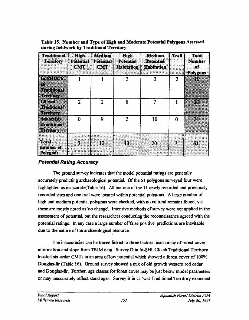
Potential Rating Accuracy
The ground survey indicates that the model potential ratings are generally
accurately predicting archaeological potential. Ofthe 51 polygons surveyed four were
higWighted as inaccurate(Table 16). All but one ofthe 11 newly recorded and previously
recorded sites and one trail were located within potential polygons. A large number ofhigh and medium potential polygons were checked, with no cultural remains found, yet
these are mostly noted as 'no change'. Intensive methods of survey were not applied in the
assessment of potential, but the researchers conducting the reconnaissance agreed with the
potential ratings. In any case a large number of 'false positive' predictions are inevitable
due to the nature of the archaeological resource.
The inaccuracies can be traced linked to three factors: inaccuracy offorest cover
information and slope from TRIM data. Survey D in In-SHUCK-ch Traditional Territorylocated six cedar CMTs in an area oflow potential which showed a forest cover of 100"10
Douglas-fir (Table 16). Ground survey showed a mix ofold growth western red cedar
and Douglas-fir. Further, age classes for forest cover may be just below model parameters
or may inaccurately reflect stand ages. Survey B in Lil'wat Traditional Territory examined
Final ReportMillennia Research 153
Squamish Forest DisfrictAOAJuly 30, 1997

ofmixed stand ofwestern red cedar and Douglas-fir rated as low potential, but with trees
ofa size for good potential for CMTs (although none were found). However, forest cover
records the age ofthe stand as one class below model parameters.
Slope is generalized over an area and sometimes does not reflect the presence of
rock outcrops resulting in inaccuracies for some potential polygons. Survey B in
Squamish Traditional Territory indicates a medium CMT polygon on an area ofslope 80"10
to 110"10. The tree cover in this polygon lies on a large rock outcrop with some sheer
faces. However, some inaccuracies apparent in the field were the result ofworking without-of-date DT< based maps. When the models were run on the revised DTM, many of
these problems may be resolved.
The TRIM data may not reflect areas which have been altered by construction.
Survey J in Lil'wat Traditional Territory recorded an area of high habitation potential as
being an artificially enhanced spit, associated with fish habitat improvement. The area was
once marsh land.
All but two ofthe sites located during survey work and recorded sites which were
revisited were within a potential polygon. An inaccuracy in the forest cover information
resulted in the area containing six CMTs not having a potential polygon identified. The
pictograph was in an area not captured by any ofthe models.
Final RepartMillennia Research 154
Squamish Forest District A OAJuly 30, 1997

Table 16. Potential Polygon Rating Alterations based on Fieldwork
High potential Forest coverindicates one
age belowmodel
parameters:good large trees
with flats
I.t.'jI.;i.. ,.;;.,.i,;.,.;;;,,,,..·.i... .,.,.,.,.,.' ,.,.,..'., .."~,. ,. " : @~MWit!!!f~
•
Survey J
SurveyB
High Habitation Low Potential(north end of
lake only)
Water Buffer(low/medium
potential)
6 cedar CMTsrecorded:
Forest coverinformation
incorrect listing100% Douglas
firArtificially
enhanced spit,was once marsh
Final ReportMillennia Research
Survey I MediumCMT
155
Low Potential Poor stand ofpine and cedaron 80-110%
slo e
Squamish Forest DistrictAOAJuly 30, 1997

EVALUATION AND DISCUSSION
As the maps accompanying the final report will indicate, there are many areas ofarchaeological potential within the boundaries of the Squamish Forest District. As described
in the ethnographic summary included in this report, First Nations peoples have lived within
and around the boundaries ofthe Forest District for many millennia and have left behind
physical evidence oftheir use and occupation ofthe land. The high and moderate potential
polygons generated from the models developed by Millennia Research and Timberline
delineate areas where that physical evidence is most likely to be present and preserved. It
should be noted that low potential areas (all those areas not identified as high or moderate
potential) should not be interpreted as areas where no First Nations occupation or use took
place. Low potential zones simply indicate areas where archaeological remains are unlikely to
be present or preserved. Therefore, archaeological sites can be found in low potential areas,
but very rarely.
There has not been much previous archaeological research within the boundaries ofthe
Squamish Forest District. What research has been conducted has focused almost exclusively
on the low lying valley bottoms and lake shores. Consequently there exists a major data gap
in regards to the higher elevation areas throughout the District.
As discussed in the archaeological correlates section, sites are most likely to be found
in the low lying valley bottom areas near bodies of fresh, potable water. Not surprisingly, high
and moderate potential polygons for habitation sites tend to cluster in these areas. It is likely
that future survey will reinforce the model's prediction with regards to habitation site
locations. The habitation model has identified areas ofpotential in high elevation locales
throughout the district. Although it is known that First Nations peoples consistently used sub
alpine areas as base camps for summer plant and root gathering and hunting, it is not known
how many ofthese sites have been preserved. The ground truthing conducted as part of this
overview was limited by the extraordinary deep snow conditions during the spring and
summer of 1997. Virtually all fieldwork was conducted below 900m. Large areas ofthe
Forest District have been tagged as high and moderate potential areas for CMTs. Again, it is
difficult to predict the density ofCMTs that may be found in these areas as no extensive data
on CMTs has been collected for this particular region. The CMT potential model was based
on information from other, similar environments; however, compilation of field testing results
should serve to refine the model and make it more specific to the Squamish region.
Final ReportMillennia Research 156
Squamish Forest District AOAJuly 30, 1997

Potential impacts on the archaeological resource base in the Squamish Forest District
can be narrowed down to two major factors. The first of these is logging and associated
silvicuhural activities. Logging is ongoing in most areas throughout the forest district, in
some more heavily than others. Currently most logging activity is taking place in the TFL 38area in the western third ofthe Forest District. The Lillooet River valley and drainage areahas seen heavy logging activity in the past however, relatively few development areas in the
Lillooet Lake and River area are slated for harvesting in the next five years. The Squamish
River Valley and it's tributaries have also been the focus ofconsiderable logging and
silvicultural activity and several licensees have planned harvesting in that area in the next five
years.
The second major factor having current and potential impacts to the archaeological
record is resort development. In the past several years Whistler Ski Resort and adjacentdevelopments have grown exponentially. With the influx of more and more tourists,
developers are looking to adjacent areas for further expansion. Consequently, areas which are
likely to be considered high potential for archaeological sites are also likely to be pinpointed
for ideal resort locales. With these new developments come necessary facilities such as roads,
utility corridors and residential development all ofwhich have the potential to impact
archaeological sites in the area.
The model and associated potential maps produced for the Squamish ADA shouldserve to focus archaeological efforts on particular areas which are ofhigh and moderatepotential for archaeological sites while assisting with the Ministry ofForests land-use planningprocess.
Final ReportMillennia Research 157
Squamish Forest DistrictAOAJuly 30, 1997

RECOMMENDATIONS
Overall Management Recommendations for the Squamish AOA
The following are management recommendations specifically related to the use ofthe
Sguamish ADA potential maps:
• AlI high potential areas should require an Archaeological Impact Assessment (AlA);• AlI moderate potential areas should require a Reconnaissance survey (RECCE) in
. order to determine whether or not further work (an AIA) is required in those areas;• Areas delineated as high or moderate potential for CMTs only could, instead of
requiring an AlA, be subject to a CMT inventory (see discussion below);• All AlAs, and RECCEs should be conducted under permit in order to ensure that a
quality, standardized methodological approach is being used and that data derivedfrom field survey can be used in model refinement; and;
• Development areas falling within the 'caution zone' delineated by the purple borderfollowing the perimeter of major lakes and rivers, should also require an initialRECCE survey (except those areas within the 'caution zone' which are already definedas high potential and therefore require an AIA) the results from which should be usedto determine whether or not further work is required.
Management Options
CMT Inventories for areas ofHigh or Moderate CMTpotential only.
In areas which are defined as high or moderate only for the CMT potential could besubject to a CMT inventory as opposed to an AlA or RECCE. Areas which are declared high or
moderate potential for CMTs and other site types will require an AIA or RECCE as prescribed
below. The CMT inventory process is sanctioned by the Archaeology Branch for areas which
likely contain CMTs but no other site types. CMT inventories can be conducted by trained
individuals in the forestry or First Nations communities. CMT inventories are designed to survey,
identitY and record, to level 2 standards, CMTs in all potential areas. IfCMTs are located but
there is uncertainty as to there nature or age, archaeologists can then be brought in to assess and
deal with the final site recording.
Blanket Permits for AlAs and RECCEs
While AlAs must be conducted under an Archaeology Branch permit, a permit is not
necessary for RECCEs. However, it is extremely important that certain standards ofsurvey be
maintained so that results ofRECCEs are compatible with one another and of use for future
Final ReportMillennia Research 158
Squamish Forest DistrictAOAJuly 30, 1997

model refinement. To this end, we strongly recommend that RECCEs be conducted under an
Archaeology Branch permit. We also understand that this recommendation could come at
considerable cost to licensees and suggest that any licensee who requires archaeological work in
their development areas request that the archaeologist they hire apply for a "blanket permit" from
the Archaeology Branch. A "blanket permit" is one which allows an archaeologist to apply for
work to be done in a certain Chart Area, TFL or series ofdevelopment areas under a single
licensee. The methodological approach outlined in a "blanket permit" can be flexible and allow
for in-field assessment or re-assessment oforiginal archaeological management prescriptions.
Levels of Future Work
As stated previously, the model designed for the Squamish Forest District ADA was
developed and applied based on known information for the Forest District area. Because there is
a paucity ofinformation for many ofthe regions which were assessed during this project, a
number ofchecks have been built into the results to ensure those areas are investigated. A
predictive model is only as effective as the data used to generate it, consequently, it isessential that data gathered during upcoming field work portion ofArchaeological Impact
Assessments and Reconnaissance is tabulated and introduced into the existing model. These
recommendations should provide some standards for model revisitation while simultaneously
refining the model itself:
• Any information which may indicate likely site locations (traditional use sites,ceremonial sites, unrecorded habitation sites etc.) from the First Nations whosetraditional territories encompass parts ofthe Forest District must be added to themodel. Consultation with First Nations should be ongoing;
• The model should be revisited every year for the first two years and every second yearfollowing;
• Results offield work should be tabulated and introduced into the model by one party tomaintain consistency and reliability of results;
• The model may need to be changed to incorporate further information from FirstNations or other sources ofknowledge; and;
• Avoid adding new site models and concentrate on refining existing ones.
7 Recommendations specific to individual First Nations territories will be made in the final report in co-operationwith the First Nations whose territories encompass portions of the Forest District.
Final ReportMillennia Research 159
Squamish Forest District AOAJuly 30, 1997

Recommendations for future model refinement: In-house
The following are some suggestions for in-house refinement of the existing Squamish
ADA models:
• Results ofAlAs and RECCEs ofdevelopment areas should be compiled and used toprovide base-line data to test the existing models. For example, areas which aresubject to AlAs should yield more sites than those subject to RECCEs. IfRECCEsare yielding more sites than AlAs then the models will have to be adjusted accordingly.
• Since TRIM data is still somewhat unreliable, archaeologists hired to conduct surveyin development areas in the Squamish Forest District should be required to commenton their impressions regarding the potential ratings for both the survey area and accessto that area (i.e. were there any major discrepancies between the potential rating andthe actual landscape along the access road and in the development area?).
• Serious consideration should be given to providing funds to have RECCEs conductedin a certain percentage ofthe low potential areas. Survey in low potential areas willserve to verifY whether the model is working. Ifthere is no survey conducted in lowpotential areas the model cannot be tested effectively.
• Future model refinements should be based on culture area/traditional territory. Asnoted in the ethnographic and archaeological correlates sections ofthis report, FirstNations peoples whose territories encompass portions ofthe Forest District lived inculturally distinct ways descriptions ofwhich mayor may not be included in theethnographic and anthropological information available at this time. For this reason, itis important to further refine models based on information derived from the FirstNations themselves. This may require establishing different model parameters for eachFirst Nations territory and then applying those models within the boundaries ofeachindividual territory.
• Biogeoclimatic sub-zones may provide another data set for further model refinement.Since certain plant and animal species thrive in certain biogeoclimatic zones, modelscould be changed to reflect specific sub-zones which may have potential forarchaeological sites based on those plant and animal species commonly used byaboriginal peoples.
Recommendations for future model refinement: External
The results of the field-work for the Squamish ADA could only be used to refine the
potential zones within the survey areas and immediately adjacent landscape. Consequently, model
refinement for the majority ofthe Forest District will have to take place after the ADA is
Final ReportMillennia Research 160
Squamish Forest District AOAJuly 30, 1997

completed. It would be beneficial to supplement in-house development area survey results (from
AIAs and RECCEs) with Archaeological Inventory Surveys (AlS). An AlS could focus on low
potential areas or locales where the potential map designation is suspect.
Since there are many different types of map coverages which are not yet available for the
entire Squamish Forest District, there are certain classes of potentially valuable information that
we could not use in generating the potential maps, for example;
• fisheries and wildlife information could be used to pinpoint spawningchannels or ungulate habitat upon which a fishing camp/station orhunting model might be generated;
• terrain stability mapping and/or aerial photographs could be usedto establish the exact location ofancient beaches and river terraceswhich in tum could be used to establish a paleoshoreline habitationmodel or to locate areas ofactive geological processes which mayseverely effect the preservation ofarchaeological sites (e.g. avalanchechutes);
• soils maps may be use to pinpoint areas ofgood drainage, soil textureand type (e.g. fluvial-glacial), and associated vegetation which may lendthemselves toward a variety ofactivities and associated site types.
While it is not possible at this stage to determine whether the application ofthese
additional coverages would have produced significantly different results it may be beneficial to
choose an area which has a number ofdifferent coverages, produce a refine model based on those
coverages, and apply it to that area and compare the resulting potential maps to the ones
produced for the Squamish AOA. The TFL 38 area may be an excellent choice for this type of
exercise.
Minimum Standards for Archaeological Impact Assessments (AlA) andReconnaissance (RECCE)
The Ministry ofForests, Squamish Forest District requested that there be minimum
standards outlined for both AlAs and RECCEs. The following are intended to serve as minimum
standards for each type ofassessment and should not be viewed as restrictions should more
thorough work be deemed necessary by field crews.
Guidelines for Archaeological Impact Assessments (AlAs) in the High Potential Areas oftheSquamish Forest District
All AIAs must be done under a permit from the Archaeology Branch. The Branch has
established a set ofGuidelines (see Appendix 4) which should be adhered to however, the
Final ReportMillennia Research 161
Squamish Forest District AOAJuly 30. 1997

Squamish Forest District has requested we establish a list of suggested minimum standards
necessary for effective archaeological inspection and assessment ofdevelopment areas which fallwithin high potential areas. These standards are also intended to ensure that results ofarchaeological survey, regardless ofwho does the work, will provide a set ofcompatible results
upon which the ADA models can be tested.
Archaeologists conducting an AlA for development areas in the Squamish Forest District
must:
• consult with the First Nations within whose traditional territories the development areaslie prior to conducting any field work;
• obtain the appropriate Archaeology Branch and First Nations permits;• shovel test (screening or trowelling through backdirt) within a maximum 50 metre grid
in areas judgmentally deemed to have high archaeological potential within thedevelopment area;
• ensure that a crew oftwo is not expected to cover more than 30 hectares per day inareas with difficult access or significant undergrowth (e.g. open canopy stands in verywet maritime coastal western hemlock zone) or 40 hectares per day in areas with easyaccess and little undergrowth (e.g. Interior Douglas Fir Zone);
• conduct, in areas ofold growth, traverses no more than 50 metres apart in order tolocate CMTs;
• be provided with a copy ofthe potential map coverage for their survey area and shouldbe required to note their impressions regarding the assessment the potential the maphas given compared to their impressions ofpotential upon viewing the actual landscape,and;
• note general vegetation within the development area and specific vegetation inassociation with sites.
Guidelines for RECCE in the Moderate Potential Areas ofthe Squamish Forest District
A significant amount of the Squamish Forest District has been assigned a moderate
potential rating and will require reconnaissance survey (RECCE). The reconnaissance is designedto provide a quick assessment ofareas in a mid-archaeological potential range, and provides someflexibility should the archaeologist wish to change a moderate potential rating to a high or low
rating. The need for on-site assessment, especially in areas which are poorly represented by
previous archaeological survey, cannot be overstressed. However, guidelines for reassessment
should be established so that archaeologists are changing potential ratings according to
standardized criteria. In addition, permits from the Archaeology Branch should be required for
Reconnaissance surveys as this is one ofthe only ways to ensure that survey and recording
standards are maintained and, should the archaeologist come upon an area of high potential within
Final ReportMillennia Research 162
Squamish Forest DistrictAOAJuly 30, 1997

a moderate potential zone, sub-surface testing for archaeological remains can be conducted
immediately. The following are suggested minimum guidelines for archaeologists conducting
reconnaissance.
Archaeologists conducting reconnaissance for the Squarnish Forest District must:
• consult with the First Nation(s) whose traditional territories encompass thedevelopment areas prior to conducting any field work;
• obtain a permit issued by the Archaeology Branch, Ministry ofSmall Business, Tourismand Culture so that subsurface testing can be done ifnecessary;
• obtain a permit from the First Nation (for those who require one);• be provided with a copy ofthe potential map coverage for their survey area and should
be required to note their impressions regarding the assessment the potential the maphas given compared to their impressions of potential upon viewing the actual landscape;
• walk at least two traverses the width of the block or for at least 200m, no closer than100m to one another, to ensure coverage of all major landforms/vegetation zones in theblock. For roads, the majority should be traversed along the centreline;
• flag and map areas if they appear to have archaeological potential sufficient to requirean AlA; and,
• complete a brief report which includes a description of; the block, its location and thetype and extent of survey coverage performed; the location and nature ofany culturalremains or deposits including CMTs; and finally; recommendations regarding futureplans for the area (i.e. whether the area needs an AlA or no further work) andjustifications for any change in archaeological management prescription.
Luw Potential
The GIS generated model for the Squarnish Forest District will designate all those areas
not deemed as either high or moderate potential, low potential. However, one should not assume
that low potential areas do not contain archaeological sites. Some site types, such as lithic
quarries, are dependent upon geological exposures which can not be mapped. Very large and
significant quarry sites may be found in areas otherwise totally unsuitable for any other activity.
Areas identified as low potential may also have been extensively used by First Nations inways which may leave few physical traces (e.g. berry picking areas, hunting locales) or in areas
where site preservation is unlikely. A low potential rating therefore should not be interpreted as
part of an overall statement concerning aboriginal use ofa particular area. Low potential ratings
in this case are specific to archaeological sites. If the First Nations indicate an area which has
been identified as low potential but they know has archaeological deposits, that area should be
immediately considered of high potential and all development areas within 500m or less ofthat
site should require an Archaeological Impact Assessment.
Final ReportMillennia Research 163
Squamish Forest District AOAJuly 30, J997

REFERENCES CITED
Albright, Sylvia1991 Test Excavation ofa Reported Burial Site in the Vicinity ofUre Creek Logging Road, Mount Currie
Area, B.C. Permit 1991-28. Report on file, Ministry of Small Business, Tourism, and Culture,Victoria, B.C.
Alexander, Diana M.1989 Ethnoarchaeology ofthe Fountain and Pavilion Indian Bands, Southwestern British Columbia.
Permits 1986-26, 1987-20, 1988-26. Report on file with the Culture Libnuy, Ministry of SmallBusiness, Tourism and Culture, Victoria, B.C..
1992 A Reconstruction ofTraditional Land-Use Patterns in the Mid-Fraser River Area Based onEthnographic Data. inA Complex Culture ofthe B.C. Plateau: Traditional Stl'atl'imx Resource Use,Brian Hayden (ed.), pp.47-98. UBC Press, Vancouver, B.C..
Alexander, Diana, R. Tyhurst, L. Burnard-Hogarth, and R.G. Matson (UBC)1985 A Preliminary Ethnoarchaeological Investigation ofthe Potato Mountain Range and Eagle Lake
Area. Permit 1984-14. Report on file with the Culture Libnuy, Ministry of Small Business, Tourismand Culture, Victoria. B.C..
Apland, Brian1980 Heritage Resource Impact Assessment ofthe B.C. Hydro Proposed Cheekeye to Dunsmuir
Transmission Line. Permit 1980-2. ARESCO Ltd. Report on file with the Culture Libnuy, Ministryof Small Business, Tourism and Culture, Victoria. B.C..
Areas Consulting Archaeologists Ltd.1996 Archaeological Investigations in Traditional Squamish Territory 1989-1992. Permits 1990-32 and
1990-89. Draft report.
Bailey, Jeff1996 Archaeological and Cultural Heritage Overview Assessments, Various Existing and Proposed
Woodlot Licenses and Proposed Expansion Areas, Quesnel Forest District, B.C. non-permit reportprepared for Ministry ofForests, Quesnel Forest District, Quesnel, B.C.
Barnett, HG.1944 Underground Houses on the British Columbia Coast. American Antiquity. 9: 265-2701955 The Coast Salish ofBritish Columbia. University ofOregon Press, Eugene.
Bernick, Kathryn1992 Preliminary Report ofArchaeolagical Waterlogged Deposits at Scowlitz Site Permit 1992-117.
Report on file with the Culture Libnuy, Ministry of Small Business, Tourism and Culture, Victoria.B.C..
Boas, Charles1891 Second General Report on the Indians ofBritish Columbia. Report ofthe British Association for the
Advancement ofScience. 60: 562-692.1894 Indian Tribes ofthe Lower Fraser River. pp. 408-447 in 64th Report ofthe British Association for the
Advancement ofScience for 1890. London.
Final ReportMillennia Research 164
Squamish Forest DistrictAOAJuly 30, 1997

Borden, Charles E.1950 Preliminary Report on Archaeological Investigation in the Fraser Delta Region. Anthropology In
British Columbia 1:13-26.1951 Facts and Problems of Northwest Coast Prehistory. Anthropology in British Columbia 2:35-52.1968a Prehistory ofllie Lower Mainland. In Lower Fraser Valley: Eyolution ofa Cultural Landscape, edited
by A.H. Siemens. British Geographical Series No.9. Vancouver, B.C.1968b New Evidence ofEarly Cultural Relations Eurasia and Western North America. Proceedings, VlIlth
Congress ofAnthropological and Ethnological Sciences, Tokyo and Kyoto 3:331-337.1970 Cultural History of the Fraser-Delta Region: An Outline. pp. 95-112 in Archaeology in British
Columbia, New Discoveries. Roy L.Carlson, ed. BC Studies 6-7(Fall-Winter). Vancouver.1975 Origins and Development ofEarly Northwest Coast Culture, to About 3000 BC. Canada. National
Museum ofMan. Mercury Series. Archaeological Survey Papers 45. Ottawa.
Bouchard, Randy1991 Letter to All Council, Wallace v Interl'or et al., Supreme Court ofB.C. #C910592. March 3, 1991.
Bouchard, Randy, and Dorothy Kennedy1977 Lillooet Stories. Sound Heritage. 6(1). Provincial Archives ofRC.
Bouchard, Randy and Nancy Turner1976 Ethnobotany ofthe Squamish People ofBritish Columbia. British Columbia Indian Language Project.
Report on file with the Culture Library, Ministry of Small Business, Tourism, and Culture, Victoria,B.C.
Boucher, N.1976 Prehistoric Subsistence at the Helen Point Site. M.A. thesis, Department of Archaeology, Simon
Fraser University, Burnaby.
British Columbia Heritage Conservation Branch1980 Lillooet-Fraser Heritage Resource Study. 2 Volumes. Report on file with the Culture Library,
Ministry of Small Business, Tourism, and Culture, Victoria, B.C.
Brown, Robert1873-1876 The Races ofMankind: Being a Popular Description ofthe Characteristics, Manners and
Customs ofthe Principle Varieties ofthe Human Family (4 Volumes). cassell, Petter and Galpin,London.
Burley, D.1980 Marpole, Anthropological Reconstructions ofa Prehistoric Northwest Coast Culture Type.
Department of Archaeology, Simon Fraser University, Burnaby.1989 Senewelets: Culture History ofthe Nanaimo Coast Salish and the False Narrows Midden. Memoir 2,
Royal British Columbia Museum, Victoria.
Bussey, Jean1988 Heritage Resource Inventory and Impact Assessment: Department ofHighways, Lillooet and
Chilliwack Districts. Permit 1988-65. Report on file with the Culture Library, Ministry of SmallBusiness, Tourism and Culture, Victoria. B.C..
1990a Heritage Resource Overview Assessment and Inventory Proposed Soo River Hydroelectric Facility.Permit 1990-46. Report on file with the Culture Library, Ministry of Small Business, Tourism andCulture, Victoria. B.C..
Final ReportMillennia Research 165
Squamish Forest District AOAJuly 30, 1997

1990b Heritage Resource Update: Proposed Kelly LakeiCheekye 500 kV Transmission Line. Points WestHeritage Consulting Ltd. Report on file with the Culture Library, Ministly of SmaIl Business,Tourism and Culture, Victoria. B.C..
Caldwell, W.1954 An Archaeological Survey of the Okanagan and Similkameen Valleys ofBritish Columbia.
Anthropology in British Columbia, 4:10-25.
Carlson, Roy L.1960 Chronology and Culture Change in the San Juan Islands, Washington. American Antiquity 25:562
586.1970 Excavations at Helen Point on Mayne Island. B.C. Studies 6 & 7: 113-125.1976 Prehistory of the Northwest Coast. In Carlson, Roy (ed.),Indian Art Traditions 0/Northwest Coast: 13
... 32. Department of Archaeology, Simon Fraser University, Burnaby.1990 Cultural Antecedents. In Handbook o/North American Indians, Volume 7: Northwest Coast, edited by
Wayne Suttles. Smithsonian Institution, Washington D.C. pp. 60-69..1996 Early Human Occupotion in British Columbia. University ofBritish Columbia Press.
Casteel, R.1976 Fish Remains from Glenrose. In Matson, R.G. (ed.), The Glenrose Cannery Site. Mercury Series,
Archaeological Survey Papers 52, National Museum ofMan, Ottawa.
Christensen, Tina1996 The Gwai HaanasArchaeological Project: Raised Beach Survey 1995 Field Report. On file, Parks
Canada.
Clague, John, John Harper, Richard Hebda, and Don Howes1982 Late Quaternary Sea-levels and Crustal Movements, Coastal British Columbia Canadian Journal 0/
Earth Sciences 19:579-618.
Clague, John 1. John L. Leternauer, and Richard 1. Hebda1983 Sedimentary Environments and Postglacial History of the Fraser Delta and Lower Fraser Valley,
British Columbia. Canadian Journal 0/Earth Sciences 20: 1314-1326.
Cowan and Guiget,1973 The Mammals 0/British Columbia. British Columbia Provincial Museum Handbook No. II, Victoria,
B.C..
Cressman, L.S.1977 Prehistory o/the Far West: Homes o/Vanished Peoples. University of Utah Press, Salt Lake City.
Dahm, Inge1995 Cultural and Social Dimensions o/the Prehistoric GulfIslands Soapstone Industry. Unpublished
M.A. Thesis, Simon Fraser University.
Debloois, Evan 1.1985 Predictive Modeling in the Forest Service. In Archaeological Inventory and Predictive Modelling in
the Pacific Northwest: Studies in Cultural Resource Management. No.6, edited by Richard F. Dorsie
Final ReportMillennia Research 166
Squamish Forest District AOAJuly 30, 1997

and James D. Keyer, pp. 5-11 United Stales Department of Agriculture Forest Service, PacificNorthwest Region.
Duff, Wilson1952 The Upper StaIo Indians of the Fraser Valley. Anthropology in British Columbia Memoir No. I.
British Columbia Provincial Museum, Victoria.1956 Prehistoric Stone Sculpture of the Fraser River and Gnlfof Georgia. Anthropology in British Columbia
5:15-51. Victoria, B.C.
Eldridge, Morley1984 Archaeological Investigations at St. Mungo Cannery, DgRr-2. Prepared for the Heritage ConseNation
Branch, Provincial Secretary and GoVernment Services. On file with the Culture Library of theMinistry of Sntall Business, Tourism, and Culture, Victoria, B.C.
1989 Mercantile Creek, Ucluelet Inlet Heritage Impact Assessment. Permit 1988-2. On file with theCulture Library, Ministry of Sntall Business, Tourism, and Culture, Victoria, B.C.
Eldridge, Morley and Alexander Mackie1993 Predictive Modelling and the Existing Archaeological Inventory in British Columbia. Non-permit.
On file with the Culture Library, Ministry of Sntall Business, Tourism, and Culture, Victoria, B.C.
Elliot, T.e. (ed.)1912 Journal of John Work, November and December, 1824. Washington Historical Quarterly. Volume
3(3): 198-228.
Fladmark, Knut R.1975 A Paleoecological Model for Northwest Coast Prehistory. National Museum ofMan Mercury Series
Archaeological Survey Papers 43, Ottawa.1985 Glass and Ice. Simon Fraser University Archaeology Press. Burnaby, B.C.
Friesen, David E.1980 Heritage Resource Assessment ofthe Proposed Westcoast Transmission Company Limited Vancouver
Island Gas Pipeline Williams Lake to Comox and Squamish Lateral. On file with the Culture Library,Ministry ofSntall Business, Tourism, and Culture, Victoria, B.C.
Ham, Leonard C., Arlene J. Yip, and Leila V. Kullar1984 The 1982/83 Archaeological Excavations at the St. Mungo Site (DgRr 2), North Delta, British
Columbia. Permit 1982-21. On file with the Culture Library, Ministry of Sntall Business, Tourismand Culture, Victoria, B.C.
Hansen, H.P.1947 Postglacial Forest Succession, Climate Chronology in the Pacific Northwest. Transactions ofthe
American Philosophical Society (NS) 37(1).
Hanson, Gordon William1973 The Katz Site: A Prehistoric Pithouse Settlement in the Lower Fraser Valley, British Columbia.
Unpublished M.A. Thesis, Department of Anthropology and Sociology, University of BritishColumbia, Vancouver.
Final ReportMillennia Research 167
Squamish Forest DistrictAOAJuly 30, 1997

Hebda, Richard 1.1995 British Columbia Vegetation and Climate History with Focus on 6KA BP. Geographic Physique et
Quaternaire 49 (1):55-79.
Heritage Conservation Branch1980 Lillooet-Fraser Heritage Resource Study: Volume IlA. Report on file with the Culture Library,
Ministty ofSmall Business, Tourism and Culture, Victoria. B.Coo
Heusser, C.J.1960 Late-Pleistocene Environments of North Pacific North America. American Geographical Society
Special Publications No. 35.
Hill-Tout, Charles1900 Notes on the Sk'qo'mic ofBritish Columbia, a Bmnch ofthe Great Salish Stock ofNorth America. pp.
472-549 (Appendix II) in the 70th Report ofthe British Associationfor the Advancement ofSciencefor 1902. London.
1978 The Salish People: The Local Contribution ofCharles Hill-Tout. Volume II: The Squamish and theLillooet. Edited by Ralph Maud. Talon Books. Vancouver B.C.
Hobler, Philip1995 The 1995 Excavations at Tsini Tsini. Pennit No. 1995-097. Report on file with the Culture Library,
Ministty of Small Business, Tourism and Culture, Victoria. B.Coo
Hudson, Doug1994 Cultural OveMew of the Lower Lillooet River Region. On file, Squamish District Office, Ministty of
Forests, British Columbia.
Keddie, Grant1987 Same Thoughts on the Prehistoric Settlement Systems ofthe Victoria Region and the Nature of
Archaeological Inquiry in the GulfofGeorgia. Unpublished paper presented at the 20th AnnualMeeting of the Canadian Archaeological Association. April 22-26, 1987.
Kennedy, Dorothy and Randy Bouchard1975 Utilization ofFish by the Mount Currie Lillooet Indian People ofBritish Columbia. British
Columbian Indian Language Project. On file with the Culture Library of the Ministty of SmallBusiness, Tourism, and Culture, Victoria, B.C.
1976a Utilization ofFish, Beach Foods, andMarine Mammals by the Squamish Indian People ofBritishColumbia. British Columbia Indian Language Project.
1976b Knowledge and Usage ofLandMammals, Birds, Insects, Reptiles andAmphibians by the SquamishIndian People ofBritish Columbia. British Columbia Indian Language Project.
Kohler, Timothy A.1985 Predictive Models In Archaeology: What Are They and How Are They Being Used? In Archaeological
I""entory and Predictive Modeling in the Pacific Northwest: Studies in Cultural ResourceManagement No.6, edited by Richard F. Darsie and James D. Keyser, pp. 13-19. United StatesDepartment of Agriculture, Forest SeMce, Pacific Northwest Region.
Kuijt, Ian1989 Subsistence Resource Variability and Culture Change During the Middle-Late Prehistoric Cultural
Transition on the Canadian Plateau. Canadian Journal ofArchaeology 13: 97-118.
Final ReportMillennia Research 168
Squamish Forest District ADAJuly 30, 1997

Kuipers, Aert. H1969 The Squamish Language. 2 PIs. The Hague: Mouton.
Krajina, Vladimir1969 Ecology ofForest Trees in British Columbia. Ecalogy ofWestern Nor/hAmerica 2 (I): 1-144.
Lamb, W. Kaye ed.1960 The £eners andJournals ofSimon Fraser 1806-1808. The MacMillan Company Canada, Limited.,
Toronto.
Lord, John Keast1866 The Naturalist in Vancouver Island and British Columbia. 2 Volumes· Richard Bentley, London.
Mackie, AI and Morley Eldridge1992 Overview Assessment ofHeritage Values in the Kalum South Resource ManagementArea (Non
permit). Report on file with the Culture Libnuy, Ministly of Small Business, Tourism and Culture,Victoria. B.C..
MacMillan, James and Archibald MacDonald1827 - 1830 [Fort Langley Journal, June 27, 1827-July 30, 1830.] In Provincial Archives ofBritish Columbia,
. Victoria, B.C.
Maschner, Hubert D.G. and Jeffrey W. Stein1995 Multivariate approaches to Site Location on the Northwest Coast of North America. Antiquity. 69
(262): 61-73.
Mason, Andrew1994 The Hatzic Rock Site: A Charles Culture Settlement. M.A. Thesis, University of British Columbia.
Mathewes, R.W.1985 Palaeobotanical Evidence for Climatic Change in Southern British Columbia During Late-glacial And
Holocene Time. In Climate Change in Canada 5: Critical Periods in the Quaternary Climatic HistoryofNorthwestern North America, edited by C.R. Harrington, pp 397-422. Syllogeus 55.
Matson, R.G.1989 The Locarno Beach Phase and the Origins of the Northwest Coast Pattern. In B. Onat (ed.),
Development ofHunting-Fishing-Gathering Maritime Societies along the West Cost ofNorth America(Reprint proceedings, Vol. me). The Circum-Pacific Prehistory Conference, Seattle, Washington,August 1-6, 1989. Washington State University Press, Pullman, WA.
1994 Report on the 1993 Excavations at Scowlitz. Permit 1993-45. Report on file with the Culture Libnuy,Ministly of Small Business, Tourism and Culture, Victoria. B.C..
Matson, R.G. and Gary Coupland1995 The Prehistory ofthe Northwest Coast. Academic Press, San Diego.
Final ReportMillennia Research 169
Squamish Forest DistrictAOAJuly 30, 1997

Matson, R.G., Heather Pratt and Lisa Rankin1991 1989 and 1990 Crescent Beach Excavations, Final Repori. The Origins ofthe Northwest Coast
Ethnographic Pattern: The Place ofthe Locarno Beach Phase. Report on file with the CultureLibnuy, Minisuy of Small Business, Tourism and Culture, Victoria. B.C..
Matthews, J.S.1955 Conversations With Khahtsahlano, 1932-1954. Publisher unknown, (Vancouver).
May, Joyce and Sandy Lucs1976 South Coast Regional Survey - Vancouver Island and the Lower Fraser Mainland Report on file with
the Culture Libnuy, Minisuy of Small Business, Tourism and Culture, Victoria. B.C..
Meidinger, Del and Jim Pojar1991 Ecosystems ofBritish Columbia. B.C. Minisuy of Forests, Victoria
Merchant, Peter and Mike K. Rousseau1994 An Overview Assessment ofArchaeological Resource Potential For BCR Properties' Proposed
Development Property Near Porteau Cove on Howe Sound. Report on file with the Culture Libnuy,Minisuy of Small Business, Tourism and Culture, Victoria. B.C..
Mierendorf, Robert R., David 1. Harry and Gregg M. Sullivann.d. An Archaeological Site Survey and Evaluation in the Upper Skagit River Valley, Whatcom County,
Washington. Draft report in possession of the senior author.
Ministry of Small Business, Tourism and Culture1995 Archaeology Branch Annotated Bibliography. Archaeology Branch, Minisuy of Small Business,
Tourism and Culture, Victoria. B.C.
Mitchell, Donald1971 Archaeology of the Gulf of Georgia Area, a Natural Region and its Culture Types. Syesis, vol. 4: 1
228. British Columbia Provincial Museum, Victoria, B.C.1990 Prehistory of the Coasts of Southern British Columbia and Northern Washington. In Suttles, Wayne
(vol. ed.) Northwest Coast, vol. 7:340-358. Handbook ofNorth American Indians, William C.Sturtevant (gen. ed.). Smithsonian Institution, Washington.
Mitchell, Monty1991 Heritage Resource Inventory and Impact Assessment ofthe Mamquam River Hydroelectric Project.
Pennit 1991-117. Report on file with the Culture Libnuy, Minisuy of Small Business, Tourism andCulture, Victoria. B.C..
Mohs, Gordon1987 Spiritual Sites, Ethnic Significance, and Native Spirituality: The Heritage and Heritage Sites ofthe
Sto:lo Indians ofBritish Columbia. (Unpublished M.A. Thesis in Anthropology, Simon FraserUniversity, Burnaby, B.C.)
1990 1990 Sto:lo Heritage Project. Pennit 1990-45. Report on file with the Culture Libnuy, Minisuy ofSmall Business, Tourism and Culture, Victoria. B.C.
1994 SIo:lo Sacred ground. In Sacred Sites, Socred Places. DE Charmichael, Jane Hubert, Brian Reeves,andAudhild Schanche (eds.), pp. 184-208. Routledge, London.
Final ReportMillennia Research 170
Squamish Forest District AOAJuly 30, 1997

Osbourne, R.W., W. Caldwell and R. Crabtree1956 The Problem ofNorthwest Coast-Interior Relationships as seen from Seattle. American Antiquity
22:117-128.
Owens-Baird, D'Ann1996 Vancouver Island Highway Project, Victoria ApproachesArchaeological Inventory and Impact
Assessment. Pennit 1995-10. Report on file with the Culture Library, Minisuy of Small Business,Tourism and Culture, Victoria. B.CoO
Pojar, Jim and Andy MacKinnon1994 Plants ofCoastal British Columbia. B.C. MinistJy ofForests and Lone Pine Pnblishing, Canada.
Pratt, Heather1992 The Charles Culture ofthe GulfofGeorgia: A Re-evaluation ofthe Charles Culture and its three sub
phases. M.A. thesis, Department ofAnthropology and Sociology, University ofBritish Columbia,Vancouver.
Quirolo, Mary M. and Leonard Ham1990 Archaeological Resource Overview ofthe Furry Creek Delta, Howe Sound. British Columbia. Report
on file with the Culture Library, Minisuy of Small Business, Tourism and Culture, Victoria. B.c..
Richards, Thomas H. and Michael K. Rousseau1987 Late Prehistoric Cultural Horizons on the Canadian Plateau. Department of Archaeology, Simon
Fraser University Pnblication No. 16.
Ross, Richard E.1983 Archaeological Sites and Surveys on the North and Central Coast ofOregon Pp. 21-218 in
Prehistoric Places on the Southern Northwest Coast. Robert E. Greengo, ed. University ofWashington, Washington State Museum. Seattle.
Rousseau, Mike K.1988 Heritage Resource Inventory andMitigation for the Ross Lake Provincial Park Campground
Expansion Project, Upper Skagit Valley, British Columbia. Report on file with the Culture Library,Minisuy of Small Business, Tourism and Culture, Victoria. B.CoO
1990 Changes in Human Sedentism. Mobility and Subsistence During the Plateau Pithouse Tradition on theCanadian Plateau. Ms. in possession of the author.
Rousseau, Mike K., Ian C. Franck, and Diana M. Alexander1993 An Archaeological Impact Assessmentfor the Proposed Cayoosh Resort Recreational Development
ProjectArea, Melvin Creek Valley, Southwestern B.C. Pennit 1992-102. Report on file with theCulture Library, Minisuy of Small Business, Tourism and Culture. Victoria. B.CoO
Rousseau, Mike K. and Geordie Howe1987 Scheidam Flats: A Prehistoric Root Roasting Area near Kamloops. The Midden XIX(2).
Sanger, David1967 Prehistory of the Pacific Northwest Plateau as Seen From the Interior ofBritish Columbia. American
Antiquity 32(2): 186-197.Final ReportMillennia Research 171
Squamish Forest District AOAJuly 30. 1997

Simonsen, Bjorn O.1993 Results ofan Archaeological Site Survey andImact Assessment ofa Proposed New Crossing ofthe
BirkenheadRiver: Pemberton Portage Road. PenniI1992-129. Report on file with the CultureLibrary, MinislIy of SmaIl Business, Tourism and Culture, Victoria. B.c..
Smith, Harlan I.1907 Archaeology of the GulfofGeorgia and Poge! Sound. Publications ofthe Jesup North Pacific
Expedition 2(6); Memoirs ofthe American Museum ofNatural History 4(6):303-441. New York.
Smith, Marian W.1947 House Types ofthe Middle Fraser region. American Antiquity. 12 (4):255-267.
Sneed, Paul G. and Mary-Margaret Smith1977a Archaeological and Ethnohistorical Assessment ofHeritage Resources in the Harrison-Lillooet River
Valley. Report on file with the Culture Library, Minislly ofSmaIl Business, Tourism and Culture,Victoria. B.C..
1977b An Assessment an Overview ofthe Ethno-histoIY and Archaeological Resources of the Fraser canyonand Bridge River Region. Pennit 1977-17. Report on file with the Culture Library, MinislIy of SmallBusiness, Tourism and Culture, Victoria. B.C..
Stryd, Arnoud H. and Michael K. Rousseau1996 The Early Prehist0IY ofthe Mid Fraser-Thompson River Area ofBritish Columbia. In Early Human
Occupotion in British Columbia, edited by Roy L. carlson and Luke Dalla Bona. UBC Press,Vancouver.
Suttles, Wayne1951 The Economic Life ofthe Coast Salish ofHaro andRosario Straits. (ph.D. Dissertation in
Anthropology, . University of Washington, Seattle.)1955 Katzie Ethnographic Notes. Anthropology in British Columbia Memoir No.2. British Columbia
Provincial Museum, Victoria1957 The "Middle Fraser" and "Foothill" Cultures: A Criticism. Southwestem Joumal ofAnthropology
13(2): 156-183.1960 Affinal Ties, Subsistence, and Prestige Among the Coast Salish. American Anthropologist 62(2):295
305.1987 Coast Solish Essays. Seattle: University of Washington Press.1990a Environment. In Suttles, Wayne (vol. ed.) Northwest Coast, vol. 7:16-29. Handbook ofNorth
American Indians, William C. Sturtevant (gen. ed.). Smithsonian Institution, Washington.1990b Central Coast Salish. In Suttles, Wayne (vol. ed.) Northwest Coast, vol. 7:453-475. Handbook of
North American Indians, William C. Sturtevant (gen. ed.). Smithsonian Institution, Washington.
Teit, James1900 The Thompson Indians ofBritish Columbia In Memoir ofthe American Museum ofNatural History
2. Jesup North Pacific Expedition 1(4):161-392.1906 The Lillooet Indians. In Memoir ofthe American Museum ofNatural History 4. Jesup North Pacific
Expedition 11(5):193-300.
Thompson, Laurence C. and M. Dale Kincade1990 Languages. In Suttles, Wayne (vol. ed.) Northwest Coast, vol. 7:30-51. Handbook ofNorth American
Indians, William C. Sturtevant (gen. ed.). Smithsonian Institution. Washington.
Final ReportMillennia Research 172
Squamish Forest DistrictAOAJuly 30, 1997

Turner, Nancy 1.1978 Food Plants 0/British Columbio Indions, Part 2: Interior Peoples. B.C. Provincial Museum
Handbook No.36. Victoria, B.C.1979 Plants in British Columbia Indian Technology. British Columbia Provincial Museum. Handbook
No.38. Victoria, B.C.1988 Plant Resources o/the Fraser River Lillooet People: A Window Into the Past. Unpublished
manuscript in possession of the author.
Tyhurst, Robert1988 Traditional and Contemporary Land and Resource Use by Ts 'kw 'aylaxw and Fountain Bands:
Ethnographic and Ethnoarchaeological Results 0/1986 and /987 Fieldwork. Unpublishedmanuscript in possession ofthe author.
Valentine, K.W.G., P.N. Sprout, T.E. Baker, and L.M. Lavkulich1978 Soil Landscapes o/British Columbia. The Resource Analysis Branch, Ministty ofthe Environment,
Victoria, British Columbia.
Vancouver, Captain George1798 Voyage ofDiscovery to the North Pacific Ocean and Round the World. 3 vols. London.
Wales, W. Derek and Anne Murray1975 Archaeological Site Survey: A Preliminary Report: Pemberton Valley /975. Pennit 1975-6. Report
on file with the Culture Library, Ministty of Small Business, Tourism and Culture, Victoria. B.C..
Wells, Oliver N.1987 The Chilliwacks and Their Neighbours. Talonbooks, Vancouver.
Wessert, Gary1990 Prehistory of the Ocean Coast of Washington in Handbook o/North American Indians, W. Suttles
(ed), Smithsonian Institution, Washington.
Wilsort, Charles1866 Report on the Indian Tribes Inhabiting the Country in the Vicinity of the 49th Parallel of North
Latitude. Transactions o/the Ethnological Society o/London n.s. 4:275-332.
Wilson, I.R.1990 Ure Creek Logging Haulroad Heritage Resource Inventory and Impact Assessment. Pennit 1990-73.
Report on file with the Culture Library, Ministty of Small Business, Tourism and Culture, Victoria.B.C..
1991a Excavations at EdQx 4/ and 42, and Site Evaluation at EdQx 43 Monte Creek. Pennit 1990-140.Report on file with the Culture Library, Ministty of Small Business, Tourism and Culture, Victoria.B.C..
1991b Ure Creek Logging Haulroad Extension and Cut Blocks Heritage Resource Inventory and ImpactAssessment. Pennit 1991-36. Report on file with the Culture Library, Ministty of Small Business,Tourism and Culture, Victoria. B.C..
1992a Heritage Resource Inventory and Impact Assessment o/the Mamquam River Hydroelectric Project.Pennit 1991-117. Report on file with the Culture Library, Ministty of Small Business, Tourism andCulture, Victoria. B.C..
Final ReportMillennia Research 173
Squamish Forest District AOAJuly 30, /997

1992b Detailed Heritage Resource Impact Assessment. Southern Mainline Looping 1993 ConstructionProjects. Report on file with the Culture Library, MinistJy of Small Business, Tourism and Culture,Victoria. B.C..
1992c Excavations at the Baker Site EdQx 43, Monte Creek. PennitI991-107. Report on file with theCulture Library, MinistJy of Small Business, Tourism and Culture, Victoria. B.C..
WIlson, I. R., Bouchard, R., Kennedy, D. (I.R Wilson Consultants)1988 Stein River Haulroad Heritage Resources Inventory andImpactAssessment. Report on file with the
Culture Library, MinistJy of Small Business, Tourism and Culture, Victoria. B.C..
Winram, Pat1975 A Repart on the Howe Sound Archaeological Survey. Pennit1975-11. Report on file with the Culture
Library, MinistJy of Small Business, Tourism and Culture, Victoria. B.C..
Zacharias, Sandra1992 Archaeologicallnvento'Y and Impact Assessment ofProposed Langdale Tenninal Parking Lot
Expansion, Gibsons, B.C. Pennit 1992-13. Report on file with the Culture Library, MinistJy of SmallBusiness, Tourism and Culture, Victoria. B.C..
Zacharias, Sandra and Alex Maas1995 Birken-Darcy Cultural Heritage Resource Overview. Report on file with the Culture Library,
. MinistJy of Small Business, Tourism and Culture, Victoria. B.C..
Final RepartMillennia Research 174
Squamish Forest DistrictAOAJuly 30, 1997

Appendix 1: Letter of Introduction to the First Nations.
Final ReportMillennia Research 175
Squamish Forest District AOAJUly 30, 1997

MILLEN~D& RESEA~©[J:OQl4.101141otcOon11d PII1l Rl*I_ s..Ich. B.C. V8l5X8
April 29, 1996
TIIophano: (llO4) ll58 0C50Fox: (llO4) ll58 0453E_ mIhIOlIlIndnIl.com
Re: Squamish Forest District. Archaeolozical Overview Assessment (ADA),
Further to our conversation today, please find following a briefoutline ofthe AOA as proposedby Millennia Research and a company profile.
We are in the intial stages ofthe project and wish to meet with interested parties from the InSHUCK-ch Nation to discuss it in detail. In briet: we have been retained by the Sqnamish ForestDistrict to conduct an assessment ofthe relative potential ofareas within the entire district tocontain archaeology sites. The study does not include a traditional land use study, but doesinclude a review ofexisting published and unpublished ethnographic and historical documents, acheck ofarchaeology sites listed in the B.C. Archaeological Site Inventory, a review ofpreviousarchaeology in the district, and an examination ofthe local palaeoecology. Information fromthese reviews will be compiled with data on forestry and fisheries values, terrain, slope, etc., toformulate a predictive model for each archaeological site type. This model will combine anassessment ofknown site distribution, ethnographic land use, and physiographic characteristics.When completed, a draft oftbis model will be forwarded for your comment.
The data will be linked to polygons crested with the GIS and stored in Arc-Info Export dataformat. Two datasets will be produced: Dataset I will include the archaeological potentialpolygons with linked attributes; Dataset IT will present all known archaeological sites with Bordennumber used as unique identifiers. This information will be used by the Squamish Forest Districtas a management tool allowing informed decisions regarding the necessity offuture archaeologicalimpact assessments.
Millennia Research is a firm speciaUzing in archaeological and ethnographic consulting. Formedin 1984, the firm has provided professional expertise to governments at all levels, including FJrst

Nations governments, forest and oil sector companies, and smaller companies and developers.Some ofour areas ofexpertise include: archaeological inventory and impact assessment; culturallymodified tree research; wet site research; GIS applications; and overviews and management oflarge-scale archaeological inventories. Millennia Research is committed to working with FirstNations to document and organize information on traditional use places. The Traditional Use SiteInventory System (TUSIS) was developed by Millennia and Silhouette Software to help organizethe complex information involved in a traditional use study into an easily entered and accessedformat.
The firm's principle, Morley Eldridge has an M.A. in anthropology from the University ofVictoria and 26 years ofarchaeological experience throughout the Pacific Northwest. Morley willact as overall project supervisor, analyse known site distribution patterns, create models of sitedistribution, oversee the application ofthese models in GIS, and will edit the final report. Theprimary researchers for the project are Tanja Hoffman and Tma Christensen. Tanja is an M.A.candidate in First Nations Studies and the University ofNorthern British Columbia. She has threeyears ofarchaeological experience in British Columbia. Tanja will be responsible for the majorityofthe liaison and consultation with all concerned First Nations and with the Squarnish ForestDistrict. Tina has just been accepted as a M.A. candidate at Simon Fraser University but willcontinue with her work at Millennia. She has three years ofarchaeological experience in bothB.C. and Belize and has participated in several overview assessments with Millennia Research.
For the duration ofthis project, Millennia will be working with Steve Lipscomb ofTimberlineForest Inventory Consultants who will be responsible for the GIS portion ofthe project.Timberline has extensive practical experience with database design, digital mapping, and dataanalysis gained over the past ten years in short and long term projects. Timberline currentlyemploys a staffofapproximately 100 computer professionals, foresters, forestry technicians,geographies, and photogrammetrists.
Tanja is just finishing her studies at UNBC and will return to the Millennia office in early May. Atpresent I am filling her position but I will defer to Tanja upon her arrival. In the meantime, pleasedo not hesitate to contact me ifyou have any questions or concerns regarding the project.
Yours sincerely,
(/~CNV' (J~.02;~~~~A.D'Ann Owens-Baird "/~
( ..~l
C.c. Diane ReedijquamiSh Forest District

Appendix 2: The Heritage Conservation Act.From: British Columbia Archaeological Impact Assessment Guidelines, Archaeology Branch,Ministry ofSmall Business, Tourism and Culture. Pp. 29-48. Revised 1995. Victoria, B.C..
Final ReportMillennia Research 176
Squamish Forest DistrictAOAJuly 30, 1997

RSCHAP.187
Section
HERITAGE CONSERVAnON
HERITAGE CONSERVATION ACT
CHAPTER 187
Contents
45 ELIZ. 2
PART I-INTRODUCTION1 Definitions2 Purpose of Act3 Provincial heritage register4 Agreements with first nations5 Act is binding on the government6 Act prevails over conflicting legislation7 Provincial heritage policies8 No derogation of aboriginal and treaty rights
PART 2 - PROVINCIAL HERITAGE CONSERVATION9 Heritage designation
10 Designation procedure11 Compensation for heritage designation12 Permits13 Heritage protection14 Heritage inspection and heritage investigation15 Entry authority for heritage inspection and heritage investigation orders16 Temporary protection orders17 Notices and immunity18 Promotion of heritage value19 Unclaimed objects in heritage collections20 Powers of the minister21 Preservation intervention22 Advisory committees23 Provincial heritage properties
PART 3 - BRITISH COLUMBIA HERITAGE TRUST24 Heritage Trust continued25 Objects of Heritage Trust26 Directors27 Officers and employees28 Powers of Heritage Trust29 Heritage Trust Fund30 Financial administration31 Property of the Heritage Trust
PART 4 - GENERAL PROVISIONS32 Notice of heritage status on land title33 Service of documents34 Civil remedies respecting contraventions35 Indemnity

RS CHAP. 187 HERITAGE CONSERVAnON 45 ELiz. 2
36 Offence and penalty37 Power to make regulations38 Continuation of former designations
PART 1 - INTRODUCTION
Definitions
1 In this Act:
''alter'' means to change in any manner and, without limiting this, includes
(a) the making of an improvement, as defined in the Builders Lien Act, and
(b) any action that detracts from the heritage value of a heritage site or aheritage object;
"board" means the board of directors of the Heritage Trust;
"conservation" includes any activity undertaken to protect, preserve or enhance theheritage value of heritage property;
"designate" means to designate under section 9;
"first nation" means, as the context requires, an aboriginal people sharing acommon traditional territory and having a common traditional language, cultureand laws, or the duly mandated governing body of one or more such people;
"heritage inspection" means a physical examination and other research necessary
(a) to identify the heritage value of property or a portion of it, and
(b) to establish, if the property is a heritage site or heritage object,
(i) the need for protection and conservation, or
(ii) conformance with heritage protection requirements;
"heritage investigation" means an archaeological or other systematic study ofheritage property to reveal its history, and may include the recording, removaland analysis of artifacts, features and other material necessary for the purpose ofthe heritage investigation;
"heritage object" means, whether designated or not, personal property that hasheritage value to British Columbia, a community or an aboriginal people;
''heritage site" means, whether designated or not, land, including land covered bywater, that has heritage value to British Columbia, a community or an aboriginalpeople;
"Heritage Trust" means the British Columbia Heritage Trust continued undersection 24 (I);
''heritage value" means the historical, cultural, aesthetic, scientific or educationalworth or usefulness of a site or object;
2

1996 HERITAGE CONSERVATION RSCHAP.187
Section 2
"heritage wreck" means the remains of a wrecked vessel or aircraft if
(a) 2 or more years have passed from the date that the vessel or aircraft sank,was washed ashore or crashed, or
(b) the vessel or aircraft has been abandoned by its owner and the governmenthas agreed to accept the abandonment for the purposes of this Act;
"local government" includes the council of a municipality, the board of a regionaldistrict, and the Trust Council and a local trust committee established under theIslands Trust Act;
''Provincial heritage object" means a heritage object designated under section 9;
''Provincial heritage site" means a heritage site designated under section 9 or aProvincial heritage property established under section 23.
Purpose of Act
2 The purpose of this Act is to encourage and facilitate the protection and conservationof heritage property in British Columbia.
Provincial heritage register
3 (I) The minister must establish and maintain one or more registers, to be knowncollectively as the Provincial heritage register, for the recording of the following:
(a) Provincial heritage sites;
(b) Provincial heritage objects;
(c) heritage sites and heritage objects that are included in a schedule undersection 4 (4) (a);
(d) other known heritage sites and heritage objects that are, in the opinion of theminister, protected under section 13;
(e) buildings, structures and sites for which the minister has received noticefrom a local government under section 977 (I) of the Municipal Act orsection 602 (I) of the Vancouver Charter;
(f) other prescribed heritage property.
(2) Subject to subsections (3) and (4), information in the Provincial heritage registermust be available for inspection by any person during regular business hours.
(3) Despite the Freedom ofInformation and Protection ofPrivacy Act, the ministermay refuse to disclose information in the Provincial heritage register and otherinformation obtained in the administration of this Act or the Museum Act if anyof the following apply:
(a) disclosure of the information could, in the opinion of the minister, result indamage to or interfere with the conservation of a heritage site or heritageobject;
(b) disclosure of the information would violate an agreement made undersection 4;
3

RSCHAP.187
Section 4
HERITAGE CONSERVATION 45 ELlZ. 2
(c) anthropological infonnation that is of traditional social, spiritual or othercultural importance to a living community
(i) was obtained under conditions of confidentiality, or
(ii) is confidential at the request of representatives of the communitywhose heritage is represented by the infonnation.
(4) The inspection of infonnation in the Provincial heritage register is subject toreasonable conditions the minister may impose.
(5) .Without limiting subsection (4), the minister may require payment of aprescribed fee to inspect the infonnation in the Provincial heritage register.
(6) Protection of a heritage site or heritage object is not affected by an error oromission in the Provincial heritage register or, except for a Provincial heritagesite orProvincial heritage object, by a failure to register property in the Provincialheritage register.
Agreements with first nations
4 (1) The Province may enter into a fonnal agreement with a first nation with respectto the conservation and protection of heritage sites and heritage objects thatrepresent the cultural heritage of the aboriginal people who are represented bythat first nation.
(2) An agreement under subsection (I) must be in writing and must be approved bythe Lieutenant Governor in Council.
(3) Subsection (2) does not apply to an agret:ment that is entered into undersection 20 (I) (b) or 28 (1) (b).
(4) Without limiting subsection (I), an agreement made under this section mayinclude one or more of the following:
(a) a schedule of heritage sites and heritage objects that are of particularspiritual, ceremonial or other cultural value to the aboriginal people for thepurpose of protection under section 13 (2) (h);
(b) a schedule of heritage sites and heritage objects of cultural value to theaboriginal people that are not included in a schedule under paragraph (a);
(c) circumstances under which the requirements of sections 13 (I) and (2)and 14 (I) do not apply with respect to heritage sites and heritage objects,or to types of heritage sites and heritage objects, for which the first nationadministers its own heritage protection;
(d) policies or procedures that will apply to the issuance of or refusal to issue apennit under section 12 or 14 with respect to
(i) sites and objects identified in a schedule under paragraph (a) or (b), or
(ii) other sites and objects or types of sites and objects identified in theagreement;
4

1996 HERITAGE CONSERVATION RSCHAP.187
Section 5
(e) provlSlons with regard to the delegation of ministerial authority undersections 12 and 14 (4);
(f) any other provisions the parties agree on.
(5) For the purpose of section 13 (2), if an agreement includes a schedule undersubsection (4) (a), the agreement must identify actions which would constitute adesecration or which would detract from the heritage value of scheduled sites andobjects, and different actions may be identified for different sites or objects or fordifferent classes of sites or objects.
Act is binding on the government
5 Despite section 14 (2) of the Interpretation Act, this Act and the regulations and ordersmade under it are binding on the government.
Act prevails over conflicting legislation
6 If, with respect to any matter affecting the conservation of a heritage site or heritageobject referred to in section 13 (2), there is a conflict between this Act and any otherAct, this Act prevails.
Provincial heritage policies
7 The minister may, with the approval of the Lieutenant Governor in Council, establishpolici.es and standards for the identification, conservation, management anddisposition of any heritage site or heritage object owned or managed by thegovernment
No derogation of aboriginal and treaty rights
8 For greater certainty, no provision of this Act and no provision in an agreemententered into under section 4 abrogates or derogates from the aboriginal and treatyrights of a first nation or of any aboriginal peoples.
PART 2 - PROVINCIAL HERITAGE CONSERVATION
Heritage designation
9 (1) The Lieutenant Governor in Council may
(a) designate land as a Provincial heritage site, or
(b) designate an object as a Provincial heritage object.
(2) A designation under subsection (1) (a) may apply to land that does not haveheritage value if, in the opinion of the Lieutenant Governor in Council,designation is necessary or desirable for the conservation of heritage propertythat is
(a) designated under this section,
(b) protected under section 13 (2),
5

RSCHAP.187
Section 10
HERITAGE CONSERVATION 45 ELiz. 2
(c) protected heritage property under the Municipal Act or the VancouverCharter, or
(d) established under section 23.
(3) A designation made under this section may do one or more of the following:
(a) apply to a single property or to part of a property;
(b) apply to more than one property including properties owned by differentpersons;
(c) establish policies or procedures regarding the provision of financial or othersupport for the conservation of a heritage site or heritage object;
(d) specify types of alterations to the property which may be made without apermit under section 12;
(e) specify policies or procedures concerning the issuing of permits undersection 12 with respect to a property.
Designation procedure
10 (1) Before a designation is made under section 9, the minister must serve notice ofthe proposed designation on the following persons:
(a) in the case ofland,
(i) all persons who, according to the records of the land title office, havea registered interest in the land to be designated,
(ii) the local government or local governments having jurisdiction overthe land to be designated, and
(iii) the first nation or first nations within whose traditional territory theland to be designated lies;
(b) in the case of objects,
(i) the person who has possession of the object,
(ii) all parties who, according to the records of the personal propertyregistry established under the Personal Property Security Act, have aregistered interest in the object, and
(iii) any other person or party who, in the opinion of the minister, is ormay be the owner of the object or has or may have a proprietaryinterest in the object;
(c) any other prescribed person.
(2) A person or party served with notice under subsection (1) may serve the ministerwith a notice of objection to the proposed designation within 30 days afterreceiving the notice of the proposed designation.
(3) On receiving a notice of objection, the minister must review the objection andmay then amend or cancel the proposed designation as the minister considersappropriate.
6

1996 HERITAGE CONSERVATION RSCHAP.l87
Section 11
(4) Before a designation is made, the minister must advise the Lieutenant Governorin Council if any notice of objection to the proposed designation has beenreceived and, if so received, provide the Lieutenant Governor in Council with acopy of each notice of objection received, the results of the review of the noticeor notices of objection and the tenns and conditions of any amendment to theproposed designation.
(5) Within 30 days after
(a) the minister cancels a proposed designation,
(b) the Lieutenant Governor in Council makes a designation, or
(c) the Lieutenant Governor in Council decides not to make a designation,
the minister must serve notice on the persons entitled to notice undersubsection (I) that a designation has or has not been made.
(6) Within 30 days after a designation is made, the minister must register adescription of the designated property in the Provincial heritage registerestablished under section 3 (I) and,
(a) in the case ofland, file a notice of the designation in the land title office inthe manner provided under section 32, or
(b) in the case of personal property, file a notice of the designation in thepersonal property registry under the Miscellaneous Registrations Act, 1992.
(7) No designation is invalid because of inadvertent and minor non-compliance withthis section.
Compensation for heritage designation
11 (I) If a designation under section 9 causes, or will cause at the time of designation,a reduction in the market value of the designated property, the government mustcompensate an owner of the designated property who makes an application undersubsection (2), and the compensation must be in an amount or in a fonn theminister and the owner agree on or, failing an agreement, in an amount or in afonn determined by binding arbitration under subsection (4).
(2) The owner of a designated property may apply to the minister for compensationfor the reduction in the market value of the designated property.
(3) An application under subsection (2)
(a) must be made, in order for the owner to be entitled to compensation underthis section, no later than one year after the designation under section 9, and
(b) may be made before the designation under section 9.
(4) If the minister and the owner are unable to agree
(a) that the owner is entitled to compensation under subsection (I), or
(b) on the amount or fonn of compensation,
7

RSCHAP.I87
Section 12
HERITAGE ,CONSERVATION 45 ELlZ. 2
then either the minister or the owner may refer the matter to binding arbitrationunder the Commercial Arbitration Act.
(5) An arbitration under this section must be by a single arbitrator unless the.ministerand the owner agree to the appointment of an arbitration panel.
(6) The arbitrator or arbitration panel, in detennining whether the owner is entitledto compensation and the amount or fonn of compensation, must consider
(a) eligibility for financial and other support for conservation of the heritagesite or heritage object, and
(b) any other benefits that are available because of the designation of theproperty.
(7) Compensation must not be paid, and an arbitration must not continue, if
(a) the minister cancels the proposed designation, or
(b) the Lieutenant Governor in Council does not make the designation.
(8) Nothing in this section authorizes the government to give any financial or otherbenefit to an owner except that which is commensurate with the reduction inmarket value of the designated property as caused by that designation.
(9) This section does not apply to property that, immediately before its designationunder section 9, is
(a) designated as a Provincial heritage site,
(b) designated as a heritage object,
(c) protected under section 13 (2), or
(d) designated under section 967 of the Municipal Act or section 593 of theVancouver Chaner.
Permits
12 (I) In this section, except subsection (6), and in sections 13 (4) and 14 (4),"minister" includes a person authorized in writing by the minister for thepurposes of the section.
(2) The minister may
(a) issue a pennit authorizing an action referred to in section 13, or
(b) refuse to issue a pennit for an action that, in the opinion of the minister,would be inconsistent with the purpose of the heritage protection of theproperty.
(3) A pennit issued under subsection (2) (a) may include requirements, specifications and conditions that the minister considers appropriate and, without limitingthe generality of this, the pennit may
(a) be limited to a specified period of time or to a specified location,
(b) require the holder of the pennit to consult with or obtain the consent of oneor more parties whose heritage the property represents or may represent,
8

1996 HERITAGE CONSERVATION RSCHAP.187
Section 13
(c) require the holder of the pennit to provide the minister with reports satisfactory to the minister, and
(d) specify a repository for heritage objects that are removed from the heritageproperty.
(4) Despite any other enactment, a permit issued under subsection (2) (a) mayspecify the siting, dimensions, form, exterior design and finish of newconstruction or renovations to a building or structure.
(5) The minister may, with the concurrence of the holder of the permit, amend,suspend or cancel a pennit issued under subsection (2) (a).
(6) The minister may, by order, without the concurrence of the holder of the pennit,
(a) amend or suspend a permit issued under subsection (2) (a) if the ministerhas infonnation that was not considered when the pennit was issuedrespecting the heritage value of heritage property that would be materiallyaffected by an action authorized by the pennit, or
(b) cancel a pennit issued under subsection (2) (a) ifthe minister has reasonableand probable grounds to believe that
(i) the application for the pennit included infonnation that was false ormisleading with respect to a material fact, or that omitted to state amaterial fact the omission of which makes information in theapplication false or misleading,
(ii) the holder has contravened or is in default of a requirement orcondition of the permit, whether or not the holder is charged with anoffence under this Act, or
(iii) the holder has contravened a provision of this Act, whether or not theholder is charged with an offence under this Act.
(7) A pennit does not authorize the holder of the pennit to enter property, or to makeany alteration to property, without the permission of the owner or occupier.
Heritage protection
13 (I) Except as authorized by a permit issued under section 12 or 14, a person must notremove, or attempt to remove, from British Columbia a heritage object that isprotected under subsection (2) or which has been removed from a site protectedunder subsection (2).
(2) Except as authorized by a permit issued under section 12 or 14, or an order issuedunder section 14, a person must not do any of the following:
(a) damage, desecrate or alter a Provincial heritage site or a Provincial heritageobject or remove from a Provincial heritage site or Provincial heritage objectany heritage object or material that constitutes part of the site or object;
9

RSCHAP.l87
Section 13
HERITAGE CONSERVATION 45 ELlZ. 2
(b) damage, desecrate or alter a burial place that has historical or archaeologicalvalue or remove human remains or any heritage object from a burial placethat has historical or archaeological value;
(c) damage, alter, cover or move an aboriginal rock painting or aboriginal rockcarving that has historical or archaeological value;
(d) damage, excavate, dig in or alter, or remove any heritage object from, a sitethat contains artifacts, features, materials or other physical evidence ofhuman habitation or use before 1846;
(e) damage or alter a heritage wreck or remove any heritage object from aheritage wreck;
(f) damage, excavate, dig in or alter, or remove any heritage object from, anarchaeological site not otherwise protected under this section for whichidentification standards have been established by regulation;
(g) damage, excavate, dig in or alter, or remove any heritage object from, a sitethat contains artifacts, features, materials or other physical evidence ofunknown origin if the site may be protected under paragraphs (b) to (f);
(h) damage, desecrate or alter a site or object that is identified in a scheduleunder section 4 (4) (a);
(i) damage, excavate or alter, or remove any heritage object from, a propertythat is subject to an order under section 14 (4) or 16.
(3) The Lieutenant Governor in Council may make regulations respecting thefollowing:
(a) defining the extent of types of sites protected under subsection (2), exceptheritage sites or objects protected under subsection (2) (h);
(b) identifying types of features, material or evidence for which the requirements of subsection (2) (d) and (g) do not apply, and these may be differentfor different types of sites;
(c) establishing identification standards for archaeological sites to be protectedunder subsection (2) (f);
(d) identifying actions that shall be deemed to derogate from the heritage valueofa site or object, or class of sites or objects, protected under subsection (2),except with respect to sites protected under subsection (2) (h).
(4) The minister may, after providing an opportunity for consultation with the firstnation whose heritage site or object would be affected,
(a) define the extent of a site protected under subsection (2), or
(b) exempt a site or object from subsection (2) on any terms and conditions theminister considers appropriate if the minister considers that the site orobject lacks sufficient heritage value to justify its conservation.
(5) Subsection (4) does not apply to a site or object protected undersubsection (2) (h).
10

1996 HERITAGE CONSERVAnON RSCHAP.187
Section 14
(6) Except as authorized by a pennit issued under section 12, a person must notdamage, alter or remove
(a) a notice erected under section 17, or
(b) a plaque or marker installed under section 18.
Heritage inspection and heritage investigation
14 (I) A person must not excavate or otherwise alter land for the purpose of archaeo- .logical research or searching for artifacts of aboriginal origin except under apermit or order issued under this section.
(2) The minister may, by pennit, authorize a heritage inspection or heritage investigation of any property.
(3) A pennit issued under subsection (2) does not authorize entry onto land or into abuilding without the pennission of the owner or occupier.
(4) The minister may order that a heritage inspection or heritage investigation beconducted if the minister considers that anyone or more of the following apply:
(a) land may contain a heritage site or heritage object protected undersection 13;
(b) land that may have heritage value, or that may include a heritage site orheritage object, may be SUbject to subdivision;
(c) the property may be subject to alienation from government ownership;
(d) property that may have heritage value, or land that may include heritageproperty, may be subject to alteration by natural or human causes;
(e) an object that may have heritage value may be subject to removal fromBritish Columbia
(5) The provisions of section 12 (2), (2.1), (2.2), (3), (5) and (6) apply topennits andorders under this section.
(6) A heritage inspection or heritage investigation ordered under subsection (4)
(a) must state the purpose of the heritage inspection or heritage investigation,
(b) must specify how long the order is to remain in effect,
(c) must require that the heritage inspection or heritage investigation be carriedout in an expeditious manner,
(d) may provide that property covered by the order is subject to protectionunder section 13 while the order remains in effect,
(e) may require the owner to undertake actions to preserve the integrity andcondition ofproperty covered by the order while the order remains in effect,and
(f) may include any tenns, conditions or specifications that the ministerconsiders appropriate for the purpose of the heritage investigation.
11

RSCHAP.I87
Section 15
HERITAGE CONSERVATION 45 ELIZ. 2
(7) If an order for a heritage inspection or heritage investigation made undersubsection (4) relates to
(a) alienation of government owned property,
(b) a public work authorized to be undertaken by or under an Act,
(c) the extraction or harvesting of resources from land,
(d) the subdivision of land, or
(e) changes in use or development of land,
the minister may require the person purchasing, subdividing, developing or usingthe property to undertake or pay for the heritage inspection or heritage investigation.
(8) A person must not interfere with a heritage inspection or heritage investigationordered under subsection (4).
(9) A person whose property is damaged during the course of a heritage inspectionor heritage investigation ordered under subsection (4) is entitled to have thedamage repaired at the expense of the government or, if the damage cannot berepaired, to compensation from the government.
Entry authority for heritage inspection and heritage investigation orders
15 (I) An order made under section 14 (4) authorizes the person or persons conductingthe heritage inspection or heritage investigation to enter land identified in theorder at any reasonable time for the purposes of the heritage inspection orheritage investigation.
(2) Before entering or when entering land under subsection (1), the personconducting the heritage inspection or heritage investigation must make areasonable attempt to notify the owner or occupier of the land and, if requested,present proof of his or her authorization.
(3) Except as provided in subsection (4), nothing in this section or in an order madeunder section 14 (4) authorizes entry into a building without the permission of theowner or occupier.
(4) A justice may issue a warrant authorizing a person to enter land or a buildingto conduct a heritage inspection or heritage investigation ordered undersection 14 (4) if the justice is satisfied that
(a) there are reasonable grounds to believe that entry is required to achieve thepurposes of the order, and
(b) there are reasonable grounds to believe that
(i) an emergency exists,
(ii) the person conducting the heritage inspection or heritage investigation has been unable to notify the owner or occupier after makinga reasonable attempt to do so,
(iii) the admission has been refused or refusal is anticipated, or
(iv) the notification may defeat the Object of the entry.
12

1996 HERITAGE CONSERVATION RSCHAP.I87
Section 16
(5) A warrant issued under subsection (4) continues in force until the purpose forwhich the entry is required has been satisfied.
(6) If a heritage inspection or heritage investigation conducted under the authorityof a warrant under subsection (4) requires entry into a building, the personconducting the heritage inspection or heritage -investigation must beaccompanied by a peace officer.
(7) On completion of a heritage inspection or heritage investigation ordered undersection 14 (4), if the owner of land was not notified under subsection (2), theperson undertaking the heritage inspection or heritage investigation must mail anotice informing the owner that a heritage inspection or heritage investigation hasbeen conducted.
Temporary protection orders
16 If the minister considers that property has or may have heritage value and is likely tobe altered for any reason, the minister may issue, to a person or class ofpersons, a stopwork order that prohibits any alteration of the property for a period of up to 120 days,subject to any requirements and conditions the minister considers appropriate.
Notices and immunity
17 The minister may erect and maintain a notice referring to this Act, or an order madeunder this Part, on or near a Provincial heritage site, and an action for loss, damage ortrespass must not be brought for anything done or omitted in good faith under thissection.
Promotion of heritage value
18 The minister may acknowledge the heritage value of any heritage site or heritageobject by issuing a certificate or, with the permission of the owner, by installing acommemorative plaque or marker.
Unclaimed objects in heritage collections
19 (I) A public museum, archive or other heritage conservation organization that haspossession of an object that it does not own, or is uncertain as to whether it owns,may apply to the Supreme Court for an order vesting ownership of the object inthe museum, archive or organization if one of the following applies:
(a) a reasonable attempt has been made to locate the owner of the object and
(i) at least 25 years have passed since the making of a written agreementwith the owner of the object for custody of the object, or
(ii) at least 10 years have passed since the making of an oral agreementwith the owner of the object for custody of the object and there is noknown written custody agreement;
(b) at least 2 years have passed since the museum, archive or organization gaveto the owner of the object a notice of the termination of a custody agreementwith respect to the object;
13

RS CHAP. 187
Section 20
HERITAGE C;ONSERVATION 45 ELlz. 2
(c) the owner of the object cannot be identified or the circumstances of theacquisition of the object are not known;
(d) the object was acquired from a person who may not have been the trueowner.
(2) On application under subsection (I), the court may, with respect to the object thatis the subject of the application, make an order vesting ownership of the object in
(a) the museum, archive or organization that made the application, or
(b) any other party the court considers is the most appropriate to own the objecthaving regard to any heritage value the object may possess.
(3) Before making an order under subsection (2), the court must be satisfied that
(a) a requirement of subsection (1) has been met,
(b) the limitation in subsection (6) does not apply,
(c) a reasonable attempt has been made to notify any other parties who mayhave an interest in the application, and
(d) all parties the court considers to have an interest in the application havebeen given a reasonable opportunity to be heard.
(4) An order under subsection (2) may include any terms or conditions that the courtconsiders appropriate.
(5) If an order vesting ownership is made under this section, the previous owner hasno further claim to ownership of the object or to compensation for the object.
(6) This section does not apply to an object that has cultural heritage value to anaboriginal people.
Powers of the minister
20 (1) To further the objects of this Act, the minister may do one or more of thefollowing:
(a) acquire, manage and conserve property or acquire an interest in property;
(b) enter into agreements with a person, organization, local government, firstnation or the government of Canada or of a province;
(c) conduct and arrange exhibits or activities to inform and stimulate theinterest of the public in any matter related to the purposes of this Act;
(d) subject to a trust or agreement under which a property was obtained, disposeof the property and execute instruments required to effect the disposal;
(e) receive, by donation, public subscription, devise, bequest or otherwise,money or property;
(f) assist in or undertake research, study or publication respecting heritageconservation;
(g) provide grants, advice and services to other parties having aims andobjectives consistent with the purposes of this Act;
14

1996 HERITAGE CONSERVATION RSCHAP.187
Section 21
(h) establish and maintain one or more inventories ofheritage sites and heritageobjects, including a list of heritage buildings for which the AlternateCompliance Methods of the British Columbia Building Code may apply.
(2) Property acquired by the minister under this Act is the property of thegovernment and title to the property may vest in the name of the government.
(3) Despite the Land Act, property acquired by the minister under this Act may bedealt with by the minister under this Act.
Preservation intervention
21 (1) If the minister considers that property protected under section 13 (2) is subject todamage or deterioration, the minister may order the owner, on terms andconditions that the minister considers appropriate, to preserve the property at theexpenses of the government.
(2) If the minister considers that property protected under section 13 (2) is subject todamage or deterioration and is being unreasonable neglected by the owner, theminister may order the owner, on terms and conditions and to specifications thatthe minister considers appropriate, to preserve the property at the expense of theowner or at the expense of the owner and the government on a cost sharing basis.
Advisory committees
22 (I) The minister may establish or authorize one or more committees to act in anadvisory capacity on matters relating to this Act or to the conservation ofheritagesites, heritage objects and other heritage resources.
(2) The minister may appoint, or provide for the manner of appointment of, themembers of any committee established under this section and may set the termsof reference for the committee.
(3) The members of any committee established or authorized under this section mustbe paid reasonable and necessary travelling and incidental expenses incurred inthe discharge of their duties under this Act, and may be paid remuneration forservices in an amount determined by the Lieutenant Governor in Council.
Provincial heritage properties
23 (1) The Lieutenant Governor in Council may, by order, designate a heritage site onCrown land as a Provincial heritage property and the Provincial heritage propertyincludes the collection of accessioned artifacts associated with that heritage site.
(2) The Lieutenant Governor in Council may, by regulation, provide that anyprovision of the Park Act applies to a Provincial heritage property designatedunder subsection (I), and all authorities, rights, duties and other matters underthese provisions will apply in relation to
15

RSCHAP.187
Section 24
HERITAGE CONSERVATION 45 Euz. 2
(a) the minister as though he or she were the minister under the Park Act,
(b) any branch or agency assigned by the minister to administer a Provincialheritage property as though it were the Parks Branch under the Park Act,
(c) the director and staff of a branch or agency referred to in paragraph (b) asthough they were the directors and officers respectively of the ParksBranch, and
(d) the Provincial heritage property as though it were a Class A park establishedunder the Park Act.
(3) If a park use permit applies in respect of land when that land is established as aProvincial heritage property under subsection (I), that permit is deemed to havebeen issued under this section by the minister, and subsection (2) applies for thepurpose of interpretation of that permit.
PART 3 - BRITISH COLUMBIA HERITAGE TRUST
Heritage Trust continued
24 (1) The British Columbia Heritage Trust is continued as a corporation.
(2) The Heritage Trust is for all purposes an agent of the government and the powersof the Heritage Trust may be exercised only as an agent of the government.
(3) Subject to the other provisions of this Part, the Heritage Trust has the power andcapacity of a natural person of full capacity.
(4) The Company Act does not apply to the Heritage Trust but the LieutenantGovernor in Council may, by order, direct that one or more provisions of theCompany Act apply to the Heritage Trust.
Objects of Heritage Trust
25 The objects of the Heritage Trust are as follows:
(a) to conserve and support the conservation of heritage sites and heritageobjects;
(b) to gain further knowledge about British Columbia's heritage;
(c) to increase public awareness, understanding and appreciation of BritishColumbia's heritage; .
(d) to undertake such other activities related to British Columbia's heritage asthe minister may authorize.
Directors
26 (I) The Lieutenant Governor in Council must appoint a board of directors of theHeritage Trust.
(2) The Lieutenant Governor in Council must designate one of the directors as chairand one or more of the directors as vice chair of the board.
16

1996 HERITAGE CONSERVATION RSCHAP.187
Section 27
(3) The directors must be paid reasonable and necessary travelling and incidentalexpenses incurred in the discharge of their duties under this Act, and may be paidremuneration for services in an amount determined, on the recommendation ofthe board, by the Lieutenant Governor in Council.
(4) The board may
(a) determine its own procedure and provide for the regulation and conduct ofits meetings,
(b) delegate any of the powers, functions and duties of the Heritage Trust to acommittee of directors, to an officer or employee of the Heritage Trust orof the ministry or to any other person, and
(c) establish rules or policies governing the powers, functions or dutiesdelegated under paragraph (b).
Officers and employees
27 (1) The board may appoint officers and employees of the Heritage Trust as itconsiders necessary.
(2) The power of appointtnent under subsection (1) is subject to the Public ServiceAct, and employees of the Heritage Trust are deemed to be employees and theHeritage Trust is deemed to be an employer in respect to those employees for thepurposes of the Public Service Act, the Public Service lAbour Relations Act andthe Pension (Public Service) Act.
(3) The minister may authorize an employee of the ministry to provide services tothe Heritage Trust, with or without compensation from the Heritage Trust.
(4) The Lieutenant Governor in Council may make an order to transfer one or moreemployees of the ministry to the Heritage Trust, and such an order must
(a) identify by name each employee of the ministry who is to be transferred tothe Heritage Trust,
(b) specify a transfer date for each employee who is to be transferred, and
(c) establish conditions for the transfer that the Lieutenant Governor in Councilconsiders advisable to preserve the rights and benefits of the employees tobe transferred.
(5) On the transfer date specified by an order under subsection (4), an employee ofthe ministry named in the order ceases to be an employee of the ministry andbecomes an employee of the Heritage Trust as if he or she were appointed undersubsection (I), subject to any conditions established under subsection (4) (c).
Powers of Heritage Trust
28 (1) To further the objects of this Part, the Heritage Trust may do one or more of thefollowing:
(a) acquire, manage and conserve property or acquire an interest in property;
(b) enter into agreements with a person, organization. local government. firstnation or the government of Canada or of a province;
17

RSCHAP.187
Section 29
HERITAGE CONSERVATION 45 ELiz. 2
(c) conduct and arrange exhibits or activities to infonn and stimulate theinterest of the public in any matter related to the purposes of this Part;
(d) subject to a trust or agreement under which a property was obtained, disposeof the property and executive instruments required to effect the disposal;
(e) receive money or property by donation, public subscription, devise, bequestor otherwise;
(f) charge fees for any service that is provides including fees for the use of oradmission to any of the facilities that it operates; ..
(g) assist in or undertake research, study or publication respecting heritageconservation;
(h) provide grants, advice and services to other parties having aims andobjectives consistent with the purposes of this Part;
(i) subject to tenns and conditions it may choose to apply, lend money from thetrust fund continued under section 29 or guarantee loans made by a financialinstitution for the acquisition, management, conservation or development ofheritage property by a party referred to in paragraph (b);
G) do such other things as the Lieutenant Governor in Council may authorize.
(2) Subject to the approval of the Lieutenant Governor in Council, the Heritage Trustmay, for the purpose of engaging in a commercial, industrial or business undertaking,
(a) incorporate a corporation,
(b) acquire shares in a corporation, or
(c) enter into a partnership or joint venture.
(3) Subject to the approval of the Lieutenant Governor in Council, the Heritage Trustmay borrow money in accordance with regulations made under section 75 of theFinancial Administration Act.
Heritage Trust Fund
29 (I) The fund maintained under section 22 (I) of the Heritage Conservation Act as itread immediately before October 14, 1994, is continued as the British ColumbiaHeritage Trust Fund.
(2) The Heritage Trust must pay any money received by it into the fund.
(3) The Heritage Trust may pay money out of the fund for
(a) remuneration, expenses and compensation referred to in sections 26 and 27,
(b) operation and administration expenses of the Heritage Trust,
(c) investments referred to in subsection (4), and
(d) any other expenses incurred in the exercise of its powers.
18

1996 HERITAGE CONSERVATION RSCHAP.187
Section 30
(4) Money of the fund may be invested in
(a) the acquisition, management, conservation and development of propertyunder section 28 (1) (a),
(b) loans made under section 28 (I) (i), and
(c) investments approved by the Minister of Finance and Corporate Relations.
Financial administration
30 (1) The Heritage Trust must establish and maintain an accounting system satis-factory to the Minister of Finance and Corporate Relations, and must renderdetailed accounts of its revenues and expenditures as required by that minister.
(2) The Minister of Finance and Corporate Relations may direct the ComptrollerGeneral to examine and report on any or all of the financial and accountingoperations of the Heritage Trust.
(3) The accounts of the Heritage Trust must, at least once every year, be audited andreported on by an auditor appointed by the board.
(4) The Heritage Trust must annually, within 120 days of the end of its fiscal year,submit to the minister
(a) a report of the Heritage Trust and its operations for the preceding fiscalyear,
(b) a financial statement showing the assets and liabilities of the Heritage Trustat the end of the preceding fiscal year, and
(c) the annual report of the auditor referred to in subsection (3)..
(5) The report and financial statement referred to in subsection (4) must be laidbefore the Legislative Assembly by the minister during the next session of theLegislative Assembly following the submission of the report and financialstatement to the minister.
(6) The Financial Information Act applies to the Heritage Trust.
(7) The fiscal year of the Heritage Trust ends on March 31.
Property of the Heritage Trust
31 (I) Property acquired by the Heritage Trust under this Part is the property of thegovernment and title to the property may vest in the name of the government orin the name of the Heritage Trust.
(2) Despite the LandAct, property acquired by the Heritage Trust under this Part maybe dealt with by the Heritage Trust under this Act.
(3) Property vested in the Heritage Trust is exempt from taxation, levies and all othercharges, except to the extent that the government is liable.
19

RS CHAP.IS7
Section 32
HERITAGE CONSERVATION
PART 4 - GENERAL PROVISIONS
45 ELlZ. 2
Notice of heritage status on land title
32 (I) The minister must file a written notice in the land title office with respect to landthat is designated under section 9.
(2) The minister may file a written notice in the land title office with respect to land
(a) for which a notice has been given under section 10 (I),
(b) that, in the opinion of the minister, is protected under section 13 (2),
(c) for which an order is in effect under section 14, 16 or 21, or
(d) that, in the opinion of the minister, has been altered in contravention ofsection 13 (2).
(3) On receipt of a notice under subsection (I) or (2) in which the affected land isdescribed sufficiently to be identified in the records of the land title office, theregistrar must make a note of the filing on the title of the land.
(4) If the basis on which notice was filed under subsection (I) or (2) no longer appliesto the land, the minister must notify the land title office.
(5) On receipt of a notice under subsection (4), the registrar must cancel the notemade under subsection (I) or (2).
(6) Notification to the land title office under subsections (I), (2) or (4) must be madein a form satisfactory to the registrar of the land title district.
(7) The protection of property under this Act is not affected by
(a) an error or omission in a notice given by the minister to the registrar,
(b) an error or omission in a note made by the registrar under this section, or
(c) a failure by the registrar to make or cancel a note on a land title.
(8) In the event of any omission, mistake or misfeasance by the registrar or the staffof the registrar in relation to the making or cancelling of a note under this section,
(a) the registrar is not liable nor is the government vicariously liable, and
(b) the assurance fund or the Attorney General as a nominal defendant is notliable under Part 20 of the Land Title Act.
Service of documents
33 (I) Where this Act requires service of a document on a person, other than service inrelation to a court application under section 19, the document is sufficientlyserved on a person if
(a) it is served personally on the person,
(b) it is sent by registered mail, or a method of delivery that provides proof ofdelivery, to the person's actual or last known address. or
20

1996 HERITAGE CONSERVATION RSCHAP.187
Section 34
(c) in the circumstances described in subsection (2), it is published inaccordance with that subsection.
(2) If a document cannot be served personally on a person and the person's actual orlast known address cannot be determined after reasonable steps for the purposehave been taken, the document may be served by publishing a notice in theprescribed form in 2 issues, at least one week apart, of a newspaper havinggeneral circulation
(a) in the area where the person to be served was last known to reside or carryon business according to the information available to the person serving thedocument, or
(b) in the area in which the land is situated if the document relates to landowned by the person to be served.
(3) A document served under subsection (I) (b) is deemed to be received on theearlier of
(a) the date the person to whom it is sent actually receives the document, and
(b) the expiry of 10 days after the date on which the document was sent.
Civil remedies respecting contraventions
34 (I) The minister may apply to the Supreme Court for an injunction restraining aperSon from committing, or continuing to commit, a contravention of this Act orthe regulations.
(2) The minister may apply to the Supreme Court for a restoration or complianceorder if a person
(a) fails to comply with or contravenes the requirements or conditions of apermit issued under section 12 or 14,
(b) fails to comply with or contravenes an order made under section 14 or 21,
(c) removes property, or attempts to remove property, from British Columbiain contravention of section 13 (I),
(d) moves, removes, damages, desecrates, alters, excavates or digs in property,or removes objects from property in contravention of section 13 (2), or
(e) contravenes a regulation made under section 23 (2) or 37 (2) (e).
(3) An order of the court iii respect of an application under subsection (2) mayinclude one or more of the following:
(a) a requirement that the person restore the property to which the matter relatesto its condition before the contravention on terms and conditions the courtspecifies;
(b) a requirement that the person undertake, as the court considers appropriate,compensatory conservation work on the property that was affected or onother heritage property, or that conservation work be performed by othersat the expense of that person;
21

RSCHAP.187
Section 35
HERITAGE CONSERVATION 45 ELlz. 2
(c) an authorization that the minister may undertake conservation work at theexpense of the person;
(d) any other requirements the court considers advisable.
(4) This section applies whether or not a person is charged with an offence under thisAct.
Indemnity
35 (1) Except as provided in section 11 or 14 (9), no compensation is payable to a personfor any loss or damage, or for any reduction in the value of property, that resultsfrom the operation of this Act, the performance in good faith of any duty underthis Act or the exercise in good faith of any power under this Act.
(2) An action for damages must not be brought against the minister, an employee ofthe government, the Heritage Trust, a director, officer or employee of theHeritage Trust, a member of a committee established or authorized undersection 22 or a person who is subject to the direction of the minister or the boardof directors of the Heritage Trust, because of anything done or omitted to be donein good faith in the performance or intended performance of a duty or in theexercise or intended exercise of a power under this Act or the regulations.
(3) Subsection (2) does not absolve the government from vicarious liability for an actor omission of a person referred to in that subsection for which an act or omissionthe government would be vicariously liable if the subsection were not in force.
Offence and penalty
36 (I) A person who does any of the following commits an offence:
(a) contravenes section 13 (6), 14 (I) or (8) or a provision of the Park Actreferred to in section 23 (2) as it applies to a Provincial heritage property;
(b) fails to comply with or contravenes a requirement or condition of an orderor permit under section 12 (2) (a), 14 (2) or (4), 16, 19 (2), 23 (2) or 34 (3);
(c) contravenes a regulation made under section 23 (2) or 37 (2) (e);
(d) contravenes section 13 (I) or (2).
(2) A person convicted of an offence under subsection (1) (a) to (c) is liable to a fineof not more than $2 000 or to imprisonment for a term ofnot more than 6 monthsor to both.
(3) A person convicted of an offence under subsection (1) (d) is liable,
(a) if the person is an individual, to a fine of not more than $50 000 or to imprisonment for a term of not more than 2 years or to both, or
(b) if the person is a corporation, to a fine of not more than $1 000 000.
(4) Ifa corporation commits an offence under this Act, an employee, officer, directoror agent of the corporation who authorized, permitted or acquiesced in theoffence also commits the offence and is liable,
22

1996 HERITAGE CONSERVATION RSCHAP.187
Section 37
(a) if it is an offence under subsection (I) (a) to (c), to the penalty set out insubsection (2), or
(b) if it is an offence under subsection (I) (d), to the penalty set out insubsection (3) (a).
(5) Section 5 of the Offence Act does not apply to this Act or the regulations.
Power to make regulations
37 (I) The Lieutenant Governor in Council may make regulations referred to in section41 of the Interpretation Act.
(2) Without limiting subsection (I), the Lieutenant Governor in Council may makeregulations as follows:
(a) respecting the form, content and manner of giving notice in relation to thisAct;
(b) respecting the form, content and manner of giving information for regis·tration in the Provincial heritage register under section 3;
(c) respecting the administration and conservation of Provincial heritageproperties;
(d) prescribing fees for a service, or for use of or admission to a facility, underthis Act;
(e) respecting the maintenance of order at Provincial heritage properties;
(f) respecting heritage property that may be recorded in the Provincial heritageregister under section 3 (I) (f);
(g) prescribing persons entitled to notice under section 10 (I) (c);
(h) prescribing the manner in which a notice ofdesiguation undersection 10 (6) (b) is to be filed in the personal property registry;
(i) respecting the conduct of a heritage inspection or heritage investigationunder section 14.
Continuation of former designations
38 (I) In this section, ''former Act" means
(a) the Archaeological and Historic Sites Protection Act, S.B.C. 1972, c. 4,
(b) the Archaeological and Historic Sites Protection Act, R.S.B.C. 1960, c. 15,or
(c) the Historic Objects Preservation Act, R.S.B.C. 1948, c. 145.
(2) All heritage designations made under a former Act that have not been rescindedare continued as if they were designated by the Lieutenant Governor in Councilunder section 9, but a continuance under this subsection does not entitle anyperson to compensation under section II.
23

RSCHAP.l87
24
HERITAGE CONSERVATION
Queen's Primer for British ColumbiaClVictoria. 1997
45 ELlZ. 2

HERITAGE CONSERVATION - HISTORICAL TABLE
Amendments Not in ForceHERITAGE CONSERVATION ACT
RSBC 1996, chapter 187
Section Citation
12 ....." ..."""",. RS1996 (Supp) -187-1; 1994-43-16(part).
Legislative HistoryHERITAGE CONSERVATION ACTRSBC 1996, chapter 187
section HIstory
1,,,,,,,,,,, ..,, ..,,, RS1979-165-1; 1994-43-13.2 .."" " RS1979-165-2.3 .."" "".."" RS1979·165-3; 1994-43·14.4 ,..,,,,,,,....,, RS1979-165-3.1; 1994-43-15.5 ,..,,,,,,,,.. ,,, RSl979-165-3.2; 1994-43'15,6 .." .."""......" RS1979-165-3,3; 1994-43,15,7 .., ,,,,, ..,,..,, RS1979-165·3.4; 1994-43-15.8 .., ,.. RS1979-165·3,5; 1994-43-15.
·9""",.. ,.., ,.. RS1979-165-4; 1994-43-16,10 ..,,,..,, ,.. RS1979-165-4,1; 1994-43-16.11 ",..."", RS1979-165-4,2; 1994-43-16.12 ..,,,..,, ..,, ,.. RS1979-165·5; 1994-43-16.13,,, , , ,.. RS1979-165-6; 1994-43-16.14 "" ,,,,,.. RS1979·165-7; 1994-43-16.15 " " ..,.. RS1979-165·7.1; 1994-43-16.16,,,..,,,,..,,,,,,, .. RS1979-165-7.2; 1994-43·16.17,,,..,....,,..,,,,.. RS1979-165-8.18 ..",,,..,,,,,, , RS1979-165·8.1; 1994-43-17.19 .."" , RS1979-165-6,2; 1994-43-17.20 .., " ". RS1979·165-8,3; 1994-43-17.21 "" " ,,, RS197il-165-8.4; 1994·43-17.22 .."".." """ RS1979-165-9; 1994-43-18.23" "" ,.. RS1979-165-9.1; 1994-43-18.24 " " ... RS1979-165-16; 1994-43·20.25"".." ..", " .. RS1979-165'17; 1994-43-20.26"..", " .. , RS1979·165-18; 1994-43-20.27 " ..""" RS1979-165·19; 1994-43·20.28." " ", RS1979-165-20; 1994-43-20.29 ..".",,, ,,,,. RS1979-165-21; 1994-43-20,30",..,,, ,, ... RS1979-165-22; 1994-43-20,31 " "."" RS1979-165-23; 1994-43·20.32 """"", , RS1979-165-27; 1994-43-21.33 ..", " RS1979-165·26; 1994-43-21.34 .." , ", RS1979-165-29; 1994-43·21.35 ..,,, ..,, ,,, RS1979-165-30; 1994-43-21.36"" " RS1979-165-31; 1994-43·21-37 ....", "....... RS1979-165-32; 1994-43-21.38 .."",..,,,, ..... ,, RS1979-165-33; 1994-43-21.
See lhe ExpJanalory Note at the end of the Table for information on this Historical Table

HERITAGE CONSERVATION - HISTORICAL TABLE
EXPLANATORY NOTE
Amendments Not in Force: If there are any legislative changes to the Act that are not in force as ofDecember 31, 1996, these are identified in italics at the beginning of the historical table. The"Section" column identifies the affected provisions of the Act. The "Citation" column identifies theamending legislation by its citation in the 1996 Statute Revision Supplement.
Legislative History: The second part of the table provides a legislative history of each section of theAct between the 1979 Statute Revision and the 1996 Statute Revision. The "Section" columnidentifies all sections of the Act in force on December 31, 1996. The "History" column for eachsection begins with the citation of the section immediately before the 1996 Statute Revision. This isfollowed by a list of citations for the legislation that enacted or amended the section between the1979 Statute Revision and the 1996 Statute Revision (if a section was repealed and replaced duringthat period, these last citations begin at the most recent replacement).
Legislative citations have the format of "year-chapter-section".
Queen's Printer for British Columbia ©Victoria, J997
ji See the Explanatory Note at the end of lhe Table for information on this Historical Table

1996 HERITAGE CONSERVATION (SUPPLEMENT)
HERITAGE CONSERVATION ACT
CHAPTER 187
RSCHAP.187
J Section 12 ofthe Heritage Conservation Act is amended by adding the foUowing subsections:
(2.1) On receipt of an application for a permit that would, in the opinion of theminister, affect a site or object referred to in subsection (2.2), the minister mustprovide an opportunity for consultation by informing the appropriate first nation.
(2.2) Subsection (2.1) applies in respect of the following:
(a) a heritage site or heritage object that is included in a schedule undersection 4 (4) (a) or (b);
(b) a heritage site or heritage object for which the first nation has requested anopportunity for consultation under this section;
(c) a site of aboriginal origin protected under section 13 (2) (b), (c), (d) or (f);
(d) other circumstances the minister considers advisable.1994-43·16[partj.
Commencement
2 Section I comes into force by regulation of the Lieutenant Governor in Council.1994-43-108.
Queen's Prinrer for British Columbia©ViCloria. 1997

Appendix 3: Glossary of Terms.
Final ReportMillennia Research 177
Squamish Forest District ADAJuly 30, 1997

Glossary of TermsAbrasive Stone: Usually a sandstone slab used for grinding and polishing.
Activity Area: A limited portion (area) ofa site in which a specialized cultural function wascarried out, such as food preparation, tool manufacture etc.
Adze-Blade: A ground and polished stone artifact characterizedby a generally rectangular shape with a beveled (slanted) cuttingedge on one end. Used as a wood-working tool.
Arbitrary Level: An excavation level defined by factors ofconvenience, with no necessaryrelationship to site-stratigraphy or cultural components.
Archaeology: The discipline concerned with the recovery, analysis, description and explanationof remains left by humans. The remains can include artifacts, features, human skeletons, plant andanimal food refuse, etc..
Archaeology Branch: A Branch ofthe Ministry of Small Business, Tourism and Culture. TheArchaeology Branch is responsible for issuing pennits and is the central repository for informationpertaining to archaeological sites in B.C..
Artifact: Any manually portable product ofhuman workmanship. In its broadest sense includestools, weapons, ceremonial items, art objects, all industrial waste, and all floral and faunal remainsmodified by human activity.
Assemblage: A collection ofcultural materials such as artifacts, animal bones, and fire crackedrock from a sampling area or unit, such as a site, pit, or level.
Association: Archaeological materials are said to be associated when they are found in closeproximity in an undisturbed context.
Awl: A small pointed hand tool used for piercing holes in leather, wood and other materials.
Basalt: A fine-grained volcanic rock and used for the manufacture ofchipped stone artifacts.Colour black to grey, texture granular to glass-like.
Basal Thinning: The intentional removal ofsmalliongitudinal flakes from the base of a chippedstone projectile point or knife to facilitate hafting.
Baulks: Unexcavated "walls" which may be left between pits to provide stratigraphic control.
Biface: A stone artifact flaked on both faces.
Bi-facial Flaking: The manufacture ofa stone artifact by removing flakes from both faces
Bilaterally Barbed: A projectile point or harpoon with barbs on both edges.

Bipoint: A bone or stone artifact pointed at both ends.
Blade: A long slender stone flake usually made from very fine stone material such as obsidian orbasalt. A blade is twice as long as it is wide and very sharp.
Blank: An "advanced" preliminary stage in the manufacture ofan artifact, also perform.
Borden System: A code offour letters and a number based on a grid system used to designatearchaeological sites in Canada. It is named after Charles E. Borden who devised the system.E.g.: DgRn 23. The letters represent an area on a map, the capitalized 'D' and 'G' refer to alongitudinally and latitudinally designated 10 degree coordinate while the lower case 'g' and 'n'refer to finer degree increments within the upper case designation. The number following the fourletters indicates that the site was the 23rd found in the Borden Block.
B.P.: "Before Present" The notation commonly used on radiocarbon dates, e.g. 1,000 B.P. =
1,000 years before A.D. 1950 or approximately 950 years ago.
Burial: A human internment (burial). May be "flexed" (curled up), or "extended" (arms and legsstraight); single or multiple; primary (in its original location) or secondary (reburied).
Burial Mound: An artifact aboriginal mound containing or covering human burials.
Carbon Sample: A quantity oforganic material, usually charcoal, collected for radiocarbondating.
Catalogue: The systematic list recording artifacts and other finds, recovered by archaeologicalresearch, including their description and provenience.
Catalogue Number: A number assigned all items recovered by archaeological research to crossindex them to the catalogue.
Ceramics: Deliberately fired clay artifacts, such as ceramic vessels, bowls, bottles, etc.
Chalcedony: A semi-translucent (transparent) silicate (quartz) rock with a wax-like luster and agreat range ofcolours, used as raw material for the manufacture ofchipped stone artifacts.Commonly called agate.
Chert: A mainly opaque (non-transparent), fairly granular, silicate rock with a dull shiny lusterand a great range ofcolours, used a raw material for the manufacture ofchipped stone artifacts.Varieties include jasper and flint.
Chronology: Arrangement ofpast events in time.
Complex: A consistently recurring assemblage ofartifacts or traits which may be indicative ofspecific set ofactivities, or a common cultural tradition.
Component: The manifestation ofa given archaeological PHASE at a site. Sites may be "singlecomponent" (only one distinct cultural unit), or "multi-component" (2 or more cultural units).

Composite tool: A tool formed oftwo or more joined parts, e.g. "composite toggling harpoonhead".
Concentration: A notable accumulation ofarchaeological materials in a small area, such as a"concentration offlakes" etc.
Context: The spatial relationship ofarchaeological items and samples within a site. "PrimaryContext" refers to materials found in their original position, also known as "in situ"; "SecondaryContext" refers to materials which have been disturbed and then redeposited.
Core: (1) A blocky nucleus ofstone from which flakes or blades have been removed. (2) Acolumn or lineal sample ofmaterials obtained by "coring" the ground, trees, etc.
Cortex: The naturally weathered outer surface ofa pebble.
Cultural: Ofhuman origin.
Culture: The sum ofhuman non-biological behavioral trait - learned, patterned and adaptive.
Culture History: A record ofthe cultural changes through time within a particular group.
Culture Sequence: The chronologically succession ofcultural traits, phases, or traditions in alocal area.
Culturally Modified Tree: A tree that has been altered intentionally by First Nations peoples intheir utilization ofthe forest.
Datum: A fixed reference point on an archaeological site from which measurements are taken.
Debitage: Waste by-products from tool making.
Dentalia: Small, slender horn-like Pacific Ocean shell used and traded as beads and wealth-items.
Detritus: Waste by-products from tool manufacture. Most frequently applied to chips andfragments resulting from stone flaking.
Diffusion: When elements ofone culture spread to another.
Distal: That portion ofa tool or bone farthest from the body ofthe user or "owner".
Disturbance: A cultural deposit is said to be disturbed when the original sequence of depositionhas been altered or upset by factors which might include: natural forces such as stream or winderosion; plant or animal activity; land-slides etc.; and cultural forces such as later excavations.
Drinking Tube: A length ofhollow bird-bone used in aboriginal ceremonial situations fordrinking liquids.
Ethnography: The description ofthe culture, of particular social groups, through interaction andinterviews with members of that group.

Faunal Remains: Bones and other animal or fish parts found in archaeological sites. Importantin the reconstruction ofenvironments and diet ofpast cultures.
Feature: A non-portable product of human activity such as house depressions, hearths, fire pits,cache pits, etc. Features are destroyed when removed from the ground.
Flake: A fragment removed from a core or nucleus ofcryptocrystalline or fine-grained rock bypercussion or pressure. May be used as a tool with no further deliberate modification, may beretouched, or may serve as a preform for further reduction.
Flexed Burial: A human interment (burial) where the body is placed in a semi-fetal position withthe knees drawn up against the chest and hands near the chin.
Floral remains: Remnants of past vegetation found in archaeological sites. Useful in thereconstruction of past environments.
Flotation: The process ofrecovering small particles oforganic material by immersing sedimentsamples in water or other fluids and skimming off the particles which float to the surface. Animportant method for obtaining microfloral and microfaunal remains and carbon samples.
Gorge: A bone bi-point used to catch fish or waterfowl. After beingswallowed, the hook will toggle (snag) in the stomach ofthe prey andcannot be drawn out.
Grave Goods: (Also: "Grave Inclusions", "Mortuary Goods" etc.): Tools, weapons, food, orceremonial objects placed with a burial.
Ground Stone: Stone artifacts shaped by sawing, grinding, and/or polishing with abrasivematerials (eg. "ground slate knives", "polished soapstone pendants" etc.)
Habitation Area: A generalized term for a house or tent floor, or the remains ofany other typeofshelter.
Habitation Site: A location where a human group has lived and conducted normal daily activitiesfor a significant period oftime.
Hafted: Attached with a binding to a shaft or handle (eg. a "hafted knife").
Hammerstone: A natural rounded, largely unmodified pebble used as an un-hafted hammer.
Hand-maul: A carefully maufaetured un-hafted stone hammer.
Harpoon: A thrown or thrust spear-like weapon armed with a detachable point fastened to aretrieving line.
Harpoon Head (Point): The arming tip ofa harpoon. Generally classifiable into 2 main forms toggling and barbed - each ofwhich may be composite, and have cutting-blades or side-blades.Always have line-guards or other means of line attachment, which distinguishs them from otherpoints.

Hearth: A fireplace, often circular and may be unlined, rock or clay-lined, or rock-filled.
In Situ: Archaeological items are said to be "in situ" when they are found in the location wherethere were first deposited.
Level: The basic vertical subdivision ofan excavation unit. May be natural, arbitrary orcontoured.
Line -Guard: A device to fasten the retrieving line to a harpoon point.
Lithic: Of, or pertaining to stone.
Lithic Industry: That part of an archaeological artifact assemblage manufactured ofstone.
Lithic Technology: The process ofmanufacturing tools etc. from stone. Most frequently refersto stone flaking.
Midden: A deposit of camp refuse. Many middens on the coast are made almost entirely of shelland are called "shell middens".
Natural Levels: (Also "Stratigraphic Levels"): An excavation level defined by the originalstratigraphic units of the site.
Nephrite: A hard, fibrous, green to white rock often used for the manufacture ofadze-blades.Commonly called jade.
Ochre: Iron oxide or hematite. Colour is commonly reddish-brown to yellow. Used as a naturalpigment.
Paleontology: The study offossil animal remains.
Pecking (Also "Pecking and Grinding"): The process ofmanufacturing heavy-duty stone tools(bowls, mauls etc.) from granular rocks by prolonged hammering with a hammerstone. Abrasivetechniques might be used to finish the piece.
Pedestal: A raised area isolated around important excavated materials to facilitate their study.
Permit: According to the Heritage Conservation Act, in order to disturb an archaeological siteone must be under a permit issued by the Archaeology Branch. Qualifications for permit holdersare listed in the Archaeology Branch Archaeological Impact Assessment Guidelines.
Phase: A unit of time within a defined area and culture that is characterized by its culturalmaterial. The material culture within a phase is distinct, and sets it apart from other phases.Examples of such phases are the St. Mungo and Mayne Phases.
Post-Contact Period: Refers to the period following the first arrival ofEuropeans.
Post-Mold: The impression, stain, or cavity, left in the ground by a rotted wooden post.
Pre-Contact: Refers to the period before the first arrival ofEuropeans in a given area.

Preform: An early preliminary stage in the reduction manufacture ofa flaked stone artifact.
Prehistoric: The period prior to written records for any given area. In North America this is thesame as pre-contact.
Profile: A section, or exposure ofthe ground, showing depositional or developmental strata orhorizons.
Projectile Point: A term used to describe arrow, spearor dart points. The points are symmetrical, with the basedesigned in such a fashion that they can be attached to theprojectile shaft. Some common shapes are: leaf-shaped;lanceoliite; triangular; stemmed; comer-notched; and side-notched.
Radiocarbon Dating: An absolute dating method based on the radioactive decay of Carbon-14(C14) contained in organic materials. Samples ofcarbon (like charcoal) from an archaeologicalsite can be used to provide a time-line ofoccupation for a site or in some cases several sites.
Retouch: The removal of small secondary flakes along the edge ofa lithic artifact to improve oralter the cutting properties of that edge. Retouch flaking may be bifacial or unifacial.
Retouched Flake: A stone flake which has had one or more edges modified by the deliberateremoval of secondary chips.
Sampling: The probabilistic, systematic, or judgmental selection of a sub-element from a largerpopulation, with the aim ofapproximating a representative picture of the whole.
Sampling Unit: The sub-element ofthe total population selected for sampling.
Serrated: Notched or toothed. May refer to the edge of a tool.
SheD Midden: A site consisting mainly ofconcentrated shellfish remains (See Midden above).
Site: Any location with detectable evidence ofpast human activity. Includes habitation sites, killsites, quarry sites, burial sites, etc.
Skull Deformation: The artificial distortion of cranial bones during growth, practised by someaboriginal cultures.
Stratigraphy: The depositional layers within a site and their study.
Subsistence Pattern: The basic means by which a human group extracted and utilized energyfrom its environment.
Surface Collection: Archaeological materials obtained from the ground surface.
Survey(ing): In archaeology, the process oflocating archaeological sites. More generally, theprocess ofmapping and measuring points on the surface of the ground (eg. "legal" or"topographic surveying").

Topography: The physical ground features ofan area.
Tradition: A continuum ofgradual and cumulative culture-change through time, representing asingle culture.
Type: A distinctive formal artifact class restricted in space and time; e.g. the "Plateau Point" is aprojectile point "type".
Typology: The classification ofartifacts according to analytical criteria, in order to determine anddefine significant trends or variations in time and space. -
Uniface: A stone artifact flaked only on one surface.
Unifacial Flaking: The removal of secondary flakes from only one surface ofa stone nucleus.
UtUized Flake: A stone flake used as a tool without deliberate retouching, but exhibiting usewear.

Appendix 4: Archaeology Branch Guidelines for ArchaeologicalOverview Assessments.
From: British Columbia Archaeological Impact Assessment Guidelines, Archaeology Branch,Ministry of Small Business, Tourism and Culture. Pp. 8-10. Revised 1995. Victoria, B.C..
Final ReportMillennia Research 178
Squamish Forest District ADAJuly 30, 1997

(e) ensuring that Fust Nations who could be affected by decisions are given an opportunity to bave their concerns con·sidered prior to making decisions;
(I) providing consultants with access to arcbaeological site ftleg, maps, and other documentary materials majntainedwithin the Ministry;
(g) monitoring field aspects of arcbaeological impact assessment and management studies for compliance with termsand conditions oforders and permits;
(b) reviewing reports and research proposals for relevance, completeness and objectivity; and(i) establisbing terms and conditions for project approval.
3.2.3 Project Committees .Committeesset up for each projectreview incOIporate the archaeological resource 8$SCssmentprocess by providing gen
eral direction and coordination ofthe province's overall enviroolllental assessment and review process. Thesecommitteeswork directly with the proponent and the Branch to clarify requirements or provide general advice on assessment and review procedures at various stages in the approval process. They also coordinate review comments, advice and queries theBranch may bave regarding a proponent's arcbaeological impact studies.
3.3 Review ProceduresThe Branch may conduct as many as three formal reviews. The first involves an examination of the pro
ponent's application for a ProjectApproval Certificate to detennine whether further involvement in the archaeological resource assessment process is required. Therefore the application should include anarchaeological overview. The second review is to evaluate the Project Report which should include the results of an archaeological impact assessment The third review is to assist in the preparation of the termsof reference for an Environmental Assessment Board hearing, if required, and will address archaeologicalimpact management issues.
The Branch may request that report deficiencies either be rectified immediately or, depending on the nature ofthese deficiencies, in a following stage of the assessment process. In this regard, the Branch will advise the proponent of the nature of deficiencies and how they may be rectified.
Archaeological assessment reports should be received by the Branch as early as possible in the projectplanning process. Early Branch review will provide maximum lead time for correcting report deficienciesand/or designing and implementing subsequent archaeological investigations. This practice will minimizeexpense and delay to the proponent
Unless the proponent requests otherwise, fmal reports received by the Branch are considered public information.
3.4 OverviewThe archaeological resource overview is intended to identify and assess archaeological resource poten
tial or sensitivity within a proposed stuey area Recommendations concerning the appropriate methodology and scope of work for subsequent inventory and/or impact assessment studies are also expected.
Typical overview studies should entail (see Appendix A):(a) a background library and records search of ethnographic, archaeological and historical documents
pertinent to the study area;(b) a statement of archaeological resource potential and distribution in the study area;(c) a preliminary assessment of anticipated impacts in light of proposed development plans; and(d) recommendations concerning the need for further archaeological impact assessment studies.
8

These studies are offundamental importance in assessing the archaeological resource potential of a studyarea, and should result in predictions regarding archaeological site variability, density and distribution. Inaddition, it may also be possible to develop a preliminary evaluatory framework within which to judge thesignificance of archaeological sites. Depending on the availability and quality of existing data, it may bepossible to achieve these research objectives without undertaking field survey; however, documentary research and, where practical. direct consultation with knowledgeable persons and organizations is essential.
Overview studies are particularly important with respect to 1aJ:ge-scale development projects such as hydroelectric dams. electrical transmission lines, pipelines. etc. More site specific projects involving small, welldefined localities such as residential subdivisions, manufacturing plants. and port facilities may effectivelycombine an overview and impact assessment study. However. the most appropriate type of study to be undertaken at this stage should be established through consultation with the Branch.
3,4.1 Documentary ResearchThis aspect of the overview study should involve a thorough review of library and archival literature as well as other
relevant data soun:es. The research should include, hut need not be limited to:(a) acheck ofextant records including the B.C. Archaeological Site Inventory, legal land survey records, and other per
tinent records and inventory files;(b) a review of all previous archaeological investigations in the study area or in immediately adjacent areas;.(c) a review of relevant information from published and unpublished sources such as local and regional history, pre
history and ethnography;(d) a review of relevant paleoecological studies to assess past environmental conditions that may have influenced cul
tural adaptations; and(e) examination and interpretation of air photographs and geomorphological and pedological information as an aid for
assessing the potential for human habitation. . .
Occasionally, access to relevant unpublished data may be seriously hindered. For example, some institutions or organizations that maintain archaeological documents, records, files, etc. may have, except under special arrangement, a confidential policy regarding use of the material. Such a policy usually reflects legitimate concerns about the integrity of thedocuments. In other cases, the researcher may face a long waiting period before access to the data is permitted. Problemsin accessing pertinent and necessary documentary sources should be ascertained as early as possible, and those problemswhich cannot be immediately resolved should be brought to the attention of the Branch.
3.4.2 Direct ConsultationIndividuals and organizations with knowledge of archaeological resources in the study area should be contacted where
appropriate. The objective is to compile information concerning the location. distribution and significance ofreported archaeological sites. Interviews should be designed to elicit information which may facilitate reconstructing or confinningethnographic and historic patterns of settlement, land use and subsistence. Among those who should be consulted are aboriginal groups, local museums, archaeological or historical societies, longtime residents, and specialists having local orregional expertise in the area. Specialists may include archaeologists. historians and elhnohistorians, among others.
Local perceptions and attitudes may have a significant bearing on resource management decision-making, and therefore should be reported. This is especially true wben there is strong local interest and concern regarding the safety of aparticular archaeological site or a group of such sites. Interviews with various persons can provide the researcher with anopportunity to documentpublic orcommunity attitudes toward impacts which aproposed development may have on localarchaeological resources. However, particularly in the early project planning phases where speculation may be a concern,these interviews must be conducted only with the approval of the proponent, and must be handled very objectively.
3.4.3 Preliminary Field ReconnaissanceThe archaeological overview may require a preliminary field reconnaissance, which may involve a simple overflight of
the study area or, if greater intensity is demanded, a field survey using either systematic orjudgemental site sampling techniques. Reconnaissance survey should be undertaken in the event that historical, archaeological, ethnological, orother documentary sources necessary for assessing the archaeological resource potential ofthe study area are insufficientor unavailable.Afield reconnaissance is also warranted in the case where many alternatives are under consideration for the location of
9

project facilities. In this case, an overview of the resource potential of an area, based entirely on documentary research,may he inadequate for providing effective gUidance in project planning. The Branch will provide assistance in determining the need and appropriate intensity of preliminary field reconnaissance for specific development projects.
The reconnaissance survey should he designed to assess the archaeological resource potential of the study area, and toidentify the need and appropriate scope of further field studies. Although this may involve some ground reconnaissance,areal coverage will usually be quite small relative to the overall size of the study area. This preliminary survey will seldom provide sufficient data to ensure an adequate estimate of all archaeological sites in an area. However, informationresulting from preliminary field reconnaissance should:
(a) confum or refute the existence of archaeological sites reported or predicted from documentary research;(b) allow further predictions to he made about the distribution, density and potential significance of archaeological sites
within the study area;(c) identify areas where sites are apparently absent, implying low or no potential;(d) verify, wherever possible, potential impacts imposed by the development project:(e) suggest the IOOst appropriate survey methods or techniques to he used in an intensive field survey should such asur
vey he necessary.
By accoJllllishing these research objectives, the reconnaissance survey serves as a useful preliminary study for designingand subsequently iJllllementing a more intensive site survey.
Techniques eJlllloyed in reconnaissance survey will vary depending on such factors as terrain, vegetation, land use, easeofaccess, urbanization, the size ofthe project area, and the types of archaeological resources being sought Where archaeologicalsites are anticipated, it may he necessary to undertake some subsurface testing to locate sites lacking surface evidence, todelineate site boundaries or, where necessary, to obtain sufficient information for preliminary site evaluation.
In undertaking an archaeological overview the development proponent, or his consultant, is encouraged to develop innovative approaches to predicting or evaluating overall resource sensitivity or potential within the study area. In this respect, it is important to consult all relevant data sources. FurtherIOOre, the services of specialists such as ethnohistoriansand geologists should he drawn upon so as to make the fullest use of the data. AcOJlllrehensive overview will ultimately result in IOOre efficient and cost-effective research in later stages of the assessment process.

Appendix 5:Trail Routes within the Squamish Forest
Final ReportMillennia Research 179
Squamish Forest District AOAJuly 30, 1997

Squamish Forest District - Trails
TRAILS WITHIN THE SQUAMISH FOREST DISTRICT
The purpose ofthis section is to identifY the extent oftrails located within the SquamishForest District for archaeological site potetial. The following trail information wasresearched at the Surveyor Generals Office, located in Victoria, B.C. By no means is this acomplete trail study within the Squamish Forest District. The following sources have beenexamined but not in full detail, and therefore should be revisted. They are:• the British Columbia Archives -information conerning railway lines, traplines (maps),
RG-IO documents, and timber crusing reports.• the Ministry ofHighways reports (public Works).• detailed ethnographic literature.• Indian Reserve Commision reports.
The process of retreiving trail information was a time consuming task, and could not havebeen completed without the cooperation ofthe qualified staff at the Surveyor GeneralsOffice. Traditions Consulting Services Inc. would also like to thank Lori Williamson forher assistance and input on this preliminary study. To complete this study, all surveyormaps for the Squamish Forest District were examined. This report:• identifies each trail found at the Surveyor Generals Office• assignes each trail a site number• plots each trial on a coresponding 1:50,000 NTS map• provides a trail name or reference, as it appeared in the source document• provides a general georgraphic description oftrail location• source ofinformation (see mapping key)• additional remarks concerning the trail
In total 35 trails (some interconnected) were identified, mapped and referenced.
Traditions Consulting Services

Squamish Foresi District- Trails
Map Key - Trails in the Squamish Forest District
LIIR
L2IR
L22IR
W20IR
21 WIR
Plan ofPemberton Indian Reserves, Yale District, surveyed by WSJemmett, 1882, 1883.
Plan ofAnderson Indian Reserves, Yale District, surveyed by WS Jemmett,1882, 1883.
Plan NO.2 of the Pemberton Indian Reserves, Lillooet District, surveyedby J.F. Ritchie, 1905.
-Plan ofDouglas Indian Reserves, Yale District, surveyed by WS Jemmett,1882, 1883.
-Plan No. 20fDougias Indian Reserves, New Westminster District,surveyed by JF Ritchie, 1904
16T1 Land Divisions -Lillooet Electoral District, BC Lands and Works Department, dateunknown.
2 Locker 4 -New Westminster District, no maker, no date.
6 Locker 25 -Hydro Electric Survey, City of Vancouver, 1923.
II Locker 25 -Hydro Electric Schemes, City ofVancouver, Portion ofHarrison Lakeand Lillooet River, by A. Lighthall, BCLS, 1924.
7 Locker P -Bridge River Power Co.Ltd, Capilano Route, WR 8982, Sheet 20, dateunknown.
25 T Misc. -Pemberton Portage, no maker, no date.
IAT7 Old Maps - Map ofPortion ofNew Westminster District with Adjacent Islands andPart of Vancouver Island, by Lands and Works Department, 1910.
6T4 Old Maps - Map ofMineral Claims on Fire Mountain, New Westminster District, byJW Vaughan, 1897.
4T7 Old Maps - Map ofPortion ofNew Westminster District with Adjacent Islands andPart ofVancouver Island, BC Department ofLands and Works, 1906.
12AT2 Old Maps - Map ofthe Peace River Block, BC Department ofLands, 1922.
Traditions Consulting Services 2

Squamish Forest District- Troils
17T2 Old Maps - Pre-Emptor's Map, Lillooet Sheet, Map N. 3K, BC Department ofLands, 1924.
34T1 Original Maps - Map ofthe South-Western Part ofBritish Columbia, by BC Landsand Works, CW Wells, 1903.
D2 Railway Index - New Westminster and Yale, BC Department ofLands, 1914.
IT169 RWY -Pacific Great Eastern Railway, Alta Lake Summit North, Plan of Right ofWay, District ofLiUooet, by CW Williams, BCLS, 1915.
lRY 169 -Pacific Great Eastern Railway, District ofLillooet, District ofLillooet,Alta Lake Summit North, Mile 10 to Mile 22.65, Plan of Right of Wayfrom N.Body ofDistrict ofNew Westminster to DL 210- District ofLillooet, by C Williams, BCLS, 1923.
6T131 RYS -Pacific Great Eastern Railway, District ofLillooet, Plan ofLocation ofBirkenhead Summit South and Revised Birkenhead Summit North, by JCallaghan, 1913.
4T135 RYS -Pacific Great Eastern Railway Right ofWay Through Lots... and CrownLands, Lillooet District, maker and date unknown.
17T1 R & T -Sketch Map ofPart ofBritish Columbia Shewing Trails and Routes ofCommunication, no maker, no date.
3T2 R & T -Plan ofDouglas and Lillooet Road, by JB Launders, date unknown.
4T2 R & T -Sketch ofthe 2nd or Birkenhead Portage from Pemberton to Anderson, byJB Launders, date unknown.
13T4 -untitled, plan taken from FB - PH48, 24/45, Lillooet District, surveyed byA. Cummings, 1945.
14T4 -untitled, plan taken from FB - PH20, 3577112, 1912.
7T3B Townsites - untitled, plan ofPemberton, Pemberton and Little Lakes, by J Conroy,RM Carsons, 1861.(9T195)
Traditions Consulting Services 3

TRAILS - SQUAMISH FOREST DISTRICT
Squamish Forest District - Trails
.Trail # NTSMao NameIRefereoce Geot>raohical Descriotioo SoorceMaos NotatiooslRemarksI 92 G/16 "Old Trail" From Douglas, N along E side of II Locker 25 Main trail which connects with trails
92 J/I, 2, 7 "Waggon Road" Lillooet R and Lk to Pemberton. 02 Railway. Index north to Anderson and Lillooet."Mule Trail" 17 Tl- Roads and 17Tl (n.d.) refers to this as a mnle"Douglas Road" Trails trail which changes to wagon road in"Caribou Road" 12A T2- Old Maps progress for section S from Lillooet
17 T2- Old Maps Lk. 17 TI (1924) shows the Donglas21 W - Indian to Lillooet Lk section as road whichReserves, New then reverts to trail. Some early mapsWestminster show trail ending at Lilloet Lk (346 T4-Qld Maps Tl-I903, 17 Tl-n.d.). 21W IR34 T2-Qriginal (1904) only shows section of trail
Maps from IR I I N to IR 2A..Most give NL I-Indian end of trail at NE end ofLillooet LkReserves, Lillooet as marked on NTS. Ll (1882.83)
indicates N end oftrail "to Douglas"at 29 Mile Honse at Little (Xit'olacw)Lk. From here trail continues on toAnderson #3 trail (7 T3B-186\).
2 92 Gill, 14 "Howe Sound Trail" From Squamish N to Pemberton; 4 T7- Old Maps Main Trail. 4 T7 (1906) shows as92 J/2, 3, 7 unnamed trail from Squamish at S end along o 2- Railway Index trail; 02 (1914) shows as road; 12A
indefinite road Cheakamus R and Green R to 12A TI- Old Maps T2 (1922) gives rough sketch outlineroad Pemberton. 17 TI- Old Maps as trail; 17 T2 (1924) legend shows
2 Locker 4 as indefinite road and 2 Locker 4(n.d.) gives Howe Sound notation.Squamish end of trail is unclear-!-ITS location is aprox. N end of trailat Pemberton crosses Lilloet R andconnects with #21 trail W upPemberton Valley and #22 trail Einto Mount Currie. From here trail#24 feeds into main Anderson trail.
Traditions Consulting Services Inc.3
3

Squamish Forest District - Trails
3 92 In, 9,10 "Birkenhead Portage From Xit'olacu Lk at NE end of 16 Tl- Land Some discrepancies between maps onfrom Pemberton to Lillooet Lk in Pemberton area, Divisions route of trail. NTS location is aprox.Anderson" NW to Birkenhead R, continuing 4 T2- Roads and Several trails feed into this main trail"Pemberton Portage" N along river past Gates Lk to Trails at Pemberton end (#24,25, possibly"Waggon Road" Gates R, and on to Nequatque IR D2- Railway Index 22). 7 T3 B (1861) shows version of"Government Road" at S end of Anderson Lk. 17 T2- Old Maps S end of trail at Xit'olacw Lk (also
12A T2- Old Maps known as Little LK). Some mapsL2-lndian show N end of trail stopping at S endReserves, Lillooet of Anderson Lk (17 Tl-n.d.,4Tl-34 Tl-Qriginal 1903, 16Tl- n.d.). Later continuationMaps of trail on to Seton and Lillooet (see17 Tl- Roads and trail #35). This northern extent of
Trails the trail is primarily outside the .25 T2- Mise study area. Gates R was also called6 T131 RYS Anderson R and Gates Lk was7 T3 B- Townsites formerlv Summit Lk.
4 92 G/16 unnamed trail Little Harrison Lk, starting in L I-plan, Lillooet L I (1882.83) notation "to Douglas".Ito Douglas" NE comer from Douglas, along W 20-1ndian at Send of trail. W 20 (1882.83) has
E side of lake to NE comer of Reserves, New no legend and shows as colouredHarrison Lk. Westminster dotted line. Trail provides overland
II Locker 25 access to Douglas from N end ofHarrison Lk. Trail possibly continuesdown E side ofHarrison Lk?
5 92 G/9, 16 unnamed Lillooet R, W side, from mouth D 2- Railway Index D2 (1914) and 17 T2legends showofFire Ck SE past Tipella Ck to 17 T2- Old Maps as unnamed trail. II U5 (1924)NW comer ofHarrison Lk. II Locker 25 does not show trail but marks
junction of trail with Sloquet Ck trailand S terminus of trail in Tipella.Appears to be access trail along Wshore joiuing Tipella, IR 8, andadjacent creek trails. N end of trail atriver crossinjl over to IR 6.
Traditions Consulting Services Inc.
44

Squamish Forest District - Trails
6 29 G/9, 16 unnamed Sloquet 0. (fonneriy Springy D 2-Railway Index D 2 (1914) shows as longer,0.), N side, from mouth at 17 T2- Old Maps unnamed trai1. Later map 17 njunction with Lillooet R (1924) indicates trai1 ends midway
along length ofcreek. Furthest extentis marked on NTS. Both sourcesshow this access trai1lXlnnectingwith trai1 #5 along W shore ofLillooetR
7 92 G/16 unnamed Unnamed tributary, extend S 17 T2- Old Maps 17 nlegend (1924) shows asfrom midway along S side of unnamed trai1. Trail jogs steep sidedFire Ck. Trail parallels W side creek to follow ridge. Likely tertiaryofstream. trail for exploration.
8 92 G/16 "Horse Trail" Fire Ck, N side, from mouth at 6 T4- Old Maps 6 T4 (1897) terminates trai1 inor unnamed junction with Lillooet R, W to D 2- Railway Index mineral claim LI685 on S side of
Fire Lk. 17 T2- Old Maps Fire Mto. D 2 (1914) puts terminus11 Locker 25 midway along N shore ofFire Lk. 17
n (1924) and 11 Locker 25 (1924)legends show as unnamed, shorter .trail which ends at start ofFire Lk.Furthest extent up mountain side toclaim area is marked on NTS.
9 92 GIl6 "trair' Snowcap 0., W side, from D 2-Railway Index D2 (1914) has no legend and showsor unnamed mouth at junction with Lillooet 17 n- Old Maps trail as unnamed lXlloured dotted
R south past Glacier Lk. II Locker 25 line. I I Locker 25 (1924) gives"trail" notation and extends N and Sends of the trail. 17 T 2 (1924)legend shows as unnamed trailconnecting'with offshoot trail nearSnowcan 0. mouth..
10 92 GIl6 unnamed Trail crosscuts Snowcap Ck just 17 T2- Old Maps Map legend (1924) shows as short,W from Lillooet R. unnamed trail. Trail begins from
Snowcap 0. trai1. This is likely atertiary trail to access benchland.NTS location is aprox.
Traditions Consulting Services Inc.
55

Squamish Forest District - Trails
11 92 G/16 unmarked Gowan Ck, E side, upstream 21 W- Indian 17 TI legend (I924)showsasfrom mouth at junction with Reserves, NW unnamed trail. This was only mapLillooet R 17 T 2- Old Maps found to indicate a traiI here. 21 W
(1882.83) IIlllIks this as "Salmon R"but does not show river c:oun;e ortrail. Trail follows steep sides ofcreek. It crossuts #1 traiI alongLillooet R, continuing downstream tocreek mouth. Possibly used as accesstrail for fishinl! UDstream?
12 92 GIl6 uunamed Skookumchuck IR 4, starting 21 W- Indian 21 W (1904) has no legend andfrom Lillooet R it crosscuts E Reserves, NW shows as coloured dotted line. Trailhalfof the reserve. climbs slope to benchland and
branches N. This traiI did not showon some later maps ofsame area.
13 92 Gill "South Valley Trail" Furry Ck, along N side then 7 LockerP Exact extent of trail is vague- NTS"trail to beach" crosses S along E side ofPhyllis location is aprox. and needsunnamed Ck to Marion Lk. verification. Also included are 2
additional, incomplete sections oftrail in general area which possiblyconnect with section along Phyllis
. Ck. South Valley notation on 7Locker P (n.d.) refers to short sectionmarked ca.600' inland from HoweSound shoreline.
14 92 GI7, II unnamed trail Overland trail from Squamish to D 2- Railway Index D 2 legend (1914) shows full extentBurrard Inlet; south along 17 TI- Old Maps of this overland trail along riverStawamus R, past Loch Lomand, courses. 17 T2legend (1924) showsdown the Seymour R to its as unnamed trail. Both maps markmouth. start of trail further upstream from
Stawamus R mouth. Only N halfofthis trail is inside study area andmarked on NTS.
Traditions Consulting Services Inc.
66

Squcunish Forest District - Trails
IS 92 G/IO wmamed Marnquam R, S side, from D 2- Railway Index D 2 (1914) and 17 T2 (1924) legendsStowammusa Rat Wend 17 T2- Old Maps show as wmamed traiI. Trail appearsupstream to Crawford Ck. to follow river along base of
mountain range then crosses SE toconnect with the Stawamus R trail.
16 92 G/14 indefinite road Squamish R, E side, from SE D 2- Railway Index D 2 (1914) legend shows this as aunnamed road comer of Cheakamus IR II 17 T 2- Old Maps road. 17 T2 (1924) legend shows this
north to Skowishin IR 7. as a road which reverts to indefiniteroad in northern haIf. (This sourcealso classified trail #2 from HoweSound as a road at this time). N endof this "indefinite road" is estimated.Further research reauired.
17 92 G/13, 14 "Tsuahdi Trail" Estimated course from Jervis 12A T2- Old Maps 12A T2(1922) is a very rough sketchInlet SE along N side ofTsuahdi map which provides notation andand Ashlu Creeks to Squamish arrow indicator with minimalR. locational ioformation. It shows trail
ending at junction of Ashlu Ck andSquamish R. NTS location for thistrail is aprox and needs verification.The Tsuahdi Ck portion of the trailis outside the studv area.
18 92 J/2, 3 "Trail to Cheakamus Cheakamus Lk, from NE comer 6 Locker 25 Map source (1923) shows as dottedLake" shoreline downstream along W line with notation. Some other maps
side of Cheakamus R to junction of same general area do not markwith Miller Ck. this trail.
19 92J12 unnamed trail Fitzsimmons Ck, from area D 2-Railway Index Trail appears to stop midway alongadjacent to SE comer of Alta Lk, 12A T2- Old Maps the river. 12A T2 (1922) gives roughcrossing NE and then turning sketch outline of traiI with buildings?sharply SE along W side of the marked Green Make M.Co. acrosscreek. the river from end of trail. Wend of
trail is not clear, NTS location isaorox.
Traditions Consulting Services Inc.
77

Squamish Forest District - Trails
20 92 ]/2 "Wagon Road" Soo R, S side, to railway line D 2- Railway Index D2 (1914) and 17 n (1924) legendsor unnamed along Green R. I Tl69- Railways show as unnamed trail. E end of trail
17 T2- Old Maps is unclear but it is likely a tertiatytrail connecting with SquamishPemberton trail. NTS location isaprox. Sao R was also known asEilmt Mile Ck.
21 92Jn "Old Road" Pemberton Valley, follows D 2- Railway Index Access trail up Pemberton ValleyLillooet R, S end in Pemberton 17 T2- Old Maps corridor. S end of trail connects withtownsite area, N end on W side Howe Sound #2 trail and Mountof Lillooet R past Ryan R. Currie area. N end oftrail is
unclear.17 n legend (1924) showsas road reverting to indefinite roadjust N from Pemberton. D2 (1914)marks this as road revc:rting to trailN from Ryan Ck. NTS location oftrail is aprox.
22 92Jn unnamed Mount Currie area, N side of L1-lndian Major junction area. This trailLillooet R, Wend at IR 2 Reserves, Lillooet connects with Squamish-Pembertonthrough IR I and 3 to the east. D 2-Railway Index #2, with Pemberton Valley #21 and
17 T2-Qld Maps the #24 feeder trail into theAnderson #3 trail. E end oftrailunclear but likely links with #I trailfrom Douglas. Trail is detailed in LI(1882.83) and shows as coloureddotted line. NTS location is aprox.
23 92Jn unnamed Green R, E end, short trail D 2- Railway Index Short trail follows river course atcontinuing W from Green and base of MoUnt Currie, across fromLillooet R junction, on S side of Mont Currie IR I and 2. D 2 (1914)the river below Pemberton legend shows as unnamed trail. Notairport. indicated on some other maps of
same area.
Traditions Consulting Services Inc.
88

Squamish Forest District - Trails
24 92Jn "Trail" Birkenhead R, S end from LI-Indian Major junction area. Appears to becontinues N "to Mount Currie, just north of 1R Reserves, Lillooet connecting trail between MountLillooet" I, along W side of river to L22-lndian Currie area and Anderson #3 trail"Mule Road" Lockla 1R4. Reserves, Lillooet north. Trail is detailed in Ll
12 A T2- Old Maps (1882.83) and L22 (1882.83) andshows as coloured dotted line. Bothmaps show this trail joining withtrail from Burrard Inlet (#22) andwith #21 trail to Anderson Lk. 12AT4 (1922) gives rough sketch oftrail.Notation indicates #25 trail to HoweSound branching off this trail.Thissouthern portion ofBilkenhead Rwas also known as Mosouito R.
25 92Jn "from Burrard lulet" Lower Birkenhead R, SW from L 1- Indian No map found which details cowse"from Howe Sound" Owl Ck junction. Reserves, Lillooet of trail. Li (1882.83) and L22 (1905)
L 22- Indian both mark with notations and showReserves, Lillooet N end of this trail feeding into trail
#24. Possibly was earlier, seasonallyused shortcut linking Howe Soundand Anderson trails, bypassingMount Currie. Possible cowse SWbetween Mosouito and Ivev Lakes.
26 92 J/IO unnamed Unnamed creek between Tenas 17 T2- Old Maps One of several tertiary access trailsand Fowl Ck off Birkenhead R. 12A T2- Old Maps in this area ofcreek junctions alongFollows N side ofck then cuts S Birkenhead R. Marked as a trail onalong W side ofBirkenhead R 17 T2 legend (1924). Discrepanciespast Fowl Ck. between source and NTS map- 17T2
puts trail on Tenquille Ck. Samelocation on NTS location is unnamedclc, with Tenquille Ck showingfurther N from Tenas Ck.
Traditions Consulting Services Inc.
99

Squamish Forest District - Trails
27 92 JI7,1O "trail" From S end of Birkenhead Lk 17 T2- Old Maps 17 T 2 legend (1924) shows asalong E side ofTaillefer Ck, 16 Tl- plan unnamed trail. 16 T I plan givesalong E side of Birkenhead Lillooet abbreviated, earlier (1897) version ofR.almost reaching junction with trail which stops at Tenas Ck-GatesR. Birkenhead Rjunction. One of
several tertiaty access trails in thisarea ofcreek iunctions.
28 92 JI7,1O unnamed Taillefer Ck, W side, from Send 17 T2- Old Maps One of several tertiaty access trailsofBirkenhead Lk almost to 16 Tl- plan in this creek junction area.junction with Birkenhead R. Lillooet Discrepancies between maps on
southern extent- NTS location isaprox. 16 T I (1897) could showtrail crossing the creek near theBirkenhead Rjunction and
" connecting with #27 trail.. TailleferCk was also known as BirkenheadLkCk.
29 92 JI7, 10 unnamed "trail" Tenas Ck, trail runs N-S 16 Tl, plan, Plan map taken from surveyor's 1897paralleling the Birekenhead R Lillooet FB. Short trail shows as dotted line.and crosscutting the creek. Several other trails are found in area
surrounding this junction ofcreekswith the Birkenhead R.
30 92J17 unnamed Gates (formerly Summit) Lake, 25 T2- No date on map- 1911 railwayunnamed creek midway along S Miscellaneous notation ouly. No legend- shows asshoreline of lake, follows E side coloured dotted line on original.ofcreek. Tertiary trail up steep sided creek
course on flank of Gates Peak.31 92J17 unnamed Eight Mile Creek, E side, 25 T2- Tertiary trail offPemberton-
starting from junction with Miscellaneous Anderson trail follows steep sidedGates R. creek course up steep slope. No date
on map- 1911 railway notation ouly.No legend, shows as coloured dottedline. NTS location is aprox.; courseofcreek varies from source mao.
Traditions Consulting Services Inc.
1010

Squamish Forest District - Trails
32 92 J/9 unnamed. "trair' Spruce Ck, runs E-W on N side 13 T4, plan, A short trail that parallels the creekof the creek. Lillooet bUt is some distance from it. It
climbs a steep slope.Trail does notconnect with anything and appears tostart and end in the middle ofnowhere
33 92 J/9 unnamed "trail" , S end of Anderson Lk, E from 13 T4- plan, Short trail ntaIked on surveyor's planGates R, trail crosscuts Lillooet which does not show on some otherNequatQue tR I and L2682. maps of same area.
34 92 J/9,1O "Trail to Blackwater" Blackwater Ck, N side, from 25 T2- 25 T 2 (n.d.) gives notation but only"Blackwater Trail" junction with Gates R Wesl 10 Miscellaneous shows E end of trail. 17 T2 (1924)
Birkenhead Lk. 17 TI- Old Maps shows full extent as dotted line. 1313 T4- plan T4 is plan from 1945 survey andLillooel shows only E halfbut notes
continuation. E end oftrail connectswith Anderson trail #3.
35 92 117,9 "Trail from Pemberton Anderson Lk, from Nequalque 25TI- This trail is northern extension of92 1112 Meadows to Lillooet" tRial S end, along W side of Miscellaneous #21. It also continues N from Seton
"Waggon Road" lake 10 Seton (see remarks). 17 T2- Old Maps (Seton Portage) to Lillooet. Most of"Anderson - Lillooet trail is beyond study area. Some earlyTrail" maps (17 n-n.d., 4 T1-1903, 16 n-
n.d.)do not show this continuation ofthe trail a1onl! W shore of the lake.
...
Traditions Consulting Se1'Vices Inc.11
11

Appendix 6: Maps of Survey transects and potential polygonsassessed during field work in In-8HUCK-ch, Lil'wat and
Squamish Traditional Territories.
Final ReportMillennia Research 180
Squamish Forest DistrictAOAJuly 30, 1997

Archaeological Survey
• • • Survey Transect
Base Map Features
Logging Rood
Potential Polygons
o High Potential CM!s
~I Medium Potential CM!s
o 400m~-.......,;j
N
A-- --- - --- -----
Figure 1. Survey transects and potential polygons for Survey B, Gowan Creek, InSHUCK-ch Traditional Territory

Archaeological Survey
.... ,
•Survey Transects
Archaeological Site
Potential Polygons
• High Potential Habitation
Medium Potential Habitation
Base Map Features
Logging Road
Highway or paved road
Powerlines
N
~~m AII
--~-----~-~
Figure 2. Survey transects and potential polygons for Survey C, confluence of the LillooetRiver and Gowan Creek, In-SHUCK-ch Traditional Territory

Potential Polygons
• High Potential Habitation
• Medium Potential Habitation I100 metre buffer (law/moderate potential) I
N
~om ALogging Road
Highway or paved road
Survey Transects 0 High Potential eMTs
Triangular Bark Stripped Trees U Medium Potential eMTs
Glacier
Archaeological Survey
.... ,
Base Map Features
Lake
,;--'\/,,
j ), \
~ (\\\/, /
) /I I /
J I /iI,/' ;' It 1'/
.-- --==J..L..LIL/L/L/L/ _
Figure 3. Survey transects and potential polygons for Surveys D, E, F, Glacier Lake,Iu_SHUCK-ch Traditional Territory

Archaeological Survey
Survey Transects
• Archaeological Site
Base Map Features
Lagging Rood
Highway ar paved rood
Powerlines
Railway
.--- ._--
Potential Polygons
o High Potential GMTs
o Medium Potential GMTs
• High Potential Habitatian
• Medium Potential Habitation
100 metre buffer {iaw/moderate patential)
N
AFigure 4. Survey transects and potential polygons for Survey A and B, Miller Creek,Lil'wat Traditional Territory

• • • Survey TrollSeCts [l Hig'l Potential CMTs
I Rectangular Bark Stripped Trees I Mecium Potential CMTs
• ~ Potential Habitation
• Medi.ro Potennal HctJitofoOn
400--
Potential Polygons
~ 100 melle buffer Oow/T'Tl(Xjefate potential)
AJo
---
Loggilg Road
~ or paved rOOd
Po.<terIines
RolwOy
Archaeological Survey
Base Map Features
Figure 6. Survey transects and potential polygons for Survey E and J, Pemberton Creekand One Mile Lake, LiI'wat Traditional Territory

--- Survey Transects D Low Potential N
Base Mop Features0 400 ALogging Rood r;;.-.--..:
JL _____ ----
Figure 5. Survey transects and potential polygons for Survey D, Owl Creek, LiI'watTraditional Territory

"
....... .,..I .. ·•.,
<,J ....
/
:
I
iIl1'-,
1\I \.I "
""-
Archaeological Survey
N
A
Medium Potential Habitation
100 metre buffer (low/moderate potential)
o 400~~--~
Potential Polygons
o High Potential CMTs
Ll Medium Potential CMTs
High Potential Habitation
•
Survey Transects---r
II
I Base Map Features
I Logging Road
IHighway 0' paved road
Powerlines! Railway
1 _
Figure 7. Survey transects and potential polygons for Survey F, Mud Lake, LiI'watTraditional Territory

Figure 8. Survey transects and potential polygons for Survey G, Horseshoe Lake, Lil'watTraditional Territory

••• I Survey Transects
... Triangular Bark Stripped Trees
• Archaeological Site
Base Map Features
LJ High Potential CMTs
r I Medium Potential CMTs
• High Potential Habitation
• Medium Potential Habitation
100 metre buffer (low/moderate potential)
Logging Road
Highway or paved road
PowerfinesRailway
o 400N
A
Figure 9. Survey transects and potential polygons for Survey H and I, Aides Lake, LiI'watTraditional Territory

Base Map Features
Archaeological Survey
••• I
•Survey Transects
Archaeological Site
Potential Polygons
• High Potential Habitation
• Medium Potential Habitation
100 metre buffer (low/moderate potential)
N
_400_~_J- - - - -- - - - -Logging Rood 0
l__.__H.i_gh_W_OV_O_'pav_ed_ rood
Figure 10. Survey transects and potential polygons for Survey A and B, Squamish andAshlu Rivers, Squamish Traditional Territory

••• I Survey Transects
N
400 A- - - - -- - - - -oLogging Rood
Highway or paved road
Base Mop Features
Figure 11. Survey transects and potential polygons for Survey C, Ashlu River, SquamishTraditional Territory

Potential Polygons
D High Potential CMTs
D Medium Potential CMTs
Medium Potential Habitation
Survey Transects
Base Map Features
L-- ~ _
---I
---I Archaeological SurveyI
I
100 metre buffer (low/moderate potential)
- - - - -- - - - -Logging Road
Highway or paved road 0 400N
A
Figure 12. Survey transects and potential polygons for Survey D and E, Ashlu River,Squamish Traditional Territory

Archaeological Survey
Base Map Features
••• I SUIVeY Transects o High Potential CMfs
D Medium Potentia CMfs
Medium Potential HabUation
Logging Road
Highway or paved road
Poweflines
Raimov
o 400m
N
AL-~~~~~~_____________ _ __._
Figure 13. Survey transects and potential polygons for Survey F, Squamish River,Squamish Traditional Territory

Archaeological Survey
•••• I Survey Transects
Base Map Features
Logging Rood
Powerlines
o 400~......
o High Potential CMTs
o Medium Potential CMTs
• High Potential Habitation
• Medium Potential Habitation
100 metre buffer (low/moderate potential)
N
A-----~~ -- -------- ___~ .J
Figure 14. Survey transects and potential polygons for Survey G, Squamish River,Squamish Traditional Territory

Logging Road
••• I Survey Transects
Base Map Features
o 400.........N
A
n High Potential CM!s
CJ Medium Potential CM!s
High Potential Habitation
• Medium Potential Habitation
DIDO metre buffer (low/moderate potential]
Figure 15. Survey transects and potential polygons for Survey H and I, Squamish River,Squamish Traditional Territory

I
( I
Base Map Features
D High Potential CMTs
I I Medium Potential CMTs
• High Potential Habitation
• Medium Potential Habitation
100 metre buffer (low/moderate potential)
••• I
•Survey Tra~sects
Archaeological Site
Logging Rood
Highway or poved road
o!
........_---.........\
'u
400!
()~
N
A
... 1\ ',,', \". '-,......\
\ I
" 't\. \\ ,
" I I
IJ )
I:t._ll
"" I'/I,/ ...j
n\\\\\t..,\\\ I\\\ I.\1\II
Figure 16. Survey transects and potential polygons for Survey J and K, Squamish andElaho Rivers, Squamish Traditional Territory

--_._-_._---- ._-----
Archaeological Survey Potential Polygons
• • • Survey Transects 1":1 High Potential CMTs
I Rectangular Bark Stripped Trees 0 Medium Potential CMTs
Base Map Features
111 .51 -I Cut Black Number12
It It J I JI
Road
Permanent Road
Stream (class 55, W5j
Stream (class S6)
Bridge
• High Potential Habitation
• Medium Potential Habitation
100 metre buffer (law/moderate potential)
N
o 400m A~
Figure 17. Survey transects and potential polygons for Survey L, Elaho River, SquamishTraditional Territory

,\ ,
",
..............
...' .'. '; '. .'~..
'\<,,', "ii)
#:" '~"~ .."
\.'\. "'.
", .. - . :J'~;"~~~ .'------
/
-',"." ,"",,'., ..
" ..\ .. 't.,
. '..",. '~\~.
'........... ~'.
\ '........... ':' .
\,\, '.
'\...
. .-....
Archaeological Survey
• • • SUrvey Transects
Base Map Features
Potential Polygons
I Medium Potential CMTs
• Medium Potential Habitation
C~;5~ Cut Block Number
400m NRoad 0
A1IiI!""-~J( J( IIII Permanent Rood --
Stream (class 55, W5j
Stream (class 56), ,
Bridge I_-l
Figure 18. Survey transects and potential polygons for Survey M, Elaho River, SquamishTraditional Territory