The origins and development of Zuwīla, Libyan Sahara: an archaeological and historical overview of...
51
This article was downloaded by: [University of Leicester] On: 17 March 2015, At: 04:14 Publisher: Routledge Informa Ltd Registered in England and Wales Registered Number: 1072954 Registered office: Mortimer House, 37-41 Mortimer Street, London W1T 3JH, UK Click for updates Azania: Archaeological Research in Africa Publication details, including instructions for authors and subscription information: http://www.tandfonline.com/loi/raza20 The origins and development of Zuwīla, Libyan Sahara: an archaeological and historical overview of an ancient oasis town and caravan centre David J. Mattingly a , Martin J. Sterry a & David N. Edwards a a School of Archaeology and Ancient History, University of Leicester, Leicester, LE1 7RH, United Kingdom Published online: 12 Mar 2015. To cite this article: David J. Mattingly, Martin J. Sterry & David N. Edwards (2015): The origins and development of Zuwīla, Libyan Sahara: an archaeological and historical overview of an ancient oasis town and caravan centre, Azania: Archaeological Research in Africa, DOI: 10.1080/0067270X.2014.980126 To link to this article: http://dx.doi.org/10.1080/0067270X.2014.980126 PLEASE SCROLL DOWN FOR ARTICLE Taylor & Francis makes every effort to ensure the accuracy of all the information (the “Content”) contained in the publications on our platform. Taylor & Francis, our agents, and our licensors make no representations or warranties whatsoever as to the accuracy, completeness, or suitability for any purpose of the Content. Versions of published Taylor & Francis and Routledge Open articles and Taylor & Francis and Routledge Open Select articles posted to institutional or subject repositories or any other third-party website are without warranty from Taylor & Francis of any kind, either expressed or implied, including, but not limited to, warranties of merchantability, fitness for a particular purpose, or non-infringement. Any opinions and views expressed in this article are the opinions and views of the authors, and are not the views of or endorsed by Taylor & Francis. The accuracy of the Content should not be relied upon and should be independently verified with primary sources of information. Taylor & Francis shall not be liable for any losses, actions, claims, proceedings, demands, costs, expenses, damages, and other liabilities whatsoever or howsoever caused arising directly or indirectly in connection with, in relation to or arising out of the use of the Content.
Transcript of The origins and development of Zuwīla, Libyan Sahara: an archaeological and historical overview of...
This article was downloaded by: [University of Leicester]On: 17 March 2015, At: 04:14Publisher: RoutledgeInforma Ltd Registered in England and Wales Registered Number: 1072954 Registeredoffice: Mortimer House, 37-41 Mortimer Street, London W1T 3JH, UK
Click for updates
Azania: Archaeological Research inAfricaPublication details, including instructions for authors andsubscription information:http://www.tandfonline.com/loi/raza20
The origins and development of Zuwīla,Libyan Sahara: an archaeological andhistorical overview of an ancient oasistown and caravan centreDavid J. Mattinglya, Martin J. Sterrya & David N. Edwardsa
a School of Archaeology and Ancient History, University ofLeicester, Leicester, LE1 7RH, United KingdomPublished online: 12 Mar 2015.
To cite this article: David J. Mattingly, Martin J. Sterry & David N. Edwards (2015): The originsand development of Zuwīla, Libyan Sahara: an archaeological and historical overview ofan ancient oasis town and caravan centre, Azania: Archaeological Research in Africa, DOI:10.1080/0067270X.2014.980126
To link to this article: http://dx.doi.org/10.1080/0067270X.2014.980126
PLEASE SCROLL DOWN FOR ARTICLE
Taylor & Francis makes every effort to ensure the accuracy of all the information (the“Content”) contained in the publications on our platform. Taylor & Francis, our agents,and our licensors make no representations or warranties whatsoever as to the accuracy,completeness, or suitability for any purpose of the Content. Versions of publishedTaylor & Francis and Routledge Open articles and Taylor & Francis and Routledge OpenSelect articles posted to institutional or subject repositories or any other third-partywebsite are without warranty from Taylor & Francis of any kind, either expressedor implied, including, but not limited to, warranties of merchantability, fitness for aparticular purpose, or non-infringement. Any opinions and views expressed in this articleare the opinions and views of the authors, and are not the views of or endorsed byTaylor & Francis. The accuracy of the Content should not be relied upon and should beindependently verified with primary sources of information. Taylor & Francis shall not beliable for any losses, actions, claims, proceedings, demands, costs, expenses, damages,and other liabilities whatsoever or howsoever caused arising directly or indirectly inconnection with, in relation to or arising out of the use of the Content.

This article may be used for research, teaching, and private study purposes. Terms &Conditions of access and use can be found at http://www.tandfonline.com/page/terms-and-conditions It is essential that you check the license status of any given Open and OpenSelect article to confirm conditions of access and use.
Dow
nloa
ded
by [
Uni
vers
ity o
f L
eice
ster
] at
04:
14 1
7 M
arch
201
5
The origins and development of Zuwīla, Libyan Sahara:an archaeological and historical overview of an ancient oasis townand caravan centre
David J. Mattingly* , Martin J. Sterry and David N. Edwards
School of Archaeology and Ancient History, University of Leicester, Leicester, LE1 7RH, UnitedKingdom
(Received 22 August 2014; accepted 17 October 2014)
Zuwīla in southwestern Libya (Fazzān) was one of the most important early Islamiccentres in the Central Sahara, but the archaeological correlates of the written sourcesfor it have been little explored. This paper brings together for the first time a detailedconsideration of the relevant historical and archaeological data, together with newAMS radiocarbon dates from several key monuments. The origins of the settlement atZuwīla were pre-Islamic, but the town gained greater prominence in the earlycenturies of Arab rule of the Maghrib, culminating with the establishment of an Ibādīstate ruled by the dynasty of the Banū Khattāb, with Zuwīla its capital. The historicalsources and the accounts of early European travellers are discussed and archaeologicalwork at Zuwīla is described (including the new radiocarbon dates). A short gazetteerof archaeological monuments is provided as an appendix. Comparisons and contrastsare also drawn between Zuwīla and other oases of the ash-Sharqiyāt region of Fazzān.The final section of the paper presents a series of models based on the availableevidence, tracing the evolution and decline of this remarkable site.
Keywords: Libya; Sahara; trade; Garamantes; oases; urbanism
Zuwīla, un site du sud-ouest Libyen (Fazzān), était l’un des centres islamiques les plusimportants du Sahara central, mais les données archéologiques correspondant auxsources écrites ne sont que peu étudiées. Cet article rassemble pour la première foisune étude détaillée des données historiques et archéologiques ainsi que de nouvellesdatations radiocarbones AMS de certains monuments clés. Les origines de l’occupa-tion de Zuwīla remontent à la période pré-islamique, mais la ville gagna en importancedans les siècles suivant la conquête arabe du Maghreb, aboutissant avec l’établisse-ment d’un État ibadite gouverné par la dynastie des Banū Khattāb, dont Zuwīla était lacapitale. Cet article examine les sources historiques et les récits des premiersvoyageurs européens de l’époque moderne et décrit le travail archéologique à Zuwīla(y compris les nouvelles datations radiocarbones). Un court index géographique desmonuments archéologiques est donné en annexe. Un certain nombre de parallèles etcontrastes qui peuvent être observés entre Zuwīla et d’autres oasis de la région del’ash-Sharqiyāt au Fazzān y sont aussi présentés. Dans une dernière partie sontproposés une série de modèles, fondés sur les données disponibles, qui décriventl’évolution et le déclin de ce site remarquable.
*Corresponding author. Email: [email protected] emails: [email protected]; [email protected]
Azania: Archaeological Research in Africa, 2015http://dx.doi.org/10.1080/0067270X.2014.980126
© 2015 The Author(s). Published by Taylor & Francis. This is an Open Access article. Non-commercial re-use, distribution, andreproduction in any medium, provided the original work is properly attributed, cited, and is not altered, transformed, or built uponin any way, is permitted. The moral rights of the named author(s) have been asserted.
Dow
nloa
ded
by [
Uni
vers
ity o
f L
eice
ster
] at
04:
14 1
7 M
arch
201
5
Introduction
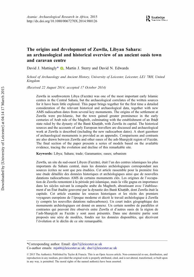
Research on the Sahara in the early Islamic period remains a chronically under-developedfield (Figure 1). Indeed, with a few notable exceptions like Sijilmāsa, Tadmakka,Timbuktu or Tagdaoust/Awdaghust (Robert et al. 1970; Vanacker 1979; Devisse 1983;Polet 1985; Robert-Chaleix 1989; Lightfoot and Miller 1996; Insoll 2003; Nixon 2009),the archaeological exploration of the great centres of Islamic Saharan trade has laggedbehind historical analysis (Lewicki 1976; Thiry 1995; Devisse 1992; Levtzion andHopkins 2000; Brett 2006; but see Insoll 2006 for a recent review of Islamic archaeologyin the Sahara). In the Libyan Sahara, the state of research is particularly unsatisfactory.Even UNESCO World Heritage Sites like Ghadāmis remain somewhat superficiallyexplored archaeologically (Cuneo 1996; Cuneo et al. 1997; cf. Mattingly and Sterry2010). Ethnographic and anthropological studies of the main Libyan oases haveprogressed comparatively little since the great Italian and French colonial surveys(Eldblom 1968; Jamal 2008; cf. Scarin 1934, 1937a, 1937b, 1937c, 1937d, 1938; Despois1946; Lethielleux 1948). Given the unsettled political conditions prevailing since theLibyan Revolution of 2011, which preclude new investigations in a time of increasedthreat to the region’s cultural heritage, the lack of a full evaluation of heritage resources inthe Saharan oases is a particular concern. This is highlighted by reports that themonumental Islamic tombs at Zuwīla have been demolished in 2013.
The early Arabic sources emphasised one key Libyan oasis above all others —Zuwīla (see inter alia Thiry 1995: 356–373, but note the alternative spelling, Zawīla).However, the archaeological correlates of the sparse primary source references have beenlittle considered. The present paper is part of a body of work reassessing early urbanismin the trans-Saharan zone, with a particular focus on the Central Sahara (see Mattinglyand Sterry 2013). Our work developed from a programme of research focused on an earlySaharan civilisation known as the Garamantes, located in southwestern Libya (Mattingly2006, 2011). We have previously identified two Garamantian sites as having urbancharacteristics, Old Jarma and Qasr ash-Sharrāba, and have speculated on the existence of
Figure 1. Map of the Libyan Sahara showing the position of Zuwīla in relation to Jarma and themain Saharan routes.
2 D. Mattingly et al.
Dow
nloa
ded
by [
Uni
vers
ity o
f L
eice
ster
] at
04:
14 1
7 M
arch
201
5

further Saharan towns (Mattingly and Sterry 2013). In the case of Jarma, we havepresented a detailed urban biography of the site (Mattingly et al. 2013: 505–544). Thespecific aims of this paper are to provide a fuller evaluation of what is known historicallyabout Zuwīla and to present in detail the available archaeological data and a more precisechronology for the site. In its final section we advance a plausible sequence ofdevelopment of this important Saharan oasis centre based on all the currently availableevidence. A gazetteer of archaeological monuments is provided as Appendix 1 and asummary of the material dating evidence as Appendix 2.
The early medieval period has generally been considered pivotal in the extension andintensification of trans-Saharan trade and this has also been linked with the spread ofIslam from the Maghrib across the Sahara (Austen 2010: 19–22). On the southern fringesof the Sahara there is firm evidence of trans-Saharan contacts in the earlier firstmillennium AD at sites such as Kissi in Burkina Faso and Culabel and Siouré in Senegal(MacDonald 2011; Magnavita 2013). However, sites dating to the seventh to tenthcenturies, such as Tadmakka, Gao, Marandet and Kumbi Saleh show a step-change in thevolume of importations such as beads and glazed ceramics at this time (Insoll 1996;Magnavita et al. 2007; Nixon 2009; MacDonald 2011; Magnavita 2013). Yet, this hasalways been at odds with the evidence from the Libyan Sahara where sites linked to theGaramantes, whose power flourished in the first to sixth centuries AD, demonstrateplentiful evidence of wide trading contacts (Mattingly 2013a). Some outlying Garaman-tian centres, like Aghram Nadharif and Fewet near Ghāt (Liverani 2006; Mori 2014), hadundergone significant decline (or abandonment) by the sixth century. Archaeologicalsurvey elsewhere in the heartlands of the Garamantes, in the Wādī al-Ajāl, the Wādī ash-Shātī and the Murzuq Basin, have shown an increasing emphasis on defensive structuresat Garamantian settlements; in the Murzuq area at least this was linked to an expansion ofsettlement (Edwards 2001; Sterry and Mattingly 2011; Merlo et al. 2013). Further northin the Libyan pre-desert the gradual withdrawal of Roman forts and of the garrisonsettlements of al-Qurayyāt al-Gharbīya (Mackensen 2012) and Bū Nijīm (Mattingly1995: 95–97) was accompanied by a general thinning of increasingly fortified farmingsettlements in the Libyan valleys (Barker 1996: 166–167). It is hard to avoid theconclusion that there was a reduction in population and cultivated areas, even a wholesaleabandonment of some regions, during late antiquity. However, the transformation of theSahara in late antiquity was not all about decline — indeed, the early Arab sourcesemphasise the opening up of the Sahara through the spread of Islam and opportunitiesarising from new trade networks (Thiry 1995; Levtzion and Hopkins 2000).
Zuwīla is of particular importance in this regard, as it was clearly a key location in thetransition between a Roman/Garamantian Sahara and an Islam-dominated Sahara. Thispaper presents a number of separate strands of investigation, summarising observationsmade more than 50 years ago by Charles Daniels, along with the more recent surveyfindings of the Fazzān Project (Mattingly 2007: 282–288). As part of a wider remote-sensing and dating programme for the Central Sahara, a small number of AMS samplesfrom Zuwīla have now been dated at the Oxford Radiocarbon Accelerator Unit (ORAU)and we have also carried out mapping and analysis of Zuwīla and its environs, utilisingWorldview-2 imagery Zuwīla in conjunction with a run of aerial photographs from 1958.In combination with a reassessment of the historical and archaeological record, thisallows us to advance a substantially changed picture of Zuwīla and throws new light onits trans-Saharan role that linked the Islamic Maghrib with Sub-Saharan Africa.
Azania: Archaeological Research in Africa 3
Dow
nloa
ded
by [
Uni
vers
ity o
f L
eice
ster
] at
04:
14 1
7 M
arch
201
5
The historical record
First to sixth centuries AD
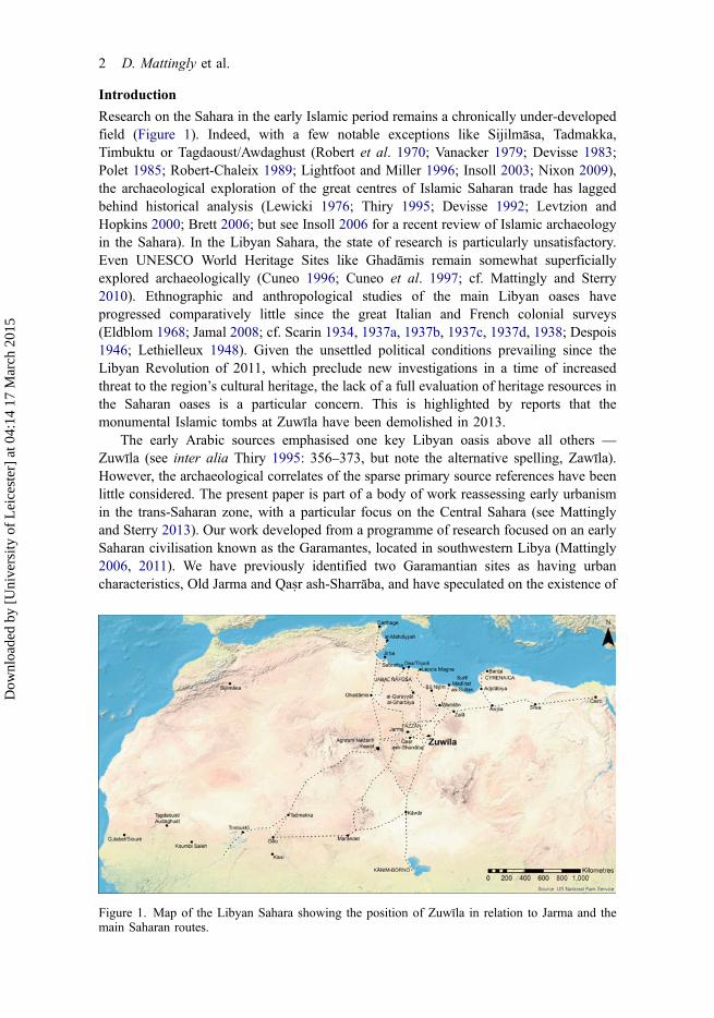
There are no explicit references to Zuwīla in the Roman sources, though the Garamantesfeature as an important people of the Central Sahara (for a summary of the sources seeMattingly 2003: 76–90). By supplementing these sources with the results of archaeologicalresearches of recent decades, we know that the Garamantian civilisation occupied the mainoasis bands of southwestern Libyan (Fazzān) and that they were oasis cultivators, living inpermanent, sedentary villages and towns. Zuwīla lies towards the eastern extremity ofFazzān at the start of a route leading past the Syrtic oases (Awjila) and on towards Sīwa andthe oases of the Egyptian Western Desert. It is also astride the most direct north-to-southline of march from the Tripolitanian coastal cities to the Lake Chad area (Figure 1). TheRoman sources refer to kings of the Garamantes and to their metropolis at Garama(Old Jarma in the Wādī al-Ajāl, 250 km to the west of Zuwīla), strongly suggesting thatGaramantian power was exercised over an extensive area (Figure 2). We have argued thatthere was in this period a Garamantian state that controlled the various oasis zones ofFazzān (Mattingly 2003: 76–90, 346–351, 2013: 530–534). As we shall see, there isevidence to show that Zuwīla originated as an oasis settlement in this period (contraLewicki 1988: 287 and Levtzion and Hopkins 2000: 460) and that it had arguably grown tobe a centre of above average size by the Late Garamantian period.
There have been long-running debates about the realities of trans-Saharan trade in thepre-Islamic era with strong partisans both for (Law 1967; Bovill 1968; Liverani 2006)and against (Brett 2006; Austen 2010). The material evidence from this period is
Figure 2. Map of Garamantian settlement in the Libyan Sahara showing the main places named inthe text.
4 D. Mattingly et al.
Dow
nloa
ded
by [
Uni
vers
ity o
f L
eice
ster
] at
04:
14 1
7 M
arch
201
5
growing, both within the Sahara itself (Wilson 2012; Mattingly 2013b) and to its south(Insoll 2003; MacDonald 2011; Magnavita 2013), such that we can attest to examples ofcontacts and movement of goods, though the scale and nature of trade overall remaindifficult to delineate when so many of the probable key commodities are archaeologicallyinvisible or at best severely under-represented in the surviving material record. Betweenthe Garamantes and Rome there were certainly substantial contacts. Excavated Garaman-tian tombs and settlements have recovered the remains of thousands of amphorae alongwith numerous other ceramics, examples of glassware and beads. When extrapolated to thehundreds of settlements and cemeteries found in Fazzān, this implies caravan tradenumbering in the hundreds of camel loads per year (Mattingly 2013b). However, thetransport of amphorae, weighing up to 90 kg each along with other ceramics (all heavy andbreakable), should perhaps be considered aberrant, rather than the main indicator ofSaharan trade. The evidence now available attests much more clearly than hitherto to therehaving been substantial contacts between the Garamantes and Rome and between theGaramantes and Sub-Saharan areas (Fenn et al. 2009; MacDonald 2011; Wilson 2012;Mattingly 2013b). Gold was an important component of later Saharan trade and is aplausible candidate for the elusive smoking gun to satisfy sceptics concerning pre-Islamicactivity (Bovill 1968; Garrard 1982; Wilson 2012). The hunt continues for pre-Islamicgold-working sites that also have materials of Garamantian or Mediterranean provenance(Kissi in Burkina Faso is plausibly close to gold workings, but still lacks the vital proof ofprocessing; Magnavita 2003, 2008, 2009, 2013; cf. MacDonald 2011). Slaves wereanother key commodity and were a prime driver of the interest of Mediterranean empiresand kingdoms in the Sahara (Haour 2007, 2011; Lydon 2009; Fentress 2011). Thus, whilecontacts between the Garamantes and Sub-Saharan Africa are attested, they are far moredifficult to assess in terms of scale. Nonetheless, the default reading of the evidence is onceagain shifting in favour of there having been some regular trading contacts across theSahara in the pre-Islamic era. As we shall see, Zuwīla may contribute some proxy evidenceto the debate on pre-Islamic trade. The scale of this trade was such that it wasfundamentally tied to the power of the state. During the Late Garamantian period, tradeat Jarma declined, as is amply attested in its material record (Mattingly 2013a). As theurban centre began an inexorable decline, settlement flourished in the more easterly partsof Fazzān and it is within this context that Zuwīla may have begun to grow. The increasedisolation of the central Maghrib in the fifth century following the Vandal conquest ofRoman North Africa (AD 429–439) may have stimulated a diversion of trade towardsCyrenaica and the Nile which Zuwīla was better placed to take advantage of.
Seventh to ninth centuries
There are more numerous sources on the Sahara in Islamic times (Mattingly 2003:90–106, for a summary; Levtzion and Hopkins 2000 is the essential compendium; Rossi1968 is a good commentary on events relating to Libya). The earliest historical eventrelating to Zuwīla concerned a raid by ‘Uqba bin Nāfi‘ in AD 642 from Barqa in Cyrenaica(Monès 1988: 231; Thiry 1995: 53–56). A second raid in AD 666/667 recorded by bothIbn ‘Abd al-Hakam (writing in the mid-ninth century) and al-Bakrī (in the eleventhcentury) ended with ‘[the person referred to is ‘Uqba (with an accent)] ‘Uqba’s armyresting at the site of the present Zuwīla’ (Thiry 1995: 76–109; Levtzion and Hopkins 2000:12–13 and 63). Although the historicity of this raid has been called into question(Brunschwig 1947), most scholars accept the broad framework of the account. However,the reference to ‘the site of the present Zuwīla’ has sometimes been taken to imply that the
Azania: Archaeological Research in Africa 5
Dow
nloa
ded
by [
Uni
vers
ity o
f L
eice
ster
] at
04:
14 1
7 M
arch
201
5

oasis, if it existed at this time, was not yet urban in scale. It is not clear in the sourceswhether ‘Uqba’s raid permanently created an Arab outpost in the Sahara at Zuwīla (Martin1969: 17 suggests not, though Thiry 1995: 54, note 6, notes that Barqa and Zuwīla weretowns under ‘Uqba’s jurisdiction until he was named governor of Ifrīqiya in AD 670). Onepossible reading of Ibn ‘Abd al-Hakam’s account is that power in this part of the CentralSahara had already become fragmented by the seventh century, rather than being stillunder the authority of a single Garamantian king (Mattingly 2003: 85–92).
The historical sources make much more sense in fact if the pre-existence of asettlement and oasis at Zuwīla is recognised. As we have noted, the early Arab sourcesimply that ‘Uqba first became aware of Zuwīla’s existence at the time of the conquest ofBarqa in Cyrenaica (Levtzion and Hopkins 2000: 63). This suggests the existence of tradelinks running from eastern Fazzān to Cyrenaica and Egypt and, as we have already noted,Zuwīla sat at one of the likely junction points between the south-north route and the routerunning to the northeast. A striking feature of the early Islamic sources, if we accept theirhistoricity, is that the conquest of the Sahara was undertaken in parallel with the conquestof the Mediterranean littoral and the Maghrib. This does not make much sense for thosewho wish to deny the existence of pre-Islamic trade, but the Sahara will have been a farmore attractive territory for the Arab armies if we accept that there was significant pre-Islamic Saharan trade. If some part of that trade was already diverted towards Egypt, it isalso easy to understand how and why the Islamic forces will have made the Saharancentres a prime target of their early forays westward. They arguably knew as much ormore at this stage about commercial wealth from the Sahara as they did about theprodigious agricultural wealth of the Maghrib. Taken at face value, the raids on Zuwīlaand Waddān in the 640s (by ‘Uqba bin Nāfi‘ and Busr Ibn Abi Artah respectively) andthe subsequent campaigns in the 660s of ‘Uqba bin Nāfi‘ against Waddān, Jarma, Kawārand Ghadāmis seem to reflect an awareness of, and a desire to control or extract resourcesfrom, a potentially lucrative trade network. The motivation of the campaign in 666 wasapparently that the people of Waddān had ceased to honour the agreement that they hadmade with Busr Ibn Abi Artah.
If Zuwīla had already been visited by an Arab force in the 640s and a treaty agreed, itis understandable why ‘Uqba’s subsequent invasion of Fazzān made it a focal point ofboth the campaigns and their follow-up. While Waddān had reneged on its agreement, thelack of reference to retribution against Zuwīla perhaps suggests that that settlement hadremained true to its treaty with ‘Uqba. When Ibn ‘Abd al-Hakam says that after takingJarma, ‘‘Uqba sent his baggage train off towards the east’ (Levtzion and Hopkins 2000:12), it is pertinent to ask where was this going and why? This was the moment that ‘Uqbalaunched a lightning raid with his cavalry forces through southern Fazzān and towardsKawār. The slow-moving baggage train, no doubt retaining some troops to guard it, wassurely not left to camp out in potentially hostile territory. A probable scenario is thatZuwīla was already considered a ‘friendly’ centre and that ‘Uqba was sending hisbaggage train there to await his return. At any rate, it was Zuwīla for which he made onhis return from Kawār and something of significance evidently happened there as Ibn‘Abd al-Hakam described how he ‘marched until he reached the site of the presentZuwīla. Then he travelled again until he came back to his army [near Surt]’ (Levtzion andHopkins 2000: 13). Why not simply say he marched back to his army? The obviousexplanation is that he was reunited with his baggage train at Zuwīla and potentially madefurther dispositions to cement the relationship between the Arabs and the settlement there.From that time on, Zuwīla was the key Libyan site through which the Arab authorities
6 D. Mattingly et al.
Dow
nloa
ded
by [
Uni
vers
ity o
f L
eice
ster
] at
04:
14 1
7 M
arch
201
5
sought to access Sub-Saharan goods and slaves, along with, but to a lesser extent than,Waddān and Ghadāmis.
The subsequent story of Zuwīla and the Ibādī Muslims is very much bound up withthe strong nonconformist tendencies manifested by a series of related religious groupswithin Africa — for instance, the Khārajites and Rustumids — a phenomenon that is inpart connected to the specificities of incorporating Berber converts to Islam. A key themein the early Islamic history of the Maghrib and the Sahara concerns the oscillatingrelations between orthodox and nonconformist powers, moving repeatedly fromsymbiotic trading to warfare and revolt. Because of their remote location and wealth,Saharan oases like Zuwīla were periodically centres of the religious and politicalresistance of Berber Muslims against overlordship by the main Islamic dynasties in theMaghrib. Ibādīsm has thus been depicted as part of a revolutionary doctrine in NorthAfrica (Talbi 1988) and, as well as subverting the orthodoxy of Islam in Ifrīqiya, we mayconsider that it was an important element in the spread of Islam in the Saharan frontierzone of the Islamic empire. However, Moraes Farias (2003) has demonstrated in theArabic inscriptions from Mali that there were also groups of mixed religious affiliationparticipating in trans-Saharan trade.
It was in the mid-eighth century that Zuwīla started to become regularly mentioned inArabic sources and Lewicki (1957: 339–343; cf. el-Hesnawi 1990: 29) has argued that itwas around this time that a large number of Ibādīs settled in Fazzān. By AD 761 Zuwīlawas established as an important city on the trans-Saharan route from Tripoli to Lake Chadand it was attacked by Ibn al-Ash‘ath who massacred many of Zuwīla’s Ibādī population,including their leader (Lewicki 1988: 287). The Ibādī population in Zuwīla neverthelessseems to have recovered and it is mentioned by al-Ya’qūbī in AD 889–890. Al-Ya’qūbīalso provides the first detailed account of Zuwīla, describing its exportation of slavesfrom the kings of the Sūdān and of skins known as al-zawīliyya, its agriculture of dates,sorghum and other grains and the varied make-up of the town, the inhabitants of whichcame from as far away as Khurāsān, al-Basra and al-Kūfa (Levtzion and Hopkins 2000:22). Whilst based in Egypt he noted that at least some Zuwīlan pilgrims turned up eachyear and el-Hesnawi (1990: 259) has interpreted this to mean that Zuwīla was used as astaging post for pilgrims coming from all across the Sahara and the western Sūdān.Zuwīla also became a centre for a growing number of Ibādī scholars (el-Hesnawi 1990:30–31), including the poet Di’bil b. ‘Alī al-Khuzā‘, who died and was entombed inZuwīla (Levtzion and Hopkins 2000: 63).
With strong ties to the Ibādī communities in Tripolitania (notably those in the JabalNafūsa) and elsewhere in the Sahara and being located more directly on the trans-Saharantrade routes, Zuwīla was able to cement its position as the most important trading centrein Fazzān. The importance of Ibādī Muslims at Zuwīla was no doubt a consequence ofthe significant role played in the caravan trade by people based in Tripolitania whereIbādīsm became first established. Refugees from periodic conflict between IbādīteMuslims in Tripolitania and the mainstream Arab rulers of the Maghrib in the 750s–760s,811–812 and 921–922 will no doubt have contributed to the reinforcement of SaharanIbādīte communities. The Banū Khattāb dynasty at Zuwīla was born out of this Ibādīdominance at the oasis.
Tenth to twelfth centuries — the Banū Khattāb dynasty
In 918 a new kingdom emerged at Zuwīla under ‘Abd Allāh ibn al-Khattāb al-Hawwārī(Levtzion and Hopkins 2000: 122). This state held considerable influence in the Maghrib
Azania: Archaeological Research in Africa 7
Dow
nloa
ded
by [
Uni
vers
ity o
f L
eice
ster
] at
04:
14 1
7 M
arch
201
5
and was the dominant power in Fazzān until the death of its final ruler in 1172–1173.Writing in 1068, al-Bakrī described Zuwīla as a town at the centre of a web of tradingroutes:
‘Zuwīla… is a town without walls and situated in the midst of the desert. It is the first pointof the land of the Sūdān. It has a congregational mosque, a bath and markets. Caravans meetthere from all directions and from there the ways of setting out radiate. There are palm grovesand cultivated areas which are irrigated by means of camels … Between Zuwīla and the townof Ajdābiya there are fourteen stages … From there slaves are exported to Ifrīqiya and otherneighbouring regions. They are bought for short pieces of red cloth. Between Zuwīla and theregion of Kānim is 40 stages. The Kānimīs live beyond the desert of Zuwīla and scarcelyanyone reaches them. They are pagan Sūdān’ (Levtzion and Hopkins 2000: 63–64).
The account of al-Idrīsī, written about a century after al-Bakrī, identifies the town as thesouthwestern terminus of a route running west from Awjila, via Zāla, also connectingwith the coast at Surt via Waddān:
‘The town of Zuwīlat Ibn Khattāb is in the desert. It is a small town with markets. From thereone may go to the regions of Sūdān. The inhabitants drink from wells of sweet water.There are many palms with good fruit. Travellers bring there merchandise for its supply andall things that are needed. Arabs roam the country causing as much trouble for the people[of Zuwīla] as they can. All these areas… are in the hands of the [nomad] Arabs’ (Levtzionand Hopkins 2000: 129–130).
Another anonymous account of c. 1191, the Kitab al-Istibsar, also includes a shortmention of Zuwīla:
‘Zuwīla is a great and very ancient city in the desert. It is near the land of Kānim, who are ofthe Sūdān. They [the Kānimi] had embraced Islam some time after 500 [AD 1106–1107]. Itis the place of assembly for caravans and slaves are brought to it. It is the point of departurefor Ifrīqiya and other countries’ Levtzion and Hopkins 2000: 138).
The trading of slaves from the Sūdān to Ifrīqiya remained of crucial importance and, as wesaw above, al-Bakrī describes how they were bought for pieces of cloth (hinting thattextiles were an important good heading south). The rulers of Zuwīla were careful tonegotiate the politics of the Fatimids, who dominated Tunisia and the Libyan coast formost of the tenth century before conquering Egypt in 969. In 992 they sent a mission withgifts of slaves, a giraffe and other goods from the Sūdān to the Zirid governor of al-Mahdiyyah in modern Tunisia (Martin 1985: 78–79). The Mai of Kānim (in the Lake ChadBasin) must also have passed through Zuwīla on his two visits to Egypt between 1098 and1150 (Martin 1985). Benjamin of Tudela, who died in 1173, mentions Zuwīla as one of thenations the merchants of which had established themselves at Alexandria (Adler 1907:106) and also describes merchants from Helwan, near Cairo, leaving with copper, grain,salt, fruits and legumes and returning with gold and precious stones (Adler 1907: 96;although surely many of these were exchanged at the oases along the journey, this is thesame route that was taken by the German explorer Friedrich Hornemann in 1798). TheBāb az-Zuwīla, one of the gates of Fatimid Cairo, was built in the late eleventh century(1087–1091) and its name has been attributed to the warrior-slaves from the south whogarrisoned it and were known as the Zuwīlayin (Lyon 1821: 217; Edwards 2011: 90).
Trade in slaves seems to have been a key element in the importance of Zuwīla fromthe very start of contact with the Arab world (Levtzion and Hopkins 2000: 1–131). Whilesome have argued that slave trading was a development of the eighth or ninth centuries
8 D. Mattingly et al.
Dow
nloa
ded
by [
Uni
vers
ity o
f L
eice
ster
] at
04:
14 1
7 M
arch
201
5

(on the different commodities of trade, see Bovill 1968; Vanacker 1973; Haour 2007,2011; though mainly focused on later periods Savage 1992 is also useful), it seemsequally plausible that it was part of the raison d’être of a site like Zuwīla in the firstplace. We might note that the raid of ‘Uqba bin Nāfi‘ in AD 666/667 — attacking themain oasis locations in Fazzān and following the route south to Kāwār — involved thetaking of slaves from every point on the route (with the levy from Waddān evidentlybeing a reimposition of a tribute levied in slaves reportedly first instituted in the 640s;Levtzion and Hopkins 2000: 12).
During the rule of the Banū Khattāb dynasty, Zuwīla also appears to have developed asignificant role in the trans-Saharan gold trade. The Persian geography Hudud al-‘Alammentions the gold riches of Zuwīla’s Berber inhabitants (Baadj 2013: 286) and we havealready seen Benjamin of Tudela’s description of merchants returning from it with gold(Adler 1907: 96). In 1023/24 Zuwīla even issued its own dinars as is firmly attested bythe publication of two coins, one of unknown provenance and the other from Zuwīla itself(Lavoix 1896: 86–87; Mostafa 1965: 126–127). These bear the name of the Fatimidcaliph az-Zahar le-l’zaz Din Allah (reigned 1021–1036). It is possible, given thediscovery of coin moulds at Tadmakka in northern Mali (Nixon et al. 2011), and thedescriptions of blank dinars in al-Bakrī (Levtzion and Hopkins 2000: 85) that the peopleof Zuwīla were stamping coins that had been produced from West African gold on thesouthern fringes of the Sahara.
In the eleventh century there is evidence that the Banū Khattāb dynasty was able toestablish control over the whole of Fazzān and this coincides with the evidence fromJarma and Tsāwa for the adoption of Islam. At Jarma and Qasr ash-Sharrāba we also seerenewed construction of walls and fortifications that may indicate a revitalisation of thesesites as regional centres under Banū Khattāb suzerainty.
Although outlasting the Fatimids, the Banū Khattāb dynasty was finally overthrownin 1172/1173 by Qarāqūsh, a general of the Egyptian sultan Saladin, who conqueredFazzān and many other parts of the Maghrib. Qarāqūsh was himself besieged at Waddān,where he was eventually executed by Yahyā of the Banū Ghaniya in 1212. Baadj (2013:287–288) has argued that this period corresponded with a more than 80% reduction of theannual gold minted by the Almohad rulers of the Maghrib and that this was evidence of amajor disruption in the gold trade. Hence the instability may be the result of theAlmohads, the Ayyubids (the dynasty established by Saladin) and the Banū Ghaniyavying for the valuable trade routes of which Zuwīla was the key nodal point.
It is possible that the Qarāqūsh dynasty set up its own state based on Zuwīla andWaddān, but if so this came to an end in 1258. A year earlier, a delegation had been sentfrom the king of Kānim to the court of the Hafsid caliph of Tunisia al-Muntasir to presenthim with the gift of a giraffe (Ibn Khaldūn, cited in Martin 1969: 19–20). Martin (1969)suggests that this is evidence of an alliance between the two states. The next year thearmy of Kānim invaded Fazzān and defeated and killed the last son of Qarāqūsh.
Thirteenth to eighteenth centuries
The invasion by Kānim marked the beginning of Zuwīla’s political and economic decline.The representatives of the Kānimi rulers, known as the Banū Nasr, constructed a newcapital at a site just to the southwest of modern Trāghan. The Kānimi capital may well beidentifiable with a large oval walled site (2.2 ha) located by Lange and Berthoud (1977),approximately 5 km southwest of the modern centre. This site is still clearly visible todayin satellite imagery and we have located another walled structure of very similar
Azania: Archaeological Research in Africa 9
Dow
nloa
ded
by [
Uni
vers
ity o
f L
eice
ster
] at
04:
14 1
7 M
arch
201
5
morphology close to Tsāwa — both these fortifications are very different from thefortified villages of Garamantian and early Islamic towns and seem to have parallels inKānim.
There are no significant mentions of Zuwīla in the Arabic sources after this time,although sources are scarce for Fazzān in general. Both Duveyrier (1864: 277) andNachtigal (1974: 151) recorded a tradition that the Banū Nasr were succeeded by theKhurmān, a Fazzāni group from the Wādī al-Ajāl (probably the descendants of theGaramantes), who made Zuwīla the capital of Fazzān once again for some periodbetween the fourteenth and fifteenth centuries. In any event, Zuwīla seems to havemaintained a role in trans-Saharan trade for some time.
In the sixteenth century, when Muhammad al-Fāsī was establishing his rule overFazzān as the first of the Awlād Muhammad, Zuwīla was one of the towns that weresubdued and its chief eliminated (el-Hesnawi 1990; cf. Duveyrier 1864; Lethielleux 1948;Ayoub 1968). The foundation of Murzuq, possibly in the fifteenth or sixteenth centuries(Sterry and Mattingly 2013), appears to have reduced Zuwīla’s importance still further asit lost its role as a terminus of trans-Saharan trade.
European travellers of the eighteenth and nineteenth centuries
There are a number of accounts of Zuwīla by European travellers in the eighteenth andnineteenth centuries and because these contain both important details and some enigmaticaspects, we have chosen to cite them in extensive passages. When Frederick Hornemann(1802) visited in 1798 he described Zuwīla as a town a third of its former size with itscongregational mosque in ruins. His reference to the ruins of a large building with verythick walls within the walled area is a clear reference to the existence of the castle orqaṣabah:
‘Zuila has received the name of Belled-el-Shereef, or town of the Shereefs: in former times itwas an important place, and its circumference appears to have been thrice the extent of whatit is now. Some of the Shereef’s family told me that some centuries past Zuila has been theresidence of the sultans, and the general rendezvous of the caravans: and even yet the voyageto Fezzan is termed, the voyage to Seela, by the caravan from Bornou.
This little city stands on a space about one mile in circuit; as in Augila, the houses have onlya ground floor, and the rooms are lighted from the door. Near the centre of the town, are theruins of a building several stories high, and of which the walls are very thick; and report saysthis was formerly a palace. Without the town near the southern wall, stands an old mosque,little destroyed by time, serving as a sample of the ancient magnificence of Zuila; it containsin the middle a spacious hall or saloon, encompassed by a lofty colonnade, behind whichruns a broad passage, with entrances to various apartments belonging to the establishment ofthe mosque. At some little distance further from the city, appear very lofty edifices, which arethe tombs of shereefs who fell in battle, at the time the country was attacked by infidels’(Hornemann 1802: 56–57).
Despite its dilapidated state, many leading and wealthy men and relations of the Sultan ofFazzān were said to live in Zuwīla (Hornemann 1802: 56) such that it was known as the‘town of sharifs’ and it was customary for the wife of the sultan to be a sharif fromZuwīla or Waddān. There was also evidently enough wealth for Hornemann’s caravan tobe met by Sharif Hindy with 20 horsemen on white horses (Hornemann 1802: 56).
George Francis Lyon, visiting in 1819, similarly drew attention to the ruins of thecastle, the mosque and the tombs of the Banū Khattāb, along with the town’s continuingprestige. Lyon’s description is worth citing extensively:
10 D. Mattingly et al.
Dow
nloa
ded
by [
Uni
vers
ity o
f L
eice
ster
] at
04:
14 1
7 M
arch
201
5
‘We rode out of town to see the extraordinary ruins… The one most esteemed by the Shreefsis an old Mosque, standing at about half a mile to the westward of the town. It is a largeoblong building of evidently an early date, though certainly of Arab origin. The walls arebuilt with a neatness now unpractised and unknown, of unbaked rough bricks and strongbinding clay. At the north-west corner is the Mouaden (or minaret), much dilapidated, butstill of a height sufficient to command an extensive view of the surrounding country. Thelength of the Meseed inside is 135 feet and its breadth is 90, immense dimensions for anArab building, which has no cross walls to support the roof. It is quite open overhead andnothing remains to give an idea of what it once was covered with. There are two niches forthe Imaum; one is in a partition built partly across and near one end, for that purpose; theother is in the wall, and in the form of a pulpit … From this mosque we went to a spot half amile east to examine five buildings, the appearance of which was much more interesting.These are in a line with one another, and have a passage between them of three or four feet inbreadth. They are square; their diameters are about twenty feet, and their height about thirty.They have dome tops, and two windows; one low near the ground, the other high and narrowand situated about ten feet above it. The rough skeleton of the building is of sun-dried bricksand clay, which has hardened to nearly the consistency of stone; over this, to about half theheight of the building are laid large flat stones of reddish colour, and unhewn, as found in theneighbouring mountains. Few of these still adhere.
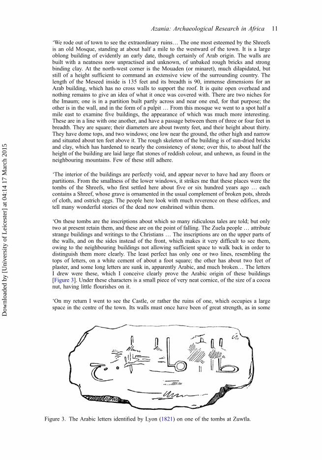
‘The interior of the buildings are perfectly void, and appear never to have had any floors orpartitions. From the smallness of the lower windows, it strikes me that these places were thetombs of the Shreefs, who first settled here about five or six hundred years ago … eachcontains a Shreef, whose grave is ornamented in the usual complement of broken pots, shredsof cloth, and ostrich eggs. The people here look with much reverence on these edifices, andtell many wonderful stories of the dead now enshrined within them.
‘On these tombs are the inscriptions about which so many ridiculous tales are told; but onlytwo at present retain them, and these are on the point of falling. The Zuela people … attributestrange buildings and writings to the Christians … The inscriptions are on the upper parts ofthe walls, and on the sides instead of the front, which makes it very difficult to see them,owing to the neighbouring buildings not allowing sufficient space to walk back in order todistinguish them more clearly. The least perfect has only one or two lines, resembling thetops of letters, on a white cement of about a foot square; the other has about two feet ofplaster, and some long letters are sunk in, apparently Arabic, and much broken… The lettersI drew were these, which I conceive clearly prove the Arabic origin of these buildings[Figure 3]. Under these characters is a small piece of very neat cornice, of the size of a cocoanut, having little flourishes on it.
‘On my return I went to see the Castle, or rather the ruins of one, which occupies a largespace in the centre of the town. Its walls must once have been of great strength, as in some
Figure 3. The Arabic letters identified by Lyon (1821) on one of the tombs at Zuwīla.
Azania: Archaeological Research in Africa 11
Dow
nloa
ded
by [
Uni
vers
ity o
f L
eice
ster
] at
04:
14 1
7 M
arch
201
5
places I observed them to be about thirty feet in thickness … the Castle had nothing to boastof but the solidity of its materials … the present walls of Zuela are of the same materials asthe Castle. The town has but few good houses; but, judging from the ruins I saw, I shouldconceive it must once have been of much consequence and built in a manner rather superiorto Arab towns in general … The town has three good mosques, and three gates of entrance’(Lyon 1821: 214–217).
He also mentioned an ‘archaeological’ discovery he made by accident:
‘Near the town, my horse stumbled and fell into a grave, which, from its being hollow, ledme to examine it … From the side of the first pit a chamber of the same length is excavatedin the gravel, which lies under the surface of the sand, and the body is placed in the vault, thepit alone is filled with earth’ (Lyon 1821: 217).
Hugh Clapperton also left a diary record of a visit in May 1822, but note that when herefers to the Castle, he is referring to the walled town, rather than the qaṣabah (BruceLockhart and Wright 2000: 59–60; the punctuation and spelling are as in the original):
‘We were waited upon by Shereef Hamed before we got out of bed & in about an hourafterds he returned & we went with him to visit the remains of the castle which has been thelargest in this country that we have seen but is now in ruins it is built of clay & gravel beingplaced in large wooden frames & beat down with ramers at first sight they look like immensestones and are mostly as hard it has flanking towers of a square form about 20 paces distantfrom one another - the north end which is complete & joins part of the Town wall is 200paces in length & the height of what remains may be about 35 feet & is nearly 25 feet thickat the base decreasing in thickness as it goes up - the greater part of the town is built withinthe square of the castle the houses are the best I have seen in Fezan & the streets are muchbroader than in Moorish towns in general -‘From the Castle we went to the ruins of aMosque about a 1/4 of a mile to the East of the town the walled part of the Mouadan & mostof the Arches that supported the domed roof yet remain they are formed much like the gothicarch but the pillars are very rude - the whole is built of sun dried bricks & morterd it has beenwhite washed & plasterd inside from the church we went to their tombs which they say werebuilt by the Romes but they were Mislem each tomb may be about 30 feet high having [a]small window near the top covered with [a] dome at top containing one grave each thebodies lying north & south like all true believers who are buried with their right arm undertheir head & their faces looking towards Mecca they are built of sun dried bricks faced overwith flags of sand stone & round the tops below the dome has been a cornice with ornaments& arabic inscriptions only two or three of which now remain - There are two windows at the[top] & one at the bottom of each of the buildings those at the top being longer & broader &arched over’
Most of the other nineteenth-century Saharan travellers by-passed Zuwīla and did not addsignificant information about the site.
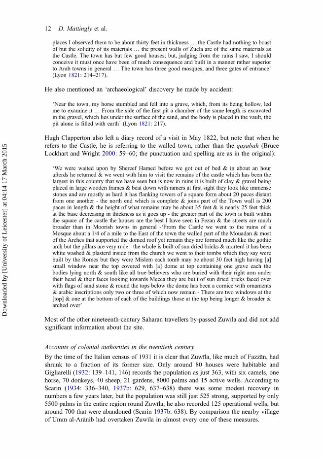
Accounts of colonial authorities in the twentieth century
By the time of the Italian census of 1931 it is clear that Zuwīla, like much of Fazzān, hadshrunk to a fraction of its former size. Only around 80 houses were habitable andGigliarelli (1932: 139–141, 146) records the population as just 363, with six camels, onehorse, 70 donkeys, 40 sheep, 21 gardens, 8000 palms and 15 active wells. According toScarin (1934: 336–340, 1937b: 629, 637–638) there was some modest recovery innumbers a few years later, but the population was still just 525 strong, supported by only5500 palms in the entire region round Zuwīla; he also recorded 125 operational wells, butaround 700 that were abandoned (Scarin 1937b: 638). By comparison the nearby villageof Umm al-Arānib had overtaken Zuwīla in almost every one of these measures.
12 D. Mattingly et al.
Dow
nloa
ded
by [
Uni
vers
ity o
f L
eice
ster
] at
04:
14 1
7 M
arch
201
5
Gigliarelli (1931: 141) had the following to say about Zuwīla (for original text seeAppendix 3):
‘It is one of the oldest inhabited centres of Fazzān, and reached its maximum population andcommercial development under the Banū Khattāb dynasty, who chose it as the capital of theregion… The village, quasi-rectangular in shape, is constructed in a depression that iscompletely detached from the oasis [of ash-Sharqiyat?]. To the north and south thedepression is limited by two chains of hills about 6 kilometres from Zuwīla. In the middleof the village are the ruins of an ancient castle with massive walls, which could be tracedback to Roman times: in fact, the quadrangular plan is reminiscent of a Roman castrum [fort;italics added], but the stones of which it is built do not have the quality of workmanship andregularity usually used by the Romans for buildings of such importance. Currently, theseremains have almost disappeared under a new building that is used as a barracks by the CC.RR [Italian colonial force]. The construction of the circuit wall is more probably Roman, ofwhich some stretches are still standing. The era of the Banū Khattāb is widely remembered,more from the ruins of the Great Mosque than from the tombs of the sultans of that dynasty.These constitute a line of seven structures each with the form of a low tower surmounted by adome. They have rectangular windows on their east and west sides and the blocks ofsandstone of which they are built are perfectly aligned’ (translated by Martin Sterry).
Scarin (1937b: 637–638) largely reprised the account of Gigliarelli, but did not commenton the larger enceinte around the qaṣabah.
In the 1940s the French mission to Fazzān identified Zuwīla as one of two centres(the other being Tmissa) where occupation had been continuous for more than 1000years (Despois 1946: 103–104). From an original open and extensive settlement, the sitehad eventually withdrawn within a strong enceinte of pisé construction, pierced by fourgates. In the northwestern angle of the fortified town, Despois credited the Turks withthe construction of a small fort (the qaṣabah) that was subsequently further adapted bythe Italians. The growth of the town beyond the northern and eastern defences seems tohave followed the reorientation of the settlement following the creation of this fort, witha wide area of ground around it cleared of buildings and a new main mosqueconstructed facing it to the east. Despois (1946: 214–215) was also the first modernvisitor to comment on the ‘assez nombreux’ remains of foggaras in the Zuwīla area, buthis account otherwise adds little to the earlier reports on the old walls, the ruins of the‘white mosque’ and the tombs of the Banū Khattāb. He reported the population of theash-Sharqiyāt region as numbering 2530 people, with Zuwīla, Umm al-Arānib andTmissa being the largest villages, and with just 50,700 palms and 188 gardens, by thenentirely fed by wells.
Archaeological fieldwork at ZuwīlaThe earliest archaeological fieldwork in and around Zuwīla was conducted by Caputo(Pace et al. 1951: 416–419) in October 1933. Although only a note, this provides theearliest plan of the walls of Zuwīla and the monumental tombs that have been commonlyascribed to the Banū Khattāb (Figures 4a and 5a). The largest campaigns of survey andthe only excavation were undertaken in the 1960s and 1970s. The controller of antiquitiesfor Fazzān, Muhammad Ayoub, evidently undertook some fieldwork around Zuwīla,although the nature of this was not reported (Ayoub 1968).
Charles M. Daniels first visited Zuwīla in 1968 as part of a Middle East Land Armyexpedition (Boxhall 1968: 26–27, 50; Daniels 1968), undertaking a systematic survey ofsites around Zuwīla, making a detailed plan of the town walls (Figure 4b) and the BanūKhattāb tombs (Figure 5.c), collecting ceramic material and producing an invaluable
Azania: Archaeological Research in Africa 13
Dow
nloa
ded
by [
Uni
vers
ity o
f L
eice
ster
] at
04:
14 1
7 M
arch
201
5
photographic record (Daniels 1968, 1989; Mattingly 2010: 10–11). The photographs,along with some of the ceramic material collected in 1968, are held in the Archive of theSociety for Libyan Studies in Leicester. The Daniels photographs provide the mostimportant record of the state of the mosque prior to excavation (Figure 6), of the townwalls before late twentieth-century redevelopment and further demolition (Figure 7) andof the tombs prior to their being restored with alterations (Figure 8). He appears to havemade a brief second visit accompanied by John Hayes in April 1972, when he observedthat the Department of Antiquities had carried out considerable reconstruction work onthe tombs of the Banū Khattāb. His notes record that the Department’s workmen hadfound a fragment of mortar cornice and traces of three or four Kufic letters on the side ofa tomb — this seems to be the same fragment spotted by Lyon (see above). This evidencesuggests that the tops of the tombs were originally ornamented in plaster externally.
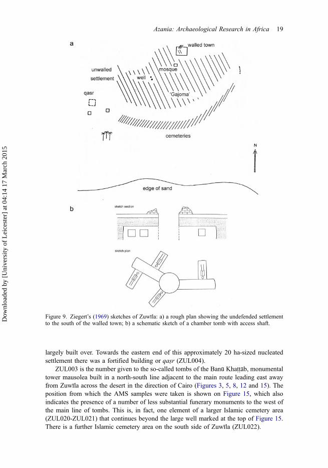
The German archaeologist Helmut Ziegert (1969: 49–52) published some brief noteson the archaeology of Zuwīla, focused on the town walls, the main mosque, the tombs,the hydraulic features and various cemetery areas, including a shaft burial (Figure 9b) that
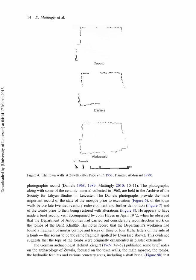
Figure 4. The town walls at Zuwīla (after Pace et al. 1951; Daniels; Abdussaid 1979).
14 D. Mattingly et al.
Dow
nloa
ded
by [
Uni
vers
ity o
f L
eice
ster
] at
04:
14 1
7 M
arch
201
5

was evidently similar to that described by Lyon. He was the first to identify the extensivearea of undefended settlement to the south of the great mosque (Figure 9a, though manydetails of his sketch plan are erroneous or oversimplified). Ziegert also claimed to haveidentified an inscription in Latin letters (‘FUZIU’) on the southeastern corner ofmausoleum 5 (see Figure 5b for his plan), but this is contradicted by Lyon 1821) andCharles Daniels, who both identified the script of the inscriptions as being Arabic/Kufic.
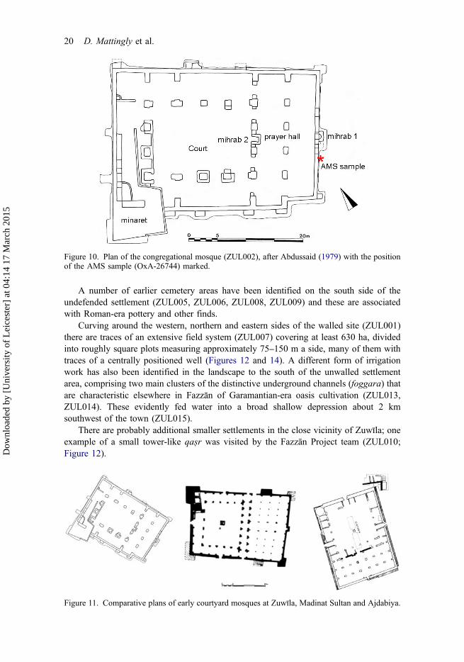
The congregational mosque was subsequently partially excavated by Ziegert andAbdussalam (1969, 1973) and more substantially by Abdussaid (1979; see also thesummary by el-Mahmoudi 1997). It is one of the largest mosques known in theCentral Sahara, especially significant given its presumed early date (Figures 10 and 11).Abdussaid’s short English account (1979: 327–329) was accompanied by a slightly longerArabic text, 65 photographs and six fold-out plans and sections. His account of themosque (Abdussaid 1979: 327–328) suggests that there was some damage as a result ofan earthquake. He also has brief comments on the tombs (Abdussaid 1979: 328), notingthat they were made of white mud-bricks and coated with stone slabs and that they weredecorated around the topmost part of the walls with plaster painted with Kufic inscriptions.The size of the white mud-bricks used for mosque and tombs was similar, leading him tosuggest that the two were contemporary with one another, although as we shall see thereare now reasons to doubt that. Abdussaid recognised that the main settlement associatedwith the mosque was unfortified, but his comments on the walled enceinte to its north arevery brief, notwithstanding the fact that a survey and plan of the walls appears to havebeen done at this time:
‘The fortifications that still stand promenantly (sic) were built nearly at the north-west cornerof the early city. It is difficult to date these late fortifications, but it is clear that they werebuilt without care to conform to geometrical precise alignments. Probably it was done in ahurry to face an urgent circumstance’ (Abdussaid 1979: 329).
Figure 5. Plans of the tombs of the Banū Khattāb at Zuwīla (after Pace et al. 1951; Ziegert 1969;Daniels).
Azania: Archaeological Research in Africa 15
Dow
nloa
ded
by [
Uni
vers
ity o
f L
eice
ster
] at
04:
14 1
7 M
arch
201
5
His verdict as regards the date and relative care and timescale of construction can both bequestioned, though the plan is certainly not a regular rectangle.
John W. Hayes was sent a small amount of ceramics from Ziegert’s excavations in1972 and the full details of his report are described below (Appendix 2). Importantly, thematerial included a number of Roman imports, providing the first evidence for theGaramantian origins of the site.
The most recent fieldwork at Zuwīla was undertaken in 1998 and 2001 by the FazzānProject directed by one of us (DM). The Project revisited many of the sites originallylocated by Daniels, establishing for the first time a systematic list and map and collectingfurther ceramic material (stored at the Jarma Museum), as well as obtaining a number ofsamples for radiocarbon dating from key standing structures. The initial results werepublished as part of the gazetteer of the Fazzān Project (Mattingly 2007: 282–288). TheFazzān Project’s baseline account of the archaeology of Zuwīla is recapitulated andexpanded here, in particular drawing on the AMS dates that have now become availablefrom the Oxford Radiocarbon Accelerator Unit. Finally, in the preparation of this paperwe purchased a 25 km2 Worldview-2 scene centred on the Zuwīla old town and integratedthis along with a sequence of vertical air photographs from 1958 to create acomprehensive plan of all features in the Zuwīla environs (Figure 12). Despite the lack
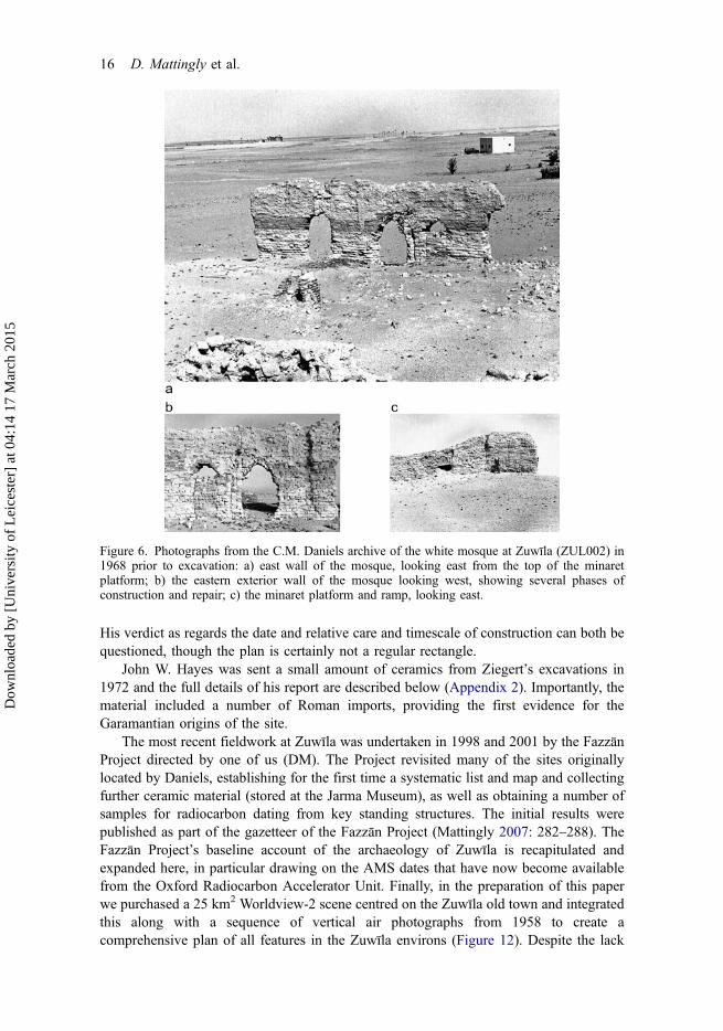
Figure 6. Photographs from the C.M. Daniels archive of the white mosque at Zuwīla (ZUL002) in1968 prior to excavation: a) east wall of the mosque, looking east from the top of the minaretplatform; b) the eastern exterior wall of the mosque looking west, showing several phases ofconstruction and repair; c) the minaret platform and ramp, looking east.
16 D. Mattingly et al.
Dow
nloa
ded
by [
Uni
vers
ity o
f L
eice
ster
] at
04:
14 1
7 M
arch
201
5
of recent excavations at Zuwīla, there is therefore a substantial amount of new data topresent that clarifies in important ways the literary accounts.
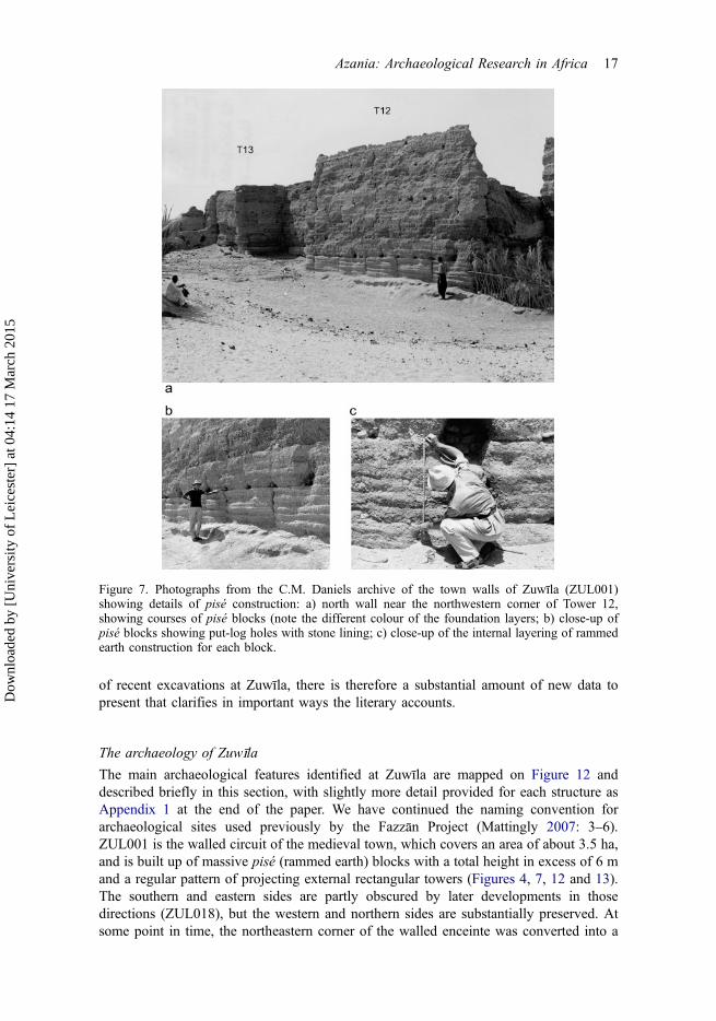
The archaeology of ZuwīlaThe main archaeological features identified at Zuwīla are mapped on Figure 12 anddescribed briefly in this section, with slightly more detail provided for each structure asAppendix 1 at the end of the paper. We have continued the naming convention forarchaeological sites used previously by the Fazzān Project (Mattingly 2007: 3–6).ZUL001 is the walled circuit of the medieval town, which covers an area of about 3.5 ha,and is built up of massive pisé (rammed earth) blocks with a total height in excess of 6 mand a regular pattern of projecting external rectangular towers (Figures 4, 7, 12 and 13).The southern and eastern sides are partly obscured by later developments in thosedirections (ZUL018), but the western and northern sides are substantially preserved. Atsome point in time, the northeastern corner of the walled enceinte was converted into a
Figure 7. Photographs from the C.M. Daniels archive of the town walls of Zuwīla (ZUL001)showing details of pisé construction: a) north wall near the northwestern corner of Tower 12,showing courses of pisé blocks (note the different colour of the foundation layers; b) close-up ofpisé blocks showing put-log holes with stone lining; c) close-up of the internal layering of rammedearth construction for each block.
Azania: Archaeological Research in Africa 17
Dow
nloa
ded
by [
Uni
vers
ity o
f L
eice
ster
] at
04:
14 1
7 M
arch
201
5

citadel or qaṣabah with thick walls (ZUL016). As the walls stood over 7 m tall in thissector and the towers were more closely spaced, it is possible that the early modernqaṣabah replaced an original citadel in this area, dating back to the initial construction ofthe walled enceinte. It is mentioned as being already ruinous by Hornemann (1802: 56–57), but was evidently later refurbished by the Ottoman and Italian authorities.
ZUL002 is the ‘white mosque’, so named because of the employment of distinctivewhite mud-bricks. It is identified with the congregational mosque mentioned by al-Bakrī(Figures 6, 10–12). The position of the mosque is interesting as it lies outside and southof the walled ‘town’ and on the northern edge of an unwalled area of settlement(ZUL012) that is visible on the air photographs from the 1950s (Figure 14), but is now
Figure 8. Photographs from the C.M. Daniels archive of the tombs of the Banū Khattāb at Zuwīla(ZUL003) in 1968 prior to restoration: a) general view, facing west (Tomb 1 to the right); b) Tomb6 to the left); b) Tomb 2, facing east; c) Tomb 5, facing west; d) Tomb 6, facing west; e) niches onthe east wall of Tomb 4, looking west; f) interior of the dome of Tomb 4 (note the timbers across theangles of walls to support the dome); g) Tombs 1 and 2, looking east (note the small gapbetween them).
18 D. Mattingly et al.
Dow
nloa
ded
by [
Uni
vers
ity o
f L
eice
ster
] at
04:
14 1
7 M
arch
201
5
largely built over. Towards the eastern end of this approximately 20 ha-sized nucleatedsettlement there was a fortified building or qaṣr (ZUL004).
ZUL003 is the number given to the so-called tombs of the Banū Khattāb, monumentaltower mausolea built in a north-south line adjacent to the main route leading east awayfrom Zuwīla across the desert in the direction of Cairo (Figures 3, 5, 8, 12 and 15). Theposition from which the AMS samples were taken is shown on Figure 15, which alsoindicates the presence of a number of less substantial funerary monuments to the west ofthe main line of tombs. This is, in fact, one element of a larger Islamic cemetery area(ZUL020-ZUL021) that continues beyond the large well marked at the top of Figure 15.There is a further Islamic cemetery area on the south side of Zuwīla (ZUL022).
Figure 9. Ziegert’s (1969) sketches of Zuwīla: a) a rough plan showing the undefended settlementto the south of the walled town; b) a schematic sketch of a chamber tomb with access shaft.
Azania: Archaeological Research in Africa 19
Dow
nloa
ded
by [
Uni
vers
ity o
f L
eice
ster
] at
04:
14 1
7 M
arch
201
5
A number of earlier cemetery areas have been identified on the south side of theundefended settlement (ZUL005, ZUL006, ZUL008, ZUL009) and these are associatedwith Roman-era pottery and other finds.
Curving around the western, northern and eastern sides of the walled site (ZUL001)there are traces of an extensive field system (ZUL007) covering at least 630 ha, dividedinto roughly square plots measuring approximately 75–150 m a side, many of them withtraces of a centrally positioned well (Figures 12 and 14). A different form of irrigationwork has also been identified in the landscape to the south of the unwalled settlementarea, comprising two main clusters of the distinctive underground channels (foggara) thatare characteristic elsewhere in Fazzān of Garamantian-era oasis cultivation (ZUL013,ZUL014). These evidently fed water into a broad shallow depression about 2 kmsouthwest of the town (ZUL015).
There are probably additional smaller settlements in the close vicinity of Zuwīla; oneexample of a small tower-like qaṣr was visited by the Fazzān Project team (ZUL010;Figure 12).
Figure 10. Plan of the congregational mosque (ZUL002), after Abdussaid (1979) with the positionof the AMS sample (OxA-26744) marked.
Figure 11. Comparative plans of early courtyard mosques at Zuwīla, Madinat Sultan and Ajdabiya.
20 D. Mattingly et al.
Dow
nloa
ded
by [
Uni
vers
ity o
f L
eice
ster
] at
04:
14 1
7 M
arch
201
5
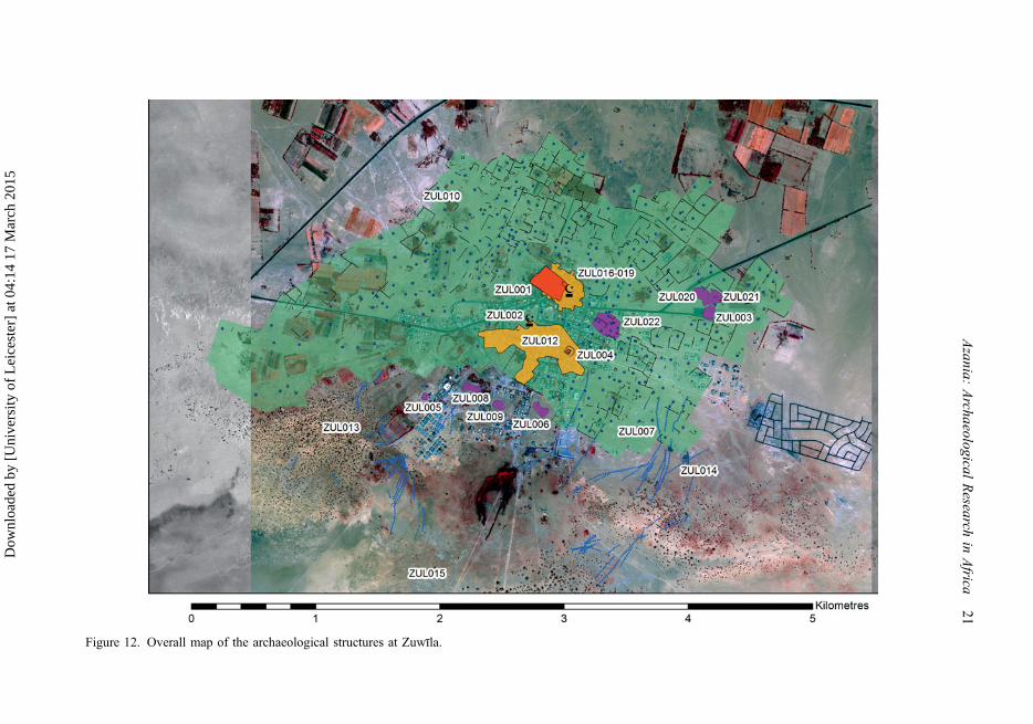
Figure 12. Overall map of the archaeological structures at Zuwīla.
Azania:
Archaeological
Research
inAfrica
21
Dow
nloa
ded
by [
Uni
vers
ity o
f L
eice
ster
] at
04:
14 1
7 M
arch
201
5

It is clear from the different character of the settlement features, cemeteries andirrigation works that we have a palimpsest landscape here. Without more substantial fieldinvestigation and excavation picking this apart is not easy, although some surfacecollections have been made (see Appendix 2) and these can now be supplemented byAMS radiocarbon dates on some of the key structures. The origins of the oasis settlementat Zuwīla can confidently be placed in the Classic Garamantian era, in light of numerousfinds of imported Roman pottery dating to the first few centuries AD. There are nocertain ceramics of the Proto-Urban Garamantian period (500-1 BC), something that isalso characteristic of the Murzuq area, where the main development of oases appears tofall in the Classic and Late Garamantian eras (Sterry et al. 2012; Sterry and Mattingly2013). A small fragment of a Hellenistic eye-bead reported by Daniels in his unpublishednotes on the site could have been long curated before its deposition at the site. Thepresence of foggara irrigation systems is another probable indication of the initialGaramantian development of the oasis, since the introduction of this technology to theCentral Saharan region can now be firmly dated to Garamantian times, while the Islamicsources specify the use of wells for irrigation at Zuwīla and elsewhere in Fazzān.
AMS samples from ZuwīlaWith the agreement of the Libyan Department of Antiquities, a total of four samples weretaking from the key standing monuments of Zuwīla (Table 1 and Figure 16) during thesurvey work undertaken by the Fazzān Project in 2001. In each case botanical remains
Figure 13. The C.M. Daniels plan of the walls of Zuwīla (ZUL) showing the later buildings insideand overlying the enceinte, with the position of AMS sample OxA-26743, the qaṣabah ZUL017and the early modern main mosque (ZUL018) marked.
22 D. Mattingly et al.
Dow
nloa
ded
by [
Uni
vers
ity o
f L
eice
ster
] at
04:
14 1
7 M
arch
201
5

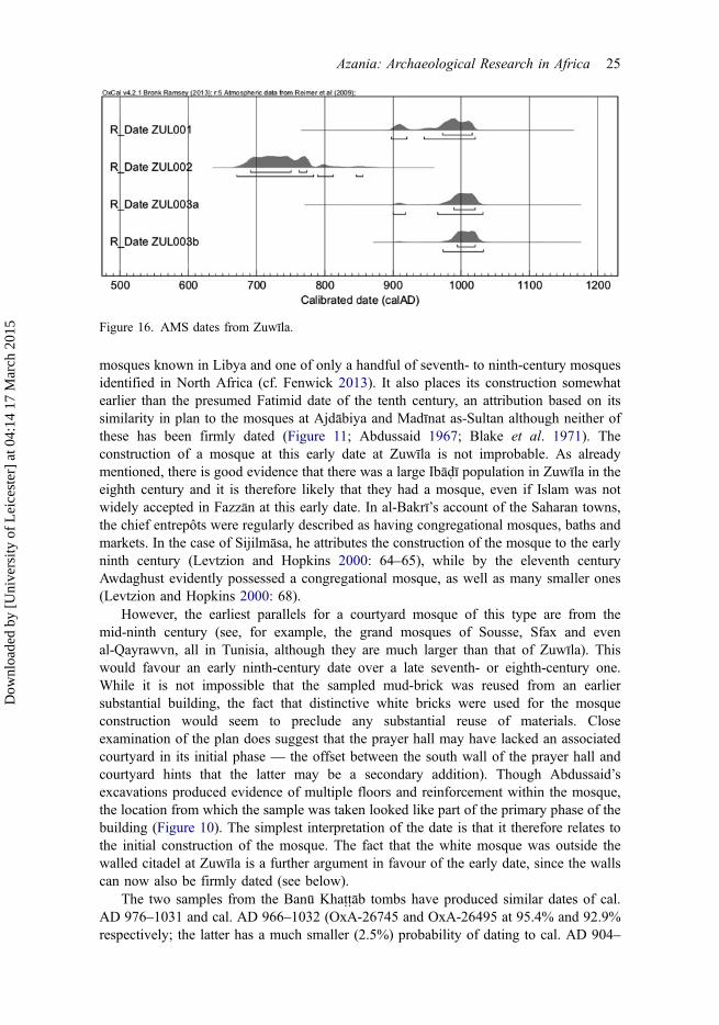
relating to an annual growth cycle (date stone, chaff) were extracted directly from thewall fabric. The sample from the urban wall circuit came from the northwestern cornerbastion and comprised a date stone thoroughly embedded in the rammed earth wall about1.5 m above ground level. Another date stone was extracted from a mud-brick of theexternal face of the eastern wall of the white mosque, just to the south of the mihrab,again at about 1.5 m above ground level. Both of these contexts were judged to beprimary in constructional terms, with no obvious evidence for rebuilding or repair. Thetwo samples from the so-called Banū Khattāb tombs were taken from the mud bondingmortar of the interior mud-brick walls. While the external faces of the monuments hadbeen extensively renovated in recent times, the interior walls appeared untouched inmodern times. The sampled material consisted of thin plant fibres (chaff?) within the mudmortar. The most northerly and most southerly tombs were sampled in case there was asignificant time lag between the construction of the first and last tombs in the line. All thesamples were sent for analysis at the Oxford Radiocarbon Accelerator Unit.
Discussion points
The date on the mosque, cal. AD 670-857 (OxA-26744 calibrated at 95.4%), is perhapsthe most surprising result of these analyses. This would make it one of the earliest
Figure 14. A 1950s air photograph of Zuwīla showing the central features of the site.
Azania: Archaeological Research in Africa 23
Dow
nloa
ded
by [
Uni
vers
ity o
f L
eice
ster
] at
04:
14 1
7 M
arch
201
5
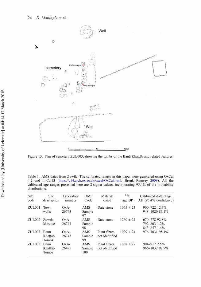
Figure 15. Plan of cemetery ZUL003, showing the tombs of the Banū Khattāb and related features.
Table 1. AMS dates from Zuwīla. The calibrated ranges in this paper were generated using OxCal4.2 and IntCal13 (https://c14.arch.ox.ac.uk/oxcal/OxCal.html; Bronk Ramsey 2009). All thecalibrated age ranges presented here are 2-sigma values, incorporating 95.4% of the probabilitydistributions.
Sitecode
Sitedescription
Laboratorynumber
DMPCode
Materialdated
14Cage BP
Calibrated date rangeAD (95.4% confidence)
ZUL001 Townwalls
OxA-26743
AMSSample97
Date stone 1065 ± 23 900–922 12.3%948–1020 83.1%
ZUL002 ZuwīlaMosque
OxA-26744
AMSSample98
Date stone 1260 ± 24 670–778 92.8%792–803 1.2%843–857 1.4%
ZUL003 BanūKhattābTombs
OxA-26745
AMSSample99
Plant fibres,not identified
1029 ± 24 976–1031 95.4%
ZUL003 BanūKhattābTombs
OxA-26495
AMSSample100
Plant fibres,not identified
1038 ± 27 904–917 2.5%966–1032 92.9%
24 D. Mattingly et al.
Dow
nloa
ded
by [
Uni
vers
ity o
f L
eice
ster
] at
04:
14 1
7 M
arch
201
5
mosques known in Libya and one of only a handful of seventh- to ninth-century mosquesidentified in North Africa (cf. Fenwick 2013). It also places its construction somewhatearlier than the presumed Fatimid date of the tenth century, an attribution based on itssimilarity in plan to the mosques at Ajdābiya and Madīnat as-Sultan although neither ofthese has been firmly dated (Figure 11; Abdussaid 1967; Blake et al. 1971). Theconstruction of a mosque at this early date at Zuwīla is not improbable. As alreadymentioned, there is good evidence that there was a large Ibādī population in Zuwīla in theeighth century and it is therefore likely that they had a mosque, even if Islam was notwidely accepted in Fazzān at this early date. In al-Bakrī’s account of the Saharan towns,the chief entrepôts were regularly described as having congregational mosques, baths andmarkets. In the case of Sijilmāsa, he attributes the construction of the mosque to the earlyninth century (Levtzion and Hopkins 2000: 64–65), while by the eleventh centuryAwdaghust evidently possessed a congregational mosque, as well as many smaller ones(Levtzion and Hopkins 2000: 68).
However, the earliest parallels for a courtyard mosque of this type are from themid-ninth century (see, for example, the grand mosques of Sousse, Sfax and evenal-Qayrawvn, all in Tunisia, although they are much larger than that of Zuwīla). Thiswould favour an early ninth-century date over a late seventh- or eighth-century one.While it is not impossible that the sampled mud-brick was reused from an earliersubstantial building, the fact that distinctive white bricks were used for the mosqueconstruction would seem to preclude any substantial reuse of materials. Closeexamination of the plan does suggest that the prayer hall may have lacked an associatedcourtyard in its initial phase — the offset between the south wall of the prayer hall andcourtyard hints that the latter may be a secondary addition). Though Abdussaid’sexcavations produced evidence of multiple floors and reinforcement within the mosque,the location from which the sample was taken looked like part of the primary phase of thebuilding (Figure 10). The simplest interpretation of the date is that it therefore relates tothe initial construction of the mosque. The fact that the white mosque was outside thewalled citadel at Zuwīla is a further argument in favour of the early date, since the wallscan now also be firmly dated (see below).
The two samples from the Banū Khattāb tombs have produced similar dates of cal.AD 976–1031 and cal. AD 966–1032 (OxA-26745 and OxA-26495 at 95.4% and 92.9%respectively; the latter has a much smaller (2.5%) probability of dating to cal. AD 904–
Figure 16. AMS dates from Zuwīla.
Azania: Archaeological Research in Africa 25
Dow
nloa
ded
by [
Uni
vers
ity o
f L
eice
ster
] at
04:
14 1
7 M
arch
201
5
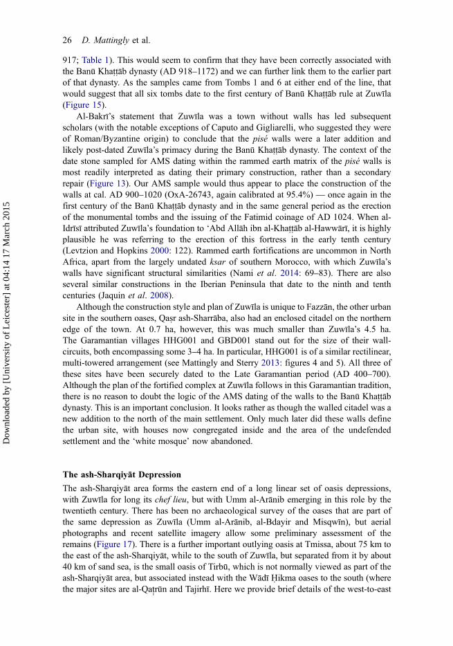
917; Table 1). This would seem to confirm that they have been correctly associated withthe Banū Khattāb dynasty (AD 918–1172) and we can further link them to the earlier partof that dynasty. As the samples came from Tombs 1 and 6 at either end of the line, thatwould suggest that all six tombs date to the first century of Banū Khattāb rule at Zuwīla(Figure 15).
Al-Bakrī’s statement that Zuwīla was a town without walls has led subsequentscholars (with the notable exceptions of Caputo and Gigliarelli, who suggested they wereof Roman/Byzantine origin) to conclude that the pisé walls were a later addition andlikely post-dated Zuwīla’s primacy during the Banū Khattāb dynasty. The context of thedate stone sampled for AMS dating within the rammed earth matrix of the pisé walls ismost readily interpreted as dating their primary construction, rather than a secondaryrepair (Figure 13). Our AMS sample would thus appear to place the construction of thewalls at cal. AD 900–1020 (OxA-26743, again calibrated at 95.4%) — once again in thefirst century of the Banū Khattāb dynasty and in the same general period as the erectionof the monumental tombs and the issuing of the Fatimid coinage of AD 1024. When al-Idrīsī attributed Zuwīla’s foundation to ‘Abd Allāh ibn al-Khattāb al-Hawwārī, it is highlyplausible he was referring to the erection of this fortress in the early tenth century(Levtzion and Hopkins 2000: 122). Rammed earth fortifications are uncommon in NorthAfrica, apart from the largely undated ksar of southern Morocco, with which Zuwīla’swalls have significant structural similarities (Nami et al. 2014: 69–83). There are alsoseveral similar constructions in the Iberian Peninsula that date to the ninth and tenthcenturies (Jaquin et al. 2008).
Although the construction style and plan of Zuwīla is unique to Fazzān, the other urbansite in the southern oases, Qasr ash-Sharrāba, also had an enclosed citadel on the northernedge of the town. At 0.7 ha, however, this was much smaller than Zuwīla’s 4.5 ha.The Garamantian villages HHG001 and GBD001 stand out for the size of their wall-circuits, both encompassing some 3–4 ha. In particular, HHG001 is of a similar rectilinear,multi-towered arrangement (see Mattingly and Sterry 2013: figures 4 and 5). All three ofthese sites have been securely dated to the Late Garamantian period (AD 400–700).Although the plan of the fortified complex at Zuwīla follows in this Garamantian tradition,there is no reason to doubt the logic of the AMS dating of the walls to the Banū Khattābdynasty. This is an important conclusion. It looks rather as though the walled citadel was anew addition to the north of the main settlement. Only much later did these walls definethe urban site, with houses now congregated inside and the area of the undefendedsettlement and the ‘white mosque’ now abandoned.
The ash-Sharqiyāt DepressionThe ash-Sharqiyāt area forms the eastern end of a long linear set of oasis depressions,with Zuwīla for long its chef lieu, but with Umm al-Arānib emerging in this role by thetwentieth century. There has been no archaeological survey of the oases that are part ofthe same depression as Zuwīla (Umm al-Arānib, al-Bdayir and Misqwīn), but aerialphotographs and recent satellite imagery allow some preliminary assessment of theremains (Figure 17). There is a further important outlying oasis at Tmissa, about 75 km tothe east of the ash-Sharqiyāt, while to the south of Zuwīla, but separated from it by about40 km of sand sea, is the small oasis of Tirbū, which is not normally viewed as part of theash-Sharqiyāt area, but associated instead with the Wādī Hikma oases to the south (wherethe major sites are al-Qat rūn and Tajirhī. Here we provide brief details of the west-to-east
26 D. Mattingly et al.
Dow
nloa
ded
by [
Uni
vers
ity o
f L
eice
ster
] at
04:
14 1
7 M
arch
201
5
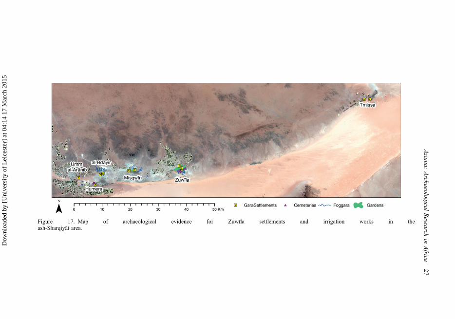
Figure 17. Map of archaeological evidence for Zuwīla settlements and irrigation works in theash-Sharqiyāt area.
Azania:
Archaeological
Research
inAfrica
27
Dow
nloa
ded
by [
Uni
vers
ity o
f L
eice
ster
] at
04:
14 1
7 M
arch
201
5

line of oases of ash-Sharqiyāt as a basis for comparison with the visible archaeology ofZuwīla.
Umm al-ArānibThe most remarkable remains at Umm al-Arānib are those of a walled village some 3 hain area. The buildings are largely upstanding, apart from some modern bulldozing in thenorthwestern and southwestern corners, allowing the full plan to be seen with around 100houses. The village walls are sub-rectangular in plan with corner towers and twointermediate towers on each side. The internal buildings do not abut the village walls onthe east side so that either the walls are a later addition to the village or there has been anextension of village and walls to the east at some point. No building can be identified as amosque from the satellite imagery, but there is an Islamic cemetery on the northern sidewith more than 1000 visible tombs. The closest parallel for the settlements is theabandoned southern sector of Murzuq, which has structures of similar size and plan anddates to the sixteenth to eighteenth centuries (Sterry and Mattingly 2013). To the east ofthis settlement a group of approximately ten foggaras runs south-north into a smalldepression. There is no clear evidence of further settlements or cemeteries, but severalmounds are likely to be the remains of field-systems and wells of unknown date.
al-Bdayir
At least 15 foggaras run north to south at al-Bdayir and feed into an extensive area offield-systems on the edge of a playa. Although there are stretches of mud-brick wall,settlement is elusive in this area, though the overall level of preservation is poor. On thewestern edge of these fields is an unusual 0.8 ha fortification that is sub-circular with tenevenly spaced towers and a number of buildings in its centre. The closest parallel is thesupposed Kānimi fortification at Trāghan, which is also sub-circular, but three timeslarger with 23 towers (Lange and Berthoud 1977: 31–32). This would date it to thethirteenth to fifteenth centuries, although there are several irregular shaped qṣur in Fazzānthat are of likely post-medieval date. Several thin scatters of cairns and possible hutclearings on the plateaux to the north are most reminiscent of those on the Hamada al-Hamra and are probably of Pastoral date (i.e. of Neolithic origin).
Humera
South of al-Bdayir another foggara group (about five in number) runs south-to-north intothe same depression. At its southern end a badly preserved mud-brick settlement coveringan area of about 0.5 ha may contain a fortification. This cannot be directly dated, but thepreservation of the mud-brick is consistent with that of Garamantian settlements in theMurzuq region. There are several abandoned wells in this area and to the east of thesettlement an area of disturbed gypsum that is similar to the cemeteries south of Zuwīla.Some 500 m to the northwest of the settlement is a rocky outcrop, which is almostentirely covered with a nucleated shaft cemetery covering about 6 ha that is almostcertainly of Classic Garamantian date.
MisqwīnOnce again a foggara group of about 20 channels runs into this oasis. A field-system onthe edge of the playa is well preserved and covers at least 300 ha. There are some
28 D. Mattingly et al.
Dow
nloa
ded
by [
Uni
vers
ity o
f L
eice
ster
] at
04:
14 1
7 M
arch
201
5
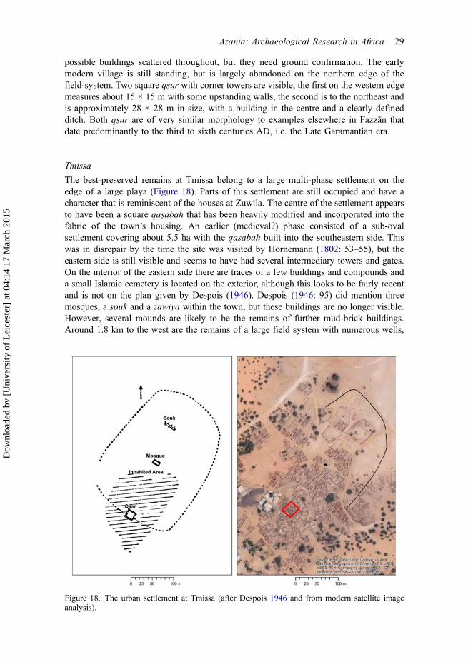
possible buildings scattered throughout, but they need ground confirmation. The earlymodern village is still standing, but is largely abandoned on the northern edge of thefield-system. Two square qṣur with corner towers are visible, the first on the western edgemeasures about 15 × 15 m with some upstanding walls, the second is to the northeast andis approximately 28 × 28 m in size, with a building in the centre and a clearly definedditch. Both qṣur are of very similar morphology to examples elsewhere in Fazzān thatdate predominantly to the third to sixth centuries AD, i.e. the Late Garamantian era.
Tmissa
The best-preserved remains at Tmissa belong to a large multi-phase settlement on theedge of a large playa (Figure 18). Parts of this settlement are still occupied and have acharacter that is reminiscent of the houses at Zuwīla. The centre of the settlement appearsto have been a square qaṣabah that has been heavily modified and incorporated into thefabric of the town’s housing. An earlier (medieval?) phase consisted of a sub-ovalsettlement covering about 5.5 ha with the qaṣabah built into the southeastern side. Thiswas in disrepair by the time the site was visited by Hornemann (1802: 53–55), but theeastern side is still visible and seems to have had several intermediary towers and gates.On the interior of the eastern side there are traces of a few buildings and compounds anda small Islamic cemetery is located on the exterior, although this looks to be fairly recentand is not on the plan given by Despois (1946). Despois (1946: 95) did mention threemosques, a souk and a zawiya within the town, but these buildings are no longer visible.However, several mounds are likely to be the remains of further mud-brick buildings.Around 1.8 km to the west are the remains of a large field system with numerous wells,
Figure 18. The urban settlement at Tmissa (after Despois 1946 and from modern satellite imageanalysis).
Azania: Archaeological Research in Africa 29
Dow
nloa
ded
by [
Uni
vers
ity o
f L
eice
ster
] at
04:
14 1
7 M
arch
201
5
on the western side of which is a possible Late Garamantian qaṣr measuringapproximately 16 × 16 m within a 0.2 ha enclosure.
Summary
The distribution of the visible archaeology in the ash-Sharqiyāt region closely mirrors thatof the oasis villages in existence today. This has led to a certain degree of clusteringrather than the linear spreads of settlement that are found in many of the other depressionsof Fazzān. Each oasis has a group of 10–20 foggaras and substantial areas of relict fieldsystems and/or wells. Given that the total population in 1931 was only 1495, we canassume that, as with other parts of Fazzān (Mattingly 2013a: 537–544), the population inthe past could easily have been two or three times larger than this. Apart from Zuwīlathere is no evidence for urban settlements and we may consider that, as with the Murzuqregion, the dominant settlement forms were the nucleated village and the qaṣr. We almostcertainly have examples from the Garamantian, medieval and post-medieval periods.There are very few settlements visible and in part this must be due to the substantialdevelopment at each of the oases, but it is also possible that there were relatively fewfortifications in this region. The lack of upstanding remains (and here fortifications areparticularly useful) prevents application of the landscape phasing possible elsewhere inFazzān and we are therefore not in a position to describe how the region changed overtime. The numbers of foggaras, the scale of gardens with wells and the settlementevidence all make Zuwīla stand out in comparison to the other sites in the region(Figure 17). There is thus no reason to doubt the primacy of Zuwīla for much of itshistory, despite its modern eclipse by Umm al-Arānib.
The urban biography of ZuwīlaIn this final section, we present a series of models tracing the hypothetical evolution anddecline of the oasis of Zuwīla. Without further fieldwork certainty on many points isimpossible, but we think our reconstruction is plausible and coherent given the evidencecurrently available. It will certainly provide a basis for future work to build on(Figure 19).
The Garamantian era
We suspect the establishment of the oasis to have been in the late first or second centuriesAD. The presence of substantial Garamantian activity in the Zuwīla region is indisputableas is evident from the numerous cemeteries and the presence of ceramics from the first tofourth centuries AD.
Figure 19a presents the possible appearance of the site around AD 300. The size ofthe Garamantian settlement cannot be determined with any precision, but we wouldexpect that it was located next to the fortified building (qaṣr) ZUL004, which isprobably Garamantian. Such fortified structures within settlements are characteristic ofthe Late Garamantian era (Mattingly and Sterry 2013; Sterry and Mattingly 2013). Wecannot distinguish at present whether Zuwīla was a large village or a town in its ownright (as we suspect). The modern destruction of most of this urban area may hinder anyattempt to resolve this question, but a key aspect to look for in any future work will beevidence of craft working. The spread of cemeteries on the southern side of the site andalso perhaps to the east certainly implies a substantial site and the apparent scale of the
30 D. Mattingly et al.
Dow
nloa
ded
by [
Uni
vers
ity o
f L
eice
ster
] at
04:
14 1
7 M
arch
201
5
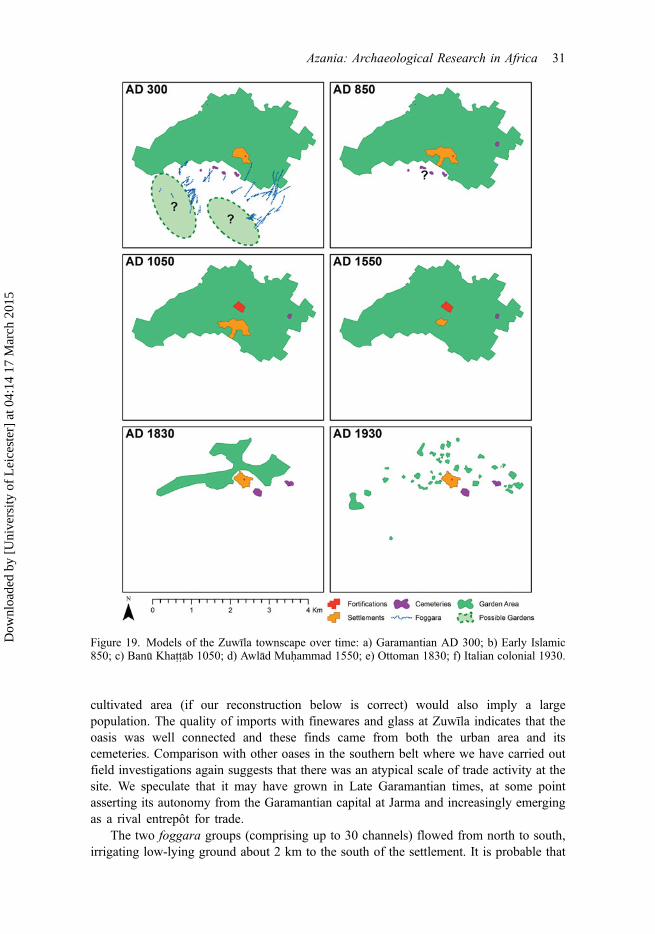
cultivated area (if our reconstruction below is correct) would also imply a largepopulation. The quality of imports with finewares and glass at Zuwīla indicates that theoasis was well connected and these finds came from both the urban area and itscemeteries. Comparison with other oases in the southern belt where we have carried outfield investigations again suggests that there was an atypical scale of trade activity at thesite. We speculate that it may have grown in Late Garamantian times, at some pointasserting its autonomy from the Garamantian capital at Jarma and increasingly emergingas a rival entrepôt for trade.
The two foggara groups (comprising up to 30 channels) flowed from north to south,irrigating low-lying ground about 2 km to the south of the settlement. It is probable that
Figure 19. Models of the Zuwīla townscape over time: a) Garamantian AD 300; b) Early Islamic850; c) Banū Khattāb 1050; d) Awlād Muhammad 1550; e) Ottoman 1830; f) Italian colonial 1930.
Azania: Archaeological Research in Africa 31
Dow
nloa
ded
by [
Uni
vers
ity o
f L
eice
ster
] at
04:
14 1
7 M
arch
201
5
part of the extensive garden area irrigated by wells to its north should also be dated to thisperiod. This is supported by finds of imported Roman pottery from the surface of some ofthe gardens and by parallels with other sectors of the southern oasis belt of theGaramantes, where wells and foggaras appear to have been used in combination (Sterryand Mattingly 2011). The position of the main Garamantian settlement close to thesenorthern gardens, rather than right alongside the foggara-fed southern gardens is anotherindication that the Garamantian settlement employed both types of irrigation works.Foggaras can be seen in the other oases of the ash-Sharqiyāt Depression.
The Early Islamic period: the first IbāḍīsFigure 19b presents the possible configuration of the site around AD 850. Thereconstruction envisages the undefended settlement approaching its maximum size,with the congregational mosque constructed on its northern periphery and the qaṣr still inactive use at the heart of the settlement. It is unclear if the foggara irrigation and gardensin the depressions south of the town were already abandoned, but the garden zone withnumerous wells to the north of the town was probably fully developed, though arguablyat this stage irrigated by simple water-lifting shaduf wells. The location of cemeteries inthis period is uncertain, although an extensive funerary zone (ZUL020) with possibletransitional forms on the eastern side of the oasis is a candidate.
The Banū Khaṭtāb dynasty
In contrast to the rest of Fazzān, Zuwīla seems to have thrived, with many of the majorconstructions in the city dating to this period. Although they were certainly intimatelyconnected to the various Arabic and Berber states of the Maghrib, we cannot view Zuwīlaor Fazzān as simply an extension of the Arab rule created by ‘Uqba bin Nāfi‘’s mid-seventh-century conquest. The historical sources are clear that the region was largelyindependent, never being directly ruled from afar for more than a few years at a time (thisis a theme that is common to the later Ottoman period too). Despite the small number ofarchaeological finds that can be linked to trans-Saharan or Saharan trade, it is clear thatthis was what underpinned the growth and decline of Zuwīla’s wealth and influence. Wehave elsewhere argued that urban-sized centres in the Central Sahara are unsustainablewithout some form of outside investment due to the increased stress of feeding anucleated population in an environment in which all water (for drinking and irrigation)had to be lifted from wells or foggaras (Mattingly and Sterry 2013: 515). Trade andpolitical authority (perhaps in tandem with religious authority) are the most likely reasonsfor this sort of investment. However, the process was not unidirectional, settlements werenot imposed in some form of Saharan colonisation. Edwards (2004: 20) and Stahl (2014:20–22) have drawn attention to the importance of Bayart’s (2000) model of extraversionin understanding how societies produced power through mediating access to externalresources and environments. In this sense, Zuwīla can be considered to both mediateMaghribian access to the trans-Saharan staples of slaves and gold and also control theaccess of caravans to water, food and camels.
The strength of this model in Fazzān is that although the extraversion would createsocial distinctions (we may see the rise of Ibādīsm and Islam at Zuwīla in this light) it didnot initially encourage the exploitation of others within that polity (Bayart 2000: 231).Hence we see little evidence of a Fazzāni state during the seventh to tenth centuries, onlythe decline of centres that had previously relied upon trade, such as Jarma (Mattingly
32 D. Mattingly et al.
Dow
nloa
ded
by [
Uni
vers
ity o
f L
eice
ster
] at
04:
14 1
7 M
arch
201
5
2013a). However, things seem to have changed when the Banū Khattāb establishedthemselves as rulers of all of Fazzān. We do not know if Zuwīla had a central ruler priorto the tenth century, but it is certainly a possibility that the Banū Khattāb actively pursueda policy of state-building. Certainly they seem to have been keen to monumentalise theirdynasty through the creation of a substantial fortress, dynastic tomb building and theminting of their own coinage at Zuwīla. They may also have been responsible for thecontemporary building and repair of walls at Qasr ash-Sharrāba and Jarma. A possiblereference to the king of Zuwīla also being king of the Mazāta Berbers may indicateimperial ambitions over a much greater swathe of the Central Sahara. This must also haveincluded a proselytising component, as it is during this period that we see the finalexamples of the Garamantian burial tradition in the Wādī al-Ajāl to the northwest ofZuwīla (Mattingly et al. in press) and the adoption of Islam across the whole of Fazzān(Mattingly 2003).
The period of Banū Khattāb suzerainty also coincided with the adoption of Islam inKānim-Borno by the early twelfth century (Levtzion and Hopkins 2000: 138). Islam haslong been seen as a key part of what made trans-Saharan trade possible, but the issue isobviously more complex (Haour 2007). Trans-Saharan trade and Zuwīla both existedprior to Islam, although the Ibādī network certainly appears to have benefitted bothZuwīla and traders. The reasons for and the impact of the widespread adoption of Islamare even less clear, although it is likely that Fazzān needs to be seen in the context of theincreased prominence of Islam in North Africa in the ninth and tenth centuries (Fenwick2013). Certainly, this is a fertile area for future research.
Figure 19c shows the possible appearance of the town c. AD 1050. The constructionof the fortified citadel is the most striking change. Henceforth, the trading, herding andfarming communities that came together in the markets at Zuwīla were very visiblydominated by the imposing 6-m-high walls of the fortress palace. The undefendedsettlement area (with the congregational mosque) to the south remained occupied,although the old qaṣr may have passed out of use. The major cemetery was now certainlyon the east side, round the monumental mausolea of the dynasty. The garden area wasprobably of similar extent to before, though it is highly probable that wells were nowbeing widened and deepened to combat a falling water table that threatened the efficacyof shaduf wells. Al-Bakrī’s account of Zuwīla specifically mentions wells powered bycamels, a clear reference to the dalw (self-dumping bucket) (Levtzion and Hopkins 2000:63; Wilson and Mattingly 2003: 266–270 on the different well types). Surface inspectionof many wells at Zuwīla shows that they were modified and deepened, with the additionof animal walkways and A-frame structures of the dalw type well.
Under the Awlād Muhammad
Zuwīla’s decline from urban centre to village mirrors those of other former capitals ofFazzān (Jarma and Trāghan). When the Kānimi sought to establish themselves as themajor regional power, controlling Saharan trade would have been of paramountimportance. Given the silence of the historical sources, the exact sequence of eventsand speed of transformation are uncertain, but the diverting of caravans into the newcapital of Trāghan probably had a rapid impact. Without these external resources tomediate, Zuwīla would have quickly become unsustainable in its expanded urban form.In the political anarchy that followed the successive overthrows of the rule of Qarāqūsh inthe late twelfth century, Kānimi power (second half of the thirteenth century) and theKhurmān (fourteenth and fifteenth centuries), Zuwīla may have been briefly revived as
Azania: Archaeological Research in Africa 33
Dow
nloa
ded
by [
Uni
vers
ity o
f L
eice
ster
] at
04:
14 1
7 M
arch
201
5
capital, but the ascendancy of the Awlād Muhammad with a new capital at Murzuq fromc. 1500 marked a new era.
While the settlement shrank in size and importance, in keeping with the model ofextraversion discussed above it is notable that much of the social hierarchy was still intactand that, even in the Ottoman period, the few inhabitants still had a high social standingwithin Fazzān because of their sharif status.
In Figure 19d we present a model for the mid-sixteenth century state of Zuwīla. It ispossible that the Awlād Muhammad made use of the fortress initially as a garrison pointfrom which to oversee the oasis, with some habitation still present in the open settlementarea and the congregational mosque continuing. The loss of status as a trade entrepôt andpolitical centre could well have rapidly reduced the population base and our modelassumes that by 1550 the settlement was reoriented entirely within the protective walls ofthe citadel, with a new qaṣabah created in the northeastern corner, and the opensettlement and mosque to the south entirely abandoned. This was certainly the situationfirst encountered by European travellers to Zuwīla in the late eighteenth and earlynineteenth centuries. Lyon (1821), for instance, makes it clear that there was a dilapidatedpolice post set into the northeastern corner of the walled settlement. While we cannot becertain when this was established, it is quite likely that Zuwīla was a location thatrecurrently required supervision because of its liminal position on the eastern andsoutheastern fringes of Fazzān.
Ottoman outpost: the nineteenth century
By the early nineteenth century there are some slight indications of Zuwīla undergoing aslight revival in population. This is shown in Figure 19e. By this date, if not earlier, thesettlement had expanded beyond the north, east and south walls, leading to the partialdemolition of the walls and the creation of new breaches in them. There are traces of anadditional wall built further out on the northern side and the walls of new buildings on theeast and south limited access to a few gates and entry roads. The motivation for theremodelling may have been a desire to create a wider open area around the qaṣabah, withbuildings being demolished to achieve this effect. New quarters were at the same timelaid out in such a way as to make the qaṣabah the heart of the settlement, rather than anisolated structure in the corner of the old enceinte. A new main mosque was constructedon the east side of the square that the qaṣabah now opened onto, i.e. outside the originalwalled area. It is hard to know how extensive the cultivated area was at this date. Theremay have been some slight revival in population from the sixteenth-century position, asthe nineteenth century settlement appears to have been about a third larger. As theEuropean powers came to exert more pressure on the Barbary states of the North Africancoast regarding slave trading through the nineteenth century, there is some evidence thatcaravans once again were diverted towards Egypt, which may have befitted villages likeZuwīla on the eastern margins of Fazzān.
The Italian-era village
The final stages of the site’s history were somewhat similar to the pattern established bythe nineteenth century (Figure 19f). The final decline of trans-Saharan trade, after theabolition of the slave trade and the collapse of the European market in ostrich feathers, inall probability led to further decline at villages like Zuwīla (Martin 1985; Haarmann1998; Wright 1998). The qaṣabah continued to be used as a police post by the Italians,
34 D. Mattingly et al.
Dow
nloa
ded
by [
Uni
vers
ity o
f L
eice
ster
] at
04:
14 1
7 M
arch
201
5
but this was a population reduced to extremis by the loss of trade and by 20 years ofresistance to and warfare with the Italian colonial regime. Air photographs taken in the1950s reveal a massively shrunken area of oasis cultivation, now reduced to a fewscattered pocket-handkerchief gardens, rather than a consolidated area of gardens. TheItalian census bears this out, with a very low established population and comparativelyfew wells and gardens compared to the numbers that were visibly derelict on the airphotographs.
Conclusion
The urban biography of Zuwīla has some similarities with the story of the Garamantiancapital at Jarma (Mattingly 2013a: 505–544), but there are also important differences.Jarma was founded c. 400 BC and peaked much earlier than Zuwīla in the first fewcenturies AD. In its late period, it was probably a walled site, with a citadel structure(qaṣr) at its heart. As Jarma lost its trade and political influence in the second half of thefirst millennium AD, the material culture, the architecture and even the diet at the sitechanged. Although Jarma remained a large site (by Central Saharan standards) into thetwentieth century, long before the end it was a village masquerading as a town. There arehints of the same sort of process at Zuwīla, once political and economic supremacypassed to other centres, first Trāghan, then Murzuq and Sabhā. Zuwīla appears to havebeen a moderately successful and quite important settlement for some time underGaramantian and Ibāḍī suzerainty, without being anything out of the ordinary. The changeappears to coincide with the creation of the Ibāḍī state of the Banū Khaṭṭāb. The mostdramatic development was the erection of the urban defences in the late tenth or earlyeleventh centuries. This fortress expressed the larger territorial ambitions of the BanūKhaṭṭāb dynasty and sent a message well beyond the adjacent oasis settlement, to the restof Fazzān, to Tripoli at the Mediterranean end of the trade route and to Kānim in thesouth. The line of monumental tombs no doubt served a similar purpose in announcingZuwīla as the centre of a powerful state, with prestigious and holy rulers.
After the fall of the Banū Khattāb dynasty, the settlement at Zuwīla appears to havebeen carefully supervised by the successor states (Awlād Muhammad) or external powersseeking to control Saharan trade (Kānimi, Qaramānli, Ottoman, Italian), as demonstratedby the erection of the qaṣabah in the corner of the walled enceinte (possibly linkedwith the partial demolition of the walls to weaken the site’s defensibility for theinhabitants).
However, we cannot consider Zuwīla solely in terms of its political position. Acorrelation can be seen with Marandet, Tadmakka and probably also Timbuktu on thefringes of the Sahara, all of which have similar booms in activity in both thearchaeological and historical sources related to trade (Bernus and Cressier 1991; Insoll2000; Haour 2007: 93–95; Magnavita et al. 2007; Nixon 2013). We cannot necessarilylink Zuwīla to these centres, but this highlights that a break in part of a trading networkwould have implications for all the traders that were part of it. Haour (2007: 101) hasargued that these sorts of settlement — dependent upon the patronage of traders andrulers — were vulnerable to geopolitical considerations and therefore far more prone todecline and abandonment than say the towns of the Maghrib. The start-up costs of oasisfarming were high, sometimes prohibitively so, making trade a crucial catalyst (Scheele2010). Oasis settlements, especially large ones, were peculiarly dependent on the abilityto supplement the farming economy with the profits of trade. The population of such sites
Azania: Archaeological Research in Africa 35
Dow
nloa
ded
by [
Uni
vers
ity o
f L
eice
ster
] at
04:
14 1
7 M
arch
201
5
was very susceptible if the cross-subsidy of trade was removed, as we can also see in thecase of Jarma.
Other factors affected the sustainability of the site. Water is a pressing concern in theCentral Sahara and the fossil water aquifers that are tapped by wells and foggarasrecharge very slowly and have been in a continual state of decline since the last Saharanpluvial phase ended c. 5000 years ago (Wilson and Mattingly 2003). This has two effects:firstly, individual irrigation components can be exhausted which, in combination withland salinisation, can lead to patches of unproductive land; and secondly, new wells haveto be dug increasingly deeper, reducing their overall efficiency. The combination of thesefactors means that over the longue durée an urban settlement will become increasinglydifficult to feed, especially if it is also a stop-over point for caravans that could numberthousands of slaves and camels. It is notable in this context that many oases have hada pattern of shifting settlement (e.g. Kawār and Djado—Lange and Berthoud 1977;Fazzān—Mattingly 2007; Sterry and Mattingly 2011; Merlo et al. 2013; Ghāt—Liverani2006 and al-Jufra).
The evidence from Fazzān leads us to question the dominant development narrativesof other oasis chains in the Central Sahara, especially those of Wadi Righ, Suf, Mzab,Tuwat and Kawār. In all of these areas Ibādīte and other Berber groups have been given aprominent role in the establishment of these centres, as they were at Zuwīla. The recentarchaeological results from Fazzān should give pause for thought about whether pre-Islamic oasis development took place more widely in the Sahara. We should question towhat extent this is absence of evidence rather than evidence of absence. Our newevidence demonstrates that Zuwīla was not an Ibādīte foundation nor inconsequential inthe pre-Islamic period. The same is also true of Ghadāmis, which appears to have been amajor centre in the Roman period (Mattingly 1995; Mattingly and Sterry 2010).
The spread of Islam in the Sahara capitalised on prior developments, no doubt addingnew networks (Haour 2007), but apparently also giving opportunity to newcomers or theearly local adopters of the new dominant religion. The pattern observed at Zuwīla andGhadāmis may also be true of other oasis belts and it likely that the seventh to tenthcenturies were characterised as much by a reorganisation of existing networks ofsettlements as by new foundations (although the latter may well have been important).We now know that trans-Saharan trade existed before the coming of Islam and the Arabdynasties established in the Maghrib were from very early on particularly interested in itspotential. The supply of slaves for the slave markets in Egypt and Ifrīqiya, and perhapsalso of West African gold, was a matter of huge interest and profit and the intervention ofthe generals, governors and merchants of Muslim Africa and transformed the nature, lociand political underpinnings of pre-Islamic trade. The rise of sites like Zuwīla to fargreater prominence and the final decline of Garamantian power were symptoms of thesenew relationships.
Appendix 1: Archaeological sites in and around ZuwīlaThe Fazzān project identified ten sites of significance (labelled ZUL001-010; ZUL011relates to a foggara group at al-Bdayir, 14 km to the west). Our satellite remote-sensingand re-analysis of the aerial photographs has identified a further two foggara groups andallocated numbers to several Early Modern structures and a number of Islamic cemeteries(ZUL012–ZUL023). We have also clarified the plans and descriptions of a number ofsites (some of the descriptions below were originally published in Mattingly 2007: 282–88, but the expanded and improved gazetteer seems worthy of inclusion here).
36 D. Mattingly et al.
Dow
nloa
ded
by [
Uni
vers
ity o
f L
eice
ster
] at
04:
14 1
7 M
arch
201
5
ZUL001 Urban settlement, wall 26°10′05″N, 15°07′43″EThe sub-rectangular town walls of Zuwīla, enclosing an area of 4.5 ha, are of unusualconstruction in comparison with other walled towns in Fazzān (see Mattingly et al. inpress for a detailed presentation of this walled enceinte). The wall line was presumed tohave been roughly rectangular, but closer study suggests a more trapezoidal layout (forpublished plans see Pace et al. 1951; Abdussaid 1979; Mattingly 2007). The southeasternquadrant has been lost beneath later buildings. Regular external rectangular towers wereincorporated in the original design and probably originally numbered about 40. The wallis built in pisé style, with sections that are approximately 2 m long by 1 m high by up to 1m thick having been formed within wooden shuttering. The material used is a verygravely sand/mud mix, which has apparently been rammed solid. The walls survive to amaximum height of about 6–7 m. The wall circuit appears to have been erected in thetenth or early eleventh centuries (as determined from an AMS sample), despite al-Bakrī’sdescription of Zuwīla as being unwalled.
The ‘Turkish’ fort (ZUL016) survives in the northeastern corner of old Zuwīla. Thedomestic buildings of the old town are now very dilapidated, with some occupied byTubu migrants and others in ruins.
ZUL002 Mosque 26°09′55″N, 15°07′31″EElements of the walls of a large ruined mosque lie outside the south side of the walledtown, measuring approximately 32 × 34 m. This is the site mentioned by early travellersand often referred to as the ‘white mosque’ and it is almost certainly the ‘congregationalmosque’ mentioned by al-Bakrī. Daniels roughly planned the standing remains in 1968and some further observations were made in 1972, following trial excavations by H.Ziegert and Ali Abdussalam (1973) and before the full exposure of the complex byAbdussaid (1979). Much of the large tower in the southwestern corner was thought to beof relatively recent (nineteenth-century?) date, although it seems plausible that this wasthe basis of the minaret. The AMS sample we have dated suggests a late seventh- to mid-ninth-century date for the initial construction of the mosque although the visiblecourtyard layout may be partly due to later additions (of tenth-century date?) dueto its similarity to similar the Ajdabiya and Madinat Sultan mosques in Libya(Abdussaid 1979).
Daniels’ comments on the visible architecture are superseded by the data from theexcavation (Ziegert and Abdussalam 1973; Abdussaid 1979; el-Mahmudi 1997). Themosque is large by the standards of Fazzān and measures 34.5 m east-west and 24 mnorth-south (30 m including the minaret projecting at the southwestern corner). Theprayer hall is 11.5 × 24 m, but the structure shows signs of several phases ofmodifications. Since the excavation some conservation work appears to have beencarried out on the mosque.
ZUL003 Cemetery, mausolea 26°09′58″N, 15°08′22″EThis is a large cemetery area with the tombs of the Banū Khattāb dynasty, about 1.2 km tothe east of the town. The tombs were restored c. 1970, but substantially demolished,apparently by Islamic extremists, in September 2013 (pictures have been posted in theblogpost http://alensarlibya.blogspot.co.uk/2013/10/blog-post_1919.html, accessed 19thNovember 2014). The two AMS dates we obtained (Table 1) now give a firm associationof the monumental tombs with the Banū Khattāb dynasty, dating them to the tenth to
Azania: Archaeological Research in Africa 37
Dow
nloa
ded
by [
Uni
vers
ity o
f L
eice
ster
] at
04:
14 1
7 M
arch
201
5
eleventh centuries. The monumental tombs took the form of tower-like structures,covering an area of approximately 6 m2 at their base and were around 8 m tall, capped bya dome that added another 1.5 m to give a total height of some 9–10 m. There were nodoors into the structures, but a pair of tall windows was present just below the dome, withsmaller observation windows about 1.5 m above ground level on the eastern and westernsides. The walls are of mud-brick, but with an outer facing of vertically mounted thinstone slabs. When Lyon visited the site in the 1820s, he observed burials intact within thelower chambers, still adorned with the sort of offerings (pots, ribbons, ostrich eggs)accorded to the graves of murābiṭūn (marabouts) in the Sahara (Lyon 1821: 215). Even aslate as 1968, Major Boxhall (1968: 27) observed a ritual procession to the tombs byyoung boys from the town, which passed three times around the monuments. Traces ofstucco decoration with Arabic/Kufic lettering suggest that originally the top part of theexternal walls above the vertical slab-work and below the domes was plastered andadorned with dedications to the deceased. There are no obvious architectural parallels forthe form of the tombs, although the ‘north-to-south’ alignment and ‘easterly’ orientationof the series of monuments coincidentally recalls the layout of the royal cemetery of theGaramantes (Mattingly et al. 2011). The line is actually south-southwest to north-northeast, with the tombs facing 113°. This may have been intended to recall the directionof Mecca, as the mosque ZUL002, for instance, faces 124°, but it seems just as likely thatthe tombs were constructed in a line to the north of the main route leading eastwards fromthe fortress.
The CMD survey made an extensive photographic record of the main tombs,providing an invaluable record of their condition prior to restoration. At that time, muchof the stone cladding of the structures had been robbed on their western sides, but theyappeared much better preserved on their eastern sides. These photographs are importantas they show the state of preservation of the monuments prior to the restoration workundertaken by the Libyan Department of Antiquities.
Tomb 1 had lost much of its northern side before 1968, and much of the survivingnorth wall may have been a rebuild, lacking large blocks of type used in the south side ofthe structure (and Tombs 2–5). Tomb 2 was constructed to the south of and very closelyabutting Tomb 1. The dome was still intact in 1968, although much of the stone claddinghad been lost from the west side. The structure was primarily of mud-brick with sixcourses of horizontally laid stone slabs framing an external stone cladding. The dome isan example of ‘false corbelling’. Tomb 3 was very similar to Tomb 2 using the sametechnique of stone cladding. Two windows are preserved in the lower west face and oneon the east side. Tomb 4 differs from the other tombs with the presence of two archedniches in the north and east sides. There was also a narrow offset in the walls about 3.2 mabove ground level. The niche on the north side indicates that this tomb predated Tomb 3,which otherwise blocks it. Fragments of wooden sill beams survived across the windows,as well as across the angles on which the dome sat. The interior walls were plastered. Itsslightly larger size and different elaboration might suggest that it was, in fact, the firsttomb to be built (and must have some claim to be that of the founder of the dynasty, ‘AbdAllāh ibn al-Khattāb al-Hawwārī). Tomb 5 was much decayed and had lost its dome andmuch of its superstructure by 1968. The lower exterior walls were largely of rough stone,the interior mainly of mud-brick. Tomb 6 at the south end of the row was built entirely ofmud-brick and was relatively intact in 1968. The arched heads of the two windows on theeastern and western sides were higher than the springing of the pendentive. Tomb 6lacked the exterior stone cladding, but was otherwise identical in form to Tombs 1–5. Itwas thought to perhaps have been the latest in the group and have been awaiting its outer
38 D. Mattingly et al.
Dow
nloa
ded
by [
Uni
vers
ity o
f L
eice
ster
] at
04:
14 1
7 M
arch
201
5
facing when the dynasty of the Banū Khattāb came to an end. However, the AMS date weobtained indicates a similar terminus post quem for this tomb as for Tomb 1 and thussuggests that both monuments were probably erected in the first century of Banū Khattābrule, i.e. by the early eleventh century. A plausible sequence of construction based on thephysical proximity of the tombs to each other and the AMS dates is as follows: Tombs 4,then 3 and 5, then 2, then 1, then 6, with development starting in the centre of the line andworking out to the north and south and with all tombs being built by the early eleventhcentury (though not necessarily all being occupied by burials at that date?).
Tomb 7 lies to the southwest of the main group of tombs. It was constructed in mud-bricks that are larger than those used in the other tombs and stood much lower thanTombs 1–6. It is preserved to the level of the base of dome some 3 m high. There is anarched door on the west side and small windows in the north, east and west sides. Severalother mounds in this area probably mark other mud-brick tomb superstructures.
Recent excavations under the auspices of the Department of Antiquities have shownthat the standing tombs are surrounded by an extensive cemetery of less monumentalburials with superficial surface structures.
ZUL004 Qaṣr, enclosure 26°09′47″N, 15°07′43″E
Identified on air photographs, this is a fortified building (qaṣr) 300 m east of ZUL002 onthe eastern edge of the open settlement (ZUL012). Despite its prominent remains neitherDaniels nor Ziegert made any comment on it and it is possible that it had been levelled bythe late 1960s. Hayes’ record that a bag of wall sherds of Roman date came from the ‘oldqaṣr’ may relate to this site. The building had a rectangular core structure approximately32 × 37 m across with towers at the corners and centre of walls; the entrance is likely tohave been on the southeastern side. There is also an outer enclosure wall some 60–70 macross, giving a total area of about 0.47 ha. All the standing remains of the site have beendestroyed by the expansion of modern Zuwīla. The majority of rectangular qṣur of thistype in southern Fazzān date to the Garamantian period (Sterry and Mattingly 2013).
ZUL005 Cemetery 26°09′36″N, 15°07′02″EThis is a cemetery area about 2 km south of the town. The location of this cemetery is notclear from Daniels’ notes and it may be confused with another cemetery. It had beenpreviously robbed and perhaps part excavated. Sherds of imported pottery were found onthe heavily disturbed surface (see below). These are probably the graves described byZiegert (1969: Table IB).
ZUL006 Cemetery 26°09′31″N, 15°07′35″EThis is an area of a cemetery (numbered as ZUL 1 or ‘eastern cemetery’ by Daniels),where Ziegert apparently also excavated. A number of excavated hollows have evidentlypierced a gypsum substratum and local informants mention underground funerarychambers. Finds of Garamantian pottery suggest a pre-Islamic date. The area of gypsumcrust is visible on the satellite imagery, but no funerary chambers can be identified.
ZUL007 Field system 26°09′49″N, 15°08′16″EThis area of roughly 630 ha is covered by field/garden boundaries and wells that arevisible on both aerial photographs and satellite imagery. The expansion of the town and
Azania: Archaeological Research in Africa 39
Dow
nloa
ded
by [
Uni
vers
ity o
f L
eice
ster
] at
04:
14 1
7 M
arch
201
5
of agriculture at Zuwīla since 1958 has destroyed many of the remains. A small area ofpossible field/garden boundaries that is visible on the air photographs was inspected onthe ground in 2001. These comprise low banks of heaped up earth and stones. Many ofthe enclosures have large well cuts in their centre that are now all dry. There are fewtraces of associated buildings (though see ZUL010) and pottery is generally sparse (a fewsherds of Garamantian and possibly Islamic pottery were recovered). The interpretation ofthese traces as marking the limits of abandoned gardens/fields appears to be confirmed.
ZUL008 Cemetery 26°09′43″N, 15°07′28″EThis is another cemetery area on a low mound to the south of Zuwīla reported by a localinformant in 2001. It is possible that Ziegert excavated here. The site is now on the fringeof the built up area and is at critical risk from future development. No tombs areidentifiable on either aerial photographs or satellite imagery.
ZUL009 Cemetery 26°09′34″N, 15°07′22″EThis is a further cemetery area reported by a local informant on the south side of Zuwīla(Daniels numbering ZUL 2 or western cemetery). What appears to be a slightly raisedmound with a subterranean chamber is cut into a thick gypsum stratum here. Danielsrecorded Roman fineware (African Red Slipped ware), glass and beads here, indicating apre-Islamic date. The site is surrounded by the expansion of Zuwīla and is at critical riskfrom future housing development. No tombs are identifiable on either aerial photographsor satellite imagery.
ZUL010 Qasr, settlement, wall 26°10′31″N, 15°07′08″E
Situated about 2 km to the northwest of Zuwīla old town on the edge of the zone ofgardens ZUL007, this site comprises the remains of a small tower-like qaṣr on the northcorner and an enclosed settlement (in total covering at least 1 ha). The tower, in yellowmud-brick, stands about 8 m high and is approximately 10 m square. There is a very deepwell alongside the qaṣr. A large volume of Garamantian pottery (including bothhandmade vessels and amphorae) and Islamic glazed wares was noted on the surfaceand a sample of it collected. The site now sits between two modern fields, which havetruncated its extent, and is at severe risk from modern development.
ZUL012 Open settlement, town 26°09′50″N, 15°07′34″EOn the 1958 aerial photographs an area of disturbance measuring approximately 20 ha inarea stretches from the mosque (ZUL002) to the enclosed qaṣr (ZUL004). Within thisarea there are no field boundaries and only a few features that could be wells. The mostsoutherly part of the area has several upstanding walls and, just to the south of themosque, there are the walls of a large, rectangular structure. We can be confident that thisis an area of mud-brick buildings and it is likely to be the same area described byHornemann (1802) as the abandoned part of the town; it may also be the unwalled areadescribed by al-Bakrī. Unfortunately, this is the area into which modern Zuwīla hasexpanded and the only remaining part is the area directly south of the mosque. Theremains of some mud-brick structures, including part of the rectangular building, are stillvisible in this area, although they are likely to be badly damaged from construction andwaste dumping and are under critical threat from further expansion. A selection of Roman
40 D. Mattingly et al.
Dow
nloa
ded
by [
Uni
vers
ity o
f L
eice
ster
] at
04:
14 1
7 M
arch
201
5
finewares and glass analysed by Hayes came from this area, indicating the Garamantianorigin of the settlement, although they do not provide resolution on its size. Thesettlement may have reached its maximum extent in the ninth to eleventh centuries.
ZUL013 Foggara group 26°09′25″N, 15°06′49″EThis is a group of around 10–15 foggara systems up to 1.3 km in length that flow fromnorth to south, feeding into a slight depression some 2 km southwest of the town, by aplaya. The available DEM data indicate that these foggara channels could not haveirrigated part of the field system (ZUL007). The channels are generally narrow withlittle spoil, suggesting that they are not very deep. A Garamantian date is assumed onthe basis of the predominant use of this form of irrigation technology at that periodin Fazzān.
ZUL014 Foggara group 26°09′14″N, 15°08′06″EThis constitutes a second group of about 10–15 foggara systems up to 1.7 km in lengththat flow from north to south, feeding into a slight depression around 2 km southeast ofthe town. The channels are generally narrow with little spoil, suggesting that they are notvery deep. A Garamantian date is again assumed on the basis of the predominant use ofthis form of irrigation technology at that period in Fazzān.
ZUL015 Depression linked with foggaras 26°08′48″N, 15°06′48″EThe foggara groups ZUL013 and ZUL014 flow towards a large playa on the southeasternedge of the Zuwīla oasis. Potentially this could have been a cultivated area of 100 ha ormore, but no field boundaries are now visible.
ZUL016 Qasabah within ZUL001 26°10′05″N, 15°07′43″EThe northeastern corner of the walled enceinte at Zuwīla (ZUL001) is occupied by afortified citadel (qaṣabah) of late medieval to Early Modern date. It reused and built onthe original pisé walls and towers in this quarter, which were higher here than elsewherearound the enceinte, suggesting the presence from the start of an inner citadel or palacecomplex in this corner. The visible structure of the qaṣabah is probably a mixture ofrebuilding and modification that spans its use as a garrison post by the AwlādMuḥammad, Ottoman and Italian rulers of Fazzān between the fifteenth and twentiethcenturies. At some point, parts of the original enceinte to the west and south of theqaṣabah were demolished to create an open area around the fort with new areas ofdomestic housing laid out to the north and east (ZUL018).
ZUL017 Early Modern main mosque 26°10′04″N, 15°07′44″EThe main Early Modern mosque of Zuwīla lies just to the east of the original fortifiedarea ZUL001 and directly opposite the qaṣabah ZUL016. This was the Friday mosque bythe time of the earliest European accounts of Zuwīla. In the 1960s local reports suggestedthat it was around 250 years old (Boxhall 1968: 27).
Azania: Archaeological Research in Africa 41
Dow
nloa
ded
by [
Uni
vers
ity o
f L
eice
ster
] at
04:
14 1
7 M
arch
201
5
ZUL018 Early Modern suburbs of ZUL001 26°10′03″N, 15°07′45″EBy 1958, and presumably sometime in the Ottoman period, the main urban centre hadspilled over the pisé walls of ZUL001 to form six groups of mud-brick houses. It is notclear if these were ever occupied simultaneously as several observers commented on thenumbers of abandoned dwellings and the small population recorded in the Italiancensuses implies that much of the town was unoccupied. The main areas of housingremain largely visible today.
ZUL019 Enclosure wall on the north side of ZUL018 26°10′08″N, 15°07′43″EAlong the northern edge of the suburbs ZUL018 this is a small wall that runs betweentwo groups of housing and restricts access into the town. It is unlikely to have served anyserious defensive function.
ZUL020 Islamic cemetery 26°10′02″N, 15°08′23″ELocated just to the northwest of ZUL003, this is a cemetery of several thousand tombsthat appears to have been initially located within an enclosure of the field systemZUL007. The tombs are mostly supine burials laid out north to south in the Islamictradition. However, the centre of the cemetery consists of several oval cairns andenclosures that appear to be the oldest funerary structures present. Their precise nature isunclear, but they may represent a transitional funerary form from the Garamantian drumtomb or some kind of funerary shrine. In the southeastern corner of the cemetery a smallsquare structure is probably a marabout tomb, a type common in Fazzān.
ZUL021 Islamic cemetery 26°10′01″N, 15°08′26″ELocated directly north of ZUL003 and to the east of ZUL020, this is an extension ofZUL020 and clearly postdates the construction of the field system ZUL007 as there aretwo abandoned wells in the centre of the cemetery. There are several thousand tombs. Allare supine burials laid out on a north-to-south orientation and some are quite new,indicating that the cemetery is probably still in use. On the southern edge a small squarestructure is probably a marabout tomb.
ZUL022 Islamic cemetery 26°09′53″N, 15°07′54″ELocated 500 m to the southeast of ZUL001, this is a large cemetery of several thousandtombs. The cemetery is laid out over the top of the field system ZUL007 and the remainsof wells and mud-brick walls are clearly visible. It is probably of relatively recent date.
Appendix 2. Finds from ZuwīlaOnly a small amount of ceramics has been studied from Zuwīla. John Hayes inspected asmall assemblage collected in 1972. Two bags of surface finds included a mixture ofimported Roman pottery, including fineware (African Red slipware), coarsewares, a lamp,glass and glass beads. Charles Daniels collected ceramics from two cemeteries —ZUL006 and ZUL009 — that were mostly a mixture of body sherds from handmadevessels, but again with some imported wheel-made vessels (both coarsewares andamphorae). Finally, the Fazzān Project collected a small amount of surface ceramics fromcemeteries ZUL006 and ZUL007 and from the qaṣr ZUL010. Handmade pottery,
42 D. Mattingly et al.
Dow
nloa
ded
by [
Uni
vers
ity o
f L
eice
ster
] at
04:
14 1
7 M
arch
201
5

amphorae and coarsewares were present at all three of these sites, with African CookingWare noted at ZUL006 and Glazed Ware at ZUL010. Together these finds demonstratethe presence of a community at Zuwīla with links to the Mediterranean from the firstcentury onwards (Table 2).
In general, these unsystematic collections focused on the Roman era finds because ofthe lack of historical attestation of the site at that time. Though it is regrettable that alarger collection of Islamic pottery was not made, notes on these visits indicate thatIslamic glazed pottery was relatively common among surface material, certainly more sothan at Jarma, where they made up only 0.03% of the ceramic assemblage (Mattingly2013a: 326–333, 406–408). The five seasons of survey by the Fazzān Project onlylocated 25 Islamic sherds and the reconnaissance survey in the Murzuq region alsolocated only a few sherds from the medieval villages MZQ021 and HHG012, thoughagain the urban centre of Murzuq has much larger quantities visible on the surface,possibly mainly of the Ottoman period (Sterry and Mattingly 2011). Islamic imports arerare finds at sites on the south side of the Sahara, as at Tadmakka (Nixon 2009) and GāoSaney (Cissé 2011: 178–179). As Nixon (2009) has demonstrated with the evidence for
Table 2. Diagnostic pottery and other finds reported from Zuwīla.
Reference Ware Form Date
ZUL006 (FP) African Cooking Ware Hayes 27 First to early thirdcenturies AD
ZUL006 (FP) Amphora Not described RomanZUL006 (FP) Coarseware Not described RomanZUL007 (FP) Coarseware Not described RomanZUL007 (FP) Glazed Ware Tunisian: yellow
surfaceModern?
ZUL010 (FP) Amphora Not described RomanZUL010 (FP) Glazed Ware Sicilian – pale
greenIslamic-Modern
ZUL012 (By the old qasr- Hayes)
Imported wheel-made Wall sherds Roman
ZUL012 (Zuwīla area -Hayes)
African Red Slip Hayes 6 Late first to secondcenturies AD
ZUL012 (Zuwīla area -Hayes)
African Red Slip Possibly Hayes 91 AD 450–530
ZUL012 (Zuwīla area -Hayes)
African Red Slip Base Late third to fourthcenturies AD
ZUL012 (Zuwīla area -Hayes)
Coarseware Flagon Unknown, but probablyRoman
ZUL012 (Zuwīla area -Hayes)
Fine Red Not described Roman
ZUL012 (Zuwīla area -Hayes)
Glass Not described Likely Roman
ZUL012 (Zuwīla area -Hayes)
Glass Beads Unknown
ZUL012 (Zuwīla area -Hayes)
Glass beads Green coloured? Unknown
ZUL012 (Zuwīla area -Hayes)
Lamp Lamp Second or thirdcenturies AD
ZUL012 (Zuwīla area -Hayes)
Red walled (AfricanRed Slip?)
Not described Unknown
Azania: Archaeological Research in Africa 43
Dow
nloa
ded
by [
Uni
vers
ity o
f L
eice
ster
] at
04:
14 1
7 M
arch
201
5
trans-Saharan gold trading at Tadmakka, the lack of imported ceramics does not precludemajor activity and trade at these medieval sites.
Appendix 3. Original text of Gigliarelli (1931: 141)
‘È uno dei più antichi paesi del Fezzàn, ed ebbe il suo massimo sviluppo demografico ecommerciale sotto la dinastia dei Bèni el-Chattàb, che la elessero capitale della regione…Il paese, a forma quasi rettangolare, è costruito in un avvallamento del terrenocompletamente staccato dall’oasi. A nord ed a sud due catene di alture limitano ladepressione a circa 6 chilometri da Zuìla. In mezzo all’abitato si ergono i ruderi di unantico castello, di mura massicce, che vuolsi far risalire all’epoca romana; in realtà la suapianta quadrangolare ricorda il castrum romano ma le pietre di cui è costruito non hannola squadratura e la regolarità usata di solito dai romani per edifici di tale importanza.Attualmente anche questi resti sono pressochè scomparsi sotto una nuova costruzioneadibita a caserma dei CC. RR. Più probabilmente romana è la costruzione del muro dicinta, di cui rimangono in piedi ancora alcuni tratti. L’epoca dei Bèni el-Chattàb èlargamente ricordata, oltre che dalle rovine della grande moschea, dalle tombe di sultanidi quella dinastia. Sono sette costruzioni allineate a forma di basse torri sormontateciascuna da una cupola. Hanno aperture rettangolari disposte ad oriente e ad occidente, edi blocchi di arenaria di cui sono formati si mostrano esattamente squadrati.’
AcknowledgementsThe satellite mapping programme and AMS dating work have been funded as part of the Trans-Sahara Project (European Research Council grant 269418) and the Peopling the Desert Project(Leverhulme Trust F/00212/AL). The support of these grants is gratefully acknowledged. Theunpublished papers and photographs of the late Charles Daniels are held in the Archive of theSociety for Libyan Studies at the University of Leicester and we are grateful to the Society foraccess to them. Other members of Charles Daniels’ team involved in the survey work at Zuwīla in1968 were Patrick Carmody and Jack Tait. Work by the Fazzān Project at Zuwīla in 1998 and 2001was funded by the Society for Libyan Studies and involved David Mattingly, Jamie Preston, SophieHay, Toby Savage and John Dore. We are particularly grateful to consecutive Presidents of theLibyan Department of Antiquities, Dr Salah Aghab and Dr Giuma Anag. The samples for AMSdating were taken at the request of the Controller of Fazzān, Dr Ali Abu Salim. The identification ofthe nature of the samples was undertaken by Anita Radini and we are also grateful to Prof. TomHigham and his colleagues at the Oxford Radiocarbon Laboratory (ORAU) for their advice andsupport of our dating programme. We bear responsibility for the views expressed.
Notes on contributorsDavid Mattingly is Professor of Roman Archaeology at the University of Leicester. His researchinterests include the archaeology of Libya and the Sahara and he is Principal Investigator on theTrans-Sahara Project. He has led numerous projects in North Africa, including several in Fazzānfocused on early settlement development and trade at well-known historic oasis centres.
Martin Sterry is a Post-Doctoral Research Fellow at the University of Leicester. As part of theERC: Trans-Sahara Project he is leading its research into urbanisation and state-formation in theSahara. His research interests include the archaeological applications of GIS and remote-sensing,North Africa and archaeological field survey.
David Edwards is Lecturer in Archaeology at the University of Leicester. His primary researchfocuses on the social archaeology of Nubia and the Middle Nile and he has more general interests inSaharan and Sudanic archaeologies in historic periods.
44 D. Mattingly et al.
Dow
nloa
ded
by [
Uni
vers
ity o
f L
eice
ster
] at
04:
14 1
7 M
arch
201
5
ORCID
David Mattingly http://orcid.org/0000-0003-1862-8392
ReferencesAbdussaid, A. 1967. “An early mosque at Medina Sultan. A preliminary report.” Libya Antiqua 3/4:155–160.
Abdussaid, A. 1979. “The excavations of Zwela mosque.” Libya Antiqua 15/16: 327–329.Adler, M.N. 1907. The Itinerary of Benjamin of Tudela: Critical Text, Translation and Commentary.Oxford: Oxford University Press.
Austen, R.A. 2010. Trans-Saharan Africa in World History. Oxford: Oxford University Press.Ayoub, M.S. 1968. Fezzan, A Short History. Tripoli: Ministry of Tourism and Antiquities.Baadj, A. 2013. “Saladin and the Ayyubid campaigns in the Maghrib.” Al-Qantara: Revista deEstudios Arabes 34: 267–295.
Barker, G. (ed.). 1996. Farming the Desert: The UNESCO Libyan Valleys Archaeological Survey,Volume 1: Synthesis. London: Society for Libyan Studies.
Bayart, J.F. 2000. “Africa in the world: a history of extraversion.” African Affairs 99: 217–267.Bernus, S. and Cressier, P. 1991. La Région d’In Gall-Tegidda n Tesemy (Niger): ProgrammeArchéologique d’Urgence 1977–1981, Tome IV: Azelik-Takadda et l’Implantation SédentaireMédiévale. Niamey: Institut de Recherche en Sciences Humaines.
Blake, H., Hutt, A. and Whitehouse, D. 1971. “Ajdabiya and the earliest Fatimid architecture.”Libya Antiqua 8: 105–123.
Bovill, E.W. 1968. The Golden Trade of the Moors. Oxford: Oxford University Press.Boxhall, P. 1968. Near East Land Forces Expedition to Murzuk, Libya. Expedition Report. Nicosia.Brett, M. 2006. “Libya and the Sahara in the history of Africa.” In The Libyan Desert. NaturalResources and Cultural Heritage, edited by D.J. Mattingly, S. McLaren, E. Savage, Y. al-Fasatwiand K. Gadgood, 271–285. London: Society for Libyan Studies.
Bronk Ramsey, C. 2009. “Bayesian analysis of radiocarbon dates.” Radiocarbon 51: 337–360.Bruce–Lockhart, J. and Wright, J. (eds). 2000. Difficult and Dangerous Roads: Hugh Clapperton’sTravels in Sahara and Fezzan 1822–1825. London: Sickle Moon Books.
Brunschwig, R. 1947. “Ibn ‘Abd al-Hakam et la conquête de l’Afrique du nord par les Arabes.Etude critique.” Annales de l’Institut d’Etudes Orientales 6: 108–155.
Cisse, M. 2011. “Archaeological Investigations of Early Trade and Urbanism at Gao Saney (Mali).”PhD diss., Rice University.
Cuneo, P. 1996. “The Italian Architectural Mission for the Islamic Period (1989–1994).” LibyaAntiqua (New Series) 1: 170–174.
Cuneo, P., Abdelhadi, K., Barucco, P., Benedetti, E. and Pinna Caboni, B. 1997. “The ItalianArchitectural Mission for the Islamic Period: 1995 report.” Libya Antiqua (New Series)2: 204–210.
Daniels, C.M. 1968. The Garamantes of Fezzan. An Interim Report of Work Carried out by the1968 Expedition to Fezzan, Libya. Unpublished manuscript.
Daniels, C.M. 1989. “Excavation and fieldwork amongst the Garamantes.” Libyan Studies20: 45–61.
Despois, J. 1946. Mission Scientifique du Fezzan (1944–1945) III Géographie Humaine. Algiers:Omp. Imbert.
Devisse, J. (ed.). 1983. Tegdaoust III: Recherches sur Aoudaghost. Campagnes 1960/65, EnquêteGénérale Paris: Editions Recherche sur les Civilisations.
Devisse, J. 1992. “Trade and trade routes in West Africa.” In UNESCO General History of AfricaVolume III: Africa from the Seventh to the Eleventh Century, edited by I. Hrbek, abridged edition,190–215. London: James Currey.
Duveyrier, H. 1864. Les Touareg du Nord. Exploration du Sahara. Paris: Challamel Ainé, Libraire–Éditeur.
Edwards, D.N. 2001. “Archaeology in the southern Fazzan and prospects for future research.”Libyan Studies 32: 49–66.
Edwards, D.N. 2004. The Nubian Past: An Archaeology of the Sudan. London: Routledge.Edwards, D.N. 2011. ‘Slavery and slaving in the medieval and post-medieval kingdoms ofthe Middle Nile.’ In Slavery in Africa: Archaeology and Memory, edited by P.J. Lane andK.C. MacDonald, 79–108. London: British Academy.
Azania: Archaeological Research in Africa 45
Dow
nloa
ded
by [
Uni
vers
ity o
f L
eice
ster
] at
04:
14 1
7 M
arch
201
5

el-Hesnawi, H.W. 1990. Fazzan under the Rule of the Awlad Muhammad. A Study in Political,Economic, Social and Intellectual History. Sabhā.
Elmahmudi, A.A.A. 1997. The Islamic Cities in Libya: Planning and Architecture. Frankfurt: PeterLang GmbH.
Eldblom, L. 1968. Structure Foncière. Organisation et Structure Sociale. Une Etude Comparativesur la Vie Socio–Economique dans les Trois Oasis Libyennes de Ghat, Mourzouk etParticulièrement Ghadamès. Lund: Uniksol.
Fenn, T.R., Killick, D.J., Chesley, J., Magnavita, S. and Ruiz, J. 2009. “Contacts between WestAfrica and Roman North Africa: archaeometallurgical results from Kissi, northeastern BurkinaFaso.” In Crossroads/Carrrefour Sahel. Cultural and Technological Developments in the FirstMillennium BC/AD West Africa, edited by S. Magnavita, L. Kolé, P. Breunig and O.A. Idé,119–146. Frankfurt: Africa Magna Verlag.
Fentress, E. 2011. “Slavers on chariots.” In Money, Trade and Trade Routes in Pre-Islamic NorthAfrica, edited by A. Dowler and E.R. Galvin, 64–71. London: British Museum Press.
Fenwick, C. 2013. “From Africa to Ifrīqiya: settlement and society in early medieval North Africa(650–800).” Al-Masaq 25: 9–33.
Garrard, T.F. 1982. “Myth and metrology: the early trans-Saharan gold trade.” Journal of AfricanHistory 23: 443–461.
Gigliarelli, U. 1932. Il Fezzan. Tripoli: Governo della Tripolitania.Haour, A. 2007. Rulers, Warriors, Traders, Clerics. The Central Sahel and the North Sea,800–1500. Oxford: Oxford University Press.
Haour, A. 2011. “The early medieval slave trade of the central Sahel: archaeological and historicalconsiderations.” In Slavery in Africa: Archaeology and Memory, edited by P.J. Lane andK.C. Macdonald, 61–78. Oxford: Oxford University Press.
Haarmann, U. 1998. “The dead ostrich. Life and trade in Ghadames (Libya) in the nineteenthcentury.” Die Welt des Islams 38: 9–94.
Hornemann, F. 1802. The Journal of Frederick Hornemann’s Travels from Cairo to Mourzouk theCapital of the Kingdom of Fezzan in Africa in the Years 1797–9. 1985 reprint. London: DarfPublishers.
Insoll, T. 1996. Islam, Archaeology and History. Gao Region (Mali) ca. AD 900–1250. Oxford:Tempus Reparatum.
Insoll, T. 2000. “The origins of Timbuktu.” Antiquity 74: 495–496.Insoll, T. 2003. The Archaeology of Islam in Sub-Saharan Africa. Cambridge: CambridgeUniversity Press.
Insoll, T. 2006. Islamic archaeology and the Sahara. In The Libyan Desert: Natural Resourcesand Cultural Heritage, edited by D.J. Mattingly, S. McLaren, E. Savage, Y. al-Fasatwi andK. Gadgood, 223–238. London: Society for Libyan Studies.
Jamal, A.M.H. 2008. “The Kel Zjer Tuareg Culture: Public and Private Space in Ghat.” PhD diss.,McGill University.
Jaquin, P.A., Augarde, C.E. and Gerrard, C.M. 2008. “Chronological description of the spatialdevelopment of rammed earth techniques.” International Journal of Architectural Heritage2: 377–400.
Lange, D. and Berthoud, S. 1977. “Al-Qasaba et d’autres villes de la route centrale du Sahara.”Paideuma 23: 19–40.
Lavoix, H. 1896. Catalogue de Monnaies Musilmanes de la Bibliothéque Nationale, Egypte etSyrie. Paris: Imprimerie Nationale.
Law, R.C.C. 1967. “The Garamantes and Trans-Saharan enterprise in Classical times.” Journal ofAfrican History 8: 181–200.
Lethielleux, J. 1948. Le Fezzan. Ses Jardins, Ses Palmiers. Notes d’Ethnologie et d’Histoire. Tunis:Bascone and Muscat.
Levtzion, N. and Hopkins, J.F.P. 2000. Corpus of Early Arab Sources for West African History.Princeton: Princeton University Press.
Lewicki, T. 1957. “La répartition géographique des groups ibadites dans l’Afrique du nord auMoyen Age.” Rocznik Orientalistyczny 21: 301–343.
Lewicki, T. 1976. Etudes Maghrebiennes et Soudanaises. Warsaw: Editions Scientifiques de Pologne.Lewicki, T. 1988. “The role of the Sahara and Saharians in relationships between north and south.”In Africa from the Seventh to the Eleventh Century, edited by M. el-Fasi, 276–313. Paris:UNESCO.
46 D. Mattingly et al.
Dow
nloa
ded
by [
Uni
vers
ity o
f L
eice
ster
] at
04:
14 1
7 M
arch
201
5
Lightfoot, D.R. and Miller, J.A. 1996. “Sijilmassa: the rise and fall of a walled oasis in medievalMorocco.” Annals of the Association of American Geographers 86: 78–101.
Liverani, M. (ed.). 2006. Aghram Nadarif. A Garamantian citadel in the Wadi Tannezzuft. Firenze:All’Insegna del Giglio.
Lydon, G. 2009. On Trans-Saharan Trails: Islamic Law, Trade Networks and Cross-CulturalExchange in Nineteenth-century Western Africa. Cambridge: Cambridge University Press.
Lyon, G.F. 1821. A Narrative of Travels in Northern Africa in the Years 1818–1819 and 1820.(1966 reprint). London: Frank Cass.
MacDonald, K.C. 2011. “A view from the south. Sub-Saharan evidence for contacts betweenNorth Africa, Mauritania and the Niger 1000 BC – AD 700.” In Money, Trade and Trade Routesin Pre-Islamic North Africa, edited by A. Dowler and E.R. Galvin, 72–82. London: BritishMuseum.
Mackensen, M. 2012. “New fieldwork at the Severan fort of Myd(…)/heriat el-Garbia on the limesTripolitanus.” Libyan Studies 43: 41–60.
Magnavita, C. 2003. “The beads of Kissi, Burkina Faso.” Journal of African Archaeology1: 127–138.
Magnavita, S. 2008. “The oldest textiles from sub-Saharan West Africa: woollen facts from Kissi,Burkina Faso.” Journal of African Archaeology 6: 243–254.
Magnavita, S. 2009. “Sahelian crossroads: some aspects on the Iron Age sites of Kissi, BurkinaFaso.” In Crossroads/Carrrefour Sahel. Cultural and Technological Developments in the FirstMillennium BC/AD West Africa, edited by S. Magnavita, L. Kolé, P. Breunig and O.A. Idé,79–104. Frankfurt: Africa Magna Verlag.
Magnavita, S. 2013. “Initial encounters: seeking traces of ancient trade connections betweenWest Africa and the wider world.” Afriques 4 http://afriques.revues.org/1145 Site accessed16 September 2014.
Magnavita, S., Maga, A., Magnavita, C. and Idé, O.A. 2007. “New studies on Marandet, centralNiger.” Nyame Akuma, 68: 47–51.
Martin, B.G. 1969. “Kanem, Bornu and the Fezzan. Notes on the political history of a trade route.”Journal of African History 10: 15–26.
Martin, B.G. 1985. “Ahmad Rasim Pasha and the suppression of the Fazzan slave trade, 1881–1896.” In Slaves and Slavery in Africa: Volume Two: The Servile Estate edited by J.R. Willis,50–81. London: Frank Cass and Co
Mattingly, D.J. 1995. Tripolitania. London: Batsford.Mattingly, D.J. (ed.). 2003. The Archaeology of Fazzān. Volume 1, Synthesis. London: Society forLibyan Studies.
Mattingly, D.J. 2006. “The Garamantes: the first Libyan state.” In The Libyan Desert: NaturalResources and Cultural Heritage, edited by D.J. Mattingly, S. McLaren, E. Savage, Y. al-Fasatwiand K. Gadgood, 189–204. London: Society for Libyan Studies.
Mattingly, D.J. (ed.). 2007. The Archaeology of Fazzān. Volume 2, Site Gazetteer, Pottery andOther Survey Finds. London: Society for Libyan Studies.
Mattingly, D.J. (ed.). 2010. The Archaeology of Fazzān. Volume 3, Excavations Carried Out byC.M. Daniels. London: Society for Libyan Studies.
Mattingly, D.J. 2011. “The Garamantes of Fazzān: an early Libyan state with Trans-Saharanconnections.” In Money, Trade and Trade Routes in Pre-Islamic North Africa, edited byA. Dowler and E.R. Galvin, 49–60. London: British Museum.
Mattingly, D.J. (ed.). 2013a. The Archaeology of Fazzān. Volume 4, Survey and Excavations at OldJarma (Ancient Garama) carried out by C.M. Daniels (1962–69) and the Fazzān Project (1997–2001). London: Society for Libyan Studies.
Mattingly, D.J. 2013b. “To south and north: Saharan trade in antiquity.” In Living and Working inthe Roman World, edited by H. Eckardt and S. Rippon, 169–190. Portsmouth: Journal of RomanArchaeology Supplement.
Mattingly, D.J., Abduli, H., Ahmed, M., Cole, F., Fenwick, C., Fothergill, B.T., GonzalezRodriguez, M., Hobson, M., Khalaf, N., Lahr, M., Moussa, F., Nikita, E., Nikolaus, J., Radini,A., Ray, N., Savage, T., Sterry, M. and Wilson, A.I. 2011. “DMP XII: excavations and survey ofthe so-called Garamantian Royal Cemetery (GSC030–031).” Libyan Studies 42: 89–102.
Mattingly, D.J., Daniels, C.M., Sterry, M.J. and Edwards, D.N. in press. “The walls of medievalZuwila.” Libyan Studies.
Azania: Archaeological Research in Africa 47
Dow
nloa
ded
by [
Uni
vers
ity o
f L
eice
ster
] at
04:
14 1
7 M
arch
201
5
Mattingly, D.J. and Sterry, M.J. 2010. Ghadames Archaeological Survey. Phase 1 Desk–top Report.Unpublished consultancy report produced for the Libyan Department of Antiquities, theGhadames Development Authority and BP.
Mattingly, D.J. and Sterry, M.J. 2013. “The first towns in the Central Sahara.” Antiquity87: 503–518.
Mattingly, D.J., Sterry, M.J. and Thomas, D.C. 2013. “Jarma in its Saharan context: an urbanbiography,” In The Archaeology of Fazzān. Volume 4, Survey and Excavations at Old Jarma(Ancient Garama) carried out by C.M. Daniels (1962–69) and the Fazzān Project (1997–2001),edited by D.J. Mattingly, 503–544. London: Society for Libyan Studies.
Merlo, S., Hackenbeck, S. and Balbo, A.L. 2013. “The archaeology of the northern Fazzan:a preliminary report.” Libyan Studies 44: 141–161.
Monès, H. 1988. “The conquest of North Africa and Berber resistance.” In Africa from the Seventhto the Eleventh Century, edited by M. el-Fasi, 224–245. Paris: UNESCO.
Moraes Farias, P. de 2003. Arabic Medieval Inscriptions from the Republic of Mali: Epigraphy,Chronicles, and Songhay-Tuareg History. Oxford: Oxford University Press.
Mori, L. (ed.). 2014. The Archaeological Investigation in the Oasis of Fewet. Life and Death of aRural Village in Garamantian Times. Firenze: All’Insegna del Giglio.
Mostafa, M. 1965. “Islamic object of art.” Libya Antiqua 2: 123–128.Nachtigal G. 1974. Sahara and Sūdān, Volume I, Tripoli and Fezzan, Tibesti or Tu. London:C. Hunt and Co.
Nami, M., Belatik, M. and Atki, M. 2014. De Foum Zguid à Foum el Hisa. Inventaire duPatrimoine Culturel de Tala. Bilnet.
Nixon, S. 2009. “Excavating Essouk-Tadmakka (Mali): new archaeological investigations of earlyIslamic trans-Saharan trade.” Azania: Archaeological Research in Africa 44: 217–255.
Nixon, S. 2013. “Tadmekka: archéologie d’une ville caravanière des premiers temps du commercetranssaharien.” Afriques 4 http://afriques.revues.org/1237 Site accessed 13 September 2014.
Nixon, S., Filomena Guerra, M. and Rehren, T. 2011. “New light on the early Islamic West Africangold trade: coin moulds from Tadmekka, Mali.” Antiquity 85: 1353–1368.
Pace, B., Sergi, S. and Caputo, G. 1951. “Scavi sahariani.” Monumenti Antichi 41: 150–549.Polet, J. 1985. Tegdaoust IV: Fouille d’un Quartier de Tegdaoust. Paris: Editions Recherche sur lesCivilisations.
Robert, D., Robert, S. and Devisse, J. 1970. Tegdaoust I: Researches sur Aoudaghost. Paris: Arts etMétiers Graphiques.
Robert-Chaleix, D. 1989. Tegdaoust V: Une Concession Médiévale à Tegdaoust: Implantation,Evolution d’une Unité d’Habitation. Paris: Editions Recherche sur les Civilisations.
Rossi, E. 1968. Storia di Tripoli e della Tripolitania dalla Conquista Araba al 1911. Rome: Istitutoper l’Oriente.
Savage, E. (ed.). 1992. The Human Commodity. Perspectives on the Trans-Saharan Slave Trade.London: Cass.
Scarin, E. 1934. Le Oasi del Fezzan. Bologna: Zanichelli.Scarin, E. 1937a. “Insediamenti e tipi di dimore.” Sahara Italiano 1937: 515–560.Scarin, E. 1937b. “Descrizione delle oasi e gruppi di oasi.” In Il Sahara Italiano, I. Fezzan e oasi diGat. Rome: Società Italiana Arto Grafiche: 603–664.
Scarin, E. 1937c. Le Oasi Cirenaiche del 29° Parallelo. Firenze: Sansoni.Scarin, E. 1937d. L’Insediamento Umano della Zona Fezzanese di Gat. Firenze: Centro di StudiColoniali.
Scarin, E. 1938. La Giofra e Zella (Le Oasi del 29 Parallelo della Libia Occidentale). Firenze: Sansoni.Scheele, J., 2010. “Traders, saints and irrigation: reflections on Saharan connectivity.” Journal ofAfrican History 51: 281–300.
Stahl, A.B. 2014. “Africa in the world: (re)centering African history through archaeology.” Journalof Anthropological Research 70: 5–33.
Sterry, M.J., and Mattingly, D.J. 2013. “Desert Migrations Project XVII: further AMS dates forhistoric settlements from Fazzān, South-West Libya.” Libyan Studies 44: 127–140.
Sterry, M.J., Mattingly, D.J. and Higham, T. 2012. “Desert Migrations Project XVI: radiocarbondates from the Murzuq region, Southern Libya.” Libyan Studies 43: 137–147.
Sterry, M. and Mattingly, D.J. (with contributions by Muftah Ahmed, Toby Savage, Kevin Whiteand Andrew Wilson). 2011. “DMP XIII: reconnaissance survey of archaeological sites in theMurzuq area.” Libyan Studies 42: 103–116.
48 D. Mattingly et al.
Dow
nloa
ded
by [
Uni
vers
ity o
f L
eice
ster
] at
04:
14 1
7 M
arch
201
5

Talbi, M. 1988. “The independence of the Maghrib.” In Africa from the Seventh to the EleventhCentury, edited by M. el-Fasi, 246–275. Paris: UNESCO.
Thiry, J. 1995. Le Sahara Libyen dans l’Afrique du Nord Mediévale. Leuven: OrientaliaLovaniensia Analecta 72.
Vanacker C. 1973. “Géographie économique de l’Afrique du Nord selon les auteurs arabes du IXesiècle au milieu du XIIe siècle.” Annales ESC 28: 659–680.
Vanacker, C. 1979. Tegdaoust II: Recherches sur Aoudaghost. Fouille d’un Quartier Artisanal.Paris: Arts et Métiers Graphiques.
Wilson, A.I. 2012. “Saharan trade: short-, medium- and long-distance trade networks in the Romanperiod.” Azania: Archaeological Research in Africa 47: 409–449.
Wilson, A.I. and Mattingly, D.J. 2003. “Irrigation technologies: foggaras, wells and field systems.”In The Archaeology of Fazzān. Volume 1, Synthesis, edited by D.J. Mattingly, 234–278. London:Society for Libyan Studies.
Wright, J. 1998. “Murzuk and the Saharan slave trade in the 19th century.” Libyan Studies29: 89–96.
Ziegert, H. 1969. “Überblick zur jüngeren Besiedlungsgechichte des Fezzan.” Berliner Geogra-phischen Abhandlungen 8: 49–58.
Ziegert, H. and Abdussalam A. 1973. “The White Mosque of Old Zuila.” Libya Antiqua 9/10:221–222.
Azania: Archaeological Research in Africa 49
Dow
nloa
ded
by [
Uni
vers
ity o
f L
eice
ster
] at
04:
14 1
7 M
arch
201
5