The Caribou Hut: Newfoundlanders, Servicemen, and the St ...
Gibbston River Trail
Rum Currie’s Hut & Orchard
Rafter’s Road, Gibbston
Archæological site F41/685
P.G. Petchey
Southern Archæology
2009

Rafter’s Road Orchard
1
Archæological Survey of Orchard & Huts, Rafter’s Road
Gibbston FlatP.G. Petchey
Southern Archæology
2009
Introduction
This report was commissioned by Susan Stevens of the Gibbston Community Association
(GCA). The association wishes to carry out restoration work on the old orchard at the end of
Rafter’s Road, Gibbston Flat, Queenstown Lakes District, as part of the overall Gibbston
River Trail development This survey describes the archæological site, and the proposed
restoration work.
Proposal
The Gibbston Community Association propose to restore the orchard and associated stone
ruins to provide a public amenity associated with the Gibbston River Trail that is currently
under development. The restoration work will involve:
• Clearance of undergrowth from the orchard site (already achieved)
• Survey of the site and trees (already achieved)
• Identification of heritage trees, as well as self-seeded weed species (in process)
• Propogation of heritage trees to ensure succession and to replace missing trees
• Levelling of ground surface by introduction of soil to remove modern vehicle tracks
etc
• Mulching and pruning of surviving heritage trees
• Removal of weed and dead trees
• Installation of low chain fence to stop vehicle access to orchard area
• Stabilisation of hut ruins
This work programme has been worked out after on-site discussion between Susan Stevens
(GCA) and Peter Petchey (Southern Archæology). It is designed to protect the heritage and
archæological values of the orchard and associated sites, and at the same time provide a
public amenity that is easily accessible.
This assessment is intended to accompany an archæological authority application to the New
Zealand Historic Places Trust to introduce soil to the site to enable the ground to be levelled
and grassed, to create mulch areas around the existing historic trees, plant propagated trees to
replace dead and missing fruit trees, and to carry out stabilisation work on the stone ruins.
A more detailed description of the proposed walkway and the general history of the Gibbston
area is given in Petchey (2008) “Gibbston River Trail (Wentworth Section) Archæological
Assessment.”
Rafter’s Road Orchard
2
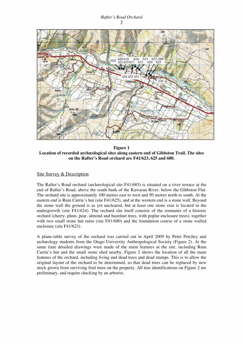
Figure 1
Location of recorded archæological sites along eastern end of Gibbston Trail. The sites
on the Rafter’s Road orchard are F41/623, 625 and 680.
Site Survey & Description
The Rafter’s Road orchard (archæological site F41/685) is situated on a river terrace at the
end of Rafter’s Road, above the south bank of the Kawarau River, below the Gibbston Flat.
The orchard site is approximately 100 metres east to west and 50 metres north to south. At the
eastern end is Rum Currie’s hut (site F41/625), and at the western end is a stone wall. Beyond
the stone wall the ground is as yet uncleared, but at least one stone ruin is located in the
undergrowth (site F41/624). The orchard site itself consists of the remnants of a historic
orchard (cherry, plum, pear, almond and hazelnut trees, with poplar enclosure trees), together
with two small stone hut ruins (site F41/680) and the foundation course of a stone walled
enclosure (site F41/623).
A plane-table survey of the orchard was carried out in April 2009 by Peter Petchey and
archæology students from the Otago University Anthropological Society (Figure 2). At the
same time detailed drawings were made of the main features at the site, including Rum
Currie’s hut and the small stone shed nearby. Figure 2 shows the location of all the main
features of the orchard, including living and dead trees and dead stumps. This is to allow the
original layout of the orchard to be determined, so that dead trees can be replaced by new
stock grown from surviving fruit trees on the property. All tree identifications on Figure 2 are
preliminary, and require checking by an arborist.

Rafter’s Road Orchard
3
Figure 2
Plane table map of the Rafter’s Road orchard (F41/685), showing preliminary tree
identifications.

Rafter’s Road Orchard
4
The layout of the orchard appears to be in two halves, separated by a row of large poplar trees
down the middle of the site. The eastern half of the site contains the two small stone ruins and
Rum Currie’s hut. The trees in this area appear to have been regularly laid out, although only
7 or 8 of the original planting remain, plus three hazelnut bushes that appear to be reasonably
healthy and vigorous.
The western half of the orchard is bounded on its western side by a stone wall, and contains
the foundation courses for a stone enclosure (site F41/623) that measures approximately 16
metres by 16 metres. There is less apparent pattern in the tree planting in this area, although
this is probably the result of original trees dying and self-seeded trees growing up. At the time
of the field survey (April 2009) the large pear tree at the foot of the slope was in fruit. Most
other surviving fruit trees had finished fruiting at that date.
Rafter’s Road Orchard
5
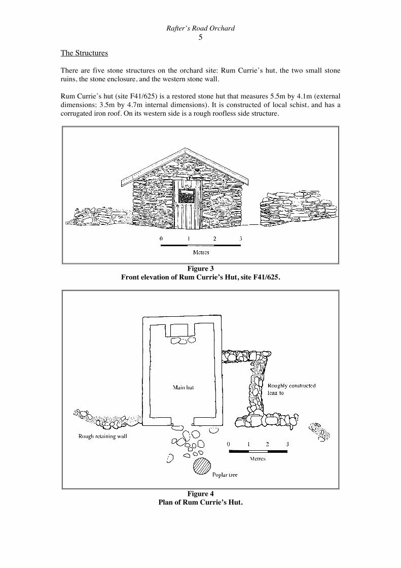
The Structures
There are five stone structures on the orchard site: Rum Currie’s hut, the two small stone
ruins, the stone enclosure, and the western stone wall.
Rum Currie’s hut (site F41/625) is a restored stone hut that measures 5.5m by 4.1m (external
dimensions; 3.5m by 4.7m internal dimensions). It is constructed of local schist, and has a
corrugated iron roof. On its western side is a rough roofless side structure.
Figure 3
Front elevation of Rum Currie’s Hut, site F41/625.
Figure 4
Plan of Rum Currie’s Hut.
Rafter’s Road Orchard
6
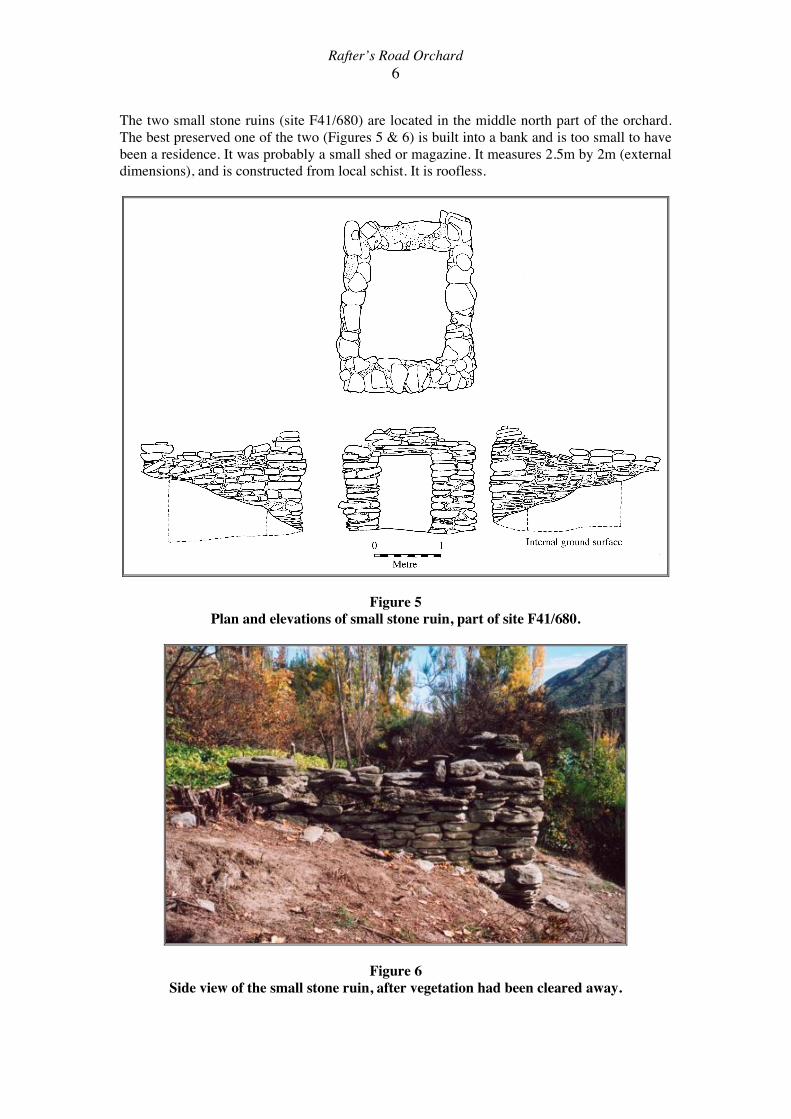
The two small stone ruins (site F41/680) are located in the middle north part of the orchard.
The best preserved one of the two (Figures 5 & 6) is built into a bank and is too small to have
been a residence. It was probably a small shed or magazine. It measures 2.5m by 2m (external
dimensions), and is constructed from local schist. It is roofless.
Figure 5
Plan and elevations of small stone ruin, part of site F41/680.
Figure 6
Side view of the small stone ruin, after vegetation had been cleared away.

Rafter’s Road Orchard
7
The second structure has largely collapsed (Figure 7), and only the back and part of one side
of the chimney stands (1.8m wide, 1.5m high). Some there has been some modification to
part of the structure, and a concrete and stone slab and stone pile is attached to one side. The
remaining chimney section is very unstable, and is likely to collapse unless immediate
stabilisation work is undertaken.
Figure 7
Partially collapsed stone ruin.
The stone enclosure consists only of
the foundation courses of stone
visible at ground level (Figure 8).
The enclosure measures 16 metres
by 16 metres, although the wall lines
are not exactly straight.
Figure 8 (left)
Part of stone enclosure.
The stone wall at the western
boundary of the orchard runs for 24
metres, with a gap (possibly for a
gate) near its northern end. On its
western side the stone face of the
wall is visible, but earth is piled up
all along its eastern side. It is
possible that the wall originally had
a stone base and a mud-brick or sod
upper section, and this has toppled
over to the east.
Rafter’s Road Orchard
8
Discussion & Recommendations
The Rafter’s Road orchard is a significant site, not simply because of its
heritage/archæological values, but also because it is easily accessible to the public, and can
therefore play an important role both as an amenity area and as an area where heritage values
can be promoted. The proposed Gibbston Community Association restoration of the orchard
will not only save this orchard from a slow overgrown decay, but also allow public enjoyment
of this space. A maintenance programme for the surviving fruit trees and a propogation
programme to replace missing trees will greatly enhance the area, and will ensure the survival
of important heritage fruit varieties.
The works proposal for the orchard, together with recommended actions and precautions, is
as follows:
1. Introduction of new topsoil to level the orchard area (F41/685), particularly the
modern vehicle tracks and an old toilet pit.
• Soil should be introduced, rather than ground dug away, to level areas.
• No soil should be deposited on, or within 1 metre, of the stone structures (hut
sites, enclosure, stone wall). Soil levels should be graduated towards these
structures, so there is no obvious step down to them.
2. Pruning of trees, mulching around trees, removal of dead and weed trees.
• Detailed records should be kept of tree varieties, with locations marked on
the site plan.
3. Planting of new trees from propagated stock.
• The locations of all new trees should be recorded as above. As far as
practical, locations of fruit varieties should be based on historic orchard
layouts.
4. Stabilisation of stone structures.
• The small square stone hut should be stabilised by a stoneworker with
experience with historic structures. The unstable hut chimney may require a
greater degree of intervention. Again, this should be carried out by
experienced personnel. Some reconstruction might be necessary. In both
cases, no ground excavation should be undertaken (including lifting piles of
fallen stones). Any such disturbance would require a prior archæological
excavation.
5. Stone walled enclosure and stone wall.
• At present these structures should not be disturbed or modified, other than
having grass sown around them. The earth pile adjacent to the stone wall
should not be dug away.
6. Fenceposts
• If any archæological material is found while digging a post hole, work on that
hole should stop immediately, and if possible the post location changed.
The Gibbston Community Association will require an archæological authority for this work to
be carried out. Although the detailed history of the orchard is not known, its location and
nature, and the presence of the stone huts, make it likely that it pre-dates 1900, and is
therefore protected under the archæological provisions of the Historic Places Act. It is my
recommendation that such an authority can be issued, subject to the conditions outlined
above. The above work will not damage heritage values, but will ensure that they are
preserved for the future.

Rafter’s Road Orchard
9
Acknowledgements
Many people assisted with this survey, both in the Otago University Anthropological Society
and in the Gibbston and Wakatipu community, and I would like to thank them all.
The OAS members that participated were: Jason Gay, Andy Brown, Chelsea Dickson, Alex
Bell, Charlotte King, Kyle Davis, Kirsty Potts, Ben Teele and Sarah Mann.
Copyright © 2022 FDOKUMEN