Kilkenny Archaeological Project preliminary results
30
The Kilkenny Archaeological Project (KKAP): Heritage Council Irish National Strategic Archaeological Research (INSTAR) Programme 2008 Heritage Council grant reference: 16677 Principal Investigator: Cóilín Ó Drisceoil Date: 24 th October 2008
-
Upload
independent -
Category
Documents
-
view
0 -
download
0
Transcript of Kilkenny Archaeological Project preliminary results

1
The Kilkenny Archaeological Project (KKAP):
Heritage Council Irish National Strategic Archaeological Research (INSTAR)
Programme 2008
Heritage Council grant reference: 16677
Principal Investigator: Cóilín Ó Drisceoil Date: 24th October 2008

1
Summary overview of 2008 results

1
1.1 General Background
In 2008 the Kilkenny Archaeological Project (KKAP) was established as a multi-disciplinary
collaborative effort which aimed to transform the data produced by archaeological investigations
that occurred in the city between 1968-2006 into publically accessible knowledge of the urban past.
The project received Irish National Strategic Archaeological Research programme (INSTAR)
funding for its first phase - ‘Archaeological Investigations in Kilkenny City: A Proposal for
Knowledge Creation’ - and this has proved to be a highly successful data-gathering and assessment
exercise (Figure 1.1). This document presents a summary overview of the key results of the project’s
first year of work.
Figure 1.1: Summary diagram showing key components of the Kilkenny Archaeological Project, Phase 1
Kilkenny Archaeological
Project
(KKAP)
Kilkenny Urban
Archaeology Database (KKUAD)KKAP Phase 1
Report
www.kkap.ie
website
KKAP Bibliography
Collabarative Partnerships

2
1.2 Key achievements in 2008:
1.2.1 The completion of the Kilkenny Urban Archaeology Database (KKUAD)
The Kilkenny Urban Archaeology Database (KKUAD) covers the present Kilkenny Borough
Council area and its immediate environs and was modelled on similar schemes that had been
completed for a number of historic towns in England (eg. Lincoln (Stocker 2008) and Canterbury1)
as part of the English Heritage review of urban archaeological strategies (1996-7).2 KKUAD records
information on a Microsoft Access database and Geographical Information System (GIS) (ArcView
9.2) about all known recording ‘events’ in the city from 1845 and all recorded modern archaeological
investigations (210 entities) since 1968 (Figure 1.2). The latter includes 275 individual site reports by
77 archaeologists.
Figure 1.2: Kilkenny Urban Archaeology Database screen-shot
1 http://www.canterbury.gov.uk/buildpage.php?id=3062 (accessed 20th October 2008) 2 http://www.eng-h.gov.uk/ArchRev/rev96_7/urban.htm (accessed 20th October 2008)

3
Figure 1.3: GIS map of Kilkenny showing areas of archaeological investigation

4
Figure 1.4: GIS map of Kilkenny showing archaeological cuttings

5
Figure 1.5: Example of GIS map of Kilkenny showing archaeological cuttings with KKAP entity numbers
6
KKUAD took its information from a variety of sources: published and unpublished archaeological
reports, historic maps and newspapers, the Urban Archaeology Survey, recorded findspots, and
artefact catalogues in the National Museum of Ireland and Rothe House museum. As structured it is
capable of being constantly updated, and it is invaluable for providing rapid and concise
archaeological data as well as access to original site reports and publications. 96% of the
archaeological investigation areas and their cuttings have been mapped onto the Geographical
Information System (ArcView 9.2) (Figures 1.3-1.5).3 The GIS allows the dataset to be interrogated
geographically in relation to a wide range of queries.
1.2.2 KKAP Report
A report detailing the results of the 2008 phase of the project will be available by for the INSTAR
completion date. This report provides an account of the project’s methodology, a historiography and
overview of the archaeological discoveries in the city between 1968-2006 as well as an assessment of
Kilkenny’s unpublished excavations. It also contains a detailed catalogue with accompanying
mapping for each investigation and a methodology to bring the project to completion. A summary
of the key results is provided below (Section 1.3).
1.2.3 Collaborative partnerships
Partnerships have been formulated between KKAP and the following (Figure 1.6):
1. Kilkenny Local Authorities (Kilkenny Borough Council and Kilkenny County Council) who
are providing digital Ordnance Survey mapping and aerial photographic coverage for the
city. Should the project proceed into 2009 a dedicated office will be made available by
Kilkenny Local Authorities to the project.
2. The Department of History National University of Ireland Maynooth are partners through
John Bradley, senior lecturer in archaeology.
3. The National Monuments Service of the Department of the Environment, Heritage and
Local Government have provided access to their reports archive and it is envisaged will be
end-users of the Kilkenny Urban Archaeology database.
4. The Kilkenny Archaeological Society have provided KKAP access to their archive and
library at Rothe House, Kilkenny.
3 There is insufficient information available for the remaining 4%.

7
5. Seventy-six individual archaeologists and 15 consultancy firms have provided consent to
include their investigation reports in the KKAP.
6. A panel of 16 specialists has been formulated to provide analysis of archaeological finds and
palaeo-environmental material.
Figure 1.6: Collaborative structure of the Kilkenny Archaeological Project
1.2.4 The production of the KKAP Bibliography
The KKAP bibliography has been produced and includes 125 individual entries which are sorted by
topic.
Principal Investigators
Cóilín Ó Drisceoil, Kilkenny Archaeology.
Kilkenny Archaeology Associate Investigators
John Bradley, NUI Maynooth
Paul Stevens (Kilkenny Flood Relief Scheme)
Richard Jennings (GIS)
Leah McCullough (Research Assistant, Administration)
Philip Kenny (Digital illustration)
Specialist panel (16 analysists)
National Collaborative Partnerships
National Monuments Service, Department of the
Environment, Heritage and Local Government
Academic Collaborative Partnership
National University of Ireland Maynooth
Local Collaborative Partnerships
Kilkenny Local Authorities
Kilkenny Archaeological Society
Professional Collaborative Partnerships
76 excavation directors and 15 archaeological consultancy
firms.
8
1.2.5 KKAP website
A website (www.kkap.ie) has been designed to be used as research portal for project participants as
well as providing news and overviews of the project. Relevant project reports and other documents
have also been uploaded. The website will be available online in December 2008 and it is envisaged
that the complete KKUAD dataset will be obtainable on the website in year 2 of the project4
1.2.6 Public Awareness of Project
Local newspapers have published reports on KKAP and the principal investigator has carried out
interviews with local radio and has had briefing sessions with the Kilkenny Heritage and
Conservation officers and the Kilkenny Archaeological Society.
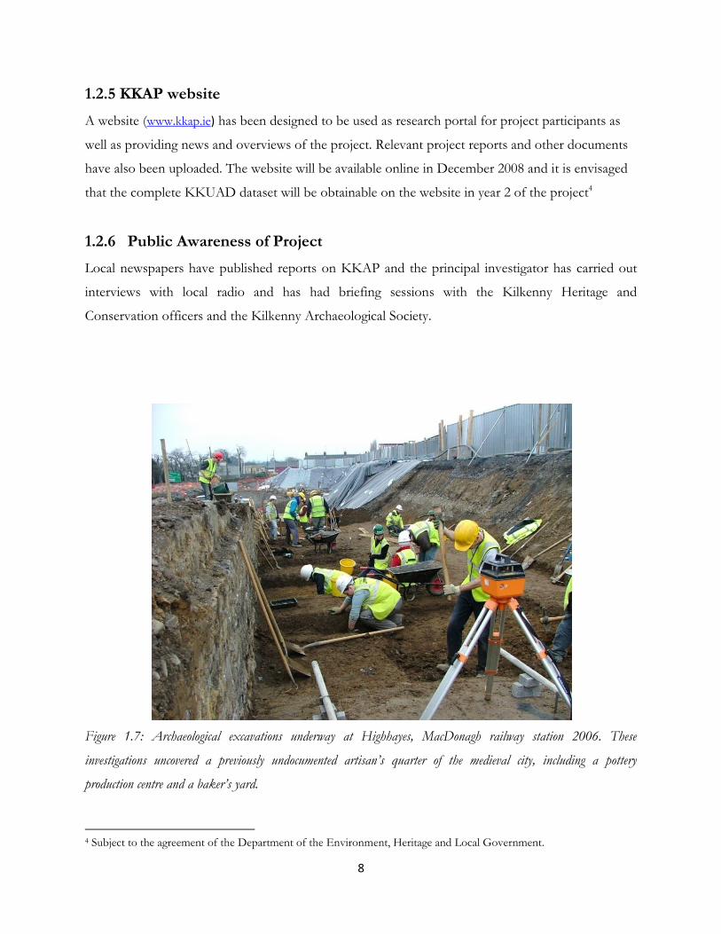
Figure 1.7: Archaeological excavations underway at Highhayes, MacDonagh railway station 2006. These
investigations uncovered a previously undocumented artisan’s quarter of the medieval city, including a pottery
production centre and a baker’s yard.
4 Subject to the agreement of the Department of the Environment, Heritage and Local Government.

9
1.3 KKAP Phase 1 Report Key Results
1.3.1 Rate of archaeological investigation
Between 1968-2006 210 archaeological sites were investigated in the city in 275 individual recording
‘operations’ (Figure 1.8).
Figure 1.8: Rate of archaeological investigations in Kilkenny city per annum
1.3.2 Comparison with other urban areas
In comparison to other towns such as Galway, Cork, Waterford and Limerick the rate of
archaeological intervention compares very favourably (Figure 1.9). It is also however a reflection of
the forms of development that have taken place within the historic centre, which have been in the
main of small-scale character.
Figure 1.9: Rate of archaeological investigations by year in comparison with Galway
0
5
10
15
20
25
30
Number of Investigations in Kilkenny City, 1968-2006
0
5
10
15
20
25
30
19
68
19
71
19
74
19
77
19
80
19
83
19
86
19
89
19
92
19
95
19
98
20
01
20
04
Number of Investigations in Kilkenny and Galway, 1968-2006
Kilkenny
Galway

10
1.3.3 Type of archaeological intervention
Just under half (49.8%) of the 275 archaeological interventions comprised testing (Figure 1.10). 59
excavations occurred, 21.4% of the total number of interventions.
Figure 1.10 Type of archaeological investigation undertaken
1.3.4 Geographical spread
The geographical spread of archaeological investigations was quite broad, with each area of the city
having experienced some form of investigation (Figure 1.11). Not surprisingly the Hightown, the
heart of the medieval walled town, experienced the largest amount of sites investigated (120).
Figure 1.11: Number of archaeological investigation sites per area of Kilkenny city
59
137
52
24 3
Investigation type
Excavation
Testing
Monitoring
Architectural
Underwater
12031
27
522
5
Number of sites per area of cityHightown
Irishtown
Suburb of St. Johns
Suburb of Donaghmore
Riverine

11
Figure 1.12: Locations of Grade 1-3archaeological investigation sites

12
1.3.5 Grading
Over half of the investigation (53.7%) produced results that can be considered (using the Heritage
Council’s grading system)to be worthy of publication (Grades 1-3) (Figures 1.12-1.13). The list of
sites proposed for inclusion in the next stages of the project is set out in Table 1.
Figure 1.13: Significance grading of archaeological investigations for Kilkenny city (grading after Doyle et.al. 2001, section 3.2).
1.3.6 Publications
Just 6.1% (13 sites) of Grade 1-3 investigations, have been published (Figure 1.14).5
Figure 1.14: Quantity of published sites per significance category
5 Publication in the annual ‘Excavations’ bulletins is not considered as ‘full’ publication.
4
54 55 55
39
30
10
20
30
40
50
60
1 2 3 4 5 Unknown
Qu
anti
ty
Significance Category
Site Grade
0102030405060
1 2 3 4 5
Qu
anti
ty
Site significance category
Quantity of published sites
Sites not published
Sites published

13
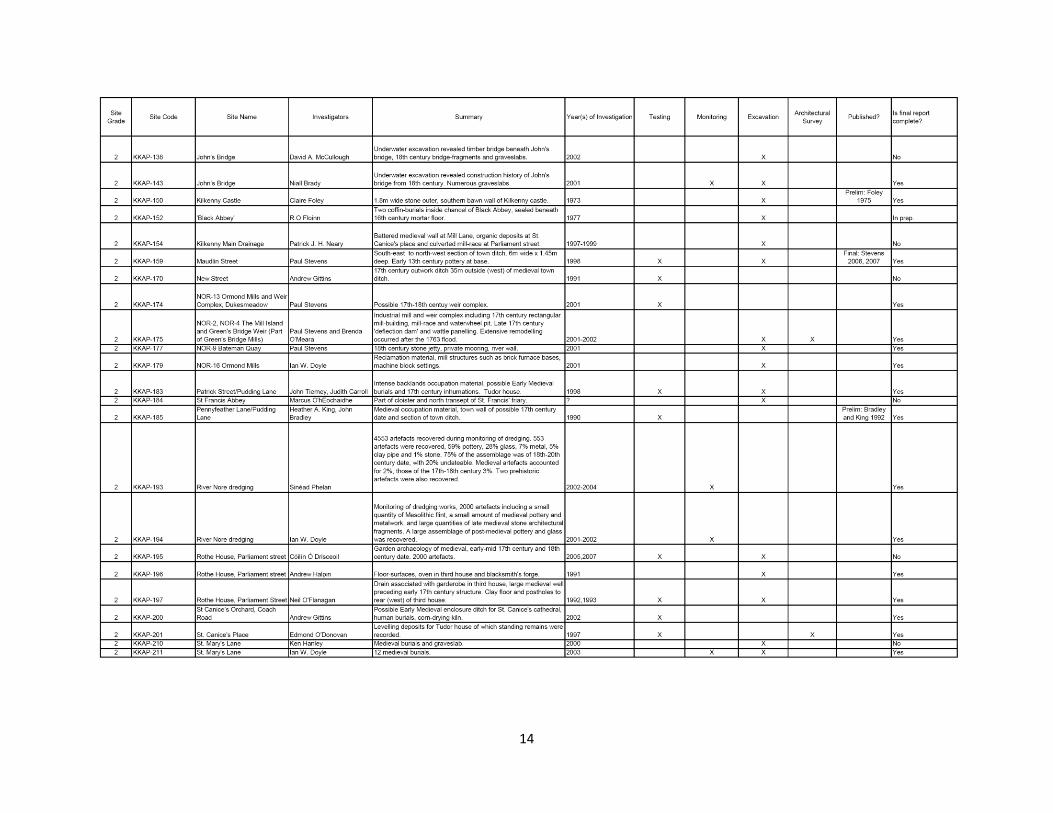
Table 1: Table of sites proposed for inclusion in the Kilkenny Archaeological Project 2009-2011
14

15

16
Table of sites for inclusion in Kilkenny Archaeological Project. Please note that this includes published sites as well as unpublished.
17
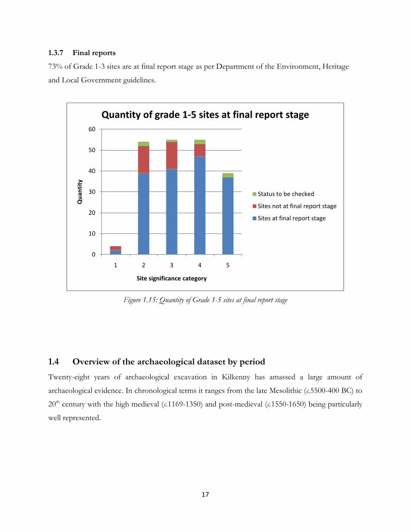
1.3.7 Final reports
73% of Grade 1-3 sites are at final report stage as per Department of the Environment, Heritage
and Local Government guidelines.
Figure 1.15: Quantity of Grade 1-5 sites at final report stage
1.4 Overview of the archaeological dataset by period
Twenty-eight years of archaeological excavation in Kilkenny has amassed a large amount of
archaeological evidence. In chronological terms it ranges from the late Mesolithic (c.5500-400 BC) to
20th century with the high medieval (c.1169-1350) and post-medieval (c.1550-1650) being particularly
well represented.
0
10
20
30
40
50
60
1 2 3 4 5
Qu
anti
ty
Site significance category
Quantity of grade 1-5 sites at final report stage
Status to be checked
Sites not at final report stage
Sites at final report stage

18
Figure 1.16: Total number of archaeological periods represented by all sites represented in the Kilkenny Urban
Archaeology Database.
Figure 1.17: Number of sites grades 1-3 per chronological period
6 7 148 2950
50
100
150
200
250
300
350
Prehistoric Early Medieval Medieval Post-Medieval
Qu
anti
ty
Site Period
0
50
100
150
200
250
300
Qu
anti
ty
Site Grades 1-3 and chronological periods
Grade 3
Grade 2
Grade 1

19
Figure 1.18: Graph showing site types documented in KKUAD
1.4.1 Prehistoric Kilkenny
A small number of indications for prehistoric activity within the city have been discovered in recent
years, most notably during the course of the Kilkenny flood relief scheme (2000-2005). In total 5
prehistoric discoveries have been documented- Mesolithic flints, Neolithic polished stone axes, an
Early Bronze Age cremation burial, a Late Bronze Age fish-trap and fulacht fiadh.
44 43
33
26
21 20 1917
15 14 13 12
9
6 5 5 4 4 3 3 2 2 1 1 1
0
5
10
15
20
25
30
35
40
45
50B
ackl
and
s
Po
st-1
65
0 H
ou
sin
g
Def
ence
s
Pre
-16
50
Ho
usi
ng
Gar
den
s
Bu
rial
s
Rel
igio
n
Rec
lam
atio
n
Stre
ets
Man
ufa
ctu
rin
g
Mill
s
Ind
ust
rial
Bri
dge
s
Riv
er D
red
gin
g
Wel
ls
Dra
ins
Trad
es a
nd
Cra
fts
Kiln
s
Art
efac
t Fi
nd
Sp
ots
'Ple
asu
re H
ou
se'
Wei
rs
Ove
ns
Cas
tle
Fula
cht
Fiad
h
Pre
his
tori
c B
uri
al
Qu
anti
ty
Site type
The range of site types discovered during investigations in Kilkenny City, 1968-2006

20
1.4.2 Early Medieval Kilkenny (c.800-1169 AD)
Seven sites have reported evidence for Early Medieval activity. What may have been an inner vallum
of the ecclesiastical precinct of Cill Chainnigh has recently been discovered in the ‘Deanery garden’
beside St. Canice’s cathedral. The site also produced evidence for antler working and a corn-drying
kiln that may be of Early Medieval date. On the south side of the city a section of a similar enclosure
around the Domhnach Mór was documented on Father Hayden road. Excavations at Kilkenny castle
have uncovered what has been reported as evidence for a secular settlement site of Early Medieval
date. This contained a c.4.6m x 4.2m sod-built structure with a central hearth, nearby to which was a
small smelting-furnace for bronze and iron working.
Figure 1.19: Test-excavations in 2006 on this site at the Deanery Orchard, St. Canice’s cathedral provided
important evidence regarding the Early Medieval archaeology of the site.
21
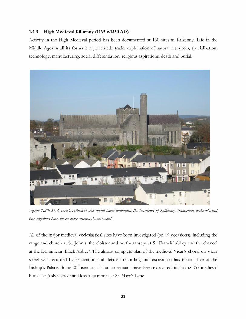
1.4.3 High Medieval Kilkenny (1169-c.1350 AD)
Activity in the High Medieval period has been documented at 130 sites in Kilkenny. Life in the
Middle Ages in all its forms is represented:. trade, exploitation of natural resources, specialisation,
technology, manufacturing, social differentiation, religious aspirations, death and burial.
Figure 1.20: St. Canice’s cathedral and round tower dominates the Irishtown of Kilkenny. Numerous archaeological
investigations have taken place around the cathedral.
All of the major medieval ecclesiastical sites have been investigated (on 19 occasions), including the
range and church at St. John’s, the cloister and north-transept at St. Francis’ abbey and the chancel
at the Dominican ‘Black Abbey’. The almost complete plan of the medieval Vicar’s choral on Vicar
street was recorded by excavation and detailed recording and excavation has taken place at the
Bishop’s Palace. Some 20 instances of human remains have been excavated, including 255 medieval
burials at Abbey street and lesser quantities at St. Mary’s Lane.

22
Thirty-three investigations have taken place on the town walls, providing important information
regarding the development and military technology employed from the early 13th-late 17th century.
What may have been the ditch of the primary defences was recorded at William Street and timber
piles associated with the later 13th century extension to the defences at Abbey Street. In addition
there have been a series of substantial excavations carried out on the walls of St. John’s suburb.
Figure 1.21: The environs of the Dominican ‘Black Abbey’, founded 1225 have been extensively excavated. The
former chancel has been excavated, as has a section of its precinct wall and a large proportion of its medieval cemetery.
Very little direct evidence for medieval housing has been recorded. Part of a sill-beam house was
recorded at Brennan’s yard, Irishtown and a timber-framed building on James’ street may also be of
medieval date. There is also the possibility that many of the cellars recorded on High Street and
Parliament street originated in the Middle Ages.
Kilkenny’s medieval bridges have received much attention as a consequence of the works associated
with the 2000-2005 flood relief scheme. Much of the 16th century Green’s bridge was recorded and

23
excavated and at John’s Bridge a major collection of graveslabs was found at the abutments. A
previously undocumented bridge has also been unearthed at John’s priory in a separate project.
At Kilkenny castle extensive excavations have been undertaken which have documented in some
considerable detail the main building phases and their associated material culture. In addition part of
the outer curtain wall has been excavated.
Direct archaeological evidence for tanning pits, a pottery kiln, drying kilns and lead working have all
been documented and a vast range of artefacts in pottery, leather, wood, iron and copper-alloy
present information on the crafts and trades that were undertaken within the city.
Roughly half the area of the Hightown and Irishtown, and almost the entire suburb of St. John’s was
constructed on the former flood-plains of the Nore and Breagagh rivers. Archaeological material
unearthed within the reclamation zone can therefore be expected to be better preserved (as a
consequence of anaerobic conditions) than elsewhere in the city. Seventeen investigations have
produced direct evidence for medieval reclamation in the form of massive dumps and timber/stone
revetments.
1.4.4 Post-Medieval Kilkenny (c.1550-1650)
Sites that could be dated to between c.1550-1650 amounted to 43, with 25 producing evidence for
structures that related to the boom in stone house construction that occurred within the city at this
time. Architectural recording has taken place at number of these (eg. the Shee House, 91-3 High
Street and the Rothe House, Parliament street) and a large stone building with a battered wall was
excavated on Poyntz’s Lane. Cellars have been recorded on many occasions including fine barrel-
vaulted examples at the Langton House, High Street. Milling was an important industry in Kilkenny
in the late 16th-early 17th century and the earliest phases of a number the excavated sites were of such
a date.

24
Figure 1.22: The late Tudor Rothe House on Parliament street has been the focus for excavations both within the
building and also its rear-garden.
1.4.5 18th-19th century Kilkenny
The archaeology of milling forms the most significant component of the investigations from the
18th-19th century in Kilkenny. Thirteen excavation took place on mills and/or their associated
infrastructure during the Kilkenny flood relief scheme. Key sites included Mill Island, Ormonde Mill
and the archer ‘tuck mill’. Excavation and architectural recording has also been carried out on a
number of 18th century houses in the city, most notably the ‘New Building’.

25
1.5 The Artefacts and Palaeoenvironmental remains from Kilkenny’s
archaeological investigations
Cumulative totals for all artefact-types and palaeoenvironmental samples are presented in Table 2
below.6 Medieval pottery forms the most commonly recovered find-type with post-medieval pottery
and metal finds also being prominent. A substantial quantity - 88% - of the excavated material has
been already subjected to specialist analysis (Figure 1.23). Significantly, the archaeological works on
the Kilkenny City Flood Relief Scheme (2000-2005) and the excavations at Highhayes (MacDonagh
railway station) produced 59% of the total finds assemblage from the city.7
Table 2: Cumulative list of quantities of artefacts, human remains and palaeoenvironmental samples recovered from Grade 1-3 Kilkenny City Investigations. The table also includes final tallies on the quantities of artefacts that require analysis.
6 These quantities should be regarded as minimum numbers. 7 The third major project was at Kilkenny castle (Murtagh 1993) but no reliable, up-to-date finds totals are available for this site.
Find Type Quantity Found Other sites with same find type (unquantified)
Quantity Already Analysed
Quantity to be Analysed
Medieval Pottery 16488 7 14414 2074
Post medieval Pottery 9471 27 8543 928
Ferrous Metal 2816 6 2389 427
Non-Ferrous Metal 1633 4 1500 133
Glass 2663 18 2330 333
Small stone 93 0 31 62
Coins 296 0 170 126
Bone Artefacts 31 6 25
Clay pipe 2466 19 1917 549
Burial Monuments 47 22 25
Structural Timbers 72 23 49
Wooden artefacts 51 19 32
Leather 329 326 3
Roof tiles 144 2 82 62
Floor tiles 193 5 37 156
Architectural Stone 347 0 347 27
Human Burials 1155 884 271
Human Disarticulated Bone
244 1 244 0
Animal Bone 25941 7 25939 2
Environmental Samples
122 1 122 1
Wood/charcoal 399 0 399 0

26
Figure 1.23: Percentages of finds/samples where specialist reports have been carried out
Figure 1.24: This 14th century jug from Highhayes is a copy of similar vessels from Redcliffe, England
0%
20%
40%
60%
80%
100%
Wo
od
/ch
arco
al s
amp
les
Envi
ron
men
tal S
amp
les
An
imal
Bo
ne
Leat
her
No
n-F
erro
us
Met
al
Po
st m
edie
val P
ott
ery
Arc
hit
ectu
ral S
ton
e
Gla
ss
Med
ieva
l Po
tter
y
Ferr
ou
s M
etal
Hu
man
Bu
rial
s
Cla
y p
ipe
Co
ins
Bu
rial
Mo
nu
men
ts
Smal
l sto
ne
Stru
ctu
ral T
imb
ers
Ro
of
tile
s
Bo
ne
Art
efac
ts
Wo
od
en a
rtef
acts
Flo
or
tile
s
Hu
man
Dis
arti
cula
ted
Bo
ne
Met
allu
rgic
al W
aste
Percentage of finds/samples analysed by specialists
To be analysed
Analysed
27
Bibliography
Prendergast, E. 1970 ‘Burials at Gallowshill’, Old Kilkenny Review Vol.22, 64.
Foley, C. 1975 ‘The discovery of a portion of 13th Century wall at Kilkenny Castle’,
Old Kilkenny Review 1(2), 103.
Cotter, C. 1992 ‘Archaeological Excavations in Dean Street, Kilkenny 1990’, Old
Kilkenny Review, 4 (4), 1065-1075.
Bradley, J. and 1992 ‘Archaeological trial excavations in Kilkenny’, Old Kilkenny Review
King, H.A.. 4 (4), 973-87.
Kiely, J. 2000 ‘Archaeological excavation at No. 26 Patrick Street, Kilkenny’, Old
Kilkenny Review 57 116-122.
Ó Drisceoil, C. 2004 ‘Probing the Past: a geophysical survey at St Canice's Cathedral,
Kilkenny’, Old Kilkenny Review 56, 80-106.
Doyle, I.W. 2005 ‘Excavation of a riverside circular tower in College Park, Kilkenny
City’, Old Kilkenny Review 57, 32-42.
Ó Drisceoil, C. 2005 ‘Archaeological excavations at the rear of 63 High Street, Kilkenny’,
Old Kilkenny Review 57, 43-61.
O Meara, B. 2006 ‘A preliminary account of recent excavations adjacent to Kilkenny
Union Workhouse’, Old Kilkenny Review 58, 154-162.
Stevens, P. 2006 ‘Four Excavations in Kilkenny City (1999-2001): Part 1 The
Medieval Findings’, Old Kilkenny Review 58, 47-66.
Stevens, P. 2007 ‘Four Excavations in Kilkenny City (1999-2001): Part 2 The Late

28
Medieval/Post-medieval findings’, Old Kilkenny Review 59, 18-37.
Stocker, D. 2008 ‘Explaining LARA, the Lincoln Archaeological Research Assessment in its
policy context’ in G. Fairclough, R. Harrison, J.H. Jameson and J. Schofield, The Heritage Reader, 340-
345, Routledge, New York.