Archaeological Surveys of Jebel Bishri: The Preliminary Report of the Finnish Mission to Syria,...
42
KASKAL Rivista di storia, ambienti e culture del Vicino Oriente Antico Volume 6 (2009) ARCHAEOLOGICAL SURVEYS OF JEBEL BISHRI THE PRELIMINARY REPORT OF THE FINNISH MISSION TO SYRIA, 2005-2006 Minna Lönnqvist with the contributions of Markus Törmä, Kenneth Lönnqvist, Jari Okkonen, Michael Herles and Markus Königsdörfer 1. Introduction 1.1. The Mobility of Life at Jebel Bishri The Finnish archaeological project SYGIS (the Syrian GIS) has continued its surveys and mapping on Jebel Bishri, the Bishri mountain, in Central Syria during the years 2005 and 2006 under the direction of Dr. Minna Lönnqvist from the University of Helsinki. The location, geology and environment of the mountain in the Palmyride mountain belt between the Syrian Desert and the Middle Euphrates have been already described in KASKAL 3 (2006) in association with the reporting of the surveys of 2000-2004. Jebel Bishri is clearly a nomadic habitat and has been such since the prehistoric times. The primary aim of the Finnish project SYGIS has been to prospect, survey and map archaeological sites ranging from the Palaeolithic Age to recent abandoned Bedouin sites in the region of Jebel Bishri in order to preserve and protect the ancient remains of the area and collect the scientific information they provide. From the systematically collected and acquired basic data the project is studying the development of the pastoral nomadic life in the region and the relation of the nomadic groups to agricultural village life of the Euphrates from ancient time to the present. The project pays special attention to the cyclic phenomena of nomadism and sedentism including dynamics and mechanisms taking place in sedentarization, site abandonment and reoccupation processes in the region. Therefore ethnoarchaeological approaches have been attached to the project design in order to understand some phenomena typical of the life of the nomads in the region. During the 2000-2004 surveys the nature of the archaeological remains of the desert-steppe and steppe areas of Jebel Bishri was established at the western edge of the mountain, the central eastern areas and the northeastern edge facing the Euphrates. The mobility of human groups living on the
Transcript of Archaeological Surveys of Jebel Bishri: The Preliminary Report of the Finnish Mission to Syria,...

KASKAL Rivista di storia, ambienti e culture del Vicino Oriente Antico
Volume 6 (2009)
ARCHAEOLOGICAL SURVEYS OF JEBEL BISHRI THE PRELIMINARY REPORT OF THE FINNISH MISSION TO SYRIA, 2005-2006
Minna Lönnqvist with the contributions of
Markus Törmä, Kenneth Lönnqvist, Jari Okkonen, Michael Herles and Markus Königsdörfer
1. Introduction
1.1. The Mobility of Life at Jebel Bishri
The Finnish archaeological project SYGIS (the Syrian GIS) has continued its surveys and mapping on Jebel Bishri, the Bishri mountain, in Central Syria during the years 2005 and 2006 under the direction of Dr. Minna Lönnqvist from the University of Helsinki. The location, geology and environment of the mountain in the Palmyride mountain belt between the Syrian Desert and the Middle Euphrates have been already described in KASKAL 3 (2006) in association with the reporting of the surveys of 2000-2004. Jebel Bishri is clearly a nomadic habitat and has been such since the prehistoric times. The primary aim of the Finnish project SYGIS has been to prospect, survey and map archaeological sites ranging from the Palaeolithic Age to recent abandoned Bedouin sites in the region of Jebel Bishri in order to preserve and protect the ancient remains of the area and collect the scientific information they provide.
From the systematically collected and acquired basic data the project is studying the development of the pastoral nomadic life in the region and the relation of the nomadic groups to agricultural village life of the Euphrates from ancient time to the present. The project pays special attention to the cyclic phenomena of nomadism and sedentism including dynamics and mechanisms taking place in sedentarization, site abandonment and reoccupation processes in the region. Therefore ethnoarchaeological approaches have been attached to the project design in order to understand some phenomena typical of the life of the nomads in the region.
During the 2000-2004 surveys the nature of the archaeological remains of the desert-steppe and steppe areas of Jebel Bishri was established at the western edge of the mountain, the central eastern areas and the northeastern edge facing the Euphrates. The mobility of human groups living on the

2 Minna Lönnqvist
mountain is typical of the region starting from the hunter-gatherers of the Palaeolithic Age, the emergence of semi-sedentism in the Upper Palaeolithic and Epipalaeolithic eras and the rise of pastoral nomadism during the Neolithic (PPNB) period. The districts that were covered by the systematic intensive ground surveys are Tar al-Sbai, Nadra and the surroundings of Tell Tabus. The first two sites show slight differences in their environments, the former being desert-steppe with greater emphasis on hunter-gatherer cultures, and the latter being more steppic with springs and evidence of pastoral nomads and semi-sedentary compounds (see more in Lönnqvist et al. 2006, and KASKAL 3). The transitional process from the hunter-gatherer subsistence economy to the nomadic one is important to assess while studying the remains on Jebel Bishri reflecting the life in this marginal zone restricted by the desert environment and the so-called Levantine corridor. The Levantine corridor starts from the Jordan valley, continues through Aswad in Damascus and researches the oasis of El Kown on the western piedmont of Jebel Bishri and the fan of on the Middle Euphrates at Abu Hureyra and Mureybet, where the evidence of incipient agriculture dates to the Epipalaeolithic period.1
Already in 2003 and 2004, while prospecting and surveying the Euphrates side of Jebel Bishri, we started seeing differences in the remains compared to the central areas of the mountain. The archaeological data in these two main districts reflects clear differences in mobility and sedentism. The sites on the mountain provided flimsy structures and scanty amounts of pottery but plenty of flint tools, chert and debitage while the river terraces were littered with pottery sherds, although flint artefacts were also present. The Plateaus 1 and 2 (H 1 and H 16) on the upper fluvial terraces had provided indications of buried structures detected with GPR in 2004. In addition, Tell Tabus in the studied area provides a monumental structure while the central areas of the mountain are so far devoid of monuments.
Agriculture never seems to have taken a permanent root on Jebel Bishri, and the transition from the semi-sedentary economy of the Epipalaeolithic period apparently made a way to the pastoral nomadic one including its semi-sedentary forms. The Early and Middle Bronze Age nomads of the third and second millennium BC living in the region are often identified as Amorites in the Mesopotamian cuneiform sources.2 Later on Jebel Bishri is described as the mountain of the Aramaeans, whose legacy in the Assyrian sources starts in association with the mountain at the end of the Late Bronze Age,3 i.e. the end of the second millennium BC stretching to the floruit of Palmyra and the Roman hegemony.4 The question of the Assyrian–Aramaean conflict5 and the role of Jebel Bishri in relation to the Aramaean state of Laqē has become a new element in our studies since 2004 and has also been the interest of our German co-operating partners, who participated in the survey in 2005 from the University of Halle-Wittenberg. The subject fits in our main research theme dealing with the relations of nomadic and sedentary societies in the region. The surveys of
1. See, e.g., Cauvin 2000 and Moore et al. 2000. 2. See references to the Amorites in Lönnqvist et al. 2006. 3. Luckenbill 1926, § 239. 4. See the sources in Lönnqvist et al. 2007. 5. Darmark 2008.
Archaeological surveys of Jebel Bishri _ preliminary report 2005-2006 3
the years 2005-2006 were carried out in the Mouhafazat (Province) of Deir ez-Zor under the Museum of Deir ez-Zor.
The connection of Jebel Bishri to the Roman eastern border zone, the so-called limes (although not representing a continuous fortification line) and its organisation have influenced the nature of the recovered remains since the first field season 2000. During our research it became a necessity to record and document the remains and organisation of the border zone of the empire including forts and military stations as there seems to be a gap in the present knowledge of the presence of the Romans on Jebel Bishri. It has been previously noted in several Roman frontier studies that the region of the Euphrates in Syria is still insufficiently studied and known to say anything definite about the Roman military organization there.6 However, apart from our survey, further studies on the Euphrates limes have been carried out by the French and the Germans in recent years. Indications of the hither-to-unknown presence of the Roman activities in the inner areas of Jebel Bishri have been gathered since 2003 by SYGIS. The ancient historical sources dealing with the Roman period of the region include the works such as Ptolemy’s (AD 90-168) Geography, itineraries, military tabulae of the Roman Empire such as Notititia Dignitatum and Tabula Peutingeriana (original from the 4th century AD) as well as architectural accounts provided by the ancient historian Procopius from the 6th century AD. They all elucidate the Roman history surrounding the archaeological remains that the Finnish project SYGIS has traced in the area. 1.2. The Strategies and Methods of the Field Seasons 2005 and 2006
The strategies of the Finnish project in surveying and mapping Jebel Bishri and its piedmonts consist of remote-sensing studies and empirical field surveys on the ground for GIS-mapping (see more about the data and mapping in KASKAL 3). The prospecting and mapping of the region that covers ca. 1 million hectares of desert-steppe and steppe have been carried out by using satellite image data sources of different kinds, field walking in chosen plots, capturing data for documentation with a tachymeter on the ground and using a ground penetrating radar (GPR) for the studies underneath the ground surface. Additional new data to the previously mentioned7 LANDSAT, CORONA, X-SAR and QuickBird images have been acquired since 2005 consisting of SPOT satellite images and ASTER-DEM data (digital elevation model data). Apart from identifying ancient sites, more environmental studies have been carried out by prospecting and surveying the region to understand the constraints of the past cultures.
Nowadays desertification is an acute problem on Jebel Bishri. The abandonments of the semi-sedentary Bedouin sites in the region are on the one hand due to desertification and on the other due to the agricultural ban by the Syrian government as agriculture increases desertification in the vulnerable steppe areas. Beside the desertification observations,8 the Finnish project has studied changes in the landscape on the Euphrates side in 2004-2007. Some of the terraces in the Middle Euphrates area are connected with the piedmonts of Jebel Bishri. Une Mission de Reconnaissance de
6. See, e.g., Parker 2000, 134-135. 7. See Lönnqvist et al. 2006, 211. 8. See, e.g., Lönnqvist _ Törmä 2004; 2006.

4 Minna Lönnqvist
l’Euphrate en 1922 led by pilot Charles Héraud (Reprinted by Institut Français de Damas 1998) presents aerial maps of the Middle Euphrates survey before A. Poidebard’s studies. The changes in the landscape are visible while comparing Héraud’s maps to the present day situations. In many areas poplars as well as tamarisk woods were still present in the 1920s but nowadays the upper terraces are quite devoid of any orchards. Since 2004 the Finnish project has carried out some analyses of the Euphrates channel changes with satellite images and the connections of the past channels to ancient sites. However, since the 1970s the Tabqa dam has caused the channel changes to decease so that the scale and tempo of the changes cannot be indicated with the satellite images that have only been available for half a century.9
During the field seasons of 2005 and 2006 the survey team consisted of altogether seven people. Like in the previous seasons the field groups were formed of 2-3 people and were labelled alphabetically so that the surveyed sites were accordingly numbered J 1, 2, 3 … K 1, 2 … L 1, 2… The documentation followed the same strategy and methods as used during the previous seasons. In the systematic survey no preference was given to one period over another, and all the ancient sites were equally recorded and documented. The sites are defined as the past locations of human activities. The major parameters for working with GIS are the coordinates and dimensions of the sites, captured with a GPS (global positioning system) and preferably with an EDM/tachymeter. This location data as well as the site descriptions with indicative finds were recorded and documented using computerized field forms. In addition to the systematic intensive survey, new Roman military sites were prospected by satellite images in the central areas or traced by using A. Poidebard’s aerial atlas of 1934. These remote-sensed sites were surveyed and mapped as targeted specific spots on the ground and mapped in 2005 and 2006.
The starting point of the intensive survey on the Euphrates side of Jebel Bishri was allocated to the right bank to trace more of the alignment of the ancient road found paralleling the Euphrates during the previous season and traced on CORONA satellite photographs from the 1960s. Therefore the survey changed its direction from the previous years, now approaching from the direction of Deir ez-Zor towards the village of El Kharita. The survey of the year 2005 started on the southern side of the village of Ayyash and south from the Deir ez-Zor–Aleppo road (UTM 37s, 0595830, 391814, ca. 240-250 m asl.) ca. 12 km northwest from the centre of Deir ez-Zor. It continued to the village of Ain Abu Jima. In 2006 the survey proceeded from Ain Abu Jima as far as to the village of El Kharita and its border with the village of El Kharita–Mustaha (to make the definitions clear: there are three villages El Kharita, El Kharita–Mustaha and Mustaha). Like during the previous seasons the 15 m interval field walking was carried out in groups of three people in transects defined by with natural boundaries: the mountain edges, ancient river terraces limited to the Deir-ez-Zor–Aleppo road and the river valley. The areas were walked back and forth so that a stretch of ca. 7.5 km long and 100 m wide area was covered at the edge of the river valley during the 2005 and 2006 seasons.
The Roman sites such as Mambri, Tabus, Qseybe and Qebaqeb were not closely documented in A. Poidebard’s aerial surveys of the 1920s,10 and some sites from the inner regions of the mountain
9. Lönnqvist et al. 2007. 10. Poidebard 1934.

Archaeological surveys of Jebel Bishri _ preliminary report 2005-2006 5
were not noticed and observed at all, perhaps due to the flying routes or visibility. So, the Finnish project brings forward new evidence in several parts of the mountain. Outside of the intensive and systematic survey we prospected and mapped sedentary sites along the Euphrates and some Roman military sites in the central eastern areas of the mountain. 2. Scattered Cultural Developments on the Euphrates Side of Jebel Bishri
2.1. The Prehistoric Finds on Fluvial Terraces
There are three distinctive types of fluvial terraces in the Middle Euphrates valley. They are partly attached to the edge of Jebel Bishri which follows the river valley over a distance of 100 km. Basi-cally the terraces are divided into three categories: the upper ones are called plateaus which may date from the Pleistocene period, and then there are usually two lower terraces beside the immediate river channel. J. Besançon and P. Sanlaville11 have previously carried out geomorphological studies and associated prehistoric surveys concentrating on Palaeolithic finds on the fluvial terraces between Raqqa and Deir ez-Zor. In addition to S. Muhesen and P. Sanlaville,12 further studies of the Palaeolithic Age in the Euphrates valley have been published by L. Copeland13 and the British and British –Syrian teams including R. Westaway, D. Bridgland, K. Challis, M. White, M. Daoud, Y. Radwan, M. Abu Romieh, R. Yassminh and A. al-Ashkar.14 Contemporaneously with the Finnish project the British team has been studying the geomorphology and Palaeolithic chronology of the terraces. The tools found between Sabkha and Ain Abu Jima appeared to be of the Achaeulian type dating to the Lower Palaeolithic period as well as of the Levallois type from the Middle Palaeolithic period.
The British and British–Syrian teams15 have radiometrically dated the actual deposits at basalt outcrops of Ayyash and Halabiya at the northeastern edge of Jebel Bishri facing the Euphrates also to define the chronology of the Lower and Middle Palaeolithic artefacts discovered in the area. At least the dates for the banks of the Euphrates at Halabiya were obtained φ2800-2100 ka equivalent to QfIII. For the village terrace of Ayyash the dating for QfI was φ425-415 ka, which is far older than has been previously suggested using stratigraphical techniques, that is QfI being φ140-70 ka. The older dating provides the terminus post quem for the Lower Palaeolithic finds associated with Ayyash and Ain Abu Jima.
On the Euphrates side of Jebel Bishri the Finnish project found several Palaeolithic sites between the villages of Ayyash and El Kharita during the years 2005-2006. The bedrock in the areas was covered by clayish silt. Earlier in 2003 and 200416 Palaeolithic finds had been identified by the project teams between El Kharita and Mustaha in the areas named as Plateaus 1 and 2 (H 1 and H 16) offering flint tools, chert and debitage. In 2003 an additional Plateau 3 was also visited outside
11. Besançon _ Sanlaville 1981. 12. Sanlaville 2004. 13. See, e.g., Copeland 2004 and Besançon et al. 1980. 14. Westaway et al. 2005, 31-33: Westaway et al. 2007, 82-89. 15. Westaway et al. 2005, 31-33: Westaway et al. 2007, 82-89. 16. Lönnqvist et al. 2006.
6 Minna Lönnqvist
our systematic survey area between the villages of Mustaha and Tibne providing similar material. The Palaeolithic finds from these terraces mainly date to the Middle Palaeolithic following the Mousterian tradition. But in the areas of Ayyash and Ain Abu Jima we encountered some older evidence like a hand axe (Fig. 3) and a bifacial between Ayyash and Ain Abu Jima dating to the Lower Palaeolithic period. In addition, a limestone ridge close to the river valley west from a N-S–orientated wadi and northern side of the road between Ayyash and Ain Abu Jima had clearly been a preferred activity area (Sites J 10, UTM 0593109, 3921225 and J 11, UTM 0593185, 3921140) during the Middle Palaeolithic period. Its connection to the river meant immediate availability of fish.
Unlike in the central areas of Jebel Bishri the Epipalaeolithic finds are not abundantly attested from the surveyed fringes of the Euphrates side of Jebel Bishri. Only a few sites were found in the district of Ayyash (Site J 1, UTM 0595032, 3919265) and Ain Abu Jima (Site L 3 UTM 0590486, 3922129). Ayyash does not seem to have close contact with the “Levantine corridor”. The Neolithic impact is also quite unrecognizable between Ayyash and El Kharita apart from the indications of the past PPNB activities exemplified by lime plaster bowls found beside Plateau 1 (H 1) in 2004,17 but Neolithic data may become more visible with further studies of the terraces. 2.2. Scattered Remains and Graves from the Bronze Age
Small cairns ca. 8.50 m and 10.40 m in diameter (J 8, UTM 0593324, 3920353, 255 m asl) were identified on a hillock on the southern side of the Aleppo–Deir ez-Zor road in 2005 in the area of an ancient road J 6 (first point UTM 0593719, 3920310, 237 m asl) southwest from the village of Ayyash. Some Early Bronze and Roman pottery pieces were found on a Plateau beneath. Site J 11 (UTM 0593185, 3921140) was discovered on a low ridge of Jebel Bishri facing the Euphrates and situated between the villages of Ayyash and Ain Abu Jima on the northern side of Deir ez-Zor–Aleppo road. Besides Palaeolithic flints, Roman pottery and remains of a rectangular stone structure 6.50×8.70 m in size associated with some Early Bronze Age pottery, were discovered on the ridge (Fig. 4.). The Roman pottery is clearly associated with the ancient road alignments (J 6 and L 1) which pass through the areas. The alignments that are visible on CORONA satellite photographs from the 1960s will be discussed in due course.
Graveyards intermingling with Bronze Age cairns/tumuli (J 14, 0593793, 3920928), cists and Islamic tombs were identified just west of Ayyash in 2005. One cairn/tumulus tomb (J 16, UTM 0593927, 3920971, max. 15 m in diameter) had been opened and looted. It included a large marble/gypsum cist consisting of two preserved marble/gypsum slabs (size 1.80×0.30 m and 1.10×0.30 m) in situ, and some broken fragments thrown out of the cist (Fig. 5). Associated pottery was badly weathered but seemed to date from the Middle Bronze Age. The cairn/tumulus site J 17 had a similar fate, and also provided Middle Bronze Age pottery (Fig. 6).
17. See Lönnqvist et al. 2006.

Archaeological surveys of Jebel Bishri _ preliminary report 2005-2006 7
3. Evidence of Sedentary Life and the Proccess of Sedentarisation in the Foot of Jebel Bishri on the Euphrates Side
3.1. Prospecting Sedentary Sites at the Foot of the Mountain
Apart from A. Poidebard’s studies, the previously mentioned Héraud’s aerial maps several hills and possible tells between Raqqa and Deir ez-Zor can be identified between Raqqa and Deir ez-Zor in the Middle Euphrates valley, although practically most of them are sand dunes. Our remote sensing studies and prospecting at the northern foot of Jebel Bishri following the right bank of the Euphrates including empirical checks on the ground have resulted in the mapping of altogether eight sedentary sites, i.e. tells, of which seven are earlier known. All the eight tells are situated along the 100 km long stretch following the piedmont of Jebel Bishri between Ayyash and Raqqa. Some of the seven tells have been previously mentioned by the 1922 Héraud’s mission, by J. Besançon and P. Sanlaville,18 by Kay Kohlmeyer,19 and are indicated in the atlas of Syria, Archaeology from Space.20 In addition, C. Falb et al.21 mention Tell Ghanem Ali (Tell Grnaia), which is now under the study of a Syro-Japanese mission.22 According to A. Moore (personal communication), his expedition at the Tabqa dam also surveyed the right bank towards Deir ez-Zor but no documentation has been published.
Between Halabiya and Raqqa we mapped three tells — that also appear on J. Besançon’s and P. Sanlaville’s map,23 and some of them are mentioned in K. Kohlmeyer’s surveys.24 These tells are in the midst of irrigated fields at the northern and northwestern foot of Jebel Bishri: Tell Grnaia (UTM 0538009, 3959311, 223 m asl) ca. 40 km from Raqqa towards Halabiya, Tell Hamadin (UTM 531832, 3960719, 216 m asl) at the village of Hablé ca. 33 km from Raqqa towards Halabiya and a shallow tell (UTM 3750543436, 3958166, m asl 226), the name of which we do not know, but which is situated near the village of Khamisiyah. Tell Hamadin is a site also mentioned by K. Kohlmeyer25 in his surveys. The site offers marble/gypsum structures and Hellenistic-Roman pottery as well as Early and Middle Bronze Age sherds, and previous studies have discovered some Lower Palaeolithic finds there. At Tell Grnaia town walls and several structures constructed from marble/gypsum are visible at the surface. Unlike Tell Grnaia and Hamadin, which are situated on the northern side of Deir ez-Zor–Aleppo road, the shallow tell site near Khamisiyah is on the southern side of the road and provides Early and Middle Bronze Age pottery. This tell like Tell Grnaia is currently occupied by a Muslim graveyard (see Fig. 2.)
At Qasabi on the peninsula of Halabiya there is a well-known tell northwest from the fort of Zenobia. It was already visited by F. Sarre and E. Herzfeld at the beginning of the 20th century and K. Kohlmeyer in the 1980s.26 We have also visited Qasabi, and it has been studied by the Spanish-
18. Besançon _ Sanlaville 1981, 10-11, Carte 1, presents four tells. 19. Kohlmeyer 1984, Beilage 4. 20. See, e.g., SAS 2002, 21. 21. Felb et al. 2005, Abb. 1. 22. Ohnuma et al. 2008. 23. Besançon _ Sanlaville 1981, 10-11, Carte 1, presents four tells. 24. Kohlmeyer 1984, Beilage 4. 25. Kohlmeyer 1984, 101. 26. Sarre – Herzfeld 1911, 165. Kohlmeyer 1986, 61.

8 Minna Lönnqvist
Syrian mission team in 2005.27 Beside Medieval pottery it is providing some Bronze Age sherds. Frenchmen have studied Halabiya excavating the ruins of Zenobia since the 1940s.28 Between Halabiya and Ayyash there are four tells to our knowledge; they are located at Tibne, Tabus, Kharita and Ayyash. Beside the mapping and documentation by the Finnish mission in 2003-2005, Tibne has offered Palaeolithic finds reported by earlier missions concentrating on prehistory. The tell at the peninsula of Ayyash is situated a few hundred meters west from and beside the Roman ruins of Qreiye. It was excavated by Marcus Gschwind during the years 2002-2004. According to Dr. Gschwind, the material from the tell is Pre-Roman but needs to be further studied to determine the specific periods that it represents. Tabus has been known by earlier travellers; a trial trench had been dug into its walls before the Finnish mission studied and mapped the site in 2004 (see more in Lönnqvist et al. 2006, KASKAL 3). At the village of El Kharita there is the only tell newly found by the Finns in 2006, and thus it has not been documented before.
As already presented in the 2000-2004 reports, historical Akkadian and Sumerian sources of the third millennium BC indicate Amorite presence on the mountain. The evidence of the second mil-lennium belongs to the era after the alleged large-scale sedentarization process of the nomadic Amorites that is thought to have started in the end of the third millennium BC — i.e. the Early Bronze Age.29 The Mari archives of the Amorite Age date to the second millennium BC and have been interpreted to reflect the existence of transhumance, enclosed nomadism or dimorphism30 among the Amorite tribes including the neighbourhood of Jebel Bishri. But whether the transhu-mance of these Middle Bronze Age pastoralists was a result of a larger scale sedentarization and whether it can be traced further back in time in the region is a question which still needs much more surveying to asses, and possibilities for detecting wider evidence of the continuity concerning pastoral transhumance by archaeological means are limited.
From our own studies we know that nowadays transhumance among the village pastoralists, inter-viewed at the villages of Tibne and Shummatyah at the foot of the mountain, takes place between the river villages and the mountain. In contrast, the semi-sedentary pastoralists living near Tar al-Sbai at the western edge of the mountain and at Shanhas on the western piedmont had their sea-sonal summer grazing grounds as far as on the Jezira (see more in KASKAL 3). This situation dif-fers from the information, e.g., given by some ethnographers, and it seems that changes may take place in the forms of vertical pastoral movement of transhumance only in the course of a few dec-ades. There is plenty of ethnographic data collected during the past century.
The actual archaeological evidence of the Aramean presence and Assyrian conquests in the dis-trict has been obscure before the finds made by the Finnish project in season 2006 at Tell Kharita. Assyrian Annals mention that Assurnasirpal II (883-859 BC) conquered the sites such as @indanu, @aridi and Kipina. The description of the campaign offers some indications that the sites are situ-ated after the gorge of Halabiya downstream the Euphrates.31 A. Musil suggested that the site of
27. Montero Fenollós et al. 2006, Abstract and presentation, 5th ICAANE, 48-49. 28. See Lauffray 1983-1991. 29. See Lönnqvist 2008 and 2009. 30. See, e.g., Rowton 1973, 248-251, 1976, 13-20 and Matthews 1978, 7. 31. Lönnqvist et al. 2007.

Archaeological surveys of Jebel Bishri _ preliminary report 2005-2006 9
Kipina is situated near Deri ez-Zor.32 However, as indicated above, the possibility is the tell beside the Roman fort of Qreiye at the village of Ayyash. 3.2. Mapping a Tell at the Village of Tibne, the Site for Mambri
A tell (UTM 0574179, 3941645, 231 m asl, see Figs. 2 and 7) at the village of Tibne is situated be-tween the Euphrates and the Deir ez-Zor–Aleppo road on the northern side of the road. The diameter of the tell is ca. 200 m. The tell is mentioned in K. Kohlemeyer’s survey33 and located on J. Besançon’s and P. Sanlaville’s map.34 It was already visited in 2003 and 2004 by our teams, but the intensive surface study and mapping were carried out in the 2005 season. Currently there is a muslim graveyard on the tell. Because of its location the exposed ruins at the site may be identified as those belonging to the fort of Mambri built by the Emperor Diocletian and rebuilt by the Emperor Justinian I. (See Fig. 10 and the map on Fig. 11). The distance of 6 km southeast from the fortress of Zenobia accords with the description given by the ancient historian Procopius (Buildings II, 8.7). However, beside apparent Late Roman and Byzantine structures and pottery (Figs. 9_11) the tell has produced prehistoric flints, early Uruk (Fig. 8), Early and Middle Bronze Age pottery as well as Islamic sherds. Interestingly there are also large marble/gypsum exposures (UTM 0578749, 3932878) on the way from Deir ez-Zor just before Tibne at Jebel Bishri, and Tibne could have served as a convenient site for transporting marble/gypsum along the river to Lower Mesopotamia. This reminds us of the reference to the mountain of Tidnum, possibly associated with Jebel Bishri, as a source of marble/alabaster in the Gudea texts dating from the late third millennium BC. 3.3. A Tell at the Village of El Kharita
In 2006 our intention was to reach the area surveyed in 2004 approaching from the opposite direction, and finally we ascended to marl terraces the foot of Jebel Bishri at the village of El- Kharita. Here we found a previously unknown tell (L 14, UTM 0589436, 3923932, 197-207 m asl, see Fig. 2) situated just beneath the Early Bronze Age tomb H 12 (UTM 0588791, 3924304) discovered and identified in the year 2004. The tomb had offered a marble/gypsum cist and Early Bronze Age pottery pieces. The tell site is ca. 1 kilometre east from Plateau 1 (H 1 found in 2003 and surveyed in 2004) but only a few hundred meters east from Plateau 2 (H 16 surveyed in 2004). The areas like Plateaus 1, 2 and the tomb H 12 had provided Early Bronze Age remains but stronger accumulation of the period became evident at the tell.
The newly discovered tell L 14 is situated ca. 22 km NW of the centre of Deir ez-Zor on the southern side of the Deir ez-Zor – Aleppo road in the border zone between the villages Mustaha –El Kharita and El Kharita; it is just inside the borders of the village of El Kharita. At present it is used as a site for the local Muslim graveyard (see Fig. 12), and as grounds for an elementary school. The tell covers ca. 150×150 m. However, its stratification is not deep max. 2-3 m in the ascending
32. Musil 1927. 33. Besançon – Sanlaville 1981, 10-11, Carte 1. 34. Besançon – Sanlaville 1981, 10-11, Carte 1.

10 Minna Lönnqvist
road profile (see Fig. 12) but differences in elevation vary by ca.10 m. It has not been visible to surveyors on a marl terrace above the Euphrates valley.
The finds consist of Palaeolithic flints, Chalcolithic (for example Al-Ubaid, see Fig. 13), Bronze Age (especially EB) and Iron Age pottery with some examples of Assyrian and the so-called Aramean red burnished pottery. Interestingly a lot of the so-called holemouth jars in the pottery types indicate that the site might have served as a place for sedentarizing nomads coming from the Bishri mountain. Large pithoi vessels with profiled rims are also in the material. Two or three in-scriptions were found at the surface survey. One is apparently written with cuneiforms (two and one broken off signs) on a large terracotta tile (see Fig. 15), the other is smaller unidentified scripture in terracotta. The apparent cuneiform signs are extraordinary large but drawn on the tile instead of stamping or pressing with a rod which would indicate the influence of Aramean scribal techniques.35
3.4. The new evidence from Tell Tibne and Tell Kharita considered
The sites such as Tell Tibne and Tell Kharita bring new evidence of the spread of the Mesopotamian Al-Ubaid and early Uruk cultures to the Middle Euphrates in the area between Deir ez-Zor and Halabiya, and thus the rise of urbanism in the region. A Chalcolithic site called Tell Zaidan (Site 16) providing Al-Ubaid and Halaf pottery exists on the Balikh but during his 1983 survey K. Kohlmeyer also found other sites (his Sites 61, 55, 96, 99) with Al-Ubaid evidence up the stream on the left bank of the Middle Euphrates 6 km east from Raqqa. There on the left bank there also exist more Uruk sites.36 The Al-Ubaid pottery recovered from Tell Kharita as well as the Uruk pot found at Tell Tibne on the Middle Euphrates between the Habur and the Balikh rivers bring forward new evidence of the activities on the right bank of the Middle Euphrates between the Habur and the Balikh rivers. The Syro-Spanish team led by J.L. Montero Fenollos37 has also recently traced considerable evidence of Uruk impact in the area of the gorge of Halabiya, namely at Tell Humeida. So, it may be that Tell Tibne already served as an Uruk station on the right bank of the Euphrates coming from Qraya and Lower Mesopotamia.38
As the previous seasons had already indicated, some sites clearly point to the Early Bronze Age and Middle Bronze Age influence that might be connected with the Amorite era. But in the lack of any epigraphic data in situ this ethno-tribal influence in specific is tentative, and it is premature to use it as conclusive evidence. The immediate connection of Tell Kharita to Jebel Bishri and its material, however, suggests that the site is reflecting the change from nomadism to sedentism. The question whether it provides evidence of enclosed nomadism or transhumance already in the Early Bronze Age — if using M. Rowton’s nomenclature associated with the Middle Bronze Age data — should be studied by an excavation, and also in that respect the data may appear to be just tentative. Tell Tibne instead provides Middle Bronze Age pottery contemporary with the Mari archives and
35. We thank Prof. G.B. Lanfranchi and Dr. M. Luukko for giving preliminary comments on the apparent
inscription. 36. Kohlmeyer 1984, 106-109. 37. See http://aidifondation.org/English/Syrian_spanish_mission.htm. 38. See the discussion in Algaze 1993, 48.
Archaeological surveys of Jebel Bishri _ preliminary report 2005-2006 11
judging from the convenient location may have served as a station on the route from Yam~ad to Mari along the Euphrates. However, there is no epigraphic evidence yet from the site so the ap-proach is purely hypothetical and based on literary sources like the Mari archives connecting the neighbourhood of Jebel Bishri with the Suteans and the Benjaminites.39
Tell Kharita, however, provides the first apparent archaeological indications of the Aramaean–Assyrian conflict in the neighbourhood. It provides both Assyrian and Aramaean types of pottery. Topographically the site would match with the site of @aridi in the Ashurnasirpal II Annals describing the punishing campaign against Aramaeans in the foot of Jebel Bishri while conquering the towns of @indanu, @aridi and Kipina downstream from the gorge of Halabiya.40 We have more closely analysed CORONA satellite photographs which show that the ancient river channel once was just beneath the tell, but there is no evidence of the particular time period at the moment.41
4. The Roman connections along the Euphrates 4.1. Tracing ancient road alignments, a ruined bridge and Roman impact
During Emperor Diocletian’s reign the Habur river became the Roman boundary in the east. The security of the frontier became a priority after the Roman defeats, e.g., at Dura Europos ca. AD 256 and queen Zenobia’s revolt. At the junction of the Euphrates and the Habur, according to Ammia-nus Marcellinus (23.5.2), Diocletian rebuilt the fortress of Circesium. It also became necessary to secure the area from Palmyra and Oriza to Circesium on the right bank of the Euphrates.42 The forts such as Mambri (UTM 574179, 3941645, ca. 231-235 m asl) and probably Tabus (UTM 0586948, 3925414, ca. 300 m asl) belonged to Diocletian’s fortification policy on the Euphrates. The Roman fort of Qreiye (UTM 596177, 3920938, ca. 228 m asl) northeast from Tabus is earlier instead and is tentatively identified as Birtha Arupan. It is situated at the village of Ayyash and was conquered by the Sassanians approximately at the same time with Dura Europos. Qreiye apparently fell in the spring of AD 25343 while Dura Europos was defeated ca. AD 256,44 and both were abandoned and still laid in ruins during the reign of Diocletian. However, while Mambri and Tabus were active, ac-cording to the pottery evidence, there was small-scale activity at Ayyash as well45 — there probably existed a relay-station during later Roman and Byzantine periods. The Finnish project has carried out a GIS-based viewshed analysis between the forts to study their intervisibility and interaction in the military organisation (see the locations on map Fig. 2).46
D. Kennedy, who has specialised in aerial archaeology and the identification of military sites on the Roman Eastern Frontier zone, notes the applicability of aerial perspective in detecting Roman
39. See for the references and discussion in Lönnqvist et al. 2006. 40. See, e.g., Maspero 1903. See also Lönnqvist et al. 2007 and K. Darmark apud Lönnqvist (ed.) 2008. 41. Lönnqvist et al. 2007. 42. Musil 1928, 254. 43. Gschwind 2004, 160. 44. See the last coins dated to AD 256 carried by the soldiers in the battle at the time of the defeat of Dura,
Rostovtzeff et al. 1936, 470. 45. See Gschwind 2003. 46. Lönnqvist et al. 2005.

12 Minna Lönnqvist
military sites.47 He, however, expresses how the balance in the present-day knowledge of the sites is heavily on the Jordanian side, indicating the fact that there have been more archaeological studies there. Apart from Poidebard’s studies, the aerial archives that would bring new data are not avail-able in Syria and Turkey. He also acknowledges that Syria was the heart of the Roman East being not only the oldest but the most urbanized among the military provinces. He further emphasises that archaeology provides the most important approach to reach new evidence of the Roman army in the East. In addition, Kennedy stated that more details of the Roman army in Syria and Cappadocia need to be traced and published.48 As previously mentioned, since Kennedy’s appeal more studies have been carried out among the French and German archaeologists along the Euphrates in recent years. The Finnish project is contributing to the study from the district of Jebel Bishri.
A. Poidebard49 and R. Mouterde with A. Poidebard50 connected several Roman/Byzantine sta-tions and forts with roads in their aerial maps and photographs illustrating the sites in the neigh-bourhood of Jebel Bishri. However, in his 1934 Atlas (see Fig. 15.), Poidebard mentions that he did not trace all the roads from the air or on the ground but indicated their possible existence and lining by connecting the identified ancient forts. S. Gregory also points out that Poidebard did not try to conceal the fact that many of his roads were hypothetical, based on others’ description and not visible from the air.51
During the year 2004 field survey, the Finnish project had identified two ancient roads (H 13 and H 15) next to the fort of Tabus the alignments and possible continuity of which were further studied and prospected with the aid of CORONA satellite photographs and LANDSAT satellite images.52 Fortunately the CORONA photographs from the 1960s still had preserved some possible stretches of the ancient road parallel to the Euphrates (Fig. 16) and running on its right bank. The road can be traced in the photograph bearing the same shadow as the road H 13 surveyed in 2004. But in the later LANDSAT and SPOT images the stretches are not detectable any more, which does not apparently be due to the resolution.
We tried to trace and study the identified and visible parts of the road on the ground in 2005-2006. Several indications varying from the location of the road on a fluvial terrace attached to the bedrock, its structures and associated finds indicate that the road and some of its preserved parts date to the Roman/Byzantine era. This road with partly preserved paving and rock-cut parts differs from the Roman military unpaved desert roads appearing in Poidebard’s Atlas and in our studies on Jebel Bishri (cfr. Fig. 16). The road following the Euphrates is most likely to have been better con-structed to avoid flooding, and it could have been used for several purposes varying from military, administrative to trading and caravan travelling needs. As the traffic was heavy it is quite possible that it was paved in the parts where bedrock was not easily applicable for cutting. The detailed documentation of the road will be discussed below.
47. See, e.g., Kennedy 1982; Kennedy – Riley 1990; Kennedy 1996; and Kennedy – Baley 2004. 48. Kennedy 1996, 11, 22. 49. Poidebard 1934. 50. Mouterde – Poidebard 1945. 51. Gregory 1996, 181. 52. See also the Finnish studies of ancient roads at Petra in Jordan in Haggrén et al. 2002, 108-113.

Archaeological surveys of Jebel Bishri _ preliminary report 2005-2006 13
In the season of 2005 we discovered another stetch of the mentioned ancient road (H 13) visible on the CORONA photograph. This part of the ancient abandoned road (J 6, the first GPS point UTM 0593818, 3980323, 235 m asl, the last point UTM 0593379, 3920863, 228 m asl) is situated southwest from Ayyash and is apparently the preserved eastern end of the road H 13 (Figs. 16 and 18) discovered in 2004 and passing Plateau 1 between the villages of El Kharita and Mustaha opposite to the village called Shummatiyah. Both parts of the road (H 13 and J 6) are 5 meters in width. Like H 13, J 6 had also been preserved ca. 1 km in length. However, apart from the old asphalt cover, this part J 6 of the road had several layers, in some points even 75 cm in section of altering layers of asphalt, the Macadam type crushed calcite or gypsum, gypsum layers with angular gypsum stones 20 × 15 cm across as a foundation or an original pavement. The road (J 6) led to a ruined bridge (J 7, see the description below), which we also documented. After crossing a wadi, during the following season 2006 we found other alignments of the ancient road at Ain Abu Jima. Here the exposed road (L 1, UTM 0592625, 3921364) is starting from the southern side of Deir ez-Zor – Aleppo road approximately opposite to the Ain Abu Jima police station. It had been cut into marble/gypsum rock and had horizontal grooves (in the interval of every 20 cm) like in the Roman roads (see Fig. 17),53 and like in the road H 15 studied in 2004 and 2005 (see below). The road (L 1) was approximately 5.4 m in width but had probably been widened in modern times.
In 2005 we also followed the alignment of the ancient road H 15 which was identified in 200454 and which is not the one parallel to the Euphrates (H 13, J 6 and L 1). This road had been cut into the bedrock just east from Tabus not leading to the fort but passing it instead and continuing further up to the south on Jebel Bishri. We have marked this road on a CORONA satellite photograph (Fig. 18). It seems that the road in question is a Roman road, as it is associated with Roman pottery, and bears carved wheel marks and horizontal grooves. It continues over two kilometres to the south up on the mountain, but its track disappears after reaching a high plateau with a possible graveyard of bulb type tombs (J 22, UTM 0586904, 3924695). The possible tombs seem to extend on both sides of the road to the east and west. The size of this apparent graveyard is ca. 50 × 80 m in size, and it seems to comprise over a hundred graves. A few of the alleged tombs had been looted, but otherwise the site seemed to be untouched and was surrounded by plenty of Early Bronze Age and some Roman pottery sherds. 4.2. A ruined bridge
The road (J 6) led to a ruined bridge (J 7 UTM 0593354, 3920769: ca. 226 m asl), which we recorded and documented. This bridge that is built of limestone stretches over a north-south-orientated wadi the seasonal water currents of which are coming to the Euphrates valley from Jebel Bishri. The wadi is dividing the village of Ayyash from the village of Ain Abu Jima. The bridge is situated to the south from the Deir Ez-Zor – Aleppo road ca. 100 m south from the new bridge stretching over the wadi (Fig. 19). In the CORONA satellite photograph (Fig. 16, above) the bridge is situated at a wadi where the old road is crossing with the modern one. The overall preserved length of the bridge
53. Chevallier 1989, 89. 54. Lönnqvist et al. 2006, 230.

14 Minna Lönnqvist
is ca. 17 m and the inner side of the preserved pillar facing the east is 13 m wide (see Figs. 19, 20). The bridge stands on ca. 3 m high foundation layer consisting of mixed rubble of concrete and basalt stones. This is typical of the Roman foundations, and the so-called rubble core is forming the inner construction of the bridge structure common in Roman bridges and triumphal arches.55 Here in J 7 the stones in the concrete mixture of the rubble core consist of gypsum, calcite and marble. The inside wall to the east is 11.90 m in width and has 16 layers of preserved limestone courses of ashlars as dressing (Figs. 19, 20.). The inside wall towards west is 13 m in width, in which even 20 layers of ashlars are preserved. The inner side limestone ashlar masonry consists of stones of 0.65 m-0.45 m l. × 0.32 m h. in size from the surface. Some stones have preserved frames which are visi-ble.
The bridge has a semicircular arch. The space beneath the arch and between the pillars is 7.95 m in width. The arch is partly preserved and has four limestone layers at the top. The arch rib can be formed from individual stones in different ways. In our case it is the construction of the stretcher bond that in the vault which represents the most common vault type in the Roman arches. A study of a number of Roman bridges and aqueducts showed that 62% were constructed using a stretcher bond.56 The outer stone courses inside the bridge pillars and the arch resemble the Roman bridges of Segura between Spain and Portugal as well as Puenta de la Cigarrosa at Petin and also the bridge at Bibey.57 But curiously Héraud’s aerial survey from the 1920s reports a bridge built by the British in the same location or where the modern bridge is situated over the wadi. Studying closely the bridge ruin in question, this is not likely to have been built by the British, but it has been used and possibly partly reconstructed in the Ottoman era. In Judaea the Legio_Scythopolis road is also associated with a bridge used in the Roman and Ottoman era.58 Here also at our site the context of the ancient road alignments in association with the bridge is apparent. 5. Mapping Roman Sites on the Eastern Slope and Southeastern Areas 5.1. Background for the Roman site on the mountain
R. Mouterde and A. Poidebard suggest that there was a Roman itinerary crossing Jebel Bishri from the forts of Resafa to Circesium dating to Emperor Diocletian’s rule. A water post called As-Šigri was identified by Poidebard in the central eastern area along the itinerary.59 Our studies and discoveries, even we have not yet traced As-Šigri, provide further evidence that there indeed existed Roman sites along an itinerary here called the “Bishri corridor”, for which we have now attained more evidence on the ground. This evidence fills the gap in our knowledge and in maps concerning Ro-man activities inside Jebel Bishri.
In 2004 the sites at Nadra (see Figs. 2 and 21.) in the central eastern area of the mountain had already provided Late Roman pottery: those sites are I 7 and I 8 as well as I 15 and I 21, including
55. See, e.g., Spence 1990, Fig. 27. 56. O’ Connor 1993, 172. 57. O’ Connor 1993, Figs. 88, 92, 93. 58. See Isaac – Roll 1982. 59. Poidebard 1934, 92, and Mouterde – Poidebard 1945, 135.

Archaeological surveys of Jebel Bishri _ preliminary report 2005-2006 15
reddish and blackish brittle ware handles and body parts of Roman pottery. It seems that the sites are located along the itinerary following a large wadi associated with smaller dry ravines and leading towards the military post of Qseybe situated further on the southeastern piedmont. Site I 7 (UTM 0551944, 3910610, 530 m asl) identified in 2004 is located at a hilltop and provides cairns /tumuli associated with a rectangular foundation of a building (8 × 3.6 m) at a ridge and various unidentifiable house structures in the vicinity. I 8 (UTM 0551925, 3910802, ca. 525 m asl) is just an open accumulated site at the northwestern bank of a wadi without visible structures but offering Roman pottery and some flints.
As far as we know, the Roman sites of Qseybe and Qebaqeb situated on the southeastern pied-mont of Jebel Bishri (Fig. 2), identified by A. Poidebard in his aerial surveys and visible in his maps (see, e.g., Fig. 15), have not been properly recorded with UTM coordinates on the ground.60 There-fore we wished to take the coordinates of the sites and draw maps of the exposed structures for their preservation and protection. 5.2. A Roman military camp near Ash-Shujiri
D. Kennedy points out that a number of references to flimsy and ephemeral Roman military camps appear in literary sources dealing with the Roman Eastern Frontier but very few of them are known, and it is likely that many more will be found in the future.61 A previously unknown Roman military camp was indeed found by the principal investigator of the Finnish project while prospect-ing Jebel Bishri with QuickBird satellite images in Finland in 2003. As previously mentioned, the remote-sensing has been recognized to provide valuable means to trace Roman military sites. On a high resolution QuickBird image (0.6 m) we recognized this classic military camp62 in the shape of a rough square with rounded corners and a via principalis leading through it. The location of the site was navigated with a GPS in 2005, and its nature as a Roman military camp K 1 (UTM 0540793, 3917317, 730 m asl) was confirmed. The site is situated ca. 2 km southeast from the village of Ash-Shujiri in the central area of Jebel Bishri (see Fig. 21) We mapped the site with a tachymeter (EDM, see Fig. 23).
The site is located on a high plateau surrounded by some hills and a wadi to the north. The maxi-mum plan of the camp covers ca. 150 × 120 m. Currently the site is ploughed inside, and a sparse plantation consisting of small fig trees is scattered around the inner area. A satellite image reveals possible barracks along the southern edge of the site but their existence is hard to judge on the ground without an excavation. An earthworks construction surrounding the square currently com-prises scattered stones that seemed to be remains of disturbed structures. A clear road already rec-ognized as via principalis is leading into the square camp formation and out of it (see, e.g., Fig. 22). The site provided Late Roman pottery (including brittle ware), Roman glass and a copper-alloyed armour scale (Fig. 24) just outside the defined camp area. Similar scales of armour were found at
60. See, e.g., Poidebard 1934, 92. 61. Kennedy 1996, 13. 62. See, e.g., Henderson 1991, 73-83.

16 Minna Lönnqvist
the Roman site of Qebaqeb (see below) that we shall shortly discuss. Dura Europos on the Euphrates has provided a plenty of comparable armour scales.63
The camp K1 had a visibility to two ruined rectangular houses K 2 (UTM 0539429, 3919109) which might have served as a guarding station. They are situated ca. 2.5 km NW from the camp near Ash-Shujiri, outside our study area, and therefore were not documented. They are constructed behind each other in a longitudinal axis towards the north. There is a main building and a smaller subsidiary one. These buildings seem to have been used by Bedouins, but they may originally be older. They were quite heavy in their construction. These houses are situated on a hillock that comprises reddish and greenish sandstone and provides good visibility to different directions, which would make the site a good guarding post. On a slope there grow the only acacia trees seen in the neighbourhood. In the neighbouring hills there are abandoned Bedouin houses belonging to the village of Ash-Shujiri. Some pottery in the surroundings seems to date from the Byzantine–Mediaeval times. We also checked another possible Roman site K 4 (UTM 0547170, 3919719, 739 m asl) prospected by the QuickBird images in 2003-2004, but there were no associated small finds to confirm the identification, only some Chalcolithic flints were recovered. Further studies with a GPR would be worthwhile to carry out at the sites of K 1 and K 4.64
5.3. A dam and a water harvesting site with a tower at Darakhlia
At Darakhlia (see Figs. 2., 21) in the central eastern parts of Jebel Bishri ca. 5 km east from the vil-lage of Ash-Shujiri there is a rather large Roman water harvesting site K 3 (UTM 0548591, 3920667, 690 m asl). It consists of a dam and a rectangular water reservoir with ruins of a square tower on a nearby hill to guard the installation. The site was already found with a Bedouin guide and identified during our visit in 2003 (see Fig. 25), but we revisited the site in 2004 and 2005. The question whether this site is the same one as Poidebard’s water post of As-Siqri in the same neighbourhood needs to be studied more closely. As such the name of “Siqri” did not appear to be associated with Darakhlia, and Siqri is referred as a well site while this site is a dam with a water reservoir. The installation is situated only 4 km NE from the Roman camp K 1. The site is very difficult to reach either by coming over Jebel Bishri from the north, through Nadra valley from the South or from the West through the abandoned village of Ash-Shujiri.
All the constructions at the site K 3 are of local undressed limestone blocks and boulders. The dam fence or barrage in the southern end of the rectangular water reservoir is 14.2 m in length and 1.5 m in width. Its height is 3.6 m. Some of its structures in the southeastern end have collapsed. The maximum length of the stepped rectangular water reservoir is 53 m on the eastern side and 46 m on the western side. The total width is 16.6 m. On the long eastern side there are three rows of steps left and on the western side six steps and the staircase is 2.80 m wide and being 2.20 in depth from the surface to the bottom of the reservoir. The general size of the undressed rectangular step blocks is 30-40 × 60 cm. The ruined square tower (UTM 0548630, 3920887, 695 m asl, the plan being 7 × 7 m in size) is situated ca. 100 m north from the dam and the water reservoir. It has very
63. See James 2004, 136-137. 64. Cfr. although in a large scale in Bidwell 1991, and Henderson 1991.

Archaeological surveys of Jebel Bishri _ preliminary report 2005-2006 17
thick walls varying from 1.5 to 1.75 m in width. Late Roman pottery was scattered inside and around the tower. So, it is clear that this is an area belonging to the Late Roman military organisation. The water collected was intended for a group of people and probably also for animals. 5.4. Qseybe – a house compound, a well and a Roman post
The way to another Roman military site, namely Qseybe, turns to NW at the crossroads of Al Kha-rata ca. 12 km from Deir ez-Zor on the main road to Palmyra. It continues 28 km to Al Kharata petrol company and from there the distance is ca. 1 km to Qseybe (see Figs. 2 and 15). Two differ-ent compounds were identified at Qseybe and labelled as Sites K 5 and K 6, as the parts were on opposite sides of the modern road and an ancient well. Site K 5 (UTM 0568815, 3911211, 408 m asl) appeared to be a house compound (200 × 200 m), obviously a settlement connected to the headquarters of the fortlet (K 6) to the southwest. The settlement site K 5 had been occupied al-ready in prehistoric times as the ground surface was full of flints among which there were Pa-laeolithic and Epipalaeolithic type of implements. Roman pottery was plentifully present. In-terestingly one piece of pottery apparently of local cooking ware bore two possible Aramaic signs ּל ּו, which would be the first local proof of the existence of the Aramaeans at Jebel Bishri. An exotic oyster shell was found among the pottery pieces the existence of which is surprising. It can be rests of a recent picnic but also not totally impossible in the culinary life of the Roman soldiers in the East which is blamed by historians Tacitus and Fronto of its luxury style.
Nowadays the environment is desert with a few shrubs, but the neighbourhood has several small oases which are currently occupied by local Bedouins. The surroundings of the site K 5 is character-ized by exposed bedrock and silt. There were three groups of ruined houses at K 5 of which the most eastern ones (two) are obviously from the Roman period because of their structure and the associated finds. These two rectangular ruined houses stood 18.40 m apart set in a longitudinal axis behind each other aligned to NE-SW direction and comprising 3-1 rooms. The northern one was 12 × 4 m in size with three separate rooms in a longitudinal axis behind each other and a small adjacent space of 2 × 1.80 m in the southeastern corner, and the southern house has a single rectangular room which was 7. 80 × 4 m in size. The walls are 20 cm in width and are built from greenish gypsum slabs (35 × 25 × 10 cm in size) fitted together with mortar. The building tech-nique is the same as used at the fortlet of Qseybe K 6. There were Roman bricks and pottery as-sociated with the houses. 20 m apart to the west there was another rectangular and ruined house but of different type in its construction technique: it has been built of limestone boulders and seems to be a modern Bedouin house or a reused Roman one.
Between the Sites K 5 and K 6 there is a well (UTM 0568854, 3911118, 392 m asl, see Fig. 26) which is 3.3 m deep and when studied in October it was dry. It had been cut into the marble bedrock and has an oval opening and shaft (max. 135 cm in diam.). It seems to date to the Roman period but its outer parts at the surface are constructed of modern concrete which also indicates to the more recent use.
K 6 (UTM 0568664, 3911075, 392 m asl) is a small Roman military post, fortlet or a guarding station (Fig. 27) ca. 200 m southwest from K 5. It is roughly a rectangle 38 × 45 m in size with 1 m wide walls built of greenish and angular gypsum slabs (generally ca. 30-20 cm in diam.) fitted together with mortar. The building technique resembles the one used at the Roman fort of Qreiye.

18 Minna Lönnqvist
The shortest walls are exactly N–S-orientated. The fort has two visible semicircle east facing corner towers which also resemble those of Qreiye dated to the third century AD. In the southwestern corner there are six visible rectangular rooms (5 × 7.4 m in size) which look like barrack rooms. Late Roman barracks, e.g., at Vindolanda and South Shields resemble these ones in their shape and small size (see, e.g., Bidwell 1991 and Henderson 1991). Those are dated to the late third century – early fourth century AD. There were fragments of Roman bricks in the area, but bricks were especially plenty in the two mounds which apparently are remains of gates or towers (mounds were 15 m apart and 10 × 6 m and 12 × 17 m in size) 33 m NW from the main building. The remains of these brick structures had stone slab foundations. The dating of the associated pottery is Late Roman. A stamped clay tessera or an invitation card from the site finds parallels in the Palmyra museum and is dated from the first to the third century AD.
Poidebard (see Fig. 15) in his map suggests that there existed a road from Qseybe to Qreiye and thus indicates a possible connection between the sites. However, Poidebard says that he did not visit Qseybe. We did not trace any signs of a road either, but the aerial angle could have revealed alignments that are not easily visible on the ground, e.g., through vegetation in the spring. Never-theless, it seems that Poidebard’s suggestion concerning the connection between Qseybe and Qreiye seems to have a point. In that case Qseybe could have functioned as a military post already before the construction of the Strata Diocletiana and before the fall of Dura Europos in the third century AD, because as previously mentioned Qreiye (Birtha Arupan) functioned as a military fort at the same time with Dura and was destroyed slightly before it.
5.5. Qebaqeb – a Roman camp and a water channel
Qebaqeb is located ca. 40 km southwest from Qseybe, by the Deir ez-Zor – Palmyra road 50 km from Deir ez-Zor towards Palmyra (see Figs. 2 and 15). In the present-day village of Qebaqeb, ca. 100 m east from the modern highway, there is a rock-cut well, or a water harvesting site with two 4 m long water channels (K 7, UTM 0562337, 3881610, 282 m asl), which apparently date from the Roman period. According to the locals, among them a local guide Mohammed Hamdan, the well is 12 m deep, and we measured that its max. diameter is 1.20 m. Local people also told us that there are ca. 300 wells in the village.
An apparent Roman camp K 8 (UTM 0558858, 3878879, 270 m asl) is surrounded by large earthworks vallum forming a square of ca. 100 × 100 m in size (see Fig. 28) at the western edge of the village. The earthworks that consist of sand, gravel and stones are up to 2-3 m high and ca. 17 m thick in the southwestern corner. Presently the centre of the camp has been cleared with a bulldozer to make a way for a water pool. Roman pottery and bricks were found in quantity as well as copper-alloyed armour scales like the ones discovered at the camp K 1 in association with the site.
Further in the direction of Palmyra on the Deir ez-Zor – Palmyra road, ca. 54.4 km from Deir ez-Zor, there is a mound K 9 (UTM 0558255, 3878241) 50 m north of the road, which may re-present rests of a ruined tower. Broken bricks and scattered marble/limestone slabs were found with Roman pottery. Ca. 18 km from Qebaqeb, along a new asphalt road that runs diagonally over the piedmont of Jebel Bishri towards Qseybe, there is a rock-cut, 230 m long and northeast-south-west-oriented Roman water channel (see Fig. 29) and a 1.80 m deep well K 10 (UTM 563635,

Archaeological surveys of Jebel Bishri _ preliminary report 2005-2006 19
3894940, 352 m asl) with an oval mouth and shaft measuring max. 1.40 m in diameter. The well was fed by the channel under the ground. Roman pottery and bricks were found in association with the water system.
6. Conclusions and discussion
When the prospected and spotted Roman sites in the central eastern areas of Jebel Bishri near Ash-Shujiri are added, the seasons 2005 and 2006 resulted in the discovery of 50 sites. Of the 50 sites, 34 sites belonged to the systematically surveyed stretch covering 7.5 km at the northeastern edge on the Euphrates side between the villages of Ayyash and El Kharita. The others were Tell Tibne, Tell Kharita and the possible graveyard J 22: they were studied as separate entities. The categories of the 34 sites and their numbers are presented as a column chart below (Table 1). Most of the sites were open accumulated ones on old fluvial terraces at the mountain edge. Of the finds recovered at the terraces and edges the majority date from the Palaeolithic era, whereas some sites provide Bronze Age and Roman pottery. In the graveyard categories there are cairn/tumulus tombs, clay bulb type tombs and Islamic graves. The first two grave types generally offered Early Bronze Age and Middle Bronze Age pottery.
0
5
10
15
20
25
Sites
open
acc.
cairn
/tumu
bulb
tomb
Islam
ic gr,
ruin h
ouse roa
dbri
dge
Series1
Table 1. A comparison between the sites and structures at the Euphrates side of Jebel Bishri
between the villages of Ayyash and El-Kharita in a 7.5 km stretch covered in 2005-2006.
What strikes the eye here is the scarcity of ancient structural remains at the edges facing the Euphrates. However, one has to take into account the fact that we passed the village of Ayyash that provides a tell and the Roman fort of Qreiye which have been under the study of a German mis-

20 Minna Lönnqvist
sion. In the years 2000-2004 surveys concentrated on Tar al-Sbai: the western edge and Nadra in the central eastern area of the steppe had provided more visible ancient structures than the edges at the Euphrates. The reason for the scarcity of the visible structural remains at the edge of the Eu-phrates seems to be due to flooding and sedimentation that have buried possible structures, but also rebuilding at old sites which hinders studies at courtyards of private houses. However, as ex-pected the variety of the types of the sites on the Euphrates side of Jebel Bishri is more manifold than on the mountain as the ridges along the river are providing different degrees of mobility and sedentism from hunter-gatherer sites to semi-sedentary and sedentary types of sites including monumental structures.
When the systematic studies of the years 2003-2004 covering ca. 4 km long and 1 km wide area are added to the lot of 2005-2006 being ca. 7.5 km in length and 100 m wide, the overall 11.5 km long and minimum 100 m wide area is covered along the edges facing the Euphrates. So, the mini-mum 1.15 km² in largeness and coherent area has been covered between the villages of Ayyash and Mustaha, but the overall maximum coverage of our survey on the Euphrates side of Jebel Bishri is ca. 4.75 km². It should be noted that between Ain Abu Jima and El Kharita there still exists a gap of ca. 2 km × 100 m to be covered by a survey on the marl terraces that are currently occupied by village houses. This is also the area, where more pottery and sedentary evidence is likely to be found. The density of the sites in the area of the 2003-2006 systematic survey on the Euphrates side is ca. 13 sites in every 1 km², which is dozen times more than at Nadra in the central eastern area but still much less than at Tar al-Sbai at the western edge where ca. 50 sites were identified in the 2.1 km stretch. The total amount of identified and so far mapped sites on the ground in the area of Jebel Bishri researches ca. 200. The mentioned total amount of sites does not include the mapping of the earlier known tells. In addition, some sites such as an additional number of corrals have been identified by remote sensing methods in the central areas, and they are under our mapping process on high resolution QuickBird satellite images.
As far as the Palaeolithic era is concerned, the time scale it represents is immense, forming 98%, historical period being only 2 %, in the human time-scale. So, there is no wonder that the Pa-laeolithic sites take the majority of the sites along the Euphrates upper terraces. The Roman East-ern frontier has an important impact in the finds as well, and while Chalcolithic and Bronze Age activities seem to be more scattered at the mountain itself, the clearly sedentary sites such as multi-period tells also appeared to provide Al-Ubaid and Uruk pottery beside the Early and Middle Bronze Age sherds on the Euphrates. The sites providing Al-Ubaid and Uruk pottery are filling the gap in our knowledge concerning the impact of these Mesopotamian cultures on the right bank of the Middle Euphrates in the time of the rise of the civilization and development of writing. The tells, most of which have been known but now mapped seem to be located in an interval of 3-12 km at the foot of the mountain facing the Euphrates. Some of them like the tombs from the Bronze Age are contemporary with the so-called Amorite era. The tells apparently had trade connections along the Euphrates with the Lower Mesopotamia.
A new tell discovered at the village of El-Kharita by the Finnish project is situated between Tell Tabus and the tell at the village of Ayyash. The distance between the tell of Ayyash and El Kharita is slightly over 10 km, and it seems that both of these sites may provide background for the Assyr-ian–Aramaean conflict described in Assyrian sources. The first indications of the Assyrian and
Archaeological surveys of Jebel Bishri _ preliminary report 2005-2006 21
Aramaean impact in the region were actually found in the inscriptions and pottery finds from Tell Kharita and on a pottery piece with apparent Aramaic signs from the Roman site of Qseybe. They could provide additional important evidence of the nomadic population of Jebel Bishri.
The surveys of 2005-2006 with the year 2004 survey have also yielded important evidence that adds to our knowledge about the Roman activities in the central areas, especially the Roman mili-tary presence and sites belonging to the itinerary in the so-called Bishri corridor. However, as the dating of site K 1 and Qseybe suggests, some sites seem to be older than the Strata Diocletiana already belonging to the second and third century phase of the military organisation on the Eatern Limes. The role of the sites in association with Dura Europos should also be reconsidered. Acknowledgements
The Finnish mission wishes especially to thank the Syrian co-operation including the Syrian Depart-ment of Antiquities, General Director Dr. Bassam Jamous, Director of the Archaeological Excava-tions Dr. Michel al-Maqdissi, Vice-President of the Syrian Geological Society Dr. Moutaz Dalati, GORS, Director of the Palmyra Museum Waleed Al-Assad, emeritus Vice-Director Ali Taha, Di-rector of the Deir ez-Zor Museum Yasser Showhan and assistant Muhammed Naji, the personnel of the Hotel Badia Cham, the headquarters of the project at Deir ez-Zor. All the finds are stored in the Museum of Palmyra storerooms. We also wish to thank our European co-operating parties of the German Aero-Space Center and the team led by Prof. Felix Blocher of the Martin Luther Uni-versity of Halle-Wittenberg, Germany. Professor Milton Nuñez of the University of Oulu, Profes-sors J.U.E. Lehtonen and Mika Lavento of the University of Helsinki and GIS-Professor Kirsi Virrantaus of the Helsinki University of Technology have given their kind support from Finland. The contribution of Research scientist Markus Törmä at the Helsinki University of Technology has concentrated on the remote-sensing studies of Jebel Bishri which has been of great help for the project. Helena Riihiaho, Theol. Cand. of the University of Uppsala, Sweden, should also be thanked for her support.
The project is grateful for the initial funding from the Academy of Finland, NordForsk and sponsorship from Nokia Co., but the surveys of the years 2005-2006 have mainly been privately funded by Minna and Kenneth Lönnqvist at the University of Helsinki, Finland.
The field teams of the 2005-2006 surveys consisted of two (2006) Syrians (Director Yasser Showhan and Muhammed Naji), three (2005) to two (2006) Finnish archaeologists (Director Minna Lönnqvist, Adj. Prof., Ph.D., GIS specialist; Kenneth Lönnqvist Ph.Lic.; and Jari Okkonen Ph.D., GIS specialist) with two German surveyors (Michael Herles, Ph.D., and Markus Königsdörfer, BA) (2005).
BIBLIOGRAPHY
Al-Maqdissi M. – Ohnuma K. 2008, Preliminary Reports of the Syria-Japan Archaeological Joint Research in the Region of Ar-Raqqa, Syria, 2007, in Al-Rāfidān, Vol. XXIX, 117-196.

22 Minna Lönnqvist
Algaze G. 1993, The Uruk World System, The Dynamics of Expansion of Early Mesopotamian Civilization, Chicago _ London.
Besançon J. _ Sanlaville P. 1981, “Aperçu géomorphologique sur la vallée de l’Éuphrate Syrien”, Paléorient 7/2, 5-18.
Besançon J. et al. 1980, Géomorphologie et préhistoire de la vallée moyenne de l’Euphrate (Comptes-rendus des séances de l’ Académie des Sciences. 290 série D), Paris.
Bidwell P.T. 1991, “Later Roman barracks in Britain”, in V.A. Maxfield _ M.J. Dobson (eds.), Roman Frontier Studies 1989, Proceedings of the XVth International Congress of Roman Frontier Studies, Exeter, 9-15.
Brown A.G. 1997, Alluvial Geoarchaeology, Floodplain Archaeology and Environmental Change (Cambridge Manuals in Archaeology), Cambridge.
Cauvin J. 2000, The Birth of the Gods and the Origins of Agriculture, Cambridge. Chapot V. 1907, La Frontiêre de l’Euphrate de Pompée à la conquéte arabe, Paris. Chevallier R. 1989, Roman Roads, London. Copeland L. 2004, “The Palaeolithic of the Euphrates Valley in Syria”, in O. Aurenche _ Le Mière
_ P. Sanlaville (eds.), From the River to the Sea (British Archaeological Reports, International Series, 1263), Oxford, 19-114.
Darmark K. 2008, “The Archaeological Potential of the Assyro-Aramaean Hostility on the Euphra-tes Side of Jebel Bishri, Implications of Battlefield Archaeology”, in M. Lönnqvist (ed.), Jebel Bishri in Context, Introduction to the Archaeological Studies and the Neighbourhood of Jebel Bishri in Central Syria, Proceedings of a Nordic Research Training Seminar in Syria, May 2004 (British Archaeological Reports, International Series 1817), Oxford, pp. 49-58.
Falb C. – Krasnik K. – Meyer J.-W. – Vila E. 2005, Gräber des 3. Jahrtausends v. Chr. Im syrischen Euphrattal. 4. Der Friedhof vom Abu Hamed. Schriften zur vorderasiatischen Archäologie. Herausgegeben von Winfried Orthmann. Band 8. Saarwellingen: Saarländische Druckerei & Verlag.
Gregory S. 1996, “Was there an eastern origin for the design of late Roman fortifications? Some problems for research on forts of Rome’s eastern frontier”, in D. Kennedy (ed.), The Roman Army in the East (Journal of Roman Archaeology Supplementary Series, No. 18), Ann Arbor, MI, pp. 169-209.
Gschwind M. 2003, “Qreiye”, Archäologischer Anzeiger, pp. 258-259. —— 2004, “Qreiye/Ayyash — Ein römisches Kastell am Euphrat, Qreiye/Ayyash — A Roman
fort on the Euphrates”, in Zwischen Kulturen und Kontineneten, 175 Jahre Forschung am Deutschen Archäologischen Institut, Berlin.
Haggrén H. _ Nuikka M. _ Junnilainen H. _ Järvinen J. 2002, “Photogrammetric Approach for Archaeological Documentation of an Ancient Road, CIPA Heritage Documentation”, in J. Albertz (ed.), Proceedings of the XVIIIth International Symposium of CIPA, Potsdam (Germany) Sept. 18-21 2001, The ISPRS International Archives of Photogrammetry, Remote Sensing and Spatial Information Sciences, Vol. XXXIV-5/C7, Berlin, 108-113.
Henderson C.G. 1991, “Aspects of the Planning of the Neronian Fortress of Legio II Augusta at Exeter”, in V. Maxfield _ M.J. Dobson (eds.), Frontier Studies 1989, Proceedings of the XVth International Congress of Roman Frontier Studies, Exeter UK, 73-83.
Héraud C. 1922, Une Mission de reconnaissance de l’ Euphrate en 1922 (Reprinted by Institut Français de Damas 1998).
Isaac B. _ Roll I. 1982, Roman Roads in Judaea I, The Legio-Scythopolis Road (British Archaeological Reports. International Series 141), Oxford.
James S. 2004, Excavations at Dura-Europos 1928-1937, Final Report VII, The Arms and Armour and other Military Equipment, London.

Archaeological surveys of Jebel Bishri _ preliminary report 2005-2006 23
Kennedy D. 1982, Archaeological Explorations on the Roman Frontier in North-East Jordan (British Archaeo-logical Reports. International Series 134), Oxford.
—— 1996, “The Roman Army in the East”, in D.L. Kennedy (ed.), The Roman Army in the East (Journal of Roman Archaeology Supplementary Series, No. 18), Ann Arbor, Mi., 9-19.
Kennedy D. _ Bailey R. 2004, Ancient Jordan from the Air, London. Kennedy D. _ Riley D. 1990, Rome’s Desert Frontier From the Air, London. Kohlmeyer K. 1984, “Euphrat–Survey, Die mit Mitteln der Gerda Henkel Stiftung durchgeführte
archäologische Geländebegehung im Syrischen Euphrattal”, Mitteilungen der Deutschen Orient-Gesellschaft 116, 95-118.
—— 1986, “Euphrat–Survey 1984. Zweiter Vorbericht über die Mitteln der Gerda Henkel Stiftung durchgeführte archäologische Geländebegehung im syrische Euphrattal”, Mitteilungen der Deutschen Orient-Geselleschaft 118, 51-64.
Lauffray J. 1983-91, Halabiyya–Zenobia, Place Forte du Limes Oriental et la Haute-Mésopotamie au IVe siècle, Tome I: Aris (1983); Tome II: Paris _ Beyrouth _ Damas _ Amman (1991).
Liverani M. 1997. “Half-Nomads on the Middle Euphrates and the Concept of Dimorphic Soci-ety”, Altorientalische Forschungen 24, 44-48.
Luckenbill D.D. 1926, Ancient Records of Assyria and Babylonia, from the earliest times to Sargon, Vol. I. Chicago.
Lönnqvist M. 2008, Were Nomadic Amorites on the Move? Migration, Invasion and Gradual Infiltration as Mechanisms for Cultural Transition, in Proceedings of the 4th International Congress of the Archaeology of the Near East, 29 March – 3 April 2004, Freie Universität Berlin, Vol. 2, Social and Cultural Transformation: The Archaeology of Transitional Periods and Dark Ages, Excavation reports, ed. Kuhne, H., Czichon, R., Kreppner, F. J., Wiesbaden, 195-215.
Lönnqvist M. (ed.) 2008, Jebel Bishri in Context: Introduction to the Archaeological Studies and the Neighbour-hood of Jebel Bishri in Central Syria. Proceedings of a Nordic Research Training Seminar in Syria, May 2004 (British Archaeological Reporrts, International Series No. 817), Oxford.
Lönnqvist M. 2009, Jebel Bishri in Syria and the Role of Nomadism in the End of the Early Bronze Age, in The Levant in Transition, Proceedings of a Conference held at the British Museum on 20-21 April 2004, ed. Parr, P.J., The Palestine Exploration Fund Annual IX, Leeds, 49-55.
Lönnqvist M. _ Törmä M. 2004, “Different Implications of a Spatial Boundary, Jebel Bishri be-tween the Desert and the Sown in Syria”, in M. Orhan Altan (ed.), The ISPRS XXth Congress Proceedings (The ISPRS International Archives of the Photogrammetry, Remote Sensing and Spatial Information Sciences, Vol. XXXV. Part B), Istanbul, 897-902.
Lönnqvist M. 2006, “Observing Changes and their Effects in Nomadic Environment, Remote-sensing and Archaeology for Sustainable Development on Jebel Bishri in Syria”, in M. Anji Reddy (ed.), Environmental Geoinformatics and Modeling. Proceedings of ICEM ’05, International Conference on Environmental Management (28-30 Oct 2005), Vol. IV,Hyderabad.
Lönnqvist M. _ Lönnqvist K. _ Whiting M.S. _ Törmä M. _ Nuñez M. _ Okkonen J. 2005, “Documenting, Identifying and Protecting a Late Roman – Byzantine Fort at Tabus on the Euphrates”, in S. Dequal (ed.), International Cooperation to Save the World’s Cultural Heritage, Proceedings of the XX International Symposium CIPA 2005, Turin (Italy) 26 September-01 October, 2005, Vol. 1 (The International Archives of Photogrammetry, Remote Sensing and Spatial Information Sciences, Vol. XXXVI-5/C34), CIPA – The ICOMOS/ISPRS Committee for Documentation of Cultural Heritage, Italy, 427-432.
Lönnqvist M. with the contributions by M. Törmä, M. Nuñez, K. Lönnqvist, M. Stout Whiting, J. Okkonen, H. Riihiaho, M. Nissinen 2006, “Archaeological Surveys of Jebel Bishri 2000-2004, Preliminary Reports of the Finnish Mission to Syria”, KASKAL 3, 203-240.
Lönnqvist M. _ Törmä M. _ Okkonen J. _ Lönnqvist K. _ Nuñez M. _ Latikka J. 2007, “The Eu-phrates Channel Changes and Archaeology along Jebel Bishri in Syria”, in A. Georgopoulos

24 Minna Lönnqvist
(ed.), Proceedings of the XXI International Symposium CIPA 2007, AntiCIPAting the Future of the Cultural Past, Vol. 1 (The International Archives of Photogrammetry, Remote Sensing and Spatial Information Sciences, Vol. XXXVI-5/C53), Greece, 465-470.
Maspero G. 1903, History of Egypt, Vol. 7, Part A, “Chaldea, Syria, Babylonia and Assyria”, ed. A. H. Sayce, London.
Matthews V.H. 1978, Pastoral Nomadism in the Mari Kingdom (ca. 1830-1760 B.C.) (American Schools of Oriental Research Dissertation Series 3), Cambridge, Mass.
Moore A.M.T. _ Hillman G.C. _ Legge A.J. 2000, A Village on the Euphrates: From Foraging to Farm-ing at Abu Hureyra., Oxford.
Montero Fenollós J.L. _ Chebibe S. Márquez I. _ Caramelo F. _ Vidal J. 2006, 5th International Congress on the Archaeology of the Ancient Near East (5 ICAANE), Abstracts, Madrid.
Mouterde R. _ Poidebard A. 1945, Le Limes de Chalcis, Organisation de la steppe en Haute Syrie Romaine (Bibliothèque archéologique et historique, Documents aériens et épigraphiques, Texte and Atlas), Paris.
Musil A. 1927, The Middle Euphrates, A Topographical Itinerary (American Geographical Society, Oriental Ex-plorations and Studies No. 3), New York.
—— 1928, Palmyrena, A Topographical Itinerary (American Geographical Society of Oriental Explorations and Studies No. 4), Ed. J.K. Wright, New York.
O’ Connor C. 1993, Roman Bridges, Cambridge. Parker T. S. 2000, “Roman Legionary Fortresses in the East”, in R.J. Brewer (ed.), Roman Fortresses
and their Legions (The Society of Antiquaries of London and National Museums & Galleries of Wales), Trowbridge, 128-130.
Poidebard A. 1934, La trace de Rome dans le désert de Syrie. Le Limes de Trajan à la conquête arabe, recherches aériennes (1925-1932) (Bibliothèque archèologique et historique, Texte, Atlas, T. XVIII), Paris.
Rostovzeff M. _ Belénger A. _ Hopkins C. _ Welles C.B. 1936, The Excavations at Dura Europos, conducted by Yale University and the French Academy of Inscriptions and Letters. Preliminary reports of Sixth Season of Work, October 1932-March 1933, New Haven.
Rowton M. B. 1973, “Autonomy and Nomadism in Western Asia”, Orientalia 42, 247-258. —— 1976, “Dimorphic Structure and the Problem of `Apiru_`Ibrim”, Journal of Near Eastern Studies
35, 13-20. Sanlaville P. 2004, “Les terraces pléistocènes de la vallée de l’Euphrate en Syrie et dans l’extrême
sud de la Turquie”, in O. Aurenche et al. (eds.), From the River to the Sea (British Archaeological Reports, International Series, 1263), Oxford, 115-133.
Sarre F. _ Herzfeld E. 1911, Archäologische Reise im Euphrat- und Tigris-Gebiet, I, Berlin. SAS = Syria, Archaeology from Space 2002. Published by General Organization of Remote Sensing,
Damascus. Spence C. (ed.) 1990, Archaeological Site Manual (Department of Urban Archaeology, Museum of
London), London. Westaway R. _ Bridgland D. _ Challis K. _ White M. 2005, “A Dating Framework for the Lower
and Middle Palaeolithic in Levantine Rivers”, CBRL 2005, Newsletter of the Council for the British Research in the Levant, 31-33.
Westaway R. _ Bridgland D. _ Daoud M. _ Radwan Y. _ Abu Romieh M. _ Yassminh R. _ Al Ashkar A. 2007, “Investigations of Euphrates terraces and related archaeology”, CBRL 2007, Newsletter of the Council for the British Research in the Levant, Vol. 2, 82-89.

25Archaeological surveys of Jebel Bishri _ preliminary report 2005-2006
Fig. 1. The location of Jebel Bishri along the Euphrates in Central Syria.
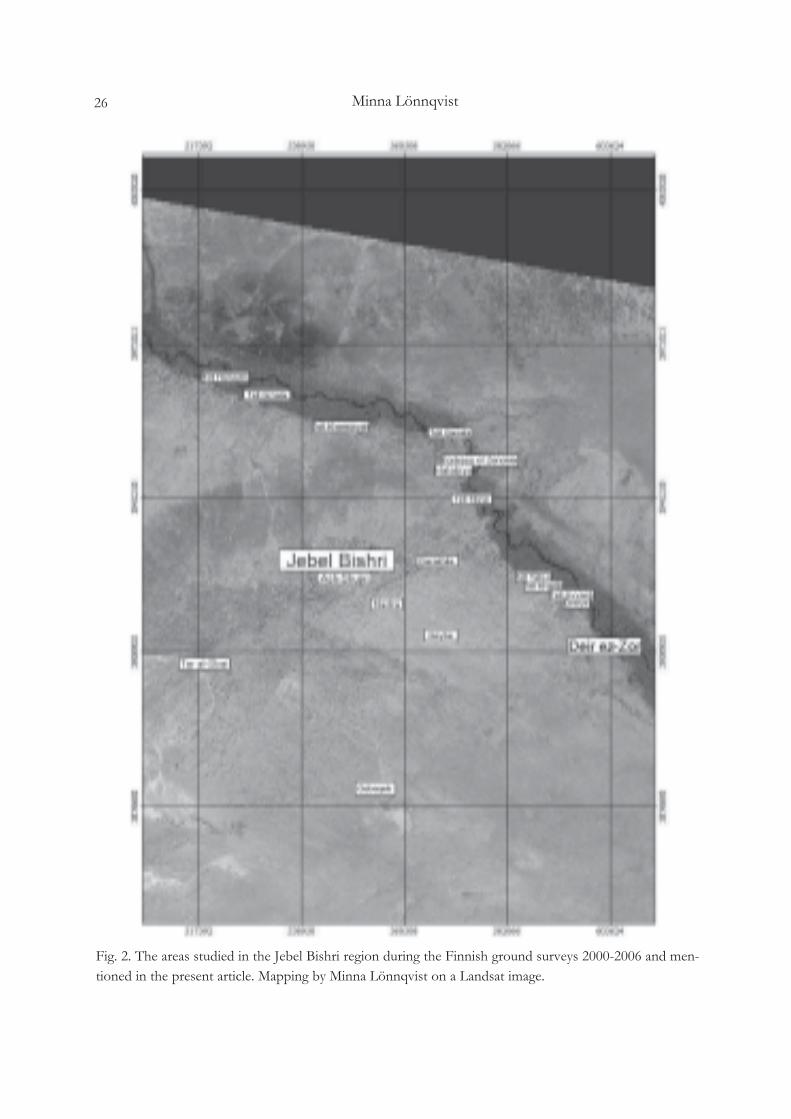
Minna Lönnqvist26
Fig. 2. The areas studied in the Jebel Bishri region during the Finnish ground surveys 2000-2006 and men-tioned in the present article. Mapping by Minna Lönnqvist on a Landsat image.

27Archaeological surveys of Jebel Bishri _ preliminary report 2005-2006
Fig. 3. A Palaeolithic hand-axe from the area of Ayyash. Photo: Michael Herles 2005.
Fig. 4. A piece of Early Bronze pottery with a ledge handle from Site J 11.

Minna Lönnqvist28
Fig. 5. Remains of a looted and broken cist in cairn/tumulus J 16 west from Ayyash. Photo from W: MichaelHerles 2005.
Fig. 6. A piece of a neck from a pottery jar from cairn/tumulus Site J 17. Drawing: Michael Herles 2005.

29Archaeological surveys of Jebel Bishri _ preliminary report 2005-2006
Fig. 8. Fragment of an Early Uruk pot seen from inside. Photo: Michael Herles 2005.
Fig. 7. Location of Tell Tibne at the edge of Jebel Bishri along the Deir ez-Zor – Aleppo road on CORONAsatellite photograph from the 1960s.

Minna Lönnqvist30
Fig. 9. Visible ruins at Tell Tibne and an Islamic graveyard in the back stage. Photo from W: KennethLönnqvist 2005.
Fig. 10. Map of Tell Tibne. Mapping: Jari Okkonen 2005.

31Archaeological surveys of Jebel Bishri _ preliminary report 2005-2006
Fig. 11. Late Roman pottery stamp from Tell Tibne identified with the ruins of Diocletian’s fortress Mambri.Photo: Michael Herles 2005.
Fig. 12. The western profile of Tell Kharita. Photo from S: Minna Lönnqvist 2006.

Minna Lönnqvist32
Fig. 14. A fragment of an apparent large cuneiform inscription written on a terracotta tile found at TellKharita. Drawing: Minna Lönnqvist 2006.
Fig. 13. Al-Ubaid pottery.

33Archaeological surveys of Jebel Bishri _ preliminary report 2005-2006
Fig. 15. Part of Poidebard’s aerial map (1934) showing Jebel Bishri and the surrounding Roman sites.

Minna Lönnqvist34
Fig. 16. An ancient road between the Roman forts of Tabus and Qreiye. The road follows the Euphratesalong the edge of Jebel Bishri. Road prospection: Minna Lönnqvist.

35Archaeological surveys of Jebel Bishri _ preliminary report 2005-2006
Fig. 17. Exposed part of the road L 1. Photo from W: Kenneth Lönnqvist 2006.

Minna Lönnqvist36
Fig. 18. The two ancient roads H 13, to the right, and H 15, next to the fort of Tabus to the left discoveredin 2004, the alignments seen on a CORONA satellite photograph.

37Archaeological surveys of Jebel Bishri _ preliminary report 2005-2006
Fig. 19. An ancient bridge crossing a wadi between the villages of Ayyash and Ain Abu Jima. Photo: MinnaLönnqvist 2005.
Fig. 20. Site J 7, a ruined bridge. Inner profile of the lower layers of the masonry seen from W. Drawing:Markus Königsdörfer.

Minna Lönnqvist38
Fig. 21. Sites recorded at Nadra during the season of 2004, the locations of the Roman camp and of thewater harvesting site above mapped in 2005.
Fig. 22. A straight line of the via principalis running through the area of the Roman camp K 1. Photo fromNW: Kenneth Lönnqvist 2005.

39Archaeological surveys of Jebel Bishri _ preliminary report 2005-2006
Fig. 23. The plan of the Roman camp with the associated finds. Map: Jari Okkonen 2005.
Fig. 24. An armour scale from the Roman camp K 1 (see metal fragment on the map Fig. 26). Drawing:Kenneth Lönnqvist 2007. Scale 1:1.

Minna Lönnqvist40
Fig. 25. A Roman dam and a water reservoir at Darakhlia. Photo from SE: Kenneth Lönnqvist 2003.
Fig. 26. A well at Qseybe. Photo: Minna Lönnqvist 2006.

41Archaeological surveys of Jebel Bishri _ preliminary report 2005-2006
Fig. 27. Site K 6 _ the Qseybe Fort. On the right a close-up to the plan of masonry wall of 1 m in width.Drawing: Minna Lönnqvist.
Fig. 28. An overview of a corner of the earthworks at the Roman military camp site of Qebaqeb. Photo:Kenneth Lönnqvist 2006.

Minna Lönnqvist42
Fig. 29. A Roman water channel near Qebaqeb. Photo from E: Kenneth Lönnqvist 2006.