Combining glaciological and archaeological methods for gauging glacial archaeological potential
11
Combining glaciological and archaeological methods for gauging glacial archaeological potential Stephanie R. Rogers a, * , Mauro Fischer a , Matthias Huss a, b a Department of Geosciences, Geography, University of Fribourg, Chemin du Mus ee 4, 1700 Fribourg, Switzerland b Laboratory of Hydraulics, Hydrology and Glaciology (VAW), ETH Zurich, 8093 Zurich, Switzerland article info Article history: Received 30 April 2014 Received in revised form 8 September 2014 Accepted 13 September 2014 Available online 22 September 2014 Keywords: Glacial archaeology Glaciology GIS Locational analysis Least cost path analysis Archaeological prediction abstract Recent climate changes have led to an increase in the exposure of archaeological remains in frozen environments due to the melting of glaciers and ice patches, and the thawing of permafrost. In some cases, the discovery of glacial archaeological findings has occurred due to chance. In order to avoid the risk of losing exceptional, often organic, cultural remains due to decomposition, systematic and pre- dictive methods should be employed to locate areas of high glacial archaeological potential. Here, we merged archaeological and glaciological methods to create a new type of archaeological prediction model in the field of glacial archaeology. Locational analysis and glaciological modelling were used to highlight current and future areas of archaeological potential in the Pennine Alps, located between Switzerland and Italy. Future glacier area was calculated in 10 year increments until 2100. By 2090, 93% of glacier area is expected to have disappeared. The results from the final model, GlaciArch, provide new insights into future glacial archaeological prospection in the Pennine Alps by narrowing down a study region of 4500 km 2 into several manageable square kilometre sites. © 2014 Elsevier Ltd. All rights reserved. 1. Introduction Due to the alternation of various warm and cold periods, glacier extents and ice volume storage have fluctuated in the entire Eu- ropean Alps during the Holocene (10.5 ka to present). Compared to the Last Glacial Maximum (LGM) (19e20 ka BP) and latest Pleis- tocene, when large piedmont lobes of vast valley glaciers reached the Alpine foreland (Clark et al., 2009; Ivy-Ochs et al., 2008), glacier changes have been rather minor during the Holocene. The glaci- erized area varied between the stage of the Little Ice Age (LIA) maximum, around 1850, and a minimum which was significantly smaller than the present day extents (Grosjean et al., 2007; Holzhauser, 2007; Joerin et al., 2006, 2008). Glacier-climate interactions have affected humans for millennia. In the European Alps, glacier fluctuations directly influenced hu- man interaction with Alpine areas (Benedict and Olson, 1978; Wiegandt and Lugon, 2008). For example, as glaciers receded af- ter the LGM, humans took advantage of the newly ice-free Alpine biome which offered plenty of food and resources during the Paleolithic period (Pacher, 2003; Tagliacozzo and Fiore, 2000). The present atmospheric warming has caused shrinkage of glaciers and ice caps all over the world (IPCC, 2013). In consequence, melting ice and snow has uncovered archaeological remains in Arctic and Alpine environments (Andrews et al., 2012; Beattie et al., 2000; Callanan, 2012, 2013; Dixon et al., 2005; Farbregd, 1972; Farnell et al., 2004; Hafner, 2012; Hare et al., 2004, 2012; Lee, 2012; Rogers et al., 2014; VanderHoek et al., 2007) which further attests to the use of frozen regions on a global scale. These artefacts which have melted out of ice patches and glaciers, and thawed out of permafrost, have created a new sub-discipline of archaeology: glacial archaeology. “Glacial archaeology” has also been referred to as ice patch archaeology (c.f. Andrews and MacKay, 2012; Reckin, 2013) and frozen archaeology (Molyneaux and Reay, 2010). Perhaps one of the most famous examples of a glacial archaeolog- ical find is that of € Otzi the Tyrolean Iceman who was accidentally discovered by hikers in 1991 on the Italian/Austrian border, pro- truding from an ice patch (Prinoth-Fornwagner and Niklaus, 1994; Seidler et al., 1992). The uniqueness of € Otzi and other glacial archaeological discoveries is that they have often been preserved by ice for thousands of years, thus protecting them and providing scientists with unparalleled information about past cultures and climates (Dixon et al., 2005; Reckin, 2013). There is urgency to collect these delicate, often organic, glacial archaeological remains before, or soon after, they melt out of the ice and become destroyed * Corresponding author. E-mail address: [email protected] (S.R. Rogers). Contents lists available at ScienceDirect Journal of Archaeological Science journal homepage: http://www.elsevier.com/locate/jas http://dx.doi.org/10.1016/j.jas.2014.09.010 0305-4403/© 2014 Elsevier Ltd. All rights reserved. Journal of Archaeological Science 52 (2014) 410e420
Transcript of Combining glaciological and archaeological methods for gauging glacial archaeological potential
lable at ScienceDirect
Journal of Archaeological Science 52 (2014) 410e420
Contents lists avai
Journal of Archaeological Science
journal homepage http wwwelsevier comlocate jas
Combining glaciological and archaeological methods for gaugingglacial archaeological potential
Stephanie R Rogers a Mauro Fischer a Matthias Huss a b
a Department of Geosciences Geography University of Fribourg Chemin du Musee 4 1700 Fribourg Switzerlandb Laboratory of Hydraulics Hydrology and Glaciology (VAW) ETH Zurich 8093 Zurich Switzerland
a r t i c l e i n f o
Article historyReceived 30 April 2014Received in revised form8 September 2014Accepted 13 September 2014Available online 22 September 2014
KeywordsGlacial archaeologyGlaciologyGISLocational analysisLeast cost path analysisArchaeological prediction
Corresponding authorE-mail address stephrogers5gmailcom (SR Rog
httpdxdoiorg101016jjas2014090100305-4403copy 2014 Elsevier Ltd All rights reserved
a b s t r a c t
Recent climate changes have led to an increase in the exposure of archaeological remains in frozenenvironments due to the melting of glaciers and ice patches and the thawing of permafrost In somecases the discovery of glacial archaeological findings has occurred due to chance In order to avoid therisk of losing exceptional often organic cultural remains due to decomposition systematic and pre-dictive methods should be employed to locate areas of high glacial archaeological potential Here wemerged archaeological and glaciological methods to create a new type of archaeological predictionmodel in the field of glacial archaeology Locational analysis and glaciological modelling were used tohighlight current and future areas of archaeological potential in the Pennine Alps located betweenSwitzerland and Italy Future glacier area was calculated in 10 year increments until 2100 By 2090 93 ofglacier area is expected to have disappeared The results from the final model GlaciArch provide newinsights into future glacial archaeological prospection in the Pennine Alps by narrowing down a studyregion of 4500 km2 into several manageable square kilometre sites
copy 2014 Elsevier Ltd All rights reserved
1 Introduction
Due to the alternation of various warm and cold periods glacierextents and ice volume storage have fluctuated in the entire Eu-ropean Alps during the Holocene (105 ka to present) Compared tothe Last Glacial Maximum (LGM) (19e20 ka BP) and latest Pleis-tocene when large piedmont lobes of vast valley glaciers reachedthe Alpine foreland (Clark et al 2009 Ivy-Ochs et al 2008) glacierchanges have been rather minor during the Holocene The glaci-erized area varied between the stage of the Little Ice Age (LIA)maximum around 1850 and a minimum which was significantlysmaller than the present day extents (Grosjean et al 2007Holzhauser 2007 Joerin et al 2006 2008)
Glacier-climate interactions have affected humans for millenniaIn the European Alps glacier fluctuations directly influenced hu-man interaction with Alpine areas (Benedict and Olson 1978Wiegandt and Lugon 2008) For example as glaciers receded af-ter the LGM humans took advantage of the newly ice-free Alpinebiome which offered plenty of food and resources during thePaleolithic period (Pacher 2003 Tagliacozzo and Fiore 2000) The
ers)
present atmospheric warming has caused shrinkage of glaciers andice caps all over the world (IPCC 2013) In consequence melting iceand snow has uncovered archaeological remains in Arctic andAlpine environments (Andrews et al 2012 Beattie et al 2000Callanan 2012 2013 Dixon et al 2005 Farbregd 1972 Farnellet al 2004 Hafner 2012 Hare et al 2004 2012 Lee 2012Rogers et al 2014 VanderHoek et al 2007) which further atteststo the use of frozen regions on a global scale These artefacts whichhave melted out of ice patches and glaciers and thawed out ofpermafrost have created a new sub-discipline of archaeologyglacial archaeology ldquoGlacial archaeologyrdquo has also been referred toas ice patch archaeology (cf Andrews and MacKay 2012 Reckin2013) and frozen archaeology (Molyneaux and Reay 2010)Perhaps one of the most famous examples of a glacial archaeolog-ical find is that of euroOtzi the Tyrolean Iceman who was accidentallydiscovered by hikers in 1991 on the ItalianAustrian border pro-truding from an ice patch (Prinoth-Fornwagner and Niklaus 1994Seidler et al 1992) The uniqueness of euroOtzi and other glacialarchaeological discoveries is that they have often been preserved byice for thousands of years thus protecting them and providingscientists with unparalleled information about past cultures andclimates (Dixon et al 2005 Reckin 2013) There is urgency tocollect these delicate often organic glacial archaeological remainsbefore or soon after theymelt out of the ice and become destroyed
SR Rogers et al Journal of Archaeological Science 52 (2014) 410e420 411
by decomposition (Andrews and MacKay 2012 Dixon et al 2005Molyneaux and Reay 2010) As melting in high altitudes and lati-tudes is not anticipated to halt in the near future (cf Radic et al2014) more glacial archaeological finds can be expected andthere is a need to further develop predictive methods in thisresearch domain
In this paper archaeological and glaciological methods aremerged together to create a new type of predictive model todetermine areas of glacial archaeological potential The results willbe used as a decision support tool for future prospection ofarchaeological findings in high mountain environments Ourapproach referred to as ldquoGlaciArchrdquo in the following is based oncurrent ice thickness distribution future evolution of glacierizedareas and topographic characteristics of the terrain which couldhave influenced past human accessibility First currently glaci-erized or recently deglacierized high altitude mountain passeslocated on the border of Switzerland and Italy are selected to beused as sites onwhich to perform the locational analysis Next leastcost paths (LCPs) are calculated between valleys and respectivepasses Then locational analysis is used to determine areas ofglacial archaeological potential based on the physical characteris-tics of the terrain After the future evolution of glaciers is modelledfor the Pennine Alps using a glacier evolution model (Huss et al2010a) Finally the results of glacier modelling are combinedwith the results of locational analysis to create GlaciArch a pre-dictive model which ultimately defines regions of highest
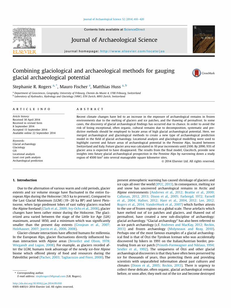
Fig 1 Overview of study area Glacieri
archaeological interest for now and the future This paper high-lights how the intersection of glaciological and archaeologicalmethods provides a new approach for looking at glacial archaeo-logical prospection
2 Study area and data
21 Study area
The Pennine Alps (centered at approximately 45570N 7320E)are located between the canton of Valais Switzerland and theprovinces of Aosta and Piedmont Italy (Fig 1) The whole region isof particular glacial archaeological interest due to its large glaci-erized area and rich cultural heritage The Pennine Alps coverapproximately 4500 km2 and reach altitudes above 4000 m aslThe main valleys to the north south and east of the Pennine Alpsthe Rhone valley (Switzerland) and the Aosta and Antigorio valleys(Italy) respectively are scattered with archaeological remainsdating fromMesolithic (95 ka to55 ka BC) to historic times (Curdy2007 Radmilli 1963) Although most travellers reached thesevalleys from lower altitudes each valley could also be reached bycrossing the Pennine Alps between them This relatively shortdistance was often traversed for commercial purposes Archaeo-logical remains collected on the way to and on top of mountainpasses between Switzerland and Italy demonstrate the use of thesepasses as trade and travel routes for thousands of years (Bezinge
zed areas are shaded in dark grey
SR Rogers et al Journal of Archaeological Science 52 (2014) 410e420412
and Curdy 1994 1995 Coolidge 1912 Curdy 2007 Curdy et al2003 Harriss 1970 1971 Lehner and Julen 1991 Rogers et al2014) In fact early Neolithic culture seems to have spread toValais via the high altitude passes of the Pennine Alps from thesouth possibly due to the grazing of small herds in the high pas-tures in summer (Curdy et al 2003 Curdy 2007) ThroughoutPrehistory and the Roman Period therewere indications of a strongcultural relationship between Aosta and the Rhone valley later theAosta and Upper Rhone valleys were integrated as the uniqueecclesiastical province of Tarentasia for several centuries (Harriss1970 Curdy 2010) The relatively few archaeological remainsfound at high altitudes in this region should not be considered to bea direct result of the use of these high altitude passes In the pastcontrary to current beliefs high altitude regions were used moreoften than assumed and proved to be more hospitable than theyseem to modern day people (Aldenderfer 2006 Reckin 2013Walsh et al 2006)
22 Data
The high altitude pass names and locations used in the first stepof the locational analysis are derived from the 25 m resolutionSwissNames database provided by the Swiss Federal Office ofTopography (swisstopo) (Federal Office of Topography (2014))which contains all names given on the 125000 national topo-graphic maps The 1973 Swiss glacier inventory (Muumlller et al 1976)was used to determine glacierized or recently deglacierized passesThe Digital Elevation Model (DEM) used in both the Least Cost PathAnalysis (LCPA) and slope calculation was the global 30 m resolu-tion Advanced Spaceborne Thermal Emission and Reflection Radi-ometer Global Digital Elevation Model (ASTER GDEM) (version 2)(NASA 2012) Although more accurate DEMs exist it was notpossible to obtain a consistent DEM for each side of the PennineAlps The ASTER GDEM provides a consistent and sufficient dataaccuracy for these regional scale calculations in this study
For the Swiss glaciers the new Swiss Glacier Inventory SGI2010(Fischer et al in press) was used This layer was created by manualdigitization from high resolution (50 cm) aerial orthoimagery ac-quired between 2008 and 2011 For the Italian glaciers outlinesbased on satellite imagery of 2003 were used (Paul et al 2011)Surface topography for each glacier was extracted by intersectingglacier outlines with terrain elevation data Glacier ice thicknessdistribution and bedrock topography were calculated based on aflux-gate approach and using the principles of ice flow dynamics(Huss and Farinotti 2012) Information on surfacemass balance of alarge sample of glaciers in the Pennine Alps over the last decades isavailable from a combination of direct field observations geodeticice volume changes and distributed modelling (Huss 2012) Sce-narios for the future evolution of climatological variables are ob-tained from Regional Climate Models (RCM) from the CH2014project (CH2014-Impacts 2014)
3 Background
In the Swiss Alps glacial archaeological finds have been locatedat four locations two sites on the border of the cantons of Valaisand Bern in the Bernese Alps the Leurootschenpass (Bellwald 1992Meyer 1992) and Schnidejoch pass (Hafner 2012) one site ineastern Switzerland the Porchabella glacier (Rageth 1995) and inValais located in the Pennine Alps near the Theodulpass (Lehnerand Julen 1991 Meyer 1992) The oldest and most notable findswere discovered between 2004 and 2011 at the Schnidejoch passfrom a melting ice patch which was formerly attached to theChilchli glacier on the north side of the pass The ages of the findsrange from the Neolithic Early Bronze Age Iron Age Roman and
Medieval periods making this one of the most prolific glacialarchaeological sites in the Alps (Hafner 2012) The abundance offinds can be attributed to the location of the ice patch which is in asmall depression facing northeast where ice has accumulated overcenturies The Pennine Alps most prolific glacial archaeological siteto date has been that of the Theodulpass The finds which includeskeletal remains leather clothing and shoe soles weapons andcoins from the ldquoMercenary of Theodulrdquo date back to the 16thcentury (Lehner and Julen 1991 Meyer 1992) These items werefound between 1985 and 1990 along the margins of the ObererTheodul glacier on the Swiss side of the border It is believed thatthe Mercenary fell into a crevasse and was preserved for hundredsof years until glacial dynamics andmelting eventually released himand his belongings
31 Archaeological predictive modelling
In archaeology the use of predictive modelling began in the1980s and has since grown into awide research field mostly due toan increase in the accessibility to Geographic Information Systems(GIS) software and the ever-improving spatial resolution of data(cf Ebert 2004 Kvamme 1999 McCoy and Ladefoged 2009) Inmost cases archaeological predictive modelling is used to forecastthe location of archaeological sites based on the presence orabsence of defined criteria in order to allocate information aboutknown patterns onto unknown places (Conolly and Lake 2006Warren and Asch 2003 Wheatley and Gillings 2002) Inputs topredictive models usually include sampled sites and have the maingoal of finding new sites which were used for human occupation(Carleton et al 2012 Carrer 2013 Graves 2011 Kohler and Parker1986) Put simplistically predictive methods have been used todetermine the level of archaeological potential in a region andprovide decision-makers with a tool to justify why certain areas aremore archaeologically interesting than others (McCoy andLadefoged 2009)
In glacial archaeology specifically predictivemethods have beenused in relatively few instances but show promising results(Andrews et al 2012 Dixon et al 2005) For example in AlaskaDixon et al (2005) were the first to use predictive modelling forglacial archaeological purposes by using aweighted combination ofcultural biological and geological input layers to successfullydetermine areas of high glacial archaeological potential SimilarlyAndrews et al (2012) used remotely sensed data andotherweightedinput layers to determine areas of glacial archaeological potential innorthern Canada Both previous studies were conducted at variousice patch sites This study which focuses on the potential of locatingglacial archaeological remains on or near glaciers differs from pre-vious ones basedon thedistinctive environments Ice characteristicsand glacier dynamics can strongly affect the potential of locatingglacial archaeological remains and thus should be researched ac-cording to local conditions For example glaciers composed of thickice or located on steep slopes move relatively quickly and woulddestroy anything entrained within it in a matter of a few hundredyears basedon theprinciples of ice dynamics (BennandEvans 2010Dixon et al 2005 Hafner 2012) The margins of slower-movingglaciers could prove to be a better environment for finding glacialarchaeological remains with the ideal environment being sur-rounded by ice with little or no movement such as ice patches (likethe Schnidejoch site) or slow-moving small glaciers located onrelatively flat terrains (like the Theodul site)
32 Least cost path analysis
LCPA is one type of archaeological prediction method used inGIS to calculate the ldquooptimalrdquo path across a landscape based on one
Table 1Names and locations of high altitude passes on the border between Switzerland andItaly which were glacierized in 1973
Number Name Latitude (N) Longitude (E) Altitude (m)
1 Petit Col Ferret 45 53 58 7 4 9 24902 Col dAmiante 45 55 6 7 18 9 33193 Col de la Balme 45 54 7 7 22 27 33214 Col du Petit Mont Collon 45 57 42 7 29 11 32925 Col Collon 45 57 41 7 30 51 30876 Col des Bouquetins 45 59 13 7 33 36 33577 Col de la Tete Blanche 45 59 33 7 34 53 35798 Tiefmattenjoch 45 58 22 7 35 13 35439 Breuiljoch 45 58 18 7 40 18 331310 Theodulpass 45 56 38 7 42 35 330111 Passo di Ventina Nord 45 56 4 7 42 39 345012 Breithornpass (south) 46 14 36 8 5 12 336813 Zwillingsjoch 45 55 36 7 47 24 384514 Felikjoch 45 55 5 7 48 11 406615 Lisjoch 45 55 18 7 51 12 416916 Neues Weisstor 45 59 20 7 54 4 350917 Seewjinenluumlcke 45 59 53 7 57 22 309518 Tossenjoch 46 7 31 8 3 22 292319 Breithornpass (east) 45 55 56 7 44 34 3845
SR Rogers et al Journal of Archaeological Science 52 (2014) 410e420 413
or more predefined input criteria (Anderson and Gillam 2000 Belland Lock 2000 Egeland et al 2010 Gorenflo and Gale 1990Howey 2007 Madry and Rakos 1996 Rogers et al 2014Verhagen and Jeneson 2012) It allows archaeologists to gain abetter understanding about movement patterns in prehistoric orhistoric terrains (Llobera et al 2011 Murrieta-Flores 2010 2012White and Surface-Evans 2012) It is based on the principal thathumans will take the easiest path from one location to another ifthere are no other social or cultural forces directing them other-wise The concept is not unique to archaeology and was developedfirstly in psychology and has since been used in various researchfields (Zipf 1949)
33 Locational analysis
Locational analysis also referred to as archaeological locationmodelling (ALM) or site predictive modelling is a predictivemethod which calculates archaeological potential based on multi-ple weighted inputs often including known archaeological sitelocations (Andrews et al 2012 Carleton et al 2012 Carrer 2013Dixon et al 2005 Egeland et al 2010) Like the term predictivemodelling locational analysis has various meanings and a defini-tion which has developed over time (Kvamme 1999 McCoy andLadefoged 2009) Therefore we define locational analysis usingMcCoy and Ladefogeds (2009) descriptionwhereby the potential ofundiscovered sites will be determined by calculating zones offuture prospection without spatially analysing known site loca-tions This method is often used in vast areas from which archae-ological remains are sparse possibly due to a lack of prospection
34 Glacier retreat modelling
The atmospheric warming observed during the last decades hascaused a considerable reduction in area andmass of glaciers and icecaps all around the globe (Zemp et al 2009) As an immediateresponse changes in the climatic forcing acting on glaciers lead tochanges in the surface mass balance that is to changes in thequantity of snow and ice added to or melted from the glacier Theeffects of the observed glacier changes are numerous and apply to abroad range of spatio-temporal scales from global sea level rise(Gardner et al 2013) to regional impacts on runoff in major rivercatchments (Kaser et al 2010) to local consequences for landscapeevolution hydropower production natural hazards and tourism(Cannone et al 2008 Farinotti et al 2012 Fischer et al 2011)Consequently the projection of future glacier evolution has gainedincreasing attention in glaciology
In recent years various glacier modelling approaches have beendeveloped For individual glaciers they range from simple 2Dflowline models (Oerlemans et al 1998 Van de Wal and Wild2001) to complex 3D coupled mass-balance ice-flow models(Jouvet et al 2011 Schneeberger et al 2003) To calculate glacierresponse at the regional scale simpler approaches neglectingtransient changes and the effect of ice dynamics were used (Paulet al 2007 Schaefli et al 2005) More advanced models drivenby distributed surface mass balance input and employing aparameterization of glacier ice flow have also been applied both atthe single-glacier scale and to the entire European Alps (Huss2012 Huss et al 2010a Salzmann et al 2012)
4 Methods
GlaciArch is composed of various steps which culminate in thecreation of a predictive model which gauges the glacial archaeo-logical potential of the Pennine Alps The respective steps arepresented in the next sections
41 High altitude pass selection and LCPs
The first step was to determine which high altitude passes onthe SwissItalian border were glacierized in 1973 This coincideswith the notion that recently deglacierized passes have a higherglacial archaeological potential and should be prospected firstbased on the fragility of glacial archaeological remains and arte-facts The 1973 glacier inventory (Muumlller et al 1976) was chosenbecause it covers an ideal time frame as archaeological itemsexposed over the last 40 years might have a better chance to persistcompared to 160 years if using the glacier inventory from orthoi-magery prior to the SGI2010 (Fischer et al 2014) The passes werechosen using the selection tools in ArcGIS 101 First the select byattributes tool was used to query all mountain passes which couldbe crossed by either foot or by road from the SwissNames databasefor the canton of Valais resulting in the selection of 670 recordsNext the select by location tool was used to query those passeswhich were glacierized in 1973 from the currently selected recordsto highlight the ones that were recently deglacierized or stillcurrently glacierized leaving 111 passes From those 111 passes theones on and near the border between Switzerland and Italy wereselected as it is known that some of the high altitude passes in thisstudy region have been used for thousands of years This resulted inthe final extraction of 19 border passes which were glacierized in1973 from which to calculate LCPs (Table 1 Fig 2a)
LCPs were calculated using the method described by Rogerset al (2014) from each of the 19 passes to their nearest respectivemain valleys (Rhone Aosta or Antigorio) (Fig 2b) This methodused Toblers (1993) hiking algorithm to calculate walking timesbased on slope and prehistoric landcover as inputs (Bell and Lock2000 Gorenflo and Gale 1990 Rogers et al 2014 Tobler 1993Verhagen and Jeneson 2012 Whitley and Hicks 2003) The pathdistance and cost distance tools in ArcGIS which calculate theaccumulative cost across the terrain from a starting location andthe shortest path from a destination back to starting locationrespectively were used for the calculations
42 Locational analysis
In this part of the analysis multiple criteria were used to locateareas of high archaeological potential by analysing where peoplewere able to travel based on the topographic characteristics of theterrain by measuring the distance from LCPs and the slope of the
Fig 2 Visualization of the locational analysis processing steps (a) calculation of least cost paths with pass number corresponding to Table 1 (b) calculation of buffers around eachpath (c) weighted slope values derived from DEM (d) weighted glacier thickness layer (e) selected close-up of slope multiplied by thickness and (f) the final weighted locationalanalysis layer with pass numbers (see Table 1)
Table 2Weight values for the layers used in the locational analysis
Weights Distance from LCPs (m) Slope () Ice thickness (m)
5 0e100 0e10 0e254 100e250 10e20 25e503 250e500 20e30 50e752 500e750 30e40 75e1001 750e1000 gt40 gt100
SR Rogers et al Journal of Archaeological Science 52 (2014) 410e420414
terrain and where archaeological remains might be located basedon glacial characteristics and ice thickness The input layers aredescribed in the following paragraphs
Buffers were constructed around each path in 100 250 500750 and 1000 m intervals on each side of the path to represent thenotion that archaeological potential decreases with distance fromthe paths The zones within the 100 m buffers were assumed tohave the highest archaeological potential and weighted with thevalue of 5 while the zones located within the 1 km buffer wereassumed to have to lowest potential andweightedwith the value of1 (Table 2) The values in between are listed in Table 2
The 1000 m buffers calculated above were used to define thestudy area surrounding the paths from which to calculate slopevalues The extract by mask tool was used to isolate the study area
for the DEM and the slope tool was used to calculate the steepnessof the terrain (Fig 2c) The slope values were calculated andweighted based on the potential of finding archaeological remainsSlopes greater than 40 were given a value of 1 thus very low
SR Rogers et al Journal of Archaeological Science 52 (2014) 410e420 415
archaeological potential as they are difficult to climb and wouldprobably have been avoided Furthermore at steep slopes archae-ological remains are more likely to be washed out by erosionSlopes between 0 and 10 were determined to be the easiest towalk across and thus were given the highest potential value of 5Slopes between 10 and 40 were assigned with a respective linearlyincreasing potential value for 10 classes (Table 2)
Next the glacier ice thickness layer was weighted from low tohigh archaeological potential The ice thickness range between0 and 25 m was assigned a weight of 5 as those are the areas withthe highest potential now and in future years because they willlikely be the first to become ice-free (Table 2) Even more impor-tantly archeological remains are only likely to be preserved belowrelatively thin ice Thicker ice tends to flow faster and is generallymore destructive in terms of bedrock erosion The classes with25e50 m 50e75 m and 75e100 mwere weighted with 4 3 and 2respectively (Fig 2d)
The weighted layers for distance from LCPs slope and thicknesswere multiplied together to obtain one layer containing all possiblevalue combinations The results ranged from 2 to 125 in 29 differentclasses (Fig 2e) As afinal step in the locational analysis these classeswere combined into five final potential categories using the NaturalBreaks classification scheme which arranges classes into ldquonaturalrdquoobjectively selected categories (Fig 2f) (Jenks and Caspall 1971)
43 Glaciological modelling
Future changes in glacier coverage over the entire Pennine Alpswere assessed by a combination of different glaciological models athigh spatial resolution First the current glacier ice thickness dis-tribution was derived using the glacier outlines from Fischer et al(2014) for Switzerland and from Paul et al (2011) for Italy basedon the approach by Huss and Farinotti (2012) Next surface massbalance and 3D glacier geometry changewere modelled transientlyfor 50 Swiss glaciers from 2010 to 2100 based on a detailed glaciermodel (Huss et al 2010a) The model runs at daily resolution on a25 m grid and takes into account snow accumulation distributionthe influence of radiation on ice melting and calculated glacierretreat based on a mass-conservation approach Model calibrationand validation for the 50 investigated glaciers was achieved with avariety of field data covering the entire 20th century (Huss et al2010b) For calculating future glacier change we chose to use onesingle regional climate scenario for simplicity although the pro-jected evolution of meteorological variables is subject considerableuncertainties Seasonal changes in air temperature and precipita-tion as projected by the Eidgeneuroossische Technische HochschuleZuumlrich (ETHZ Swiss Federal Institute of Technology) RCM wereused as inputs into themodel This climatemodel was driven by theA1B CO2-emission scenario (Nakicenovic 2000) Until 2100 a meanannual air temperature rise of thorn47 C relative to 1980e2009 isexpected for the study region and precipitation is found to increasein winter but to decrease in summer (CH2014-Impacts 2014)Finally we extrapolated annual mass balance from the 50 glaciersto every glacier in the Pennine Alps (Huss 2012) Thus for eachglacier a glacier-specific transient annual series of the glacier massbudget was obtained which was used to drive the glacier retreatmodel (Huss et al 2010a) From the transient model runs weextracted glacier ice coverage for 10-year time steps between 2020and 2100 These glacier masks were overlaid onto the results of thelocational analysis
44 GlaciArch
In this step past (1850 and 1973) current (2010) and selectedfuture (2030 2060 and 2090) glacier extents were overlaid onto
locational analysis results to create the GlaciArch predictive modelThe current archaeological potential of a region was assesseddifferently than that of the future potential Current archaeologicalpotential is considered to exist in the regions that have beendeglacierized since 1973 that is between the 1973 and 2010 ex-tents Those are the general areas where archaeological remainscould be currently located based on the principles of glacier dy-namics Future archaeological potential is ultimately gauged bycomparing the modelled glacier extents for 2030 2060 and 2090to the results obtained by the locational analysis
5 Results and discussion
51 Locational analysis
The locational analysis results defined regions which were gla-cierized or recently deglacierized located near LCPs in areas withless than 40 slope and where ice thickness is at a minimum Theconsideration of currently glacierized or recently deglacierizedpasses is important when dealing with glacial archaeological re-mains as previously suggested The calculation of LCPs enabled abetter understanding about how people might have travelled fromone location to another based on the principles of walking acrossdifferent landscapes Although prehistoric and historic landscapesare often uncertain paleoecological research gives a good generalunderstanding about past landscapes (Berthel et al 2012 Tinnerand Theurillat 2003 Wick and Tinner 1997) The final product ofthe locational analysis displays the overlapping areas of theweighted distance from LCPs slope and ice thickness layers in therange of 5 (high potential) to 1 (low potential) for the region(Fig 3a) The results of locational analysis alone reduced a region ofover 4500 km2 to a 114 km2 area of interest 816 km2 of which isconsidered as high potential (Table 3) Similar to the work con-ducted by Dixon et al (2005) and Andrews et al (2012) locationalanalysis provided a means to define small manageable regions forglacial archaeological prospection The areas are more finelydelimited in the final GlaciArch model (Section 53)
52 Glaciological modelling
Future glacier extents for 10-year increments between 2020 and2100 in Switzerland and in Italy were calculated (shown for 20302060 and 2090 in Fig 3b) This regional scale modelling methodprovided a high resolution projection of future glacier extents Thetotal area of glaciers in 2010 in the Pennine Alps was 446 km2 andcalculated to decrease in future years For example a reduction of37e280 km2 in 2030 80 to 91 km2 in 2060 and 93 to 30 km2 in2090 was modelled based on the climate scenario used In thisstudy we did not assess the impact of different assumptions onfuture climate evolution and other glaciological model un-certainties on the results However Addor et al (in press) showedthat the CO2-emission storyline until 2100 only had a small effecton calculated total glacier area
53 GlaciArch
The results of the GlaciArch model show current and futureareas of archaeological potential spread over the Pennine Alps re-gion (see supplementary maps covering the entire region) Asmentioned in Section 52 the locational analysis results provided abroadly defined research area The addition of glaciologicalmodelling results allows the delineations to be further defined Forexample between 2010 and 2030 the total area of interest is301 km2 and the high potential region is 324 km2 compared to thedecreased areas between 2060 and 2090 with 137 km2 and
Fig 3 Results from (a) locational analysis and (b) glaciological modelling from the whole study area The Swiss Glacier Inventory for 2010 is shown along with the modelled glacierextents for 2010 on the Italian side of the border The projected glacier extents for 2030 2060 and 2090 are shown for both sides of the border of the Pennine Alps The boundariesfor Figs 1 and 2 are shown in red Boundaries S1eS5 refer to additional maps not discussed in the text which can be found in the supplementary data section (For interpretation ofthe references to colour in this figure legend the reader is referred to the web version of this article)
SR Rogers et al Journal of Archaeological Science 52 (2014) 410e420416
058 km2 for area of interest and high potential respectively (seeTable 3 for all values)
Taking a closer look at the results the area surrounding theMont Collon (Fig 4) is an area of interest due to its archaeologicalsignificance in the surrounding regions although no glacialarchaeological finds have been retrieved from that site to date(Fig 4) In 1948 a Neolithic tool made of flint was located on thePlans de Bertol which is located on theway to the Col Collon whichleads archaeologists to believe that it was a pass which was used byhumans for thousands of years (Bezinge and Curdy 1994 1995Sauter 1950) (Fig 4) Currently the model indicates that there is
high glacial archaeological potential on the margins of the HautGlacier dArolla and the Glacier du Mont Collon as well as the areabetween the Petit Mont Collon and the northern section of theGlacier dOtemma just south of the Col de Charmontagne (Fig 4)For the future the results from GlaciArch show that between 2010and 2030 there will be high potential areas on the margins of thetongue of the Glacier du Mont Collon as well as the Haut GlacierdrsquoArolla Between 2030 and 2060 the Col Collon (5) is expected tobecome an area of high archaeological potential as well as someregions surrounding the Petit Mont Collon Sections in the middleof the Glacier du Mont Collon and to the north of the southern
Table 3Locational analysis areas calculated for 2010 and the time periods between2010e2030 2030e2060 and 2060e2090 The high glacial archaeological potential(value 5) areas are also calculated for each time period
Year(s) Total area (km2) High potential (km2)
2010 114 8162010e2030 301 3242030e2060 405 2312060e2090 137 058
SR Rogers et al Journal of Archaeological Science 52 (2014) 410e420 417
section of the Glacier dOtemma also show high potential Ac-cording to the results it appears that by 2060 the Haut GlacierdArolla will have almost completely disappeared By 2090 verylittle ice will remain however the section to the north of the Col duPetit Mont Collon (4) could be of interest at that time
Already briefly discussed in Section 3 the area surrounding theTheodulpass will now be revisited The high altitude passes of in-terest near the Theodulpass resulting from this analysis are theBreuiljoch (9) Theodulpass (10) Passo di Ventina Nord (11) and theBreithornpass (12) (Fig 5) From 2010 to 2030 there are regions ofhigh archaeological potential on the extents of the Furgg ObererTheodul and Valtournanche glaciers as well as on the Theodulpassand Passo de Ventina Nord Between 2030 and 2060 the east side ofthe Oberer Theodul glacier becomes a predominant area of interest
Fig 4 GlaciArch results around the Mont Collon which includes the Col de Petit MontCollon (4) and the Col Collon (5) The Glacier du Mont Collon Glacier dOtemma andHaut glacier dArolla are labelled as well as locations mentioned in the text Petit MontCollon Col de Charmontagne and Plans de Bertol LCP refers to least cost path
while the Furgg glacier has decreased archaeological potential Thearea south of the Passo de Ventina also shows high potential duringthat time period From 2060 to 2090 The Furgg and Oberer Theodulglaciers are predicted to almost completely disappear thereforetheir glacial archaeological potential decreases significantly
The performance of this model has yet to be tested in the fieldhowever the results seem to correspond well to glaciologicalprinciples and the few glacial archaeological finds already locatedin the region for example at the Oberer Theodul site (Figs 4 and 5)In theory high archaeological potential is expected near the glaciermargins as those are the areas with the thinnest ice while areas oflow potential should occur mid-glacier where the ice is thickest Anexample of this can be seen in Fig 4 at the Haut Glacier dArollahigh potential exists on the extents of the glacier tongue and po-tential decreases as inward movement onto the glacier continuesOne problem with this model is that it is difficult to conveyinherently dynamic movement on a static map In fact potential
Fig 5 GlaciArch results around the Theodulhorn Passes listed are the Breuiljoch (9)Theodulpass (10) and the Passo di Ventina Nord (11) The Furgg glacier and Obererand Unterer Theodul glaciers are labelled LCP refers to least cost path
SR Rogers et al Journal of Archaeological Science 52 (2014) 410e420418
maps should be calculated for each year to obtain a greater un-derstanding about the true and temporally varying archaeologicalpotential of the region however 2D mapping contraints do notpermit dynamic visualisation of this type of results An interactiveinterface would be the best way to visualize the end results
6 Conclusion
In this paper the new integrated model GlaciArch was used toidentify areas of current and future archaeological interest andpotential in the Pennine Alps The model highlights areas whichcorrespond to the retrieval of archaeological remains based onglaciological principles and the topographic properties of theterrain Thus the GlaciArch results can be used as a decision sup-port tool for the selection of glacial archaeological prospectionsites The definition of small regions of high glacial archaeologicalpotential means less time effort andmoney spent in the field or onflight reconnaissance missions By combining archaeological andglaciological methods for the first time a new perspective has beengiven to the field of glacial archaeology The integration of loca-tional analysis and regional scale glacier modelling proved to bebeneficial for narrowing down a large often inaccessible andremote study region to identify zones of archaeological interestbased on glaciological characteristics and human accessibility Theglacier modelling results forecast a 93 loss in area by 2090 Withthese alarming melting rates immediate focus should be given tohigh archaeological potential areas in hopes to locate and recoverpossibly irreplaceable culturally significant items In order to pro-tect and conserve these exceptional and rare relics further multi-disciplinary predictive methods should be developed andemployed in sensitive areas such as the Pennine Alps
Acknowledgements
This research has been supported by the Swiss National ScienceFoundation (grant CR21I2 130279) the Service des batimentsmonuments et archeologie (Canton du Valais Switzerland) and theHistory Museum of Valais (Switzerland) Thanks to Philippe Curdyand Sophie Providoli from the History Museum of Valais for theirarchaeological inputs and Martin Hoelzle for his glaciological dis-cussions Also thanks to the three anonymous reviewers whohelped strengthen this paper
Appendix A Supplementary data
Supplementary data related to this article can be found at httpdxdoiorg101016jjas201409010
References
Addor N Roessler O Koeplin N Huss M Weingartner R Seibert J 2014 Robustchanges and sources of uncertainty in the projected hydrological regimes ofSwiss catchments Water Resour Res (in press)
Aldenderfer M 2006 Modelling plateau peoples the early human use of theworlds high plateaux World Archaeol 38 357e370 httpdxdoiorg10108000438240600813285
Anderson DG Gillam JC 2000 Paleoindian colonization of the Americas im-plications from an examination of physiography demography and artifactdistribution Am Antiq 65 43e66 httpdxdoiorg1023072694807
Andrews TD MacKay G 2012 The archaeology and paleoecology of Alpine icepatches a global perspective Arctic 65 iiievi
Andrews TD MacKay G Andrew L 2012 Archaeological investigations of Alpineice patches in the Selwyn Mountains Northwest Territories Canada Arctic 651e21
Beattie O Apland B Blake EW Cosgrove JA Gaunt S Greer S Mackie APMackie KE Straathof D Thorp V Troffe PM 2000 The Kweuroad
ay Deuroan Tsiacutench
idiscovery from a Glacier in British Columbia Can J Archaeol J Can Archeol 24129e147
Bell T Lock GR 2000 Topographic and cultural influences on walking theRidgeway in later prehistoric times In Lock GR (Ed) Beyond the MapArchaeology and Spatial Technologies IOS Press Oxford pp 85e100
Bellwald W 1992 Drei speuroatneolithischfruumlhbronzezeitiche Pfeilbogen aus demGletschereis am Leurootschenpass SGUF
Benedict JB Olson BL 1978 The Mount Albion Complex a Study of PrehistoricMan and the Altithermal Research Report 1 Center for Mountain ArchaeologyWard Colorado
Benn DI Evans DJA 2010 Glaciers and Glaciation Hodder Education LondonBerthel N Schweuroorer C Tinner W 2012 Impact of Holocene climate changes on
alpine and treeline vegetation at Sanetsch Pass Bernese Alps Switzerland RevPalaeobot Palynol 174 91e100 httpdxdoiorg101016jrevpalbo201112007
Bezinge A Curdy P 1994 Les Alpes pennines au temps dOetzi vers 3200 av J-C(momie du Hauslabjoch) Bull Muritienne 65e77
Bezinge A Curdy P 1995 Les Alpes pennines au temps dOetzi vers 3200 av J-C(momie du Hauslabjoch) Houille Blanche 111e115 httpdxdoiorg101051lhb1995055
Callanan M 2012 Central Norwegian snow patch archaeology patterns past andpresent Arctic 65 178e188
Callanan M 2013 Melting snow patches reveal Neolithic archery Antiquity 87728e745
Cannone N Diolaiuti G Guglielmin M Smiraglia C 2008 Accelerating climatechange impacts on alpine glacier forefield ecosystems in the European AlpsEcol Appl 18 637e648 httpdxdoiorg10189007-11881
Carleton WC Conolly J Ianonne G 2012 A locally-adaptive model of archaeo-logical potential (LAMAP) J Archaeol Sci 39 3371e3385 httpdxdoiorg101016jjas201205022
Carrer F 2013 An ethnoarchaeological inductive model for predicting archaeo-logical site location a case-study of pastoral settlement patterns in the Val diFiemme and Val di Sole (Trentino Italian Alps) J Anthropol Archaeol httpdxdoiorg101016jjaa201210001
CH2014-Impacts 2014 Toward Quantitative Scenarios of Climate Change Impacts inSwitzerland OCCR FOEN MeteoSwiss C2SM Agroscope ProClim Bern
Clark PU Dyke AS Shakun JD Carlson AE Clark J Wohlfarth BMitrovica JX Hostetler SW McCabe AM 2009 The Last Glacial MaximumScience 325 710e714 httpdxdoiorg101126science1172873
Conolly J Lake M 2006 Geographical Information Systems in ArchaeologyCambridge University Press Cambridge
Coolidge WAB 1912 Alpine Studies Longmans Green and Co LondonCurdy P 2007 Prehistoric settlement in middle and high altitudes in the Upper
Rhone Valley (Valais-Vaud Switzerland) a summary of twenty years of researchPreist Alp 42 99e108 httpdxdoiorg101111j1472-4642201200930x
Curdy P 2010 Les passages des Alpes centrales a lage du fer quelques reflexionsIn Le Bihan JP Guillaumet JP (Eds) Routes du monde et passages obligesCentre de recherche archeologique du Finistere Quimper
Curdy P Leuzinger-Piccand C Leuzinger U 2003 Zermatt Alp Hermettji et lescols secondaires du Valais In Besse M Stahl Gretsch L-I Curdy P (Eds)ConstellaSion Hommage a Alain Gallay Cahiers darcheologie romande Lau-sanne pp 73e88
Dixon EJ Manley WF Lee CM 2005 The emerging archaeology of glaciers andice patches examples from Alaskas Wrangell-St Elias National Park and pre-serve Am Antiq 70 129e143
Ebert D 2004 Applications of archaeological GIS Can J Archaeol J Can Archeol28 319e341
Egeland CP Nicholson CM Gasparian B 2010 Using GIS and ecological variablesto identify high potential areas for Paleoanthropological Survey an examplefrom Northern Armenia J Ecol Anthropol 14 89e98 httpdxdoiorg1050382162-45931418
Farbregd O 1972 Pilefunn fra Oppdalsfjella NTNU VitenskapsmuseetFarinotti D Usselmann S HussM Bauder A FunkM 2012 Runoff evolution in the
Swiss Alps projections for selected high-alpine catchments based on ENSEMBLESscenarios Hydrol Process 26 1909e1924 httpdxdoiorg101002hyp8276
Farnell R Hare PG Blake E Bowyer V Schweger C Greer S Gotthardt R2004 Multidisciplinary investigations of Alpine Ice Patches in SouthwestYukon Canada paleoenvironmental and paleobiological investigations Arctic57 247e259
Federal Office of Topography 2014 Swisstopo Retrieved from httpwwwswisstopoadminchinternetswisstopoenhomeproductslandscapetoponymyhtml (accessed 220414)
Fischer A Olefs M Abermann J 2011 Glaciers snow and ski tourism in Austriaschanging climate Ann Glaciol 52 89e96
Fischer M Huss M Barboux C Hoelzle M 2014 The new Swiss Glacier In-ventory SGI2010 relevance of using high-resolution source data in areasdominated by very small glaciers Arct Antarct Alp Res 64
Gardner AS Moholdt G Cogley JG Wouters B Arendt AA Wahr JBerthier E Hock R Pfeffer WT Kaser G Ligtenberg SRM Bolch TSharp MJ Hagen JO Broeke MR van den Paul F 2013 A reconciled esti-mate of glacier contributions to sea level rise 2003 to 2009 Science 340852e857 httpdxdoiorg101126science1234532
Gorenflo LJ Gale N 1990 Mapping regional settlement in information spaceJ Anthropol Archaeol 9 240e274 httpdxdoiorg1010160278-4165(90)90008-2
Graves D 2011 The use of predictive modelling to target Neolithic settlement andoccupation activity in mainland Scotland J Archaeol Sci 38 633e656
SR Rogers et al Journal of Archaeological Science 52 (2014) 410e420 419
Grosjean M Suter PJ Trachsel M Wanner H 2007 Ice-borne prehistoric finds inthe Swiss Alps reflect Holocene glacier fluctuations J Quat Sci 22 203e207httpdxdoiorg101002jqs1111
Hafner A 2012 Archaeological discoveries on Schnidejoch and at other ice sites inthe European Alps Arctic 65 189e202
Hare PG Greer S Gotthardt R Farnell R Bowyer V Schweger C Strand D2004 Ethnographic and archaeological investigations of alpine ice patches insouthwest Yukon Canada Arctic 260e272
Hare PG Thomas CD Topper TN Gotthardt RM 2012 The archaeology ofYukon Ice Patches new artifacts observations and insights Arctic 65 118e135
Harriss B 1970 The Theodulpass a history Alp J 75 87e94Harriss B 1971 The Monte Moro Pass and the Col DHerens Alp J 127e132Holzhauser H 2007 Holocene glacier fluctuations in the Swiss Alps In Richard H
Magny M Mordant C (Eds) Environnements et cultures a lage du bronze enEurope occidentale Editions du Comite des travaux historiques et scientifiquesParis pp 29e43
Howey MCL 2007 Using multi-criteria cost surface analysis to explore pastregional landscapes a case study of ritual activity and social interaction inMichigan AD 1200e1600 J Archaeol Sci 34 1830e1846 httpdxdoiorg101016jjas200701002
Huss M 2012 Extrapolating glacier mass balance to the mountain-range scale theEuropean Alps 1900e2100 Cryosphere 6 713e727 httpdxdoiorg105194tc-6-713-2012
Huss M Farinotti D 2012 Distributed ice thickness and volume of all glaciersaround the globe J Geophys Res Earth Surf 117 F04010 httpdxdoiorg1010292012JF002523
Huss M Jouvet G Farinotti D Bauder A 2010a Future high-mountain hydrol-ogy a new parameterization of glacier retreat Hydrol Earth Syst Sci 14815e829 httpdxdoiorg105194hess-14-815-2010
Huss M Hock R Bauder A Funk M 2010b 100-year mass changes in the SwissAlps linked to the Atlantic Multidecadal Oscillation Geophys Res Lett 37httpdxdoiorg1010292010GL042616
IPCC 2013 Climate Change 2013 the Physical Science Basis Cambridge UniversityPress Cambridge
Ivy-Ochs S Kerschner H Reuther A Preusser F Heine K Maisch MKubik PW Schluumlchter C 2008 Chronology of the last glacial cycle in theEuropean Alps J Quat Sci 23 559e573 httpdxdoiorg101002jqs1202
Jenks GF Caspall FC 1971 Error on choroplethic maps definition measurementreduction Ann Assoc Am Geogr 61 217e244 httpdxdoiorg101111j1467-83061971tb00779x
Joerin UE Stocker TF Schluechter C 2006 Multicentury glacier fluctuations inthe Swiss Alps during the Holocene Holocene 16 697e704 httpdxdoiorg1011910959683606hl946rp
Joerin UE Nicolussi K Fischer A Stocker TF Schluumlchter C 2008 Holoceneoptimum events inferred from subglacial sediments at Tschierva GlacierEastern Swiss Alps Quat Sci Rev 27 337e350 httpdxdoiorg101016jquascirev200710016
Jouvet G Picasso M Rappaz J Huss M Funk M 2011 Modelling and numericalsimulation of the dynamics of glaciers including local damage effects MathModel Nat Phenom 6 263e280 httpdxdoiorg101051mmnp20116510
Kaser G Grosshauser M Marzeion B 2010 Contribution potential of glaciers towater availability in different climate regimes Proc Natl Acad Sci 10720223e20227 httpdxdoiorg101073pnas1008162107
Kohler TA Parker SC 1986 Predictive models for archaeological resource loca-tion Adv Archaeol Method Theory 397e452
Kvamme KL1999 Recent directions anddevelopments in geographical informationsystems J Archaeol Res 7 153e201 httpdxdoiorg101007BF02446276
Lee CM 2012 Withering snow and ice in the mid-latitudes a new archaeologicaland Paleobiological record for the Rocky Mountain Region Arctic 65 165e177
Lehner P Julen A 1991 A mans bones with 16th-century weapons and coins in aglacier near Zermatt Switzerland Antiquity 65 269e273
Llobera M Fabrega-Alvarez P Parcero-Oubi~na C 2011 Order in movement a GISapproach to accessibility J Archaeol Sci 38 843e851 httpdxdoiorg101016jjas201011006
Madry S Rakos L 1996 Line-of-sight and Cost-surface Techniques for RegionalResearch in the Arroux River Valley In NewMethods Old Probl Geogr Inf SystMod Archaeol Res pp 104e126
McCoy MD Ladefoged TN 2009 New developments in the use of spatial tech-nology in archaeology J Archaeol Res 17 263e295 httpdxdoiorg101007s10814-009-9030-1
Meyer W 1992 Der Seurooldner vom Theodulpaszlig und andere Gletscherfunde aus derSchweiz In Heuroopfel F Platzer W Spindler K (Eds) Der Mann im Eis SpringerInnsbruck
Molyneaux K Reay DS 2010 Frozen archaeology meltdown Nat Geosci 4 2httpdxdoiorg101038ngeo1043
Muumlller FB Caflisch T Muumlller G 1976 Firn und Eis der Schweizer Alpen Glet-scherinventar ETH Geographisches Institut Zurich
Murrieta-Flores PA 2010 Travelling in a prehistoric landscape exploring theinfluences that shaped human movement In Frischer Bernard Crawford JaneWebb Koller David (Eds) Making History Interactive Computer Applicationsand Quantitative Methods in Archaeology (CAA) Proceedings of the 37th In-ternational Conference Williamsburg Virginia United States of AmericaMarch 22e26 2009 BAR International Series 2079 Archaeopresspp 249e267 Presented at the Computer Applications and Quantitativemethods in Archaeology
Murrieta-Flores PA 2012 Understanding human movement through spatialtechnologies The role of natural areas of transit in the Late Prehistory of South-western Iberia Trab Prehist 69 103e122 httpdxdoiorg103989tp201212082
Nakicenovic N 2000 Special Report on Emissions Scenarios a Special Report ofWorking Group III of the Intergovernmental Panel on Climate Change Cam-bridge University Press Cambridge
NASA 2012 ASTER Global Digital Elevation Map ASTER GDEM URL httpasterwebjplnasagovgdemasp (accessed 020213)
Oerlemans J Anderson B Hubbard A Huybrechts P Johannesson T Knap WHSchmeits M Stroeven AP Wal RSW van de Wallinga J Zuo Z 1998Modelling the response of glaciers to climate warming Clim Dyn 14 267e274httpdxdoiorg101007s003820050222
Pacher M 2003 Upper Pleistocene cave assemblages et alpine sites in Austria andadjacent region 128 Preist Alp 115e128
Paul F Maisch M Rothenbuumlhler C Hoelzle M Haeberli W 2007 Calculationand visualisation of future glacier extent in the Swiss Alps by means of hyp-sographic modelling Glob Planet Change 55 343e357 httpdxdoiorg101016jgloplacha200608003
Paul F Frey H Le Bris R 2011 A new glacier inventory for the European Alps fromLandsat TM scenes of 2003 challenges and results Ann Glaciol 52 144e152httpdxdoiorg103189172756411799096295
Prinoth-Fornwagner R Niklaus TR 1994 The man in the ice results fromradiocarbon dating Nucl Instrum Methods Phys Res Sect B Beam InteractMater Atoms 92 282e290 httpdxdoiorg1010160168-583X(94)96020-8
Radic V Bliss A Beedlow AC Hock R Miles E Cogley JG 2014 Regional andglobal projections of twenty-first century glacier mass changes in response toclimate scenarios from global climate models Clim Dyn 42 37e58 httpdxdoiorg101007s00382-013-1719-7
Radmilli AM 1963 Il Mesolitico nel Carso Triestino In Atti VII Riun Sci IIPPpp 39e43
Rageth J 1995 Ein Gletscherleichenfund im Piz Kesch-Gebiet BuumlndnerMonatsblatt
Reckin R 2013 Ice patch archaeology in global perspective archaeological dis-coveries from Alpine ice patches worldwide and their relationship with pale-oclimates J World Prehistory 26 323e385 httpdxdoiorg101007s10963-013-9068-3
Rogers SR Collet C Lugon R 2014 Least cost path analysis for predicting glacialarchaeological site potential in central Europe In Traviglia A (Ed) AcrossSpace and Time Computer Applications and Quantitative Methods in Archae-ology (CAA) Proceedings of the 41st International Conference (Perth AustraliaMarch 25e28 2013)
Salzmann N Machguth H Linsbauer A 2012 The Swiss Alpine glaciers responseto the global ldquo2 C air temperature targetrdquo Environ Res Lett 7 044001 httpdxdoiorg1010881748-932674044001
Sauter M-R 1950 Prehistoire du Valais des origines aux temps merovingiensVallesia 1e297
Schaefli B Hingray B Niggli M Musy A 2005 A conceptual glacio-hydrologicalmodel for high mountainous catchments Hydrol Earth Syst Sci Discuss 273e117
Schneeberger C Blatter H Abe-Ouchi A Wild M 2003 Modelling changes inthe mass balance of glaciers of the northern hemisphere for a transient 2 CO2scenario J Hydrol Mt Hydrol Water Resour 282 145e163 httpdxdoiorg101016S0022-1694(03)00260-9
Seidler H Bernhard W Teschler-Nicola M Platzer W zur Nedden D Henn ROberhauser A Sjovold T 1992 Some anthropological aspects of the prehis-toric Tyrolean ice man Science 258 455e457 httpdxdoiorg101126science1411539
Tagliacozzo A Fiore I 2000 La chasse au bouquetin au Paleolithique superieur enzone alpine Anthropozoologica 69e76
Tinner W Theurillat J-P 2003 Uppermost limit extent and fluctuations of thetimberline and treeline ecocline in the Swiss Central Alps during the past 11500years Arct Antarct Alp Res 35 158e169 httpdxdoiorg1016571523-0430(2003)035[0158ULEAFO]20CO2
Tobler W 1993 Three Presentations on Geographical Analysis and ModelingNCGIA Santa Barbara
Van de Wal RSW Wild M 2001 Modelling the response of glaciers to climatechange by applying volume-area scaling in combination with a high resolutionGCM Clim Dyn 18 359e366 httpdxdoiorg101007s003820100184
VanderHoek R Tedor RM McMahan JD 2007 Cultural Materials Recoveredfrom ice patches in the Denali Highway Region Central Alaska 2003e2005Alsk J Anthr 5 185e200
Verhagen P Jeneson K 2012 A Roman Puzzle Trying to find the via Belgica withGIS In Chrysanthi A Murrieta-Flores P Papadopoulus C (Eds) Thinkingbeyond the Tool Archaeological Computing and the Interpretive ProcessArchaeopress Oxford
Walsh K Richer S de Beaulieu JL 2006 Attitudes to altitude changing mean-ings and perceptions within a ldquomarginalrdquo Alpine landscape e the integration ofpalaeoecological and archaeological data in a high-altitude landscape in theFrench Alps World Archaeol 38 436e454 httpdxdoiorg10108000438240600813392
Warren RE Asch DL 2003 A predictive model of archaeological site location inthe eastern Prairie Peninsula In Wescott KL Brandon RJ (Eds) PracticalApplications of GIS for Archaeologists a Predictive Modelling Toolkit Taylor ampFrancis London pp 5e32
SR Rogers et al Journal of Archaeological Science 52 (2014) 410e420420
Wheatley D Gillings M 2002 Spatial Technology and Archaeology the Archae-ological Applications of GIS Taylor amp Francis London
White DA Surface-Evans SL 2012 Least Cost Analysis of Social LandscapesArchaeological Case Studies University of Utah Press
Whitley TG Hicks LM 2003 A geographic information systems approach tounderstanding potential prehistoric and historic travel corridors SoutheastArchaeol 22 77e91
Wick L Tinner W 1997 Vegetation changes and timberline fluctuations in theCentral Alps as indicators of Holocene climatic oscillations Arct Alp Res 29445e458 httpdxdoiorg1023071551992
Wiegandt E Lugon R 2008 Challenges of living with glaciers in the Swiss Alpspast and present In Orlove BS Wiegandt E Luckman BH (Eds) DarkeningPeaks Glacier Retreat Science and Society University of California Press LosAngeles pp 33e48
Zemp M Hoelzle M Haeberli W 2009 Six decades of glacier mass-balanceobservations a review of the worldwide monitoring network Ann Glaciol50 101e111
Zipf G 1949 Human Behavior and the Principle of Least Effort Addison-WesleyPress Oxford
SR Rogers et al Journal of Archaeological Science 52 (2014) 410e420 411
by decomposition (Andrews and MacKay 2012 Dixon et al 2005Molyneaux and Reay 2010) As melting in high altitudes and lati-tudes is not anticipated to halt in the near future (cf Radic et al2014) more glacial archaeological finds can be expected andthere is a need to further develop predictive methods in thisresearch domain
In this paper archaeological and glaciological methods aremerged together to create a new type of predictive model todetermine areas of glacial archaeological potential The results willbe used as a decision support tool for future prospection ofarchaeological findings in high mountain environments Ourapproach referred to as ldquoGlaciArchrdquo in the following is based oncurrent ice thickness distribution future evolution of glacierizedareas and topographic characteristics of the terrain which couldhave influenced past human accessibility First currently glaci-erized or recently deglacierized high altitude mountain passeslocated on the border of Switzerland and Italy are selected to beused as sites onwhich to perform the locational analysis Next leastcost paths (LCPs) are calculated between valleys and respectivepasses Then locational analysis is used to determine areas ofglacial archaeological potential based on the physical characteris-tics of the terrain After the future evolution of glaciers is modelledfor the Pennine Alps using a glacier evolution model (Huss et al2010a) Finally the results of glacier modelling are combinedwith the results of locational analysis to create GlaciArch a pre-dictive model which ultimately defines regions of highest
Fig 1 Overview of study area Glacieri
archaeological interest for now and the future This paper high-lights how the intersection of glaciological and archaeologicalmethods provides a new approach for looking at glacial archaeo-logical prospection
2 Study area and data
21 Study area
The Pennine Alps (centered at approximately 45570N 7320E)are located between the canton of Valais Switzerland and theprovinces of Aosta and Piedmont Italy (Fig 1) The whole region isof particular glacial archaeological interest due to its large glaci-erized area and rich cultural heritage The Pennine Alps coverapproximately 4500 km2 and reach altitudes above 4000 m aslThe main valleys to the north south and east of the Pennine Alpsthe Rhone valley (Switzerland) and the Aosta and Antigorio valleys(Italy) respectively are scattered with archaeological remainsdating fromMesolithic (95 ka to55 ka BC) to historic times (Curdy2007 Radmilli 1963) Although most travellers reached thesevalleys from lower altitudes each valley could also be reached bycrossing the Pennine Alps between them This relatively shortdistance was often traversed for commercial purposes Archaeo-logical remains collected on the way to and on top of mountainpasses between Switzerland and Italy demonstrate the use of thesepasses as trade and travel routes for thousands of years (Bezinge
zed areas are shaded in dark grey
SR Rogers et al Journal of Archaeological Science 52 (2014) 410e420412
and Curdy 1994 1995 Coolidge 1912 Curdy 2007 Curdy et al2003 Harriss 1970 1971 Lehner and Julen 1991 Rogers et al2014) In fact early Neolithic culture seems to have spread toValais via the high altitude passes of the Pennine Alps from thesouth possibly due to the grazing of small herds in the high pas-tures in summer (Curdy et al 2003 Curdy 2007) ThroughoutPrehistory and the Roman Period therewere indications of a strongcultural relationship between Aosta and the Rhone valley later theAosta and Upper Rhone valleys were integrated as the uniqueecclesiastical province of Tarentasia for several centuries (Harriss1970 Curdy 2010) The relatively few archaeological remainsfound at high altitudes in this region should not be considered to bea direct result of the use of these high altitude passes In the pastcontrary to current beliefs high altitude regions were used moreoften than assumed and proved to be more hospitable than theyseem to modern day people (Aldenderfer 2006 Reckin 2013Walsh et al 2006)
22 Data
The high altitude pass names and locations used in the first stepof the locational analysis are derived from the 25 m resolutionSwissNames database provided by the Swiss Federal Office ofTopography (swisstopo) (Federal Office of Topography (2014))which contains all names given on the 125000 national topo-graphic maps The 1973 Swiss glacier inventory (Muumlller et al 1976)was used to determine glacierized or recently deglacierized passesThe Digital Elevation Model (DEM) used in both the Least Cost PathAnalysis (LCPA) and slope calculation was the global 30 m resolu-tion Advanced Spaceborne Thermal Emission and Reflection Radi-ometer Global Digital Elevation Model (ASTER GDEM) (version 2)(NASA 2012) Although more accurate DEMs exist it was notpossible to obtain a consistent DEM for each side of the PennineAlps The ASTER GDEM provides a consistent and sufficient dataaccuracy for these regional scale calculations in this study
For the Swiss glaciers the new Swiss Glacier Inventory SGI2010(Fischer et al in press) was used This layer was created by manualdigitization from high resolution (50 cm) aerial orthoimagery ac-quired between 2008 and 2011 For the Italian glaciers outlinesbased on satellite imagery of 2003 were used (Paul et al 2011)Surface topography for each glacier was extracted by intersectingglacier outlines with terrain elevation data Glacier ice thicknessdistribution and bedrock topography were calculated based on aflux-gate approach and using the principles of ice flow dynamics(Huss and Farinotti 2012) Information on surfacemass balance of alarge sample of glaciers in the Pennine Alps over the last decades isavailable from a combination of direct field observations geodeticice volume changes and distributed modelling (Huss 2012) Sce-narios for the future evolution of climatological variables are ob-tained from Regional Climate Models (RCM) from the CH2014project (CH2014-Impacts 2014)
3 Background
In the Swiss Alps glacial archaeological finds have been locatedat four locations two sites on the border of the cantons of Valaisand Bern in the Bernese Alps the Leurootschenpass (Bellwald 1992Meyer 1992) and Schnidejoch pass (Hafner 2012) one site ineastern Switzerland the Porchabella glacier (Rageth 1995) and inValais located in the Pennine Alps near the Theodulpass (Lehnerand Julen 1991 Meyer 1992) The oldest and most notable findswere discovered between 2004 and 2011 at the Schnidejoch passfrom a melting ice patch which was formerly attached to theChilchli glacier on the north side of the pass The ages of the findsrange from the Neolithic Early Bronze Age Iron Age Roman and
Medieval periods making this one of the most prolific glacialarchaeological sites in the Alps (Hafner 2012) The abundance offinds can be attributed to the location of the ice patch which is in asmall depression facing northeast where ice has accumulated overcenturies The Pennine Alps most prolific glacial archaeological siteto date has been that of the Theodulpass The finds which includeskeletal remains leather clothing and shoe soles weapons andcoins from the ldquoMercenary of Theodulrdquo date back to the 16thcentury (Lehner and Julen 1991 Meyer 1992) These items werefound between 1985 and 1990 along the margins of the ObererTheodul glacier on the Swiss side of the border It is believed thatthe Mercenary fell into a crevasse and was preserved for hundredsof years until glacial dynamics andmelting eventually released himand his belongings
31 Archaeological predictive modelling
In archaeology the use of predictive modelling began in the1980s and has since grown into awide research field mostly due toan increase in the accessibility to Geographic Information Systems(GIS) software and the ever-improving spatial resolution of data(cf Ebert 2004 Kvamme 1999 McCoy and Ladefoged 2009) Inmost cases archaeological predictive modelling is used to forecastthe location of archaeological sites based on the presence orabsence of defined criteria in order to allocate information aboutknown patterns onto unknown places (Conolly and Lake 2006Warren and Asch 2003 Wheatley and Gillings 2002) Inputs topredictive models usually include sampled sites and have the maingoal of finding new sites which were used for human occupation(Carleton et al 2012 Carrer 2013 Graves 2011 Kohler and Parker1986) Put simplistically predictive methods have been used todetermine the level of archaeological potential in a region andprovide decision-makers with a tool to justify why certain areas aremore archaeologically interesting than others (McCoy andLadefoged 2009)
In glacial archaeology specifically predictivemethods have beenused in relatively few instances but show promising results(Andrews et al 2012 Dixon et al 2005) For example in AlaskaDixon et al (2005) were the first to use predictive modelling forglacial archaeological purposes by using aweighted combination ofcultural biological and geological input layers to successfullydetermine areas of high glacial archaeological potential SimilarlyAndrews et al (2012) used remotely sensed data andotherweightedinput layers to determine areas of glacial archaeological potential innorthern Canada Both previous studies were conducted at variousice patch sites This study which focuses on the potential of locatingglacial archaeological remains on or near glaciers differs from pre-vious ones basedon thedistinctive environments Ice characteristicsand glacier dynamics can strongly affect the potential of locatingglacial archaeological remains and thus should be researched ac-cording to local conditions For example glaciers composed of thickice or located on steep slopes move relatively quickly and woulddestroy anything entrained within it in a matter of a few hundredyears basedon theprinciples of ice dynamics (BennandEvans 2010Dixon et al 2005 Hafner 2012) The margins of slower-movingglaciers could prove to be a better environment for finding glacialarchaeological remains with the ideal environment being sur-rounded by ice with little or no movement such as ice patches (likethe Schnidejoch site) or slow-moving small glaciers located onrelatively flat terrains (like the Theodul site)
32 Least cost path analysis
LCPA is one type of archaeological prediction method used inGIS to calculate the ldquooptimalrdquo path across a landscape based on one
Table 1Names and locations of high altitude passes on the border between Switzerland andItaly which were glacierized in 1973
Number Name Latitude (N) Longitude (E) Altitude (m)
1 Petit Col Ferret 45 53 58 7 4 9 24902 Col dAmiante 45 55 6 7 18 9 33193 Col de la Balme 45 54 7 7 22 27 33214 Col du Petit Mont Collon 45 57 42 7 29 11 32925 Col Collon 45 57 41 7 30 51 30876 Col des Bouquetins 45 59 13 7 33 36 33577 Col de la Tete Blanche 45 59 33 7 34 53 35798 Tiefmattenjoch 45 58 22 7 35 13 35439 Breuiljoch 45 58 18 7 40 18 331310 Theodulpass 45 56 38 7 42 35 330111 Passo di Ventina Nord 45 56 4 7 42 39 345012 Breithornpass (south) 46 14 36 8 5 12 336813 Zwillingsjoch 45 55 36 7 47 24 384514 Felikjoch 45 55 5 7 48 11 406615 Lisjoch 45 55 18 7 51 12 416916 Neues Weisstor 45 59 20 7 54 4 350917 Seewjinenluumlcke 45 59 53 7 57 22 309518 Tossenjoch 46 7 31 8 3 22 292319 Breithornpass (east) 45 55 56 7 44 34 3845
SR Rogers et al Journal of Archaeological Science 52 (2014) 410e420 413
or more predefined input criteria (Anderson and Gillam 2000 Belland Lock 2000 Egeland et al 2010 Gorenflo and Gale 1990Howey 2007 Madry and Rakos 1996 Rogers et al 2014Verhagen and Jeneson 2012) It allows archaeologists to gain abetter understanding about movement patterns in prehistoric orhistoric terrains (Llobera et al 2011 Murrieta-Flores 2010 2012White and Surface-Evans 2012) It is based on the principal thathumans will take the easiest path from one location to another ifthere are no other social or cultural forces directing them other-wise The concept is not unique to archaeology and was developedfirstly in psychology and has since been used in various researchfields (Zipf 1949)
33 Locational analysis
Locational analysis also referred to as archaeological locationmodelling (ALM) or site predictive modelling is a predictivemethod which calculates archaeological potential based on multi-ple weighted inputs often including known archaeological sitelocations (Andrews et al 2012 Carleton et al 2012 Carrer 2013Dixon et al 2005 Egeland et al 2010) Like the term predictivemodelling locational analysis has various meanings and a defini-tion which has developed over time (Kvamme 1999 McCoy andLadefoged 2009) Therefore we define locational analysis usingMcCoy and Ladefogeds (2009) descriptionwhereby the potential ofundiscovered sites will be determined by calculating zones offuture prospection without spatially analysing known site loca-tions This method is often used in vast areas from which archae-ological remains are sparse possibly due to a lack of prospection
34 Glacier retreat modelling
The atmospheric warming observed during the last decades hascaused a considerable reduction in area andmass of glaciers and icecaps all around the globe (Zemp et al 2009) As an immediateresponse changes in the climatic forcing acting on glaciers lead tochanges in the surface mass balance that is to changes in thequantity of snow and ice added to or melted from the glacier Theeffects of the observed glacier changes are numerous and apply to abroad range of spatio-temporal scales from global sea level rise(Gardner et al 2013) to regional impacts on runoff in major rivercatchments (Kaser et al 2010) to local consequences for landscapeevolution hydropower production natural hazards and tourism(Cannone et al 2008 Farinotti et al 2012 Fischer et al 2011)Consequently the projection of future glacier evolution has gainedincreasing attention in glaciology
In recent years various glacier modelling approaches have beendeveloped For individual glaciers they range from simple 2Dflowline models (Oerlemans et al 1998 Van de Wal and Wild2001) to complex 3D coupled mass-balance ice-flow models(Jouvet et al 2011 Schneeberger et al 2003) To calculate glacierresponse at the regional scale simpler approaches neglectingtransient changes and the effect of ice dynamics were used (Paulet al 2007 Schaefli et al 2005) More advanced models drivenby distributed surface mass balance input and employing aparameterization of glacier ice flow have also been applied both atthe single-glacier scale and to the entire European Alps (Huss2012 Huss et al 2010a Salzmann et al 2012)
4 Methods
GlaciArch is composed of various steps which culminate in thecreation of a predictive model which gauges the glacial archaeo-logical potential of the Pennine Alps The respective steps arepresented in the next sections
41 High altitude pass selection and LCPs
The first step was to determine which high altitude passes onthe SwissItalian border were glacierized in 1973 This coincideswith the notion that recently deglacierized passes have a higherglacial archaeological potential and should be prospected firstbased on the fragility of glacial archaeological remains and arte-facts The 1973 glacier inventory (Muumlller et al 1976) was chosenbecause it covers an ideal time frame as archaeological itemsexposed over the last 40 years might have a better chance to persistcompared to 160 years if using the glacier inventory from orthoi-magery prior to the SGI2010 (Fischer et al 2014) The passes werechosen using the selection tools in ArcGIS 101 First the select byattributes tool was used to query all mountain passes which couldbe crossed by either foot or by road from the SwissNames databasefor the canton of Valais resulting in the selection of 670 recordsNext the select by location tool was used to query those passeswhich were glacierized in 1973 from the currently selected recordsto highlight the ones that were recently deglacierized or stillcurrently glacierized leaving 111 passes From those 111 passes theones on and near the border between Switzerland and Italy wereselected as it is known that some of the high altitude passes in thisstudy region have been used for thousands of years This resulted inthe final extraction of 19 border passes which were glacierized in1973 from which to calculate LCPs (Table 1 Fig 2a)
LCPs were calculated using the method described by Rogerset al (2014) from each of the 19 passes to their nearest respectivemain valleys (Rhone Aosta or Antigorio) (Fig 2b) This methodused Toblers (1993) hiking algorithm to calculate walking timesbased on slope and prehistoric landcover as inputs (Bell and Lock2000 Gorenflo and Gale 1990 Rogers et al 2014 Tobler 1993Verhagen and Jeneson 2012 Whitley and Hicks 2003) The pathdistance and cost distance tools in ArcGIS which calculate theaccumulative cost across the terrain from a starting location andthe shortest path from a destination back to starting locationrespectively were used for the calculations
42 Locational analysis
In this part of the analysis multiple criteria were used to locateareas of high archaeological potential by analysing where peoplewere able to travel based on the topographic characteristics of theterrain by measuring the distance from LCPs and the slope of the
Fig 2 Visualization of the locational analysis processing steps (a) calculation of least cost paths with pass number corresponding to Table 1 (b) calculation of buffers around eachpath (c) weighted slope values derived from DEM (d) weighted glacier thickness layer (e) selected close-up of slope multiplied by thickness and (f) the final weighted locationalanalysis layer with pass numbers (see Table 1)
Table 2Weight values for the layers used in the locational analysis
Weights Distance from LCPs (m) Slope () Ice thickness (m)
5 0e100 0e10 0e254 100e250 10e20 25e503 250e500 20e30 50e752 500e750 30e40 75e1001 750e1000 gt40 gt100
SR Rogers et al Journal of Archaeological Science 52 (2014) 410e420414
terrain and where archaeological remains might be located basedon glacial characteristics and ice thickness The input layers aredescribed in the following paragraphs
Buffers were constructed around each path in 100 250 500750 and 1000 m intervals on each side of the path to represent thenotion that archaeological potential decreases with distance fromthe paths The zones within the 100 m buffers were assumed tohave the highest archaeological potential and weighted with thevalue of 5 while the zones located within the 1 km buffer wereassumed to have to lowest potential andweightedwith the value of1 (Table 2) The values in between are listed in Table 2
The 1000 m buffers calculated above were used to define thestudy area surrounding the paths from which to calculate slopevalues The extract by mask tool was used to isolate the study area
for the DEM and the slope tool was used to calculate the steepnessof the terrain (Fig 2c) The slope values were calculated andweighted based on the potential of finding archaeological remainsSlopes greater than 40 were given a value of 1 thus very low
SR Rogers et al Journal of Archaeological Science 52 (2014) 410e420 415
archaeological potential as they are difficult to climb and wouldprobably have been avoided Furthermore at steep slopes archae-ological remains are more likely to be washed out by erosionSlopes between 0 and 10 were determined to be the easiest towalk across and thus were given the highest potential value of 5Slopes between 10 and 40 were assigned with a respective linearlyincreasing potential value for 10 classes (Table 2)
Next the glacier ice thickness layer was weighted from low tohigh archaeological potential The ice thickness range between0 and 25 m was assigned a weight of 5 as those are the areas withthe highest potential now and in future years because they willlikely be the first to become ice-free (Table 2) Even more impor-tantly archeological remains are only likely to be preserved belowrelatively thin ice Thicker ice tends to flow faster and is generallymore destructive in terms of bedrock erosion The classes with25e50 m 50e75 m and 75e100 mwere weighted with 4 3 and 2respectively (Fig 2d)
The weighted layers for distance from LCPs slope and thicknesswere multiplied together to obtain one layer containing all possiblevalue combinations The results ranged from 2 to 125 in 29 differentclasses (Fig 2e) As afinal step in the locational analysis these classeswere combined into five final potential categories using the NaturalBreaks classification scheme which arranges classes into ldquonaturalrdquoobjectively selected categories (Fig 2f) (Jenks and Caspall 1971)
43 Glaciological modelling
Future changes in glacier coverage over the entire Pennine Alpswere assessed by a combination of different glaciological models athigh spatial resolution First the current glacier ice thickness dis-tribution was derived using the glacier outlines from Fischer et al(2014) for Switzerland and from Paul et al (2011) for Italy basedon the approach by Huss and Farinotti (2012) Next surface massbalance and 3D glacier geometry changewere modelled transientlyfor 50 Swiss glaciers from 2010 to 2100 based on a detailed glaciermodel (Huss et al 2010a) The model runs at daily resolution on a25 m grid and takes into account snow accumulation distributionthe influence of radiation on ice melting and calculated glacierretreat based on a mass-conservation approach Model calibrationand validation for the 50 investigated glaciers was achieved with avariety of field data covering the entire 20th century (Huss et al2010b) For calculating future glacier change we chose to use onesingle regional climate scenario for simplicity although the pro-jected evolution of meteorological variables is subject considerableuncertainties Seasonal changes in air temperature and precipita-tion as projected by the Eidgeneuroossische Technische HochschuleZuumlrich (ETHZ Swiss Federal Institute of Technology) RCM wereused as inputs into themodel This climatemodel was driven by theA1B CO2-emission scenario (Nakicenovic 2000) Until 2100 a meanannual air temperature rise of thorn47 C relative to 1980e2009 isexpected for the study region and precipitation is found to increasein winter but to decrease in summer (CH2014-Impacts 2014)Finally we extrapolated annual mass balance from the 50 glaciersto every glacier in the Pennine Alps (Huss 2012) Thus for eachglacier a glacier-specific transient annual series of the glacier massbudget was obtained which was used to drive the glacier retreatmodel (Huss et al 2010a) From the transient model runs weextracted glacier ice coverage for 10-year time steps between 2020and 2100 These glacier masks were overlaid onto the results of thelocational analysis
44 GlaciArch
In this step past (1850 and 1973) current (2010) and selectedfuture (2030 2060 and 2090) glacier extents were overlaid onto
locational analysis results to create the GlaciArch predictive modelThe current archaeological potential of a region was assesseddifferently than that of the future potential Current archaeologicalpotential is considered to exist in the regions that have beendeglacierized since 1973 that is between the 1973 and 2010 ex-tents Those are the general areas where archaeological remainscould be currently located based on the principles of glacier dy-namics Future archaeological potential is ultimately gauged bycomparing the modelled glacier extents for 2030 2060 and 2090to the results obtained by the locational analysis
5 Results and discussion
51 Locational analysis
The locational analysis results defined regions which were gla-cierized or recently deglacierized located near LCPs in areas withless than 40 slope and where ice thickness is at a minimum Theconsideration of currently glacierized or recently deglacierizedpasses is important when dealing with glacial archaeological re-mains as previously suggested The calculation of LCPs enabled abetter understanding about how people might have travelled fromone location to another based on the principles of walking acrossdifferent landscapes Although prehistoric and historic landscapesare often uncertain paleoecological research gives a good generalunderstanding about past landscapes (Berthel et al 2012 Tinnerand Theurillat 2003 Wick and Tinner 1997) The final product ofthe locational analysis displays the overlapping areas of theweighted distance from LCPs slope and ice thickness layers in therange of 5 (high potential) to 1 (low potential) for the region(Fig 3a) The results of locational analysis alone reduced a region ofover 4500 km2 to a 114 km2 area of interest 816 km2 of which isconsidered as high potential (Table 3) Similar to the work con-ducted by Dixon et al (2005) and Andrews et al (2012) locationalanalysis provided a means to define small manageable regions forglacial archaeological prospection The areas are more finelydelimited in the final GlaciArch model (Section 53)
52 Glaciological modelling
Future glacier extents for 10-year increments between 2020 and2100 in Switzerland and in Italy were calculated (shown for 20302060 and 2090 in Fig 3b) This regional scale modelling methodprovided a high resolution projection of future glacier extents Thetotal area of glaciers in 2010 in the Pennine Alps was 446 km2 andcalculated to decrease in future years For example a reduction of37e280 km2 in 2030 80 to 91 km2 in 2060 and 93 to 30 km2 in2090 was modelled based on the climate scenario used In thisstudy we did not assess the impact of different assumptions onfuture climate evolution and other glaciological model un-certainties on the results However Addor et al (in press) showedthat the CO2-emission storyline until 2100 only had a small effecton calculated total glacier area
53 GlaciArch
The results of the GlaciArch model show current and futureareas of archaeological potential spread over the Pennine Alps re-gion (see supplementary maps covering the entire region) Asmentioned in Section 52 the locational analysis results provided abroadly defined research area The addition of glaciologicalmodelling results allows the delineations to be further defined Forexample between 2010 and 2030 the total area of interest is301 km2 and the high potential region is 324 km2 compared to thedecreased areas between 2060 and 2090 with 137 km2 and
Fig 3 Results from (a) locational analysis and (b) glaciological modelling from the whole study area The Swiss Glacier Inventory for 2010 is shown along with the modelled glacierextents for 2010 on the Italian side of the border The projected glacier extents for 2030 2060 and 2090 are shown for both sides of the border of the Pennine Alps The boundariesfor Figs 1 and 2 are shown in red Boundaries S1eS5 refer to additional maps not discussed in the text which can be found in the supplementary data section (For interpretation ofthe references to colour in this figure legend the reader is referred to the web version of this article)
SR Rogers et al Journal of Archaeological Science 52 (2014) 410e420416
058 km2 for area of interest and high potential respectively (seeTable 3 for all values)
Taking a closer look at the results the area surrounding theMont Collon (Fig 4) is an area of interest due to its archaeologicalsignificance in the surrounding regions although no glacialarchaeological finds have been retrieved from that site to date(Fig 4) In 1948 a Neolithic tool made of flint was located on thePlans de Bertol which is located on theway to the Col Collon whichleads archaeologists to believe that it was a pass which was used byhumans for thousands of years (Bezinge and Curdy 1994 1995Sauter 1950) (Fig 4) Currently the model indicates that there is
high glacial archaeological potential on the margins of the HautGlacier dArolla and the Glacier du Mont Collon as well as the areabetween the Petit Mont Collon and the northern section of theGlacier dOtemma just south of the Col de Charmontagne (Fig 4)For the future the results from GlaciArch show that between 2010and 2030 there will be high potential areas on the margins of thetongue of the Glacier du Mont Collon as well as the Haut GlacierdrsquoArolla Between 2030 and 2060 the Col Collon (5) is expected tobecome an area of high archaeological potential as well as someregions surrounding the Petit Mont Collon Sections in the middleof the Glacier du Mont Collon and to the north of the southern
Table 3Locational analysis areas calculated for 2010 and the time periods between2010e2030 2030e2060 and 2060e2090 The high glacial archaeological potential(value 5) areas are also calculated for each time period
Year(s) Total area (km2) High potential (km2)
2010 114 8162010e2030 301 3242030e2060 405 2312060e2090 137 058
SR Rogers et al Journal of Archaeological Science 52 (2014) 410e420 417
section of the Glacier dOtemma also show high potential Ac-cording to the results it appears that by 2060 the Haut GlacierdArolla will have almost completely disappeared By 2090 verylittle ice will remain however the section to the north of the Col duPetit Mont Collon (4) could be of interest at that time
Already briefly discussed in Section 3 the area surrounding theTheodulpass will now be revisited The high altitude passes of in-terest near the Theodulpass resulting from this analysis are theBreuiljoch (9) Theodulpass (10) Passo di Ventina Nord (11) and theBreithornpass (12) (Fig 5) From 2010 to 2030 there are regions ofhigh archaeological potential on the extents of the Furgg ObererTheodul and Valtournanche glaciers as well as on the Theodulpassand Passo de Ventina Nord Between 2030 and 2060 the east side ofthe Oberer Theodul glacier becomes a predominant area of interest
Fig 4 GlaciArch results around the Mont Collon which includes the Col de Petit MontCollon (4) and the Col Collon (5) The Glacier du Mont Collon Glacier dOtemma andHaut glacier dArolla are labelled as well as locations mentioned in the text Petit MontCollon Col de Charmontagne and Plans de Bertol LCP refers to least cost path
while the Furgg glacier has decreased archaeological potential Thearea south of the Passo de Ventina also shows high potential duringthat time period From 2060 to 2090 The Furgg and Oberer Theodulglaciers are predicted to almost completely disappear thereforetheir glacial archaeological potential decreases significantly
The performance of this model has yet to be tested in the fieldhowever the results seem to correspond well to glaciologicalprinciples and the few glacial archaeological finds already locatedin the region for example at the Oberer Theodul site (Figs 4 and 5)In theory high archaeological potential is expected near the glaciermargins as those are the areas with the thinnest ice while areas oflow potential should occur mid-glacier where the ice is thickest Anexample of this can be seen in Fig 4 at the Haut Glacier dArollahigh potential exists on the extents of the glacier tongue and po-tential decreases as inward movement onto the glacier continuesOne problem with this model is that it is difficult to conveyinherently dynamic movement on a static map In fact potential
Fig 5 GlaciArch results around the Theodulhorn Passes listed are the Breuiljoch (9)Theodulpass (10) and the Passo di Ventina Nord (11) The Furgg glacier and Obererand Unterer Theodul glaciers are labelled LCP refers to least cost path
SR Rogers et al Journal of Archaeological Science 52 (2014) 410e420418
maps should be calculated for each year to obtain a greater un-derstanding about the true and temporally varying archaeologicalpotential of the region however 2D mapping contraints do notpermit dynamic visualisation of this type of results An interactiveinterface would be the best way to visualize the end results
6 Conclusion
In this paper the new integrated model GlaciArch was used toidentify areas of current and future archaeological interest andpotential in the Pennine Alps The model highlights areas whichcorrespond to the retrieval of archaeological remains based onglaciological principles and the topographic properties of theterrain Thus the GlaciArch results can be used as a decision sup-port tool for the selection of glacial archaeological prospectionsites The definition of small regions of high glacial archaeologicalpotential means less time effort andmoney spent in the field or onflight reconnaissance missions By combining archaeological andglaciological methods for the first time a new perspective has beengiven to the field of glacial archaeology The integration of loca-tional analysis and regional scale glacier modelling proved to bebeneficial for narrowing down a large often inaccessible andremote study region to identify zones of archaeological interestbased on glaciological characteristics and human accessibility Theglacier modelling results forecast a 93 loss in area by 2090 Withthese alarming melting rates immediate focus should be given tohigh archaeological potential areas in hopes to locate and recoverpossibly irreplaceable culturally significant items In order to pro-tect and conserve these exceptional and rare relics further multi-disciplinary predictive methods should be developed andemployed in sensitive areas such as the Pennine Alps
Acknowledgements
This research has been supported by the Swiss National ScienceFoundation (grant CR21I2 130279) the Service des batimentsmonuments et archeologie (Canton du Valais Switzerland) and theHistory Museum of Valais (Switzerland) Thanks to Philippe Curdyand Sophie Providoli from the History Museum of Valais for theirarchaeological inputs and Martin Hoelzle for his glaciological dis-cussions Also thanks to the three anonymous reviewers whohelped strengthen this paper
Appendix A Supplementary data
Supplementary data related to this article can be found at httpdxdoiorg101016jjas201409010
References
Addor N Roessler O Koeplin N Huss M Weingartner R Seibert J 2014 Robustchanges and sources of uncertainty in the projected hydrological regimes ofSwiss catchments Water Resour Res (in press)
Aldenderfer M 2006 Modelling plateau peoples the early human use of theworlds high plateaux World Archaeol 38 357e370 httpdxdoiorg10108000438240600813285
Anderson DG Gillam JC 2000 Paleoindian colonization of the Americas im-plications from an examination of physiography demography and artifactdistribution Am Antiq 65 43e66 httpdxdoiorg1023072694807
Andrews TD MacKay G 2012 The archaeology and paleoecology of Alpine icepatches a global perspective Arctic 65 iiievi
Andrews TD MacKay G Andrew L 2012 Archaeological investigations of Alpineice patches in the Selwyn Mountains Northwest Territories Canada Arctic 651e21
Beattie O Apland B Blake EW Cosgrove JA Gaunt S Greer S Mackie APMackie KE Straathof D Thorp V Troffe PM 2000 The Kweuroad
ay Deuroan Tsiacutench
idiscovery from a Glacier in British Columbia Can J Archaeol J Can Archeol 24129e147
Bell T Lock GR 2000 Topographic and cultural influences on walking theRidgeway in later prehistoric times In Lock GR (Ed) Beyond the MapArchaeology and Spatial Technologies IOS Press Oxford pp 85e100
Bellwald W 1992 Drei speuroatneolithischfruumlhbronzezeitiche Pfeilbogen aus demGletschereis am Leurootschenpass SGUF
Benedict JB Olson BL 1978 The Mount Albion Complex a Study of PrehistoricMan and the Altithermal Research Report 1 Center for Mountain ArchaeologyWard Colorado
Benn DI Evans DJA 2010 Glaciers and Glaciation Hodder Education LondonBerthel N Schweuroorer C Tinner W 2012 Impact of Holocene climate changes on
alpine and treeline vegetation at Sanetsch Pass Bernese Alps Switzerland RevPalaeobot Palynol 174 91e100 httpdxdoiorg101016jrevpalbo201112007
Bezinge A Curdy P 1994 Les Alpes pennines au temps dOetzi vers 3200 av J-C(momie du Hauslabjoch) Bull Muritienne 65e77
Bezinge A Curdy P 1995 Les Alpes pennines au temps dOetzi vers 3200 av J-C(momie du Hauslabjoch) Houille Blanche 111e115 httpdxdoiorg101051lhb1995055
Callanan M 2012 Central Norwegian snow patch archaeology patterns past andpresent Arctic 65 178e188
Callanan M 2013 Melting snow patches reveal Neolithic archery Antiquity 87728e745
Cannone N Diolaiuti G Guglielmin M Smiraglia C 2008 Accelerating climatechange impacts on alpine glacier forefield ecosystems in the European AlpsEcol Appl 18 637e648 httpdxdoiorg10189007-11881
Carleton WC Conolly J Ianonne G 2012 A locally-adaptive model of archaeo-logical potential (LAMAP) J Archaeol Sci 39 3371e3385 httpdxdoiorg101016jjas201205022
Carrer F 2013 An ethnoarchaeological inductive model for predicting archaeo-logical site location a case-study of pastoral settlement patterns in the Val diFiemme and Val di Sole (Trentino Italian Alps) J Anthropol Archaeol httpdxdoiorg101016jjaa201210001
CH2014-Impacts 2014 Toward Quantitative Scenarios of Climate Change Impacts inSwitzerland OCCR FOEN MeteoSwiss C2SM Agroscope ProClim Bern
Clark PU Dyke AS Shakun JD Carlson AE Clark J Wohlfarth BMitrovica JX Hostetler SW McCabe AM 2009 The Last Glacial MaximumScience 325 710e714 httpdxdoiorg101126science1172873
Conolly J Lake M 2006 Geographical Information Systems in ArchaeologyCambridge University Press Cambridge
Coolidge WAB 1912 Alpine Studies Longmans Green and Co LondonCurdy P 2007 Prehistoric settlement in middle and high altitudes in the Upper
Rhone Valley (Valais-Vaud Switzerland) a summary of twenty years of researchPreist Alp 42 99e108 httpdxdoiorg101111j1472-4642201200930x
Curdy P 2010 Les passages des Alpes centrales a lage du fer quelques reflexionsIn Le Bihan JP Guillaumet JP (Eds) Routes du monde et passages obligesCentre de recherche archeologique du Finistere Quimper
Curdy P Leuzinger-Piccand C Leuzinger U 2003 Zermatt Alp Hermettji et lescols secondaires du Valais In Besse M Stahl Gretsch L-I Curdy P (Eds)ConstellaSion Hommage a Alain Gallay Cahiers darcheologie romande Lau-sanne pp 73e88
Dixon EJ Manley WF Lee CM 2005 The emerging archaeology of glaciers andice patches examples from Alaskas Wrangell-St Elias National Park and pre-serve Am Antiq 70 129e143
Ebert D 2004 Applications of archaeological GIS Can J Archaeol J Can Archeol28 319e341
Egeland CP Nicholson CM Gasparian B 2010 Using GIS and ecological variablesto identify high potential areas for Paleoanthropological Survey an examplefrom Northern Armenia J Ecol Anthropol 14 89e98 httpdxdoiorg1050382162-45931418
Farbregd O 1972 Pilefunn fra Oppdalsfjella NTNU VitenskapsmuseetFarinotti D Usselmann S HussM Bauder A FunkM 2012 Runoff evolution in the
Swiss Alps projections for selected high-alpine catchments based on ENSEMBLESscenarios Hydrol Process 26 1909e1924 httpdxdoiorg101002hyp8276
Farnell R Hare PG Blake E Bowyer V Schweger C Greer S Gotthardt R2004 Multidisciplinary investigations of Alpine Ice Patches in SouthwestYukon Canada paleoenvironmental and paleobiological investigations Arctic57 247e259
Federal Office of Topography 2014 Swisstopo Retrieved from httpwwwswisstopoadminchinternetswisstopoenhomeproductslandscapetoponymyhtml (accessed 220414)
Fischer A Olefs M Abermann J 2011 Glaciers snow and ski tourism in Austriaschanging climate Ann Glaciol 52 89e96
Fischer M Huss M Barboux C Hoelzle M 2014 The new Swiss Glacier In-ventory SGI2010 relevance of using high-resolution source data in areasdominated by very small glaciers Arct Antarct Alp Res 64
Gardner AS Moholdt G Cogley JG Wouters B Arendt AA Wahr JBerthier E Hock R Pfeffer WT Kaser G Ligtenberg SRM Bolch TSharp MJ Hagen JO Broeke MR van den Paul F 2013 A reconciled esti-mate of glacier contributions to sea level rise 2003 to 2009 Science 340852e857 httpdxdoiorg101126science1234532
Gorenflo LJ Gale N 1990 Mapping regional settlement in information spaceJ Anthropol Archaeol 9 240e274 httpdxdoiorg1010160278-4165(90)90008-2
Graves D 2011 The use of predictive modelling to target Neolithic settlement andoccupation activity in mainland Scotland J Archaeol Sci 38 633e656
SR Rogers et al Journal of Archaeological Science 52 (2014) 410e420 419
Grosjean M Suter PJ Trachsel M Wanner H 2007 Ice-borne prehistoric finds inthe Swiss Alps reflect Holocene glacier fluctuations J Quat Sci 22 203e207httpdxdoiorg101002jqs1111
Hafner A 2012 Archaeological discoveries on Schnidejoch and at other ice sites inthe European Alps Arctic 65 189e202
Hare PG Greer S Gotthardt R Farnell R Bowyer V Schweger C Strand D2004 Ethnographic and archaeological investigations of alpine ice patches insouthwest Yukon Canada Arctic 260e272
Hare PG Thomas CD Topper TN Gotthardt RM 2012 The archaeology ofYukon Ice Patches new artifacts observations and insights Arctic 65 118e135
Harriss B 1970 The Theodulpass a history Alp J 75 87e94Harriss B 1971 The Monte Moro Pass and the Col DHerens Alp J 127e132Holzhauser H 2007 Holocene glacier fluctuations in the Swiss Alps In Richard H
Magny M Mordant C (Eds) Environnements et cultures a lage du bronze enEurope occidentale Editions du Comite des travaux historiques et scientifiquesParis pp 29e43
Howey MCL 2007 Using multi-criteria cost surface analysis to explore pastregional landscapes a case study of ritual activity and social interaction inMichigan AD 1200e1600 J Archaeol Sci 34 1830e1846 httpdxdoiorg101016jjas200701002
Huss M 2012 Extrapolating glacier mass balance to the mountain-range scale theEuropean Alps 1900e2100 Cryosphere 6 713e727 httpdxdoiorg105194tc-6-713-2012
Huss M Farinotti D 2012 Distributed ice thickness and volume of all glaciersaround the globe J Geophys Res Earth Surf 117 F04010 httpdxdoiorg1010292012JF002523
Huss M Jouvet G Farinotti D Bauder A 2010a Future high-mountain hydrol-ogy a new parameterization of glacier retreat Hydrol Earth Syst Sci 14815e829 httpdxdoiorg105194hess-14-815-2010
Huss M Hock R Bauder A Funk M 2010b 100-year mass changes in the SwissAlps linked to the Atlantic Multidecadal Oscillation Geophys Res Lett 37httpdxdoiorg1010292010GL042616
IPCC 2013 Climate Change 2013 the Physical Science Basis Cambridge UniversityPress Cambridge
Ivy-Ochs S Kerschner H Reuther A Preusser F Heine K Maisch MKubik PW Schluumlchter C 2008 Chronology of the last glacial cycle in theEuropean Alps J Quat Sci 23 559e573 httpdxdoiorg101002jqs1202
Jenks GF Caspall FC 1971 Error on choroplethic maps definition measurementreduction Ann Assoc Am Geogr 61 217e244 httpdxdoiorg101111j1467-83061971tb00779x
Joerin UE Stocker TF Schluechter C 2006 Multicentury glacier fluctuations inthe Swiss Alps during the Holocene Holocene 16 697e704 httpdxdoiorg1011910959683606hl946rp
Joerin UE Nicolussi K Fischer A Stocker TF Schluumlchter C 2008 Holoceneoptimum events inferred from subglacial sediments at Tschierva GlacierEastern Swiss Alps Quat Sci Rev 27 337e350 httpdxdoiorg101016jquascirev200710016
Jouvet G Picasso M Rappaz J Huss M Funk M 2011 Modelling and numericalsimulation of the dynamics of glaciers including local damage effects MathModel Nat Phenom 6 263e280 httpdxdoiorg101051mmnp20116510
Kaser G Grosshauser M Marzeion B 2010 Contribution potential of glaciers towater availability in different climate regimes Proc Natl Acad Sci 10720223e20227 httpdxdoiorg101073pnas1008162107
Kohler TA Parker SC 1986 Predictive models for archaeological resource loca-tion Adv Archaeol Method Theory 397e452
Kvamme KL1999 Recent directions anddevelopments in geographical informationsystems J Archaeol Res 7 153e201 httpdxdoiorg101007BF02446276
Lee CM 2012 Withering snow and ice in the mid-latitudes a new archaeologicaland Paleobiological record for the Rocky Mountain Region Arctic 65 165e177
Lehner P Julen A 1991 A mans bones with 16th-century weapons and coins in aglacier near Zermatt Switzerland Antiquity 65 269e273
Llobera M Fabrega-Alvarez P Parcero-Oubi~na C 2011 Order in movement a GISapproach to accessibility J Archaeol Sci 38 843e851 httpdxdoiorg101016jjas201011006
Madry S Rakos L 1996 Line-of-sight and Cost-surface Techniques for RegionalResearch in the Arroux River Valley In NewMethods Old Probl Geogr Inf SystMod Archaeol Res pp 104e126
McCoy MD Ladefoged TN 2009 New developments in the use of spatial tech-nology in archaeology J Archaeol Res 17 263e295 httpdxdoiorg101007s10814-009-9030-1
Meyer W 1992 Der Seurooldner vom Theodulpaszlig und andere Gletscherfunde aus derSchweiz In Heuroopfel F Platzer W Spindler K (Eds) Der Mann im Eis SpringerInnsbruck
Molyneaux K Reay DS 2010 Frozen archaeology meltdown Nat Geosci 4 2httpdxdoiorg101038ngeo1043
Muumlller FB Caflisch T Muumlller G 1976 Firn und Eis der Schweizer Alpen Glet-scherinventar ETH Geographisches Institut Zurich
Murrieta-Flores PA 2010 Travelling in a prehistoric landscape exploring theinfluences that shaped human movement In Frischer Bernard Crawford JaneWebb Koller David (Eds) Making History Interactive Computer Applicationsand Quantitative Methods in Archaeology (CAA) Proceedings of the 37th In-ternational Conference Williamsburg Virginia United States of AmericaMarch 22e26 2009 BAR International Series 2079 Archaeopresspp 249e267 Presented at the Computer Applications and Quantitativemethods in Archaeology
Murrieta-Flores PA 2012 Understanding human movement through spatialtechnologies The role of natural areas of transit in the Late Prehistory of South-western Iberia Trab Prehist 69 103e122 httpdxdoiorg103989tp201212082
Nakicenovic N 2000 Special Report on Emissions Scenarios a Special Report ofWorking Group III of the Intergovernmental Panel on Climate Change Cam-bridge University Press Cambridge
NASA 2012 ASTER Global Digital Elevation Map ASTER GDEM URL httpasterwebjplnasagovgdemasp (accessed 020213)
Oerlemans J Anderson B Hubbard A Huybrechts P Johannesson T Knap WHSchmeits M Stroeven AP Wal RSW van de Wallinga J Zuo Z 1998Modelling the response of glaciers to climate warming Clim Dyn 14 267e274httpdxdoiorg101007s003820050222
Pacher M 2003 Upper Pleistocene cave assemblages et alpine sites in Austria andadjacent region 128 Preist Alp 115e128
Paul F Maisch M Rothenbuumlhler C Hoelzle M Haeberli W 2007 Calculationand visualisation of future glacier extent in the Swiss Alps by means of hyp-sographic modelling Glob Planet Change 55 343e357 httpdxdoiorg101016jgloplacha200608003
Paul F Frey H Le Bris R 2011 A new glacier inventory for the European Alps fromLandsat TM scenes of 2003 challenges and results Ann Glaciol 52 144e152httpdxdoiorg103189172756411799096295
Prinoth-Fornwagner R Niklaus TR 1994 The man in the ice results fromradiocarbon dating Nucl Instrum Methods Phys Res Sect B Beam InteractMater Atoms 92 282e290 httpdxdoiorg1010160168-583X(94)96020-8
Radic V Bliss A Beedlow AC Hock R Miles E Cogley JG 2014 Regional andglobal projections of twenty-first century glacier mass changes in response toclimate scenarios from global climate models Clim Dyn 42 37e58 httpdxdoiorg101007s00382-013-1719-7
Radmilli AM 1963 Il Mesolitico nel Carso Triestino In Atti VII Riun Sci IIPPpp 39e43
Rageth J 1995 Ein Gletscherleichenfund im Piz Kesch-Gebiet BuumlndnerMonatsblatt
Reckin R 2013 Ice patch archaeology in global perspective archaeological dis-coveries from Alpine ice patches worldwide and their relationship with pale-oclimates J World Prehistory 26 323e385 httpdxdoiorg101007s10963-013-9068-3
Rogers SR Collet C Lugon R 2014 Least cost path analysis for predicting glacialarchaeological site potential in central Europe In Traviglia A (Ed) AcrossSpace and Time Computer Applications and Quantitative Methods in Archae-ology (CAA) Proceedings of the 41st International Conference (Perth AustraliaMarch 25e28 2013)
Salzmann N Machguth H Linsbauer A 2012 The Swiss Alpine glaciers responseto the global ldquo2 C air temperature targetrdquo Environ Res Lett 7 044001 httpdxdoiorg1010881748-932674044001
Sauter M-R 1950 Prehistoire du Valais des origines aux temps merovingiensVallesia 1e297
Schaefli B Hingray B Niggli M Musy A 2005 A conceptual glacio-hydrologicalmodel for high mountainous catchments Hydrol Earth Syst Sci Discuss 273e117
Schneeberger C Blatter H Abe-Ouchi A Wild M 2003 Modelling changes inthe mass balance of glaciers of the northern hemisphere for a transient 2 CO2scenario J Hydrol Mt Hydrol Water Resour 282 145e163 httpdxdoiorg101016S0022-1694(03)00260-9
Seidler H Bernhard W Teschler-Nicola M Platzer W zur Nedden D Henn ROberhauser A Sjovold T 1992 Some anthropological aspects of the prehis-toric Tyrolean ice man Science 258 455e457 httpdxdoiorg101126science1411539
Tagliacozzo A Fiore I 2000 La chasse au bouquetin au Paleolithique superieur enzone alpine Anthropozoologica 69e76
Tinner W Theurillat J-P 2003 Uppermost limit extent and fluctuations of thetimberline and treeline ecocline in the Swiss Central Alps during the past 11500years Arct Antarct Alp Res 35 158e169 httpdxdoiorg1016571523-0430(2003)035[0158ULEAFO]20CO2
Tobler W 1993 Three Presentations on Geographical Analysis and ModelingNCGIA Santa Barbara
Van de Wal RSW Wild M 2001 Modelling the response of glaciers to climatechange by applying volume-area scaling in combination with a high resolutionGCM Clim Dyn 18 359e366 httpdxdoiorg101007s003820100184
VanderHoek R Tedor RM McMahan JD 2007 Cultural Materials Recoveredfrom ice patches in the Denali Highway Region Central Alaska 2003e2005Alsk J Anthr 5 185e200
Verhagen P Jeneson K 2012 A Roman Puzzle Trying to find the via Belgica withGIS In Chrysanthi A Murrieta-Flores P Papadopoulus C (Eds) Thinkingbeyond the Tool Archaeological Computing and the Interpretive ProcessArchaeopress Oxford
Walsh K Richer S de Beaulieu JL 2006 Attitudes to altitude changing mean-ings and perceptions within a ldquomarginalrdquo Alpine landscape e the integration ofpalaeoecological and archaeological data in a high-altitude landscape in theFrench Alps World Archaeol 38 436e454 httpdxdoiorg10108000438240600813392
Warren RE Asch DL 2003 A predictive model of archaeological site location inthe eastern Prairie Peninsula In Wescott KL Brandon RJ (Eds) PracticalApplications of GIS for Archaeologists a Predictive Modelling Toolkit Taylor ampFrancis London pp 5e32
SR Rogers et al Journal of Archaeological Science 52 (2014) 410e420420
Wheatley D Gillings M 2002 Spatial Technology and Archaeology the Archae-ological Applications of GIS Taylor amp Francis London
White DA Surface-Evans SL 2012 Least Cost Analysis of Social LandscapesArchaeological Case Studies University of Utah Press
Whitley TG Hicks LM 2003 A geographic information systems approach tounderstanding potential prehistoric and historic travel corridors SoutheastArchaeol 22 77e91
Wick L Tinner W 1997 Vegetation changes and timberline fluctuations in theCentral Alps as indicators of Holocene climatic oscillations Arct Alp Res 29445e458 httpdxdoiorg1023071551992
Wiegandt E Lugon R 2008 Challenges of living with glaciers in the Swiss Alpspast and present In Orlove BS Wiegandt E Luckman BH (Eds) DarkeningPeaks Glacier Retreat Science and Society University of California Press LosAngeles pp 33e48
Zemp M Hoelzle M Haeberli W 2009 Six decades of glacier mass-balanceobservations a review of the worldwide monitoring network Ann Glaciol50 101e111
Zipf G 1949 Human Behavior and the Principle of Least Effort Addison-WesleyPress Oxford
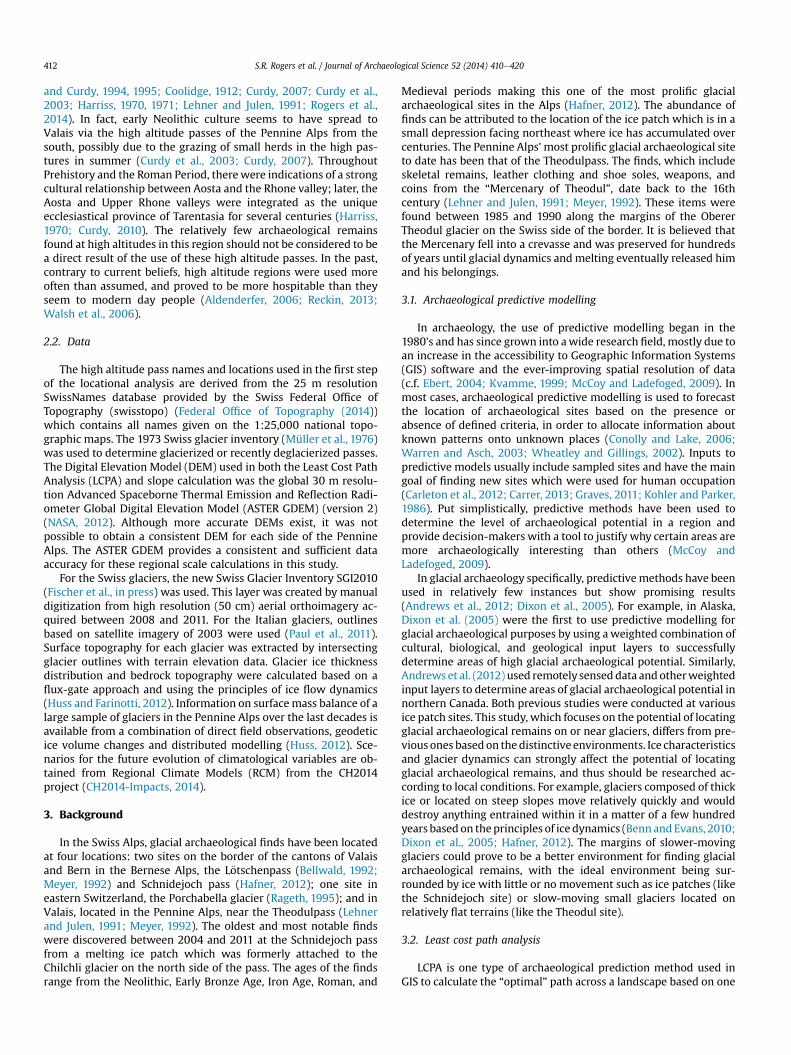
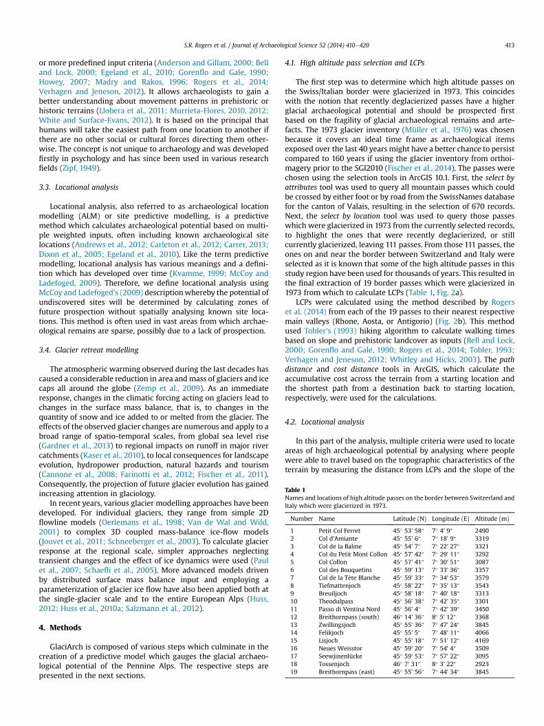
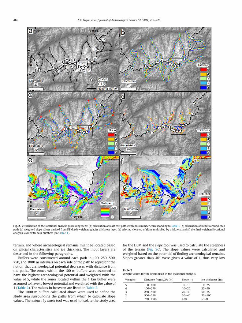
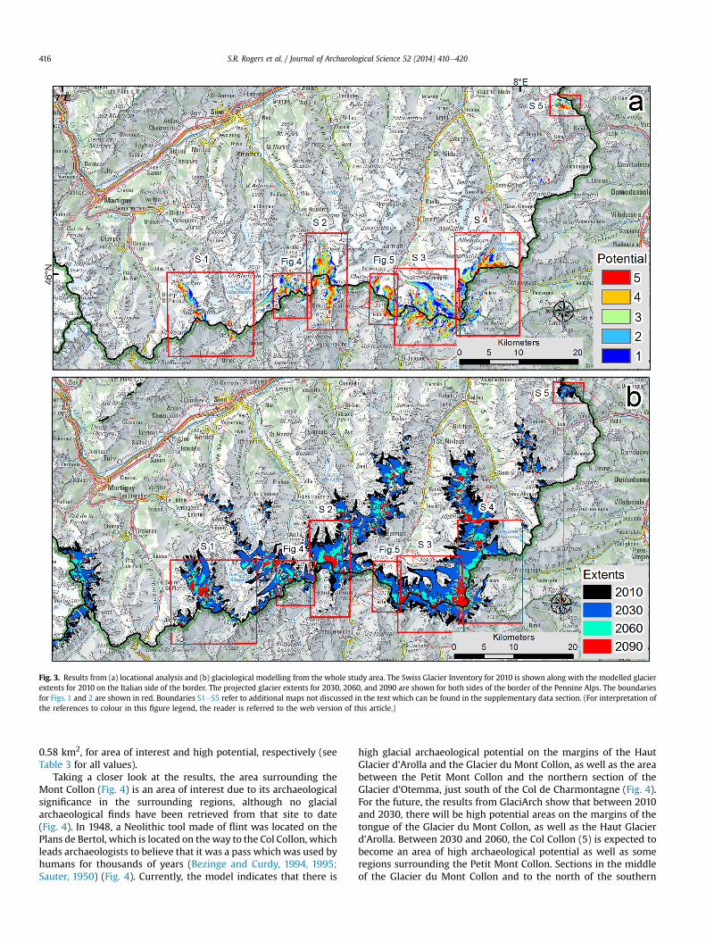
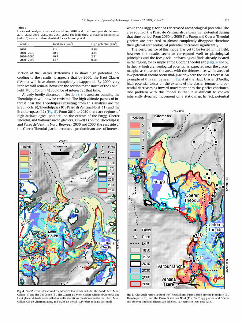
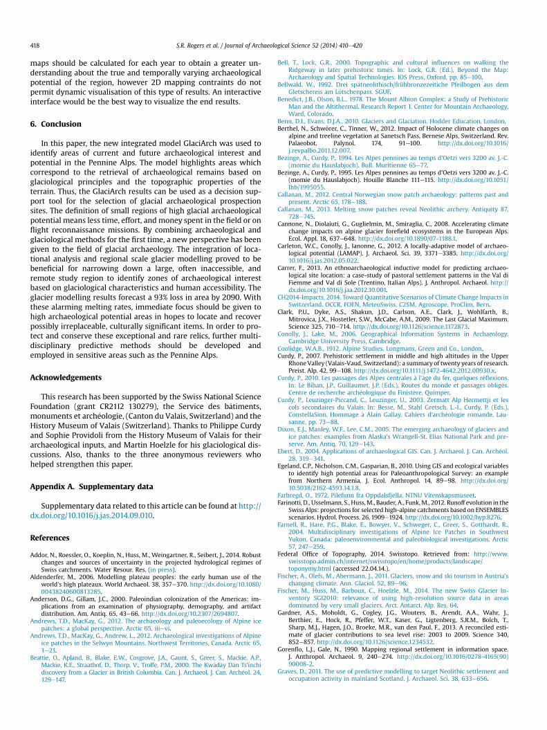