Grafton Wreck & Epigwaitt Hut Site, Auckland Islands, New Zealand. Heritage Assessment.
48
Heritage Assessment Grafton Wreck NZAA Site No. AU/42 Epigwaitt Hut Site NZAA Site No. AU/43 Auckland Islands, New Zealand Peter Petchey Southern Archaeology Ltd 2014
Transcript of Grafton Wreck & Epigwaitt Hut Site, Auckland Islands, New Zealand. Heritage Assessment.

Heritage Assessment
Grafton Wreck NZAA Site No. AU/42
Epigwaitt Hut Site NZAA Site No. AU/43
Auckland Islands, New Zealand
Peter Petchey Southern Archaeology Ltd
2014
Grafton & Epigwaitt Heritage Assessment
2
Cover Photo: The crew of the Grafton (Raynal 1892) Peer review statement Assessment prepared by Peter Petchey, Southern Archaeology Ltd., Dunedin Date: 2014 Assessment reviewed by Neville Ritchie, Department of Conservation. Date: 18/12/2014

Grafton & Epigwaitt Heritage Assessment
3
Table of Contents
1.0 Site Overview ................................................................................................................ 4 2.0 Setting ............................................................................................................................ 5 3.0 History of the Wreck of the Grafton and Epigwaitt ...................................................... 7 Sources ........................................................................................................................... 7 Site History ..................................................................................................................... 9 Chronology of the Grafton Events ............................................................................... 18 4.0 Descriptions of the Site in Contemporary Texts ......................................................... 19 The Grafton .................................................................................................................. 19 The Wreck Site ............................................................................................................. 20 The Boat Run ................................................................................................................ 20 Epigwaitt Hut ................................................................................................................ 20 The Forge ...................................................................................................................... 23 Charcoal Production ..................................................................................................... 23 Stone Paths ................................................................................................................... 24 The Surrounding Forest ................................................................................................ 24 5.0 Physical Description .................................................................................................... 25 The Boat Run ................................................................................................................ 26 Epigwaitt ....................................................................................................................... 27 The Forge ...................................................................................................................... 29 Stone Paths ................................................................................................................... 29 Grafton Wreck .............................................................................................................. 30 6.0 Museum Collections .................................................................................................... 33 National Museum of New Zealand (Te Papa) .............................................................. 33 Southland Museum & Art Gallery ............................................................................... 33 Canterbury Museum ..................................................................................................... 34 Alexander Turnbull Library, Wellington ..................................................................... 34 Queensland Maritime Museum .................................................................................... 34 Melbourne Museum ...................................................................................................... 34 Department of Conservation ......................................................................................... 35 7.0 Cultural Connections ................................................................................................... 36 8.0 Contextual Analysis .................................................................................................... 39 9.0 Assessment of Significance ......................................................................................... 42 9.1 Historic Significance .................................................................................................. 42 9.2 Physical Significance ................................................................................................. 43 9.3 Cultural Significance .................................................................................................. 43 10.0 Comparative Analysis ......................................................................................... 45 11.0 Sources & reports ............................................................................................... 46

Grafton & Epigwaitt Heritage Assessment
4
1.0 Site Overview AMIS Functional Location number: DS-84-200-0612 The wreck of the Grafton and the associated site of the castaway’s hut ‘Epigwaitt’ are located in Carnley Harbour at the southern end of Auckland Island. The Grafton was wrecked in January 1864, and is the great success story of the Auckland Island shipwrecks as all of the crew survived and eventually got back to civilisation, in stark contrast to some of the other wrecks on the island where many people died both in the sea and on land. The publication of the accounts of both the captain (Musgrave 1866) and first mate (Raynal 1892) have ensured that the events surrounding the castaways’ time on the island are well documented. The Auckland Islands are managed by the Department of Conservation as a National Nature Reserve under the Reserves Act (1977), and are part of the New Zealand Sub-Antarctic Islands World Heritage Area. Because of the sensitive ecological values entry to the islands is by permit only. There are tourism operators who have permits to take a total of 600 tourists each year to specific locations in the islands. The waters around the island group are a marine reserve, protected under the Marine Reserves Act (1971), with particular provisions for shipwrecks. It is an offence to disturb any archaeological site (including all shipwrecks) or historic building of any age in the Auckland Islands without a permit from the Minister of Conservation under the Reserves Act. The Heritage New Zealand Pouhere Taonga Act 2014 makes it unlawful for anyone to destroy, damage or modify any pre-1900 or gazetted archaeological site, including shipwrecks, without an Archaeological Authority. Uplifting and removal of artefacts and other movable objects are also prohibited, and export or trade of some items may be restricted by the Protected Objects Act (1975).
• The wreck of the Grafton and Epigwaitt Hut are situated within the Auckland Island Group National Nature Reserve, which includes an area of 57,102.9 hectares. The Auckland Islands were declared a National Nature Reserve in 1986.
• The Grafton wreck and the site of Epigwaitt hut are recorded as archaeological sites on the New Zealand Archaeological Association Site Record File: Grafton wreck site AU/42; Epigwaitt site AU/43.
• The Grafton wreck and Epigwaitt hut are actively conserved historic places managed by the Department of Conservation. They are listed as nationally significant. (Conservation Management Strategy, Southland Murihiku 2014-2024 (Draft June 2013).
• Visitor numbers to the Grafton wreck and Epigwaitt are limited to a maximum of 50 per day and 150 per year (Conservation Management Strategy, Southland Murihiku 2014-2024 (Draft June 2013).
• The New Zealand Sub-Antarctic Islands, including the Auckland Islands, were declared a World Heritage Site by UNESCO in 1998 due to their ecological values (http://whc.unesco.org/en/list/877)
The draft Conservation Management Strategy 2014-2024 states: The Department is responsible for managing an array of historic sites within this Place (the Subantarctic Islands). These sites represent a broad range of history and culture, from utilisation by Maori, early European sealing and settlement, through to the dramatic stories of ship wrecks, New Zealand’s southernmost sheep farm, and the coastwatch era of World War II. There are 21 actively conserved historic sites within this Place, a number of which straddle the land-sea boundary.

Grafton & Epigwaitt Heritage Assessment
5
2.0 Setting The following is largely taken from Dingwell et al (2009): The Auckland Islands are Located some 450 km south of the South Island of New Zealand (Figure 1), and are one of five subantarctic island groups lying in the Southern Ocean between the New Zealand mainland and the Antarctic continent. Although the islands have an interesting human history, today they are uninhabited and protected as nature reserves harbouring important indigenous communities of plants and animals, including countless numbers of seabirds.
Figure 1 The location of the Grafton wreck and Epigwaitt in the Auckland Islands.
The Auckland Islands group is an archipelago comprising the main Auckland Island (50,990 hectares), together with five other islands, of which Adams Island (10,119 hectares) and Enderby Island (710 hectares) are the largest, and many islets. The total area is 62,564 hectares. The islands rise to 705 metres, and are the remains of two coalescing shield volcanoes formed between 25 and 10 million years ago, centred respectively around Musgrave Peninsula in Carnley Harbour and Disappointment Island. Carnley Harbour is formed from the sea-filled crater area of the southern volcanoe. Coastal erosion has removed much of the western sector of the volcanoes, particularly the northern one, forming a line of cliffs up to 400 metres high along the western coast of Auckland Island. Cloudy, windy and wet weather predominates. Wind, often gale force, is persistent and generally from the west. The mean annual temperature is 8°C, with an annual rainfall of 1000-1500mm. There are light snowfalls in the winter but the snow does not sit for long, and there is no permanent snow or ice. Peaty soils up to 8m thick are widespread. Isolation of the islands over a long period has produced a biota with many species that are endemic, some of which are specially adapted to their oceanic island setting. A narrow fringing coastal forest extending to 50 metres altitude is the southernmost forest in the New Zealand region. It is dominated by southern rata (Metrosideros umbellata) (Figure 2), accompanied in some sheltered places by the world’s southernmost tree fern (Cyathea

Grafton & Epigwaitt Heritage Assessment
6
smithii) and the tree fuchsia (Fuchsia excorticata). Upslope this forest cover grades into a dense shrubland.
Figure 2 Coastal rata forest near the site of Epigwaitt.
The wreck of the Grafton occurred along the eastern shore of the north arm of Carnley Harbour, in an area where a shingle beach slopes up to the coastal rata forest. The on-shore remains of the wreck are at the mouth of a small stream, and the Epigwaitt hut site is on top of a rise on the true right of the stream, about 20 metres back from the beach. The area was largely cleared of trees by the Grafton castaways and subsequent nineteenth century visitors, and now the site is surrounded by regenerating rata forest. Evidence of clearing extends for about 100 metres north of the stream and at least that far inland, and the area is distinguished by the predominance of much younger rata trees and the presence of numerous cut stumps and limbs. These cut stumps are in a more advanced state of decay that those of the 1939 Erlangen clearing, supporting the conclusion that they relate to a nineteenth century event (Egerton et al 2009: 133).

Grafton & Epigwaitt Heritage Assessment
7
3.0 History of the Wreck of the Grafton and Epigwaitt Sources The history of the wreck of the Grafton and the survival of the crew is extremely well documented, as two first-hand accounts of events were published. Thomas Musgrave, the captain of the Grafton, published Castaway on the Auckland Isles in Melbourne 1865, while Francois Raynal, the second officer and representative of the backers of the voyage on which the Grafton was engaged, wrote Wrecked on a Reef. Raynal’s work was originally published as a series of three articles in the French travel magazine Le Tour du Monde in 1869, and as a much longer book (also in French), Les Naufragés des Auckland Iles, in 1870 (Mortellier 2003: 234). The first English translation was published in 1874, and it went through numerous reprints, the most recent edition being produced in 2003, transcribed from the 1880 edition togeher with an additional commentary by Christiane Mortellier. The versions used in this report are the 1866 edition of Musgrave’s book and the 1892 edition of Raynal’s work (both published in London), copies of which are held in the McNab Room, Dunedin Public Library. Musgrave’s and Raynal’s accounts provide a great deal of detail regarding the wreck and subsequent events. Joan Druett (2007) has recently synthesised their two accounts (and attempted to reconcile any differences), and compared their experiences with those of the contemporary Invercauld castaways. The Invercauld was wrecked at the north end of Auckland Island in May 1864, but in contrast to the crew of the Grafton, of the 25 men aboard only 19 survived the wreck, and of them only 3 lived to be rescued. Although both groups were living on the island at the same time, they were unaware of each other.

Grafton & Epigwaitt Heritage Assessment
8
Figure 3 Thomas Musgrave’s map of the Auckland Islands (Musgrave 1866).

Grafton & Epigwaitt Heritage Assessment
9
Site History Early Maori or Polynesian explorers made the first known landfall at the Auckland Islands around 1300AD, but no evidence has been found for more than a fleeting presence there (Anderson in Dingwell et al 2009: 35). The European discovery and naming of the Auckland Islands was made in 1806 by Captain Abraham Bristow of the whaler Ocean. Prior to the widespread replacement of sail by steam power the islands lay on the commonly used Great Circle shipping route through the southern ocean and a number of ships were wrecked on the rocky shores; mostly on the hostile and barren west coast. The most famous of these wrecks was the General Grant in 1866, which still attracts gold-seekers, but others included the Grafton (1864), Invercauld (1864), Derry Castle (1887), Compadre (1891), Anjou (1905) and Dundonald (1907) (Druett 2007; Egerton et al 2009: 126-151). There were also an unknown number of other unidentified wrecks that left no survivors. For example in 1833 a large amount of wreckage was found on shore without survivors or bodies and at the time the ship was not confidently identified (Ingram 1984: 8), but is now thought to be the Rifleman that was lost after leaving Hobart bound for London (McCrystal et al 2012).
Figure 4 The crew of the Grafton (Raynal 1892). The Grafton was a small schooner engaged by Sydney traders Charles Sarpy and his partner Musgrave (the uncle of the captain of the Grafton, Thomas Musgrave) for a prospecting trip to look for tin on Campbell Island, with the added (and probably the main) intention of carrying out some sealing while in the islands. They engaged Sarpy’s friend Francois Raynal as their representative on the voyage and second officer of the ship, and Thomas Musgrave as the captain of the Grafton (Raynal 1892: 36). Raynal was a 33 year old Frenchman, and Musgrave was a 30 year old British born American, then resident in Sydney. Three further crew were also engaged; George Harris (a 20 year old Englishman), Alexander Maclaren (a 28 year old Norwegian) and Henry Forgés (a 28 year old Portugese) (Raynal 1892: 41). The Grafton set sail from Sydney on
November 12th 1863 and anchored at Campbell Island on December 2nd (Raynal 1892: 39, 50). The Grafton remained for a month, but only a few sea-lions were caught, and no sign was found of any tin mine. Musgrave set sail again on December 29th, setting course for the Auckland Islands, which lay on the intended route back to Sydney (Raynal 1892: 57-58). The Auckland Islands were sighted the following day, and the Grafton entered Carnley Harbour on January 1st, 1864. Temptingly, numerous seals could be seen on-shore. However, the weather changed, and no good anchorage could be reached. Musgrave put down two anchors in Carnley Harbour, but one chain broke and the other anchor dragged, and at

Grafton & Epigwaitt Heritage Assessment
10
midnight on January 3rd the Grafton drifted ashore. At daybreak the crew managed to get to dry land. Initially they made a small tent from sails to shelter from the weather, which they soon replaced by a larger tent erected in a clearing cut from the coastal forest. The five men were fortunate that they had at hand the resources of the Grafton, which did not break up, but remained substantially intact (although holed beyond practical repair). These resources included not only their personal items (including Raynal’s gun), but also the provisions and tools aboard, and the timber, iron fittings, cordage and canvas of the ship itself.
Figure 5 Getting shore from the Grafton during the storm (Raynal 1892).
Figure 6 Epigwaitt hut (Raynal 1892).

Grafton & Epigwaitt Heritage Assessment
11
The crew soon set about building a hut, constructed from both ships timbers and timber cut from the coastal forest. The detailed descriptions given of the construction of this hut are reproduced below in Section 4. The house was christened “Epigwaitt,” a name suggested by Musgrave that he stated was a North American Indian word meaning “a home by the wave” or “a dwelling by the water” (Musgrave 1866: 118). The castaways’ diet consisted largely of sea lions, together with such birds, fish or mussels that they could shoot, catch or gather. Food was one of their constant worries, particularly when the sea lions migrated away from Carnley. After a year on the island, it had become clear to the men that no rescue was to be expected from Sarpy and (uncle) Musgrave (the backers of the voyage), and they would have to find their own way off the island. Musgrave had already inspected the Grafton to see if she could be repaired, but the hull was too badly damaged (Musgrave 1866: 55). The men then determined to build a new boat from the timbers of the Grafton, and Raynal set up a forge beside the hut in which to manufacture such tools and fittings that they would require (Figure 7), and took the necessary iron coming from the wreck. However, the logistics of such a task became too great, especially their lack of suitable tools that could not be made on site (in particular Raynal found it impossible to make the spiral point of an auger). Instead, the men modified their small ship’s boat, lengthening it by three feet and adding two feet in height to its gunwales (Raynal 1892: 267, 275). The finished boat was seventeen feet long and six feet wide, and was launched on either July 12th 1865 (Raynal 1892: 281) or, more probably, in late June 1865 (Musgrave 1866: 93). She was named Rescue.
Figure 7 Raynal working at the forge (Raynal 1892)

Grafton & Epigwaitt Heritage Assessment
12
Figure 8 Launching the Rescue (Raynal 1892).
On the 19th of July Musgrave, Raynal and Alick Maclaren set sail for Stewart Island in the Rescue. An initially favourable wind soon turned into a gale, and for five days the small boat endured bed weather. But on July 23rd Stewart Island was sighted, and on the 24th of July 1865 the Rescue entered Port Adventure (Musgrave 1866: 96; Raynal 1892: 292). They were greeted by Captain Cross, who was living there with his Maori wife. The three men were extremely weak after their voyage, and were given baths and clean clothes, ate a meal, and then slept for 24 hours. When they awoke they were on board Captin Cross’ cutter, the Flying Scud en route to Invercargill. There the three men were warmly greeted, but local government officials would or could not organise a mission to rescue the two men remaining on Auckland Island (the Province of Southland was in severe financial difficulties at the time). A public subscription was soon launched, and money to raise such an expedition was raised. As the most suitable boat then in New River, the Flying Scud was equipped to sail, with Musgrave acting as pilot. Contrary winds, bad weather and a faulty compass all hindered the rescue voyage, but seven weeks later the Flying Scud arrived back in Invercargill with the last two castaways. On the way back from Carnley Harbour the Flying Scud put in at Port Ross, and there they found the body of James Mahoney (one of the Invercauld castaways) in the ruins of one of the Hardwicke houses. After burying the body they returned to New Zealand, where all five Grafton castaways were reunited in Invercargill. Four of the five never again visited the Auckland Islands, but Thomas Musgrave almost immediately returned to assist with the official search for any other castaways. Musgrave had returned to Melbourne, and thence to Sydney where his wife and children were waiting. He submitted a report on his experiences, and in response the governments of New South Wales, Queensland and Victoria requisitioned the colonial steamer Victoria to undertake a voyage to the Auckland Islands to check for any further castaways. Musgrave was engaged to act as a guide. The Victoria circumnavigated the islands in October 1865, and revisited both Epigwaitt and Port Ross, but no further castaways were found (Druett 2007: 240-246). Epigwaitt was still in good condition, and Captain Norman of the Victoria planted an avenue of trees from the door of the hut to the steps down to the creek.

Grafton & Epigwaitt Heritage Assessment
13
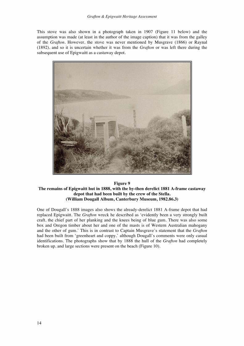
Ironically, given their lack of action when the first Grafton survivors arrived in Invercargill, the New Zealand authorities also decided to send a ship to the islands, largely as a result of the discovery of the body of James Mahoney by the Flying Scud crew (Druett 2007: 239, 260). Under the command of James Greig the paddle steamer Southland was fitted out for the voyage and departed in October 1865, only to find that the Victoria had already visited the same locations ealier in the month. Grieg also visited Epigwaitt and found the hut in good enough condition to stay in it for two nights (Druett 2007: 262; Egerton et al 2009: 157). In 1866 the most famous of the Auckland Islands shipwrecks occurred when the General Grant struck the west side of the island. Fifteen people (including one woman) survived the wreck, along with two of the ship’s boats which gave the castaways reasonable mobility. The castaways found the remains of the old house at Erebus Cove, but a cache of supplies that had been left by Captain Norman of the Victoria had been taken (Allen & Scedden 2009: 51). The boats were then used to explore the islands, looking for shelter and food as the survivors knew from recent newspaper reports that Epigwaitt was located at the southern end of the island. The elation of the discovery of the hut was tempered with the realisation that neither the Victoria or Southland had left any provisions there. Eight of the men spent the winter of 1866 at Epigwaitt, as it offered both shelter and good access to seals for food (Egerton et al 2009: 137; Eunson 1979; Sydney Morning Herald, 24 January 1868: 2). In January 1867 four of the General Grant castaways attempted to sail to New Zealand, in the same way that Musgrave and Raynal had done, and the sailcloth ‘lining’ (possibly the roof) of Epigwaitt was used to make sails for the pinnace (Allen & Scadden 2009: 59; Eunson 1974: 77; Sydney Morning Herald, 24 January 1868: 2). However, these men had no compass and were never seen again. The remaining ten survivors (one man had died on the island) were rescued in 1867 by Paddy Gilroy and his brig the Amherst (Eunson 1974: 100). After the rescue of the General Grant survivors, Paddy Gilroy of the Amherst was engaged by the New Zealand authorities in 1868 to return to the Auckland Islands as well as Campbell Island and the Antipodes Islands to establish the first of the castway depots in these places, in order to provide essential supplies for any future shipwreck victims (Rowley 2006: 105). The early Auckland Island castaway depots simply reused some of the huts already constructed by wreck survivors, including Epigwaitt and one of the General Grant huts on Enderby Island. The Amherst crew repaired the roof of Epigwaitt by shoring it up with timbers taken from the hulk of the Grafton and replacing the thatch, and inside they left a case of provisions, a spade and a box of books (Egerton et al 2009: 138-139, 159; Sydney Morning Herald, 27 April 1868: 2). A spar was set up in front of the hut as a marker, and the Grafton’s bowsprit was taken and set up as another marker on Musgrave’s Peninsula. From about 1876 the servicing of castaway depots began to improve, as the government steamer Stella became available, followed by the Hinemoa and Kekeno in 1881. New depots were established, and regular visits were made (during which it was found that some depots had been looted). In 1881 Captain Grey of the Stella found Epigwaitt to be in poor condition, and a new A-frame depot shed was erected nearby (Egerton 2009: 163; McCraw 1999: 134). This only remained in service for a few years, and was superceded by the Camp Cove depot in about 1884 (Egerton et al 2009: 163; McCraw 1999: 153). After this date the site of Epigwaitt continued to attract visitors because of its history and the relics that could be seen, but was no longer officially managed. The increased official visitation to the Auckland Islands also allowed an increased number of visitors on various expeditions. William Dougall (nd) published an account of his visit to Epigwaitt in 1888, and took a number of photographs of the Grafton wreck and Epigwaitt hut site (Figures 9 & 10). Dougall described the remains of the hut as consisting of the remains of the upright posts made from the Grafton’s masts, and the stove (‘which we nearly brought away with us’), and it is clear that by this date Epigwaitt had almost completely collapsed.
Grafton & Epigwaitt Heritage Assessment
14
This stove was also shown in a photograph taken in 1907 (Figure 11 below) and the assumption was made (at least in the author of the image caption) that it was from the galley of the Grafton. However, the stove was never mentioned by Musgrave (1866) or Raynal (1892), and so it is uncertain whether it was from the Grafton or was left there during the subsequent use of Epigwaitt as a castaway depot.
Figure 9 The remains of Epigwaitt hut in 1888, with the by-then derelict 1881 A-frame castaway
depot that had been built by the crew of the Stella. (William Dougall Album, Canterbury Museum, 1982.86.3)
One of Dougall’s 1888 images also shows the already-derelict 1881 A-frame depot that had replaced Epigwaitt. The Grafton wreck he described as ‘evidently been a very strongly built craft, the chief part of her planking and the knees being of blue gum. There was also some box and Oregon timber about her and one of the masts is of Western Australian mahogany and the other of gum.’ This is in contrast to Captain Musgrave’s statement that the Grafton had been built from ‘greenheart and coppy,’ although Dougall’s comments were only casual identifications. The photographs show that by 1888 the hull of the Grafton had completely broken up, and large sections were present on the beach (Figure 10).

Grafton & Epigwaitt Heritage Assessment
15
Figure 10 Wreck of Grafton, Epigwaitt, Auckland Islands, circa 1888, Auckland Islands, by
William Dougall, Burton Brothers. Purchased 1943. Te Papa (C.010536).
Figure 11 The site of Epigwaitt hut, ca. 1907, taken during the Canterbury Philosophical
Institute’s Scientific Expedition to the Auckland Islands in 1907. The stove is clearly visible left of centre. (Auckland Weekly News, 2 January 1908; Sir George Grey Special
Collections, Auckland Libraries, AWNS-19080102-15-1).
Grafton & Epigwaitt Heritage Assessment
16
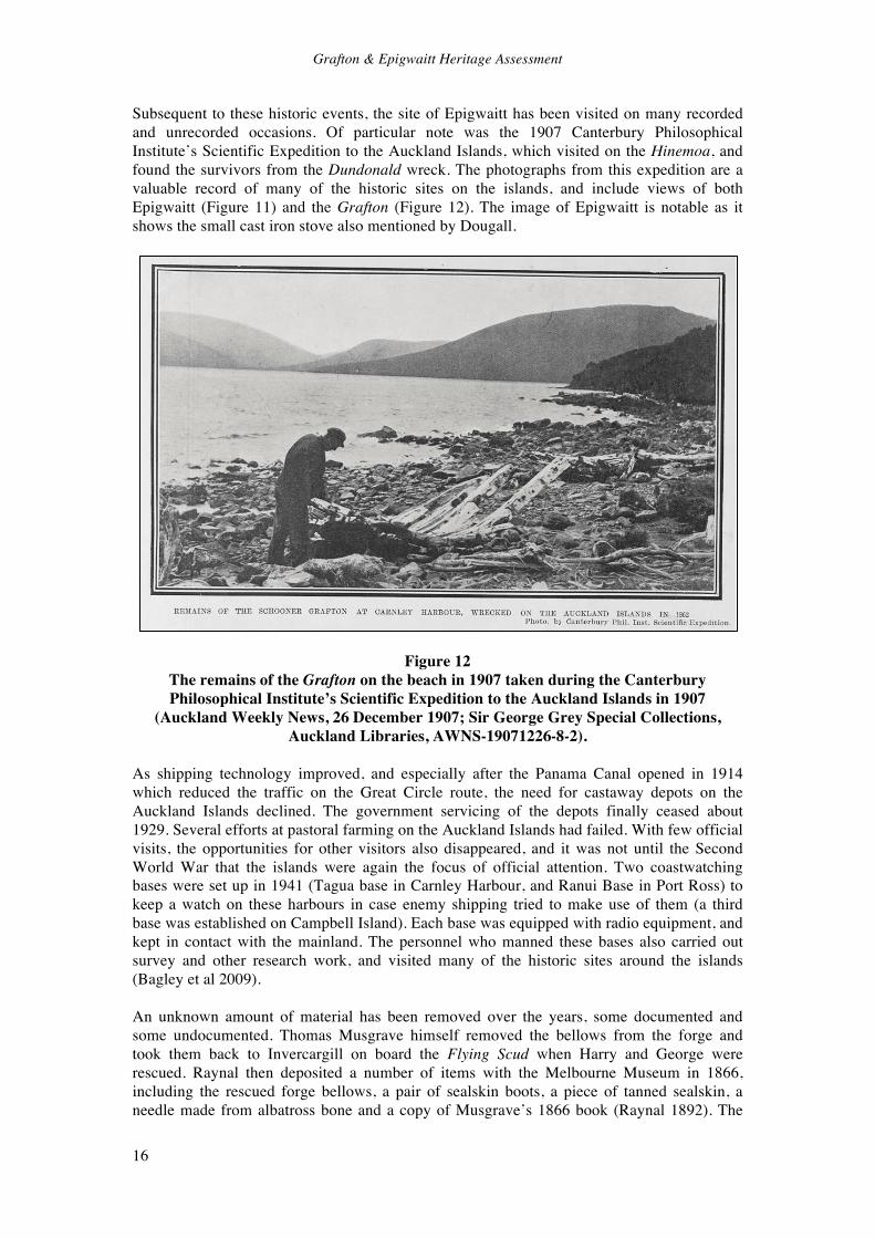
Subsequent to these historic events, the site of Epigwaitt has been visited on many recorded and unrecorded occasions. Of particular note was the 1907 Canterbury Philosophical Institute’s Scientific Expedition to the Auckland Islands, which visited on the Hinemoa, and found the survivors from the Dundonald wreck. The photographs from this expedition are a valuable record of many of the historic sites on the islands, and include views of both Epigwaitt (Figure 11) and the Grafton (Figure 12). The image of Epigwaitt is notable as it shows the small cast iron stove also mentioned by Dougall.
Figure 12 The remains of the Grafton on the beach in 1907 taken during the Canterbury Philosophical Institute’s Scientific Expedition to the Auckland Islands in 1907
(Auckland Weekly News, 26 December 1907; Sir George Grey Special Collections, Auckland Libraries, AWNS-19071226-8-2).
As shipping technology improved, and especially after the Panama Canal opened in 1914 which reduced the traffic on the Great Circle route, the need for castaway depots on the Auckland Islands declined. The government servicing of the depots finally ceased about 1929. Several efforts at pastoral farming on the Auckland Islands had failed. With few official visits, the opportunities for other visitors also disappeared, and it was not until the Second World War that the islands were again the focus of official attention. Two coastwatching bases were set up in 1941 (Tagua base in Carnley Harbour, and Ranui Base in Port Ross) to keep a watch on these harbours in case enemy shipping tried to make use of them (a third base was established on Campbell Island). Each base was equipped with radio equipment, and kept in contact with the mainland. The personnel who manned these bases also carried out survey and other research work, and visited many of the historic sites around the islands (Bagley et al 2009). An unknown amount of material has been removed over the years, some documented and some undocumented. Thomas Musgrave himself removed the bellows from the forge and took them back to Invercargill on board the Flying Scud when Harry and George were rescued. Raynal then deposited a number of items with the Melbourne Museum in 1866, including the rescued forge bellows, a pair of sealskin boots, a piece of tanned sealskin, a needle made from albatross bone and a copy of Musgrave’s 1866 book (Raynal 1892). The
Grafton & Epigwaitt Heritage Assessment
17
General Grant survivors recovered everything that they could to aid their survival, including the remaining canvas from Epigwaitt. Captain John Bollons, master of several government steamers, regularly visited the Auckland Islands and was an avid collector, and much of his collection is now held by the National Museum Te Papa (Egerton et al 2009: 126). During the Second World War the coastwatchers removed many items from sites around the islands, and relocated them to the two bases. More recently, Pettit (2008: 83) reported that in 1970 Kelly Tarlton removed the cast iron stove that Dougall had mentioned and the 1907 expedition had photographed (Figure 11), and this was later displayed at Tarlton’s private shipwreck museum at Paihia, and is now in the Canterbury Museum (see also Allen & Scadden 2009: 134). The site of the wreck of the Grafton and Epigwaitt hut therefore has a long history, which includes not just the wreck of the ship and efforts and experiences of the castaways, but also its role as one of the first formal castaway depots in the Auckland Islands, and as a visitor attraction right up to the present day.

Grafton & Epigwaitt Heritage Assessment
18
Chronology of the Grafton Events 1863 The Grafton sets sail from Sydney to Campbell Island and the Auckland Islands. 1864 The Grafton is wrecked in Carnley Harbour. The crew built Epigwaitt hut. 1865 Musgrave, Raynal and Alick Maclaren sail to Stewart Island in the Rescue.
The Flying Scud is sent to rescue remaining two crew members. The Victoria and Southland both inspect Auckland Islands looking for castaways.
1866 The General Grant is wrecked. Eight survivors overwinter at Epigwaitt. The survivors thoroughly search Epigwaitt and environs for anything that might be useful to them.
1867 Canvas at Epigwaitt is removed to make a sail for a failed attempt to sail the General Grant’s pinnace back to New Zealand. Paddy Gilroy of the Amherst rescues the remaining ten General Grant survivors.
1868 Paddy Gilroy of the Amherst sets up the first castaway depots. Epigwaitt is repaired and stocked with provisions.
1881 Epigwaitt is found to be in poor condition, and Captain Grey of the Stella erects a new A-frame depot, probably on the site of the old hut.
1884 A new castaway depot is established at Camp Cove, which replaces the Epigwaitt depot.
1888 Photographs show that both Epigwaitt and the replacement A-frame structure are derelict. Only the corner posts stand of Epigwaitt.
1907 Photographs show that Epigwaitt is completely collapsed, with just the stone fireplace partially standing, together with a scatter of artefacts including a small cast iron stove.
1970 Kelly Tarlton removes the stove from Epigwaitt. 2002 Archaeological survey of Epigwaitt identifies and records the stone fireplace, stone
paths and fragments of the Grafton hull. Results confirm that the Raynal and Musgrave accounts are accurate in all verifiable respects.
2003 Auckland Islands Archaeological & Historical Expedition revisits Epigwaitt and identifies forge site, again confirming Raynal’s and Musgrave’s accounts.

Grafton & Epigwaitt Heritage Assessment
19
4.0 Descriptions of the Site in Contemporary Texts In Musgrave’s and Raynal’s accounts there are many specific references to the Grafton, construction of the Epigwaitt hut, the boat run, the forge and their paths, all of which are of value in the archæological interpretation of the site. The main references are quoted verbatim below. It may be noted that some of the dates given in the two accounts do not tally. Druett (2007) has reconciled many of the differences, but these accounts and dates have been quoted here as published in Raynal’s and Musgrave’s own words. The Grafton A small schooner, not of much length in the keel, but capable through her breadth of beam of carrying seventy-five to eighty tons of merchandise without being overloaded…At the bottom of her hold the Grafton carried about fifteen tons of ballast, composed chiefly of old iron; above this was a solid deck…Nevertheless, for our expedition…we though it desirable to add another ten tons’ weight of ballast (blocks of sandstone, which is very common at Sydney) (Raynal 1892: 37-38). (Sunday March 6, 1864) The Grafton is breaking up fast today. There is a heavy surf on with the gale. Her decks are coming up (Musgrave 1866: 19). (Sunday August 7, 1864) I have determined on trying to get the schooner higher on the beach, so as to look at her bottom. It may be that it is not impossible to make something of her yet: she is evidently very strongly built, for she holds together in spite of all the gales which have blown since she was stranded, with the exception of a portion of the decks, which came up some time ago (Musgrave 1866: 52).
(Sunday August 21, 1864) After getting all of the ballast out of her, we tried by pumping and bailing to keep the water down, but found it impossible. We then, with considerable difficulty, got her thrown over on the other bilge, and found a number of holes in her, some of her timbers broken, and the main wheel gone from the stern to about the main rigging. This was done when we first struck. The holes have no doubt been chafed through since. Nothing more can be done (Musgrave 1866: 55). (Sunday October 30, 1864) If nothing comes after us, we shall commence at the New Year to pull the Grafton to pieces, and try what we can do with her bones (Musgrave 1866: 74). At an early hour I paid a visit to the Grafton, or at least to all that remained of the poor schooner: the breakers had destroyed its upper works; they had left nothing but the empty hulk, which was solidly fixed among the rocks (Raynal 1892: 255) (Sunday February 5, 1865) …last Sunday we were working at the wreck, trying to get her higher on the beach, to do which, with the means at my command, I have exhausted my ingenuity without success. We stripped the lower masts and bowsprit, and cut them away: took every ounce of ballast out, and disburthened her of all possible weight, without taking away any of her upper work, as I did not know what I might have done with her had I succeeded in moving her (Musgrave 1866: 79). She is built of very heavy hard wood, principally greenheart and coppy. She was built from the wreck of a Spanish man-of-war; but I am sorry to say they took care not to put any copper bolts in her: but perhaps there were none in the original wreck. But they have not been at all sparing with the iron. She has got any quantity of that about her, which will be of more
Grafton & Epigwaitt Heritage Assessment
20
service to me than any other part of her, excepting the plant, which is already full of bolt-holes; but we must make it answer our purpose (Musgrave 1866: 79-80). The Wreck Site I followed my companions to the mouth of the little brook which rippled near the tent. It emptied itself into the bay, nearly opposite the wrecked vessel (Raynal 1892: 103). The Boat Run (February 1864) During the remainder of the time we have been occupied in laying ways for hauling up and launching the boat on, and making a jetty (Musgrave 1866: 15). (Sunday August 7, 1864) On Monday and Tuesday we employed ourselves at tide-time in clearing away the rocks and boulders off the beach up above where she (the Grafton) now lies, and where she must come up, if she comes up at all, which I consider as very doubtful (Musgrave 1866: 52). In the morning, conforming ourselves to our new plan, we felled some trees, and transported their trunks to the shore. After roughly planing them with the axe, we arranged them on the ground, in parallel lines to the beach, at intervals of one foot, like the joists of a floor. We had erected our yard at high-water mark, which a line of withered marine plants clearly indicated, at a point where the slope of the shore would allow our boat to glide easily in to the sea, as soon as she was ready for launching (Raynal 1892: 269). Epigwaitt Hut Further up, on the same stretch of shore, rose a small hill, or rather a rounded hillock, thirty-five to forty feet in height, and covered, like the rest of the littoral, with a dense vegetation. As we were anxious to keep as near as possible to the Grafton, this seemed a convenient site for our projected building (Raynal 1892: 103).
Our house is elevated about 30 feet above the mean tide level, and is about 50 yards from the water (Musgrave 1866: 51).
When sufficient space had been cleared, another day was occupied in levelling the soil, and the day after…they repaired to the Grafton for the necessary materials. They returned with the yards and lightest spars, intended for the framework of our edifice (Raynal 1892: 103-104). Last Monday we went on board the wreck, and got all the boards we could muster to make a floor in the tent… We also unbent the sails, and sent down all the yards and topmasts, and are using them for building a house (Musgrave 1866: 5). In a week we erected the framework of our little house, after the following fashion:- At the four corners of a rectangle, which was twenty-four feet long by sixteen feet wide, four strong posts, shaped out of the schooner’s masts, were planted in the ground to a depth of about forty inches. To presvent them sinking further into the peat, we laid a large stone as a foundation for each; then, with the view of steadying and strengthening them, we filled in the holes with very small stones, closely pressed together. Each post rose about seven feet out of

Grafton & Epigwaitt Heritage Assessment
21
the ground and was notched at the upper end. These notches were intended to receive four horizontal beams, made out of the top-masts and lightest yards of the Grafton, and bound solidly together, as well as to the top of the posts, with stout cordage. In the middle of the two narrower sides, and directly opposite one another, we fixed two additional posts, stronger and longer than those at the angles. For this purpose we employed the mainyard of the schooner, cut into two equal lengths; the two posts being seven feet higher than the height of the beams. The bowsprit rested horizontally on their extremities to support the apex of the roof. It traversed the rectangle in the middle, throughout its entire length, at a height of fourteen feet. In couples, and at equal intervals- about twenty inches- and fastened at one end to the bowsprit, twenty-eight rafters (fourteen on each side) leaned obliquely on the two long lateral beams, to which they were fixed at the other end by means of strong cordage. We had no nails, and made use instead of the rigging and shrouds of the schooner. These rafters were supplied by the small mountain pines of which I have already spoken. We had lost a great deal of time in seeking out those which were straight, in a country where all the trees, even the pines, are twisted. This was not all. In the middle of the longer side of the hut- the side which fronted inland- two strong posts, planted a yard apart, while assisting to support the beam, served as a framework for our door. We made our entrance on this side, that it might not be exposed to the sea-winds. On the other side- turned towards the shore- were two similar posts: these were the framework for the chimney, whose construction occupied us for the whole of the week following (Raynal 1892: 107-108). The construction of our chimney, moreover, was a troublesome business. The spot we intended for the hearth we dug out to some depth, and then filled up the cavity with stones, so as to prevent the peaty soil from catching fire. The outer angles of the body of it were made with posts bound to one another, and also to the rest of the framework, by cross-beams. We could not line the interior with wood; evidently stone and masonry were required. Therefore we picked out, among the rocky fragments with which the shore was strewn, the flattest and smoothest; and after removing them, not without difficulty, to our hillock, we built up the side-walls and fireplace. The former were stayed externally by a row of wooden pegs sunk into the ground. As we could not find any clay to serve instead of plaster, and cement the stones together, we found it requisite to invent a new kind of mortar. Equipped with the bags which had formerly been used to hold our salt, we wandered, therefore, along the sea-shore, and collected a great quantity of shells of every kind. These we calcined during the night, and next day found ourselves provided with a supply of lime. This lime, mixed with the fine gravel we found under the rocks of the beach, made a capital mortar for our mason’s-work (Raynal 1892: 108-109). (Musgrave (1866: 11) gave the dimensions of the chimney as 8 feet by 5 feet.) The next business was the building of the chimney-pot. Four perches, twelve feet long, raised vertically, yet with a slight inclination towards one another, so as to form a kind of truncated pyramid at the summit, were fastened to the walls. They were held together by numerous cross-pieces, disposed like the steps of a ladder; and upon these we nailed, in the inside first, and afterwards on the outside, a double lining of sheets of copper (Raynal 1892: 109-110).

Grafton & Epigwaitt Heritage Assessment
22
Monday, 18. We have all been busy in the forest, selecting, cutting, and transporting to our hillock the straightest pieces of wood, to build up the walls of the hut (Raynal 1892: 114). Next day we resumed the construction of our hut. The posts we had cut in the forest were sunk some inches deep into the ground on each side of the little structure, and fixed at the top to the transversal beams of the framework. Then over the entire superficies of this palisade we fastened horizontal and parallel rows of laths, or thin planks, and the rafters of the roof we covered in the same manner. The next task was to fill up the interstices of this trellis-work with straw, instead of oakum or putty, as we had neither. For this purpose we made use of a coarse, long and strong grass, which grew in thick tufts on the sea-shore and along the edge of the cliffs. When we had at length collected a sufficient quantity of grass, we spent several days in tying it up with thread in small bundles about as thick as a man’s arm. As fast as these were got ready, my companions passed them to me, and, resting them on a log of wood, I cut off, with a few blows of the axe, all the straws which bulged out of, or projected from, the bundle. It took no fewer than nine thousand of these little sheaves to cover the sides and roof of our cabin; and this is how we disposed of them:- Commencing at the bottom of the framework, we bound them against the planking side by side, exactly on a level, and taking care that no space was left between them. When the first row was finished, we placed the second, which partly overlapped it; then above the second a third; and so on up to the top of the walls, and thence to the very summit of the roof. The sheaves were upwards of a yard in length, and formed an outer covering of nine to ten inches in thickness. To prevent the wind from taking hold of our thatched walls, and stripping them clean, we fastened outside a quantity of laths, connected with those inside by loops of twine, which we carried through holes made in the straw with a wooden needle- a wooden needle of the size of a sword-blade! In the upper part of the walls we cut three small openings, into which we inserted, with the utmost nicety, some panes of glass which had belonged to the cabin of the Grafton, and which we had found intact. These were our windows (Raynal 1892: 120-122). While I am fully engaged in manufacturing soap, Musgrave and the others have gone on board the wreck in search of some wood. With the iron pincer, they have torn down the partition between the cabin and the hold, and have obtained a small supply of nails, which will be very useful in completing the equipment, so to speak, of our chimney. They have also brought away all of the remaining long and narrow timbers of the schooner’s bulwarks; they will serve to make a floor, which is really indispensable to the healthiness of our new abode (Raynal 1892: 131). Wednesday, February 10.- The wind has swept away the clouds. While Musgrave assists me in building a door to our hut, and Harry is engaged in the tent in the preparation of our dinner, Alick and George dig around the chimney a trench to preserve it from damp. But as this trench weakens the foundations, we resolve on setting up at the corners, as well as on each side of the door, strong inclined stakes, like buttresses, whose base will rest on stout trunks of trees previously sunk into the peat at some distance from the walls (Raynal 1892: 141). All these little indoor labours were terminated on Saturday morning, the 5th of March. The rest of the day was occupied in dismantling the tent and transporting our penates into our new abode, where, after lighting a good fire on the hearth, we slept that very evening (Raynal 1892: 151).

Grafton & Epigwaitt Heritage Assessment
23
I may here give a description of this castle of ours. It is 24 feet long by 16 wide. The walls are 7 feet high, roof 14 feet. The corner posts and centre posts, which are made of spars from the ship, as also the wall plates and ridge poles, are let three feet into the ground. The walls or sides and ends are made of timber out of the bush, placed upright, and let into the ground about a foot. They are far from being straight, consequently they are far from being close together. This is why we are obliged to thatch them. They are now covered with old canvas outside, but it lets a great deal of wind through. The door is a very good one, made of inch boards. The floor is also boarded, and tolerably good. There are two small panes of glass, which were taken out of the cabin of the vessel. The rafters are sticks out of the bush, placed two feet apart. There is a double cover on the roof, with two sets of rafters and two ridge poles. The fireplace is built of stone, as high as the walls of the house; above, it is made of copper, tin, zinc, and boards towards the top, and is 15 feet high. The fireplace inside the walls is 6 feet, with four walls 1 foot thick…We have trenches all round the house two feet deep, which keep the floor perfectly dry, and no water has yet come through the roof (Musgrave 1866: 15-16). (Sunday March 27, 1864) We have finished thatching the house, and find it very warm and comfortable. It has taken 5000 bundles of thatch, each bundle weighing a pound, so that the total weight of thatch on the sides of the house is about two and a quarter tons. The roof remains covered with canvas (Musgrave 1866: 22). The Forge It was then to the erection of a forge- that is to say, of a furnace, an anvil, and a pair of bellows- that I must in the first place busy myself (Raynal 1892: 255). (Sunday February 5, 1865) Mr. Raynal is Vulcan; he has had some little experience in blacksmithing…He has got a forge up ready for going to work at, as soon as we get some charcoal made (Musgrave 1866: 80). We began by building, he and I, beside our hut, a shed, roofed in with the sheets of copper stripped from the sides of the Grafton. Under this shelter we set up our forge-bellows, and in front of them erected a large fireplace of masonry, whose platform was made of the bricks found at Camp Cove. The only thing wanting then was an anvil. I thought at first of using, as I had often done in Australia, a smooth stone; but stones break easily, and the necessity of replacing them would have frequently cause delay. I once more visited the Grafton, our inexhaustible resource, and among the iron ballast in the hold I was fortunate enough to find a smooth four-sided block of iron, about fourteen inches in length, by three inches and a half in breadth and thickness. I had but to set this in a strong framework of timber, and my anvil was made (Raynal 1892: 261). Early in the morning of the 16th of January, our forge was set to work for the first time (Raynal 1892: 262). Charcoal Production Nor was the work of Alick, our Norwegian, much lighter. He had to supply the forge with fuel, of which it consumed a great quantity. This wearisome occupation demanded his continued attention both night and day. First, he had to cut down the wood, and form a pile from seven to nine yards thick; then to overlay this pile with turf, to kindle it in the middle, and to watch its combustion (Raynal 1892: 260).
Grafton & Epigwaitt Heritage Assessment
24
Stone Paths (Sunday June 5, 1864) We have now got some very good roads made about the house, which was very necessary, for the ground is so soft that after any part of it has been trodden a little it becomes mud, which in this damp weather never has a chance to get dry (Musgrave 1866: 36). The Surrounding Forest We congratulated ourselves on having left standing on the sea-shore a rampart or screen of trees, which deadened to some extent the shock of the wind…(Raynal 1892: 173).
(Sunday June 5, 1864) We are also getting a considerable clearing round the place; for we burn a great deal of wood- not less that a cart-load a day (Musgrave 1866: 36).

Grafton & Epigwaitt Heritage Assessment
25
5.0 Physical Description The site of “Epigwaitt” is located on the eastern shore of the north arm of Carnley Harbour (see Figure 1), near the mouth of a small stream. The site was visited in February 2002 and 2003. During the 2002 visit a map of the overall site was made using tape and compass (Figure 13). After the features that were visible on the surface were recorded, probing was undertaken in the area of the hut in order to find the foundation stones of Epigwaitt. Basic measurements of the height of the chimney and the exposed timbers from the Grafton were then made. It had been intended to search for the forge site and draw a cross-section of the site on the following day, but time was cut short due to changing weather. The forge was located during the 2003 site visit.
Figure 13 Map of the Epigwaitt site, showing the on-shore fragments of the Grafton’s hull. The
main wreck is in the water directly off shore from this site. The site is in an area of regenerating rata forest (Figure 14), which was cleared when the Grafton crew cut firewood almost every day. The 1907 photograph of the site (Figure 11) shows no old rata around the hut site. Older rata can be found a short distance away, clearly showing the gnarled forms that could not provide the straight timbers required by the castaways. The archæological features discussed below are shown in Figure 13.

Grafton & Epigwaitt Heritage Assessment
26
Figure 14 The site of Epigwaitt hut in the regenerating coastal rata forest.
The Boat Run The boat run is the first archæological feature that is seen by the visitor, as it is quite obvious on the beach at low tide. It is a 12 metre wide area of shore that has been cleared of large rocks to create a smooth approach. Musgrave’s account mentions creating a landing for the small ship’s boat in February 1864, but the main run was almost certainly constructed on Monday and Tuesday, August 8 and 9, 1864, when the beach was cleared above the Grafton wreck in an unsuccessful attempt to pull her ashore and repair her (Musgrave 1866: 52). The area was then probably the place where the Rescue was constructed from the ship’s boat.
Figure 15 The boat run on the beach (centre of view) in front of Epigwaitt (R. Egerton).

Grafton & Epigwaitt Heritage Assessment
27
Epigwaitt The site of Epigwaitt is on the north side of a small creek, immediately inland from the boat run. As described by Raynal, it is on a rise, thus making it free-draining. The site is partially overgrown with ferns. The most obvious feature is the remaining part of the stone fireplace and chimney (Figures 16 & 17). This has now largely collapsed, but some in-situ stonework is visible on the interior (Figure 17). The mortar is a brown colour, with white flecks of shell, this being the fine-gravel and shell-lime mortar made by Raynal (1892: 108-109). The measured internal dimensions of the fireplace are 5 feet 2 inches by 3 feet 8 inches (1.58m by 1.12m). Fire reddening is still visible on some inside faces of the stonework. The structure currently stands to a maximum height of 2 feet 8 inches (0.81m) above ground level.
Figure 16 The chimney of Epigwaitt hut in 2002.
Figure 17 Detail of the in situ stonework of Epigwaitt hut in 2002. The lime mortar manufactured by Raynal in 1864 is still in place between these stones. The scale is 0.5m long.

Grafton & Epigwaitt Heritage Assessment
28
The site of the hut has been flattened, and the modified area agrees well with both Musgrave’s and Raynal’s accounts of the building measuring 24 feet by 16 feet (7.3m by 4.8m). No surface detail was visible, but probing located numerous buried stones, which are highly likely to be those buried by the castaways during the construction of the hut foundations. Large stones were buried beneath the main posts to prevent them sinking into the peat, and the holes were backfilled with smaller stones to hold the posts steady (Raynal 1892: 107-108). Using the fireplace as a guide for the location of the back wall, the corners of the hut were estimated by measuring the quoted size (24ft. by 16ft.) on the ground, and then probing accordingly. Buried stones were located at the expected places, as well as some on the wall line opposite the fireplace, where the door is known to have been. Unfortunately, there was insufficient time to fully probe the entire area, and when the stone hits were later plotted out, the identified shape was a parallelogram. This is undoubtedly the result of measuring the site, not checking the diagonals, and accepting the results without question as they were what were expected. More time and a systematic coverage of the site would undoubtedly clarify the issue. What the exercise did show was that buried stones are on the site, as described in the contemporary accounts, which confirms that the site has substantial sub-surface archæological evidence. Limited probing away from the hut site found no stones in the peat, suggesting that the stones that were found were culturally placed. Some bottle glass fragments found on the hut site, by the fireplace, appeared to be from a ring-seal beer bottle (ca.1878-1920), post-dating the Grafton wreck. A number of timbers were lying on the back of the chimney mound (Figure 18). These had obviously been placed there in recent years. There were three main timbers (plus a number of smaller fragments). One was a softwood plank (possibly Oregon), measuring 5” by 3/4” by 4’ long. The second was a post, 4 inches in diameter and 8’ 3” long, with two notches in one end and bearing some iron nails. The provenance of these two timbers is unclear, but it appears unlikely that they originate either from Epigwaitt or the Grafton. The third timber was of more interest. It was a hardwood plank, 8 inches wide, 2 inches thick and 7’ 3” long. The head of an iron spike was still embedded in the plank, while one side had numerous small nailholes, nails, and fragments of copper sheet. The plank appeared water worn. It is extremely likely to be a hull plank from the wreck of the Grafton, with the remains of the copper hull sheathing. Presumably it was on the beach, and has been placed on the hut site by a visitor.
Figure 18 Timbers lying on the back of the Epigwaitt fireplace in 2002. The scale is 0.5m long.

Grafton & Epigwaitt Heritage Assessment
29
The Forge Raynal’s account (Raynal 1892: 261) states that the forge was built beside the hut, with a stone and brick hearth, and a roof made from copper sheets from the Grafton’s hull. The site of the forge was located during a visit to the site in January 2003, near the stream bank on the south side of Epigwaitt. A post, 7 inches (180mm) diameter and 20 inches (500mm) high, associated with a stone scatter, was located below the hut site and towards the stream, 11 metres form the Epigwaitt fireplace. A metal detector was used to search the surrounding ground, and this gave numerous responses. The humus layer was excavated in this area (under Archaeological Authority No. 2003/106), and this revealed a scatter of charcoal, a number of probable hearth stones, several bricks and a number of heavily oxidised fragments of iron. The bricks had no frogs or maker’s marks.
Figure 19 The wooden post and bricks at the site of the forge (R. Egerton 2003).
Stone Paths Stone paths were constructed by the castaways, as the peaty ground quickly turned to mud if regularly walked upon. One path was identified and plotted during this survey (Figure 4). It led from Epigwaitt hut, near the door location, along the top of the stream bank (heading inland) and down to a boggy section of old stream bed (the present stream course is 20 metres to the south). The path was formed by placing stones, presumably brought up from the beach, on the ground to form a hard surface. No excavation was carried out to determine whether any foundation courses were laid, or simply a single layer. Some pig-rooting damage to the path was observed.

Grafton & Epigwaitt Heritage Assessment
30
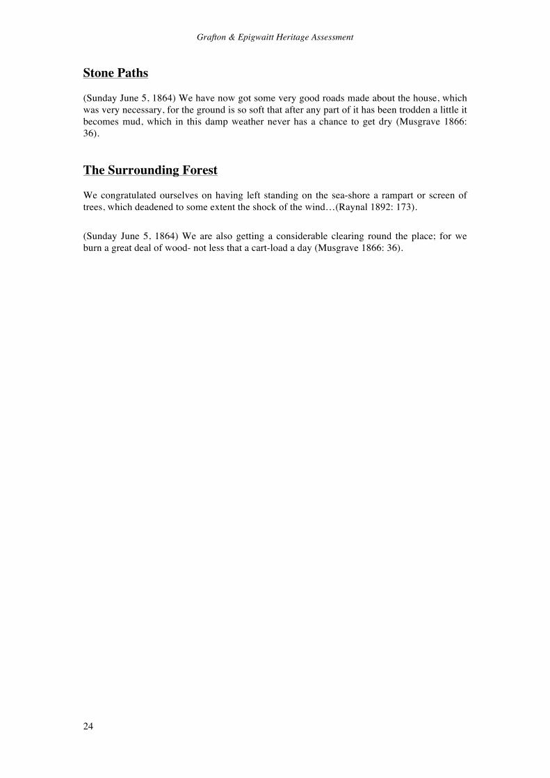
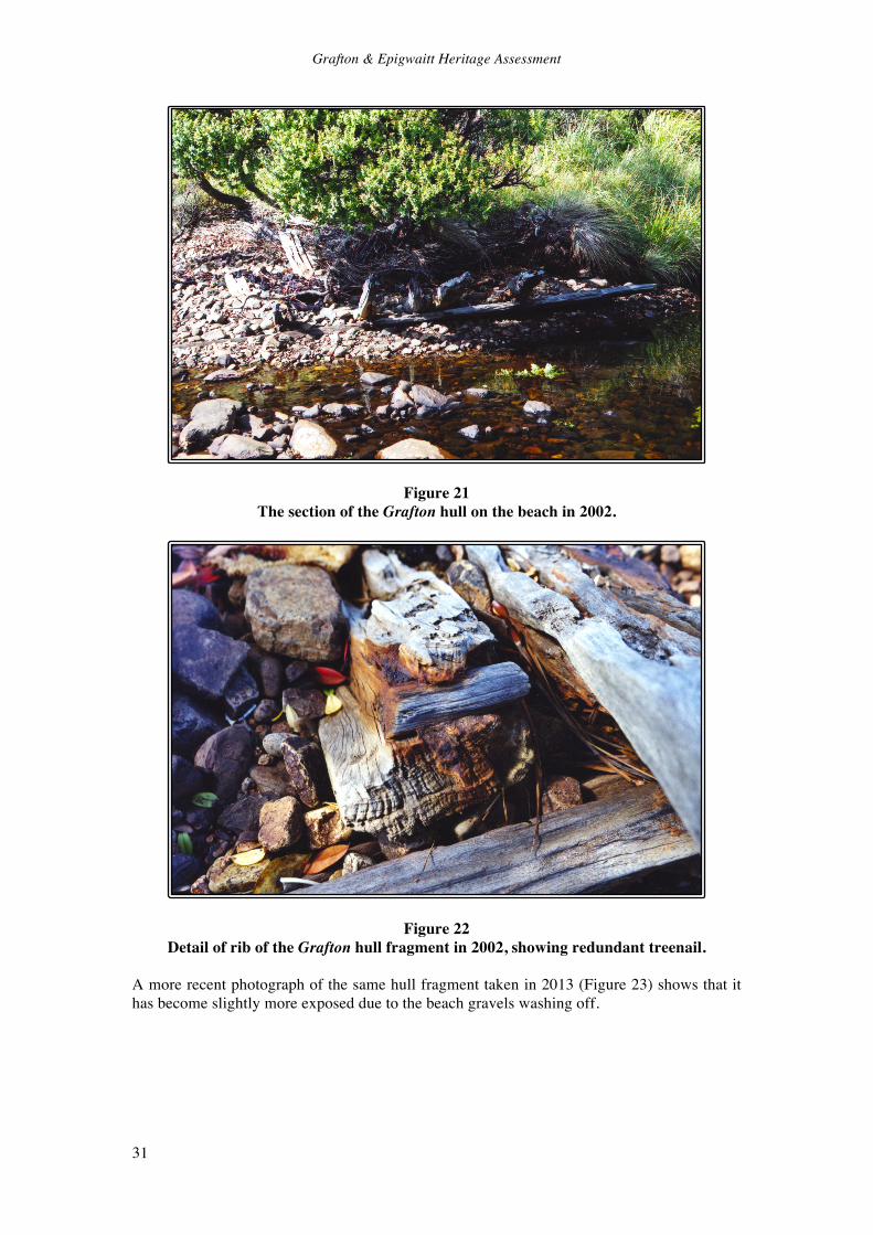
Grafton Wreck It is known from the contemporary accounts (quoted above) that the Grafton grounded close to where the hut was later built, and that the boat run was cleared in an attempt to haul her as far ashore as possible. The assumed position of the wreck should thus be a short distance off shore, very close to the boat run. This location was confirmed by Bill Day,1 who has dived on the wreck on three separate occasions. He described the wreck as lying immediately out from the stream mouth, about 50 metres off-shore. It is lying parallel to the shore, on a flat, slightly sloping, weedy bottom. The hull has broken up, and the remains consist of the keel and a number of timbers (presumably mainly ribs and frame timbers), scattered over an area of approximately 40 metres (parallel to the shore) by 10 metres. Some metal fastenings are visible, including some copper bolts and the rudder pintles. On shore there is a section of hull timbering (Figures 20 & 21). It is lying at high-water mark, immediately beside the mouth of the stream. It consists of 8 closely spaced light rib sections held together with at least one external plank. It was partially buried when measured in 2002, and all observations and measurements were based on the visible timbers only. The ribs were approximately 4.75 inches by 4 inches in section. One had a treenail2 in it (Figure 22), but this was of no apparent use in its location, and is evidence that the ship’s timbers were recycled.3 The plank was 10 inches wide, 2 inches thick and 12 feet long. The exterior appears to have been tarred on the outside, but bears none of the small nail holes that the plank left at the huts site has, indicating that it was not sheathed in copper. This may suggest that this section was from part of the hull above the waterline. The accounts of Musgrave and Raynal clearly state that the Grafton had a copper-sheathed hull, while Raynal refers to scraping dry tar from the sides of the schooner to make pitch for the shoes he was making (Raynal 1892: 243).
Figure 20 The section of the Grafton hull on the beach in 2002. The scale is 0.5m long.
1 Bill Day, pers. comm. May 2002. 2 A cylindrical wooden pin or dowel used to fasten a ship’s planks to its frames. 3 Musgrave (1866: 79-80) commented that the Grafton was built from the wreck of a Spanish man-o-war.
Grafton & Epigwaitt Heritage Assessment
31
Figure 21 The section of the Grafton hull on the beach in 2002.
Figure 22 Detail of rib of the Grafton hull fragment in 2002, showing redundant treenail.
A more recent photograph of the same hull fragment taken in 2013 (Figure 23) shows that it has become slightly more exposed due to the beach gravels washing off.

Grafton & Epigwaitt Heritage Assessment
32
Figure 23 The same section of the hull of the Grafton as shown in Figures 20 and 21, in 2013
(Samuel Blanc; www.panoramio.com) The conservation plan for the site also notes that the two anchors put out by the Grafton are almost certainly still on the harbour floor somewhere, although their exact location is not known (Bradley & Egerton 1996).

Grafton & Epigwaitt Heritage Assessment
33
6.0 Museum Collections Over the years many items have been removed from the Grafton wreck and Epigwaitt hut (as well as the other Auckland Island historic sites), and a number of these have found their way into museum collections. The National Museum (Te Papa) and the Southland Museum and Art Gallery hold the main collections, and the Canterbury Museum has a good photographic record as well as a number of related Auckland Islands items. National Museum of New Zealand (Te Papa) (http://collections.tepapa.govt.nz) Letter, M.K. Fitzgerald, National Museum, to The Secretary, Outlying Islands Reserves Committee, 8 July 1987. Artefacts:
• Keel: Portion of the keel of the schooner ‘Grafton,’ wrecked in Carnley Harbour, Auckland Islands, 1864. Three V-shaped wooden sections, joined by massive iron nails. Recovered Feruary 1973. Registration No. NS000046.
• Box: Wooden box. Made from Australian Cedar from a spar from the ‘Grafton’ wrecked at Carnley Harbour, Auckland Islands, January 3, 1864. Has a hinged lid with brass handle. The spar was used as a stud for the house in which the castaways lived for 20 months. Registration No. GH002593.
Photographs:
• Photograph: Remains of the wreck of the Grafton, Carnley Harbour. From the album: [1907 Sub-Antarctic Expedition] North, W. Page, Samuel (photographer). Registration No. O.007051. (Note: this photo actually shows Epigwaitt, not the Grafton, and includes the iron stove later removed by Kelly Tarlton).
• Photograph: Wreck of the Grafton, Epigwaitt, Auckland Islands. Dougall, William (photographer), ca. 1888, Auckland Islands, Burton Brothers (photography studio), New Zealand. Registration No. C.010536.
• Photograph: Victoria Tree, Erebus Cove. Photograph of tree inscribed during the 1865 visit of the ‘Victoria’ in search of castaways, after the story of the Grafton became known (note the Te Papa online catalogue wrongly dates the tree to 1863 and to the search for the Grafton crew). Dougall, William (photographer), ca. 1888. Registration No. C.010566.
Southland Museum & Art Gallery List supplied by David Dudfield, Southland Museum. Artefacts:
• 83.1958a-b Two pieces planking from the brigantine "Grafton" • 0000.3399 Three pieces of hull beam with metal bolts. From the "Grafton", Carnley
Harbour. • 2008.57 Various fragments of what are believed to be remnants of a cast iron cooking
pot from the wreck of the Grafton. Recovered by a DOC research team 11 December 1996, and donated to the museum in 2008.
Grafton & Epigwaitt Heritage Assessment
34
Photographs:
• P76.31 Photograph of "Grafton" wreck, Auckland Islands • P81.207 Photograph of "Grafton", Epigwaitt, Auckland Islands • 62 Photograph of "Remains of the Grafton". • 2001.1294 Photograph "Remains of schooner 'Grafton', Auckland Islands" • 2001.1295 Photograph "Remains of schooner 'Grafton', Auckland Islands" • 2001.1296 Photograph "Remains of schooner 'Grafton', Auckland Islands" • 2001.1414 Photograph "Remains of the "Grafton", Auckland Islands" 1907 • 2001.1415 Photograph "Remains of the "Grafton", Auckland Islands" 1907 • 2001.1419 Photograph "Remains of the "Grafton", Auckland Islands" 1907 • 2001.1412 Photograph Musgrave's Hut, Auckland Islands 1907
Canterbury Museum Artefacts:
• 1976.366.1 Stove, Camp. Stove from Epigwaitt Hut. Presented: Kelly Tarlton’s Shipwreck Museum, Paihia.
• Fragment of wood from the Grafton. Collected 1901. Photographs:
• William Dougall Album (1880s) • 1982.103.11. Remains of Musgrave’s Hut, Epigwaitt. Philosophical Institute of
Canterbury Album, 1907, p.28. S. Page, photographer. • 1982.103.10. The Grafton Wreck. Philosophical Institute of Canterbury Album, 1907,
p.28. S. Page, photographer. Alexander Turnbull Library, Wellington
• The Macpherson collection (MSX-4936) includes three letters, one fragmentary, written by Musgrave to Macpherson, a letter of thanks from Mrs. Musgrave to Macpherson, an unsourced newspaper clipping dated October 20, 1865, reprinting Andres Smith’s account from the Glasgow Mail, a statement of acounts from the Grafton relief fund, a receipt for Mahoney’s gravestone, and a review of Raynal’s book (Druett 2007: 278).
Queensland Maritime Museum
• A notebook kept by Musgrave while on Auckland Island (Druett 2007: 278). Melbourne Museum Raynal recorded that in 1866 he donated the following to the Melbourne Museum and Public Library, which was receipted by Augustus Polk:
• ‘Cast Away at the Auckland Isles,’ one vol. 8vo; • Pair of blacksmith’s bellows, made of seal skin at the Auckland Isles; • One pair of boots skin made of seal skin tanned at the Auckland Isles; • One piece of seal-skin tanned at the Auckland Isles;

Grafton & Epigwaitt Heritage Assessment
35
• One needle made of bone from the wing of an albatross. In 1992 Christiane Mortelier enquired after these items, and was informed that although the museum does hold sealskin items, the donors and sources are not recorded (Mortelier 2003: 227). A further enquiry regarding these items was made in 2014, and the response was that the museum does not hold them. Department of Conservation The Invercargill office of the Department of Conservation holds a large collection of photographs of the Grafton wreck and Epigwaitt hut, derived from many visits over the years by Department staff, and particularly from the 2003 Aucklands Islands Historical Expedition.

Grafton & Epigwaitt Heritage Assessment
36
7.0 Cultural Connections The cultural significance of a place is not a static and easily defined concept, and can mean different things to different people. Cultural significance of a place can be considered with regard to one or more specific cultural groups, and/or with regard to its importance to the wider present population. A very good recent example of this is the management of the Christchurch Cathedral in the wake of the Canterbury earthquakes; the wider community has expressed considerable interest in the building as a cultural symbol of the city, resulting in enormous resistance to the Anglican Church’s decision to deconstruct the building. The building has strong and variable meaning to different groups. The Grafton and Epigwaitt site can be regarded in a number of ways: as an historic shipwreck and castaway site that represents human suffering and endurance; as a key site in the establishment of the subantarctic islands castaway depots; as the setting of several significant nineteenth century publications; as a place for guided tourists to visit in the Auckland Islands. Each of these attributes is of interest to different groups today. Many of these values overlap considerably with each other and with archaeological and historical values, but what is important in this discussion is how the events surrounding the Grafton’s foundering affected contemporary society, particularly through the media of newspaper reports and books, and their lasting literary legacy. All of the Auckland Island castaway accounts made for good newspaper stories and tales of survival against the odds and/or tragedy. In an age where sea voyaging was the only means of international transport, sail was still more common than steam, and the loss of ships far more common than today, the horror of shipwreck was a real and immediate concern. Castaway stories with a happy ending (such as the case of the Grafton’s crew) were far less common than those where many died (such as the Invercauld or General Grant), where no-one survived, or where the ship simply disappeared at sea. Shipwrecks on the mainland could be terrifying enough (see Collins 1995; Ingram 1984; McLean 2007); those in the remote and wild southern ocean were worse. Discoveries of skeletons such as that of James Mahoney (of the Invercauld) only added poignancy to such stories. The first newspaper accounts of the experiences of the crew of the Grafton attracted much interest, and when Musgrave and the Flying Scud returned to the islands and found Mahoney’s skeleton this interest increased (in both New Zealand and Australia) to the point where the Victoria and Southland were officially despatched to search for more castaways. When less than a year later the General Grant was wrecked, the survivors were bitterly disappointed to find that while the Victoria and Southland had left notes describing their visits, they could find no provisions (Sydney Morning Herald, 24 January 1868: 2), although the pigs and goats that had been released by several ships did provide a valuable food source. Four of the General Grant castaways attempted to repeat Musgrave’s and Raynal’s voyage to New Zealand on board a modified ship’s boat, but were never seen again. Once the other survivors were rescued and their story added to the tales of deprivation in the subantarctic islands, the authorities finally started to maintain provisioned castaway depots. It was these depots that saved the lives of many subsequent shipwrecked sailors, including the crews of the Derry Castle, Anjou and Dundonald on the Auckland Islands and the President Felix Faure on Antipodes Island (Egerton et al 2009; Taylor 2006: 163). The Great Circle Route was an international shipping route that connected Australia and Europe, and these ships were registed in Boston, France, Scotland and France respectively, illustrating the cosmopolitan nature of international shipping, and therefore the importance of the depots to sailors of many nations. The wreck of the Grafton and subsequent experiences of the crew therefore had a direct influence on the attitudes and actions of the public and authorities in the 1860s and 1870s, as their story was
Grafton & Epigwaitt Heritage Assessment
37
an important and early element of this wider (and international) shipwreck/castaway narrative. However, the story of the Grafton wreck also had a far wider impact than simply influencing contemporary events in the Subantarctic Islands. Through the media of Musgrave’s and Raynal’s published accounts the story also reached an international audience, and proved extremely popular. Musgrave’s account was published in Melbourne in 1865, and in London the following year. A third edition was published in New Zealand in 1943, but this was heavily edited and is not well regarded by modern researchers (Druett 2007: 278). Raynal’s account was first published as a series of articles in 1869, and as a complete book in 1870 (in French) and 1874 (in English). Recent research by Christiane Mortelier (2003) and Joan Druett (2007) has reintroduced both Musgrave’s and Raynal’s accounts to modern readers, and Druett has interwoven the Grafton and Invercauld stories to produce not only an interesting tale, but also a modern parable regarding the value of leadership and industry. But potentially the most important literary legacy of the Grafton story is via the influence of Raynal’s book, although the significance of this is not (yet) widely known in New Zealand. Christiane Mortelier (2003: 234-238) has discussed the literary values of Raynal’s work in its own right, which she rated highly, and noted that it remained a popular book right up until World War One:
‘Raynal’s narrative differs from Musgrave’s inasmuch as it has a special claim to being a work of literature. The power of memory to recreate events and places is constantly at work, underlining the difference between diary jottings and terse logbook entries and a narrative intended for a reader totally unfamiliar with the experience of survival on a subantarctic island. Raynal follows chronological order in his retelling, but lingers on chosen moments so that the reader may share in the atmosphere of the story and in the significance of chosen incidents.’ (Mortelier 2003: 236).
More significantly, Mortelier (2003: 246-256) has also made a very convincing case for the direct influence of Raynal’s work on a number of the novels of Jules Verne. It has been acknowledged that Verne was influenced by a number of classic castaway stories, including Robinson Crusoe and The Swiss Family Robinson, and Raynal’s Wrecked on a Reef not only joins these in general context, but has the added value of being an entirely true story. The first example of Verne referencing the Grafton events was his story ‘A Floating City’ published in Le Journal des Debats in 1869, shortly after Raynal’s three articles were published in Le Tour du Monde. In Verne’s story mention is made of a shipwreck on the ‘Auckland reefs,’ a clear nod to Raynal’s account. The next references are in Verne’s Mysterious Island, published in 1874, where not only does he write ‘the imaginary heroes created by Daniel Defoe or Wyss, as well as Selkirk and Raynal, castaways on Juan Fernandez or the Auckland Island Group, were never as absolutely destitute as these castaways,’ but Mortelier has also identified numerous parallels between the fictional experiences of Verne’s protagonists and Raynal’s factual ones. And again in Two Years’ Holiday (1888) Mortelier has identified numerous parallels in the shipwreck/castaway story, including the port of departure (Auckland, possibly referencing the Auckland Islands), events during the wrecking, eventual salvation by repairing a small boat, and the name of the steamer that finally rescues them (the Grafton). Mortelier has commented (2003: 229) that ‘this book haunted Jules Verne’s imagination to the end of his career- though Vernian scholarship has rarely underlined its seminal influence.’ Her arguments are good enough to have convinced New Zealand historian Gavin McLean (2007: 78), who simply states that Raynal’s book ‘inspired Jules Verne’s Mysterious Island.’ The contemporary effect of Raynal’s book may also have been wider still, as Druett (2007: 258) has observed:
Grafton & Epigwaitt Heritage Assessment
38
At a time when technological advances were booming, it brought renewed awareness of the blessings of tools and engineering. It even affected the leisure time of its readers - a fashion arose for such activities as gardening, camping, pottery, sewing, leather-work, and the keeping of pets. In the past, these basic skills had been dismissed as the kind of thing our lowly peasant ancestors did to keep body and soul together, but now they became therapeutic recreational activities for educated city-dwellers.’
While it would be overstepping the mark to ascribe such a movement solely to Raynal (remembering that Verne was also influenced by Robinson Crusoe and other books, and was in turn influencing people himself), nevertheless Raynal’s book was very popular and undoubtedly helped fire public imagination. Of course, it must not be forgotten that the crew of the Grafton was French, American, English, Norwegian and Portugese; a mixture that not only reflected the cosmopolitan nature of ships and their crews (as already discussed), but also potentially considerably widened the audience for the stories of the castaways. Musgrave’s account was published (in English) in Australia and England, while Raynal’s was published in France (French) and England (English) and also translated into Italian, German and Norwegian. In the modern world, the story of the Grafton is no longer so widely known, while the General Grant wreck of two years later has remained in the public eye largely because of the gold this ship was reputed to carry and the many (failed) salvage attempts (Allen & Scadden 2009; Eunson 1974). However, the recent publication of Druett’s (2007) Island of the Lost and Mortelier’s 2003 reprint (with commentary) of Wrecked on a Reef have reintroduced the Grafton story to a new generation. The Listener (29 May 2004: 66) ran a story on the Grafton and Mortelier’s work, which was followed by a Spectrum radio programme on the subject (National Radio, Sunday 6 May 2004). Druett’s book was also published in America, and Mortelier is presently working on a new book, which will be published in French (C. Mortelier, pers. comm. 2014), widening the international audience.

Grafton & Epigwaitt Heritage Assessment
39
8.0 Contextual Analysis The immediate geographical and historical context of the wreck of the Grafton and Epigwaitt hut is within the Auckland Islands and this group’s history of shipwrecks and castaways. Despite the emphasis on natural ecological values in the status and management of the Auckland Islands, they also have a significant human history and concomitant archaeological potential. This history is made more poignant by the suffering and deprivation that has accompanied many of the inhabitants’ experiences. The history and archaeology of the Auckland Islands has recently been thoroughly addressed in Dingwell et al (2009) In Care of the Southern Ocean, An archaeological and historical survey of the Auckland Islands, which was based on both a thorough review of preceding publications and research together with the results of the Auckland Islands Archaeological and Historical Expedition from January to March 2003. Chapter 7, ‘The Auckland Islands Shipwreck Era’ (Egerton et al 2009) dealt specifically with the Grafton, Epigwaitt, and all of the other known shipwrecks and castaway experiences The other chapters in the volume that dealt with prehistoric occupation, sealing, the Enderby settlement, pastoral farming attempts, various scientific expeditions and the World War Two coastwatchers, should also be read to gain an understanding of the overall historical and archaeological landscape. Rowley Taylor’s book Straight Through From London (2006) described the human and natural histories of the Antipodes and Bounty Islands, and adds to the understanding of the human history of the Subantarctic Islands. The first human inhabitants of the Auckland Islands were Maori in the 13th or 14th centuries AD, who only stayed for a short time and exploited mainly the coastal fringe and rocky shore food sources (Anderson 2009: 34-35). As Anderson commented (ibid): ‘the relative scarcity of both sub-tidal shellfish and forest birds in the midden remains suggests a certain and understandable reluctance to get wet, either in the sea or under the dripping forest.’ While these first inhabitants undoubtedly got extremely wet both getting to and going from the Auckland Islands (one only has to read Raynal’s and Musgrave’s accounts of their trip in the Rescue to appreciate this), Anderson’s point underlines an important issue when considering all human occupation of the islands: the weather is generally terrible. All attempts at permanent habitation have failed, and the most successful occupation was arguably by the World War Two coastwatchers as they completely fulfilled their expectations by denying the enemy the use of the islands (Bagley et al 2009: 191, 220), which ironically was an attempt to deny the use of the resources of the islands rather than exploit them. The only successful exploitation attempt was by the sealers, who quickly denuded the seal population. All attempts at farming have failed, with the (relatively nearby) Campbell Island enterprise from 1894 until 1931 being the longest lasting. The last feral sheep were eliminated from that island in 1992 (www.doc.govt.nz/conservation/historic/by-region/southland/subantarctic-islands/campbell-island/). Within this context, the experiences of the various castaways on the Auckland Islands can be understood as trying at best, fatal at worst. Of the approximately 203 people known to have been shipwrecked in the islands (certainly a large under-estimate), approximately 106 got ashore alive, of whom 79 were rescued (Egerton et al 2009: Table 7.1). The Grafton stands apart from the other wrecks in one important way; the ship was wrecked on a relatively sheltered shore and the survivors not only got ashore unharmed but also had all of the resources and supplies on board, including a gun. The leadership shown by Musgrave and Raynal was also vital for the group’s survival, and the value of this was graphically illustrated in other castaways’ experiences: the General Grant survivors agreed that James Teer’s leadership was instrumental in their survival (Eunson 1974: 112), while it was the lack of effective leadership amongst the Invercauld survivors that meant that only 3 survived from 19 who got ashore (Durett 2007). Therefore, while the Grafton events were not entirely typical
Grafton & Epigwaitt Heritage Assessment
40
of the Auckland Island shipwreck era, they are generally representative, and as discussed above (Section 7) served to spread the news of these wrecks to not only New Zealand but also to Australia, Britain and Europe. Within the much wider context of shipwrecks and castaway episodes both in New Zealand and worldwide, there is a vast literature, covering the subject from contemporary, historical and archaeological perspectives (eg Collins 1995; Clark n.d.; Ingram 1984; Layton 1997; McLean 2007; Throckmorton 1996). Several shipwrecks have received enormous attention due to their historical significance, the Titanic and the Mary Rose being good examples (Ballard 1985; Rule 1983). As already noted, when international travel was by wooden sailing ship, shipwrecks and disasters at sea were common. Even just in New Zealand there are hundreds of examples; one count puts the number of wrecks at more than 2,300 since the 1790s, and the discovery of Maori canoe fragments in places such as Mason Bay in Stewart Island adds an unknown number of prehistoric victims (Gillies & Skerret 1996; Te Ara). The first European settlement in New Zealand was the result of the East Indiaman Endeavour being condemned in Facile Harbour in Fiordland in 1795: not quite a shipwreck, but castaways nontheless (Duggan 1997). Across the Tasman Connah (1993: 12) has observed wryly ‘the earliest European visitors to leave substantial archaeological traces in Australia had no choice in the matter, they hit it acidentally.’ During the 17th and 18th centuries at least four Dutch ships and one English ship were wrecked on the Western Australian coast. One of these, the Dutch East Indiaman Batavia, was wrecked in 1629 and subsequent events amongst the survivors, when some of the crew mutinied and 125 people were massacred, has become one of the worst horror stories of maritime history (Connah 1993: 16; Throckmorton 1996: 168). In the Pacific Ocean, on the island of Ulong in Palau, the East India Packet Antelope was wrecked in 1783, and the well-organised crew under Captain Wilson constructed the schooner Oroolong from material from the wreck, and successfully sailed away (Clark n.d.). The Batavia incident stands in stark contrast to the experience of the Grafton crew, but when both are considered alongside other castaway stories such as the Invercauld and Antelope they show how varied the experiences of castaways could be, depending on an infinite number of variables. As already discussed two of these variables were access to resources and leadership, and Raynal and Musgrave provided the leadership required to make the most of the resources that they had. This leadership and success, combined with the two published first hand accounts, ensured that the Grafton would become one of the notable castaway stories. At a more immediate and physical level, the wreck of the Grafton is one of the only Auckland Island shipwrecks where substantial remains of the ship are known to survive, and the only one where these remains are relatively easily accessible. In this regard it is the antithesis of the famous General Grant wreck, which has long been sought (because of the gold it was known to contain) but has yet to be found, although as already discussed in other ways the Grafton and General Grant stories have much in common. The Grafton was a typical mid to late nineteenth century small commercial sailing vessel. Most accounts, including Raynal’s and Musgrave’s, described the Grafton as a schooner, although some news reports at the time of the arrival of the castaways in Invercargill described it as a brigantine (Colonist, 12 September 1865: 7; Otago Daily Times, 3 August 1865: 4), as do some modern sources (eg Ingram 1984: 80). The difference is largely academic in the present context, as both forms were often small to moderately sized ships fitted with two masts, an essential difference being the schooners’ use of the gaff sail (MacGregor 1997: 9-11). The wreck of the Grafton provides an opportunity to study construction details of small ships of this period, which can be compared to a growing international maritime archaeology literature in this subject (eg Sikes 2004). The site of Epigwaitt is also one of the few places where a castaway-built hut can still be firmly identified in the Auckland Islands. The general location of the General Grant huts on
Grafton & Epigwaitt Heritage Assessment
41
Enderby Island, Derry Castle huts at Sandy Bay, Compadre and Anjou huts at Camp Cove and Dundonald huts on Disappointment Island are all known, but none of the specific sites could be identified during the 2003 survey (Egerton et al 2009). No doubt most or all of these sites could be pinpointed by archaeological investigation, but this is unlikely to be undertaken for both practical and conservation reasons. Excavation of castaway sites can be very rewarding: excavations by Clark on Ulong Island in Palau found extensive evidence of the activities of the crew of the East India Packet Antelope that was wrecked there in 1783 (Clark n.d.); and investigations at the 1629 Batavia site not only found remains of the victims of the post-wreck massacre, but also a stone portico façade that was being carried in the ship to Batavia in Indonesia (Throckmorton 1996: 168). All of the Auckland Islands castaway hut sites will contain sub-surface archaeological information, but Epigwaitt can be examined without intrusive archaeological excavation. In common with overseas sites that have been investigated, all of the Auckland Islands sites will contain valuable information about the ways that castaways adapted to survive their unintended sojourn ashore.

Grafton & Epigwaitt Heritage Assessment
42
9.0 Assessment of Significance Most historic places in New Zealand are assessed using a recognised heritage values system. DOC uses the significance assessment criteria contained within the Historic Places Act 1993 (recently replaced by the Heritage New Zealand Pouhere Taonga Act 2014). Heritage New Zealand (previously the New Zealand Historic Places Trust) is the national authority in the assessment of the significance of historic places. The current Heritage New Zealand assessment criteria are used in its List (previously the NZHPT Register) proposal guidelines (www.heritage.org.nz/the-list/-/media/8c1c89c0ef5d48a19821975d1eef68de.ashx). These criteria are: Historical, cultural, aesthetic, archaeological, architectural, scientific, social, spiritual, technological and traditional significance or value. Section 66 (3) of the Heritage New Zealand Pouhere Taonga Act 2014 further describes these criteria for heritage sites to be included in the New Zealand Heritage List. For the purposes of this report these criteria have been amalgamated under three headings: Historical (historical, social); Physical (archaeological, architectural, scientific, technological); and Cultural (aesthetic, spiritual, traditional). The Department of Conservation’s ‘Southland Historic Resource Management Plan 1993’ has already assessed the Grafton wreck and site of Epigwaitt hut as being nationally significant.
9.1 Historic Significance The historical significance of the Grafton and Epigwaitt site is high nationally. The site meets a number of the Section 66 (3) criteria particularly (c) the potential of the place to provide knowledge of New Zealand History and (k) the extent to which the place forms part of a wider historical and cultural area. Both of these themes (history and the heritage landscape) were key considerations in the 2003 Auckland Islands Expedition (Dingwell et al 2009). As a small island in a large ocean, maritime history is an important element in New Zealand’s human history: from the first Polynesian settlers that arrived by canoe, to Tasman and Cook who were exploring the Pacific in small sailing ships, to the thousands of immigrants who came in sailing and steam ships, the sea has always played an important role. Shipwrecks were the unwelcome corollary of this dominance of the ocean. The fact that the Great Circle Route of the 19th century trading ships passed though the wild ocean to the south of New Zealand added an international traffic that did not necessarily have any direct associations with New Zealand; most of the ships wrecked on the Auckland Islands had no intention to either make landfall there or in New Zealand. However, it fell upon the New Zealand authorities to patrol these hazardous waters, and the establishment and maintenance of the castaway depots saved the lives of many shipwrecked sailors. This means that the events surrounding and subsequent to the Grafton sinking are not just part if New Zealand’s maritime history, but part of the wider history of international shipping in the nineteenth century. The subantarctic islands form a scattered historical and archaeological landscape, within which the wreck sites, castaway huts and camps and castaway depots are an important element. A number of the depots and the finger post signs still exist, and are significant heritage sites.

Grafton & Epigwaitt Heritage Assessment
43
While shipwrecks and castaway stories were common in the nineteenth century, the combination of the fortunate outcome of the Grafton sinking (all of the crew survived and returned to civilisation), the ingenuity and leadership shown by Musgrave and Raynal, and the production of the two published accounts (which has ensured that all the details of the events are still known), gives the site high national significance.
9.2 Physical Significance The physical significance of the Grafton and Epigwaitt site is high nationally. The site meets a number of the Section 66 (3) criteria particularly (g) the technical accomplishment of the place and (k) the extent to which the place forms part of a wider historical and cultural area. It is of particular note that the technical accomplishment of the place is unusual in that while the technology represented is not unique or advanced, the circumstances of its application are highly unusual. Raynal’s and Musgrave’s published accounts describe such activities as making lime mortar for the chimney, making soap and constructing a forge, and archaeological evidence of many of these undertakings is known to exist. The ability of these castaways to apply technological solutions to their problems was remarkable. It is unlikely that modern castaways in a similar situation would be able to emulate the feats of Raynal and Musgrave. The archaeological potential of the Grafton wreck and Epigwaitt hut site are very high. The Grafton is the only Auckland Islands wreck where substantial remains of the ship are known to survive, and the only such site that is easily accessible. As such, it provides the opportunity to examine nineteenth century shipbuilding technology. This value of this opportunity is increased by the historical context and background information provided by Musgrave’s and Raynal’s accounts, which describe aspects of the ship’s design and construction that can be tested archaeologically. The archaeological potential of Epigwaitt is arguably even greater than the wreck. While other nineteenth century shipwrecks survive elsewhere in New Zealand and the rest of the world, castaway sites for which such meticulous accounts of events and structures are much rarer. The results of the 2002 and 2003 site visits to Epigwaitt confirmed in all important verifiable respects the events as outlined by Musgrave and Raynal. The site has considerable archaeological potential for the study of people isolated in an extreme environment, the results of which could be greatly enriched by comparison with the associated contemporary narratives. Archaeological results could be interpreted in light of not only known events, but also in terms of intent, knowledge and agency. Of course, such an archaeological investigation may never occur, and there are very good arguments for preserving the site without such intrusive work, but the potential remains.
9.3 Cultural Significance The cultural significance of the Grafton wreck and Epigwaitt hut site are high, both nationally and internationally. The crew of the Grafton were cosmopolitan, consisting of a Frenchman, an American (born in England), an Englishman, a Norwegian and a Portugese, and they had sailed from Sydney on an expedition funded by two Sydney merchants. The Grafton events therefore have relevance to all of these places, and not just New Zealand. Other wrecks on the Auckland Islands were

Grafton & Epigwaitt Heritage Assessment
44
of ships using the Great Circle Route from Australia to Europe, and as such the shipwreck narrative of the islands was an international one. Not only did the Grafton events have an immediate effect on the New Zealand and Australian population and authorities, as one of the critical factors that led to the inspection of the Auckland Islands by the Victoria and Southand, and ultimately to the establishment of the castaway depots, but also the publication of the two narratives had a much wider and long lasting effect. Gavin McLean (2007: 78) has commented that ‘on a publication (two books) to survivor (five men) ratio, the Grafton’s contribution to castaway literature is exceptional,’ and Christiane Mortelier (2003) has additionally argued for the literary quality of Raynal’s account. Furthermore, Mortelier (2003) has demonstrated that Raynal’s account also influenced Jules Verne’s writings, and that several of Verne’s books adopted and adapted names, places and events from Raynal’s book. In particular, both Mortelier and McLean (2007) consider that Raynal’s Wrecked on a Reef had a direct influence on Verne’s Mysterious Island. This direct link between the place, the meticulously recorded events, and an international literary heritage, make the Grafton wreck and Epigwaitt hut very significant cultural sites.
Grafton & Epigwaitt Heritage Assessment
45
10.0 Comparative Analysis The wreck of the Grafton and Epigwaitt hut are not necessarily unique items/places, as there are many other recorded shipwreck and castaway sites in the Auckland Islands and around the world. However, they do lay claim to a particular significance because of the survival of the entire crew, and the published works of Musgrave and Raynal that have provided an exceptionally detailed account of how a group of castaways survived in, and then escaped from, the remote and harsh Subantarctic Islands. Although death and despair are often associated with the other Auckland Island shipwreck stories, and the Invercauld episode was the worst of these as only three men survived of the 19 that got ashore from the wreck, there were other success stories. The Compadre was wrecked in 1891 and 16 of the 17 crew were rescued later that year, while all 22 of the crew of the Anjou survived in 1905. It was the General Grant sinking that probably has the greatest parallels with the Grafton events. Despite the high death toll of the actual sinking (68 people), only one man actually subsequently died on the island. It was the leadership of James Teel that was critical for the survival of these castaways, and they successfully made sealskin clothes, built huts, grew potatoes and kept pigs and goats. The group also emulated Musgrave and Raynal in their effort to convert a ship’s boat and sail to New Zealand, but whereas Musgrave was fortunate, the four men who made the attempt were not and were never seen again. On the New Zealand mainland the most significant castaway location is at Facile Harbour in Fiordland, the site of one of New Zealand’s first European settlements where the East Indiaman Endeavour was condemned in 1795. The crew, passengers and stowaways lived in Facile Harbour and on Anchor Island while they completed a small schooner that had been built by sealers two years earlier, and converted the Endeavour’s longboat into a deep sea boat (Duggan 1997). The sites of both the Endeavour settlement and Anchor Island shipbuilding cove were the subject of archaeological investigations in the 1990s (Smith & Gillies 1998). Parallels with the Grafton site include the conversion of a ship’s boat, and the survival of all of the castaways. Internationally there are many shipwreck and castaway accounts and sites, and the literature is vast. Many parallels with the Auckland Islands and Grafton sites can be identified: such as the importance of good leadership, the improved chance of survival if the resources of the wreck are to hand, and deep sea voyages in converted or built-from-the-wreck small boats. The Batavia events of 1629 illustrate what could go wrong ashore, while the Antelope events of 1783 in many ways mirror the Grafton experiences with the successful completion of a rescue voyage in a small boat. The Grafton wreck and Epigwaitt hut therefore fit into an international maritime narrative, and within this arguably hold a special place because of the published first hand accounts and their influence on the literature of Jules Verne.
Grafton & Epigwaitt Heritage Assessment
46
11.0 Sources & reports Allen, M.F., Scadden, K. (2009) The General Grant’s Gold. Shipwreck and greed in the Southern Ocean. Exisle Publishing Ltd., Auckland. Anderson, A. (2009) ‘Prehistoric Archaeology in the Auckland Islands.’ In, In care of the Southern Ocean: An archaeological and historical survey of the Auckland Islands. P.R. Dingwell, K.L. Jones, R. Egerton (eds.), New Zealand Archaeological Association Monograph 27. Bagley, S., Jones, K.L., Dingwell, P.R., Edkins, C. (2009) ‘The Erlangen incident and the Cape Expedition of World War II.’ In, In care of the Southern Ocean: An archaeological and historical survey of the Auckland Islands. P.R. Dingwell, K.L. Jones, R. Egerton (eds.), New Zealand Archaeological Association Monograph 27. Ballard, R.D. (1985) ‘How We Found Titanic.’ National Geographic, 168 (6): 696-718. Beaglehole, J.C. (1939) The Discovery of New Zealand. Department of Internal Affairs, Wellington. Begg, A.C. & Begg, N.C. (1966) Dusky Bay. In the Steps of Captain Cook. Whitcombe & Tombs Ltd., Christchurch. Bradley, K. & Egerton, R. (1996) ‘Grafton Wreck, Carnley Harbour, Auckland Islands. Conservation Plan.’ Invercargill, Department of Conservation. Carter, M. (2012) ‘People, Place and Space: an archaeological survey of the maritime cultural landscapes of Otago Harbour, New Zealand. Australasian Historical Archaeology, 30, 14-23. Clark, G. (n.d.) ‘Rediscovery of Captain Wilson’s 1783 Camp on Ulong Island, Republic of Palau.’ Unpublished report, University of Otago. Collins, B.E. (1995) Rocks, Reefs and Sandbars. A History of Otago Shipwrecks. Otago Heritage Books, Dunedin. Colonist (newspaper, Nelson) 12 September 1865: 7. Connah, G. (1993) The Archaeology of Australia’s History. Cambridge University Press. First published 1988 as Of the Hut I Builded. Dingwell, P.R., Jones, K.L., Egerton, R. (eds.), In care of the Southern Ocean: An archaeological and historical survey of the Auckland Islands. New Zealand Archaeological Association Monograph 27. Dougall, W. (nd) Far South: Stewart Island, The Snares, Auckland, Campbell, Antipodes and Bounty Islands. Held in the Pamphlet Collection of Sir Robert Stout: Volume 68. Victoria University of Wellington Library, Wellington (http://nzetc.victoria.ac.nz/tm/scholarly/tei-Stout68-t14-body-d1-d1.html). Druett, J. (2007) Island of the Lost. Allen & Unwin, NSW. Duggan, B. (1997) Incidental History. The author, Taradale.

Grafton & Epigwaitt Heritage Assessment
47
Egerton, R., Burgess, S., Petchey, P. Dingwall, P.R. (2009) ‘The Auckland Islands Shipwreck Era.’ In In care of the Southern Ocean: An archaeological and historical survey of the Auckland Islands. P.R. Dingwell, K.L. Jones, R. Egerton (eds.), New Zealand Archaeological Association Monograph 27. Eunson, K. (1974) The Wreck of the General Grant. A.H. & A.W. Reed, Wellington. Gillies, K., Skerret, M. (1996) ‘A Maori Canoe Prow From Stewart Island, New Zealand.’ New Zealand Journal of Archaeology, 18: 125-143. Ingram, C.W.N. (1984) New Zealand Shipwrecks 1795-1982. A.H. & A.W. Reed, Wellington. Layton, T.N. (1997) The Voyage of the Frolic. Stanford University Press, Stanford. Listener (Magazine, Wellington) 29 May 2004. Locker-Lampson, S., Francis, I. (1994) The Wreck Book. Rediscovered New Zealand Shipwrecks. Halcyon Press, Auckland. Locker-Lampson, S. (1995) New Zealand Treasure Wrecks. Halcyon Press, Auckland. McCraw, J (1999) Coastmaster. The Story of Captain James B. Greig. Hamilton, Silverdale Publications. McCrystal, J., Day, W., Fry, J. (2012) The Riddle of the Rifleman. Marttime Archaeological Association of New Zealand. McLean, G. (2007) Full Astern! An illustrated history of New Zealand shipwrecks. Grantham House Publishing, Wellington. McNab, R. (1909) Murihiku: A History of the South Island of New Zealand and the Islands Adjacent and Lying to the South, from 1642 to 1835. Whitcombe & Tombs, Wellington. Mortelier, C. (2003) ‘Commentaries,’ in 2003 reprint of Wrecked on a Reef by F. Raynal, originally publiched in 1880. Steele Roberts Ltd., Wellington. Musgrave, Capt. T. (1866) Castaway on the Auckland Isles. London, Lockwood & Co. Otago Daily Times (newspaper, Dunedin). 3 August 1865: 4; 15 November 1865: 5 (accessed through www.paperspast.natlib.govt.nz) Palmer, J., Turney, C., Hogg, A., Hilliam, No., Watson, M., Van Sebille, E., Cowie, W., Jones, R., Petchey, F. (2013) The discovery of New Zealand’s oldest shipwreck – possible evidence of further Dutch exploration of the South Pacific, Journal of Archaeological Science, 42, 435-441. Petchey, P.G. (2002) ‘’Epigwaitt’ and the Wreck of the Grafton.’ Unpublished report for the Department of Conservation, Southern Archaeology Ltd. Copy lodged in Hocken Library, Dunedin, New Zealand. Pettit, J. (2008) Treasure Below. The Halcyon Press, Auckland. Raynal, F.E. (1892) Wrecked on a Reef. London, T. Nelson & Sons.
Grafton & Epigwaitt Heritage Assessment
48
Rule, M. (1983) ‘The Search for Mary Rose.’ National Geographic, 163 (5): 654-675. Sikes, K. (2004) Governor Stone: Analysis of an 1877 Two-masted Schooner from the Gulf of Mexico. The International Journal of Nautical Archaeology, 33 (2): 297-314. Smith, I.W.G. & Gillies, K. (1998) “Archaeological Investigations at Facile Harbour, Dusky Sound, February 1998.” Report to the New Zealand Historic Places Trust and Department of Conservation. Sydney Morning Herald (Newspaper, Sydney). Accessed on: www.trove.nla.gov.au Taylor, R. (2006) Straight Through from London. The Antiopdes and Bounty Islands, New Zealand. Heritage Expeditions New Zealand Ltd., Christchurch. Throckmorton, P. (ed) (1996) The Sea Remembers, Shipwrecks and Archaeology. Chancellor Press, London. Online Resources Te Area Encyclopedia of New Zealand. http://www.teara.govt.nz/en/shipwrecks Wreck of Grafton, Epigwaitt, Auckland Islands, circa 1888, Auckland Islands, by William Dougall, Burton Brothers. Purchased 1943. Te Papa (C.010536) (http://collections.tepapa.govt.nz/object/19841) Accessed 12 July 2014. The wreck of the 'Grafton' on the Auckland Islands. Ref: 1/2-098189-F. Alexander Turnbull Library, Wellington, New Zealand. http://natlib.govt.nz/records/23191033. Accessed 10 July 2014. www.panoramio.com/photo_explorer#view=photo&position=29&with_photo_id=107505207&order=date_desc&user=7330120 www.collections.tepapa.govt.nz Canterbury Museum Images Remains of Epigwaitt hut site, Auckland Islands. William Dougall album, Canterbury Museum. 1982.86.3