In situ preservation of a deep-sea wreck site: Sinop D in the Black Sea
6
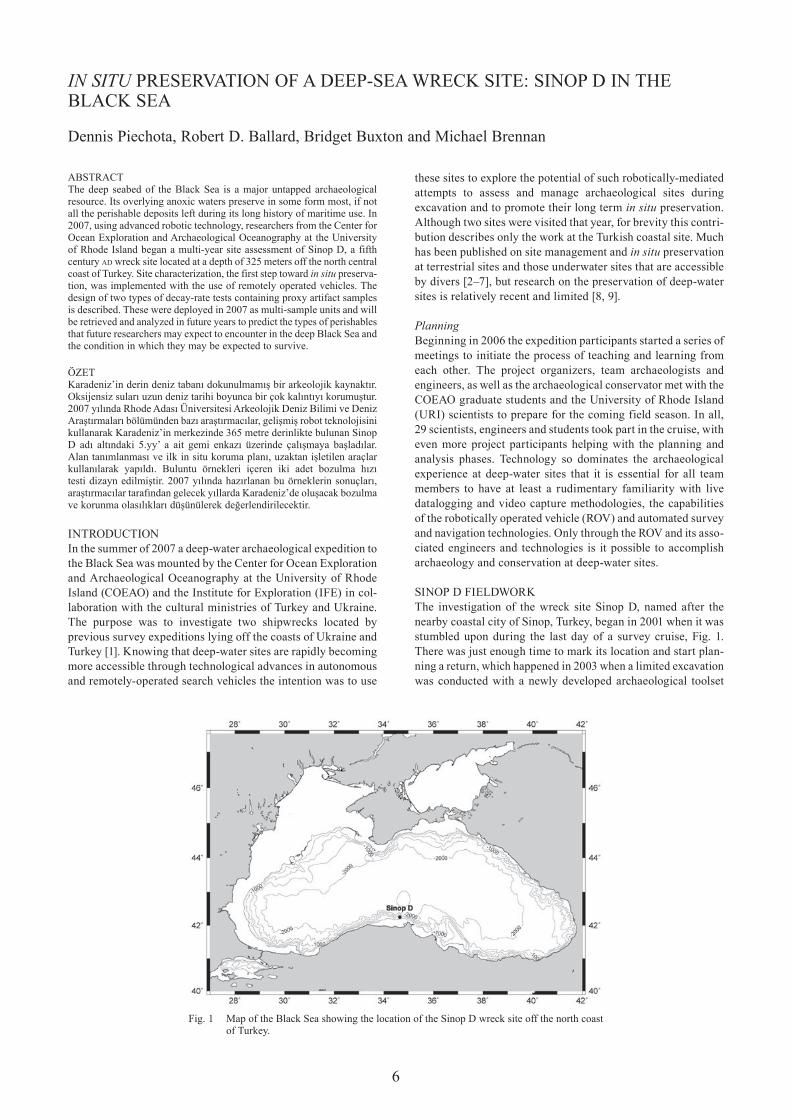
6 ABSTRACT The deep seabed of the Black Sea is a major untapped archaeological resource. Its overlying anoxic waters preserve in some form most, if not all the perishable deposits left during its long history of maritime use. In 2007, using advanced robotic technology, researchers from the Center for Ocean Exploration and Archaeological Oceanography at the University of Rhode Island began a multi-year site assessment of Sinop D, a fifth century ad wreck site located at a depth of 325 meters off the north central coast of Turkey. Site characterization, the first step toward in situ preserva- tion, was implemented with the use of remotely operated vehicles. The design of two types of decay-rate tests containing proxy artifact samples is described. These were deployed in 2007 as multi-sample units and will be retrieved and analyzed in future years to predict the types of perishables that future researchers may expect to encounter in the deep Black Sea and the condition in which they may be expected to survive. ÖZET Karadeniz’in derin deniz tabanı dokunulmamış bir arkeolojik kaynaktır. Oksijensiz suları uzun deniz tarihi boyunca bir çok kalıntıyı korumuştur. 2007 yılında Rhode Adası Üniversitesi Arkeolojik Deniz Bilimi ve Deniz Araştırmaları bölümünden bazı araştırmacılar, gelişmiş robot teknolojisini kullanarak Karadeniz’in merkezinde 365 metre derinlikte bulunan Sinop D adı altındaki 5.yy’ a ait gemi enkazı üzerinde çalışmaya başladılar. Alan tanımlanması ve ilk in situ koruma planı, uzaktan işletilen araçlar kullanılarak yapıldı. Buluntu örnekleri içeren iki adet bozulma hızı testi dizayn edilmiştir. 2007 yılında hazırlanan bu örneklerin sonuçları, araştırmacılar tarafından gelecek yıllarda Karadeniz’de oluşacak bozulma ve korunma olasılıkları düşünülerek değerlendirilecektir. INTRODUCTION In the summer of 2007 a deep-water archaeological expedition to the Black Sea was mounted by the Center for Ocean Exploration and Archaeological Oceanography at the University of Rhode Island (COEAO) and the Institute for Exploration (IFE) in col- laboration with the cultural ministries of Turkey and Ukraine. The purpose was to investigate two shipwrecks located by previous survey expeditions lying off the coasts of Ukraine and Turkey [1]. Knowing that deep-water sites are rapidly becoming more accessible through technological advances in autonomous and remotely-operated search vehicles the intention was to use these sites to explore the potential of such robotically-mediated attempts to assess and manage archaeological sites during excavation and to promote their long term in situ preservation. Although two sites were visited that year, for brevity this contri- bution describes only the work at the Turkish coastal site. Much has been published on site management and in situ preservation at terrestrial sites and those underwater sites that are accessible by divers [2–7], but research on the preservation of deep-water sites is relatively recent and limited [8, 9]. Planning Beginning in 2006 the expedition participants started a series of meetings to initiate the process of teaching and learning from each other. The project organizers, team archaeologists and engineers, as well as the archaeological conservator met with the COEAO graduate students and the University of Rhode Island (URI) scientists to prepare for the coming field season. In all, 29 scientists, engineers and students took part in the cruise, with even more project participants helping with the planning and analysis phases. Technology so dominates the archaeological experience at deep-water sites that it is essential for all team members to have at least a rudimentary familiarity with live datalogging and video capture methodologies, the capabilities of the robotically operated vehicle (ROV) and automated survey and navigation technologies. Only through the ROV and its asso- ciated engineers and technologies is it possible to accomplish archaeology and conservation at deep-water sites. SINOP D FIELDWORK The investigation of the wreck site Sinop D, named after the nearby coastal city of Sinop, Turkey, began in 2001 when it was stumbled upon during the last day of a survey cruise, Fig. 1. There was just enough time to mark its location and start plan- ning a return, which happened in 2003 when a limited excavation was conducted with a newly developed archaeological toolset In sItu PRESERVATION OF A DEEP-SEA WRECK SITE: SINOP D IN ThE BLACK SEA Dennis Piechota, Robert D. Ballard, Bridget Buxton and Michael Brennan Fig. 1 Map of the Black Sea showing the location of the Sinop D wreck site off the north coast of Turkey.
Transcript of In situ preservation of a deep-sea wreck site: Sinop D in the Black Sea
6
ABSTRACTThe deep seabed of the Black Sea is a major untapped archaeological resource. Its overlying anoxic waters preserve in some form most, if not all the perishable deposits left during its long history of maritime use. In 2007, using advanced robotic technology, researchers from the Center for Ocean Exploration and Archaeological Oceanography at the University of Rhode Island began a multi-year site assessment of Sinop D, a fifth century ad wreck site located at a depth of 325 meters off the north central coast of Turkey. Site characterization, the first step toward in situ preserva-tion, was implemented with the use of remotely operated vehicles. The design of two types of decay-rate tests containing proxy artifact samples is described. These were deployed in 2007 as multi-sample units and will be retrieved and analyzed in future years to predict the types of perishables that future researchers may expect to encounter in the deep Black Sea and the condition in which they may be expected to survive.
ÖZET Karadeniz’in derin deniz tabanı dokunulmamış bir arkeolojik kaynaktır. Oksijensiz suları uzun deniz tarihi boyunca bir çok kalıntıyı korumuştur. 2007 yılında Rhode Adası Üniversitesi Arkeolojik Deniz Bilimi ve Deniz Araştırmaları bölümünden bazı araştırmacılar, gelişmiş robot teknolojisini kullanarak Karadeniz’in merkezinde 365 metre derinlikte bulunan Sinop D adı altındaki 5.yy’ a ait gemi enkazı üzerinde çalışmaya başladılar. Alan tanımlanması ve ilk in situ koruma planı, uzaktan işletilen araçlar kullanılarak yapıldı. Buluntu örnekleri içeren iki adet bozulma hızı testi dizayn edilmiştir. 2007 yılında hazırlanan bu örneklerin sonuçları, araştırmacılar tarafından gelecek yıllarda Karadeniz’de oluşacak bozulma ve korunma olasılıkları düşünülerek değerlendirilecektir.
INTRODUCTIONIn the summer of 2007 a deep-water archaeological expedition to the Black Sea was mounted by the Center for Ocean Exploration and Archaeological Oceanography at the University of Rhode Island (COEAO) and the Institute for Exploration (IFE) in col-laboration with the cultural ministries of Turkey and Ukraine. The purpose was to investigate two shipwrecks located by previous survey expeditions lying off the coasts of Ukraine and Turkey [1]. Knowing that deep-water sites are rapidly becoming more accessible through technological advances in autonomous and remotely-operated search vehicles the intention was to use
these sites to explore the potential of such robotically-mediated attempts to assess and manage archaeological sites during excavation and to promote their long term in situ preservation. Although two sites were visited that year, for brevity this contri-bution describes only the work at the Turkish coastal site. Much has been published on site management and in situ preservation at terrestrial sites and those underwater sites that are accessible by divers [2–7], but research on the preservation of deep-water sites is relatively recent and limited [8, 9].
PlanningBeginning in 2006 the expedition participants started a series of meetings to initiate the process of teaching and learning from each other. The project organizers, team archaeologists and engineers, as well as the archaeological conservator met with the COEAO graduate students and the University of Rhode Island (URI) scientists to prepare for the coming field season. In all, 29 scientists, engineers and students took part in the cruise, with even more project participants helping with the planning and analysis phases. Technology so dominates the archaeological experience at deep-water sites that it is essential for all team members to have at least a rudimentary familiarity with live datalogging and video capture methodologies, the capabilities of the robotically operated vehicle (ROV) and automated survey and navigation technologies. Only through the ROV and its asso-ciated engineers and technologies is it possible to accomplish archaeology and conservation at deep-water sites.
SINOP D FIELDWORKThe investigation of the wreck site Sinop D, named after the nearby coastal city of Sinop, Turkey, began in 2001 when it was stumbled upon during the last day of a survey cruise, Fig. 1. There was just enough time to mark its location and start plan-ning a return, which happened in 2003 when a limited excavation was conducted with a newly developed archaeological toolset
In sItu PRESERVATION OF A DEEP-SEA WRECK SITE: SINOP D IN ThE BLACK SEA
Dennis Piechota, Robert D. Ballard, Bridget Buxton and Michael Brennan
Fig. 1 Map of the Black Sea showing the location of the Sinop D wreck site off the north coast of Turkey.
7
for the robotically-mediated archaeology [10]. Building on those experiences the 2007 expedition was a complex logistical effort conducted from the 93 meter research vessel nRV Alliance and staffed by a team of archaeologists, engineers, graduate students and the lone archaeological conservator, all exploring the applications of new technologies in an anoxic deep-water environment.
Sinop D lies on the coastal slope at a depth of 325 meters, inaccessible to conventional archaeological dive teams. The attraction of the site is that at this depth the site is part of the anoxic water column of the Black Sea, a zone that begins at a depth of around 150 meters and extends to the deepest reach of the seabed. Besides being obviously devoid of the destructive effects of sunlight, storm currents and wave action from surface waters, its cold, still waters have a complete lack of destructive higher life forms. Only single-celled anaerobic bacteria func-tion in these waters and ancient wreck sites lying within this environment promise an uncommonly high level of preservation, particularly in respect of any organic components.
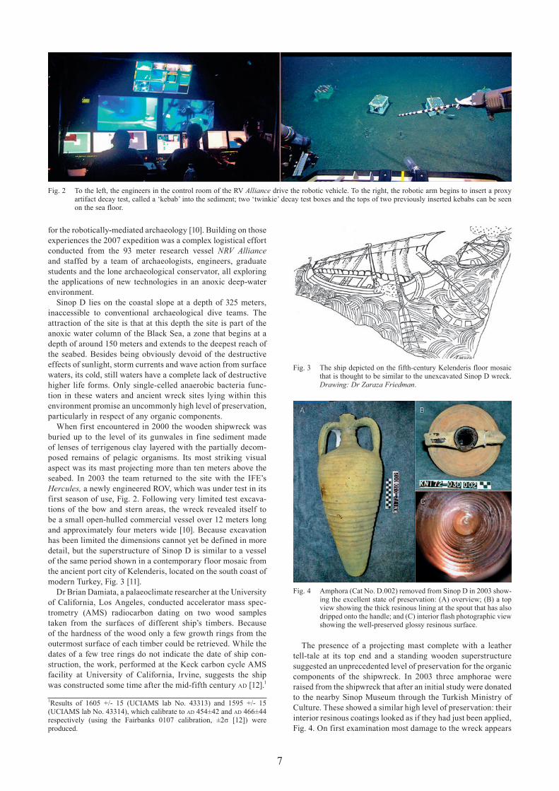
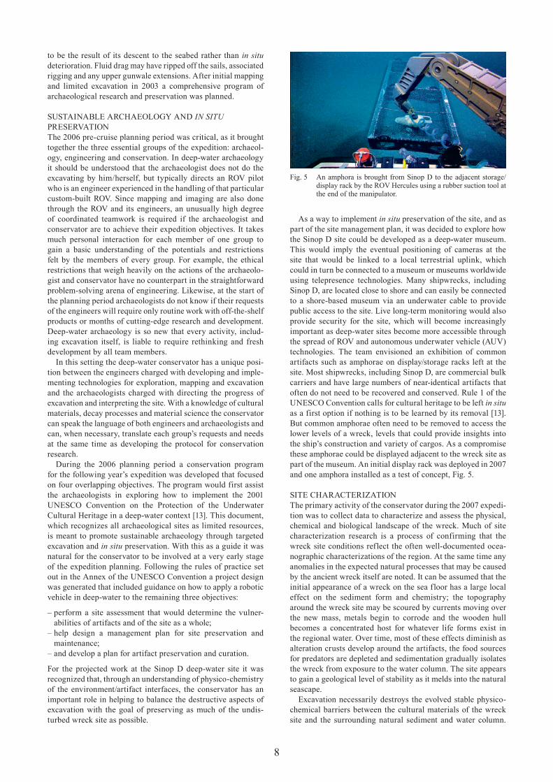
When first encountered in 2000 the wooden shipwreck was buried up to the level of its gunwales in fine sediment made of lenses of terrigenous clay layered with the partially decom-posed remains of pelagic organisms. Its most striking visual aspect was its mast projecting more than ten meters above the seabed. In 2003 the team returned to the site with the IFE’s Hercules, a newly engineered ROV, which was under test in its first season of use, Fig. 2. Following very limited test excava-tions of the bow and stern areas, the wreck revealed itself to be a small open-hulled commercial vessel over 12 meters long and approximately four meters wide [10]. Because excavation has been limited the dimensions cannot yet be defined in more detail, but the superstructure of Sinop D is similar to a vessel of the same period shown in a contemporary floor mosaic from the ancient port city of Kelenderis, located on the south coast of modern Turkey, Fig. 3 [11].
Dr Brian Damiata, a palaeoclimate researcher at the University of California, Los Angeles, conducted accelerator mass spec-trometry (AMS) radiocarbon dating on two wood samples taken from the surfaces of different ship’s timbers. Because of the hardness of the wood only a few growth rings from the outermost surface of each timber could be retrieved. While the dates of a few tree rings do not indicate the date of ship con-struction, the work, performed at the Keck carbon cycle AMS facility at University of California, Irvine, suggests the ship was constructed some time after the mid-fifth century ad [12].1
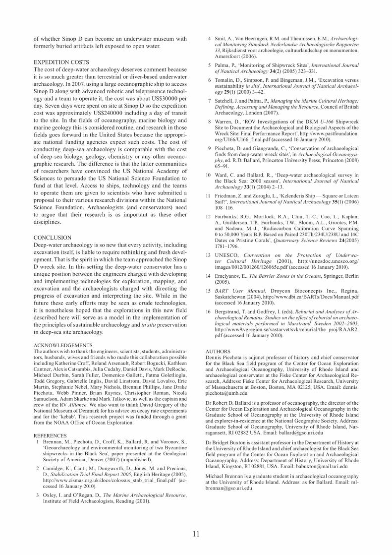
The presence of a projecting mast complete with a leather tell-tale at its top end and a standing wooden superstructure suggested an unprecedented level of preservation for the organic components of the shipwreck. In 2003 three amphorae were raised from the shipwreck that after an initial study were donated to the nearby Sinop Museum through the Turkish Ministry of Culture. These showed a similar high level of preservation: their interior resinous coatings looked as if they had just been applied, Fig. 4. On first examination most damage to the wreck appears
Fig. 4 Amphora (Cat No. D.002) removed from Sinop D in 2003 show-ing the excellent state of preservation: (A) overview; (B) a top view showing the thick resinous lining at the spout that has also dripped onto the handle; and (C) interior flash photographic view showing the well-preserved glossy resinous surface.
Fig. 2 To the left, the engineers in the control room of the RV Alliance drive the robotic vehicle. To the right, the robotic arm begins to insert a proxy artifact decay test, called a ‘kebab’ into the sediment; two ‘twinkie’ decay test boxes and the tops of two previously inserted kebabs can be seen on the sea floor.
1Results of 1605 +/- 15 (UCIAMS lab No. 43313) and 1595 +/- 15 (UCIAMS lab No. 43314), which calibrate to ad 454±42 and ad 466±44 respectively (using the Fairbanks 0107 calibration, ±2σ [12]) were produced.
Fig. 3 The ship depicted on the fifth-century Kelenderis floor mosaic that is thought to be similar to the unexcavated Sinop D wreck. Drawing: Dr Zaraza Friedman.
8
to be the result of its descent to the seabed rather than in situ deterioration. Fluid drag may have ripped off the sails, associated rigging and any upper gunwale extensions. After initial mapping and limited excavation in 2003 a comprehensive program of archaeological research and preservation was planned.
SUSTAINABLE ARChAEOLOGY AND In sItu PRESERVATIONThe 2006 pre-cruise planning period was critical, as it brought together the three essential groups of the expedition: archaeol-ogy, engineering and conservation. In deep-water archaeology it should be understood that the archaeologist does not do the excavating by him/herself, but typically directs an ROV pilot who is an engineer experienced in the handling of that particular custom-built ROV. Since mapping and imaging are also done through the ROV and its engineers, an unusually high degree of coordinated teamwork is required if the archaeologist and conservator are to achieve their expedition objectives. It takes much personal interaction for each member of one group to gain a basic understanding of the potentials and restrictions felt by the members of every group. For example, the ethical restrictions that weigh heavily on the actions of the archaeolo-gist and conservator have no counterpart in the straightforward problem-solving arena of engineering. Likewise, at the start of the planning period archaeologists do not know if their requests of the engineers will require only routine work with off-the-shelf products or months of cutting-edge research and development. Deep-water archaeology is so new that every activity, includ-ing excavation itself, is liable to require rethinking and fresh development by all team members.
In this setting the deep-water conservator has a unique posi-tion between the engineers charged with developing and imple-menting technologies for exploration, mapping and excavation and the archaeologists charged with directing the progress of excavation and interpreting the site. With a knowledge of cultural materials, decay processes and material science the conservator can speak the language of both engineers and archaeologists and can, when necessary, translate each group’s requests and needs at the same time as developing the protocol for conservation research.
During the 2006 planning period a conservation program for the following year’s expedition was developed that focused on four overlapping objectives. The program would first assist the archaeologists in exploring how to implement the 2001 UNESCO Convention on the Protection of the Underwater Cultural heritage in a deep-water context [13]. This document, which recognizes all archaeological sites as limited resources, is meant to promote sustainable archaeology through targeted excavation and in situ preservation. With this as a guide it was natural for the conservator to be involved at a very early stage of the expedition planning. Following the rules of practice set out in the Annex of the UNESCO Convention a project design was generated that included guidance on how to apply a robotic vehicle in deep-water to the remaining three objectives:
– perform a site assessment that would determine the vulner-abilities of artifacts and of the site as a whole;
– help design a management plan for site preservation and maintenance;
– and develop a plan for artifact preservation and curation.
For the projected work at the Sinop D deep-water site it was recognized that, through an understanding of physico-chemistry of the environment/artifact interfaces, the conservator has an important role in helping to balance the destructive aspects of excavation with the goal of preserving as much of the undis-turbed wreck site as possible.
As a way to implement in situ preservation of the site, and as part of the site management plan, it was decided to explore how the Sinop D site could be developed as a deep-water museum. This would imply the eventual positioning of cameras at the site that would be linked to a local terrestrial uplink, which could in turn be connected to a museum or museums worldwide using telepresence technologies. Many shipwrecks, including Sinop D, are located close to shore and can easily be connected to a shore-based museum via an underwater cable to provide public access to the site. Live long-term monitoring would also provide security for the site, which will become increasingly important as deep-water sites become more accessible through the spread of ROV and autonomous underwater vehicle (AUV) technologies. The team envisioned an exhibition of common artifacts such as amphorae on display/storage racks left at the site. Most shipwrecks, including Sinop D, are commercial bulk carriers and have large numbers of near-identical artifacts that often do not need to be recovered and conserved. Rule 1 of the UNESCO Convention calls for cultural heritage to be left in situ as a first option if nothing is to be learned by its removal [13]. But common amphorae often need to be removed to access the lower levels of a wreck, levels that could provide insights into the ship’s construction and variety of cargos. As a compromise these amphorae could be displayed adjacent to the wreck site as part of the museum. An initial display rack was deployed in 2007 and one amphora installed as a test of concept, Fig. 5.
SITE ChARACTERIZATIONThe primary activity of the conservator during the 2007 expedi-tion was to collect data to characterize and assess the physical, chemical and biological landscape of the wreck. Much of site characterization research is a process of confirming that the wreck site conditions reflect the often well-documented ocea-nographic characterizations of the region. At the same time any anomalies in the expected natural processes that may be caused by the ancient wreck itself are noted. It can be assumed that the initial appearance of a wreck on the sea floor has a large local effect on the sediment form and chemistry; the topography around the wreck site may be scoured by currents moving over the new mass, metals begin to corrode and the wooden hull becomes a concentrated host for whatever life forms exist in the regional water. Over time, most of these effects diminish as alteration crusts develop around the artifacts, the food sources for predators are depleted and sedimentation gradually isolates the wreck from exposure to the water column. The site appears to gain a geological level of stability as it melds into the natural seascape.
Excavation necessarily destroys the evolved stable physico-chemical barriers between the cultural materials of the wreck site and the surrounding natural sediment and water column.
Fig. 5 An amphora is brought from Sinop D to the adjacent storage/display rack by the ROV hercules using a rubber suction tool at the end of the manipulator.

9
From the standpoint of anticipating potential in situ preservation problems it is best to think of a wreck site not as a collection of artifacts or of ship construction materials but as a concentrated mass of organic and inorganic boundary surfaces. Each surface, whether that of a ship’s timber or artifact can then be thought of as representing a relatively stable physico-chemical barrier [14]. As excavation destroys these barriers the relationship of the materials across them also changes and potential physical and chemical instabilities are created. The conservator’s role then is to try to anticipate the degree to which excavation will disrupt the stable barrier surfaces.
Materials and MethodsIn deep-water archaeology, site characterization requires the active participation of the engineers, archaeologists and marine scientists, many of whom collect data sets that can be essential to the work of the conservator. Specialized data sets include the digital time-stamped ROV operations logs. This stream of information forms the backbone of all deep-water archaeo-logical activities. The data sets include the ‘navlog’ and the ‘eventlog’. The navlog functions like an airliner’s black box; it records the position of the ROV at all times. The eventlog is also a time-stamped log synchronized to the navlog. It allows all participants, the ROV operators, archaeologists, conservator and other scientists, to make text-based observations and to attach video and still photographs of all operations using the ROV’s imaging equipment. Taken together, the logs allow the participants to reconstruct in minute detail all archaeological activities.
A specialized form of imaging carried out at the beginning and end of the deep-water work was the construction of photomosa-ics of the site. Before any site disturbance occurred at Sinop D, the ROV was programmed to fly over the site taking hundreds of overlapping close-up images that were then stitched together to form a detailed photographic image of the site, Fig. 6. Data from this operation were also used to create a microbathymetric
map of the site to show the slope and relief of the wreck and surrounding seabed.
Important to site characterization and conservation in gen-eral is the ROV’s onboard environmental datalog. Data that are generated routinely by sampling equipment that runs constantly whenever the ROV is deployed record parameters of the water column including water temperature, conductivity and dissolved oxygen content.
In addition to the streaming ROV-based data, a number of discrete data collection operations were designed and per-formed. Local water sampling was conducted and analyzed for dissolved element composition using inductively coupled plasma mass spectrometry (ICPMS). Water samples were also analyzed for dominant bacterial class using simple bacterial activity testers [15]. Wood samples were collected to identify the ship construction materials and estimate the degree of preservation.
The physico-chemistry of the sediment, the shipwreck’s supporting matrix, was sampled using eight sediment cores taken from various locations around the wreck, Fig. 6. Two pre-disturbance cores (C1003-02PC and C1003-04PC) were taken to document the very easily disturbed fluffy sediment layer at the sediment/water interface and the remaining six cores were taken during excavation, several from the bottoms of two targeted excavation pits, approximately 30 and 100 centimeters below the seabed. This allowed sampling down to approximately 128 centimeters of sediment depth.
Ongoing analysis of these cores focuses on characterizing the properties of the sediment environment in terms of its capabili-ties to preserve cultural remains and looks for any alterations to the natural conditions caused by the presence of the wreck itself. Selected cores were immediately analyzed for redox and ph trends in the upper sediment and flock layer. After their return to the laboratory they were X-rayed; their physical prop-erties were measured; and samples were prepared for sediment micromorphology.
Fig. 6 Pre-disturbance photomosaic of the Sinop D wreck site showing the location of each cataloged timber (e.g., ‘FA35s’) and the eight sediment cores (e.g., ‘C1003-02PC’). The locations of the four ‘twinkie’ and eight ‘kebab’ proxy artifact decay tests can be seen in the lower left corner.

10
Two environmental dataloggers, containing conductivity, temperature, depth, dissolved oxygen and current sensors, were deployed to record seasonal variations around the site. One was
left 500 m east of Sinop D at the same depth as the wreck. The second was positioned in shallower waters (106 m) in the suboxic zone. These allowed seasonal variability in the waters around the wreck to be examined and it was possible to monitor whether the depth of the upper edge of the anoxic waters, called the suboxic layer, of the Black Sea varies over time.
Surrogate artifact decay experiments were also designed and deployed at the site. These devices were inspired by work conducted in the waters off northern Europe [16]; these mate-rial packages will be retrieved serially over the coming years to estimate the types and aggressiveness of various modes of deterioration at this site. Two sets of surrogate artifact decay experiments were deployed near the wreck site to achieve two goals. First, to determine the mechanics and rates of long-term decay that might be expected for artifacts and ship construction materials in the sediment and open water environments of the site. Second, to explore whether it would be safe to expose and display selected artifacts, including organics, on the anoxic seabed in a future underwater museum.
The first set of experiments uses so-called ‘kebabs’; these are based on 65 centimeter-long titanium rods that were inserted into the sediment near the wreck site. Four rods were fitted with mild steel test cylinders. Each metal sample was electri-cally insulated from the rod and adjacent samples with Teflon washers and sleeves. Four kebabs were fitted with modern wood samples of pine and oak, Fig. 7. Over the coming years one rod of each type, wood and steel, will be recovered for analysis. Taken together, the decay patterns for the samples will be used to describe a trend line that will help to anticipate the likelihood of retrieving particular ancient artifact classes and the condition in which they might be preserved.
A second type of decay rate experiment, called a ‘twinkie’, was designed as a way to test additional material types and to look at the differences in decay patterns between open water and sediment surface. here, the test samples were attached to panels within open crates measuring 20 (height) × 30 (width) × 40 cm (length), which were simply placed on the seafloor. One panel of samples was affixed to the bottom of the crate so that the samples faced downward and were in direct contact with the sediment. Duplicate test samples were contained within the open crate in a manner that exposed them to the open water just above the sea floor. The wider variety of modern test samples on the twinkies includes rawhide, bone, pine, oak, copper, lead, steel and barley, Fig. 8. These will be recovered serially over multiple expeditions to the site to study how materials may decay differently above and below the sea floor. They will be critical to the exploration
Fig. 7 The wood and steel ‘kebab’ proxy artifact decay tests. On the wood kebab (left) 2.1 cm high white pine and red oak samples alternate. In the second kebab (right) 1.25 cm high mild steel samples alternate with Teflon electrical insulators. The kebabs that were deployed were double the length shown.
Fig. 8 To the left is an overview of the ‘twinkie’ proxy artifact decay test. Samples in the open crate are exposed to seawater. To the right the downward-facing panel that is affixed to the bottom of the twinkie in contact with the seabed can be seen. The panel contains the same samples as those in the crate: red oak, white pine, barley grains held in a net bag, rawhide and bone as well as duplicate samples of lead, copper and mild steel.
11
of whether Sinop D can become an underwater museum with formerly buried artifacts left exposed to open water.
EXPEDITION COSTSThe cost of deep-water archaeology deserves comment because it is so much greater than terrestrial or diver-based underwater archaeology. In 2007, using a large oceanographic ship to access Sinop D along with advanced robotic and telepresence technol-ogy and a team to operate it, the cost was about US$30000 per day. Seven days were spent on site at Sinop D so the expedition cost was approximately US$240000 including a day of transit to the site. In the fields of oceanography, marine biology and marine geology this is considered routine, and research in those fields goes forward in the United States because the appropri-ate national funding agencies expect such costs. The cost of conducting deep-sea archaeology is comparable with the cost of deep-sea biology, geology, chemistry or any other oceano-graphic research. The difference is that the latter communities of researchers have convinced the US National Academy of Sciences to persuade the US National Science Foundation to fund at that level. Access to ships, technology and the teams to operate them are given to scientists who have submitted a proposal to their various research divisions within the National Science Foundation. Archaeologists (and conservators) need to argue that their research is as important as these other disciplines.
CONCLUSIONDeep-water archaeology is so new that every activity, including excavation itself, is liable to require rethinking and fresh devel-opment. That is the spirit in which the team approached the Sinop D wreck site. In this setting the deep-water conservator has a unique position between the engineers charged with developing and implementing technologies for exploration, mapping, and excavation and the archaeologists charged with directing the progress of excavation and interpreting the site. While in the future these early efforts may be seen as crude technologies, it is nonetheless hoped that the explorations in this new field described here will serve as a model in the implementation of the principles of sustainable archaeology and in situ preservation in deep-sea site archaeology.
ACKNOWLEDGEMENTSThe authors wish to thank the engineers, scientists, students, administra-tors, husbands, wives and friends who made this collaboration possible including Katherine Croff, Roland Arsenault, Robert Bogucki, Kathleen Cantner, Alexis Catsambis, Julia Cudahy, Daniel Davis, Mark DeRoche, Michael Durbin, Sarah Fuller, Domenico Galletti, Fatma Goletlioglu, Todd Gregory, Gabrielle Inglis, David Linstrom, David Lovalvo, Eric Martin, Stephanie Nebel, Mary Nichols, Brennan Phillips, Jane Drake Piechota, Webb Pinner, Brian Raynes, Christopher Roman, Nicola Samuelson, Adam Skarke and Mark Talkovic, as well as the captain and crew of the RV Alliance. We also want to thank David Gregory of the National Museum of Denmark for his advice on decay rate experiments and for the ‘kebab’. This research project was funded through a grant from the NOAA Office of Ocean Exploration.
REFERENCES 1 Brennan, M., Piechota, D., Croff, K., Ballard, R. and Voronov, S.,
‘Geoarchaeology and environmental monitoring of two Byzantine shipwrecks in the Black Sea’, paper presented at the Geological Society of America, Denver (2007) (unpublished).
2 Camidge, K., Canti, M., Dungworth, D., Jones, M. and Precious, D., stabilization trial Final Report 2005, English heritage (2005), http://www.cismas.org.uk/docs/colossus_stab_trial_final.pdf (ac-cessed 16 January 2010).
3 Oxley, I. and O’Regan, D., the Marine Archaeological Resource, Institute of Field Archaeologists, Reading (2001).
4 Smit, A., Van heeringen, R.M. and Theunissen, E.M., Archaeologi-cal Monitoring standard: nederlandse Archaeologische Rapporten 33, Rijksdienst voor archeologie, cultuurlandschap en monumenten, Amersfoort (2006).
5 Palma, P., ‘Monitoring of Shipwreck Sites’, International Journal of nautical Archaeology 34(2) (2005) 323–331.
6 Tomalin, D., Simpson, P. and Bingeman, J.M., ‘Excavation versus sustainability in situ’, International Journal of nautical Archaeol-ogy 29(1) (2000) 3–42.
7 Satchell, J. and Palma, P., Managing the Marine Cultural Heritage: Defining, Accessing and Managing the Resource, Council of British Archaeology, London (2007).
8 Warren, D., ‘ROV Investigations of the DKM u-166 Shipwreck Site to Document the Archaeological and Biological Aspects of the Wreck Site: Final Performance Report’, http://www.pastfoundation.org/U166/U166_final.pdf (accessed 16 January 2010).
9 Piechota, D. and Giangrande, C., ‘Conservation of archaeological finds from deep-water wreck sites’, in Archaeological Oceanogra-phy, ed. R.D. Ballard, Princeton University Press, Princeton (2008) 65–91.
10 Ward, C. and Ballard, R., ‘Deep-water archaeological survey in the Black Sea: 2000 season’, International Journal of nautical Archaeology 33(1) (2004) 2–13.
11 Friedman, Z. and Zoroglu, L., ‘Kelenderis Ship — Square or Lateen Sail?’, International Journal of nautical Archaeology 35(1) (2006) 108–116.
12 Fairbanks, R.G., Mortlock, R.A., Chiu, T.-C., Cao, L., Kaplan, A., Guilderson, T.P., Fairbanks, T.W., Bloom, A.L., Grootes, P.M. and Nadeau, M.-J., ‘Radiocarbon Calibration Curve Spanning 0 to 50,000 Years B.P. Based on Paired 230Th/234U/238U and 14C Dates on Pristine Corals’, Quaternary science Reviews 24(2005) 1781–1796.
13 UNESCO, Convention on the Protection of underwa-ter Cultural Heritage (2001), http://unesdoc.unesco.org/images/0012/001260/126065e.pdf (accessed 16 January 2010).
14 Emelyanov, E., the Barrier Zones in the Oceans, Springer, Berlin (2005).
15 BARt user Manual, Droycon Bioconcepts Inc., Regina, Saskatchewan (2004), http://www.dbi.ca/BARTs/Docs/Manual.pdf (accessed 16 January 2010).
16 Bergstrand, T. and Godfrey, I. (eds), Reburial and Analyses of Ar-chaeological Remains: studies on the effect of reburial on archaeo-logical materials performed in Marstrand, sweden 2002–2005, http://www9.vgregion.se/vastarvet/svk/reburial/the_proj/RAAR2.pdf (accessed 16 January 2010).
AUThORSDennis Piechota is adjunct professor of history and chief conservator for the Black Sea field program of the Center for Ocean Exploration and Archaeological Oceanography, University of Rhode Island and archaeological conservator at the Fiske Center for Archaeological Re-search, Address: Fiske Center for Archaeological Research, University of Massachusetts at Boston, Boston, MA 02125, USA. Email: [email protected]
Dr Robert D. Ballard is a professor of oceanography, the director of the Center for Ocean Exploration and Archaeological Oceanography in the Graduate School of Oceanography at the University of Rhode Island and explorer-in-residence at the National Geographic Society. Address: Graduate School of Oceanography, University of Rhode Island, Nar-ragansett, RI 02882 USA. Email: [email protected]
Dr Bridget Buxton is assistant professor in the Department of history at the University of Rhode Island and chief archaeologist for the Black Sea field program of the Center for Ocean Exploration and Archaeological Oceanography. Address: Department of history, University of Rhode Island, Kingston, RI 02881, USA. Email: [email protected]
Michael Brennan is a graduate student in archaeological oceanography at the University of Rhode Island. Address: as for Ballard. Email: [email protected]


![Preliminary finding on reconstruction of the late Roman water structure in Sinop (Turkey) [Sinop (Türkiye) geç Roma dönemi su yapılarının rekonstrüksiyonuna ait ön bulgular]](https://static.fdokumen.com/doc/165x107/63184bfd831644824d03d5d5/preliminary-finding-on-reconstruction-of-the-late-roman-water-structure-in-sinop.jpg)