Sea Level Dynamics and Coastal Erosion in the Baltic Sea ...
48
1 Sea Level Dynamics and Coastal Erosion in the Baltic Sea Region Ralf Weisse 1 , Inga Dailidiene 2 , Birgit Hünicke 1 , Kimmo Kahma 3 , Kristine Madsen 4 , Anders Omstedt 5 , Kevin Parnell 6 , Tilo Schöne 7 , Tarmo Soomere 6 , Wenyan Zhang 1 , Eduardo Zorita 1 1 Institute of Coastal System Analysis and Modeling, Helmholtz Zentrum Hereon, Max-Planck-Str. 1, 21502 Geesthacht, Germany 5 2 Klaipeda University, Marine Research Institute, Klaipeda, LT-92294, Lithuania 3 Finnish Meteorological Institute, Helsinki, Finland 4 Danish Meteorological Institute, Copenhagen, 2100, Denmark 5 University of Gothenburg, Department of Marine Sciences, Box 461, SE-405 30 Göteborg, Sweden 6 Tallinn University of Technology, School of Science, Department of Cybernetics, Tallinn, 12618, Estonia 10 7 German Research Centre for Geosciences GFZ, Potsdam, 14473, Germany Correspondence to: Ralf Weisse ([email protected]) Abstract. There are a large number of geophysical processes affecting sea level dynamics and coastal erosion in the Baltic Sea region. These processes operate on a large range of spatial and temporal scales and are observed in many other coastal regions worldwide. Together with the outstanding number of long data records, this makes the Baltic Sea a unique laboratory 15 for advancing our knowledge on interactions between processes steering sea level and erosion in a climate change context. Processes contributing to sea level dynamics and coastal erosion in the Baltic Sea include the still ongoing visco-elastic response of the Earth to the last deglaciation, contributions from global and North Atlantic mean sea level changes, or from wind waves affecting erosion and sediment transport along the subsiding southern Baltic Sea coast. Other examples are storm surges, seiches, or meteotsunamis contributing primarily to sea level extremes. All such processes have undergone considerable 20 variations and changes in the past. For example, over the past about 50 years, the Baltic absolute (geocentric) mean sea level rose at a rate slightly larger than the global average. In the northern parts, due to vertical land movements, relative mean sea level decreased. Sea level extremes are strongly linked to variability and changes in large-scale atmospheric circulation. Patterns and mechanisms contributing to erosion and accretion strongly depend on hydrodynamic conditions and their variability. For large parts of the sedimentary shores of the Baltic Sea, the wave climate and the angle at which the waves 25 approach the nearshore are the dominant factors, and coastline changes are highly sensitive to even small variations in these driving forces. Consequently, processes contributing to Baltic sea level dynamics and coastline change are expected to vary and to change in the future leaving their imprint on future Baltic sea level and coastline change and variability. Because of the large number of contributing processes, their relevance for understanding global figures, and the outstanding data availability, global sea level research and research on coastline changes may greatly benefit from research undertaken in the Baltic 30 Sea.
-
Upload
khangminh22 -
Category
Documents
-
view
3 -
download
0
Transcript of Sea Level Dynamics and Coastal Erosion in the Baltic Sea ...

1
Sea Level Dynamics and Coastal Erosion in the Baltic Sea Region Ralf Weisse1, Inga Dailidiene2, Birgit Hünicke1, Kimmo Kahma3, Kristine Madsen4, Anders Omstedt5, Kevin Parnell6, Tilo Schöne7, Tarmo Soomere6, Wenyan Zhang1, Eduardo Zorita1 1Institute of Coastal System Analysis and Modeling, Helmholtz Zentrum Hereon, Max-Planck-Str. 1, 21502 Geesthacht, Germany 5 2Klaipeda University, Marine Research Institute, Klaipeda, LT-92294, Lithuania 3Finnish Meteorological Institute, Helsinki, Finland 4Danish Meteorological Institute, Copenhagen, 2100, Denmark 5University of Gothenburg, Department of Marine Sciences, Box 461, SE-405 30 Göteborg, Sweden 6Tallinn University of Technology, School of Science, Department of Cybernetics, Tallinn, 12618, Estonia 10 7German Research Centre for Geosciences GFZ, Potsdam, 14473, Germany
Correspondence to: Ralf Weisse ([email protected])
Abstract. There are a large number of geophysical processes affecting sea level dynamics and coastal erosion in the Baltic
Sea region. These processes operate on a large range of spatial and temporal scales and are observed in many other coastal
regions worldwide. Together with the outstanding number of long data records, this makes the Baltic Sea a unique laboratory 15
for advancing our knowledge on interactions between processes steering sea level and erosion in a climate change context.
Processes contributing to sea level dynamics and coastal erosion in the Baltic Sea include the still ongoing visco-elastic
response of the Earth to the last deglaciation, contributions from global and North Atlantic mean sea level changes, or from
wind waves affecting erosion and sediment transport along the subsiding southern Baltic Sea coast. Other examples are storm
surges, seiches, or meteotsunamis contributing primarily to sea level extremes. All such processes have undergone considerable 20
variations and changes in the past. For example, over the past about 50 years, the Baltic absolute (geocentric) mean sea level
rose at a rate slightly larger than the global average. In the northern parts, due to vertical land movements, relative mean sea
level decreased. Sea level extremes are strongly linked to variability and changes in large-scale atmospheric circulation.
Patterns and mechanisms contributing to erosion and accretion strongly depend on hydrodynamic conditions and their
variability. For large parts of the sedimentary shores of the Baltic Sea, the wave climate and the angle at which the waves 25
approach the nearshore are the dominant factors, and coastline changes are highly sensitive to even small variations in these
driving forces. Consequently, processes contributing to Baltic sea level dynamics and coastline change are expected to vary
and to change in the future leaving their imprint on future Baltic sea level and coastline change and variability. Because of the
large number of contributing processes, their relevance for understanding global figures, and the outstanding data availability,
global sea level research and research on coastline changes may greatly benefit from research undertaken in the Baltic 30
Sea.

2
1 Introduction
Regional climate change in the Baltic Sea basin has been systematically assessed in two comprehensive assessment reports:
BACC I (BACC Author Team, 2008) and BACC II (BACC II Author Team, 2015) initiated by BALTEX and its successor
Baltic Earth (https://baltic.earth). As a follow-up, the present study represents one of the thematic Baltic Earth Assessment 35
Reports (BEARs) which consist of a series of review papers summarizing and updating the knowledge around the major Baltic
Earth science topics. Being part of the series, this study concentrates on sea level dynamics and coastal erosion in the Baltic
Sea region.
The Baltic Sea is an intra-continental, semi-enclosed sea in northern Europe that is connected to the Atlantic Ocean only
via the narrow and shallow Danish Straits (see Figure 1 for a map of geographical names). With an area of about 40
417,000 km2 and a volume of about 21,200 km3(Jakobsson et al., 2019), it contributes less than a tenth of a percent to
the area and the volume of the global ocean (Eakins and Sharman, 2010). For that reason, contributions from the Baltic
Sea to global sea level changes are small. Over the last centuries and decades, sea level and coastline changes in the
Baltic Sea have received considerable attention in research anyway. There are several reasons:
1. Historically, changes in sea levels and coastlines have influenced Baltic Sea harbors, settlements, and economic 45
activity over millennia. As a result, the area comprises not only some of the longest available tide-gauge
records worldwide, but also much longer observational evidence that challenged our understanding of sea level
dynamics and land movements associated with the glacial isostatic adjustment (GIA) (e.g., BIFROST project
members, 1996), and contributed significantly to our present understanding of large-scale sea level changes on
a global scale. 50
2. Processes and forcing contributing to Baltic sea level dynamics and coastline change vary substantially over
short distances (Harff et al., 2017). For example, there is a pronounced north-south gradient in GIA leading to
substantial differences in the rates of relative sea level change across the Baltic Sea (see below). Together with
zonal and meridional changes in the geological composition of the coast and the variability of the wind- and
wave-driven hydrodynamics this leads to variations in the relative contributions of these factors to erosion and 55
sedimentation in the order of kilometers. Time scales of processes and forcings also vary considerably, ranging
from a few seconds (e.g. wind waves) to millennia (e.g. GIA). Again, this enables researchers to study a wide
range of phenomena with larger and global relevance (e.g. glacial isostasy or characteristics of relative sea
level changes).
3. Finally, and from a regional perspective, regional mean and extreme sea level changes and erosion represent 60
important indicators of regional climate variability and change. Any long-term change in mean or extreme sea
levels as well as in erosion and accretion will have an immediate impact on society, influencing sectors such
as coastal protection, shipping, or development of offshore renewable energy resources among others (e.g.,
Weisse et al., 2015).

3
65 Figure 1: Map of the Baltic Sea and geographical names used in this manuscript. The Øresund and the Belt Sea are together called the Danish Straits. The Bothnian Bay and the Bothnian Sea together form the Gulf of Bothnia.
Historically, considerable progress in sea level research worldwide was made based on early Baltic Sea observations
that indicated that sea levels were falling. Stones carved with runic texts, linking them to the coast, were found quite far
away from the present-day coastline. Shallow harbors were gradually abandoned as the water level apparently declined. 70
In the 18th century, Celsius (1743) estimated the rate of falling water levels based on so-called seal rocks (Figure 2,
left). Seal rocks were economically important for seal hunting and are therefore well described in the written records
(Ekman, 2016).

4
Figure 2: (Left) The Celsius seal rock at Lövgrunden outside the Swedish city of Gävle on the Bothnian Sea coast (Ekman, 2016). The water level today is about 2 meters below the 1731 mark (photo courtesy of Martin Ekman). (Right) Stockholm annual sea level 75 variations (black) and land rise (red) according to Ekman (2003) [redrawn from Omstedt (2015)].
The reason for the sinking water levels was unclear and debated until it was understood that in the past thick layers of
ice had covered Scandinavia and that sea levels were not falling but instead the land was rising elastically after the ice
cover disappeared. The idea of postglacial uplift was proposed in the mid-19th century by Jamieson (1865) and then
later by others, although the causes of the uplift were strongly debated. Another major progress in ideas was not possible 80
until new knowledge of the thermal history of the Earth due to changes in Sun-Earth orbital motions was available in
the late 19th century and early 20th century (Milanković, 1920).
Figure 2 (right) shows observed Baltic sea level change and land rise for Stockholm, one of the longest available tide-
gauge records comprising almost 250 years of data. Apart from the long-term trend, substantial variability on different
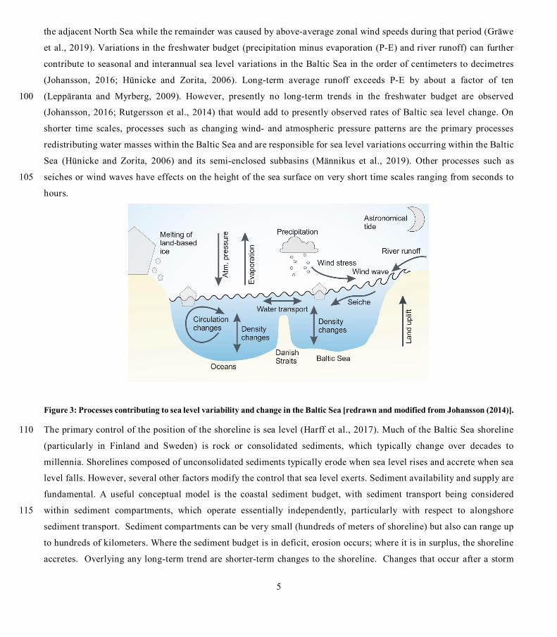
time scales is inferred. A sketch illustrating processes contributing to such variability is shown in Figure 3. For the 85
Baltic Sea, such processes can be separated into processes that alter the volume of the Baltic Sea and/or the total amount
of water in the basin, and processes that redistribute water within the Baltic Sea (Samuelsson and Stigebrandt, 1996;
Svansson, 1980). From analyses of tide-gauge data and dynamical consideration, we know that processes with
characteristic time scales of about half a month or longer can change the volume of the water in the Baltic Sea. Due to
the limited transport capacity across the Danish Straits, processes with shorter time scales primarily redistribute water 90
within the Baltic Sea (Johansson, 2014; Soomere et al., 2015; Männikus et al., 2019). At longer time scales, North
Atlantic mean sea level changes and effects from large-scale atmospheric variability have the strongest influence on
Baltic mean sea level variability and change apart from changes caused by movements in the Earth’s crust due to the
GIA. For example, using experiments with a hydrodynamic model Gräwe et al. (2019) showed that for the period 1980-
2000 about 75% of the basin-averaged mean sea level change externally entered the Baltic Sea as a mass signal from 95
5
the adjacent North Sea while the remainder was caused by above-average zonal wind speeds during that period (Gräwe
et al., 2019). Variations in the freshwater budget (precipitation minus evaporation (P-E) and river runoff) can further
contribute to seasonal and interannual sea level variations in the Baltic Sea in the order of centimeters to decimetres
(Johansson, 2016; Hünicke and Zorita, 2006). Long-term average runoff exceeds P-E by about a factor of ten
(Leppäranta and Myrberg, 2009). However, presently no long-term trends in the freshwater budget are observed 100
(Johansson, 2016; Rutgersson et al., 2014) that would add to presently observed rates of Baltic sea level change. On
shorter time scales, processes such as changing wind- and atmospheric pressure patterns are the primary processes
redistributing water masses within the Baltic Sea and are responsible for sea level variations occurring within the Baltic
Sea (Hünicke and Zorita, 2006) and its semi-enclosed subbasins (Männikus et al., 2019). Other processes such as
seiches or wind waves have effects on the height of the sea surface on very short time scales ranging from seconds to 105
hours.
Figure 3: Processes contributing to sea level variability and change in the Baltic Sea [redrawn and modified from Johansson (2014)].
The primary control of the position of the shoreline is sea level (Harff et al., 2017). Much of the Baltic Sea shoreline 110
(particularly in Finland and Sweden) is rock or consolidated sediments, which typically change over decades to
millennia. Shorelines composed of unconsolidated sediments typically erode when sea level rises and accrete when sea
level falls. However, several other factors modify the control that sea level exerts. Sediment availability and supply are
fundamental. A useful conceptual model is the coastal sediment budget, with sediment transport being considered
within sediment compartments, which operate essentially independently, particularly with respect to alongshore 115
sediment transport. Sediment compartments can be very small (hundreds of meters of shoreline) but also can range up
to hundreds of kilometers. Where the sediment budget is in deficit, erosion occurs; where it is in surplus, the shoreline
accretes. Overlying any long-term trend are shorter-term changes to the shoreline. Changes that occur after a storm

6
event are typically called erosion, although technically if the sediment remains in the active sediment compartment,
this use of the term in this context may be seen as inaccurate. The Baltic Sea differs from many other coastal locations. 120
In particular, short wind fetches mean that swell waves are generally insignificant (Broman et al., 2006; Soomere et
al., 2012) and waves often approach the shoreline at a large angle (Soomere and Viška, 2014). That means that the
Baltic Sea shorelines are very sensitive to wind direction. Wave periods are short, leading to the situation where waves
can approach the shore at high angles, and the effects of an individual storm on beach processes and sediment transport
within a compartment can vary considerably depending on wind (and therefore wave) characteristics, overlying the 125
effects of short term elevated water levels. Figure 4 provides a sketch of the main topographic coastal features and
processes contributing to erosion and sedimentation at the Baltic Sea shores.
Figure 4: Main coastal topographic features and erosion/accretion processes at the Baltic Sea shores [redrawn and modified from Harff et al. (2017)]. 130
Being part of the thematic Baltic Earth Assessment reports, this study concentrates and reviews knowledge on sea level
dynamics and coastal erosion in the Baltic Sea region. Section 2 provides an overview of the current state of knowledge
for both, mean and extreme sea levels as well as for coastal erosion and sedimentation. This includes brief recaps of
sources of data and relevant processes along with descriptions of variability and past, ongoing, and potential future
changes. Section 3 addresses several knowledge gaps, that emerged from reviewing the available publications. 135
Eventually, conclusions and key messages are presented in Section 4.

7
2 Current state of knowledge
2.1 Mean sea level
2.1.1 Sources of data
The primary sources for measuring mean sea level changes are tide gauges and radar altimetry from satellites. Both measure 140
two different quantities, namely relative and absolute (geocentric) sea levels. Absolute sea level refers to the height of the sea
surface relative to a geocentric reference such as the reference ellipsoid and is derived from satellite altimetry or global
navigation satellite system (GNSS)-controlled tide gauges (Schöne et al., 2009; Schöne et al., 2011). Relative sea level refers
to the height of the sea surface relative to the seafloor (or a local benchmark on land) and is derived from tide gauges or sea
level reconstructions. Contrary to absolute sea level, relative sea level is thus influenced both by variations in the height of the 145
sea surface and by land uplift or subsidence.
The tide gauge network of the Baltic Sea is one of the most densely spaced and longest-running networks in the world. Many
stations have been in continuous operation since the early 19th century and some stations provide monthly averages for over
200 years (Ekman, 2009; Bogdanov et al., 2000; Kowalewska-Kalkowska and Marks, 2011). There are about 45 operational
tide gauges with more than 60 years of data and with very good coverage of the western, southwestern, and northern Baltic 150
Sea coasts (Hünicke et al., 2015). Eight additional gauges with data since 1961 in Latvian waters were recently added to this
data set (Männikus et al., 2019). Monthly averaged data is often provided to, and open access through, the Permanent Service
for Mean Sea Level (PSMSL; e.g., Holgate et al., 2013). The Copernicus Marine Environment Monitoring Service collects
data in hourly resolution from a range of national stations in hourly resolution with daily updates, but with varying quality
control. The EMODnet Physics portal provides access to both data sources, and thus combines a substantial amount of long-155
term monthly and higher frequency Baltic sea level measurements. The tide gauges measure relative to specific reference
levels that differ between Baltic countries for historical reasons (Ekman, 2009). There are efforts to connect Baltic Sea gauges
to a common datum, such as the Baltic Sea Chart Datum 2000 (BSCD2000; Schwabe et al., 2020). Additionally, uncertainties
in local reference levels are introduced by, e.g. different measuring techniques and sampling frequencies (Ekman, 2009),
changes in the reference points due to relocation of benchmarks, or man-made changes of the tide-gauge surroundings, such 160
as coastal or port development. Examples, for the case of the Kronstadt gauge, are described in Bogdanov et al., (2000).
Phenomena occurring on timescales of years to decades, such as subsidence, for example, the sinking of piers due to unstable
foundations, or land sinking due to groundwater or gas extractions, can be other sources of uncertainties (Hünicke et al., 2015).
Subsidence can further result from processes such as compaction of unconsolidated alluvial soils, oxidation of organic
materials, or increased surface load due to construction activities (e.g. Pelling and Blackburn, 2013). 165
Radar satellite altimetry from different satellite missions is available continuously since 1991 (e.g., Schöne et al., 2010).
Presently, the longest and most sound dataset is derived from a combination of the consecutive dual-frequency missions
Topex/Poseidon, Jason-1, -2, and -3 (Legeais et al., 2018). The orbit repeats itself every 10 days allowing the construction of
continuous time series since 1993. The missions form a pattern of ascending and descending orbits with an average cross-track
8
distance of 100 km (at 60°N). Starting in 1991 with the European mission ERS-1 (followed by ERS-2, and the dual-frequency 170
mission ENVISAT (ESA) and AltiKa (India/France)) the Baltic Sea is also mapped every 35 days with an average cross-track
distance of 55 km (at 60°N). With the launch of ESA’s CryoSat-2 in 2010, a new altimetry concept was established using a
synthetic aperture interferometric radar altimeter (SAR/SARin) to especially map ice parameters but also sea surface heights
closer to the coastlines. In 2016 the European COPERNICUS program launched a mission on Sentinel-3A (followed in 2018
by Sentinel-3B) carrying forward the uninterrupted altimetry program with 27 day repeat periods. The recent launch of 175
Sentinel-6A Michael Freilich in November 2020 will continue the important missions with unprecedented accuracy.
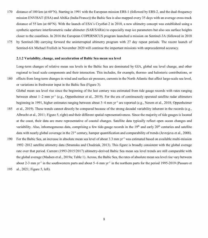
2.1.2 Variability, change, and acceleration of Baltic Sea mean sea level
Long-term changes of relative mean sea levels in the Baltic Sea are dominated by GIA, global sea level change, and other
regional to local scale components and their interaction. This includes, for example, thermo- and halosteric contributions, or
effects from long-term changes in wind and surface air pressure, currents in the North Atlantic that affect large-scale sea level, 180
or variations in freshwater input in the Baltic Sea (Figure 3).
Global mean sea level rise since the beginning of the last century was estimated from tide gauge records with rates ranging
between about 1–2 mm yr-1 (e.g., Oppenheimer et al., 2019). For the era of continuously operated satellite radar altimeters
beginning in 1991, higher estimates ranging between about 3–4 mm yr-1 are reported (e.g., Nerem et al., 2018; Oppenheimer
et al., 2019). These trends cannot directly be compared because of the strong decadal variability inherent in the records (e.g., 185
Albrecht et al., 2011; Figure 5, right) and their different spatial representativeness. Since the majority of tide gauges is located
at the coast, their data are more representative of coastal changes. Satellite data typically reflect open ocean changes and
variability. Also, inhomogeneous data, comprising a few tide-gauge records in the 19th and early 20th centuries and satellite
data with nearly global coverage in the 21st century, hamper quantification and comparability of trends (Jevrejeva et al., 2008).
For the Baltic Sea, an increase in absolute mean sea level of about 3.3 mm yr-1 was estimated based on available multi-mission 190
1992–2012 satellite altimetry data (Stramska and Chudziak, 2013). This figure is broadly consistent with the global average
rate over that period. Current (1993-2015/2017) altimetry-derived Baltic Sea mean sea level trends are still comparable with
the global average (Madsen et al., 2019a; Table 1). Across, the Baltic Sea, the rates of absolute mean sea level rise vary between
about 2-3 mm yr-1 in the southwestern parts and about 5–6 mm yr-1 in the northern parts for the period 1995-2019 (Passaro et
al., 2021; Figure 5, left). 195

9
Figure 5: (Left) Trends in annual absolute mean sea level 1995-2019 derived from multi-mission satellite altimetry. Trends were provided by Baltic Seal (https://balticseal.eu). Data and methods are described in Passaro et al. (2021). [Redrawn and modified from Passaro et al. (2021)]. (Right) Time series of relative sea level trends in Warnemünde over successive 40-year periods; that is, the trend in 2020 is representative for 1981-2020, the trend in 1980 for 1941-1980, etc. The orange line represents the median, the yellow 200 area the 5-95% range of all 40-year trends. Note that the vertical land movement at Warnemünde is close to zero (0.55 ± 0.59 mm yr-1; estimate provided by https://www.sonel.org for the last about 11 years; accessed: 28. June 2021) [Redrawn and modified from https://sealevel-monitor.eu/].
Relative mean sea level changes and their secular trends are strongly affected by vertical land movements and vary
considerably across the Baltic Sea. Geologically, the Baltic Sea region is divided into the uplifting Fennoscandian Shield in 205
the North and the subsiding lowland parts in the South (Harff et al., 2007). Land uplift rates in the northern parts are in the
order of several millimeters per year and are comparable to the climatically induced rates of sea level rise in the 21st century.
Relative mean sea level trends in the Baltic Sea show a corresponding north-south gradient, reflecting these crustal deformation
rates due to GIA: In the northern parts, relative mean sea level decreases with a maximum rate of about 8.2 mm yr-1 in the Gulf
of Bothnia (Hünicke et al., 2015). This corresponds to the area with maximum GIA-induced crustal uplift (Peltier, 2004; 210
Lidberg et al., 2010). In the southern Baltic Sea, relative mean sea level increases at a rate of about 1 mm yr-1 with a gradient
in a northeasterly direction (Richter et al., 2012; Groh et al., 2017). These findings are supported by numerous studies analyzing
Baltic relative mean sea level trends on a national basis (Suursaar et al., 2006a; Dailidienė et al., 2012; Männikus et al., 2019).
Different observation periods and analysis techniques hamper comparison to some extent. A more comprehensive figure on
Baltic sea level trends and variability was provided by Madsen et al. (2019a) who took a statistical approach to combine data 215
from century-long tide gauge records with results from hydrodynamic modeling based on atmospheric reanalysis data, and
compared the results with those from satellite altimetry records (Table 1). The analysis again emphasizes that the rate of sea
level rise strongly depends on the period considered but that present-day rates are higher than previously observed. This is also
supported by an analysis of trends over successive 40-year periods at the tide gauge Warnemünde that shows pronounced
variability in decadal sea level trends with present trends in the upper range of the observed values (Figure 5, right). 220

10
Table 1: Rates of mean sea level rise for the Baltic Sea and estimated uncertainty (one standard deviation range) based on (Madsen et al., 2019a).
Mean sea level rise
(mm/year)
Uncertainty
(mm/year)
Statistical model, 1900-1999 1.3 0.3
Statistical model, 1915-2014 1.6 0.3
Statistical model, 1993-2014 3.4 0.7
Satellite data (CCI1), 1993-2015 4.0 1.3 1 Here CCI refers to ESA Sea Level CCI ECV v2.0 (Quartly et al., 2017; Legeais et al., 2018)
Atmospheric forcing in the form of wind and precipitation can affect the basin-average sea level through changes in the total
volume of water, but also the internal distribution of water volume within the Baltic Sea basin. Winds, and more particularly 225
the strength of the westerly winds, modulate the exchange of water masses with the North Sea (Gräwe et al., 2019). During
periods of weak or moderate wind conditions a two-layer system of in- and outflow prevails in the Danish Straits while during
periods of strong winds in- or outflow occurs across the entire water column, the strength of which is controlled by the sea
level gradient between the Kattegat and the western Baltic Sea (Sayin and Krauss, 1996; Stigebrandt, 1983; Mattsson, 1996).
The alignment of the prevailing wind directions in this region with the geographical orientation of the connecting straits 230
between the Baltic and the North Seas favor such conditions in which stronger than normal westerly winds push water masses
into the Baltic Sea, raising overall sea level and vice versa.
On average, there is a strong salinity increase from the Northeast to the Southwest of the Baltic Sea. This gradient results from
the along-basin separation between the main saltwater (Danish Straits) and freshwater (rivers discharging into the Gulf of
Finland and the Bothnian Sea) sources. It leads, through density, to a corresponding sea level gradient which, together with 235
the volume of the freshwater input and the effects of the prevailing westerly winds, gives rise to a corresponding sea level
variation of about 35–50 cm across the Baltic Sea (Ekman and Mäkinen, 1996). Kniebusch et al. (2019) showed that there is
pronounced decadal variability in the freshwater forcing leading to a corresponding variability in the along-basin salinity
gradient which in turn affects the sea level gradient. Over the period 1900-2008, Kniebusch et al. (2019) also detected a trend
in the salinity gradient but found the trend to be sensitive to the exact period chosen and small compared to the decadal 240
variability. Likewise, precipitation anomalies affect the distribution of the Baltic mean sea level through corresponding
changes in salinity and water density (Hünicke and Zorita, 2006). Presently no robust long-term trends in the freshwater budget
are observed (Johansson, 2016; Rutgersson et al., 2014) that would add to presently observed rates of Baltic sea level change.
The relation between Baltic sea level variability with the state of the large-scale atmospheric circulation has been the subject
of numerous studies (Kahma, 1999; Johansson et al., 2001; Lehmann et al., 2002; Dailidiene et al., 2006; Hünicke and Zorita, 245
2006; Suursaar et al., 2006a; Johansson and Kahma, 2016; Chen and Omstedt, 2005, 2005; Omstedt et al., 2004). Mostly, these

11
studies focused on relations between the NAO1 and Baltic sea level. Generally, the positive phase of the NAO is associated
with enhanced westerly winds over the Baltic Sea area which causes sea level to rise. Correlations strongly vary by region
with higher values in the northern and the eastern parts and smaller values in the southern parts of the Baltic Sea. Moreover,
the magnitude of the correlations is not constant but changed over the 20th century, including both, periods with very high and 250
very low values (Figure 6). This suggests that the state of the NAO is a good but, for some periods, not the optimal indicator
to describe Baltic sea level variability associated with the atmospheric circulation. Based on that finding Karabil et al. (2018)
suggested an alternative pattern based on the pressure differences between the Bay of Biscay and Tromsø. Correlations between
this new index and Baltic sea level variability were found to be more stable, suggesting that this index is better suited to
describe the parts of Baltic sea level variability associated with the large-scale atmospheric circulation (Figure 6). Similar to 255
the NAO this new index exhibits pronounced interannual and decadal variability over the past about 120 years but does no
show a significant long-term change (Karabil et al., 2018).
Figure 6: (Left) Correlation between the NAO/the new index (BANOS) and winter mean sea level at Stockholm (STO), Warnemünde (WAR), and Cuxhaven (CUX) together with the correlation between both indices. (Right): Correlation maps for the periods when the correlation between the NAO and sea-level variability were minimum (top) and maximum (bottom). The two white points in the 260 bottom panel were used to construct the new BANOS index. Reproduced from Karabil et al. (2018). Distributed under a CC-BY license.
The contribution of the different mechanisms behind current sea-level trends can be also estimated from the analysis of
simulations with regional ocean models driven by observed atmospheric and global mean sea level forcing (Gräwe et al.,
2019). This approach has the advantage that the effects of land movement on the Baltic sea level are explicitly neglected so 265
that the contribution from other factors can be disentangled. In the simulation of Gräwe et al. (2019), the Baltic sea level rose
at a rate of about 2 mm yr-1 over the past 50 years, a rate that is slightly larger than the global average. Most of this sea level
rise in the Baltic Sea was caused by a corresponding increase of sea level in the North Atlantic Ocean. Model results along
1 The North Atlantic Oscillation (NAO) basically describes a meridional pattern in sea level pressure (SLP) with higher than normal SLP around the Azores and lower than normal SLPs over Island and vice versa. Variability of this pattern is physically linked to the intensity of the westerlies in the European region.

12
with data from Latvian waters (Männikus et al., 2020) further suggest a heterogeneous pattern of sea level rise, with larger
rates in the northern and smaller rates in the southeastern Baltic Sea that appears to be the result of a poleward shift of 270
atmospheric pressure systems (Gräwe et al., 2019).
For the future, global mean sea level rise is expected to have the largest impact on future Baltic sea level changes
(Grinsted, 2015; Hieronymus and Kalén, 2020). It is expected, that most of the future Baltic absolute sea level rise will
be strongly linked with corresponding large-scale changes in the North Atlantic and the factors modulating these
changes. These factors are mainly the thermal expansion of the water column, contributions from melting of the 275
Antarctic ice sheet (Grinsted, 2015), and imprints from the variability and change of the Atlantic Meridional
Overturning Circulation (Börgel et al., 2018).
For absolute sea level trends, the relative contribution from future melting of the Greenland and Antarctic ice sheets is the
major source for spatial variations across the Baltic Sea. Melting of ice from the large ice sheets leads to changes in the Earth’s
gravitational field, rotation, and crustal deformation the patterns of which are called sea level fingerprints (Plag and Jüttner, 280
2001). For any given place on Earth, these fingerprints are specific to the location of the ice melt. Baltic sea level is substantially
more sensitive to melting from Antarctica than from Greenland. For example, if an ice volume melts from Antarctica that is
equivalent to an increase of the global mean sea level of 10 cm, the increase of the absolute mean sea level in the Baltic Sea
would be about 11 cm (+10%). If the same volume melts from the Greenland ice sheet, the response of the Baltic Sea level
would be smaller and spatially more heterogeneous. Here the values would vary around zero such that the southern Baltic Sea 285
would experience an increase in absolute sea level of about 2 cm (20% of the globally averaged sea level rise from Greenland
melting), while the northern Baltic Sea would expect a corresponding sea level fall (Hieronymus and Kalén, 2020).
For the Swedish coast, Hieronymus and Kalén (2020) provided sea level projections accounting for such variations. When
compared to earlier estimates, this resulted in lower projections in 2100. However, as more recent estimates of potential future
contributions from Antarctic melting increased (Oppenheimer et al., 2019), Hieronymus and Kalén (2020) found their 290
projections still being broadly consistent with earlier estimates, because their more careful treatment of spatial inhomogeneities
was balanced by the larger estimates for Antarctic melting.
Stronger winds and increased run-off can further contribute to future Baltic sea level rise in the order of some cm
(Meier, 2006; Hünicke, 2010; Johansson, 2014; Karabil, 2017; Pellikka et al., 2018). Future changes in the Baltic Sea
freshwater budget may also affect the regional distribution of Baltic mean sea level (Hünicke et al., 2017). If present 295
links between atmospheric forcing and Baltic mean sea level are extrapolated into the future, their contribution to future
Baltic mean sea level can be estimated from climate projections. Presently such contributions are thought to be minor
(Weisse and Hünicke, 2019). As GIA continues and will persist to dominate relative mean sea level changes in the
northern parts of the Baltic Sea, these areas are expected to see a continued, although decelerated, decrease in relative
mean sea level in the future, while the southern parts are expected to experience a relative mean sea level rise slightly 300
exceeding the global average (Räisänen, 2017).

13
One of the expected implications of anthropogenic climate change would be an acceleration in sea level rise over time.
So far, global mean sea level rise seems to have accelerated over the 20th century (Nerem et al., 2018; Oppenheimer et
al., 2019; Dangendorf et al., 2019) although there is still ongoing debate (Kleinherenbrink et al., 2019; Veng and
Andersen, 2020). Robust detection of acceleration is to some extent hampered by changes in the measurement system: 305
While most of the data over much of the 20th century originate from coastal tide gauges mostly in the Northern
Hemisphere, since 1991 satellite altimetry provides a nearly global figure mostly from the open ocean. Differences in
estimates of satellite intra-mission biases also have substantial effects on estimated acceleration rates (Kleinherenbrink
et al., 2019). As tide gauges in the Baltic Sea provide some of the longest, best quality controlled, and more
homogeneous records, they may provide some support in assessing acceleration. From a statistical analysis of long 310
Baltic sea level records, Hünicke and Zorita (2016) could indeed detect an acceleration in sea level rise. While the tests
were not powerful enough to detect a significant acceleration in most of the records taken individually, results are
robust for the set of gauges against different definitions of acceleration. The overall magnitude of the acceleration is
small, and if continued unchanged over the whole 21st century, would add just a few centimeters to the sea level rise.
The latter is, however, unlikely as an increase in the acceleration of sea level rise is expected for the future, in particular, 315
when the large ice sheets melt more rapidly.
Acceleration of Baltic sea level rise also displays a spatial pattern with accelerations in the northeastern parts three
times as large as those in the southwest. The spatial structure is compatible with what would be expected from an
expected deceleration of GIA. However, applying the theoretical deceleration calculated with models of the dynamics
of the Earth's crust (Spada et al., 2014) the resulting order of magnitude is still too small to explain the apparent 320
acceleration of relative coastal sea level. It has to be kept in mind that most tide-gauges are affected by the rather strong
noise of local vertical movements, and thus the detection of a second-order change, like acceleration, is challenging.
2.2 Extreme sea levels and wind-generated waves
2.2.1 Sources of data
Sea level extremes are measured using the same primary devices as for mean sea level; that is, tide gauges and radar altimetry. 325
For wind waves, also data from visual observations, wave buoys, or radars mounted on platforms are common. Spatial coverage
of instrumental wave measurements in the Baltic Sea is scarce and limited to a few regions. So far, no long-term data exists
from the central and eastern Baltic Proper and the Gulf of Riga (Suursaar et al., 2012). In the northern parts, measurements are
often limited to ice-free periods as buoys are usually removed during winter to prevent damage from ice. Homogeneity of data
can be problematic due to effects from the relocation of measurement sites or the replacement of instruments (Hünicke et al., 330
2015). Wave data from measurements are often used in combination with reconstructions from numerical wave hindcasts
(Cieślikiewicz and Paplińska-Swerpel, 2008; Nikolkina et al., 2014; Björkqvist et al., 2018; Soomere et al., 2012), where they
provide a reasonable characterization of open sea wave fields.

14
2.2.2 Variability and change of Baltic sea level extremes and wind-generated waves
Baltic sea level extremes occur over a wide range of spatial and time scales. Contributions can arise from phenomena 335
acting at small scales, such as wind wave run-ups occurring at local scales with variations in the range of seconds, up
to phenomena such as variations in the volume of the entire Baltic Sea characterized by formation time scales of up to
a few weeks and even longer persistence (Soomere and Pindsoo, 2016). In between these ranges, other phenomena such
as storm surges contribute to sea level extremes. All these phenomena are generated mostly by meteorological and to
some extent by astronomical factors (Weisse and Hünicke, 2019). From a climate perspective, this indicates that any 340
relevant change in meteorological forcing may be associated with corresponding changes in Baltic sea level extremes.
The most prominent and most relevant phenomena contributing to sea level extremes in the Baltic Sea are storm surges,
wind waves, and a preconditioning that leads to increased water volumes and thus sea levels in the entire Baltic Sea
before the onset of a storm (Suursaar et al., 2006b; Madsen et al., 2015). Preconditioning is associated with periods of
prevailing westerly winds that increase the sea level gradient across the Danish Straits. In turn, the increased sea level 345
gradient leads to higher inflow and higher Baltic Sea water volumes (Samuelsson and Stigebrandt, 1996). While the
long-term average barotropic outflow from the Baltic Sea is about 7 km3 day-1 or 80.000 m3 s-1 (Winsor et al., 2001)
transports across the Danish Straits can reach values of up to about 45 km3 day-1 in both directions, which corresponds
to a sea level change of about 12 cm day-1 over the entire Baltic Sea (Mohrholz, 2018). Major inflow events are
associated with typical volumes in the order of about 100 km3, corresponding to a Baltic sea level increase of about 24 350
cm (Matthäus and Franck, 1992). Typically, such variations have time scales of about 10 days and longer (Soomere
and Pindsoo, 2016) while atmospheric variability on shorter time scales primarily leads to a redistribution of water
masses within the Baltic Sea basin (Kulikov et al., 2015) or between the Baltic Proper and the Gulf of Riga (Männikus
et al., 2019).
Storm surges refer to changes in sea level in coastal waters, caused primarily by strong onshore winds during storms 355
and secondarily by the action of spatially varying atmospheric pressure on the sea surface (Pugh and Woodworth, 2014)
and by wave set-up in specific locations (Soomere et al., 2013). They represent a substantial threat for the low-lying
coastal areas of the Baltic Sea, in particular in the southwestern parts (Wolski et al., 2014), the Gulf of Finland (Suursaar
and Sooäär, 2016; Averkiev and Klevannyy, 2010), the Gulf of Riga (Suursaar and Sooäär, 2016; Männikus et al.,
2019; Suursaar et al., 2006b), and the Gulf of Bothnia (Averkiev and Klevannyy, 2010). Comparing 50 years of hourly 360
sea level data from gauges across the entire Baltic Sea, Wolski and Wiśniewski (2020) showed that Pärnu in the Gulf
of Riga and Kemi in the Gulf of Bothnia are particularly prone to storm surges. In their analysis, these two gauges were
characterized by both, the highest average number of surges per year and the highest average number of hours per year
with extreme sea levels. Regarding height, a surge in November 1824 in the Gulf of Finland was responsible for the
highest recorded water level in the Baltic Sea (4.21 m above tide gauge zero in St. Petersburg, Wolski and Wiśniewski, 365
2020). In the western Baltic Sea, a storm in November 1872 caused water levels to exceed 3 m at many gauges (Feuchter

15
et al., 2013; Wolski and Wiśniewski, 2020). For the Gulf of Riga/the western Baltic Sea, storm surge heights around 2
m/1–1.5 m are typical (Wolski and Wiśniewski, 2020).
Storm surges in the Baltic Sea can last from several hours to almost a day (Wolski and Wiśniewski, 2020). Because of
the seasonal cycle in wind speed, storm surges are highest and most frequent during fall and winter (Weidemann, 2014). 370
The presence of sea ice may substantially reduce the effectiveness of wind in generating storm surges. In winter in the
Gulf of Bothnia, the piling-up of water is strongly suppressed by the existence of sea ice (Zhang and Leppäranta, 1995).
When preconditioning exists, that is high Baltic Sea water volumes, even moderate wind and wind surges may lead to
coastal sea level extremes (e.g., Weisse and Weidemann, 2017).
Wind waves in the Baltic Sea show a pronounced seasonal cycle, with higher values in winter and smaller values in 375
summer. This behavior is associated with a corresponding seasonal cycle in wind speed (Björkqvist et al., 2018) and
leads to extensive variations in the wave energy flux (Soomere and Eelsalu, 2014). Generally, waves are higher in open
waters than in coastal waters. To date, the highest measured waves in the Baltic Sea were reported from a wave buoy
in the northern Baltic Proper. During a storm in December 2004, this buoy recorded a significant wave height of 8.2 m
(Björkqvist et al., 2018; Tuomi et al., 2011). During windstorm Gudrun in 2005, measured significant wave heights 380
reached 7.2 m in the Baltic Proper and 4.5 m in the Gulf of Finland. For this storm and away from sensors, model
simulations suggested the existence of extreme significant wave heights of up to 9.5 m off the northwestern coast of
Latvia (Soomere et al., 2008). More recently, very high waves with significant wave heights up to 8.1 m were also
recorded in the Sea of Bothnia (Björkqvist et al., 2020). However, in the Bothnian and the northern Baltic Seas, the
seasonal presence of sea ice typically modifies the wave climate and limits wave heights during the freezing season 385
(Tuomi et al., 2011).
In the coastal zone, the height of the wave extremes is considerably smaller, but other wave-related processes such as
wave set-up or run-up (swash) can make substantial contributions to short-term sea level extremes. Wave set-up refers
to a wave-induced increase in the mean water level caused by the release of momentum from the dissipation of a long
sequence of breaking waves and swash is caused by the run-up of single waves on the beach (Melet et al., 2018). For 390
example, for some coasts in the Gulf of Finland (Soomere et al., 2013; Soomere et al., 2020) and along the shores of
the West Estonian archipelago (Eelsalu et al., 2014) potential wave set-up may reach values of up to 70–80 cm.
Moreover, the shape of the shoreline and irregular bottom topography can strongly modify local wave conditions
(Tuomi et al., 2012; Tuomi et al., 2014), and wave set-up and run-up may both have a strong influence on the level of
the flooding and erosion at the shore (Dean and Bender, 2006). Coastal wave climate, its impacts, and its long-term 395
changes thus strongly depend on location.
Changes in the Baltic Sea volume, storm surges, and extreme sea levels are tightly coupled. As increased volumes
provide preconditioning for extremes in the entire sea (Pindsoo and Soomere, 2020), higher Baltic Sea volumes
generally lead to higher extremes under otherwise similar storm conditions (Weisse and Weidemann, 2017). More

16
specifically, westerly storms not only cause surges on the eastern Baltic Sea coast but also increase the volume of the 400
sea. During subsequent storms, extreme sea levels are then higher than without preconditioning.
Two other noticeable effects may further contribute to Baltic sea level extremes: seiches and meteotsunamis. In the
Baltic Sea, seiches with periods of up to tens of hours and e-folding times of up to two days may develop under certain
atmospheric conditions (Leppäranta and Myrberg, 2009). Details of these oscillations are debated and are still not fully
understood. From numerical studies, Wübber and Krauss (1979) proposed a series of basin-wide seiches with periods 405
of up to 31 hours. Other authors argued that the existence of such basin-wide oscillations is not entirely supported by
data. They suggested, that such sea level oscillations in the Baltic Sea could alternatively be considered as an ensemble
of weakly coupled local seiches with periods between 17 and 27 hours in the Gulf of Riga, the Gulf of Finland, and the
Belt Sea (Jönsson et al., 2008). Oscillations with similar periods also occur in the West Estonian archipelago (Otsmann
et al., 2001). For the Gulf of Riga Suursaar et al. (2002) also note the existence of a five-hour barotropic seiche. When 410
favorably coupled with storm surges or in resonance with atmospheric forcing, such oscillations may contribute to very
high sea level extremes at the coast (Suursaar et al., 2006a; Weisse and Weidemann, 2017; Wolski and Wiśniewski,
2020). Meteotsunamis are generated by moving atmospheric disturbances that trigger resonant sea level fluctuations.
While not extremely frequent in the Baltic Sea, cases were described by Pellikka et al. (2014; 2020) for the Gulf of
Finland or by Holfort et al. (2016) for the western Baltic Sea. Amplitudes may be in the order of one meter (Pellikka 415
et al., 2014; 2020).
The contribution from tides to the height of Baltic sea level extremes is mostly small as the connection to the open
ocean and thus co-oscillation is limited. Overall, tidal ranges are mostly between about 2 and 5 cm (Witting, 1911 as
cited in Leppäranta and Myrberg, 2009). In the western sea areas, tidal ranges of up to 10–30 cm are observed (Defant,
1961 as cited in Leppäranta and Myrberg, 2009). Due to resonance, tidal ranges of up to 20 cm are also found near St. 420
Petersburg at the end of the Gulf of Finland (Medvedev et al., 2013). While co-oscillation is limited, locally generated
tides, albeit small, may also contribute in the same order of magnitude at some places (Schmager et al., 2008). In the
western Baltic Sea, tidal conditions are predominantly semi-diurnal while in the Gulf of Finland and the Gulf of Riga,
diurnal tides prevail (Medvedev et al., 2013; Schmager et al., 2008). While tidal ranges are generally small, they still have
noticeable effects on the return periods of sea level extremes (Särkkä et al., 2017) 425
Variability and long-term changes in Baltic extreme sea levels can occur for various reasons but are primarily linked
to changes in relative mean sea level and atmospheric conditions. Relative mean sea level changes will modify the base
upon which other atmospheric drivers of extremes will act although the response is not necessarily linear (e.g. Arns et
al., 2015). For example, for the same wind field, and hence surge levels, higher extremes are expected under higher
relative mean sea levels. Also, changes in the driving atmospheric conditions will lead to changes in the statistics of 430
waves, surges, etc. which in turn will affect the sea level extremes. Moreover, non-linear interaction between the
contributions, potentially non-stationary behavior of the population of extremes (Kudryavtseva et al., 2018), and local

17
effects such as from bathymetry or the shape of the coastline can make overall effects on sea level extremes highly
non-additive (e.g., Arns et al., 2015).
Based on tide gauge data and for different periods, several studies revealed trends in Baltic sea level extremes. These 435
trends were found to originate mainly from a corresponding change in mean sea level (Marcos and Woodworth, 2017;
Ribeiro et al., 2014; Barbosa, 2008) or the increase in the magnitude of the preconditioning (Soomere and Pindsoo,
2016; Pindsoo and Soomere, 2020). For the periods from 1960 onwards Marcos and Woodworth (2017) showed that
the height and duration of sea level extremes increased/decreased at sites with increasing/decreasing relative mean sea
level and that these trends mostly disappear when the mean sea level signal is removed. Only for some of the eastern 440
and northernmost stations, trends indicate some contribution from corresponding changes in the large-scale atmospheric
circulation and regional wind patterns (Barbosa, 2008; Ribeiro et al., 2014). Using data from a hindcast simulation
ignoring GIA, Pindsoo and Soomere (2020) found increases in the height of Baltic sea level extremes for the period
1961-2004/2005. These increases were strongest in the Gulf of Finland, the Gulf of Riga and, the eastern Baltic proper
(Figure 7). Pindsoo and Soomere (2020) concluded that the increases along the Swedish coast and the Gulf of Bothnia 445
were almost entirely a result of global mean sea level rise and an increase in the maximum water volume of the entire
sea. On the other hand, they noted substantial contributions from stronger local storm surges to explain the higher
values along the eastern shorelines.
Figure 7: Trends of storm-season (from July to June of the subsequent year) maximum water level derived from simulated total 450 water level in 1961–2004/2005. Reproduced from Pindsoo and Soomere (2020) with permission from Elsevier and the authors.

18
Long-term changes in the wave climate may further contribute to changing extremes through corresponding adjustments
of wave transformation in the surf zone (e.g., wave set-up and swash). So far, there is no conclusive large-scale figure
but results vary strongly depending on period and region. For the Arkona Basin, Soomere et al. (2012) analyzed wind
wave variability and trends based on 20 years of observation and a 45-year wave hindcast. They concluded that the 455
wave height in this area exhibits no long-term trend but reveals modest inter-annual and substantial seasonal variations.
For shorter periods (1993-2015), estimates from satellite altimetry data suggest a slight increase in annual mean
significant wave height in the order of 10% (about 12 cm or 0.005 m yr-1). Spatially, wave height increased in the
central and western parts of the sea and decreased in the eastern parts (Kudryavtseva and Soomere, 2017). Nikolkina
et al. (2014) analyzed a multi-ensemble wind wave hindcast covering the entire Baltic Sea using different atmospheric 460
forcing and periods (1970–2007 and 1957–2008). While these authors found the hindcasts consistently describing the
known spatial patterns with relatively severe wave climate in the eastern parts of the Baltic proper and its sub-basins
they could not infer consistent conclusions on long-term changes mainly due to differences in the atmospheric forcing
used in the model simulations.
As for mean sea level, extreme sea levels are linked and correlated with the large-scale atmospheric circulation and its 465
variability. Often, the NAO is used to characterize the state and the variability of the large-scale atmospheric circulation
(Johansson, 2014; Marcos and Woodworth, 2018). There are several mechanisms that contribute to the link between
Baltic sea level extremes and the NAO. The positive correlation between the phase of the NAO and mean sea level in
the northwestern European shelf seas (Woolf et al., 2003) suggests that higher than normal mean sea levels occur during
positive phases of the NAO. This would lead to an increase in the baseline sea level upon which wind- and pressure-470
induced extremes will act. In addition, there is also a positive relationship between the phase of the NAO and the
frequency of westerly winds. Increased frequencies of westerly winds may lead to on average higher-than-normal water
volume in the Baltic Sea, which again would increase the baseline. Eventually, potential relationships between changes
in the NAO and regional wind patterns would contribute to corresponding changes in wind-surges and waves.
Using tide gauge data, Johansson (2014) and Marcos and Woodworth (2018) showed that the positive correlation 475
between the NAO and Baltic sea level extremes persisted even when long-term mean sea level changes were removed.
This indicates that the NAO influences on Baltic sea level extremes are not only limited to the effects of changes in the
mean but have contributions from NAO effects on Baltic Sea volume and/or locally generated wind surges and waves.
This conclusion was further supported by a model study in which a coupled North and Baltic Sea model was forced
solely by wind and sea level pressure from 1948–2011, thereby explicitly excluding effects from global mean sea level 480
rise and rising temperatures (Weidemann, 2014). In this experiment, periods of high water volume in the Baltic Sea
occurred more often during positive NAO phases and vice versa, and lower wind speeds were generally needed to
sustain higher sea level extremes when the volume was above normal (Weisse and Weidemann, 2017).
Future changes in sea level extremes in the Baltic Sea crucially depend on two factors: future changes in relative mean
sea level and future developments in large-scale atmospheric conditions associated with changing wind patterns. For 485

19
some regions, changes in the frequency or thickness of sea ice may also have an impact. Relative sea level changes will
strongly vary across the Baltic Sea because of the existing spatial gradient in GIA and the spatial inhomogeneity
associated with the uncertain relative contributions of melting from Antarctica and Greenland (see section 2.1.2). For
the Baltic Sea, changing mean sea levels are expected to have larger effects on future extremes than changing
atmospheric circulation (Gräwe and Burchard, 2012). GIA is expected to continue at rates similar to that observed over 490
the last century. Absolute mean sea levels are expected to rise in the entire Baltic Sea, but exact rates are uncertain and
depend on models, scenarios, and periods considered (Grinsted, 2015; Hieronymus and Kalén, 2020, see also discussion
in section 2.1.2).
Potential future changes in long-term mean and extreme wind speeds are highly uncertain (Räisänen, 2017). In the fifth
assessment report of the Intergovernmental Panel on Climate Change (IPCC), a poleward shift of Northern Hemisphere 495
mid-latitude storm tracks and an ensemble average increase in the NAO index are reported as possible future
developments (Kirtman et al., 2013). Because of the large internal variability together with the large variability among
models and scenarios, there was, however, only medium confidence in these projected changes (Kirtman et al., 2013).
Recent studies indicate, that the poleward shift of the westerlies is most pronounced in summer and less obvious in
other seasons (Zappa and Shepherd, 2017). Because storm surges in the Baltic Sea are primarily a winter and fall 500
phenomenon, this implies that contributions from changes in atmospheric circulation to future Baltic Sea storm surge
climate remain uncertain. This is in agreement with climate model simulations investigated for the Second Assessment
of Climate Change for the Baltic Sea Basin (BACC II Author Team, 2015) that were highly inconsistent for projected
changes in wind speeds at the end of the 21st century (Christensen et al., 2015; BACC II Author Team, 2015).
Despite these uncertainties, some storm surge and wind wave projections seem to report relatively robust changes 505
towards 2100. Using data from a multi-model ensemble, driven with atmospheric data from eight different climate
models and the two emission scenarios RCP4.5 and RCP8.5, Vousdoukas et al. (2016) projected an increase in storm
surge heights in the order of about 5-10% across the entire Baltic Sea towards the end of the twenty-first century. For
wind waves, Groll et al. (2017) reported an increase of about 5-10% in mean and extreme wave heights using data from
two realizations of two emission scenarios. On the other hand, using a substantially larger ensemble consisting of data 510
from six climate models and three emission scenarios Dreier et al. (2021) found no consistent long-term changes in
wave climate along the German Baltic Sea coast, and their projected changes in extreme wave height varied between
about -10% and +6%. This again suggests that projections of future wind waves and storm surges in the Baltic Sea are
still highly dependent on the atmospheric scenario, climate model, and realization used for the projection. Nevertheless,
because of the larger effect of changing mean sea levels on the extremes, regions with expected increases in relative 515
mean sea level are still highly likely to experience an increase in sea level extremes.

20
2.3 Coastal erosion and sedimentation
2.3.1 Sources of data
Coastal erosion and sedimentation, and longer-term shoreline changes tend to be researched at local, sediment compartment,
or regional scales, where particular combinations of wind, wave, sediment characteristics and availability, and sea level 520
variations and extremes at a range of scales can be considered. Generally, remote sensing data have been widely applied to
investigate coastline change at various spatial and temporal scales. Different sources of remote sensing data include satellite
images (e.g., Tiepold and Schuhmacher, 1999), aerial photographs (e.g., Furmanczyk et al., 2011; Dudzinska-Nowak, 2017),
terrestrial (Eelsalu et al., 2015) and air-born laser scanning data (e.g. Hartleib and Bobertz, 2017), and orthophoto maps (e.g.,
Zhang et al., 2017; Dudzinska-Nowak, 2017). Such data were used, for example, to quantify the rates of coastline change over 525
the past decades along the sandy southern Baltic Sea coast and more recently for the Russian waters (Ryabchuk et al., 2020).
Also, historical maps with scales between 1:250000 and 1:5000 dating back to the 1820s have provided useful information on
the coastline change of the Baltic Sea at a longer time scale (Deng et al., 2017a; Hartleib and Bobertz, 2017). As tides are
small in the Baltic Sea, the baseline of the seaward-most foredune or cliff, which represents the cumulative effect of deposition
or erosion, has been used as an indicator to quantify coastline change (e.g., Dudzinska-Nowak, 2017; Zhang et al., 2015). 530
2.3.2 Variability and change of erosion and sedimentation
The Baltic Sea region can be geologically divided into the uplifting Fennoscandian Shield in the North and the subsiding
lowlands in the South (details see Fig. 2.8 in Harff et al., 2007). Coastline change is characterized by a corresponding
north-south gradient (Figure 8) along which the main driving force gradually shifts from GIA to atmospheric and
hydrodynamic forcing. Vertical land movement ranges from uplifts of up to almost 9 mm yr-1 in the North to subsidence 535
of up to 2 mm yr-1 in the South. Since the onset of the Holocene, these vertical movements have caused a persistent
marine regression at the northern coasts and a marine transgression along the southern coasts of the Baltic Sea (Harff
et al., 2007; 2011). The transitional area between the northern uplift and the southern subsidence is located at the
southern coast of the Gulf of Finland (Rosentau et al., 2017).

21
540 Figure 8: Rate of mean annual coastline change 2007-2017 in the Baltic Sea based on a combination of satellite data for sandy beaches (Luijendijk et al., 2018) and field measurements for other coastline types (www.emodnet-geology.eu). Note that the accretion of the northern Baltic Sea coast is due to land uplift instead of sedimentation. Primary alongshore sediment transport direction along the sandy southern Baltic Sea coast is indicated by the arrows based on existing literature compiled by Harff et al. (2017).
About half of the shores of the Baltic Sea are comprised of either extremely resistant bedrock or relatively slowly 545
changing cliffs of limestone or morainic materials. Due to this geology and the ongoing GIA, coastal erosion is not
regarded as an issue of concern in Finland and for the majority of the Swedish coast (Pranzini and Williams, 2013).
The other half of the Baltic Sea shores located primarily in the South and the East are sedimentary and susceptible to
coastline change due to erosion and accretion. This part of the coast is characterized by a series of barrier islands and
sandy dunes connected with soft moraine cliffs. A typical cross-shore dune profile at the southern Baltic coast features 550
an established or a series of foredune ridges with typical heights between 3 and 12 m above mean sea level (Łabuz et
al., 2018). At the backshore behind the established foredune ridges, drifting or stabilized dunes in transgressive forms
are commonly developed. The source of sediment for dune development includes fluvioglacial sands from eroded cliffs,
river-discharged sands, and older eroded dunes (Łabuz, 2015).
As with other (semi-) enclosed seas, dominant processes relevant for erosion and accretion on Baltic Sea shores differ 555
from those described in the classic coastal process literature. As on other shorelines, erosion is generally largest during
storms when nearshore waves are longest, highest, and thus most energetic. Differences arise on Baltic Sea shorelines,

22
however, from the lack of substantial tides, the lack of long wind-generated swell, the frequently occurring high angles
of storm waves approaching the shore, and partially the presence of a seasonal ice cover. Wave energy and direction
are the dominant drivers of sediment transport, erosion, and accretion in the Baltic Sea. Regional properties of the 560
energy supply and the wave-driven transport are described in Soomere and Viška (2014), Kovaleva et al. (2017), or
Björkqvist et al. (2018). A broader contextualization for the entire Baltic Sea can be found in Hünicke et al. (2015) and
Harff et al. (2017).
On most shorelines, erosion is concentrated over relatively short periods around high tide, but as tides are very small
in the Baltic Sea, elevated average water levels, which provide conditions conducive to erosion, can be maintained for 565
extended periods (Johansson and Kahma, 2016; Soomere and Pindsoo, 2016). Therefore, Baltic Sea volume, storm
surges, wave set-up, the presence or absence of sea ice, and long-period wave energy from infragravity or edge waves
are the main factors influencing the duration and location on the beach profile where sediment can be mobilized and
erosion may occur. Systematic synchronization of water level and wave intensity may considerably modify the width
of the affected nearshore strip and the depth to which profile changes may occur (Soomere et al., 2017a). 570
The classic cut-and-fill concept of beach erosion and recovery (e.g. Brenninkmeyer, 1984) assumes that the most
energetic steep waves induce beach erosion and mostly cross-shore transport of sediment to the deeper part of the shore
while sandbar formation, transport of sediment onshore, and the accretion of the same beach appear during calmer wave
conditions with less energy and longer wave periods (constructive swell). Changes on the beach thus primarily follow
the incident wave energy level (Masselink and Pattiaratchi, 2001). This cycle is less significant in the Baltic Sea where 575
the wave regime is highly intermittent and contains very small proportions of low-intensity constructive long swell
waves (Broman et al., 2006; Soomere et al., 2012). If waves approach the nearshore at large angles with respect to
shore-normal, the classic cut-and-fill cycle of beach change is modulated by a relatively intense alongshore movement
of sediment when compared to open ocean shores with a similar wave intensity (Soomere and Viška, 2014).
While strongest alongshore and cross-shore sediment transport in the nearshore (surf and swash zones) usually take 580
place during extreme wave events, the most rapid shoreline changes (both erosion and accretion) occur when high
waves attack the shore at relatively large angles (Ashton et al., 2001), in particular when the angle of wave approach
is unusual for the specific location. The latter indicates that specific shore segments may be sensitive to erosion for a
particular wave direction only. Several small pocket or headland-confined beaches with very small amounts of sand are
in a fragile, but yet almost equilibrium, state as they are geometrically protected against winds from many directions 585
(Caliskan and Valle-Levinson, 2008).
Compared to average conditions in the world oceans, storm waves in the Baltic Sea often approach the shore at
relatively large angles (Soomere and Viška, 2014; Pindsoo and Soomere, 2015). On open shores, such waves drive
much more intense alongshore transport than waves of comparable height that approach the shore almost
perpendicularly. When the approach angle exceeds a threshold of about 45 degrees (Ashton et al., 2001), the 590
predominance of high-angle waves can lead to the explosive development of large spits and sand ridges. The growth
23
of such structures has been observed in the eastern part of the Gulf of Finland (Ryabchuk et al., 2011b; Ryabchuk et
al., 2020).
The presence of sea ice during a storm can modify this general pattern (Omstedt and Nyberg, 1991). The hydrodynamic
forces are particularly effective in reshaping the shore when no sea ice is present and when the sediment is mobile 595
(Orviku et al., 2003; Ryabchuk et al., 2011a). Storm surges are generally higher in the absence of sea ice (Omstedt and
Nyberg, 1991). During extreme storm surges, strong waves may reach unprotected and unfrozen mobile sediment on
higher sections of the shore that are out of reach for the waves during times with average water levels (Orviku et al.,
2003). Land–ice interaction in the coastal zone is also crucial during ice winters. The principal erosion mechanisms are
the wind-driven shore ride-up and pile-up of ice, and ice growth down to the sea bottom with resulting transport of 600
bottom sediment when the ice drifts out to sea (Girjatowicz, 2004; Leppäranta, 2013; Orviku et al., 2011). The former
mechanism is also a risk to structures close to the shoreline.
Because of the dominant role of westerly winds that take up more than 60% of the year over the southern Baltic Sea
(Zhang et al., 2011a) and the sheltering effect of the land in the west, wind waves are typically more developed in the
eastern Baltic Sea than in the western part. As a result, sediment transport and dune development are generally more 605
facilitated along the eastern and southeastern coast. For example, the coastal dunes with the largest size and height are
developed along the Polish and the Lithuanian coast. Being open to large hydrodynamic loads over short periods, but
with almost no low and long-period swell that is typically associated with beach accretion, Baltic Sea shorelines are
conceptually vulnerable to erosion. Waves in the Baltic Sea are also relatively short, implying a narrow surf zone and
less powerful wave run-up than on the open ocean shores. 610
The Baltic Sea wave climate is highly intermittent and anisotropic following the intermittency and anisotropy of the
wind climate; that is, there are only short periods and few directions from which the higher waves approach the
shorelines. Only about 1% of the total onshore annual energy flux arrives within the calmest 170–200 days, about 60%
arrives within 20 days, and as much as about 30% arrives during the 3–4 stormiest days (Soomere and Eelsalu, 2014).
A simple consequence of the intermittency and anisotropy of wave fields and the complicated geometry of the coast is 615
that the evolution of Baltic Sea shores is a step-like process (Soomere and Healy, 2011). They remain unchanged and
seemingly stable for long periods until a storm from an unusual direction causes massive change. The most extreme
erosion events will occur when such a combination comes along with high, normally storm-surge-related, water levels
(Tõnisson et al., 2013b). But for most of the time changes are very slow and require high-resolution measurements such
as laser scanning techniques (Eelsalu et al., 2015; Sergeev et al., 2018) to be detected. The anisotropy of the wave 620
climate combined with the orientation of large sections of the shoreline leads to a large-scale asymmetry of the sediment
flux (that is mostly counter-clockwise on the shore of the Baltic Sea proper; Soomere and Viška, 2014; Figures 8, 9).
Owing principally to the overall sediment deficit on the Baltic Sea sedimentary shores (Pranzini and Williams, 2013),
actual sediment transport is frequently limited by the availability of suitably sized sediment. Thus, the real sediment
flux is only a few percent of the potential flux (Soomere and Viška, 2014). Consequently, there is only slow sediment 625

24
accumulation in flux convergence areas (Figure 9) and accumulation features may be destroyed easily as sediment
transport during a single storm from an unusual direction may be substantially higher. This emphasizes the role of
storms and storm waves in the Baltic Sea as substantial factors controlling sediment transport and coastal change.
Figure 9: Direction (arrows) and magnitude (numbers at arrows, in 1000 m3) of net sediment transport: left - original scheme by R. Knaps, amended by Ulsts (1998); right - simulated potential net sediment transport (Viška and Soomere, 2013). Reproduced with 630 permission from the authors and Baltica.
Hydrodynamic conditions strongly affect coastal morphogenesis. Along the southern and eastern Baltic Sea coast
coastal morphogenesis has been extensively studied for more than a century (Keilhack, 1912; Kolp, 1978; Kliewe,
1995; Lampe et al., 2007; Zhang et al., 2010; 2014; Tõnisson et al., 2013a; Furmanczyk and Musielak, 2015; Harff et
al., 2017; Deng et al., 2019). Barrier coasts are generally resilient to changing climate and can maintain their 635
morphology provided that there is a neutral or positive sediment budget (Zhang et al., 2014) and beach migration is
unimpeded (Cooper et al., 2020). The foredunes form a natural barrier for coastal protection along a major part of the
southern Baltic coast. The part of the Baltic coastline that is protected by engineering structures or newly formed
foredune ridges has been able to sustain its general shape and function (both ecological and economical) in the past
decades, while most of the remaining parts, including the soft cliffs and old dune sections, have been subject to 640
continuous and increased erosion (Łabuz, 2015). Most coastline erosion along the southern Baltic Sea is caused either
by storms or by human-induced depletion of sediment supply (e.g., as a side effect of engineering structures). Existing
studies reveal a highly nonlinear relationship between storm intensity and the rate of coastline erosion along the

25
southern Baltic Sea coast (Zhang et al., 2011b, 2015). Additionally, a strong relationship has been found between rates
of coastline change and the relative level of human development. Even local and modest level of development (e.g., 645
beach nourishment and pier construction) was found to influence the long-term coastline change at larger spatial scales
(up to 100 km) (Deng et al., 2014; Dudzinska-Nowak, 2017). Because of this and the strong dependence on the angle at
which the waves approach the shore, even smaller human interventions or a climate-related change in the predominant wind
and wave directions in the Baltic Sea may substantially alter the structural patterns and pathways of wave-driven
transport and functioning of large sections of the coastline (Viška and Soomere, 2012). 650
Human activities have become significant drivers of coastal change. With sediment transport being largely confined to
shallow water, even smaller coastal construction works such as small boat harbors, can significantly disrupt natural
sediment transport pathways, leading to significant local (and frequently undesirable) coastal changes. Ship traffic,
with the advent of strongly powered and fast large vessels, has become a significant driver of coastal processes and has
caused erosion locally (Soomere et al., 2009). As is the case worldwide (UNEP, 2019), the demand for coastal sand for 655
construction, industry, and beach nourishment will become increasingly significant for sediment supply.
3 Knowledge gaps and further research challenges
Baltic sea level dynamics and coastal erosion have been extensively studied for much longer than a century.
Considerable progress has been made on both, understanding details in the Baltic Sea but also enhancing general
knowledge. This was possible due to the outstanding and long data records available in the Baltic Sea and the fact that 660
processes relevant for understanding sea level dynamics and coastal erosion vary across short spatial distances and
cover a broad range of time scales (Harff et al., 2017). Even so, when we compiled and reviewed the available
publications and knowledge, we identified several gaps. We suggest that addressing these issues could substantially
increase our knowledge of the Baltic and more generally contribute to an improved understanding of sea level dynamics,
erosion, and coastline change. Without claiming completeness, and from our perspective, we here provide a list of a 665
few of the more relevant issues.
3.1 Long-term changes
A range for possible future Baltic relative mean sea level rise by the end of the 21st century assuming a scenario of
strong greenhouse gas emissions (RCP 8.5) was provided by Grinsted (2015). These estimates include contributions of
the thermal expansion of the water volume in the North Atlantic, the transfer of water mass towards the coastal regions, 670
the land movement caused by the GIA, and the contribution from melting of the Antarctic and Greenland ice sheets. In
these estimates, the melting of the ice sheets represents the most uncertain factor. These processes are complex to
simulate, as they include the dynamics of marine glaciers that are affected not only by the surface heat flux but also by
ocean temperature variability and trends at very small spatial scales. Assessments of the contribution of such processes

26
to sea level rise thus currently rely on estimates based on a mixture of model simulations that are difficult to validate 675
and expert assessments (Bamber et al., 2019). For the Baltic sea level, the largest uncertainty arises from the melting
of the Antarctic ice sheet. This is a consequence of contributions from self-gravitational effects, which for the Baltic
Sea are affected much stronger from the Antarctic than from Greenland melting (Mitrovica et al., 2001).
For the Baltic Sea coast, as for many coastal areas worldwide, there is a large variety of stakeholders with different
levels of risk aversion, who need information on future sea level on different time and spatial scales (Madsen et al., 680
2019b; Gerkensmeier and Ratter, 2018; González-Riancho et al., 2017). For the Baltic Sea, the potential in providing
such information has not yet been fully exploited. There are gaps in providing information covering the whole range of
available emission scenarios as well as in contextualizing such information. The latter includes the development of
approaches on how evidence for high-end and plausible upper limits may be accounted for in reliable and acceptable
ways (e.g., Thejll et al., 2020). This, in turn, calls for transdisciplinary approaches in which trust and co-creation of 685
knowledge are fostered (Weisse et al., 2019; Schaper et al., 2019) and for the developments of frameworks (e.g.,
Stammer et al., 2019) accepted by both, the scientific community and a wider range of stakeholders.
Coastal changes are strongly linked to changing extreme sea levels and strong wave conditions. Estimation and
assessment of trends for extremes over centuries are still limited due to observational constraints and the rareness of
extremes. Digitalization of the available historical data from analog archives or proxy analyses could improve the 690
situation. Similarly, providing more comprehensive information on potential future developments comprising a larger
range of available scenarios would be a step forward. In this context, approaches that account for the non-linear
interplay between mean and extreme sea level changes in front of ongoing coastline changes are required. This is
needed in particular, as it is known that the various drivers that in combination with extreme water levels in the Baltic
Sea are not well described by classical statistical distributions (Johansson et al., 2001; Männikus et al., 2019). Also, 695
parameters of extreme value distributions vary in both, space (Soomere et al., 2018) and time (Kudryavtseva et al.,
2018).
There is an urgent need for improved modeling of extreme sea levels at finer spatial resolutions that are applicable to
small coastal segments, which are sensitive to minor shifts in wind directions and intensities. This also applies to the
modeling of wave properties as spatial resolutions of wave fields of about 500 m and even finer are necessary to account 700
adequately for contributions of coastal processes such as wave set-up on total nearshore water levels (Pindsoo and
Soomere, 2015; Pindsoo and Soomere, 2020). Moreover, there are indications that the empirical distribution of set-up
heights in some coastal sections follows an inverse Gaussian distribution that substantially complicates the construction
of joint probability distributions of different components of extreme water levels (Soomere et al., 2020). There is also
a need to better understanding the mechanisms and the long-term changes (mean, frequency, variability) of seiches and 705
meteotsunamis.
Long-term changes in Baltic mean and extreme sea levels are strongly influenced by GIA. The quantification of land
vertical velocities caused by GIA thus represents an important issue and source of uncertainty in determining long-term

27
sea level changes. Generally, long-term GIA changes occur jointly with shorter-term land movements caused for
instance by construction works, gas and oil exploitation, or others. Nowadays land vertical velocities are measured 710
relative to the geoid using the GNSS. However, such GNSS records are still short and show rather patchy patterns of
land vertical velocities (Richter et al., 2012) in which the detection of GIA signals is hampered by short-term
fluctuations. Moreover, trend differences over two decades of available data in vertical positions of GNSS antennae
from stations separated by a few hundreds of kilometers may reach values of up to 2 mm yr-1, which is comparable to
the climate signal (Richter et al., 2012). Extrapolating these trends to the end of the 21st century yields relative sea-715
level rise uncertainties in the order of 20 cm, which can be substantial for some applications.
More recent publications have attempted to provide gridded estimates of GIA uplift based on a denser network of local
observations (Vestøl et al., 2019). The uncertainty in these gridded data sets is in the order of 0.25 mm yr-1 in areas
close to the local station data but rapidly grows to values between about 1–3 mm yr-1 in areas where nearby station data
are unavailable. Along the Baltic Sea coast, the typical uncertainty is of the order of about 0.5 mm yr-1, which is smaller 720
than in previous estimates, but still substantial compared to the climate-related sea level rise. This calls for a more
accurate estimation of the GIA and other contributions to vertical land movements, e.g. by combining observational
data with the results of Earth's crust deformation models. A basin-wide database of historical tide gauge data with a
common reference would strongly support such efforts.
The GIA is a process of adjustment towards a new state of equilibrium in which the Earth’s crust viscously adjusts to 725
changes in ice load. While for the time scales of contemporary sea level rise GIA is usually considered as constant,
GIA-related vertical velocities will become smaller over millennia and become zero once the Earth’s crust has
completely adjusted. Even if such deceleration is small, the question remains, whether it can be detected in sea level
records and if and how it can be separated from the possible climate-related sea level rise acceleration. Except for
Spada et al. (2014), these questions are usually not addressed but may become more pressing in the future when the 730
rates of sea level rise substantially increase relative to the present rates.
3.2 Coastal satellite altimetry
Sea level information derived from satellite data has become increasingly important over the past decades. The
estimation of sea level trends and sea level variability from satellite altimetry requires several auxiliary data and
environmental corrections to the radar measurements. Besides the internal measurement errors, these corrections 735
account for most of the uncertainties in altimetry. While for most oceanographic applications the correction models are
mature for the open ocean, these are still being researched near the coast and in enclosed or semi-enclosed seas.
Concerning the Baltic Sea, the most important corrections to be discussed are the wet tropospheric attenuation
correction, the ionospheric corrections, the barometric corrections, and, to a minor extent, ocean tides. The wet
troposphere correction is estimated employing radiometers carried on most modern satellites (except ERS-1 and ERS-740
2). This correction is deteriorated near land, as the radiometer footprint is much larger than the altimeter footprint. As

28
part of the ESA CCI initiative a new composite product was developed (GPD+; Fernandes et al., 2015) which combines
different observations (radiometer, GNSS, etc.) in the vicinity of the satellite measurements. The estimation of
ionospheric corrections is based on dual-frequency measurements of the altimeters. Also, this correction fails near the
coast, and models, such as Global Ionospheric Maps (GIM), are widely used to replace wrong values near the coast 745
especially in areas with good GNSS coverage. The estimation of the mean sea level often also includes a correction of
barotropic pressure change effects. A high-resolution barotropic model (Carrère and Lyard, 2003; Carrere et al., 2016)
forced with pressure and wind fields from atmospheric analyses including inverse barometer corrections is often used.
Although the model operates on finite element grids with improved resolution also for the Baltic Sea, the available
product is gridded on a 0.25° × 0.25° grid only. Of minor importance, but especially important for variability studies, 750
are ocean tides. Baltic Sea tides are small and often not well assessed in global tide models, which may increase the
errors or introduce aliasing effects in variability studies. A recent study (Esselborn et al., 2018) aimed at the importance
of the quality of satellite orbit solutions found surprisingly large annual error signals also for the Baltic Sea when
comparing orbit solutions provided by different originators.
Studies of coastal vulnerability, erosion, or the hazard potential along coastlines require sea level estimation as close 755
as possible to the coastline. The conventional radar altimetry is available at a 1 Hz interval (~6.7 km) along-track, and
the illuminated footprint varies between 2 and 25 km diameter depending on the surface roughness. Several studies use
high-rate data (10 to 40 Hz depending on the altimeter mission), often in combination with advanced signal processing
technologies, such as the so-called re-tracking of individual radar pulses, allowing the extraction of water levels closer
to the shore. In recent years in radar altimetry, the SAR/SARin technology has been developed and employed. The first 760
altimeter with SAR/SARin capability is CryoSat-2 (launch 2010) and now is also used for Sentinel-3A and -3B. A
study by Dinardo et al. (2018) for the North and Western Baltic Sea using CryoSat-2 data demonstrated the possibility
of mapping the mean sea surface with reasonable quality to as close as 2 km to the coast. A similar study by Idžanović
et al. (2018) for Norway also demonstrated the ability to map the sea surface close to the coast and under difficult
topographic conditions, e.g., in fjords. Both studies also emphasized the importance of improved environmental 765
corrections replacing standard products.
3.3 Coastline changes and erosion
There remains a need for further high-resolution modeling of the basic process drivers of coastal change, particularly
waves and co-functioning of severe waves and high water levels. Wave models used for the Baltic Sea usually have
spatial resolutions of about 2–3 nautical miles (see Björkqvist et al., 2018 for an overview). The most recent Baltic Sea 770
wide simulations have resolutions of about 1 nautical mile (Björkqvist et al., 2018; Nilsson et al., 2019). For some
confined areas such as Tallinn Bay (Soomere et al., 2007) or the sea area off Helsinki (Björkqvist et al., 2017) modeled
datasets are available at higher resolution in the order of a few hundred meters. Given the complex shape of the
sedimentary shoreline of the Baltic Sea, a resolution in the order of 500 m for relatively straight sections of the shoreline

29
and up to 100–200 m for more complicated sections is highly desirable to resolve the existing pattern of sedimentary 775
compartments and cells and to better understand the processes behind their development and stability.
One of the largest gaps is simply the scarcity of in-situ data. Data on coastline changes are mainly collected by national
agencies during geological and coastal surveys and are not systematically available (Madsen et al., 2018). Such data
provide the backbone for estimation of sediment fluxes, the identification of sediment compartments, or for filling gaps
on shoreline relocation and in understanding and forecasting coastline changes. The development of a systematic 780
database for the entire Baltic Sea would be a major step forward.
Despite intensive research (Pranzini and Williams, 2013), a comprehensive view of alongshore sediment transport and
associated spatial and temporal variability along the subsiding southern Baltic Sea coast is still lacking (Harff et al.,
2017). It is known that the major transport pathway is determined jointly by the angle of incidence of the prevailing
waves and the alongshore currents. Due to the prevailing westerly winds, eastward (counter-clockwise) transports 785
dominate along major parts of the southern Baltic Sea coast. However, the intensity of secondary transport (usually
reversals of the predominant transport pattern) induced by easterly and especially by northerly winds is less well
understood. In particular along the southern coast, when storm surges occur with northerly winds the sandy dunes and
cliffs are exposed to the highest erosional impact (Musielak et al., 2017). For some parts of the Baltic Sea coastline,
alongshore transport is very sensitive to the angle of incidence of the waves due to the orientation of the coastline 790
(Viška and Soomere, 2012), and several stretches have clockwise transport. For example, the incidence angle of
westerly wind-waves at the western part of Wolin Island in Poland (Dudzinska-Nowak, 2017) and the coast of Lithuania
and Latvia (Soomere et al., 2017b) is very small and even small changes in wind direction (in the order of about 10
degrees) could lead to a reverse of the alongshore transport direction. On these sections of the coast, coastline change
is highly variable and extremely sensitive to future changes in wind-wave climate (Viška and Soomere, 2012). 795
Approaches are needed for both better quantification of changes and uncertainties and frameworks to cope with
uncertainties in coastal management.
There are major gaps in the understanding of the functioning of sedimentary compartments and cells and the wave-
driven mobility of sediment between these cells in the eastern Baltic Sea (Soomere and Viška, 2014). Although many
of the cells are quite large, many are also small (Soomere et al., 2007), requiring modeling and measurements at a much 800
finer scale than is currently available. An approach to comprehensively quantify sediment budget regions with small-
scale sedimentary compartments could be to combine (airborne and terrestrial) laser scanning measurements (Eelsalu
et al., 2015) and detailed bathymetric data with high-resolution, possibly phase-resolving simulations of the nearshore
wave climate. Underwater sediment transport and distribution changes could be roughly estimated from approximations
such as inverse Bruun’s Rule (Eelsalu et al., 2015), however more sophisticated techniques should be developed that 805
take systematically into account the alongshore transport.
There is yet to be a universally accepted model of coastal change under sea level rise (Le Cozannet et al., 2019). Indeed,
even the assessment of the current state of the world’s beaches is incomplete including Europe and the Baltic Sea

30
(Luijendijk et al., 2018). Simple approximations such as Bruun’s rule are continuously applied (e.g. Vousdoukas et al.,
2020) despite being widely criticized (Cooper and Pilkey, 2004; Le Cozannet et al., 2016; Cooper et al., 2020). For the 810
Baltic Sea, existing efforts to model shoreline evolution have all focused on relatively short coastal sections (e.g.,
Zhang et al., 2015). Moreover, they implicitly or explicitly assumed that the wind and wave climate was stationary over
the modeled period (e.g., Deng et al., 2015). This assumption has been questioned implicitly by non-stationary modeling
of water level extremes (Kudryavtseva et al., 2018; Kudryavtseva et al., 2021). Extension of modeling capabilities to
cover larger coastal segments and to include non-stationary wind and wave conditions is needed. While morphodynamic 815
models are already capable of reproducing the main statistical properties of alongshore sediment transport they are not
yet suitable for capturing details of coastal evolution (Deng et al., 2017b). The latter would also include an improved
understanding of the factors controlling the formation of the various types of coastal dunes and their interaction with
adjoining morphological features such as cliffs, inlets, and engineering structures or the effect of structures and
waterworks on coastline changes. 820
While there has been substantial progress in the development of coastal morphological models there remains a need for
conceptual development (Hinkel et al., 2013; Vitousek et al., 2017) that takes the specifics of Baltic Sea conditions
such as the modification of the classic cut-and-fill process or the high sensitivity to minor changes in the wind and
wave climate (Viška and Soomere, 2012) into account. Major progress is expected from research that integrates
modeling, measurement, and monitoring (Vitousek et al., 2017). 825
3.4 Decadal predictability of mean and extreme sea levels
Considerable efforts have been made in assessing and understanding past and possible future changes in mean and
extreme sea levels. Assessment of future changes is mostly available for the end of the 21st century or even longer time
horizons. They are mostly available in the form of scenarios or projections, that is in the form of conditional statements
depending for example on future greenhouse gas emissions. However, there is a substantial societal need (e.g., Weisse 830
et al., 2009; Weisse et al., 2015) for improved information on the near-term regional climate that has stimulated
considerable research in the field of decadal climate prediction (Meehl et al., 2009; 2014). Decadal predictions aim at
filling the gap between short-term predictions and long-term projections typically aiming at the years around 2100. It
is suggested that there is some skill required for such predictions obtained mainly from two sources: First, the so-called
climate change commitment arises because the warming of the ocean lags that of the land areas so that the atmosphere 835
will continue to warm even if greenhouse gas emissions were stabilized today. Second, the uncertainty from increased
greenhouse gas forcing is much smaller for the near future (Meehl et al., 2009).
The techniques required for such predictions have not been, and need to be, explored for Baltic mean and extreme sea
levels. Both are strongly influenced by sea level in the North Atlantic and by the atmospheric and ocean circulation.
The decadal predictability of Baltic sea levels is therefore linked to the predictability of the dynamical state of the 840
North Atlantic ocean and the large-scale sea level pressure patterns. Decadal predictions are admittedly difficult and

31
are still in the initial stage of development. However, decadal prediction schemes based on initialized simulations with
Earth System Models display moderate success in the prediction of sea surface temperatures in the North Atlantic
Ocean, which is related partly to the temperature trend caused by climate change and to the genuine prediction of
decadal fluctuations (Müller et al., 2014; Smith et al., 2019). Exploring decadal predictability of Baltic sea level based 845
on decadal predictions provided by Earth System models possibly downscaled with statistical methods or with regional
models of the Baltic Sea would represent major progress and provide useful information for both, the scientific
community and a large variety of diverse stakeholders.
4 Conclusions and key messages
Baltic sea level and coastline change have received considerable attention for centuries. As a consequence, the Baltic 850
Sea tide-gauge network represents one of the most densely spaced networks comprising some of the longest available
records worldwide. Many of the processes determining sea level dynamics and coastline change are relevant in the
Baltic Sea where their relative contribution to the overall changes vary over short distances and across time scales. This
has substantially contributed to the expansion of general concepts and of our present understanding of sea level and
coastline change and similarly fostered a regional understanding of the implications of climate change in the Baltic 855
Sea.
From a different (ecological) perspective, Reusch et al. (2018) concluded that “the Baltic Sea stands out in providing a
strong scientific foundation and accessibility to long-term data series that provide a unique opportunity to assess the
efficacy of management actions”. We suggest that the same argument holds for sea level dynamics and coastal erosion
and that global sea level research and research on coastline change could greatly benefit from research undertaken in 860
the Baltic Sea. This is in particular because of the extremely large number of processes contributing to observed
variability and change in the Baltic Sea. In combination with the outstanding data availability, they offer excellent
research opportunities. Presently the situation is different. Despite the dense observational network, the long records
available, and the considerable progress made in the general understanding of global geophysical processes based on
Baltic Sea data (Ekman, 2009; Omstedt, 2017), data from the Baltic Sea is often excluded in global sea level research 865
(Jevrejeva et al., 2006). This is primarily because of the large number of processes contributing to Baltic Sea level
variation and change, which makes interpretation difficult. We suggest that this represents opportunities rather than
threats.
Author contributions. The manuscript is a joint effort of all authors. It represents the result of many fruitful discussions within
the BalticEarth community and the review of existing literature. More specifically, the contributions are: AO and RW drafted 870
the introduction; EZ, BH, TiS, and RW the sections on mean sea level; BH, EZ, KK, TiS, ID, KM, TaS, and RW the sections
on extreme sea level; and TaS, KP and WZ the sections on coastal erosion and sedimentation. The sections on knowledge

32
gaps, conclusions, and key messages are the result of a joint effort and discussions between all authors. All authors carefully
read, commented, and complemented the entire manuscript. The final manuscript was compiled by RW.
Competing interests. The authors declare that they have no conflict of interest. 875
Acknowledgments. This work is a contribution to the Baltic Earth programme (https://baltic.earth) and part of the Baltic Earth
Assessment Reports.
Financial support. TaS acknowledges institutional support IUT33-3 by the Estonian Ministry of Education and Research via
Estonian Research Council and the European Economic Area (EEA) Financial Instrument 2014–2021 Baltic Research
Programme project EMP480 “Solutions to current and future problems on natural and constructed shorelines, eastern Baltic 880
Sea”. KP acknowledges the European Regional Development Fund program Mobilitas Pluss, reg. nr 2014-2020.4.01.16-0024,
project MOBTT72. KM received funding from the Danish State through the Danish Climate Atlas.
References
Albrecht, F., Wahl, T., Jensen, J., and Weisse, R.: Determining sea level change in the German Bight, Ocean Dynamics, 61,
2037–2050, doi:10.1007/s10236-011-0462-z, 2011. 885
Arns, A., Wahl, T., Dangendorf, S., and Jensen, J.: The impact of sea level rise on storm surge water levels in the northern
part of the German Bight, Coastal Engineering, 96, 118–131, doi:10.1016/j.coastaleng.2014.12.002, 2015.
Ashton, A., Murray, A. B., and Arnault, O.: Formation of coastline features by large-scale instabilities induced by high-angle
waves, Nature, 414, 296–300, doi:10.1038/35104541, 2001.
Averkiev, A. S. and Klevannyy, K. A.: A case study of the impact of cyclonic trajectories on sea-level extremes in the Gulf 890
of Finland, Continental Shelf Research, 30, 707–714, doi:10.1016/j.csr.2009.10.010, 2010.
BACC Author Team (Ed.): Assessment of Climate Change for the Baltic Sea Basin, Regional Climate Studies, Springer-
Verlag Berlin Heidelberg, 2008.
BACC II Author Team (Ed.): Second Assessment of Climate Change for the Baltic Sea Basin, Regional Climate Studies,
Springer International Publishing, Cham, 2015. 895
Bamber, J. L., Oppenheimer, M., Kopp, R. E., Aspinall, W. P., and Cooke, R. M.: Ice sheet contributions to future sea-level
rise from structured expert judgment, Proceedings of the National Academy of Sciences of the United States of America,
116, 11195–11200, doi:10.1073/pnas.1817205116, 2019.
Barbosa, S. M.: Quantile trends in Baltic sea level, Geophys. Res. Lett., 35, 76, doi:10.1029/2008GL035182, 2008.
BIFROST project members: GPS measurements to constrain geodynamic processes in Fennoscandia, Eos Trans. AGU, 77, 900
337, doi:10.1029/96EO00233, 1996.
33
Björkqvist, J.-V., Lukas, I., Alari, V., van Vledder, G. P., Hulst, S., Pettersson, H., Behrens, A., and Männik, A.: Comparing
a 41-year model hindcast with decades of wave measurements from the Baltic Sea, Ocean Engineering, 152, 57–71,
doi:10.1016/j.oceaneng.2018.01.048, 2018.
Björkqvist, J.-V., Rikka, S., Alari, V., Männik, A., Tuomi, L., and Pettersson, H.: Wave height return periods from combined 905
measurement–model data: A Baltic Sea case study, Nat. Hazards Earth Syst. Sci., 20, 3593–3609, doi:10.5194/nhess-20-
3593-2020, 2020.
Björkqvist, J.-V., Tuomi, L., Fortelius, C., Pettersson, H., Tikka, K., and Kahma, K. K.: Improved estimates of nearshore
wave conditions in the Gulf of Finland, Journal of Marine Systems, 171, 43–53, doi:10.1016/j.jmarsys.2016.07.005,
2017. 910
Bogdanov, V. I., Medvedev, M. Y., Solodov, V. A., Trapeznikov, Y. A., Troshkov, G. A., and Trubitsina, A. A.: Mean
monthly series of sea level observations (1777 - 1993) at the Kronstadt gauge, Reports of the Finnish Geodetic Institute,
2000,1, Geodeettinen Laitos, Kirkkonummi, 34 pp., 2000.
Börgel, F., Frauen, C., Neumann, T., Schimanke, S., and Meier, H. E. M.: Impact of the Atlantic Multidecadal Oscillation on
Baltic Sea Variability, Geophys. Res. Lett., 45, 9880–9888, doi:10.1029/2018GL078943, 2018. 915
Brenninkmeyer, B. M.: Cut and fill, in: Beaches and Coastal Geology, Schwartz, M. (Ed.), Springer US, New York, NY,
1984.
Broman, B., Hammarklint, T., Rannat, K., Soomere, T., and Valdmann, A.: Trends and extremes of wave fields in the north–
eastern part of the Baltic Proper, Oceanologia, 48, 165–184, 2006.
Caliskan, H. and Valle-Levinson, A.: Wind-wave transformations in an elongated bay, Continental Shelf Research, 28, 920
1702–1710, doi:10.1016/j.csr.2008.03.009, 2008.
Carrere, L., Faugère, Y., and Ablain, M.: Major improvement of altimetry sea level estimations using pressure-derived
corrections based on ERA-Interim atmospheric reanalysis, Ocean Sci., 12, 825–842, doi:10.5194/os-12-825-2016, 2016.
Carrère, L. and Lyard, F.: Modeling the barotropic response of the global ocean to atmospheric wind and pressure forcing -
comparisons with observations, Geophys. Res. Lett., 30, 405, doi:10.1029/2002GL016473, 2003. 925
Celsius, A.: Anmärkning om vattnets förminskande så I Östersiön som Vesterhafvet, Kongl. Swenska Wetenskaps
Academiens Handlingar, 33–50, 1743.
Chen, D. and Omstedt, A.: Climate-induced variability of sea level in Stockholm: Influence of air temperature and
atmospheric circulation, Adv. Atmos. Sci., 22, 655–664, doi:10.1007/BF02918709, 2005.
Christensen, O. B., Kjellström, E., and Zorita, E.: Projected Change—Atmosphere, in: Second Assessment of Climate 930
Change for the Baltic Sea Basin, Team, T. B. A., II (Ed.), Regional Climate Studies, Springer International Publishing,
Cham, 217–233, 2015.
Cieślikiewicz, W. and Paplińska-Swerpel, B.: A 44-year hindcast of wind wave fields over the Baltic Sea, Coastal
Engineering, 55, 894–905, doi:10.1016/j.coastaleng.2008.02.017, 2008.

34
Cooper, J. A. G., Masselink, G., Coco, G., Short, A. D., Castelle, B., Rogers, K., Anthony, E., Green, A. N., Kelley, J. T., 935
Pilkey, O. H., and Jackson, D. W. T.: Sandy beaches can survive sea-level rise, Nature Climate change, 10, 993–995,
doi:10.1038/s41558-020-00934-2, 2020.
Cooper, J. A. G. and Pilkey, O. H.: Sea-level rise and shoreline retreat: Time to abandon the Bruun Rule, Global and
Planetary Change, 43, 157–171, doi:10.1016/j.gloplacha.2004.07.001, 2004.
Dailidiene, I., Davuliene, L., Tilickis, B., Stankevicius, A., and Myrberg, K.: Sea level variability at the Lithuanian coast of 940
the Baltic Sea, Boreal Environment Research, 11, 109–121, 2006.
Dailidienė, I., Davulienė, L., Kelpšaitė, L., and Razinkovas, A.: Analysis of the Climate Change in Lithuanian Coastal Areas
of the Baltic Sea, Journal of Coastal Research, 282, 557–569, doi:10.2112/JCOASTRES-D-10-00077.1, 2012.
Dangendorf, S., Hay, C., Calafat, F. M., Marcos, M., Piecuch, C. G., Berk, K., and Jensen, J.: Persistent acceleration in
global sea-level rise since the 1960s, Nature Climate change, 9, 705–710, doi:10.1038/s41558-019-0531-8, 2019. 945
Dean, R. G. and Bender, C. J.: Static wave setup with emphasis on damping effects by vegetation and bottom friction,
Coastal Engineering, 53, 149–156, doi:10.1016/j.coastaleng.2005.10.005, 2006.
Defant, A.: Physical Oceanography, Pergamon Press, New York, NY, 729 pp., 1961.
Deng, J., Harff, J., Giza, A., Hartleib, J., Dudzinska-Nowak, J., Bobertz, B., Furmanczyk, K., and Zölitz, R.: Reconstruction
of coastline changes by the comparisons of historical maps at the Pomeranian Bay, southern Baltic Sea, in: Coastline 950
Changes of the Baltic Sea from South to East, Harff, J., Furmańczyk, K., and von Storch, H. (Eds.), 19, Springer
International Publishing, Cham, 271–287, 2017a.
Deng, J., Harff, J., Schimanke, S., and Meier, H. E. M.: A method for assessing the coastline recession due to the sea level
rise by assuming stationary wind-wave climate, Oceanological and Hydrobiological Studies, 44, 7649, doi:10.1515/ohs-
2015-0035, 2015. 955
Deng, J., Woodroffe, C. D., Rogers, K., and Harff, J.: Morphogenetic modelling of coastal and estuarine evolution, Earth-
Science Reviews, 171, 254–271, doi:10.1016/j.earscirev.2017.05.011, 2017b.
Deng, J., Wu, J., Zhang, W., Dudzinska-Nowak, J., and Harff, J.: Characterising the relaxation distance of nearshore
submarine morphology: A southern Baltic Sea case study, Geomorphology, 327, 365–376,
doi:10.1016/j.geomorph.2018.11.018, 2019. 960
Deng, J., Zhang, W., Harff, J., Schneider, R., Dudzinska-Nowak, J., Terefenko, P., Giza, A., and Furmanczyk, K.: A
numerical approach for approximating the historical morphology of wave-dominated coasts—A case study of the
Pomeranian Bight, southern Baltic Sea, Geomorphology, 204, 425–443, doi:10.1016/j.geomorph.2013.08.023, 2014.
Dinardo, S., Fenoglio-Marc, L., Buchhaupt, C., Becker, M., Scharroo, R., Joana Fernandes, M., and Benveniste, J.: Coastal
SAR and PLRM altimetry in German Bight and West Baltic Sea, Advances in Space Research, 62, 1371–1404, 965
doi:10.1016/j.asr.2017.12.018, 2018.

35
Dreier, N., Nehlsen, E., Fröhle, P., Rechid, D., Bouwer, L., and Pfeifer, S.: Future Changes in Wave Conditions at the
German Baltic Sea Coast Based on a Hybrid Approach Using an Ensemble of Regional Climate Change Projections,
Water, 13, 167, doi:10.3390/w13020167, 2021.
Dudzinska-Nowak, P.: Morphodynamic processes of the Swina Gate coasta zone development (Southern Baltic Sea), in: 970
Coastline Changes of the Baltic Sea from South to East, Harff, J., Furmańczyk, K., and von Storch, H. (Eds.), 19,
Springer International Publishing, Cham, 219–255, 2017.
Eakins, B. W. and Sharman, G. F.: Volumes of the World's Oceans from ETOPO1:
https://www.ngdc.noaa.gov/mgg/global/etopo1_ocean_volumes.html, last access: 18 April 2018.
Eelsalu, M., Soomere, T., and Julge, K.: Quantification of changes in the beach volume by the application of an inverse of 975
the Bruun Rule and laser scanning technology, Proc. Estonian Acad. Sci., 64, 240, doi:10.3176/proc.2015.3.06, 2015.
Eelsalu, M., Soomere, T., Pindsoo, K., and Lagemaa, P.: Ensemble approach for projections of return periods of extreme
water levels in Estonian waters, Continental Shelf Research, 91, 201–210, doi:10.1016/j.csr.2014.09.012, 2014.
Ekman, M.: The changing level of the Baltic Sea during 300 years: A clue to understanding the earth, Summer Institute for
Historical Geophysics, Godby, 155 pp., 2009. 980
Ekman, M.: The Man behind "Degrees Celsius": A Pioneer in Investigating the Earth and its Changes, Åland Islands, 159
pp., 2016.
Ekman, M. and Mäkinen, J.: Mean sea surface topography in the Baltic Sea and its transition area to the North Sea: A
geodetic solution and comparisons with oceanographic models, J. Geophys. Res., 101, 11993–11999,
doi:10.1029/96JC00318, 1996. 985
Esselborn, S., Rudenko, S., and Schöne, T.: Orbit-related sea level errors for TOPEX altimetry at seasonal to decadal
timescales, Ocean Sci., 14, 205–223, doi:10.5194/os-14-205-2018, 2018.
Fernandes, M. J., Lázaro, C., Ablain, M., and Pires, N.: Improved wet path delays for all ESA and reference altimetric
missions, Remote Sensing of Environment, 169, 50–74, doi:10.1016/j.rse.2015.07.023, 2015.
Feuchter, D., C. Jörg, G. Rosenhagen, R. Auchmann, O. Martius, and S. Brönnimann: The 1872 Baltic Sea storm surge., in: 990
Weather extremes during the past 140 years., S. Brönnimann, and O. Martius (Eds.), Geographica Bernensia, G89, 91–
98, 2013.
Furmanczyk, K. and Musielak, S.: Polish spits and barriers, in: Sand and gravel spits, Randazzo, G., Jackson, D. W. T., and
Cooper, J. A. G. (Eds.), Coastal research library, 12, Springer, Cham, 181–194, 2015.
Furmanczyk, K. K., Dudzinska-Nowak, J., Furmanczyk, K. A., Paplinska-Swerpel, B., and Brzezowska, N.: Dune erosion as 995
a result of the significant storms at the western Polish coast (Dziwnow Spit example), Journal of Coastal Research, 64,
756–759, 2011.
Gerkensmeier, B. and Ratter, B. M.W.: Governing coastal risks as a social process—Facilitating integrative risk
management by enhanced multi-stakeholder collaboration, Environmental Science & Policy, 80, 144–151,
doi:10.1016/j.envsci.2017.11.011, 2018. 1000

36
Girjatowicz, J. P.: Ice thrusts and piles on the shores of the southern Baltic Sea coast (Poland) lagoons, Baltic Coastal Zone,
8, 5–22, 2004.
González-Riancho, P., Gerkensmeier, B., and Ratter, B. M.W.: Storm surge resilience and the Sendai Framework: Risk
perception, intention to prepare and enhanced collaboration along the German North Sea coast, Ocean & Coastal
Management, 141, 118–131, doi:10.1016/j.ocecoaman.2017.03.006, 2017. 1005
Gräwe, U. and Burchard, H.: Storm surges in the Western Baltic Sea: The present and a possible future, Clim Dyn, 39, 165–
183, doi:10.1007/s00382-011-1185-z, 2012.
Gräwe, U., Klingbeil, K., Kelln, J., and Dangendorf, S.: Decomposing Mean Sea Level Rise in a Semi-Enclosed Basin, the
Baltic Sea, Journal of Climate, 32, 3089–3108, doi:10.1175/JCLI-D-18-0174.1, 2019.
Grinsted, A.: Projected Change—Sea Level, in: Second Assessment of Climate Change for the Baltic Sea Basin, BACC II 1010
Author Team (Ed.), Regional Climate Studies, Springer International Publishing, Cham, 253–263, 2015.
Groh, A., Richter, A., and Dietrich, R.: Recent Baltic Sea Level Changes Induced by Past and Present Ice Masses, in:
Coastline Changes of the Baltic Sea from South to East, Harff, J., Furmańczyk, K., and von Storch, H. (Eds.), 19,
Springer International Publishing, Cham, 55–68, 2017.
Groll, N., Grabemann, I., Hünicke, B., and Meese, M.: Baltic Sea wave conditions under climate change scenarios, Boreal 1015
Environment Research, 22, 1–12, 2017.
Harff, J., Junjie Deng, Joanna Dudzińska-Nowak, Peter Fröhle, Andreas Groh, Birgit Hünicke, Tarmo Soomere, and Wenyan
Zhang: What Determines the Change of Coastlines in the Baltic Sea?, in: Coastline Changes of the Baltic Sea from
South to East, Harff, J., Furmańczyk, K., and von Storch, H. (Eds.), 19, Springer International Publishing, Cham, 15–36,
2017. 1020
Harff, J., Meyer, M., Zhang, W., Barthel, A., and Naumann, M.: Holocene sediment dynamics at the southern Baltic Sea,
Berichte der Römisch-Germanischen Kommission, 92, 41-76, 2011.
Harff, J., Wolfram Lemke, Reinhard Lampe, Friedrich Lüth, Harald Lübke, Michael Meyer, Franz Tauber, and Ulrich
Schmölcke: The Baltic Sea coast—A model of interrelations among geosphere, climate, and anthroposphere, in:
Coastline Changes: Interrelation of Climate and Geological Processes, Harff, J., William W. Hay, and Daniel M. 1025
Tetzlaff (Eds.), Geological Society of America Special Paper 426, 133–142, 2007.
Hartleib, J. and Bobertz, B.: New Demands on Old Maps – An Approach for Estimating Aspects of Accuracy of Old Maps
as Basis for Landscape Development Research, in: Coastline Changes of the Baltic Sea from South to East, Harff, J.,
Furmańczyk, K., and von Storch, H. (Eds.), 19, Springer International Publishing, Cham, 257–270, 2017.
Hieronymus, M. and Kalén, O.: Sea-level rise projections for Sweden based on the new IPCC special report: The ocean and 1030
cryosphere in a changing climate, Ambio, 54A, 76, doi:10.1007/s13280-019-01313-8, 2020.
Hinkel, J., Nicholls, R. J., Tol, R. S.J., Wang, Z. B., Hamilton, J. M., Boot, G., Vafeidis, A. T., McFadden, L., Ganopolski,
A., and Klein, R. J.T.: A global analysis of erosion of sandy beaches and sea-level rise: An application of DIVA, Global
and Planetary Change, 111, 150–158, doi:10.1016/j.gloplacha.2013.09.002, 2013.
37
Holfort, J., Perlet, I., and Stanislawczyk, I.: Rapid changes in sea level, in: Multiple drivers for Earth system changes in the 1035
Baltic Sea region, Reckermann, M., and Köppen, S. (Eds.), First Baltic Earth Conference, Nida, Curonian Spit,
Lithuania, 13.-17. June, International Baltic Earth Secretariat Publications, 9, 119, 2016.
Holgate, S. J., Matthews, A., Woodworth, P. L., Rickards, L. J., Tamisiea, M. E., Bradshaw, E., Foden, P. R., Gordon, K.
M., Jevrejeva, S., and Pugh, J.: New Data Systems and Products at the Permanent Service for Mean Sea Level, Journal
of Coastal Research, 29, 493–504, doi:10.2112/JCOASTRES-D-12-00175.1, 2013. 1040
Hünicke, B.: Contribution of regional climate drivers to future winter sea-level changes in the Baltic Sea estimated by
statistical methods and simulations of climate models, International Journal of Earth Sciences, 99, 1721–1730,
doi:10.1007/s00531-009-0470-0, 2010.
Hünicke, B. and Zorita, E.: Influence of temperature and precipitation on decadal Baltic Sea level variations in the 20th
century, Tellus A: Dynamic Meteorology and Oceanography, 58, 141–153, doi:10.1111/j.1600-0870.2006.00157.x, 1045
2006.
Hünicke, B. and Zorita, E.: Statistical Analysis of the Acceleration of Baltic Mean Sea-Level Rise, 1900–2012, Front. Mar.
Sci., 3, 125, doi:10.3389/fmars.2016.00125, 2016.
Hünicke, B., Zorita, E., Soomere, T., Madsen, K. S., Johansson, M., and Suursaar, Ü.: Recent Change—Sea Level and Wind
Waves, in: Second Assessment of Climate Change for the Baltic Sea Basin, BACC II Author Team (Ed.), Regional 1050
Climate Studies, Springer International Publishing, Cham, 155–185, 2015.
Hünicke, B., Zorita, E., and Storch, H. von: The Challenge of Baltic Sea Level Change, in: Coastline Changes of the Baltic
Sea from South to East, Harff, J., Furmańczyk, K., and von Storch, H. (Eds.), 19, Springer International Publishing,
Cham, 37–54, 2017.
Idžanović, M., Ophaug, V., and Andersen, O. B.: Coastal sea level from CryoSat-2 SARIn altimetry in Norway, Advances in 1055
Space Research, 62, 1344–1357, doi:10.1016/j.asr.2017.07.043, 2018.
Jakobsson, M., Stranne, C., O'Regan, M., Greenwood, S. L., Gustafsson, B., Humborg, C., and Weidner, E.: Bathymetric
properties of the Baltic Sea, Ocean Sci., 15, 905–924, doi:10.5194/os-15-905-2019, 2019.
Jamieson, T. F.: On the History of the Last Geological Changes in Scotland, Quarterly Journal of the Geological Society, 21,
161–204, doi:10.1144/GSL.JGS.1865.021.01-02.24, 1865. 1060
Jevrejeva, S., Grinsted, A., Moore, J. C., and Holgate, S.: Nonlinear trends and multiyear cycles in sea level records, Journal
of Geophysical Research: Oceans, 111, doi:10.1029/2005JC003229, 2006.
Jevrejeva, S., Moore, J. C., Grinsted, A., and Woodworth, P. L.: Recent global sea level acceleration started over 200 years
ago?, Geophysical Research Letters, 35, doi:10.1029/2008GL033611, 2008.
Johansson, J.: Total and Regional Runoff to the Baltic Sea: https://helcom.fi/media/documents/BSEFS_Total-and-regional-1065
runoff-to-the-Baltic-Sea-in-2015.pdf, last access: 9 June 2021.
Johansson, M., Boman, H., Kahma, K. K., and Launiainen, J.: Trends in sea level variability in the Baltic Sea, Boreal
Environment Research, 6, 159–179, 2001.

38
Johansson, M. M.: Sea level changes on the finnish coast and their relationship to atmospheric factors, Contributions /
Finnish Meteorological Institute, 109, Finnish Meteorological Inst, Helsinki, getr. Zählung, 2014. 1070
Johansson, M. M. and Kahma, K. K.: On the statistical relationship between the geostrophic wind and sea level variations in
the Baltic Sea, Boreal Environment Research, 21, 25–43, 2016.
Jönsson, B., Döös, K., Nycander, J., and Lundberg, P.: Standing waves in the Gulf of Finland and their relationship to the
basin-wide Baltic seiches, J. Geophys. Res., 113, 599, doi:10.1029/2006JC003862, 2008.
Kahma, K.: NAO is reflected in the Baltic Sea level, Annual Report, 1999. 1075
Karabil, S.: Influence of Atmospheric Circulation on the Baltic Sea Level Rise under the RCP8.5 Scenario over the 21st
Century, Climate, 5, 71, doi:10.3390/cli5030071, 2017.
Karabil, S., Zorita, E., and Hünicke, B.: Contribution of atmospheric circulation to recent off-shore sea-level variations in the
Baltic Sea and the North Sea, Earth Syst. Dynam., 9, 69–90, doi:10.5194/esd-9-69-2018, 2018.
Keilhack, K.: Die Verlandung der Swinepforte, Jahrbuch der Königliche-Preussischen Geologischen Landesanstalt, XXXII, 1080
209-244, 1912.
Kirtman, B., S.B. Power, J.A. Adedoyin, G.J. Boer, R. Bojariu, I. Camilloni, F.J. Doblas-Reyes, A.M. Fiore, M. Kimoto,
G.A. Meehl, M. Prather, A. Sarr, C. Schär, R. Sutton, G.J. van Oldenborgh, G. Vecchi, and H.J. Wang: Near-term
Climate Change: Projections and Predictability., in: Climate Change 2013: The Physical Science Basis: Contribution of
Working Group I to the Fifth Assessment Report of the Intergovernmental Panel on Climate Change, Stocker, T.F., D. 1085
Qin, G.-K. Plattner, M. Tignor, S.K. Allen, J. Boschung, A. Nauels, Y. Xia, V. Bex and P.M. Midgley (Ed.), Cambridge
University Press, Cambridge, United Kingdom and New York, NY, USA, 2013.
Kleinherenbrink, M., Riva, R., and Scharroo, R.: A revised acceleration rate from the altimetry-derived global mean sea
level record, Scientific reports, 9, 10908, doi:10.1038/s41598-019-47340-z, 2019.
Kliewe, H.: Zeit- und Klimamarken in Sedimenten der südlichen Ostsee und ihrer Vorpommerschen Boddenküste, Journal of 1090
Coastal Research, 17, 181–186, 1995.
Kniebusch, M., Meier, H. M., and Radtke, H.: Changing Salinity Gradients in the Baltic Sea As a Consequence of Altered
Freshwater Budgets, Geophys. Res. Lett., 46, 9739–9747, doi:10.1029/2019GL083902, 2019.
Kolp, O.: Das Wachstum der Landspitze Darsser Ort, Petermanns Geogr Mitt, 122, 3–111, 1978.
Kovaleva, O., Eelsalu, M., and Soomere, T.: Hot-spots of large wave energy resources in relatively sheltered sections of the 1095
Baltic Sea coast, Renewable and Sustainable Energy Reviews, 74, 424–437, doi:10.1016/j.rser.2017.02.033, 2017.
Kowalewska-Kalkowska, H. and Marks, R.: 200 years of sea level measurements at the Swinoujscie tide gauge, Scientific
symposium 200 years of oldest continuous record of tide-gauge in Swinoujscie, Swinoujscie, Poland, 18.11.2011, 2011.
Kudryavtseva, N., Pindsoo, K., and Soomere, T.: Non-stationary Modeling of Trends in Extreme Water Level Changes
Along the Baltic Sea Coast, Journal of Coastal Research, 85, 586–590, doi:10.2112/SI85-118.1, 2018. 1100
Kudryavtseva, N. and Soomere, T.: Satellite altimetry reveals spatial patterns of variations in the Baltic Sea wave climate,
Earth Syst. Dynam., 8, 697–706, doi:10.5194/esd-8-697-2017, 2017.

39
Kudryavtseva, N., Soomere, T., and Männikus, R.: Non-stationary analysis of water level extremes in Latvian waters, Baltic
Sea, during 1961–2018, Nat. Hazards Earth Syst. Sci., 21, 1279–1296, doi:10.5194/nhess-21-1279-2021, 2021.
Kulikov, E. A., Medvedev, I. P., and Koltermann, K. P.: Baltic sea level low-frequency variability, Tellus A: Dynamic 1105
Meteorology and Oceanography, 67, 25642, doi:10.3402/tellusa.v67.25642, 2015.
Łabuz, T. A.: Environmental impacts – coastal erosion and coastline changes, in: Second Assessment of Climate Change for
the Baltic Sea Basin, Team, T. B. A., II (Ed.), Regional Climate Studies, Springer International Publishing, Cham, 381–
396, 2015.
Łabuz, T. A., Grunewald, R., Bobykina, V., Chubarenko, B., Česnulevičius, A., Bautrėnas, A., Morkūnaitė, R., and 1110
Tõnisson, H.: Coastal Dunes of the Baltic Sea Shores: A Review, Quaestiones Geographicae, 37, 47–71,
doi:10.2478/quageo-2018-0005, 2018.
Lampe, R., Meyer, H., Ziekur, R., Janke, W., and Endtmann, E.: Holocene evolution of the irregularly sinking southern
Baltic Sea coast and the interactions of sea-level rise, Berichte der Römisch-Germanischen Kommission, 88, 9-14, 2007.
Le Cozannet, G., Bulteau, T., Castelle, B., Ranasinghe, R., Wöppelmann, G., Rohmer, J., Bernon, N., Idier, D., Louisor, J., 1115
and Salas-Y-Mélia, D.: Quantifying uncertainties of sandy shoreline change projections as sea level rises, Scientific
reports, 9, 42, doi:10.1038/s41598-018-37017-4, 2019.
Le Cozannet, G., Oliveros, C., Castelle, B., Garcin, M., Idier, D., Pedreros, R., and Rohmer, J.: Uncertainties in Sandy
Shorelines Evolution under the Bruun Rule Assumption, Front. Mar. Sci., 3, 434, doi:10.3389/fmars.2016.00049, 2016.
Legeais, J.-F., Ablain, M., Zawadzki, L., Zuo, H., Johannessen, J. A., Scharffenberg, M. G., Fenoglio-Marc, L., Fernandes, 1120
M. J., Andersen, O. B., Rudenko, S., Cipollini, P., Quartly, G. D., Passaro, M., Cazenave, A., and Benveniste, J.: An
improved and homogeneous altimeter sea level record from the ESA Climate Change Initiative, Earth Syst. Sci. Data,
10, 281–301, doi:10.5194/essd-10-281-2018, 2018.
Lehmann, A., Krauss, W., and Hinrichsen, H.-H.: Effects of remote and local atmospheric forcing on circulation and
upwelling in the Baltic Sea, Tellus A, 54, 299–316, doi:10.1034/j.1600-0870.2002.00289.x, 2002. 1125
Leppäranta, M.: Land–ice interaction in the Baltic Sea, Estonian J. Earth Sci., 62, 2, doi:10.3176/earth.2013.01, 2013.
Leppäranta, M. and Myrberg, K.: Physical oceanography of the Baltic Sea, Springer-Praxis books in geophysical sciences,
Springer/Praxis Pub., Berlin, Chichester, UK, 1 online resource (xxix, 378, 2009.
Lidberg, M., Johansson, J. M., Scherneck, H.-G., and Milne, G. A.: Recent results based on continuous GPS observations of
the GIA process in Fennoscandia from BIFROST, Journal of Geodynamics, 50, 8–18, doi:10.1016/j.jog.2009.11.010, 1130
2010.
Luijendijk, A., Hagenaars, G., Ranasinghe, R., Baart, F., Donchyts, G., and Aarninkhof, S.: The State of the World's
Beaches, Scientific reports, 8, 6641, doi:10.1038/s41598-018-24630-6, 2018.
Madsen, K. S., Høyer, J. L., Fu, W., and Donlon, C.: Blending of satellite and tide gauge sea level observations and its
assimilation in a storm surge model of the N orth S ea and B altic S ea, J. Geophys. Res. Oceans, 120, 6405–6418, 1135
doi:10.1002/2015JC011070, 2015.

40
Madsen, K. S., Høyer, J. L., Suursaar, Ü., She, J., and Knudsen, P.: Sea Level Trends and Variability of the Baltic Sea From
2D Statistical Reconstruction and Altimetry, Front. Earth Sci., 7, 67, doi:10.3389/feart.2019.00243, 2019a.
Madsen, K. S., Murawski, J., Blokhina, M., and Su, J.: Sea Level Change: Mapping Danish Municipality Needs for Climate
Information, Front. Earth Sci., 7, 113, doi:10.3389/feart.2019.00081, 2019b. 1140
Madsen, K. S., She, J., Soomere, T., Pindsoo, K., Männikus, R., and Kudryavtseva, N.: Growth and innovation in ocean
economy – gaps and priorities in Baltic Sea basin observation and data., EMODNET Baltic Sea Check Point for
Challenge Area: Coastal Protection, 2018.
Männikus, R., Soomere, T., and Kudryavtseva, N.: Identification of mechanisms that drive water level extremes from in situ
measurements in the Gulf of Riga during 1961–2017, Continental Shelf Research, 182, 22–36, 1145
doi:10.1016/j.csr.2019.05.014, 2019.
Männikus, R., Soomere, T., and Viška, M.: Variations in the mean, seasonal and extreme water level on the Latvian coast,
the eastern Baltic Sea, during 1961–2018, Estuarine, Coastal and Shelf Science, 245, 106827,
doi:10.1016/j.ecss.2020.106827, 2020.
Marcos, M. and Woodworth, P. L.: Spatiotemporal changes in extreme sea levels along the coasts of the North Atlantic and 1150
the Gulf of Mexico, J. Geophys. Res. Oceans, 122, 7031–7048, doi:10.1002/2017JC013065, 2017.
Marcos, M. and Woodworth, P. L.: Changes in extreme sea levels, in: Sea level rise, J. Church (Ed.), CLIVAR Exchanges,
University Corporation For Atmospheric Research (UCAR), 20–24, 2018.
Masselink, G. and Pattiaratchi, C. B.: Seasonal changes in beach morphology along the sheltered coastline of Perth, Western
Australia, Marine Geology, 172, 243–263, doi:10.1016/S0025-3227(00)00128-6, 2001. 1155
Matthäus, W. and Franck, H.: Characteristics of major Baltic inflows—a statistical analysis, Continental Shelf Research, 12,
1375–1400, doi:10.1016/0278-4343(92)90060-W, 1992.
Mattsson, J.: Some comments on the barotropic flow through the Danish Straits and the division of the flow between the Belt
Sea and the Oresund, Tellus A, 48, 456–464, doi:10.1034/j.1600-0870.1996.t01-2-00007.x, 1996.
Medvedev, I. P., Rabinovich, A. B., and Kulikov, E. A.: Tidal oscillations in the Baltic Sea, Oceanology, 53, 526–538, 1160
doi:10.1134/S0001437013050123, 2013.
Meehl, G. A., Goddard, L., Boer, G., Burgman, R., Branstator, G., Cassou, C., Corti, S., Danabasoglu, G., Doblas-Reyes, F.,
Hawkins, E., Karspeck, A., Kimoto, M., Kumar, A., Matei, D., Mignot, J., Msadek, R., Navarra, A., Pohlmann, H.,
Rienecker, M., Rosati, T., Schneider, E., Smith, D., Sutton, R., Teng, H., van Oldenborgh, G. J., Vecchi, G., and Yeager,
S.: Decadal Climate Prediction: An Update from the Trenches, Bull. Amer. Meteor. Soc., 95, 243–267, 1165
doi:10.1175/BAMS-D-12-00241.1, 2014.
Meehl, G. A., Goddard, L., Murphy, J., Stouffer, R. J., Boer, G., Danabasoglu, G., Dixon, K., Giorgetta, M. A., Greene, A.
M., Hawkins, E., Hegerl, G., Karoly, D., Keenlyside, N., Kimoto, M., Kirtman, B., Navarra, A., Pulwarty, R., Smith, D.,
Stammer, D., and Stockdale, T.: Decadal Prediction, Bull. Amer. Meteor. Soc., 90, 1467–1485,
doi:10.1175/2009BAMS2778.1, 2009. 1170
41
Meier, H. E. M.: Baltic Sea climate in the late twenty-first century: A dynamical downscaling approach using two global
models and two emission scenarios, Clim Dyn, 27, 39–68, doi:10.1007/s00382-006-0124-x, 2006.
Melet, A., Meyssignac, B., Almar, R., and Le Cozannet, G.: Under-estimated wave contribution to coastal sea-level rise,
Nature Climate change, 8, 234–239, doi:10.1038/s41558-018-0088-y, 2018.
Milanković, M.: Théorie mathématique des phénomènes thermiques produits par la radiation solaire, Académie Yougoslave 1175
des Sciences et des Arts de Zagreb / Gauthier-Villars et Cie, Paris, 338 pp., 1920.
Mitrovica, J. X., Tamisiea, M. E., Davis, J. L., and Milne, G. A.: Recent mass balance of polar ice sheets inferred from
patterns of global sea-level change, Nature, 409, 1026–1029, doi:10.1038/35059054, 2001.
Mohrholz, V.: Major Baltic Inflow Statistics – Revised, Front. Mar. Sci., 5, 280, doi:10.3389/fmars.2018.00384, 2018.
Müller, W. A., Pohlmann, H., Sienz, F., and Smith, D.: Decadal climate predictions for the period 1901-2010 with a coupled 1180
climate model, Geophys. Res. Lett., 41, 2100–2107, doi:10.1002/2014GL059259, 2014.
Musielak, S., Furmanczyk, K., and Bugajny, N.: Factors and processes forming the Polish southern Baltic Sea coast on
various temporal and spatial scales, in: Coastline Changes of the Baltic Sea from South to East, Harff, J., Furmańczyk,
K., and von Storch, H. (Eds.), 19, Springer International Publishing, Cham, 69–86, 2017.
Nerem, R. S., Beckley, B. D., Fasullo, J. T., Hamlington, B. D., Masters, D., and Mitchum, G. T.: Climate-change-driven 1185
accelerated sea-level rise detected in the altimeter era, Proceedings of the National Academy of Sciences of the United
States of America, 115, 2022–2025, doi:10.1073/pnas.1717312115, 2018.
Nikolkina, I., Soomere, T., and Raamet, A.: Multidecadal ensemble hindcast of wave fields in the Baltic Sea, in: 2014
IEEE/OES Baltic International Symposium (BALTIC), 2014 IEEE/OES Baltic International Symposium (BALTIC),
Tallinn, Estonia, IEEE, 1–9, 2014. 1190
Nilsson, E., Rutgersson, A., Dingwell, A., Björkqvist, J.-V., Pettersson, H., Axell, L., Nyberg, J., and Strömstedt, E.:
Characterization of Wave Energy Potential for the Baltic Sea with Focus on the Swedish Exclusive Economic Zone,
Energies, 12, 793, doi:10.3390/en12050793, 2019.
Omstedt, A.: Guide to Process Based Modeling of Lakes and Coastal Seas, Springer International Publishing, Cham, 2015.
Omstedt, A.: The Development of Climate Science of the Baltic Sea Region, OXFORD RESEARCH ENCYCLOPEDIA, 1195
CLIMATE SCIENCE, 1, Oxford University Press, 2017.
Omstedt, A. and Nyberg, L.: Sea level variations during ice-covered periods in the Baltic Sea, Geophysica, 27, 41–61, 1991.
Omstedt, A., Pettersen, C., Rodhe, J., and Winsor, P.: Baltic Sea climate: 200 yr of data on air temperature, sea level
variation, ice cover, and atmospheric circulation, Clim. Res., 25, 205–216, doi:10.3354/cr025205, 2004.
Oppenheimer, M., Glavovic, B. C., Hinkel, J., van de Wal, R., Magnan, A. K., Abd-Elgawad, A., Cai, R., Cifuentes-Jara, M., 1200
DeConto, R. M., Ghosh, T., Hay, J., Isla, F., Marzeion, B., Meyssignac, B., and Sebesvari, Z.: Sea Level Rise and
Implications for Low-Lying Islands, Coasts and Communities, in: IPCC Special Report on the Ocean and Cryosphere in
a Changing Climate, Pörtner, H.-O., Roberts, D. C., Masson-Delmotte, V., Zhai, P., Tignor, M., Poloczanska, E.,
Mintenbeck, K., Alegría, A., Nicolai, M., Okem, A., Petzold, J., Rama, B., and Weyer, N. M. (Eds.), 2019.

42
Orviku, K., Jaagus, J., Kont, A., Ratas, U., and Rivis, R.: Increasing Activity of Coastal Processes Associated with Climate 1205
Change in Estonia, Journal of Coastal Research, 19, 364–375, 2003.
Orviku, K., Jaagus, J., and Tõnisson, H.: Sea ice shaping the shores, Journal of Coastal Research, SI64, 681–685, 2011.
Otsmann, M., Suursaar, Ü., and Kullas, T.: The oscillatory nature of the flows in the system of straits and small
semienclosed basins of the Baltic Sea, Continental Shelf Research, 21, 1577–1603, doi:10.1016/S0278-4343(01)00002-
4, 2001. 1210
Passaro, M., Müller, F. L., Oelsmann, J., Rautiainen, L., Dettmering, D., Hart-Davis, M. G., Abulaitijiang, A., Andersen, O.
B., Høyer, J. L., Madsen, K. S., Ringgaard, I. M., Särkkä, J., Scarrott, R., Schwatke, C., Seitz, F., Tuomi, L., Restano,
M., and Benveniste, J.: Absolute Baltic Sea Level Trends in the Satellite Altimetry Era: A Revisit, Front. Mar. Sci., 8, 7,
doi:10.3389/fmars.2021.647607, 2021.
Pellikka, H., Laurila, T. K., Boman, H., Karjalainen, A., Björkqvist, J.-V., and Kahma, K. K.: Meteotsunami occurrence in 1215
the Gulf of Finland over the past century, 2020.
Pellikka, H., Leijala, U., Johansson, M. M., Leinonen, K., and Kahma, K. K.: Future probabilities of coastal floods in
Finland, Continental Shelf Research, 157, 32–42, doi:10.1016/j.csr.2018.02.006, 2018.
Pellikka, H., Rauhala, J., Kahma, K. K., Stipa, T., Boman, H., and Kangas, A.: Recent observations of meteotsunamis on the
Finnish coast, Nat Hazards, 74, 197–215, doi:10.1007/s11069-014-1150-3, 2014. 1220
Pelling, M. and Blackburn, S. (Eds.): Megacities and the coast: Risk, resilience and transformation, Routledge, London, 245
pp., 2013.
Peltier, W. R.: GLOBAL GLACIAL ISOSTASY AND THE SURFACE OF THE ICE-AGE EARTH: The ICE-5G (VM2)
Model and GRACE, Annu. Rev. Earth Planet. Sci., 32, 111–149, doi:10.1146/annurev.earth.32.082503.144359, 2004.
Pindsoo, K. and Soomere, T.: Contribution of wave set-up into the total water level in the Tallinn area, Proc. Estonian Acad. 1225
Sci., 64, 338, doi:10.3176/proc.2015.3S.03, 2015.
Pindsoo, K. and Soomere, T.: Basin-wide variations in trends in water level maxima in the Baltic Sea, Continental Shelf
Research, 193, 104029, doi:10.1016/j.csr.2019.104029, 2020.
Plag, H.-P. and Jüttner, H.-U.: Inversion of the global tide gauge data for present-day ice load changes, Mem. Natl Inst. Polar
Res., 54, 301–317, 2001. 1230
Pranzini, E. and Williams, A. (Eds.): Coastal Erosion and Protection in Europe, Taylor and Francis, Hoboken, 483 pp., 2013.
Pugh, D. and Woodworth, P.: Sea-Level Science, Cambridge University Press, Cambridge, 2014.
Quartly, G. D., Legeais, J.-F., Ablain, M., Zawadzki, L., Fernandes, M. J., Rudenko, S., Carrère, L., García, P. N., Cipollini,
P., Andersen, O. B., Poisson, J.-C., Mbajon Njiche, S., Cazenave, A., and Benveniste, J.: A new phase in the production
of quality-controlled sea level data, Earth Syst. Sci. Data, 9, 557–572, doi:10.5194/essd-9-557-2017, 2017. 1235
Räisänen, J.: Future Climate Change in the Baltic Sea Region and Environmental Impacts, 1, Oxford University Press, 2017.
Reusch, T. B. H., Dierking, J., Andersson, H. C., Bonsdorff, E., Carstensen, J., Casini, M., Czajkowski, M., Hasler, B.,
Hinsby, K., Hyytiäinen, K., Johannesson, K., Jomaa, S., Jormalainen, V., Kuosa, H., Kurland, S., Laikre, L., MacKenzie,

43
B. R., Margonski, P., Melzner, F., Oesterwind, D., Ojaveer, H., Refsgaard, J. C., Sandström, A., Schwarz, G., Tonderski,
K., Winder, M., and Zandersen, M.: The Baltic Sea as a time machine for the future coastal ocean, Science advances, 4, 1240
eaar8195, doi:10.1126/sciadv.aar8195, 2018.
Ribeiro, A., Barbosa, S. M., Scotto, M. G., and Donner, R. V.: Changes in extreme sea-levels in the Baltic Sea, Tellus A:
Dynamic Meteorology and Oceanography, 66, 20921, doi:10.3402/tellusa.v66.20921, 2014.
Richter, A., Groh, A., and Dietrich, R.: Geodetic observation of sea-level change and crustal deformation in the Baltic Sea
region, Physics and Chemistry of the Earth, Parts A/B/C, 53-54, 43–53, doi:10.1016/j.pce.2011.04.011, 2012. 1245
Rosentau, I., Merle Muru, Martin Gauk, Tõnis Oja, Aive Liibusk, Tarmo Kall, Enn Karro, Antti Roose, Mait Sepp, Ants
Tammepuu, Jaan Tross, and Marge Uppin: Sea-Level Change and Flood Risks at Estonian Coastal Zone, in: Coastline
Changes of the Baltic Sea from South to East, Harff, J., Furmańczyk, K., and von Storch, H. (Eds.), 19, Springer
International Publishing, Cham, 363–388, 2017.
Rutgersson, A., Jaagus, J., Schenk, F., and Stendel, M.: Observed changes and variability of atmospheric parameters in the 1250
Baltic Sea region during the last 200 years, Clim. Res., 61, 177–190, doi:10.3354/cr01244, 2014.
Ryabchuk, D., Kolesov, A., Chubarenko, B., Spiridonov, M., Kurennoy, D., and Soomere, T.: Coastal erosion processes in
the eastern Gulf of Finland and their links with geological and hydrometeorological factors, Boreal Environment
Research, 16 (suppl A), 117–137, 2011a.
Ryabchuk, D., Leont'yev, I., Sergeev, A., Nesterova, E., Sukhacheva, L., and Zhamoida, V.: The morphology of sand spits 1255
and the genesis of longshore sand waves on the coast of the eastern Gulf of Finland, Baltica: The International Journal
on Geosciences, 24, 13–24, 2011b.
Ryabchuk, D., Sergeev, A., Burnashev, E., Khorikov, V., Neevin, I., Kovaleva, O., Budanov, L., Zhamoida, V., and
Danchenkov, A.: Coastal processes in the Russian Baltic (eastern Gulf of Finland and Kaliningrad area), Quarterly
Journal of Engineering Geology and Hydrogeology, 28, qjegh2020-036, doi:10.1144/qjegh2020-036, 2020. 1260
Samuelsson, M. and Stigebrandt, A.: Main characteristics of the long-term sea level variability in the Baltic sea, Tellus A,
48, 672–683, doi:10.1034/j.1600-0870.1996.t01-4-00006.x, 1996.
Särkkä, J., Kahma, K. K., Kämäräinen, M., Johansson, M. M., and Saku, S.: Simulated extreme sea levels at Helsinki, Boreal
Environment Research, 22, 299–355, 2017.
Sayin, E. and Krauss, W.: A numerical study of the water exchange through the Danish Straits, Tellus A: Dynamic 1265
Meteorology and Oceanography, 48, 324–341, doi:10.3402/tellusa.v48i2.12063, 1996.
Schaper, J., Ulm, M., Arns, A., Jensen, J., Ratter, B. M.W., and Weiße, R.: Transdisziplinäres Risikomanagement im
Umgang mit extremen Nordsee-Sturmfluten: Vom Modell zur Wissenschafts-Praxis-Kooperation, Die Küste, 87,
doi:10.18171/1.087112, 2019.
Schmager, G., Fröhle, P., Schrader, D., Weisse, R., and Müller‐Navarra, S.: Sea State, Tides, Wiley-Blackwell, 143 pp., 1270
doi:10.1002/9780470283134.ch7: https://onlinelibrary.wiley.com/doi/full/10.1002/9780470283134.ch7, 2008.

44
Schöne, T., Esselborn, S., Rudenko, S., and Raimondo, J.-C.: Radar altimetry derived sea level anomalies - The benefit of
new orbits and harmonization, in: System earth via geodetic-geophysical space techniques, Flechtner, F. M., Gruber, T.,
Güntner, A., Mandea, M., Rothacher, M., Schöne, T., and Wickert, J. (Eds.), Springer, Berlin, Heidelberg, 317–324,
2010. 1275
Schöne, T., Illigner, J., Manurung, P., Subarya, C., Khafid, Zech, C., and Galas, R.: GPS-controlled tide gauges in Indonesia
– a German contribution to Indonesia's Tsunami Early Warning System, Nat. Hazards Earth Syst. Sci., 11, 731–740,
doi:10.5194/nhess-11-731-2011, 2011.
Schöne, T., Schön, N., and Thaller, D.: IGS Tide Gauge Benchmark Monitoring Pilot Project (TIGA): Scientific benefits, J
Geod, 83, 249–261, doi:10.1007/s00190-008-0269-y, 2009. 1280
Schwabe, J., Ågren, J., Liebsch, G., Westfeld, P., Hammarklint, T., Monoen, J., and Andersen, O. B.: THE BALTIC SEA
CHART DATUM 2000 (BSCD2000)Implementation of a common reference level in the Baltic Sea, International
Hydrographic Review, 63–83, 2020.
Sergeev, A., Ryabchuk, D., Zhamoida, V., Leont’yev, I., Kolesov, A., Kovaleva, O., and Orviku, K.: Coastal dynamics of
the eastern Gulf of Finland, the Baltic Sea: Toward a quantitative assessment, Baltica, 31, 49–62, 1285
doi:10.5200/baltica.2018.31.05, 2018.
Smith, D. M., Eade, R., Scaife, A. A., Caron, L.-P., Danabasoglu, G., DelSole, T. M., Delworth, T., Doblas-Reyes, F. J.,
Dunstone, N. J., Hermanson, L., Kharin, V., Kimoto, M., Merryfield, W. J., Mochizuki, T., Müller, W. A., Pohlmann,
H., Yeager, S., and Yang, X.: Robust skill of decadal climate predictions, npj Clim Atmos Sci, 2, 1366,
doi:10.1038/s41612-019-0071-y, 2019. 1290
Soomere, T., Behrens, A., Tuomi, L., and Nielsen, J. W.: Wave conditions in the Baltic Proper and in the Gulf of Finland
during windstorm Gudrun, Nat. Hazards Earth Syst. Sci., 8, 37–46, doi:10.5194/nhess-8-37-2008, 2008.
Soomere, T. and Eelsalu, M.: On the wave energy potential along the eastern Baltic Sea coast, Renewable Energy, 71, 221–
233, doi:10.1016/j.renene.2014.05.025, 2014.
Soomere, T., Eelsalu, M., Kurkin, A., and Rybin, A.: Separation of the Baltic Sea water level into daily and multi-weekly 1295
components, Continental Shelf Research, 103, 23–32, doi:10.1016/j.csr.2015.04.018, 2015.
Soomere, T., Eelsalu, M., and Pindsoo, K.: Variations in parameters of extreme value distributions of water level along the
eastern Baltic Sea coast, Estuarine, Coastal and Shelf Science, 215, 59–68, doi:10.1016/j.ecss.2018.10.010, 2018.
Soomere, T. and Healy, T.: On the dynamics of “almost equilibrium” beaches in semi-sheltered bays along the southern
coast of the Gulf of Finland, in: The Baltic Sea Basin, Harff, J., Björck, S., and Hoth, P. (Eds.), Central and Eastern 1300
European Development Studies (CEEDES), Springer-Verlag Berlin Heidelberg, Berlin, Heidelberg, 255–279, 2011.
Soomere, T., Kask, A., Kask, J., and Nerman, R.: Transport and distribution of bottom sediments at Pirita Beach, Estonian J.
Earth Sci., 56, 233, doi:10.3176/earth.2007.04, 2007.
Soomere, T., Männikus, R., Pindsoo, K., Kudryavtseva, N., and Eelsalu, M.: Modification of closure depths by
synchronisation of severe seas and high water levels, Geo-Mar Lett, 37, 35–46, doi:10.1007/s00367-016-0471-5, 2017a. 1305
45
Soomere, T., Parnell, K. E., and Didenkulova, I.: Implications of fast-ferry wakes for semi-sheltered beaches: a case study at
Aegna Island, Baltic Sea, Journal of Coastal Research, SI 56, 128–132, 2009.
Soomere, T. and Pindsoo, K.: Spatial variability in the trends in extreme storm surges and weekly-scale high water levels in
the eastern Baltic Sea, Continental Shelf Research, 115, 53–64, doi:10.1016/j.csr.2015.12.016, 2016.
Soomere, T., Pindsoo, K., Bishop, S. R., Käärd, A., and Valdmann, A.: Mapping wave set-up near a complex geometric 1310
urban coastline, Nat. Hazards Earth Syst. Sci., 13, 3049–3061, doi:10.5194/nhess-13-3049-2013, 2013.
Soomere, T., Pindsoo, K., Kudryavtseva, N., and Eelsalu, M.: Variability of distributions of wave set-up heights along a
shoreline with complicated geometry, Ocean Sci., 16, 1047–1065, doi:10.5194/os-16-1047-2020, 2020.
Soomere, T., Viska, M., and Pindsoo, K.: Retrieving the signal of climate change from numerically simulated sediment
transport along the eastern Baltic Sea coast, in: Coastline Changes of the Baltic Sea from South to East, Harff, J., 1315
Furmańczyk, K., and von Storch, H. (Eds.), 19, Springer International Publishing, Cham, 327–362, 2017b.
Soomere, T. and Viška, M.: Simulated wave-driven sediment transport along the eastern coast of the Baltic Sea, Journal of
Marine Systems, 129, 96–105, doi:10.1016/j.jmarsys.2013.02.001, 2014.
Soomere, T., Weisse, R., and Behrens, A.: Wave climate in the Arkona Basin, the Baltic Sea, Ocean Sci., 8, 287–300,
doi:10.5194/os-8-287-2012, 2012. 1320
Spada, G., Olivieri, M., and Galassi, G.: Anomalous secular sea-level acceleration in the Baltic Sea caused by isostatic
adjustment, Annals of Geophysics, 57, S0432, doi:10.4401/ag-6548, 2014.
Stammer, D., Wal, R. S. W., Nicholls, R. J., Church, J. A., Le Cozannet, G., Lowe, J. A., Horton, B. P., White, K., Behar,
D., and Hinkel, J.: Framework for High‐End Estimates of Sea Level Rise for Stakeholder Applications, Earth's Future, 7,
923–938, doi:10.1029/2019EF001163, 2019. 1325
Stigebrandt, A.: A Model for the Exchange of Water and Salt Between the Baltic and the Skagerrak, J. Phys. Oceanogr., 13,
411–427, doi:10.1175/1520-0485(1983)013%3C0411:AMFTEO%3E2.0.CO;2, 1983.
Stramska, M. and Chudziak, N.: Recent multiyear trends in the Baltic Sea level, Oceanologia, 55, 319–337,
doi:10.5697/oc.55-2.319, 2013.
Suursaar, Ü., Jaagus, J., and Kullas, T.: Past and future changes in sea level near the Estonian coast in relation to changes in 1330
wind climate, Boreal Environment Research, 11, 123–142, 2006a.
Suursaar, Ü., Kullas, T., and Aps, R.: Currents and waves in the northern Gulf of Riga: Measurement and long-term
hindcast, Oceanologia, 54, 421–447, doi:10.5697/oc.54-3.421, 2012.
Suursaar, Ü., Kullas, T., Otsmann, M., and Kõuts, T.: A model for storm surge forecasts in the Eastern Baltic Sea, in: Risk
analysis III: [papers presented at the Third International Conference on Computer Simulation in Risk Analysis and 1335
Hazard Mitigation (RISK/2002) held in Sintra, Portugal in June 2002], Brebbia, C. A. (Ed.), /WIT transactions on
modelling and simulation], 31, WIT Press, Southampton, 509–519, 2002.

46
Suursaar, Ü., Kullas, T., Otsmann, M., Saaremäe, I., Kuik, J., and Merilain, M.: Cyclone Gudrun in January 2005 and
modelling its hydrodynamic consequences in Estonian coastal waters, Boreal Environment Research, 11, 143–159,
2006b. 1340
Suursaar, Ü. and Sooäär, J.: Decadal variations in mean and extreme sea level values along the Estonian coast of the Baltic
Sea, Tellus A: Dynamic Meteorology and Oceanography, 59, 249–260, doi:10.1111/j.1600-0870.2006.00220.x, 2016.
Svansson, A.: Exchange of water and salt in the Baltic and adjacent seas, Oceanologica Acta, 3, 431–440, 1980.
Thejll, P., Boberg, F., Schmith, T., Christiansen, B., Christensen, O. B., Madsen, M. S., Su, J., Andree, E., Olsen, S., Langen,
P. L., and Madsen, K. S.: Methods used in the Danish Climate Atlas, DMI Rep., 19-17, 2020. 1345
Tiepold, L. and Schuhmacher, W.: Historische bis rezente Küstenveränderungen im Raum Fischland-Darß-Zingst-Hiddensee
anhand von Kartne, Luft- und Satellitenbildern, Die Küste, 61, 1999.
Tõnisson, H., Orviku, K., Lapinskis, J., Gulbinskas, S., and Zaromskis, R.: The Baltic States: Estonia, Latvia and Lithuania,
in: Coastal Erosion and Protection in Europe, Pranzini, E., and Williams, A. (Eds.), Taylor and Francis, Hoboken, 47–
81, 2013a. 1350
Tõnisson, H., Suursaar, Ü., Rivis, R., Kont, A., and Orviku, K.: Observation and analysis of coastal changes in the West
Estonian Archipelago caused by storm Ulli (Emil) in January 2012, Journal of Coastal Research, 65, 832–837,
doi:10.2112/SI65-141.1, 2013b.
Tuomi, L., Kahma, K. K., and Fortelius, C.: Modelling fetch-limited wave growth from an irregular shoreline, Journal of
Marine Systems, 105-108, 96–105, doi:10.1016/j.jmarsys.2012.06.004, 2012. 1355
Tuomi, L., Kahma, K. K., and Pettersson, H.: Wave hindcast statistics in the seasonally ice-covered Baltic Sea, Boreal
Environment Research, 16, 451–472, 2011.
Tuomi, L., Pettersson, H., Fortelius, C., Tikka, K., Björkqvist, J.-V., and Kahma, K. K.: Wave modelling in archipelagos,
Coastal Engineering, 83, 205–220, doi:10.1016/j.coastaleng.2013.10.011, 2014.
Ulsts, V.: Latvian Coastal Zone of the Baltic Sea (in Latvian), Riga, 96 pp., 1998. 1360
UNEP: Sand and sustainability: Finding new solutions for environmental governance of global sand resources synthesis for
policy makers, United Nations Environment Programme, Nairobi, Kenya, 1 vol. (35, 2019.
Veng, T. and Andersen, O. B.: Consolidating sea level acceleration estimates from satellite altimetry, Advances in Space
Research, doi:10.1016/j.asr.2020.01.016, 2020.
Vestøl, O., Ågren, J., Steffen, H., Kierulf, H., and Tarasov, L.: NKG2016LU: A new land uplift model for Fennoscandia and 1365
the Baltic Region, J Geod, 93, 1759–1779, doi:10.1007/s00190-019-01280-8, 2019.
Viška, M. and Soomere, T.: Hindcast of sediment flow along the Curonian Spit under different wave climates, in: 2012
IEEE/OES Baltic International Symposium (BALTIC), 2012 IEEE/OES Baltic International Symposium (BALTIC),
Klaipeda, 08.05.2012 - 10.05.2012, IEEE, 1–7, 2012.
Viška, M. and Soomere, T.: Simulated and observed reversals of wave-driven alongshore sediment transport at the eastern 1370
Baltic Sea coast, Baltica, 26, 145–156, doi:10.5200/baltica.2013.26.15, 2013.

47
Vitousek, S., Barnard, P. L., and Limber, P.: Can beaches survive climate change?, J. Geophys. Res. Earth Surf., 122, 1060–
1067, doi:10.1002/2017JF004308, 2017.
Vousdoukas, M. I., Ranasinghe, R., Mentaschi, L., Plomaritis, T. A., Athanasiou, P., Luijendijk, A., and Feyen, L.: Sandy
coastlines under threat of erosion, Nature Climate change, 10, 260–263, doi:10.1038/s41558-020-0697-0, 2020. 1375
Vousdoukas, M. I., Voukouvalas, E., Annunziato, A., Giardino, A., and Feyen, L.: Projections of extreme storm surge levels
along Europe, Clim Dyn, 47, 3171–3190, doi:10.1007/s00382-016-3019-5, 2016.
Weidemann, H.: Klimatologie der Ostseewasserstände: Eine Rekonstruktion von 1948 bis 2011, Universität Hamburg, Von-
Melle-Park 3, 20146 Hamburg, 2014.
Weisse, R., Bisling, P., Gaslikova, L., Geyer, B., Groll, N., Hortamani, M., Matthias, V., Maneke, M., Meinke, I., Meyer, E. 1380
M. I., Schwichtenberg, F., Stempinski, F., Wiese, F., and W?ckner-Kluwe, K.: Climate services for marine applications
in Europe, Earth Perspectives, 2, 3887, doi:10.1186/s40322-015-0029-0, 2015.
Weisse, R. and Hünicke, B.: Baltic Sea Level: Past, Present, and Future, in: Oxford Research Encyclopedia of Climate
Science, Oxford University Press, Oxford, 2019.
Weisse, R., Iris Grabemann, Lidia Gaslikova, Elke Meyer, Birger Tinz, Natacha Fery, Thomas Möller, Elisabeth Rudolph, 1385
Tabea Brodhagen, Arne Arns, Jürgen Jensen, Marius Ulm, Beate Ratter, and Jürgen Schaper: Extreme
Nordseesturmfluten und mögliche Auswir-kungen: Das EXTREMENESS Projekt, Die Küste, 87,
doi:10.18171/1.087110, 2019.
Weisse, R., Storch, H. von, Callies, U., Chrastansky, A., Feser, F., Grabemann, I., Günther, H., Winterfeldt, J., Woth, K.,
Pluess, A., Stoye, T., and Tellkamp, J.: Regional Meteorological-Marine Reanalyses and Climate Change Projections: 1390
Results for Northern Europe and Potential for Coastal and Offshore Applications, Bull. Amer. Meteor. Soc., 90, 849–
860, doi:10.1175/2008BAMS2713.1, 2009.
Weisse, R. and Weidemann, H.: Baltic Sea extreme sea levels 1948-2011: Contributions from atmospheric forcing, Procedia
IUTAM, 25, 65–69, doi:10.1016/j.piutam.2017.09.010, 2017.
Winsor, P., Rodhe, J., and Omstedt, A.: Baltic Sea ocean climate: An analysis of 100 yr of hydrographic data with focus on 1395
the freshwater budget, Clim. Res., 18, 5–15, doi:10.3354/cr018005, 2001.
Witting, R.: Tidevatten i østerjönoch Finska, Fennia, 29, 1–84, 1911.
Wolski, T. and Wiśniewski, B.: Geographical diversity in the occurrence of extreme sea levels on the coasts of the Baltic
Sea, Journal of Sea Research, 159, 101890, doi:10.1016/j.seares.2020.101890, 2020.
Wolski, T., Wiśniewski, B., Giza, A., Kowalewska-Kalkowska, H., Boman, H., Grabbi-Kaiv, S., Hammarklint, T., Holfort, 1400
J., and Lydeikaitė, Ž.: Extreme sea levels at selected stations on the Baltic Sea coast, Oceanologia, 56, 259–290,
doi:10.5697/oc.56-2.259, 2014.
Woolf, D. K., Shaw, A. G. P., and Tsimplis, M. N.: The influence of the North Atlantic Oscillation on sea-level variability in
the North Atlantic region, Journal of Atmospheric & Ocean Science, 9, 145–167, doi:10.1080/10236730310001633803,
2003. 1405
48
Wübber, C. and Krauss, W.: The Two dimensional seiches of the baltic sea, Oceanologica Acta, 2, 435–446, 1979.
Zappa, G. and Shepherd, T. G.: Storylines of Atmospheric Circulation Change for European Regional Climate Impact
Assessment, J. Climate, 30, 6561–6577, doi:10.1175/JCLI-D-16-0807.1, 2017.
Zhang, W., Harff, J., and Schneider, R.: Analysis of 50-year wind data of the southern Baltic Sea for modelling coastal
morphological evolution – a case study from the Darss-Zingst Peninsula, Oceanologia, 53, 489–518, doi:10.5697/oc.53-1410
1-TI.489, 2011a.
Zhang, W., Harff, J., Schneider, R., Meyer, M., and Wu, C.: A Multiscale Centennial Morphodynamic Model for the
Southern Baltic Coast, Journal of Coastal Research, 276, 890–917, doi:10.2112/JCOASTRES-D-10-00055.1, 2011b.
Zhang, W., Harff, J., Schneider, R., Meyer, M., Zorita, E., and Hünicke, B.: Holocene morphogenesis at the southern Baltic
Sea: Simulation of multi-scale processes and their interactions for the Darss–Zingst peninsula, Journal of Marine 1415
Systems, 129, 4–18, doi:10.1016/j.jmarsys.2013.06.003, 2014.
Zhang, W., Harff, J., Schneider, R., and Wu, C.: Development of a modelling methodology for simulation of long-term
morphological evolution of the southern Baltic coast, Ocean Dynamics, 60, 1085–1114, doi:10.1007/s10236-010-0311-
5, 2010.
Zhang, W., Schneider, R., Harff, J., Hünicke, B., and Fröhle, P.: Modelling of Medium-Term (Decadal) Coastal Foredune 1420
Morphodynamics- Historical Hindcast and Future Scenarios of the Świna Gate Barrier Coast (Southern Baltic Sea),, in:
Coastline Changes of the Baltic Sea from South to East, Harff, J., Furmańczyk, K., and von Storch, H. (Eds.), 19,
Springer International Publishing, Cham, 112–140, 2017.
Zhang, W., Schneider, R., Kolb, J., Teichmann, T., Dudzinska-Nowak, J., Harff, J., and Hanebuth, T. J.J.: Land–sea
interaction and morphogenesis of coastal foredunes — A modeling case study from the southern Baltic Sea coast, 1425
Coastal Engineering, 99, 148–166, doi:10.1016/j.coastaleng.2015.03.005, 2015.
Zhang, Z.-h. and Leppäranta, M.: Modeling the influence of ice on sea level variations in the Baltic Sea, Geophysica, 31, 31–
45, 1995.