
Appendix – Main Modifications - Sefton Council
69
Sefton Local Plan - Inspector’s Report, March 2017 1 Appendix – Main Modifications The modifications below are expressed either in the conventional form of strikethrough for deletions and underlining for additions of text, or by specifying the modification in words in italics. The page numbers and paragraph numbering below refer to the Submission (July 2015) Sefton Local Plan (Document LP.1). Ref. Page Policy/ Paragraph Main Modification MM1 22 4.11-4.12 Amend the paragraphs as follows: 4.11 This concluded that Sefton’s household growth over the plan period was ‘objectively assessed housing need’ was in the order of 615 576 dwellings a year. 4.12 The This figure of 615 dwellings includes an assessment of ‘pent up’ housing need based on the Census needs to be revised upward by approximately 10% to allow for affordability and past under-delivery. The total requirement over the Plan period is 11,070 11,520 (615 640 x 18 = 11,070 11,520) which is higher but broadly comparable to the ‘Option Two’ figure of 10,700 at Preferred Option stage. MM2 26 4.42-4.44 Replace ‘early review’ with ‘immediate review’ in heading before paragraph 4.42 and amend the final sentence of paragraph 4.42: It is proposed to review the Plan at an early stage if required to take account of the results of this study in a co-ordinated sub- regional manner. Amend paragraphs 4.43 and 4.44 as follows: 4.43 This review will also reflect the conclusions of the Port of Liverpool Options Identification and Assessment commissioned by Highways England Port Access Study in relation to proposals for major road improvements. Public engagement as part of this work is likely to take place early in 2016. The options assessment work is expected to be completed in Summer / Autumn 2016. 4.44 This early review will also be able to take account of the findings of a future sub-regional strategic housing market assessment, should this imply a significantly different housing requirement. The Council is committed to an immediate review of the Plan if the publication of the sub-regional Strategic Housing and Employment Land Market Assessment (SHELMA) identifies a need for more housing or employment including land for logistics associated with the Port of Liverpool (see part 5 of policy MN1 ‘Housing and Employment Land Requirements’). To this end, and as part of the Duty to Co-operate, it is collaborating with the other Liverpool City Region authorities to carry this study out. MM3 28 Figure 4.3 Amend table as follows: Proposed new homes [net of demolitions] % Strategic Employment Sites & Allocations [hectares] %
-
Upload
khangminh22 -
Category
Documents
-
view
5 -
download
0
Transcript of Appendix – Main Modifications - Sefton Council

Sefton Local Plan - Inspector’s Report, March 2017
1
Appendix – Main Modifications
The modifications below are expressed either in the conventional form of strikethrough
for deletions and underlining for additions of text, or by specifying the modification in
words in italics.
The page numbers and paragraph numbering below refer to the Submission (July 2015)
Sefton Local Plan (Document LP.1).
Ref. Page Policy/
Paragraph Main Modification
MM1 22 4.11-4.12 Amend the paragraphs as follows:
4.11 This concluded that Sefton’s household growth over the plan
period was ‘objectively assessed housing need’ was in the order of
615 576 dwellings a year.
4.12 The This figure of 615 dwellings includes an assessment of
‘pent up’ housing need based on the Census needs to be revised
upward by approximately 10% to allow for affordability and past
under-delivery. The total requirement over the Plan period is
11,070 11,520 (615 640 x 18 = 11,070 11,520) which is higher
but broadly comparable to the ‘Option Two’ figure of 10,700 at
Preferred Option stage.
MM2 26 4.42-4.44 Replace ‘early review’ with ‘immediate review’ in heading before
paragraph 4.42 and amend the final sentence of paragraph 4.42:
It is proposed to review the Plan at an early stage if required to
take account of the results of this study in a co-ordinated sub-
regional manner.
Amend paragraphs 4.43 and 4.44 as follows:
4.43 This review will also reflect the conclusions of the Port of
Liverpool Options Identification and Assessment commissioned by
Highways England Port Access Study in relation to proposals for
major road improvements. Public engagement as part of this
work is likely to take place early in 2016. The options assessment
work is expected to be completed in Summer / Autumn 2016.
4.44 This early review will also be able to take account of the
findings of a future sub-regional strategic housing market
assessment, should this imply a significantly different housing
requirement. The Council is committed to an immediate review of
the Plan if the publication of the sub-regional Strategic Housing
and Employment Land Market Assessment (SHELMA) identifies a
need for more housing or employment including land for logistics
associated with the Port of Liverpool (see part 5 of policy MN1
‘Housing and Employment Land Requirements’). To this end, and
as part of the Duty to Co-operate, it is collaborating with the other
Liverpool City Region authorities to carry this study out.
MM3 28 Figure 4.3 Amend table as follows:
Proposed new
homes [net of
demolitions]
% Strategic
Employment
Sites &
Allocations
[hectares]
%

Sefton Local Plan - Inspector’s Report, March 2017
2
Ref. Page Policy/
Paragraph Main Modification
Southport 3,295 2,921 28.0
25.5
13.1 16.01
Formby 999 996 8.5 8.7 15 8 18.3
9.8
Sefton East
Parishes
2,685 2,609 22.8 20 24.45
Crosby &
Hightown
1,133 1,010 9.6 8.8 - 0-
Bootle &
Netherton
1,459 1,655 12.4
14.5
34 41.47
Windfalls 1,503 1,071 12.7 9.4 - -
Completions
2012-2014
717 1,172 6.1 10.2 6.5 8.0
Total 11,793 11,435 100 81.6 100
MM4 Figure 4.4 Insert a Key Diagram (Figure 4.4) after Figure 4.3.

Sefton Local Plan - Inspector’s Report, March 2017
3
Ref. Page Policy/
Paragraph Main Modification
MM5 31 Policy SD2 Add an additional bullet point (as the penultimate bullet point):
To ensure that all new development addresses flood
risk mitigation and explores all methods for mitigating
surface water run-off. Wherever possible, developers
should include an element of betterment within their
proposals to reduce further the risk of flooding in the
area
MM6 33 Policy MN1 Amend part 1 of policy MN1 as follows:
1. During the period 2012 – 2030 provision will be made
for the development of a minimum of 11,520 11,070 new
homes in Sefton. The housing requirement will met at the
following average annual rates:
2012-2017: 500 dwellings per annum
2017-2030: 694 660 dwellings per annum
Amend part 3:
3. During the period 2012 – 2030 provision will be made
for a total of 81.6 84.5 ha of employment land
Add a new part 5 to the policy:
5. Sefton is working jointly with the other Liverpool City
Region local planning authorities and the Liverpool City
Region Local Enterprise Partnership to undertake the
Strategic Housing and Employment Land Market
Assessment (SHELMA) to establish, objectively, the level of
long-term growth in housing and employment needs
appropriate in Sefton. In the event that it is demonstrated
that further housing or employment provision is required in
Sefton, an immediate review or partial review of the Sefton
Local Plan will be brought forward to address these
matters. The review will commence following the adoption
of the Sefton Local Plan. It will take into account the
findings of the SHELMA, and will be submitted within two
years from the date of the Local Plan adoption.
MM7 34 6.12-6.13 Amend paragraph 6.12 as follows:
6.12 Sefton’s housing and employment requirements are based
on a full objective assessment of the needs of households and
businesses in the Borough. The housing requirement is based on
the findings of the ‘Housing Requirement for Sefton’, which was
published in November 2014. This study was based on the 2012-
based population household projections issued by the Office for
National Statistics Department for Communities and Local
Government and other evidence. The employment requirement is
derived from the 2012 Employment Land & Premises Study
Refresh and the 2015 Update which and is are primarily based on
an analysis of the rate at which land was developed for
employment in the past and a blended approach to employment
need.This was the most optimistic of a number of indicators of
future need.
Amend the first two sentences of paragraph 6.13 as follows:
6.13 The housing requirement of 11,520 11,070 dwellings would
equate to an average of 640 615 dwellings a year between 2012
and 2030. However, this requirement is staged and will be met at
Sefton Local Plan - Inspector’s Report, March 2017
4
Ref. Page Policy/
Paragraph Main Modification
a rate of 500 dwellings a year between 2012 and 2017, and 694
660 dwellings between 2017 and 2030.
MM8 34 6.14A -
6.14C
Add three new paragraphs after paragraph 6.14:
6.14A The Sefton Local Plan does not make any provision for the
additional demand for distribution and other port-related uses
across Merseyside arising from the expansion of the Port of
Liverpool in Sefton (Liverpool2). As a result of these
requirements, which can only be assessed across the sub-region,
the Council is committed to carrying out an immediate review or
partial review of the Local Plan to address these matters.
6.14B The review of the Local Plan will be completed within two
years of the adoption of this Plan. Sefton has already begun
working with the other Liverpool City Region local planning
authorities through the commissioning of the SHELMA to establish
the scale and distribution of any emerging housing shortfall and
the emerging employment needs, including those associated with
the expansion of the Port of Liverpool, including a new or
improved port access.
6.14C The devolution deal signed on 17 November 2015 between
HM Treasury and the Liverpool City Region, grants powers over
strategic planning to the City Region, including the responsibility
for creating a single statutory city-region framework. This is
intended to help accelerate economic growth and new housing
development throughout the city region. The planning powers will
include the development of a single statutory city-region
framework supporting the delivery of strategic employment and
housing sites throughout the city-region. The agreement stresses
that this approach must not delay the development of local plans.
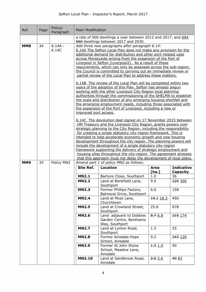
MM9 35 Policy MN2 Amend part 1 of policy MN2 as follows:
Site Ref. Location Area
[ha.]
Indicative
Capacity
MN2.1 Bartons Close, Southport 1.0 36
MN2.2 Land at Bankfield Lane,
Southport
9.0 220 300
MN2.3 Former Phillips Factory,
Balmoral Drive, Southport
6.0 158
MN2.4 Land at Moss Lane,
Churchtown
19.1 18.3 450
MN2.5 Land at Crowland Street,
Southport
25.8 678
MN2.6 Land adjacent to Dobbies
Garden Centre, Benthams
Way, Southport
8.7 6.8 215 174
MN2.7 Land at Lynton Road,
Southport
1.5 25
MN2.8 Former Ainsdale Hope
School, Ainsdale
9.2 243 120
MN2.9 Former St John Stone
School, Meadow Lane,
Ainsdale
1.3 1.4 40
MN2.10 Land at Sandbrook Road,
Ainsdale
2.0 2.6 49 83

Sefton Local Plan - Inspector’s Report, March 2017
5
Ref. Page Policy/
Paragraph Main Modification
MN2.11 Land south of Moor Lane,
Ainsdale
2.6 3.2 69
MN2.12 Land north of
Brackenway, Formby
13.7 286
MN2.13 Land at West Lane,
Formby
1.9 40
MN2.14 Former Holy Trinity
School, Lonsdale Road,
Formby1
0.9 1.0 50
MN2.14A Land at Shorrocks Hill,
Lifeboat Road, Formby
3.3 34
MN2.15 Formby Professional
Development Centre, Park
Road, Formby
1.6 15
MN2.16 Land at Liverpool Road,
Formby
14.2 319
MN2.17 Land at Altcar Lane,
Formby
0.7 29
MN2.18 Power House phase 2,
Hoggs Hill Lane, Formby
0.6 0.4 20 12
MN2.19 Land at Andrew’s Close,
Formby
3.3 87
MN2.20 Land at Elmcroft Lane,
Hightown
6.5 120
MN2.21 Land at Sandy Lane,
Hightown
0.7 10
MN2.22 Land at Hall Road West,
Crosby
1.1 14
MN2.23 Land at Southport Old
Road, Thornton
3.9 85
MN2.24 Land at Holgate, Thornton 8.4 221
MN2.25 Land at Lydiate Lane,
Thornton
10.3 10.2 265
MN2.26 Land south of Runnell’s
Lane, Thornton
5.3 137
MN2.27 Land at Turnbridge Road,
Maghull
1.6 40
MN2.28 Land north of Kenyons
Lane, Lydiate
9.7 10.1 295
MN2.29 Former Prison Site, Park
Lane, Maghull
13.6 370
MN2.30 Land east of Waddicar
Lane, Melling
6.0 178
MN2.31 Wadacre Farm, Chapel
Lane, Melling
5.5 135
MN2.32 Land south of Spencers
Lane, Melling
0.6 18
MN2.33 Land at Wango Lane,
Aintree
1.8 25
MN2.34 Aintree Curve Site,
Ridgewood Way,
Netherton
3.1 100 109
MN2.35 Former Z Block Sites, 3.5 100

Sefton Local Plan - Inspector’s Report, March 2017
6
Ref. Page Policy/
Paragraph Main Modification
Buckley Hill Lane,
Netherton
MN2.36 Former St Raymond’s
School playing field,
Harrops Croft, Netherton
1.9 65 53
MN2.37 Land at Pendle Drive,
Netherton
1.4 52 29
MN2.38 Land at the former Bootle
High School, Browns
Lane, Netherton
1.7 63
MN2.39 Former Daleacre School,
Daleacre Drive, Netherton
1.0 37
MN2.40 Former Rawson Road
Primary School, Rawson
Road, Bootle
1.0 20
MN2.41 Former St Wilfrid’s
School, Orrell Road,
Bootle
6.6 160
MN2.42 Klondyke Phases 2 and 3,
Bootle
4.2 3.6 140 142
MN2.43 Peoples site, Linacre
Lane, Bootle
2.9 110
MN2.44 Former St Joan of Arc
School, Rimrose Road,
Bootle
1.3 48 51
MN2.45 Former St Mary’s Primary
School playing fields,
Waverley Street, Bootle
1.6 72
MN2.46 Land East of Maghull 86.0 85.8 1400
TOTALS: 314.3
315.2
7309
7264 1 Site allocated specifically for older persons housing / accommodation
(reserved for residents aged 55 and over).
MM10 36 Policy MN2 Amend part 4 of the policy as follows:
4. Sites MN2.2, MN2.4, MN2.6, and MN2.19 are adjacent to
areas of ‘Proposed Open Space’. These areas will be
developed for new open space alongside the housing
allocation.
MM11 36 Policy MN2 Add a new part 4A to the policy:
4A. Site MN2.8 Former Ainsdale Hope School, Ainsdale will
include an Ecological Improvement Area to be developed as
a nature reserve alongside the housing allocation.
MM12 36 Policy MN2 Delete reference to site MN2.49 in part 5 of the policy:
MN2.49: Land to the South of Formby Industrial Estate - 7
ha (net)
Amend part 7 of the policy:
7. Land North of the Formby Industrial Estate (site
MN2.48) and Land South of the Formby Industrial Estate
(site MN2.49) are is subject to a site specific policyies
(Policyies MN4 and MN5).
MM13 37 6.17 Delete paragraph 6.17:
6.17 Sufficient land has been identified to exceed the total

Sefton Local Plan - Inspector’s Report, March 2017
7
Ref. Page Policy/
Paragraph Main Modification
housing requirement of 11,070 dwellings by around 6.5% (720
dwellings) to allow for contingencies. This additional supply is
intended to ensure that delays or unforeseen problems on
allocated sites identified in this policy will not undermine housing
delivery over the Plan period. This contingency allowance is
unrelated to the requirement at paragraph 47 of the Framework
to identify a buffer of 5% or 20% to the ‘5 year supply’. The
contingency allowance will also allow choice and provide flexibility
to adapt to rapid change, as required by paragraph 14 of the
National Planning Policy Framework.
MM14 38 6.25 Amend the paragraph as follows:
6.25 Two Four areas of ‘Proposed Open Space’ are identified on
the Policies Map. These areas are adjacent to, and in the same
ownership as, proposed housing allocations. New open space will
be created at these sites alongside the development of the
adjacent housing allocation. Both All these areas are affected by
constraints that severely restrict or preclude residential
development. The Proposed Open Space at Land adjacent to
Dobbies Garden Centre, Benthams Way, Southport (MN2.6) is at
greatest risk of surface water flooding. The Proposed Open Space
at Andrews Close, Formby (site MN2.19) is in Flood Zone 3, and
tThe area identified at Bankfield Lane, Southport (MN2.2) is within
the setting of a listed building and the area at Moss Lane,
Churchtown (MN2.4) has been identified to maintain the open
character of the north east corner as it is within the setting of the
North Meols conservation area. However, these areas are suitable
for the creation of open space, which could include new public
open space, habitat creation, sustainable drainage, or a mixture
of these. Their removal from Green Belt would also create a more
robust Green Belt boundary.
MM15 40 Policy MN3 Amend policy MN3 as follows:
MN3 STRATEGIC MIXED USE ALLOCATION - LAND EAST OF
MAGHULL
1. Land East of Maghull (shown on the Policies Map) is
identified as a Strategic Mixed Use Allocation. The
development of this site will create a comprehensive high
quality, well-designed phased sustainable urban extension
containing integrated, distinctive, safe and secure
residential neighbourhoods, a Business Park and
improvements to local infrastructure.
1A. Proposals for development within Land East of Maghull
will only be granted planning permission where they are
consistent with a single detailed master plan for the whole
site which is approved by the Council. The master plan
should accord with this policy and any associated
Supplementary Planning Document and should be
submitted prior to or with the first application. Planning
permissions will be linked to any necessary legal
agreements for the improvement, provision, management
and maintenance of infrastructure, services and facilities,
open spaces and other matters necessary to make the
development acceptable and which facilitate
comprehensive delivery of all phases of development

Sefton Local Plan - Inspector’s Report, March 2017
8
Ref. Page Policy/
Paragraph Main Modification
within the site in accordance with the master plan.
1B. Proposals for development within this site must
demonstrate a comprehensive approach to infrastructure
provision (including provision of an appropriate proportion
of financial and/or ‘in kind’ contributions towards strategic
and/or local infrastructure required to enable the
comprehensive development of the site). All residential
applications within the site must contribute proportionally
(on a per dwelling basis) to the following improvements:
a) expansion of Summerhill Primary School to become a
two form entry school
b) the provision of a main park within the site
c) new slip roads at junction 1 of the M58 motorway
d) subsidy of a bus service through the site for a period of
5 years
2. No applications for residential or employment
development will be permitted until a Supplementary
Planning Document relating to this site has been
adopted by the Council.
3. The development of the site must provide:
a) A minimum of 1400 dwellings, including incorporating a
range of housing types and tenures to meet identified
housing needs. This will include the provision of
affordable / special needs housing (policy HC1), and
provision at least 2 dedicated older persons housing
schemes (reserved for residents of 55 and over) each
comprising at least 25 dwellings for older persons
housing (policy HC2)
b) A 20 hectare (net) serviced Business Park for office and
light industrial (class B1), general industrial, (B2), and
storage and distribution (B8) uses. The Business Park
will to be located adjacent to the site’s northern and
eastern boundary as set out in the broad location
identified in figure 6.1.
c) Small-scale retail and commercial development to
ensure the convenience shopping and other needs of
new residents are met. This should be no more than
2,000 sq m (gross) in total. Local shopping provision of
an appropriate scale to serve the needs of the new
community;
d) A new ‘main park’ through the site located either side of
Whinney Brook. This must incorporate an equipped play
area, new habitat creation, and provision for outdoor
sports Appropriate new public open space,
incorporating a neighbourhood park, equipped play
area, new habitat creation, and provision for outdoor
sports
e) A landscaping network including tree planting, buffer
zones between employment and housing areas and to
the M58 motorway and railway, the strategic paths and
cycle routes network
f) A layout that facilitates provides:

Sefton Local Plan - Inspector’s Report, March 2017
9
Ref. Page Policy/
Paragraph Main Modification
a bus route across the site from School Lane /
Maghull Lane in the north to Poverty Lane in the
south;
a distributor road(s) that encourages residential
traffic from the southern part of the site to access /
egress via School Lane / Maghull Lane. The
distributor road(s) will run from School Lane /
Maghull Lane through the site and will cross
Whinney Brook; and
appropriate separation of commercial and residential
traffic
g) The layout should also ensure an appropriate separation
of commercial and residential traffic
g) Walking and cycling routes within and beyond the site
linking new and existing residential areas and business
park to the railway stations, bus services, new local
centre local shops, open space, and local schools. This
will include improving existing rights of way within the
site, including upgrading the existing Maghull no. 11
footpath to a pedestrian / cycle way
h) Effective management of flood risk within the site,
including use of sustainable drainage systems. The
development of the site will result in the reduction of
flood risk onsite and to the adjacent railway line. No
residential development will be located in Flood Zones 2
or 3 following any watercourse realignment, and
Buildings should be sited away from areas at high risk
of flooding, and
i) The long-term management and maintenance of public
open space, landscaping, and sustainable urban
drainage systems, to be agreed by the Council.
4. The development of this site must be subject to a
single outline planning application covering the whole of
the site. The outline application must:
Specify how the infrastructure contributions listed at
part 5 of this policy will be phased and implemented
Indicate the location of the business park
Indicate the location of an internal bus route linking
School Lane and Poverty Lane
Indicate the location of access points to the business
park and new residential areas from Poverty Lane
and School Lane
Indicate the location of the proposed public open
space, and
Provide a strategic landscaping framework.
4. Development of the site will be phased to The following
phasing requirements will be applied to ensure that the
required infrastructure is provided alongside new
development. The following timetable and restrictions
will apply unless an alteration is agreed in writing with
the Local Planning Authority:
a) Maghull North station must be operational before
the practical completion of the 500th dwelling

Sefton Local Plan - Inspector’s Report, March 2017
10
Ref. Page Policy/
Paragraph Main Modification
b) The southbound on slip and northbound off slip at
Junction 1 of the M58 motorway must be constructed
before the practical completion of the 500th dwelling
c) The internal bus route linking School Lane and
Poverty Lane must be provided before completion of the
500th dwelling. No more than 250 dwellings will be served
from Poverty Lane and no more than 250 dwellings will be
served from School Lane / Maghull Lane, prior to the
completion of the internal bus route / distributor road
d) Serviced plots must be made available on 25% of
the area of the business park The access into the business
park from School Lane / Maghull Lane must be constructed
to an appropriate standard, servicing into the business
park provided, and the landscaping framework to the
business park implemented before the practical completion
of the 500th dwelling
e) The proposed Business Park must not be occupied
until the new slip roads are completed at Junction 1 of the
M58
f) The local shopping provision must be constructed
and made available for occupancy before the practical
completion of the 750th dwelling, and
g) The neighbourhood main park and outdoor sports
provision will be provided in a phased manner, so that it
becomes available when the adjacent housing is completed
5. The development of this site will secure the following
benefits, including through the use of planning conditions,
‘Section 106’ or other legal agreements and a phasing/
implementation plan:
a) A financial contribution to secure the provision of the
new Maghull North station and associated park and ride
facility
b) A financial contribution to secure the delivery of the
new slip roads required at Junction 1 of the M58 motorway
c) A financial contribution to subsidise a bus service
through the site for at least 3 years
d) Provision of other appropriate highways and public
transport improvements
e) The provision of affordable / special needs housing
and older persons housing (policies HC1 and HC2), and
f) Financial contributions to improve health care and
education facilities, including expansion of Summerhill
Primary School, and to provide appropriate community
facilities within the local centre.
MM16 41-
42
6.38-6.41 Amend the first two sentences of paragraph 6.38 as follows:
6.38 Land east of Maghull will provide a sustainable urban
extension with major local benefits. These will include a
contribution to a new Maghull North railway station slip roads at
junction 1 of the M58, a new neighbourhood main park (as set out
in the Open Space and Recreation Study and other Council
documents), sports provision, a new local centre shopping
provision, and a 20 ha (net) business park.
Add an additional sentence to the end of paragraph 6.41 and a

Sefton Local Plan - Inspector’s Report, March 2017
11
Ref. Page Policy/
Paragraph Main Modification
new Figure 6.1:
The Business Park should be located adjacent to the site’s north
eastern boundary as set out Figure 6.1:
MM17 43 Policy MN4 Amend part 1e of the policy as follows:
e) Flood risk will be managed effectively and appropriately
within the site, including through the use of flood
storage areas and sustainable drainage systems; and
MM18 44 Policy MN5 Delete policy MN5 and the associated text
MM19 45 Policy MN6 Amend the first sentence of part 1b of the policy as follows:
b) Retain and manage 7.9 ha of grassland and wetland
habitats outside of the residential allocation as a buffer
zone to the adjacent nature reserve, including additional
species enhancement measures.
Amend part 1c of the policy as follows:
c) Include a signal controlled junction onto the Formby
Bypass and a through route to a secondary means of
access via Paradise Lane
MM20 46 6.64 Amend paragraph 6.64 as follows:
6.64 A new signal controlled junction must also be provided onto
the Formby Bypass to facilitate provide access into the site. The
site layout should ensure provide that a secondary access via
Paradise Lane. Any route created through the site into Formby
should be designed to direct through route to other parts of
Formby is not created, to discourage ‘rat running’ through traffic.
MM21 46 Policy
MN6A
Add a new policy and explanatory text:
Land at Moss Lane, Churchtown

Sefton Local Plan - Inspector’s Report, March 2017
12
Ref. Page Policy/
Paragraph Main Modification
6.64A Land at Moss Lane, Churchtown has been identified as a
housing allocation under Policy MN2. The policy below sets out the
site specific requirements that will apply to this site.
MN6A LAND AT MOSS LANE, CHURCHTOWN
1. Land at Moss Lane, Churchtown, is allocated for housing
(as shown on the Policies Map). Development of this site
must:
a) Provide for the widening of Moss Lane between the Roe
Lane/Mill Lane roundabout and the main vehicular
access point into the site, to a minimum width of 6
metres with 2m wide footway on the southern side of
Moss Lane. This can be achieved within the existing
highway and site boundary.
b) Provide a financial contribution to subsidise the
extension of a bus service into the site for at least 5
years.
c) Provide a loop road arrangement or suitable turning
facility within the northern half of the site for the use of
bus services.
d) Provide a layout that provides for mitigation from the
operation of the adjacent golf course
e) Retain the existing woodland that abuts Moss Lane to
the north, and provide for its long term management.
The development must also make provision for
footpaths through and public access to the woodland
area.
f) Preserve the setting of the adjacent North Meols
Conservation Area, and secure a transition to open
countryside, by:
o Providing a 15 metre deep screen of trees along the
Moss Lane frontage, between no. 83 Moss Lane and
the western edge of Pool House Farm, whilst
allowing for a safe vehicular point of access into the
development. Existing mature trees around Pool
House Farm should be retained and supplemented
with additional planting.
o Maintaining the open character of the north east
corner of the site, identified as Proposed Open Space
on the Policies Map.
g) Incorporate any necessary flood risk mitigation; and
h) Provide habitat creation and management, appropriate
tree planting, and a landscaped buffer alongside the
Three Pools Waterway.
2. These requirements will be achieved through the use of
planning conditions, Section 106 and other legal
agreements.
Key policy links
MN1 Housing and Employment Requirements
MN2 Housing, Employment, and Mixed Use Allocations
Explanation

Sefton Local Plan - Inspector’s Report, March 2017
13
Ref. Page Policy/
Paragraph Main Modification
6.64B Land at Moss Lane, Churchtown is a 18.3 ha urban
extension with the capacity to accommodate around 450
dwellings. The site will make a significant contribution to housing
provision in Southport, including towards meeting Southport’s
high affordable housing need.
6.64C A number of improvements are necessary to ensure that
the site is accessible to pedestrians, vehicles, and public
transport. Whilst the majority of Moss Lane between the Roe
Lane/Mill Lane roundabout and the likely main vehicular access
point into the site is of adequate width, certain sections will
require widening and the introduction of footways. In addition, the
existing no. 43 bus service currently terminates at the Roe
Lane/Mill Lane roundabout. MerseyTravel have confirmed to the
Council that the extension of the no. 43 service into the site would
be feasible, and that a contribution would be required from the
developer for a period of 5 years to establish this extended
service. The 5 year subsidy period should commence immediately
following the construction of the 150th dwelling.
6.64D Southport Old Links Golf Course is adjacent to the site, and
a number of holes are close to the proposed development area.
The layout of any development in this location should incorporate
mitigation to ensure that new properties are reasonably screened
from wayward golf balls.
6.64E An existing area of woodland (approximately 1.2 ha in
size) is located within the northern part of the site. This woodland
should be retained and integrated within the development,
including provision for footpaths through, and public access into,
the woodland area.
6.64F The North Meols Conservation Area is located to the north
west of the site, and includes the Grade II* listed Meols Hall and
its historic parkland. Historically, the Hall was surrounded by open
countryside, and whilst its western boundaries have now been
subsumed by urban Southport and trees planted to the eastern
perimeter, part of the agricultural setting of the estate remains
intact. In order to preserve connections between the estate and
the countryside, the development of this site must retain and
enhance the existing screen of trees and development along Moss
Lane. In addition, the area of the site to the east of Pool House
Farm must be retained as open space to preserve the open
countryside feel of this part of the site.
6.64G It is envisaged that the main vehicular point of access will
be located between the existing plantation and the western edge
of Pool House Farm. Whilst part 1f(a) of the policy requires a 15
metre deep screen of trees along part of the Moss Lane frontage,
this should allow for a safe point of access into the development,
including necessary visibility splays.
6.64H The Habitats Regulations Assessment (HRA) of the Local
Plan requires a site specific HRA for this site, in order to provide
appropriate protection to the integrity of the Special Protection
Areas/Ramsar sites bird populations. Appropriate species surveys

Sefton Local Plan - Inspector’s Report, March 2017
14
Ref. Page Policy/
Paragraph Main Modification
will be required to determine the presence/ likely absence of
target species where identified. Sufficient information must be
provided with the planning application to enable the Council to
make a Habitats Regulations Assessment.
MM22 48 Policy MN8 Amend the site areas in part 1 of the policy:
Site Ref. Location Area [ha.]
MN8.1 Land at Lambshear Lane, Lydiate 33 33.9
MN8.2 Land adjacent to Ashworth Hospital,
Maghull
18.5 15.1
MM23 49 6.78 Replace paragraph 6.78 with the following:
6.78 The two areas of Safeguarded Land have a combined
potential capacity for around 1,000 dwellings. In addition, it is
assumed that 318 dwellings at site MN2.5 Crowland Street,
Southport, 90 dwellings at site MN2.4 Land at Moss Lane,
Southport, 80 dwellings at site MN2.46 Land East of Maghull, and
263 dwellings at Town Lane, Southport (permission ref
S/2012/0400) will be delivered after 2030 due to likely market
take-up rates. This land, with a total estimated capacity of some
1,750 dwellings, will ensure that the proposed Green Belt
boundary will endure in the longer term, beyond the current Local
Plan period, though no specific time horizon is identified as to
when that will be.
MM24 51 Policy ED1 Replace part 1f of policy ED1 with the following:
f) For development which is outside the Seaforth Nature
Reserve, but within the remainder of the Port and Maritime
Zone including any expansion of the operational port area
to the A565, it can be demonstrated that there are no
likely significant effects on the Mersey Narrows and North
Wirral Foreshore and Liverpool Bay Special Protection
Areas and other internationally important nature sites.
Amend part 2c as follows:
c) Demonstrate that there are no likely significant effects
on the Mersey Narrows and North Wirral Foreshore and
Liverpool Bay Special Protection Areas or and other
internationally important nature sites.
Amend part 3 as follows:
3. Improvements to access will be required to support the
expansion of the Port. This may require a new road and /or
substantial improvements to the surrounding highway
network beyond the Port area, as well as other modes of
transport, specifically rail.
Amend part 4 as follows:
4. Planning conditions and / or legal agreements will be
used to ensure appropriate compensation, mitigation,
infrastructure and appropriate local economic, environment
and community benefits are secured and provided both
within and beyond Sefton.
MM25 52 7.14 Replace the final five sentences of paragraph 7.14 with:
The area adjacent to the main entrance to the Port suffers from
poor air quality. It is recognised that major road improvements to
facilitate port access will be required in the long term. A scheme
has been included in the Road Investment Strategy, and

Sefton Local Plan - Inspector’s Report, March 2017
15
Ref. Page Policy/
Paragraph Main Modification
Highways England has commissioned an Options Identification
and Assessment study, which will be completed in summer 2016.
Highways England have confirmed, in their newsletter of October
2015, that they are considering two options for improved road
access to the port; upgrade Dunnings Bridge Road; or a new road
through the Rimrose Valley.
Add new paragraphs 7.14A and 7.14B after paragraph 7.14:
7.14A The Canada Dock Rail Connectivity Study (April 2015) was
prepared on behalf of Merseytravel and the Homes and
Communities Agency to identify options for reconnecting the
Southern Zone of the Port of Liverpool to the railway network. The
study recommended that land associated with the former Canada
Dock Branch Line should not be safeguarded, and that reinstating
the route would be a costly and operationally unsatisfactory
option. The study concludes that rail connectivity could be
improved most affectively by extending the existing rail line south
from Alexandra Dock. The viability of this proposal will be
assessed in greater detail within the emerging Port Master Plan
and Long Term Freight Strategy and as part of the Duty to
Cooperate associated with an early review of the Local Plan
7.14B Network Rail is bringing forward proposals that will
improve the rail freight capacity on the Bootle Branch Line into
the Port of Liverpool, which will accommodate increased rail
freight movements associated with the increase in biomass
imports for energy generation and with the growth in container
movements that will result from the opening of Liverpool2.
MM26 54 7.18 Replace ‘Primary Retail Areas’ with ‘Primary Shopping Areas’
MM27 54 Policy ED2 Amend parts 1 to 5 of policy ED2 as follows:
ED2 DEVELOPMENT IN TOWN CENTRES, DISTRICT
CENTRES, LOCAL CENTRES AND LOCAL SHOPPING
PARADES AND OUTSIDE DEFINED CENTRES
1. Retail, leisure and other main town centre uses1 will be
directed towards the Borough's existing centres in
accordance with the following hierarchy:
Town
Centres:
Bootle and Southport
District
Centres:
Crosby, Formby, Maghull and Waterloo
Local
Centres:
Ainsdale, Birkdale, Churchtown, Netherton
and Old Roan
Planning permission will only be granted for development
which is appropriate to the role and function of each
centre.
Sequential Test
2. Where proposed outside of the defined town, district and
local centres, Proposals for all retail, leisure and other
town centre uses will be subject to a sequential approach
to development. This will require applications for town

Sefton Local Plan - Inspector’s Report, March 2017
16
Ref. Page Policy/
Paragraph Main Modification
centre uses to be located firstly in:
Primary Shopping Areas (retail uses only), then
town centres, district and local centres (in
accordance with the hierarchy in part 1), then
edge of centre locations, and
only if suitable sites are not available should out of
centre sites be considered.
When considering new proposals in out of centre locations,
preference will be given to accessible sites that are well
connected to a defined centre in accordance with part 1 of
the policy. For retail uses, if there are no accessible out of
centre sites that are well connected to a defined centre,
preference will be given to the existing retail parks2 (as
shown on the Policies Map).In addition, all proposed retail,
leisure and other town centre uses should demonstrate:
• that they would not prejudice the delivery of planned
investment within any existing defined centre, and
• that no significant adverse impact on the vitality and
viability of any existing centre will arise from the
proposed development.
Impact Test
3. For retail, leisure and other town centreoffice uses
proposalsproposed outside of existing defined centres,
impact assessments will be required to accompany
planning applications at the locations identified below
based on the following floorspace thresholds at the
following locations set out:
• outside of the Primary Shopping Areas (for retail) or
the town, district and local centres (for leisure and
office uses) of Bootle and Southport, an impact
assessments will be required for development which
proposes more than 500m2 gross floorspace or more
• within 800 metres of the boundaries of the district
centres, an impact assessment will be required for
development which proposes more than 300m2 gross
floorspace, and
• within 800 metres of the boundaries of the local
centres, an impact assessment will be required for
development which proposes more than 200m2 gross
floorspace.
Where more than one impact threshold applies, the lower
impact threshold will take precedence. Where appropriate,
impacts on the vitality and viability of designated retail
centres in neighbouring local authorities will also be
required to be assessed. All proposed retail, leisure and
offices uses which exceed the above local impact threshold
test (part 3) should demonstrate:
that they would not have a significant adverse
impact on the delivery of existing, committed, and
planned public and private investment within any

Sefton Local Plan - Inspector’s Report, March 2017
17
Ref. Page Policy/
Paragraph Main Modification
existing defined centres, and
that no significant adverse impact on the vitality and
viability of any existing centres will arise from the
proposed development, including to local consumer
choice and trade in defined centres and the wider
area, up to five years from the time the application is
made. For major schemes where the full impact will
not be realised in five years, the impact should also
be assessed up to ten years from when the
application is made.
Subject to the above, impact assessments may also be
required in other circumstances, including where a change
of use or variation of conditions from one form of
retail development to another is proposed and could
materially affect local shopping patterns.
4. Within Primary Shopping Areas (as shown on the
Policies Mapsee figure 7.2) proposals for non-retail uses,
compatible with a town centre location, will be permitted
providing that:
(i) the overall retail function of the Centre would not
be undermined
(ii) the use would make a positive contribution to the
overall vitality and viability of the Centre, and
(iii) it would not result in an unacceptable cluster of
non-retail uses.
Within the primary retail frontages identified on the
Policies Map, it is expected that 70% of units should fall
within the A1 (retail) Use Class.
Applications within primary and secondary frontages at the
town and district centres which would result in the loss of
an active ground floor use will not be supported.
Outside of Primary Shopping Areas, but within defined
centres, all main town centre uses will be considered
acceptable in principle.
5. Residential development and other non-town centre
usesdevelopment will be permitted, if it does not
compromise the vitality and viability of the centre or
parade, in:
defined town and district centres (outside Primary
Shopping Areas) and local centres, or
upper floors of buildings in the Primary Shopping
Area, or
local shopping parades 1 As defined in NPPF Annex 2 2 Aintree Racecourse Retail Park and Grand National Retail Park in Aintree, Switch Island Leisure Park, Netherton and Meols Cop, Ocean Plaza and Kew Retail Parks in Southport
MM28 56 7.20-7.22 Replace paragraph 7.20 with the following:
7.20 The 2015 Retail Strategy Review (RSR) identifies no

Sefton Local Plan - Inspector’s Report, March 2017
18
Ref. Page Policy/
Paragraph Main Modification
immediate capacity for additional convenience shopping
floorspace in North Sefton, with a limited capacity arising in the
longer term up to 2030. For South Sefton, the RSR forecasts a
more significant capacity for additional convenience shopping
floorspace in both the short and medium term, providing potential
investment opportunities to support future development in Bootle,
Crosby and Maghull.
Replace paragraph 7.21 with the following:
7.21 The RSR identifies no significant overall need for new
comparison floorspace within the Borough in the period up to
2020, with additional capacity for comparison goods floorspace
predicted to arise in the latter half of the plan period, The reuse of
existing vacant floorspace is expected to absorb some of this
identified capacity. The RSR forecasts the majority of the arising
comparison floorspace need will be in North Sefton. To reflect this,
additional floorspace for comparison shopping would be supported
in principle in Southport Town Centre, particularly where it would
improve Southport’s market share or reuse existing floorspace.
Similarly in south Sefton, notwithstanding the availability of
capacity in the south of the Borough, any proposed new
floorspace should be focused towards the Borough’s defined
centres in accordance with the sequential approach and the Retail
Strategy.
Replace paragraph 7.22 with the following:
7.22 The RSR’s forecasts will be reviewed regularly to help
provide an up to date assessment of the retail needs and capacity
within the Borough, and help to address any uncertainties in
predicting how the retail sector will perform over time given its
fluidity in recent years.
Add new paragraph 7.22A after paragraph 7.22:
7.22A The sequential test and impact assessment should be
undertaken in a proportionate and locally appropriate way, and
ideally agreed at pre-application stages, drawing on and sharing
existing information where possible. The applicants and the
Council should seek to agree the scope, key impacts for
assessment, potentially alternative sites and the level of detail
required in advance of applications being submitted.
MM29 56 Figure 7.2 Delete Figure 7.2.
MM30 57 Policy ED3 Rename the policy ‘Existing Employment Areas’, and replace
‘Primarily Industrial Area’ with ‘Existing Employment Area’
throughout the policy, including the policy links and associated
text (paragraphs 7.26 - 7.28).
Amend the policy as follows:
ED3 PRIMARILY INDUSTRIAL EXISTING EMPLOYMENT
AREAS
1. The Primarily Industrial Existing Employment Areas are
suitable for the following uses:
• Office and light industrial (class B1)
• General Industrial (class B2)
• Storage and distribution (class B8)

Sefton Local Plan - Inspector’s Report, March 2017
19
Ref. Page Policy/
Paragraph Main Modification
2. Other uses will only be permitted where they:
They are small scale or ancillary to the above uses,
and would not prejudice the operation of Class B1,
B2, or B8 uses within the Existing Employment Area,
or
The land/premises are currently vacant and have
been continuously and actively marketed for B1, B2
or B8 uses for at least 12 months (starting from the
date the site became vacant) at a reasonable
market rate (i.e. rent or capital values) and it has
been demonstrated in a formal marketing report that
there is no reasonable prospect of the site being
used for employment use, or
There would be a significant community benefit that
would outweigh the loss of the employment
land/premises.
• are small scale or ancillary to the above uses, or
• maximise job outputs and are compatible with the
character and function of the area and with adjacent
uses.
3. Development within the Primarily Industrial Existing
Employment Areas must not:
• Significantly harm the amenity of any nearby
residents, and
• Significantly harm the general environment.
MM31 58 Policy ED4 Amend the policy as follows:
ED4 MIXED USE AREAS
1. The Mixed Use Areas listed below are suitable for the
following types of development: office and light industry,
health and educational uses, civic and community facilities,
and other uses that are compatible with complement the
character of the area.
1. Bootle Central Commercial Area
2. Land at Crosby Road North, Waterloo
3. Land at Copy Lane, Netherton
4. Land to the West of Ormskirk Road, Aintree
5. Switch Island, Aintree
6. Land at Hawthorne Road / Church Road, Bootle
MM32 59 Policy ED5 Amend policy ED5 as follows:
ED5 TOURISM
Strategic Tourism Locations
1. Tourism development will be supported in the following
locations, subject to there being no adverse effects on the
integrity of sites of international nature conservation
importance and to , other natural and heritage assets, or
other Local Plan policies:
Southport Seafront and Southport Central Area
Crosby Coastal Park
Aintree Racecourse
Adjacent to the Leeds and Liverpool Canal.
Other Tourism Development
Sefton Local Plan - Inspector’s Report, March 2017
20
Ref. Page Policy/
Paragraph Main Modification
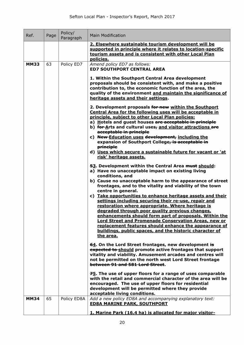
2. Elsewhere sustainable tourism development will be
supported in principle where it relates to location-specific
tourism assets and is consistent with other Local Plan
policies.
MM33 63 Policy ED7 Amend policy ED7 as follows:
ED7 SOUTHPORT CENTRAL AREA
1. Within the Southport Central Area development
proposals should be consistent with, and make a positive
contribution to, the economic function of the area, the
quality of the environment and maintain the significance of
heritage assets and their settings.
2. Development proposals for new within the Southport
Central Area for the following uses will be acceptable in
principle, subject to other Local Plan policies:
a) Hotels and guest houses are acceptable in principle
b) for Arts and cultural uses, and visitor attractions are
acceptable in principle
c) New Education uses development, including the
expansion of Southport College, is acceptable in
principle
d) Uses which secure a sustainable future for vacant or ‘at
risk’ heritage assets.
53. Development within the Central Area must should:
a) Have no unacceptable impact on existing living
conditions, and
b) Cause no unacceptable harm to the appearance of street
frontages, and to the vitality and viability of the town
centre in general.
c) Take opportunities to enhance heritage assets and their
settings including securing their re-use, repair and
restoration where appropriate. Where heritage is
degraded through poor quality previous changes,
enhancements should form part of proposals. Within the
Lord Street and Promenade Conservation Areas, new or
replacement features should enhance the appearance of
buildings, public spaces, and the historic character of
the area.
64. On the Lord Street frontages, new development is
expected to should promote active frontages that support
vitality and viability. Amusement arcades and centres will
not be permitted on the north west Lord Street frontage
between 91 and 581 Lord Street.
75. The use of upper floors for a range of uses comparable
with the retail and commercial character of the area will be
encouraged. The use of upper floors for residential
development will be permitted where they provide
acceptable living conditions.
MM34 65 Policy ED8A Add a new policy ED8A and accompanying explanatory text:
ED8A MARINE PARK, SOUTHPORT
1. Marine Park (16.4 ha) is allocated for major visitor-

Sefton Local Plan - Inspector’s Report, March 2017
21
Ref. Page Policy/
Paragraph Main Modification
based development [shown on the Policies Map].
Redevelopment of this site must significantly enhance the
regional leisure and tourism role of Southport.
2. The redevelopment of this site must:
a) Be of high design quality that compliments the
existing historic seaside environment and its open
character
b) Incorporate active frontages to both Marine Drive
and Esplanade
c) Significantly improves pedestrian links within and
through the site. This must include the provision
of a high quality, landscaped pedestrian link
through the site continuing the linear route
connecting Scarisbrick Avenue and the Venetian
Bridge in King’s Gardens to the seafront
d) Incorporate high quality landscaping, including
enhancements to the north western edge of the
Marine Lake.
e) Retain the open seafront setting of the listed pier,
and maintain views to and from it
f) Ensure that the position, orientation, and scale of
new buildings allows for open views to be
retained towards the sea from the Promenade and
the Seafront Gardens
g) Improve views from the Promenade towards
Ocean Plaza.
h) Provide appropriate compensatory open space and
green infrastructure within the site
3. The expansion of the existing fairground and the
provision of new outdoor leisure facilities are acceptable in
principle.
4. Any proposal to partially develop the site should be
prepared in the context of a development strategy for the
whole site.
5. Development that would adversely affect the integrity of
adjacent internationally important nature sites will not be
permitted.
Policy links:
ED5 Tourism
ED6 Regeneration
ED8 Southport Seafront
NH2 Protection and enhancement of nature sites, priority
habitats and species
National /regional context
LCR Visitor Economy Strategy to 2020, 2009
Southport Investment Strategy
Explanation
7.67A The Marine Park site represents a significant opportunity to

Sefton Local Plan - Inspector’s Report, March 2017
22
Ref. Page Policy/
Paragraph Main Modification
provide high quality development of a scale that enhances
Southport’s role as a regionally important centre for tourism, and
to act as a catalyst for further tourism investment. In particular,
this site offers the potential to create a development that
increases the number and type of visitors to Southport, and
encourages more families to visit the town. The Visitor Economy
Strategy also supports the development of a major new tourist
attraction at Marine Park. Development of this site will be
expected to meet each of the criteria set out in the policy to
ensure that the highest quality of development is achieved on this
prominent site.
7.67B The site is in a sensitive location between the seafront, the
Grade II listed pier and the Promenade Conservation Area,
incorporating the Kings and South Marine Registered Historic
Gardens. It is essential that the historic and visual connections
between the development site, the pier, the historic Promenade
frontage, and the historic gardens and the sea are retained. The
fairground compliments Southport’s heritage as a seaside resort
town, and the continuation of this use is seen as maintaining the
seafront’s historic character
7.67C Marine Park is located at a key gateway to Southport town
centre so design, layout and quality of development are critical to
the success and perception of the town. The Ocean Plaza
buildings currently detract from views across the historic
seafront. Opportunities to improve the longer ranging views
across the seafront from the Pier, Promenade, and Kings and
South Marine Registered Historic Gardens, should be taken.
7.67D The development of this site may involve the loss of some
or all of Princes Park (a non-designated heritage asset). It is
envisaged that the benefits of meeting parts 1 and 2 of this policy
will outweigh this loss. Appropriate new open space and green
infrastructure should also be provided within the site to
compensate for any loss of open space.
MM35 65 Policy ED8B Add new policy ED8B and accompanying explanatory text:
AINTREE RACECOURSE
7.67E Aintree Racecourse is an asset of national importance, and
is the home of the Grand National Festival, which hosts the world
class National Steeplechase. It is therefore a major and valuable
recreation, tourism and conferencing facility which attracts
significant numbers of visitors throughout the year thereby
contributing positively to the Borough and the wider Region’s
economy.
ED8B AINTREE RACECOURSE
1. Within the part of Aintree Racecourse which lies within
the Green Belt, development must meet all of the
following criteria:
a) maintain or enhance the existing use of the
Racecourse
b) preserve the character of the area
c) be consistent with national Green Belt Policy and

Sefton Local Plan - Inspector’s Report, March 2017
23
Ref. Page Policy/
Paragraph Main Modification
other Local Plan policies.
2. Within the remaining part of Aintree Racecourse,
development which enhances the recreational, tourism
and conference functions of the Racecourse will be
supported where consistent with other Local Plan
policies.
Key Policy Links:
ED5 Tourism
MN7 Sefton’s Green Belt
National /regional context
Liverpool City Region Visitor Economy Strategy to 2020,
2009
Explanation
7.67F Aintree Racecourse is an appropriate use within the Green
Belt, in which the majority of the site is located. Development that
enhances the recreational use of the Racecourse as a racing
venue will be supported where consistent with other Local Plan
policies. Development in this area should respect the openness of
the Green Belt. It is also important that development does not
harm existing outdoor recreation uses in the area of the
Racecourse within the Green Belt, due to the special character
and function of the Racecourse. This is in addition to the
restrictions on development within the Green Belt.
7.67G In the area of the Racecourse which is outside the Green
Belt (i.e. the Ormskirk Road frontage), development proposals
related to tourism, recreation or conferencing, particularly those
relating to the Racecourse, such as hotel and conference facilities,
will be supported where consistent with other Local Plan policies.
Retail uses, including food and drinks uses, which are ancillary to
the function of the Racecourse will be supported.
MM36 69 Policy HC1 Add new part 4A to policy HC1 after “All Areas” heading:
4A. Vacant Building Credit - Proposals that involve the re-
use of a vacant building or where it is demolished and
replaced by a new building, will receive a financial credit
equivalent to the existing gross floorspace (of relevant
vacant buildings) when calculating any affordable housing
contributions.
Amend part 5 of the policy by deleting the last sentence:
5. Special needs housing can be substituted for up to 50%
of the site affordable housing contribution on a bedspace
for bedspace basis. The residual affordable housing
requirement should meet the relevant tenure requirement.
Amend part 6 of the policy as follows:
6. Where extra care or sheltered housing is proposed to be
substituted for affordable housing, this must meet the
tenure requirements set out in parts 2 and 4 of this
policy.80% of this should be provided as social

Sefton Local Plan - Inspector’s Report, March 2017
24
Ref. Page Policy/
Paragraph Main Modification
rented/affordable rented and the remaining 20% provided
as intermediate housing for all parts of the Borough apart
from Bootle and Netherton, where it should be provided as
50% social/affordable rented housing and 50%
intermediate housing.
Add new parts 9 and 10 to the policy:
9. Off-site provision of affordable housing, or a
financial contribution of broadly equivalent value, will be
considered where it can be robustly justified, and where
the agreed approach contributes to the objective of
creating mixed and balanced communities.
10. In implementing the policy, the Council will have
regard to:
a) the definitions and provisions of affordable and/or
special needs housing in relevant national guidance as they
may change over time; and
b) changes in the Borough’s requirements for affordable
and special needs housing based on new evidence of need
as set out in future commissioned Strategic Housing
Market Assessments or similar studies.
MM37 70 After 8.13 Insert new paragraph 8.13A after paragraph 8.13:
8.13A The Vacant Building Credit is intended to offer an incentive
to brownfield development, including the reuse or redevelopment
of empty and redundant buildings. The existing floorspace of a
vacant building will be credited against the floorspace of the new
development. For example, where a building with a gross
floorspace of 8,000 square metres is demolished as part of a
proposed development with a gross floorspace of 10,000 square
metres, any affordable housing contribution should be a fifth of
what would normally be sought. When assessing Vacant Building Credits the Council will consider
the following: Whether the building has been made vacant for the sole
purposes of re-development Whether the building is covered by an extant or recently
expired planning permission for the same or substantially the
same development. The Government’s Planning Practice Guidance provides more
detail on the operation of the Vacant Building Credit.
MM38 72 Policy HC2 Amend the threshold in part 1 from 15 to 25 dwellings
1. In developments of 15 25 or more dwellings, the mix of
new properties provided must be as follows……
Replace part 2 of the policy with the following:
2. In developments of 50 or more dwellings, at least 20%
of new market properties must be designed to meet
Building Regulation Requirement M4(2) ‘accessible and
adaptable dwellings’.
Amend part 3 of the policy as follows:
3. Where housing for older people or people with special
needs is provided as part of a larger scheme, this should,
where appropriate, be located within the scheme in the

Sefton Local Plan - Inspector’s Report, March 2017
25
Ref. Page Policy/
Paragraph Main Modification
most accessible location for local services and facilities.
Add a new part 5 to the policy:
5. The Council will support proposals for Custom or Self-
Build homes on appropriate sites. To identify and provide
for those who wish to custom or self-build their own homes
the Council will:
Manage a register of interested parties who wish to
custom or self-build their own home
Identify at least two pilot schemes to be made
available for custom or self-builders.
MM39 73 8.31 Amend the first sentence of paragraph 8.31 as follows:
8.31 In this context, the construction of 20% of new housing in
developments of 50 homes or more to Building Regulation
Requirement M4(2) Lifetime Homes standards will help to provide
more flexible accommodation.
Delete the remainder of the paragraph and replace with:
Optional Technical Standards for Housing allow planning
authorities to set additional technical requirements exceeding the
minimum standards required by Building Regulations in respect to
access. Optional requirement M4(2) ensures new housing
incorporates features that make it adaptable to a wide range of
occupants, including older people. The emerging Affordable,
Special Needs and Older People’s Housing SPD will provide further
guidance on policy HC2 part 2.
MM40 74 After 8.34 Add new paragraph 8.34A after paragraph 8.34:
8.34A Custom and Self-build homes are a means of allowing local
people or groups to commission, design, construct or complete
their own home. Sefton has recently completed an Assessment of
the Potential for Self-build and Custom Build Homes in the
borough. Whilst this assessment hasn’t been able to determine a
level of demand in Sefton for these types of schemes, it proposed
a number of recommendations to allow the Council to further
understand likely demand. One recommendation is for the setting
up of a register to allow people and groups to indicate that they
want to custom or self-build their homes. Another
recommendation is that the Council identifies a small number of
pilot sites to be made available for custom and self-build homes.
The Council intends to implement both of these recommendations
in the short term. These will provide a much better view of the
demand for this type of accommodation in Sefton and may lead to
a Supplementary Planning Document and/or a review of how the
Council disposes of its excess land.
MM41 77 Policy HC5 In part 2 of policy HC5, add “including from flood risk” to the end
of the first bullet point.
The site should provide a safe environment for intended
occupants including from flood risk
MM42 79 Policy HC7 Amend part 2 of the policy as follows:
2. Development of the site must retain key green
infrastructure and minimise harm to the historic
environment and its setting the heritage characteristics of
the site.
Amend part 3 of the policy and header above:

Sefton Local Plan - Inspector’s Report, March 2017
26
Ref. Page Policy/
Paragraph Main Modification
Sites formerly in use as schools, colleges or other care
institutions
3. Development for an alternative use which is compatible
with the surrounding area is acceptable in principle, where
appropriate evidence is provided that the institution and its
ancillary facilities are surplus to recreational requirements.
MM43 81 Policy IN1 Amend policy IN1 as follows:
IN1 INFRASTRUCTURE AND DEVELOPER CONTRIBUTIONS
1. The Infrastructure Delivery Plan, Appendix 1 and other
policies in the Local Plan lists the essential infrastructure
required for the implementation of the Local Plan strategy.
2. Social, community, environmental and physical
infrastructure will be protected, enhanced and provided
where there is an identified need to support sustainable
communities.
3. Developer contributions may also be sought in
appropriate locations to assist with regeneration objectives
set out elsewhere in the plan.
4. Where appropriate, contributions will be sought to
enhance and provide infrastructure to support new
development. This may be secured as a planning obligation
through a legal agreement, through the Community
Infrastructure Levy or through other agreements.
5. Where appropriate, the Council may require developers
to provide the necessary infrastructure themselves as part
of their development proposals, rather than making
financial contributions.
5A. Developer contributions may also be sought in
appropriate locations to assist with regeneration objectives
set out elsewhere in the plan.
6. Planning conditions or phased legal agreements may be
used to ensure essential infrastructure is provided within
appropriate timescales.
7. The Council will work with a range of partners to make
sure that infrastructure is provided in the right location
when required.
8. The impact of providing or contributing to infrastructure
on the viability of development proposals will be
considered. Where scheme viability will be affected,
developers will be expected to provide Viability
Assessments which will be taken into account as a material
consideration in the determination of planning
applications. Essential infrastructure is required regardless
of viability.
MM44 82 9.13 Add an additional sentence to the end of the paragraph:
However, viability issues must not be a reason to avoid the
provision of essential infrastructure, i.e. infrastructure needed to

Sefton Local Plan - Inspector’s Report, March 2017
27
Ref. Page Policy/
Paragraph Main Modification
make the development acceptable in planning terms.
MM45 83 Policy IN2
In the last bullet point of part 1 of policy IN2, replace ‘Aintree
Curve’ with ‘North Mersey Branch line’.
Amend part 2 of the policy as follows:
2. Improvements to The Council’s general priorities for the
transport network will take account of the need forinclude:
• Improving safety and accessibility for all transport
users
• Protecting the freight distribution network
• Maintaining, improving and extending the walking
and cycling network
• Better connecting new and existing neighbourhoods
with the public transport network
• Creating opportunities for existing transport to
become more sustainable such as by
promoting/installing charger units at appropriate
places along routeslocations.
Delete ‘Highways Agency’ from the first bullet point of part 4 of
the policy.
Add a new part 7 to the policy:
7. The Council will support initiatives to reconnect the Port
of Liverpool (Southern Zone) between Alexandra Dock and
Sandon Dock to the rail network. Subject to the compliance
with Policy ED1 ‘The Port and Maritime Zone’ and Policy
NH2 ‘Protection and enhancement of nature sites, priority
habitats and species’, proposals by Peel Ports to extend the
existing rail lines within the Port of Liverpool at Seaforth to
directly serve the new Liverpool2 container terminal will be
supported.
MM46 84 9.17 Replace the final sentence with:
Options are being explored to reconnect the Port of Liverpool
(Southern Zone) from Alexandra Dock to the rail network as part
of the Port Master Plan and Long Term Freight Strategy. Network
Rail is also developing proposals to improve rail freight capacity
on the Bootle Branch Line and the wider rail network and Peel
Ports is considering options for a direct rail connection to the new
Liverpool 2 container terminal. Highways England is developing
proposals for a major highway improvement to the Port, as
identified in the Road Investment Strategy, which will be delivered
within the Local Plan period.
MM47 86 9.33-9.34 Add four new paragraphs after paragraph 9.33:
9.33A Further national guidance is set out in National Planning
Practice Guidance and the Ministerial Written Statements of 25
March and 18 June 2015. The latter indicates that when
determining planning applications for wind energy development
for one or more wind turbines, local planning authorities should
only grant planning permission if:
The proposed development site is in an area identified as
suitable for wind energy development in a Local or Neighbourhood
Plan; and
Following consultation, it can be demonstrated that the
planning impacts identified by affected local communities have

Sefton Local Plan - Inspector’s Report, March 2017
28
Ref. Page Policy/
Paragraph Main Modification
been fully addressed and the proposal has their backing.
9.33B The Written Ministerial Statement of 25 March 2015
included provisions on the siting of large scale ground-mounted
solar panel installations to ensure that the locations chosen for
these schemes are the most suitable, taking into account factors
such as the agricultural quality of the land concerned.
9.33C The Plan does not allocate any sites for large scale
renewable energy schemes in the Green Belt, and does not
identify any sites as being suitable for wind energy development.
The area of search for wind energy at Ince Blundell identified at
the Preferred Options stage of Local Plan preparation has not been
taken forward. This area was originally identified in the Liverpool
City Region Renewable Energy Capacity Study (2011). This Study
looked only at wind speeds and high level constraints with a view
to identifying areas suitable for multiple turbine installations, and
did not look at, matters such as flood risk, landscape character,
cumulative impact or the specific impacts on heritage assets. It
did not consider wind energy installations at a small enough scale
to comply with the requirements of the 18 June 2015 Ministerial
Written Statement. Ince Blundell Parish Council and local
residents submitted objections to this proposal at the Preferred
Options stage.
9.33D The immediate review of the Plan provides the opportunity
for the Council, working where appropriate in collaboration with
the other Liverpool City Region authorities, to generate a new
evidence base regarding renewable energy, including wind. This
would assist the Council to determine such renewable energy
applications in the light of the Framework, National Planning
Practice Guidance and most particularly the Ministerial Written
Statement of June 2015. In light of the current situation, the
Council will be unable to consent applications for onshore wind
energy development until a review of the Local Plan is
undertaken.
Amend the final sentence of paragraph 9.34:
Any proposals will be assessed against the Framework and other
policies within the Plan, National Planning Practice Guidance and
the Ministerial Written Statement of June 2015.
MM48 87 Policy EQ1 Amend the sixth bullet point as follows:
Appropriately locating food and drink shops, hot
food takeaways, drinking establishments,
restaurants, cafes and other non-food and drink uses
which have health impacts, having regard to other
land uses in the local area
MM49 90 Policy EQ3 Amend policy EQ3 as follows:
EQ3 ACCESSIBILITY
In order to improve accessibility in Sefton, new
development must adhere to the following principles:
Be located and designed to encourage walking and
cycling both within, to and from the site
Where practical, be located in areas that are

Sefton Local Plan - Inspector’s Report, March 2017
29
Ref. Page Policy/
Paragraph Main Modification
accessible, or are capable of being made accessible,
to bus stops and rail stations
Be accessible to an existing range of local services
and facilities or, where appropriate, be supported by
new services and facilities
Ensure the needs of all residents and users of
services and buildings, including those with limited
mobility are met Consider the needs of all residents
and users of services and buildings, including those
with limited mobility
Ensure existing pedestrian and cycle paths are
protected and where possible enhanced
Ensure the safety of pedestrians, cyclists and all
road users is not adversely affected, and
Consider the safety of pedestrians, cyclists and all
road users, and
Comply with the Council’s parking standards.Have
regard to the Council’s parking standards and the
recommendations of any submitted Transport
Assessment or Transport Statement.
MM50 93 Policy EQ5 Amend policy EQ5 as follows:
EQ5 AIR QUALITY
1. Development proposals must demonstrate that they will
not:
Hinder the achievement of Air Quality Management Area
(AQMA) objectives and the measures set out in an Air
Quality Management Area Action Plan; orResult in a
significant worsening of air pollution levels in an Air
Quality Management Area or
Hinder the revocation of an Air Quality Management
Area by:
o introducing significant new sources of air
pollutants, or
o Introducing new development whose users will
be especially susceptible to air pollution, or
Lead to the declaration of an Air Quality Management
Area; or
Lead to a significant material decline in air quality.
2. Where appropriate, major developments must
incorporate appropriate measures to reduce air pollution
and minimise exposure to harmful levels of air pollution to
both occupiers of the site and occupiers of neighbouring
sites.
MM51 93 10.37-
10.38
Amend paragraph 10.37 as follows:
Development must not compromise Sefton’s ability to meet
national air quality targets, reflected in its AQMAs and Action
Plans and other local air quality plans. As well as the individual
impacts, the cumulative effects of development within an AQMA or
elsewhere will also be taken into account, where in combination
they result in a material decline in air quality.
Add two new paragraphs after paragraph 10.37:
10.37A When assessing the level of the impact of

Sefton Local Plan - Inspector’s Report, March 2017
30
Ref. Page Policy/
Paragraph Main Modification
development proposals on air quality, relevant issues in relation
to both parts of this policy are likely to include:
The ‘baseline’ local air quality and the location of the
development in relation to existing AQMAs or known air
pollution sources or issues;
Whether the proposed development could significantly change
air quality during the construction and operational phases;
Whether there is likely to be a significant increase in the
number of people exposed to a problem with air quality, e.g.
when new housing is proposed in an area known to experience
poor air quality; and/or
Other issues set out in local air quality plans or national
Planning Policy Guidance (PPG).
10.37B In relation to part 2 of the policy, the type and scale
of both impact assessment and mitigation measures should be
proportionate and will depend on the location of the site, the
proposed development and the likely impact on air quality.
Planning obligations or other legal agreements or mechanisms
may be used to secure these measures. Examples of mitigation
include:
Design and layout of development to increase separation
distances from sources of air pollution;
Provision of trees or other green infrastructure to absorb dust
and other pollutants;
Provision or promotion of infrastructure for means of travel
which have a low impact on emissions, including low emissions
vehicles;
Funding contributions towards measures to offset the impact
on air quality arising from new development, including those
identified in local or City Region air quality action plans and
low emission strategies; and/or
Other examples set out in local air quality plans or national
Planning Practice Guidance (PPG)’.
Delete paragraph 10.38
MM52 95 10.48-
10.49
Replace paragraph 10.48 with the following:
10.48 In July 2015 the Government indicated that it would not be
pursuing the ‘Allowable Solutions’ mechanism for achieving zero
carbon homes in major housing schemes. If the national policy
context regarding the use of ‘Allowable Solutions’ changes in the
future, the Council will encourage developments in Sefton which
includes ‘Allowable Solutions’, and any ‘Allowable Solutions’
themselves, to be compatible with the Council’s energy strategies
and plans. These include the Sefton Sustainable Energy Action
Plan (SEAP), the Liverpool City Region SEAP or the Sefton Home
Energy Conservation Act Plan 2013.
Delete paragraph 10.49
MM53 96 Policy EQ8 Amend policy EQ8 as follows:
EQ8 MANAGING FLOOD RISK AND SURFACE WATER
Flood risk generally
1. Development must be located in areas at lowest risk

Sefton Local Plan - Inspector’s Report, March 2017
31
Ref. Page Policy/
Paragraph Main Modification
of flooding from all sources, unless the Sequential test and
where appropriate the Exceptions test set out in national
policy have been passed. Within the site, uses with the
greater vulnerability to flooding must be located in areas
with lower risk of flooding, unless it is demonstrated that
there are overriding reasons why this should not take
placein accordance with national policy. Within the site,
buildings must be located in the areas at lowest risk of
flooding.
2. Development proposals must not increase flood risk
from any sources within the site or elsewhere, and where
possible should reduce the causes and impacts of flooding
flood risk.
2A. Development proposals must incorporate an integrated
approach to the management of flood risk, surface water
and foul drainage.
2B. Ground floor and basement access levels of all
development should be a minimum of 600mm above the 1
in 100 annual probability fluvial flood level or the 1 in 200
annual probability tidal flood level with an allowance for
climate change, taking into account the presence of
defences and the residual risks of failure of those defences.
2C. Ground floor and basement access levels of all
development should be a minimum of 300mm above the 1
in 100 annual probability surface water flood level with an
allowance for climate change.
Surface water management
3. In addition to the national requirements, site-
specific Flood Risk Assessments will also be required for all
development on sites of 0.5 hectares or more in Critical
Drainage Areas as defined in the Strategic Flood Risk
Assessment. Site-specific Flood Risk Assessments will be
required for all development on sites of 0.5 hectares or
more in Critical Drainage Areas as defined in the Strategic
Flood Risk Assessment.
4. Where reasonably practicable, development must
incorporate sustainable drainage systems to manage
surface water flooding run-off within the site, so that:
a) Surface water run-off rates and volumes are reduced by
20% (compared to the pre-existing rates) for sites
covered by buildings or impermeable hard surfaces, and
for greenfield sites do not exceed greenfield rates.
b) Surface water discharge is targeted using a sequential
approach, and proposals to for the attenuated discharge
of surface water into anything other than the ground
must demonstrate why the other sequentially
preferable alternatives cannot be implemented:
i. Into the ground (infiltration)
ii. Into a watercourse or surface water body,

Sefton Local Plan - Inspector’s Report, March 2017
32
Ref. Page Policy/
Paragraph Main Modification
iii. Into a surface water sewer, or
iv. Into a combined sewer.
c) Above ground, natural drainage features rather than
engineered or underground systems are used.
5. Sustainable drainage systems must be designed to
provide effective drainage for properties and their capacity
must take account of the likely impacts of climate change
and likely changes in impermeable area within the site over
the lifetime of the development. Sustainable drainage
systems and any water storage areas must control
pollution and should enhance water quality and existing
habitats and create new habitats where practicable.
Sustainable drainage systems and any water storage areas
must control pollution and should enhance water quality
and existing habitats and create new habitats where
practicable.
5A. Suitable arrangements for long-term access to and
operation, maintenance and management of sustainable
drainage systems must be incorporated within
development proposals. This includes both surface and
subsurface components of sustainable drainage systems,
over the lifetime of the development. 6. Development on an area which is an adopted
Sustainable Drainage System or has a formal flood risk
management function is acceptable in principle where the
development proposals do not reduce the ability of the
area to manage the surface water or flood risk.
MM54 97-
98
10.57-
10.60
Add a new paragraph 10.57A after paragraph 10.57:
10.57A Paragraph 103 of the Framework says that development
proposals should not increase flood risk elsewhere, and paragraph
100 says that local plans should use opportunities offered by new
development to reduce the causes and impacts of flooding. Part 2
of the policy reflects this. Where development proposals include
raising ground levels in areas where surface water or flood water
flows or collects (including Flood Zones 2 and 3), compensatory
reductions in ground levels within the site must also be included.
That is, where infilling of the flood plain or sustainable drainage
systems is proposed, flood storage must be provided to
compensate for this, including an allowance for climate change.
This is to make sure that areas next to the site or further away do
not suffer from increased surface water or flood levels.
Add a new paragraph 10.58A after paragraph 10.58:
10.58A Part 2A reflects the need for an effective, integrated,
approach to management of flood risk, surface water and foul
drainage. This would include assessment of potential interactions
and the most effective ways of managing these, in combination,
rather than considering each in isolation. Paragraphs 10.60 to
10.61 are also particularly relevant in this context. Parts 2B and
2C are based on the recommendations in the 2013 Strategic Flood
Risk Assessment, and need to make sure that development is
safe.

Sefton Local Plan - Inspector’s Report, March 2017
33
Ref. Page Policy/
Paragraph Main Modification
Amend the first sentence of paragraph 10.59 as follows:
10.59 The Framework sets out the national requirements for site-
specific Flood Risk Assessments. Part 3 sets out additional
requirements,Section 3 is based on the recommendations in the
2013 Strategic Flood Risk Assessment and the 2011 Surface
Water Management Plan and reflects the significance of surface
water flood risk in Sefton.
Replace paragraph 10.60 as follows:
10.60 Regarding sustainable drainage systems and parts 4, 5 and
5A of the policy, applicants should refer to national and local
guidance on sustainable drainage systems (SuDS), and should set
out the arrangements for on-going maintenance. It may be that
the most sustainable form of surface water drainage varies
between different parts of a development site, including where a
site includes areas covered by buildings or impermeable hard
surfaces as well as undeveloped ‘greenfield’ areas, or due to the
site’s topography. In these cases the applicant must incorporate
the most sustainable drainage option for each different part of the
site within the overall drainage scheme. It is recognised that Parts
4, 5 and 5A may be difficult to achieve for some changes of use or
extensions.
Add a new paragraph 10.60A after paragraph 10.60:
10.60A The guidance includes the National Planning Practice
Guidance, National Planning Practice Guidance, Ministerial
Statement (December 2014) and Defra’s Non-Statutory Technical
Standards for Sustainable Drainage Systems (2015), and CIRIA’s
SuDS Manual.
MM55 98 Policy EQ9 Replace part 1 of policy EQ9 with:
1. Appropriate high quality new public open space of at
least 40 square metres per new-build home must be
provided for the following developments:
Proposals for 150 or more new-build homes
Proposals for 11 to 149 new-build homes on sites which
are more than 2 kilometres from a main park or
Countryside Recreation Area
Add a new part 1A to the policy:
1A. This new public open space must be provided within
the site unless it can be demonstrated that enhancement of
off-site open space is more appropriate, in terms of:
The type and density of housing development and site
size, or
Proximity to existing main, neighbourhood and
community parks, or
Other site-specific factors.
Amend part 3 of the policy:
3. Development proposals which includes new public open
space must incorporate suitable arrangements for long-
term management and maintenance of, and public access
to, the new open space.

Sefton Local Plan - Inspector’s Report, March 2017
34
Ref. Page Policy/
Paragraph Main Modification
Amend part 5 of the policy:
5. Links to, or extensions of existing public rights of way,
strategic paths or cycleways will be supported required
where they improve the accessibility of an existing
community or a development site.
MM56 99 10.65-
10.67
Amend paragraph 10.65 as follows:
10.65 Parts 1 Sections 1 and 1A2 of the policy aim to secure
appropriate new public open space provision in relation to new
housing development. 18 square metres per person, or New-build
homes include homes in Use Classes C3 and C4: houses,
bungalows, and flats and Houses in Multiple Occupation.
Conversions are excluded from any count of new build homes on a
site. Parts 1 and 1A also apply to proposals for less than 150
homes which are part of phased development for a site of 150 or
more new homes.
Add a new paragraph after paragraph 10.65:
10.65A In part 1 the figure of 40 square metres per home is
based on the findings of the Open Space and Recreation Study
2015. It does not include provision for new outdoor sports, which
may need to be factored in once the Playing Pitch Strategy has
been approved. The threshold figure of 150 new-build homes and
the extent of accessibility deficiency areas are also based on the
findings of the Open Space and Recreation Study 2015. The
Council considers that new open space must be at least 0.6
hectares in size, also based on this 2015 Study. While the type of
public open space provided should take into account the criteria in
part 1A, plus existing local open space provision including
identified shortfalls, the Council would generally expect an
equipped play area be provided. New public open space must be
integrated into the development site and provided to a high
design quality, and where appropriate and practicable should
provide other green infrastructure benefits, such as tree planting,
flood or water storage areas or new habitats.
Amend paragraph 10.66 as follows:
10.66 Part 1A of the policy recognises that there may be some
circumstances where on-site provision of new public open space
may not be appropriate. However, it is recognised that this is
dependent on tThe type, (e.g. family homes, flats, care homes
etc) and size (number of bedrooms) of new homes may be
relevant., and that in some cases a lower standard of on-site or
off-site provision may be more appropriate. It is also recognised
that with higher density housing schemes, on-site provision of
new open spacea lower level of open space provision may be
acceptable where the application of the open space standards
would prejudice the delivery of an otherwise acceptable scheme.
The type of public open space provided should take into account
the needs of future residents of the development, site-specific
factors and existing local provision including shortfalls identified in
2015 Sefton Recreation and Open Space study or strategy. New
public open space should be provided to a high design quality and
where appropriate and practicable should provide other green
infrastructure benefits, such as flood or water storage areas or
new habitats.There may be situations where the Council and

Sefton Local Plan - Inspector’s Report, March 2017
35
Ref. Page Policy/
Paragraph Main Modification
developer agree that the site is too small to accommodate
appropriate public open space, especially for smaller sites in
accessibility deficiency areas. There will also be situations where
development sites are close to existing public parks and other
open space, for example next to a main park, within 1 kilometre
of a neighbourhood park or within 400 metres of a community
park, as set out in the Open Space and Recreation Study 2015.
Delete paragraph 10.67 and replace with the following:
10.67 In these circumstances it may be more appropriate for
these existing parks to be enhanced. Even where a site of more
than 10 homes is within an accessibility deficiency area, as set out
in the Open Space and Recreation Study 2015 , site–specific
factors may mean it is more appropriate to enhance existing open
space or its accessibility from the site. This will be secured
through Section 106 planning obligations where these meet the
tests set out in Regulations 122 and 123 of the Community
Infrastructure Levy Regulations 2010 [as amended] and
paragraph 204 of the Framework, other legal agreements, or
other appropriate delivery mechanisms.
MM57 101 Policy EQ10 Amend part 1 and replace part 2 of policy EQ10 as follows:
EQ10 FOOD AND DRINK
1. Proposals for food and drink uses in the town, district
and local centres will only be permitted where they are
located so as to meet all of the following criteria:
They would not cause significant harm to local amenity
They would not result in unacceptable groupings of
similar uses where they would harm the character of
the area, the vitality and viability of a centre or
shopping parade or harm public health, and
Any external ventilation and extractor systems do not:
a. Significantly harm the external appearance of the
building or the street scene
b. Harm the residential amenity of neighbouring
properties through noise or odours.
2. In order to address the problem of obesity amongst
children, proposals for hot food takeaways [Class A5 uses]
within 400 metres of secondary schools and further
education establishments will not be permitted. Exceptions
will be made where:
It is located within a designated town, district or
local centre; or
The premises are not open until after 1700 hours.
Proposals for food and drink uses in or adjacent to
Primarily Residential Areas and/or close to school and
educational establishments will not be permitted where
they cause significant harm to living conditions for
local people, encourage unhealthy lifestyle choices in local
people or harm the residential character of the
local area.
MM58 101 10.78- Amend paragraph 10.78 as follows:
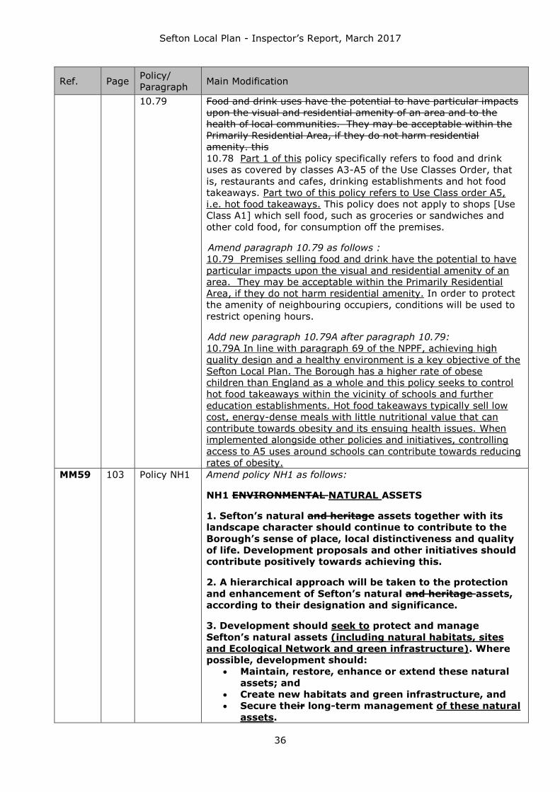
Sefton Local Plan - Inspector’s Report, March 2017
36
Ref. Page Policy/
Paragraph Main Modification
10.79 Food and drink uses have the potential to have particular impacts
upon the visual and residential amenity of an area and to the
health of local communities. They may be acceptable within the
Primarily Residential Area, if they do not harm residential
amenity. this
10.78 Part 1 of this policy specifically refers to food and drink
uses as covered by classes A3-A5 of the Use Classes Order, that
is, restaurants and cafes, drinking establishments and hot food
takeaways. Part two of this policy refers to Use Class order A5,
i.e. hot food takeaways. This policy does not apply to shops [Use
Class A1] which sell food, such as groceries or sandwiches and
other cold food, for consumption off the premises.
Amend paragraph 10.79 as follows :
10.79 Premises selling food and drink have the potential to have
particular impacts upon the visual and residential amenity of an
area. They may be acceptable within the Primarily Residential
Area, if they do not harm residential amenity. In order to protect
the amenity of neighbouring occupiers, conditions will be used to
restrict opening hours.
Add new paragraph 10.79A after paragraph 10.79:
10.79A In line with paragraph 69 of the NPPF, achieving high
quality design and a healthy environment is a key objective of the
Sefton Local Plan. The Borough has a higher rate of obese
children than England as a whole and this policy seeks to control
hot food takeaways within the vicinity of schools and further
education establishments. Hot food takeaways typically sell low
cost, energy-dense meals with little nutritional value that can
contribute towards obesity and its ensuing health issues. When
implemented alongside other policies and initiatives, controlling
access to A5 uses around schools can contribute towards reducing
rates of obesity.
MM59 103 Policy NH1 Amend policy NH1 as follows:
NH1 ENVIRONMENTAL NATURAL ASSETS
1. Sefton’s natural and heritage assets together with its
landscape character should continue to contribute to the
Borough’s sense of place, local distinctiveness and quality
of life. Development proposals and other initiatives should
contribute positively towards achieving this.
2. A hierarchical approach will be taken to the protection
and enhancement of Sefton’s natural and heritage assets,
according to their designation and significance.
3. Development should seek to protect and manage
Sefton’s natural assets (including natural habitats, sites
and Ecological Network and green infrastructure). Where
possible, development should:
Maintain, restore, enhance or extend these natural
assets; and
Create new habitats and green infrastructure, and
Secure their long-term management of these natural
assets.

Sefton Local Plan - Inspector’s Report, March 2017
37
Ref. Page Policy/
Paragraph Main Modification
4. Where it has been demonstrated that appropriate
protection or retention of natural assets cannot be
achieved, and there are no alternatives, mitigation and/or
as a last resort compensatory provision will be required.
5. The main priorities are, improving access, quality,
linkages and habitat within the city region ecological
network (including the Nature Improvement Area),
improving access to and the quality of public open space
and other outdoor facilities available to the public and
urban trees.
4. Sefton’s heritage assets should be protected from losses
and harmful changes to their, fabric and features or in their
settings. Development should:
Secure the long-term future of the heritage asset
Be designed to avoid harm
Be of a high quality design which is sympathetic to
the historic context of the heritage assets affected
Incorporate proposals for proper repair and re-
instatement of historic features and/or involve work
which better reveals the significance of Sefton’s
heritage assets and their settings
Where losses are unavoidable, recording, analysis
and reporting must be undertaken where
appropriate.
MM60 104 11.5–11.8
Add the following new paragraphs after paragraph 11.5:
11.5A Sefton’s natural assets include the designated nature and
geological sites and Priority Habitats which comprise the Core
Biodiversity Area that underpin the Liverpool City Region (LCR)
Ecological Network. Paragraph 9 of the Framework recognises that
pursuing sustainable development includes moving from a net loss
of biodiversity to achieving net gains for nature, in line with wider
Government policy set out in ‘Biodiversity 2020: A strategy for
England’s wildlife and ecosystem services’ (2011). Other national
policy for nature conservation is set out in paragraphs 109 to 119
of the Framework. This complements legal duties and
requirements for nature conservation set out in a range of
legislation including the Natural Environment and Rural
Communities Act 2006 and the Conservation of Habitats and
Species Regulations 2010 as amended.
11.5B The internationally important nature sites are the most
important features of the City Region’s outstanding natural
environment and network of green infrastructure as set out in the
LCR Ecological Network. In line with the hierarchical approach,
these sites have rigorous policy and legal protection and should
only be developed where there are no alternative solutions, there
are imperative reasons of overriding public interest and where
there has been appropriate mitigation and / or compensatory
provision.
11.5C The key priorities for nature and geology in the City Region
are:
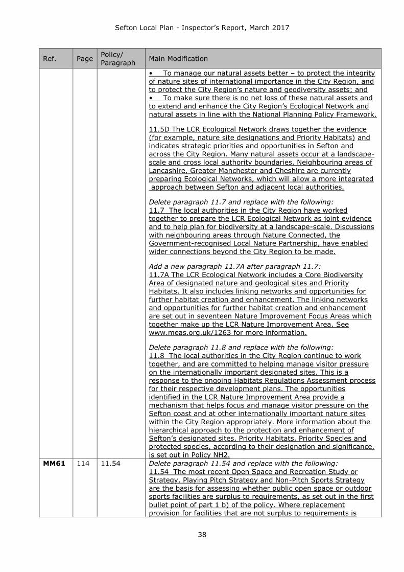
Sefton Local Plan - Inspector’s Report, March 2017
38
Ref. Page Policy/
Paragraph Main Modification
• To manage our natural assets better – to protect the integrity
of nature sites of international importance in the City Region, and
to protect the City Region’s nature and geodiversity assets; and
• To make sure there is no net loss of these natural assets and
to extend and enhance the City Region’s Ecological Network and
natural assets in line with the National Planning Policy Framework.
11.5D The LCR Ecological Network draws together the evidence
(for example, nature site designations and Priority Habitats) and
indicates strategic priorities and opportunities in Sefton and
across the City Region. Many natural assets occur at a landscape-
scale and cross local authority boundaries. Neighbouring areas of
Lancashire, Greater Manchester and Cheshire are currently
preparing Ecological Networks, which will allow a more integrated
approach between Sefton and adjacent local authorities.
Delete paragraph 11.7 and replace with the following:
11.7 The local authorities in the City Region have worked
together to prepare the LCR Ecological Network as joint evidence
and to help plan for biodiversity at a landscape-scale. Discussions
with neighbouring areas through Nature Connected, the
Government-recognised Local Nature Partnership, have enabled
wider connections beyond the City Region to be made.
Add a new paragraph 11.7A after paragraph 11.7:
11.7A The LCR Ecological Network includes a Core Biodiversity
Area of designated nature and geological sites and Priority
Habitats. It also includes linking networks and opportunities for
further habitat creation and enhancement. The linking networks
and opportunities for further habitat creation and enhancement
are set out in seventeen Nature Improvement Focus Areas which
together make up the LCR Nature Improvement Area. See
www.meas.org.uk/1263 for more information.
Delete paragraph 11.8 and replace with the following:
11.8 The local authorities in the City Region continue to work
together, and are committed to helping manage visitor pressure
on the internationally important designated sites. This is a
response to the ongoing Habitats Regulations Assessment process
for their respective development plans. The opportunities
identified in the LCR Nature Improvement Area provide a
mechanism that helps focus and manage visitor pressure on the
Sefton coast and at other internationally important nature sites
within the City Region appropriately. More information about the
hierarchical approach to the protection and enhancement of
Sefton’s designated sites, Priority Habitats, Priority Species and
protected species, according to their designation and significance,
is set out in Policy NH2.
MM61 114 11.54 Delete paragraph 11.54 and replace with the following:
11.54 The most recent Open Space and Recreation Study or
Strategy, Playing Pitch Strategy and Non-Pitch Sports Strategy
are the basis for assessing whether public open space or outdoor
sports facilities are surplus to requirements, as set out in the first
bullet point of part 1 b) of the policy. Where replacement
provision for facilities that are not surplus to requirements is

Sefton Local Plan - Inspector’s Report, March 2017
39
Ref. Page Policy/
Paragraph Main Modification
necessary under the second bullet point of part 1 b), appropriate
delivery mechanisms, such as legal agreements, must be in place
before planning permission is granted. Replacement provision
may involve the development of new open space or sports
facilities, or a significant improvement in the quality of existing
facilities such that they are capable of accommodating much
greater usage, for example through the provision of artificial ‘3G’
playing pitches for sports use. Policy EQ9 ‘Provision of public open
space, strategic paths and trees in development’ sets out the
current basis for judging appropriate provision of public open
space in new housing development.
MM62 116 Policy NH8 Amend part 1 of policy NH8 as follows:
1. 1. To minimise the need for minerals extraction, the use
of recycled, secondary and substitute materials will be
encouraged. Mineral Safeguarding Areas have been defined
for deposits of sub-alluvial sand and windblown silica sand
(The Shirdley Hill Formation). Mineral resources found to
be present on sites intended for development will be
expected to be extracted for beneficial use prior to
development taking place, unless special circumstances
can be demonstrated that justify proceeding without prior
extraction.
Within Mineral Safeguarding Areas, as shown on the
Policies Map, proposals for development will not be
permitted unless:
It is compatible with safeguarding the mineral; or
the applicant can demonstrate that the mineral
concerned is no longer of any value or potential value;
or
the mineral can be extracted satisfactorily prior to the
development taking place; or
the development is of a temporary nature and can be
completed and the site restored to a condition that does
not inhibit extraction; or
there is an overriding need for the development; or
the development is included on the list of exempt
developments in figure 11.2A
Delete part 2 of policy NH8 and replace with the following:
The Port of Liverpool and strategic rail freight links suitable
for the movement of minerals will be
safeguarded from inappropriate development. Proposals
for non-mineral related development that may
threaten the functioning of the wharfage of the Port of
Liverpool, transport links or other infrastructure
through which minerals are landed, processed (including
secondary and recycled materials) and transshipped,
will only be permitted where it can be demonstrated that:
The infrastructure is not required for mineral purposes,
and is unlikely to be so in the future, or
There is an overriding case for development taking
place, or

Sefton Local Plan - Inspector’s Report, March 2017
40
Ref. Page Policy/
Paragraph Main Modification
Equivalent alternative infrastructure capacity exists
which is able to meet commercial needs.
2. 2. Existing, planned and potential infrastructure
supporting the aggregates industry will be safeguarded
from inappropriate development. This includes strategic
rail freight links and sites for concrete batching, the
manufacture of coated materials, other concrete products
and the handling, processing and distribution of substitute,
recycled and secondary aggregate material. Proposals for
non-mineral related development that may threaten, lead
to the loss of or damage to, the functioning of safeguarded
infrastructure or locations will not be permitted unless it
can be demonstrated that:
An alternative site within an acceptable distance can be
provided, which is at least as appropriate for the use as
the safeguarded site; and
It can be demonstrated that the infrastructure no
longer meets the current or anticipated future needs of
the minerals, building and construction industry or the
waste management industry.
Amend the second bullet of part 4 of policy NH8 as follows:
Air and water quality
Add a new part 5 to policy NH8 as follows:
5. In determining shale gas applications Sefton will seek
the highest levels of environmental, health and social
protection and benefit consistent with prevailing national
policy and regulation, including that relating to
Environmental Impact Assessment and Habitats
Regulations Assessment. Compliance with industry best
practice standards as defined by United Kingdom Onshore
Oil and Gas (UKOOG) will also be expected.
MM63 117 11.63-
11.68
Delete paragraph 11.63 and replace with the following:
11.63 Sefton Council participates actively in the NW Aggregates
Working Party and subscribes to the national Managed Aggregate
Supply System through market monitoring and production of an
annual Local Aggregates Assessment (LAA). The LAA is produced
jointly with other authorities to reflect an aggregates sub-region
defined by Government to include Merseyside, Warrington and
Greater Manchester. Matters related to minerals reserves and land
banks are therefore monitored and reported annually at this sub-
regional level through the LAA. This is the principal component of
the evidence base to inform Sefton’s future role in facilitating the
appropriate supply of aggregate minerals. Sefton will maintain its
commitment to the Managed Aggregate Supply System through
continued representation in the North West Aggregates Working
Party.
Insert two new paragraphs and a new figure 11.2A after
paragraph 11.63:
11.63A Whilst Sefton has defined Mineral Safeguarding Areas
[MSAs], identified on the Policies Map, relating to identified sand
resources, these are understood to be of limited scale and scope
and not currently commercially viable or likely to become so in

Sefton Local Plan - Inspector’s Report, March 2017
41
Ref. Page Policy/
Paragraph Main Modification
the future. The designation of MSAs does not indicate a
presumption that resources defined in the MSAs will be worked.
However, the policy seeks to avoid sterilisation of aggregate
resources through non-mineral development and to encourage
mineral resources present on development sites to be extracted
where it is sensible to do so. Applications for non-mineral
development in the MSAs, which are not listed in Figure 11.2A,
will be required to include a Minerals Assessment setting out how
it complies with part 1 of the policy. The Minerals Assessment
should be proportionate to the situation and should have regard
to the BGS report ‘Mineral Safeguarding in England: good practice
advice, 2011' or any subsequent updates. The Council will provide
an Information Note for developers to provide guidance on
mineral safeguarding and minerals assessments.
11.63B Safeguarding principles will also be applied to transport
and other infrastructure important to the aggregate minerals
market. The Port of Liverpool and Sefton’s transport infrastructure
facilitates the landing and transhipment of minerals, including
aggregates from marine and onshore sources. However, as the
Port of Liverpool benefits from permitted development rights for
many types of development, safeguarding of minerals
infrastructure would not be enforceable in the port’s operational
area. If areas within the Port of Liverpool currently used for
minerals purposes are no longer available for port-related
reasons, the Council will work with the Port to seek a suitable
alternative facility within the port estate. Policy NH8 provides for
these facilities to be safeguarded in the interests of facilitating the
continuing supply of minerals.
Figure 11.2A Development Types that do not require a
Minerals Assessment
Applications for less than 10 new homes [or if the number of
homes isn’t known sites less than 0.5 hectare];
Applications for non-residential development where the floor
space to be created by the development is less than 1,000
square metres;
Applications for non-residential development on a site having
an area of less than 1 hectare;
Applications that are in accordance with the development plan
where the plan took account of the prevention of unnecessary
mineral sterilisation and determined that prior extraction
should not be considered when development applications in a
MSA came forward;
Applications for advertisement consent;
Applications for reserved matters including subsequent
applications after outline consent has been granted;
Prior notifications (telecoms, forestry, agriculture, demolition);
Certificates of Lawfulness of Existing Use or Development
(CLEUD) and Certificates of Lawfulness of Proposed Use or
Development (CLOPUD);
Applications for works to trees;
Applications for temporary planning permission.

Sefton Local Plan - Inspector’s Report, March 2017
42
Ref. Page Policy/
Paragraph Main Modification
Delete paragraphs 11.65 and 11.68
MM64 120 Policy
NH9A
Insert a new policy and explanatory text:
NH9A HERITAGE ASSETS
1. Sefton’s heritage assets together with its historic
landscape character should continue to contribute to the
Borough’s sense of place, local distinctiveness and quality
of life. Development proposals and other initiatives should
contribute positively towards achieving this.
2. The Council will seek to protect the significance of
Sefton’s heritage assets and their settings. Opportunities
will be pursued to enhance heritage to reinforce the
identity of the distinctive towns, villages and rural
landscapes within Sefton.
3. Key elements which contribute to the distinctive
identity of Sefton, and which will therefore be a strategic
priority for safeguarding and enhancing into the future,
include;
The verandahs throughout Southport, particularly in
Lord Street, which add considerably to its local
distinctiveness.
The historic centre, resort and traditional seafront of
Southport including the conservation areas of Lord
Street and Promenade, and their settings.
The spacious planned character of Victorian and
Edwardian suburban conservation areas such as
those in Birkdale, Blundellsands, Christ Church, Moor
Park and Waterloo Park.
Country estates, their countryside settings and
associated villages including Ince Blundell Hall,
Crosby Hall and North Meols Hall.
The dispersed layout and simple rural character of
village conservation areas such as Lunt, Homer
Green and Sefton village.
The open and flat ditched former wetland
landscapes.
The broad sands, dune system, pinewoods and
habitats that characterise parts of the Sefton coast,
and the ancient and modern historic features within
them such as the prehistoric footprints and wartime
remnants;
The 18th century Leeds and Liverpool Canal,
associated historic features and its setting.
Valued historic green spaces and their key features,
particularly registered Historic parks and gardens,
but also undesignated parkland and cemeteries such
as Crosby Hall and Duke Street Cemetery.
Important archaeological sites such as village and
wayside crosses, moated sites, Lunt Meadows and St
Catherine’s Chapel;
4. Designated heritage which is ‘at risk’ will be a

Sefton Local Plan - Inspector’s Report, March 2017
43
Ref. Page Policy/
Paragraph Main Modification
priority for action. Opportunities to secure enhancements
to safeguard and sustain these assets will be expected to
be taken.
5. Proposals affecting Sefton’s heritage assets and
their settings should ensure that features which contribute
to their significance are protected from losses and harmful
changes. Development should therefore:
Secure the long-term future of the heritage asset
Be designed to avoid harm
Be of a high quality design which is sympathetic to
the historic context of the heritage assets affected
Incorporate proposals for proper repair and re-
instatement of historic features and/or involve work
which better reveals the significance of Sefton’s
heritage assets and their settings
Where losses are unavoidable, a thorough analysis
and recording of the asset should be undertaken.
Key policy links and objectives:
Other policies in this chapter
Explanation
11.76A This policy aims to protect, enhance and manage Sefton’s
strategic heritage assets, taking a proportionate approach
according to the designation and significance of the assets.
11.76B Sefton’s heritage assets are a finite resource which once
lost cannot be replaced. More information about Sefton’s
approach to its conservation, enhancement and public enjoyment
of its heritage assets is set out in policies NH9-NH14 at the end
of this chapter.
11.76C Sefton’s heritage priorities are set out in part 3 of the
policy. The aspects which contribute to the significance of these
assets will be expected to be retained. Opportunities should be
taken to enhance the character of these key assets through
incorporation of relevant priorities within corporate strategies and
masterplans, regeneration proposals and development.
11.76D Enhancements might include using an area’s heritage as a
catalyst for its regeneration, locating and designing new
development such that it reflects local identity and creates a
positive relationship with heritage assets, or restoring lost historic
features and spaces.
11.76E Sefton has a rich archaeological resource and
opportunities to investigate it during the course of development
will be actively pursued, ensuring sites are not lost without having
been explored and recorded, with an emphasis on public
engagement and dissemination of the findings to increase
awareness of the depth of Sefton’s past.
11.76F The Council is producing a Heritage Strategy which will
contain a positive and proactive strategy for Sefton in line with
national guidance. It will include:

Sefton Local Plan - Inspector’s Report, March 2017
44
Ref. Page Policy/
Paragraph Main Modification
An overview of the benefits that Sefton’s heritage brings
The features which contribute to Sefton’s towns and
villages
Action Plans for heritage which is at risk, or vulnerable of
becoming so, including identifying opportunities for
enhancement
Management proposals for these and for Sefton’s
conservation areas which will provide more detailed
guidance, and
Identifying opportunities for funding to help enhance
heritage assets and their settings.
11.76G In addition, the Council intends to develop a ‘local list’ of
heritage assets in accordance with best practice guidelines,
enabling local heritage to be more readily identified and
conserved when development proposals are being considered.
MM65 120 Policy NH9 Amend policy NH9 as follows:
NH9 DEMOLITION OR SUBSTANTIAL HARM TO
DESIGNATED HERITAGE ASSETS
Development which results in substantial harm to, or
demolition of, a designated heritage asset or its setting will
not be permitted, unless it can be demonstrated that
substantial public benefits outweigh the harm or loss.
MM66 121 Policy NH10 Amend policy NH10 as follows:
NH10 WORKS AFFECTING LISTED BUILDINGS
1. Works affecting a Listed Building or its setting will only
be permitted where:
a) Any alterations preserve the historic fabric and
features of the building and/or its setting which
contribute to its significanceare important to it.
b) Any new additions are well designed and respect the
special architectural or historic interest of the
building.
c) New development affectingin the building’s setting
respects and conserves historic and positive existing
relationships between the listed building and its
surroundings.
d) Development does not undermine the long term
economic viability of the listed building or otherwise
harm options for its long term maintenance.
2. Opportunities should be taken to enhance the
significance of a listed building or its setting
3. Development which harms elements that contribute to
the significance of a Listed Building or its setting will not
be permitted, unless it can be demonstrated that public
benefits outweigh the harm.
MM67 123 Policy NH11 Amend policy NH11 as follows:
NH11 DEVELOPMENT AFFECTING CONSERVATION AREAS
1. Development within conservation areas or affecting
their setting will only be permitted where the proposal is of

Sefton Local Plan - Inspector’s Report, March 2017
45
Ref. Page Policy/
Paragraph Main Modification
high quality design and preserves or enhances the
character or appearance of the conservation area or its
setting. Development must ensure that:Changes of use
within conservation areas should retain the mix of uses
which are characteristic of the area.
a) Replacement or new features are of an
appropriate style and use materials which are
sympathetic to the age, architecture and features
of the affected property
b) Extensions, alterations or additions respect the
layout and historic pattern of development in the
conservation area affected
c) Hard and soft landscape features which
contribute to the historic value of the site to the
conservation area are retained (including
historically significant features from previous
uses), and
d) The character of historic boundary treatments,
patterns of trees and planting in the conservation
area are retained and enhanced.
e) Changes of use within conservation areas
generally retain the mix of uses which are
characteristic of the area.
2. Development which affects harms features elements
which make a positive contribution to positively contribute
to the significance of a conservation area or its setting will
only not be permitted where, unless it can be
demonstrated that public benefits outweigh the harm.
f) Replacement or new features are of an
appropriate style and use materials which are
sympathetic to the age, architecture and features
of the affected property
g) Extensions, alterations or additions respect the
layout and historic pattern of development in the
conservation area affected
h) Hard and soft landscape features which
contribute to the historic value of the site to the
conservation area are retained (including
historically significant features from previous
uses), and
i) The character of historic boundary treatments,
patterns of trees and planting in the conservation
area are retained and enhanced.
3. Development proposals which provide opportunities to
better reveal the significance of conservation areas and
their settings will be supported. Where the asset affected
is degraded, enhancements will normally be required.
which affects sites or features which do not contribute
positively to the character or appearance of the
conservation area, must enhance the site or conservation
area.
MM68 124 Policy NH12 Amend part 1 of policy NH12 as follows and add a new part 3:

Sefton Local Plan - Inspector’s Report, March 2017
46
Ref. Page Policy/
Paragraph Main Modification
1. Development within a Registered Historic Park or
Garden or affecting its setting will only be permitted where
the developmentmust relates well to the elements which
contribute to significant features of the significance of the
historic park or garden, and is be of high quality design,
which conserves and enhances is sympathetic to the
special interest and function of the site.
3. Development which harms elements which make a
positive contribution to a Registered Historic Park or
Garden or its setting will not be permitted, unless it can be
demonstrated that public benefits outweigh the harm.
MM69 125 Policy NH13 Amend policy NH13 as follows:
NH13 DEVELOPMENT AFFECTING ARCHAEOLOGY AND
SCHEDULED MONUMENTS AND NON_DESIGNATED
ARCHAEOLOGY
1. Development affecting, or within the setting of,
Scheduled Monuments or nationally important
archaeological sites will only be permitted where the
development does not detract from the importance of the
site harm their significance or setting, unless it can be
demonstrated that the development is necessary to deliver
public benefits which outweigh the harm. Historically
significant relationships between features within the site
and between the site and its surroundings must be
retained.
2. Where Development development which harms the
archaeological interest of buildings, and development on or
within the setting of designated or non-designated
archaeological sites or their setting (i.e. including
buildings and sites recognised as having archaeological
potential, where their significance, extent and state are
unclear), development will not be permitted unless the
benefits of the proposals outweigh the loss and:
a) the nature and value of the archaeology is well
understood
b) the development has been designed to minimise harm
to the archaeology, and
c) provision is made for recording, reporting and
interpretation where appropriate.
MM70 126 11.109 Add a new sentence to the end of paragraph 11.109:
A balanced judgement will therefore be required to establish the
scale of harm or loss against the significance of the heritage
asset.
MM71 139 Appendix 1 Amend the first requirement and add new requirements as
follows:
MN2.6 Land south of Dobbies Garden Centre, Southport
take all vehicular access from Benthams Way; and unless
other equally or more appropriate vehicular access is agreed
by the Council;
provide new public open space, flood water storage, and
habitat creation on the adjacent land designated as ‘Proposed

Sefton Local Plan - Inspector’s Report, March 2017
47
Ref. Page Policy/
Paragraph Main Modification
Open Space;
meet the requirements of policy NH2, notably in relation to
water voles and invasive species;
make an appropriate financial contribution towards the
provision of a new school playing field for the Birkdale Primary
School; and
MM72 139 Appendix 1 Insert new requirements as follows:
MN2.8 Former Ainsdale Hope School, Ainsdale
Development of this site must:
ensure that sufficient information is provided with the planning
application to enable the Council to make a Habitats
Regulations Assessment. This must include information about
the impact of recreational pressure on the integrity of
internationally important nature sites;
ensure that the loss of the former playing pitch(es) is
addressed consistent with Local Plan policy NH5. This will be
achieved via a commuted sum payment (on a per dwelling
basis) towards the provision of a new 3G pitch(es) at Meols
Park or adjacent land; and
provide new habitat and ecological improvements on the
adjacent ‘Ecological Improvement Area’, the extent of which
will be determined following the completion of future evidence.
MM73 139 Appendix 1 Insert new requirements as follows:
MN2.9 Former St John Stone School, Meadow Lane,
Ainsdale
Development of this site must:
ensure that sufficient information is provided with the planning
application to enable the Council to make a Habitats
Regulations Assessment;
ensure that the loss of the former playing pitch(es) is
addressed consistent with Local Plan policy NH5. This will be
achieved via a commuted sum payment (on a per dwelling
basis) towards the provision of a new 3G pitch(es) at Meols
Park or adjacent land.
MM74 139 Appendix 1 Insert new requirements as follows:
MN2.11 Land south of Moor Lane, Ainsdale
Development of this site must:
ensure that sufficient information is provided with the planning
application to enable the Council to make a Habitats
Regulations Assessment;
preserve the setting of the Grade II listed Formby House
Farmhouse.
MM75 139 Appendix 1 Insert a new requirement as follows:
MN2.14 Former Holy Trinity School, Lonsdale Road, Formby
Development of this site must:
be developed for older persons housing / accommodation
(reserved for residents aged 55 and over)
MM76 139 Appendix 1 Insert new requirements as follows:
MN2.14A Land at Shorrocks Hill, Lifeboat Road, Formby
Development of this site must:
ensure that sufficient information is provided with the planning
application to enable the Council to make a Habitats
Regulations Assessment. Any planning application at this site
should seek to avoid increased recreational pressure upon the

Sefton Local Plan - Inspector’s Report, March 2017
48
Ref. Page Policy/
Paragraph Main Modification
SAC and address any likely significant effects upon these
habitats as a result of the individual project alone;
secure the long term management of the adjacent woodland
Local Wildlife Site between the site and Formby Point Caravan
Park, to minimise impact on the adjacent internationally
important nature sites;
provide for full public access into the area of woodland
between the site and Formby Point Caravan Park in a manner
which minimises impact on the adjacent internationally
important nature sites;
extend the existing Formby no. 52 Bridleway through the
woodland area from Lifeboat Road to Alexandra Road;
provide a new 100 space public car park in the northern part
of the allocation; and
provide a new public toilet block adjacent to the car park and
secure its long term management.
MM77 139 Appendix 1 Insert a new requirement as follows:
MN2.15 Formby Professional Development Centre, Park
Road, Formby
The Raven Meols Community Centre is listed as an Asset of
Community Value under the Community Right to Bid
provisions of the Localism Act 2011. The obligations under the
relevant statutory provisions and regulations will need to be
met, as will the requirements of policy HC6.
MM78 139 Appendix 1 Amend the requirements as follows:
MN2.16 Land at Liverpool Road, Formby
Proposals for development on Land at Liverpool Road, Formby will
only be granted planning permission where they are consistent
with a single detailed master plan for the whole site which is
approved by the Council before any application is submitted.
Development of this site must:
preserve the setting of grade II listed Loveladys Farmhouse
and adjacent buildings by leaving the far west of the site
(south of the existing gymnasium) open; and
be served by a single point of access onto Liverpool Road; and
identify opportunities to reduce flood risk elsewhere through a
site Flood Risk Assessment, and implement any appropriate
solutions.
MM79 140 Appendix 1 Insert new requirements as follows:
MN2.23 Land at Southport Old Road, Thornton
ensure that sufficient information is provided with the planning
application to enable the Council to make a Habitats
Regulations Assessment;
provide a proportional financial contribution towards the
implementation of the A565 Route Management Strategy
(Thornton to Crosby section);
MM80 140 Appendix 1 Insert new requirements as follows:
MN2.24 Land at Holgate, Thornton
ensure that sufficient information is provided with the planning
application to enable the Council to make a Habitats
Regulations Assessment;
provide a proportional financial contribution towards the
implementation of the A565 Route Management Strategy
(Thornton to Crosby section);

Sefton Local Plan - Inspector’s Report, March 2017
49
Ref. Page Policy/
Paragraph Main Modification
MM81 140 Appendix 1 Insert new requirements as follows:
MN2.30 Land East of Waddicar Lane, Melling
Development of this site must:
ensure that sufficient information is provided with the planning
application to enable the Council to make a Habitats
Regulations Assessment; and
identify opportunities to reduce flood risk elsewhere through a
site Flood Risk Assessment, and implement any appropriate
solutions.
MM82 140 Appendix 1 Insert new requirements as follows:
MN2.31 Wadacre Farm, Chapel Lane, Melling
Development of this site must:
ensure that sufficient information is provided with the planning
application to enable the Council to make a Habitats
Regulations Assessment; and
identify opportunities to reduce flood risk elsewhere through a
site Flood Risk Assessment, and implement any appropriate
solutions. This should include improvements to the capacity of
the existing watercourse that forms the northern and western
site boundaries.
MM83 140 Appendix 1 Insert a new requirement as follows:
MN2.36 Former St Raymond’s School playing field, Harrops
Croft, Netherton
Development of this site must:
ensure that the loss of the former playing pitch(es) is
addressed consistent with Local Plan policy NH5. This will be
achieved via a commuted sum payment (on a per dwelling
basis) towards the provision of a new 3G pitch(es) at
Litherland Sports Park.
MM84 140 Appendix 1 Insert a new requirement as follows:
MN2.39 Former Daleacre School, Daleacre Drive, Netherton
Development of this site must:
ensure that the loss of the former playing pitch(es) is
addressed consistent with Local Plan policy NH5. This will be
achieved via a commuted sum payment (on a per dwelling
basis) towards the provision of a new 3G pitch(es) at
Litherland Sports Park.
MM85 140 Appendix 1 Amend requirements as follows:
MN2.41 Former St Wilfrid’s School, Orrell Road, Bootle
Development of this site must:
ensure that sufficient information is provided with the planning
application to enable the Council to make a Habitats
Regulations Assessment;
provide pedestrian and cyclist links between Orrell Road and
Hawthorne Road to improve accessibility to the adjacent
supermarket; and
take vehicular access from the existing signal controlled
junction on Hawthorne Road that serves the adjacent
supermarket; and
retain and improve the disused football pitches within the site
and bring them back into use.
MM86 140 Appendix 1 Insert a new requirement as follows:
MN2.45 Former St Mary’s Primary School playing fields,
Waverley Street, Bootle

Sefton Local Plan - Inspector’s Report, March 2017
50
Ref. Page Policy/
Paragraph Main Modification
ensure that the loss of the former playing pitch(es) is
addressed consistent with Local Plan policy NH5. This will be
achieved via a commuted sum payment (on a per dwelling
basis) towards the provision of a new 3G pitch(es) at
Litherland Sports Park.
MM87 145 Appendix 3 Replace the Monitoring Framework to set out the implications of
not meeting targets (Appended to end of Schedule)
MM88 147 Appendix 5 Appendix 5 has been added ‘List of saved Unitary Development
Plan policies to be replaced by Local Plan policies’ (Appended to
end of Schedule)

Sefton Local Plan - Inspector’s Report, March 2017
51
APPENDIX 3 LOCAL PLAN MONITORING
The aim of the monitoring framework is to provide a robust approach to ensuring the
strategy, objectives and policies of the Local Plan for Sefton are being implemented
correctly and that in doing so they are having the required effect. The monitoring
framework is split into two clear sections. The first considers indicators that measure the
direct impacts of specific policies. The second looks at indirect indicators, i.e. those they
are influenced by the policies in the Local Plan but which are much more influenced by
other external factors.
Below is the list of objectives from the Local Plan and the indicators that will measure
how well they are being met. The numbers relate to the indicator number from the
tables of indicators that follow.
To support urban regeneration and priorities for investment in Sefton
3 5 6 7 1
2
1
4
1
5
1
6
1
9
2
0
2
1
2
2
2
3
6
1
7
1
To help meet the housing needs of Sefton’s changing population for market and
affordable housing; homes for families, the elderly, people with other special housing
needs and others
1 2 2
4
2
5
2
6
2
7
3
1
6
2
6
3
6
4
7
1
To promote economic growth, tourism and jobs creation and support new and
existing businesses
3 5 6 7 1
3
1
5
1
6
1
7
1
8
5
7
5
8
To meet the diverse needs for homes, jobs, services and facilities, as close to where
they arise as possible
1 2 2
4
2
5
2
6
2
8
2
9
3
0
3
1
3
3
3
4
3
5
3
6
3
7
5
7
5
8
6
2
6
3
To help Sefton’s town, district and local centres to diversify and thrive
1
2
1
5
1
9
2
0
2
1
2
2
2
3
5
9
6
0
To make the most of the value of the Port to the local economy and jobs, while making
sure that the impact on the environment and local communities is mitigated
5 10 11
To make sure that new developments include the essential infrastructure, services
and facilities that they require
40 41 42 46 47
To improve access to services, facilities and jobs
3
8
4
0
4
1
4
2
4
6
4
7
5
7
5
8
5
9
6
0
6
5
To protect and enhance Sefton’s natural and heritage assets
8 9 3
2
4
3
4
4
4
5
4
6
4
7
4
8
4
9
5
0
5
2
5
3
5
4
5
5
5
6
7
0
7
2
7
3
7
4
7
5
To achieve high quality design and a healthy environment

Sefton Local Plan - Inspector’s Report, March 2017
52
8 9 3
2
4
3
4
4
4
5
4
6
4
7
4
8
4
9
5
0
5
2
5
3
5
4
5
5
5
6
6
6
6
9
7
2
7
4
7
5
7
6
To respond to the challenge of climate change, encouraging best use of resources
and assets
8 9 3
2
4
3
4
4
4
5
4
9
5
0
5
1
5
2
6
7
6
8
7
1
7
2
7
3
7
4
7
5
7
6
To work with partners and make the most of Sefton’s place within the Liverpool City
Region
5 10 11
TABLE 1 DIRECT IMPACT INDICATORS
Policy Indicator Baseline Target or
direction of
travel
Action undertaken if not met
MN1 1. Five year
housing supply
position
2.9 years
[2015]
61 years by 1st
April 2017 and
beyond
Contact landowners of housing
allocations to determine causes of
delay in submitting planning
applications.
Review policy constraints on
housing sites.
Undertake annual call for sites
exercise.
Review of the Local Plan.
2. Net additional
dwellings
[total/on
allocated sites]
454 net
completion
s [total]
[2014/15]
500 pa [2012-
17]
694 pa [2017-
30]
Contact developers with planning
permission for new homes to
determine causes of delay in
implementing planning
applications.
Review constraints [including
planning obligations] that may be
preventing housing delivery.
Work with housing colleagues to
identify potential funding to help
unlock sites for housing,
particularly in relation to the need
to remediate brownfield sites.
Review housing allocations to
assess suitability for housing.
Undertake call for sites exercise.
Review of the Local Plan.
3. Land available
for [general]
employment [ha]
56ha
[2015]
Not less than
22.66ha2
Undertake call for sites process.
Review of the Local Plan
4. Employment
land lost to non-
employment
uses
Not
available
No loss Review employment site
designations to determine if they
remain suitable for employment.
Contact landowners to determine
reasons why sites are not being
developed for employment.
1 Five years plus 20% as per paragraph 47 of NPPF
2 22.66ha equates to five years employment land requirement when the total Local Plan employment land requirement of 81.59 is annualised [i.e. 4.53ha per annum]

Sefton Local Plan - Inspector’s Report, March 2017
53
Policy Indicator Baseline Target or
direction of
travel
Action undertaken if not met
5. Land available
for Port related
employment
0ha [2015] Currently not
known. Sefton’s
requirement to
be determined
through strategic
study. [note: Not
less than 125ha
in city region3]
Undertake call for sites process.
Review of the Local Plan.
6. Floorspace
[m2] developed
for employment
[by type (B1, B2,
B8)/location]
1,278m2
270m2
[B1A -
office]
1008m2
[B8 –
storage/
distribution
]
[2015]
Increase
Review employment allocations to
determine barriers to
development.
Contact landowners of
employment allocations to
determine level of interest in
development of site.
Work with economic development
colleagues to identify potential
funding to help unlock sites for
economic development.
7. Number of
jobs [full time
equivalent]
created on
employment
sites
Not
available
Increase Review employment allocations to
determine barriers to
development.
Consider restricting development
on certain sites for more labour
intensive uses.
Work with economic development
colleagues to identify potential
opportunities for increasing
investment in Sefton that will
bring in jobs.
MN7 8. Approvals in
the Green Belt
and %
inappropriate
No data/
not
available
No inappropriate
approvals
Review implementation of policy
on inappropriate approvals.
Consider Supplementary Planning
Document to set out more specific
guidance on implementation of
policy and NPPF.
9. Approvals in
Safeguarded
Land and %
inappropriate
Not
applicable
No inappropriate
approvals
ED1 10. Approvals in
Port and
Maritime Zone
and %
inappropriate
No data/
not
available
No inappropriate
approvals
Review implementation of policy
on inappropriate approvals.
Liaise with Port of Liverpool to
determine any issues with scope
of implementation of port policy.
11. Improved
access to the
port consulted
on/ approved/
implemented
Not
applicable
Consulted on by
2016. Dates for
approval and
implementation
will be
Work with Strategic Transport
Team, LEP and Highways England
to determine issues restricting
progress.
3 125ha equates to five years port related employment land requirement when the total port
related employment land requirement of 500ha over 20 years [as identified in The Liverpool City Region Superport Market Analysis] is annualised [i.e. 25ha per annum]

Sefton Local Plan - Inspector’s Report, March 2017
54
Policy Indicator Baseline Target or
direction of
travel
Action undertaken if not met
determined by
the Highways
Agency at a later
stage. The
Monitoring
Framework will
be updated to
reflect this at the
appropriate time.
ED2 12. Number and
% of approved
retail/leisure/oth
er town centre
uses
development in
designated
centres
(Primary
Shopping
Areas)
edge of centre
retail parks
elsewhere
9,469m2
[528m2
(5.6%) in
town
centre,
7,168m2
(75.7%) in
edge of
centre,
1,773m2
(18.7%)
out of
centre]
A1-5
[shops and
services] -
4,577m2
B1a [office]
– 270m2
D2
[Leisure] –
1,858m2
[2014-15]
Increase in
approvals in
designated
centres.
Decrease in
number of
approvals for
retail/leisure/oth
er centre uses
approved outside
designated
centres.
Review implementation of
sequential test.
Work with colleagues to review
the regeneration strategies for
Central Southport, Crosby and
Maghull to review potential issues
restricting investment in Sefton’s
tourism areas.
Work with economic development
colleagues to determine potential
issues restricting investment in
Sefton’s centres.
Consider Supplementary Planning
Document to set out more specific
guidance on implementation of
sequential test.
ED5 13. Approvals by
type in locations
listed in Policy
ED5 ‘Tourism’
No data/
not
available
Increase of
appropriate
approvals and no
inappropriate
approvals
Review implementation of policy.
Work with Tourism colleagues to
determine potential issues
restricting investment in Sefton’s
tourism areas.
ED6 14. Approvals in
locations listed in
Policy ED6
‘Regeneration
Areas’ by type
No data/
not
available
Increase of
appropriate
approvals and no
inappropriate
approvals
Review implementation of policy.
Contact landowners to determine
intentions/expectations.
Work with economic regeneration
colleagues to determine potential
issues restricting investment in
regeneration areas and to
determine what funding may be
available to assist regeneration
objectives.
Consider Supplementary Planning
Document or Area Action Plans to
set out more specific guidance on
how regeneration objectives can
be implemented.
ED7 15. Approvals in
Southport
No data/
not
Increase in uses
listed in policy
Review implementation of policy.
Undertake an audit of the sites

Sefton Local Plan - Inspector’s Report, March 2017
55
Policy Indicator Baseline Target or
direction of
travel
Action undertaken if not met
Central Area by
type
available available in the Southport Central
Area and assess potential for
development.
Contact landowners to determine
intentions/ expectations.
Work with Tourism colleagues and
partners to determine potential
issues restricting investment in
Southport Central Area.
Consider Supplementary Planning
Document or Area Action Plan to
set out more specific guidance on
how development in Southport
Central Area will be managed.
ED8 16. Approvals in
Southport
Seafront Area by
type
No data/
not
available
Increase in uses
listed in part 1 of
policy
Review implementation of policy.
Undertake an audit of the sites
available in the Southport
Seafront Area and assess
potential for development.
Contact landowners to determine
intentions/expectations.
Work with Tourism colleagues and
partners to determine potential
issues restricting investment in
Southport Seafront Area.
Consider Supplementary Planning
Document or Area Action Plan to
set out more specific guidance on
how development in Southport
Seafront will be managed.
ED8B 17. Approvals in
Aintree
Racecourse [in
Green Belt Area]
by type
18. Approvals in
Aintree
Racecourse
[outside Green
Belt Area] by
type
No data/
not
available
No inappropriate
approvals
Increase in uses
listed in part 2 of
policy
Review implementation of policy.
Contact landowners to determine
intentions/expectations.
Work with Tourism colleagues and
partners to determine potential
issues restricting investment in
Aintree Racecourse.
Consider Supplementary Planning
Document or Area Action Plan to
set out more specific guidance on
how development in Aintree
Racecourse will be managed.
ED9 19. Approvals in
Crosby Centre by
type
20. Total units in
Crosby Centre
21. Total
floorspace in
Crosby Centre
22. Reduction in
No data/
not
available
117 [2015]
18,563m2
[2015]
12 units
Increase in ‘town
centre’ approvals
Increase
Increase
Decrease
Review implementation of policy.
Undertake an audit of the sites
available in the Crosby Centre
Area and assess potential for
development.
Contact landowners to determine
intentions/expectations.
Work with Economic Development
colleagues and partners to
determine potential issues
restricting investment in Crosby
Centre.

Sefton Local Plan - Inspector’s Report, March 2017
56
Policy Indicator Baseline Target or
direction of
travel
Action undertaken if not met
vacancies in
Crosby Centre
23. Number of
National
Retailers in
Crosby Centre4
[10.3%]
1,269m2
[6.8%]
[2015]
29 [2015]
Increase
Consider Area Action Plan to set
out more specific guidance on
how development in Crosby
Centre will be managed.
HC1 24. Number of
affordable
housing
completions
[by type (social
rented,
affordable
rented,
intermediate,
through section
106) and
location]
111
[2014/5]
2005 by 2018/19
Annual increase
Review implementation of policy.
Contact developers of stalled
schemes with an affordable
housing element to determine
reasons for delay.
Review planning obligations to
determine if these are preventing
implementation of development.
25. % of
bedspaces that
are affordable in
approvals for
new homes in
qualifying
schemes [15
homes or more]
[total and by
settlement]
Not
available
15% in Bootle
and Netherton
30% elsewhere
Review implementation of policy.
Review planning obligations to
determine if these are affecting
viability.
Consider using off-site affordable
housing contributions to support
affordable housing schemes.
Be more flexible on the split
between social rented and other
types of affordable homes.
HC2 26. In
developments of
15 homes of
more the number
and % of homes
with:
1 or 2
bedrooms
3 bedrooms
4 bedrooms
or more
No data Minimum of 25%
1 or 2 bedrooms
Minimum of 40%
3 bedroom
Maximum 35% 4
or more
bedrooms
Review implementation of policy.
Review viability implications of
policy.
Consider Supplementary Planning
Document to provide additional
guidance to developers for
meeting the policy requirement.
27. Approvals of
older persons
housing by type,
tenure and
settlement [inc
extra care,
sheltered
accommodation,
No data/
not
available
100 units per
year
Consider allocating Council owned
sites specifically for housing for
older people.
Work with providers of homes for
older people to see if they can
assist in delivery of schemes for
older people.
Consider Council or external
4 Town and District Centre Health checks are likely to be undertaken every 3 to 5 years so
indicators ‘b’ to ‘e’ are unlikely to be monitored annually. 5 This is based on the total anticipated Local Plan Affordable Housing Delivery as set out at Appendix 2 of the Housing Technical Paper.

Sefton Local Plan - Inspector’s Report, March 2017
57
Policy Indicator Baseline Target or
direction of
travel
Action undertaken if not met
nursing homes
etc]
funding sources to cross subsidise
delivery of homes for older
people.
28. In approved
schemes of 50 or
more dwellings,
the % of market
homes designed
to meet Building
Regulation
Requirement M4
(2) ‘accessible
and adaptable
dwellings’.
No data 20% Review implementation of policy.
Review viability implications of
policy.
Consider Information Note or
Supplementary Planning
Document to provide additional
guidance to developers for
meeting the policy requirement.
29. Number of
approved custom
or self-build
homes
30. Number of
people registered
on Sefton’s
Custom and Self-
Build Register
No data To be
determined once
custom build
homes register
has been live for
minimum six
months [June
2016]
Allocate Council land specifically
for custom or self-build housing.
Provide support services to those
who wish to self or custom-build
their own home.
HC3 31. Approvals in
PRA that are not
residential and
inappropriate
No data/
not
available
No inappropriate
approvals
Review implementation of policy.
Consider Supplementary Planning
Document to provide additional
guidance to developers.
32. Densities in
approvals for
residential
development
No data/
not
available
Minimum 30
dwellings per
hectare
(developable
area)
Review implementation of policy.
Review Supplementary Planning
Document to provide additional
guidance to developers.
HC4 33. Applications
for conversions
to HMOs and the
proportions
refused/approve
d (with some
explanatory text)
34. Total number
of HMOs in
Sefton and by
ward
No data/
not
available
No specific target
for these two
indicators but
commentary will
be provide on
whether the
impact of
clusters of HMOs
is occurring and
whether this is
causing
significant harm
to the character
of an area or
harming the
living conditions
of residents.
Review implementation of policy
and existing Supplementary
Planning Document.
Consider the use of an article 4
direction to restrict HMOs in
specific areas.
HC5 35. Five year
traveller pitch
supply
0 years
[2015]
5 years by 1st
April 2017
Contact landowners of allocated
traveller sites to determine any
causes of planning applications
being delayed.

Sefton Local Plan - Inspector’s Report, March 2017
58
Policy Indicator Baseline Target or
direction of
travel
Action undertaken if not met
Review policy constraints on
allocated sites.
Update traveller needs
assessment to determine if
identified need remains valid.
36. Provision of
traveller pitches
[permanent/tran
sit]
0 in
2014/15
4 additional
permanent
pitches by
2017/18.
10 additional
permanent
pitches 2018/19
to 2027/28.
4 transit pitches
by 2017/18.
37. Number, size
and duration of
unauthorised
traveller
encampments
No data/
not
available
0 Work with traveller liaison officer
determine reasons for
unauthorised encampments and
to ensure Council transit site
[when provided] is well
advertised.
Review access/pricing policy for
Council transit site is suitable.
Work with neighbouring
authorities to ensure they are
providing their identified transit
pitches.
Consider extension of or
additional transit site.
HC6 38. No. of
applications that
affect an Asset of
Community
Value and the
proportions
refused/approve
d (with some
explanatory text)
No data No inappropriate
approvals
HC7 39. Approvals in
Sites of
Education and
Care Institutions
and %
inappropriate
No data No inappropriate
approvals
Review implementation of policy
on inappropriate approvals.
Consider Supplementary Planning
Document to set out more specific
guidance on implementation of
policy.
IN1 40. Amount of
Community
Infrastructure
Levy secured
[total/by area]
No data To be
determined if
and when CIL is
implemented
To be determined if and when CIL
is implemented.
IN2 41. No. of
schemes in part
1 of the policy
implemented
Not
applicable
All implemented
by 2030. Annual
review
undertaken to
determine
Work with transport colleagues to
determine potential issues
restricting investment in transport
schemes.
Look at potential funding sources

Sefton Local Plan - Inspector’s Report, March 2017
59
Policy Indicator Baseline Target or
direction of
travel
Action undertaken if not met
progress. including from developer
contributions.
EQ3 42. % of new
build housing
within
appropriate
[SPD] distance to
bus stop; rail
station; GP;
primary school
No data/
not
available
Increase Work with transport colleagues to
maximise public transport
improvements on larger
development sites.
EQ6 43.
Contaminated
land remediated
as part of
development
No data No target but
commentary will
consider impact
of the policy
Review implementation of policy.
Liaise with contaminated land
colleagues to assess whether
advice on contamination is being
correctly used in planning
decisions.
EQ8 44. Number of
applications
refused on flood
risk grounds
No data/
not
available
No target but
commentary will
consider the
impact of the
policy.
Review implementation of policy.
Liaise with drainage colleagues to
assess whether advice on flood
risk/drainage is being correctly
used in planning decisions.
Consider Supplementary Planning
Document to set out more specific
guidance on implementation of
policy.
45. Number of
major
applications
approved with
conditions and/or
legal agreements
related to SuDs
No data/
not
available
EQ9 46. Area of new
Public Open
Space approved
on:
schemes of
150 or more
dwellings
Proposals for
11 to 149
dwellings on
sites which
are more
than 2km
from a main
parks or
Countryside
Recreation
Areas’
No data 40m2 per home Review implementation of policy.
Review other planning obligations
to determine if this is limiting
implementation of policy.
Work with leisure colleagues to
ensure policy approach is
securing the improvements
required.
Determine the best approach to
ensuring this policy and the
implementation of the [potential]
Community Infrastructure Levy
are compatible and maximise
improvements.
47. Financial
contributions
secured through
section 106 to
No data/
not
available
No target but
commentary on
reasons why off-
site contributions

Sefton Local Plan - Inspector’s Report, March 2017
60
Policy Indicator Baseline Target or
direction of
travel
Action undertaken if not met
improve existing
public open
space
was accepted
and which
existing public
open spaces will
be improved
EQ10 48. Approvals of
A5 uses in
designated
centres;
Shopping
Parades; within
400m of
secondary school
or college
[including those
restricted to
opening after
5pm]
No data/
not
available
No inappropriate
approvals
Review implementation of policy
and Supplementary Planning
Document.
Work with education and public
health colleagues to determine
whether additional A5 uses close
to a particular secondary school
or college is likely to change
eating habits of students.
NH2 49. Approvals in
International,
National and
Local nature
sites and %
inappropriate
No data/
not
available
No inappropriate
approvals
Review implementation of policy
and Supplementary Planning
Document.
Liaise with colleagues in
Merseyside Environmental
Advisory Service and Natural
England to determine whether
policy approach is appropriate.
NH3 50. Approvals in
Nature
Improvements
Areas and %
inappropriate
No data/
not
available
No inappropriate
approvals
NH4 51. Approvals in
Coastal Change
Management
Area and %
inappropriate
No data/
not
available
No inappropriate
approvals
Review implementation of policy.
Liaise with Coastal Management
Team to determine whether policy
approach is appropriate.
Consider Supplementary Planning
Document to set out more specific
guidance on implementation of
policy.
NH5 52. Approvals in
Public Open
Space and %
inappropriate
n/a No inappropriate
approvals
Review implementation of policy.
Liaise with Leisure colleagues to
determine whether policy
approach is appropriate.
Consider Supplementary Planning
Document to set out more specific
guidance on implementation of
policy.
HN6 53. Approvals in
Urban Golf
Course and %
inappropriate
n/a No inappropriate
approvals
Review implementation of policy.
Consider Supplementary Planning
Document to set out more specific
guidance on implementation of
policy.
NH9-
14
54. % of Listed
Buildings
Not
available
10-20% of Listed
Buildings
Review resources and priorities
within Conservation Team.

Sefton Local Plan - Inspector’s Report, March 2017
61
Policy Indicator Baseline Target or
direction of
travel
Action undertaken if not met
surveyed per
year
55. Conservation
Area Appraisals
adopted
56. Conservation
Area
Management
Plans adopted
13/25
[2015]
0/25
[2015]
Increase
Increase
TABLE 2 INDIRECT IMPACT INDICATORS
SA Topic Area Indicator Baseline Target or
direction of
travel
Economy 57. Number of jobs in
Sefton
58. Unemployment rate
103,000 [2013]
5.3% [June 2015]
Increase
Decrease
Local Centres 59. Retail ranking of Bootle
and Southport
60. Vacancy rates [units]
in designated centres
Bootle 235th Southport 96th
[2014/15]
23% Bootle
13.1% Southport
10.3% Crosby
10.1% Maghull
9.5% Waterloo
2.8% Formby
[July 2015]
Higher Ranking
Decrease
Communities 61. % of Sefton’s
population living in 20%
most deprived areas in
England
62. Social housing waiting
lists
27% [2015 IMD]
2883 [2015, OneVision
Housing – Housing Register]
Decrease
Decrease
Housing 63. Population in Sefton
64. Average house prices
by area
273,500 [2014 ONS estimate]
£86,458 Bootle
£166,949 Maghull
£168,945 Southport
£216,557 Crosby
£270,087 Formby
[2015 Land Registry]
Increase
No target
Accessibility 65. Travel to work by
transport mode
56.7% Car or van
9.5% On foot
8.3% Work from home
7.3% Train
6.9% Bus
6.0% Passenger in car or van
2.6% Bicycle
1.3% Taxi
0.7% Other
0.5% Motorcycle
Increase those
using public
transport and
sustainable
modes

Sefton Local Plan - Inspector’s Report, March 2017
62
0.4% Rapid transit
[2011 Census]
Health &
Wellbeing
66. Obesity rates in
adults/children
19.6% of children [2012]
23.6% of adults [2012]
Decrease
Climate
Change &
Resource Use
67. Carbon emissions by
source [tCO2 per person]
Total 5.0
Industrial and Commercial 1.8
Domestic 2.2
Transport 1.0 [2013]
Source DECC, 25 June 2015
Decrease
Flooding 68. Total of homes and
businesses classed at risk
from flooding
No data/ not available No increase
Environmental
Quality
69. Air quality at
monitoring stations
70. River quality
71. Vacant home rate
Quoting lowest and highest
levels of the five stations
Nitric oxide: Waterloo Primary
School 24.5ppb - Princess
Way, Seaforth 49.6ppb [2015]
Nitrogen dioxide: Waterloo
Primary School 33.7µg/m³ -
Princess Way, Seaforth 44.1
µg/m³ [2015]
Oxides of Nitrogen: Waterloo
Primary School 41.7ppb -
Princess Way, Seaforth
72.2ppb [2015]
No data/ not available
Local Term Vacant Rate – 3236
homes [2.56%]
Decrease
Decrease
Decrease
Improvement
Decrease
Landscape None
Biodiversity 72. Local sites and sites in
positive conservation
management
60 local sites; 30 sites in
positive management [50%]
2014/15 Defra
Increase
Culture &
Heritage
73. Number of listed
buildings at risk
74. Number of
Conservation Areas ‘at
risk’
75. Number of Scheduled
Monuments ‘at risk’
76. Parks with green flag
status
10 Grade II* Listed Buildings
or Conservation Areas [2015]
6 [Historic England, 2015]
1 [Historic England, 2015]
10 Green Flag awarded Parks
[2015]
Decrease
Decrease
Decrease
Increase

Sefton Local Plan - Inspector’s Report, March 2017
63
APPENDIX 5 LIST OF SAVED UNITARY DEVELOPMENT PLAN POLICIES TO BE REPLACED BY LOCAL
PLAN POLICIES
Unitary Development Plan Policy (2006)
Superseding Local Plan Policy/ies (2016)
CS1 Development and Regeneration SD1 Presumption in favour of sustainable development
SD2 Principles of sustainable development
CS2 Restraint on development and protection of
environmental assets
SD1 Presumption in favour of sustainable development
SD2 Principles of sustainable development
NH1 Natural Assets
NH9A Heritage Assets
CS3 Development principles SD1 Presumption in favour of sustainable Development
SD2 Principles of sustainable development
EQ1 Planning for a healthy Sefton
UP1 Development in Urban Priority Areas SD2 Principles of sustainable development
EDT1 Strategic Employment Locations MN2 Housing, Employment , and Mixed Use Allocations
EDT2 Provision of Employment Land MN2 Housing, Employment , and Mixed Use Allocations
EDT3 Strategic Employment Sites in the
Dunnings Bridge Corridor
ED6 Regeneration Areas
MN2.47 Dunnings Bridge Road Corridor, Netherton
EDT4 Southport Commerce Park MN2.50 Southport Business Park
EDT5 Primarily Industrial Areas ED3 Existing Employment Areas
EDT6 Development Sites within Primarily
Industrial Areas
ED3 Existing Employment Areas
MN2 Housing, Employment , and Mixed Use
Allocations EDT8 Business and Industrial Development Outside Primarily Industrial Areas
ED3 Existing Employment Areas
EDT9 The Port and Maritime Zone ED1 The Port and Maritime Zone
EDT10 Bootle Central Area – Development Principles
ED2 Development in town, district and local centres, local shopping parades and outside defined centres ED4 Mixed Use Areas ED6 Regeneration Areas
EDT11 Development in the Bootle Office Quarter ED6 Regeneration Areas
EDT12 Bootle Central Area Opportunity Sites ED6 Regeneration Areas
EDT13 Southport Central Area – Development Principles
ED2 Development in town, district and local centres, local shopping parades and outside defined centres ED5 Tourism ED6 Regeneration Areas
ED7 Southport Central Area
EDT14 Southport Resort Area ED5 Tourism
EDT15 Southport Seafront Area ED5 Tourism
ED8 Southport Seafront
ED8A Marine Park
EDT16 Mixed Use Areas ED4 Mixed Use Areas

Sefton Local Plan - Inspector’s Report, March 2017
64
Unitary Development Plan Policy (2006)
Superseding Local Plan Policy/ies (2016)
EDT17 Employment Opportunity Sites ED6 Regeneration Areas
MN2.34 Aintree Curve Site, Ridgewood Way, Netherton
MN2.43 Peoples site, Linacre Lane, Bootle
EDT18 Retention of Local Employment
Opportunities
ED3 Existing Employment Areas
H1 Housing Requirement Not Saved (equivalent Local Plan Policy MN1 Housing and employment Requirement)
H2 Requirement for Affordable, Special Needs and Key Worker Housing
HC1 Affordable and special needs housing (and accompanying Affordable, Special Needs and Older People’s Housing SPD)
H3 Housing Land Supply MN2 Housing, Employment , and Mixed Use
Allocations
H4 Land at Town Lane, Southport Site has planning permission
HC3 Residential development and development in Primarily
Residential Areas
H5 Land to the west of Southport and Formby District General Hospital
HC3 Residential development and development in Primarily Residential Areas
HC7 Education and Care Institutions in the Urban Area
NH5 Protection of open space and Countryside Recreation Areas
H6 Opportunity Sites ED6 Regeneration Areas MN2.34 Aintree Curve Site, Ridgewood Way, Netherton MN2.43 Peoples site, Linacre Lane, Bootle
Other sites developed
H7 Housing Renewal, Clearance and Regeneration ED6 Regeneration Areas
H8 Redevelopment within the Pathfinder
Area
ED4 Mixed Use Areas
ED6 Regeneration Areas
H9 Hawthorne Road/ Canal Corridor ED4 Mixed Use Areas ED5 Tourism
ED6 Regeneration Areas
H10 Residential Development and
Development in Residential Areas
HC3 Residential Development and
Development in Primarily Residential Areas (and accompanying New Housing SPD)
H11 Mixed Use Developments Incorporating
Housing
ED4 Mixed Use Areas
H12 Residential Density HC3 Residential Development and
Development in Primarily Residential Areas (and accompanying New Housing SPD)
EQ2 Design
R1 Retail Development Strategy ED2 Development in town, district and local centres, local shopping parades and outside defined centres
R2 Southport Town Centre ED2 Development in town, district and local
centres, local shopping parades and outside defined centres ED5 Tourism ED6 Regeneration Areas
ED7 Southport Central Area

Sefton Local Plan - Inspector’s Report, March 2017
65
Unitary Development Plan Policy (2006)
Superseding Local Plan Policy/ies (2016)
R3 Southport Station Complex ED2 Development in town, district and local centres, local shopping parades and outside defined centres ED6 Regeneration Areas ED8 Southport Central Area EQ3 Accessibility
R4 Bootle town Centre ED2 Development in town, district and local centres, local shopping parades and outside defined centres ED4 Mixed Use Areas ED6 Regeneration Areas
R5 Edge-of-Centre Retail Development:
TAVR Site, Strand Road, Bootle
Not Saved
R6 Development in District and Local Shopping Centres
ED2 Development in town, district and local centres, local shopping parades and outside defined centres
R7 Local Shopping Parades ED2 Development in town, district and local centres, local shopping parades and outside defined centres
R8 Upper Floors in Defined Centres and
Shopping Parades
Not Saved
R9 Edge-of-Centre and Out-of-Centre Retail Developments and Key Town Centre Uses
ED2 Development in town, district and local centres, local shopping parades and outside defined centres
ED4 Mixed Use Areas
ED5 Tourism
R10 Lanstar Site, Church Road, Litherland MN2.53 Former Lanstar Site, Hawthorne Road, Bootle
T1 Transport Network Priorities IN2 Transport
T2 Walking and Cycling IN2 Transport EQ1 Planning for a healthy Sefton
EQ3 Accessibility
EQ9 Provision of public open space, strategic paths and trees
in development
T3 Pedestrian Priority on Chapel Street, Southport Not Saved
T4 Safeguarding the Public Transport Network IN2 Transport
T5 New Car Parks in Designated Areas IN2 Transport
EQ3 Accessibility
EMW1 Prudent Use of Resources EQ1 Planning for a healthy Sefton
EQ7 Energy Efficient and Low Carbon Design
IN3 Managing Waste
EMW2 Renewable Energy Infrastructure EQ7 Energy Efficient and Low Carbon Design
EMW3 Protection of Mineral Resources NH8 Minerals
EMW4 Proposals for Mineral and Aggregate
Developments
NH8 Minerals
EMW5 Onshore Oil and Gas NH8 Minerals
EMW6 Waste Management Strategy Replaced by Merseyside and Halton Waste
Local Plan (2013)
EMW7 Waste Management Facilities Replaced by Merseyside and Halton Waste
Local Plan (2013)

Sefton Local Plan - Inspector’s Report, March 2017
66
Unitary Development Plan Policy (2006)
Superseding Local Plan Policy/ies (2016)
EMW8 Landfill Sites Replaced by Merseyside and Halton Waste
Local Plan (2013)
EMW9 Recycling Facilities IN3 Managing Waste
GBC1 The Green Belt MN7 Sefton’s Green Belt
GBC2 Development in the Green Belt MN7 Sefton’s Green Belt
GBC3 Redevelopment of a Major Developed
Site in the Green Belt – The Powerhouse, Hoggs Hill Lane, Formby
MN2.18 Power House phase 2, Hoggs Hill Lane, Formby
GBC4 Redevelopment or Infilling of a Major Developed Site in the Green Belt – Ashworth Hospital, Maghull
MN8.2 Land adjacent to Ashworth Hospital, Maghull
GBC5 Infill Development on Major
Developed Sites in the Green Belt
MN7 Sefton’s Green Belt
GBC6 Landscape Character NH7 Rural Landscape Character
GBC7 Agricultural Land Quality MN7 Sefton’s Green Belt
GBC8 Equestrian Development MN7 Sefton’s Green Belt
GBC9 Landscape Renewal Areas MN7 Sefton’s Green Belt
NC1 Site Protection NH1 Natural Assets
NH2 Protection and enhancement of nature sites, priority
habitats and species (and accompanying Nature Conservation
SPD)
NH3 Development in the Nature Improvement Area
NC2 Protection of Species NH1 Natural Assets
NH2 Protection and enhancement of nature sites, priority
habitats and species (and accompanying Nature Conservation
SPD)
NH3 Development in the Nature Improvement Area
NC3 Habitat Protection, Creation and Management NH1 Natural Assets
NH2 Protection and enhancement of nature sites, priority
habitats and species (and accompanying Nature Conservation
SPD)
NH3 Development in the Nature Improvement Area
CPZ1 Development in Coastal Planning Zones NH1 Natural Assets
NH4 The Sefton coast and development
CPZ2 Coastal Protection NH1 Natural Assets
NH4 The Sefton coast and development
CPZ3 Coastal Landscape Conservation and Management
EQ4 Pollution and Hazards
NH1 Natural Assets
NH2 Protection and enhancement of nature sites, priority
habitats and species (and accompanying Nature Conservation
SPD)
NH3 Development in the Nature Improvement Area
NH4 The Sefton coast and development
CPZ4 Coastal Park NH4 The Sefton coast and development

Sefton Local Plan - Inspector’s Report, March 2017
67
Unitary Development Plan Policy (2006)
Superseding Local Plan Policy/ies (2016)
NH5 Protection of open space and Countryside Recreation
Areas
G1 Protection of Urban Greenspace NH5 Protection of open space and Countryside Recreation Areas
G2 Improving Public Access to Urban
Greenspace
ED3 Existing Employment Areas ED6 Regeneration Areas
HC3 Residential Development and
Development in Primarily Residential Areas (and accompanying New Housing SPD) HC7 Education and Care Institutions in the Urban Area NH6 Urban Golf Courses
G3 Urban Greenspace Systems NH1 Natural assets NH5 Protection of open space and Countryside Recreation Areas
G4 Development Adjacent to the Leeds and Liverpool Canal
ED5 Tourism
EQ2 Design
NH1 Natural assetsNH5 Protection of open space and Countryside Recreation Areas
G5 Protection of Recreational Open Space NH1 Natural assets NH5 Protection of open space and Countryside Recreation Areas
G6 Built Recreation Facilities HC6 Assets of community value
G7 Strategic Paths for Countryside
Recreation
NH5 Protection of open space and
Countryside Recreation Areas
G8 Countryside Recreation Areas NH5 Protection of open space and Countryside Recreation
Areas
G9 Aintree Racecourse Recreational Area ED5 Tourism
ED8B Aintree Racecourse
MN7 Sefton’s Green Belt
HC1 Development in Conservation Areas NH9A Heritage Assets NH11 Development affecting Conservation Areas
HC2 Demolition of Listed buildings and
Demolition in Conservation Areas
NH9A Heritage Assets
NH9 Demolition or substantial harm to
designated Heritage Assets
HC3 Development or Change of Use
Affecting a Listed Building
NH9A Heritage Assets
NH10 Works affecting Listed Buildings
HC4 Development Affecting the Setting of a Listed Building
NH9A Heritage Assets NH10 Works affecting Listed Buildings
HC5 Historic Parks and Gardens NH9A Heritage Assets
NH12 Development affecting Registered Parks and Gardens
HC6 Sites and Areas of Archaeological
Importance
NH9A Heritage Assets
NH13 Development affecting Archaeology and Scheduled
Monuments
AD1 Location of Development EQ1 Planning for a healthy Sefton
EQ3 Accessibility
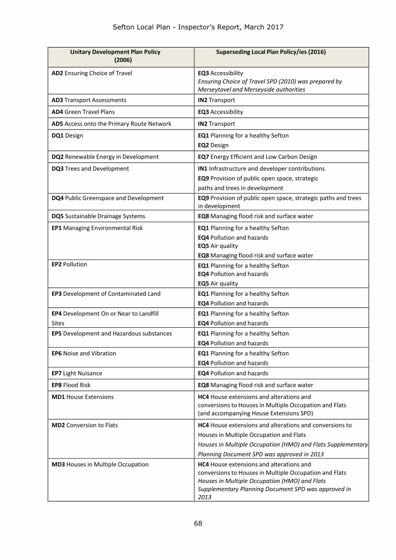
Sefton Local Plan - Inspector’s Report, March 2017
68
Unitary Development Plan Policy (2006)
Superseding Local Plan Policy/ies (2016)
AD2 Ensuring Choice of Travel EQ3 Accessibility
Ensuring Choice of Travel SPD (2010) was prepared by Merseytavel and Merseyside authorities
AD3 Transport Assessments IN2 Transport
AD4 Green Travel Plans EQ3 Accessibility
AD5 Access onto the Primary Route Network IN2 Transport
DQ1 Design EQ1 Planning for a healthy Sefton
EQ2 Design
DQ2 Renewable Energy in Development EQ7 Energy Efficient and Low Carbon Design
DQ3 Trees and Development IN1 Infrastructure and developer contributions
EQ9 Provision of public open space, strategic
paths and trees in development
DQ4 Public Greenspace and Development EQ9 Provision of public open space, strategic paths and trees in development
DQ5 Sustainable Drainage Systems EQ8 Managing flood risk and surface water
EP1 Managing Environmental Risk EQ1 Planning for a healthy Sefton
EQ4 Pollution and hazards EQ5 Air quality
EQ8 Managing flood risk and surface water
EP2 Pollution EQ1 Planning for a healthy Sefton
EQ4 Pollution and hazards
EQ5 Air quality
EP3 Development of Contaminated Land EQ1 Planning for a healthy Sefton
EQ4 Pollution and hazards
EP4 Development On or Near to Landfill
Sites
EQ1 Planning for a healthy Sefton
EQ4 Pollution and hazards
EP5 Development and Hazardous substances EQ1 Planning for a healthy Sefton
EQ4 Pollution and hazards
EP6 Noise and Vibration EQ1 Planning for a healthy Sefton
EQ4 Pollution and hazards
EP7 Light Nuisance EQ4 Pollution and hazards
EP8 Flood Risk EQ8 Managing flood risk and surface water
MD1 House Extensions HC4 House extensions and alterations and conversions to Houses in Multiple Occupation and Flats (and accompanying House Extensions SPD)
MD2 Conversion to Flats HC4 House extensions and alterations and conversions to
Houses in Multiple Occupation and Flats
Houses in Multiple Occupation (HMO) and Flats Supplementary
Planning Document SPD was approved in 2013
MD3 Houses in Multiple Occupation HC4 House extensions and alterations and
conversions to Houses in Multiple Occupation and Flats Houses in Multiple Occupation (HMO) and Flats Supplementary Planning Document SPD was approved in 2013

Sefton Local Plan - Inspector’s Report, March 2017
69
Unitary Development Plan Policy (2006)
Superseding Local Plan Policy/ies (2016)
MD4 Caravan Sites for Gypsies and Travelling
Showpeople
HC5 Planning for Gypsies and Travellers
MD5 Commercial Frontages and Security
Shutters
EQ2 Design
MD6 Food and Drink Uses EQ10 Food and Drink (and accompanying
Hot Food Takeaways and Betting Shops SPD)
MD7 Advertisements EQ11 Advertisements
MD8 Telecommunications Development IN1 Infrastructure and Developer
Contributions
No Policy MN3 Strategic Mixed Use Allocation – Land
east of Maghull (and accompanying SPD)
No Policy MN4 Land north of Formby Industrial Estate
No Policy MN6 Land north of Brackenway, Formby
No Policy MN6A Land at Moss Lane, Churchtown
No Policy MN8 Safeguarded Land
No Policy HC2 Housing type, mix and tenure
No Policy ED9 Crosby Centre (and accompanying SPD)
No Policy NH14 Development affecting non-
designated Heritage Assets
No Specific Policy (although many cover issues) PIM1 Planning enforcement